
Hornsby Shire Council Table of Contents
Page 1
AGENDA AND SUMMARY OF RECOMMENDATIONS
Rescission Motions
Mayoral Minutes
ITEMS PASSED BY EXCEPTION / CALL FOR SPEAKERS ON AGENDA ITEMS
GENERAL BUSINESS
Office of the General Manager
Nil
Corporate Support Division
Item 1 CS23/16 Investments and Borrowings for 2015/16 - Status for Period Ending 31 May 2016 1
Environment and Human Services Division
Nil
Planning Division
Item 2 PL55/16 Development Application - Two, Five Storey Residential Flat Buildings Comprising 56 Units - 51, 53 and 53A Balmoral Street, Waitara..................................................................... 4
Item 3 PL41/16 Development Application - Residential Flat Building Comprising 29 Units - Demolition - 27-31 Thornleigh Street, Thornleigh................................................................................. 31
Item 4 PL54/16 Development Application - Alterations and Additions to an Existing Quail Farm - 1-3 Peebles Road, Fiddletown......................................................................................... 74
Item 5 PL45/16 Development Application - Torrens Title Subdivision of One Allotment into Two Lots and Retention of the Existing Dwelling - 17 Cannan Close, Cherrybrook............................ 104
Item 6 PL50/16 Development Application - Dwelling House - 68 Brooklyn Road, Brooklyn..... 127
Item 7 PL51/16 RFT3/2016 - Tender for Consultant Services to Review the South Dural Planning Proposal.............................................................................................................................. 148
Item 8 PL23/16 Report on Submissions - Housekeeping Planning Proposal ......................... 151
Infrastructure and Recreation Division
Item 9 IR20/16 Request to Remove Trees - 43 Edwards Road, Wahroonga........................... 159
PUBLIC FORUM – NON AGENDA ITEMS
Questions of Which Notice Has Been Given
Mayor's Notes
Item 10 MN7/16 Mayor's Notes from 1 to 30 June 2016......................................................... 163
Notices of Motion
Item 11 NOM6/16 Extension of Arianna Avenue, Normanhurst at Rear of 17B Redgrave Road, Normanhurst.............................................................................................................................. 165
SUPPLEMENTARY AGENDA
MATTERS OF URGENCY
QUESTIONS WITHOUT NOTICE
Hornsby Shire Council Agenda and Summary of Recommendations
Page 1
AGENDA AND SUMMARY OF RECOMMENDATIONS
PRESENT
NATIONAL ANTHEM
OPENING PRAYER/S
Pastor Ian Miller, from Community Church, Hornsby, will open the meeting in prayer.
Acknowledgement of RELIGIOUS DIVERSITY
Statement by the Chairperson:
"We recognise our Shire's rich cultural and religious diversity and we acknowledge and pay respect to the beliefs of all members of our community, regardless of creed or faith."
ABORIGINAL RECOGNITION
Statement by the Chairperson:
"We acknowledge we are on the traditional lands of the Darug and Guringai Peoples. We pay our respects to elders past and present."
AUDIO RECORDING OF COUNCIL MEETING
Statement by the Chairperson:
"I advise all present that tonight's meeting is being audio recorded for the purposes of providing a record of public comment at the meeting, supporting the democratic process, broadening knowledge and participation in community affairs, and demonstrating Council’s commitment to openness and accountability. The recordings of the non-confidential parts of the meeting will be made available on Council’s website once the Minutes have been finalised. All speakers are requested to ensure their comments are relevant to the issue at hand and to refrain from making personal comments or criticisms. No other persons are permitted to record the Meeting, unless specifically authorised by Council to do so."
APOLOGIES / LEAVE OF ABSENCE
political donations disclosure
Statement by the Chairperson:
“In accordance with Section 147 of the Environmental Planning and Assessment Act 1979, any person or organisation who has made a relevant planning application or a submission in respect of a relevant planning application which is on tonight’s agenda, and who has made a reportable political donation or gift to a Councillor or employee of the Council, must make a Political Donations Disclosure Statement.
If a Councillor or employee has received a reportable political donation or gift from a person or organisation who has made a relevant planning application or a submission in respect of a relevant planning application which is on tonight’s agenda, they must declare a non-pecuniary conflict of interests to the meeting, disclose the nature of the interest and manage the conflict of interests in accordance with Council’s Code of Conduct.”
declarations of interest
Clause 52 of Council’s Code of Meeting Practice (Section 451 of the Local Government Act, 1993) requires that a councillor or a member of a Council committee who has a pecuniary interest in a matter which is before the Council or committee and who is present at a meeting of the Council or committee at which the matter is being considered must disclose the nature of the interest to the meeting as soon as practicable. The disclosure is also to be submitted in writing (on the form titled “Declaration of Interest”).
The Councillor or member of a Council committee must not be present at, or in sight of, the meeting of the Council or committee:
(a) at any time during which the matter is being considered or discussed by the Council or committee.
(b) at any time during which the Council or committee is voting on any question in relation to the matter.
Clause 51A of Council’s Code of Meeting Practice provides that a Councillor, Council officer, or a member of a Council committee who has a non pecuniary interest in any matter with which the Council is concerned and who is present at a meeting of the Council or committee at which the matter is being considered must disclose the nature of the interest to the meeting as soon as practicable. The disclosure is also to be submitted in writing (on the form titled “Declaration of Interest”).
If the non-pecuniary interest is significant, the Councillor must:
a) remove the source of conflict, by relinquishing or divesting the interest that creates the conflict, or reallocating the conflicting duties to another Council official.
OR
b) have no involvement in the matter by absenting themself from and not taking part in any debate or voting on the issue as if the provisions of Section 451(2) of the Act apply.
If the non-pecuniary interest is less than significant, the Councillor must provide an explanation of why they consider that the interest does not require further action in the circumstances.
confirmation of minutes
THAT the Minutes of the General Meeting held on 8 June 2016 be confirmed; a copy having been distributed to all Councillors.
Petitions
presentations
Rescission Motions
Mayoral Minutes
ITEMS PASSED BY EXCEPTION / CALL FOR SPEAKERS ON AGENDA ITEMS
Note:
Persons wishing to address Council on matters which are on the Agenda are permitted to speak, prior to the item being discussed, and their names will be recorded in the Minutes in respect of that particular item.
Persons wishing to address Council on non agenda matters, are permitted to speak after all items on the agenda in respect of which there is a speaker from the public have been finalised by Council. Their names will be recorded in the Minutes under the heading "Public Forum for Non Agenda Items".
GENERAL BUSINESS
· Items for which there is a Public Forum Speaker
· Public Forum for non agenda items
· Balance of General Business items
Office of the General Manager
Nil
Corporate Support Division
Page Number 1
Item 1 CS23/16 Investments and Borrowings for 2015/16 - Status for Period Ending 31 May 2016
RECOMMENDATION
THAT the contents of Deputy General Manager’s Report No. CS23/16 be received and noted.
Environment and Human Services Division
Nil
Planning Division
Page Number 4
Item 2 PL55/16 Development Application - Two, Five Storey Residential Flat Buildings Comprising 56 Units - 51, 53 and 53A Balmoral Street, Waitara
RECOMMENDATION
THAT Development Application No. DA/1700/2015 for demolition of existing structures and the construction of two, five storey residential flat buildings comprising 56 units with basement car parking at Lots 2, 3 and 4 DP 370816, 51, 53 and 53A Balmoral Street, Waitara be approved in accordance with the recommendation of the independent consultant’s report and conditions of consent detailed in Schedule 1 of Group Manager’s Report No. PL55/16.
Page Number 31
Item 3 PL41/16 Development Application - Residential Flat Building Comprising 29 Units - Demolition - 27-31 Thornleigh Street, Thornleigh
RECOMMENDATION
THAT Development Application No. DA/1505/2015 for demolition of existing structures and construction of a 5 storey residential flat building comprising 29 units and three basement parking levels at Lot 37, 38, 39 Sec 4 DP 1854, Nos. 27-31 Thornleigh Street, Thornleigh be approved subject to the conditions of consent detailed in Schedule 1 of Group Manager’s Report No. PL41/16.
Page Number 74
Item 4 PL54/16 Development Application - Alterations and Additions to an Existing Quail Farm - 1-3 Peebles Road, Fiddletown
RECOMMENDATION
THAT Development Application No. DA/1673/2015 for construction of two sheds for use in conjunction with an existing quail farm and relocation of an approved rural workers dwelling at Lot 2 DP 504720, Nos. 1-3 Peebles Road, Fiddletown be approved subject to the conditions of consent detailed in Schedule 1 of Group Manager’s Report No. PL54/16.
Page Number 104
Item 5 PL45/16 Development Application - Torrens Title Subdivision of One Allotment into Two Lots and Retention of the Existing Dwelling - 17 Cannan Close, Cherrybrook
RECOMMENDATION
THAT Development Application No. DA/314/2016 for Torrens title subdivision of one allotment into two lots and retention of an existing dwelling at Lot 1035 DP 812942, No. 17 Cannan Close, Cherrybrook be approved subject to the conditions of consent detailed in Schedule 1 of Group Manager’s Report No. PL45/16.
Page Number 127
Item 6 PL50/16 Development Application - Dwelling House - 68 Brooklyn Road, Brooklyn
RECOMMENDATION
THAT Council assume the concurrence of the Secretary of the Department of Planning and Environment pursuant to Clause 4.6 of the Hornsby Local Environmental Plan 2013 and approve Development Application No. DA/75/2016 for the demolition of a dwelling house and construction of a two storey dwelling house at Lot 20 Section 2 DP 2002, No. 68 Brooklyn Road, Brooklyn subject to the conditions of consent detailed in Schedule 1 of Group Manager’s Report No. PL50/16.
Page Number 148
Item 7 PL51/16 RFT3/2016 - Tender for Consultant Services to Review the South Dural Planning Proposal
RECOMMENDATION
THAT Council accept the tender from GLN Planning for Tender No. RFT3/2016 – Tender for Consultant Services to Review the South Dural Planning Proposal.
Page Number 151
Item 8 PL23/16 Report on Submissions - Housekeeping Planning Proposal
RECOMMENDATION
THAT:
1. Council forward the Housekeeping Planning Proposal attached to Group Manager’s Report No. PL23/16 to the Minister for Planning for finalisation.
2. All persons who made submissions be advised of Council’s resolution.
3. The significance of Heritage Item 647 located within 2A Paling Street, Thornleigh (Lot 1 of SP 58495) be reviewed as part of the next Heritage Review.
4. That Council write to the City of Parramatta Council to advise of Hornsby Council’s resolution regarding the Essex Street Heritage Conservation Area and submissions received relating to heritage listings in Essex Street, for its consideration in any future review of planning controls for Epping.
Infrastructure and Recreation Division
Page Number 159
Item 9 IR20/16 Request to Remove Trees - 43 Edwards Road, Wahroonga
RECOMMENDATION
THAT Council refuse consent to remove three Eucalyptus saligna (Sydney Blue Gums), Trees No. 3, 4 and 5.
PUBLIC FORUM – NON AGENDA ITEMS
Questions of Which Notice Has Been Given
Mayor's Notes
Page Number 163
Item 10 MN7/16 Mayor's Notes from 1 to 30 June 2016
Notices of Motion
Page Number 165
Item 11 NOM6/16 Extension of Arianna Avenue, Normanhurst at Rear of 17B Redgrave Road, Normanhurst
COUNCILLOR Browne To Move
THAT the Group Manager, Planning prepare a briefing for Councillors and a report to Council on the background to the abandonment of the plan for the extension of Arianna Avenue, Normanhurst and options to secure access to property No. 17B Redgrave Road, Normanhurst.
Note from Councillor:
In July 1977, Council adopted a plan showing the location of a proposed road extending north and south from Arianna Avenue, Normanhurst. The purpose of the road was to facilitate the development of the rear of properties fronting Hinemoa Avenue and Redgrave Road. It was intended that upon development of a property adjoining the proposed road, the property owner would construct and dedicate the land as public road.
In 1984, a Building Application was lodged and approved by Council for the erection of a two storey dwelling house at property No. 17B Redgrave Road. The dwelling house was constructed in accordance with the approved plans which show the orientation of the dwelling house towards the rear of the site and proposed future road. The dwelling includes a double garage which also faces the rear boundary.
Subsequently, various other developments were approved that did not make provision for future road construction and no physical extension of the road was undertaken. During the 1980s and 1990s, Council re-assessed the plan for the proposed road to ascertain its practicality having regard to the numerous properties affected and the views of the owners.
Following consideration of a number of reports to Council and meetings with residents, in 2005 Council resolved to abandon the plan for the road extension. Council also resolved that upon development of No. 34 Hinemoa Avenue, Council negotiate to obtain a right of carriageway to provide vehicular access to the existing garage at No. 17B Redgrave Road.
It has been over 30 years since the construction of the dwelling house at No. 17B Redgrave Road and over 10 years since Council resolved to negotiate a right of carriageway to service the dwelling. However, to date the owners of the adjacent property have not sought to develop their property and the owner of No. 17B Redgrave Road has made representations to Council requesting assistance in securing vehicular access to the property.
Given the time that has elapsed and as no solution has been negotiated, it would be appropriate for a report to be presented to Council outlining the background to the issue and options to secure access to property No. 17B Redgrave Road, Normanhurst.
SUPPLEMENTARY AGENDA
MATTERS OF URGENCY
QUESTIONS WITHOUT NOTICE
Deputy General Manager's Report No. CS23/16
Corporate Support Division
Date of Meeting: 13/07/2016
1 INVESTMENTS AND BORROWINGS FOR 2015/16 - STATUS FOR PERIOD ENDING 31 MAY 2016
EXECUTIVE SUMMARY
· This Report provides details of Council’s investment performance for the period ending 31 May 2016 as well as the extent of its borrowings at the end of the same period.
· Council may invest funds that are not, for the time being, required for any other purpose. The investments must be in accordance with relevant legislative requirements and Council’s policies and the Chief Financial Officer must report monthly to Council on the details of funds invested.
· All of Council’s investments have been made in accordance with the Local Government Act, the Local Government (General) Regulation and Council's Investment of Surplus Funds Policy and Investment Strategy.
· In respect of Council’s cash and term deposit investments, the annualised return for the month of May 2016 was 3.01% compared to the benchmark of 1.75%.
|
THAT the contents of Deputy General Manager’s Report No. CS23/16 be received and noted. |
PURPOSE
The purpose of this Report is to advise Council of funds invested in accordance with Section 625 of the Local Government Act; to provide details as required by Clause 212(1) of the Local Government (General) Regulation and Council's Investment of Surplus Funds Policy; and to advise on the extent of Council’s current borrowings.
BACKGROUND
A report is required to be submitted for Council’s consideration each month detailing Council's investments and borrowings and highlighting the monthly and year to date performance of the investments. Initial investments and reallocation of funds are made, where appropriate, after consultation with Council's financial investment adviser and fund managers.
DISCUSSION
Council may invest funds which are not, for the time being, required for any other purpose. Such investment must be in accordance with relevant legislative requirements and Council Policies, and the Chief Financial Officer must report monthly to Council on the details of the funds invested.
Council’s investment performance for the month ending 31 May 2016 is detailed in the attached document. In summary; the At-Call and Term Deposits achieved an annualised return of 3.01% for May 2016, compared to the benchmark of 1.75%.
In respect of Council borrowings, the weighted average interest rate payable on outstanding loans taken out from June 2006 to May 2016, based on the principal balances outstanding was 7.29% compared to 5.94% to April 2016.
The Borrowings Schedule as at 31 May 2016 is also attached for Council’s information.
CONSULTATION
Appropriate consultation has occurred with Council's financial investment adviser.
BUDGET
In the December Quarter Review, the original budgeted investment income for 2015/16 was revised from $2,418,000 to $3,061,000. Investment income for the period ended 31 May 2016 was $3,310,000 compared to the revised budgeted income of $2,829,000. Approximately 55% of the investment income received by Council relates to externally restricted funds (e.g. Section 94 monies) and is required to be allocated to those funds. All investments have been made in accordance with the Local Government Act, the Local Government (General) Regulation and Council's Investment of Surplus Funds Policy and Investment Strategy.
CONCLUSION
The investment of Council funds and the extent of its borrowings as at 31 May 2016 are detailed in the documents attached to this Report. Council’s consideration of the Report and its attachments ensures that the relevant legislative requirements and Council protocols have been met in respect of those investments.
RESPONSIBLE OFFICER
The officer responsible for the preparation of this Report is the Acting Chief Financial Officer – Duncan Chell, who can be contacted on 9847 6822.
|
Duncan Chell Acting Chief Financial Officer - Financial Services Corporate Support Division |
Glen Magus Acting Deputy General Manager Corporate Support Division |
|
1.View |
HSC Borrowings Schedule - May 2016 |
|
|
|
2.View |
HSC Investment Holdings Report - May 2016 |
|
|
File Reference: F2004/06987-02
Document Number: D06971386
Group Manager’s Report No. PL55/16
Planning Division
Date of Meeting: 13/07/2016
2 DEVELOPMENT APPLICATION - TWO, FIVE STOREY RESIDENTIAL FLAT BUILDINGS COMPRISING 56 UNITS - 51, 53 AND 53A BALMORAL STREET, WAITARA
EXECUTIVE SUMMARY
|
DA No: |
DA/1700/2015 (Lodged 29 December 2015) |
|
Description: |
Demolition of existing structures and the construction of two, five storey residential flat buildings comprising 56 units with basement car parking. |
|
Property: |
Lots 2, 3 and 4 DP 370816 Nos. 51, 53 and 53A Balmoral Street, Waitara |
|
Applicant: |
Waitara Group Pty Ltd |
|
Owner: |
Mr Michele Inzerillo, Mrs Nunzia Inzerillo, Ageing, Disability & Home Care – Hornsby and Waitara Group Pty Ltd |
|
Estimated Value: |
$14,693,960 |
· The application involves demolition of the existing structures and construction of two, five storey residential flat buildings comprising 56 units with basement car parking.
· The proposal generally complies with the Hornsby Local Environmental Plan 2013, State Environmental Planning Policy No. 65 – Design Quality of Residential Flat Development, Apartment Design Guidelines and the Hornsby Development Control Plan 2013.
· Two submissions have been received in respect of the application.
· An independent assessment of the development application (report attached) has been undertaken by GLN Planning.
· In accordance with the assessment of the independent consultant it is recommended that the application be approved.
|
THAT Development Application No. DA/1700/2015 for demolition of existing structures and the construction of two, five storey residential flat buildings comprising 56 units with basement car parking at Lots 2, 3 and 4 DP 370816, 51, 53 and 53A Balmoral Street, Waitara be approved in accordance with the recommendation of the independent consultant’s report and conditions of consent detailed in Schedule 1 of Group Manager’s Report No. PL55/16. |
ASSESSMENT
The application involves demolition of existing structures and construction of two, five-storey residential flat buildings comprising 56 units over a common basement car park with 71 spaces including visitors’ spaces, bicycle and motorbike spaces.
Council engaged an independent town planning consultant, GLN Planning, to assess the large scale development. The report by GLN Planning is attached to this report for consideration. The report concludes that the proposed development is designed in accordance with the Key Principles of the ‘Balmoral Street, Waitara precinct’ of the HDCP and would contribute to the future desired five storey residential character of the precinct. The proposal generally complies with the design principles of SEPP 65 and the Apartment Design Guide.
The independent town planning consultant recommends approval of the application.
CONCLUSION
The application proposes demolition of the existing dwellings and outbuildings and construction of two five storey residential flat buildings and basement car parking.
Council has referred the application to an independent planning consultancy to carry out an assessment of the application and to consider public submissions. The assessment concludes that the application should be approved.
It is recommended that Council approve the application in accordance with the recommendation in the report prepared by GLN Planning and the conditions of consent detailed in Schedule 1 of this report.
Note: At the time of the completion of this planning report, no persons have made a Political Donations Disclosure Statement pursuant to Section 147 of the Environmental Planning and Assessment Act 1979 in respect of the subject planning application.
RESPONSIBLE OFFICER
The officer responsible for the preparation of this Report is the Manager – Development Assessments – Rodney Pickles, who can be contacted on 9847 6731.
|
Rod Pickles Manager - Development Assessment Planning Division |
James Farrington Group Manager Planning Division |
|
1.View |
Locality Plan |
|
|
|
2.View |
Independent Consultant Report - GLN Planning |
|
|
|
3.View |
Landscape Plan |
|
|
|
4.View |
Floor Plans |
|
|
|
5.View |
Elevations and Sections |
|
|
|
6.View |
Solar Access Study |
|
|
|
7.View |
Photomontage |
|
|
File Reference: DA/1700/2015
Document Number: D06980102
SCHEDULE 1
GENERAL CONDITIONS
The conditions of consent within this notice of determination have been applied to ensure that the use of the land and/or building is carried out in such a manner that is consistent with the aims and objectives of the relevant legislation, planning instruments and council policies affecting the land and does not disrupt the amenity of the neighbourhood or impact upon the environment.
Note: For the purpose of this consent, the term ‘applicant’ means any person who has the authority to act on or the benefit of the development consent.
Note: For the purpose of this consent, any reference to an Act, Regulation, Australian Standard or publication by a public authority shall be taken to mean the gazetted Act or Regulation, or adopted Australian Standard or publication as in force on the date that the application for a construction certificate is made.
1. Approved Plans and Supporting Documentation
The development must be carried out in accordance with the plans and documentation listed below and endorsed with Council’s stamp, except where amended by Council and/or other conditions of this consent:
|
Plan No. |
Plan Title |
Drawn by |
Dated |
|
DA-B 03 Issue B |
Basement 2 |
Zhinar Architects |
June 2016 |
|
DA-B 04 Issue B |
Basement 1 |
Zhinar Architects |
June 2016 |
|
DA-B 05 Issue B |
Ground + Site Plan |
Zhinar Architects |
June 2016 |
|
DA-B 06 Issue B |
First Floor Plan |
Zhinar Architects |
June 2016 |
|
DA-B 07 Issue B |
Second Floor Plan |
Zhinar Architects |
June 2016 |
|
DA-B 08 Issue B |
Third Floor Plan |
Zhinar Architects |
June 2016 |
|
DA-C 09 Issue C |
Fourth Floor Plan |
Zhinar Architects |
29 June 2016 |
|
DA-C 10 Issue C |
Roof Plan |
Zhinar Architects |
29 June 2016 |
|
DA-B 11 Issue B |
Section 1 |
Zhinar Architects |
June 2016 |
|
DA-B 12 Issue B |
Section 2 |
Zhinar Architects |
June 2016 |
|
DA-B 13 Issue B |
Section 3 |
Zhinar Architects |
June 2016 |
|
DA-C 14 Issue C |
Elevations 1 |
Zhinar Architects |
29 June 2016 |
|
DA-C 15 Issue C |
Elevations 2 |
Zhinar Architects |
29 June 2016 |
|
15348 D1 B |
Details, Notes and Legend |
Quantum Engineers |
20/04/2016 |
|
15348 D2 B |
Basement Level 2 |
Quantum Engineers |
20/04/2016 |
|
15348 D3 B |
Basement Level 1 |
Quantum Engineers |
20/04/2016 |
|
15348 D4 B |
Site, Ground Floor Plan |
Quantum Engineers |
20/04/2016 |
|
15348 D5 B |
Easement Drainage Plan |
Quantum Engineers |
20/04/2016 |
|
15348 D6 B |
OSD Details and Calculations |
Quantum Engineers |
20/04/2016 |
|
15348 D7 B |
WSUD Details and Model |
Quantum Engineers |
20/04/2016 |
|
15348 D8 B |
Sediment Control Plan |
Quantum Engineers |
20/04/2016 |
|
15348 D9 B |
Sediment Control Details |
Quantum Engineers |
20/04/2016 |
|
15/1836/DA 1 of 3 Issue A |
Landscape Plan |
Paul Scrivener |
22/12/2015 |
|
15/1836/DA 2 of 3 Issue A |
Landscape Planting Plan |
Paul Scrivener |
22/12/2015 |
|
15/1836/DA 3 of 3 Issue A |
Landscape Calculations and Notes |
Paul Scrivener |
22/12/2015 |
|
Document Title |
Document Name |
Prepared by |
Dated |
|
DA-B 00 Issue B |
Cover |
Zhinar Architects |
June 2016 |
|
DA-A 01 Issue A |
Site Analysis |
Zhinar Architects |
December 2015 |
|
DA-A 02 Issue A |
Urban Context |
Zhinar Architects |
December 2015 |
|
DA-C 16 Issue C |
Materials Schedule 1 |
Zhinar Architects |
29 June 2016 |
|
DA-C 17 Issue C |
Materials Schedule 2 |
Zhinar Architects |
29 June 2016 |
|
DA-C 18 Issue C |
Materials Schedule 3 |
Zhinar Architects |
28 June 2016 |
|
DA- A19 - 20 Issue A |
Solar Study |
Zhinar Architects |
December 2015 |
|
DA:A21 Issue A |
Shadow Diagrams |
Zhinar Architects |
December 2015 |
|
0635/282974 |
Survey Plan |
Donovan Associates |
5/11/2015 |
|
A5U123A2 |
Access Compliance Assessment Report |
Certified Building Specialists |
8/06/2016 |
|
1699 |
Arboricultural Impact Assessment Report |
Redgum Horticultural |
22/12/2015 |
|
693413M |
BASIX Certificate |
Eco Certificates Pty Ltd |
22/12/2015 |
|
- |
Statement of Environmental Effects |
Think Planners |
22/12/2015 |
|
- |
Design Verification Statement |
Zhinar |
December 2015 |
|
8465 |
Waste Management Plan |
Waitara Group P/L |
17/12/2015 |
2. Removal of Existing Trees
a) This development consent permits the removal of trees numbered 1-20 and 23 as identified on Survey Plan prepared by Donovan Associates dated 5/11/2015.
b) The removal of any other trees requires separate approval in accordance with the Tree and Vegetation Chapter 1B.6 Hornsby Development Control Plan (HDCP).
3. Amendment of Plans
a) To comply with Councils requirement in terms of visual privacy the approved plans are to be amended as follows (marked in red):
i) The north facing windows to living areas for units 28 and 53 are to be highlight windows with a minimum sill height of 1.5m above the finished floor level;
ii) The living area and bedroom windows with a setback of 4m from the northern and southern boundaries (side boundaries) of Block B of the development on all levels up to level 4 are to be highlight windows with a minimum sill height of 1.5m above the finish floor level of that floor;
iii) The kitchen and bedroom windows with a setback of 4m from the southern boundary (side boundary) of Block A of the development on all levels up to level 4 are to be highlight windows with a minimum sill height of 1.5m above the finish floor level of that floor;
iv) The living room windows on the eastern elevation of Block B (internal) to units 37, 43 and 49 are to be highlight windows with a minimum sill level of 1.5m above the finished floor level; and
v) A minimum of 2 motorcycle parking spaces are to be provided in the basement.
b) These amended plans must be submitted with the application for the Construction Certificate.
4. Project Arborist
A Project Arborist is to be appointed in accordance with AS 4970-2009 (1.4.4) to provide monitoring and certification throughout the development process. The details of the appointed Arborist are to be provided to Council and the PCA prior to the issue of the construction certificate.
5. Construction Certificate
a) A Construction Certificate is required to be approved by Council or a Private Certifying Authority prior to the commencement of any works under this consent.
b) A separate Construction Certificate must be obtained from Council for all works within the public road reserve under S138 of the Roads Act.
c) A separate Construction Certificate must be obtained from Council for all works within drainage easements vested in Council.
d) The Construction Certificate plans must not be inconsistent with the Development Consent plans.
6. Section 94 Development Contributions
a) In accordance with Section 80A(1) of the Environmental Planning and Assessment Act, 1979 and the Hornsby Shire Council Section 94 Development Contributions Plan 2014-2024, the following monetary contributions must be paid to Council to cater for the increased demand for community infrastructure resulting from the development:
|
Description |
Contribution (4) |
|
Roads |
$29,468.10 |
|
Open Space and Recreation |
$613,680.60 |
|
Community Facilities |
$235,917.25 |
|
Plan Preparation and Administration |
$1,979.20 |
|
TOTAL |
$881,045.15 |
being for 5 x 1 bedroom units, 46 x 2 bedrooms units, and 5 x 3 bedrooms with a credit of three existing dwellings.
b) The value of this contribution is current as at 22 June 2016. If the contribution is not paid within the financial quarter that this condition was generated, the contribution payable will be adjusted in accordance with the provisions of the Hornsby Shire Council Section 94 Development Contributions Plan and the amount payable will be calculated at the time of payment in the following manner:
$CPY = $CDC x CPIPY
CPIDC
Where:
$CPY is the amount of the contribution at the date of Payment
$CDC is the amount of the contribution as set out in this Development Consent
CPIPY is the latest release of the Consumer Price Index (Sydney – All Groups) at the date of Payment as published by the ABS.
CPIDC is the Consumer Price Index (Sydney – All Groups) for the financial quarter at the date applicable in this Development Consent Condition.
c) The monetary contribution must be paid to Council:
i) prior to the issue of the Subdivision Certificate where the development is for subdivision; or
ii) prior to the issue of the first Construction Certificate where the development is for building work; or
iii) prior to issue of the Subdivision Certificate or first Construction Certificate, whichever occurs first, where the development involves both subdivision and building work; or
iv) prior to the works commencing where the development does not require a Construction Certificate or Subdivision Certificate.
Note: It is the professional responsibility of the Principal Certifying Authority to ensure that the monetary contributions have been paid to Council in accordance with the above timeframes.
Council’s Development Contributions Plan may be viewed at www.hornsby.nsw.gov.au or a copy may be inspected at Council’s Administration Centre during normal business hours.
REQUIREMENTS PRIOR TO THE ISSUE OF A CONSTRUCTION CERTIFICATE
7. Building Code of Australia
All approved building work must be carried out in accordance with the relevant requirements of the Building Code of Australia.
8. Contract of Insurance (Residential Building Work)
Where residential building work for which the Home Building Act, 1989 requires there to be a contract of insurance in force in accordance with Part 6 of that Act, this contract of insurance must be in force before any building work authorised to be carried out by the consent commences.
9. Notification of Home Building Act, 1989 Requirements
Residential building work within the meaning of the Home Building Act 1989 must not be carried out unless the principal certifying authority for the development to which the work relates (not being Council) has given Council written notice of the following information:
a) In the case of work for which a principal contractor is required to be appointed:
i) The name and licence number of the principal contractor; and
ii) The name of the insurer by which the work is insured under Part 6 of that Act.
b) In the case of work to be done by an owner-builder:
i) The name of the owner-builder; and
ii) If the owner-builder is required to hold an owner-builder’s permit under that Act, the number of the owner-builder’s permit.
Note: If arrangements for doing the residential building work are changed while the work is in progress so that the information notified becomes out of date, further work must not be carried out unless the principal certifying authority for the development to which the work relates (not being Council) has given Council written notification of the updated information.
10. Utility Services
The applicant must submit written evidence of the following service provider requirements:
a) Ausgrid (formerly Energy Australia) – a letter of consent demonstrating that satisfactory arrangements have been made to service the proposed development.
b) Telstra – a letter of consent demonstrating that satisfactory arrangements have been made to service the proposed development.
11. Sydney Water – Approval
This application must be submitted to Sydney Water for approval to determine whether the development would affect any Sydney Water infrastructure, and whether further requirements are to be met.
Note: Building plan approvals can be obtained online via Sydney Water Tap inTM through www.sydneywater.com.au under the Building and Development tab.
12. Dilapidation Report
a) A ‘Dilapidation Report’ is to be prepared by a ‘chartered structural engineer’ detailing the structural condition of adjoining properties at 55 Balmoral Street, 40 Edgeworth David Avenue and 40 – 42A Park Avenue, Waitara.
b) To record the structural condition of all properties adjoining the approved development, a dilapidation report must be prepared by a suitably qualified structural engineer for inclusion with the application of the Construction Certificate.
13. Traffic Control Plan
A Traffic Control Plan (TCP) must be prepared by a qualified traffic controller in accordance with the Roads & Traffic Authority’s Traffic Control at Worksites Manual 1998 and Australian Standard 1742.3 for all work on a public road. The Traffic Management Plan shall be submitted and approved by Council’s Manager Traffic and Road Safety prior to the issue of a construction certificate. The TCP must detail the following:
a) Arrangements for public notification of the works;
b) Temporary construction signage;
c) Permanent post-construction signage;
d) Vehicle movement plans;
e) Traffic management plans; and
f) Pedestrian and cyclist access/safety.
14. Identification of Survey Marks
A registered surveyor must identify all survey marks in the vicinity of the proposed development. Any survey marks required to be removed or displaced as a result of the proposed development shall be undertaken by a registered surveyor in accordance with Section 24 (1) of the Surveying and Spatial Information Act 2002 and following the Surveyor General’s Directions No.11 – "Preservation of Survey Infrastructure".
15. Stormwater Drainage
The stormwater drainage system for the development must be designed in accordance with the approved stormwater plans, Council’s Civil Works – Design and Construction Specification 2005 and the following requirements:
a) Connected directly to Council’s street drainage system in Park Avenue via the inter-allotment drainage system within Lot 1 DP 1201825, Nos. 40-42A Park Avenue, Waitara. The inter-allotment drainage system shall be designed and constructed in accordance with Hornsby Council’s Civil Works Design Specification.
16. On-Site Stormwater Detention
An on-site stormwater detention system must be designed by a chartered civil engineer in accordance with the approved plans and the following requirements:
a) The permitted site discharge from the development site shall be amended to limit the flows for all storms up to the 20 year ARI storm to the 5 year ARI pre-development flows or 55 litres per second whichever is the lessor.
b) The minimum storage capacity required to limit the flows for all storms up to the 20 year ARI storm shall be provided.
c) Have a surcharge/inspection grate located directly above the outlet;
d) Discharge from the detention system must be controlled via 1 metre length of pipe, not less than 50 millimetres diameter or via a stainless plate with sharply drilled orifice bolted over the face of the outlet discharging into a larger diameter pipe capable of carrying the design flow to an approved Council system;
e) Where above ground and the average depth is greater than 0.3 metres, a ‘pool type’ safety fence and warning signs must be installed; and
f) Not be constructed in a location that would impact upon the visual or recreational amenity of residents.
17. Stormwater Quality Requirements
Stormwater quality treatment measures shall be designed generally in accordance with the approved plans listed in Condition 1 of this development consent and the MUSIC Model outlined in the Music Link Report Ref No.06675.
Prior to the issue of a construction certificate, a qualified engineer shall certify that the MUSIC model and stormwater treatment design plans submitted for approval to the principal certifying authority are in accordance with the stormwater quality targets outlined in Hornsby Council’s Development Control Plan 2013 - Table 1C.1.2(b) and the MUSIC Link Validation Report.
18. Vehicular Crossing
A separate application under the Local Government Act, 1993 and the Roads Act 1993 must be submitted to Council for the installation of a new vehicular crossing and the removal of the redundant crossing. The vehicular crossing must be constructed in accordance with Council’s Civil Works Design 2005 and the following requirements:
a) Design levels at the front boundary must be obtained from Council for the design on the internal driveway;
b) Any redundant crossings must be replaced with integral kerb and gutter;
c) The footway area must be restored by turfing;
d) Approval must be obtained from all relevant utility providers that all necessary conduits be provided and protected under the crossing.
Note: An application for a vehicular crossing can only be made to one of Council’s Authorised Vehicular Crossing Contractors. You are advised to contact Council on 02 9847 6940 to obtain a list of contractors.
19. Road Works
All road works approved under this consent must be designed in accordance with Council’s Civil Works Design and Construction Specification 2005 and the following requirements:
a) The existing kerb and gutter in Balmoral Street for the full frontage of the development site shall be removed and reconstructed together with footpath formation, necessary drainage and sealing of road pavement between the existing pavement and lip of the gutter.
b) The existing road pavement to be saw cut a minimum of 300 mm from the existing edge of the bitumen and reconstructed.
Note: A separate application under the Local Government Act, 1993 and the Roads Act, 1993 must be submitted to Council for all works within the road reserve.
20. Footpath
A concrete footpath must be designed across the full frontage of the subject site in accordance Council’s Civil Works Design and Construction Specification 2005 and the following requirements:
a) The existing footpath being removed.
b) Construction of a concrete footpath to the full frontage of the development site in Balmoral Street.
c) The land adjoining the footpath to be fully turfed.
d) Any public utility adjustments to be carried out at the cost of the applicant and to the requirements of the relevant public authority.
Note: A separate application under the Local Government Act, 1993 and the Roads Act, 1993 must be submitted to Council for all works within the road reserve.
21. Internal Driveway/Vehicular Areas
The driveway and parking areas on site must be designed and a Construction Certificate issued in accordance with Australian Standards 2890.1, 2890.2, 3727 and the following requirements:
a) Design levels at the front boundary be obtained from Council.
b) The driveway be a rigid pavement.
c) The driveway grade must not exceed 25 percent and changes in grade must not exceed 8 percent per plan metre where access is provided for domestic use.
d) Longitudinal sections along both sides of the access driveway shall be submitted to the principal certifying authority in accordance with the relevant sections of the Australian Standards AS 2890 and the following requirements.
i) The maximum grade for the first 6 metres from the property boundary shall not exceed 1 in 20 (5%).
ii) Designed for Heavy Rigid Vehicle access to the bin storage room garbage collection.
iii) The longitudinal sections shall incorporate the design levels obtained by Council.
iv) A certificate from a qualified engineer shall be submitted to the principal certifying authority certifying that the driveway grades, headroom clearance, aisle widths and parking areas have been designed in accordance with Australian Standards AS 2890.1
22. Parking for Disability
All car parking spaces required for people with disability shall be designed in accordance with Australian Standards AS 2890.6:2009 – Off-Street Parking for people with disability.
23. Construction Traffic Management Plan
In order to enable unencumbered movement of traffic in the public road during construction works, a Construction Management Plan, including a Traffic Management Plan and scaled construction plans prepared by a suitably Chartered and Qualified Chartered Civil Engineer and Qualified Worksite Traffic Controller shall be prepared and submitted to Hornsby Shire Council for approval according to the following requirements:-
a) A copy of the plans shall be submitted for consideration and written approval by Hornsby Shire Council prior to the release of the Construction Certificate.
b) The plans shall detail the order of construction works and arrangement of all construction machines and vehicles being used at the same time during all stages.
c) The CTMP plans shall be in accordance with the approved Development Application plans and the Development Consent conditions.
d) In order to prevent injury, accident and loss of property, no building materials, work sheds, vehicles, machines or the like shall be allowed to remain in the road reserve area without the written consent of Hornsby Shire Council.
e) The Plan shall be generally in compliance with the requirements of the Road and Traffic Authority’s “Traffic Control at Worksites Manual 1998” and detailing:-
i) Public notification of proposed works;
ii) Long term signage requirements;
iii) Short term (during actual works) signage;
iv) Vehicle Movement Plans, where applicable;
v) Traffic Management Plans;
vi) Pedestrian and Cyclist access and safety;
f) The plans shall indicate traffic controls including those used during non-working hours and shall provide pedestrian access and two-way traffic in the public road to be facilitated at all times.
g) The plans shall include the proposed truck routes to and from the site including details of the frequency of truck movements at the different stages of the development. The plan shall also include details of parking arrangements for all employees and contractors.
h) The Applicant and all employees of contractors on the site must obey any direction or notice from the Prescribed Certifying Authority or Hornsby Shire Council in order to ensure the above.
i) If there is a requirement to obtain a Work Zone, partial Road Closure or Crane Permit an application to Hornsby Shire Council is to be made prior to the issue the Construction Certificate.
24. Adaptable Units/Letter Boxes/Storage
The following details must be provided with the Construction Certificate plans.
a) The development is required to provide 6 units designed as adaptable housing pursuant to the requirements of 1C.2.2 of the Hornsby Development Control Plan 2013. In this regard, six (6) car parking spaces are to be designed for people with a disability and allocated to 6 accessible units;
b) A minimum of 20% of the units, being 12 units are to be designed in accordance with the Liveable Housing Guidelines (2012) silver level design;
c) The letter boxes must be located as shown on the approved planDA0B – 05 Issue B;
d) The ground level bin collection area/bin holding area must have minimum internal dimensions no less than 3.2m by 5.2m; and
e) Each dwelling within the development must have a minimum area for storage (not including kitchen and bedroom cupboards) for 6m3 for one bedroom units, 8m3 for two bedroom units and 10m3 for three bedroom units, where 50% is required to be located within the apartment and accessible from either the hall or living area.
25. Waste Management Details
The following waste management details must be provided with the Construction Certificate Plans:
a) Storage space must be provided for all equipment required for the operation of the waste management system, including a bin lifter(s) and motorised bin carting equipment;
b) There must be sufficient vertical clearance to operate the bin lifter in the bin room at the basement level.
c) A bulky waste storage area of at least 8m2 must be provided at the basement level.
d) The first 3m of the temporary bin standing area at the ground level, calculated from the nearest point at the front boundary, must comply with the following requirements:
i) There must be no step, raised kerb, retaining wall or any other obstacle between the temporary bin standing area and the driveway; and
ii) The temporary bin standing area must be at the same level as the driveway; and
iii) The gradient of the driveway must not exceed 1:20 for the first 6 m of the driveway;
Note: If necessary, the edge of the driveway can be marked by paint for the length of the temporary bin standing area.
e) Each bin cupboard on each residential level with less than 8 dwellings, must have internal dimensions of no less than 1.5 m wide by 0.9 m deep, and double doors of total width no less than 1.4 m.
f) Each bin cupboard on each residential level with 8 or more dwellings, must have internal dimensions of no less than 2.1 m wide by 0.9 m deep, and double doors of total width no less than 2.0 m.
g) Each bin cupboard must be accessible by persons with a disability.
h) There must be a bin cupboard on each residential level of each building. The doors must be positioned so that the bins can fit through.
Note: Internal dimensions do not include wall thickness, door thickness, ventilation ducting etc., which must be added.
i) A Waste Management Plan Section One – Demolition Stage and Section Three – Construction Stage, covering the scope of this project and including the following details, is required to be submitted to Council:
i) An estimate of the types and volumes of waste and recyclables to be generated;
ii) A site plan showing sorting and storage areas for demolition and construction waste and the vehicle access to these areas;
iii) How excavation, demolition and construction waste materials will be reused or recycled and where residual wastes will be disposed; and
iv) The total percentage (by weight) of demolition and construction waste that will be reused or recycled.
REQUIREMENTS PRIOR TO THE COMMENCEMENT OF ANY WORKS
26. Erection of Construction Sign
a) A sign must be erected in a prominent position on any site on which any approved work is being carried out:
i) Showing the name, address and telephone number of the principal certifying authority for the work;
ii) Showing the name of the principal contractor (if any) for any demolition or building work and a telephone number on which that person may be contacted outside working hours; and
iii) Stating that unauthorised entry to the work site is prohibited.
b) The sign is to be maintained while the approved work is being carried out and must be removed when the work has been completed.
27. Protection of Adjoining Areas
A temporary hoarding, fence or awning must be erected between the work site and adjoining lands before the works begin and must be kept in place until after the completion of the works if the works:
a) Could cause a danger, obstruction or inconvenience to pedestrian or vehicular traffic;
b) Could cause damage to adjoining lands by falling objects; and/or
c) Involve the enclosure of a public place or part of a public place.
Note: Notwithstanding the above, Council’s separate written approval is required prior to the erection of any structure or other obstruction on public land.
28. Toilet Facilities
a) To provide a safe and hygienic workplace, toilet facilities must be available or be installed at the works site before works begin and must be maintained until the works are completed at a ratio of one toilet for every 20 persons employed at the site.
b) Each toilet must:
i) be a standard flushing toilet connected to a public sewer; or
ii) be a temporary chemical closet approved under the Local Government Act 1993; or
iii) have an on-site effluent disposal system approved under the Local Government Act 1993.
29. Erosion and Sediment Control
To protect the water quality of the downstream environment, erosion and sediment control measures must be provided and maintained throughout the construction period in accordance with the manual ‘Soils and Construction 2004 (Bluebook)’, the approved plans, Council specifications and to the satisfaction of the principal certifying authority. The erosion and sediment control devices must remain in place until the site has been stabilised and revegetated.
Note: On the spot penalties may be issued for any non-compliance with this requirement without any further notification or warning.
30. Tree Protection Barriers
a) To safeguard the natural environment during the approved development works, tree protection fencing must be erected around tree Nos. 21, 22, 24, 25, 26 and 27 identified in the Survey Plan prepared by Donovan Associates dated 5/11/2015, at nominated setbacks listed in the Arboricultural Assessment Report prepared by Red Gum Horticultural dated 22/12/2015.
b) All trees proposed to be retained on site must have tree protection measures for the ground, trunk and canopy installed in accordance with the Australian Standard ‘Protection of Trees on Development Sites (AS 4970-2009) and the Arboricultural Assessment Report prepared by Red Gum Horticultural dated 22/12/2015.
c) All Tree Protection Zones must have a layer of wood-chip mulch installed prior to works commencing and must be maintained throughout the period of construction at a depth of 150mm – 300mm using material that complies with Australian Standard AS 4454.
d) A certificate from the Project Arborist must be submitted to the Principal Certifying Authority and Council stating compliance with the relevant tree protection conditions of this consent.
REQUIREMENTS DURING CONSTRUCTION
31. Construction Work Hours
All work on site (including demolition and earth works) must only occur between 7am and 5pm Monday to Saturday (unless otherwise approved in writing by Council due to extenuating circumstances). No work is to be undertaken on Sundays or public holidays.
32. Demolition
To protect the surrounding environment, all demolition work must be carried out in accordance with “Australian Standard 2601-2001 – The Demolition of Structures” and the following requirements:
a) Demolition material must be disposed of to an authorised recycling and/or waste disposal site and/or in accordance with an approved waste management plan;
b) Demolition works, where asbestos material is being removed, must be undertaken by a contractor that holds an appropriate licence issued by WorkCover NSW in accordance with Chapter 10 of the Occupational Health and Safety Regulation 2001 and Clause 29 of the Protection of the Environment Operations (Waste) Regulation 2005 ;and
c) On construction sites where any building contain asbestos material, a standard commercially manufactured sign containing the words ‘DANGER ASBESTOS REMOVAL IN PROGRESS’ and measuring not less than 400mm x 300mm must be displayed in a prominent position visible from the street.
33. Environmental Management
The site must be managed in accordance with the publication ‘Managing Urban Stormwater – Landcom (March 2004) and the Protection of the Environment Operations Act 1997 by way of implementing appropriate measures to prevent sediment run-off, excessive dust, noise or odour emanating from the site during the construction of the development.
34. Street Sweeping
To protect the surrounding environment, Street sweeping must be undertaken following sediment tracking from the site along Balmoral Street during works and until the site is established.
The street cleaning services must undertake a street ‘scrub and dry’ method of service and not a dry sweeping service that may cause sediment tracking to spread or cause a dust nuisance.
35. Works Near Trees
a) To protect trees to be retained, all required tree protection measures are to be maintained in good condition for the duration of the construction period.
b) Any scaffolding must be erected outside the tree protection zone of all trees to be retained on site in accordance with Section 4.5.6 of AS4970 – 2009.
c) Approved works within the nominated Tree Protection Zones (where encroachment is more than 10%) of all trees required to be retained on the site must be carried out in accordance with the methods listed in the Arboricultural Assessment Report prepared by Red Gum Horticultural dated 22/12/2015 and the following requirements:
i) All works must be approved by the Project Arborist.
ii) Root/ground protection/root pruning outside the structure root zone of a tree and underground services installation must be provided in accordance with AS 4970-2009 (Clause 4.5.4 and clause 4.5.5);
iii) The Structural Root Zone of any tree required to be retained must remain intact;
iv) Activities within the Tree Protection Zone must comply with AS 4970-2009 (Clause 4.2); and
v) Installation of services must be undertaken using sensitive methods such as directional drilling or in manually excavated trenches;
vi) Machinery other than hand held must not enter or carry out works on public land.
vii) Any necessary excavation must be undertaken by sensitive methods such as pneumatic or by hand as prescribe in AS 4970-2007 Sections 4.5.5.
d) The Project Arborist must monitor and record any necessary remedial actions for maintaining tree health and condition required for trees numbered 21, 22, 24, 25, 26 and 27.
e) The appointed Project Arborist must monitor and record all changes or modifications required regarding tree protection measures for the period of construction.
f) A certificate must be submitted to the principal certifying authority by the Project Arborist detailing the method(s) used to preserve these tree(s) during the course of construction.
Note: Except as provided above, the applicant is to ensure that no excavation, filling or stockpiling of building materials, parking of vehicles or plant, disposal of cement slurry, waste water or other contaminants occurs within 4 metres of any tree to be retained.
36. Council Property
To ensure that the public reserve is kept in a clean, tidy and safe condition during construction works, no building materials, waste, machinery or related matter is to be stored on the road/footpath/nature strip in front of the site including the grass verge within the Mittabah Road reserve.
37. Landfill
Landfill must be constructed in accordance with Council’s ‘Construction Specification 2005’ and the following requirements:
a) All fill material imported to the site is to wholly consist of Virgin Excavated Natural Material (VENM) as defined in Schedule 1 of the Protection of the Environment Operations Act, 1997 or a material approved under the Department of Environment and Climate Change’s general resource recovery exemption.
b) A compaction certificate is to be obtained from a suitably qualified geotechnical engineer verifying that the specified compaction requirements have been met.
c) A compaction certificate must be provided by a geotechnical engineer certifying any fill within road reserves, and all road sub-grade and road pavement materials.
d) The compaction certificates must be included with the application for an occupation certificate.
38. Excavated Material
All excavated material removed from the site must be classified by a suitably qualified person in accordance with the Department of Environment, Climate Change and Water NSW Waste Classification Guidelines prior to disposal to an approved waste management facility and be reported to the principal certifying authority prior to the issue of an Occupation Certificate.
39. Survey Report – Finished Floor Level
The following reports must be prepared by a registered surveyor and submitted to the principal certifying authority:
a) Prior to the pouring of concrete at each level of the building certifying that:
i) The building, retaining walls and the like have been correctly positioned on the site;
ii) The finished floor level(s) are in accordance with the approved plans;
iii) The height of the topmost level of the building including lift overruns and the roof overhang is a maximum of 17.5m above the natural ground level at that point.
b) Confirming that the waste collection vehicle standing area complies with AS2890.1 – 2004 and AS20890.2 – 2002 for small rigid vehicles (SRV).
40. Waste Management
Waste management during the demolition and construction phase of the development must be undertaken in accordance with the approved Waste Management Plan. Additionally written records of the following items must be maintained during the removal of any waste from the site and such information submitted to the Principal Certifying Authority within fourteen days of the date of completion of the works:
a) The identity of the person removing the waste.
b) The waste carrier vehicle registration.
c) Date and time of waste collection.
d) A description of the waste (type of waste and estimated quantity).
e) Details of the site to which the waste is to be taken.
f) The corresponding tip docket/receipt from the site to which the waste is transferred (noting date and time of delivery, description (type and quantity) of waste).
g) Whether the waste is expected to be reused, recycled or go to landfill.
Note: In accordance with the Protection of the Environment Operations Act 1997, the definition of waste includes any unwanted substance, regardless of whether it is reused, recycled or disposed to landfill.
41. Compliance During Construction Works
The development must be carried out in accordance with the following approved documents:
a) Traffic Control Plan (TCP); and
b) Construction Traffic Management Plan (CTMP).
42. Maintenance of Public Footpaths
Public footpaths must be maintained for the duration of works to ensure they are free of trip hazards, displacements, breaks or debris to enable pedestrians to travel along the footpath safely.
REQUIREMENTS PRIOR TO THE ISSUE OF AN OCCUPATION CERTIFICATE
Note: For the purpose of this consent, a reference to ‘occupation certificate’ shall not be taken to mean an ‘interim occupation certificate’ unless otherwise stated.
43. Fulfilment of BASIX Commitments
The applicant must demonstrate the fulfilment of BASIX commitments pertaining to the development.
44. Sydney Water – s73 Certificate
An s73 Certificate must be obtained from Sydney Water and submitted to the PCA.
Note: Sydney Water requires that s73 applications are to be made through an authorised Sydney Water Servicing Coordinator. Refer to www.sydneywater.com.au or telephone 13 20 92 for assistance.
45. Certification of WSUD Facilities
A certificate from a Civil Engineer is to be obtained stating that the WSUD facilities have been constructed and will meet the water quality targets as specified in the Hornsby Shire Development Control Plan 2013.
46. Damage to Council Assets
To protect public property and infrastructure any damage caused to Council’s assets including the removal, damage, destruction, displacement or defacing of the existing survey marks as a result of the construction or demolition of the development must be rectified by the applicant in accordance with Council’s Civil Works Specifications.
The public reserve must not sustain any damage or be at risk of damage as a result of the works associated with this consent.
47. Car Parking and Vehicular Areas
All vehicular areas within the site and the car parking must be constructed in accordance with Australian Standard AS 2890.1 – 2004 – Off Street Car Parking and Australian Standard 2890.2 - 2002 – Off Street Commercial and the following requirements:
a) The driveway to be designed in accordance with Condition 21 of this development consent;
b) All parking areas and driveways are to be sealed to an all-weather standard, line marked and signposted;
c) Residential parking spaces are to be secure spaces with access controlled by card or numeric pad;
d) Eight (8) visitors’ spaces are to be provided at the basement level. Visitors are to be able to access the basement car park by an audio/visual intercom system located at the top of the ramped driveway;
e) Seventeen bicycle spaces (resident and visitor) are to be provided in the basement car park. Bicycle parking spaces are to be designed in accordance with AS 2890.3-1993;
f) Two motorcycle parking spaces are to be provided within the basement car park, designed in accordance with AS 2890.5-1993;
g) All parking for people with disabilities is to comply with AS/NZS 2890.6:2009 Off-street parking for people with disabilities; and
h) The location of the driveway must maintain sight lines for the pedestrians.
48. Creation of Easements
The following matter(s) must be nominated on the plan of subdivision under s88B of the Conveyancing Act, 1919:
a) The creation of an appropriate "Positive Covenant" and "Restriction as to User" over the constructed on-site detention/retention systems, stormwater quality treatment system and outlet works, within the lots in favour of Council in accordance with Council’s prescribed wording. The position of the on-site detention system and stormwater quality treatment system is to be clearly indicated on the title;
b) The positive covenant for the stormwater quality treatment system shall include a maintenance schedule.
c) To register the OSD easement, the restriction on the use of land “works-as-executed” details of the on-site-detention system and stormwater quality treatment system must be submitted verifying that the required storage and discharge rates have been constructed in accordance with the design requirements. The details must show the invert levels of the on-site system together with pipe sizes and grades. Any variations to the approved plans must be shown in red on the “works-as-executed” plan and supported by calculations;
Note: Council must be nominated as the authority to release, vary or modify any easement, restriction or covenant.
49. Works as Executed Plan
A works-as-executed plan(s) must be prepared by a registered surveyor and submitted to Council for completed road pavement, kerb & gutter, public drainage systems, driveways and on-site detention system.
50. Preservation of Survey Marks
A certificate by a Registered Surveyor must be submitted to the Principal Certifying Authority, certifying that there has been no removal, damage, destruction, displacement or defacing of the existing survey marks in the vicinity of the proposed development or otherwise the re-establishment of damaged, removed or displaced survey marks has been undertaken in accordance with the Surveyor General’s Direction No.11 – “Preservation of Survey Infrastructure”.
51. Construction of Engineering Works
All engineering works identified in this consent including stormwater works, retaining walls, driveway works, roadworks and the like are to be completed and a Compliance Certificate issued prior to the release of the Occupation Certificate.
52. Consolidation of Allotments
All allotments the subject of this consent must be consolidated into one allotment.
Note: The applicant is recommended to submit the plan of subdivision to consolidate allotments to the NSW Department of Lands at least 4-6 weeks prior to seeking an occupation certificate.
53. Provision for National Broadband Network (NBN)
Provision must be made for fibre ready passive infrastructure (pits and pipes) generally in accordance with NBN Co's pit and pipe installation guidelines to service the proposed development. A certificate from NBN Co or Telstra must be submitted to the PCA that the fibre optic cabling provided for the development complies with MDU Building Design Guides for Development.
54. Completion of Landscaping
A certificate must be submitted to the PCA by a practicing landscape architect, horticulturalist or person with similar qualifications and experience certifying that all required landscaping works have been satisfactorily completed in accordance with the approved landscape plans and the following requirement:
a) Planting of 3 x Tristaniopsis laurina (Watergum) along the Balmoral Street frontage of the site;
b) The planted street trees are to be located 1000mm long and min 600mm wide mulched plant beds, have three hardwood stakes with a minimum 200 litre pot size during plant establishment;
c) The street trees are to be located to ensure safe sight lines for drivers of vehicles egressing the site;
d) An additional evergreen tree is to be planted at the north-eastern corner (front) of the site. The tree should be selected from the Council’s Indigenous species listing located in the Hornsby Development Control Plan 2013 Tree Preservation Measures 1B.6 Table 1B.6(b) such as Angophora costata, Angophora hispida, Banksia integrifolia, Ceratopetalum gummifera;
e) All replacement tree planting within the site must be native to Hornsby Shire and must reach a mature height greater than 9 metres;
f) The replacement tree(s) must be maintained until they reach the height of 3 metres;
g) All tree stock must meet the specifications outlined in ‘Specifying Trees’ (Ross Clark, NATSPEC Books);
h) Planting methods must meet professional (best practice) industry standards;
i) On slab planter boxes including the ground cover above the on-site detention tank and the paved areas along the north-western boundary of the site must include waterproofing, subsoil drainage (proprietary drainage cell, 50mm sand and filter fabric) automatic irrigation, minimum 300mm planting soil for grasses and ground covers, 500mm planting soil for shrubs and minimum 1000mm planting soil for trees and palms and 75mm mulch to ensure sustainable landscape is achieved.
Note: Advice on suitable species for landscaping can be obtained from Council’s planting guide ‘Indigenous Plants for the Bushland Shire’, available at www.hornsby.nsw.gov.au.
Note: Applicants are advised to pre-order plant material required in pot sizes 45 litre or larger to ensure Nurseries have stock available at the time of install.
55. Retaining Walls
All required retaining walls must be constructed as part of the development.
56. Boundary Fencing
Fencing must be erected along all property boundaries front building line to a height of 1.8m.
Note: Alternative fencing may be erected along the northern, eastern and southern boundaries subject to the written consent of the adjoining property owner(s).
57. External Lighting
a) To protect the amenity of adjacent premises, all external lighting must be designed and installed in accordance with Australian Standard AS 4282 – Control of the Obtrusive Effects of Outdoor Lighting.
b) Certification of compliance with this Standard must be obtained from a suitably qualified person and submitted to the PCA with the application for the Construction Certificate.
58. Garbage Collection Easement
For the purpose of waste collection, an easement entitling Council, its servants and agents and persons authorised by it, to enter upon the subject land and to operate thereon, vehicles and other equipment for the purposes of garbage collection must be granted to Council by the owner of the land.
Note: The easement must be in a form prescribed by Council and must include covenants to the effect that parties will not be liable for any damage caused to the subject land or any part thereof or to any property located therein or thereon by reason of the operation thereon of any vehicle or other equipment used in connection with the collection of garbage and to the effect that the owner for the time being of the subject land shall indemnify the Council, its servants, agents and persons authorised by it to collect garbage against liability in respect of any such claims made by any person whomsoever.
59. Waste Management
The following waste management requirements must be complied with:
a) The bin storage room at the basement level must include water or a hose for cleaning, graded floors with drainage to sewer, robust doors, sealed and impervious surface, adequate lighting and ventilation, and must be lockable. The residential waste facility at each residential level must include sealed and impervious surface, adequate lighting and ventilation and robust doors.
b) A report must be prepared by an appropriately qualified person, certifying the following:
i) A comparison of the estimated quantities of each waste type against the actual quantities of each waste type.
Note: Explanations of any deviations to the approved Waste Management Plan is required to be included in this report.
ii) That at least 60% of the waste generated during the demolition and construction phase of the development was reused or recycled.
Note: If the 60% diversion from landfill cannot be achieved in the Construction Stage, the Report is to include the reasons why this occurred and certify that appropriate work practices were employed to implement the approved Waste Management Plan. The Report must be based on documentary evidence such as tipping dockets/receipts from recycling depots, transfer stations and landfills, audits of procedures etc. which are to be attached to the report.
iii) All waste was taken to site(s) that were lawfully permitted to accept that waste.
c) Each unit must be provided with an indoor waste/recycling cupboard for the interim storage of waste with two separate 20 litre containers for general waste and recyclable materials.
d) Space must be provided for either individual compost containers for each unit or a communal compost container;
Note: The location of the compost containers should have regard for potential amenity impacts.
e) A bulky waste storage area of at least 8m2 is to be identified and marked with paint and signage.
f) The bin carting routes must be devoid of any steps.
Note: Ramps between different levels are acceptable.
g) The bin holding area must be screened from the front by appropriate landscaping up to a height of 1.5m as per the approved plans;
h) Prior to an Occupation Certificate being issued or the use commencing, whichever is earlier, the Principal Certifying Authority must obtain Council’s approval of the waste and recycling management facilities provided in the development and ensure arrangements are in place for domestic waste collection by Council.
i) Motorised bin carting equipment must be provided to assist the site caretaker in the safe transfer of 240 litre and 660 litre garbage bin between the basement and ground levels.
j) The waste facilities (a garbage bin and recycling bin in a cupboard) on each residential level must be accessible by persons with a disability while comfortably housing one 240 L garbage bin (for levels with less than 8 dwellings) or two 240 L garbage bins (for levels with 8 or more dwellings), and one 240 L recycling bin (on all levels).
Note: 240L recycling bins are 600mm wide by 750mm deep; allow for ease around the bin – 75mm is recommended.
k) A registered surveyor must certify that first 6 m of driveway has a gradient no steeper than 1:20.
l) The ground level bin collection area/bin holding area is to have internal dimensions no less than 3m by 10m.
60. Unit Numbering
All units are to be numbered consecutively commencing at No.1. The strata plan lot number is to coincide with the unit number, e.g. Unit 1 = Lot 1. The allocated of unit numbering must be authorised by Council prior to the numbering of each units in the development.
61. Final Certification – Tree Protection
Following the final inspection and the completion of any remedial works, the project Arborist must submit to the Principal Certifying Authority documentation stating that the completed works have been carried out in compliance with the approved plans conditions of development consent and specifications for tree protection as above and AS 4970-2009.
62. Safety and Security
This site must include the following elements:
a) An intercom system must be installed at gate locations to ensure screening of persons entering the units;
b) The entry doors to the pedestrian foyer is to be constructed of safety rated glass to enable residents a clear line of site before entering or exiting the residential apartments;
c) Lighting is to be provided to pathways, building foyer entries, driveways and common external spaces;
d) Security gate access is to be provided to the car parking areas allowing residents-only access to private car spaces;
e) CCTV cameras must be installed at the entry and exit point and the around the mailbox;
f) The communal open spaces within the site must be illuminated with high luminance by motion sensor lighting;
g) The driveway and basement car parking must be illuminated with low luminance at all times;
h) Security deadlocks are to be provided to each apartment door; and
i) Peep holes are to be provided to individual apartment doors to promote resident safety.
OPERATIONAL CONDITIONS
63. Noise
All noise generated by the proposed development must be attenuated to prevent levels of noise being emitted to adjacent premises which possess tonal, beating and similar characteristics or which exceeds background noise levels by more than 5dB(A).
64. Fire Safety Statement - Annual
On at least one occasion in every 12 month period following the date of the first ‘Fire Safety Certificate’ issued for the property, the owner must provide Council with an annual ‘Fire Safety Certificate’ to each essential service installed in the building.
65. Landscape Establishment
The landscape works must be maintained into the future to ensure the establishment and successful growth of plant material to meet the intent of the landscape design. This must include but not limited to watering, weeding, replacement of failed plant material and promoting the growth of plants through standard industry practices.
66. Car Parking/Sight Lines and Deliveries
All car parking must be operated in accordance with Australian Standard AS 2890.1 – 2004 – Off Street Car Parking and Australian Standard 2890.2 - 2002 – Off Street Commercial and the following requirements:
a) All parking areas and driveways are to be sealed to an all-weather standard, line marked and signposted at all times.
b) Car parking, loading and manoeuvring areas to be used solely for nominated purposes.
c) Vehicles awaiting loading, unloading or servicing shall be parked on site and not on adjacent or nearby public roads;
d) All vehicular entry on to the site and egress from the site shall be made in a forward direction;
e) Minimum sight lines for pedestrian safety are to be provided at the driveway; and
f) Any proposed landscaping and/or fencing must not restrict sight distance to pedestrians and cyclists travelling along the footpath.
67. Waste Management
The waste management on site must be in accordance with the following requirements:
a) A site caretaker must be employed and be responsible for moving bins where and when necessary, washing bins and maintaining waste storage areas, ensuring the chute system and related devices are maintained in effective and efficient working order, managing the communal composting area, managing the bulky item storage area, arranging the prompt removal of dumped rubbish, and ensuring cars do not park in the loading bay and that all residents are informed of the use of the waste management system.
b) The approved on-going waste management practise for the site must not be amended without consent from Council.
- END OF CONDITIONS –
ADVISORY NOTES
The following information is provided for your assistance to ensure compliance with the Environmental Planning and Assessment Act, 1979, Environmental Planning and Assessment Regulation 2000, other relevant legislation and Council’s policies and specifications. This information does not form part of the conditions of development consent pursuant to Section 80a of the Act.
Environmental Planning and Assessment Act 1979 Requirements
The Environmental Planning and Assessment Act 1979 require:
· The issue of a construction certificate prior to the commencement of any works. Enquiries can be made to Council’s Customer Services Branch on 9847 6760.
· A principal certifying authority to be nominated and Council notified of that appointment prior to the commencement of any works.
· Council to be given at least two days written notice prior to the commencement of any works.
· Mandatory inspections of nominated stages of the construction inspected.
· An occupation certificate to be issued before occupying any building or commencing the use of the land.
Long Service Levy
In accordance with Section 34 of the Building and Construction Industry Long Service Payments Act 1986, a ‘Long Service Levy’ must be paid to the Long Service Payments Corporation or Hornsby Council.
Note: The rate of the Long Service Levy is 0.35% of the total cost of the work.
Note: Hornsby Council requires the payment of the Long Service Levy prior to the issue of a construction certificate.
Tree and Vegetation Preservation
In accordance with Clause 5.9 of the Hornsby Local Environmental Plan 2013 a person must not ringbark, cut down, top, lop, remove, injure or wilfully destroy any tree or other vegetation protected under the Hornsby Development Control Plan 2013 without the authority conferred by development consent or a permit granted by Council.
Notes: A tree is defined as a long lived, woody perennial plant with one or relatively few main stems with the potential to grow to a height greater than three metres (3M). (HDCP 1B.6.1.c).
Tree protection measures and distances are determined using the Australian Standard AS 4970:2009, “Protection of Trees on Development Sites”.
Fines may be imposed for non-compliance with both the Hornsby Local Environmental Plan 2013 and the Hornsby Development Control Plan 2013.
Disability Discrimination Act
The applicant’s attention is drawn to the existence of the Disability Discrimination Act. A construction certificate is required to be obtained for the proposed building/s, which will provide consideration under the Building Code of Australia, however, the development may not comply with the requirements of the Disability Discrimination Act. This is the sole responsibility of the applicant.
Covenants
The land upon which the subject building is to be constructed may be affected by restrictive covenants. Council issues this approval without enquiry as to whether any restrictive covenant affecting the land would be breached by the construction of the building, the subject of this consent. Applicants must rely on their own enquiries as to whether or not the building breaches any such covenant.
Dial Before You Dig
Prior to commencing any works, the applicant is encouraged to contact Dial Before You Dig on 1100 or www.dialbeforeyoudig.com.au for free information on potential underground pipes and cables within the vicinity of the development site.
Telecommunications Act 1997 (Commonwealth)
If you are aware of any works or proposed works which may affect or impact on Telstra’s assets in any way, you are required to contact: Telstra’s Network Integrity Team on Phone Number 1800810443.
Asbestos Warning
Should asbestos or asbestos products be encountered during demolition or construction works, you are advised to seek advice and information prior to disturbing this material. It is recommended that a contractor holding an asbestos-handling permit (issued by WorkCover NSW) be engaged to manage the proper handling of this material. Further information regarding the safe handling and removal of asbestos can be found at:
Alternatively, telephone the WorkCover Asbestos and Demolition Team on 8260 5885.
Group Manager’s Report No. PL41/16
Planning Division
Date of Meeting: 13/07/2016
3 DEVELOPMENT APPLICATION - RESIDENTIAL FLAT BUILDING COMPRISING 29 UNITS - DEMOLITION - 27-31 THORNLEIGH STREET, THORNLEIGH
EXECUTIVE SUMMARY
|
DA No: |
DA/1505/2015 (Lodged on 16 November 2015) |
|
Description: |
Demolition of existing structures and construction of a 5 storey residential flat building comprising 29 units and three basement parking levels |
|
Property: |
Lot 37, 38, 39 Sec 4 DP 1854, Nos. 27-31 Thornleigh Street, Thornleigh |
|
Applicant: |
A Plus Project Management |
|
Owner: |
Green Garden Development Pty Ltd |
|
Estimated Value: |
$7,315,000 |
· The application involves demolition of existing structures and construction of a 5 storey residential flat building comprising 29 units and three basement parking levels.
· The proposal generally complies with the Hornsby Local Environmental Plan 2013, State Environmental Planning Policy No. 65 – Design Quality Residential Flat Development, Residential Flat Design Code and the Hornsby Development Control Plan 2013.
· Two submissions have been received in respect of the application.
· It is recommended that the application be approved.
|
THAT Development Application No. DA/1505/2015 for demolition of existing structures and construction of a 5 storey residential flat building comprising 29 units and three basement parking levels at Lot 37, 38, 39 Sec 4 DP 1854, Nos. 27-31 Thornleigh Street, Thornleigh be approved subject to the conditions of consent detailed in Schedule 1 of Group Manager’s Report No. PL41/16. |
BACKGROUND
The subject land was rezoned from Residential A (Low Density) to R4 (High Density Residential) on 2 September 2011 as part of Council’s Housing Strategy.
The site is within a precinct which is undergoing redevelopment. The surrounding developments include single and two storey residential dwellings. A development application for five storey mixed use development comprising 1 commercial unit and 21 residential units has been approved at Nos. 5-7 Thornleigh Street. A five storey residential flat building comprising 33 units with two levels of basement car parking has also been granted consent at Nos.11-19 Thornleigh Street.
The subject application was lodged with Council on 16 November 2015. Amended plans were received on 10 June 2016 addressing Council’s concerns with setbacks to Thornleigh Street and areas of non-compliance with the relevant controls.
SITE
The site comprises three allotments, Nos. 27-31 Thornleigh Street with an area of 1449.2sqm. The site is located on the north-western corner of Thornleigh Street and Wood Street.
The site is immediately surrounded by single dwellings. Approximately 150m to the west of the site is the intersection of Pennant Hills Road, ALDI supermarket complex and other retail and commercial premises. To the north-east is Thornleigh Marketplace that accommodates Woolworths. The site is also within walking distance of Thornleigh Train Station, which is approximately 280m to the west, on the opposite side of Pennant Hills Road.
The site has a 4 metre fall from the northern boundary to the southern boundary (to Thornleigh Street). Overhead power lines and a footpath exist along the Wood Street frontage.
The site contains three dwelling-houses with associated outbuildings and landscaping and a number of exotic, native and locally indigenous trees.
Bus stops with regular services to Hornsby are located along Pennant Hills Road (to the west) in close proximity to the site.
The site forms part of a redevelopment precinct which is zoned for five storey development.
PROPOSAL
The proposal involves the demolition of existing structures and construction of a five storey residential flat building comprising 29 units with 3 levels of basement car parking.
The unit mix would comprise 7 x 1 bedroom, 19 x 2 bedroom and 3 x 3 bedroom units. The units would be accessed via a lift centrally located in the building and would include balconies fronting the street, rear and side property boundaries. The lower ground units UG01-UG05 are split level with a mezzanine, responding to the slope of the land and car park design, and a total of nine adaptable units are provided throughout all levels of the development.
The development would be accessed from Thornleigh Street via a driveway located along the western boundary of the site. A separate pedestrian entry centrally located at the front of the property to Thornleigh Street would provide access to all levels of the building via a landscaped pathway. A total of 33 car parking spaces, including five visitors’ parking spaces, bicycle and motorbike parking spaces are proposed in three basement levels. Waste storage areas are provided within basement 1.
The development has a modern appearance, with a mix of materials and architectural features including louvres and glazing. The materials comprise render and paint and metal cladding in neutral colours.
Nine trees are identified for removal and a new landscaping scheme is proposed.
ASSESSMENT
The development application has been assessed having regard to ‘A Plan for Growing Sydney’, the ‘North Subregion (Draft) Subregional Strategy’ and the matters for consideration prescribed under Section 79C of the Environmental Planning and Assessment Act 1979 (the Act). The following issues have been identified for further consideration.
1. STRATEGIC CONTEXT
1.1 A Plan for Growing Sydney and (Draft) North Subregional Strategy
A Plan for Growing Sydney has been prepared by the NSW State Government to guide land use planning decisions for the next 20 years. The Plan sets a strategy for accommodating Sydney’s future population growth and identifies the need to deliver 689,000 new jobs and 664,000 new homes by 2031. The Plan identifies that the most suitable areas for new housing are in locations close to jobs, public transport, community facilities and services.
The NSW Government will use the subregional planning process to define objectives and set goals for job creation, housing supply and choice in each subregion. Hornsby Shire has been grouped with Hunters Hill, Ku-ring-gai, Lane Cove, Manly, Mosman, North Sydney, Pittwater, Ryde, Warringah and Willoughby to form the North Subregion. The Draft North Subregional Strategy will be reviewed and the Government will set housing targets and monitor supply to ensure planning controls are in place to stimulate housing development.
The proposed development would be consistent with ‘A Plan for Growing Sydney’, by providing 26 additional dwellings and would contribute to housing choice in the locality.
2. STATUTORY CONTROLS
Section 79C(1)(a) requires Council to consider “any relevant environmental planning instruments, draft environmental planning instruments, development control plans, planning agreements and regulations”.
2.1 Hornsby Local Environmental Plan 2013
The proposed development has been assessed having regard to the provisions of the Hornsby Local Environmental Plan 2013 (HLEP).
2.1.1 Zoning of Land and Permissibility
The subject land is zoned R4 (High Density Residential) under the HLEP. The objectives of the zone are as follows:
· To provide for the housing needs of the community within a high density residential environment.
· To promote a variety of housing types within a high density residential environment.
· To enable other land uses that provide facilities or services to meet the day to day needs of residents. The proposed development is defined as and is permissible in the zone with Council’s consent.
The proposed development is a high density residential development and complies with the zone objectives by providing a variety of housing types and new housing stock. The proposed development is defined as a ‘residential flat building’ under the HLEP and is permissible in the zone with the consent of Council.
2.1.2 Height of Buildings
Clause 4.3 of the HLEP provides that the height of a building on any land should not exceed the maximum height shown for the land on the Height of Buildings Map. The maximum permissible height for the subject site is 17.5m. The proposal complies with this provision.
2.1.3 Heritage Conservation
Clause 5.10 of the HLEP sets out heritage conservation provisions for Hornsby Shire. The site does not include a heritage item and is not located in a heritage conservation area. Accordingly, no further assessment regarding heritage is necessary.
2.1.4 Earthworks
Clause 6.2 of the HLEP states that consent is required for proposed earthworks on site. Before granting consent for earthworks, Council is required to assess the impacts of the works on adjoining properties, drainage patterns and soil stability of the locality. The site adjoins residential properties to its sides and rear and Thornleigh and Wood Streets. Accordingly, conditions of consent are recommended regarding the submission of a dilapidation report assessing the impact of the excavation on the adjoining residential properties.
2.2 State Environmental Planning Policy No. No. 55 – Remediation of Land
The application has been assessed against the requirements of State Environmental Planning Policy No. 55. This Policy provides State-wide planning controls requiring that consent must not be granted to the carrying out of any development on land unless it has considered whether the land is contaminated or requires remediation for the proposed use.
A search of Council’s records and aerial images reveals that the property has been used exclusively for residential purposes with no record of any site contamination. There is no evidence to suggest that the land has previously supported any activities which may have resulted in land contamination. Given this, the site would be suitable for the proposed use and no further assessment in relation to this SEPP is required.
It is also noted that due to the age of the existing fibro clad dwelling house at No. 31 Thornleigh Street and the associated outbuildings, there is potential for the existing buildings to contain asbestos. Appropriate conditions are included to require all asbestos to be removed from the site. Furthermore, taking into account the significant excavation required to accommodate the proposed basement car park, much of the existing soil would be removed from the site.
2.3 State Environmental Planning Policy (Building Sustainability Index – BASIX)
The application has been assessed against the requirements of State Environmental Planning Policy (Building Sustainability Index: BASIX) 2004. The proposal includes a BASIX Certificate for the proposed units and is considered to be satisfactory.
2.4 State Environmental Planning Policy No. 32 – Urban Consolidation (Redevelopment of Urban Land) (SEPP 32)
The application has been assessed against the requirements of SEPP 32, which requires Council to implement the aims and objectives of this Policy to the fullest extent practicable when considering development applications relating to redevelopment of urban land. The application complies with the objectives of the Policy as it would promote the social and economic welfare of the locality and would result in the orderly and economic use of under-utilised land within the Shire.
2.5 State Environmental Planning Policy No. 65 – Design Quality of Residential Flat Development
The Policy provides for design principles to improve the design quality of residential flat development and for consistency in planning controls across the State.
SEPP 65 was amended on 19 June 2015, following review of the Policy by the Department of Planning and Environment. The amendments replace the Residential Flat Design Guidelines with the Apartment Design Guide which prevails in the event of any inconsistency with a Development Control Plan. The amendments include objectives to meet housing and population targets, affordable housing and to facilitate timely and efficient assessment of development application. The amendments make further provision for design review panels; include additional provisions for the determination of development application and for standards for car parking, visual privacy, solar and daylight access, common circulation and spaces, apartment size and layout, ceiling heights, private open space and balconies, natural ventilation and storage, which cannot be used as grounds for refusal of development consent.
Given that the development application was lodged on 16 November 2015, the provisions of the amended SEPP 65 apply.
|
Principle |
Compliance |
|
1. CONTEXT AND NEIGHBOURHOOD CHARACTER |
Yes |
|
Comment: The site is located within a precinct planned for five storey residential flat buildings in close proximity to Thornleigh Railway Station and the existing commercial centre. The proposal responds to the desired future character of the precinct as envisaged by Council for 5 storey residential flat buildings in landscaped settings with underground car parking. Once the development of the precinct is completed, the proposal would integrate with the surrounding sites, including two approved five storey residential flat buildings on the northern side of Thornleigh Street and would be in keeping with the future urban form. The proposed building would respond and contribute to the identity and future character of the precinct and its context. |
|
|
2. BUILT FORM AND SCALE |
Yes |
|
Comment: The scale, bulk and height of the development is appropriate for the desired future character of five storey development within the precinct. The proposed building complies with the height and maximum floor-plate dimension prescribed within the HDCP. The development achieves a scale consistent with the desired outcome for well-articulated buildings that are set back to incorporate landscaping, open space and separation between buildings. The proposal incorporates high quality facades with a balanced composition of varied building elements including the use of sheer vertical panels to levels 1 to 3 and a mix of materials and colours to break up the development and reduce the overall bulk. The proposal achieves an appropriate built form for the site and its purpose, in terms of building alignments, proportions, and the manipulation of building elements. Flat roof forms have been adopted with an increased top storey setback on the external facades to minimise bulk and height of the building as required by the HDCP. The scale of the development is considered appropriate for the site and is consistent with the desired future character of the precinct. |
|
|
3. DENSITY |
Yes |
|
Comment: The HLEP does not incorporate floor space ratio requirements for the site. The density of the development is governed by the height of the building and the required setbacks. The proposed density is considered to be sustainable as it responds to the regional context, availability of infrastructure, public transport, community facilities and environmental quality and is acceptable in terms of density. |
|
|
4. SUSTAINABILITY |
Yes |
|
Comment: The application includes good sustainable design including the use of natural cross ventilation and sunlight for amenity, liveability of residents. The applicant has submitted a BASIX Certificate for the proposed development. In achieving the required BASIX targets for sustainable water use, thermal comfort and energy efficiency, the proposed development would achieve efficient use of natural resources, energy and water throughout its full life cycle, including demolition and construction. |
|
|
5. LANDSCAPE |
Yes |
|
Comment: The application includes a landscape concept plan which provides landscaping along the street frontages, side and rear boundaries. Medium to large trees are proposed along the street frontages intercepted by shrubs and hedges which would soften the appearance of the development when viewed from the streets. Deep soil areas that incorporate canopy trees are provided around the building envelope which would enhance the development’s natural environmental performance and provide an appropriate landscaped setting. The landscape design provides planting around the entire building, which softens the overall appearance of the building, integrates the new building into the existing landscaped area and provides screening to adjoining properties. |
|
|
6. AMENITY |
Yes |
|
Comment: The proposed units are designed with appropriate room dimensions and layout to maximise amenity for future residents. The proposal incorporates good design in terms of achieving natural ventilation, solar access and acoustic privacy. All units incorporate adequate indoor and outdoor spaces with balconies accessible from living areas and privacy has been achieved through appropriate design and orientation of balconies and living areas. Storage areas have been provided within each unit and in the basement levels. The proposal would provide efficient and safe access to service areas and all residential units via a central lift connecting the basement and all other levels. |
|
|
7. SAFETY |
Yes |
|
Comment: The design orientates the balconies and windows of individual apartments towards both streets, rear and side boundaries, providing passive surveillance of the public domain and communal open space areas. Both the pedestrian and vehicular entry points are secured and visibly prominent from the streets. The proposal includes an assessment of the development against crime prevention controls in the Statement of Environmental Effects (SEE). The SEE has regard to Crime Prevention Through Environmental Design Principles (CPTED) and includes details of surveillance, access control, territorial reinforcement and space management such as artificial lighting in public places; attractive landscaping whilst maintaining clear sight lines; security coded door lock or swipe card entry; physical or symbolic barriers to attract, channel or restrict the movement of people; security controlled access to basement car park; intercom access for pedestrians; and security cameras located at the entrance of the building. Appropriate conditions of consent are recommended to ensure that there is a positive relationship between public and private spaces achieved through clearly defined secure access points and well-lit and visible areas that are easily maintained. |
|
|
8. HOUSING DIVERSITY AND SOCIAL INTERACTION |
Yes |
|
Comment: The proposal incorporates a range of unit sizes to cater for different demographics, living needs and household budgets. The development complies with the housing choice requirements of the HDCP by providing a component of adaptable housing and a mix of 1, 2 and 3 bedroom dwellings. The proposal responds to the social context in terms of providing a range of dwelling sizes with good access to social facilities and services as the site is located in close proximity to Thornleigh Railway Station and existing retail / commercial centre. The communal open space at the rear with lawn areas provides opportunities for social interaction amongst residents. |
|
|
9. AESTHETICS |
Yes |
|
Comment: The architectural treatment of the building incorporates indentations and projections in the exterior walls with balcony projections to articulate the facades. The roof is flat to minimise building height and incorporates eaves which would cast shadows across the top storey wall. The articulation of the building, composition of building elements, textures, recycled materials and colours would achieve a built form generally consistent with the design principles contained within the Apartment Design Guideline and the HDCP. The proposed external elevations provide elements of depth and articulation and the proposed colour scheme for the building compliments the surrounding existing dwellings and residential flat buildings approved nearby. |
|
2.6 State Environmental Planning Policy No. 65 – Apartment Design Guide
Amendment No. 3 of the SEPP 65 also requires consideration of the Apartment Design Guide, NSW Department of Planning and Environment 2015. The Guide includes development controls and best practice benchmarks for achieving the design principles of SEPP 65. The following table sets out the proposal’s compliance with the Guide:
|
Apartment Design Guide |
|||
|
Control |
Proposal |
Requirement |
Compliance |
|
Deep Soil Zone |
36% |
7% of site area |
Yes |
|
Communal Open Space |
26% |
25% |
Yes |
|
Ground Level Private Open Space |
>15m2 Min Depth of 3m
Except UG03 – 13m² which is split level and has an upper balcony which cumulatively exceeds the control. |
15m2 Min Depth of 3m |
Yes
No |
|
Solar Access (Living rooms and private open space areas) |
75% (22/29) |
2 hours for 70% of units |
Yes |
|
No Solar Access allowable for units |
14% (4/29) |
15% of units (max) |
Yes |
|
Natural Cross Ventilation |
75% |
60% |
Yes |
|
Minimum Dwelling Size |
1 br – 54m2 - 61m2 2 br – 75m2 - 95m2 3 br – 95m2 |
1 br – 50m2 2 br – 70m2 3 br – 90m2 + 5m2 for additional bathrooms |
Yes Yes Yes Yes |
|
Habitable room depth from a window for open plan layout |
4m to 8m |
8m from a window (max) |
Yes |
|
Minimum Ceiling Height |
2.7m (min) |
2.7m (habitable rooms) 2.4m (non-habitable rooms) |
Yes |
|
Minimum Balcony Size (minimum depth 2m – 2.4m) |
1 bedroom 8 -15m² 2 bedroom 13 - 43m² 3 bedroom 21m² |
1 bedroom 8m² 2 bedroom 10m² 3 bedroom 12m² |
Yes Yes Yes |
|
Maximum Number of Units on a Single Level |
6 units |
8 units off a circulation core |
Yes |
|
Total Storage Area |
1 bed - 6m3 (Min) 2 bed - 8m3 (Min) 3 bed - 10m3 (Min)
50% accessible from the apartments |
1 bed - 6m3 (Min) 2 bed - 8m3 (Min) 3 bed - 10m3 (Min)
50% accessible from the apartments |
Yes Yes Yes
Yes |
As detailed in the above table, the proposed development generally complies with the prescriptive measures within the Apartment Design Guide (ADG). Below is a brief discussion regarding the relevant development controls and best practice guidelines.
2.6.1 Solar Access and Ventilation
As stated in the table, more than 70% of the units would receive two hours of direct solar access between 9am and 3pm during winter solstice. The application is acceptable in this regard.
The proposal also complies with the requirement for at least 60% of dwellings to have dual aspect and natural cross ventilation.
2.6.2 Apartment Size and Layout
The proposed residential flat building incorporates a mix of single aspect and corner units comprising of one, two and three bedroom apartments. The majority of apartments would be well ventilated with some corner units provided with dual aspect balconies. The ground floor units have been designed to be split over two levels due to the slope of the land and excavation for the basement, providing improved solar access to the unit as well as two areas of private open space.
The proposed layout of all units consists of open plan living/dining rooms widths, bedroom sizes and all window areas in habitable rooms are greater than 10%, complying with the controls of the ADG. As the majority of units have also been designed for adequate cross ventilation, it is considered that these layouts are well designed and functional for a majority of units.
The proposed outdoor living areas comply with the minimum dimensions required by the ADG on all floors and are readily accessible from the primary living areas, with the exception of UG03 which has a terrace marginally below the 15m2 area requirement. Notwithstanding this, the unit has a second balcony on the mezzanine level which cumulatively combined with the terrace is well in excess of the minimum requirements. Both areas of private open space are usable.
2.6.3 Internal Circulation
The proposed development includes access to all floors via a lift. The internal corridors meet the design criteria requirements of the AGD as the proposal serves six apartments on each level and achieves good amenity as the length of the corridor is a maximum of 9.5 metres.
2.6.4 Acoustic Privacy
The internal layout of the residential units is designed such that noise generating areas would adjoin each other wherever possible. Storage or circulation zones would act as a buffer between units. Bedroom and service areas such as kitchens, bathrooms and laundries would be grouped together wherever possible. The proposal is consistent with the ADG in regard to acoustic privacy.
2.6.5 Storage
The proposed residential flat building includes storage areas within the apartments, accessed from either circulation or living areas and within the basement levels complying with the ADG requirements. To ensure that the storage provided is proportional to the size of the apartment, a condition is recommended that each dwelling within the development has a minimum storage area of 6m³ for one bedroom units, 8m³ for two bedroom units and 10m³ for three bedroom units, where at least 50% is required to be located within the apartment and provided in addition to storage in kitchens, bathrooms and bedrooms.
2.6.6 Facades
The proposed residential flat building incorporates high quality facades with a balanced composition of varied building elements including a defined base, middle and top of the building. The facades are well composed with horizontal and vertical elements with varied textures that provide visual interest along the street while respecting the character of the local area. The proposal is consistent with the ADG with regard to facades. The use of varying colours and materials, as well as the horizontal panels for the central portion and articulation all assist in breaking up the bulk of the building.
2.7 Sydney Regional Environmental Plan (Sydney Harbour Catchment) 2005
The application has been assessed against the requirements of Sydney Regional Environmental Plan (Sydney Harbour Catchment) 2005. This Policy provides general planning considerations and strategies to ensure that the catchment, foreshores, waterways and islands of Sydney Harbour are recognised, protected, enhanced and maintained.
Subject to the implementation and installation of sediment and erosion control measures and stormwater management to protect water quality, the proposal would have minimal potential to impact on the Sydney Harbour Catchment.
2.8 Clause 74BA Environmental Planning and Assessment Act, 1979 - Purpose and Status of Development Control Plans
Clause 74BA of the Environmental Planning and Assessment Act, 1979 states that a DCP provision will have no effect if it prevents or unreasonably restricts development that is otherwise permitted and complies with the development standards in relevant Local Environmental Plans and State Environmental Planning Policies.
The principal purpose of a development control plan is to provide guidance on the aims of any environmental planning instrument that applies to the development; facilitate development that is permissible under any such instrument; and achieve the objectives of land zones. The provisions contained in a DCP are not statutory requirements and are for guidance purposes only. Consent authorities have flexibility to consider innovative solutions when assessing development proposals, to assist achieve good planning outcomes.
2.9 Hornsby Development Control Plan 2013
The proposed development has been assessed having regard to the relevant desired outcomes and prescriptive requirements within the Hornsby Development Control Plan 2013 (HDCP). The following table sets out the proposal’s compliance with the prescriptive requirements of the Plan:
|
Hornsby Development Control Plan 2013 |
|||
|
Control |
Proposal |
Requirement |
Compliance |
|
Site Width |
39.6m - Thornleigh St 36.5m Wood Street |
30m |
Yes |
|
Height |
5 storeys including mezzanine – 17.5m |
5 storeys – 17.5m |
Yes |
|
Lowest Residential Floor Above Ground |
<1m |
1m |
Yes |
|
Maximum Floorplate Dimension |
25.5m (N/S) 25.5m (E/W) |
35m 35m |
Yes Yes |
|
Building Indentation |
3m x 2m (Wood Street elevation) |
4m x 4m |
No |
|
Height of Basement Above Ground |
<1m |
1m (max) |
Yes |
|
Front Setback (Wood Street) |
10m 8m (for 6.6m) < 1/3 frontage 7m (balconies) |
10m 8m (for 8.5m) < 1/3 frontage 7m (balconies) |
Yes Yes
Yes |
|
Secondary Side Setback (Thornleigh Street)
|
9m 7m (for 7.6m) < 1/3 frontage 7m (balconies) |
6m 4m (for 8.5m) < 1/3 frontage 6m (balconies) |
Yes Yes
Yes |
|
Side Setback |
6m 4m (for 15m) < 1/3 frontage 4m (balconies) |
6m 4m (for 8.5m) < 1/3 frontage 6m (balconies) |
Yes No
No |
|
Rear Setback |
7- 8m 8m (for 7m) < 1/3 frontage 4-6m (balconies) |
10m 8m (for 8.5m) < 1/3 frontage 7m (balconies) |
No
Yes No |
|
Top Storey Setback from Ground Floor |
3m |
3m |
Yes |
|
Underground Parking Setback |
7m-front (Wood and Thornleigh street) 4m-side 2-4m-rear |
7m-front
4m-side 7m-rear |
Yes
Yes No |
|
Basement Ramp Setback |
2.5m |
2m |
Yes |
|
Deep Soil Landscaped Areas |
7m-front (Wood & Thornleigh street) 4m-side 7m -rear |
7m-front
4m-side 7m-rear |
Yes
Yes No |
|
Communal Open Space with Minimum Dimensions 4m |
50m2 (min) 26% 4m dimension |
50m2 (min) 25% 4m dimension |
Yes
Yes
|
|
Parking |
28 resident spaces
5 visitor spaces 9 bicycle racks 1 motorbike space |
27 resident spaces 4 visitor spaces 9 bicycle racks 1 motorbike space |
Yes
Yes Yes Yes Yes |
|
Solar Access |
75% |
70% |
Yes |
|
Housing Choice |
1br – 24% 2br – 65.5% 3br– 10.5% |
10% of each type (min) |
Yes |
|
Adaptable Units |
31% (9 units) |
30% |
Yes |
As detailed in the above table, the proposed development generally complies with the prescriptive requirements within the HDCP with the exception of side and rear setbacks. The matters of non-compliance are detailed below, as well as a brief discussion on compliance with relevant desired outcomes.
2.9.1 Desired Future Character
The site is included in the Station Street, Thornleigh Precinct which was rezoned from Residential A (Low Density) to R4 (High Density Residential) as part of Council’s Housing Strategy.
The proposed building is in accordance with the key principles for the precinct for well-articulated five storey residential flat buildings with flat roof in garden settings with basement car parking. The proposal will make a positive contribution to the desired future character of the Station Street Precinct.
2.9.2 Station Street, Thornleigh Precinct
The strategy for redevelopment of this precinct is to incorporate five storey residential flat buildings in garden settings with parking in basements. The development responds appropriate to the site constraints and would provide for a landscaped setting and a built form that is consistent with the desired outcome for the Station Street, Thornleigh Precinct.
2.9.3 Site Requirements
The HDCP requires sites to have a minimum frontage of 30 metres. The subject site complies with this requirement. The existing lots within the precincts are considerably small when compared to similar precincts elsewhere within the Shire. Therefore, it is anticipated that the development pattern nearby would comprise amalgamation of primarily three lots. This development would not compromise the amalgamation pattern for adjoining sites Nos. 21, 23 and 25 Thornleigh Street which are zoned R4 High density residential.
Given the above, it is not considered that the proposed amalgamation would result in isolation of any site based on the HDCP prescriptive measures.
2.9.4 Setbacks
As noted in the table above, the proposal generally complies with most of the building setback controls. The subject site is located on the corner of Thornleigh and Wood Streets. The Hornsby DCP states that the setback to Thornleigh Street should be treated as a side setback which would result in the building having a front boundary setback of 4–6 metres and would result in minimal landscaping to Thornleigh Street.
To maintain a similar street appearance for future 5 storey developments, the front setback requirements have been applied to both the Thornleigh and Wood Street frontages to ensure that future five storey developments along Thornleigh and Wood Street maintain similar front setbacks to the road reserve.
This has resulted in non-compliant setbacks to the northern, side boundary and western, rear boundary which are discussed below.
Northern Side Setback
The northern side elevation of the building is predominantly setback 4 metres to the side boundary for a 14.6 metre section of the 25 metre width of the building and contains a 4m2 balcony serving units Nos. 106, 206 and 306 on levels 1 – 3 which does not comply with the maximum 1/3 encroachment control within the HDCP and that balconies should be setback 6 metres.
The non-compliance is limited to a minor section of the northern elevation and not the entire length of the building and would be setback 17 metres from Wood Street which would not be noticeable when viewed from the street. The encroachment to the side boundary would not create additional privacy impacts to a future 5 storey building adjacent to the subject site at No.30-34 Station Street as highlight windows and bronze vertical louvres are proposed along the 2 metre encroachment and along the 4m2 balconies adjoining unit Nos. 106, 206 and 306.
In this instance, the non-compliance is acceptable as it facilitates the provision of a setback greater than the DCP requirements along Thornleigh Street.
Western Rear Setback
The western rear elevation of the building is predominantly setback 7 – 8 metres to the rear boundary and balconies on levels 1 – 3 encroach to 4 - 6 metres from the rear boundary. As stated above, the non-compliance with the rear setback is a result of providing a 9 metre setback along the Thornleigh Street frontage.
Given that the development of the adjoining site at No.25 Thornleigh Street is unknown at this stage, the proposal includes privacy screen measures along the western elevation balconies which include bronze vertical louvres and planter boxes to screen the development from a future 5 storey building and would provide an acceptable level of privacy and separation between the subject site and a future adjoining 5 storey building.
Top Storey Setback
The HDCP requires 5-storey residential flat buildings to incorporate a 3m additional setback for the top storey on all elevations. Whilst the development complies with this requirement, the balcony on the western rear elevation adjoining Unit No.403 would be setback 5 metres from the rear boundary which does not comply with the minimum 7 metre requirement. To address this issue, a condition is recommended that a 1 metre wide planter box be installed in-front of the balcony to serve as a privacy screen.
2.9.5 Built Form and Separation
Building Separation
The RFDC requires a building separation of 12m between unscreened habitable areas or balconies increasing to 18m from the fifth level between residential buildings on adjoining sites. Accordingly, all proposed developments are required to provide half of the building separation, as setbacks from boundaries.
The development would potentially adjoin future five storey developments to the north and west. As mentioned above in the report under Section 2.9.4, the building does not comply with the side and rear setback as the development has been setback 9 metres to Thornleigh Street which would ordinarily be treated as a side setback. This has resulted in non-compliant building separation to the northern side and western rear boundary.
To address privacy impacts, the development incorporates privacy screens which include sliding bronze vertical louvres and planter boxes along balconies that encroach into the minimum required building separation and highlight windows which is considered acceptable and would create negligible privacy concerns to future 5 storey developments.
Floor-Plates
The proposed building has a 25.5 metre maximum floor-plate dimension when measured in a perpendicular direction in the middle of the building that complies with the requirements of the HDCP.
In accordance with the HDCP, floorplates that exceed 25 metres should incorporate a distinct indentation which measures 4 x 4 metres and create the appearance of two separate “building pavilions”.
To comply with Council’s requirements in requiring a greater setback to Thornleigh Street, the building has required significant redesign which has resulted in a compact building that provides one building indentation on the Wood Street elevation.
Despite the non-compliance, the 25.5 metre building mass would be located in the middle of the building and would not be perceptible when viewed from Thornleigh and Wood Street. The building provides well-articulated facades and would appear as two separate building pavilions with vertical louvres in the middle of the building providing a separation between wrap around balconies which feature contrasting building materials such as timber panels and bronze vertical louvres.
The proposed development results in a reasonable design outcome for the site and is considered acceptable.
Articulation
The articulation of the building facades has been achieved in the following ways:
· The facades have been divided into vertical ‘panels’ for the central portion of levels 1 - 3;
· The use of varying colours visually breaks the building up into two elements which reduces bulk;
· The inclusion of wrap around balconies, vertical and horizontal blade elements, stepped levels of the building, flat roof and large proportion of openings at the topmost storey; and
· The building would incorporate a varied use of finishes including facebrick, render paint finishes, metal cladding and a neutral colour palette with lightweight balconies.
The design of the floor-plate, the proposed indentations and the articulation of the facades are in accordance with the “Design” element of the HDCP.
2.9.6 Landscaping
The landscaping provisions of the HDCP prescribe that a 7m wide landscaped area should be provided at the front and a 4m wide landscaped area be provided along the side boundaries.
The design of the basement generally achieves the prescribed setbacks along the boundaries. However, it is noted that the driveway ramp has a setback of 2.5m from the western, rear boundary. Therefore, the width of the deep soil landscaped area along this boundary has been reduced considerably. Given that the HDCP allows driveway encroachment up to 2m within the side setbacks, this is considered acceptable. Furthermore, the proposed building fronts two streets and 8 – 10 metre building setbacks are proposed which allows for additional areas for landscaping.
Landscaping along both street frontages would include canopy trees intercepted by hedges and shrubs. The landscaping would include planting of locally indigenous trees in suitable locations that would contribute to the streetscape setting and the local tree canopy.
A communal open space area with associated grassed area is located within the north-western rear setback area. This would provide a communal space that is readily accessed by the residents.
The submitted landscape plan proposes medium sized shrubs to provide privacy and integrate the new building into the landscape area.
2.9.7 Open Space
The proposed private open space areas generally comply with the prescriptive area requirements of the ADG, include a range of layouts with access off living areas and would provide for a range of outdoor activities, including a barbeque.
The proposed communal open space area, located at the rear of the site, complies with the prescriptive area requirements of the HDCP. Direct access to the communal open space is proposed off the upper ground level foyer/hallway with units No.UG01-05 being able to access the communal open space via a lift to the upper ground floor or using the stairs. The proposal is assessed as satisfactory in this regard.
2.9.8 Privacy and Security
The proposed development is appropriately designed for privacy with all of the units having an external outlook. The proposal is generally consistent with the separation requirements of the HDCP on all sides with provisions for screens where appropriate. As a result, the development would not compromise the privacy of future occupants or adjoining neighbours.
In terms of security, the proposal has been designed to provide safe, clear and direct pedestrian entrances from Thornleigh Street. Passive surveillance is achieved by the orientation of private open space and living room windows of units being oriented to the street and side boundaries.
2.9.9 Sunlight and Ventilation
75% of residential apartments will receive a minimum of two hours of direct sunlight between 9.00 am and 3.00 pm in mid-winter and 75% are naturally cross ventilated.
2.9.10 Housing Choice
As stated in the above table, the proposed development includes a mix of one, two and three bedroom units including adaptable units complying with the prescriptive measures of the HDCP.
2.9.11 Vehicular Access and Parking
The proposed basement car park is over three levels and is accessed via a 6m wide driveway from Thornleigh Street.
Parking provision within the basement levels exceeds the minimum number of car spaces prescribed by the HDCP. The basement level includes storage areas for residents, bicycle/motor cycle parking areas, visitors parking spaces and accessible car spaces.
The HDCP has a residential parking requirement of 0.75 spaces/dwelling for 0-1 bedroom units, 1 space/dwelling for 2 bedroom units and 1.5 spaces/bedroom for 3 or more bedroom units, and 1 visitor space per 7 dwellings where the development is < 800 metres from a railway station.
In accordance with the DCP, there is a requirement for 31 parking spaces, being 27 residential and 4 visitor parking spaces. Thirty-three (33) parking spaces have been provided, including 28 residential and 5 visitor parking spaces.
The HDCP requires that at least one third of adaptable units (i.e. 10% of all units) are to be provided with a parking space designed for people with a disability. Therefore, 3 parking spaces designed for people with disabilities are required. Five accessible parking spaces have been provided in the basement which comply with this requirement. All parking for people with disabilities is to comply with AS/NZS 2890.6:2009 Off-street parking for people with disabilities.
The HDCP requires bicycle parking at the rate of 1 space per 5 units for residents and 1 space per 10 units for visitors in the car park area, giving a requirement for 9 bicycle spaces. Seven bicycle spaces are provided on basement level 3 and two visitor bicycle spaces on basement level 1. Bicycle parking spaces are to be designed in accordance with AS 2890.3-1993.
The HDCP requires motorcycle parking at the rate of 1 space per 50 car parking spaces, or part thereof, giving a requirement for 1 motorcycle space. One motorcycle parking space is provided on basement level 1. Motorcycle parking spaces are to be designed in accordance with AS/NZS 2890.1:2004.
Subject to recommended conditions, the proposal is considered satisfactory in respect to the HDCP requirements for vehicle access and parking.
2.9.12 Waste Management
The proposal includes a waste management plan with details of waste management during the demolition phase and the construction phase of building works. The site will require 3 x 660 litre garbage bins serviced two times per week, 6 x 240 litre recycling bins serviced weekly and 1 x 660 litre paper/cardboard bin.
A garbage chute and a recycling bin in a small room have been provided on each residential level. Each waste facility is accessible by persons with a disability. The garbage chute terminates in the garbage room in the basement. Volume handling equipment is required but compaction is not necessary. A 2 x 660 L bin linear or diverter is acceptable. Appropriate conditions of consent are recommended in this regard.
There is a garbage holding area at the basement level which provides sufficient space for the spare bins. A bulky waste storage area of at least 8m² is also required. Although a bulky waste storage area is not shown on the plans, there is sufficient space available within the garbage holding area at the basement level and is subject to a condition of consent.
The site is to be serviced by the HRV waste collection vehicle which is to reverse onto the site. The first 6 m of the driveway must be no steeper than 1:20 (in accordance with AS 2890) to allow for the safe manoeuvring of the bins on the driveway.
All bin transfers between the waste facility on each level, the chute service rooms, bin storage area(s) and the bin collection point(s) are to be carried out by the site caretaker. A bin hoist has been provided to enable the bins to be transferred safely between the basement and lower ground levels.
The collection area is sufficiently separated from the ground floor units and would not result in adverse amenity impacts due to noise and odour. The truck would only utilise the driveway area twice weekly and would not restrict useability of the access way by the residents of the building.
Subject to conditions of consent, the proposed development is assessed as satisfactory with regard to on-going waste management operations on site and service vehicle access.
2.10 Section 94 Contributions Plans
Hornsby Shire Council Section 94 Contributions Plan 2012-2021 applies to the development as it would result in an additional 26 residential dwellings in lieu of the 3 existing residences. Accordingly, the requirement for a monetary Section 94 contribution is recommended as a condition of consent.
3. ENVIRONMENTAL IMPACTS
Section 79C(1)(b) of the Act requires Council to consider “the likely impacts of that development, including environmental impacts on both the natural and built environments, and social and economic impacts in the locality”.
3.1 Natural Environment
3.1.1 Tree and Vegetation Preservation
The proposed development would necessitate the removal of nine trees to facilitate the construction of the building, including two street trees to facilitate the driveway access to the site. None of the trees to be removed are identified as ‘significant trees’ in accordance with the Tree and Vegetation provisions of the HDCP. The subject site and adjoining land contains exotic and native (exempt species).
The application is supported by an Arboricultural impact assessment prepared by Footprint Green Pty Ltd, dated 10 November 2015.
The applicant submitted revised landscape details in response to issues raised by Council, including levels, additional planting within the Thornleigh Street setback, pathways and embellishment of the common open space.
A landscape plan has been submitted with the application that includes replacement planting with a range of locally native plant species with a mix of small, medium and large canopy trees, shrub layers and ground covers. Subject to conditions requiring the on-going maintenance of the landscaped areas, the development would achieve a landscape setting and would be acceptable with respect to the natural environment.
Four bottle-brush replacement street tree plantings are proposed along the front verge of Thornleigh Street.
3.1.2 Stormwater Management
The development would connect to the existing drainage system located in Thornleigh Street via an onsite detention tank located within the front setback which does not protrude above the natural ground level of RL 158.6 to control the discharge of water from the site and a rainwater tank to control the water quality. Overland flow is proposed to be diverted along the northern boundary, the western boundary and into Thornleigh Street.
The details of the system, prepared by an accredited engineer, have been submitted and assessed as satisfactory by Council, subject to the implementation of recommended conditions of consent.
3.2 Built Environment
3.2.1 Built Form
The development achieves a scale consistent with the desired outcome for well-articulated buildings that are set back to incorporate landscaping, open space and separation between buildings. The proposal incorporates a high quality facade with a balanced composition of varied building elements including the use of sheer vertical panels to levels 1 to 3 and a mix of materials and colours to break up the development and reduce the overall bulk and achieves an appropriate built form for the site and its purpose, in terms of building alignments, proportions, and the manipulation of building elements. Flat roof forms have been adopted with an increased top storey setback on the external facades to minimise bulk and height of the building as required by the HDCP.
The proposed scheme has been designed to aesthetically fit within the envisaged future streetscape and character of the area and will present as a contemporary and coherent development. The façade structure and design will complement the surrounding and envisaged streetscape and respect amenity of adjacent forms. Softscape landscaping has also been used to soften the edges of the site and provide privacy for both the proposed residential dwellings within the precinct.
The building would be located within a precinct identified with a future character of five storey residential flat buildings in a garden setting with underground car parking. The built form of the proposal would be consistent with the desired future character of the precinct.
3.2.2 Traffic
The site has a frontage to Thornleigh and Wood Streets, which are local roads. The site is also located in close proximity to Pennant Hills Road. A Traffic and Parking Impact Assessment submitted with the proposal has estimated traffic generation of the existing site and proposed development using RMS TDT 2013/04a. Council’s traffic assessment concludes that the nett traffic generation is estimated to be 3 vehicle trips in the AM peak hour and 2 vehicle trips in the PM peak hour which is negligible when compared with the traffic volumes on the adjacent road network.
Although this additional traffic may appear to be negligible when compared with the traffic volumes on the adjacent road network for this development alone, the cumulative traffic impacts of all sites earmarked for redevelopment in the precinct would be significant. The cumulative impact has been considered in the strategic transport model for Council’s Housing Strategy. The State Government has committed funding to address regional traffic growth, including the construction of NorthConnex to provide important infrastructure for freight traffic and the wider connectivity within NSW to reduce congestion and improve traffic flow along Pennant Hills Road.
3.3 Social Impacts
The residential development would improve housing choice in the locality by providing a range of dwelling types. The location of the development is in close proximity to Thornleigh Railway Station and shops allowing direct access to retail facilities and transportation. It is considered that the development would result in a net positive social impact on the locality. This is consistent with Council’s Housing Strategy which identifies the need to provide a mix of housing options to meet future demographic needs in Hornsby Shire.
3.4 Economic Impacts
The development would result in a positive economic impact on the locality via employment generation during construction and minor increase in demand for local services following completion of the development.
4. SITE SUITABILITY
Section 79C(1)(c) of the Act requires Council to consider “the suitability of the site for the development”.
The subject site is zoned for five storey apartment buildings and the proposal involves the erection of a five storey apartment building.
The scale of the proposed development is consistent with the capability of the site and is considered acceptable.
The subject site has not been identified as bushfire prone or flood prone land.
5. PUBLIC PARTICIPATION
Section 79C(1)(d) of the Act requires Council to consider “any submissions made in accordance with this Act”.
5.1 Community Consultation
The proposed development was placed on public exhibition and was notified to adjoining and nearby landowners between 3 December 2015 and 17 December 2015 and renotified between 6 June 2016 to 20 June 2016 following the lodgement of amended plans in accordance with the Notification and Exhibition requirements of the HDCP. During this period, Council received two submissions. The map below illustrates the location of those nearby landowners who made a submission that are in close proximity to the development site.
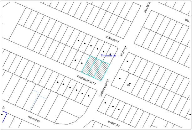
|
NOTIFICATION PLAN |
|
||
|
• PROPERTIES NOTIFIED
|
X SUBMISSIONS RECEIVED |
PROPERTY SUBJECT OF DEVELOPMENT
|
|
|
1 SUBMISSION RECEIVED OUT OF MAP RANGE |
|||
Two submissions objected to the development, generally on the grounds that the development would result in:
· Unacceptable traffic on local streets and parking problems, including traffic island and parked cars turning the two-way road into a one way;
· Disruptions during construction including traffic, parking, noise and dust;
· Concrete pathway only on one side of Thornleigh Street;
· Overshadowing;
· Noise impacts;
· Development has no public interest and does not consider remaining residents;
· Development does not add to the character of the area;
· Development more suited to main road; and
· Development is pre-determined and forced relocations.
The merits of the matters raised in community submissions have been addressed in the body of the report with the exception of the following:
5.1.1 Traffic and Parking During Construction Period
Management of construction activity in the area by Council’s compliance officers will ensure adequate and safe traffic flow during construction phases of various sites in the area. Construction traffic management plans have been submitted to Council and will be implemented by the Developer.
Additional short term parking has been provided in Thornleigh Street by Council in late 2015 to address the short fall of parking in the area.
Council’s traffic assessment does not support restricting on-street parking on one side of the Street as this would increase the traffic speeds and traffic flow on Thornleigh Street. The existing traffic island assists with slowing down traffic and deters those using the street as a shortcut.
5.1.2 Concrete Pathway Only on One Side of Thornleigh Street
A pedestrian pathway is proposed to be installed at the frontage of the development on Thornleigh Street to the corner of the intersection with Wood Street as a condition of consent.
5.1.3 Disruptions During Construction including Traffic, Parking, Noise and Dust
Conditions of consent are imposed which require appropriate control of dust and noise by way of limiting hours of construction and implementing erosion and sedimentation controls. Furthermore, a Construction Traffic Management Plan will be implemented by the Developer.
5.1.4 Overshadowing
Given the orientation of the development, the majority of overshadowing will fall onto Thornleigh Street. Overshadowing from a five storey building cannot be avoided, however the proposed setbacks and stepping of the upper floor, as well as the cut of the development into the site will assist in reducing impacts.
5.1.5 Noise
There will be an increase in noise from the addition of 29 units, however the construction standards will assist in minimising noise impacts. The rear and setbacks adjoining dwellings and privacy mitigation measures implemented in the design are in accordance with SEPP 65, ADG and HDCP.
5.1.6 Development has No Public Interest and Does Not Consider Remaining Residents
The site is located within the Station Street Precinct and the development is proposed in accordance with the relevant environmental planning instruments. A positive public benefit will result from the additional housing stock in a well serviced area. As part of the assessment, amenity impacts of adjoining properties are considered, as well as the future character of the area.
5.1.7 Development Does Not Add to the Character of the Area
The development has been considered against the existing and future desired character, with a high level of architectural design being displayed within the building, located in a landscape setting.
5.1.8 Development More Suited to Main Road
The site is appropriately designed for high density given its location to Thornleigh Railway Station, Pennant Hills Road and existing retail/commercial facilities.
5.1.9 Development is Pre-determined and Forced Relocations
The area was identified in Council’s Housing Strategy for higher density. There is no forced relocation of residents and the decision to relocate is at the discretion of the landowners.
5.2 Public Agencies
The development application was not referred to any Public Agencies for comment.
6. THE PUBLIC INTEREST
Section 79C(1)(e) of the Act requires Council to consider “the public interest”.
The public interest is an overarching requirement, which includes the consideration of the matters discussed in this report. Implicit to the public interest is the achievement of future built outcomes adequately responding to and respecting the future desired outcomes expressed in environmental planning instruments and development control plans.
The application is considered to have satisfactorily addressed Council’s criteria and would provide a development outcome that, on balance, would result in a positive impact for the community. Accordingly, it is considered that the approval of the proposed development would be in the public interest.
CONCLUSION
The application proposes demolition of existing structures and construction of a five storey residential flat buildings comprising 29 units and basement car park.
The proposed development is designed in accordance with the Key Principles of ‘Station Street, Thornleigh precinct of the HDCP and would contribute to the future desired five storey residential character of the precinct. The proposal complies with the design principles of SEPP 65 and the Apartment Design Guide.
The proposal would provide a high quality articulated building, surrounded by quality landscaping which would contribute positively to the streetscape and be in keeping with the desired future character of the precinct.
Two submissions were received in response to notification of the proposal.
Approval of the application is recommended.
Note: At the time of the completion of this planning report, no persons have made a Political Donations Disclosure Statement pursuant to Section 147 of the Environmental Planning and Assessment Act 1979 in respect of the subject planning application.
RESPONSIBLE OFFICER
The officer responsible for the preparation of this Report is the Manager – Development Assessments – Rodney Pickles, who can be contacted on 9847 6731.
|
Rod Pickles Manager - Development Assessment Planning Division |
James Farrington Group Manager Planning Division |
|
1.View |
Locality Plan |
|
|
|
2.View |
Floor Plans |
|
|
|
3.View |
Elevations and Sections |
|
|
|
4.View |
Site Plan |
|
|
|
5.View |
Schedule of Materials and Finishes |
|
|
|
6.View |
Landscape Plan |
|
|
|
7.View |
Stormwater Plan |
|
|
|
8.View |
Shadow Diagram |
|
|
|
9.View |
Photomontage |
|
|
File Reference: DA/1505/2015
Document Number: D06942944
SCHEDULE 1
GENERAL CONDITIONS
The conditions of consent within this notice of determination have been applied to ensure that the use of the land and/or building is carried out in such a manner that is consistent with the aims and objectives of the relevant legislation, planning instruments and Council policies affecting the land and does not disrupt the amenity of the neighbourhood or impact upon the environment.
Note: For the purpose of this consent, the term ‘applicant’ means any person who has the authority to act on or the benefit of the development consent.
Note: For the purpose of this consent, any reference to an Act, Regulation, Australian Standard or publication by a public authority shall be taken to mean the gazetted Act or Regulation, or adopted Australian Standard or publication as in force on the date that the application for a construction certificate is made.
1. Approved Plans and Supporting Documentation
The development must be carried out in accordance with the plans and documentation listed below and endorsed with Council’s stamp, except where amended by Council and/or other conditions of this consent:
Approved Plans
|
Plan No. |
Plan Description |
Drawn by |
Dated |
|
A 1.01, Issue D |
Site roof plan |
Aplusdg |
2.06.2016 |
|
A 2.01, Issue D |
Basement 3 Plan |
Aplusdg |
2.06.2016 |
|
A 2.02, Issue D |
Basement 2 Plan |
Aplusdg |
2.06.2016 |
|
A 2.03, Issue D |
Basement 1 Plan |
Aplusdg |
2.06.2016 |
|
A 2.04, Issue D |
Lower Ground Floor |
Aplusdg |
2.06.2016 |
|
A 2.05, Issue D |
Upper Ground Floor |
Aplusdg |
2.06.2016 |
|
A 2.06, Issue D |
Level 1-3 Plan |
Aplusdg |
2.06.2016 |
|
A 2.07, Issue D |
Level 4 Plan |
Aplusdg |
2.06.2016 |
|
A 3.01, Issue D |
North & South Elevations |
Aplusdg |
2.06.2016 |
|
A 3.02, Issue D |
East & West Elevations |
Aplusdg |
2.06.2016 |
|
A 4.01, Issue D |
Section A-A |
Aplusdg |
2.06.2016 |
|
A 4.02, Issue D |
Section B-B |
Aplusdg |
2.06.2016 |
|
L/01, Rev C |
Proposed ground floor landscape plan |
ATC |
14.06.2016 |
|
L/02, Rev A |
Proposed landscape plan level 1- 3 |
ATC |
14.06.2016 |
|
L/03, Rev A |
Proposed landscape plan level 4 |
ATC |
14.06.2016 |
|
HDA01-HDA07/P1 |
Stormwater plans |
AJ Consulting Group |
Oct 2015 |
Supporting Documentation
|
Document title |
Prepared by |
Dated |
|
Construction traffic management plan, version 1b |
ML Traffic Engineers |
April 2016 |
|
Arboricultural impact assessment |
Footprint Green |
10 Nov 2015 |
|
Waste management plan |
Aplusdg, Adin PiIcer |
5 Nov 2015 |
|
BCA Capability statement |
MBC certifiers |
9 Nov 2015 |
|
Geotechnical investigation |
JK Geotechnics |
2 Nov 2015 |
|
DA Access report |
Visionary Access consulting |
29 Oct 2015 |
|
Cross ventilation/ solar access analysis, A7.01, Issue D |
Aplusdg |
02.06.2016 |
|
Shadow diagrams, A6.01, Issue D |
Aplusdg |
02.06.2016 |
|
BASIX Certificate No.680747M |
Victor Lin & Associates |
6 Nov 2015 |
|
Design Verification Statement |
Aplusdg |
9 Nov 2015 |
|
Traffic and parking assessment |
Varga traffic planning |
4 Nov 2015 |
2. Amendment of Plans
a) To comply with Councils requirement in terms of privacy, the approved plan A 2.07, Issue D prepared by Aplusdg dated 22.06.2016 is to be amended to include a 1 metre wide planter box along the western elevation of the balcony to Unit 403 currently shown as ‘pebble’ to incorporate screen planting.
b) To provide additional landscaping within the Thornleigh Street frontage, the approved ground floor landscape plan, Revision C prepared by ATC, dated 14.06.2016 is to be amended to delete the ‘stepping stones in pebble mulch’ which serve access to two fire escapes and two terraces on the ground floor and replaced with grass.
c) The approved Stormwater plans, Plan Nos. HDA01-HDA07/P1, prepared by AJ Consulting Group, dated Oct 2015 is to be amended to reflect the approved plans A 1.01 Issue D, A 2.01 Issue D, A 2.03 Issue D, A 2.04 Issue D and A 2.05 Issue D, prepared by Aplusdg, dated 2.06.2016.
d) These amended plans must be submitted with the application for the Construction Certificate.
3. Removal of Existing Trees
a) This development consent permits the removal of 9 trees numbered 1, 2, 3, 4, 5, 6, 7, 8 and 10 as identified in the submitted Arboricultural impact assessment prepared by Footprint Green, dated 10 Nov 2015.
b) The removal of any other trees requires separate approval in accordance with the Tree and Vegetation Chapter 1B.6 Hornsby Development Control Plan (HDCP).
4. Construction Certificate
a) A Construction Certificate is required to be approved by Council or a Private Certifying Authority prior to the commencement of any works under this consent.
b) A separate Construction Certificate must be obtained from Council for all works within the public road reserve under S138 of the Roads Act.
c) A separate Construction Certificate must be obtained from Council for all works within drainage easements vested in Council.
d) The Construction Certificate plans must not be inconsistent with the Development Consent plans.
5. Section 94 Development Contributions
a) In accordance with Section 80A(1) of the Environmental Planning and Assessment Act, 1979 and the Hornsby Shire Council Section 94 Development Contributions Plan 2014-2024, the following monetary contributions must be paid to Council to cater for the increased demand for community infrastructure resulting from the development:
|
Description |
Contribution |
|
Roads |
$11,258.05 |
|
Open Space and Recreation |
$250,699.35 |
|
Community Facilities |
$108,482.55 |
|
Plan Preparation and Administration |
$728.00 |
|
TOTAL |
$371,167.95 |
being for 7 x 1 bedroom, 19 x 2 bedroom and 3 x 3 bedroom units with a credit of 3 existing dwelling-houses.
b) The value of this contribution is current as at 6 May 2016. If the contribution is not paid within the financial quarter that this condition was generated, the contribution payable will be adjusted in accordance with the provisions of the Hornsby Shire Council Section 94 Development Contributions Plan and the amount payable will be calculated at the time of payment in the following manner:
$CPY = $CDC x CPIPY
CPIDC
Where:
$CPY is the amount of the contribution at the date of Payment
$CDC is the amount of the contribution as set out in this Development Consent
CPIPY is the latest release of the Consumer Price Index (Sydney – All Groups) at the date of Payment as published by the ABS.
CPIDC is the Consumer Price Index (Sydney – All Groups) for the financial quarter at the date applicable in this Development Consent Condition.
c) The monetary contribution must be paid to Council:
i) prior to the issue of the Subdivision Certificate where the development is for subdivision; or
ii) prior to the issue of the first Construction Certificate where the development is for building work; or
iii) prior to issue of the Subdivision Certificate or first Construction Certificate, whichever occurs first, where the development involves both subdivision and building work; or
iv) prior to the works commencing where the development does not require a Construction Certificate or Subdivision Certificate.
Note: It is the professional responsibility of the Principal Certifying Authority to ensure that the monetary contributions have been paid to Council in accordance with the above timeframes.
Council’s Development Contributions Plan may be viewed at www.hornsby.nsw.gov.au or a copy may be inspected at Council’s Administration Centre during normal business hours.
REQUIREMENTS PRIOR TO THE ISSUE OF A CONSTRUCTION CERTIFICATE
6. Building Code of Australia
All approved building work must be carried out in accordance with the relevant requirements of the Building Code of Australia.
7. Contract of Insurance (Residential Building Work)
Where residential building work for which the Home Building Act 1989 requires there to be a contract of insurance in force in accordance with Part 6 of that Act, this contract of insurance must be in force before any building work authorised to be carried out by the consent commences.
8. Notification of Home Building Act 1989 Requirements
Residential building work within the meaning of the Home Building Act 1989 must not be carried out unless the principal certifying authority for the development to which the work relates (not being Council) has given Council written notice of the following information:
a) In the case of work for which a principal contractor is required to be appointed:
i) The name and licence number of the principal contractor; and
ii) The name of the insurer by which the work is insured under Part 6 of that Act.
b) In the case of work to be done by an owner-builder:
i) The name of the owner-builder; and
ii) If the owner-builder is required to hold an owner-builder’s permit under that Act, the number of the owner-builder’s permit.
Note: If arrangements for doing the residential building work are changed while the work is in progress so that the information notified becomes out of date, further work must not be carried out unless the principal certifying authority for the development to which the work relates (not being Council) has given Council written notification of the updated information.
9. Dilapidation Report
To record the structural condition of Nos. 30, 32 and 34 Station Street and No. 25 Thornleigh Street which adjoin the approved development, a dilapidation report must be prepared by a suitably qualified structural engineer for inclusion with the application of the Construction Certificate.
10. Utility Services
The applicant must submit written evidence of the following service provider requirements:
a) Ausgrid (formerly Energy Australia) – a letter of consent demonstrating that satisfactory arrangements have been made to service the proposed development.
b) Telstra – a letter of consent demonstrating that satisfactory arrangements have been made to service the proposed development.
11. Sydney Water – Approval
This application must be submitted to Sydney Water for approval to determine whether the development would affect any Sydney Water infrastructure, and whether further requirements are to be met.
Building plan approvals can be obtained online via Sydney Water Tap inTM through www.sydneywater.com.au under the Building and Development tab.
12. Adaptable Units/Storage
The following details must be provided with the Construction Certificate plans.
a) The development is required to provide 9 units designed as adaptable housing pursuant to the requirements of 1C.2.2 of the Hornsby Development Control Plan 2013. In this regard, three (3) car parking spaces are to be designed for people with a disability and allocated to 3 accessible units;
b) Each dwelling within the development must have a minimum area for storage (not including kitchen and bedroom cupboards) for 6m3 for one bedroom units, 8m3 for two bedroom units and 10m3 for three bedroom units, where 50% is required to be located within the apartment and accessible from either the hall or living area.
13. Letterboxes
The details of letter boxes and meter enclosures must be provided with the Construction Certificate Plans. The letter boxes and meter enclosures must be provided with a minimum setback of 2 metres from all boundaries and must be suitably screened.
14. Waste Management Details
The following waste management details must be provided with the Construction Certificate Plans:
a) A bulky waste storage area of at least 8 square metres must be provided at the basement level.
b) The chute system must include volume handling equipment (2x660L linear or similar, with no compaction) to automatically change the bin under the chute when it becomes full.
c) The bin hoist to transfer bins between the basement and lower ground levels must be suitable for 660 L bins (which are 800 mm deep and 1400 mm wide)
d) The driveway gradient must not exceed 1:20 for the first 6 metres.
e) The waste facilities on each residential level must be accessible by persons with a disability (a garbage chute and recycling bin in a small room) while comfortably housing the garbage chute and one 240 L recycling bin.
Note: A 240 L recycling bin is 600 mm wide by 750 mm deep; allow for ease around the bin – 75 mm is recommended). The door must be wide enough and positioned such that the bin can fit through. The chute system supplier must be consulted for chute space requirements.
15. Waste Management Plan
a) A Waste Management Plan Section One – Demolition Stage and Section Three – Construction Stage, covering the scope of this project and including the following details, is required to be submitted to Council:
i) An estimate of the types and volumes of waste and recyclables to be generated;
ii) A site plan showing sorting and storage areas for demolition and construction waste and the vehicle access to these areas;
iii) How excavation, demolition and construction waste materials will be reused or recycled and where residual wastes will be disposed;
iv) The total percentage (by weight) of demolition and construction waste that will be reused or recycled.
16. Construction Traffic Management Plan
In order to enable unencumbered movement of traffic in the public road during construction works, a Construction Management Plan, including a Traffic Management Plan and scaled construction plans prepared by a suitably Chartered and Qualified Chartered Civil Engineer and Qualified Worksite Traffic Controller shall be prepared and submitted to Hornsby Shire Council for approval according to the following requirements:-
a) A copy of the plans shall be submitted for consideration and written approval by Hornsby Shire Council prior to the release of the Construction Certificate.
b) The plans shall detail the order of construction works and arrangement of all construction machines and vehicles being used at the same time during all stages.
c) The CTMP plans shall be in accordance with the approved Development Application plans and the Development Consent conditions.
d) In order to prevent injury, accident and loss of property, no building materials, work sheds, vehicles, machines or the like shall be allowed to remain in the road reserve area without the written consent of Hornsby Shire Council.
e) The Plan shall be generally in compliance with the requirements of the Road and Traffic Authority’s “Traffic Control at Worksites Manual 1998” and detailing:-
i) Public notification of proposed works;
ii) Long term signage requirements;
iii) Short term (during actual works) signage;
iv) Vehicle Movement Plans, where applicable;
v) Traffic Management Plans;
vi) Pedestrian and Cyclist access and safety;
f) The plans shall indicate traffic controls including those used during non-working hours and shall provide pedestrian access and two-way traffic in the public road to be facilitated at all times.
g) The plans shall include the proposed truck routes to and from the site including details of the frequency of truck movements at the different stages of the development. The plan shall also include details of parking arrangements for all employees and contractors.
h) The Applicant and all employees of contractors on the site must obey any direction or notice from the Prescribed Certifying Authority or Hornsby Shire Council in order to ensure the above.
i) If there is a requirement to obtain a Work Zone, partial Road Closure or Crane Permit an application to Hornsby Shire Council is to be made prior to the issue the Construction Certificate.
17. Traffic Control Plan
A Traffic Control Plan (TCP) must be prepared by a qualified traffic controller in accordance with the Roads & Traffic Authority’s Traffic Control at Worksites Manual 1998 and Australian Standard 1742.3 for all work on a public road. The Traffic Management Plan shall be submitted and approved by Council’s Manager Traffic and Road Safety prior to the issue of a construction certificate. The TCP must detail the following:
a) Arrangements for public notification of the works;
b) Temporary construction signage;
c) Permanent post-construction signage;
d) Vehicle movement plans;
e) Traffic management plans; and
f) Pedestrian and cyclist access/safety.
18. Road Works
All road works approved under this consent must be designed in accordance with Council’s Civil Works Design and Construction Specification 2005 and the following requirements:
a) Existing kerb and gutter along both frontages of the development site shall be removed and new ones constructed.
b) The existing footpath along both the frontages shall be removed and new footpath constructed
c) The existing road pavement to be saw cut a minimum of 300 mm from the existing edge of the bitumen and reconstructed.
d) The submission of a compaction certificate from a geotechnical engineer for any fill within road reserves, and all road sub-grade and road pavement materials.
e) No work is to commence within the road reserve until approval under Section 138 of the Roads Act is obtained from Hornsby Shire Council. In this regard a construction certificate application is to be submitted to Council.
19. Vehicular Crossing
A separate application under the Local Government Act, 1993 and the Roads Act 1993 must be submitted to Council for the installation of a new vehicular crossing and the removal of the redundant crossing. The vehicular crossing must be constructed in accordance with Council’s Civil Works Design 2005 and the following requirements:
a) Design levels at the front boundary must be obtained from Council for the design on the internal driveway;
b) Any redundant crossings must be replaced with integral kerb and gutter;
c) The footway area must be restored by turfing;
d) Approval must be obtained from all relevant utility providers that all necessary conduits be provided and protected under the crossing.
Note: An application for a vehicular crossing can only be made to one of Council’s Authorised Vehicular Crossing Contractors. You are advised to contact Council on 02 9847 6940 to obtain a list of contractors.
20. Internal Driveway/Vehicular Areas
The driveway and parking areas on site must be designed, constructed and a Construction Certificate issued in accordance with Australian Standards 2890.1, 2890.2, 3727 and the following requirements:
a) Design levels at the front boundary shall be obtained from Council if a private accredited certifier is engaged to obtain a construction certificate for these works.
b) The driveway be a rigid pavement.
c) Conduit for utility services including electricity, water, gas and telephone be provided. All existing overhead assets including electricity and telecommunications cabling shall be relocated underground at no cost to Council. A certificate from an appropriately licensed contractor shall be submitted to the principal certifying authority certifying that the service conduits have been installed in accordance with the relevant utility provider and Australian Standards.
d) Longitudinal sections along both sides of the access driveway shall be submitted to the principal certifying authority in accordance with the relevant sections of AS 2890.1. The maximum grade shall not exceed 1 in 4 (25%) with the maximum changes of grade of 1 in 8 (12.5%) for summit grades and 1 in 6.7 (15%) for sag grades. Any transition grades shall have a minimum length of 2 metres. The longitudinal sections shall incorporate the design levels obtained by Council.
21. Stormwater Drainage
The stormwater drainage system for the development must be designed for an average recurrence interval (ARI) of 20 years and be gravity drained via an on-site detention and water quality treatment facility or one of the deemed to comply measures in accordance with the following requirements:
a) Connected directly to a Council’s drainage system via an easement to drain water.
b) Be designed by a Chartered Professional Civil/Hydraulic Engineer of the Institution of Engineers, Australia
22. On-Site Stormwater Detention
An on-site stormwater detention system must be designed by a chartered civil engineer and constructed in accordance with the following requirements:
a) Storage capacity to accommodate volume from up to 20 years ARI (average recurrence interval) storms and a maximum discharge (when full) limited to 5 years pre development rate.
b) Have a surcharge/inspection grate located directly above the outlet. Discharge from the detention system to be controlled via 1 metre length of pipe, not less than 50 millimetres diameter or via a stainless plate with sharply drilled orifice bolted over the face of the outlet discharging into a larger diameter pipe capable of carrying the design flow to an approved Council system.
c) Where above ground system is proposed and the average depth is greater than 0.3 metres, a ‘pool type’ safety fence and warning signs to be installed
d) Not be constructed in a location that would impact upon the visual or recreational amenity of residents.
e) Detail calculations are to be shown in construction certificate plan.
f) An overflow/escape path shall be incorporated in the design.
23. Preservation of Survey Infrastructure
Prior to the issue of a construction certificate, a registered surveyor shall identify all survey marks in the vicinity of the proposed development. Any survey marks required to be removed or displaced as a result of the proposed development shall be undertaken by a registered surveyor in accordance with Section 24 (1) of the Surveying and Spatial Information Act 2002 and following the Surveyor General’s Directions No.11 – "Preservation of Survey Infrastructure".
REQUIREMENTS PRIOR TO THE COMMENCEMENT OF ANY WORKS
24. Construction Traffic Management Plan
A document signed by the Principle Building Contractor is to be submitted to Hornsby Council to confirm the following:
a) The specified travel routes in the approved Construction Traffic Management Plan are to be complied with; and
b) The details of the truck routes are will be provided to the excavation and concrete contractors.
25. Erection of Construction Sign
a) A sign must be erected in a prominent position on any site on which any approved work is being carried out:
i) Showing the name, address and telephone number of the principal certifying authority for the work;
ii) Showing the name of the principal contractor (if any) for any demolition or building work and a telephone number on which that person may be contacted outside working hours; and
iii) Stating that unauthorised entry to the work site is prohibited.
b) The sign is to be maintained while the approved work is being carried out and must be removed when the work has been completed.
26. Protection of Adjoining Areas
A temporary hoarding, fence or awning must be erected between the work site and adjoining lands before the works begin and must be kept in place until after the completion of the works if the works:
a) Could cause a danger, obstruction or inconvenience to pedestrian or vehicular traffic;
b) Could cause damage to adjoining lands by falling objects; and/or
c) Involve the enclosure of a public place or part of a public place.
Note: Notwithstanding the above, Council’s separate written approval is required prior to the erection of any structure or other obstruction on public land.
27. Toilet Facilities
a) To provide a safe and hygienic workplace, toilet facilities must be available or be installed at the works site before works begin and must be maintained until the works are completed at a ratio of one toilet for every 20 persons employed at the site.
b) Each toilet must:
i) be a standard flushing toilet connected to a public sewer; or
ii) be a temporary chemical closet approved under the Local Government Act 1993; or
iii) have an on-site effluent disposal system approved under the Local Government Act 1993.
28. Erosion and Sediment Control
To protect the water quality of the downstream environment, erosion and sediment control measures must be provided and maintained throughout the construction period in accordance with the manual ‘Soils and Construction 2004 (Bluebook)’, the approved plans, Council specifications and to the satisfaction of the principal certifying authority. The erosion and sediment control devices must remain in place until the site has been stabilised and revegetated.
Note: On the spot penalties may be issued for any non-compliance with this requirement without any further notification or warning.
REQUIREMENTS DURING DEMOLITION AND CONSTRUCTION
29. Construction Work Hours
All work on site (including demolition and earth works) must only occur between 7 am and 5 pm Monday to Saturday (unless otherwise approved in writing by Council due to extenuating circumstances). No work is to be undertaken on Sundays or public holidays.
30. Demolition
To protect the surrounding environment, all demolition work must be carried out in accordance with “Australian Standard 2601-2001 – The Demolition of Structures” and the following requirements:
a) Demolition material must be disposed of to an authorised recycling and/or waste disposal site and/or in accordance with an approved waste management plan;
b) Demolition works, where asbestos material is being removed, must be undertaken by a contractor that holds an appropriate licence issued by WorkCover NSW in accordance with Chapter 10 of the Occupational Health and Safety Regulation 2001 and Clause 29 of the Protection of the Environment Operations (Waste) Regulation 2005 ;and
c) On construction sites where any building contain asbestos material, a standard commercially manufactured sign containing the words ‘DANGER ASBESTOS REMOVAL IN PROGRESS’ and measuring not less than 400mm x 300mm must be displayed in a prominent position visible from the street.
31. Environmental Management
The site must be managed in accordance with the publication ‘Managing Urban Stormwater – Landcom (March 2004) and the Protection of the Environment Operations Act 1997 by way of implementing appropriate measures to prevent sediment run-off, excessive dust, noise or odour emanating from the site during the construction of the development.
32. Street Sweeping
Street sweeping must be undertaken following sediment tracking from the site along Lords Avenue during works and until the site is established.
33. Council Property
To ensure that the public reserve is kept in a clean, tidy and safe condition during construction works, no building materials, waste, machinery or related matter is to be stored on the road or footpath.
34. Disturbance of Existing Site
During construction works, the existing ground levels of open space areas and natural landscape features, (including natural rock-outcrops, vegetation, soil and watercourses) must not be altered unless otherwise nominated on the approved plans.
35. Landfill
Landfill must be constructed in accordance with Council’s ‘Construction Specification 2005’ and the following requirements:
a) All fill material imported to the site is to wholly consist of Virgin Excavated Natural Material (VENM) as defined in Schedule 1 of the Protection of the Environment Operations Act 1997 or a material approved under the Department of Environment and Climate Change’s general resource recovery exemption.
b) A compaction certificate is to be obtained from a geotechnical engineer verifying that the specified compaction requirements have been met.
36. Excavated Material
All excavated material removed from the site must be classified in accordance with the Department of Environment, Climate Change and Water NSW Waste Classification Guidelines prior to disposal to an approved waste management facility and reported to the principal certifying authority.
37. Survey Report – Finished Floor Level
To ensure that the approved development has been located at the setbacks and levels shown on the relevant plans and elevations, a report(s) must be prepared by a registered surveyor and submitted to the principal certifying authority prior to the pouring of concrete at each level of the building certifying that:
a) The building, retaining walls and the like have been correctly positioned on the site;
b) The finished floor level(s) are in accordance with the approved plans; and
c) The height of the topmost level of the building including lift overruns and the roof overhang is a maximum of 17.5m above the natural ground level at that point.
38. Waste Management
Waste management during the demolition and construction phase of the development must be undertaken in accordance with the approved Waste Management Plan. Additionally written records of the following items must be maintained during the removal of any waste from the site and such information submitted to the Principal Certifying Authority within fourteen days of the date of completion of the works:
a) The identity of the person removing the waste.
b) The waste carrier vehicle registration.
c) Date and time of waste collection.
d) A description of the waste (type of waste and estimated quantity).
e) Details of the site to which the waste is to be taken.
f) The corresponding tip docket/receipt from the site to which the waste is transferred (noting date and time of delivery, description (type and quantity) of waste).
g) Whether the waste is expected to be reused, recycled or go to landfill.
Note: In accordance with the Protection of the Environment Operations Act 1997, the definition of waste includes any unwanted substance, regardless of whether it is reused, recycled or disposed to landfill.
39. Compliance with Construction Traffic Management Plan
The Council approved Construction Traffic Management Plan prepared by ML Traffic Engineers and dated April 2016, Version 1b is to be complied with for the duration of works.
REQUIREMENTS PRIOR TO THE ISSUE OF AN OCCUPATION OR SUBDIVISION CERTIFICATE
Note: For the purpose of this consent, a reference to ‘occupation certificate’ shall not be taken to mean an ‘interim occupation certificate’ unless otherwise stated.
40. Fulfilment of BASIX Commitments
The applicant must demonstrate the fulfilment of BASIX commitments pertaining to the development.
41. Sydney Water – s73 Certificate
An s73 Certificate must be obtained from Sydney Water and submitted to the PCA.
Note: Sydney Water requires that s73 applications are to be made through an authorised Sydney Water Servicing Coordinator. Refer to www.sydneywater.com.au or telephone 13 20 92 for assistance.
42. Water Saving Urban Design
Stormwater discharging from the development site is to be treated to achieve the quality specified in Council’s Development Control Plan 2013 (table 1C.1.2(b) Urban Stormwater Quality Targets) or utilise one of the deemed to comply solutions. MUSIC model and Hornsby Shire Council Music-link report are to be submitted for Council’s endorsement prior to issue of a construction certificate where treatment measures are incorporated in the stormwater management plans. Council’s parameters are to be used in the model.
43. Certification of WSUD Facilities
Prior to the issue of an Occupation Certificate a certificate from a Civil Engineer is to be obtained stating that the WSUD facilities have been constructed and will meet the water quality targets as specified in the Hornsby Development Control Plan 2013.
44. Damage to Council Assets
To protect public property and infrastructure any damage caused to Council’s assets as a result of the construction or demolition of the development must be rectified by the applicant in accordance with Council’s Civil Works Specifications.
45. Car Parking and Vehicular Areas
All vehicular areas within the site and the car parking must be constructed in accordance with Australian Standard AS 2890.1 – 2004 – Off Street Car Parking and Australian Standard 2890.2 - 2002 – Off Street Commercial and the following requirements:
a) The driveway to be designed in accordance with Condition 15 of this development consent;
b) All parking areas and driveways are to be sealed to an all-weather standard, line marked and signposted;
c) Residential parking spaces are to be secure spaces with access controlled by card or numeric pad;
d) Visitors are to be able to access the basement car park by an audio/visual intercom system located at the top of the ramped driveway;
e) Nine bicycle spaces (resident and visitor) are to be provided in the basement car park. Bicycle parking spaces are to be designed in accordance with AS 2890.3-1993;
f) One motorcycle parking space is to be provided within the basement car park, designed in accordance with AS 2890.5-1993;
g) All parking for people with disabilities is to comply with AS/NZS 2890.6:2009 Off-street parking for people with disabilities; and
h) The location of the driveway must maintain sight lines for the pedestrians.
46. Planting on Onsite Stormwater Detention (OSD)
Planting of shrubs and groundcovers is required along the boundary on top of the OSD to define the boundary line and soften the built form.
47. Completion of landscaping
A certificate must be provided by a practicing landscape architect, horticulturalist or person with similar qualifications and experience certifying that all required landscaping works have been satisfactorily completed in accordance with the approved landscape plans.
Note: Applicants are advised to pre-order plant material required in pot sizes 45 litre or larger to ensure nurseries have stock available at the time of install.
48. Retaining Walls
All required retaining walls must be constructed as part of the development.
49. Boundary Fencing
Fencing must be erected along all property boundaries behind the front building alignments to a height of 1.8 metres.
The exact location, design and costing for the erection of boundary fencing are to be the subject of negotiation and agreement in accordance with the relevant requirements of the Building Fences Act, 1991.
Note: Alternative fencing may be erected subject to the written consent of the adjoining property owner(s).
50. External Lighting
a) To protect the amenity of adjacent premises, all external lighting must be designed and installed in accordance with Australian Standard AS 4282 – Control of the Obtrusive Effects of Outdoor Lighting.
b) Certification of compliance with this Standard must be obtained from a suitably qualified person and submitted to the PCA with the application for the Construction Certificate.
51. Garbage Collection Easement
For the purpose of waste collection, an easement entitling Council, its servants and agents and persons authorised by it to enter upon the subject land and to operate thereon, vehicles and other equipment for the purposes of garbage collection must be granted to Council by the owner of the land.
Note: The easement must be in a form prescribed by Council and must include covenants to the effect that parties will not be liable for any damage caused to the subject land or any part thereof or to any property located therein or thereon by reason of the operation thereon of any vehicle or other equipment used in connection with the collection of garbage and to the effect that the owner for the time being of the subject land shall indemnify the Council, its servants, agents and persons authorised by it to collect garbage against liability in respect of any such claims made by any person whomsoever.
52. Waste Management
The following waste management requirements must be complied with:
a) The bin storage room at the basement level must include water or a hose for cleaning, graded floors with drainage to sewer, robust doors, sealed and impervious surface, adequate lighting and ventilation, and must be lockable. The waste facility rooms/cupboards at each residential level must include sealed and impervious surface, adequate lighting and ventilation.
b) A report must be prepared by an appropriately qualified person, certifying the following:
i) A comparison of the estimated quantities of each waste type against the actual quantities of each waste type.
Note: Explanations of any deviations to the approved Waste Management Plan is required to be included in this report.
ii) That at least 60% of the waste generated during the demolition and construction phase of the development was reused or recycled.
Note: If the 60% diversion from landfill cannot be achieved in the Construction Stage, the Report is to include the reasons why this occurred and certify that appropriate work practices were employed to implement the approved Waste Management Plan. The Report must be based on documentary evidence such as tipping dockets/receipts from recycling depots, transfer stations and landfills, audits of procedures etc. which are to be attached to the report.
iii) All waste was taken to site(s) that were lawfully permitted to accept that waste.
c) Each unit must be provided with an indoor waste/recycling cupboard for the interim storage of a minimum one day’s waste generation with separate containers for general waste and recyclable materials.
d) Space must be provided for either individual compost containers for each unit or a communal compost container;
Note: The location of the compost containers should have regard for potential amenity impacts.
e) A bulky waste storage area of at least 8m2 is to be identified and marked with paint and signage.
f) The bin carting routes must be devoid of any steps.
Note: Ramps between different levels are acceptable.
g) Access to the automatic waste volume handling equipment by unauthorised persons (including residents and waste collectors) must be prevented.
Note: Caging of the automatic volume handling equipment is acceptable.
h) Prior to an Occupation Certificate being issued or the use commencing, whichever is earlier, the Principal Certifying Authority must obtain Council’s approval of the waste and recycling management facilities provided in the development and ensure arrangements are in place for domestic waste collection by Council.
53. Creation of Easements
The following matter(s) must be nominated on the plan of subdivision under s88B of the Conveyancing Act, 1919:
a) The creation of an appropriate "Positive Covenant" and "Restriction as to User" over the constructed on-site detention and water quality treatment systems (if constructed) and outlet works, within the lots in favour of Council in accordance with Council’s prescribed wording. The position of the on-site detention system and water quality treatment system is to be clearly indicated on the title.
b) To register the positive covenant and the restriction on the use of land, “works-as-executed” details of the on-site-detention system and water quality treatment system (if constructed) must be submitted verifying that the required storage and discharge rates and water quality treatment measures have been constructed in accordance with the design requirements. The details must show the invert levels of the on- site system together with pipe sizes and grades and details of water quality treatment measures. Any variations to the approved plans must be shown in red on the “works-as-executed” plan and supported by calculations
54. Unit Numbering
All units are to be numbered consecutively commencing at No.1. The strata plan lot number is to coincide with the unit number, e.g. Unit 1 = Lot 1. The allocated of unit numbering must be authorised by Council prior to the numbering of each units in the development.
55. Works as Executed Plan
A works-as-executed plan(s) must be prepared by a registered surveyor and submitted to Council for completed road pavement, kerb & gutter, public drainage systems, driveways and on-site detention system. The plan(s) must be accompanied by a certificate from a registered surveyor certifying that all pipelines and associated structures lie wholly within any relevant easements.
56. Consolidation of Allotments
All allotments the subject of this consent must be consolidated into one allotment.
Note: The applicant is recommended to submit the plan of subdivision to consolidate allotments to the NSW Department of Lands at least 4-6 weeks prior to seeking an occupation certificate.
57. Construction of Engineering Works
All engineering works including but not be limited to the stormwater works, on-site detention system, construction of retaining walls and road works identified in this consent are to be completed and a Compliance Certificate issued prior to the release of the Occupation Certificate.
58. Provision for National Broadband Network (NBN)
Provision must be made for fibre ready passive infrastructure (pits and pipes) generally in accordance with NBN Co's pit and pipe installation guidelines to service the proposed development. A certificate from NBN Co or Telstra must be submitted to the PCA that the fibre optic cabling provided for the development complies with MDU Building Design Guides for Development.
59. Safety and Security
This site must include the following elements:
a) An intercom system must be installed at gate locations to ensure screening of persons entering the units;
b) The entry doors to the pedestrian foyer is to be constructed of safety rated glass to enable residents a clear line of site before entering or exiting the residential apartments;
c) Lighting is to be provided to pathways, building foyer entries, driveways and common external spaces;
d) Security gate access is to be provided to the car parking areas allowing residents-only access to private car spaces;
e) CCTV cameras must be installed at the entry and exit point and the around the mailbox;
f) The communal open spaces within the site must be illuminated with high luminance by motion sensor lighting;
g) The driveway and basement car parking must be illuminated with low luminance at all times;
h) Security deadlocks are to be provided to each apartment door; and
i) Peep holes are to be provided to individual apartment doors to promote resident safety.
OPERATIONAL CONDITIONS
60. Noise
All noise generated by the proposed development must be attenuated to prevent levels of noise being emitted to adjacent premises which possess tonal, beating and similar characteristics or which exceeds background noise levels by more than 5dB(A).
61. Fire Safety Statement - Annual
On at least one occasion in every 12 month period following the date of the first ‘Fire Safety Certificate’ issued for the property, the owner must provide Council with an annual ‘Fire Safety Certificate’ to each essential service installed in the building.
62. Car Parking and Deliveries
All car parking must be operated in accordance with Australian Standard AS 2890.1 – 2004 – Off Street Car Parking and Australian Standard 2890.2 - 2002 – Off Street Commercial and the following requirements:
a) All parking areas and driveways are to be sealed to an all-weather standard, line marked and signposted at all times.
b) Car parking, loading and manoeuvring areas to be used solely for nominated purposes.
c) Vehicles awaiting loading, unloading or servicing shall be parked on site and not on adjacent or nearby public roads;
d) All vehicular entry on to the site and egress from the site shall be made in a forward direction.
63. Sight Lines
Minimum sight lines for pedestrian safety are to be provided at the driveway. Any proposed landscaping and/or fencing must not restrict sight distance to pedestrians and cyclists travelling along the footpath.
64. Waste Management
The waste management on site must be in accordance with the following requirements:
a) A site caretaker must be employed and be responsible for moving bins where and when necessary, washing bins and maintaining waste storage areas, ensuring the chute system and related devices are maintained in effective and efficient working order, managing the communal composting area, managing the bulky item storage area, arranging the prompt removal of dumped rubbish, and ensuring all residents are informed of the use of the waste management system. The site caretaker must be employed for a sufficient number of hours each week to allow all waste management responsibilities to be carried out to a satisfactory standard.
b) The approved on-going waste management practise for the site must not be amended without consent from Council.
65. Landscape Establishment
The landscape works must be maintained into the future to ensure the establishment and successful growth of plant material to meet the intent of the landscape design. This must include but not limited to watering, weeding, replacement of failed plant material and promoting the growth of plants through standard industry practices.
- END OF CONDITIONS -
ADVISORY NOTES
The following information is provided for your assistance to ensure compliance with the Environmental Planning and Assessment Act 1979, Environmental Planning and Assessment Regulation 2000, other relevant legislation and Council’s policies and specifications. This information does not form part of the conditions of development consent pursuant to Section 80A of the Act.
Environmental Planning and Assessment Act 1979 Requirements
The Environmental Planning and Assessment Act 1979 requires:
· The issue of a construction certificate prior to the commencement of any works. Enquiries can be made to Council’s Customer Services Branch on 9847 6760;
· a principal certifying authority to be nominated and Council notified of that appointment prior to the commencement of any works;
· Council to be given at least two days written notice prior to the commencement of any works;
· mandatory inspections of nominated stages of the construction inspected; and
· an occupation certificate to be issued before occupying any building or commencing the use of the land.
Long Service Levy
In accordance with Section 34 of the Building and Construction Industry Long Service Payments Act 1986, a ‘Long Service Levy’ must be paid to the Long Service Payments Corporation or Hornsby Council.
Note: The rate of the Long Service Levy is 0.35% of the total cost of the work.
Note: Hornsby Council requires the payment of the Long Service Levy prior to the issue of a construction certificate.
Tree and Vegetation Preservation
In accordance with Clause 5.9 of the Hornsby Local Environmental Plan 2013 a person must not ringbark, cut down, top, lop, remove, injure or wilfully destroy any tree or other vegetation protected under the Hornsby Development Control Plan 2013 without the authority conferred by a development consent or a permit granted by Council.
Notes: A tree is defined as a long lived, woody perennial plant with one or relatively few main stems with the potential to grow to a height greater than three metres (3M). (HDCP 1B.6.1.c).
Tree protection measures and distances are determined using the Australian Standard AS 4970:2009, “Protection of Trees on Development Sites”.
Fines may be imposed for non-compliance with both the Hornsby Local Environmental Plan 2013 and the Hornsby Development Control Plan 2013.
Disability Discrimination Act
The applicant’s attention is drawn to the existence of the Disability Discrimination Act. A construction certificate is required to be obtained for the proposed building/s, which will provide consideration under the Building Code of Australia, however, the development may not comply with the requirements of the Disability Discrimination Act. This is the sole responsibility of the applicant.
Covenants
The land upon which the subject building is to be constructed may be affected by restrictive covenants. Council issues this approval without enquiry as to whether any restrictive covenant affecting the land would be breached by the construction of the building, the subject of this consent. Applicants must rely on their own enquiries as to whether or not the building breaches any such covenant.
Dial Before You Dig
Prior to commencing any works, the applicant is encouraged to contact Dial Before You Dig on 1100 or www.dialbeforeyoudig.com.au for free information on potential underground pipes and cables within the vicinity of the development site.
Telecommunications Act 1997 (Commonwealth)
If you are aware of any works or proposed works which may affect or impact on Telstra’s assets in any way, you are required to contact: Telstra’s Network Integrity Team on Phone Number 1800810443.
Asbestos Warning
Should asbestos or asbestos products be encountered during demolition or construction works, you are advised to seek advice and information prior to disturbing this material. It is recommended that a contractor holding an asbestos-handling permit (issued by WorkCover NSW) be engaged to manage the proper handling of this material. Further information regarding the safe handling and removal of asbestos can be found at:
Alternatively, telephone the WorkCover Asbestos and Demolition Team on 8260 5885.
Group Manager’s Report No. PL54/16
Planning Division
Date of Meeting: 13/07/2016
4 DEVELOPMENT APPLICATION - ALTERATIONS AND ADDITIONS TO AN EXISTING QUAIL FARM - 1-3 PEEBLES ROAD, FIDDLETOWN
EXECUTIVE SUMMARY
|
DA No: |
DA/1673/2015 (Lodged 22 December 2015) |
|
Description: |
Construction of two sheds for use in conjunction with an existing quail farm and relocation of an approved rural workers dwelling. |
|
Property: |
Lot 2 DP 504720, Nos. 1-3 Peebles Road, Fiddletown |
|
Applicant: |
Game Farm Property Pty Ltd |
|
Owner: |
Game Farm Property Pty Ltd |
|
Estimated Value: |
$1,700,000 |
· The application involves alterations and additions to an existing quail farm.
· The proposal generally complies with the requirements of the Hornsby Local Environmental Plan 2013 and the Hornsby Development Control Plan 2013.
· 10 submissions have been received in respect of the application.
· It is recommended that the application be approved.
|
THAT Development Application No. DA/1673/2015 for construction of two sheds for use in conjunction with an existing quail farm and relocation of an approved rural workers dwelling at Lot 2 DP 504720, Nos. 1-3 Peebles Road, Fiddletown be approved subject to the conditions of consent detailed in Schedule 1 of Group Manager’s Report No. PL54/16. |
BACKGROUND
Game Farm has been operating in the Hornsby Shire for over 30 years and has been located at Nos. 1-3 Peebles Road for over 25 years.
On 16 January 1989, Council approved DA/522/1988 for two chicken sheds in conjunction with the existing poultry farm onsite.
On 2 December 1994, Council approved DA/581/1994 for the erection of a rural workers dwelling in conjunction with the existing poultry farm.
Both applications acknowledge the ongoing use of the site as a poultry farm.
SITE
The site is located on the western side of Peebles Road and has dual street frontage to Peebles Road and Nollands Road. The site has an area of approximately 4.21ha. The site frontage to Peebles Road is approximately 260m and the frontage to Nollands Road is approximately 146m. Vehicular access into the site is from Peebles Road.
Current improvements to the site include:
· Three large sheds, each split into two sections, for growing quail;
· Ancillary farm sheds and workshops;
· Feed silos;
· Two residential dwellings for farm workers; and
· One farm dam in the north-east corner of the site.
The site is generally flat, but has a gentle slope across the site falling approximately 2m. The site has open grassed areas and scattered vegetation across the site. Hedging and screen trees have been planted along the Peebles Road and Nollands Road frontages and along the rear (western) boundary.
The site is surrounded by a mix of agricultural, rural residential and educational uses. To the east on the opposite side of Peebles Road, is a rural residential property and plant agriculture establishment. To the north and east are rural residential properties and to the north-west there is a poultry farm (No. 7 Peebles Road). Northholm Grammar School is located to the south, with the outdoor areas, dams and playing fields closest to the property. The closest school buildings are approximately 140m from the site boundary. To the south west is a rural residential property with a horse riding and training facility known as Suntori Park.
The closest residential dwellings to the property are to the east (Nos. 10-12 Nollands Road) and west (Nos. 18-20 Nollands Road) which are located approximately 35m from the site boundary. The residential dwelling to the north (No. 5 Peebles Road) is approximately 85m from the site boundary and the residential dwelling to the south (No. 9 Nollands Road) is approximately 70m to the site boundary.
existing operations
Game Farm currently operates a breeding and hatchery facility at a property at Merriwa in the Hunter Valley. Currently newly hatched quail chicks are transported to the Fiddletown site on either a weekly or fortnightly basis from Merriwa. The Merriwa facility consists of up to 25,000 breeding Quail (cocks and hens) which provide fertile eggs to the hatchery (and infertile eggs for sale). The hatchery capacity is 60,000 Quail chicks. The chicks are transferred to the site by truck from Merriwa when one day old and placed in the growing sheds.
The Fiddletown site is currently used for growing quail birds in the sheds. Quail birds are significantly smaller than chickens and grow to approximately 1/6 to 1/10 the size of a broiler chicken. The number of birds on the farm at any one time ranges from between 180,000 to 210,000 birds depending on the growing cycle. Once the birds have grown to the required size they are transported off-site to Game Farm’s processing facility at Galston.
The existing sheds on site are conventional broiler chicken sheds which have open sides that run from the roof line to about half way down the wall of the shed. These openings are fitted with curtains. The environment and amount of air circulating through the shed is regulated by raising or lowering the curtains. Mixing fans assist with circulation of air inside the shed and water misting systems cool the sheds by evaporative cooling during very hot conditions.
The three large sheds are each split into two sections, providing a total of six sheds. Each run of six sheds represents a batch (growing cycle) and each growing cycle is approximately 33-40 days. Game Farm currently grows between 7.5 to 8.5 batches per year, subject to demand.
There is an informal gravel car parking area adjoining the existing growing shed.
PROPOSAL
The proposed development comprises:
· Relocation of an existing rural worker’s dwelling towards the front of the site (Peebles Road frontage);
· Removal of eleven trees;
· Construction of a breeding shed and hatchery shed, linked by a common walkway;
· Installation of wastewater treatment system; and
· Stormwater drainage works.
The breeder shed would be 50m in length and 27m in width (including the covered walkway). The walls would be 4m in height and the ridge of the roof 8m (RL226). Internally, the breeders shed would comprise three sections being two breeding areas and a manure store. The shed would be constructed of colorbond walls and roof, with a ventilation cowl along the south elevation. The breeders shed would accommodate up to 25,000 breeding birds.
The proposed hatchery shed is approximately 33m long x 24m wide and 9.6m (RL227.6) in height to the roof ridge. The hatchery would include a hatcher room, egg storage room, setter room, hatchbrood, store room, plant rooms and staff facilities (office, showers, toilets etc.).
ASSESSMENT
The development application has been assessed having regard to ‘A Plan for Growing Sydney’, the ‘North Subregion (Draft) Subregional Strategy’ and the matters for consideration prescribed under Section 79C of the Environmental Planning and Assessment Act 1979 (the Act). The following issues have been identified for further consideration.
1. STRATEGIC CONTEXT
1.1 A Plan for Growing Sydney and (Draft) North Subregional Strategy
A Plan for Growing Sydney has been prepared by the NSW State Government to guide land use planning decisions for the next 20 years. The Plan sets a strategy for accommodating Sydney’s future population growth and identifies the need to deliver 689,000 new jobs and 664,000 new homes by 2031. The Plan identifies that the most suitable areas for new housing are in locations close to jobs, public transport, community facilities and services.
The NSW Government will use the subregional planning process to define objectives and set goals for job creation, housing supply and choice in each subregion. Hornsby Shire has been grouped with Hunters Hill, Ku-ring-gai, Lane Cove, Manly, Mosman, North Sydney, Pittwater, Ryde, Warringah and Willoughby to form the North Subregion. The Draft North Subregional Strategy will be reviewed and the Government will set housing targets and monitor supply to ensure planning controls are in place to stimulate housing development.
The proposed development would be consistent with ‘A Plan for Growing Sydney’, by providing additional services to support a growing population.
2. STATUTORY CONTROLS
Section 79C(1)(a) requires Council to consider “any relevant environmental planning instruments, draft environmental planning instruments, development control plans, planning agreements and regulations”.
2.1 Environmental Planning and Assessment Regulation 2000 - Designated Development
Clause 21 in Schedule 3 of the Environmental Planning and Assessment Regulation 2000 (the Regs) prescribes that a poultry farm is designated development when the following criteria are satisfied:
(4) Poultry farms for the commercial production of birds (such as domestic fowls, turkeys, ducks, geese, game birds and emus), whether as meat birds, layers or breeders and whether as free range or shedded birds:
(a) that accommodate more than 250,000 birds, or
(b) that are located:
(i) within 100 metres of a natural waterbody or wetland, or
(ii) within a drinking water catchment, or
(iii) within 500 metres of another poultry farm, or
(iv) within 500 metres of a residential zone or 150 metres of a dwelling not associated with the development and, in the opinion of the consent authority, having regard to topography and local meteorological conditions, are likely to significantly affect the amenity of the neighbourhood by reason of noise, odour, dust, lights, traffic or waste.
As the site is within 500m of another poultry farm and within 150m of a dwelling not associated with the development, a development application for a new poultry farm operation would be designated development and an EIS would be required.
However, Part 2 of Schedule 3 of the Regs (Clause 35) states:
“Development involving alterations or additions to development (whether existing or approved) is not designated development if, in the opinion of the consent authority, the alterations or additions do not significantly increase the environmental impacts of the total development (that is the development together with the additions or alterations) compared with the existing or approved development.”
The existing quail farm operates lawfully pursuant to DA/522/88 which granted consent for the construction of two chicken sheds as part of a poultry operation. Furthermore, Council granted consent to DA/581/94 for the construction of a rural workers dwelling in conjunction with an existing poultry farm on the site. The applicant Game Farm has been operating on the site since 1994.
Clause 36 of Part 2 of Schedule 3 of the Regs sets out the factors to be taken into consideration when considering if alterations and additions are designated development. These include the impact of the existing development, the likely impact of the proposed alterations and additions and proposals to mitigate the potential environmental impacts.
The applicant has provided the information in the table below to address Clauses 35 and 36 by providing a comparison of the existing and proposed operations.
|
Comparison of the Existing Operation with Proposed Operation |
||
|
Existing Operations |
Proposed Operations |
Change |
|
Maximum quail numbers range 180,000 to 215,000 |
Maximum quail numbers range 205,000 to 240,000. The additional maximum 25,000 quails are the breeders. The max 45,000 per hatch day old chicks are transported to the site from Merriwa and grown on the site. The proposed hatchery does not add to the total number of quails on the site at any one time. The chicks are transported to the site 5 times every 6 weeks |
+25,000 breeder quails |
|
Existing vehicle movements - Chick delivery 42 per year - Gas delivery 52 per year - Feed delivery 52 per year - Dead birds removed three times per week moved in farm ute to Galston operation and removed by Waste Contractor. - Litter removed from the sheds and removed offsite 1.5 times per year - Litter deliveries 9 per year - Quail pick up to processing plant 3 times per week 156 per year - Staff car movements 4-6 per day
|
Proposed vehicle movements - Chick delivery - nil - Gas delivery 52 per year - Feed delivery 52 per year - Dead birds removed three times per week moved in farm ute to Galston operation and removed by Waste Contractor. - Litter removed from the sheds and removed offsite 1.5 times per year - Litter deliveries 9 per year - Quail pick up to processing plant 3 times per week 156 per year - Staff car movements 6-10 per day - Manure removal from breeder shed monthly |
- 42 truck movements per year
+ 2-4 cars per day |
|
Existing Staff - 4 Includes: - 2 live onsite staff - 1 manager |
Proposed Staff - 8 Includes: - 3 live on site staff - 1 manager |
+ 4 staff |
|
Existing buildings - 3 poultry sheds - Primary dwelling - Rural Workers cottage - 3 metal sheds - Workers amenities building |
Proposed new buildings - 1 breeder shed - 1 hatchery shed Retained buildings - 3 poultry sheds - Primary dwelling - Rural Workers cottage (relocated) - 2 metal sheds - Workers amenities building Removed building - 1 existing metal shed |
+ 2 buildings
- 1 shed |
|
Noise Existing - Bird noise and general farming activity
|
Noise Proposed - Bird noise and general farming activity. - Ventilation / equipment. |
No expected increase than existing Consistent with current operation |
|
Existing Waste management - Each batch period on average 35 days floor litter rotary hoed - Every 4th batch sheds are completely cleaned out with new floor material provided - Sheds are checked daily with mortalities removed on a daily basis |
Proposed Waste Management - No change to existing sheds - Removal of breeder manure weekly from holding shed - Hatchery waste removed once a week on hatch day and transported with mortalities to Galston plant. |
Consistent with current operation |
|
Existing Water Management - Current run off directed to farm dam
|
Proposed Water Management - Additional runoff will be collected and treated in farm dam. - Processed water will be used to water boundary planting and other landscaping.
|
Consistent with current operation Additional treated waste water redirected to watering landscaped areas |
|
Existing grounds management - Grounds are well maintained with regular mowing. - Fence lines planted with shrubs and trees for screening
|
Proposed grounds management - Grounds are well maintained with regular mowing. - Fence lines planted with shrubs and trees for screening
|
No change Consistent with current operation |
Clause 36 of Part 2 of Schedule 3 of the Regs sets out the factors to be taken into consideration by a consent authority in forming its opinion as to whether or not development is designated development. These factors are discussed below:
(a) the impact of the existing development having regard to factors including:
(i) previous environmental management performance, including compliance with the conditions of any consents, licences, leases or authorisations by a public authority and compliance with any relevant codes of practice, and
(ii) rehabilitation or restoration of any disturbed land, and
(iii) the number and nature of all past changes and their cumulative effects, and
With regards to (a) (i), a search of Council’s records indicates that there has been only one incident reported to Council (July 2015) regarding dust and odour from the operation of the business. The matter was investigated and additional screen planting was provided adjacent to the breeding sheds to mitigate dust when the ventilation curtains were open.
With regards to (a) (ii), the operation does not require any rehabilitation or restoration of land
With regards to (a) (iii), Council records indicate that on 16 January 1989, Council approved DA/522/1988 for two chicken sheds in conjunction with the existing poultry farm onsite. The two new sheds replaced two existing sheds on the site. On 2 December 1994, Council approved DA/581/1994 for the erection of a rural workers dwelling in conjunction with the existing poultry farm.
Based on the previous consents granted, there have been no cumulative increases in the scale of the operation of the business on the site and the works proposed under the current application will not increase the number of quail growing sheds on the site.
(b) the likely impact of the proposed alterations or additions having regard to factors including:
(i) the scale, character or nature of the proposal in relation to the development, and
(ii) the existing vegetation, air, noise and water quality, scenic character and special features of the land on which the development is or is to be carried out and the surrounding locality, and
(iii) the degree to which the potential environmental impacts can be predicted with adequate certainty, and
(iv) the capacity of the receiving environment to accommodate changes in environmental impacts, and
With respect to (b), the proposed alterations and additions are to allow the breeding and hatchery facilities to operate on the site instead of the day old chicks being transported from Merriwa to Fiddletown on a weekly basis. This would involve an additional 25,000 quails on the site that would be contained inside the new ventilated and managed poultry shed.
The character and nature of the operation would remain consistent with the existing operation and would include a reduction in the amount of semi-trailer deliveries to the site by 42 per year.
Whilst the proposal would result in the removal of 7 trees within the site, none of the trees are significant and compensatory plantings are included with the proposed works. The recently planted screen hedging along Nollands Road would screen the operation from the street over time.
New wastewater treatment systems would be installed to service the existing dwelling and the relocated rural workers’ dwelling and for staff amenities in the hatchery building. A recycled water system is also to be installed for water used in the hatchery building.
The 25,000 breeder quails would be contained within the proposed ventilated shed. Compliance with the maintenance schedules in the submitted Environmental Management Plan would minimise odour and dust and ensure that it is controlled within the site.
The site is large enough to accommodate the buildings and additional quails. The relocation of the existing rural workers residence towards Peebles Road would ensure the new sheds are located in the centre of the site as far as practical from the site boundaries. The screen landscaping along Nollands Road, the side boundary and near the rural workers dwellings along Peebles Road minimises visual exposure to public roads and adjoining properties
Accordingly the potential environmental impacts are assessed as being consistent with the existing operation.
(c) any proposals:
(i) to mitigate the environmental impacts and manage any residual risk, and
(ii) to facilitate compliance with relevant standards, codes of practice or guidelines published by the Department or other public authorities.
With respect to (c), the existing farm management techniques are proposed to be utilised with the new buildings in conjunction with the submitted Environmental Management Plan (EMP) for the farm.
The applicant has also submitted legal advice on whether the proposed alterations and additions constitute designated development that would require the preparation of an EIS. The legal opinion, concludes that the proposed development is appropriately described as alterations and additions to an existing development and that the proposal would not significantly increase the environmental impacts of the existing development as:
· Game Farm has a good record for environmental management performance.
· Compared with the size of the existing operations which satisfactorily manage the environmental impacts (such as odour, noise, dust, and traffic) of some 180,000–210,000 birds, it is apparent that the site and its operations can accommodate and adequately manage a further 25,000 new adult birds.
· There will be no change to the character or nature of the existing operations, and minimal change to existing vegetation.
· Any increase in odour, dust, noise and waste will be dealt with according to an environmental management regime which is consistent with current operations.
· The increase in staff movement is not of a magnitude to adversely impact the environment to any serious extent more than current staff movements.
· Co-locating the breeding and hatchery sheds with the growing sheds will result in greater farm efficiencies.
· Importantly, the proposal will reduce the traffic impact of the existing development because the 42 semi-trailer deliveries of chicks annually from Merriwa will no longer be required.
Accordingly, it is considered that the proposal would not significantly increase the environmental impacts of the existing development and that the alterations and additions do not constitute designated development.
2.2 Hornsby Local Environmental Plan 2013
The proposed development has been assessed having regard to the provisions of the Hornsby Local Environmental Plan 2013 (HLEP).
2.2.1 Zoning of Land and Permissibility
The subject land is zoned RU1 Primary Production under the HLEP. The objectives of the RU1 Primary Production zone are:
· To encourage sustainable primary industry production by maintaining and enhancing the natural resource base.
· To encourage diversity in primary industry enterprises and systems appropriate for the area.
· To minimise the fragmentation and alienation of resource lands.
· To minimise conflict between land uses within this zone and land uses within adjoining zones.
· To encourage land uses that support primary production, including low-scale and low-intensity tourist and visitor accommodation and the provision of farm produce direct to the public.
· To ensure that development does not unreasonably increase the demand for public infrastructure, services or facilities.
The proposed development is defined as ‘intensive livestock agriculture’ and ‘rural workers’ dwelling’. Both land use are permissible in the zone with Council’s consent.
The proposed development is consistent with the zone objectives as it provides diversity in primary industry enterprises in the locality and would provide employment opportunities.
2.2.2 Height of Buildings
Clause 4.3 of the HLEP provides that the height of a building on any land should not exceed the maximum height shown for the land on the Height of Buildings Map. The maximum permissible height for the subject site is 10.5m. The proposal has a maximum height of 9.6m and complies with this provision.
2.2.3 Heritage Conservation
Clause 5.10 of the HLEP sets out heritage conservation provisions for Hornsby Shire. The site does not include a heritage item and is not located in a heritage conservation area. Accordingly, no further assessment regarding heritage is necessary.
2.3 State Environmental Planning Policy No. 44 Koala Habitat Protection
The Policy requires Council to consider whether development upon land with an area greater than 1 hectare would have an adverse impact upon potential koala habitat. The proposed shed would be located within an already cleared area of the site. Accordingly, no further consideration of the Policy is required.
2.4 Sydney Regional Environmental Plan No. 20 Hawkesbury-Nepean River
The site is located within the catchment of the Hawkesbury Nepean River. Part 2 of this Plan contains general planning considerations and strategies requiring Council to consider the impacts of development on water quality, aquaculture, recreation and tourism.
The septic tank for the existing residence fronting Peebles Road would be decommissioned and new wastewater treatment system installed to service both residences. The system to be installed would have a design capacity of a minimum 1,680 litres per day. The wet composting unit for the staff amenities in the hatchery building would also be connected to the wastewater treatment system servicing the residences.
Water used for processing and wash down of the hatchery and breeding buildings is to be recycled for re-use in the hatchery and breeding buildings. A drainage and piping system would be installed independent of the potable water and human wastewater drainage. The recycled water system would have colour coded taps and be clearly marked that the treated and recycled water is not for human consumption.
The water application areas for the wastewater treatment system would pipe wastewater to these areas when the systems reach 100% capacity. The systems would be fitted with warning alarms when the tanks are 80% full. The water application areas are only used as an emergency back-up if tanks are not emptied before reaching 100% capacity.
New stormwater drainage infrastructure would be established onsite to collect stormwater from the new buildings and relocated residence, which would drain to the existing farm dam, consistent with current stormwater disposal arrangements.
Subject to compliance with the conditions included in Schedule 1 of this report, the proposal would not result in an adverse impact on the water quality of the Hawkesbury Nepean Catchment.
2.5 Clause 74BA Environmental Planning and Assessment Act, 1979 - Purpose and Status of Development Control Plans
Clause 74BA of the Environmental Planning and Assessment Act, 1979 states that a DCP provision will have no effect if it prevents or unreasonably restricts development that is otherwise permitted and complies with the development standards in relevant Local Environmental Plans and State Environmental Planning Policies.
The principal purpose of a development control plan is to provide guidance on the aims of any environmental planning instrument that applies to the development; facilitate development that is permissible under any such instrument; and achieve the objectives of land zones. The provisions contained in a DCP are not statutory requirements and are for guidance purposes only. Consent authorities have flexibility to consider innovative solutions when assessing development proposals, to assist achieve good planning outcomes.
2.6 Hornsby Development Control Plan 2013
The proposed development has been assessed having regard to the relevant desired outcomes and prescriptive requirements within the Hornsby Development Control Plan 2013 (HDCP). The following table sets out the proposal’s compliance with the prescriptive requirements of the Plan:
|
HDCP – Part 2.1 Rural Buildings |
|||
|
Control |
Proposal |
Requirement |
Complies |
|
Site Area |
4.21ha |
N/A |
N/A |
|
Building Height |
|
|
|
|
- Breeding Shed |
8m |
10.5m |
Yes |
|
- Hatchery |
9.6m |
10.5m |
Yes |
|
Site Coverage |
17% |
On merit |
Yes |
|
Floor Area |
|
|
|
|
- Breeding Shed |
1350m2 |
Max area of 250m2 and total max cumulative area of 500m2 unless demonstrated they are required for intensive rural activity |
Yes |
|
- Hatchery |
792m2 |
Yes |
|
|
Setbacks |
|
|
|
|
- Peebles Road Frontage |
16.5m |
15m |
Yes |
|
- Nollands Road Frontage |
45m |
10m |
Yes |
|
- Side (north) |
150m |
10m |
Yes |
|
- Rear (west) |
16.5m |
15m |
Yes |
|
Car Parking |
Unchanged |
merit |
Yes |
|
Land Use Separation (Poultry) |
35m |
30m |
Yes |
|
HDCP - Part 2.12.6 Rural Workers Dwelling |
|||
|
Gross Floor Area |
150m2 |
max. 110m2 |
No |
|
Setbacks |
|
|
|
|
- Peebles Road Frontage |
20m |
15m |
Yes |
|
- Nollands Road Frontage |
100m |
10m |
Yes |
|
- Side (north) |
>130m |
10m |
Yes |
|
- Rear (west) |
110m |
15m |
Yes |
|
Car Parking |
2 spaces |
2 spaces |
Yes |
As detailed in the above table, the proposed development does not comply with the maximum floor area for a rural workers’ dwelling requirement within the HDCP. The matter of non-compliance is detailed below, as well as a brief discussion on compliance with relevant desired performance requirements.
2.6.1 Scale
The proposed sheds are of a height bulk and scape that is compatible with the rural area. They comply with the height and setback requirements of the HDCP and are well set back from the Peebles Road and Nollands Road frontages. The proposed site coverage is assessed as appropriate for the existing use of the site as a quail farm.
2.6.2 Landscaping
Existing landscaping on the site comprising hedging along the property boundaries would screen the 2 new sheds and the relocated rural workers’ dwelling and is consistent with the visual landscapes of the rural area.
2.6.3 Vehicular Access and Parking
The existing dwelling and the relocated rural workers’ dwelling have sufficient area for 2 car parking spaces and the site is large enough to accommodate the additional staff parking.
2.6.4 Rural Buildings
The proposal is for alterations and additions to an existing poultry/ quail farm which is defined as ‘intensive livestock agriculture’. The proposed additions comply with the minimum separation requirement of 30m for a building accommodating poultry to sensitive land uses.
2.6.5 Rural Workers’ Dwelling
The development does not comply with the prescriptive measures of the HDCP that state a rural workers’ dwelling should ‘have a maximum gross floor area of 110m2, or involve the conversion of an existing dwelling’. Notwithstanding, the proposal includes the relocation of the existing rural workers’ dwelling on the site that was approved under DA/581/94 with a floor area of 150m2. The dwelling exceeds the minimum setback requirements from all boundaries of the site and will be screened by existing vegetation along the Peebles Road frontage. The rural workers’ dwelling has been used by staff of the poultry farm since this time and is required for the continued operation of the site.
2.7 Section 94A Contributions Plans
Hornsby Shire Council Section 94A Contributions Plan 2012-2021 applies to the development as the estimated costs of works is greater than $100,000. Should the application be approved, an appropriate condition of consent is recommended requiring the payment of a contribution in accordance with the Plan.
3. ENVIRONMENTAL IMPACTS
Section 79C(1)(b) of the Act requires Council to consider “the likely impacts of that development, including environmental impacts on both the natural and built environments, and social and economic impacts in the locality”.
3.1 Natural Environment
3.1.1 Tree and Vegetation Preservation
The subject site and adjoining land contains exotic, native (exempt species) and protected locally occurring tree species by Hornsby Shire DCP Tree Preservation Measures 1B.
The proposed development would necessitate the removal of 11 trees from the site. None of the trees to be removed are identified as ‘significant trees’ in accordance with the Tree and Vegetation provisions of the HDCP.
Council’s assessment of the proposal included a detailed examination of the existing trees on site and noted that all trees located within 10-15m of the proposed development are species exempt under the HDCP and concluded that the removal of the trees is acceptable in the circumstances of the case. Schedule 1 includes a conditions requiring 10 replacement trees to be planted to offset the removal of trees as part of the development.
3.1.2 Stormwater Management
The existing stormwater infrastructure would be augmented to include a new pit, additional pipes, low flow channels and headwall works to existing channels. Stormwater run-off from the new shed and relocated dwelling would be directed to the network of pipes, which drain to the existing farm dam in the north-west corner of the site.
Council’s engineering assessment raises no objections to the proposed development subject to the recommended conditions in Schedule 1.
3.2 Built Environment
3.2.1 Built Form
The new sheds would be setback from the Peebles Road frontage by approximately 91m and would be generally screened by existing vegetation along Peebles Road and the existing residence fronting Peebles Road. The breeder shed would only be visible from Peebles Road, near the intersection of Nollands Road, however it is set back into the site and would present as a rural building in a rural landscaped setting.
The new buildings would not be visible from Nollands Roads as they would sit behind an existing shed. A row of screen hedge planting has also been established along Nollands Road which would screen the existing buildings.
Existing vegetation along the rear boundary would screen the new buildings from the neighbouring property to the rear.
Due to the siting and location of the new buildings and the significant vegetation along the front, side and rear boundaries, it is considered that the proposed development would not cause any unacceptable visual impacts.
3.2.2 Transport and Parking
The proposed development would have negligible impacts on traffic movements to and from the site. The proposed development would result in a reduction of truck movements to the site as the co-location of the hatchery facility on site would no longer require the delivery of new born chicks to the site. This would result in a reduction of 42 truck movements to the site annually. The frequency of goods deliveries such as gas, litter and feed would remain the same, as would waste collection, just in larger quantities.
There would be a minor increase in staff movements associated with the new facilities; however the additional vehicular movements would be between 2-4 cars per day, which would have a negligible impact on the road network.
3.2.3 Waste Management
The application was accompanied by an Environmental Management Plan (EMP) that proposed the following waste management protocols:
· Game Farm has a team of two on-site farm managers and workers and sheds are checked regularly through the day, 7 days a week. The managers and their families live on-site.
· All manure from the breeder shed would be stored under cover in an enclosed drying room and removed weekly. All hatchery waste is removed from the hatchery and farm in suitable containers on the day of the hatch.
· Mortalities are picked up daily, frozen and transported from the farm 2-3 times a week. Game Farm does not compost or incinerate mortalities on site, both of which cause unwanted odour issues.
· All shed litter is replaced every 4-5 batches and disposed of off-site by licenced contractors.
· General waste is removed from the farm 3 times per week.
A condition is recommended in Schedule 1 to ensure that the ongoing operation of the site with respect to waste management is in accordance with the EMP.
3.2.4 Effluent Disposal
A Wastewater Management Assessment and Design Advice report was submitted as part of the application.
New wastewater treatment systems are proposed to manage and treat wastewater from the staff amenities in the hatchery building and on-site residences. In addition a recycled water system (non-potable) would be installed for the washing and cleaning of the hatchery and breeding sheds.
The application is assessed as acceptable in this regard.
3.2.5 Noise and Vibration
Noise generating activity at the farm is typically associated with birds and general farming activities such as maintenance, pick-up and deliveries, shed cleaning and washing, waste collection and use of shed fans.
General farm activities typically occur during normal business hours (7.00am – 6.00pm) and Game Farm regularly checks and maintains farm equipment to ensure equipment is maintained to manufacturer’s requirements.
There may be occasional times where night time pick-up of quail occurs, and the EMP notes that where possible, equipment using reversing alarms may use visual alarms (subject to safety conditions) to minimise off-site noise to neighbours. For site alarm systems, where possible, visual alarms and phone/pages would be used to minimise off-site noise to neighbours.
The co-location of the hatchery facility on the site would reduce the number of truck movements associated with the delivery of chicks, by 42 trucks per year. Therefore, there would be a reduction of noise associated with truck movements.
Schedule 1 includes a condition requiring that all noise generated by the proposed development must be attenuated to prevent levels of noise being emitted to adjacent premises which possess tonal, beating and similar characteristics or which exceeds background noise levels by more than 5dB(A).
3.2.6 Air Quality
The applicant has provided the following information to with respect to air quality and the operation of the site.
3.2.6.1 Dust and Odour Control
Dust and odour control of the farm is generally a litter related issue and therefore procedures for litter management are important for odour management.
Litter is used for bedding and absorption of moisture through a batch. Game Farm uses wood shavings sourced from an approved supplier. The shavings are dry, free of mould, pesticides and any other obvious contaminate and suitable for absorbing moisture.
The litter in sheds is inspected regularly and any caked or wet litter is removed which assist in controlling odours. Regular humidity checks are also carried out and humidity is controlled by the use of the mixing fans. Humidity control also assists in managing litter moisture and therefore assists in controlling odours.
Drinking lines are managed and monitored ensuring correct height and pressure to avoid moisture being added to the litter.
The above measures are incorporated into the EMP submitted with the application and a condition is recommended in Schedule 1 to ensure that the ongoing operation of the site is in accordance with the EMP.
3.2.6.2 Shed Cleaning and Maintenance
At the end of every batch (33-40 day growing cycle) litter is rotary hoed to aerate and reduce moisture levels after the birds have been removed. The outside of the shed is washed including walls and curtains.
All equipment used in the shed during the growing period is washed. Silo pads are washed and drinker lines are flushed and disinfected.
Regular shed clean outs are also carried out in the sheds. The clean out cycle is typically after every 4-5 batches or as required depending on litter quality. The shed clean out includes cleaning the inside walls, outside walls, curtains, ceiling, roof trusses, mixing fans, feed pans, drinker lines. All other equipment is thoroughly washed.
A contractor removes all litter from the shed and farm. To minimise dust litter is removed post washing when it is moist. Floors are also swept to remove loose material.
Shed disinfection is carried out after the farm sheds have been thoroughly cleaned.
The above measures are incorporated into the EMP submitted with the application and a condition is recommended in Schedule 1 to ensure that the ongoing operation of the site with regard to cleaning and maintenance is in accordance with the EMP.
3.3 Social Impacts
The proposed development would not have a detrimental social impact upon the locality.
3.4 Economic Impacts
Submissions raise concern regarding the potential adverse impacts upon the land values of adjoining properties. This is not a relevant matter for consideration under section 79C of the Environmental Planning and Assessment Act 1979. No evidence has been submitted to indicate that an adverse impact on land values would occur. It is considered that the proposal would not result in a negative economic impact on the locality.
4. SITE SUITABILITY
Section 79C(1)(c) of the Act requires Council to consider “the suitability of the site for the development”.
The subject site has not been identified as bushfire prone or flood prone land. The site is considered to be capable of accommodating the proposed development. The scale of the proposed development is consistent with the capability of the site and is considered acceptable.
5. PUBLIC PARTICIPATION
Section 79C(1)(d) of the Act requires Council to consider “any submissions made in accordance with this Act”.
5.1 Community Consultation
The proposed development was placed on public exhibition and was notified to adjoining and nearby landowners between 21 January 2016 and 4 February 2016 in accordance with the Notification and Exhibition requirements of the HDCP. During this period, Council received 10 submissions. The map below illustrates the location of those nearby landowners who made a submission that are in close proximity to the development site.
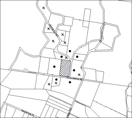
|
NOTIFICATION PLAN |
|||
|
• PROPERTIES NOTIFIED |
X SUBMISSIONS RECEIVED |
PROPERTY SUBJECT OF DEVELOPMENT |
|
|
1 SUBMISSION RECEIVED OUT OF MAP RANGE |
|||
Ten submissions objected to the development, generally on the grounds that the development would result in:
· Traffic impacts;
· Noise and odour impacts;
· Visual impact;
· Out of character with the area; and
· Devaluation of adjoining properties.
The merits of the matters raised in community submissions have been addressed in the body of the report.
5.2 Public Agencies
The development application was not referred to any Public Agencies for comment.
6. THE PUBLIC INTEREST
Section 79C(1)(e) of the Act requires Council to consider “the public interest”.
The public interest is an overarching requirement, which includes the consideration of the matters discussed in this report. Implicit to the public interest is the achievement of future built outcomes adequately responding to and respecting the future desired outcomes expressed in environmental planning instruments and development control plans.
The application is considered to have satisfactorily addressed Council’s criteria and would provide a development outcome that, on balance, would result in a positive impact for the community. Accordingly, it is considered that the approval of the proposed development would be in the public interest.
CONCLUSION
The application proposes alterations and additions to an existing quail farm.
The development generally meets the desired outcomes of Council’s planning controls and is satisfactory having regard to the matters for consideration under Section 79C of the Environmental Planning and Assessment Act 1979.
Council received 10 submissions during the public notification period. The matters raised have been addressed in the body of the report.
Having regard to the circumstances of the case, approval of the application is recommended.
Note: At the time of the completion of this planning report, no persons have made a Political Donations Disclosure Statement pursuant to Section 147 of the Environmental Planning and Assessment Act 1979 in respect of the subject planning application.
RESPONSIBLE OFFICER
The officer responsible for the preparation of this Report is the Manager – Development Assessments – Rodney Pickles, who can be contacted on 9847 6731.
|
Rod Pickles Manager - Development Assessment Planning Division |
James Farrington Group Manager Planning Division |
|
1.View |
Locality Plan |
|
|
|
2.View |
Architectural Plans |
|
|
|
3.View |
Floor Plans |
|
|
|
4.View |
Tree Location Plan |
|
|
File Reference: DA/1673/2015
Document Number: D06976072
SCHEDULE 1
GENERAL CONDITIONS
The conditions of consent within this notice of determination have been applied to ensure that the use of the land and/or building is carried out in such a manner that is consistent with the aims and objectives of the relevant legislation, planning instruments and Council policies affecting the land and does not disrupt the amenity of the neighbourhood or impact upon the environment.
Note: For the purpose of this consent, the term ‘applicant’ means any person who has the authority to act on or the benefit of the development consent.
Note: For the purpose of this consent, any reference to an Act, Regulation, Australian Standard or publication by a public authority shall be taken to mean the gazetted Act or Regulation, or adopted Australian Standard or publication as in force on the date that the application for a construction certificate is made.
1. Approved Plans and Supporting Documentation
The development must be carried out in accordance with the plans and documentation listed below and endorsed with Council’s stamp, except where amended by Council and/or other conditions of this consent:
|
Plan No. |
Plan Title |
Drawn by |
Dated |
|
A01b |
Site Plan |
HPS architects |
16 November 2015 |
|
A02b |
Breeder Shed and Hatchery Floor Plan |
HPS architects |
16 November 2015 |
|
A03b |
Cross Section and Elevation |
HPS architects |
16 November 2015 |
|
A04b |
Elevations |
HPS architects |
16 November 2015 |
|
A05b |
Relocated Residence 2 |
HPS architects |
16 November 2015 |
|
Document Title |
Prepared by |
Dated |
|
Dwg No. D15322, Sheets 1 & 2 Survey Plan |
Chase Burke & Harvey |
8 October 2015 |
|
Environmental Management Plan |
Game Farm Pty Ltd |
December 2015 |
|
On-site Wastewater Management Assessment & Design |
Kerry Flanagan Wastewater |
25 November 2015 |
|
Stormwater Report Job No. SY151-102 |
Van Der Meer Consulting |
December 2015 |
|
Dwg No. DA011, Rev A Drainage Layout |
Van Der Meer Consulting |
23 November 2015 |
|
Dwg No. DA010, Rev A Erosion & Sediment Control |
Van Der Meer Consulting |
17 December 2015 |
|
Tree Location Plan |
Hornsby Shire Council |
11 February 2016 |
2. Removal of Existing Trees
a) This development consent permits the removal of trees numbered 1-11 as identified on the Tree Location Plan prepared by Hornsby Shire Council, dated 11 February 2016 (Document No. D06876994).
b) The removal of any other trees requires separate approval in accordance with the Tree and Vegetation Chapter 1B.6 Hornsby Development Control Plan (HDCP).
3. Construction Certificate
a) A Construction Certificate is required to be approved by Council or a Private Certifying Authority prior to the commencement of any works under this consent.
b) A separate Construction Certificate must be obtained from Council for all works within the public road reserve under S138 of the Roads Act.
c) The Construction Certificate plans must not be inconsistent with the Development Consent plans.
4. Section 94A Development Contributions
a) In accordance with Section 80A(1) of the Environmental Planning and Assessment Act, 1979 and the Hornsby Shire Council Section 94A Development Contributions Plan 2014-2024, $17,000 must be paid to Council to cater for the increased demand for community infrastructure resulting from the development, based on development costs of $1,700,000.
b) The value of this contribution is current as at 14 June 2016. If this contribution is not paid within the financial quarter that this condition was generated, the contribution payable will be adjusted in accordance with the provisions of the Hornsby Shire Council Section 94 Development Contributions Plan and the amount payable will be calculated at the time of payment in the following manner:
$CPY = $CDC x CPIPY
CPIDC
Where:
$CPY is the amount of the contribution at the date of Payment
$CDC is the amount of the contribution as set out in this Development Consent
CPIPY is the latest release of the Consumer Price Index (Sydney – All Groups) at the date of Payment as published by the ABS.
CPIDC is the Consumer Price Index (Sydney – All Groups) for the financial quarter at the date applicable in this Development Consent Condition.
c) The monetary contributions must be paid to Council:
i) prior to the issue of the Subdivision Certificate where the development is for subdivision; or
ii) prior to the issue of the first Construction Certificate where the development is for building work; or
iii) prior to issue of the Subdivision Certificate or first Construction Certificate, whichever occurs first, where the development involves both subdivision and building work; or
iv) prior to the works commencing where the development does not require a Construction Certificate or Subdivision Certificate.
Note: It is the professional responsibility of the Principal Certifying Authority to ensure that the monetary contributions have been paid to Council in accordance with the above timeframes.
Council’s S94A Development Contributions Plan may be viewed at www.hornsby.nsw.gov.au or a copy may be inspected at Council’s Administration Centre during normal business hours.
REQUIREMENTS PRIOR TO THE ISSUE OF A CONSTRUCTION CERTIFICATE
5. Building Code of Australia
All approved building work must be carried out in accordance with the relevant requirements of the Building Code of Australia.
6. Contract of Insurance (Residential Building Work)
Where residential building work for which the Home Building Act, 1989 requires there to be a contract of insurance in force in accordance with Part 6 of that Act, this contract of insurance must be in force before any building work authorised to be carried out by the consent commences.
7. Notification of Home Building Act, 1989 Requirements
Residential building work within the meaning of the Home Building Act 1989 must not be carried out unless the principal certifying authority for the development to which the work relates (not being Council) has given Council written notice of the following information:
a) In the case of work for which a principal contractor is required to be appointed:
i) The name and licence number of the principal contractor; and
ii) The name of the insurer by which the work is insured under Part 6 of that Act.
b) In the case of work to be done by an owner-builder:
i) The name of the owner-builder; and
ii) If the owner-builder is required to hold an owner-builder’s permit under that Act, the number of the owner-builder’s permit.
Note: If arrangements for doing the residential building work are changed while the work is in progress so that the information notified becomes out of date, further work must not be carried out unless the principal certifying authority for the development to which the work relates (not being Council) has given Council written notification of the updated information.
8. Sydney Water – Approval
This application must be submitted to Sydney Water for approval to determine whether the development would affect any Sydney Water infrastructure, and whether further requirements are to be met.
Note: Building plan approvals can be obtained online via Sydney Water Tap inTM through www.sydneywater.com.au under the Building and Development tab.
9. Stormwater Drainage
The stormwater drainage system for the development must be designed for an average recurrence interval (ARI) of 20 years and be gravity drained discharged to the dam within the property and in accordance with the following requirements:
a) Be designed by a Chartered Professional Civil/ Hydraulic Engineer of the Institution of Engineers, Australia
b) Generally constructed in accordance with the drawing number DA011, Rev A Drainage Layout prepared by Van Der Meer Consulting, dated 23 November 2015
10. Internal Driveway/Vehicular Areas
The driveway and parking areas on site must be designed, constructed and a Construction Certificate issued in accordance with Australian Standards 2890.1, 2890.2, 3727 and the following requirements:
a) Design levels at the front boundary be obtained from Council.
b) The driveway be a paved (bitumen sealed or pavement) from the site entry to the site exit.
c) The driveway grade must not exceed 25 percent and changes in grade must not exceed 8 percent.
11. Appointment of a Project Arborist
a) A project Arborist (AQF Level 5) must be appointed to provide monitoring and certification throughout the development process.
b) Details of the appointed project Arborist must be submitted to the PCA and Council for registration with the approved construction certificate.
REQUIREMENTS PRIOR TO THE COMMENCEMENT OF ANY WORKS
12. Erection of Construction Sign
a) A sign must be erected in a prominent position on any site on which any approved work is being carried out:
i) Showing the name, address and telephone number of the principal certifying authority for the work;
ii) Showing the name of the principal contractor (if any) for any demolition or building work and a telephone number on which that person may be contacted outside working hours; and
iii) Stating that unauthorised entry to the work site is prohibited.
b) The sign is to be maintained while the approved work is being carried out and must be removed when the work has been completed.
13. Protection of Adjoining Areas
A temporary hoarding, fence or awning must be erected between the work site and adjoining lands before the works begin and must be kept in place until after the completion of the works if the works:
a) Could cause a danger, obstruction or inconvenience to pedestrian or vehicular traffic;
b) Could cause damage to adjoining lands by falling objects; and/or
c) Involve the enclosure of a public place or part of a public place.
14. Toilet Facilities
a) To provide a safe and hygienic workplace, toilet facilities must be available or be installed at the works site before works begin and must be maintained until the works are completed at a ratio of one toilet for every 20 persons employed at the site.
b) Each toilet must:
i) be a standard flushing toilet connected to a public sewer; or
ii) be a temporary chemical closet approved under the Local Government Act 1993; or
iii) have an on-site effluent disposal system approved under the Local Government Act 1993.
15. Erosion and Sediment Control
To protect the water quality of the downstream environment, erosion and sediment control measures must be provided and maintained throughout the construction period in accordance with the manual ‘Soils and Construction 2004 (Bluebook)’, the approved plans, Council specifications and to the satisfaction of the principal certifying authority. The erosion and sediment control devices must remain in place until the site has been stabilised and revegetated.
Note: On the spot penalties may be issued for any non-compliance with this requirement without any further notification or warning.
16. Installation of Tree Protection
a) All trees retained on site must have tree protection measures for the ground, trunk and canopy installed in accordance with the Australian Standard AS 4970-2009 ‘Protection of Trees on Development Sites.
b) Tree protection zone fencing (TPZF) must be erected around trees numbered 12-22 in accordance with section 1B.6.1.i of Councils DCP. The fencing must be retained at the perimeter of the nominated TPZ setbacks specified in the table below:
|
Tree Number |
TPZF |
|
12-22 |
10m |
17. Tree Protection Zone Ground Protection
All Tree Protection Zones must have a layer of wood-chip mulch installed prior to works commencing and must be maintained throughout the period of construction at a depth of 150mm - 300mm using material that complies with Australian Standard AS 4454.
18. Tree Protection Certification
A certificate from the project Arborist must be submitted to the Principal Certifying Authority and Council stating compliance with the relevant tree protection conditions of this consent.
REQUIREMENTS DURING DEMOLITION AND CONSTRUCTION
19. Construction Work Hours
All works on site, including demolition and earth works, must only occur between 7am and 5pm Monday to Saturday.
No work is to be undertaken on Sundays or public holidays.
20. Demolition
To protect the surrounding environment, all demolition work must be carried out in accordance with “Australian Standard 2601-2001 – The Demolition of Structures” and the following requirements:
a) Demolition material must be disposed of to an authorised recycling and/or waste disposal site and/or in accordance with an approved waste management plan;
b) Demolition works, where asbestos material is being removed, must be undertaken by a contractor that holds an appropriate licence issued by WorkCover NSW in accordance with Chapter 10 of the Occupational Health and Safety Regulation 2001 and Clause 29 of the Protection of the Environment Operations (Waste) Regulation 2005 ;and
c) On construction sites where any building contain asbestos material, a standard commercially manufactured sign containing the words ‘DANGER ASBESTOS REMOVAL IN PROGRESS’ and measuring not less than 400mm x 300mm must be displayed in a prominent position visible from the street.
21. Environmental Management
The site must be managed in accordance with the publication ‘Managing Urban Stormwater – Landcom (March 2004) and the Protection of the Environment Operations Act 1997 by way of implementing appropriate measures. To prevent sediment run-off, excessive dust, noise or odour emanating from the site during the construction of the development.
22. Works Near Trees
a) The project Arborist must monitor and record any necessary remedial actions for maintaining tree health and condition required for trees numbered 12-22.
b) The appointed project Arborist must monitor and record all changes or modifications to required tree protection measures for the period of construction.
c) The project Arborist must submit to the principal certifying authority on a monthly basis a certificate that the works have been carried out in compliance with the approved plans and specifications for tree protection. Certification should include a statement of site attendance, the condition of the retained trees, details of any deviations from the approved tree protection measures and their impacts on trees. Copies of monitoring documentation may be required.
23. Building Materials and Site Waste
The filling or stockpiling of building materials, the parking of vehicles or plant, the disposal of cement slurry, waste water or other contaminants must be located outside the tree protection zones as prescribed in the conditions of this consent or the prescriptive measures of Part 1B.6.1 Tree Preservation of the Hornsby Development Control Plan, 2013, of any tree to be retained.
24. Council Property
To ensure that the public reserve is kept in a clean, tidy and safe condition during construction works, no building materials, waste, machinery or related matter is to be stored on the road or footpath.
25. Disturbance of Existing Site
During construction works, the existing ground levels of open space areas and natural landscape features, including natural rock-outcrops, vegetation, soil and watercourses must not be altered unless otherwise nominated on the approved plans.
26. Landfill
Landfill must be constructed in accordance with Council’s ‘Construction Specification 2005’ and the following requirements and all fill material imported to the site is to wholly consist of Virgin Excavated Natural Material (VENM) as defined in Schedule 1 of the Protection of the Environment Operations Act, 1997 or a material approved under the Department of Environment and Climate Change’s general resource recovery exemption.
27. Excavated Material
All excavated material removed from the site must be classified by a suitably qualified person in accordance with the Department of Environment, Climate Change and Water NSW Waste Classification Guidelines prior to disposal to an approved waste management facility and be reported to the principal certifying authority prior to the issue of an Occupation Certificate.
REQUIREMENTS PRIOR TO THE ISSUE OF AN OCCUPATION CERTIFICATE
Note: For the purpose of this consent, a reference to ‘occupation certificate’ shall not be taken to mean an ‘interim occupation certificate’ unless otherwise stated.
28. Smoke Alarms – Relocated Dwelling
To warn the occupants of the development in the event of a fire, smoke alarms must be installed in the relocated dwelling in accordance with the requirements of the Building Code of Australia.
29. External Lighting
a) To protect the amenity of adjacent premises, all external lighting must be designed and installed in accordance with Australian Standard AS 4282 – Control of the Obtrusive Effects of Outdoor Lighting.
b) Certification of compliance with this Standard must be obtained from a suitably qualified person and submitted to the PCA with the application for the Construction Certificate.
30. Completion of Works and Compliance Certificate
All engineering works identified in this consent are to be completed and a Compliance Certificate issued prior to the release of the Occupation Certificate.
31. Wastewater System Approval
a) An on-site sewage management system, separately approved under the Local Government Act, 1993, must be installed, commissioned and certified by a licensed plumber in accordance with Australian Standard 1547 – Onsite Domestic Wastewater Management (2000) and Environment & Health Protection Guidelines – Onsite Sewage Management for Single Households (1998).
b) The certificate must be submitted to the PCA prior to the issue of an occupation certificate.
32. Maintain Canopy Cover
a) To maintain canopy cover, a minimum of 10 trees are to be planted on the subject site. The trees must be species selected from the Council’s Indigenous species listing located in the Hornsby Shire DCP Tree Preservation Measures 1B.6 Table 1B.6(b) such as Angophora costata, Angophora floribunda, Eucalyptus elata, Banksia integrifolia.
b) Location and Size of Plantings
i) Replacement Trees must be located in front or rear setbacks and setback 4 metres or greater from the foundation walls of the approved development.
ii) The pot size of the replacement tree(s) must be a minimum 25 litres and replacement tree(s) must be maintained until they reach the height of 3 metres.
iii) The replacement trees must reach a mature height greater than 15 metre.
iv) All tree stock must meet the specifications outlined in ‘Specifying Trees’ by Ross Clark (NATSPEC Books).
v) Planting methods must meet professional (best practice) industry standards
c) The suitably qualified person holding a certificate III in Horticulture must submit to the principal certifying authority a statement confirming all landscaping requirements has been completed in accordance with approved landscape plans and conditions of consent.
33. Final Certification Arborist
a) The Project Supervisor must submit to the principal certifying authority all relevant certificates with the application for the occupation certificate stating compliance with all the conditions of this consent.
b) The Project Arborist must submit to the principal certifying authority a certificate that all the completed works have been carried out in compliance with the approved plans and specifications for tree protection. Certification must include a statement of overall site attendance, the condition of the retained trees, details of any deviations from the approved tree protection measures and their impacts on trees. Copies of monitoring documentation may be required.
OPERATIONAL CONDITIONS
34. Use of Premises
The development approved under this consent shall be used for ‘‘intensive livestock agriculture’ and ‘rural workers’ dwelling’ and not for any other purpose without Council’s separate written consent.
35. Rural Workers Dwelling
The person(s) occupying the rural workers dwelling must be engaged in full-time agricultural based employment on the subject property. Upon cessation of the person(s) occupying the rural workers dwelling being in full-time agricultural based employment on the property, the rural worker's dwelling must be demolished or removed from the property forthwith.
36. Environmental Management
The operation of the site must be undertaken in accordance with the Environmental Management Plan prepared by Game Farm Pty Ltd, dated December 2015.
37. Car Parking and Deliveries
a) Vehicles awaiting loading, unloading or servicing must be parked on site and not on adjacent or nearby public roads; and
b) All vehicular entry on to the site and egress from the site must be made in a forward direction.
38. Noise
All noise generated by the proposed development must be attenuated to prevent levels of noise being emitted to adjacent premises which possess tonal, beating and similar characteristics or which exceeds background noise levels by more than 5dB(A).
39. Storage of Flammable and Combustible Goods
Flammable and combustible liquids must be stored in accordance with Australian Standard 1940 – The Storage and Handling of Flammable and Combustible Liquids. A bund wall must be constructed around all work and liquid storage areas to prevent any spillage entering into the stormwater system. The bunded area must provide a volume equal to 110% of the largest container stored and graded to a blind sump so as to facilitate emptying and cleansing.
40. Maintenance of Wastewater Device
All wastewater and stormwater treatment devices (including drainage systems, sumps and traps) must be regularly maintained in order to remain effective. All solid and liquid wastes collected from the device must be disposed of in accordance with the Protection of the Environment Operations Act 1997.
- END OF CONDITIONS -
ADVISORY NOTES
The following information is provided for your assistance to ensure compliance with the Environmental Planning and Assessment Act 1979, Environmental Planning and Assessment Regulation 2000, other relevant legislation and Council’s policies and specifications. This information does not form part of the conditions of development consent pursuant to Section 80A of the Act.
Environmental Planning and Assessment Act 1979 Requirements
The Environmental Planning and Assessment Act 1979 requires:
· The issue of a construction certificate prior to the commencement of any works. Enquiries can be made to Council’s Customer Services Branch on 9847 6760.
· A principal certifying authority to be nominated and Council notified of that appointment prior to the commencement of any works.
· Council to be given at least two days written notice prior to the commencement of any works.
· Mandatory inspections of nominated stages of the construction inspected.
· An occupation certificate to be issued before occupying any building or commencing the use of the land.
Long Service Levy
In accordance with Section 34 of the Building and Construction Industry Long Service Payments Act 1986, a ‘Long Service Levy’ must be paid to the Long Service Payments Corporation or Hornsby Council.
Note: The rate of the Long Service Levy is 0.35% of the total cost of the work.
Note: Hornsby Council requires the payment of the Long Service Levy prior to the issue of a construction certificate.
Tree and Vegetation Preservation
In accordance with Clause 5.9 of the Hornsby Local Environmental Plan 2013 a person must not ringbark, cut down, top, lop, remove, injure or wilfully destroy any tree or other vegetation protected under the Hornsby Development Control Plan 2013 without the authority conferred by a development consent or a permit granted by Council.
Notes: A tree is defined as a long lived, woody perennial plant with one or relatively few main stems with the potential to grow to a height greater than three metres (3M). (HDCP 1B.6.1.c).
Tree protection measures and distances are determined using the Australian Standard AS 4970:2009, “Protection of Trees on Development Sites”.
Fines may be imposed for non-compliance with both the Hornsby Local Environmental Plan 2013 and the Hornsby Development Control Plan 2013.
Covenants
The land upon which the subject building is to be constructed may be affected by restrictive covenants. Council issues this approval without enquiry as to whether any restrictive covenant affecting the land would be breached by the construction of the building, the subject of this consent. Applicants must rely on their own enquiries as to whether or not the building breaches any such covenant.
Advertising Signage – Separate DA Required
This consent does not permit the erection or display of any advertising signs. Most advertising signs or structures require development consent. Applicants should make separate enquiries with Council prior to erecting or displaying any advertising signage.
Dial Before You Dig
Prior to commencing any works, the applicant is encouraged to contact Dial Before You Dig on 1100 or www.dialbeforeyoudig.com.au for free information on potential underground pipes and cables within the vicinity of the development site.
Telecommunications Act 1997 (Commonwealth)
If you are aware of any works or proposed works which may affect or impact on Telstra’s assets in any way, you are required to contact: Telstra’s Network Integrity Team on Phone Number 1800810443.
Asbestos Warning
Should asbestos or asbestos products be encountered during demolition or construction works, you are advised to seek advice and information prior to disturbing this material. It is recommended that a contractor holding an asbestos-handling permit (issued by WorkCover NSW)be engaged to manage the proper handling of this material. Further information regarding the safe handling and removal of asbestos can be found at:
Alternatively, telephone the WorkCover Asbestos and Demolition Team on 8260 5885.
Group Manager’s Report No. PL45/16
Planning Division
Date of Meeting: 13/07/2016
5 DEVELOPMENT APPLICATION - TORRENS TITLE SUBDIVISION OF ONE ALLOTMENT INTO TWO LOTS AND RETENTION OF THE EXISTING DWELLING - 17 CANNAN CLOSE, CHERRYBROOK
EXECUTIVE SUMMARY
|
DA No: |
DA/314/2016 (Lodged on 18 March 2016) |
|
Description: |
Torrens title subdivision of one allotment into two lots and retention of an existing dwelling |
|
Property: |
Lot 1035 DP 812942, No. 17 Cannan Close, Cherrybrook |
|
Applicant: |
Key Urban Planning |
|
Owner: |
Mrs Suying Chen |
|
Estimated Value: |
Nil |
· The application involves Torrens title subdivision of one allotment into two lots and retention of an existing dwelling.
· The proposal generally complies with the Hornsby Local Environmental Plan 2013 and the Hornsby Development Control Plan 2013.
· The application is the subject of an appeal in the NSW Land and Environment Court against Council’s deemed refusal of the proposal.
· Eighteen submissions have been received in respect of the application.
· It is recommended that the application be approved.
|
THAT Development Application No. DA/314/2016 for Torrens title subdivision of one allotment into two lots and retention of an existing dwelling at Lot 1035 DP 812942, No. 17 Cannan Close, Cherrybrook be approved subject to the conditions of consent detailed in Schedule 1 of Group Manager’s Report No. PL45/16. |
BACKGROUND
On 12 May 1989, Council approved DA/608/1988 for residential subdivision of Woodgrove Avenue, Castle Hill creating 41 residential lots, a public reserve dedication and a residue lot. This subdivision created the lots within Darlington Drive, Cannan Close, and Greywood Street.
On 20 June 1990, Council approved DA/74/1989 for subdivision creating 35 residential lots, 2 residue lots and construction of a section of the County Link Road.
The subject site comprises of Lot 108 (788m2) of DP 806547 (created under DA/608/1988) and approved Lot 1035 (812m2) created under DA/74/1989. The Subdivision Certificate subsequently sought consolidated Lot 108 with approved Lot 1035 at the request of the applicant to enhance allotment building platforms.
On 16 May 2012, Council considered a report on Development Application No. DA/186/2012 for subdivision of one allotment into two lots. The proposed subdivision was generally the same as the application which is the subject of this report. Council resolved to refuse the application for the following reasons:
1.1 Pursuant to Section 79C(1)(a)(i) of the Environmental Planning and Assessment Act 1979, the proposal is unsatisfactory as the State Environmental Planning Policy No. 1 objection relating to non-compliance with the applicable floor space ratio provision is not well founded.
1.2 The proposal is unsatisfactory in respect to Section 79C(1)(a)(iii) of the Environmental Planning and Assessment Act 1979, as the proposed subdivision layout is contrary to the objective of the Residential Subdivision DCP to enhance the established character of the area.
1.3 Pursuant to the provisions of Section 79C(1)(e) of the Environmental Planning and Assessment Act 1979, the proposed development would not be in the public interest.
1.4 Pursuant to Section 79C(1)(b) of the Environmental Planning and Assessment Act 1979, the proposed subdivision would result in a residual allotment in which the size and shape of private open space is insufficient having regard to the size of the dwelling on the land.
1.5 Pursuant to Section 79C(1)(b) of the Environmental Planning and Assessment Act 1979, the proposed subdivision would result in a dwelling that is inconsistent with the established streetscape.
Council also resolved to convene a meeting between available Councillors and residents of Cannan Close to outline the process and implications of establishing a heritage conservation area (HCA) to protect Cannan Close, Cherrybrook.
On 25 May 2012, the applicant made application for a review of the determination under Section 82A of Environmental Planning and Assessment Act 1979.
On 11 July 2012, a meeting was held with residents of Cannan Close. At the conclusion of the meeting, it was agreed that Council would commission a preliminary heritage review by a consultant and residents were invited to make submissions identifying their position in relation to establishing a HCA to protect Cannan Close. Council subsequently received 7 submissions, including a submission from the Cannan Close and Friends Residents Association supporting the establishment of a HCA and/or the commissioning of a comprehensive heritage assessment report for Cannan Close.
On 17 October 2012, Council considered Group Manager's Report No. PL28/12 regarding the recommendations of a preliminary heritage assessment report and resolved not to pursue the establishment of a Heritage Conservation Area for Cannan Close. The heritage assessment undertaken by Council’s heritage consultant advised that, under NSW Heritage Assessment criteria, Cannan Close does not merit listing as a HCA.
On 17 October 2012, Council considered Group Manager's Report No. PL24/12 and resolved to defer the determination of the Section 82A Review of Development Application No.186/2012 to facilitate an on-site meeting with residents, the owner and Councillors.
On 22 October 2012, the applicant lodged a Class 1 Appeal in the Land and Environment Court against Council’s refusal of the original development application.
On 25 October 2012, an onsite meeting was held to discuss the application. The meeting was attended by the applicant, owner, residents of Cannan Close, available Councillors and Council officers. At the conclusion of the meeting, it was noted that Planning Report No. PLN 24/12 assessing the matter should be referred back to Council for its consideration. The report concluded that, based on the planning merits of the case, the application should be approved subject to recommended conditions of consent.
On 14 November 2012, Council considered Group Manager's Report No. PL44/12 and resolved to confirm its determination of Development Application No. DA/186/2012 and refuse the review of the application pursuant to Section 82A of the Environmental Planning and Assessment Act 1979. The review was refused for the same reasons as the original application.
On 5 December 2012, the applicant discontinued the Class 1 Appeal.
On 18 March 2016, Development Application No. DA/314/2016 was lodged seeking Torrens title subdivision of one allotment into two lots. This application is the subject of this report.
On 30 May 2016, the applicant lodged a Class 1 Appeal in the Land and Environment Court against Council’s deemed refusal of the abovementioned application.
SITE
The site is located on the northern side of Cannan Close at the end of the cul-de-sac and experiences an average gradient of 7% from the front, south-eastern corner to the north-eastern corner.
The site is an irregular trapezoidal shaped allotment with curved front boundary of 40 metres and has an area of 1468.5m2.
An existing two-storey brick dwelling-house is located on the eastern side of the site and a tennis court is located on the western side of the site. An easement to drain water exists at the north-western corner of the site.
The surrounding area is primarily low density residential with two storey dwelling-houses. The site is approximately 250 metres south of New Line Road.
PROPOSAL
The application proposes Torrens title subdivision of one allotment into two lots and retention of the existing dwelling.
Proposed Lot A is a trapezoidal-shaped lot with a curved frontage to Cannan Close, an area of 911.89m2 and an average gradient of 5.7% from the south-eastern corner to the north-western corner. An existing two storey brick dwelling-house would be retained on the lot.
Proposed Lot B would be positioned in lieu of the existing tennis court to be demolished and have an area of 556.72m2. This lot would have a 13.11 metre frontage to Cannan Close and an average gradient of 4.1% from the southern boundary to the northern boundary.
ASSESSMENT
The development application has been assessed having regard to ‘A Plan for Growing Sydney’, the ‘North Subregion (Draft) Subregional Strategy’ and the matters for consideration prescribed under Section 79C of the Environmental Planning and Assessment Act 1979 (the Act). The following issues have been identified for further consideration.
1. STRATEGIC CONTEXT
1.1 A Plan for Growing Sydney and (Draft) North Subregional Strategy
A Plan for Growing Sydney has been prepared by the NSW State Government to guide land use planning decisions for the next 20 years. The Plan sets a strategy for accommodating Sydney’s future population growth and identifies the need to deliver 689,000 new jobs and 664,000 new homes by 2031. The Plan identifies that the most suitable areas for new housing are in locations close to jobs, public transport, community facilities and services.
The NSW Government will use the subregional planning process to define objectives and set goals for job creation, housing supply and choice in each subregion. Hornsby Shire has been grouped with Hunters Hill, Ku-ring-gai, Lane Cove, Manly, Mosman, North Sydney, Pittwater, Ryde, Warringah and Willoughby to form the North Subregion. The Draft North Subregional Strategy will be reviewed and the Government will set housing targets and monitor supply to ensure planning controls are in place to stimulate housing development.
The proposed development would be consistent with ‘A Plan for Growing Sydney’, by providing an additional allotment capable of accommodating a future dwelling house.
2. STATUTORY CONTROLS
Section 79C(1)(a) requires Council to consider “any relevant environmental planning instruments, draft environmental planning instruments, development control plans, planning agreements and regulations”.
2.1 Hornsby Local Environmental Plan 2013
The proposed development has been assessed having regard to the provisions of the Hornsby Local Environmental Plan 2013 (HLEP).
2.1.1 Zoning of Land and Permissibility
The subject land is zoned R2 Low Density Residential under the HLEP 2013. The objectives of the R2 Low Density Residential zone are:
· To provide for the housing needs of the community within a low density residential environment.
· To enable other land uses that provide facilities or services to meet the day to day needs of residents.
The proposed development is defined as “subdivision” and is permissible in the zone with Council’s consent.
2.1.2 Minimum Lot Size
Clause 4.1 of the HLEP provides that the subdivision lot size should not be less than the minimum areas shown for the land on the Lot Size Map. The minimum lot size for the subject site is 500m2.The proposed lots have an area of 911.86m2 (Lot A) and 556.72m2 (Lot B), which complies with this control.
2.1.3 Floor Space Ratio
Clause 4.4 of the HLEP provides that the FSR of a building should not exceed the maximum FSR shown for the land on the Floor Space Ratio Map. The Floor Space Ratio map does not prescribe a maximum FSR for the site.
2.1.4 Heritage Conservation
Clause 5.10 of the HLEP sets out heritage conservation provisions for Hornsby Shire. The site does not include a heritage item and is not located in a heritage conservation area. However, in accordance with the undertaking provided at the Council meeting on 11 July 2012, Council sought an assessment on the likelihood of Cannan Close fulfilling the criteria for listing as a Heritage Conservation Area. A heritage assessment was prepared by Council’s heritage consultant, John Oultram Heritage & Design.
In summary, the heritage assessment noted that the existing subdivision layout is typical of development in the area and does not demonstrate any particular advancement in planning terms. There is a general pattern to the houses in terms of scale, form, materials and detail and they are recognisable as being from the same stable of designs. The houses are larger and have greater articulation than many of the other houses in the area and are of a higher architectural quality. Though there are similar houses in the surrounding area and in other streets that have a similar development pattern.
The heritage assessment made comments that the buildings in Cannan Close are a hybrid form of the Inter War and Federations styles and do not mark a new or aesthetically important typology. The assessment noted that while the area has a consistent character due to the scale and stylistic uniformity of the houses, it has little aesthetic or historic qualities that would merit it being listed as a conservation area.
The assessment concluded that, having regard to the heritage assessment criteria, Cannan Close does not merit listing as a Heritage Conservation Area.
2.1.5 Earthworks
Clause 6.2 of the HLEP states that consent is required for proposed earthworks on site. Before granting consent for earthworks, Council is required to assess the impacts of the works on adjoining properties, drainage patterns and soil stability of the locality.
The earthworks proposed as part of this application are limited to minor earthworks to facilitate the construction of a stormwater drainage system. Council’s assessment of the proposed works and excavation concludes that the works are unlikely to have a detrimental effect on drainage patterns and soil stability in the locality of the development, subject to recommended consent conditions.
2.2 State Environmental Planning Policy No. 55 – Remediation of Land
The Policy provides guidelines for the remediation of contaminated land for the purpose of reducing the risk of harm to human health or any other aspect of the environment. Clause 7 requires Council to consider whether land is contaminated prior to granting consent to the carrying out of any development on that land.
Should the land be contaminated, Council must be satisfied that the land is suitable in a contaminated state for the proposed use. If the land requires remediation to be undertaken to make the land suitable for the proposed use, Council must be satisfied that the land will be remediated before the land is used for that purpose.
Given the site has a history of residential use it is not likely that the site has experienced any significant contamination, and further assessment under SEPP 55 is not required.
2.3 Sydney Regional Environmental Plan No. 20 – Hawkesbury-Nepean River
The site is located within the catchment of the Hawkesbury Nepean River. Part 2 of this Plan contains general planning considerations and strategies requiring Council to consider the impacts of development on water quality, aquaculture, recreation and tourism.
Subject to the implementation of sediment and erosion control measures and stormwater management to protect water quality, the proposal would comply with the requirements of the Policy.
2.4 Clause 74BA Environmental Planning and Assessment Act, 1979 - Purpose and Status of Development Control Plans
Clause 74BA of the Environmental Planning and Assessment Act, 1979 states that a DCP provision will have no effect if it prevents or unreasonably restricts development that is otherwise permitted and complies with the development standards in relevant Local Environmental Plans and State Environmental Planning Policies.
The principal purpose of a development control plan is to provide guidance on the aims of any environmental planning instrument that applies to the development; facilitate development that is permissible under any such instrument; and achieve the objectives of land zones. The provisions contained in a DCP are not statutory requirements and are for guidance purposes only. Consent authorities have flexibility to consider innovative solutions when assessing development proposals, to assist achieve good planning outcomes.
2.5 Hornsby Development Control Plan 2013
The proposed development has been assessed having regard to the relevant desired outcomes and prescriptive requirements within the Hornsby Development Control Plan 2013 (HDCP). The following table sets out the proposal’s compliance with the prescriptive requirements of the Plan:
|
Hornsby Development Control Plan 2013 Part 3 – Dwelling House and Part 6 – Subdivision |
|||
|
Control |
Proposal |
Requirement |
Compliance |
|
Site Area |
1468.5m2 |
N/A |
N/A |
|
Lot Area Lot A Lot B |
911.86m2 556.72m2 |
500m2 500m2 |
Yes Yes |
|
Lot Width (building line) Lot A Lot B |
24m 13m |
12m 12m |
Yes Yes |
|
Lot A – Existing Dwelling |
|||
|
Site Area |
911.86m2 |
500m2 |
Yes |
|
Floor Area of Existing Dwelling |
510m2 |
430m2 |
No |
|
Setbacks |
|
|
|
|
- Front |
9m |
9m |
Yes |
|
- Side (West) |
3.8m |
0.9m (up to 1 storey) 1.5m (2 storey element) |
Yes |
|
- Side (East) |
1m |
0.9m |
Yes |
|
- Rear |
1m |
8m |
No |
|
Site Coverage |
39% |
40% (max) |
Yes |
|
Landscaping Soft Landscape Area Front Yard |
29.3% 168m2 (54.7% of front yard) |
40% 153m2 (50% of front yard) |
No Yes
|
|
Private Open Space |
>24m2 |
24m2 |
Yes |
|
Parking |
3 spaces |
2 spaces |
Yes |
|
Lot B – Proposed Building Envelope |
|||
|
Site Area |
556.72m2 |
500m2 |
Yes |
|
Building Envelope with a minimum dimension of 10 metres |
212m2 (Excluding the envelope area 7.5m wide adjacent to the southern boundary) |
200m2 |
Yes |
|
Building Envelope Setbacks |
|
|
|
|
- Front |
11m |
9m |
Yes |
|
- Side (West) |
1m |
0.9m |
Yes |
|
- Side (East) |
1m |
0.9m |
Yes |
|
- Rear |
11m |
5m |
Yes |
|
Landscaping |
52% |
20% |
Yes |
|
Private Open Space |
>24m2 |
24m2 |
Yes |
|
Car Parking |
2 spaces |
2 spaces |
Yes |
As detailed in the above table, the proposed development generally complies with the prescriptive measures within the HDCP, with the exception of the floor area and landscaping for the existing dwelling house. A brief discussion on compliance with relevant performance requirements is provided below.
2.5.1 Floor Area
The existing building on proposed Lot A would have a floor area, as defined by the HDCP and the NSW Housing Code, of 510sqm. For a lot size greater than 900m2, a maximum dwelling size of 430m2 is prescribed in the HDCP. To achieve technical compliance with the numerical floor space controls of the HDCP, 80sqm could be removed from the rear of the building, comprising a single storey element and a covered veranda. However, the removal would have no impact on the character of the area and little impact on the relationship of the existing dwelling to adjoining neighbours. It considered that strict compliance with the maximum floor area for proposed Lot A would not achieve any benefit in respect to residential amenity or the character of the locality. It is unreasonable to insist on strict compliance with the numerical floor area provision of the HDCP.
In addition, review of the Building Approvals for the adjacent dwelling houses in Cannan Close found that the neighbouring properties would also exceed the maximum floor area controls.
2.5.2 Lot Size, Lot Shape and Setbacks
Lot A accommodates an existing dwelling-house. The size of the proposed lot A is in excess of the minimum prescribed in the HLEP. The retention of the dwelling-house on Lot A would comply with the prescriptive measures in the HDCP for site coverage, private open space, front yard landscaping and parking. The existing building setbacks to the southern, eastern and northern boundaries are unaltered.
The existing building on Lot A would have a 2.8 metre setback to the new western boundary, in excess of the minimum side setback provision of 0.9 metres. Submissions raise concerns that the existing dwelling does not comply with the rear setback requirement of the HDCP. The rear boundary would not be altered by the proposed subdivision and the rear setback of the existing dwelling on proposed Lot A is an existing encroachment. In this regard, the visual and amenity impacts on adjoining properties would be consistent with the existing development and is considered acceptable in respect to the Setback requirements of the HDCP.
Lot B would be a vacant allotment. The HDCP requires vacant lots to be able to accommodate a building envelope of 200m2 with a minimum dimension of 10 metres that complies with the setback provisions. The indicative building envelope illustrated on the subdivision plans has an envelope of 244m2. However, this incorporates an envelope area at the front of the site that does not comply with the minimum envelope dimension.
Proposed Lot B could accommodate a 200m2 indicative building envelope that would be compliant with the prescriptive measures for site coverage, private open space, setbacks, landscaping and parking, as detailed in the above table. The proposed lot would facilitate development that is consistent with the capacity of the site and the low density residential zone. There would be an acceptable level of amenity provided in respect to privacy of a future dwelling-house on proposed Lot B and private open space for the future and existing dwelling-house.
Proposed Lots A and B would have a frontage of 24 metres and 13 metres to Cannan Close, respectively. A number of submissions raise concern that the frontage of Lot B is too narrow as the majority of lots in Cannan Close typically have a wide frontage. The HDCP requires that lots be designed to be able to accommodate a building envelope with a minimum dimension of 10 metres and a side setback of 0.9 metre. Both proposed lots comply with the minimum 12m width requirement of the HDCP. The building envelope submitted demonstrates that the proposed new allotment would be capable of accommodating a 2 storey dwelling-house of a bulk and scale commensurate with the bulk and scale of existing low density residential development in the Cherrybrook locality and the streetscape.
Whilst the proposed subdivision would result in reduced lot sizes, the lot size and design remains generally consistent with the existing subdivision pattern in the locality.
2.5.3 Private Open Space
Submissions raise concerns regarding insufficient private open space for the existing dwelling-house as a result of the proposed subdivision and that the open space for Lot A would be mostly hard surface area.
The size and shape of private open space on both lots exceeds the requirements of the HDCP and the complying development provisions of the NSW Housing Code, as summarised in the table below. There is no requirement prescribing that the open space area is to be hard and/or soft landscaping.
|
Private Open Space (rear) |
Proposed Minimum |
Hornsby DCP Minimum |
NSW Housing Code Minimum |
|||
|
Dimension |
Area |
Dimension |
Area |
Dimension |
Area |
|
|
Lot A |
8-9m |
135sqm |
3m |
24sqm |
3m |
24sqm |
|
Lot B |
11-12m |
155sqm |
3m |
24sqm |
3m |
24sqm |
Accordingly, the size and shape of private open space on both lots exceeds the requirements of the HDCP and the complying development provisions of the NSW Housing Code.
2.5.4 Landscaping
Submissions raise concerns that insufficient landscaping would be provided for Lot A. The proportion of Lot A that would be built-upon and available for landscaping is summarised in the table below:
|
Site Coverage and Landscaping on Lot A |
||
|
Element |
Proposed |
HDCP |
|
Site Coverage |
39% |
max 40% |
|
Landscaping |
|
|
|
Soft Landscaping |
29.3% |
min 40% |
|
Hard Landscaping |
16.6% |
|
|
Total Landscaping |
45.9% |
|
|
Driveway |
15.1% |
|
|
Total Site |
100% |
|
The HDCP requires that 40% of the site should be landscaped area. Landscaping is defined as “part of the site used for growing plants, grasses and trees but does not include any building, structure or hard paved area.” The existing dwelling on proposed Lot A would not comply with the 45% landscaping requirements of the HDCP. However, the existing dwelling is compliant with the 50% landscaping requirement within the front yard. In addition, it is not unusual in Cannan Close for properties to have a large proportion of hard landscaping, such as paved outdoor private open space areas and extensive driveways. Therefore, the percentage of landscaping proposed for Lot A would be consistent with other properties in the street.
In addition, some of the submissions raise concern that the private open space to the rear of Lot A would be fully paved with no soft landscaping area. The subdivision plan proposes to incorporate part of the tennis court into Lot A. The recommended consent conditions require this area to be turfed. Therefore, the application would increase the total area of soft landscaping behind the front building line of the existing dwelling.
2.6 Section 94 Contributions Plans
Hornsby Shire Council Section 94 Contributions Plan 2012-2021 applies to the development as it would result in an additional allotment. Accordingly, the requirement for a monetary Section 94 contribution is recommended as a condition of consent.
3. ENVIRONMENTAL IMPACTS
Section 79C(1)(b) of the Act requires Council to consider “the likely impacts of that development, including environmental impacts on both the natural and built environments, and social and economic impacts in the locality”.
3.1 Natural Environment
3.1.1 Tree and Vegetation Preservation
Concerns are raised in submissions that the loss of trees in the front setback would have a detrimental impact on the streetscape. The site comprises a number of exotic, native planted trees and locally indigenous specimens. There are currently 18 trees in the front setback of Lot B, of which 8 trees are indigenous and protected by the HDCP. There is currently no approval sought for the construction of a new driveway or dwelling on proposed Lot B. However, there is adequate setback on the western side boundary of proposed Lot B that could accommodate a new driveway. The proposed new driveway would necessitate the removal of one indigenous tree and two trees which are exempt.
In addition, with the provision of a 9 metre front building line on proposed Lot B, a future dwelling could be sited more than 4 metres from the indigenous trees. Accordingly, the majority of the indigenous trees could be maintained. Notwithstanding, Council’s assessment of the proposal included a detailed examination of the existing trees on site and none of the indigenous trees are significant as the trees do not meet Council’s criteria with respect to significant trees.
3.1.2 Stormwater Management
An inter-allotment drainage easement would be required to service the proposed development as the property slopes to the rear. The subject allotment has the benefit of an existing drainage easement contained within DP 806547. The drainage easement is located along the rear of the site.
3.2 Built Environment
3.2.1 Built Form and Streetscape
A number of submissions raise concerns that the proposal is inconsistent with the established streetscape in respect to narrow road frontages, small lot sizes, and a future dwelling design which would be inconsistent with the established built form.
The proposed subdivision would result in a reduced frontage of the existing allotment. The 13.1 metre frontage of proposed Lot B would be generally consistent with the frontages of the adjoining allotments at the end of the cul-de-sac at Nos. 19, 20 and 21 Cannan Close. The adjoining allotments however, are fan shaped allotments that are larger towards the rear, which would make dwelling-houses appear to be less bulky in relation to their lots.
The 556.72m2 lot size of proposed Lot B would be smaller than other allotments in Cannan Close. However, subdivision is permissible within the R2 Low Density Residential Zone and the proposal complies with the 500m2 development standard under the HLEP. The proposed subdivision would provide for the housing needs of the community within a low density residential environment. In this regard, the development would meet the objectives of the zone.
Notwithstanding that the existing dwelling-houses within Cannan Close were erected by the same developer with a similar built form, it would be unrealistic to expect that the current streetscape would remain in perpetuity. The area is not identified as a heritage conservation area and ‘demolition’ and ‘dwelling-houses’ are permissible developments within the R2 Low Density Residential zone and applications for such developments could be progressed as development applications or Complying Development.
Furthermore, proposed Lot B would be a rectangular shaped allotment that is not burdened by topographical or environmental constraints. In this regard, a future dwelling-house could be designed and positioned on the newly created allotment that is consistent with the established built form in terms of height, setbacks, landscaping and private open space while retaining amenity to adjoining properties in respect to privacy and solar access. The width of the lot complies with the prescriptive measures for Lot Shape in the HDCP.
The recommended consent conditions clarify that the proposed building envelope on Lot B shown on the plan of subdivision is not approved. Any future application for a dwelling-house on Lot B made pursuant to the provisions of the HDCP and the NSW Housing Code would require a larger front and side setback than indicated on the proposed plans. Alternatively, a development application would need to be submitted to the Council for a merit assessment.
3.2.2 Traffic
Concerns are raised in submissions that the development would result in increased traffic and reduce available on-street parking. The increase in traffic generated by an additional dwelling-house would be minor and does not warrant refusal of the application. On-site carparking would be required to be provided for any future dwelling on Lot B. Furthermore, the design of proposed Lot B allows for the front setback area/driveway to be available for visitor parking.
3.3 Social Impacts
The proposed development would not result in a social impact.
3.4 Economic Impacts
The proposal would have a minor positive impact on the local economy in conjunction with other new low density residential development in the locality by generating an increase in demand for local services.
4. SITE SUITABILITY
Section 79C(1)(c) of the Act requires Council to consider “the suitability of the site for the development”.
The subject site has not been identified as bushfire prone or flood prone land. The site is considered to be capable of accommodating the proposed development. The scale of the proposed development is consistent with the capability of the site and is considered acceptable.
5. PUBLIC PARTICIPATION
Section 79C(1)(d) of the Act requires Council to consider “any submissions made in accordance with this Act”.
5.1 Community Consultation
The proposed development was placed on public exhibition and was notified to adjoining and nearby landowners between 7 April 2016 and 21 April 2016 in accordance with the Notification and Exhibition requirements of the HDCP. During this period, Council received eighteen submissions. The map below illustrates the location of those nearby landowners who made a submission that are in close proximity to the development site.
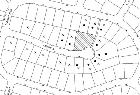
|
NOTIFICATION PLAN |
|
||
|
• PROPERTIES NOTIFIED
|
X SUBMISSIONS RECEIVED |
PROPERTY SUBJECT OF DEVELOPMENT
|
|
Eighteen submissions objected to the development, generally on the grounds that the development would result in:
· Inadequate landscaping of the existing dwelling on Lot A;
· Detrimental impacts from a future dwelling-house on Lot B;
· Car parking not provided behind building line on Lot B;
· Non-compliance with setback and landscaping on Lot B;
· Non-compliance with setback, maximum floor area and site coverage requirements on Lot A;
· Subdivision out of character with the streetscape;
· Increased traffic and loss of on-street parking;
· A precedent for other subdivisions in Cannan Close;
· Loss of trees;
· Development not in public interest; and
· Devaluation of adjoining properties.
The merits of the matters raised in community submissions have been addressed in the body of the report with the exception of the following:
5.1.1 Precedent
Concerns are raised that if the subdivision is approved, this would set a precedent for other properties to follow suit which would not be in keeping with the character of the street.
The subject site was originally approved to be developed as two lots, pursuant to development consents DA/608/1988 and DA/74/1989. As these two approved lots were subsequently consolidated, the site has a lot width of 40 metres which is double the typical lot width of 20 metres achieved in the remainder of the street. No other site in the street has a lot size of greater than 1000sqm with a double frontage.
All applications for development, including subdivision are based on their merits, taking into account the applicable planning controls.
5.1.2 Devaluation of Property
Concerns are raised that this development may devalue the homes in the street. The belief that a development may devalue a property is not within the scope of matters that can be considered in the assessment of a development application under Section 79C of the Environmental Planning and Assessment Act 1979.
5.2 Public Agencies
The development application was not referred to any Public Agencies for comment.
6. THE PUBLIC INTEREST
Section 79C(1)(e) of the Act requires Council to consider “the public interest”.
The public interest is an overarching requirement, which includes the consideration of the matters discussed in this report. Implicit to the public interest is the achievement of future built outcomes adequately responding to and respecting the future desired outcomes expressed in environmental planning instruments and development control plans.
The application is considered to have satisfactorily addressed Council’s and relevant agencies’ criteria and would provide a development outcome that, on balance, would result in a positive impact for the community. Accordingly, it is considered that the approval of the proposed development would be in the public interest.
CONCLUSION
The application involves Torrens title subdivision of one allotment into two and retention of an existing dwelling on proposed Lot A.
The development complies with the minimum 500sqm development standard under the HLEP and the proposal generally complies with the requirements of the HDCP.
Eighteen submissions were received in respect of the application. The matters raised in the submissions have been addressed in the body of the report.
Conditions are recommended to minimise disruption to residential amenity.
Having regard to the circumstances of the case, approval of the application is recommended.
Note: At the time of the completion of this planning report, no persons have made a Political Donations Disclosure Statement pursuant to Section 147 of the Environmental Planning and Assessment Act 1979 in respect of the subject planning application.
RESPONSIBLE OFFICER
The officer responsible for the preparation of this Report is the Manager – Development Assessments – Rodney Pickles, who can be contacted on 9847 6731.
|
Rod Pickles Manager - Development Assessment Planning Division |
James Farrington Group Manager Planning Division |
|
1.View |
Locality Plan |
|
|
|
2.View |
Survey Plan |
|
|
|
3.View |
Landscape Plan |
|
|
|
4.View |
Existing Floor Plan |
|
|
|
5.View |
Subdivision Plan |
|
|
|
6.View |
Site Analysis |
|
|
File Reference: DA/314/2016
Document Number: D06947505
SCHEDULE 1
GENERAL CONDITIONS
The conditions of consent within this notice of determination have been applied to ensure that the use of the land and/or building is carried out in such a manner that is consistent with the aims and objectives of the relevant legislation, planning instruments and council policies affecting the land and does not disrupt the amenity of the neighbourhood or impact upon the environment.
Note: For the purpose of this consent, the term ‘applicant’ means any person who has the authority to act on or the benefit of the development consent.
Note: For the purpose of this consent, any reference to an Act, Regulation, Australian Standard or publication by a public authority shall be taken to mean the gazetted Act or Regulation, or adopted Australian Standard or publication as in force on the date that the application for a construction certificate is made.
1. Approved Plans and Supporting Documentation
The development must be carried out in accordance with the plans and documentation listed below and endorsed with Council’s stamp, except where amended by Council and/or other conditions of this consent:
|
Plan No. |
Plan Title |
Drawn by |
Dated |
|
A100 |
Subdivision Layout |
Greg Pickworth |
21/2/2012 |
|
Document Title |
Prepared by |
Dated |
|
Site Image (Reference Drawing No. A001 Issue A) |
Greg Pickworth |
21/2/2012 |
|
Real Property Descriptions (Reference Drawing No. A002 Issue A) |
Greg Pickworth |
21/2/2012 |
|
Sewerage Plan (Reference Drawing No. A003 Issue A) |
Greg Pickworth |
21/2/2012 |
|
Survey Plan (Reference Drawing No. A004 Issue A) |
Greg Pickworth |
21/2/2012 |
|
Existing Floor Plans (Reference Drawing No. A005 Issue A) |
Greg Pickworth |
21/2/2012 |
|
Site Analysis (Reference Drawing No. A006 Issue A) |
Greg Pickworth |
21/2/2012 |
|
Massing and Shadows (Reference Drawing No. A101 Issue A) |
Greg Pickworth |
21/2/2012 |
2. Removal of Trees
This development consent does not permit the removal of any trees.
Note: The removal of any trees from the site requires separate approval by Council in accordance with Part 1B.6 Tree and Vegetation Preservation of the Hornsby Development Control Plan, 2013 (HDCP).
3. Amendment of Plans
The approved plans are to be amended as follows:
a) The proposed building envelope on Lot B as identified on Plan No. A100 prepared by Greg Pickworth dated 21/2/2012 is not approved.
4. Construction Certificate
a) A Construction Certificate is required to be approved by Council or a Private Certifying Authority prior to the commencement of any works under this consent.
b) A separate Construction Certificate must be obtained from Council for all works within the public road reserve under S138 of the Roads Act.
c) A separate Construction Certificate must be obtained from Council for all works within drainage easements vested in Council.
d) The Construction Certificate plans must not be inconsistent with the Development Consent plans.
5. Section 94 Development Contributions
a) In accordance with Section 80A(1) of the Environmental Planning and Assessment Act, 1979 and the Hornsby Shire Council Section 94 Development Contributions Plan 2014-2024, the following monetary contributions must be paid to Council to cater for the increased demand for community infrastructure resulting from the development:
|
Description |
Contribution (4) |
|
Roads |
$2,849.50 |
|
Open Space and Recreation |
$9,470.60 |
|
Community Facilities |
$7,676.20 |
|
Plan Preparation and Administration |
$3.70 |
|
TOTAL |
$20,000.00 |
being for one additional dwelling.
b) The value of this contribution is current as at 14 June 2016. If the contribution is not paid within the financial quarter that this condition was generated, the contribution payable will be adjusted in accordance with the provisions of the Hornsby Shire Council Section 94 Development Contributions Plan and the amount payable will be calculated at the time of payment in the following manner:
$CPY = $CDC x CPIPY
CPIDC
Where:
$CPY is the amount of the contribution at the date of Payment
$CDC is the amount of the contribution as set out in this Development Consent
CPIPY is the latest release of the Consumer Price Index (Sydney – All Groups) at the date of Payment as published by the ABS.
CPIDC is the Consumer Price Index (Sydney – All Groups) for the financial quarter at the date applicable in this Development Consent Condition.
c) The monetary contribution must be paid to Council:
i) prior to the issue of the Subdivision Certificate where the development is for subdivision; or
ii) prior to the issue of the first Construction Certificate where the development is for building work; or
iii) prior to issue of the Subdivision Certificate or first Construction Certificate, whichever occurs first, where the development involves both subdivision and building work; or
iv) prior to the works commencing where the development does not require a Construction Certificate or Subdivision Certificate.
Note: It is the professional responsibility of the Principal Certifying Authority to ensure that the monetary contributions have been paid to Council in accordance with the above timeframes.
Council’s Development Contributions Plan may be viewed at www.hornsby.nsw.gov.au or a copy may be inspected at Council’s Administration Centre during normal business hours.
REQUIREMENTS PRIOR TO THE ISSUE OF A CONSTRUCTION CERTIFICATE
6. Utility Services
The applicant must submit written evidence of the following service provider requirements:
a) Ausgrid (formerly Energy Australia) – a letter of consent demonstrating that satisfactory arrangements have been made to service the proposed development.
b) Telstra – a letter of consent demonstrating that satisfactory arrangements have been made to service the proposed development.
7. Stormwater Drainage
The stormwater drainage system for the development must be designed in accordance with Council’s Civil Works – Design and Construction Specification 2005 and the following requirements:
a) Connected directly to the existing drainage system that drains to Council’s drainage system in Darlington Drive.
b) An inter-allotment stormwater drainage system to service the proposed subdivision with pits being cast in situ or pre-cast concrete pits being used.
c) The roof and stormwater drainage system from the existing dwelling to be connected to the proposed inter-allotment drainage system.
REQUIREMENTS PRIOR TO THE COMMENCEMENT OF ANY WORKS
8. Erection of Construction Sign
a) A sign must be erected in a prominent position on any site on which any approved work is being carried out:
i) Showing the name, address and telephone number of the principal certifying authority for the work;
ii) Showing the name of the principal contractor (if any) for any demolition or building work and a telephone number on which that person may be contacted outside working hours; and
iii) Stating that unauthorised entry to the work site is prohibited.
b) The sign is to be maintained while the approved work is being carried out and must be removed when the work has been completed.
9. Protection of Adjoining Areas
A temporary hoarding, fence or awning must be erected between the work site and adjoining lands before the works begin and must be kept in place until after the completion of the works if the works:
a) Could cause a danger, obstruction or inconvenience to pedestrian or vehicular traffic;
b) Could cause damage to adjoining lands by falling objects; and/or
c) Involve the enclosure of a public place or part of a public place.
Note: Notwithstanding the above, Council’s separate written approval is required prior to the erection of any structure or other obstruction on public land.
10. Toilet Facilities
a) To provide a safe and hygienic workplace, toilet facilities must be available or be installed at the works site before works begin and must be maintained until the works are completed at a ratio of one toilet for every 20 persons employed at the site.
b) Each toilet must:
i) be a standard flushing toilet connected to a public sewer; or
ii) be a temporary chemical closet approved under the Local Government Act 1993; or
iii) have an on-site effluent disposal system approved under the Local Government Act 1993.
11. Erosion and Sediment Control
To protect the water quality of the downstream environment, erosion and sediment control measures must be provided and maintained throughout the construction period in accordance with the manual ‘Soils and Construction 2004 (Bluebook)’, the approved plans, Council specifications and to the satisfaction of the principal certifying authority. The erosion and sediment control devices must remain in place until the site has been stabilised and revegetated.
Note: On the spot penalties may be issued for any non-compliance with this requirement without any further notification or warning.
REQUIREMENTS DURING Demolition and CONSTRUCTION
12. Construction Work Hours
All works on site, including demolition and earth works, must only occur between 7am and 5pm Monday to Saturday.
No work is to be undertaken on Sundays or public holidays.
13. Demolition
To protect the surrounding environment, all demolition work must be carried out in accordance with “Australian Standard 2601-2001 – The Demolition of Structures” and the following requirements:
a) Demolition material must be disposed of to an authorised recycling and/or waste disposal site.
14. Works Near Trees
The applicant must ensure that all excavation (i.e. water, drainage, gas, and sewer) must not be laid within the Tree Root Zone (TRZ) of any tree located on the subject property.
The filling or stockpiling of building materials, the parking of vehicles or plant, the disposal of cement slurry, waste water or other contaminants must be located outside the tree protection zones as prescribed in the conditions of this consent or the prescriptive measures of Part 1B.6.1 Tree Preservation of the Hornsby Development Control Plan, 2013, of any tree to be retained.
15. Environmental Management
The site must be managed in accordance with the publication ‘Managing Urban Stormwater – Landcom (March 2004) and the Protection of the Environment Operations Act 1997 by way of implementing appropriate measures. To prevent sediment run-off, excessive dust, noise or odour emanating from the site during the construction of the development.
16. Council Property
During construction works, no building materials, waste, machinery or related matter is to be stored on the road or footpath. The public reserve is to be kept in a clean, tidy and safe condition at all times.
REQUIREMENTS PRIOR TO THE ISSUE OF A SUBDIVISION CERTIFICATE
17. Sydney Water – s73 Certificate
An s73 Certificate must be obtained from Sydney Water and submitted to the PCA.
Note: Sydney Water requires that s73 applications are to be made through an authorised Sydney Water Servicing Coordinator. Refer to www.sydneywater.com.au or telephone 13 20 92 for assistance.
18. Creation of Easements
The following matter(s) must be nominated on the plan of subdivision under s88B of the Conveyancing Act, 1919:
a) An inter-allotment drainage easement(s) over each of the burdened lots.
Note: Council must be nominated as the authority to release, vary or modify any easement, restriction or covenant.
19. Works as Executed Plan
A works-as-executed plan(s) must be prepared by a registered surveyor and submitted to Council for completed inter-allotment drainage works. The plan(s) must be accompanied by a certificate from a registered surveyor certifying that all pipelines and associated structures lie wholly within any relevant easements.
20. Preservation of Survey Marks
A certificate by a Registered Surveyor shall be submitted to the Principal Certifying Authority, certifying that there has been no removal, damage, destruction, displacement or defacing of the existing survey marks in the vicinity of the proposed development or otherwise the re-establishment of damaged, removed or displaced survey marks has been undertaken in accordance with the Surveyor General’s Direction No.11 – “Preservation of Survey Infrastructure”.
21. Damage to Council Assets
Any damage caused to Council’s assets including the removal, damage, destruction, displacement or defacing of the existing survey marks as a result of the construction of the development must be rectified in accordance with Council’s written requirements and at the sole cost of the applicant.
22. Demolition of Existing Tennis Court
The existing tennis court and any structure that traverses the proposed allotment boundary must be demolished prior to the release of the subdivision certificate. All disturbed areas must be reinstated with turf.
23. Boundary Fencing
The exact location, design and costing for the erection of boundary fencing are to be the subject of negotiation and agreement in accordance with the relevant requirements of the Dividing Fences Act, 1991.
Fencing must be erected along all property boundaries behind the front building alignment to a height of 1.8 metres.
Note: Alternative fencing may be erected subject to the written consent of the adjoining property owner(s).
24. Allotment Numbering
The allocation of allotment numbering must be authorised by Council prior to the numbering of each allotment in the development.
- END OF CONDITIONS –
ADVISORY NOTES
The following information is provided for your assistance to ensure compliance with the Environmental Planning and Assessment Act 1979, Environmental Planning and Assessment Regulation 2000, other relevant legislation and Council’s policies and specifications. This information does not form part of the conditions of development consent pursuant to Section 80a of the Act.
Environmental Planning and Assessment Act 1979 Requirements
The Environmental Planning and Assessment Act 1979 requires:
· The issue of a construction certificate prior to the commencement of any works. Enquiries can be made to Council’s Customer Services Branch on 9847 6760.
· A principal certifying authority to be nominated and Council notified of that appointment prior to the commencement of any works.
· Council to be given at least two days written notice prior to the commencement of any works.
· Mandatory inspections of nominated stages of the construction inspected.
· An occupation certificate to be issued before occupying any building or commencing the use of the land.
Tree and Vegetation Preservation
In accordance with Clause 5.9 of the Hornsby Local Environmental Plan 2013 a person must not ringbark, cut down, top, lop, remove, injure or wilfully destroy any tree or other vegetation protected under the Hornsby Development Control Plan 2013 without the authority conferred by a development consent or a permit granted by Council.
Notes: A tree is defined as a long lived, woody perennial plant with one or relatively few main stems with the potential to grow to a height greater than three metres (3M). (HDCP 1B.6.1.c).
Tree protection measures and distances are determined using the Australian Standard AS 4970:2009, “Protection of Trees on Development Sites”.
Fines may be imposed for non-compliance with both the Hornsby Local Environmental Plan 2013 and the Hornsby Development Control Plan 2013.
Covenants
The land upon which the subject building is to be constructed may be affected by restrictive covenants. Council issues this approval without enquiry as to whether any restrictive covenant affecting the land would be breached by the construction of the building, the subject of this consent. Applicants must rely on their own enquiries as to whether or not the building breaches any such covenant.
Subdivision Certificate Requirements
A subdivision certificate application is required to be lodged with Council containing the following information:
· A surveyor’s certificate certifying that all structures within the subject land comply with the development consent in regard to the setbacks from the new boundaries.
· A surveyor’s certificate certifying that all services, drainage lines or access are located wholly within the property boundaries. Where services encroach over the new boundaries, easements are to be created.
· Certification that the requirements of relevant utility authorities have been met.
· A surveyor’s certificate certifying finished ground levels are in accordance with the approved plans.
Note: Council will not issue a subdivision certificate until all conditions of the development consent have been completed.
Fees and Charges – Subdivision
All fees payable to Council as part of any construction, compliance or subdivision certificate or inspection associated with the development (including the registration of privately issued certificates) are required to be paid in full prior to the issue of the subdivision certificate. Any additional Council inspections beyond the scope of any compliance certificate required to verify compliance with the terms of this consent will be charged at the individual inspection rate nominated in Council's Fees and Charges Schedule.
Dial Before You Dig
Prior to commencing any works, the applicant is encouraged to contact Dial Before You Dig on 1100 or www.dialbeforeyoudig.com.au for free information on potential underground pipes and cables within the vicinity of the development site.
Telecommunications Act 1997 (Commonwealth)
If you are aware of any works or proposed works which may affect or impact on Telstra’s assets in any way, you are required to contact: Telstra’s Network Integrity Team on Phone Number 1800810443.
Group Manager’s Report No. PL50/16
Planning Division
Date of Meeting: 13/07/2016
6 DEVELOPMENT APPLICATION - DWELLING HOUSE - 68 BROOKLYN ROAD, BROOKLYN
EXECUTIVE SUMMARY
|
DA No: |
DA/75/2016 (Lodged on 27 January 2016) |
|
Description: |
Demolition of an existing dwelling house and construction of a two storey dwelling house |
|
Property: |
Lot 20 Sec 2 DP 2002, No. 68 Brooklyn Road, Brooklyn |
|
Applicant: |
Precision Planning Pty Ltd |
|
Owner: |
Mr Garry Steven Blythe and Mrs Debra Anne Boss |
|
Estimated Value: |
$350,000 |
· The application involves the demolition of a dwelling house and construction of a two storey dwelling house.
· The applicant has made a submission in accordance with Clause 4.6 ‘Exceptions to Development Standards’ of the Hornsby Local Environmental Plan (HLEP) 2013 to vary the 0.3:1 Floor Space Ratio development standard. The submission is considered well founded and is supported.
· No submissions have been received in respect of the application.
· It is recommended that the application be approved.
|
THAT Council assume the concurrence of the Secretary of the Department of Planning and Environment pursuant to Clause 4.6 of the Hornsby Local Environmental Plan 2013 and approve Development Application No. DA/75/2016 for the demolition of a dwelling house and construction of a two storey dwelling house at Lot 20 Section 2 DP 2002, No. 68 Brooklyn Road, Brooklyn subject to the conditions of consent detailed in Schedule 1 of Group Manager’s Report No. PL50/16. |
BACKGROUND
The site was subdivided prior to 1965 and zoned 2(a2) residential under the Hornsby Planning Scheme Ordinance 1977.
In 1994, the site zoning was amended to Environmental Protection B (River Catchment) under the Hornsby Shire Local Environmental Plan 1994. The rezoning of the site was a result of a strategic plan to generally restrict the insensitivity of development to protect the natural environment of sensitive areas along the river settlements. This particular zoning did not contain an FSR requirement under the HSLEP1994.
In 2013, the site zoning was carried over to the E3 Environmental Management zone under the HLEP2013. The HLEP 2013 applied a 0.3:1 FSR requirement for all development within this zone. This was based on the findings of the River Settlements and Foreshores Review 2007 and was generally based on properties with larger allotment sizes of more than 1,000m2.
On 14 October 2015, advice was provided by Council under pre-lodgement application PL/115/2015 for development of the subject allotment. The Pre-lodgement concluded that the floor space ratio would need to be reduced from the proposed 0.48:1 or a Clause 4.6 Exception to the development standards would need to be submitted with the development application.
On 27 January 2016, DA/75/2016 was lodged with Council proposing the demolition of a dwelling house and construction of a part two storey dwelling house. The application is the subject of this report.
SITE
The site has an area of 371.6 square metres and is located on the southern side of Brooklyn Road on the corner of Melrose Street.
The site contains a single storey fibro clad dwelling and experiences a 6 metre fall towards the northern, front boundary.
The site is not located in a flood prone area.
The site is located in a bushfire prone area and has a rating of BAL-12.5.
The site is not heritage listed, is not in the vicinity of a heritage listed item and is not located in a heritage conservation area.
Vehicular access to the site is from a driveway via Melrose Street.
The site is generally clear of vegetation.
There are five houses located to the east of the property within the E3 Environmental Management zone with similar lot sizes and a mix of one storey and part two storey dwelling houses.
Dwelling houses immediately west of the property are located within the R2 Low Density Residential zone and contain dwelling houses on similar sized lots to the subject site.
PROPOSAL
The application proposes the demolition of the existing dwelling and the erection of a part one and two storey dwelling-house.
The proposed dwelling comprises an open plan living, kitchen and dining area; master bedroom; two bathrooms; laundry; alfresco area and entry at the upper storey. Stairs lead to the lower storey where a double garage, guest bedroom with an ensuite and a balcony are proposed.
The proposed garage has frontage to Melrose Street, where a new vehicular crossing would be required.
ASSESSMENT
The development application has been assessed having regard to ‘A Plan for Growing Sydney’, the ‘North Subregion (Draft) Subregional Strategy’ and the matters for consideration prescribed under Section 79C of the Environmental Planning and Assessment Act 1979 (the Act). The following issues have been identified for further consideration.
1. STRATEGIC CONTEXT
1.1 A Plan for Growing Sydney and (Draft) North Subregional Strategy
A Plan for Growing Sydney has been prepared by the NSW State Government to guide land use planning decisions for the next 20 years. The Plan sets a strategy for accommodating Sydney’s future population growth and identifies the need to deliver 689,000 new jobs and 664,000 new homes by 2031. The Plan identifies that the most suitable areas for new housing are in locations close to jobs, public transport, community facilities and services.
The NSW Government will use the subregional planning process to define objectives and set goals for job creation, housing supply and choice in each subregion. Hornsby Shire has been grouped with Hunters Hill, Ku-ring-gai, Lane Cove, Manly, Mosman, North Sydney, Pittwater, Ryde, Warringah and Willoughby to form the North Subregion. The Draft North Subregional Strategy will be reviewed and the Government will set housing targets and monitor supply to ensure planning controls are in place to stimulate housing development.
The proposed development would be consistent with ‘A Plan for Growing Sydney’, by providing renewed housing stock for a growing population.
2. STATUTORY CONTROLS
Section 79C(1)(a) requires Council to consider “any relevant environmental planning instruments, draft environmental planning instruments, development control plans, planning agreements and regulations”.
2.1 Hornsby Local Environmental Plan 2013
The proposed development has been assessed having regard to the provisions of the Hornsby Local Environmental Plan 2013 (HLEP).
2.1.1 Zoning of Land and Permissibility
The subject land is zoned E3 Environmental Management under the HLEP. The objectives of the E3 zone are:
· To protect, manage and restore areas with special ecological, scientific, cultural or aesthetic values.
· To provide for a limited range of development that does not have an adverse effect on those values.
· To protect the natural environment of steep lands and floodplains within the catchment of the Hawkesbury River.
The proposed development is defined as “dwelling house” and is permissible in the E3 zone with Council’s consent.
2.1.2 Height of Buildings
Clause 4.3 of the HLEP provides that the height of a building on any land should not exceed the maximum height shown for the land on the Height of Buildings Map. The maximum permissible height for the subject site is 10.5 metres. The proposal complies with this provision.
2.1.3 Floor Space Ratio
Clause 4.4 of the HLEP provides that the maximum floor space ratio for a building on any land is not to exceed the floor space ratio shown for the land on the Floor Space Ratio Map. The subject site has a Floor Space Ratio of 0.3:1. The proposal does not comply with this provision and the applicant has made a submission in accordance with Clause 4.6 Exception to the development standards, to vary the control. This matter is addressed below.
2.1.4 Exceptions to Development Standards
The application has been assessed against the requirements of Clause 4.6 of the HLEP. This clause provides flexibility in the application of the development standards in circumstances where strict compliance with those standards would, in any particular case, be unreasonable or unnecessary or tender to hinder the attainment of the objectives of the zone.
The proposal exceeds the Floor Space Ratio requirements of 0.3:1 as prescribed in Clause 4.4 of the HLEP and the Floor Space Ratio Map.
The applicant has made a submission in support of a variation to the development standard in accordance with Clause 4.6 of the HLEP. The development proposed would result in a variation to the development standard by 37.95m2, resulting in an FSR of 0.4:1. The applicant states the proposed variation is considered to be consistent with the objectives of the control and justified for the following reasons:
· Compliance with the development standard (FSR) is unreasonable or unnecessary in the circumstance of the case as the subject site is an exclusive allotment with numerical restrictions that negatively impact the potential of the site when compared to the objectives of the Hornsby LEP and DCP.
· The Australian Bureau of Statistics (2013) acknowledges an increasing trend for greater floor area in new dwellings (houses), particularly in NSW, with an average of 266.2 square metres of floor area, which is indicative of the average residential needs. The proposed dwelling seeks a total floor area of 149.43 square metres (56% of the state-wide average).
· The zoning of the subject site (E3) is unreasonable to require a maximum FSR of 0.3:1 for a small corner block site that otherwise would achieve the numerical provisions of an R2 zone.
State Government Guidelines on varying development standards recommend considering the provisions of Clause 4.6 of the LEP and the ‘five part test’ established by the Land and Environment Court as follows:
1. the objectives of the standard are achieved notwithstanding noncompliance with the standard;
2. the underlying objective or purpose of the standard is not relevant to the development and therefore compliance is unnecessary;
3. the underlying object of purpose would be defeated or thwarted if compliance was required and therefore compliance is unreasonable;
4. the development standard has been virtually abandoned or destroyed by the council’s own actions in granting consents departing from the standard and hence compliance with the standard is unnecessary and unreasonable;
5. the compliance with development standard is unreasonable or inappropriate due to existing use of land and current environmental character of the particular parcel of land. That is, the particular parcel of land should not have been included in the zone.
The applicant’s submission to vary the 0.3:1 floor space ratio development standard is considered well founded for the following reasons:
· With respect to part 1 of the ‘five part test’, the proposal achieves the objectives of the standard by facilitating construction of a development with a bulk and scale that is appropriate for the site constraints and is compatible with the low density residential environment in Brooklyn. The property adjacent to the site, No. 66 Brooklyn Road, is zoned R2 Low Density Residential and contains a similar lot size. The property contains a dwelling house with a bulk and scale similar to the proposed dwelling.
· The floor space ratio requirement for properties in the E3 Environmental Management zone was determined based on generally larger property sizes of more than 1,000m2. Compliance with the development standard on such a small lot size would result in a dwelling house with a floor area of 111.5m2. Compliance with this standard would be unreasonable as it would restrict the construction of a practical dwelling house that is consistent with size of dwelling houses fronting Brooklyn Road in the immediate vicinity of the development site.
· With respect to part 5 of the ‘five part test’, it is onerous to apply E3 environmental management standards due to the size of the particular site. The property is located adjacent to land zoned R2 Low Density Residential that has similar characteristics to the subject site in terms of size and scenic qualities. The minimum allowable floor area for a dwelling house on R2 Low Density Residential zone land for an allotment with and equivalent lot size to the subject site would be 270m2. The proposed dwelling would have a floor area of 149.48m2. Further, the properties located in the E3 Environmental Management zone immediately to the east of the property maintain a similar lot size with dwellings that have a floor area of more than 150m2.
· The proposal complies with the maximum two storey height control for the E3 Environmental Management zone.
· The proposal complies with Part 8 River Settlements of the HDCP in terms of site coverage, open space, sunlight access, and privacy and views.
· Notwithstanding the FSR non-compliance, the application is a reasonable outcome for the site and achieves the aims of the HLEP and Hornsby DCP.
Based on this assessment, it is considered that compliance with the development standard would be unreasonable and unnecessary in the circumstances of the case. Accordingly, the Clause 4.6 submission is supported.
2.1.5 Heritage Conservation
Clause 5.10 of the HLEP sets out heritage conservation provisions for Hornsby Shire. The site does not include a heritage item and is not located in a heritage conservation area. Accordingly, no further assessment regarding heritage is necessary.
2.1.6 Earthworks
Clause 6.2 of the HLEP states that consent is required for proposed earthworks on site. Before granting consent for earthworks, Council is required to assess the impacts of the works on adjoining properties, drainage patterns and soil stability of the locality.
The proposal would involve excavation to a maximum depth of 0.6 metres to accommodate the dwelling. Council’s assessment of the proposed works and excavation concludes that the excavation would be minimal. The excavated material would be used as fill for the garage. There would be minimal detrimental impact on the environment, neighbours or features of the surrounding land.
2.2 Sydney Regional Environmental Plan No. 20 – Hawkesbury – Nepean River
The site is located within the catchment of the Hawkesbury Nepean River. Part 2 of this Plan contains general planning considerations and strategies requiring Council to consider the impacts of development on water quality, aquaculture, recreation and tourism.
Subject to the implementation of sediment and erosion control measures and stormwater management to protect water quality, the proposal would comply with the requirements of the Policy.
2.3 SEPP (Building Sustainability Index: BASIX) 2004
In accordance with the State Environmental Planning Policy (Building Sustainability Index: BASIX) 2004, a BASIX certificate is required for new dwellings. A BASIX certificate for the proposed dwelling was submitted with the application. A condition is recommended for the proposal to satisfy the BASIX commitments pertaining to the development.
2.4 Hornsby Shire Council Section 94A Contributions Plan – 2012-2021
In accordance with Hornsby Shire Council Section 94A Contribution Plans a Section 94A contributions levy is required as the cost of works for alterations and additions is above $100,000. A condition has been recommended for the proposal to satisfy the Section 94A contributions pertaining to the development.
2.5 Clause 74BA Environmental Planning and Assessment Act, 1979 - Purpose and Status of Development Control Plans
Clause 74BA of the Environmental Planning and Assessment Act, 1979 states that a DCP provision will have no effect if it prevents or unreasonably restricts development that is otherwise permitted and complies with the development standards in relevant Local Environmental Plans and State Environmental Planning Policies.
The principal purpose of a development control plan is to provide guidance on the aims of any environmental planning instrument that applies to the development; facilitate development that is permissible under any such instrument; and achieve the objectives of land zones. The provisions contained in a DCP are not statutory requirements and are for guidance purposes only. Consent authorities have flexibility to consider innovative solutions when assessing development proposals, to assist achieve good planning outcomes.
2.6 Hornsby Development Control Plan 2013
The proposed development has been assessed having regard to the relevant desired outcomes and prescriptive requirements within the Hornsby Development Control Plan 2013 (HDCP). The following table sets out the proposal’s compliance with the prescriptive requirements of the Plan:
|
HDCP – Part 8.1 River Settlement Land |
|||
|
Control |
Proposal |
Requirement |
Complies |
|
Site Area |
371.6m2 |
N/A |
N/A |
|
Building Height |
8.095m |
10.5m |
Yes |
|
No. storeys |
2 |
max. 2 + attic |
Yes |
|
Site Coverage |
28.9% |
N/A |
N/A |
|
Floor Area |
149.43m2 |
N/A |
N/A |
|
Floor Space Ratio |
0.4:1 |
0.3:1 |
No |
|
Setbacks |
|
|
|
|
Front |
6.2m |
3m |
Yes |
|
Secondary Road |
|
|
|
|
Ground floor |
2.5m |
3m |
No
|
|
First floor |
2.5m |
3m |
No |
|
Side (north east) |
|
|
|
|
Ground floor |
950mm |
2m |
No |
|
First floor |
1.5m |
2m |
No |
|
Rear |
|
|
|
|
Ground floor |
3m |
3m |
Yes |
|
Private Open Space - minimum area - minimum dimension |
42.12m2 3.51m |
24m2 3m |
Yes Yes |
|
Car Parking |
2 spaces |
2 spaces |
Yes |
As detailed in the above table, the proposed development does not comply with a number of prescriptive requirements within the HDCP. The matters of non-compliance are detailed below, as well as a brief discussion on compliance with relevant desired outcomes.
2.6.1 Setbacks
The desired outcomes of Part 8.1.3 Setbacks of the HDCP are to encourage “setbacks that are compatible with adjacent development and complement the riverine scenic quality.”
This is supported by the prescriptive measure which states that “the minimum setback of all buildings and structures to the boundaries of the site should comply with Table 8.1.3(a): Secondary Road Boundary: 3m, Side Boundary: 2m.” The dwelling house is proposed to have a side setback to the eastern boundary of 0.95 metres and a secondary boundary setback to the western boundary of 2.5 metres which would not comply with this measure.
The subject site is only 12.19 metres wide. A compliant development would result in a building footprint 7 metres wide, which is less than the 10 metre footprint width acceptable for a dwelling house.
In support of this non-compliance with the secondary boundary setbacks, the 5 metre wide Council reserve fronting Melrose Street provides an appropriate landscape setting that complies with the desired outcomes of Part 8.1.3 Setbacks of the HDCP.
In support of the non-compliance with the side setback, the adjacent dwellings along Brooklyn Road maintain a mix of side setbacks from 0.9 metres to 3 metres. In particular No. 74, 76 and 76A Brooklyn road all maintain a side setback of approximately 0.9 metres. Further, the properties immediately adjacent to the west of the property are located in the R2 Low Density Residential zone and apply a 0.9 metre side setback. The proposal would be in character with setbacks in the immediate vicinity of the property.
The windows proposed on the eastern side of the dwelling house serve a bedroom, laundry and kitchen. As these are not considered entertaining or active use rooms, the development would not result in any unreasonable privacy or amenity impacts to the adjacent property at No. 70 Brooklyn Road, Brooklyn.
The proposal meets the desired outcomes of Part 8.1.3 Setbacks of the HDCP and is considered acceptable.
2.6.2 Scale
The desired outcomes of Part 8.1.2 Scale of the HDCP encourage “Development with a height, bulk and scale that protect and maintain the environmental and scenic qualities of the area.”
This is supported by the prescriptive measures which state that “The maximum floor space ratio shall be in accordance with the HLEP Floor Space Ratio Map as follows: 0.3:1.”
The site area of the property is 371.6m2 resulting in a maximum allowable floor space ratio of 0.3:1 or 111.48m2. The dwelling house would have an FSR of 0.4:1 or 149.43m2 which does not comply with this measure.
In support of this non-compliance, it is noted that the proposed dwelling house would be modest in scale and would be in character with the bulk and scale of adjoining residential dwellings.
The prescriptive measures of Part 8.1.2 Scale also state that “in addition to the above, the maximum floor area of buildings should comply with the following: E3 Environmental Management Zone Lot size 450m2 to 599m2: maximum floor area of 330m2.”
It is noted that the HSDCP2013 only determines a maximum floor area for dwellings in the E3 Environmental Management zone with a lot size of 450m2 or larger. As the site is 371.6m2, there is no maximum floor area control for the proposed site.
Additionally, the HSDCP2013 only determines a maximum area of site coverage for lot sizes 450m2 or larger. Similarly, there is no maximum site coverage control for the proposed dwelling.
The typical dwelling size of a lot of similar size in R2 Low Density Residential zone has a maximum allowable floor area of 270m2. The proposed dwelling would be significantly smaller than this maximum control, which applies to land immediately adjacent to the property at No. 66 Brooklyn Road, Brooklyn.
2.6.3 Privacy
The desired outcome of Part 8.1.7 Privacy and Views of the HDCP is to encourage “development that is designed to provide reasonable privacy to adjacent properties.”
This is supported by the prescriptive measures which states that “decks and the like that need to be located more than 600 millimetres above existing ground level should not face a window of another habitable room, balcony or private open space of another dwelling located within 9 metres of the proposed deck unless appropriately screened.” The proposed alfresco area would be elevated 3.8 metres above natural ground level and would not comply with this prescriptive measure.
In support of this issue of non-compliance, it is noted that a privacy screen is proposed along the eastern side of the alfresco area to provide privacy to the adjacent property at No. 70 Brooklyn Road, Brooklyn. Further, the alfresco area would be orientated towards Brooklyn Road and views to the north.
The proposal meets the desired outcomes of Part 8.1.7 Privacy and Views of the HDCP and is considered acceptable.
2.6.4 Sunlight Access
The desired outcomes of Part 8.1.5 Sunlight Access of the HDCP encourage “development designed to provide solar access to open space areas.”
This is supported by the prescriptive measures which state that “on 22 June, 50 percent of the principal private open space on any adjoining property should receive 3 hours of unobstructed sunlight access between 9am and 3pm.”
Shadow diagrams have been submitted with the development application that indicate overshadowing to the adjacent property at No. 70 Brooklyn Road between approximately 1pm and sunset. It is noted that the overshadowing between these times for the adjacent property would not impact on more than 50% of the private open space. Further, the property would receive full sunlight access between sunrise and approximately 1pm.
It is also noted that the overshadowing as a result of the development in the morning would not impact adjoining properties as the shadow would fall within in Melrose Street road reserve.
The proposal meets the desired outcomes of Part 8.1.5 Sunlight Access of the HDCP and is considered acceptable
2.6.5 Design Details
The desired outcomes of Part 8.1.8 Design Details of the HDCP encourage a “building design that complements the desired character of the River Settlements.”
This is supported by the prescriptive measures which state that “buildings should be of lightweight timber and steel construction with a weatherboard and fibro cement appearance and corrugated iron roofing.”
As part of the development application, a schedule of external materials, colours and finishes was submitted to provide details on the overall visual character of the dwelling house. The proposed external, materials and finishes include weatherboard walls, colorbond roof and frameless glass balustrades.
The proposed external materials and finishes are in line with the adjacent properties and contribute to the character of Brooklyn.
The proposal meets the desired outcomes of Part 8.1.8 Design Details of the HDCP and is considered acceptable.
3. ENVIRONMENTAL IMPACTS
Section 79C(1)(b) of the Act requires Council to consider “the likely impacts of that development, including environmental impacts on both the natural and built environments, and social and economic impacts in the locality”.
3.1 Natural Environment
The proposed development does not require the removal of any significant trees and would have minimal impacts on the natural environment.
3.2 Built Environment
The proposal would not have an adverse effect on the built environment of the surrounding area. The proposed dwelling would be sufficiently setback from the front boundary, adjoining properties and the streetscape to Brooklyn Road would be maintained.
The proposed dwelling would be in keeping with the height of the neighbouring properties. The design responds to the sloping topography of the site through the part one and two storey design of the dwelling.
No trees are proposed to be removed or impacted by the development.
The proposal is considered acceptable with respect to the built environment.
3.3 Social and Economic Impacts
There are no anticipated adverse social or economic impacts resulting from the proposed development.
4. SITE SUITABILITY
Section 79C(1)(c) of the Act requires Council to consider “the suitability of the site for the development”.
The subject site has not been identified as flood prone land. The site is considered to be capable of accommodating the proposed development. The scale of the proposed development is consistent with the capability of the site and is considered acceptable.
4.1 Bushfire
A Bushfire Hazard Assessment Report was submitted with the development application and was conducted by Building Code & Bushfire Hazard Solutions Pty Limited. The report concludes that the property is located in an area with a bushfire rating of BAL-12.5 and the demolition of the existing dwelling house and construction of a new dwelling house must comply with the current Australian Standard AS3959 ‘Construction of buildings in bush fire-prone areas’ in accordance with section A3.7 Addendum Appendix 3 of Planning for Bushfire Protection 2006. This has been conditioned in Schedule 1.
4.2 Economic Impacts
The proposal would have a minor positive impact on the local economy in conjunction with other new low density residential development in the locality by generating an increase in demand for local services.
5. PUBLIC PARTICIPATION
Section 79C(1)(d) of the Act requires Council to consider “any submissions made in accordance with this Act”.
5.1 Community Consultation
The proposed development was placed on public exhibition and was notified to adjoining and nearby landowners between 11 February 2016 and 25 February 2016 in accordance with the Notification and Exhibition requirements of the HDCP. During this period, Council received no submissions.
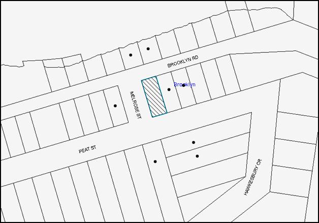
|
NOTIFICATION PLAN |
|
||
|
· PROPERTIES NOTIFIED
|
X SUBMISSIONS RECEIVED |
PROPERTY SUBJECT OF DEVELOPMENT |
|
5.2 Public Agencies
The development application was not referred to any Public Agencies for comment.
6. THE PUBLIC INTEREST
Section 79C(1)(e) of the Act requires Council to consider “the public interest”.
The public interest is an overarching requirement, which includes the consideration of the matters discussed in this report. Implicit to the public interest is the achievement of future built outcomes adequately responding to and respecting the future desired outcomes expressed in environmental planning instruments and development control plans.
The application is considered to have satisfactorily addressed Council’s and relevant agencies’ criteria and would provide a development outcome that, on balance, would result in a positive impact for the community. Accordingly, it is considered that the approval of the proposed development would be in the public interest.
CONCLUSION
The application proposes the demolition of the existing dwelling house and the erection of a dwelling house. The proposal would result in a variation to the maximum floor space ratio for the site. The applicant submitted a clause 4.6 variation which is well founded.
The development generally meets the desired outcomes of Council’s planning controls and is satisfactory having regard to the matters for consideration under Section 79C of the Environmental Planning and Assessment Act 1979.
Conditions are recommended to minimise disruption to residential amenity.
Having regard to the circumstances of the case, approval of the application is recommended.
Note: At the time of the completion of this planning report, no persons have made a Political Donations Disclosure Statement pursuant to Section 147 of the Environmental Planning and Assessment Act 1979 in respect of the subject planning application.
RESPONSIBLE OFFICER
The officer responsible for the preparation of this Report is the Manager – Development Assessments – Rodney Pickles, who can be contacted on 9847 6731.
|
Rod Pickles Manager - Development Assessment Planning Division |
James Farrington Group Manager Planning Division |
|
1.View |
Locality Plan |
|
|
|
2.View |
Site Plan |
|
|
|
3.View |
Elevations and Sections |
|
|
|
4.View |
Landscape Plan |
|
|
|
5.View |
Stormwater Concept Plan |
|
|
|
6.View |
Soil and Waste Management Plan |
|
|
File Reference: DA/75/2016
Document Number: D06960045
SCHEDULE 1
GENERAL CONDITIONS
The conditions of consent within this notice of determination have been applied to ensure that the use of the land and/or building is carried out in such a manner that is consistent with the aims and objectives of the relevant legislation, planning instruments and council policies affecting the land and does not disrupt the amenity of the neighbourhood or impact upon the environment.
Note: For the purpose of this consent, the term ‘applicant’ means any person who has the authority to act on or the benefit of the development consent.
Note: For the purpose of this consent, any reference to an Act, Regulation, Australian Standard or publication by a public authority shall be taken to mean the gazetted Act or Regulation, or adopted Australian Standard or publication as in force on the date that the application for a construction certificate is made.
1. Approved Plans and Supporting Documentation
The development must be carried out in accordance with the plans and documentation listed below and endorsed with Council’s stamp, except where amended by Council and/or other conditions of this consent:
|
Plan No. |
Plan Title |
Drawn by |
Dated |
|
#031-1 |
Site and Site Analysis Plan |
Precision Planning Pty Ltd |
Jan. 2016 |
|
#031-2 |
Proposed Basement Floor Plan |
Precision Planning Pty Ltd |
Jan. 2016 |
|
#031-3 |
Proposed Ground Floor Plan |
Precision Planning Pty Ltd |
Jan. 2016 |
|
#031-4 |
East Elevation & West Elevation |
Precision Planning Pty Ltd |
Jan. 2016 |
|
#031-5 |
North Elevation & Front Perspective |
Precision Planning Pty Ltd |
Jan. 2016 |
|
#031-6 |
South Elevation & Rear Perspective |
Precision Planning Pty Ltd |
Jan. 2016 |
|
#031-7 |
Section Plan |
Precision Planning Pty Ltd |
Jan. 2016 |
|
#031-8 |
Section Plan |
Precision Planning Pty Ltd |
Jan. 2016 |
|
#031-9 |
Landscape Concept Plan |
Precision Planning Pty Ltd |
Jan. 2016 |
|
#031-10 |
Site Cover |
Precision Planning Pty Ltd |
Jan. 2016 |
|
#031-11 |
Stormwater Concept Plan |
Precision Planning Pty Ltd |
Jan. 2016 |
|
#031-12 |
Soil and Waste Management Plan |
Precision Planning Pty Ltd |
Jan. 2016 |
|
Document Title |
Prepared by |
Dated |
|
BASIX Certificate No. 649796S |
Precision Planning Pty Ltd |
25 January 2016 |
2. Construction Certificate
a) A Construction Certificate is required to be approved by Council or a Private Certifying Authority prior to the commencement of any works under this consent.
b) A separate Construction Certificate must be obtained from Council for all works within the public road reserve under S138 of the Roads Act.
c) The Construction Certificate plans must not be inconsistent with the Development Consent plans.
3. Section 94A Development Contributions
a) In accordance with Section 80A(1) of the Environmental Planning and Assessment Act, 1979 and the Hornsby Shire Council Section 94A Development Contributions Plan 2012-2021, $3,500.00 must be paid to Council to cater for the increased demand for community infrastructure resulting from the development, based on development costs of $350,000.
b) The value of this contribution is current as at 09 June 2016. If this contribution is not paid within the financial quarter that this condition was generated, the contribution payable will be adjusted in accordance with the provisions of the Hornsby Shire Council Section 94 Development Contributions Plan and the amount payable will be calculated at the time of payment in the following manner:
$CPY = $CDC x CPIPY
CPIDC
Where:
$CPY is the amount of the contribution at the date of Payment
$CDC is the amount of the contribution as set out in this Development Consent
CPIPY is the latest release of the Consumer Price Index (Sydney – All Groups) at the date of Payment as published by the ABS.
CPIDC is the Consumer Price Index (Sydney – All Groups) for the financial quarter at the date applicable in this Development Consent Condition.
c) The monetary contributions must be paid to Council:
i) prior to the issue of the Subdivision Certificate where the development is for subdivision; or
ii) prior to the issue of the first Construction Certificate where the development is for building work; or
iii) prior to issue of the Subdivision Certificate or first Construction Certificate, whichever occurs first, where the development involves both subdivision and building work; or
iv) prior to the works commencing where the development does not require a Construction Certificate or Subdivision Certificate.
Note: It is the professional responsibility of the Principal Certifying Authority to ensure that the monetary contributions have been paid to Council in accordance with the above timeframes.
Council’s S94A Development Contributions Plan may be viewed at www.hornsby.nsw.gov.au or a copy may be inspected at Council’s Administration Centre during normal business hours.
REQUIREMENTS PRIOR TO THE ISSUE OF A CONSTRUCTION CERTIFICATE
4. Building Code of Australia
All approved building work must be carried out in accordance with the relevant requirements of the Building Code of Australia.
5. Contract of Insurance (Residential Building Work)
Where residential building work for which the Home Building Act 1989 requires there to be a contract of insurance in force in accordance with Part 6 of that Act, this contract of insurance must be in force before any building work authorised to be carried out by the consent commences.
6. Notification of Home Building Act 1989 Requirements
Residential building work within the meaning of the Home Building Act 1989 must not be carried out unless the principal certifying authority for the development to which the work relates (not being Council) has given Council written notice of the following information:
a) In the case of work for which a principal contractor is required to be appointed:
i) The name and licence number of the principal contractor; and
ii) The name of the insurer by which the work is insured under Part 6 of that Act.
b) In the case of work to be done by an owner-builder:
i) The name of the owner-builder; and
ii) If the owner-builder is required to hold an owner-builder’s permit under that Act, the number of the owner-builder’s permit.
Note: If arrangements for doing the residential building work are changed while the work is in progress so that the information notified becomes out of date, further work must not be carried out unless the principal certifying authority for the development to which the work relates (not being Council) has given Council written notification of the updated information.
7. Sydney Water – Approval
This application must be submitted to Sydney Water for approval to determine whether the development would affect any Sydney Water infrastructure, and whether further requirements are to be met.
Building plan approvals can be obtained online via Sydney Water Tap inTM through www.sydneywater.com.au under the Building and Development tab.
8. Design and Construction
New construction must comply with the current Australian Standard AS3959 ‘Construction of buildings in bush fire-prone areas’ in accordance with the Bushfire Attack Level (BAL-12.5) and section A3.7 Addendum Appendix 3 of Planning for Bushfire Protection 2006, together with conditions based on Planning for Bush Fire Protection 2006.
Note: Timbers treated with an applied intumescent paint are no longer recognised by the Rural Fire Service as a fire retardant treated timber or a performance option to increase fire resistance.
9. Stormwater Drainage
The stormwater drainage system for the development must be designed for an average recurrence interval (ARI) of 20 years and be gravity drained and connected directly to Council’s street drainage system.
10. Internal Driveway/Vehicular Areas
The driveway and parking areas on site must be designed, constructed and a Construction Certificate issued in accordance with Australian Standards 2890.1, 3727 and the following requirements:
a) Design levels at the front boundary shall be obtained from Council if a private accredited certifier is engaged to obtain a construction certificate for these works.
b) Design levels at the front boundary be obtained from Council.
c) The driveway be a rigid pavement.
d) Longitudinal sections along both sides of the access driveway shall be submitted to the principal certifying authority in accordance with the relevant sections of AS 2890.1. The maximum grade shall not exceed 1 in 4 (25%) with the maximum changes of grade of 1 in 8 (12.5%) for summit grades and 1 in 6.7 (15%) for sag grades. Any transition grades shall have a minimum length of 2 metres. The longitudinal sections shall incorporate the design levels obtained by Council.
11. Vehicular Crossing
A separate application under the Local Government Act, 1993 and the Roads Act 1993 must be submitted to Council for the installation of a new vehicular crossing and the removal of the redundant crossing. The vehicular crossing must be constructed in accordance with Council’s Civil Works Design 2005 and the following requirements:
a) Design levels at the front boundary must be obtained from Council for the design on the internal driveway;
b) Any redundant crossings must be replaced with integral kerb and gutter;
c) The footway area must be restored by turfing.
Note: An application for a vehicular crossing can only be made to one of Council’s Authorised Vehicular Crossing Contractors. You are advised to contact Council on 02 9847 6940 to obtain a list of contractors.
REQUIREMENTS PRIOR TO THE COMMENCEMENT OF ANY WORKS
12. Erection of Construction Sign
a) A sign must be erected in a prominent position on any site on which any approved work is being carried out:
i) Showing the name, address and telephone number of the principal certifying authority for the work;
ii) Showing the name of the principal contractor (if any) for any demolition or building work and a telephone number on which that person may be contacted outside working hours; and
iii) Stating that unauthorised entry to the work site is prohibited.
b) The sign is to be maintained while the approved work is being carried out and must be removed when the work has been completed.
13. Toilet Facilities
a) To provide a safe and hygienic workplace, toilet facilities must be available or be installed at the works site before works begin and must be maintained until the works are completed at a ratio of one toilet for every 20 persons employed at the site.
b) Each toilet must:
i) be a standard flushing toilet connected to a public sewer; or
ii) be a temporary chemical closet approved under the Local Government Act 1993; or
iii) have an on-site effluent disposal system approved under the Local Government Act 1993.
14. Erosion and Sediment Control
To protect the water quality of the downstream environment, erosion and sediment control measures must be provided and maintained throughout the construction period in accordance with the manual ‘Soils and Construction 2004 (Bluebook)’, the approved plans, Council specifications and to the satisfaction of the principal certifying authority. The erosion and sediment control devices must remain in place until the site has been stabilised and revegetated.
Note: On the spot penalties may be issued for any non-compliance with this requirement without any further notification or warning.
REQUIREMENTS DURING CONSTRUCTION
15. Construction Work Hours
All works on site, including demolition and earth works, must only occur between 7am and 5pm Monday to Saturday. No work is to be undertaken on Sundays or public holidays.
16. Demolition
To protect the surrounding environment, all demolition work must be carried out in accordance with “Australian Standard 2601-2001 – The Demolition of Structures” and the following requirements:
a) Demolition material must be disposed of to an authorised recycling and/or waste disposal site and/or in accordance with an approved waste management plan;
b) Demolition works, where asbestos material is being removed, must be undertaken by a contractor that holds an appropriate licence issued by WorkCover NSW in accordance with Chapter 10 of the Occupational Health and Safety Regulation 2001 and Clause 29 of the Protection of the Environment Operations (Waste) Regulation 2005 ;and
c) On construction sites where any building contain asbestos material, a standard commercially manufactured sign containing the words ‘DANGER ASBESTOS REMOVAL IN PROGRESS’ and measuring not less than 400mm x 300mm must be displayed in a prominent position visible from the street.
17. Council Property
To ensure that the public reserve is kept in a clean, tidy and safe condition during construction works, no building materials, waste, machinery or related matter is to be stored on the road or footpath.
18. Disturbance of Existing Site
During construction works, the existing ground levels of open space areas and natural landscape features, (including natural rock-outcrops, vegetation, soil and watercourses) must not be altered unless otherwise nominated on the approved plans.
19. Survey Report
A report(s) must be prepared by a registered surveyor and submitted to the principal certifying authority;
a) Prior to the pouring of concrete at each level of the building certifying that:
i) The building, retaining walls and the like have been correctly positioned on the site; and
ii) The finished floor level(s) are in accordance with the approved plans.
REQUIREMENTS PRIOR TO THE ISSUE OF AN OCCUPATION CERTIFICATE
Note: For the purpose of this consent, a reference to ‘occupation certificate’ shall not be taken to mean an ‘interim occupation certificate’ unless otherwise stated.
20. Fulfilment of BASIX Commitments
The applicant must demonstrate the fulfilment of BASIX commitments pertaining to the development.
21. Damage to Council Assets
To protect public property and infrastructure, any damage caused to Council’s assets as a result of the construction or demolition of the development must be rectified by the applicant in accordance with Council’s Civil Works Specifications. Rectification works must be undertaken prior to the issue of an Occupation Certificate, or sooner, as directed by Council.
22. Retaining Walls
All required retaining walls must be constructed as part of the development.
- END OF CONDITIONS -
ADVISORY NOTES
The following information is provided for your assistance to ensure compliance with the Environmental Planning and Assessment Act 1979, Environmental Planning and Assessment Regulation 2000, other relevant legislation and Council’s policies and specifications. This information does not form part of the conditions of development consent pursuant to Section 80a of the Act.
Environmental Planning and Assessment Act 1979 Requirements
The Environmental Planning and Assessment Act 1979 requires:
· The issue of a construction certificate prior to the commencement of any works. Enquiries can be made to Council’s Customer Services Branch on 9847 6760;
· a principal certifying authority to be nominated and Council notified of that appointment prior to the commencement of any works;
· Council to be given at least two days written notice prior to the commencement of any works;
· mandatory inspections of nominated stages of the construction inspected; and
· an occupation certificate to be issued before occupying any building or commencing the use of the land.
Long Service Levy
In accordance with Section 34 of the Building and Construction Industry Long Service Payments Act 1986, a ‘Long Service Levy’ must be paid to the Long Service Payments Corporation or Hornsby Council.
Note: The rate of the Long Service Levy is 0.35% of the total cost of the work.
Note: Hornsby Council requires the payment of the Long Service Levy prior to the issue of a construction certificate.
Tree and Vegetation Preservation
In accordance with Clause 5.9 of the Hornsby Local Environmental Plan 2013 a person must not ringbark, cut down, top, lop, remove, injure or wilfully destroy any tree or other vegetation protected under the Hornsby Development Control Plan 2013 without the authority conferred by a development consent or a permit granted by Council.
Notes: A tree is defined as a long lived, woody perennial plant with one or relatively few main stems with the potential to grow to a height greater than three metres (3M). (HDCP 1B.6.1.c).
Tree protection measures and distances are determined using the Australian Standard AS 4970:2009, “Protection of Trees on Development Sites”.
Fines may be imposed for non-compliance with both the Hornsby Local Environmental Plan 2013 and the Hornsby Development Control Plan 2013.
Dial Before You Dig
Prior to commencing any works, the applicant is encouraged to contact Dial Before You Dig on 1100 or www.dialbeforeyoudig.com.au for free information on potential underground pipes and cables within the vicinity of the development site.
Asbestos Warning
Should asbestos or asbestos products be encountered during demolition or construction works, you are advised to seek advice and information prior to disturbing this material. It is recommended that a contractor holding an asbestos-handling permit (issued by WorkCover NSW) be engaged to manage the proper handling of this material. Further information regarding the safe handling and removal of asbestos can be found at:
Alternatively, telephone the WorkCover Asbestos and Demolition Team on 8260 5885.
Group Manager's Report No. PL51/16
Planning Division
Date of Meeting: 13/07/2016
7 RFT3/2016 - TENDER FOR CONSULTANT SERVICES TO REVIEW THE SOUTH DURAL PLANNING PROPOSAL
EXECUTIVE SUMMARY
· At its meeting on 8 June 2016, Council considered Group Manager’s Report No. PL43/16 concerning RFT3/2016 – South Dural Tender for a consultant to peer review technical studies and plans associated with the South Dural Planning Proposal.
· Council resolved not to accept any tender and negotiate with GLN Planning to arrive at a lump sum tender price.
· Negotiations have been undertaken to ensure allocation of resources is appropriate to provide value for money and to achieve the requirements of the brief.
· It is recommended that the tender submission received from GLN Planning be accepted for RFT3/2016.
|
THAT Council accept the tender from GLN Planning for Tender No. RFT3/2016 – Tender for Consultant Services to Review the South Dural Planning Proposal. |
PURPOSE
The purpose of this Report is to provide a recommendation for the acceptance of Request for Tender No RFT3/2016 – South Dural Planning Proposal following negotiations with Tenderer GLN Planning.
BACKGROUND
In March 2016, tenders were sought from suitable contractors to peer review the technical studies and plans associated with the South Dural Planning Proposal (RFT3/2016). At its meeting on 8 June 2016, Council considered Group Manager’s Report No. PL43/16 concerning the evaluation of tenders received and resolved that:
1. Council not accept any tenders and negotiate with GLN Planning to arrive at a lump sum tender price.
2. Subject to the Evaluation Panel being satisfied with the outcome of the negotiations, Council accept the tender from GLN Planning for Tender No. RFT3/2016 – Provision of Consultant Services – South Dural Planning Proposal.
3. Council decline to invite fresh tenders or seek fresh applications from tenderers or persons expressing interest in the contract for the following reasons:
a) Council has tested the market for the project and further tendering or fresh applications are not likely to produce a better result.
b) Timing constraints do not unduly delay the project.
4. Unsuccessful tenderers be advised of Council’s resolution.
In accordance with Council’s resolution, a negotiation letter was subsequently issued to GLN Planning seeking an updated proposal and lump sum tender price.
DISCUSSION
This report discusses the outcome of tender negotiations with GLN Planning regarding RFT3/2016.
RFT3/2016
In response to the negotiation letter, a revised fee proposal was received from GLN Planning on 21 June 2016.
A complete copy of the Tender Negotiation Evaluation Report is provided as a Confidential Attachment. The attachment should be dealt with in confidential session, under S10A(2)(d) of the Local Government Act, 1993 as it contains commercial information of a confidential nature that would if disclosed, (i) prejudice the commercial position of the person who supplied it, or (ii) confer a commercial advantage on a competitor of the Council, or (iii) reveal a trade secret.
Following a non-price and value for money evaluation of the updated fee proposal, it is recommended that Council accept the tender on the grounds that the allocation of resources is appropriate to provide value for money and to achieve the requirements of the brief.
BUDGET
The funding agreement with Statewide Property Ventures Pty Ltd provides for funding of costs incurred by Council in reviewing the studies and other matters required in relation to the Planning Proposal.
POLICY
There are no policy implications associated with this Report.
CONCLUSION
At its meeting on 8 June 2016, Council resolved not to accept tenders for RFT3/2016 – South Dural Planning Proposal and negotiate with GLN Planning. Tender negotiations were undertaken and a revised fee proposal from GLN Planning has been evaluated on non-price and value for money criteria.
It is recommended that the tender submission received from GLN Planning be accepted for RFT3/2016.
RESPONSIBLE OFFICER
The officer responsible for the preparation of this Report is the Manager, Strategic Planning – Fletcher Rayner, who can be contacted on 9847 6744.
|
Fletcher Rayner Manager - Strategic Planning Planning Division |
James Farrington Group Manager Planning Division |
|
1.View |
Tender Negotiation Evaluation Report - This attachment should be dealt with in confidential session, under Section 10A (2) (d) of the Local Government Act, 1993. This report contains commercial information of a confidential nature that would, if disclosed (i) prejudice the commercial position of the person who supplied it; or (ii) confer a commercial advantage on a competitor of the council; or (iii) reveal a trade secret. |
|
|
File Reference: F2015/00488
Document Number: D06966802
Group Manager's Report No. PL23/16
Planning Division
Date of Meeting: 13/07/2016
8 REPORT ON SUBMISSIONS - HOUSEKEEPING PLANNING PROPOSAL
EXECUTIVE SUMMARY
· The Housekeeping Planning Proposal seeks to amend the Hornsby Local Environmental Plan (HLEP) 2013 to resolve some of the issues raised during the exhibition of the HLEP and rectify anomalies and mapping issues that have been identified since the Plan came into force in October 2013.
· The Planning Proposal was publicly exhibited from 9 December 2015 to 29 January 2016. A total of 27 submissions were received on various aspects of the Proposal. In response to submissions received, three post exhibition amendments were made to the Planning Proposal and re-exhibited for community comment from 26 April 2016 to 27 May 2016. A total of 4 submissions were received during the additional exhibition period.
· The majority of submissions relate to the address of a heritage item at property No. 2A Paling Street Thornleigh, the reclassification of land at property No. 111x New Line Road, Cherrybrook and a request for a review of the Essex Street, Epping Heritage Conservation Area. These issues and issues raised in other submissions are addressed in this report.
· In accordance with the Local Government (LG) Act 1993 a Public Hearing was held into the proposed reclassification of property No. 111x New Line Road, Cherrybrook. There were no community attendees at the hearing.
· The issues raised in submissions do not introduce any matters that would require further changes to the Planning Proposal. Accordingly it is recommended that Council forward the Housekeeping Planning Proposal to the Minister for Planning for finalisation.
|
THAT: 1. Council forward the Housekeeping Planning Proposal attached to Group Manager’s Report No. PL23/16 to the Minister for Planning for finalisation. 2. All persons who made submissions be advised of Council’s resolution. 3. The significance of Heritage Item 647 located within 2A Paling Street, Thornleigh (Lot 1 of SP 58495) be reviewed as part of the next Heritage Review. 4. That Council write to the City of Parramatta Council to advise of Hornsby Council’s resolution regarding the Essex Street Heritage Conservation Area and submissions received relating to heritage listings in Essex Street, for its consideration in any future review of planning controls for Epping. |
PURPOSE
The purpose of this Report is to review submissions received in response to the exhibition of the Housekeeping Planning Proposal and to recommend that Council forward the plan to the Minister for Planning for finalisation.
BACKGROUND
The Housekeeping Planning Proposal seeks to amend the Hornsby Local Environmental Plan (HLEP) 2013 to resolve some of the issues raised during the exhibition of the draft HLEP in 2012 that would have delayed the making of the Plan in 2013. It also seeks to rectify a number of anomalies and mapping issues that have been identified since the Plan came into force in October 2013.
At its meeting on 8 July 2015, Council considered Group Manager’s Report No. PL39/15 and resolved (in part) to:
1. Endorse progression of the Housekeeping Planning Proposal and forward the Proposal to the Minister seeking Gateway Determination;
2. Exhibit the Planning Proposal in accordance with the Gateway Determination; and
3. Hold a public hearing after the exhibition period to discuss the reclassification of land at property No. 111x New Line Road, Cherrybrook.
In accordance with Council’s resolution, a Gateway Determination was sought from the Department of Planning and Environment (DP&E). A Gateway Determination was issued in October 2015 and the Housekeeping Planning Proposal was publicly exhibited from 9 December 2015 to 29 January 2016.
DISCUSSION
This report presents a summary of submissions received in response to the exhibition of the Housekeeping Planning Proposal.
1. Exhibition
The Planning Proposal was exhibited from 9 December 2015 to 29 January 2016. The exhibition included advertisements in local newspapers, an advertisement on the Council website under “On Exhibition”, displays at Council’s administration building and libraries and letters to affected owners. A total of 27 submissions were received during the initial exhibition period.
In response to submissions received, three post exhibition amendments were made to the Planning Proposal and re-exhibited for community comment from 26 April 2016 to 27 May 2016. Modifications to the Planning Proposal related to the item name and property description of two existing heritage items and the identification of a small portion of a property in Asquith required to remain on the Land Reservation Acquisition Map. A total of 4 submissions were received during the additional exhibition period. The major issues raised in submissions are discussed below.
1.1 Heritage – 2A Paling Street, Thornleigh
Nine submissions were received during the initial exhibition period objecting to the change in the description of Heritage Item No. 647, a house which is currently listed with a historic address of Lot 1 DP 882348 (317-321 Pennant Hills Road, Pennant Hills), to the current Strata Plan number. In response to submissions received, the Planning Proposal was amended to limit the listing to the Strata Plan Lot that contains the heritage listed house.
Four submissions were received during the additional exhibition period. The submissions relate to the perceived heritage listing of the 12 townhouses which are also located on the property, significance of the existing heritage item and request that the item be removed from the heritage schedule. The submissions contend that the heritage value of the Bungalow has been diminished due to the construction of the townhouses, modifications to the heritage fabric of the building, the loss of nearby heritage items and the erection of a 2 metre high front boundary wall.
Comment: The Planning Proposal seeks to amend the address of the existing heritage listed house on the site. The item name, “house” is unchanged, as is the heritage inventory sheet which identifies the circa 1930 Inter-War Bungalow. The address of the Bungalow has been altered over the years due to boundary adjustments and the development of townhouses on the same parcel of land. The updating of the property address in the HLEP has not kept up with the various changes to the property address overtime. The heritage item was incorporated into Strata Plan 58495, with a corresponding address of 2A Paling Street, Thornleigh, subsequent to the development of townhouses on the site in 1998. The historic address in the current listing (Lot 1 DP 882348) covers the entire parcel of land upon which the heritage item and the townhouses are located.
In response to concerns raised in submissions, the property description for the heritage listing has been further amended by adding “Lot 1” before “SP 58495” to clarify that the Bungalow which is listed as a heritage item is located on Lot 1 of the Strata Plan.
The heritage assessment submitted by the applicant as part of the previous development application (DA/769/1994) for townhouses on the site, identified the Bungalow as being worthy of retention and one of the major examples of inter-war residential architecture in the Hornsby area. A two metre high brick acoustic fence along the Pennant Hills Road boundary was approved as part of the previous consent.
In relation to the request that the Council delist the property from the Heritage Schedule, an updated heritage assessment has not been undertaken as part of this Planning Proposal. The Housekeeping Planning Proposal only seeks to update Schedule 5 – Environmental Heritage of the HLEP to correct errors in property descriptions or listings. As stated in ‘Part 2 - Explanation of the Provisions’ in the Planning Proposal, the amendment does not attempt to resolve issues which relate to the location or significance of items, which would be considered as part of the next Heritage Review.
Recommendation: No change to the Housekeeping Planning Proposal as a result of submissions objecting to the change in description for Heritage Item No. 647. It is recommended that the significance of the heritage item located within 2A Paling Street, Thornleigh (Lot 1 of SP 58495) be reviewed as part of the next Heritage Review.
1.2 Reclassification – 111x New Line Road, Cherrybrook
Six submissions raise objections to the reclassification of property No. 111x New Line Road, Cherrybrook from community to operational land. Key issues raised in submissions include access to the adjoining Council-owned drainage easement for maintenance, use of the site for cricket training and loss of public land.
Comment: There is a Council-owned drainage reserve located adjacent to the subject site, at property No. 113x New Line Road, Cherrybrook. Council has a Gross Pollutant Device (in the form of channel nets) installed within the drainage reserve. The nets are emptied by a contractor who uses property No. 111x New Line Road to gain access to the nets. Should Council sell property No. 111x New Line Road, an easement would be required to ensure continued access to the nets. Alternatively, the nets could be removed pending review of their effectiveness and downstream infrastructure alternatives. Notwithstanding the channel nets, should maintenance to the drainage reserve be required, there is adequate room for a Council excavator to enter where property No. 113x meets New Line Road.
In relation to concern regarding the loss of recreation land, Council has over 130 parks, playgrounds and sportsgrounds available to the community throughout the Shire. Property No. 111x New Line Road is not recognised by Council to be a park or playground. The property does not contain playground equipment or other infrastructure such as seating, shading etc.
Accessible public open space of superior size, shape and location exists within Cherrybrook, including Edward Bennett Oval (approximately 250m from the site) and Thomas Thompson Park (approximately 200m from the site) which both contain a cricket pitch, soccer field, toilets and car parking. Edward Bennet Oval also contains a playground, picnic tables and BBQ.
A Public Hearing to discuss the reclassification was held on Tuesday, 15 March 2016. There were no community attendees (see below under heading Public Hearing).
Recommendation: No change to the Housekeeping Planning Proposal as a result of submissions objecting to the reclassification of property No. 111x New Line Road, Cherrybrook.
1.3 Heritage – Essex Street, Epping Heritage Conservation Area
The Epping Urban Activation Precinct (UAP) was finalised in 2014 via a State Environmental Planning Policy (SEPP) which amended the Land Zoning, Height of Buildings, Floor Space Ratio and Heritage Maps associated with the HLEP 2013. However, corresponding changes to the Lot Size Map were not made at the time. The Housekeeping Planning Proposal seeks to amend the Lot Size Map to remove the minimum lot size for land rezoned R3 Medium Density Residential and R4 High Density Residential to correspond with the zoning changes which have occurred.
Five submissions request that changes to the Heritage Map also be made through the Housekeeping Planning Proposal to amend the boundary of the Essex Street Heritage Conservation Area (HCA). The submissions object to the impact of the rezoning of land in Forest Grove, Epping on the Essex Street HCA, and state that it is an anomaly with the planning controls that should be addressed as a matter of urgency, rather than being put off until development in Forest Grove is completed.
Comment: At its meeting on 8 October 2014, Council considered Group Manager’s Report No. PL72/14 concerning submissions received during the exhibition of the draft Epping Town Centre amendments to the Hornsby Development Control Plan (HDCP) 2013. Council resolved (in part) to review the heritage significance of the Essex Street and Rosebank Avenue HCAs in a future stage of Council’s Heritage Review to follow development of the adjacent five storey residential precincts. The Housekeeping Planning Proposal does not attempt to resolve issues which relate to the significance of heritage items or conservation areas.
On 12 May 2016, the NSW Government announced the amalgamation of 42 councils into 19 new councils. The proclamation created the City of Parramatta Council that includes parts of Epping that were formerly under the jurisdiction of Hornsby Shire Council. Therefore, it is now the responsibility of the City of Parramatta to revisit and reassess the appropriateness of maintaining the conservation area (in part or whole).
Recommendation: No change to the Housekeeping Planning Proposal as a result of submissions concerning the Essex Street Heritage Conservation Area. However, it would be appropriate that Council write to the City of Parramatta Council to advise of Hornsby Council’s previous resolutions regarding the Essex Street Heritage Conservation Area and the related submissions, for its consideration in any future review of planning controls for Epping.
1.4 Heritage – Property No. 42 Essex Street, Epping
One submission objects to the change in the description of Heritage Item No. 800, located at property No. 42 Essex Street, Epping. The item name is currently listed as “House”. It is proposed to improve the item name by amending it to “Wurundjer”. The submission objects to the change in item name and also objects to the listing itself. The submission states that the owner was not advised of the listing and questions the heritage significance of the house.
Comment: State Environmental Planning Policy (Epping Town Centre Precinct) 2013 listed 22 new heritage items of local significance as recommended in Council’s Epping Town Centre Study 2011 and the Perumal Murphy Alessi Heritage Review of the Epping Town Centre Structure Plan 2013. The SEPP was exhibited from 16 March 2013 to 19 May 2013 by the Department of Planning and Environment. All land owners were notified of the exhibition by letter, it was included in newspaper advertisements and information was provided on the Department of Planning and Environment’s website.
The Perumal Murphy Alessi report concluded that the property is of high local historic and aesthetic significance as a good and largely intact Federation period weatherboard house. The listing became current when the Epping SEPP was finalised in March 2014. This Planning Proposal only attempts to correct errors in property descriptions or listings, in this case by changing the existing item name from “House” to its historic name “Wurundjer”
Recommendation: No change to the Housekeeping Planning Proposal as a result of the submission concerning the property No. 42 Essex Street, Epping. However, it would be appropriate that Council write to the City of Parramatta Council to advise of the submission received for its consideration in any future review of planning controls for Epping.
1.5 Permissibility of Jetties in E2 Zone
Two submissions were received concerning the proposal to permit jetties in the E2 Environmental Conservation zone. One submission is in favour of the change. Another submission objects on the basis that the amendment should also facilitate the development of a road/accessway across E2 zoned land and the construction of a boat ramp at the river. The submitter requests that the planning controls be amended to reflect a private right of way that exists over a property on the eastern side of Singleton Road (Lot 3 DP 578626) that permits properties on the western side of Singleton Road “…to go pass and repass at all times and for all purposes with or without animals or vehicles or boats or boat trailers…”. The submission includes details of a proposal to construct a carriageway along the right of way on E2 zoned land, with a shade shelter, mooring area and boat ramp at the water’s edge into the W1 Natural Waterway zone.
Comment: The intention of the HLEP 2013 is to permit jetties, subject to Council consent, where properties have frontages to waterways. Council has recognised an anomaly where there is an E2 zoning over the water adjacent to a waterfront property, as jetties are prohibited in the E2 zone. This amendment seeks to rectify that issue.
The existence of a private right of way over land does not negate the need for development consent to be obtained from Council if works are desired to upgrade a private access arrangement. Boat ramps are permitted in the foreshore area and in the W1 Natural Waterways zone, subject to development consent from Council and owners consent from the Crown for work on public land (the river). However, roads are prohibited in the E2 zone. The E2 Environmental Conservation zone applies to protected mangrove, saltmarsh and seagrass communities. The introduction of roads as a permissible use in the E2 zone would not be appropriate due to the potential harm to protected biodiversity.
The introduction of jetties as a permissible use in the E2 zone is supported by Clause 6.5 of the HLEP which would ensure that development consent is not granted unless Council is satisfied that the jetty will not cause environmental harm such as an adverse effect on surrounding marine habitat, wetland areas or flora and fauna habitat. The Hornsby DCP contains further controls for waterways structures (including jetties) aimed at avoiding locations containing seagrass beds and saltmarshes, or using mitigation measures such as translucent or mesh walkways to allow sunlight penetration.
Recommendation: No change to the Housekeeping Planning Proposal as a result of the submission concerning the permissibility and construction of road access in the E2 zone.
1.6 Acquisition – 7 Amor Street, Asquith
The Housekeeping Planning Proposal seeks to amend the land reservation acquisition requirement for property No. 5 Amor Street to retain a small portion (13sq.m) at the rear of the property as design work has revealed that the proposed extension of Wattle Street to Amor Street can be achieved mainly through the acquisition of No. 7 Amor Street. A submission objects to the change to the Land Reservation Acquisition Map to leave the reservation only on No. 7 Amor Street on the basis that the HDCP indicates the extension is to be located mostly on property No. 5 Amor Street. The submission also states that, because Clause 5.1A of the HLEP 2013 restricts development on the site identified for acquisition to a road only, the continued use of No. 7 Amor Street as a dwelling would be impacted due to the need for maintenance and repairs which require development consent.
Comment: The HDCP includes a key principles diagram with traffic management improvements indicated in concept form only. Subsequent design work has indicated that the preferred option to implement the extension of Wattle Street to Amor Street is to curve the road and align it mainly within the boundaries of property No. 7 Amor Street, with a signalised intersection rather than a roundabout.
Maintenance and repair to the dwelling at No.7 Amor Street is able to be undertaken as exempt development pursuant to the provisions of State Environmental Planning Policy (Exempt and Complying Development Codes) 2008. Furthermore, the previous use of the dwelling for residential purposes is able to continue until the land is acquired.
Provision for the purchase and extension of Wattle Street has been made within Council’s Section 94 Contributions Plan. The extension of Wattle Street in comparison with other works has been classified by the plan as low (Priority 3) with acquisition by Council not scheduled to occur within the next 5 years.
Recommendation: No change to the Housekeeping Planning Proposal as a result of the submission concerning acquisition of properties in Amor Street, Asquith.
2. Public Hearing
In accordance with Section 29 of the LG Act 1993, a Public Hearing in relation to the reclassification of Council owned land (Property No. 111x New Line Road, Cherrybrook) was held in Function Room 1 of the Council Chambers on Tuesday, 15 March 2016 commencing at 6.30pm. The Public Hearing was independently chaired by a consultant from DFP Planning Consultants. There were no community attendees at the hearing.
A copy of the Public Hearing Report (attached) was placed on display at Council’s Administration Building, libraries and on Council’s website under “Latest News”. Person who made a submission during the exhibition period were notified of the availability of the Public Hearing Report. The Report recommends that Council proceed with the proposed reclassification.
3. Consultation with Public Authorities
In accordance with the Gateway Determination issued by the Department of Planning and Environment, a copy of the Housekeeping Planning Proposal was sent to the Rural Fire Service, Greater Sydney Local Land Services and the Office of Environment and Heritage (Heritage Office and Environment Branch). No response was received from the Greater Sydney Local Land Services. Both the Rural Fire Service and the Office of Environment and Heritage responded that they have no objection to the Planning Proposal.
The Department of Education (DoE) advised that it has no objection to the Proposal, subject to clarification of the amendment for Item No. 476 – Hornsby Girls High School. The DoE requested clarification that the addition of the fence to the listing of school buildings refers only to the front masonry fence along Edgeworth David Avenue and not the metal security fence along Thomas Street. The listing has been further amended by adding the word “masonry” before fence to clarify that this is the case. As this amendment is minor in nature it does not require re-exhibition.
On 12 May 2016, extensive council boundary changes occurred as part of the state-wide Council Boundary Review process. Under the new boundaries, the Hornsby Local Government Area south of the M2 became part of the City of Parramatta Council. The City of Parramatta Council is currently working with neighbouring councils under proposed Service Agreements to transfer strategic planning projects to and from other councils, as appropriate under the new boundary arrangements.
Pursuant to Section 154 of the Environmental Planning and Assessment Act, where land is transferred from one Council area to another, a planning proposal that has been placed on public exhibition and that applies to land has been transferred, may, with the written consent of the new council, be proceeded with as if the transfer had not taken effect.
On 14 June 2016, the City of Parramatta Council considered a report on the Hornsby Housekeeping Local Environmental Plan as the proposed modifications will impact on land now located within the City of Parramatta. The Council resolved that Hornsby Council be advised that the City of Parramatta does not object to the Housekeeping Planning Proposal, as publicly exhibited, being finalised.
BUDGET
There are no budgetary implications associated with this report.
STATUTORY CONSIDERATIONS
The Housekeeping Planning Proposal was exhibited in accordance with the requirements of the Gateway Determination issued by the Department of Planning and Environment in October 2015. The Gateway Determination requires finalisation of the Housekeeping Planning Proposal by October 2016. It is recommended that the amended Housekeeping Planning Proposal attached to this report be forwarded to the Minster for Planning and Environment for finalisation.
CONCLUSION
The Housekeeping Planning Proposal has been exhibited in accordance with the Gateway Determination issued by the DP&E. A Public Hearing was independently chaired by a consultant from DFP Planning Consultants on 15 March 2016 in relation to the reclassification of land identified in the Planning Proposal. There were no community attendees.
A total of 31 submissions were received in relation to various aspects of the Planning Proposal. The issues raised are addressed in this report.
It is recommended that Council forward the Housekeeping Planning Proposal attached to this report to the DP&E for finalisation.
RESPONSIBLE OFFICER
The officer responsible for the preparation of this Report is the Manager, Strategic Planning – Fletcher Rayner, who can be contacted on 9847 6744.
|
Fletcher Rayner Manager - Strategic Planning Planning Division |
James Farrington Group Manager Planning Division |
|
1.View |
Planning Proposal April 2016 |
|
|
|
2.View |
Final Report on Public Hearing |
|
|
File Reference: F2015/00054
Document Number: D06893557
Deputy General Manager's Report No. IR20/16
Infrastructure and Recreation Division
Date of Meeting: 13/07/2016
9 REQUEST TO REMOVE TREES - 43 EDWARDS ROAD, WAHROONGA
EXECUTIVE SUMMARY
· The owner of 43 Edwards Road, Wahroonga has sought approval to remove three Eucalyptus saligna (Sydney Blue Gums) located at the front of the property due to safety concerns.
· There have been two previous applications seeking to remove the trees. The first application was lodged in November 2015 and an appeal was lodged in May 2016.
· The most recent application was accompanied by an Arborist report and sought approval to remove five Sydney Blue Gums. The owner’s Arborist has recommended two options: either removal of all trees, or removal of three trees (Tree No. 1, 2 and 3) and retention of the remaining two.
· Council’s Arborist has subsequently approved two trees to be removed being Trees 1 and 2 and has conditioned the retention of Trees No. 3, 4 and 5 with remedial pruning.
· The closest of the trees is located approximately 30 metres from the owner’s dwelling and is located in an area of the property that appears relatively unused.
· Council officers are satisfied that Trees No. 3, 4 and 5 are worthy of retention and can be safely retained. This Report recommends that Council refuse permission for the removal of the Trees No. 3, 4 and 5.
|
THAT Council refuse consent to remove three Eucalyptus saligna (Sydney Blue Gums), Trees No. 3, 4 and 5. |
PURPOSE
The purpose of this Report is to provide Council with the information required to consider an application by the owner of 43 Edwards Road, Wahroonga to remove five Sydney Blue Gums.
BACKGROUND
Council has received a tree application (TA/159/2015) and an appeal (TA/159/2015/A), seeking to remove five Sydney Blue Gums. The species is characteristic of Blue Gum High Forest (BGHF), although in this circumstance the site is not located within a mapped Endangered Ecological Community area.
The recent application has sought approval to remove all five trees and was supported by an Arborist report (Attachment 1). The owner’s Arborist has provided two management options one of which includes retention of two trees. These options and Council’s Arborist’s position is summarised in the following table.
|
Tree No. |
Species |
Owner’s Request and Owner’s Arborist Report Option A |
Owner’s Arborist Report Option B |
Council Arborist Determination TA/159/2015/A |
|
1 |
Eucalyptus saligna (Sydney Blue Gum) |
Removal |
Removal |
Removal |
|
2 |
Eucalyptus saligna (Sydney Blue Gum) |
Removal |
Removal |
Removal |
|
3 |
Eucalyptus saligna (Sydney Blue Gum) |
Removal |
Removal |
Retention with pruning |
|
4 |
Eucalyptus saligna (Sydney Blue Gum) |
Removal |
Retention with pruning |
Retention with pruning |
|
5 |
Eucalyptus saligna (Sydney Blue Gum) |
Removal |
Retention with pruning |
Retention with pruning |
Whilst the subject property has a street address of 43 Edwards Road, access to the dwelling is via Tracey Close. The trees are located in a group at the northern end of property which is at the intersection of Edwards Road and Tracey Close (see Attachment 2 for a site plan). The trees are highly visible from both streets and contribute to the leafy character of the area.
DISCUSSION
The owner is concerned that the trees pose a threat to the safety of her family and the general public using the area adjacent to the trees (see Attachment 3 for supporting letter from applicant).
A detail discussion regarding each tree is provided below.
Tree No. 1 Details
Species: Eucalyptus saligna
Common Name: Sydney Blue Gum
Height: 14 metres
Age: Mature
Comment
Removal of this tree is supported due to its condition and the recommendation regarding this tree is not in dispute.
Tree No. 2 Details
Species: Eucalyptus saligna
Common Name: Sydney Blue Gum
Height: 20 metres
Age: Mature
Comment
Removal of this tree is supported due to its condition and the recommendation regarding this tree is not in dispute.
Tree No. 3 Details
Species: Eucalyptus saligna
Common Name: Sydney Blue Gum
Height: 22 metres
Age: Mature
Comment
The subject tree dropped a large limb early in 2016 and there is evidence this branch was subject to fungal rot. This is also a fungal fruiting body on another lower branch. The owner’s Arborist has concluded that the whole tree should be removed; however, it is the position of Council’s Arborist that the tree can be retained and the offending limbs removed at the respective branch collars. There is no evidence of any rot occurring in any other branches or the main trunk.
The removal the offending limbs which contain the fungal bodies allow the tree to be retained. The approach is consistent with that suggested by the owner’s Arborist for Trees No. 4 and 5.
Tree No. 4 Details
Species: Eucalyptus saligna
Common Name: Sydney Blue Gum
Height: 22 metres
Age: Mature
Comment
Whilst the owner has requested this tree to be removed, the owner’s supporting Arborist report has concluded that the tree could be retained and re-inspected within two years. The tree would also be subject to reduction pruning works in accordance with Australian Standards 4373-2007.
Council’s Arborists support this approach.
Tree No. 5 Details
Species: Eucalyptus saligna
Common Name: Sydney Blue Gum
Height: 22 metres
Age: Mature
Comment
Whilst the owner has requested this tree to be removed, the owner’s supporting Arborist report has concluded that the tree could be retained and re-inspected within two years. The tree would also be subject to reduction pruning works in accordance with Australian Standards 4373-2007.
Council’s Arborists support this approach.
BUDGET
There are no budgetary implications associated with this Report.
POLICY
The recommendation contained within the Report is consistent with Council’s Tree Preservation Measures (HDCP) that provides protection to trees that are indigenous to Hornsby Shire such as the Eucalyptus saligna (Sydney Blue Gum) and only permits removal of a tree in case of safety concerns if there are signs that the tree is diseased, dying or dangerous.
CONCLUSION
Council inspections support the removal of Trees No. 1 and 2 based upon their health and condition. However, Council Arborists recommend that Trees No. 3, 4 and 5 be retained on the basis that with remedial pruning they can be safely retained. These trees are located approximately 30 metres distance from the dwelling house. The retention of these three trees as a group is beneficial for their long term retention as their canopies have developed in unison and they offer each other protection. They are also highly visible from the road and contribute to the leafy character of the area as illustrated in Attachment 4. Council officers are satisfied that Trees No. 3, 4 and 5 are worthy of retention and can be safely retained. This Report recommends that Council refuse permission for the removal of the Trees No. 3, 4 and 5.
RESPONSIBLE OFFICER
The officer responsible for the preparation of this Report is the Manager, Parks and Recreation – David Sheils, who can be contacted on 9847 6792.
|
Robert Stephens Deputy General Manager Infrastructure and Recreation Division |
|
|
1.View |
Attachment 1 - Owner's Arborist Report |
|
|
|
2.View |
Attachment 2 - Site Plan |
|
|
|
3.View |
Attachment 3 - Supporting Letter from Applicant |
|
|
|
4.View |
Attachment 4 - Photo of Trees No. 3, 4 and 5 |
|
|
File Reference: TA/159/2015/A
Document Number: D06982511
Mayor's Note No. MN7/16
Date of Meeting: 13/07/2016
10 MAYOR'S NOTES FROM 1 TO 30 JUNE 2016
Note: These are the functions that the Mayor, or his representative, has attended in addition to the normal Council Meetings, Workshops, Mayoral Interviews and other Council Committee Meetings.
Thursday 2 June 2016 – The Mayor attended the Hornsby Primary School Leaders’ Morning Tea with Mr Matt Kean MP at Parliament House, Sydney.
Thursday 2 June 2016 – The Mayor attended the MAB16 City Leaders’ Summit at Willoughby Council, Chatswood.
Friday 3 June 2016 – The Mayor officially opened the Re-magine 2016 Exhibition at Wallarobba Arts and Cultural Centre.
Friday 3 June 2016 – The Mayor hosted the Mayor’s Annual State Emergency Services Dinner at Hornsby RSL Club.
Monday 6 June 2016 – The Mayor attended the Greater Sydney Commission Morning Tea to meet the Minister for Planning, Mr Rob Stokes MP, at Sydney Water’s office in Parramatta.
Monday 6 June 2016 – The Mayor attended the Westleigh Tennis Club Annual General Meeting at Westleigh.
Thursday 9 June 2016 – The Mayor officially opened the new Fresenius Kabi Australia office at Mount Kuring-gai.
Friday 17 June 2016 – The Mayor attended the 1st Cherrybrook Scout Group Annual Report Presentation at Cherrybrook.
Saturday 18 June 2016 – The Mayor attended St Leo’s Catholic College 60th Anniversary Dinner Dance at Hornsby RSL Club.
Tuesday 21 June 2016 – The Mayor hosted three Citizenship Ceremonies in the Council Chambers.
Thursday 23 June 2016 – The Mayor officially launched Waitara Lifeline’s new retail Op Shop at Waitara.
Thursday 23 June 2016 – The Mayor attended Hornsby Girls’ High School Year 9 English Group Projects Presentation at the School.
Friday 24 June 2016 – The Mayor attended the St John Ambulance Hornsby Division Celebration Dinner at Magpies Waitara.
Monday 27 June 2016 – The Mayor attended the Rotary Club of Pennant Hills Changeover Dinner at Pennant Hills Golf Club.
Tuesday 28 June 2016 – The Mayor attended the Rotary Club of Dural Changeover Dinner at Dural Country Club.
File Reference: F2004/07053
Document Number: D06984286
Notice of Motion No. NOM6/16
Date of Meeting: 13/07/2016
11 EXTENSION OF ARIANNA AVENUE, NORMANHURST AT REAR OF 17B REDGRAVE ROAD, NORMANHURST
|
THAT the Group Manager, Planning prepare a briefing for Councillors and a report to Council on the background to the abandonment of the plan for the extension of Arianna Avenue, Normanhurst and options to secure access to property No. 17B Redgrave Road, Normanhurst. Note from Councillor: In July 1977, Council adopted a plan showing the location of a proposed road extending north and south from Arianna Avenue, Normanhurst. The purpose of the road was to facilitate the development of the rear of properties fronting Hinemoa Avenue and Redgrave Road. It was intended that upon development of a property adjoining the proposed road, the property owner would construct and dedicate the land as public road. In 1984, a Building Application was lodged and approved by Council for the erection of a two storey dwelling house at property No. 17B Redgrave Road. The dwelling house was constructed in accordance with the approved plans which show the orientation of the dwelling house towards the rear of the site and proposed future road. The dwelling includes a double garage which also faces the rear boundary. Subsequently, various other developments were approved that did not make provision for future road construction and no physical extension of the road was undertaken. During the 1980s and 1990s, Council re-assessed the plan for the proposed road to ascertain its practicality having regard to the numerous properties affected and the views of the owners. Following consideration of a number of reports to Council and meetings with residents, in 2005 Council resolved to abandon the plan for the road extension. Council also resolved that upon development of No. 34 Hinemoa Avenue, Council negotiate to obtain a right of carriageway to provide vehicular access to the existing garage at No. 17B Redgrave Road. It has been over 30 years since the construction of the dwelling house at No. 17B Redgrave Road and over 10 years since Council resolved to negotiate a right of carriageway to service the dwelling. However, to date the owners of the adjacent property have not sought to develop their property and the owner of No. 17B Redgrave Road has made representations to Council requesting assistance in securing vehicular access to the property. Given the time that has elapsed and as no solution has been negotiated, it would be appropriate for a report to be presented to Council outlining the background to the issue and options to secure access to property No. 17B Redgrave Road, Normanhurst. |
There are no attachments for this report.
File Reference: DA/1951/2004
Document Number: D06992723
