

Hornsby Shire Council Table of Contents
Page 1
AGENDA AND SUMMARY OF RECOMMENDATIONS
Rescission Motions
Mayoral Minutes
ITEMS PASSED BY EXCEPTION / CALL FOR SPEAKERS ON AGENDA ITEMS
GENERAL BUSINESS
Office of the General Manager
Nil
Corporate Support Division
Item 1 CS24/16 Local Government Reform - InterCouncil Transitional Services Agreement - Hornsby Shire Council and City of Parramatta Council........................................................................ 1
Item 2 CS28/16 Local Government NSW - 2016 Annual Conference - Submission of Motions ... 6
Item 3 CS26/16 Your Community Plan 2013-2023 - A Snapshot of the Hornsby Shire in 2016.. 11
Item 4 CS27/16 Investments and Borrowings for 2015/2016 - Status for Period Ending 30 June 2016 16
Environment and Human Services Division
Item 5 EH8/16 Biobanking Memorandum of Understanding for Galston Park Bushland........... 19
Planning Division
Item 6 PL59/16 Development Application - Alterations and Additions to an Existing Residential Care Facility - 3-7 Hillmont Avenue, Thornleigh............................................................................... 22
Item 7 PL57/16 Development Application - Townhouse Development Comprising 9 Dwellings - 475 and 477 Pacific Highway, Asquith........................................................................................... 69
Item 8 PL62/16 Development Application - Subdivision of One Allotment into Two and Construction of a Dwelling House - 9 Summerhaze Place, Hornsby Heights.......................................... 114
Item 9 PL58/16 Further Report - Development Application - Subdivision Two Lots into Eight Lots - Nos. 75-77 Bellamy Street, Pennant Hills............................................................................... 146
Item 10 PL56/16 Report on Submissions - Planning Proposal - Property No. 12 Schofield Parade, Pennant Hills........................................................................................................................ 179
Infrastructure and Recreation Division
Item 11 IR21/16 Impounding Amendment (Unattended Boat Trailers) Act 2015 No. 27.............. 182
Item 12 IR22/16 Request to Prune Tree - 1/40 Dean Street, West Pennant Hills........................ 186
PUBLIC FORUM – NON AGENDA ITEMS
Questions of Which Notice Has Been Given
Mayor's Notes
Item 13 MN8/16 Mayor's Notes from 1 to 31 July 2016.......................................................... 190
Notices of Motion
Item 14 NOM7/16 Inclusive Playgrounds............................................................................... 191
SUPPLEMENTARY AGENDA
MATTERS OF URGENCY
QUESTIONS WITHOUT NOTICE
Hornsby Shire Council Agenda and Summary of Recommendations
Page 1
AGENDA AND SUMMARY OF RECOMMENDATIONS
PRESENT
NATIONAL ANTHEM
OPENING PRAYER/S
Acknowledgement of RELIGIOUS DIVERSITY
Statement by the Chairperson:
"We recognise our Shire's rich cultural and religious diversity and we acknowledge and pay respect to the beliefs of all members of our community, regardless of creed or faith."
ABORIGINAL RECOGNITION
Statement by the Chairperson:
"We acknowledge we are on the traditional lands of the Darug and Guringai Peoples. We pay our respects to elders past and present."
AUDIO RECORDING OF COUNCIL MEETING
Statement by the Chairperson:
"I advise all present that tonight's meeting is being audio recorded for the purposes of providing a record of public comment at the meeting, supporting the democratic process, broadening knowledge and participation in community affairs, and demonstrating Council’s commitment to openness and accountability. The recordings of the non-confidential parts of the meeting will be made available on Council’s website once the Minutes have been finalised. All speakers are requested to ensure their comments are relevant to the issue at hand and to refrain from making personal comments or criticisms. No other persons are permitted to record the Meeting, unless specifically authorised by Council to do so."
APOLOGIES / LEAVE OF ABSENCE
political donations disclosure
Statement by the Chairperson:
“In accordance with Section 147 of the Environmental Planning and Assessment Act 1979, any person or organisation who has made a relevant planning application or a submission in respect of a relevant planning application which is on tonight’s agenda, and who has made a reportable political donation or gift to a Councillor or employee of the Council, must make a Political Donations Disclosure Statement.
If a Councillor or employee has received a reportable political donation or gift from a person or organisation who has made a relevant planning application or a submission in respect of a relevant planning application which is on tonight’s agenda, they must declare a non-pecuniary conflict of interests to the meeting, disclose the nature of the interest and manage the conflict of interests in accordance with Council’s Code of Conduct.”
declarations of interest
Clause 52 of Council’s Code of Meeting Practice (Section 451 of the Local Government Act, 1993) requires that a councillor or a member of a Council committee who has a pecuniary interest in a matter which is before the Council or committee and who is present at a meeting of the Council or committee at which the matter is being considered must disclose the nature of the interest to the meeting as soon as practicable. The disclosure is also to be submitted in writing (on the form titled “Declaration of Interest”).
The Councillor or member of a Council committee must not be present at, or in sight of, the meeting of the Council or committee:
(a) at any time during which the matter is being considered or discussed by the Council or committee.
(b) at any time during which the Council or committee is voting on any question in relation to the matter.
Clause 51A of Council’s Code of Meeting Practice provides that a Councillor, Council officer, or a member of a Council committee who has a non pecuniary interest in any matter with which the Council is concerned and who is present at a meeting of the Council or committee at which the matter is being considered must disclose the nature of the interest to the meeting as soon as practicable. The disclosure is also to be submitted in writing (on the form titled “Declaration of Interest”).
If the non-pecuniary interest is significant, the Councillor must:
a) remove the source of conflict, by relinquishing or divesting the interest that creates the conflict, or reallocating the conflicting duties to another Council official.
OR
b) have no involvement in the matter by absenting themself from and not taking part in any debate or voting on the issue as if the provisions of Section 451(2) of the Act apply.
If the non-pecuniary interest is less than significant, the Councillor must provide an explanation of why they consider that the interest does not require further action in the circumstances.
confirmation of minutes
THAT the Minutes of the General Meeting held on 13 July 2016 be confirmed; a copy having been distributed to all Councillors.
Petitions
presentations
Rescission Motions
Mayoral Minutes
ITEMS PASSED BY EXCEPTION / CALL FOR SPEAKERS ON AGENDA ITEMS
Note:
Persons wishing to address Council on matters which are on the Agenda are permitted to speak, prior to the item being discussed, and their names will be recorded in the Minutes in respect of that particular item.
Persons wishing to address Council on non agenda matters, are permitted to speak after all items on the agenda in respect of which there is a speaker from the public have been finalised by Council. Their names will be recorded in the Minutes under the heading "Public Forum for Non Agenda Items".
GENERAL BUSINESS
· Items for which there is a Public Forum Speaker
· Public Forum for non agenda items
· Balance of General Business items
Office of the General Manager
Nil
Corporate Support Division
Page Number 1
Item 1 CS24/16 Local Government Reform - InterCouncil Transitional Services Agreement - Hornsby Shire Council and City of Parramatta Council
RECOMMENDATION
THAT:
1. The contents of Deputy General Manager’s Report No. CS24/16 dealing with the finalisation of an InterCouncil Transitional Services Agreement (ITSA) between Hornsby Shire Council and the City of Parramatta Council be noted.
2. The Mayor and Acting General Manager be delegated authority to execute the ITSA as soon as current negotiations on the document are finalised.
Page Number 6
Item 2 CS28/16 Local Government NSW - 2016 Annual Conference - Submission of Motions
RECOMMENDATION
THAT the motions dealing with a proposal to repeal Section 21C of the Land Tax Management Act and the inclusion of local government in the consultation process for disposal of State Government owned property, which are detailed in Deputy General Manager’s Report No. CS28/16, be submitted for consideration at the 2016 Local Government NSW (LGNSW) Annual Conference.
Page Number 11
Item 3 CS26/16 Your Community Plan 2013-2023 - A Snapshot of the Hornsby Shire in 2016
RECOMMENDATION
THAT the document titled “A Snapshot of the Hornsby Shire in 2016” attached to Deputy General Manager’s Report No. CS26/16 be received and noted.
Page Number 16
Item 4 CS27/16 Investments and Borrowings for 2015/2016 - Status for Period Ending 30 June 2016
RECOMMENDATION
THAT the contents of Deputy General Manager’s Report No. CS27/16 be received and noted.
Environment and Human Services Division
Page Number 19
Item 5 EH8/16 Biobanking Memorandum of Understanding for Galston Park Bushland
RECOMMENDATION
THAT:
1. Council enter into a Biobanking Memorandum of Understanding for Galston Park Bushland with the NSW Department of Education.
2. The Acting General Manager be authorised to execute any documents in relation to the Biobanking Memorandum of Understanding for Galston Park Bushland as deemed appropriate by Council’s legal advisors.
3. A further report be prepared for Council’s consideration once detailed investigations and the development of management actions relating to the Biobank site have been undertaken.
Planning Division
Page Number 22
Item 6 PL59/16 Development Application - Alterations and Additions to an Existing Residential Care Facility - 3-7 Hillmont Avenue, Thornleigh
RECOMMENDATION
THAT Council assume the concurrence of the Secretary of the Department of Planning and Government pursuant to State Environmental Planning Policy No. 1 and approve DA/333/2016 for the demolition of two dwellings and alterations and additions to the existing residential care facility to provide a facility with 67 beds and basement car parking in three stages at Lots 2 and 3 DP 322996, Lots 4 and 5 DP 9872, Nos. 3-7 Hillmont Avenue, Thornleigh subject to the conditions of consent detailed in Schedule 1 of Group Manager’s Report No. PL59/16.
Page Number 69
Item 7 PL57/16 Development Application - Townhouse Development Comprising 9 Dwellings - 475 and 477 Pacific Highway, Asquith
RECOMMENDATION
THAT Development Application No. DA/279/2016 for demolition of existing structures and construction of nine, two-storey townhouses with attics over basement car parking at Lots 21 and 22 DP 14476, Nos. 475 and 477 Pacific Highway, Asquith be approved as a deferred commencement pursuant to Section 80(3) of the Environmental Planning and Assessment Act 1979 subject to the conditions of consent detailed in Schedule 1 of Group Manager’s Report No. PL57/16.
Page Number 114
Item 8 PL62/16 Development Application - Subdivision of One Allotment into Two and Construction of a Dwelling House - 9 Summerhaze Place, Hornsby Heights
RECOMMENDATION
THAT Development Application No. DA/1507/2015 for Torrens Title subdivision of one allotment into two lots and construction of a two storey dwelling house at Lot 32 DP 813213, No. 9 Summerhaze Place, Hornsby Heights be approved subject to the conditions of consent detailed in Schedule 1 of Group Manager’s Report No. PL62/16.
Page Number 146
Item 9 PL58/16 Further Report - Development Application - Subdivision Two Lots into Eight Lots - Nos. 75-77 Bellamy Street, Pennant Hills
RECOMMENDATION
THAT Development Application No. DA/963/2015 for demolition of existing structures and community title subdivision of two allotments into eight lots at Lot 22 DP 841114 and Lot B DP 411312, Nos. 75-77 Bellamy Street, Pennant Hills be approved as a deferred commencement pursuant to Section 80(3) of the Environmental Planning and Assessment Act 1979 subject to the conditions of consent detailed in Schedule 1 of Group Manager’s Report No. PL58/16.
Page Number 179
Item 10 PL56/16 Report on Submissions - Planning Proposal - Property No. 12 Schofield Parade, Pennant Hills
RECOMMENDATION
THAT:
1. Council adopt the Planning Proposal attached to Group Manager’s Report No. PL56/16, which amends the Land Zoning Map for Property No.12 Schofield Parade, Pennant Hills from SP2 Infrastructure – ‘Group Home’ to SP2 Infrastructure – ‘Community Facility’ and forward the Proposal to the Minister for Planning for finalisation.
2. In accordance with the plan making powers delegated to Council, the Acting General Manager exercise the functions of the Minister for Planning and proceed to make the Plan.
3. The applicant and submitters be advised of Council’s resolution.
Infrastructure and Recreation Division
Page Number 182
Item 11 IR21/16 Impounding Amendment (Unattended Boat Trailers) Act 2015 No. 27
RECOMMENDATION
THAT:
1. The contents of Deputy General Manager’s Report No. IR21/16 be noted by Council.
2. Council publically advertise and notify adjoining councils of its intention to nominate Hornsby Shire as a “declared area” under the Impounding Amendment (Unattended Boat Trailers) Act 2015 No. 27.
Page Number 186
Item 12 IR22/16 Request to Prune Tree - 1/40 Dean Street, West Pennant Hills
RECOMMENDATION
THAT Council refuse consent to prune two Eucalyptus saligna (Sydney Blue Gum) located at the front of the property at 1/40 Dean Street, West Pennant Hills.
PUBLIC FORUM – NON AGENDA ITEMS
Questions of Which Notice Has Been Given
Mayor's Notes
Page Number 190
Item 13 MN8/16 Mayor's Notes from 1 to 31 July 2016
Notices of Motion
Page Number 191
Item 14 NOM7/16 Inclusive Playgrounds
COUNCILLOR Tilbury To Move
THAT Council:
1. Ensure accessible and inclusive design is the starting point for all new and refurbished playgrounds.
2. Engage, as part of its local consultation process, with community and user groups and utilise applicable industry resources to ensure playground designs provide accessible and inclusive play opportunities.
Note from Councillor:
I am a keen advocate for the development of playgrounds throughout our area and acknowledge that these spaces need to provide play experiences for people of all abilities that promote independence. Recently I have been contacted by a group who have established a Facebook Page – Play For All Australia. This group has been campaigning for new and upgraded playgrounds across Australia to be inclusive for all children.
Whilst not everyone can play on everything, there should be something for everyone. We therefore need to think about how inclusive our playgrounds are. I understand Council’s landscape architects have met with representatives from Play For All Australia regarding playground designs that are scheduled for the current financial year. I support the continuation of this approach to achieve inclusive play as outlined in the proposed resolution.
SUPPLEMENTARY AGENDA
MATTERS OF URGENCY
QUESTIONS WITHOUT NOTICE
Deputy General Manager's Report No. CS24/16
Corporate Support Division
Date of Meeting: 10/08/2016
1 LOCAL GOVERNMENT REFORM - INTERCOUNCIL TRANSITIONAL SERVICES AGREEMENT - HORNSBY SHIRE COUNCIL AND CITY OF PARRAMATTA COUNCIL
EXECUTIVE SUMMARY
· The boundary adjustment announced by the Minister for Local Government on 12 May 2016 resulted in parts of the Hornsby Shire south of the M2 Motorway being transferred to the newly proclaimed City of Parramatta Council.
· Properties affected by this change in most instances will continue to have services provided by Hornsby Shire Council on behalf of the City of Parramatta Council. This arrangement will continue until services are able to be fully transferred to the City of Parramatta Council.
· This transitional period where Hornsby Shire Council continues to provide services on behalf of the City of Parramatta Council has been determined based on discussions between managers at each council and the establishment of key documents that will formalise service expectations during the transitional phase.
· The City of Parramatta Council has already adopted a resolution that enables their Interim General Manager and Administrator to finalise the InterCouncil Transitional Services Agreement (ITSA) with Hornsby Shire Council in line with the existing draft document (but incorporating further amendments as negotiated).
· To progress and finalise the ITSA, it is recommended that a similar delegation be provided to Hornsby Shire Council’s Mayor and General Manager.
|
THAT: 1. The contents of Deputy General Manager’s Report No. CS24/16 dealing with the finalisation of an InterCouncil Transitional Services Agreement (ITSA) between Hornsby Shire Council and the City of Parramatta Council be noted. 2. The Mayor and Acting General Manager be delegated authority to execute the ITSA as soon as current negotiations on the document are finalised. |
PURPOSE
The purpose of this Report is to seek Council’s endorsement of an InterCouncil Transitional Services Agreement which has been drafted by staff and legal advisers of Hornsby Shire Council and the City of Parramatta Council to deal with the provision of services to the former Hornsby Shire Council area south of the M2 Motorway which was transferred by Government proclamation to the City of Parramatta Council on 12 May 2016.
BACKGROUND
On 12 May 2016 the NSW Premier and Minister for Local Government announced the creation of 19 new councils across NSW through amalgamations/mergers. Those councils commenced operating from that day in line with proclamations made by the NSW Governor. Although the amalgamation of Hornsby and Ku-ring-gai Councils was not one of the 19, the Minister indicated his in-principle support for such a merger to occur as soon as Ku-ring-gai’s Court action on the matter is decided. The main issue for Hornsby Council to deal with as a consequence of the 12 May 2016 proclamations has been the transfer of its former area south of the M2 Motorway (including some or all of the suburbs of Beecroft, Carlingford, Cheltenham Eastwood and Epping) to the new City of Parramatta Council, and in particular ensuring that services are maintained in the area whilst a transition to the City of Parramatta Council is occurring.
Based on the understanding that the Government’s announcements on amalgamations/mergers were imminent, the General Manager of Parramatta City Council and the Acting General Manager of Hornsby Shire Council signed a document titled Letter of Intent: Likely Merger Proclamation – Memo of Understanding and Intercouncil Transitional Services Agreement on 11 May 2016. In the document it was stated that “… it is incumbent upon our respective councils to maintain all existing services for the benefit of our respective communities, regardless of changes to boundaries which may be imposed by the Proclamation. To achieve this end, certain services that were provided by each of our Councils in our current local government area will need to continue to be provided until a carefully considered transition of those services to the new Council can be achieved.”
Attached to the Letter of Intent were drafts of a Memorandum of Understanding (MOU) and an InterCouncil Transitional Services Agreement (ITSA) which were to provide the basis for the new Councils’ cooperation and provision of services on each other’s behalf, from the date of a Proclamation. The aim of the MOU was to provide a statement of principles and objectives governing the proposed arrangements and an undertaking to negotiate quickly and in good faith a more detailed agreement – the ITSA. In this regard, the ITSA, whilst maintaining the principles enunciated in the MOU, aims to provide more detailed commercial terms and conditions on which the services will be provided and paid for by each Council and then transitioned permanently to the City of Parramatta Council.
In signing the Letter of Intent, the General Managers acknowledged that the MOU was in a form suitable for execution following a Proclamation and that the draft ITSA would form the basis of negotiations to govern the provision of services during a transition period.
Following the proclamation of the new City of Parramatta Council, the Administrator and Interim General Manager of that Council (Ms Amanda Chadwick and Mr Greg Dyer) and Hornsby Council’s Mayor and Acting General Manager (Councillor Steve Russell and Mr Gary Bensley) signed the MOU document on 17 May 2016. In the MOU it was noted that “…. there is an immediate need to put in place arrangements or systems to facilitate the ongoing and uninterrupted delivery of services to communities within the Councils’ local government areas and to systematically transfer services between the Councils on a timely, co-operative and cost effective basis so as to fully implement the terms of the Proclamation.”
The MOU went on to say that “The Councils agree to negotiate in good faith and use their best endeavours to finalise the terms of an InterCouncil Transitional Services Agreement, as soon as reasonably practical….. The InterCouncil Transitional Services Agreement will provide comprehensive detail of the services to be provided by each Council, on behalf of the other Council, and the commercial terms on which they agree to do so.”
DISCUSSION
At the time of writing this Report, the draft ITSA is approximately 95% complete. When negotiations on the document are finalised, a copy will be provided to Councillors by a Late Items Memo. Due to the uncertainty around when the Government may move on further mergers (including that for Hornsby and Ku-ring-gai Councils) it is considered appropriate that a finalised ITSA be signed off by Hornsby Shire Council at the 10 August 2016 General Meeting.
The ITSA document consists of schedules detailing each service that Hornsby Shire Council will provide on behalf of the City of Parramatta Council. It outlines specific details around the scope of service activities to be provided and the basis for which Hornsby Shire Council will recoup costs from the City of Parramatta for service provision during the transitional period. There are also legal terms and conditions which have been reviewed and determined appropriate by both Councils’ legal advisers.
The main activities covered by the draft ITSA are:
· Hornsby Shire Council staff will continue to assess all development applications for the transferred area which were lodged with Hornsby Shire Council prior to the proclamation. Assessment reports and recommendations will then be forwarded to the City of Parramatta Council for determination.
· City of Parramatta Council staff will be responsible for responding to all service requests, public health, food and regulated premises inspections for the subject area from the date of the proclamation. Hornsby Shire Council staff will provide support to the City of Parramatta Council staff when requested to assist in undertaking these functions.
· The Councils will continue to operate existing Developer Contributions Plans (i.e. Section 94 and Section 94A Plans) which were in force on the date of proclamation as cross boundary developer contributions plans.
· Hornsby Shire Council will continue to provide domestic waste services to the area transferred to the City of Parramatta Council until approximately 30 June 2017.
· Hornsby Shire Council will continue management of the Epping Library as well as the community centres in the transferred area until approximately 31 December 2016.
· Hornsby Shire Council will continue to provide rating services for the transferred area until property data can be finalised and transferred to the City of Parramatta Council.
· Traffic compliance and regulation issues in the transferred have been managed by the City of Parramatta Council since the date of proclamation.
Other matters being negotiated by the two Councils, some of which will need to be included in the final ITSA include:
· On what basis a proportion of Section 94 Development Contribution funds received by Hornsby Shire Council prior to the 12 May 2016 proclamation will be transferred to the City of Parramatta Council.
· On what basis a proportion of restricted asset funds held by Hornsby Shire Council prior to the 12 May 2016 proclamation will be transferred to the City of Parramatta Council.
· On what basis a proportion of the proceeds from the sale of an asset in the transferred area that occurred after 12 May 2016 will be shared between the two Councils. In this regard, the proceeds which were received by Hornsby Shire Council were being used by Council to offset considerable capital expenditure spent in the same area prior to 12 May 2016.
· On what basis funds received by Hornsby Shire Council under the Roads to Recovery Program will be distributed to the City of Parramatta Council.
· On what basis employee related costs will be transferred to the City of Parramatta Council.
It is noted that the City of Parramatta Council has already adopted a resolution that enables the Council’s Interim General Manager and Administrator to execute the draft ITSA with Hornsby Shire Council (incorporating amendments as negotiated to finalise the document). It is appropriate that a similar delegation be provided by Hornsby Shire Council to its Mayor and Acting General Manager so that the document can be finalised as soon as possible.
CONSULTATION
In the preparation of this Report there has been consultation and negotiation between staff from both Hornsby Shire and the City of Parramatta Councils to ensure that the ITSA contains all relevant information. Legal advice has also been obtained to ensure that the terms and conditions of the ITSA are appropriate and fully understood by both Councils.
BUDGET
The transfer of rates income south of the M2 Motorway (offset in a small part by expenditure in the transferred area) to the City of Parramatta Council will have a significant impact on the cash surplus forecast for Hornsby Shire Council in its original 2016/17 Budget. The overall impact of this net transfer is being quantified such that Hornsby Shire Council’s 2016/17 Budget can be revised as part of the September 2016 Quarter Review.
POLICY
As a responsible local government authority, Council has and continues to be committed to participating in an ongoing discussion with the NSW Government and its neighbouring councils about the reform of local government.
CONCLUSION
The finalisation of an ITSA with the City of Parramatta Council is an important milestone in ensuring the continued provision of services to those residents who live in the area south of the M2 Motorway which is being transferred to the City of Parramatta Council. Officers from both Hornsby Shire and the City of Parramatta Councils have negotiated a document which will ensure such service provision, on terms which are supported by both Councils. Whilst the final touches need to be made to the document, it is considered appropriate that the Mayor and General Manager be delegated authority to sign off on the final ITSA as soon as possible.
RESPONSIBLE OFFICER
The officer responsible for the preparation of this Report is the Acting Deputy General Manager Corporate Support – Glen Magus, who can be contacted on 9847 6635.
|
Glen Magus Acting Deputy General Manager Corporate Support Division |
Gary Bensley Acting General Manager Office of the General Manager |
There are no attachments for this report.
File Reference: F2016/00007
Document Number: D06983759
Deputy General Manager's Report No. CS28/16
Corporate Support Division
Date of Meeting: 10/08/2016
2 LOCAL GOVERNMENT NSW - 2016 ANNUAL CONFERENCE - SUBMISSION OF MOTIONS
EXECUTIVE SUMMARY
· The 2016 Annual Conference of Local Government NSW (LGNSW) will be held at the WIN Entertainment Centre in Wollongong, from Sunday 16 to Tuesday 18 October 2016. The Conference provides the opportunity for Council delegates to network and be involved in discussions and consideration of motions about matters which affect local government across NSW.
· In considering the submission of motion/s by Council, regard has been given to resolutions made by Council over the past 12 months, discussions between Councillors and members of the Executive Committee (ExCo) and recommendations emanating from ExCo members in respect of matters for which their Divisions are responsible.
· Based on the feedback received, it is proposed that two motions be submitted by Council for consideration at the Conference. The motions deal with a proposal to repeal Section 21C of the Land Tax Management Act and the inclusion of local government in the consultation process for disposal of State Government owned property.
· The nomination of voting delegates for the Conference will be the subject of a further Report to Council for consideration at the 14 September 2016 General Meeting.
|
THAT the motions dealing with a proposal to repeal Section 21C of the Land Tax Management Act and the inclusion of local government in the consultation process for disposal of State Government owned property, which are detailed in Deputy General Manager’s Report No. CS28/16, be submitted for consideration at the 2016 Local Government NSW (LGNSW) Annual Conference. |
PURPOSE
The purpose of this Report is to provide an opportunity for Council to submit matters for consideration and debate at the 2016 LGNSW Annual Conference.
BACKGROUND
The 2016 LGNSW Annual Conference is to be held at the WIN Entertainment Centre, Wollongong, from Sunday 16 to Tuesday 18 October 2016. The Conference provides the opportunity for Council delegates to network and be involved in discussions and consideration of motions about matters which affect local government across NSW.
Councils have recently been invited to submit motions for consideration at the Annual Conference. LGNSW has indicated that motions proposed by councils should fit within one of the five categories of:
· Industrial Relations and Employment
· Economic
· Social Policy
· Environmental
· Governance/Civic Leadership (e.g. legislative and regulatory setting, elections, participation, reform).
Submitted motions will be included in the Conference Business Paper where the LGNSW Board determines that the motions:
· are consistent with the objects of the Association (see Rule 4 of the Association’s rules)
· relate to local government in NSW and/or across Australia
· concern or are likely to concern local government as a sector
· seek to advance the local government policy agenda of the Association and/or improve governance of the Association
· have a lawful purpose (a motion does not have a lawful purpose if its implementation would require or encourage non-compliance with prevailing laws)
· are clearly worded and unambiguous in nature
· do not express preference for one or several members over one or several other members.
The relevant council is required to provide evidence of its support for the motion to be included e.g. in the form of an attachment or addendum such as an extract of the minutes of the meeting at which the council resolved to submit the motion for consideration by the Conference.
Motions for the 2016 Conference are to be submitted online and must include the following details:
· the relevant category
· a heading or title
· details of the issue
· motion or proposed solution.
DISCUSSION
Motions
In considering the development of draft motion/s, regard has been given to resolutions made by Council over the past 12 months, discussions between Councillors and members of the Executive Committee (ExCo) and recommendations emanating from ExCo members in respect of matters for which their Divisions are responsible. Based on the feedback received, it is proposed that the following motions be submitted by Council for consideration at the 2016 Annual Conference:
Motion 1
Category: Economic
Title: Proposed Repeal of Section 21C of the Land Tax Management Act 1956
Details of Issue:
The Land Tax Management (Amendment) Act 1991 No. 47 inserted Section 21C, applicable from 31 December 1990. Whilst noting that a local council is not liable for land tax in respect of land it owns, the new section 21C effectively imposed a land tax liability on certain lessees of council owned land, as if the lessee were the owner. It is understood that, having regard to opposition from local councils of this amendment, enforced compliance was not actively pursued by the Office of State Revenue (OSR) for many years. More recently, the OSR has been enforcing compliance with section 21C, issuing Land Tax assessment notices upon many lessees of council owned lands.
Hornsby Shire Council has been approached by a number of affected lessees, seeking assistance with, what is in some cases, considerably financially onerous Land Tax assessments. In one case, a lessee who manages a small sporting complex, has been retrospectively assessed for the last five years of Land Tax to a significant total amount that equates to almost twice the current annual rent and this is payable within three months over three equal monthly instalments. The most recent Land Tax assessment amounts to nearly 50% of the current annual rent. As this tenant is not considered to be a “not for profit”, the Land Tax is payable, despite the fact that the purpose of council’s lease to this tenant was to provide for expert management of its community sports facility on a relatively “break even” basis, after the lessee’s maintenance responsibilities.
The current and future implications for this property are that there is now a high risk that the lessee cannot afford to continue with the lease. Council will then be forced to seek a new lessee and disclose the land tax liabilities, with the likelihood that Council will be forced to accept a rent that is vastly reduced by the current and perceived future amounts of Land Tax payable by the lessee, as prospective lessees consider their “gross” cost of occupancy. It is also plausible that Council may not be able to secure a lessee, due to the risks of future high Land Tax assessments, forcing Council to manage and maintain the tennis courts.
The above example clearly illustrates the consequences of Section 21C, where councils have become effectively liable for the payment of Land Tax on some council owned properties by way of having to accept reduced rentals that account for the lessee’s obligation for the payment of Land Tax. This financial risk is multiplied by the number of leases that may be subject to the provisions of Section 21C, directly affecting councils’ budgets, shifting income from local government to the State.
Motion or Proposed Solution:
THAT Local Government NSW write to the Treasurer and the Ministers for Finance, Services and Property, The Hon. Dominic Perrottet and The Hon. Victor Dominello, requesting the NSW Government investigate changes to, or the repealing of Section 21C of the Land Tax Management Act 1956 which has the effect of councils maintaining a sustainable source of alternative revenue that supplements the cost of delivering infrastructure and community services due to the loss of revenue as an indirect consequence of the provisions of Section 21C.
Motion 2
Category: Social Policy
Title: Recognition of Local Government as an Important Stakeholder for Inclusion in the Consultation Process for Disposal of State Government Owned Property
Details of Issue:
Property NSW manages the State’s significant property portfolio and its places for the people of NSW. The approach of Property NSW is to “collaborate with stakeholders to deliver government objectives for the community” to achieve its mission to “deliver property solutions and great places for the people of NSW”. Their services include active portfolio and asset management and delivering transactions and major projects. In delivering disposal transactions on behalf of State Government, Hornsby Shire Council has been advised that prior to offering any State owned property for disposal, an initial process of consultation is conducted with the various State Government organisations as to their interest in such property. Local Government is not considered to be a stakeholder and is therefore not included in this initial process.
Hornsby Shire Council believes that local government is a significant stakeholder when the State considers the disposal of its property assets within the boundaries of local government. Whilst State Government organisations may consider potential disposals of State owned property at a “macro” level across NSW, local councils are best placed to consider such disposals at the local “micro” level within their local government boundaries. Hornsby Shire Council considers that councils are at least just as important a stakeholder in the disposal process of State owned properties, if not more important than State organisations, due to the connection of local government with the community.
It is therefore considered that councils should seek to mitigate the risk of losing any opportunities that might be presented from the potential disposal of State owned properties by recognition of their stakeholder status and their inclusion in the initial consultative process. This aligns with the objectives of Property NSW and accords with Hornsby Shire Council and the Government of NSW promoting the theory of “one government” working together for the benefit of the current and future generations of the community.
Motion or Proposed Solution:
THAT Local Government NSW write to Ministers for Finance, Services and Property, The Hon. Dominic Perrottet, and The Hon. Victor Dominello, requesting Property NSW investigate the recognition of local councils as important stakeholders in the process of the disposal of State government owned property in NSW and request that Property NSW include the local council where the property for disposal is located, in the initial consultative process prior to disposal.
__________________________
Voting Delegates
It is intended that a separate Report in respect of voting delegates for the 2016 LGNSW Conference will be submitted for Council’s consideration at the 14 September 2016 General Meeting. By that time, a final decision in respect of the proposed merger of the Hornsby and Ku-ring-gai Council may be known and Council will be better placed to determine if attendance at the Conference is warranted.
BUDGET
Funds have been allocated in the 2016/17 budget for attendance by Councillors and relevant staff at the 2016 LGNSW Annual Conference.
POLICY
There are no policy implications associated with this Report.
CONCLUSION
The 2016 LGNSW Annual Conference provides the opportunity for Council delegates to network and be involved in discussions and consideration of motions about matters which affect local government across NSW. In this regard, the motions dealing with a proposal to repeal Section 21C of the Land Tax Management Act and the inclusion of Local Government in the consultation process for disposal of State Government owned property are proposed to be submitted by Council for consideration at the Conference.
RESPONSIBLE OFFICER
The officer responsible for the preparation of this Report is the Manager Governance and Customer Service – Robyn Abicair, who can be contacted on 9847 6608.
|
Robyn Abicair Manager - Governance and Customer Service Corporate Support Division |
Glen Magus Acting Deputy General Manager Corporate Support Division |
There are no attachments for this report.
File Reference: F2016/00220
Document Number: D07008363
Deputy General Manager's Report No. CS26/16
Corporate Support Division
Date of Meeting: 10/08/2016
3 YOUR COMMUNITY PLAN 2013-2023 - A SNAPSHOT OF THE HORNSBY SHIRE IN 2016
EXECUTIVE SUMMARY
· The attached “A Snapshot of the Hornsby Shire in 2016” would normally form the legislatively required End of Term Report for Council. It has been presented as part of this Report, however, because Council is currently awaiting a decision on the legal challenge to the proposed amalgamation with Ku-ring-gai Council and is unsure when its current term will finalise.
· The Snapshot of the Hornsby Shire in 2016 reflects back over the last four years and outlines the characteristics of Hornsby Shire in 2016. It includes a Key Achievements document covering the term of this Council.
· The document details improvements in a wide range of issues including in the area of community connectedness, evidenced by high rates of volunteerism and neighbourliness, and also in better than average health related behaviours resulting in lower mortality rates than most of NSW.
· Actions taken by the current Council has ensured the financial sustainability of the organisation in the medium to longer term. This in turn has enabled the planning and implementation of numerous significant capital works projects, including the completion of the Hornsby Aquatic and Leisure Centre.
· Council is well placed to continue playing a critical role in delivering local services and providing opportunities for recreation, leisure and cultural expression.
|
THAT the document titled “A Snapshot of the Hornsby Shire in 2016” attached to Deputy General Manager’s Report No. CS26/16 be received and noted. |
PURPOSE
The purpose of this Report is to present for Council’s consideration an end of term report titled “A Snapshot of the Hornsby Shire in 2016”, noting that the reporting has been expanded to better reflect the characteristics of the Shire. The document includes comment on major community issues such as social capital, demographic trends, the local economy, transport issues, recreational trends and the local environment.
BACKGROUND
In normal circumstances, an end of term report would be presented to the August 2016 Council meeting because Council’s term was due to expire in September 2016. Although the current uncertainty with respect to the local government reform process has resulted in doubt about when the end of term for Hornsby Shire’s elected representatives will be, presenting the Snapshot of the Hornsby Shire in 2016 at this time ensures that legislative requirement for end of term reporting has been met.
While Council delivers many of the services that impact on residents’ quality of living, Council is not the only influencer of a person’s sense of quality of life, and the Snapshot of the Hornsby Shire in 2016 addresses social, environmental, economic, health, transport, safety and civic leadership objectives over the past four years.
The report comprises two elements (which are attached and flowed into the single publication titled “A Snapshot of the Hornsby Shire in 2016”):
· A report on the implementation and effectiveness of the Hornsby Shire Community Plan 2010-2020 since its adoption in 2010.
· A key achievements and highlights document covering the four-year term of Council from September 2012 to June 2016.
Council first published a baseline snapshot document describing the state of play in Hornsby Shire in 2010. The document was updated in 2012 and has now been updated to reflect Hornsby Shire in 2016. It includes trend data so the reader can track progress over a broad range of issues.
DISCUSSION
The Snapshot of the Hornsby Shire in 2016 document demonstrates positive trends in personal health and mortality rates. Many people rate their health as ‘excellent’, they tend to be more active and are less likely to be overweight than many parts of NSW. On the other hand there are more fall-related hospitalisations and binge drinking rates are higher than the NSW average. 89% of persons over 16 years of age feel safe walking down their street after dark – this is the best result across NSW. Speeding is the number one reason for motor vehicle accidents in the Shire with those aged between 17 and 25 years being featured prominently in speed related road crashes.
The Bureau of Crime Statistics figures indicate that over the past five years trends in violent offences in the Shire are declining. Over the same period incidents of vandalism and graffiti on Council property have also declined. Economic data confirms the prosperity of the Shire. The Shire’s gross regional product has increased over the past four years to $6,853 million in 2015. There are over 15,000 businesses in the Shire providing 54,527 jobs, and the unemployment rate is lower than the NSW and Australian average.
Retaining the bushland character of the Shire and improving the local environment are major concerns for many people. Council has helped ‘green’ the Shire by giving residents approximately 160,000 native plants for their gardens over the past four years. Water monitoring probes at representative creeks across the Shire continue to show that water quality at the majority of sites is in excellent or very good condition.
Hornsby Shire Council is a major contributor to wellbeing in the Shire, and is also the largest employer in the Shire. Its role is to:
· Provide community leadership, having regard to the long term and cumulative effects of its decisions
· Be the custodian and trustee over public assets
· Manage, develop, protect, restore, enhance and conserve the environment of the shire
· Facilitate the development, improvement and coordination of its local communities.
Some of Council’s service highlights over the past four years include:
· The adoption of the Hornsby West Side Precinct Planning Proposal in June 2013. The Proposal aims to rejuvenate the west side through redevelopment and public domain improvements
· The gazettal of the Hornsby Local Environmental Plan and Development Control Plan in October 2013, providing a new planning framework for development in the Shire
· Joining the “Scores on Door” program which provides local food businesses with the opportunity of prominently displaying their food safety and hygiene credentials
· The adoption of the Waitara Park Plan of Management which will deliver a range of new recreation opportunities including a new sport and community centre for the Police Citizens Youth Club
· Reaching agreement with the State and Federal Governments to partly fill Hornsby Quarry with clean excavated material from the NorthConnex tunnel project
· The purchase of 34 acres of land at Westleigh from Sydney Water - to be used for recreation and sport
· The construction of a new synthetic sports field at Pennant Hills Park
· The adoption of the West Epping Oval Plan of Management providing the opportunity for a detailed design to be completed and then tendered. As this facility is in the area being transferred to the new City of Parramatta Council, that Council will now be able to immediately proceed to construction of a range of significant recreation improvements at West Epping Oval
· The negotiation of two bio-banking agreements with the NSW Government totalling $3.8 million which will fund the restoration of Upper Pyes Creek and New Farm Road bushland reserves, and management of weed control of critically endangered Sydney Blue Gums at Dog Pound Creek Thornleigh
· The propagation of 160,000 plants by volunteers at Council’s Community Nursery. The plants are provided to residents, schools and public land projects
· The adoption of the Community and Cultural Facilities Strategic Plan in August 2015 which will establish a long term strategic approach to Council’s provision of community and cultural facilities over the next 10-20 years.
During the period, Council also spent $139.83 million undertaking a number of major capital upgrades including:
· Hornsby Aquatic and Leisure Centre
· Galston Aquatic and Leisure Centre
· Hornsby Mountain Bike Trail
· Kangaroo Point park works
· Parsley Bay and McKell Park upgrades
· Heritage Steps improvements
· Hornsby CBD drainage works.
A comprehensive list of local improvement projects is available on Council’s website at hornsby.nsw.gov.au/council/major-projects/current-work.
CONSULTATION
In the preparation of this Report there was consultation with 3,750 residents who were engaged in an online survey and focus groups to determine current results for community sense of belonging, perceptions of safety, use of local sustainable transport, working locally and use of leisure and recreation facilities.
BUDGET
There are no budgetary implications associated with this Report.
POLICY
There are no policy implications associated with this Report.
CONCLUSION
This term of Council has ensured the financial sustainability of the current organisation in the medium to longer term. This has enabled the planning and implementation of numerous significant services and capital works projects over four years. Council is well placed to continue playing a critical role in delivering local services and providing opportunities for recreation, leisure and cultural expression.
RESPONSIBLE OFFICER
The officers responsible for the preparation of this Report are the Managers Strategy and Communications – Julie Williams and Rachel Hawke. They can be contacted on 9847 6790 or 9847 6062.
|
Glen Magus Acting Deputy General Manager Corporate Support Division |
Gary Bensley Acting General Manager Office of the General Manager |
|
1.View |
A Snapshot of the Hornsby Shire in 2016 |
|
|
File Reference: F2015/00476
Document Number: D06996128
Deputy General Manager's Report No. CS27/16
Corporate Support Division
Date of Meeting: 10/08/2016
4 INVESTMENTS AND BORROWINGS FOR 2015/2016 - STATUS FOR PERIOD ENDING 30 JUNE 2016
EXECUTIVE SUMMARY
· This Report provides details of Council’s investment performance for the period ending 30 June 2016 as well as the extent of its borrowings at the end of the same period.
· Council invests funds that are not, for the time being, required for any other purpose. The investments must be in accordance with relevant legislative requirements and Council’s policies and the Chief Financial Officer must report monthly to Council on the details of funds invested.
· All of Council’s investments have been made in accordance with the Local Government Act, the Local Government (General) Regulation and Council's Investment of Surplus Funds Policy and Investment Strategy.
· In respect of Council’s cash and term deposit investments, the annualised return for the month of June 2016 was 3.00% compared to the benchmark of 1.75%.
|
THAT the contents of Deputy General Manager’s Report No. CS27/16 be received and noted. |
PURPOSE
The purpose of this Report is to advise Council of funds invested in accordance with Section 625 of the Local Government Act; to provide details as required by Clause 212(1) of the Local Government (General) Regulation and Council's Investment of Surplus Funds Policy; and to advise on the extent of Council’s current borrowings.
BACKGROUND
A report is required to be submitted for Council’s consideration each month detailing Council's investments and borrowings and highlighting the monthly and year to date performance of the investments. Initial investments and reallocation of funds are made, where appropriate, after consultation with Council's financial investment adviser and fund managers.
DISCUSSION
Council invests funds which are not, for the time being, required for any other purpose. Such investment must be in accordance with relevant legislative requirements and Council Policies, and the Chief Financial Officer must report monthly to Council on the details of the funds invested.
Council’s investment performance for the month ending 30 June 2016 is detailed in the attached document. In summary, the At-Call and Term Deposits achieved an annualised return of 3.00% for June 2016, compared to the benchmark of 1.75%.
In respect of Council borrowings, the weighted average interest rate payable on outstanding loans taken out from June 2006 to June 2016, based on the principal balances outstanding was 7.27%.
The Borrowings Schedule as at 30 June 2016 is also attached for Council’s information.
CONSULTATION
Appropriate consultation has occurred with Council's financial investment adviser.
BUDGET
In the December Quarter Review, the original budgeted investment income for 2015/16 was revised from $2,418,000 to $3,061,000. Actual Investment income for the period ended 30 June 2016 was $3,640,000 compared to the revised budgeted income of $3,061,000. Approximately 48% of the investment income received by Council relates to externally restricted funds (e.g. Section 94 monies) and is required to be allocated to those funds. All investments have been made in accordance with the Local Government Act, the Local Government (General) Regulation and Council's Investment of Surplus Funds Policy and Investment Strategy.
CONCLUSION
The investment of Council funds and the extent of its borrowings as at 30 June 2016 are detailed in the documents attached to this Report. Council’s consideration of the Report and its attachments ensures that the relevant legislative requirements and Council protocols have been met in respect of those investments.
RESPONSIBLE OFFICER
The officer responsible for the preparation of this Report is the Acting Chief Financial Officer – Pamela Cook, who can be contacted on 9847 6534.
|
Pamela Cook Acting Chief Financial Officer - Financial Services Corporate Support Division |
Glen Magus Acting Deputy General Manager Corporate Support Division |
|
1.View |
HSC Investments Holdings Report - June 2016 |
|
|
|
2.View |
HCS Borrowings Schedule - June 2016 |
|
|
File Reference: F2004/06987-02
Document Number: D06996941
Group Manager's Report No. EH8/16
Environment and Human Services Division
Date of Meeting: 10/08/2016
5 BIOBANKING MEMORANDUM OF UNDERSTANDING FOR GALSTON PARK BUSHLAND
EXECUTIVE SUMMARY
· In October 2013 Council resolved to investigate a number of reserves including Galston Park Bushland (58X and 60X Crosslands Road; and 18X Matthew Close, Galston) as potential biobank sites and this was registered as an expression of interest on the Office of Environment and Heritage website.
· Council has recently been approached by the NSW Department of Education (NSW DoE) seeking to secure biobanking credits for a planned expansion of Manly Vale Public School. The NSW DoE has identified that Galston Park Bushland would provide sufficient ecosystem and species credits to offset impacts on biodiversity associated with the planned school expansion.
· The NSW DoE have sought to enter into a Memorandum of Understanding (MOU) with Council to acknowledge NSW DoE’s intention to purchase credits and Council’s intention to supply the required credits at Galston Park Bushland.
· The draft MoU notes that the Biobanking Agreement at Galston Park Bushland would only proceed on the basis that the redevelopment of Manly Vale Public School receives Development Consent and does not stipulate the dollar amount, nor commits Council to a fixed price purchase for the ecosystem and species credits. Such an amount will be determined once management action plans for the Galston Park are prepared and will be acknowledged in the final Biobanking Agreement.
|
THAT: 1. Council enter into a Biobanking Memorandum of Understanding for Galston Park Bushland with the NSW Department of Education. 2. The Acting General Manager be authorised to execute any documents in relation to the Biobanking Memorandum of Understanding for Galston Park Bushland as deemed appropriate by Council’s legal advisors. 3. A further report be prepared for Council’s consideration once detailed investigations and the development of management actions relating to the Biobank site have been undertaken. |
PURPOSE
The purpose of this Report is to seek Council’s consideration of and approval to authorise the Acting General Manager to sign an MOU between the NSW DoE and Council to purchase and retire biodiversity credits at Galston Park Bushland.
BACKGROUND
At the 16 October 2013 General Meeting, Council considered Group Manager’s Report No. EH17/13 and resolved:
“THAT:
1. Council amend its Plans of Management for Community Land and Crown Reserves to include the establishment of Biobank sites as a permitted use.
2. Council publicly exhibit the amended Plans of Management for Community Land and Crown Reserves for public comment.
3. Council advertise the proposed Biobank sites associated with the ‘Linking Landscapes’ grant, North West Rail Link, Epping to Thornleigh Third Track project and the M2 Upgrade project as shown in Attachments 1-6 of Group Manager’s Report No. EH17/13.
4. A further Report be prepared for Council’s consideration once detailed investigations into the Biobank sites have been undertaken.”
The amended Plans of Management were adopted at the 18 December 2013 General Meeting, where Council considered Group Manager’s Report No. EH26/13 and resolved:
“THAT Council amend its generic Plans of Management for Community Land and Crown Reserves for Districts 1-9 to include the establishment of Biobank sites as a permitted use.”
Galston Park Bushland was originally considered amongst the proposed biobank sites for the Linking Landscapes grant, however did not progress to a formal biobanking agreement under this grant.
DISCUSSION
Council has recently been approached by the NSW DoE seeking to secure biobanking credits for a planned extension of Manly Vale Public School. The NSW DoE has identified Galston Park Bushland (58X & 60X Crosslands Road; and 18X Matthew Close, Galston) as a potential location to provide biodiversity offsets.
Detailed biodiversity surveys have been undertaken at Galston Park Bushland by accredited Biobanking assessors, at the expense of NSW DoE, to enable the type and number of biodiversity credits to be calculated. It is understood that sufficient ecosystem and species credits would be created to offset impacts on biodiversity associated with the planned school expansion.
The NSW DoE are seeking to enter into a MOU with Council to acknowledge the NSW DoE’s intention to purchase credits and Council’s intention to supply the required credits at Galston Park Bushland subject to the redevelopment of Manly Vale Public School receiving Development Consent.
Draft management actions, monitoring and reporting requirements are currently being prepared (at the expense of NSW DoE) that will inform the cost of undertaking the required actions in-perpetuity. This in turn will create an estimate for the total fund deposit required for Galston Park Bushland.
CONSULTATION
Council has consulted with NSW DoE and sought legal advice from Councils’ solicitors in the preparation of this Report.
BUDGET
The costs associated with undertaking investigations and development of the management action plans would be borne by the NSW DoE.
Should the Biobank proposal be finalised and credits generated sold to the NSW DoE this would result in Trust funds being established with the investment proceeds providing ongoing funding to manage the reserves bushland values.
POLICY
An MOU acknowledging the commitment of NSW DoE and Council to establish a biobanking agreement at Galston Park Bushland is consistent with Council’s plans and policies including its Plans of Management for Community Land and Crown Reserves, Hornsby Local Environmental Plan 2013, Biodiversity Conservation Strategy and complements its Green Offsets Policy.
CONCLUSION
An MOU between the NSW DoE and Council which acknowledges both parties commitment and intent to establish a biobanking agreement for Galston Park, will result in long-term benefit to Council and the community by enabling Council to more effectively manage bushland, endangered ecological communities and threatened species on its land.
RESPONSIBLE OFFICER
The officer responsible for the preparation of this Report is the Acting Manager Natural Resources – Peter Coad, who can be contacted on 9847 6766.
|
Peter Coad Acting Manager Natural Resources Environment and Human Services Division |
Stephen Fedorow Group Manager Environment and Human Services Division |
|
1.View |
Map of Galston Park Bushland |
|
|
File Reference: F2004/09595
Document Number: D06954726
Group Manager’s Report No. PL59/16
Planning Division
Date of Meeting: 10/08/2016
6 DEVELOPMENT APPLICATION - ALTERATIONS AND ADDITIONS TO AN EXISTING RESIDENTIAL CARE FACILITY - 3-7 HILLMONT AVENUE, THORNLEIGH
EXECUTIVE SUMMARY
|
DA No: |
DA/333/2016 (Lodged 22 March 2016) |
|
Description: |
Demolition of two dwellings and alterations and additions to an existing residential care facility to provide a facility with 67 beds and basement car parking in three stages |
|
Property: |
Lots 2 and 3 DP 322996, Lots 4 and 5 DP 9872, Nos. 3 - 7 Hillmont Avenue, Thornleigh |
|
Applicant: |
GAC Projects Australia |
|
Owner: |
The Presbyterian Church (NSW) Property Trust |
|
Estimated Value: |
$12,217,756 |
· The application involves the demolition of the two existing dwellings and alterations and additions to an existing residential care facility to provide a facility with 67 beds and basement car parking in three stages.
· The proposal does not comply with the State Environmental Planning Policy (Housing for Seniors or People with a Disability) 2004 with regard to Clause 40 - Development Standards (Height). A submission has been made in accordance with State Environmental Planning Policy No. 1 to vary the development. The submission is considered well-founded and is supported.
· Twelve submissions from residents of six properties have been received in respect of the application.
· It is recommended that the application be approved.
|
THAT Council assume the concurrence of the Secretary of the Department of Planning and Government pursuant to State Environmental Planning Policy No. 1 and approve DA/333/2016 for the demolition of two dwellings and alterations and additions to the existing residential care facility to provide a facility with 67 beds and basement car parking in three stages at Lots 2 and 3 DP 322996, Lots 4 and 5 DP 9872, Nos. 3-7 Hillmont Avenue, Thornleigh subject to the conditions of consent detailed in Schedule 1 of Group Manager’s Report No. PL59/16. |
BACKGROUND
The allotment at No. 3 Hillmont Avenue has been used for the purpose of a nursing home since 1962. On 12 January 1995, Council approved alterations to the existing nursing home.
On 19 December 2001, Council approved DA/1874/2001 for alterations and additions to the existing nursing home to provide a facility with 53 beds. The application was subsequently amended to increase the number of beds to 54.
Two pre-lodgement meetings were held between the applicant and Council officers on 6 November 2014 and 14 April 2015 to discuss the proposal for alterations to the existing residential care facility. The pre-lodgement advice was sought regarding redevelopment of the allotments at Nos. 3-5 Hillmont Avenue.
At the pre-lodgement meetings, Council officers raised concerns regarding the proposed impact of the redevelopment of the site on the adjoining properties at No. 7 Hillmont Avenue and along Alma Court (at the rear of the site).
On 27 August 2015, DA/1079/2015 for alterations to the existing residential care facility was lodged with Council at Nos. 3-5 Hillmont Avenue, Thornleigh.
Following lodgement of the application, the applicant advised that the DA would be amended by adding the site at No. 7 Hillmont Avenue, Thornleigh. Given the substantial amendments to the proposal and the property description, the application was withdrawn on 28 September 2015 based on advice from Council.
On 17 December 2015, a further pre-lodgement meeting was held between the applicant and Council officers to discuss the proposed alterations to the residential care facility. The site comprised Nos. 3-7 Hillmont Avenue.
On 22 March 2016, the subject application was lodged with Council.
On 16 May 2016, Council sought additional information regarding gross floor area and waste management issues.
On 7 June 2016, amended plans were lodged addressing the information requested by Council.
SITE
The rectangular site includes four allotments located on the northern side of Hillmont Avenue, Thornleigh at its intersection with Alma Court, about 40m east of the intersection of the road with Pennant Hills Road.
The site has a total area of 3398m², a frontage of 85.35m to Hillmont Avenue and 39.81m to Alma Court. The site falls from north-west to south-east (front) with an average grade of 9%.
The current improvement on No. 3 Hillmont Avenue is known as the Presbyterian Aged Care (PAC) ‘Ashleigh Lodge’ facility comprising a part two storey residential aged care facility with 54 beds and at-grade parking with 8 spaces fronting the road. The facility currently accommodates 54 residents in shared rooms including twins and some triples.
There is a (paved) central courtyard and elevated south-facing communal balconies which overlook Hillmont Avenue. Soft landscaping is limited to a narrow strip along the rear boundary, western boundary and the street frontage.
The existing gross floor area of the facility is 1421m2. In addition to residential care and accommodation, the facility provides a range of extended services, related health care services and medical professional services on an individual patient’s needs basis. All residents of the home require assistance in their daily activities. 17 day staff are currently employed on the site.
The current improvements on Nos. 5 and 7 Hillmont Avenue include dwelling houses and associated outbuildings with vehicular access from Hillmont Avenue.
The surrounding developments on the northern side (rear) include single to two storey dwellings with frontage to Alma Court. The dwellings are located at a higher level than the site.
A 4m wide Council reserve (Lot 13 DP 1132004) is located between the site and the Alma Court carriageway to the east. A wide nature strip also fronts the site along the Hillmont Avenue frontage.
A single storey dwelling house with outbuildings adjoins the western boundary and is located at the corner of Hillmont Avenue and Pennant Hills Road. Low density developments are located on the southern side of Hillmont Avenue.
The “Thornleigh Market Place” shopping centre including Woolworths, chemist, optometrist, post office with banking facilities and café are located 322m south of the site at the corner of the Connemara Parkway and Pennant Hill Road.
Bus stops are located within 260m - 360m of the site along Pennant Hills Road providing public transport services in both directions.
PROPOSAL
The proposal involves the upgrade and expansion of the Presbyterian Aged Care residential aged care facility “Ashleigh Lodge” to achieve a higher standard of amenity for residents and to improve the overall building functionality and level of service.
The application proposes the demolition of the two dwellings at Nos. 5 and 7 Hillmont Avenue, internal alterations to the existing residential care facility (RCF) at No. 3 Hillmont Avenue, addition of a first floor to the northern section of the building and a part 2-3 storey extension on the eastern side to provide 67 beds with a basement car park accommodating 8 car spaces. The gross floor area of the RCF would be 3389m2 including the new extension.
The building works are proposed to be completed in three stages as detailed below.
Stage 1 – Construction of the New Extension at Nos. 5-7 Hillmont Avenue
· Extension of the lower ground floor on the eastern side to include a basement carpark with 8 car spaces, one ambulance bay, service areas and a lift;
· A 5m wide driveway providing access to the basement car park from Hillmont Avenue;
· A total of 24 new single rooms with ensuite (24 beds) in two floors above the basement;
· A new entry to the building with a foyer, lift and staff areas;
· Associated facilities including dining rooms, servery and service areas, a sunroom facing Alma Court and two lounge rooms at the north-eastern corner;
· Landscaping of the site along both the street frontages with a large lawn area at the south-eastern corner, gazebos with BBQ area along the eastern side and gardens that would be directly connected to the sun room and lounge areas on the ground level;
· A secure dementia garden and courtyard on the eastern side;
· New landscaped retaining walls and fence along the eastern boundary;
· Replacement of rear retaining wall and screen fence adjoining Nos. 3-7 Alma Court; and
· Connection of the stormwater from the new extension to the Council controlled drainage system on Hillmont Avenue via an on-site detention system located under the new driveway.
The extension would present as a part 2-3 storey building. The 3-storey section of the building would be located at the south-eastern corner (intersection of the two streets).
Stage 2 – Refurbishment of the Southern Portion of the Existing Building
· The refurbishment works would include alterations to the lower ground floor area including provision of a new kitchen and staff areas;
· Retention of the existing waste collection at the south-western corner, the driveway areas and the lift at the lower ground level;
· Removal of two car spaces to provide additional landscaping along the Hillmont Avenue frontage;
· Provision of 13 beds on the ground floor comprising 5 x twin share rooms and 3 single rooms with ensuite; and
· Doctors’ and staff areas on the ground floor; and
· Connection with the new extension via corridors.
Stage 3 – Refurbishment of the Northern Portion of the Existing Building and Addition of the First Floor
· Alterations to the ground floor on the northern side of the courtyard;
· Provision of 30 beds in two levels comprising 24 x single rooms with ensuite and 3 x twin share rooms;
· Associated facilities including dining rooms, servery areas, Chinese lounge, chapel, a sitting area on the northern side;
· A conservatory and dining area at the first floor level overlooking the central courtyard with clerestory windows for northlight;
· Landscaping of the courtyard and provision of shade structures; and
· Additional landscaping on the northern side between the existing building and the proposed extension.
External finishes to the existing building would include replacement of existing window frames and glazing, external louvre privacy screens to windows facing neighbour properties, painted render, and applied lightweight cladding to the full exterior. Upon completion of the works, the existing building at No. 3 Hillmont Avenue will present as a two storey building from the street, with significant upgrades to the external appearance of the existing 1960s style building, matching the style of the contemporary design of the new building on the eastern side.
Details of the Use
· The RCF would include a total of 67 beds comprising 51 single rooms with ensuite and 8 x twin share rooms catering for aged people with high dependency needs.
· There would be a net increase of 13 beds on the site when compared to the existing development.
· The new facility would be purpose-built to accommodate ageing-in-place and include new services such as Dementia care, Palliative care, complex medical needs and Respite care. The development would require food deliveries and laundry deliveries to the site between 7am and 6pm, 4 – 6 times a week.
· The residential care facility would have a 24 hour, 7 day permanent nursing/staffing roster in 3 shifts per day (60 staff members in total). There would be a maximum of 20 staff members on site including:
o Facility Manager (Director of Nursing);
o Deputy Director of Nursing;
o Care staff, including registered nurses, care service employees, Diversional Therapist;
o Recreational activities officers;
o Care service employees including kitchen staff, handyman/gardeners; and
o Administration staff/clerical staff.
ASSESSMENT
The development application has been assessed having regard to ‘A Plan for Growing Sydney’, the ‘North Subregion (Draft) Subregional Strategy’ and the matters for consideration prescribed under Section 79C of the Environmental Planning and Assessment Act 1979 (the Act). The following issues have been identified for further consideration.
1. STRATEGIC CONTEXT
1.1 A Plan for Growing Sydney and (Draft) North Subregional Strategy
A Plan for Growing Sydney has been prepared by the NSW State Government to guide land use planning decisions for the next 20 years. The Plan sets a strategy for accommodating Sydney’s future population growth and identifies the need to deliver 689,000 new jobs and 664,000 new homes by 2031. The Plan identifies that the most suitable areas for new housing are in locations close to jobs, public transport, community facilities and services.
The NSW Government will use the subregional planning process to define objectives and set goals for job creation, housing supply and choice in each subregion. Hornsby Shire has been grouped with Hunters Hill, Ku-ring-gai, Lane Cove, Manly, Mosman, North Sydney, Pittwater, Ryde, Warringah and Willoughby to form the North Subregion. The Draft North Subregional Strategy will be reviewed and the Government will set housing targets and monitor supply to ensure planning controls are in place to stimulate housing development.
The proposed development would be consistent with ‘A Plan for Growing Sydney’, by providing residential accommodation choice for people with high dependency needs. The proposal would provide additional housing and support services for an ageing population.
2. STATUTORY CONTROLS
Section 79C(1)(a) requires Council to consider “any relevant environmental planning instruments, draft environmental planning instruments, development control plans, planning agreements and regulations”.
2.1 Hornsby Local Environmental Plan 2013
The proposed development has been assessed having regard to the provisions of the Hornsby Local Environmental Plan 2013 (HLEP).
2.1.1 Zoning of Land and Permissibility
The subject land is zoned R2 - Low Density Residential under Hornsby Local Environmental Plan 2013 (HLEP). The objectives of the zone are:
· To provide for the housing needs of the community within a low density residential environment.
· To enable other land uses that provides facilities or services to meet the day to day needs of residents.
The proposed development is defined as ‘Seniors Housing.’ Seniors Housing is prohibited under the HLEP in the R2 zone. Notwithstanding, the proposal is permitted pursuant to Clause 4 of State Environmental Planning Policy (Housing for Seniors or People with a Disability) 2004 where land is zoned for urban purposes and where residential development is permitted. The provisions of State Environmental Planning Policy (Housing for Seniors or People with a Disability) 2004 prevail to the extent of any inconsistency with the HLEP.
2.1.2 Heritage Conservation
Clause 5.10 of the HLEP sets out heritage conservation provisions for Hornsby Shire. The site does not include a heritage item, is not within a heritage conservation area and is not subject to consideration for heritage conservation.
The site is located in the near vicinity of a tree located on No. 253 Pennant Hills Road (opposite side of the street) listed as a heritage item of local significance pursuant to Schedule 5 of the HLEP. The proposal development would not have a detrimental impact on the heritage significance of the tree, given the distance between the two properties. No further assessment in this regard is considered necessary.
2.1.3 Earthworks
Clause 6.2 of the HLEP states that consent is required for proposed earthworks on the site. Before granting consent for earthworks, Council is required to assess the impacts of the works on adjoining properties, drainage patterns and soil stability of the locality.
The applicant has submitted a desktop geotechnical study. The geotechnical study includes recommendations for excavation methods, shoring, submission of dilapidation reports, footing design, subsurface preparation and fill compaction, groundwater monitoring and inspections of the footings by geotechnical engineers. A condition is recommended for the proposed development to be constructed in accordance with the recommendations of the geotechnical report and the following:
· A dilapidation assessment of adjoining properties; and
· Use of rock saws only wherever practicable.
2.2 State Environmental Planning Policy No. 55 – Remediation of Land
The application has been assessed against the requirements of State Environmental Planning Policy No. 55. This Policy provides State-wide planning controls requiring that consent must not be granted to the carrying out of any development on land unless it has considered whether the land is contaminated or requires remediation for the proposed use.
The application includes a Preliminary Environmental Site Assessment report. The report states that borehole testing has revealed imported fill (0.3-1m) on some parts of the site and asbestos at the south-eastern corner of the allotment at No. 5 Hillmont Avenue. Accordingly, the report concludes that a Stage 2 investigation should be undertaken after demolition of the structures and the site remediated prior to the commencement of works.
Conditions of consent recommend preparation of a detailed site investigation report and the subsequent remediation of the site (should contamination be encountered) after completion of demolition works and prior to the commencement of earthworks and construction.
2.3 State Environmental Planning Policy (Housing for Seniors or People with Disability) 2004
State Environmental Planning Policy (Housing for Seniors or People with a Disability) 2004 (SEPP HS&PD) is the overriding planning instrument for the development of housing for aged and disabled people in NSW and provides for hostels, residential care facilities (nursing homes), self-contained dwellings and multi-storey buildings. SEPP HS&PD is comprehensive in scope including land use planning provisions, design principles, development standards and standards specifically to meet the housing needs of aged and disabled people. SEPP HS&PD also includes design guidelines for infill development.
For the purposes of assessment against SEPP HS&PD the proposed development is defined as ‘Residential Care Facilities’. The assessment of the proposal in accordance with the relevant requirements of SEPP HS&PD is provided in the following sections of the report.
2.3.1 Clause 11 – Residential Care Facility
Clause 11 of the SEPP HS&PD defines a residential care facility to be a “residential accommodation for seniors or people with a disability that includes:
a) meals and cleaning services, and
b) personal care or nursing care, or both, and
c) appropriate staffing, furniture, furnishings and equipment for the provision of that accommodation and care, not being a dwelling, hostel, hospital or psychiatric facility”.
The development would provide residential accommodation, meals, cleaning and nursing care as well as all furnishings and equipment to cater for residents domiciled on site. The specialist care facility would cater for people with high dependency needs and including residents suffering from dementia. In addition to residential care and accommodation, the use includes the provision of a range of extended services including various therapies, spa and wellness services, entertainment and outdoor recreational facilities. Access to a range of related health care services and medical professional services would also be available. All residents of the facility require assistance in their daily activity. The application includes a statement detailing management of such facilities on the site.
The proposal complies with the above definition.
2.3.2 Clause 26 - Location and Access to Facilities
The site is located within 400m distance of public transport as required by SEPP HS&PD being:
a) 322m to “Thornleigh Market Place” shopping centre on the corner of Comenarra Parkway and Pennant Hill Road to the south (includes Woolworths, chemist, optometrist, post office with banking facilities & cafe);
b) 314m to “Hope Medical Centre” at No. 8 Station Street; and
c) 260m - 360m to outbound/return bus stops along Pennant Hills Road. The relevant bus routes include No. 589 and M60 (7 day service, every 10 minutes during the morning and afternoon peak hours and weekend services every 20 minutes).
Access to the shopping centre and bus stops is provided via an existing sealed footpath along the southern side of Hillmont Avenue opposite the subject site, which then connects to the footpath on Pennant Hills Road. A signalised crossing is provided at Bellevue Street and a ramped overpass is located across Pennant Hills Road near Station Street providing safe access to the north-bound bus stop.
Additionally a 2m wide footpath is proposed to be constructed along the entire frontage of the site. Kerb ramps would provide accessible connection between the footpaths on both sides of the Hillmont Avenue carriageway.
Given the above, the proposal complies with the provisions of Clause 26.
2.3.3 Clause 33 - Neighbourhood Amenity and Streetscape
The consolidated site is already developed and used as a residential care facility. As such, the proposed use as a ‘residential care facility’ forms an integral component of the established land use on the site. The proposed development does not comply with the height requirements of SEPP HS&PD. However, the building represents as a two storey structure along the Hillmont Avenue frontage. Only the south-eastern corner of the site facing the two streets would include a three storey element due to the basement at the lower ground level.
The nature of the intended land use coupled with the well-articulated façade design results in an outcome that is not inconsistent with the residential character of the locality. The photomontages and sections submitted with the application demonstrate that the proposed development would blend with the existing streetscape pattern. The setbacks as proposed respond to the established character of the locality and the siting of the adjacent dwellings.
Generous setbacks are maintained from the streets and the boundaries to retain reasonable neighbourhood amenity. The landscaped gardens along the eastern sides and the Council verge with the street trees would provide satisfactory landscaping screening reducing the perceived bulk of the development from Alma Court.
The development would maintain a pitched roof form consistent with the character of the area.
The ground level of the existing building is approximately 1m below the ground level of the adjoining properties at the rear (north). A 1.8m high fence over an approximately 1m high retaining wall currently forms the common boundary between the sites. The ground level for the subject site falls further towards the east and therefore, the adjoining dwellings at Nos. 3, 5 and 7 Alma Court would be located at a much higher level than the site itself (over 2m). The dwelling houses/decks have a minimum setback of 7m – 8m from the common boundary. A number of rear yards include swimming pools. Only the dwelling house at No. 251 Pennant Hills Road is located in close proximity to the building. No living area windows of this dwelling face the common boundary between the sites.
Site sections submitted with the application demonstrate that the overall bulk and scale of the building would not be perceived from the rear yards of the dwellings on the northern side due to the existing level changes and the design of the development. Only the upper level of the northern elevation would be visible as a single storey element with a minimum building separation of 12m – 15m.
A minimum setback of 3m to the northern boundary is proposed for the new extension. Appropriate landscape screening with medium canopy trees intercepted by shrubs has been proposed along the common boundary. The details provide for appropriate spatial separation to neighbouring dwellings in terms of access to light, sunlight and visual privacy.
Additionally privacy devices such as horizontal screens to bedroom windows, obscure film to the lounge area windows and screen to the balcony (at the north-eastern corner) have been proposed along the upper level of the northern elevation to maintain visual privacy of the neighbours.
The proposed building does not include any openings on the first floor along the western elevation and therefore, would not impact on the amenity of the dwelling house at No. 1 Hillmont Avenue.
The proposed gazebo and BBQ area at the north-eastern corner would be located at a similar level adjoining the dwelling at No.3 Alma Court, but would not be visible due to the proposed retaining wall along the northern boundary and the 1.8m high fence on top.
The proposed landscape treatment to the curtilage areas of the building and the landscaped sandstone terraces along the Alma Court frontage would reinforce the streetscape setting of the locality and are consistent with the existing streetscape. A condition of consent is recommended requiring the height of the wall to be a maximum of 1m above existing ground level to reduce visual impact and improve sightlines of drivers.
It is considered that the proposal has addressed the neighbourhood amenity and streetscape so as to be compatible with the existing natural and built environment.
2.3.4 Clause 34 - Visual and Acoustic Privacy
The design of the development results in adequate space for the effective landscape settings along the boundaries of the development and separation between neighbouring buildings.
As discussed earlier in this report, privacy screens are proposed to attenuate adverse visual impact on the neighbouring properties due to the proposed use. Balconies are proposed at the ground floor of the existing building fronting Hillmont Avenue only to minimise disruption to adjoining properties.
Service vehicle access and loading areas are sited at the lower ground level fronting Hillmont Avenue to minimise acoustic impacts. The application is supported by an Acoustic Impact Assessment Report that assesses the impact of noise due to the proposed use of the north-eastern courtyard, the central courtyard and the lounge areas. The report concludes that the noise generated by the proposed use of this area would be typical to a residential neighbourhood and is not unreasonable. Further, given the proposed use of the site, it is unlikely that this area would be utilised during the night time and therefore, exceedance of noise levels over the Industrial Noise Policy criteria would be minimal. Notwithstanding, it is recommended that a 1.8m high solid acoustic fence be proposed along the northern boundary to avoid adverse noise impacts on the neighbours.
A low powered amplified music system may be used occasionally within the east facing lounge room. The Acoustic Report includes recommendations regarding construction materials and glazing specifications to attenuate noise due to the use of the lounge (if applicable).
The report recommends provision of acoustic rated glazing for all openings on the western and north-western elevation of the building to alleviate high level high noise intrusion due to traffic on Pennant Hills Road.
The report specifies details for plant rooms so that all the acoustic criteria would be achieved. A condition is recommended to ensure that the proposed development complies with the recommendations of the Acoustic Impact Assessment Report.
The application includes details of food and other deliveries that would be required for the operation of the site. Given that the proposed facility is operative and that the proposal would only result in an increase of 13 beds, it is not considered to be a major intensification of use that would require additional delivery vehicle access to the site. Notwithstanding, the applicant specifies that all deliveries would only occur between 7am and 6pm to maintain neighbourhood amenity.
Subject to the above, the proposal complies with the provisions of Clause 34.
2.3.5 Clause 35 - Solar Access and Design for Climate
The proposed rooms are to be located around the central courtyard area, along the street frontages and the northern boundary. The design of the development provides adequate opportunity for residents to access sunlight within individual rooms, communal courtyard and lounge areas and garden areas.
Additionally, a clear storey window with a raked roof is proposed above the conservatory area on the first floor of the existing building to attract northern light and improve the amenity of the residents. This is considered to be an improved outcome as it would not result in overlooking to neighbouring properties while improving the solar access.
All adjoining developments to the north, west, on the opposite side of Hillmont Avenue and Bridgeview Crescent would receive 3 hours of solar access to the living room windows and private open space areas. The proposal is assessed as satisfactory in this regard.
2.3.6 Clause 36 - Stormwater
The stormwater from the development would be collected and drained to Hillmont Avenue via an on-site detention system. Adequate arrangements have been proposed for the management of stormwater within the site including water detention. Council’s engineering assessment raises no objections to the proposal in this regard.
2.3.7 Clause 37 - Crime Prevention
The development would be secured with a single entrance arrangement for visitors through the main foyer/ reception area adjacent to Hillmont Avenue within the new extension. Access to the residential areas from the lobby would be secured. The site planning has regard to crime prevention principles separating the service areas from the main circulation areas. Other security measures to be implemented include secure locking and key card access to external doors after hours and to the main entry doors.
The proposal is assessed as satisfactory in this regard.
2.3.8 Clause 38 - Accessibility
The development provides for interconnecting corridors with associated patient and staff areas on each level and linked vertically with a series of lifts. The building remains fully accessible with the internal and outdoor layouts satisfying the applicable standards of the Building Code of Australia and the Disability Discrimination Act.
2.3.9 Clause 39 - Waste Management
Adequate waste storage and collection facilities are available on the site. The facility would require 2 x 660 litre garbage bins serviced 2 - 3 times per week and 2 x 240 litre recycling bins which would need servicing once per week. The garbage storage facility would be located at the lower ground floor fronting Hillmont Avenue. The waste collection would be undertaken by a private waste contractor as per the current ongoing practice.
The proposal complies with the provisions of Clause 39.
2.3.10 Clause 40 - Development Standards
The proposal complies with the standards in respect to the site area being greater than the minimum 1,000m2 required and site frontage of 20m at the building line, as the site has an area of 3398m2 and a site frontage of approximately 85.35m to Hillmont Avenue and 39.81m to Alma Court.
Clause 40 (4) specifies height requirements in zones where residential flat buildings are not permitted as follows:
“(4) Height in zones where residential flat buildings are not permitted:
(a) the height of all buildings in the proposed development must be 8 metres or less, and
(b) a building that is adjacent to a boundary of the site (being the site, not only of that particular , but also of any other associated development to which this Policy applies) must be not more than 2 storeys in height, and
(c) a building located in the rear 25% area of the site must not exceed 1 storey in height.”
“Residential flat buildings” are not permissible in the R2 Low Density Residential zone and Clause 40 (4) is therefore applicable. Height is defined in the SEPP HS&PD as follows:
“height in relation to a building, means the distance measured vertically from any point on the ceiling of the topmost floor of the building to the ground level immediately below that point”.
“ground level means the level of the site before development is carried out pursuant to this Policy.”
Based on the above definitions, the proposed building would result in a height of 7m – 9.45m which does not comply with Clause40(4)(a).
A portion of the basement car park under the two storey building at the south-eastern corner extends more than 1 metre above the existing ground level. This part of the basement would be included as an additional storey pursuant to Clause 3(2) of SEPP HSPD and therefore, the proposal would not comply with Clause 40(4)(b). The three storey element would be located about 14.5m from the south-eastern corner and about 7.8m from the Hillmont Avenue frontage.
The applicant has submitted an objection pursuant to State Environmental Planning Policy No. 1 – Development Standards supporting a variation to the development standards in Clause 40(4)(a) and (b) of the SEPP HS&PD. The matter is discussed below in Section 2.4 of this report.
Clause 40 (4)(c) does not apply to the development as Presbyterian Aged Care is a “social housing provider” as defined under SEPP Seniors which includes a not-for-profit organisation that is a “direct provider of rental housing to tenants”.
Development standards concerning access and useability for residential care facilities are not specified in SEPP HS&PD. The policy refers to the Commonwealth aged care accreditation standards and the Building Code of Australia for relevant standards. The proposed development complies or can be appropriately designed to comply with the criteria.
2.3.11 Clause 48 - Standards that Cannot be Used to Refuse Development Consent for Residential Care Facilities
Compliance with the controls is discussed below:
|
Control |
Proposal |
Requirement |
Compliance |
|
48(a) Building Height |
7m – 9.45m |
8m |
No |
|
48(b) Density (FSR) |
1:1 |
1:1 |
Yes |
|
48(c) Landscape Area (25m2 per bed) |
1268m2 |
1675m2 |
No |
|
48(d) Parking (1 space per 10 beds; 1 space per 2 employees; and 1 space for ambulance) |
14 + 1 space for ambulance |
17 + 1 space for ambulance |
No |
As indicated above the proposed development fails to satisfy the numerical controls for a number of subclauses within Clause 48 of the SEPP HS&PD. The relevant matters are discussed below.
2.3.11.1 Clause 48(a) – Building Height
The non-compliance in height is discussed in detail in Section 2.4 of this report.
2.3.11.2 Clause 48(b) – Density
The development proposes a gross floor area of 3389m2 and complies with the density provision within the SEPP HS&PD.
2.3.11.3 Clause 48(c) – Landscape Area
As noted in the table above, the landscaped area of the redeveloped site would not comply with the requirement of the SEPP HS&PD. The non-compliance is supported for the following reason:
· The site is constrained in that there is an existing building covering a substantial portion of the site which is not proposed to be demolished.
· Clause 48(c) of the SEPP HS&PD prescribes that a landscaped area of 1675m² (@ 25m2 per bed) be provided for 67 beds. However, this clause primarily relates to new developments built under the current development controls. The existing development was built prior to the gazettal of the SEPP HS&PD. Therefore, landscaping provision @ 25m2 per bed is not available on the site.
· The existing development has minimal provision of landscape area only within the front setback and as a row of screen planting along the rear garden. None of landscaped areas are available for use by the residents of the facility.
· The proposed development only increases the number of beds by 13 and the additional floor area primarily caters for increase in the size of each room with addition of an ensuite, additional services, a number of lounge areas and recreational areas to provide improved amenity for residents.
· The proposal would include 1268m² of landscaped area @ 18.9m2 per resident which does not strictly comply with the landscaping requirements. However, the additional 13 beds would require 325m2 of landscaped area. The proposal includes landscaped areas well in excess of this requirement.
· The previous approval for the existing development on the site pursuant to DA/1847/2001 consented to 12% landscaped area within the site. The current proposal includes additional site area and provides 37% landscaped area which is a substantial improvement.
· The proposal provides significant enhancements to the existing landscaped setting including shading and landscaping to the central courtyard, a ground level garden at the north-eastern corner and generous landscaped setbacks along the two frontages. Two of the existing car spaces would be relocated at the basement parking level to allow further landscaping along the Hillmont Avenue frontage of the existing building.
· The development would retain an existing tree at the south-eastern corner of the site to maintain the established streetscape. The submitted landscape plan includes replacement planting with medium and large canopy trees intercepted by shrubs and ground covers.
· Lot 13 on the eastern side, being part of the Alma Court road reserve comprises a wide landscape strip providing additional landscape screening between Alma Court and the proposed building.
· In summary, the proposed landscaping is an improved outcome for the site and would provide satisfactory level of outdoor recreational facilities for the residents.
Therefore, the numerical non-compliance is acceptable in this instance.
2.3.11.4 Clause 48(d) – Parking
The development retains 6 car spaces in front of the existing building and purposes 8 car spaces at the basement level plus 1 space suitable for an ambulance, thus providing a total of 14 on-site car spaces.
The SEPP HS&PD requires that 17 spaces plus an ambulance space be provided on site for a residential care facility with 67 beds. In this regard, it is noted that the previous approval for alterations and additions to the existing development on the site pursuant to DA/1874/2001 required 8 car spaces to cater for 54 beds and 17 staff members.
An increase in the number of beds by 13 and the number of staff by 3 would require 3 additional car spaces to be provided on site plus one space for ambulance. The proposal complies with this requirement by providing 6 additional car spaces plus one space for ambulance at the basement level.
Given that the proposed development seeks approval for alterations and additions to an existing residential care facility, compliance with the current car parking requirements is considered unreasonable.
The proposal in its current form is assessed as satisfactory and is supported.
2.4 State Environmental Planning Policy No.1 - Development Standards
The application has been assessed against the requirements of State Environmental Planning Policy No.1 (SEPP 1). This Policy provides flexibility in the application of development standards in circumstances where strict compliance with those standards would, in any particular case, be unreasonable or unnecessary or tend to hinder the attainment of the objectives of Act. The relevant objectives of Section 5(a) of the Act are to encourage:
“(i) the proper management, development and conservation of natural and artificial resources, including agricultural land, natural areas, forests, minerals, water, cities, towns and villages for the purpose of promoting the social and economic welfare of the community and a better environment,
(ii) the promotion and co-ordination of the orderly and economic use and development of land,
(v) the provision and co-ordination of community services and facilities,”
The Aims of SEPP HS&PD encourage the provision of housing (including residential care facilities) that will:
a) increase the supply and diversity of residences that meet the needs of seniors or people with a disability, and
b) make efficient use of existing infrastructure and services, and
c) be of good design.
The proposed development would result in a building height of 7m - 9.45m which does not comply with the maximum permissible height of 8m as stipulated by Clause 40(4) “Development Standards - Height in zones where residential flat buildings are not permitted” within the SEPP HS&PD. Additionally, a component of the building would be classified as 3-storey given that the basement protrudes 1m above the natural ground level comprising an additional storey pursuant to Clause 3 SEPP HS&PD. The following provisions are relevant:
“ground level means the level of the site before development is carried out pursuant to this Policy.
height in relation to a building, means the distance measured vertically from any point on the ceiling of the topmost floor of the building to the ground level immediately below that point.
3(2) In calculating the number of storeys in a development for the purposes of this Policy, a car park that does not extend above ground level by more than 1 metre is not to be counted as a storey.”
The applicant has submitted a SEPP 1 objection against the adherence to the “Height” development standard. The applicant submits that strict compliance with the “Height” requirement is unreasonable and unnecessary for the following reasons:
· The site experiences a significant cross fall from west to east and from north to south creating a low point RL 167.49 AHD at the south-eastern corner which is 6.11m below the ground level at the north-western corner (RL 173.6 AHD). The proposal retains the existing ground level of the building which pre-sets the floor levels for the new building. Functional requirements to maintain level access between the old and new building sections is fundamental to the safe and efficient operations of a high-care residential care facility. The need for the continuation of the floor levels across the site for accessibility has resulted in the building height exceedance and non-compliance with the number of storeys at the lowest corner of the site.
· The 3-storey section (comprising 23% of the whole building footprint) is located at the south-eastern portion of the building where the site slopes towards the street resulting in basement protrusion beyond the allowable 1m (basement) above ground level, thus constituting a storey.
· The maximum height pursuant to the SEPP HS&PD definition is at the south-eastern corner, being 9.45m. The height variation diminishes with distance from the south-eastern corner. Over 50% of the 3-storey component is 8m or less in height so that only 212m2 of the gross floor area exceeds the height limit of 8m.
· The third storey element in the south eastern corner of the development is setback 5.9m - 14.5m from the eastern boundary and is setback over 8m from the southern boundary (Hillmont Avenue), being screened by the existing Liquidambar tree located at the south-western corner of the site and the Alma Court landscape reserve. The setback of the third storey element combined with the dual street frontage, mitigates any adverse impacts to the adjoining neighbours in terms of visual bulk, solar access and privacy.
· The current site, No. 3 Hillmont Avenue, has an area of 1942m2 in area which averages 36m2 site area/bed. The subject proposal seeks to add the adjoining properties at No. 5 and No. 7 Hillmont Avenue to achieve a combined site area of 3398m2 for 67 beds comprising 50.7m2 site area/bed. The larger site area allows for improved amenity for residents including a significant reduction in multi-bed and shared rooms, a significant increase in the provision of internal lounge areas/ communal activity rooms and a major increase in outdoor spaces.
· Distances from the 3-storey section to the nearest residential properties to the north and east (No. 1 Bridgeview) exceed 20m therefore eliminating any potential adverse impact due to overlooking and overshadowing.
· The proposed development will not result in any inconsistency with the underlying purpose of the development standard which is to ensure that the height of the development is consistent with the desired scale and character of the street and locality in which the buildings are located and there are no adverse impacts to the adjoining neighbours.
· The proposal is for the expansion of a high-care nursing home/aged care facility by Presbyterian Aged Care. A strictly compliant development would reduce 5 high care beds and resident communal areas which are of high amenity value to frail/aged residents which is not considered reasonable by the provider.
· The design achieves an overall scale that is complementary to the scale of development in the area and achieves an overall improved streetscape contribution to the existing unsympathetic built form.
The Land and Environment Court has expressed the view that there are five different ways in which an objection may be well founded and that approval of the objection may be consistent with the aims of the Policy:
1. The objectives of the standard are achieved notwithstanding non-compliance with the standard;
2. The underlying objective or the purpose of the standard is not relevant to the development and therefore compliance is unnecessary;
3. The underlying object of purpose would be defeated or thwarted if compliance was required and therefore compliance is unreasonable;
4. The development standard has been virtually abandoned or destroyed by the Council’s own actions in granting consents departing from the standard and hence compliance with the standard would be unnecessary and unreasonable.
5. The zoning of the particular land is unreasonable or inappropriate so that a development standard appropriate for that zoning is also unreasonable and unnecessary as it applies to the land and compliance with the standard would be unreasonable or unnecessary. That is, a particular parcel of land should not have been included in the particular zone.
Having regard to the above points, the following matters are considered relevant:
· The development is consistent with the objectives of Section 5 of the Act in that it encourages the improved management of urban land and promotes the orderly use of the otherwise underutilised land.
· The non-compliance with the height limit does not result in any additional floor level or non-compliance with the required floor space ratio for the site. The building would comprise two levels of development over a basement car park which is the desired form of development as outlined in the SEPP HS&PD.
· The 3 storey element is in response to the compliance of the proposal with the relevant accessibility provisions for the residential care facility which should be given priority over compliance with height control, given the form of development. Stepping of the built form to reduce the height would result in multiple level changes within the building which would lead to non-compliance with disability and barrier free access standards. The roof form has also been varied to reduce the overall bulk of the development.
· The non-compliant section of the building is an extension to the first floor level and occurs due to the building design following the natural slope of the site. The third level would be appropriately setback from the street frontages and is not considered to be visually intrusive to the streetscape or the neighbouring properties due to the landscaped screening proposed.
· The 3 storey element is well setback from the neighbouring property at No. 1 Bridgeview Crescent and does not directly adjoin any other property along Hillmont Avenue or Alma Court.
· The submitted SEPP 1 objection includes figures and diagrams to demonstrate that the additional height over 8m would be imperceptible from the public domain, given the overall scale of the building.
· Notwithstanding the height non-compliance, the application is a reasonable outcome for the site and achieves the aims of SEPP HS&PD. As such, the proposed development would result in a superior outcome for the site when compared to the existing nursing home.
Based on this assessment, it is considered that the applicant’s SEPP 1 submission is well founded and that compliance with the development standard would be unreasonable and unnecessary in the circumstances of the case. Accordingly, the SEPP 1 objection is supported.
2.5 Sydney Regional Environmental Plan (Sydney Harbour Catchment) 2005
The application has been assessed against the requirements of Sydney Regional Environmental Plan (Sydney Harbour Catchment) 2005. This Policy provides general planning considerations and strategies to ensure that the catchment, foreshores, waterways and islands of Sydney Harbour are recognised, protected, enhanced and maintained.
Subject to the installation of sediment and erosion control measures and stormwater management to protect water quality, the proposal would have minimal potential to impact on the Sydney Harbour Catchment.
2.6 Clause 74BA Environmental Planning and Assessment Act, 1979 - Purpose and Status of Development Control Plans
Clause 74BA of the Environmental Planning and Assessment Act, 1979 states that a DCP provision will have no effect if it prevents or unreasonably restricts development that is otherwise permitted and complies with the development standards in relevant Local Environmental Plans and State Environmental Planning Policies.
The principal purpose of a development control plan is to provide guidance on the aims of any environmental planning instrument that applies to the development; facilitate development that is permissible under any such instrument; and achieve the objectives of land zones. The provisions contained in a DCP are not statutory requirements and are for guidance purposes only. Consent authorities have flexibility to consider innovative solutions when assessing development proposals, to assist achieve good planning outcomes.
2.7 Hornsby Development Control Plan 2013
As discussed in Section 2.1 of this report, the development is prohibited within the R2 zone pursuant to HLEP. Accordingly, the HDCP provisions would not apply to this development and no further assessment is required in this regard.
2.8 Section 94 Contributions Plans
Hornsby Shire Council Section 94A Contributions Plan 2012 – 2021 applies to the development as the estimated costs of works is greater than $100,000.
In this regard the applicant submits that Presbyterian Aged Care is a “social housing provider” as defined by Clause 3 of the SEPP HS&PD. In accordance with the Minister’s Directions for seniors housing, the application seeks exemption from payment of S94A contributions. The exception is supported in this instance.
3. ENVIRONMENTAL IMPACTS
Section 79C(1)(b) of the Act requires Council to consider “the likely impacts of that development, including environmental impacts on both the natural and built environments, and social and economic impacts in the locality”.
3.1 Natural Environment
3.1.1 Tree and Vegetation Preservation
The site comprises a number of exotic, native planted trees and locally indigenous specimens. None of the trees located on the site or the adjoining nature strips are identified as significant.
The proposed development would necessitate the removal of 8 trees from the site. The building has been designed to retain the trees along the Alma Court frontage of the site in accordance with the recommendations with the “Tree Report” prepared by Stuart Pittendrigh dated March 2016.
Council’s assessment of the proposal included a detailed examination of the existing trees on site. Trees within the front setback of the existing building and on the Hillmont Avenue frontage are considered to be in poor health. Therefore, removal of these trees and replacement with suitable species is considered to be an appropriate outcome for the site.
The proposed pathway at the eastern boundary of the property would be located within the Structural Root Zone (SRZ) of tree 9 identified in the submitted Landscape Plan (the Liquidambar tree). Conditions of consent are recommended requiring tree sensitive techniques to be implemented during construction of the pathway.
The submitted Landscape Plan includes replacement planting on the site in the form of large and medium canopy trees (30 in total) intercepted by shrubs and ground cover. Additionally, 11 street trees are proposed along the Hillmont avenue frontage of the site.
It is considered that the removal of the trees is acceptable subject to recommended conditions regarding tree protection measures and replacement planting in accordance with the Landscape Plan.
3.2 Built Environment
3.2.1 Built Form
The existing building presents itself as a large institutional building with a major services frontage, and finishes and detailing not in context with the residential genre. The proposed redevelopment of this building respects the local character and updates the external materiality and detailing of the building to reflect a contemporary residential development by using rendered brick, face brick in a modern smooth-faced style, articulated panels of lightweight construction / painted horizontal cladding, balcony balustrades and windows broken into residential scale with transoms and mullions. New roofing is proposed to the existing building being consistent with the roof form in the area.
The addition to the building utilises the same mix of materiality as the upgraded existing building to provide an integrated built form. New landscaping along the frontage and to the east would soften the visual impact of a large building form.
Privacy devices are proposed to be installed to alleviate overlooking opportunities along the northern boundary in addition to appropriate setbacks to the neighbouring dwellings.
Considering the above, the design of the building and the site planning is assessed as satisfactory.
3.2.2 Traffic
A Traffic and Parking Assessment Report was submitted with the application. The Report estimates that the proposed increase of 13 beds and 3 staff members would generate 1 vehicle trip per hour (vtph) during peak periods.
Council has assessed the proposal is this regard and calculated the nett traffic increase due to the development with 67 beds and 20 staff members to be 4 vehicle trips per hour (vtph) during peak period utilising the Roads and Maritime Services Guide to Traffic Generating Developments TDT 2013/04a. The traffic generation is negligible when compared to the capacity of the local road network.
Vehicular access to the existing development is provided via two driveways off Hillmont Avenue. The existing driveways and parking area within the front setback are utilised for parking, waste collection, drop-offs/ pick-ups and ambulance parking. An additional driveway is proposed on the eastern side to cater for the new basement level car park. A 2m wide pedestrian footpath is proposed along the entire frontage of the site to facilitate pedestrian access.
Conditions of consent would ensure that the driveways include vehicular crossings as per Council’s standards and sight lines for pedestrians in accordance with AS2890.1. A condition is also recommended requiring that a pick-up drop off area be demarcated in front of the existing building.
Council’s traffic assessment concludes that subject to the recommended conditions, the proposal would have minimal impacts to the existing local road network and is considered to be acceptable in this regard.
3.3 Social Impacts
The development would make a positive social contribution to the local community by providing housing for older persons and persons with disabilities.
3.4 Economic Impacts
The proposal would have a minor positive impact on the local economy in conjunction with other residential type development in the locality by generating an increase in demand for local services.
4. SITE SUITABILITY
Section 79C(1)(c) of the Act requires Council to consider “the suitability of the site for the development”.
There is no known hazard or risk associated with the site with respect to landslip, subsidence, flooding and bushfire that would preclude development of the site.
The proposed development is located within 400m of bus services, which provide transport to surrounding shopping facilities, services, and community and health facilities at Thornleigh.
The site has been historically utilised for the purpose of a residential care facility and the proposed addition on the enlarged site would improve the functionality of the building, provide additional beds with improved amenity and provide additional services for the residents without impacting on the amenity of the neighbouring properties or the locality.
The site is considered suitable for the proposed additions to the existing building.
5. PUBLIC PARTICIPATION
Section 79C(1)(d) of the Act requires Council to consider “any submissions made in accordance with this Act”.
5.1 Community Consultation
The proposed development was placed on public exhibition and was notified to adjoining and nearby landowners between 7 April 2016 and 2 May 2016 in accordance with the Notification and Exhibition requirements of the HDCP. During this period, Council received 12 submissions from residents of 6 properties. The map below illustrates the location of those nearby landowners who made a submission that are in close proximity to the development site.
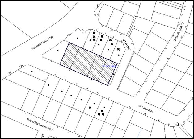
|
NOTIFICATION PLAN |
|
||
|
• PROPERTIES NOTIFIED
|
X SUBMISSIONS RECEIVED |
PROPERTY SUBJECT OF DEVELOPMENT
|
|
Twelve submissions from six residents objected to the development, generally on the following grounds:
· The building would be excessive in bulk and scale, being three storey;
· The extension on the northern side would have adverse impacts on the rear yards of the adjoining properties due to the height;
· The clerestory window would further add to the height of the building;
· The windows along the northern elevation would have adverse impacts on the privacy of the adjoining properties;
· The increase in the number of beds would result in additional noise generated by the use;
· The proposal does not include satisfactory on-site parking provisions;
· The reception and the driveway are located directly opposite No. 10 Hillmont Avenue and is unsafe being at the intersection of two streets;
· The development does not comply with the provisions within the SEPP HS&PD;
· The new lounge and activities room would overlook the living areas of the dwelling house at No. 3 Alma Court;
· The proposed development would overshadow the rear yard of the property at No. 3 Alma Court; and
· The proposal would devaluate the adjoining properties.
Additionally, the submissions made the following observations:
· The proposed use involves noise generation by the residents at odd hours, due to fire alarms and the truck deliveries. The truck movements should be via Alma Court instead of Hillmont Avenue and fixed windows with acoustically rated glass should be provided along the Hillmont Avenue frontage;
· A tree within No. 7 Hillmont Avenue has been removed;
· There are at least 23 staff members on site currently; and
· The application was advertised during school holidays thereby not providing opportunity for residents to comment.
The merits of the matters raised in community submissions have been addressed in the body of the report with the exception of the following:
5.1.1 Privacy Impacts on Properties Fronting Alma Court
The rear of the building adjoining the properties at Nos. 3-9 Alma Court does not exceed the height limit of 8m. Therefore the height of the building is comparable to a two storey dwelling on the site.
As stated earlier in this report, the windows/balconies oriented to the north incorporate screening or translucent glass to 1.6m height to alleviate overlooking opportunities. Additionally, screen planting along the northern boundary would comprise 4- 8m high canopy trees.
About 50% of the south facing elevation for the dwelling at No. 3 Alma Court would face the garden at the north-eastern corner.
5.1.2 Notification Period
The application has been advertised in accordance with Council’s notification policy within the HDCP. There is no requirement for exclusion of notification during mid-year school holidays. Additionally, two yellow signs were displayed along the frontages to notify residents in the locality.
5.1.3 Driveway Location
The driveway is not located close to the intersection with a busy road and therefore, no concerns are raised in this regard.
5.1.4 Noise Due to Activities in the Centre
The proposal is for alterations and additions to a residential development for people with high care needs and exists on the site historically. An Acoustic report has been submitted with the application which concludes that the proposed use would generate noise that is comparable with low density residential dwellings. Installation of fixed glass windows to the rooms facing Hillmont Avenue would cause unreasonable impact on the amenity of residents and is not warranted in this instance.
Subject to conditions regulating the delivery times to be within 7am and 6pm and the acoustic treatment to the glazing, no concerns are raised regarding unruly noise generated by the residents.
5.1.5 Number of Staff on Site
The statement submitted with the application confirms that the existing facility has 17 staff members. The proposal would result in 20 staff members on the site.
5.1.6 Devaluation of Properties
The proposal is a permissible use on the site and is an extension to an existing development. As such devaluation of properties due to adjoining developments is not a matter for consideration under Section 79C of the Act.
5.2 Public Agencies
The development application was not referred to any Public Agencies for comment.
6. THE PUBLIC INTEREST
Section 79C(1)(e) of the Act requires Council to consider “the public interest”.
The public interest is an overarching requirement, which includes the consideration of the matters discussed in this report. Implicit to the public interest is the achievement of future built outcomes adequately responding to and respecting the future desired outcomes expressed in environmental planning instruments and development control plans.
The application is considered to have satisfactorily addressed Council’s criteria and would provide a development outcome that, on balance, would result in a positive impact for the community. Accordingly, it is considered that the approval of the proposed development would be in the public interest.
CONCLUSION
The application proposes alterations to an existing residential care facility and additions to the eastern side of the building to provide a facility with 67 beds, basement car park, ancillary services and associated landscaping.
The proposed alterations would result in improved building functionality and appropriate level of services to the residents.
The development generally complies with the objectives and controls contained in State Environmental Planning Policy (Housing for Seniors or People with a Disability) 2004 and the Hornsby Local Environmental Plan 2013 and is satisfactory having regard to the matters for consideration pursuant to Section 79C of the Environmental Planning and Assessment Act 1979. The non-compliances with the provisions within the State Environmental Planning Policy (Housing for Seniors or People with a Disability) 2004 are acceptable given that the facility exists on site and the proposed alterations would result in an improved outcome for the site.
The proposal does not comply with the State Environmental Planning Policy (Housing for Seniors or People with a Disability) 2004 with regard to Clause 40 (Height). An objection pursuant to State Environmental Planning Policy No. 1 has been submitted to support the development, which is considered well-founded.
Council received twelve submissions during the public notification period and appropriate controls and conditions are recommended to minimise disruption to residential amenity.
Having regard to the circumstances of the case, approval of the application is recommended.
Note: At the time of the completion of this planning report, no persons have made a Political Donations Disclosure Statement pursuant to Section 147 of the Environmental Planning and Assessment Act 1979 in respect of the subject planning application.
RESPONSIBLE OFFICER
The officer responsible for the preparation of this Report is the Manager – Development Assessments – Rodney Pickles, who can be contacted on 9847 6731.
|
Rod Pickles Manager - Development Assessment Planning Division |
James Farrington Group Manager Planning Division |
|
1.View |
Locality Map |
|
|
|
2.View |
Site Plan |
|
|
|
3.View |
Floor Plans Part 1 |
|
|
|
4.View |
Floor Plans Part 2 |
|
|
|
5.View |
Elevations and Sections |
|
|
|
6.View |
Shadow Plan |
|
|
|
7.View |
Staging Plan |
|
|
|
8.View |
Landscape Plan |
|
|
File Reference: DA/333/2016
Document Number: D06998770
SCHEDULE 1
Conditions of approval
STAGE 1 – CONSTRUCTION OF THE NEW ADDITIONS TO THE EAST INCLUDING LOWER BASEMENT CARPARK AND 24 NEW BEDS
STAGE 2 – REFURBISHMENT OF THE SOUTHERN PART OF THE EXISTING BUILDING INCLUDING A NEW KITCHEN AND 13 REFURBISHED BEDS AT THE GROUND LEVEL
STAGE 3 – REFURBISHEMNT OF THE NORTHERN PORTION OF THE EXISTING BUILDING AND ADDITION OF FIRST FLOOR TO PROVIDE 30 BEDS AND ASSOCIATED FACILITIES
CONDITIONS APPLICABLE TO STAGES 1, 2 AND 3 OF THE DEVELOPMENT
GENERAL CONDITIONS
The conditions of consent within this notice of determination have been applied to ensure that the use of the land and/or building is carried out in such a manner that is consistent with the aims and objectives of the relevant legislation, planning instruments and council policies affecting the land and does not disrupt the amenity of the neighbourhood or impact upon the environment.
Note: For the purpose of this consent, the term ‘applicant’ means any person who has the authority to act on or the benefit of the development consent.
Note: For the purpose of this consent, any reference to an Act, Regulation, Australian Standard or publication by a public authority shall be taken to mean the gazetted Act or Regulation, or adopted Australian Standard or publication as in force on the date that the application for a construction certificate is made.
1. Approved Plans and Supporting Documentation
The development must be carried out in accordance with the plans and documentation listed below and endorsed with Council’s stamp, except where amended by Council and/or other conditions of this consent:
Architectural Plans
|
Plan No. |
Rev |
Plan Title |
Drawn by |
Dated |
|
A101 |
F |
Site Plan |
Sue Kenny Architect |
30/05/2016 |
|
A150 |
C |
Demolition Plan |
Sue Kenny Architect |
18/03/2016 |
|
A201 |
F |
Lower Ground Floor and Ground Floor Plan |
Sue Kenny Architect |
30/05/2016 |
|
A202 |
E |
First Floor and Roof Plan |
Sue Kenny Architect |
18/03/2016 |
|
A301 |
D |
Elevations and External Finishes Schedule |
Sue Kenny Architect |
18/03/2016 |
|
A401 |
C |
Sections and 3D model image |
Sue Kenny Architect |
18/03/2016 |
|
A103 |
D |
Site Analysis Sections |
Sue Kenny Architect |
18/03/2016 |
|
A104 |
C |
Site Analysis Sections/Streetscape elevations/Photomontage |
Sue Kenny Architect |
18/03/2016 |
|
A106 |
D |
Waste Management Plan and proposed staging plan |
Sue Kenny Architect |
18/03/2016 |
|
L01 |
- |
Landscape Plan |
Frolic Consortium |
March 2016 |
|
L02 |
- |
Plant Species Schedule |
Frolic Consortium |
August 2015 |
|
C01 |
4 |
Stormwater Plan |
Michael Frost and Associates Pty Ltd |
11/03/2016 |
|
C02 |
4 |
Stormwater Details |
Michael Frost and Associates Pty Ltd |
11/03/2016 |
|
C03 |
2 |
Sedimentation and Erosion Control Plan |
Michael Frost and Associates Pty Ltd |
11/03/2016 |
|
C04 |
2 |
Sedimentation and Erosion Control Details |
Michael Frost and Associates Pty Ltd |
11/03/2016 |
Supporting Documents
|
Plan No |
Rev |
Plan Title |
Drawn by |
Dated |
|
A100 |
C |
Cover Sheet |
Sue Kenny Architect |
18/03/2016 |
|
A102 |
C |
Site Analysis Plan |
Sue Kenny Architect |
18/03/2016 |
|
A102A |
C |
Site Analysis Plan |
Sue Kenny Architect |
18/03/2016 |
|
A105 |
D |
Site shadow diagram and height analysis plan |
Sue Kenny Architect |
18/03/2016 |
|
Sheet 1 - 5 |
E |
Detail Survey |
William Backhouse Surveyors |
2/02/2016 |
|
|
|
Architectural Design Statement |
Sue Kenny Architect |
17/03/2016 |
|
|
|
Tree Report |
Stuart Pittendrigh |
March 2016 |
|
|
|
Landscape Design Statement |
Frolic Consortium |
March 2016 |
|
|
|
Traffic and Parking Assessment Report |
Varga Traffic Planning |
4/03/2016 |
|
R01 |
V4 |
Acoustic Impact Assessment Report |
PKA Acoustic Consultancy |
22/03/2016 |
|
215008 |
- |
Access Report |
Accessible Building Solutions |
18/03/2016 |
|
|
|
Construction Management Plan |
GAC Projects Australia |
12/02/2016 |
|
|
|
Waste Management Plan |
GAC Projects Australia |
15/02/2016 |
|
|
|
PAC Services and Charity Status Statement |
Presbyterian Aged Care |
15/02/2016 |
|
E27536 |
Hrpt |
Preliminary Environmental Site Assessment |
Environmental Investigation Services |
21/07/2014 |
|
27536 |
1 |
Geotechnical Investigation |
JK Geotechnics |
24/02/2016 |
|
15075650 |
1 |
Preliminary Energy Efficiency Evaluation |
Partners Energy |
21/03/2016 |
|
- |
- |
SEPP 1 Objection |
Smyth Planning |
22/03/2016 |
|
- |
- |
Statement of Environmental Effects |
Smyth Planning |
22/03/2016 |
2. Removal of Existing Trees
a) This development consent permits the removal of trees numbered 2, 3, 4, 5, 6, 7, 8 and 19 as identified on plan number L01 - Landscape Plan prepared by Frolic Consortium dated March 2016.
b) The removal of any other trees requires separate approval in accordance with the Tree and Vegetation Chapter 1B.6 Hornsby Development Control Plan (HDCP).
3. Amendment of Plans
a) The approved Landscape Plan L01 prepared by Frolic Consortium dated March 2016 must be amended to redesign the location of the street trees and include the 2m wide footpath as shown in the approved Site plan A101 Rev F prepared by Sue Kenny Architect dated 30/05/2016.
b) These amended plans must be submitted with the application for the Construction Certificate for Stage 1 of the building works.
4. Construction Certificate
a) A Construction Certificate is required to be approved by Council or a Private Certifying Authority prior to the commencement of any works under this consent.
b) A separate Construction Certificate must be obtained from Council for all works within the public road reserve under S138 of the Roads Act.
c) A separate Construction Certificate must be obtained from Council for all works within drainage easements vested in Council.
d) The Construction Certificate plans must not be inconsistent with the Development Consent plans.
5. Project Arborist
A Project Arborist is to be appointed in accordance with AS 4970-2009 (1.4.4) to provide monitoring and certification throughout the development process. The details of the appointed Arborist are to be provided to Council and the PCA prior to the issue of the construction certificate.
REQUIREMENTS PRIOR TO THE ISSUE OF A CONSTRUCTION CERTIFICATE
6. Building Code of Australia
All approved building work must be carried out in accordance with the relevant requirements of the Building Code of Australia.
7. Contract of Insurance (Residential Building Work)
Where residential building work for which the Home Building Act, 1989 requires there to be a contract of insurance in force in accordance with Part 6 of that Act, this contract of insurance must be in force before any building work authorised to be carried out by the consent commences.
8. Notification of Home Building Act, 1989 Requirements
Residential building work within the meaning of the Home Building Act 1989 must not be carried out unless the principal certifying authority for the development to which the work relates (not being Council) has given Council written notice of the following information:
a) In the case of work for which a principal contractor is required to be appointed:
i) The name and licence number of the principal contractor; and
ii) The name of the insurer by which the work is insured under Part 6 of that Act.
b) In the case of work to be done by an owner-builder:
i) The name of the owner-builder; and
ii) If the owner-builder is required to hold an owner-builder’s permit under that Act, the number of the owner-builder’s permit.
Note: If arrangements for doing the residential building work are changed while the work is in progress so that the information notified becomes out of date, further work must not be carried out unless the principal certifying authority for the development to which the work relates (not being Council) has given Council written notification of the updated information.
9. Utility Services
The applicant must submit written evidence of the following service provider requirements:
a) Ausgrid (formerly Energy Australia) – a letter of consent demonstrating that satisfactory arrangements have been made to service the proposed development.
b) Telstra – a letter of consent demonstrating that satisfactory arrangements have been made to service the proposed development.
10. Sydney Water – Approval
This application must be submitted to Sydney Water for approval to determine whether the development would affect any Sydney Water infrastructure, and whether further requirements are to be met.
Note: Building plan approvals can be obtained online via Sydney Water Tap inTM through www.sydneywater.com.au under the Building and Development tab.
11. Traffic Control Plan
A Traffic Control Plan (TCP) must be prepared by a qualified traffic controller in accordance with the Roads & Traffic Authority’s Traffic Control at Worksites Manual 1998 and Australian Standard 1742.3 for all work on a public road. The Traffic Management Plan shall be submitted and approved by Council’s Manager Traffic and Road Safety prior to the issue of a construction certificate. The TCP must detail the following:
a) Arrangements for public notification of the works;
b) Temporary construction signage;
c) Permanent post-construction signage;
d) Vehicle movement plans;
e) Traffic management plans; and
f) Pedestrian and cyclist access/safety.
12. Identification of Survey Marks
A registered surveyor must identify all survey marks in the vicinity of the proposed development. Any survey marks required to be removed or displaced as a result of the proposed development shall be undertaken by a registered surveyor in accordance with Section 24 (1) of the Surveying and Spatial Information Act 2002 and following the Surveyor General’s Directions No.11 – "Preservation of Survey Infrastructure".
13. Acoustics
The construction certificate plans for each stage of building work must demonstrate compliance with the recommendations and construction specifications within the Acoustic Impact Assessment Report prepared by PKA Acoustic Consultancy dated 22/03/2016.
REQUIREMENTS PRIOR TO THE COMMENCEMENT OF ANY WORKS
14. Erection of Construction Sign
a) A sign must be erected in a prominent position on any site on which any approved work is being carried out:
i) Showing the name, address and telephone number of the principal certifying authority for the work;
ii) Showing the name of the principal contractor (if any) for any demolition or building work and a telephone number on which that person may be contacted outside working hours; and
iii) Stating that unauthorised entry to the work site is prohibited.
b) The sign is to be maintained while the approved work is being carried out and must be removed when the work has been completed.
15. Protection of Adjoining Areas
A temporary hoarding, fence or awning must be erected between the work site and adjoining lands before the works begin and must be kept in place until after the completion of the works if the works:
a) Could cause a danger, obstruction or inconvenience to pedestrian or vehicular traffic;
b) Could cause damage to adjoining lands by falling objects; and/or
c) Involve the enclosure of a public place or part of a public place.
Note: Notwithstanding the above, Council’s separate written approval is required prior to the erection of any structure or other obstruction on public land.
16. Toilet Facilities
a) To provide a safe and hygienic workplace, toilet facilities must be available or be installed at the works site before works begin and must be maintained until the works are completed at a ratio of one toilet for every 20 persons employed at the site.
b) Each toilet must:
i) be a standard flushing toilet connected to a public sewer; or
ii) be a temporary chemical closet approved under the Local Government Act 1993; or
iii) have an on-site effluent disposal system approved under the Local Government Act 1993.
17. Erosion and Sediment Control
To protect the water quality of the downstream environment, erosion and sediment control measures must be provided and maintained throughout the construction period in accordance with the manual ‘Soils and Construction 2004 (Bluebook)’, the approved plans, Council specifications and to the satisfaction of the principal certifying authority. The erosion and sediment control devices must remain in place until the site has been stabilised and revegetated.
Note: On the spot penalties may be issued for any non-compliance with this requirement without any further notification or warning.
18. Tree Protection Barriers
a) To safeguard the natural environment during the approved development works, tree protection fencing must be erected around tree Nos. 9, 11, 12, 13, 14, 15, 16, 17, 18 identified L01 - Landscape Plan prepared by Frolic Consortium dated March 2016 at nominated setbacks listed in Clause 3.2 of AS 4970-2009.
b) All trees proposed to be retained on site must have tree protection measures for the ground, trunk and canopy installed in accordance with the Clause 4.3 and 4.4 Australian Standard ‘Protection of Trees on Development Sites (AS 4970-2009).
c) All Tree Protection Zones must have a layer of wood-chip mulch installed prior to works commencing and must be maintained throughout the period of construction at a depth of 150mm – 300mm using material that complies with Australian Standard AS 4454.
d) Where tree protection fencing cannot be located at the perimeter of the Tree Protection Zone, appropriate ground, trunk and crown protection must be provided in accordance with AS 4970-2009 (Clause 4.5) under the direction of the project Arborist. The Structural Root Zone must be protected by fencing.
e) A certificate from the Project Arborist must be submitted to the Principal Certifying Authority and Council stating compliance with the relevant tree protection conditions of this consent.
19. Geotechnical Investigation
Geotechnical Investigation should be undertaken and a report submitted to the Principal Certifying Authority in accordance with the recommendations within Section 4.6 of the submitted Geotechnical Investigation Report No. 27536 Rev 1 prepared by JK Geotechnics dated 24/02/2016.
REQUIREMENTS DURING CONSTRUCTION
20. Construction Work Hours
All works on site, including demolition and earth works, must only occur between 7am and 5pm Monday to Saturday.
No work is to be undertaken on Sundays or public holidays.
21. Demolition
To protect the surrounding environment, all demolition work must be carried out in accordance with “Australian Standard 2601-2001 – The Demolition of Structures” and the following requirements:
a) Demolition material must be disposed of to an authorised recycling and/or waste disposal site and/or in accordance with an approved waste management plan;
b) Demolition works, where asbestos material is being removed, must be undertaken by a contractor that holds an appropriate licence issued by WorkCover NSW in accordance with Chapter 10 of the Occupational Health and Safety Regulation 2001 and Clause 29 of the Protection of the Environment Operations (Waste) Regulation 2005 ;and
c) On construction sites where any building contain asbestos material, a standard commercially manufactured sign containing the words ‘DANGER ASBESTOS REMOVAL IN PROGRESS’ and measuring not less than 400mm x 300mm must be displayed in a prominent position visible from the street.
22. Environmental Management
The site must be managed in accordance with the publication ‘Managing Urban Stormwater – Landcom (March 2004) and the Protection of the Environment Operations Act 1997 by way of implementing appropriate measures. To prevent sediment run-off, excessive dust, noise or odour emanating from the site during the construction of the development.
23. Street Sweeping
To protect the surrounding environment, street sweeping must be undertaken following sediment tracking from the site along Alma Court and Hillmont Avenue during works and until the site is established.
The street cleaning services must undertake a street ‘scrub and dry’ method of service and not a dry sweeping service that may cause sediment tracking to spread or cause a dust nuisance.
24. Works Near Trees
a) To protect trees to be retained, all required tree protection measures are to be monitored and maintained by the Project Arborist in accordance with Clause 5.4.3 of AS 4970-2009.
b) Any scaffolding must be erected outside the tree protection zone of all trees to be retained on site in accordance with Section 4.5.6 of AS4970 – 2009.
c) The approved pruning works must be conducted under the direction of the Project Arborist in accordance with the Clause 7.2 General Crown Maintenance in Australian Standard Pruning of Amenity Trees (AS 4373-2007).
d) Approved works within the nominated Tree Protection Zones of trees protected by this development consent, must be conducted in accordance with the following:
i) All works must be approved by and be conducted under the direction of the Project Arborist;
ii) Root/ground protection/root pruning outside the structure root zone of a tree and underground services installation must be provided in accordance with AS 4970-2009 (Clause 4.5.4 and clause 4.5.5);
iii) The Structural Root Zone retained must remain intact;
iv) Activities within the Tree Protection Zone must comply with AS 4970-2009 (Clause 4.2);
v) Installation of services must be undertaken using sensitive methods such as directional drilling or in manually excavated trenches; and
vi) Any necessary excavation must be undertaken by sensitive methods such as pneumatic or by hand as prescribe in AS 4970-2007 Sections 4.5.5
e) The Project Arborist must monitor, record and recommend any necessary remedial actions for maintaining tree health and conditions where works are approved to be conducted within the nominated tree protection zones of trees to be protected on the site or on the adjoining properties, is there is evidence of the following:
i) A general decline in health and vigour;
ii) Damaged, crushed or dying roots;
iii) Excessive (>10%) loss or dieback of roots, branches and foliage;
iv) Mechanical damage or bruising of bark and timber of roots, trunks and branches;
v) Yellowing of foliage of thinning of canopy uncharacteristic of the species;
vi) An increase in the amount of deadwood not associated with normal growth;
vii) Inappropriate increase in the development of epicormic growth and/or the presence of sucker growth on the trunk; and
viii) Branch drop, torn branches and stripped bark not associated with natural climate conditions.
f) The appointed Project Arborist must monitor and record all changes or modifications required regarding tree protection measures for the period of construction.
g) A certificate must be submitted to the principal certifying authority by the Project Arborist detailing the method(s) used to preserve these tree(s) during the course of construction.
Note: Except as provided above, The filling or stockpiling of building materials, the parking of vehicles or plant, the disposal of cement slurry, waste water or other contaminants must be located outside the tree protection zones as prescribed in the conditions of this consent or the prescriptive measures of Part 1B.6.1 Tree Preservation of the Hornsby Development Control Plan, 2013, of any tree to be retained.
25. Council Property
To ensure that the public reserve is kept in a clean, tidy and safe condition during construction works, no building materials, waste, machinery or related matter is to be stored on the road or footpath.
26. Excavated Material
All excavated material removed from the site must be classified by a suitably qualified person in accordance with the Department of Environment, Climate Change and Water NSW Waste Classification Guidelines prior to disposal to an approved waste management facility and be reported to the principal certifying authority prior to the issue of an Occupation Certificate.
27. Landfill
Landfill must be constructed in accordance with Council’s ‘Construction Specification 2005’ and the following requirements:
a) Prior to fill material being imported to the site, a certificate shall be obtained from a suitable qualified environmental consultant confirming the fill wholly consists of Virgin Excavated Natural Material (VENM) as defined in Schedule 1 of the Protection of the Environment Operations Act, 1997 or material approved under the Department of Environment and Climate Change’s general resource recovery exemption.
b) A compaction certificate is to be obtained from a suitably qualified geotechnical engineer verifying that the specified compaction requirements have been met.
c) These certificates must be included with the application for an occupation certificate.
28. Survey Report
A report(s) must be prepared by a registered surveyor and submitted to the principal certifying authority:
a) Prior to the pouring of concrete at each level of the building certifying that:
i) The building, retaining walls and the like have been correctly positioned on the site; and
ii) The finished floor level(s) are in accordance with the approved plans.
29. Waste Management
Waste management during the demolition and construction phase of the development must be undertaken in accordance with the approved Waste Management Plan. Additionally written records of the following items must be maintained during the removal of any waste from the site and such information submitted to the Principal Certifying Authority within fourteen days of the date of completion of the works:
a) The identity of the person removing the waste.
b) The waste carrier vehicle registration.
c) Date and time of waste collection.
d) A description of the waste (type of waste and estimated quantity).
e) Details of the site to which the waste is to be taken.
f) The corresponding tip docket/receipt from the site to which the waste is transferred (noting date and time of delivery, description (type and quantity) of waste).
g) Whether the waste is expected to be reused, recycled or go to landfill.
Note: In accordance with the Protection of the Environment Operations Act 1997, the definition of waste includes any unwanted substance, regardless of whether it is reused, recycled or disposed to landfill.
30. Compliance During Construction Works
a) The development must be carried out in accordance with the following approved documents:
i) Traffic Control Plan (TCP);
ii) Construction Management Plan (CMP); and
iii) The recommendations within the Section 4 of the Geotechnical Investigation Report No. 27536 Rev 1 prepared by JK Geotechnics dated 24/02/2016 regarding Excavation, Subgrade preparation and fill compaction, Footing Design, Shoring, Groundwater considerations relevant to the particular stage of building works.
b) Noise attenuation measures be implemented along the northern and southern boundaries of the site;
c) During excavation works, rock removal must be undertaken by sawing instead of rock hammering, wherever practicable;
d) The construction works must be undertaken in accordance with the “Interim Construction Noise Guidelines – 2009” published by DECCW and achieve compliance with the relevant noise levels; and
e) The delivery times and vehicular movements related to demolition, excavation and construction works must be restricted to the construction hours only.
31. Maintenance of Public Footpaths
Public footpaths must be maintained for the duration of works to ensure they are free of trip hazards, displacements, breaks or debris to enable pedestrians to travel along the footpath safely.
REQUIREMENTS PRIOR TO THE ISSUE OF AN OCCUPATION CERTIFICATE
Note: For the purpose of this consent, a reference to ‘occupation certificate’ shall not be taken to mean an ‘interim occupation certificate’ unless otherwise stated.
32. Damage to Council Assets
To protect public property and infrastructure, any damage caused to Council’s assets as a result of the construction or demolition of the development must be rectified by the applicant in accordance with Council’s Civil Works Specifications. Rectification works must be undertaken prior to the issue of an Occupation Certificate, or sooner, as directed by Council.
33. Preservation of Survey Marks
A certificate by a Registered Surveyor must be submitted to the Principal Certifying Authority, certifying that there has been no removal, damage, destruction, displacement or defacing of the existing survey marks in the vicinity of the proposed development or otherwise the re-establishment of damaged, removed or displaced survey marks has been undertaken in accordance with the Surveyor General’s Direction No.11 – “Preservation of Survey Infrastructure”.
34. Retaining Walls
All required retaining walls must be constructed as part of the development.
35. External Lighting
a) To protect the amenity of adjacent premises, all external lighting must be designed and installed in accordance with Australian Standard AS 4282 – Control of the Obtrusive Effects of Outdoor Lighting.
b) Certification of compliance with this Standard must be obtained from a suitably qualified person and submitted to the PCA with the application for the Construction Certificate.
36. Waste Management
The following waste management requirements must be complied with:
a) A report must be prepared by an appropriately qualified person, certifying the following:
i) A comparison of the estimated quantities of each waste type against the actual quantities of each waste type.
Note: Explanations of any deviations to the approved Waste Management Plan is required to be included in this report.
ii) That at least 60% of the waste generated during the demolition and construction phase of the development was reused or recycled.
Note: If the 60% diversion from landfill cannot be achieved in the Construction Stage, the Report is to include the reasons why this occurred and certify that appropriate work practices were employed to implement the approved Waste Management Plan. The Report must be based on documentary evidence such as tipping dockets/receipts from recycling depots, transfer stations and landfills, audits of procedures etc. which are to be attached to the report.
iii) All waste was taken to site(s) that were lawfully permitted to accept that waste.
37. Final Certification – Tree Protection
Following the final inspection and the completion of any remedial works, the project Arborist must submit to the Principal Certifying Authority documentation stating that the completed works have been carried out in compliance with the approved plans conditions of development consent and specifications for tree protection as above and AS 4970-2009.
38. Final Certification – Acoustic Consultant
A suitably qualified Acoustic Consultant must provide a certificate to the Principal Certifying Authority stating that the development has been constructed in accordance with the acoustic treatments recommended in the Acoustic Impact Assessment Report prepared by PKA Acoustic Consultancy dated 22/03/2016.
39. Final Certification Geotechnical Consultant
A certificate from a suitably qualified geotechnical consultant must be provided to the Principal Certifying Authority stating that the construction has been undertaken in accordance with the findings and recommendations of the geotechnical investigation required in accordance with condition 19 of this consent.
40. Installation of Privacy Devices
To establish and maintain a reasonable level of privacy for the adjoining premises all approved privacy devices (relevant to the Stage of building works) including the screen planting must be installed/provided and be operative.
41. Restriction on Occupation – Housing for Seniors or People with a Disability
A restriction as to user must be created under s88B of the Conveyancing Act, 1919 and registered, requiring the dwellings approved under this consent to be solely used for the accommodation of:
a) Seniors (55+ age) or people with a disability;
b) People who live within the same household as seniors or people with a disability; and
c) Staff employed to assist the administration and provision of services to housing provided under SEPP (Housing for Seniors or People with a Disability) 2004.
Note: The restriction must nominate Council as the authority to release, vary or modify the restriction.
42. Fire Sprinkler System
a) The residential care facility must have a fire sprinkler system installed and operational.
43. Installation of Air Conditioner
a) To protect the amenity of adjacent properties, the condenser unit for the air conditioner must be sited a minimum of 3 metres from the property boundary of any adjoining residential premises.
b) Alternatively, a certificate must be submitted to the PCA by a suitably qualified person confirming that the unit has been tested for heating and cooling on the highest settings and that the noise levels generated do not exceed 5 dB(A) above background noise levels when tested at the property boundary between 8 pm and 10 pm.
OPERATIONAL CONDITIONS
44. Noise
All noise generated by the proposed development must be attenuated to prevent levels of noise being emitted to adjacent premises which possess tonal, beating and similar characteristics or which exceeds background noise levels by more than 5dB(A).
45. Heavy Vehicle Access
The hours or delivery vehicle access to the site such as a garbage collection vehicle, food delivery and other deliveries specified in the PAC Services and Charity Status Statement prepared by Presbyterian Aged Care dated 15/02/2016 would be restricted to the following:
a) Monday to Saturday – 7am – 6pm
46. Fire Safety Statement - Annual
On at least one occasion in every 12 month period following the date of the first ‘Fire Safety Certificate’ issued for the property, the owner must provide Council with an annual ‘Fire Safety Certificate’ to each essential service installed in the building.
47. Landscape Establishment
The landscape works must be maintained into the future to ensure the establishment and successful growth of plant material to meet the intent of the landscape design. This must include but not limited to watering, weeding, replacement of failed plant material and promoting the growth of plants through standard industry practices.
48. Car Parking/Sight Lines and Deliveries
All car parking must be operated in accordance with Australian Standard AS 2890.1 – 2004 – Off Street Car Parking and Australian Standard 2890.2 - 2002 – Off Street Commercial and the following requirements:
a) All parking areas and driveways are to be sealed to an all-weather standard, line marked and signposted at all times.
b) Car parking, loading and manoeuvring areas to be used solely for nominated purposes.
c) Vehicles awaiting loading, unloading or servicing shall be parked on site and not on adjacent or nearby public roads;
d) All vehicular entry on to the site and egress from the site shall be made in a forward direction;
e) Minimum sight lines for pedestrian safety are to be provided at the driveway; and
f) Any proposed landscaping and/or fencing must not restrict sight distance to pedestrians and cyclists travelling along the footpath.
49. Waste Management
The waste management on site must be in accordance with the following requirements:
a) All commercial tenants must keep written evidence on site of a valid contract with a licensed waste contractor(s) for the regular collection and disposal of the waste and recyclables that are generated on site.
b) All commercial tenants must have a sufficient number of bins to contain the volume of waste and recycling expected to be generated between collection services.
50. Number of Staff
The premises shall accommodate a maximum of 20 staff members at any one time.
ADDITIONAL CONDITIONS APPLICABLE TO STAGE 1 OF THE BUILDING WORKS
REQUIREMENTS PRIOR TO THE ISSUE OF A CONSTRUCTION CERTIFICATE
51. Dilapidation Report
a) A ‘Dilapidation Report’ is to be prepared by a ‘chartered structural engineer’ detailing the structural condition of adjoining properties at Nos. 3, 5, 9, 7 and 11 Alma Court and No. 1 Hillmont Avenue, Thornleigh.
b) To record the structural condition of all properties adjoining the approved development, a dilapidation report must be prepared by a suitably qualified structural engineer for inclusion with the application of the Construction Certificate for Stage 1.
52. Stormwater Drainage
The stormwater drainage system for the development must be designed for an average recurrence interval (ARI) of 20 years and be gravity drained in accordance with the following requirements:
a) The roof water from the existing building must connected directly to Council’s street drainage system in accordance with the approved plans listed in Condition 1.
53. On-Site Stormwater Detention
An on-site stormwater detention system must be designed by a chartered civil engineer in accordance with the approved plans and the following requirements:
a) Have a capacity of not less than 27 cubic metres, and a maximum discharge (when full) of 14 litres per second;
b) Have a surcharge/inspection grate located directly above the outlet; and
c) Discharge from the detention system must be controlled via 1 metre length of pipe, not less than 50 millimetres diameter or via a stainless plate with sharply drilled orifice bolted over the face of the outlet discharging into a larger diameter pipe capable of carrying the design flow to an approved Council system.
54. Vehicular Crossing
A separate application under the Local Government Act, 1993 and the Roads Act 1993 must be submitted to Council for the installation of a new vehicular crossing and the removal of the redundant crossing. The vehicular crossing must be constructed in accordance with Council’s Civil Works Design 2005 and the following requirements:
a) Any redundant crossings must be replaced with integral kerb and gutter;
b) The footway area must be restored by turfing;
c) Approval must be obtained from all relevant utility providers that all necessary conduits be provided and protected under the crossing; and
Note: An application for a vehicular crossing can only be made to one of Council’s Authorised Vehicular Crossing Contractors. You are advised to contact Council on 02 9847 6940 to obtain a list of contractors.
55. Footpath
A 2m wide concrete footpath must be designed and constructed across the full frontage of the subject site in accordance with Hornsby Council’s Civil Works Design and Construction Specification 2005 and the following requirements:
a) Pouring of the concrete footpath to the full frontage of the subject site.
b) A standard pram ramp is to be constructed at Alma Court.
c) The land adjoining the footpath to be fully turfed.
d) Any public utility adjustments to be carried out at the cost of the applicant and to the requirements of the relevant public authority.
56. Internal Driveway/Vehicular Areas
The driveway and parking areas on site must be designed and a Construction Certificate issued in accordance with Australian Standards 2890.1, 2890.2, 3727 and the following requirements:
a) Design levels at the front boundary be obtained from Council if a private accredited certifier is engaged to obtain a construction certificate for these works;
b) The driveway be a rigid pavement;
c) The driveway grade must not exceed 25 percent and changes in grade must not exceed 8 percent;
d) The driveway pavement be a minimum 3 metres wide, 0.15 metres thick reinforced concrete with SL72 steel reinforcing fabric and a 0.15 metre sub-base;
e) The pavement have a kerb to one side and a one-way cross fall with a minimum gradient of 2 percent and a lintel and pit provided at the low point;
f) Construction of pedestrian access designed to help prevent slip and fall shall be designed and constructed with the future access driveway. Pedestrian grades steeper than 12.5% must be provided with surface texturing, brushing or cleats to satisfy Class V: R11 ramps in accordance with AS 4586-2004 Clause 5.2.
g) Conduit for utility services including electricity, water, gas and telephone be provided. All existing overhead assets including electricity and telecommunications cabling shall be relocated underground at no cost to Council (if applicable);
h) Longitudinal sections along both sides of the access driveway must be submitted to the principal certifying authority in accordance with the relevant sections of AS 2890.1. The maximum grade shall not exceed 1 in 4 (25%) with the maximum changes of grade of 1 in 8 (12.5%) for summit grades and 1 in 6.7 (15%) for sag grades. Any transition grades shall have a minimum length of 2 metres;
i) The longitudinal sections shall incorporate the design levels obtained from Council; and
j) A certificate from a qualified engineer must be submitted to the principal certifying authority certifying that the driveway grades, headroom clearance, aisle widths and parking areas have been designed in accordance with Australian Standards AS 2890.1.
57. Construction Management Plan
The Construction Management Plan (CMP) listed in Condition 1 of this development consent must be amended to include the following information:
a) Details of the proposed truck routes to and from the site, the routes must show that vehicles will not utilise local roads other than Hillmont Avenue, vehicles must enter and exit the site in a forward direction and must turn left from Hillmont Avenue onto Pennant Hills Road when exiting the site.
b) The amended (CTMP) must be submitted to Council for approval.
58. Waste Management Details
The following waste management details must be provided with the Construction Certificate Plans:
a) A Waste Management Plan Section One – Demolition Stage and Section Three – Construction Stage, covering the scope of this project and including the following details, is required to be submitted to Council:
i) An estimate of the types and volumes of waste and recyclables to be generated;
ii) A site plan showing sorting and storage areas for demolition and construction waste and the vehicle access to these areas;
iii) How excavation, demolition and construction waste materials will be reused or recycled and where residual wastes will be disposed; and
iv) The total percentage (by weight) of demolition and construction waste that will be reused or recycled.
REQUIREMENTS PRIOR TO THE COMMENCEMENT OF ANY EARTHWORKS OR CONSTRUCTION WORKS
59. Requirements Prior to the Disturbance of Ground and any Excavation Works
a) Demolition works up to the GROUND LEVEL ONLY can commence on the site subject to the issue of the Construction Certificate and the compliance with condition Nos. 1 – 19 of this development consent.
b) No demolition works below the ground level that may result in excavation or disturbance of ground, must occur prior to the compliance with the following conditions of consent:
i) Detailed Site Investigation
A detailed investigation of the proposed development site must be prepared by a suitably qualified environmental consultant. Such investigation must be undertaken in accordance with NSW Environment Protection Authority’s Contaminated Sites – Guidelines for Consultants Reporting on Contaminated Sites and Contaminated Sites – Sampling Design Guidelines.
ii) Remedial Action Plan
Should the preliminary/detailed investigation reveal contamination exceeding criteria prescribed by the NSW Environment Protection Authority’s Contaminated Sites – Guidelines for the NSW Site Auditor Scheme, a Remedial Action Plan (RAP) must be prepared by a suitably qualified environmental consultant and submitted to Council for approval.
REQUIREMENTS DURING DEMOLITION AND CONSTRUCTION
60. Demolition Works Below Ground and Excavation Works
All demolition works below ground, disturbance of ground and excavation works must commence after the site has been remediated in accordance with the approved Remedial Action Plan.
REQUIREMENTS PRIOR TO THE ISSUE OF AN OCCUPATION CERTIFICATE
Note: For the purpose of this consent, a reference to ‘occupation certificate’ shall not be taken to mean an ‘interim occupation certificate’ unless otherwise stated.
61. Site Remediation Verification
The applicant must provide documentation from a suitably qualified environmental consultant verifying that the site has been remediated in accordance with the NSW Environment Protection Authority’s Contaminated Sites – Guidelines for Consultants Reporting on Contaminated Sites, the Contaminated Sites- Sampling Design Guidelines Contaminated Sites – Guidelines for the NSW Site Auditor Scheme and the recommendations of the approved Remedial Action Plan.
62. Creation of Easements
The following matter(s) must be nominated on the plan of subdivision under s88B of the Conveyancing Act, 1919:
a) The creation of an appropriate "Positive Covenant" and "Restriction as to User" over the constructed on-site detention systems and outlet works, within the lots in favour of Council in accordance with Council’s prescribed wording. The position of the on-site detention system is to be clearly indicated on the title;
b) To register the OSD easement, the restriction on the use of land “works-as-executed” details of the on-site-detention system must be submitted verifying that the required storage and discharge rates have been constructed in accordance with the design requirements. The details must show the invert levels of the on-site system together with pipe sizes and grades. Any variations to the approved plans must be shown in red on the “works-as-executed” plan and supported by calculations.
Note: Council must be nominated as the authority to release, vary or modify any easement, restriction or covenant.
63. Works as Executed Plan
A works-as-executed plan(s) must be prepared by a registered surveyor and submitted to Council for completed road pavement, kerb & gutter, public drainage systems, driveways and on-site detention system.
64. Construction of Engineering Works
All engineering works identified in this consent including stormwater works, retaining walls, driveway works, roadworks and the like are to be completed and a Compliance Certificate issued prior to the release of the Occupation Certificate for Stage 1.
65. Consolidation of Allotments
All allotments the subject of this consent must be consolidated into one allotment.
Note: The applicant is recommended to submit the plan of subdivision to consolidate allotments to the NSW Department of Lands at least 4-6 weeks prior to seeking an occupation certificate.
66. Completion of Landscaping
A certificate must be submitted to the PCA by a practicing landscape architect, horticulturalist or person with similar qualifications and experience certifying that all required landscaping works have been satisfactorily completed in accordance with the approved landscape plan as amended by Condition 3 of this development consent and the following requirements:
a) All landscaping works within the eastern part of the site accommodating the new building must be completed including the screen planting on the northern side;
b) 5 x Crepe Myrtle trees must be planted on Council’s nature strip on Alma Court and Hillmont Avenue in front of the new building;
c) The street trees are to be located 1000mm long and min 600mm wide mulched plant beds, have three hardwood stakes with a minimum 200 litre pot size during plant establishment;
d) The pot size of the replacement trees within the site must be a minimum 25 litres and replacement trees must be maintained until they reach the height of 3 metres;
e) All tree stock must meet the specifications outlined in ‘Specifying Trees’ (Ross Clark, NATSPEC Books);
f) Planting methods must meet professional (best practice) industry standards; and
g) On slab planter boxes including the ground cover above the on-site detention tank and the paved areas along the north-western boundary of the site must include waterproofing, subsoil drainage (proprietary drainage cell, 50mm sand and filter fabric) automatic irrigation, minimum 300mm planting soil for grasses and ground covers, 500mm planting soil for shrubs and minimum 1000mm planting soil for trees and palms and 75mm mulch to ensure sustainable landscape is achieved.
Note: Advice on suitable species for landscaping can be obtained from Council’s planting guide ‘Indigenous Plants for the Bushland Shire’, available at www.hornsby.nsw.gov.au.
Note: Applicants are advised to pre-order plant material required in pot sizes 45 litre or larger to ensure Nurseries have stock available at the time of install.
67. Boundary Fencing
Boundary fencing should be installed as per the following requirements:
a) Fencing along the Alma Court frontage including all landscaped retaining walls must be constructed in accordance with the approved plans;
b) The fencing along the rear boundary (north) be 1.8m high solid timber lapped and capped fence as per recommendations of the Acoustic Impact Assessment Report prepared by PKA Acoustic Consultancy dated 22/03/2016.
c) Fencing must be erected along Hillmont Avenue frontage to the east of the new driveway in accordance with the approved plans.
Note: Alternative fencing may be erected along the northern boundary subject to the written consent of the adjoining property owner(s).
68. Car Parking and Vehicular Areas
a) A total of 8 car spaces including a disabled car space and plus an ambulance bay must be provided within the basement carpark;
b) All vehicular areas within the site must be constructed in accordance with the approved plans and conditions of the development consent, the Australian Standard AS 2890.1 – 2004 – Off Street Car Parking; and
c) The ambulance parking area and the turning area vehicle turning paths in the Traffic and Parking Assessment Report (ref 16050) prepared by Varga Traffic Planning dated 4/03/2016.
69. Security
All the landscaped areas, gardens and courtyards and the building must be provided with appropriate security measures as identified in the plans.
a) An intercom system must be installed at gate locations to ensure screening of persons entering the units;
b) The entry doors to the pedestrian foyer is to be constructed of safety rated glass to enable residents a clear line of site before entering or exiting the residential care facility;
c) Lighting is to be provided to pathways, building foyer entries, driveways and common external spaces;
d) Security gate access is to be provided to the car parking areas allowing residents-only access to private car spaces;
e) CCTV cameras must be installed at the entry and exit point;
f) The landscaped gardens and communal open space areas within the site must be illuminated with high luminance by motion sensor lighting; and
g) The driveway and basement car parking must be illuminated with low luminance at all times.
ADDITIONAL CONDITIONS APPLICABLE TO STAGE 2 OF THE BUILDING WORKS
REQUIREMENTS PRIOR TO THE ISSUE OF AN OCCUPATION CERTIFICATE
Note: For the purpose of this consent, a reference to ‘occupation certificate’ shall not be taken to mean an ‘interim occupation certificate’ unless otherwise stated.
70. Car Parking and Vehicular Areas
a) Six car spaces must be provided in front of the existing residential care facility building;
b) All vehicular areas within the site and the car parking, the ambulance parking area and the turning area must be constructed in accordance with Australian Standard AS 2890.1 – 2004 – Off Street Car Parking.
71. Completion of Landscaping
A certificate must be submitted to the PCA by a practicing landscape architect, horticulturalist or person with similar qualifications and experience certifying that all required landscaping works have been satisfactorily completed in accordance with the approved landscape plan as amended by Condition 3 of this development consent and the following requirements:
a) All proposed landscaping works in front of the existing building must be completed;
b) 6 x Crepe Myrtle trees must be planted on Council’s nature strip on Hillmont Avenue in front of the existing building;
c) The street trees are to be located 1000mm long and min 600mm wide mulched plant beds, have three hardwood stakes with a minimum 200 litre pot size during plant establishment;
d) The pot size of the replacement trees within the site must be a minimum 25 litres and replacement trees must be maintained until they reach the height of 3 metres;
e) All tree stock must meet the specifications outlined in ‘Specifying Trees’ (Ross Clark, NATSPEC Books);
f) Planting methods must meet professional (best practice) industry standards; and
g) On slab planter boxes within the site must include waterproofing, subsoil drainage (proprietary drainage cell, 50mm sand and filter fabric) automatic irrigation, minimum 300mm planting soil for grasses and ground covers, 500mm planting soil for shrubs and minimum 1000mm planting soil for trees and palms and 75mm mulch to ensure sustainable landscape is achieved.
Note: Advice on suitable species for landscaping can be obtained from Council’s planting guide ‘Indigenous Plants for the Bushland Shire’, available at www.hornsby.nsw.gov.au.
Note: Applicants are advised to pre-order plant material required in pot sizes 45 litre or larger to ensure Nurseries have stock available at the time of install.
72. Construction of Engineering Works
All engineering works identified in this consent for Stage 2 works are to be completed and a Compliance Certificate issued prior to the release of the Occupation Certificate.
73. Connection
The existing building must be connected to the new building internally and be operated as a single facility.
74. Security
All the existing security measures within the building should be operative.
ADDITIONAL CONDITIONS APPLICABLE TO STAGE 3 OF THE BUILDING WORKS
REQUIREMENTS PRIOR TO THE ISSUE OF AN OCCUPATION CERTIFICATE
Note: For the purpose of this consent, a reference to ‘occupation certificate’ shall not be taken to mean an ‘interim occupation certificate’ unless otherwise stated.
75. Completion of Landscaping
A certificate must be submitted to the PCA by a practicing landscape architect, horticulturalist or person with similar qualifications and experience certifying that all required landscaping works have been satisfactorily completed in accordance with the approved landscape plan as amended by Condition 3 of this development consent and the following requirements:
a) The landscaping works on the northern side in between the new and the existing building must be completed.
b) The pot size of any replacement trees must be a minimum 25 litres and replacement trees must be maintained until they reach the height of 3 metres;
c) All tree stock must meet the specifications outlined in ‘Specifying Trees’ (Ross Clark, NATSPEC Books);
d) Planting methods must meet professional (best practice) industry standards; and
e) On slab planter boxes within the site must include waterproofing, subsoil drainage (proprietary drainage cell, 50mm sand and filter fabric) automatic irrigation, minimum 300mm planting soil for grasses and ground covers, 500mm planting soil for shrubs and minimum 1000mm planting soil for trees and palms and 75mm mulch to ensure sustainable landscape is achieved.
Note: Advice on suitable species for landscaping can be obtained from Council’s planting guide ‘Indigenous Plants for the Bushland Shire’, available at www.hornsby.nsw.gov.au.
Note: Applicants are advised to pre-order plant material required in pot sizes 45 litre or larger to ensure Nurseries have stock available at the time of install.
76. Construction of Engineering Works
All engineering works identified in this consent for Stage 2 works are to be completed and a Compliance Certificate issued prior to the release of the Occupation Certificate.
77. Security
All the existing security measures within the building should be operative.
- END OF CONDITIONS –
ADVISORY NOTES
The following information is provided for your assistance to ensure compliance with the Environmental Planning and Assessment Act 1979, Environmental Planning and Assessment Regulation 2000, other relevant legislation and Council’s policies and specifications. This information does not form part of the conditions of development consent pursuant to Section 80a of the Act.
Environmental Planning and Assessment Act 1979 Requirements
The Environmental Planning and Assessment Act 1979 requires:
· The issue of a construction certificate prior to the commencement of any works. Enquiries can be made to Council’s Customer Services Branch on 9847 6760.
· A principal certifying authority to be nominated and Council notified of that appointment prior to the commencement of any works.
· Council to be given at least two days written notice prior to the commencement of any works.
· Mandatory inspections of nominated stages of the construction inspected.
· An occupation certificate to be issued before occupying any building or commencing the use of the land.
Long Service Levy
In accordance with Section 34 of the Building and Construction Industry Long Service Payments Act 1986, a ‘Long Service Levy’ must be paid to the Long Service Payments Corporation or Hornsby Council.
Note: The rate of the Long Service Levy is 0.35% of the total cost of the work.
Note: Hornsby Council requires the payment of the Long Service Levy prior to the issue of a construction certificate.
Tree and Vegetation Preservation
In accordance with Clause 5.9 of the Hornsby Local Environmental Plan 2013 a person must not ringbark, cut down, top, lop, remove, injure or wilfully destroy any tree or other vegetation protected under the Hornsby Development Control Plan 2013 without the authority conferred by development consent or a permit granted by Council.
Notes: A tree is defined as a long lived, woody perennial plant with one or relatively few main stems with the potential to grow to a height greater than three metres (3M). (HDCP 1B.6.1.c).
Tree protection measures and distances are determined using the Australian Standard AS 4970:2009, “Protection of Trees on Development Sites”.
Fines may be imposed for non-compliance with both the Hornsby Local Environmental Plan 2013 and the Hornsby Development Control Plan 2013.
Disability Discrimination Act
The applicant’s attention is drawn to the existence of the Disability Discrimination Act. A construction certificate is required to be obtained for the proposed building/s, which will provide consideration under the Building Code of Australia, however, the development may not comply with the requirements of the Disability Discrimination Act. This is the sole responsibility of the applicant.
Covenants
The land upon which the subject building is to be constructed may be affected by restrictive covenants. Council issues this approval without enquiry as to whether any restrictive covenant affecting the land would be breached by the construction of the building, the subject of this consent. Applicants must rely on their own enquiries as to whether or not the building breaches any such covenant.
Dial Before You Dig
Prior to commencing any works, the applicant is encouraged to contact Dial Before You Dig on 1100 or www.dialbeforeyoudig.com.au for free information on potential underground pipes and cables within the vicinity of the development site.
Telecommunications Act 1997 (Commonwealth)
If you are aware of any works or proposed works which may affect or impact on Telstra’s assets in any way, you are required to contact: Telstra’s Network Integrity Team on Phone Number 1800810443.
Asbestos Warning
Should asbestos or asbestos products be encountered during demolition or construction works, you are advised to seek advice and information prior to disturbing this material. It is recommended that a contractor holding an asbestos-handling permit (issued by WorkCover NSW) be engaged to manage the proper handling of this material. Further information regarding the safe handling and removal of asbestos can be found at:
Alternatively, telephone the WorkCover Asbestos and Demolition Team on 8260 5885.
Group Manager’s Report No. PL57/16
Planning Division
Date of Meeting: 10/08/2016
7 DEVELOPMENT APPLICATION - TOWNHOUSE DEVELOPMENT COMPRISING 9 DWELLINGS - 475 AND 477 PACIFIC HIGHWAY, ASQUITH
EXECUTIVE SUMMARY
|
DA No: |
DA/279/2016 (Lodged 10 March 2016) |
|
Description: |
Demolition of the existing structures and construction of a two-storey, multi dwelling housing development with attics comprising nine townhouses over basement car parking |
|
Property: |
Lots 21 and 22 DP 14476, Nos. 475 and 477 Pacific Highway, Asquith |
|
Applicant: |
Australian Consulting Architects Pty Ltd |
|
Owner: |
Seventy Thirty Pty Ltd |
|
Estimated Value: |
$ 3,248,551 |
· The application involves demolition of the existing structures and construction of a two-storey, multi dwelling housing development with attics comprising nine townhouses over basement car parking.
· The proposal generally complies with the Hornsby Local Environmental Plan 2013 and Hornsby Development Control Plan 2013.
· Five submissions have been received in respect of the application from one resident.
· It is recommended that the application be approved as deferred commencement consent subject to the creation of an easement for stormwater to drain to Council’s stormwater drainage system.
|
THAT Development Application No. DA/279/2016 for demolition of existing structures and construction of nine, two-storey townhouses with attics over basement car parking at Lots 21 and 22 DP 14476, Nos. 475 and 477 Pacific Highway, Asquith be approved as a deferred commencement pursuant to Section 80(3) of the Environmental Planning and Assessment Act 1979 subject to the conditions of consent detailed in Schedule 1 of Group Manager’s Report No. PL57/16. |
BACKGROUND
The subject land was rezoned from Residential A (Low Density) to R3 (Medium Density Residential) on 2 September 2011 as part of Council’s Housing Strategy.
On 13 October 2015, a pre-lodgement meeting was held between the applicant and Council officers. At the meeting, the applicant sought advice regarding a proposed multi dwelling housing comprising 10 two storey townhouses on the site. Council raised concerns regarding the setbacks to the boundaries, access to Asquith Oval, garbage collection and the loss of a significant tree.
The application was lodged on 10 March 2016 proposing construction of a multi dwelling housing comprising 10 two storey townhouses with attics over a common basement carpark.
Following an initial assessment of the application, on 20 April 2016, concerns were raised by Council officers regarding the design of the development, the proposed setbacks and solar access to individual units.
A meeting was held between Council Officers and the applicant in May 2016 to discuss these concerns. Consequently, amended plans were lodged on 15 June 2016 for 9 townhouses with increased setbacks from the side boundaries.
Further amended plans were submitted to Council on 22 July 2016 that increased the setbacks of the townhouses from the rear boundary. The amended plans are the subject of this report.
SITE
The subject site comprises two allotments located on the western side of the Pacific Highway, Asquith. The site is irregular in shape, has an area of 1,402m2 and a 31.12m frontage to the road. The site has a downward slope of 5.8% from the north-eastern corner to the south-western corner (rear).
Existing improvements on the site include two dwelling-houses with associated garages and carports accessed off the Pacific Highway via existing driveways. The site accommodates a number of trees including locally native and exotic species.
Asquith Oval adjoins the western boundary (rear) of the site. The adjoining allotments to the north and south include single and two storey dwelling houses.
The site is located approximately 1km north of Asquith Railway Station and the Asquith Commercial Centre. The surrounding developments include low density single and two storey residential dwellings on both sides of the Pacific Highway. The locality forms part of a redevelopment precinct zoned for two storey townhouse style developments which is undergoing transition.
PROPOSAL
The application proposes the demolition of the existing structures and construction of a two-storey multi dwelling housing development with attics comprising nine townhouses over basement car parking. The townhouses are proposed in two rows with a central courtyard accommodating private open space areas and a common walkway.
The unit configuration includes 6 x 3 bedroom dwellings and 3 x 4 bedroom dwellings with ground level open space fronting the street and rear setbacks. Individual access to the basement level car spaces is proposed for the four dwellings fronting the Pacific Highway.
One pedestrian entry is located adjacent to the northern boundary of the site with another pedestrian entry located adjacent to the driveway. A total of 19 car parking spaces including 18 residential car spaces in tandem arrangement, 1 visitors’ car space, bicycle and motorcycle parking, an on-site stormwater detention system, a garbage storage area and a truck turning area facilitating access for Small Rigid vehicles (SRV) are included in a single basement level.
Access to the rear row of townhouses from the basement level is proposed via stairs at the north-western corner of the basement. The stairs would connect to a communal open space on the northern side and then provide access to the individual dwellings via a common pathway across the centre of the site.
The development would be accessed from the Pacific Highway via a driveway located adjacent to the southern boundary of the site.
ASSESSMENT
The development application has been assessed having regard to ‘A Plan for Growing Sydney’, the ‘North Subregion (Draft) Subregional Strategy’ and the matters for consideration prescribed under Section 79C of the Environmental Planning and Assessment Act 1979 (the Act). The following issues have been identified for further consideration.
1. STRATEGIC CONTEXT
1.1 A Plan for Growing Sydney and (Draft) North Subregional Strategy
A Plan for Growing Sydney has been prepared by the NSW State Government to guide land use planning decisions for the next 20 years. The Plan sets a strategy for accommodating Sydney’s future population growth and identifies the need to deliver 689,000 new jobs and 664,000 new homes by 2031. The Plan identifies that the most suitable areas for new housing are in locations close to jobs, public transport, community facilities and services.
The NSW Government will use the subregional planning process to define objectives and set goals for job creation, housing supply and choice in each subregion. Hornsby Shire has been grouped with Hunters Hill, Ku-ring-gai, Lane Cove, Manly, Mosman, North Sydney, Pittwater, Ryde, Warringah and Willoughby to form the North Subregion. The Draft North Subregional Strategy will be reviewed and the Government will set housing targets and monitor supply to ensure planning controls are in place to stimulate housing development.
The proposed development would be consistent with ‘A Plan for Growing Sydney’, by providing seven additional dwellings and would contribute to housing choice in the locality.
2. STATUTORY CONTROLS
Section 79C(1)(a) requires Council to consider “any relevant environmental planning instruments, draft environmental planning instruments, development control plans, planning agreements and regulations”.
2.1 Hornsby Local Environmental Plan 2013
The proposed development has been assessed having regard to the provisions of the Hornsby Local Environmental Plan 2013 (HLEP).
2.1.1 Zoning of Land and Permissibility
The subject land is zoned R3 – Medium Density Residential under the HLEP. The objectives of the zone are:
· To provide for the housing needs of the community within a medium density residential environment.
· To provide a variety of housing types within a medium density residential environment.
· To enable other land uses that provide facilities or services to meet the day to day needs of residents.
The proposed development is defined as “multi dwelling housing” and is permissible in the zone with Council’s consent.
2.1.2 Height of Buildings
Clause 4.3 of the HLEP provides that the height of a building on any land should not exceed the maximum height shown for the land on the Height of Buildings Map. The maximum permissible building height for the subject site is 10.5 metres. The proposed building height is 10.4 metres and complies with this provision.
2.1.3 Heritage Conservation
Clause 5.10 of the HLEP sets out heritage conservation provisions for Hornsby Shire. The site does not include a heritage item and is not located in a heritage conservation area. Accordingly, no further assessment regarding heritage is necessary.
2.1.4 Earthworks
Clause 6.2 of the HLEP states that consent is required for proposed earthworks on site. Before granting consent for earthworks, Council is required to assess the impacts of the works on adjoining properties, drainage patterns and soil stability of the locality.
Council’s assessment of the proposed earthworks and excavation concludes that the proposal is satisfactory subject to conditions regarding submission of a dilapidation report assessing the impact of the excavation on the adjoining properties.
2.2 State Environmental Planning Policy No. 55 – Remediation of Land
The application has been assessed against the requirements of State Environmental Planning Policy No. 55. This Policy provides State-wide planning controls requiring that consent must not be granted to the carrying out of any development on land unless it has considered whether the land is contaminated or requires remediation for the proposed use.
A search of Council’s records and aerial images reveals that the property has been used exclusively for residential purposes with no record of site contamination. Given this, the site would be suitable for the proposed use and no further assessment in relation to this SEPP is required.
Due to the age of the existing fibro clad dwelling houses and outbuildings on the existing allotments there is potential for the existing buildings to contain asbestos. Accordingly, appropriate conditions are included to require all asbestos to be removed from the site appropriately. Furthermore, taking into account the significant excavation required to accommodate the proposed basement car park, much of the existing soil would be removed from the site.
2.3 State Environmental Planning Policy (Infrastructure) 2007
The application has been assessed against the requirements of State Environmental Planning Policy (Infrastructure) 2007. This Policy contains State-wide planning controls for developments adjoining busy roads and railways. The development has frontage to a classified road corridor (Pacific Highway). The following matters are required to be considered pursuant to the SEPP (Infrastructure).
2.3.1 Development with Frontage to a Classified Road
The proposal has been assessed against the requirements of Clause 101 as the site has frontage to the Pacific Highway.
The objective of this Clause is:
(a) to ensure that new development does not compromise the effective and ongoing operation and function of classified roads, and
(b) to prevent or reduce the potential impact of traffic noise and vehicle emission on development adjacent to classified roads.
The compliance of the proposal with the objectives of this Clause is discussed below.
2.3.1.1 Frontage to Classified Road
The site has a frontage to the Pacific Highway with access being provided via a 6m wide (and variable) driveway. The proposal was referred to the Roads and Maritime Services (RMS) under the provisions of Section 138 of the Roads Act 1993 and no objections are raised regarding the location of the driveway subject to recommended conditions of consent.
A Traffic and Parking Impact Assessment submitted with the proposal estimates the traffic generation from the existing site and proposed development using Roads and Maritime Services (RMS) traffic generation rates. The net traffic generation is estimated to be 4.5 vehicle trips per hour in the AM and PM peak hours, which is negligible when compared with the traffic volumes on the adjacent road network.
In the vicinity of the development site, the Pacific Highway has two vehicular lanes per direction. In terms of carriageway capacity, this equates to 3,800 vehicles per hour. Based on the observed traffic flows, the estimated volume to capacity ratio (the degree of congestion) of the Pacific Highway has been established to be less than 0.50 which is less than 50% of nominal capacity.
Given the above, it is considered that the proposed development would not have an adverse impact on the safety, efficient and ongoing operation of the Pacific Highway.
2.3.1.2 Impact of Vehicle Emissions
The proposed development would have frontage to a State Road and the impact of vehicle emissions on sensitive land uses is required to be considered.
The current improvements on the site include dwelling houses that would currently be impacted upon by vehicle emissions and airborne dust particles due to the current traffic flow. The rezoning of the land to R3 - Medium Density Residential pursuant to Council’s Housing Strategy has been the subject of consultation with the RMS and endorsed by the Department of Planning, who have not raised concern with regard to air quality in this area. The proposed development includes setbacks, landscaping, deep soil zones generally in accordance with the requirements of the Hornsby Shire Housing Strategy Development Control Plan which would ameliorate the impacts of noise and emissions. The proposed development would result in the net increase of 4.5 vehicles during peak hours and therefore, the additional impact due to vehicle emissions would be negligible.
Given that the proposed development does not significantly alter the current traffic conditions, no further assessment in this regard is necessary.
The design of the development responds to the site context, being in the vicinity of a busy road and is designed in accordance with the recommendations with the document “Development Near Rail Corridors and Busy Roads – Interim Guidelines 2008”. This includes setbacks, landscaping and deep soil zones that would ameliorate the impacts of noise and emission related impacts.
The application is assessed as satisfactory in this regard.
2.3.2 Impact of Noise
Assessment of the impact of road noise on a residential use is required pursuant to Clause 102 of SEPP Infrastructure where a development fronts a road with an annual average daily traffic volume of more than 40,000 vehicles. The subject site has a frontage to Pacific Highway. However, the average daily traffic volume on the Pacific Highway in the vicinity of the site does not exceed 40,000 vehicles and therefore, this clause does not apply to the proposal. Recommended conditions of consent ensure that the development is capable of achieving reasonable amenity and acoustic privacy in accordance with the requirements within “Development Near Rail Corridors and Busy Roads – Interim Guidelines 2008”.
2.3.3 Traffic Generating Developments
The development is not classified as a Traffic Generating Development in accordance with Clause 104 and Schedule 3 of SEPP (Infrastructure) as it would not result in more than 75 dwellings fronting a classified road.
2.4 State Environmental Planning Policy (Building Sustainability Index – BASIX)
The application has been assessed against the requirements of State Environmental Planning Policy (Building Sustainability Index: BASIX) 2004. The proposal includes a BASIX Certificate for the proposed units and is considered to be satisfactory.
2.5 State Environmental Planning Policy No. 32 – Urban Consolidation (Redevelopment of Urban Land) (SEPP 32)
The application has been assessed against the requirements of SEPP 32, which requires Council to implement the aims and objectives of this Policy to the fullest extent practicable when considering development applications relating to redevelopment of urban land. The application complies with the objectives of the Policy as it would promote the social and economic welfare of the locality and would result in the orderly and economic use of under-utilised land within the Shire.
2.6 Sydney Regional Environmental Plan No. 20 – Hawkesbury – Nepean River
The site is located within the catchment of the Hawkesbury Nepean River. Part 2 of this Plan contains general planning considerations and strategies requiring Council to consider the impacts of development on water quality, aquaculture, recreation and tourism.
Subject to the implementation of sediment and erosion control measures and stormwater management to protect water quality, the proposal would comply with the requirements of the Policy.
2.7 Clause 74BA Environmental Planning and Assessment Act, 1979 - Purpose and Status of Development Control Plans
Clause 74BA of the Environmental Planning and Assessment Act, 1979 states that a DCP provision will have no effect if it prevents or unreasonably restricts development that is otherwise permitted and complies with the development standards in relevant Local Environmental Plans and State Environmental Planning Policies.
The principal purpose of a development control plan is to provide guidance on the aims of any environmental planning instrument that applies to the development; facilitate development that is permissible under any such instrument; and achieve the objectives of land zones. The provisions contained in a DCP are not statutory requirements and are for guidance purposes only. Consent authorities have flexibility to consider innovative solutions when assessing development proposals, to assist achieve good planning outcomes.
2.8 Hornsby Development Control Plan 2013
The proposed development has been assessed having regard to the relevant desired outcomes and prescriptive requirements within the Hornsby Development Control Plan 2013 (HDCP). The following table sets out the proposal’s compliance with the prescriptive requirements of the Plan:
|
Hornsby Development Control Plan 2013 |
|||
|
Control |
Proposal |
Requirement |
Compliance |
|
Site Width |
31.12m |
30m |
Yes |
|
Height |
10.4m |
10.5m |
Yes |
|
No. storeys |
2 storeys + attic |
2 storeys + attic |
Yes |
|
Height of Basement Above Ground |
1.8 - 2m |
1m (max) |
No |
|
Roof pitch |
25 degrees |
25 degrees (max) |
Yes |
|
Dormer Windows Max. width Min. separation |
2m 3m |
2m 2m |
Yes Yes |
|
Front Setback |
9m |
9m |
Yes |
|
Balcony encroachment |
1.6m |
1.6m |
Yes |
|
Rear Setback |
5m |
6m |
No |
|
Side Setback (north) |
3m |
3m |
Yes |
|
Side Setback (south) |
3m |
3m |
Yes |
|
Separation between townhouses |
8m – 9m |
9m |
No |
|
Underground Parking Setback |
6m-front 4m-rear 3m-sides |
6m-front 4m-rear 3m-sides |
Yes Yes Yes |
|
Basement Ramp Setback |
3m |
2m |
Yes |
|
Maximum Panel Width Front Side (north) Side (south) |
5m – 6m 8m 5m – 14m |
6m 8m 8m |
Yes Yes No |
|
Deep Soil Landscaped Areas |
6m-front 4m -rear 3m-sides |
6m-front 4m -rear 3m sides |
Yes Yes Yes |
|
Principle Private Open Space with minimum dimension 3m |
15m2 - 24m2 |
Min. 24m2 |
No |
|
Communal Open Space |
N/A as <10 units |
N/A |
N/A |
|
Parking |
18 resident spaces 1 visitor space 7 bicycle racks 1 motorbike space |
18 resident spaces 2 visitor spaces 3 bicycle racks 1 motorbike space |
Yes No Yes Yes |
|
Solar Access |
88% (8/9) |
70% receive 3 hours |
Yes |
|
Housing Choice |
N/A as <10 units |
N/A |
N/A |
|
Adaptable Units |
N/A as <10 units |
N/A |
N/A |
As detailed in the above table, the proposed development does not comply with a number of prescriptive requirements within the HDCP. The matters of non-compliance are detailed below, as well as a brief discussion on compliance with relevant desired outcomes.
2.8.1 Desired Future Character
The proposed development is generally in accordance with the desired future character of the area for well-articulated two-storey multi dwelling houses with attics and residential flat buildings in garden settings with basement car parking, pitched roofs with wide eaves and additional floor area within the roof space.
2.8.2 Site Requirements
The HDCP requires sites to have a minimum frontage of 30 metres. The subject site complies with this requirement. The development would not result in isolation of any site.
2.8.3 Height
The proposed development complies with the 10.5 metre maximum height limit.
The section of the basement below Unit 1 would project 1.8m – 2m above the natural ground level at the south-western corner. Given that a SRV truck would access the basement for garbage collection, a 3.5m height clearance is required to be provided at the south-western corner which results in the additional basement projection at this point. Notwithstanding, the proposed Unit 1 does not include an attic level and therefore, complies with the maximum height limit despite the finished floor levels being 1.8m – 2m above the natural ground level.
The proposed non-compliance at the south-western corner would not result in adverse impact on the amenity of the adjoining southern property and would not be perceivable from the public domain at the rear (Asquith Oval) or the front (Pacific Highway). Accordingly, the proposed basement projection is acceptable.
2.8.4 Roof Design
The development incorporates pitched roofs with wide eaves extending to the front and rear of each unit. The roof pitches would be less than 25 degrees, in accordance with the requirements of HDCP. The attic level is contained wholly within the roof space.
Dormer windows at the attic level are set below the ridge level, well integrated with the design of the roof itself and provide additional articulation to the roof forms. Accordingly, the proposed development is satisfactory in respect to the two-storey built form with attics.
2.8.5 Setbacks
The setbacks are assessed under the relevant headings:
Front Setback (Pacific Highway)
The majority of the building frontage to the Pacific Highway has a setback of 9m. Minor encroachments within the prescribed setbacks (8.5m) are noted for 50% of the total building frontage to allow building articulation. The encroachments would not have an adverse impact on the streetscape and would enhance the building façade fronting the street by including offsets and indents. Balconies encroach up to a maximum 1.6m in accordance with the HDCP requirements.
Rear Setback
The proposed townhouses would encroach within the prescribed 6m setback to the rear. The non-compliance is acceptable for the following reasons:
· The site fronts the Pacific Highway. Therefore, a setback of 9m is required from the classified road in lieu of 7.6m to local roads. The proposal incorporates reasonable floorplates for the individual dwellings and provides appropriate building separation within the site. Given the depth of the site, two rows of townhouses can only be achieved by proposing an encroachment to the rear setback. Compliance with the rear setback may require deletion of the rear row of townhouses which is not warranted in this instance.
· The intent of the rear setback development control is to provide adequate building separation with a development at the rear. However, the site adjoins Asquith Oval to the rear. Therefore, the proposed encroachment would not impact on the amenity or outlook of any adjoining development.
· The building at the rear would be well articulated to enhance the public domain along this frontage of the site. The allowance would be minor compared to the overall scale for the development and would not create an undesirable precent for the precinct.
Side Setbacks
The proposed townhouses are oriented to the front/rear property boundaries. Accordingly, provision of a 3m setback to the side boundaries is acceptable. The windows and openings on the northern and southern sides are proposed to be highlight with a minimum sill level of 1.5m or glass blocks to alleviate any overlooking opportunities.
Given the above, the proposed development would not have any unreasonable impact on the privacy of the adjoining properties on both sides.
2.8.6 Built Form and Separation
2.8.6.1 Separation
The HDCP stipulates the following separation requirements:
· 12m between unscreened habitable rooms/balconies/private open space
· 9m between screened habitable rooms/balconies/private open space
· 6m between non-habitable rooms (including blank walls)
The proposed internal separation between the two rows of townhouses would vary between 8m – 9m and would not strictly comply with the above requirements.
Further, ground level private open spaces (POS) for both the rows of townhouses have been divided into two components. The POS components, located centrally between the townhouses, would not have an internal separation of 9m. The above non-compliances are supported due to the following reasons:
· Due to the constraints of the site, private open space is not achievable elsewhere on the site and is most appropriate between the townhouses. The POS areas at the ground level, located in between the two rows would be separated by fencing, raised planter boxes and level changes within the site to avoid overlooking opportunities.
· No screening has been proposed for the ground level doors and windows on the internal elevations. This is considered acceptable as the townhouses would be separated by fencing, change of levels and screen planting at the ground level. Notwithstanding, a condition of consent requires that any proposed fencing to courtyards within the central section of the site be a minimum 1.5m.
· The entrance to Unit 2 is proposed to be in close proximity to a window on the eastern elevation of Unit 3. This is considered unacceptable as it would have adverse impact on the visual and acoustic privacy of the residents of both the dwellings. Accordingly a condition of consent recommends that this window be deleted.
· At the first floor level, windows of two habitable rooms would not face each other. Bathroom windows are designed to be located opposite bedroom windows to alleviate any overlooking opportunities that may arise due to the reduced building separation.
· A balcony to a bedroom of Unit 8 would directly face the bedroom window of Unit 2. To avoid any adverse privacy impact on future occupants, a privacy screen has been added to the secondary balcony at the upper level balcony.
Given that the design incorporates appropriate privacy measures to alleviate overlooking opportunities and maintain amenity of the future occupants and neighbours, the proposal complies with the intent of the “Building separation” control and would result in a reasonable design outcome for the site.
2.8.6.2 Articulation
Articulation has been achieved within the front façade by stepping the townhouses resulting in wall panels 5m – 6m wide with vertical detailing between the dwellings along the front and rear.
The unbroken wall length along the northern elevation is also restricted to 8m by proposing offsets to wall panels.
Non-compliance is noted along the southern elevation where a continuous building length of 14m is proposed for Unit 1 at the ground level only. The facade has been divided into vertical panels varying between 5m – 8m in length at the first floor level to reduce any adverse visual impact due to the unbroken wall length. Given that the non-compliance relates to the ground floor only and would not impact on the streetscape or the public domain, the proposal is acceptable in this regard.
2.8.7 Landscaping
The landscaping provisions of the HDCP prescribe that 4m - 6m wide landscaped areas be provided at the front and rear and 3m wide landscaped areas be provided along the side boundaries. The design of the basement generally achieves the prescribed setbacks along the street frontage, the rear and the northern boundaries.
A common staircase providing access to the rear row of townhouses from the basement carpark would encroach within the deep soil area along the northern boundary. The encroachment is minor and is considered acceptable.
The proposal would result in the removal of a significant tree located within the development footprint. The matter is discussed later in this report. The submitted landscape plan proposes medium to large sized native trees (28 in total) intercepted by hedges and shrubs along the road frontage, side and rear boundaries and the central courtyard.
A communal landscaped area is proposed on the northern side of the site with a gate providing access to Asquith Oval from the site. Council has reviewed this proposal and raises no objection to the provision of one common access to the park from the site. This would provide additional amenity to the future occupants of the site. A condition of consent recommends that a 1.8m high timber lapped and capped fence be proposed along the entire rear boundary of the site.
A condition of consent also recommends that low height (1.2m) front fence be provided to enclose the courtyards fronting Pacific Highway and that such fencing be located behind a 2.5m wide communal landscaped area in the front setback. Individual access to the front row of townhouses is to be provided from this landscaped area.
The proposal does not provide a 4m wide landscaped strip with a minimum 2m dimension in between the two rows of buildings. Notwithstanding the numerical non-compliance, the proposal includes appropriate planting in between the two buildings to provide privacy for the two rows of dwellings and is assessed as satisfactory.
The proposal is assessed as satisfactory with regard to basement carpark setbacks and landscaping, subject to recommended conditions of consent.
2.8.8 Open Space
All the dwellings include open space areas in excess of the requirement of 24m2. Given the design of the floorplates, the private open space areas have been divided into two components, being at the front and rear of each dwelling.
For a number of dwellings, the area of each component would be less than 24m2. Notwithstanding, the proposed plans demonstrate that at least one component would have a depth in excess of 3m and includes a reasonable sized deck and an open lawn area. Both the private open spare areas would be accessed off living/dining areas at the ground floor and would be suitable for use as an extension to living areas.
The components of private open space areas facing the Pacific Highway are well setback and screened by raised planters, canopy trees and low height fencing (1.2m). Given that the site is at a lower level than the road, the design of these areas is acceptable.
The private open space areas between the rows of dwellings would be screened by low height fencing and raised planter boxes.
The development could achieve the 24m2 of principal private open space at a single location by reducing the size of the floorplates for the individual dwellings or by reducing the common areas at the centre of the site. However, the size of the dwellings is considered appropriate in respect of amenity desired for medium density housing and further reduction in the floor space is not warranted in this instance. The encroachment of private open space areas within the common areas between the two rows of dwellings would reduce the width of the central pathway or landscaping which is not desirable.
In the current form, the proposed design of the ground floor terraces and lawn areas are considered appropriate for the respective dwellings in respect to dwelling size, aspect, unit configuration and amenity. The provision of two components of private open space areas would provide opportunity for alternate uses by the occupants and would also facilitate solar access to one of the areas throughout the day.
It is considered that the proposed private open space areas achieve the desired outcome of the HDCP and are assessed as satisfactory.
2.8.9 Privacy and Security
The HDCP encourages the location of primary living areas and private open space areas at the front or rear. The development is designed orientating the upper level balconies and the ground level private open space areas to the front and rear of each dwelling with an east west orientation. Screen planting around the private open space areas between dwellings would restrict overlooking opportunities.
The design orientates the windows of the individual dwellings towards the street and central courtyard area, providing passive surveillance of the public domain and communal areas. Both the pedestrian and vehicular entry points are secured and visibly prominent from the Pacific Highway.
The proposal includes an assessment of the development against crime prevention controls having regard to surveillance, access/egress control, territorial reinforcement and space management. Subject to the implementation of recommended conditions of consent, the proposal is assessed as satisfactory with regard to privacy and safety.
2.8.10 Sunlight and Ventilation
The HDCP stipulates that, between 9am and 3pm on 22 June, at least 70% of the dwellings should receive a minimum of 3 hours of unobstructed solar access to 50% of the private open space areas and the north facing living areas.
The applicant has provided shadow diagrams at 9am, 12 noon and 3pm which indicate that 8 of the 9 units receive at least 3 hours of unobstructed sunlight on 22 June.
2.8.11 Vehicular Access and Parking
The proposed single level basement car park is to be accessed via a 6m wide driveway from the Pacific Highway. Two car spaces are allocated to each dwelling in a stacked arrangement. The HDCP requires that 2 visitor car spaces be provided for the development. The basement plan includes only one visitor car space and does not comply with this provision.
A condition of consent recommends that the bicycle parking spaces be replaced by another visitor car space. There is sufficient scope within the basement to relocate the 3 bicycle spaces required by HDCP. The proposal is assessed as satisfactory subject to the implementation of the recommended condition.
The driveway width, ramp gradients and aisle widths are assessed as satisfactory.
2.8.12 Waste Management
The proposal includes a waste management plan for the demolition phase and the construction phase of building works.
The site will require 3 x 240 litre garbage bins serviced two times per week and 3 x 240 litre recycling bins serviced weekly. A shared bin area is proposed within the basement level, sufficient in size to accommodate the required number of bins. The development includes an 8m2 bulky waste storage area within the basement.
The site would be serviced by a SRV garbage truck within the basement. Vehicle turning paths have been provided demonstrating that forward ingress and egress of the SRV truck from the basement can be achieved.
Subject to recommended conditions, the proposed development is satisfactory with regard to waste management and collection.
2.8.13 Pacific Highway, Mount Colah and Asquith Precinct
The strategy for redevelopment of this precinct is to incorporate predominantly one or two storey multi dwelling housing in garden settings with parking in basements and reflect the established pattern of detached dwellings by dividing the floor space of new buildings into well-articulated pavilion forms.
The development proposes two rows of townhouses with landscaped setbacks. The development would provide for a landscaped setting and a built-form that is consistent with the desired future outcome for the precinct.
2.9 Draft Hornsby Development Control Plan 2013
Draft amendments to the HDCP are currently being exhibited. The draft HDCP amendments include amendments to the prescriptive controls within Section 3 of the HDCP.
The proposed development would be consistent with the draft amendments to the HDCP.
2.10 Section 94 Contributions Plans
Hornsby Shire Council Section 94 Contributions Plan 2012-2021 applies to the development as it would result in an additional 9 residential dwellings in lieu of the 2 existing residences. Accordingly, the requirement for a monetary Section 94 contribution is recommended as a condition of consent.
3. ENVIRONMENTAL IMPACTS
Section 79C(1)(b) of the Act requires Council to consider “the likely impacts of that development, including environmental impacts on both the natural and built environments, and social and economic impacts in the locality”.
3.1 Natural Environment
3.1.1 Tree and Vegetation Preservation
The subject site and adjoining properties including the Asquith Park accommodate tree species that are consistent with Sydney Turpentine Iron Bark Forest, listed as Endangered Ecological Communities (EEC). The proposed development would necessitate the removal of nine existing trees from the site. One tree to be removed (T3 – Sydney Blue Gum) is identified as a ‘significant tree’, in accordance with the Tree and Vegetation provisions of the HDCP. All other trees within the site constitute exempt species.
The application is supported by an Arboricultural Impact Assessment Report. The report states that T3 would require removal as it is located within the building footprint. A further significant tree (T1 – Red Mahogany) is located on the adjoining property at No. 473 Pacific Highway. Tree protection measures are proposed to retain T1, T2 and T12 located on the neighbouring properties.
Council’s assessment of the proposal included a detailed examination of the existing trees on site. No objections are raised regarding the removal of the exempt trees (8 in total) from the site. The garbage collection area and truck turning area are proposed under T3 whereby retention of the tree is not feasible.
As such, the desired future character of the redevelopment precinct is required to be considered in conjunction with the objectives of the objectives of the Environmental Planning and Assessment Act 1979, which requires co-ordination of orderly and economic use of land. The tree would be located within the development footprint. Retention of the tree would significantly constrain redevelopment of the site in accordance with the objectives of the R3 zone. In this regard, it is considered that a greater public benefit would be achieved by providing seven additional dwellings in lieu of removal of a tree.
A landscape plan has been submitted with the application that includes replacement planting with a range of large and medium canopy trees with a mix of small and medium shrub layers and ground covers. Two large Eucalyptus trees are proposed within the front setback which is considered to be a suitable location for such replacement planting.
Subject to conditions requiring the on-going maintenance of the landscaped areas, the development would achieve a landscape setting and would be acceptable with respect to the natural environment.
3.1.2 Stormwater Management
The development proposes to connect to Council’s drainage system located within Asquith Oval at No. 459X Pacific Highway, Asquith via a below ground on-site detention (OSD) and a rainwater tank system to control discharge of water from the site.
The details of the water quality treatment system and the associated MUSIC model, prepared by an accredited person, have been submitted and assessed as satisfactory by Council, subject to the implementation of recommended conditions of consent.
The application proposes to create a drainage easement over No. 459X Pacific Highway to enable connection to the existing system. The location of the drainage easement would not impact on any of Council’s existing assets or trees. The applicant is currently seeking consent from Council to facilitate the drainage connection. Accordingly, a deferred commencement is recommended for the creation of an easement to drain water from the site over the downstream property at No. 459X Pacific Highway, Asquith.
Subject to recommended conditions, the proposal would be satisfactory.
3.2 Built Environment
3.2.1 Built Form
The built form responds to the existing streetscape and the slope of the site. The proportions, alignments and articulation provide an appropriate scale relationship between dwellings and create streetscape interest. The proposed external finishes would provide a variety in built form and blend with the existing developments in the street.
The proposal is acceptable in terms of the built form, scale and its relation to the desired future character.
3.2.2 Traffic
The site has frontage to a state road, the Pacific Highway. The impact of the traffic generated by the proposal, on the local road network has been discussed in Section 2.3.1 of this report.
Council has undertaken an assessment of the overall traffic impact of the redeveloped precinct on the locality. A Traffic Management Improvement Plan is included in the HDCP relating to the Asquith precinct. This includes the extension of Wattle Street to Amor Street, construction of a new roundabout at the junction of Wattle Street, Amor Street and Lords Avenue and restriction of left in, left out movements from Amor Street to Pacific Highway. The precinct plan also includes provisions of a signalised pedestrian crossing between Rupert Street and Mills Avenue to service the medium density developments. These improvements have been included in the Works Schedule in Council’s Section 94 Development Contribution Plan 2012 – 2021 for implementation. These works would provide for the increase in traffic in the area and ease of traffic flow within the existing network.
3.3 Social Impacts
The residential development would improve housing choice in the locality by providing a range of house hold types. This is consistent with Council’s Housing Strategy which identifies the need to provide a mix of housing options to meet future demographic needs in Hornsby Shire.
3.4 Economic Impacts
The proposal would have a minor positive impact on the local economy in conjunction with other new low density residential development in the locality by generating an increase in demand for local services.
4. SITE SUITABILITY
Section 79C(1)(c) of the Act requires Council to consider “the suitability of the site for the development”.
The subject site has not been identified as bushfire prone or flood prone land. The site is considered to be capable of accommodating the proposed development. The scale of the proposed development is consistent with the capability of the site and is considered acceptable.
5. PUBLIC PARTICIPATION
Section 79C(1)(d) of the Act requires Council to consider “any submissions made in accordance with this Act”.
5.1 Community Consultation
The proposed development was placed on public exhibition and was notified to adjoining and nearby landowners between 31/03/2016 and 14/04/2016 in accordance with the Notification and Exhibition requirements of the HDCP. During this period, Council received five submissions from one resident. The map below illustrates the location of those nearby landowners who made a submission that are in close proximity to the development site.
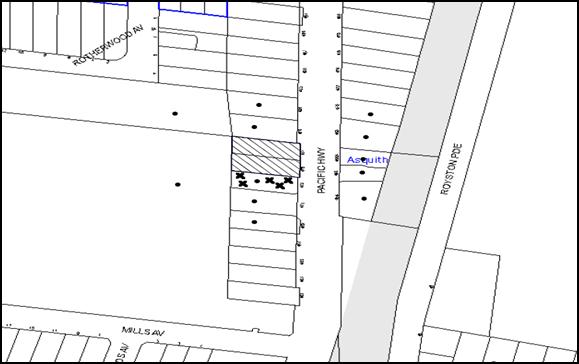
|
NOTIFICATION PLAN |
|
||
|
• PROPERTIES NOTIFIED
|
X SUBMISSIONS RECEIVED |
PROPERTY SUBJECT OF DEVELOPMENT
|
|
Five submissions objected to the development, generally on the grounds:
· The proposed development would isolate No. 473 Pacific Highway (adjoining property to the south);
· The proposal would have adverse overshadowing impacts on the adjoining southern property;
· The proposal would result in adverse privacy impacts on the adjoining southern property due to the windows of Unit 1;
· The development would have an acceptable bulk and scale when viewed from the adjoining southern property;
· The development would result in stormwater overflow on to the downstream properties; and
· The developer for the site has demanded that consent be granted for a stormwater easement by the owners of No. 473 Pacific Highway.
The merits of the matters raised in community submissions have been addressed in the body of the report with the exception of the following:
5.1.1 Isolation of Site
The proposed development is the first application lodged for a medium density development on the western side of Pacific Highway. There are a number of properties on either side of the site that are capable of being consolidated. Accordingly, this proposal would not isolate the adjoining allotment at No. 473 Pacific Highway, Asquith.
5.1.2 Overshadowing
The proposed development would overshadow the adjoining southern property to some extent. However, the buildings comply with the permissible height limit on the site and the built form is consistent with the desired future character of the area. Being a redevelopment precinct, the overshadowing is considered to be reasonable.
Should the adjoining southern property be redeveloped with townhouses orientated to the front and rear, the future dwellings would receive 3 hours solar access to the private open space areas and the living room windows.
5.1.3 Overlooking
As discussed in Section 2.8.5 of this report, all windows on the southern elevations of Units 1 and 9 are proposed to have a minimum sill height of 1.5m above the finished floor level. This is considered to be satisfactory and would retain the privacy of the adjoining property to the south.
5.1.4 Easement
The application initially proposed connection to the Council controlled drainage system via the downstream property No. 473 Pacific Highway. However, the amended proposal seeks approval for direct connection to Council’s drainage system via Asquith Park. Accordingly, any dispute regarding granting of an easement is not relevant to the assessment of this application.
5.2 Public Agencies
The development application was referred to the following Agencies for comment:
5.2.1 Roads and Maritime Services
As discussed in Section 2.3 of this report, RMS has reviewed the proposal and raised no objections subject to recommended conditions of consent.
6. THE PUBLIC INTEREST
Section 79C(1)(e) of the Act requires Council to consider “the public interest”.
The public interest is an overarching requirement, which includes the consideration of the matters discussed in this report. Implicit to the public interest is the achievement of future built outcomes adequately responding to and respecting the future desired outcomes expressed in environmental planning instruments and development control plans.
The application is considered to have satisfactorily addressed Council’s and relevant agencies’ criteria and would provide a development outcome that, on balance, would result in a positive impact for the community. Accordingly, it is considered that the approval of the proposed development would be in the public interest.
CONCLUSION
The application seeks approval for the demolition of existing structures and construction of a multi dwelling housing development comprising nine two storey townhouses with attics over a single level basement car parking.
The proposed development is generally in accordance with the development controls for the Pacific Highway Mount Colah and Asquith Precinct of the HDCP and would contribute to the desired residential character of the precinct, subject to recommended conditions of consent.
The proposal would result in a development that would be in keeping with the desired future character of the precinct.
Note: At the time of the completion of this planning report, no persons have made a Political Donations Disclosure Statement pursuant to Section 147 of the Environmental Planning and Assessment Act 1979 in respect of the subject planning application.
RESPONSIBLE OFFICER
The officer responsible for the preparation of this Report is the Manager – Development Assessments – Rodney Pickles, who can be contacted on 9847 6731.
|
Rod Pickles Manager - Development Assessment Planning Division |
James Farrington Group Manager Planning Division |
|
1.View |
Locality Plan |
|
|
|
2.View |
Site Plan |
|
|
|
3.View |
Landscape Plan |
|
|
|
4.View |
Floor Plans |
|
|
|
5.View |
Elevations and Sections |
|
|
|
6.View |
Shadow Plans |
|
|
|
7.View |
Perspectives |
|
|
|
8.View |
Stormwater Plan |
|
|
File Reference: DA/279/2016
Document Number: D06993903
SCHEDULE 1
1. Deferred Commencement
Pursuant to Section 80(3) of the Environmental Planning and Assessment Act 1979, this consent does not operate until the following information is submitted to Council:
a) The registration and creation of an easement to drain water from the site over downstream property at Lot 2 DP 618687, No. 459X Pacific Highway, Asquith.
Such information must be submitted within 3 years of the date of this notice.
Upon Council’s written satisfaction of the above information, the following conditions of development consent apply:
CONDITIONS OF APPROVAL
GENERAL CONDITIONS
The conditions of consent within this notice of determination have been applied to ensure that the use of the land and/or building is carried out in such a manner that is consistent with the aims and objectives of the relevant legislation, planning instruments and council policies affecting the land and does not disrupt the amenity of the neighbourhood or impact upon the environment.
Note: For the purpose of this consent, the term ‘applicant’ means any person who has the authority to act on or the benefit of the development consent.
Note: For the purpose of this consent, any reference to an Act, Regulation, Australian Standard or publication by a public authority shall be taken to mean the gazetted Act or Regulation, or adopted Australian Standard or publication as in force on the date that the application for a construction certificate is made.
2. Approved Plans and Supporting Documentation
The development must be carried out in accordance with the plans and documentation listed below and endorsed with Council’s stamp, except where amended by Council and/or other conditions of this consent:
Approved Plans
|
Plan No. |
Issue |
Plan Title |
Drawn by |
Dated |
|
A003 |
D |
Site Plan |
Australian Consulting Architects |
22/07/2016 |
|
A101 |
E |
Basement GA Plan |
Australian Consulting Architects |
22/07/2016 |
|
A102 |
D |
Ground Floor GA Plan |
Australian Consulting Architects |
22/07/2016 |
|
A103 |
E |
Level 1 GA Plan |
Australian Consulting Architects |
22/07/2016 |
|
A104 |
E |
Attic GA Plan |
Australian Consulting Architects |
22/07/2016 |
|
A105 |
D |
Roof GA Plan |
Australian Consulting Architects |
22/07/2016 |
|
A200 |
D |
Elevations |
Australian Consulting Architects |
22/07/2016 |
|
A201 |
D |
Elevations |
Australian Consulting Architects |
22/07/2016 |
|
A202 |
A |
Internal elevation |
Australian Consulting Architects |
22/07/2016 |
|
A300 |
D |
Sections |
Australian Consulting Architects |
22/07/2016 |
|
A301 |
D |
Sections |
Australian Consulting Architects |
22/07/2016 |
|
DA1 |
C |
Landscape Concept Plan |
Vision Dynamics |
23/07/2016 |
|
D01 |
C |
Basement Stormwater Drainage Plan |
Loka Consulting Engineers |
06/06/2016 |
|
D02 |
A |
Basement Stormwater Drainage Details |
Loka Consulting Engineers |
12/01/2016 |
|
D03 |
E |
Site Stormwater Drainage Plan |
Loka Consulting Engineers |
06/06/2016 |
|
D04 |
D |
Easement Details |
Loka Consulting Engineers |
04/05/2016 |
|
D05 |
B |
Stormwater Drainage Details |
Loka Consulting Engineers |
03/02/2016 |
|
D06 |
A |
Erosion and Sediment Control Plan |
Loka Consulting Engineers |
12/01/2016 |
Supporting Documents
|
No. |
Issue |
Plan Title |
Drawn by |
Dated |
|
A002 |
D |
Survey Plan |
Australian Consulting Architects |
22/07/2016 |
|
A004 |
D |
Site Analysis |
Australian Consulting Architects |
22/07/2016 |
|
A600 and A601 |
D |
Shadow Diagrams |
Australian Consulting Architects |
22/07/2016 |
|
A602 |
D |
Shadow Ground Level |
Australian Consulting Architects |
22/07/2016 |
|
A604 |
A |
Elevation Shadow Diagrams |
Australian Consulting Architects |
22/07/2016 |
|
A605 |
A |
Elevation Shadow Diagrams |
Australian Consulting Architects |
22/07/2016 |
|
A500 |
D |
Perspectives |
Australian Consulting Architects |
22/07/2016 |
|
A501 |
A |
Perspectives |
Australian Consulting Architects |
22/07/2016 |
|
A700 |
D |
Window Schedule |
Australian Consulting Architects |
22/07/2016 |
|
A800 |
D |
Finishes Schedule |
Australian Consulting Architects |
22/07/2016 |
|
D00 |
A |
Cover sheet, notes and legend |
Loka Consulting Engineers |
12/01/2016 |
|
D07 |
A |
Music Modelling Result |
Loka Consulting Engineers |
29/01/2016 |
|
2404AIA |
- |
Arboricultural Impact Assessment |
Tree Wise Men |
February 2016 |
|
2404AIP |
- |
Arboricultural Implications Plan |
Tree Wise Men |
11/09/2015 |
|
15588 |
- |
Traffic and Parking Assessment Report |
Varga Traffic Planning |
4/03/2016 |
|
- |
- |
Waste Management Plan |
Australian Consulting Architects |
3/03/2016 |
|
702728M |
03 |
BASIX Certificate |
Eco Certificates |
13/07/2016 |
|
|
|
Construction Management Plan |
- |
Received 10/03/2016 |
|
0342/15 |
- |
Statement of Environmental Effects |
Planning Ingenuity |
22/02/2016 |
|
0000512720 |
|
NatHERS Certificate |
Eco Certificates |
13/07/2016 |
3. Removal of Existing Trees
a) This development consent permits the removal of trees numbered 3, 4, 5, 6, 7, 8, 9, 10 and 11 as identified on plan number DA1 – C Landscape Concept Plan prepared by Vision Dynamics, dated 23/07/2016.
b) The removal of any other trees requires separate approval in accordance with the Tree and Vegetation Chapter 1B.6 Hornsby Development Control Plan (HDCP).
4. Amendment of Plans
a) The approved plan A101 – E Basement GA plan prepared by Australian Consulting Architects dated 22/07/2016 are to be amended as follows:
i) Delete the bicycle parking space and provide a visitors car space at that location. The dimension of the car space must comply with AS2890.1; and
ii) Relocate the bicycle spaces behind the proposed visitor’s car space as marked in red.
b) The ground level window on the eastern elevation of Unit 3 on A102 – E and A202-A prepared by Australian Consulting Architects dated 22/07/2016 must be deleted, as marked in red on the approved plans.
c) The following plans are to be amended to be in accordance with the approved floor plans in A101 – E Basement GA Plan and A102-D Ground Floor GA Plan prepared by Australian Consulting Architects dated 22/07/2016:
|
Plan No. |
Issue |
Plan Title |
Drawn by |
Dated |
|
D01 |
C |
Basement Stormwater Drainage Plan |
Loka Consulting Engineers |
06/06/2016 |
|
D02 |
A |
Basement Stormwater Drainage Details |
Loka Consulting Engineers |
12/01/2016 |
|
D03 |
E |
Site Stormwater Drainage Plan |
Loka Consulting Engineers |
06/06/2016 |
|
D04 |
D |
Easement Details |
Loka Consulting Engineers |
04/05/2016 |
|
D05 |
B |
Stormwater Drainage Details |
Loka Consulting Engineers |
03/02/2016 |
|
D06 |
A |
Erosion and Sediment Control Plan |
Loka Consulting Engineers |
12/01/2016 |
d) The location of the letter boxes in DA1 – C Landscape Concept Plan prepared by Vision Dynamics, dated 23/07/2016 must be amended to provide a setback of 2m from the front boundary. Shrubs must be planted in this section of the site between the mailbox and the front boundary.
e) These amended plans must be submitted with the application for the Construction Certificate.
5. Construction Certificate
a) A Construction Certificate is required to be approved by Council or a Private Certifying Authority prior to the commencement of any works under this consent.
b) A separate Construction Certificate must be obtained from Council for all works within the public road reserve under S138 of the Roads Act.
c) A separate Construction Certificate must be obtained from Council for all works within drainage easements vested in Council.
d) The Construction Certificate plans must not be inconsistent with the Development Consent plans.
6. Section 94 Development Contributions
a) In accordance with Section 80A(1) of the Environmental Planning and Assessment Act, 1979 and the Hornsby Shire Council Section 94 Development Contributions Plan 2014-2024, the following monetary contributions must be paid to Council to cater for the increased demand for community infrastructure resulting from the development:
|
Description |
Contribution (4) |
|
Roads |
$ 16,944.30 |
|
Open Space and Recreation |
$ 81,843.20 |
|
Community Facilities |
$ 39,228.15 |
|
Plan Preparation and Administration |
$ 226.50 |
|
TOTAL |
$138,242.15 |
being for 9 townhouses with a credit of 2 existing dwellings.
b) The value of this contribution is current as at 7 July 2016. If the contribution is not paid within the financial quarter that this condition was generated, the contribution payable will be adjusted in accordance with the provisions of the Hornsby Shire Council Section 94 Development Contributions Plan and the amount payable will be calculated at the time of payment in the following manner:
$CPY = $CDC x CPIPY
CPIDC
Where:
$CPY is the amount of the contribution at the date of Payment
$CDC is the amount of the contribution as set out in this Development Consent
CPIPY is the latest release of the Consumer Price Index (Sydney – All Groups) at the date of Payment as published by the ABS.
CPIDC is the Consumer Price Index (Sydney – All Groups) for the financial quarter at the date applicable in this Development Consent Condition.
c) The monetary contribution must be paid to Council:
i) prior to the issue of the Subdivision Certificate where the development is for subdivision; or
ii) prior to the issue of the first Construction Certificate where the development is for building work; or
iii) prior to issue of the Subdivision Certificate or first Construction Certificate, whichever occurs first, where the development involves both subdivision and building work; or
iv) prior to the works commencing where the development does not require a Construction Certificate or Subdivision Certificate.
Note: It is the professional responsibility of the Principal Certifying Authority to ensure that the monetary contributions have been paid to Council in accordance with the above timeframes.
Council’s Development Contributions Plan may be viewed at www.hornsby.nsw.gov.au or a copy may be inspected at Council’s Administration Centre during normal business hours.
7. Project Arborist
A Project Arborist is to be appointed in accordance with AS 4970-2009 (1.4.4) to provide monitoring and certification throughout the development process. The details of the appointed Arborist are to be provided to Council and the PCA prior to the issue of the construction certificate.
REQUIREMENTS PRIOR TO THE ISSUE OF A CONSTRUCTION CERTIFICATE
8. Building Code of Australia
All approved building work must be carried out in accordance with the relevant requirements of the Building Code of Australia.
9. Contract of Insurance (Residential Building Work)
Where residential building work for which the Home Building Act, 1989 requires there to be a contract of insurance in force in accordance with Part 6 of that Act, this contract of insurance must be in force before any building work authorised to be carried out by the consent commences.
10. Notification of Home Building Act, 1989 Requirements
Residential building work within the meaning of the Home Building Act 1989 must not be carried out unless the principal certifying authority for the development to which the work relates (not being Council) has given Council written notice of the following information:
a) In the case of work for which a principal contractor is required to be appointed:
i) The name and licence number of the principal contractor; and
ii) The name of the insurer by which the work is insured under Part 6 of that Act.
b) In the case of work to be done by an owner-builder:
i) The name of the owner-builder; and
ii) If the owner-builder is required to hold an owner-builder’s permit under that Act, the number of the owner-builder’s permit.
Note: If arrangements for doing the residential building work are changed while the work is in progress so that the information notified becomes out of date, further work must not be carried out unless the principal certifying authority for the development to which the work relates (not being Council) has given Council written notification of the updated information.
11. Utility Services
The applicant must submit written evidence of the following service provider requirements:
a) Ausgrid (formerly Energy Australia) – a letter of consent demonstrating that satisfactory arrangements have been made to service the proposed development.
b) Telstra – a letter of consent demonstrating that satisfactory arrangements have been made to service the proposed development.
12. Sydney Water – Approval
This application must be submitted to Sydney Water for approval to determine whether the development would affect any Sydney Water infrastructure, and whether further requirements are to be met.
Note: Building plan approvals can be obtained online via Sydney Water Tap inTM through www.sydneywater.com.au under the Building and Development tab.
13. Dilapidation Report
a) A ‘Dilapidation Report’ is to be prepared by a ‘chartered structural engineer’ detailing the structural condition of adjoining properties at nos. 473 and 479 Pacific Highway, Asquith.
b) To record the structural condition of all properties adjoining the approved development, a dilapidation report must be prepared by a suitably qualified structural engineer for inclusion with the application of the Construction Certificate.
14. Traffic Control Plan
A Traffic Control Plan (TCP) must be prepared by a qualified traffic controller in accordance with the Roads & Traffic Authority’s Traffic Control at Worksites Manual 1998 and Australian Standard 1742.3 for all work on a public road. The Traffic Management Plan shall be submitted and approved by Council’s Manager Traffic and Road Safety prior to the issue of a construction certificate. The TCP must detail the following:
a) Arrangements for public notification of the works;
b) Temporary construction signage;
c) Permanent post-construction signage;
d) Vehicle movement plans;
e) Traffic management plans; and
f) Pedestrian and cyclist access/safety.
15. Identification of Survey Marks
A registered surveyor must identify all survey marks in the vicinity of the proposed development. Any survey marks required to be removed or displaced as a result of the proposed development shall be undertaken by a registered surveyor in accordance with Section 24 (1) of the Surveying and Spatial Information Act 2002 and following the Surveyor General’s Directions No.11 – "Preservation of Survey Infrastructure".
16. Stormwater Drainage
The stormwater drainage system for the development must be designed for an average recurrence interval (ARI) of 20 years and be gravity drained via an on-site detention and water quality treatment facility or one of the deemed to comply measures in accordance with the following requirements:
a) Connected directly to a Council’s drainage system via the easement to drain water.
b) Be designed by a Chartered Professional Civil/ Hydraulic Engineer of the Institution of Engineers, Australia.
17. On-Site Stormwater Detention
An on-site stormwater detention system must be designed by a chartered civil engineer in accordance with the approved plans and the following requirements:
a) Have a storage capacity to accommodate volume from up to 20 years ARI (average recurrence interval) storms and a maximum discharge (when full) limited to 5 years pre development rate;
b) The permitted site discharge from the development site is not to exceed 25 litres/second and the volume of storage not less than 17m3;
c) Have a surcharge/inspection grate located directly above the outlet;
d) Discharge from the detention system must be controlled via 1 metre length of pipe, not less than 50 millimetres diameter or via a stainless plate with sharply drilled orifice bolted over the face of the outlet discharging into a larger diameter pipe capable of carrying the design flow to an approved Council system;
e) Where above ground and the average depth is greater than 0.3 metres, a ‘pool type’ safety fence and warning signs must be installed; and
f) Not be constructed in a location that would impact upon the visual or recreational amenity of residents.
18. Stormwater Quality Requirements
Details of water quality treatment system required to achieve the quality specified in Hornsby Development Control Plan 2012 (table 1C.1.2(b) Urban Stormwater Quality Targets), is to be provided to Council for approval.
19. Vehicular Crossing
A separate application under the Local Government Act, 1993 and the Roads Act 1993 must be submitted to Council for the installation of a new vehicular crossing and the removal of the redundant crossing. The vehicular crossing must be constructed in accordance with Council’s Civil Works Design 2005 and the following requirements:
a) Any redundant crossings must be replaced with integral kerb and gutter;
b) The footway area must be restored by turfing;
c) Approval must be obtained from all relevant utility providers that all necessary conduits be provided and protected under the crossing; and
d) Concurrence and approval of the Roads and Maritime Authority (RMS) for all works within Pacific Highway is to be submitted to Council with the construction certificate application.
Note: An application for a vehicular crossing can only be made to one of Council’s Authorised Vehicular Crossing Contractors. You are advised to contact Council on 02 9847 6940 to obtain a list of contractors.
20. Road Works
All road works approved under this consent must be designed in accordance with Council’s Civil Works Design and Construction Specification 2005 and the following requirements:
a) Kerb and guttering be constructed along the frontage of Pacific Highway for the full frontage of the site in accordance with the requirements of RMS;
b) The existing footpath along Pacific Highway is to be removed and a new footpath constructed;
c) The existing road pavement to be saw cut a minimum of 300 mm from the existing edge of the bitumen and reconstructed;
d) The open swale (drain) in front of the development site must be replaced by a stormwater and nature strip graded to the requirements of RMS;
e) The submission of a compaction certificate from a geotechnical engineer for any fill within road reserves, and all road sub-grade and road pavement materials;
f) Concurrence and approval of the RMS for all works within Pacific Highway is to be submitted to Council with the construction certificate application.
g) Necessary road occupancy permit is to be obtained from RMS to carry out works in Pacific Highway.
Note: A separate application under the Local Government Act, 1993 and the Roads Act, 1993 must be submitted to Council for all works within the road reserve.
No work is to commence within the road reserve until approval under Section 138 of the Roads Act is obtained from Hornsby Shire Council.
21. Internal Driveway/Vehicular Areas
The driveway and parking areas on site must be designed and a Construction Certificate issued in accordance with Australian Standards 2890.1, 2890.2, 3727 and the following requirements:
a) Design levels at the front boundary be obtained from Council if a private accredited certifier is engaged to obtain a construction certificate for these works;
b) The driveway be a rigid pavement;
c) Conduit for utility services including electricity, water, gas and telephone be provided. All existing overhead assets including electricity and telecommunications cabling shall be relocated underground at no cost to Council;
d) Longitudinal sections along both sides of the access driveway must be submitted to the principal certifying authority in accordance with the relevant sections of AS 2890.1;
e) The maximum grade of the driveway must not exceed 1 in 4 (25%) with the maximum changes of grade of 1 in 8 (12.5%) for summit grades and 1 in 6.7 (15%) for sag grades. Any transition grades shall have a minimum length of 2 metres;
f) The longitudinal sections must incorporate the design levels obtained by Council;
g) A certificate from a qualified engineer must be submitted to the principal certifying authority certifying that the driveway grades, headroom clearance, aisle widths and parking areas have been designed in accordance with Australian Standards AS 2890.1; and
h) A certificate from a qualified traffic Engineer must be submitted to the principal certifying authority certifying that the driveway grades, headroom clearance, aisle width for the sections of driveway to be utilised by waste collection vehicles is designed in accordance with Australian Standard AS 2890.2 – 2002 Parking Facilities Part 2: Off-street commercial vehicle facilities for a Small Rigid Vehicle (SRV).
22. Construction Traffic Management Plan
In order to enable unencumbered movement of traffic in the public road during construction works, a Construction Management Plan, including a Traffic Management Plan and scaled construction plans prepared by a suitably Chartered and Qualified Chartered Civil Engineer and Qualified Worksite Traffic Controller shall be prepared and submitted to Hornsby Shire Council for approval according to the following requirements:-
a) A copy of the plans shall be submitted for consideration and written approval by Hornsby Shire Council prior to the release of the Construction Certificate.
b) The plans shall detail the order of construction works and arrangement of all construction machines and vehicles being used at the same time during all stages.
c) The CTMP plans shall be in accordance with the approved Development Application plans and the Development Consent conditions.
d) In order to prevent injury, accident and loss of property, no building materials, work sheds, vehicles, machines or the like shall be allowed to remain in the road reserve area without the written consent of Hornsby Shire Council.
e) The Plan shall be generally in compliance with the requirements of the Road and Traffic Authority’s “Traffic Control at Worksites Manual 1998” and detailing:
i) Public notification of proposed works;
ii) Long term signage requirements;
iii) Short term (during actual works) signage;
iv) Vehicle Movement Plans, where applicable;
v) Traffic Management Plans; and
vi) Pedestrian and Cyclist access and safety.
f) The plans shall indicate traffic controls including those used during non-working hours and shall provide pedestrian access and two-way traffic in the public road to be facilitated at all times.
g) The plans shall include the proposed truck routes to and from the site including details of the frequency of truck movements at the different stages of the development. The plan shall also include details of parking arrangements for all employees and contractors.
h) The Applicant and all employees of contractors on the site must obey any direction or notice from the Prescribed Certifying Authority or Hornsby Shire Council in order to ensure the above.
i) If there is a requirement to obtain a Work Zone, partial Road Closure or Crane Permit an application to Hornsby Shire Council is to be made prior to the issue the Construction Certificate.
23. Noise – Rail and Road Corridor
The development must be carried out in accordance with the requirements of the Department of Planning’s Development Near Rail Corridors and Busy Roads – Interim Guideline and RailCorp’s Interim Guidelines for Applicants.
Note: The Department of Planning’s document is available at www.planning.nsw.gov.au (development assessments). The RailCorp document is available at www.railcorp.nsw.gov.au/publications.
24. Waste Management Details
The following waste management details must be provided with the Construction Certificate Plans:
a) The bin storage room at the basement level must be accessibly by persons with a disability while comfortably holding at least 6 of 240L bins;
Note: a 240 L recycling bin is 600 mm wide by 750 mm deep; allow for ease around the bin – 75 mm is recommended. These dimensions do not include wall thickness, door thickness, ventilation ducting etc., which must be added. The door must be wide enough and positioned such that the bin can fit through. Every bin must be able to be accessed (so stacking of bins two or more deep).
b) A Waste Management Plan Section One – Demolition Stage and Section Three – Construction Stage, covering the scope of this project and including the following details, is required to be submitted to Council:
i) An estimate of the types and volumes of waste and recyclables to be generated;
ii) A site plan showing sorting and storage areas for demolition and construction waste and the vehicle access to these areas;
iii) How excavation, demolition and construction waste materials will be reused or recycled and where residual wastes will be disposed; and
iv) The total percentage (by weight) of demolition and construction waste that will be reused or recycled.
REQUIREMENTS PRIOR TO THE COMMENCEMENT OF ANY WORKS
25. Erection of Construction Sign
a) A sign must be erected in a prominent position on any site on which any approved work is being carried out:
i) Showing the name, address and telephone number of the principal certifying authority for the work;
ii) Showing the name of the principal contractor (if any) for any demolition or building work and a telephone number on which that person may be contacted outside working hours; and
iii) Stating that unauthorised entry to the work site is prohibited.
b) The sign is to be maintained while the approved work is being carried out and must be removed when the work has been completed.
26. Protection of Adjoining Areas
A temporary hoarding, fence or awning must be erected between the work site and adjoining lands before the works begin and must be kept in place until after the completion of the works if the works:
a) Could cause a danger, obstruction or inconvenience to pedestrian or vehicular traffic;
b) Could cause damage to adjoining lands by falling objects; and/or
c) Involve the enclosure of a public place or part of a public place.
Note: Notwithstanding the above, Council’s separate written approval is required prior to the erection of any structure or other obstruction on public land.
27. Toilet Facilities
a) To provide a safe and hygienic workplace, toilet facilities must be available or be installed at the works site before works begin and must be maintained until the works are completed at a ratio of one toilet for every 20 persons employed at the site.
b) Each toilet must:
i) be a standard flushing toilet connected to a public sewer; or
ii) be a temporary chemical closet approved under the Local Government Act 1993; or
iii) have an on-site effluent disposal system approved under the Local Government Act 1993.
28. Erosion and Sediment Control
To protect the water quality of the downstream environment, erosion and sediment control measures must be provided and maintained throughout the construction period in accordance with the manual ‘Soils and Construction 2004 (Bluebook)’, the approved plans, Council specifications and to the satisfaction of the principal certifying authority. The erosion and sediment control devices must remain in place until the site has been stabilised and revegetated.
Note: On the spot penalties may be issued for any non-compliance with this requirement without any further notification or warning.
29. Tree Protection Barriers
a) To safeguard the natural environment during the approved development works, tree protection fencing must be erected around tree Nos. 1, 2 and 12 identified DA1 – C Landscape Concept Plan prepared by Vision Dynamics, dated 23/07/2016, at nominated setbacks listed in the Arboricultural impact Assessment prepared by Tree Wise Men dated February 2016.
b) All trees proposed to be retained on site must have tree protection measures for the ground, trunk and canopy installed in accordance with the Australian Standard ‘Protection of Trees on Development Sites (AS 4970-2009) and the Arboricultural impact Assessment prepared by Tree Wise Men dated February 2016.
c) All Tree Protection Zones must have a layer of wood-chip mulch installed prior to works commencing and must be maintained throughout the period of construction at a depth of 150mm – 300mm using material that complies with Australian Standard AS 4454.
d) A certificate from the Project Arborist must be submitted to the Principal Certifying Authority and Council stating compliance with the relevant tree protection conditions of this consent.
REQUIREMENTS DURING CONSTRUCTION
30. Construction Work Hours
All works on site, including demolition and earth works, must only occur between 7am and 5pm Monday to Saturday.
No work is to be undertaken on Sundays or public holidays.
31. Demolition
To protect the surrounding environment, all demolition work must be carried out in accordance with “Australian Standard 2601-2001 – The Demolition of Structures” and the following requirements:
a) Demolition material must be disposed of to an authorised recycling and/or waste disposal site and/or in accordance with an approved waste management plan;
b) Demolition works, where asbestos material is being removed, must be undertaken by a contractor that holds an appropriate licence issued by WorkCover NSW in accordance with Chapter 10 of the Occupational Health and Safety Regulation 2001 and Clause 29 of the Protection of the Environment Operations (Waste) Regulation 2005 ;and
c) On construction sites where any building contain asbestos material, a standard commercially manufactured sign containing the words ‘DANGER ASBESTOS REMOVAL IN PROGRESS’ and measuring not less than 400mm x 300mm must be displayed in a prominent position visible from the street.
32. Environmental Management
The site must be managed in accordance with the publication ‘Managing Urban Stormwater – Landcom (March 2004) and the Protection of the Environment Operations Act 1997 by way of implementing appropriate measures to prevent sediment run-off, excessive dust, noise or odour emanating from the site during the construction of the development.
33. Street Sweeping
To protect the surrounding environment, Street sweeping must be undertaken following sediment tracking from the site along the Pacific Highway during works and until the site is established.
The street cleaning services must undertake a street ‘scrub and dry’ method of service and not a dry sweeping service that may cause sediment tracking to spread or cause a dust nuisance.
34. Works Near Trees
a) To protect trees to be retained, all required tree protection measures are to be maintained in good condition for the duration of the construction period.
b) Any scaffolding must be erected outside the tree protection zone of all trees to be retained on site in accordance with Section 4.5.6 of AS4970 – 2009.
c) The approved pruning works for T1 must be undertaken by a qualified Arborist (minimum AQF3) and in accordance with the recommendations in Section 5.3.1 of the Arboricultural Impact Assessment report provided by provided by Tree Wise Men dated February 2016. Certification must be supplied to the Principal Certifying Authority within 7 days of the works being undertaken confirming compliance with AS4373-2007.
d) Approved works within the nominated Tree Protection Zone of T1 must be carried out in accordance with the methods listed in the Arboricultural impact Assessment prepared by Tree Wise Men dated February 2016 and the following requirements:
i) All works must be approved by the Project Arborist.
ii) Root/ground protection/root pruning outside the structure root zone of a tree and underground services installation must be provided in accordance with AS 4970-2009 (Clause 4.5.4 and clause 4.5.5);
iii) The Structural Root Zone retained must remain intact;
iv) Activities within the Tree Protection Zone must comply with AS 4970-2009 (Clause 4.2);
v) Installation of services must be undertaken using sensitive methods such as directional drilling or in manually excavated trenches; and
vi) Any necessary excavation must be undertaken by sensitive methods such as pneumatic or by hand as prescribe in AS 4970-2007 Sections 4.5.5.
e) The Project Arborist must monitor and record any necessary remedial actions for maintaining tree health and condition required for trees numbered 1, 2 and 12.
f) The appointed Project Arborist must monitor and record all changes or modifications required regarding tree protection measures for the period of construction.
g) A certificate must be submitted to the principal certifying authority by the Project Arborist detailing the method(s) used to preserve these tree(s) during the course of construction.
Note: Except as provided above, The filling or stockpiling of building materials, the parking of vehicles or plant, the disposal of cement slurry, waste water or other contaminants must be located outside the tree protection zones as prescribed in the conditions of this consent or the prescriptive measures of Part 1B.6.1 Tree Preservation of the Hornsby Development Control Plan, 2013, of any tree to be retained.
35. Council Property
To ensure that the public reserve is kept in a clean, tidy and safe condition during construction works, no building materials, waste, machinery or related matter is to be stored on the road or footpath.
36. Excavated Material
All excavated material removed from the site must be classified by a suitably qualified person in accordance with the Department of Environment, Climate Change and Water NSW Waste Classification Guidelines prior to disposal to an approved waste management facility and be reported to the principal certifying authority prior to the issue of an Occupation Certificate.
37. Landfill
Landfill must be constructed in accordance with Council’s ‘Construction Specification 2005’ and the following requirements:
a) Prior to fill material being imported to the site, a certificate shall be obtained from a suitable qualified environmental consultant confirming the fill wholly consists of Virgin Excavated Natural Material (VENM) as defined in Schedule 1 of the Protection of the Environment Operations Act, 1997 or material approved under the Department of Environment and Climate Change’s general resource recovery exemption.
b) A compaction certificate is to be obtained from a suitably qualified geotechnical engineer verifying that the specified compaction requirements have been met.
c) These certificates must be included with the application for an occupation certificate.
38. Survey Report
A report(s) must be prepared by a registered surveyor and submitted to the principal certifying authority:
a) Prior to the pouring of concrete at each level of the building certifying that:
i) The building, retaining walls and the like have been correctly positioned on the site;
ii) The finished floor level(s) are in accordance with the approved plans; and
iii) The maximum height of the building (including ridge) is 10.5mfrom the natural ground level at that point.
b) Confirming that the waste collection vehicle turning area complies with AS2890.1 – 2004 and AS20890.2 – 2002 for small rigid vehicles (SRV).
39. Waste Management
Waste management during the demolition and construction phase of the development must be undertaken in accordance with the approved Waste Management Plan. Additionally written records of the following items must be maintained during the removal of any waste from the site and such information submitted to the Principal Certifying Authority within fourteen days of the date of completion of the works:
a) The identity of the person removing the waste.
b) The waste carrier vehicle registration.
c) Date and time of waste collection.
d) A description of the waste (type of waste and estimated quantity).
e) Details of the site to which the waste is to be taken.
f) The corresponding tip docket/receipt from the site to which the waste is transferred (noting date and time of delivery, description (type and quantity) of waste).
g) Whether the waste is expected to be reused, recycled or go to landfill.
Note: In accordance with the Protection of the Environment Operations Act 1997, the definition of waste includes any unwanted substance, regardless of whether it is reused, recycled or disposed to landfill.
40. Compliance During Construction Works
The development must be carried out in accordance with the following approved documents:
a) Traffic Control Plan (TCP); and
b) Construction Traffic Management Plan (CTMP).
41. Maintenance of Public Footpaths
Public footpaths must be maintained for the duration of works to ensure they are free of trip hazards, displacements, breaks or debris to enable pedestrians to travel along the footpath safely.
REQUIREMENTS PRIOR TO THE ISSUE OF AN OCCUPATION CERTIFICATE
Note: For the purpose of this consent, a reference to ‘occupation certificate’ shall not be taken to mean an ‘interim occupation certificate’ unless otherwise stated.
42. Fulfilment of BASIX Commitments
The applicant must demonstrate the fulfilment of BASIX commitments pertaining to the development.
43. Sydney Water – s73 Certificate
An s73 Certificate must be obtained from Sydney Water and submitted to the PCA..
Note: Sydney Water requires that s73 applications are to be made through an authorised Sydney Water Servicing Coordinator. Refer to www.sydneywater.com.au or telephone 13 20 92 for assistance.
44. Water Saving Urban Design
A Water Saving Urban Design (WSUD) is to be constructed generally in accordance with the engineering report and plans listed in Condition 2 of this development consent. The Water Quality Targets as detailed within the report and Hornsby Shire Councils DCP are to be achieved in the design and supported by a MUSIC model.
Prior to the issue of an Occupation Certificate a certificate from a Civil Engineer is to be obtained stating that the WSUD facilities have been constructed and will meet the water quality targets as specified in the Hornsby Shire Councils DCP.
45. Unit Numbering
All units are to be numbered consecutively commencing at No.1. The strata plan lot number is to coincide with the unit number, e.g. Unit 1 = Lot 1. The allocated of unit numbering must be authorised by Council prior to the numbering of each units in the development.
46. Damage to Council Assets
To protect public property and infrastructure, any damage caused to Council’s assets as a result of the construction or demolition of the development must be rectified by the applicant in accordance with Council’s Civil Works Specifications. Rectification works must be undertaken prior to the issue of an Occupation Certificate, or sooner, as directed by Council.
47. Creation of Easements
The following matter(s) must be nominated on the plan of subdivision under s88B of the Conveyancing Act, 1919:
a) The creation of an appropriate "Positive Covenant" and "Restriction as to User" over the constructed on-site detention systems, water quality system and outlet works, within the lots in favour of Council in accordance with Council’s prescribed wording. The position of the on-site detention system is to be clearly indicated on the title;
b) To register the restriction on the use of land “works-as-executed” details of the on-site-detention system and water quality treatment system must be submitted verifying that the required storage and discharge rates have been constructed in accordance with the design requirements. The details must show the invert levels of the on-site system together with pipe sizes and grades. Any variations to the approved plans must be shown in red on the “works-as-executed” plan and supported by calculations;
Note: Council must be nominated as the authority to release, vary or modify any easement, restriction or covenant.
48. Works as Executed Plan
A works-as-executed plan(s) must be prepared by a registered surveyor and submitted to Council for completed road pavement, kerb & gutter, public drainage systems, driveways and on-site detention system.
49. Preservation of Survey Marks
A certificate by a Registered Surveyor must be submitted to the Principal Certifying Authority, certifying that there has been no removal, damage, destruction, displacement or defacing of the existing survey marks in the vicinity of the proposed development or otherwise the re-establishment of damaged, removed or displaced survey marks has been undertaken in accordance with the Surveyor General’s Direction No.11 – “Preservation of Survey Infrastructure”.
50. Construction of Engineering Works
All engineering works identified in this consent including stormwater works, retaining walls, driveway works, roadworks and the like are to be completed and a Compliance Certificate issued prior to the release of the Occupation Certificate.
51. Consolidation of Allotments
All allotments the subject of this consent must be consolidated into one allotment.
Note: The applicant is recommended to submit the plan of subdivision to consolidate allotments to the NSW Department of Lands at least 4-6 weeks prior to seeking an occupation certificate.
52. Provision for National Broadband Network (NBN)
Provision must be made for fibre ready passive infrastructure (pits and pipes) generally in accordance with NBN Co's pit and pipe installation guidelines to service the proposed development. A certificate from NBN Co or Telstra must be submitted to the PCA that the fibre optic cabling provided for the development complies with MDU Building Design Guides for Development.
53. Completion of Landscaping
A certificate must be submitted to the PCA by a practicing landscape architect, horticulturalist or person with similar qualifications and experience certifying that all required landscaping works have been satisfactorily completed in accordance with the approved landscape plans and the following requirements:
a) Planting of 2 additional trees selected from the Council’s Indigenous species listing located in the Hornsby Shire DCP Tree Preservation Measures 1B.6 Table 1B.6(b) such as Angophora costata, Angophora floribunda, Banksia integrifolia;
b) The pot size of the replacement trees must be a minimum 25 litres and replacement trees must be maintained until they reach the height of 3 metres;
c) All replacement tree planting within the site must reach a mature height greater than 10 metres;
d) All tree stock must meet the specifications outlined in ‘Specifying Trees’ (Ross Clark, NATSPEC Books);
e) Planting methods must meet professional (best practice) industry standards; and
f) On slab planter boxes including the ground cover above the on-site detention tank and the paved areas along the north-western boundary of the site must include waterproofing, subsoil drainage (proprietary drainage cell, 50mm sand and filter fabric) automatic irrigation, minimum 300mm planting soil for grasses and ground covers, 500mm planting soil for shrubs and minimum 1000mm planting soil for trees and palms and 75mm mulch to ensure sustainable landscape is achieved.
Note: Advice on suitable species for landscaping can be obtained from Council’s planting guide ‘Indigenous Plants for the Bushland Shire’, available at www.hornsby.nsw.gov.au.
Note: Applicants are advised to pre-order plant material required in pot sizes 45 litre or larger to ensure Nurseries have stock available at the time of install.
54. Retaining Walls
All required retaining walls must be constructed as part of the development.
55. Boundary Fencing
Boundary fencing should be installed as per the following requirements:
a) Fencing along the front courtyards must have a minimum setback of 2.5m from the front boundary and have a maximum height of 1.2m. The design of the fencing is to be in accordance with the approved plans listed in Condition 2 of this development consent;
b) Fencing for all courtyards internally located within the site must have a maximum height of 1.2m;
c) The fencing along the rear boundary (between the site and Asquith Park) be 1.8m high solid timber lapped and capped fence with one common gate providing access on the northern side as per the approved DA1 – C Landscape Concept Plan prepared by Vision Dynamics, dated 23/07/2016.
d) Fencing must be erected along the northern and southern boundaries behind the front building line to a height of 1.8m.
Note: Alternative fencing may be erected along the northern and southern boundaries subject to the written consent of the adjoining property owner(s).
56. Car Parking and Vehicular Areas
All vehicular areas within the site and the car parking must be constructed in accordance with Australian Standard AS 2890.1 – 2004 – Off Street Car Parking and Australian Standard 2890.2 - 2002 – Off Street Commercial and the following requirements:
a) The driveway to be designed in accordance with Condition 21 of this development consent;
b) The parking and driveway areas to be accessed by the garbage truck must comply with the requirements of AS2890.2 – 2002 for SRV;
Note: Encroachments of the small rigid vehicle turning path and low speed manoeuvring clearance (300 mm both sides) into parking spaces must not occur.
c) The 3.5 metre clearance height within the waste collection vehicle travel path must not be reduced by ducting, lights, pipes or anything else;
d) A certificate from an appropriately licensed contractor must be submitted to the principal certifying authority certifying that the service conduits have been installed in accordance with the relevant utility provider and Australian Standards;
e) All parking areas and driveways are to be sealed to an all-weather standard, line marked and signposted;
f) Residential parking spaces are to be secure spaces with access controlled by card or numeric pad;
g) Two visitors’ spaces are to be provided at the basement level. Visitors are to be able to access the basement car park by an audio/visual intercom system located at the top of the ramped driveway;
h) Three bicycle spaces (resident and visitor) are to be provided in the basement car park. Bicycle parking spaces are to be designed in accordance with AS 2890.3-1993;
i) One motorcycle parking space is to be provided within the basement car park, designed in accordance with AS 2890.5-1993;
j) The location of the driveway must maintain sight lines for the pedestrians.
57. External Lighting
a) To protect the amenity of adjacent premises, all external lighting must be designed and installed in accordance with Australian Standard AS 4282 – Control of the Obtrusive Effects of Outdoor Lighting.
b) Certification of compliance with this Standard must be obtained from a suitably qualified person and submitted to the PCA with the application for the Construction Certificate.
58. Garbage Collection Easement
For the purpose of waste collection, an easement entitling Council, its servants and agents and persons authorised by it, to enter upon the subject land and to operate thereon, vehicles and other equipment for the purposes of garbage collection must be granted to Council by the owner of the land.
Note: The easement must be in a form prescribed by Council and must include covenants to the effect that parties will not be liable for any damage caused to the subject land or any part thereof or to any property located therein or thereon by reason of the operation thereon of any vehicle or other equipment used in connection with the collection of garbage and to the effect that the owner for the time being of the subject land shall indemnify the Council, its servants, agents and persons authorised by it to collect garbage against liability in respect of any such claims made by any person whomsoever.
59. Waste Management
The following waste management requirements must be complied with:
a) The bin storage room at the basement level must include water or a hose for cleaning, graded floors with drainage to sewer, robust doors, sealed and impervious surface, adequate lighting and ventilation, and must be lockable.
b) A report must be prepared by an appropriately qualified person, certifying the following:
i) A comparison of the estimated quantities of each waste type against the actual quantities of each waste type.
Note: Explanations of any deviations to the approved Waste Management Plan is required to be included in this report.
ii) That at least 60% of the waste generated during the demolition and construction phase of the development was reused or recycled.
Note: If the 60% diversion from landfill cannot be achieved in the Construction Stage, the Report is to include the reasons why this occurred and certify that appropriate work practices were employed to implement the approved Waste Management Plan. The Report must be based on documentary evidence such as tipping dockets/receipts from recycling depots, transfer stations and landfills, audits of procedures etc. which are to be attached to the report.
iii) All waste was taken to site(s) that were lawfully permitted to accept that waste.
c) Each dwelling must be provided with an indoor waste/recycling cupboard for the interim storage of waste with two separate 20 litre containers for general waste and recyclable materials.
d) Space must be provided for either individual compost containers for each unit or a communal compost container;
Note: The location of the compost containers should have regard for potential amenity impacts.
e) A bulky waste storage area of at least 8m2 is to be identified and marked with paint and signage;
f) “No parking” signs must be erected to prohibit parking in the waste collection loading bay and turning area;
g) Prior to an Occupation Certificate being issued or the use commencing, whichever is earlier, the Principal Certifying Authority must obtain Council’s approval of the waste and recycling management facilities provided in the development and ensure arrangements are in place for domestic waste collection by Council;
h) Site security measures implemented on the property, including electronic gates, must not prevent access to the collection point by waste removal services.
60. Final Certification – Tree Protection
Following the final inspection and the completion of any remedial works, the project Arborist must submit to the Principal Certifying Authority documentation stating that the completed works have been carried out in compliance with the approved plans conditions of development consent and specifications for tree protection as above and AS 4970-2009.
61. Final Certification – Acoustics
Following the final inspection a qualified Acoustic Consultant must provide certification that the building has been constructed in accordance with the requirements of the Department of Planning’s Development Near Rail Corridors and Busy Roads – Interim Guideline and RailCorp’s Interim Guidelines for Applicants.
62. Safety and Security
This site must include the following elements:
a) An intercom system must be installed at gate locations to ensure screening of persons entering the units;
b) The entry doors are is to be constructed of safety rated glass to enable residents a clear line of site before entering or exiting the dwellings;
c) Lighting is to be provided to pathways, building entries, driveways and common external spaces;
d) Security gate access is to be provided to the car parking areas allowing residents-only access to private car spaces;
e) CCTV cameras must be installed at the entry and exit point and the around the mailbox;
f) The communal open spaces within the site must be illuminated with high luminance by motion sensor lighting;
g) The driveway and basement car parking must be illuminated with low luminance at all times;
h) Security deadlocks are to be provided to each dwelling door; and
i) Peep holes are to be provided to individual apartment doors to promote resident safety.
OPERATIONAL CONDITIONS
63. Noise
All noise generated by the proposed development must be attenuated to prevent levels of noise being emitted to adjacent premises which possess tonal, beating and similar characteristics or which exceeds background noise levels by more than 5dB(A).
64. Fire Safety Statement - Annual
On at least one occasion in every 12 month period following the date of the first ‘Fire Safety Certificate’ issued for the property, the owner must provide Council with an annual ‘Fire Safety Certificate’ to each essential service installed in the building.
65. Landscape Establishment
The landscape works must be maintained into the future to ensure the establishment and successful growth of plant material to meet the intent of the landscape design. This must include but not limited to watering, weeding, replacement of failed plant material and promoting the growth of plants through standard industry practices.
66. Car Parking/Sight Lines and Deliveries
All car parking must be operated in accordance with Australian Standard AS 2890.1 – 2004 – Off Street Car Parking and Australian Standard 2890.2 - 2002 – Off Street Commercial and the following requirements:
a) All parking areas and driveways are to be sealed to an all-weather standard, line marked and signposted at all times.
b) Car parking, loading and manoeuvring areas to be used solely for nominated purposes.
c) Vehicles awaiting loading, unloading or servicing shall be parked on site and not on adjacent or nearby public roads;
d) All vehicular entry on to the site and egress from the site shall be made in a forward direction;
e) Minimum sight lines for pedestrian safety are to be provided at the driveway; and
f) Any proposed landscaping and/or fencing must not restrict sight distance to pedestrians and cyclists travelling along the footpath.
67. Waste Management
The waste management on site must be in accordance with the following requirements:
a) A site caretaker must be employed and be responsible for moving bins where and when necessary, washing bins and maintaining waste storage areas, ensuring the chute system and related devices are maintained in effective and efficient working order, managing the communal composting area, managing the bulky item storage area, arranging the prompt removal of dumped rubbish, and ensuring cars do not park in the loading bay and that all residents are informed of the use of the waste management system.
b) The approved on-going waste management practise for the site must not be amended without consent from Council.
CONDITIONS OF CONCURRENCE – ROADS AND MARITIME SERVICES
The following conditions of consent are from the nominated State Agency pursuant to Section 79B of the Environmental Planning and Assessment Act 1979 and must be complied with to the satisfaction of that Agency.
68. All buildings or structures, together with any improvements integral to the future use of the site, shall be clear of the Pacific Highway, road reserve (unlimited in height and depth).
69. Any redundant vehicular crossings on Pacific Highway are to be removed and replaced with kerb and gutter to match existing.
70. The design and construction of the gutter crossing on Pacific Highway shall be in accordance Roads and Maritime requirements. Details of these requirements should be obtained from Roads and Maritime Project Services Manager, Traffic Project Section, Parramatta (telephone 8849 2138).
Detailed design plans of the proposed gutter crossing are to be submitted to Roads and Maritime for approval prior to the issue of a Construction Certificate and commencement of any road works.
A plan check fee (amount to be advised) and lodgement of a performance bond may be required from the applicant prior to the release of the approved road design plans by Roads and Maritime.
71. Detailed design plans and hydraulic calculations of any charges are to the stormwater drainage system are to be submitted to Roads and Maritime for approval, prior to the commencement of works.
Details should be forward to:
The Sydney Asset Management
Roads and Maritime Services
PO BOX 973 Parramatta CBD 2124
A plan checking fee will be payable and a performance bond may be required before Roads and Maritime approval is issued. With regard to the Civil Works requirement please contact the Roads and Maritime Project Engineer, External Works Ph: 8849 2114.
72. All vehicles are to enter and leave the site in a forward direction.
73. A Road Occupancy Licence should be obtained from Roads and Maritime for any works that may impact on traffic flows on the Pacific Highway during construction activities. A construction zone will not be permitted on Pacific highway.
74. The developer is to submit design drawings and documents relating to the excavation of the site and support structures to Roads and Maritime for assessment, in accordance with Technical Direction GTD2012/001.
The developer is to submit all documentation at least six (6) weeks prior to commencement of construction and is to meet the full cost of the assessment by Roads and Maritime.
The report and any enquired should be forwarded to:
Project Engineer, External Works
Sydney Asset Management
Roads and maritime Services
PO Box 973 Parramatta CBD 2124.
Telephone 8849 2114
If it is necessary to excavated below the level of the base of the footings of the adjoining roadworks, the person acting on the consent shall ensure that the owner/s of the roadway is/are given at least seven (7) days’ notice of the intention to excavate below the base of the footings. The notice is to include complete details of the work.
75. A Construction Traffic Management Plan detailing construction vehicle routes, number of trucks, hours of operation, access arrangement and traffic control should be submitted to Council prior to the issue of a Construction Certificate.
76. The proposed development should be designed such that road noise from Pacific Highway is mitigated by durable materials in order to satisfy the requirements for habitable rooms under Clause 102(3) of State Environmental Planning Policy (Infrastructure) 2007.
77. Any proposed landscaping and/or fencing must not restrict sight distance to pedestrians and cyclists travelling along the footpath of Pacific Highway.
- END OF CONDITIONS -
ADVISORY NOTES
The following information is provided for your assistance to ensure compliance with the Environmental Planning and Assessment Act 1979, Environmental Planning and Assessment Regulation 2000, other relevant legislation and Council’s policies and specifications. This information does not form part of the conditions of development consent pursuant to Section 80a of the Act.
Environmental Planning and Assessment Act 1979 Requirements
The Environmental Planning and Assessment Act 1979 requires:
· The issue of a construction certificate prior to the commencement of any works. Enquiries can be made to Council’s Customer Services Branch on 9847 6760.
· A principal certifying authority to be nominated and Council notified of that appointment prior to the commencement of any works.
· Council to be given at least two days written notice prior to the commencement of any works.
· Mandatory inspections of nominated stages of the construction inspected.
· An occupation certificate to be issued before occupying any building or commencing the use of the land.
Long Service Levy
In accordance with Section 34 of the Building and Construction Industry Long Service Payments Act 1986, a ‘Long Service Levy’ must be paid to the Long Service Payments Corporation or Hornsby Council.
Note: The rate of the Long Service Levy is 0.35% of the total cost of the work.
Note: Hornsby Council requires the payment of the Long Service Levy prior to the issue of a construction certificate.
Tree and Vegetation Preservation
In accordance with Clause 5.9 of the Hornsby Local Environmental Plan 2013 a person must not ringbark, cut down, top, lop, remove, injure or wilfully destroy any tree or other vegetation protected under the Hornsby Development Control Plan 2013 without the authority conferred by development consent or a permit granted by Council.
Notes: A tree is defined as a long lived, woody perennial plant with one or relatively few main stems with the potential to grow to a height greater than three metres (3M). (HDCP 1B.6.1.c).
Tree protection measures and distances are determined using the Australian Standard AS 4970:2009, “Protection of Trees on Development Sites”.
Fines may be imposed for non-compliance with both the Hornsby Local Environmental Plan 2013 and the Hornsby Development Control Plan 2013.
Disability Discrimination Act
The applicant’s attention is drawn to the existence of the Disability Discrimination Act. A construction certificate is required to be obtained for the proposed building/s, which will provide consideration under the Building Code of Australia, however, the development may not comply with the requirements of the Disability Discrimination Act. This is the sole responsibility of the applicant.
Covenants
The land upon which the subject building is to be constructed may be affected by restrictive covenants. Council issues this approval without enquiry as to whether any restrictive covenant affecting the land would be breached by the construction of the building, the subject of this consent. Applicants must rely on their own enquiries as to whether or not the building breaches any such covenant.
Dial Before You Dig
Prior to commencing any works, the applicant is encouraged to contact Dial Before You Dig on 1100 or www.dialbeforeyoudig.com.au for free information on potential underground pipes and cables within the vicinity of the development site.
Telecommunications Act 1997 (Commonwealth)
If you are aware of any works or proposed works which may
affect or impact on Telstra’s assets in any way, you are required to
contact: Telstra’s Network Integrity Team on Phone Number
1800 810 443.
Asbestos Warning
Should asbestos or asbestos products be encountered during demolition or construction works, you are advised to seek advice and information prior to disturbing this material. It is recommended that a contractor holding an asbestos-handling permit (issued by WorkCover NSW) be engaged to manage the proper handling of this material. Further information regarding the safe handling and removal of asbestos can be found at:
Alternatively, telephone the WorkCover Asbestos and Demolition Team on 8260 5885.
Group Manager’s Report No. PL62/16
Planning Division
Date of Meeting: 10/08/2016
8 DEVELOPMENT APPLICATION - SUBDIVISION OF ONE ALLOTMENT INTO TWO AND CONSTRUCTION OF A DWELLING HOUSE - 9 SUMMERHAZE PLACE, HORNSBY HEIGHTS
EXECUTIVE SUMMARY
· The application involves Torrens Title subdivision of one allotment into two and construction of a two storey dwelling house.
· The proposal generally complies with the Hornsby Local Environmental Plan (HLEP) 2013 and the Hornsby Development Control Plan (HDCP) 2013.
· Twelve submissions have been received in respect of the application.
· The proposal is integrated development. General Terms of Approval have been received from the NSW Rural Fire Service.
· It is recommended that the application be approved.
|
THAT Development Application No. DA/1507/2015 for Torrens Title subdivision of one allotment into two lots and construction of a two storey dwelling house at Lot 32 DP 813213, No. 9 Summerhaze Place, Hornsby Heights be approved subject to the conditions of consent detailed in Schedule 1 of Group Manager’s Report No. PL62/16. |
BACKGROUND
On 3 March 2010, Council approved DA/787/2009 for the subdivision of two allotments into three lots and construction of a dwelling. The approved development is substantially the same as the current development proposal. There has been no physical commencement of works on the site within the five year statutory period and the consent has therefore lapsed.
SITE
The 1366m2 site is located on the southern side of Summerhaze Place, Hornsby Heights and contains a dwelling house.
The site is steeply sloping with an average gradient of 33% and falls towards the western boundary of the site.
The site is located within bushfire prone area.
Surrounding development comprises a mixture of single and two storey dwellings on various sized allotments.
PROPOSAL
The application proposes Torrens Title subdivision of one allotment into two lots and construction of a two storey dwelling house.
· Proposed Lot 1 – 504.5m2
· Proposed Lot 2 – 861.5m2
The proposed dwelling would be located on proposed Lot 1. The dwelling house would consist of a living room, dining, kitchen, laundry, bathroom, three bedrooms, ensuite, alfresco, balcony and front deck on the ground floor.
The lower ground floor would consist of a double garage, games room, bathroom, wet-bar, front porch and side courtyard.
Proposed Lot 2 would contain the existing two storey dwelling house and ancillary outbuildings.
As the application proposes construction of a dwelling house on the proposed Lot 1, conditions of consent have been staged in two construction stages. Stage 1 – subdivision works and stage 2 – construction of a dwelling house.
The proposed development differs from DA/787/2009 in a number of minor respects, namely the inclusion of the ground floor games room, width of garage increased, relocation of the pedestrian entrance to the western side, reduced front setback, roof pitch, internal changes and allotment size.
Five trees would be removed or impacted by the development.
ASSESSMENT
The development application has been assessed having regard to ‘A Plan for Growing Sydney’, the ‘North Subregion (Draft) Subregional Strategy’ and the matters for consideration prescribed under Section 79C of the Environmental Planning and Assessment Act 1979 (the Act). The following issues have been identified for further consideration.
1. STRATEGIC CONTEXT
1.1 A Plan for Growing Sydney and (Draft) North Subregional Strategy
A Plan for Growing Sydney has been prepared by the NSW State Government to guide land use planning decisions for the next 20 years. The Plan sets a strategy for accommodating Sydney’s future population growth and identifies the need to deliver 689,000 new jobs and 664,000 new homes by 2031. The Plan identifies that the most suitable areas for new housing are in locations close to jobs, public transport, community facilities and services.
The NSW Government will use the subregional planning process to define objectives and set goals for job creation, housing supply and choice in each subregion. Hornsby Shire has been grouped with Hunters Hill, Ku-ring-gai, Lane Cove, Manly, Mosman, North Sydney, Pittwater, Ryde, Warringah and Willoughby to form the North Subregion. The Draft North Subregional Strategy will be reviewed and the Government will set housing targets and monitor supply to ensure planning controls are in place to stimulate housing development.
The proposed development would be consistent with ‘A Plan for Growing Sydney’, by providing an additional dwelling and would contribute to housing choice in the locality.
2. STATUTORY CONTROLS
Section 79C(1)(a) requires Council to consider “any relevant environmental planning instruments, draft environmental planning instruments, development control plans, planning agreements and regulations”.
2.1 Hornsby Local Environmental Plan 2013
The proposed development has been assessed having regard to the provisions of the Hornsby Local Environmental Plan 2013 (HLEP).
2.1.1 Zoning of Land and Permissibility
The subject land is zoned R2 (Low Density Residential) under the HLEP. The objectives of the zone are:
· To provide for the housing needs of the community within a low density residential environment.
· To enable other land uses that provide facilities or services to meet the day to day needs of residents.
The proposed development is defined as ‘subdivision’ and ‘dwelling house’ and is permissible in the zone with Council’s consent.
2.1.2 Height of Buildings
Clause 4.3 of the HLEP provides that the height of a building on any land should not exceed the maximum height shown for the land on the Height of Buildings Map. The maximum permissible height for the subject site is 8.5m. The proposal complies with this provision.
2.1.3 Heritage Conservation
Clause 5.10 of the HLEP sets out heritage conservation provisions for Hornsby Shire. The site does not include a heritage item and is not located in a heritage conservation area. Accordingly, no further assessment regarding heritage is necessary.
2.1.4 Earthworks
Clause 6.2 of the HLEP states that consent is required for proposed earthworks on site. Before granting consent for earthworks, Council is required to assess the impacts of the works on adjoining properties, drainage patterns and soil stability of the locality.
Council has received seven submissions raising concerns with respect to topography, landslip concerns, excavation and suitability of the site for the proposed development. The site has a steep topography including sandstone rock ledge and outcrops. A geotechnical report has been submitted for the site. It is noted that the submitted geotechnical report is dated 1994 (which was submitted with the previous DA on site). Notwithstanding the site has not significantly changed over the years and the report determined that the site is affected by a very low risk slope instability.
The proposal involves rock excavation works for the proposed dwelling and driveway. Accordingly, to minimise impacts of the landform and to address potential impacts on adjoining properties, conditions are recommended including preparation of a dilapidation report, footing designed by a structural engineer and a management plan prepared for the sandstone excavation work to retain landscape features, protect adjoining properties and reuse extracted sandstone for retaining walls in construction of the development.
2.2 SEPP (Building Sustainability index: BASIX) 2004
The application has provided a BASIX Certificate indicating compliance with the SEPP (Building Sustainability Index: BASIX) 2004. A condition of consent requires fulfilment of the BASIX commitments. Subject to conditions, the proposal would be consistent with the objectives of the Policy.
2.3 State Environmental Planning Policy No. 55 (Remediation of Land)
The application has been assessed against the requirements of State Environmental Planning Policy No. 55 (SEPP 55). This Policy provides State-wide planning controls requiring that consent must not be granted to the carrying out of any development on land unless it has considered whether the land is contaminated or requires remediation for the proposed use.
A search of Council’s records and aerial images reveals that the property has been used exclusively for residential purposes with no record of any site contamination. Given this, the site would be suitable for the proposed use and no further assessment in relation to this SEPP is required.
2.4 Sydney Regional Environmental Plan No. 20 – Hawkesbury – Nepean River
The site is located within the catchment of the Hawkesbury Nepean River. Part 2 of this Plan contains general planning considerations and strategies requiring Council to consider the impacts of development on water quality, aquaculture, recreation and tourism.
Subject to the implementation of sediment and erosion control measures and stormwater management to protect water quality, the proposal would comply with the requirements of the Policy.
2.5 State Environmental Planning Policy (Exempt and Complying Development Codes) 2008 – NSW Housing Code
The application has been assessed against the requirements of State Environmental Planning Policy (Exempt and Complying Development Codes) 2008 – NSW Housing Code. The Policy provides Exempt and Complying Development codes that have State-wide application. The Policy also identifies types of development that are of minimal environmental impact that may be carried out without the need for development consent and types of Complying Development (including dwelling houses) that may be carried out in accordance with a Complying Development Certificate.
The proposed dwelling house may not be approved as Complying Development, as the subject site is located in bush fire prone with Bushfire Attack Level (BAL-40). This rating precludes the application from being assessed as Complying Development. The proposal also includes cut and fill that exceeds the complying development requirement of 600mm.
The proposal complies with the requirements of the NSW Housing Code in all other aspects including maximum dwelling size, height, setbacks, private open space, landscaping and car parking.
2.6 Clause 74BA Environmental Planning and Assessment Act, 1979 - Purpose and Status of Development Control Plans
Clause 74BA of the Environmental Planning and Assessment Act, 1979 states that a DCP provision will have no effect if it prevents or unreasonably restricts development that is otherwise permitted and complies with the development standards in relevant Local Environmental Plans and State Environmental Planning Policies.
The principal purpose of a development control plan is to provide guidance on the aims of any environmental planning instrument that applies to the development; facilitate development that is permissible under any such instrument; and achieve the objectives of land zones. The provisions contained in a DCP are not statutory requirements and are for guidance purposes only. Consent authorities have flexibility to consider innovative solutions when assessing development proposals, to assist achieve good planning outcomes.
2.7 Hornsby Development Control Plan 2013
The proposed development has been assessed having regard to the relevant desired outcomes and prescriptive requirements within the Hornsby Development Control Plan 2013 (HDCP). The following table sets out the proposal’s compliance with the prescriptive requirements of the Plan:
|
HDCP – Part 3 Residential and Part 6 Subdivision |
|||
|
Control |
Proposal |
Requirement |
Complies |
|
Allotment Size |
|
|
|
|
- Lot 1 |
504.5m2 |
500m2 |
Yes |
|
- Lot 2 |
861.5m2 |
500m2 |
Yes |
|
Lot 1 – Proposed Dwelling |
|||
|
Building height |
7.1m |
8.5m |
Yes |
|
No. storeys |
2 storey |
max. 2 + attic |
Yes |
|
Site Coverage |
40% |
50% |
Yes |
|
Floor Area |
245.9m2 |
330m2 |
Yes |
|
Setbacks |
|
|
|
|
- Front |
5.8m |
6m |
No |
|
- Side (east) - |
|
|
|
|
Ground Floor |
3.4m |
0.9m |
Yes |
|
First Floor |
1.5m |
1.5m |
Yes |
|
- Side (west) |
|
|
|
|
Ground Floor |
1.5m |
0.9m |
Yes |
|
First Floor |
1.5m |
1.5m |
Yes |
|
- Rear |
|
|
|
|
Ground floor |
3m |
3m |
Yes |
|
First ground |
3m |
8m |
No |
|
Landscaped Area (% of lot size) |
>20% |
20% |
Yes |
|
Private Open Space |
|
|
|
|
- Minimum area |
24m2 |
24m2 |
Yes |
|
- Minimum dimension |
3m |
3m |
Yes |
|
Car Parking |
2 spaces |
2 spaces |
Yes |
|
Lot 2 – Existing Dwelling |
|||
|
Building height |
existing |
8.5m |
N/A |
|
No. storeys |
2 storey – existing |
max. 2 + attic |
Yes |
|
Site Coverage |
16.5% |
50% |
Yes |
|
Floor Area |
284m2 |
380m2 |
Yes |
|
Setbacks |
|
|
|
|
- Front |
11.2m |
6m |
Yes |
|
- Side (east) - |
|
|
|
|
Ground Floor |
3.2m (existing) |
0.9m |
Yes |
|
First Floor |
3.2m (existing) |
1.5m |
Yes |
|
- Side (west) |
|
|
|
|
Ground Floor |
1m |
0.9m |
Yes |
|
First Floor |
1m |
1.5m |
No |
|
- Rear |
|
|
|
|
Ground floor |
8.2m |
3m |
Yes |
|
First Floor |
8.2m |
8m |
Yes |
|
Landscaped Area (% of lot size) |
>20% |
20% |
Yes |
|
Private Open Space |
|
|
|
|
- Minimum area |
24m2 |
24m2 |
Yes |
|
- Minimum dimension |
3m |
3m |
Yes |
|
Car Parking |
2 spaces |
2 spaces |
Yes |
As detailed in the above table, the proposed development does not comply with prescriptive requirements of setbacks within the HDCP. The matters of non-compliance are detailed below, as well as a brief discussion on compliance with relevant desired outcomes.
2.7.1 Allotment Size
Council has received one submission raising concerns with respect to lot size and lot shape. The proposal complies with the minimum allotment sizes for the subdivision of land. The HLEP minimum lot size map prescribes a minimum lot size of 500m2 for the land. The proposed lots meet the 500m2 requirement. The proposed subdivision pattern is not regular. However, it generally complies with the prescriptive measures of Part 6.2 Urban Subdivision and Part 3.1 Dwelling house within HDCP and is similar in size and shape to the previous development application approved on this site.
2.7.2 Scale
One submission raises concerns with respect to the scale and building height of the proposed development. The desired outcome of Part 3.1.1 Scale of the HDCP is to encourage “development with a height, bulk and scale that is compatible with a low density residential environment”.
The 7.1 metre building height for the proposed dwelling complies with the 8.5 metre prescriptive measure.
The 245.9m2 maximum floor area of the proposed dwelling complies with the 330m2 prescriptive measure in relation to the 504.5m2 allotment size.
The 40% site coverage of the proposed dwelling complies with the 50% prescriptive measure.
The proposed dwelling house complies with the prescriptive measures of Part 3.1.1 Scale of the HDCP and is considered acceptable.
2.7.3 Setbacks
Council has received two submissions raising concerns with respect to setbacks. One of the submission states that the site is burdened with a covenant within the 88B instrument which restricts any building within the 7.6m front setback.
This restriction was placed on the property when the subdivision was registered in 1991. Notwithstanding, the Hornsby Local Environmental Plan 2013 includes a provision under clause 1.9A that suspends covenants and restrictions that would otherwise restrict the carrying out of development under this plan.
The proposed dwelling on Lot 1 has a front setback of 5.8 metres and does not comply with the 6 metre requirement. However, this encroachment is in the form of a front deck on the first floor level. The minor non-compliance would not have a detrimental impact on the adjoining property or the streetscape and does not warrant refusal of the application.
The proposed dwelling on Lot 1 has a rear setback of 3 metres on the first floor level and does not comply with the 8 metre requirement for the two storey element. Notwithstanding the site is constrained and the rear elevation on the first floor level only consists of one small window off a bedroom. Given that this room is not considered as an active room and the size of the window would not provide overlooking into the rear property at No. 7 Summerhaze Place, the reduced setback is considered acceptable.
The existing dwelling house on proposed Lot 2 has a western side setback on the first floor of 1 metre which does not comply with the 1.5 metre requirement. This non-compliance is for a small section of the dwelling house and would not have a detrimental impact on the adjoining property or the streetscape.
The proposal meets the desired outcome of the 3.1.2 Setbacks and is considered acceptable.
2.7.4 Privacy
Six submissions have been received raising concerns with respect to privacy impacts from the proposed development. One of these objections also requests a privacy screen on the southern and western elevations.
The desired outcome of Part 3.1.6 Privacy is to encourage “development that is designed to provide reasonable privacy to adjacent properties.”
The proposed ground floor (lower ground) courtyard does not comply with the prescriptive measures of the Privacy element which states that “a deck, balcony, terrace or the like should be located within 600mm of existing ground level where possible to minimise potential visual and acoustic privacy conflicts” and “decks and the like that need to be located more than 600mm above existing ground should not face a window of another habitable room, balcony or private open space of another dwelling located within 9 metres of the proposed deck unless appropriately screened”.
The courtyard would be elevated a maximum of 1.1 metres above the ground and would be orientated towards the adjoining properties at Nos. 1, 3 Cottonwood Way and No. 7 Summerhaze Place and overlook the private open spaces. Therefore, a condition of consent is recommended for a privacy screen on the southern and western elevations to minimise any overlooking into Nos. 1, 3 Cottonwood Way and No. 7 Summerhaze Place.
The proposed first floor (ground floor) living room, dining, kitchen does not comply with the prescriptive measures of the Privacy element which states “living and entertaining areas of dwelling houses should be located on the ground floor and oriented towards the private open space of the dwelling house and not side boundaries”. However, all the windows to these rooms are orientated towards the front and eastern side boundary. The rooms would only overlook the front yards and driveways of the adjoining properties and rock outcrops on the eastern boundary. Therefore the proposal would not have a detrimental impact on the adjoining property.
Furthermore, the first floor (ground floor) balcony and alfresco incorporate adjustable louvers on the western elevation which would screen any direct line of sight to the adjoining properties at No. 1 and 3 Cottonwood Way. A condition of consent is recommended to require a privacy screen on the balcony and alfresco on the western elevation of the dwelling. It is also noted that similar a first-floor balcony and alfresco areas were approved by DA/787/2009.
With the privacy measures, the proposal meets the desired outcome of Part 3.1.6 Privacy and is considered acceptable.
2.7.5 Private Open Space
Three submissions raise concerns with respect to private open space of the proposed dwelling. The proposed private open space complies with the minimum area of 24m2 required under Part 3.1.4 of the HDCP. The submissions also raise concerns in relation to the location of the private open space for the proposed dwelling. Whilst the HDCP states that the private open space should be located behind the front building line, it also states that private open space should be directly accessible from the living area of the dwelling. The location of the proposed private open space would provide direct access from the living area of the dwelling and is located to receive sunlight access. Accordingly the proposed private open space is considered acceptable.
2.7.6 Solar Access
The desired outcomes of Part 3.1.5 Sunlight Access of the HDCP are to encourage “dwelling houses designed to provide solar access to open space areas” and “development designed to provide reasonable sunlight to adjacent properties.”
The prescriptive measures of Part 3.1.5 Sunlight Access state that on “22 June, 50% of the required principal private open space should receive 3 hours of unobstructed sunlight between 9am and 3pm.” The prescriptive measures also state that on “22 June, 50% of the required principal open space of an adjoining property should receive 3 hours of unobstructed sunlight between 9am and 3pm.”
Council has received five submissions raising concerns with respect to overshadowing impacts from the proposed development.
The applicant has submitted shadow diagrams demonstrating compliance with the prescriptive measures where at least 50% (12m2) of the private open space of the subject site and the adjoining properties would receive 3 hours of unobstructed sunlight between 9am and 3pm on 21 June. The living area windows of the adjoining property at No.1 Cottonwood Way are not orientated towards the subject site. Council’s assessment concludes that the proposal complies with the prescriptive measures of Part 3.1.5 Sunlight Access and is acceptable.
2.7.7 Landscaping
Council has received one submission raising concerns with respect to landscaping. The proposed development complies with the prescriptive requirement of 20% for landscaping under the HDCP. The proposal complies with the desired outcome and is considered satisfactory.
2.8 Section 94 Contributions Plans
Hornsby Shire Council Section 94 Contributions Plan 2012-2021 applies to the development as it would result in one additional allotment. Accordingly, the requirement for a monetary Section 94 contribution is recommended as a condition of consent.
3. ENVIRONMENTAL IMPACTS
Section 79C(1)(b) of the Act requires Council to consider “the likely impacts of that development, including environmental impacts on both the natural and built environments, and social and economic impacts in the locality”.
3.1 Natural Environment
3.1.1 Tree and Vegetation Preservation
Section 1B.6.1 and 2 Tree and Vegetation Preservation of the HDCP outline the measures for the consideration of tree removal and vegetation work.
The application was supported by an Arboricultural Impact Assessment report prepared by Ecologie Group Pty Ltd dated 30 March 2015.
The proposed development would necessitate the removal of 5 trees (numbered 1, 2, 3, 6 and 8) for the construction of the dwelling house and driveway. Of these trees to be removed, trees 1 and 3 are dead. Trees 2 and 8 are Corymbia gummifera - Red Bloodwood and tree 6 is an Angophora costata - Smooth Barked Apple.
Council’s assessment of the Arboricultural Impact Assessment report has determined that the removal of these five trees as part of development can be supported, subject to the remaining trees on the site and adjoining properties being protected during the construction phase and compliance with the submitted landscape plan which specifies that two trees will be planted at the rear of the building. The availability for further replacement tree planting to offset the removal of five trees is restricted by the asset protection zone required by the NSW Rural Fire Service bushfire management objectives.
Conditions are recommended in Schedule 1 that requires the implementation of appropriate tree sensitive construction techniques, the appointment of an Arborist and Ecologist to oversee tree removal and to carry out remedial action to ensure the health and protection of trees to be retained.
Subject to conditions, the proposal, on balance has an acceptable impact on the natural environment whilst facilitating the provision of additional housing consistent with the objectives of the residential zone. The proposal meets the desired outcomes of Section 1B.1 and 2 Tree and Vegetation Preservation of the HDCP and is considered acceptable.
3.1.2 Stormwater Management
The proposed development would require an on-site stormwater detention system for the proposed dwelling house which would connect to Council's stormwater system in Summerhaze Place. Subject to conditions, the proposed development would not have an adverse impact on the current stormwater management system and is considered acceptable.
3.2 Built Environment
3.2.1 Built Form
The proposed dwelling complies with the maximum building height and site coverage requirements of the HDCP. The maximum RL (height) of the building would be marginally higher than the previous approved dwelling increasing from RL179.477 to RL171.834. The proposal would also provide sufficient setback from the front boundary, adjoining properties and the streetscape to Summerhaze Place would be maintained.
The design responds to the sloping topography of the site through the one and two storey design of the dwelling. The proposed development would not adversely impact on the character, privacy and amenity of the surrounding built environment and would be consistent with the established character of the area of detached one and two storey dwellings.
The proposal is considered acceptable with respect to the built environment.
3.3 Social Impacts
The proposal would provide additional housing opportunity in the locality.
3.4 Economic Impacts
The proposal would have a minor positive impact on the local economy in conjunction with other new low density residential development by generating an increase in demand for local services.
4. SITE SUITABILITY
Section 79C(1)(c) of the Act requires Council to consider “the suitability of the site for the development”.
4.1 Bushfire Risk
The land is identified as being subject to bushfire risk from bushland on the neighbouring properties. The application was referred to NSW Rural Fire Service. The NSW Rural Fire Service considered the proposal and has issued general terms of approval with conditions requiring asset protection zones, design and construction measures to withstand the potential impacts of bush fire attack, provision of adequate water services for the protection buildings during and after the passage of a bush fire, and appropriate location of gas and electricity so it does not contribute to the risk of fire to a building.
5. PUBLIC PARTICIPATION
Section 79C(1)(d) of the Act requires Council to consider “any submissions made in accordance with this Act”.
5.1 Community Consultation
The proposed development was placed on public exhibition and was notified to adjoining and nearby landowners between 12 January 2016 and 14 February 2016, and 25 February 2016 and 11 March 2016 in accordance with the Notification and Exhibition requirements of the HDCP. During this period, Council received 12 submissions. The map below illustrates the location of those nearby landowners who made a submission that are in close proximity to the development site.
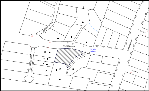
|
NOTIFICATION PLAN |
|
||
|
• PROPERTIES NOTIFIED
|
X SUBMISSIONS RECEIVED |
PROPERTY SUBJECT OF DEVELOPMENT
|
|
Twelve submissions from five residents objected to the development, generally on the grounds that the development would result in:
· Unacceptable setbacks;
· Unacceptable lot size;
· Unacceptable overshadowing;
· Loss of Privacy;
· Loss of view;
· Devaluation of adjoining properties;
· Unacceptable cut and fill;
· Development out of character;
· Development that is excessive in bulk and scale;
· Topography/excavation;
· Fauna concerns;
· Pedestrian safety;
· Unacceptable private open space;
· Unacceptable landscaping;
· Unacceptable driveway gradient;
· Unacceptable building materials;
· Unacceptable material storage area;
· Fences;
· Notification sign;
· Inaccurate plans/documentations; and
· Missing Plans.
The merits of the matters raised in community submissions have been addressed in the body of the report with the exception of the following:
5.1.1 Loss of View
One submission raised concerns with respect to view loss. The submission states that the proposed development would obstruct the valley view of No. 7 Summerhaze Place. The view is not considered to be iconic. Furthermore, the proposed development is well within the building height and floor area requirement within the HDCP.
5.1.2 Devaluation of Properties
One submission raises concerns with respect to devaluation of properties. Devaluation of properties is not a matter for consideration under Section 79C of the Environmental Planning and Assessment Act 1979.
5.1.3 Unacceptable Cut and Fill
Council has received three submissions raising concerns with respect to the proposed retaining wall heights as a result of the proposed cut and fill for the development. The proposed cut and fill exceeds the 1 metre requirement with a maximum cut of 1.5 metres and a maximum fill of 2.1 metres. It is also noted that the proposal incorporates pole construction to reduce the amount of fill on the western elevation. Notwithstanding, the site is constrained due to its topography therefore, such amount of cut and fill is unavoidable.
To minimise impacts of the landform and to address potential impacts on adjoining properties, conditions are recommended including preparation of a dilapidation report, footings designed by a structural engineer and a management plan prepared for the sandstone excavation work to retain landscape features, protect adjoining properties and reuse extracted sandstone for retaining walls in construction of the development.
5.1.4 Development Out of Character
Council has received three submissions raising concerns that the proposed development is out of character. The proposed development generally complies with the requirements of the HDCP including scale, setbacks, open space, landscaping and design details and would blend with the surrounding environment and streetscape. The proposed dwelling is consistent with other two-storey and split-level dwelling houses in the immediate locality built on steeply sloping sites.
5.1.5 Topography/Excavation
Council has received seven submissions raising concerns with respect to topography, landslip concerns, excavation and suitability of the site for the proposed development. The site has a steep topography including sandstone rock ledge and outcrops. A geotechnical report has been submitted for the site. It is noted that the submitted geotechnical report is dated 1994 (which was submitted with the previous DA on site). Notwithstanding the site has not significantly changed over the years and the report determined that the site is affected by a very low risk slope instability.
The proposal involves rock excavation works for the proposed dwelling and driveway. Accordingly, to minimise impacts of the landform and to address potential impacts on adjoining properties, conditions are recommended including preparation of a dilapidation report, footing designed by a structural engineer and a management plan prepared for the sandstone excavation work to retain landscape features, protect adjoining properties and reuse extracted sandstone for retaining walls in construction of the development.
5.1.6 Fauna Concerns
Two submissions raise concerns with respect to loss of fauna and a request that ‘a fat tailed gecko to be collected prior to construction’. A Flora and Fauna Assessment prepared by Clarke Dowdle and Associates Pty Ltd dated October 2009 was prepared and considered in the assessment of the previously approved application (DA/787/2209) for a similar development. The Flora and Fauna report is only 6 years old and did not raise any concerns with respect to fauna impacts on the subject site from the proposed development. The fat tailed gecko is not an endangered species and Council’s assessment concludes that there would not be any detrimental fauna impact from the proposal development and such request is considered unreasonable.
5.1.7 Pedestrian Safety
Council has received one submission raising concerns with respect to pedestrian safety from reversing vehicles from the driveway. Summerhaze Place is a quiet street with very limited pedestrian traffic. A condition of consent is recommended that vehicular access is to be design in accordance with Australian Standard to minimise any risks to pedestrians from vehicles reversing onto the street.
5.1.7.1 Unacceptable Driveway Gradient
Council has received three submissions raising concerns with respect to the driveway gradient. Council requested for an engineering longitudinal section of the driveway during the assessment. Council’s assessment concluded the driveway was satisfactory subject to appropriate conditions of consent being recommended that the driveway be designed and constructed in accordance with the Australian Standards 2890.1.
5.1.8 Unacceptable Building Materials
Council has received three submissions raising concerns with the proposed building material. The submission states that the site is burdened with a covenant within the 88B instrument which restricts the building material.
This restriction was placed on when the subdivision was registered in 1991. The Hornsby Local Environmental Plan 2013 includes a provision under clause 1.9A that suspends covenants and restrictions that would otherwise restrict the carrying out of development under this plan. The Hornsby Development Control Plan does not apply restrictions on building material on any new development in this area except where a site is heritage listed. It would be unreasonable for Council to restrict building material for the proposed development.
The dwelling proposes dark toned colorbond roof and garage door, white and grey coloured rendered walls, aluminium window and door frames and steel louvres and posts. The proposed development would not detract from the existing streetscape. Therefore, the proposed development meets the objectives of the design element and is considered acceptable.
5.1.9 Unacceptable Material Storage Area
One submission raises concerns with the location of the material storage area as it may potentially enter into No. 1 Cottonwood Way. The Construction Management Plan indicates that there would be sediment control fencing along the western boundary of the property to stop any material runoff to the adjoining properties including No. 1 Cottonwood Way.
5.1.10 Fences
Council has received one submission raising concerns with respect to boundary fences.
The submission states that the site is burdened with a covenant within the 88B instrument which restricts the boundary fence. The restriction refers to no fence erected on the common boundary of lots with rights of way. The proposed subdivision does not propose any new fencing along the right of way and would not alter the existing rights of way for the surrounding lots.
5.1.11 Notification Sign
Three submissions raise concerns that no notification sign was displayed on the site during the first notification period. The application was renotified for an additional 2 weeks and the applicant submitted photo evidence of the yellow notification sign erected on the property.
5.1.12 Inaccurate Plans/Documentations
Council received five submissions raising concerns with respect to inaccurate plans/documents. The initial plans/documentations with the application had some discrepancies. Accordingly, Council requested amended plans and documentation with accurate details.
5.1.13 Missing Plans
Three submissions raise concerns with respect missing plans (including floor plans, landscape plan and shadow diagrams). The submitted application includes all these plans, however the floor plans and landscape plan which has floor layout is not available for public access on the Council DA tracking system due to Council’s privacy policy.
5.2 Public Agencies
The development application was referred to the following Agencies for comment:
5.2.1 Rural Fire Service
The development application is Integrated Development under the Act. Accordingly, the application was referred to the NSW Rural Fire Service for comment. The NSW Rural Fire Service has issued general terms of approval with conditions requiring asset protection zones, design and construction measures to withstand the potential impacts of bush fire attack, provision of adequate services of water for the protection buildings during and after the passage of a bush fire, and appropriate location of gas and electricity so it does not contribute to the risk of fire to a building.
6. THE PUBLIC INTEREST
Section 79C(1)(e) of the Act requires Council to consider “the public interest”.
The public interest is an overarching requirement, which includes the consideration of the matters discussed in this report. Implicit to the public interest is the achievement of future built outcomes adequately responding to and respecting the future desired outcomes expressed in environmental planning instruments and development control plans.
The application is considered to have satisfactorily addressed Council’s and relevant agencies’ criteria and would provide a development outcome that, on balance, would result in a positive impact for the community. Accordingly, it is considered that the approval of the proposed development would be in the public interest.
CONCLUSION
The proposed development is for subdivision of one allotment into two and construction of a dwelling house. The proposed development is similar to a previous development approved on the site that has since lapsed.
The proposed subdivision is considered satisfactory in maintaining the residential character of the locality and the pattern of subdivision and in this regard, would not establish an undesirable precedent.
The proposed development is considered acceptable with regard to the provisions of the relevant environmental planning instruments applicable to the site and the Hornsby Development Control plan.
The application is recommended for approval.
Note: At the time of the completion of this planning report, no persons have made a Political Donations Disclosure Statement pursuant to Section 147 of the Environmental Planning and Assessment Act 1979 in respect of the subject planning application.
RESPONSIBLE OFFICER
The officer responsible for the preparation of this Report is the Manager – Development Assessments – Rodney Pickles, who can be contacted on 9847 6731.
|
Rod Pickles Manager - Development Assessment Planning Division |
James Farrington Group Manager Planning Division |
|
1.View |
Locality Map |
|
|
|
2.View |
Floor Plans |
|
|
|
3.View |
Subdivision Plan |
|
|
|
4.View |
Site Plan |
|
|
|
5.View |
Stormwater Concept Plan |
|
|
|
6.View |
Elevations and Sections |
|
|
|
7.View |
Landscape Plan |
|
|
File Reference: DA/1507/2015
Document Number: D07006195
SCHEDULE 1
CONDITIONS APPLICABLE TO BOTH STAGE 1 AND STAGE 2
GENERAL CONDITIONS
The conditions of consent within this notice of determination have been applied to ensure that the use of the land and/or building is carried out in such a manner that is consistent with the aims and objectives of the relevant legislation, planning instruments and council policies affecting the land and does not disrupt the amenity of the neighbourhood or impact upon the environment.
Note: For the purpose of this consent, the term ‘applicant’ means any person who has the authority to act on or the benefit of the development consent.
Note: For the purpose of this consent, any reference to an Act, Regulation, Australian Standard or publication by a public authority shall be taken to mean the gazetted Act or Regulation, or adopted Australian Standard or publication as in force on the date that the application for a construction certificate is made.
1. Approved Plans and Supporting Documentation
The development must be carried out in accordance with the plans and documentation listed below and endorsed with Council’s stamp, except where amended by Council and/or other conditions of this consent:
Approved Plans
|
Plan No. |
Drawn by |
Dated |
|
1601-DA-02 – proposed Subdivision – Rev B |
Ecologie group architects |
Mar 2016 |
|
1601-DA-05 – Site Plan & Roof Plan – Rev B |
Ecologie group architects |
Mar 2016 |
|
1601-DA-08 – North & South Elevation – Rev B |
Ecologie group architects |
Mar 2016 |
|
1601-DA-09 – East & West Elevation – Rev B |
Ecologie group architects |
Mar 2016 |
|
1601-DA-10 – Section AA – Rev B |
Ecologie group architects |
Mar 2016 |
|
1601-DA-11 – Section BB – Rev B |
Ecologie group architects |
Mar 2016 |
|
1601-DA-13 – Stormwater Concept Plan – Rev B |
Ecologie group architects |
Mar 2016 |
|
1601-DA-14 – Construction Management Plan – Rev B |
Ecologie group architects |
Mar 2016 |
|
1601-DA-19 – Driveway Section – Rev B |
Ecologie group architects |
Mar 2016 |
|
1601-DA-12 – Landscape Concept Plan – Rev B |
Ecologie group architects |
Mar 2016 |
|
1601-DA-06 – Ground Floor Plan – Rev B |
Ecologie group architects |
Mar 2016 |
|
1601-DA-07 – Lower Ground Floor – Rev B |
Ecologie group architects |
Mar 2016 |
Supporting Documents:
|
Document Title |
Prepared by |
Dated |
|
Waste Management Report |
Ecologie group architects |
Nov 2015 |
|
Materials & Colour Schedule |
- |
Nov 2015 |
|
BASIX Certificate 592515S |
Ecologie group architects |
4 November 2015 |
|
Arboricultural Impact Report |
Guy Paroissien – Landscape Matrix Pty Ltd |
30 March 2015 |
|
Bushfire Hazard Assessment Report |
Building Code & Bushfire Hazard Solutions Pty Limited |
28 October 2015 |
|
Statement of Environmental Effects |
The Ecologie Group Pty Ltd |
November 2015 |
2. Project Arborist
a) A Project Arborist is to be appointed in accordance with AS 4970-2009 (1.4.4) to provide monitoring and certification throughout the development process.
b) Details of the Project Arborist are to be submitted to Council and the PCA prior to the issue of a Construction Certificate.
3. Removal of Existing Trees
a) This development consent permits the removal of five trees numbered 1, 2, 3, 6 and 8 as identified on plan number 1601-DA-12 - Landscape Plan - Rev B prepared by Ecologie group architects, dated Mar 2016.
b) The removal of any other trees requires separate approval in accordance with the Tree and Vegetation Chapter 1B.6 Hornsby Development Control Plan (HDCP).
4. Construction Certificate
a) A Construction Certificate is required to be approved by Council or a Private Certifying Authority prior to the commencement of any works under this consent.
b) A separate Construction Certificate must be obtained from Council for all works within the public road reserve under S138 of the Roads Act.
c) A separate Construction Certificate must be obtained from Council for all works within drainage easements vested in Council.
d) The Construction Certificate plans must not be inconsistent with the Development Consent plans.
5. Section 94 Development Contributions
a) In accordance with Section 80A(1) of the Environmental Planning and Assessment Act, 1979 and the Hornsby Shire Council Section 94 Development Contributions Plan 2014-2024, the following monetary contributions must be paid to Council to cater for the increased demand for community infrastructure resulting from the development:
|
Description |
Contribution (4) |
|
Roads |
$3,064.95 |
|
Open Space and Recreation |
$9,263.60 |
|
Community Facilities |
$7,667.30 |
|
Plan Preparation and Administration |
$4.15 |
|
TOTAL |
$20,000.00 |
being for one additional lot.
b) The value of this contribution is current as at 8 July 2016. If the contribution is not paid within the financial quarter that this condition was generated, the contribution payable will be adjusted in accordance with the provisions of the Hornsby Shire Council Section 94 Development Contributions Plan and the amount payable will be calculated at the time of payment in the following manner:
$CPY = $CDC x CPIPY
CPIDC
Where:
$CPY is the amount of the contribution at the date of Payment
$CDC is the amount of the contribution as set out in this Development Consent
CPIPY is the latest release of the Consumer Price Index (Sydney – All Groups) at the date of Payment as published by the ABS.
CPIDC is the Consumer Price Index (Sydney – All Groups) for the financial quarter at the date applicable in this Development Consent Condition.
c) The monetary contribution must be paid to Council:
i) prior to the issue of the Subdivision Certificate where the development is for subdivision; or
ii) prior to the issue of the first Construction Certificate where the development is for building work; or
iii) prior to issue of the Subdivision Certificate or first Construction Certificate, whichever occurs first, where the development involves both subdivision and building work; or
iv) prior to the works commencing where the development does not require a Construction Certificate or Subdivision Certificate.
Note: It is the professional responsibility of the Principal Certifying Authority to ensure that the monetary contributions have been paid to Council in accordance with the above timeframes.
Council’s Development Contributions Plan may be viewed at www.hornsby.nsw.gov.au or a copy may be inspected at Council’s Administration Centre during normal business hours.
REQUIREMENTS PRIOR TO THE ISSUE OF A CONSTRUCTION CERTIFICATE
6. Building Code of Australia
All approved building work must be carried out in accordance with the relevant requirements of the Building Code of Australia.
REQUIREMENTS PRIOR TO THE COMMENCEMENT OF ANY WORKS
7. Erection of Construction Sign
a) A sign must be erected in a prominent position on any site on which any approved work is being carried out:
i) Showing the name, address and telephone number of the principal certifying authority for the work;
ii) Showing the name of the principal contractor (if any) for any demolition or building work and a telephone number on which that person may be contacted outside working hours; and
iii) Stating that unauthorised entry to the work site is prohibited.
b) The sign is to be maintained while the approved work is being carried out and must be removed when the work has been completed.
8. Toilet Facilities
a) To provide a safe and hygienic workplace, toilet facilities must be available or be installed at the works site before works begin and must be maintained until the works are completed at a ratio of one toilet for every 20 persons employed at the site.
b) Each toilet must:
i) be a standard flushing toilet connected to a public sewer; or
ii) be a temporary chemical closet approved under the Local Government Act 1993; or
iii) have an on-site effluent disposal system approved under the Local Government Act 1993.
9. Tree Protection Requirements
The Project Arborist must oversee the installation and provide certification for all tree protection measures as specified in this consent and in accordance with Australian Standard AS 4970-2009 Section 4.
a) Tree protection fencing must be installed around trees numbered 5, 7, 9 and 10 at the distances determined by AS 4970-2009 (Clause 3.2).
b) Where tree protection fencing cannot be located at the perimeter of the Tree Protection Zone, appropriate ground, trunk and crown protection must be provided in accordance with AS 4970-2009 (Clause 4.5) under the direction of the project Arborist.
c) Tree Protective Fencing must be installed in accordance with AS 4970-2009 (Clauses 4.3 and 4.4).
d) Maintenance of the Tree Protection Zones must be carried out in accordance with AS 4970-2009 (Clause 4.6) for the duration of this consent.
10. Erosion and Sediment Control
To protect the water quality of the downstream environment, erosion and sediment control measures must be provided and maintained throughout the construction period in accordance with the manual ‘Soils and Construction 2004 (Bluebook)’, the approved plans, Council specifications and to the satisfaction of the principal certifying authority. The erosion and sediment control devices must remain in place until the site has been stabilised and revegetated.
Note: On the spot penalties may be issued for any non-compliance with this requirement without any further notification or warning.
REQUIREMENTS DURING CONSTRUCTION
11. Construction Work Hours
All works on site, including demolition and earth works, must only occur between 7am and 5pm Monday to Saturday.
No work is to be undertaken on Sundays or public holidays.
12. Works within Tree Protection Zones (TPZ)
a) All works within the TPZ must be approved by the Project Arborist.
b) Root/ground protection must be provided in accordance with AS 4970-2009 (Clause 4.5.4).
c) Underground services must be installed in accordance with AS 4970-2009 (Clause 4.5.5).
d) The Structural Root Zone of any tree required to be retained must remain intact.
e) Root pruning outside a trees Structural Root Zone must be carried out in accordance with AS 4970-2009 (Clauses 4.5.4 and 4.5.5).
f) Where works are undertaken within the Tree Protection Zone of a tree the Project Arborist must assess the condition of tree at regular intervals and make recommendations for, and carry out remedial actions where there is evidence of:
i) A general decline in health and vigour;
ii) Damaged, crushed or dying roots;
iii) Excessive (>10%) loss or dieback of roots, branches and foliage;
iv) Mechanical damage or bruising of bark and timber of roots, trunks and branches;
v) Yellowing of foliage of thinning of canopy uncharacteristic of the species;
vi) An increase in the amount of deadwood not associated with normal growth;
vii) Inappropriate increase in the development of epicormic growth and/or the presence of sucker growth on the trunk; and
viii) Branch drop, torn branches and stripped bark not associated with natural climate condition.
g) The Project Arborist must provide to the Principal Certifying Authority certification for the monitoring and maintenance of Tree Protection Zones and documentation of the methods used to preserve the trees during construction.
13. Council Property
To ensure that the public reserve is kept in a clean, tidy and safe condition during construction works, no building materials, waste, machinery or related matter is to be stored on the road or footpath.
14. Disturbance of Existing Site
During construction works, the existing ground levels of open space areas and natural landscape features, (including natural rock-outcrops, vegetation, soil and watercourses) must not be altered unless otherwise nominated on the approved plans.
REQUIREMENTS PRIOR TO THE ISSUE OF AN OCCUPATION OR SUBDIVISION CERTIFICATE
Note: For the purpose of this consent, a reference to ‘occupation certificate’ shall not be taken to mean an ‘interim occupation certificate’ unless otherwise stated.
15. Final Certification
Where works have been undertaken within the Tree Protection Zone of a specified tree the project Arborist must assess the condition of tree(s) and the growing environment and make recommendations for, and carry out remedial actions where necessary.
a) Following the final inspection and the completion of any remedial works, the project Arborist must submit to the Principal Certifying Authority documentation stating that the completed works have been carried out in compliance with the approved plans and specifications for tree protection as above and AS 4970-2009.
16. Damage to Council Assets
To protect public property and infrastructure, any damage caused to Council’s assets as a result of the construction or demolition of the development must be rectified by the applicant in accordance with Council’s Civil Works Specifications. Rectification works must be undertaken prior to the issue of an Occupation Certificate, or sooner, as directed by Council.
GENERAL TERMS OF APPROVAL – NSW RURAL FIRE SERVICES
The following conditions of consent are General Terms of Approval from the nominated State Agency pursuant to Section 91A of the Environmental Planning and Assessment Act 1979 and must be complied with to the satisfaction of that Agency.
Asset Protection Zones
17. At the issue of subdivision certificate and in perpetuity the entire property shall be managed as an inner protection area (IPA) as outlined within section 4.1.3 and Appendix 5 of 'Planning for Bush Fire Protection 2006' and the NSW Rural Fire Service's document 'Standards for asset protection zones'.
18. For asset protection zones (APZ) on slopes greater than 18 degrees, the property shall be landscaped or managed (e.g. terracing) with suitable access being provided to the APZ to ensure the ongoing maintenance of the area. Details of landscaping plans are to be submitted for approval to Council/or the principal certifier with the construction certificate.
Water and Utilities
19. Water, electricity and gas are to comply with section 4.1.3 of 'Planning for Bush Fire Protection 2006'.
Design and Construction
20. A minimum 1.8 metres high radiant heat shield made of non-combustible materials shall be constructed along the southern boundary adjacent to the hazard. All posts and rails shall be constructed of steel. The bottom of the fence is to be in direct contact with the finished ground level or plinth.
21. The western and southern elevations, and all new roof structures, of the proposed dwelling on lot 1 shall comply with Sections 3 and 8 (BAL 40) Australian Standard AS3959-2009 'Construction of buildings in bush fire-prone areas' and section A3.7 Addendum Appendix 3 of 'Planning for Bush Fire Protection 2006'.
22. The northern and eastern elevations of the proposed dwelling on lot 1 shall comply with section 3 and section 7 (BAL 29) Australian Standard AS3959-2009 ‘Construction of buildings in bush fire-prone areas’ and section A3.7 Addendum Appendix 3 of 'Planning for Bush Fire Protection' 2006’.
CONDITIONS APPLICABLE TO STAGE 1 – SUBDIVISION
REQUIREMENTS PRIOR TO THE ISSUE OF A CONSTRUCTION CERTIFICATE
23. Utility Services
The applicant must submit written evidence of the following service provider requirements:
a) Ausgrid – a letter of consent demonstrating that satisfactory arrangements have been made to service the proposed development.
b) Telstra - a letter of consent demonstrating that satisfactory arrangements have been made to service the proposed development.
24. Road Works
All road works approved under this consent must be designed in accordance with Council’s Civil Works Design and Construction Specification 2005 and the following requirements at the Applicant’s cost:
a) In order to provide access to the proposed vacant lot, Council’s standard layback and gutter dish to be constructed in the line of kerb to suit the proposed Crossing and driveway location for the proposed dwelling’s crossing with appropriate splays;
b) Where an existing Council kerb inlet and pit is impacted by a layback work, the grate and kerb inlet shall be removed, and replaced with a standard galvanised single leaf 900 mm grate;
c) Council’s removed kerb inlet pit if applicable shall be reconstructed on the existing street pipe alignment using a standard 1.8m extended kerb inlet pit and 900 mm grate;
d) The existing road pavement to be saw cut a minimum of 300 mm from the existing edge of bitumen. All impacted or damaged Council road assets are to be reconstructed and made good. Services shall be relocated as required per the requirements of the appropriate Utility;
e) Pursuant to Section 138 Roads Act 1993, a separate Construction Certificate Application shall be made to Council’s Planning Division as the Roads Authority for these works. The Application shall be submitted with construction plans and payment of Council’s quoted fees for assessment and compliance inspections.
25. Traffic Control Plan
A Traffic Control Plan (TCP) must be prepared by a qualified traffic controller in accordance with the Roads & Traffic Authority’s Traffic Control at Worksites Manual 1998 and Australian Standard 1742.3 for all work on a public road. The Traffic Management Plan shall be submitted and approved by Council’s Manager Traffic and Road Safety prior to the issue of a construction certificate. The TCP must detail the following:
a) Arrangements for public notification of the works;
b) Temporary construction signage;
c) Permanent post-construction signage;
d) Vehicle movement plans;
e) Traffic management plans; and
f) Pedestrian and cyclist access/safety.
REQUIREMENTS PRIOR TO THE COMMENCEMENT OF ANY WORKS
26. Erosion and Sediment Control
To protect the water quality of the downstream environment, erosion and sediment control measures must be provided and maintained throughout the construction period in accordance with the manual ‘Soils and Construction 2004 (Bluebook)’, the approved plans, Council specifications and to the satisfaction of the principal certifying authority. The erosion and sediment control devices must remain in place until the site has been stabilised and revegetated.
Note: On the spot penalties may be issued for any non-compliance with this requirement without any further notification or warning.
REQUIREMENTS DURING CONSTRUCTION
27. Council Property
To ensure that the public reserve is kept in a clean, tidy and safe condition during construction works, no building materials, waste, machinery or related matter is to be stored on the road or footpath.
REQUIREMENTS PRIOR TO THE ISSUE OF A SUBDIVISION CERTIFICATE
28. Sydney Water – s73 Certificate
An s73 Certificate must be obtained from Sydney Water and submitted to the PCA..
Note: Sydney Water requires that s73 applications are to be made through an authorised Sydney Water Servicing Coordinator. Refer to www.sydneywater.com.au or telephone 13 20 92 for assistance.
29. Works as Executed Plan
As applicable, a works-as-executed plan must be prepared by a Registered Surveyor and submitted to Council for completed public drainage systems.
30. Creation of Easements
The following matter(s) must be nominated on the plan of subdivision under s88B of the Conveyancing Act, 1919:
a) The creation of a “Positive Covenant” over the proposed vacant Lot requiring that any future development is to provide an on-site detention system. The on-site detention system is to have a storage capacity of 5 cubic metres and a maximum discharge of 8 litres per second into Council’s drainage system in accordance with Council’s prescribed wording;
b) The creation of a Positive Covenant over proposed Lots requiring the foundations of any structure on the land be designed by a Chartered Structural Engineer, using terms available from Council.
Note: Council must be nominated as the authority to release, vary or modify any easement, restriction or covenant.
CONDITIONS APPLICABLE TO STAGE 2 – CONSTRUCTION OF A DWELLING HOUSE
REQUIREMENTS PRIOR TO THE ISSUE OF A CONSTRUCTION CERTIFICATE
31. Works Management Plan
An excavation works management plan, prepared by a qualified geotechnical engineer, must be submitted to the principal certifying authority for the site of the proposed dwelling house, that addresses the following:-
a) Protection of existing landform to retain the rock shelf on the eastern side of Lot 1;
b) Reuse of excavated sandstone on-site for landscaping and retaining walls;
c) Protection of adjoining properties; and
d) Methodology to stabilize rock boulders.
32. Dilapidation Report
A ‘Dilapidation Report’ is to be prepared by a ‘chartered structural engineer’ detailing the structural condition of all adjoining properties – Nos.1, 3 Cottonwood Way and 7 Summerhaze Place, Hornsby Heights.
a) To record the structural condition of all properties adjoining the approved development, a dilapidation report must be prepared by a suitably qualified structural engineer for inclusion with the application of the Construction Certificate.
33. Sydney Water – Approval
This application must be submitted to Sydney Water for approval to determine whether the development would affect any Sydney Water infrastructure, and whether further requirements are to be met.
Building plan approvals can be obtained online via Sydney Water Tap inTM through www.sydneywater.com.au under the Building and Development tab.
34. Contract of Insurance (Residential Building Work)
Where residential building work for which the Home Building Act 1989 requires there to be a contract of insurance in force in accordance with Part 6 of that Act, this contract of insurance must be in force before any building work authorised to be carried out by the consent commences.
35. Notification of Home Building Act 1989 Requirements
Residential building work within the meaning of the Home Building Act 1989 must not be carried out unless the principal certifying authority for the development to which the work relates (not being Council) has given Council written notice of the following information:
a) In the case of work for which a principal contractor is required to be appointed:
i) The name and licence number of the principal contractor; and
ii) The name of the insurer by which the work is insured under Part 6 of that Act.
b) In the case of work to be done by an owner-builder:
i) The name of the owner-builder; and
ii) If the owner-builder is required to hold an owner-builder’s permit under that Act, the number of the owner-builder’s permit.
Note: If arrangements for doing the residential building work are changed while the work is in progress so that the information notified becomes out of date, further work must not be carried out unless the principal certifying authority for the development to which the work relates (not being Council) has given Council written notification of the updated information.
36. On Site Stormwater Detention
An on-site stormwater detention system must be designed by a chartered civil or hydraulic engineer and constructed in accordance with the following requirements:-
a) Have a capacity of not less than 5 cubic metres, and a maximum discharge (when full) of 8 litres per second;
b) Have a surcharge/inspection grate located directly above the outlet;
c) Discharge from the detention system must be controlled via 1 metre length of pipe, not less than 50 millimetres diameter or via a stainless plate with sharply drilled orifice bolted over the face of the outlet discharging into a larger diameter pipe capable of carrying the design flow to an approved Council system;
d) Where above ground pondage and the average depth is greater than 0.3 metres, a ‘pool type’ safety fence and warning signs must be installed; and
e) Not be constructed in a location that would impact upon the visual or recreational amenity of residents.
37. Foundation Design
Foundations for the dwelling must be designed by a suitably qualified civil or structural Engineer, with the Engineer’s plans submitted for consideration with the Construction Certificate.
38. Internal Driveway/Vehicular Areas
The driveway and parking areas on site must be designed, constructed and a Construction Certificate issued in accordance with Australian Standards 2890.1, 3727 and the following requirements:-
a) Design levels at the front boundary shall be obtained from Council via a separate application to Council’s Infrastructure and Recreation Division for Crossing Levels.
b) Design levels at the front boundary obtained from Council shall be used in the preparation of the design of the driveway longitudinal section.
c) The driveway be a rigid pavement.
d) The driveway grade must not exceed 25 percent and transitions for changes in grade must not exceed 8 percent per plan metre.
e) The driveway pavement be a minimum 3 metres wide, 0.15 metres thick reinforced concrete with SL72 steel reinforcing fabric on a firm sub-base.
f) Retaining walls required to support the carriageway and the compaction of all fill batters to be in accordance with the requirements of a chartered structural engineer.
g) The provision of safety rails/walls where there is a level difference more than 0.3 metres and a 1:4 batter cannot be achieved. To protect the rail or wall, a 150 mm high kerb shall be provided a distance of 300 mm from each rail or wall.
h) Construction of pedestrian access designed to help prevent slip and fall shall be designed and constructed with the driveway. Pedestrian grades steeper than 12.5% shall be provided with surface texturing, brushing or cleats to satisfy Class V: R11 ramps in accordance with AS 4586-2004 Clause 5.2.
39. Vehicular Crossing
A separate application under the Local Government Act, 1993 and the Roads Act 1993 must be submitted to Council for the installation of a new vehicular crossing and the removal of any redundant crossing. The vehicular crossing must be constructed in accordance with Council’s Civil Works Design 2005 and the following requirements:
a) Design levels at the front boundary must be obtained from Council for the design on the internal driveway;
b) Any redundant crossings must be replaced with integral kerb and gutter;
c) The footway area must be restored by turfing and Council’s standard 80 mm concrete footpath;
Note: An application for a vehicular crossing can only be made to one of Council’s Authorised Vehicular Crossing Contractors. You are advised to contact Council on 02 9847 6940 to obtain a list of contractors.
REQUIREMENTS DURING CONSTRUCTION
40. Environmental Management
The site must be managed in accordance with the publication ‘Managing Urban Stormwater – Landcom (March 2004) and the Protection of the Environment Operations Act 1997 by way of implementing appropriate measures. To prevent sediment run-off, excessive dust, noise or odour emanating from the site during the construction of the development.
41. Landfill
Landfill must be constructed in accordance with Council’s ‘Construction Specification 2005’ and the following requirements:
a) Prior to fill material being imported to the site, a certificate shall be obtained from a suitable qualified environmental consultant confirming the fill wholly consists of Virgin Excavated Natural Material (VENM) as defined in Schedule 1 of the Protection of the Environment Operations Act, 1997 or material approved under the Department of Environment and Climate Change’s general resource recovery exemption.
b) A compaction certificate is to be obtained from a suitably qualified geotechnical engineer verifying that the specified compaction requirements have been met.
c) These certificates must be included with the application for an occupation certificate.
42. Excavated Material
All excavated material removed from the site must be classified by a suitably qualified person in accordance with the Department of Environment, Climate Change and Water NSW Waste Classification Guidelines prior to disposal to an approved waste management facility and be reported to the principal certifying authority prior to the issue of an Occupation Certificate.
43. Survey Report
A report(s) must be prepared by a registered surveyor and submitted to the principal certifying authority:
a) Prior to the pouring of concrete at each level of the building certifying that:
i) The building, retaining walls and the like have been correctly positioned on the site; and
ii) The finished floor level(s) are in accordance with the approved plans.
44. Council Property
To ensure that the public reserve is kept in a clean, tidy and safe condition during construction works, no building materials, waste, machinery or related matter is to be stored on the road or footpath.
REQUIREMENTS PRIOR TO THE ISSUE OF AN OCCUPATION CERTIFICATE
Note: For the purpose of this consent, a reference to ‘occupation certificate’ shall not be taken to mean an ‘interim occupation certificate’ unless otherwise stated.
45. Fulfilment of BASIX Commitments
The applicant must demonstrate the fulfilment of BASIX commitments pertaining to the development.
46. Retaining Walls
All required retaining walls must be constructed as part of the development.
47. Installation of Privacy Devices
To establish and maintain a reasonable level of privacy for the adjoining premises at No. 1, 3 Cottonwood Way and No. 7 Summerhaze Place:
a) A 1.7-2.2 metre high privacy screen must be erected along the southern and western elevations (as marked in red) of the courtyard on the lower ground floor plan to minimise a direct line of sight to the adjacent property.
b) The proposed screen on the ground floor balcony and alfresco must have no individual openings more than 30mm wide and have a total of all openings less than 30% of the surface area of the screen.
48. Creation of Easements
The following matter(s) must be nominated on Title under s88E of the Conveyancing Act, 1919:
a) The creation of an appropriate "Positive Covenant" and "Restriction as to User" over the constructed on-site detention/retention systems and outlet works, within the lots in favour of Council in accordance with Council’s prescribed wording. The position of the on-site detention system is to be clearly identified on the title, using the Surveyor’s sketch prepared by the Registered Surveyor;
b) To register the OSD easement, the restriction on the use of land “works-as-executed” details of the on-site-detention system must be submitted verifying that the required storage and discharge rates have been constructed in accordance with the design requirements. The details must show the invert levels of the on-site system together with pipe sizes and grades. Any variations to the approved plans must be shown in red on the “works-as-executed” plan and supported by calculations;
Note: Council must be nominated as the authority to release, vary or modify any easement, restriction or covenant.
- END OF CONDITIONS -
ADVISORY NOTES
The following information is provided for your assistance to ensure compliance with the Environmental Planning and Assessment Act 1979, Environmental Planning and Assessment Regulation 2000, other relevant legislation and Council’s policies and specifications. This information does not form part of the conditions of development consent pursuant to Section 80A of the Act.
Environmental Planning and Assessment Act 1979 Requirements
The Environmental Planning and Assessment Act 1979 requires:
· The issue of a construction certificate prior to the commencement of any works. Enquiries can be made to Council’s Customer Services Branch on 9847 6760;
· a principal certifying authority to be nominated and Council notified of that appointment prior to the commencement of any works;
· Council to be given at least two days written notice prior to the commencement of any works;
· mandatory inspections of nominated stages of the construction inspected; and
· an occupation certificate to be issued before occupying any building or commencing the use of the land.
Long Service Levy
In accordance with Section 34 of the Building and Construction Industry Long Service Payments Act 1986, a ‘Long Service Levy’ must be paid to the Long Service Payments Corporation or Hornsby Council.
Note: The rate of the Long Service Levy is 0.35% of the total cost of the work.
Note: Hornsby Council requires the payment of the Long Service Levy prior to the issue of a construction certificate.
Tree and Vegetation Preservation
In accordance with Clause 5.9 of the Hornsby Local Environmental Plan 2013 a person must not ringbark, cut down, top, lop, remove, injure or wilfully destroy any tree or other vegetation protected under the Hornsby Development Control Plan 2013 without the authority conferred by a development consent or a permit granted by Council.
Notes: A tree is defined as a long lived, woody perennial plant with one or relatively few main stems with the potential to grow to a height greater than three metres (3M). (HDCP 1B.6.1.c).
Tree protection measures and distances are determined using the Australian Standard AS 4970:2009, “Protection of Trees on Development Sites”.
Fines may be imposed for non-compliance with both the Hornsby Local Environmental Plan 2013 and the Hornsby Development Control Plan 2013.
Dial Before You Dig
Prior to commencing any works, the applicant is encouraged to contact Dial Before You Dig on 1100 or www.dialbeforeyoudig.com.au for free information on potential underground pipes and cables within the vicinity of the development site.
Asbestos Warning
Should asbestos or asbestos products be encountered during demolition or construction works, you are advised to seek advice and information prior to disturbing this material. It is recommended that a contractor holding an asbestos-handling permit (issued by WorkCover NSW) be engaged to manage the proper handling of this material. Further information regarding the safe handling and removal of asbestos can be found at:
Alternatively, telephone the WorkCover Asbestos and Demolition Team on 8260 5885.
Works within Public Roads
All internal vehicular accessways and drainage invert levels must match existing levels in the public domain. Before preparing construction plans for these works, please acquire information through detail surveys and a separate Application for Crossing Levels to Council’s Crossing Engineer in the Infrastructure and Recreation Division. You are advised to contact the Crossing Engineer by telephone on 9847 6760 for additional details.
Fees and Charges – Subdivision
All fees payable to Council as part of any construction, compliance or subdivision certificate or inspection associated with the development (including the registration of privately issued certificates) are required to be paid in full prior to the issue of the subdivision certificate. Any additional Council inspections beyond the scope of any compliance certificate required to verify compliance with the terms of this consent will be charged at the individual inspection rate nominated in Council's Fees and Charges Schedule.
Telecommunications Act 1997 (Commonwealth)
If you are aware of any works or proposed works which may affect or impact on Telstra’s assets in any way, you are required to contact: Telstra’s Network Integrity Team on Phone Number 1800810443.
House Numbering
The house numbering for this subdivision shall be:
|
Lot |
Street Number |
Street Name |
Street Type |
Locality |
|
Lot 1 |
9A |
Summerhaze Place |
Local |
Hornsby Heights |
|
Lot 2 |
9 |
Summerhaze Place |
Local |
Hornsby Heights |
Group Manager’s Report No. PL58/16
Planning Division
Date of Meeting: 10/08/2016
9 FURTHER REPORT - DEVELOPMENT APPLICATION - SUBDIVISION TWO LOTS INTO EIGHT LOTS - NOS. 75-77 BELLAMY STREET, PENNANT HILLS
EXECUTIVE SUMMARY
|
DA No: |
DA/963/2015 (Lodged on 5 August 2015) |
|
Description: |
Subdivision of two allotments into eight lots – Community Title |
|
Property: |
Lot 22 DP 841114, Lot B DP 411312, Nos. 75-77 Bellamy Street, Pennant Hills |
|
Applicant: |
Icepine Pty Ltd |
|
Owner: |
Icepine Pty Ltd |
|
Estimated Value: |
$400,000 |
· The application involves demolition of existing structures and community title subdivision of two allotments into eight lots.
· At its meeting on 13 April 2016, Council deferred the application for an onsite meeting to determine the impacts of the proposal on neighbouring properties. At the on-site meeting on 5 May 2016, Councillors requested consideration of a stormwater drainage easement and measures to address amenity impacts on adjoining residents.
· The proposal generally complies with Hornsby Local Environmental Plan 2013 and would meet the desired outcomes of Hornsby Development Control Plan 2013. The site is partially within a bushfire prone area. NSW Rural Fire Service approval for a bushfire safety authority has been granted for the proposed subdivision.
· A Red Sticker has been placed on the application requiring that it be determined at a Council meeting.
· 11 submissions have been received in respect of the application.
· It is recommended that the application be approved as a deferred consent commencement for the creation of a drainage easement for upstream properties.
|
THAT Development Application No. DA/963/2015 for demolition of existing structures and community title subdivision of two allotments into eight lots at Lot 22 DP 841114 and Lot B DP 411312, Nos. 75-77 Bellamy Street, Pennant Hills be approved as a deferred commencement pursuant to Section 80(3) of the Environmental Planning and Assessment Act 1979 subject to the conditions of consent detailed in Schedule 1 of Group Manager’s Report No. PL58/16. |
BACKGROUND
On 19 May 1999, Council refused DA/358/1998 for subdivision of three allotments into eight. The proposed subdivision included No. 12 Jackson Crescent and the subject land. The appeal against Council’s refusal of the application was dismissed in the Land and Environment Court on grounds of unsatisfactory lot layout (Proceedings No. 10897 of 1998).
On 2 April 2003, Council refused DA/1083/2002 for demolition of two existing dwellings and erection of a multi-unit housing development comprising eight dwellings and community title subdivision of the subject land. Council refused the application generally on grounds that the proposed dwelling density did not meet the objectives of a low density residential environment.
On 17 September 2014, the applicant attended a Pre DA Meeting (PL/112/2014) for the proposed subdivision of two allotments into eight community title lots. At the meeting the applicant was requested to address lot design, landscape screening of adjoining properties, accessway design, flood design and integrated development requirements.
On 13 April 2016, Council considered Group Manager’s Report No. PL10/16 and resolved as follows:
THAT consideration of Development Application No. DA/963/2015 for demolition of existing structures and community title subdivision of two allotments into eight lots at Lot 22 DP 841114, Lot B DP 411312 Nos. 75-77 Bellamy Street, Pennant Hills be deferred to allow for an onsite meeting involving available Councillors, the applicant and affected residents as needed to better observe and understand the impacts of the proposed subdivision on the environment, traffic and safety issues and impacts on neighbouring properties.
On 5 May 2016, an on-site meeting was held, attended by available Councillors, the applicant’s representative, neighbouring residents and Council officers. Following discussion regarding the proposal with residents, Councillors inspected the site and requested additional matters be addressed for Council’s further consideration.
This report amends Group Manager’s Report No. PL10/16 to include discussion concerning the additional matters discussed as follows:
· A stormwater drainage easement to benefit the Thorn Street properties that adjoin the western boundary of the site (Refer to Section 2.8.5);
· The provision of privacy screening along the southern boundary of Lot 2 comprising landscaping and 300mm of lattice above a 1.8m high fence (Refer to Section 5.1.2);
· Underground power to replace existing power poles (Refer to Section 5.2);
· Privacy screening along the northern site boundary comprising 1.8m high fencing with 300mm lattice (Refer to Section 5.1.2); and
· A contribution to the owner of No. 87 Bellamy Street for landscape screening along the boundary with the site. (Refer to Section 5.1.2).
SITE
The site is located on the western side of Bellamy Street, 90 metres north of the intersection with Stevens Street.
The irregular shaped site has an area of 4,398m2 and comprises two existing battle-axe lots with a combined 11.4m wide x 50m long handle off the western side of Bellamy Street. The site includes two existing dwelling houses with a shared driveway. The house at No. 77 Bellamy Street is derelict. The houses include extensive paved areas. A minor watercourse flows south to north under the driveway via a concrete bridge and through the frontage of adjoining properties fronting Bellamy Street. The watercourse is a tributary of Berowra Creek.
The site benefits from easements over adjoining property No. 73 Bellamy Street for services. A Sydney Water sewer main crosses the shared driveway following the line of the watercourse.
The site has an average fall of 13% to the eastern boundary. The site has a north easterly aspect. The topography is sloping with exposed ground sandstone areas and an uneven eroded gully area in the northern part of the site. The eastern boundary adjoins four dwelling houses with frontage to Bellamy Street. The eastern boundary is unfenced. The adjoining dwelling houses are sited below the level of the subject site and include retaining walls along the boundary which are screened by the existing vegetation on the site.
The northern boundary adjoins an older style dwelling house on a battle-axe lot off Bellamy Street and two dwelling houses fronting Jackson Crescent. The western boundary adjoins four dwelling houses on battle-axe lots off Thorn Street. The southern boundary adjoins three dwelling houses with frontage to Bellamy Street and includes a battle-axe lot.
The Bellamy Street frontage includes remnant trees identified as Blackbutt Gully Forest. The site includes a number of significant trees. The majority of the trees on the site are non-indigenous. The vegetation on No. 77 Bellamy Street is overgrown with bamboo and other noxious weeds.
The north east corner of the site is partly within a bushfire prone area. The bushfire threat is from bushland within Berowra Valley National Park north-east of the site.
The surrounding properties mainly comprise single and two storey dwelling houses on relatively large lots with substantial trees developed since the 1960s and more recent dwelling houses on battle-axe lots. A duplex cluster housing development comprising 12 public housing dwellings is located opposite the site at Nos. 88-94 Bellamy Street.
The site is located 890m north-west of Pennant Hills Railway Station.
PROPOSAL
The proposal is for demolition of existing structures and community title subdivision of two allotments into eight lots including seven residential lots and a community lot which comprises the accessway. The proposed lots are detailed as follows:
Lot 1 (Community Lot) has an area of 769m2 and comprises the proposed accessway which includes the proposed driveway, turning area, associated landscaping, retaining walls, stormwater drainage infrastructure, driveway culvert and waste bin storage facility. The lot includes four trees identified as significant to be retained at the Bellamy Street frontage (Tree No. 1 – White-Mahogany Eucalyptus acmenoides, Tree No. 2 – Deodar-Cedar Cedrus deodara, Tree No. 3 – Smooth-barked Apple Angphora costata and Tree No. 6 – Turpentine – Syncarpia glomulifera).
Lot 2 is an irregular shaped lot with an area of 507m2. The lot has a width of 12m and reduces to 8.2m over the irregular part of the lot comprising an area of 91.2m2 at the lot frontage. The lot has an average gradient of 14% to the accessway (Lot 1). The proposed lot includes an indicative building envelope of 214.5m2, setback 5.5m from the proposed accessway. The accessway includes a turning head at the lot frontage. The lot includes Tree No. 17 located on the southern boundary and Tree No. 18 on the adjoining land which are identified as significant trees (Turpentine – Syncarpia glomulifera) to be retained.
Lot 3 is irregular in shape at the lot frontage, has an area of 501.5m2 and a width of 12m. The lot includes an indicative building envelope of 241m2, setback 8m from the frontage. The lot has an average fall of 12% to the accessway (Lot 1).
Lot 4 is regular in shape with an area of 517m2 and a width of 12m. The lot includes an indicative building envelope of 276.5m2, setback 8m from the frontage. The lot has an average fall of 10% to the accessway (Lot 1). The lot includes Tree No. 50 identified as significant (Turpentine – Syncarpia glomulifera) located near the rear boundary to be retained.
Lot 5 is regular in shape with an area of 517.5m2 and a width of 12m. The lot includes an indicative building envelope of 279.5m2, setback 7.7m from the frontage. The lot has an average fall of 12% to the accessway (Lot 1).
Lot 6 is a battle-axe lot with an area of 501.5m2 excluding the 1.5m x 6m handle and has a width of 12m. The lot has an average fall of 12% to the eastern boundary. The lot shares a driveway and right of access with proposed Lot 7 along the eastern boundary. The lot includes an indicative building envelope of 272m2, setback 7m from the right of access.
Lot 7 is a battle-axe lot with an area of 513.5m2 excluding the 2m x 18.2m handle and has a width of 11.9m. The lot has an average fall of 13% to the eastern boundary. The lot shares a driveway and right of access with proposed Lot 6. The accessway is across an eroded gully area. The lot includes an indicative building envelope of 260m2.
Lot 8 is an irregular triangular shaped lot with an area of 503m2 and a maximum width of 30.4m, reducing to a frontage of 4.8m to the accessway. The lot has an average gradient of 20% to the eastern boundary and includes an eroded gully area. The lot includes an indicative building envelope of 211m2.
ASSESSMENT
The development application has been assessed having regard to the ‘A Plan for Growing Sydney’, the ‘North Subregion (Draft) Subregional Strategy’ and the matters for consideration prescribed under Section 79C of the Environmental Planning and Assessment Act 1979 (the Act). The following issues have been identified for further consideration.
1. STRATEGIC CONTEXT
1.1 A Plan for Growing Sydney and (Draft) North Subregional Strategy
A Plan for Growing Sydney has been prepared by the NSW State Government to guide land use planning decisions for the next 20 years. The Plan sets a strategy for accommodating Sydney’s future population growth and identifies the need to deliver 689,000 new jobs and 664,000 new homes by 2031. The Plan identifies that the most suitable areas for new housing are in locations close to jobs, public transport, community facilities and services.
The NSW Government will use the subregional planning process to define objectives and set goals for job creation, housing supply and choice in each subregion. Hornsby Shire has been grouped with Hunters Hill, Ku-ring-gai, Lane Cove, Manly, Mosman, North Sydney, Pittwater, Ryde, Warringah and Willoughby to form the North Subregion. The Draft North Subregional Strategy will be reviewed and the Government will set housing targets and monitor supply to ensure planning controls are in place to stimulate housing development.
The proposed development would be consistent with ‘A Plan for Growing Sydney’, by providing additional residential allotments and would contribute to future housing supply in the locality.
2. STATUTORY CONTROLS
Section 79C(1)(a) requires Council to consider “any relevant environmental planning instruments, draft environmental planning instruments, development control plans, planning agreements and regulations”.
2.1 Hornsby Local Environmental Plan 2013
The proposed development has been assessed having regard to the provisions of the Hornsby Local Environmental Plan 2013 (HLEP).
2.1.1 Zoning of Land and Permissibility
The subject land is zoned R2 Low Density Residential under the HLEP. The objectives of the R2 zone are:
· To provide for the housing needs of the community within a low density residential environment.
· To enable other land uses that provide facilities or services to meet the day to day needs of residents.
The proposed subdivision is permissible in the zone with Council’s consent pursuant to Clause 4.1 of the HLEP.
2.1.2 Minimum Subdivision Lot Size
Clause 4.1 of the HLEP provides that the size of any lot resulting from the subdivision of land, excluding the area of the access handle, must not be less than the minimum size shown on the Lot Size Map. The minimum lot size for the subject site is 500m2. The proposed subdivision complies with this requirement.
2.1.3 Heritage Conservation
Clause 5.10 of the HLEP sets out heritage conservation provisions for Hornsby Shire. The site does not include a heritage item and is not located in a heritage conservation area. Accordingly, no further assessment regarding heritage is necessary.
2.1.4 Earthworks
Clause 6.2 of the HLEP states that consent is required for proposed earthworks on site. Before granting consent for earthworks, Council is required to assess the impacts of the works on adjoining properties, drainage patterns and soil stability of the locality.
The construction of the proposed accessway would require earthworks and landform modification.
Council’s assessment of the proposed earthworks and land modification concludes that subject to recommended conditions for soil and water management and retaining walls, the proposal would not impact on adjoining properties, drainage patterns or soil stability.
2.2 State Environmental Planning Policy No. 32 – Urban Consolidation (Redevelopment of Urban Land) (SEPP 32)
The application has been assessed against the requirements of SEPP 32, which requires Council to implement the aims and objectives of this Policy to the fullest extent practicable when considering development applications relating to redevelopment of urban land. The application complies with the objectives of the Policy as it would promote the social and economic welfare of the locality and would result in the orderly and economic use of under-utilised land within the Shire.
2.3 State Environmental Planning Policy No. 55 – Remediation of Land
State Environmental Planning Policy No. 55 (SEPP 55) requires that consent must not be granted to the carrying out of any development on land unless it has considered whether the land is contaminated or requires remediation for the proposed use.
The site has been used for residential purposes and is unlikely to be contaminated. Further assessment in this regard is not warranted.
2.4 Sydney Regional Environmental Plan No. 20 – Hawkesbury – Nepean River
The site is located within the catchment of the Hawkesbury Nepean River. Part 2 of this Plan contains general planning considerations and strategies requiring Council to consider the impacts of development on water quality, aquaculture, recreation and tourism.
Subject to the implementation of sediment and erosion control measures and stormwater management to protect water quality, the proposal would comply with the requirements of the Policy.
2.5 Rural Fires Act 1997
The proposed subdivision is integrated development subject to approval of the NSW Rural Fire Service for the issue of a Bush Fire Safety Authority pursuant to Section 100B of the Rural Fires Act 1997.
The NSW Rural Fire Service has raised no objections and has issued a Bush Fire Safety Authority for the proposed subdivision subject to conditions including asset protection zones, water and utilities, and access.
2.6 Water Management Act 2000
The site is traversed by a watercourse tributary of Berowra Creek. Pursuant to Clause 91 of the Act, a ‘controlled activity’ permit from the Department of Primary Industries – Water (DPI - Water) is required for development within 40m of a watercourse.
The watercourse forms part of the local stormwater drainage system in this location.
DPI – Water advised Council the watercourse through the site is considered a drainage channel and there is no requirement for a ‘controlled activity’ permit for the proposed development.
2.7 Clause 74BA Environmental Planning and Assessment Act, 1979 - Purpose and Status of Development Control Plans
Clause 74BA of the Environmental Planning and Assessment Act 1979 states that a DCP provision will have no effect if it prevents or unreasonably restricts development that is otherwise permitted and complies with the development standards in relevant Local Environmental Plans and State Environmental Planning Policies.
The principal purpose of a development control plan is to provide guidance on the aims of any environmental planning instrument that applies to the development; facilitate development that is permissible under any such instrument; and achieve the objectives of land zones. The provisions contained in a DCP are not statutory requirements and are for guidance purposes only. Consent authorities have flexibility to consider innovative solutions when assessing development proposals, to assist achieve good planning outcomes.
2.8 Hornsby Development Control Plan 2013
The proposed subdivision has been assessed having regard to the relevant desired outcomes and prescriptive requirements within the Hornsby Development Control Plan 2013 (HDCP). The following table sets out the proposal’s compliance with the prescriptive requirements of the Plan:
|
Hornsby Development Control Plan 2013 |
|||
|
Control |
Proposal |
Requirement |
Compliance |
|
Lot Size (Allotment sizes excluding the access handle) |
Lot 2 – 507m2 Lot 3 – 501.5m2 Lot 4 – 517m2 Lot 5 – 517.4m2 Lot 6 – 501.5m2 Lot 7 – 513.5m2 Lot 8 – 503m2 |
500m2 (min) |
Yes |
|
Accessway Width |
7.81m (min) |
6.65m (min) |
Yes |
|
Indicative Building Envelope |
211m2 – 276.5m2 |
200m2 |
Yes |
As detailed in the above table, the proposed subdivision complies with prescriptive requirements within the HDCP. The following is a brief discussion on compliance with relevant desired outcomes.
2.8.1 General Provisions
The HDCP includes the following desired outcomes.
a. Subdivision design that provides usable allotments that relate to site conditions.
b. Subdivision design that provides for the retention of significant landscape features and respects site constraints including: significant trees, remnant bushland, steep topography, watercourses, riparian land and stormwater overland flow paths, and bushfire hazard asset protection zones.
c. Subdivision design that provides for all necessary services and facilities, including any required extension or amplification to Council infrastructure.
The proposed subdivision layout and lot design have regard to the sloping topography and the north easterly aspect of the site, would provide useable areas for a range of low density housing types, retain significant trees and provide for bushfire protection.
The proposal includes replacement of the existing bridge over the watercourse with a culvert with design capacity for a 1 in 100 year storm. The proposed lots, including the accessway, would be flood free.
2.8.2 Residential Lands Subdivision
The HDCP includes the following desired outcomes:
a. Subdivision design should maintain appropriately shaped lots to accommodate a dwelling and associated development that is compatible with a low density residential environment.
b. Subdivision design should provide setbacks to developable areas that will: complement the streetscape, provide for landscaping, protect landscape features, and provide separation between existing and future dwellings.
The proposed lots are appropriately shaped to conform to the configuration of the site and the proposed accessway. Proposed lots 2, 3, 4, 5, 6 and 8 comply with the 12m minimum lot width prescriptive measure and would accommodate a 200m2 indicative building envelope clear of required setbacks to boundaries and trees to be retained. Proposed Lot 7 has a width of 11.92m. The non-compliance with the minimum width is acceptable with regard to the minor variation and location on the northern boundary with existing larger adjoining properties. The proposed indicative building envelopes would enable the provision of private open space and on-site car parking in accordance with the HDCP prescriptive measures.
2.8.3 Accessway Design
The HDCP includes the following desired outcomes:
a. To ensure access along private accessways to all new lots is simple, safe and direct.
b. Driveway should not be visually intrusive to the existing streetscape.
c. To limit the number of driveway crossings and additional dwellings with direct access to main roads to limit the cumulative impacts on traffic flows and safety.
The proposed accessway would be located over the existing handles of the two battle-axe lots and would extend along the eastern boundary of the site. The extended accessway involves cut and fill to provide a uniform level increasing from RL155.5m to RL157.0m at the rear of No. 79 and No. 81A Bellamy Street respectively. The two adjoining properties include retaining walls along their rear boundaries at RL 155m. The two existing dwellings are setback > 3.0m and < 7.5m from the boundary.
The proposed driveway is setback 2.0m to 3.5m from the eastern boundary. The proposed landscaping within the setback area would provide adequate screening of the driveway in relation to adjoining residents. Where the driveway is more than 0.5m above ground level, a guard rail is required in accordance with AS2890.1.
The proposed accessway is in accordance with the HDCP requirement for a minimum width of 6.65m for the proposed seven residential lots. The proposed driveway width reduces to 4m for proposed lots 3, 4, 5, 6 and 7. The 4m driveway width is in accordance with the NSW Rural Fire Service requirements in Planning for Bushfire Protection Guidelines 2006. A condition is recommended for the landscaping to be maintained in accordance with the submitted landscape plan.
The proposed accessway includes a common turning area and passing bays in compliance with the HDCP accessway design requirements. The proposed accessway would retain the existing driveway crossing and trees at the street frontage. In this regard, the proposal would maintain the existing streetscape.
The proposed subdivision includes a waste bin storage facility on the northern side of the accessway near the frontage. The storage facility is designed for Council’s waste collection vehicle to reverse onto the driveway for waste collection and forward out.
The proposed accessway meets the HDCP desired outcome for accessway design subject to recommended conditions.
2.8.4 Stormwater Management
A natural watercourse traverses the access handles of the site and forms part of Council’s stormwater drainage system.
The site experiences overland flows from neighbouring properties along the western boundary in the direction of the watercourse. Appropriate conditions are recommended for intercepting and diverting these stormwater water flows to the watercourse.
The proposal includes the upgrading of the existing culvert for the 1 in 100 year storm and for construction of on-site stormwater detention within the proposed driveway. Appropriate conditions are recommended to ensure the post development stormwater flows remain the same as pre-development.
The recommended conditions require the proposed stormwater drainage line on the lower side of the driveway to be relocated within the driveway to improve utility design and landscaping.
Subject to recommended conditions the proposed subdivision would meet the HDCP desired outcomes for stormwater management.
2.8.5 Stormwater Drainage Easement
At the on-site meeting on 5 May 2016, Councillors requested the applicant to give consideration to granting a stormwater drainage easement benefiting the adjoining Thorn Street properties. The request is in recognition of the existing drainage connection through the site to the watercourse. In this regard, the applicant submitted legal advice which states:
We advise that the property being folio identifier 22/841114 is not encumbered by an easement to drain in favour of the owner of the Thorn Street property.
The property is a Torrens title and rights of prescription in relation to an unregistered easement do not exist pursuant to the Torrens system, as that system is one of recording affectations on title. The fact that the pipes of the Thorn Street runs through the property gives no rise to a right of prescription, or an implied easement in favour of the Thorn Street property.
Council then wrote to the adjoining Thorn Street property owners in respect to the applicant’s legal advice and their position in regards to negotiating with the site owner to obtain an easement. In response, Council received a copy of a resident’s letter to the owner of the site requesting an easement.
On 12 July 2016, the site owner advised the adjoining owners of preparedness to negotiate a drainage easement under Section 88 of the Conveyancing Act.
The existing drainage line from the Thorns Street properties was installed by the previous owner of No. 75 Bellamy Street and connects with No. 14A Thorn Street and collects the roof and paved surface runoff from these properties. To prevent surcharge of flows at the pit on the adjoining land by blockage of the drainage line a deferred consent commencement condition is recommended for an easement to be created for the connection of the drainage line to the recommended piped drainage system. The application of such a deferred commencement condition would be consistent with applicant’s expressed position that they are willing to provide an easement and would also formalise an existing drainage system mitigating adverse stormwater impacts on the site and adjoining properties.
2.9 Section 94 Contributions Plans
Hornsby Shire Council Section 94 Contributions Plan 2012-2021 applies to the development as it would result in an additional five residential lots in lieu of the two existing residences. Accordingly, the requirement for a monetary Section 94 contribution is recommended as a condition of consent.
3. ENVIRONMENTAL IMPACTS
Section 79C(1)(b) of the Act requires Council to consider “the likely impacts of that development, including environmental impacts on both the natural and built environments, and social and economic impacts in the locality”.
3.1 Natural Environment
3.1.1 Tree and Vegetation Preservation
The site includes 13 trees of which Trees No. 1 – Eucalyptus acmeniodes (White Mahogany), Tree No. 2 – Cedrus deodara (Deodar Cedar), Tree No. 3 – Angophora costata (Smooth-barked Apple), Trees Nos. 17, 18 and 50 – Syncarpia glomulifera (Turpentine), are identified as significant trees and are proposed to be retained.
Tree No. 8 – Syzygium paniculatum (Magenta Lilly Pilly) and Trees Nos. 56 and 58 – Pittosporum undulatum (Sweet Pittosporum) would be removed. Magenta Lilly Pilly is listed as endangered under Schedule 1 of the Threatened Species Conservation Act 1995. The tree however, is a horticultural planting in an area that does not include habit for Syzygium paniculatum. Trees Nos. 56 and 58 (Sweet Pittosporum) are locally indigenous but are considered an invasive species and would not warrant protection. The proposed removal of Trees Nos. 8, 56 and 58 is therefore acceptable.
The remaining vegetation on the site primarily consists of non-indigenous tree species and noxious weeds species. Appropriate conditions are recommended for the removal of noxious weeds on the site.
A condition is recommended for the submitted landscaping plan to be amended to include locally indigenous plant species.
3.1.2 Natural Watercourse
The proposed subdivision includes upgrading of the existing watercourse culvert across the accessway. A condition is recommended for the area to be rehabilitated with riparian vegetation to stabilise the banks of the watercourse.
3.2 Built Environment
3.2.1 Built Form
Proposed lots 2 to 7 would form a regular pattern for future dwelling houses and provide appropriate spatial arrangement in relation to neighbouring houses with uniform front, rear and side setbacks. Proposed lot 8 is an irregular shaped lot occupying the north eastern triangular shaped part of the site. A dwelling house could be designed for the lot with regard to building separation and privacy.
3.2.2 Traffic
The proposed subdivision would generate 33 daily vehicle trips in accordance with the Roads and Maritime Services Technical Direction – Guide to Traffic Generating Developments dated August 2013 which estimates 6.66 daily trips per dwelling.
Council’s engineering assessment of the traffic impacts of the development concludes the proposed traffic generation is acceptable in respect to the capacity of the local road network.
3.3 Social Impacts
The proposed subdivision would provide opportunity for additional dwelling houses in a locality well provided with public infrastructure, transport and community facilities and would be of positive social impact.
3.4 Economic Impacts
The proposal would have a minor positive impact on the local economy in conjunction with other new low density residential development in the locality by generating an increase in demand for local services.
4. SITE SUITABILITY
Section 79C(1)(c) of the Act requires Council to consider “the suitability of the site for the development”.
4.1 Flooding
The existing and proposed accessway is subject to the 1 in 100 year flood level of a minor watercourse drainage system. The proposal includes upgrading of the accessway with a new culvert designed for a 1 in 100 year storm, thus providing flood free access.
The proposed stormwater drainage works include on-site stormwater detention to ensure pre-development flows are maintained. In this regard, the proposal would not increase the flood risk of downstream properties.
4.2 Bushfire Risk
The land is partly within a bushfire prone area being in the vicinity of Berowra Valley National Park north of the site.
The NSW Rural Fire Service recommends appropriate conditions for bushfire protection.
5. PUBLIC PARTICIPATION
Section 79C(1)(d) of the Act requires Council to consider “any submissions made in accordance with this Act”.
5.1 Community Consultation
The proposed development was placed on public exhibition and was notified to adjoining and nearby landowners between 19 August and 19 September 2015 in accordance with the Notification and Exhibition requirements of the HDCP. During this period, Council received 11 submissions. The map below illustrates the location of those nearby landowners who made a submission that are in close proximity to the development site.
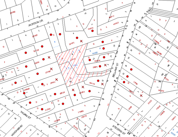
|
NOTIFICATION PLAN |
|
||
|
• PROPERTIES NOTIFIED
|
X SUBMISSIONS RECEIVED |
PROPERTY SUBJECT OF DEVELOPMENT |
|
|
TWO SUBMISSIONS RECEIVED OUT OF MAP RANGE |
|||
At the site meeting on 5 May 2016, concern was raised that the owner of property No. 81A Bellamy Street, Pennant Hills was not notified of the application. A review of Council’s file indicates that a letter to the owner of the property was included in the notification of the application. Accordingly, the above notification plan has been corrected.
Eleven submissions objected to the development. The matters raised by the objectors are discussed as follows:
5.1.1 Traffic Impact on Road Safety
The increase in traffic was raised as a concern for the operation of the intersection of Stevens Street and Bellamy Street and for road safety.
The proposed traffic generation involving 33 daily vehicle trips would not detract from the operation of the local road network and is acceptable in respect to road safety.
The proposed waste collection operation would involve the waste truck reversing onto the driveway for collection from the proposed waste facility at the frontage. The proposed driveway is sufficiently wide to enable vehicles to pass when the waste truck is standing on the driveway.
5.1.2 Dwelling Density and Residential Amenity
The number of proposed lots and potential loss of privacy and solar access resulting from future two storey dwelling houses was raised as a concern.
The proposed lots are generally of uniform shape and size and would enable future dwellings to be designed for solar access and privacy. A maximum building height of 8.5m (two storey) is permissible in accordance with the HLEP.
At the on-site meeting on 5 May 2016, residents raised concerns regarding privacy impacts on adjoining properties. The topography of proposed Lot 2 and proposed Lot 7 is elevated to the rear yards of existing adjoining dwellings. To minimise impacts on privacy of neighbouring residents, a condition is recommended for 1.8m high fencing topped with 300mm of lattice along the respective lot boundaries (Refer to amended Condition No. 40).
An existing brush fence on top of a retaining wall is located along the southern boundary of the site and proposed Lot 2 and the existing driveway. A section of the retaining wall is well inside the property boundary. A condition is recommended for the existing retaining wall not aligned with the site boundary to be demolished and replaced to align with the site boundary. A condition is recommended for landscape screening to replace the existing brush fence (Refer to amended Conditions No. 4 and No. 39).
Further to the on-site meeting the owner of the adjoining dwelling at No. 87 Bellamy Street declined to consider the prospect of a monetary contribution for landscaping on their adjoining land.
5.1.3 Stormwater Drainage and Flooding
The impact of stormwater drainage flows through the site from adjacent properties fronting Thorn Street was raised as a concern regarding the need for easements and impacts of flooding.
The proposed stormwater drainage system is subject to a deferred commencement condition for the creation of a drainage easement for upstream properties and a condition for drainage control measures along the western boundary of the site to divert overland sheet flow from neighbouring properties to the natural watercourse.
The existing drainage line across the driveway is to be upgraded for a new culvert with capacity for the 1 in 100 year storm event. The proposed subdivision would not increase the flooding risk for downstream properties.
5.1.4 Loss of Trees
The loss of existing trees on the site in particular Tree No. 3 – Angophora costata (Smooth-barked Apple) and Tree No. 8 – Syzgium paniculatum (Magenta Lilly Pilly) was raised as a concern.
The proposed waste bin storage facility has been relocated to the northern side of the driveway to retain the locally indigenous Tree No. 3.
The proposed driveway is within the structural root zone of Tree No. 8 located at the frontage of proposed Lot 3. The proposed removal of Tree No. 8 is acceptable as discussed in Section 3.1.1.
The design of the proposed driveway has been amended to increase the area of landscaping. The proposed landscaping would provide adequate screening of the driveway for neighbouring residents and replace dense vegetation along the boundary of the site.
5.1.5 Visual and Acoustic Amenity
The impact of the proposal on visual quality and the acoustic environment was raised as a concern.
The proposal would not impact on the existing streetscape which would be maintained. The proposal would retain the majority of the locally indigenous trees on the site.
The proposed accessway is in close proximity to the existing dwelling houses. The submitted landscape plan includes a 2.5m-3.0m wide landscaping strip along the accessway which would provide effective screening of the driveway. A condition is recommended for fencing of the boundaries of the site which together with landscaping would mitigate noise impacts from the operation of the driveway.
5.2 Public Agencies
The development application is ‘integrated development’ subject to approval of the NSW Rural Fire Service for a Bushfire Safety Authority.
The Rural Fire Service granted its approval for a Bushfire Safety Authority subject to conditions for the subdivision to be designed in accordance with Planning for Bushfire Protection Guidelines 2006 criteria for accessway design and asset protection.
At the on-site meeting on 5 May 2016, Councillors raised concerns regarding the existing power poles on the site. In this regard, Ausgrid will require the subdivision to be serviced by underground power in accordance with the Ausgrid Electrical Supply Standard ES10 – Requirements for Electricity Connection to Developments, December 2008.
6. THE PUBLIC INTEREST
Section 79C(1)(e) of the Act requires Council to consider “the public interest”.
The public interest is an overarching requirement, which includes the consideration of the matters discussed in this report. Implicit to the public interest is the achievement of future built outcomes adequately responding to and respecting the future desired outcomes expressed in environmental planning instruments and development control plans.
The application is considered to have satisfactorily addressed Council’s and relevant agencies’ criteria and would provide a development outcome that, on balance, would result in a positive impact for the community. Accordingly, it is considered that the approval of the proposed development would be in the public interest.
CONCLUSION
The proposal is for demolition of existing structures and subdivision of two allotments into eight community title lots.
The proposed subdivision complies with Hornsby Local Environmental Plan 2013 and generally meets the prescriptive measures of the Hornsby Development Control Plan 2013 for residential subdivision, accessway design, tree preservation, stormwater management and waste management.
The proposed subdivision includes an area of bushfire prone land. The NSW Rural Fire Service would grant a Bushfire Safety Authority for the proposal subject to recommended conditions.
Eleven submissions were received in response to notification of the application.
A deferred consent commencement condition is recommended for creation of a stormwater drainage easement to address drainage impacts of the proposal on adjoining land.
Appropriate conditions are recommended to minimise amenity impacts on neighbouring residents.
The application is recommended for approval.
RESPONSIBLE OFFICER
The officer responsible for the preparation of this Report is the Manager – Development Assessments – Rodney Pickles, who can be contacted on 9847 6731.
|
Rod Pickles Manager - Development Assessment Planning Division |
James Farrington Group Manager Planning Division |
|
1.View |
Locality Map |
|
|
|
2.View |
Subdivision Plan |
|
|
|
3.View |
Landscape Plan |
|
|
|
4.View |
Accessway Design Plans |
|
|
|
5.View |
Meeting Minutes - Item 7 |
|
|
File Reference: DA/963/2015
Document Number: D06994528
SCHEDULE 1
GENERAL CONDITIONS
The conditions of consent within this notice of determination have been applied to ensure that the use of the land and/or building is carried out in such a manner that is consistent with the aims and objectives of the relevant legislation, planning instruments and council policies affecting the land and does not disrupt the amenity of the neighbourhood or impact upon the environment.
Note: For the purpose of this consent, the term ‘applicant’ means any person who has the authority to act on or the benefit of the development consent.
Note: For the purpose of this consent, any reference to an Act, Regulation, Australian Standard or publication by a public authority shall be taken to mean the gazetted Act or Regulation, or adopted Australian Standard or publication as in force on the date that the application for a construction certificate is made.
1. Deferred Commencement
Pursuant to Section 80(3) of the Environmental Planning and Assessment Act 1979, this consent does not operate until the following information is submitted to Council:-
a) The registration and creation of an easement to drain water benefitting No. 14A Thorn Street, Pennant Hills. The Easement is to be created over No. 75 and No. 77 Bellamy Street (the subject site) to connect piped drainage water from upstream properties for safe disposal to the natural watercourse crossing the driveway handle of the subject site.
Such information must be submitted within 36 months of the date of this notice.
Upon Council’s written satisfaction of the above information, the following conditions of development consent apply:
2. Approved Plans and Supporting Documentation
The development must be carried out in accordance with the plans and documentation listed below and endorsed with Council’s stamp, except where amended by Council and/or other conditions of this consent:
|
Plan No. |
Plan Title |
Drawn by |
Dated |
|
12848_DET_C |
Plan Showing Detail and Levels & Proposed Subdivision |
Survey Plus |
27.05.2015 |
|
1 of 2 Revision B |
Landscape Plan |
Stylish Gardens |
15/2/16 |
|
2 of 2 Revision B |
Plant Schedule & Specifications |
Stylish Gardens |
15/2/16 |
|
1676 – Cover Sheet 01 of 04 Rev C |
Access Driveway Concept design |
Storm Consulting |
12.02.16 |
|
1676 – P02 Sheet 02 of 04 Rev C |
Access Driveway Concept Design |
Storm Consulting |
12.02.16 |
|
1676 – D03 Sheet 03 of 04 Rev C |
Access Driveway Concept Design |
Storm Consulting |
12.02.16 |
|
1676 – P04 Sheet 04 of 04 Rev C |
Access Driveway Concept Design |
Storm Consulting |
12.02.16 |
|
Document Title |
Prepared by |
Dated |
|
Arboricultural Impact Assessment |
Australis Tree Management |
21 July 2015 |
|
Bushfire Hazard Assessment Report |
Building Code & Bushfire Hazard Solutions Pty Limited |
20 July 2015 |
|
Stormwater OSD and Flood Design |
Storm Consulting |
10 July 2015 |
|
Waste Management Plan |
SurveyPlus |
March 2016 |
3. Removal of Existing Trees
a) This development consent permits the removal of trees numbered 8, 56 and 58 as identified on plan number Figure 2 Site Map within the Arboricultural Impact Assessment prepared by Australis Tree Management, dated 21 July 2015.
b) The removal of any other trees requires separate approval in accordance with the Tree and Vegetation Chapter 1B.6 Hornsby Development Control Plan (HDCP).
4. Amendment of Plans
a) To comply with Councils requirement in terms of Section 1C.2.9 of HDCP, the approved plans are to be amended as follows:
i) The landscape plan is to be amended to include plantings of locally indigenous plants species including six Syncarpia glomulifera (Turpentine). Refer: http://www.hornsby.nsw.gov.au/media/documents/environment-and-waste/bushland-and-biodiversity/gardening-with-natives/Create-a-Native-Garden-Southern-Suburbs.pdf
ii) The landscape plan is to be amended to address Condition No. 12 d).
iii) The landscape plan is to be amended to replace the existing brush fence along the southern boundary with screen planting.
b) The amended plans must be submitted with the application for the Construction Certificate.
5. Construction Certificate
a) A Construction Certificate is required to be approved by Council or a Private Certifying Authority prior to the commencement of any works under this consent.
b) A separate Construction Certificate must be obtained from Council for all works within the public road reserve under S138 of the Roads Act.
c) A separate Construction Certificate must be obtained from Council for all works within drainage easements vested in Council.
d) The Construction Certificate plans must not be inconsistent with the Development Consent plans.
6. Section 94 Development Contributions
a) In accordance with Section 80A(1) of the Environmental Planning and Assessment Act, 1979 and the Hornsby Shire Council Section 94 Development Contributions Plan 2014-2024, the following monetary contributions must be paid to Council to cater for the increased demand for community infrastructure resulting from the development:
|
Description |
Contribution (4) |
|
Roads |
$11,683.25 |
|
Open Space and Recreation |
$57,867.10 |
|
Community Facilities |
$30,316.70 |
|
Plan Preparation and Administration |
$132.96 |
|
TOTAL |
$100,000.00 |
being for 7 residential lots and including a credit for two existing lots.
b) The value of this contribution is current as at 10 March 2016. If the contribution is not paid within the financial quarter that this condition was generated, the contribution payable will be adjusted in accordance with the provisions of the Hornsby Shire Council Section 94 Development Contributions Plan and the amount payable will be calculated at the time of payment in the following manner:
$CPY = $CDC x CPIPY
CPIDC
Where:
$CPY is the amount of the contribution at the date of Payment
$CDC is the amount of the contribution as set out in this Development Consent
CPIPY is the latest release of the Consumer Price Index (Sydney – All Groups) at the date of Payment as published by the ABS.
CPIDC is the Consumer Price Index (Sydney – All Groups) for the financial quarter at the date applicable in this Development Consent Condition.
c) The monetary contribution must be paid to Council:
i) prior to the issue of the Subdivision Certificate where the development is for subdivision; or
ii) prior to the issue of the first Construction Certificate where the development is for building work; or
iii) prior to issue of the Subdivision Certificate or first Construction Certificate, whichever occurs first, where the development involves both subdivision and building work; or
iv) prior to the works commencing where the development does not require a Construction Certificate or Subdivision Certificate.
Note: It is the professional responsibility of the Principal Certifying Authority to ensure that the monetary contributions have been paid to Council in accordance with the above timeframes.
Council’s Development Contributions Plan may be viewed at www.hornsby.nsw.gov.au or a copy may be inspected at Council’s Administration Centre during normal business hours.
REQUIREMENTS PRIOR TO THE ISSUE OF A CONSTRUCTION CERTIFICATE
7. Building Code of Australia
All approved building work must be carried out in accordance with the relevant requirements of the Building Code of Australia.
8. Utility Services
The applicant must submit written evidence of the following service provider requirements:
a) Ausgrid (formerly Energy Australia) – a letter of consent demonstrating that satisfactory arrangements have been made to service the proposed development.
b) Telstra – a letter of consent demonstrating that satisfactory arrangements have been made to service the proposed development.
9. Dilapidation Report
a) A ‘Dilapidation Report’ is to be prepared by a ‘chartered structural engineer’ detailing the structural condition of adjoining properties Nos. 73, 79, 81A and 83 Bellamy Street, Pennant Hills.
b) To record the structural condition of all properties adjoining the approved development, a dilapidation report must be prepared by a suitably qualified structural engineer for inclusion with the application of the Construction Certificate.
10. Identification of Survey Marks
A registered surveyor must identify all survey marks in the vicinity of the proposed development. Any survey marks required to be removed or displaced as a result of the proposed development shall be undertaken by a registered surveyor in accordance with Section 24 (1) of the Surveying and Spatial Information Act 2002 and following the Surveyor General’s Directions No.11 – "Preservation of Survey Infrastructure".
11. Stormwater Drainage
The stormwater drainage system for the development must be designed in accordance with Council’s Civil Works – Design and Construction Specification 2005 and the following requirements:
a) In order to protect against nuisance flooding, an interception swale and piped drainage system to catch the design 100 year average recurrence interval (ARI) overland storm flow from upstream catchments shall be designed and approved for construction. The swale/piped drainage system shall be designed and constructed along the western boundary of the subject site, and drained via gravity in a piped system to the natural watercourse crossing the sites’ access handles separately from the proposed internal drainage system;
b) The hydrologic and hydraulic analysis and construction detail for the interception swale and piped drainage system shall be submitted with construction plans;
c) An inter-allotment stormwater drainage system to service all proposed lots in the subdivision with pits being cast in situ or pre-cast concrete pits being used. The internal inter-allotment drainage system shall be connected to the proposed on-site detention (OSD) system;
d) The OSD system shall be designed and proposed for construction at a level to permit the connection of proposed Lot 8’s roofed areas at least, to drain via gravity to the system;
e) The proposed internal driveway pavement shall provide crossfall, kerbing and a piped drainage system capable of draining the 20 year ARI to the proposed connection point at the natural watercourse. Additional details are provided in condition No. 13.
12. On Site Stormwater Detention
An on-site stormwater detention system must be designed by a chartered civil engineer and constructed in accordance with Council’s OSD Specification and the following requirements:-
a) Have a capacity of not less than 55 cubic metres, and a maximum discharge (when full) of 40 litres per second;
b) Have a surcharge/inspection grate located directly above the control orifice ;
c) Subsequent to the control orifice, have a separate overflow chamber to permit surcharge weir flows to be drained by the internal piped drainage system;
d) Discharge from the detention system must be controlled via 1 metre length of pipe, not less than 50 millimetres diameter or via a stainless plate with sharply drilled orifice bolted over the face of the outlet discharging into a larger diameter pipe capable of carrying the design flow to an approved Council system;
e) Not be constructed in a location that would impact upon the visual or recreational amenity of residents.
13. Natural Watercourse Driveway and Drainage System
The stormwater drainage system for the development must be designed in accordance with Council’s Civil Works – Design and Construction Specification 2005 and the following requirements:
a) The existing structure shall be demolished and the proposed culvert or bridge and abutments shall be designed by a Chartered Civil or Structural Engineer;
b) The driveway shall provide for vehicle and pedestrian safety with provision of structural car barriers and hand railing. Details to be included on the plans;
c) The proposed bridge or culvert over the natural watercourse shall have a flowing-full capacity of at least the 100 year average recurrence interval (ARI) design storm flow from the upstream catchment with the following requirements:
i) the design storm top water level in the culvert must permit freeboard of at least 0.5m to the soffit level of the bridge beam or culvert;
ii) The width of the culvert or distance between bridge abutments must ensure no constriction or backwater effect for the design storm flow;
d) Rehabilitation of disturbed areas with a landscaping plan containing suitable riparian species as per requirements of ‘Guidelines for Controlled Activities - Vegetation Management Plans’. Refer to http://www.water.nsw.gov.au/water-management/law-and-policy/key-policies;
e) Construction Plans shall be submitted for consideration and approval with the following information:
i) A catchment plan, including sub-catchments from adjoining streets;
ii) Run off calculations (Hydrological and Hydraulic) according to Australian Rainfall and Run off 1987, as well as all electronic files for any computer generated modelling of the flow path;
iii) A detailed site plan including topography of existing and post development levels, showing how the design flow is conveyed in the natural watercourse, as well as;
iv) A site contour plan of the area affected by the 100 year ARI storm flow path.
14. Internal Driveways/Vehicular Areas
The driveway and parking areas on site must be designed, constructed and a Construction Certificate issued in accordance with Australian Standards 2890.1, 2890.2, 3727 and the following requirements:
a) Design levels at the front boundary shall be obtained from Council via a separate application to Hornsby Council’s Crossings Engineer for Crossing Levels;
b) The driveways be rigid pavements. All shared driveways are to be designed and constructed;
c) For cars, the driveway grade must not exceed 25 percent and transitions for changes in grade must not exceed 8 percent per plan metre;
d) For waste truck access, driveway grade and transitions shall comply with AS 2890.2;
e) The driveway pavement be a minimum 3 metres wide (where single width), 0.15 metres thick reinforced concrete with SL72 steel reinforcing fabric and a 0.15 metre sub-base.
f) In order to permit two-way passing of vehicles at the Bellamy Street entrance to the site and improve the viability of Tree 3, the driveway pavement shall be designed and constructed for a clear width of 5.5m measured from the bin enclosure with appropriate merge tapers in both directions along the driveway. The driveway pavement design within the Tree Protection Zone of Tree 3 shall be a pier and beam construction designed by the Structural Engineer;
g) Driveway set out shall also comply with the Rural Fire Service guidelines “Planning for Bushfire Protection”;
h) The pavement have a kerb to one side at least, a one-way cross fall with a minimum gradient of 2 percent and kerb inlets and pits provided on grade and at low points;
i) Retaining walls required to support the carriageway, car barrier and handrail protection and the compaction of all fill batters to be in accordance with the requirements of a chartered structural engineer;
j) Conduit for utility services including electricity, water, gas and telephone be provided on plans. Construction plans shall provide base preparation and concrete slab jointing details;
k) A common turning area to service the proposed subdivision in accordance with Australian Standards AS 2890.1 to ensure vehicles can enter and leave the site in a forward direction. A right of access shall be created over the turning area to ensure access is maintained at all times; and
l) Construction of pedestrian access designed to help prevent slip and fall shall be designed and constructed with the future access driveway. Pedestrian grades steeper than 12.5% shall be provided with surface texturing, brushing or cleats to satisfy Class V: R11 ramps in accordance with AS 4586-2004 Clause 5.2.
15. Vehicular Crossing
A separate application under the Local Government Act 1993 and the Roads Act 1993 must be submitted to Council for the installation of a new vehicular crossing and the removal of the redundant crossing. The vehicular crossing must be constructed in accordance with Council’s Civil Works Design 2005 and the following requirements:-
a) Design levels at the front boundary must be obtained from Council for the design on the internal driveway;
b) Any redundant crossings must be replaced with integral kerb and gutter.
Note: An application for a vehicular crossing can only be made to one of Council’s Authorised Vehicular Crossing Contractors, or be the subject of a Construction Certificate to Hornsby Shire Council as the Roads Authority. You are advised to contact Council on 02 9847 6940 to obtain a list of contractors.
16. Traffic Control Plan
A Traffic Control Plan (TCP) must be prepared by a qualified traffic controller in accordance with the Roads & Traffic Authority’s Traffic Control at Worksites Manual 1998 and Australian Standard 1742.3 for all work on a public road. The Traffic Management Plan shall be submitted and approved by Council’s Manager Traffic and Road Safety prior to the issue of a construction certificate. The TCP must detail the following:
a) Arrangements for public notification of the works;
b) Temporary construction signage;
c) Permanent post-construction signage;
d) Vehicle movement plans;
e) Traffic management plans; and
f) Pedestrian and cyclist access/safety.
17. Waste Management Details
The following waste management requirements must be complied with:
a) From no greater than 6m from the Boundary Street boundary, the driveway pavement must be no less than 6.5m wide for no less than 18 m.
Note: Bins are to be placed along the northern side of this 18 m long section of driveway for servicing by the side loader heavy rigid waste collection vehicle, which is to reverse in and forward out of the driveway.
b) The section of the driveway to be used by waste collection vehicles, must be designed in compliance with Australian Standard AS2890.2-2002 Parking Facilities Part 2: Off-street Commercial Vehicle Facilities for heavy rigid vehicles.
c) A Waste Management Plan Section One – Demolition Stage and Section Three – Construction Stage, covering the scope of this project and including the following details, is required to be submitted to Council:
i) An estimate of the types and volumes of waste and recyclables to be generated;
ii) A site plan showing sorting and storage areas for demolition and construction waste and the vehicle access to these areas;
iii) How excavation, demolition and construction waste materials will be reused or recycled and where residual wastes will be disposed;
iv) The total percentage (by weight) of demolition and construction waste that will be reused or recycled.
d) Prior to the issue of a Construction Certificate, a Certificate from an appropriate qualified Traffic Engineer is to be submitted to the Principal Certifying Authority (PCA) certifying that the drive way entry complies with AS 2890.2 for heavy rigid vehicles and the approved Development Consent plans and conditions.
REQUIREMENTS PRIOR TO THE COMMENCEMENT OF ANY WORKS
18. Erection of Construction Sign
a) A sign must be erected in a prominent position on any site on which any approved work is being carried out:
i) Showing the name, address and telephone number of the principal certifying authority for the work;
ii) Showing the name of the principal contractor (if any) for any demolition or building work and a telephone number on which that person may be contacted outside working hours; and
iii) Stating that unauthorised entry to the work site is prohibited.
b) The sign is to be maintained while the approved work is being carried out and must be removed when the work has been completed.
19. Protection of Adjoining Areas
A temporary hoarding, fence or awning must be erected between the work site and adjoining lands before the works begin and must be kept in place until after the completion of the works if the works:
a) Could cause a danger, obstruction or inconvenience to pedestrian or vehicular traffic;
b) Could cause damage to adjoining lands by falling objects; and/or
c) Involve the enclosure of a public place or part of a public place.
Note: Notwithstanding the above, Council’s separate written approval is required prior to the erection of any structure or other obstruction on public land.
20. Toilet Facilities
a) To provide a safe and hygienic workplace, toilet facilities must be available or be installed at the works site before works begin and must be maintained until the works are completed at a ratio of one toilet for every 20 persons employed at the site.
b) Each toilet must:
i) be a standard flushing toilet connected to a public sewer; or
ii) be a temporary chemical closet approved under the Local Government Act 1993; or
iii) have an on-site effluent disposal system approved under the Local Government Act 1993.
21. Erosion and Sediment Control
To protect the water quality of the downstream environment, erosion and sediment control measures must be provided and maintained throughout the construction period in accordance with the manual ‘Soils and Construction 2004 (Bluebook)’, the approved plans, Council specifications and to the satisfaction of the principal certifying authority. The erosion and sediment control devices must remain in place until the site has been stabilised and revegetated.
Note: On the spot penalties may be issued for any non-compliance with this requirement without any further notification or warning.
REQUIREMENTS DURING CONSTRUCTION
22. Construction Work Hours
All works on site, including demolition and earth works, must only occur between 7am and 5pm Monday to Saturday.
No work is to be undertaken on Sundays or public holidays.
23. Demolition
To protect the surrounding environment, all demolition work must be carried out in accordance with “Australian Standard 2601-2001 – The Demolition of Structures” and the following requirements:
a) Demolition material must be disposed of to an authorised recycling and/or waste disposal site and/or in accordance with an approved waste management plan;
b) Demolition works, where asbestos material is being removed, must be undertaken by a contractor that holds an appropriate licence issued by WorkCover NSW in accordance with Chapter 10 of the Occupational Health and Safety Regulation 2001 and Clause 29 of the Protection of the Environment Operations (Waste) Regulation 2005 ;and
c) On construction sites where any building contain asbestos material, a standard commercially manufactured sign containing the words ‘DANGER ASBESTOS REMOVAL IN PROGRESS’ and measuring not less than 400mm x 300mm must be displayed in a prominent position visible from the street.
24. Environmental Management
The site must be managed in accordance with the publication ‘Managing Urban Stormwater – Landcom (March 2004) and the Protection of the Environment Operations Act 1997 by way of implementing appropriate measures. To prevent sediment run-off, excessive dust, noise or odour emanating from the site during the construction of the development.
25. Street Sweeping
To protect the surrounding environment, street sweeping must be undertaken following sediment tracking from the site along Bellamy Street (vicinity Nos. 73, 75 & 77) during works and until the site is established.
The street cleaning services must undertake a street ‘scrub and dry’ method of service and not a dry sweeping service that may cause sediment tracking to spread or cause a dust nuisance.
26. Works Near Trees
a) All required tree protection measures must be monitored by the appointed project Arborist to ensure that they are maintained in good condition for the duration of the construction period. In addition:
i) The project Arborist must supervise and record all works, including driveways and retaining walls and the like, on the subject or adjoining properties within the Tree Protection Zones of any trees required to be retained.
ii) The project Arborist must record the method(s) used to preserve tree(s) all trees to be retained.
b) The project Arborist must assess the condition of tree(s) within the growing environment and make recommendations for maintaining tree health/condition and if necessary carry out remedial action to ensure the health and vigour of the tree(s). The project Arborist must record the method(s) used to preserve the tree(s).
c) Driveway construction near trees to be retained to meet the following requirements:
i) Tree Protection fencing must only be adjusted in accordance with Appendix E - Tree Protection Plan to facilitate the installation of the driveway.
ii) The driveway must be built on existing grade.
iii) A certificate from the project Arborist must be submitted to the principal certifying authority detailing the method(s) used to preserve the trees.
d) Excavation to facilitate the construction of the proposed driveway or any other associated works within the Tree Protection Zone of specified trees T1, T2, T3, T4, T6, T17, T18, T49.1 and T50, must be carried out by hand excavation ONLY.
e) Where tree roots of specified trees Nos. T1, T2, T3, T4, T6, T17, T18, T49.1 and T50 are required to be severed for the purposes of this consent, all pruning must be undertaken as specified in Australian Standard AS 4970-2009 Sections 3.3.4, 4.5.4 and 4.5.5. In addition:
i) Tree roots severed during excavation must be cut cleanly by hand by a qualified and experienced Arborist or horticulturalist with minimum qualifications of Horticultural Certificate or Tree Surgery Certificate (AQF 3).
ii) A certificate must be submitted by the project Arborist to the principal certifying authority detailing the methods used to preserve the trees e.g. application of nutrients/root development stimulants (Seasol).
f) Should the excavation of any underground services (i.e. drainage/sewer/stormwater) be approved within the tree protection zones, excavation by hand ONLY shall be undertaken in accordance with section 4e.
g) Grading or regrading within the tree protection zones, must be undertaken ONLY if at all, after consultation with the Project Arborist.
h) The filling or stockpiling of building materials, the parking of vehicles or plant, the disposal of cement slurry, waste water or other contaminants must be located outside the tree protection zones of any tree to be retained as prescribed in the conditions of this consent or the prescriptive measures of Part 1B.6.1 Tree Preservation of the Hornsby Development Control Plan 2013.
27. Landfill
Landfill must be constructed in accordance with Council’s ‘Construction Specification 2005’ and the following requirements:
a) All fill material imported to the site is to wholly consist of Virgin Excavated Natural Material (VENM) as defined in Schedule 1 of the Protection of the Environment Operations Act, 1997 or a material approved under the Department of Environment and Climate Change’s general resource recovery exemption.
b) A compaction certificate is to be obtained from a suitably qualified geotechnical engineer verifying that the specified compaction requirements have been met.
c) This compaction certificate must be included with the application for an occupation certificate.
28. Excavated Material
All excavated material removed from the site must be classified by a suitably qualified person in accordance with the Department of Environment, Climate Change and Water NSW Waste Classification Guidelines prior to disposal to an approved waste management facility and be reported to the principal certifying authority prior to the issue of an Occupation Certificate.
29. Waste Management
a) All work must be carried out in accordance with the approved waste management plan.
b) Stockpiling, cutting and sanding must be performed a minimum of 10 metres from the shoreline and screened by sediment fencing.
30. Council Property
To ensure that the public reserve is kept in a clean, tidy and safe condition during construction works, no building materials, waste, machinery or related matter is to be stored on the road or footpath.
Note: This consent does not give right of access to the site via Council’s park or reserve. Should such access be required, separate written approval is to be obtained from Council.
31. Waste Management Details
Waste management during the demolition and construction phase of the development must be undertaken in accordance with the approved Waste Management Plan. Additionally written records of the following items must be maintained during the removal of any waste from the site and such information submitted to the Principal Certifying Authority within fourteen days of the date of completion of the works:
a) The identity of the person removing the waste.
b) The waste carrier vehicle registration.
c) Date and time of waste collection.
d) A description of the waste (type of waste and estimated quantity).
e) Details of the site to which the waste is to be taken.
f) The corresponding tip docket/receipt from the site to which the waste is transferred (noting date and time of delivery, description (type and quantity) of waste).
g) Whether the waste is expected to be reused, recycled or go to landfill.
Note: In accordance with the Protection of the Environment Operations Act 1997, the definition of waste includes any unwanted substance, regardless of whether it is reused, recycled or disposed to landfill.
REQUIREMENTS PRIOR TO THE ISSUE OF A SUBDIVISION CERTIFICATE
Note: For the purpose of this consent, a reference to ‘occupation certificate’ shall not be taken to mean an ‘interim occupation certificate’ unless otherwise stated.
32. Sydney Water – s73 Certificate
An s73 Certificate must be obtained from Sydney Water and submitted to the PCA.
Note: Sydney Water requires that s73 applications are to be made through an authorised Sydney Water Servicing Coordinator. Refer to www.sydneywater.com.au or telephone 13 20 92 for assistance.
33. Damage to Council Assets
To protect public property and infrastructure, any damage caused to Council’s assets as a result of the construction or demolition of the development must be rectified by the applicant in accordance with Council’s Civil Works Specifications. Rectification works must be undertaken prior to the issue of an Occupation Certificate, or sooner, as directed by Council.
34. Works as Executed Plan
A works-as-executed plan(s) must be prepared by a registered surveyor and submitted to Council for completed structures, road pavements, kerb & gutter, drainage systems, services and service conduit, driveways and on-site detention systems. The details must show the invert levels of the drainage system together with pipe sizes and grades. Any variations to the approved plans must be shown in red on the “works-as-executed” plan and supported by calculations.
35. Creation of Easements
The following matter(s) must be nominated on the plan of subdivision under s88B of the Conveyancing Act 1919:
a) Rights of Access and Easements for Services over the access corridors;
b) An inter-allotment drainage easement(s) over each of the burdened lots;
c) Provision for Registered Proprietors of all lots to be jointly and severally responsible for maintenance of the proposed internal driveway and drainage systems. Terms must be obtained from Hornsby Council;
d) A drainage easement seven metres wide (refer to requirements of Council’s Design Specification 2005) over the access handle in favour of Hornsby Council and in accordance with the terms set out in Memorandum B5341305V filed with the NSW Department of Lands;
e) A Restriction benefitting Hornsby Council over the flow path and pipeline - referred to in Condition titled “Stormwater Drainage” - designed to convey the 100 year average recurrence interval storm to the natural watercourse. The terms of this restriction must be obtained from Council;
f) The creation of an appropriate "Positive Covenant" and "Restriction as to User" over the constructed on-site detention/retention systems and outlet works, within the lots in favour of Council in accordance with Council’s prescribed wording. The position of the on-site detention tank is to be clearly indicated on the title;
g) An easement for letterboxes shall be created over the driveway handle benefiting each lot. The 88b instrument shall be worded to reflect the obligations and responsibilities of the benefiting and burdening parties.
Note: Council must be nominated as the authority to release, vary or modify any easement, restriction or covenant.
36. Waste Management Details
The following waste management requirements must be complied with:
a) A report must be prepared by an appropriately qualified person, certifying the following:
i) A comparison of the estimated quantities of each waste type against the actual quantities of each waste type.
Note: Explanations of any deviations to the approved Waste Management Plan is required to be included in this report.
ii) That at least 60% of the waste generated during the demolition and construction phase of the development was reused or recycled.
Note: If the 60% diversion from landfill cannot be achieved in the Construction Stage, the Report is to include the reasons why this occurred and certify that appropriate work practices were employed to implement the approved Waste Management Plan. The Report must be based on documentary evidence such as tipping dockets/receipts from recycling depots, transfer stations and landfills, audits of procedures etc. which are to be attached to the report.
iii) All waste was taken to site(s) that were lawfully permitted to accept that waste.
b) A survey of the finished driveway (including gradient, site entry/exit) to be used by HRV waste collection vehicle must be carried out by a registered surveyor and submitted to the principal certifying authority. Written confirmation must be submitted to the Principal certifying authority from a qualified Traffic Engineer, that this survey confirms the finished drive way within the waste collection vehicle travel path was designed and constructed in compliance with Australian Standard AS2890.2-2002 Parking Facilities Part 2: Off-street Commercial Vehicle Facilities for heavy rigid vehicles.
37. Arborist Certification
Where works have been undertaken within the Tree Protection Zone of a tree to be retained the project Arborist must assess the condition of tree(s) and the growing environment and make recommendations for, and carry out remedial actions where necessary.
Following the final inspection and the completion of any remedial works, the project Arborist must submit to the Principal Certifying Authority documentation stating that the completed works have been carried out in compliance with the approved plans and specifications for tree protection as above and AS 4970-2009.
38. Completion of Landscaping
A certificate must be submitted to the PCA by a practicing landscape architect, horticulturalist or person with similar qualifications and experience certifying that all required landscaping works have been satisfactorily completed in accordance with the approved landscape plans.
Note: Advice on suitable species for landscaping can be obtained from Council’s planting guide ‘Indigenous Plants for the Bushland Shire’, available at www.hornsby.nsw.gov.au.
39. Retaining Walls
a) All required retaining walls must be constructed as part of the development.
b) The existing retaining wall not aligned with the southern boundary of Lot 1 and Lot 2 must be demolished and replaced with a retaining wall aligned with the site boundary.
40. Boundary Fencing
a) Fencing must be erected along all property boundaries of the site behind the front building alignment to a height of 1.8 metres.
b) The fencing of the southern boundary of Lot 1 and Lot 2 and the northern boundary of Lot 7 is to be topped with 300mm lattice screening.
Note: Alternative fencing may be erected subject to the written consent of the adjoining property owner(s).
41. Allotment Numbering
The allocation of allotment numbering must be authorised by Council prior to the numbering of each allotment in the development.
42. Demolition of Structures
All structures on the site shall be demolished prior to the release of the subdivision certificate.
43. Preservation of Survey Marks
A certificate by a Registered Surveyor must be submitted to the Principal Certifying Authority, certifying that there has been no removal, damage, destruction, displacement or defacing of the existing survey marks in the vicinity of the proposed development or otherwise the re-establishment of damaged, removed or displaced survey marks has been undertaken in accordance with the Surveyor General’s Direction No.11 – “Preservation of Survey Infrastructure”.
44. Provision for National Broadband Network (NBN)
Provision must be made for fibre ready passive infrastructure (pits and pipes) generally in accordance with NBN Co's pit and pipe installation guidelines to service the proposed development. A certificate from NBN Co or Telstra must be submitted to the PCA that the fibre optic cabling provided for the development complies with MDU Building Design Guides for Development.
45. Noxious and Environmental Weed Removal
To ensure the appropriate control of weeds on the property, the applicant must ensure the following:
a) All noxious weeds including Large-leaf Privet (Ligustrum lucidum), Small-leaf Privet (Ligustrum sinense) and Ochna (Ochna serrulata) are to be removed and suppressed using recognised weed control techniques including the ‘cut and paint’ technique. The noxious weed Rhizomatous bamboo (Phyllostachys spp.) must be wholly removed including the above ground vegetative matter and all below ground rhizomes.
b) All environmental weeds including Tree of Heaven (Ailanthus altissima) are to be removed and suppressed using recognised weed control techniques including the ‘cut and paint’ technique.
Note: Further information on weed control techniques can be provided by the Sydney Weeds Committees available at: http://sydneyweeds.org.au/ and The NSW Department of Primary Industries at: http://www.dpi.nsw.gov.au/agriculture/pests-weeds/weeds
OPERATIONAL CONDITIONS
46. Waste Management
The waste management on site must be in accordance with the following requirements:
a) Bin must be placed at the waste collection area along the driveway no earlier than the day before the collection day and must be removed no later than the day after the collection day.
47. Landscape Establishment
The landscape works must be maintained into the future in accordance with the approved landscape plan and to ensure the establishment and successful growth of plant material to meet the intent of the landscape design. This must include but not be limited to watering, weeding, replacement of failed plant material and promoting the growth of plants through standard industry practices.
GENERAL TERMS OF APPROVAL – NSW RURAL FIRE SERVICE
The following conditions of consent are General Terms of Approval from the nominated State Agency pursuant to Section 91A of the Environmental Planning and Assessment Act 1979 and must be complied with to the satisfaction of that Agency.
48. Bush Fire Protection
a) The development proposal is to comply with the subdivision layout identified on the drawing prepared by Surveyplus numbered 12848_DET_C, dated 27 May 2015.
b) At the issue of subdivision certificate and in perpetuity the entire property shall be managed as an inner protection area (IPA) as outlined within section 4.1.3 and appendix 5 of ‘Planning for Bush Fire Protection 2006’ and the NSW Rural Fire Service’s document ‘Standards for asset protection zones’.
c) Property access roads for community title developments shall comply with sections 4.1.3(2) and 4.2.7 of ‘Planning for Bush Fire Protection 2006’.
- END OF CONDITIONS -
ADVISORY NOTES
The following information is provided for your assistance to ensure compliance with the Environmental Planning and Assessment Act 1979, Environmental Planning and Assessment Regulation 2000, other relevant legislation and Council’s policies and specifications. This information does not form part of the conditions of development consent pursuant to Section 80a of the Act.
Environmental Planning and Assessment Act 1979 Requirements
The Environmental Planning and Assessment Act 1979 requires:
· The issue of a construction certificate prior to the commencement of any works. Enquiries can be made to Council’s Customer Services Branch on 9847 6760.
· A principal certifying authority to be nominated and Council notified of that appointment prior to the commencement of any works.
· Council to be given at least two days written notice prior to the commencement of any works.
· Mandatory inspections of nominated stages of the construction inspected.
· An occupation certificate to be issued before occupying any building or commencing the use of the land.
Works within Public Roads
All internal vehicular accessways and drainage invert levels must match existing levels in the public domain. Before preparing construction plans for these works, please acquire information through detail surveys and a separate Application for Crossing Levels to Council’s Crossing Engineer in the Infrastructure and Recreation Division. You are advised to contact the Crossing Engineer by telephone on 9847 6760 for additional details.
Subdivision Certificate Requirements
A subdivision certificate application is required to be lodged with Council containing the following information:
· A certificate by a Registered Surveyor certifying that all structures within the subject land comply with the development consent in regard to the setbacks from the new boundaries.
· A certificate by a Registered Surveyor certifying that all services, drainage lines or access are located wholly within the property boundaries. Where services encroach over the new boundaries, easements are to be created.
Note: Council will not issue a subdivision certificate until all conditions of the development consent have been completed.
Fees and Charges – Subdivision
All fees payable to Council as part of any construction, compliance or subdivision certificate or inspection associated with the development (including the registration of privately issued certificates) are required to be paid in full prior to the issue of the subdivision certificate. Any additional Council inspections beyond the scope of any compliance certificate required to verify compliance with the terms of this consent will be charged at the individual inspection rate nominated in Council's Fees and Charges Schedule.
Tree and Vegetation Preservation
In accordance with Clause 5.9 of the Hornsby Local Environmental Plan 2013 a person must not ringbark, cut down, top, lop, remove, injure or wilfully destroy any tree or other vegetation protected under the Hornsby Development Control Plan 2013 without the authority conferred by a development consent or a permit granted by Council.
Notes: A tree is defined as a long lived, woody perennial plant with one or relatively few main stems with the potential to grow to a height greater than 3 metres.
Tree protection measures and distances are determined using the Australian Standard AS 4970:2009, “Protection of Trees on Development Sites”.
Fines may be imposed for non-compliance with both the Hornsby Local Environmental Plan 2013 and the Hornsby Development Control Plan 2013.
Dial Before You Dig
Prior to commencing any works, the applicant is encouraged to contact Dial Before You Dig on 1100 or www.dialbeforeyoudig.com.au for free information on potential underground pipes and cables within the vicinity of the development site.
Asbestos Warning
Should asbestos or asbestos products be encountered during demolition or construction works, you are advised to seek advice and information prior to disturbing this material. It is recommended that a contractor holding an asbestos-handling permit (issued by WorkCover NSW) be engaged to manage the proper handling of this material. Further information regarding the safe handling and removal of asbestos can be found at:
Alternatively, telephone the WorkCover Asbestos and Demolition Team on 8260 5885.
Telecommunications Act 1997 (Commonwealth)
If you are aware of any works or proposed works which may affect or impact on Telstra’s assets in any way, you are required to contact: Telstra’s Network Integrity Team on Phone Number 1800810443.
House Numbering
House numbering can only be authorised by Council. Before proceeding to number each premise in the development, the allocation of numbers is required to be obtained from Council's Planning Division prior to the issue of a Subdivision Certificate. The authorised numbers are required to comply with Council’s Property Numbering Policy and be displayed in a clear manner at or near the main entrance to each premise.
Group Manager's Report No. PL56/16
Planning Division
Date of Meeting: 10/08/2016
10 REPORT ON SUBMISSIONS - PLANNING PROPOSAL - PROPERTY NO. 12 SCHOFIELD PARADE, PENNANT HILLS
EXECUTIVE SUMMARY
· On 15 October 2015, Creative Planning Solutions Pty Ltd submitted a Planning Proposal on behalf of the Department of Family and Community Services, Ageing, Disability and Home Care (DADHC).
· The Proposal seeks to permit community facilities at Property No. 12 Schofield Parade, Pennant Hills by amending the Land Zoning Map for the property from SP2 Infrastructure – ‘Group Home’ to SP2 Infrastructure – ‘Community Facility’ under the Hornsby Local Environmental Plan 2013 (HLEP).
· At its meeting on 10 February 2016, Council resolved to forward the Planning Proposal to the Department of Planning and Environment seeking a Gateway Determination and endorsement for exhibition.
· The Planning Proposal was exhibited from 16 June 2016 to 15 July 2016. Two submissions were received from the Office of Environment and Heritage and NSW Rural Fire Service who raised no objections and noted that the proposed use for a community facility would be more compatible with the site.
· It is recommended that Council forward the Planning Proposal attached to Group Manager’s Report No. PL56/16 to the Minister for Planning for finalisation.
|
THAT: 1. Council adopt the Planning Proposal attached to Group Manager’s Report No. PL56/16, which amends the Land Zoning Map for Property No.12 Schofield Parade, Pennant Hills from SP2 Infrastructure – ‘Group Home’ to SP2 Infrastructure – ‘Community Facility’ and forward the Proposal to the Minister for Planning for finalisation. 2. In accordance with the plan making powers delegated to Council, the Acting General Manager exercise the functions of the Minister for Planning and proceed to make the Plan. 3. The applicant and submitters be advised of Council’s resolution. |
PURPOSE
The purpose of this Report is to review submissions received in response to the exhibition of the Planning Proposal for property No. 12 Schofield Parade, Pennant Hills and to recommend that Council proceed with the making of the plan.
BACKGROUND
A Planning Proposal was submitted to Council on 15 October 2015 by Creative Planning Solutions on behalf of the Department of Family and Community Services, Ageing, Disability and Home Care (DADHC), to rezone property No. 12 Schofield Parade, Pennant Hills from SP2 Infrastructure – ‘Group Home’ to SP2 Infrastructure – ‘Community Facility’ to allow for educational day programs.
The DADHC is seeking a more suitable use of the site as a community facility (i.e. no overnight accommodation) rather than a group home to reduce the risk of operating on the site. However, the current zoning (SP2 Infrastructure – Group Home) restricts the use of the site to a group home.
At its meeting on 10 February 2016, Council considered Group Manager’s Report No. PL4/16 and resolved that:
1. Council forward the Planning Proposal for Property No. 12 Schofield Parade, Pennant Hills attached to Group Manager’s Report PL4/16 to the Department of Planning and Environment for a Gateway Determination.
2. In accordance with the plan making powers delegated to Council, Council exercise Authorisation to prepare and make the Planning Proposal following receipt of the Gateway Authorisation.
3. The Acting General Manager be given delegated authority to endorse the exhibition material.
4. Following the exhibition, a report on submissions be presented to Council.
5. The proponent be advised of Council’s resolution.
In accordance with Council’s resolution, the Planning Proposal was forwarded to the Department of Planning and Environment requesting a Gateway Determination. A Gateway Determination was issued on 22 April 2016 authorising progression of the Planning Proposal.
DISCUSSION
In accordance with the Consultation Strategy outlined in the Planning Proposal and the Gateway Determination, the documents were exhibited for a minimum of 28 days from 16 June 2016 to 15 July 2016.
A notice was placed on Council’s website and in the Hornsby Advocate. Letters were sent to adjoining property owners and copies of the Planning Proposal were made available for inspection at Council’s Administration Building and Pennant Hills Library.
Two submissions were received from public authorities, namely the Office of Environment and Heritage and the NSW Rural Fire Service. No objections to the rezoning were raised by either organisation who noted that the Proposal would be more compatible with the site.
BUDGET
There are no budgetary implications associated with this Report.
POLICY
There are no policy implications associated with this Report.
STATUTORY CONSIDERATIONS
As part of the Gateway Authorisation, Council was granted delegated authority to request the making of the LEP amendment. Section 23 of the Environmental Planning and Assessment Act 1979 allows the Minister and the Director – General to delegate functions to a Council and/or officer or employee of a Council. Under Section 59 of the Act, the Minister has delegated the plan making powers with respect to the Planning Proposal to Council.
At its meeting on 19 December 2012, Council resolved to formally accept the plan making delegations and delegate the plan making functions to the General Manager. Acknowledgement of Council’s resolution was received from the then DP&I on 3 March 2013.
Should Council resolve to adopt the Planning Proposal, the next step involves the forwarding of all relevant documentation, including a copy of Council’s assessment report (i.e. details of community consultation, responses to submissions, maps, a copy of the Opinion from Parliamentary Counsel Office, any other relevant material, and the completed delegation reporting template) to the Department.
The Department makes arrangements for the drafting of the instrument with the Parliamentary Counsel’s Office, finalising the LEP and maps and arranging for the Plan to be made and notified on the NSW Government legislation website.
CONCLUSION
The Planning Proposal for property No. 12 Schofield Parade, Pennant Hills was exhibited from 16 June 2016 to 15 July 2016. Two submissions were received from the Office of Environment and Heritage and NSW Rural Fire Service who raised no objections and noted that the proposed use for a community facility would be more compatible with the site.
Accordingly, it is recommended that Council adopt the exhibited Planning Proposal and request that the Minister for Planning finalise the plan.
RESPONSIBLE OFFICER
The officer responsible for the preparation of this Report is the Manager, Strategic Planning – Fletcher Rayner, who can be contacted on 9847 6744.
|
Fletcher Rayner Manager - Strategic Planning Planning Division |
James Farrington Group Manager Planning Division |
|
1.View |
Planning Proposal and Gateway Determination - Property No. 12 Schofield Parade, Pennant Hills |
|
|
File Reference: PP/8/2015
Document Number: D06985694
Deputy General Manager's Report No. IR21/16
Infrastructure and Recreation Division
Date of Meeting: 10/08/2016
11 IMPOUNDING AMENDMENT (UNATTENDED BOAT TRAILERS) ACT 2015 NO. 27
EXECUTIVE SUMMARY
· The Impounding Amendment (Unattended Boat Trailers) Act 2015 No. 27 has been proclaimed by the New South Wales Government and came into effect on 1 July 2016.
· This amendment allows councils to impound derelict boat trailers from public areas including roads.
· Implementation of the legislation will require Council to consult the community and neighbouring councils and make application to the Office of Local Government. Council will be able to enforce the legislation after its “declared area” has been published in the NSW Government Gazette.
· A “declared area” can be part of or the entire local government area. Ku-ring-gai Council has recently advised Hornsby Council of its decision to identify its entire local government area as a “declared area”.
|
THAT: 1. The contents of Deputy General Manager’s Report No. IR21/16 be noted by Council. 2. Council publically advertise and notify adjoining councils of its intention to nominate Hornsby Shire as a “declared area” under the Impounding Amendment (Unattended Boat Trailers) Act 2015 No. 27. |
PURPOSE
The purpose of this Report is to advise Council of changes made by the NSW State Government to the Impounding Act 1993. The Impounding Amendment (Unattended Boat Trailers) Act 2015 No. 27 came into effect on 1 July 2016. Council’s compliance officers, with the delegation from the General Manager, will be able to enforce the legislative requirements of the Act in “declared areas” if it follows the prescribed procedures involving consultation, notification and gazettal.
BACKGROUND
The Office of Local Government has invited three councils to participate in a program to pilot the new measures prescribed in the Impounding Amendment (Unattended Boat Trailers) Act 2015. From 1 October 2016 additional councils who have appropriately consulted their communities may commence implementation of the measures in nominated areas. This will draw on the lessons learned from the pilot councils to ensure effective implementation. Should Hornsby Shire Council wish to implement the legislation, Council will need to commence consultation with the community and neighbouring councils and make application to the Officer of Local Government by 1 October 2016, with enforcement to begin in its gazetted area by early 2017.
The legislation is designed to balance the rights of boat owners to legally park their trailers on the street with the interests and amenity of residents and the broader community in the use of public roads for on-street parking.
This amendment seeks to address complaints from the public regarding derelict boat trailers left in residential built up streets often in disrepair e.g. flat tyres or stolen wheels; covered in leaf litter. These abandoned trailers are an eyesore and can become receptacles for illegal dumping.
DISCUSSION
Currently, the Impounding Act 1993 confers the power on enforcement officers to impound a vehicle or a trailer where the officer believes on reasonable grounds that the vehicle or trailer has been abandoned or left unattended. The inherent difficulty with the current legislation is proving that the trailer or vehicle has been abandoned. Under current legislation Council officers must contact the last registered owner of the trailer or vehicle and give them notice of the intended impounding. Should the owner respond to the notice and advise that they still have an interest in ownership of the trailer or vehicle; the officers may not impound or move the trailer on. It is only if the owner cannot be traced or the vehicle or trailer is in such poor condition as to be considered unroadworthy that Council may impound the vehicle or trailer under the old provisions of the Act.
The Impounding Amendment (Unattended Boat Trailers) Act 2015 No. 27 requires all boat trailers to be moved from their parked position on the roadway every 28 days. To be regarded as having “moved” the Amendment states that trailer must be moved:
“along the same road and pass an intersection with another road. An intersection with a road related area is to be disregarded for the purposes of this subsection unless it is related to a different road.”
Should a Council officer observe a trailer not having been moved within the previous 28 days, they must give 15 days’ notice to the owner to move the trailer so as to avoid impounding. If Council does not receive any correspondence from the owner after the 15 day notice period, Council can instruct its service provider to remove the trailer. The trailer will be then held for a further 28 days at Council’s impounding yard. The trailer will then be sold through an auction process if the trailer is not claimed within the specified time frame.
The 28 day relocation or moving rule is intended to ensure that boat owners return to their on-street parked boat and trailer at least monthly so as to check on their condition. The rule also intends to act as a disincentive to persons residing outside the local area, as the obligation to take a trip to check on their boat at a remote location may be enough reason for them to relocate their boat to their general place of residence.
Concern is raised as to how Council officers will be able to determine if the boat has been moved the required distance in the preceding 28 days and then returned to the previous parking position. However, it is anticipated that this issue will be resolved by the pilot councils who have been chosen to initially implement the legislation (the former Pittwater and Warringah Councils – now part of the Northern Beaches Council and Woollahra Council).
Hornsby Council enforcement officers would like to exercise discretion where a boat trailer is parked outside the owner’s residence, is clean and tidy, and is parked legally in respect to the NSW Road Rules.
The amendments will not affect the delegated power enforcement officers currently have under the Impounding Act 1993 - immediately impound, without notice, any boat trailer that is obstructing traffic or that is likely to be a danger to the public. Nor does the amendment affect the general power that enforcement officers currently have to impound a boat trailer where they believe, on reasonable grounds, that the trailer has been left abandoned or left unattended.
Unlike other legislation regularly used by Council, the delegation of powers to utilise this legislation will only be granted after special application to the Office of Local Government, and publishing of the “declared areas” within the NSW Government Gazette.
Before gazettal may occur Council must first consult with its local community regarding the intended implementation of the legislation. Council must also liaise with neighbouring councils, as the implementation of a 28 day parking limit restriction may have the effect of just moving the problem onto another neighbouring Council. Ku-ring-gai Council wrote to Council on the 3 July 2016 of their intention to declare their entire local government area. Accordingly it would be appropriate to make the entire Hornsby Local Government Area a “declared area” for the purpose of impounding under this Act.
BUDGET
There are no budgetary implications associated with this Report.
POLICY
There are no policy implications associated with this Report.
CONCLUSION
The proposed changes to the Impounding Act 1993 will give Council’s Traffic Rangers more appropriate legislation to deal with complaints regarding boat trailer parking. Under the previous legislation, the Rangers could not move on trailers that have been parked on Council’s roads for extended periods of time. This had a major impact on the amenity of the local area and, in some circumstances, the safety of road users.
RESPONSIBLE OFFICER
The officer responsible for the preparation of this Report is the Roads and Traffic Manager – Lawrence Nagy, who can be contacted on 9847 6724.
|
Robert Stephens Deputy General Manager Infrastructure and Recreation Division |
|
|
1.View |
Office of Local Government Circular 16/09 |
|
|
File Reference: F2004/07666-14
Document Number: D07000043
Deputy General Manager's Report No. IR22/16
Infrastructure and Recreation Division
Date of Meeting: 10/08/2016
12 REQUEST TO PRUNE TREE - 1/40 DEAN STREET, WEST PENNANT HILLS
eXECUTIVE SUMMARY
· The owners of 1/40 Dean Street, West Pennant Hills have sought Council approval for the pruning or, if possible, removal of two Eucalyptus saligna (Sydney Blue Gum) located at the front of the property. The trees are species characteristic of Blue Gum High Forest (BGHF) and are in a mapped Endangered Ecological Community (EEC) area.
· The owner did not supply sufficient supporting evidence in the initial application to demonstrate the two trees should be removed due to structural defects, decline, disease or movement in the ground. Removal of these trees was refused and approval was provided for the removal of deadwood.
· After one tree had two branches break during a storm event in January 2016, an appeal application (TA/702/2015/A) was lodged requesting the pruning of two Eucalyptus saligna (Sydney Blue Gum) trees. The appeal application was supported by a statement prepared by an Arborist recommending pruning of the trees. However, the statement did not include supporting evidence justifying why the branches should be removed e.g. disease or dysfunction.
· Council’s Arborists do not agree that the requested pruning is warranted or desirable considering the trees have already been pruned beyond that which is required. It is the view of Council’s Arborists that further pruning would have an adverse impact on the health of the trees and contribute to further branch loss. The owners have requested the matter be considered at a General Meeting of Council.
· Council inspections identified that these trees have been previously pruned without consent.
· Both trees are located within the front building line setback and are approximately 10 metres from the nearest dwelling and contribute to the leafy character of Dean Street.
· This Report concludes the subject trees are healthy and recommends no further pruning works occur.
|
THAT Council refuse consent to prune two Eucalyptus saligna (Sydney Blue Gum) located at the front of the property at 1/40 Dean Street, West Pennant Hills. |
PURPOSE
The purpose of this Report is to provide Council with the information required to consider an application by the owners of 1/40 Dean Street, Pennant Hills to prune or remove two Eucalyptus saligna (Sydney Blue Gum), located in the front yard of the property.
BACKGROUND
Council received a tree application (TA/702/2015) seeking consent to prune or, if possible, remove the two Sydney Blue Gum trees as a result of two branches breaking in a storm event in January 2016. The species is characteristic of Blue Gum High Forest (BGHF) and is in a mapped Endangered Ecological Community (EEC) area.
The resulting inspection undertaken by Council’s Arborist noted the two Sydney Blue Gum trees to be 10 metres from the nearest dwelling. Both trees were assessed and observed to be in good health, condition, and there was evidence of multiple previous pruning events on the property sides of the tree canopies. The application was refused on the basis that insufficient information had been provided to grant consent for removal or pruning (live tissue) of the tree. However, Council did authorise dead wooding to assist in managing the tree.
In April 2016 an appeal application (TA/702/2015/A) was submitted with an Arborist statement (Attachment 1). The statement did not provide a full report assessing the two Sydney Blue Gums and made recommendations for pruning specific branches without supporting evidence, such as, disease or dysfunction.
The resulting appeal inspection conducted by a Council Arborist did not reveal any new evidence to support the recommended pruning in the Arborist statement. The appeal application was subsequently refused. The inspecting officer also noted a number of pruning wounds on the property side of Tree 1 (Attachment 2).
DISCUSSION
Tree Details
Tree 1
Species: Eucalyptus saligna
Common Name: Sydney Blue Gum
Height (Est.): 27m
Age: Mature
Tree 2
Species: Eucalyptus saligna
Common Name: Sydney Blue Gum
Height (Est.): 27m
Age: Mature
The loss of branches during storm events does occasionally occur. Industry research has also indicated that excessive canopy modifications can also contribute to branch failure.
No other branch failure events have been recorded for these trees since the January 2016 storm event.
The owner’s Arborist statement recommended pruning works without supporting evidence to suggest it was to address any disease or structural defect within the tree canopy. Rather, the statement made reference to works being required (with a quotation for pruning works) to address risk, but does not quantify this risk using an industry accepted risk criteria method i.e. Quantified Tree Risk Assessment (QTRA) or Tree Risk Assessment Qualification (by the International Society of Arboriculture).
At the time of the April 2016 inspection by Council’s Arborist, the two Sydney Blue Gum trees were considered to be of good vitality and condition typical for the species in the urban context and observed with good foliage density and new growth in the canopy. Vigour was considered to be good as observed through active development of wound wood at pruning points, no large sections of deadwood (>100mm dia.) or dead stubs, no large limb loss (>100mm dia.). There was no evidence of disease or dysfunction warranting remediation. There is no history of repetitive branch failure (i.e. every three months escalating in size) or any other visual indicator that would warrant any further diagnostic testing or aerial inspections.
All Council Arborist tree assessments were made by visual external inspections. No internal, underground or aerial investigations were undertaken.
Council officers noted previous pruning events in the process of occluding (closing the wound with tissue). The pruning undertaken to Tree 1 would exceed Council’s normal allowance of 10%. This amount of pruning will change the tree bio-mechanics and decrease the tree’s ability to dampen and dissipate wind energy evenly through the tree canopy. To undertake further pruning would increase the likelihood of branch failures and the associated risk to public and property.
Concerns Regarding Safety
The owners are concerned the tree is unsafe and have requested branch removal to reduce the risk of branches falling. For trees in the urban environment Arborists are able to undertake risk assessments by following industry accepted risk assessment criteria. Council’s Arborists have applied these criteria in their assessments and determined the risk rating to be acceptable.
The results of these methods categorise the risk as being ‘low’ and ‘acceptable’.
BUDGET
There are no budgetary implications associated with this Report.
POLICY
The recommendation contained within the Report is consistent with Council’s Tree Preservation Measures (HDCP) that provides protection to trees that are indigenous to Hornsby Shire such as the Eucalyptus saligna (Sydney Blue Gum) and only permits removal of a tree in the case of safety concerns if there are signs that the tree is diseased, dying or dangerous.
CONCLUSION
Council inspections have found the tree to be healthy with no justifiable reason for pruning. In many circumstances trees can be pruned in a manner that retains their shape and health whilst reducing risks such as future limb failure. However, in this circumstance the scale of limb removal proposed (together with the limbs already removed) will elevate the potential for remaining limbs to fail.
Council’s Arborists have formed the conclusion that the two Sydney Blue Gum trees are mature and healthy specimens that form part of the remnant BGHF community in West Pennant Hills. Both trees are located within the front building line setback and contribute to the leafy character of Dean Street which is dominated by similar remnant Sydney Blue Gums. There is no history of repetitive branch failure or any other visual indicator that would warrant any further diagnostic testing or aerial inspections.
The risk posed by the trees was assessed in the field using the QTRA system. The risk of harm was calculated to be less than 1 in 1,000,000.
There is no reason to believe that the trees are at imminent risk of failure or decline and, therefore, can be retained.
Council Arborists recommend that Council refuse the application for consent to the Eucalyptus saligna (Sydney Blue Gum) tree located at the frontage of 1/40 Dean Street, West Pennant Hills.
RESPONSIBLE OFFICEr
The officer responsible for the preparation of this Report is the Manager, Parks and Recreation – David Sheils, who can be contacted on 9847 6792.
|
Robert Stephens Deputy General Manager Infrastructure and Recreation Division |
|
|
1.View |
Attachment 1 - Arborist Statement - 1/40 Dean Street, West Pennant Hills |
|
|
|
2.View |
Attachment 2 - Photo - Tree 1 - 1/40 Dean Street, West Pennant Hills |
|
|
File Reference: TA/702/2015
Document Number: D07001275
Mayor's Note No. MN8/16
Date of Meeting: 10/08/2016
13 MAYOR'S NOTES FROM 1 TO 31 JULY 2016
Note: These are the functions that the Mayor, or his representative, has attended in addition to the normal Council Meetings, Workshops, Mayoral Interviews and other Council Committee Meetings.
Saturday 9 July 2016 – On behalf of the Mayor, Councillor Browne attended the 2016 Hornsby Gang Show at Barker College, Hornsby.
Saturday 9 July 2016 – On behalf of the Mayor, the Deputy Mayor Councillor Hutchence attended the Ku-ring-gai Male Choir’s 70th Anniversary Celebration Dinner at North Ryde RSL Community Club.
Wednesday 20 July 2016 – The Mayor officially opened the Pound Road Pedestrian Plaza at Hornsby.
Friday 22 July 2016 – On behalf of the Mayor, Councillor Browne attended the Hornsby Art Society Annual Members’ Exhibition and Awards Night at Hornsby.
Saturday 23 July 2016 – The Mayor attended Cherrybrook Community and Cultural Centre’s 25th Anniversary Celebration at Cherrybrook.
Tuesday 26 July 2016 – The Mayor hosted three Citizenship Ceremonies in the Council Chambers.
File Reference: F2004/07053
Document Number: D07012771
Notice of Motion No. NOM7/16
Date of Meeting: 10/08/2016
14 INCLUSIVE PLAYGROUNDS
|
THAT Council: 1. Ensure accessible and inclusive design is the starting point for all new and refurbished playgrounds. 2. Engage, as part of its local consultation process, with community and user groups and utilise applicable industry resources to ensure playground designs provide accessible and inclusive play opportunities. Note from Councillor: I am a keen advocate for the development of playgrounds throughout our area and acknowledge that these spaces need to provide play experiences for people of all abilities that promote independence. Recently I have been contacted by a group who have established a Facebook Page – Play For All Australia. This group has been campaigning for new and upgraded playgrounds across Australia to be inclusive for all children. Whilst not everyone can play on everything, there should be something for everyone. We therefore need to think about how inclusive our playgrounds are. I understand Council’s landscape architects have met with representatives from Play For All Australia regarding playground designs that are scheduled for the current financial year. I support the continuation of this approach to achieve inclusive play as outlined in the proposed resolution. |
There are no attachments for this report.
File Reference: F2004/09976
Document Number: D07016640
