
Hornsby Shire Council Table of Contents
Page 1
AGENDA AND SUMMARY OF RECOMMENDATIONS
Rescission Motions
Mayoral Minutes
ITEMS PASSED BY EXCEPTION / CALL FOR SPEAKERS ON AGENDA ITEMS
GENERAL BUSINESS
Office of the General Manager
Nil
Corporate Support Division
Item 1 CS33/16 Election of Deputy Mayor.............................................................................. 1
Item 2 CS32/16 Schedule of Council Meetings and Order of Business to Apply at Those Meetings - October 2016 to September 2017................................................................................ 5
Item 3 CS34/16 Councillor Representation on Committees, Working Parties and Other Relevant Groups - October 2016 to September 2017................................................................................ 8
Item 4 CS29/16 General Purpose and Special Purpose Financial Reports - 2015/16 Financial Year 10
Item 5 CS36/16 Northern Sydney Regional Organisation of Councils - Amendment of Constitution - Further Considerations.......................................................................................................... 13
Item 6 CS37/16 Local Government NSW - 2016 Annual Conference - Determination of Attendees and Voting Delegates................................................................................................................. 19
Item 7 CS30/16 Delivery Program 2013-17 including Operational Plan (Budget) for 2015/16 - June 2016 Quarter Review.......................................................................................................... 22
Item 8 CS31/16 Investments and Borrowings for 2016/17- Status for Period Ending 31 July 2016 25
Environment and Human Services Division
Nil
Planning Division
Item 9 PL44/16 Development Application - Seniors Living Development Comprising 19 Units - 3-5 Copeland Road, Beecroft and 585-587 Pennant Hills Road, West Pennant Hills........................... 28
Item 10 PL60/16 Development Application - Childcare Centre - 82 Galston Road, Hornsby Heights 92
Item 11 PL63/16 Development Application - Alterations and Additions to a Hardware and Building Supplies Establishment and Erection of Signage - 246-250 New Line Road, Dural.................... 128
Item 12 PL53/16 Development Application - Dwelling House and Secondary Dwelling - 7 Lyne Road, Cheltenham............................................................................................................. 167
Item 13 PL61/16 Development Application - Subdivision of Four Allotments into Four Lots - Calabash Point, Berowra Creek......................................................................................................... 193
Item 14 PL64/16 Reporting Variations to Development Standards.......................................... 233
Infrastructure and Recreation Division
Nil
PUBLIC FORUM – NON AGENDA ITEMS
Questions of Which Notice Has Been Given
Mayor's Notes
Item 15 MN9/16 Mayor's Notes from 1 to 31 August 2016...................................................... 236
Notices of Motion
SUPPLEMENTARY AGENDA
MATTERS OF URGENCY
QUESTIONS WITHOUT NOTICE
Hornsby Shire Council Agenda and Summary of Recommendations
Page 1
AGENDA AND SUMMARY OF RECOMMENDATIONS
PRESENT
NATIONAL ANTHEM
OPENING PRAYER/S
Reverend Rob Denham, from St Peter’s Anglican Church, Hornsby, will open the meeting in prayer.
Acknowledgement of RELIGIOUS DIVERSITY
Statement by the Chairperson:
"We recognise our Shire's rich cultural and religious diversity and we acknowledge and pay respect to the beliefs of all members of our community, regardless of creed or faith."
ABORIGINAL RECOGNITION
Statement by the Chairperson:
"We acknowledge we are on the traditional lands of the Darug and Guringai Peoples. We pay our respects to elders past and present."
AUDIO RECORDING OF COUNCIL MEETING
Statement by the Chairperson:
"I advise all present that tonight's meeting is being audio recorded for the purposes of providing a record of public comment at the meeting, supporting the democratic process, broadening knowledge and participation in community affairs, and demonstrating Council’s commitment to openness and accountability. The recordings of the non-confidential parts of the meeting will be made available on Council’s website once the Minutes have been finalised. All speakers are requested to ensure their comments are relevant to the issue at hand and to refrain from making personal comments or criticisms. No other persons are permitted to record the Meeting, unless specifically authorised by Council to do so."
APOLOGIES / LEAVE OF ABSENCE
political donations disclosure
Statement by the Chairperson:
“In accordance with Section 147 of the Environmental Planning and Assessment Act 1979, any person or organisation who has made a relevant planning application or a submission in respect of a relevant planning application which is on tonight’s agenda, and who has made a reportable political donation or gift to a Councillor or employee of the Council, must make a Political Donations Disclosure Statement.
If a Councillor or employee has received a reportable political donation or gift from a person or organisation who has made a relevant planning application or a submission in respect of a relevant planning application which is on tonight’s agenda, they must declare a non-pecuniary conflict of interests to the meeting, disclose the nature of the interest and manage the conflict of interests in accordance with Council’s Code of Conduct.”
declarations of interest
Clause 52 of Council’s Code of Meeting Practice (Section 451 of the Local Government Act, 1993) requires that a councillor or a member of a Council committee who has a pecuniary interest in a matter which is before the Council or committee and who is present at a meeting of the Council or committee at which the matter is being considered must disclose the nature of the interest to the meeting as soon as practicable. The disclosure is also to be submitted in writing (on the form titled “Declaration of Interest”).
The Councillor or member of a Council committee must not be present at, or in sight of, the meeting of the Council or committee:
(a) at any time during which the matter is being considered or discussed by the Council or committee.
(b) at any time during which the Council or committee is voting on any question in relation to the matter.
Clause 51A of Council’s Code of Meeting Practice provides that a Councillor, Council officer, or a member of a Council committee who has a non pecuniary interest in any matter with which the Council is concerned and who is present at a meeting of the Council or committee at which the matter is being considered must disclose the nature of the interest to the meeting as soon as practicable. The disclosure is also to be submitted in writing (on the form titled “Declaration of Interest”).
If the non-pecuniary interest is significant, the Councillor must:
a) remove the source of conflict, by relinquishing or divesting the interest that creates the conflict, or reallocating the conflicting duties to another Council official.
OR
b) have no involvement in the matter by absenting themself from and not taking part in any debate or voting on the issue as if the provisions of Section 451(2) of the Act apply.
If the non-pecuniary interest is less than significant, the Councillor must provide an explanation of why they consider that the interest does not require further action in the circumstances.
confirmation of minutes
THAT the Minutes of the General Meeting held on 10 August 2016 be confirmed; a copy having been distributed to all Councillors.
Petitions
presentations
Rescission Motions
Mayoral Minutes
ITEMS PASSED BY EXCEPTION / CALL FOR SPEAKERS ON AGENDA ITEMS
Note:
Persons wishing to address Council on matters which are on the Agenda are permitted to speak, prior to the item being discussed, and their names will be recorded in the Minutes in respect of that particular item.
Persons wishing to address Council on non agenda matters, are permitted to speak after all items on the agenda in respect of which there is a speaker from the public have been finalised by Council. Their names will be recorded in the Minutes under the heading "Public Forum for Non Agenda Items".
GENERAL BUSINESS
· Items for which there is a Public Forum Speaker
· Public Forum for non agenda items
· Balance of General Business items
Office of the General Manager
Nil
Corporate Support Division
Page Number 1
Item 1 CS33/16 Election of Deputy Mayor
RECOMMENDATION
THAT:
1. Council determine if it wishes to elect a Deputy Mayor.
2. If a Deputy Mayor is to be elected, Council:
a) Determine the period for which the Deputy Mayor is to be elected;
b) Determine if the election of the Deputy Mayor is to be by preferential ballot, ordinary ballot or open voting; and
c) Request the Returning Officer to conduct the election, using the election method determined in b) above.
3. If a Deputy Mayoral election is held, the ballot papers (if any) be destroyed following the declaration of the election.
Page Number 5
Item 2 CS32/16 Schedule of Council Meetings and Order of Business to Apply at Those Meetings - October 2016 to September 2017
RECOMMENDATION
THAT Council:
1. Adopt the schedule of ordinary Council meetings for the period October 2016 to September 2017 as set out in Attachment 1 of Deputy General Manager’s Report No. CS32/16.
2. Adopt the order of business for the ordinary Council meetings to be held in the period October 2016 to September 2017 as set out in Attachment 2 of Deputy General Manager’s Report No. CS32/16.
Page Number 8
Item 3 CS34/16 Councillor Representation on Committees, Working Parties and Other Relevant Groups - October 2016 to September 2017
RECOMMENDATION
THAT Council review the list of Committees, Working Parties and other relevant groups included in the attachment to Deputy General Manager’s Report No. CS34/16 and determine Councillor representation as appropriate for the period October 2016 to September 2017.
Page Number 10
Item 4 CS29/16 General Purpose and Special Purpose Financial Reports - 2015/16 Financial Year
RECOMMENDATION
THAT:
1. The 2015/16 General Purpose and Special Purpose Financial Reports be received and noted and referred for audit.
2. The Mayor and Deputy Mayor be authorised to sign the Statutory Statements in connection with the 2015/16 Financial Reports.
3. The 2015/16 Financial Reports be authorised for “presentation to the public” on receipt of the Auditor’s Report.
4. The Acting General Manager be delegated authority to fix the date of the General Meeting at which the 2015/16 Financial Reports and Auditor’s Report will be formally “presented to the public”.
Page Number 13
Item 5 CS36/16 Northern Sydney Regional Organisation of Councils - Amendment of Constitution - Further Considerations
RECOMMENDATION
THAT Council endorse the proposed amendments to the Constitution of the Northern Sydney Regional Organisation of Councils (NSROC) and delegate authority to its representatives on the NSROC Board to vote in favour of the proposed amendments at the NSROC Extraordinary Board meeting which is scheduled to be held on 22 September 2016.
Page Number 19
Item 6 CS37/16 Local Government NSW - 2016 Annual Conference - Determination of Attendees and Voting Delegates
RECOMMENDATION
THAT Council determine which Councillors should be registered to attend and be voting delegates at the 2016 Annual Conference of Local Government NSW.
Page Number 22
Item 7 CS30/16 Delivery Program 2013-17 including Operational Plan (Budget) for 2015/16 - June 2016 Quarter Review
RECOMMENDATION
THAT the June 2016 Quarter Review of the Delivery Program, including the 2015/16 Operational Plan and Budget, be received and noted.
Page Number 25
Item 8 CS31/16 Investments and Borrowings for 2016/17- Status for Period Ending 31 July 2016
RECOMMENDATION
THAT the contents of Deputy General Manager’s Report No. CS31/16 be received and noted.
Environment and Human Services Division
Nil
Planning Division
Page Number 28
Item 9 PL44/16 Development Application - Seniors Living Development Comprising 19 Units - 3-5 Copeland Road, Beecroft and 585-587 Pennant Hills Road, West Pennant Hills
RECOMMENDATION
THAT Council approve Development Application No. DA/1485/2015 for the demolition of existing structures, adaptive reuse of a heritage listed dwelling house and construction of a seniors living development comprising 19 self-contained dwellings with car parking and strata subdivision at Lots 55, 56, 58, 59 and 60 DP 1212724, Nos. 3 and 5 Copeland Road, Beecroft and Nos. 585 and 587 Pennant Hills Road, West Pennant Hills subject to the conditions of consent detailed in Schedule 1 of Group Manager’s Report No. PL44/16.
Page Number 92
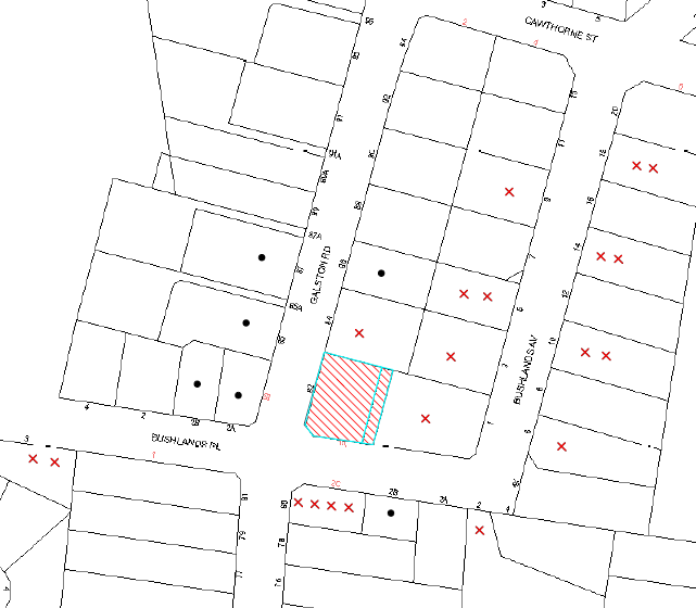
Item 10 PL60/16 Development Application - Childcare Centre - 82 Galston Road, Hornsby Heights
RECOMMENDATION
THAT Development Application No. DA/1218/2015 for demolition of existing structures and construction of a 36 place purpose built child care centre with associated signage at Lot A DP 396851, Lot C DP 408622, No. 82 Galston Road, Hornsby Heights be approved subject to the conditions of consent detailed in Schedule 1 of Group Manager’s Report No. PL60/16.
Page Number 128
Item 11 PL63/16 Development Application - Alterations and Additions to a Hardware and Building Supplies Establishment and Erection of Signage - 246-250 New Line Road, Dural
RECOMMENDATION
THAT Council assume the concurrence of the Secretary of the Department of Planning and Environment pursuant to Clause 4.6 of the Hornsby Local Environmental Plan 2013 and approve Development Application No. DA/266/2016 for alterations and additions to a hardware and building supplies establishment and erection of signage at Lot 1 DP 1049242 and Lot 13 DP 1049239, Nos. 246-250 New Line Road, Dural as a deferred commencement pursuant to Section 80(3) of the Environmental Planning and Assessment Act 1979 subject to the conditions of consent detailed in Schedule 1 of Group Manager’s Report No. PL63/16.
Page Number 167
Item 12 PL53/16 Development Application - Dwelling House and Secondary Dwelling - 7 Lyne Road, Cheltenham
RECOMMENDATION
THAT Development Application No. DA/545/2016 for demolition of a dwelling house and construction of a dwelling house and secondary dwelling at Lot A DP 323398, No. 7 Lyne Road, Cheltenham be approved subject to the conditions of consent detailed in Schedule 1 of Group Manager’s Report No. PL53/16.
Page Number 193
Item 13 PL61/16 Development Application - Subdivision of Four Allotments into Four Lots - Calabash Point, Berowra Creek
RECOMMENDATION
THAT Council seek the concurrence of the Secretary of the Department of Planning and Environment pursuant to State Environmental Planning Policy No. 1 – Development Standards and approve Development Application No. DA/1009/2013 for subdivision of four allotments into four lots and construction of two jetties and pontoons at Lot 1 and Lot 2 DP 882783, Lot 78 DP 752048 and Lot 163 DP 1113745, Calabash Point, Berowra Creek as a deferred commencement pursuant to Section 80(3) of the Environmental Planning and Assessment Act 1979 subject to the conditions of consent detailed in Schedule 1 of Group Manager’s Report No. PL61/16.
Page Number 233
Item 14 PL64/16 Reporting Variations to Development Standards
RECOMMENDATION
THAT the contents of Group Manager’s Report No. PL64/16 be received and noted.
Infrastructure and Recreation Division
Nil
PUBLIC FORUM – NON AGENDA ITEMS
Questions of Which Notice Has Been Given
Mayor's Notes
Page Number 236
Item 15 MN9/16 Mayor's Notes from 1 to 31 August 2016
Notices of Motion
SUPPLEMENTARY AGENDA
MATTERS OF URGENCY
QUESTIONS WITHOUT NOTICE
Deputy General Manager's Report No. CS33/16
Corporate Support Division
Date of Meeting: 14/09/2016
1 ELECTION OF DEPUTY MAYOR
EXECUTIVE SUMMARY
· In accordance with Section 231 of the Local Government Act, Councillors may elect a person from among their number to be the Deputy Mayor, with the term of such office being either equal to that of the Mayoral term or for a shorter period.
· This Report provides details about the role of a Deputy Mayor and the choices that Council has about the period and method of election to such office.
· If Council decides to elect a Deputy Mayor, it will need to determine the term for which the Deputy Mayor will serve and the method of voting to be used for electing the Deputy Mayor. It will also need to appoint the Acting General Manager (or his delegate) to conduct the election.
|
THAT: 1. Council determine if it wishes to elect a Deputy Mayor. 2. If a Deputy Mayor is to be elected, Council: a) Determine the period for which the Deputy Mayor is to be elected; b) Determine if the election of the Deputy Mayor is to be by preferential ballot, ordinary ballot or open voting; and c) Request the Returning Officer to conduct the election, using the election method determined in b) above. 3. If a Deputy Mayoral election is held, the ballot papers (if any) be destroyed following the declaration of the election. |
PURPOSE
The purpose of this Report is to provide Council with the opportunity to consider whether or not it wishes to elect a Deputy Mayor. The Report includes information about the role of the Deputy Mayor and the different methods of voting which can be used to elect a Deputy Mayor.
BACKGROUND
In accordance with Section 231 of the Local Government Act, Councillors may elect a person from among their number to be the Deputy Mayor, with such term of office being either equal to that of the Mayoral term or for a shorter period.
Prior to the March 2004 local government elections, Hornsby Council’s Mayor was elected annually by the Councillors. It was also Council’s practice to annually elect a Deputy Mayor. At the 2004 election, the method of electing Hornsby’s Mayor was changed to be by the residents/ratepayers across the Shire for the term of the elected Council i.e. a popularly elected Mayor, rather than by the elected Councillors on an annual basis.
Although Councillors no longer have the responsibility of electing the Mayor, it is still necessary for Council to decide whether or not to elect a Deputy Mayor and, if so, to determine the period of the term to be served by the Deputy Mayor. Council’s latest decision in this regard was at the General Meeting held on 9 September 2015, when it considered Deputy General Manager’s Report No. CS30/15 and elected Councillor Hutchence as Deputy Mayor for the period to September 2016.
DISCUSSION
The Role of Deputy Mayor
The Deputy Mayor may exercise any function of the Mayor, at the request of the Mayor, if the Mayor is prevented by illness, absence or otherwise from exercising the function, or if there is a casual vacancy in the office of Mayor. If there was to be a casual vacancy in the office of Mayor, a by-election for the position of Mayor would need to be conducted in accordance with a timetable set by the Local Government Act. The Deputy Mayor would usually fulfil the duties of Mayor during this period, until a new Mayor was elected.
Period of Election of the Deputy Mayor
Under Section 231 of the Local Government Act, Councillors may elect a Deputy Mayor for the same period as the Mayoral term or for a shorter period. As Council’s Mayor is popularly elected, the current Mayoral term is until the next local government elections, currently scheduled for September 2017. Council may, therefore, determine that a Deputy Mayor be elected for the period until September 2017 or for some shorter period e.g. six months, 12 months, etc. The practice at Hornsby Council has been to elect a Deputy Mayor for a 12 month period. It is noted that the current local government reform process and imminent decisions by the NSW Government about the proposed merger of Hornsby and Ku-ring-gai Councils will have an effect on the above.
Method of Election
If a Deputy Mayor is to be elected, the method of election is in accordance with Schedule 7 of the Local Government (General) Regulation 2005. A Councillor may be nominated without notice for election as Deputy Mayor provided the nomination is made in writing by two or more Councillors (one of whom may be the nominee) and the nominee consents to the nomination in writing. The nomination is to be delivered or sent to the Returning Officer. A nomination form in respect of a Deputy Mayoral Election is included as an attachment to this Report.
If only one Councillor is nominated for election as Deputy Mayor, that Councillor is elected. If more than one Councillor is nominated, an election shall be held at which the Acting General Manager (or his nominee) is the Returning Officer. The Council must resolve whether the election is to proceed by preferential ballot, by ordinary ballot or by open voting. To ensure probity of the election process, the counting of votes where necessary is undertaken in the presence of the Returning Officer and at least one other staff member.
It should be noted that any recommendation on the method of election (if any) is dependant to some extent on the number of candidates – see below.
Preferential Ballot
Preferential ballot would only normally be used if there are three or more candidates. Under this system, Councillors indicate their order of preference for all candidates. If a candidate receives more than half the first preference votes (i.e. an absolute majority), he or she is declared elected. If no candidate has an absolute majority, the candidate with the lowest number of votes is excluded and his or her preferences are allocated to the other candidates and so on, until one candidate has more than half the votes. A preference for each candidate standing for election must be indicated on a ballot paper, or the ballot paper will be declared invalid.
Ordinary Ballot
Ordinary ballot would normally apply where there are two or more candidates and Council decides to proceed by secret ballot. If there are only two candidates, the candidate with the higher number of votes is elected. If the two candidates are tied, the one elected is chosen by lot. If there are three or more candidates, the candidate with the lowest number of votes is excluded and a fresh vote is taken and so on, until there are only two candidates. A final vote between the two candidates is then taken and the candidate with the higher number of votes is declared elected. If at any stage during a count up until two candidates are remaining, there is a tie on the lowest number of votes, the one excluded is chosen by lot.
Open Voting
Open voting uses the same system as ordinary ballot, except that voting is by a show of hands or similar means and not by secret ballot.
Choosing by Lot
To choose a candidate by lot, the names of the candidates who have equal numbers of votes are written on similar slips of paper by the Returning Officer, folded, so as to prevent the names being seen, mixed and then drawn at random by the Returning Officer. The candidate whose name is on the drawn slip is chosen.
Appointment of Scrutineers and Inspection of Ballot Papers and Progress of Count
Council has previously sought legal advice about the ability of Councillors to inspect ballot papers and the progress of the count as well as the ability of election candidates to appoint scrutineers. In summary, the advice was that candidates are not entitled to appoint scrutineers; an inspection of the ballot papers should not be permitted; the progress of the count should not be revealed; and the ballot papers (if any) for the Deputy Mayoral election should be destroyed after the election has been declared.
BUDGET
There are no budgetary implications associated with this Report.
POLICY
There are no policy implications associated with this Report.
CONCLUSION
Council needs to consider the contents of this Report and determine whether or not it wishes to elect a Deputy Mayor. If it does decide to elect a Deputy Mayor, Council will also need to determine the term of office and method of voting to be used to elect the Deputy Mayor. It will also need to request the Acting General Manager, or his nominee, to conduct the election.
RESPONSIBLE OFFICER
The officer responsible for the preparation of this Report is the Manager, Governance and Customer Service – Robyn Abicair, who can be contacted on 9847 6608.
|
Robyn Abicair Manager - Governance and Customer Service Corporate Support Division |
Gary Bensley Deputy General Manager - Corporate Support Corporate Support Division |
|
1.View |
Nomination Form - Deputy Mayoral Election - September 2016 |
|
|
File Reference: F2004/07075
Document Number: D07029220
Deputy General Manager's Report No. CS32/16
Corporate Support Division
Date of Meeting: 14/09/2016
2 SCHEDULE OF COUNCIL MEETINGS AND ORDER OF BUSINESS TO APPLY AT THOSE MEETINGS - OCTOBER 2016 TO SEPTEMBER 2017
EXECUTIVE SUMMARY
· In accordance with Clauses 5 and 15 of its Code of Meeting Practice, Council annually determines a schedule of meeting dates for the following year and the order of business to apply at those meetings.
· It is proposed that the practice of holding one General Meeting per month be maintained for 2016/17, with that Meeting to be held on the second Wednesday of each month (excluding January); and that Workshop Meetings and Councillor briefing sessions continue to be held on other Wednesdays of the month, with appropriate notice being provided as required.
· It is also proposed that the existing order of business be maintained for 2016/17.
|
THAT Council: 1. Adopt the schedule of ordinary Council meetings for the period October 2016 to September 2017 as set out in Attachment 1 of Deputy General Manager’s Report No. CS32/16. 2. Adopt the order of business for the ordinary Council meetings to be held in the period October 2016 to September 2017 as set out in Attachment 2 of Deputy General Manager’s Report No. CS32/16. |
PURPOSE
The purpose of this Report is to recommend a proposed schedule of ordinary meeting dates for the period October 2016 to September 2017, and the order of business to apply at those meetings.
BACKGROUND
Council last considered its schedule of meetings and order of business at those meetings at the 9 September 2015 General Meeting – refer Deputy General Manager’s Report No. CS31/15. At the Meeting, Council decided to maintain the practice of holding one General Meeting per month with that Meeting to be held on the second Wednesday of each month (excluding January) and that Workshop Meetings and Councillor briefing sessions continue to be held on other Wednesdays of the month, with appropriate notice being provided as required – i.e. a General Meeting being held on the second Wednesday of each month (except January) and Workshop Meetings/Councillor briefing sessions being held (as required) on the first, third, fourth and/or fifth Wednesdays of each month (except January).
DISCUSSION
Schedule of Meetings
In accordance with Clauses 5 and 15 of the Code of Meeting Practice, Council annually determines a schedule of ordinary meeting dates for the following year and the order of business to apply at those meetings. Such determinations generally occur in September of each year, at the same meeting at which the Deputy Mayor is elected.
Section 2(1) of Council’s current Code of Meeting Practice states the following in respect of ordinary meetings:
Ordinary Meetings are meetings of Council, other than extraordinary meetings, held during each year on such regular days and at such regular times as Council may appoint. They include:
General Meetings which are held at 6.30pm on the second Wednesday of each month (excluding January) to consider all relevant matters.
Workshop Meetings which are held at 6.30pm on the first, third, fourth and/or fifth Wednesdays of each month as required (excluding January) to consider all relevant matters, especially those where a presentation by Council staff or an external person or organisation is required.
It is noted that Informal Briefings of Councillors are also held as required, generally on Wednesdays where a General or Workshop Meeting has not been scheduled.
A proposed schedule of General Meeting and Workshop Meeting dates for the period from October 2016 to September 2017 has now been drafted and is attached to this Report. The draft schedule of Meetings maintains the existing structure of one General Meeting per month which considers both planning and other matters, as well as providing for Workshop meetings and informal Councillor briefing sessions as required.
Order of Business
In respect of the order of business to apply at General and Workshop Meetings, a proposed order of business of General Meetings and Workshop Meetings for the period from October 2016 to September 2017 has now been drafted and is attached to this Report. The draft order of business maintains the existing structure with no changes proposed.
BUDGET
There are no budgetary implications associated with this Report.
POLICY
This Report has been prepared in accordance with the requirements of Council's Code of Meeting Practice and the Local Government Act and Regulations.
CONCLUSION
The existing schedule of holding one monthly General Meeting on the second Wednesday of the month (except for January) is working well and the Council Meetings process appears to be running smoothly and efficiently. As such, no changes are proposed to the meeting schedule or to the order of business for the next 12 months.
RESPONSIBLE OFFICER
The officer responsible for the preparation of this Report is the Manager, Governance and Customer Service – Robyn Abicair, who can be contacted on 9847 6608.
|
Robyn Abicair Manager - Governance and Customer Service Corporate Support Division |
Gary Bensley Deputy General Manager - Corporate Support Corporate Support Division |
|
1.View |
Schedule of Council Meetings October 2016-September 2017 |
|
|
|
2.View |
Council Meetings Order of Business - October 2016-September 2017 |
|
|
File Reference: F2004/07032
Document Number: D07029204
Deputy General Manager's Report No. CS34/16
Corporate Support Division
Date of Meeting: 14/09/2016
3 COUNCILLOR REPRESENTATION ON COMMITTEES, WORKING PARTIES AND OTHER RELEVANT GROUPS - OCTOBER 2016 TO SEPTEMBER 2017
EXECUTIVE SUMMARY
· Each year, Council reviews the need for Councillor Representation on Committees, Working Parties and other relevant groups and makes a determination about the appointment of Councillors for the ensuing 12 months.
· This Report provides up to date information about each of the 2016/17 Committees, Working Parties and other groups and seeks a Council determination in respect of the appointment of Councillors for the period October 2016 to September 2017.
|
THAT Council review the list of Committees, Working Parties and other relevant groups included in the attachment to Deputy General Manager’s Report No. CS34/16 and determine Councillor representation as appropriate for the period October 2016 to September 2017. |
PURPOSE
The purpose of this Report is to enable Council to review Councillor representation on Committees, Working Parties and other relevant groups and appoint Councillor representatives, as considered appropriate, for the period October 2016 to September 2017.
BACKGROUND
At the 9 September 2015 General Meeting, Council considered Deputy General Manager’s Report No. CS32/15 and appointed Councillor representatives to Committees, Working Parties and other relevant groups for the period October 2015 to September 2016. As that period of appointment will shortly expire, Council needs to determine relevant Councillor representation for the 2016/17 period.
DISCUSSION
The 2016/17 list of Committees, Working Parties and other groups has been reviewed by the relevant Divisions and is included as an attachment to this Report. Where appropriate, a comment about the operation of the Committee, Working Party or group and/or whether Councillor representation is still required has been provided by the Divisional Manager.
To assist Council in determining Councillor representation for the 2016/17 period, the 2015/16 Councillor representatives on each Committee, Working Party and group are included in the column titled “Councillor Representation 2015/16” and a blank column has been left in respect of “Councillor Representation 2016/17”.
BUDGET
Any budgetary implications are detailed in the comment column of the attachment to this Report.
POLICY
There are no policy implications associated with this Report.
CONCLUSION
Council’s consideration of this Report will allow it to determine Councillor representation on relevant Committees, Working Parties and other groups for the period October 2016 to September 2017.
RESPONSIBLE OFFICER
The officer responsible for the preparation of this Report is the Manager, Governance and Customer Service – Robyn Abicair, who can be contacted on 9847 6608.
|
Robyn Abicair Manager - Governance and Customer Service Corporate Support Division |
Gary Bensley Deputy General Manager - Corporate Support Corporate Support Division |
|
1.View |
Councillor Representation on Committees - October 2016 - September 2017 |
|
|
File Reference: F2004/07056
Document Number: D07029239
Deputy General Manager's Report No. CS29/16
Corporate Support Division
Date of Meeting: 14/09/2016
4 GENERAL PURPOSE AND SPECIAL PURPOSE FINANCIAL REPORTS - 2015/16 FINANCIAL YEAR
EXECUTIVE SUMMARY
· Council’s General Purpose and Special Purpose Financial Reports for the year ended 30 June 2016 (the Financial Reports) have been completed by staff in accordance with the requirements of the Local Government Act, the Local Government Code of Accounting Practice and relevant Accounting Standards.
· Subject to Council’s approval, the Financial Reports now need to be referred for audit.
· Following receipt of the Auditor’s Reports, it is proposed that the Financial Reports and Auditor’s Report be "presented to the public" at the 9 November 2016 General Meeting.
|
THAT: 1. The 2015/16 General Purpose and Special Purpose Financial Reports be received and noted and referred for audit. 2. The Mayor and Deputy Mayor be authorised to sign the Statutory Statements in connection with the 2015/16 Financial Reports. 3. The 2015/16 Financial Reports be authorised for “presentation to the public” on receipt of the Auditor’s Report. 4. The Acting General Manager be delegated authority to fix the date of the General Meeting at which the 2015/16 Financial Reports and Auditor’s Report will be formally “presented to the public”. |
PURPOSE
The purpose of this Report is to recommend that Council’s 2015/16 Financial Reports be received and noted and referred for audit.
BACKGROUND
In accordance with Section 413 of the Local Government Act, Council must prepare a set of Financial Reports for each year, and must refer them for external audit as soon as practicable after the end of that year.
DISCUSSION
Council’s Financial Reports for 2015/16 have been completed by staff in accordance with the requirements of the Local Government Act, the Local Government Code of Accounting Practice and relevant Accounting Standards. It is recommended that they be referred to Council’s external auditors for review. The unaudited Financial Reports (a copy of which has been provided to Councillors under separate cover) are not for distribution to the public at this stage. The audited Reports are those that will be made available to the public in accordance with Local Government Act requirements.
Council is required to give notice as to the Meeting at which the Financial Reports (including the Auditor's Reports) will be formally "presented to the public". The proposed date for this Meeting will be set as soon as possible after the Auditor's Reports have been received. At this stage, it is anticipated that the Reports will be "presented to the public" at the 9 November 2016 General Meeting. Council's external auditor, Mr Dennis Banicevic of PricewaterhouseCoopers, is expected to be available to make a presentation on the Reports at that General Meeting.
Following presentation of the Reports to the public, any person may make a submission concerning the Reports within a period of seven days after the 9 November 2016 General Meeting.
BUDGET
There are no budgetary implications associated with this Report.
POLICY
The Financial Reports have been compiled in accordance with the Local Government Act, the Local Government (General) Regulation 2005 and the Local Government Code of Accounting Practice issued by the Office of Local Government.
CONCLUSION
Council’s referral of the 2015/16 Financial Reports for audit, and ultimately the presentation of the Financial and Auditor’s Report to the public at the 9 November 2016 General Meeting, will ensure that the requirements of the Local Government Act have been met.
RESPONSIBLE OFFICER
The officer responsible for the preparation of this Report is the Chief Financial Officer – Glen Magus, who can be contacted on 9847 6635.
|
Glen Magus Chief Financial Officer - Financial Services Corporate Support Division |
Gary Bensley Deputy General Manager - Corporate Support Corporate Support Division |
There are no attachments for this report.
File Reference: F2016/00233
Document Number: D07014960
Deputy General Manager's Report No. CS36/16
Corporate Support Division
Date of Meeting: 14/09/2016
5 NORTHERN SYDNEY REGIONAL ORGANISATION OF COUNCILS - AMENDMENT OF CONSTITUTION - FURTHER CONSIDERATIONS
EXECUTIVE SUMMARY
· Over the last few months, the Northern Sydney Regional Organisation of Councils (NSROC) Board has considered the options for the future operation of NSROC. Part of that consideration has included potential amendments to the NSROC Constitution to alter the member representation on the Board in the event that councils are amalgamated.
· The first option considered was to add transitional provisions to the Constitution which would enable two representatives (named individuals) from each of the (current) member Councils to sit on the Board until the next local government elections if the current councils were dissolved, amalgamated or otherwise cease to exist. That proposal (which was not supported by Hornsby Shire Council) was lost at the 7 July 2016 Extraordinary Board Meeting.
· A second option has now been proposed which enables the Administrator of newly constituted councils to nominate two delegates to the Board from each of the current member councils of NSROC. That proposal, details of which are provided in the Discussion Section of this Report, was supported by Council’s delegates at the most recent Board Meeting.
· The effect of the new proposed amendments are that whilst ever the current councils remain in place, the current Board arrangements will prevail; if councils are dissolved by proclamation, or there is no Mayor/Councillors holding office, the Council Administrator will be requested to nominate two delegates to populate the Board; and once council elections are held, and new Mayor/Councillors are in place, the organisation will revert to the current Board selection arrangements (i.e. it will be populated by the Mayor and one other Councillor).
· The proposed alternative amendment to the Constitution is scheduled to be considered at an Extraordinary Meeting of the NSROC Board on 22 September 2016 following the provision of the required 21 days’ notice to members.
|
THAT Council endorse the proposed amendments to the Constitution of the Northern Sydney Regional Organisation of Councils (NSROC) and delegate authority to its representatives on the NSROC Board to vote in favour of the proposed amendments at the NSROC Extraordinary Board meeting which is scheduled to be held on 22 September 2016. |
PURPOSE
The purpose of this Report is to provide Council with the opportunity of determining its position in respect of proposed changes to NSROC’s Constitution. The proposed changes provide that, should Hornsby Shire Council not be constituted by elected members; or the Council is dissolved, amalgamated or otherwise ceases to exist; the Council’s Administrator will be able to nominate delegates to the NSROC Board for the period up until the next local government election.
BACKGROUND
Over the last few months the NSROC Board has considered the options for the operation of NSROC in the context of the local government reform agenda, including the receipt of legal advice and weighing various options for the organisation over the coming year. Part of that consideration has included potential amendments to the NSROC Constitution to alter the member representation on the Board in the event that councils are dissolved by amalgamation or otherwise.
The NSROC Constitution currently requires that its Board consist of two delegates from each member council, who must be the Mayor and a Councillor. The NSROC Board obtained legal advice on the future operation of NSROC in the context of council amalgamations and how the organisation could operate if member councils were removed and no representatives of member councils were available to hold Board positions.
Following consideration of the legal advice, the NSROC Board resolved at its meeting on 5 May 2016 to include transitional provisions into its Constitution which would enable two representatives (named individuals) from each of the (current) member Councils to sit on the Board until the next local government elections if the current councils were dissolved, amalgamated or otherwise cease to exist. NSROC sought support of this recommended amendment to its Constitution from member councils.
At its 8 June 2016 General Meeting, Council considered the matter via Deputy General Manager’s Report No. CS20/16 and resolved that:
1. The contents of Deputy General Manager’s Report No. CS20/16 dealing with a proposed amendment to the Constitution of the Northern Sydney Regional Organisation of Councils (NSROC) be received and noted.
2. Council note that if member councils are dissolved, amalgamated or otherwise cease to exist as part of the current local government reform process, NSROC can continue to operate without Board supervision in line with the adopted 2016/17 NSROC Business Plan and Budget with oversight being provided by the NSROC General Manager’s Advisory Committee and by utilising the existing delegations to NSROC staff.
3. Council oppose the proposed amendments to the current NSROC Constitution and delegate authority to the Mayor and Councillor Tilbury (or alternates Councillor Browne, Councillor Anisse or Councillor Hutchence) to vote against the proposed amendments at the NSROC Extraordinary Board meeting scheduled for 9 June 2016.
4. The NSROC Board be advised that where there is a transition period between the dissolution of existing councils up until the election of new councils, it is Council’s view that the appointed administrator/s should be the appropriate representative of NSROC member councils during that period.
5. As Council’s opinion is that the ratepayers of Hornsby have received little or no apparent benefit through membership of NSROC, Council provide notice to the Executive Director of NSROC that it will be terminating its membership of NSROC as at 30 June 2017 in line with Clause 27 of the current Constitution.
Following on from the above, Council representatives attended the NSROC Extraordinary Board Meeting at which the motion to amend the Constitution was lost.
DISCUSSION
The current NSROC Constitution requires that its Board include two delegates from each member council, who must be the Mayor and a Councillor. The Board was concerned about how it could continue to operate if, as a result of council amalgamations, member councils were removed and no elected representatives of member councils were in place. Such a situation would result in the operations of NSROC being limited to matters already approved by a duly constituted Board (that is, approved before any proclamation to abolish councils is made) or able to be put into effect under delegated decision-making by staff or others such as the General Managers Advisory Committee.
Following the consideration of legal advice obtained by the NSROC Board, the previous amendment to the Constitution was suggested. This in effect proposed that the Board be populated by two named individual councillors from each current member council until council elections are held. This recommendation was not supported at the Extraordinary NSROC Board meeting on 7 July 2016.
In light of the previously received legal advice, the NSROC Board was still of the view that a change in the Constitution would place NSROC in the best position to enable continuation of its operations in the most effective manner. As a result, a second, alternative amendment to the Constitution has been proposed which enables the Board to be populated by alternate delegates in the event that role of Mayors and Councillors are extinguished. As such, at the 11 August 2016 NSROC Board Meeting (attended by Mayor Russell and Councillors Tilbury and Browne), the Board determined that, in the event that councils are dissolved, the appropriate way forward would be for the Administrator of newly constituted councils to nominate two delegates to the Board from each of the current member councils of NSROC.
The proposed amendments to the Constitution are show below in italics below:
“4. Membership
i) Membership of the Organisation shall be open to, but not restricted to, the following Councils:
a. The Council of the Shire of Hornsby
b. The Council of the Municipality of Hunters Hill
c. The Council of the Municipality of Ku-ring-gai
d. The Council of Lane Cove
e. The Council of North Sydney
f. The Council of the City of Ryde
g. The Council of the City of Willoughby
h. Any Council newly constituted by amalgamation or otherwise that includes any area formerly within the area of any of the above Councils.
ii) If any existing member Council is dissolved, amalgamated or otherwise ceases to exist:
a. the Council (whether newly formed or otherwise) that becomes the Council for any area within the existing member Council’s area automatically becomes a member of the Organisation upon becoming the Council for that area; and
b. unless and until the new or continuing member Councils are constituted by elected Councillors, the representation in respect of such member Councils is to be determined in accordance with clause 5.vii) below.”
“5. Representation
i) A member Council will be represented on the Organisation as follows:
a. The Mayor and one other Councillor.
ii) A member Council shall, at its first ordinary meeting after any Council election, appoint delegates from the Council membership to the Organisation, one of whom shall be the Mayor. Each such delegate shall hold office until the appointment of a successor.
iii) The office of delegate shall become vacant if the delegate:
a. ceases to hold the office as a Councillor;
b. resigns by letter addressed to the member Council; or
c. is absent from three (3) consecutive meetings of the Organisation without having obtained leave of absence from the Organisation;
d. is replaced by the member Council at any time.
iv) Where the office of a delegate becomes vacant, the member Council concerned, at the first convenient ordinary meeting held after such vacancy occurs, should appoint another delegate.
v) Where the Mayor of a Council is unable to attend a meeting of the Organisation, the Council may only be represented by the Acting Mayor for the purpose of being an alternative delegate.
vi) Where any delegate, not being the Mayor, of a Council is unable to attend a meeting of the Organisation, the Council may be represented by another member of the Council duly appointed for the purpose of being an alternative delegate.
vii) Despite clauses 5.i) to 5.vi) above, in the event that a member Council is not constituted by elected Councillors, and the functions of the Council are being undertaken by an Administrator, the representation in respect of the Council (whether newly formed or otherwise) is to be determined by the Administrator of that Council, who may nominate two (2) delegates to the Organisation for each former member Council, to populate the Board.
The proposed amendments would have the following effect:
· Whilst ever the current councils remain in place, the current Board arrangements will prevail (i.e. the Board will be populated by the Mayor and one other Councillor from each member Council)
· If councils are dissolved by proclamation, or there is no Mayor/Councillors holding office, an Administrator of a Council will be requested to nominate two delegates to populate the Board
· Once council elections are held, and new Mayor/Councillors are in place, the organisation will revert to the current Board selection arrangements (i.e. the Board will be populated by the Mayor and one other Councillor).
In order that NSROC’s constitution be amended, each member council is required to consider the proposed amendment prior to the matter being dealt with as a “special resolution” at a subsequent Extraordinary Board meeting. At such a meeting, three-quarters of the delegates would need to agree to the recommendation for it to be passed (provided that the majority of Councils are represented by at least one delegate). Not less than 21 days’ notice is to be given for a meeting involving a special resolution, including notice of the intended motion.
Based on the above, the proposed alternative amendment to the Constitution is scheduled to be considered at an Extraordinary Meeting of the NSROC Board on 22 September 2016.
CONSULTATION
The preparation of this Report had regard to information provided from the Executive Director of NSROC.
BUDGET
There are no budgetary implications associated with this Report.
POLICY
There are no policy implications associated with this Report.
CONCLUSION
The NSROC Board is recommending that Council support insertion of transitional provisions into its Constitution which enables an Administrator of a council to nominate two delegates to sit on the Board until the next local government elections if the current councils are dissolved, amalgamated or otherwise cease to exist. While continued operation of NSROC is not precluded if these amendments to the Constitution are not made, the recommended option by the NSROC Board would allow for continuity of representation for existing member councils during the interim period if the councils were operating under administration.
RESPONSIBLE OFFICER
The officer responsible for the preparation of this Report is the Manager Governance and Customer Service – Robyn Abicair, who can be contacted on 9847 6608.
|
Robyn Abicair Manager - Governance and Customer Service Corporate Support Division |
Gary Bensley Deputy General Manager - Corporate Support Corporate Support Division |
There are no attachments for this report.
File Reference: F2004/07189-02
Document Number: D07030581
Deputy General Manager's Report No. CS37/16
Corporate Support Division
Date of Meeting: 14/09/2016
6 LOCAL GOVERNMENT NSW - 2016 ANNUAL CONFERENCE - DETERMINATION OF ATTENDEES AND VOTING DELEGATES
EXECUTIVE SUMMARY
· The 2016 Annual Conference of Local Government NSW (LGNSW) will be held at the WIN Entertainment Centre in Wollongong from Sunday 16 to Tuesday 18 October 2016.
· The Conference provides the opportunity for Council delegates to network and be involved in discussions and consideration of motions about matters which affect local government across NSW.
· As part of its previous consideration of Deputy General Manager’s Report No. CS28/16 at the 10 August Ordinary Meeting, Council resolved to submit two motions for discussion at the Conference.
· Noting that LGNSW has advised that Council is entitled to 10 voting delegates at the Conference, this Report seeks a decision about Councillor attendance at the Conference.
|
THAT Council determine which Councillors should be registered to attend and be voting delegates at the 2016 Annual Conference of Local Government NSW. |
PURPOSE
The purpose of this Report is to determine Council’s attendees and voting delegates for the 2016 LGNSW Annual Conference.
BACKGROUND
The 2016 LGNSW Annual Conference is to be held at the WIN Entertainment Centre in Wollongong from Sunday 16 to Tuesday 18 October 2016. The Conference provides the opportunity for Council delegates to network and be involved in discussions and consideration of motions about matters which affect local government across NSW. A copy of the Conference brochure is attached.
DISCUSSION
At its 10 August General Meeting, Council considered Deputy General Manager’s Report No. CS28/16 – Local Government NSW – 2016 Annual Conference - Submission of Motions, and resolved that two motions be submitted for consideration at the Conference, and that voting delegates for the Conference be determined via a subsequent report to Council.
The two motions adopted by Council, which deal with a proposal to repeal Section 21C of the Land Tax Management Act and the inclusion of local government in the consultation process for disposal of State Government owned property, have been forwarded to LGNSW for inclusion in the Conference Business Paper.
LGNSW has advised that Council is entitled to 10 delegates at the 2016 Conference and those delegates will be able to vote on motions being considered by the Conference. The cost per Councillor of attending the Conference is estimated at $1,800 which comprises full registration costs ($999) along with travelling, sustenance and accommodation costs for three days (approximately $800).
BUDGET
Funds have been allocated in the 2016/17 budget for attendance by Councillors and relevant staff at the 2016 LGNSW Annual Conference.
POLICY
Councillor attendance at the 2016 LGNSW Annual Conference is in accordance with the Councillors' Expenses and Facilities Policy.
CONCLUSION
The 2016 LGNSW Annual Conference provides the opportunity for Council delegates to network and be involved in discussions and consideration of motions about matters which affect local government across NSW. Noting that Council is entitled to 10 voting delegates, this Report seeks a decision from Council about which Councillors should be registered to attend and to be voting delegates at the Conference.
RESPONSIBLE OFFICER
The officer responsible for the preparation of this Report is the Manager Governance and Customer Service – Robyn Abicair, who can be contacted on 9847 6608.
|
Robyn Abicair Manager - Governance and Customer Service Corporate Support Division |
Gary Bensley Deputy General Manager - Corporate Support Corporate Support Division |
|
1.View |
LGNSW Annual Conference 2016 - Registration Brochure |
|
|
File Reference: F2016/00220
Document Number: D07034389
Deputy General Manager's Report No. CS30/16
Corporate Support Division
Date of Meeting: 14/09/2016
7 DELIVERY PROGRAM 2013-17 INCLUDING OPERATIONAL PLAN (BUDGET) FOR 2015/16 - JUNE 2016 QUARTER REVIEW
EXECUTIVE SUMMARY
· Accountable organisations like Council review their budget and operational performance at least each quarter. In this regard, the June 2016 Quarter Review of the Delivery Program including the 2015/16 Operational Plan and Budget is attached for Council’s consideration.
· Based on an inflow and outflow of funds as at 30 June 2016, the actual result for 2015/16 is a surplus of $823K. This result is satisfactory in maintaining an appropriate level of available working funds.
· Progress against the adopted Delivery Program, including the 2015/16 Operational Plan and Budget, and the operational performance of the organisation has been in line with the service delivery standards adopted by Council.
|
THAT the June 2016 Quarter Review of the Delivery Program, including the 2015/16 Operational Plan and Budget, be received and noted. |
PURPOSE
The purpose of this Report is to present for Council’s consideration the June 2016 Quarter Review of the 2013-17 Delivery Program, including the 2015/16 Operational Plan.
BACKGROUND
On 19 June 2013, Council adopted a new four year Delivery Program which included the 2015/16 Operational Plan and the 2015/16 Fees and Charges. The Delivery Program and Operational Plan set out the manner in which Council intended to deliver services and measure performance.
In line with Office of Local Government requirements, a Quarterly Budget Review Statement (QBRS) must be submitted for Council’s consideration at the end of each quarter. The Statement must be based on key financial indicators and the estimate of income and expenditure set out in Council’s Operational Plan for the relevant year.
DISCUSSION
During 2015/16, service delivery standards have been maintained and 84% of actions have been completed or are ongoing and are performing well. The highlights for 2015/16 include:
· Expenditure of over $52 million on infrastructure, including park/playground and sporting facility upgrades at 27 facilities
· Approval of development applications with a construction value of $1.29 billion - an increase of over $975 million from 2012/13 levels. Compared to 2012/13, this increase in economic activity has realised a $1.07 million increase in income from development applications and a $44.7 million increase in income from Section 94 contributions
· Being named by Planet Ark as the top Council area in Australia for residents recycling printer cartridges.
Other highlights are contained in Attachment 1 to this Report.
Budget Comment
This Review includes the full year results for 2015/16, comparing actual expenditure, income and funding sources against the budget. Based on this inflow and outflow of funds as at 30 June 2016, the actual result for 2015/16 is a surplus of $823K. This result is satisfactory in maintaining an appropriate level of available working funds.
Hornsby Quarry
Included in the Budget result is a transfer of $5.985 million to a restricted asset account to assist in funding the remediation of the Hornsby Quarry site. This, along with a further transfer of $11 million to the restricted asset account in August 2016 from the proceeds of a Council asset sale ensures that the cash requirements estimated for the Quarry’s future remediation is funded.
Aquatic Centres
When compared to budget forecasts included in tender documents for the second year of operation of the Hornsby Aquatic Centre, the 2015/16 actual financial result showed a positive variance of $22K. In line with the tender, the Centre is expected in 2016/17 (its third year of operation) to provide an improved financial return to Council in the order of $300K.
The Epping Aquatic Centre’s actual result for 2015/16 (i.e. its third year of operation under the tender) was a negative variance of $133K when compared to budget. In part, this was due to decisions around the opening and closure of this Centre that were not aligned to the acceptance of the tender and resulted in additional costs being incurred. It is noted that this Centre has been transferred to the City of Parramatta Council due to Council boundary adjustments that were announced by the Minister for Local Government on the 12 May 2016.
The Galston Aquatic Centre’s actual result for 2015/16 (i.e. its third year of operation under the tender) was a negative variance of $555K when compared to budget. It is noted that the delay in the construction of the program pool at this Centre has resulted in learn to swim classes commencing 12 months later than expected and has in part impacted revenue forecasts in this third year of operation. The impact of this delay when compared to the second year of the tender budget would attribute approximately $206K of this $555K negative variance.
Having regard to the above, the Chief Financial Officer has requested a detailed revenue analysis in respect to the operation of both the Hornsby and Galston Aquatic Centres with the intention to provide Councillors with a briefing on the budgets required for future years.
BUDGET
This Report provides the June 2016 Quarter Review of the Delivery Program 2013-17 including the Operational Plan 2015/16. The Review results in an actual surplus at 30 June 2016 of $823K compared to the forecasted budget surplus of $264K. This positive result will improve Council’s cash balances.
POLICY
There are no policy implications associated with this Report.
CONCLUSION
This Report provides the June 2016 Quarter Review of the Delivery Program 2013-17 including the Operational Plan 2015/16. The Review results in a budget surplus at 30 June 2016 of $823K.
RESPONSIBLE OFFICER
The officers responsible for preparation of this Report are Julie Williams – Manager, Strategy and Communications and Glen Magus – Chief Financial Officer. They can be contacted on 9847 6790 and 9847 6635 respectively.
|
Gary Bensley Deputy General Manager - Corporate Support Corporate Support Division |
Robert Stephens Acting General Manager Office of the General Manager |
|
1.View |
June 2016 Quarter Review |
|
|
|
2.View |
Quarterly Budget Review Statement 30 June 2016 |
|
|
File Reference: F2014/00562
Document Number: D07016287
Deputy General Manager's Report No. CS31/16
Corporate Support Division
Date of Meeting: 14/09/2016
8 INVESTMENTS AND BORROWINGS FOR 2016/17- STATUS FOR PERIOD ENDING 31 JULY 2016
EXECUTIVE SUMMARY
· This Report provides details of Council’s investment performance for the period ending 31 July 2016 as well as the extent of its borrowings at the end of the same period.
· Council invests funds that are not, for the time being, required for any other purpose. The investments must be in accordance with relevant legislative requirements and Council’s policies and the Chief Financial Officer must report monthly to Council on the details of funds invested.
· All of Council’s investments have been made in accordance with the Local Government Act, the Local Government (General) Regulation and Council's Investment of Surplus Funds Policy and Investment Strategy.
· In respect of Council’s cash and term deposit investments, the annualised return for the month of July 2016 was 2.98% compared to the benchmark of 1.75%.
|
THAT the contents of Deputy General Manager’s Report No. CS31/16 be received and noted. |
PURPOSE
The purpose of this Report is to advise Council of funds invested in accordance with Section 625 of the Local Government Act; to provide details as required by Clause 212(1) of the Local Government (General) Regulation and Council's Investment of Surplus Funds Policy; and to advise on the extent of Council’s current borrowings.
BACKGROUND
A report is required to be submitted for Council’s consideration each month detailing Council's investments and borrowings and highlighting the monthly and year to date performance of the investments. Initial investments and reallocation of funds are made, where appropriate, after consultation with Council's financial investment adviser and fund managers.
DISCUSSION
Council invests funds which are not, for the time being, required for any other purpose. Such investment must be in accordance with relevant legislative requirements and Council Policies, and the Chief Financial Officer must report monthly to Council on the details of the funds invested.
Council’s investment performance for the month ending 31 July 2016 is detailed in the attached document. In summary, the At-Call and Term Deposits achieved an annualised return of 2.98% for July 2016, compared to the benchmark of 1.75%.
In respect of Council borrowings, the weighted average interest rate payable on outstanding loans taken out from June 2007 to July 2016, based on the principal balances outstanding was 7.27%. The Borrowings Schedule as at 31 July 2016 is also attached for Council’s information.
CONSULTATION
Appropriate consultation has occurred with Council's financial investment adviser.
BUDGET
Budgeted investment income for 2016/17 is $3,000,000 with an average budgeted monthly income of $250,000. Investment income for the period ended 31 July 2016 was $307,000. Approximately 52% of the investment income received by Council relates to externally restricted funds (e.g. Section 94 monies) and is required to be allocated to those funds. All investments have been made in accordance with the Local Government Act, the Local Government (General) Regulation and Council's Investment of Surplus Funds Policy and Investment Strategy.
CONCLUSION
The investment of Council funds and the extent of its borrowings as at 31 July 2016 are detailed in the documents attached to this Report. Council’s consideration of the Report and its attachments ensures that the relevant legislative requirements and Council protocols have been met in respect of those investments.
RESPONSIBLE OFFICER
The officer responsible for the preparation of this Report is the Chief Financial Officer – Glen Magus, who can be contacted on 9847 6635.
|
Glen Magus Chief Financial Officer - Financial Services Corporate Support Division |
Gary Bensley Deputy General Manager - Corporate Support Corporate Support Division |
|
1.View |
HSC Investment Holdings Report - July 2016 |
|
|
|
2.View |
HSC Borrowings - July 2016 |
|
|
File Reference: F2004/06987-02
Document Number: D07022826
Group Manager’s Report No. PL44/16
Planning Division
Date of Meeting: 14/09/2016
9 DEVELOPMENT APPLICATION - SENIORS LIVING DEVELOPMENT COMPRISING 19 UNITS - 3-5 COPELAND ROAD, BEECROFT AND 585-587 PENNANT HILLS ROAD, WEST PENNANT HILLS
EXECUTIVE SUMMARY
|
DA No: |
DA/1485/2015 (Lodged on 12 November 2015) |
|
Description: |
Demolition of existing structures, adaptive reuse of a heritage listed dwelling house and construction of a seniors living development comprising 19 self-contained dwellings with strata subdivision |
|
Property: |
Lots 55, 56, 58, 59 and 60 DP 1212724, Nos. 3 and 5 Copeland Road, Beecroft and Nos. 585 and 587 Pennant Hills Road, West Pennant Hills |
|
Applicant: |
S. Chilly Developments Pty Ltd |
|
Owner: |
S. Chilly Developments Pty Ltd, Mr Nadarajah Sundararaju and Mrs Kalachelvi Sundararaju |
|
Estimated Value: |
$5.82 million |
· The application involves demolition of existing structures, adaptive reuse of a heritage listed dwelling house and construction of a seniors living development comprising 19 self-contained dwellings with ground floor and basement parking and strata subdivision.
· The proposal does not comply with State Environmental Planning Policy (Housing for Seniors or People with a Disability) 2004 with regard to Clause 40 - Development Standards (Height). A submission to vary the development standard has been made in accordance with State Environmental Planning Policy No. 1. The submission is well-founded.
· Eleven submissions have been received in respect of the application from five residents.
· It is recommended that the application be approved.
|
THAT Council approve Development Application No. DA/1485/2015 for the demolition of existing structures, adaptive reuse of a heritage listed dwelling house and construction of a seniors living development comprising 19 self-contained dwellings with car parking and strata subdivision at Lots 55, 56, 58, 59 and 60 DP 1212724, Nos. 3 and 5 Copeland Road, Beecroft and Nos. 585 and 587 Pennant Hills Road, West Pennant Hills subject to the conditions of consent detailed in Schedule 1 of Group Manager’s Report No. PL44/16. |
BACKGROUND
The site has a history of residential land use.
On 8 June 2011, Council approved alterations and additions to the existing heritage listed dwelling house at No. 587 Pennant Hills Road, West Pennant Hills.
On 10 June 2015, the applicant held a pre-lodgement meeting with Council officers regarding the subject proposal. At the pre-lodgement meeting, Council officers provided advice regarding front setback to Copeland Road, maintenance of privacy of the neighbouring properties to the east, south and north, solar access to the internal sit-out areas, maintenance of a single storey built form to Copeland Road and to consider the interface of the development with the low density residential developments on the adjoining properties. Advice was also provided regarding retention and adaptive reuse of the heritage item on the site.
On 8 October 2015, the stratum subdivision of the subject allotments was registered. The stratum subdivision defined the land below ground, to be acquired by Roads and Maritime Services for the purposes of NorthConnex. The registration of the subdivision resulted in new title allocations to each allotment.
The application was lodged on 12 November 2015. Following initial assessment of the proposal Council sent a letter to the applicant raising concerns regarding the height of the buildings, retention of the heritage item, solar access, landscaping and privacy issues.
A meeting was held between the applicant and Council officers to discuss the matters raised in Council’s letter. Consequently, amended plans were lodged with Council on 22 March 2016 to address the concerns raised by Council.
The amended plans were notified to the owners of the neighbouring properties until 4 May 2016.
Following review of the plans and inspection of the site, Council officers raised further concerns regarding the height of the two storey building, impacts on the streetscape and impacts on the heritage item. A meeting was held between Council officers and the applicant on 24 May 2016 to discuss the concerns. Council recommended that the following amendments be undertaken:
· Increase the setback of the development to Copeland Road;
· Align Dwelling 18 to be in line with the heritage item;
· Increase the landscaped setback to the eastern boundary adjoining the driveway;
· Improve the amenity of the neighbouring property at No. 7 Copeland Road; and
· Relocate the terrace of Dwelling 7 to have sufficient separation from the eastern boundary.
In response, the applicant submitted amended plans on 9 June 2016. The following amendments were included:
· Align Dwelling 18 with the heritage item;
· Propose a double carport with flat roof in front of Dwelling 18;
· Remove a pedestrian pathway to increase the landscaped buffer along the eastern boundary adjoining the driveway entrance to the site;
· Marginally increase the setback of Dwelling 2 to Copeland Road and relocate the sit-out area to be north-facing; and
· Reduce the overall height of the two storey building by 200mm.
On 28 June 2016, the applicant lodged an appeal at the Land and Environment Court against the deemed refusal of the application by Council. The matter is listed for an on-site Section 34 Conference on 16 September 2016.
On 11 July 2016, Council held a further meeting with the applicant to discuss possible amendments to the proposal.
On 15 July 2016, amended plans were lodged with Council including the following:
· Relocate the sit-out areas for both Dwellings 1 and 2 on the northern side and provide an average setback of 7m from Copeland Road;
· Relocate the terrace for Dwelling 7 internally within the site to face Dwelling 3;
· Propose highlight windows for the upper level on the eastern elevation of the two storey building; and
· Propose a 1.8m high screen on the eastern side of the upper level balcony for Dwelling 10.
The amended plans were notified to the owners on the neighbouring properties until 8 August 2016 whereby two submissions were received.
On 16 August 2016, Council officers met with the resident at No. 7 Copeland Road to discuss the amendments to the proposed development.
On 18 August 2016, a meeting was held between the Council officer and the applicant to discuss the design levels of the two storey building and design options that would potentially lower the height of the building. The applicant indicated that the design levels of the two storey buildings are as per the submitted Access Report and that further reduction in the height of the two storey building would result in non-compliance with the accessibility requirements and would not be feasible.
On 19 August 2016, the applicant submitted an amended Objection pursuant to State Environmental Planning Policy No. 1.
SITE
The site comprises four allotments, Nos. 585 and 587 Pennant Hills Road, West Pennant Hills and Nos. 3 – 5 Copeland Road, Beecroft. The site is an irregular shaped allotment with a 62.5m frontage to the eastern side of Pennant Hills Road, 36.57m frontage to the northern side of Copeland Road and an area of 5033m2.
The site has an 11% average downward slope from west to east (sideways) and a gentle (5.8%) slope towards Copeland Road (south-eastern corner).
The current improvements on the site include one dwelling on each allotment with associated outbuildings accessed via individual driveways off Copeland Road and Pennant Hills Road. The property, No.587 Pennant Hills Road, West Pennant Hills is listed as a heritage item (No.791 – House) of local significance under the provisions of Schedule 5 (Environmental Heritage) of the Hornsby Local Environmental Plan 2013 (HLEP). A high brick wall runs along the Pennant Hills Road frontage of the site.
The site and neighbouring properties contain a large number of trees of native and exotic species.
The land beneath the footprint of the site has been acquired by the Roads and Maritime Services for the construction of the NorthConnex tunnel. The interactive map provided by NorthConnex indicates that the ramp tunnels that join the Hills M2 Motorway and Pennant Hills Road to the tunnel would cross between the south-western corner and the north-eastern corner of the site, approximately 25 – 30m below ground level.
The surrounding developments consist of low scale, one and two storey dwelling-houses featuring well-established gardens and landscaped areas. The site is located on the opposite side of Copeland Road from the Pennant Hills Golf Club.
The site is located approximately 2 kilometres west of Beecroft Railway Station and shops. Bus stops are located in front of No. 587 Pennant Hills Road and on the opposite side near the intersection with Aiken Road (250m) providing connection between Beecroft, Castle Hill and Macquarie Shopping Centres (Routes 620, 621, 622 and 651). Pedestrian footpaths and the signalised intersection of Copeland Road and Pennant Hills Road provide safety for users of the bus service in crossing the road. A bus stop is also located on the opposite side Copeland Road.
PROPOSAL
The proposal involves demolition of the existing dwelling houses and associated structures, retention and adaptive reuse of the heritage listed dwelling house and construction of a seniors living housing development comprising 19 self-care dwellings comprising 10 x 2-bedroom dwellings and 9 x 3-bedroom dwellings with strata subdivision. The development would be accessed via a common driveway off Copeland Road, located on the eastern boundary. The driveway would provide access to four separate clusters of single storey attached dwellings, a two storey residential flat building comprising six units and a single storey building with attic comprising three units. Basement car parking is proposed under the residential flat building and the adjoining single storey building. The details of the proposal are provided below:
· Dwellings 1 and 2: One single storey building with attic roof space comprising two attached dwellings (2 x 3 br) with attached double garages fronting Copeland Road. The common driveway would provide access to the garages on the northern side.
· Dwellings 3 – 5: One single storey building with attic roof space comprising three units (1 x 2-br + 2 x 3-br), accessed via a common lobby. Car parking is proposed at the basement level shared with the residential flat building. Five spaces are allocated to the three units in secured garages. A lift provides access to the common lobby.
· Dwellings 6 to 11: Six units (4 x 2-br and 2 x 3-br) within a two storey residential flat building with basement car park containing 8 car parking spaces (lockable garages). A lift provides access to the common lobby from the carpark.
· Dwellings 12 to 14: One single storey building with attic roof space comprising three attached dwellings (2 x 3-br and 4 x 2-br) with attached single/double garages located at the north-eastern corner of the site.
· Dwellings 15 and 16: One single storey building with attic roof space comprising two attached dwellings (2 x 2- br) located on the northern side of the driveway. Dwelling 15 would front Pennant Hills Road.
· Dwelling 17: Single storey detached dwelling comprising 2 bedrooms with attached single garage access via the common driveway.
· Dwelling 18: Single storey detached dwelling comprising 2 bedrooms with a double carport with flat roof located in front facing the internal driveway.
· Dwelling 19: The existing heritage listed dwelling house is proposed to be retained and extended towards the west. Adaptive reuse of this dwelling house is proposed for the purpose of a detached self-care dwelling (Unit 19). The car space for this dwelling would be accommodated within the double carport fronting Dwelling 18. The existing vehicular access to Pennant Hills Road is proposed to be abolished.
The proposed dwellings range in size from 94.5m2 to 170m2. The gross floor area of the development would be 2286.6m2. Each dwelling includes the primary living area being directly connected to a balcony or terrace. The proposed detached dwellings would be constructed of face brick with tiled hip roofs. A flat roof is proposed for the two storey residential flat building.
The application also includes associated landscape works within the site. An enclosed garbage bin room is proposed at the entrance to the site and at the basement level.
Four visitors’ parking spaces are provided within the common basement level.
ASSESSMENT
The development application has been assessed having regard to ‘A Plan for Growing Sydney’, the ‘North Subregion (Draft) Subregional Strategy’ and the matters for consideration prescribed under Section 79C of the Environmental Planning and Assessment Act 1979 (the Act). The following issues have been identified for further consideration.
1. STRATEGIC CONTEXT
1.1 A Plan for Growing Sydney and (Draft) North Subregional Strategy
A Plan for Growing Sydney has been prepared by the NSW State Government to guide land use planning decisions for the next 20 years. The Plan sets a strategy for accommodating Sydney’s future population growth and identifies the need to deliver 689,000 new jobs and 664,000 new homes by 2031. The Plan identifies that the most suitable areas for new housing are in locations close to jobs, public transport, community facilities and services.
The NSW Government will use the subregional planning process to define objectives and set goals for job creation, housing supply and choice in each subregion. Hornsby Shire has been grouped with Hunters Hill, Ku-ring-gai, Lane Cove, Manly, Mosman, North Sydney, Pittwater, Ryde, Warringah and Willoughby to form the North Subregion. The Draft North Subregional Strategy will be reviewed and the Government will set housing targets and monitor supply to ensure planning controls are in place to stimulate housing development.
The proposed development would be consistent with ‘A Plan for Growing Sydney’, by providing 15 additional dwellings and would contribute to housing choice in the locality.
2. STATUTORY CONTROLS
Section 79C(1)(a) requires Council to consider “any relevant environmental planning instruments, draft environmental planning instruments, development control plans, planning agreements and regulations”.
2.1 Hornsby Local Environmental Plan 2013
The proposed development has been assessed having regard to the provisions of the Hornsby Local Environmental Plan 2013 (HLEP).
2.1.1 Zoning of Land and Permissibility
The subject land is zoned R2 – Low Density Residential under the Hornsby Local Environmental Plan 2013 (HLEP). The objectives of the zone are:
· To provide for the housing needs of the community within a low density residential environment.
· To enable other land uses that provides facilities or services to meet the day to day needs of residents.
The proposed development is defined as ‘Seniors Housing.’ Seniors Housing is prohibited under the HLEP in the R2 zone. Notwithstanding, the proposal is permitted pursuant to Clause 4 of State Environmental Planning Policy (Housing for Seniors or People with a Disability) 2004 (SEPP HSPD) where land is zoned for urban purposes and where residential development is permitted. The provisions of SEPP HSPD prevail to the extent of any inconsistency with the HLEP.
2.1.2 Height of Buildings
Clause 4.3 of the HLEP provides that the height of a building on any land should not exceed the maximum height show for the land on the Height of Buildings Map. The maximum permissible height for the subject site is 8.5m. The proposal complies with this requirement.
2.1.3 Heritage Conservation
Clause 5.10 of the HLEP sets out heritage conservation provisions for Hornsby Shire. The existing house at No.587 Pennant Hills Road is listed as a heritage item (No.791) of local significance under the provisions of Schedule 5 (Environmental Heritage) of the HLEP.
The heritage item consists of an original cottage, built circa 1838, within a suburban allotment surrounded by suburban housing and garden settings, constructed since the 1950s. It is a rare example of an early surviving primitive cottage. Remnants of its original fabric and form include the two room floor plan facing east, verandah, the exterior brick walls and chimney (now rendered), the main door opening on the eastern façade and southern window.
Previous modifications to the c.1838 cottage include a modern house attached to the western elevation, a large steel carport constructed to the east elevation, the interior floor/ceiling and walls lined with modern materials (following a fire in 2009) and the hip roof replaced with a gable form and attic.
The submitted Statement of Heritage Impact states that there was a bottle-lined well located to the west of the house, likely under the brick wall along Pennant Hills Road.
The subject application initially included a substantial extension to the west of the heritage item and a carport providing direct access to this dwelling from Pennant Hills Road. Further, Dwelling 18 was proposed to be located within 1.5m of the southern elevation of the cottage with a garage in front of the heritage item. The proposal was referred to the Heritage Advisory Committee whereby concerns were raised regarding the impact of the proposed extension and the adaptive reuse on the curtilage and interpretation of the heritage item. Additional documentation regarding the restoration works and a heritage interpretation plan were requested.
In response to the above comments, the application was amended as follows:
· Retain and conserve the original section of the c.1838 cottage. The intrusive elements attached to the cottage and within close proximity are to be removed, the known original forms reconstructed and other elements replaced with conjectural reconstruction of the original design according to the Conservation Management Plan (CMP) prepared by Helen Wilson in 2011, Schedule of Restoration and Conservation Work and the Heritage Interpretation Plan dated March 2016, prepared by NBRS Partners;
· Extension to the west elevation of the heritage listed dwelling house within the footprint of the existing additions to the original cottage;
· Deletion of the carport and access to Pennant Hills Road;
· Relocation of Dwelling 18 to be 2.3m from the heritage item and behind the front building line of the cottage;
· An open double carport with two car spaces in front of Dwelling 18;
· Retention of the existing Fig tree (T35) and the heritage garden on the northern side to maintain the curtilage of the existing dwelling;
· Adaptive reuse of the heritage cottage to be a part of Dwelling 19;
· Retention of Tree 35 (Ficus rubiginosa), which is a heritage listed tree; and
· Dwelling 17 to be located at a minimum distance of 7.1m from the heritage cottage.
Additionally, the amended proposal includes a schedule of restoration works, a Statement of Heritage Impact and a Heritage Interpretation Plan as per Council’s request. The cottage would retain its original simple form with the additions designed under a separate roof, stepping behind to the northwest, with sympathetic pitched roof and face brick materials. The report also states that it is unlikely that the bottle-lined well would be disturbed by the proposed works.
The applicant submits that DA/316/2011 approved a substantial extension to the heritage cottage. The extension and adaptive reuse, proposed under the current application is modest and would not impact on the heritage significance of the dwelling house.
Following further discussions with Council with regard to setback of Dwelling 18 and the location of the carport, the applicant amended the proposal so that Dwelling 18 is located behind the front building line of the heritage item. Unit 18 has been redesigned in accordance with Council’s comments to be located outside the curtilage of the heritage listed dwelling house.
The amended proposal was referred to Council’s Heritage Advisory Committee. No objections are raised regarding the proposal location of Dwellings 17 and 18, adaptive reuse of the heritage item and the location of the double carport. A condition of consent recommends that an Archaeologist be appointed prior to any ground disturbances in the vicinity of the identified location of the well.
2.1.4 Earthworks
Clause 6.2 of the HLEP states that consent is required for proposed earthworks on site. Before granting consent for earthworks, Council is required to assess the impacts of the works on adjoining properties, drainage patterns and soil stability of the locality.
The site adjoins residential properties to its northern, eastern and southern sides. As discussed, the land beneath the site (25 – 30m below the ground level) has been acquired for the NorthConnex Tunnel construction. The proposal would require bulk earthworks to level the site and excavation works to accommodate the single level basement. The proposal is supported by a Geotechnical Assessment Report which considers the impact of the proposed excavation and the location of the NorthConnex tunnel on the development. The report includes recommendations regarding construction of foundations, excavation works, ongoing monitoring of groundwater inflows and dilapidation surveys.
The application is assessed as satisfactory in this regard, subject to recommended conditions regarding submission of dilapidation reports assessing the impact of the excavation on the adjoining residential properties and compliance with the recommendations contained with the Geotechnical Report during construction and earthworks.
2.2 State Environmental Planning Policy No. 55 – Remediation of Land
The application has been assessed against the requirements of State Environmental Planning Policy No. 55. This Policy provides State-wide planning controls requiring that consent must not be granted to the carrying out of development on land unless it has considered whether the land is contaminated or requires remediation for the proposed use.
A search of Council’s records and aerial images reveals that the property has been used exclusively for residential purposes with no record of any site contamination. Given this, the site would be suitable for the proposed use and no further assessment in relation to this SEPP is required.
It is also noted that due to the age of the existing fibro clad dwelling houses and the associated outbuildings, there is potential for the existing buildings to contain asbestos. Accordingly, conditions of consent are recommended requiring all asbestos to be removed from the site. Furthermore, taking into account the excavation required to accommodate the proposed basement car park and the levelling, much of the existing soil would be removed from the site during construction works.
2.3 State Environmental Planning Policy (Building Sustainability Index – BASIX)
The application has been assessed against the requirements of State Environmental Planning Policy (Building Sustainability Index: BASIX) 2004. The proposal includes a BASIX Certificate for the proposed dwellings and is considered to be satisfactory.
2.4 State Environmental Planning Policy (Housing for Seniors or People with a Disability) 2004
The State Environmental Planning Policy (Housing for Seniors or People with a Disability) 2004 (SEPP HSPD) is the overriding planning instrument for the development of housing for aged and disabled people in NSW and provides for hostels, residential care facilities (nursing homes) self-contained dwellings and multi-storey buildings. SEPP HSPD is comprehensive in scope including land use planning provisions, design principles, development standards and standards specifically to meet the housing needs of aged and disabled people. The assessment of the proposal in accordance with the relevant requirements of SEPP HSPD is provided as follows:
2.4.1 Clause 13 – Self Contained Dwellings
The SEPP HSPD includes the following definitions for “self-contained dwellings”:
“General term: “self-contained dwelling
In this Policy, a self-contained dwelling is a dwelling or part of a building (other than a hostel), whether attached to another dwelling or not, housing seniors or people with a disability, where private facilities for significant cooking, sleeping and washing are included in the dwelling or part of the building, but where clothes washing facilities or other facilities for use in connection with the dwelling or part of the building may be provided on a shared basis.
Example: “in-fill self-care housing”
In this Policy, in-fill self-care housing is seniors housing on land zoned primarily for urban purposes that consists of 2 or more self-contained dwellings where none of the following services are provided on site as part of the development: meals, cleaning services, personal care, nursing care.”
For the purposes of assessment against SEPP HSPD, the proposed development is defined as ‘in-fill self-care housing’ comprising 19 ‘self-contained dwellings’.
2.4.2 Clause 26 – Location and Access to Facilities
The SEPP HSPD includes mandatory standards for accessibility and useability of self-contained dwellings to ensure wheelchair accessibility throughout the development and to a public road. Mandatory standards also apply for access to public transport, medical services and shops. The applicant submitted a report prepared by Accessibility Solutions, which includes a detailed assessment of the subject site and the proposed development, concerning compliance with the mandatory standards.
Beecroft Railway Station and shops are located at a distance of approximately 2km from the site.
The site is serviced by regular and frequent bus services (bus route 620, 621, 622, 651, 653); the bus stops being located in front of the site on Pennant Hills Road, 150m from the site on the opposite side of Pennant Hills Road, on Aiken Road and on the opposite side of the Copeland Road frontage of the site.
A signalised intersection at the crossing with Aiken Road includes kerb ramps and provides wheelchair access to the bus stops on the opposite side of Pennant Hills Road. The buses provide access to Beecroft Railway Station, Beecroft village, Castle Hill and Macquarie shopping centres with all the required amenities and facilities.
The submitted Access Report notes that the gradient of the footpath on Copeland Road providing access to the bus stop is steeper than that required under Clause 26(3) of the SEPP HSPD. Notwithstanding, there are alternative bus stops on Pennant Hills Road that can be utilised by the residents to access the facilities.
Given the above, the proposal complies with the provisions of Clause 26.
2.4.3 Clause 30 – Site Analysis
The application includes a Site Analysis plan in accordance with the requirements of the SEPP HSPD. The proposal is assessed as satisfactory in this regard.
2.4.4 Clause 31 – Design of In-Fill Self-Care Housing
In determining a development application for in-fill self-care housing, a consent authority must take into consideration (in addition to any other matters that are required to be, or may be, taken into consideration) the provisions of Seniors Living Policy: Urban Design Guideline for Infill Development published by the Department of Planning and Environment.
The merits of the proposal in meeting the SEPP HSPD design principles and the Seniors Living Policy Urban Design Guidelines for Infill Development (The Guidelines) are discussed in the following sections of this report.
2.4.5 Clause 33 – Neighbourhood Amenity and Streetscape
2.4.5.1 Streetscape
Copeland Road
The site generally slopes towards Copeland Road, the side (east) and the rear (north-eastern corner). The development proposes a single storey built form fronting Copeland Road with the second storey being accommodated in the roof.
The applicant has submitted a detailed analysis of the relationship of the proposed buildings with the adjoining developments as follows:
· Proposed Dwellings 1 and 2 would have an average setback varying between 6m – 9m from the front boundary. The plans have been amended to relocate the sit-out areas on the northern side to increase the setback to Copeland Road;
· A low stone wall is proposed as a decorative element within the front setback;
· An enclosed bin room with bulky waste storage area has been proposed on the front boundary of the site;
· The dwelling house immediately adjoining the site to the west has a front setback of 9m whereas the dwelling house on eastern side has a large front setback with an established garden (being approximately 15m); and
· Further east of the site, existing developments have a range of front setbacks with an approximate average setback of 8m to Copeland Road.
Council’s assessment in this regard concludes the following:
The Guidelines provide the following objectives in relation to streetscape impacts:
· To minimise impacts on the existing streetscape and enhance its desirable characteristics;
· To ensure that new development, including the built form, front and side setbacks, trees, planting and front fences, is designed and scaled appropriately in relation to the existing streetscape;
· To minimise dominance of driveways and car park entries in the streetscape;
· To provide a high level activation and passive surveillance to the street.
The Guidelines state that the visual bulk of a building, as viewed from the street should be reduced by breaking up the building mass, allow breaks in rows of attached dwellings and avoid uninterrupted building facades.
Having regard to the above criteria, the proposal would provide an appropriate relationship to the established streetscape of the locality due to the following reasons:
· There is no established pattern of setbacks on the southern side of Copeland Road due to Pennant Hills Golf Course. Consequently, the proposed setbacks rely upon the established streetscape along the northern side of Copeland Road;
· Council’s assessment of the existing streetscape pattern reveals that the dwellings in the near vicinity of the site have an average setback of 8m to the street frontage. The proposal has been amended to provide front setbacks varying between 6m – 9m which is similar to the average setback of 8m along the northern side of Copeland Road;
· The front building would maintain a single storey built form being similar to the existing streetscape;
· The two attached dwellings fronting Copeland Road have been well articulated to break the resultant building mass and reduce the overall bulk and scale as perceived from the street;
· Additional landscaping has been proposed at the interface between the development and the adjoining single dwelling to the east;
· Dwellings 1 and 2 are designed so that the front building of the development is set back in sympathy with the existing building line along Copeland Road;
· The overall site planning is dependent on the location of the heritage item, driveway gradients and the slope of the site. Considering the site constraints, further increase in the front setbacks would result in compromising the driveway or locating structures closer to the heritage item which would not be a desirable outcome on heritage grounds; and
· The setback of the existing dwelling on No. 5 Copeland Road is approximately 9m. Therefore, it would be unreasonable to set a proposed building behind this established line.
It should be noted that the allotments at Nos. 3, 5 and 7 Copeland Road are capable of being subdivided. Any proposed building envelope on the subdivided allotments fronting Copeland Road would have an average setback varying between 6m – 8m in accordance with Hornsby Development Control Plan 2013. Accordingly, the proposed setback to Copeland Road and the impact of the development on Copeland Road streetscape are assessed as satisfactory.
Pennant Hills Road
The locality along Pennant Hills Road does not have an established streetscape pattern. The living areas and sit-outs for the proposed dwellings along the Pennant Hills Road frontage would be orientated internally within the site. Setbacks varying between 2m – 5m would be maintained from the road.
Currently, a high brick wall runs along the western boundary of the site and dominates the streetscape. This wall acts as a buffer to the noise generated by the road. The wall is proposed to be retained and none of the proposed dwellings would be visible from the road. Therefore, the reduced building setbacks to Pennant Hills Road would not impact on the streetscape.
Two storey Building
The proposed two storey building is located on the lower (eastern) side of the site, being a minimum 30m from the Pennant Hills Road frontage. Whilst the site falls towards the Copeland Road frontage, the proposed building would be located about 40m from the street frontage. Accordingly, the proposed two storey building would not have a negative impact on either streetscape.
2.4.5.2 Neighbourhood Amenity
The design objectives within the Guidelines in relation to minimising impacts on neighbours are:
· To minimise impacts on the privacy and amenity of existing neighbouring dwellings;
· To minimise overshadowing of existing dwellings and private open space by new dwellings;
· To retain neighbours’ views and outlook to existing mature planting and tree canopy;
· To reduce the apparent bulk of development and its impact on neighbouring properties; and
· To provide adequate building separation.
The impact of the proposed buildings on neighbourhood amenity is discussed below, having regard to the above objectives:
Eastern Side
A single storey brick dwelling is located on the adjoining property to the east with a 1m setback to the common boundary. The site has a fall towards the eastern side. Consequently, the adjoining dwelling and the private open space areas would be located at a lower level than the site. Three bedroom windows of the existing dwelling face the common boundary separating the two properties. A 4m high hedge provides screening along the entire western boundary of the rear yard which accommodates a lawn and a swimming pool (about 8m from the boundary). The impacts along the eastern side are discussed under the following headings:
Impacts of Dwellings 3 - 5
The proposed dwellings would be mostly orientated to face the proposed driveway and internally. Dwelling 3 would directly adjoin the neighbouring dwelling house. However, it is a single storey building with attic and the sit-out areas orientated internally. The roof RL of the existing dwelling at No. 7 Copeland Road is 148.73 whereas the ridge RL for Dwellings 3 – 11 would be RL 151.13. Although the height of the proposed dwelling exceeds that of the neighbouring property, no windows would overlook on to the eastern boundary. Given the fence and the proposed landscaping, only the roof would be visible to the immediate neighbours at No. 7 Copeland Road. Further, a side setback of 3m has been provided to the building accommodating dwellings 3 – 5 to maintain the amenity of the private open space areas of the adjoining development. No overshadowing would occur due to the proposed single storey building.
The location of the building accommodating Dwellings 3 – 5 is assessed as satisfactory and would have no impact on the neighbourhood amenity.
Impact of the Two Storey Building
The two storey unit block accommodating Units 6 – 11 would be located along the eastern boundary of the site adjoining the rear yard of the existing dwelling at No. 7 Copeland Road. The two storey building has been sited at an average setback of 3m – 5m from the eastern boundary. It is noted that at the north-eastern corner, the basement would protrude more than 1m above ground due to the slope of the site.
Given the downward slope of the site towards the east and the location of the heritage listed dwelling on the western side of the site, the two storey residential flat building with basement carpark has been sited on the eastern side of the site.
Relocating the two storey element to the central part of the site would result in adverse impacts on the heritage item and is not supported by Council. Location of the two storey element in close proximity to Pennant Hills Road would also result in adverse noise impacts from vehicles. Given the above, it is considered that the current location responds appropriately to the constraints of the site.
A flat roof form has been adopted on the upper floor to reduce the overall bulk of the development as perceived from the adjoining eastern property at No. 7 Copeland Road. The design of the roof form is acceptable as the roof would not be visible from the road. As such, it is noted that a new dwelling house on No. 11 Copeland Road (to the east of the site) is of contemporary built form and has a flat roof. Therefore, the proposed form is not inconsistent with the contemporary forms of development in the area.
The living areas for the dwellings have been designed to be orientated internally so that privacy of the neighbouring properties is maintained wherever possible.
The applicant has amended the proposal by reducing the building height by 200mm and relocating the terrace for Dwelling 7 internally within the site. The terrace would now be south-facing and fronting Dwelling 3. This would alleviate any adverse impacts on the neighbouring property at No. 7 Copeland Road with regard to noise and overlooking.
The amended proposal includes two full height windows to the ground level living area for Dwelling 7 being setback 3m from the eastern boundary. Given the height of the building at this location, the openings may have negative impact on the neighbouring property due to noise and overlooking. To address this, a condition of consent recommends that the east facing living room windows to Dwelling 7 be deleted and replaced by a single highlight window with a minimum sill height of 1.8m above the finished floor level.
The existing screen planting (hedge) coupled with the proposed landscaping along the eastern side and the highlight windows would result in maintaining the desired privacy of the adjoining property on the eastern side at the ground level.
The upper level of the building is proposed to be setback 5.2m from the eastern boundary. The length of the building at the upper level would be approximately 14m. Window openings would provide visual relief to the façade.
At the upper level, six windows would face the rear yard of No. 7 Copeland Road. The proposal has been amended by proposing all east facing living area windows for Dwelling 10 be highlight. Further, a 1.8m high privacy screen is proposed along the eastern elevation of the upper level terrace to Dwelling 10.
The swimming pool within the rear yard of No. 7 Copeland Road is setback 7m from the common boundary between the two properties. Therefore, the separation between the upper level and the swimming pool would be in excess of 12m which is considered appropriate for the proposed form of development.
To improve the privacy of the adjoining eastern property, the following additional conditions are recommended for Dwelling 10:
· Deletion of the window to the kitchen; and
· All east facing windows to the bedroom and bathroom to have a minimum sill height of 1.8m above the finished floor level.
Additionally, a condition of consent recommends that fencing along the eastern boundary (adjoining the rear yard of No. 7), southern boundary (adjoining No. 1) and the western boundary (adjoining No. 1) comprise a 1.8m high timber lapped and capped fence with a 300mm high lattice screen on top of the fence. The 1.8m high fence on the eastern side should be constructed over the finished levels of any retaining walls required to be constructed along the boundaries.
It is considered that the proposed amendments and additional privacy measures along the eastern boundary would minimise overlooking opportunities and provide acoustic privacy to the adjoining property.
Northern Side
The adjoining development to the north includes a single storey dwelling fronting Pennant Hills Road. Single storey dwellings with attics have been proposed along the northern rear boundary. The sit-out areas would front the northern boundary. Given the scale of the dwelling houses and the landscaping along the boundary, no adverse impact on the adjoining development is anticipated.
Southern Side
Dwelling 18 would be setback 1.1m – 2m from the southern boundary, being treated as the side setback. The proposed setback is consistent with a single storey detached dwelling house. The adjoining dwelling to the south would be located at a distance of 7m from Dwelling 18 and therefore, no negative impacts on the amenity of the neighbours is anticipated.
The southern boundary of the site adjoining the property at No. 7 Copeland Road accommodates the driveway providing access to Dwelling 12. The dwelling house would be sufficiently separated from this driveway and therefore, the development along this boundary would have negligible impact on the amenity of the neighbouring properties.
In summary, it is considered that the proposed buildings are satisfactorily integrated in design to provide for internal amenity, minimise impacts on neighbours and reduce impacts on the streetscape.
2.4.6 Clause 34 – Visual and Acoustic Privacy
The site and the surrounding developments are in close proximity to Pennant Hills Road with a high level of background noise at all times. The development is to be used as a seniors living and would be a low noise generating development. Therefore, vehicular access to and from the site would not have any unreasonable acoustic impact on the surroundings.
The proposed driveway entry along the eastern boundary adjoins the front setback of property No. 7 Copeland Road. The driveway would then continue internally to reduce adverse noise impacts on the neighbouring properties. The proposal has been amended to introduce a 2m – 4m wide landscape strip along the eastern boundary adjoining the driveway entrance. The landscape buffer at the interface with No. 7 Copeland Road would assist retention of visual and acoustic privacy of the neighbours.
Two windows to the master bedroom of the dwelling house at No. 7 Copeland Road may be impacted by noise generated due to vehicles accessing the basement carpark. To alleviate this impact, a condition of consent recommends the construction of a 1.8m high fence comprising 200mm thick concrete block acoustic wall at this interface. The height of the fence should be reduced to 1.2m for the first 6m from the entrance to the site. A timber lapped and capped fence is to be provided for the remaining length of the boundary.
The proposed dwellings are generally designed with regard to visual privacy to avoid overlooking of neighbouring residents. This coupled with the landscape details and setbacks results in adequate space for the effective landscape settings along the boundaries of the development and separation between neighbouring buildings.
The proposed private open space areas are integrated with the living areas of the dwellings and have regard to acoustic privacy. The proposal would not have any unreasonable acoustic impact on adjoining properties.
2.4.7 Clause 35 – Solar Access and Design for Climate
Clause 35 requires that a seniors living development should ensure that adequate daylight is provided to the main living areas of neighboring properties and adequate sunlight to areas of private open space.
The submitted shadow diagrams demonstrate that the north facing windows, the outdoor deck and swimming pool within the rear yard of No. 7 Copeland Road would receive solar access at all times during winter solstice. The west facing bedroom windows would be overshadowed at 3pm during winter solstice. Notwithstanding, 3 hours of solar access would be provided to these windows between 9am and 12 noon. The provision of solar access is generally in accordance with the requirements of Hornsby Development Control Plan 2013 for any new dwelling house in an established residential area.
The application also demonstrates that 70% of the proposed dwellings would receive solar access for 3 hours between 9am and 3pm during winter solstice in accordance with Clause 50 of the SEPP HSPD.
The proposal complies with the provisions of Clause 35 of the SEPP HSPD and is assessed as satisfactory in this regard.
2.4.8 Clause 36 – Stormwater
The development would connect to the existing drainage system within Copeland Road via three onsite detention tanks to control the discharge of water from the site.
The stormwater concept plan incorporates water quality treatment systems within the on-site detention tank (stormwater filter cartridges). The details of the system and the associated MUSIC model, prepared by an accredited person, have been submitted and assessed as satisfactory by Council subject to the implementation of appropriate conditions to manage stormwater on site.
2.4.9 Clause 37 – Crime Prevention
The access way design, pedestrian linkages and orientation of dwellings ensures casual surveillance of the development and separation of public and private areas. The application is assessed as satisfactory in this regard.
2.4.10 Clause 38 – Accessibility
The development remains fully accessible with the internal and outdoor layouts satisfying the applicable standards of the Building Code of Australia and the Disability Discrimination Act. The matter is assessed in detail in Section 2.4.13 of this report.
2.4.11 Clause 39 – Waste Management
Adequate waste storage and collection facilities are available on the site. The 19 self-contained dwellings would require 5 x 240 litre garbage bins that would be serviced twice weekly plus 5 x 240 litre recycling bins serviced weekly.
An open bin-collection area is proposed to be located adjacent to the driveway entrance. Two additional garbage rooms are proposed within the basement level carpark. The bins are within accessible distances of the dwellings. It is proposed that a site caretaker would take the bins from the bin area to the bin collection point for servicing. The waste collection vehicles would park on Copeland Road in a merging lane to enable garbage collection. Council’s traffic assessment concludes that the proposal is satisfactory having regard to the truck parking location and the local traffic conditions. The proposal was also referred to the Roads and Maritime Services and no objections were raised in this regard.
Given the location of the site and the garbage collection point, there may be a risk of accident to the persons that would be on duty during garbage collection. To ensure safety of all garbage collecting and transferring personnel, the following conditions of consent are recommended:
· Prior to the issue of the Construction Certificate, a Work, Health & Safety (WHS) risk assessment must be carried out by a suitably qualified person with qualifications in Work, Health & Safety Legislation with specific regard to traffic and road safety and heavy rigid rear-loader waste collection vehicle management.
· Prior to the issue of the Occupation Certificate, A Work, Health & Safety (WHS) audit must be carried out by a suitably qualified person with qualifications in Work, Health & Safety Legislation with specific regard to traffic and road safety and heavy rigid rear-loader waste collection vehicle management, to confirm the recommendations of the WHS Risk Assessment have been implemented as required.
Having regard to the above, the proposal is assessed as satisfactory against the requirements of Clause 39.
2.4.12 Clause 40 – Development Standards
The site has an area of 5033m2 and complies with the standard in respect to the site area being greater than the minimum 1,000m2. The site frontage is approximately 62.5m to Pennant Hills Road and 36.57m to Copeland Road which complies with the minimum frontage of 20m at the building line.
Clause 40 (4) specifies height requirements in zones where residential flat buildings are not permitted as follows:
“(4) Height in zones where residential flat buildings are not permitted:
a) The height of all buildings in the proposed development must be 8 metres or less, and
b) a building that is adjacent to a boundary of the site (being the site, not only of that particular development, but also of any other associated development to which this Policy applies) must be not more than 2 storeys in height, and
c) a building located in the rear 25% area of the site must not exceed 1 storey in height.”
“Residential flat buildings” are not permissible in the R2 Low Density Residential zone and Clause 40 (4) is therefore applicable. Height is defined in the SEPP HSPD as follows:
“height in relation to a building, means the distance measured vertically from any point on the ceiling of the topmost floor of the building to the ground level immediately below that point.
Ground level means the level of the site before development is carried out pursuant to this Policy.”
The proposed development would result in a height of 8m which complies with Clause 40(4)(a).
A portion of the basement car park under the two storey residential flat building extends more than 1 metre above the existing ground level on the eastern side (primarily at the north-eastern corner). This part of the basement would be included as an additional storey pursuant to Clause 3(2) of SEPP HSPD and therefore, the proposal would not comply with Clause 40(4)(b).
The applicant has submitted an objection pursuant to State Environmental Planning Policy No. 1 – Development Standards to request variation to the height standard. The matter is discussed in Section 2.5 of this report.
Clause 40(4)(c) of the SEPP HSPD requires that buildings located within the rear 25% of the site be single storey. Given the amalgamation pattern for the site and the two frontages, there is no defined rear boundary for the site. Accordingly, this Clause would not strictly apply to this development. Notwithstanding, single storey dwelling houses with attics have been proposed along the northern boundary of the site.
2.4.13 Clause 41 – Standards Regarding Accessibility and Useability
This clause requires developments to comply with development standards contained within Schedule 3 of SEPP HSPD to ensure an adequate level of access for people with disabilities. The application includes a Disability Access Assessment report that addresses the controls. Compliance with the controls is discussed below and reinforced by conditions of consent.
|
Clause |
Provision |
Compliance |
Comments |
|
2(1), (2) and (3) |
Wheelchair Access 100% of the units must have wheelchair access by a continuous path of travel to an adjoining public road and to common areas.
Site gradient should be less than 1:10 or If the whole of the site does not have a gradient of less than 1:10: (a) the percentage of dwellings that must have wheelchair access must equal the proportion of the site that has a gradient of less than 1:10, or 50%, whichever is the greater, and (b) the wheelchair access provided must be by a continuous accessible path of travel (within the meaning of AS 1428.1) to an adjoining public road or an internal road or a driveway that is accessible to all residents.
|
Yes
Yes |
The levels are designed to provide a continuous accessible path from the units to the internal driveway and public road. Lifts/ramps are provided for the two storey buildings. The access report certifies that gradients for all parts of the development are suitable for wheelchair access.
Slope – Less than 1:10 except the rear, north-eastern part, where the slope of the site is 1:8 (6m fall over 48m). In order to comply with Clause 2(1)(2), cut and fill is proposed resulting in average access gradients between 1:14 and 1:20 to dwellings 12 to 14 from all areas of the site and the access roads.
A pathway has also been provided at the basement level to provide level access between units 12 – 14 at the rear of the site and units 1 – 2 at the front of the site.
The access report certifies that all gradients are suitable for wheelchair access and complies with Clause 2(1),(2) and (3).
|
|
2(3) |
Security Pathway lighting. |
Yes
|
Low level lighting is proposed adjacent to all pathways, courtyards and dwelling entrances. |
|
2(4) |
Letterboxes |
Yes |
To be provided at the entry point. |
|
2(5) |
Private Car Accommodation If car parking (not being car parking for employees) is provided: · car paces must comply with AS2890, and · 5% of total number must be designed to enable width to be increased to 3.8 metres. · Garage with power operated doors |
Yes
Yes
Yes |
All parking spaces comply with AS2890.6
|
|
2(6) |
Accessible Entry Every entry must comply with AS4299. |
Yes
|
The Access Report advises that the units comply. Compliance can be enforced via conditions of consent. |
|
2(7) |
Interior: General Widths of internal corridors and circulation at internal doorways must comply with AS1428.1. |
Yes
|
The Access Report advises that the units comply with AS1428.1. Compliance can be enforced via conditions of consent. |
|
2(8) |
Bedroom One bedroom to accommodate a wardrobe and queen-size bed and a clear area of at least 1200mm at the foot of the bed and 1000mm wide beside the bed and the wall. |
Yes
|
The Access Report advises that the units comply with AS1428.1. Compliance can be enforced via a condition of consent. |
|
2(9) |
Bathroom At least 1 bathroom to comply with AS1428.1 |
Yes
|
The Access Report advises that the units comply with AS1428.1. Compliance can be enforced via a condition of consent. |
|
2(10) |
Toilet Provide a visitable toilet per AS4299. |
Yes
|
The Access Report advises that the units comply with this provision. Compliance can be enforced via a condition of consent. |
|
2(11, 12 and 13) |
Surface Finishes, Door Hardware, Ancillary Items Slip resistance surfaces. |
Yes
|
Compliance can be enforced via a condition of consent recommended and as per the recommendation contained within the Access Report. |
|
2(15) |
Living Room and Dining Room Circulation space per AS4299. |
Yes
|
The Access Report advises that the units comply with this provision. Compliance can be enforced via a condition of consent. |
|
2(16 and 17) |
Kitchen and Access Circulation space per Cl.4.5.2 of AS4299. Width of door approaches of 1200mm. |
Yes
|
The Access Report advises that the units comply with this provision. Compliance can be enforced via a condition of consent. |
|
2(18) |
Lifts Lifts in multi-storey buildings |
Yes |
Lifts are proposed for two storey buildings. |
|
2(19) |
Laundry Width of door approach to be 1200mm Clear space in front of appliances of 1300mm. |
Yes |
The Access Report advises that the units comply with this provision. Compliance can be enforced via a condition of consent. |
|
2(20) |
Storage for Linen Linen cupboard per AS4299. |
Yes |
Linen cupboards provided. |
|
2(21) |
Garbage A garbage storage area must be provided in an accessible location. |
Yes |
An accessible path of travel is provided to the garbage storage rooms. |
In accordance with the above table, conditions of consent are recommended to enforce compliance with the requirements of Clause 41.
2.4.14 Clause 50 – Standards That Cannot be Used to Refuse Development Consent for Self-Contained Dwellings
The SEPP HSPD includes non-discretionary development standards whereby compliance cannot be used to refuse development consent. The following table sets out the proposal’s compliance with these standards.
|
Clause |
Control |
Proposal |
Requirement |
Compliance |
|
50(a) |
Building Height |
8m >2 storey |
8m 2 storeys |
Yes No |
|
50(b) |
Density and Scale |
0.45:1 |
0.5:1 |
Yes |
|
50€ |
Landscaped Area |
33% |
30% |
Yes |
|
50(d) |
Deep Soil Percentage
Deep soil at the rear Minimum dimension |
19%
Not applicable 3m |
15%
<2/3 3m |
Yes
N/A Yes |
|
50(e) |
Solar Access |
78.9% (15/19) |
70% |
Yes |
|
50(f) |
Private open Space Ground level units Minimum dimension Upper level units Minimum dimension upper level |
15m2 <3m >10 m2 2m |
15m2 (min) 3m 10 m2(min) 2m |
Yes No Yes Yes |
|
50(h) |
No. of car spaces
|
27 including 13 in the basement + 4 additional visitors parking in the basement
|
24 (47 bedrooms @ minimum of 0.5 car spaces per bedroom) |
Yes |
The relevant matters and compliance of the proposal with Clause 50 of the SEPP HS&PD are discussed below.
2.4.14.1 Building Height
The proposed building accommodating dwellings 1 – 6, would exceed the 2 storey height limit. The matter is discussed in Section 2.5 of this report.
2.4.14.2 Solar Access
As stated in the table above, 15 out of 19 dwellings (78.9%) would receive adequate sunlight between 9am and 3pm during Winter Solstice which satisfies Clause 50(e) of the SEPP HSPD.
2.4.14.3 Landscaping and Deep Soil Zones
The proposed landscaping is satisfactory in providing for streetscape amenity and pockets of communal open space areas. The proposal also retains the existing garden within the curtilage of the heritage item.
The proposal provides adequate deep soil zones on the site and proposes large trees along the peripheries wherever possible. The proposed community open space areas located centrally and at the frontage, promote interaction in providing useable meeting and resting places.
A condition of consent is recommended to ensure completion of all landscape works in accordance with the plan, prior to the issue of an Occupation Certificate.
2.4.14.4 Private Open Space
The private open space areas comply with the requirements of Clause 50 of the SEPP HSPD. Sections of the terraces to Dwellings 6 and 9 would be less than the 3m in width. However, the proposed areas exceed the minimum requirement of 15m2. The numerical non-compliances are minor and the proposed ground floor terraces and balconies are considered appropriate for the respective ground floor units in respect to dwelling size, aspect, unit configuration and amenity.
2.5 State Environmental Planning Policy No. 1 – Development Standards
The application has been assessed against the requirements of State Environmental Planning Policy No.1 (SEPP 1). This Policy provides flexibility in the application of development standards in circumstances where strict compliance with those standards would, in any particular case, be unreasonable or unnecessary or tend to hinder the attainment of the objectives of the Act. The relevant objectives of Section 5(a) of the Act are to encourage:
“(i) the proper management, development and conservation of natural and artificial resources, including agricultural land, natural areas, forests, minerals, water, cities, towns and villages for the purpose of promoting the social and economic welfare of the community and a better environment,
(ii) the promotion and co-ordination of the orderly and economic use and development of land,
(v) the provision and co-ordination of community services and facilities,”
The aims of SEPP HSPD encourage the provision of housing (including infill self-care housing) that will:
· increase the supply and diversity of residences that meet the needs of seniors or people with a disability, and
· make efficient use of existing infrastructure and services, and
· be of good design.
The proposed development would exceed the 2-storey height limit as stipulated by Clause 40(4)(b) of the SEPP HSPD as the basement car park protrudes more than 1m above the natural ground level at the north-eastern section of the building.
Clause 3(2) – Interpretation of the SEPP HSPD, states the following:
“(2) In calculating the number of storeys in a development for the purposes of this Policy, a car park that does not extend above ground level by more than 1 metre is not to be counted as a storey.”
At the north-eastern corner below the two storey residential flat building, the basement would protrude a maximum of 2.1 metres above the natural ground level. The additional height would result in part of the basement being defined as a “storey” and the overall building being 3-storey being non-compliant with Clause 40(4)(b) of the SEPP HSPD.
The height of the basement above the natural ground level diminishes towards the western side of the building. It is noted that about 30% of the overall building footprint of the two storey building located above the basement level would be subject of this non-compliance.
The applicant has submitted a SEPP 1 objection against the adherence to the “Height” development standard. The applicant submits that strict compliance with the “Height” requirement is unreasonable and unnecessary for the following reasons:
· There is no stated objective to the provision. However, guidance is provided by the Seniors Living Policy Urban Design Guidelines produced by the Department of Planning and includes:
o Protect Neighbour amenity by carefully designing the bulk and scale of the new development;
o Designing second storeys to reduce overshadowing and overlooking of neighbouring properties;
o To avoid abrupt changes in the scale of the development when viewed from the street; and
o Setting upper storeys back behind the side or rear building line.
· The objectives of this provision are satisfied by the design of the proposed development in the following ways:
o The primary reason for the design of the ground floor level slab to be at RL 145.95 is to provide an acceptable pathway at 1:20 grade both from Copeland Road and Pennant Hills Road to the entry lift access to units 3 – 11 in accordance with the requirements of the SEPP HSPD.
o The basement level is setback 3m from the eastern boundary. The ground floor is setback 3.4m – 5.2m. The first floor has a minimum setback of 5.2m.
o The design reduces the bulk and overshadowing to the neighbours to the east, This avoids any abrupt change in scale and achieves the setting back of the upper level.
o The design adopts two distinct materials to accentuate the change in setback with brick treatment at the ground level and painted render finish to the first floor southern façade.
o The development complies with the 8m height control.
o The choice of parapet roof form minimises bulk and overshadowing.
· Strict compliance with the development standard would not allow flexibility in the design.
· The proposal provides for a development outcome that is consistent with the bulk and scale of the surrounding residential development.
· The proposal meets the design control and setback controls of the SEPP HSPD except for the minor departure of the storey control in the Apartment building as detailed in the attached plan.
· The proposal is well articulated with generous landscaped areas within the setback that will support and provide good landscaping and screening between the proposed building and adjoining southern boundary.
· The objectives of the applicable development standard are achieved notwithstanding the proposed non-compliance.
The Land and Environment Court has expressed the view that there are five different ways in which an objection may be well founded and that approval of an objection may be consistent with the aims of the Policy:
1. The objectives of the standard are achieved notwithstanding non-compliance with the standard;
2. The underlying objective or the purpose of the standard is not relevant to the development and therefore compliance is unnecessary;
3. The underlying object of purpose would be defeated or thwarted if compliance was required and therefore compliance is unreasonable;
4. The development standard has been virtually abandoned or destroyed by the Council’s own actions in granting consents departing from the standard and hence compliance with the standard would be unnecessary and unreasonable.
5. The zoning of the particular land is unreasonable or inappropriate so that a development standard appropriate for that zoning is also unreasonable and unnecessary as it applies to the land and compliance with the standard would be unreasonable or unnecessary. That is, a particular parcel of land should not have been included in the particular zone.
Having regard to the above points, the following matters are considered relevant:
· The proposal is for a seniors living development within the meaning of the SEPP HSPD. The design of the buildings, the driveway gradients and the finished floor levels of the buildings are primarily guided by the accessibility requirements within Schedule 3 of the SEPP HSPD. As noted in Section 2.4.13 of this report, 100% of the dwellings have wheelchair access by a continuous path of travel to an adjoining public road and to common areas in accordance with AS1428.1.
· The north-eastern section of the site has a gradient of 1:8 (being less than the required 1:10 gradient). To satisfy the requirements of the SEPP HSPD in this section of the site, cut and fill is proposed to provide driveway grades varying between 1:14 to 1:20. The driveway gradient dictates the level of the basement floor for the two storey building at the northern end. The basement entry level is at RL 142.15 at the north eastern corner and at RL 143.5 on the southern side.
· The basement ceiling height is guided by the finished floor levels (FFL) of the ground floor of the two storey building. The ground floor FFL of the two storey building is at RL 145.95 connecting to an accessible pathway along the western side. There is no scope to lower this level as it would result in non-compliance with the gradient of the accessible pathway. The submitted Access Report certifies these levels and recommends that the development achieves compliance with AS 1428.1.
· Consequently, the height of the basement along the eastern side of the development would vary between 2.1m – 3.5m. A comparison of the basement design levels with the existing contour levels on the eastern side reveals that the basement would protrude up to 2.1m above the natural ground level (RL 142.51) at the north-eastern corner. The basement protrusion would reduce along the eastern boundary to be about 1.2m above the natural ground level (RL 143.31) at the southern entry.
· The entire 3-storey component is 8m or less in height. Therefore, the development complies with the requirements of Clause 40(4)(a) of the SEPP HSPD which requires buildings to be restricted to a maximum height of 8m.
· It is evident from the above discussion, the 3-storey element occurs due to the sudden fall of the land at the north-eastern corner and the design of the building following the accessibility and gradient requirements of the SEPP HSPD.
· The height of the basement cannot be lowered at any section due to the reasons stated above.
· To alleviate the impacts due to the third level, the proposal includes the following provisions:
o A flat roof form is proposed to reduce the overall bulk and scale of the development;
o The upper level (accommodating Unit 10) would be setback a minimum 5.2m from the boundary and would not directly adjoin any building;
o The building would have a separation in excess of 12m from the primary outdoor areas of the neighbouring property at No. 7 Copeland Road;
o The building is centrally located within the site to avoid adverse visual impacts on the Copeland Road streetscape; and
o Highlight windows are proposed at the upper level to maintain privacy of the neighbouring property to the east. Further highlight windows and deletion of windows are recommended via conditions of consent.
· The non-compliance with the height limit does not result in an additional level or floor space and the proposal complies with the required floor space ratio.
· The building would not result in unreasonable overshadowing of the neighbouring properties, as discussed in Section 2.4 of this report. Additional privacy impacts at the upper levels due to the additional height are alleviated via site planning, careful location of windows and appropriate landscaping.
· Relocation of the uppermost level to any other section of the site is not achievable due to the heritage item and proximity to Pennant Hills Road.
· Given that the proposal complies with the density requirements in Clause 50 of the SEPP HSPD, the proposal is not considered to be an overdevelopment for the site.
· The development complies with all development controls within the SEPP HSPD except the technical non-compliance with the 1m basement protrusion above the natural ground level.
· The proposed development would provide housing choice in the locality in accordance with the aims of SEPP HSPD which is the overriding planning instrument for the development of housing for aged and disabled people in NSW and provides for hostels, residential care facilities (nursing homes) self-contained dwellings and multi-storey buildings.
Based on this assessment, it is considered that the applicant’s SEPP 1 submission is well founded and that compliance with the development standard would be unreasonable and unnecessary in the circumstances of the case. Accordingly, the SEPP 1 objection is supported.
2.6 State Environmental Planning Policy (Infrastructure) 2007
The application has been assessed against the requirements of State Environmental Planning Policy (Infrastructure) 2007. This Policy contains State-wide planning controls for developments adjoining busy roads. The development is located immediately adjoining a classified road corridor (Pennant Hills Road). The following matters are required to be considered pursuant to the SEPP.
2.6.1 Development with Frontage to a Classified Road
The proposal has been assessed against the requirements of Clause 101 of SEPP (Infrastructure) under the following headings:
2.6.1.1 Impact of the Development on Pennant Hills Road
The site has a frontage to Pennant Hills Road which is a State Road carrying three traffic lanes in each direction separated by a concrete median island in the vicinity of the site and a signalised intersection with Copeland Road. Clearway restrictions apply on both sides of the road during commuter peak periods. The traffic volume on Pennant Hills Road (northbound) is currently in the order of 3000 vehicles/hours in the commuter peak hours.
A Traffic and Parking Impact Assessment submitted with the proposal estimates the traffic generation from the existing site and proposed development using RMS traffic generation rates. The net traffic generation is estimated to be 0.4 vehicle trips per hour in the AM and PM peak hours. The projected increase in traffic activities is minimal when compared to the maximum number of vehicles that can be accommodated by Pennant Hills Roads, in the vicinity of the site.
The proposal provides vehicular access to the site via a driveway off Copeland Road which is a Regional Road managed by Hornsby Council. The existing access to Pennant Hills Road is proposed to be abolished and no additional access proposed off the classified road in accordance with the requirements of SEPP (Infrastructure). The application was referred to the NSW Roads and Maritime Services (RMS) for concurrence under Section 138 of the Roads Act 1993. No objections have been raised regarding the driveway location subject to recommended conditions. Council’s engineering assessment concludes that the width of the driveway is satisfactory to enable vehicles to pass and enter and leave the site in a forward direction.
It is concluded that the proposed development would not adversely impact on the on-going operation of Pennant Hills Road and would comply with the objectives of Clause 101.
2.6.1.2 Impact of Airborne Contaminants on the Proposed Development
The application is supported by an Air Quality Assessment Report.
The proposed outdoor ‘sit out’ and landscaped garden areas within the seniors living development were examined for potential air quality impacts to the elderly occupants in accordance. A range of chemicals have been examined including contaminants such as carbon monoxide and benzene. The report concludes that these hazardous airborne chemical substances were either not detected or are below the relevant health criteria at the subject area. Therefore, the future users of the outdoor garden areas would be considered safe in terms of air quality and health impacts.
Council’s assessment of the proposal in this regard was based on the submitted report and the analysis results. It is concluded that the development would not be adversely impacted by airborne emissions and dust. Therefore, the proposed outdoor areas at the seniors living development are suitable for their intended use in terms of air quality compliance.
2.6.2 Impact of Road Noise
Assessment of the impact of road noise on a residential use is required pursuant to Clause 102 of SEPP (Infrastructure), where a development fronts a road with an annual average daily traffic volume of more than 40,000 vehicles. “Average Daily Traffic Volume data” published by RMS in 2012 reveals that the average daily traffic volume on Pennant Hills Road is more than 40,000 vehicles. Accordingly, based on traffic generation, the SEPP applies.
The application is supported by an Acoustic Assessment report. The report provides details of construction techniques, glazing specifications and measures to attenuate road noise and vibration. The report concludes that the development would not exceed the specified noise criteria and LAeq levels within Clause 102 of the SEPP (Infrastructure) subject to adherence to the recommendations. Council’s assessment in this regard concludes that the proposed noise mitigation measures are satisfactory.
Conditions of consent recommend that Construction Certificate Plans should incorporate with the recommendations of the acoustic report through the use of appropriate materials for glazing and construction.
2.6.3 Traffic Generating Development
The development is not classified as a Traffic Generating Development in accordance Clause 104 and Schedule 3 of SEPP (Infrastructure) as it would not result in more than 75 dwellings fronting a classified road. No objections have been raised by RMS with regard to traffic generation.
2.7 Sydney Regional Environmental Plan (Sydney Harbour Catchment) 2005
The application has been assessed against the requirements of Sydney Regional Environmental Plan (Sydney Harbour Catchment) 2005. This Policy provides general planning considerations and strategies to ensure that the catchment, foreshores, waterways and islands of Sydney Harbour are recognised, protected, enhanced and maintained.
Subject to the implementation of installation of sediment and erosion control measures and stormwater management to protect water quality, the proposal would have minimal potential to impact on the Sydney Harbour Catchment.
2.8 Clause 74BA Environmental Planning and Assessment Act, 1979 – Purpose and Status of Development Control Plans
Clause 74BA of the Environmental Planning and Assessment Act, 1979 states that a DCP provision will have no effect if it prevents or unreasonably restricts development that is otherwise permitted and complies with the development standards in relevant Local Environmental Plans and State Environmental Planning Policies.
The principal purpose of a development control plan is to provide guidance on the aims of any environmental planning instrument that applies to the development; facilitate development that is permissible under any such instrument; and achieve the objectives of land zones. The provisions contained in a DCP are not statutory requirements and are for guidance purposes only. Consent authorities have flexibility to consider innovative solutions when assessing development proposals, to assist achieve good planning outcomes.
2.9 Hornsby Development Control Plan 2013
The Hornsby Development Control Plan 2013(HDCP) applies to all land within Hornsby Shire and came into effect on 11 October 2013. As discussed in Section 2.1 of this report, the development is prohibited within the R2 zone pursuant to HLEP. Accordingly, the HDCP provisions would not apply to this development.
2.10 Section 94 Contributions Plans
Hornsby Shire Council Section 94 Contributions Plan 2012 – 2021 applies to the development as a seniors living development with 19 self-care dwellings are proposed in lieu of the four existing residences. Given that the proposal involves the adaptive reuse of a heritage item, the allotment accommodating the heritage item has been excluded in calculating the Section 94 contributions.
Consequently, the Section 94 contribution calculations are based on the construction of 18 self-care dwellings with a credit of three existing residences.
The relevant contributions are recommended to be levied as a condition of consent.
3. ENVIRONMENTAL IMPACTS
Section 79C(1)(b) of the Act requires Council to consider “the likely impacts of that development, including environmental impacts on both the natural and built environments, and social and economic impacts in the locality”.
3.1 Natural Environment
3.1.1 Tree and Vegetation Preservation
The site and neighbouring properties contain a mix of locally indigenous, native and exotic tree species. The proposal would necessitate the removal of 44 trees that are classified as exempt species.
The application is supported by an Arboricultural Assessment Report. The proposal would retain five trees within the neighbouring properties and on the street. Further, the development has been designed to retain six significant trees within the site (T2, T3, T35, T38, T45 and T45A) including a heritage listed tree Ficus rubiginosa (T35). Additionally, T39, T47, T48 and T49 located on the adjoining properties and T46, located on the Pennant Hills Road reserve are also proposed to be retained. The Arboricultural Assessment Report includes tree protection measures for the trees to be retained within the site and adjoining properties with sensitive construction techniques for works approved within the nominated tree protection zones.
A landscape plan has been submitted with the application that includes replacement planting with a range of medium canopy trees with a mix of small and medium shrub layers and ground covers.
Council’s assessment of the proposal included a detailed examination of the existing trees on site. No objections are raised regarding the removal of the trees on site subject to appropriate replacement planting in accordance with the submitted landscape plan.
3.1.2 Stormwater Management
The matter is discussed in Section 2.4.8 of this report.
3.2 Built Environment
3.2.1 Built Form
The building presents a single storey built form to Copeland Road. The impact of the proposed design and site planning on the built environment of the locality has been discussed in Section 2.4 of this report.
3.2.2 Traffic
The impact of the proposed development on the local traffic network has been discussed in Section 2.6 of this report.
3.3 Social Impacts
The development would make a positive social contribution to the local community by providing housing for older persons and persons with disabilities.
3.4 Economic Impacts
The proposal would have a minor positive impact on the local economy in conjunction with other residential type development in the locality by generating an increase in demand for local services.
4. SITE SUITABILITY
Section 79C(1)(c) of the Act requires Council to consider “the suitability of the site for the development”.
The subject site has not been identified as bushfire prone or flood prone land. The site is located in an accessible area and has the capability to accommodate a seniors living development.
5. PUBLIC PARTICIPATION
Section 79C(1)(d) of the Act requires Council to consider “any submissions made in accordance with this Act”.
5.1 Community Consultation
The proposed development was placed on public exhibition and was notified to adjoining and nearby landowners between 25/11/2015 and 9/12/2015 in accordance with the Notification and Exhibition requirements of the HDCP. During this period, Council received one submission. The amended plans were renotified to the neighbouring properties between 20/04/2016 and 4/05/2016. During this period, Council received eight submissions from four residents. Further amended plans were renotified to the neighbouring properties between 19/07/2016 and 8/08/2016. During this period Council received two further submissions from two residents. The map below illustrates the location of those nearby landowners who made a submission that are in close proximity to the development site.

|
NOTIFICATION PLAN |
|
||
|
• PROPERTIES NOTIFIED
|
X SUBMISSIONS RECEIVED |
PROPERTY SUBJECT OF DEVELOPMENT |
|
Eleven submissions objected to the development, generally on the following grounds:
· Adverse impact on the streetscape of Copeland Road due to reduced setbacks and poor design;
· The resultant development is excessive in bulk and scale, out of character with the area and an overdevelopment of the site;
· Inappropriate location of the driveway, being close to the Pennant Hills Road intersection;
· Location of 19 dwellings at the end of a merging lane on Copeland Road and allowing right-turn on to Copeland Road would increase the risk of accidents;
· Lack of on-site parking;
· Reduced safety of vehicles that enter Copeland Road from Pennant Hills Road and the safety of pedestrians using the Copeland Road footpath;
· The traffic along Copeland Road would be further impacted due to kerbside garbage collection;
· The building referred to as two storeys is actually a 3-storey building that would result in a negative visual impact and would overlook the private open space area and swimming pool within No. 7 Copeland Road;
· The height of the basement carpark is 3.5m above the natural ground level resulting in a dominating three storey structure;
· The driveway is located in close proximity to the bedroom window for No. 7 Copeland Road while the entry to the basement carpark is located close to the dwelling house itself;
· The location of the driveway would have an adverse acoustic impact on the neighbouring property to the east;
· Location of the 2-3 storey building along the eastern boundary is inappropriate as it would have adverse visual impacts due to blank brick walls and basement carpark;
· The flat roof form adopted for the two storey building is inconsistent with the character of the area;
· The development would result in removal of the tree canopy resulting in lack of shading to neighbouring properties; and
· The development would result in bins being placed in front of the property at No. 7 Copeland Road.
Additionally, the submissions made the following observations:
· The development would result in isolation of No. 1 Copeland Road;
· The front setback is inappropriate for the street and should be increased. The setback study submitted by the applicant to support the development is incorrect and should be amended as the average setback along the northern side of Copeland Road is 13m;
· The floor to floor height of each floor of the residential flat building should be reduced to 2.4m to reduce the overall height of the building. The basement could be further excavated to reduce the building height as well;
· A comparison of the proposed development with that of the existing seniors living development at No. 51 Copeland Road reveals that the proposal provides a higher density (being 19 dwellings) and would have a front setback less than that approved on the adjoining site. Further, the maximum height of approved buildings on 51 Copeland Road is 8.2m. The setback of the buildings to the boundaries adjoining low density residential properties was 4.8m – 6m;
· The building height is more than two storeys and the SEPP 1 objection is not well founded;
· The two storey building is 5m taller than the adjoining development to the east;
· The proposal would reduce the security of No. 1 Copeland Road. Therefore, the developer should install adequate fencing along the western boundary adjoining the walkway and provide a secure steel front gate to the property at No. 1 Copeland Road;
· The Traffic Report incorrectly states that Copeland Road has one traffic lane per direction in the near vicinity of the site and does not discuss the impact of this development on the road;
· The traffic generation data is incorrect;
· The submitted photographic study does not include any details of overlooking impacts due to the first floor;
· Details of acoustic measures to ameliorate noise from mechanical plants and garage doors are not known;
· Mature trees should be planted along the eastern boundary to maintain privacy of the neighbours; and
· The trees T2 and T3 should be removed as they are damaging the neighbour’s property.
The merits of the matters raised in community submissions have been addressed in the body of the report with the exception of the following:
5.1.1 Traffic Matters
As discussed earlier in this report, the proposal would result in a maximum of 0.48 vtph during peak hours which would have negligible impact on the local road network. The Traffic Report correctly states that Copeland Road carries one lane of traffic in each direction. Roads and Maritime Services and Council’s traffic assessment considered the location of the merging lane. The location of the merge lane cannot be amended as it would impact upon the sight distances for the vehicle drivers. A driveway to No. 5 Copeland Road currently exists at that location and therefore, no concerns are raised regarding the location of a wider driveway at the same location.
Given that the development would generate a very low level of traffic, the location of the driveway is unlikely to increase accidents in the locality. Further, it is noted that No Stopping/No Parking restrictions apply along both sides of Pennant Hills Road at all other times including the southern half of the site frontage. No Stopping restrictions apply along the northern and southern sides of Copeland Road in the vicinity of the Pennant Hills Road intersection including the frontage of the site. Therefore, vehicles could not legally park on the road in front of the site to impede sight distances for drivers.
As discussed in Section 2.4.11 of this report, conditions of consent recommend the preparation and implementation of a Risk Assessment Plan during garbage collection along the Copeland Road frontage. Subject to the implementation of this condition, no concerns are raised regarding traffic safety during garbage collection.
5.1.2 Placement of Bins
The bins would be stored in common bin storage areas at different locations within the site. A site caretaker would then be responsible to transfer the bins to the common bin holding area at the Copeland Road frontage of the site to enable garbage collection.
Given the above, the bins would not be placed along the Copeland Road frontage or in front of any adjoining property.
5.1.3 Boundary Fence
It is considered to be a reasonable request that the applicant be required to construct the boundary fence at nil cost to the neighbouring property owner at No. 1 Copeland Road. Conditions of consent recommend the installation of a 1.8m fence with 300mm lattice on top along the relevant boundaries. However, the installation of a steel gate to No. 1 Copeland Road is not considered relevant to this development application.
5.1.4 Isolation of No. 1 Copeland Road
The site and the adjoining allotments are located in R2 – Low Density zone. The allotment at No. 1 Copeland Road is capable of accommodating a single dwelling which is a permissible use in the zone with consent. A range of other uses would also be permissible on this site with Council’s consent. There is no requirement in the R2 zone to amalgamate allotments in order to undertake developments.
5.1.5 Comparison with the Approved Development at No. 51 Copeland Road
One submitter raises concerns that the approved development at No. 51 Copeland Road, in the near vicinity of the site is a better outcome for the site as the buildings are setback 10 – 11m from Copeland Road, the two storey building has a maximum height of 8.2m with pitched roof, the basement is not located 3.5m above ground and the setback to adjoining properties is between 4.8m – 6m. Further, the density of the approved development is less than that of current application under consideration.
Council approved DA/109/2011 for the construction of seniors living development comprising 18 self-care dwellings at No. 51 Copeland Road, further east of the site. The applicant submits that the proposed built form and the streetscape setback is similar to that approved under DA/109/2011.
A comparison of the two developments reveals the following:
· The properties adjoining No. 51 Copeland Road are not setback in excess of 10m to the front boundary. Accordingly, designing the front building to be in line with the adjoining development is achievable. For the current development, the adjoining eastern development has a setback of 17m – 18m. Given that the proposed development is for seniors living development and not a single dwelling, compliance with this front setback is unreasonable in this instance and would compromise development on the site significantly.
· The development is generally consistent with the average setback of 8m along the northern side of Copeland Road and is considered appropriate. A large tree located within the front setback would enhance the landscaped setting along Copeland Road, for the proposed development.
· The approved development at No. 51 Copeland Road includes a common bin holding area at the frontage being similar to the proposed bin holding area.
· It is acknowledged that the density of development in terms of dwelling numbers is higher for the proposed development (19 dwellings) when compared to the approved development for 18 dwellings at No. 51 Copeland Road. However, the gross floor areas for individual dwellings approved under DA/109/2011 varied between 123 m2 and 177m2 sqm whereas the gross floor areas for dwellings within the subject site vary between 94.5m2 and 170m2. As such, the overall FSR for both the developments are consistent, being 0.46:1 (DA/109/2011) and 0.45:1 (the proposal) respectively, being well below the permissible FSR of 0.5:1. Both developments achieve a similar total floor area, therefore it cannot be argued that the proposal is an overdevelopment for the site or proposes a higher density than previously approved by Council.
· The site at No. 51 Copeland Road does not accommodate a heritage item, nor does it adjoin a classified road. The site planning for the approved development is not comparable to the current scenario having regard to front setback or the side setbacks.
· As discussed earlier in this report, the location of the two storey building is guided by the heritage item, the required curtilage, noise from Pennant Hills Road and the slope of the site. The non-compliance with the height of the basement is an engineering outcome specific to the subject site and cannot be compared to the design outcome at No. 51 Copeland Road.
· The two storey building at No. 51 Copeland Road included balconies facing the rear yards of the adjoining properties that accommodate swimming pools. There is only one tree which provides screening between the development and the neighbouring dwelling houses. The 4.8m – 6m setback area includes communal seating and useable open space areas.
· In comparison, the current development with marginally reduced setbacks does not include any terraces facing the neighbouring property and the landscaped setback area would not be used as communal open space areas. Therefore, comparison of the two developments having regard to numerical setback requirements would not be relevant.
· Council and the Joint Regional Planning Panel have previously accepted non-compliances with the height due to basement car parking in case of development applications for seniors living developments at multiple development sites with sloping land within the Hornsby LGA including the following applications:
o DA/1394/2013 at 186 Beecroft Road;
o DA/1434/2013 for a residential care facility at 9 – 17 Hinemoa Avenue Normanhurst; and
o DA/333/206 for a residential care facility at 3 - 7 Hillmont Avenue Thornleigh.
Given the above, the objection regarding the development being inconsistent with Council’s previous approval at No. 51 Copeland Road is not supported.
5.1.6 Removal of Trees
Council considers that T2 and T3 are in good health and should be retained. Accordingly, no further assessment in this regard is considered necessary.
5.2 Public Agencies
The development application was referred to the following Agencies for comment:
5.2.1 Roads and Maritime Services
The application was referred to the Roads and Maritime Services (RMS) for concurrence. No objections have been raised subject to recommended conditions.
6. THE PUBLIC INTEREST
Section 79C(1)(e) of the Act requires Council to consider “the public interest”.
The public interest is an overarching requirement, which includes the consideration of the matters discussed in this report. Implicit to the public interest is the achievement of future built outcomes adequately responding to and respecting the future desired outcomes expressed in environmental planning instruments and development control plans.
The application has satisfactorily addressed Council’s and the relevant public agency’s criteria and would provide a development outcome that, on balance, would result in a positive impact for the community. Accordingly, it is considered that the approval of the proposed development would be in the public interest.
CONCLUSION
The application proposes the demolition of existing buildings, construction of an infill self-care seniors living development including 19 self-contained dwellings, retention of an existing heritage listed dwelling house and adaptive reuse for the purpose of a self-care dwelling and strata subdivision.
The use is prohibited in the R2 zone pursuant to the Hornsby Local Environmental Plan 2013. The proposed development is permissible under State Environmental Planning Policy (Housing for Seniors or People with a Disability) 2004 and generally complies with the objectives and controls contained in the Policy.
The proposal does not comply with the State Environmental Planning Policy (Housing for Seniors or People with a Disability) 2004 with regard to Clause 40 (Height). An objection pursuant to State Environmental Planning Policy No. 1 has been submitted to support the development. The SEPP 1 objection is considered to be well founded.
The proposal is assessed as satisfactory with regard to the matters for consideration pursuant to Section 79C of the Environmental Planning and Assessment Act 1979. Council received eleven submissions during notification period and the proposal has been amended to address Council’s and neighbours’ concerns regarding adverse impacts on the neighbourhood amenity, streetscape, visual and acoustic privacy of the future residents and the adjoining properties. Conditions of consent would ensure that proposal does not adversely impact on the natural and built environment of the locality.
Having regard to the circumstances of the case, approval of the application is recommended.
Note: At the time of the completion of this planning report, no persons have made a ‘Political Donations Disclosure Statement’ pursuant to Section 147 of the ‘Environmental Planning and Assessment Act 1979’ in respect of the subject planning application.
RESPONSIBLE OFFICER
The officer responsible for the preparation of this report is the Manager – Development Assessments – Rodney Pickles, who can be contacted on 9847 6731.
|
Rod Pickles Manager - Development Assessment Planning Division |
James Farrington Group Manager Planning Division |
|
1.View |
Locality Map |
|
|
|
2.View |
Survey Plan |
|
|
|
3.View |
Floor Plans |
|
|
|
4.View |
Landscape Plan |
|
|
|
5.View |
Elevations and Sections |
|
|
|
6.View |
Height Diagram |
|
|
|
7.View |
Shadow Diagram |
|
|
File Reference: DA/1485/2015
Document Number: D06944431
Schedule 1
CONDITIONS OF APPROVAL
GENERAL CONDITIONS
The conditions of consent within this notice of determination have been applied to ensure that the use of the land and/or building is carried out in such a manner that is consistent with the aims and objectives of the relevant legislation, planning instruments and Council policies affecting the land and does not disrupt the amenity of the neighbourhood or impact upon the environment.
Note: For the purpose of this consent, the term ‘applicant’ means any person who has the authority to act on or the benefit of the development consent.
Note: For the purpose of this consent, any reference to an Act, Regulation, Australian Standard or publication by a public authority shall be taken to mean the gazetted Act or Regulation, or adopted Australian Standard or publication as in force on the date that the application for a construction certificate is made.
1. Approved Plans and Supporting Documentation
The development must be carried out in accordance with the plans and documentation listed below and endorsed with Council’s stamp, except where amended by Council and/or other conditions of this consent:
|
Plan Title |
Rev |
Drawn by |
Dated |
|
Demolition Plan-10 |
|
Paul Meyer Design Pty Ltd |
27/03/2015 |
|
Tree removal diagram |
|
Paul Meyer Design Pty Ltd |
9/10/2015 |
|
Lower Floor Plan – 03 - LF |
|
Paul Meyer Design Pty Ltd |
15/08/2016 |
|
Ground Floor Plan – 04-GF |
|
Paul Meyer Design Pty Ltd |
15/08/2016 |
|
First Floor Plan – 05 - FL |
|
Paul Meyer Design Pty Ltd |
15/08/2016 |
|
U1 and U2 Elevation and Section |
02 |
Paul Meyer Design Pty Ltd |
15/08/2016 |
|
U1 and U2 Elevation |
01 |
Paul Meyer Design Pty Ltd |
15/08/2016 |
|
EU12 - 17 Elevations |
11 |
Paul Meyer Design Pty Ltd |
15/08/2016 |
|
Units 13, 15, 16 and 17 Sections |
12 |
Paul Meyer Design Pty Ltd |
15/08/2016 |
|
U3-11-08 Elevations |
03 |
Paul Meyer Design Pty Ltd |
15/08/2016 |
|
U3-11-09 Elevations |
04 |
Paul Meyer Design Pty Ltd |
15/08/2016 |
|
U3-11- 10 Sections |
05 |
Paul Meyer Design Pty Ltd |
15/08/2016 |
|
U19 – Elevations |
07 |
Paul Meyer Design Pty Ltd |
15/08/2016 |
|
U18 -02 Elevations |
06 |
Paul Meyer Design Pty Ltd |
15/08/2016 |
|
Carport CP – 01 U18 and U19 |
08 |
Paul Meyer Design Pty Ltd |
15/08/2016 |
|
Landscape Concept Plan -14-LP |
|
Paul Meyer Design Pty Ltd |
15/08/2016 |
|
Landscape Details – 15 |
|
Paul Meyer Design Pty Ltd |
15/08/2016 |
|
General Notes C00.01 |
C |
Engineering Studio Civil and Structural |
16/08/2016 |
|
Sediment and Erosion Control Plan C01.01 |
C |
Engineering Studio Civil and Structural |
16/08/2016 |
|
Roof and Ground Stormwater Drainage Plan C02.01 |
C |
Engineering Studio Civil and Structural |
16/08/2016 |
|
Stormwater drainage Long Section C02.02 |
C |
Engineering Studio Civil and Structural |
16/08/2016 |
|
Basement Stormwater Drainage Plan C03.01 |
C |
Engineering Studio Civil and Structural |
16/08/2016 |
|
Stormwater Details Sheet 1 C03.02 |
C |
Engineering Studio Civil and Structural |
16/08/2016 |
|
Stormwater Details Sheet 2 C03.03 |
C |
Engineering Studio Civil and Structural |
16/08/2016 |
|
Document Title |
Prepared by |
Dated |
|
Detailed Survey 13523-T1 |
M.Y Xu and Co |
16/05/2016 |
|
Site Analysis plan – 02 |
Paul Meyer Design Pty Ltd |
9/10/2015 |
|
Deep Soil Zone Calculation Diagram – 16 |
Paul Meyer Design Pty Ltd |
13/05/2016 |
|
Shadow Diagrams– 12 |
Paul Meyer Design Pty Ltd |
15/08/2016 |
|
Solar Amenity Study - 13 |
Paul Meyer Design Pty Ltd |
15/08/2016 |
|
Front Street Diagram ADD-01 |
Paul Meyer Design Pty Ltd |
15/08/2016 |
|
Copeland Road Street setback studies |
Paul Meyer Design Pty Ltd |
15/08/2016 |
|
Draft Strata Plans Sheets 1 -8 |
- |
Received 12/11/2015 |
|
Building Code of Australia Report |
McKenzie Group |
20/10/2015 |
|
Materials Board |
Meyer Design |
Received on 9/11/2015 |
|
Design Statement |
Paul Meyer Design Pty Ltd |
9/11/2015 |
|
Statement of Environmental Effects |
Glendinning Minto and Associates |
November 2015 |
|
SEPP 1 Objection |
Ian Glendinning |
March 2014 |
|
Arboricultural Impact Assessment Report |
Jackson Nature Works |
24/09/2015 |
|
Traffic and Parking Assessment Report |
Varga Traffic Planning |
21/10/2015 |
|
Acoustic Assessment |
Renzo Tonin and Associates |
25/03/2015 |
|
Access Report |
Accessibility Solutions |
12/12/2013 and 21/05/2014 |
|
Waste Management Plan |
S Chilly Developments |
9/11/2015 |
|
Statement of Heritage Impact |
NBRS + Partners |
March 2016 |
|
Schedule of Restoration and Conservation Works |
NBRS + Partners |
March 2016 |
|
Heritage Interpretation Plan |
NBRS + Partners |
March 2016 |
|
Preliminary Geotechnical Investigation Report |
Environmental Investigations |
15/07/2015 |
|
Air Quality Assessment Report |
Benbow Environmental |
16/07/2015 |
|
ABSA Energy Certificate no. 1008484329 |
Suruchi Pathak |
30/10/2015 |
|
BASIX Certificate No. A233951 and 664574M |
Energia Design Concepts |
30/10/2015 |
|
MUSIC Link report |
- |
Received on 29/04/2016 |
2. Removal of Existing Trees
a) This development consent permits the removal of trees numbered 1, 4, 5, 6, 7, 8, 9, 10, 11, 12, 13, 14, 15, 16, 17, 18, 19, 20, 21, 22, 23, 24, 25, 26, 27, 28, 29, 30, 31, 32, 32A, 33, 34, 36, 37, 40, 40A, 41, 42, 43, 44, 50, 51 and 52 as identified in the Tree Removal Diagrams prepared by Paul Meyer Design Pty Ltd dated 9/10/2015.
b) The removal of any other trees requires separate approval in accordance with the Tree and Vegetation Chapter 1B.6 Hornsby Development Control Plan (HDCP).
3. Amendment of Plans
a) The approved plans are to be amended as follows:
i) The window to the kitchen for Dwelling 10 must be deleted as marked in red on the approved plan 05-FL drawn by Paul Meyer Design Pty Ltd dated 12/07/2016 and U3-11-08 Rev – 03 drawn by Paul Meyer Design Pty Ltd dated 12/07/2016 ;
ii) The windows to the east facing bedroom to Dwelling 10 must be deleted and replaced by a single highlight window with a minimum sill height of 1.8m above the finished floor level as marked in red on U3-11-08 Rev – 03 drawn by Paul Meyer Design Pty Ltd dated 12/07/2016;
iii) The sill height of the bathroom window to Dwelling 10 must be highlight with a minimum height of 1.8 metres above the finished floor level of the first floor of the building as marked in U3-11-08 Rev – 03 drawn by Paul Meyer Design Pty Ltd dated 12/07/2016;
iv) A 1.8m high fence comprising 200mm thick concrete block acoustic wall shall be provided on the eastern boundary between the front building line of Dwelling 3 and the front boundary as marked in red on the approved Ground Floor Plan 04-GF. The height of the fence should be reduced to 1.2m for the first 6m from the entrance to the site.
v) The submitted draft Strata plans must be amended to reflect the approved floor layout in 04-GF dated 12/07/2016.
vi) Section 6.0 of the submitted ‘Heritage Interpretation Plan’ is to be amended to refer to the correct address.
b) These amended plans must be submitted with the application for the Construction Certificate.
4. Construction Certificate
a) A Construction Certificate is required to be approved by Council or a Private Certifying Authority prior to the commencement of any works under this consent.
b) A separate Construction Certificate must be obtained from Council for all works within the public road reserve under S138 of the Roads Act.
c) A separate Construction Certificate must be obtained from Council for all works within drainage easements vested in Council.
d) The Construction Certificate plans must not be inconsistent with the Development Consent plans.
5. Section 94 Development Contributions
a) In accordance with Section 80A(1) of the Environmental Planning and Assessment Act, 1979 and the Hornsby Shire Council Section 94 Development Contributions Plan 2014-2024, the following monetary contributions must be paid to Council to cater for the increased demand for community infrastructure resulting from the development:
|
Description |
Contribution (4) |
|
Roads |
$ 15,225.30 |
|
Open Space and Recreation |
$ 107,604.25 |
|
Community Facilities |
$ 53,472.55 |
|
Plan Preparation and Administration |
$ 266.50 |
|
TOTAL |
$176,568.60 |
being for 19 self-care dwellings comprising seniors living development with a credit of 4 existing dwellings (including the adaptive reuse of the heritage item).
b) The value of this contribution is current as at 15 August 2016. If the contribution is not paid within the financial quarter that this condition was generated, the contribution payable will be adjusted in accordance with the provisions of the Hornsby Shire Council Section 94 Development Contributions Plan and the amount payable will be calculated at the time of payment in the following manner:
$CPY = $CDC x CPIPY
CPIDC
Where:
$CPY is the amount of the contribution at the date of Payment
$CDC is the amount of the contribution as set out in this Development Consent
CPIPY is the latest release of the Consumer Price Index (Sydney – All Groups) at the date of Payment as published by the ABS.
CPIDC is the Consumer Price Index (Sydney – All Groups) for the financial quarter at the date applicable in this Development Consent Condition.
c) The monetary contribution must be paid to Council:
i) prior to the issue of the Subdivision Certificate where the development is for subdivision; or
ii) prior to the issue of the first Construction Certificate where the development is for building work; or
iii) prior to issue of the Subdivision Certificate or first Construction Certificate, whichever occurs first, where the development involves both subdivision and building work; or
iv) prior to the works commencing where the development does not require a Construction Certificate or Subdivision Certificate.
Note: It is the professional responsibility of the Principal Certifying Authority to ensure that the monetary contributions have been paid to Council in accordance with the above timeframes.
Council’s Development Contributions Plan may be viewed at www.hornsby.nsw.gov.au or a copy may be inspected at Council’s Administration Centre during normal business hours.
6. Project Arborist
A Project Arborist is to be appointed in accordance with AS 4970-2009 (1.4.4) to provide monitoring and certification throughout the development process. The details of the appointed Arborist are to be provided to Council and the PCA prior to the issue of the construction certificate
REQUIREMENTS PRIOR TO THE ISSUE OF A CONSTRUCTION CERTIFICATE
7. Building Code of Australia
All approved building work must be carried out in accordance with the relevant requirements of the Building Code of Australia.
8. Contract of Insurance (Residential Building Work)
Where residential building work for which the Home Building Act, 1989 requires there to be a contract of insurance in force in accordance with Part 6 of that Act, this contract of insurance must be in force before any building work authorised to be carried out by the consent commences.
9. Notification of Home Building Act, 1989 Requirements
Residential building work within the meaning of the Home Building Act 1989 must not be carried out unless the principal certifying authority for the development to which the work relates (not being Council) has given Council written notice of the following information:
a) In the case of work for which a principal contractor is required to be appointed:
i) The name and licence number of the principal contractor; and
ii) The name of the insurer by which the work is insured under Part 6 of that Act.
b) In the case of work to be done by an owner-builder:
i) The name of the owner-builder; and
ii) If the owner-builder is required to hold an owner-builder’s permit under that Act, the number of the owner-builder’s permit.
Note: If arrangements for doing the residential building work are changed while the work is in progress so that the information notified becomes out of date, further work must not be carried out unless the principal certifying authority for the development to which the work relates (not being Council) has given Council written notification of the updated information.
10. Utility Services
The applicant must submit written evidence of the following service provider requirements:
a) Ausgrid (formerly Energy Australia) – a letter of consent demonstrating that satisfactory arrangements have been made to service the proposed development.
b) Telstra - a letter of consent demonstrating that satisfactory arrangements have been made to service the proposed development.
11. Sydney Water – Approval
This application must be submitted to Sydney Water for approval to determine whether the development would affect any Sydney Water infrastructure, and whether further requirements are to be met.
Note: Building plan approvals can be obtained online via Sydney Water Tap inTM through www.sydneywater.com.au under the Building and Development tab.
12. Identification of Survey Marks
A registered surveyor must identify all survey marks in the vicinity of the proposed development. Any survey marks required to be removed or displaced as a result of the proposed development shall be undertaken by a registered surveyor in accordance with Section 24 (1) of the Surveying and Spatial Information Act 2002 and following the Surveyor General’s Directions No.11 – "Preservation of Survey Infrastructure".
13. Dilapidation Report
A ‘Dilapidation Report’ is to be prepared by a ‘chartered structural engineer’ detailing the structural condition of all adjoining properties.
a) To record the structural condition of all properties at No. 1 Copeland Road, No. 7 Copeland Road, No. 11 Copeland Road and No. 583 Pennant Hills Road adjoining the approved development, a dilapidation report must be prepared by a suitably qualified structural engineer for inclusion with the application of the Construction Certificate.
14. Traffic Control Plan
A Traffic Control Plan (TCP) must be prepared by a qualified traffic controller in accordance with the Roads & Traffic Authority’s Traffic Control at Worksites Manual 1998 and Australian Standard 1742.3 for all work on a public road. The Traffic Management Plan shall be submitted and approved by Council’s Manager Traffic and Road Safety prior to the issue of a construction certificate. The TCP must detail the following:
a) Arrangements for public notification of the works;
b) Temporary construction signage;
c) Permanent post-construction signage;
d) Vehicle movement plans;
e) Traffic management plans; and
f) Pedestrian and cyclist access/safety.
15. Stormwater Drainage – Dwellings
The stormwater drainage system for the development must be designed for an average recurrence interval (ARI) of 20 years and be gravity drained in accordance with the following requirements:
a) Connected directly to Council’s street drainage system.
b) Be designed by a Chartered Professional Civil/ Hydraulic Engineer of the Institution of Engineers, Australia
Note: No work is to commence within the road reserve until approval under Section 138 of the Roads Act is obtained from Hornsby Shire Council to discharge to Council pit. In this regard a construction certificate application is to be submitted to Council.
16. On Site Stormwater Detention
An on-site stormwater detention system must be designed by a chartered civil engineer and constructed in accordance with the following requirements:
a) Storage capacity to accommodate volume from up to 20 years ARI (average recurrence interval) storms and a maximum discharge (when full) limited to 5 years pre development rate.
b) Have a surcharge/inspection grate located directly above the outlet;
c) Discharge from the detention system must be controlled via 1 metre length of pipe, not less than 50 millimetres diameter or via a stainless plate with sharply drilled orifice bolted over the face of the outlet discharging into a larger diameter pipe capable of carrying the design flow to an approved Council system;
d) Where above ground and the average depth is greater than 0.3 metres, a ‘pool type’ safety fence and warning signs must be installed; and
e) Not be constructed in a location that would impact upon the visual or recreational amenity of residents.
f) Detail calculations are to be shown in construction certificate plan.
g) An overflow/escape path shall be incorporated in the design.
17. Internal Driveway/Vehicular Areas
The driveway and parking areas on site must be designed in accordance with Australian Standards 2890.1, 2890.2, 3727 and the following requirements:
a) Design levels at the front boundary shall be obtained from Council if a private accredited certifier is engaged to obtain a construction certificate for these works.
b) The driveway be a rigid pavement.
c) Conduit for utility services including electricity, water, gas and telephone be provided. All existing overhead assets including electricity and telecommunications cabling shall be relocated underground at no cost to Council. A certificate from an appropriately licensed contractor shall be submitted to the principal certifying authority certifying that the service conduits have been installed in accordance with the relevant utility provider and Australian Standards.
d) Longitudinal sections along both sides of the access driveway shall be submitted to the principal certifying authority in accordance with the relevant sections of AS 2890.1. The maximum grade shall not exceed 1 in 4 (25%) with the maximum changes of grade of 1 in 8 (12.5%) for summit grades and 1 in 6.7 (15%) for sag grades. Any transition grades shall have a minimum length of 2 metres. The longitudinal sections shall incorporate the design levels obtained by Council.
18. Vehicular Crossing
A separate application under the Local Government Act, 1993 and the Roads Act 1993 must be submitted to Council for the installation of a new vehicular crossing and the removal of the redundant crossing. The vehicular crossing must be constructed in accordance with Council’s Civil Works Design 2005 and the following requirements:
a) Design levels at the front boundary must be obtained from Council for the design on the internal driveway;
b) Any redundant crossings must be replaced with integral kerb and gutter;
c) The footway area must be restored by turfing;
d) Approval must be obtained from all relevant utility providers that all necessary conduits be provided and protected under the crossing; and
e) Concurrence and approval of the Roads and Maritime Services is required prior to approval of any construction certificate for all works within Pacific Highway. Approved stamped plans are to be submitted with the application.
Note: An application for a vehicular crossing can only be made to one of Council’s Authorised Vehicular Crossing Contractors. You are advised to contact Council on 02 9847 6940 to obtain a list of contractors.
19. Construction Traffic Management Plan
In order to enable unencumbered movement of traffic in the public road during construction works, a Construction Management Plan, including a Traffic Management Plan and scaled construction plans prepared by a suitably Chartered and Qualified Chartered Civil Engineer and Qualified Worksite Traffic Controller shall be prepared and submitted to Hornsby Shire Council for approval according to the following requirements:-
a) A copy of the plans shall be submitted for consideration and written approval by Hornsby Shire Council prior to the release of the Construction Certificate.
b) The plans shall detail the order of construction works and arrangement of all construction machines and vehicles being used at the same time during all stages.
c) The CTMP plans shall be in accordance with the approved Development Application plans and the Development Consent conditions.
d) In order to prevent injury, accident and loss of property, no building materials, work sheds, vehicles, machines or the like shall be allowed to remain in the road reserve area without the written consent of Hornsby Shire Council.
e) The Plan shall be generally in compliance with the requirements of the Road and Traffic Authority’s “Traffic Control at Worksites Manual 1998” and detailing:
i) Public notification of proposed works;
ii) Long term signage requirements;
iii) Short term (during actual works) signage;
iv) Vehicle Movement Plans, where applicable;
v) Traffic Management Plans;
vi) Pedestrian and Cyclist access and safety;
f) The plans shall indicate traffic controls including those used during non-working hours and shall provide pedestrian access and two-way traffic in the public road to be facilitated at all times.
g) The plans shall include the proposed truck routes to and from the site including details of the frequency of truck movements at the different stages of the development. The plan shall also include details of parking arrangements for all employees and contractors.
h) The Applicant and all employees of contractors on the site must obey any direction or notice from the Prescribed Certifying Authority or Hornsby Shire Council in order to ensure the above.
i) If there is a requirement to obtain a Work Zone, partial Road Closure or Crane Permit an application to Hornsby Shire Council is to be made prior to the issue the Construction Certificate.
20. Pedestrian Access Management Plan
A Pedestrian Access Management Plan (PAMP) is to be prepared detailing methods of managing pedestrian movements during various stages of construction works, particularly during partial or total closure of footpaths along Pennant Hills Road or Copeland Road. The PAMP must be submitted to Council for approval.
21. Construction Management Plan
A Construction Management Plan (CMP), prepared by a suitably qualified consultant, must be submitted for approval by Council. The CMP must be include, but not be limited, details of the following:
a) Noise attenuation measures be implemented along the northern, eastern and southern boundaries of the site adjoining residential developments;
b) During excavation works, rock removal must be undertaken by sawing instead of rock hammering, wherever practicable;
c) The construction works must be undertaken in accordance with the “Interim Construction Noise Guidelines – 2009” published by DECCW and achieve compliance with the relevant noise levels; and
d) The delivery times and vehicular movements related to demolition, excavation and construction works must be restricted to the construction hours only.
22. Noise – Road Corridor
The development must be carried out in accordance with the recommendations contained within the “Acoustic Assessment Report” submitted with the development application, prepared by Renzo Tonin and Associates dated 25 March 2015 and the requirements of the Department of Planning’s Development Near Rail Corridors and Busy Roads – Interim Guideline, EPA criteria for new land use developments (The Environmental Criteria for Road Traffic Noise, May 1999) and the RMS’s Environmental Noise Management Manual.
Note: The Department of Planning’s document is available at www.planning.nsw.gov.au (development assessments).
23. Accessibility/Geotechnics/Noise/Heritage
Construction Certificate plans must demonstrate compliance with the following:
a) Specifications within the Access Report prepared by Accessibility Solutions dated 6th November 2015;
b) Recommendations of the Schedule of Restoration and Conservation Works and the Heritage Interpretation Plan prepared by NBRS + Partners dated March 2016;
c) Preliminary Geotechnical Investigation Report prepared by Environmental Investigations dated 15/07/2015;
d) Each bedroom for all dwellings must be fitted with a wardrobe;
e) A laundry and a linen cupboard must be provided for all dwellings;
f) The letter boxes must be located as approved plan 04-GF dated 12/07/2016; and
g) The details of the acoustic fencing along the eastern boundary be provided as per Condition 3 of this development consent.
24. Waste Management
The following waste management requirements must be complied with:
a) A Waste Management Plan Section One – Demolition Stage and Section Three – Construction Stage, covering the scope of this project and including the following details, is required to be submitted to Council:
i) An estimate of the types and volumes of waste and recyclables to be generated;
ii) A site plan showing sorting and storage areas for demolition and construction waste and the vehicle access to these areas;
iii) How excavation, demolition and construction waste materials will be reused or recycled and where residual wastes will be disposed;
iv) The total percentage (by weight) of demolition and construction waste that will be reused or recycled.
b) There must be an area of at least 8m2 allocated for residents to place unwanted bulky items awaiting removal.
c) The common bin collection area at the driveway entry from Copeland Road must be a minimum 3.3m x 3.3 m (internal dimensions).
d) Each dwelling/unit must be within 50 metres walking distance to a bin storage room.
e) Each bin storage room must be accessible by persons with a disability while comfortably housing the garbage and recycling bins that are to be stored there.
Note: A 240 L recycling bin is 600 mm wide by 750 mm deep; allow for ease around the bin – 75 mm is recommended. These dimensions do not include wall thickness, door thickness, ventilation ducting etc., which must be added. The door must be wide enough and positioned such that the bin can fit through.
25. Risk Assessment Report
A Work, Health & Safety (WHS) risk assessment must be carried out by a suitably qualified person with qualifications in Work, Health & Safety Legislation with specific regard to traffic and road safety and heavy rigid rear-loader waste collection vehicle management.
Note: Workplace health and safety concerns include but are not limited to the heavy rigid waste collection vehicle parked on Copeland Road near the Pennant Hills Road intersection and its driver working at the rear of the vehicle in a merging lane.
26. Record of the Heritage Item on the Site
a) An archival photographic record of the dwelling-house at No.587 Pennant Hills Road, West Pennant Hills shall be taken by a suitably qualified professional.
b) The photographic record must include (but not be limited to) an accurate record of the exterior and interior of the dwelling-house, all physical features that contribute to the cultural significance and the context of the site.
c) The photographic record should be undertaken in accordance with the Office of Environment and Heritage, Heritage Branch guidelines and two (2) complete copies submitted to Hornsby Council.
REQUIREMENTS PRIOR TO THE COMMENCEMENT OF ANY WORKS
27. Erection of Construction Sign
a) A sign must be erected in a prominent position on any site on which any approved work is being carried out:
i) Showing the name, address and telephone number of the principal certifying authority for the work;
ii) Showing the name of the principal contractor (if any) for any demolition or building work and a telephone number on which that person may be contacted outside working hours; and
iii) Stating that unauthorised entry to the work site is prohibited.
b) The sign is to be maintained while the approved work is being carried out and must be removed when the work has been completed.
28. Protection of Adjoining Areas
A temporary hoarding, fence or awning must be erected between the work site and adjoining lands before the works begin and must be kept in place until after the completion of the works if the works:
a) Could cause a danger, obstruction or inconvenience to pedestrian or vehicular traffic;
b) Could cause damage to adjoining lands by falling objects; and/or
c) Involve the enclosure of a public place or part of a public place.
Note: Notwithstanding the above, Council’s separate written approval is required prior to the erection of any structure or other obstruction on public land.
29. Toilet Facilities
a) To provide a safe and hygienic workplace, toilet facilities must be available or be installed at the works site before works begin and must be maintained until the works are completed at a ratio of one toilet for every 20 persons employed at the site.
b) Each toilet must:
i) be a standard flushing toilet connected to a public sewer; or
ii) be a temporary chemical closet approved under the Local Government Act 1993; or
iii) have an on-site effluent disposal system approved under the Local Government Act 1993.
30. Erosion and Sediment Control
To protect the water quality of the downstream environment, erosion and sediment control measures must be provided and maintained throughout the construction period in accordance with the manual ‘Soils and Construction 2004 (Bluebook)’, the approved plans, Council specifications and to the satisfaction of the principal certifying authority. The erosion and sediment control devices must remain in place until the site has been stabilised and revegetated.
Note: On the spot penalties may be issued for any non-compliance with this requirement without any further notification or warning.
31. Tree Protection Barriers
a) To safeguard the natural environment during the approved development works, tree protection fencing must be erected around trees numbered 2, 3, 35, 38, 39, 45, 45A, 46, 47, 48 49 as identified in the Tree Removal Diagrams prepared by Paul Meyer Design Pty Ltd dated 9/10/2015 to be retained at nominated setbacks outlined in Clause 3.2 of AS 4970-2009.
b) Tree Protective Fencing must be installed in accordance with AS 4970-2009 (Clauses 4.3 and 4.4).
c) Where tree protection fencing cannot be located at the perimeter of the Tree Protection Zone, appropriate ground, trunk and crown protection must be provided in accordance with AS 4970-2009 (Clause 4.5) under the supervision of the Project Arborist.
d) A Certificate must be provided by the Project Arborist to the Principal Certifying Authority stating that all required tree protection measures have been installed in accordance with AS 4970-2009 (Clauses 5.3.2 & 5.4.2).
32. Requirements Prior to the Disturbance of Ground and Any Excavation Works
a) Demolition works up to the GROUND LEVEL ONLY can commence on the site subject to the issue of the Construction Certificate and the compliance with condition Nos. 1 – 31 of this development consent.
b) An archaeologist is to be engaged prior to commencement of any works below the ground level that may result in excavation or disturbance of ground in the vicinity of the bottle-lined well identified in the Statement of Heritage Impact listed in Condition 1 of this development consent.
REQUIREMENTS DURING DEMOLITION AND CONSTRUCTION
33. Construction Work Hours
All works on site, including demolition and earth works, must only occur between 7am and 5pm Monday to Saturday (unless otherwise approved in writing by Council due to extenuating circumstances).
No work is to be undertaken on Sundays or public holidays.
34. Demolition Works Below Ground and Excavation Works
All demolition works below ground, disturbance of ground and excavation works in the vicinity of the well site must comply with the following:
a) The appointed Archaeologist is to supervise and direct those works with regard to the potential exposure or disturbance of the well or relics.
b) In the event that relics, remnants or artefacts are found during the progression of works on site, all works on site are to cease , the appointed archaeologist is to attend site and inform the Heritage Division, Office of Environment and Heritage immediately.
c) If any excavation permit is required, a Section 140 application is to be made to the Heritage Division, Office of Environment and Heritage prior to progression of any further work on the site to allow archaeological testing.
35. Photographic Record
Prior to the commencement of construction works for additions to the cottage and after completion of all approved demolition works, the remaining section of the existing cottage must be photographed, both internally and externally and submitted to Council for record.
36. Demolition
To protect the surrounding environment, all demolition work must be carried out in accordance with “Australian Standard 2601-2001 – The Demolition of Structures” and the following requirements:
a) Demolition material must be disposed of to an authorised recycling and/or waste disposal site and/or in accordance with an approved waste management plan;
b) Demolition works, where asbestos material is being removed, must be undertaken by a contractor that holds an appropriate licence issued by WorkCover NSW in accordance with Chapter 10 of the Occupational Health and Safety Regulation 2001 and Clause 29 of the Protection of the Environment Operations (Waste) Regulation 2005 ;and
c) On construction sites where any building contain asbestos material, a standard commercially manufactured sign containing the words ‘DANGER ASBESTOS REMOVAL IN PROGRESS’ and measuring not less than 400mm x 300mm must be displayed in a prominent position visible from the street.
37. Environmental Management
The site must be managed in accordance with the publication ‘Managing Urban Stormwater – Landcom (March 2004) and the Protection of the Environment Operations Act 1997 by way of implementing appropriate measures. To prevent sediment run-off, excessive dust, noise or odour emanating from the site during the construction of the development.
38. Street Sweeping
To protect the surrounding environment, Street sweeping must be undertaken following sediment tracking from the site along Pennant Hills Road and Copeland Road during works and until the site is established.
The street cleaning services must undertake a street ‘scrub and dry’ method of service and not a dry sweeping service that may cause sediment tracking to spread or cause a dust nuisance.
39. Works Near Trees
a) To protect trees to be retained, all required tree protection measures are to be maintained in good condition for the duration of the construction period under the supervision of the Project Arborist.
b) Approved works within the nominated Tree Protection Zones must be carried out in accordance with the following requirements:
i) All works must be approved by the Project Arborist.
ii) Root/ground protection/root pruning outside the structure root zone of a tree and underground services installation must be provided in accordance with AS 4970-2009 (Clause 4.5.4 and clause 4.5.5);
iii) The Structural Root Zone of any tree required to be retained must remain intact;
iv) Activities within the Tree Protection Zone must comply with AS 4970-2009 (Clause 4.2); and
v) Machinery other than hand held must not enter or carry out works on public land.
c) The Project Arborist must assess the conditions of the trees during works within the tree protection zones, make recommendations (if required) and carry out remedial actions if the following conditions are evident:
i) A general decline in health and vigour;
ii) Damaged, crushed or dying roots;
iii) Excessive (>10%) loss or dieback of roots, branches and foliage;
iv) Mechanical damage or bruising of bark and timber of roots, trunks and branches;
v) Yellowing of foliage or thinning of canopy uncharacteristic of the species;
vi) An increase in the amount of deadwood not associated with normal growth;
vii) Inappropriate increase in the development of epicormic growth and/or the presence of sucker growth on the trunk; and
viii) Branch drop, torn branches and stripped bark not associated with natural climate conditions.
d) The existing hedge on the common boundary (eastern) between the site and No. 7 Copeland Road must be retained and maintained at all times.
e) A certificate must be submitted to the Principal Certifying Authority detailing the methods used to preserve these trees during the course of construction.
Note: Except as provided above, the applicant is to ensure that no excavation, filling or stockpiling of building materials, parking of vehicles or plant, disposal of cement slurry, waste water or other contaminants occurs within 4 metres of any tree to be retained.
40. Council Property
To ensure that the public reserve is kept in a clean, tidy and safe condition during construction works, no building materials, waste, machinery or related matter is to be stored on the road or footpath.
41. Disturbance of Existing Site
During construction works, the existing ground levels of open space areas and natural landscape features, including natural rock-outcrops, vegetation, soil and watercourses must not be altered unless otherwise nominated on the approved plans.
42. Excavated Material
All excavated material removed from the site must be classified by a suitably qualified person in accordance with the Department of Environment, Climate Change and Water NSW Waste Classification Guidelines prior to disposal to an approved waste management facility and be reported to the principal certifying authority prior to the issue of an Occupation Certificate.
43. Landfill
Landfill must be constructed in accordance with Council’s ‘Construction Specification 2005’ and the following requirements:
a) Prior to fill material being imported to the site, a certificate shall be obtained from a suitable qualified environmental consultant confirming the fill wholly consists of Virgin Excavated Natural Material (VENM) as defined in Schedule 1 of the Protection of the Environment Operations Act, 1997 or material approved under the Department of Environment and Climate Change’s general resource recovery exemption.
b) A compaction certificate is to be obtained from a suitably qualified geotechnical engineer verifying that the specified compaction requirements have been met.
c) These certificates must be included with the application for an occupation certificate.
44. Survey Report
A report(s) must be prepared by a registered surveyor and submitted to the principal certifying authority:
a) Prior to the pouring of concrete at each level of the building certifying that:
i) The building, retaining walls and the like have been correctly positioned on the site;
ii) The finished floor level(s) are in accordance with the approved plans; and
iii) The ceiling level of the units 10 and 11 has a maximum height of 8m above the natural ground level at any point.
45. Waste Management
Waste management during the demolition and construction phase of the development must be undertaken in accordance with the approved Waste Management Plan. Additionally written records of the following items must be maintained during the removal of any waste from the site and such information submitted to the Principal Certifying Authority within fourteen days of the date of completion of the works:
a) The identity of the person removing the waste.
b) The waste carrier vehicle registration.
c) Date and time of waste collection.
d) A description of the waste (type of waste and estimated quantity).
e) Details of the site to which the waste is to be taken.
f) The corresponding tip docket/receipt from the site to which the waste is transferred (noting date and time of delivery, description (type and quantity) of waste).
g) Whether the waste is expected to be reused, recycled or go to landfill.
Note: In accordance with the Protection of the Environment Operations Act 1997, the definition of waste includes any unwanted substance, regardless of whether it is reused, recycled or disposed to landfill.
46. Construction Vehicles
All construction vehicles associated with the proposed development are to be contained on site as no construction zones are permitted on Pennant Hills Road or Copeland Road in the vicinity of the site.
47. Compliance During Construction Works
The development must be carried out in accordance with the following approved documents:
a) Traffic Control Plan (TCP);
b) Construction Traffic Management Plan (CTMP);
c) Construction Management Plan (CMP);
d) Pedestrian Access Management Plan (PAMP); and
e) The recommendations within the Preliminary Geotechnical Investigation Report prepared by Environmental Investigations dated 15/07/2015.
48. Conservation of the Heritage Cottage
a) The restoration and conservation of the c.1838 cottage is to be in accordance with the conservation documents, including the Conservation Management Plan (CMP) prepared by Helen Wilson, Schedule of Restoration and Conservation Work and the Heritage Interpretation Plan prepared by NBRS Partners dated March 2016.
b) Conservation and reconstruction works to the cottage are to be carried out under the supervision of the heritage consultant.
49. Maintenance of Public Footpaths
Public footpaths must be maintained for the duration of works to ensure they are free of trip hazards, displacements, breaks or debris to enable pedestrians to travel along the footpath safely.
REQUIREMENTS PRIOR TO THE ISSUE OF AN OCCUPATION OR SUBDIVISION CERTIFICATE
Note: For the purpose of this consent, a reference to ‘occupation certificate’ shall not be taken to mean an ‘interim occupation certificate’ unless otherwise stated.
50. Fulfilment of BASIX Commitments
The applicant must demonstrate the fulfilment of BASIX commitments pertaining to the development.
51. Sydney Water – s73 Certificate
An s73 Certificate must be obtained from Sydney Water and submitted to the PCA.
Note: Sydney Water requires that s73 applications are to be made through an authorised Sydney Water Servicing Coordinator. Refer to www.sydneywater.com.au or telephone 13 20 92 for assistance.
52. Certification of WSUD Facilities
A Water Saving Urban Design (WSUD) is to be constructed generally in accordance with the engineering report and the approved plans listed in Condition 1 of this development consent. The Water Quality Targets as detailed within the report and Hornsby Shire Councils DCP are to be achieved in the design and supported by a MUSIC model.
Prior to the issue of an Occupation Certificate a certificate from a Civil Engineer is to be obtained stating that the WSUD facilities have been constructed and will meet the water quality targets as specified in the Hornsby Development Control Plan 2013.
53. Unit Numbering
All units are to be numbered consecutively commencing at No.1. The strata plan lot number is to coincide with the unit number, e.g. Unit 1 = Lot 1. The allocated of unit numbering must be authorised by Council prior to the numbering of each units in the development.
54. Damage to Council Assets
To protect public property and infrastructure, any damage caused to Council’s assets as a result of the construction or demolition of the development must be rectified by the applicant in accordance with Council’s Civil Works Specifications. Rectification works must be undertaken prior to the issue of an Occupation Certificate, or sooner, as directed by Council.
55. Creation of Easements
The following matter(s) must be nominated on the plan of subdivision under s88B of the Conveyancing Act, 1919:
a) The creation of an appropriate "Positive Covenant" and "Restriction as to User" over the constructed on-site detention and water quality treatment systems and outlet works, within the lots in favour of Council in accordance with Council’s prescribed wording. The position of the on-site detention system and water quality treatment system is to be clearly indicated on the title.
b) To register the positive covenant and the restriction on the use of land, “works-as-executed” details of the on-site-detention system and water quality treatment system must be submitted verifying that the required storage and discharge rates and water quality treatment measures have been constructed in accordance with the design requirements. The details must show the invert levels of the on- site system together with pipe sizes and grades and details of water quality treatment measures. Any variations to the approved plans must be shown in red on the “works-as-executed” plan and supported by calculations
Note: Council must be nominated as the authority to release, vary or modify any easement, restriction or covenant.
56. Completion of Landscaping
A certificate must be submitted to the PCA by a practicing landscape architect, horticulturalist or person with similar qualifications and experience certifying that all required landscaping works have been satisfactorily completed in accordance with the approved landscape plan listed in Condition 1 of this development consent and the following requirements:
a) To ensure that sustainable landscape is achieved, the on slab planter boxes must include the following:
i) Waterproofing;
ii) Subsoil drainage (proprietary drainage cell, 50mm sand and filter fabric);
iii) Automatic irrigation;
iv) Minimum 500mm planting soil for shrubs;
v) Minimum 1000mm planting soil for trees and palms; and
vi) 75mm mulch.
Note: Advice on suitable species for landscaping can be obtained from Council’s planting guide ‘Indigenous Plants for the Bushland Shire’, available at www.hornsby.nsw.gov.au.
57. Certification by Project Arborist
The Project Arborist must assess the condition of trees and their growing environment and make recommendations for, and if necessary carry out remedial actions.
Following the final inspection and the completion of any remedial works, the Project Arborist must submit to the Principal Certifying Authority documentation stating that the completed works have been carried out in compliance with the approved plans and specifications for tree protection as above, the conditions of development consent and AS 4970-2009.
58. Final Certification Acoustic Consultant
A final certificate must be provided by the Acoustic Consultant stating that the recommended measures in Condition No. 23 have been complied with.
59. Retaining Walls
All required retaining walls must be constructed as part of the development.
60. Installation of Air Conditioner
a) To protect the amenity of adjacent properties, the condenser unit for the air conditioner must be sited a minimum of 3 metres from the property boundary of any adjoining residential premises.
b) Alternatively, a certificate must be submitted to the PCA by a suitably qualified person confirming that the unit has been tested for heating and cooling on the highest settings and that the noise levels generated do not exceed 5 dB(A) above background noise levels when tested at the property boundary between 8 pm and 10 pm.
61. Installation of Privacy Devices
To establish and maintain a reasonable level of privacy for the adjoining premises the following requirements must be complied:
a) All privacy screens and highlight windows identified on the approved drawings listed in Condition 1 (or amended by condition 3) of this development consent must be installed/provided;
b) A 300 high close-form lattice screen must be installed on top of the 1.8m high boundary fence along the following sections of the site:
i) The entire length of the eastern boundary behind the front building line of Dwelling 7; and
ii) The entire northern and southern boundaries of the site adjoining residential properties as marked in red on the approved ground floor plan (04-GF).
62. Boundary Fencing
Fencing must be erected along all property boundaries in accordance with the following requirements:
a) A 1.8m high timber lapped and capped fence is to be constructed at the cost of the applicant along the western boundary of the site adjoining No. 1 Copeland Road as marked in red on the approved plans;
b) An acoustic fence be constructed along the front setback of the eastern boundary as per condition 3(a)(iv);
c) A 1.8m high timber lapped and capped fence be constructed along the eastern boundary behind the front building line for the Dwelling 3;
d) 1.8m high fencing must be installed along all other property boundaries behind the front building line (if applicable);
e) The existing brick wall along Pennant Hills Road is to be retained; and
f) All fencing must be constructed above the finished ground level including retaining walls rather than the natural ground level along the boundary.
Note: Alternative fencing may be erected subject to the written consent of the adjoining property owner(s).
63. External Lighting
a) To protect the amenity of adjacent premises, all external lighting must be designed and installed in accordance with Australian Standard AS 4282 – Control of the Obtrusive Effects of Outdoor Lighting.
b) Certification of compliance with this Standard must be obtained from a suitably qualified person and submitted to the PCA with the application for the Construction Certificate.
64. Works as Executed Plan
A works-as-executed plan(s) must be prepared by a registered surveyor and submitted to Council for completed road pavement, kerb & gutter, public drainage systems, driveways and on-site detention system. The plan(s) must be accompanied by a certificate from a registered surveyor certifying that all pipelines and associated structures lie wholly within any relevant easements.
65. Consolidation of Allotments
All allotments the subject of this consent must be consolidated into one allotment.
Note: The applicant is recommended to submit the plan of subdivision to consolidate allotments to the NSW Department of Lands at least 4-6 weeks prior to seeking an occupation certificate.
66. Preservation of Survey Marks
A certificate by a Registered Surveyor must be submitted to the Principal Certifying Authority, certifying that there has been no removal, damage, destruction, displacement or defacing of the existing survey marks in the vicinity of the proposed development or otherwise the re-establishment of damaged, removed or displaced survey marks has been undertaken in accordance with the Surveyor General’s Direction No.11 – “Preservation of Survey”.
67. Restriction on Occupation – Housing for Seniors or People with a Disability
A restriction as to user must be created under s88B of the Conveyancing Act, 1919 and registered, requiring the dwellings approved under this consent to be solely used for the accommodation of:
a) Seniors (55+ age) or people with a disability;
b) People who live within the same household as seniors or people with a disability; and
c) Staff employed to assist the administration and provision of services to housing provided under SEPP (Housing for Seniors or People with a Disability) 2004.
Note: The restriction must nominate Council as the authority to release, vary or modify the restriction.
68. Construction of Engineering Works
All engineering works identified in this consent are to be completed and a Compliance Certificate issued prior to the release of the Occupation Certificate or Subdivision Certificate
69. Provision for National Broadband Network (NBN)
Provision must be made for fibre ready passive infrastructure (pits and pipes) generally in accordance with NBN Co's pit and pipe installation guidelines to service the proposed development. A certificate from NBN Co or Telstra must be submitted to the PCA that the fibre optic cabling provided for the development complies with MDU Building Design Guides for Development.
70. Works Health and Safety Risk Assessment
A Work, Health & Safety (WHS) audit must be carried out by a suitably qualified person with qualifications in Work, Health & Safety Legislation with specific regard to traffic and road safety and heavy rigid rear-loader waste collection vehicle management, to confirm the recommendations of the WHS Risk Assessment (condition No. 25) have been implemented as required.
71. Car Parking and Deliveries
All car parking and driveway areas including turning paths, aisle widths, parking bay dimensions, sight lines and grades must be constructed in accordance with Australian Standard AS 2890.1 – 2004 – Off Street Car Parking, Australian Standard 2890.2 - 2002 – Off Street Commercial and the following requirements:
a) The driveway works are to be completed in accordance with Condition No.17;
b) All parking areas and driveways are to be sealed to an all-weather standard, line marked and signposted;
c) No landscaping or fencing within the front setback should restrict sight distance to pedestrians and cyclists travelling along the footpath; and
d) All parking spaces for people with disabilities must be constructed in accordance with Australian Standard AS/NZS 2890.6:2009 – Off-street parking for people with disabilities.
72. Waste Management
The following waste management requirements must be complied with:
a) The garbage/recycling bin storage room must include a robust door, sealed and impervious surface, adequate lighting and ventilation, water or a hose for cleaning, graded floors with drainage to sewer.
b) A report must be prepared by an appropriately qualified person, certifying the following:
i) A comparison of the estimated quantities of each waste type against the actual quantities of each waste type.
· Note: Explanations of any deviations to the approved Waste Management Plan is required to be included in this report
ii) That at least 60% of the waste generated during the demolition and construction phase of the development was reused or recycled.
Note: If the 60% diversion from landfill cannot be achieved in the Construction Stage, the Report is to include the reasons why this occurred and certify that appropriate work practices were employed to implement the approved Waste Management Plan. The Report must be based on documentary evidence such as tipping dockets/receipts from recycling depots, transfer stations and landfills, audits of procedures etc. which are to be attached to the report.
iii) All waste was taken to site(s) that were lawfully permitted to accept that waste.
c) The bin carting routes must be devoid of any steps.
Note: Ramps between different levels are acceptable
d) Each dwelling/unit must be provided with an indoor waste/recycling cupboard for the interim storage of waste with two separate 20 litre containers, one each for general waste and recyclable materials.
e) Prior to an Occupation Certificate being issued or the use commencing, whichever is earlier, the Principal Certifying Authority must obtain Council’s approval of the waste and recycling management facilities provided in the development and ensure arrangements are in place for domestic waste collection by Council.
f) Space must be provided for either individual compost containers for each unit or a communal compost container.
Note: The location of the compost container must have regard to the potential amenity impact.
g) The bin collection area/bin holding area at the driveway entrance to the site is to have internal dimensions no less than 3.3m by 3.3m.
73. Heritage Conservation
a) To ensure the long term conservation of the heritage cottage by any future body corporate, a maintenance plan is to be prepared and submitted to Council for approval.
b) All required conservation works are to be completed in accordance with the documents listed in Condition 1 of this development consent.
c) A final certificate must be submitted by the Heritage Consultant to the Principal Certifying Authority, stating that all conservation, restoration, alteration and management works in relation to the heritage item and any required archaeological works have been completed in accordance with the conditions of this development consent.
74. Safety and Security
This site must include the following elements:
a) An intercom system must be installed at gate locations to ensure screening of persons entering the units;
b) The entry doors to the pedestrian foyer is to be constructed of safety rated glass to enable residents a clear line of site before entering or exiting the residential apartments;
c) Lighting is to be provided to pathways, building foyer entries, driveways and common external spaces;
d) CCTV cameras must be installed at the entry and exit point and the around the mailbox;
e) The communal open spaces within the site must be illuminated with high luminance by motion sensor lighting;
f) The driveway and basement car parking must be illuminated with low luminance at all times;
g) Security deadlocks are to be provided to each apartment door; and
h) Peep holes are to be provided to individual apartment doors to promote resident safety.
OPERATIONAL CONDITIONS
75. Ongoing Waste Management
The waste management on site must be in accordance with the following requirements:
a) A site caretaker must be employed and be responsible for moving bins where and when necessary, washing bins and maintaining waste storage areas, ensuring the chute system and related devices are maintained in effective and efficient working order, managing the communal composting area, managing the bulky item storage area, arranging the prompt removal of dumped rubbish, and ensuring cars do not park in the loading bay and that all residents are informed of the use of the waste management system.
b) The approved Work, Health & Safety (WHS) risk assessment plan must be implemented at all times.
c) The approved on-going waste management practise for the site must not be amended without consent from Council.
76. Car Parking and Deliveries
All car parking must be operated in accordance with Australian Standard AS 2890.1 – 2004 – Off Street Car Parking and Australian Standard 2890.2 - 2002 – Off Street Commercial and the following requirement:
a) All parking areas and driveways are to be sealed to an all-weather standard, line marked and signposted at all times.
b) Car parking, loading and manoeuvring areas to be used solely for nominated purposes.
c) Vehicles awaiting loading, unloading or servicing shall be parked on site and not on adjacent or nearby public roads;
d) All vehicular entry on to the site and egress from the site shall be made in a forward direction;
e) Minimum sight lines for pedestrian safety are to be provided at the driveway; and
f) Any proposed landscaping and/or fencing must not restrict sight distance to pedestrians and cyclists travelling along the footpath.
77. Landscape Establishment
a) The trees must be maintained until they reach a height of 3m.
b) Plantings that fail to survive or do not exhibit normal health and vigour growth characteristics for their species prior to reaching mature height for that species must be replaced.
c) The landscape works must be maintained into the future to ensure the establishment and successful growth of plant material to meet the intent of the landscape design. This must include but not be limited to watering, weeding, replacement of failed plant material and promoting the growth of plants through standard industry practices.
78. Noise – Plant and Machinery
The level of total continuous noise emanating from operation of all the plant, including air conditioning units and processes in all buildings (LA10) (measured for at least 15 minutes) in or on the above premises, must not exceed the background level by more than 5dB(A) when measured at all property boundaries.
79. Fire Safety Statement – Annual
On at least one occasion in every 12 month period following the date of the first ‘Fire Safety Certificate’ issued for the property, the owner must provide Council with an annual ‘Fire Safety Certificate’ to each essential service installed in the building.
CONDITIONS OF CONCURRENCE – ROADS AND MARITIME SERVICES (RMS)
The following conditions of consent are from the nominated State Agency pursuant to Section 79b of the Environmental Planning and Assessment Act 1979 and must be complied with to the satisfaction of that Agency.
80. Land Acquisition
a) All buildings and structures, together with any improvements integral to the future use of the site are wholly within the freehold property, adjoining the Pennant Hills Road boundary and clear of the land acquired for the NorthConnex Tunnel.
b) The integrity of the NorthConnex tunnel is not to be compromised.
Note: Roads and Maritime Services has previously resumed and dedicated a strip of land as road along the Pennant Hills Road frontage of the subject site.
Roads and Maritime Services has also acquired land for the NorthConnex tunnel Project from beneath the subject property, as shown approximately on the attached sketches – SR1188, SR1848, SR1973. SR1976 and SR1977 and defined by DP1205942.
The land originally proposed to be subdivided now comprises Lots 10, 11, 13, 14 and 15 DP 1205942 that is limited in depth.
Further information regarding the proposed tunnel and NorthConnex project can be obtained by contacting NorthConnex – Email: enquiries@northconnex.com.au or by calling 1800 997 057 or by visiting the website: www.northconnex.com.au
81. Road Works and Licences
a) The developer shall be responsible for all public utility adjustment/relocation works, be necessitated by the above work and as required by the various public utility authorities and/or their agents.
b) A Road Occupancy Licence must be obtained from Transport Management Centre for any works which may impact upon the traffic flows on Pennant Hills Road during the construction activities.
c) A construction zone will not be permitted on Pennant Hills Road.
d) Any proposed landscaping and/or fencing must not restrict sight distance to pedestrians and cyclist travelling along the footpath of Pennant Hills Road.
e) All vehicles are to enter and exit the site in a forward direction.
f) All works/ regulatory signposting associated with the proposed development are to be installed at no cost to the RMS.
82. Driveway Crossing
The redundant driveways on Pennant Hills Road must be removed and replaced with kerb and gutter to match existing. The design and construction of the kerb and gutter on pennant Hills Road shall be in accordance with Roads and Maritime requirements.
Detailed design plans for the proposed driveway kerb and gutter are to be submitted to in RMS prior to the issue of the Construction Certificate and commencement of any road works.
Note: Details of the above requirements should be obtained from Roads and Maritime Services, Manager Developer Works, Statewide Delivery, Parramatta (telephone 8849 2138).
A plan checking fee (amount to be advised) and lodgement of a performance bond may be required from the applicant prior to the release of the approved road design plans by RMS.
83. Excavation Works
The developer is to submit design drawings and documents relating to the excavation of the site and support structures to RMS for assessment, in accordance with Technical Direction GTD2012/001.
The developer is to submit all documentation at least six weeks prior to the commencement of construction and is to meet the full cost of the assessment by RMS.
If it is necessary to excavate below the base of the footings of the adjoining roadways, the person acting on the consent shall ensure that the owner/s of the roadway is/are given at least seven (7) days’ notice of the intention to excavate below the base of the footings. The notice is to include complete details of the work.
Note: The report or any enquiries should be forwarded to:
Project Engineer, External Works
Sydney Asset Management
Roads and Maritime Services
PO Box 973
Parramatta CBD 2124
Telephone 8849 2114
Fax 8849 2766
84. Stormwater Discharge
Detailed design plans and hydraulic calculations of any changes to the RMS stormwater drainage system are to be submitted to RMS for approval, prior to the commencement of works.
A plan checking fee will be payable and a performance bond may be required from the applicant prior to the release of the approved by RMS.
Note: The details must be submitted to:
Sydney Asset Management
Roads and Maritime Services
PO Box 973
Parramatta CBD 2124
With regard to the Civil Works requirement please contact the:
Roads and Maritime Project Engineer, External Works
Telephone 8849 2114 and Fax 8849 2766
- END OF CONDITIONS -
ADVISORY NOTES
The following information is provided for your assistance to ensure compliance with the Environmental Planning and Assessment Act 1979, Environmental Planning and Assessment Regulation 2000, other relevant legislation and Council’s policies and specifications. This information does not form part of the conditions of development consent pursuant to Section 80A of the Act.
Environmental Planning and Assessment Act 1979 Requirements
The Environmental Planning and Assessment Act 1979 requires:
· The issue of a construction certificate prior to the commencement of any works. Enquiries can be made to Council’s Customer Services Branch on 9847 6760.
· A principal certifying authority to be nominated and Council notified of that appointment prior to the commencement of any works.
· Council to be given at least two days written notice prior to the commencement of any works.
· Mandatory inspections of nominated stages of the construction inspected.
· An occupation certificate to be issued before occupying any building or commencing the use of the land.
Long Service Levy
In accordance with Section 34 of the Building and Construction Industry Long Service Payments Act 1986, a ‘Long Service Levy’ must be paid to the Long Service Payments Corporation or Hornsby Council.
Note: The rate of the Long Service Levy is 0.35% of the total cost of the work.
Note: Hornsby Council requires the payment of the Long Service Levy prior to the issue of a construction certificate.
Tree and Vegetation Preservation
In accordance with Clause 5.9 of the Hornsby Local Environmental Plan 2013 a person must not ringbark, cut down, top, lop, remove, injure or wilfully destroy any tree or other vegetation protected under the Hornsby Development Control Plan 2013 without the authority conferred by a development consent or a permit granted by Council.
Note: A tree is defined as a long lived, woody perennial plant with one or relatively few main stems with the potential to grow to a height greater than three metres (3M). (HDCP 1B.6.1.c).
Tree protection measures and distances are determined using the Australian Standard AS 4970:2009, “Protection of Trees on Development Sites”.
Fines may be imposed for non-compliance with both the Hornsby Local Environmental Plan 2013 and the Hornsby Development Control Plan 2013.
Disability Discrimination Act
The applicant’s attention is drawn to the existence of the Disability Discrimination Act. A construction certificate is required to be obtained for the proposed building/s, which will provide consideration under the Building Code of Australia, however, the development may not comply with the requirements of the Disability Discrimination Act. This is the sole responsibility of the applicant.
Covenants
The land upon which the subject building is to be constructed may be affected by restrictive covenants. Council issues this approval without enquiry as to whether any restrictive covenant affecting the land would be breached by the construction of the building, the subject of this consent. Applicants must rely on their own enquiries as to whether or not the building breaches any such covenant.
Fees and Charges – Subdivision
All fees payable to Council as part of any construction, compliance or subdivision certificate or inspection associated with the development (including the registration of privately issued certificates) are required to be paid in full prior to the issue of the subdivision certificate. Any additional Council inspections beyond the scope of any compliance certificate required to verify compliance with the terms of this consent will be charged at the individual inspection rate nominated in Council's Fees and Charges Schedule.
Dial Before You Dig
Prior to commencing any works, the applicant is encouraged to contact Dial Before You Dig on 1100 or www.dialbeforeyoudig.com.au for free information on potential underground pipes and cables within the vicinity of the development site.
Telecommunications Act 1997 (Commonwealth)
If you are aware of any works or proposed works which may affect or impact on Telstra’s assets in any way, you are required to contact: Telstra’s Network Integrity Team on Phone Number 1800810443.
Asbestos Warning
Should asbestos or asbestos products be encountered during demolition or construction works, you are advised to seek advice and information prior to disturbing this material. It is recommended that a contractor holding an asbestos-handling permit (issued by WorkCover NSW) be engaged to manage the proper handling of this material. Further information regarding the safe handling and removal of asbestos can be found at:
Alternatively, telephone the WorkCover Asbestos and Demolition Team on 8260 5885.
House Numbering
House numbering can only be authorised by Council. Before proceeding to number each premise in the development, the allocation of numbers is required to be obtained from Council's Planning Division prior to the issue of a Subdivision Certificate. The authorised numbers are required to comply with Council’s Property Numbering Policy and be displayed in a clear manner at or near the main entrance to each premise.
Group Manager’s Report No. PL60/16
Planning Division
Date of Meeting: 14/09/2016
10 DEVELOPMENT APPLICATION - CHILDCARE CENTRE - 82 GALSTON ROAD, HORNSBY HEIGHTS
EXECUTIVE SUMMARY
|
DA No: |
DA/1218/2015 (Lodged 24/9/2015) |
|
Description: |
Demolition of existing structures and construction of a 36 place purpose built child care centre with associated signage |
|
Property: |
Lot A DP 396851, Lot C DP 408622, No. 82 Galston Road, Hornsby Heights |
|
Applicant: |
Baini Design |
|
Owner: |
Mrs Kyung-Sook Park and Mr William Park |
|
Estimated Value: |
$650,000 |
· The application involves demolition of an existing dwelling and construction of a 36 place purpose built child care centre with associated signage.
· The proposal generally complies with the provisions of the Hornsby Local Environmental Plan 2013 and the Hornsby Development Control Plan 2013.
· 21 submissions from 12 residents and two petitions with a total of 57 signatures have been received in respect of the application.
· It is recommended that the application be approved.
|
THAT Development Application No. DA/1218/2015 for demolition of existing structures and construction of a 36 place purpose built child care centre with associated signage at Lot A DP 396851, Lot C DP 408622, No. 82 Galston Road, Hornsby Heights be approved subject to the conditions of consent detailed in Schedule 1 of Group Manager’s Report No. PL60/16. |
BACKGROUND
The site has a history of use for residential purposes.
On 28 April 2015, a pre-lodgement meeting was held for the construction of a purpose built child care centre. Council advised that an acoustic report and traffic report would be required to be submitted with a DA for Council to adequately consider the impacts of the development. Other advice was provided by Council in relation to storm water drainage, bushfire risk, tree removal, car parking and general submission requirements.
On 24 September 2015, DA/1218/2015 was lodged with Council for construction of a 40 place child care centre with parking for 10 vehicles within the front setback. The centre was proposed with 8 spaces allocated to the 0-2 year olds, 10 spaces for 2-3 years olds and 22 spaces for 3-5 year olds. The proposed single storey child care centre building was proposed to be located centrally upon the site, with the outdoor open space located at the northern rear portion of the site adjacent to residential properties. The development application was notified between 28 September 2015 and 30 October 2015, during which time 12 submissions were received by Council.
On 29 February 2016, Council wrote to the applicant identifying a number of concerns with the proposal, including:
· Predicted noise from the outdoor play area would exceed 5dBA above background noise levels;
· The proposed 2.8m acoustic fence along the northern boundary would appear excessive in height;
· Limiting outdoor play time to 2 hours a day as means to limit noise to adjoining properties;
· The carpark layout does not provide for separate pedestrian pathways;
· Insufficient landscaping along boundaries; and
· Non-compliance with the minimum outdoor open space requirements per child.
On 8 March 2016, a meeting was held with the applicant and Council officers regarding the above matters. The concerns raised in the community submissions, particularly regarding traffic and parking issues in Bushlands Avenue were also discussed. To address traffic concerns, it was requested that the applicant prepare a traffic survey of a child care centre with similar capacity and location so that the frequency of vehicular trips could be more accurately considered.
On 27 June 2016, the applicant submitted amended plans and additional information, including a traffic survey and an amended acoustic report. The amended proposal involved a redesign and re-positioning of the child care centre building to the northern portion of the site and the car parking area on the south-eastern side of the site. The amended design locates the noise generating component of the outdoor play area within the south-western portion towards Galston Road and Bushlands Avenue and away from the dwellings on the adjoining residential properties.
The amended proposal also reduced the capacity of the child care centre from 40 to 39 children and changed the age groups of the children. The amended proposal removed the placements for 0-2 year olds, which consequently deleted the requirement for separate sleeping quarters and separate open space areas for children under 2 years. The amended proposal included the provision of all of the 39 children within the 2-5 year age bracket. The amended proposal was re-notified to adjoining properties between 4 July 2016 and 20 July 2016.
On 28 July 2016, further discussions were held with the applicant regarding concerns relating to unresolved non-compliances with the required landscaping provision and outdoor space per child. The applicant subsequently amended the proposal by reducing the proposed capacity of the child care centre to 36 children and reduced the extent of hard stand areas on the site. The amended plans are the subject of this report.
SITE
The site is a rectangular shaped corner allotment located on the eastern side of Galston Road and the northern side of Bushlands Avenue. The site has an area of 954m2 with a frontage of 24.3m to Bushlands Avenue and 33.7m to Galston Road. The site experiences a minor fall from west to east with an average grade of 4%.
The site contains a single storey dwelling house and a number of small to large trees. The site has a 1.5m boundary fence to Galston Road and a portion of Bushlands Avenue. Vehicular access to the site is via an existing driveway from Bushlands Avenue.
Surrounding developments consist of one and two storey residential dwelling houses. The site is located 120m to the west of Hornsby North Public School. A school crossing is located in front of the Galston Road frontage of the site.
PROPOSAL
The proposal involves the construction of a single storey 36 place purpose built child care centre with parking for 9 vehicles in the front setback.
The details of the proposal are provided below:
· The child care centre would have a capacity of 36 spaces and employ 5 staff, comprising:
o 2-3 years: 10 children (2 teachers)
o 3-5 years: 26 children (3 teachers)
· A carpark comprising 9 spaces including 1 accessible space is proposed with access from Bushlands Avenue. A pedestrian path along the eastern side of the parking area would provide access from Bushlands Avenue to the entrance of the centre.
· The child care centre comprises two separate indoor play areas to cater for the two age groups, children’s toilets, staff toilets, office, kitchen, laundry and storage room.
· An outdoor play area located in the south-western portion of the site, comprising shade sails, grassed areas, sand pit and landscaping.
· The proposed hours of operation would be 7.00am to 6.00pm Monday to Friday.
· A 1.8 metre brick fence is proposed along the Galston Road frontage of the site and for a small portion of the Bushlands Avenue frontage.
· A single sign is proposed to be affixed to the boundary fencing on the corner of Galston Road and Bushlands Avenue. The proposed sign would be 1.5m wide by 1m high and will incorporate the logo and name of the child care centre.
ASSESSMENT
The development application has been assessed having regard to ‘A Plan for Growing Sydney’, the ‘North Subregion (Draft) Subregional Strategy’ and the matters for consideration prescribed under Section 79C of the Environmental Planning and Assessment Act 1979 (the Act). The following issues have been identified for further consideration.
1. STRATEGIC CONTEXT
1.1 A Plan for Growing Sydney and (Draft) North Subregional Strategy
A Plan for Growing Sydney has been prepared by the NSW State Government to guide land use planning decisions for the next 20 years. The Plan sets a strategy for accommodating Sydney’s future population growth and identifies the need to deliver 689,000 new jobs and 664,000 new homes by 2031. The Plan identifies that the most suitable areas for new housing are in locations close to jobs, public transport, community facilities and services.
The NSW Government will use the subregional planning process to define objectives and set goals for job creation, housing supply and choice in each subregion. Hornsby Shire has been grouped with Hunters Hill, Ku-ring-gai, Lane Cove, Manly, Mosman, North Sydney, Pittwater, Ryde, Warringah and Willoughby to form the North Subregion. The Draft North Subregional Strategy will be reviewed and the Government will set housing targets and monitor supply to ensure planning controls are in place to stimulate housing development.
The proposed development would be consistent with ‘A Plan for Growing Sydney’, by providing additional child care services to support a growing population.
2. STATUTORY CONTROLS
Section 79C(1)(a) requires Council to consider “any relevant environmental planning instruments, draft environmental planning instruments, development control plans, planning agreements and regulations”.
2.1 Hornsby Local Environmental Plan 2013
The proposed development has been assessed having regard to the provisions of the Hornsby Local Environmental Plan 2013 (HLEP).
2.1.1 Zoning of Land and Permissibility
The subject land is zoned R2 Low Density Residential under the HLEP. The objectives of the zone are:
· To provide for the housing needs of the community within a low density residential environment.
· To enable other uses that provide facilities or services to meet the day to day needs of the residents.
The proposed development is defined as a ‘child care centre’ and is permissible in the zone with Council’s consent.
2.1.2 Height of Buildings
Clause 4.3 of the HLEP provides that the height of a building on any land should not exceed the maximum height shown for the land on the Height of Buildings Map. The maximum permissible height for the subject site is 8.5m. The proposal would comply with this provision.
2.1.3 Heritage Conservation
Clause 5.10 of the HLEP sets out heritage conservation provisions for Hornsby Shire. The site does not include a heritage item and is not located in a heritage conservation area. Accordingly, no further assessment regarding heritage is necessary.
2.1.4 Earthworks
Clause 6.2 of the HLEP states that consent is required for proposed earthworks on site. Before granting consent for earthworks, Council is required to assess the impacts of the works on adjoining properties, drainage patterns and soil stability of the locality.
Council’s assessment concludes that the proposal would be satisfactory in regards to earthworks subject to appropriate conditions regarding the preparation of dilapidation reports assessing impacts of excavation on adjoining properties and earthwork management measures.
2.2 State Environmental Planning Policy No. 55 Remediation of Land
The application has been assessed against the requirements of State Environmental Planning Policy No. 55 Remediation of Land (SEPP 55). This Policy requires that Council must not consent to the carrying out of any development on land unless it has considered whether the land is contaminated or requires remediation for the proposed use. A search of Council’s records reveals that the property has been used exclusively for residential purposes with no record of any site contamination. Given this, the site would be suitable for the proposed use and no further assessment in relation to SEPP 55 is required.
2.3 State Environmental Planning Policy No. 64 – Advertising and Signage
The proposed sign has been assessed against the requirements of SEPP 64 - Advertising and Signage. This Policy provides State-wide planning controls for advertising signs and prevails over other environmental planning instruments including the HLEP and the Hornsby Development Control Plan 2013. The aims of the Policy are to ensure that advertising and signage is compatible with the desired amenity and visual character of an area, to provide effective communication in suitable locations and to ensure signage is of high quality design and finish.
The proposed signage is a ‘business identification sign’ as defined under SEPP 64 and is subject to assessment under the provisions of Schedule 1 of the Policy. The proposal’s compliance with the Policy is detailed in the table below:
|
State Environmental Planning Policy No. 64 – Schedule 1 Assessment Criteria |
||
|
Control |
Requirement |
Compliance |
|
Character of the area |
Is the proposal compatible with the existing or desired future character of the area or locality in which it is proposed to be located? Is the proposal consistent with a particular theme for outdoor advertising in the area or locality? |
The signage would be compatible with the prevailing patterns of signage associated with child care centres with signage integrated into fencing. The sign is orientated towards the intersection of Galston Road and Bushlands Avenue. Although there is no particular theme for outdoor advertising in the area, the proposal is compatible in scale and form with similar signage for community facilities in the locality. |
|
Special areas |
Does the proposal detract from the amenity or visual quality of any environmentally sensitive areas, heritage areas, natural or other conservation areas, open space areas, waterways, rural landscapes or residential areas? |
The proposed sign would not detract from the amenity or visual quality of the residential area. The site does not adjoin a heritage item, is not within a heritage conservation area and would not impact on any environmentally sensitive or other special areas. |
|
Views and vistas |
Does the proposal obscure or compromise important views? Does the proposal dominate the skyline and reduce the quality of vistas?
Does the proposal respect the viewing rights of other advertisers? |
No important views would be impacted.
The proposed signed would be flush mounted to the 1.8m high fence and would not protrude above the height of the fence. The proposal does not dominate the skyline or impact on vistas. The signage would not impact on the viewing rights of other existing signage. |
|
Streetscape, setting or landscape |
Is the scale, proportion and form of the proposal appropriate for the streetscape, setting or landscape?
Does the proposal contribute to the visual interest of the streetscape, setting or landscape? Does the proposal reduce clutter by rationalising and simplifying existing advertising? Does the proposal screen unsightliness? Does the proposal protrude above buildings, structures or tree canopies in the area or locality? Does the proposal require ongoing vegetation management? |
The scale and form of the signage is appropriate for the streetscape and setting, noting the signage is low scale and consistent with the forms of signage associated with other community facilities. The signage would identify the child care centre and not adversely impact on the streetscape setting. The proposal is for a small scale single sign that is appropriate to identify the child care centre. There is no unsightliness that requires screening. The sign is affixed to the fence and would not protrude above the fence height. No ongoing vegetation management would be required. |
|
Site and building |
Is the proposal compatible with the scale, proportion and other characteristics of the site or building, or both, on which the proposed signage is to be located? Does the proposal respect important features of the site or building, or both?
Does the proposal show innovation and imagination in its relationship to the site or building, or both |
The proposed sign is compatible with the scale and proportion of the proposed building on the site and is compatible with the residential area.
The proposed sign would be flush to the fence and would respect the features of the site.
The location of the sign and placement on the fence is acceptable. |
|
Associated devices and logos |
Have any safety devices, platforms, lighting devices or logos been designed as an integral part of the signage or structure on which it is to be displayed? |
No |
|
Illumination |
N/A – Signs are not proposed to be illuminated. |
A condition is recommended to ensure that the signage is not illuminated. |
|
Safety |
Would the proposal reduce the safety for any public road? Would the proposal reduce the safety for pedestrians or bicyclists? Would the proposal reduce the safety for pedestrians, particularly children, by obscuring sightlines from public areas? |
The signs would be affixed to the fence and would not reduce the safety of roads. No
No |
The proposal satisfies the assessment criteria under Schedule 1 of SEPP 64 and is acceptable.
2.4 Sydney Regional Environmental Plan No. 20 – Hawkesbury – Nepean River
The site is located within the catchment of the Hawkesbury Nepean River. Part 2 of this Plan contains general planning considerations and strategies requiring Council to consider the impacts of development on water quality, aquaculture, recreation and tourism.
Subject to the implementation of sediment and erosion control measures and stormwater management to protect water quality, the proposal would comply with the requirements of the Policy.
2.5 Children (Education and Care Services) Supplementary Provisions Regulation 2012
Compliance with the Regulation is required for the licencing of child care centres by the NSW Department of Education and Communities.
The proposed development has been designed in accordance with Clause 107 and 108 of the Regulation which require the provision of 3.25 square metres of unencumbered indoor play area per child and 7 square metres of useable outdoor play area per child.
The centre would employ 5 staff members to comply with the respective child ratios as follows:
· 1:4 for 0-2 year olds (No children proposed in this age bracket)
· 1:5 for 2-3 year olds (10 children = 2 educators)
· 1:10 for 3-5 year olds (26 children = 3 educators)
A condition is recommended that the outdoor play space be adequately shaded in accordance with The Shade Handbook, published by the New South Wales Cancer Council in 2008 prior to the issue of the Occupation Certificate.
The proposal is assessed as satisfactory with respect to the provisions of the Regulations.
2.6 Clause 74BA Environmental Planning and Assessment Act, 1979 - Purpose and Status of Development Control Plans
Clause 74BA of the Environmental Planning and Assessment Act, 1979 states that a DCP provision will have no effect if it prevents or unreasonably restricts development that is otherwise permitted and complies with the development standards in relevant Local Environmental Plans and State Environmental Planning Policies.
The principal purpose of a development control plan is to provide guidance on the aims of any environmental planning instrument that applies to the development; facilitate development that is permissible under any such instrument; and achieve the objectives of land zones. The provisions contained in a DCP are not statutory requirements and are for guidance purposes only. Consent authorities have flexibility to consider innovative solutions when assessing development proposals, to assist achieve good planning outcomes.
2.7 Hornsby Development Control Plan 2013
The proposed development has been assessed having regard to the relevant desired outcomes and prescriptive requirements within the Hornsby Development Control Plan 2013 (HDCP). The following table sets out the proposal’s compliance with the prescriptive requirements of the Plan:
|
Hornsby Development Control Plan 2013 – Part 7 Community |
|||
|
Control |
Proposal |
Requirement |
Compliance |
|
Site Area |
954m2
|
N/A |
N/A |
|
Height |
1 storey
|
2 storeys 8.5m |
Yes |
|
Scale · Floor Area · Site Coverage |
206m2 24% |
Maximum 430m2 Maximum 50% |
Yes Yes |
|
Number of Children |
36 |
Maximum 40 (purpose built) |
Yes |
|
Recreation Space · Indoor: 3.25m2 child · Outdoor: 7m2 per child |
131m2 276m2 |
117m2 252m2 |
Yes Yes |
|
Setbacks · Front -Bushlands Place · Secondary Frontage - Galston Rd · Side -East · Side/Rear –North
|
16m 4m 2m 2m |
6m 3m 2m 3m |
Yes Yes Yes No |
|
Setbacks / Landscaping Parking area within front setbacks · Front · Side
|
Generally 2m 1m landscape + 1.1m path |
2m 2m |
Yes Yes |
|
Landscaped Area · Total |
40% |
40% |
Yes |
|
Parking (1 space per 4 children) |
9 spaces |
9 spaces |
Yes |
As detailed in the above table, the proposal generally complies with the prescriptive requirements within the HDCP other than the setback to the northern boundary. The matters of non-compliance are detailed below, as well as a brief discussion on compliance with relevant desired outcomes.
2.7.1 Site Requirements
The HDCP provides selection criteria that aim to encourage the location of community land uses on sites with the lowest potential social and environmental impacts. The proposed development is located within a low density residential area within Hornsby Shire.
The HDCP states that community uses should not be sited on battle-axe allotments or in a street ending in a cul-de-sac, and they should be separated from intensive, offensive and hazardous land uses. The proposed site complies with these objectives. The site is within walking distance of a local public school, being sited approximately 120 metres from Hornsby North Public School. Being located in a residential zone, the child care centre would service the population of the Hornsby Heights catchment. Furthermore, whilst the site is partly bushfire prone, the site is not flood prone land and is not steeply sloping and therefore, the site is not considered to have any significant environmental constraints.
The HDCP also provides suggestions for the preferred location of community uses. This includes corner sites, sites adjacent to non-residential uses and sites with frontage to a park. The site is located on the corner of two streets and therefore, is consistent with the preferred location criteria. A number of submissions received objecting to the application advise that a residential street is not an appropriate location for a child care centre. The HLEP permits child care centres throughout the R2 Low Density Residential Zone, pursuant to clause 74BA of the Environmental Planning and Assessment Act 1979, A DCP provision has no effect if it prevents development that is otherwise permitted in the HLEP. Therefore, the DCP controls do not act to prohibit child care centre but rather require consideration of whether the siting of the centre is consistent with the objectives of the controls.
The proposal complies with the HDCP desired outcome to locate community uses in a manner that contributes to the desired urban design outcomes for the zone, is readily accessible to uses and minimises potential land use conflicts. Accordingly, the attributes of the site are considered conducive to the proposed development.
2.7.2 Scale
The HDCP provides controls to limit the scale of development and to have a height, scale and intensity that is compatible with the character of the area. The intent of the numerical controls is to ensure that child care centres in predominantly residential areas are of a scale comparable to a dwelling house.
The proposed child care centre building is single storey and complies with the applicable maximum building height, floor space and site coverage controls for the locality. Furthermore, the HDCP permits purpose built centres in low density zones to be of a scale to accommodate 40 to 60 children. The proposed facility would accommodate 36 children. The capacity of the proposed child care centre is consistent with the intent of the planning controls.
A submission states that there is no need for an additional child care centre in the area. The submission suggests that if additional placements are required, existing child care centres should increase numbers instead of creating new centres. The number of child care centres already existing in the area is not a matter for consideration in this assessment in accordance with Section 79C of the Environmental Planning and Assessment Act 1979. Any proposal for a child care centre to increase numbers would require additional car parking, indoor and outdoor recreation space in accordance with the HDCP. Site constraints of existing child care centres may not allow significant increase in numbers.
The proposed development is of a scale, density and intensity that would ensure compatibility with the low density residential character of the surrounding locality.
2.7.3 Setbacks
The building is setback 16m to Bushlands Avenue and 4m to Galston Road which complies with the setback requirements for front and secondary frontages. The building is setback 2 metres from the eastern side boundary in accordance with the side setback requirements. The building however is proposed with a setback of 2 metres from the northern boundary which does not satisfy the 3 metre rear boundary setback control. A variation to the rear setback control is considered acceptable in this instance due to the following reasons:
· There would be no unreasonable privacy, acoustic or amenity impact as a result of this setback as the development is single storey and the northern elevation is devoid of any doors or openable windows. As per the acoustic report, double glazed windows are to be installed which would mitigate against noise impacts.
· The development includes a 1.8m high acoustic fence and screen planting along the northern boundary to achieve appropriate privacy and acoustic amenity for the adjoining residents.
· The setbacks and position of the building is considered appropriate in facilitating a built form which locates the noise generating component of the outdoor play area towards Galston Road and Bushlands Avenue and away from the dwellings on the adjoining residential properties.
· The rear northern boundary is treated as a side boundary for the dwelling at No. 84 Galston Road.
The setbacks of the development are considered appropriate for the site and surrounding area.
2.7.4 Privacy
Concerns were raised in submissions that the development would adversely impact on the privacy of the adjoining residences. As addressed under ‘Setbacks’, the child care centre has been designed to retain the privacy of the neighbouring properties by incorporating a single storey building, screen planting and 1.8m acoustic fencing. These privacy measures are assessed as satisfactory.
2.7.5 Open Space
The proposal complies with the requirements of Clause 28 (Space requirements) of the Children (Education and Care Services) Supplementary Provisions Regulation 2012. The indoor play areas are separated into two separate rooms in accordance with the age groups and include unencumbered play space. The proposed outdoor play area is useable and accessible by children of all age groups. The play area includes shade sails over the open areas.
The HDCP provides that outdoor play areas should be located within the side or the rear setbacks, to limit conflict with the neighbouring properties. The proposed design incorporates the outdoor open area within the Galston Road and Bushlands Avenue frontage. Although this does not strictly comply with the desired outcome of the HDCP, the location is considered suitable in this instance for the following reasons:
· The site is a corner allotment and the location of the outdoor open space would have minimum conflict with the adjoining properties and reduces acoustic impacts to the residential property at 84 Galston Road and 1 Bushlands Avenue.
· The design of the outdoor recreation space has been assessed as satisfactory in terms of area, configuration, useability and the connectivity with the indoor space.
Concerns were raised in submissions regarding the safety risk presented by locating the children’s play area adjacent to Galston Road. This matter is addressed in Section 5.1.1 of this report.
2.7.6 Landscaping
The HDCP requires the provision of landscaping that is compatible with the character of the locality.
The proposal provides for 40% of the site to be landscaped, taking into account soft fall areas under shade sails. The car parking area is located within the front setback with a landscaping buffer along the Bushlands Avenue frontage of the site in accordance with the HDCP.
A submission raises concerns that the development would necessitate the removal of the majority of vegetation from the site. The construction of the building, car park and open space areas would require the removal of most vegetation from the site, however none of the trees located on the site have been identified as significant. The impact of the development on trees is further addressed in Section 3.1.1 of this report.
The submitted landscape plan demonstrates the planting of 6 trees along boundaries and the retention of 4 established trees on the site. A mix of trees, shrubs and low lying plants have been incorporated into the landscape design and would achieve an adequate landscape setting for the development.
The proposed 1.8m brick and masonry fence along Galston Road has been designed to be compatible with the locality and provide for acoustic attenuation. The height of the fence would not be detrimental to the streetscape of Galston Road and is important to achieve a level of privacy, security and acoustic amenity for children attending the centre.
2.7.7 Signage
The proposed signage would be 1.5m wide by 1m in height and would be affixed to the proposed fence at the south-western corner of the site at the Galston Road and Bushlands Avenue intersection. The size and placement of the sign is considered appropriate for the site and enables the centre to be identified. The signage is to comprise the centre logo and business name. A condition is recommended to ensure that the sign will not be illuminated and be used for business identification purposes only.
2.7.8 Vehicular Access and Parking
The Vehicular Access and Parking controls within the HDCP require development to have simple, safe and direct vehicular and pedestrian access.
In accordance with the requirements of the HDCP, 1 car space is required to be provided per 4 children. The proposed development includes 9 car spaces and complies with the parking requirements. Four visitor (drop off/pick up) parking spaces have been located on the eastern side of the car park located adjacent to a pedestrian path leading to the entrance of the centre. Five staff car spaces plus a turning area are located on the western side of the car park.
Some submissions raise concerns that there would be insufficient parking for parents considering that staff may utilise more than half of the available parking. The proposal satisfies the parking requirements of the HDCP. As demonstrated in the traffic survey completed by the applicant, the arrival and departure times of children at long day care are commonly staggered over a few hours in the morning and afternoon. This differs to the situation of the nearby Hornsby North Public School which has a set start and finish time, resulting in a large number of students arriving and leaving the area within a short period of time. The parking provision on the site has been assessed as acceptable in Council’s traffic and parking assessment and satisfies the parking requirements of the HDCP.
2.7.9 Acoustics
A number of submissions raise concerns regarding the noise from the premises, including from the building, outdoor play area and vehicles entering and leaving the site.
The original proposal included the outdoor play space within the northern rear portion of the site that was proposed to directly adjoin existing residential properties at No. 84 Galston Road and No. 1 Bushlands Avenue. The child care centre building was proposed to be centrally located on the site, with the parking areas within the front portion adjacent to Bushlands Avenue.
The application was supported by an acoustic report prepared by Acoustic Consulting Engineers. The report provides an assessment of external noise intrusion into the child care centre, as well contributed noise emission levels from noise sources associated with the development at nearby residential receivers. The acoustic report made a number of recommendations, including the installation of a 2.8 metre acoustic fence along the northern boundary adjoining No. 84 Galston Road, as well as limiting outdoor play to 2 hours per day. Council raised concerns regarding the height of the acoustic fence and the reliance on restricting outdoor play hours to achieve a development with a reasonable acoustic impact.
The application was subsequently amended to site the building within the northern portion of the site, with the parking areas on the south-east and the outdoor play areas within the west and south-west portion of the site. This arrangement enables the building and the car parking area to act as a buffer to mitigate noise impacts from outdoor play on the adjoining residential properties. An amended acoustic report was submitted with the revised proposal, which recommends a 1.8m high acoustic fence along the northern, eastern and western boundaries with no limitations on the periods of outdoor play. Council’s noise assessment concurs with the submitted noise assessment and the recommendations within this report.
A submission raises concern regarding the reliance on management to achieve an acceptable acoustic impact. The acoustic report states that the predicted noise levels from the proposed development are satisfactory and recommends additional management measures to minimise noise impacts from the development as follows:
· Staff being made aware of nearby residences and the need to minimise noise;
· Crying children be taken inside and comforted;
· Signs be displayed requesting parents to use the car park quietly; and
· Supervision of children playing in the outdoor area and children encouraged not to make unreasonable noise.
As stated in the acoustic report, these are suggested additional measures that can be implemented to minimise the noise generation from the site. Irrespective of whether these measures are implemented, the design and configuration of the development, combined with the recommendations in the acoustic report including the provision of a 1.8m high acoustic fencing and window glazing, would achieve an acceptable acoustic outcome for nearby residents.
A further concern is that the Acoustic report does not address the noise impacts from activities outside the operating hours of 7:00am to 5:00pm that would generate noise, including commercial cleaners, rubbish collection and maintenance. A condition has been recommended for any noise generated from the premise to not exceed 5dBA above background noise levels.
To ensure that activities at the centre comply with the Acoustic Rating guidelines, the recommendations of the acoustic report have been included as a condition of consent. Consent conditions also require a review of the acoustic mitigation measures after 60 days. Subject to compliance with the conditions of consent, the proposal is considered satisfactory with regard to potential acoustic impacts.
2.7.10 Waste Management
The applicant has submitted a Waste Management plan for the demolition and construction phases of the development in accordance with the requirements of the HDCP. The development requires three 240L bins plus one 240L recycling bin to be accommodated. The bins are proposed to be located on the western side of the building within a screen enclosure. The bin location area would be screened from the street with proposed 1.8m high fencing and screen planting along the boundary. A path would enable bins to be transported to Bushlands Avenue for kerbside collection. The application is assessed as satisfactory with regard to waste management.
2.7.11 Accessible Design
The proposed development includes barrier free access and continuous paths of travel. An accessible car parking space and an accessible toilet has been incorporated into the development. A condition of consent requires compliance with the Building Code of Australia which includes the relevant requirements of the Disability (Access Premises–Buildings) Standards 2010. The application is assessed as satisfactory with regard to the Accessible Design controls within the HDCP.
2.8 Section 94 Contributions Plans
Hornsby Shire Council Section 94A Contributions Plan 2012 – 2021 applies to the development as the estimated costs of works is greater than $100,000. Should the application be approved, an appropriate condition of consent is recommended requiring the payment of a contribution in accordance with the Plan.
3. ENVIRONMENTAL IMPACTS
Section 79C(1)(b) of the Act requires Council to consider “the likely impacts of that development, including environmental impacts on both the natural and built environments, and social and economic impacts in the locality”.
3.1 Natural Environment
3.1.1 Tree and Vegetation Preservation
The site contains 14 trees and 4 street trees. None of the trees on the site or within the road reserve are identified as ‘significant trees’ in accordance with the Tree and Vegetation provisions of the HDCP. All of the tree species located within the site have been identified as exempt species under the HDCP and therefore, do not require permission for removal.
Council’s tree assessment raises no objections to the removal of 14 trees from the site to accommodate the development subject to replacement planting. Further, the removal of four street trees from Bushlands Avenue to accommodate the new driveway crossing, kerb and gutter and new pedestrian foot path has been assessed as acceptable.
The landscape plan submitted with the application includes the retention of four existing trees on the site adjacent to the western and south-west corner of the site, with the planting of six additional trees. The existing trees identified to be retained include a Sweet Pittosporum, a Bottlebrush, Tibouchina / Purple Glory Tree, and Port Jackson Fig. Given the proximity of these existing trees to the proposed fence, it is possible that construction works may impact on the health and longevity of these trees and therefore permission has been granted for these trees to be removed. In the event that these trees are required to be removed from the site, either during construction or at a later stage, a condition requires these trees to be replaced with locally indigenous medium sized trees. With these conditions, the development would provide for 10 trees within the site which is considered appropriate for the extent of landscaped and open space areas of the site.
3.1.2 Stormwater Management
The proposed development would be gravity drained to Bushlands Avenue via an on-site detention system to control peak flow rates from the site. A condition of consent requiring the inclusion of an on-site stormwater detention system to be designed by a civil engineer is included in Schedule 1. Subject to recommended conditions, the proposal would not adversely impact on the natural water flow in the area and is acceptable.
3.2 Built Environment
3.2.1 Built Form
The proposed development is a single storey child care centre with an internal and outdoor play area of sufficient size in accordance with the Children (Education and Care Services) Supplementary Provisions Regulation 2012. The setbacks provide for sufficient landscape screening to retain the privacy of the adjoining properties.
It is considered that the design is sympathetic to the existing streetscape and amenity of the locality and is acceptable in this regard.
3.2.2 Traffic
A traffic and parking assessment prepared by Transport and Traffic Planning Associates has been submitted with the proposal. A traffic survey was also prepared that documented the arrival and departure times at similar existing child care centre, being Asquith Early Learning Centre (8 Dudley Street, Asquith) which accommodates 40 children.
The traffic generation of the proposed child care centre is 25 vehicle trips per hour (generally outside school peak hours). This equates to approximately 1 vehicle trip every 2-3 minutes.
A number of submissions raise concern that the traffic generated by the child care centre would compound existing traffic issues associated with drop off and pick up of students attending Hornsby North Public School. The school is located 120m east of the site, with an entrance off Cawthorne Street and a pedestrian walkway from the eastern end of Bushlands Avenue. The traffic matters that the community submissions raise have been addressed in detail in Section 5.1.1 of this report.
An assessment of the traffic impacts of the development concludes that the traffic generation associated with the development is acceptable. Conditions have been recommended for a pedestrian footpath along the frontage of the site and kerb and guttering on Bushlands Avenue.
3.3 Social Impacts
The proposed child care centre would provide an extra 36 child care spaces in the locality. The development would make a positive social contribution to the local community by providing additional child care options.
3.4 Economic Impacts
The proposal would have a minor positive impact on the local economy by generating an increase in demand for local services.
4. SITE SUITABILITY
Section 79C(1)(c) of the Act requires Council to consider “the suitability of the site for the development”.
The site is considered to be capable of accommodating the proposed development. The scale of the proposed development is consistent with the capability of the site and is considered acceptable. The subject site has not been identified as flood prone land, however is identified as being subject to bushfire risk.
4.1 Bushfire Risk
The land is identified as being subject to bushfire risk and is integrated development for the purpose of the Rural Fires Act 1997. The application was referred to Rural Fire Service (RFS) for who raises no objections to the proposal subject to conditions. These conditions have been applied in Schedule 1 of this report which includes the requirement for the maintenance of an asset protection zone and compliance with RFS evacuation management procedures. Subject to conditions, the proposal is acceptable with respect to bushfire risk.
5. PUBLIC PARTICIPATION
Section 79C(1)(d) of the Act requires Council to consider “any submissions made in accordance with this Act”.
5.1 Community Consultation
The proposed development was placed on public exhibition and was notified to adjoining and nearby landowners between 28 September 2015 and 30 October 2015 in accordance with the Notification and Exhibition requirements of the HDCP. During this period, Council received 11 submissions from 10 local residents and a petition with 23 signatures.
Following lodgement of amended plans, the application was renotified between 4 July 2016 and 20 July 2016. During this period Council received 9 submissions from 8 local residents and a petition with 34 signatures.
The map below illustrates the location of those nearby landowners who made a submission that are in close proximity to the development site.
|
|
||||
|
NOTIFICATION PLAN |
|
|
||
|
• PROPERTIES NOTIFIED
|
X SUBMISSIONS RECEIVED |
PROPERTY SUBJECT OF DEVELOPMENT |
|
|
|
ONE SUBMISSION RECEIVED OUT OF MAP RANGE |
|
|||
21 submissions from 12 residents objected to the development, generally on the grounds that the development would result in:
· Unacceptable traffic and parking on local streets;
· Compounding of existing traffic issues associated with the drop off and pick up of students attending Hornsby North Public School;
· Insufficient car parking provision on the site;
· Unacceptable noise due to the activities of the centre and the outdoor play area;
· A use inconsistent with a low density residential environment;
· Safety issues due to the location of the open space play area adjacent to Galston Road;
· Removal of a number of trees and insufficient landscaping provision.
Other matters raised in the submissions:
· Safety issues for children being dropped off to school as there are no footpaths in the area.
· Request for a path to be provided along the Bushlands Ave.
The merits of the matters raised in community submissions have been addressed in the body of the report with the exception of the following:
5.1.1 Traffic Issues
The submissions raise a number of specific concerns with respect to traffic issues within the locality. The key concerns are outlined and addressed below:
Traffic Congestion in Bushlands Avenue and Cawthorne Street.
Comment: Observation of Bushlands Avenue during school pick up time has shown that there is limited parking and congestion between Galston Road and the bend in Bushlands Avenue. This congestion results in low vehicle speeds which are considered appropriate for this location. The traffic survey provided by the proponent shows low traffic generation and the peak hour traffic generation of the proposed child care centre and Hornsby North Public School (HNPS) do not conflict. The traffic data displays the peak hour traffic generation of other child care centres with similar operating hours, to be 7 vehicle trips during 7:15am – 8:15am and 9 vehicle trips during 5:00pm – 6:00pm.
Intersection of Galston Road and Bushlands Avenue is already choked.
Comment: Observation of the intersection of Galston Road and Bushlands Avenue showed the queue length extending to 4 or 5 vehicles. Pedestrians crossing Galston Road under the supervision of the Crossing Supervisor provide adequate gaps in Galston Road traffic to allow left and right turns out of Bushlands Avenue.
Issues with parking and U-turns in Bushlands Avenue.
Comment: The provision of parking spaces for the proposed child care centre complies with HDCP. Illegal driving or dangerous movements are a matter for the police. The local road network (Cawthorne Street/Bushlands Avenue/Galston Road) provides alternatives for vehicles other than U-turn movements.
Concerns with proposed driveway too close to the intersection of Galston Road and Bushlands Avenue. Requesting right turn bays at Bushlands Avenue and Cawthorne Street.
Comment: The proposed driveway location meets AS/NZS 2890.1:2004 Off-street car parking that states that driveways must be 6 metres away from the tangent point of an un-signalised intersection. Existing demands for right turn movements associated with the peak traffic for the school is noted, however the peak traffic flows will not coincide with the proposed child care centre as stated previously.
Galston Road is an extremely busy road with difficult and dangerous access. Numerous crashes have occurred and concerns for the outdoor play area being too close to Galston Road.
Comment: Galston Road is a State road under the jurisdiction of the Roads and Maritime Services (RMS). Review of crash data for the past 5 year period at the intersection of Galston Road and Bushlands Avenue shows that there have been no off road or intersection related crashes recorded. The proposed outdoor play area adjacent to Galston Road is typical to other locations along Galston Road (e.g. Rofe Park and a child care centre at 104X Galston Road). Considering this, in Council’s traffic assessment it was determined that there is no significant risk presented at this intersection and therefore the location of the outdoor space is acceptable.
A condition is recommended as a precautionary measure requiring that a Road Safety Auditor be engaged by the applicant to undertake a Road Safety Risk Assessment in accordance with RMS guidelines. This assessment is to determine whether a safety barrier (such as a guard rail) along the Galston Road frontage of the site is warranted. The condition requires that any recommendation of the Road Safety Risk Assessment is to be implemented prior to the issue of an Occupation Certificate.
Suggesting separate entry/exit driveway for the proposed child care centre.
Comment: AS/NZS 2890.1:2004 Off-street car parking Table 3.1 and 3.2 classifies the proposed child care centre as an access facility category 1 where the entry/exit width is to be 3.0 to 5.5 metres combined. The traffic generation of the child care centre and low arrival rate are unlikely to cause any queuing within Galston Road.
No footpath or kerb and gutter at Bushlands Avenue.
Comment: Installation of kerb and gutter and pedestrian footpath along Bushlands Avenue is recommended as a condition of consent.
Illegal parking across driveways and difficult access for local bus services.
Comment: Council’s traffic rangers frequently monitor schools around Hornsby Shire to ensure all vehicles are parked legally. Parking restrictions have been installed on Bushlands Avenue and Cawthorne Street for easier access for buses. Additional parking restrictions at the bend of Bushlands Avenue will be considered by Council’s Traffic Committee.
Potentially dangerous traffic and parking conditions in Bushlands Avenue.
Comment: Review of crash data shows that there have been no crashes in Bushlands Avenue in the past 5 years and is currently operating safely. Council will continue to monitor the traffic and parking conditions to ensure problems are identified and adequately addressed.
No additional analysis has been undertaken at the intersection of Galston Road and Bushlands Avenue.
Comment: The traffic generation of the proposed child care centre is 25 vehicle trips per hour (generally outside school peak hours). This equates to approximately 1 vehicle trip every 2-3 minutes. Low increase in traffic such as this cannot be detected through an intersection analysis and is unlikely to have any traffic implications.
Concerned traffic data was taken during school holiday period and is not accurate.
Comment: The traffic data provided by the proponent was collected on 6 June 2016 during school term.
Drivers do not obey standard and school zone speed limits.
Comment: This is a Police enforcement issue.
5.2 Public Agencies
The development application was referred to the following Agencies for comment:
5.2.1 Rural Fire Service
As detailed in Section 4.1 of this report, the application was referred to Rural Fire Service (RFS) for comment. The RFS raise no objections to the proposal subject to conditions.
6. THE PUBLIC INTEREST
Section 79C(1)(e) of the Act requires Council to consider “the public interest”.
The public interest is an overarching requirement, which includes the consideration of the matters discussed in this report. Implicit to the public interest is the achievement of future built outcomes adequately responding to and respecting the future desired outcomes expressed in environmental planning instruments and development control plans.
The application is considered to have satisfactorily addressed Council’s and relevant agencies’ criteria and would provide a development outcome that, on balance, would result in a positive impact for the community. Accordingly, it is considered that the approval of the proposed development would be in the public interest.
CONCLUSION
The proposal involves the erection of a child care centre accommodating 36 child placements. A total of 21 submissions from residents of 12 properties were received objecting to the proposal on the grounds of traffic, parking, safety, noise and landscaping. The issues raised are addressed in the body of the report and the relevant consent conditions under Schedule 1.
The proposed size of the child care centre complies with the maximum permissible under the HDCP controls. The development is permissible in the zone and is considered to be within the environmental capacity of the site.
Accordingly, the proposed development is recommended for approval.
Note: At the time of the completion of this planning report, no persons have made a Political Donations Disclosure Statement pursuant to Section 147 of the Environmental Planning and Assessment Act 1979 in respect of the subject planning application.
RESPONSIBLE OFFICER
The officer responsible for the preparation of this Report is the Manager – Development Assessments – Rodney Pickles, who can be contacted on 9847 6731.
|
Rod Pickles Manager - Development Assessment Planning Division |
James Farrington Group Manager Planning Division |
|
1.View |
Locality Map |
|
|
|
2.View |
Floor Plan |
|
|
|
3.View |
Landscape Plan |
|
|
|
4.View |
Elevations and Sections |
|
|
|
5.View |
Streetscape Elevation |
|
|
File Reference: DA/1218/2015
Document Number: D06998833
SCHEDULE 1
GENERAL CONDITIONS
The conditions of consent within this notice of determination have been applied to ensure that the use of the land and/or building is carried out in such a manner that is consistent with the aims and objectives of the relevant legislation, planning instruments and council policies affecting the land and does not disrupt the amenity of the neighbourhood or impact upon the environment.
Note: For the purpose of this consent, the term ‘applicant’ means any person who has the authority to act on or the benefit of the development consent.
Note: For the purpose of this consent, any reference to an Act, Regulation, Australian Standard or publication by a public authority shall be taken to mean the gazetted Act or Regulation, or adopted Australian Standard or publication as in force on the date that the application for a construction certificate is made.
1. Approved Plans and Supporting Documentation
The development must be carried out in accordance with the plans and documentation listed below and endorsed with Council’s stamp, except where amended by Council and/or other conditions of this consent:
|
Plan No. |
Plan Title |
Drawn by |
Dated |
|
15098/04 – Issue B |
Plan |
Baini Design |
24/06/2016 |
|
15098/05 – Issue B |
Elevations |
Baini Design |
24/06/2016 |
|
15098/07 |
Streetscape Elevation |
Baini Design |
24/06/2016 |
|
1120.L.01 |
Landscape Plan |
Greenland Design Pty Ltd |
August 2016 |
|
Document Title |
Prepared by |
Dated |
|
Noise Assessment |
Acoustic Consulting Engineers |
11/05/2016 |
|
Landscape Details and Specifications - 1120.L.02 |
Greenland Design Pty Ltd |
May 2016 |
|
Site Plan |
ING Consulting Engineers Pty Ltd |
25 July 2015 |
|
Erosion and Sediment Control Plan |
ING Consulting Engineers Pty Ltd |
25 July 2015 |
|
Notes and Details |
ING Consulting Engineers Pty Ltd |
25 July 2015 |
|
Site Tree Plan |
Council’s Tree Management Team, |
28/10/2015 |
2. Removal of Existing Trees
a) This development consent permits the removal of trees numbered T1-T26 as identified on the Site Tree Plan prepared by Council’s Tree Management Team, dated 28/10/2015.
b) The removal of any other trees requires separate approval in accordance with the Tree and Vegetation Chapter 1B.6 Hornsby Development Control Plan (HDCP).
3. Construction Certificate
a) A Construction Certificate is required to be approved by Council or a Private Certifying Authority prior to the commencement of any works under this consent.
b) A separate Construction Certificate must be obtained from Council for all works within the public road reserve under S138 of the Roads Act.
c) A separate Construction Certificate must be obtained from Council for all works within drainage easements vested in Council.
d) The Construction Certificate plans must not be inconsistent with the Development Consent plans.
4. Section 94A Development Contributions
a) In accordance with Section 80A(1) of the Environmental Planning and Assessment Act, 1979 and the Hornsby Shire Council Section 94A Development Contributions Plan 2014-2024, $6,500 must be paid to Council to cater for the increased demand for community infrastructure resulting from the development, based on development costs of $650,000.
b) The value of this contribution is current as at 18/08/2016. If this contribution is not paid within the financial quarter that this condition was generated, the contribution payable will be adjusted in accordance with the provisions of the Hornsby Shire Council Section 94 Development Contributions Plan and the amount payable will be calculated at the time of payment in the following manner:
$CPY = $CDC x CPIPY
CPIDC
Where:
$CPY is the amount of the contribution at the date of Payment
$CDC is the amount of the contribution as set out in this Development Consent
CPIPY is the latest release of the Consumer Price Index (Sydney – All Groups) at the date of Payment as published by the ABS.
CPIDC is the Consumer Price Index (Sydney – All Groups) for the financial quarter at the date applicable in this Development Consent Condition.
c) The monetary contributions must be paid to Council:
i) prior to the issue of the Subdivision Certificate where the development is for subdivision; or
ii) prior to the issue of the first Construction Certificate where the development is for building work; or
iii) prior to issue of the Subdivision Certificate or first Construction Certificate, whichever occurs first, where the development involves both subdivision and building work; or
iv) prior to the works commencing where the development does not require a Construction Certificate or Subdivision Certificate.
Note: It is the professional responsibility of the Principal Certifying Authority to ensure that the monetary contributions have been paid to Council in accordance with the above timeframes.
Council’s S94A Development Contributions Plan may be viewed at www.hornsby.nsw.gov.au or a copy may be inspected at Council’s Administration Centre during normal business hours.
REQUIREMENTS PRIOR TO THE ISSUE OF A CONSTRUCTION CERTIFICATE
5. Road Safety Risk Assessment
The applicant must engage a Road Safety Auditor to undertake a Road Safety Risk Assessment in accordance with RMS guidelines to determine whether a safety barrier along the Galston Road frontage of the site is warranted. A copy of the Road Safety Risk Assessment is to be submitted to Council prior to the issue of a Construction Certificate. The applicant is to ensure any recommendation of the Road Safety Risk Assessment is implemented prior to the issue of an Occupation Certificate.
6. Building Code of Australia
All approved building work must be carried out in accordance with the relevant requirements of the Building Code of Australia.
7. Sydney Water – Approval
This application must be submitted to Sydney Water for approval to determine whether the development would affect any Sydney Water infrastructure, and whether further requirements are to be met.
Note: Building plan approvals can be obtained online via Sydney Water Tap inTM through www.sydneywater.com.au under the Building and Development tab.
8. Dilapidation Report
A ‘Dilapidation Report’ is to be prepared by a ‘chartered structural engineer’ detailing the structural condition of No. 84 Galston Road and No. 1 Bushlands Avenue, Hornsby Heights.
a) To record the structural condition of all properties adjoining the approved development, a dilapidation report must be prepared by a suitably qualified structural engineer for inclusion with the application of the Construction Certificate.
9. Traffic Control Plan
A Traffic Control Plan (TCP) must be prepared by a qualified traffic controller in accordance with the Roads & Traffic Authority’s Traffic Control at Worksites Manual 1998 and Australian Standard 1742.3 for all work on a public road. The Traffic Management Plan shall be submitted and approved by Council’s Manager Traffic and Road Safety prior to the issue of a construction certificate. The TCP must detail the following:
a) Arrangements for public notification of the works;
b) Temporary construction signage;
c) Permanent post-construction signage;
d) Vehicle movement plans;
e) Traffic management plans; and
f) Pedestrian and cyclist access/safety.
10. Identification of Survey Marks
A registered surveyor must identify all survey marks in the vicinity of the proposed development. Any survey marks required to be removed or displaced as a result of the proposed development shall be undertaken by a registered surveyor in accordance with Section 24 (1) of the Surveying and Spatial Information Act 2002 and following the Surveyor General’s Directions No.11 – "Preservation of Survey Infrastructure".
11. Stormwater Drainage
The stormwater drainage system for the development must be designed for an average recurrence interval (ARI) of 20 years and be gravity drained to connect directly to the kerb line in Bushlands Place via the on-site detention system.
12. On-Site Stormwater Detention
An on-site stormwater detention system must be designed by a chartered civil engineer and constructed in accordance with the following requirements:
a) Have a capacity of not less than 12.8 cubic metres, and a maximum discharge (when full) of 10.5 litres per second;
b) Have a surcharge/inspection grate located directly above the outlet;
c) Discharge from the detention system must be controlled via 1 metre length of pipe, not less than 50 millimetres diameter or via a stainless plate with sharply drilled orifice bolted over the face of the outlet discharging into a larger diameter pipe capable of carrying the design flow to an approved Council system;
d) Where above ground and the average depth is greater than 0.3 metres, a ‘pool type’ safety fence and warning signs must be installed; and
e) Not be constructed in a location that would impact upon the visual or recreational amenity of residents.
13. Internal Driveway/Vehicular Areas
The driveway and parking areas on site must be designed, constructed and a Construction Certificate issued in accordance with Australian Standards 2890.1, 2890.2, 3727 and the following requirements:
a) Design levels at the front boundary shall be obtained from Council if a private accredited certifier is engaged to obtain a construction certificate for these works.
b) The driveway and parking areas be a rigid pavement.
14. Footpath
A concrete footpath must be designed across the full frontage of the subject site in Bushlands Avenue and Galston Road in accordance with Council’s Civil Works Design and Construction Specification 2005 and the following requirements:
a) The existing footpath being removed.
b) Pouring of the concrete footpath to the full frontage of the subject site.
c) The land adjoining the footpath to be fully turfed.
d) Any public utility adjustments to be carried out at the cost of the applicant and to the requirements of the relevant public authority.
15. Vehicular Crossing
A separate application under the Local Government Act, 1993 and the Roads Act 1993 must be submitted to Council for the installation of a new vehicular crossing and the removal of the redundant crossing. The vehicular crossing must be constructed in accordance with Council’s Civil Works Design 2005 and the following requirements:
a) Design levels at the front boundary must be obtained from Council for the design on the internal driveway;
b) Any redundant crossings must be replaced with integral kerb and gutter;
Note: An application for a vehicular crossing can only be made to one of Council’s Authorised Vehicular Crossing Contractors. You are advised to contact Council on 02 9847 6940 to obtain a list of contractors.
16. Road Works
All road works approved under this consent must be designed in accordance with Council’s Civil Works Design and Construction Specification 2005 and the following requirements:
a) A kerb and gutter is to be constructed across the frontage of the site in Bushlands Avenue.
b) The existing road pavement to be saw cut a minimum of 300 mm from the existing edge of the bitumen and reconstructed.
c) The submission of a compaction certificate from a geotechnical engineer for any fill within road reserves, and all road sub-grade and road pavement materials.
REQUIREMENTS PRIOR TO THE COMMENCEMENT OF ANY WORKS
17. Erection of Construction Sign
a) A sign must be erected in a prominent position on any site on which any approved work is being carried out:
i) Showing the name, address and telephone number of the principal certifying authority for the work;
ii) Showing the name of the principal contractor (if any) for any demolition or building work and a telephone number on which that person may be contacted outside working hours; and
iii) Stating that unauthorised entry to the work site is prohibited.
b) The sign is to be maintained while the approved work is being carried out and must be removed when the work has been completed.
18. Protection of Adjoining Areas
A temporary hoarding, fence or awning must be erected between the work site and adjoining lands before the works begin and must be kept in place until after the completion of the works if the works:
a) Could cause a danger, obstruction or inconvenience to pedestrian or vehicular traffic;
b) Could cause damage to adjoining lands by falling objects; and/or
c) Involve the enclosure of a public place or part of a public place.
Note: Notwithstanding the above, Council’s separate written approval is required prior to the erection of any structure or other obstruction on public land.
19. Toilet Facilities
a) To provide a safe and hygienic workplace, toilet facilities must be available or be installed at the works site before works begin and must be maintained until the works are completed at a ratio of one toilet for every 20 persons employed at the site.
b) Each toilet must:
i) be a standard flushing toilet connected to a public sewer; or
ii) be a temporary chemical closet approved under the Local Government Act 1993; or
iii) have an on-site effluent disposal system approved under the Local Government Act 1993.
20. Erosion and Sediment Control
To protect the water quality of the downstream environment, erosion and sediment control measures must be provided and maintained throughout the construction period in accordance with the manual ‘Soils and Construction 2004 (Bluebook)’, the approved plans, Council specifications and to the satisfaction of the principal certifying authority. The erosion and sediment control devices must remain in place until the site has been stabilised and revegetated.
Note: On the spot penalties may be issued for any non-compliance with this requirement without any further notification or warning.
REQUIREMENTS DURING CONSTRUCTION
21. Construction Work Hours
All works on site, including demolition and earth works, must only occur between 7am and 5pm Monday to Saturday.
No work is to be undertaken on Sundays or public holidays.
22. Demolition
To protect the surrounding environment, all demolition work must be carried out in accordance with “Australian Standard 2601-2001 – The Demolition of Structures” and the following requirements:
a) Demolition material must be disposed of to an authorised recycling and/or waste disposal site and/or in accordance with an approved waste management plan;
b) Demolition works, where asbestos material is being removed, must be undertaken by a contractor that holds an appropriate licence issued by WorkCover NSW in accordance with Chapter 10 of the Occupational Health and Safety Regulation 2001 and Clause 29 of the Protection of the Environment Operations (Waste) Regulation 2005 ;and
c) On construction sites where any building contain asbestos material, a standard commercially manufactured sign containing the words ‘DANGER ASBESTOS REMOVAL IN PROGRESS’ and measuring not less than 400mm x 300mm must be displayed in a prominent position visible from the street.
23. Environmental Management
The site must be managed in accordance with the publication ‘Managing Urban Stormwater – Landcom (March 2004) and the Protection of the Environment Operations Act 1997 by way of implementing appropriate measures. To prevent sediment run-off, excessive dust, noise or odour emanating from the site during the construction of the development.
24. Council Property
To ensure that the public reserve is kept in a clean, tidy and safe condition during construction works, no building materials, waste, machinery or related matter is to be stored on the road or footpath.
Note: This consent does not give right of access to the site via Council’s park or reserve. Should such access be required, separate written approval is to be obtained from Council.
25. Disturbance of Existing Site
During construction works, the existing ground levels of open space areas and natural landscape features, including natural rock-outcrops, vegetation, soil and watercourses must not be altered unless otherwise nominated on the approved plans.
26. Landfill
Landfill must be constructed in accordance with Council’s ‘Construction Specification 2005’ and the following requirements:
a) Prior to fill material bring imported to the site, a certificate shall be obtained from a suitable qualified environmental consultant confirming the fill wholly consists of Virgin Excavated Natural Material (VENM) as defined in Schedule 1 of the Protection of the Environment Operations Act, 1997 or material approved under the Department of Environment and Climate Change’s general resource recovery exemption.
b) A compaction certificate is to be obtained from a suitably qualified geotechnical engineer verifying that the specified compaction requirements have been met.
c) These certificates must be included with the application for an occupation certificate.
27. Excavated Material
All excavated material removed from the site must be classified by a suitably qualified person in accordance with the Department of Environment, Climate Change and Water NSW Waste Classification Guidelines prior to disposal to an approved waste management facility and be reported to the principal certifying authority prior to the issue of an Occupation Certificate.
28. Maintenance of Public Footpaths
Public footpaths must be maintained for the duration of works to ensure they are free of trip hazards, displacements, breaks or debris to enable pedestrians to travel along the footpath safely.
REQUIREMENTS PRIOR TO THE ISSUE OF AN OCCUPATION CERTIFICATE
Note: For the purpose of this consent, a reference to ‘occupation certificate’ shall not be taken to mean an ‘interim occupation certificate’ unless otherwise stated.
29. Damage to Council Assets
To protect public property and infrastructure, any damage caused to Council’s assets as a result of the construction or demolition of the development must be rectified by the applicant in accordance with Council’s Civil Works Specifications. Rectification works must be undertaken prior to the issue of an Occupation Certificate, or sooner, as directed by Council.
30. Creation of Easements
The following matter(s) must be nominated on the plan of subdivision under s88B of the Conveyancing Act, 1919:
a) The creation of an appropriate "Positive Covenant" and "Restriction as to User" over the constructed on-site detention/retention systems and outlet works, within the lots in favour of Council in accordance with Council’s prescribed wording. The position of the on-site detention system is to be clearly indicated on the title;
b) To register the OSD easement, the restriction on the use of land “works-as-executed” details of the on-site-detention system must be submitted verifying that the required storage and discharge rates have been constructed in accordance with the design requirements. The details must show the invert levels of the on-site system together with pipe sizes and grades. Any variations to the approved plans must be shown in red on the “works-as-executed” plan and supported by calculations;
Note: Council must be nominated as the authority to release, vary or modify any easement, restriction or covenant.
31. Completion of Landscaping
A certificate must be submitted to the PCA by a practicing landscape architect, horticulturalist or person with similar qualifications and experience certifying that all required landscaping works have been satisfactorily completed in accordance with the approved landscape plans.
Note: Advice on suitable species for landscaping can be obtained from Council’s planting guide ‘Indigenous Plants for the Bushland Shire’, available at www.hornsby.nsw.gov.au.
32. Installation of Air Conditioner
a) To protect the amenity of adjacent properties, the condenser unit for the air conditioner must be sited a minimum of 3 metres from the property boundary of any adjoining residential premises.
b) Alternatively, a certificate must be submitted to the PCA by a suitably qualified person confirming that the unit has been tested for heating and cooling on the highest settings and that the noise levels generated do not exceed 5 dB(A) above background noise levels when tested at the property boundary between 8 pm and 10 pm.
33. Boundary Fencing
The exact location, design and costing for the erection of boundary fencing are to be the subject of negotiation and agreement in accordance with the relevant requirements of the Dividing Fences Act, 1991.
Fencing must be erected along all property boundaries behind the front building alignment to a height of 1.8 metres.
Note: Alternative fencing may be erected subject to the written consent of the adjoining property owner(s).
34. External Lighting
a) To protect the amenity of adjacent premises, all external lighting must be designed and installed in accordance with Australian Standard AS 4282 – Control of the Obtrusive Effects of Outdoor Lighting.
b) Certification of compliance with this Standard must be obtained from a suitably qualified person and submitted to the PCA with the application for the Construction Certificate.
35. Works as Executed Plan
A works-as-executed plan(s) must be prepared by a registered surveyor and submitted to Council for completed road pavement, kerb & gutter, public drainage systems, driveways and on-site detention system.
36. Consolidation of Allotments
All allotments the subject of this consent must be consolidated into one allotment.
Note: The applicant is recommended to submit the plan of subdivision to consolidate allotments to the NSW Department of Lands at least 4-6 weeks prior to seeking an occupation certificate.
37. Preservation of Survey Marks
A certificate by a Registered Surveyor must be submitted to the Principal Certifying Authority, certifying that there has been no removal, damage, destruction, displacement or defacing of the existing survey marks in the vicinity of the proposed development or otherwise the re-establishment of damaged, removed or displaced survey marks has been undertaken in accordance with the Surveyor General’s Direction No.11 – “Preservation of Survey Infrastructure”.
38. Construction of Engineering Works
All engineering works identified in this consent are to be completed and a Compliance Certificate issued prior to the release of the Occupation Certificate or Subdivision Certificate
39. Replacement Tree Planting
a) The planting of no less than six trees is to be completed in accordance with the Landscape plan prepared by Greenland Design dated May 2016.
b) Should the existing trees identified for retention in the landscape plan be removed, these are to be replaced with medium sized tree species selected from the Council’s Indigenous species listing located in the Hornsby Shire DCP Tree Preservation Measures 1B.6 Table 1B.6(b).
c) The pot size of the replacement trees must be a minimum 25 litres and must be maintained until they reach the height of 3 metres.
d) All tree stock must meet the specifications outlined in ‘Specifying Trees’ (Ross Clark, NATSPEC Books) and Planting methods must meet professional (best practice) industry standards
40. Food Premises
The fit out and operation of that part of the building to be used for the manufacture, preparation or storage of food for sale, must be in accordance with Australian Standard 4674-2004 – Design and fit out of food premises, the Food Act 2003, and the Food Regulation 20010 and the Food Standards Code developed by Food Standards Australia New Zealand. Food Standards 3.3.1. 3.2.2 and 3.2.3 are mandatory for all food businesses.
Note: Walls are to be of solid construction.
41. Kitchen Exhaust Installation
A kitchen exhaust system must be designed and installed to effectively prevent air pollution in accordance with the Protection of the Environment Operations Act 1997.
42. Retaining Walls
All required retaining walls must be constructed as part of the development.
43. Waste Management Details
The following waste management requirements must be complied with:
a) The bin storage room must include water or a hose for cleaning, graded floors with drainage to sewer, robust doors, sealed and impervious surface, adequate lighting and ventilation, and must be lockable.
b) A report must be prepared by an appropriately qualified person, certifying the following:
i) A comparison of the estimated quantities of each waste type against the actual quantities of each waste type.
Note: Explanations of any deviations to the approved Waste Management Plan is required to be included in this report.
ii) That at least 60% of the waste generated during the demolition and construction phase of the development was reused or recycled.
Note: If the 60% diversion from landfill cannot be achieved in the Construction Stage, the Report is to include the reasons why this occurred and certify that appropriate work practices were employed to implement the approved Waste Management Plan. The Report must be based on documentary evidence such as tipping dockets/receipts from recycling depots, transfer stations and landfills, audits of procedures etc. which are to be attached to the report.
iii) All waste was taken to site(s) that were lawfully permitted to accept that waste.
c) The child care centre must be provided with an indoor waste/recycling cupboard for the interim storage of a minimum one day’s waste generation with separate containers for general waste and recyclable materials.
d) The bin carting routes must be devoid of any steps.
Note: Ramps between different levels are acceptable
44. Outdoor Play Area
The outdoor play space must be adequately shaded in accordance with The Shade Handbook, published by the New South Wales Cancer Council in 2008.
45. Advertising Signs
The advertising signage approved under this consent must comply with the following requirements:
a) The signage is a business identification sign.
b) The advertising signage approved under this consent must not be illuminated, flash, move or display electronic images.
46. Acoustic Work Certification
On completion of all works and prior to the issue of an Occupation Certificate, the certifier is to be provided with a certificate from a qualified acoustic engineer / consultant certifying that all acoustic works have been completed in accordance with the recommendations contained within the Noise Assessment prepared by Acoustic Consulting Engineers dated 11 May 2016.
OPERATIONAL CONDITIONS
47. Use of Premises
a) The development approved under this consent shall be used for ‘child care centre’ and not for any other purpose without Council’s separate written consent.
b) The child care centre shall accommodate a maximum of 36 children. The age mix of children as at 1 January of each calendar year shall be in accordance with the following:
i) 3 - 5 years: 36 children
ii) 0 - 2 years: No children
c) A maximum of 6 staff members shall be present at the centre at any one time.
d) The hours of operation of the “child care centre” are restricted to those times listed below:
i) Monday to Friday – 7:00am to 6:00 pm
ii) Saturday, Sunday & Public Holidays - No work
48. Acoustics
The use of the premise must be controlled so that any emitted noise is at a level so as not to create an ‘offensive noise’ as defined in the Protection of the Environment Operations Act 1997 to any affected receiver.
49. Acoustic Assessment of Operational Stage
All noise generated by the proposed development must be attenuated to prevent levels of noise being emitted to adjacent premise which possess tonal, beating and similar characteristics or which exceeds background noise levels by more than 5dB(A).
An acoustic assessment is to be undertaken by a suitably qualified environmental consultant within 60 days of occupying the site in accordance with the Environmental NSW Industrial Noise Policy (2000), Council’s Policy and Guidelines for Noise and Vibration Generating Development (Acoustic Guidelines V.5, 2000) and the DECC’s Noise for Local Government (2004). The assessment must be submitted to Council for review. Should the assessment find that noise from the premises exceeds 5dB(A) above background noise level, appropriate measures must be employed to rectify excessive noise.
50. Waste Management
The waste management on site must be in accordance with the following requirements:
a) All commercial tenants must keep written evidence on site of a valid contract with a licenced waste contractor(s) for the regular collection and disposal of waste and recyclables that are generated on site.
b) The site must have a sufficient number of bins to contain the volume of waste and recycling expected to be generated between collection services.
51. Landscape Establishment
The landscape works must be maintained into the future to ensure the establishment and successful growth of plant material to meet the intent of the landscape design. This must include but not be limited to watering, weeding, replacement of failed plant material and promoting the growth of plants through standard industry practices.
52. Fire Safety Statement - Annual
On at least one occasion in every 12 month period following the date of the first ‘Fire Safety Certificate’ issued for the property, the owner must provide Council with an annual ‘Fire Safety Certificate’ to each essential service installed in the building.
GENERAL TERMS OF APPROVAL – NSW RURAL FIRE SERVICE
The following conditions of consent are General Terms of Approval from the nominated State Agency pursuant to Section 91A of the Environmental Planning and Assessment Act 1979 and must be complied with to the satisfaction of that Agency.
53. Asset Protection Zone
The intent of the measures is to provide sufficient space and maintain reduced fuel loads so as to ensure radiant head levels of building are below critical limits and to prevent direct flame contact with a building. To achieve this, the following conditions shall apply:
a) At the commencement of building works and in perpetuity the entire property shall be managed as an inner protection area (IPA) as outlined within Section 4.1.3 and Appendix 5 of 'Planning for Bush Fire Protection 2006' and the NSW Rural Fire Service's document 'Standards for asset protection zones':
54. Evacuation and Emergency Management
The intent of measures is to provide suitable emergency and evacuation (and relocation) arrangements for occupants of special fire protection purpose developments. To achieve this, the following conditions shall apply:
a) Arrangements for emergency and evacuation are to comply with Section 4.2.7 of ‘Planning for Bush Fire Protection 2006'
- END OF CONDITIONS -
ADVISORY NOTES
The following information is provided for your assistance to ensure compliance with the Environmental Planning and Assessment Act 1979, Environmental Planning and Assessment Regulation 2000, other relevant legislation and Council’s policies and specifications. This information does not form part of the conditions of development consent pursuant to Section 80a of the Act.
Environmental Planning and Assessment Act 1979 Requirements
The Environmental Planning and Assessment Act 1979 requires:
· The issue of a construction certificate prior to the commencement of any works. Enquiries can be made to Council’s Customer Services Branch on 9847 6760.
· A principal certifying authority to be nominated and Council notified of that appointment prior to the commencement of any works.
· Council to be given at least two days written notice prior to the commencement of any works.
· Mandatory inspections of nominated stages of the construction inspected.
· An occupation certificate to be issued before occupying any building or commencing the use of the land.
Long Service Levy
In accordance with Section 34 of the Building and Construction Industry Long Service Payments Act 1986, a ‘Long Service Levy’ must be paid to the Long Service Payments Corporation or Hornsby Council.
Note: The rate of the Long Service Levy is 0.35% of the total cost of the work.
Note: Hornsby Council requires the payment of the Long Service Levy prior to the issue of a construction certificate.
Tree and Vegetation Preservation
In accordance with Clause 5.9 of the Hornsby Local Environmental Plan 2013 a person must not ringbark, cut down, top, lop, remove, injure or wilfully destroy any tree or other vegetation protected under the Hornsby Development Control Plan 2013 without the authority conferred by a development consent or a permit granted by Council.
Notes: A tree is defined as a long lived, woody perennial plant with one or relatively few main stems with the potential to grow to a height greater than three metres (3M). (HDCP 1B.6.1.c).
Tree protection measures and distances are determined using the Australian Standard AS 4970:2009, “Protection of Trees on Development Sites”.
Fines may be imposed for non-compliance with both the Hornsby Local Environmental Plan 2013 and the Hornsby Development Control Plan 2013.
Disability Discrimination Act
The applicant’s attention is drawn to the existence of the Disability Discrimination Act. A construction certificate is required to be obtained for the proposed building/s, which will provide consideration under the Building Code of Australia, however, the development may not comply with the requirements of the Disability Discrimination Act. This is the sole responsibility of the applicant.
Covenants
The land upon which the subject building is to be constructed may be affected by restrictive covenants. Council issues this approval without enquiry as to whether any restrictive covenant affecting the land would be breached by the construction of the building, the subject of this consent. Applicants must rely on their own enquiries as to whether or not the building breaches any such covenant.
Dial Before You Dig
Prior to commencing any works, the applicant is encouraged to contact Dial Before You Dig on 1100 or www.dialbeforeyoudig.com.au for free information on potential underground pipes and cables within the vicinity of the development site.
Telecommunications Act 1997 (Commonwealth)
If you are aware of any works or proposed works which may affect or impact on Telstra’s assets in any way, you are required to contact: Telstra’s Network Integrity Team on Phone Number 1800810443.
Asbestos Warning
Should asbestos or asbestos products be encountered during demolition or construction works, you are advised to seek advice and information prior to disturbing this material. It is recommended that a contractor holding an asbestos-handling permit (issued by WorkCover NSW)be engaged to manage the proper handling of this material. Further information regarding the safe handling and removal of asbestos can be found at:
Alternatively, telephone the WorkCover Asbestos and Demolition Team on 8260 5885.
Group Manager’s Report No. PL63/16
Planning Division
Date of Meeting: 14/09/2016
11 DEVELOPMENT APPLICATION - ALTERATIONS AND ADDITIONS TO A HARDWARE AND BUILDING SUPPLIES ESTABLISHMENT AND ERECTION OF SIGNAGE - 246-250 NEW LINE ROAD, DURAL
EXECUTIVE SUMMARY
· The application is for alterations and additions to a hardware and building supplies establishment and erection of signage.
· The proposal generally complies with the Hornsby Local Environmental Plan 2013 and the Hornsby Development Control Plan 2013. The applicant has made a submission in accordance with Clause 4.6 ‘Exceptions to development standards’ of the HLEP 2013 to vary the height standard. The submission is considered well founded and is supported.
· No submissions have been received in respect of the application.
· It is recommended that the application be approved as a deferred commencement subject to the registration of a drainage easement over the downstream property.
|
THAT Council assume the concurrence of the Secretary of the Department of Planning and Environment pursuant to Clause 4.6 of the Hornsby Local Environmental Plan 2013 and approve Development Application No. DA/266/2016 for alterations and additions to a hardware and building supplies establishment and erection of signage at Lot 1 DP 1049242 and Lot 13 DP 1049239, Nos. 246-250 New Line Road, Dural as a deferred commencement pursuant to Section 80(3) of the Environmental Planning and Assessment Act 1979 subject to the conditions of consent detailed in Schedule 1 of Group Manager’s Report No. PL63/16. |
BACKGROUND
On 7 November 2000, DA/2262/2000 was lodged for the erection of a bulky goods retailing establishment, ancillary café, parking, intersection to New Line Road and signage.
On 6 February 2002, Council refused DA/2262/2000 generally on grounds that the proposed intersection to New Line Road was contrary to the “traffic Management Strategy” within the Dural Service Centre Development Control Plan. At the time, the developer proposed to install a two lane roundabout at the intersection of New Line Road to access the proposed development.
The applicant appealed to the Land and Environmental Court against Council’s refusal of the application. The applicant provided a concept plan which demonstrated that the roundabout could be incorporated into a future service road design and fit within a four lane dual carriageway proposed for New Line Road.
On 10 September 2002, the Land and Environment Court approved Development Application No. DA/2262/2000.
SITE
The site is located on the eastern side of New Line Road, within the Dural Service Centre and has an area of 35,476m2. The site currently contains an existing Bunnings Warehouse with associated car parking and landscaping. The irregular shaped site has a 110m frontage to New Line Road and a depth of 300 metres. The site is generally flat for the first 240 metres (grade of 2%), then falls steeply for next 60 metres towards the rear boundary. The site is accessed via a roundabout which also provides access to the adjoining industrial development at No. 252 New Line Road.
The Dural Service Centre comprises a mix of land uses including industrial, commercial and retail. To the north of the site comprises an industrial development which includes bulky good retailing uses. To the south comprises a commercial/showroom business involving the display of gazebos, patios, decks and spas. To the immediate east of the site is the Dural Nature Reserve and to the immediate west is a mix of rural residential land uses, wholesale nurseries and a caravan park (this area is also subject to the South Dural Planning Proposal to allow residential subdivision).
The site is bushfire prone.
The site is not a heritage listed item or within a heritage conservation area, however, it does adjoin heritage listed street trees along New Line Road which are listed under the provisions of Schedule 5 of the Hornsby Local Environmental Plan 2013.
PROPOSAL
The application involves demolition of part of an existing warehouse building, demolition of a single brick building, consolidation of two lots into one lot and alterations and additions to the existing hardware and building supplies building. The proposal also includes the erection of 5 painted wall signs and a pylon sign. The proposed development comprises the following:
· Relocation and expansion of the timber trade sales area from the southern area of the building to the eastern, rear;
· Relocation and expansion of the outdoor nursery and bagged goods canopy area from the eastern, rear to the western frontage and the provision of a nursery entry point;
· New and altered car parking area comprising 325 car parking spaces;
· New entrance to the building via the nursery area;
· New vehicular egress to New Line Road; and
· Increase in the hours of operation from the approved hours of 7am to 9pm Monday to Friday and 8am to 6pm Saturdays, Sundays and Public Holidays to 6am to 10pm Monday to Friday and 6am to 7pm Saturdays, Sundays and Public Holidays.
A total of 6 signs, including 5 painted wall signs and 1 pylon sign are proposed as follows:
· Eastern, rear elevation - “Bunnings Warehouse” text with dimensions of 13.025m x 4.117m.
· Western, front elevation – Two new signs. One on a panel to the nursery reading - “Bunnings Warehouse” with dimensions of 10m x 3.161m and one on the wall to the bagged goods area reading “Lowest Prices are just the beginning…” with dimensions of 12.093m x 4.975m.
· Southern elevation – Two new signs. One reading “Bunnings Warehouse” text with dimensions of 18.19m x 5.75m and one featuring the Hammer logo with text reading “Lowest Prices are just the beginning…”. The logo and text would have dimensions of 18.425m x 7.4m.
· The painted wall signs would be illuminated using top mounted arms directing light onto the signs.
· Pylon Sign at the front boundary with an overall height of 12m. The two sided sign would comprise a signage area of 4.8m wide and 7.2m high on each side. Under the sign would be a 3.8m x 1.4m area for promotional banners when required. The pylon sign would be illuminated with top mounted flood lights set on arms for directional lighting.
The application would involve the removal of 86 trees from the site.
ASSESSMENT
The development application has been assessed having regard to ‘A Plan for Growing Sydney’, the ‘North Subregion (Draft) Subregional Strategy’ and the matters for consideration prescribed under Section 79C of the Environmental Planning and Assessment Act 1979 (the Act). The following issues have been identified for further consideration.
1. STRATEGIC CONTEXT
1.1 A Plan for Growing Sydney and (Draft) North Subregional Strategy
A Plan for Growing Sydney has been prepared by the NSW State Government to guide land use planning decisions for the next 20 years. The Plan sets a strategy for accommodating Sydney’s future population growth and identifies the need to deliver 689,000 new jobs and 664,000 new homes by 2031. The Plan identifies that the most suitable areas for new housing are in locations close to jobs, public transport, community facilities and services.
The NSW Government will use the subregional planning process to define objectives and set goals for job creation, housing supply and choice in each subregion. Hornsby Shire has been grouped with Hunters Hill, Ku-ring-gai, Lane Cove, Manly, Mosman, North Sydney, Pittwater, Ryde, Warringah and Willoughby to form the North Subregion. The Draft North Subregional Strategy will be reviewed and the Government will set housing targets and monitor supply to ensure planning controls are in place to stimulate housing development.
The proposed development would be consistent with ‘A Plan for Growing Sydney’, by providing additional employment opportunities to support a growing population.
2. STATUTORY CONTROLS
Section 79C(1)(a) requires Council to consider “any relevant environmental planning instruments, draft environmental planning instruments, development control plans, planning agreements and regulations”.
2.1 Hornsby Local Environmental Plan 2013
The subject land is zoned IN2 (Light Industrial) under the Hornsby Local Environmental Plan 2013 (HLEP). The objectives of the IN2 zone are:
· To provide a wide range of light industrial, warehouse and related land uses,
· To encourage employment opportunities and to support the viability of centres,
· To minimise any adverse effect of industry on other land uses,
· To enable other land uses that provide facilities or services to meet the day to day needs of workers in the area; and
· To support and protect industrial land for industrial uses.
The proposed development is defined as “hardware and building supplies” under the HLEP which is a permissible land use within the IN2 zone.
The original approved use was defined as “bulky goods premises” under the Hornsby Shire Local Environmental Plan 1994. Since then, Council has adopted a new LEP based on the State Government’s standard instrument which includes a definition of “hardware and building supplies establishment” which more appropriately reflects the use of the land.
2.1.1 Height of Buildings
Clause 4.3 of the HLEP provides that the height of a building on any land should not exceed the maximum height shown for the land on the Height of Buildings Map. The maximum permissible height for the site is 10.5 metres. The 12.4 metre height of the proposal does not comply with this provision. This non-compliance is addressed below under Section 2.1.3 of this report.
2.1.2 Floor Space Ratio
Clause 4.4 of the HLEP provides that the FSR of a building should not exceed the maximum FSR shown for the land on the Floor Space Ratio Map. The maximum permissible FSR for the site is 0:7:1.
The total Gross Floor Area (GFA) of the proposed development is 13,290m2 which equates to an overall FSR of 0:375:1 which complies with Clause 4.4 of the HLEP.
2.1.3 Exceptions to Development Standards
The application has been assessed against the requirements of Clause 4.6 of the HLEP. This clause provides flexibility in the application of development standards in circumstances where strict compliance with those standards would, in any particular case, be unreasonable or unnecessary or tender to hinder the attainment of the objectives of the zone.
The proposal has an overall height of 12.4 metres which exceeds the 10.5 metre maximum building height prescribed under Clause 4.3 “Height of buildings” stipulated under the HLEP. The objective of the Height of Buildings control is to permit building heights that are appropriate for the site constraints, development potential and infrastructure capacity of the locality.
The ground level was established when the land was filled when the original building was constructed. The proposed additions are to be constructed on top of the filled land/concrete slab. The survey indicates that the concrete slab at the rear of the site is at RL203. The proposed addition is an extension of the existing ridge line which is at RL215.44. The proposed addition has a maximum height of 12.4 metres at the ridge to the main warehouse building at the rear of the site which represents a departure of 1.9 metres.
The applicant has made a submission in support of a variation to the development standard in accordance with Clause 4.6 of the HLEP. The applicant states the proposed variation is considered to be consistent with the objectives of the control and is justified as follows:
· The proposed development complies with the FSR applicable to the site and provides for significant building setbacks;
· The proposed variation to the building height does not place any greater load on the infrastructure capacity of the locality than if the building complied with the height control;
· The proposed warehouse and building supplies building will not result in significant adverse impacts in terms of views of the sky from public areas or exposure of public or private spaces to sunlight. The shadow analysis prepared by JRB (see Drawing 200 at Index 3) demonstrates that the rear of the building will cast a shadow during the afternoon over the bushland area and part of an adjoining industrial building and no surrounding residential development will be overshadowed;
· The non-compliance with the development standard allows for an orderly use of the land, which has the environmental capacity to accommodate the proposed form of development with variations to the height control at the rear of the site. Other parts of the building are well within the height limit provided for by the LEP and in particular provide for a lower scale building height of 5-7m where the building presents to New Line Road;
· The proposed development will provide for expansion of an existing hardware and building supplies land use which is currently a significant employment generator in this locality. The proposed expansion will result in additional employment opportunities;
· The variation to the height control is a consequence of extending the main warehouse building and therefore matching the roof form and height. This is a logical approach for an addition to the rear of the building to accommodate the timber and trade sales which requires good internal clearance for racking / storage of goods. Accordingly, requiring strict compliance with the development standard would be inconsistent with the objectives of clause 4.6 which are to provide flexibility in the application of the standard and to achieve better outcomes for and from development through such flexibility; and
· Will promote the orderly and economic use and development of the site in a manner which achieves the objectives of the relevant planning controls.
State Government Guidelines on varying development standards recommend considering the provisions of Clause 4.6 of the LEP and the ‘five part test’ established by the Land and Environment Court as follows:
1. the objectives of the standard are achieved notwithstanding non-compliance with the standard;
2. the underlying objective or purpose of the standard is not relevant to the development and therefore compliance is unnecessary;
3. the underlying object of purpose would be defeated or thwarted if compliance was required and therefore compliance is unreasonable;
4. the development standard has been virtually abandoned or destroyed by the council’s own actions in granting consents departing from the standard and hence compliance with the standard is unnecessary and unreasonable;
5. the compliance with development standard is unreasonable or inappropriate due to existing use of land and current environmental character of the particular parcel of land. That is, the particular parcel of land should not have been included in the zone.
The applicant’s submission to vary the Height of Building development standard is considered well founded for the following reasons:
· The height non-compliance would be located at the rear of the existing building which adjoins dense bushland. The additional height would not be perceptible when viewed from New Line Road or adjoining properties and would not cause significant adverse impacts to surrounding properties in terms of overshadowing, visual impacts or view loss;
· The proposal would not set an unacceptable precedent for the precinct, taking into account that the excess height is a result of extending the existing roof form at the rear of the building which already exceeds the 10.5 metre height control;
· As the site adjoins bushland to the rear, the height variation would not exacerbate environmental impacts to adjoining properties or other impacts that would arise from the non-compliance;
· The bulk and scale of the development is consistent and appropriate for the site and it generally complies with the built form controls of the HLEP and HDCP, in particular maximum floor space ratio and minimum boundary setbacks;
· The proposal is considered to be in the public interest as it achieves consistency with the objectives of the IN2 Light Industrial Zone and the objective of the Height of buildings development standard. Notwithstanding the building height non-compliance, the application is a reasonable outcome for the site and achieves the aims of the HLEP and HDCP; and
· Satisfies the Land and Environment Court’s parameters for a well-founded objection to depart from a development standard.
It is considered that the applicant’s written submission has satisfactorily addressed the relevant matters under Clause 4.6 of the HLEP and as such the proposal’s non-compliance with the height development standard is considered acceptable. The contravention of the development standard does not raise any matter of significance for State and regional environmental planning, and there is no public benefit in strictly maintaining the development standard in this case.
Based on this assessment, it is considered that compliance with the development standard would be unreasonable and unnecessary in the circumstances of the case. Accordingly, the Clause 4.6 submission is supported.
2.1.4 Heritage Conservation
Clause 5.10 of the HLEP sets out heritage conservation provisions for Hornsby Shire. The site does not include a heritage item and is not located in a heritage conservation area, however the site adjoins heritage listed street trees on New Line Road, Dural. The tree species which are present are Sydney Blue Gum, Blue Gum High Forest and Angophora. Some of the trees specimens date back to the 1920s-1930s and currently act as significant ecological and biological corridor along New Line Road.
The proposed development would demolish an existing structure on No.246 New Line Road for the purposes of establishing an extended car parking area and an extension to the warehouse building. The proposed extension would not result in heritage impacts to the street trees as the existing vegetation growing along the front boundary would act as a screen to the new at-grade car parking in the front setback. The proposal also seeks to erect a new pylon sign at the front of property which is considered to be setback sufficiently from the existing street trees.
The proposed demolition of part of the existing Bunnings structure and alterations and additions would similarly not result in an impact to the heritage significance of the existing street character. The removal of 86 trees from the site tree would not result in the removal of any street trees growing along New Line Road, Accordingly, no further assessment regarding heritage is necessary.
2.1.5 Earthworks
Clause 6.2 of the HLEP states that consent is required for proposed earthworks on site. Before granting consent for earthworks, Council is required to assess the impacts of the works on adjoining properties, drainage patterns and soil stability of the locality.
Council’s assessment of the proposed works and excavation concludes that the impact of the proposed work is acceptable
2.2 State Environmental Planning Policies
2.2.1 State Environmental Planning Policy No.55 – Remediation of the Land
The State Environmental Planning Policy No. 55 (SEPP 55) requires that Council must not consent to the carrying out of any development on land unless it has considered whether the land is contaminated or requires remediation for the proposed use.
The applicant submitted a Preliminary Site Investigation Report prepared by Environmental Investigation Services (EIS) for the property at No.246 New Line Road which would be consolidated with the existing building and carpark at Nos. 248-250 New Line Road in accordance with NSW Environment Protection Authority’s Guidelines for Consultants Reporting on Contaminated Sites (2011).
A search of Council’s Development Application and Building Approval records indicates that the site has primarily been occupied by Southern Cross Laboratories since 1973. The major product produced was actizyme. Previous to that the land was used for agricultural purposes, predominately for growing orchards.
The report includes the following statement:
“Based on the scope of work undertaken for this investigation, EIS consider the site to be suitable for the proposed development. Any unexpected conditions encountered during the proposed demolition of the buildings at the site or during any excavation at the site should be inspected by experienced environmental personnel. A hazardous materials inspection should be undertaken on the existing building at the site.”
The proposal does not involve excavation works for alterations and additions that would involve exposure of below slab soils. To ensure the proposed site is free from contamination following the alterations and additions, a condition is recommended for the applicant to provide to Council and the Principal Certifying Authority a hazardous materials report by a suitably qualified Occupational Hygienist that the site is clear of contamination and suitable for the intended use.
2.2.2 State Environmental Planning Policy (Infrastructure) 2007
The application has been assessed against the requirements of State Environmental Planning Policy (Infrastructure) 2007. This Policy contains State-wide planning controls for developments adjoining busy roads.
The Development Application was referred to the NSW Roads and Maritime Services (RMS) for Concurrence pursuant to State Environmental Planning Policy (Infrastructure) 2007 as the new vehicle exit driveway adjoins a classified road corridor (New Line Road). Additionally, a Traffic and Parking Impact Assessment report has been submitted with the application prepared by Transport and Traffic Planning Associates, dated February 2016 (Revision D) and a further revision of the report dated May 2016 (Revision E).
Comments received from the RMS, dated 22 April 2016, included a request for further information which required the applicant to submit detailed plans and a swept path analysis of the access arrangement including lane width, driveway width, median width and length to enable service vehicles including Heavy Rigid Vehicles and customers using the Timber Trade Sales to exit the site. The RMS also required the submitted Traffic Parking Study to incorporate the proposed South Dural Planning Proposal and to incorporate the recently installed signalised intersection at New Line Road and Sebastian Drive.
In response to the above requirements, the applicant provided further information dated 13 May 2016 which included a median island along New Line Road and a swept vehicle turning path analysis demonstrating that Articulated Vehicles and Heavy Rigid Vehicles could satisfactory exit the proposed new exit point at the south western section of the site.
As a consequence of the above additional information, the matter was re-referred to the RMS who raised no objections to the new driveway exit to New Line Road, subject to the driveway being left out only and the construction of 900mm wide central median strip on New Line Road covering the width of the driveway to restrict vehicles turning right.
In addition to RMS referral, Council’s traffic assessment raises no objections to the proposed new exit subject to a condition that the exit is restricted to left turn only, the provision of a central median in New Line Road and that landscaping/fencing not restricting sight distances to pedestrians and cyclists travelling along the footpath.
2.2.3 Sydney Regional Environmental Plan No. 20 – Hawkesbury – Nepean River
The site is located within the catchment of the Hawkesbury Nepean River. Part 2 of this Plan contains general planning considerations and strategies requiring Council to consider the impacts of development on water quality, aquaculture, recreation and tourism.
Subject to the implementation of sediment and erosion control measures and stormwater management to protect water quality, the proposal would comply with the requirements of the Policy.
2.2.4 State Environmental Planning Policy No. 64 - Advertising and Signage
The development proposes the erection of six signs, which includes 5 painted wall signs and 1 pylon sign. The proposed signage has been assessed in greater detail against the relevant provisions of State and Environmental Planning Policy No.64 - Advertising and Signage in section 2.5 of the report below.
2.3 Clause 74BA Environmental Planning and Assessment Act, 1979 - Purpose and Status of Development Control Plans
Clause 74BA of the Environmental Planning and Assessment Act, 1979 states that a DCP provision will have no effect if it prevents or unreasonably restricts development that is otherwise permitted and complies with the development standards in relevant Local Environmental Plans and State Environmental Planning Policies.
The principal purpose of a development control plan is to provide guidance on the aims of any environmental planning instrument that applies to the development; facilitate development that is permissible under any such instrument; and achieve the objectives of land zones. The provisions contained in a DCP are not statutory requirements and are for guidance purposes only. Consent authorities have flexibility to consider innovative solutions when assessing development proposals, to assist achieve good planning outcomes.
2.4 Hornsby Development Control Plan 2013
The proposed development has been assessed having regard to the relevant desired outcomes and prescriptive requirements within the Hornsby Development Control Plan 2013 (HDCP). The following table sets out the proposal’s compliance with the prescriptive requirements of the Plan:
|
Hornsby Development Control Plan 2013 – Part 1 General and Part 5 Industrial |
|||
|
Control |
Proposal |
Requirement |
Compliance |
|
Height |
12.44m |
10.5m |
No (discussed in section 2.1.3) |
|
Floor Space Ratio |
0:375:1 |
0:7:1 |
Yes |
|
Site coverage (Dural Service Centre) |
36.7% or 13,035m2 |
35% or 12,416m2 |
No |
|
Ancillary Office Space |
Unchanged |
30% of GFA |
Yes |
|
Front Setback – Building Front Setback – Carpark |
50.8m 8.9 - 11m |
15m 15m |
Yes No |
|
Side Setback (north) |
10.4m |
5m |
Yes |
|
Side Setback (south) |
10.5m |
5m |
Yes |
|
Rear Setback |
74.8m |
15m |
Yes |
|
Open Space |
255m2 mezzanine area |
1m2 per employee |
Yes (See comments below) |
|
Parking |
325 car spaces 6 Accessible spaces 11 motorbike spaces |
280 car spaces 6 Accessible spaces 6 Motorbike spaces |
Yes Yes
Yes |
|
Solar Access |
>2hrs between 9am and 3pm |
2hrs between 9am and 3pm |
Yes |
As detailed in the above table, the proposed development does not comply with the height of building, site coverage and setback prescriptive requirements within the HDCP. The matters of non-compliance are detailed below, as well as a brief discussion on compliance with relevant desired outcomes.
2.4.1 Site Coverage
Part 5.1.1 Industrial of the prescriptive measures of the HDCP recommends a maximum site coverage for buildings within the Dural Service Centre of 35%.
The desired outcomes of Part 5.1.1 of the HDCP concerning Scale recommends that “Development with a height, scale and intensity compatible with the character of the area” and “development that provides appropriate areas for access, car parking and landscaping”.
The proposed alterations and additions will increase the existing Gross Floor Area (GFA) of the building from 10,850m2 and 900m2 nursery area to 13,035m2 and 1088m2 nursery area which represents a site coverage of 36.7%. The nursery is excluded from site coverage calculations as it is not enclosed by a solid roof.
The proposed additions to the existing building are of a height and scale which is compatible with adjoining development within the Dural Service Centre. The building provides setbacks to all boundaries which comply with the HDCP controls and provides a generous front setback of 51.4 metres to 67.1 metres which far exceeds the 15 metre setback control and serves as a transition to the trees growing along New Line Road and the rural character on the western side of New Line Road.
The front car parking area would be setback 8.9 – 11 metres to New Line Road which would not comply with the minimum 15 metre requirement. Notwithstanding this, the existing setback of the front car park varies in width and is setback 8.9 – 11 metres. The proposal would extend the car park to the south and provide a continuation of the existing carpark at a 8.9 metre setback which would not adversely impact the New Line Road Streetscape and would be screened by proposed landscaping along this frontage.
The additions provide appropriate access to New Line Road via the existing roundabout and proposed new southern exit, 325 car parking spaces (45 excess car parking spaces above the required 280) and a landscape setting with trees planted between car parking areas, along the New Line Road frontage. The proposal also retains the existing dense bushland at the rear.
The proposed variation is not considered to provide an unsatisfactory impact on neighbouring properties, does not result in adverse overshadowing or privacy loss and ensures the provision of a desirable and aesthetically pleasing working environment and streetscape presentation which is considered acceptable.
2.4.2 Open Space
The proposal does not indicate an outdoor sitting area for employees which should be provided at a minimum rate of 10m2. In accordance with the HDCP, where an outdoor eating and sitting area cannot be accommodated, an internal eating/sitting area is to be provided.
The proposal contains a 255m2 mezzanine within the Bunnings Warehouse which includes a eating and sitting area, toilets, storage and offices which is considered acceptable.
2.4.3 Height Requirements
As discussed in Section 2.1.3 of the report, the proposed alterations and additions at the rear of the building exceed the maximum 10.5 metre building height, in part only, due to extending and matching the roof form of the existing warehouse.
The point of encroachment is for a small portion of the roof rather than the entire roof. When considered on balance, the proposed variation to the height control would not cause any overshadowing or amenity impacts to adjoining properties, would not be seen from New Line Road and would not be perceptible when viewed from adjoining properties as the addition would extend the existing roof of the warehouse over an existing concrete area.
Accordingly, the proposed height exceedance is considered satisfactory in respect to the built form of the Dural Service Centre.
2.4.4 Signage
The proposed development has been assessed having regard to the relevant desired outcomes and prescriptive requirements within Part 1C.2.11 Signage of the HDCP as demonstrated below:
|
HDCP Standard |
Permissible / Required |
Proposed |
Complies |
|
Flush wall and painted wall signs
|
Should not extend laterally beyond the wall of the building to which it is attached.
|
The signs do not extend laterally above the wall. |
Yes |
|
Should be flush with the building.
|
The signs will be flush with the building. |
Yes |
|
|
The total area of wall signs should not exceed 5m2, unless it can be demonstrated that the sign is consistent with the character of the locality in accordance with SEPP No.64.
|
Eastern wall – 53m2 Western wall – 90m2 Southern wall – 239m2 |
No – Variation of 377m2 however variation is considered satisfactory as detailed below. |
|
|
Pylon Sign |
Should not exceed a maximum height of 8 metres. |
The pylon sign would be 12m high. |
No – Variation of 4m, not acceptable, see detailed comments below. |
|
Should not exceed 2m in width. |
The pylon sign would be 4.8m in width. |
No – Variation of 2.3m, not acceptable, see detailed comments below. |
|
|
Should not exceed 0.5m in depth. |
The pylon sign would be 0.4m in depth. |
Yes |
|
|
Should be located within property boundaries and 2.6m above any footpath. |
The pylon sign would be located 3.4m from front property boundary. |
Yes |
As detailed in the above table, the proposed development provides a significant variation to the advertising signage development standards within HDCP Part 1.C.2.11.
Wall Signs
The original Development Application DA/2262/2000 approved the erection of four painted wall signs with a total signage area of 97.5m2. The proposed alterations and additions would require the removal of existing signage. It is proposed to repaint signage on the eastern, western and southern elevations with larger signage as detailed below:
· Eastern, rear elevation - “Bunnings Warehouse” text with dimensions of 13.025m x 4.117m.
· Western, front elevation – Two new signs. One on a panel to the nursery reading - “Bunnings Warehouse” with dimensions of 10m x 3.161m and one on the wall to the bagged goods area reading “Lowest Prices are just the beginning…” with dimensions of 12.093m x 4.975m.
· Southern elevation – Two new signs. One reading “Bunnings Warehouse” text with dimensions of 18.19m x 5.75m and one featuring the Hammer logo with text reading “Lowest Prices are just the beginning…”. The logo and text will have dimensions of 18.425m x 7.4m.
· Northern Elevation – no change
The proposed painted wall signage is considered satisfactory as the signage is in keeping with the scale of the development and provides a signage branding which is consistent with other Bunning developments in the Hornsby Shire and similar bulky goods retail uses (Hardware and General) along New Line Road. The signage proposed also does not occupy all the allocated areas with signage media as the hammer logo and associated slogan when excluded from the background wall colour comprises only half of the area depicted on the plans. In this regard, the hammer logo and slogan becomes an ancillary feature of the building façade, iconic of all Bunnings developments but not visually obtrusive or offensive within the streetscape.
In addition, the wall signs would be setback 50.8 metres from New Line Road and would not appear extensive in scale at this distance when viewed by passing motorists.
Given the scale of signage proposed, and the consistent scale of signage to the built form evident on other Bunnings development sites, the proposed variation part 1.C.2.11 Signage of the HDCP is considered acceptable in this instance.
Pylon Sign
The proposed 12 metre height and 4.8 metre width of the pylon sign does not comply with the prescriptive measures of part 1C.2.11(e) Signage of the HDCP which states that “pylon signs should not exceed a maximum height of 8 metres and should not exceed 2m in width”.
The applicant provided justification to support a 4 metre variation to the pylon sign generally stating that the 12 metre high pylon sign would be in keeping with similar pylon signs along both sides of New Line Road and that the additional height would not be out of character on a large site in a setting of taller trees.
A review of development approvals of similar pylon signs in the immediate vicinity of the existing warehouse revealed the following:
· DA/1831/2006 at No.238 New Line Road was refused for the erection of two pylon signs with a height of 8m and 5m respectively;
· DA/512/2003 at No.252 New Line Road was approved for the erection of a pylon sign height of 8 metres;
· DA/1006/2007 at No.256 New Line Road was approved for the erection of a pylon sign height of 8 metres and 2.7 metres wide; and
· DA/1661/2015 at No.276 New Line Road was approved for the erection of a pylon sign height of 8 metres and 2.4 metres wide.
Given the above, it is considered that the 12 metre high pylon sign would be inconsistent with the character of the area and surrounding industrial area within the vicinity of the site and previous developments. The location of the sign at the front of the site is not affected by major topographical constraints that would justify a height or width exceedance. Furthermore the 12 metre height would project above the warehouse and be a dominant feature with excessive bulk and scale in the streetscape. Accordingly, a condition is recommended that the pylon sign be reduced in height to 8 metres and 2.5 metres width.
Subject to a condition requiring amended plans restricting the height of the pylon sign to 8 metres, the pylon sign would be compatible in scale with the built form on the site and would be in keeping with the existing character of the area.
2.5 State Environmental Planning Policy No. 64 - Advertising and Signage
SEPP 64 aims to improve the amenity of urban and natural settings by managing the impact of outdoor advertising. The policy responds to growing concerns from the community, the advertising industry and local government that existing controls and guidelines were not effective. SEPP No. 64 offers the comprehensive provisions and consistent approach needed.
The Policy defines a ‘business identification sign’ as a sign that indicates the name of the business carried out at the premises or place at which the sign is displayed and may include the address of the premises or place and a logo or other symbol that identifies the business/use. In this instance, the signs are considered to identify the use on site, being Bunnings warehouse and therefore fall within the definition referred to above.
In accordance with Part 3, Clause 9, the proposed signage is defined as a ‘business identification sign’ and the provisions of Part 3 of the Policy do not apply. However, the SEPP does require consideration of the following assessment criteria outlined in Schedule 1 of the SEPP.
|
Assessment Criteria |
Proposal |
Compliance |
|
Character of the area Is the proposal compatible with the existing or desired future character of the area or locality in which it is proposed to be located? Is the proposal consistent with a particular theme for outdoor advertising in the area or locality? |
The proposed signage exceeds the DCP requirements but is compatible with other Bunnings developments within the LGA.
The building is large in scale and the signage is considered to be in scale with the building, especially as the majority of the signage panels comprise the green branding background rather than full signage media. |
Yes
Yes |
|
Special areas Does the proposal detract from the amenity or visual quality of any environmentally sensitive areas, heritage areas, natural or other conservation areas, open space areas, waterways, rural landscapes or residential areas? |
The proposal does not detract from the existing character of the heritage listed street trees or adjacent rural residential area and while a variation is proposed, the variation is considered to be in scale, especially as the majority of the signage panels comprise the green branding background rather than full signage media. |
Yes |
|
Views and vistas Does the proposal obscure or compromise important views?
Does the proposal dominate the skyline and reduce the quality of vistas?
Does the proposal respect the viewing rights of other advertisers? |
No the signage is contained wholly on the external face of the building.
The signage is contained wholly on the external face of the building with the exception of the pylon sign which is conditioned to be 8m high in keeping with existing pylon signs. The signage is contained wholly on the external face of the building. |
Yes
Yes
Yes |
|
Streetscape, setting or landscape Is the scale, proportion and form of the proposal appropriate for the streetscape, setting or landscape?
Does the proposal contribute to the visual interest of the streetscape, setting or landscape?
Does the proposal reduce clutter by rationalising and simplifying existing advertising?
Does the proposal protrude above buildings, structures or tree canopies in the area or locality?
|
The proposed signage exceeds the DCP requirements but is compatible with other Bunnings developments within the LGA and nationwide. The building is large in bulk and scale and the signage is considered to be in scale.
The proposal provides a development which does not adversely affect the streetscape or landscaping setting of the site subject to the pylon sign being reduced to 8m high and provides visual interest at along New Line Road.
The proposal results in additional signage which is sympathetic to the development on which it relates and does not result in an excessive number of signs or clutter.
The signage is contained wholly on the external face of the building with the exception of the pylon sign which is conditioned to be 8m high and will not protrude above buildings, structures or tree canopies. |
Yes
Yes
Yes
No
|
|
Site and building Is the proposal compatible with the scale, proportion and other characteristics of the site or building, or both, on which the proposed signage is to be located?
Does the proposal respect important features of the site or building, or both?
Does the proposal show innovation and imagination in its relationship to the site or building, or both? |
The building is large in bulk and scale and the signage is considered to be in scale with the existing building and proposed alterations to the warehouse.
The proposal does not detrimentally affect important site features.
The proposal does not rationalise existing signage as the redevelopment provides greater signage than the existing but does provide signage which is sympathetic to the development in which it relates and is consistent with other Bunnings developments. |
Yes
Yes
Yes |
|
Illumination Would illumination result in unacceptable glare?
|
No – The Pylon sign will be illuminated with top mounted flood lights set on arms for directional lighting and the painted wall signs will be illuminated with top mounted arms directing light on to the wall signs. The proposed lighting would not result in glare or light spillage to the adjoining industrial area and adjacent rural area and would not impact traffic safety. The signs do not advertise products and relate only to the business usage. A condition is recommended that the signs must not be illuminated beyond the approved trading hours. |
Yes |
|
Safety Would the proposal reduce the safety for any public road?
Would the proposal reduce the safety for pedestrians or bicyclists?
Would the proposal reduce the safety for pedestrians, particularly children, by obscuring sightlines from public areas |
No safety is affected.
No safety is affected.
No safety is affected. |
Yes
Yes
Yes |
2.6 Section 94A Contributions Plans
Hornsby Shire Council Section 94A Contributions Plan 2012 – 2021 applies to the development as the estimated costs of works is greater than $100,000. Should the application be approved, an appropriate condition of consent is recommended requiring the payment of a contribution in accordance with the Plan.
3. ENVIRONMENTAL IMPACTS
Section 79C(1)(b) of the Act requires Council to consider “the likely impacts of that development, including environmental impacts on both the natural and built environments, and social and economic impacts in the locality”.
3.1 Natural Environment
3.1.1 Tree and Vegetation Preservation
The proposed development would necessitate the removal of 83 trees from the site to provide additional car parking spaces and modify the existing car parking layout at the front of the site and to accommodate the bagged goods and nursery area. The application was supported by a Tree Survey provided by John Lock and Associates Architecture and a Landscape Plan.
The site comprises a number of exotic and locally indigenous specimens. Council’s assessment of the proposal included a detailed examination of the existing trees on the site. It is considered that the removal of the 83 trees is acceptable as the native trees being removed have been planted recently within the car parking areas to provide shading to customers when Bunnings was built in 2002-2003. The remainder of the trees to be removed are located on the newly acquired lot at No.246 New Line Road and are exempt species which can be removed without Council consent.
To protect the existing heritage listed street trees growing along New Line Road, conditions are recommended that require tree fencing around trees numbered 49-74, 99, 100, 122, 125, 126 and 131-133 and the appointment of an Arborist to oversee any construction works within the vicinity of these trees.
In addition, to maintain canopy cover and provide shading for customers, a condition is recommended that the developer plant 1 shade tree per 6 car parking spaces within the carpark area to replace the removal of the existing shade trees in the car park and that the Arborist oversee the completion of the proposed landscape plan which provides additional planting of trees along New Line Road and within the car parking areas.
3.1.2 Stormwater Management
The proposed alterations and additions would connect to the existing drainage system via an existing on-site detention tank approved as part of the original warehouse and a new on-site detention tank for the development on No.246 New Line Road which is proposed to connect to an existing 4 metre wide Sydney Water Drainage easement at the rear of the property located on Lot 661 DP 1043597 Bellenden Place Dural.
As no written permission from the owners of the downstream property was submitted with the development application or the creation and registration of an easement to drain water from Lot 661 over the downstream property, a deferred commencement condition has been recommended in the consent.
3.1.3 Noise Impacts and Trading Hours
The application proposes to increase the hours of operation from the approved hours of 7am to 9pm Monday to Friday and 8am to 6pm Saturdays, Sundays and Public Holidays to 6am to 10pm Monday to Friday and 6am to 7pm Saturdays, Sundays and Public Holidays. The application is supported by an acoustic report prepared by Wilkinson Murray.
A proposal has been submitted to Council to rezone land known as South Dural (bounded by New Line Road, Old Northern Road and Hastings Road, Dural) to allow 2,500 – 3,000 residential dwellings as well as schools and shops. This land is located opposite to the existing Bunning’s development.
Given the potential rezoning of the adjacent site to residential uses and potential noise emission and amenity impacts associated with increased trading hours, it would be appropriate to maintain the existing operating hours of the Bunning’s Warehouse until Council’s investigation of the study has concluded. Should the South Dural Planning Proposal not succeed, Council would consider extending the operating hours of the Bunning’s Warehouse. Accordingly, the proposed increase in trading hours is not supported at this time.
3.2 Built Environment
3.2.1 Built Form
The proposed development is an addition to an existing building located within an area identified for light industrial uses. The proposed additions would not be higher than the existing building with the most visible component being the bagged goods canopy and outdoor nursery fronting New Line Road which would be constructed using light-weight transparent materials and be lower than the main building.
The development achieves a design which is consistent with the scale of the existing building and the character of the surrounding Dural Service Centre.
3.2.2 Traffic
The site has a frontage to New Line Road which is a classified road. A Traffic and Parking Impact Assessment has been submitted with the proposal.
Council’s traffic assessment of the proposal concludes that by using the RMS TDT 2013/4a, weekday peak hour trips for a bulky goods retail store would be 2.7 vehicles per 100m2 of GFA and weekend day peak hour trips would be 3.9 vehicles per 100m2 metres of GFA. The existing development has a GFA of 10,850m2 and the proposed additions will increase the GFA to 13,290m2 resulting in a nett traffic generation of 66 vehicle trips per hour during the weekday peak hour and 96 vehicle trips per hour during the weekend day peak hour.
The increase in traffic volumes as a result of the proposed additions is not considered to have a significant impact on existing traffic volumes on this section of New Line Road. In addition, the Roads and Maritime Services is currently investigating the provision of a dual carriageway along New Line Road to provide greater traffic capacity. As a consequence, the proposal is considered satisfactory in respect to traffic volumes.
3.3 Social Impacts
The social impacts of the development on the local and broader community have been considered with specific reference to the potential employment generation. The proposal would increase the total retail floor area of the existing warehouse by 2,628m2 which will contribute a minor increase in additional employment opportunities post construction. This is consistent with “A Plan for Growing Sydney”, prepared by the NSW State Government to deliver 689,000 new jobs by 2031.
3.4 Economic Impacts
The alterations to the existing development which is currently occupied by Bunnings would result in a positive impact on the local economy via additional employment generation during and after construction.
4. SITE SUITABILITY
Section 79C(1)(c) of the Act requires Council to consider “the suitability of the site for the development”.
The subject site is zoned for light industrial uses and the proposal involves alterations and additions to an existing building used for the selling of principally large scale timber, power gardening equipment, garden supplies, construction equipment, paint, fixtures as well as smaller ancillary goods. The majority of the items are considered to be of a size and scale which require a large area for handling, storage and display.
The scale of the proposed development is consistent with the capability of the site and is considered acceptable.
4.1 Bushfire Risk
The land is identified as being subject to bushfire risk and was referred to the NSW Rural Fire Service for comment.
The NSW Rural Fire Service provided appropriate conditions of consent which recommend ongoing bushfire landscaping management.
5. PUBLIC PARTICIPATION
Section 79C(1)(d) of the Act requires Council to consider “any submissions made in accordance with this Act”.
5.1 Community Consultation
The proposed development was placed on public exhibition and was notified to adjoining and nearby landowners between 24 March 2016 and 7 April 2016 in accordance with the Notification and Exhibition requirements of the HDCP. During this period, Council received no submissions. The map below illustrates the location of the landowners in close proximity to the development site and those that were notified of the application.
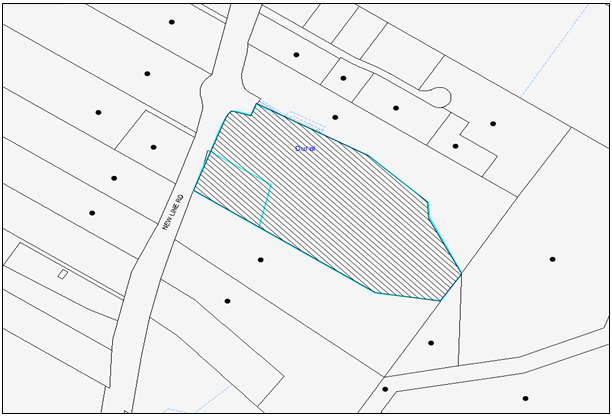
|
NOTIFICATION PLAN |
|
||
|
• PROPERTIES NOTIFIED
|
X SUBMISSIONS RECEIVED |
PROPERTY SUBJECT OF DEVELOPMENT |
|
6. THE PUBLIC INTEREST
Section 79C(1)(e) of the Act requires Council to consider “the public interest”.
The public interest is an overarching requirement, which includes the consideration of the matters discussed in this report. Implicit to the public interest is the achievement of future built outcomes adequately responding to and respecting the future desired outcomes expressed in environmental planning instruments and development control plans.
The application is considered to have satisfactorily addressed Council’s and relevant agencies’ criteria and would provide a development outcome that, on balance, would result in a positive impact for the community. Accordingly, it is considered that the approval of the proposed development would be in the public interest.
CONCLUSION
The application proposes demolition of existing structures and construction of alterations and additions, a carpark and signage.
The application does not comply with the Hornsby Local Environmental Plan 2013 in respect to Clause 4.6 ‘Height of Buildings’. The applicant has submitted a Clause 4.6 request to vary the height of building development standard. The objection is considered well founded with regard to the existing development and the principles established by the Land and Environmental Court.
There were no submissions received in response to the notification of the proposed development.
Having regard to the circumstances of the case and consideration of the Clause 4.6 request, approval of the application is recommended.
Note: At the time of the completion of this planning report, no persons have made a Political Donations Disclosure Statement pursuant to Section 147 of the Environmental Planning and Assessment Act 1979 in respect of the subject planning application.
RESPONSIBLE OFFICER
The officer responsible for the preparation of this Report is the Manager – Development Assessments – Rodney Pickles, who can be contacted on 9847 6731.
|
Rod Pickles Manager - Development Assessment Planning Division |
James Farrington Group Manager Planning Division |
|
1.View |
Locality Map |
|
|
|
2.View |
Site Plan |
|
|
|
3.View |
Existing Floor Plan |
|
|
|
4.View |
Floor Plan |
|
|
|
5.View |
Elevations and Sections |
|
|
|
6.View |
Shadow Plan |
|
|
|
7.View |
Landscape Plans |
|
|
|
8.View |
Existing Tree Plan |
|
|
|
9.View |
Stormwater Plans |
|
|
File Reference: DA/266/2016
Document Number: D07008288
SCHEDULE 1
1. Deferred Commencement
Pursuant to Section 80(3) of the Environmental Planning and Assessment Act 1979, this consent does not operate until the following information is submitted to Council:
a) The proposed drainage easement over downstream property Lot 661 DP 1043597 in favour of Lot 13 DP 1049239 must be registered with the NSW Department of Lands.
Upon Council’s written satisfaction of the above information, the following conditions of development consent apply:
GENERAL CONDITIONS
The conditions of consent within this notice of determination have been applied to ensure that the use of the land and/or building is carried out in such a manner that is consistent with the aims and objectives of the relevant legislation, planning instruments and council policies affecting the land and does not disrupt the amenity of the neighbourhood or impact upon the environment.
Note: For the purpose of this consent, the term ‘applicant’ means any person who has the authority to act on or the benefit of the development consent.
Note: For the purpose of this consent, any reference to an Act, Regulation, Australian Standard or publication by a public authority shall be taken to mean the gazetted Act or Regulation, or adopted Australian Standard or publication as in force on the date that the application for a construction certificate is made.
2. Approved Plans and Supporting Documentation
The development must be carried out in accordance with the plans and documentation listed below and endorsed with Council’s stamp, except where amended by Council and/or other conditions of this consent:
|
Plan No. |
Plan Title |
Drawn by |
Dated |
|
2300 LP – 00, Rev B |
Existing tree plan |
John Lock & Associates |
23/06/2016 |
|
010, Rev A |
Site outline |
John R. Brogan & Associates |
17.02.2016 |
|
025, Rev A |
Site context |
John R. Brogan & Associates |
17.02.2016 |
|
030, Rev B |
Site plan |
John R. Brogan & Associates |
23.06.2016 |
|
100, Rev A |
Floor plan warehouse & mezzanine |
John R. Brogan & Associates |
17.02.2016 |
|
120, Rev A |
Sections |
John R. Brogan & Associates |
17.02.2016 |
|
130, Rev A |
Elevations |
John R. Brogan & Associates |
17.02.2016 |
|
01579_201, Rev 02 |
Stormwater plans |
C & M Consulting Engineers |
23.06.2016 |
|
01579_202, Rev 02 |
Stormwater plans |
C & M Consulting Engineers |
23.06.2016 |
|
Plan No. |
Drawn by |
Dated |
|
Shadow diagrams, Drg No.200 |
John R. Brogan & Associates |
17.02.2016 |
|
Areas diagram, Drg No.010 |
John R. Brogan & Associates |
John R. Brogan & Associates |
|
Sediment & erosion plan Drg No.01579_701 & 02 |
C & M Consulting Engineers |
15.02.2016 |
|
Contamination report |
EIS Environmental Investigation Services |
March 2010 |
|
Acoustic report, version A |
Wilkinson Murray |
February 2016 |
|
Bushfire report |
Abel Ecology |
19 Feb 2016 |
|
Flora and fauna report |
Abel Ecology |
19 Feb 2016 |
|
Traffic Parking Impact Assessment (Revision E) |
Transport and Traffic Planning Associates |
May 2016 |
|
Swept path analysis |
No name |
No date |
|
General terms of approval |
NSW Roads and Maritime Services |
1 June 2016 |
|
Landscape plans, Drg No. 2300 LP 01- 03, Rev E |
John Lock & Associates |
16.02.2016 |
|
Geotech report |
Jeffery and Katauskas Pty Ltd |
9 March 2010 |
3. Removal of Trees
This development consent permits the removal of trees numbered 1-5, 20-34, 39-48, 76-98, 101-121, 123, 132, 127-130 and 134 as identified in the Site Tree Location Plan provided by Tree Survey Provided by John Lock and Associates Architecture dated 23/6/16 (TRIM: D07011763).
Note: The removal of any other trees from the site requires separate approval by Council in accordance with Part 1B.6 Tree and Vegetation Preservation of the Hornsby Development Control Plan, 2013 (HDCP).
4. Amendment of Plans
To comply with Councils Development Control Plan requirement in terms of Outdoor Signage, the approved plans are to be amended as follows:
a) The Pylon sign is to be reduced in height to have a maximum height of 8 metres and a maximum width of 2.5 metres.
These amended plans must be submitted with the application for the Construction Certificate.
5. Section 94A Development Contributions
a) In accordance with Section 80A(1) of the Environmental Planning and Assessment Act, 1979 and the Hornsby Shire Council Section 94A Development Contributions Plan 2014-2024, $89,600 must be paid to Council to cater for the increased demand for community infrastructure resulting from the development, based on development costs of $8,960,000
b) The value of this contribution is current as at 17 August 2016. If this contribution is not paid within the financial quarter that this condition was generated, the contribution payable will be adjusted in accordance with the provisions of the Hornsby Shire Council Section 94 Development Contributions Plan and the amount payable will be calculated at the time of payment in the following manner:
$CPY = $CDC x CPIPY
CPIDC
Where:
$CPY is the amount of the contribution at the date of Payment
$CDC is the amount of the contribution as set out in this Development Consent
CPIPY is the latest release of the Consumer Price Index (Sydney – All Groups) at the date of Payment as published by the ABS.
CPIDC is the Consumer Price Index (Sydney – All Groups) for the financial quarter at the date applicable in this Development Consent Condition.
c) The monetary contributions must be paid to Council:
i) prior to the issue of the Subdivision Certificate where the development is for subdivision; or
ii) prior to the issue of the first Construction Certificate where the development is for building work; or
iii) prior to issue of the Subdivision Certificate or first Construction Certificate, whichever occurs first, where the development involves both subdivision and building work; or
iv) prior to the works commencing where the development does not require a Construction Certificate or Subdivision Certificate.
Note: It is the professional responsibility of the Principal Certifying Authority to ensure that the monetary contributions have been paid to Council in accordance with the above timeframes.
Council’s S94A Development Contributions Plan may be viewed at www.hornsby.nsw.gov.au or a copy may be inspected at Council’s Administration Centre during normal business hours.
6. Appointment of a Project Arborist
a) A project Arborist (AQF Level 5) must be appointed to provide monitoring and certification throughout the development process.
b) Details of the appointed project Arborist must be submitted to the PCA and Council for registration with the approved construction certificate.
7. Construction Certificate
a) A Construction Certificate is required to be approved by Council or a Private Certifying Authority prior to the commencement of any works under this consent.
b) A separate Construction Certificate must be obtained from Council for all works within the public road reserve under S138 of the Roads Act.
c) A separate Construction Certificate must be obtained from Council for all works within drainage easements vested in Council.
d) The Construction Certificate plans must not be inconsistent with the Development Consent plans.
REQUIREMENTS PRIOR TO THE ISSUE OF A CONSTRUCTION CERTIFICATE
8. Sydney Water – Approval
This application must be submitted to Sydney Water for approval to determine whether the development would affect any Sydney Water infrastructure, and whether further requirements are to be met.
Note: Building plan approvals can be obtained online via Sydney Water Tap inTM through www.sydneywater.com.au under the Building and Development tab.
9. Stormwater Drainage
The stormwater drainage system for the development must be designed for an average recurrence interval (ARI) of 20 years and be gravity drained in accordance with the following requirements:
a) Connected to an existing inter-allotment drainage system generally in accordance with Drawing No. 01579_201 and Drawing No. 01579_202 Revision 02 dated 23.06.2016 by C & M Consulting Engineers.
10. Internal Driveway/Vehicular Areas
The driveway and parking areas on site must be designed, constructed and a Construction Certificate issued in accordance with Australian Standards 2890.1, 2890.2, 3727 and the following requirements:
a) Design levels at the front boundary be obtained from Council.
b) The driveway be a rigid pavement.
c) The driveway grade must not exceed 25 percent and changes in grade must not exceed 8 percent per plan metre.
d) Longitudinal sections along both sides of the access driveway shall be submitted to the principal certifying authority in accordance with the relevant sections of AS 2890.1. The maximum grade shall not exceed 1 in 4 (25%) with the maximum changes of grade of 1 in 8 (12.5%) for summit grades and 1 in 6.7 (15%) for sag grades. Any transition grades shall have a minimum length of 2 metres. The longitudinal sections shall incorporate the design levels obtained by Council.
11. On Site Stormwater Detention
An on-site stormwater detention system must be designed by a chartered civil engineer and constructed in accordance with the following requirements:
a) Be generally in accordance with Drawing No. 01579_201, Drawing No. 01579_202 Revision 02 dated 23.06.2016 and Drawing No. 01579_501 Revision 01 dated 16.02.2016 by C & M Consulting Engineers.
b) Have a capacity of not less than 90 cubic metres, and a maximum discharge (when full) of 91 litres per second;
c) Have a surcharge/inspection grate located directly above the outlet;
d) Discharge from the detention system must be controlled via 1 metre length of pipe, not less than 50 millimetres diameter or via a stainless plate with sharply drilled orifice bolted over the face of the outlet discharging into a larger diameter pipe capable of carrying the design flow to an approved Council system;
12. Stormwater Quality Requirements
Stormwater quality treatment measures shall be designed generally in accordance with Drawing No. 01579_501 Revision 01 dated 16.02.2016 by C & M Consulting Engineers and the MUSIC Model Report No.R021579-SWMP Revision A.
Prior to the issue of a construction certificate, a qualified engineer shall certify that the MUSIC model and stormwater treatment design plans submitted for approval to the principal certifying authority are in accordance with the stormwater quality targets outlined in Hornsby Council’s Development Control Plan 2013 - Table 1C.1.2(b) and the MUSIC Link Validation Report.
13. Traffic Control Plan
A Traffic Control Plan (TCP) must be prepared by a qualified traffic controller in accordance with the Roads & Traffic Authority’s Traffic Control at Worksites Manual 1998 and Australian Standard 1742.3 for all work on a public road. The Traffic Management Plan shall be submitted and approved by Council’s Manager Traffic and Road Safety prior to the issue of a construction certificate. The TCP must detail the following:
a) Arrangements for public notification of the works;
b) Temporary construction signage;
c) Permanent post-construction signage;
d) Vehicle movement plans;
e) Traffic management plans; and
f) Pedestrian and cyclist access/safety.
14. Construction Traffic Management Plan
In order to enable unencumbered movement of traffic in the public road during construction works, a Construction Management Plan, including a Traffic Management Plan and scaled construction plans prepared by a suitably Chartered and Qualified Chartered Civil Engineer and Qualified Worksite Traffic Controller shall be prepared and submitted to Hornsby Shire Council for approval according to the following requirements:-
a) A copy of the plans shall be submitted for consideration and written approval by Hornsby Shire Council prior to the release of the Construction Certificate.
b) The plans shall detail the order of construction works and arrangement of all construction machines and vehicles being used at the same time during all stages.
c) The CTMP plans shall be in accordance with the approved Development Application plans and the Development Consent conditions.
d) In order to prevent injury, accident and loss of property, no building materials, work sheds, vehicles, machines or the like shall be allowed to remain in the road reserve area without the written consent of Hornsby Shire Council.
e) The Plan shall be generally in compliance with the requirements of the Road and Traffic Authority’s “Traffic Control at Worksites Manual 1998” and detailing:-
i) Public notification of proposed works;
ii) Long term signage requirements;
iii) Short term (during actual works) signage;
iv) Vehicle Movement Plans, where applicable;
v) Traffic Management Plans;
vi) Pedestrian and Cyclist access and safety;
f) The plans shall indicate traffic controls including those used during non-working hours and shall provide pedestrian access and two-way traffic in the public road to be facilitated at all times.
g) The plans shall include the proposed truck routes to and from the site including details of the frequency of truck movements at the different stages of the development. The plan shall also include details of parking arrangements for all employees and contractors.
h) The Applicant and all employees of contractors on the site must obey any direction or notice from the Prescribed Certifying Authority or Hornsby Shire Council in order to ensure the above.
i) If there is a requirement to obtain a Work Zone, partial Road Closure or Crane Permit an application to Hornsby Shire Council is to be made prior to the issue the Construction Certificate
15. Vehicular Crossing
A separate application under the Local Government Act, 1993 and the Roads Act 1993 must be submitted to Council for the installation of a new vehicular crossing and the removal of the redundant crossing. The vehicular crossing must be constructed in accordance with Council’s Civil Works Design 2005 and the following requirements:
a) Design levels at the front boundary must be obtained from Council for the design on the internal driveway;
b) Any redundant crossings must be replaced with integral kerb and gutter;
c) The footway area must be restored by turfing;
d) The design and construction of the gutter crossing shall be in accordance with the Roads and Maritime Services requirements. The design shall be submitted to the Roads and Maritime Services for approval prior to construction.
e) A Road Occupancy License shall be obtained from the Roads and Maritime Services Transport Management Centre for any works that may impact on traffic flows.
f) Approval must be obtained from all relevant utility providers that all necessary conduits be provided and protected under the crossing.
Note: An application for a vehicular crossing can only be made to one of Council’s Authorised Vehicular Crossing Contractors. You are advised to contact Council on 02 9847 6940 to obtain a list of contractors.
16. Road Works
A separate application under the Local Government Act 1993 and the Roads Act 1993 must be submitted to Council for all public road works required under this consent.
a) The design and construction of a raised concrete median on New Line Road covering the width of the driveway in accordance with Roads and Maritime Services Road Design Guide. The design shall be submitted to the Roads and Maritime Services for approval prior to construction.
b) A Road Occupancy License shall be obtained from the Roads and Maritime Services Transport Management Centre for any works that may impact on traffic flows.
REQUIREMENTS PRIOR TO THE COMMENCEMENT OF ANY WORKS
17. Erection of Construction Sign
a) A sign must be erected in a prominent position on any site on which any approved work is being carried out:
i) Showing the name, address and telephone number of the principal certifying authority for the work;
ii) Showing the name of the principal contractor (if any) for any demolition or building work and a telephone number on which that person may be contacted outside working hours; and
iii) Stating that unauthorised entry to the work site is prohibited.
b) The sign is to be maintained while the approved work is being carried out and must be removed when the work has been completed.
18. Protection of Adjoining Areas
A temporary hoarding, fence or awning must be erected between the work site and adjoining lands before the works begin and must be kept in place until after the completion of the works if the works:
a) Could cause a danger, obstruction or inconvenience to pedestrian or vehicular traffic;
b) Could cause damage to adjoining lands by falling objects; and/or
c) Involve the enclosure of a public place or part of a public place.
Note: Notwithstanding the above, Council’s separate written approval is required prior to the erection of any structure or other obstruction on public land.
19. Toilet Facilities
To provide a safe and hygienic workplace, toilet facilities must be available or be installed at the works site before works begin and must be maintained until the works are completed at a ratio of one toilet for every 20 persons employed at the site.
20. Erosion and Sediment Control
To protect the water quality of the downstream environment, erosion and sediment control measures must be provided and maintained throughout the construction period in accordance with the manual ‘Soils and Construction 2004 (Bluebook)’, the approved plans, Council specifications and to the satisfaction of the principal certifying authority. The erosion and sediment control devices must remain in place until the site has been stabilised and revegetated.
Note: On the spot penalties may be issued for any non-compliance with this requirement without any further notification or warning.
21. Installation of Tree Protection
Tree protection zone fencing (TPZF) must be erected around trees numbered 49-74, 99, 100, 122, 125, 126 and 131-133 in accordance with section 1B.6.1.i of the HDCP.
22. Tree Protection Zone Ground Protection
All Tree Protection Zones must have a layer of wood-chip mulch installed prior to works commencing and must be maintained throughout the period of construction at a depth of 150mm – 300mm using material that complies with Australian Standard AS 4454.
REQUIREMENTS DURING CONSTRUCTION
23. Construction Work Hours
All works on site, including demolition and earth works, must only occur between 7am and 5pm Monday to Saturday.
No work is to be undertaken on Sundays or public holidays.
24. Construction Vehicles
All construction vehicles associated with the proposed development are to be contained on site.
25. Demolition
To protect the surrounding environment, all demolition work must be carried out in accordance with “Australian Standard 2601-2001 – The Demolition of Structures” and the following requirements:
a) Demolition material must be disposed of to an authorised recycling and/or waste disposal site and/or in accordance with an approved waste management plan;
b) Demolition works, where asbestos material is being removed, must be undertaken by a contractor that holds an appropriate licence issued by WorkCover NSW in accordance with Chapter 10 of the Occupational Health and Safety Regulation 2001 and Clause 29 of the Protection of the Environment Operations (Waste) Regulation 2005 ;and
c) On construction sites where any building contain asbestos material, a standard commercially manufactured sign containing the words ‘DANGER ASBESTOS REMOVAL IN PROGRESS’ and measuring not less than 400mm x 300mm must be displayed in a prominent position visible from the street.
26. Council Property
To ensure that the public reserve is kept in a clean, tidy and safe condition during construction works, no building materials, waste, machinery or related matter is to be stored on the road or footpath.
Note: This consent does not give right of access to the site via Council’s park or reserve. Should such access be required, separate written approval is to be obtained from Council.
27. Excavated Material
All excavated material removed from the site must be classified by a suitably qualified person in accordance with the Department of Environment, Climate Change and Water NSW Waste Classification Guidelines prior to disposal to an approved waste management facility and be reported to the principal certifying authority prior to the issue of an Occupation Certificate.
28. Environmental Management
The site must be managed in accordance with the publication ‘Managing Urban Stormwater – Landcom (March 2004) and the Protection of the Environment Operations Act 1997 by way of implementing appropriate measures. To prevent sediment run-off, excessive dust, noise or odour emanating from the site during the construction of the development.
29. Street Sweeping
To protect the surrounding environment, Street sweeping must be undertaken following sediment tracking from the site along New Line Road, Dural during works and until the site is established.
The street cleaning services must undertake a street ‘scrub and dry’ method of service and not a dry sweeping service that may cause sediment tracking to spread or cause a dust nuisance.
30. Disturbance of Existing Site
During construction works, the existing ground levels of open space areas and natural landscape features, including natural rock-outcrops, vegetation, soil and watercourses must not be altered unless otherwise nominated on the approved plans.
31. Landfill
Landfill must be constructed in accordance with Council’s ‘Construction Specification 2005’ and the following requirements:
a) Prior to fill material being imported to the site, a certificate shall be obtained from a suitable qualified environmental consultant confirming the fill wholly consists of Virgin Excavated Natural Material (VENM) as defined in Schedule 1 of the Protection of the Environment Operations Act, 1997 or material approved under the Department of Environment and Climate Change’s general resource recovery exemption.
32. Survey Report
A report(s) must be prepared by a registered surveyor and submitted to the principal certifying authority:
a) Prior to the pouring of concrete of the building certifying that:
i) The building, retaining walls and the like have been correctly positioned on the site; and
ii) The finished floor level is in accordance with the approved plans.
33. Works Near Trees
a) The project Arborist must monitor and record any necessary remedial actions for maintaining tree health and their condition for trees numbered 6, 8-18, 49-74, 99, 100, 122, 125, 126 and 131-133.
b) The appointed project Arborist must monitor and record all changes or modifications to required tree protection measures for the period of construction.
34. Works Near Trees Certification
The project Arborist must submit to the principal certifying authority on a monthly a certificate that the works have been carried out in compliance with the approved plans and specifications for tree protection. Certification should include a statement of site attendance, the condition of the retained trees, details of any deviations from the approved tree protection measures and their impacts on trees. Copies of monitoring documentation may be required.
REQUIREMENTS PRIOR TO THE ISSUE OF AN OCCUPATION CERTIFICATE
Note: For the purpose of this consent, a reference to ‘occupation certificate’ shall not be taken to mean an ‘interim occupation certificate’ unless otherwise stated.
35. Damage to Council Assets
To protect public property and infrastructure, any damage caused to Council’s assets as a result of the construction or demolition of the development must be rectified by the applicant in accordance with Council’s Civil Works Specifications. Rectification works must be undertaken prior to the issue of an Occupation Certificate, or sooner, as directed by Council.
36. Certification of WSUD Facilities
Prior to the issue of an Occupation Certificate a certificate from a Civil Engineer is to be obtained stating that the WSUD facilities have been constructed and will meet the water quality targets as specified in the Hornsby Shire Councils DCP.
37. Creation of Easements
The following matter(s) must be nominated on the plan of subdivision under s88B of the Conveyancing Act 1919:
a) The creation of an appropriate "Positive Covenant" and "Restriction as to User" over the constructed on-site detention/retention systems, stormwater quality treatment system and outlet works, within the lots in favour of Council in accordance with Council’s prescribed wording. The position of the on-site detention system and stormwater quality treatment system is to be clearly indicated on the title;
b) The positive covenant for the stormwater quality treatment system shall include a maintenance schedule.
c) To register the OSD easement, the restriction on the use of land “works-as-executed” details of the on-site-detention system and stormwater quality treatment system must be submitted verifying that the required storage and discharge rates have been constructed in accordance with the design requirements. The details must show the invert levels of the on-site detention system together with pipe sizes and grades. Any variations to the approved plans must be shown in red on the “works-as-executed” plan and supported by calculations;
Note: Council must be nominated as the authority to release, vary or modify any easement, restriction or covenant.
38. Preservation of Survey Marks
A certificate by a Registered Surveyor shall be submitted to the Principal Certifying Authority, certifying that there has been no removal, damage, destruction, displacement or defacing of the existing survey marks in the vicinity of the proposed development or otherwise the re-establishment of damaged, removed or displaced survey marks has been undertaken in accordance with the Surveyor General’s Direction No.11 – “Preservation of Survey Infrastructure”.
39. Works as Executed Plan
A works-as-executed plan(s) must be prepared by a registered surveyor and submitted to Council for completed public road and drainage works, water quality treatment devices and on-site detention system.
40. Retaining Walls
All required retaining walls must be constructed as part of the development.
41. Car Parking
All car parking must be constructed in accordance with Australian Standard AS/NZS 2890.1:2004 – Off-street car parking, and Australian Standard 2890.2 - 2002 – Off-street commercial vehicle facilities and the following requirement:
a) All parking areas and driveways are to be sealed to an all-weather standard, line marked and signposted.
b) Car parking, loading and manoeuvring areas to be used solely for nominated purposes.
c) Vehicles awaiting loading, unloading or servicing shall be parked on site and not on adjacent or nearby public roads;
d) All vehicular entry on to the site and egress from the site shall be made in a forward direction.
42. External Lighting
a) To protect the amenity of adjacent premises, all external lighting must be designed and installed in accordance with Australian Standard AS 4282 – Control of the Obtrusive Effects of Outdoor Lighting.
b) Certification of compliance with this Standard must be obtained from a suitably qualified person and submitted to the PCA with the application for the Construction Certificate.
43. Consolidation of Allotments
All allotments the subject of this consent must be consolidated into one allotment.
Note: The applicant is recommended to submit the plan of subdivision to consolidate allotments to the NSW Department of Lands at least 4-6 weeks prior to seeking an occupation certificate.
44. Construction of Engineering Works
All engineering works including but not be limited to the stormwater works, on-site detention system, construction of retaining walls and road works identified in this consent are to be completed and a Compliance Certificate issued prior to the release of the Occupation Certificate.
45. Occupational Hygienist
Provide to Council and the Principal Certifying Authority a hazardous materials report prepared by a suitably qualified Occupational Hygienist that the site is clear of contamination and suitable for the intended use.
46. Landscaping
a) To soften the impact of the development, shade trees are to be provided in open parking areas at the ratio of 1 shade tree per 6 car spaces.
b) The landscape works must be implemented according to the approved landscape plan, Drg No. 2300 LP 01 - 03, Rev E, prepared by John Lock & Associates, dated 16.02.2016.
c) The proposed streetscape planting to the New Line Road setback zone shall include a mixed canopy species including Angophora costata, Corymbia gummifera, Eucalyptus saligna, and Syncarpia glomulifera.
47. Final Certification Arborist
a) The Project Supervisor must submit to the principal certifying authority all relevant certificates with the application for the occupation certificate stating compliance with all the conditions of this consent.
b) The Project Arborist must submit to the principal certifying authority a certificate that all the completed works have been carried out in compliance with the approved plans and specifications for tree protection. Certification must include a statement of overall site attendance, the condition of the retained trees, details of any deviations from the approved tree protection measures and their impacts on trees. Copies of monitoring documentation may be required.
OPERATIONAL CONDITIONS
48. Advertising Signs
The advertising signage approved under this consent must only be illuminated between the hours of operation and must not flash, move or display electronic images.
49. Hours of Operation
The trading hours of the use are to be restricted to those times listed below:
Monday to Friday 7am to 9pm
Saturday 8am to 6pm
Sunday & Public Holidays 8am to 6pm
50. Offensive Noise
The use of the premise must be controlled so that any emitted noise is at a level so as not to create an “offensive noise” as defined in the Protection of the Environment Operations Act 1997 to any affected receiver.
51. Operation of Exhaust Fans
Exhaust fans are to be switched to a low level of operation during periods of low background noise levels and in accordance with the following:
a) Fans are to be operated at half (or less) speed between 6am-9am and 5pm-9pm each day;
b) Fans must not be in operation between 9pm and 6am; and
c) Fans are to be hardwired to an automated switch to ensure the fan speeds are reduced or off at the above times. There is to be no manual override of timers.
52. Noise
All noise generated by the proposed development must be attenuated to prevent levels of noise being emitted to adjacent premises which possess tonal, beating and similar characteristics or which exceeds background noise levels by more than 5dB(A).
53. Fire Safety Statement - Annual
On at least one occasion in every 12 month period following the date of the first ‘Fire Safety Certificate’ issued for the property, the owner must provide Council with an annual ‘Fire Safety Certificate’ to each essential service installed in the building.
54. Landscaping in Bushfire Prone Areas
Landscaping must comply with the principles of Appendix 5 of Planning for Bush Fire Protection 2006.
55. Sight Lines
Minimum sight lines for pedestrian safety are to be provided at the driveway. Any proposed landscaping and/or fencing must not restrict sight distance to pedestrians and cyclists travelling along the footpath.
56. Car Parking and Deliveries
All car parking must be operated in accordance with Australian Standard AS 2890.1 – 2004 – Off Street Car Parking and Australian Standard 2890.2 - 2002 – Off Street Commercial and the following requirements:
a) All parking areas and driveways are to be sealed to an all-weather standard, line marked and signposted at all times.
b) Car parking, loading and manoeuvring areas to be used solely for nominated purposes.
c) Vehicles awaiting loading, unloading or servicing shall be parked on site and not on adjacent or nearby public roads;
d) All vehicular entry on to the site and egress from the site shall be made in a forward direction.
e) All parking for people with disabilities is to comply with AS/NZS 2890.6:2009 Off-street parking for people with disabilities.
f) Bicycle parking facilities are to be designed in accordance with AS 2890.3-1993 Bicycle parking facilities.
g) Motorcycle parking spaces are to be designed in accordance with AS 2890.1:2004.
CONDITIONS OF CONCURRENCE – NSW ROADS AND MARITIME SERVICES
The following conditions of consent are from the nominated State Agency pursuant to Section 79B of the Environmental Planning and Assessment Act 1979 and must be complied with to the satisfaction of that Agency.
57. RMS Condition 1
A strip of land has previously been dedicated as Public Road by private subdivision (DP 1049242), along the New Line Road frontage of the subject property, as shown by yellow colour on the attached Aerial —"X". Therefore, all buildings and structures, together with any improvements integral to the future use of the site are to be wholly within the freehold property (unlimited in height or depth), along the New Line Road boundary.
58. RMS Condition 2
The proposed exit driveway on New Line Road shall be restricted to left turn movements only by provision of a raised strip concrete median on New Line Road covering the width of the driveway.
The raised concrete median shall be an absolute minimum of 900 mm wide and designed and constructed in accordance with Roads and Maritime's Road Design Guide.
The central concrete median is to be fully constructed and operational prior to the issue of an Occupation Certificate for the proposed development.
59. RMS Condition 3
The design and construction of the raised concrete median on New Line Road shall be in accordance with Roads and Maritime's requirements. Detailed design plans of the proposed concrete median along with a swept path analysis are to be submitted to Roads and Maritime for approval prior to commencement of any road works.
The plans should include the dimension of the driveway, lane width, concrete median width and length, driveways on both side of the New Line Road and any other relevant information including any road widening required for the placement of the raised median.
The developer will be required to enter into a Works Authorisation Deed (WAD) for the abovementioned works. Please note that the WAD will need to be executed prior to Roads and Maritime assessment of the detailed civil design plans.
Roads and Maritime fees for administration, plan checking, civil works inspections and project management shall be paid by the developer prior to the commencement of works.
60. RMS Condition 4
The redundant driveway on the New Line Road shall be removed and replaced with kerb and gutter. The design and construction of the kerb and gutter crossing on New Line Road shall be in accordance with Roads and Maritime requirements. Details of these requirements should be obtained from Roads and Maritime Services, Manager Developer Works, Statewide Delivery, Parramatta (telephone 8849 2138).
Detailed design plans of the proposed kerb and gutter crossing are to be submitted to Roads and Maritime for approval prior to the issue of a Construction Certificate and commencement of any road works.
A plan checking fee (amount to be advised) and lodgement of a performance bond may be required from the applicant prior to the release of the approved road design plans by Roads and Maritime.
61. RMS Condition 5
All vehicles are to exit the site onto New Line Road in a forward direction. Turnaround facilities should be provided on site to ensure this requirement is met.
62. RMS Condition 6
Detailed design plans and hydraulic calculations of any changes to the Roads and Maritime's stormwater drainage system are to be submitted to Roads and Maritime for approval, prior to the commencement of any works. Details should be forwarded to:
The Sydney Asset Management
Roads and Maritime Services
PO Box 973 Parramatta CBD 2124
A plan checking fee will be payable and a performance bond may be required before Roads and Maritime approval is issued. With regard to the Civil Works requirement please contact the Roads and Maritime Project Engineer, External Works Ph: 8849 2114 or Fax: 88492766
63. RMS Condition 7
The developer shall be responsible for all public utility adjustment/relocation works, necessitated by the above work and as required by the various public utility authorities and/or their agents.
64. RMS Condition 8
A construction zone will not be permitted on New Line Road.
65. RMS Condition 9
A Road Occupancy Licence should be obtained from Transport Management Centre for any works that may impact on traffic flows on New Line Road during construction activities.
66. RMS Condition 10
Any proposed landscaping and/or fencing must not restrict sight distance to pedestrians and cyclist travelling along the footpath of New Line Road.
67. RMS Condition 11
All works/regulatory signposting associated with the proposed development are to be at no cost to Roads and Maritime.
- END OF CONDITIONS -
ADVISORY NOTES
The following information is provided for your assistance to ensure compliance with the Environmental Planning and Assessment Act 1979, Environmental Planning and Assessment Regulation 2000, other relevant legislation and Council’s policies and specifications. This information does not form part of the conditions of development consent pursuant to Section 80a of the Act.
Environmental Planning and Assessment Act 1979 Requirements
The Environmental Planning and Assessment Act 1979 requires:
· The issue of a construction certificate prior to the commencement of any works. Enquiries can be made to Council’s Customer Services Branch on 9847 6760.
· A principal certifying authority to be nominated and Council notified of that appointment prior to the commencement of any works.
· Council to be given at least two days written notice prior to the commencement of any works.
· Mandatory inspections of nominated stages of the construction inspected.
· An occupation certificate to be issued before occupying any building or commencing the use of the land.
Long Service Levy
In accordance with Section 34 of the Building and Construction Industry Long Service Payments Act 1986, a ‘Long Service Levy’ must be paid to the Long Service Payments Corporation or Hornsby Council.
Note: The rate of the Long Service Levy is 0.35% of the total cost of the work.
Note: Hornsby Council requires the payment of the Long Service Levy prior to the issue of a construction certificate.
Tree and Vegetation Preservation
In accordance with Clause 5.9 of the Hornsby Local Environmental Plan 2013 a person must not ringbark, cut down, top, lop, remove, injure or wilfully destroy any tree or other vegetation protected under the Hornsby Development Control Plan 2013 without the authority conferred by a development consent or a permit granted by Council.
Notes: A tree is defined as a long lived, woody perennial plant with one or relatively few main stems with the potential to grow to a height greater than three metres (3M). (HDCP 1B.6.1.c).
Tree protection measures and distances are determined using the Australian Standard AS 4970:2009, “Protection of Trees on Development Sites”.
Fines may be imposed for non-compliance with both the Hornsby Local Environmental Plan 2013 and the Hornsby Development Control Plan 2013.
Disability Discrimination Act
The applicant’s attention is drawn to the existence of the Disability Discrimination Act. A construction certificate is required to be obtained for the proposed building/s, which will provide consideration under the Building Code of Australia, however, the development may not comply with the requirements of the Disability Discrimination Act. This is the sole responsibility of the applicant.
Covenants
The land upon which the subject building is to be constructed may be affected by restrictive covenants. Council issues this approval without enquiry as to whether any restrictive covenant affecting the land would be breached by the construction of the building, the subject of this consent. Applicants must rely on their own enquiries as to whether or not the building breaches any such covenant.
Dial Before You Dig
Prior to commencing any works, the applicant is encouraged to contact Dial Before You Dig on 1100 or www.dialbeforeyoudig.com.au for free information on potential underground pipes and cables within the vicinity of the development site.
Telecommunications Act 1997 (Commonwealth)
If you are aware of any works or proposed works which may affect or impact on Telstra’s assets in any way, you are required to contact: Telstra’s Network Integrity Team on Phone Number 1800810443.
Asbestos Warning
Should asbestos or asbestos products be encountered during demolition or construction works, you are advised to seek advice and information prior to disturbing this material. It is recommended that a contractor holding an asbestos-handling permit (issued by WorkCover NSW)be engaged to manage the proper handling of this material. Further information regarding the safe handling and removal of asbestos can be found at:
Alternatively, telephone the WorkCover Asbestos and Demolition Team on 8260 5885.
Group Manager’s Report No. PL53/16
Planning Division
Date of Meeting: 14/09/2016
12 DEVELOPMENT APPLICATION - DWELLING HOUSE AND SECONDARY DWELLING - 7 LYNE ROAD, CHELTENHAM
EXECUTIVE SUMMARY
|
DA No: |
DA/545/2016 (Lodged on 4 May 2016) |
|
Description: |
Demolition of an existing dwelling house and construction of a single storey dwelling house and secondary dwelling |
|
Property: |
Lot A DP 323398, No. 7 Lyne Road, Cheltenham |
|
Applicant: |
Ms Amy Oi Chu Poon |
|
Owner: |
Ms Amy Oi Chu Poon |
|
Estimated Value: |
$742,000 |
· The application involves the demolition of an existing single storey dwelling, carport and shed, and the construction of a single storey dwelling house and a detached secondary dwelling.
· Council previously approved Development Application No. DA/996/2014 on 11 February 2015 for alterations and additions to a dwelling house and the erection of detached secondary dwelling subject to conditions of consent. The approved development was not commenced.
· The proposal generally complies with the requirements of the Hornsby Local Environmental Plan 2013, the Hornsby Development Control Plan 2013 and State Environmental Planning Policy (Affordable Rental Housing) 2009.
· One submission has been received in respect of the application.
· A Red Sticker has been placed on the application requiring that it be determined at a Council meeting.
· It is recommended that the application be approved.
|
THAT Development Application No. DA/545/2016 for demolition of a dwelling house and construction of a dwelling house and secondary dwelling at Lot A DP 323398, No. 7 Lyne Road, Cheltenham be approved subject to the conditions of consent detailed in Schedule 1 of Group Manager’s Report No. PL53/16. |
BACKGROUND
At its meeting on 11 February 2015, Council approved Development Application DA/996/2014 for alterations and additions to a dwelling house and the erection of a detached single storey secondary dwelling on the subject site subject to conditions of consent.
The approval included an amendment to the kitchen and pantry windows of the primary dwelling to be top hinged and obscured, and a privacy screen on the deck at the rear of the primary dwelling to maintain the privacy of the adjoining property at No.5 Lyne Road, Cheltenham.
The approval also included a condition of consent for a Project Arborist to be appointed to monitor and certify excavation works within two metres of the trees along the north-east boundary and adjacent to the approved garage.
On 11 February 2015, Council approved a Section 96(1A) modification to the development consent for minor amendments to privacy and heritage requirements within the consent.
On 11 February 2015, Council approved a Section 96(2) modification to development consent DA/996/2014/B involving the re-orientation of the internal layout and balcony of the secondary dwelling and minor changes to the roof design of the primary and secondary dwelling.
To date, the approved development (DA/996/2014) and related works have not been commenced.
On 4 May 2016, DA/545/2016 was lodged for the construction of a new dwelling and detached secondary dwelling. The application differs from the previous approved development application in that the existing dwelling is to be demolished and the secondary dwelling is to be re-located further towards the rear boundary of the site.
SITE
The site has an area of 972.3m2 and is located on the eastern side of Lyne Road, Cheltenham. The site is a rectangular shaped allotment with a frontage of 18 metres to Lyne Road and a depth of approximately 50 metres. The site currently contains a single storey dwelling with attached garage, carport and a detached shed in the yard.
The site slopes down 4 metres to the rear, southern boundary of the site.
A Sydney Water sewer line runs across the rear of the site, along the southern boundary.
The site is not burdened by any easements or restrictions.
The site is located within the Beecroft-Cheltenham Heritage Conservation Area – Beecroft Plateau Precinct which is listed in Part 2, Schedule 5 (Environmental Heritage) of the Hornsby Local Environmental Plan (HLEP) 2013. The site is also located in the vicinity of two heritage listed items, namely ‘Edensor’, No. 203 Beecroft Road (Item No. 268) and the ‘Grounds of Cheltenham Recreation Club’, Nos.60-74 The Crescent (Item No.296).
There are two access driveways to the west of the site which provide access to a battle-axe property at the rear of the subject site.
There are no large trees identified on the site, however, there are two smaller trees that straddle the side (north-east) boundary.
The surrounding development is typified by blend of one and two storey dwelling houses of varying style and age. Towards the eastern end of Lyne Road is the Cheltenham Recreation Club.
PROPOSAL
The application proposes the construction of a dwelling house and secondary dwelling.
The primary dwelling would comprise a family room, meals room, kitchen, office, laundry and bathroom, 3 bedrooms and an en-suite and a double garage attached to the north corner of the dwelling. The application also proposes an outdoor terrace on the southern side of the dwelling.
The secondary dwelling would comprise a living room, kitchen and dining area, two bedrooms, a laundry and a bathroom.
The application proposes to demolish the existing single storey dwelling, garage, attached carport and shed located in the rear yard.
No significant trees would be impacted by the development.
ASSESSMENT
The development application has been assessed having regard to ‘A Plan for Growing Sydney’, the ‘North Subregion (Draft) Subregional Strategy’ and the matters for consideration prescribed under Section 79C of the Environmental Planning and Assessment Act 1979 (the Act). The following issues have been identified for further consideration.
1. STRATEGIC CONTEXT
1.1 A Plan for Growing Sydney and (Draft) North Subregional Strategy
A Plan for Growing Sydney has been prepared by the NSW State Government to guide land use planning decisions for the next 20 years. The Plan sets a strategy for accommodating Sydney’s future population growth and identifies the need to deliver 689,000 new jobs and 664,000 new homes by 2031. The Plan identifies that the most suitable areas for new housing are in locations close to jobs, public transport, community facilities and services.
The NSW Government will use the subregional planning process to define objectives and set goals for job creation, housing supply and choice in each subregion. Hornsby Shire has been grouped with Hunters Hill, Ku-ring-gai, Lane Cove, Manly, Mosman, North Sydney, Pittwater, Ryde, Warringah and Willoughby to form the North Subregion. The Draft North Subregional Strategy will be reviewed and the Government will set housing targets and monitor supply to ensure planning controls are in place to stimulate housing development.
The proposed development would be consistent with ‘A Plan for Growing Sydney’, by providing renewed and additional housing stock to support a growing population.
2. STATUTORY CONTROLS
Section 79C(1)(a) requires Council to consider “any relevant environmental planning instruments, draft environmental planning instruments, development control plans, planning agreements and regulations”.
2.1 Hornsby Local Environmental Plan 2013
The proposed development has been assessed having regard to the provisions of the Hornsby Local Environmental Plan 2013 (HLEP).
2.1.1 Zoning of Land and Permissibility
The subject land is zoned R2 Low Density Residential under the HLEP. The objectives of the zone are:
· To provide for the housing needs of the community within a low density residential environment.
· To enable other land uses that provide facilities or services to meet the day to day needs of residents.
The proposed development is defined as “dwelling” and “secondary dwelling”.
Under the HLEP, a “dwelling house” is permissible in the zone with Council’s consent whilst a “secondary dwelling” is not permissible in the zone. Notwithstanding, a “secondary dwelling” is a permissible land use in the R2 – Low Density Residential zone pursuant to the provisions of the State Environmental Planning Policy (Affordable Rental Housing) 2009 (AHSEPP 2009).
2.1.2 Height of Buildings
Clause 4.3 of the HLEP provides that the height of a building on any land should not exceed the maximum height shown for the land on the Height of Buildings Map. The maximum permissible height for the subject site is 8.5 metres. The maximum height of the dwelling would be 7 metres and complies with this provision.
2.1.3 Heritage Conservation
Clause 5.10 of the HLEP sets out heritage conservation provisions for Hornsby Shire which are applicable to development involving any modifications to the detail, fabric, finish or appearance of a building within a heritage conservation area.
The site is located within the Beecroft-Cheltenham Heritage Conservation Area and is in the vicinity of two listed items – property No. 203 Beecroft Road (‘Edensor’, garden, stable and wall - Item No. 268) and Property Nos. 60-74 The Crescent (Grounds of Cheltenham Recreation Club – Item No. 296). The application and potential impacts on the heritage significance of the HCA are addressed in Section 2.7.3 of this report.
2.2 State Environmental Planning Policy (Affordable Rental Housing) 2009
State Environmental Planning Policy (Affordable Rental Housing) 2009 (SEPP ARH) was introduced by the NSW State Government to increase the supply and diversity of affordable rental and social housing in NSW. It covers housing types including villas, townhouses and apartments which contain an affordable rental housing component, along with secondary dwellings (also known as granny flats), new generation boarding houses, group homes, social housing and supportive accommodation.
Division 2 of the Policy outlines the standards for Secondary Dwellings. Clause 18 of the policy defines a “secondary dwelling” to be a self-contained dwelling that:
a) is established in conjunction with another dwelling (the principal dwelling), and
b) is on the same lot of land (not being an individual lot in a strata plan or community title scheme) as the principal dwelling, and
c) is located within, or is attached to, or is separate from, the principal dwelling.
The proposed secondary dwelling would be established in conjunction with the proposed principal dwelling on the site and satisfies the above definition.
Clause 20 of the Policy outlines the zones in which secondary dwellings are permissible. The site is located within the R2 Low Density Residential zone, which is listed in the Policy as a zone where secondary dwellings are permissible. Therefore, the proposal is permissible within the R2 land use zone.
The following table sets out the proposal’s compliance with the development standards as prescribed for secondary dwellings under Clause 22 and Schedule 1 of SEPP ARH:
|
State Environmental Planning Policy (Affordable Rental Housing) 2009 |
||||
|
Standard |
Approved DA/996/2014 |
Proposal |
Requirement |
Complies |
|
Site Area |
972.3m2 |
972.3m2 |
450m2 |
Yes |
|
No. of Dwellings |
2 |
2 |
2 (Max) |
Yes |
|
Floor Area |
|
|
|
|
|
Principal Dwelling |
238.93m2 |
236.6m2 |
N/A |
|
|
Secondary Dwelling |
60m2 |
59.7m2 |
60m2 |
Yes |
|
Total |
298.93m2 |
296.3m2 |
430m2 |
Yes |
|
Car Parking |
|
|
|
|
|
Principal Dwelling |
2 |
2 |
2 |
Yes |
|
Secondary Dwelling |
0 |
0 |
0 |
Yes |
|
Site Coverage |
30.8% |
30% |
40% |
Yes |
|
Setbacks |
|
|
|
|
|
Side (north-east) |
6m |
2.5m |
1.5m |
Yes |
|
Side (south-west) |
0.9m |
1.5m |
1.5m |
Yes |
|
Rear (south-east) |
6.3m |
3.6m |
5m |
No |
|
Height |
5.7m |
4.4m |
8.5m |
Yes |
|
Private Open Space |
|
|
|
|
|
Minimum area |
161.4m2 |
>24m2 |
24m2 |
Yes |
|
Minimum dimension |
>6.3m |
>4m |
4m |
Yes |
|
Landscaped Area (total) |
44.3% |
45% |
35% |
Yes |
As indicated in the above table, the proposed secondary dwelling complies with the development standards under the SEPP other than the rear setback from the south-eastern boundary. However, the proposal cannot be undertaken as Complying Development under the provisions of the Policy as the subject site is located within a heritage conservation area. The approval of secondary dwelling as Complying Development is excluded from heritage conservation areas for the purposes of the Policy and therefore, development consent is required. The heritage implications of the proposal are addressed in Section 2.7.3 of this report.
The non-compliance with the setback and privacy development standards is addressed below.
2.2.1 Setbacks
As the site has an area greater than 900m2, the development standards of Schedule 1 of the SEPP require that a minimum rear boundary setback of 5 metres be provided for the secondary dwelling.
The proposed secondary dwelling would have a setback of 3.6m from the south-eastern side of the property, which does not comply with the above requirement. In support of this variation, it is noted as follows:
· The proposed secondary dwelling would be a single storey structure and as a consequence, would have minimal amenity impacts on adjoining properties in terms of height, privacy or sunlight access.
· The proposed secondary dwelling has been sited towards the rear boundary in a location that would not compromise access to the existing sewer line and would provide the maximum possible separation from the adjoining dwelling at No. 5 Lyne Road.
· The private open space of the secondary dwelling would be orientated away from the property at No. 5 Lyne Road to minimise any privacy impacts. The terrace would be orientated towards the south-western side boundary which immediately adjoins an 8.7 metre wide right-of-carriageway.
Given these circumstances, the proposal is considered acceptable.
2.2.2 Privacy
One objection was received with respect to the scale and orientation of the secondary dwelling and its privacy impacts on the private open space of property No.5 Lyne Road, Cheltenham.
The two windows (W103 and W104) within the north-eastern elevation of the secondary dwelling serve bedrooms only and are highlight windows with a minimum sill height of 1.8 metres above the floor level. Windows W101 and W102 along the north-western elevation serve a bedroom and a bathroom. Minimal impacts are anticipated in this regard given the “non-active” use of these rooms and noting that the secondary dwelling is single storey in height. Therefore, any line of sight would largely be mitigated by boundary fencing.
The objection also comments that the previous approved Development Application DA/996/2014 and its subsequent revisions sited the secondary dwelling further from the north-eastern side boundary fence which minimised the privacy impact to the neighbouring property. It is acknowledged that the current application proposes the secondary dwelling be moved closer to the north-eastern side boundary from the previous approval (DA/996/2014) to accommodate an area for private open space to the west of the secondary dwelling, away from No.5 Lyne Road, Cheltenham. Additionally, the secondary dwelling would be moved 3 metres towards the rear boundary from the previous approval to maintain an appropriate separation distance between No.5 Lyne Road Cheltenham and achieve a reasonable level of privacy.
2.3 Sydney Regional Environmental Plan (Sydney Harbour Catchment) 2005
The site is located within the catchment of Sydney Harbour. Sydney Regional Environmental Plan (Sydney Harbour Catchment) 2005 aims to protect the environment of the Sydney Harbour Catchment by ensuring that the impacts of future land uses are considered in a regional context.
Subject to the implementation of sediment and erosion control measures and stormwater management to protect water quality, the proposal would comply with the requirements of the Policy.
2.4 SEPP (Exempt and Complying Development) – NSW Housing Code
The application has been assessed against the requirements of State Environmental Planning Policy (Exempt and Complying Development Codes) 2008 – NSW Housing Code. The Policy provides exempt and complying development codes that have State-wide application. The Policy also identifies types of development that are of minimal environmental impact that may be carried out without the need for development consent and types of complying development (including dwelling houses) that may be carried out in accordance with a Complying Development Certificate.
The proposed dwelling house may not be approved as Complying Development, as the proposed dwelling falls within the Beecroft-Cheltenham Heritage Conservation Area and requires assessment against Clause 5.10 of the HLEP and Part 9.3 of the HDCP.
The proposal complies with the requirements of the NSW Housing Code in all other aspects including height, maximum floor area, setbacks, private open space, landscaping and car parking and access.
2.5 SEPP (Building Sustainability Index: BASIX) 2004
In accordance with the State Environmental Planning Policy (Building Sustainability Index: BASIX) 2004, a BASIX certificate is required for new dwellings. A BASIX certificate for the proposed principal dwelling and the secondary dwelling was submitted with the application. A condition has been recommended for the proposal to satisfy the BASIX commitments pertaining to the development.
2.6 Clause 74BA Environmental Planning and Assessment Act, 1979 - Purpose and Status of Development Control Plans
On 1 March 2013, the Environmental Planning and Assessment Act, 1979 was amended so that a DCP provision will have no effect if it has the practical effect of “preventing or unreasonably restricting development” that is otherwise permitted and complies with the development standards set out in relevant Local Environmental Plans and State Environmental Planning Policies.
The principal purpose of a development control plan is to provide guidance on the aims of any environmental planning instrument that applies to the development; facilitating development that is permissible under any such instrument; and achieving the objectives of land zones under any such instrument. The provisions of a development control plan made for that purpose are not statutory requirements.
2.7 Hornsby Development Control Plan 2013
The proposed development has been assessed having regard to the relevant desired outcomes and prescriptive requirements within the Hornsby Development Control Plan 2013 (HDCP). The following table sets out the proposal’s compliance with the prescriptive requirements of the Plan:
|
HDCP - Part 3.1 Dwelling Houses |
||||
|
Control |
Approved DA/996/2014 |
Proposal |
Requirement |
Complies |
|
Building Height |
7m |
7m |
8.5m |
Yes |
|
No. Storeys |
Single Storey |
Single Storey |
max. 2 + attic |
Yes |
|
Site Coverage – Total |
30.8% |
30% |
40% |
Yes |
|
Floor Area |
238m2 |
236m2 |
430m2 |
Yes |
|
Setbacks |
|
|
|
|
|
Front (north-west) |
8.9m |
7.1m |
6m |
Yes |
|
Side (north-east) |
0.9m |
1.2m |
0.9m |
Yes |
|
Side (south-west) |
1.36m |
1.5m |
0.9m |
Yes |
|
Rear (south-east) |
24m |
24m |
3m |
Yes |
|
Landscaped Area |
44.3% |
45% |
30% |
Yes |
|
Private Open Space |
|
|
|
|
|
Minimum area |
161m2 |
>24m2 |
24m2 |
Yes |
|
Minimum dimension |
8.8m |
>3m |
3m |
Yes |
|
Car Parking |
2 spaces |
2 spaces |
2 spaces |
Yes |
As detailed in the above table, the proposal complies with the prescriptive requirements of Parts 1, 3 and 9 of the HDCP. A discussion on compliance with the relevant desired outcomes and issues raised in submissions is outlined below.
2.7.1 Privacy
One objection raises concerns regarding loss of privacy for the property at No. 5 Lyne Road, Cheltenham as a result of the proposed dwelling.
The desired outcome of Part 3.1.6 Privacy is to encourage “development that is designed to provide reasonable privacy to adjacent properties.”
The prescriptive measures of Part 3.1.6 Privacy require a privacy screen for a window if:
· it is a window to a habitable room, other than a bedroom, that has a floor level of more than 1 metre above existing ground level;
· the window it setback less than 3 metres from a side or rear boundary; and
· the window has a sill height of less than 1.5 metres.
The objection raises concerns that three windows that serve the garage, kitchen and bedroom within the north-eastern elevation of the proposal would allow overlooking into the windows and private open space of the adjacent property. The bedroom which the objection refers to is proposed to be used as an office which is considered a habitable room and is sited 3.2 metres from the side boundary. The 1.8 metre side boundary fence would also provide additional privacy screening. Therefore, a reasonable level of privacy is achieved for No. 5 Lyne Road.
The window serving the garage is not considered as a habitable room and therefore, there would be minimal detrimental impacts to the privacy of adjoining property No.5 Lyne Road, Cheltenham.
The most recent, modification to DA/996/2014/B approved the following condition with respect to privacy maintenance for the property at No.5 Lyne Road, Cheltenham:
1c) To maintain the privacy of the adjoining property at No.5 Lyne Road Cheltenham, the following amendments are to be made on the approved plans:
i) Windows W5, W6 and W7 serving the kitchen and pantry of the primary dwelling shall be top hinged, awning windows with obscured glass;
ii) If these windows are to be openable they shall be top hinge windows with obscured glass.
The concerns of the previous approval have been addressed by the current application. The current application proposes obscure glass on W5 of the kitchen and un-obscured glass for the meals and office window. The window ‘W6’ that serves the meals room would have a sill height of 1.5 metres which would not allow overlooking from a seated position from this room, therefore a reasonable level of privacy would be achieved for the adjoining property at No. 5 Lyne Road.
The window to the kitchen (W5) is recommended to be a top hinged, openable window. This condition is recommended in the consent at Schedule 1.
The prescriptive measures of Part 3.1.6 Privacy also require that “decks and the like that need to be located more than 600mm above existing ground should not face a window of another habitable room, balcony or private open space of another dwelling located within 9 metres of the proposed deck unless appropriately screened.”
The proposed outdoor terrace area would be located 1 metre above the natural ground level. However, the terrace is orientated towards the rear private open space of the subject site and would not allow overlooking into the private open space of adjoining properties as it is located between the meals room and bedroom. Therefore, the terrace is considered acceptable with respect to the prescriptive measures of Part 3.1.6 Privacy.
Subject to recommended conditions of consent, the proposal meets the desired outcomes of Part 3.1.6 Privacy of the HDCP and is considered acceptable.
2.7.2 Overshadowing and Sunlight Access
One objection raises concerns regarding overshadowing from the proposed double garage on the living areas of the adjacent premises, No.5 Lyne Road.
The desired outcomes of Part 3.1.5 Sunlight Access of the HDCP are to encourage “dwelling houses designed to provide solar access to open space areas” and “development designed to provide reasonable sunlight to adjacent properties.”
The prescriptive measures of Part 3.1.5 Sunlight Access state that on 22 June, 50% of the required principal private open space should receive 3 hours of unobstructed sunlight between 9am and 3pm. The prescriptive measures also require that on 22 June, 50% of the required principal open space of an adjoining property should receive at least 3 hours of unobstructed sunlight between 9am and 3pm.
The single storey height of the proposed dwelling and the secondary dwelling would have minimal impact on sunlight access to adjoining properties. As addressed in Part 2.7 of this report the dwelling would have a maximum height of 7 metres which complies with the maximum height requirement of 8.5 metres under the HDCP.
Given the orientation of the allotments and the single storey height of the development, the adjoining property would receive unobstructed sunlight over 50% of its respective rear yard for more than 3 hours between 9am and 3pm in accordance with the prescriptive measures of Part 3.1.5 Sunlight Access.
In assessing the sunlight access impacts of the proposal on the dwelling house at No. 5 Lyne Road, it should be noted that the quality of sunlight access enjoyed by the internal living and entertaining areas of any adjoining dwelling house is not a prescribed requirement of the HDCP. Notwithstanding, any overshadowing would be in the afternoon only.
The proposal meets the desired outcomes of Part 3.1.5 Sunlight Access and is considered acceptable.
2.7.3 Heritage
The subject site is within the Beecroft-Cheltenham Heritage Conservation Area (HCA) – Beecroft Plateau Precinct which is listed in Part 2, Schedule 5 (Environmental Heritage) of the HLEP 2013. The site is also located in the vicinity of two heritage listed items, namely ‘Edensor’, No. 203 Beecroft Road (Item No. 268) and the ‘Grounds of Cheltenham Recreation Club’, Nos. 60-74 The Crescent (Item No.296).
The desired outcome of Part 9.3.1(a) - General Design Provisions of the HDCP is to encourage development in a heritage conservation area “that complements the existing character of the conservation area and the elements that are significant to that character”.
Part 9.3.6(a) of the HDCP prescribes that buildings from the Victorian, Federation, Edwardian and Interwar periods should be retained. The subject dwelling dates from the Post-war period and accordingly no objections are raised to the demolition of the dwelling and front fence.
Council’s heritage assessment notes that the proposed double width driveway and crossing would have a negative impact on the streetscape and should be reduced. Tapering of the driveway in width down to 3 metres at the front boundary, including the crossing width within the road reserve is recommended. A wheel strip should also be included in the driveway in accordance with the HDCP, Part 9.3.2 and the paving should be a recessive colour and material.
The proposed setbacks are compatible with the predominant setback in the street, including those of immediately adjoining buildings to the east and west of the site. Accordingly, no objections are raised to the single storey, brick dwelling on heritage grounds, subject to conditions regarding the driveway, landscaping and exterior colour scheme.
Council’s heritage assessment notes that the secondary dwelling would be screened by the primary dwelling house and would not be visible from the street level.
The proposal meets the desired outcomes of Part 9.3.1 General Design Provisions and is considered acceptable.
2.7.4 Demolition and Asbestos Removal
An objection raises concerns regarding the removal of asbestos during the demolition of structures on the site. To address this issue, a condition is recommended requiring demolition works to be undertaken by a licensed contractor and in compliance with the relevant Australian Standard for demolition works and handling of asbestos.
2.8 Section 94 Contributions Plans
Hornsby Shire Council Section 94 Contributions Plan 2012-2021 applies to the development as it would result in an additional dwelling on the land in the form of the secondary dwelling Accordingly, the requirement for a monetary Section 94 contribution is recommended as a condition of consent.
3. ENVIRONMENTAL IMPACTS
Section 79C(1)(b) of the Act requires Council to consider “the likely impacts of that development, including environmental impacts on both the natural and built environments, and social and economic impacts in the locality”.
3.1 Natural Environment
3.1.1 Tree and Vegetation Preservation
One submission was received with respect to the maintenance of landscaping along the north-eastern boundary during the demolition and construction works. Council’s tree assessment notes that trees numbered 3, 4, 6 and 7 as per the Tree Site Plan are of low retention value and can be removed. None of these trees are considered significant or worthy of specific measures to ensure their preservation and their removal is recommended by way of a condition of consent. To compensate for the loss of these trees to accommodate the proposed development replacement planting of four trees will be required on the subject site by way of a condition of consent.
One submission raised concerns regarding the proposed new stormwater system being within the Tree Protection Zone (TPZ) of tree numbered 5 located on the adjoining premises. Council’s tree assessment notes that the encroachment to the root zone of this tree is less than 10% which is within acceptable limits under AS4970-2009’ Protection of Trees on Development Sites’. The installation of the pipeline and pit by conventional methods (open trenching) would not result in any adverse impact on this tree. To avoid any unforeseen impacts of the proposed development on tree 5, excavations for the stormwater services within the measured TPZ should be carefully excavated by hand.
Trees numbered 1, 2 and 5 located on the subject site and adjoining land will require appropriate tree protection measures as outlined in AS4970-2009’ Protection of Trees on Development Sites’ to prevent and minimise potential impacts on the health and longevity of these trees. Further, a project Arborist is to be appointed to provide monitoring and certification through the development process as a condition of consent.
3.1.2 Stormwater Management
One objection raises concerns regarding the proposed stormwater system being discharged via a charged pipe system to Lyne Road.
The desired outcome of Part 1C.1.2 Stormwater Management of the HDCP is to encourage “development that protects waterways from erosion, pollution and sedimentation, and maintains or improves water quality and aquatic habitats.”
The prescriptive measures of Part 1C.1.2 Stormwater Management of the HDCP require “an onsite stormwater management system for all development involving external works.”
The original Stormwater Management plan submitted to Council on the 11 May 2016 lacked detailed information with regards to the charged system and additional information was requested by Council.
On 22 August 2016, amended Stormwater Management plans were submitted. As the site does not fall to the street and noting that an easement to drain water is not available, the application proposes an onsite absorption system for the primary and secondary dwelling which would have the capacity to disperse stormwater run-off collected over the roof and impervious area of the development. The rainwater collected from the primary dwelling would be collected in a 2,500 litre rainwater tank and discharged to the kerb and gutter in Lyne Road via a fully sealed charge line. A condition of consent is recommended for the stormwater to be designed in accordance with the Stormwater Management plans prepared by ACOR Consulting Engineering Project, dated 18 July 2016 and certified by a qualified Civil Engineer prior to the Occupation Certificate being issued.
The Sydney Water sewer line runs across the rear of the property and is located directly beneath the proposed on-site absorption trench for the secondary dwelling. To assist in management of Sydney Water assets, a condition is recommended to move the proposed on-site absorption trench of the secondary dwelling at least 1 metre away from the sewer line to allow the pipes to be easily accessed in the future.
The proposal meets the desired outcomes of Part 1C.1.2 Stormwater Management of the HDCP and is considered acceptable.
3.2 Built Environment
3.2.1 Built Form
The proposal would result in adequate separation between the proposed dwelling, secondary dwelling and surrounding properties. The proposed height and design of the primary dwelling is considered acceptable as addressed in Section 2.7 of this report. The proposal is acceptable in terms of its impact on the built environment.
3.3 Social Impacts
The proposal would provide a positive social outcome by providing additional housing choice in the locality.
3.4 Economic Impacts
The proposal would have a minor positive impact on the local economy in conjunction with other new low density residential development in the locality by generating an increase in demand for local services.
4. SITE SUITABILITY
Section 79C(1)(c) of the Act requires Council to consider “the suitability of the site for the development”.
The subject site has not been identified as bushfire prone or flood prone land. The site is considered to be capable of accommodating the proposed development. The scale of the proposed development is consistent with the capability of the site and is considered acceptable.
5. PUBLIC PARTICIPATION
Section 79C(1)(d) of the Act requires Council to consider “any submissions made in accordance with this Act”.
5.1 Community Consultation
The proposed development was placed on public exhibition and was notified to adjoining and nearby landowners between 4 May 2016 and 1 June 2016 in accordance with the Notification and Exhibition requirements of the HDCP. During this period, Council received one submission. The map below illustrates the location of those nearby landowners who made a submission that are in close proximity to the development site.
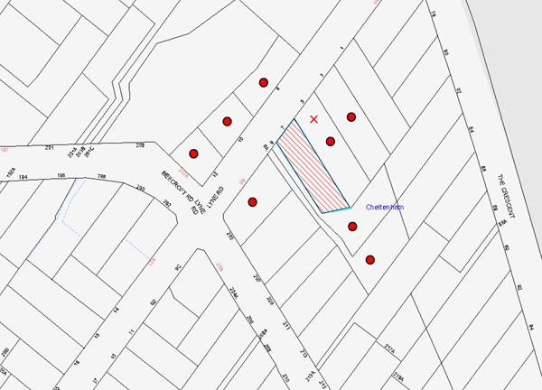
|
NOTIFICATION PLAN |
|||
|
• PROPERTIES NOTIFIED |
X SUBMISSIONS RECEIVED |
PROPERTY SUBJECT OF DEVELOPMENT |
|
One submission objected to the development, generally on the grounds that the development would result in:
· Unacceptable privacy and amenity impacts as a result of the windows of the new garage, kitchen and bedroom along the north-eastern, side elevation;
· Unacceptable overshadowing and lack of sunlight access to the property at No.5 Lyne Road, Cheltenham;
· Maintenance of trees, shrubs and landscaping along the north-eastern boundary during construction;
· The proposed stormwater ‘charged’ system is not in accordance with Council’s regulations;
· Requests Council monitor the removal of asbestos within the existing shed and an asbestos management plan be prepared.
The merits of the matters raised in community submissions have been addressed in the body of the report with the exception of the following:
· Concerns that the proposed plans did not show the side setbacks. This matter was resolved and the Site Plan was made available to the public during the notification period.
· Lack of information with respect to the position of the proposed new dwelling and secondary dwelling relative to the neighbouring property at No.5 Lyne Road. The matter was resolved with additional information being made publicly available on Council website during the notification period.
6. THE PUBLIC INTEREST
Section 79C(1)(e) of the Act requires Council to consider “the public interest”.
The public interest is an overarching requirement, which includes the consideration of the matters discussed in this report. Implicit to the public interest is the achievement of future built outcomes adequately responding to and respecting the future desired outcomes expressed in environmental planning instruments and development control plans.
The application is considered to have satisfactorily addressed Council’s and relevant agencies’ criteria and would provide a development outcome that, on balance, would result in a positive impact for the community. Accordingly, it is considered that the approval of the proposed development would be in the public interest.
CONCLUSION
The application proposed the demolition of a dwelling house, carport and detached shed and the construction of a new dwelling house and secondary dwelling at the rear.
The development meets the desired outcomes of Council’s planning controls and is satisfactory having regard to the matters for consideration under Section 79C of the Environmental Planning and Assessment Act 1979.
Council received one during the public notification period. The matters raised have been addressed in the body of the report and conditions are recommended to minimise disruption to residential amenity.
Having regard to the circumstances of the case, approval of the application is recommended.
Note: At the time of the completion of this planning report, no persons have made a Political Donations Disclosure Statement pursuant to Section 147 of the Environmental Planning and Assessment Act 1979 in respect of the subject planning application.
RESPONSIBLE OFFICER
The officer responsible for the preparation of this Report is the Manager – Development Assessments – Rodney Pickles, who can be contacted on 9847 6731.
|
Rod Pickles Manager - Development Assessment Planning Division |
James Farrington Group Manager Planning Division |
|
1.View |
Locality Map |
|
|
|
2.View |
Floor Plan |
|
|
|
3.View |
Elevation Plan |
|
|
|
4.View |
Site Analysis Plan |
|
|
|
5.View |
Site Sediment Control Plan |
|
|
|
6.View |
Survey Plan |
|
|
|
7.View |
Stormwater Plans |
|
|
|
8.View |
Landscape Plan |
|
|
|
9.View |
Tree Plan |
|
|
File Reference: DA/545/2016
Document Number: D06970133
SCHEDULE 1
GENERAL CONDITIONS
The conditions of consent within this notice of determination have been applied to ensure that the use of the land and/or building is carried out in such a manner that is consistent with the aims and objectives of the relevant legislation, planning instruments and Council policies affecting the land and does not disrupt the amenity of the neighbourhood or impact upon the environment.
Note: For the purpose of this consent, the term ‘applicant’ means any person who has the authority to act on or the benefit of the development consent.
Note: For the purpose of this consent, any reference to an Act, Regulation, Australian Standard or publication by a public authority shall be taken to mean the gazetted Act or Regulation, or adopted Australian Standard or publication as in force on the date that the application for a construction certificate is made.
1. Approved Plans and Supporting Documentation
The development must be carried out in accordance with the plans and documentation listed below and endorsed with Council’s stamp, except where amended by Council and/or other conditions of this consent:
|
Plan No. |
Plan Title |
Drawn by |
Dated |
|
Sheet 2 |
Site Analysis Plan |
Binet Homes |
March 2016 |
|
Sheet 3 |
Survey |
Binet Homes |
March 2016 |
|
Sheet 4 |
Site House Plan |
Binet Homes |
3 May 2016 |
|
Sheet 6 |
2nd Dwelling Plans & Elevations |
Binet Homes |
March 2016 |
|
Sheet 7 |
Site Management Plan |
Binet Homes |
March 2016 |
|
Sheet 8 |
Landscape Plan |
Binet Homes |
March 2016 |
|
Unknown |
Tree Site Plan |
As amended by Council |
6 June 2016 |
|
C2 |
Stormwater Management Plan, Issue B |
ACOR Consultants (CC) Pty Ltd |
18 July 2016 |
|
C3 |
Stormwater Management Details Sheet No.1, Issue B |
ACOR Consultants (CC) Pty Ltd |
18 July 2016 |
|
Document Title |
Prepared by |
Dated |
|
BASIX Certificate No.719451S |
Ramon Eguaras |
3 May 2016 |
|
Waste Management Plan |
Unknown |
24 April 2016 |
2. Amendment of Plans
a) To maintain the character of the Beecroft/Cheltenham Heritage Conservation Area, the following amendments are to be made on the approved plans prior to issue of a Construction Certificate:
i) Face brick of the dwelling should be red/brown colour similar to that of the existing dwelling and garage doors and driveway paving to be a dark recessive colour/material;
ii) A wheel strip is to be included in the driveway in accordance with Part 9.3.2 of the Hornsby Development Control Plan 2013.
iii) The proposed double width driveway and crossing is to be reduced in width, by tapering the driveway down to 3 metres at the front boundary, including the crossing width within the road reserve.
b) To maintain the privacy of the adjoining property at No. 5 Lyne Road Cheltenham, the following amendments are to be made on the approved plans:
i) Window W5 serving the kitchen shall be a top hinged, openable window with obscure glazing.
c) These amendments are to be shown on the plans submitted with the application for the Construction Certificate.
3. Appointment of a Project Arborist
a) A project Arborist (AQF Level 5) must be appointed to provide monitoring and certification throughout the development process.
b) Details of the appointed project Arborist must be submitted to the PCA and Council for registration with the approved construction certificate.
4. Removal of Trees
a) This development consent permits the removal of tree(s) numbered 3, 4, 6, and 7 as identified in the Site Tree Location Plan provided by Council’s Tree Management Team dated 10/6/16 Document Number – D06974340.
Note: The removal of any other trees from the site requires separate approval by Council in accordance with Part 1B.6 Tree and Vegetation Preservation of the Hornsby Development Control Plan, 2013 (HDCP).
5. Construction Certificate
a) A Construction Certificate is required to be approved by Council or a Private Certifying Authority prior to the commencement of any works under this consent.
b) The Construction Certificate plans must not be inconsistent with the Development Consent plans.
6. Section 94 Development Contributions
a) In accordance with Section 80A(1) of the Environmental Planning and Assessment Act, 1979 and the Hornsby Shire Council Section 94 Development Contributions Plan 2014-2024, the following monetary contributions must be paid to Council to cater for the increased demand for community infrastructure resulting from the development:
|
Description |
Contribution (4) |
|
Roads |
$1,029.70 |
|
Open Space and Recreation |
$6,806.40 |
|
Community Facilities |
$2,616.60 |
|
Plan Preparation and Administration |
$21.95 |
|
TOTAL |
$10,474.65 |
being for a secondary dwelling.
b) The value of this contribution is current as at 14 June 2016. If the contribution is not paid within the financial quarter that this condition was generated, the contribution payable will be adjusted in accordance with the provisions of the Hornsby Shire Council Section 94 Development Contributions Plan and the amount payable will be calculated at the time of payment in the following manner:
$CPY = $CDC x CPIPY
CPIDC
Where:
$CPY is the amount of the contribution at the date of Payment
$CDC is the amount of the contribution as set out in this Development Consent
CPIPY is the latest release of the Consumer Price Index (Sydney – All Groups) at the date of Payment as published by the ABS.
CPIDC is the Consumer Price Index (Sydney – All Groups) for the financial quarter at the date applicable in this Development Consent Condition.
c) The monetary contribution must be paid to Council:
i) prior to the issue of the Subdivision Certificate where the development is for subdivision; or
ii) prior to the issue of the first Construction Certificate where the development is for building work; or
iii) prior to issue of the Subdivision Certificate or first Construction Certificate, whichever occurs first, where the development involves both subdivision and building work; or
iv) prior to the works commencing where the development does not require a Construction Certificate or Subdivision Certificate.
Note: It is the professional responsibility of the Principal Certifying Authority to ensure that the monetary contributions have been paid to Council in accordance with the above timeframes.
Council’s Development Contributions Plan may be viewed at www.hornsby.nsw.gov.au or a copy may be inspected at Council’s Administration Centre during normal business hours.
REQUIREMENTS PRIOR TO THE ISSUE OF A CONSTRUCTION CERTIFICATE
7. Building Code of Australia
All approved building work must be carried out in accordance with the relevant requirements of the Building Code of Australia.
8. Contract of Insurance (Residential Building Work)
Where residential building work for which the Home Building Act 1989 requires there to be a contract of insurance in force in accordance with Part 6 of that Act, this contract of insurance must be in force before any building work authorised to be carried out by the consent commences.
9. Notification of Home Building Act 1989 Requirements
Residential building work within the meaning of the Home Building Act 1989 must not be carried out unless the principal certifying authority for the development to which the work relates (not being Council) has given Council written notice of the following information:
a) In the case of work for which a principal contractor is required to be appointed:
i) The name and licence number of the principal contractor; and
ii) The name of the insurer by which the work is insured under Part 6 of that Act.
b) In the case of work to be done by an owner-builder:
i) The name of the owner-builder; and
ii) If the owner-builder is required to hold an owner-builder’s permit under that Act, the number of the owner-builder’s permit.
Note: If arrangements for doing the residential building work are changed while the work is in progress so that the information notified becomes out of date, further work must not be carried out unless the principal certifying authority for the development to which the work relates (not being Council) has given Council written notification of the updated information.
10. Sydney Water – Approval
This application must be submitted to Sydney Water for approval to determine whether the development would affect any Sydney Water infrastructure, and whether further requirements are to be met.
Building plan approvals can be obtained online via Sydney Water Tap inTM through www.sydneywater.com.au under the Building and Development tab.
11. Stormwater Drainage – Dwellings
The stormwater drainage system for the development must be designed for an average recurrence interval (ARI) of 20 years and drained in accordance with the following requirements:
a) Connected directly to the kerb in Lyne Road generally in accordance with the plans prepared by ACOR Consulting Engineers Project No GO160284 dated 18 Jul 2016.
b) The Council nature strip and any associated improvements are to be restored to the satisfaction of Council Engineers.
c) To assist management of Sydney Water assets, the proposed on-site absorption system for the secondary dwelling shall be sited at least 1m away from the existing Board Sewer line.
12. Internal Driveway/Vehicular Areas
The driveway and parking areas on site must be designed, constructed and a Construction Certificate issued in accordance with Australian Standards 2890.1, 2890.2, 3727 and the following requirements:
a) Design levels at the front boundary shall be obtained from Council if a private accredited certifier is engaged to obtain a construction certificate for these works.
b) The driveway be a rigid pavement.
13. Vehicular Crossing
A separate application under the Local Government Act, 1993 and the Roads Act 1993 must be submitted to Council for the installation of a new vehicular crossing and the removal of the redundant crossing. The vehicular crossing must be constructed in accordance with Council’s Civil Works Design 2005 and the following requirements:
a) Design levels at the front boundary must be obtained from Council for the design on the internal driveway;
b) Any redundant crossings must be replaced with integral kerb and gutter; and
c) The footway area must be restored by turfing.
Note: An application for a vehicular crossing can only be made to one of Council’s Authorised Vehicular Crossing Contractors. You are advised to contact Council on 02 9847 6940 to obtain a list of contractors.
REQUIREMENTS PRIOR TO THE COMMENCEMENT OF ANY WORKS
14. Erection of Construction Sign
a) A sign must be erected in a prominent position on any site on which any approved work is being carried out:
i) Showing the name, address and telephone number of the principal certifying authority for the work;
ii) Showing the name of the principal contractor (if any) for any demolition or building work and a telephone number on which that person may be contacted outside working hours; and
iii) Stating that unauthorised entry to the work site is prohibited.
b) The sign is to be maintained while the approved work is being carried out and must be removed when the work has been completed.
15. Toilet Facilities
a) To provide a safe and hygienic workplace, toilet facilities must be available or be installed at the works site before works begin and must be maintained until the works are completed at a ratio of one toilet for every 20 persons employed at the site.
b) Each toilet must:
i) be a standard flushing toilet connected to a public sewer; or
ii) be a temporary chemical closet approved under the Local Government Act 1993; or
iii) have an on-site effluent disposal system approved under the Local Government Act 1993.
16. Installation of Tree Protection
a) Tree protection fencing must be erected around trees numbered 1, 2 and 5 in accordance with the Australian Standard ‘Protection of Trees on Development Sites (AS 4970-2009).
b) A certificate from the project Arborist must be submitted to the Principal Certifying Authority stating compliance with the relevant tree protection conditions of this consent.
17. Building Materials and Site Waste
The filling or stockpiling of building materials, the parking of vehicles or plant, the disposal of cement slurry, waste water or other contaminants must be located outside the tree protection zones as prescribed in the conditions of this consent or the prescriptive measures of Part 1B.6.1 Tree Preservation of the Hornsby Development Control Plan, 2013, of any tree to be retained.
18. Erosion and Sediment Control
To protect the water quality of the downstream environment, erosion and sediment control measures must be provided and maintained throughout the construction period in accordance with the manual ‘Soils and Construction 2004 (Bluebook)’, the approved plans, Council specifications and to the satisfaction of the principal certifying authority. The erosion and sediment control devices must remain in place until the site has been stabilised and revegetated.
Note: On the spot penalties may be issued for any non-compliance with this requirement without any further notification or warning.
REQUIREMENTS DURING DEMOLITION AND CONSTRUCTION
19. Works Within Tree Protection Zones
a) Excavation
Any necessary excavation must be undertaken by sensitive methods such as pneumatic or by hand as prescribe in AS 4970-2007 Sections 4.5.5.
b) Root Pruning
All Root pruning must be recorded and undertaken as specified in Australian Standard AS 4970-2009 Sections 3.3.4, 4.5.4 and 4.5.5. and under the supervision of the project Arborist.
c) Changing of Grade
Existing grade must be retained within the TPZ of trees being retained.
d) Installing Services
i) The installation of all services which enter or transects a designated TPZ must utilise sensitive methods of installation such as manually excavated trenches.
ii) The process must be monitored by the project Arborist to assess the likely impacts on retained trees.
iii) For manual excavation of trenches the project Arborist must advise on roots to be retained and must monitor the works. Manual excavation may include the use of pneumatic and hydraulic tools. Refer Clause 4.5.3.
20. Works Near Trees
a) The project Arborist must monitor and record any necessary remedial actions for maintaining tree health.
b) The project Arborist must submit to the principal certifying authority on a monthly a certificate that the works have been carried out in compliance with the approved plans and specifications for tree protection. Certification should include a statement of site attendance, the condition of the retained trees, details of any deviations from the approved tree protection measures and their impacts on trees. Copies of monitoring documentation may be required.
21. Construction Work Hours
All works on site, including demolition and earth works, must only occur between 7am and 5pm Monday to Saturday.
No work is to be undertaken on Sundays or public holidays.
22. Demolition
To protect the surrounding environment, all demolition work must be carried out in accordance with “Australian Standard 2601-2001 – The Demolition of Structures” and the following requirements:
a) Demolition material must be disposed of to an authorised recycling and/or waste disposal site and/or in accordance with an approved waste management plan;
b) Demolition works, where asbestos material is being removed, must be undertaken by a contractor that holds an appropriate licence issued by WorkCover NSW in accordance with Chapter 10 of the Occupational Health and Safety Regulation 2001 and Clause 29 of the Protection of the Environment Operations (Waste) Regulation 2005 ;and
c) On construction sites where any building contain asbestos material, a standard commercially manufactured sign containing the words ‘DANGER ASBESTOS REMOVAL IN PROGRESS’ and measuring not less than 400mm x 300mm must be displayed in a prominent position visible from the street.
23. Council Property
To ensure that the public reserve is kept in a clean, tidy and safe condition during construction works, no building materials, waste, machinery or related matter is to be stored on the road or footpath.
24. Disturbance of Existing Site
During construction works, the existing ground levels of open space areas and natural landscape features, (including natural rock-outcrops, vegetation, soil and watercourses) must not be altered unless otherwise nominated on the approved plans.
REQUIREMENTS PRIOR TO THE ISSUE OF AN OCCUPATION CERTIFICATE
Note: For the purpose of this consent, a reference to ‘occupation certificate’ shall not be taken to mean an ‘interim occupation certificate’ unless otherwise stated.
25. Fulfilment of BASIX Commitments
The applicant must demonstrate the fulfilment of BASIX commitments pertaining to the development.
26. Damage to Council Assets
To protect public property and infrastructure, any damage caused to Council’s assets as a result of the construction or demolition of the development must be rectified by the applicant in accordance with Council’s Civil Works Specifications. Rectification works must be undertaken prior to the issue of an Occupation Certificate, or sooner, as directed by Council.
27. Installation of Air Conditioner
a) To protect the amenity of adjacent properties, the condenser unit for the air conditioner must be sited a minimum of 3 metres from the property boundary of any adjoining residential premises.
b) Alternatively, a certificate must be submitted to the PCA by a suitably qualified person confirming that the unit has been tested for heating and cooling on the highest settings and that the noise levels generated do not exceed 5 dB(A) above background noise levels when tested at the property boundary between 8 pm and 10 pm.
28. Maintain Canopy Cover
a) Must be a minimum of four 4 trees planted in a suitable location on the subject site. Species selected must be from the Council’s Indigenous species listing located in the Hornsby Shire DCP Tree Preservation Measures 1B.6 Table 1B.6(b) such as Syncarpia glomulifera (Turpentine), Ceratopetalum gummiferum (N.S.W. Christmas Bush), Callistemon salignus (Willow Bottlebrush) or Tristaniopsis laurina (Water Gum).
b) Location and Size of Plantings
i) Replacement Trees for must be located in front or rear setbacks and setback 4 metres or greater from the foundation walls of the approved development.
ii) The pot size of the replacement tree(s) must be a minimum 25 litres and replacement tree(s) must be maintained until they reach the height of 3 metres.
iii) The replacement trees must reach a mature height greater than 6 metre.
iv) All tree stock must meet the specifications outlined in ‘Specifying Trees’ (Ross Clark, NATSPEC Books).
v) Planting methods must meet professional (best practice) industry standards
c) The suitably qualified person holding a Certificate III in Horticulture must submit to the principal certifying authority a statement confirming all landscaping requirements has been completed in accordance with approved landscape plans and conditions of consent.
29. Final Certification Arborist
a) The Project Supervisor must submit to the principal certifying authority all relevant certificates with the application for the occupation certificate stating compliance with all the conditions of this consent.
b) The Project Arborist must submit to the principal certifying authority a certificate that all the completed works have been carried out in compliance with the approved plans and specifications for tree protection. Certification must include a statement of overall site attendance, the condition of the retained trees, details of any deviations from the approved tree protection measures and their impacts on trees. Copies of monitoring documentation may be required.
30. Certification of Stormwater Drainage
Prior to the release of the Occupation Certificate an appropriately qualified Civil Engineer is to certify that the constructed stormwater drainage system including the proposed charged system to Lyne Road will function hydraulically in accordance with the approved drawings.
31. Damage to Council Assets
To protect public property and infrastructure, any damage caused to Council’s assets as a result of the construction or demolition of the development must be rectified by the applicant in accordance with Council’s Civil Works Specifications. Rectification works must be undertaken prior to the issue of an Occupation Certificate, or sooner, as directed by Council.
- END OF CONDITIONS -
ADVISORY NOTES
The following information is provided for your assistance to ensure compliance with the Environmental Planning and Assessment Act 1979, Environmental Planning and Assessment Regulation 2000, other relevant legislation and Council’s policies and specifications. This information does not form part of the conditions of development consent pursuant to Section 80A of the Act.
Environmental Planning and Assessment Act 1979 Requirements
The Environmental Planning and Assessment Act 1979 requires:
· The issue of a construction certificate prior to the commencement of any works. Enquiries can be made to Council’s Customer Services Branch on 9847 6760;
· a principal certifying authority to be nominated and Council notified of that appointment prior to the commencement of any works;
· Council to be given at least two days written notice prior to the commencement of any works;
· mandatory inspections of nominated stages of the construction inspected; and
· an occupation certificate to be issued before occupying any building or commencing the use of the land.
Long Service Levy
In accordance with Section 34 of the Building and Construction Industry Long Service Payments Act 1986, a ‘Long Service Levy’ must be paid to the Long Service Payments Corporation or Hornsby Council.
Note: The rate of the Long Service Levy is 0.35% of the total cost of the work.
Note: Hornsby Council requires the payment of the Long Service Levy prior to the issue of a construction certificate.
Tree and Vegetation Preservation
In accordance with Clause 5.9 of the Hornsby Local Environmental Plan 2013 a person must not ringbark, cut down, top, lop, remove, injure or wilfully destroy any tree or other vegetation protected under the Hornsby Development Control Plan 2013 without the authority conferred by a development consent or a permit granted by Council.
Notes: A tree is defined as a long lived, woody perennial plant with one or relatively few main stems with the potential to grow to a height greater than three metres (3M). (HDCP 1B.6.1.c).
Tree protection measures and distances are determined using the Australian Standard AS 4970:2009, “Protection of Trees on Development Sites”.
Fines may be imposed for non-compliance with both the Hornsby Local Environmental Plan 2013 and the Hornsby Development Control Plan 2013.
Dial Before You Dig
Prior to commencing any works, the applicant is encouraged to contact Dial Before You Dig on 1100 or www.dialbeforeyoudig.com.au for free information on potential underground pipes and cables within the vicinity of the development site.
Asbestos Warning
Should asbestos or asbestos products be encountered during demolition or construction works, you are advised to seek advice and information prior to disturbing this material. It is recommended that a contractor holding an asbestos-handling permit (issued by WorkCover NSW) be engaged to manage the proper handling of this material. Further information regarding the safe handling and removal of asbestos can be found at:
Alternatively, telephone the WorkCover Asbestos and Demolition Team on 8260 5885.
Group Manager’s Report No. PL61/16
Planning Division
Date of Meeting: 14/09/2016
13 DEVELOPMENT APPLICATION - SUBDIVISION OF FOUR ALLOTMENTS INTO FOUR LOTS - CALABASH POINT, BEROWRA CREEK
EXECUTIVE SUMMARY
|
DA No: |
DA/1009/2013 (Lodged on 24 September 2013) |
|
Description: |
Subdivision of four allotments into four lots and construction of two jetties and pontoons |
|
Property: |
Lot 1 DP 882783, Lot 2 DP 882783, Lot 78 DP 752048 and Lot 163 DP 1113746, Calabash Point, Berowra Creek |
|
Applicant: |
Mr Stephen Bruce Berry |
|
Owner: |
Mrs B S Neimanis and Mr J R Neimanis, Calabash Investments Pty Ltd, Mr J R Neimanis |
|
Estimated Value: |
$502,100 |
· The application was lodged prior to the commencement of the Hornsby Local Environmental Plan 2013 and is subject to the Hornsby Shire Local Environmental Plan 1994.
· The proposal does not comply with the minimum 40 hectare lot size development standard under Clause 14 of the Hornsby Local Environmental Plan 1994 for an allotment within the Environment Protection E (River Settlement) zone. The applicant has made a submission to vary the minimum lot size standard. The submission is considered well founded and is supported.
· 22 submissions have been received in respect of the application.
· It is recommended that the application be approved as a deferred commencement consent for the applicant to address management plans for bushfire protection and ecology and a Voluntary Planning Agreement to offset the loss of bushland.
|
THAT Council seek the concurrence of the Secretary of the Department of Planning and Environment pursuant to State Environmental Planning Policy No. 1 – Development Standards and approve Development Application No. DA/1009/2013 for subdivision of four allotments into four lots and construction of two jetties and pontoons at Lot 1 and Lot 2 DP 882783, Lot 78 DP 752048 and Lot 163 DP 1113745, Calabash Point, Berowra Creek as a deferred commencement pursuant to Section 80(3) of the Environmental Planning and Assessment Act 1979 subject to the conditions of consent detailed in Schedule 1 of Group Manager’s Report No. PL61/16. |
BACKGROUND
Council in 1984, approved Subdivision Application No. SA25/84 Stage 1 and Stage 2 for the subdivision of the current holdings including Lots 1, 2, 3, 4 and 5 DP 882783. The subdivision included easements for electricity and rights of carriageway off a road reservation of McCallums Road. At that time, the land was zoned Residential (a1) under the Hornsby Planning Scheme 1977.
A further Subdivision Application No. SA25/84 Stage 3 for subdivision for 16 lots in 1987 was not progressed due to a land claim under Native Title which was not disclaimed until 2003 by which time the land had been rezoned.
On 22 July 1994, the Hornsby Shire Local Environmental Plan 1994 was gazetted rezoning the residential zoned land Environmental Protection B (River Catchment).
On 7 February 2003, the Environmental Protection B (River Catchment) land was rezoned Environment Protection E (River Settlement) under Hornsby Shire Local Environment Plan 1994 (Amendment No. 64).
On 22 September 2003, Council approved DA/1111/2002 for upgrading of McCallums Road for use as a fire trail.
On 24 September 2013, the applicant submitted the subject DA/1009/2013 for subdivision of two lots (Lot 1 DP 882783 and Lot 2 DP 882783) into eight lots and construction of two jetties and pontoons, stairs and an inclinator. The proposed subdivision included six waterfront lots with areas ranging from 1,400m2 to 4,000m2, a larger 2.6 hectare lot with a building envelope for a dwelling and a residue lot of 8.787 hectares.
On 11 October 2013, Hornsby Local Environmental Plan 2013 came into force rezoning the Environment Protection E zoned land E4 Environmental Living and the waterway W1 Natural Waterway and E2 Environmental Conservation.
On 9 April 2014, at a meeting with Council officers, the applicant was advised the application for subdivision could not be supported following NSW Rural Fire Service advice of concerns regarding access for firefighting.
On 29 July 2014, following review of a draft amended subdivision proposal, the NSW Rural Fire Service requested the applicant address safe water access for firefighting vessels.
On 24 September 2014, the applicant amended the subject application for subdivision of four lots into four lots and construction of two jetties and pontoons. The amended application incorporates two existing additional lots on the site (Lot 78 DP 752048 and Lot 163 DP 1113746). The two additional lots are both zoned E3 Environmental Management and RE1 Public Recreation.
On 10 February 2015, the NSW Rural Fire Service requested additional information for an engineering solution to demonstrate the safety of water access for firefighting personnel along the channel to the proposed pontoons.
On 5 March 2015, the NSW Rural Fire Service requested further information regarding the accessibility of firefighting boats and vessels likely to be used by future residents to access the sites with due regard to the Mean Low Water Spring (MLWS) depths at the proposed pontoons and along the channel.
On 27 March 2015, following submission of additional information, Council requested the NSW Rural Fire Service to provide details of firefighting vessels at Berowra Waters.
On 24 June 2015, the NSW Rural Fire Service advised assessment of suitability of water access for firefighting and evacuation was based on a minimum depth of 700mm at Median Low Water Spring tide (MLWS).
On 17 July 2015, the NSW Rural Fire Service advised of its General Terms of Approval for a Bush Fire Safety Authority subject to recommended conditions. The approval however related to navigable access based on MLWS.
On 18 August 2015, Council requested review of the hydrographic survey in respect to requirements of the Australian Hydrographic Service.
On 25 August 2015, the applicant submitted a Voluntary Planning Agreement to offset the loss of native vegetation on the site required to provide an Asset Protection Zone for the proposed lots.
On 1 September 2015, the applicant submitted additional hydrographic information which established minimum navigable water depth is 600mm at Indian Spring Low Water (ISLW).
On 2 November 2015, Council requested additional information for plan elevations of proposed jetties and pontoons at ISLW.
On 5 November 2015, Council requested additional information for a Construction Environmental Management Plan and an Integrated Vegetation and Fire Management Plan.
On 5 November 2015, the applicant submitted elevation plans of the proposed jetties and pontoons at ISLW and requested deferred commencement consent conditions based on Council’s additional information request of 5 November 2015.
On 17 November 2015, Council referred additional information concerning navigable access at ISLW to NSW Rural Fire Service and requested clarification of the approval for a Bush Fire Safety Authority.
On 18 December 2015, the NSW Rural Fire Service requested Council undertake independent assessment of the navigability of the channel along Calabash Bay to the proposed lots at ISLW to validate suitability of water access for firefighting operations.
On 3 February 2016, the applicant agreed to fund the engagement of Council’s consultant for the independent assessment of water access at ISLW.
On 18 February 2016, Council engaged Manly Hydraulics Laboratory (MHL) to undertake an assessment of the navigable water access for the site.
On 10 May 2016, the MHL report ‘Calabash Bay Bushfire Fighting Vessel Access’ was referred to the NSW Rural Fire Service.
On 17 May 2016, the NSW Rural Fire Service requested additional information to demonstrate compliance with Planning for Bush Fire Protection 2006 performance criteria, having regard to MHL recommendation for deepening the channel for navigable access.
On 4 July 2016, Council referred the applicant’s ‘Plan of Management’ for bushfire protection to the NSW Rural Fire Service.
On 22 July 2016, the NSW Rural Fire Service revised its General Terms of Approval for a Bush Fire Safety Authority for the proposed subdivision.
SITE
The bushland site has an area of 43.38 hectares and comprises steep sandstone ridge formations on the western side of the Berowra Creek estuary.
The site has a northern foreshore frontage to Calabash Bay, is bounded to the west by Fosters Creek and to the east by the foreshore properties of Calabash Point, and the site of the Fretus Hotel ruins (heritage item). The southern boundary is undefined in the bushland which extends to the rural area along Bay Road. The boundary forms the suburban boundary line between the localities of Berowra Creek and Berrilee.
The site’s Calabash Bay foreshore adjoins two foreshore properties previously subdivided and developed for dwelling houses (lot 4 and lot 5 DP 882783) in an earlier subdivision involving the site. The two adjoining dwellings share an existing jetty and pontoon.
A fire trail through the site links the Fretus Hotel ruins with McCallums Road, Berrilee (off Bay Road) and generally follows a road reservation that extends from McCallums Road through to the central part of the site. In February 2014, the fire trail was upgraded by Ausgrid for vehicle access for power line maintenance.
An unformed right of carriageway, created on title in the earlier subdivision of the site, extends from the road reservation to the rear of the adjoining foreshore Lot 4 and Lot 5 DP 882783. A right of carriageway also extends from the road reservation to the Fretus Hotel ruins, generally in accordance with the path of the fire trail. The fire trail is an item of heritage significance.
The surrounding bushland and steep sandstone ridges extend to Marramarra National Park and the Muogamara Nature Reserve which are bisected by the Berowra Creek estuary.
The site supports a range of vegetation communities including ‘Rough-barked Apple - Forest Oak’ along the lower slopes and foreshore, and ‘Scribbly Gum – Bloodwood Ridgetop Woodland Heath’ on the ridges and slopes. Other vegetation types include ‘Banksia – Tea Tree – Casuarina Rock Platform Heath’, ‘Smooth-barked Apple – Grey Gum Slopes and Gully Forest’ and ‘Grey Myrtle Rainforest’ along creek lines.
A number of creeks flow into Calabash Bay including Fosters Creek, Banks Creek and Calabash Creek and form an extensive sand flat in Calabash Bay which is exposed at low tide. The Creeks are tidal in the vicinity of the site and lined with mangroves. A channel along the edge of the sandbank at the foreshore frontage of the site has a water depth up to 1.0m at low tide.
The site includes Aboriginal relics including a midden on the Calabash Bay foreshore of the site.
The site is adjacent to the river settlement of Calabash Point which is a water access only river settlement of approximately 60 waterfront dwellings.
The river settlement of Berowra Waters is approximately 1.6 km upstream from the site with berthing facilities and road connection to Berowra Heights shopping centre and to Berowra Railway Station located 5.3km south east of the site.
PROPOSAL
The proposal is for the subdivision of four existing lots into four lots having frontage to Calabash Bay and construction of two jetties with pontoons. The proposed subdivision would alter the boundaries and areas of the four existing lots to form three waterfront lots and a large residue lot with water frontage.
The proposed lots are as follows:
· Lot 1 has an area of 42.632 hectares and forms a residue lot. A dwelling house site is proposed at the waterfront. The topography of the lot area for the proposed indicative building envelope is very steep with an average gradient of 85%. The house site is bushland. The water depth of the channel at low tide is less than 0.7m. A shared jetty is proposed on Lot 2 for water access. The residue lot comprises the remainder of the bushland site with the topography less steep along the ridge. The residue lot includes the existing right of carriageway and road reservation off McCallums Road, Berrilee.
· Lot 2 has an area of 2,980m2 and a width of 35m. The bushland waterfront lot is generally uniform in shape. The rear of the lot adjoins an unformed right of carriageway. The lot has an average gradient of 85%. A jetty and pontoon are proposed with boardwalk across the frontage for shared jetty access for Lot 1. The water depth of the channel at low tide in the vicinity of the proposed pontoon is 0.75m – 0.97m. The foreshore includes an Aboriginal midden proposed to be retained.
· Lot 3 has an area of 2,320m2 and a width of 30m. The bushland waterfront lot is generally uniform in shape. The rear of the lot adjoins an unformed right of carriageway. The lot has an average gradient of 70%. Shared jetty and pontoon access is proposed with Lot 4. The water depth of the channel at low tide in the vicinity of the proposed pontoon is 0.73m – 1.36m. The foreshore includes an Aboriginal midden proposed to be retained.
· Lot 4 has an area of 2,180m2 and a width of 30m. The bushland waterfront lot is generally uniform in shape. The rear of the lot adjoins an unformed right of carriageway. The lot has an average gradient of 52%. Shared jetty and pontoon access is proposed with Lot 3. The eastern boundary of the lot adjoins an existing dwelling house (Lot 5 DP 882783).
The proposed lots are subject to a proposed Asset Protection Zone for bushfire protection. A right of way and easement for electricity benefiting Lot 1 is proposed across the rear of proposed Lots 2, 3 and 4 to the existing right of carriageway and electricity easement at the rear of the proposed lots.
The proposed lots are water access only lots via the two proposed jetties and pontoons. The existing berthing facilities and public car parking at Berowra Waters are relied on for vehicular/boat access for the proposed subdivision.
ASSESSMENT
The development application has been assessed having regard to ‘A Plan for Growing Sydney’, the ‘North Subregion (Draft) Subregional Strategy’ and the matters for consideration prescribed under Section 79C of the Environmental Planning and Assessment Act 1979 (the Act). The following issues have been identified for further consideration.
1. STRATEGIC CONTEXT
1.1 A Plan for Growing Sydney and (Draft) North Subregional Strategy
A Plan for Growing Sydney has been prepared by the NSW State Government to guide land use planning decisions for the next 20 years. The Plan sets a strategy for accommodating Sydney’s future population growth and identifies the need to deliver 689,000 new jobs and 664,000 new homes by 2031. The Plan identifies that the most suitable areas for new housing are in locations close to jobs, public transport, community facilities and services.
The NSW Government will use the subregional planning process to define objectives and set goals for job creation, housing supply and choice in each subregion. Hornsby Shire has been grouped with Hunters Hill, Ku-ring-gai, Lane Cove, Manly, Mosman, North Sydney, Pittwater, Ryde, Warringah and Willoughby to form the North Subregion. The Draft North Subregional Strategy will be reviewed and the Government will set housing targets and monitor supply to ensure planning controls are in place to stimulate housing development.
The proposed development would be consistent with ‘A Plan for Growing Sydney’ by providing allotments capable of supporting future dwelling houses.
2. STATUTORY CONTROLS
Section 79C(1)(a) requires Council to consider “any relevant environmental planning instruments, draft environmental planning instruments, development control plans, planning agreements and regulations”.
2.1 Hornsby Local Environmental Plan 2013
The proposed development has been assessed having regard to the provisions of the Hornsby Local Environmental Plan 2013 (HLEP).
The HLEP includes a savings provision under Clause 1.8A which is applicable to the application lodged prior to the commencement HLEP as follows:
1.8A Savings provision relating to development applications
If a development application has been made before the commencement of this Plan in relation to land to which this Plan applies and the application has not been finally determined before that commencement, the application must be determined as if this Plan had not commenced.
Accordingly the application is subject to the provisions of Hornsby Shire Local Environmental Plan 1994, the planning instrument applying to the site and in force prior to the commencement of HLEP.
2.2 Hornsby Shire Local Environmental Plan 1994
The proposed development has been assessed having regard to the provisions of the Hornsby Shire Local Environmental Plan 1994 (HSLEP) as follows.
2.2.1 Zoning Controls
The subject land is zoned part Environmental Protection A (Wetlands), part Environment Protection B (River Catchment), part Environment Protection E (River Settlements), part Open Space B (Public Recreation – District) and part Rural AR (Large Holdings – Rural Landscapes), under the Hornsby Local Environmental Plan 1994.
The objectives of the Environmental Protection A (Wetlands) Zone are:
(a) to protect the ecological value of wetland areas.
(b) to assist in the maintenance of acceptable water quality in the Hawkesbury River.
(c) to provide for development that is compatible with the ecology of wetland areas.
The objectives of the Environmental Protection B (River Catchment) Zone are:
(a) to protect the natural environment of sensitive areas within the catchment of the Hawkesbury River.
(b) to protect the valleys and escarpments within the catchment of the Hawkesbury River and accommodate land uses, including housing, that recognise environmental sensitivity of the area.
(c) to protect the scenic quality of visually prominent areas and water quality within the catchment of the Hawkesbury River.
The objectives of the Environmental Protection E (River Settlements) Zone are:
(a) to protect the natural environment of sensitive areas within the catchment of the Hawkesbury River.
(b) to accommodate low density housing that is consistent with the environmental sensitivity, infrastructure limitations and access limitations of the area.
(c) to protect the scenic quality and water quality of the area and promote development that is within the environmental capacity of the area.
The objectives of the Open Space B (Public Recreation – District) Zone are:
(a) to ensure there is provision of adequate open space to meet the needs of the regional community and to enhance the environmental quality of the Hornsby area.
(b) to encourage a diversity of recreational settings and facilities.
(c) to protect and preserve areas of urban bushland which are considered valuable in terms of their ecology.
The objectives of the Rural AR (Large Holdings – Rural Landscapes) Zone are:
(a) to restrain population growth and maintain the rural character of the area.
(b) to provide for a range of compatible land uses, including agriculture, which maintain the rural environment of the area.
(c) to ensure development is carried out in a manner that improves the environmental qualities, and is within the servicing capacity, of the area.
The proposed subdivision is permissible with development consent under Clause 14 of HSLEP in the above zones other than the Environmental Protection A (Wetlands) Zone which generally applies to the Calabash Bay area west of the proposed indicative building envelopes and foreshore structures, below the Mean High Water Mark, and is not directly impacted by the proposal. The proposed two jetties and pontoons are permissible with development consent pursuant to Clause 20 of HSLEP. The proposed jetties are located within the W1 Natural Waterways zone under Hornsby Local Environmental Plan 2013 and would be permissible with development consent.
The proposed subdivision would provide for the future use of land for dwelling houses within the Environmental Protection E (River Settlement) Zone, which is a permissible use of the land with development consent.
2.2.2 Services
Pursuant to Clause 10 of HSLEP Council must be satisfied that adequate water and sewerage services are available to the development.
The proposal is for potable rainwater tanks with a storage capacity of 22,000 litres for future dwellings on the proposed four lots. The proposed capacity is considered adequate for water supply in the subject location with an average annual rainfall of 1100mm per annum. An additional static supply is recommended by the NSW Rural Fire Service of 10,000 litres for lots 2 to 4 and 22,000 litres for lot 1, for firefighting purposes.
The application includes an ‘On-site Waste Water Management Report’ dated 7 September 2014 prepared by Nyranie Consulting. The recommendations of the report are acceptable to Council for the type of waste water treatment system to be used for future dwelling houses on the proposed lots and the extent of works necessary for on-site disposal of treated waste water; for accreditation of sewerage management facilities in accordance NSW Health accreditation guidelines.
2.2.3 Density
Clause 14 of HSLEP provides for a minimum lot size of 40 hectares for land within the Environmental Protection B (River Catchment) Zone and the Environmental Protection E (River Settlement) Zone.
The proposed subdivision of four lots into four lots would alter the boundaries of the existing lots which do not comply with the minimum 40 hectare lot size development standard as follows:
|
Existing Lots |
Proposed Lots |
|
Lot 1 DP 882783 – 2.0 hectares |
Lot 1 – 42.632 hectares |
|
Lot 2 DP 882783 – 10.64 hectares |
Lot 2 – 2,980m2 |
|
Lot 78 DP 752048 – 15.07 hectares |
Lot 3 – 2,320m2 |
|
Lot 163 DP 1113745 – 15.67 hectares |
Lot 4 – 2,180m2 |
The proposed subdivision is subject to an objection to the HSLEP minimum 40 hectare lot size development standard, pursuant to State Environmental Planning Policy No. 1 – Development Standards. Refer to discussion in Section 2.9.
2.2.4 Floor Space Ratio
Clause 15 of HSLEP provides for a maximum floor space ratio of 0.3:1 for building within the Environmental Protection E (River Settlement) Zone area of the site.
The maximum 0.3:1 floor space ratio would apply to any future dwelling houses on the proposed lots (if approved) under Clauses 4.4 and 4.5 of Hornsby Local Environmental Plan 2013 (HLEP).
The proposed lots are of sufficient size to accommodate a future dwelling house in accordance with the proposed indicative envelopes and comply with the maximum floor space ratio. Any future dwelling houses would be subject to the Hornsby Development Control Plan 2013 prescriptive measures for river settlement land.
2.2.5 Land Acquisition
Clause 17 of HSLEP provides for the acquisition of land for community purposes and applies to the Open Space B (Public Recreation – District) Zone area of the site, other than the Open Space B zoned area within the road reservation off McCallums Road. The proposed subdivision would not alter the status of the acquisition provisions applying to the land which remain current in accordance with the acquisition provisions under Clause 5.1 of Hornsby Local Environmental Plan 2013.
2.2.6 Heritage
Clause 18 of HSLEP sets out heritage conservation provisions within the Hornsby area. The site includes the ‘Fire Trail’ which is a heritage item of local significance under Schedule D of HSLEP. The ‘Fire Trail’ links McCallums Road, Berrilee with the ‘Fretus Hotel ruins’ which is a heritage item of local significance that adjoins the site. The access for the proposed subdivision is water access and would not involve the ‘Fire Trail’ or impact on the heritage significance of the item. The proposed indicative building envelopes are more than 150m west of the ‘Fretus Hotel ruins’ and would not be visible in relation to the item and would not impact on the significance of the ruins.
In respect to the Aboriginal relics on the site, the application includes an Aboriginal Archaeological Survey Report and Statement of Heritage Impact for non-Indigenous Heritage, in accordance with the requirements of Clause 18. The NSW Office of Environment and Heritage advised of its General Terms of Approval for the proposed development in respect to Aboriginal relics. Refer to discussion in Section 2.4.
2.2.7 Waterways
Clause 20 of HSLEP requires development consent for all development below mean high water mark.
NSW Fisheries raised no objection to the proposed jetties and pontoons in respect to impacts on the marine environment. Roads and Maritime Services raised no objection to the proposal in respect to navigation of local waterways.
The HSLEP Environmental Protection E (River Settlement) Zone includes the following objective:
To accommodate low density housing that is consistent with the environmental sensitivity, infrastructure limitations and access limitations of the area.
Water access to the proposed jetties and pontoons would be limited during low tide. The Hornsby Development Control Plan 2013 - Section 8.2.2 Water Recreation Structures, requires a minimum navigable water depth of 600mm at Indian Spring Low Water (ISLW). The applicant submitted a hydrographic survey of Calabash Bay prepared by Manly Hydraulics Laboratories which details a 10m-15m wide channel with a water depth of 300mm+ at ISLW for the proposed jetties and pontoons. This depth of water would preclude access at low tide other than for tinnie type vessels.
The proposed water access is essentially the same as for the existing adjoining shared jetty and pontoon for the two dwelling houses at Lot 4 and Lot 5 DP 882783.
To ensure minimal environmental impact to the tidal channel a covenant on title is recommended for the private operation of the jetties and pontoons to be limited to vessels with a draft of less than 300mm.
In summary, the submitted design and specifications of the proposed jetties and pontoons are appropriate for the location and properties to be serviced and acceptable subject to recommended conditions.
2.2.8 Acid Sulfate Soils
Clause 20A of HSLEP requires development consent for works as specified for the class of land shown on the Acid Sulphate Soils map. The subject site includes Class 5 land along the waterfront. For Class 5 land, Clause 20A requires consent for works which are likely to lower the water table.
The proposed development does not involve works likely to lower the water table.
2.3 Water Management Act 2000
The proposed development is ‘integrated development’ subject to approval of the NSW Office of Water for a ‘controlled activity’ permit under the Water Management Act 2000 for the foreshore works for the construction of two jetties and pontoons.
The NSW Office of Water granted General Terms of Approval for a ‘controlled activity’ permit, which form recommended conditions of development consent under Schedule 1 of this report.
2.4 National Parks and Wildlife Act 1974
The site includes Aboriginal relics and the proposed development includes works involving the construction of a boardwalk over an Aboriginal midden. The proposed development is ‘integrated development’ subject to approval of the Office of Environment and Heritage for an Aboriginal Heritage Impact Permit under Section 90 of the National Parks and Wildlife Act 1974.
The NSW Office of Environment and Heritage granted its General Terms of Approval in respect to Aboriginal Cultural Heritage subject to requirements for an Aboriginal Heritage Impact Permit to be obtained, for Aboriginal sites to be registered and for worker induction to protect Aboriginal sites during construction. The requirements are addressed by the recommended conditions of development consent under Schedule 1 of this report.
2.5 Fisheries Management Act 1994
The proposed jetties and pontoons are ‘integrated development’ subject to approval of NSW Fisheries under Part 7 and Part 7A of the Fisheries Management Act 1994 for activities that may impact on aquatic habitat.
NSW Fisheries advised the proposal would not impact on key fish habitat and granted its General Terms of Approval with no conditions.
2.6 Management of Waters and Waterside Lands Regulation - NSW
The application was referred to Roads and Maritime Services in regard to the above regulatory requirements regarding navigation safety.
Roads and Maritime Service advised there are no navigational concerns regarding the proposal in respect to local waterways.
2.7 Rural Fires Act 1997
The proposed subdivision within a bushfire prone area is ‘integrated development’ subject to approval of the NSW Rural Fire Service for the issue of a ‘Bushfire Safety Authority’ under Section 100B of the Rural Fires Act 1997.
Following detailed investigations concerning operational access to the site, the NSW Rural Fire Service made the following comments:
Reference is made to Council’s correspondence dated 17 November 2015 seeking clarification of the general terms of approval in the previous Bush Fire Safety Authority (BFSA) for the above application for integrated development in accordance with Section 91 of the Environmental Planning and Assessment Act 1979.
The New South Wales Rural Fire Service (NSW RFS) has reviewed the following documents:
· Calabash Bay Bushfire Fighting Vessel Access Report MHL2451 prepared by Manly Hydraulics Laboratory (MHL), dated May 2016.
· Addendum to MHL Report 2451, dated 27 May 2016.
· Plan of Management (PoM) prepared by Australian Bushfire Protection Planners Pty Limited, dated 29 June 2016.
The previous consent (RFS letter dated 17 July 2015) was issued based on the information provided by the applicant, on the navigability of Calabash Bay for NSW RFS bush firefighting vessels to access the proposed berthing facilities, with regard to Median Low Water Spring (MLWS) tide levels. These tide levels are no longer applicable. The Indian Spring Low Water (ISLW) tides are adopted instead as advised by the Hornsby Shire Council.
The access to the proposed lots along Calabash Bay for firefighting operations and evacuation could be restricted associated with ISLW tides in accordance with the independent assessment provided by MHL. The bush fire protection measures, supported by the PoM, proposed as part of the performance based solution by the bush fire consultant demonstrate compliance with the performance criteria of Section 4.1.3 of Planning for Bush Fire Protection 2006 with the exception of the provision of roads for operational access and evacuation.
The NSW RFS provides assistance for the protection of life, property and natural environment through fire suppression and prevention during bush fire emergencies for which officers of the rural fire brigades may enter any premises in accordance with Section 23 of the Rural Fires Act 1997 (RFA 1997). However, this provision is not to be relied upon as a contingency measure for the mitigation of bush fire risk to future development on the proposed lots, given the existing road access through the fire trail via the McCallums Road, Crown Road reserve and right of carriageway over Lot 2 in DP 882783 and Lot 78 in DP 752048 is not considered as part of the proposal and the water access can be restricted for firefighting and evacuation.
Whilst it is acknowledged that the conditions with regard to water and utilities, design and construction, evacuation and emergency planning, and landscaping are applicable at the construction phase of future dwellings, these are included at the subdivision stage as it is imperative that these recommendations be reflected in any future development on the proposed lots given the exceptional circumstances considered for the proposal.
The NSW RFS advises that this response replaces our previous general terms of approval dated 17 July 2015 and is to be deemed a bush fire safety authority subject to the recommended conditions.
The recommended conditions of the NSW Rural Fire Service applicable for the subdivision and future dwellings on the proposed lots are addressed in Schedule 1 of this report.
2.8 Section 5A Environmental Planning and Assessment Act, 1979 – Significant Effect on Threatened Species, Populations or Ecological Communities or their Habitats
The applicant submitted a flora and fauna assessment prepared by Ecotone Ecological Consultants dated 10 September 2013.
The site is floristically diverse with 157 flora species from 56 families identified within the site. The assessment did not record any threatened flora species but noted previous surveys recorded Tetratheca glandulosa which is listed as vulnerable. The species is unlikely to be impacted on by the proposal as the species was recorded on the upper ridge land areas of the site.
A total of 77 fauna species including 50 birds, 13 mammals, 11 reptiles and two amphibians were recorded. Two threatened species were recorded on the site including Red-crowned Toadlet and Glossy Black Cockatoo. The proposal is unlikely to have a significant impact upon the local population of these species as the proposed subdivision involving development of the foreshore area does not include Red-crowned Toadlet habitat and the extensive foraging habitat available for Glossy Black Cockatoo.
The two proposed jetties and pontoons would not impact on seagrass in Calabash Bay. A small mangrove tree would require removal which is acceptable for the proposal and would not diminish the mangrove tidal habitat.
The proposed subdivision would require vegetation reduction involving an area of approximately 1.02 hectares for bushfire protection of the indicative building envelopes. Due to the large areas of similar habitat on and surrounding the site, it is unlikely that the proposal will have a significant impact upon threatened species, populations and endangered ecological communities listed under the Threatened Species Conservation Act.
Refer also to discussion in Section 2.14.1.
2.9 State Environmental Planning Policy No. 1 – Development Standards (SEPP 1)
SEPP 1 provides flexibility in the application of development standards in circumstances where strict compliance with those standards would, in any particular case, be unreasonable or tend to hinder the attainment of the objectives under Section 5(a)(i) and (ii) of the Environmental Planning and Assessment Act, 1979 (EP&A Act) as follows:
5 Objects
The objects of this Act are:
(a) to encourage
(i) the proper management, development and conservation of natural and artificial resources, including agricultural land, natural areas, forests, minerals, water, cities, towns and villages for the purpose of promoting the social and economic welfare of the community and a better environment.
(ii) the promotion and co-ordination of the orderly and economic use and development of land.
The proposed subdivision involves adjustment of the boundaries of the four existing lots to create three waterfront lots and one large residual lot with water frontage.
Clause 14 of HSLEP provides for a minimum allotment size of 40 hectares for land within the Environmental Protection B (River Catchment) Zone and the Environmental Protection E (River Settlement) Zone.
The four existing lots are non-compliant with the minimum 40 hectare lot size. The existing and proposed lots are detailed as follows:
|
Existing Lots |
Proposed Lots |
|
Lot 1 DP 882783 – 2.0 hectares |
Lot 1 – 42.632 hectares |
|
Lot 2 DP 882783 – 10.64 hectares |
Lot 2 – 2,980m2 |
|
Lot 78 DP 752048 – 15.07 hectares |
Lot 3 – 2,320m2 |
|
Lot 163 DP 1113745 – 15.67 hectares |
Lot 4 – 2,180m2 |
The objective of the density development standard under Clause 14 of HSLEP is as follows:
To provide for the development of land at a density that is in accordance with the land’s environmental capacity and zone objectives.
The Land and Environment Court (LEC) has expressed the view that there are five different ways in which an objection may be well founded and that approval of the objection may be consistent with the aims of the Policy:
1. The objectives of the standard are achieved notwithstanding non-compliance with the standards;
2. The underlying objective or purpose of the standard is not relevant to the development and therefore compliance is unnecessary;
3. The underlying object of purpose would be defeated or thwarted if compliance was required and therefore compliance is unreasonable;
4. The development standard has been virtually abandoned or destroyed by the Council’s own actions in granting consents departing from the standard and hence compliance with the standard is unnecessary and unreasonable;
5. The zoning of the particular land is unreasonable or inappropriate so that a development standard appropriate for that zoning is also unreasonable and unnecessary as it applies to the land and compliance with the standard would be unreasonable or unnecessary. That is, the particular parcel of land should not have been included in the particular zone.
The applicant’s ground of objection is on the basis that compliance with the minimum 40 hectare lot size development standard would be unreasonable and unnecessary. The objection is summarised as follows:
a) The proposal is consistent with the objectives of the density development standard as the proposal does not create any new lots or dwelling entitlements. The proposed lots align with the scale and nature of existing waterfront lots which accommodate waterfront dwellings. The existing waterfront land is proven to be environmentally capable of accommodating dwelling house development. The proposal is consistent with the objectives of the Environmental Protection E (River Settlements) Zone with measures to protect the natural environment; compatibility with existing waterfront lots in accommodating a dwelling house with appropriate access and provision for utilities; and in maintaining the scenic quality of the waterway.
b) The proposal is a minor extension of the existing Calabash Point river settlement with the proposed dwelling entitlement for the larger residue lot 1 confined to the waterfront, preventing any residential development of the bushland ridge area. The proposal forms the limit of potential extension of the settlement.
c) The proposal would not create a precedent for development of similar river settlement land as the proposed realignment of lot boundaries cannot readily be applied to other waterfront land zoned Environment Protection E (River Settlement).
d) The proposal would maintain the pattern of waterfront settlement at Calabash Point.
e) The proposal would have limited environmental impacts in the context of the 43.38 hectare site. The proposed building sites step up the slope promoting design to minimise adverse visual, acoustic and solar access impacts.
f) The site is suitable for the proposed development in respect to water access, the provision of utility services, waste water treatment and bush fire protection.
The applicant submits that compliance with the density development standard would hinder the attainment of the objectives under Section 5(a) of the EP&A Act as the existing dwelling entitlement for which the land is zoned would never be realised.
Comment:
The minimum 40 hectare lot size development standard for the Environmental Protection E (River Settlement) Zone retains the established river settlements with no subdivision development opportunity. The river settlement at Calabash Point typically includes lots ranging from 725m2 to 1300m2 in area.
The objective of the density standard under Clause 14 of the HSLEP applies to all land use zones subject to a minimum lot size development standard. The objective however in respect to the Environmental Protection E (River Settlement) Zone is atypical as the objectives for this zone provide for low density housing development of the existing river settlement lots which are substantially less than 40 hectares in size.
The applicant’s submission concerning the 40 hectare minimum lot size development standard is considered well founded in respect to items 1 and 3 of the LEC principles and is supported with respect to the existing allotment dwelling entitlement which is maintained, the proposed consistency with the existing river settlement pattern, and the management of environmental constraints and access limitations as demonstrated by the existing river settlement.
The concurrence of the Department Planning and Environment is to be obtained for the variation of the lot size development standard involving environmental protection zoned land in accordance with the Department of Planning Circular PS 08-003.
2.10 State Environmental Planning Policy No. 19 – Bushland In Urban Areas
The site includes land zoned Open Space B (Public Recreation – District) and is subject to the provisions of State Environmental Planning Policy No. 19 – Bushland in Urban Areas which applies to the Hornsby Shire.
The proposed development would not require any work within the open space zoned land or result in any disturbance to the open space land in any future residential development of the proposed lots.
2.11 State Environmental Planning Policy No. 44 – Koala Habitat Protection
The Policy provides for the protection of koala habitat on sites greater than one hectare in size. The Policy includes steps to establish potential and core habitat and whether consent can be granted for development.
The submitted Flora and Fauna Assessment includes an assessment of potential koala habitat under the Policy criteria. The site represents potential koala habitat as defined in the Policy. However, no koalas or evidence of koalas were observed on the site. There is only one record of koala within 2 km of the site and 9 records within 5 km, the most recent from 1995. It is therefore unlikely the site represents core koala habitat. A koala management plan is not required for the site.
2.12 Sydney Regional Environmental Plan No. 20 – Hawkesbury – Nepean River
The site is located within the catchment of the Hawkesbury Nepean River. Part 2 of this Plan contains general planning considerations and strategies requiring Council to consider the impacts of development on environmentally sensitive areas, water quality, cultural heritage, flora and fauna and riverine scenic quality.
The requirements of the Policy are addressed by the proposal through appropriating siting of indicative building envelopes to maintain the pattern of river settlement in minimising impacts on scenic quality and flora and fauna, and the proposed raised boardwalk to protect Aboriginal heritage. Subject to the implementation of sediment and erosion control measures and waste water management to protect water quality, the proposal would comply with the requirements of the Policy.
2.13 Clause 74BA Environmental Planning and Assessment Act, 1979 - Purpose and Status of Development Control Plans
Clause 74BA of the Environmental Planning and Assessment Act, 1979 states that a DCP provision will have no effect if it prevents or unreasonably restricts development that is otherwise permitted and complies with the development standards in relevant Local Environmental Plans and State Environmental Planning Policies.
The principal purpose of a development control plan is to provide guidance on the aims of any environmental planning instrument that applies to the development; facilitate development that is permissible under any such instrument; and achieve the objectives of land zones. The provisions contained in a DCP are not statutory requirements and are for guidance purposes only. Consent authorities have flexibility to consider innovative solutions when assessing development proposals, to assist achieve good planning outcomes.
2.14 Hornsby Development Control Plan 2013
The proposed development has been assessed having regard to the relevant desired outcomes and prescriptive requirements within the Hornsby Development Control Plan 2013 (HDCP). The following discussion addresses the proposal’s compliance with the relevant prescriptive requirements of the Plan.
2.14.1 Vegetation Preservation
The site area proposed for future waterfront dwellings is identified as “Biodiversity” under the prescriptive measures of HDCP.
The indicative building sites for the proposed lots require an Asset Protection Zone (APZ) to be implemented for the proposed subdivision in accordance with the requirements of the NSW Rural Fire Service under Section 4.1.3 and Appendix 5 of Planning for Bush Fire Protection 2006. The APZ area includes ‘Rough-barked Apple - Forest Oak’ vegetation community. The Rural Fire Service APZ requirement is to provide for selective clearing of vegetation to create a buffer for bush fire protection of future dwellings with a Bush Fire Attack Level (BAL) of BAL29. In this regard, an Integrated Vegetation and Fire Management Plan is recommended to maintain biodiversity and provide a buffer for bush fire protection. A Construction Environment Management Plan is also recommended to address biodiversity protection measures for construction of the jetties, pontoons and boardwalk. A deferred consent commencement condition is recommended in this regard.
A condition is recommended for the APZ area to be subject to a ‘Restricted Development Area’ on title to ensure the vegetation community remains viable and is protected.
The applicant submitted a Voluntary Planning Agreement (VPA) to offset the nett loss of vegetation. The offset is for financial contribution to Council’s bushland regeneration sites along the Hawkesbury River (Bushland Restoration Offset Program – Create, Restore and Enhance) for Rough-barked Apple – Forrest Oak vegetation community. Refer to discussion is Section 2.15.
Subject to recommended conditions for the applicant to enter into a VPA with Council and conditions to maintain and protect biodiversity, the proposal is acceptable in respect to the HDCP requirements for vegetation preservation and biodiversity.
2.14.2 Stormwater Management
The proposal involves works along the waterfront and vegetation removal. Subject to the implementation of erosion and sediment control measures, the impacts of the proposal on the water quality of Calabash Bay would be minimised.
2.14.3 Earthworks and Slope
The site of the proposed lots for future dwelling houses is a very steep sandstone slope with an average fall of approximately 60% to 80%. The sandstone topography includes rock outcrops and benches. The lots have a width of 30m+. The topography is essentially the same as the existing river settlement lots at Calabash Point. The proposed lots would provide for future dwelling houses subject to geotechnical design to address the steeply sloping topography.
2.14.4 Waste Management
The proposal involves on-site waste water management for future dwelling houses. The applicant submitted a site capability assessment for disposal of effluent, prepared by Nyranie Consulting, dated 30 August 2013. The assessment included bore hole sampling and analysis across the proposed lots. The analysis identified sandy soil with a depth of 200mm to 400mm over sandstone.
The assessment determined the site of the proposed lots and future dwellings has limitations for on-site disposal of effluent. An advanced secondary treatment system for each dwelling would be necessary to achieve the required pathogen reduction for the application of treated waste water on-site. The on-site dispersal area would need to include design for runoff interception and diversion around the dispersal area. The dispersal area would involve trenches or retaining walls to provide soil depth of 1200mm minimum. The proposed lots are of sufficient size to accommodate the dispersal area required for the likely volume of waste water generated by future dwellings. The waste water treatment system design would be subject to further assessed for future dwellings.
A garbage waste collection service is not provided for the river settlement of Calabash Point. Future residents of the proposed lots would be required to transfer their household waste to the disposal facility at Berowra Waters.
The waste management requirements for the proposal would be addressed in development applications for future dwelling houses on the proposed lots.
2.14.5 Water Recreation Structures
The proposal includes the construction of two jetties and pontoons and a boardwalk for water access.
The first jetty is shared between proposed lot 3 and lot 4 and comprises a 2.5m x 1.5m jetty with 6m x 1.5m ramp and 12m x 2.5m pontoon. The jetty is over the common boundary and above the MHWM.
The second jetty is shared between proposed lot 1 and lot 2 and comprises a 3.0m x 1.5m jetty with 6m x 1.5m ramp and 12m x 2.5m pontoon. The jetty is at the eastern side of the frontage of lot 2 and above the MHWM. A right of pedestrian access and boardwalk is proposed for access for lot 1 over the frontage of lot 2.
The foreshore of proposed lot 2 and lot 3 includes the remains of an Aboriginal midden. The proposed board walk is to protect the midden in-situ. Refer to discussion in Section 2.4.
The proposed jetties and pontoons would not significantly impact on marine habitat. The pontoons would have a clearance of 300mm at Indian Spring Low Tide within a channel width of up to 10m. The navigable depth is satisfactory subject to recommended conditions for operation of the jetties and pontoons to be limited to vessels with a draft of less than 300mm. Refer to discussion in Section 2.2.7.
The proposed water recreation structures are satisfactory in respect to the HDCP prescriptive measures.
2.14.6 River Settlements
The sites for the indicative building envelopes on the proposed lots would provide for future dwelling houses with regard to the desired outcomes and prescriptive measures of the HDCP for river settlement land, in respect to dwelling design, setbacks and open space.
2.14.7 Aboriginal Heritage
The proposal is satisfactory in respect to the protection of Aboriginal sites and relics and would meet the prescriptive measures of HDCP subject to the recommended conditions for integrated development approval of the NSW Office of Environment and Heritage. Refer to discussion in Section 2.4.
2.15 Voluntary Planning Agreement
The proposal is subject to a Voluntary Planning Agreement (VPA) pursuant to Section 93F of the Environmental Planning and Assessment Act 1979. The VPA is to offset the loss of vegetation by a monetary contribution towards the Council managed bush regeneration sites along the Hawkesbury River (Bushland Restoration Offset Program – Create, Restore and Enhance).
The contribution is determined in accordance with Council’s Green Offsets Code (2013) for the identified vegetation category ‘Other Vegetation and Mapped Patches of Remnant Trees’ which has a multiplier of 2, and the calculated cost for the Bushland Restoration Offset Program which is set at $209,207 per hectare.
The area of vegetation that would be lost as a result of the proposed subdivision is 2400m2. The area comprises the four proposed house pads areas, boardwalk and waste water application areas. The APZ area is to be managed to maintain Rough-barked Apple – Forest Oak vegetation community and is excluded from the calculation which is as follows:
Vegetation Loss 0.24 ha x 2 x $209,207 = $100,419
The proposed VPA is acceptable is respect to the principles of the Green Offsets Code. A deferred commencement condition is recommended for the applicant to enter into a VPA to offset the loss of Rough-barked Apple – Forest Oak vegetation community.
2.16 Section 94 Contributions Plans
Hornsby Shire Council Section 94 Contributions Plan 2012-2021 does not apply to the proposed development as it would not result in any additional allotments.
3. ENVIRONMENTAL IMPACTS
Section 79C(1)(b) of the Act requires Council to consider “the likely impacts of that development, including environmental impacts on both the natural and built environments, and social and economic impacts in the locality”.
3.1 Natural Environment
3.1.1 Tree and Vegetation Preservation
The proposed development would result in the removal of existing trees and vegetation comprising Rough-barked Apple – Forest Oak vegetation community and involving a net loss of 0.24 hectares.
The vegetation community is not identified under the Threatened Species Conservation Act 1995 and the proposed removal of the vegetation would not significantly impact on any flora or fauna species or communities identified under the legislation.
The removal of the vegetation is subject to a VPA for offsetting the loss of the vegetation with the regeneration and enhancement of Council bush regeneration sites along the Hawkesbury River. The regeneration sites include Calabash Point, Cunio Point, Neverfail Bay, Fisherman’s Point, Cobah Point, The Woolwash, Collingridge Point, Bar Island, Milsons Passage and Dangar Island.
The proposed removal of the vegetation is acceptable subject to a condition that the applicant enter into a VPA to offset the loss.
A condition is recommended for the management of the APZ required for future dwellings on the site to maintain the Rough-barked Apple – Forest Oak vegetation community within the APZ area.
3.2 Built Environment
The proposal would provide for the extension of the river settlement of Calabash Point with the four proposed lots providing for future dwelling houses.
3.3 Social Impacts
The proposal would provide additional housing opportunities in the river settlement of Calabash Point.
3.4 Economic Impacts
The proposal would have a minor positive impact on the local economy in generating an increase in demand for local services.
4. SITE SUITABILITY
Section 79C(1)(c) of the Act requires Council to consider “the suitability of the site for the development”.
4.1 Topography
The foreshore site comprises a sandstone ridge and has very steep slopes. The site of the proposed lots for future dwelling houses could be developed subject to geotechnical design standards being met.
4.2 Bushfire
The site is subject to high bushfire risk. The bushfire risk can be managed for the proposal subject to recommended conditions of the NSW Rural Fire Service.
4.3 Vegetation
The bushland area of the site subject to the proposed development comprises Rough-barked Apple – Forest Oak vegetation community. The vegetation community is not an identified endangered ecological community.
The proposed removal of vegetation is acceptable subject to the loss being offset under Council’s Green Offset Code.
5. PUBLIC PARTICIPATION
Section 79C(1)(d) of the Act requires Council to consider “any submissions made in accordance with this Act”.
5.1 Community Consultation
The proposed development was placed on public exhibition and was notified to adjoining and nearby landowners between 10 October and 31 October 2013 in accordance with the Notification and Exhibition requirements of the HDCP. In response Council received 8 submissions. Amended plans were notified from 13 November to 27 November 2014. In response Council received 14 submissions including 3 from previous submitters. The map below illustrates the location of those nearby landowners who made a submission that are in close proximity to the development site.
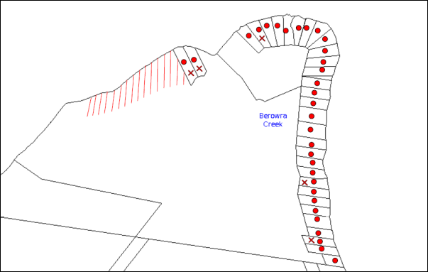
|
NOTIFICATION PLAN |
|
||
|
• PROPERTIES NOTIFIED
|
X SUBMISSIONS RECEIVED |
PROPERTY SUBJECT OF DEVELOPMENT |
|
|
17 SUBMISSIONS RECEIVED OUT OF MAP RANGE |
|||
22 submissions objected to the development. The matters raised by the objectors are discussed as follows:
5.1.1 Limited Access Low Tide
Access at low tide for emergency services including Rural Fire Service access was raised as a concern.
A water depth of 300mm ISLW would enable access to the proposed pontoons by small vessels in the event of a medical emergency.
The proposal is acceptable for NSW Rural Fire Service water access subject to additional requirements for bush fire protection.
5.1.2 River Settlements Strategy
Inconsistency with the strategy for no further subdivision involving river settlements was raised as a concern.
The strategy is incorporated in Council’s planning controls. The proposal is consistent with the strategy in not creating any additional lots.
5.1.3 Limited Resident Car Parking, Commuter Boat Moorings & Garbage Facilities
Additional demand on limited resident facilities on the eastern side of Berowra Waters was raised as a concern.
A range of alternative private and public facilities are available at Berowra Waters which would meet requirements of future residents, including the 78 berth West Marina and secure parking at the West Car Park off Bay Road.
5.1.4 Loss Recreational Access Calabash Bay
Obstruction of the tidal channel by the proposed pontoons for recreational access was raised as a concern.
The proposed pontoons would not obstruct the tidal channel for access by recreational craft. Refer MHL Drawing Figure 3.2.
5.1.5 Potential Dredging To Maintain Channel
The likelihood of dredging the tidal channel for boat access was raised as a concern.
The proposed water access is restricted at low tide to smaller vessels. To ensure operation of the proposed pontoons would not require deepening of the channel a condition is recommended for the operation to be limited to vessels with a draft of not more than 300mm.
5.1.6 Loss of Scenic Quality
The impact of the proposal on scenic quality was raised as a concern.
The proposed APZ and future dwellings would extend the river settlement of Calabash Point and change the scenic quality of Calabash Bay. The impact on scenic quality would be mitigated subject to appropriate design of future dwellings.
The loss of scenic quality resulting from the reduction in natural area is acceptable in respect to the existing dwelling entitlement being maintained, and would not warrant grounds of refusal of the application.
5.1.7 SEPP 1 Objection Not Well Founded
Whether the proposal is consistent with the objectives of the Environmental Protection E (River Settlement) Zone was raised as a concern.
The applicant’s submission concerning the minimum 40 hectare lot size required for the river settlement zone is considered well founded as discussed in Section 2.9 of this report.
5.1.8 Potential Further Subdivision McCallums Road
The likelihood of further subdivision with access off McCallums Road was raised as a concern.
The subject site would not provide for further subdivision under the current planning controls for a minimum lot size of 40 hectares.
5.1.9 Whether Amended Proposal Same Development
Whether the amended proposal is the same development as originally submitted was raised as a concern.
The original proposal was for subdivision of two lots (Lots 1 & 2 DP 882783) into eight lots. The proposal was amended to include Lot 78 DP 752048 and Lot 163 DP 1113746 and for subdivision of four lots into four lots and deletion of access stairs and inclinator.
The amended proposal addressed RFS bush firefighting concerns for development not to occur on the upper ridge area of the site and was accepted by Council in not creating any additional lots. The amended proposal involves the same waterfront area as originally proposed for subdivision.
The amended application was made in accordance with Clause 55 of the Environmental Planning and Assessment Regulation 2000.
5.1.10 Tidal Survey Inadequate
The accuracy of the hydrographic survey information submitted to Council was raised as a concern.
The application originally included hydrographic survey information based on Median Spring Low Tide data which was revised to Indian Spring Low Tide.
An independent hydrographic survey was provided by Manly Hydraulics Laboratory which determined the navigable access. Refer to discussion in Section 2.2.7.
5.1.11 Loss Existing Vegetation
The loss of vegetation was raised as a concern for biodiversity impact.
The loss of vegetation required for the proposed house sites and APZ is acceptable subject to replacement offset planting as proposed. Refer to discussion in Section 2.14.1.
5.1.12 Need For Restricted Development Area
Protection of the natural area between existing lots 3 and 4 was raised as a concern.
The natural area would be included in the proposed residual Lot 1 but would otherwise not be affected by the proposed subdivision.
5.1.13 Pathogen Runoff
The proposed on-site waste water treatment system and impact on the waterway was raised as a concern.
The application demonstrates on-site waste water management can be achieved for future dwelling houses on the proposed lots. Refer to discussion in Section 2.14.4.
5.1.14 Inconsistent SREP 20
Inconsistency with the SREP 20 requirement for locating structures in areas which are already cleared or disturbed instead of clearing or disturbing further land, was raised as a concern.
The proposed development of the undisturbed natural area is acceptable in respect to the existing dwelling entitlement being maintained and the undisturbed nature of the entire site, and would not warrant grounds for refusal of the application.
5.1.15 No Provision Transfer Dwelling Entitlement
The transfer of entitlement from the existing lots to the proposed lots was raised as a concern as requiring separate provision under HLEP.
The matter of dwelling entitlement relates to a dwelling house being permissible on an allotment within the Environment Protection E (River Settlement) Zone with development consent. As the proposed subdivision does not change the number of allotments the ‘dwelling entitlement’ remains the same, i.e. subject to development consent. A separate statutory provision is not required.
5.2 Public Agencies
The development application was referred to the following Agencies for comment:
5.2.1 Roads and Maritime Services
Roads and Maritime Service advised there are no navigational concerns regarding the proposal in respect to local waterways.
5.2.2 Rural Fire Service
The NSW Rural Fire Service granted its General Terms of Approval for the issue of a ‘Bushfire Safety Authority’ under Section 100B of the Rural Fires Act 1997 subject to recommended conditions under Schedule 1 of this report.
5.2.3 Office of Water
The NSW Office of Water granted its General Terms of Approval for a ‘controlled activity’ permit, which form recommended conditions of development consent under Schedule 1 of this report.
5.2.4 Office of Environment and Heritage
The NSW Office of Environment and Heritage granted their General Terms of Approval in respect to Aboriginal Cultural Heritage and an Aboriginal Heritage Impact Permit. The requirements form recommended conditions of development consent under Schedule 1 of this report.
5.2.5 NSW Fisheries
NSW Fisheries granted General its Terms of Approval unconditionally.
6. THE PUBLIC INTEREST
Section 79C(1)(e) of the Act requires Council to consider “the public interest”.
The public interest is an overarching requirement, which includes the consideration of the matters discussed in this report. Implicit to the public interest is the achievement of future built outcomes adequately responding to and respecting the future desired outcomes expressed in environmental planning instruments and development control plans.
The application is considered to have satisfactorily addressed Council’s and relevant agencies’ criteria and would provide a development outcome that, on balance, would result in a positive impact for the community. Accordingly, it is considered that the approval of the proposed development would be in the public interest.
CONCLUSION
The proposal is for the subdivision of four allotments into four and construction of two jetties and pontoons.
The development application was lodged prior to the commencement of Hornsby Local Environmental Plan 2013 and is subject to the provisions of Hornsby Shire Local Environmental Plan 1994.
The proposal does not comply with the minimum 40 hectare lot size area required for an allotment created in the subject Environmental Protection E (River Settlement) Zone. The applicant’s submission under State Environmental Planning Policy No. 1 – Development Standards in respect to the non-compliance is well founded. The proposed non-compliance would not create a precedent for similar subdivision and is acceptable in the circumstances.
The proposal is integrated development and General Terms of Approval have been obtained from the NSW Rural Fire Service, the Department of Primary Industries – Water, the NSW Office of Environment and Heritage and NSW Fisheries.
22 submissions were received in response to the proposal.
The proposal is recommended for deferred commencement approval.
RESPONSIBLE OFFICER
The officer responsible for the preparation of this Report is the Manager – Development Assessments – Rodney Pickles, who can be contacted on 9847 6731.
|
Rod Pickles Manager - Development Assessment Planning Division |
James Farrington Group Manager Planning Division |
|
1.View |
Locality Map |
|
|
|
2.View |
Existing Lot Layout |
|
|
|
3.View |
Subdivision Plan |
|
|
|
4.View |
House Pad Plan |
|
|
|
5.View |
Jetties, Ramps and Pontoons |
|
|
|
6.View |
Water Access Plan |
|
|
|
7.View |
Zoning Map |
|
|
|
8.View |
Aerial Photo |
|
|
File Reference: DA/1009/2013
Document Number: D06999326
SCHEDULE 1
GENERAL CONDITIONS
The conditions of consent within this notice of determination have been applied to ensure that the use of the land and/or building is carried out in such a manner that is consistent with the aims and objectives of the relevant legislation, planning instruments and council policies affecting the land and does not disrupt the amenity of the neighbourhood or impact upon the environment.
Note: For the purpose of this consent, the term ‘applicant’ means any person who has the authority to act on or the benefit of the development consent.
Note: For the purpose of this consent, any reference to an Act, Regulation, Australian Standard or publication by a public authority shall be taken to mean the gazetted Act or Regulation, or adopted Australian Standard or publication as in force on the date that the application for a construction certificate is made.
1. Deferred Commencement
Pursuant to Section 80(3) of the Environmental Planning and Assessment Act 1979, this consent does not operate until the following information is submitted to Council:
A. Construction Environment Management Plan
Due to the environmental sensitivities of Calabash Bay and the proposed development, a Construction Environment Management Plan is required to direct protective measures to be implemented during the jetty, pontoon and boardwalk construction, and the installation of other essential subdivision services (e.g. power, water, telecommunications etc.).
The site must be managed in accordance with the publication ‘Managing Urban Stormwater – Landcom (March 2004) and the Protection of the Environment Operations Act 1997 by way of implementing appropriate measures to prevent sediment run-off, excessive dust, noise or odour emanating from the site during the construction of the development.
The plan must be prepared by a suitably qualified and experienced person. The plan shall include the following:
A.1 Scaled survey plan of the site showing the development footprint in relation to remnant trees, waterways and other significant features including the midden as per the approved plans.
A.2 Location of protective fencing (1.8m high cyclone mesh) installed around bushland areas proposed for retention and to be clearly delineated from building works areas where deemed suitable.
A.3 Location of tree protection fences outside the tree protection zone of all trees approved for retention.
A.4 Location of temporary and permanent trenches required for installation of services
A.5 Location and specification of sediment and erosion control fencing to prevent degradation of the waterway.
A.6 Location of any soil, mulch, waste and building material stock piles.
A.7 Location of dedicated barge mooring areas.
A.8 Specifications of cut and fill.
A.9 Notation describing ‘that no mulch is to be applied within remnant bushland areas’
A.10 Phytophthora management protocols.
A.11 Appointment of a Project Arborist (minimum QF5 level) shall supervise the severance of any roots greater than 40mm and certify the installation of the tree protection fencing as well the condition of trees before, during and post development.
A.12 Appointment of a Project Ecologist (licensed by NSW OEH and possess Animal Ethics Authority) to be nominated to Council. Include notations on the plan describing that an ecologist shall be on site during tree clearing works to ensure fauna is relocated and only approved vegetation is removed. Prior to the approved removal of hollow bearing trees the applicant is to carry out the following actions to prevent harm to native wildlife:
i) Ensure the trees are removed in sections by a qualified Tree Surgeon just prior to dusk when roosting animals would be alert and likely to disperse ‘naturally’ from the site. Ensure that trees are knocked several times (with a hammer etc.) to alert any roosting animals of the possibility of danger. Ensure that all tree hollows are be examined prior to and immediately after their removal to ensure roosting animals are free from danger.
ii) WIRES (Wildlife Rescue) volunteers can be contacted on (02) 8977 3333 or Wildlife Services Sydney Metropolitan volunteers can be contacted on (02) 9413 4300. Information on animal nesting boxes can be gained from WIRES, Kalkari Information Centre in Ku-Ring-Gai Chase National Park, or Birds Australia web site – www.birdsaustralia.com.au
B. Integrated Vegetation and Fire Management Plan
An Integrated Vegetation and Fire Management Plan including the Asset Protection Zone shall be prepared for the proposed retained bushland on the site for the Asset Protection Zone for each of the proposed allotments and jetty / boardwalk structures. The plan is to be approved by Council’s Natural Resources Unit and shall be undertaken by a suitably qualified and experienced bushfire consultant/ecologist and shall include, but not be limited to the following:
B.1 Strategies to manage, maintain and conserve the bushland including:
i) On-going weed control and suppression using bush regeneration methods or other recommended control methods.
ii) Habitat protection for native fauna species. All hollow-bearing trees are to be identified by the ecologist and marked for retention.
iii) The restoration of all disturbed areas using bush regeneration techniques.
iv) Control of pest animal species and domestic pet control to maintain wildlife corridor
v) Recommendations from the Bushfire and Ecologist consultant report.
B.2 Strategies for management of the Asset Protection Zones in a manner that has the least impact on the natural environment and maintains indigenous vegetation for the benefit of the corridor function.
B.3 Hand Removal of Bushfire Fuel:
i) Any clearing for bushfire protection within the approved Asset Protection Zones shall be undertaken using manual methods including manual removal of dead timber, raking and removal of leaf litter (fine fuel), manual slashing of understorey vegetation such as a hand held brushcutter and other methods that ensure minimal environmental damage and erosion whilst maintaining the vegetation at a low fuel reduced state. Indigenous vegetation including trees and shrubs shall be retained in partially thinned scattered clumps to ensure the vegetation is non-continuous. Underscrubbing is to retain 15 centimetres of groundcover vegetation (including grass and herbaceous species) and all vegetation greater than three metres in height is to be otherwise retained. No removal of native vegetation shall occur within 10 metres of a natural watercourse. Clearing is not permitted in bushland outside the asset protection zone. No mulch or garden waste is to be deposited in bushland.
B.4 Revegetation works in disturbed and modified areas using a diversity of locally indigenous species. Include details of appropriate planting density, source of planting stock, species to be planted, site preparation works, mulching, watering of plants and maintenance of revegetation area.
B.5 Management of overhanging trees close to residential and open space areas. Identify areas proposed for other landscaping works.
B.6 Management and maintenance of approved stormwater/ wastewater irrigation areas.
B.7 Erosion, sediment and stormwater runoff controls including the management of impacts of run-off from all impervious surfaces including pavement areas.
B.8 Appropriate map of the site showing all areas to be managed under the Plan. The areas occurring outside of the APZ area shall be restricted from vegetation disturbance of any kind unless specified in this plan for weed removal. The map shall include the GPS locations of hollow-bearing trees to be retained where practical.
B.9 Schedule of works including timeframes and responsibilities for management actions.
B.10 Details of site monitoring including the submission of 6 monthly reports to Council’s Natural Resources Unit for the lifetime of the plan (5 years). This may include simple photographs from a consistent reference point in a letter format undertaken by the engaged bush regeneration contractor.
B.11 Details of qualifications and experience of personnel preparing the plan.
B.12 The lifetime of the Plan shall be for a minimum of 5 years from the issue of the Subdivision Certificate. The establishment of the APZ, and initial weed control works shall be implemented prior to issue of the Subdivision Certificate and subject to an inspection by Council’s Natural Resources Unit.
C. Voluntary Planning Agreement
Pursuant to Section 93F of the Environmental Planning and Assessment Act 1979, the applicant must prepare and enter into a Voluntary Planning Agreement (VPA) with Hornsby Shire Council for the offsetting of the loss of Rough-barked Apple – Forest Oak vegetation community under Council’s Green Offset Code (2013).
The terms of the VPA must include but not be limited to the following:
C.1 The Applicant agrees to pay Council a monetary contribution of $100,419 towards the replacement of 0.24 hectares of Rough-barked Apple – Forest Oak vegetation community lost from the site as result of the development.
C.2 Hornsby Shire Council agrees to provide Council managed bushland reserves in the locality on the Lower Hawkesbury Estuary to undertake the required offset actions including revegetation, restoration and enhancement works to offset the development impacts, under Council’s Bushland Restoration Offset Program – Create, Restore and Enhance.
C.3 In addition to the above, the applicant agrees to pay all costs (including Council’s costs) associated with the preparation, public notification, legal costs and administration costs of the VPA.
Such information must be submitted within 36 months of the date of this notice.
Upon Council’s written satisfaction of the above information, the following conditions of development consent apply:
2. Approved Plans and Supporting Documentation
The development must be carried out in accordance with the plans and documentation listed below and endorsed with Council’s stamp, except where amended by Council and/or other conditions of this consent:
|
Plan No. |
Plan Title |
Drawn by |
Dated |
|
253445 Revision J |
Calabash Point Plan of Proposed 4 Lot Realignment |
VEKTA |
11/08/20214 |
|
253445 Revision J |
Calabash Point 4 Lot Realignment Showing Contours (APZ) |
VEKTA |
11/08/2014 |
|
253445 Revision J |
Calabash Point 4 Lot Realignment (APZ) |
VEKTA |
11/08/2014 |
|
253445 Revision J |
Calabash Point 4 lot Realignment Showing Proposed House Pad |
VEKTA |
11/08/2014 |
|
5675 Issue E |
Details, Levels & Proposed Shared Jetties Ramps Pontoons & Stabilising Piles |
SDG |
07-05-2014 |
|
MHL Report 2451 Figure 3.2 |
Calabash Bay Navigation Channel and Location Proposed Berthing Facilities |
NSW Public Works – Manly Hydraulics Laboratory |
March 2016 |
|
Document Title |
Prepared by |
Dated |
|
Plan of Management |
Australian Bushfire Protection Planners Pty Ltd |
28.06.2016 |
|
Calabash Bay Bushfire Fighting Vessel Access |
NSW Public Works – Manly Hydraulics Laboratory |
May 2016 |
|
On-site Waste Water Management Report |
Nyranie Consulting |
7 Sept 2014 |
|
Aboriginal Archaeological Survey Report and Statement of Heritage Impacts for Non-Indigenous Heritage |
Artefact Heritage |
Sept 2013 |
|
Flora And Fauna Impact Assessment |
Ecotone Ecological Consultants |
10 Sept 2013 |
|
Aquatic Ecology Survey |
Marine Pollution Research |
6 May 2013 |
|
Bushfire Protection Assessment |
ABPP |
12.09.2014 |
3. Construction Certificate
a) A Construction Certificate is required to be approved by Council or a Private Certifying Authority prior to the commencement of any works under this consent.
b) A separate Construction Certificate must be obtained from Council for all works within the public road reserve under S138 of the Roads Act.
c) A separate Construction Certificate must be obtained from Council for all works within drainage easements vested in Council.
d) The Construction Certificate plans must not be inconsistent with the Development Consent plans.
REQUIREMENTS PRIOR TO THE ISSUE OF A CONSTRUCTION CERTIFICATE
4. Building Code of Australia
All approved building work must be carried out in accordance with the relevant requirements of the Building Code of Australia.
5. Controlled Activity Approval
A Construction Certificate will not be issued over any part of the site requiring a controlled activity approval until a copy of the approval of the Department of Primary Industries – Water has been provided to Council.
6. Aboriginal Heritage Impact Permit
A Construction Certificate will not be issued over any part of the site requiring an Aboriginal Heritage Impact Permit until a copy of the Permit obtained from the NSW Office of Environment and Heritage has been provided to Council.
REQUIREMENTS PRIOR TO THE COMMENCEMENT OF ANY WORKS
7. Erection of Construction Sign
a) A sign must be erected in a prominent position on any site on which any approved work is being carried out:
i) Showing the name, address and telephone number of the principal certifying authority for the work;
ii) Showing the name of the principal contractor (if any) for any demolition or building work and a telephone number on which that person may be contacted outside working hours; and
iii) Stating that unauthorised entry to the work site is prohibited.
b) The sign is to be maintained while the approved work is being carried out and must be removed when the work has been completed.
8. Toilet Facilities
a) To provide a safe and hygienic workplace, toilet facilities must be available or be installed at the works site before works begin and must be maintained until the works are completed at a ratio of one toilet for every 20 persons employed at the site.
b) Each toilet must:
i) be a standard flushing toilet connected to a public sewer; or
ii) be a temporary chemical closet approved under the Local Government Act 1993; or
iii) have an on-site effluent disposal system approved under the Local Government Act 1993.
9. Erosion and Sediment Control
To protect the water quality of the downstream environment, erosion and sediment control measures must be provided and maintained throughout the construction period in accordance with the manual ‘Soils and Construction 2004 (Bluebook)’, the approved plans, Council specifications and to the satisfaction of the principal certifying authority. The erosion and sediment control devices must remain in place until the site has been stabilised and revegetated.
Note: On the spot penalties may be issued for any non-compliance with this requirement without any further notification or warning.
REQUIREMENTS DURING CONSTRUCTION
10. Construction Work Hours
All works on site, including demolition and earth works, must only occur between 7am and 5pm Monday to Saturday.
No work is to be undertaken on Sundays or public holidays.
11. Environmental Management
The site must be managed in accordance with the Construction Environment Management Plan approved by Council under Condition No. 1 of this consent.
12. Acid Sulfate Soils
Should acid sulfate soils be encountered during construction works, Council is to be notified immediately. An Acid Sulfate Soil Management Plan, written in accordance with the NSW Acid Sulfate Soil Manual 1998, is to be submitted to Council for approval and implementation. Piers for jetty construction are to be pile driven in Class 1 Acid Sulfate Soil zones.
13. Landfill
Landfill must be constructed in accordance with Council’s ‘Construction Specification 2005’ and the following requirements:
a) All fill material imported to the site is to wholly consist of Virgin Excavated Natural Material (VENM) as defined in Schedule 1 of the Protection of the Environment Operations Act 1997 or a material approved under the Department of Environment and Climate Change’s general resource recovery exemption.
14. Excavated Material
All excavated material removed from the site must be classified in accordance with the Department of Environment, Climate Change and Water NSW Waste Classification Guidelines prior to disposal to an approved waste management facility and reported to the principal certifying authority.
15. Disturbance of Existing Site
During construction works, the existing ground levels of open space areas and natural landscape features, including natural rock-outcrops, vegetation, soil and watercourses must not be altered unless otherwise nominated on the approved plans.
16. Construction of Jetties and Pontoons
The jetties and pontoons must be constructed in accordance with the following requirements:
a) Stockpiling, cutting and sanding must be performed a minimum of 10 metres from the shoreline and screened by sediment fencing;
b) No alteration of the natural gradient or scouring of the shoreline is permitted;
c) Works performed above the waterway must include preventive controls measures, such as booms, silt curtains, dust bags, covers, aprons or barrier controls to ensure dust and particulate pollutants are captured and contained and to prevent the escape of turbid plumes into the aquatic environment.
d) The jetty is to have a minimum deck height of 0.75 metres above local mean high water level finished at even height.
e) Piles must be well spaced to allow full tidal flushing, wave current and must not alter flow patterns or impede fish passage.
f) No outlying wires or obstructions are permitted to project outside the extremities of the jetty and pontoon.
17. Waste Management
a) All work must be carried out in accordance with the approved waste management plan.
b) Stockpiling, cutting and sanding must be performed a minimum of 10 metres from the shoreline and screened by sediment fencing.
REQUIREMENTS PRIOR TO THE ISSUE OF AN OCCUPATION OR SUBDIVISION CERTIFICATE
Note: For the purpose of this consent, a reference to ‘occupation certificate’ shall not be taken to mean an ‘interim occupation certificate’ unless otherwise stated.
18. Restriction as to User – Protection of Land from Future Development
To inform current and future owners that the areas of native vegetation and habitat on the site comprising the Asset Protection Zone of each lot (based upon BAL 29 for each indicative building envelope) is to be protected from future development, a Restriction as to User must be created under Section 88B of the Conveyancing Act, 1919 identifying the area of the site shown on the approved plans is restricted from development activities that would adversely affect the bushland.
Note: The wording of the Restriction as to User must be to Council’s satisfaction and Council must be nominated as the authority to release, vary or modify the Restriction.
19. Positive Covenant – Asset Protection Zones
A positive covenant must be created under s88E of the Conveyancing Act, 1919 and registered, requiring the Asset Protection Zones on the allotments approved under this consent to be managed in accordance with the Integrated Vegetation and Fire Management Plan approved by Council under Condition No. 1.
Note: The restriction must nominate Council as the authority to release, vary or modify the restriction.
20. Positive Covenant – Water Access
A positive covenant must be created under s88E of the Conveyancing Act, 1919 and registered on each of the allotments, requiring private vessels operating from the pontoons and tidal channel to have a draft not exceeding 300mm.
Note: The restriction must nominate Council as the authority to release, vary or modify the restriction.
21. Positive Covenant – Water Supply and Utilities
A positive covenant must be created under s88E of the Conveyancing Act, 1919 and registered on each of the allotments, requiring the provision of water supply and utilities for a future dwelling in accordance with the requirements of the NSW Rural Fire Service under Condition No. 27 and Condition No. 28 of this development consent.
Note: The restriction must nominate Council as the authority to release, vary or modify the restriction.
OPERATIONAL CONDITIONS
22. Bushfire Protection Zones
The required bushfire protection zone(s) must be maintained in perpetuity in accordance with the Integrated Vegetation and Fire Management Plan approved under Condition No. 1.
GENERAL TERMS OF APPROVAL – NSW RURAL FIRE SERVICE
The following conditions of consent are General Terms of Approval from the nominated State Agency pursuant to Section 91A of the Environmental Planning and Assessment Act 1979 and must be complied with to the satisfaction of that Agency.
23. Asset Protection Zones
The intent of measures is to provide sufficient space and maintain reduced fuel loads so as to ensure radiant heat levels of buildings are below critical limits and to prevent direct flame contact with a building. To achieve this, the following conditions shall apply:
23.1 Asset Protection Zones (APZs) shall be provided as recommended in the Bushfire Protection Assessment prepared by Australian Bushfire Protection Planners Pty Limited referenced B121884-3 dated 16 September 2014 and indicated on the drawing titled Section 8 – Plan of Development Site showing extent of Asset Protection Zones to the future dwellings erected on proposed Lots 1-4 in the report.
23.2 In accordance with section 88B of the Conveyancing Act 1919, a restriction to the land use must be placed on the proposed Lots 1-4 requiring the provision of the recommended APZs which must be maintained as outlined within section 4.1.3 and Appendix 5 of Planning for Bush Fire Protection 2006 and the NSW RFS’s document Standards for asset protection zones.
23.3 The restriction must require certification of the APZs for compliance with section 4.1.3 and Appendix 5 of Planning for Bush Fire Protection 2006 and the NSW RFS’s document Standards for asset protection zones each year by a suitably qualified bush fire consultant. The certificate must be submitted to Hornsby Shire Council no later than the 1st of October, after the annual inspection undertaken prior to the end of August of each year.
24. Water Access
The intent of measures is to provide safe operational access to structures and water supply for emergency services, while residents are seeking to evacuate from an area. To achieve this, the following conditions shall apply:
24.1 The proposed on-shore boardwalks to provide access to the proposed pontoons must be constructed of non-combustible materials.
25. Water and Utilities
The intent of measures is to provide adequate services of water for the protection of buildings during and after the passage of a bush fire, and to locate gas and electricity so as not to contribute to the risk of fire to a building. To achieve this, the following conditions shall apply:
25.1 A Static Water Supply (SWS) of 10,000 litres must be provided to service each of the future dwellings on proposed Lots 2 – 4 and 22,000 litres to service the future dwelling on proposed Lot 1.
25.2 Above ground tanks must be manufactured of concrete or metal and raised tanks must have their stands protected. All associated fittings to the tank must be non-combustible.
25.3 SWS tanks must be located within the inner protection area (IPA) of the future dwellings.
25.4 SWS tanks must be equipped with a minimum 5hp or 3kW petrol or diesel powered auxiliary pump housed in a non-combustible enclosure.
25.5 A 19mm (internal diameter) fire hose capable of reaching all parts of the future dwelling must be connected to the pump.
25.6 SWS tanks must be provided with 65 millimetre (mm) metal Storz outlet with a gate or ball valve, Stortz coupling and blanking cap. A 25mm branch must be extended off the 65mm outlet to connect the pump.
25.7 A separate water supply, with control valves, must be installed to feed the proposed roof sprinkler system. There must be unrestricted access to the control valves for operation during emergency.
25.8 A SWS marker must be obtained and positioned for ease of identification by brigade personnel and other users of the SWS. In this regard:
a) Markers must be fixed in a suitable location near the water body so as to be highly visible; and
b) Markers should be positioned adjacent to the most appropriate access to the SWS.
25.9 A permanent, suitably powered diesel pump must be installed to supply sea water from the western pontoon to a fire hydrant supply to each future dwelling. The spacing, sizing and pressures of fire hydrant supply for each dwelling must comply with AS 2419.1-2005. The pump must be housed in a non-combustible enclosure with the supply line installed under the deck of the pontoon. The supply line to the hydrants must be metal except where buried or covered by the pontoon structure.
25.10 A 25mm connection must be provided from the pump to the reticulated hydrant supply from the pontoons.
25.11 The aerial electricity supply to the future dwellings shall be installed in ‘bundled cable’.
25.12 Reticulated or bottled gas must be installed and maintained in accordance with Australian Standard AS/NZS 1596:2002: The storage and handling of LP gas and the requirements of relevant authorities. All fixed gas cylinders must be kept clear of all flammable materials to a distance of 10 metres and be shielded on the hazard side of the installation. Gas cylinders kept close to the building must have release valves directed away from the building and be located at least 2 metres away from any combustible material. Connections to and from gas cylinders must be metal.
25.13 All above ground water and gas service pipes external to the building shall be metal, including and up to any taps.
25.14 Inspection and maintenance of the fire fighting equipment for water supply including pumps must be undertaken three times a year, in April, August and December with the servicing and operation checked and certified by a suitably qualified bush fire consultant. The fire fighting equipment providing sea water from the proposed pontoons to hydrants must be flushed with non-salty water as part of the maintenance regime. The certificates must be submitted to Hornsby Shire Council each year.
25.15 A weatherproof operational chart shall be displayed in the vicinity of the proposed pontoons providing guidance on the use of fire fighting equipment.
26. Design and Construction
The intent of the measures is to reduce the risk of ignition of a building from a bush fire while the fire front passes. To achieve this, the following conditions shall apply:
26.1 The future dwellings erected on proposed Lots 1-4 shall comply with section 3 and section 7 (BAL 29) Australian Standard AS 3959-2009 Construction of buildings in bush fire-prone areas and section A3.7 of Addendum Appendix 3 of Planning for Bush Fire Protection 2006.
27. Evacuation and Emergency Planning
The intent of the measures is to provide suitable emergency and evacuation (and relocation) arrangements for occupants of special fire protection purpose developments. To achieve this, the following conditions shall apply:
27.1 Prior to the issue of a Subdivision Certificate, a Fuel Management Plan must be submitted to Hornsby Shire Council addressing the protocols for the maintenance of the APZs and the remnant vegetation within proposed Lot 1.
27.2 Prior to the issue of a Subdivision Certificate, a Bushfire Management Plan and fire emergency procedure must be submitted to Hornsby Shire Council.
28. Landscaping
Landscaping to the site is to comply with the principles in Appendix 5 of Planning for Bush Fire Protection 2006. In this regard the following landscaping principles shall be incorporated into the development:
a) Suitable impervious areas such as courtyards, paths and driveways shall be provided immediately surrounding the building;
b) Grassed areas/mowed lawns/ or ground cover plantings shall be provided in close proximity to the building;
c) Planting in the immediate vicinity of the building which may over time and if not properly maintained come in contact with the building shall be restricted; Maximum tree cover shall be less than 15%, and maximum shrub cover shall be less than 20%;
d) Planting shall not provide a continuous canopy to the building. Trees or shrubs shall be isolated or located in small clusters;
e) Consideration shall be given to estimated size of the plant at maturity when selecting landscape species;
f) Species with rough fibrous bark, or which retain/shed bark in long strips or retain dead material in their canopies shall be avoided;
g) Smooth bark species of trees which generally do not carry a fire up the bark into the crown shall be used;
h) Planting of deciduous species that may increase fuel at surface/ ground level (leaf litter) shall be avoided;
i) Climbing species to walls and pergolas shall be avoided;
j) Combustible materials such as woodchips/mulch, flammable fuel stores shall be located away from the building;
k) Combustible structures such as garden sheds, pergolas and timber garden furniture shall be located away from the building; and
l) Low flammability vegetation species shall be used.
GENERAL TERMS OF APPROVAL – DEPARTMENT OF PRIMARY INDUSTRIES – OFFICE OF WATER (REF. NO. 10 ERM2013/0827)
The following conditions of consent are General Terms of Approval from the nominated State Agency pursuant to Section 91A of the Environmental Planning and Assessment Act 1979 and must be complied with to the satisfaction of that Agency.
29. Plans, Standards and Guidelines
a) These General Terms of Approval (GTA) only apply to the controlled activities described in the plans and associated documentation relating to DA2013/1009 and provided by Council:
i) Site plan, map and/or surveys
Any amendments or modifications to the proposed controlled activities may render these GTA invalid. If the proposed controlled activities are amended or modified the NSW Office of Water must be notified to determine if any variations to these GTA will be required.
b) Prior to the commencement of any controlled activity (works) on waterfront land, the consent holder must obtain a Controlled Activity Approval (CAA) under the Water Management Act from the NSW Office of Water. Waterfront land for the purposes of this DA is land and material in or within 40 metres of the top of the bank or shore of the river identified.
c) The consent holder must prepare or commission the preparation of:
i) Vegetation Management Plan
ii) Erosion and Sediment Control Plan
iii) Soil and Water Management Plan
d) The consent holder must:
i) Carry out any controlled activity in accordance with approved plans and
ii) Construct and/or implement any controlled activity by or under the direct supervision of a suitably qualified professional and
iii) When required, provide a certificate of completion to the NSW Office of Water.
e) The consent holder must reinstate waterfront land affected by the carrying out of any controlled activity in accordance with a plan or design approved by the NSW Office of Water.
f) The consent holder must use a suitably qualified person to monitor the progress, completion, performance of works, rehabilitation and maintenance and report to the NSW Office of Water as required.
g) The consent holder must design and construct all ramps, stairs access ways, cycle paths, pedestrian paths or other non-vehicular form of access way so that they do not result in erosion, obstruction of flow, destabilisation, or damage to the bed or banks of the river or waterfront land, other than in accordance with a plan approved by the NSW Office of Water.
h) The consent holder must not locate ramps, stairs, access ways, cycle paths, pedestrian paths or any other non-vehicular form of access way in a riparian corridor other than in accordance with a plan approved by the NSW Office of Water.
i) The consent holder must ensure that no materials or cleared vegetation that may,
i) Obstruct flow,
ii) Wash into the water body, or
iii) Cause damage to the river banks;
are left on waterfront land other than in accordance with a plan approved by the NSW Office of Water.
j) The consent holder must stabilise drain discharge points to prevent erosion in accordance with a plan approved by the NSW Office of Water.
k) The consent holder must establish all erosion and sediment control works and water diversion structures in accordance with a plan approved by the NSW Office of Water. These works and structures must be inspected and maintained throughout the working period and must not be removed until the site has been fully stabilised.
l) The consent holder must ensure that no excavation is undertaken on waterfront land other than in accordance with a plan approved by the NSW Office of Water.
GENERAL TERMS OF APPROVAL – NSW OFFICE OF ENVIRONMENT & HERITAGE
The following conditions of consent are General Terms of Approval from the nominated State Agency pursuant to Section 91A of the Environmental Planning and Assessment Act 1979 and must be complied with to the satisfaction of that Agency.
30. Aboriginal Cultural Heritage
a) The two Aboriginal archaeological sites identified as Calabash Bay 1 and Calabash Bay 2 in the Aboriginal Archaeological Survey Report and Statement of Heritage Impacts for non-Indigenous Heritage prepared by Artefact Heritage dated September 2013 must be registered on the Aboriginal Heritage Information Management System (AHIMS) database in accordance with Section 89A of the National Parks and Wildlife Act 1974.
b) An Aboriginal Heritage Impact Permit (AHIP) must be obtained from the Office of Environment and Heritage under Section 90 of the National Parks and Wildlife Act 1974 for the proposal in respect to the Aboriginal archaeological site identified as Calabash Bay 2, prior to the issue of a Construction Certificate.
c) A site induction is to inform construction personnel of the location of the Aboriginal sites. The site Calabash Bay 1 must not be used during construction and is to be delineated to prevent access.
- END OF CONDITIONS -
ADVISORY NOTES
The following information is provided for your assistance to ensure compliance with the Environmental Planning and Assessment Act 1979, Environmental Planning and Assessment Regulation 2000, other relevant legislation and Council’s policies and specifications. This information does not form part of the conditions of development consent pursuant to Section 80a of the Act.
Environmental Planning and Assessment Act 1979 Requirements
The Environmental Planning and Assessment Act 1979 requires:
· The issue of a construction certificate prior to the commencement of any works. Enquiries can be made to Council’s Customer Services Branch on 9847 6760.
· A principal certifying authority to be nominated and Council notified of that appointment prior to the commencement of any works.
· Council to be given at least two days written notice prior to the commencement of any works.
· Mandatory inspections of nominated stages of the construction inspected.
· An occupation certificate to be issued before occupying any building or commencing the use of the land.
Long Service Levy
In accordance with Section 34 of the Building and Construction Industry Long Service Payments Act 1986, a ‘Long Service Levy’ must be paid to the Long Service Payments Corporation or Hornsby Council.
Note: The rate of the Long Service Levy is 0.35% of the total cost of the work.
Note: Hornsby Council requires the payment of the Long Service Levy prior to the issue of a construction certificate.
Tree and Vegetation Preservation
In accordance with Clause 5.9 of the Hornsby Local Environmental Plan 2013 a person must not ringbark, cut down, top, lop, remove, injure or wilfully destroy any tree or other vegetation protected under the Hornsby Development Control Plan 2013 without the authority conferred by a development consent or a permit granted by Council.
Notes: A tree is defined as a long lived, woody perennial plant with one or relatively few main stems with the potential to grow to a height greater than three metres (3M). (HDCP 1B.6.1.c).
Tree protection measures and distances are determined using the Australian Standard AS 4970:2009, “Protection of Trees on Development Sites”.
Fines may be imposed for non-compliance with both the Hornsby Local Environmental Plan 2013 and the Hornsby Development Control Plan 2013.
Subdivision Certificate Requirements
A subdivision certificate application is required to be lodged with Council containing the following information:
· A surveyor’s certificate certifying that all structures within the subject land comply with the development consent in regard to the setbacks from the new boundaries.
· A surveyor’s certificate certifying that all services, drainage lines or access are located wholly within the property boundaries. Where services encroach over the new boundaries, easements are to be created.
· Certification that the requirements of relevant utility authorities have been met.
· A surveyor’s certificate certifying finished ground levels are in accordance with the approved plans.
Note: Council will not issue a subdivision certificate until all conditions of the development consent have been completed.
Fees and Charges – Subdivision
All fees payable to Council as part of any construction, compliance or subdivision certificate or inspection associated with the development (including the registration of privately issued certificates) are required to be paid in full prior to the issue of the subdivision certificate. Any additional Council inspections beyond the scope of any compliance certificate required to verify compliance with the terms of this consent will be charged at the individual inspection rate nominated in Council's Fees and Charges Schedule.
Group Manager's Report No. PL64/16
Planning Division
Date of Meeting: 14/09/2016
14 REPORTING VARIATIONS TO DEVELOPMENT STANDARDS
EXECUTIVE SUMMARY
· In accordance with Department of Planning and Environment’s Planning Circular PS 08‑14, Council is required to report variations to development standards for development applications approved under delegated authority, which relied upon State Environmental Planning Policy No. 1 – Development Standards (SEPP 1) or Clause 4.6 of the Hornsby Local Environmental Plan - 2013 (HLEP).
· Council’s consideration of this report ensures Council’s obligation to monitor variations to development standards is complied with.
|
THAT the contents of Group Manager’s Report No. PL64/16 be received and noted. |
PURPOSE
The purpose of this report is to advise Council of determined development applications under delegated authority involving a SEPP 1 or Clause 4.6 variation to a development standard for the period 1 April 2016 to 30 June 2016.
DISCUSSION
Department of Planning and Environment’s Circular B1, issued in March 1989, requested that councils monitor the use of the Secretary’s assumed concurrence under SEPP 1 on a quarterly basis. This reporting requirement remains effective.
Monitoring of variations to development standards is important to provide the Department and councils with an overview of the manner in which established development standards are being varied and whether the assumed concurrence is being used as intended. This enables Council and the Department to determine whether development standards are appropriate, or whether changes are required.
The Department issued Circular PS 08–014 on 14 November 2008. The purpose of the Circular was to remind councils of their responsibilities to monitor the use of the Secretary’s assumed concurrence under SEPP 1. Councils were reminded of the need to keep accurate records of the use of SEPP 1 and to report on a quarterly basis.
The Circular also provides that councils are required to adopt the following four measures:
1. Establish a register of development applications determined with variations in standards under SEPP 1.
2. Require all development applications where there has been a variation greater than 10% in standards under SEPP 1 to be determined by full council (rather than General Manager or nominated staff member).
3. Provide a report to Council on the development applications determined where there had been a variation in standards under SEPP 1.
4. Make the register of development applications determined with variations in standards under SEPP 1 available to the public on the council’s website.
In accordance with Point 3 of Department Circular, attached is a list of development applications determined between1 April 2016 to 30 June 2016.
A copy of the attachment to this report is also reproduced on Council’s website.
BUDGET
There are no budget implications.
POLICY
This report addresses Council’s reporting obligations for development applications determined where there has been a variation in standards under SEPP 1. Under the HLEP 2013, the application of the provisions of SEPP 1 has been replaced by Clause 4.6 (exceptions to development standards). The Department of Planning and Environment has advised that the current reporting practice for variation to development standards continues to apply for applications involving a submission pursuant to Clause 4.6 of the HLEP 2013.
CONCLUSION
Council is required to monitor the manner in which development standards are being varied. This assists in determining whether changes are required to relevant standards. This report provides advice to Council on standards varied under delegated authority which relied upon SEPP 1 or Clause 4.6 of the HLEP during the reporting period from1 April 2016 to 30 June 2016.
RESPONSIBLE OFFICER
The officer responsible for the preparation of this report is the Group Manager Planning Division – James Farrington, who can be contacted on 9847 6750.
|
James Farrington Group Manager Planning Division |
|
|
1.View |
SEPP 1 Returns Quarter - 1 April 2016 to 30 June 2016 |
|
|
File Reference: F2004/07599
Document Number: D07012479
Mayor's Note No. MN9/16
Date of Meeting: 14/09/2016
15 MAYOR'S NOTES FROM 1 TO 31 AUGUST 2016
Note: These are the functions that the Mayor, or his representative, has attended in addition to the normal Council Meetings, Workshops, Mayoral Interviews and other Council Committee Meetings.
Friday 5 August 2016 – The Mayor attended the Annual Knit In supporting Wrap with Love at Hornsby Library.
Tuesday 9 August 2016 – On behalf of the Mayor, Councillor Browne attended the Hornsby Ku-ring-gai PCYC Annual General Meeting at Waitara.
Wednesday 10 August 2016 – The Mayor attended the 6th Annual Apprenticeship and Traineeship Expo for Young People at Hornsby War Memorial Hall.
Tuesday 16 August 2016 – The Mayor hosted three Citizenship Ceremonies in the Council Chambers.
Friday 19 August 2016 – The Mayor attended the Hornsby RSL Sub-Branch “Artex Vietnam” Cocktail Party in conjunction with the 50th Anniversary of the Battle of Long Tan, at Hornsby War Memorial Hall.
Saturday 20 August 2016 – On behalf of the Mayor, Deputy Mayor Councillor Hutchence judged the NorthConnex Colouring Competition at the Spring Fair at Thornleigh West Public School.
Saturday 20 August 2016 – The Mayor presented Gala Day winners with trophies at the Northern Suburbs Football Association Junior Gala Day at Montview Oval, Hornsby Heights.
Sunday 21 August 2016 – The Mayor officiated at the start of the Variety “Berowra to Bowen Bash” at Berowra Oval.
Sunday 21 August 2016 – The Mayor attended the Berowra RSL Sub-Branch Annual Service to Commemorate Victory in the Pacific and Vietnam Veterans Day at Berowra Heights.
Friday 26 August 2016 – On behalf of the Mayor, Deputy Mayor Councillor Hutchence attended Loreto Normanhurst’s Year 12 Visual Arts Exhibition at the School.
Friday 26 August 2016 – The Mayor hosted Hornsby/Ku-ring-gai Rural Fire District’s Volunteer Thank You Dinner at Hornsby RSL Club.
Monday 29 August 2016 – On behalf of the Mayor, Councillor Gallagher attended the Welcome Luncheon for Creative Arts and Band Scholarships for 2017 at Asquith Boys High School.
Monday 29 August 2016 – On behalf of the Mayor, Deputy Mayor Councillor Hutchence presented trophies at the Northern Suburbs District Women’s Bowling Association Annual Hornsby Shire Trophy Competition at North Epping.
File Reference: F2004/07053
Document Number: D07041494