
Hornsby Shire Council Table of Contents
Page 1
AGENDA AND SUMMARY OF RECOMMENDATIONS
Rescission Motions
Mayoral Minutes
ITEMS PASSED BY EXCEPTION / CALL FOR SPEAKERS ON AGENDA ITEMS
GENERAL BUSINESS
Office of the General Manager
Item 1 GM4/16 Code Of Conduct Complaints - Annual Report................................................. 1
Corporate Support Division
Item 2 CS48/16 Outstanding Council Resolutions - Period Until 31 August 2016....................... 5
Item 3 CS49/16 Investments and Borrowings for 2016/17 - Results for Period Ending 31 October 2016 8
Environment and Human Services Division
Item 4 EH11/16 Proposal to Enter into Biobanking Agreements at Waitara Creek Bushland, Galston Park Bushland and Arcadia Park Bushland......................................................................... 11
Item 5 EH13/16 Proposed New Leases - Council's Pre-School and Kindergarten Portfolio....... 15
Planning Division
Item 6 PL70/16 Development Application - Addition of Two Silos to an Existing Concrete Batching Plant - 23 Sefton Road, Thornleigh....................................................................................... 21
Item 7 PL73/16 Development Application - Dwelling House - 8A Kirkham Street Beecroft ....... 38
Item 8 PL75/16 Development Application - Residential Flat Building Comprising 36 Units - Nos 3, 5 and 5A Citrus Avenue, Hornsby............................................................................................. 63
Item 9 PL76/16 Development Application - Industrial Building Comprising 17 Units, Signage, Strata Subdivision and First Use - 4 Gundah Road, Mount Kuring-gai ................................. 107
Item 10 PL81/16 Development Application - Emergency Services Facility - Berowra Park (R33756), 14X Berowra Waters Road, Berowra................................................................................ 144
Item 11 PL77/16 Further Report - Development Application - Subdivision Of Four Allotments Into Four Lots - Water Recreation Structure - Calabash Point, Berowra Creek...................................... 155
Item 12 PL80/16 Former Plan for the Extension of Arianna Avenue, Normanhurst.................... 199
Item 13 PL83/16 Draft Medium Density Housing Code.......................................................... 204
Infrastructure and Recreation Division
Item 14 IR31/16 Inclusive Playgrounds.................................................................................. 215
PUBLIC FORUM – NON AGENDA ITEMS
Questions of Which Notice Has Been Given
Mayor's Notes
Item 15 MN12/16 Mayor's Notes from 1 to 30 November 2016............................................... 220
Notices of Motion
Item 16 NOM8/16 Peats Ferry Road – Intersection with Dural Street - No Right Turn Restriction and Other Matters................................................................................................................... 222
SUPPLEMENTARY AGENDA
MATTERS OF URGENCY
QUESTIONS WITHOUT NOTICE
Hornsby Shire Council Agenda and Summary of Recommendations
Page 1
AGENDA AND SUMMARY OF RECOMMENDATIONS
PRESENT
NATIONAL ANTHEM
OPENING PRAYER/S
Father Robert Brog, from Our Lady of the Rosary Cathedral, Waitara will open the meeting in prayer.
Acknowledgement of RELIGIOUS DIVERSITY
Statement by the Chairperson:
"We recognise our Shire's rich cultural and religious diversity and we acknowledge and pay respect to the beliefs of all members of our community, regardless of creed or faith."
ABORIGINAL RECOGNITION
Statement by the Chairperson:
"We acknowledge we are on the traditional lands of the Darug and Guringai Peoples. We pay our respects to elders past and present."
AUDIO RECORDING OF COUNCIL MEETING
Statement by the Chairperson:
"I advise all present that tonight's meeting is being audio recorded for the purposes of providing a record of public comment at the meeting, supporting the democratic process, broadening knowledge and participation in community affairs, and demonstrating Council’s commitment to openness and accountability. The recordings of the non-confidential parts of the meeting will be made available on Council’s website once the Minutes have been finalised. All speakers are requested to ensure their comments are relevant to the issue at hand and to refrain from making personal comments or criticisms. No other persons are permitted to record the Meeting, unless specifically authorised by Council to do so."
APOLOGIES / LEAVE OF ABSENCE
political donations disclosure
Statement by the Chairperson:
“In accordance with Section 147 of the Environmental Planning and Assessment Act 1979, any person or organisation who has made a relevant planning application or a submission in respect of a relevant planning application which is on tonight’s agenda, and who has made a reportable political donation or gift to a Councillor or employee of the Council, must make a Political Donations Disclosure Statement.
If a Councillor or employee has received a reportable political donation or gift from a person or organisation who has made a relevant planning application or a submission in respect of a relevant planning application which is on tonight’s agenda, they must declare a non-pecuniary conflict of interests to the meeting, disclose the nature of the interest and manage the conflict of interests in accordance with Council’s Code of Conduct.”
declarations of interest
Clause 52 of Council’s Code of Meeting Practice (Section 451 of the Local Government Act, 1993) requires that a councillor or a member of a Council committee who has a pecuniary interest in a matter which is before the Council or committee and who is present at a meeting of the Council or committee at which the matter is being considered must disclose the nature of the interest to the meeting as soon as practicable. The disclosure is also to be submitted in writing (on the form titled “Declaration of Interest”).
The Councillor or member of a Council committee must not be present at, or in sight of, the meeting of the Council or committee:
(a) at any time during which the matter is being considered or discussed by the Council or committee.
(b) at any time during which the Council or committee is voting on any question in relation to the matter.
Clause 51A of Council’s Code of Meeting Practice provides that a Councillor, Council officer, or a member of a Council committee who has a non pecuniary interest in any matter with which the Council is concerned and who is present at a meeting of the Council or committee at which the matter is being considered must disclose the nature of the interest to the meeting as soon as practicable. The disclosure is also to be submitted in writing (on the form titled “Declaration of Interest”).
If the non-pecuniary interest is significant, the Councillor must:
a) remove the source of conflict, by relinquishing or divesting the interest that creates the conflict, or reallocating the conflicting duties to another Council official.
OR
b) have no involvement in the matter by absenting themself from and not taking part in any debate or voting on the issue as if the provisions of Section 451(2) of the Act apply.
If the non-pecuniary interest is less than significant, the Councillor must provide an explanation of why they consider that the interest does not require further action in the circumstances.
confirmation of minutes
THAT the Minutes of the General Meeting held on 9 November, 2016 be confirmed; a copy having been distributed to all Councillors.
Petitions
presentations
Rescission Motions
Mayoral Minutes
ITEMS PASSED BY EXCEPTION / CALL FOR SPEAKERS ON AGENDA ITEMS
Note:
Persons wishing to address Council on matters which are on the Agenda are permitted to speak, prior to the item being discussed, and their names will be recorded in the Minutes in respect of that particular item.
Persons wishing to address Council on non agenda matters, are permitted to speak after all items on the agenda in respect of which there is a speaker from the public have been finalised by Council. Their names will be recorded in the Minutes under the heading "Public Forum for Non Agenda Items".
GENERAL BUSINESS
· Items for which there is a Public Forum Speaker
· Public Forum for non agenda items
· Balance of General Business items
Office of the General Manager
Page Number 1
Item 1 GM4/16 Code Of Conduct Complaints - Annual Report
RECOMMENDATION
THAT the contents of General Manager’s Report No. GM4/16 be received and noted.
Corporate Support Division
Page Number 5
Item 2 CS48/16 Outstanding Council Resolutions - Period Until 31 August 2016
RECOMMENDATION
THAT the contents of Deputy General Manager’s Report No. CS48/16 be received and noted.
Page Number 8
Item 3 CS49/16 Investments and Borrowings for 2016/17 - Results for Period Ending 31 October 2016
RECOMMENDATION
THAT the contents of Deputy General Manager’s Report No. CS49/16 be received and noted.
Environment and Human Services Division
Page Number 11
Item 4 EH11/16 Proposal to Enter into Biobanking Agreements at Waitara Creek Bushland, Galston Park Bushland and Arcadia Park Bushland
RECOMMENDATION
THAT:
1. Council submit proposed Biobanking agreements to the Office of Environment and Heritage for land known as Waitara Creek Bushland, Galston Park Bushland and Arcadia Park Bushland as outlined in Attachments 1, 2 and 3 to Group Manager’s Report No. EH11/16.
2. The General Manager be authorised to enter into negotiations with Lend Lease Bouygues Joint Venture/NorthConnex, The NSW Department of Education and other interested parties to finalise the transfer and retirement of Biobanking credits generated for Waitara Creek Bushland, Galston Park Bushland and Arcadia Park Bushland.
3. The General Manager be authorised to execute any documents in relation to Biobanking agreements for Waitara Creek Bushland, Galston Park Bushland and Arcadia Park Bushland as deemed appropriate by Council’s legal advisors.
Page Number 15
Item 5 EH13/16 Proposed New Leases - Council's Pre-School and Kindergarten Portfolio
RECOMMENDATION
THAT:
1. In respect of KU Berowra, KU Galston, KU Grevillia, Jack and Jill Kindergarten, Larool Preschool and North Epping Kindergarten, Council delegate authority to the Acting General Manager to undertake further detailed negotiations and execute appropriate lease documents and any other related documents deemed appropriate by Council’s legal advisors for leases of a maximum term of 10 years (including any option periods), generally in accordance with the Heads of Agreement included in Confidential Attachment 2 to Group Manager’s Report No. EH13/16.
2. In respect of Norwood Community Preschool and Cherrybrook Community Kindergarten, Council delegate authority to the Acting General Manager to undertake further detailed negotiations and execute appropriate lease documents and any other related documents deemed appropriate by Council’s legal advisors for leases of a maximum term of 10 years (including any option periods) generally reflective of the market valuations received and agreements reached with the other kindergartens.
3. Council seek consent from the Minister for Crown Lands to those leases on Crown Land at Asquith and Hornsby Heights.
Planning Division
Page Number 21
Item 6 PL70/16 Development Application - Addition of Two Silos to an Existing Concrete Batching Plant - 23 Sefton Road, Thornleigh
RECOMMENDATION
THAT Council assume the concurrence of the Secretary of the Department of Planning and Environment pursuant to Clause 4.6 of the Hornsby Local Environmental Plan 2013 and approve Development Application No. DA/938/2016 for the addition of two silos to an existing concrete batching plant at Lot 1 DP 590251, No. 23 Sefton Road, Thornleigh, subject to the conditions of consent detailed in Schedule 1 of Group Manager’s Report No. PL70/16.
Page Number 38
Item 7 PL73/16 Development Application - Dwelling House - 8A Kirkham Street Beecroft
RECOMMENDATION
THAT Development Application No. DA/802/2016 for construction of a dwelling house at Lot 9 DP1089650, No. 8A Kirkham Street, Beecroft be approved subject to the conditions of consent detailed in Schedule 1 of Group Manager’s Report No. PL73/16.
Page Number 63
Item 8 PL75/16 Development Application - Residential Flat Building Comprising 36 Units - Nos 3, 5 and 5A Citrus Avenue, Hornsby
RECOMMENDATION
THAT Development Application No. DA/725/2016 for demolition of existing structures and construction of a five storey residential flat building comprising 36 units and basement car park at Lot 2 DP 882305, Lot 17 DP 7071, Lot 1 DP 882305 Nos. 3, 5 and 5A Citrus Avenue, Hornsby be approved subject to the conditions of consent detailed in Schedule 1 of Group Manager’s Report No. PL75/16.
Page Number 107
Item 9 PL76/16 Development Application - Industrial Building Comprising 17 Units, Signage, Strata Subdivision and First Use - 4 Gundah Road, Mount Kuring-gai
RECOMMENDATION
THAT Council assume the concurrence of the Secretary of the Department of Planning and Environment pursuant to Clause 4.6 of the Hornsby Local Environmental Plan 2013 and approve Development Application No. DA/519/2016 for construction of an industrial building comprising 17 units, signage, strata subdivision and first use of units, at Lot 2 DP 733994, No. 4 Gundah Road, Mount Kuring-gai, as a deferred commencement pursuant to Section 80(3) of the Environmental Planning and Assessment Act 1979 subject to the conditions of consent detailed in Schedule 1 of Group Manager’s Report No. PL76/16.
Page Number 144
Item 10 PL81/16 Development Application - Emergency Services Facility - Berowra Park (R33756), 14X Berowra Waters Road, Berowra
RECOMMENDATION
THAT Development Application No. DA/805/2016 for construction of an emergency services facility for the NSW Rural Fire Service at Lot 7308 DP 116522, Berowra Park (R33756), No. 14X Berowra Waters Road, Berowra be approved subject to the agreement of the NSW Rural Fire Service to the imposition of conditions of consent detailed in Schedule 1 of Group Manager’s Report No. PL81/16.
Page Number 155
Item 11 PL77/16 Further Report - Development Application - Subdivision Of Four Allotments Into Four Lots - Water Recreation Structure - Calabash Point, Berowra Creek
RECOMMENDATION
THAT Council seek the concurrence of the Secretary of the Department of Planning and Environment pursuant to State Environmental Planning Policy No. 1 – Development Standards and approve Development Application No. DA/1009/2013 for subdivision of four allotments into four lots and construction of two jetties and pontoons at Lot 1 and Lot 2 DP 882783, Lot 78 DP 752048 and Lot 163 DP 1113745, Calabash Point, Berowra Creek as a deferred commencement pursuant to Section 80(3) of the Environmental Planning and Assessment Act 1979 subject to the conditions of consent detailed in Schedule 1 of Group Manager’s Report No. PL77/16.
Page Number 199
Item 12 PL80/16 Former Plan for the Extension of Arianna Avenue, Normanhurst
RECOMMENDATION
THAT
1. Council negotiate with the landowner of property No. 34 Hinemoa Avenue, Normanhurst when a development application for the redevelopment of the land is lodged to obtain a right of carriageway to provide vehicular access to the existing garage on property No. 17B Redgrave Road, Normanhurst.
2. The owners of the affected properties be advised of Council’s resolution.
Page Number 204
Item 13 PL83/16 Draft Medium Density Housing Code
RECOMMENDATION
1. THAT Council forward a submission to the Department of Planning and Environment supporting the intent of promoting density housing but raising the concerns identified in Group Manager’s Report No. PL83/16 including:
2. Implementation of the Medium Density Design Guide by way of State Environmental Planning Policy (Exempt and Complying Development) Codes 2008 is inconsistent with the draft North District Plan which identifies that councils are best placed to investigate opportunities for medium density housing.
3. Medium density development is better suited to the development application pathway to enable merit assessment when required.
4. The role of the Medium Density Design Guide should be similar to that of the NSW Apartment Design Guide and State Environmental Planning Policy No.65 Design Quality of Residential Apartment Development to respect local character.
5. Should the Department proceed to amend the Codes SEPP, provision should be made for councils to seek exemption where they can demonstrate that their local housing strategy has implemented the requirements of the District Plan and is consistent with the design intent of the Medium Density design Guide.
Infrastructure and Recreation Division
Page Number 215
Item 14 IR31/16 Inclusive Playgrounds
RECOMMENDATION
THAT:
1. Council provide in-principle support to ensuring accessible and inclusive design is the starting point for all new and refurbished playgrounds.
2. Council shall consult with the local community and look to incorporate inclusive play opportunities wherever possible in new and renewal playground developments. For larger playground projects at destination parks staff will also engage specifically with disability service provider groups regarding design principles for inclusive design.
PUBLIC FORUM – NON AGENDA ITEMS
Questions of Which Notice Has Been Given
Mayor's Notes
Page Number 220
Item 15 MN12/16 Mayor's Notes from 1 to 30 November 2016
Notices of Motion
Page Number 222
Item 16 NOM8/16 Peats Ferry Road – Intersection with Dural Street - No Right Turn Restriction and Other Matters
COUNCILLOR Browne To Move
That Council:
1. Agree to refer the proposal to change the existing “No Right Turn, 7am - 9am, 3pm - 6pm Monday to Friday” in place in Peats Ferry Road at Dural Street to “No Right Turn, 6am – 10am, 3pm - 7 pm, Monday to Friday” to the Hornsby Shire Local Traffic Committee for a recommendation after the results of public consultation are known.
2. Investigate the imposition of “No Right Turn” bans into or out of Peats Ferry Road at Dural Street or Dural Lane after the Quarry Filling work has commenced and impacts can be evaluated.
Note from Councillor:
Traffic calming in Peats Ferry Road has transformed the former two lane state highway into a single lane local road with kerbside parking. This kerbside parking limits opportunities for through vehicles on Peats Ferry Road to pass right turning vehicles at the Dural Street and Dural Lane intersections on Peats Ferry Road during peak periods.
Currently there is a part time No Right Turn Restriction in place at the intersection, of Dural Street and Peats Ferry Roads. The turn restriction duration needs to be amended to conform to Roads and Maritime Services current standard practices, which have been updated to manage the longer traffic peaks now experienced across Sydney.
The existing “No Right Turn, 7am - 9am, 3pm - 6pm Monday to Friday” should be amended to “No Right Turn, 6am - 10 am, 3pm - 7 pm, Monday to Friday”, subject to the recommendation of the Hornsby Shire Local Traffic Committee after public consultation.
Due the cumulative impacts of quarry fill related traffic, further consideration of No Right Turn bans into or out of Peats Ferry Road at Dural Street or Dural Lane should be investigated when the quarry filling work is underway.
SUPPLEMENTARY AGENDA
MATTERS OF URGENCY
QUESTIONS WITHOUT NOTICE
General Manager's Report No. GM4/16
Office of the General Manager
Date of Meeting: 14/12/2016
1 CODE OF CONDUCT COMPLAINTS - ANNUAL REPORT
EXECUTIVE SUMMARY
· Clause 12.1 of Council’s Procedures for the Administration of the Code of Conduct requires the Complaints Coordinator to report annually to Council on Code of Conduct complaints made about Councillors and/or the General Manager.
· A total of two Code of Conduct complaints were received about Councillors and/or the General Manager in the year to September 2016.
|
THAT the contents of General Manager’s Report No. GM4/16 be received and noted. |
PURPOSE
The purpose of this Report is to meet the requirements of Council’s Procedures for the Administration of the Code of Conduct (Procedures) in respect of the receipt of Code of Conduct complaints during the period 30 September 2015 to 30 September 2016.
BACKGROUND
Clause 12.1 of Council’s Procedures for the Administration of the Code of Conduct states:
The Complaints Coordinator must arrange for the following statistics to be reported to the Council within 3 months of the end of September of each year:
a) the total number of code of conduct complaints made about Councillors and the General Manager under the code of conduct in the year to September,
b) the number of code of conduct complaints referred to a conduct reviewer,
c) the number of code of conduct complaints finalised by a conduct reviewer at the preliminary assessment stage and the outcome of those complaints,
d) the number of code of conduct complaints investigated by a conduct reviewer,
e) the number of code of conduct complaints investigated by a conduct review committee,
f) without identifying particular matters, the outcome of code of conduct complaints investigated by a conduct reviewer or conduct review committee under these procedures,
g) the number of matters reviewed by the Office of Local Government (OLG) and, without identifying particular matters, the outcome of the reviews, and
h) the total cost of dealing with code of conduct complaints made about Councillors and the General Manager in the year to September, including staff costs.
DISCUSSION
There were two Code of Conduct complaints made against Councillors and/or the General Manager in the period from 30 September 2015 to 30 September 2016. Statistics in relation to these matters are shown in the summary table below:
|
Total number of code of conduct complaints made |
2 |
|
Number of code of conduct complaints resolved by Acting General Manager by alternate means in accordance with clause 5.18 of the Procedures |
2 |
|
Number of code of conduct complaints referred to a conduct reviewer |
0 |
|
Number of code of conduct complaints finalised by a conduct reviewer at the preliminary assessment stage and the outcome of those complaints |
0 |
|
Number of code of conduct complaints investigated by a conduct reviewer |
0 |
|
Without identifying particular matters, the outcome of code of conduct complaints investigated by a conduct reviewer or conduct review committee under these procedures |
0 |
|
Number of matters reviewed by the OLG and, without identifying particular matters, the outcome of the reviews |
1* No action taken by OLG due to lack of prima-facie evidence that the alleged conduct was in breach of Part 8 of the Code. |
|
Total cost of dealing with code of conduct complaints made about Councillors and the General Manager in the year to September, including staff costs
|
$1,900 (estimated staff costs) |
*One of the complaints alleged a breach of various sections of Part 3 of the Code and Part 8 of the Code. Pursuant to clause 5.16 of the Procedures all complaints alleging a breach of Part 8 are required to be referred to the OLG. The allegations concerning Part 3, however, were handled by the Acting General Manager.
BUDGET
There are no budgetary implications associated with this Report.
POLICY
There are no policy implications associated with this Report.
CONCLUSION
Council’s consideration of this Report ensures the requirements of Council’s Procedures for the Administration of the Code of Conduct are met. As specific details of the Code of Conduct complaints are not reportable, the only action required is for Council to receive and note this Report.
RESPONSIBLE OFFICER
The officer responsible for the preparation of this Report is the Risk and Audit Manager (and Council’s Complaints Coordinator) – Scott Allen, who can be contacted on 9847 6609.
|
Robert Stephens Acting General Manager Office of the General Manager |
|
There are no attachments for this report.
File Reference: F2006/00554
Document Number: D07050341
Deputy General Manager's Report No. CS48/16
Corporate Support Division
Date of Meeting: 14/12/2016
2 OUTSTANDING COUNCIL RESOLUTIONS - PERIOD UNTIL 31 AUGUST 2016
EXECUTIVE SUMMARY
· Clause 32A of the Code of Meeting Practice deals with the implementation of Council resolutions.
· The Clause requires that a quarterly report be prepared for Council’s consideration detailing resolutions which have not been substantially implemented within two months of being adopted as well as any impediments to their finalisation.
· In accordance with the Code, each Division has carried out a review of any resolutions adopted by Council up until the end of August 2016 which have not been substantially implemented.
· Council should consider the comments provided in the attachment to this Report in respect of each of the outstanding resolutions and determine if any further action is required.
|
THAT the contents of Deputy General Manager’s Report No. CS48/16 be received and noted. |
PURPOSE
The purpose of this Report is to comply with Council’s Code of Meeting Practice and provide details in respect of resolutions adopted by Council up until the end of August 2016 which have not been substantially implemented.
BACKGROUND
Clause 32A of the Code of Meeting Practice deals with the implementation of Council resolutions and requires that a quarterly report be prepared detailing resolutions which have not been substantially implemented within two months of being adopted as well as any impediments to their finalisation. The reports are generally submitted for Council’s consideration at the General Meetings in March, June, September and December each year.
DISCUSSION
In accordance with the Code of Meeting Practice, each Division has carried out a review of any resolutions adopted by Council up until the end of August 2016 which have not been substantially implemented. This has resulted in the attached table being prepared which shows a list of outstanding resolutions per Division. Details are provided about the:
· Report Number and Name
· Outstanding Resolution
· Latest Status
· Comment
In preparing Outstanding Council Resolutions reports, Divisional Managers give special consideration to any long outstanding resolutions and, where such resolutions exist, provide comments about whether further action may be unlikely or impractical. In these cases, Council may wish to determine whether or not the item should be removed from further reporting in the Outstanding Council Resolutions report.
BUDGET
Any budgetary implications are included in the relevant report or in the “Latest Status” column of the attached spreadsheet.
POLICY
The preparation of this Report meets the requirements of Clause 32A of the Code of Meeting Practice.
CONCLUSION
Council should consider the comments provided in the attachment in respect of each of the outstanding resolutions and, if necessary, determine if any further action is required.
RESPONSIBLE OFFICER
The officer responsible for the preparation of this Report is the Manager Governance and Customer Service – Robyn Abicair, who can be contacted on 9847 6608.
|
Robyn Abicair Manager - Governance and Customer Service Corporate Support Division |
Gary Bensley Deputy General Manager - Corporate Support Corporate Support Division |
|
1.View |
Outstanding Council Resolutions for Period Ending 31 August 2016 |
|
|
File Reference: F2005/00112
Document Number: D07094643
Deputy General Manager's Report No. CS49/16
Corporate Support Division
Date of Meeting: 14/12/2016
3 INVESTMENTS AND BORROWINGS FOR 2016/17 - RESULTS FOR PERIOD ENDING 31 OCTOBER 2016
EXECUTIVE SUMMARY
· This Report provides details of Council’s investment performance for the period ending 31 October 2016 as well as the extent of its borrowings at the end of the same period.
· Council invests funds that are not, for the time being, required for any other purpose. The investments must be in accordance with relevant legislative requirements and Council’s policies and the Chief Financial Officer must report monthly to Council on the details of funds invested.
· All of Council’s investments have been made in accordance with the Local Government Act, the Local Government (General) Regulation and Council's Investment of Surplus Funds Policy and Investment Strategy.
· In respect of Council’s cash and term deposit investments, the annualised return for the month of October 2016 was 2.76% compared to the benchmark of 1.50%.
|
THAT the contents of Deputy General Manager’s Report No. CS49/16 be received and noted. |
PURPOSE
The purpose of this Report is to advise Council of funds invested in accordance with Section 625 of the Local Government Act; to provide details as required by Clause 212(1) of the Local Government (General) Regulation and Council's Investment of Surplus Funds Policy; and to advise on the extent of Council’s current borrowings.
BACKGROUND
A report is required to be submitted for Council’s consideration each month detailing Council's investments and borrowings and highlighting the monthly and year to date performance of the investments. Initial investments and reallocation of funds are made, where appropriate, after consultation with Council's financial investment adviser and fund managers.
DISCUSSION
Council invests funds which are not, for the time being, required for any other purpose. Such investment must be in accordance with relevant legislative requirements and Council Policies, and the Chief Financial Officer must report monthly to Council on the details of the funds invested.
Council’s investment performance for the month ending 31 October 2016 is detailed in the attached document. In summary, the At-Call and Term Deposits achieved an annualised return of 2.76% for October 2016, compared to the benchmark of 1.5%.
In respect of Council borrowings, the weighted average interest rate payable on outstanding loans taken out from June 2007 to October 2016, based on the principal balances outstanding was 7.25%. The Borrowings Schedule as at 31 October 2016 is also attached for Council’s information.
CONSULTATION
Appropriate consultation has occurred with Council's financial investment adviser.
BUDGET
Budgeted investment income for 2016/17 is $3,000,000 with an average budgeted monthly income of $250,000. Total investment income for the period ended October 2016 was $1,372,000 compared to the budgeted income of $1,000,000. Approximately 41% of the investment income received by Council relates to externally restricted funds (e.g. Section 94 monies) and is required to be allocated to those funds. All investments have been made in accordance with the Local Government Act, the Local Government (General) Regulation and Council's Investment of Surplus Funds Policy and Investment Strategy.
CONCLUSION
The investment of Council funds and the extent of its borrowings as at 31 October 2016 are detailed in the documents attached to this Report. Council’s consideration of the Report and its attachments ensures that the relevant legislative requirements and Council protocols have been met in respect of those investments and borrowings.
RESPONSIBLE OFFICER
The officer responsible for the preparation of this Report is the Chief Financial Officer – Glen Magus, who can be contacted on 9847 6635.
|
Glen Magus Chief Financial Officer - Financial Services Corporate Support Division |
Gary Bensley Deputy General Manager - Corporate Support Corporate Support Division |
|
1.View |
HSC Investment Holdings Report - October 2016 |
|
|
|
2.View |
HSC Borrowings Schedule - October 2016 |
|
|
File Reference: F2004/06987-02
Document Number: D07095085
Group Manager's Report No. EH11/16
Environment and Human Services Division
Date of Meeting: 14/12/2016
4 PROPOSAL TO ENTER INTO BIOBANKING AGREEMENTS AT WAITARA CREEK BUSHLAND, GALSTON PARK BUSHLAND AND ARCADIA PARK BUSHLAND
EXECUTIVE SUMMARY
· Council has investigated Biobanking proposals for land known as Waitara Creek Bushland, Galston Park Bushland and Arcadia Park Bushland (‘the subject sites’). The subject sites have been investigated with respect to the number of biodiversity credits generated on the land, the management actions required to restore the bushland and the in‑perpetuity cost of management.
· The proposed credits were placed on public exhibition between 1 November and 1 December 2016 with all adjoining land holders informed of the proposal. Twelve submissions were received in total including requests to clarify the boundaries of the subject sites, Biobanking process and vegetation communities listed.
· Council has been in discussion with the Lend Lease Bouygues Joint Venture / NorthConnex project team and The NSW Department of Education regarding their requirements for Biobanking credits. The subject sites create credits sufficient to meet their respective needs, with some additional credits remaining that will be available for future market sales.
· Proceeds from the sale of credits are paid into a Trust Fund and will generate an income for Council for the long-term management of the reserves in accordance with the management actions within Biobanking agreements.
· It is recommended that the appropriate Biobanking agreement applications be lodged with the Office of Environment and Heritage to register the biobanking agreements for the subject sites.
|
THAT: 1. Council submit proposed Biobanking agreements to the Office of Environment and Heritage for land known as Waitara Creek Bushland, Galston Park Bushland and Arcadia Park Bushland as outlined in Attachments 1, 2 and 3 to Group Manager’s Report No. EH11/16. 2. The General Manager be authorised to enter into negotiations with Lend Lease Bouygues Joint Venture/NorthConnex, The NSW Department of Education and other interested parties to finalise the transfer and retirement of Biobanking credits generated for Waitara Creek Bushland, Galston Park Bushland and Arcadia Park Bushland. 3. The General Manager be authorised to execute any documents in relation to Biobanking agreements for Waitara Creek Bushland, Galston Park Bushland and Arcadia Park Bushland as deemed appropriate by Council’s legal advisors. |
PURPOSE
The purpose of this Report is to seek Council’s approval to proceed with lodging Biobanking applications with the NSW Office of Environment and Heritage (OEH) for Waitara Creek Bushland, Galston Park Bushland and Arcadia Park Bushland.
BACKGROUND
Biobanking helps to address the loss of biodiversity values, including threatened species, due to habitat degradation and loss. Biobanking is a market-based scheme that provides a streamlined biodiversity assessment process for development, a rigorous and credible offsetting scheme as well as an opportunity for rural landowners to generate income by managing land for conservation.
Biobanking enables 'biodiversity credits' to be generated by landowners and developers who commit to enhance and protect biodiversity values on their land through a biobanking agreement. These credits can then be sold, generating funds for the management of the site. Credits can be used to counterbalance (or offset) the impacts on biodiversity values that are likely to occur as a result of development. The credits can also be sold to those seeking to invest in conservation outcomes, including philanthropic organisations and government.
DISCUSSION
Potential Biobank Sites – Arcadia Park Bushland and Waitara Creek bushland
Council has received a letter of intent from Lend Lease Bouygues Joint Venture/NorthConnex for the purchase of credits under the NSW Biobanking Scheme. Arcadia Park Bushland and Waitara Creek bushland were identified as reserves that could provide the required credits. Eco Logical Australia was appointed as the Biobanking Assessor to undertake the Biobanking Assessments and prepare the Biobanking Assessment Reports for the subject sites.
A detailed assessment of the flora and fauna for the sites has subsequently been undertaken and management action plans have been prepared in consultation with Council staff. Credits have been created for both vegetation communities and some individual flora and fauna species represented in the reserves.
Potential Biobank Site – Galston Park Bushland
Council has received a letter of intent from The NSW Department of Education for the purchase of credits under the NSW Biobanking Scheme. Galston Park Bushland was identified as a reserve that could provide the required credits. Kleinfelder Australia Pty Ltd was appointed as the Biobanking Assessor to undertake the Biobanking Assessments and prepare the Biobanking Assessment Reports for the site.
A detailed assessment of the flora and fauna for the site was undertaken and a management action plan has been prepared in consultation with Council staff. Credits have been created for both vegetation communities and some individual fauna species represented in the reserve.
Should the three Biobanking proposals proceed, it would result in a long-term benefit to Council and the community by enabling Council to more effectively manage bushland, endangered ecological communities and threatened species on its land via a Biobanking agreement.
CONSULTATION
Consultation was undertaken with the community, Sydney Water, Transgrid, and the Office of Environment and Heritage as part of the preparation of this Report.
Community consultation regarding the proposals occurred for a period of 28 days in accordance with Section 47 of the Local Government Act, as creating a Biobank site is considered to be granting an estate under that Act.
Twelve submissions in total were received by the general public. Seven submissions were for Waitara Creek Bushland and generally sought clarification of the Biobanking boundary. One submission was received for Arcadia Park Bushland and sought clarification on why Arcadia Tip was excluded from the proposal area. Arcadia Tip was excluded on the basis that it does not fit the criteria for a Biobank site.
Four submissions were received for Galston Park Bushland seeking clarification on water quality testing and the vegetation communities listed. Two of these submissions raised concerns that the creation of Biobanking sites at Galston would enable the proposed Manly Vale Public School development to proceed as the local environmental impacts are offset at Galston Park. In this regard it is noted that the creation of a biobank site at Galston is independent of the assessment process for the Manly Vale Public School development and does not influence the final approval for the proposal to proceed.
BUDGET
Progression of the Biobank proposal for Waitara Creek Bushland, Galston Park Bushland and Arcadia Park Bushland would result in Biobanking Trust Funds being established. The BioBanking Trust Fund invests the proceeds of sales of biodiversity credits to enable annual management payments to Council in perpetuity. Each biobank site will have an individual account in the BioBanking Trust Fund.
When biodiversity credits are first sold (or first retired if they haven’t been sold before) the Total Fund Deposit must be deposited into the BioBanking Trust Fund. The Total Fund Deposit is the net present value of all management actions and other recurring costs (worked out using the biodiversity credits pricing calculator) and is specified in each biobanking agreement.
The fund provides annual payments to Council to implement the management actions described in the biobanking agreement for each subject site.
POLICY
The proposal is consistent with Council’s Biodiversity Conservation Strategy, the respective Plans of Management, Hornsby Local Environmental Plan 2013 and complements Council’s Green Offsets Policy. The specific areas of land were advertised in accordance with Section 47 of the Local Government Act, as creating a Biobank site is considered to be granting an estate under that Act.
CONCLUSION
Council has consulted with the community regarding Biobanking proposals for Waitara Creek Bushland, Galston Park Bushland and Arcadia Park Bushland and twelve submissions were received in total. All submission comments have been taken into consideration, issues have been addressed and Council has responded to the residents.
It is recommended that the Biobanking proposal for Waitara Creek Bushland, Galston Park Bushland and Arcadia Park Bushland proceed as it would result in long-term benefit to Council and the community by enabling Council to more effectively manage bushland, endangered ecological communities and threatened species on its land.
RESPONSIBLE OFFICER
The officer responsible for the preparation of this Report is the Acting Manager, Natural Resources Peter Coad, who can be contacted on 9847 6766.
|
Peter Coad Acting Manager Natural Resources Environment and Human Services Division |
Stephen Fedorow Group Manager Environment and Human Services Division |
|
1.View |
Waitara vegetation |
Included under separate cover |
|
|
2.View |
Galston vegetation |
Included under separate cover |
|
|
3.View |
Arcadia vegetation |
Included under separate cover |
|
File Reference: F2015/00348
Document Number: D07058148
Group Manager's Report No. EH13/16
Environment and Human Services Division
Date of Meeting: 14/12/2016
5 PROPOSED NEW LEASES - COUNCIL'S PRE-SCHOOL AND KINDERGARTEN PORTFOLIO
EXECUTIVE SUMMARY
· In March 2016, Council resolved to adopt a commercial approach to the offer of leased kindergartens and preschools, including a move to market based rents, to be phased in over five years commencing on 1 January 2017.
· Council has reached agreement with and has received signed “Heads of Agreement” for new leases from KU Berowra, KU Galston, KU Grevillia, Jack and Jill Kindergarten, Larool Preschool and North Epping Kindergarten. It is recommended that Council proceed to finalise and execute new leases for these kindergartens.
· Negotiations with Norwood Community Preschool and Cherrybrook Community Kindergarten are yet to be finalised. It is recommended that Council continue to negotiate with each for new leases of a maximum term of 10 years that are generally reflective of the market valuations received and agreements reached with the other kindergartens.
|
THAT: 1. In respect of KU Berowra, KU Galston, KU Grevillia, Jack and Jill Kindergarten, Larool Preschool and North Epping Kindergarten, Council delegate authority to the Acting General Manager to undertake further detailed negotiations and execute appropriate lease documents and any other related documents deemed appropriate by Council’s legal advisors for leases of a maximum term of 10 years (including any option periods), generally in accordance with the Heads of Agreement included in Confidential Attachment 2 to Group Manager’s Report No. EH13/16. 2. In respect of Norwood Community Preschool and Cherrybrook Community Kindergarten, Council delegate authority to the Acting General Manager to undertake further detailed negotiations and execute appropriate lease documents and any other related documents deemed appropriate by Council’s legal advisors for leases of a maximum term of 10 years (including any option periods) generally reflective of the market valuations received and agreements reached with the other kindergartens. 3. Council seek consent from the Minister for Crown Lands to those leases on Crown Land at Asquith and Hornsby Heights. |
PURPOSE
The purpose of this Report is for Council to consider the direction of progress in moving towards market based leases of the eight Council owned pre-schools and kindergartens identified within this Report (“the subject portfolio”), and to recommend that Council delegate authority to the Acting General Manager to negotiate and complete the leasing to tenants, generally in accordance with the broad terms adopted by Council, up to a maximum term, including option periods of 10 years.
BACKGROUND
At its August 2015 General Meeting Council considered and adopted the draft Community and Cultural Facilities Strategic Plan, with the exception of Strategic Direction 4 (relates to moving preschool leases to market based rents) to allow for further consultation.
At the General Meeting of 9 March 2016, Council considered Group Manager’s Report No. EH1/16 and resolved inter alia to follow Strategic Direction 4 of the Community and Cultural Facilities Strategic Plan and transition the existing tenancies of Council’s owned pre-schools and kindergartens (“the subject portfolio”) to market based rents over a five year phase in period.
DISCUSSION
Market Rental Valuations
Group Manager’s Report No. EH1/16 noted that Council’s basis for determining the rental of the subject portfolio would move away from a subsidised day rate basis to a market based approach, “to recognise that the provision of subsidies for education and services is the responsibility of the State and Federal Governments”.
Two independent valuation firms were subsequently engaged by Council to provide current market rental valuation report of the portfolio of eight pre-schools and kindergartens. One firm was instructed to provide reports for each of the three properties leased to KU Children’s Services, whilst the other firm was instructed to provide reports for each of the five other independently leased centres. The basis of the instructions was to provide open market rental valuations of each property for a new lease on standard commercial terms for the permitted use of “education and child care services”, assuming ‘vacant possession’ and disregarding the value of goodwill, if any.
Council’s Property Services staff worked closely with each of the valuers, providing information, reviewing draft valuation reports, and comparing the market value levels adopted by each valuer. This is a proven process that provides a high level of checks and balances, ensuring high levels of valuation integrity within reports that are of the highest possible standard, that could withstand detailed scrutiny and ultimately, could be best relied upon.
Confidential Attachment 1 to this report contains more detailed information regarding each of the valuations, used in determining the basis of assessment of the rentals for the proposed new leases of the subject portfolio. The attachment is considered to be “commercial in confidence”, under section 10A(2)(c) of the Local Government Act 1993 as it contains valuation information “that would, if disclosed, confer a commercial advantage on a person with whom the council is conducting (or proposes to conduct) business”.
Determination of the Proposed New Rents
A substantial amount of research and analysis has been completed to arrive at, what is considered to be, a fair and reasonable outcome that properly takes account of the intentions of the Council resolution and the affordability and sustainability of the existing pre-school/kindergarten operations.
Ultimately, the main factors considered in reaching an assessment of a fair “market based” rental included:
· the market rental valuations assessed on the basis of “highest and best use” under the broad definition of “education and child care services”. This basis ultimately accounted for the “long day care” operating model;
· the current operating model of shorter term pre-school/kindergartens to long day care;
· rental ‘affordability’ as a proportion of gross income;
· decades of minimal increases to the existing highly subsidised rents, effectively increasing the level of subsidy, resulting in the rent ‘base’ falling further behind inflationary increases and the increase in average council rates (more than 50% over the last 10 years) borne by ratepayers across the Shire; and
· the requirements of Crown lands to secure the highest possible rents from the two kindergartens built on Crown land.
The assessment of an affordable annual transition over the next five years to a fair “market based” rental, reflecting the current actual model adopted, has been assessed as being broadly equivalent to $2 per day per licensed place per annum.
Terms of the Proposed New Leases
Council’s solicitors were instructed to draft a “master lease”, which would form the base document to use in drafting individual lease for each property within the subject portfolio. Each individual lease would then take “into account the unique circumstances of the asset and the pre-school provider”.
Council officers undertook a detailed process of working closely with council’s solicitors throughout the drafting, revisions and amendments of the draft master lease to ensure that the document would best reflect “education and child care” industry standards, protect the interests of both the tenant and council, provide equity and fairness across the portfolio and withstand the test of time in fully accounting for actual and perceived risks and issues.
The salient terms of the draft master lease include the following:
· Rent – the market based rent equating to $2 per day per licence place is assessed on a “gross” basis to provide more certainty for the tenant in budgeting for the total costs of occupancy. “Gross” rentals include the outgoings paid by the owner. The market rental valuations reflected standard industry practice of “net” rents, where the tenants pay all the owner’s outgoings including rates, taxes, insurance, etc. in addition to the rent.
· Repairs and Maintenance – following substantial consultation, a detailed list has been drafted that clearly articulates the various responsibilities, in line with industry ‘best practice’. The list has been based on Council being responsible for items relating to the structural items and the tenant being responsible for items related to their ongoing use of the property. Any expenditure relating to the negligence of either party, is the direct responsibility of that party.
· Permitted and Operating Use – the “Permitted Use” mirrors the legislative definition of “education and child care services”, whilst the “Operating Use” is a specific sub heading of the Permitted Use, reflecting the operating ‘model’ (pre-school/kindergarten) in existence at any point in time. The determination of rent is to be based upon such “operating use”, thereby linking ‘affordability’ with the business model, rather than the ‘highest and best use’ (e.g. long day care).
· Bank Guarantee – in line with industry practice, equating to six months rental.
· Dispute Provisions – not previously included in such leases, but provides for the appointment of an independent “expert determination” to resolve any disputes that may arise between Council and the tenant.
· Early Termination (without penalty) – for the benefit of the tenant, who may choose in the early part of each calendar year to terminate the lease, without penalty, at the end of any calendar year. This would allow Council to have plenty of time to conduct a public EOI for a new lease, to commence at the start of the next year, without any interruption to the pre-school/kindergarten operation.
· Length of Lease – a term certain of up to 10 years aligns more with industry practice and allows more time to ‘amortise’ capital investment by the tenants, whilst not over-committing council too far into the future.
· Market Rent Review after five years – reflects industry practice and ensures that the underlying intention of Council’s resolution is protected.
Leases on Crown Land – Direct Dealing with Existing Tenants – Requirement for Minister’s Consent
Notwithstanding any resolution of Council, the kindergartens at Asquith (“Norwood”) and Hornsby Heights (“Grevillea”) are located on Crown land and require Minister’s consent to enter into any new lease. Increasingly, the Crown enforces the requirement to enter into new leases after having conducted a public “Expression of Interest” or “Tender” campaign, with the intention of presenting an open and fair competitive process to all interested parties, and to secure the highest possible return in rent.
Following a detailed submission, Minister’s consent was granted to negotiate directly with each of the two existing tenants of the Asquith and Hornsby Heights properties. Upon completion of negotiations, with the support of a relevant Council resolution, a further submission is to be forwarded to obtain Minister’s consent to enter into the lease.
Negotiation Process and Consultation with Tenants
Following completion of the market rental valuation reports, the process of consultation and negotiation was commenced individually with each of the tenants of the subject portfolio. Upon completion of the draft master lease, a best and final offer to lease was presented individually to each of the tenants of the subject portfolio in the form of a “Heads of Agreement” document, together with the draft master lease, the existing lease for each property and a comparative analysis of the changes between the old lease provisions and the proposed new lease provisions.
Council has reached agreement with and has received singed “Heads of Agreement” for new leases from KU Berowra, KU Galston, KU Grevillia, Jack and Jill Kindergarten, Larool Preschool and North Epping Kindergarten. Norwood Community Preschool have the benefit of a lease that runs until 30 June 2019 and have advised that for the present time they will rely upon this lease, noting that their rent will increase from 1 January 2017 by the equivalent of $2 per day per licenced place. Norwood has indicated their intention to commence new negotiations in early 2017 for a new 10 year lease and rental structure to replace the existing lease. Negotiations with Cherrybrook Community Kindergarten were continuing at the time of writing this Report.
Accordingly, it is recommended that Council delegate authority to the Acting General Manager to undertake further detailed negotiations and execute appropriate lease documents with Norwood Community Preschool and Cherrybrook Community Kindergarten, that are generally reflective of the market valuation received and agreements reached with the other kindergartens.
The results of the negotiation process are outlined within Confidential Attachments 1 and 2 to this report.
CONSULTATION
In the preparation of this Report, Council has consulted with each of the community preschools and kindergartens, external specialist property advisers and valuers and Council’s solicitors.
BUDGET
Entering into new market based leases across Council’s Preschool and Kindergarten portfolio will progressively phase out the previous subsidies and have a positive impact on Council’s budget.
POLICY
Entering into new market based leases across Council’s Preschool and Kindergarten portfolio is consistent with the policy direction contained within Council’s Community and Cultural Facilities Strategic Plan.
CONCLUSION
In March 2016 Council resolved to adopt a commercial approach to the offer of leased kindergartens and preschools including a move to market based rents, to be phased in over five years commencing on 1 January 2017.
An independent valuation of each property was subsequently commissioned to form the basis of lease negotiations with each kindergarten. Council has reached agreement with and has received signed “Heads of Agreement” for new leases from KU Berowra, KU Galston, KU Grevillia, Jack and Jill Kindergarten, Larool Preschool and North Epping Kindergarten.
Negotiations with Norwood Community Preschool and Cherrybrook Community Kindergarten are yet to be finalised. It is recommended that Council continue to negotiate with each for new leases of a maximum term of 10 years, and that are generally reflective of the market valuations received and agreements reached with the other kindergartens.
RESPONSIBLE OFFICER
The officer responsible for the preparation of this Report is the Manager Land and Property Services – Peter Thompson who can be contacted on 9847 6669.
|
Peter Thompson Manager - Land and Property Services Corporate Support Division |
Stephen Fedorow Group Manager Environment and Human Services Division |
|
1.View |
Summary of Valuations and Outcomes of Negotiations - This attachment should be dealt with in confidential session, under Section 10A (2) (c) of the Local Government Act, 1993. This report contains information that would, if disclosed, confer a commercial advantage on a person with whom the council is conducting (or proposes to conduct) business. |
|
|
|
2.View |
Heads of Agreement - This attachment should be dealt with in confidential session, under Section 10A (2) (c) of the Local Government Act, 1993. This report contains information that would, if disclosed, confer a commercial advantage on a person with whom the council is conducting (or proposes to conduct) business. |
|
|
File Reference: F2016/00073
Document Number: D07098853
Planning Report No. PL70/16
Planning Division
Date of Meeting: 14/12/2016
6 DEVELOPMENT APPLICATION - ADDITION OF TWO SILOS TO AN EXISTING CONCRETE BATCHING PLANT - 23 SEFTON ROAD, THORNLEIGH
EXECUTIVE SUMMARY
|
DA No: |
DA/938/2016 (Lodged on 28 July 2016) |
|
Description: |
Addition of two silos to an existing concrete batching plant |
|
Property: |
Lot 1 DP 590251, No. 23 Sefton Road, Thornleigh |
|
Applicant: |
Boral Resources (NSW) Pty Ltd |
|
Owner: |
Boral Resources (NSW) Pty Ltd |
|
Estimated Value: |
$445,227 |
· The application involves the addition of two silos to an existing concrete batching plant.
· The proposal does not comply with the maximum building height development standard of the Hornsby Local Environmental Plan 2013 (HLEP). The applicant has made a submission in accordance with Clause 4.6 ‘Exceptions to development standards’ of the HLEP 2013 to vary the maximum building height development standard. The submission is considered well founded and is supported.
· One submission has been received in respect of the application.
· It is recommended that the application be approved.
|
THAT Council assume the concurrence of the Secretary of the Department of Planning and Environment pursuant to Clause 4.6 of the Hornsby Local Environmental Plan 2013 and approve Development Application No. DA/938/2016 for the addition of two silos to an existing concrete batching plant at Lot 1 DP 590251, No. 23 Sefton Road, Thornleigh, subject to the conditions of consent detailed in Schedule 1 of Group Manager’s Report No. PL70/16. |
BACKGROUND
The site was originally approved as a concrete batching plant in 1958 and operated by Ready Mix Concrete. Boral Resources has operated on the site since 1974.
On 20 August 1985, Council approved DA/193/1985 for additional plant and a service access platform at the mezzanine level.
On 19 October 2000, Council approved DA/1348/2000 for construction of a noise barrier.
On 25 March 2010, Council approved DA/90/2010 for alterations and additions to increase the height of screen fencing to 5.8m.
On 9 June 2016, the applicant attended a Pre DA Meeting (PL/47/2016) concerning the proposal. Council advised that any future development application should be accompanied by a detailed assessment of visual impact given the proposed height of the silos.
SITE
The site is within the Thornleigh Industrial Area.
The site is located on the southern side of Sefton Road and has an area of 3,922m2. The site includes an existing concrete batching plant and associated plant including additive stands, aggregate storage and weigh bins, two existing silos, water tanks, truck hard stand areas, waste water management infrastructure, office building and amenities building.
The current operating hours are 7am to 6pm Monday to Friday, 8am to 1pm Saturday, closed Sunday and public holidays.
Current staff includes a site manager, two plant operators and 13 truck drivers.
The site is surrounded by warehouse and distribution activities, concrete pump manufacturer, mechanical repairs, self-storage units and pharmaceutical industry. The northern side of Sefton Road opposite the site is a low density residential area with single and two storey dwelling houses. A neighbourhood centre opposite the site on the corner of Sefton Road and Larool Crescent includes a restaurant and takeaway.
PROPOSAL
The application proposes the installation of two, 130 tonne silos for the storage of cement and fly ash. The proposed silos are to be installed adjacent to the rear of the existing concrete batching plant and connect with the existing loading bay for filling of agitator trucks.
The proposed installation involves the construction of concrete footings and silo mounting frame. The proposed silos would be delivered by road transport and installed by crane.
The proposed steel cylindrical silos would be 11.726m high and 3.4m wide and have a 130 tonne capacity. The total height of the silos including support structure would be 22.423m.
The two new storage silos would improve the storage capacity and efficiency of the existing plant. The silos would not result in an increase in truck numbers or hours of operation. It is submitted that the proposed increase in storage capacity is to avoid delays in meeting construction requirements for NorthConnex.
The proposal would not alter the current operating hours of 7am to 6pm Monday to Friday and 8am to 1pm Saturday. Closed Sundays and public holidays.
ASSESSMENT
The development application has been assessed having regard to ‘A Plan for Growing Sydney’, the ‘Draft North District Plan’ and the matters for consideration prescribed under Section 79C of the Environmental Planning and Assessment Act 1979 (the Act). The following issues have been identified for further consideration.
1. STRATEGIC CONTEXT
1.1 A Plan for Growing Sydney and (Draft) North District Plan
A Plan for Growing Sydney has been prepared by the NSW State Government to guide land use planning decisions for the next 20 years. The Plan sets a strategy and actions for accommodating Sydney’s future population growth and identifies dwelling targets to ensure supply meets demand. The Plan identifies that the most suitable areas for new housing are in locations close to jobs, public transport, community facilities and services.
The NSW Government will use the subregional planning process to define objectives and set goals for job creation, housing supply and choice in each subregion. Hornsby Shire has been grouped with Hunters Hill, Ku-ring-gai, Lane Cove, Mosman, North Sydney, Ryde, Northern Beaches and Willoughby to form the North District. The Greater Sydney Commission has realised the draft North District Plan which includes priorities and actions for the Northern District for the next 20 years. The identified challenge for Hornsby Shire will be to provide an additional 4,350 dwellings by 2021 with further strategic supply targets to be identified to deliver 97,000 additional dwellings in the North District by 2036.
The proposed development would be consistent with ‘A Plan for Growing Sydney’ and ‘Draft North District Plan’ by providing essential construction materials for the building and construction industry.
2. STATUTORY CONTROLS
Section 79C(1)(a) requires Council to consider “any relevant environmental planning instruments, draft environmental planning instruments, development control plans, planning agreements and regulations”.
2.1 Designated Development
Pursuant to Clause 77A of the Environmental Planning and Assessment Act, 1979 concrete batching plants are listed as designated development. The Act declares development to be designated development as listed in Section 14 of Schedule 3 of the Environmental Planning and Assessment Regulation 2000 which provides that:
14. Concrete Works
(1) Concrete works that produce pre-mixed concrete or concrete products and:
(a) that have an intended production capacity of more than 150 tonnes per day or 30,000 tonnes per year of concrete or concrete products, or
(b) that are located:
(i) within 100 metres of a natural waterbody or wetland, or
(ii) within 250 metres of a residential zone or dwelling not associated with the development.
(2) This clause does not apply to concrete works located or adjacent to a construction site exclusively providing material to the development carried out on that site:
(a) for a period of less than 12 months, or
(b) for which the environmental impacts were previously assessed in an environmental impact statement prepared for that development.
The existing concrete batching plant is located within 250 metres of a residential zone.
However, the Act also includes provisions which enable alterations and additions to be undertaken which are not designated development. In this instance, the proposal is not designated development as outlined in Section 2.2 below.
2.2 Alterations and Additions - Designated Development
Part 2 of Schedule 3 includes provision outlining circumstances where development involving alterations and additions is not designated development. The factors for consideration under Section 36 are as follows:
36 Factors to be taken into consideration
In forming its opinion as to whether or not development is designated development, a consent authority is to consider:
(a) the impact of the existing development having regard to factors including:
(i) previous environmental management performance, including compliance with the conditions of any consents, licences, leases or authorisations by a public authority and compliance with any relevant codes of practice, and
(ii) rehabilitation or restoration of any disturbed land, and
(iii) the number and nature of all past changes and their cumulative effects, and
(b) the likely impact of the proposed alterations or additions having regard to factors including:
(i) the scale, character or nature of the proposal in relation to the development, and
(ii) the existing vegetation, air, noise and water quality, scenic character and special features of the land on which the development is or is to be carried out and the surrounding locality, and
(iii) the degree to which the potential environmental impacts can be predicted with adequate certainty, and
(iv) the capacity of the receiving environment to accommodate changes in environmental impacts, and
(c) any proposals:
(i) to mitigate the environmental impacts and manage any residual risk, and
(ii) to facilitate compliance with relevant standards, codes of practice or guidelines published by the Department or other public authorities.
In respect to Clause 36(a) the current operation has been in place since 1974 in accordance with Development Consent 2248. Since then a noise barrier was erected to mitigate noise impacts (DA/1348/2000) and the height of fencing along the western boundary was increased from 3.6m to 5.8m to address amenity impacts on the adjoining property from water spraying (DA/90/2010). Council records indicate the current operation has otherwise been satisfactory in respect to environmental management.
In respect to Clause 36(b) the proposed addition of two new silos would adjoin two existing silos at the rear of the site. The addition is relatively minor in the context of the overall site and the existing plant and would not detract from the amenity of the surrounding locality. The proposed addition would not result in the loss of vegetation. The proposal will not significantly alter the environmental impacts of the existing operations as the two new silos will improve storage capacity and efficiency of the existing plant. The new silos are not proposed to increase production volumes, truck movements or operating hours.
In respect to Clause 36(c) the silo operation is sealed and includes dust level monitoring to prevent emissions.
The applicant’s Statement of Environmental Effects prepared by Element Environment Pty Ltd dated 12 July 2016 is supported in demonstrating the addition of the two silos is within the existing regulatory regime for the concrete batching plant, would not exacerbate impacts from previous additions, is within the scale and capacity of the existing plant and is subject to appropriate mechanisms to mitigate environmental impacts.
The proposed addition of the two silos to the existing concrete batching plant therefore does not constitute ‘designated development’ and is assessable under Part 4 of the Environmental Planning and Assessment Act, 1979.
2.3 Hornsby Local Environmental Plan 2013
The proposed development has been assessed having regard to the provisions of the Hornsby Local Environmental Plan 2013 (HLEP).
2.3.1 Zoning of Land and Permissibility
The subject land is zoned IN1 General Industrial under the HLEP. The objectives of the zone are:
· To provide a wide range of industrial and warehouse land uses.
· To encourage employment opportunities.
· To minimise any adverse effect of industry on other land uses.
· To support and protect industrial land for industrial uses.
· To permit other land uses that provide facilities or services to meet the day-to-day needs of workers in the area.
The proposed development is defined as a ‘general industry’ and ‘industrial activity’ and is permissible in the zone with Council’s consent.
2.3.2 Height of Buildings
Clause 4.3 of the HLEP provides that the height of a building on any land should not exceed the maximum height shown for the land on the Height of Buildings Map. The maximum permissible height for the subject site is 10.5m.
The proposed silo structure has a height of 22.423m and does not comply with the maximum height development standard. The height of the silo structure is necessary for operation of the hopper to the agitator truck loading bay and forms an addition to the existing silos.
The applicant has submitted justification for the non-compliance in accordance with Clause 4.6 of the HLEP as discussed in Section 2.3.3.
2.3.3 Exceptions to Development Standards
Clause 4.6 of the HLEP provides for a degree of flexibility in applying development standards to achieve better planning outcomes and applies to standards under the HLEP.
The proposed silo structure has a height of 22.423m and exceeds the 10.5m maximum building height permissible on the land in accordance with Clause 4.3 of HLEP.
The applicant has submitted written justification for contravention of the building height development standard pursuant to Clause 4.6 (3) of HLEP to demonstrate:
(a) that compliance with the development standard is unreasonable or unnecessary in the circumstances of the case, and
(b) that there are sufficient environmental planning grounds to justify contravening the development standard.
The applicant’s justification is summarised as follows:
· The proposed silos are 1.882m lower than the existing silos on the site which have a height of 24.305m and would not protrude above the height of the existing concrete batching plant;
· The proposed silos are similar in height to the height of silos of the concrete batching plants in the vicinity of the site in Pioneer Avenue and in Chilvers Road, Thornleigh;
· The proposed silos would not be readily visible in the Sefton Road streetscape; and
· The proposed silos would not substantially alter the form or scale of the existing concrete batching plant.
The applicant’s submission is supported in respect to Clause 4.6(3)(a) as the existing height of the silos on the site and concrete batching plants in the vicinity substantially exceed the maximum 10.5m height development standard. Further, the submission is supported in respect to Clause 4.6(3)(b) as the proposed silos would not substantially alter the form or scale of the existing concrete batching plant or impact on the visual amenity of Sefton Road or the residential amenity of the dwelling houses on the northern side of Sefton Road.
Strict compliance with the height development standard is unreasonable as the height of the silos cannot be reduced due to design requirements for storage capacity and truck clearance. The variation would allow the orderly and economic use of the land in accordance with the land zoning, facilitating the delivery of a key State government infrastructure project by providing concrete for NorthConnex.
Accordingly, the proposed exception to the maximum building height development standard is well founded and acceptable.
2.4 State Environmental Planning Policy No. 55 – Remediation of Land
State Environmental Planning Policy No. 55 (SEPP 55) requires that Council must not consent to the carrying out of any development on land unless it has considered whether the land is contaminated or requires remediation for the proposed use.
The site has been used for a concrete batching plant since 1958. The proposal maintains the current use of the site. Further assessment in this regard is not warranted.
The applicant submits a search of EPA Contaminated Land Records was undertaken and no sites were recorded in the vicinity.
2.5 Sydney Regional Environmental Plan No. 20 – Hawkesbury-Nepean River (SREP 20)
The site is located within the catchment of the Hawkesbury Nepean River. Part 2 of SREP 20 contains general planning considerations and strategies requiring Council to consider the impacts of development on environmentally sensitive areas, water quality, cultural heritage, flora and fauna and riverine scenic quality.
The proposed silos are integrated with the existing concrete batching plant and loading bay. The site is an existing hard paved area.
The surface water runoff is treated on-site in settlement tanks and flush captured before discharge to the Council stormwater system. Captured water is reused in the plant together with retained solids.
The by-product water from the concrete plant is drained to an agitation pit and water recycling tanks. The recycled water is reused and solids retained. During large rainfall events, overflow from the agitation pit is drained to the settlement tanks. To prevent the discharge of pollutants to Council’s stormwater drainage system and to Larool Creek a condition is recommended for the applicant to obtain a trade waste agreement with Sydney Water for the stormwater drainage treatment system to discharge to the sewer.
Subject to recommended conditions the proposal is satisfactory in respect to SREP 20.
2.6 Hornsby Development Control Plan 2013
The proposed development has been assessed having regard to the relevant desired outcomes and prescriptive requirements within the Hornsby Development Control Plan 2013 (HDCP) as follows:
2.6.1 Stormwater Management
The proposed silos are integrated with the existing concrete batching plant over an existing paved surface area and would not generate additional stormwater runoff.
A condition is recommended for the existing stormwater treatment system to discharge to the sewer in accordance with a trade waste agreement with Sydney Water.
Subject to recommended condition the proposal would meet the desired outcome of the HDCP for stormwater management.
2.6.2 Transport and Parking
The proposal does not involve addition to the 13 agitator trucks currently on site or addition to the number of staff. The proposal would increase the volume storage capacity of the concrete batching plant. However, the singular hopper operation restricts the intensity of the operation. Any improved efficiency in the plant operation would be consistent with the existing operation as the number of agitator trucks remains the same.
To ensure the frequency of truck movements remains consistent with the existing operation, a condition is recommended for the number of agitator trucks operating from the plant to remain at a maximum of 13 trucks.
The proposal does not involve any increase in floor space.
The existing car parking provision and truck loading facilities are acceptable for the proposal in accordance with HDCP.
2.6.3 Noise and Vibration
The proposed two silos would be attached to the existing concrete batching plant silos. An existing noise barrier wall is in place which mitigates noise generated by the plant. The noise generated by the operation of the silos would be the same as the existing silos.
A condition is recommended to maintain the approved hours of operation as follows:
· 7.00am to 6.00pm - Monday to Friday
· 8.00am to 1.00pm - Saturday.
2.6.4 Air Quality
The proposal two silos would be attached to the two existing silos which feature the same provision for air quality management. In this regard, the submitted Statement of Environmental Effects includes the following discussion:
· The main potential source of dust from the operating silos is during the filling of the silos from road tankers and from the loading of agitator trucks. However, the new silos will be fitted with the same dust management systems as the existing silos which include:
· Cement and fly ash are discharged from road tankers by a sealed pneumatic pipe into one of the storage silos. Controls are in place to prevent the silos over-filling and over-pressurising. Dust monitors in the clean air vent are used to stop the tanker discharge cycle if dust breaches the filter.
· Cement and fly ash are then delivered via sealed air slides from the silos to the discharge point at the rear of the agitator. Any dust generated by dry materials being batched into the agitators is captured via the dust extraction system and deposited into the holding hopper. This ensures no dust is released from the agitator loading point.
Given the above site operation systems, the proposal is satisfactory in respect to air quality.
2.6.5 Industrial Land
The proposed addition of two silos to the existing concrete batching plant is satisfactory in respect to the HDCP industrial land prescriptive measures for scale, setbacks, landscaping and vehicle access and parking. The silos would be setback more than 30 metres from Sefton Road and would comply with the setback requirements from all other boundaries. Accordingly, the proposal would not be visibly intrusive in the streetscape and would be consistent with the character of the industrial area.
2.6.6 Section 94A Development Contributions Plan 2014-2024
Hornsby Shire Council Section 94A Development Contributions Plan applies to industrial development. Accordingly, the requirement for a monetary Section 94A contribution is recommended as a condition of consent.
3. ENVIRONMENTAL IMPACTS
Section 79C(1)(b) of the Act requires Council to consider “the likely impacts of that development, including environmental impacts on both the natural and built environments, and social and economic impacts in the locality”.
3.1 Natural Environment
3.1.1 Tree and Vegetation Preservation
The proposed addition of two silos to the existing concrete batching plant involves the existing paved surface area and would not impact on any trees or vegetation.
3.1.2 Stormwater Management
The proposal would not generate additional stormwater runoff.
The on-site stormwater is subject to water quality treatment as discussed in Section 2.5.
3.2 Built Environment
The proposed silos would be attached to the existing silos of the rear of the concrete batching plant and would not be readily visible from residential properties on the northern side of Sefton Road.
The proposed silo structures are consistent with the existing plant and the character of the industrial area.
3.3 Social Impacts
The proposal would not result in any social impact.
3.4 Economic Impacts
The proposal would improve the capacity of the existing concrete batching plant. The proposal would facilitate the implementation of NorthConnex and other infrastructure projects and be of positive economic impact.
4. SITE SUITABILITY
Section 79C(1)(c) of the Act requires Council to consider “the suitability of the site for the development”.
The site is existing and suitable for the concrete batching plant.
5. PUBLIC PARTICIPATION
Section 79C(1)(d) of the Act requires Council to consider “any submissions made in accordance with this Act”.
5.1 Community Consultation
The proposed development was placed on public exhibition and was notified to adjoining and nearby landowners between 11/08/2016 and 25/08/2016 in accordance with the Notification and Exhibition requirements of the HDCP. During this period, Council received one submission. The map below illustrates the location of the nearby landowner who made a submission.
|
NOTIFICATION PLAN |
|
||
|
• PROPERTIES NOTIFIED
|
X SUBMISSIONS RECEIVED |
PROPERTY SUBJECT OF DEVELOPMENT |
|
One submission objected to the development, generally on the ground that the development would result in:
5.1.1 Dust and Noise Emissions
The submission raised concerns that the proposal would result in dust and noise impacts on residents of Sefton Road.
The proposal would maintain the current noise levels and control dust emissions in the operation of the concrete batching plant as the hopper operation and dust control measures remain the same.
5.1.2 Operating Hours
The submission raises concerns the existing operation of the concrete batching plant is outside the required hours.
The plant is required to operate in accordance with the approved hours. A condition is recommended in this regard. Any future non-compliance would be subject to compliance investigations by Council.
5.1.3 Traffic Impacts
The submission raises concerns the proposal would increase traffic congestion on Sefton Road. It is suggested that trucks queuing to enter the site do not obey ‘No Standing’ signs.
The proposal would not increase the number of agitator trucks operating from the site and is satisfactory in respect to traffic and road safety.
5.2 Public Agencies
The development application was not referred to any Public Agencies for comment.
6. THE PUBLIC INTEREST
Section 79C(1)(e) of the Act requires Council to consider “the public interest”.
The public interest is an overarching requirement, which includes the consideration of the matters discussed in this report. Implicit to the public interest is the achievement of future built outcomes adequately responding to and respecting the future desired outcomes expressed in environmental planning instruments and development control plans.
The application is considered to have satisfactorily addressed Council’s criteria and would provide a development outcome that, on balance, would result in a positive impact for the community. Accordingly, it is considered that the approval of the proposed development would be in the public interest.
CONCLUSION
The application proposes the addition of two silos to an existing concrete batching plant.
The proposed development does not comply with the maximum 10.5m height of building development standard applicable to the site. The submitted justification for contravention of the development standard is satisfactory pursuant to Clause 4.6 of HLEP.
The development otherwise generally meets the desired outcomes of Council’s planning controls and is satisfactory having regard to the matters for consideration under Section 79C of the Environmental Planning and Assessment Act 1979.
Council received one submission during the public notification period. The matters raised have been addressed in the body of the report.
Conditions are recommended to minimise disruption to residential amenity and impacts on downstream water quality.
Having regard to the circumstances of the case, approval of the application is recommended.
RESPONSIBLE OFFICER
The officer responsible for the preparation of this Report is the Manager – Development Assessments – Rodney Pickles, who can be contacted on 9847 6731.
|
Rod Pickles Manager - Development Assessment Planning Division |
James Farrington Group Manager Planning Division |
|
1.View |
Locality Map |
|
|
|
2.View |
Existing Site Plan Survey |
|
|
|
3.View |
Proposed Site Plan |
|
|
|
4.View |
Sections and Elevations |
|
|
|
5.View |
Aerial View of Proposed Dual Silo |
|
|
|
6.View |
Neighbours View of Proposed Dual Silo |
|
|
|
7.View |
Proposal Overlay Plan |
|
|
File Reference: DA/938/2016
Document Number: D07061846
SCHEDULE 1
GENERAL CONDITIONS
The conditions of consent within this notice of determination have been applied to ensure that the use of the land and/or building is carried out in such a manner that is consistent with the aims and objectives of the relevant legislation, planning instruments and Council policies affecting the land and does not disrupt the amenity of the neighbourhood or impact upon the environment.
Note: For the purpose of this consent, any reference to an Act, Regulation, Australian Standard or publication by a public authority shall be taken to mean the gazetted Act or Regulation, or adopted Australian Standard or publication as in force on the date that the application for a construction certificate is made.
1. Approved Plans and Supporting Documentation
The development must be carried out in accordance with the plans and documentation listed below and endorsed with Council’s stamp, except where amended by Council and/or other conditions of this consent:
|
Plan No. |
Drawn by |
Dated |
|
5475-DET1_A Plan of Detail & Levels |
Mepstead & Associates |
1/07/16 |
|
BT010-180416 Boral Thornleigh Plant Upgrade Proposal |
Bulk Engineering Pty Ltd |
18/04/2016 |
|
Document title |
Prepared by |
Dated |
|
Statement of Environmental Effects |
Element Environment |
12 July 2016 |
2. Construction Certificate
a) A Construction Certificate is required to be approved by Council or a Private Certifying Authority prior to the commencement of any works under this consent.
b) A separate Construction Certificate must be obtained from Council for all works within the public road reserve under S138 of the Roads Act.
c) A separate Construction Certificate must be obtained from Council for all works within drainage easements vested in Council.
d) The Construction Certificate plans must not be inconsistent with the Development Consent plans.
3. Section 94A Development Contributions
a) In accordance with Section 80A(1) of the Environmental Planning and Assessment Act, 1979 and the Hornsby Shire Council Section 94A Development Contributions Plan 2014-2024, $4,425.25 must be paid to Council to cater for the increased demand for community infrastructure resulting from the development, based on development costs of $445,227.20
b) The value of this contribution is current as at 28 September 2016. If this contribution is not paid within the financial quarter that this condition was generated, the contribution payable will be adjusted in accordance with the provisions of the Hornsby Shire Council Section 94 Development Contributions Plan and the amount payable will be calculated at the time of payment in the following manner:
$CPY = $CDC x CPIPY
CPIDC
Where:
$CPY is the amount of the contribution at the date of Payment
$CDC is the amount of the contribution as set out in this Development Consent
CPIPY is the latest release of the Consumer Price Index (Sydney – All Groups) at the date of Payment as published by the ABS.
CPIDC is the Consumer Price Index (Sydney – All Groups) for the financial quarter at the date applicable in this Development Consent Condition.
c) The monetary contributions must be paid to Council:
i) prior to the issue of the Subdivision Certificate where the development is for subdivision; or
ii) prior to the issue of the first Construction Certificate where the development is for building work; or
iii) prior to issue of the Subdivision Certificate or first Construction Certificate, whichever occurs first, where the development involves both subdivision and building work; or
iv) prior to the works commencing where the development does not require a Construction Certificate or Subdivision Certificate.
Note: It is the professional responsibility of the Principal Certifying Authority to ensure that the monetary contributions have been paid to Council in accordance with the above timeframes.
Council’s S94A Development Contributions Plan may be viewed at www.hornsby.nsw.gov.au or a copy may be inspected at Council’s Administration Centre during normal business hours.
REQUIREMENTS PRIOR TO THE ISSUE OF A CONSTRUCTION CERTIFICATE
4. Building Code of Australia
All approved building work must be carried out in accordance with the relevant requirements of the Building Code of Australia.
5. Sydney Water – Approval
This application must be submitted to Sydney Water for approval to determine whether the development would affect any Sydney Water infrastructure, and whether further requirements are to be met.
Note: Building plan approvals can be obtained online via Sydney Water Tap inTM through www.sydneywater.com.au under the Building and Development tab.
REQUIREMENTS PRIOR TO THE COMMENCEMENT OF ANY WORKS
6. Erection of Construction Sign
a) A sign must be erected in a prominent position on any site on which any approved work is being carried out:
i) Showing the name, address and telephone number of the principal certifying authority for the work;
ii) Showing the name of the principal contractor (if any) for any demolition or building work and a telephone number on which that person may be contacted outside working hours; and
iii) Stating that unauthorised entry to the work site is prohibited.
b) The sign is to be maintained while the approved work is being carried out and must be removed when the work has been completed.
7. Protection of Adjoining Areas
A temporary hoarding, fence or awning must be erected between the work site and adjoining lands before the works begin and must be kept in place until after the completion of the works if the works:
a) Could cause a danger, obstruction or inconvenience to pedestrian or vehicular traffic;
b) Could cause damage to adjoining lands by falling objects; and/or
c) Involve the enclosure of a public place or part of a public place.
Note: Notwithstanding the above, Council’s separate written approval is required prior to the erection of any structure or other obstruction on public land.
8. Toilet Facilities
a) To provide a safe and hygienic workplace, toilet facilities must be available or be installed at the works site before works begin and must be maintained until the works are completed at a ratio of one toilet for every 20 persons employed at the site.
b) Each toilet must:
i) be a standard flushing toilet connected to a public sewer; or
ii) be a temporary chemical closet approved under the Local Government Act 1993; or
iii) have an on-site effluent disposal system approved under the Local Government Act 1993.
REQUIREMENTS DURING DEMOLITION AND CONSTRUCTION
9. Construction Work Hours
All works on site, including demolition and earth works, must only occur between 7am and 5pm Monday to Saturday.
No work is to be undertaken on Sundays or public holidays.
10. Environmental Management
The site must be managed in accordance with the publication ‘Managing Urban Stormwater – Landcom (March 2004) and the Protection of the Environment Operations Act 1997 by way of implementing appropriate measures. To prevent sediment run-off, excessive dust, noise or odour emanating from the site during the construction of the development.
11. Council Property
To ensure that the public reserve is kept in a clean, tidy and safe condition during construction works, no building materials, waste, machinery or related matter is to be stored on the road or footpath.
REQUIREMENTS PRIOR TO THE ISSUE OF AN OCCUPATION CERTIFICATE
Note: For the purpose of this consent, a reference to ‘occupation certificate’ shall not be taken to mean an ‘interim occupation certificate’ unless otherwise stated.
12. Damage to Council Assets
To protect public property and infrastructure, any damage caused to Council’s assets as a result of the construction or demolition of the development must be rectified by the applicant in accordance with Council’s Civil Works Specifications. Rectification works must be undertaken prior to the issue of an Occupation Certificate, or sooner, as directed by Council.
13. Trade Waste – Cementitious Catchment
Liquid trade waste generated from the cementitious catchment system must be reused onsite or discharged in accordance with a trade waste agreement with Sydney Water and by a licensed liquid trade waste contractor.
OPERATIONAL CONDITIONS
14. Hours of Operation
The hours of operation of the premise are restricted to those times listed below:
Monday to Friday 7 am to 6 pm
Saturday 8 am to 1 pm
Sunday and Public Holidays No work
15. Number of Agitator Trucks
A maximum of 13 agitator trucks are permitted to operate in association with the concrete batching plant.
16. WMaintenance of Wastewater Device
All wastewater and stormwater treatment devices (including drainage systems, sumps and traps) must be regularly maintained in order to remain effective. All solid and liquid wastes collected from the device must be disposed of in accordance with the Protection of the Environment Operations Act 1997.
- END OF CONDITIONS –
ADVISORY NOTES
The following information is provided for your assistance to ensure compliance with the Environmental Planning and Assessment Act 1979, Environmental Planning and Assessment Regulation 2000, other relevant legislation and Council’s policies and specifications. This information does not form part of the conditions of development consent pursuant to Section 80A of the Act.
Environmental Planning and Assessment Act 1979 Requirements
The Environmental Planning and Assessment Act 1979 requires:
· The issue of a construction certificate prior to the commencement of any works. Enquiries can be made to Council’s Customer Services Branch on 9847 6760.
· A principal certifying authority to be nominated and Council notified of that appointment prior to the commencement of any works.
· Council to be given at least two days written notice prior to the commencement of any works.
· Mandatory inspections of nominated stages of the construction inspected.
· An occupation certificate to be issued before occupying any building or commencing the use of the land.
Long Service Levy
In accordance with Section 34 of the Building and Construction Industry Long Service Payments Act 1986, a ‘Long Service Levy’ must be paid to the Long Service Payments Corporation or Hornsby Council.
Note: The rate of the Long Service Levy is 0.35% of the total cost of the work.
Note: Hornsby Council requires the payment of the Long Service Levy prior to the issue of a construction certificate.
Dial Before You Dig
Prior to commencing any works, the applicant is encouraged to contact Dial Before You Dig on 1100 or www.dialbeforeyoudig.com.au for free information on potential underground pipes and cables within the vicinity of the development site.
Telecommunications Act 1997 (Commonwealth)
If you are aware of any works or proposed works which may affect or impact on Telstra’s assets in any way, you are required to contact: Telstra’s Network Integrity Team on Phone Number 1800810443.
Planning Report No. PL73/16
Planning Division
Date of Meeting: 14/12/2016
7 DEVELOPMENT APPLICATION - DWELLING HOUSE - 8A KIRKHAM STREET BEECROFT
EXECUTIVE SUMMARY
|
DA No: |
DA/802/2016 (Lodged on 27 June 2016) |
|
Description: |
Erection of a dwelling house on a vacant allotment |
|
Property: |
Lot 9 DP1089650, No. 8A Kirkham Street, Beecroft |
|
Applicant: |
Mr Matthew John Pearce |
|
Owner: |
Mr Peter Benedict Gibbs |
|
Estimated Value: |
$700,000 |
· The application is for the construction of a three storey dwelling house including basement parking on a vacant allotment.
· The proposal generally complies with the Hornsby Local Environmental Plan (HLEP) 2013 and the Hornsby Development Control Plan (HDCP) 2013 other than the maximum floor area of the dwelling. The additional floor area is contained in a basement level and therefore, does not add to the bulk and scale of the development.
· 8 submissions have been received from 5 objectors in respect of the application.
· A Red Sticker has been placed on the application requiring that it be determined at a Council meeting.
· It is recommended that the application be approved.
|
THAT Development Application No. DA/802/2016 for construction of a dwelling house at Lot 9 DP1089650, No. 8A Kirkham Street, Beecroft be approved subject to the conditions of consent detailed in Schedule 1 of Group Manager’s Report No. PL73/16. |
BACKGROUND
On 19 April 2002, Council approved DA/1131/2001 for the subdivision of 8 Kirkham Street into two allotments and the demolition of a carport. The subject site was created as part of the subdivision.
SITE
The vacant, 630m2 battle-axe site is located on the north-west side of Kirkham Street, Beecroft.
The site experiences a fall of 2.5 metres from the north-east, side boundary towards the south-west, side boundary.
The site is not bushfire or flood prone.
The site is located within an R2- Low Density Residential zone and surrounded by a mix of single and two storey detached dwelling houses of various architectural styles.
The site is burdened by a right of carriageway and easement for services 4 metres wide and variable benefiting No. 8 Kirkham Street located at the front of the Lot. The site is benefited by an easement to drain water 1 metre wide over No. 8 Kirkham Street.
The site is located within the Beecroft/Cheltenham Heritage Conservation Area and is in the vicinity of a heritage item, namely a house at No. 8 Kirkham Street which is listed in Schedule 5 of the Hornsby Local Environmental Plan 2013.
APPLICATION HISTORY
On 27 June 2016, the subject application was lodged.
On 1 July 2016, Council requested amended plans and additional information as no heritage statement or BASIX certificate was submitted with the application and the submitted plans did not comply with the HLEP requirement for Height of Buildings. On 12 July 2016, a BASIX certificate, a heritage statement and revised plans were submitted.
On 3 August 2016, Council issued a request for amended plans and additional as the proposal did not comply with the HDCP requirements for privacy and tree preservation. On 24 August 2016, an arborist impact assessment was submitted by the applicant.
On 31 August 2016, a meeting was held between Council officers and the applicant to discuss the progress of the application. On 12 September 2016, Council issued a further request for amended plans and additional information as the proposal did not comply with the HDCP requirements for scale, setbacks, privacy and heritage and the Australian Standard AS 2890.1 for the proposed driveway.
On 26 September 2016, revised plans were submitted by the applicant deleting the elevated porch on the western side of the dwelling house and increasing the western setback, deleting the gymnasium from the basement, reducing the height of the outdoor tiled living area and the swimming pool and including screen plating on the western side of the dwelling house. On 11 October 2016, stormwater concept plans were submitted by the applicant.
On 13 October 2013, a meeting was held between Council officers and the applicant and amended driveway plans were requested as the proposal still did not comply with the Australian Standard AS 2890.1 for the proposed driveway. On 18 October 2016, revised plans were submitted by the applicant reducing the driveway gradient.
PROPOSAL
The application proposes the construction of a two storey dwelling house with a basement carpark.
The basement carpark would comprise three car spaces, manoeuvring area, bin storage area, services room and pool equipment room.
The ground floor would comprise a front entry porch, foyer, gallery, lounge room, bathroom, quiet reading room, guest bathroom with ensuite, kitchen and dining room, laundry, an outdoor patio and lap pool.
The first floor would comprise a master bedroom with an ensuite, bathroom, three additional bedrooms, and sitting/play area.
Three trees would be removed and ten trees would be impacted by the development.
ASSESSMENT
The development application has been assessed having regard to the ‘A Plan for Growing Sydney’, the ‘Draft North District Plan’ and the matters for consideration prescribed under Section 79C of the Environmental Planning and Assessment Act 1979 (the Act). The following issues have been identified for further consideration.
1. STRATEGIC CONTEXT
1.1 A Plan for Growing Sydney and (Draft) North District Plan
A Plan for Growing Sydney has been prepared by the NSW State Government to guide land use planning decisions for the next 20 years. The Plan sets a strategy and actions for accommodating Sydney’s future population growth and identifies dwelling targets to ensure supply meets demand. The Plan identifies that the most suitable areas for new housing are in locations close to jobs, public transport, community facilities and services.
The NSW Government will use the subregional planning process to define objectives and set goals for job creation, housing supply and choice in each subregion. Hornsby Shire has been grouped with Hunters Hill, Ku-ring-gai, Lane Cove, Mosman, North Sydney, Ryde, Northern Beaches and Willoughby to form the North District. The Greater Sydney Commission has realised the draft North District Plan which includes priorities and actions for the Northern District for the next 20 years. The identified challenge for Hornsby Shire will be to provide an additional 4,350 dwellings by 2021 with further strategic supply targets to be identified to deliver 97,000 additional dwellings in the North District by 2036.
The proposed development would be consistent with ‘A Plan for Growing Sydney’ and ‘Draft North District Plan’ by providing an additional dwelling contributing to Council’s housing target.
2. STATUTORY CONTROLS
Section 79C(1)(a) requires Council to consider “any relevant environmental planning instruments, draft environmental planning instruments, development control plans, planning agreements and regulations”.
2.1 Hornsby Local Environmental Plan 2013
The subject land is zoned R2 (Low Density-Residential) under the Hornsby Local Environmental Plan 2013 (HLEP). The objectives of the R2 zone are:
· To provide for the housing needs of the community within a low density residential environment; and
· To enable other land uses that provide facilities or services to meet the day to day needs of residents.
The proposed development is defined as a “dwelling house” under the HLEP and is permissible in the zone with Council’s consent.
2.1.1 Height of Buildings
Clause 4.3 of the HLEP provides that the height of a building on any land should not exceed the maximum height shown for the land on the Height of Buildings Map. The maximum permissible height for the subject site is 8.5 metres. The 8.5 metre height of the proposal complies with this provision.
2.1.2 Heritage Conservation
Clause 5.10 of the HLEP sets out heritage conservation provisions for Hornsby Shire. The site is located within the Beecroft/Cheltenham Heritage Conservation Area and is located adjacent to a house at No. 8 Kirkham Street, which is listed as a heritage item of local significance in Schedule 5 of the HLEP.
The objectives of Clause 5.10 Heritage conservation in the HLEP are to:
(a) to conserve the environmental heritage of Hornsby,
(b) to conserve the heritage significance of heritage items and heritage conservation areas, including associated fabric, settings and views,
(c) to conserve archaeological sites,
(d) to conserve Aboriginal objects and Aboriginal places of heritage
Clause 5.10(4) of the HLEP states that “the consent authority must, before granting consent under this clause in respect of a heritage item or heritage conservation area, consider the effect of the proposed development on the heritage significance of the item or area concerned”.
A heritage statement, completed by Econstruct Consulting, dated July 2016 was included in the application. The statement notes that the building and landscaping materials selected for the dwelling house would be consistent with the surrounding environment including face brick, window brick seals, sandstone sub floor walls and roof tiles. In addition, it notes that the architectural design of the dwelling would be sympathetic to neighbouring dwellings due to the use of the proposed front verandah, porch, pitched roof and ridge shape. Overall the statement concludes the proposal is in line with Council’s controls.
In assessing the impact of the proposal in regard to the Beecroft-Cheltenham Conservation area, the site is surrounded by a mix of single and two storey dwelling houses of various sizes and architectural styles. A federation bungalow is located to the east, a rendered two storey house to the south and a single storey weatherboard house to the north.
When viewed from the street, it is anticipated that only a small portion of the house would be visible as it would be setback approximately 55 metres from the street and would also be located behind several large trees fronting No. 8 Kirkham Street. The visible portion of the dwelling house would be of dark coloured face brick and tiles which are consistent with those found in the surrounding conservation area and listed within the HDCP character statement.
In regard to the adjacent heritage item at No. 8 Kirkham Street, the site consists of a single storey federation bungalow. The subject site is located directly behind No. 8 Kirkham Street and is accessed via a 50 metre long driveway running parallel to the heritage listed dwelling. An existing Quercus robur, English Oak tree is located on the northern side of the driveway and provides screening along the access handle when viewed from the street. Screening vegetation also exists between the boundary of No. 8 and No. 8A Kirkham Street which was required as a condition of consent under DA/1131/2001 for the subdivision.
It is anticipated that the proposed dwelling house would not have any detrimental impacts to the heritage significance of the item as a building separation of 13 metres would be provided and the existing screen planting would provide a visual barrier between the two dwellings.
In summary, the development would not result in any significant physical change to the streetscape given the battleaxe site would not be highly visible. The proposed dwelling would be constructed of materials that would be consistent with those found in the surrounding conservation area. As a consequence, the development would have negligible impacts on the heritage significance of either the adjacent item or the conservation area and is considered acceptable in regard to Clause 5.10 of the HLEP.
2.1.3 Earthworks
The objective of Clause 6.2 Earthworks in the HLEP is “to ensure that earthworks for which development consent is required will not have a detrimental impact on environmental functions and processes, neighbouring uses, cultural or heritage items or features of the surrounding land”.
Under Clause 6.2, Council is required to assess the impacts of the works on adjoining properties, drainage patterns and the soil stability of the surrounding environment.
The proposed excavation works for the basement parking would involve excavation between 2.3-0.8 metres as the site slopes downward from the north-east corner towards the south-west corner. A condition is recommended for a dilapidation report to be prepared in respect to adjoining properties.
The proposed earthworks are satisfactory in respect to Clause 6.2 of HLEP subject to recommended conditions.
2.2 State Environmental Planning Policy (Exempt and Complying Development Codes) 2008 – NSW Housing Code
The application has been assessed against the requirements of State Environmental Planning Policy (Exempt and Complying Development Codes) 2008 – NSW Housing Code. The Policy provides exempt and complying development codes that have State-wide application. The Policy also identifies types of development that are of minimal environmental impact that may be carried out without the need for development consent and types of complying development (including dwelling houses) that may be carried out in accordance with a complying development certificate.
However, the proposed dwelling house may not be approved as complying development, as the subject site is located within the Beecroft/Cheltenham Heritage Conservation Area and is located adjacent to a heritage listed house at No. 8 Kirkham Street. This precludes the application from being assessed as complying development. The proposal would also not comply with the requirements of the NSW Housing Code in terms of floor area and number of storeys.
However, the proposal would comply with the other requirements of the NSW Housing Code including height, site coverage, setbacks, private open space, landscaping and car parking.
2.3 Sydney Regional Environmental Plan (Sydney Harbour Catchment) 2005
The application has been assessed against the requirements of Sydney Regional Environmental Plan (Sydney Harbour Catchment) 2005. This Policy provides general planning considerations and strategies to ensure that the catchment, foreshores, waterways and islands of Sydney Harbour are recognised, protected, enhanced and maintained.
Subject to the installation of sediment and erosion control measures and stormwater management to protect water quality, the proposal would have minimal potential to impact on the Sydney Harbour Catchment.
2.4 State Environmental Planning Policy (Building Sustainability Index – BASIX) 2004
The application has been assessed against the requirements of State Environmental Planning Policy (Building Sustainability Index: BASIX) 2004. BASIX Certificate No. 737188S has been submitted for the dwelling house in compliance with the requirements of the SEPP.
2.5 Clause 74BA Environmental Planning and Assessment Act, 1979 - Purpose and Status of Development Control Plans
On 1 March 2013, the Environmental Planning and Assessment Act, 1979 was amended so that a DCP provision will have no effect if it has the practical effect of “preventing or unreasonably restricting development” that is otherwise permitted and complies with the development standards set out in relevant Local Environmental Plans and State Environmental Planning Policies.
The principal purpose of a development control plan is to provide guidance on the aims of any environmental planning instrument that applies to the development; facilitating development that is permissible under any such instrument and achieving the objectives of land zones under any such instrument. The provisions of a development control plan made for that purpose are not statutory requirements.
2.6 Hornsby Development Control Plan 2013
The proposed development has been assessed having regard to the relevant desired outcomes and prescriptive requirements within the Hornsby Development Control Plan 2013 (HDCP). The following table sets out the proposal’s compliance with the prescriptive requirements of the Plan:
|
Hornsby Development Control Plan 2013 |
|||
|
Control |
Proposal |
Requirement |
Compliance |
|
Site Area |
630m2 |
N/A |
N/A |
|
Height |
8.5m |
8.5m |
Yes |
|
No. Storeys |
3 |
Max 2 + attic |
No |
|
Site Coverage |
34% |
50% Max |
Yes |
|
Floor Area |
535m2 |
380m2 |
No |
|
Setbacks Ground Floor |
|||
|
Front (Battle-axe) |
5.1m |
0.9m |
Yes |
|
Side (north) |
2.5m |
0.9m |
Yes |
|
Side (south) |
3.6m |
0.9m |
Yes |
|
Rear |
8m |
3m |
Yes |
|
Setbacks First Floor |
|||
|
Front (Battle-axe) |
7.2m |
1.5m |
Yes |
|
Side (north) |
2.5m |
1.5m |
Yes |
|
Side (south) |
3.6m |
1.5m |
Yes |
|
Rear |
8m |
8m |
Yes |
|
Landscaping |
32% |
30% |
Yes |
|
Private Open Space - minimum area - minimum dimension |
35m2 4m |
24m2 3m |
Yes Yes |
|
Car Parking |
3 spaces |
2 spaces |
Yes |
As detailed in the above table, the proposed development generally complies with the prescriptive measures within the HDCP apart from the floor area and number of storeys. A brief discussion on compliance with relevant performance requirements and Part 1C General Controls is provided below.
2.6.1 Scale
The desired outcome of Part 3.1.1 Scale in the HDCP is to encourage “development with a height, bulk and scale that is compatible with a low density residential environment.”
Objections have been received raising concerns regarding the height, scale, floor area and the relationship of the proposed dwelling to the topography of the site.
The proposed dwelling house would have two habitable storeys above existing ground level and a predominantly below-ground basement comprising car parking. As part of the basement level would be located more than 1 metre above the existing ground level on the south-western side, it is considered 3 stories which does not comply with the maximum 2 storey limit. In addition, the dwelling would have a floor area of 535m2 which does not comply with the prescribed maximum 380m2 floor area control of the HDCP.
Written justification as to why the development would exceed these controls has been provided by the applicant. The justification notes that while the development does not comply with the maximum floor area requirement it does comply with the maximum height and site coverage. In addition, it notes that the provision of the underground parking enables a turning area for cars as no common turning area was provided through the initial subdivision of the property.
In assessing the impact of the floor area non-compliance, it is noted that while the total floor area would be 155m2 over the prescribed floor area requirement, the combined floor area for the ground and first floor of the dwelling would be 360m2 in compliance with the standard. The proposed basement would attribute to all of the non-compliance as it would have a floor area of 175m2. As a consequence, it would not significantly impact the bulk and scale of the dwelling and would not cause any additional shadow impacts to neighbouring properties given its compliance with the 8.5 metre height limit.
Furthermore, as noted by the applicant, the original subdivision did not provide a common turning area for No. 8A Kirkham Street and therefore, a turning area must be accommodated on site in order for vehicles to leave the site in a forward direction. The turning area has been provided within the basement which accounts for much of the 175m2 basement. If this turning area were to be provided at ground level, the amount of landscaped area would need to be reduced. Further, the southern adjacent dwelling at No. 10 Kirkham Street has a floor area of approximately 490m2 which is substantially higher than the proposed 360m2 of visible floor area for No. 8A Kirkham Street.
In addressing the impact of the number of storeys non-compliance, by definition Council must define the basement as a floor where the floor level of the storey immediately above is more than 1 metre above the existing ground level. Due to the slope of the site, part of the dwelling would be 3 stories. In support of this variation, the visible, south-east portion of the dwelling from the street would be 2 storeys as the basement would be less than 1 metre above the existing ground level. Further, the first floor the dwelling would be stepped in on the south-west corner reducing the dwelling to 2 storeys. As a consequence, where the dwelling would have its highest impact, the south-west and south-east corner the dwelling would only be 2 storeys. Given the proposal complies with the height limit at all aspects. It is considered that the non-compliance with the number of stories would not have a significant impact to the overall bulk of the dwelling.
In addressing the objections regarding height and the scale of the development, the 8.5 metre building height complies with the 8.5 metre prescriptive measure. The 34% site coverage of the proposal complies with the 50% prescriptive measure. Further, the maximum RL of the dwelling would be 131.25. This would not exceed the height of the dwelling at No. 6 Kirkham Street with an RL of 131.31. The RL of No. 8 Kirkham Street is RL 128.53. It is considered that the 2.8 metre height difference would not be significant when viewed from the street.
In addressing the objections regarding the setting of the building, it is noted that the development would not exceed the 8.5 height limit at any point. As a consequence, stepping the dwelling down to follow the topography of the site is not considered necessary.
In conclusion, the development would result in an outcome that is consistent with the current and desired future character of the area. As a consequence, the proposal meets the desired outcomes of Part 3.1.1 in the HDCP and is considered acceptable.
2.6.2 Setbacks
The desired outcomes of Part 3.1.2 Setbacks in the HDCP are to encourage “setbacks that are compatible with adjacent development and complement the streetscape” and “setbacks that allow for canopy trees to be retained and planted along the front and rear property boundaries.”
Objections have been raised regarding the side and front setbacks of the proposal.
The dwelling house proposal complies and exceeds the setback prescriptive measures of the HDCP apart from the lap pool.
Part 3.1.2(h) of the HDCP states that “an inground swimming pool is able to encroach to within 1 metre of the rear boundary, measured to the water line”. The proposed lap pool would be located 1 metre from the rear boundary however, the majority of the pool would be located above-ground.
To address privacy and setback concerns, it is recommended that pool be deleted from the application.
Subject to the deletion of the lap pool, the proposal would meet the desired outcomes of Part 3.1.2 Setbacks of the HDCP and is considered acceptable.
2.6.3 Privacy
The desired outcomes of part 3.1.6 Privacy in the HDCP is to “encourage development that is designed to provide reasonable privacy to adjacent properties”.
In support of these outcomes, the prescriptive measure 3.1.6(a) states that “living and entertaining areas should be located on the ground floor and orientated towards the private open space of the dwelling house and not the side boundaries”.
In addition, the prescribe measures 3.1.6(c) and 3.1.6(d) notes that “a deck, balcony, terrace or the like should be located within 600mm of existing ground level where possible to minimise potential visual and acoustic privacy conflicts” and “decks and the like that need to be located more than 600mm above existing ground should not face a window of another habitable room, balcony or private open space of another dwelling located within 9 metres of the proposed deck unless appropriately screened”.
Objections have been raised that the proposed dwelling would cause direct overlooking into the adjoining residences at No. 10 and No. 8 Kirkham Street.
In addressing privacy concerns for the southern adjacent premises at No. 10 Kirkham Street, amended plans were received on the 26 September 2016 reducing the impact of the proposal by removing a side facing patio and including screen planting along the boundary. Further, the four first floor windows facing south would service non-active rooms. The HDCP does not contain provisions that first floor windows should include privacy screens for non-active use rooms. In regard to the ground floor windows, the only two windows would service a “foyer”. These windows would have a sill height of more than 1.5 metres and would be more than 3 metres from the boundary. As a consequence minimal privacy issues are anticipated.
In regard to the outdoor patio, the finished floor level would be approximately 2 metres above the existing ground level and would be 1.5 metres from the boundary. A 1.8 metre privacy screen is proposed to limit the direct line of sight into No. 10 Kirkham Street. In addition, screen planting is proposed between the two dwelling houses. As a consequence, minimal privacy issues are anticipated.
In addressing privacy concerns with the eastern facing premises at No. 8 Kirkham Street, the four first floor windows would service non-active rooms which do not require privacy screens. Given the 13 metre building separation and existing landscaping, the ground floor “quiet reading room” not cause any overlooking. In regard to the first floor balcony, it is noted that it would only be 880mm wide and would be accessed from a bedroom. Therefore, it is considered that its limited use would not cause unreasonable privacy impacts.
The proposal has acceptable amenity impacts on adjacent properties, meets the desired outcomes of Part 3.1.6 Privacy of the HDCP and is considered acceptable
2.6.4 Design
The desired outcome of Part 3.1.8 Design Details in the HDCP encourage development “compatible with a low density residential environment that complements the zone objectives.”
An objection raises concerns that the proposed dwelling would have an impact on the streetscape.
The prescriptive measures of Part 3.1.8(a) of the HDCP state that “dwelling houses should be orientated primarily towards the street and the rear boundary”.
The streetscape is characterised by a mixture of single and double storey detached dwellings. The dwelling-house is primarily orientated towards the street and rear boundary in accordance with the HDCP. The dwellings finishes would be consistent with the surrounding environment including face brick, window brick seals, sandstone sub floor walls and dark tone roof tiles. As a consequence, the dwelling would not have a significant impact upon the streetscape character of the area as the dwelling-house would be situated on a battle axe allotment and setback approximately 55 metres from Kirkham Street.
The proposal meets the desired outcomes of Part 3.1.8 Design Details in the HDCP and is considered acceptable.
2.6.5 Earthworks and Slope
The desired outcome of Part 1C1.4 Earthworks and Slope in the HDCP encourage “development that is designed to respect the natural landform characteristics and protects the stability of land” and “development that limits landform modification to maintain the amenity of adjoining properties and streetscape character”.
An objection raises concerns regarding the amount of excavation required for the development. The extent of the excavation is to allow for a basement level garage, turning area and bin storage. The excavation occurs within the footprint of the dwelling only. To address concerns regarding the impact of the stability of adjoining properties, a condition is recommended for a dilapidation report to be prepared.
The proposal meets the desired outcomes of the Part 1C 1.4 Earthworks and Slope of the HDCP and is considered acceptable.
2.6.6 Sunlight Access
The desired outcome of Part 3.1.5(b) Sunlight Access of the HDCP is to encourage “development designed to provide reasonable sunlight to adjacent properties”.
Objections have been received raising concerns that the development would overshadow the eastern and southern adjacent properties located at No. 8 and No. 10 Kirkham Street, Beecroft.
In addressing this concern, the prescriptive measure 3.1.5(b) in the HDCP states “On 22 June, 50 percent of the required principal private open space on any adjoining property should receive 3 hours of unobstructed sunlight access between 9am and 3pm”. There are no prescriptive measures for Council to consider in terms of overshadowing of windows serving adjacent properties.
Shadow diagrams have been submitted with the application demonstrating that the principal private open space of adjacent properties would receive at least 3 hours of unobstructed sunlight access between 9am and 3pm on 22 June, which complies with this measure.
The proposal meets the desired outcomes of Part 3.1.5 Sunlight Access of the HDCP and is considered acceptable.
2.6.7 Vehicle Access and Parking
The desired outcome of Part 3.1.7 Vehicle Access and Parking in the HDCP is to encourage “development that provides sufficient and convenient parking for residents with vehicular access that is simple, safe and direct”.
Objections have been raised relating to the proposed basement carparking and modification to the existing right of carriageway benefiting No. 8 Kirkham Street. The objection notes that no consent is given to modify the existing driveway.
The prescriptive measure of Part 3.1.7 in the HDCP notes the following:
a) Car parking for dwelling houses should be provided behind the front building line
b) A paved driveway should be provided between the required on-site car parking area and a public road.
c) A driveway should be setback a minimum 0.5 metres from side boundaries to provide for landscaping between the driveway and the side boundary.
In regard to the above, the proposed car parking complies with all of the above prescriptive measures.
It regard to the right of carriageway, the original proposed grade of 1 in 5 for the right of carriageway was not compliant with Australian Standard 2890.1. However, amended plans have been submitted proposing a grade of 1 in 10 in compliance with the Australian Standard. The proposed works are to land on No. 8A Kirkham Street only and therefore, consent of the adjacent land owner is not required.
The car parking and driveway would comply with the above prescribe measures and is consistent with the desired outcomes of Part 3.1.7 Vehicle Access and Parking in the HDCP and is considered acceptable.
2.6.8 Heritage
The site is located within the Beecroft/Cheltenham Heritage Conservation Area and is in the vicinity of a heritage item, namely a house at No. 8 Kirkham Street which is listed in Schedule 5 of the HSLEP. As a consequence, the proposal is subject to assessment under Part 9.3 and 9.4 in the HDCP.
The desired outcome of Part 9.3.1 General Design Provisions in the HDCP is to encourage “development that complements and is sympathetic to the existing character of the conservation area and the elements that are significant to that character”.
The desired outcome of Part 9.4.1 Development in the Vicinity of Heritage Items and Heritage Conservation Areas is to encourage “new work that is sympathetic to the heritage significance of nearby heritage items, or adjoining heritage conservation area, and their settings”.
Objections have been raised regarding the impact of the proposal on the Heritage Conservation Area and the adjoining heritage listed dwelling at No. 8 Kirkham Street.
In addressing these concerns, amended plans were received on the 26 September changing the white garage door to dark timber cladding as requested by Council. Further, as discussed in Part 2.1.2 of this report, the design and siting of the proposal on a battle-axe allotment would not have significant impacts on the adjoining heritage item or the conservation area given appropriate building separation, construction materials and distance from the street.
The proposal meets the desired outcomes of Part 9.3 and 9.4 in the HDCP and is considered acceptable.
2.6.9 Boundary Fencing
Objections have been raised regarding a proposed front picket fence between No. 8 and No. 8A Kirkham Street as it would reduce privacy between the two properties given the existing fence is higher.
In addressing this concern, a condition of consent is recommended that a 1.8 metre boundary fence be erected unless alternative fencing is decided between the two property owners.
The exact location, design and costing for the side boundary fence would be the subject of negotiation and agreement between the relevant property owners in accordance with the relevant requirements of the Dividing Fences Act, 1991.
3. ENVIRONMENTAL IMPACTS
Section 79C(1)(b) of the Act requires Council to consider “the likely impacts of that development, including environmental impacts on both the natural and built environments, and social and economic impacts in the locality”.
3.1 Tree and Vegetation Preservation
Part 1B6.1 Tree Preservation in the HDCP lists protected tree species indigenous to Hornsby Shire. All trees at the subject site are protected as the site is located within the Beecroft-Cheltenham Conservation Area.
An Arborist Impact Assessment (AIA), prepared by McArdle Arboricultural Consultancy was submitted on 24 August 2016 as requested by Council. The AIA notes that the development would necessitate the removal of two non-native Liquid Amber trees (Liquidambar styraciflau) which are located within the proposed building envelope of the dwelling. Council’s tree assessment notes that another non-native Prunus avium tree would be significantly impacted by the development and would be required to be removed. The AIA and Council’s tree assessment note that a further ten trees on the subject and adjacent sites would have the potential to be impacted by the development unless appropriate tree protection measures are undertaken.
No objections are raised to the proposal in regard to tree preservation subject to conditions requiring the replacement planting of three trees to compensate for the tree removal. Further, conditions are recommended requiring a project arborist to be appointed to monitor the implementation of appropriate tree sensitive construction techniques to retain the 10 neighbouring trees.
3.2 Stormwater Management
A desired outcome of Part 1C.1.2 Stormwater Management in the HDCP is to encourage “water management systems that minimise the effects of flooding and maintains natural environmental flows”.
Objections have been raised regarding the potential impacts of stormwater runoff into the adjacent premises, No. 10 Kirkham Street and that the existing inter-allotment drainage system is not satisfactory.
In addressing this concern, a stormwater concept plan was requested by Council and submitted on 11 November 2016. The stormwater plan, by Smart Plumbing Services proposes stormwater runoff from the dwelling house to be captured in rainwater tanks located adjacent to the southern side of the dwelling house. Overflow from the rainwater tank would then enter an on-site detention (OSD) tank before being directed through an existing 150mm stormwater pipe located within the Easement to Drain Water running parallel to the southern boundary of No. 8 Kirkham Street to reach Council’s street drainage system. Stormwater runoff from the driveway and the backyard would be directed to the OSD via grated drains.
Councils assessment concludes that the proposed system is satisfactory subject to conditions included in schedule 1 of this report requiring the stormwater system (including the OSD) to be designed by a qualified engineer and constructed in accordance with relevant discharge and capacity standards. No objections are raised to the existing 150mm stormwater pipe as its maximum flow rate is sufficient for the proposal.
The proposal meets the desired outcomes of Part 1.C.1.2 Stormwater Management in the HDCP and is considered acceptable.
3.3 Built Environment
The development would have reasonable and acceptable impacts on the character and amenity of the surrounding built environment. The proposal is consistent with the established character of the area of detached dwellings on landscaped allotments.
3.4 Social and Economic impacts
The proposal would have a minimal additional impact on the local economy and the local community. The dwelling house would provide a single residential occupancy which would generate a marginal increase in demand for local services.
4. SITE SUITABILITY
Section 79C(1)(c) of the Act requires Council to consider “the suitability of the site for the development”.
The site is capable of accommodating the proposed development. The scale of the proposed development is consistent with the capability of the site and is considered acceptable.
5. PUBLIC PARTICIPATION
Section 79C(1)(d) of the Act requires Council to consider “any submissions made in accordance with this Act”.
5.1 Community Consultation
The proposed development was placed on public exhibition and was notified to adjoining and nearby landowners between 4 July and 18 July 2016 and 30 September and 14 October 2016 in accordance with the Notification and Exhibition requirements of the HDCP. During this period, Council received five submissions from eight objectors including the Beecroft Cheltenham Civic Trust.
The map below illustrates the location of those nearby landowners who made a submission that are in close proximity to the development site.
|
NOTIFICATION PLAN |
|
||
|
• PROPERTIES NOTIFIED
|
X SUBMISSIONS RECEIVED |
PROPERTY SUBJECT OF DEVELOPMENT |
|
|
THREE SUBMISSIONS RECEIVED OUT OF MAP RANGE |
|||
The submissions objected to the development, generally on the following grounds:
· Stormwater;
· Privacy loss;
· Heritage;
· Overshadowing;
· Bulk and Scale;
· Excavation;
· Boundary fencing; and
· Driveway design.
The matters raised in the submissions have been addressed in the body of this report.
6. THE PUBLIC INTEREST
Section 79C(1)(e) of the Act requires Council to consider “the public interest”.
The public interest is an overarching requirement, which includes the consideration of the matters discussed in this report. Implicit to the public interest is the achievement of future built outcomes adequately responding to and respecting the future desired outcomes expressed in environmental planning instruments and development control plans.
The application is considered to have satisfactorily addressed Council’s and relevant agencies’ criteria and would provide a development outcome that, on balance, would result in a positive impact for the community. Accordingly, it is considered that the approval of the proposed development would be in the public interest.
CONCLUSION
The application proposes a two storey dwelling house with basement carparking.
The development generally meets the desired outcomes of Council’s planning controls except for the floor area and number of storeys and is satisfactory having regard to the matters for consideration under Section 79C of the Environmental Planning and Assessment Act, 1979.
Council received five submissions during the public notification period. The matters raised have been addressed in the body of the report and conditions are recommended to minimise disruption to residential amenity.
Having regard to the circumstances of the case, approval is recommended of the application.
Note: At the time of the completion of this planning report, no persons have made a Political Donations Disclosure Statement pursuant to Section 147 of the Environmental Planning and Assessment Act, 1979 in respect of the subject planning application.
RESPONSIBLE OFFICER
The officer responsible for the preparation of this Report is the Manager – Development Assessments – Rodney Pickles, who can be contacted on 9847 6731.
|
Rod Pickles Manager - Development Assessment Planning Division |
James Farrington Group Manager Planning Division |
|
1.View |
Locality Map |
|
|
|
2.View |
Site Plan |
|
|
|
3.View |
Floor Plans |
|
|
|
4.View |
Roof Plan |
|
|
|
5.View |
Elevations and Sections |
|
|
|
6.View |
Landscape Plans |
|
|
|
7.View |
Environment Plan |
|
|
|
8.View |
Stormwater Plans |
|
|
File Reference: DA/802/2016
Document Number: D07071118
SCHEDULE 1
GENERAL CONDITIONS
The conditions of consent within this notice of determination have been applied to ensure that the use of the land and/or building is carried out in such a manner that is consistent with the aims and objectives of the relevant legislation, planning instruments and Council policies affecting the land and does not disrupt the amenity of the neighbourhood or impact upon the environment.
Note: For the purpose of this consent, the term ‘applicant’ means any person who has the authority to act on or the benefit of the development consent.
Note: For the purpose of this consent, any reference to an Act, Regulation, Australian Standard or publication by a public authority shall be taken to mean the gazetted Act or Regulation, or adopted Australian Standard or publication as in force on the date that the application for a construction certificate is made.
1. Approved Plans and Supporting Documentation
The development must be carried out in accordance with the plans and documentation listed below and endorsed with Council’s stamp, except where amended by Council and/or other conditions of this consent:
|
Plan No. |
Title |
Drawn by |
Dated |
|
Project No: 396D Sheet: A004 Rev: 6 |
Site Plan |
Econstruct Consulting |
14/10/2016 |
|
Project No: 396D Sheet: A005 Rev: 6 |
Basement |
Econstruct Consulting |
14/10/2016 |
|
Project No: 396D Sheet: A006 Rev: 6 |
Ground Floor |
Econstruct Consulting |
14/10/2016 |
|
Project No: 396D Sheet: A007 Rev: 6 |
Backyard Plan |
Econstruct Consulting |
14/10/2016 |
|
Project No: 396D Sheet: A008 Rev: 6 |
First Floor |
Econstruct Consulting |
14/10/2016 |
|
Project No: 396D Sheet: A009 Rev: 6 |
Roof Plan |
Econstruct Consulting |
14/10/2016 |
|
Project No: 396D Sheet: A010 Rev: 6 |
Elevations |
Econstruct Consulting |
14/10/2016 |
|
Project No: 396D Sheet: A011 Rev: 6 |
Elevations |
Econstruct Consulting |
14/10/2016 |
|
Project No: 396D Sheet: A012 Rev: 6 |
Sections |
Econstruct Consulting |
14/10/2016 |
|
Project No: 396D Sheet: A017 Rev: 6 |
Landscape Plan |
Econstruct Consulting |
14/10/2016 |
|
Project No: 396D Sheet: A019 Rev: 6 |
Environmental Management |
Econstruct Consulting |
14/10/2016 |
|
Project No: 396D Sheet: A026 Rev: 6 |
Section |
Econstruct Consulting |
14/10/2016 |
|
Project No: 396D Sheet: A027 Rev: 6 |
Driveway Ramp |
Econstruct Consulting |
14/10/2016 |
|
Project No: 396D Sheet: A028 Rev: 6 |
Landscape Plan |
Econstruct Consulting |
14/10/2016 |
|
Project No: SWC-01 Rev: A |
Stormwater Concept Plan |
Smart Plumbing Services |
14/10/2016 |
|
Project No: SWC-02 Rev: A |
Stormwater Concept Plan |
Smart Plumbing Services |
10/2016 |
|
Document No. |
Title |
Author |
Dated |
|
N/A |
Arborist Impact Assessment |
Mcardle Arboricultural Consultancy |
23/08/2016 |
|
737188S |
BASIX Certificate |
Econstruct Consulting |
17/06/2016 |
2. Amendment of Plans
a) To comply with Councils requirement in terms of setbacks and privacy, the approved plans are to be amended as follows:
i) The lap pool must be deleted from the Site Plan & Backyard Plan by Econstruct Consulting, Project No: 396D dated 14/10/2016.
ii) The picket fence must be deleted from the Site Plan & Elevations by Econstruct Consulting, Project No: 396D dated 14/10/2016 and replaced with a 1.8 metre boundary fence as per Condition No. 29.
b) These amended plans must be submitted with the application for the Construction Certificate.
3. Dilapidation Report
A ‘Dilapidation Report’ is to be prepared by a ‘chartered structural engineer’ detailing the structural condition of No. 6, No. 8 and No. 10 Kirkham Street.
a) To record the structural condition of all properties adjoining the approved development, a dilapidation report must be prepared by a suitably qualified structural engineer for inclusion with the application of the Construction Certificate.
4. Removal of Existing Trees
a) This development consent permits the removal of trees numbered 10, 11 and 16 as identified on page 30 in the approved Arboricultural Impact Assessment prepared by McArdle Arboricultural Consultancy, dated 23 August 2016.
b) The removal of any other trees requires separate approval in accordance with the Tree and Vegetation Chapter 1B.6 Hornsby Development Control Plan (HDCP).
5. Appointment of a Project Arborist
a) A project arborist (AQF Level 5) must be appointed to provide monitoring and certification throughout the development process.
b) Details of the appointed project arborist must be submitted to the PCA and Council for registration with the approved construction certificate.
6. Construction Certificate
a) A Construction Certificate is required to be approved by Council or a Private Certifying Authority prior to the commencement of any works under this consent.
b) The Construction Certificate plans must not be inconsistent with the Development Consent plans.
REQUIREMENTS PRIOR TO THE ISSUE OF A CONSTRUCTION CERTIFICATE
7. Building Code of Australia
All approved building work must be carried out in accordance with the relevant requirements of the Building Code of Australia.
8. Contract of Insurance (Residential Building Work)
Where residential building work for which the Home Building Act 1989 requires there to be a contract of insurance in force in accordance with Part 6 of that Act, this contract of insurance must be in force before any building work authorised to be carried out by the consent commences.
9. Notification of Home Building Act 1989 Requirements
Residential building work within the meaning of the Home Building Act 1989 must not be carried out unless the principal certifying authority for the development to which the work relates (not being Council) has given Council written notice of the following information:
a) In the case of work for which a principal contractor is required to be appointed:
i) The name and licence number of the principal contractor; and
ii) The name of the insurer by which the work is insured under Part 6 of that Act.
b) In the case of work to be done by an owner-builder:
i) The name of the owner-builder; and
ii) If the owner-builder is required to hold an owner-builder’s permit under that Act, the number of the owner-builder’s permit.
Note: If arrangements for doing the residential building work are changed while the work is in progress so that the information notified becomes out of date, further work must not be carried out unless the principal certifying authority for the development to which the work relates (not being Council) has given Council written notification of the updated information.
10. Sydney Water – Approval
This application must be submitted to Sydney Water for approval to determine whether the development would affect any Sydney Water infrastructure, and whether further requirements are to be met.
Building plan approvals can be obtained online via Sydney Water Tap inTM through www.sydneywater.com.au under the Building and Development tab.
11. Stormwater Drainage
The stormwater drainage system for the development must be designed for an average recurrence interval (ARI) of 20 years and be connected to the existing inter-allotment drainage system.
12. On Site Stormwater Detention
An on-site stormwater detention system must be designed by a chartered civil engineer and constructed in accordance with the following requirements:
a) Have a capacity of not less than 5 cubic metres, and a maximum discharge (when full) of 8 litres per second;
b) Have a surcharge/inspection grate located directly above the outlet;
c) Discharge from the detention system must be controlled via 1 metre length of pipe, not less than 50 millimetres diameter or via a stainless plate with sharply drilled orifice bolted over the face of the outlet discharging into a larger diameter pipe capable of carrying the design flow to an approved Council system;
d) Where above ground and the average depth is greater than 0.3 metres, a ‘pool type’ safety fence and warning signs must be installed; and
e) Not be constructed in a location that would impact upon the visual or recreational amenity of residents.
13. Internal Driveway/Vehicular Areas
The driveway and parking areas on site must be designed, constructed and a Construction Certificate issued in accordance with Australian Standards 2890.1, 2890.2, 3727 and the following requirements:
a) The driveway be a rigid pavement.
b) Sufficient headroom clearance must be provided in accordance with Australian Standard AS2890.1.
c) Longitudinal sections along both sides of the access driveway shall be submitted to the principal certifying authority in accordance with the relevant sections of AS 2890.1. The maximum grade shall not exceed 1 in 4 (25%) with the maximum changes of grade of 1 in 8 (12.5%) for summit grades and 1 in 6.7 (15%) for sag grades. Any transition grades shall have a minimum length of 2 metres.
REQUIREMENTS PRIOR TO THE COMMENCEMENT OF ANY WORKS
14. Erection of Construction Sign
a) A sign must be erected in a prominent position on any site on which any approved work is being carried out:
i) Showing the name, address and telephone number of the principal certifying authority for the work;
ii) Showing the name of the principal contractor (if any) for any demolition or building work and a telephone number on which that person may be contacted outside working hours; and
iii) Stating that unauthorised entry to the work site is prohibited.
b) The sign is to be maintained while the approved work is being carried out and must be removed when the work has been completed.
15. Toilet Facilities
To provide a safe and hygienic workplace, toilet facilities must be available or be installed at the works site before works begin and must be maintained until the works are completed at a ratio of one toilet for every 20 persons employed at the site.
16. Erosion and Sediment Control
To protect the water quality of the downstream environment, erosion and sediment control measures must be provided and maintained throughout the construction period in accordance with the manual ‘Soils and Construction 2004 (Bluebook)’, the approved plans, Council specifications and to the satisfaction of the principal certifying authority. The erosion and sediment control devices must remain in place until the site has been stabilised and revegetated.
Note: On the spot penalties may be issued for any non-compliance with this requirement without any further notification or warning.
17. Tree Protection
a) Tree protection fencing must erected around trees numbered 3, 4, 5, 6, 7, 8, 14, 15, 17 and 20 as identified on page 30 in the approved Arboricultural Impact Assessment completed by McArdle Arboricultural Consultancy, dated 23 August 2016.
b) All Tree Protection Zones must have a layer of wood-chip mulch installed prior to works commencing and must be maintained throughout the period of construction at a depth of 100mm – 150mm using material that complies with Australian Standard AS4454-2012.
c) Tree numbered 6 must have trunk and branch protection installed by 1 - 2 metre lengths of 75mm x 25mm hardwood timbers spaced at 80mm secured with galvanised wire (not fixed or nailed to the tree in any way).
d) A certificate from the project arborist must be submitted to the Principal Certifying Authority and Council stating compliance with the relevant tree protection conditions of this consent.
REQUIREMENTS DURING CONSTRUCTION
18. Construction Work Hours
All works on site, including demolition and earth works, must only occur between 7am and 5pm Monday to Saturday.
No work is to be undertaken on Sundays or public holidays.
19. Council Property
To ensure that the public reserve is kept in a clean, tidy and safe condition during construction works, no building materials, waste, machinery or related matter is to be stored on the road or footpath.
20. Disturbance of Existing Site
During construction works, the existing ground levels of open space areas and natural landscape features, (including natural rock-outcrops, vegetation, soil and watercourses) must not be altered unless otherwise nominated on the approved plans.
21. Survey Report
A report(s) must be prepared by a registered surveyor and submitted to the principal certifying authority;
a) Prior to the pouring of concrete at each level of the building certifying that:
i) The building, retaining walls and the like have been correctly positioned on the site; and
ii) The finished floor level(s) are in accordance with the approved plans.
b) Confirming that the waste collection vehicle turning area complies with AS2890.1 – 2004 and AS20890.2 – 2002 for small rigid vehicles (SRV).
22. Works Near Trees
a) The appointed project arborist must monitor and record all changes or modifications to required tree protection measures for the period of construction.
b) Any necessary excavation must be undertaken by sensitive methods such as pneumatic or by hand as prescribed in AS 4970-2009 Section 4.5.5 to a depth of 1 metre.
c) The installation of all services which enter or transects a designated TPZ must utilise sensitive methods of installation such as directional drilling or in manually excavated trenches and must be monitored by the project arborist.
d) The filling or stockpiling of building materials, the parking of vehicles or plant, the disposal of cement slurry, waste water or other contaminants must be located outside the tree protection zones of any tree to be retained.
e) The project arborist must submit to the principal certifying authority on a monthly a certificate that the works have been carried out in compliance with the approved plans and specifications for tree protection.
REQUIREMENTS PRIOR TO THE ISSUE OF AN OCCUPATION CERTIFICATE
Note: For the purpose of this consent, a reference to ‘occupation certificate’ shall not be taken to mean an ‘interim occupation certificate’ unless otherwise stated:
23. Fulfilment of BASIX Commitments
The applicant must demonstrate the fulfilment of BASIX commitments pertaining to the development.
24. Damage to Council Assets
To protect public property and infrastructure, any damage caused to Council’s assets as a result of the construction or demolition of the development must be rectified by the applicant in accordance with Council’s Civil Works Specifications. Rectification works must be undertaken prior to the issue of an Occupation Certificate, or sooner, as directed by Council.
25. Retaining Walls
All required retaining walls must be constructed as part of the development.
26. Final Certification Arborist
The Project Arborist must submit to the principal certifying authority a certificate that all the completed works have been carried out in compliance with the approved plans and specifications for tree protection. Certification must include a statement of overall site attendance, the condition of the retained trees, details of any deviations from the approved tree protection measures and their impacts on trees. Copies of monitoring documentation may be required.
27. Creation of Easements
The following matter(s) must be nominated on the plan of subdivision under s88B of the Conveyancing Act, 1919:
a) The creation of an appropriate "Positive Covenant" and "Restriction as to User" over the constructed on-site detention/retention systems and outlet works, within the lots in favour of Council in accordance with Council’s prescribed wording. The position of the on-site detention system is to be clearly indicated on the title;
b) To register the OSD easement, the restriction on the use of land “works-as-executed” details of the on-site-detention system must be submitted verifying that the required storage and discharge rates have been constructed in accordance with the design requirements. The details must show the invert levels of the on site system together with pipe sizes and grades. Any variations to the approved plans must be shown in red on the “works-as-executed” plan and supported by calculations;
Note: Council must be nominated as the authority to release, vary or modify any easement, restriction or covenant.
28. Works as Executed Plan
A works-as-executed plan(s) must be prepared by a registered surveyor and submitted to Council for the completed on-site detention system. The plan(s) must be accompanied by a certificate from a registered surveyor certifying that all pipelines and associated structures lie wholly within any relevant easements.
29. Boundary Fencing
The exact location, design and costing for the erection of boundary fencing are to be the subject of negotiation and agreement in accordance with the relevant requirements of the Dividing Fences Act, 1991.
Fencing must be erected along the south-eastern boundary to a height of 1.8 metres.
Note: Alternative fencing may be erected subject to the written consent of the adjoining property owner(s).
- END OF CONDITIONS -
ADVISORY NOTES
The following information is provided for your assistance to ensure compliance with the Environmental Planning and Assessment Act 1979 Environmental Planning and Assessment Regulation 2000, other relevant legislation and Council’s policies and specifications. This information does not form part of the conditions of development consent pursuant to Section 80A of the Act.
Environmental Planning and Assessment Act 1979 Requirements
The Environmental Planning and Assessment Act 1979 requires:
· The issue of a construction certificate prior to the commencement of any works. Enquiries can be made to Council’s Customer Services Branch on 9847 6760;
· a principal certifying authority to be nominated and Council notified of that appointment prior to the commencement of any works;
· Council to be given at least two days written notice prior to the commencement of any works;
· mandatory inspections of nominated stages of the construction inspected; and
· an occupation certificate to be issued before occupying any building or commencing the use of the land.
Long Service Levy
In accordance with Section 34 of the Building and Construction Industry Long Service Payments Act 1986, a ‘Long Service Levy’ must be paid to the Long Service Payments Corporation or Hornsby Council.
Note: The rate of the Long Service Levy is 0.35% of the total cost of the work.
Note: Hornsby Council requires the payment of the Long Service Levy prior to the issue of a construction certificate.
Tree and Vegetation Preservation
In accordance with Clause 5.9 of the Hornsby Local Environmental Plan 2013 a person must not ringbark, cut down, top, lop, remove, injure or wilfully destroy any tree or other vegetation protected under the Hornsby Development Control Plan 2013 without the authority conferred by a development consent or a permit granted by Council.
Notes: A tree is defined as a long lived, woody perennial plant with one or relatively few main stems with the potential to grow to a height greater than three metres (3M). (HDCP 1B.6.1.c).
Tree protection measures and distances are determined using the Australian Standard AS 4970:2009, “Protection of Trees on Development Sites”.
Fines may be imposed for non-compliance with both the Hornsby Local Environmental Plan 2013 and the Hornsby Development Control Plan 2013.
Dial Before You Dig
Prior to commencing any works, the applicant is encouraged to contact Dial Before You Dig on 1100 or www.dialbeforeyoudig.com.au for free information on potential underground pipes and cables within the vicinity of the development site.
Asbestos Warning
Should asbestos or asbestos products be encountered during demolition or construction works, you are advised to seek advice and information prior to disturbing this material. It is recommended that a contractor holding an asbestos-handling permit (issued by WorkCover NSW) be engaged to manage the proper handling of this material. Further information regarding the safe handling and removal of asbestos can be found at:
Alternatively, telephone the WorkCover Asbestos and Demolition Team on 8260 5885.
Planning Report No. PL75/16
Planning Division
Date of Meeting: 14/12/2016
8 DEVELOPMENT APPLICATION - RESIDENTIAL FLAT BUILDING COMPRISING 36 UNITS - NOS 3, 5 AND 5A CITRUS AVENUE, HORNSBY
EXECUTIVE SUMMARY
|
DA No: |
DA/725/2016 (Lodged on 6 June 2016) |
|
Description: |
Demolition of existing structures and construction of a five storey residential flat building comprising 36 units and basement car park |
|
Property: |
Lot 2 DP 882305, Lot 17 DP 7071, Lot 1 DP 882305 Nos. 3, 5 and 5A Citrus Avenue, Hornsby |
|
Applicant: |
Jamz Developments |
|
Owner: |
Mr W Sleiman and Mrs M Sleiman, Mr P Kafle & Ms S Acharya and Mr K Nazha |
|
Estimated Value: |
$8,842,456 |
· The application involves demolition of existing structures and construction of a five storey residential flat building comprising 36 units and basement car park.
· The proposal generally complies with the Hornsby Local Environmental Plan 2013 and State Environmental Planning Policy No. 65 – Design Quality Residential Apartment Development. The proposal is generally satisfactory in respect to the Apartment Design Guide and Hornsby Development Control Plan 2013.
· Two submissions have been received in respect of the application.
· It is recommended that the application be approved.
|
THAT Development Application No. DA/725/2016 for demolition of existing structures and construction of a five storey residential flat building comprising 36 units and basement car park at Lot 2 DP 882305, Lot 17 DP 7071, Lot 1 DP 882305 Nos. 3, 5 and 5A Citrus Avenue, Hornsby be approved subject to the conditions of consent detailed in Schedule 1 of Group Manager’s Report No. PL75/16. |
BACKGROUND
The subject land was rezoned from Residential A (Low Density) to R4 (High Density Residential) on 2 September 2011 as part of Council’s Housing Strategy.
On 22 March 2016, the applicant attended a Pre DA Meeting (PL/19/2016) concerning the proposed five storey residential flat building and was requested to address flooding, overland flow path, mezzanines, impacts on existing school, indentation of facades, stepping upper levels and retention of existing trees.
SITE
The regular shaped site has an area of 1,729m2 and is located on the eastern side of Citrus Avenue. The site has a frontage of 48.6m and a depth of 35.5m. The site includes three existing dwelling houses.
The rear boundary and southern boundary of the site adjoin Asquith Boys High School which is zoned R2 Low Density Residential. The School land adjoining the southern boundary is vacant and separately fenced from the School. The northern side boundary adjoins a dwelling house (No. 1 Citrus Avenue) on land zoned R4 High Density Residential. The School land adjoining the rear boundary includes a sports field with associated facilities and a classroom building on the northern side of the sports field. A row of trees is located along the common rear boundary with the School.
The site has an average fall of 3% to the southern side boundary. A Council stormwater drainage line is located along the rear boundary of the site. The site is subject to a 1 in 100 year storm overland flow path.
There are no significant locally indigenous trees on the site.
The surrounding developments fronting the western side of Citrus Avenue and on the eastern side, south of the vacant School land, include dwelling houses within a R3 Medium Density Residential zone. An older style two storey commercial building with two ground floor shops and an open rear car park is located on the western corner of Citrus Avenue and Peats Ferry Road. The Asquith Bowling Club is located 150m north of the site.
A five storey residential flat building has recently been constructed at Nos. 422-426 Peats Ferry Road, Asquith, 30m north-west of the site, along the northern boundary of the School.
The eastern rear boundary of the site forms the boundary between the suburbs of Hornsby and Asquith.
The site is located within 700m of Asquith Railway Station.
PROPOSAL
The application proposes demolition of existing structures and construction of a five storey residential flat building comprising 36 units and a basement car park.
The proposed units include 9 x 1 bedroom, 23 x 2 bedroom and 4 x 3 bedroom units.
The proposed basement car park is to be constructed over two levels and includes 38 resident and 5 visitor car parking spaces.
ASSESSMENT
The development application has been assessed having regard to ‘A Plan for Growing Sydney’, the ‘Draft North District Plan’ and the matters for consideration prescribed under Section 79C of the Environmental Planning and Assessment Act 1979 (the Act). The following issues have been identified for further consideration.
1. STRATEGIC CONTEXT
1.1 A Plan for Growing Sydney and (Draft) North District Plan
A Plan for Growing Sydney has been prepared by the NSW State Government to guide land use planning decisions for the next 20 years. The Plan sets a strategy and actions for accommodating Sydney’s future population growth and identifies dwelling targets to ensure supply meets demand. The Plan identifies that the most suitable areas for new housing are in locations close to jobs, public transport, community facilities and services.
The NSW Government will use the subregional planning process to define objectives and set goals for job creation, housing supply and choice in each subregion. Hornsby Shire has been grouped with Hunters Hill, Ku-ring-gai, Lane Cove, Mosman, North Sydney, Ryde, Northern Beaches and Willoughby to form the North District. The Greater Sydney Commission has realised the draft North District Plan which includes priorities and actions for the Northern District for the next 20 years. The identified challenge for Hornsby Shire will be to provide an additional 4,350 dwellings by 2021 with further strategic supply targets to be identified to deliver 97,000 additional dwellings in the North District by 2036.
The proposed development would be consistent with ‘A Plan for Growing Sydney’ and ‘Draft North District Plan’ by providing 33 additional dwellings and would contribute to housing choice in the locality.
2. STATUTORY CONTROLS
Section 79C(1)(a) requires Council to consider “any relevant environmental planning instruments, draft environmental planning instruments, development control plans, planning agreements and regulations”.
2.1 Hornsby Local Environmental Plan 2013
The proposed development has been assessed having regard to the provisions of the Hornsby Local Environmental Plan 2013 (HLEP).
2.1.1 Zoning of Land and Permissibility
The subject land is zoned R4 High Density Residential under the HLEP. The objectives of the zone are:
· To provide for the housing needs of the community within a high density residential environment.
· To provide a variety of housing types within a high density residential environment.
· To enable other land uses that provide facilities or services to meet the day to day needs of residents.
The proposed development is defined as ‘residential flat building’ and is permissible in the zone with Council’s consent.
2.1.2 Height of Buildings
Clause 4.3 of the HLEP provides that the height of a building on any land should not exceed the maximum height shown for the land on the Height of Buildings Map. The maximum permissible height for the subject site is 17.5 metres. The proposal complies with this provision.
2.1.3 Heritage Conservation
Clause 5.10 of the HLEP sets out heritage conservation provisions for Hornsby Shire. The site does not include a heritage item and is not located in a heritage conservation area. Accordingly, no further assessment regarding heritage is necessary.
2.1.4 Earthworks
Clause 6.2 of the HLEP states that consent is required for proposed earthworks on site. Before granting consent for earthworks, Council is required to assess the impacts of the works on adjoining properties, drainage patterns and soil stability of the locality.
The site is relatively level over Winamatta Group Shales formation. The proposed excavation works for the basement carpark involve depths 6m below ground level. A condition is recommended for a detailed geotechnical assessment of the site by a chartered structural engineer, to be undertaken for the design of the basement excavation and support, groundwater drainage, basement and foundation design. A condition is recommended for a dilapidation report to be prepared in respect to adjoining properties.
The proposed earthworks are satisfactory in respect to Clause 6.2 of the HLEP subject to recommended conditions.
2.2 State Environmental Planning Policy No. 55 – Remediation of land
State Environmental Planning Policy No. 55 (SEPP 55) requires that Council must not consent to the carrying out of development on land unless it has considered whether the land is contaminated or requires remediation for the proposed use.
A search of Council’s files indicates that the site has been used for residential purposes and is unlikely to be contaminated. Further assessment in this regard is not warranted.
2.3 State Environmental Planning Policy (Building Sustainability Index – BASIX) 2004
The application has been assessed against the requirements of State Environmental Planning Policy (Building Sustainability Index: BASIX) 2004. The proposal includes a BASIX Certificate for the proposed units and is considered to be satisfactory.
2.4 State Environmental Planning Policy (Infrastructure) 2007
The application has been assessed against the requirements of State Environmental Planning Policy (Infrastructure) 2007.
The proposed development is 60m south of the Pacific Highway with potential road noise impacts. Pursuant to Clause 102 of the Policy, Council is to consider the impacts in respect to road noise and vibration impacts from the operation of the Pacific Highway.
The applicant submitted an Acoustic Assessment prepared by Acoustic Logic which addresses noise level criteria as required by the Policy. The report recommends specified glazing for noise attenuation.
A condition is recommended for implementation of the report recommendations.
2.5 State Environmental Planning Policy No. 65 – Design Quality of Residential Apartment Development (SEPP 65)
The Policy provides for design principles to improve the design quality of residential flat development and for consistency in planning controls across the State.
The design principles of SEPP 65 and the submitted design verification statement are addressed in the following table.
|
Principle |
Compliance |
|
1. Context and neighbourhood character |
Yes |
|
The site is located within a precinct planned for five storey residential flat buildings in close proximity to Asquith Railway Station and the Asquith commercial centre. The proposal responds to the desired future character of the Peats Ferry Road, Asquith Precinct as prescribed by the Hornsby Development Control Plan 2013 (HDCP), for residential flat buildings in landscaped settings with underground car parking, and has appropriate regard to the adjoining high school. |
|
|
2. Built form and scale |
Yes |
|
The development achieves a scale consistent with the HDCP desired outcome for well-articulated buildings that are set back to incorporate landscaping, open space and separation between buildings. The proposal incorporates high quality facades including a defined base, middle and top of the building and achieves an appropriate built form for the site and its purpose. Flat roof forms have been adopted with an increased top storey setback on the external facades to minimise bulk and height of the building as required by the HDCP. |
|
|
3. Density |
Yes |
|
The HLEP does not incorporate floor space ratio requirements for the site. The density of the development is governed by the height of the building and the required setbacks. The proposed density responds to the regional context, availability of infrastructure, public transport, community facilities and environmental quality and is acceptable in terms of density. |
|
|
4. Sustainability |
Yes |
|
The proposal includes good sustainable design including the use of natural cross ventilation and sunlight for amenity of residents. The applicant has submitted BASIX Certificate No. 726454M_02 for the proposed development. In achieving the required BASIX targets for sustainable water use, thermal comfort and energy efficiency, the proposed development would achieve efficient use of natural resources, energy and water throughout its full life cycle, including demolition and construction. |
|
|
5. Landscape |
Yes |
|
The proposal includes a landscape concept plan which provides landscaping along the street frontages, side and rear boundaries. Street trees are recommended along the Citrus Avenue frontage which would soften the appearance of the development when viewed from the Citrus Avenue. Deep soil areas are provided around the building envelope which would enhance the development's natural environmental performance and provide an appropriate landscaped setting subject to recommended conditions. |
|
|
6. Amenity |
Yes |
|
The proposed units are generally designed with appropriate room dimensions and layout to maximise amenity for future residents. The proposal incorporates good design in terms of achieving natural ventilation, solar access and acoustic privacy. All units incorporate adequate indoor and outdoor spaces with balconies accessible from living areas and privacy has been achieved through appropriate design and orientation of balconies and living areas. Storage areas have been provided within each unit and the basement levels. The proposal would provide efficient and safe access to service areas and to all residential units via a central lift connecting the basement and all other levels of the building. |
|
|
7. Safety |
Yes |
|
The design orientates the balconies and windows of individual apartments towards the street, rear and side boundaries, providing passive surveillance of the public domain and communal open space areas. Both the pedestrian and vehicular entry points are secured and visibly prominent from the street. The proposal includes a Crime Risk Assessment of the development against crime prevention controls. The Crime Risk Assessment has regard to Crime Prevention Through Environmental Design Principles (CPTED). Appropriate conditions of consent are recommended to ensure there is a positive relationship between public and private spaces achieved through clearly defined secure access points and well-lit and visible areas which are easily maintained. |
|
|
8. Housing diversity and social interaction |
Yes |
|
The proposal incorporates a range of unit sizes to cater for different demographics, living needs and household budgets. The proposal complies with the housing choice requirements of the HDCP by providing a component of adaptable housing and a mix of 1, 2 and 3 bedroom dwellings. The proposal responds to the social context in terms of providing a range of dwelling sizes with good access to social facilities and services as the site is located in close proximity to Asquith Railway Station and shops. The communal open spaces include seating arrangements and lawn areas providing opportunities for social interaction amongst residents. |
|
|
9. Aesthetics |
Yes |
|
The architectural treatment of the building incorporates indentations and projections in the exterior walls with balcony projections to articulate the facades. The roof is flat to minimise building height and incorporates eaves which would cast shadows across the top storey wall. The articulation of the building, composition of building elements, textures and colours would achieve a built form generally consistent with the design principles contained within the Apartment Design Guide and the HDCP. |
|
2.6 Apartment Design Guide
SEPP 65 requires consideration of the Apartment Design Guide (ADG). The ADG includes objectives and design guidance for achieving the design principles of the SEPP 65. The following table sets out the proposal’s compliance with the ADG.
|
Residential Apartment Guide |
|||
|
Control |
Proposal |
Requirement |
Compliance |
|
Deep Soil Zone |
31% |
15% |
Yes |
|
Communal Open Space |
25% |
25-30% |
Yes |
|
Minimum Dwelling Size |
1 br – 50.2m2 2 br – 75m2 3 br – 90m2 |
1 br – 50m2 2 br – 75m2 3 br – 95m2 |
Yes Yes No |
|
Maximum Depth habitable Room |
8m
|
8m |
Yes |
|
Max Units Circulation Core |
8 |
8 |
Yes |
|
Ceiling Heights |
Habitable – 2.7m Mezz < 50% - 2.4m |
Habitable 2.7m Mezz < 50% - 2.4m |
Yes Yes |
|
Privacy Separation |
4 storeys – 4m 5+ storeys – 9m |
4 storeys – 6m 5+ storeys – 9m |
No Yes |
|
Minimum Balcony Depth |
1 br – 2.0m 2 br – 1.9m+ 3 br – 2.4m+ |
1br - 2m 2 br – 2m 3 br – 2.4m |
Yes No Yes |
|
Private Open Space |
1 br – 9.8m2 + 2 br – 12.6m2 + 3 br – 12m2 + |
1 br – 8m2 2 br – 10m2 3 br – 12m2 |
Yes Yes Yes |
|
Dual Aspect and Cross Ventilation |
70% |
60% |
Yes |
|
Solar Access |
72% |
70% |
Yes |
|
Universal Design |
30% |
20% |
Yes |
As detailed in the above table, the proposed development complies with the prescriptive measures within the ADG other than minimum dwelling size, privacy separation, and minimum balcony depth. Below is a brief discussion regarding the relevant development controls and best practice guidelines.
2.6.1 Ground Floor Apartments and Private Open Space
The ADG encourages separate entries for ground floor apartments and private gardens areas at ground level.
The proposed ground floor unit open space areas are designed with regard the Hornsby Development Control Plan 2013 (HDCP) key development principle of the Peats Ferry Road, Asquith Precinct for five storey residential flat buildings in garden settings. The proposed setback areas adjoining ground floor units form common open space landscaped areas in accordance with this principle.
A number of units do not comply with the Code’s best practice for ground floor open space minimum area 25m2 and dimension of 4m. The private open space areas have been designed in accordance with the requirements of the HDCP for deep soil areas with the setbacks providing for communal open space and landscaping. The ground floor open space areas comply with the minimum area requirements of the HDCP. The non-compliance is therefore acceptable.
2.6.2 Apartment Layout and Corridors
The proposed floor plans include a range of apartment layouts with a mix of dwelling sizes including adaptable units. The proposed units generally meet the minimum size requirements of the ADG other than the mezzanine Unit No. 34 (90m2) which includes three bathrooms. The layout and design of the 3br unit complies with the ADG space dimension requirements for bedroom and living room accommodation. A condition is recommended for the unit to comply with the minimum unit size of 95m2 and the number of bathrooms reduced to two. Subject to the recommended condition, the unit layout is generally well designed for internal privacy and amenity.
The proposed building includes a central lift providing access to eight units in accordance with the ADG best practice for a maximum of eight units per lift. The proposed ‘T’ configuration of the corridor and location of the lift lobby would provide adequate circulation space, natural light access and appropriate social amenity for residents.
The proposed internal circulation is acceptable in respect to the ADG objectives for creation of pleasant spaces for circulation of people and their possessions and to encourage interaction between residents.
2.6.3 Acoustic Privacy
The unit layouts are satisfactory in meeting the ADG design criteria for separation of high activity areas from bedrooms and to provide internal privacy.
The site is adjacent to the Peats Ferry Road and adjoins the Asquith Boys High School sports field.
The applicant submitted an Acoustic Assessment prepared by Acoustic Logic. The assessment addresses the acoustic environment of the proposed development in accordance with Council’s Code of Practice for Sound Insulation of Residential Buildings and the NSW EPA Industrial Noise Policy. The objective criteria for bedrooms is 35dB(A) and for living spaces is 40dB(A).
The assessment includes recommended specifications for glazing to mitigate noise impacts from the School operation and Peats Ferry Road noise, to achieve the required residential acoustic environment. A condition is recommended for implementation of the report recommendations.
Proposed Unit 5 and Unit 6 include bedroom windows alongside the driveway. A condition is recommended for noise attenuation measures to mitigate noise impacts.
Refer also to discussion in Section 2.9.14.
2.6.4 Privacy Separation
The ADG design criteria is for a balcony setback of 6m from side boundaries for ground floor to fourth floor units and a 9m setback for fifth floor units and above.
The proposed wrap-around balconies do not comply with the ADG privacy separation design criteria and require screening which defeats the articulation prescriptive measures of the HDCP. To ensure compliance and maintain necessary articulation a condition is recommended for the deletion of wraparound balconies for 2br Units 8, 9, 12, 13, 16, 17, 20, 21, 24, 25, 28 and 29. The resulting 12m2 balcony private open space areas would comply with the minimum area requirement.
The wrap-around balcony setbacks for ground floor units Nos. 2 and 3 is acceptable given the units would be screened by boundary fencing.
The proposed fifth floor units comply with the 9m side setback requirement.
Refer also to discussion in Section 2.6.6.
2.6.5 Storage
The proposed units include built-in robes and linen cupboard storage. The basement includes residential storage areas. The proposal would comply with the ADG design criteria storage area requirements subject to the allocation of equivalent storage area for size of dwelling (i.e. for a minimum of 6m3 of storage area for one bedroom units, 8m3 for two bedroom units and 10m3 for three bedroom units) in accordance with the ADG design criteria. A condition is recommended in this regard.
2.6.6 Private Open Space and Balconies
The proposed balcony for ground floor Unit No 3 has a minimum depth of 1.9m in non-compliance with the ADG criteria for a minimum depth of 2m. The proposed 2br unit has an area of 81m. A condition is recommended for the balcony to have a minimum width of 2m. The resulting reduction in floor area is minor and acceptable (.45m2).
To better provide for privacy a condition is recommended for glass balustrades to be in translucent glass.
The proposal is satisfactory in meeting the ADG objective for private open space and balconies subject to recommended conditions.
2.6.7 Solar Access
The submitted Solar Access Diagrams have regard to a future 5 storey building adjoining the northern boundary and demonstrate 72% of proposed units would receive a minimum of 2 hours of sunlight in compliance with the ADG design criteria of 70%.
There are no units oriented south or that would not receive direct sunlight between 9am and 3pm in mid-winter.
The proposal is satisfactory in respect to the ADG objective for solar and daylight access.
2.7 Sydney Regional Environmental Plan No. 20 – Hawkesbury – Nepean River
The site is located within the catchment of the Hawkesbury Nepean River. Part 2 of this Plan contains general planning considerations and strategies requiring Council to consider the impacts of development on water quality, aquaculture, recreation and tourism.
Subject to the implementation of sediment and erosion control measures, stormwater detention and management to protect water quality, the proposal would comply with the requirements of the Policy.
2.8 Clause 74BA Environmental Planning and Assessment Act, 1979 - Purpose and Status of Development Control Plans
Clause 74BA of the Environmental Planning and Assessment Act, 1979 states that a DCP provision will have no effect if it prevents or unreasonably restricts development that is otherwise permitted and complies with the development standards in relevant Local Environmental Plans and State Environmental Planning Policies.
The principal purpose of a development control plan is to provide guidance on the aims of any environmental planning instrument that applies to the development; facilitate development that is permissible under any such instrument; and achieve the objectives of land zones. The provisions contained in a DCP are not statutory requirements and are for guidance purposes only. Consent authorities have flexibility to consider innovative solutions when assessing development proposals, to assist achieve good planning outcomes.
2.9 Hornsby Development Control Plan 2013
The proposed development has been assessed having regard to the relevant desired outcomes and prescriptive requirements within the Hornsby Development Control Plan 2013 (HDCP). The following table sets out the proposal’s compliance with the prescriptive requirements of the Plan:
|
Hornsby Development Control Plan 2013 |
|||
|
Control |
Proposal |
Requirement |
Compliance |
|
Site Width |
48.6m |
30m |
Yes |
|
Height |
5 storeys – 17.5m |
5 storeys – 17.5m |
Yes |
|
Maximum Floorplate Dimension |
40.5m |
35m |
No |
|
Building Indentation |
Rear 4m x 4m Front 6m x 6m |
4m x 4m |
Yes |
|
Articulation |
Panels < 6m |
Panels < 8m |
Yes |
|
Height of Basement Above Ground |
0m |
1m (max) |
Yes |
|
Front Setback |
10m 8m < 1/3rd building Balc. 7m |
10m 8m < 1/3rd building Balc. 7m |
Yes Yes Yes |
|
Rear Setback |
8m 6m < 1/3rd bldg. Balc. 5m |
10m 8m < 1/3rd bldg. Balc. 7m |
No No No |
|
North Side Setback |
6m 4m-4.8m< ¾ bldg |
6m 4m < 1/3rd bldg |
Yes No |
|
South Side Setback |
6m 4m < ¾ bldg |
6m 4m < 1/3rd bldg |
Yes No |
|
Top Storey Setback from Ground Floor |
3m+ |
3m |
Yes |
|
Underground Parking Setback |
7m-front 7m-rear 4m-side (north) 4m-side (south) |
7m-front 7m-rear 4m-side (north) 4m-side (south) |
Yes Yes Yes Yes |
|
Basement Ramp Setback |
2m |
2m |
Yes |
|
Deep Soil Landscaped Areas |
7m-front 7m-rear 4m-side (north) 2m-side (south) |
7m-front 6m-rear 4m sides |
Yes No Yes No |
|
Communal Open Space with Minimum Dimensions 4m |
25% |
25% |
Yes |
|
Parking |
37 resident spaces 5 visitor spaces 11 bicycle spaces 1 motorbike space |
37 resident spaces 5 visitor spaces 11 bicycle spaces 1 motorbike space |
Yes Yes Yes Yes |
|
Solar Access |
72% |
70% |
Yes |
|
Housing Choice |
9 x 1 br units 25% 23 x 2 br units 64% 4 x 3 br units 11% |
10% of each type (min) |
Yes Yes Yes |
|
Adaptable Units |
30% |
30% |
Yes |
As detailed in the above table, the proposed development does not comply with a number of prescriptive requirements within the HDCP. The matters of non-compliance are detailed below, as well as a brief discussion on compliance with relevant desired outcomes.
2.9.1 Desired Future Character
The proposed five storey residential flat development is of appropriate design in respect to the aspects of the site within the Peats Ferry Road, Asquith Precinct. The proposed building is sited over a basement car park in a garden setting.
The proposed built form, façade treatment, materials and finishes are in accordance with the prescriptive measures for the desired future character of the area.
2.9.2 Site Requirements
The southern and eastern boundaries of the site adjoin land zoned R2 Low Density Residential within the site of Asquith Boys High School which is outside the Peats Ferry Road, Asquith Precinct.
The northern boundary of the site adjoins the site of No. 1 Citrus Avenue and Nos. 416, 418 and 420 Peats Ferry Rd, Hornsby which is land zoned R4 High Density Residential (R4). The site would accommodate five storey RFB in accordance with the HDCP requirements (DA/1339/2016).
The proposed development would not result in an isolated site and would meet the HDCP site requirements.
2.9.3 Height
The proposed five storey building includes a mezzanine level and has a maximum height of 17.5m. The proposed mezzanine levels are contained within the floor areas of the respective top floor units.
The proposed fifth floor mezzanine level is setback 3m from the lower levels and includes a flat roof with eves. The proposed windows extending from floor to mezzanine height would read as large floor to ceiling windows. The proposed mezzanine level is satisfactory in design in maintaining five storey built form.
The proposed top floor roof is divided to form separate roof elements in accordance with the HDCP prescriptive measures for “building pavilions”.
The proposal would meet the HDCP desired outcome for building height.
2.9.4 Setbacks
The subject site is rectangular in shape with a depth of 35.4m and frontage/length of 48.7m. The site depth would not readily accommodate a five storey RFB in accordance with the HDCP design prescriptive measures and comply with the front and rear setback criteria.
The proposed 8m and 6m rear setbacks encroach on the required 10m and 8m rear setback HDCP prescriptive measures. The encroachment is acceptable with regard to the site dimensions and the minimal environmental impact on the adjoining Asquith Boys High School site. The School’s sports field adjoins the site and is screened by an existing row of Casuarina cunninghamiana (River Oak) trees with a height of 18m along the boundary with the site. The proposed rear setbacks are acceptable with regard to the open aspect of the School site and the existing screen planting; notwithstanding the R2 Low Density Residential zoning of the School site.
The proposed wrap-around balconies at the northern and southern side elevations involves a setback encroachment to 4m for more than the 1/3rd building length in non-compliance with the prescriptive measure of HDCP. A condition is recommended for deletion of the wrap-around balconies in compliance with the ADG privacy separation design criteria, which would meet the HDCP encroachment prescriptive measure. Refer to discussion in Section 2.6.4.
The proposal is satisfactory in meeting the HDCP desired outcome for setbacks.
2.9.5 Built Form and Separation
The proposed building exceeds the 35m maximum floorplate dimension. In this regard, the proposed 6m x 6m indentation at the front elevation which together with the break in roof form and top floor setback, is satisfactory in breaking the massing of the building and achieving the appearance of two building pavilions.
The proposed building is well articulated and is in compliance with the HDCP prescriptive measures. The proposed building includes appropriate façade treatment, flat roof form and elements to break the massing of the building.
The proposed non-compliance with the HDCP floorplate dimension and setback criteria would not diminish future RFB development potential or detract from residential amenity, as the site adjoins a high school which provides an open space aspect to the eastern and southern boundaries. Compliance with the setback requirements would potentially diminish the amenity and size of a number of proposed units without having the reciprocal benefit of providing for future adjoining residential development.
The proposal is therefore satisfactory in meeting the HDCP desired outcome for building form and separation.
2.9.6 Landscaping
The existing site includes exotic and native trees. There is one locally indigenous tree adjoining the site (Tree No. 39 – Corymbia gummifera – Red Bloodwood) located near the proposed driveway, which would be retained by the proposal. Refer to discussion in Section 3.1.1.
A row of six Casuarina cunninghamiana (River Oak) trees on the adjoining school site provide a landscape element and screening along the eastern boundary of the site. The existing shrubs (Trees Nos. 17, 18, 19 and 20 – Camellia sasanqua) along the eastern boundary of the site contribute to the screening and a condition is recommended for the shrubs to be retained.
The application includes a landscape plan, drawing number LA-1631, dated May 2016 Issue A, prepared by Greenscape Design and Associates.
The proposed rear 6m wide landscaping area is less in width than the 7m required by HDCP. The area however, is considered acceptable on merit given the limited site depth and the open space sports field of the adjoining school at the rear of the site.
The proposed landscaping of the southern side setback is 2m wide landscaping for 2/3rds of the southern side boundary, to provide for the proposed driveway. The proposed landscaping is in non-compliance with the required 4m width deep soil landscaping for side boundaries. The non-compliance is acceptable to achieve the driveway gradient necessary for access to the basement car park and with regard to the adjoining open space aspect of the vacant land of the adjoining high school.
The applicant is to provide a minimum of two canopy trees that will reach mature heights of at least 10-12m in both the front and rear setbacks. Species are to be selected from Council’s publication ‘Indigenous Plants of the Bushland Shire’.
At least two more canopy trees that will reach a mature height of at least 6-7m are to be provided in the northern side setback. The proposed Acmena smithii (Lily Pilly) have the potential to reach these heights however the plans suggest that these trees will be hedged and therefore will not provide shade and canopy cover on the northern boundary. Appropriate conditions are recommended for replacement tree planting of canopy trees.
The proposed onsite stormwater detention tank is concealed beneath the basement and would not impact on the deep soil area.
A condition is recommended for planting of three street trees - Tristaniopsis laurina ‘Luscious’ (Water gums). The street trees would reach a mature height below the level of power lines on the Citrus Road nature strip and be in addition to the existing street trees to be retained (Trees Nos 1-5 Callistemon viminalis – Weeping Bottlebrush) along the frontage.
The proposed landscaping with regard to the open aspect of the adjoining high school land, would meet the HDCP desired outcome for landscaping subject to recommended conditions. Refer also to discussion in Section 3.1.1.
2.9.7 Open Space
A compliant communal open space area has been provided in the rear setback, which includes areas to encourage active and/or passive recreation and social interaction between residents. To ensure this area is fully accessible to all residents and visitors, a solid paved path is to be provided between the building lobby and the rear communal open space area, in place of the bluestone pavers detailed on the submitted landscape plans. A condition is recommended in this regard.
The proposed unit private open space areas form extension of the living rooms and meet the prescriptive measure for ‘outdoor rooms’ of the HDCP. A condition is recommended for screening of clothes drying areas. Refer also to discussion in Section 2.6.5.
The proposed open space areas would meet the desired outcomes of the HDCP for open spaces.
2.9.8 Privacy and Security
The majority of the unit private open space areas are located at the front and rear elevations of the proposed building, minimising impacts on privacy. The proposed balconies at the northern and southern side elevations are acceptable in respect to privacy separation requirements.
The majority of private open space areas are recessed balconies which enhances unit privacy. A condition is recommended for fully glazed balustrades to be in translucent glass.
The proposed development is satisfactory in respect to the privacy prescriptive measures of HDCP.
The proposed building is designed with regard to Crime Prevention Through Environmental Design (CPTED) principles and is satisfactory in respect to the security prescriptive measures of HDCP subject to recommended conditions.
2.9.9 Sunlight and Ventilation
The proposed units are designed in compliance with the sunlight and ventilation prescriptive measures of the HDCP.
The proposed development would partially overshadow the adjacent dwelling house at No. 9 Citrus Avenue. The dwelling and open space area would however, receive three hours of sunlight between 9am and 3pm, 22 June in compliance with the HDCP requirement for solar access to dwelling houses.
The adjoining school sports field would be partially overshadowed by the proposed building between 12pm and 3pm, 22 June. The overshadowing would occur over less than 50% of the sports field area and is acceptable in respect to the HDCP requirement for community facilities.
2.9.10 Housing Choice
The proposed residential flat building includes a mix of 1, 2 and 3 bedroom dwellings and complies with the HDCP requirement for a minimum of 10% of each bedroom category.
A condition is recommended for the proposed 11 adaptable units Nos. 2, 5, 7, 8, 13, 15, 16, 21, 23, 24 and 29 to be detailed for the Construction Certificate.
The proposal meets to HDCP desired outcome for housing choice.
2.9.11 Vehicular Access and Parking
The proposed driveway and basement car parking area and resident bicycle parking areas are in accordance with the HDCP prescriptive measures subject to recommended conditions.
The basement car park includes sufficient storage for residents and would meet the minimum storage area requirement of the ADG. A condition is recommended in this regard.
2.9.12 Key Development Principles
The proposed development is satisfactory in meeting the HDCP Key Development Principles for the Peats Ferry Road, Asquith Precinct in respect to strategy, landscape setting and built form. The proposed non-compliance with the HDCP setback requirements would not create a precedent for future RFB development as the proposal is site specific in relation to the adjoining high school.
2.9.13 Waste Management
The submitted Waste Management Plans for the demolition stage and construction stage of the proposed development are acceptable subject to recommended conditions.
The proposed basement waste collection and storage facilities are serviced by a lift for waste collection by Council’s waste collection vehicle at the driveway frontage. Appropriate conditions are recommended for design, operation and management of the waste facilities.
The proposed waste management facilities on each residential level include a separate cupboard for garbage chute and recycling bin and are of appropriate design for resident access and manoeuvrability of the bins.
The proposed waste management system is satisfactory in respect to the HDCP controls subject to recommended conditions.
2.9.14 Noise and Vibration
The proposed development adjoins a high school which is identified as a noise sensitive land use.
The submitted Construction Management Plan prepared by APP Corporation dated July 2016 includes appropriate measures and controls to minimise construction impacts on the adjoining high school subject to recommended conditions.
The proposal is satisfactory in respect to the HDCP desired outcomes for noise and vibration.
2.10 Section 94 Contributions Plans
Hornsby Shire Council Section 94 Contributions Plan 2012-2021 applies to the development as it would result in an additional 36 residential units. A credit applies for the three existing residential allotments to be consolidated for the development.
The requirement for a monetary Section 94 contribution is recommended as a condition of consent.
3. ENVIRONMENTAL IMPACTS
Section 79C(1)(b) of the Act requires Council to consider “the likely impacts of that development, including environmental impacts on both the natural and built environments, and social and economic impacts in the locality”.
3.1 Natural Environment
3.1.1 Tree and Vegetation Preservation
A locally indigenous tree (Tree No. 39 – Corymbia gummifera – Red Bloodwood) is located on the adjoining school land, near the proposed driveway. The tree is in moderate health with a short useful life expectancy. The proposed driveway would encroach to within 10% of the tree protection zone (TPZ) which is acceptable in accordance with AS4790 – Protection of trees on development sites.
The submitted landscape plan includes mainly exotic and native plant species. Conditions are recommended for six additional locally indigenous canopy trees and for planting of three locally indigenous street trees.
Subject to recommended conditions the proposal is acceptable in maintaining the local tree canopy.
3.1.2 Stormwater Management
A 750mm diameter stormwater drainage pipe is along the rear boundary of the site and forms part of Council’s stormwater drainage system.
The applicant submitted a Flood Study Assessment Report prepared by Engineering Studio Civil & Structural dated April 2016. The assessment details the 1 in 100 year storm flood event for the site and recommends an overland flow path design for the proposed development. The floor level of the proposed ground floor units is 500mm above the 1 in 100 year flood level and set at RL 185.30.
The proposal includes a stormwater detention system and water quality treatment device in accordance with HDCP stormwater management requirements. Appropriate conditions are recommended in this regard.
3.2 Built Environment
3.2.1 Built Form
The proposed residential flat building would contribute to the desired future character of the Peats Ferry Road, Asquith Precinct.
Citrus Avenue and the adjoining vacant high school land would provide transition to future development of the neighbouring R3 Medium Density Residential zoned land.
3.2.2 Traffic
A traffic and parking assessment has been submitted with the proposal which demonstrates the traffic generated by the proposed development (16 vehicle trips peak hour) would not have any noticeable or unacceptable effect on the road network in terms of road network capacity or traffic related environmental effect.
3.3 Social Impacts
The residential development would improve housing choice in the locality by providing a range of dwelling types. This is consistent with Council’s Housing Strategy which identifies the need to provide a mix of housing options to meet future demographic needs in Hornsby Shire.
3.4 Economic Impacts
The proposal would have a minor positive impact on the local economy in conjunction with other new residential development in the locality by generating an increase in demand for local services.
4. SITE SUITABILITY
Section 79C(1)(c) of the Act requires Council to consider “the suitability of the site for the development”.
4.1 Flooding
The subject site has been identified as partially flood prone. The flood constraint has been addressed by the proposed overland flow path, rendering the site suitable for the development.
5. PUBLIC PARTICIPATION
Section 79C(1)(d) of the Act requires Council to consider “any submissions made in accordance with this Act”.
5.1 Community Consultation
The proposed development was placed on public exhibition and was notified to adjoining and nearby landowners between 21 June and 5 July 2016 in accordance with the Notification and Exhibition requirements of the HDCP. During this period, Council received two submissions. The map below illustrates the location of those nearby landowners who made a submission that are in close proximity to the development site.
|
NOTIFICATION PLAN |
|
||
|
• PROPERTIES NOTIFIED |
X SUBMISSIONS RECEIVED |
PROPERTY SUBJECT OF DEVELOPMENT |
|
Two submissions objected to the proposal. The grounds for objection are addressed as follows:
5.1.1 Proposal inconsistent with heritage streetscape and residential character
Citrus Avenue does not include an item of heritage and is not within a heritage conservation area.
The existing streetscape is defined by mainly single storey dwelling houses which include a range of housing from the Federation, Inter-War, Post-War and contemporary housing eras. A majority of houses on the eastern side of the street are setback to the rear of the lots clear of a stormwater drainage line. The streetscape lacks cohesion in representing an era in Hornsby’s development due to the variation in setbacks and more recent dwellings.
The subject land and adjoining lands fronting Peats Ferry Rd (Pacific Highway) were included in Council’s Housing Strategy and rezoned from low density to high density housing under Hornsby Shire Local Environmental Plan (Amendment No. 99) gazetted on 2 September 2011.
The remainder of the properties in the street were rezoned from low density residential to medium density residential under Hornsby Shire Local Environmental Plan (Amendment No. 101) gazetted 17 December 2010.
The future residential character of the street is therefore defined by medium and high density housing and the desired future character provisions of the HDCP.
5.1.2 Non-compliance HDCP rear setback
The proposed rear setbacks are acceptable with regard to the open aspect of the adjoining school site and the existing screen planting along the boundary, as discussed in Section 2.9.6.
5.1.3 Unacceptable privacy impact adjoining school
The eastern elevation of the proposed building faces the Asquith Boys High School sports field.
The unit balconies at the eastern elevation are recessed with mainly masonry balustrades and screened by existing trees along the school boundary. The proposed top floor units are setback minimising opportunity for direct overlooking of the sports field. A condition is recommended for all glass balustrades to be in translucent glass.
The proposed building is of acceptable design in respect to the adjoining school site.
5.1.4 Deficient car parking provision
The proposed basement car parking provision complies with the HDCP car parking requirements for on-site car parking.
5.2 Public Agencies
The development application was not referred to any Public Agency for comment.
6. THE PUBLIC INTEREST
Section 79C(1)(e) of the Act requires Council to consider “the public interest”.
The public interest is an overarching requirement, which includes the consideration of the matters discussed in this report. Implicit to the public interest is the achievement of future built outcomes adequately responding to and respecting the future desired outcomes expressed in environmental planning instruments and development control plans.
The application is considered to have satisfactorily addressed Council’s and relevant agencies’ criteria and would provide a development outcome that, on balance, would result in a positive impact for the community. Accordingly, it is considered that the approval of the proposed development would be in the public interest.
CONCLUSION
The proposal is for the demolition of existing structures and construction of a five storey residential flat building comprising 36 units and basement car park.
The proposed development complies with HLEP and is generally satisfactory is respect to the design principles of SEPP 65 and the requirements of the Residential Flat Design Code subject to recommended conditions. The proposal does not comply with the prescriptive measures of HDCP for floorplate dimension and rear setbacks. The non-compliances are acceptable in respect to the aspects of the site and would not establish a precedent for future RFB development.
The proposal is satisfactory in meeting the key development principles of HDCP for five storey residential flat development within the Peats Ferry Road, Asquith Precinct.
Two submissions were received in response to notification of the proposed development.
The application is recommended for approval subject to conditions in Schedule 1 of this report.
RESPONSIBLE OFFICER
The officer responsible for the preparation of this Report is the Manager – Development Assessments – Rodney Pickles, who can be contacted on 9847 6731.
|
Rod Pickles Manager - Development Assessment Planning Division |
James Farrington Group Manager Planning Division |
|
1.View |
Locality Map |
|
|
|
2.View |
Site Analysis Plan |
|
|
|
3.View |
Site and Roof Plan |
|
|
|
4.View |
Basement Plans |
|
|
|
5.View |
Floor Plans - Part 1 |
|
|
|
6.View |
Floor Plans - Part 2 |
|
|
|
7.View |
Elevations and Sections - Part 1 |
|
|
|
8.View |
Elevations and Sections - Part 2 |
|
|
|
9.View |
Materials and Finishes |
|
|
|
10.View |
Landscape Plan |
|
|
File Reference: DA/725/2016
Document Number: D07079121
SCHEDULE 1
GENERAL CONDITIONS
The conditions of consent within this notice of determination have been applied to ensure that the use of the land and/or building is carried out in such a manner that is consistent with the aims and objectives of the relevant legislation, planning instruments and council policies affecting the land and does not disrupt the amenity of the neighbourhood or impact upon the environment.
Note: For the purpose of this consent, the term ‘applicant’ means any person who has the authority to act on or the benefit of the development consent.
Note: For the purpose of this consent, any reference to an Act, Regulation, Australian Standard or publication by a public authority shall be taken to mean the gazetted Act or Regulation, or adopted Australian Standard or publication as in force on the date that the application for a construction certificate is made.
1. Approved Plans and Supporting Documentation
The development must be carried out in accordance with the plans and documentation listed below and endorsed with Council’s stamp, except where amended by Council and/or other conditions of this consent:
|
Plan No. |
Plan Title |
Drawn by |
Dated |
|
DA_01 C |
Cover Sheet, Location and Site Analysis Plan |
Laurie Liskowski Architect |
August 2016 |
|
DA_02 C |
Site and Roof Plan |
Laurie Liskowski Architect |
August 2016 |
|
DA_03 C |
Basement 2 Car Park Plan |
Laurie Liskowski Architect |
August 2016 |
|
DA_04 C |
Basement 1 Car Park |
Laurie Liskowski Architect |
August 2016 |
|
DA_05 C |
Ground Floor Plan |
Laurie Liskowski Architect |
August 2016 |
|
DA_06 B |
First Floor Plan |
Laurie Liskowski Architect |
August 2016 |
|
DA_07 B |
Second Floor Plan |
Laurie Liskowski Architect |
August 2016 |
|
DA_08 B |
Third Floor Plan |
Laurie Liskowski Architect |
August 2016 |
|
DA_09 E |
Penthouse Floor Plan |
Laurie Liskowski Architect |
November 2016 |
|
DA_10 E |
Mezzanine Plan |
Laurie Liskowski Architect |
November 2016 |
|
DA_11 E |
North and South Elevations |
Laurie Liskowski Architect |
November 2016 |
|
DA_12 E |
East & West Elevations |
Laurie Liskowski Architect |
November 2016 |
|
DA_13 C |
Sections |
Laurie Liskowski Architect |
July 2016 |
|
DA_14 A |
Materials And Finishes |
Laurie Liskowski Architect |
June 2016 |
|
LA-1631 DA_01 A |
Cover Page and Site Context Plan |
Greenscape Design & Associates |
May 2016 |
|
LA-1631 DA_01 A |
Landscape Concept Plan |
Greenscape Design & Associates |
May 2016 |
|
LA-1631 DA_01 A |
Typical Details and Specification |
Greenscape Design & Associates |
May 2015 |
|
Document Title |
Prepared by |
Dated |
|
BASIX Certificate No. 726454M_02 |
Eco Certificates Pty Ltd |
02 June 2016 |
|
Flood Study Assessment Report |
Engineering Studio Civil & Structural |
April 2016 |
|
Arboricultural Impact Report |
Landmatrix Pty Ltd |
2 June 2016 |
|
DA Acoustic Report |
Acoustic Logic |
20/05/2016 |
|
Traffic and Parking Assessment Report |
Terraffic Pty Ltd |
30 May 2016 |
|
Waste Management Plan |
Liskowski Architects |
6/6/16 |
|
Access Report |
AED Group |
May 2016 |
|
Construction Management Plan |
APP Corporation |
July 2016 |
2. Amendment of Plans
a) To comply with Councils requirement in terms of building articulation, setback, unit size and privacy, the approved plans are to be amended as follows:
i) The wrap-around section of the balconies within the 6.0metre side setbacks are to be deleted for Units 8, 9, 12, 13, 16, 17, 20, 21, 24, 25, 28 and 29.
ii) The balcony width of Unit 3 is to increase from 1.9m to 2.0m by reducing the unit floor area.
iii) Unit 34 is to have a floor area of 95m2, the downstairs bathroom adjacent to bedroom 2 made a WC only and the upstairs bathroom made separate from Bedroom 3.
iv) The landscape plan is to be amended to retain Trees Nos. 17, 18, 19 and 20 – Camellia Sasanqua.
b) These amended plans must be submitted with the application for the Construction Certificate.
3. Removal of Existing Trees
a) This development consent permits the removal of trees numbered 6 to 16 and 21 to 37 as identified by the Arboricultural Impact Report prepared by Landscape Matrix Pty Ltd dated 2 June 2016.
b) The removal of any other trees requires separate approval in accordance with the Tree and Vegetation Chapter 1B.6 Hornsby Development Control Plan (HDCP).
4. Construction Certificate
a) A Construction Certificate is required to be approved by Council or a Private Certifying Authority prior to the commencement of any works under this consent.
b) A separate Construction Certificate must be obtained from Council for all works within the public road reserve under S138 of the Roads Act.
c) A separate Construction Certificate must be obtained from Council for all works within drainage easements vested in Council.
d) The Construction Certificate plans must not be inconsistent with the Development Consent plans.
5. Section 94 Development Contributions
a) In accordance with Section 80A(1) of the Environmental Planning and Assessment Act, 1979 and the Hornsby Shire Council Section 94 Development Contributions Plan 2014-2024, the following monetary contributions must be paid to Council to cater for the increased demand for community infrastructure resulting from the development:
|
Description |
Contribution (4) |
|
Roads |
$13,897.65 |
|
Open Space and Recreation |
$329,349.40 |
|
Community Facilities |
$138,259.50 |
|
Plan Preparation and Administration |
$1,006.10 |
|
TOTAL |
$482,512.65 |
being for 9 x 1 bedroom, 23 x 2 bedroom and 4 x 3 bedroom units and including a credit for 3 existing lots.
b) The value of this contribution is current as at 24 November 2016. If the contribution is not paid within the financial quarter that this condition was generated, the contribution payable will be adjusted in accordance with the provisions of the Hornsby Shire Council Section 94 Development Contributions Plan and the amount payable will be calculated at the time of payment in the following manner:
$CPY = $CDC x CPIPY
CPIDC
Where:
$CPY is the amount of the contribution at the date of Payment
$CDC is the amount of the contribution as set out in this Development Consent
CPIPY is the latest release of the Consumer Price Index (Sydney – All Groups) at the date of Payment as published by the ABS.
CPIDC is the Consumer Price Index (Sydney – All Groups) for the financial quarter at the date applicable in this Development Consent Condition.
c) The monetary contribution must be paid to Council:
i) prior to the issue of the Subdivision Certificate where the development is for subdivision; or
ii) prior to the issue of the first Construction Certificate where the development is for building work; or
iii) prior to issue of the Subdivision Certificate or first Construction Certificate, whichever occurs first, where the development involves both subdivision and building work; or
iv) prior to the works commencing where the development does not require a Construction Certificate or Subdivision Certificate.
Note: It is the professional responsibility of the Principal Certifying Authority to ensure that the monetary contributions have been paid to Council in accordance with the above timeframes.
Council’s Development Contributions Plan may be viewed at www.hornsby.nsw.gov.au or a copy may be inspected at Council’s Administration Centre during normal business hours.
REQUIREMENTS PRIOR TO THE ISSUE OF A CONSTRUCTION CERTIFICATE
6. Building Code of Australia
All approved building work must be carried out in accordance with the relevant requirements of the Building Code of Australia.
7. Contract of Insurance (Residential Building Work)
Where residential building work for which the Home Building Act, 1989 requires there to be a contract of insurance in force in accordance with Part 6 of that Act, this contract of insurance must be in force before any building work authorised to be carried out by the consent commences.
8. Notification of Home Building Act, 1989 Requirements
Residential building work within the meaning of the Home Building Act 1989 must not be carried out unless the principal certifying authority for the development to which the work relates (not being Council) has given Council written notice of the following information:
a) In the case of work for which a principal contractor is required to be appointed:
i) The name and licence number of the principal contractor; and
ii) The name of the insurer by which the work is insured under Part 6 of that Act.
b) In the case of work to be done by an owner-builder;
i) The name of the owner-builder; and
ii) If the owner-builder is required to hold an owner-builder’s permit under that Act, the number of the owner-builder’s permit.
Note: If arrangements for doing the residential building work are changed while the work is in progress so that the information notified becomes out of date, further work must not be carried out unless the principal certifying authority for the development to which the work relates (not being Council) has given Council written notification of the updated information.
9. Utility Services
The applicant must submit written evidence of the following service provider requirements:
a) Ausgrid (formerly Energy Australia) – a letter of consent demonstrating that satisfactory arrangements have been made to service the proposed development.
b) Telstra - a letter of consent demonstrating that satisfactory arrangements have been made to service the proposed development.
10. Utility Services
The applicant must submit written evidence of the following service provider requirements:
a) Ausgrid (formerly Energy Australia) – a letter of consent demonstrating that satisfactory arrangements have been made to service the proposed development.
b) Telstra - a letter of consent demonstrating that satisfactory arrangements have been made to service the proposed development.
11. Sydney Water – Approval
This application must be submitted to Sydney Water for approval to determine whether the development would affect any Sydney Water infrastructure, and whether further requirements are to be met.
Note: Building plan approvals can be obtained online via Sydney Water Tap inTM through www.sydneywater.com.au under the Building and Development tab.
12. Dilapidation Report
A ‘Dilapidation Report’ is to be prepared by a ‘chartered structural engineer’ detailing the structural condition of all adjoining properties.
a) To record the structural condition of all properties adjoining the approved development, a dilapidation report must be prepared by a suitably qualified structural engineer for inclusion with the application of the Construction Certificate.
i) The dilapidation report is to include those buildings on the adjoining Asquith Boys High School land within 20m of the boundary with the site.
13. Excavation
A detailed geotechnical assessment of the site by a chartered structural engineer is to be undertaken for the design of the excavation, ground vibration, excavation support, design parameters for support systems and anchor design, groundwater and foundation design.
14. Noise
The development must be carried out in accordance with the recommendations contained within the acoustic report submitted with the development application, titled DA Acoustic Report, prepared by Acoustic Logic and dated 20/05/2016.
15. Acoustic Report
An acoustic report prepared by a suitably qualified acoustic consultant is to identify noise mitigation measures necessary for the bedrooms of Unit 5 and Unit 6 to address noise form the use of the driveway. The necessary measures are to be implemented prior to the issue of the Construction Certificate.
16. Storage
Each dwelling within the development must have a minimum area for storage (not including kitchen and bedroom cupboards) of 6m³ for one bedroom units, 8m³ for two bedroom units and 10m³ for three bedroom units, where at least 50% is required to be located within the apartment and accessible from either the hall or living area. Details must be submitted with the Construction Certificate plans.
17. Adaptable Units
The details of the adaptable units Nos. 2, 5, 7, 8, 13, 15, 16, 21, 23, 24 and 29 must be provided with the Construction Certificate Plans.
18. Waste Management Details
The following waste management requirements must be complied with:
a) The approved on-going waste management system must not be amended without the written consent of Council.
b) A bulky waste storage area of at least 8 square metres must be provided at the basement level.
c) There must be a garbage chute in a cupboard on each residential level of each building. Each garbage chute must be accessible by persons with a disability.
Note: The chute system supplier must be consulted for chute space requirements. AS 1428.1 requires at least 800 mm clear doorway opening for wheelchair access.
d) Each recycling bin cupboard on each residential level must have internal dimensions of no less than 750 mm wide by 900 mm deep. Each recycling bin cupboard must be accessible by persons with a disability. There must be a recycling bin cupboard on each residential level of each building. The door(s) must be wide enough and positioned so that the 240 L recycling bin can fit through.
Note: Internal dimensions do not include wall thickness, door thickness, ventilation ducting etc, which must be added. AS 1428.1 requires at least 800 mm clear doorway opening for wheelchair access. 240 L recycling bins are 600 mm wide by 750 mm deep; allow for ease around the bin for manoeuvring and to avoid damage by scraping – 75 mm is recommended.
e) The gradient of the bin carting route from the ground level bin store to the front boundary (that is, the driveway) must not exceed 1:20.
f) A Waste Management Plan Section One – Demolition Stage and Section Three – Construction Stage, covering the scope of this project and including the following details, is required to be submitted to Council:
i) An estimate of the types and volumes of waste and recyclables to be generated;
ii) A site plan showing sorting and storage areas for demolition and construction waste and the vehicle access to these areas;
iii) How excavation, demolition and construction waste materials will be reused or recycled and where residual wastes will be disposed;
iv) The total percentage (by weight) of demolition and construction waste that will be reused or recycled.
19. Appointment of a Project Arborist
a) A project arborist (AQF Level 5) must be appointed to provide monitoring and certification throughout the development process.
b) Details of the appointed project arborist must be submitted to the PCA and Council for registration with the approved construction certificate.
20. Construction Management Plan
The submitted Construction Management Plan (CMP), prepared by a APP dated July 2016, must be amended to address the following:
a) Noise attenuation measures to be implemented along the eastern boundary of the site including a hoarding height not less than 3m from the existing ground level;
b) During excavation works, rock removal must be undertaken by sawing instead of rock hammering, wherever practicable;
c) Construction works must be undertaken in accordance with the “Interim Construction Noise Guidelines – 2009” published by DECCW and achieve compliance with the relevant noise levels;
d) The delivery times and vehicular movements related to demolition, excavation and construction works must be restricted to the construction hours only; and
e) Crane operation not to occur over the Asquith Boys High School site.
21. Traffic Control Plan
A Traffic Control Plan (TCP) must be prepared by a qualified traffic controller in accordance with the Roads & Traffic Authority’s Traffic Control at Worksites Manual 1998 and Australian Standard 1742.3 for all work on a public road. The Traffic Management Plan shall be submitted and approved by Council’s Manager Traffic and Road Safety prior to the issue of a construction certificate. The TCP must detail the following:
a) Arrangements for public notification of the works;
b) Temporary construction signage;
c) Permanent post-construction signage;
d) Vehicle movement plans;
e) Traffic management plans; and
f) Pedestrian and cyclist access/safety.
22. Identification of Survey Marks
A registered surveyor must identify all survey marks in the vicinity of the proposed development. Any survey marks required to be removed or displaced as a result of the proposed development shall be undertaken by a registered surveyor in accordance with Section 24 (1) of the Surveying and Spatial Information Act 2002 and following the Surveyor General’s Directions No.11 – "Preservation of Survey Infrastructure".
23. Stormwater Drainage
The stormwater drainage system for the development must be designed in accordance with Council’s Civil Works – Design and Construction Specification 2005 and the following requirements:
a) Connected to an existing Council piped drainage system.
i) The connection to Council’s drainage pit or pipeline must be inspected by a Council Engineer in the Planning Division. Prior to the connection, an application must be made to Council and all fees paid.
Note: An inspection booking can be made by calling Council on 9847 6787.
ii) Prior to the issue of an Occupation Certificate a Compliance Certificate must be obtained from the Council for the connection to Council’s drainage system.
24. On Site Stormwater Detention
An on-site stormwater detention system must be designed by a chartered civil engineer and constructed in accordance with the following requirements:
a) Have a capacity of not less than 20.9 cubic metres, and a maximum discharge (when full) of 37 litres per second;
b) Have a surcharge/inspection grate located directly above the outlet;
c) Discharge from the detention system must be controlled via 1 metre length of pipe, not less than 50 millimetres diameter or via a stainless plate with sharply drilled orifice bolted over the face of the outlet discharging into a larger diameter pipe capable of carrying the design flow to an approved Council system;
d) Not be constructed in a location that would impact upon the visual or recreational amenity of residents.
25. Internal Driveway/Vehicular Areas
The driveway and parking areas on site must be designed, constructed and a Construction Certificate issued in accordance with Australian Standards 2890.1, 2890.2, 3727 and the following requirements:
a) Design levels at the front boundary shall be obtained from Council if a private accredited certifier is engaged to obtain a construction certificate for these works.
b) The driveway be a rigid pavement.
c) The driveway grade must not exceed 25 percent and changes in grade must not exceed 8 percent.
26. Footpath
A concrete footpath must be designed across the full frontage of the subject site in accordance Council’s Civil Works Design and Construction Specification 2005 and the following requirements:
a) The existing footpath being removed.
b) Pouring of the concrete footpath to the full frontage of the subject site.
c) The land adjoining the footpath to be fully turfed.
d) Any public utility adjustments to be carried out at the cost of the applicant and to the requirements of the relevant public authority.
27. Vehicular Crossing
A separate application under the Local Government Act, 1993 and the Roads Act 1993 must be submitted to Council for the installation of a new vehicular crossing and the removal of the redundant crossing. The vehicular crossing must be constructed in accordance with Council’s Civil Works Design 2005 and the following requirements:
a) Design levels at the front boundary must be obtained from Council for the design on the internal driveway;
b) Any redundant crossings must be replaced with integral kerb and gutter; and
c) The footway area must be restored by turfing;
Note: An application for a vehicular crossing can only be made to one of Council’s Authorised Vehicular Crossing Contractors. You are advised to contact Council on 02 9847 6940 to obtain a list of contractors.
28. Road Works
All road works approved under this consent must be designed in accordance with Council’s Civil Works Design and Construction Specification 2005 and the following requirements:
a) The existing kerb and gutter is to be removed and reconstructed.
b) A concrete footpath to be constructed within the road verge with the remaining area turfed.
c) The existing road pavement to be saw cut a minimum of 500 mm from the existing edge of the bitumen and reconstructed.
29. Construction of Overland Flowpath and Dwarf Wall
The overland flowpath is to be constructed generally in accordance with the plans prepared by Engineering Studio Civil and Structural.
30. Construction Traffic Management Plan
In order to enable unencumbered movement of traffic in the public road during construction works, a Construction Management Plan, including a Traffic Management Plan and scaled construction plans prepared by a suitably Chartered and Qualified Chartered Civil Engineer and Qualified Worksite Traffic Controller shall be prepared and submitted to Hornsby Shire Council for approval according to the following requirements:-
a) A copy of the plans shall be submitted for consideration and written approval by Hornsby Shire Council prior to the release of the Construction Certificate.
b) The plans shall detail the order of construction works and arrangement of all construction machines and vehicles being used at the same time during all stages.
c) The CTMP plans shall be in accordance with the approved Development Application plans and the Development Consent conditions.
d) In order to prevent injury, accident and loss of property, no building materials, work sheds, vehicles, machines or the like shall be allowed to remain in the road reserve area without the written consent of Hornsby Shire Council.
e) The Plan shall be generally in compliance with the requirements of the Road and Traffic Authority’s “Traffic Control at Worksites Manual 1998” and detailing:-
i) Public notification of proposed works;
ii) Long term signage requirements;
iii) Short term (during actual works) signage;
iv) Vehicle Movement Plans, where applicable;
v) Traffic Management Plans;
vi) Pedestrian and Cyclist access and safety;
f) The plans shall indicate traffic controls including those used during non-working hours and shall provide pedestrian access and two-way traffic in the public road to be facilitated at all times.
g) The plans shall include the proposed truck routes to and from the site including details of the frequency of truck movements at the different stages of the development. The plan shall also include details of parking arrangements for all employees and contractors.
h) The Applicant and all employees of contractors on the site must obey any direction or notice from the Prescribed Certifying Authority or Hornsby Shire Council in order to ensure the above.
i) If there is a requirement to obtain a Work Zone, partial Road Closure or Crane Permit an application to Hornsby Shire Council is to be made prior to the issue the Construction Certificate.
REQUIREMENTS PRIOR TO THE COMMENCEMENT OF ANY WORKS
31. Erection of Construction Sign
a) A sign must be erected in a prominent position on any site on which any approved work is being carried out:
i) Showing the name, address and telephone number of the principal certifying authority for the work;
ii) Showing the name of the principal contractor (if any) for any demolition or building work and a telephone number on which that person may be contacted outside working hours; and
iii) Stating that unauthorised entry to the work site is prohibited.
b) The sign is to be maintained while the approved work is being carried out and must be removed when the work has been completed.
32. Protection of Adjoining Areas
A temporary hoarding, fence or awning must be erected between the work site and adjoining lands before the works begin and must be kept in place until after the completion of the works if the works:
a) Could cause a danger, obstruction or inconvenience to pedestrian or vehicular traffic;
b) Could cause damage to adjoining lands by falling objects; and/or
c) Involve the enclosure of a public place or part of a public place.
Note: Notwithstanding the above, Council’s separate written approval is required prior to the erection of any structure or other obstruction on public land.
33. Toilet Facilities
a) To provide a safe and hygienic workplace, toilet facilities must be available or be installed at the works site before works begin and must be maintained until the works are completed at a ratio of one toilet for every 20 persons employed at the site.
b) Each toilet must:
i) be a standard flushing toilet connected to a public sewer; or
ii) be a temporary chemical closet approved under the Local Government Act 1993; or
iii) have an on-site effluent disposal system approved under the Local Government Act 1993.
34. Erosion and Sediment Control
To protect the water quality of the downstream environment, erosion and sediment control measures must be provided and maintained throughout the construction period in accordance with the manual ‘Soils and Construction 2004 (Bluebook)’, the approved plans, Council specifications and to the satisfaction of the principal certifying authority. The erosion and sediment control devices must remain in place until the site has been stabilised and revegetated.
Note: On the spot penalties may be issued for any non-compliance with this requirement without any further notification or warning.
35. Tree Protection Barriers
a) All trees retained on site must have tree protection measures for the ground, trunk and canopy installed in accordance with the Australian Standard ‘Protection of Trees on Development Sites (AS 4970-2009).
b) Tree protection fencing must erected around trees numbered 1-5 and 38 as specified for tree protection zones contained in the submitted Arboricultural Impact Assessment provided by Landscape Matrix dated 2 June 2016.
36. Tree Protection Zone Ground Protection
All Tree Protection Zones must have a layer of wood-chip mulch installed prior to works commencing and must be maintained throughout the period of construction at a depth of 150mm – 300mm using material that complies with Australian Standard AS 4454.
37. Tree Protection Certification
A certificate from the project arborist must be submitted to the Principal Certifying Authority and Council stating compliance with the relevant tree protection conditions of this consent.
REQUIREMENTS DURING CONSTRUCTION
38. Construction Work Hours
All work on site (including demolition and earth works) must only occur between 7am and 5pm Monday to Saturday (unless otherwise approved in writing by Council due to extenuating circumstances). No work is to be undertaken on Sundays or public holidays.
39. Demolition
To protect the surrounding environment, all demolition work must be carried out in accordance with “Australian Standard 2601-2001 – The Demolition of Structures” and the following requirements:
a) Demolition material must be disposed of to an authorised recycling and/or waste disposal site and/or in accordance with an approved waste management plan;
b) Demolition works, where asbestos material is being removed, must be undertaken by a contractor that holds an appropriate licence issued by WorkCover NSW in accordance with Chapter 10 of the Occupational Health and Safety Regulation 2001 and Clause 29 of the Protection of the Environment Operations (Waste) Regulation 2005; and
c) On construction sites where any building contain asbestos material, a standard commercially manufactured sign containing the words ‘DANGER ASBESTOS REMOVAL IN PROGRESS’ and measuring not less than 400mm x 300mm must be displayed in a prominent position visible from the street.
40. Environmental Management
a) The site must be managed in accordance with the publication ‘Managing Urban Stormwater – Landcom (March 2004) and the Protection of the Environment Operations Act 1997 by way of implementing appropriate measures to prevent sediment run-off.
b) The following is to manage dust, noise and vibration emanating from the site during the construction of the development:
i) The site is to be managed in accordance with the Construction Management Plan prepared by APP dated July 2016 as amended by Condition No. 19.
41. Street Sweeping
To protect the surrounding environment, Street sweeping must be undertaken following sediment tracking from the site along Nos. 3, 5 and 5A Citrus Avenue, Hornsby during works and until the site is established.
The street cleaning services must undertake a street ‘scrub and dry’ method of service and not a dry sweeping service that may cause sediment tracking to spread or cause a dust nuisance.
42. Works Near Trees
a) The project arborist must monitor and record any necessary remedial actions for maintaining tree health and condition required for trees numbered 1-5.
b) The appointed project arborist must monitor and record all changes or modifications to required tree protection measures for the period of construction.
43. Works Within Tree Protection Zones (TPZ) - Trees Numbered: 1-5
a) All Root pruning must be recorded and undertaken as specified in Australian Standard AS 4970-2009 Sections 3.3.4, 4.5.4 and 4.5.5. Add Project Arborist.
b) Existing grade must be retained within the TPZ of all trees being retained.
c) Installation of Services
i) The installation of all services which enter or transects a designated TPZ must utilise sensitive methods of installation such as directional drilling or in manually excavated trenches.
ii) For manual excavation of trenches the project arborist must advise on roots to be retained and must monitor the works. Manual excavation may include the use of pneumatic and hydraulic tools. Refer Section 4.5.3 of AS 4970-2009.
d) Where scaffolding is required it must be erected outside the TPZ and in accordance with AS 4970-2009 Section 4.5.6.
44. Building Materials and Site Waste (Minor/Major)
The filling or stockpiling of building materials, the parking of vehicles or plant, the disposal of cement slurry, waste water or other contaminants must be located outside the tree protection zones as prescribed in the conditions of this consent or the prescriptive measures of Part 1B.6.1 Tree Preservation of the Hornsby Development Control Plan 2013, of any tree to be retained.
45. Works Near Trees Certification
The project arborist must submit to the principal certifying authority on a monthly a certificate that the works have been carried out in compliance with the approved plans and specifications for tree protection. Certification should include a statement of site attendance, the condition of the retained trees, details of any deviations from the approved tree protection measures and their impacts on trees. Copies of monitoring documentation may be required.
46. Council Property
To ensure that the public reserve is kept in a clean, tidy and safe condition during construction works, no building materials, waste, machinery or related matter is to be stored on the road or footpath.
Note: This consent does not give right of access to the site via Council’s park or reserve. Should such access be required, separate written approval is to be obtained from Council.
47. Landfill
Landfill must be constructed in accordance with Council’s ‘Construction Specification 2005’ and the following requirements:
a) Prior to fill material being imported to the site, a certificate shall be obtained from a suitable qualified environmental consultant confirming the fill wholly consists of Virgin Excavated Natural Material (VENM) as defined in Schedule 1 of the Protection of the Environment Operations Act, 1997 or material approved under the Department of Environment and Climate Change’s general resource recovery exemption.
b) A compaction certificate is to be obtained from a suitably qualified geotechnical engineer verifying that the specified compaction requirements have been met.
c) These certificates must be included with the application for an occupation certificate.
48. Excavated Material
All excavated material removed from the site must be classified by a suitably qualified person in accordance with the Department of Environment, Climate Change and Water NSW Waste Classification Guidelines prior to disposal to an approved waste management facility and be reported to the principal certifying authority prior to the issue of an Occupation Certificate.
49. Survey Report
A report(s) must be prepared by a registered surveyor and submitted to the principal certifying authority:
a) Prior to the pouring of concrete at each level of the building certifying that:
i) The building, retaining walls and the like have been correctly positioned on the site; and
ii) The finished floor level(s) are in accordance with the approved plans.
b) Confirming that the waste collection vehicle turning area complies with AS2890.1 – 2004 and AS20890.2 – 2002 for small rigid vehicles (SRV).
50. Waste Management
Waste management during the demolition and construction phase of the development must be undertaken in accordance with the approved Waste Management Plan. Additionally written records of the following items must be maintained during the removal of any waste from the site and such information submitted to the Principal Certifying Authority within fourteen days of the date of completion of the works:
a) The identity of the person removing the waste.
b) The waste carrier vehicle registration.
c) Date and time of waste collection.
d) A description of the waste (type of waste and estimated quantity).
e) Details of the site to which the waste is to be taken.
f) The corresponding tip docket/receipt from the site to which the waste is transferred (noting date and time of delivery, description (type and quantity) of waste).
g) Whether the waste is expected to be reused, recycled or go to landfill.
Note: In accordance with the Protection of the Environment Operations Act 1997, the definition of waste includes any unwanted substance, regardless of whether it is reused, recycled or disposed to landfill.
51. Traffic Control Plan Compliance
The development must be carried out in accordance with the submitted Traffic Control Plan (TCP).
52. Maintenance of public footpaths
Public footpaths must be maintained for the duration of works to ensure they are free of trip hazards, displacements, breaks or debris to enable pedestrians to travel along the footpath safely.
REQUIREMENTS PRIOR TO THE ISSUE OF AN OCCUPATION CERTIFICATE
Note: For the purpose of this consent, a reference to ‘occupation certificate’ shall not be taken to mean an ‘interim occupation certificate’ unless otherwise stated.
53. Fulfilment of BASIX Commitments
The applicant must demonstrate the fulfilment of BASIX commitments pertaining to the development.
54. Sydney Water – s73 Certificate
A s73 Certificate must be obtained from Sydney Water and submitted to the PCA.
Note: Sydney Water requires that s73 applications are to be made through an authorised Sydney Water Servicing Coordinator. Refer to www.sydneywater.com.au or telephone 13 20 92 for assistance.
55. Water Sensitive Urban Design
A Water Sensitive Urban Design (WSUD) facility is to be constructed generally in accordance with the engineering report and plans prepared Engineering Studio Civil and Structural. The water quality targets as detailed within the report and in accordance with the Hornsby Development Control Plan 2013 – Table 1C.1.2(b) are to be achieved in the design.
56. Certification of WSUD Facilities
Prior to the issue of an Occupation Certificate a certificate from a Civil Engineer is to be obtained stating that the WSUD facilities have been constructed and will meet the water quality targets as specified in the Hornsby Shire Councils DCP.
57. Certification of Flood Levels
Prior to the issue of the Occupation Certificate a certificate from a practising civil engineer that the overland flow path and dwarf wall have been constructed in accordance with the approval and the flood levels for the 1 in 100 year ARI storm event are equal to the predicted flood levels in the Engineering Studio Civil and Structural plans.
58. Acoustic Certification
A certificate must be submitted by the appointed acoustic consultant to certify that any acoustic requirements required in accordance with condition Nos. 14 and 15 have been installed.
59. Arborist Certification
A certificate must be submitted from the project arborist to certify that the tree protection measures required in accordance with this consent have been complied with and documenting the methods and actions undertaken to ensure compliance.
60. Unit Numbering
All units are to be numbered consecutively commencing at No.1. The strata plan lot number is to coincide with the unit number, e.g Unit 1 = Lot 1. The allocated of unit numbering must be authorised by Council prior to the numbering of each units in the development.
61. Damage to Council Assets
To protect public property and infrastructure, any damage caused to Council’s assets as a result of the construction or demolition of the development must be rectified by the applicant in accordance with Council’s Civil Works Specifications. Rectification works must be undertaken prior to the issue of an Occupation Certificate, or sooner, as directed by Council.
62. Creation of Easements
The following matter(s) must be nominated on the plan of subdivision under s88B of the Conveyancing Act, 1919:
a) A restriction over the pipeline and the flow path for a 100 year average recurrence interval storm. The "Restriction on the Use of Land" over the affected area is to prohibit the alteration of the final floodway shape and the erection of any structures, including fencing, in the floodway without the written permission of Council. The terms of this restriction must be obtained from Council;
b) The creation of an appropriate "Positive Covenant" and "Restriction as to User" over the constructed on-site detention/retention/WSUD systems and outlet works, within the development site in favour of Council in accordance with Council’s prescribed wording. The position of the on-site detention system is to be clearly indicated on the title;
c) To register the OSD easement, the restriction on the use of land “works-as-executed” details of the on-site-detention and WSUD systems must be submitted verifying that the required storage and discharge rates have been constructed in accordance with the design requirements. The details must show the invert levels of the on site system together with pipe sizes and grades. Any variations to the approved plans must be shown in red on the “works-as-executed” plan and supported by calculations;
Note: Council must be nominated as the authority to release, vary or modify any easement, restriction or covenant.
63. Landscaping
The following landscaping specifications are to be met by the development:
a) On slab planter boxes must include waterproofing, subsoil drainage (proprietary drainage cell, 50mm sand and filter fabric) automatic irrigation, minimum 500mm planting soil for shrubs and minimum 1000mm planting soil for trees and palms and 75mm mulch.
b) Provide a continuous, solid paved path that is fully accessible to all residents and visitors between the building lobby and the Principal Communal Open Space.
c) Provide a minimum of two canopy trees that will reach mature heights of at least 10-12m in both the front and rear setbacks installed at no smaller pot size than 25 litre. Species should be selected from Council’s publication ‘Indigenous Plants of the Bushland Shire’ available at Council’s website www.hornsby.nsw.gov.au.
d) Provide a minimum of two canopy trees that will reach mature heights of at least 6-7m in the northern side setback installed at no smaller pot size than 25 litre. Species should be selected from Council’s publication ‘Indigenous Plants of the Bushland Shire’ available at Council’s website www.hornsby.nsw.gov.au.
e) Provide street tree planting to the front verge. Three (3) Tristaniopsis laurina ‘Luscious’ (Water gums) are to be installed at even spacings along the frontage. The trees are to be located in mulched garden beds 1000mm long and minimum 600mm wide. Each tree is to have three (3) x hardwood stakes and be installed at minimum 200 litre pot size. Trees are to be located to ensure safe sight lines for cars leaving the driveway.
64. Completion of Landscaping
A certificate must be submitted to the PCA by a practicing landscape architect, horticulturalist or person with similar qualifications and experience certifying that all required landscaping works have been satisfactorily completed in accordance with the approved landscape plans.
Note: Advice on suitable species for landscaping can be obtained from Council’s planting guide ‘Indigenous Plants for the Bushland Shire’, available at www.hornsby.nsw.gov.au.
65. Boundary Fencing
Lapped and capped timber fencing must be erected along all property boundaries behind the front building alignment to a height of 1.8 metres.
Note: Alternative fencing may be erected subject to the written consent of the adjoining property owner(s).
66. Installation of Privacy Devices
The following device(s) must be installed to maintain an element of privacy.
a) Privacy screens must be sliding stackable louvered metal screens extendable to the full width of the balconies;
b) All glass balustrades must be translucent glass;
c) Outdoor clothes drying area must be screened from view of publicly accessible areas.
67. External Lighting
a) To protect the amenity of adjacent premises, all external lighting must be designed and installed in accordance with Australian Standard AS 4282 – Control of the Obtrusive Effects of Outdoor Lighting.
b) Certification of compliance with this Standard must be obtained from a suitably qualified person and submitted to the PCA with the application for the Construction Certificate.
68. Safety and Security
a) Fire exist doors to the development must be fitted with single cylinder locksets (Australia and New Zealand Standard – Lock Sets) to restrict unauthorized access to the development.
b) Ground floor windows must be fitted with window locks that can be locked with a key.
c) A graffiti management plan must be incorporated into the maintenance plan for the development for graffiti to be removed within a forty-eight hour period.
d) The basement car park entry must be secured by security gates/roller shutters and controlled by secure access located at the top of the driveway. The access control to include an audio/visual intercom system to allow visitor access to the parking area.
e) In order to prevent tail-gating on entry to the basement car park the timing of the security door closing is to be a maximum of 10 seconds. Signage is to be erected instructing drivers to wait until the roller door fully closes prior to proceeding.
f) Lighting of pedestrian pathways throughout the development must comply with Australia and New Zealand Lighting Standard 1158.1 – Pedestrian.
g) Front fencing to be designed to allow casual surveillance at the frontage.
h) The entry foyer door is to be a security door with access being restricted to an intercom, code or card lock system.
i) The street number of the building is to be readily identifiable from Citrus Avenue.
j) Quality mail box doors and non-tamper proof locks must be fitted to the mail boxes.
k) The bicycle racks are to have secure locking loops bolted into the concrete flooring.
l) Storage cages are to be constructed of quality steel mesh, welded to a sturdy metal frame and provided with a total of 3 hinges and 3 locking points. A secure locking loop bolted into the concrete floor is also required to be provided to enable use of padlocks.
m) The internal portions of the basement are to be illuminated in accordance with the AS1158.1, AS1680 and AS2890.1.
69. Garbage Collection Easement
For the purpose of waste collection, an easement entitling Council, its servants and agents and persons authorised by it to enter upon the subject land and to operate thereon, vehicles and other equipment for the purposes of garbage collection must be granted to Council by the owner of the land.
Note: The easement must be in a form prescribed by Council and must include covenants to the effect that parties will not be liable for any damage caused to the subject land or any part thereof or to any property located therein or thereon by reason of the operation thereon of any vehicle or other equipment used in connection with the collection of garbage and to the effect that the owner for the time being of the subject land shall indemnify the Council, its servants, agents and persons authorised by it to collect garbage against liability in respect of any such claims made by any person whomsoever.
70. Waste Management
The following waste management requirements must be complied with:
a) Prior to an Occupation Certificate being issued or the use commencing, whichever is earlier, the Principal Certifying Authority must obtain Council’s approval of the waste and recycling management facilities provided in the development and ensure arrangements are in place for domestic waste collection by Council.
Note: Waste and recycling management facilities includes everything required for on-going waste management on the site. For example the garbage chute system, volume handling equipment, bin lifter, lift to ground level bin store, garbage chute and recycling bin storage on each residential level, bin storage areas, bulky waste storage area, bin collection area, waste collection vehicle access, doors wide enough to fit the bin through, etc, as applicable to the development.
b) The bin store room at the basement level must include water or a hose for cleaning, graded floors with drainage to sewer, sealed and impervious surface, adequate lighting and ventilation, and must be lockable. The residential waste facility (garbage chute and recycling bin cupboards) on each residential level, and the bin store at the ground level, must include sealed and impervious surface, adequate lighting and ventilation, a robust door(s). The door to each bin store must be no less than 920 mm wide.
c) A report must be prepared by an appropriately qualified person, certifying the following:
i) A comparison of the estimated quantities of each waste type against the actual quantities of each waste type.
Note: Explanations of any deviations to the approved Waste Management Plan is required to be included in this report
ii) That at least 60% of the waste generated during the demolition and construction phase of the development was reused or recycled.
Note: If the 60% diversion from landfill cannot be achieved in the Construction Stage, the Report is to include the reasons why this occurred and certify that appropriate work practices were employed to implement the approved Waste Management Plan. The Report must be based on documentary evidence such as tipping dockets/receipts from recycling depots, transfer stations and landfills, audits of procedures etc. which are to be attached to the report.
iii) All waste was taken to site(s) that were lawfully permitted to accept that waste.
d) Each unit must be provided with an indoor waste/recycling cupboard for the interim storage of waste with two separate 20 litre containers, one each for general waste and recyclable materials.
e) Space must be provided for either individual compost containers for each unit or a communal compost container;
Note: The location of the compost containers should have regard for potential amenity impacts.
f) The bin carting routes must be devoid of any steps.
Note: Ramps between different levels are acceptable.
g) The waste facilities (a garbage chute and 240L recycling bin in cupboards) on each residential level of each building must be accessible by persons with a disability while comfortably housing the garbage chute and one 240 L recycling bin.
Note: 240 L recycling bins are 600 mm wide by 750 mm deep; allow for ease around the bin – 75 mm is recommended. The door(s) need to be wide enough and positioned so that the bins can fit through.
h) A survey of the bin carting route from the ground level bin store to the front boundary (that is, the finished driveway), must be carried out by a registered surveyor and submitted to the principal certifying authority. The survey must confirm that the gradient of the bin carting route does not exceed 1:20.
i) A goods lift must be provided to enable the site caretaker to safely transfer the 660 L bins between the basement and ground levels.
j) There must be a bulky waste storage area of at least 8 square metres at the basement level.
k) The garbage chute must be fitted with automatic volume handling equipment to automatically change the bin under the chute when it becomes full, thus providing no less than 2 days bin capacity under the chute. The automatic volume handling equipment must not include compaction. Access to the automatic waste volume handling equipment by unauthorised persons (including residents and waste collectors) must be prevented.
Note: Acceptable volume handling equipment includes a 2x660L bin or 3x660L bin linear, 2x660L bin or 4x660L bin carousel, 2x660L bin diverter. A separate room or caging of the automatic volume handling equipment is acceptable to prevent unauthorised access.
71. Works as Executed Plan
A works-as-executed plan(s) must be prepared by a registered surveyor and submitted to Council for completed road pavement, kerb & gutter, public drainage systems, driveways and on-site detention system. The plan(s) must be accompanied by a certificate from a registered surveyor certifying that all pipelines and associated structures lie wholly within any relevant easements.
72. Consolidation of Allotments
All allotments the subject of this consent must be consolidated into one allotment.
Note: The applicant is recommended to submit the plan of subdivision to consolidate allotments to the NSW Department of Lands at least 4-6 weeks prior to seeking an occupation certificate.
73. Preservation of Survey Marks
A certificate by a Registered Surveyor must be submitted to the Principal Certifying Authority, certifying that there has been no removal, damage, destruction, displacement or defacing of the existing survey marks in the vicinity of the proposed development or otherwise the re-establishment of damaged, removed or displaced survey marks has been undertaken in accordance with the Surveyor General’s Direction No.11 – “Preservation of Survey Infrastructure”.
74. Construction of Engineering Works.
All engineering works identified in this consent are to be completed and a Compliance Certificate issued prior to the release of the Occupation Certificate or Subdivision Certificate
75. Provision for National Broadband Network (NBN)
Provision must be made for fibre ready passive infrastructure (pits and pipes) generally in accordance with NBN Co's pit and pipe installation guidelines to service the proposed development. A certificate from NBN Co or Telstra must be submitted to the PCA that the fibre optic cabling provided for the development complies with MDU Building Design Guides for Development.
OPERATIONAL CONDITIONS
76. Waste Management
The waste management on site must be in accordance with the following requirements:
a) A site caretaker must be employed and be responsible for moving bins where and when necessary, washing bins and maintaining waste storage areas, ensuring the chute system and related devices are maintained in effective and efficient working order, managing the communal composting area, managing the bulky item storage area, arranging the prompt removal of dumped rubbish, and ensuring all residents are informed of the use of the waste management system. The site caretaker must be employed for a sufficient number of hours each week to allow all waste management responsibilities to be carried out to a satisfactory standard.
b) The approved on-going waste management practise for the site must not be amended without consent from Council.
77. Car Parking
All car parking must be constructed and operated in accordance with Australian Standard AS/NZS 2890.1:2004 – Off-street car parking and Australian Standard AS 2890.2:2002 – Off-street commercial vehicle facilities, and the following requirements:
a) All parking areas and driveways are to be sealed to an all weather standard, line marked and signposted;
b) Car parking, loading and manoeuvring areas to be used solely for nominated purposes;
c) Vehicles awaiting loading, unloading or servicing shall be parked on site and not on adjacent or nearby public roads;
d) All vehicular entry on to the site and egress from the site shall be made in a forward direction;
e) Any proposed landscaping and/or fencing must not restrict sight distance to pedestrians and cyclists travelling along the footpath;
f) Residential parking spaces are to be secure spaces with access controlled by card or numeric pad;
g) Visitors must be able to access the visitor parking spaces in the basement car park at all times;
h) All parking for people with disabilities is to comply with AS/NZS 2890.6:2009 Off-street parking for people with disabilities;
i) Bicycle parking spaces are to be designed in accordance with AS 2890.3-1993 Bicycle parking facilities; and
j) Motorcycle parking spaces are to be designed in accordance with AS/NZS 2890.1:2004 Figure 2.7.
78. Landscape Establishment
The landscape works must be maintained into the future to ensure the establishment and successful growth of plant material to meet the intent of the landscape design. This must include but not be limited to watering, weeding, replacement of failed plant material and promoting the growth of plants through standard industry practices.
79. Noise
All noise generated by the proposed development must be attenuated to prevent levels of noise being emitted to adjacent premises which possess tonal, beating and similar characteristics or which exceeds background noise levels by more than 5dB(A).
80. Fire Safety Statement - Annual
On at least one occasion in every 12 month period following the date of the first ‘Fire Safety Certificate’ issued for the property, the owner must provide Council with an annual ‘Fire Safety Certificate’ to each essential service installed in the building.
- END OF CONDITIONS –
ADVISORY NOTES
The following information is provided for your assistance to ensure compliance with the Environmental Planning and Assessment Act, 1979, Environmental Planning and Assessment Regulation 2000, other relevant legislation and Council’s policies and specifications. This information does not form part of the conditions of development consent pursuant to Section 80a of the Act.
Environmental Planning and Assessment Act 1979 Requirements
The Environmental Planning and Assessment Act 1979 requires:
· The issue of a construction certificate prior to the commencement of any works. Enquiries can be made to Council’s Customer Services Branch on 9847 6760.
· A principal certifying authority to be nominated and Council notified of that appointment prior to the commencement of any works.
· Council to be given at least two days written notice prior to the commencement of any works.
· Mandatory inspections of nominated stages of the construction inspected.
· An occupation certificate to be issued before occupying any building or commencing the use of the land.
Long Service Levy
In accordance with Section 34 of the Building and Construction Industry Long Service Payments Act 1986, a ‘Long Service Levy’ must be paid to the Long Service Payments Corporation or Hornsby Council.
Note: The rate of the Long Service Levy is 0.35% of the total cost of the work.
Note: Hornsby Council requires the payment of the Long Service Levy prior to the issue of a construction certificate.
Tree and Vegetation Preservation
In accordance with Clause 5.9 of the Hornsby Local Environmental Plan 2013 a person must not ringbark, cut down, top, lop, remove, injure or wilfully destroy any tree or other vegetation protected under the Hornsby Development Control Plan 2013 without the authority conferred by a development consent or a permit granted by Council.
Notes: A tree is defined as a long lived, woody perennial plant with one or relatively few main stems with the potential to grow to a height greater than three metres (3M). (HDCP 1B.6.1.c).
Tree protection measures and distances are determined using the Australian Standard AS 4970:2009, “Protection of Trees on Development Sites”.
Fines may be imposed for non-compliance with both the Hornsby Local Environmental Plan 2013 and the Hornsby Development Control Plan 2013.
Disability Discrimination Act
The applicant’s attention is drawn to the existence of the Disability Discrimination Act. A construction certificate is required to be obtained for the proposed building/s, which will provide consideration under the Building Code of Australia, however, the development may not comply with the requirements of the Disability Discrimination Act. This is the sole responsibility of the applicant.
Dial Before You Dig
Prior to commencing any works, the applicant is encouraged to contact Dial Before You Dig on 1100 or www.dialbeforeyoudig.com.au for free information on potential underground pipes and cables within the vicinity of the development site.
Telecommunications Act 1997 (Commonwealth)
If you are aware of any works or proposed works which may affect or impact on Telstra’s assets in any way, you are required to contact: Telstra’s Network Integrity Team on Phone Number 1800810443.
Asbestos Warning
Should asbestos or asbestos products be encountered during demolition or construction works, you are advised to seek advice and information prior to disturbing this material. It is recommended that a contractor holding an asbestos-handling permit (issued by WorkCover NSW)be engaged to manage the proper handling of this material. Further information regarding the safe handling and removal of asbestos can be found at:
Alternatively, telephone the WorkCover Asbestos and Demolition Team on 8260 5885.
Unit Numbering (Strata Units)
All units are to be numbered consecutively commencing at No1. The strata plan lot No is to coincide with the unit number. Eg Unit 1 = Lot 1.
Planning Report No. PL76/16
Planning Division
Date of Meeting: 14/12/2016
9 DEVELOPMENT APPLICATION - INDUSTRIAL BUILDING COMPRISING 17 UNITS, SIGNAGE, STRATA SUBDIVISION AND FIRST USE - 4 GUNDAH ROAD, MOUNT KURING-GAI
EXECUTIVE SUMMARY
|
DA No: |
DA/519/2016 (Lodged on 27 April 2016) |
|
Description: |
Construction of an industrial building comprising 17 units, strata subdivision and first use |
|
Property: |
Lot 2 DP 733994, No 4 Gundah Road, Mount Kuring-gai |
|
Applicant: |
Mr Philip Shaw |
|
Owner: |
Wayport Pty Ltd |
|
Estimated Value: |
$3,800,000 |
· The proposal does not comply with the maximum 14.5m building height development standard under the Hornsby Local Environmental Plan 2013. The applicant has made a submission in accordance with Clause 4.6 ‘Exceptions to development standards’ of the Hornsby Local Environmental Plan 2013 to vary the building height standard.
· No submissions have been received in respect of the application.
· Adjoining land owners consent is required to create a stormwater drainage easement over the downstream property.
· It is recommended that the application be approved as a deferred commencement consent.
|
THAT Council assume the concurrence of the Secretary of the Department of Planning and Environment pursuant to Clause 4.6 of the Hornsby Local Environmental Plan 2013 and approve Development Application No. DA/519/2016 for construction of an industrial building comprising 17 units, signage, strata subdivision and first use of units, at Lot 2 DP 733994, No. 4 Gundah Road, Mount Kuring-gai, as a deferred commencement pursuant to Section 80(3) of the Environmental Planning and Assessment Act 1979 subject to the conditions of consent detailed in Schedule 1 of Group Manager’s Report No. PL76/16. |
BACKGROUND
The site is vacant industrial zoned land.
On 9 April 1990, Council approved DA/515/1989 for construction of a two level factory building with basement car park on the site. The approved development did not proceed to construction.
SITE
The site is within the Mount Kuring-gai Industrial Area.
The irregular shaped vacant site is located on the southern side of Gundah Road and has an area of 4,001m2. The site has a frontage of 60m, a western side boundary of 80m, eastern side boundary of 65m and a rear boundary of 50m.
The site has an average fall of 27% to the rear boundary. A steep rock outcrop is located across the rear portion of the site.
The frontage of the site is partly cleared, whilst the site remainder is remnant bushland. The vegetation is identified as Silvertop Ash – Scribbly Gum Woodland. The site is within a bushfire prone area.
The surrounding developments include industrial buildings adjoining the eastern and western side boundaries. The rear southern boundary adjoins an industrial lot used mainly for storage purposes. A Council stormwater drainage line on the adjoining land is within an easement near the rear boundary.
PROPOSAL
The application proposes the construction of a part two and part three storey industrial building containing 17 units, strata subdivision, signage and first use of the units. The building has a gross floor area of 3,379m2.
The proposed units are as follows:
|
Unit |
Ground Floor (m2) |
Mezzanine (m2) |
Loading Area (m2) |
Gross Floor Area (m2) |
Car Parking Spaces |
Proposed First Use |
|
1 |
1420 |
199 |
75 |
1544 |
17 |
Kitchen manufacture and assembly |
|
2 |
79 |
|
|
79 |
1 |
Storage, distribution and light manufacturing – electrical goods |
|
3 |
121 |
|
25 |
96 |
1 |
Light metal fabrication and distribution |
|
4 |
123 |
|
25 |
98 |
2 |
Glass distribution and glazing |
|
5 |
146 |
43 |
25 |
164 |
2 |
Storage, distribution and light manufacturing – Timber products |
|
6 |
163 |
43 |
25 |
181 |
2 |
Warehousing and distribution machine parts |
|
7 |
144 |
43 |
25 |
162 |
2 |
Storage, distribution and light manufacturing – marine goods |
|
8 |
144 |
43 |
25 |
162 |
2 |
Locksmith and associated light manufacturing |
|
9 |
142 |
43 |
25 |
160 |
2 |
Warehousing and distribution imported toys |
|
10 |
107 |
18 |
25 |
100 |
1 |
Storage of tradesman’s goods |
|
11 |
122 |
|
25 |
97 |
1 |
Household and vehicle storage |
|
12 |
108 |
|
25 |
83 |
1 |
Warehousing and distribution imported parts |
|
13 |
120 |
|
25 |
95 |
1 |
Light metal fabrication and distribution |
|
14 |
132 |
|
32 |
100 |
1 |
Storage of sporting goods |
|
15 |
120 |
|
25 |
95 |
1 |
Storage and repair tree lopping equipment |
|
16 |
117 |
|
25 |
92 |
1 |
Storage and repair tradesman’s goods |
|
17 |
96 |
|
25 |
71 |
1 |
Storage and distribution of plastic materials |
|
Total |
3404 |
432 |
457 |
3379 |
39 |
|
The proposed part two and three storey building is designed with regard to the sloping site. A driveway along the eastern boundary provides ramp access to Level 1 - Units 11-17 and to Level 2 – Units 2-10 for servicing by small rigid vehicle (SRV). A second central driveway provides access to Level 3 which contains Unit 1 for servicing by a heavy rigid vehicle (HRV).
The proposal includes strata subdivision of the proposed 17 units with car parking allocated to the respective units.
The proposed building is to be constructed of concrete wall panels and part concrete panel / metalclad walls and metal deck roofing.
The proposal includes two signs comprising Sign 1 - 1.5m x 13.5m, a 20.25m2 wall sign located at the front façade of Unit 1 and Sign 2 – a 2m wide x 4m high pylon sign directory board located at the frontage on the eastern side of the central driveway.
The proposal involves the removal of trees and vegetation.
ASSESSMENT
The development application has been assessed having regard to the ‘A Plan for Growing Sydney’, the ‘’Draft North District Plan’ and the matters for consideration prescribed under Section 79C of the Environmental Planning and Assessment Act 1979 (the Act). The following issues have been identified for further consideration.
1. STRATEGIC CONTEXT
1.1 A Plan for Growing Sydney and (Draft) North District Plan
A Plan for Growing Sydney has been prepared by the NSW State Government to guide land use planning decisions for the next 20 years. The Plan sets a strategy and actions for accommodating Sydney’s future population growth and identifies dwelling targets to ensure supply meets demand. The Plan identifies that the most suitable areas for new housing are in locations close to jobs, public transport, community facilities and services.
The NSW Government will use the subregional planning process to define objectives and set goals for job creation, housing supply and choice in each subregion. Hornsby Shire has been grouped with Hunters Hill, Ku-ring-gai, Lane Cove, Mosman, North Sydney, Ryde, Northern Beaches and Willoughby to form the North District. The Greater Sydney Commission has realised the draft North District Plan which includes priorities and actions for the Northern District for the next 20 years. The identified challenge for Hornsby Shire will be to provide an additional 4,350 dwellings by 2021 with further strategic supply targets to be identified to deliver 97,000 additional dwellings in the North District by 2036.
The proposed development would be consistent with ‘A Plan for Growing Sydney’ and ‘Draft North District Plan’ by providing additional employment opportunities in the locality.
2. STATUTORY CONTROLS
Section 79C(1)(a) requires Council to consider “any relevant environmental planning instruments, draft environmental planning instruments, development control plans, planning agreements and regulations”.
2.1 Hornsby Local Environmental Plan 2013
The proposed development has been assessed having regard to the provisions of the Hornsby Local Environmental Plan 2013 (HLEP).
2.1.1 Zoning of Land and Permissibility
The subject land is zoned IN1 General Industrial under the HLEP. The objectives of the IN1 General Industrial zone are:
· To provide a wide range of industrial and warehouse land uses.
· To encourage employment opportunities.
· To minimise any adverse effect of industry on other land uses.
· To support and protect industrial land for industrial uses.
· To permit other land uses that provide facilities or services to meet the day-to-day needs of workers in the area.
The proposed development is defined as ‘industrial activity’, ‘light industry’, ‘warehouse or distribution centre’, ‘storage premises’, ‘signage’ and is permissible in the zone with Council’s consent.
2.1.2 Height of Buildings
Clause 4.3 of the HLEP provides that the height of a building on any land should not exceed the maximum height shown for the land on the Height of Buildings Map. The maximum permissible height for the subject site is 14.5m. The proposed building has a maximum height of 18.5m and does not comply with this provision. Refer to discussion in Section 2.1.4.
2.1.3 Floor Space Ratio
Clause 4.4 of the HLEP provides that the maximum floor space ratio for a building on any land is not to exceed the floor space ratio shown for the land on the Floor Space Ratio Map. The maximum permissible floor space ratio for the subject site is 1:1. The proposed building has a gross floor area of 3,379m2 and a floor space ratio of 0.84:1 and complies with this provision.
2.1.4 Exceptions to Development Standards
The application has been assessed against the requirements of Clause 4.6 of the HLEP. This clause provides flexibility in the application of the development standards in circumstances where strict compliance with those standards would, in any particular case, be unreasonable or unnecessary or tend to hinder the attainment of the objectives of the zone.
The proposed development exceeds the maximum building height development standard by 27.5%.
The objective of the height of buildings development standard under Clause 4.3 of HLEP is as follows:
To permit a height of buildings that is appropriate for the site constraints, development potential and infrastructure capacity of the locality.
The applicant has made a submission in support of a variation to the development standard in accordance with Clause 4.6 of the HLEP. The development application seeks to vary the development standard by 4m. The applicant states the proposed variation is considered to be consistent with the objectives of the control and is justified as follows:
· The objective of the building height development standard is to permit buildings that are appropriate for the site constraints, development potential and infrastructure capacity of the locality. The design of the building is considered to be appropriate for the site as it achieves a functional layout for the industrial units. Due to the site slope, the site requires excavation and filling to achieve a level building pad. The extent of filling is being minimised by providing a greater rear setback and avoiding building on the steepest part of the site.
However, as the site falls steeply to the south, filling of the site (with retaining wall) or the establishment of industrial units (as proposed) is required at the greatest slope extent to achieve a level building pad. Whilst this results in additional building height to the rear, the retention of the bushland with many large mature trees within the rear landscaped setback area will provide an effective visual screen to the lower level of the proposed building.
· Due to the sloping nature of the site the proposed building ranges in height from 10.2m to 18.5m when measured from existing ground level due to the site slope. However, the proposed development is compliant in terms of floor space, site coverage and landscaped area and therefore it is considered that strict compliance is unreasonable and unnecessary in the circumstances.
· The proposal is considered to be consistent with the IN1 zone objectives as the proposal is for an industrial unit complex that can be used for a range of industrial and warehouse uses and will provide local employment opportunities. The proposed uses include manufacturing, assembly, light metal fabrication, packaging, warehousing and distribution uses, which are typical industrial uses. The proposal is also considered to be consistent with the surrounding industrial and warehouse development and will not have any adverse effects.
· There is unlikely to be any adverse visual or acoustic privacy impacts as a result of the proposal. The site is remote from any residential development and the building will present as a single storey building when viewed from Gundah Road.
· There are unlikely to be any adverse overshadowing impacts on surrounding premises as a result of the height variation due to the separation between the proposed building and adjoining building. The adjoining site (6 Gundah Road) has a café/take-away premises with some outdoor seating. The seating area is located toward the front boundary and north of the proposed building and therefore there would be minimal overshadowing impacts.
· The proposal is unlikely to result in the loss of any significant views as the site is located within an industrial area and between two sites developed for industrial purposes.
· The proposal is considered to demonstrate good urban design, is not excessive in terms of bulk and scale and provides a positive contribution to the streetscape. The proposed building is only two storeys in height and presents as one storey when viewed from Gundah Road. There are numerous examples of industrial buildings in the Mt Kuring-gai industrial area being built on sloping sites, with street frontages of 1-2 storeys, but greater building heights to the lower sloping parts of the sites.
· To achieve a compliant building height, the floor to ceiling height of part of Unit 1 on Level 3 would need to be reduced to less than 3m, which does not provide a functional or flexible industrial unit. The HDCP notes that a typical industrial floor to ceiling height is 4.5m. However, the building has been designed to achieve a 6m floor to ceiling height which is required to enable flexible industrial uses, including high bay warehousing for packaging and distribution uses.
State Government Guidelines on varying development standards recommend considering the provisions of Clause 4.6 of the LEP and the ‘five part test’ established by the Land and Environment Court as follows:
1. the objectives of the standard are achieved notwithstanding non-compliance with the standard;
2. the underlying objective or purpose of the standard is not relevant to the development and therefore compliance is unnecessary;
3. the underlying object of purpose would be defeated or thwarted if compliance was required and therefore compliance is unreasonable;
4. the development standard has been virtually abandoned or destroyed by the council’s own actions in granting consents departing from the standard and hence compliance with the standard is unnecessary and unreasonable;
5. the compliance with development standard is unreasonable or inappropriate due to existing use of land and current environmental character of the particular parcel of land. That is, the particular parcel of land should not have been included in the zone.
The applicant’s submission to vary the maximum building height development standard is considered well founded for the following reasons:
· The site includes bushland and occupies a steep slope. For a development to achieve the maximum 1:1 floor space ratio permissible for the site and comply with the building height standard, a larger building footprint would be required with a greater environmental impact than the proposed development. The proposed variation in the building height standard would achieve a better environmental outcome.
· The proposed industrial building is not inconsistent in scale with existing development in the Mount Kuring-gai industrial estate and would not create an unacceptable precedent for development on similar sites within the estate.
· The proposed floor to ceiling heights provide for a wide range of industrial and warehouse land uses in accordance with the objectives of the IN1 General Industrial zone.
· The submitted justification is acceptable in respect to the ‘five part test’ established by the Land and Environment Court for variation of a development standard.
· The height of the development is consistent with the existing 3 storey industrial building which adjoins the site to the east.
Based on this assessment, it is considered that compliance with the development standard would be unreasonable and unnecessary in the circumstances of the case. Accordingly, the Clause 4.6 submission is supported.
In respect to the Director-General’s considerations under Clause 4.6, the proposed variation would not raise any matter of significance for State or regional environmental planning. Strict compliance with the standard would not result in an acceptable environmental outcome for the subject site and would not be in the public interest.
2.1.5 Heritage Conservation
Clause 5.10 of the HLEP sets out heritage conservation provisions for Hornsby Shire. The site does not include a heritage item and is not located in a heritage conservation area. Accordingly, no further assessment regarding heritage is necessary.
2.1.6 Earthworks
Clause 6.2 of the HLEP states that consent is required for proposed earthworks on site. Before granting consent for earthworks, Council is required to assess the impacts of the works on adjoining properties, drainage patterns and soil stability of the locality.
The proposal involves excavation works to a maximum depth of 6m in a stable sandstone formation. A condition is recommended for a detailed geotechnical assessment of the site by a chartered structural engineer to be undertaken for the design of the building excavation and support, groundwater drainage, and foundation design.
Appropriate conditions are recommended to address site stability, downstream water quality, fill quality and amenity of adjoining properties. A condition is recommended for a dilapidation report in respect to the adjoining development at No. 6 Gundah Road, Mount Kuring-gai.
Subject to recommended conditions, the proposal is satisfactory in addressing the provisions under Clause 6.2 of HLEP.
2.2 State Environmental Planning Policy No 55 – Remediation of Land
State Environmental Planning Policy No. 55 (SEPP 55) requires that Council must not consent to the carrying out of any development on land unless it has considered whether the land is contaminated or requires remediation for the proposed use.
The site is vacant bushland and is unlikely to be contaminated.
A condition is recommended for excavated material to be classified by a suitably qualified person in accordance with the Department of Environment, Climate Change and Water NSW Waste Classification Guidelines prior to disposal to an approved waste management facility.
Subject to a recommended condition of consent, the proposal is satisfactory in respect to SEPP 55.
2.3 State Environmental Planning Policy No 64 – Advertising and Signage
The aims of State Environmental Planning Policy No. 64 – Advertising and Signage (SEPP 64) are to ensure that advertising and signage is compatible with the desired amenity and visual character of an area, to provide effective communication in suitable locations and to ensure signage is of high quality design and finish.
The proposal includes two signs comprising Sign 1 - 1.5m x 13.5m wall sign located at the front façade of Unit 1 and Sign 2 – 2m wide x 4m high unit directory board located at the frontage on the eastern side of the central driveway. The proposed signs are non-illuminated signs.
The proposed signs are ‘business identification signs’ subject to Part 3 of the Policy. Pursuant to Clause 13 the proposed signs are subject to the objectives of the Policy and the assessment criteria under Schedule 1.
The objectives of the Policy are as follows:
a) To ensure that signage (including advertising);
i. Is compatible with the desired amenity and visual character of an area, and
ii Provides effective communication in suitable locations, and
iii Is of high quality and finish, and
b) To regulate signage (but not content) under Part 4 of the Act, and
c) To provide time-limited consents for the display of certain advertisements, and
d) To regulate the display of advertisements in transport corridors, and
e) To ensure that public benefits may be derived from advertising in and adjacent to transport corridors.
The proposed business identification signs would be consistent with the objectives Policy.
An assessment of the application with regard to Schedule 1 of SEPP 64 is provided below:
|
State Environmental Planning Policy No. 64 |
||
|
Control |
Requirement |
Yes/No |
|
Division 1, 2 and 3 development controls |
||
|
Objectives |
Does the proposal satisfy the objectives in Clause 3 of the SEPP? |
Yes |
|
Types of Signs that are not considered to be ‘Advertisements’ |
Is the proposal a business sign?
|
Yes |
|
Schedule 1 – Assessment Criteria (to be considered for all advertising structures including “business identification signs”) |
||
|
Character of the area |
Is the proposal compatible with the existing or desired future character of the area or locality in which it is proposed to be located?
Is the proposal consistent with a particular theme for outdoor advertising in the area or locality? |
Yes
Yes |
|
Special areas |
Does the proposal detract from the amenity or visual quality of any environmentally sensitive areas, heritage areas, natural or other conservation areas, open space areas, waterways, rural landscapes or residential areas? |
No |
|
Views and vistas |
Does the proposal obscure or compromise important views?
Does the proposal dominate the skyline and reduce the quality of vistas?
Does the proposal respect the viewing rights of other advertisers? |
No
No
Yes |
|
Streetscape, setting or landscape |
Is the scale, proportion and form of the proposal appropriate for the streetscape, setting or landscape?
Does the proposal contribute to the visual interest of the streetscape, setting or landscape?
Does the proposal reduce clutter by rationalising and simplifying existing advertising?
Does the proposal screen unsightliness?
Does the proposal protrude above buildings, structures or tree canopies in the area or locality?
Does the proposal require ongoing vegetation management? |
Yes
Yes
N/A
No
No
No |
|
Site and building |
Is the proposal compatible with the scale, proportion and other characteristics of the site or building, or both, on which the proposed signage is to be located?
Does the proposal respect important features of the site or building, or both? Does the proposal show innovation and imagination in its relationship to the site or building, or both? |
Yes
Yes Yes |
|
Associated devices and logos |
Have any safety devices, platforms, lighting devices or logos been designed as an integral part of the signage or structure on which it is to be displayed? |
No |
|
Illumination |
Would illumination result in unacceptable glare?
Would illumination affect safety for pedestrians, vehicles or aircraft?
Would illumination detract from the amenity of any residence or other form of accommodation?
Can the intensity of the illumination be adjusted, if necessary?
Is the illumination subject to a curfew? |
N/A
N/A
N/A
N/A
N/A |
|
Safety |
Would the proposal reduce the safety for any public road?
Would the proposal reduce the safety for pedestrians or bicyclists?
Would the proposal reduce the safety for pedestrians, particularly children, by obscuring sightlines from public areas? |
No
No
No |
As outline in the above table, the proposed signs are satisfactory in respect to the assessment criteria under Schedule 1 of SEPP 64. Refer also to discussion in Section 2.8.8.
2.4 Sydney Regional Environmental Plan No. 20 – Hawkesbury – Nepean River
The site is located within the catchment of the Hawkesbury Nepean River. Part 2 of this Plan contains general planning considerations and strategies requiring Council to consider the impacts of development on water quality, aquaculture, recreation and tourism.
Subject to the implementation of sediment and erosion control measures and stormwater management to protect water quality, the proposal would comply with the requirements of the Policy.
2.5 State Environmental Planning Policy (Exempt and Complying Development Codes) 2008
The above Policy (Exempt & Complying SEPP) includes provision for change of use of industrial premises as Complying Development. The proposed first use of the proposed units of the industrial building would be consistent with the specified uses under Part 5 Division 1 Subdivision 2 of the Policy, enabling the future change of the first use to another use as Complying Development. A condition for the use of the premises is recommended in this regard.
2.6 Clause 79BA Environmental Planning and Assessment Act, 1979 – Certain Bush Fire Prone Land
Clause 79BA of the Environmental Planning and Assessment Act, 1979 (not applicable to subdivision) states that consent cannot be granted for carrying out development on bush fire prone land unless the consent authority is satisfied the proposal conforms with the requirements of the Planning for Bush Fire Protection relevant to the development or has been provided with a certificate by an accredited bush fire consultant stating that the development conforms to the relevant requirements.
The application includes a Bushfire Hazard Assessment Report prepared by Bushfire Consulting Services Pty Ltd, dated 19 April 2016 which certifies the proposal complies with the aims and objectives of Planning for Bush Fire Protection and includes recommendations for ember protection, asset protection zone and emergency and evacuation planning.
Conditions are recommended for implementation of the report recommendations.
2.7 Clause 74BA Environmental Planning and Assessment Act, 1979 - Purpose and Status of Development Control Plans
Clause 74BA of the Environmental Planning and Assessment Act, 1979 (EP&A Act)states that a DCP provision will have no effect if it prevents or unreasonably restricts development that is otherwise permitted and complies with the development standards in relevant Local Environmental Plans and State Environmental Planning Policies.
The principal purpose of a development control plan is to provide guidance on the aims of any environmental planning instrument that applies to the development; facilitate development that is permissible under any such instrument; and achieve the objectives of land zones. The provisions contained in a DCP are not statutory requirements and are for guidance purposes only. Consent authorities have flexibility to consider innovative solutions when assessing development proposals, to assist in achieving good planning outcomes.
2.8 Hornsby Development Control Plan 2013
The proposed development has been assessed having regard to the relevant desired outcomes and prescriptive requirements within the Hornsby Development Control Plan 2013 (HDCP). The following table sets out the proposal’s compliance with the prescriptive requirements of the Plan:
|
Hornsby Development Control Plan 2013 |
|||
|
Control |
Proposal |
Requirement |
Compliance |
|
Site Area |
4,001m2 |
N/A |
N/A |
|
Gross Floor Area |
3,379m2 |
N/A |
N/A |
|
Floor Space Ratio |
0.84:1 |
1:1 |
Yes |
|
Height |
3 storeys – 18.5m |
3 storeys – 14.5m |
No |
|
Site Coverage |
2,044m2 (51%) |
4,001m2 (50%) |
No |
|
Height of Basement Above Ground |
>3.2m |
1m (max) |
No |
|
Front Setback |
10.5m+ |
10m (max) |
Yes |
|
Rear Setback |
16.4m - 21.3m |
10m |
Yes |
|
West Side Setback |
5m |
5m |
Yes |
|
East Side Setback |
9m |
5m |
Yes |
|
Driveway Setback |
2m |
2m |
Yes |
|
Landscaping – Front Setback |
28% |
50% |
No |
|
Car Parking @ 1 space per 100m2 |
39 |
34 |
Yes |
|
Employee Outdoor Area |
0m2 |
10m2 |
No |
|
Sign 1 – Wall Sign |
20.25m2 |
5m2 |
No |
|
Sign 2 – Pylon Sign |
2m wide x 4m high |
2m x 8m (max) |
Yes |
As detailed in the above table, the proposed development does not comply with a number of prescriptive requirements within the HDCP. The matters of non-compliance are detailed below, as well as a brief discussion on compliance with relevant desired outcomes.
2.8.1 Scale
The proposed building would appear consistent in scale with the surrounding industrial buildings. The proposal has a floor space ratio of 0.84:1 in compliance with the prescriptive maximum FSR of 1:1 applicable to the site.
The proposed site coverage of 51% is in non-compliance with the maximum 50% site coverage. The non-compliance is minor, would not contribute to the overall bulk and scale of the building and is acceptable in providing for landscaping. The minor numerical non-compliance does not warrant refusal of the application.
The building would appear one and two storey at the street frontage and three storey at the rear. The proposed non-compliance of the three storey component with the prescriptive maximum building height of 14.5m would occur towards the rear of the building over the steeper section of the site. What would otherwise form an extensive open undercroft of the building is utilised for floor space for proposed Units 11-17. In this regard, the proposed building is acceptable notwithstanding the non-compliance with the maximum building height which is measured from existing ground level. Refer also to discussion in Section 2.1.4.
The proposal is compliant with the maximum of three storeys applicable to the site in accordance with the HDCP. The proposed building is consistent in scale with the existing two and three storey industrial building adjoining the eastern boundary of the site.
The proposed building is designed with regard to the sloping site. The proposed driveway along the eastern boundary provides ramp access to Level 1 - Units 11-17 and to Level 2 – Units 2-10 and is designed for servicing by small rigid vehicles (SRV). A second central driveway provides access for servicing Level 3 (Unit 1) by heaving rigid vehicle (HRV). The proposed driveways and access design provide for manoeuvring of SRVs and HRVs to loading docks and for access to car parking. Appropriate conditions are recommended for driveway and vehicular areas to be designed in compliance with Australian Standards 2890.1, 2890.2 and 3727.
The proposal is satisfactory in meeting the HDCP desired outcomes for scale.
2.8.2 Setbacks
The proposed development generally complies with the setback prescriptive measures applicable to the Mount Kuring-gai industrial area.
The proposed car park and vehicle manoeuvring area at the frontage of the top floor Level 3 is over a section of Level 2 of the building which is above existing ground level within the front setback. The section above existing ground level would form the car park and front apron of the building in the street and would not be readily discernible as built form comprising a storey of the building, when viewed from the street. In this regard, the non-compliance with the front setback prescriptive measure of the Level 2 component would not detract from the proposed 13m-17.2m front setback of Level 1 of the building which establishes the building setback consistent with the predominant setback of existing industrial buildings in the street. The non-compliance is therefore acceptable.
The proposed 16.4m-21.3m rear setback exceeds the minimum 10m rear setback in providing for the conservation of bushland and the sandstone escarpment area at the rear of the site. Refer to discussion in Section 3.1.1.
The proposed setbacks meet the HDCP desired outcomes for setbacks.
2.8.3 Landscaping
The proposed landscaping to the front setback does not comply with the landscaping requirement for 50% of the area to be landscaped. The proposed landscaping along the frontage will however minimise the impact of the car parking and manoeuvring area on the street and will complement the appearance of the building, subject to recommended conditions.
The proposed landscaping includes locally indigenous and native plant species that would support the locally occurring Silvertop Ash – Scribbly Gum Woodland on the site. Appropriate conditions are recommended for amendment to the landscape plan to provide for natural regeneration of the bushland area at the rear of the site and for integration of the recommended Asset Protection Zone for bush fire protection.
Subject to recommended conditions the proposed development would meet the HDCP desired outcome for landscaping.
2.8.4 Open Space
The proposed development does not include an on-site communal open space area for employees.
A condition is recommended for the provision of a 10m2 open space area with seating for employees in the north-west corner of the site designed for summer shade and winter sun.
Subject to recommended conditions the proposal would meet the HDCP desired outcome for open space.
2.8.5 Sunlight
The proposed development would not result in overshadowing of public open space areas or residential property.
2.8.6 Vehicle Access and Parking
The proposed HRV vehicle access design is for access to the proposed large Unit 1 directly off the Gundah Road frontage. Unit 1 includes car parking on the apron forecourt with 17 spaces in accordance with the HDCP car parking requirement. The proposed loading dock (13m x 6m), truck manoeuvring area and vehicle crossing are designed for HRV access.
The remaining Units 2-17 are designed for SRV access off the driveway along the eastern side of the building. The units are allocated the required car parking provision for industrial use (1 space @ 100m2 GLFA) in accordance with HDCP. The car parking spaces are adjacent to the respective units within the building. The SRV loading areas comply with the HDCP minimum dimension 3m x 7m.
The proposed car parking provision would provide for the first use of the units as proposed by the applicant.
The proposed development would meet the HDCP desired outcomes for vehicle access and parking.
2.8.7 Design Details
The proposed building design is consistent with neighbouring buildings in terms of architectural expression.
The proposed building would present well to the street with the façade comprising proportional mix of glazing, painted concrete panels and metal finishes. The material components would be complemented by the colour scheme of earth tone painted finishes of the lower and upper sections of the building.
The proposal is satisfactory in respect to the desired outcome of the HDCP for design details.
2.8.8 Signage
The proposed business identification signs include a wall sign and a pylon sign.
The HDCP prescribes a maximum 5m2 for wall signs other than signs that are consistent with the character of the locality in accordance with SEPP 64. In this regard the proposed 20m2 wall sign is proportional to the scale of the building and front setback in being legible in the street. The proposed sign is consistent in size with signs in the locality.
The proposed signs are satisfactory in respect to SEPP 64 and in this regard meet the prescriptive measures of HDCP.
2.8.9 Waste Management
The site would be serviced by commercial waste collection service vehicles.
Appropriate conditions are recommended for waste collection and management by licenced contractors, for trade waste and maintenance of wastewater devices.
Subject to recommended conditions the proposal would meet the HDCP desired outcomes for waste management.
2.9 Section 94 Contributions Plans
Hornsby Shire Council Section 94A Development Contributions Plan 2014-2024 applies to industrial development. Accordingly, the requirement for a monetary contribution is recommended as a condition of development consent.
3. ENVIRONMENTAL IMPACTS
Section 79C(1)(b) of the Act requires Council to consider “the likely impacts of that development, including environmental impacts on both the natural and built environments, and social and economic impacts in the locality”.
3.1 Natural Environment
3.1.1 Tree and Vegetation Preservation
There are 64 trees on the site comprising mainly locally indigenous and native species. The proposed development would necessitate the removal of 44 trees from the site. None of the trees identified for removal are identified as ‘significant trees’ in accordance with the Tree and Vegetation provisions of the HDCP. The application has been supported by an Arboricultural Impact Assessment Report prepared by Urban Arbor, dated 11 August 2016.
The report includes an assessment of the trees recommended for removal and replacement and the trees to be retained within the biodiversity area at the rear of the site. The trees to be retained include Tree No. 50 – Angophora costata (Smooth barked apple) which is identified as significant.
Council’s assessment of the proposal concurs with the Arboricultural Impact Assessment Report, subject to recommended conditions to enhance the locally significant Silvertop Ash – Scribby Gum Woodland vegetation community and to protect existing trees to be retained.
The Silvertop Ash – Scribby Gum Woodland vegetation community is not identified as an endangered ecological community under the Threatened Species Conservation Act 1995. In this regard, the submitted Flora and Fauna Assessment prepared by Cumberland Ecology, dated April 2016 makes the following conclusion:
The impact assessment conducted has determined that the proposed development is unlikely to have a significant impact on any of the threatened species and/or communities, or the ‘locally significant’ community Silvertop Ash – Scribbly Gum Woodland that have the potential to occur or are occurring within the subject site.
Although threatened species have the potential to utilise the habitat within the subject site, and locally significant vegetation is present, the clearing of the vegetation/habitat within the subject site is unlikely to significantly impact on any of their long term survival in the locality. This is due to the habitat of the site being small in size, exposed to a high level of edge effects and that larger patches of more suitable habitat will be retained in the locality within the nearby Kuring-gai Chase and Berowra Valley National Parks. Furthermore, if the mitigation measures recommended in Chapter 5 are implemented, connectivity to off-site habitat, including Berowra Valley National Park, will remain intact due to the retention and management of a vegetation strip at the southern edge of the subject site. Therefore a Species Impact Statement or further ecological assessments are not required.
The consultant ecologist’s recommended mitigation measures are incorporated into Council’s recommended conditions in respect to the Silvertop Ash – Scribbly Gum Woodland vegetation community.
Subject to recommended conditions the proposed impacts on the natural environment are acceptable.
3.1.2 Stormwater Management
The proposed stormwater drainage system includes a stormwater detention system and water quality control facility to achieve the HDCP urban stormwater quality targets. The proposed system is designed for a 1 in 100 year storm.
The proposed stormwater drainage system would drain to the Council’s stormwater drainage line in the adjoining downstream property. Owner’s consent for granting a drainage easement for connection to the system is yet to be obtained by the applicant. The connection of a drainage system over the adjoining land would involve minimal works. A deferred consent commencement condition is recommended for registration of stormwater drainage easement benefiting the subject site.
Subject to recommended conditions the proposal is acceptable in respect to the HDCP desired outcomes for stormwater management to protect waterways and maintain environmental flows.
3.2 Built Environment
3.2.1 Built Form
The proposed building would maintain the two and three storey built form character of the Mount Kuring-gai industrial area.
3.2.2 Traffic
The applicant submitted a Traffic and Parking Statement prepared by Traffic Solutions Pty Ltd dated 22 April 2016.
The proposed industrial building has a gross floor area of 3,379m2 and would generate 17 peak hour trips @ 0.5 trip/100m2, in accordance with the Roads and Maritime Services Guide to Traffic Generating Developments. The traffic generation is minor in respect to traffic flows on Gundah Road and the surrounding road network.
3.3 Social Impacts
The site is currently vacant. The proposed industrial building would generate employment opportunities and be of positive social impact.
3.4 Economic Impacts
The proposal would have a positive impact on the local economy by generating economic activity and an increase in demand for local services.
4. SITE SUITABILITY
Section 79C(1)(c) of the Act requires Council to consider “the suitability of the site for the development”.
The subject site is subject to topographic, ecological and bush fire constraints to development.
The development constraints are adequately addressed by the proposal subject to recommended conditions. In this regard the site is suitable for development.
5. PUBLIC PARTICIPATION
Section 79C(1)(d) of the Act requires Council to consider “any submissions made in accordance with this Act”.
5.1 Community Consultation
The proposed development was placed on public exhibition and was notified to adjoining and nearby landowners between 16 May 2016 and 30 May 2016 in accordance with the Notification and Exhibition requirements of the HDCP. During this period, Council received no submissions. The map below illustrates the notification of the development proposal.
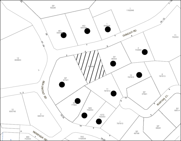
|
NOTIFICATION PLAN |
|
||
|
• PROPERTIES NOTIFIED
|
X SUBMISSIONS RECEIVED |
PROPERTY SUBJECT OF DEVELOPMENT |
|
6. THE PUBLIC INTEREST
Section 79C(1)(e) of the Act requires Council to consider “the public interest”.
The public interest is an overarching requirement, which includes the consideration of the matters discussed in this report. Implicit to the public interest is the achievement of future built outcomes adequately responding to and respecting the future desired outcomes expressed in environmental planning instruments and development control plans.
The application is considered to have satisfactorily addressed Council’s and relevant agencies’ criteria and would provide a development outcome that, on balance, would result in a positive impact for the community. Accordingly, it is considered that the approval of the proposed development would be in the public interest.
CONCLUSION
The proposed development is for the construction of an industrial building comprising 17 units, signage, strata subdivision and first use.
The proposed development would exceed the HLEP development standard for a maximum building height of 14.5m. The applicant’s justification for non-compliance with the standard is well founded in respect to Clause 4.6 of HLEP. The proposal otherwise complies with the provisions of HLEP.
The proposed signage complies with the provisions of SEPP 64.
The proposed industrial development within a bushfire prone area is satisfactory in respect to Clause 79BA EP&A Act – Certain Bush Fire Prone Land.
The proposed first use of the proposed units would be consistent with the requirements of the Exempt & Complying SEPP to enable future change of use as Complying Development.
The proposed development would retain an area of locally significant bushland at the rear of the site.
The proposal generally complies with the requirements of the HDCP for industrial development including scale, setbacks, landscaping, open space, sunlight and vehicle access and parking.
No submissions were received in response to the proposal.
The application is recommended for approval as a deferred commencement subject to the provision of a stormwater drainage easement.
RESPONSIBLE OFFICER
The officer responsible for the preparation of this Report is the Manager – Development Assessments – Rodney Pickles, who can be contacted on 9847 6731.
|
Rod Pickles Manager - Development Assessment Planning Division |
James Farrington Group Manager Planning Division |
|
1.View |
Locality Map |
|
|
|
2.View |
Site Plan and Floor Plans |
|
|
|
3.View |
Sections and Elevations |
|
|
|
4.View |
Landscape Plan |
|
|
|
5.View |
Draft Strata Plan |
|
|
File Reference: DA/519/2016
Document Number: D07081529
SCHEDULE 1
GENERAL CONDITIONS
The conditions of consent within this notice of determination have been applied to ensure that the use of the land and/or building is carried out in such a manner that is consistent with the aims and objectives of the relevant legislation, planning instruments and council policies affecting the land and does not disrupt the amenity of the neighbourhood or impact upon the environment.
Note: For the purpose of this consent, the term ‘applicant’ means any person who has the authority to act on or the benefit of the development consent.
Note: For the purpose of this consent, any reference to an Act, Regulation, Australian Standard or publication by a public authority shall be taken to mean the gazetted Act or Regulation, or adopted Australian Standard or publication as in force on the date that the application for a construction certificate is made.
1. Deferred Commencement
Pursuant to Section 80(3) of the Environmental Planning and Assessment Act 1979, this consent does not operate until the following information is submitted to Council:
a) A stormwater drainage plan must be submitted to Council showing the proposed method of connection to the Council’s drainage system. The plan is to show the existing drainage pipelines and pits (if any) and the proposed pipe alignment and connection points to the Council system with invert and surface levels.
b) The registration and creation of an easement to drain water from the site over Lot 11 DP 787913, No. 9 Marina Close, Mount Kuring-gai.
Such information must be submitted within 24 months of the date of this notice.
2. Approved Plans and Supporting Documentation
The development must be carried out in accordance with the plans and documentation listed below and endorsed with Council’s stamp, except where amended by Council and/or other conditions of this consent:
|
Plan No. |
Plan Title |
Drawn by |
Dated |
|
DA-01 Issue E |
Site Plan & Floor Plans |
Industrial Parks of Australia |
16-11-2016 |
|
DA-02 Issue E |
Site Plan & Floor Plans (Includes Sections & Elevations) |
Industrial Parks of Australia |
16-11-2016 |
|
DA-03 Issue E |
Landscape Plan |
Industrial Parks of Australia |
16-11-2016 |
|
DA-04 Issue E |
Soil & Water Management Plan |
Industrial Parks of Australia |
16-11-2016 |
|
DA-05 Issue D |
Draft Strata Plans |
Industrial Parks of Australia |
16-11-2016 |
|
Document Title |
Prepared by |
Dated |
|
Arboricultural Impact Assessment Report |
Urban Arbor |
11 August 2016 |
|
Flora and Fauna Assessment |
Cumberland Ecology |
April 2016 |
|
Traffic and Parking Statement |
Traffic Solutions Pty Ltd |
22-Apr-16 |
|
Water Sensitive Urban Design Strategy |
Sparks + Partners |
18 April 2016 |
|
Bushfire Hazard Assessment Report |
Bushfire Consulting Services Pty Ltd |
19 April 2016 |
|
Waste Management Plan |
Phillip Shaw |
19/4/16 |
3. Appointment of a Project Arborist
a) A project arborist (AQF Level 5) must be appointed to provide monitoring and certification throughout the development process.
b) Details of the appointed project arborist must be submitted to the PCA and Council for registration with the approved construction certificate.
4. Removal of Trees
a) This development consent permits the removal of tree(s) numbered 1-16, 20-24, 28-45 and 54a as identified at Item 8 of the Aboricultural Impact Assessment prepared by Urban Arbor dated 11 August 2016.
5. Pruning Works
a) This development consent only permits the pruning of tree(s) numbered 17 and 25 as identified in the Aboricultural Impact Report prepared by Urban Arbor dated 11 August 2016.
b) All approved pruning works must be undertaken by a qualified Arborist (minimum AQF3) and certification must be supplied to the PCA within 7 days of the works being undertaken confirming compliance with AS4373-2007.
Note: The pruning and or removal of any other trees from the site requires separate approval by Council in accordance with Part 1B.6 Tree and Vegetation Preservation of the Hornsby Development Control Plan, 2013 (HDCP).
6. Construction Certificate
a) A Construction Certificate is required to be approved by Council or a Private Certifying Authority prior to the commencement of any works under this consent.
b) A separate Construction Certificate must be obtained from Council for all works within the public road reserve under S138 of the Roads Act.
c) A separate Construction Certificate must be obtained from Council for all works within drainage easements vested in Council.
d) The Construction Certificate plans must not be inconsistent with the Development Consent plans.
7. Section 94A Development Contributions
a) In accordance with Section 80A(1) of the Environmental Planning and Assessment Act, 1979 and the Hornsby Shire Council Section 94A Development Contributions Plan 2014-2024, $38,000.00 must be paid to Council to cater for the increased demand for community infrastructure resulting from the development, based on development costs of $3,800,000.
b) The value of this contribution is current as at 18 November 2016. If this contribution is not paid within the financial quarter that this condition was generated, the contribution payable will be adjusted in accordance with the provisions of the Hornsby Shire Council Section 94 Development Contributions Plan and the amount payable will be calculated at the time of payment in the following manner:
$CPY = $CDC x CPIPY
CPIDC
Where:
$CPY is the amount of the contribution at the date of Payment
$CDC is the amount of the contribution as set out in this Development Consent
CPIPY is the latest release of the Consumer Price Index (Sydney – All Groups) at the date of Payment as published by the ABS.
CPIDC is the Consumer Price Index (Sydney – All Groups) for the financial quarter at the date applicable in this Development Consent Condition.
c) The monetary contributions must be paid to Council:
d) prior to the issue of the Subdivision Certificate where the development is for subdivision; or
e) prior to the issue of the first Construction Certificate where the development is for building work; or
f) prior to issue of the Subdivision Certificate or first Construction Certificate, whichever occurs first, where the development involves both subdivision and building work; or
g) prior to the works commencing where the development does not require a Construction Certificate or Subdivision Certificate.
Note: It is the professional responsibility of the Principal Certifying Authority to ensure that the monetary contributions have been paid to Council in accordance with the above timeframes.
Council’s S94A Development Contributions Plan may be viewed at www.hornsby.nsw.gov.au or a copy may be inspected at Council’s Administration Centre during normal business hours.
REQUIREMENTS PRIOR TO THE ISSUE OF A CONSTRUCTION CERTIFICATE
8. Building Code of Australia
All approved building work must be carried out in accordance with the relevant requirements of the Building Code of Australia.
9. Utility Services
The applicant must submit written evidence of the following service provider requirements:
a) Ausgrid (formerly Energy Australia) – a letter of consent demonstrating that satisfactory arrangements have been made to service the proposed development.
b) Telstra - a letter of consent demonstrating that satisfactory arrangements have been made to service the proposed development.
10. Sydney Water – Approval
This application must be submitted to Sydney Water for approval to determine whether the development would affect any Sydney Water infrastructure, and whether further requirements are to be met.
Note: Building plan approvals can be obtained online via Sydney Water Tap inTM through www.sydneywater.com.au under the Building and Development tab.
11. Dilapidation Report
A ‘Dilapidation Report’ is to be prepared by a ‘chartered structural engineer’ detailing the structural condition of the adjoining property at No. 6 Gundah Road, Mount Kuring-gai.
a) To record the structural condition of all properties adjoining the approved development, a dilapidation report must be prepared by a suitably qualified structural engineer for inclusion with the application of the Construction Certificate.
12. Excavation
A detailed geotechnical assessment of the site by a chartered structural engineer is to be undertaken for the design of the excavation, ground vibration, excavation support, design parameters for support systems and anchor design, groundwater and foundation design.
13. Stormwater Drainage
The stormwater drainage system for the development must be designed in accordance with Council’s Civil Works – Design and Construction Specification 2005 and the following requirements:
a) Connected to an existing Council piped drainage system within Lot 11 DP 787913, No. 9 Marina Close, Mount Kuring-gai.
i) The connection to Council’s drainage pit or pipeline must be inspected by a Council Engineer in the Planning Division. Prior to the connection, an application must be made to Council and all fees paid.
Note: An inspection booking can be made by calling Council on 9847 6787.
ii) Prior to the issue of an Occupation Certificate a Compliance Certificate must be obtained from the Council for the connection to Council’s drainage system.
14. On Site Stormwater Detention
The on-site detention system for the development must be designed and a construction Certificate issued for these works. The stormwater drainage system is to be designed generally in accordance with Plan No. SW1, SW2 and SW3 dated 4/11/2016 by Civil Engineering Services and Council’s On-site Stormwater Detention System Specification and Civil Works – Design and Construction Specification 2005 and the following requirements:
a) Have a capacity of not less than 76 cubic metres, and a maximum discharge (when full) of 36 litres per second.
b) Have a surcharge/inspection grate located directly above the outlet.
c) Discharge from the detention system to be controlled via 1 metre length of pipe, not less than 50 millimetres diameter or via a stainless plate with sharply drilled orifice bolted over the face of the outlet discharging into a larger diameter pipe capable of carrying the design flow to an approved Council system.
Note: A construction certificate shall be obtained prior to the commencement of these works and are to be completed prior to the issue of an occupation certificate
15. Stormwater Quality Treatment Device
Stormwater quality treatment measures shall be designed In accordance with the MUSIC Model outlined in the Water Sensitive Urban Design Report Ref No. 16050 Rev 001 Issue 002 dated 18 April 2016 by Sparks & Partners.
Prior to the issue of a construction certificate, a qualified engineer shall certify that the MUSIC model and stormwater treatment design plans submitted for approval to the principal certifying authority are in accordance with the stormwater quality targets outlined in Hornsby Council’s Development Control Plan 2013 - Table 1C.1.2(b) and Hornsby MUSIC-Link.
16. Internal Driveway/Vehicular Areas
The driveway and parking areas on site must be designed, constructed and a Construction Certificate issued in accordance with Australian Standards 2890.1, 2890.2, 3727 and the following requirements:
a) Design levels at the front boundary be obtained from Council.
b) The driveway be a rigid pavement.
c) Longitudinal sections along both sides of the access driveway shall be submitted to the principal certifying authority in accordance with the relevant sections of AS 2890.1 and AS2890.2. The maximum grade shall not exceed 1 in 6.5 (15.4%) with the maximum changes of grade of 1 in 12 (8.3%). Any transition grades shall have a minimum length of 4 metres. The longitudinal sections shall incorporate the design levels obtained by Council.
17. Driveway, Car Parking and Loading Areas
All driveway, car parking and loading areas must be constructed and operated in accordance with Australian Standard AS/NZS 2890.1:2004 – Off-street car parking and Australian Standard AS 2890.2:2002 – Off-street commercial vehicle facilities.
a) All parking areas and driveways are to be sealed to an all-weather standard, line marked and signposted;
b) Car parking, loading and manoeuvring areas to be used solely for nominated purposes;
c) Vehicles awaiting loading, unloading or servicing shall be parked on site and not on adjacent or nearby public roads;
d) All vehicular entry on to the site and egress from the site shall be made in a forward direction.
18. Identification of Survey Marks
A registered surveyor must identify all survey marks in the vicinity of the proposed development. Any survey marks required to be removed or displaced as a result of the proposed development shall be undertaken by a registered surveyor in accordance with Section 24 (1) of the Surveying and Spatial Information Act 2002 and following the Surveyor General’s Directions No.11 – "Preservation of Survey Infrastructure".
19. Construction Environment Management Plan
The applicant is to prepare a Construction Environmental Management Plan which must be submitted to Council for approval prior to the release of the Construction Certificate.
The Construction Environmental Management Plan must include the following:
a) Scaled survey plan of the site showing the development footprint in relation to the remnant trees and other bushland proposed for retention;
b) Location of protective fencing (1.8m high cyclone mesh) installed around bushland areas proposed for retention and to be clearly delineated from building works areas;
c) Location of tree protection fences for specific trees approved for retention;
d) Location of temporary and permanent trenches required for installation of services;
e) Location and specification of sediment and erosion control (in accordance with Council’s Blue Book – Sustainable Water Best Practices);
f) Location of soil, mulch, waste and building material stock piles;
g) Location of dedicated construction vehicle parking areas;
h) Specifications of approved cut and fill;
i) Location of road-base only within the approved development foot print (i.e. driveway);
j) Notation describing ‘that no mulch is to be applied within remnant bushland areas’;
k) Phytophthora management protocols;
l) A qualified arborist (AQF5 level) must supervise the severance of any roots greater than 40mm;
m) Notations describing that an ecologist must be on site during tree clearing works to ensure fauna is relocated. Prior to the approved removal of hollow bearing trees the applicant is to carry out the following actions to prevent harm to native wildlife;
n) Provide environmental inductions to other civil works and building contractors working on the site.
Note: Such information must be submitted within 12 months of the date of this notice.
20. Landscape Plan
The approved Landscape Plan is to be amended prior to the issue of the Construction Certificate as follows:
a) Integrate the location and numbering of trees identified for retention in the Arboricultural Impact Assessment Report prepared by Urban Arbor Pty Ltd dated 11 August 2016;
b) Incorporate the Asset Protection Zone (APZ) requirements as stated within Page 10 of 13 of the report prepared by Bushfire Consulting Services dated 19/4/2016;
c) Incorporate a 10m2 open space area with seating for employees in the north-west corner of the site designed for summer shade and winter sun;
d) Detail the location of proposed stormwater drainage line and grate occurring in this area as shown in the Stormwater Management Plan prepared by Civil Engineering Services;
e) No planting is to occur within areas of existing native species occurring along the southern boundary where natural regeneration from the native soil bank is to be encouraged (no mulch permitted in this area). Areas of existing native plants are to be identified and not planted out;
f) Native species chosen for planting should also take into consideration that the proposed units will block access to northern sun aspect;
g) Re-arrange the placement of proposed plantings incorporating the above factors;
h) Provide a provision/ specification for weeding and performance criteria that weeds are to be maintained below 5% for the 18 month plant establishment period;
i) State that tube stock plants obtained from recognised native nurseries stocking local province plants are only to be used for the southern side of the building; and
j) State on the plan that the planting works are be approved by Hornsby Shire Council’s Natural Resources Unit prior to release of the Occupation Certificate.
REQUIREMENTS PRIOR TO THE COMMENCEMENT OF ANY WORKS
21. Erection of Construction Sign
a) A sign must be erected in a prominent position on any site on which any approved work is being carried out:
i) Showing the name, address and telephone number of the principal certifying authority for the work;
ii) Showing the name of the principal contractor (if any) for any demolition or building work and a telephone number on which that person may be contacted outside working hours; and
iii) Stating that unauthorised entry to the work site is prohibited.
b) The sign is to be maintained while the approved work is being carried out and must be removed when the work has been completed.
22. Protection of Adjoining Areas
A temporary hoarding, fence or awning must be erected between the work site and adjoining lands before the works begin and must be kept in place until after the completion of the works if the works:
a) Could cause a danger, obstruction or inconvenience to pedestrian or vehicular traffic;
b) Could cause damage to adjoining lands by falling objects; and/or
c) Involve the enclosure of a public place or part of a public place.
Note: Notwithstanding the above, Council’s separate written approval is required prior to the erection of any structure or other obstruction on public land.
23. Toilet Facilities
a) To provide a safe and hygienic workplace, toilet facilities must be available or be installed at the works site before works begin and must be maintained until the works are completed at a ratio of one toilet for every 20 persons employed at the site.
b) Each toilet must:
i) be a standard flushing toilet connected to a public sewer; or
ii) be a temporary chemical closet approved under the Local Government Act 1993; or
iii) have an on-site effluent disposal system approved under the Local Government Act 1993.
24. Erosion and Sediment Control
To protect the water quality of the downstream environment, erosion and sediment control measures must be provided and maintained throughout the construction period in accordance with the manual ‘Soils and Construction 2004 (Bluebook)’, the approved plans, Council specifications and to the satisfaction of the principal certifying authority. The erosion and sediment control devices must remain in place until the site has been stabilised and revegetated.
Note: On the spot penalties may be issued for any non-compliance with this requirement without any further notification or warning.
25. Installation of Tree Protection
a) All trees retained on site must have tree protection measures for the ground, trunk and canopy installed in accordance with the Australian Standard ‘Protection of Trees on Development Sites (AS 4970-2009).
b) Tree protection fencing must erected around trees numbered as specified 17, 17a, 18, 19, 25, 26, 27, 28, 46, 47, 48, 49 and 51-57 for tree protection zones contained in the Supplied Arboricultural Impact Assessment provided by Urban Arbor dated 118/16(4GRMK) (TRIM:D007035048).
26. Tree Protection Zone Ground Protection
All Tree Protection Zones must have a layer of wood-chip mulch installed prior to works commencing and must be maintained throughout the period of construction at a depth of 150mm – 300mm using material that complies with Australian Standard AS 4454.
27. Tree Protection Certification
A certificate from the project arborist must be submitted to the Principal Certifying Authority and Council stating compliance with the relevant tree protection conditions of this consent.
28. Bushfire Management – Protection Zones
At the commencement of building works the entire property must be managed as an Inner Protection Area (IPA) as outlined within Section 4.1.3 and Appendix 5 of “Planning for Bush Fire Protection 2006” and the NSW Rural Fire Service’s document “Standards for asset protection zones” and in accordance with the following requirements:
a) The property around the building to a distance of 10 metres, or to the property boundary, (whichever is the lesser), must be maintained as an ‘Inner Asset Protection Zone’ in accordance with the following:
i) Minimise fine fuel at ground level;
ii) Retain vegetation that does not provide a continuous path to building/s for the transfer of fire;
iii) Retain shrubs and trees that do not form a continuous canopy and vegetation planted/cleared into clumps rather than continuous rows;
iv) Do not plant vegetation that retains dead material or deposits excessive quantities of ground fuel;
v) Prune or remove shrubs and trees so they do not touch or overhang the building/s; and
vi) Maintain vegetation at a sufficient setback from the building/s so plants will not ignite the building/s by direct flame contact or radiant heat emission.
REQUIREMENTS DURING CONSTRUCTION
29. Construction Work Hours
All works on site, including demolition and earth works, must only occur between 7am and 5pm Monday to Saturday.
No work is to be undertaken on Sundays or public holidays.
30. Environmental Management
The site must be managed in accordance with the publication ‘Managing Urban Stormwater – Landcom (March 2004) and the Protection of the Environment Operations Act 1997 by way of implementing appropriate measures. To prevent sediment run-off, excessive dust, noise or odour emanating from the site during the construction of the development.
31. Street Sweeping
To protect the surrounding environment, street sweeping must be undertaken following sediment tracking from the site along No. Gundah Road, Mount Kuring-gai during works and until the site is established.
The street cleaning services must undertake a street ‘scrub and dry’ method of service and not a dry sweeping service that may cause sediment tracking to spread or cause a dust nuisance.
32. Works Near Trees
a) Maintaining Tree Health
The project arborist must monitor and record any necessary remedial actions for maintaining tree health and condition required for trees numbered 17, 17a, 18, 19, 25, 26, 27, 28, 46, 47, 48, 49 and 51-57.
b) Maintenance and Monitoring of Tree protection
The appointed project arborist must monitor and record all changes or modifications to required tree protection measures for the period of construction.
33. Works Within Tree Protection Zones - Trees Numbered: 17, 17a, 18, 19, 25, 26, 27, 28, 46, 47, 48, 49 and 51 - 57 (only used for an encroachment exceeding 10%)
a) Root Pruning
All Root pruning must be recorded and undertaken as specified in Australian Standard AS 4970-2009 Sections 3.3.4, 4.5.4 and 4.5.5. Add Project Arborist.
b) Installing Services
i) The installation of all services which enter or transects a designated TPZ must utilise sensitive methods of installation such as directional drilling or in manually excavated trenches.
ii) The process must be monitored by the project arborist to assess the likely impacts of boring and bore pits on retained trees.
iii) For manual excavation of trenches the project arborist must advise on roots to be retained and must monitor the works. Manual excavation may include the use of pneumatic and hydraulic tools. Refer Clause 4.5.3.
c) Installation of Scaffolding
Where scaffolding is required it must be erected outside the TPZ and in accordance with AS 4970-2009 section 4.5.6.
34. Building Materials and Site Waste
The filling or stockpiling of building materials, the parking of vehicles or plant, the disposal of cement slurry, waste water or other contaminants must be located outside the tree protection zones as prescribed in the conditions of this consent or the prescriptive measures of Part 1B.6.1 Tree Preservation of the Hornsby Development Control Plan, 2013, of any tree to be retained.
35. Works Near Trees Certification
The project arborist must submit to the principal certifying authority on a monthly a certificate that the works have been carried out in compliance with the approved plans and specifications for tree protection. Certification should include a statement of site attendance, the condition of the retained trees, details of any deviations from the approved tree protection measures and their impacts on trees. Copies of monitoring documentation may be required.
36. Council Property
To ensure that the public reserve is kept in a clean, tidy and safe condition during construction works, no building materials, waste, machinery or related matter is to be stored on the road or footpath.
Note: This consent does not give right of access to the site via Council’s park or reserve. Should such access be required, separate written approval is to be obtained from Council.
37. Disturbance of Existing Site
During construction works, the existing ground levels of open space areas and natural landscape features, including natural rock-outcrops, vegetation, soil and watercourses must not be altered unless otherwise nominated on the approved plans.
38. Landfill
Landfill must be constructed in accordance with Council’s ‘Construction Specification 2005’ and the following requirements:
a) Prior to fill material being imported to the site, a certificate shall be obtained from a suitable qualified environmental consultant confirming the fill wholly consists of Virgin Excavated Natural Material (VENM) as defined in Schedule 1 of the Protection of the Environment Operations Act, 1997 or material approved under the Department of Environment and Climate Change’s general resource recovery exemption.
b) A compaction certificate is to be obtained from a suitably qualified geotechnical engineer verifying that the specified compaction requirements have been met.
c) These certificates must be included with the application for an occupation certificate.
39. Excavated Material
All excavated material removed from the site must be classified by a suitably qualified person in accordance with the Department of Environment, Climate Change and Water NSW Waste Classification Guidelines prior to disposal to an approved waste management facility and be reported to the principal certifying authority prior to the issue of an Occupation Certificate.
40. Survey Report
A report(s) must be prepared by a registered surveyor and submitted to the principal certifying authority:
a) Prior to the pouring of concrete at each level of the building certifying that:
i) The building, retaining walls and the like have been correctly positioned on the site; and
ii) The finished floor level(s) are in accordance with the approved plans.
41. Waste Management
All work must be carried out in accordance with the approved waste management plan.
REQUIREMENTS PRIOR TO THE ISSUE OF AN OCCUPATION CERTIFICATE
Note: For the purpose of this consent, a reference to ‘occupation certificate’ shall not be taken to mean an ‘interim occupation certificate’ unless otherwise stated.
42. Sydney Water – s73 Certificate
A s73 Certificate must be obtained from Sydney Water and submitted to the PCA.
Note: Sydney Water requires that s73 applications are to be made through an authorised Sydney Water Servicing Coordinator. Refer to www.sydneywater.com.au or telephone 13 20 92 for assistance.
43. Certification of Water Sensitive Urban Design (WSUD) Facilities
Prior to the issue of an Occupation Certificate a certificate from a Civil Engineer is to be obtained stating that the WSUD facilities have been constructed and will meet the water quality targets as specified in the Hornsby DCP.
44. Bush Fire Ember Protection
a) The screening of window openings in the external fabric of the building is to be undertaken by the use of metal screens with apertures less than 2mm fixed so that there are no gaps greater than 3mm between the frame and the building.
b) Door closers and door seals are to be fitted to all external doors, preventing gaps greater than 3mm between the doors and the frames.
45. Unit Numbering
All units are to be numbered consecutively commencing at No.1. The strata plan lot number is to coincide with the unit number, e.g Unit 1 = Lot 1. The allocated of unit numbering must be authorised by Council prior to the numbering of each units in the development.
46. Damage to Council Assets
To protect public property and infrastructure, any damage caused to Council’s assets, including the removal, damage, destruction, displacement or defacing of the existing survey marks, as a result of the construction or demolition of the development, must be rectified by the applicant in accordance with Council’s Civil Works Specifications. Rectification works must be undertaken prior to the issue of an Occupation Certificate, or sooner, as directed by Council.
47. Damage to Council Assets
For the purpose of waste collection, an easement entitling Council, its servants and agents and persons authorised by it to enter upon the subject land and to operate thereon, vehicles and other equipment for the purposes of garbage collection must be granted to Council by the owner of the land.
Note: The easement must be in a form prescribed by Council and must include covenants to the effect that parties will not be liable for any damage caused to the subject land or any part thereof or to any property located therein or thereon by reason of the operation thereon of any vehicle or other equipment used in connection with the collection of garbage and to the effect that the owner for the time being of the subject land shall indemnify the Council, its servants, agents and persons authorised by it to collect garbage against liability in respect of any such claims made by any person whomsoever.
48. Waste Management Details
The following waste management requirements must be complied with:
a) a) A report must be prepared by an appropriately qualified person, certifying the following:
b) i. A comparison of the estimated quantities of each waste type against the actual quantities of each waste type.
c) Note: Explanations of any deviations to the approved Waste Management Plan is required to be included in this report
d) ii. That at least 60% of the waste generated during the demolition and construction phase of the development was reused or recycled.
Note: If the 60% diversion from landfill cannot be achieved in the Construction Stage, the Report is to include the reasons why this occurred and certify that appropriate work practices were employed to implement the approved Waste Management Plan. The Report must be based on documentary evidence such as tipping dockets/receipts from recycling depots, transfer stations and landfills, audits of procedures etc. which are to be attached to the report.
49. Creation of Easements
The following easements, restrictions and/or positive covenants shall be created on the property title via s88E or s88B of the Conveyancing Act 1919:
a) The creation of an appropriate "Positive Covenant" and "Restriction as to User" over the constructed on-site detention/retention systems stormwater quality treatment devices and outlet works, within the lots in favour of Council in accordance with Council’s prescribed wording. The position of the on-site detention system is to be clearly indicated on the title.
b) To register the OSD easement, the restriction on the use of land “works-as-executed” details of the on-site-detention system must be submitted verifying that the required storage and discharge rates have been constructed in accordance with the design requirements. The details must show the invert levels of the on site system together with pipe sizes and grades. Any variations to the approved plans must be shown in red on the “works-as-executed” plan and supported by calculations.
Note: Council must be nominated as the authority to release, vary or modify any easement, restriction or covenant.
50. Engineers Certification – On-Site Detention
A certificate from a qualified civil engineer/registered surveyor must be obtained prior to the issue of an occupation certificate verifying that the on-site detention system has been constructed and will function hydraulically in accordance with the approved design plans.
51. Preservation of Survey Marks
Prior to the issue of an occupation certificate, a certificate by a Registered Surveyor shall be submitted to the Principal Certifying Authority, certifying that there has been no removal, damage, destruction, displacement or defacing of the existing survey marks in the vicinity of the proposed development or otherwise the re-establishment of damaged, removed or displaced survey marks has been undertaken in accordance with the Surveyor General’s Direction No.11 – “Preservation of Survey Infrastructure”.
52. Works as Executed Plan
A works-as-executed plan(s) must be prepared by a registered surveyor and submitted to Council for completed stormwater quality treatment devices and on-site detention system. The plan(s) must be accompanied by a certificate from a registered surveyor certifying that all pipelines and associated structures lie wholly within any relevant easements.
53. Maintain Canopy Cover
a) To provide a positive environmental outcome replacement plantings must be undertaken and must be a minimum of 15 trees.
b) The selection of tree species must selected from the Council’s Indigenous species listing located in the Hornsby DCP Tree Preservation Measures 1B.6 Table 1B.6(b) such as Angophora costata, Angophora floribunda, Eucalyptus elata.
c) Location and Size of Plantings
i) Replacement Trees for must be located in front or rear setbacks and setback 4 metres or greater from the foundation walls of the approved development.
ii) The pot size of the replacement tree(s) must be a minimum 25 litres and replacement tree(s) must be maintained until they reach the height of 3 metres.
iii) The selected tree species must have the potential to reach a mature height greater than 20 metre.
iv) All tree stock must meet the specifications outlined in ‘Specifying Trees’ (Ross Clark, NATSPEC Books).
v) Planting methods must meet professional (best practice) industry standards
d) The suitably qualified person holding a Certificate III in Horticulture must submit to the principal certifying authority a statement confirming all landscaping requirements have been completed in accordance with approved landscape plans and conditions of consent.
54. Final Certification Arborist
a) The Project Supervisor must submit to the principal certifying authority all relevant certificates with the application for the occupation certificate stating compliance with all the conditions of this consent.
b) The Project Arborist must submit to the principal certifying authority a certificate that all the completed works have been carried out in compliance with the approved plans and specifications for tree protection. Certification must include a statement of overall site attendance, the condition of the retained trees, details of any deviations from the approved tree protection measures and their impacts on trees. Copies of monitoring documentation may be required.
55. Retaining Walls
All required retaining walls must be constructed as part of the development.
OPERATIONAL CONDITIONS
56. Advertising Signs
The advertising signage approved under this consent must not be illuminated, flash, move or display electronic images.
57. Use of Premises
The development approved under this consent shall be for the following uses and not for any other purpose without Council’s separate written consent or as Complying Development approved under State Environmental Planning Policy (Exempt and Complying Development Codes) 2008:
Unit 1 Kitchen manufacture & assembly
Unit 2 Storage distribution and light manufacturing – electrical goods
Unit 3 Light metal fabrication and distribution
Unit 4 Glass distribution and glazing
Unit 5 Storage, distribution and light manufacturing – timber products
Unit 6 Warehousing and distribution machine parts
Unit 7 Storage, distribution and light manufacturing – marine goods
Unit 8 Locksmith and associated light manufacturing
Unit 9 Warehousing and distribution imported toys
Unit 10 Storage of tradesman’s goods
Unit 11 Household and vehicle storage
Unit 12 Warehousing and distribution imported parts
Unit 13 Light metal fabrication and distribution
Unit 14 Storage of sporting goods
Unit 15 Storage and repair tree lopping equipment
Unit 16 Storage and repair tradesman’s goods
Unit 17 Storage and distribution of plastic materials
58. Waste Records
All commercial tenants must keep written evidence on site of a valid contract with licensed waste contractors for the regular collection and disposal of the waste and recyclables that are generated on site.
59. Hours of Operation
The hours of operation of the premise are restricted to those times listed below:
Monday to Friday 7 am to 6 pm
Saturday 7 am to 4 pm
Sunday & Public Holidays No work
60. Noise
All noise generated by the proposed development must be attenuated to prevent levels of noise being emitted to adjacent premises which possess tonal, beating and similar characteristics or which exceeds background noise levels by more than 5dB(A).
61. Bushfire Emergency and Evacuation Plan
The occupants of the development are to formulate an emergency evacuation in accordance with the Bush Fire Emergency and Evacuation Plan on the NSW Rural Fire Service web site: www.rfs.nsw.gov.au/plan-and-prepare/building-in-a-bush-fire-area/bush-fire-emergency-management-and-evacuation-plan
62. Fire Safety Statement - Annual
On at least one occasion in every 12 month period following the date of the first ‘Fire Safety Certificate’ issued for the property, the owner must provide Council with an annual ‘Fire Safety Certificate’ to each essential service installed in the building.
63. Storage of Flammable and Combustible Goods
Flammable and combustible liquids must be stored in accordance with Australian Standard 1940 – The Storage and Handling of Flammable and Combustible Liquids. A bund wall must be constructed around all work and liquid storage areas to prevent any spillage entering into the stormwater system. The bunded area must provide a volume equal to 110% of the largest container stored and graded to a blind sump so as to facilitate emptying and cleansing.
64. Trade Waste
Liquid trade waste generated on the site must be discharged in accordance with a trade waste agreement with Sydney Water and by a licensed liquid trade waste contractor.
65. Maintenance of Wastewater Device
All wastewater and stormwater treatment devices (including drainage systems, sumps and traps) must be regularly maintained in order to remain effective. All solid and liquid wastes collected from the device must be disposed of in accordance with the Protection of the Environment Operations Act 1997.
- END OF CONDITIONS –
ADVISORY NOTES
The following information is provided for your assistance to ensure compliance with the Environmental Planning and Assessment Act, 1979, Environmental Planning and Assessment Regulation 2000, other relevant legislation and Council’s policies and specifications. This information does not form part of the conditions of development consent pursuant to Section 80a of the Act.
Environmental Planning and Assessment Act 1979 Requirements
The Environmental Planning and Assessment Act 1979 requires:
· The issue of a construction certificate prior to the commencement of any works. Enquiries can be made to Council’s Customer Services Branch on 9847 6760.
· A principal certifying authority to be nominated and Council notified of that appointment prior to the commencement of any works.
· Council to be given at least two days written notice prior to the commencement of any works.
· Mandatory inspections of nominated stages of the construction inspected.
· An occupation certificate to be issued before occupying any building or commencing the use of the land.
Long Service Levy
In accordance with Section 34 of the Building and Construction Industry Long Service Payments Act 1986, a ‘Long Service Levy’ must be paid to the Long Service Payments Corporation or Hornsby Council.
Note: The rate of the Long Service Levy is 0.35% of the total cost of the work.
Note: Hornsby Council requires the payment of the Long Service Levy prior to the issue of a construction certificate.
Tree and Vegetation Preservation
In accordance with Clause 5.9 of the Hornsby Local Environmental Plan 2013 a person must not ringbark, cut down, top, lop, remove, injure or wilfully destroy any tree or other vegetation protected under the Hornsby Development Control Plan 2013 without the authority conferred by a development consent or a permit granted by Council.
Notes: A tree is defined as a long lived, woody perennial plant with one or relatively few main stems with the potential to grow to a height greater than three metres (3M). (HDCP 1B.6.1.c).
Tree protection measures and distances are determined using the Australian Standard AS 4970:2009, “Protection of Trees on Development Sites”.
Fines may be imposed for non-compliance with both the Hornsby Local Environmental Plan 2013 and the Hornsby Development Control Plan 2013.
Disability Discrimination Act
The applicant’s attention is drawn to the existence of the Disability Discrimination Act. A construction certificate is required to be obtained for the proposed building/s, which will provide consideration under the Building Code of Australia, however, the development may not comply with the requirements of the Disability Discrimination Act. This is the sole responsibility of the applicant.
Dial Before You Dig
Prior to commencing any works, the applicant is encouraged to contact Dial Before You Dig on 1100 or www.dialbeforeyoudig.com.au for free information on potential underground pipes and cables within the vicinity of the development site.
Telecommunications Act 1997 (Commonwealth)
If you are aware of any works or proposed works which may affect or impact on Telstra’s assets in any way, you are required to contact: Telstra’s Network Integrity Team on Phone Number 1800810443.
Asbestos Warning
Should asbestos or asbestos products be encountered during demolition or construction works, you are advised to seek advice and information prior to disturbing this material. It is recommended that a contractor holding an asbestos-handling permit (issued by WorkCover NSW)be engaged to manage the proper handling of this material. Further information regarding the safe handling and removal of asbestos can be found at:
Alternatively, telephone the WorkCover Asbestos and Demolition Team on 8260 5885.
Unit Numbering (Strata Units)
All units are to be numbered consecutively commencing at No1. The strata plan lot No is to coincide with the unit number. Eg Unit 1 = Lot 1.
Planning Report No. PL81/16
Planning Division
Date of Meeting: 14/12/2016
10 DEVELOPMENT APPLICATION - EMERGENCY SERVICES FACILITY - BEROWRA PARK (R33756), 14X BEROWRA WATERS ROAD, BEROWRA
EXECUTIVE SUMMARY
|
DA No: |
DA/805/2016 (Lodged on 28 June 2016) |
|
Description: |
Construction of an emergency services facility for the NSW Rural Fire Service |
|
Property: |
Lot 7308 DP 1165922, Berowra Park (R33756), 14X Berowra Waters Road, Berowra |
|
Applicant: |
Stimson and Baker Planning |
|
Owner: |
Land and Property Management Authority - Sydney |
|
Estimated Value: |
$760,000 |
· The application involves construction of an Emergency Services Facility for the NSW Rural Fire Service.
· The development involves land under the care and control of Council. In accordance with Council’s adopted Policy ‘Proposed Council Developments’ an independent assessment of the development application has been undertaken by The Design Partnership. The independent assessment recommendation is for approval of the application.
· The proposal complies with Hornsby Local Environmental Plan 2013, State Environmental Planning Policy No. 19 – Bushland in Urban Areas and the Hornsby Development Control Plan 2013.
· 18 submissions have been received in respect of the application including 14 letters and a petition in support and 3 objections.
· It is recommended that the application be approved.
|
THAT Development Application No. DA/805/2016 for construction of an emergency services facility for the NSW Rural Fire Service at Lot 7308 DP 116522, Berowra Park (R33756), No. 14X Berowra Waters Road, Berowra be approved subject to the agreement of the NSW Rural Fire Service to the imposition of conditions of consent detailed in Schedule 1 of Group Manager’s Report No. PL81/16. |
BACKGROUND
In accordance with Council’s adopted Policy PS41 Proposed Council Developments and Practice Note No. 7 – Assessment Practice, the assessment of the development application has been referred to an independent town planning consultant. The report by The Design Partnership Pty Ltd is attached to this report.
CONSULTANT RECOMMENDATION
The proposal involves the construction of an emergency services facility for the NSW Rural Fire Service.
The independent town planning consultant recommends approval of the development application subject to recommended conditions.
The recommended conditions are under Schedule 1 of this report.
RESPONSIBLE OFFICER
The officer responsible for the preparation of this Report is the Manager – Development Assessments – Rodney Pickles, who can be contacted on 9847 6731.
|
Rod Pickles Manager - Development Assessment Planning Division |
James Farrington Group Manager Planning Division |
|
1.View |
Locality Map |
|
|
|
2.View |
Site and Landscape Plan |
|
|
|
3.View |
Proposed Site Layout Plan |
|
|
|
4.View |
Floor Plan |
|
|
|
5.View |
Elevations and Sections - Part 1 |
|
|
|
6.View |
Elevations and Sections - Part 2 |
|
|
|
7.View |
Independent Consultant Report |
|
|
File Reference: DA/805/2016
Document Number: D07096320
SCHEDULE 1
GENERAL CONDITIONS
The conditions of consent within this notice of determination have been applied to ensure that the use of the land and/or building is carried out in such a manner that is consistent with the aims and objectives of the relevant legislation, planning instruments and council policies affecting the land and does not disrupt the amenity of the neighbourhood or impact upon the environment.
Note: For the purpose of this consent, the term ‘applicant’ means any person who has the authority to act on or the benefit of the development consent.
Note: For the purpose of this consent, any reference to an Act, Regulation, Australian Standard or publication by a public authority shall be taken to mean the gazetted Act or Regulation, or adopted Australian Standard or publication as in force on the date that the application for a construction certificate is made.
1. Approved Plans and Supporting Documentation
The development must be carried out in accordance with the plans and documentation listed below and endorsed with Council’s stamp, except where amended by Council and/or other conditions of this consent:
|
Plan No. |
Drawn by |
Dated |
|
LA01 Issue A Site And Landscape Plan |
Hornsby Shire Council |
26/05/16 |
|
1404-DA02-D – Proposed Site Layout |
Architects of Arcadia |
20/10/15 |
|
1404-DA03 D – Floor Plan |
Architects of Arcadia |
20/10/15 |
|
1404-DA04 D – Elevations 1 |
Architects of Arcadia |
20/10/15 |
|
1404-DA05 D – Elevations 2 |
Architects of Arcadia |
20/10/15 |
|
1404 DA06 D - Sections |
Architects of Arcadia |
20/10/15 |
|
Document title |
Prepared by |
Dated |
|
Statement of Environmental Effects |
Stimson & Baker Planning |
June 2016 |
2. Appointment of a Project Arborist
A project arborist (AQF Level 5) must be appointed to provide monitoring and certification throughout the development process.
3. Removal of Trees
This development consent permits the removal of tree(s) numbered 4-8 and 11 as identified in the Site Tree Location Plan provided by Hornsby Shire Parks and Recreation Branch dated 26/5/2016 (TRIM: D06988640).
Note: The removal of any other trees from the site requires separate approval by Council in accordance with Part 1B.6 Tree and Vegetation Preservation of the Hornsby Development Control Plan, 2013 (HDCP).
4. Building Code of Australia
All approved building work must be carried out in accordance with the relevant requirements of the Building Code of Australia.
5. Utility Services
The applicant must submit written evidence of the following service provider requirements:
a) Ausgrid (formerly Energy Australia) – a letter of consent demonstrating that satisfactory arrangements have been made to service the proposed development.
b) Telstra - a letter of consent demonstrating that satisfactory arrangements have been made to service the proposed development.
6. Sydney Water – Approval
This application must be submitted to Sydney Water for approval to determine whether the development would affect any Sydney Water infrastructure, and whether further requirements are to be met.
Note: Building plan approvals can be obtained online via Sydney Water Tap inTM through www.sydneywater.com.au under the Building and Development tab.
7. Stormwater Drainage
The stormwater drainage system for the development must be designed in accordance with Council’s Civil Works – Design and Construction Specification 2005 and connected to the existing Council piped drainage system.
8. On Site Stormwater Detention
An on-site stormwater detention system must be designed by a chartered civil engineer and constructed in accordance with the following requirements:
a) Have a capacity of not less than 5 cubic metres, and a maximum discharge (when full) of 8 litres per second;
b) Have a surcharge/inspection grate located directly above the outlet;
c) Discharge from the detention system must be controlled via 1 metre length of pipe, not less than 50 millimetres diameter or via a stainless plate with sharply drilled orifice bolted over the face of the outlet discharging into a larger diameter pipe capable of carrying the design flow to an approved Council system;
d) Not be constructed in a location that would impact upon the visual or recreational amenity of residents.
9. Internal Driveway/Vehicular Areas
The driveway and parking areas on site must be designed, constructed in accordance with Australian Standards 2890.1, 2890.2, 3727 and the following requirements:
a) Design levels at the front boundary be obtained from Council so as to determine the internal road levels.
b) The driveway be a rigid pavement.
10. Construction of engineering works.
All engineering works identified in this consent are to be completed prior to occupation of the building.
REQUIREMENTS PRIOR TO THE COMMENCEMENT OF ANY WORKS
11. Erection of Construction Sign
a) A sign must be erected in a prominent position on any site on which any approved work is being carried out:
i) Showing the name, address and telephone number of the principal certifying authority for the work;
ii) Showing the name of the principal contractor (if any) for any demolition or building work and a telephone number on which that person may be contacted outside working hours; and
iii) Stating that unauthorised entry to the work site is prohibited.
b) The sign is to be maintained while the approved work is being carried out and must be removed when the work has been completed.
12. Protection of Adjoining Areas
A temporary hoarding, fence or awning must be erected between the work site and adjoining lands before the works begin and must be kept in place until after the completion of the works if the works:
a) Could cause a danger, obstruction or inconvenience to pedestrian or vehicular traffic;
b) Could cause damage to adjoining lands by falling objects; and/or
c) Involve the enclosure of a public place or part of a public place.
Note: Notwithstanding the above, Council’s separate written approval is required prior to the erection of any structure or other obstruction on public land.
13. Toilet Facilities
a) To provide a safe and hygienic workplace, toilet facilities must be available or be installed at the works site before works begin and must be maintained until the works are completed at a ratio of one toilet for every 20 persons employed at the site.
b) Each toilet must:
i) be a standard flushing toilet connected to a public sewer; or
ii) be a temporary chemical closet approved under the Local Government Act 1993; or
iii) have an on-site effluent disposal system approved under the Local Government Act 1993.
14. Traffic Control Plan
Any Traffic Control Plans (TCP) prepared are to comply with A51742.3 and RMS "Traffic Control at Worksites" manual and be signed by a person with RMS certification to prepare TCP's. A copy pf the TCP is to be held on site at all times throughout the closure period by the responsible traffic controllers. All signposting required is to be shown, clearly dimensioned.
15. Installation of Tree Protection
a) All trees retained on site must have tree protection measures for the ground, trunk and canopy installed in accordance with the Australian Standard ‘Protection of Trees on Development Sites’ (AS 4970-2009).
b) Tree protection fencing must erected around trees numbered 1-3, 9a, 9b, 10a, 10b, 12-39 (group) as specified in the Supplied tree assessment table provided by Hornsby Shire Parks and Recreation Branch dated 26/5/2016 (TRIM: D06988640).
16. Tree Protection Zone Ground Protection
All Tree Protection Zones must have a layer of wood-chip mulch installed prior to works commencing and must be maintained throughout the period of construction at a depth of 150mm – 300mm using material that complies with Australian Standard AS 4454.
17. Works Near Trees
a) Maintaining Tree Health
The project arborist must monitor and record any necessary remedial actions for maintaining tree health and condition required for trees numbered 1-3, 9a, 9b, 10a, 10b, 12-39 (group).
b) Maintenance and Monitoring of Tree protection
The appointed project arborist must monitor and record all changes or modifications to required tree protection measures for the period of construction.
18. Works Within Tree Protection Zones - Trees Numbered: (only used for an encroachment exceeding 10%)
a) Root Pruning
All Root pruning must be recorded and undertaken as specified in Australian Standard AS 4970-2009 Sections 3.3.4, 4.5.4 and 4.5.5. Add Project Arborist.
b) Driveway/Concrete Slabs (no-strip footing)
Existing driveway replacement must be built on existing grade with no additional excavation or excavation limited to 100mm.
c) Foundation/Footings
New foundation/footing must provide a 100mm clearance above soil and be of sensitive construction techniques such as screw pilings or piers, cantilevered or suspended slab design.
d) Installing Services
i) The installation of all services which enter or transects a designated TPZ must utilise sensitive methods of installation such as directional drilling or in manually excavated trenches.
ii) The process must be monitored by the project arborist to assess the likely impacts of boring and bore pits on retained trees.
iii) For manual excavation of trenches the project arborist must advise on roots to be retained and must monitor the works. Manual excavation may include the use of pneumatic and hydraulic tools. Refer Clause 4.5.3.
e) Installation of Scaffolding
Where scaffolding is required it must be erected outside the TPZ and in accordance with AS 4970-2009 section 4.5.6. Any incursion to TPZ must be under advice of the project Arborist.
19. Building Materials and Site Waste (Minor/Major)
The filling or stockpiling of building materials, the parking of vehicles or plant, the disposal of cement slurry, waste water or other contaminants must be located outside the tree protection zones as prescribed in the conditions of this consent or the prescriptive measures of Part 1B.6.1 Tree Preservation of the Hornsby Development Control Plan, 2013, of any tree to be retained.
20. Works Near Trees Certification
The project arborist must submit to the principal certifying authority on a monthly basis a certificate that the works have been carried out in compliance with the approved plans and specifications for tree protection. Certification should include a statement of site attendance, the condition of the retained trees, details of any deviations from the approved tree protection measures and their impacts on trees. Copies of monitoring documentation may be required.
REQUIREMENTS DURING CONSTRUCTION
21. Construction Work Hours
All works on site, including demolition and earth works, must only occur between 7am and 5pm Monday to Saturday.
No work is to be undertaken on Sundays or public holidays.
22. Council Property
To ensure that the public reserve is kept in a clean, tidy and safe condition during construction works, no building materials, waste, machinery or related matter is to be stored on the road or footpath.
23. Demolition
To protect the surrounding environment, all demolition work must be carried out in accordance with “Australian Standard 2601-2001 – The Demolition of Structures” and the following requirements:
a) Demolition material must be disposed of to an authorised recycling and/or waste disposal site and/or in accordance with an approved waste management plan;
b) Demolition works, where asbestos material is being removed, must be undertaken by a contractor that holds an appropriate licence issued by WorkCover NSW in accordance with Chapter 10 of the Occupational Health and Safety Regulation 2001 and Clause 29 of the Protection of the Environment Operations (Waste) Regulation 2005 ;and
c) On construction sites where any building contain asbestos material, a standard commercially manufactured sign containing the words ‘DANGER ASBESTOS REMOVAL IN PROGRESS’ and measuring not less than 400mm x 300mm must be displayed in a prominent position visible from the street.
24. Maintenance of public footpaths
Public footpaths must be maintained for the duration of works to ensure they are free of trip hazards, displacements, breaks or debris to enable pedestrians to travel along the footpath safely.
25. Compliance with Traffic Management Plan
A Construction Traffic Management Plan (CTMP) detailing construction vehicle routes, number of trucks, hours of operation, access arrangements and traffic control should be submitted to Council prior to the commencement of works on the site. Council will review the CTMP, agree any modifications with the proponent and enforce the CTMP during construction.
26. Compliance with Pedestrian Access Management Plan
A Pedestrian Access Management Plan (PAMP) detailing how pedestrian movements will be changed and managed during various stages of development, particularly during any partial or total closure of footpaths. Council will review the PAMP, agree any modifications with the proponent and enforce the PAMP during construction.
27. Work Zones
a) All construction vehicles associated with the proposed development are to be contained on site or in a Local Traffic Committee (LTC) approved “Work Zone”.
b) The site supervisor to be advised that the Works Zone will be deemed to be in effect, and fees will apply, between the dates nominated by the supervisor, or when parking spaces are managed for the sole use of construction vehicles associated with the site.
c) The Works Zone signs shall be in effect only for the times approved by Council, and the time is to be noted on the sign. E.g. ‘Works Zone Mon – Sat 7am – 5pm’.
d) The applicant is required to supply a sign posting installation plan for referral to the Local Traffic Committee, noting on it the duration of the Works Zone.
e) The Works Zone is only to be used for the loading and unloading of vehicles. Parking of workers’ vehicles, or storage of materials, is not permitted.
28. Damage to Council Assets
To protect public property and infrastructure, any damage caused to Council’s assets as a result of the construction or demolition of the development must be rectified by the applicant in accordance with Council’s Civil Works Specifications. Rectification works must be undertaken prior to occupation of the building, or sooner, as directed by Council.
29. External Lighting
a) To protect the amenity of adjacent premises, all external lighting must be designed and installed in accordance with Australian Standard AS 4282 – Control of the Obtrusive Effects of Outdoor Lighting.
b) Certification of compliance with this Standard must be obtained from a suitably qualified person.
30. Maintain Canopy Cover
a) To provide a positive environmental outcome replacement plantings must be undertaken and must be a minimum of 5 trees
b) The selection of tree species must selected from the Council’s Indigenous species listing located in the Hornsby Shire DCP Tree Preservation Measures 1B.6 Table 1B.6(b) such as Angophora costata, Angophora floribunda, Eucalyptus elata.
c) Location and Size of Plantings
i) Replacement Trees for must be located in front or rear setbacks and setback 4 metres or greater from the foundation walls of the approved development.
ii) The pot size of the replacement tree(s) must be a minimum 25 litres and replacement tree(s) must be maintained until they reach the height of 3 metres.
iii) The selected tree species must have the potential to reach a mature height greater than 20 metre.
iv) All tree stock must meet the specifications outlined in ‘Specifying Trees’ (Ross Clark, NATSPEC Books).
v) Planting methods must meet professional (best practice) industry standards
d) The suitably qualified person holding a Certificate 3 in Horticulture must submit to the principle certifying authority a statement confirming all landscaping requirements have been completed in accordance with approved landscape plans and conditions of consent.
31. Final Certification Arborist
The Project Arborist must ensure that all the completed works have been carried out in compliance with the approved plans and specifications for tree protection. Certification must include a statement of overall site attendance, the condition of the retained trees, details of any deviations from the approved tree protection measures and their impacts on trees. Copies of monitoring documentation may be required.
OPERATIONAL CONDITIONS
32. Car Parking
a) All car parking must be constructed and operated in accordance with Australian Standard AS/NZS 2890.1:2004 – Off-street car parking and Australian Standard AS 2890.2:2002 – Off-street commercial vehicle facilities.
b) All parking areas and driveways are to be sealed to an all weather standard, line marked and signposted;
c) Car parking, loading and manoeuvring areas to be used solely for nominated purposes;
d) Vehicles awaiting loading, unloading or servicing shall be parked on site and not on adjacent or nearby public roads;
e) All vehicular entry on to the site and egress from the site shall be made in a forward direction.
f) Any proposed landscaping and/or fencing must not restrict sight distance to pedestrians and cyclists travelling along the footpath.
g) All parking for people with disabilities is to comply with AS/NZS 2890.6:2009 Off-street parking for people with disabilities.
h) Access for garbage vehicles is to satisfy the requirements of Council’s Waste Management Branch.
i) Priority is to be given to oval users during non-emergency events such as training days and meetings, with a maximum of six car parking spaces allocated to the emergency services facility.
33. Storage of Flammable and Combustible Goods
Flammable and combustible liquids must be stored in accordance with Australian Standard 1940 – The Storage and Handling of Flammable and Combustible Liquids. A bund wall must be constructed around all work and liquid storage areas to prevent any spillage entering into the stormwater system. The bunded area must provide a volume equal to 110% of the largest container stored and graded to a blind sump so as to facilitate emptying and cleansing.
- END OF CONDITIONS –
ADVISORY NOTES
The following information is provided for your assistance to ensure compliance with the Environmental Planning and Assessment Act, 1979, Environmental Planning and Assessment Regulation 2000, other relevant legislation and Council’s policies and specifications. This information does not form part of the conditions of development consent pursuant to Section 80a of the Act.
Environmental Planning and Assessment Act 1979 Requirements
The Environmental Planning and Assessment Act 1979 requires:
· The issue of a construction certificate prior to the commencement of any works. Enquiries can be made to Council’s Customer Services Branch on 9847 6760.
· A principal certifying authority to be nominated and Council notified of that appointment prior to the commencement of any works.
· Council to be given at least two days written notice prior to the commencement of any works.
· Mandatory inspections of nominated stages of the construction inspected.
· An occupation certificate to be issued before occupying any building or commencing the use of the land.
Tree and Vegetation Preservation
· In accordance with Clause 5.9 of the Hornsby Local Environmental Plan 2013 a person must not ringbark, cut down, top, lop, remove, injure or wilfully destroy any tree or other vegetation protected under the Hornsby Development Control Plan 2013 without the authority conferred by a development consent or a permit granted by Council.
· Notes: A tree is defined as a long lived, woody perennial plant with one or relatively few main stems with the potential to grow to a height greater than 3 metres.
· Tree protection measures and distances are determined using the Australian Standard AS 4970:2009, “Protection of Trees on Development Sites”.
· Fines may be imposed for non-compliance with both the Hornsby Local Environmental Plan 2013 and the Hornsby Development Control Plan 2013.
Covenants
· The land upon which the subject building is to be constructed may be affected by restrictive covenants. Council issues this approval without enquiry as to whether any restrictive covenant affecting the land would be breached by the construction of the building, the subject of this consent. Applicants must rely on their own enquiries as to whether or not the building breaches any such covenant.
Dial Before You Dig
Prior to commencing any works, the applicant is encouraged to contact Dial Before You Dig on 1100 or www.dialbeforeyoudig.com.au for free information on potential underground pipes and cables within the vicinity of the development site.
Telecommunications Act 1997 (Commonwealth)
If you are aware of any works or proposed works which may affect or impact on Telstra’s assets in any way, you are required to contact: Telstra’s Network Integrity Team on Phone Number 1800810443.
Planning Report No. PL77/16
Planning Division
Date of Meeting: 14/12/2016
11 FURTHER REPORT - DEVELOPMENT APPLICATION - SUBDIVISION OF FOUR ALLOTMENTS INTO FOUR LOTS - WATER RECREATION STRUCTURE - CALABASH POINT, BEROWRA CREEK
EXECUTIVE SUMMARY
|
DA No: |
DA/1009/2013 (Lodged on 24 September 2013) |
|
Description: |
Subdivision of four allotments into four lots and construction of two jetties and pontoons |
|
Property: |
Lot 1 DP 882783, Lot 2 DP 882783, Lot 78 DP 752048 and Lot 163 DP 1113746, Calabash Point, Berowra Creek |
|
Applicant: |
Mr Stephen Bruce Berry |
|
Owner: |
Mrs B S Neimanis and Mr J R Neimanis, Calabash Investments Pty Ltd, Mr J R Neimanis |
|
Estimated Value: |
$502,100 |
· At its meeting on 14 September 2016, Council deferred the application to enable the applicant to submit legal advice concerning the application of Clause 55 of the Environmental Planning and Assessment Regulation 2000 and to arrange an on-site meeting.
· Council’s solicitor generally concurs with the legal advice submitted by the applicant that the provisions under Clause 55 enables Council to accept the development application as amended.
· 29 submissions have been received in respect of the application including 7 submissions following Council’s deferral of the application in September.
· It is recommended that the application be approved as a deferred commencement consent for the applicant to submit management plans for bushfire protection and ecology together with a Voluntary Planning Agreement to offset the loss of bushland.
|
THAT Council seek the concurrence of the Secretary of the Department of Planning and Environment pursuant to State Environmental Planning Policy No. 1 – Development Standards and approve Development Application No. DA/1009/2013 for subdivision of four allotments into four lots and construction of two jetties and pontoons at Lot 1 and Lot 2 DP 882783, Lot 78 DP 752048 and Lot 163 DP 1113745, Calabash Point, Berowra Creek as a deferred commencement pursuant to Section 80(3) of the Environmental Planning and Assessment Act 1979 subject to the conditions of consent detailed in Schedule 1 of Group Manager’s Report No. PL77/16. |
BACKGROUND
Council in 1984, approved Subdivision Application No. SA25/84 Stage 1 and Stage 2 for the subdivision of the current holdings including Lots 1, 2, 3, 4 and 5 DP 882783. The subdivision included easements for electricity and rights of carriageway off a road reservation of McCallums Road. At that time, the land was zoned Residential (a1) under the Hornsby Planning Scheme 1977.
A further Subdivision Application No. SA25/84 Stage 3 for subdivision for 16 lots in 1987 was not progressed due to a land claim under Native Title which was not disclaimed until 2003 by which time the land had been rezoned.
On 22 July 1994, the Hornsby Shire Local Environmental Plan 1994 was gazetted rezoning the residential zoned land Environmental Protection B (River Catchment).
On 7 February 2003, the Environmental Protection B (River Catchment) land was rezoned Environment Protection E (River Settlement) under Hornsby Shire Local Environment Plan 1994 (Amendment No. 64).
On 22 September 2003, Council approved DA/1111/2002 for upgrading of McCallums Road for use as a fire trail.
On 24 September 2013, the applicant submitted the subject DA/1009/2013 for subdivision of two lots (Lot 1 DP 882783 and Lot 2 DP 882783) into eight lots and construction of two jetties and pontoons, stairs and an inclinator. The proposed subdivision included six waterfront lots with areas ranging from 1,400m2 to 4,000m2, a larger 2.6 hectare lot with a building envelope for a dwelling and a residue lot of 8.787 hectares.
On 11 October 2013, Hornsby Local Environmental Plan 2013 came into force rezoning the Environment Protection E zoned land E4 Environmental Living and the waterway W1 Natural Waterway and E2 Environmental Conservation.
On 9 April 2014, at a meeting with Council officers, the applicant was advised the application for subdivision could not be supported following NSW Rural Fire Service advice of concerns regarding access for firefighting.
On 29 July 2014, following review of a draft amended subdivision proposal, the NSW Rural Fire Service requested the applicant address safe water access for firefighting vessels.
On 24 September 2014, the applicant amended the subject application for subdivision of four lots into four lots and construction of two jetties and pontoons. The amended application incorporates two existing additional lots on the site (Lot 78 DP 752048 and Lot 163 DP 1113746). The two additional lots are both zoned E3 Environmental Management and RE1 Public Recreation.
On 10 February 2015, the NSW Rural Fire Service requested additional information for an engineering solution to demonstrate the safety of water access for firefighting personnel along the channel to the proposed pontoons.
On 5 March 2015, the NSW Rural Fire Service requested further information regarding the accessibility of firefighting boats and vessels likely to be used by future residents to access the sites with due regard to the Mean Low Water Spring (MLWS) depths at the proposed pontoons and along the channel.
On 27 March 2015, following submission of additional information, Council requested the NSW Rural Fire Service to provide details of firefighting vessels at Berowra Waters.
On 24 June 2015, the NSW Rural Fire Service advised assessment of suitability of water access for firefighting and evacuation was based on a minimum depth of 700mm at Median Low Water Spring tide (MLWS).
On 17 July 2015, the NSW Rural Fire Service advised of its General Terms of Approval for a Bush Fire Safety Authority subject to recommended conditions. The approval however related to navigable access based on MLWS.
On 18 August 2015, Council requested review of the hydrographic survey in respect to requirements of the Australian Hydrographic Service.
On 25 August 2015, the applicant submitted a Voluntary Planning Agreement to offset the loss of native vegetation on the site required to provide an Asset Protection Zone for the proposed lots.
On 1 September 2015, the applicant submitted additional hydrographic information which established minimum navigable water depth is 600mm at Indian Spring Low Water (ISLW).
On 2 November 2015, Council requested additional information for plan elevations of proposed jetties and pontoons at ISLW.
On 5 November 2015, Council requested additional information for a Construction Environmental Management Plan and an Integrated Vegetation and Fire Management Plan.
On 5 November 2015, the applicant submitted elevation plans of the proposed jetties and pontoons at ISLW and requested deferred commencement consent conditions based on Council’s additional information request of 5 November 2015.
On 17 November 2015, Council referred additional information concerning navigable access at ISLW to NSW Rural Fire Service and requested clarification of the approval for a Bush Fire Safety Authority.
On 18 December 2015, the NSW Rural Fire Service requested Council undertake independent assessment of the navigability of the channel along Calabash Bay to the proposed lots at ISLW to validate suitability of water access for firefighting operations.
On 3 February 2016, the applicant agreed to fund the engagement of Council’s consultant for the independent assessment of water access at ISLW.
On 18 February 2016, Council engaged Manly Hydraulics Laboratory (MHL) to undertake an assessment of the navigable water access for the site.
On 10 May 2016, the MHL report ‘Calabash Bay Bushfire Fighting Vessel Access’ was referred to the NSW Rural Fire Service.
On 17 May 2016, the NSW Rural Fire Service requested additional information to demonstrate compliance with Planning for Bush Fire Protection 2006 performance criteria, having regard to MHL recommendation for deepening the channel for navigable access.
On 4 July 2016, Council referred the applicant’s ‘Plan of Management’ for bushfire protection to the NSW Rural Fire Service.
On 22 July 2016, the NSW Rural Fire Service revised its General Terms of Approval for a Bush Fire Safety Authority for the proposed subdivision.
On 14 September 2016, Council considered Group Manager’s Report No. PL61/16 and resolved as follows:
THAT Council defer consideration of Development Application No. DA/1009/2013 for subdivision of four allotments into four and construction of two jetties and pontoons at Lot 1 and Lot 2 DP 882783, Lot 78 DP 752048 and Lot 163 DP 1113745, Calabash Point, Berowra Creek to enable:
1. The applicant to submit legal advice concerning the application of Clause 55 of the Environmental Planning and Assessment Regulation 2000 to the amended proposal.
2. An onsite meeting to be arranged by the Group Manager Planning for available Councillors and Council officers to discuss the impacts of the proposed subdivision on the environment and character of the river settlement.
On 26 September 2016, the applicant submitted legal advice prepared by Peter Tomasetti SC.
On 12 October 2016, a site inspection was conducted at Calabash Bay and attended by available Councillors and Council officers.
On 4 November 2016, Council’s solicitor provided a peer review of the applicant’s legal advice.
On 17 November 2016, the applicant withdrew DA/1366/2012 for construction of three dwelling houses on existing lots (Lot 1 DP 882783, Lot 2 DP 882783 and Lot 78 DP 752048) on the ridge top area of the site and the construction of a jetty and pontoon, stairs, inclinator and access tracks. The application had been previously amended by the deletion of the proposed restoration of the ‘Fretus Hotel ruins’ as a residence.
SITE
The bushland site has an area of 43.38 hectares and comprises steep sandstone ridge formations on the western side of the Berowra Creek estuary.
The site has a northern foreshore frontage to Calabash Bay, is bounded to the west by Fosters Creek and to the east by the foreshore properties of Calabash Point, and the site of the Fretus Hotel ruins (heritage item). The southern boundary is undefined in the bushland which extends to the rural area along Bay Road. The boundary forms the suburban boundary line between the localities of Berowra Creek and Berrilee.
The site’s Calabash Bay foreshore adjoins two foreshore properties previously subdivided and developed for dwelling houses (lot 4 and lot 5 DP 882783) in an earlier subdivision involving the site. The two adjoining dwellings share an existing jetty and pontoon.
A fire trail through the site links the Fretus Hotel ruins with McCallums Road, Berrilee (off Bay Road) and generally follows a road reservation that extends from McCallums Road through to the central part of the site. In February 2014, the fire trail was upgraded by Ausgrid for vehicle access for power line maintenance.
An unformed right of carriageway, created on title in the earlier subdivision of the site, extends from the road reservation to the rear of the adjoining foreshore Lot 4 and Lot 5 DP 882783. A right of carriageway also extends from the road reservation to the Fretus Hotel ruins, generally in accordance with the path of the fire trail. The fire trail is an item of heritage significance.
The surrounding bushland and steep sandstone ridges extend to Marramarra National Park and the Muogamara Nature Reserve which are bisected by the Berowra Creek estuary.
The site supports a range of vegetation communities including ‘Rough-barked Apple - Forest Oak’ along the lower slopes and foreshore, and ‘Scribbly Gum – Bloodwood Ridgetop Woodland Heath’ on the ridges and slopes. Other vegetation types include ‘Banksia – Tea Tree – Casuarina Rock Platform Heath’, ‘Smooth-barked Apple – Grey Gum Slopes and Gully Forest’ and ‘Grey Myrtle Rainforest’ along creek lines.
A number of creeks flow into Calabash Bay including Fosters Creek, Banks Creek and Calabash Creek and form an extensive sand flat in Calabash Bay which is exposed at low tide. The Creeks are tidal in the vicinity of the site and lined with mangroves. A channel along the edge of the sandbank at the foreshore frontage of the site has a water depth up to 1.0m at low tide.
The site includes Aboriginal relics including a midden on the Calabash Bay foreshore of the site.
The site is adjacent to the river settlement of Calabash Point which is a water access only river settlement of approximately 60 waterfront dwellings.
The river settlement of Berowra Waters is approximately 1.6 km upstream from the site with berthing facilities and road connection to Berowra Heights shopping centre and to Berowra Railway Station located 5.3km south east of the site.
PROPOSAL
The proposal is for the subdivision of four existing lots into four lots having frontage to Calabash Bay and construction of two jetties with pontoons. The proposed subdivision would alter the boundaries and areas of the four existing lots to form three waterfront lots and a large residue lot with water frontage.
The proposed lots are as follows:
· Lot 1 has an area of 42.632 hectares and forms a residue lot. A dwelling house site is proposed at the waterfront. The topography of the lot area for the proposed indicative building envelope is very steep with an average gradient of 85%. The house site is bushland. The water depth of the channel at low tide is less than 0.7m. A shared jetty is proposed on Lot 2 for water access. The residue lot comprises the remainder of the bushland site with the topography less steep along the ridge. The residue lot includes the existing right of carriageway and road reservation off McCallums Road, Berrilee.
· Lot 2 has an area of 2,980m2 and a width of 35m. The bushland waterfront lot is generally uniform in shape. The rear of the lot adjoins an unformed right of carriageway. The lot has an average gradient of 85%. A jetty and pontoon are proposed with boardwalk across the frontage for shared jetty access for Lot 1. The water depth of the channel at low tide in the vicinity of the proposed pontoon is 0.75m – 0.97m. The foreshore includes an Aboriginal midden proposed to be retained.
· Lot 3 has an area of 2,320m2 and a width of 30m. The bushland waterfront lot is generally uniform in shape. The rear of the lot adjoins an unformed right of carriageway. The lot has an average gradient of 70%. Shared jetty and pontoon access is proposed with Lot 4. The water depth of the channel at low tide in the vicinity of the proposed pontoon is 0.73m – 1.36m. The foreshore includes an Aboriginal midden proposed to be retained.
· Lot 4 has an area of 2,180m2 and a width of 30m. The bushland waterfront lot is generally uniform in shape. The rear of the lot adjoins an unformed right of carriageway. The lot has an average gradient of 52%. Shared jetty and pontoon access is proposed with Lot 3. The eastern boundary of the lot adjoins an existing dwelling house (Lot 5 DP 882783).
The proposed lots are subject to a proposed Asset Protection Zone for bushfire protection. A right of way and easement for electricity benefiting Lot 1 is proposed across the rear of proposed Lots 2, 3 and 4 to the existing right of carriageway and electricity easement at the rear of the proposed lots.
The proposed lots are water access only lots via the two proposed jetties and pontoons. The existing berthing facilities and public car parking at Berowra Waters are relied on for vehicular/boat access for the proposed subdivision.
ASSESSMENT
The development application has been assessed having regard to ‘A Plan for Growing Sydney’, the ‘Draft North District Plan’ and the matters for consideration prescribed under Section 79C of the Environmental Planning and Assessment Act 1979 (the Act). The following issues have been identified for further consideration.
1. STRATEGIC CONTEXT
1.1 A Plan for Growing Sydney and (Draft) North District Plan
A Plan for Growing Sydney has been prepared by the NSW State Government to guide land use planning decisions for the next 20 years. The Plan sets a strategy and actions for accommodating Sydney’s future population growth and identifies dwelling targets to ensure supply meets demand. The Plan identifies that the most suitable areas for new housing are in locations close to jobs, public transport, community facilities and services.
The NSW Government will use the subregional planning process to define objectives and set goals for job creation, housing supply and choice in each subregion. Hornsby Shire has been grouped with Hunters Hill, Ku-ring-gai, Lane Cove, Mosman, North Sydney, Ryde, Northern Beaches and Willoughby to form the North District. The Greater Sydney Commission has realised the draft North District Plan which includes priorities and actions for the Northern District for the next 20 years. The identified challenge for Hornsby Shire will be to provide an additional 4,350 dwellings by 2021 with further strategic supply targets to be identified to deliver 97,000 additional dwellings in the North District by 2036.
The proposed development would be consistent with ‘A Plan for Growing Sydney’ and ‘Draft North District Plan’ by providing allotments capable of supporting future dwelling houses.
2. STATUTORY CONTROLS
Section 79C(1)(a) requires Council to consider “any relevant environmental planning instruments, draft environmental planning instruments, development control plans, planning agreements and regulations”.
2.1 Environmental Planning and Assessment Regulation 2000 – Clause 55
The development application was amended on 24 September 2014 for subdivision of four lots into four lots and construction of two jetties and pontoons. The amended application included two additional lots (Lot 78 DP 752048 and Lot 163 DP 1113746) in the proposed subdivision.
In a submission received in response to the amended plans, concerns were raised by a solicitor that the amended application was completely different to the original proposal and therefore, required a new application.
As advised in the Late Item Memo to Council’s Meeting on 14 September 2016, the amended application was made in accordance with the provisions of Clause 55 of the Environmental Planning and Assessment Regulation 2000 and notified in accordance with Council’s requirements. The Regulation enables Council to accept amended plans subject to procedural requirements being met. The Environmental Planning and Assessment Act 1979 and the associated Regulations are not limiting in regards to the amendments that can be made.
Following Council’s resolution, two further submissions of legal opinion from solicitors on behalf of residents of Calabash Point were received. The submissions suggests that should Council determine the amended application by granting consent, Council would be in breach of Section 123 of the Environmental Planning and Assessment Act, 1979 and the consent ruled invalid in legal proceedings.
In accordance with Council’s resolution on 14 September 2016, the applicant submitted legal advice from Peter Tomasetti SC. The legal advice together with the above submissions, were referred to Council’s solicitor Pikes & Verekers, Lawyers for peer review.
The legal advice from Peter Tomasetti SC states in part that:
In my opinion, there is no legal impediment on the Council forming the view that it has the power to amend the development application.
Regulation 55 does not contain express statutory or jurisdictional limits on where and when the power can be exercised. For example, section 96 of the Environmental Planning and Assessment Act 1979 includes a power to modify a development consent once granted. The power is expressly circumscribed and can only be exercised where the Council is satisfied that the development to which the consent as modified relates is substantially the same development as the development for which the consent was originally granted and before that consent as originally granted was modified.
Regulation 55 is couched in much wider terms than section 96 and does not include the substantially the same development test that appears in section 96.
A copy of the legal advice from Peter Tomasetti SC forms an attachment to this report.
In the peer review of the applicant’s legal advice and the submissions, Council’s solicitor generally concurs with the applicant’s legal advice (refer copy letter attached).
Specifically, the advice highlights the following paragraph of the applicant’s legal advice:
“Accordingly, it is for the Council now to consider for itself whether it is appropriate in the public interest and in the interest of trying to achieve the best environmental outcome to permit the applicant to amend the development application”
In summary, the advice from Council’s solicitor concludes:
Giving clause 55 EPA Regulation “the widest interpretation which its language permits” we conclude that the decision to agree to the amendment of the DA to the 4 lot proposal was a decision which was open to the Council to make.
Therefore, in accordance with the advice of Council’s Solicitor, the amended proposal is a valid application and can be determined by Council.
2.2 Hornsby Local Environmental Plan 2013
The proposed development has been assessed having regard to the provisions of the Hornsby Local Environmental Plan 2013 (HLEP).
The HLEP includes a savings provision under Clause 1.8A which is applicable to the application lodged prior to the commencement HLEP as follows:
1.8A Savings provision relating to development applications
If a development application has been made before the commencement of this Plan in relation to land to which this Plan applies and the application has not been finally determined before that commencement, the application must be determined as if this Plan had not commenced.
Accordingly the application is subject to the provisions of Hornsby Shire Local Environmental Plan 1994, the planning instrument applying to the site and in force prior to the commencement of HLEP.
2.3 Hornsby Shire Local Environmental Plan 1994
The proposed development has been assessed having regard to the provisions of the Hornsby Shire Local Environmental Plan 1994 (HSLEP) as follows.
2.3.1 Zoning Controls
The subject land is zoned part Environmental Protection A (Wetlands), part Environment Protection B (River Catchment), part Environment Protection E (River Settlements), part Open Space B (Public Recreation – District) and part Rural AR (Large Holdings – Rural Landscapes), under the Hornsby Local Environmental Plan 1994.
The objectives of the Environmental Protection A (Wetlands) Zone are:
(a) to protect the ecological value of wetland areas.
(b) to assist in the maintenance of acceptable water quality in the Hawkesbury River.
(c) to provide for development that is compatible with the ecology of wetland areas.
The objectives of the Environmental Protection B (River Catchment) Zone are:
(a) to protect the natural environment of sensitive areas within the catchment of the Hawkesbury River.
(b) to protect the valleys and escarpments within the catchment of the Hawkesbury River and accommodate land uses, including housing, that recognise environmental sensitivity of the area.
(c) to protect the scenic quality of visually prominent areas and water quality within the catchment of the Hawkesbury River.
The objectives of the Environmental Protection E (River Settlements) Zone are:
(a) to protect the natural environment of sensitive areas within the catchment of the Hawkesbury River.
(b) to accommodate low density housing that is consistent with the environmental sensitivity, infrastructure limitations and access limitations of the area.
(c) to protect the scenic quality and water quality of the area and promote development that is within the environmental capacity of the area.
The objectives of the Open Space B (Public Recreation – District) Zone are:
(a) to ensure there is provision of adequate open space to meet the needs of the regional community and to enhance the environmental quality of the Hornsby area.
(b) to encourage a diversity of recreational settings and facilities.
(c) to protect and preserve areas of urban bushland which are considered valuable in terms of their ecology.
The objectives of the Rural AR (Large Holdings – Rural Landscapes) Zone are:
(a) to restrain population growth and maintain the rural character of the area.
(b) to provide for a range of compatible land uses, including agriculture, which maintain the rural environment of the area.
(c) to ensure development is carried out in a manner that improves the environmental qualities, and is within the servicing capacity, of the area.
The proposed subdivision is permissible with development consent under Clause 14 of HSLEP in the above zones other than the Environmental Protection A (Wetlands) Zone which generally applies to the Calabash Bay area west of the proposed indicative building envelopes and foreshore structures, below the Mean High Water Mark, and is not directly impacted by the proposal. The proposed two jetties and pontoons are permissible with development consent pursuant to Clause 20 of HSLEP. The proposed jetties are located within the W1 Natural Waterways zone under Hornsby Local Environmental Plan 2013 and would be permissible with development consent.
The proposed subdivision would provide for the future use of land for dwelling houses within the Environmental Protection E (River Settlement) Zone, which is a permissible use of the land with development consent.
2.3.2 Services
Pursuant to Clause 10 of HSLEP Council must be satisfied that adequate water and sewerage services are available to the development.
The proposal is for potable rainwater tanks with a storage capacity of 22,000 litres for future dwellings on the proposed four lots. The proposed capacity is considered adequate for water supply in the subject location with an average annual rainfall of 1100mm per annum. An additional static supply is recommended by the NSW Rural Fire Service of 10,000 litres for lots 2 to 4 and 22,000 litres for lot 1, for firefighting purposes.
The application includes an ‘On-site Waste Water Management Report’ dated 7 September 2014 prepared by Nyranie Consulting. The recommendations of the report are acceptable to Council for the type of waste water treatment system to be used for future dwelling houses on the proposed lots and the extent of works necessary for on-site disposal of treated waste water; for accreditation of sewerage management facilities in accordance NSW Health accreditation guidelines.
2.3.3 Density
Clause 14 of HSLEP provides for a minimum lot size of 40 hectares for land within the Environmental Protection B (River Catchment) Zone and the Environmental Protection E (River Settlement) Zone.
The proposed subdivision of four lots into four lots would alter the boundaries of the existing lots which do not comply with the minimum 40 hectare lot size development standard as follows:
|
Existing Lots |
Proposed Lots |
|
Lot 1 DP 882783 – 2.0 hectares |
Lot 1 – 42.632 hectares |
|
Lot 2 DP 882783 – 10.64 hectares |
Lot 2 – 2,980m2 |
|
Lot 78 DP 752048 – 15.07 hectares |
Lot 3 – 2,320m2 |
|
Lot 163 DP 1113745 – 15.67 hectares |
Lot 4 – 2,180m2 |
The proposed subdivision is subject to an objection to the HSLEP minimum 40 hectare lot size development standard, pursuant to State Environmental Planning Policy No. 1 – Development Standards. Refer to discussion in Section 2.10.
2.3.4 Floor Space Ratio
Clause 15 of HSLEP provides for a maximum floor space ratio of 0.3:1 for building within the Environmental Protection E (River Settlement) Zone area of the site.
The maximum 0.3:1 floor space ratio would apply to any future dwelling houses on the proposed lots (if approved) under Clauses 4.4 and 4.5 of Hornsby Local Environmental Plan 2013 (HLEP).
The proposed lots are of sufficient size to accommodate a future dwelling house within the proposed indicative envelopes and comply with the maximum floor space ratio. Any future dwelling houses would be subject to the Hornsby Development Control Plan 2013 prescriptive measures for river settlement land.
2.3.5 Land Acquisition
Clause 17 of HSLEP provides for the acquisition of land for community purposes and applies to the Open Space B (Public Recreation – District) Zone area of the site, other than the Open Space B zoned area within the road reservation off McCallums Road. The proposed subdivision would not alter the status of the acquisition provisions applying to the land which remain current in accordance with the acquisition provisions under Clause 5.1 of Hornsby Local Environmental Plan 2013.
2.3.6 Heritage
Clause 18 of HSLEP sets out heritage conservation provisions within the Hornsby area. The site includes the ‘Fire Trail’ which is a heritage item of local significance under Schedule D of HSLEP. The ‘Fire Trail’ links McCallums Road, Berrilee with the ‘Fretus Hotel ruins’ which is a heritage item of local significance that adjoins the site. The access for the proposed subdivision is water access and would not involve the ‘Fire Trail’ or impact on the heritage significance of the item. The proposed indicative building envelopes are more than 150m west of the ‘Fretus Hotel ruins’ and would not be visible in relation to the item and would not impact on the significance of the ruins.
In respect to the Aboriginal relics on the site, the application includes an Aboriginal Archaeological Survey Report and Statement of Heritage Impact for non-Indigenous Heritage, in accordance with the requirements of Clause 18. The NSW Office of Environment and Heritage advised of its General Terms of Approval for the proposed development in respect to Aboriginal relics. Refer to discussion in Section 2.5.
2.3.7 Waterways
Clause 20 of HSLEP requires development consent for all development below mean high water mark.
NSW Fisheries raised no objection to the proposed jetties and pontoons in respect to impacts on the marine environment. Roads and Maritime Services raised no objection to the proposal in respect to navigation of local waterways.
The HSLEP Environmental Protection E (River Settlement) Zone includes the following objective:
To accommodate low density housing that is consistent with the environmental sensitivity, infrastructure limitations and access limitations of the area.
Water access to the proposed jetties and pontoons would be limited during low tide. The Hornsby Development Control Plan 2013 - Section 8.2.2 Water Recreation Structures, requires a minimum navigable water depth of 600mm at Indian Spring Low Water (ISLW). The applicant submitted a hydrographic survey of Calabash Bay prepared by Manly Hydraulics Laboratories which details a 10m-15m wide channel with a water depth of 300mm+ at ISLW for the proposed jetties and pontoons. This depth of water would preclude access at low tide other than for tinnie type vessels.
The proposed water access is essentially the same as for the existing adjoining shared jetty and pontoon for the two dwelling houses at Lot 4 and Lot 5 DP 882783.
To ensure minimal environmental impact to the tidal channel a covenant on title is recommended for the private operation of the jetties and pontoons to be limited to vessels with a draft of less than 300mm.
In summary, the submitted design and specifications of the proposed jetties and pontoons are appropriate for the location and properties to be serviced and acceptable subject to recommended conditions.
2.3.8 Acid Sulfate Soils
Clause 20A of HSLEP requires development consent for works as specified for the class of land shown on the Acid Sulphate Soils map. The subject site includes Class 5 land along the waterfront. For Class 5 land, Clause 20A requires consent for works which are likely to lower the water table.
The proposed development does not involve works likely to lower the water table.
2.4 Water Management Act 2000
The proposed development is ‘integrated development’ subject to approval of the NSW Office of Water for a ‘controlled activity’ permit under the Water Management Act 2000 for the foreshore works for the construction of two jetties and pontoons.
The NSW Office of Water granted General Terms of Approval for a ‘controlled activity’ permit, which form recommended conditions of development consent under Schedule 1 of this report.
2.5 National Parks and Wildlife Act 1974
The site includes Aboriginal relics and the proposed development includes works involving the construction of a boardwalk over an Aboriginal midden. The proposed development is ‘integrated development’ subject to approval of the Office of Environment and Heritage for an Aboriginal Heritage Impact Permit under Section 90 of the National Parks and Wildlife Act 1974.
The NSW Office of Environment and Heritage granted its General Terms of Approval in respect to Aboriginal Cultural Heritage subject to requirements for an Aboriginal Heritage Impact Permit to be obtained, for Aboriginal sites to be registered and for worker induction to protect Aboriginal sites during construction. The requirements are addressed by the recommended conditions of development consent under Schedule 1 of this report.
2.6 Fisheries Management Act 1994
The proposed jetties and pontoons are ‘integrated development’ subject to approval of NSW Fisheries under Part 7 and Part 7A of the Fisheries Management Act 1994 for activities that may impact on aquatic habitat.
NSW Fisheries advised the proposal would not impact on key fish habitat and granted its General Terms of Approval with no conditions.
2.7 Management of Waters and Waterside Lands Regulation - NSW
The application was referred to Roads and Maritime Services in regard to the above regulatory requirements regarding navigation safety.
Roads and Maritime Service advised there are no navigational concerns regarding the proposal in respect to local waterways.
2.8 Rural Fires Act 1997
The proposed subdivision within a bushfire prone area is ‘integrated development’ subject to approval of the NSW Rural Fire Service for the issue of a ‘Bushfire Safety Authority’ under Section 100B of the Rural Fires Act 1997.
Following detailed investigations concerning operational access to the site, the NSW Rural Fire Service made the following comments:
Reference is made to Council’s correspondence dated 17 November 2015 seeking clarification of the general terms of approval in the previous Bush Fire Safety Authority (BFSA) for the above application for integrated development in accordance with Section 91 of the Environmental Planning and Assessment Act 1979.
The New South Wales Rural Fire Service (NSW RFS) has reviewed the following documents:
· Calabash Bay Bushfire Fighting Vessel Access Report MHL2451 prepared by Manly Hydraulics Laboratory (MHL), dated May 2016.
· Addendum to MHL Report 2451, dated 27 May 2016.
· Plan of Management (PoM) prepared by Australian Bushfire Protection Planners Pty Limited, dated 29 June 2016.
The previous consent (RFS letter dated 17 July 2015) was issued based on the information provided by the applicant, on the navigability of Calabash Bay for NSW RFS bush firefighting vessels to access the proposed berthing facilities, with regard to Median Low Water Spring (MLWS) tide levels. These tide levels are no longer applicable. The Indian Spring Low Water (ISLW) tides are adopted instead as advised by the Hornsby Shire Council.
The access to the proposed lots along Calabash Bay for firefighting operations and evacuation could be restricted to ISLW tides in accordance with the independent assessment provided by MHL. The bush fire protection measures, supported by the PoM, proposed as part of the performance based solution by the bush fire consultant demonstrate compliance with the performance criteria of Section 4.1.3 of Planning for Bush Fire Protection 2006 with the exception of the provision of roads for operational access and evacuation.
The NSW RFS provides assistance for the protection of life, property and natural environment through fire suppression and prevention during bush fire emergencies for which officers of the rural fire brigades may enter any premises in accordance with Section 23 of the Rural Fires Act 1997 (RFA 1997). However, this provision is not to be relied upon as a contingency measure for the mitigation of bush fire risk to future development on the proposed lots, given the existing road access through the fire trail via the McCallums Road, Crown Road reserve and right of carriageway over Lot 2 in DP 882783 and Lot 78 in DP 752048 is not considered as part of the proposal and the water access can be restricted for firefighting and evacuation.
Whilst it is acknowledged that the conditions with regard to water and utilities, design and construction, evacuation and emergency planning, and landscaping are applicable at the construction phase of future dwellings, these are included at the subdivision stage as it is imperative that these recommendations be reflected in any future development on the proposed lots given the exceptional circumstances considered for the proposal.
The NSW RFS advises that this response replaces our previous general terms of approval dated 17 July 2015 and is to be deemed a bush fire safety authority subject to the recommended conditions.
The recommended conditions of the NSW Rural Fire Service applicable for the subdivision and future dwellings on the proposed lots are addressed in Schedule 1 of this report.
2.9 Section 5A Environmental Planning and Assessment Act, 1979 – Significant Effect on Threatened Species, Populations or Ecological Communities or their Habitats
The applicant submitted a flora and fauna assessment prepared by Ecotone Ecological Consultants dated 10 September 2013.
The site is floristically diverse with 157 flora species from 56 families identified within the site. The assessment did not record any threatened flora species but noted previous surveys recorded Tetratheca glandulosa which is listed as vulnerable. The species is unlikely to be impacted on by the proposal as the species was recorded on the upper ridge land areas of the site.
A total of 77 fauna species including 50 birds, 13 mammals, 11 reptiles and two amphibians were recorded. Two threatened species were recorded on the site including Red-crowned Toadlet and Glossy Black Cockatoo. The proposal is unlikely to have a significant impact upon the local population of these species as the proposed subdivision involving development of the foreshore area does not include Red-Crowned Toadlet habitat and the extensive foraging habitat available for Glossy Black Cockatoo.
The two proposed jetties and pontoons would not impact on seagrass in Calabash Bay. A small mangrove tree would require removal which is acceptable for the proposal and would not diminish the mangrove tidal habitat.
The proposed subdivision would require vegetation reduction involving an area of approximately 1.02 hectares for bushfire protection of the indicative building envelopes. Due to the large areas of similar habitat on and surrounding the site, it is unlikely that the proposal will have a significant impact upon threatened species, populations and endangered ecological communities listed under the Threatened Species Conservation Act.
Refer also to discussion in Section 2.16.1.
2.10 State Environmental Planning Policy No. 1 – Development Standards (SEPP 1)
SEPP 1 provides flexibility in the application of development standards in circumstances where strict compliance with those standards would, in any particular case, be unreasonable or tend to hinder the attainment of the objectives under Section 5(a)(i) and (ii) of the Environmental Planning and Assessment Act, 1979 (EP&A Act) as follows:
5 Objects
The objects of this Act are:
(a) to encourage
(i) the proper management, development and conservation of natural and artificial resources, including agricultural land, natural areas, forests, minerals, water, cities, towns and villages for the purpose of promoting the social and economic welfare of the community and a better environment.
(ii) the promotion and co-ordination of the orderly and economic use and development of land.
The proposed subdivision involves adjustment of the boundaries of the four existing lots to create three waterfront lots and one large residual lot with water frontage.
Clause 14 of HSLEP provides for a minimum allotment size of 40 hectares for land within the Environmental Protection B (River Catchment) Zone and the Environmental Protection E (River Settlement) Zone.
The four existing lots are non-compliant with the minimum 40 hectare lot size. The existing and proposed lots are detailed as follows:
|
Existing Lots |
Proposed Lots |
|
Lot 1 DP 882783 – 2.0 hectares |
Lot 1 – 42.632 hectares |
|
Lot 2 DP 882783 – 10.64 hectares |
Lot 2 – 2,980m2 |
|
Lot 78 DP 752048 – 15.07 hectares |
Lot 3 – 2,320m2 |
|
Lot 163 DP 1113745 – 15.67 hectares |
Lot 4 – 2,180m2 |
The objective of the density development standard under Clause 14 of HSLEP is as follows:
To provide for the development of land at a density that is in accordance with the land’s environmental capacity and zone objectives.
The Land and Environment Court (LEC) has expressed the view that there are five different ways in which an objection may be well founded and that approval of the objection may be consistent with the aims of the Policy:
1. The objectives of the standard are achieved notwithstanding non-compliance with the standards;
2. The underlying objective or purpose of the standard is not relevant to the development and therefore compliance is unnecessary;
3. The underlying object of purpose would be defeated or thwarted if compliance was required and therefore compliance is unreasonable;
4. The development standard has been virtually abandoned or destroyed by the Council’s own actions in granting consents departing from the standard and hence compliance with the standard is unnecessary and unreasonable;
5. The zoning of the particular land is unreasonable or inappropriate so that a development standard appropriate for that zoning is also unreasonable and unnecessary as it applies to the land and compliance with the standard would be unreasonable or unnecessary. That is, the particular parcel of land should not have been included in the particular zone.
The applicant’s ground of objection is on the basis that compliance with the minimum 40 hectare lot size development standard would be unreasonable and unnecessary. The objection is summarised as follows:
a) The proposal is consistent with the objectives of the density development standard as the proposal does not create any new lots or dwelling entitlements. The proposed lots align with the scale and nature of existing waterfront lots which accommodate waterfront dwellings. The existing waterfront land is proven to be environmentally capable of accommodating dwelling house development. The proposal is consistent with the objectives of the Environmental Protection E (River Settlements) Zone with measures to protect the natural environment; compatibility with existing waterfront lots in accommodating a dwelling house with appropriate access and provision for utilities; and in maintaining the scenic quality of the waterway.
b) The proposal is a minor extension of the existing Calabash Point river settlement with the proposed dwelling entitlement for the larger residue lot 1 confined to the waterfront, preventing any residential development of the bushland ridge area. The proposal forms the limit of potential extension of the settlement.
c) The proposal would not create a precedent for development of similar river settlement land as the proposed realignment of lot boundaries cannot readily be applied to other waterfront land zoned Environment Protection E (River Settlement).
d) The proposal would maintain the pattern of waterfront settlement at Calabash Point.
e) The proposal would have limited environmental impacts in the context of the 43.38 hectare site. The proposed building sites step up the slope promoting design to minimise adverse visual, acoustic and solar access impacts.
f) The site is suitable for the proposed development in respect to water access, the provision of utility services, waste water treatment and bush fire protection.
The applicant submits that compliance with the density development standard would hinder the attainment of the objectives under Section 5(a) of the EP&A Act as the existing dwelling entitlement for which the land is zoned would never be realised.
Comment:
The minimum 40 hectare lot size development standard for the Environmental Protection E (River Settlement) Zone retains the established river settlements with no subdivision development opportunity. The river settlement at Calabash Point typically includes lots ranging from 725m2 to 1300m2 in area.
The objective of the density standard under Clause 14 of the HSLEP applies to all land use zones subject to a minimum lot size development standard. The objective however in respect to the Environmental Protection E (River Settlement) Zone is atypical as the objectives for this zone provide for low density housing development of the existing river settlement lots which are substantially less than 40 hectares in size.
The applicant’s submission concerning the 40 hectare minimum lot size development standard is considered well founded in respect to items 1 and 3 of the LEC principles and is supported with respect to the existing allotment dwelling entitlement which is maintained, the proposed consistency with the existing river settlement pattern, and the management of environmental constraints and access limitations as demonstrated by the existing river settlement.
The concurrence of the Department Planning and Environment is to be obtained for the variation of the lot size development standard involving environmental protection zoned land in accordance with the Department of Planning Circular PS 08-003.
2.11 State Environmental Planning Policy No. 19 – Bushland In Urban Areas
The site includes land zoned Open Space B (Public Recreation – District) and is subject to the provisions of State Environmental Planning Policy No. 19 – Bushland in Urban Areas which applies to the Hornsby Shire.
The proposed development would not require any work within the open space zoned land or result in any disturbance to the open space land in any future residential development of the proposed lots.
2.12 State Environmental Planning Policy No. 44 – Koala Habitat Protection
The Policy provides for the protection of koala habitat on sites greater than one hectare in size. The Policy includes steps to establish potential and core habitat and whether consent can be granted for development.
The submitted Flora and Fauna Assessment includes an assessment of potential koala habitat under the Policy criteria. The site represents potential koala habitat as defined in the Policy. However, no koalas or evidence of koalas were observed on the site. There is only one record of koala within 2 km of the site and 9 records within 5 km, the most recent from 1995. It is therefore unlikely the site represents core koala habitat. A koala management plan is not required for the site.
2.13 Sydney Regional Environmental Plan No. 20 – Hawkesbury – Nepean River
The site is located within the catchment of the Hawkesbury Nepean River. Part 2 of this Plan contains general planning considerations and strategies requiring Council to consider the impacts of development on environmentally sensitive areas, water quality, cultural heritage, flora and fauna and riverine scenic quality.
The requirements of the Policy are addressed by the proposal through appropriating siting of indicative building envelopes to maintain the pattern of river settlement in minimising impacts on scenic quality and flora and fauna, and the proposed raised boardwalk to protect Aboriginal heritage. Subject to the implementation of sediment and erosion control measures and waste water management to protect water quality, the proposal would comply with the requirements of the Policy.
2.14 Draft Coastal Management State Environmental Planning Policy (SEPP)
The site is subject to the draft Coastal Management SEPP which is currently on exhibition until 23 December 2016 and follows State planning reforms for the NSW coast under the Coastal Management Act 2016.
The proposed development is subject to the provisions of the draft Policy pursuant to Section 79C(1)(a)(ii) of the Environmental Planning and Assessment Act, 1979.
The purpose of the draft Coastal Management SEPP is to develop a new planning framework for coastal areas. The draft SEPP seeks to integrate and improve current coastal-related SEPPs (i.e. SEPP 14 (Coastal Wetlands), SEPP 26 (Littoral Rainforests) and SEPP 71 (Coastal Protection)) to ensure that future coastal development is appropriate and sensitive to the coastal environment. The draft Coastal Management SEPP also seeks to manage risks from coastal hazards. The draft SEPP specifies the consent requirements and development controls which will apply to particular forms of development within each of the four coastal management areas, namely: “Coastal Wetlands and Littoral Rainforests”, “Coastal Environment Area”, “Coastal Use Area”, and “Coastal Vulnerability Areas”.
The subject site is mapped for “coastal wetlands”, “coastal environment area” and “coastal use area”. Part 2 of the draft SEPP includes development controls for coastal management areas.
The proposed development does not involve any works within the area of the site identified as coastal wetlands on the Coastal Wetlands and Littoral Rainforests Area Map.
The proposed indicative building envelopes and jetties and pontoons are not within the area of the site identified as ‘proximity area for coastal wetlands’. However, part of the proposed Asset Protection Zone (APZ) is within this area. In this regard, Clause 12(1) of the draft SEPP is as follows:
12. Development on land in proximity to coastal wetlands or littoral rainforest land
(1) Development consent must not be granted to development on land wholly or partly identified as “proximity area for coastal wetlands” or “proximity area for littoral rainforest” on the Coastal Wetlands and Littoral Rainforests Area Map unless the consent authority is satisfied that the proposed development will not significantly impact on:
(a) the biophysical, hydrological or ecological integrity of the adjacent coastal wetland or littoral rainforest, or
(b) the quantity and quality of surface and ground water flows to the adjacent coastal wetland or littoral rainforest if the development is on land within the catchment of the coastal wetland or littoral rainforest.
The APZ area comprises ‘Rough-barked Apple – Forest Oak’ vegetation community and is subject to recommended condition for an Integrated Vegetation and Fire Management Plan to maintain the biodiversity of the vegetation community. The APZ area is also subject to a recommended condition for a ‘Restricted Development Area’ to ensure the vegetation community remains viable and protected. Refer to discussion in Section 2.16.1.
The proposed development would not significantly impact on the adjacent coastal wetland, subject to recommended conditions.
The proposed indicative building envelopes and jetties and pontoons are within the area of the site identified as ‘coastal environment area’ under Clause 14 of the draft SEPP which is as follows:
14. Development on land within the coastal environment area
(1) Development consent must not be granted to development on land that is wholly or partly within the coastal environment area unless the consent authority is satisfied that the proposed development:
(a) is not likely to cause adverse impacts on the biophysical, hydrological (surface and groundwater) and ecological environment, and
(b) is not likely to significantly impact on geological and geomorphological coastal processes and features or be significantly impacted by those processes and features, and
(c) is not likely to have an adverse impact on native vegetation and fauna and their habitats, underdeveloped headlands and rock platforms, and
(e) will not adversely impact on Aboriginal cultural heritage and places, and
(f) incorporates water sensitive design, including consideration of effluent and stormwater management, and
(g) will not adversely impact on the use of the surf zone.
(2) In this clause, sensitive coastal lake means a body of water identified in Schedule 1.
The current statutory controls applicable to the site generally incorporate consideration of the above matters that are relevant to the site under Clause 14 of the draft SEPP. In this regard, refer to discussion under Section 2.3, Section 2.9, Section 2.13 and Section 2.16. The proposed development is satisfactory in respect to Clause 14.
The proposed APZ, indicative building envelopes and jetties and pontoons are within the area of the site identified as ‘coastal use area’ under Clause 15 of the draft SEPP which is as follows:
15. Development on land within the coastal use area
Development consent must not be granted to development on land that is wholly or partly within the coastal use area unless the consent authority:
(a) is satisfied that the proposed development:
(i) if near a foreshore, beach, headland or rock platform - maintains or, where practicable, improves existing, safe public access to and along the foreshore, beach, headland or rock platform, and
(ii) minimises overshadowing, wind funnelling and the loss of views from the public places to foreshores, and
(iii) will not adversely impact on the visual amenity and scenic qualities of the coast, including coastal headlands, and
(iv) will not impact on the use of the surf zone, and
(b) has taken into account the type and location of the proposed development, and the bulk, scale and size of the proposed development.
The relevant matters under Clause 15 of the draft SEPP are subject to consideration under current planning controls as addressed in this report. In this regard, the proposal is satisfactory in respect to Clause 15.
The provisions of the draft SEPP are not otherwise directly applicable to the proposed development.
2.15 Clause 74BA Environmental Planning and Assessment Act, 1979 - Purpose and Status of Development Control Plans
Clause 74BA of the Environmental Planning and Assessment Act, 1979 states that a DCP provision will have no effect if it prevents or unreasonably restricts development that is otherwise permitted and complies with the development standards in relevant Local Environmental Plans and State Environmental Planning Policies.
The principal purpose of a development control plan is to provide guidance on the aims of any environmental planning instrument that applies to the development; facilitate development that is permissible under any such instrument; and achieve the objectives of land zones. The provisions contained in a DCP are not statutory requirements and are for guidance purposes only. Consent authorities have flexibility to consider innovative solutions when assessing development proposals, to assist in achieving good planning outcomes.
2.16 Hornsby Development Control Plan 2013
The proposed development has been assessed having regard to the relevant desired outcomes and prescriptive requirements within the Hornsby Development Control Plan 2013 (HDCP). The following discussion addresses the proposal’s compliance with the relevant prescriptive requirements of the Plan.
2.16.1 Vegetation Preservation
The site area proposed for future waterfront dwellings is identified as “Biodiversity” under the prescriptive measures of HDCP.
The indicative building sites for the proposed lots require an Asset Protection Zone (APZ) to be implemented for the proposed subdivision in accordance with the requirements of the NSW Rural Fire Service under Section 4.1.3 and Appendix 5 of Planning for Bush Fire Protection 2006. The APZ area includes ‘Rough-barked Apple - Forest Oak’ vegetation community. The Rural Fire Service APZ requirement is to provide for selective clearing of vegetation to create a buffer for bush fire protection of future dwellings with a Bush Fire Attack Level (BAL) of BAL29. In this regard, an Integrated Vegetation and Fire Management Plan is recommended to maintain biodiversity and provide a buffer for bush fire protection. A Construction Environment Management Plan is also recommended to address biodiversity protection measures for construction of the jetties, pontoons and boardwalk. A deferred consent commencement condition is recommended in this regard.
A condition is recommended for the APZ area to be subject to a ‘Restricted Development Area’ on title to ensure the vegetation community remains viable and is protected.
The applicant submitted a Voluntary Planning Agreement (VPA) to offset the nett loss of vegetation. The offset is for financial contribution to Council’s bushland regeneration sites along the Hawkesbury River (Bushland Restoration Offset Program – Create, Restore and Enhance) for Rough-barked Apple – Forrest Oak vegetation community. Refer to discussion in Section 2.17.
Subject to recommended conditions for the applicant to enter into a VPA with Council and conditions to maintain and protect biodiversity, the proposal is acceptable in respect to the HDCP requirements for vegetation preservation and biodiversity.
2.16.2 Stormwater Management
The proposal involves works along the waterfront and vegetation removal. Subject to the implementation of erosion and sediment control measures, the impacts of the proposal on the water quality of Calabash Bay would be minimised.
2.16.3 Earthworks and Slope
The site of the proposed lots for future dwelling houses is a very steep sandstone slope with an average fall of approximately 60% to 80%. The sandstone topography includes rock outcrops and benches. The lots have a width of 30m+. The topography is essentially the same as the existing river settlement lots at Calabash Point. The proposed lots would provide for future dwelling houses subject to geotechnical design to address the steeply sloping topography.
2.16.4 Waste Management
The proposal involves on-site waste water management for future dwelling houses. The applicant submitted a site capability assessment for disposal of effluent, prepared by Nyranie Consulting, dated 30 August 2013. The assessment included bore hole sampling and analysis across the proposed lots. The analysis identified sandy soil with a depth of 200mm to 400mm over sandstone.
The assessment determined the site of the proposed lots and future dwellings has limitations for on-site disposal of effluent. An advanced secondary treatment system for each dwelling would be necessary to achieve the required pathogen reduction for the application of treated waste water on-site. The on-site dispersal area would need to include design for runoff interception and diversion around the dispersal area. The dispersal area would involve trenches or retaining walls to provide soil depth of 1200mm minimum. The proposed lots are of sufficient size to accommodate the dispersal area required for the likely volume of waste water generated by future dwellings. The waste water treatment system design would be subject to further assessment for future dwellings.
A garbage waste collection service is not provided for the river settlement of Calabash Point. Future residents of the proposed lots would be required to transfer their household waste to the disposal facility at Berowra Waters.
The waste management requirements for the proposal would be addressed in development applications for future dwelling houses on the proposed lots.
2.16.5 Water Recreation Structures
The proposal includes the construction of two jetties and pontoons and a boardwalk for water access.
The first jetty is shared between proposed lot 3 and lot 4 and comprises a 2.5m x 1.5m jetty with 6m x 1.5m ramp and 12m x 2.5m pontoon. The jetty is over the common boundary and above the MHWM.
The second jetty is shared between proposed lot 1 and lot 2 and comprises a 3.0m x 1.5m jetty with 6m x 1.5m ramp and 12m x 2.5m pontoon. The jetty is at the eastern side of the frontage of lot 2 and above the MHWM. A right of pedestrian access and boardwalk is proposed for access for lot 1 over the frontage of lot 2.
The foreshore of proposed lot 2 and lot 3 includes the remains of an Aboriginal midden. The proposed board walk is to protect the midden in-situ. Refer to discussion in Section 2.5.
The proposed jetties and pontoons would not significantly impact on marine habitat. The pontoons would have a clearance of 300mm at Indian Spring Low Tide within a channel width of up to 10m. The navigable depth is satisfactory subject to recommended conditions for operation of the jetties and pontoons to be limited to vessels with a draft of less than 300mm. Refer to discussion in Section 2.3.7.
The proposed water recreation structures are satisfactory in respect to the HDCP prescriptive measures.
2.16.6 River Settlements
The sites for the indicative building envelopes on the proposed lots would provide for future dwelling houses with regard to the desired outcomes and prescriptive measures of the HDCP for river settlement land, in respect to dwelling design, setbacks and open space.
2.16.7 Aboriginal Heritage
The proposal is satisfactory in respect to the protection of Aboriginal sites and relics and would meet the prescriptive measures of HDCP subject to the recommended conditions for integrated development approval of the NSW Office of Environment and Heritage. Refer to discussion in Section 2.5.
2.17 Voluntary Planning Agreement
The proposal is subject to a Voluntary Planning Agreement (VPA) pursuant to Section 93F of the Environmental Planning and Assessment Act 1979. The VPA is to offset the loss of vegetation by a monetary contribution towards the Council managed bush regeneration sites along the Hawkesbury River (Bushland Restoration Offset Program – Create, Restore and Enhance).
The contribution is determined in accordance with Council’s Green Offsets Code (2013) for the identified vegetation category ‘Other Vegetation and Mapped Patches of Remnant Trees’ which has a multiplier of 2, and the calculated cost for the Bushland Restoration Offset Program which is set at $209,207 per hectare.
The area of vegetation that would be lost as a result of the proposed subdivision is 2400m2. The area comprises the four proposed house pads areas, boardwalk and waste water application areas. The APZ area is to be managed to maintain Rough-barked Apple – Forest Oak vegetation community and is excluded from the calculation which is as follows:
Vegetation Loss 0.24 ha x 2 x $209,207 = $100,419
The proposed VPA is acceptable is respect to the principles of the Green Offsets Code. A deferred commencement condition is recommended for the applicant to enter into a VPA to offset the loss of Rough-barked Apple – Forest Oak vegetation community.
2.18 Section 94 Contributions Plans
Hornsby Shire Council Section 94 Contributions Plan 2012-2021 does not apply to the proposed development as it would not result in any additional allotments.
3. ENVIRONMENTAL IMPACTS
Section 79C(1)(b) of the Act requires Council to consider “the likely impacts of that development, including environmental impacts on both the natural and built environments, and social and economic impacts in the locality”.
3.1 Natural Environment
3.1.1 Tree and Vegetation Preservation
The proposed development would result in the removal of existing trees and vegetation comprising Rough-barked Apple – Forest Oak vegetation community and involving a net loss of 0.24 hectares.
The vegetation community is not identified under the Threatened Species Conservation Act 1995 and the proposed removal of the vegetation would not significantly impact on any flora or fauna species or communities identified under the legislation.
The removal of the vegetation is subject to a VPA for offsetting the loss of the vegetation with the regeneration and enhancement of Council bush regeneration sites along the Hawkesbury River. The regeneration sites include Calabash Point, Cunio Point, Neverfail Bay, Fisherman’s Point, Cobah Point, The Woolwash, Collingridge Point, Bar Island, Milsons Passage and Dangar Island.
The proposed removal of the vegetation is acceptable subject to a condition that the applicant enter into a VPA to offset the loss.
A condition is recommended for the management of the APZ required for future dwellings on the site to maintain the Rough-barked Apple – Forest Oak vegetation community within the APZ area.
3.2 Built Environment
The proposal would provide for the extension of the river settlement of Calabash Point with the four proposed lots providing for future dwelling houses.
3.3 Social Impacts
The proposal would provide additional housing opportunities in the river settlement of Calabash Point.
3.4 Economic Impacts
The proposal would have a minor positive impact on the local economy in generating an increase in demand for local services.
4. SITE SUITABILITY
Section 79C(1)(c) of the Act requires Council to consider “the suitability of the site for the development”.
4.1 Topography
The foreshore site comprises a sandstone ridge and has very steep slopes. The site of the proposed lots for future dwelling houses could be developed subject to geotechnical design standards being met.
4.2 Bushfire
The site is subject to high bushfire risk. The bushfire risk can be managed for the proposal subject to recommended conditions of the NSW Rural Fire Service.
4.3 Vegetation
The bushland area of the site subject to the proposed development comprises Rough-barked Apple – Forest Oak vegetation community. The vegetation community is not an identified endangered ecological community.
The proposed removal of vegetation is acceptable subject to the loss being offset under Council’s Green Offset Code.
5. PUBLIC PARTICIPATION
Section 79C(1)(d) of the Act requires Council to consider “any submissions made in accordance with this Act”.
5.1 Community Consultation
The proposed development was placed on public exhibition and was notified to adjoining and nearby landowners between 10 October and 31 October 2013 in accordance with the Notification and Exhibition requirements of the HDCP. In response Council received 8 submissions. Amended plans were notified from 13 November to 27 November 2014. In response Council received 14 submissions including 3 from previous submitters. The map below illustrates the location of those nearby landowners who made a submission that are in close proximity to the development site.
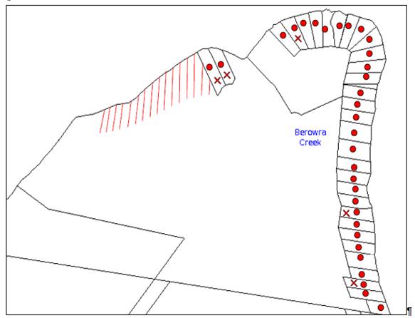
|
NOTIFICATION PLAN |
|
|||
|
• PROPERTIES NOTIFIED
|
X SUBMISSIONS RECEIVED |
|
|
|
|
17 SUBMISSIONS RECEIVED OUT OF MAP RANGE |
||||
22 submissions objected to the development. The matters raised by the objectors are discussed as follows:
5.1.1 Limited Access Low Tide
Access at low tide for emergency services including Rural Fire Service access was raised as a concern.
A water depth of 300mm ISLW would enable access to the proposed pontoons by small vessels in the event of a medical emergency.
The proposal is acceptable for NSW Rural Fire Service water access subject to additional requirements for bush fire protection.
5.1.2 River Settlements Strategy
Inconsistency with the strategy for no further subdivision involving river settlements was raised as a concern.
The strategy is incorporated in Council’s planning controls. The proposal is consistent with the strategy in not creating any additional lots.
5.1.3 Limited Resident Car Parking, Commuter Boat Moorings & Garbage Facilities
Additional demand on limited resident facilities on the eastern side of Berowra Waters was raised as a concern.
A range of alternative private and public facilities are available at Berowra Waters which would meet requirements of future residents, including the 78 berth West Marina and secure parking at the West Car Park off Bay Road.
5.1.4 Loss Recreational Access Calabash Bay
Obstruction of the tidal channel by the proposed pontoons for recreational access was raised as a concern.
The proposed pontoons would not obstruct the tidal channel for access by recreational craft. Refer MHL Drawing Figure 3.2.
5.1.5 Potential Dredging To Maintain Channel
The likelihood of dredging the tidal channel for boat access was raised as a concern.
The proposed water access is restricted at low tide to smaller vessels. To ensure operation of the proposed pontoons would not require deepening of the channel a condition is recommended for the operation to be limited to vessels with a draft of not more than 300mm.
5.1.6 Loss of Scenic Quality
The impact of the proposal on scenic quality was raised as a concern.
The proposed APZ and future dwellings would extend the river settlement of Calabash Point and change the scenic quality of Calabash Bay. The impact on scenic quality would be mitigated subject to appropriate design of future dwellings.
The loss of scenic quality resulting from the reduction in natural area is acceptable in respect to the existing dwelling entitlement being maintained, and would not warrant grounds of refusal of the application.
5.1.7 SEPP 1 Objection Not Well Founded
Whether the proposal is consistent with the objectives of the Environmental Protection E (River Settlement) Zone was raised as a concern.
The applicant’s submission concerning the minimum 40 hectare lot size required for the river settlement zone is considered well founded as discussed in Section 2.10 of this report.
5.1.8 Potential Further Subdivision McCallums Road
The likelihood of further subdivision with access off McCallums Road was raised as a concern.
The subject site would not provide for further subdivision under the current planning controls for a minimum lot size of 40 hectares.
5.1.9 Whether Amended Proposal Same Development
Whether the amended proposal is the same development as originally submitted was raised as a concern.
The original proposal was for subdivision of two lots (Lots 1 & 2 DP 882783) into eight lots. The proposal was amended to include Lot 78 DP 752048 and Lot 163 DP 1113746 and for subdivision of four lots into four lots and deletion of access stairs and inclinator.
Legal advice obtained confirms that the amended proposal addressed RFS bush firefighting concerns for development not to occur on the upper ridge area of the site and was accepted by Council in not creating any additional lots. The amended proposal involves the same waterfront area as originally proposed for subdivision.
The amended application was made in accordance with Clause 55 of the Environmental Planning and Assessment Regulation 2000.
5.1.10 Tidal Survey Inadequate
The accuracy of the hydrographic survey information submitted to Council was raised as a concern.
The application originally included hydrographic survey information based on Median Spring Low Tide data which was revised to Indian Spring Low Tide.
An independent hydrographic survey was provided by Manly Hydraulics Laboratory which determined the navigable access. Refer to discussion in Section 2.3.7.
5.1.11 Loss Existing Vegetation
The loss of vegetation was raised as a concern for biodiversity impact.
The loss of vegetation required for the proposed house sites and APZ is acceptable subject to replacement offset planting as proposed. Refer to discussion in Section 2.16.1.
5.1.12 Need For Restricted Development Area
Protection of the natural area between existing lots 3 and 4 was raised as a concern.
The natural area would be included in the proposed residual Lot 1 but would otherwise not be affected by the proposed subdivision.
5.1.13 Pathogen Runoff
The proposed on-site waste water treatment system and impact on the waterway was raised as a concern.
The application demonstrates on-site waste water management can be achieved for future dwelling houses on the proposed lots. Refer to discussion in Section 2.16.4.
5.1.14 Inconsistent SREP 20
Inconsistency with the SREP 20 requirement for locating structures in areas which are already cleared or disturbed instead of clearing or disturbing further land, was raised as a concern.
The proposed development of the undisturbed natural area is acceptable in respect to the existing dwelling entitlement being maintained and the undisturbed nature of the entire site, and would not warrant grounds for refusal of the application.
5.1.15 No Provision Transfer Dwelling Entitlement
The transfer of entitlement from the existing lots to the proposed lots was raised as a concern as requiring separate provision under HLEP.
The matter of dwelling entitlement relates to a dwelling house being permissible on an allotment within the Environment Protection E (River Settlement) Zone with development consent. As the proposed subdivision does not change the number of allotments the ‘dwelling entitlement’ remains the same, i.e. subject to development consent. A separate statutory provision is not required.
5.1.16 Submissions received following the September 2016 Council Meeting
Following the Council Meeting on 14 September 2016, a further seven submissions from previous objectors were received. The additional matters raised are noted and commented on as follows:
a. Plans to bring in power from Berrilee when power is available on adjacent lots
The proposed subdivision includes an easement for electricity identified as E1 and E4 which would extend the existing power supply line at the rear of the existing Calabash Point waterfront lots to the proposed lots.
The proposal does not involve the construction of a new electricity supply line from Berrilee.
The site is subject to existing easements for services, electricity and a right of carriageway which extend (on paper but are unformed) from the road reservation off McCallums Road, Berrilee to the rear of the existing waterfront lots (Lot 4 and Lot 5 DP 882783). The proposal does not include any works in relation to these easements.
The road reservation off McCallums Road provides access for Ausgrid and other authorities. The access is via a locked gate at the end of McCallums Road. The road reservation includes the fire trail for access to the Fretus Hotel ruins on Lot 3 DP 882783 which was subject of DA/1111/02 approved by Council on 22 September 2003 for reformation of an existing fire trail partly listed as an item of local heritage significance. The development consent for DA/1111/02 prohibits the use of the fire trail as a public road.
b. Proposed lot sizes will result in development of larger houses out of character with the river settlements
The proposed indicative building envelopes on the proposed waterfront lots are on land zoned E4 Environmental Living under Hornsby Local Environmental Plan 2013 (HLEP). Pursuant to Clause 4.4 of HLEP a maximum floor space ratio of 0.3:1 is applicable to the proposed lots. The lot areas are 46.632 ha (Lot 1) and range between 2,180m2 and 2,980m2 which would result in unrealistic floor areas @ 0.3:1 floor space ratio. The building envelopes indicate an area in which a future dwelling could be located. The envelope is not an indication of the scale of a future dwelling. Future dwellings on the proposed lots would be subject to the Hornsby Development Control Plan 2013 (HDCP) provisions under Part 8.1 River Settlement Land, which include provision for the desired future character of Calabash Point, and for environmentally sustainable design and construction sympathetic to the topography of the site. The DCP notes that the maximum dwelling size for dwelling houses should be 180m2 and 30m2 for boat sheds.
c. Covenant limiting boat size is unenforceable
The purpose of the covenant recommended under Condition No. 20 is to alert future lot owners of the limited water depth for boat access at low tide.
d. The proposed pontoon structures west of the current pontoon would be unusable for part of each day and not provide adequate access to future dwellings
The two proposed pontoons are each designed to be shared between two dwelling houses and to allow sufficient area for manoeuvring and mooring of residents’ boats. The 300mm depth at Indian Spring Low Tide would provide for tinnie boat access.
A single pontoon would take up a larger proportion of the channel and require a greater waterway area for manoeuvring boats with potential impacts on marine habitat involving sea grass.
e. Why has Lot 3 DP 882783 (Fretus Hotel ruins) been omitted from the proposed subdivision?
The applicant originally proposed the restoration of the Fretus Hotel ruins for a residence in DA/1366/2012. The proposed restoration was subsequently deleted from that application following concerns raised by Council’s Heritage Committee. The development application has been withdrawn.
The Fretus Hotel ruins (Lot 3 DP 882783) was not subject of the subdivision application under DA/1009/2013.
f. Further legal advices the amendment of the development application pursuant to Clause 55 of the Environmental Planning and Assessment Regulation 2000 should be considered a new application
The legal advices were referred to Council’s solicitor as part of the peer review of the applicant’s legal advice. Refer to discussion above under Section 2.1.
g. The application for the proposed pontoon structures would not be possible without the adjustment of the E2 Environmental Conservation zone under the Draft Hornsby Local Environmental Plan 2013
The application was lodged on 24 September 2013 prior to the HLEP coming into force on 11 October 2013. Pursuant to Clause 1.8A of HLEP a development application made before the commencement of the HLEP must be determined in accordance with applicable plan on lodgement of the application which is Hornsby Shire Local Environmental Plan 1994. Refer to discussion in Section 2.2
5.2 Public Agencies
The development application was referred to the following Agencies for comment:
5.2.1 Roads and Maritime Services
Roads and Maritime Service advised there are no navigational concerns regarding the proposal in respect to local waterways.
5.2.2 Rural Fire Service
The NSW Rural Fire Service granted its General Terms of Approval for the issue of a ‘Bushfire Safety Authority’ under Section 100B of the Rural Fires Act 1997 subject to recommended conditions under Schedule 1 of this report.
5.2.3 Office of Water
The NSW Office of Water granted its General Terms of Approval for a ‘controlled activity’ permit, which form recommended conditions of development consent under Schedule 1 of this report.
5.2.4 Office of Environment and Heritage
The NSW Office of Environment and Heritage granted their General Terms of Approval in respect to Aboriginal Cultural Heritage and an Aboriginal Heritage Impact Permit. The requirements form recommended conditions of development consent under Schedule 1 of this report.
5.2.5 NSW Fisheries
NSW Fisheries granted General its Terms of Approval unconditionally.
6. THE PUBLIC INTEREST
Section 79C(1)(e) of the Act requires Council to consider “the public interest”.
The public interest is an overarching requirement, which includes the consideration of the matters discussed in this report. Implicit to the public interest is the achievement of future built outcomes adequately responding to and respecting the future desired outcomes expressed in environmental planning instruments and development control plans.
The application is considered to have satisfactorily addressed Council’s and relevant agencies’ criteria and would provide a development outcome that, on balance, would result in a positive impact for the community. Accordingly, it is considered that the approval of the proposed development would be in the public interest.
CONCLUSION
The proposal is for the subdivision of four allotments into four and construction of two jetties and pontoons.
The development application was lodged prior to the commencement of Hornsby Local Environmental Plan 2013 and is subject to the provisions of Hornsby Shire Local Environmental Plan 1994.
The application was subsequently amended from subdivision of two lots into eight lots to subdivision of four lots into four allotments. The legal advice submitted by the applicant in response to Council’s concerns regarding the amended proposal in respect to Clause 55 of the Environmental Planning and Assessment Regulation 2000 has been reviewed by Council’s solicitor. In this regard, the amended proposal is a valid application and can be determined by Council.
The proposal does not comply with the minimum 40 hectare lot size area required for an allotment created in the subject Environmental Protection E (River Settlement) Zone. The applicant’s submission under State Environmental Planning Policy No. 1 – Development Standards in respect to the non-compliance is well founded. The proposed non-compliance would not create a precedent for similar subdivision and is acceptable in the circumstances.
The proposal is integrated development and General Terms of Approval have been obtained from the NSW Rural Fire Service, the Department of Primary Industries – Water, the NSW Office of Environment and Heritage and NSW Fisheries.
29 submissions were received in response to the proposal.
The proposal is recommended for deferred commencement approval.
RESPONSIBLE OFFICER
The officer responsible for the preparation of this Report is the Manager – Development Assessments – Rodney Pickles, who can be contacted on 9847 6731.
|
Rod Pickles Manager - Development Assessment Planning Division |
James Farrington Group Manager Planning Division |
|
1.View |
Locality Map |
|
|
|
2.View |
Existing Lot Layout |
|
|
|
3.View |
Subdivision Plan |
|
|
|
4.View |
House Pad Plan |
|
|
|
5.View |
Jetties, Ramps and Pontoons Plan |
|
|
|
6.View |
Water Access Plan |
|
|
|
7.View |
Zoning Map |
|
|
|
8.View |
Aerial Map |
|
|
|
9.View |
Legal Advice |
|
|
File Reference: DA/1009/2013
Document Number: D07091482
SCHEDULE 1
GENERAL CONDITIONS
The conditions of consent within this notice of determination have been applied to ensure that the use of the land and/or building is carried out in such a manner that is consistent with the aims and objectives of the relevant legislation, planning instruments and council policies affecting the land and does not disrupt the amenity of the neighbourhood or impact upon the environment.
Note: For the purpose of this consent, the term ‘applicant’ means any person who has the authority to act on or the benefit of the development consent.
Note: For the purpose of this consent, any reference to an Act, Regulation, Australian Standard or publication by a public authority shall be taken to mean the gazetted Act or Regulation, or adopted Australian Standard or publication as in force on the date that the application for a construction certificate is made.
1. Deferred Commencement
Pursuant to Section 80(3) of the Environmental Planning and Assessment Act 1979, this consent does not operate until the following information is submitted to Council:
A. Construction Environment Management Plan
Due to the environmental sensitivities of Calabash Bay and the proposed development, a Construction Environment Management Plan is required to direct protective measures to be implemented during the jetty, pontoon and boardwalk construction, and the installation of other essential subdivision services (e.g. power, water, telecommunications etc.).
The site must be managed in accordance with the publication ‘Managing Urban Stormwater – Landcom (March 2004) and the Protection of the Environment Operations Act 1997 by way of implementing appropriate measures to prevent sediment run-off, excessive dust, noise or odour emanating from the site during the construction of the development.
The plan must be prepared by a suitably qualified and experienced person. The plan shall include the following:
A.1 Scaled survey plan of the site showing the development footprint in relation to remnant trees, waterways and other significant features including the midden as per the approved plans.
A.2 Location of protective fencing (1.8m high cyclone mesh) installed around bushland areas proposed for retention and to be clearly delineated from building works areas where deemed suitable.
A.3 Location of tree protection fences outside the tree protection zone of all trees approved for retention.
A.4 Location of temporary and permanent trenches required for installation of services
A.5 Location and specification of sediment and erosion control fencing to prevent degradation of the waterway.
A.6 Location of any soil, mulch, waste and building material stock piles.
A.7 Location of dedicated barge mooring areas.
A.8 Specifications of cut and fill.
A.9 Notation describing ‘that no mulch is to be applied within remnant bushland areas’
A.10 Phytophthora management protocols.
A.11 Appointment of a Project Arborist (minimum QF5 level) shall supervise the severance of any roots greater than 40mm and certify the installation of the tree protection fencing as well the condition of trees before, during and post development.
A.12 Appointment of a Project Ecologist (licensed by NSW OEH and possess Animal Ethics Authority) to be nominated to Council. Include notations on the plan describing that an ecologist shall be on site during tree clearing works to ensure fauna is relocated and only approved vegetation is removed. Prior to the approved removal of hollow bearing trees the applicant is to carry out the following actions to prevent harm to native wildlife:
i) Ensure the trees are removed in sections by a qualified Tree Surgeon just prior to dusk when roosting animals would be alert and likely to disperse ‘naturally’ from the site. Ensure that trees are knocked several times (with a hammer etc.) to alert any roosting animals of the possibility of danger. Ensure that all tree hollows are be examined prior to and immediately after their removal to ensure roosting animals are free from danger.
ii) WIRES (Wildlife Rescue) volunteers can be contacted on (02) 8977 3333 or Wildlife Services Sydney Metropolitan volunteers can be contacted on (02) 9413 4300. Information on animal nesting boxes can be gained from WIRES, Kalkari Information Centre in Ku-Ring-Gai Chase National Park, or Birds Australia web site – www.birdsaustralia.com.au
B. Integrated Vegetation and Fire Management Plan
An Integrated Vegetation and Fire Management Plan including the Asset Protection Zone shall be prepared for the proposed retained bushland on the site for the Asset Protection Zone for each of the proposed allotments and jetty / boardwalk structures. The plan is to be approved by Council’s Natural Resources Unit and shall be undertaken by a suitably qualified and experienced bushfire consultant/ecologist and shall include, but not be limited to the following:
B.1 Strategies to manage, maintain and conserve the bushland including:
i) On-going weed control and suppression using bush regeneration methods or other recommended control methods.
ii) Habitat protection for native fauna species. All hollow-bearing trees are to be identified by the ecologist and marked for retention.
iii) The restoration of all disturbed areas using bush regeneration techniques.
iv) Control of pest animal species and domestic pet control to maintain wildlife corridor
v) Recommendations from the Bushfire and Ecologist consultant report.
B.2 Strategies for management of the Asset Protection Zones in a manner that has the least impact on the natural environment and maintains indigenous vegetation for the benefit of the corridor function.
B.3 Hand Removal of Bushfire Fuel:
i) Any clearing for bushfire protection within the approved Asset Protection Zones shall be undertaken using manual methods including manual removal of dead timber, raking and removal of leaf litter (fine fuel), manual slashing of understorey vegetation such as a hand held brushcutter and other methods that ensure minimal environmental damage and erosion whilst maintaining the vegetation at a low fuel reduced state. Indigenous vegetation including trees and shrubs shall be retained in partially thinned scattered clumps to ensure the vegetation is non-continuous. Underscrubbing is to retain 15 centimetres of groundcover vegetation (including grass and herbaceous species) and all vegetation greater than three metres in height is to be otherwise retained. No removal of native vegetation shall occur within 10 metres of a natural watercourse. Clearing is not permitted in bushland outside the asset protection zone. No mulch or garden waste is to be deposited in bushland.
B.4 Revegetation works in disturbed and modified areas using a diversity of locally indigenous species. Include details of appropriate planting density, source of planting stock, species to be planted, site preparation works, mulching, watering of plants and maintenance of revegetation area.
B.5 Management of overhanging trees close to residential and open space areas. Identify areas proposed for other landscaping works.
B.6 Management and maintenance of approved stormwater/ wastewater irrigation areas.
B.7 Erosion, sediment and stormwater runoff controls including the management of impacts of run-off from all impervious surfaces including pavement areas.
B.8 Appropriate map of the site showing all areas to be managed under the Plan. The areas occurring outside of the APZ area shall be restricted from vegetation disturbance of any kind unless specified in this plan for weed removal. The map shall include the GPS locations of hollow-bearing trees to be retained where practical.
B.9 Schedule of works including timeframes and responsibilities for management actions.
B.10 Details of site monitoring including the submission of 6 monthly reports to Council’s Natural Resources Unit for the lifetime of the plan (5 years). This may include simple photographs from a consistent reference point in a letter format undertaken by the engaged bush regeneration contractor.
B.11 Details of qualifications and experience of personnel preparing the plan.
B.12 The lifetime of the Plan shall be for a minimum of 5 years from the issue of the Subdivision Certificate. The establishment of the APZ, and initial weed control works shall be implemented prior to issue of the Subdivision Certificate and subject to an inspection by Council’s Natural Resources Unit.
C. Voluntary Planning Agreement
Pursuant to Section 93F of the Environmental Planning and Assessment Act 1979, the applicant must prepare and enter into a Voluntary Planning Agreement (VPA) with Hornsby Shire Council for the offsetting of the loss of Rough-barked Apple – Forest Oak vegetation community under Council’s Green Offset Code (2013).
The terms of the VPA must include but not be limited to the following:
C.1 The Applicant agrees to pay Council a monetary contribution of $100,419 towards the replacement of 0.24 hectares of Rough-barked Apple – Forest Oak vegetation community lost from the site as result of the development.
C.2 Hornsby Shire Council agrees to provide Council managed bushland reserves in the locality on the Lower Hawkesbury Estuary to undertake the required offset actions including revegetation, restoration and enhancement works to offset the development impacts, under Council’s Bushland Restoration Offset Program – Create, Restore and Enhance.
C.3 In addition to the above, the applicant agrees to pay all costs (including Council’s costs) associated with the preparation, public notification, legal costs and administration costs of the VPA.
Such information must be submitted within 36 months of the date of this notice.
Upon Council’s written satisfaction of the above information, the following conditions of development consent apply:
2. Approved Plans and Supporting Documentation
The development must be carried out in accordance with the plans and documentation listed below and endorsed with Council’s stamp, except where amended by Council and/or other conditions of this consent:
|
Plan No. |
Plan Title |
Drawn by |
Dated |
|
253445 Revision J |
Calabash Point Plan of Proposed 4 Lot Realignment |
VEKTA |
11/08/20214 |
|
253445 Revision J |
Calabash Point 4 Lot Realignment Showing Contours (APZ) |
VEKTA |
11/08/2014 |
|
253445 Revision J |
Calabash Point 4 Lot Realignment (APZ) |
VEKTA |
11/08/2014 |
|
253445 Revision J |
Calabash Point 4 lot Realignment Showing Proposed House Pad |
VEKTA |
11/08/2014 |
|
5675 Issue E |
Details, Levels & Proposed Shared Jetties Ramps Pontoons & Stabilising Piles |
SDG |
07-05-2014 |
|
MHL Report 2451 Figure 3.2 |
Calabash Bay Navigation Channel and Location Proposed Berthing Facilities |
NSW Public Works – Manly Hydraulics Laboratory |
March 2016 |
|
Document Title |
Prepared by |
Dated |
|
Plan of Management |
Australian Bushfire Protection Planners Pty Ltd |
28.06.2016 |
|
Calabash Bay Bushfire Fighting Vessel Access |
NSW Public Works – Manly Hydraulics Laboratory |
May 2016 |
|
On-site Waste Water Management Report |
Nyranie Consulting |
7 Sept 2014 |
|
Aboriginal Archaeological Survey Report and Statement of Heritage Impacts for Non-Indigenous Heritage |
Artefact Heritage |
Sept 2013 |
|
Flora And Fauna Impact Assessment |
Ecotone Ecological Consultants |
10 Sept 2013 |
|
Aquatic Ecology Survey |
Marine Pollution Research |
6 May 2013 |
|
Bushfire Protection Assessment |
ABPP |
12.09.2014 |
3. Construction Certificate
a) A Construction Certificate is required to be approved by Council or a Private Certifying Authority prior to the commencement of any works under this consent.
b) A separate Construction Certificate must be obtained from Council for all works within the public road reserve under S138 of the Roads Act.
c) A separate Construction Certificate must be obtained from Council for all works within drainage easements vested in Council.
d) The Construction Certificate plans must not be inconsistent with the Development Consent plans.
REQUIREMENTS PRIOR TO THE ISSUE OF A CONSTRUCTION CERTIFICATE
4. Building Code of Australia
All approved building work must be carried out in accordance with the relevant requirements of the Building Code of Australia.
5. Controlled Activity Approval
A Construction Certificate will not be issued over any part of the site requiring a controlled activity approval until a copy of the approval of the Department of Primary Industries – Water has been provided to Council.
6. Aboriginal Heritage Impact Permit
A Construction Certificate will not be issued over any part of the site requiring an Aboriginal Heritage Impact Permit until a copy of the Permit obtained from the NSW Office of Environment and Heritage has been provided to Council.
REQUIREMENTS PRIOR TO THE COMMENCEMENT OF ANY WORKS
7. Erection of Construction Sign
a) A sign must be erected in a prominent position on any site on which any approved work is being carried out:
i) Showing the name, address and telephone number of the principal certifying authority for the work;
ii) Showing the name of the principal contractor (if any) for any demolition or building work and a telephone number on which that person may be contacted outside working hours; and
iii) Stating that unauthorised entry to the work site is prohibited.
b) The sign is to be maintained while the approved work is being carried out and must be removed when the work has been completed.
8. Toilet Facilities
a) To provide a safe and hygienic workplace, toilet facilities must be available or be installed at the works site before works begin and must be maintained until the works are completed at a ratio of one toilet for every 20 persons employed at the site.
b) Each toilet must:
i) be a standard flushing toilet connected to a public sewer; or
ii) be a temporary chemical closet approved under the Local Government Act 1993; or
iii) have an on-site effluent disposal system approved under the Local Government Act 1993.
9. Erosion and Sediment Control
To protect the water quality of the downstream environment, erosion and sediment control measures must be provided and maintained throughout the construction period in accordance with the manual ‘Soils and Construction 2004 (Bluebook)’, the approved plans, Council specifications and to the satisfaction of the principal certifying authority. The erosion and sediment control devices must remain in place until the site has been stabilised and revegetated.
Note: On the spot penalties may be issued for any non-compliance with this requirement without any further notification or warning.
REQUIREMENTS DURING CONSTRUCTION
10. Construction Work Hours
All works on site, including demolition and earth works, must only occur between 7am and 5pm Monday to Saturday.
No work is to be undertaken on Sundays or public holidays.
11. Environmental Management
The site must be managed in accordance with the Construction Environment Management Plan approved by Council under Condition No. 1 of this consent.
12. Acid Sulfate Soils
Should acid sulfate soils be encountered during construction works, Council is to be notified immediately. An Acid Sulfate Soil Management Plan, written in accordance with the NSW Acid Sulfate Soil Manual 1998, is to be submitted to Council for approval and implementation. Piers for jetty construction are to be pile driven in Class 1 Acid Sulfate Soil zones.
13. Landfill
Landfill must be constructed in accordance with Council’s ‘Construction Specification 2005’ and the following requirements:
a) All fill material imported to the site is to wholly consist of Virgin Excavated Natural Material (VENM) as defined in Schedule 1 of the Protection of the Environment Operations Act 1997 or a material approved under the Department of Environment and Climate Change’s general resource recovery exemption.
14. Excavated Material
All excavated material removed from the site must be classified in accordance with the Department of Environment, Climate Change and Water NSW Waste Classification Guidelines prior to disposal to an approved waste management facility and reported to the principal certifying authority.
15. Disturbance of Existing Site
During construction works, the existing ground levels of open space areas and natural landscape features, including natural rock-outcrops, vegetation, soil and watercourses must not be altered unless otherwise nominated on the approved plans.
16. Construction of Jetties and Pontoons
The jetties and pontoons must be constructed in accordance with the following requirements:
a) Stockpiling, cutting and sanding must be performed a minimum of 10 metres from the shoreline and screened by sediment fencing;
b) No alteration of the natural gradient or scouring of the shoreline is permitted;
c) Works performed above the waterway must include preventive controls measures, such as booms, silt curtains, dust bags, covers, aprons or barrier controls to ensure dust and particulate pollutants are captured and contained and to prevent the escape of turbid plumes into the aquatic environment.
d) The jetty is to have a minimum deck height of 0.75 metres above local mean high water level finished at even height.
e) Piles must be well spaced to allow full tidal flushing, wave current and must not alter flow patterns or impede fish passage.
f) No outlying wires or obstructions are permitted to project outside the extremities of the jetty and pontoon.
17. Waste Management
a) All work must be carried out in accordance with the approved waste management plan.
b) Stockpiling, cutting and sanding must be performed a minimum of 10 metres from the shoreline and screened by sediment fencing.
REQUIREMENTS PRIOR TO THE ISSUE OF AN OCCUPATION OR SUBDIVISION CERTIFICATE
Note: For the purpose of this consent, a reference to ‘occupation certificate’ shall not be taken to mean an ‘interim occupation certificate’ unless otherwise stated.
18. Restriction as to User – Protection of Land from Future Development
To inform current and future owners that the areas of native vegetation and habitat on the site comprising the Asset Protection Zone of each lot (based upon BAL 29 for each indicative building envelope) is to be protected from future development, a Restriction as to User must be created under Section 88B of the Conveyancing Act, 1919 identifying the area of the site shown on the approved plans is restricted from development activities that would adversely affect the bushland.
Note: The wording of the Restriction as to User must be to Council’s satisfaction and Council must be nominated as the authority to release, vary or modify the Restriction.
19. Positive Covenant – Asset Protection Zones
A positive covenant must be created under s88E of the Conveyancing Act, 1919 and registered, requiring the Asset Protection Zones on the allotments approved under this consent to be managed in accordance with the Integrated Vegetation and Fire Management Plan approved by Council under Condition No. 1.
Note: The restriction must nominate Council as the authority to release, vary or modify the restriction.
20. Positive Covenant – Water Access
A positive covenant must be created under s88E of the Conveyancing Act, 1919 and registered on each of the allotments, requiring private vessels operating from the pontoons and tidal channel to have a draft not exceeding 300mm.
Note: The restriction must nominate Council as the authority to release, vary or modify the restriction.
21. Positive Covenant – Water Supply and Utilities
A positive covenant must be created under s88E of the Conveyancing Act, 1919 and registered on each of the allotments, requiring the provision of water supply and utilities for a future dwelling in accordance with the requirements of the NSW Rural Fire Service under Condition No. 27 and Condition No. 28 of this development consent.
Note: The restriction must nominate Council as the authority to release, vary or modify the restriction.
OPERATIONAL CONDITIONS
22. Bushfire Protection Zones
The required bushfire protection zone(s) must be maintained in perpetuity in accordance with the Integrated Vegetation and Fire Management Plan approved under Condition No. 1.
GENERAL TERMS OF APPROVAL – NSW RURAL FIRE SERVICE
The following conditions of consent are General Terms of Approval from the nominated State Agency pursuant to Section 91A of the Environmental Planning and Assessment Act 1979 and must be complied with to the satisfaction of that Agency.
23. Asset Protection Zones
The intent of measures is to provide sufficient space and maintain reduced fuel loads so as to ensure radiant heat levels of buildings are below critical limits and to prevent direct flame contact with a building. To achieve this, the following conditions shall apply:
23.1 Asset Protection Zones (APZs) shall be provided as recommended in the Bushfire Protection Assessment prepared by Australian Bushfire Protection Planners Pty Limited referenced B121884-3 dated 16 September 2014 and indicated on the drawing titled Section 8 – Plan of Development Site showing extent of Asset Protection Zones to the future dwellings erected on proposed Lots 1-4 in the report.
23.2 In accordance with section 88B of the Conveyancing Act 1919, a restriction to the land use must be placed on the proposed Lots 1-4 requiring the provision of the recommended APZs which must be maintained as outlined within section 4.1.3 and Appendix 5 of Planning for Bush Fire Protection 2006 and the NSW RFS’s document Standards for asset protection zones.
23.3 The restriction must require certification of the APZs for compliance with section 4.1.3 and Appendix 5 of Planning for Bush Fire Protection 2006 and the NSW RFS’s document Standards for asset protection zones each year by a suitably qualified bush fire consultant. The certificate must be submitted to Hornsby Shire Council no later than the 1st of October, after the annual inspection undertaken prior to the end of August of each year.
24. Water Access
The intent of measures is to provide safe operational access to structures and water supply for emergency services, while residents are seeking to evacuate from an area. To achieve this, the following conditions shall apply:
24.1 The proposed on-shore boardwalks to provide access to the proposed pontoons must be constructed of non-combustible materials.
25. Water and Utilities
The intent of measures is to provide adequate services of water for the protection of buildings during and after the passage of a bush fire, and to locate gas and electricity so as not to contribute to the risk of fire to a building. To achieve this, the following conditions shall apply:
25.1 A Static Water Supply (SWS) of 10,000 litres must be provided to service each of the future dwellings on proposed Lots 2 – 4 and 22,000 litres to service the future dwelling on proposed Lot 1.
25.2 Above ground tanks must be manufactured of concrete or metal and raised tanks must have their stands protected. All associated fittings to the tank must be non-combustible.
25.3 SWS tanks must be located within the inner protection area (IPA) of the future dwellings.
25.4 SWS tanks must be equipped with a minimum 5hp or 3kW petrol or diesel powered auxiliary pump housed in a non-combustible enclosure.
25.5 A 19mm (internal diameter) fire hose capable of reaching all parts of the future dwelling must be connected to the pump.
25.6 SWS tanks must be provided with 65 millimetre (mm) metal Storz outlet with a gate or ball valve, Stortz coupling and blanking cap. A 25mm branch must be extended off the 65mm outlet to connect the pump.
25.7 A separate water supply, with control valves, must be installed to feed the proposed roof sprinkler system. There must be unrestricted access to the control valves for operation during emergency.
25.8 A SWS marker must be obtained and positioned for ease of identification by brigade personnel and other users of the SWS. In this regard:
a) Markers must be fixed in a suitable location near the water body so as to be highly visible; and
b) Markers should be positioned adjacent to the most appropriate access to the SWS.
25.9 A permanent, suitably powered diesel pump must be installed to supply sea water from the western pontoon to a fire hydrant supply to each future dwelling. The spacing, sizing and pressures of fire hydrant supply for each dwelling must comply with AS 2419.1-2005. The pump must be housed in a non-combustible enclosure with the supply line installed under the deck of the pontoon. The supply line to the hydrants must be metal except where buried or covered by the pontoon structure.
25.10 A 25mm connection must be provided from the pump to the reticulated hydrant supply from the pontoons.
25.11 The aerial electricity supply to the future dwellings shall be installed in ‘bundled cable’.
25.12 Reticulated or bottled gas must be installed and maintained in accordance with Australian Standard AS/NZS 1596:2002: The storage and handling of LP gas and the requirements of relevant authorities. All fixed gas cylinders must be kept clear of all flammable materials to a distance of 10 metres and be shielded on the hazard side of the installation. Gas cylinders kept close to the building must have release valves directed away from the building and be located at least 2 metres away from any combustible material. Connections to and from gas cylinders must be metal.
25.13 All above ground water and gas service pipes external to the building shall be metal, including and up to any taps.
25.14 Inspection and maintenance of the fire fighting equipment for water supply including pumps must be undertaken three times a year, in April, August and December with the servicing and operation checked and certified by a suitably qualified bush fire consultant. The fire fighting equipment providing sea water from the proposed pontoons to hydrants must be flushed with non-salty water as part of the maintenance regime. The certificates must be submitted to Hornsby Shire Council each year.
25.15 A weatherproof operational chart shall be displayed in the vicinity of the proposed pontoons providing guidance on the use of fire fighting equipment.
26. Design and Construction
The intent of the measures is to reduce the risk of ignition of a building from a bush fire while the fire front passes. To achieve this, the following conditions shall apply:
26.1 The future dwellings erected on proposed Lots 1-4 shall comply with section 3 and section 7 (BAL 29) Australian Standard AS 3959-2009 Construction of buildings in bush fire-prone areas and section A3.7 of Addendum Appendix 3 of Planning for Bush Fire Protection 2006.
27. Evacuation and Emergency Planning
The intent of the measures is to provide suitable emergency and evacuation (and relocation) arrangements for occupants of special fire protection purpose developments. To achieve this, the following conditions shall apply:
27.1 Prior to the issue of a Subdivision Certificate, a Fuel Management Plan must be submitted to Hornsby Shire Council addressing the protocols for the maintenance of the APZs and the remnant vegetation within proposed Lot 1.
27.2 Prior to the issue of a Subdivision Certificate, a Bushfire Management Plan and fire emergency procedure must be submitted to Hornsby Shire Council.
28. Landscaping
Landscaping to the site is to comply with the principles in Appendix 5 of Planning for Bush Fire Protection 2006. In this regard the following landscaping principles shall be incorporated into the development:
a) Suitable impervious areas such as courtyards, paths and driveways shall be provided immediately surrounding the building;
b) Grassed areas/mowed lawns/ or ground cover plantings shall be provided in close proximity to the building;
c) Planting in the immediate vicinity of the building which may over time and if not properly maintained come in contact with the building shall be restricted; Maximum tree cover shall be less than 15%, and maximum shrub cover shall be less than 20%;
d) Planting shall not provide a continuous canopy to the building. Trees or shrubs shall be isolated or located in small clusters;
e) Consideration shall be given to estimated size of the plant at maturity when selecting landscape species;
f) Species with rough fibrous bark, or which retain/shed bark in long strips or retain dead material in their canopies shall be avoided;
g) Smooth bark species of trees which generally do not carry a fire up the bark into the crown shall be used;
h) Planting of deciduous species that may increase fuel at surface/ ground level (leaf litter) shall be avoided;
i) Climbing species to walls and pergolas shall be avoided;
j) Combustible materials such as woodchips/mulch, flammable fuel stores shall be located away from the building;
k) Combustible structures such as garden sheds, pergolas and timber garden furniture shall be located away from the building; and
l) Low flammability vegetation species shall be used.
GENERAL TERMS OF APPROVAL – DEPARTMENT OF PRIMARY INDUSTRIES – OFFICE OF WATER (REF. NO. 10 ERM2013/0827)
The following conditions of consent are General Terms of Approval from the nominated State Agency pursuant to Section 91A of the Environmental Planning and Assessment Act 1979 and must be complied with to the satisfaction of that Agency.
29. Plans, Standards and Guidelines
a) These General Terms of Approval (GTA) only apply to the controlled activities described in the plans and associated documentation relating to DA2013/1009 and provided by Council:
i) Site plan, map and/or surveys
Any amendments or modifications to the proposed controlled activities may render these GTA invalid. If the proposed controlled activities are amended or modified the NSW Office of Water must be notified to determine if any variations to these GTA will be required.
b) Prior to the commencement of any controlled activity (works) on waterfront land, the consent holder must obtain a Controlled Activity Approval (CAA) under the Water Management Act from the NSW Office of Water. Waterfront land for the purposes of this DA is land and material in or within 40 metres of the top of the bank or shore of the river identified.
c) The consent holder must prepare or commission the preparation of:
i) Vegetation Management Plan
ii) Erosion and Sediment Control Plan
iii) Soil and Water Management Plan
d) The consent holder must:
i) Carry out any controlled activity in accordance with approved plans and
ii) Construct and/or implement any controlled activity by or under the direct supervision of a suitably qualified professional and
iii) When required, provide a certificate of completion to the NSW Office of Water.
e) The consent holder must reinstate waterfront land affected by the carrying out of any controlled activity in accordance with a plan or design approved by the NSW Office of Water.
f) The consent holder must use a suitably qualified person to monitor the progress, completion, performance of works, rehabilitation and maintenance and report to the NSW Office of Water as required.
g) The consent holder must design and construct all ramps, stairs access ways, cycle paths, pedestrian paths or other non-vehicular form of access way so that they do not result in erosion, obstruction of flow, destabilisation, or damage to the bed or banks of the river or waterfront land, other than in accordance with a plan approved by the NSW Office of Water.
h) The consent holder must not locate ramps, stairs, access ways, cycle paths, pedestrian paths or any other non-vehicular form of access way in a riparian corridor other than in accordance with a plan approved by the NSW Office of Water.
i) The consent holder must ensure that no materials or cleared vegetation that may,
i) Obstruct flow,
ii) Wash into the water body, or
iii) Cause damage to the river banks;
are left on waterfront land other than in accordance with a plan approved by the NSW Office of Water.
j) The consent holder must stabilise drain discharge points to prevent erosion in accordance with a plan approved by the NSW Office of Water.
k) The consent holder must establish all erosion and sediment control works and water diversion structures in accordance with a plan approved by the NSW Office of Water. These works and structures must be inspected and maintained throughout the working period and must not be removed until the site has been fully stabilised.
l) The consent holder must ensure that no excavation is undertaken on waterfront land other than in accordance with a plan approved by the NSW Office of Water.
GENERAL TERMS OF APPROVAL – NSW OFFICE OF ENVIRONMENT & HERITAGE
The following conditions of consent are General Terms of Approval from the nominated State Agency pursuant to Section 91A of the Environmental Planning and Assessment Act 1979 and must be complied with to the satisfaction of that Agency.
30. Aboriginal Cultural Heritage
a) The two Aboriginal archaeological sites identified as Calabash Bay 1 and Calabash Bay 2 in the Aboriginal Archaeological Survey Report and Statement of Heritage Impacts for non-Indigenous Heritage prepared by Artefact Heritage dated September 2013 must be registered on the Aboriginal Heritage Information Management System (AHIMS) database in accordance with Section 89A of the National Parks and Wildlife Act 1974.
b) An Aboriginal Heritage Impact Permit (AHIP) must be obtained from the Office of Environment and Heritage under Section 90 of the National Parks and Wildlife Act 1974 for the proposal in respect to the Aboriginal archaeological site identified as Calabash Bay 2, prior to the issue of a Construction Certificate.
c) A site induction is to inform construction personnel of the location of the Aboriginal sites. The site Calabash Bay 1 must not be used during construction and is to be delineated to prevent access.
- END OF CONDITIONS -
ADVISORY NOTES
The following information is provided for your assistance to ensure compliance with the Environmental Planning and Assessment Act 1979, Environmental Planning and Assessment Regulation 2000, other relevant legislation and Council’s policies and specifications. This information does not form part of the conditions of development consent pursuant to Section 80a of the Act.
Environmental Planning and Assessment Act 1979 Requirements
The Environmental Planning and Assessment Act 1979 requires:
· The issue of a construction certificate prior to the commencement of any works. Enquiries can be made to Council’s Customer Services Branch on 9847 6760.
· A principal certifying authority to be nominated and Council notified of that appointment prior to the commencement of any works.
· Council to be given at least two days written notice prior to the commencement of any works.
· Mandatory inspections of nominated stages of the construction inspected.
· An occupation certificate to be issued before occupying any building or commencing the use of the land.
Long Service Levy
In accordance with Section 34 of the Building and Construction Industry Long Service Payments Act 1986, a ‘Long Service Levy’ must be paid to the Long Service Payments Corporation or Hornsby Council.
Note: The rate of the Long Service Levy is 0.35% of the total cost of the work.
Note: Hornsby Council requires the payment of the Long Service Levy prior to the issue of a construction certificate.
Tree and Vegetation Preservation
In accordance with Clause 5.9 of the Hornsby Local Environmental Plan 2013 a person must not ringbark, cut down, top, lop, remove, injure or wilfully destroy any tree or other vegetation protected under the Hornsby Development Control Plan 2013 without the authority conferred by a development consent or a permit granted by Council.
Notes: A tree is defined as a long lived, woody perennial plant with one or relatively few main stems with the potential to grow to a height greater than three metres (3M). (HDCP 1B.6.1.c).
Tree protection measures and distances are determined using the Australian Standard AS 4970:2009, “Protection of Trees on Development Sites”.
Fines may be imposed for non-compliance with both the Hornsby Local Environmental Plan 2013 and the Hornsby Development Control Plan 2013.
Subdivision Certificate Requirements
A subdivision certificate application is required to be lodged with Council containing the following information:
· A surveyor’s certificate certifying that all structures within the subject land comply with the development consent in regard to the setbacks from the new boundaries.
· A surveyor’s certificate certifying that all services, drainage lines or access are located wholly within the property boundaries. Where services encroach over the new boundaries, easements are to be created.
· Certification that the requirements of relevant utility authorities have been met.
· A surveyor’s certificate certifying finished ground levels are in accordance with the approved plans.
Note: Council will not issue a subdivision certificate until all conditions of the development consent have been completed.
Fees and Charges – Subdivision
All fees payable to Council as part of any construction, compliance or subdivision certificate or inspection associated with the development (including the registration of privately issued certificates) are required to be paid in full prior to the issue of the subdivision certificate. Any additional Council inspections beyond the scope of any compliance certificate required to verify compliance with the terms of this consent will be charged at the individual inspection rate nominated in Council's Fees and Charges Schedule.
Group Manager's Report No. PL80/16
Planning Division
Date of Meeting: 14/12/2016
12 FORMER PLAN FOR THE EXTENSION OF ARIANNA AVENUE, NORMANHURST
EXECUTIVE SUMMARY
· In 1977, Council adopted a plan for the extension of Arianna Avenue, Normanhurst. Council later approved a dwelling at property No. 17B Redgrave Road based on gaining future access to Arianna Avenue when built.
· Council subsequently approved developments without the requirement to gain access from Arianna Avenue and abandoned the Plan. Council resolved to negotiate the opportunity for property No. 17B Redgrave Road to obtain vehicular access from Arianna Avenue by right of carriageway over a neighbouring property when a development application was lodged for its redevelopment.
· Given that ten years elapsed without a resolution to this matter, Council requested a briefing and report presenting options to address access arrangements.
· It is recommended that Council maintain its previously adopted position to negotiate a right of carriageway with the owner of the neighbouring property when a development application is lodged for its redevelopment.
|
THAT 1. Council negotiate with the landowner of property No. 34 Hinemoa Avenue, Normanhurst when a development application for the redevelopment of the land is lodged to obtain a right of carriageway to provide vehicular access to the existing garage on property No. 17B Redgrave Road, Normanhurst. 2. The owners of the affected properties be advised of Council’s resolution. |
PURPOSE
The purpose of this report is to discuss options for vehicle access from No. 17B Redgrave Road to Arianna Avenue, Normanhurst arising from abandonment of a former Council plan of subdivision.
BACKGROUND
In May 1970 and July 1977, Council adopted plans showing the extension of Arianna Avenue, Normanhurst to facilitate the orderly subdivision of properties within Redgrave Road and Hinemoa Avenue, Normanhurst.
In November 1984, Council approved a dwelling at property No. 17B Redgrave Road, Normanhurst. The siting of the dwelling was based on gaining vehicular access to an extension of Arianna Avenue. The double garage and formal entrance of the dwelling face the rear of the property. Vehicular access is currently obtained from Redgrave Road over a shared right of carriageway with property No. 17A Redgrave Road.
Two developments were subsequently approved (including a cluster housing development at property No. 30 Hinemoa Avenue) without a requirement to extend Arianna Avenue on the following grounds:
· the need for individual owners to combine to pool resources and land;
· positioning of existing dwellings;
· the impact of the proposed road on developable area; and
· uncertainty regarding the sequencing of subdivision.
In September 1986, Council considered a report recommending the Plan be abandoned based on the above constraints. Council resolved to note the report.
In February 1994, Council resolved to write to affected property owners and seek their attitudes on abandonment of the Plan. Twenty written submissions were received. Twelve submissions were in favour of abandonment of the Plan in its entirety. Eight owners were in favour of variations of abandonment or retention. The owners of property No. 17B Redgrave Road strongly objected to abandonment in relation to their property. In April 1994, Council endorsed negotiation with the owner of property No. 34 Hinemoa Avenue to form a right of carriageway. Council’s request was subsequently declined by the owner.
In May 1994, Council held a site inspection and public meeting to hear from concerned residents. A petition was also received from thirty four residents of Arianna Avenue, Katrina Court and Redgrave Road for abandonment of the Plan.
In October 1995, Council considered feedback from residents and resolved to defer consideration to enable the new Councillors to hold an on-site meeting. Council officers at the on-site meeting concluded that the extension of Arianna Avenue would require a natural watercourse to be piped, several significant trees to be removed and for extensive batters and fill to achieve reasonable grades for any future road.
In November 1995, Council again considered the matter and concluded that the issues identified by Council officers, along with resident feedback, justified the abandonment of an extension of Arianna Avenue. Accordingly, Council resolved to exclude the southern extension of Arianna Avenue from the Plan and that residents be invited to discuss the preparation of alternate plans.
The matter was not progressed until February 2005 when Council considered Executive Manager’s Report No. PLN12/05, which was prepared following the submission of a subdivision application for properties in Redgrave Road where the proposed rear lots were affected by the road extension. The report provided an overview of the matters considered by Council in relation to road extension and discussed Council’s legal obligations. The legal advice provided that:
“As part of its planning functions for an area the Council has discretion to implement or not implement proposals as circumstances change. Provided those decisions are taken in a proper manner then the Council’s decision would not be open to challenge.”
Council resolved that the Plan for the extension of Arianna Avenue be abandoned and upon development of No. 34 Hinemoa Avenue, Council negotiate construction of a right of carriageway to provide vehicular access to No. 17B Redgrave Road.
At its meeting on 13 July 2016, Council considered Notice of Motion No. NOM6/16 providing a background to the abandonment of the Arianna Avenue extension and options to secure access to property No. 17B Redgrave Road. The report noted the time that has elapsed since Council previously considered the matter and recommended that a report be presented to Council identifying options to secure access for property No. 17B Redgrave Road to Arianna Avenue. Council resolved that a briefing be held for Councillors.
On 26 October 2016, a Councillor Briefing was held to identify access options for No. 17B Redgrave Road, Normanhurst. Councillors noted that a report on the options would be presented at a future meeting for Council’s consideration.
DISCUSSION
This report presents options to address the issue of obtaining vehicular access from Arianna Avenue to No. 17B Redgrave Road, Normanhurst.
1. Negotiate a Right of Carriageway
In October 2016, advice was sought from the owner of property No. 34 Hinemoa Avenue regarding a right of carriageway over their property in favour of No.17B Redgrave Road. The landowner verbally advised that they would not agree to provision of a right of carriageway and are currently readying the property for sale.
An opportunity exists for Council to negotiate a right of carriageway with the future landowner of property No. 34 Hinemoa Avenue when an application for development or subdivision of the land is lodged.
2. Acquire Land and Construct Access
Council may elect to acquire land and to construct vehicular access. This would involve preparing a planning proposal to amend the Land Reservation Acquisition Map under the Hornsby Local Environmental Plan 2013 to reserve land for road acquisition across the rear boundary of No. 34 Hinemoa Avenue. Such an amendment could be progressed as part of a future Housekeeping Review.
Alternatively, Council could seek acquisition by agreement with the owner of No. 34 Hinemoa Avenue or by compulsory acquisition under the Land Acquisition (Just Terms Compensation) Act 1991 where acquisition would facilitate a public road with full width road construction. This would require acquisition of 230sqm of land.
Acquisition of a lesser area of land and construction of a minimum width vehicular carriageway to service No. 17B Redgrave Road may also be adequate. This could be by negotiation and purchase of the land but would not be bound by the acquisition provisions of the Land Acquisition Act. Inclusion of a reservation in the HLEP and/or use of the acquisition provisions of the Land Acquisition Act can only be pursued if acquisition is for a public purpose (i.e. a public road).
3. Purchase Property and On-sell
Council may elect to enter into negotiations with the owner of No. 17B Redgrave Road to purchase the property at fair market value and resell. Should Council acquire the land, it may potentially be subdivided if the existing dwelling is demolished to provide the required lot configuration. The owner of No. 17B Redgrave Road has indicated that they do not wish to sell the property and this option does not meet their expectations of being able to access Arianna Avenue.
4. Compensate for Dwelling Alteration
It remains open for the landowner of No.17B Redgrave Road to undertake alterations and additions to re-orientate the dwelling to Redgrave Road. Council may elect to compensate the owner for the cost of undertaking this work which would include conversion of the double garage which currently faces Arianna Avenue to living area and reorientation of the dwelling (including construction of a new garage) to face Redgrave Road. The owner of No. 17B Redgrave Road has indicated that this option does not meet their expectations of being able to access Arianna Avenue.
Evaluation of Options
As outlined above, each option to resolve the access issue for No.17B Redgrave Road would require Council intervention. Council has previously received legal advice confirming that Council is not obliged to compensate the owner as the decision to abandon the road extension of Arianna Avenue was based on sound planning reasons and followed an appropriate process.
Intervention to provide access by way of purchasing or compensating the owner would involve the use of public funds to provide private benefit which may establish an undesirable precedent. Furthermore, feedback from the owner of No. 17B Redgrave Road indicates they are not supportive of options 3 or 4 as they do not meet their expectations of being able to access Arianna Avenue.
The timeframe to progress an amendment to the Land Acquisition May under the HLEP 2013 would take a minimum of 18 months followed by negotiations for acquisition. Although this option may achieve the desired outcome sought by the owner of No. 17B Redgrave Road, it is likely to be opposed by the owner of No. 34 Hinemoa Avenue. Further, the owner of No. 17B Redgrave Road has indicated that the timeframe associated with this option does not meet their expectations.
The dwelling house at property No. 17B Redgrave Road was constructed over 30 years ago and vehicular access has always been obtained from Redgrave Road. Therefore, there is no immediate need to acquire the land required for access. Given that the current owner of No.34 Hinemoa Avenue is not interested in negotiating an outcome and is preparing to sell the land, the preferred approach is to negotiate a right of carriageway with a future owner consistent with option 1.
BUDGET
Option 1 has no financial implications for Council. Options 2, 3 and 4 would require the reallocation of funds from other projects and/or services identified in Council’s current Annual Operating Budget.
POLICY
There are no policy implications associated with this report.
CONCLUSION
The dwelling house at property No. 17B Redgrave Road was constructed over 30 years ago. Vehicular access to the property has always been obtained from Redgrave Road. Therefore, there is no immediate need to access Arianna Avenue.
Council intervention to resolve a matter over which Council has no legal obligation would result in the use of public funds to provide private benefit. Accordingly, it is recommended that Council endorse Option 1, consistent with the previous resolution, to negotiate a right of carriageway with the owner of property No. 34 Hinemoa Avenue, Normanhurst upon the lodgement of a future subdivision application. Given that the current owner is preparing to sell the property, this opportunity may occur in the near future.
RESPONSIBLE OFFICER
The officer responsible for this report is the Manager, Strategic Planning – Fletcher Rayner, who can be contacted on 9847 6744.
|
Fletcher Rayner Manager - Strategic Planning Planning Division |
James Farrington Group Manager Planning Division |
There are no attachments for this report.
File Reference: F2004/08579
Document Number: D07095711
Group Manager's Report No. PL83/16
Planning Division
Date of Meeting: 14/12/2016
13 DRAFT MEDIUM DENSITY HOUSING CODE
EXECUTIVE SUMMARY
· On 10 February 2016, Council resolved to forward a submission to the Department of Planning and Environment supporting the intent of addressing the medium density controls but raising concern with the proposed delivery via State Environmental Planning Policy (Exempt and Complying Development) Codes 2008.
· The Department has recently released proposed amendments to the Codes SEPP and the Standard Instrument SEPP to enable medium density dwellings as complying development and a supporting Draft Medium Density Design Guide (MDDG).
· The Code SEPP would only apply to land zoned R3 Medium Density Residential in the Hornsby LGA and would enable street facing terraces (including subdivision) and manor houses (a type of 2 storey Residential Fat Building) as complying development.
· It is recommended that Council forward a submission to the Department of Planning and Environment supporting the intent of promoting medium density housing but raising concern with the proposed delivery via the Codes SEPP and MDDG.
|
1. THAT Council forward a submission to the Department of Planning and Environment supporting the intent of promoting density housing but raising the concerns identified in Group Manager’s Report No. PL83/16 including: 2. Implementation of the Medium Density Design Guide by way of State Environmental Planning Policy (Exempt and Complying Development) Codes 2008 is inconsistent with the draft North District Plan which identifies that councils are best placed to investigate opportunities for medium density housing. 3. Medium density development is better suited to the development application pathway to enable merit assessment when required. 4. The role of the Medium Density Design Guide should be similar to that of the NSW Apartment Design Guide and State Environmental Planning Policy No.65 Design Quality of Residential Apartment Development to respect local character. 5. Should the Department proceed to amend the Codes SEPP, provision should be made for councils to seek exemption where they can demonstrate that their local housing strategy has implemented the requirements of the District Plan and is consistent with the design intent of the Medium Density design Guide. |
PURPOSE
The purpose of this Report is to outline proposed medium density housing amendments to the Exempt and Complying Codes (the Codes SEPP), the Standard Instrument Local Environmental Plan (SI SEPP) and a Draft Medium Density Design Guide, identify implications for Hornsby Shire and provide recommendations for a submission to the Department of Planning and Environment.
BACKGROUND
The Codes SEPP sets out standards for particular types of development that can be carried out without the need for a development application. Small scale, low impact development such as decks and carports that meet particular standards can be undertaken as exempt development without the need for any form of approval.
For larger developments, including dwelling houses in certain areas, the Code SEPP sets out development standards and requirements for these to be undertaken as ‘complying development’ for which a complying development certificate (CDC) is issued. A CDC can be issued by Council or a private certifier. Neighbouring land owners are notified, but there is no provision for merit based submissions and no requirement to respond to merit issues.
In November 2015, the Department exhibited the Missing Middle – Options for Low Rise Medium Density Housing as Complying Development’ Discussion Paper. On 10 February 2016, Council considered Group Manager’s Report No. PL3/16 and resolved:
THAT a submission be forwarded to the Department of Planning and Environment supporting the intent of addressing the medium density housing policy ‘gap’ but raising the concerns identified in Group Manager’s Report No. PL3/16 including:
· The delivery of medium density housing should be provided through the existing framework of local housing strategies based on dwelling targets established by District Plans.
· Medium density development is better suited to the development application pathway to enable merit assessment when required.
· Permissibility of medium density development should rely on LEPs with minimum design and quality standards further explored via an expanded SEPP 65 and Apartment Design Guideline.
· Medium density development would not be appropriate in existing low density areas or areas with steep land.
· If only applied in R3 Medium Density Zones, the proposed controls could be supported if amended to provide more generous setbacks to support greater building separation, landscaping and deep soil planting.
The Department has released for comment an Explanation of Intended Effect for proposed Medium Density Housing Amendments to the State Environmental Planning Policy (Exempt and Complying Development) Codes 2008 (Codes SEPP) and the Standard Instrument Local Environmental Plan (SI SEPP) and a Draft Medium Density Design Guide (MDDG).
The proposed SI SEPP amendments would clarify and expand the range of medium density dwelling types in the Standard Instrument LEP. The Codes SEPP amendments would introduce a limited range of medium density dwelling types as complying development in areas where that dwelling type or a prescribed similar form is permitted in an LEP.
Submissions on the draft medium density SEPP Amendments and the Design Guide will be received up until 12 December 2016. Accordingly, a copy of Council’s submission report has been forwarded to the Department which will be updated pending Council’s resolution.
DISCUSSION
This report outlines the proposed amendments to the Code SEPP, Standard Instrument SEPP and the MDDG and identifies the key implications for Hornsby Shire.
1. Complying Development
Complying development is a fast-tracked, streamlined form of combined planning and construction approval for specified types of development identified and enabled through the Codes SEPP. Complying development can only be undertaken if a set of prescribed numerical controls and development standards are fully satisfied. Approvals can be issued by councils or private certifiers (certifying authority).
At present, complying development cannot be carried out on certain land, such as heritage conservation areas, foreshore areas and environmentally sensitive areas (including National Parks and critical habitat). Complying development can be carried out on bushfire and flood prone land provided additional locational, materials and construction requirements and standards are met.
2. Proposed Missing Middle Code Amendments
The proposed medium density housing code amendments are summarised below:
2.1. Standard Instrument LEP Definitions
An amended definition for multi dwelling housing and two new land use terms are proposed to be added to the Standard Instrument dictionary:
· multi dwelling housing: means 3 or more dwellings (whether attached or detached) on one lot of land, each with direct access at ground level and no other dwellings are above or below (the underlined text is the only change from the current definition).
· manor house: means a building containing 3 or 4 dwellings on one lot of land, where: (a) each dwelling is attached to another dwelling by a common wall and/floor, and (b) the building contains no more than two storeys, excluding any basement storey.
· multi dwelling housing (terraces): means 3 or more dwellings (whether attached or detached) on one lot of land, each dwelling has a frontage to a public road and no other dwellings are above or below (a form of multi-dwelling housing).
Multi dwelling housing (terraces) will be a type of multi dwelling housing. Manor homes are a new development type and are intended to apply within any zone where multi dwelling housing or residential flat buildings are permitted. R4 zoned land is excluded as larger scale residential flat buildings are encouraged in this zone.
2.2. Proposed Medium Density Housing Code
The Codes SEPP amendments for medium density housing would only apply in areas where those dwelling types are permitted in the R1, R2, R3 or, RU5 zones by an LEP. The proposed complying dwelling types would be limited to 2 storeys and be of a similar scale to a dwelling house carried out under the General Housing Code.
The following development types and subdivision requirements are proposed for inclusion in the Codes SEPP with a comment in relation to their relevance to the HLEP.
|
DWELLING TYPE |
SUBDIVISION |
COMMENT |
|
Two Dwellings side by side (attached or detached) |
Torrens title subdivision as complying development where there is no common property |
Not permitted by HLEP |
|
Dual Occupancy (attached – one over the other) |
Strata title only |
Not permitted by HLEP |
|
Multi dwelling housing (terraces)
|
Torrens title subdivision as complying development where there is no common property |
Permitted in R3 zone only |
|
Manor house
|
Strata title only
|
Permitted in R3 zone only |
The Code already permits strata subdivision of multi dwelling housing for which a complying development certificate has already been granted. The amendments propose to allow for the concurrent Torrens title subdivision and dwelling house consent where the proposal does not include the creation of any street, road or lane.
2.3. Medium Density Design Guide
The development standards for complying development would be contained within the Codes SEPP and MDDG. The role of the MDDG is to provide further explanation of the complying development standards and guidance on good design.
When preparing an application for a complying medium density housing development, an applicant would be required to consider the following parts of the MDDG:
· Part 2 as a reference for good design
· Part 3 for the design criteria that must be met
Any medium density complying development application would be required to include a Design Verification Statement to confirm the development is consistent with the principles of the MDDG.
It is also proposed that the MDDG would be used for development applications. Should councils choose, they may adopt the MDDG by reference within its DCP.
3. Issues
The Department is seeking feedback on the specific development types and standards proposed by the SEPP Code and Design Guide. Accordingly, it is recommended that Council’s submission be based on the following key issues:
3.1. District Planning Context
On 21 November 2016, the Greater Sydney Commission released the draft North District Plan for community consultation. The draft Plan requires that councils consider housing mix and affordability in housing strategies.
Whilst LGA specific housing targets are identified, the draft Plan does not identify a specific mix of low, medium or high density housing to be achieved. In the absence of a target or guidance on the take up of medium density housing, the objectives of the amendments may not be achieved, particularly as the proposed Code amendments apply differently to each council based on the permissibility of land uses within their LEP.
Local councils would be required to amend their LEPs to give effect to the District Plans and Regional Plan for Sydney. As detailed in Part 4.3.4 of the Draft North District Plan, councils are in the best position to investigate opportunities for medium density development through local housing strategies developed in consultation with their community.
Recommendation:
· Implementation of the Medium Density Design Guide by way of the Codes SEPP is inconsistent with the draft North District Plan which identifies that councils are best placed to investigate opportunities for medium density housing.
3.2. Purpose of Codes SEPP and Design Guide
The role of the Codes SEPP was originally envisaged to enable minor, low impact development as complying development, where approval by an accredited certifier would not require merit assessment. Unlike SEPP 65 and the Apartment Design Guide, the proposal to introduce medium density housing and the supporting design guide, would override local planning controls and provide no provision for the preservation of local character.
The approval pathway for the proposed types of complying development would require compliance with the Codes SEPP, MDDG and preparation of a design verification statement. This complex approval pathway demonstrates that the proposed development types are not low impact and would be better suited to the merit assessment pathway.
Furthermore, accredited certifiers generally have backgrounds in building surveying and would likely have limited experience in the assessment of the proposed dwelling types. Medium density development typically involves a merit assessment of compliance with local controls, amenity, privacy, design quality, servicing and traffic impact that involve the input of a broad range of professionals. A complying pathway would only require a single accredited certifier to assess these complex issues.
Recommendation:
· Medium density development is better suited to the development application pathway to enable merit assessment of complex planning and design issues.
· The role of the Medium Density Design Guide should be similar to that of the Apartment Design Guide and SEPP 65 to preserve local character.
3.3. Subdivision and complying development
The proposed amendments seek to allow the concurrent Torrens title subdivision and dwelling house approval without a minimum parent lot requirement. Whilst the HLEP does not specify a minimum allotment size for development in the R3 zone, the HDCP does require a minimum 30m lot to undertake multi dwelling housing or a residential flat building.
Two typical 1950’s to 1960’s lots would achieve a site frontage of just over 30m with site depths ranging from 42m to 51m. Therefore, most medium density development in Hornsby Shire are based on parent allotments of approximately 1,200 to 1,500 sq.m which is sufficient to address common and private open space, setbacks, basement parking and high quality landscaping with deep soil zones.
Should the SEPP amendments proceed, it would be appropriate that the dwelling types are based on a minimum parent lot determined by the local council. This would enable councils who currently do not apply a minimum lot size for certain types of development (as per model Clause 4.1B), to set appropriate requirements within their LEPs suitable for both complying and merit based assessment.
Recommendation:
· The Codes SEPP should not override the minimum lot size requirements within Standard Instruments LEPs.
3.4. Relationship to Local Environmental Plans
The Medium Density Housing Code amendments will only apply to land zoned R3 Medium Density Residential within the Hornsby LGA which accounts for 56ha or approximately 1% of all residentially zoned land (this figure includes land in Epping and Carlingford now in the City of Parramatta). Most R3 zoned land is already developed, with potential remaining in the medium density housing precincts of Hornsby North, Asquith and Mount Colah.
The HLEP is one of the few environmental planning instruments in NSW that permits residential flat buildings (RFBs) in the R3 Zone. As the highest and best use, lower yield housing types are less attractive to developers who mainly seek to develop two storey walk up flats. Within this context, the introduction of code assessable terraces and manor homes within the R3 zone is unlikely to increase take-up when more profitable development options exist.
However, for councils who permit dual occupancy development within their R1 and R2 zones, the SEPP will have broad implications on their zoning hierarchy. To ensure that the impact of the amendments equally apply to councils, they should only apply to development within the R3 zone which would provide councils with the scope to consider expanding this zone in future housing strategies.
Recommendation:
· The Department should consider restricting complying development to the R3 Medium Density Zone with mandated uses to support expansion of code assessable medium density housing.
3.5. Development Standards and Controls
The proposed amendments would introduce a one size fits all approach to inner, middle and outer ring suburbs. Council’s previous submission indicated that the controls could be supported if amended to provide more generous side setbacks to support greater building separation, landscape, deep soil planning and consideration of slope.
The following minimum development standards need to be met for multi dwelling housing (terraces), manor homes and subdivision to be considered as complying development. A comparison with the requirements of Council’s HDCP is provided below.
|
Manor Homes |
|||
|
Description |
Codes SEPP / MDDG |
Hornsby DCP |
|
|
Min lot size for each dwelling |
600m2 15m wide |
NA 30m wide |
|
|
Maximum Height of building |
8.5m |
|
10.5m |
|
Maximum Gross Floor Area (each lot) |
>600m2 – 700m2 >700m2-900m2 >900m2 |
0.6:1 0.5:1 0.4:1 |
Not applicable. An FRS control is not applied and yield is informed by building envelope controls. |
|
Landscaped area |
>600m2 – 700m2 >700m2-900m2 >900m2-1500m2 >1500m2 Min width 1.5m |
30% 35% 40% 45% |
Min width of 4m and min dimension of 2m Soil depth of 1m
|
|
Landscaped area forward of building line |
50% minimum
|
|
6m minimum deep soil from front boundary. |
|
Primary Road Setback |
Average of dwellings within 40m, or >600m2-900m2 >900m2-1500m2 >1500m2
|
4.5m 6.5m 10m
|
7.6m to local roads and 9m to main roads. |
|
Secondary Road Setback |
>600m2-1500m2 >1500m2
|
3m 5m
|
Town house: 6m – can be reduced to 3m where the dwelling is oriented to the front / rear property boundary RFB: 6m, can be reduced to 3m for a maximum 1/3 of the building length. |
|
Side Setback |
Front half of the lot up to 15m – 0.9m
Rear half of the lot or a distance <15m from the front boundary: Building envelope defined by 45deg plane projected from a height 3.0m above the boundary. |
Town house: - can be reduce to 3m where the dwelling is oriented to the front / rear property boundary. RFB: 6m, can be reduced to 3, for a maximum 1/3 of the building length. |
|
|
Common Wall |
There are no side setback controls that relate to a common wall |
NA |
|
|
Rear Setback |
Where the part of a development has a height of building less than 4.5: Lot Area >600m2-1500m2 >1500m2 Where the part of a development has a height of building 4.5m or more: Lot Area >600m2-1500m2 >1500m2
|
Setback 6m 15m
Setback 10m 15m
|
6m |
|
Rear setback for lots with rear lanes |
Dwelling house and ancillary development may abut the rear boundary for a maximum 5% of the length of that boundary. |
|
|
|
Multi Dwelling Housing (Attached) |
|||
|
Description |
Codes SEPP / MDDG |
Hornsby DCP |
|
|
Min lot size for each dwelling |
200m2 6m wide |
NA 30m |
|
|
Maximum height of building |
9.0m |
|
10.5m |
|
Maximum Gross Floor Area (each lot) |
200-300m2 >300m2-400m2 >400m2-500m2 >500m2 |
0.80:1 0.75:1 0.65:1 0.60:1 |
Not applicable. An FSR control is not applied and yield is informed by building envelope controls |
|
Landscaped area |
200-300m2 >300m2-400m2 >400m2-500m2 >500m2 Min width 1.5m |
20% 25% 30% 35% |
Min width of 4m and min dimension of 2m Soil depth of 1m
|
|
Landscaped area forward of building line |
25% minimum |
|
6m minimum deep soil from front boundary |
|
Primary Road Setback |
Average of dwellings within 40m, or 200-300m2 >300m2-900m2 >900m2-1500m2 >1500m2
|
3.5m 4.5m 6.5m 10m
|
7.6 to local roads and 9m to main roads |
|
Secondary Road Setback |
200-900m2 >900m2-1500m2 >1500m2
|
2m 3m 5m |
Town house: 6m – can be reduced to 3m where the dwelling is oriented to the front / rear property boundary RFB: 6m, can be reduced to 3m for a maximum 1/3 of the building length. |
|
Side Setback |
Front half of the lot up to 15m – 1.2m, or if there is a boundary wall on an adjoining lot – 0m
Rear half of the lot, or a distance >15m from the front boundary;
Building envelope defined by 45° plane projected from a height 3.6m above the boundary. |
Town house: 6m – can be reduced to 3m where the dwelling is oriented to the front / rear property boundary
RFB: 6m, can be reduced to 3m for a maximum 1/3 of the building length. |
|
|
Common Wall |
There are no side setback controls that relate to a common wall |
NA |
|
|
Rear Setback |
Where the part of a development has a height of building less than 4.5: Lot Area >200m2-600m2 >600m2-1500m2 >1500m2
Where the part of a development has a height of building less than 4.5 or more:
Lot Area >200m2-1500m2 >1500m2 |
Setback 3m 6m 15m
Setback 10m 15m
|
6m |
|
Rear setback for lots with rear lanes |
Dwelling house and ancillary development may abut the rear boundary for a maximum width of 7m. |
NA |
|
In addition to the above tables, development must comply with the design criteria listed in Part 3.2 and 3.4 of the MDDG which provide more detailed design and siting requirements.
The Codes SEPP and MDDG go some way towards improving the design controls and are generally consistent with the integrated housing requirements of Growth Centre Precincts. However, the controls are not well suited to existing middle ring suburbs and would be inconsistent with Council’s approach of encouraging medium density housing within a landscape setting.
Hornsby Council is currently preparing a medium density housing strategy that seeks to introduce the same medium density development types proposed by the SEPP Code. Should the draft Plans proceed, Council would need to align its medium density housing controls to ensure consistency with the Codes SEPP, similar to the approach already applied for dwelling houses and apartments.
Should the Department proceed with the Codes SEPP, provision should be made for councils to seek exemption where they can demonstrate that their local housing strategy has implemented the requirements of the District Plan and makes appropriate provision for a diversity of dwelling types.
Recommendation:
· Should the Department proceed to amend the Codes SEPP, provision should be made for councils to seek exemption where they can demonstrate that their local housing strategy has implemented the requirements of the District Plan and is consistent with the design intent of the MDDG.
BUDGET
There are no budgetary implications associated with this Report.
POLICY
There are no policy implications associated with this Report
CONCLUSION
The proposal to address the ‘missing middle’ with respect to medium density housing controls is supported in principle. Rather than implementing state wide controls via the Codes SEPP, it is recommended that the delivery of medium density housing be considered as part of District Plans which are currently on exhibition and would require councils to prepare future housing strategies update their LEPs.
The location of new medium and high density development should be addressed through local planning strategies where local communities have the opportunity to be consulted and participate in the plan making process. Consistent with previous decisions to repeal State planning policies that imposed inappropriate development in low density areas, the current framework of only permitting detached dwellings and granny flats as complying development should remain.
Whilst the proposed SEPP amendments and design guide have come some way to identifying a standard suite of complying controls, they are not well suited to middle ring infill areas. A better approach would be to align the MDDG so that it applies in the same way that SEPP 65 and the Apartment Design Guide operate. This would avoid the one size fits all approach and would ensure that all councils and local communities are equally impacted and given the opportunity to prepare their own medium density housing strategies.
It is recommended that a submission be made to the DP&E supporting the intent of promoting medium density housing but raising concern with the proposed delivery via the Codes SEPP and MDDG.
RESPONSIBLE OFFICER
The officer responsible for the preparation of this Report is the Manager, Strategic Planning, Fletcher Rayner who can be contacted on 9847 6744.
|
Fletcher Rayner Manager - Strategic Planning Planning Division |
James Farrington Group Manager Planning Division |
There are no attachments for this report.
File Reference: F2015/00146
Document Number: D07107640
Deputy General Manager's Report No. IR31/16
Infrastructure and Recreation Division
Date of Meeting: 14/12/2016
14 INCLUSIVE PLAYGROUNDS
EXECUTIVE SUMMARY
· A Councillor Briefing was held 24 August 2016 in response to Council’s resolution of Notice of Motion NOM7/16 of 10 August 2016. This briefing outlined the concepts of inclusive play and how opportunities for inclusive play design for new and refurbished playgrounds may be provided.
· The report recognises the need to incorporate inclusive play in park development. This is to ensure children can feel included amongst other children. It also provides an opportunity for parents to feel part of the community and interact with other parents.
· There are a range of playgrounds planned including ‘Destination Parks’ and local parks. The report lists a number of opportunity sites as well as sites where playgrounds are currently being planned. They include new and renewal playground developments. In all instances they provide opportunities for inclusive playgrounds to be developed.
· To ensure local community engagement and input into new inclusive playgrounds, Council will consult with the local community.
|
THAT: 1. Council provide in-principle support to ensuring accessible and inclusive design is the starting point for all new and refurbished playgrounds. 2. Council shall consult with the local community and look to incorporate inclusive play opportunities wherever possible in new and renewal playground developments. For larger playground projects at destination parks staff will also engage specifically with disability service provider groups regarding design principles for inclusive design. |
PURPOSE
The purpose of this Report is to address Part 3 of Council’s resolution of Notice of Motion NOM7/17 of 10 August 2016. The report aims to identify the range of opportunities for including the concept of inclusive play in the design and provision of renewal and new playgrounds across the Shire.
BACKGROUND
At the 10 August 2016 General Meeting, Council considered Notice of Motion NOM7/16 and resolved that:
1. Council provide in-principle support to ensuring accessible and inclusive design is the starting point for all new and refurbished playgrounds.
2. Given the impending possibility of an amalgamation with Ku-ring-gai Council, a briefing be held on 24 August 2016 to ensure all Councillors are provided the opportunity to better understand the concept of inclusive play.
3. As soon as possible following the briefing, a report regarding future opportunities for including the concept of inclusive play be provided for Council’s consideration.
4. The members of Play For All Australia be thanked for initially bringing this matter to Council’s attention.
DISCUSSION
In response to Part 3 of the above Council resolution, a Councillor Briefing was held 24 August 2016 presented by staff and Ms Bec Ho, Executive Officer, Touched by Olivia, as outlined in the attached presentation. Comments and suggestions made by speakers regarding Notice of Motion NOM7/16 at the Council meeting of 10 August 2016 supporting inclusive play, were incorporated into the Councillor briefing.
What is an Inclusive Playground?
Inclusive play means all children have the opportunity to play together. Inclusive play not only means the child can feel included amongst other children, it also provides an opportunity for parents to feel part of the community and interact with other parents.

An inclusive playground provides varied play activities, thereby providing choice. All categories of play experience is provided, namely physical, intellectual, social, imaginative and constructive play activities, available at differing levels of difficulty and complexity. Play activities are offered in one space, not necessarily on one piece of equipment. Play activities are offered equally, at much the same scale, so that one type of play does not dominate over the others.
The following six principles underpin inclusive play:
1. Everyone can play
Playgrounds that provide different spaces and equipment to enable a range of different experiences in the one space. The type of play includes creative, sensory, physical, individual and group play. Play equipment may be provided at different heights and include slides and swings. ‘Nest’ type swings that accommodate multiple children and at grade carousels are beneficial.
2. Connection to the community
An opportunity for community involvement is provided in the design of the playgrounds, artwork and other elements. Engaging with the local community through a meaningful consultation process engenders a sense of care, ownership and connection with the site.
3. Access to nature
Nature is the best play environment. Providing natural elements and settings engages all of the senses. Playground elements that incorporate timber products and sensory gardens can provide a calm or safe zone for children who may be overwhelmed in a crowded playground.
4. Total experience
The play space is able to cater for different needs to ensure there is something for everyone. The play activities help use senses such as touch, sound and visual.
5. Play independence
The play space provides the opportunity for children of all ages and abilities to play independently.
6. Friendship and social participation
The provision of supporting facilities at play spaces that assist social participation include graded pathways, picnic shelters, BBQ’s, wheelchair access, children and adult size change tables, fences around the play space and cafes for parents.
Inclusive playground development opportunities
With regard to the suitability of Council’s existing playgrounds to cater for inclusive play, it is generally acknowledged that some older playgrounds were established at a time when there was a focus upon ‘accessibility to play’ as opposed to ‘inclusive play’. Notwithstanding this focus, many of Council’s playgrounds have aspects that are inclusive for children with mild to moderate levels of disability.
In more recent years Council has been delivering more inclusive play designs as playgrounds are renewed. These developments are informed by consultation programs that provide opportunities for local user input. Examples of recently completed playgrounds include James Park, Hornsby and the newly completed playground at Asquith Oval.
It is recognised that there are significant opportunities for inclusive playground development to occur in the developing areas of the shire, which include the housing strategy precincts, notably Asquith, Waitara and Hornsby as well as areas under consideration for rezoning that include the Cherrybrook Station Precinct, South Dural and Pennant Hills.
Council’s Active Living Hornsby Strategy (2015) identified the value and benefits of ‘Destination Parks’ as places that can attract local residents as well as visitors from a larger catchment. These sites provide opportunities for larger scale playgrounds to be complemented with other facilities including accessible amenities, picnic facilities and circuit paths. Cafés are often available nearby.
The Active Living Hornsby Strategy envisaged that these Destination Parks would be distributed across the shire. The following sites represent opportunities for enhancement:
Northern opportunities
· Warrina Street or Berowra Oval, Berowra
· Fagan Park, Galston
· Crosslands Reserve, Hornsby Heights
· McKell Park Brooklyn.
Central and southern opportunities
· Asquith Oval, Asquith
· Storey Park, Asquith
· Waitara Park; Hornsby Park
· Brickpit Park, Thornleigh
· Erlestoke Park, Cherrybrook
· Pennant Hills Park, Pennant Hills
· Wollundry Park, Pennant Hills.
In addition the following Destination Parks and / or play spaces are currently in the process of being planned:
Waitara Park, Hornsby - This project is currently in its planning phase. In accordance with the adopted Waitara Park Plan of Management, it will locate a new playground adjacent to the new tennis centre that is currently under construction. Council will consult with the community soon, with the inclusive playground programmed to be constructed late in 2017.
Storey Park, Asquith - This project is currently subject to a development approval process. The playground has been designed for inclusive play and is funded to be completed in 2018.
Hornsby Park, including Hornsby Quarry and Old Mans Valley Parklands - Council is currently planning a large park that will include a variety of recreation opportunities in a new play setting in close proximity to Hornsby Town Centre. A key element of this Destination Park will be an inclusive playground.
Local Parks - Council has an ongoing program for the renewal and delivery of new local parks, as set out in Council’s Delivery Program. Local playgrounds are generally developed in areas where major redevelopment is occurring in association with new high density housing areas such as Asquith, Hornsby and Waitara and the Cherrybrook Station Precinct. Playground renewals are more widely distributed and respond to a need to substantially upgrade aging equipment. In all instances these projects provide an opportunity for inclusive play to be incorporated.
CONSULTATION
The preparation of this report takes into consideration the feedback provided by those members of the community who spoke to Council at its meeting of 10 August 2016.
BUDGET
There are no specific budgetary implications associated with this Report. Council’s current budget allocations for new and replacement playground projects are considered sufficient to deliver inclusive play opportunities. This has been demonstrated at the Councillor briefing together with the completion of recent playground projects such as Asquith Oval.
POLICY
There are no policy implications associated with this Report. The inclusive playground principles outlined in the report are consistent with the requirements of the Disability Inclusion Act 2014 (NSW).
CONCLUSION
This report identifies how inclusive playgrounds can be delivered within Council’s existing budget allocations. Council will continue to consult with the local community for all future new and upgraded playgrounds to seek input and achieve inclusive designs. For larger playground projects at destination parks staff will also engage specifically with disability service provider groups regarding design principles for inclusive design.
Significant new inclusive play spaces will be provided over the next few years, in Waitara Park, Storey Park and Hornsby Park, with a number of other opportunities identified in the report.
RESPONSIBLE OFFICER
The officer responsible for the preparation of this Report is the Manager, Parks and Recreation – David Sheils - who can be contacted on 9847 6792.
|
David Sheils Manager - Parks and Recreation Infrastructure and Recreation Division |
Peter Powell Acting Deputy General Manager - Infrastructure and Recreation Infrastructure and Recreation Division |
|
1.View |
Attachment 1 - Councillor Briefing - 24 August 2016 |
|
|
File Reference: F2004/09976-02
Document Number: D07092932
Mayor's Note No. MN12/16
Date of Meeting: 14/12/2016
15 MAYOR'S NOTES FROM 1 TO 30 NOVEMBER 2016
Note: These are the functions that the Mayor, or his representative, has attended in addition to the normal Council Meetings, Workshops, Mayoral Interviews and other Council Committee Meetings.
Friday 4 November 2016 – On behalf of the Mayor, Deputy Mayor Councillor Hutchence attended the the Studio ARTES Magical Fantasy Ball at Hornsby RSL Club.
Sunday 6 November 2016 – The Mayor attended the Parish of St Therapon Ten Year Anniversary Ball at Curzon Hall, Marsfield.
Friday 11 November 2016 – The Mayor attended the Hornsby RSL Sub-Branch Remembrance Day Ceremony at Hornsby Cenotaph.
Tuesday 15 November 2016 – The Mayor hosted three Citizenship Ceremonies in the Council Chambers.
Thursday 17 November 2016 – The Mayor attended the launch of Kmart Hornsby’s Wishing Tree at Kmart Hornsby.
Thursday 17 November 2016 – The Mayor attended Marian Street Theatre’s 50th Birthday Celebration at Killara.
Friday 18 November 2016 – The Mayor attended Hornsby North Public School’s 50th Anniversary Celebrations at the School.
Friday 18 November 2016 – On behalf of the Mayor, Councillor Robert Browne attended Hornsby Woodworking Men’s Shed Christmas Party at Thornleigh.
Saturday 19 November 2016 – The Mayor attended the Screen on the Green Outdoor Movie Event “Cars” at Hornsby.
Saturday 19 November 2016 – The Mayor officially opened the Hornsby Art Prize Awards Night at Wallarobba Arts and Cultural Centre, Hornsby.
Thursday 24 November 2016 – The Mayor attended the Bendigo Bank Galston Community Event at the Galston Club.
Friday 25 November 2016 – The Mayor attended the Hornsby War Memorial Hall Committee Christmas Function at Hornsby RSL Club.
Saturday 26 November 2016 - On behalf of the Mayor, Councillor Browne attended the Bushcare/Nursery Volunteer Christmas Party at Roselea Community Centre, Carlingford.
Sunday 27 November 2016 – The Mayor attended the Berowra RSL Sub-Branch Annual Christmas Lunch at Club Berowra.
File Reference: F2004/07053
Document Number: D07106617
Notice of Motion No. NOM8/16
Date of Meeting: 14/12/2016
16 PEATS FERRY ROAD – INTERSECTION WITH DURAL STREET - NO RIGHT TURN RESTRICTION AND OTHER MATTERS
|
That Council: 1. Agree to refer the proposal to change the existing “No Right Turn, 7am - 9am, 3pm - 6pm Monday to Friday” in place in Peats Ferry Road at Dural Street to “No Right Turn, 6am – 10am, 3pm - 7 pm, Monday to Friday” to the Hornsby Shire Local Traffic Committee for a recommendation after the results of public consultation are known. 2. Investigate the imposition of “No Right Turn” bans into or out of Peats Ferry Road at Dural Street or Dural Lane after the Quarry Filling work has commenced and impacts can be evaluated. Note from Councillor: Traffic calming in Peats Ferry Road has transformed the former two lane state highway into a single lane local road with kerbside parking. This kerbside parking limits opportunities for through vehicles on Peats Ferry Road to pass right turning vehicles at the Dural Street and Dural Lane intersections on Peats Ferry Road during peak periods. Currently there is a part time No Right Turn Restriction in place at the intersection, of Dural Street and Peats Ferry Roads. The turn restriction duration needs to be amended to conform to Roads and Maritime Services current standard practices, which have been updated to manage the longer traffic peaks now experienced across Sydney. The existing “No Right Turn, 7am - 9am, 3pm - 6pm Monday to Friday” should be amended to “No Right Turn, 6am - 10 am, 3pm - 7 pm, Monday to Friday”, subject to the recommendation of the Hornsby Shire Local Traffic Committee after public consultation. Due the cumulative impacts of quarry fill related traffic, further consideration of No Right Turn bans into or out of Peats Ferry Road at Dural Street or Dural Lane should be investigated when the quarry filling work is underway. |
There are no attachments for this report.
File Reference: F2004/09962

