
Hornsby Shire Council Table of Contents
Page 1
AGENDA AND SUMMARY OF RECOMMENDATIONS
Rescission Motions
Mayoral Minutes
ITEMS PASSED BY EXCEPTION / CALL FOR SPEAKERS ON AGENDA ITEMS
GENERAL BUSINESS
Office of the General Manager
Nil
Corporate Support Division
Item 1 CS1/17 Investments and Borrowings for 2016/17 - Status for Periods Ending 30 November and 31 December 2016.......................................................................................................... 1
Item 2 CS3/17 Delivery Program for 2013-17 and Operational Plan (Budget) for 2016/17 - December 2016 Quarter Review........................................................................................................... 4
Environment and Human Services Division
Item 3 EH2/17 Expression of Interest - EOI 17/2016 - Storey Park Cafe.................................... 7
Planning Division
Item 4 PL1/17 Development Application - Seniors Living Development Comprising Seven Independent Living Units - 68 Beecroft Road, Beecroft................................................................... 11
Item 5 PL2/17 Development Application - Community Centre, Carpark and Playground - Nos.10X and 12 Old Berowra Road, Hornsby...................................................................................... 63
Item 6 PL3/17 Development Application - Subdivision of One Allotment into Two and Construction of a Dwelling House - 46 Sprigg Place, Mount Colah........................................................ 85
Item 7 PL7/17 Planning Proposal - Hornsby RSL Club ........................................................ 130
Infrastructure and Recreation Division
Nil
PUBLIC FORUM – NON AGENDA ITEMS
Questions of Which Notice Has Been Given
Mayor's Notes
Item 8 MN1/17 Mayor's Notes from 1 to 31 December 2016................................................. 144
Item 9 MN2/17 Mayor's Notes from 1 to 31 January 2017..................................................... 146
Notices of Motion
Item 10 NOM2/17 Playground Shade Structures ................................................................... 147
SUPPLEMENTARY AGENDA
MATTERS OF URGENCY
QUESTIONS WITHOUT NOTICE
Hornsby Shire Council Agenda and Summary of Recommendations
Page 1
AGENDA AND SUMMARY OF RECOMMENDATIONS
PRESENT
NATIONAL ANTHEM
OPENING PRAYER/S
Acknowledgement of RELIGIOUS DIVERSITY
Statement by the Chairperson:
"We recognise our Shire's rich cultural and religious diversity and we acknowledge and pay respect to the beliefs of all members of our community, regardless of creed or faith."
ABORIGINAL RECOGNITION
Statement by the Chairperson:
"We acknowledge we are on the traditional lands of the Darug and Guringai Peoples. We pay our respects to elders past and present."
AUDIO RECORDING OF COUNCIL MEETING
Statement by the Chairperson:
"I advise all present that tonight's meeting is being audio recorded for the purposes of providing a record of public comment at the meeting, supporting the democratic process, broadening knowledge and participation in community affairs, and demonstrating Council’s commitment to openness and accountability. The recordings of the non-confidential parts of the meeting will be made available on Council’s website once the Minutes have been finalised. All speakers are requested to ensure their comments are relevant to the issue at hand and to refrain from making personal comments or criticisms. No other persons are permitted to record the Meeting, unless specifically authorised by Council to do so."
APOLOGIES / LEAVE OF ABSENCE
political donations disclosure
Statement by the Chairperson:
“In accordance with Section 147 of the Environmental Planning and Assessment Act 1979, any person or organisation who has made a relevant planning application or a submission in respect of a relevant planning application which is on tonight’s agenda, and who has made a reportable political donation or gift to a Councillor or employee of the Council, must make a Political Donations Disclosure Statement.
If a Councillor or employee has received a reportable political donation or gift from a person or organisation who has made a relevant planning application or a submission in respect of a relevant planning application which is on tonight’s agenda, they must declare a non-pecuniary conflict of interests to the meeting, disclose the nature of the interest and manage the conflict of interests in accordance with Council’s Code of Conduct.”
declarations of interest
Clause 52 of Council’s Code of Meeting Practice (Section 451 of the Local Government Act, 1993) requires that a councillor or a member of a Council committee who has a pecuniary interest in a matter which is before the Council or committee and who is present at a meeting of the Council or committee at which the matter is being considered must disclose the nature of the interest to the meeting as soon as practicable. The disclosure is also to be submitted in writing (on the form titled “Declaration of Interest”).
The Councillor or member of a Council committee must not be present at, or in sight of, the meeting of the Council or committee:
(a) at any time during which the matter is being considered or discussed by the Council or committee.
(b) at any time during which the Council or committee is voting on any question in relation to the matter.
Clause 51A of Council’s Code of Meeting Practice provides that a Councillor, Council officer, or a member of a Council committee who has a non pecuniary interest in any matter with which the Council is concerned and who is present at a meeting of the Council or committee at which the matter is being considered must disclose the nature of the interest to the meeting as soon as practicable. The disclosure is also to be submitted in writing (on the form titled “Declaration of Interest”).
If the non-pecuniary interest is significant, the Councillor must:
a) remove the source of conflict, by relinquishing or divesting the interest that creates the conflict, or reallocating the conflicting duties to another Council official.
OR
b) have no involvement in the matter by absenting themself from and not taking part in any debate or voting on the issue as if the provisions of Section 451(2) of the Act apply.
If the non-pecuniary interest is less than significant, the Councillor must provide an explanation of why they consider that the interest does not require further action in the circumstances.
confirmation of minutes
THAT subject to the amendment shown below to the record of Public Speakers in the Minute for Item 7 – PL73/16 Development Application - Dwelling House - 8A Kirkham Street Beecroft, the Minutes of the General Meeting held on Wednesday 14 December 2016 be confirmed, a copy having been distributed to all Councillors:
Replace "Mr Adam Byrnes, on behalf of the Applicant addressed Council regarding this item".
With "Mr Adam Byrnes, on behalf of Think Planners addressed Council regarding this item".
Petitions
presentations
Rescission Motions
Mayoral Minutes
ITEMS PASSED BY EXCEPTION / CALL FOR SPEAKERS ON AGENDA ITEMS
Note:
Persons wishing to address Council on matters which are on the Agenda are permitted to speak, prior to the item being discussed, and their names will be recorded in the Minutes in respect of that particular item.
Persons wishing to address Council on non agenda matters, are permitted to speak after all items on the agenda in respect of which there is a speaker from the public have been finalised by Council. Their names will be recorded in the Minutes under the heading "Public Forum for Non Agenda Items".
GENERAL BUSINESS
· Items for which there is a Public Forum Speaker
· Public Forum for non agenda items
· Balance of General Business items
Office of the General Manager
Nil
Corporate Support Division
Page Number 1
Item 1 CS1/17 Investments and Borrowings for 2016/17 - Status for Periods Ending 30 November and 31 December 2016
RECOMMENDATION
THAT the contents of Deputy General Manager’s Report No. CS1/17 be received and noted.
Page Number 4
Item 2 CS3/17 Delivery Program for 2013-17 and Operational Plan (Budget) for 2016/17 - December 2016 Quarter Review
RECOMMENDATION
THAT the December 2016 Quarter Review of the 2013-17 Delivery Program and the Operational Plan (Budget) for 2016/17 be received and noted.
Environment and Human Services Division
Page Number 7
Item 3 EH2/17 Expression of Interest - EOI 17/2016 - Storey Park Cafe
RECOMMENDATION
THAT:
1. Council does not include space for a permanent café in the new Storey Park community centre.
2. Respondents be advised of Council’s decision.
Planning Division
Page Number 11
Item 4 PL1/17 Development Application - Seniors Living Development Comprising Seven Independent Living Units - 68 Beecroft Road, Beecroft
RECOMMENDATION
THAT Development Application No. DA/858/2016 for demolition of existing structures, retention of a swimming pool and construction of a seniors living development comprising seven independent living units with basement car-park and landscaping at Lot 3 Sec 7 DP 758074, No. 68 Beecroft Road, Beecroft be approved subject to the conditions of consent detailed in Schedule 1 of Group Manager’s Report No. PL1/17.
Page Number 63
Item 5 PL2/17 Development Application - Community Centre, Carpark and Playground - Nos.10X and 12 Old Berowra Road, Hornsby
RECOMMENDATION
THAT Development Application No. DA/1097/2016 for the demolition of existing structures and construction of a community centre, car park, public playground and landscaping works at Lot 2 DP 617493 and Lot 2 DP 367716, Nos. 10X and 12 Old Berowra Road, Hornsby be approved in accordance with the recommendation of the independent town planning consultant’s report – Nexus Environmental Planning Pty Ltd and the conditions of consent detailed in Schedule 1 of Group Manager’s Report No.PL2/17.
Page Number 85
Item 6 PL3/17 Development Application - Subdivision of One Allotment into Two and Construction of a Dwelling House - 46 Sprigg Place, Mount Colah
RECOMMENDATION
THAT Development Application No. DA/444/2016 for the Torrens Title subdivision of one allotment into two lots, retention of the existing dwelling on one lot and construction of a new dwelling house on the proposed second lot at Lot 22 DP 817656, No. 46 Sprigg Place, Mount Colah be approved subject to the conditions of consent detailed in Schedule 1 of Group Manager’s Report No.PL3/17.
Page Number 130
Item 7 PL7/17 Planning Proposal - Hornsby RSL Club
RECOMMENDATION
THAT:
1. Council forward the Hornsby RSL Planning Proposal attached to Group Manager’s Report No. PL52/16 (Document No. D07100508) to the Department of Planning and Environment for a Gateway Determination with amendments to permit development up to 5 storeys on property Nos. 7-19 Ashley Street and 2-4 Webb Avenue, Hornsby, only if the development is for the purpose of a seniors housing development.
2. The General Manager be authorised to endorse the re-drafting of the Planning Proposal into the required format under Council’s cover for Gateway Determination.
3. In accordance with the plan making powers delegated to Council, Council exercise Authorisation to prepare and make the Planning Proposal following the receipt of the Gateway Authorisation.
4. Council endorse the attached amendments to the Hornsby Development Control Plan (Document No. D07137316) to be exhibited concurrently with the Planning Proposal.
5. Following the exhibition, a report on submissions be presented to Council.
6. The proponent and submitters be advised of Council’s resolution.
Infrastructure and Recreation Division
Nil
PUBLIC FORUM – NON AGENDA ITEMS
Questions of Which Notice Has Been Given
Mayor's Notes
Page Number 144
Item 8 MN1/17 Mayor's Notes from 1 to 31 December 2016
Page Number 146
Item 9 MN2/17 Mayor's Notes from 1 to 31 January 2017
Notices of Motion
Page Number 147
Item 10 NOM2/17 Playground Shade Structures
COUNCILLOR Tilbury To Move
That Council:
1. Investigate options for erecting shade structures over playgrounds throughout Hornsby Shire.
2. The investigation should address:
a) current approaches in other Council areas
b) various options (including design and material choice) to provide shade over playgrounds
c) identify budget implications including the lifecycle cost of the various options
d) recommend a broad implementation strategy for the provision of shade structure.
Note from Councillor
Council’s current approach is to use established trees or plant new trees to provide shade over playgrounds. This has been seen as a cost effective and practical solution for many years. It avoids the capital and maintenance costs associated with the current examples of shade structures, which are prone to vandalism. Tree planting is not possible for every playground – a clear example is the playground at Foxglove Oval that is built on a clay capped former garbage tip.
Residents are increasingly asking for shade structures to be erected over playgrounds and I have received two petitions relating to this issue. It is opportune that Council investigate options for addressing the issue of shade over playgrounds. The investigation should address the design and material options for these structures, lifecycle costs of providing shade structures and the priority for the provision of these structures.
SUPPLEMENTARY AGENDA
MATTERS OF URGENCY
QUESTIONS WITHOUT NOTICE
Deputy General Manager's Report No. CS1/17
Corporate Support Division
Date of Meeting: 8/02/2017
1 INVESTMENTS AND BORROWINGS FOR 2016/17 - STATUS FOR PERIODS ENDING 30 NOVEMBER AND 31 DECEMBER 2016
EXECUTIVE SUMMARY
· This Report provides details of Council’s investment performance for the periods ending 30 November 2016 and 31 December 2016 as well as the extent of its borrowings at the end of the same periods.
· Council invests funds that are not, for the time being, required for any other purpose. The investments must be in accordance with relevant legislative requirements and Council’s policies and the Chief Financial Officer must report monthly to Council on the details of funds invested.
· All of Council’s investments have been made in accordance with the Local Government Act, the Local Government (General) Regulation and Council's Investment of Surplus Funds Policy and Investment Strategy.
· In respect of Council’s cash and term deposit investments, the annualised returns for the months of November 2016 and December 2016 were 2.83% and 2.82% respectively and this compared to the benchmark of 1.50%.
|
THAT the contents of Deputy General Manager’s Report No. CS1/17 be received and noted. |
PURPOSE
The purpose of this Report is to advise Council of funds invested in accordance with Section 625 of the Local Government Act; to provide details as required by Clause 212(1) of the Local Government (General) Regulation and Council's Investment of Surplus Funds Policy; and to advise on the extent of Council’s current borrowings.
BACKGROUND
A report is required to be submitted for Council’s consideration each month detailing Council's investments and borrowings and highlighting the monthly and year to date performance of the investments. Initial investments and reallocation of funds are made, where appropriate, after consultation with Council's financial investment adviser and fund managers.
DISCUSSION
Council invests funds which are not, for the time being, required for any other purpose. Such investment must be in accordance with relevant legislative requirements and Council Policies, and the Chief Financial Officer must report monthly to Council on the details of the funds invested.
Council’s investment performance for the months ending 30 November 2016 and 31 December 2016 is detailed in the attached document. In summary, the At-Call and Term Deposits achieved an annualised return of 2.83% for November and 2.82% for December 2016, compared to the benchmark of 1.50%.
In respect of Council borrowings, the weighted average interest rate payable on outstanding loans taken out from June 2007 to December 2016, based on the principal balances outstanding was 7.23%. The Borrowings Schedules as at 30 November 2016 and 31 December 2016 are also attached for Council’s information.
CONSULTATION
Appropriate consultation has occurred with Council's financial investment adviser.
BUDGET
Budgeted investment income for 2016/17 is $3,000,000 which equates to an average budgeted monthly income of $250,000. Total investment income for the period ended December 2016 was $2,163,000 compared to the budgeted income of $1,500,000. Approximately 41% of the investment income received by Council relates to externally restricted funds (e.g. Section 94 monies) and is required to be allocated to those funds. All investments have been made in accordance with the Local Government Act, the Local Government (General) Regulation and Council's Investment of Surplus Funds Policy and Investment Strategy.
CONCLUSION
The investment of Council funds and the extent of its borrowings as at 30 November and 31 December 2016 are detailed in the documents attached to this Report. Council’s consideration of the Report and its attachments ensures that the relevant legislative requirements and Council protocols have been met in respect of those investments and borrowings.
RESPONSIBLE OFFICER
The officer responsible for the preparation of this Report is the Chief Financial Officer – Glen Magus - who can be contacted on 9847 6635.
|
Glen Magus Chief Financial Officer - Financial Services Corporate Support Division |
Gary Bensley Deputy General Manager - Corporate Support Corporate Support Division |
|
1.View |
HSC Investment Holdings Report - November 2016 |
|
|
|
2.View |
HSC Investment Holdings Report - December 2016 |
|
|
|
3.View |
HSC Borrowings Schedule - November 2016 |
|
|
|
4.View |
HSC Borrowings Schedule - December 2016 |
|
|
File Reference: F2004/06987-02
Document Number: D07128175
Deputy General Manager's Report No. CS3/17
Corporate Support Division
Date of Meeting: 8/02/2017
2 DELIVERY PROGRAM FOR 2013-17 AND OPERATIONAL PLAN (BUDGET) FOR 2016/17 - DECEMBER 2016 QUARTER REVIEW
EXECUTIVE SUMMARY
· Accountable organisations like Council review their budget and operational performance at least each quarter. In this regard, the December 2016 Quarter Review of the 2013-17 Delivery Program including the 2016/17 Operational Plan and Budget is attached.
· The 2016/17 Original Budget forecasted a surplus at 30 June 2017 of $82K. The September 2016 Review resulted in no change to the Original Budget with this Review providing proposed positive changes of $216K. As a consequence of the proposed changes, the forecast Budget surplus at 30 June 2017 is $298K.
· Progress against the adopted Delivery Program 2013-17 and the operational performance of the organisation has been in line with the service delivery standards adopted by Council.
|
THAT the December 2016 Quarter Review of the 2013-17 Delivery Program and the Operational Plan (Budget) for 2016/17 be received and noted. |
PURPOSE
The purpose of this Report is to present for Council’s consideration the December 2016 Quarter Review of the 2013-17 Delivery Program and the 2016/17 Operational Plan.
BACKGROUND
On 19 June 2013, Council adopted its four year Delivery Program 2013-17. The annual Operational Plan and Fees and Charges for 2016/17 were adopted by Council on 8 June 2016. The Delivery Program and Operational Plan set out the manner in which Council intends to deliver services and measure performance.
In line with Office of Local Government requirements, a Quarterly Budget Review Statement (QBRS) must be submitted for Council’s consideration at the end of each quarter. The Statement must be based on key financial indicators and the estimate of income and expenditure set out in Council’s Operational Plan for the relevant year.
DISCUSSION
Operational Comment
Operational performance for the second quarter of 2016/17 has been satisfactory. Some of the highlights achieved during the quarter include the approval of plans to build a new Rural Fire Station at Berowra valued at $1.3 million; and the transformation of a blank wall in Dural Lane, Hornsby into an early 20th century Hornsby street scene. Other highlights are provided in Attachment 1.
Budget Comment
This Review includes the second quarter results for 2016/17, comparing actual expenditure and income for the second quarter against the Budget. The Net Operating and Capital Result after internal funding movements showed a positive variance of $3.127 million. This positive variance is largely the result of timing differences associated with project related works and the initial phasing of the 2016/17 Budget.
The 2016/17 Original Budget forecasted a surplus at 30 June 2017 of $82K. The September 2016 Review resulted in no change to the Original Budget with this Review proposing positive changes of $216K. The Budget forecast at 30 June 2017 is, therefore, a surplus of $298K. The predicted Budget result at 30 June 2017 is satisfactory in maintaining Council’s existing liquidity levels. It is noted that the positive change in this Review relates to funding towards capital projects that was not identified at the time of setting the Original Budget.
BUDGET
This Report provides the December 2016 Quarter Review of the 2016/17 Operational Plan (Budget), which, if adopted, will amend the original budget forecast surplus at 30 June 2017 to $298K.
POLICY
There are no policy implications associated with this Report.
CONCLUSION
Council’s consideration of this Report ensures that relevant statutory requirements have been met. The December 2016 Quarter Review demonstrates that Council remains in a strong position to deliver local services and facilities in a financially responsible manner.
RESPONSIBLE OFFICER
The officers responsible for preparation of this Report are Julie Williams – Manager, Strategy and Communications and Glen Magus – Chief Financial Officer. They can be contacted on 9847 6790 and 9847 6635 respectively.
|
Gary Bensley Deputy General Manager - Corporate Support Corporate Support Division |
Robert Stephens Acting General Manager Office of the General Manager |
|
1.View |
2nd Quarter Review - December 2016 |
|
|
|
2.View |
Quarterly Budget Review Statement - December 2016 |
|
|
File Reference: F2015/00473
Document Number: D07130506
Group Manager's Report No. EH2/17
Environment and Human Services Division
Date of Meeting: 8/02/2017
3 EXPRESSION OF INTEREST - EOI 17/2016 - STOREY PARK CAFE
EXECUTIVE SUMMARY
· On 9 September 2016, Council lodged a Development Application (DA/1097/2016) for a new community centre, carpark and playground at 10X and 12 Old Berowra Road, Asquith (known as Storey Park). The DA as lodged did not include provision for a café space as Council separately wished to conduct an Expression of Interest (EOI) process to determine whether or not it was financially viable to do so.
· A Report on DA/1097/2016 is listed as a separate matter for consideration on Council’s February 2017 Business Paper.
· In November and December 2016 Council sought expressions of interest to test the market to determine whether it was financially viable to include space for a café as part of the new Storey Park community centre.
· A total of two submissions were received in response to Council’s call for expressions of interest that were subsequently evaluated. The evaluation concluded that it is not financially viable for Council to include a café as part of the Storey Park redevelopment.
· Having regard to the results of the evaluation it is recommended that Council does not seek to amend the DA to include space for a café in the new Storey Park community centre.
|
THAT: 1. Council does not include space for a permanent café in the new Storey Park community centre. 2. Respondents be advised of Council’s decision. |
PURPOSE
The purpose of this Report is to respond to Council’s resolution of April 2016 and provide a recommendation for EOI 17/2016 – Storey Park Cafe.
BACKGROUND
At the 13 April 2016 General Meeting, following consideration of Notice of Motion No. NOM2/16 it was resolved that:
1. Council authorise the lodging of a development application and construction certificate for redeveloped community facilities at Storey Park including a village scale multipurpose community centre, car park and children’s playground.
2. Concurrently, Council embark on a rigorous Expression of Interest (EOI) market testing process to determine the interest in the operation of a café on the site. The EOI process should include but not be limited to financial criteria as well as the quality and experience of the interested parties.
3. In the event the EOI process demonstrates that a café at Storey Park is viable, Council seek to amend the DA for the project to include a café.”
DISCUSSION
In accordance with Council’s April 2016 resolution, on 9 September 2016 a Development Application (DA/1097/2016) was lodged for a new community centre, carpark and playground at 10X and 12 Old Berowra Road, Asquith. The DA did not include provision for a café space as Council separately wished to conduct an EOI process to determine whether or not it was financially viable to do so. A Report on DA/1097/2016 is listed as a separate matter for consideration on Council’s February 2017 Business Paper.
EOI 17/2016 was called in late 2016 to test the market to determine whether it was financially viable to include a café in the new Storey Park community centre.
The EOI was advertised between 28 November and 19 December 2016 in the Sydney Morning Herald, the Hornsby Advocate, Tenderlink, via a digital marketing campaign focussed on food related websites, Council’s website, facebook and e‑newsletter.
Two (2) EOI submissions were received from:
· Lil Miss Collins Pty Ltd
· Team Trellie Enterprises
The following criteria were identified for the evaluation of the EOI’s:
· Financial returns and lease tenure;
· Past performance and experience;
· Capital contribution;
· Vision for the site; and
· References
A summary of submissions together with full evaluation details are attached. Excepting this report, the summary and details of the EOI’s received are to be treated as confidential in accordance with the Local Government Act.
The financial appraisal conducted on the submissions concluded that it is not financially viable for Council to include a café as part of the Storey Park redevelopment. Consequently the evaluation did not progress to the second stage assessment of non-financial criteria.
Having regard to the results of the evaluation it is recommended that Council does not seek to amend the DA to include space for a permanent café in the new Storey Park community centre.
It is noted however that one of the respondents has experience in operating a successful pop-up café and the concept of a pop-up café/food truck/coffee van could be explored should demand for such a service materialise once the community centre is constructed and operating.
BUDGET
There are no budgetary implications associated with this Report.
POLICY
There are no policy implications associated with this Report.
CONCLUSION
As part of its deliberations regarding the redevelopment of the Storey Park community centre Council wanted to test the market to determine whether it was commercially viable to include a café in the new Storey Park community centre.
A total of two submissions were received in response to Council’s call for expressions of interest that were subsequently evaluated. A financial appraisal conducted on the submissions concluded that it is not financially viable for Council to include a café as part of the Storey Park redevelopment.
Having regard to the results of the evaluation it is recommended that Council does not seek to amend the DA to include space for a café in the new Storey Park community centre.
RESPONSIBLE OFFICER
The officer responsible for the preparation of this Report is the Group Manager, Environment and Human Service - Mr Steve Fedorow, who can be contacted on 9847 6541.
|
Stephen Fedorow Group Manager Environment and Human Services Division |
|
|
1.View |
EOI 17/2016 - Evaluation Report - This attachment should be dealt with in confidential session, under Section 10A (2) (d) of the Local Government Act, 1993. This report contains commercial information of a confidential nature that would, if disclosed (i) prejudice the commercial position of the person who supplied it; or (ii) confer a commercial advantage on a competitor of the council; or (iii) reveal a trade secret. |
|
|
File Reference: F2015/00187
Document Number: D07130803
Planning Report No. PL1/17
Planning Division
Date of Meeting: 8/02/2017
4 DEVELOPMENT APPLICATION - SENIORS LIVING DEVELOPMENT COMPRISING SEVEN INDEPENDENT LIVING UNITS - 68 BEECROFT ROAD, BEECROFT
EXECUTIVE SUMMARY
|
DA No: |
DA/858/2016 (Lodged on 8 July 2016) |
|
Description: |
Demolition of existing structures, retention of a swimming pool and construction of a seniors living development comprising seven independent living units with basement car-park and landscaping |
|
Property: |
Lot 3 Sec 7 DP 758074, No. 68 Beecroft Road, Beecroft |
|
Applicant: |
Nutek Investments Pty Ltd |
|
Owner: |
Mrs Audrey June McDonald |
|
Estimated Value: |
$6,270,627 |
· The application involves the demolition of existing structures, retention of a swimming pool and construction of a seniors living development comprising seven independent living units with basement car-park and landscaping.
· The proposal generally complies with the provisions within State Environmental Planning Policy (Housing for Seniors or People with a Disability) 2004 and the heritage provisions within Hornsby Local Environmental Plan 2013.
· Two submissions have been received in respect of the application from one resident.
· It is recommended that the application be approved.
|
THAT Development Application No. DA/858/2016 for demolition of existing structures, retention of a swimming pool and construction of a seniors living development comprising seven independent living units with basement car-park and landscaping at Lot 3 Sec 7 DP 758074, No. 68 Beecroft Road, Beecroft be approved subject to the conditions of consent detailed in Schedule 1 of Group Manager’s Report No. PL1/17. |
BACKGROUND
The dwelling house on the site was constructed circa 1905.
Circa 1963, a large swimming pool was erected on the property and used for commercial purposes, being “McDonald’s Swimming School”. Council’s records indicate that the swimming school has operated without consent for a number of years and the use was formalised later.
On 3 December 2015, Council officers held a meeting with the applicant pursuant to pre-lodgement application No. PL/137/15 and provided advice regarding the demolition of the existing dwelling house, retention and refurbishment of the swimming pool and construction of a seniors living development with two x 2-storey buildings comprising 9 independent living units, a common swimming pool and putt-putt golf facility at the roof top. At the meeting, Council officers raised several concerns regarding the proposed design and its relation to the character of the area and accessibility issues within the site.
On 8 July 2016, DA/858/2016 for demolition of existing structures, retention of the swimming pool and the staged construction of a two storey seniors living development comprising 7 independent living units with basement car-park and landscaping works was lodged with Council.
On 2 September 2016, Council raised concerns regarding the impacts of the design on the character of the Heritage Conservation Area, status of the existing dwelling on the site, non-compliance with the height limit and floor space ratio, impacts on existing trees and traffic and road safety matters.
On 26 October 2016, the applicant submitted amended plans in response to Council’s concerns.
Following additional concerns raised regarding the proposed design, multiple sets of amended plans were lodged in November and December 2016.
On 21 December 2016, the applicant lodged further plans that included the following amendments:
· Reducing the gross floor area to comply with the relevant requirements;
· Introducing open corridors with louvres on the southern elevation;
· Amending the roof form to blend with the character of the Heritage Conservation Area;
· Amending the finishes and materials to include dark toned bricks and roof tiles;
· Increasing the setback of the upper level of the building from Beecroft Road;
· Adding privacy screens along the edge of the swimming pool and at the upper level;
· Amending the driveway width and introducing landscaping along both sides of the driveway; and
· Increasing deep soil zones on both sides of the site.
The amended plans seek to address the previous concerns raised by Council.
SITE
The site comprises a regular shaped allotment on the western side of Beecroft Road with an area of 1945m2 and 21.49m wide frontage to Beecroft Road. The subject site has an average cross fall of 6.8% from the rear (north-western corner) to Beecroft Road (south-eastern corner).
The current improvements on the site include a single storey dwelling house with a large garden and hardstand area in front, a carport on the southern side and an in-ground swimming pool with filter room at the rear. The swimming pool and the hardstand stand parking area in the front were previously used for commercial purpose. The use of the premises as a swimming school has ceased in the past year. Vehicular access to the site is via a concrete driveway along the southern boundary off Beecroft Road. A Sydney Water sewer line traverses the site centrally, being about 32m from the rear boundary. The sewer line is located at a depth of 1.5m below ground.
The existing vegetation on the site primarily comprises exotic species including palm trees. Dense vegetation within the front yard effectively screens the existing dwelling house from the street.
The properties on the western side of Beecroft Road, including the subject site, are located in a low density residential area, within the Beecroft Cheltenham Heritage Conservation Area. The site adjoins a heritage listed item at No. 30 Hannah Street, on the southern corner and is located opposite a heritage listed item at No. 83 Beecroft Road. A two storey seniors living development, comprising 10 independent living units over basement carpark is located at No. 64 Beecroft Road (north of the site) and was approved by Council under DA/1867/2007. Two single storey dwelling houses are located in between this development and the subject site. The adjoining developments along the southern boundary comprise single and two storey dwelling houses with frontage to Hannah Street. The St John’s Anglican Church is located further north of the site at the corner of Chapman Avenue and Beecroft Road.
The frontages of properties on the western side of Beecroft Road, in the near vicinity of the site, are strongly defined by a brick retaining wall built after the widening of the road and by dense boundary landscaping that largely obscures the buildings behind. In accordance with DA/1867/2007, the front wall of No. 64 Beecroft Road has been replaced with sandstone cladding.
Land use on the opposite side of Beecroft Road, in the near vicinity of the site, permits five storey mixed use developments under Council’s Housing Strategy 2011. The Beecroft Module shopping centre redevelopment site is located across the street. A five storey mixed use development comprising ground floor commercial and shop-top housing with 122 residential units over basement car park is currently under construction on this site pursuant to DA/1006/2014. A number of high density residential flat buildings are under construction further north of the site, on the eastern corner of Chapman Avenue and Beecroft Road.
The site is located about 225m from Beecroft Railway Station and 370m from the bus-stop on Wongala Crescent.
PROPOSAL
The proposal involves the demolition of the existing dwelling, retention of the existing swimming pool and construction of a seniors living development over basement car parking accommodating seven independent living units with landscaping works. The unit mix includes 6 x 3-bedroom dwellings and 1 x 2-bedroom dwelling. Vehicular access to the basement car-park is proposed via a driveway off Beecroft Road at the south-eastern corner of the site. The development specifics are provided below.
· A two storey residential flat building fronting Beecroft Road would accommodate six units (three on each floor).
· A basement car park is proposed to be located under this building and would be accessed by a 5.5m driveway off Beecroft Road. The basement includes 16 car spaces, the common bin storage area, individual storage areas and service areas.
· The two storey building would be located clear of the existing sewer line. The building is split into two levels following the natural slope of the land. Common entry foyers with open corridors are proposed on both levels, along the southern elevation of the building. Lift and stairs provide access to the upper level dwellings. The corridors include full height vertical privacy louvres.
· A single storey detached dwelling house with two bedrooms is proposed at the rear of the swimming pool. The dwelling does not include attached vehicular accommodation, but would utilise the common carpark under the two storey building.
· The proposed dwellings vary in size between 105m2 – 148m2. The dwellings include oversized living areas connected to large terraces with northerly aspect. The gross floor area of the development is proposed to be 963.6m2.
· A continuous pedestrian ramp along the southern boundary of the site would provide access to the two buildings. An intermediate bin stand area is located between the two buildings and accessed off this path.
· The proposed buildings are of brick construction with concrete tiled pitched roof and balcony offsets on the northern, eastern and western sides. The buildings include a mix of brick, render and sandstone finishes and timber louvers for screening.
· The development would maintain the existing vegetation screen within the front yard and refurbish the retaining wall at the front with sandstone cladding. Existing screen planting along the side boundaries would also be generally retained. A 4m wide landscaped area is proposed at the rear of the single storey building.
· The filter room adjoining the swimming pool would be demolished. However, the pool itself would be retained and utilised as a facility for the future occupants. A new elevated deck is proposed around the swimming pool with seating and BBQ areas. A 1.8m high privacy screen is proposed along the southern boundary of this deck.
ASSESSMENT
The development application has been assessed having regard to ‘A Plan for Growing Sydney’, the ‘Draft North District Plan’ and the matters for consideration prescribed under Section 79C of the Environmental Planning and Assessment Act 1979 (the Act). The following issues have been identified for further consideration.
1. STRATEGIC CONTEXT
1.1 A Plan for Growing Sydney and (Draft) North District Plan
A Plan for Growing Sydney has been prepared by the NSW State Government to guide land use planning decisions for the next 20 years. The Plan sets a strategy and actions for accommodating Sydney’s future population growth and identifies dwelling targets to ensure supply meets demand. The Plan identifies that the most suitable areas for new housing are in locations close to jobs, public transport, community facilities and services.
The NSW Government will use the subregional planning process to define objectives and set goals for job creation, housing supply and choice in each subregion. Hornsby Shire has been grouped with Hunters Hill, Ku-ring-gai, Lane Cove, Mosman, North Sydney, Ryde, Northern Beaches and Willoughby to form the North District. The Greater Sydney Commission has realised the draft North District Plan which includes priorities and actions for the Northern District for the next 20 years. The identified challenge for Hornsby Shire will be to provide an additional 4,350 dwellings by 2021 with further strategic supply targets to be identified to deliver 97,000 additional dwellings in the North District by 2036.
The proposed development would be consistent with ‘A Plan for Growing Sydney’ and ‘Draft North District Plan’ by providing six additional dwellings and would contribute to housing choice in the locality.
2. STATUTORY CONTROLS
Section 79C(1)(a) requires Council to consider “any relevant environmental planning instruments, draft environmental planning instruments, development control plans, planning agreements and regulations”.
2.1 Hornsby Local Environmental Plan 2013
The proposed development has been assessed having regard to the provisions of the Hornsby Local Environmental Plan 2013 (HLEP).
2.1.1 Zoning of Land and Permissibility
The subject land is zoned R2 – Low Density Residential under the Hornsby Local Environmental Plan 2013 (HLEP). The objectives of the zone are:
· To provide for the housing needs of the community within a low density residential environment.
· To enable other land uses that provides facilities or services to meet the day to day needs of residents.
The proposed development is defined as ‘Seniors Housing.’ Seniors Housing is prohibited under the HLEP in the R2 zone. Notwithstanding, the proposal is permitted pursuant to Clause 4 of State Environmental Planning Policy (Housing for Seniors or People with a Disability) 2004 (SEPP HSPD) where land is zoned for urban purposes and where residential development is permitted. The provisions of SEPP HSPD prevail to the extent of any inconsistency with the HLEP.
2.1.2 Heritage Conservation
Clause 5.10 of the HLEP sets out heritage conservation provisions for Hornsby Shire. The property is within the Beecroft Cheltenham Plateau precinct of the Beecroft Cheltenham Heritage Conservation Area (HCA).
The subject site is located in the vicinity of heritage items Nos. 5A, 5B, 28 and 30 Hannah Street and No. 83 Beecroft Road (Item Nos. 46, 100, 101, 102 and 104) under Schedule 5 (Environmental Heritage) of the HLEP. The application is supported by a Heritage Impact Statement.
Council’s initial assessment of the existing dwelling house and the impact of the proposal on the Heritage Conservation Area raised a number of concerns. The applicant submitted amended plans to address Council’s concern. Council’s assessment of the amended proposal concludes the following:
· Part 9.3.6 of the Hornsby Development Control Plan 2013 (HDCP) prescribes that buildings in the HCA from the Victorian, Federation and Edwardian periods should be retained. Property, No.68 Beecroft Rd, Beecroft contains a Federation period dwelling, built circa 1905, which is a contributory example from the Federation and Edwardian period of development.
· The Heritage Impact Statement and addendum by the applicant indicates that the house has undergone modifications in the past. Additionally, the existing dwelling house is not visible from Beecroft Road because of its elevation and the existing dense landscaping that screens the site. Therefore, it provides minimal evidence of the “development diary” of the area from the public domain due to its location.
· The above assessment is supported and given the circumstance, demolition of the existing dwelling on the site is acceptable.
· The proposed amendments to the design of the development reduce the overall bulk and scale of the development by increasing the setbacks from Beecroft Road, proposing appropriate articulation and including a roof form that respects the heritage values of the area. Whilst the development would be two storeys, it is of a similar scale to the approved development at No.64 Beecroft Road and would be of a much smaller scale to that of the five-storey mixed used use development approved on the opposite side of the road.
· The characteristics of the HCA, along Beecroft Road between Hannah Street and Chapman Avenue in the immediate vicinity of the site, have been altered due to recent rezoning of land and the subsequent approvals granted. It is considered that the proposed development would be consistent with the character of this section of the streetscape of Beecroft Road.
· The amended proposal includes a decorative panelled basement garage door, with a dark toned recessive colour scheme as the basement car park entry. The design of the door assists in reducing its dominance in the streetscape. The driveway is also proposed to be constructed of dark toned materials. The driveway has been minimised in width wherever possible and landscaping introduced along the edges to reduce the hard stand areas along the frontage of the site.
· The dense planting and palm trees located at the front of the site are proposed to be retained, which would screen the development effectively and assist in reducing the impact of the new development on the streetscape. Additional landscaping adjacent the driveway is also proposed to soften the impact of the hard stand areas at the front of the site.
· The existing face brick front fence/retaining wall is proposed to be retained and clad in sandstone wall tiles. The small stone block appearance would not have an adverse impact on the streetscape.
· The proposed buildings would include a mix of face brickwork and rendering with concrete tiled roof. The proposed materials would be compatible with the character of the area. The rendered sections of the building are to be of a dark tone, which result in a sympathetic and recessive colour scheme in the streetscape.
· The design of the proposed development has been satisfactorily amended to achieve an acceptable impact on the HCA. The heritage listed buildings in the near vicinity including the adjoining development ta No. 30 Hannah Street, are well separated from the development site. Consequently, the proposal would not have any impact on the adjoining heritage items.
· The proposal is supported on heritage grounds subject to a condition requiring the submission of a photographic record of the dwelling house on the site prior to demolition.
2.1.3 Earthworks
Clause 6.2 of the HLEP states that consent is required for proposed earthworks on site. Before granting consent for earthworks, Council is required to assess the impacts of the works on adjoining properties, drainage patterns and soil stability of the locality.
The site adjoins residential properties to its northern, western and southern sides. The proposal would require bulk earthworks to level the site and excavation works up to 4m, to accommodate the single level basement.
The excavation works are proposed to be clear of the sewer line and the associated easement. Council’s assessment of the application concludes that the proposal is satisfactory subject to recommended conditions regarding submission of dilapidation reports assessing the impact of the excavation on the adjoining residential properties.
2.2 State Environmental Planning Policy No. 55 – Remediation of Land
The application has been assessed against the requirements of State Environmental Planning Policy No. 55. This Policy provides State-wide planning controls requiring that consent must not be granted to the carrying out of development on land unless it has considered whether the land is contaminated or requires remediation for the proposed use.
A search of Council’s records and aerial images reveals that the property has been used exclusively for residential purposes with no record of any site contamination. Furthermore, taking into account the excavation required to accommodate the proposed basement car park and levelling, much of the existing soil would be removed from the site during construction works.
The existing dwelling is of brick construction. Notwithstanding, conditions of consent are recommended requiring the removal of all asbestos materials, if found, from the site.
Given this, the site would be suitable for the proposed use and no further assessment in relation to this SEPP is required.
2.3 State Environmental Planning Policy (Building Sustainability Index – BASIX)
The application has been assessed against the requirements of State Environmental Planning Policy (Building Sustainability Index: BASIX) 2004. The proposal includes a BASIX Certificate for the proposed dwellings and is considered to be satisfactory.
2.4 State Environmental Planning Policy (Housing for Seniors or People with a Disability) 2004
The State Environmental Planning Policy (Housing for Seniors or People with a Disability) 2004 (SEPP HSPD) is the overriding planning instrument for the development of housing for aged and disabled people in NSW and provides for hostels, residential care facilities (nursing homes) self-contained dwellings and multi-storey buildings. SEPP HSPD is comprehensive in scope including land use planning provisions, design principles, development standards and standards specifically to meet the housing needs of aged and disabled people. An assessment of the proposal in accordance with the relevant requirements of SEPP HSPD is provided as follows:
2.4.1 Clause 13 – Self Contained Dwellings
The SEPP HSPD includes the following definitions for “self-contained dwellings”:
“In this Policy, a self-contained dwelling is a dwelling or part of a building (other than a hostel), whether attached to another dwelling or not, housing seniors or people with a disability, where private facilities for significant cooking, sleeping and washing are included in the dwelling or part of the building, but where clothes washing facilities or other facilities for use in connection with the dwelling or part of the building may be provided on a shared basis.
In this Policy, in-fill self-care housing is seniors housing on land zoned primarily for urban purposes that consists of 2 or more self-contained dwellings where none of the following services are provided on site as part of the development: meals, cleaning services, personal care, nursing care.”
For the purposes of assessment against SEPP HSPD, the proposed development is defined as ‘in-fill self-care housing’ comprising seven ‘self-contained dwellings’.
2.4.2 Clause 26 – Location and Access to Facilities
The SEPP HSPD includes mandatory standards for accessibility and useability of self-contained dwellings to ensure wheelchair accessibility throughout the development and to a public road. Mandatory standards also apply for access to public transport, medical services and shops. The applicant has submitted an Access Report, which includes a detailed assessment of the subject site and the proposed development, concerning compliance with the mandatory standards.
The Access Report includes a diagram which demonstrates that the site has an accessible path of travel which is within 400m to medical services, dental services, a bank and a variety of shops. The site is located within 370m of a bus-stop on Wongala Crescent and connected via a path of travel not exceeding a gradient of 1:14. The bus services operate with multiple services per day to Macquarie Centre, City and Castle Hill.
A signalised intersection at the crossing of Beecroft Road and Hannah Street includes kerb ramps and provides wheelchair access to the bus stops and other facilities. Once the development on the opposite side of Beecroft Road is completed, the site would have direct access to a supermarket and related commercial facilities.
Given the above, the proposal complies with the provisions of Clause 26.
2.4.3 Clause 30 – Site Analysis
The application includes a Site Analysis plan identifying the site dimensions, topography, existing public utilities servicing the site, existing vegetation, orientation and prevailing winds, location of all adjoining buildings, noise sources, streetscape features, photographs identifying the character of the area and direction and distance to local facilities in accordance with the requirements of SEPP HSPD.
The proposal is assessed as satisfactory in this regard.
2.4.4 Clause 31 – Design of In-Fill Self-Care Housing
In determining a development application for in-fill self-care housing, a consent authority must take into consideration (in addition to any other matters that are required to be, or may be, taken into consideration) the provisions of Seniors Living Policy: Urban Design Guideline for Infill Development published by the Department of Planning and Environment.
The merits of the proposal in meeting the SEPP HSPD design principles and the Seniors Living Policy Urban Design Guidelines for Infill Development (The Guidelines) are discussed in the following sections of this report.
2.4.5 Neighbourhood amenity and streetscape
2.4.5.1 Streetscape
The Guidelines provide the following objectives in relation to streetscape impacts:
· To minimise impacts on the existing streetscape and enhance its desirable characteristics;
· To ensure that new development, including the built form, front and side setbacks, trees, planting and front fences, is designed and scaled appropriately in relation to the existing streetscape;
· To minimise dominance of driveways and car park entries in the streetscape;
· To provide a high level activation and passive surveillance to the street.
The proposal achieves the above design objectives as follows:
· The proposal includes a setback of approximately 9.5m – 12m at the ground level increasing to 14m -15m for the upper level, from the Beecroft Road frontage. Although, the building would be forward of the established building line in the vicinity, the setback is generally consistent with the existing seniors living development at No. 64 Beecroft Road.
· The proposed building cannot be set back further due to the zone of influence of the Sydney Water sewer line and the existing swimming pool on the site. Removal of the swimming pool may result in an increase to the front setback, however, would not result in a superior development outcome for the site. Given the existing landscaped screening along the front boundary, the development would be effectively screened and the ground level not visible from the public domain. The front facade features distinctive elements that are characteristic to the Conservation Area and relate to surrounding developments.
· The proposed entry to the basement carpark is above ground level and extends 3m forward of the building in the streetscape. At the frontage, the section of elevated basement is about 1.2m - 1.38m above finished ground level. The basement car park entry is 1.5m below the top of the basement wall and is partially below street level. The basement level blends well with the building and streetscape character due to the proposed brickwork, the decorative panelled door and the landscaped screening. The elevated basement section of the building at the frontage would not be dominant in the streetscape or detract from the appearance of the building.
· The amended proposal contributes to the built form of the locality whilst having regard to the predominant character of the Heritage Conservation Area.
· As discussed in “The Site” section of this report, the neighbourhood has undergone substantial change due to rezoning, subsequent approvals and the construction of high density mixed use developments on the opposite side. The proposed development responds appropriately to the future character of the area and the streetscape in this section of Beecroft Road.
2.4.5.2 Neighbourhood Amenity
The design objectives within the Guidelines in relation to minimising impacts on neighbours are:
· To minimise impacts on the privacy and amenity of existing neighbouring dwellings;
· To minimise overshadowing of existing dwellings and private open space by new dwellings;
· To retain neighbours’ views and outlook to existing mature planting and tree canopy;
· To reduce the apparent bulk of development and its impact on neighbouring properties; and
· To provide adequate building separation.
The impact of the proposed buildings on neighbourhood amenity is discussed below, having regard to the above objectives:
Northern boundary
Given the slope of the land, the properties on the northern side would be located at a higher level than the proposed building. Therefore, the ground level private open space areas would not interfere with the privacy of the neighbouring properties.
The proposed development includes upper level balconies on the northern side of the building. The submitted drawings indicate that the balcony of Unit 6 and a secondary balcony of Unit 5 would face the front setback of the adjoining property and not interfere with the privacy of the occupants.
Additional 3D diagrams identify that only the roof of the adjoining building can be viewed from the primary balcony of Unit 5.
Some overlooking is anticipated from the balcony of Unit 4 which extends to the rear of the building. To alleviate any such opportunity, a full height privacy screen is proposed along the northern elevation of this balcony. Given the setback of the balcony from the common boundary and the installation of the privacy screen, no adverse impact on the neighbouring property due to overlooking is envisaged.
Unit 7 does not include windows to habitable rooms on the northern elevation. The single storey dwelling would be setback 3m from the northern boundary which is consistent with setback requirements for similar developments in low density residential areas. Given this, the location of Unit 7 would not adversely impact on the amenity of the residents at No. 66A Beecroft Road, on the northern side of the site.
Southern boundary
The adjoining dwelling houses along the southern boundary would be located at a lower level than the proposed building. The development is designed to avoid orientating any balconies or ground level private open space areas along this boundary. Two bedroom windows at each level and two bathroom windows would face the southern side. Given that these are secondary living areas, limited privacy impacts are anticipated.
The ramped pathway providing access to the buildings would be appropriately screened by existing vegetation. The open corridors at both levels and the upper level balcony to Unit 4 would include full height privacy louvres to alleviate adverse overlooking impacts.
The primary entertainment areas and swimming pool within No. 70 Beecroft Road are well separated from the proposed building and screened by existing vegetation. Accordingly, no adverse impacts on the amenity of this property are envisaged.
Whilst the swimming pool on the site is an existing element, the deck around the pool would be elevated to a height of RL 158.05 (same as the edge of the pool) and used by the future occupants. Given the slope of the land, this deck would be approximately 1.19m - 2.35m above the southern boundary of the site. To alleviate overlooking opportunities to the rear yard of property No. 30 Hannah Street from the deck, a full height opaque privacy screen/fence is proposed for a length of 6.5m along the southern edge of the pool. Conditions of consent recommend that this swimming pool fence/privacy screen be constructed of fixed translucent glass and extend the length of the southern elevation of the deck. A continuous 1.8m high screen would ensure the privacy of the adjoining southern property.
The pathway on the southern side would also be raised about 700mm above the natural ground. Dense vegetation currently exists along the southern boundary at the rear portion of the site. Maintenance of this vegetation and the construction of a 1.8m high boundary fence would ensure effective screening of this pathway.
The windows on the southern elevation of Unit 7 are proposed to be highlight to alleviate overlooking to the rear yard of No. 30 Hannah Street.
Western boundary
A tennis court at the rear of the dwelling house at No. 32 Hannah Street adjoins the rear (western) boundary of the site. Existing vegetation screens the subject site from the tennis court.
The single storey dwelling house at the rear would utilise the 4m rear setback area (western boundary) as the private open space. This is consistent with the rear setback area of a single storey dwelling house in the R2 zone. The proposed use would not impact on the amenity of No. 32 Hannah Street.
The proposed dwelling is modest in scale and well separated from the neighbouring development.
2.4.6 Clause 34 – Visual and Acoustic Privacy
The site and surrounding developments are in close proximity to Beecroft Road with a high level of background noise at all times. The development is to be used for seniors living and would be a low noise generating development. Vehicular access to and from the site would not have an unreasonable acoustic impact on the surroundings, given the low level of traffic generation.
The proposed dwellings are generally designed with regard to visual privacy to avoid overlooking of neighbouring residents. This coupled with the landscape details and setbacks results in adequate space for an effective landscape setting along the boundaries of the development and separation between neighbouring buildings. Privacy screens are proposed at locations that have potential to overlook on to neighbouring properties.
The proposed dwellings are generally orientated to maintain visual and acoustic privacy of future occupants. The balcony to Unit 4 would overlook on to the swimming pool area and is acceptable as this is a communal facility.
The drawings identify two windows on the eastern elevation of Unit 7 fronting the swimming pool. No details of these windows are provided. Given that this dwelling house would be located at a lower level than the swimming pool, the windows would allow overlooking on to the living area which is not desirable. Consequently, a condition of consent recommends that the bathroom window be relocated to the northern elevation and the window to the dining area be deleted.
The proposal would not have any unreasonable visual or acoustic impact on adjoining properties and the future occupants of the development. The impact of road noise on the development is discussed in Section 2.5.2 of this report.
2.4.7 Clause 35 – Solar Access and Design for Climate
Clause 35 requires that a seniors living development should ensure that adequate daylight is provided to the main living areas of neighboring properties and adequate sunlight to areas of private open space is maintained.
The private open space areas and swimming pool adjoining the southern dwelling at No. 70 Beecroft have a westerly aspect. The submitted shadow diagrams identify that the proposed development would partially overshadow the north facing windows during winter solstice. However, the living and private open space areas have alternate aspect and accordingly, the overshadowing impacts are acceptable. The shadow diagrams demonstrate that the private open space areas and swimming pool within the rear yard of No. 70 Beecroft Road would receive solar access at all times during winter solstice. The provision of solar access is generally in accordance with the requirements of Hornsby Development Control Plan 2013 for any new dwelling house in an established residential area.
The application also demonstrates that all of the proposed dwellings would receive solar access for 3 hours between 9am and 3pm during winter solstice in accordance with Clause 50 of the SEPP HSPD.
The proposal complies with the provisions of Clause 35 of the SEPP HSPD and is assessed as satisfactory in this regard.
2.4.8 Clause 36 – Stormwater
The development would connect to the existing drainage system within Beecroft Road via three onsite detention tanks to control the discharge of water from the site.
The stormwater concept plan incorporates a rainwater tank to achieve the water quality targets outlined in the HDCP. The details of the system have been submitted and assessed as satisfactory by Council subject to the implementation of appropriate conditions to manage stormwater on site.
2.4.9 Clause 37 – Crime Prevention
The access way design, pedestrian linkages and orientation of dwellings ensures casual surveillance of the development and separation of communal and private areas. The application is assessed as satisfactory in this regard.
2.4.10 Clause 38 – Accessibility
The development remains fully accessible with the internal and outdoor layouts satisfying the applicable standards of the Building Code of Australia and the Disability Discrimination Act. The matter is assessed in detail in Section 2.4.13 of this report.
2.4.11 Clause 39 – Waste Management
Adequate waste storage and collection facilities are available on the site. The seven self-contained dwellings would require 3 x 240 litre garbage bins that would be serviced twice weekly plus 3 x 240 litre recycling bins serviced weekly.
An enclosed bin room is proposed at the basement level and additional open bin-storage area adjacent to the swimming pool. The bins are within accessible distances of the dwellings. A continuous path of travel via ramps and a platform lift are proposed along the southern boundary to allow carting of bins from the rear bin area to the collection point at the front. It is proposed that a site caretaker would take the bins from the bin rooms to the bin collection point within 4.5m of the front boundary. Council’s assessment concludes that a rear-loader garbage truck can be parked at the Beecroft Road frontage of the site and the bins be serviced from the bin collection area manually by the waste collection personnel. The proposed method of waste collection is consistent with the developments in the near vicinity.
Having regard to the above, the proposal is assessed as satisfactory against the requirements of Clause 39.
2.4.12 Clause 40 – Development Standards
The site has an area of 1,945m2 and complies with the standard in respect to the site area being greater than the minimum 1,000m2. The site frontage is approximately 21.5m to Beecroft Road which complies with the minimum frontage of 20m at the building line.
Clause 40(4)(a) of SEPP HSPD specifies that the maximum celling height of seniors living developments in low density residential zones must not exceed 8m. The proposed development would result in a maximum ceiling height of 6.7m and complies with this provision.
In accordance with Clause 40(4)(b), the building would be two storeys in height. A portion of the basement car park under the two storey residential flat building extends more than 1m above the existing ground level at the south-eastern corner and constitutes a “storey”. The building has been designed to avoid any additional levels on top of this section so that the overall built form constitutes a two storey building form.
Clause 40(4)(c) of SEPP HSPD requires that buildings located within the rear 25% of the site be single storey. One single storey dwelling house is proposed along the western boundary of the site complying with this requirement.
2.4.13 Clause 41 – Standards Regarding Accessibility and Useability
This clause requires developments to comply with development standards contained within Schedule 3 of SEPP HSPD to ensure an adequate level of access for people with disabilities. The application includes a Disability Access Assessment report that addresses the controls. Compliance with the controls is discussed below and reinforced by conditions of consent.
|
Clause |
Provision |
Compliance |
Comments |
|
2(1), (2) and (3) |
Wheelchair Access 100% of the units must have wheelchair access by a continuous path of travel to an adjoining public road and to common areas.
Site gradient should be less than 1:10 or If the whole of the site does not have a gradient of less than 1:10: (a) the percentage of dwellings that must have wheelchair access must equal the proportion of the site that has a gradient of less than 1:10, or 50%, whichever is the greater, and (b) the wheelchair access provided must be by a continuous accessible path of travel (within the meaning of AS 1428.1) to an adjoining public road or an internal road or a driveway that is accessible to all residents.
|
Yes
Yes |
The levels are designed to provide a continuous accessible path from the units to the internal driveway and public road. Lifts/ramps are provided for the two storey buildings. The access report certifies that gradients for all parts of the development are suitable for wheelchair access.
The access report certifies that all gradients are suitable for wheelchair access in accordance with AS1428.9 and complies with Clause 2(1),(2).
Accessible path of travel including a platform lift are provided to access the communal areas and the swimming pool in accordance with Clause 2(3).
|
|
2(3) |
Security Pathway lighting. |
Yes
|
Low level lighting is proposed adjacent to all pathways, courtyards and dwelling entrances.
|
|
2(4) |
Letterboxes |
Yes |
To be provided at the entry point.
|
|
2(5) |
Private Car Accommodation If car parking (not being car parking for employees) is provided: · car paces must comply with AS2890, and
· 5% of total number must be designed to enable width to be increased to 3.8 metres. · Garage with power operated doors |
No
Yes
Yes |
The proposal provides a double car space for each unit. The space can be used as two standard car spaces or to provide a compliant accessible space to AS2890.6. Each of the double car spaces allow for a single 3.8m car space if required so exceed the 5% requirement of the SEPP. The matter is discussed below.
|
|
2(6) |
Accessible Entry Every entry must comply with AS4299. |
Yes
|
The Access Report advises that the units comply. Compliance can be enforced via conditions of consent. |
|
2(7) |
Interior: General Widths of internal corridors and circulation at internal doorways must comply with AS1428.1. |
Yes
|
The Access Report advises that the units comply with AS1428.1. Compliance can be enforced via conditions of consent. |
|
2(8) |
Bedroom One bedroom to accommodate a wardrobe and queen-size bed and a clear area of at least 1200mm at the foot of the bed and 1000mm wide beside the bed and the wall. |
Yes
|
The Access Report advises that the units comply with AS1428.1. Compliance can be enforced via a condition of consent. |
|
2(9) |
Bathroom At least 1 bathroom to comply with AS1428.1 |
Yes
|
The Access Report advises that the units comply with AS1428.1. Compliance can be enforced via a condition of consent. |
|
2(10) |
Toilet Provide a visitable toilet per AS4299. |
Yes
|
The Access Report advises that the units comply with this provision. Compliance can be enforced via a condition of consent. |
|
2(11, 12 and 13) |
Surface Finishes, Door Hardware, Ancillary Items Slip resistance surfaces. |
Yes
|
Compliance can be enforced via a condition of consent recommended and as per the recommendation contained within the Access Report. |
|
2(15) |
Living Room and Dining Room Circulation space per AS4299. |
Yes
|
The Access Report advises that the units comply with this provision. Compliance can be enforced via a condition of consent. |
|
2(16 and 17) |
Kitchen and Access Circulation space per Cl.4.5.2 of AS4299. Width of door approaches of 1200mm. |
Yes
|
The Access Report advises that the units comply with this provision. Compliance can be enforced via a condition of consent. |
|
2(18) |
Lifts Lifts in multi-storey buildings |
Yes |
One passenger lift is proposed for the two storey building. |
|
2(19) |
Laundry Width of door approach to be 1200mm Clear space in front of appliances of 1300mm. |
Yes |
The Access Report advises that the units comply with this provision. Compliance can be enforced via a condition of consent. |
|
2(20) |
Storage for Linen Linen cupboard per AS4299. |
Yes |
Linen cupboards provided. Compliance can be enforced via a condition of consent. |
|
2(21) |
Garbage A garbage storage area must be provided in an accessible location. |
Yes |
An accessible path of travel is provided to the garbage storage rooms. |
In accordance with the above table, conditions of consent are recommended to enforce compliance with the requirements of Clause 41. The non-compliance in respect of car parking is discussed below.
2.4.13.1 Private Car Accommodation
Clause (2)(5) of Schedule 3 states the following:
“if car parking (not being car parking for employees) is provided:
a) car paces must comply with AS2890, and
b) 5% of total number must be designed to enable width to be increased to 3.8 metres.
c) Garage with power operated doors”
The development would result in 20 bedrooms and would require 10 car parking spaces on the site in accordance with Clause 50 of SEPP HSPD. The submitted Access Report provides the following comment in this regard:
As the SEPP HSPD was written prior to AS2890.6, car parking for the residents needs to offer compliance with AS2890.1 (1993) under the Interpretations Act, 1987.
Car parking spaces for seniors living developments are to be a minimum of 3.2m wide (3.8 for enclosed garages) and have 2.5m head clearance over the parking space to allow the use of wheelchair loading ramps.
Alternatively, car parking is to be a minimum of 2400mm wide with a shared area to one side of the space 2400mm wide in accordance with AS2890.6 which has superseded AS2890.1 – 1993. Circulation space can be shared between adjacent accessible carparks. In order to comply with this requirement, a total width of 4800mm is required for a single car space with a bollard to the shared circulation space as illustrated in AS2890.6, Figure 2.2. The clear height of the accessible car parking space is to be 2500mm.
Comment: The proposal provides a double car space for each unit in the form of a lock up garage at the basement level. The allocated car spaces can be used as two standard car spaces or one compliant accessible space pursuant to AS2890.6. In excess of 5% of the car spaces can be widened to be 3.8m, in accordance with the SEPP HSPD.
Council’s assessment notes that the proposal in its current form should comply with AS2890.6 as it has superseded AS2890.1 – 1993 and provides the current standards for disabled parking.
The proposal would provide 14 standard car spaces (being 2 spaces per unit) or 7 single car spaces per unit plus two visitors’ parking spaces, if compliance with AS2890.6 is sought. This would not comply with the SEPP HSPD which requires that a minimum of 10 car spaces be provided for the development and that all spaces comply with the relevant provisions of AS2890 for disabled access.
In this regard, it is considered that the proposed length of the basement aisle has sufficient space to accommodate 10 accessible car spaces and shared areas in accordance with AS2890.6 plus the requirement to allow widening of one car space to be 3.8m. Additionally, two visitors’ parking spaces can also be provided.
Consequently, a condition of consent recommends that the car spaces be reorganised to comply with the above requirements. It is noted that this would result in a common car parking area (not double garages) with a potential loss of 2 car spaces.
2.4.14 Clause 50 – Standards That Cannot be Used to Refuse Development Consent for Self-Contained Dwellings
The SEPP HSPD includes non-discretionary development standards whereby compliance cannot be used to refuse development consent. The following table sets out the proposal’s compliance with these standards.
|
Clause |
Control |
Proposal |
Requirement |
Compliance |
|
50(a) |
Building Height |
8m 2 storey |
6.7m 2 storeys |
Yes Yes |
|
50(b) |
Density and Scale |
0.5:1 |
0.5:1 |
Yes |
|
50(c) |
Landscaped Area |
31% |
30% |
Yes |
|
50(d) |
Deep Soil Percentage
Minimum dimension |
21%
3m |
15%
3m |
Yes
Yes |
|
50(e) |
Solar Access |
100% |
70% |
Yes |
|
50(f) |
Private open Space Ground level units Minimum dimension Upper level units Minimum dimension upper level |
15m2 - 60m2 3m – 4m >10 m2 2m |
15m2 (min) 3m 10 m2(min) 2m |
Yes Yes Yes Yes |
|
50(h) |
No. of car spaces
|
14 + 2 additional visitors parking in the basement
|
10 (20 bedrooms @ minimum of 0.5 car spaces per bedroom) |
Yes |
The relevant matters and compliance of the proposal with Clause 50 of the SEPP HS&PD are discussed below.
2.4.14.1 Density
Clause 50(b) of the SEPP HSPD requires that the maximum floor space ratio of in-fill self-care housing be restricted to 0.5:1. Clause 3 of the SEPP HSPD indicates that in calculating the gross floor area of the building, ancillary storage spaces may be excluded.
The proposal includes individual storage cages for the residents at the basement level. Additionally linen cupboards and wardrobes are proposed internally within each unit. The storage provisions are considered satisfactory to cater for the future residents. The proposal also includes two rooms within Units 2 and 5 with no ventilation. The rooms are labelled as ancillary storage spaces. These rooms have the potential to be used as habitable rooms in the future and therefore constitute floor space. Should these areas be added to the gross floor area, the development would exceed the permissible floor space ratio on the site.
Given the circumstance, conditions of consent are recommended requiring deletion of these rooms and addition of this area (being 10sqm per unit) to the open plan living areas of the units. In lieu of the added areas, 10sqm of floor space per unit is required to be deleted from the living area floor space. This area may be used as a part of the balcony and extended outdoor living space to avoid any non-compliance with the floor space ratio.
Subject to the above amendment to the plans, the proposal is acceptable having regard to the ‘Density’ provisions within SEPP HSPD.
2.4.14.2 Landscaping and Deep Soil Zones
The SEPP HSPD states that “if, in relation to that part of the site that is not built on, paved or otherwise sealed, there is soil of a sufficient depth to support the growth of trees and shrubs on an area of not less than 15% of the area of the site (the deep soil zone). Two-thirds of the deep soil zone should preferably be located at the rear of the site and each area forming part of the zone should have a minimum dimension of 3 meters.”
The proposal provides adequate deep soil zones on the site with a minimum dimension of 3m and retains large trees along the peripheries wherever possible. The proposal also retains the existing garden within the front setback. The deep soil zone along the southern boundary would be reduced to 1m only in one location due to a platform lift. Notwithstanding, the development includes adequate deep soil zone areas with a minimum dimension of 3m within the site. However, less than 2/3 of the deep soil zone would be present within the rear setback due to the presence of the swimming pool, which does not comply with the preferred outcome. In lieu of this, a large deep soil zone is proposed in between the two storey development and the swimming pool. In this regard, it is considered that the proposal meets the objective of the standard.
The proposed landscaping is satisfactory in providing for streetscape amenity and pockets of communal open space areas adjoining the swimming pool. Retention of the swimming pool is considered to be a preferred outcome for the site as it would form an attractive communal facility for the future occupants and provide opportunity for social interaction. The proposed community open space areas are located centrally and promote interaction in providing useable meeting and resting places.
A condition of consent is recommended to ensure completion of all landscape works in accordance with the plan, prior to the issue of an Occupation Certificate.
2.4.14.3 Private Open Space
The private open space areas comply with the requirements of Clause 50 of SEPP HSPD and are acceptable.
2.4.14.4 State Environmental Planning Policy (Infrastructure) 2007
The application has been assessed against the requirements of State Environmental Planning Policy (Infrastructure) 2007. This Policy contains State-wide planning controls for developments adjoining busy roads. The development is located immediately adjoining a classified road corridor (Beecroft Road). The following matters are required to be considered pursuant to the SEPP.
2.4.15 Development with Frontage to a Classified Road
The proposal has been assessed against the requirements of Clause 101 of SEPP (Infrastructure) as the site has a frontage to Beecroft Road which is a classified road with two traffic lanes each way and signalised intersections with Hannah Street and Chapman Avenue in the near vicinity.
Clearway restrictions apply on both sides of the road during commuter peak periods. A Traffic and Parking Impact Assessment submitted with the proposal estimates the traffic generation from the existing site and proposed development using RMS traffic generation rates and provides a detailed analysis of the nearby intersections and their capacities. The net traffic generation is estimated to be 1 vehicle trip per hour in the AM and none during PM peak hours when compared to the observed trip generation from the use of the site as a swimming school. The projected increase in traffic activities is minimal when compared to the capacity of the local road network. The additional trips would not impact on the Level of Service for the overall intersection or for turning movements.
The development proposes a new vehicular crossing off Beecroft Road and was referred to the NSW Roads and Maritime Services (RMS) for concurrence under Section 138 of the Roads Act 1993. No objections have been raised regarding the driveway location subject to conditions of consent. Council’s engineering assessment concludes that the width of the driveway is satisfactory to enable vehicles to pass and enter and leave the site in a forward direction.
It is concluded that the proposed development would not adversely impact on the on-going operation of Beecroft Road and would comply with the objectives of Clause 101.
2.4.16 Impact of Road Noise
Assessment of the impact of road noise on a residential use is required pursuant to Clause 102 of SEPP (Infrastructure), where a development fronts a road with an annual average daily traffic volume of more than 40,000 vehicles. “Average Daily Traffic Volume data” published by RMS in 2012 reveals that the average daily traffic volume on Beecroft Road is less than 40,000 vehicles. Accordingly, based on traffic generation, the SEPP does not apply.
Notwithstanding, a condition of consent recommends that the development utlises construction techniques and measures through the use of appropriate materials for glazing and construction materials, to not exceed the specified noise criteria and LAeq levels within Clause 102 of the SEPP (Infrastructure).
2.4.17 Impact of Airborne Contaminants on the Proposed Development
The application is supported by an Air Quality Assessment Report. The proposed seniors living development was examined for potential air quality impacts to the elderly occupants in accordance with the requirements of SEPP (Infrastructure). A range of chemicals have been examined including contaminants such as carbon monoxide and nitrogen dioxide. The results of the modelling indicate compliance with the air quality criteria defined by the NSW Environment Protection Authority.
Council’s assessment of the proposal in this regard was based on the submitted report and the analysis results. It is concluded that the development would not be adversely impacted by airborne emissions and dust. Therefore, the proposed balconies and outdoor areas of the seniors living development are suitable for their intended use in terms of air quality compliance.
2.4.18 Traffic Generating Development
The development is not classified as a Traffic Generating Development in accordance Clause 104 and Schedule 3 of SEPP (Infrastructure) as it would not result in more than 75 dwellings fronting a classified road. No objections have been raised by RMS with regard to traffic generation.
2.5 Sydney Regional Environmental Plan (Sydney Harbour Catchment) 2005
The application has been assessed against the requirements of Sydney Regional Environmental Plan (Sydney Harbour Catchment) 2005. This Policy provides general planning considerations and strategies to ensure that the catchment, foreshores, waterways and islands of Sydney Harbour are recognised, protected, enhanced and maintained.
Subject to the implementation of installation of sediment and erosion control measures and stormwater management to protect water quality, the proposal would have minimal potential to impact on the Sydney Harbour Catchment.
2.6 Clause 74BA Environmental Planning and Assessment Act, 1979 - Purpose and Status of Development Control Plans
Clause 74BA of the Environmental Planning and Assessment Act, 1979 states that a DCP provision will have no effect if it prevents or unreasonably restricts development that is otherwise permitted and complies with the development standards in relevant Local Environmental Plans and State Environmental Planning Policies.
The principal purpose of a development control plan is to provide guidance on the aims of any environmental planning instrument that applies to the development; facilitate development that is permissible under any such instrument; and achieve the objectives of land zones. The provisions contained in a DCP are not statutory requirements and are for guidance purposes only. Consent authorities have flexibility to consider innovative solutions when assessing development proposals, to assist achieve good planning outcomes.
2.7 Hornsby Development Control Plan 2013
The Hornsby Development Control Plan 2013(HDCP) applies to all land within Hornsby Shire and came into effect on 11 October 2013. As discussed in Section 2.1 of this report, the development is prohibited within the R2 zone pursuant to HLEP. Accordingly, the HDCP provisions do apply to this development.
2.8 Section 94 Contributions Plans
Hornsby Shire Council Section 94 Contributions Plan 2012 – 2021 applies to the development as a seniors living development with seven self-care dwellings are proposed in lieu of the four existing residence and that the applicant is not a social housing provider.
The relevant contributions are recommended to be levied as a condition of consent.
3. ENVIRONMENTAL IMPACTS
Section 79C(1)(b) of the Act requires Council to consider “the likely impacts of that development, including environmental impacts on both the natural and built environments, and social and economic impacts in the locality”.
3.1 Natural Environment
3.1.1 Tree and Vegetation Preservation
The site and neighbouring properties contain a mix of locally indigenous, native and exotic tree species. The property is located in the Beecroft Cheltenham Heritage Conservation Area all tree species are therefore, protected.
The proposal would necessitate the removal of 18 trees that are classified as exotic species. The subject trees are not assessed as significant pursuant to Council’s criteria for significance of a tree. Therefore no objections are raised regarding removal of these trees.
The application is supported by a Tree Assessment Report. The report indicates that a further eight trees, located within the front setback would require removal due to the proposed landform modification and vehicular access. The report indicates that these trees are not native and therefore may be removed. Council’s assessment in this regard concludes that the trees within the front setback screen the site effectively and would continue to screen the proposed development. The architectural drawings rely on the retention of these trees in achieving the desirable streetscape elevation for the development. Accordingly, the existing trees within the front setback are recommended to be retained. The development would retain a total of 37 trees on the site including the above.
The Tree Assessment Report includes tree protection measures for the trees to be retained within the site and adjoining properties with sensitive construction techniques for works approved within the nominated tree protection zones. Conditions of consent would ensure the retention of the trees within the front setback and recommend that one palm tree within the front setback be relocated to the landscaped area between the swimming pool and the proposed two storey building (Tree 34).
The submitted Landscape plan proposes the planting of medium sized shrubs (74 in total) intercepted by canopy trees (10 in total) along the side and rear boundaries that would screen the development from the neighbouring properties and provide an acceptable landscape setting.
3.1.2 Stormwater Management
The matter is discussed in Section 2.4.8 of this report.
3.2 Built Environment
3.2.1 Built Form
The impact of the proposed design and site planning on the built environment of the locality has been discussed in Section 2.5 of this report.
The proposed development responds appropriately to the low density character of the heritage conservation area and the future character of the precinct. The development would provide housing choice in the locality by way of a built form which is a reasonable design outcome for the site.
Appropriate conditions are recommended to enable completion of the development in two stages.
3.2.2 Traffic
The impact of the proposed development on the local traffic network has been discussed in Section 2.6 of this report.
3.3 Social Impacts
The development would make a positive social contribution to the local community by providing housing for older persons and persons with disabilities in close proximity to Beecroft Railway Station and Beecroft commercial precinct.
3.4 Economic Impacts
The proposal would have a minor positive impact on the local economy in conjunction with other new low density residential development in the locality by generating an increase in demand for local services.
4. SITE SUITABILITY
Section 79C(1)(c) of the Act requires Council to consider “the suitability of the site for the development”.
The subject site has not been identified as bushfire prone or flood prone land. The site is located in an accessible area and has the capability to accommodate a seniors living development.
5. PUBLIC PARTICIPATION
Section 79C(1)(d) of the Act requires Council to consider “any submissions made in accordance with this Act”.
5.1 Community Consultation
The proposed development was placed on public exhibition and was notified to adjoining and nearby landowners between 19/07/2016 and 3/08/2016 in accordance with the Notification and Exhibition requirements of the HDCP. During this period, Council received one submission. The amended plans were renotified to the neighbouring properties between 5/01/2017 and 19/01/2017. During this period, Council received one submission. The map below illustrates the location of those nearby landowners who made a submission that are in close proximity to the development site.
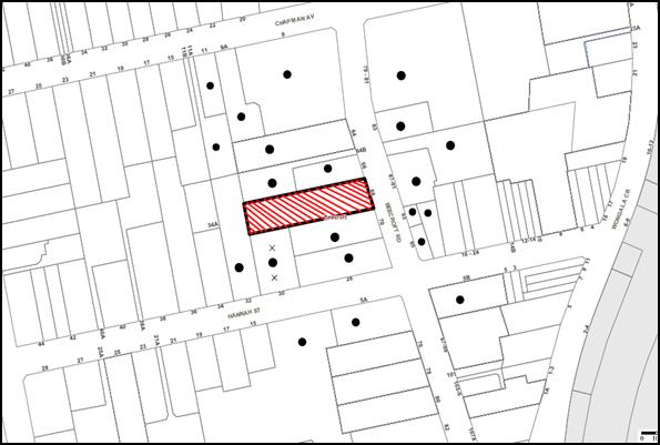
|
NOTIFICATION PLAN |
|
||
|
• PROPERTIES NOTIFIED
|
X SUBMISSIONS RECEIVED |
PROPERTY SUBJECT OF DEVELOPMENT |
|
The submissions were lodged by the resident of one property and object to the development, generally on the following grounds:
· Overlooking opportunities at the south-western corner and the adverse impact on the privacy of the occupants of No. 30 Hannah Street due to the elevated deck around the swimming pool and the pathway on the southern side; and
· Adverse impact of the development on the privacy of the adjoining southern property at No. 30 Hannah Street during construction works.
The submission has requested that the following matters be resolved by way of conditions:
· The privacy screen along the southern boundary of the deck should be extended along the entire length of the pool;
· A privacy screen or dense vegetation along the entire length of the pathway on the southern side; and
· A hoarding along the southern boundary adjoining No. 30 Hannah Street to protect the amenity of the neighbours during construction works.
The merits of the matters raised in community submissions have been addressed in the body of the report with the exception of the following:
5.1.1 Privacy screens
It is considered to be a reasonable request that the applicant be required to construct a privacy screen along the entire southern boundary of the swimming pool deck, include additional privacy measures on the southern side of the pathway and install a hoarding to protect the amenity of the neighbouring properties during construction works. In this regard the submitted landscape plan proposes 20 Lily Pilli trees to provide screening along the southern boundary adjoining No. 30 Hannah Street. Notwithstanding, conditions of consent are recommended requiring the installation of a privacy screen along the southern edge of the swimming pool deck, installation of 300mm high lattice screens over 1.8 high lapped and capped fence and the erection of a 3m high hoarding along the southern boundary to maintain the amenity of the neighbouring properties.
Subject to the implementation of the above conditions, the proposal would not result in adverse impact on the privacy of the neighbouring properties during construction or post completion of the development.
5.2 Public Agencies
The development application was referred to the following Agencies for comment:
5.2.1 Roads and Maritime Services
The application was referred to the Roads and Maritime Services (RMS) for concurrence. No objections have been raised subject to recommended conditions.
6. THE PUBLIC INTEREST
Section 79C(1)(e) of the Act requires Council to consider “the public interest”.
The public interest is an overarching requirement, which includes the consideration of the matters discussed in this report. Implicit to the public interest is the achievement of future built outcomes adequately responding to and respecting the future desired outcomes expressed in environmental planning instruments and development control plans.
The application is considered to have satisfactorily addressed Council’s and relevant agencies’ criteria and would provide a development outcome that, on balance, would result in a positive impact for the community. Accordingly, it is considered that the approval of the proposed development would be in the public interest.
CONCLUSION
The application proposes the demolition of existing buildings, retention of the existing swimming pool and construction of an infill self-care seniors living development including seven self-contained dwellings over basement car park with landscaping as a staged development. The proposed built form would include a two storey residential flat building with basement carpark fronting Beecroft Road and a single storey detached dwelling house at the rear of the swimming pool.
The use is prohibited in the R2 zone pursuant to the Hornsby Local Environmental Plan 2013. The proposed development is permissible under State Environmental Planning Policy (Housing for Seniors or People with a Disability) 2004 and generally complies with the objectives and controls contained in the Policy.
The proposal is assessed as satisfactory with regard to the matters for consideration pursuant to Section 79C of the Environmental Planning and Assessment Act 1979. Council received two submissions from one resident during notification period and condition of consent have been recommended to address the neighbour’s concerns regarding adverse privacy impacts. The proposed built form is consistent with the character of the locality in the near vicinity of the site and the Beecroft Cheltenham Heritage Conservation Area.
Conditions of consent would ensure that proposal does not adversely impact on the natural and built environment of the locality.
Having regard to the circumstances of the case, approval of the application is recommended.
Note: At the time of the completion of this planning report, no persons have made a Political Donations Disclosure Statement pursuant to Section 147 of the Environmental Planning and Assessment Act 1979 in respect of the subject planning application.
RESPONSIBLE OFFICER
The officer responsible for the preparation of this Report is the Manager – Development Assessments – Rodney Pickles, who can be contacted on 9847 6731.
|
Rod Pickles Manager - Development Assessment Planning Division |
James Farrington Group Manager Planning Division |
|
1.View |
Locality Map |
|
|
|
2.View |
Site Plan |
|
|
|
3.View |
Tree Location Plan |
|
|
|
4.View |
Landscape Plan |
|
|
|
5.View |
Floor Plans |
|
|
|
6.View |
Elevations and Sections |
|
|
|
7.View |
Shadow Plan |
|
|
|
8.View |
Views |
|
|
File Reference: DA/858/2016
Document Number: D07125450
SCHEDULE 1
GENERAL CONDITIONS
The conditions of consent within this notice of determination have been applied to ensure that the use of the land and/or building is carried out in such a manner that is consistent with the aims and objectives of the relevant legislation, planning instruments and council policies affecting the land and does not disrupt the amenity of the neighbourhood or impact upon the environment.
Note: For the purpose of this consent, the term ‘applicant’ means any person who has the authority to act on or the benefit of the development consent.
Note: For the purpose of this consent, any reference to an Act, Regulation, Australian Standard or publication by a public authority shall be taken to mean the gazetted Act or Regulation, or adopted Australian Standard or publication as in force on the date that the application for a construction certificate is made.
1. Approved Plans and Supporting Documentation
The development must be carried out in accordance with the plans and documentation listed below and endorsed with Council’s stamp, except where amended by Council and/or other conditions of this consent:
|
Plan No. |
Plan Title |
Drawn by |
Dated |
|
DA-03 |
Site Plan |
AGM Studio |
13/12/2016 |
|
DA-05 |
Basement Plan |
AGM Studio |
13/12/2016 |
|
DA-06 |
Ground Floor Plan |
AGM Studio |
13/12/2016 |
|
DA-07 |
First Floor Plan |
AGM Studio |
13/12/2016 |
|
DA-08 |
Roof Plan |
AGM Studio |
13/12/2016 |
|
DA-09 |
Elevations |
AGM Studio |
13/12/2016 |
|
DA-10 |
Sections |
AGM Studio |
13/12/2016 |
|
C001-A |
Site and Stormwater Plan |
Roz Engineering Pty Ltd |
11/12/2016 |
|
C002-A |
Stormwater Catchment Plan |
Roz Engineering Pty Ltd |
11/12/2016 |
|
C003-A |
R.W Tank and OSD Details |
Roz Engineering Pty Ltd |
11/12/2016 |
|
1602 - A |
Landscape Design Plan |
Birdwood Landscape Design |
27/01/2016 |
|
DA-01 |
Sediment Control Plan |
Architectural Design and Creations |
15/02/2016 |
|
Document No. |
Plan Title |
Drawn by |
Dated |
|
360034 |
Detail Contour Survey |
Alan Bardsley |
15/10/2015 |
|
DA-02 |
Demolition Plan |
AGM Studio |
13/12/2016 |
|
DA-04 |
Site Analysis |
AGM Studio |
13/12/2016 |
|
DA-11 |
Shadow Diagrams |
AGM Studio |
13/12/2016 |
|
DA-12 |
Photomontage |
AGM Studio |
13/12/2016 |
|
DA-12 |
Schedule of Finishes |
AGM Studio |
13/12/2016 |
|
DA-14 |
Streetscape Photos |
AGM Studio |
13/12/2016 |
|
DA-15 |
Unit outward views |
AGM Studio |
13/12/2016 |
|
- |
Site Tree Location Plan |
Hornsby Council |
3/11/2016 |
|
AN16-206347 |
Accessibility Review |
Philip Chun |
27/06/2016 |
|
4478replet01 |
Air Quality Review |
Air Noise Pty Ltd |
11/02/2016 |
|
- |
Tree Assessment Report and Addendum |
Mark Bury Consulting |
25/01/2016 |
|
713610M_03 |
BASIX Certificate |
Certified Energy |
21/03/2016 |
|
1008945352 |
NatHERS Certificate |
Certified Energy |
21/03/2016 |
|
A1615664N (Version 1b) |
Carpark, Ramp Certification |
ML Traffic Engineer |
February 2016 |
|
A1615664N (Version 1a) |
Traffic Report |
ML Traffic Engineer |
February 2016 |
|
- |
Statement of Environmental Effects |
ADC |
March 2016 |
|
|
Statement of Heritage Impact and Addendum |
NBRS + Partners |
February 2016 and 20/09/2016 |
|
SBMG01337-00 |
Construction Traffic Management Plan |
SBMG |
22/02/2016 |
|
- |
Waste Management Plan |
Matt Holt |
22/09/2016 |
2. Removal of Existing Trees
a) This development consent permits the removal of trees numbered 11, 13, 14, 15, 16, 17, 18, 35, 36, 37, 38, 39, 44, 49, 51, 53, 54 and 55 as identified on the Site Tree Location Plan prepared by Hornsby Shire Council, dated 3/11/2016.
b) This development consent does not permit the removal of trees numbered 1, 2, 3, 4, 5, 6, 7, 8, 9, 10, 12, 19, 20, 21, 22, 23, 24, 25, 26, 27, 28, 29, 30, 31, 32, 33, 34, 40, 41, 42, 43, 45, 46, 47, 48, 50 and 52 as identified on the Site Tree Location Plan prepared by Hornsby Shire Council, dated 3/11/2016.
c) The removal of any other trees requires separate approval in accordance with the Tree and Vegetation Chapter 1B.6 Hornsby Development Control Plan (HDCP).
3. Construction Certificate
a) A Construction Certificate is required to be approved by Council or a Private Certifying Authority prior to the commencement of any works under this consent.
b) A separate Construction Certificate must be obtained from Council for all works within the public road reserve under S138 of the Roads Act.
c) A separate Construction Certificate must be obtained from Council for all works within drainage easements vested in Council.
d) The Construction Certificate plans must not be inconsistent with the Development Consent plans.
4. Project Arborist
A Project Arborist is to be appointed in accordance with AS 4970-2009 (1.4.4) to provide monitoring and certification throughout the development process. The details of the appointed Arborist are to be provided to Council and the PCA prior to the issue of the construction certificate.
5. Amendment of Plans
a) To comply with Councils requirement in terms of privacy and car parking the approved plans are to be amended as follows:
i) The layout of car spaces within the approved basement plan DA-05 prepared by AGM Studio dated 13/12/2016 must be amended so that a minimum of 10 car spaces comply with the provisions of AS2890.6 by providing 2.4m wide shared zones with bollards between car spaces. 5% of the car spaces (being one) must have the allowance to be widened to 3.8m.
ii) The approved plans DA-06 and DA-07 dated 13/12/2016 are to be amended as follows:
a. Deletion of the ancillary storage areas (total of 10m2 as marked in red on the plans) within Units 2 and 5 and addition of these areas in the floor space of the open plan living areas;
b. Deletion of 10m2 of floor space adjoining the balcony areas for each of units 2 and 5 as marked in red in the approved plans. These sections are to be added to the balcony area and constitute private open space for Units 2 and 5 respectively; and
c. The total area of the Units would not exceed the labels as marked on the approved plans.
iii) A 1.8 metre high translucent glass privacy screen/swimming pool fence must be erected along the southern boundary of the elevated deck at the rear as indicated in red on the approved plans;
iv) The windows on the eastern elevation of dwelling 7 must be deleted;
v) A window must be added to the bathroom of Unit 7, on the northern elevation. The minimum sill height of this window must be 1.8m above the finished floor level (highlight window);
vi) The proposed opening on the southern elevation of the terrace fronting Unit 6 must be clearly marked on DA-09 prepared by AGM Studio dated 13/12/2016 as marked in red on the approved plan;
vii) The approved Landscape Design Plan prepared by Birdwood Landscape Design dated 27/01/2016 must be amended to include the following:
a. Approved layout of the ground floor in DA-06 including the platform lift;
b. Relocated position of Tree No. 34 between the swimming pool and the two storey building;
c. The existing tree numbers on the site in accordance with the Site Tree Location Plan dated 3/11/2016; and
d. Identify the trees to be retained.
viii) The bin collection area adjoining the driveway must be increased have the dimension 2m x 4m with a minimum wall height of 1.5m; and
ix) The bin collection area at the rear of the site is to have the minimum dimensions of 1.7m (width) x 2.3m (depth) with a minimum wall height of 1.5m.
b) These amended plans must be submitted with the application for the Construction Certificate.
6. Section 94 Development Contributions
a) In accordance with Section 80A(1) of the Environmental Planning and Assessment Act, 1979 and the Hornsby Shire Council Section 94 Development Contributions Plan 2014-2024, the following monetary contributions must be paid to Council to cater for the increased demand for community infrastructure resulting from the development:
|
Description |
Contribution (4) |
|
Roads |
$ 5,328.15 |
|
Open Space and Recreation |
$ 48,703.95 |
|
Community Facilities |
$ 18,723.20 |
|
Plan Preparation and Administration |
$ 157.10 |
|
TOTAL |
$72,912.40 |
being for 6 self-care dwellings comprising seniors living development with a credit of one existing dwelling.
b) The value of this contribution is current as at 12 January 2016. If the contribution is not paid within the financial quarter that this condition was generated, the contribution payable will be adjusted in accordance with the provisions of the Hornsby Shire Council Section 94 Development Contributions Plan and the amount payable will be calculated at the time of payment in the following manner:
$CPY = $CDC x CPIPY
CPIDC
Where:
$CPY is the amount of the contribution at the date of Payment
$CDC is the amount of the contribution as set out in this Development Consent
CPIPY is the latest release of the Consumer Price Index (Sydney – All Groups) at the date of Payment as published by the ABS.
CPIDC is the Consumer Price Index (Sydney – All Groups) for the financial quarter at the date applicable in this Development Consent Condition.
c) The monetary contribution must be paid to Council:
i) prior to the issue of the Subdivision Certificate where the development is for subdivision; or
ii) prior to the issue of the first Construction Certificate where the development is for building work; or
iii) prior to issue of the Subdivision Certificate or first Construction Certificate, whichever occurs first, where the development involves both subdivision and building work; or
iv) prior to the works commencing where the development does not require a Construction Certificate or Subdivision Certificate.
Note: It is the professional responsibility of the Principal Certifying Authority to ensure that the monetary contributions have been paid to Council in accordance with the above timeframes.
Council’s Development Contributions Plan may be viewed at www.hornsby.nsw.gov.au or a copy may be inspected at Council’s Administration Centre during normal business hours.
REQUIREMENTS PRIOR TO THE ISSUE OF A CONSTRUCTION CERTIFICATE
7. Building Code of Australia
All approved building work must be carried out in accordance with the relevant requirements of the Building Code of Australia.
8. Contract of Insurance (Residential Building Work)
Where residential building work for which the Home Building Act, 1989 requires there to be a contract of insurance in force in accordance with Part 6 of that Act, this contract of insurance must be in force before any building work authorised to be carried out by the consent commences.
9. Notification of Home Building Act, 1989 Requirements
Residential building work within the meaning of the Home Building Act 1989 must not be carried out unless the principal certifying authority for the development to which the work relates (not being Council) has given Council written notice of the following information:
a) In the case of work for which a principal contractor is required to be appointed:
i) The name and licence number of the principal contractor; and
ii) The name of the insurer by which the work is insured under Part 6 of that Act.
b) In the case of work to be done by an owner-builder:
i) The name of the owner-builder; and
ii) If the owner-builder is required to hold an owner-builder’s permit under that Act, the number of the owner-builder’s permit.
Note: If arrangements for doing the residential building work are changed while the work is in progress so that the information notified becomes out of date, further work must not be carried out unless the principal certifying authority for the development to which the work relates (not being Council) has given Council written notification of the updated information.
10. Utility Services
The applicant must submit written evidence of the following service provider requirements:
a) Ausgrid (formerly Energy Australia) – a letter of consent demonstrating that satisfactory arrangements have been made to service the proposed development.
b) Telstra - a letter of consent demonstrating that satisfactory arrangements have been made to service the proposed development.
11. Sydney Water – Approval
This application must be submitted to Sydney Water for approval to determine whether the development would affect any Sydney Water infrastructure, and whether further requirements are to be met.
Note: Building plan approvals can be obtained online via Sydney Water Tap inTM through www.sydneywater.com.au under the Building and Development tab.
12. Traffic Control Plan
A Traffic Control Plan (TCP) must be prepared by a qualified traffic controller in accordance with the Roads & Traffic Authority’s Traffic Control at Worksites Manual 1998 and Australian Standard 1742.3 for all work on a public road. The Traffic Management Plan shall be submitted and approved by Council’s Manager Traffic and Road Safety prior to the issue of a construction certificate. The TCP must detail the following:
a) Arrangements for public notification of the works;
b) Temporary construction signage;
c) Permanent post-construction signage;
d) Vehicle movement plans;
e) Traffic management plans; and
f) Pedestrian and cyclist access/safety.
13. Identification of Survey Marks
A registered surveyor must identify all survey marks in the vicinity of the proposed development. Any survey marks required to be removed or displaced as a result of the proposed development shall be undertaken by a registered surveyor in accordance with Section 24 (1) of the Surveying and Spatial Information Act 2002 and following the Surveyor General’s Directions No.11 – "Preservation of Survey Infrastructure".
14. Noise – Rail and Road Corridor
The development must be carried out in accordance with the requirements of the Department of Planning’s Development Near Rail Corridors and Busy Roads – Interim Guideline. Construction Certificate Plans must include construction techniques, glazing and construction material specifications for the entire development to ensure that the following LAeq levels are not exceeded:
a) in any bedroom in the building - 35 dB(A) at any time between 10 pm and 7 am; and
b) anywhere else in the building (other than a garage, kitchen, bathroom or hallway) - 40 dB(A) at any time.
Note: The Department of Planning’s document is available at www.planning.nsw.gov.au (development assessments). The RailCorp document is available at www.railcorp.nsw.gov.au/publications.
15. Dilapidation Report
To record the structural condition of all properties at Nos. 30 and 32 Hannah Street, No. 66, 66A and 70 Beecroft Road adjoining the approved development, a dilapidation report must be prepared by a suitably qualified structural engineer for inclusion with the application of the Construction Certificate.
16. Stormwater Drainage
The stormwater drainage system for the development must be designed in accordance with Council’s Civil Works – Design and Construction Specification 2005 and connected directly to Council’s street drainage system in Beecroft Road.
17. On Site Stormwater Detention
An on-site stormwater detention system must be designed by a chartered civil engineer and constructed in accordance with the following requirements:
a) Have a capacity of not less than 15.4 cubic metres, and a maximum discharge (when full) of 42 litres per second;
b) Have a surcharge/inspection grate located directly above the outlet;
c) Discharge from the detention system must be controlled via 1 metre length of pipe, not less than 50 millimetres diameter or via a stainless plate with sharply drilled orifice bolted over the face of the outlet discharging into a larger diameter pipe capable of carrying the design flow to an approved Council system;
d) Not be constructed in a location that would impact upon the visual or recreational amenity of residents.
18. Internal Driveway/Vehicular Areas
The driveway and parking areas on site must be designed in accordance with Australian Standards 2890.1, 2890.2, 3727 and the following requirements:
a) Design levels at the front boundary shall be obtained from Council if a private accredited certifier is engaged to obtain a construction certificate for these works; and
b) The driveway be a rigid pavement.
19. Water Saving Urban Design – Water Tank
The proposed water tank is to have a minimum volume of 27m3 and is to be connected to all toilets and laundry taps within the development. Details are to be submitted with the Construction Certificate Plans.
20. Certification of Car Parking
A certificate from a practising Traffic Engineer is to be submitted to the Principal Certifying Authority (PCA) certifying that the car park design complies with AS 2890.1 and AS 2890.6 and with Condition 5(a)(i) of this development consent. The car park design is to also ensure that all vehicles can exit the site in a forward direction.
21. Vehicular Crossing
A separate application under the Local Government Act, 1993 and the Roads Act 1993 must be submitted to Council for the installation of a new vehicular crossing and the removal of the redundant crossing. The vehicular crossing must be constructed in accordance with Council’s Civil Works Design 2005 and the following requirements:
a) Design levels at the front boundary must be obtained from Council for the design on the internal driveway;
b) Any redundant crossings must be replaced with integral kerb and gutter;
c) The footway area must be restored by turfing;
d) Approval must be obtained from all relevant utility providers that all necessary conduits be provided and protected under the crossing.
Note: An application for a vehicular crossing can only be made to one of Council’s Authorised Vehicular Crossing Contractors. You are advised to contact Council on 02 9847 6940 to obtain a list of contractors.
22. Photographic records
The existing dwelling on the subject site is to be photographically recorded generally in accordance with the NSW Heritage Office guidelines for archival recording and a copy submitted to Council.
23. Waste Management
The following waste management requirements must be complied with:
a) A Waste Management Plan Section One – Demolition Stage and Section Three – Construction Stage, covering the scope of this project and including the following details, is required to be submitted to Council:
i) An estimate of the types and volumes of waste and recyclables to be generated;
ii) A site plan showing sorting and storage areas for demolition and construction waste and the vehicle access to these areas;
iii) How excavation, demolition and construction waste materials will be reused or recycled and where residual wastes will be disposed;
iv) The total percentage (by weight) of demolition and construction waste that will be reused or recycled.
b) Each dwelling/unit must be within 50 metres walking distance to a bin storage room;
c) The bin carting route must not include any steps; and
d) Each bin storage room must be accessible by persons with a disability while comfortably housing the garbage and recycling bins that are to be stored there.
Note: A 240 L recycling bin is 600 mm wide by 750 mm deep; allow for ease around the bin – 75 mm is recommended. These dimensions do not include wall thickness, door thickness, ventilation ducting etc., which must be added. The door must be wide enough and positioned such that the bin can fit through.
24. Accessibility
Construction Certificate plans must demonstrate compliance with the following:
a) Specifications within the Access Report prepared by Philip Chun Building Compliance dated 27/06/2016;
b) Car Parking in accordance with Condition 5(a)(i) of this development consent.
c) Each bedroom for all dwellings must be fitted with a wardrobe;
d) A laundry and a linen cupboard must be provided for all dwellings; and
e) The letter boxes must be located as approved plan DA-06 dated 13/02/2016.
25. Construction Traffic Management Plan
In order to enable unencumbered movement of traffic in the public road during construction works, a Construction Management Plan, including a Traffic Management Plan and scaled construction plans prepared by a suitably Chartered and Qualified Chartered Civil Engineer and Qualified Worksite Traffic Controller shall be prepared and submitted to Hornsby Shire Council for approval according to the following requirements:
a) A copy of the plans shall be submitted for consideration and written approval by Hornsby Shire Council prior to the release of the Construction Certificate.
b) The plans shall detail the order of construction works and arrangement of all construction machines and vehicles being used at the same time during all stages.
c) The CTMP plans shall be in accordance with the approved Development Application plans and the Development Consent conditions.
d) In order to prevent injury, accident and loss of property, no building materials, work sheds, vehicles, machines or the like shall be allowed to remain in the road reserve area without the written consent of Hornsby Shire Council.
e) The Plan shall be generally in compliance with the requirements of the Road and Traffic Authority’s “Traffic Control at Worksites Manual 1998” and detailing:-
i) Public notification of proposed works;
ii) Long term signage requirements;
iii) Short term (during actual works) signage;
iv) Vehicle Movement Plans, where applicable;
v) Traffic Management Plans;
vi) Pedestrian and Cyclist access and safety;
f) The plans shall indicate traffic controls including those used during non-working hours and shall provide pedestrian access and two-way traffic in the public road to be facilitated at all times.
g) The plans shall include the proposed truck routes to and from the site including details of the frequency of truck movements at the different stages of the development. The plan shall also include details of parking arrangements for all employees and contractors.
h) The Applicant and all employees of contractors on the site must obey any direction or notice from the Prescribed Certifying Authority or Hornsby Shire Council in order to ensure the above.
i) If there is a requirement to obtain a Work Zone, partial Road Closure or Crane Permit an application to Hornsby Shire Council is to be made prior to the issue the Construction Certificate.
26. Construction Management Plan
A Construction Management Plan (CMP), prepared by a suitably qualified consultant, must be submitted for approval by Council. The CMP must be include, but not be limited, details of the following:
a) Noise attenuation measures be implemented along the southern boundary of the site including a hoarding with a height not less than 3m from the existing ground level;
b) During excavation works, rock removal must be undertaken by sawing instead of rock hammering, wherever practicable;
c) The construction works must be undertaken in accordance with the “Interim Construction Noise Guidelines – 2009” published by DECCW and achieve compliance with the relevant noise levels; and
d) The delivery times and vehicular movements related to demolition, excavation and construction works must be restricted to the construction hours only.
27. Pedestrian Management Plan
A Pedestrian Access Management Plan (PAMP) detailing how pedestrian movements will be changed and managed during various stages of development, particularly during any partial or total closure of footpaths. Council will review the PAMP, agree any modifications with the proponent and enforce the PAMP during construction.
REQUIREMENTS PRIOR TO THE COMMENCEMENT OF ANY WORKS
28. Erection of Construction Sign
a) A sign must be erected in a prominent position on any site on which any approved work is being carried out:
i) Showing the name, address and telephone number of the principal certifying authority for the work;
ii) Showing the name of the principal contractor (if any) for any demolition or building work and a telephone number on which that person may be contacted outside working hours; and
iii) Stating that unauthorised entry to the work site is prohibited.
b) The sign is to be maintained while the approved work is being carried out and must be removed when the work has been completed.
29. Protection of Adjoining Areas
A temporary hoarding, fence or awning must be erected between the work site and adjoining lands before the works begin and must be kept in place until after the completion of the works if the works:
a) Could cause a danger, obstruction or inconvenience to pedestrian or vehicular traffic;
b) Could cause damage to adjoining lands by falling objects; and/or
c) Involve the enclosure of a public place or part of a public place.
Note: Notwithstanding the above, Council’s separate written approval is required prior to the erection of any structure or other obstruction on public land.
30. Toilet Facilities
a) To provide a safe and hygienic workplace, toilet facilities must be available or be installed at the works site before works begin and must be maintained until the works are completed at a ratio of one toilet for every 20 persons employed at the site.
b) Each toilet must:
i) be a standard flushing toilet connected to a public sewer; or
ii) be a temporary chemical closet approved under the Local Government Act 1993; or
iii) have an on-site effluent disposal system approved under the Local Government Act 1993.
31. Erosion and Sediment Control
To protect the water quality of the downstream environment, erosion and sediment control measures must be provided and maintained throughout the construction period in accordance with the manual ‘Soils and Construction 2004 (Bluebook)’, the approved plans, Council specifications and to the satisfaction of the principal certifying authority. The erosion and sediment control devices must remain in place until the site has been stabilised and revegetated.
Note: On the spot penalties may be issued for any non-compliance with this requirement without any further notification or warning.
32. Tree Protection Barriers
a) To safeguard the natural environment during the approved development works, tree protection fencing must be erected around trees numbered 1, 2, 3, 4, 5, 6, 7, 8, 9, 10, 12, 19, 20, 21, 22, 23, 24, 25, 26, 27, 28, 29, 30, 31, 32, 33, 40, 41, 42, 43, 45, 46, 47, 48, 50 and 52 as identified on the Site Tree Location Plan prepared by Hornsby Shire Council, dated 3/11/2016 in accordance with the AS4970-2009 and under the observations and recommendations of the appointed project arborist.
b) All trees retained on site must have tree protection measures for the ground, trunk and canopy installed in accordance with the Australian Standard ‘Protection of Trees on Development Sites (AS 4970-2009)’Protection of Trees on Development Sites’.
c) Once erected, the tree protective fencing must not be removed or altered without the prior approval of the project arborist.
d) All Tree Protection Zones must have a layer of wood-chip mulch installed prior to works commencing and must be maintained throughout the period of construction at a depth of 100mm using material that complies with Australian Standard AS 4454.
e) A certificate from the project arborist must be submitted to the Principal Certifying Authority and Council stating compliance with the relevant tree protection conditions of this consent.
REQUIREMENTS DURING CONSTRUCTION
33. Construction Work Hours
All works on site, including demolition and earth works, must only occur between 7am and 5pm Monday to Saturday.
No work is to be undertaken on Sundays or public holidays.
34. Demolition
To protect the surrounding environment, all demolition work must be carried out in accordance with “Australian Standard 2601-2001 – The Demolition of Structures” and the following requirements:
a) Demolition material must be disposed of to an authorised recycling and/or waste disposal site and/or in accordance with an approved waste management plan;
b) The materials of the existing dwelling on the site are to be recovered and recycled to an appropriate second hand builder’s yard and evidence is to be provided to Council.
c) Demolition works, where asbestos material is being removed, must be undertaken by a contractor that holds an appropriate licence issued by WorkCover NSW in accordance with Chapter 10 of the Occupational Health and Safety Regulation 2001 and Clause 29 of the Protection of the Environment Operations (Waste) Regulation 2005 ;and
d) On construction sites where any building contain asbestos material, a standard commercially manufactured sign containing the words ‘DANGER ASBESTOS REMOVAL IN PROGRESS’ and measuring not less than 400mm x 300mm must be displayed in a prominent position visible from the street.
35. Transplantation of Tree
Tree No. 34 must be satisfactorily transplanted under the supervision of the project arborist to the landscaped area in between the swimming pool and the two-storey residential flat building.
36. Environmental Management
The site must be managed in accordance with the publication ‘Managing Urban Stormwater – Landcom (March 2004) and the Protection of the Environment Operations Act 1997 by way of implementing appropriate measures. To prevent sediment run-off, excessive dust, noise or odour emanating from the site during the construction of the development.
37. Street Sweeping
To protect the surrounding environment, Street sweeping must be undertaken following sediment tracking from the site along Beecroft Road during works and until the site is established.
The street cleaning services must undertake a street ‘scrub and dry’ method of service and not a dry sweeping service that may cause sediment tracking to spread or cause a dust nuisance.
38. Works Near Trees
a) To protect trees to be retained, all required tree protection measures are to be maintained in good condition for the duration of the construction period.
b) The appointed Project Arborist must monitor and record all changes or modifications to required tree protection measures for the period of construction and any necessary remedial actions for maintaining tree health and condition of the trees required to be protected under this development consent.
c) Approved works within the tree protection zones (TPZ) of tree Nos. 30, 31, 32 and 33 located within No. 70 Beecroft Road and tree Nos. 40, 41, 42, 43, 45, 46, 47, 48 located within the front setback of the site, must be undertaken in accordance with the following requirements:
i) All Root pruning must be recorded and undertaken as specified in Australian Standard AS 4970-2009 Sections 3.3.4, 4.5.4 and 4.5.5, by the Project Arborist.
ii) New foundation/footing must provide a 100mm clearance above soil and be of sensitive construction techniques such as screw pilings or piers, cantilevered or suspended slab design.
iii) Any necessary excavation must be undertaken by sensitive methods such as pneumatic or by hand as prescribe in AS 4970-2007 Sections 4.5.5.
iv) The installation of all services which enter or transects a designated TPZ must utilise sensitive methods of installation such as directional drilling or in manually excavated trenches. The process must be monitored by the Project Arborist to assess the likely impacts of boring and bore pits on retained trees.
v) During manual excavation of trenches, the Project Arborist must provide advice on roots to be retained and must monitor all such works.
vi) Manual excavation may include the use of pneumatic and hydraulic tools in accordance with AS 4970-2009 Clause 4.5.3.
vii) All scaffoldings must be erected outside the TPZ of trees to be protected and in accordance with AS 4970-2009 Section 4.5.6.
viii) If, during the course of excavation within the TPZ of tree nos. 30, 31, 32 and 33, any critical roots are uncovered that, in the view of the project arborist, may impact on the health and longevity of these trees; such works are to cease until further assessment and/or root mapping is carried out by the project arborist.
d) The filling or stockpiling of building materials, the parking of vehicles or plant, the disposal of cement slurry, waste water or other contaminants must be located outside the tree protection zones as prescribed in the conditions of this consent or the prescriptive measures of Part 1B.6.1 Tree Preservation of the Hornsby Development Control Plan, 2013, of any tree to be retained.
e) The Project Arborist must submit monthly certificates to the principal certifying authority, certificate stating that the works have been carried out in compliance with the approved plans and specifications for tree protection. The certification should include a statement of site attendance, the condition of the retained trees, details of any deviations from the approved tree protection measures and their impacts on trees.
Note: Copies of monitoring documentation may be required.
39. Survey Report
A report(s) must be prepared by a registered surveyor and submitted to the principal certifying authority:
a) Prior to the pouring of concrete at each level of the building certifying that:
i) The building, retaining walls and the like have been correctly positioned on the site; and
ii) The finished floor level(s) are in accordance with the approved plans.
b) Confirming that the turning area for the vehicles complies with AS2890.1 – 2004.
40. Council Property
To ensure that the public reserve is kept in a clean, tidy and safe condition during construction works, no building materials, waste, machinery or related matter is to be stored on the road or footpath.
41. Disturbance of Existing Site
During construction works, the existing ground levels of open space areas and natural landscape features, including natural rock-outcrops, vegetation, soil and watercourses must not be altered unless otherwise nominated on the approved plans.
42. Landfill
Landfill must be constructed in accordance with Council’s ‘Construction Specification 2005’ and the following requirements:
a) Prior to fill material bring imported to the site, a certificate shall be obtained from a suitable qualified environmental consultant confirming the fill wholly consists of Virgin Excavated Natural Material (VENM) as defined in Schedule 1 of the Protection of the Environment Operations Act, 1997 or material approved under the Department of Environment and Climate Change’s general resource recovery exemption.
b) A compaction certificate is to be obtained from a suitably qualified geotechnical engineer verifying that the specified compaction requirements have been met.
43. Excavated Material
All excavated material removed from the site must be classified by a suitably qualified person in accordance with the Department of Environment, Climate Change and Water NSW Waste Classification Guidelines prior to disposal to an approved waste management facility and be reported to the principal certifying authority prior to the issue of an Occupation Certificate.
44. Waste Management
Waste management during the demolition and construction phase of the development must be undertaken in accordance with the approved Waste Management Plan. Additionally written records of the following items must be maintained during the removal of any waste from the site and such information submitted to the Principal Certifying Authority within fourteen days of the date of completion of the works:
a) The identity of the person removing the waste.
b) The waste carrier vehicle registration.
c) Date and time of waste collection.
d) A description of the waste (type of waste and estimated quantity).
e) Details of the site to which the waste is to be taken.
f) The corresponding tip docket/receipt from the site to which the waste is transferred (noting date and time of delivery, description (type and quantity) of waste).
g) Whether the waste is expected to be reused, recycled or go to landfill.
Note: In accordance with the Protection of the Environment Operations Act 1997, the definition of waste includes any unwanted substance, regardless of whether it is reused, recycled or disposed to landfill.
45. Construction Vehicles
All construction vehicles associated with the proposed development are to be contained on site as no construction zones are permitted on Beecroft Road in the vicinity of the site.
46. Traffic Control Plan Compliance
The development must be carried out in accordance with the following documents:
a) Traffic Control Plan (TCP);
b) Construction Management Plan (CMP);
c) Pedestrian Management Plan (PMP); and
d) Construction Traffic management Plan (CTMP).
47. Maintenance of public footpaths
Public footpaths must be maintained for the duration of works to ensure they are free of trip hazards, displacements, breaks or debris to enable pedestrians to travel along the footpath safely.
REQUIREMENTS PRIOR TO THE ISSUE OF AN OCCUPATION CERTIFICATE
Note: For the purpose of this consent, a reference to ‘occupation certificate’ shall not be taken to mean an ‘interim occupation certificate’ unless otherwise stated.
48. Fulfilment of BASIX Commitments
The applicant must demonstrate the fulfilment of BASIX commitments pertaining to the development.
49. Sydney Water – s73 Certificate
A s73 Certificate must be obtained from Sydney Water and submitted to the PCA.
Note: Sydney Water requires that s73 applications are to be made through an authorised Sydney Water Servicing Coordinator. Refer to www.sydneywater.com.au or telephone 13 20 92 for assistance.
50. Damage to Council Assets
To protect public property and infrastructure, any damage caused to Council’s assets as a result of the construction or demolition of the development must be rectified by the applicant in accordance with Council’s Civil Works Specifications. Rectification works must be undertaken prior to the issue of an Occupation Certificate, or sooner, as directed by Council.
51. Preservation of Survey Marks
A certificate by a Registered Surveyor must be submitted to the Principal Certifying Authority, certifying that there has been no removal, damage, destruction, displacement or defacing of the existing survey marks in the vicinity of the proposed development or otherwise the re-establishment of damaged, removed or displaced survey marks has been undertaken in accordance with the Surveyor General’s Direction No.11 – “Preservation of Survey Infrastructure”.
52. Construction of Engineering Works.
All engineering works identified in this consent are to be completed and a Compliance Certificate issued prior to the release of the Occupation Certificate.
53. Works as Executed Plan
A works-as-executed plan(s) must be prepared by a registered surveyor and submitted to Council for completed road pavement, kerb & gutter, public drainage systems, driveways and on-site detention system, services and conduits.
54. Unit Numbering
All units are to be numbered consecutively commencing at No.1. The strata plan lot number is to coincide with the unit number, e.g. Unit 1 = Lot 1. The allocated of unit numbering must be authorised by Council prior to the numbering of each units in the development.
55. Completion of Landscaping
A certificate must be submitted to the PCA by a practicing landscape architect, horticulturalist or person with similar qualifications and experience certifying that all required landscaping works have been satisfactorily completed in accordance with the approved landscape plan listed in Condition 1 of this development consent and the following requirements:
a) To ensure that sustainable landscape is achieved, the on slab planter boxes must include the following:
i) Waterproofing;
ii) Subsoil drainage (proprietary drainage cell, 50mm sand and filter fabric);
iii) Automatic irrigation;
iv) Minimum 500mm planting soil for shrubs;
v) Minimum 1000mm planting soil for trees and palms; and
vi) 75mm mulch.
b) Replacement Trees must be located at a distance of 4 metres or greater from the foundation walls of the approved development;
c) The pot size of the replacement tree(s) must be a minimum 25 litres and replacement tree(s) must be maintained until they reach the height of 3 metres;
d) The replacement trees must reach a mature height greater than 15 metre;
e) All tree stock must meet the specifications outlined in ‘Specifying Trees’ (Ross Clark, NATSPEC Books); and
f) Planting methods must meet professional (best practice) industry standards
Note: Advice on suitable species for landscaping can be obtained from Council’s planting guide ‘Indigenous Plants for the Bushland Shire’, available at www.hornsby.nsw.gov.au.
56. Final Certification Project Arborist
The Project Arborist must assess the condition of trees and their growing environment and make recommendations for, and if necessary carry out remedial actions.
Following the final inspection and the completion of any remedial works, the Project Arborist must submit to the Principal Certifying Authority documentation stating that the completed works have been carried out in compliance with the approved plans and specifications for tree protection as above, the conditions of development consent and AS 4970-2009.
57. Final Certification Acoustic Consultant
A final certificate must be provided by the Acoustic Consultant stating that the recommended measures in Condition No. 14 have been complied with.
58. Final Certification Access Consultant
A final certificate must be provided by the Access Consultant stating that the recommended measures in the submitted Access Report and the conditions of this development consent are complied with.
59. Retaining Walls
All required retaining walls must be constructed as part of the development.
60. Installation of Air Conditioner
a) To protect the amenity of adjacent properties, the condenser unit for the air conditioner must be sited a minimum of 3 metres from the property boundary of any adjoining residential premises.
b) Alternatively, a certificate must be submitted to the PCA by a suitably qualified person confirming that the unit has been tested for heating and cooling on the highest settings and that the noise levels generated do not exceed 5 dB(A) above background noise levels when tested at the property boundary between 8 pm and 10 pm.
61. External Lighting
a) To protect the amenity of adjacent premises, all external lighting must be designed and installed in accordance with Australian Standard AS 4282 – Control of the Obtrusive Effects of Outdoor Lighting.
b) Certification of compliance with this Standard must be obtained from a suitably qualified person and submitted to the PCA with the application for the Construction Certificate.
62. Provision for National Broadband Network (NBN)
Provision must be made for fibre ready passive infrastructure (pits and pipes) generally in accordance with NBN Co's pit and pipe installation guidelines to service the proposed development. A certificate from NBN Co or Telstra must be submitted to the PCA that the fibre optic cabling provided for the development complies with MDU Building Design Guides for Development.
63. Waste Management
The following waste management requirements must be complied with:
a) The garbage/recycling bin storage room at the basement level must include a robust door, sealed and impervious surface, adequate lighting and ventilation, water or a hose for cleaning, graded floors with drainage to sewer. The bin storage area at the rear of the site must have sealed and impervious surface, adequate lighting and ventilation.
b) A report must be prepared by an appropriately qualified person, certifying the following:
i) A comparison of the estimated quantities of each waste type against the actual quantities of each waste type.
Note: Explanations of any deviations to the approved Waste Management Plan is required to be included in this report
ii) That at least 60% of the waste generated during the demolition and construction phase of the development was reused or recycled.
Note: If the 60% diversion from landfill cannot be achieved in the Construction Stage, the Report is to include the reasons why this occurred and certify that appropriate work practices were employed to implement the approved Waste Management Plan. The Report must be based on documentary evidence such as tipping dockets/receipts from recycling depots, transfer stations and landfills, audits of procedures etc. which are to be attached to the report.
iii) All waste was taken to site(s) that were lawfully permitted to accept that waste.
c) A bulky waste storage area (8m2) must be located at the ground level. The bin storage area may be used for this purpose.
d) The bin carting routes must be devoid of any steps.
Note: Ramps between different levels are acceptable
e) Each dwelling/unit must be provided with an indoor waste/recycling cupboard for the interim storage of waste with two separate 20 litre containers, one each for general waste and recyclable materials.
f) The bin storage rooms/areas must be accessible by persons with a disability while comfortably housing no less than 6 x 240L bins at the basement level and 2 x 240L bins at the rear.
g) Prior to an Occupation Certificate being issued or the use commencing, whichever is earlier, the Principal Certifying Authority must obtain Council’s approval of the waste and recycling management facilities provided in the development and ensure arrangements are in place for domestic waste collection by Council.
h) Space must be provided for either individual compost containers for each unit or a communal compost container.
Note: The location of the compost container must have regard to the potential amenity impact.
64. Water Saving Urban Design
A certificate from a qualified Civil Engineer is to be obtained certifying that all toilet and laundry taps are connected to the water tank.
65. Creation of Easements
The following matter(s) must be nominated on the plan of subdivision under s88B of the Conveyancing Act, 1919:
a) The creation of an appropriate "Positive Covenant" and "Restriction as to User" over the constructed on-site detention/retention systems and water tank, within the development in favour of Council in accordance with Council’s prescribed wording. The position of the on-site detention system is to be clearly indicated on the title;
b) To register the OSD easement, the restriction on the use of land “works-as-executed” details of the on-site-detention system must be submitted verifying that the required storage and discharge rates have been constructed in accordance with the design requirements. The details must show the invert levels of the on-site system together with pipe sizes and grades. Any variations to the approved plans must be shown in red on the “works-as-executed” plan and supported by calculations;
Note: Council must be nominated as the authority to release, vary or modify any easement, restriction or covenant.
66. Installation of Privacy Devices
To establish and maintain a reasonable level of privacy for the adjoining premises the following devices must be installed:
a) A dense screen of trees or shrubs (minimum mature growth height of 3-4 metres), must be planted along the common boundary with No. 30 Hannah Street in accordance with the approved Landscape Plan in Condition 1 of this development consent;
b) A 300m high close-form lattice screen must be affixed to the top of a solid 1.8m high lapped and capped fence along the common boundary with No. 30 Hannah Street as marked on the approved plans;
c) A 1.8m high privacy swimming pool fence constructed with translucent glass must be provided along the entire southern boundary of the elevated deck; and
d) Privacy screens must be installed along the northern and southern elevations of the balcony to Unit 4 as marked on the approved plans listed in Condition 1 of this consent.
67. Restriction on Occupation – Housing for Seniors or People with a Disability
A restriction as to user must be created under s88B of the Conveyancing Act, 1919 and registered, requiring the dwellings approved under this consent to be solely used for the accommodation of:
a) Seniors (55+ age) or people with a disability;
b) People who live within the same household as seniors or people with a disability; and
c) Staff employed to assist the administration and provision of services to housing provided under SEPP (Housing for Seniors or People with a Disability) 2004.
Note: The restriction must nominate Council as the authority to release, vary or modify the restriction.
68. Boundary Fencing
Fencing must be erected along all property boundaries in accordance with the following requirements:
a) A 1.8m high timber lapped and capped fence is to be constructed at the cost of the applicant along the southern boundary of the site behind the building line;
b) A 1.8m high solid boundary fence including the height of any retaining walls be constructed along the northern and western boundaries of the site behind the front building line; and
c) The existing brick wall along Beecroft Road is to be retained and reclad with sandstone blocks as per the approved plans in Condition 1 of this development consent.
Note: Alternative fencing may be erected subject to the written consent of the adjoining property owner(s).
69. Car Parking and Deliveries
All car parking and driveway areas including turning paths, aisle widths, parking bay dimensions, sight lines and grades must be constructed in accordance with Australian Standard AS 2890.1 – 2004 – Off Street Car Parking, Australian Standard 2890.2 - 2002 – Off Street Commercial and the following requirements:
a) The driveway works are to be completed in accordance with Condition No.18;
b) All parking areas and driveways are to be sealed to an all-weather standard, line marked and signposted;
c) No landscaping or fencing within the front setback should restrict sight distance to pedestrians and cyclists travelling along the footpath; and
d) All parking spaces for people with disabilities must be constructed in accordance with Australian Standard AS/NZS 2890.6:2009 – Off-street parking for people with disabilities.
70. Safety and Security
This site must include the following elements:
a) An intercom system must be installed at gate locations to ensure screening of persons entering the units;
b) The entry doors to the pedestrian foyer is to be constructed of safety rated glass to enable residents a clear line of site before entering or exiting the residential apartments;
c) Lighting is to be provided to pathways, building foyer entries, driveways and common external spaces;
d) CCTV cameras must be installed at the entry and exit point and the around the mailbox;
e) The communal open spaces within the site must be illuminated with high luminance by motion sensor lighting;
f) The driveway and basement car parking must be illuminated with low luminance at all times;
g) Security deadlocks are to be provided to each apartment door; and
h) Peep holes are to be provided to individual apartment doors to promote resident safety.
OPERATIONAL CONDITIONS
71. Ongoing Waste Management
The waste management on site must be in accordance with the following requirements:
a) A site caretaker must be employed and be responsible for moving bins where and when necessary, washing bins and maintaining waste storage areas, managing the communal composting area, managing the bulky item storage area, arranging the prompt removal of dumped rubbish, and ensuring all residents are informed of the use of the waste management system. The site caretaker must be employed for a sufficient number of hours each week to allow all waste management responsibilities to be carried out to a satisfactory standard.
b) The approved on-going waste management practise for the site must not be amended without consent from Council.
72. Car Parking and Deliveries
All car parking must be operated in accordance with Australian Standard AS 2890.1 – 2004 – Off Street Car Parking and AS2890.6 – Parking for People with disabilities and the following requirement:
a) All parking areas and driveways are to be sealed to an all-weather standard, line marked and signposted at all times.
b) Car parking, loading and manoeuvring areas to be used solely for nominated purposes.
c) Vehicles awaiting loading, unloading or servicing shall be parked on site and not on adjacent or nearby public roads;
d) All vehicular entry on to the site and egress from the site shall be made in a forward direction;
e) Minimum sight lines for pedestrian safety are to be provided at the driveway; and
f) Any proposed landscaping and/or fencing must not restrict sight distance to pedestrians and cyclists travelling along the footpath.
73. Landscape Establishment
a) The trees must be maintained until they reach a height of 3m.
b) Plantings that fail to survive or do not exhibit normal health and vigour growth characteristics for their species prior to reaching mature height for that species must be replaced.
c) The landscape works must be maintained into the future to ensure the establishment and successful growth of plant material to meet the intent of the landscape design. This must include but not be limited to watering, weeding, replacement of failed plant material and promoting the growth of plants through standard industry practices.
74. Noise – Plant and Machinery
The level of total continuous noise emanating from operation of all the plant, including air conditioning units and processes in all buildings (LA10) (measured for at least 15 minutes) in or on the above premises, must not exceed the background level by more than 5dB(A) when measured at all property boundaries.
75. Fire Safety Statement – Annual
On at least one occasion in every 12 month period following the date of the first ‘Fire Safety Certificate’ issued for the property, the owner must provide Council with an annual ‘Fire Safety Certificate’ to each essential service installed in the building.
76. Swimming Pool Requirements
The construction and operation of the swimming pool must comply with the provisions of the Swimming Pool Act 1992, the Swimming Pool Regulation 2008 Australian Standards 1926.1-3 – Swimming Pool Safety and the following requirements:
a) All waste water from the pool’s filtration system must be piped to Sydney Water’s sewer system. In the event that Sydney Water’s sewer system is not accessible, a filtration system that does not require backwashing must be installed;
b) The filtration motor and pump must be housed in a soundproofed structure. Sound from the equipment must not exceed 5(dBA) above ambient noise levels at any residential property boundary;
c) The swimming pool must be located a minimum of 6 metres from any existing wastewater disposal area as outlined in the “Environment & Health Protection Guidelines – Onsite Sewage Management for Single Households (1998)”;
d) The applicant must participate in the ‘Static Water Supply Project’ initiative of the NSW Fire Brigade, to make available the water in the swimming pool for use as a static water supply for fire fighting purposes by the NSW Fire Brigade.
Note: On completion of the swimming pool, the applicant is to contact the local NSW Fire Brigade Station to arrange the installation of a static water supply identification plate.
CONDITIONS OF CONCURRENCE – ROADS AND MARITIME SERVICES
The following conditions of consent are from the nominated State Agency pursuant to Section 79B of the Environmental Planning and Assessment Act 1979 and must be complied with to the satisfaction of that Agency.
77. Road Works and Licences
a) The developer shall be responsible for all public utility adjustment/relocation works, be necessitated by the above work and as required by the various public utility authorities and/or their agents.
b) A Road Occupancy Licence must be obtained from Transport Management Centre for any works which may impact upon the traffic flows on Pennant Hills Road during the construction activities.
c) All demolition and construction vehicles are to be contained wholly within the site and vehicles must enter the site before stopping.
d) A construction zone will not be permitted on Beecroft Road.
e) Any proposed landscaping and/or fencing must not restrict sight distance to pedestrians and cyclist travelling along the footpath of Beecroft Road.
f) All vehicles are to enter and exit the site in a forward direction. Provision for vehicles to turn around must be provided within the property boundary.
g) All buildings and structures, together with any improvements integral to the future use of the site are to be wholly within the freehold property (unlimited in height or depth), along the Beecroft Road boundary.
h) All works/ regulatory signposting associated with the proposed development are to be installed at no cost to the RMS.
78. Driveway Crossing
The redundant driveway on Beecroft Road must be removed and replaced with kerb and gutter to match existing. The design and construction of the new driveway must be in accordance with Roads and Maritime (RMS) requirements.
Detailed design plans for the proposed driveway kerb and gutter are to be submitted to RMS for approval prior to the issue of the Construction Certificate and commencement of any road works.
Note: Details of the above requirements should be obtained from Roads and Maritime Services, Manager Developer Works, Statewide Delivery, Parramatta (telephone 9598 7798).
A plan checking fee (amount to be advised) and lodgement of a performance bond may be required from the applicant prior to the release of the approved road design plans by RMS.
79. Existing Signs
The existing ‘CLEARWAY’, ‘BUS ZONE’ and parking restriction sign should be relocated with respect to the proposed driveway at no cost to RMS. Consultation with TfNSW would be required regarding the relocation of the existing ‘BUS ZONE’ sign.
80. Excavation Works
The developer is to submit design drawings and documents relating to the excavation of the site and support structures to RMS for assessment, in accordance with Technical Direction GTD2012/001.
The developer is to submit all documentation at least six weeks prior to the commencement of construction and is to meet the full cost of the assessment by RMS.
If it is necessary to excavate below the base of the footings of the adjoining roadways, the person acting on the consent shall ensure that the owner/s of the roadway is/are given at least seven (7) days’ notice of the intention to excavate below the base of the footings. The notice is to include complete details of the work.
Note: The report or any enquiries should be forwarded to:
Project Engineer, External Works
Sydney Asset Management
Roads and Maritime Services
PO Box 973
Parramatta CBD 2124
Telephone 8849 2114
Fax 8849 2766
81. Stormwater Discharge
Detailed design plans and hydraulic calculations of any changes to the RMS stormwater drainage system are to be submitted to RMS for approval, prior to the commencement of works.
A plan checking fee will be payable and a performance bond may be required prior to the release of the approved by RMS.
Note: The details must be submitted to:
Sydney Asset Management
Roads and Maritime Services
PO Box 973
Parramatta CBD 2124
With regard to the Civil Works requirement please contact the:
Roads and Maritime Project Engineer, External Works
Telephone 8849 2114 and Fax 8849 2766
- END OF CONDITIONS –
ADVISORY NOTES
The following information is provided for your assistance to ensure compliance with the Environmental Planning and Assessment Act, 1979, Environmental Planning and Assessment Regulation 2000, other relevant legislation and Council’s policies and specifications. This information does not form part of the conditions of development consent pursuant to Section 80a of the Act.
Environmental Planning and Assessment Act 1979 Requirements
The Environmental Planning and Assessment Act 1979 requires:
· The issue of a construction certificate prior to the commencement of any works. Enquiries can be made to Council’s Customer Services Branch on 9847 6760.
· A principal certifying authority to be nominated and Council notified of that appointment prior to the commencement of any works.
· Council to be given at least two days written notice prior to the commencement of any works.
· Mandatory inspections of nominated stages of the construction inspected.
· An occupation certificate to be issued before occupying any building or commencing the use of the land.
Long Service Levy
In accordance with Section 34 of the Building and Construction Industry Long Service Payments Act 1986, a ‘Long Service Levy’ must be paid to the Long Service Payments Corporation or Hornsby Council.
Note: The rate of the Long Service Levy is 0.35% of the total cost of the work.
Note: Hornsby Council requires the payment of the Long Service Levy prior to the issue of a construction certificate.
Tree and Vegetation Preservation
In accordance with Clause 5.9 of the Hornsby Local Environmental Plan 2013 a person must not ringbark, cut down, top, lop, remove, injure or wilfully destroy any tree or other vegetation protected under the Hornsby Development Control Plan 2013 without the authority conferred by a development consent or a permit granted by Council.
Notes: A tree is defined as a long lived, woody perennial plant with one or relatively few main stems with the potential to grow to a height greater than three metres (3M). (HDCP 1B.6.1.c).
Tree protection measures and distances are determined using the Australian Standard AS 4970:2009, “Protection of Trees on Development Sites”.
Fines may be imposed for non-compliance with both the Hornsby Local Environmental Plan 2013 and the Hornsby Development Control Plan 2013.
Disability Discrimination Act
The applicant’s attention is drawn to the existence of the Disability Discrimination Act. A construction certificate is required to be obtained for the proposed building/s, which will provide consideration under the Building Code of Australia, however, the development may not comply with the requirements of the Disability Discrimination Act. This is the sole responsibility of the applicant.
Covenants
The land upon which the subject building is to be constructed may be affected by restrictive covenants. Council issues this approval without enquiry as to whether any restrictive covenant affecting the land would be breached by the construction of the building, the subject of this consent. Applicants must rely on their own enquiries as to whether or not the building breaches any such covenant.
Dial Before You Dig
Prior to commencing any works, the applicant is encouraged to contact Dial Before You Dig on 1100 or www.dialbeforeyoudig.com.au for free information on potential underground pipes and cables within the vicinity of the development site.
Telecommunications Act 1997 (Commonwealth)
If you are aware of any works or proposed works which may affect or impact on Telstra’s assets in any way, you are required to contact: Telstra’s Network Integrity Team on Phone Number 1800810443.
Asbestos Warning
Should asbestos or asbestos products be encountered during demolition or construction works, you are advised to seek advice and information prior to disturbing this material. It is recommended that a contractor holding an asbestos-handling permit (issued by WorkCover NSW) be engaged to manage the proper handling of this material. Further information regarding the safe handling and removal of asbestos can be found at:
Alternatively, telephone the WorkCover Asbestos and Demolition Team on 8260 5885.
Planning Report No. PL2/17
Planning Division
Date of Meeting: 8/02/2017
5 DEVELOPMENT APPLICATION - COMMUNITY CENTRE, CARPARK AND PLAYGROUND - NOS.10X AND 12 OLD BEROWRA ROAD, HORNSBY
EXECUTIVE SUMMARY
|
DA No: |
DA/1097/2016 (Lodged on 9 September 2016) |
|
Description: |
Demolition of existing structures and construction of a community centre, a car park, a public playground and associated landscaping works |
|
Property: |
Lot 2 DP 617493 and Lot 2 DP 367716, Nos.10X and 12 Old Berowra Road, Hornsby |
|
Applicant: |
Hornsby Shire Council |
|
Owner: |
Hornsby Shire Council |
|
Estimated Value: |
$3,929,383 |
· The application involves land owned by Hornsby Shire Council. In accordance with Council’s adopted Policy, ‘PSA1 Proposed Council Developments’ and ‘Practice Note No. 7 Assessment Practice’ an independent assessment of the development application has been undertaken by Nexus Environmental Planning Pty Ltd.
· The proposal generally complies with the provisions of Hornsby Local Environmental Plan 2013 and Hornsby Development Control Plan 2013.
· Four submissions have been received in respect of the application.
· The report by Nexus Environmental Planning is attached to this report for consideration. The report recommends approval.
|
THAT Development Application No. DA/1097/2016 for the demolition of existing structures and construction of a community centre, car park, public playground and landscaping works at Lot 2 DP 617493 and Lot 2 DP 367716, Nos. 10X and 12 Old Berowra Road, Hornsby be approved in accordance with the recommendation of the independent town planning consultant’s report – Nexus Environmental Planning Pty Ltd and the conditions of consent detailed in Schedule 1 of Group Manager’s Report No.PL2/17. |
ASSESSMENT
In accordance with Council’s adopted Policy PS41 Proposed Council Developments and Practice Note No. 7 – Assessment Practice, the assessment of the development application has been referred to an independent town planning consultant. The report by Nexus Environmental Planning is held at Attachment 2 of this report.
In summary the assessment report notes that the current application for proposed redevelopment of the community centre, car park and playground, is smaller in scale that the previously approved application, DA/1281/2012, and would result in a desired outcome for the site. Appropriate measures have been undertaken including construction of an acoustic fence on the northern boundary to maintain the amenity of the neighbouring properties. Whilst, the development would result in non-compliance with regard to the number of on-site car spaces, the locality has sufficient on-street parking spaces to cater for the use.
The redevelopment of the playground and community centre would have negligible adverse impacts on the natural and the built environment of the locality. Once completed, the development would have a positive social impact on the community.
CONCLUSION
The application proposes the demolition of the existing community centre at No. 10X Old Berowra Road and the adjoining residence at No. 12 Old Berowra Road and the construction of a new community centre accommodating 240 patrons, car parking area with 30 car spaces, public playground and associated landscaping works.
Council has referred the application to an independent planning consultancy to carry out an assessment of the application and to consider the public submissions. The assessment concludes that the application should be approved.
It is recommended that Council approve the application in accordance with the recommendation in the report prepared by Nexus Environmental Planning Pty Ltd and the conditions of consent detailed in Schedule 1 of this report.
Note: At the time of the completion of this planning report, no persons have made a Political Donations Disclosure Statement pursuant to Section 147 of the Environmental Planning and Assessment Act 1979 in respect of the subject planning application.
RESPONSIBLE OFFICER
The officer responsible for the preparation of this Report is the Manager – Development Assessments – Rodney Pickles, who can be contacted on 9847 6731.
|
Rod Pickles Manager - Development Assessment Planning Division |
James Farrington Group Manager Planning Division |
|
1.View |
Locality Map |
|
|
|
2.View |
Consultant's Report - Nexus Envrionmental Planning |
|
|
|
3.View |
Site Plan |
|
|
|
4.View |
Floor Plan |
|
|
|
5.View |
Roof Plan |
|
|
|
6.View |
Elevations and Sections |
|
|
|
7.View |
Acoustic Boundary Fence Concept Plan |
|
|
|
8.View |
Shadow Diagram Plan |
|
|
|
9.View |
Photomontage |
|
|
File Reference: DA/1097/2016
Document Number: D07125453
SCHEDULE 1
GENERAL CONDITIONS
The conditions of consent within this notice of determination have been applied to ensure that the use of the land and/or building is carried out in such a manner that is consistent with the aims and objectives of the relevant legislation, planning instruments and Council policies affecting the land and does not disrupt the amenity of the neighbourhood or impact upon the environment.
Note: For the purpose of this consent, the term ‘applicant’ means any person who has the authority to act on or the benefit of the development consent.
Note: For the purpose of this consent, any reference to an Act, Regulation, Australian Standard or publication by a public authority shall be taken to mean the gazetted Act or Regulation, or adopted Australian Standard or publication as in force on the date that the application for a construction certificate is made.
1. Approved Plans and Supporting Documentation
The development must be carried out in accordance with the plans and documentation listed below and endorsed with Council’s stamp, except where amended by Council and/or other conditions of this consent:
|
Plan No. |
Rev |
Plan Title |
Drawn by |
Dated |
|
DA-A0200 |
1 |
Proposed Site Plan |
Mode |
09/09/2016 |
|
DA-A1200 |
1 |
Proposed Floor Plan |
Mode |
09/09/2016 |
|
DA-A1400 |
1 |
Roof Plan |
Mode |
09/09/2016 |
|
DA-A1600 |
1 |
Elevations |
Mode |
09/09/2016 |
|
DA-A1601 |
1 |
Elevations |
Mode |
09/09/2016 |
|
DA-A1700 |
2 |
Sections |
Mode |
15/11/2016 |
|
DA-A1701 |
1 |
Sections |
Mode |
09/09/2016 |
|
15126SYD |
- |
Acoustic Boundary Fence Concept Plan |
Mode |
02/11/2016 |
|
L101 |
C |
Landscape Surfaces and Finishes |
Mode |
09/09/2016 |
|
L102 |
C |
Furniture and fences |
Mode |
09/09/2016 |
|
L200 |
C |
Planting Plan |
Mode |
09/09/2016 |
|
L300 |
C |
Senior and Junior Play Equipment |
Mode |
09/09/2016 |
|
C1.01 |
C |
Cover Sheet |
Warren Smith and Partners |
April 2016 |
|
C1.02 |
C |
Existing Survey Plan |
Warren Smith and Partners |
April 2016 |
|
C2.01 |
C |
Sediment and Erosion Control Plan |
Warren Smith and Partners |
April 2016 |
|
C2.02 |
C |
Sediment and Erosion Control Details |
Warren Smith and Partners |
April 2016 |
|
C6.01 |
C |
Stormwater Layout Plan |
Warren Smith and Partners |
April 2016 |
|
C6.02 |
C |
Stormwater Catchment Plan |
Warren Smith and Partners |
April 2016 |
|
C6.03 |
C |
Stormwater drainage Details |
Warren Smith and Partners |
April 2016 |
|
C6.04 |
C |
On-site detention plan and sections |
Warren Smith and Partners |
April 2016 |
|
C6.05 |
C |
Stormwater360 Typical details |
Warren Smith and Partners |
April 2016 |
Supporting Documents
|
Plan No. |
Rev |
Document Title |
Drawn by |
Dated |
|
DA-A0000 |
1 |
Cover Sheet |
Mode |
09/09/2016 |
|
DA-A1100 |
1 |
Demolition Plan |
Mode |
09/09/2016 |
|
DA-A1800 |
1 |
Shadow Diagrams |
Mode |
09/09/2016 |
|
L000 |
C |
Coversheet |
Mode |
09/09/2016 |
|
C1.01 |
C |
Cover Sheet |
Warren Smith and Partners |
April 2016 |
|
L100 |
C |
Existing Trees |
Mode |
09/09/2016 |
|
3481 Sheets 1 - 7 |
B |
Locality Plan of details and levels |
Summit Geomatic |
13/06/2012 |
|
DA-A9000 |
1 |
Perspective |
Mode |
09/09/2016 |
|
- |
E |
Acoustic Report |
JHA |
22/11/2016 |
|
- |
- |
External Colours and Finishes |
Mode |
Received on 13/09/2016 |
|
- |
- |
Statement of Environmental Effects |
Mode |
Received on 13/09/2016 |
|
16034 |
1 |
Traffic and Parking Impacts Report |
TEF Consulting |
04/05/2016 |
|
- |
- |
Preliminary Tree Assessment Report |
Earthscape Horticultural Services |
February 2011 |
|
- |
- |
DA Access Audit |
Independent Living Centre NSW |
16/06/2016 |
|
- |
- |
Waste Management Plan |
- |
Received on 13/09/2016 |
|
5151000 |
C |
Development Application Report |
Warren Smith and Partners |
5/09/2016 |
|
E24607Krpt |
- |
Preliminary Environmental Site Assessment |
Environmental Investigation Services |
February 2011 |
|
CA/13/83-1001 – 080313 doc)
|
- |
Stage 2 Environmental Site Assessment |
N.G. Child & Associates |
08/03/2013 |
|
PCA1240_2008 |
- |
Asbestos Containing Construction materials Inspection |
P. Clifton and Associated Pty Ltd |
Nov 2008 |
2. Removal of Existing Trees
a) This development consent permits the removal of Tree Nos. T4 - T9 and T42 - T46 as identified in the Tree Location Plan Appendix 5 contained the Preliminary Tree Assessment Report prepared by Earthscape Horticultural Services dated February 2011.
b) This development consent does not permit the removal of tree(s) numbered T1 and T2, T9 - T40 and T47 identified in the Tree Location Plan Appendix 5 contained the Preliminary Tree Assessment Report prepared by Earthscape Horticultural Services dated February 2011 as these trees contribute to the landscape amenity of the area/streetscape.
c) The removal of any other trees requires separate approval in accordance with the Tree and Vegetation Chapter 1B.6 Hornsby Development Control Plan (HDCP).
3. Amendment of Plans
a) The drawing DA-A0200 Rev 1, Proposed Site Plan prepared by Mode dated 09/09/2016 must be amended as follows:
i) Delete reference to the 2.4m high acoustic fence. The acoustic fence on the northern side is to be designed as per the approved plans in Condition 1 of this development consent and be 2.5m in height;
ii) Delete the incorrect reference to “existing chainlink fence” on the southern boundary adjoining the playground and include “existing colourbond fence” as per the existing situation on the site.
b) The drawing L102 Rev C, Furniture and fences prepared by Mode dated 09/09/2016 must be amended to delete reference to “existing chainlink fence” on the southern boundary adjoining the playground and include “existing colourbond fence” as per the existing situation on the site.
c) These amended plans must be submitted with the application for the Construction Certificate.
4. Project Arborist
A Project Arborist is to be appointed in accordance with AS 4970-2009 (1.4.4) to provide monitoring and certification throughout the development process. The details of the appointed Arborist are to be provided to Council and the PCA prior to the issue of the construction certificate.
5. Construction Certificate
a) A Construction Certificate is required to be approved by Council or a Private Certifying Authority prior to the commencement of any works under this consent.
b) A separate Construction Certificate must be obtained from Council for all works within the public road reserve under S138 of the Roads Act.
c) A separate Construction Certificate must be obtained from Council for all works within drainage easements vested in Council.
d) The Construction Certificate plans must not be inconsistent with the Development Consent plans.
REQUIREMENTS PRIOR TO THE ISSUE OF A CONSTRUCTION CERTIFICATE
6. Building Code of Australia
All approved building work must be carried out in accordance with the relevant requirements of the Building Code of Australia.
7. Utility Services
The applicant must submit written evidence of the following service provider requirements:
a) Ausgrid (formerly Energy Australia) – a letter of consent demonstrating that satisfactory arrangements have been made to service the proposed development.
8. Sydney Water – Approval
This application must be submitted to Sydney Water for approval to determine whether the development would affect any Sydney Water infrastructure, and whether further requirements are to be met.
Note: Building plan approvals can be obtained online via Sydney Water Tap inTM through www.sydneywater.com.au under the Building and Development tab.
9. Dilapidation Report
To record the structural condition of No. 10, No. 14, No. 14A Old Berowra Road, Hornsby, adjoining the approved development, a Dilapidation Report must be prepared by a suitably qualified structural engineer for inclusion with the application of the Construction Certificate.
10. Traffic Control Plan
A Traffic Control Plan (TCP) must be prepared by a qualified traffic controller in accordance with the Roads & Traffic Authority’s Traffic Control at Worksites Manual 1998 and Australian Standard 1742.3 for all work on a public road. The Traffic Management Plan shall be submitted and approved by Council’s Manager Traffic and Road Safety prior to the issue of a construction certificate. The TCP must detail the following:
a) Arrangements for public notification of the works;
b) Temporary construction signage;
c) Permanent post-construction signage;
d) Vehicle movement plans;
e) Traffic management plans; and
f) Pedestrian and cyclist access/safety.
11. Identification of Survey Marks
A registered surveyor must identify all survey marks in the vicinity of the proposed development. Any survey marks required to be removed or displaced as a result of the proposed development shall be undertaken by a registered surveyor in accordance with Section 24 (1) of the Surveying and Spatial Information Act 2002 and following the Surveyor General’s Directions No.11 – "Preservation of Survey Infrastructure".
12. Stormwater Drainage
The stormwater drainage system for the development must be designed in accordance with Council’s Civil Works – Design and Construction Specification 2005 and the following requirements:
a) The drainage system shall be designed and constructed generally in accordance with the approved plans and water Quality treatment requirements pursuant to Council’s HDCP s1C.1.2.i; and
b) Connected to an existing Council piped drainage system under the supervision of Council.
Note: A certificate from a chartered civil engineer together with a works as executed design plan must be submitted to the principal certifying authority to demonstrate the satisfaction of this condition.
13. On Site Stormwater Detention
An on-site stormwater detention system must be designed by a chartered civil engineer and constructed in accordance with the following requirements:
a) Have a capacity similar to the approved plans and stormwater report;
b) Have a surcharge/inspection grate located directly above the outlet;
c) Discharge from the detention system must be controlled via 1 metre length of pipe, not less than 50 millimetres diameter or via a stainless plate with sharply drilled orifice bolted over the face of the outlet discharging into a larger diameter pipe capable of carrying the design flow to an approved Council system;
d) Not be constructed in a location that would impact upon the visual or recreational amenity of residents.
14. Internal Driveway/Vehicular Areas
The driveway and parking areas on site must be designed, constructed and a Construction Certificate issued in accordance with Australian Standards 2890.1, 2890.2, and the following requirements:
a) Design levels at the front boundary be obtained from Council;
b) The pavements shall be an all-weather seal or concrete pavement designed by the Engineer;
c) The pavements have a kerb to at least one side and a one-way cross fall with a minimum gradient of 1 percent and kerb inlets or flush grated pits provided on grade and at the low points; and
d) The provision of safety systems where there is a level difference more than 0.3 metres and a 1:4 batter cannot be achieved.
15. Vehicular Crossing
A separate application under the Local Government Act, 1993 and the Roads Act 1993 must be submitted to Council for the installation of a new vehicular crossing and the removal of any redundant crossing. The vehicular crossing must be constructed in accordance with Council’s Civil Works Design 2005 and the following requirements:
a) Design levels at the front boundary must be obtained from Council for the design on the internal pavements;
b) Any redundant crossings must be replaced with integral kerb and gutter;
c) The footway area must be restored by turfing;
Note: An application for a vehicular crossing can only be made to one of Council’s Authorised Vehicular Crossing Contractors. You are advised to contact Council on 02 9847 6940 to obtain a list of contractors.
16. Pedestrian Refuge Islands
A preliminary design for a pedestrian refuge island in Old Berowra Road is to be provided to Council. The preliminary design will then be used for public consultation purposes, and pursuant to appropriate amendments will be considered by the Hornsby Local Traffic Committee (HLTC).
17. Waste Management Plan
Prior to issue of the Construction Certificate, a detailed Waste Management Plan Section One – Demolition Stage, Section Two – Design Stage, Section Three – Construction Stage and Section Four – Use and On-going Management as applicable, covering the scope of this project is required to be submitted to Council in accordance with the Waste Minimisation and Management Development Control Plan.
18. Acoustic Report Compliance
The proposed development must be designed in accordance with the recommendations of the Acoustic Report Revision E, prepared by JHA dated 22/11/2016. Details including the acoustic fence must be submitted with the Construction Certificate.
19. Construction Traffic Management Plan
In order to enable unencumbered movement of traffic in the public road during construction works, a Construction Management Plan, including a Traffic Management Plan and scaled construction plans prepared by a suitably Chartered and Qualified Chartered Civil Engineer and Qualified Worksite Traffic Controller shall be prepared and submitted to Hornsby Shire Council for approval according to the following requirements:
a) A copy of the plans shall be submitted for consideration and written approval by Hornsby Shire Council prior to the release of the Construction Certificate.
b) The plans shall detail the order of construction works and arrangement of all construction machines and vehicles being used at the same time during all stages.
c) The CTMP plans shall be in accordance with the approved Development Application plans and the Development Consent conditions.
d) In order to prevent injury, accident and loss of property, no building materials, work sheds, vehicles, machines or the like shall be allowed to remain in the road reserve area without the written consent of Hornsby Shire Council.
e) The Plan shall be generally in compliance with the requirements of the Road and Traffic Authority’s “Traffic Control at Worksites Manual 1998” and detailing:-
i) Public notification of proposed works;
ii) Long term signage requirements;
iii) Short term (during actual works) signage;
iv) Vehicle Movement Plans, where applicable;
v) Traffic Management Plans;
vi) Pedestrian and Cyclist access and safety;
f) The plans shall indicate traffic controls including those used during non-working hours and shall provide pedestrian access and two-way traffic in the public road to be facilitated at all times.
g) The plans shall include the proposed truck routes to and from the site including details of the frequency of truck movements at the different stages of the development. The plan shall also include details of parking arrangements for all employees and contractors.
h) The Applicant and all employees of contractors on the site must obey any direction or notice from the Prescribed Certifying Authority or Hornsby Shire Council in order to ensure the above.
i) If there is a requirement to obtain a Work Zone, partial Road Closure or Crane Permit an application to Hornsby Shire Council is to be made prior to the issue the Construction Certificate
20. Pedestrian Access Management Plan
A Pedestrian Access Management Plan (PAMP) must be submitted to Council, detailing changes and management of pedestrian movements during various stages of development, particularly during any partial or total closure of footpaths.
REQUIREMENTS PRIOR TO THE COMMENCEMENT OF ANY WORKS
21. Erection of Construction Sign
a) A sign must be erected in a prominent position on any site on which any approved work is being carried out:
i) Showing the name, address and telephone number of the principal certifying authority for the work;
ii) Showing the name of the principal contractor (if any) for any demolition or building work and a telephone number on which that person may be contacted outside working hours; and
iii) Stating that unauthorised entry to the work site is prohibited.
b) The sign is to be maintained while the approved work is being carried out and must be removed when the work has been completed.
22. Protection of Adjoining Areas
A temporary hoarding, fence or awning must be erected between the work site and adjoining lands before the works begin and must be kept in place until after the completion of the works if the works:
a) Could cause a danger, obstruction or inconvenience to pedestrian or vehicular traffic;
b) Could cause damage to adjoining lands by falling objects; and/or
c) Involve the enclosure of a public place or part of a public place.
Note: Notwithstanding the above, Council’s separate written approval is required prior to the erection of any structure or other obstruction on public land.
23. Hazardous Material Survey Report
A Hazardous Material Survey Report for No. 12 Old Berowra Road is to be submitted to Council prior to the commencement of demolition works on the site.
24. Toilet Facilities
a) To provide a safe and hygienic workplace, toilet facilities must be available or be installed at the works site before works begin and must be maintained until the works are completed at a ratio of one toilet for every 20 persons employed at the site.
b) Each toilet must:
i) be a standard flushing toilet connected to a public sewer; or
ii) be a temporary chemical closet approved under the Local Government Act 1993; or
iii) have an on-site effluent disposal system approved under the Local Government Act 1993.
25. Erosion and Sediment Control
To protect the water quality of the downstream environment, erosion and sediment control measures must be provided and maintained throughout the construction period in accordance with the manual ‘Soils and Construction 2004 (Bluebook)’, the approved plans, Council specifications and to the satisfaction of the principal certifying authority. The erosion and sediment control devices must remain in place until the site has been stabilised and revegetated.
Note: On the spot penalties may be issued for any non-compliance with this requirement without any further notification or warning.
26. Tree Protection Barriers
a) To safeguard the natural environment during the approved development works, tree protection fencing must be installed around T1, T2, T9 - T40 and T47 at nominated setbacks identified in Appendix 4 of the Preliminary Tree Assessment Report prepared by Earthscape Horticultural Services dated February 2011.
b) The fencing must be constructed of 1.8 metre cyclone chainmesh fence or star pickets spaced at 2 metre intervals and connected by a continuous high-visibility barrier/hazard mesh at a height of 1 metre.
c) All Tree Protection Zones must have a layer of wood-chip mulch installed prior to works commencing and must be maintained throughout the period of construction at a depth of 150mm – 300mm using material that complies with Australian Standard AS 4454.
d) A certificate from the project arborist must be submitted to the Principal Certifying Authority and Council stating compliance with the relevant tree protection conditions of this consent.
REQUIREMENTS DURING DEMOLITION AND CONSTRUCTION
27. Construction Work Hours
All works on site, including demolition and earth works, must only occur between 7am and 5pm Monday to Saturday.
No work is to be undertaken on Sundays or public holidays.
28. Demolition
To protect the surrounding environment, all demolition work must be carried out in accordance with “Australian Standard 2601-2001 – The Demolition of Structures” and the following requirements:
a) Demolition material must be disposed of to an authorised recycling and/or waste disposal site and/or in accordance with an approved waste management plan;
b) Demolition works, where asbestos material is being removed, must be undertaken by a contractor that holds an appropriate licence issued by WorkCover NSW in accordance with Chapter 10 of the Occupational Health and Safety Regulation 2001 and Clause 29 of the Protection of the Environment Operations (Waste) Regulation 2005 ;and
c) On construction sites where any building contain asbestos material, a standard commercially manufactured sign containing the words ‘DANGER ASBESTOS REMOVAL IN PROGRESS’ and measuring not less than 400mm x 300mm must be displayed in a prominent position visible from the street.
29. Environmental Management
The site must be managed in accordance with the publication ‘Managing Urban Stormwater – Landcom (March 2004) and the Protection of the Environment Operations Act 1997 by way of implementing appropriate measures. To prevent sediment run-off, excessive dust, noise or odour emanating from the site during the construction of the development.
30. Street Sweeping
a) To protect the surrounding environment, Street sweeping must be undertaken following sediment tracking from the site along Old Berowra Road during works and until the site is established.
b) The street cleaning services must undertake a street ‘scrub and dry’ method of service and not a dry sweeping service that may cause sediment tracking to spread or cause a dust nuisance.
31. Works Near Trees
a) To protect trees to be retained, all required tree protection measures are to be maintained in good condition for the duration of the construction period.
b) The appointed Project Arborist must monitor and record all changes or modifications to required tree protection measures for the period of construction and any necessary remedial actions for maintaining tree health and condition of the trees required to be protected under this development consent.
c) Approved works within the tree protection zones (TPZ) of T1, T2, T9 - T40 and T47 must be undertaken in accordance with the following requirements:
i) New foundation/footing must provide a 100mm clearance above soil and be of sensitive construction techniques such as screw pilings or piers, cantilevered or suspended slab design.
ii) When the root zone is reactive clay, techniques such as localized pier and beam (bridged) screw pile footings or root and soil moisture control barriers may be appropriate to minimize effects on structures.
iii) Any necessary excavation must be undertaken by sensitive methods such as pneumatic or by hand as prescribe in AS 4970-2007 Sections 4.5.5.
iv) Existing grade must be retained within the TPZ of all trees being retained.
v) The installation of all services which enter or transects a designated TPZ must utilise sensitive methods of installation such as directional drilling or in manually excavated trenches. The process must be monitored by the Project Arborist to assess the likely impacts of boring and bore pits on retained trees.
vi) During manual excavation of trenches, the Project Arborist must provide advice on roots to be retained and must monitor all such works.
vii) Manual excavation may include the use of pneumatic and hydraulic tools in accordance with AS 4970-2009 Clause 4.5.3.
viii) All scaffoldings must be erected outside the TPZ of trees to be protected and in accordance with AS 4970-2009 Section 4.5.6.
d) The filling or stockpiling of building materials, the parking of vehicles or plant, the disposal of cement slurry, waste water or other contaminants must be located outside the tree protection zones as prescribed in the conditions of this consent or the prescriptive measures of Part 1B.6.1 Tree Preservation of the Hornsby Development Control Plan, 2013, of any tree to be retained.
e) The Project Arborist must submit monthly certificates to the principal certifying authority, certificate stating that the works have been carried out in compliance with the approved plans and specifications for tree protection. The certification should include a statement of site attendance, the condition of the retained trees, details of any deviations from the approved tree protection measures and their impacts on trees.
Note: Copies of monitoring documentation may be required.
32. Disturbance of Existing Site
During construction works, the existing ground levels of open space areas and natural landscape features, including natural rock-outcrops, vegetation, soil and watercourses must not be altered unless otherwise nominated on the approved plans.
33. Landfill
Landfill must be constructed in accordance with Council’s ‘Construction Specification 2005’ and the following requirements:
a) Prior to fill material being imported to the site, a certificate shall be obtained from a suitable qualified environmental consultant confirming the fill wholly consists of Virgin Excavated Natural Material (VENM) as defined in Schedule 1 of the Protection of the Environment Operations Act, 1997 or material approved under the Department of Environment and Climate Change’s general resource recovery exemption.
34. Excavated Material
All excavated material removed from the site must be classified by a suitably qualified person in accordance with the Department of Environment, Climate Change and Water NSW Waste Classification Guidelines prior to disposal to an approved waste management facility and be reported to the principal certifying authority prior to the issue of an Occupation Certificate.
35. Traffic Control Plan Compliance
The development must be carried out in accordance with the following documents:
a) Traffic Control Plan (TCP);
b) Construction traffic Management Plan;
c) Pedestrian Management Plan
d) The recommendations within the approved Stage 2 Environmental Site Assessment (Section 10.2) report and the Preliminary Environmental Site Assessment report.
36. Asbestos or Soil Contamination
Should the presence of asbestos or soil contamination, not recognised during the application process be identified during demolition, the applicant must immediately notify the principal certifying authority and Council.
37. Survey Report – Finished Floor Level
A report(s) must be prepared by a registered surveyor and submitted to the principal certifying authority prior to the pouring of concrete at each level of the building certifying that:
a) The building, retaining walls and the like have been correctly positioned on the site and;
b) The finished floor level is in accordance with the approved plans.
38. Waste Management
Waste management during the demolition and construction phase of the development must be undertaken in accordance with the approved Waste Management Plan. Additionally written records of the following items must be maintained during the removal of any waste from the site and such information submitted to the Principal Certifying Authority within fourteen days of the date of completion of the works:
a) The identity of the person removing the waste;
b) The waste carrier vehicle registration;
c) Date and time of waste collection;
d) A description of the waste (type of waste and estimated quantity);
e) Details of the site to which the waste is to be taken;
f) The corresponding tip docket/receipt from the site to which the waste is transferred (noting date and time of delivery, description (type and quantity) of waste); and
g) Whether the waste is expected to be reused, recycled or go to landfill.
Note: In accordance with the Protection of the Environment Operations Act 1997, the definition of waste includes any unwanted substance, regardless of whether it is reused, recycled or disposed to landfill.
REQUIREMENTS PRIOR TO THE ISSUE OF AN OCCUPATION CERTIFICATE
Note: For the purpose of this consent, a reference to ‘occupation certificate’ shall not be taken to mean an ‘interim occupation certificate’ unless otherwise stated.
39. Sydney Water – s73 Certificate
A s73 Certificate must be obtained from Sydney Water and submitted to the PCA
Note: Sydney Water requires that s73 applications are to be made through an authorised Sydney Water Servicing Coordinator. Refer to www.sydneywater.com.au or telephone 13 20 92 for assistance.
40. Certification of WSUD Facilities
Prior to the issue of an Occupation Certificate a certificate from a Civil Engineer is to be obtained stating that the WSUD facilities have been constructed and will meet the water quality targets as specified in the Hornsby Shire Councils DCP.
41. Creation of Easements
The following matter(s) must be nominated on the plan of subdivision under s88B of the Conveyancing Act, 1919:
a) The creation of an appropriate "Positive Covenant" and "Restriction as to User" over the constructed on-site detention/water quality treatment systems and outlet works within the lots in accordance with Council’s standard wording. The position of the on-site detention system is to be clearly indicated on the title;
b) To register the OSD easement, the restriction on the use of land “works-as-executed” details of the on-site-detention system must be submitted verifying that the required storage and discharge rates have been constructed in accordance with the design requirements. The details must show the invert levels of the on-site system together with pipe sizes and grades. Any variations to the approved plans must be shown in red on the “works-as-executed” plan and supported by calculations.
Note: Council must be nominated as the authority to release, vary or modify any easement, restriction or covenant.
42. Pedestrian Refuge
A pedestrian refuge is to be constructed in Old Berowra Road subject to detailed design and approval process by the RMS and Council.
43. Completion of Landscaping
A certificate must be submitted to the PCA by a practicing landscape architect, horticulturalist or person with similar qualifications and experience certifying that all required landscaping works have been satisfactorily completed in accordance with the approved landscape plans and the following requirements:
a) A minimum of 12 additional trees must be planted on the subject site. The tree species must be selected from the Council’s Indigenous species listing located in the Hornsby Shire DCP Tree Preservation Measures 1B.6 Table 1B.6(b) such as Angophora costata, Angophora floribunda, Eucalyptus elata.
b) Replacement trees must be located setback 4 metres or greater from the foundation walls of the approved development.
c) The pot size of the replacement tree(s) must be a minimum 25 litres and replacement tree(s) must be maintained until they reach the height of 3 metres.
d) The replacement trees must reach a mature height greater than 10 metres.
e) All tree stock must meet the specifications outlined in ‘Specifying Trees’ (Ross Clark, NATSPEC Books).
f) Planting methods must meet professional (best practice) industry standards
g) The suitably qualified person holding a Certificate III in Horticulture must submit to the principal certifying authority a statement confirming all landscaping requirements has been completed in accordance with approved landscape plans and conditions of consent.
Note: Advice on suitable species for landscaping can be obtained from Council’s planting guide ‘Indigenous Plants for the Bushland Shire’, available at www.hornsby.nsw.gov.au.
44. Retaining Walls
All required retaining walls must be constructed as part of the development.
45. Installation of Air Conditioner
To protect the amenity of adjacent properties, the condenser unit for the air conditioner must be sited a minimum of 3 metres from the property boundary of any adjoining residential premises.
46. Boundary Fencing
Fencing must be installed as per the following:
a) Acoustic fencing along the northern boundary and landscape screening as per the approved plan Acoustic Boundary Fence Concept Plan prepared by Mode dated 02/11/2016;
b) Existing colourbond fence on the southern boundary of the site to be retained; and
c) All the remaining fencing to be in accordance with the approved plan, L102 Rev C, Furniture and fences prepared by Mode dated 09/09/2016 as amended by Condition 3 of this development consent.
47. External Lighting
a) To protect the amenity of adjacent premises, all external lighting must be designed and installed in accordance with Australian Standard AS 4282 – Control of the Obtrusive Effects of Outdoor Lighting.
b) Certification of compliance with this Standard must be obtained from a suitably qualified person and submitted to the PCA with the application for the Construction Certificate.
48. Construction of engineering works.
All engineering works identified in this consent are to be completed and a Compliance Certificate issued prior to the release of the Occupation Certificate.
49. Food Preparation Area
The fit out and operation of that part of the building to be used for the manufacture, preparation or storage of food, must be in accordance with Australian Standard 4674-2004 – Design and fit out of food premises, the Food Act 2003, and the Food Regulation 2015 and the Food Standards Code developed by Food Standards Australia New Zealand. Food Standards 3.3.1. 3.2.2 and 3.2.3 are mandatory for all food businesses.
Note: Walls are to be of solid construction.
50. Preservation of Survey Marks
A certificate by a Registered Surveyor must be submitted to the Principal Certifying Authority, certifying that there has been no removal, damage, destruction, displacement or defacing of the existing survey marks in the vicinity of the proposed development or otherwise the re-establishment of damaged, removed or displaced survey marks has been undertaken in accordance with the Surveyor General’s Direction No.11 – “Preservation of Survey Infrastructure”.
51. Kitchen Exhaust Installation
A kitchen exhaust system must be designed and installed to effectively prevent air pollution in accordance with the Protection of the Environment Operations Act 1997.
52. Final Certification Arborist
The Project Arborist must submit to the principal certifying authority a certificate that all the completed works have been carried out in compliance with the approved plans and specifications for tree protection. Certification must include a statement of overall site attendance, the condition of the retained trees, details of any deviations from the approved tree protection measures and their impacts on trees.
Note: Copies of monitoring documentation may be required.
53. Damage to Council Assets
Any damage caused to Council’s assets as a result of the construction of the development must be rectified in accordance with Council’s written requirements and at the sole cost of the applicant.
54. Works as Executed Plan
A works-as-executed plan(s) must be prepared by a registered surveyor and submitted to Council for completed road pavement, kerb & gutter, public drainage systems, driveways and on-site detention system, services and service conduits.
55. Consolidation of Allotments
All allotments the subject of this consent must be consolidated into one allotment.
Note: The applicant is recommended to submit the plan of subdivision to consolidate allotments to the NSW Department of Lands at least 4-6 weeks prior to seeking an occupation certificate.
56. Car Parking and Deliveries
All car parking and driveway areas including turning paths, aisle widths, parking bay dimensions, sight lines and grades must be constructed in accordance with Australian Standard AS 2890.1 – 2004 – Off Street Car Parking, Australian Standard 2890.2 - 2002 – Off Street Commercial and the following requirements:
a) The driveway works are to be completed in accordance with Condition No.14;
b) All parking areas and driveways are to be sealed to an all-weather standard, line marked and signposted;
c) No landscaping or fencing within the front setback should restrict sight distance to pedestrians and cyclists travelling along the footpath; and
d) All parking spaces for people with disabilities must be constructed in accordance with Australian Standard AS/NZS 2890.6:2009 – Off-street parking for people with disabilities.
57. Final Certification Acoustic Consultant
A final certificate must be provided by the Acoustic Consultant stating that the recommended measures in the approved Acoustic Report have been complied with.
OPERATIONAL CONDITIONS
58. Use of the premises
The approved community centre would accommodate a maximum of 240 patrons at any one time.
59. Hours of Operation
The hours of operation of the premise are restricted to those times listed below:
a) 7.30am to 10.00pm Monday to Saturday; and
b) 8.00am to 10.00pm Sunday.
60. Car park security gate
The security gate at the entry to the proposed on site car park is to remain open until 10.30pm, seven days a week, to allow for egress from evening sports training.
61. Noise
All noise generated by the proposed development must be attenuated to prevent levels of noise being emitted to adjacent premises which possess tonal, beating and similar characteristics or which exceeds background noise levels by more than 5dB(A).
62. Fire Safety Statement - Annual
On at least one occasion in every 12 month period following the date of the first ‘Fire Safety Certificate’ issued for the property, the owner must provide Council with an annual ‘Fire Safety Certificate’ to each essential service installed in the building.
63. Waste Management
The waste management on site must be in accordance with the following requirements:
a) The site must include sufficient number of bins to contain the volume of waste and recycling expected to be generated between collection services.
b) The Community Centre hire terms and conditions are to include waste management provisions.
64. Landscape establishment
The landscape works must be maintained into the future to ensure the establishment and successful growth of plant material to meet the intent of the landscape design. This must include but not be limited to watering, weeding, replacement of failed plant material and promoting the growth of plants through standard industry practices.
ADVISORY NOTES
The following information is provided for your assistance to ensure compliance with the Environmental Planning and Assessment Act 1979 Environmental Planning and Assessment Regulation 2000, other relevant legislation and Council’s policies and specifications. This information does not form part of the conditions of development consent pursuant to Section 80A of the Act.
Environmental Planning and Assessment Act 1979 Requirements
The Environmental Planning and Assessment Act 1979 requires:
· The issue of a construction certificate prior to the commencement of any works. Enquiries can be made to Council’s Customer Services Branch on 9847 6760.
· A principal certifying authority to be nominated and Council notified of that appointment prior to the commencement of any works.
· Council to be given at least two days written notice prior to the commencement of any works.
· Mandatory inspections of nominated stages of the construction inspected.
· An occupation certificate to be issued before occupying any building or commencing the use of the land.
Long Service Levy
In accordance with Section 34 of the Building and Construction Industry Long Service Payments Act 1986, a ‘Long Service Levy’ must be paid to the Long Service Payments Corporation or Hornsby Council.
Note: The rate of the Long Service Levy is 0.35% of the total cost of the work.
Note: Hornsby Council requires the payment of the Long Service Levy prior to the issue of a construction certificate.
Tree and Vegetation Preservation
In accordance with Clause 5.9 of the Hornsby Local Environmental Plan 2013 a person must not ringbark, cut down, top, lop, remove, injure or wilfully destroy any tree or other vegetation protected under the Hornsby Development Control Plan 2013 without the authority conferred by a development consent or a permit granted by Council.
Notes: A tree is defined as a long lived, woody perennial plant with one or relatively few main stems with the potential to grow to a height greater than three metres (3M). (HDCP 1B.6.1.c).
Tree protection measures and distances are determined using the Australian Standard AS 4970:2009, “Protection of Trees on Development Sites”.
Fines may be imposed for non-compliance with both the Hornsby Local Environmental Plan 2013 and the Hornsby Development Control Plan 2013.
Disability Discrimination Act
The applicant’s attention is drawn to the existence of the Disability Discrimination Act. A construction certificate is required to be obtained for the proposed building/s, which will provide consideration under the Building Code of Australia, however, the development may not comply with the requirements of the Disability Discrimination Act. This is the sole responsibility of the applicant.
Covenants
The land upon which the subject building is to be constructed may be affected by restrictive covenants. Council issues this approval without enquiry as to whether any restrictive covenant affecting the land would be breached by the construction of the building, the subject of this consent. Applicants must rely on their own enquiries as to whether or not the building breaches any such covenant.
Dial Before You Dig
Prior to commencing any works, the applicant is encouraged to contact Dial Before You Dig on 1100 or www.dialbeforeyoudig.com.au for free information on potential underground pipes and cables within the vicinity of the development site.
Telecommunications Act 1997 (Commonwealth)
If you are aware of any works or proposed works which may affect or impact on Telstra’s assets in any way, you are required to contact: Telstra’s Network Integrity Team on Phone Number 1800810443.
Asbestos Warning
Should asbestos or asbestos products be encountered during demolition or construction works, you are advised to seek advice and information prior to disturbing this material. It is recommended that a contractor holding an asbestos-handling permit (issued by WorkCover NSW) be engaged to manage the proper handling of this material. Further information regarding the safe handling and removal of asbestos can be found at:
Alternatively, telephone the WorkCover Asbestos and Demolition Team on 8260 5885.
Planning Report No. PL3/17
Planning Division
Date of Meeting: 8/02/2017
6 DEVELOPMENT APPLICATION - SUBDIVISION OF ONE ALLOTMENT INTO TWO AND CONSTRUCTION OF A DWELLING HOUSE - 46 SPRIGG PLACE, MOUNT COLAH
EXECUTIVE SUMMARY
|
DA No: |
DA/444/2016 (Lodged on 12 April 2016) |
|
Description: |
Torrens Title subdivision of one allotment into two lots, retention of the existing dwelling on one lot and construction of a new dwelling house on the proposed second lot |
|
Property: |
Lot 22 DP 817656, No. 46 Sprigg Place, Mount Colah |
|
Applicant: |
Mr Goran Milutinovic |
|
Owner: |
Mr Goran Milutinovic |
|
Estimated Value: |
$440,000 |
· The application involves the Torrens Title subdivision of one allotment into two lots, retention of the existing dwelling on one lot and construction of a new dwelling house on the proposed second lot.
· The proposal generally complies with the provisions of the Hornsby Local Environmental Plan 2013 (HLEP) and Hornsby Development Control Plan 2013 (HDCP).
· The property has been the subject of a number of previous applications for subdivision and construction of dwellings that have been refused by Council and the Land and Environment Court due to geotechnical and design issues. The subject application includes geotechnical information and an amended dwelling design addressing Council’s previous concerns.
· Seven submissions have been received in respect of the application.
· It is recommended that the application be approved.
|
THAT Development Application No. DA/444/2016 for the Torrens Title subdivision of one allotment into two lots, retention of the existing dwelling on one lot and construction of a new dwelling house on the proposed second lot at Lot 22 DP 817656, No. 46 Sprigg Place, Mount Colah be approved subject to the conditions of consent detailed in Schedule 1 of Group Manager’s Report No.PL3/17. |
BACKGROUND
On 5 October 1989, Council approved DA/257/1989 to create 23 allotments including the subject site. Subsequently, on 2 June 1992, DP 817656 was registered following approval of Subdivision Application No. 93151. The associated Section 88B instrument created a Right of Way, easement for services, easements to drain water and restrictions on the use of land related to fencing and development on the site.
On 9 September 1997, Council approved DA/307/1997 for the construction of a new dwelling on the subject property.
On 5 April 2001 and 18 December 2002, Council refused two applications (DA/277/2001 and DA/1405/2002) both of which proposed the subdivision of the subject property into two lots. The applications were refused on the grounds that the proposals would facilitate the construction of dwelling houses within the section of the site that is subject to landslip. The applications did not demonstrate that a dwelling house could be constructed on the subdivided allotment without adversely impacting on the existing geotechnical constraints.
On 16 July 2003, Council refused DA/407/2003 for the “erection of a dwelling to create multi-unit housing and the subdivision of one lot into two”. Subsequently, Council also refused the Section 82A review of the application. The application was refused on the grounds that the proposal did not address the matters in relation to slope instability and geotechnical constraints, that the proposed dwelling house on the subdivided allotment exceeded the permissible height control applicable to the site (3.6m), did not include appropriate parking and manoeuvring facilities and would result in an over-development of the site.
On 26 July 2005, DA/1158/2005 for “construction of a multi-unit housing development comprising a new dwelling and subdivision of one allotment into two” was lodged with Council. On 7 Dec 2005, Council refused the application on the following grounds:
a) A restriction as to user applies to the land which states, “No development shall be carried out on that part of the burdened allotment denoted (R) on the abovementioned plan” i.e. Deposited Plan No. 817656.
b) The proposal does not comply with the objectives of the Residential A Zone pursuant to Clause 7, or the objective of the “Density” provision pursuant to Clause 14 of the Hornsby Shire Local Environmental Plan 1994.
c) The proposal is unsatisfactory pursuant to section 79C(1)(c) of the Environmental Planning and Assessment Act 1979 as it fails to demonstrate that the site is suitable for the proposed development having regard to the steep slope and the limited vehicular access.
d) Having regard to the site constraints and characteristics, such as the site gradient and potential site instability, the proposal is considered to be an over-development of the site.
e) The proposed dwelling exceeds the 3.6m height control within Council’s Low Density Multi-Unit Housing Development Control Plan and will have unacceptable visual impacts on the character of the locality.
f) The proposal has not demonstrated that a dwelling can be erected on proposed Lot 22B without adverse impacts upon the residential amenity of adjoining residents, including impacts upon privacy, solar access and visual amenity.
g) The proposal is deficient in not providing adequate manoeuvring areas and sight distances for the proposed Lots 22A and 22B.
h) The proposed development will not retain a significant tree within the site with the minimum setback as required by Council’s Parks and Landscape Team.
i) The proposal is not in the public interest.
On 7 March 2006, the applicant lodged an appeal at the Land and Environment Court against Council’s refusal of the application. At the Land and Environment Court, Council was represented by Dr Peter Redman as the Court appointed expert for geotechnical studies and Mr Brett Newbold as the independent planning expert. The Commissioner was of the view that the proposal could not be approved due to the non-compliances with regard to the design of the proposed dwelling house and the uncertainty regarding the geotechnical requirements. Consequently, the appeal was dismissed on 27 October 2006.
On 12 April 2016, DA/444/2016 was lodged for retention of the existing dwelling, Torrens title subdivision of the subject property into two allotments and construction of a dwelling house on the subdivided allotment.
The application was on notification until 12 May 2016 whereby Council received seven submissions. The application was also referred to an independent geotechnical consultant, Dr. Peter Redman, for comments.
On 4 July 2016, Council requested additional information regarding geotechnical matters, provision of a turning bay, on-site detention system and impact on adjoining neighbours due to overlooking. On 4 August 2016, NSW Rural Fire Service requested the submission of a Bushfire Hazard Assessment Report.
Council received additional information on 29 August 2016 and 7 November 2016.
On 15 November 2016, Council received comments from the NSW Rural Fire Service.
The amended plans and additional geotechnical information seek to address the concerns raised by Council.
SITE
The subject site comprises a landlocked allotment located on the northern side of Sprigg Place at the rear of No. 49 and No. 51 Sprigg Place, Mount Colah. The site has an area of 1398m2 and an average downward slope of 31.9% from the north-western corner to the south-eastern corner. The site is currently accessed via a variable width right-of-access over the adjoining allotments at Nos. 40, 42 and 44 Sprigg Place.
The current improvements on the site include a two storey dwelling with double garage, located on the western section of the site. A concrete driveway, located along the southern boundary provides access to the dwelling house.
The eastern half of the site is currently vacant and experiences an average fall of 38% from the northern boundary to the southern boundary. A sandstone boulder retaining wall traverses the upper slope of this portion of the site, about 5m below the northern boundary. The site drops vertically by about 4m along this rock wall. Two large trees are located on either side of this area. A restriction-as-to-user (R) affects this half of the site.
A number of other restrictions affect the site including a right-of-way providing access from Sprigg Place, a drainage easement along the concrete driveway and the north-eastern boundary.
The site constitutes bushfire prone land.
The surrounding developments include two to three storey dwelling houses located on steep land. The adjoining dwelling on the eastern side is three storeys. The adjoining developments to the north are located on steep slopes with access from Heaney Close. The development on the southern side is a single storey dwelling house with the rear yard facing the existing concrete driveway.
PROPOSAL
The proposal is for retention of the existing dwelling, Torrens Title subdivision of one allotment into two lots, construction of a new dwelling on the subdivided allotment and associated earthworks. The details of the proposal are provided below.
Lot 211 is proposed to be an irregular shaped battleaxe allotment on the western part of the site accommodating the existing dwelling house. The size of the allotment would be 629m2 excluding the access handle. The allotment would include a number of drainage easements that currently burden the parent allotment.
Lot 212 is proposed to be an irregular shaped allotment on the eastern part of the site currently affected by a restriction-as-to-user (R). The allotment would have an area of 609m2 and benefit from right-of-access over the access handle of Lot 211. A common-turning bay benefitting both the allotments is proposed within Lot 212.
A new dwelling house is proposed to be constructed within the restricted development area (R) of Lot 212. The proposed dwelling is designed in four levels as a stepped building, the height of each level being generally single storey. At grade access is provided from the driveway to a double garage. Living areas are split into three levels above the garage. The uppermost level would accommodate the primary living areas and two decks on the southern and western sides. Internal access to each level is provided via stairs.
Direct access to all levels from the garage is provided via an external staircase along the eastern elevation. Disabled access is proposed via an inclinator along the eastern boundary.
The additional structural works would require the construction of a 1.2m high retaining wall between the existing boulder retaining wall and the proposed dwelling house.
Post development stormwater is proposed to be connected to the existing drainage system via an on-site detention system.
ASSESSMENT
The development application has been assessed having regard to ‘A Plan for Growing Sydney’, the ‘Draft North District Plan’ and the matters for consideration prescribed under Section 79C of the Environmental Planning and Assessment Act 1979 (the Act). The following issues have been identified for further consideration.
1. STRATEGIC CONTEXT
1.1 A Plan for Growing Sydney and (Draft) North District Plan
A Plan for Growing Sydney has been prepared by the NSW State Government to guide land use planning decisions for the next 20 years. The Plan sets a strategy and actions for accommodating Sydney’s future population growth and identifies dwelling targets to ensure supply meets demand. The Plan identifies that the most suitable areas for new housing are in locations close to jobs, public transport, community facilities and services.
The NSW Government will use the subregional planning process to define objectives and set goals for job creation, housing supply and choice in each subregion. Hornsby Shire has been grouped with Hunters Hill, Ku-ring-gai, Lane Cove, Mosman, North Sydney, Ryde, Northern Beaches and Willoughby to form the North District. The Greater Sydney Commission has realised the draft North District Plan which includes priorities and actions for the Northern District for the next 20 years. The identified challenge for Hornsby Shire will be to provide an additional 4,350 dwellings by 2021 with further strategic supply targets to be identified to deliver 97,000 additional dwellings in the North District by 2036.
The proposed development would be consistent with ‘A Plan for Growing Sydney’ and ‘Draft North District Plan’ by providing one additional dwelling contributing to the achievement of Council’s dwelling target.
2. STATUTORY CONTROLS
Section 79C(1)(a) requires Council to consider “any relevant environmental planning instruments, draft environmental planning instruments, development control plans, planning agreements and regulations”.
2.1 Hornsby Local Environmental Plan 2013
The proposed development has been assessed having regard to the provisions of the Hornsby Local Environmental Plan 2013 (HLEP).
2.1.1 Zoning of Land and Permissibility
The subject land is zoned R2 (Low Density Residential) under the HLEP. The objectives of the zone are:
· To provide for the housing needs of the community within a low density residential environment.
· To enable other land uses that provides facilities or services to meet the day to day needs of residents.
The proposed development is defined as “subdivision” and “dwelling house” and is permissible in the zone with Council’s consent. The proposed development is required to be implemented by construction and registration of the subdivision prior to construction of the dwelling house on the new allotment, to ensure the development does not form ‘multi dwelling housing’ which would be prohibited under the HLEP. Appropriate consent conditions are recommended in this regard so that the development is carried out in two stages:
· Stage 1 – Subdivision of one lot into two; and
· Stage 2 – Construction of a dwelling house on Lot 212.
2.1.2 Minimum Lot Size
Clause 4.1 of the HLEP provides that the subdivision lot size should not be less than the minimum areas shown for the land on the Lot Size Map. The minimum lot size for the subject site is 500m2, excluding the access handle. The proposed lots have an area of 609m2 and 629m2 complying with this provision.
2.1.3 Height of Buildings
Clause 4.3 of the HLEP provides that the height of a building on any land should not exceed the maximum height shown for the land on the Height of Buildings Map. The maximum permissible height for the subject site is 8.5m. The proposed dwelling house is designed in a stepped form with a maximum height of 5.5m – 6m above natural ground at any point. Accordingly, the proposal complies with this provision.
2.1.4 Heritage Conservation
Clause 5.10 of the HLEP sets out heritage conservation provisions for Hornsby Shire. The site does not include a heritage item and is not located in a heritage conservation area. Accordingly, no further assessment regarding heritage is necessary.
2.1.5 Earthworks
Clause 6.2 of the HLEP states that consent is required for proposed earthworks on site. Before granting consent for earthworks, Council is required to assess the impacts of the works on adjoining properties, drainage patterns and soil stability of the locality.
The site has a steep fall with an average gradient of 38% from the north-western corner to the south-eastern corner. A sandstone retaining wall is located about 5m south of the rear boundary to assist in stabilising the slope. The height of the wall varies between 3.4m - 4m. The upper slope of this wall is about 33 degrees whereas the southern side has a slope of about 30 degrees. Geotechnical reports submitted to Council under previous applications describe this boulder wall to be in good condition with no evidence of bulging, boulder dislodgement or sliding. A restriction-as-to-user (R) affects the eastern part of the site. The Section 88B instrument for the subject allotment includes the following restrictions that are relevant to this application as detailed below:
Restriction No. 13: “No structure shall be erected on the burdened allotments unless the foundations are designed by a Structural Engineer”; and
Restriction No.15: “No development shall be carried out on that part of the burdened allotment denoted (R) on the above mentioned plan.”
Restriction No. 15 was imposed at the time of the original subdivision creating DP 817656, due to unstable fill, then present on Lots 10 DP 246903 (Nos. 17 Heaney Close), uphill of the subject site, that had also spilled on to Lot 22. The geotechnical report supporting the subdivision application identified the extent of this fill and also showed a previous slip in the fill affecting the eastern part of the site (Lot 22). Areas of Lot 22 outside the influence of the fill on the adjoining northern site were assessed as having a “Moderate risk” of instability. The subdivision report noted that a rock retaining wall has been constructed on the eastern half of the subject site (Lot 22) to assist in stabilizing the site. A further geotechnical report prepared in 2001 assessed the risk of instability to be low, subject to the stability and structural integrity of the sandstone boulder retaining wall.
As noted in the “Background” section of this report, a number of proposals to subdivide the subject site and construct a dwelling house within the restricted development area have been refused by Council and a subsequent appeal dismissed by the Land and Environment Court.
The current proposal would involve earthworks including excavation up to 4m to construct the basement garage. The remaining section of the dwelling house would comprise concrete wall and slab construction built on piers supporting single storey structures with minimal excavation. The development has been informed by the previous geotechnical assessments of the site prepared during the appeal proceedings. A further detailed Geotechnical Report has been prepared and submitted within this application. The report indicates that any development on the site is subject to the following hazards:
· Failure of the existing sandstone boulder retaining wall; and
· Failure of the upslope fill present on Lot 10 Heaney Close.
The report includes detailed calculations related to risk of failure and concludes the following:
· Based on the upslope geometry and published information on travel distances of landslides it was assessed that 80% of a failure would stop above the sandstone boulder retaining wall, with 20% travelling as far as the rear wall of the proposed residence;
· 20% of material reaching the rear wall of the proposed residence would be close to the limit if reach (travel distance) and therefore would not have much retained energy;
· The associate risk to the person most at risk was assessed as 7.5x10⁻⁷, or at least 10 times less than the tolerable risk based on AGS2007; and
· The risk to property was assessed as “Low” on the basis of a likelihood of “unlikely” and a consequence to property of “minor”.
Based on the above, the report recommends the following:
· The sandstone boulder retaining wall/slope should be drained. This may include horizontal drains through the retaining wall;
· The rear wall of the proposed residence is to be appropriately designed for a small volume of landslide upslope fill extending to the rear wall;
· The rear wall of the proposed residence is to have a minimum distance of 4m away from the toe of the sandstone boulder retaining wall; and
· Specific geotechnical advice should be sought for the cut for the proposed car porch to the south.
The application was referred to a Council appointed independent geotechnical expert, Dr. Peter Redman, for review. Upon initial assessment of the proposal, Dr. Redman identified the key differences between the previous proposal and the current geotechnical assessment and generally agreed with the conclusions of the submitted report, concluding as follows:
· I agree that the sandstone boulder retaining wall would have an acceptable factor of safety, provided the wall was effectively drained so as to limit the build-up of water pressure behind the wall;
· Based on the further information on landslide probability provided by MacGregor et al (2007) I would accept that the risk to life from failure of the upslope fill on Lot 10 Heaney Close was below (less than) a tolerable level;
· I agree that the level of risk to property from failure of the sandstone boulder retaining wall is “Low” provided measures are taken to design the proposed residence to be able to withstand the load from some of the upslope fill reaching the rear wall.
The report then states that the proper assessment of the proposed development and the adequacy of the measures proposed to address the matters referred to in the preceding paragraph would require the following information:
· The engineered design of the drainage to the sandstone boulder retaining wall; and
· The structural design of the proposed residence demonstrating that the load from the upslope fill had been appropriately allowed for.
In accordance with the above, Council requested the submission of further details regarding the structural design of the rear wall of the residence and the drainage of the sandstone wall. In response, the applicant provided the following information:
· Drainage details of the sandstone retaining wall including proposed horizontal drains through the wall; and
· Structural details for the construction of an additional 1.2m high concrete block wall between the rear wall of the residence and the sandstone boulder wall to withstand the load from a potential landslip from the up-hill slope (0.75m of the slip material and an allowance for a nominal dynamic load as recommended by the applicant’s geotechnical engineer).
Council’s appointed Geotechnical expert reviewed the additional information and concurs with the applicant’s proposal to construct the additional wall to stabilise the slope. The concept allows for about 1m3 of fill per metre run of the wall, to be retained. This is consistent with the conclusions of the geotechnical report submitted with the application and addresses the initial concerns raised by Council. Given the above, it is considered that the applicant has demonstrated that the proposed development is achievable on the site subject to additional structural and drainage works in accordance with the recommendations of the submitted reports and certification of such works by a qualified structural and geotechnical engineer as addressed in the recommended conditions of consent.
2.2 State Environmental Planning Policy No. 55 – Remediation of Land
State Environmental Planning Policy No. 55 (SEPP 55) requires that consent must not be granted to the carrying out of development on land unless it has considered whether the land is contaminated or requires remediation for the proposed use.
The geotechnical report submitted by the applicant indicates that fill placed on No. 17 (Lot 10) Heaney Close has previously spilled on to the upper slopes of the site. However, the previous geotechnical studies have not identified any contamination on the site due to the fill. Accordingly, it is not considered that the site is contaminated.
Notwithstanding, a condition of consent recommends that remedial action be taken prior to commencement of construction works on the site, should any contaminants be encountered during earthworks or excavation works on the site.
2.3 State Environmental Planning Policy No (Building Sustainability Index – BASIX) 2004
The application has been assessed against the requirements of State Environmental Planning Policy (Building Sustainability Index: BASIX) 2004. The proposal includes a BASIX Certificate for the proposed dwelling house and includes the details in the architectural plans. The application is assessed as satisfactory in this regard.
2.4 Sydney Regional Environmental Plan No. 20 – Hawkesbury – Nepean River
The site is located within the catchment of the Hawkesbury Nepean River. Part 2 of this Plan contains general planning considerations and strategies requiring Council to consider the impacts of development on water quality, aquaculture, recreation and tourism.
Subject to the implementation of sediment and erosion control measures and stormwater management to protect water quality, the proposal would comply with the requirements of the Policy.
2.5 Clause 74BA Environmental Planning and Assessment Act, 1979 - Purpose and Status of Development Control Plans
Clause 74BA of the Environmental Planning and Assessment Act, 1979 states that a DCP provision will have no effect if it prevents or unreasonably restricts development that is otherwise permitted and complies with the development standards in relevant Local Environmental Plans and State Environmental Planning Policies.
The principal purpose of a development control plan is to provide guidance on the aims of any environmental planning instrument that applies to the development; facilitate development that is permissible under any such instrument; and achieve the objectives of land zones. The provisions contained in a DCP are not statutory requirements and are for guidance purposes only. Consent authorities have flexibility to consider innovative solutions when assessing development proposals, to assist achieve good planning outcomes.
2.6 Hornsby Development Control Plan 2013
The proposed development has been assessed having regard to the relevant desired outcomes and prescriptive requirements within the Hornsby Development Control Plan 2013 (HDCP). The following table sets out the proposal’s compliance with the prescriptive requirements of the Plan:
|
Hornsby Development Control Plan 2013 – Subdivision |
|||
|
Control |
Proposal |
Requirement |
Compliance |
|
Site Area |
1398m2 |
1000m2 |
Yes |
|
Lot size (excluding rights-of-way) Lot 211 Lot 212
|
629m2 609m2 |
500m2 500m2
|
Yes Yes
|
|
Lot Width (building line) Lot 211 Lot 212 |
22.5m 23.4m |
12m 12m |
Yes Yes |
|
Access-way width |
5.5m |
3.5m |
Yes |
|
Lot 211 - Existing Dwelling |
|||
|
Site Area |
629m2 |
500m2 |
Yes |
|
Floor Area |
196m2 |
380m² (Max) |
Yes |
|
Site Coverage |
18% |
Max. 50% |
Yes |
|
Height |
Unchanged – 9.7m |
N/A |
N/A |
|
Setbacks - Front /Rear - Side (West) - Side (East) - Rear |
Unchanged Unchanged 1m 5.7m – 9m |
N/A N/A 0.9m – 1.5m 3m – 8m |
N/A N/A No Yes |
|
Landscaping (soil area 1.5m wide) |
66% |
30% |
Yes |
|
Private Open Space |
35m2 |
24m2 |
Yes |
|
Car Parking |
2 spaces |
2 spaces |
Yes |
|
Lot 212 - Proposed Dwelling |
|||
|
Site Area |
609m2 |
500m2 |
Yes |
|
Floor Area |
189m2 |
380m² (Max) |
Yes |
|
Site Coverage |
30% |
Max. 50% |
Yes |
|
Height |
5.5m – 6m |
8.5m |
Yes |
|
Setbacks - Front /Rear - Side (West) - Side (East) - Rear |
1m 6m – 10m 1.7m – 3.4m 8m |
1m 1.5m 0.9m – 1.5m 3m |
Yes Yes Yes Yes |
|
Landscaping (soil area 1.5m wide) |
61.7% |
30% |
Yes |
|
Private Open Space |
43m2 |
24m2 |
Yes |
|
Car Parking |
2 spaces |
2 spaces |
Yes |
As detailed in the above table, the proposed development generally complies with the prescriptive requirements within the HDCP except the side setbacks for the existing dwelling. The matter of non-compliance is detailed below, as well as a brief discussion on compliance with relevant desired outcomes.
2.6.1 Subdivision - General Provisions
The HDCP includes the following desired outcomes for subdivision:
a. Subdivision design that provides usable allotments that relate to site conditions.
b. Subdivision design that provides for the retention of significant landscape features and respects site constraints including: significant trees, remnant bushland, steep topography, watercourses, riparian land and stormwater overland flow paths, and bushfire hazard asset protection zones.
c. Subdivision design that provides for all necessary services and facilities, including any required extension or amplification to Council infrastructure.
The existing locality accommodates two to three storey dwelling houses surrounding the cul-de-sac head of Sprigg Place, including battle-axe allotments, where the houses are separated by landscaped gardens that accommodate a prominent band of canopy trees. In the Judgement of the Land and Environment Court in Milutinovic vs Hornsby Shire Council concerning the subject site, the Commissioner noted the following:
“The original subdivision layout has required small lots of around 600 – 650m2 facing the cul-de-sac with the larger lots behind up to 1500m2 battleaxe allotments. The battleaxe allotments need that area to deal with the topographical constraints of steep hillside around the amphitheatre.”
In this regard, the current proposal for subdivision would create two irregular shaped battleaxe allotments with steep downward slope and an additional dwelling. As discussed in section 2.1.5 of this report, the applicant has demonstrated that the proposed allotment can be developed and that a dwelling house can be built within the restricted development area subject to appropriate structural design, addressing the above concern previously raised by the Commissioner. The subdivision pattern would generally be consistent with the lot layouts along Heaney Close, on the northern side of the site, and also Sprigg place, on the southern side. The design of the proposed dwelling house would retain a significant Eucalyptus tree located centrally within the site. The height of the building would not protrude above the existing tree canopy.
The application was referred to the NSW Rural Fire Service (RFS). The requirements of the RFS in granting General Terms of Approval would not alter the design of the proposed development. The matter is discussed in detail in Section 3.1.1 and Section 5.2.1 of this report.
The proposed stormwater drainage connection to the Council’s drainage system is acceptable.
Having regard to the above, it is considered that the proposed subdivision in its current form achieves the desired outcomes of the HDCP for subdivision and is acceptable.
2.6.2 Residential Lands Subdivision
The HDCP includes the following desired outcomes:
a. Subdivision design should maintain appropriately shaped lots to accommodate a dwelling and associated development that is compatible with a low density residential environment.
b. Subdivision design should provide setbacks to developable areas that will complement the streetscape, provide for landscaping, protect landscape features, and provide separation between existing and future dwellings.
The layout of the proposed lots conforms to the configuration of the site, the proposed accessway and the constraints of the site. The proposed lots comply with the minimum lot width prescriptive measure at the building line and can accommodate the existing and proposed dwelling and trees to be retained.
2.6.3 Vehicular Access and Parking
The proposal retains the existing concrete driveway and proposes a common turning bay to facilitate forward ingress and egress of vehicles. Conditions of consent recommend reconstruction of this driveway to Council’s design standards.
2.6.4 Scale and Design Details
Section 3.1.1 and 3.1.8 of the HDCP include the following desired outcomes:
· Developments should be designed with height, bulk and scale that are compatible with the low density residential environment.
· Development compatible with a low density residential environment that complements the zone objectives.
The subject site is a battleaxe allotment located at the rear of two allotments fronting Sprigg Place. Due to the orientation of the allotment and the steep topography of the site, the subject site is visible from the street and the public domain unlike typical battleaxe allotments in suburban areas. The dwellings surrounding the proposed development including the existing dwelling on Lot 211 are two - three storeys stepping up the slope. The dwellings are well separated by existing vegetation. The allotments on the relatively level blocks on the lower side of the hill are mostly single storey.
The previous application for a dwelling house on this site was refused by Council due to excessive height and bulk, overshadowing impacts on the primary open space of the adjoining southern property and the construction of a 3 – 3.5m high wall on the upper slope of the dwelling house that would be visually intrusive to the neighbourhood. In the subsequent proceedings in the Land and Environment Court, the Commissioner noted that the dwelling house would appear to be a 16m high structure when viewed from the patio of No. 51 Sprigg Place and therefore, would be overpowering.
In the expert report submitted to Court by Mr. Brett Newbold, the following was concluded:
· Subdivision of the existing property or development of a new dwelling are not inherently contrary to the environmental capacity of this low density location;
· The fundamental requirement is to provide satisfactory geotechnical protection for a new dwelling without structural solutions that display an intrusive design character; and
· The secondary requirement is for a dwelling form with minimal impact upon sunlight enjoyed by the neighbour at number 51, as well as a significantly lesser visual impact upon that neighbour.
The Court appointed expert presented an alternative building layout that could be achieved on the site subject to the structural solutions being acceptable. The recommendation included a stepped building envelope, approximately 9m wide with a total floor area of about 230m2 and each level being single storey, located outside the critical root zone of the significant tree at the centre of the site.
The current proposal for the dwelling house seeks to address the above concerns in line with the alternative building layout recommended in the Court proceedings to reduce the impacts on the surrounding areas.
A comparison between the dwelling house proposed under previous application DA/1158/2005 and the subject application is provided below:
|
Control |
DA/1158/2005 |
DA/444/2016 |
|
Floor area (with garage) |
270m2 |
189m2 |
|
Height above NGL |
6m – 9m |
5.5m – 6m |
|
Ridge level |
RL170.8 |
RL168.35 |
|
Site Coverage
|
33% |
30% |
|
Landscaping
|
45% |
61.7% |
|
Private Open Space
|
136m2 |
43m2 |
|
Distance from existing wall
|
Dwelling built over the rock wall |
Located 4m south of the rock wall |
It is considered the design of the proposed dwelling achieves the desired outcome of the HDCP, having regard to the context of the site and the locality, as follows:
· The design of the dwelling house respects the topography of the site and proposes a basement garage to reduce the overall scale. The development then steps back in three levels, each being generally single storey. Large terraces with screen planting are proposed at each level to reduce the overall scale of the development.
· The overall height of the dwelling house, when viewed from the southern boundary, would be about 8.5m (maximum). Given that the uppermost level is set back a further 6.5m from the lower level balcony, it would not be visibly dominant from the street. The proposed planting on the deck adjoining the dining area and the proposed privacy screens would assist in further screening the uppermost level.
· Although the apparent height of the structure is about 13m (as per the drawings), the top level (being 3m – 4m high) would be set back about 25m from the rear patio of No. 51 Sprigg Place. Accordingly, the building would not appear as an overpowering structure from the public domain or neighbouring properties to the south.
· The development utilises a dark colour palette which would assist in blending the structure with the surroundings.
· The applicant has provided a diagram comparing the proposed dwelling house profile with the building envelope suggested by the Council appointed expert at the Land and Environment Court. The comparative analysis demonstrates that the proposal is generally in accordance with the previous recommendations.
· The photomontage submitted by the applicant demonstrates that the proposed contemporary design of the dwelling house would blend with the surrounding character of the area due to use of recessive colours, variation of materials, offsets in the form of balconies and porches, use of a skillion roof which reasonably reduces the scale of the development and appropriately responds to the site constraints.
· The use of the concrete blockwork along the side elevations and articulation of the facades would reduce the adverse visual impact of the vertical walls.
· The stepped dwelling house would also reduce the overshadowing impacts on the neighbouring properties and would maintain solar access to the north facing private open space of No. 51 Sprigg Place all day during winter solstice.
· The proposed alternative structural design would eliminate the requirement for anchor walls on the upper slope that would be visually intrusive. Instead, the proposed development includes a 1.2m high toe wall at the rear of the dwelling house that would not be visible to the neighbouring properties.
· The proposed dwelling house would not obstruct the views enjoyed by neighbours.
· The existing dwelling house on Lot 211 was approved with a height of 9.7m and a setback of 5.1m from the front boundary. The ridge for this dwelling house is at RL165.84. The ridge of the proposed dwelling would be at RL168.35. However, the upper level of the proposed dwelling would be well setback from the front boundary and therefore, the proposed dwelling house would not appear to be substantially higher than the existing dwelling on the site.
In summary, the proposal achieves a reasonable design outcome on the site and proposes a modest sized dwelling house in comparison to the maximum permissible floor area and height.
2.6.5 Setbacks
As stated in the table, a minor non-compliance is noted regarding the eastern side setback of the existing dwelling from the common boundary. However, the proposed dwelling on the eastern side would have a 10m setback from this boundary with adequate landscaping in between. Accordingly, no adverse privacy impacts are envisaged due to the non-compliance and the non-compliance is supported.
The rear portion of the existing dwelling house is single storey and the setback of 5m from the northern boundary of Lot 211 is considered acceptable.
2.6.6 Sunlight Access
The HDCP requires that on 22 June, 50% of the required principal private open space area should receive 3 hours of unobstructed sunlight access between 9am and 3pm. The HDCP also requires that on 22 June, 50% of required principal private open space on any adjoining property should receive 3 hours of unobstructed sunlight access between 9am and 3pm.
DA/1158/2005, for a proposed dwelling house on the subject allotment was refused partly due to adverse overshadowing impacts on the patio and principal private open space areas of No. 51 Sprigg Place. The current proposal seeks to address these concerns by reducing the height of the dwelling house and increasing the setbacks of the top levels.
The applicant has submitted 3D terrain models identifying the existing solar access pattern due to the topography of the site and the downward slope towards the southern side. The images demonstrate that the adjoining southern dwelling at No. 51 Sprigg Place would receive direct solar access between 9pm and 1:30pm during winter solstice, which satisfies the HDCP requirements for solar access to adjoining properties.
The proposed dwelling house includes a deck with northerly aspect that would be overshadowed due to the terrain shadows. However, the deck fronting the dining area would receive 3 hours of solar access during winter solstice.
The subject application complies with the HDCP with regard to solar access provisions and is acceptable.
2.6.7 Open Space
The existing dwelling house would continue utilising the front yard (south-western corner) as its private open space.
The new dwelling house includes a large deck adjoining the upper level dining area and a further open deck area on the western side to be used as principal private open space areas. The areas are well connected to the primary living areas and are considered acceptable.
2.6.8 Privacy
The proposed dwelling house would be appropriately screened from the adjoining developments on the eastern and the western sides due to existing vegetation. Additionally five x Blueberry Ash trees are proposed along the common boundary of the two subdivided allotments to provide additional screening. The proposed deck at the rear would face the rear setback area of Lot 211. However, the deck is setback in excess of 6m from the boundary and is adequately screened by existing vegetation and proposed landscaping. Therefore, no adverse impacts on the privacy of the residents of Lot 211 are anticipated due to the location of this deck.
The dwelling on the eastern side is well separated from the proposed development, by about 16m intercepted by dense vegetation. Accordingly, no adverse impacts are anticipated due to the location of the multi-level decks.
The proposed development would have the opportunity to overlook on to the private open space areas of the adjoining southern properties, given the slope of the site and the orientation of the decks. To alleviate adverse privacy impacts, the following measures are proposed:
· 1.5m high horizontal aluminium blades along the entire width of the southern elevation of the balconies; and
· 1.5m high vertical privacy timber blade privacy screens on the southern elevation of the deck on the western side.
It is noted that during the Land and Environment Court Case, the Court appointed expert recommended that privacy screens, screen planting coupled with the stepping of the dwelling house would effectively reduce overlooking opportunities and adverse privacy impacts. The current design incorporates these recommendations.
The proposed dwelling house is designed to minimise overlooking on to the adjoining development at Nos. 49 and 51 Sprigg Place.
2.6.9 Waste Management
The additional allotment would utilise Council’s kerbside collection practise and is assessed as satisfactory in this regard.
2.7 Section 94 Contributions Plans
Hornsby Shire Council Section 94 Contributions Plan 2012-2021 applies to the development as it would result in one additional allotment. Accordingly, the requirement for a monetary Section 94 contribution is recommended as a condition of consent.
3. ENVIRONMENTAL IMPACTS
Section 79C(1)(b) of the Act requires Council to consider “the likely impacts of that development, including environmental impacts on both the natural and built environments, and social and economic impacts in the locality”.
3.1 Natural Environment
3.1.1 Tree and Vegetation Preservation
The development area of the site includes a number of large and medium trees including two Sydney Peppermint trees (T1 and T2) located centrally and on the eastern side. Additionally, a significant tree (T3 – Smooth-barked Apple) is located on the neighbouring property in close proximity to the eastern boundary.
The proposed development would necessitate the removal of one tree (T2) from the site. The application is supported by an Arborist report that assesses existing trees. The report states that T2 is of medium to low significance. Subject to a condition requiring replacement planting within the site, the proposed removal is acceptable.
T1 is considered to be a significant tree located centrally within the site and is proposed to be retained. T3 is located on the neighbouring property and would be retained. Appropriate conditions are recommended regarding installation of tree protection barriers and to allow minor works within the tree protection zones of these trees.
The submitted Landscape Plan includes nine medium to large canopy trees to be planted on the site in addition small to medium size shrubs and ground cover. Planting is also proposed along the upper slope of the rock boulder wall.
Council’s assessment of the proposal included a detailed examination of the existing trees on site. It is considered that the removal of the trees is acceptable in the circumstances subject to retention of T1 and T3 and implementation of replacement planting in accordance with the submitted landscape plan.
NSW RFS has reviewed the proposed development and requested that the site be maintained as an Inner Protection Area (IPA). However, the proposed landscaping on the site would not have an adverse impact on the maintenance of the site as an IPA.
3.1.2 Stormwater Management
Post development stormwater would be connected to the existing drainage easement on the southern side via an on-site detention system to be located under the building. Council’s engineering assessment of the stormwater management method concludes that the proposed connection would not have adverse impacts on the adjoining downstream properties. The existing stormwater infrastructure is capable of accommodating the proposed drainage from the hardstand areas associated with Lot 212 subject to the implementation of recommended conditions of consent.
3.2 Built Environment
The impact of the proposed subdivision and the dwelling house on the built environment of the locality is discussed in Section 2.6 of this report.
The proposed dwelling house adopts a stepped design and responds appropriately to the topographical constraints of the site. The proposed design would complement the established character of the area and addresses the concerns raised by Council during refusal of the previous applications for the site. The built form would not result in adverse overlooking or overshadowing impacts on neighbouring properties.
The proposal is acceptable in terms of its impact on the built environment.
3.3 Social Impacts
The proposal would provide a positive social outcome by providing additional housing choice in the locality.
3.4 Economic Impacts
The proposal would have a minor positive impact on the local economy in conjunction with other new low density residential development in the locality by generating an increase in demand for local services.
4. SITE SUITABILITY
Section 79C(1)(c) of the Act requires Council to consider “the suitability of the site for the development”.
The subject site has been identified as bushfire prone land. The matter regarding bushfire management is discussed in Section 5.2 of this report.
The applicant has demonstrated that the site is suitable for development without adversely impacting on the stability of the slope or the structural integrity of the existing rock boulder wall subject to recommended conditions of consent regarding structural design of the dwelling house.
The scale of the proposed development is consistent with the capability of the site. The design of the dwelling house respects the neighbouring properties and proposes measures to reduce adverse visual and privacy impacts. The design also retains significant vegetation and proposes appropriate landscaping works.
Given the above, it is considered that the site is suitable for the development in its current form.
5. PUBLIC PARTICIPATION
Section 79C(1)(d) of the Act requires Council to consider “any submissions made in accordance with this Act”.
5.1 Community Consultation
The proposed development was placed on public exhibition and was notified to adjoining and nearby landowners between 28/04/2016 and 12/05/2016 in accordance with the Notification and Exhibition requirements of the HDCP. During this period, Council received seven submissions. The map below illustrates the location of those nearby landowners who made a submission that are in close proximity to the development site.

|
NOTIFICATION PLAN |
|
||
|
• PROPERTIES NOTIFIED
|
X SUBMISSIONS RECEIVED |
PROPERTY SUBJECT OF DEVELOPMENT |
|
|
ONE SUBMISSION RECEIVED OUT OF MAP RANGE |
|||
Seven submissions objected to the development, generally on the grounds:
· The development including drainage of the rock wall and excavation works may result in the slope being unstable and therefore cause “risk of lives”;
· The subdivision would result in smaller battleaxe lots, being out of character with the area;
· The development is proposed over a restricted area of the site;
· Increased vehicular movement, fumes and unacceptable traffic;
· Increased on-street parking due to lack of off street car spaces;
· Lack of area for on-street garbage bins, additional power poles and letter boxes;
· There is no guarantee that the proposed landscaping works and installation of privacy devices would be completed;
· Adverse visual impact due to the bulk and scale of the dwelling house;
· Unacceptable overshadowing of adjoining properties;
· Unacceptable impact on the privacy of the adjoining southern properties;
· Unacceptable stormwater overflow on to the downstream properties due to the development;
· Unacceptable noise and dust pollution during construction of the dwelling house and subdivision works;
· Damage to adjoining properties and Sprigg Place during construction works;
· The removal of a significant tree; and
· Unacceptable precedent for the area.
Additionally, the submitters made the following observations:
· A number of previous applications have been refused on the site by Council and the Land and Environment Court;
· Incorrect reference in the Arborist report as “49 Sprigg Place”.
The merits of the matters raised in community submissions have been addressed in the body of the report with the exception of the following:
5.1.1 Traffic
The proposed subdivision would only result in one additional dwelling utilising the existing driveway. In accordance with the requirements of the HDCP, the dwelling includes two off-street car spaces within a double garage. Therefore, the development would not impact upon the on-street car parking spaces. The traffic generated due to the proposed allotment is negligible compared to the capacity of the local road network.
The proposal is acceptable with regard to traffic.
5.1.2 Letterboxes
The proposal would result in an additional letterbox. There is sufficient space at the entrance to the site to place a letterbox.
5.1.3 Noise and Dust
Appropriate conditions of consent are recommended to ensure that noise and dust are controlled during the construction process to reduce adverse amenity impacts on the neighbouring properties.
5.1.4 Completion of works
Conditions of consent are recommended to ensure that all landscaping works including replacement planting and the works in relation to installation of privacy devices are completed prior to the issue of the Occupation Certificate.
5.1.5 Damage to Assets
Conditions of consent are recommended to ensure that Council’s assets including the road are secured during the construction works.
5.2 Public Agencies
The development application was referred to the following Agencies for comment:
5.2.1 Rural Fire Service
The site constitutes bushfire prone land and the application is an integrated development in accordance with Section 91 of the 'Environmental Planning and Assessment Act 1979'.
The proposal was referred to NSW Rural Fire Service whereby bushfire safety authority under section 100B of the 'Rural Fires Act 1997' was granted subject to conditions of consent requiring both allotments to be managed as Inner Protection Areas.
6. THE PUBLIC INTEREST
Section 79C(1)(e) of the Act requires Council to consider “the public interest”.
The public interest is an overarching requirement, which includes the consideration of the matters discussed in this report. Implicit to the public interest is the achievement of future built outcomes adequately responding to and respecting the future desired outcomes expressed in environmental planning instruments and development control plans.
The application is considered to have satisfactorily addressed Council’s and relevant agencies’ criteria and would provide a development outcome that, on balance, would result in a positive impact for the community. Accordingly, it is considered that the approval of the proposed development would be in the public interest.
CONCLUSION
The proposal involves the subdivision of one allotment into two, retention of the existing dwelling and construction of a new dwelling on the subdivided allotment. The site comprises very steep land with significant geotechnical constraints. Council has refused a number of previous applications on the site for subdivision and an application for subdivision and multi-unit housing.
The current proposal addresses the previous concerns regarding landslip and stability of the site and demonstrates that the site is capable of accommodating the proposed dwelling house on the subdivided allotment.
The development complies with the provisions of the Hornsby Local Environmental Plan 2013 and generally achieves the desired outcomes within the Hornsby Development Control Plan 2013. The proposal is assessed as satisfactory having regard to the matters for consideration under Section 79C of the Environmental Planning and Assessment Act 1979.
Council received seven submissions during the public notification period. The matters raised have been addressed in the body of the report. Conditions are recommended for the development not to form ‘multi dwelling housing’ and to minimise disruption to residential amenity.
Having regard to the circumstances of the case, approval of the application is recommended.
Note: At the time of the completion of this planning report, no persons have made a Political Donations Disclosure Statement pursuant to Section 147 of the Environmental Planning and Assessment Act 1979 in respect of the subject planning application.
RESPONSIBLE OFFICER
The officer responsible for the preparation of this Report is the Manager – Development Assessments – Rodney Pickles, who can be contacted on 9847 6731.
|
Rod Pickles Manager - Development Assessment Planning Division |
James Farrington Group Manager Planning Division |
|
1.View |
Locality Map |
|
|
|
2.View |
Site Plan |
|
|
|
3.View |
Floor Plans |
|
|
|
4.View |
Elevation Plans |
|
|
|
5.View |
Sections Plans |
|
|
|
6.View |
Landscape Plan |
|
|
|
7.View |
Subdivision Plan |
|
|
|
8.View |
Shadow Plans - Part 1 |
|
|
|
9.View |
Shadow Plan - Part 2 |
|
|
|
10.View |
Shadow Plan - Part 3 |
|
|
|
11.View |
Photomontage |
|
|
|
12.View |
Recommended Layout by Court Appointed Expert |
|
|
File Reference: DA/444/2016
Document Number: D07125557
SCHEDULE 1
CONDITIONS OF APPROVAL APPLICABLE TO STAGES 1 AND STAGE 2 OF THE DEVELOPMENT CONSENT
GENERAL CONDITIONS
The conditions of consent within this notice of determination have been applied to ensure that the use of the land and/or building is carried out in such a manner that is consistent with the aims and objectives of the relevant legislation, planning instruments and council policies affecting the land and does not disrupt the amenity of the neighbourhood or impact upon the environment.
Note: For the purpose of this consent, the term ‘applicant’ means any person who has the authority to act on or the benefit of the development consent.
Note: For the purpose of this consent, any reference to an Act, Regulation, Australian Standard or publication by a public authority shall be taken to mean the gazetted Act or Regulation, or adopted Australian Standard or publication as in force on the date that the application for a construction certificate is made.
1. Approved Plans and Supporting Documentation
The development must be carried out in accordance with the plans and documentation listed below and endorsed with Council’s stamp, except where amended by Council and/or other conditions of this consent:
|
Plan No. |
Rev. |
Plan Title |
Drawn by |
Dated |
|
L1 |
B |
Landscape Concept Plan |
Wallman Partners Pty Ltd |
14/08/2014 |
|
DA01 |
A |
Site Plan |
Paris John Spana |
18/09/2016 |
|
DA02 |
A |
Lv 0 – Car Parking Plan |
Paris John Spana |
18/09/2016 |
|
DA03 |
A |
Lv 1 – Floor Plan |
Paris John Spana |
18/09/2016 |
|
DA04 |
A |
Lv 2 – Floor Plan |
Paris John Spana |
18/09/2016 |
|
DA05 |
A |
Lv 3 – Floor Plan |
Paris John Spana |
18/09/2016 |
|
DA06 |
A |
West Elevation |
Paris John Spana |
18/09/2016 |
|
DA07 |
A |
East Elevation |
Paris John Spana |
18/09/2016 |
|
DA08 |
A |
South Elevation |
Paris John Spana |
18/09/2016 |
|
DA09 |
A |
North Elevation/Section 1 |
Paris John Spana |
18/09/2016 |
|
DA10 |
A |
Section 2 |
Paris John Spana |
18/09/2016 |
|
DA11 |
A |
Site Section 3 |
Paris John Spana |
18/09/2016 |
|
DA13 |
A |
Stormwater Management Layout |
Paris John Spana |
18/09/2016 |
|
DA02 |
B |
Civil Works Plan |
Costin Roe Consulting |
26/09/2016 |
|
DA03 |
B |
Civil Works Details |
Costin Roe Consulting |
26/09/2016 |
|
12-61 |
- |
Proposed Plan of Subdivision |
Pro-Position |
12/10/2016 |
|
- |
- |
Schedule of External Materials and Finishes |
Paris John Spana |
Undated |
|
Doc No. |
Rev. |
Document Title |
Drawn by |
Dated |
|
12-61 |
- |
Topographical Survey |
McKittrick Fry and O’Hagan |
17/07/2012 |
|
DA00 |
A |
Site Analysis |
Paris John Spana |
18/09/2016 |
|
DA12 |
- |
Areas diagram |
Paris John Spana |
18/02/2015 |
|
- |
- |
Montage View 1 and 2 |
Paris John Spana |
Undated |
|
- |
- |
Turning areas (3 drawings) |
Paris John Spana |
Undated |
|
DA01 |
B |
Drawing list and general notes |
Costin Roe Consulting |
26/09/2016 |
|
CO13180.000-02 |
- |
Letter with Structural Design Detail |
Costin Roe Consulting |
19/09/2016 |
|
PSM1530-005L |
- |
Sandstone Retaining Wall Drainage Design |
Pells Sullivan Meynik |
18/07/2016 |
|
PSM1530-005L |
- |
Sketch 1 |
Pells Sullivan Meynik |
Undated |
|
- |
- |
Slip Material Resistant barrier details |
Pells Sullivan Meynik |
02/09/2016 |
|
PSM1530-001L |
1 |
Geotechnical Advice |
Pells Sullivan Meynik |
29/10/2014 |
|
- |
- |
Statement of Environmental Effects |
BTG Planning |
December 2015 |
|
16166 (8338) |
- |
Arboricultural Impact Assessment |
Urban Tree Management |
17/07/2014 |
|
472679S_2 |
|
BASIX Certificate |
Paris John Spana |
31/03/2016 |
|
100B - 166 |
- |
Bushfire Assessment and Recommendations |
BPAD |
29/08/2016 |
|
- |
- |
Waste Management Plan |
- |
Undated |
2. Removal of Existing Trees
a) This development consent permits the removal of trees numbered T2 as identified on plan number Arboricultural Impact Assessment prepared by Urban Tree Management dated 17/07/2014.
b) The removal of any other trees requires separate approval in accordance with the Tree and Vegetation Chapter 1B.6 Hornsby Development Control Plan (HDCP).
3. Construction Certificate
c) A Construction Certificate is required to be approved by Council or a Private Certifying Authority prior to the commencement of any works under this consent.
d) A separate Construction Certificate must be obtained from Council for all works within the public road reserve under S138 of the Roads Act.
e) A separate Construction Certificate must be obtained from Council for all works within drainage easements vested in Council.
f) The Construction Certificate plans must not be inconsistent with the Development Consent plans.
4. Project Arborist
A Project Arborist is to be appointed in accordance with AS 4970-2009 (1.4.4) to provide monitoring and certification throughout the development process. The details of the appointed Arborist are to be provided to Council and the PCA prior to the issue of the construction certificate.
STAGE 1 – SUBDIVISION OF ONE LOT INTO TWO
REQUIREMENTS PRIOR TO THE ISSUE OF A CONSTRUCTION CERTIFICATE
5. Section 94 Development Contributions
a) In accordance with Section 80A(1) of the Environmental Planning and Assessment Act, 1979 and the Hornsby Shire Council Section 94 Development Contributions Plan 2014-2024, the following monetary contributions must be paid to Council to cater for the increased demand for community infrastructure resulting from the development:
|
Description |
Contribution (4) |
|
Roads |
$1,902.45 |
|
Open Space and Recreation |
$13,041.80 |
|
Community Facilities |
$5,013.65 |
|
Plan Preparation and Administration |
$42.05 |
|
TOTAL |
$20,000.00 |
being for one additional residential lot;
b) The value of this contribution is current as at 5 January 2017. If the contribution is not paid within the financial quarter that this condition was generated, the contribution payable will be adjusted in accordance with the provisions of the Hornsby Shire Council Section 94 Development Contributions Plan and the amount payable will be calculated at the time of payment in the following manner:
$CPY = $CDC x CPIPY
CPIDC
Where:
$CPY is the amount of the contribution at the date of Payment
$CDC is the amount of the contribution as set out in this Development Consent
CPIPY is the latest release of the Consumer Price Index (Sydney – All Groups) at the date of Payment as published by the ABS.
CPIDC is the Consumer Price Index (Sydney – All Groups) for the financial quarter at the date applicable in this Development Consent Condition.
c) The monetary contribution must be paid to Council:
i) prior to the issue of the Subdivision Certificate where the development is for subdivision; or
ii) prior to the issue of the first Construction Certificate where the development is for building work; or
iii) prior to issue of the Subdivision Certificate or first Construction Certificate, whichever occurs first, where the development involves both subdivision and building work; or
iv) prior to the works commencing where the development does not require a Construction Certificate or Subdivision Certificate.
Note: It is the professional responsibility of the Principal Certifying Authority to ensure that the monetary contributions have been paid to Council in accordance with the above timeframes.
Council’s Development Contributions Plan may be viewed at www.hornsby.nsw.gov.au or a copy may be inspected at Council’s Administration Centre during normal business hours.
6. Building Code of Australia
All approved building work must be carried out in accordance with the relevant requirements of the Building Code of Australia.
7. Traffic Control Plan
A Traffic Control Plan (TCP) must be prepared by a qualified traffic controller in accordance with the Roads & Traffic Authority’s Traffic Control at Worksites Manual 1998 and Australian Standard 1742.3 for all work on a public road. The Traffic Management Plan shall be submitted and approved by Council’s Manager Traffic and Road Safety prior to the issue of a construction certificate. The TCP must detail the following:
a) Arrangements for public notification of the works;
b) Temporary construction signage;
c) Permanent post-construction signage;
d) Vehicle movement plans;
e) Traffic management plans; and
f) Pedestrian and cyclist access/safety.
8. Identification of Survey Marks
A registered surveyor must identify all survey marks in the vicinity of the proposed development. Any survey marks required to be removed or displaced as a result of the proposed development shall be undertaken by a registered surveyor in accordance with Section 24 (1) of the Surveying and Spatial Information Act 2002 and following the Surveyor General’s Directions No.11 – "Preservation of Survey Infrastructure".
9. Utility Services
The applicant must submit written evidence of the following service provider requirements:
a) Ausgrid (formerly Energy Australia) – a letter of consent demonstrating that satisfactory arrangements have been made to service the proposed development.
10. Sydney Water – Approval
This application must be submitted to Sydney Water for approval to determine whether the development would affect any Sydney Water infrastructure, and whether further requirements are to be met.
Note: Building plan approvals can be obtained online via Sydney Water Tap inTM through www.sydneywater.com.au under the Building and Development tab.
11. Stormwater Drainage
The stormwater drainage system for the development must be designed in accordance with Council’s Civil Works – Design and Construction Specification 2005 and the following requirements:
a) Connected to the existing inter-allotment drainage system.
b) An inter-allotment stormwater drainage system to service the proposed subdivision with pits being cast in situ or pre cast concrete pits being used.
c) The roof and stormwater drainage system from the existing dwelling to be connected to the proposed inter-allotment drainage system.
12. Internal Driveway/Vehicular Areas
The existing driveway, from the eastern boundary of the subject site to the end of the proposed Right of Access, is to be removed and reconstructed and the proposed turning area on site must be designed in accordance with Australian Standards 2890.1, 2890.2, 3727 and the following requirements:
a) The driveway be a rigid pavement.
b) The driveway grade must not exceed 25 percent and changes in grade must not exceed 8 percent.
c) The driveway pavement be a minimum 3 metres wide, 0.15 metres thick reinforced concrete with F72 steel reinforcing fabric and a 0.15 metre sub-base.
d) The pavement have a kerb to one side and a one-way cross fall with a minimum gradient of 2 percent and a lintel and pit provided at the low point.
e) Retaining walls required to support the carriageway and the compaction of all fill batters to be in accordance with the requirements of a chartered structural engineer and the geotechnical engineer.
f) The provision of safety rails where there is a level difference more than 0.3 metres and a 1:4 batter cannot be achieved.
g) Planting of landscaping strips 0.5 metres wide along both sides of the length of the driveway.
h) Conduits for utility services including electricity, water, gas and telephone be provided. All existing overhead assets including electricity and telecommunications cabling shall be relocated underground at no cost to Council. A certificate from an appropriately licensed contractor shall be submitted to the principal certifying authority certifying that the service conduits have been installed in accordance with the relevant utility provider and Australian Standards.
i) A common turning area to service the proposed subdivision in accordance with Australian Standards AS 2890.1 to ensure vehicles can enter and leave the site in a forward direction. A right of access shall be created over the turning area to ensure access is maintained at all times.
13. Construction Traffic Management Plan
In order to enable unencumbered movement of traffic in the public road during construction works, a Construction Management Plan, including a Traffic Management Plan and scaled construction plans prepared by a suitably Chartered and Qualified Chartered Civil Engineer and Qualified Worksite Traffic Controller shall be prepared and submitted to Hornsby Shire Council for approval according to the following requirements:-
a) A copy of the plans shall be submitted for consideration and written approval by Hornsby Shire Council prior to the release of the Construction Certificate.
b) The plans shall detail the order of construction works and arrangement of all construction machines and vehicles being used at the same time during all stages.
c) The CTMP plans shall be in accordance with the approved Development Application plans and the Development Consent conditions.
d) In order to prevent injury, accident and loss of property, no building materials, work sheds, vehicles, machines or the like shall be allowed to remain in the road reserve area without the written consent of Hornsby Shire Council.
e) The Plan shall be generally in compliance with the requirements of the Road and Traffic Authority’s “Traffic Control at Worksites Manual 1998” and detailing:-
i) Public notification of proposed works;
ii) Long term signage requirements;
iii) Short term (during actual works) signage;
iv) Vehicle Movement Plans, where applicable;
v) Traffic Management Plans;
vi) Pedestrian and Cyclist access and safety;
f) The plans shall indicate traffic controls including those used during non-working hours and shall provide pedestrian access and two-way traffic in the public road to be facilitated at all times.
g) The plans shall include the proposed truck routes to and from the site including details of the frequency of truck movements at the different stages of the development. The plan shall also include details of parking arrangements for all employees and contractors.
h) The Applicant and all employees of contractors on the site must obey any direction or notice from the Prescribed Certifying Authority or Hornsby Shire Council in order to ensure the above.
i) If there is a requirement to obtain a Work Zone, partial Road Closure or Crane Permit an application to Hornsby Shire Council is to be made prior to the issue the Construction Certificate.
14. Construction Management Plan
A Construction Management Plan (CMP), prepared by a suitably qualified consultant, must be submitted for approval by Council. The CMP must be include, but not be limited, details of the following:
a) Noise attenuation measures be implemented along the eastern and southern boundaries of the site;
b) During excavation works, rock removal must be undertaken by sawing instead of rock hammering, wherever practicable;
c) The construction works must be undertaken in accordance with the “Interim Construction Noise Guidelines – 2009” published by DECCW and achieve compliance with the relevant noise levels; and
d) The delivery times and vehicular movements related to demolition, excavation and construction works must be restricted to the construction hours only.
REQUIREMENTS PRIOR TO THE COMMENCEMENT OF ANY WORKS
15. Erection of Construction Sign
a) A sign must be erected in a prominent position on any site on which any approved work is being carried out:
i) Showing the name, address and telephone number of the principal certifying authority for the work;
ii) Showing the name of the principal contractor (if any) for any demolition or building work and a telephone number on which that person may be contacted outside working hours; and
iii) Stating that unauthorised entry to the work site is prohibited.
b) The sign is to be maintained while the approved work is being carried out and must be removed when the work has been completed.
16. Protection of Adjoining Areas
A temporary hoarding, fence or awning must be erected between the work site and adjoining lands before the works begin and must be kept in place until after the completion of the works if the works:
a) Could cause a danger, obstruction or inconvenience to pedestrian or vehicular traffic;
b) Could cause damage to adjoining lands by falling objects; and/or
c) Involve the enclosure of a public place or part of a public place.
Note: Notwithstanding the above, Council’s separate written approval is required prior to the erection of any structure or other obstruction on public land.
17. Erosion and Sediment Control
To protect the water quality of the downstream environment, erosion and sediment control measures must be provided and maintained throughout the construction period in accordance with the manual ‘Soils and Construction 2004 (Bluebook)’, the approved plans, Council specifications and to the satisfaction of the principal certifying authority. The erosion and sediment control devices must remain in place until the site has been stabilised and revegetated.
Note: On the spot penalties may be issued for any non-compliance with this requirement without any further notification or warning.
18. Tree Protection Barriers
a) To safeguard the natural environment during the approved development works, tree protection fencing must be erected around trees numbered T1 and T3 as specified for tree protection zones plan contained in the Arboricultural Impact Assessment prepared by Urban Tree Management dated 17 July 2014.
b) All trees retained on site must have tree protection measures for the ground, trunk and canopy installed in accordance with the Australian Standard ‘Protection of Trees on Development Sites (AS 4970-2009).
c) All Tree Protection Zones must have a layer of wood-chip mulch installed prior to works commencing and must be maintained throughout the period of construction at a depth of 150mm – 300mm using material that complies with Australian Standard AS 4454.
d) A certificate from the project arborist must be submitted to the Principal Certifying Authority and Council stating compliance with the relevant tree protection conditions of this consent.
REQUIREMENTS DURING CONSTRUCTION
19. Construction Work Hours
All works on site, including demolition and earth works, must only occur between 7am and 5pm Monday to Saturday.
No work is to be undertaken on Sundays or public holidays.
20. Demolition
To protect the surrounding environment, all demolition work must be carried out in accordance with “Australian Standard 2601-2001 – The Demolition of Structures” and the following requirements:
a) Demolition material must be disposed of to an authorised recycling and/or waste disposal site and/or in accordance with an approved waste management plan;
b) Demolition works, where asbestos material is being removed, must be undertaken by a contractor that holds an appropriate licence issued by WorkCover NSW in accordance with Chapter 10 of the Occupational Health and Safety Regulation 2001 and Clause 29 of the Protection of the Environment Operations (Waste) Regulation 2005 ;and
c) On construction sites where any building contain asbestos material, a standard commercially manufactured sign containing the words ‘DANGER ASBESTOS REMOVAL IN PROGRESS’ and measuring not less than 400mm x 300mm must be displayed in a prominent position visible from the street.
21. Environmental Management
The site must be managed in accordance with the publication ‘Managing Urban Stormwater – Landcom (March 2004) and the Protection of the Environment Operations Act 1997 by way of implementing appropriate measures. To prevent sediment run-off, excessive dust, noise or odour emanating from the site during the construction of the development.
22. Street Sweeping
To protect the surrounding environment, Street sweeping must be undertaken following sediment tracking from the site along Sprigg Place during works and until the site is established.
The street cleaning services must undertake a street ‘scrub and dry’ method of service and not a dry sweeping service that may cause sediment tracking to spread or cause a dust nuisance.
23. Works Near Trees
a) To protect trees to be retained, all required tree protection measures are to be maintained in good condition for the duration of the construction period.
b) The appointed Project Arborist must monitor and record all changes or modifications to required tree protection measures for the period of construction and any necessary remedial actions for maintaining tree health and condition of the trees required to be protected under this development consent.
c) Approved works within the tree protection zones (TPZ) of T1 and T3 must be undertaken in accordance with the following requirements:
i) All Root pruning must be recorded and undertaken as specified in Australian Standard AS 4970-2009 Sections 3.3.4, 4.5.4 and 4.5.5, by the Project Arborist.
ii) New foundation/footing must provide a 100mm clearance above soil and be of sensitive construction techniques such as screw pilings or piers, cantilevered or suspended slab design.
iii) Any necessary excavation must be undertaken by sensitive methods such as pneumatic or by hand as prescribe in AS 4970-2007 Sections 4.5.5.
iv) The installation of all services which enter or transects a designated TPZ must utilise sensitive methods of installation such as directional drilling or in manually excavated trenches. The process must be monitored by the Project Arborist to assess the likely impacts of boring and bore pits on retained trees.
v) During manual excavation of trenches, the Project Arborist must provide advice on roots to be retained and must monitor all such works.
vi) Manual excavation may include the use of pneumatic and hydraulic tools in accordance with AS 4970-2009 Clause 4.5.3.
vii) All scaffoldings must be erected outside the TPZ of trees to be protected and in accordance with AS 4970-2009 Section 4.5.6.
d) The filling or stockpiling of building materials, the parking of vehicles or plant, the disposal of cement slurry, waste water or other contaminants must be located outside the tree protection zones as prescribed in the conditions of this consent or the prescriptive measures of Part 1B.6.1 Tree Preservation of the Hornsby Development Control Plan, 2013, of any tree to be retained.
e) The Project Arborist must submit monthly certificates to the principal certifying authority, certificate stating that the works have been carried out in compliance with the approved plans and specifications for tree protection. The certification should include a statement of site attendance, the condition of the retained trees, details of any deviations from the approved tree protection measures and their impacts on trees.
Note: Copies of monitoring documentation may be required.
24. Council Property
To ensure that the public reserve is kept in a clean, tidy and safe condition during construction works, no building materials, waste, machinery or related matter is to be stored on the road or footpath.
25. Disturbance of Existing Site
During construction works, the existing ground levels of open space areas and natural landscape features, including natural rock-outcrops, vegetation, soil and watercourses must not be altered unless otherwise nominated on the approved plans.
26. Landfill
Landfill must be constructed in accordance with Council’s ‘Construction Specification 2005’ and the following requirements:
a) Prior to fill material bring imported to the site, a certificate shall be obtained from a suitable qualified environmental consultant confirming the fill wholly consists of Virgin Excavated Natural Material (VENM) as defined in Schedule 1 of the Protection of the Environment Operations Act, 1997 or material approved under the Department of Environment and Climate Change’s general resource recovery exemption.
b) A compaction certificate is to be obtained from a suitably qualified geotechnical engineer verifying that the specified compaction requirements have been met.
27. Excavated Material
All excavated material removed from the site must be classified by a suitably qualified person in accordance with the Department of Environment, Climate Change and Water NSW Waste Classification Guidelines prior to disposal to an approved waste management facility and be reported to the principal certifying authority prior to the issue of an Occupation Certificate.
28. Council Property
To ensure that the public reserve is kept in a clean, tidy and safe condition during construction works, no building materials, waste, machinery or related matter is to be stored on the road or footpath.
29. Traffic Control Plan Compliance
The development must be carried out in accordance with the following documents:
a) Traffic Control Plan (TCP);
b) Construction Management Plan (CMP); and
c) Construction Traffic management Plan (CTMP).
30. Waste Management
All work must be carried out in accordance with the approved waste management plan.
31. Maintenance of public footpaths
Public footpaths must be maintained for the duration of works to ensure they are free of trip hazards, displacements, breaks or debris to enable pedestrians to travel along the footpath safely.
REQUIREMENTS PRIOR TO THE ISSUE OF SUBDIVISION CERTIFICATE
Note: For the purpose of this consent, a reference to ‘occupation certificate’ shall not be taken to mean an ‘interim occupation certificate’ unless otherwise stated.
32. Sydney Water – s73 Certificate
A s73 Certificate must be obtained from Sydney Water and submitted to the PCA.
Note: Sydney Water requires that s73 applications are to be made through an authorised Sydney Water Servicing Coordinator. Refer to www.sydneywater.com.au or telephone 13 20 92 for assistance.
33. Damage to Council Assets
To protect public property and infrastructure, any damage caused to Council’s assets as a result of the construction or demolition of the development must be rectified by the applicant in accordance with Council’s Civil Works Specifications. Rectification works must be undertaken prior to the issue of an Occupation Certificate, or sooner, as directed by Council.
34. Creation of Easements
The following matter(s) must be nominated on the plan of subdivision under s88B of the Conveyancing Act, 1919:
a) A right of access and easement for services over the access corridor;
b) An inter-allotment drainage easement(s) over each of the burdened lots;
c) The creation of an appropriate "Positive Covenant" and "Restriction as to User" over the constructed on-site detention/retention systems and outlet works, within the lots in favour of Council in accordance with Council’s prescribed wording. The position of the on-site detention system is to be clearly indicated on the title;
d) To register the OSD easement, the restriction on the use of land “works-as-executed” details of the on-site-detention system must be submitted verifying that the required storage and discharge rates have been constructed in accordance with the design requirements. The details must show the invert levels of the on-site system together with pipe sizes and grades. Any variations to the approved plans must be shown in red on the “works-as-executed” plan and supported by calculations;
e) Any future dwelling house to be constructed on Lot 212 must be as approved under DA/444/2016; and
f) The design and construction of the dwelling house and the retaining wall at the rear of the dwelling house as approved under DA/444/2016 must be certified by a Structural Engineer and a Geotechnical Engineer.
Note: Council must be nominated as the authority to release, vary or modify any easement, restriction or covenant.
35. Works as Executed Plan
A works-as-executed plan(s) must be prepared by a registered surveyor and submitted to Council for completed road pavement, kerb & gutter, public drainage systems, driveways and on-site detention system. The plan(s) must be accompanied by a certificate from a registered surveyor certifying that all pipelines and associated structures lie wholly within any relevant easements.
36. Geotechnical Certification
All engineering works including the construction of retaining walls and/or any load bearing walls relating to the right-of-access way, are to be certified by the geotechnical engineer and structural engineer that the walls have been constructed in accordance with the requirements of the geotechnical engineer and structural engineer.
37. Construction of engineering works.
All engineering works identified in this consent are to be completed and a Compliance Certificate issued prior to the release of the Occupation Certificate or Subdivision Certificate.
STAGE 2 – CONSTRUCTION OF THE DWELLING HOUSE ON PROPOSED LOT 212
REQUIREMENTS PRIOR TO THE ISSUE OF A CONSTRUCTION CERTIFICATE
38. Subdivision – Lodgement of Plan
Evidence that the plan of subdivision creating the proposed lots has been registered with the NSW Department of Lands must be submitted to Council or the Principal Certifying Authority.
39. Building Code of Australia
All approved building work must be carried out in accordance with the relevant requirements of the Building Code of Australia.
40. Contract of Insurance (Residential Building Work)
Where residential building work for which the Home Building Act, 1989 requires there to be a contract of insurance in force in accordance with Part 6 of that Act, this contract of insurance must be in force before any building work authorised to be carried out by the consent commences.
41. Notification of Home Building Act, 1989 Requirements
Residential building work within the meaning of the Home Building Act 1989 must not be carried out unless the principal certifying authority for the development to which the work relates (not being Council) has given Council written notice of the following information:
a) In the case of work for which a principal contractor is required to be appointed:
i) The name and licence number of the principal contractor; and
ii) The name of the insurer by which the work is insured under Part 6 of that Act.
b) In the case of work to be done by an owner-builder:
i) The name of the owner-builder; and
ii) If the owner-builder is required to hold an owner-builder’s permit under that Act, the number of the owner-builder’s permit.
Note: If arrangements for doing the residential building work are changed while the work is in progress so that the information notified becomes out of date, further work must not be carried out unless the principal certifying authority for the development to which the work relates (not being Council) has given Council written notification of the updated information.
42. Stormwater Drainage
The stormwater drainage system for the development must be designed for an average recurrence interval (ARI) of 20 years and be gravity drained in accordance with the following requirements:
a) Connected to an existing inter-allotment drainage system.
43. On Site Stormwater Detention
An on-site stormwater detention system must be designed by a chartered civil engineer and constructed in accordance with the following requirements:
a) Have a capacity of not less than 5 cubic metres, and a maximum discharge (when full) of 8 litres per second;
b) Have a surcharge/inspection grate located directly above the outlet;
c) Discharge from the detention system must be controlled via 1 metre length of pipe, not less than 50 millimetres diameter or via a stainless plate with sharply drilled orifice bolted over the face of the outlet discharging into a larger diameter pipe capable of carrying the design flow to an approved Council system;
d) Not be constructed in a location that would impact upon the visual or recreational amenity of residents.
44. Internal Driveway/Vehicular Areas
The parking areas must be designed in accordance with Australian Standards 2890.1, 2890.2, 3727 and the following requirements:
a) Design levels at the front boundary shall be obtained from Council if a private accredited certifier is engaged to obtain a construction certificate for these works.
b) Design levels at the front boundary be obtained from Council.
45. Structural requirements
a) The existing sandstone retaining wall must be drained as per the drainage details submitted in PSM1530-005L Sketch 1 prepared by PSM.
b) The design of the 1.2m concrete block wall at the rear of the residence must withstand the load from a potential landslip from the up-hill slope (0.75m height of the slip material and an allowance for a nominal dynamic load factor).
c) Details of all associated structural works must be submitted prior to the issue of the Construction Certificate.
d) A certificate from a suitably qualified structural engineer must be submitted to Council that the rear wall of the residence the drainage of the sandstone boulder wall and the 1.2m high concrete block wall are designed and constructed to withstand the loads as specified in the above conditions.
REQUIREMENTS PRIOR TO THE COMMENCEMENT OF ANY WORKS
46. Erection of Construction Sign
a) A sign must be erected in a prominent position on any site on which any approved work is being carried out:
i) Showing the name, address and telephone number of the principal certifying authority for the work;
ii) Showing the name of the principal contractor (if any) for any demolition or building work and a telephone number on which that person may be contacted outside working hours; and
iii) Stating that unauthorised entry to the work site is prohibited.
b) The sign is to be maintained while the approved work is being carried out and must be removed when the work has been completed.
47. Protection of Adjoining Areas
A temporary hoarding, fence or awning must be erected between the work site and adjoining lands before the works begin and must be kept in place until after the completion of the works if the works:
a) Could cause a danger, obstruction or inconvenience to pedestrian or vehicular traffic;
b) Could cause damage to adjoining lands by falling objects; and/or
c) Involve the enclosure of a public place or part of a public place.
Note: Notwithstanding the above, Council’s separate written approval is required prior to the erection of any structure or other obstruction on public land.
48. Toilet Facilities
a) To provide a safe and hygienic workplace, toilet facilities must be available or be installed at the works site before works begin and must be maintained until the works are completed at a ratio of one toilet for every 20 persons employed at the site.
b) Each toilet must:
i) be a standard flushing toilet connected to a public sewer; or
ii) be a temporary chemical closet approved under the Local Government Act 1993; or
iii) have an on-site effluent disposal system approved under the Local Government Act 1993.
49. Erosion and Sediment Control
To protect the water quality of the downstream environment, erosion and sediment control measures must be provided and maintained throughout the construction period in accordance with the manual ‘Soils and Construction 2004 (Bluebook)’, the approved plans, Council specifications and to the satisfaction of the principal certifying authority. The erosion and sediment control devices must remain in place until the site has been stabilised and revegetated.
Note: On the spot penalties may be issued for any non-compliance with this requirement without any further notification or warning.
50. Tree Protection Barriers
a) To safeguard the natural environment during the approved development works, tree protection fencing must be erected around trees numbered T1 and T3 as specified for tree protection zones plan contained in the Arboricultural Impact Assessment prepared by Urban Tree Management dated 17 July 2014.
b) All trees retained on site must have tree protection measures for the ground, trunk and canopy installed in accordance with the Australian Standard ‘Protection of Trees on Development Sites (AS 4970-2009).
c) All Tree Protection Zones must have a layer of wood-chip mulch installed prior to works commencing and must be maintained throughout the period of construction at a depth of 150mm – 300mm using material that complies with Australian Standard AS 4454.
d) A certificate from the project arborist must be submitted to the Principal Certifying Authority and Council stating compliance with the relevant tree protection conditions of this consent.
REQUIREMENTS DURING CONSTRUCTION
51. Construction Work Hours
All works on site, including demolition and earth works, must only occur between 7am and 5pm Monday to Saturday.
No work is to be undertaken on Sundays or public holidays.
52. Environmental Management
The site must be managed in accordance with the publication ‘Managing Urban Stormwater – Landcom (March 2004) and the Protection of the Environment Operations Act 1997 by way of implementing appropriate measures. To prevent sediment run-off, excessive dust, noise or odour emanating from the site during the construction of the development.
53. Street Sweeping
To protect the surrounding environment, Street sweeping must be undertaken following sediment tracking from the site along Sprigg Place during works and until the site is established.
The street cleaning services must undertake a street ‘scrub and dry’ method of service and not a dry sweeping service that may cause sediment tracking to spread or cause a dust nuisance.
54. Works Near Trees
a) To protect trees to be retained, all required tree protection measures are to be maintained in good condition for the duration of the construction period.
b) The appointed Project Arborist must monitor and record all changes or modifications to required tree protection measures for the period of construction and any necessary remedial actions for maintaining tree health and condition of the trees required to be protected under this development consent.
c) Approved works within the tree protection zones (TPZ) of T1 and T3 must be undertaken in accordance with the following requirements:
i) All Root pruning must be recorded and undertaken as specified in Australian Standard AS 4970-2009 Sections 3.3.4, 4.5.4 and 4.5.5, by the Project Arborist.
ii) New foundation/footing must provide a 100mm clearance above soil and be of sensitive construction techniques such as screw pilings or piers, cantilevered or suspended slab design.
iii) Any necessary excavation must be undertaken by sensitive methods such as pneumatic or by hand as prescribe in AS 4970-2007 Sections 4.5.5.
iv) The installation of all services which enter or transects a designated TPZ must utilise sensitive methods of installation such as directional drilling or in manually excavated trenches. The process must be monitored by the Project Arborist to assess the likely impacts of boring and bore pits on retained trees.
v) During manual excavation of trenches, the Project Arborist must provide advice on roots to be retained and must monitor all such works.
vi) Manual excavation may include the use of pneumatic and hydraulic tools in accordance with AS 4970-2009 Clause 4.5.3.
vii) All scaffoldings must be erected outside the TPZ of trees to be protected and in accordance with AS 4970-2009 Section 4.5.6.
d) The filling or stockpiling of building materials, the parking of vehicles or plant, the disposal of cement slurry, waste water or other contaminants must be located outside the tree protection zones as prescribed in the conditions of this consent or the prescriptive measures of Part 1B.6.1 Tree Preservation of the Hornsby Development Control Plan, 2013, of any tree to be retained.
e) The Project Arborist must submit monthly certificates to the principal certifying authority, certificate stating that the works have been carried out in compliance with the approved plans and specifications for tree protection. The certification should include a statement of site attendance, the condition of the retained trees, details of any deviations from the approved tree protection measures and their impacts on trees.
Note: Copies of monitoring documentation may be required.
55. Survey Report
A report(s) must be prepared by a registered surveyor and submitted to the principal certifying authority:
a) Prior to the pouring of concrete at each level of the building certifying that:
i) The building, retaining walls and the like have been correctly positioned on the site; and
ii) The finished floor level(s) are in accordance with the approved plans.
b) Confirming that the turning area for the vehicles complies with AS2890.1 – 2004.
56. Council Property
To ensure that the public reserve is kept in a clean, tidy and safe condition during construction works, no building materials, waste, machinery or related matter is to be stored on the road or footpath.
57. Disturbance of Existing Site
During construction works, the existing ground levels of open space areas and natural landscape features, including natural rock-outcrops, vegetation, soil and watercourses must not be altered unless otherwise nominated on the approved plans.
58. Landfill
Landfill must be constructed in accordance with Council’s ‘Construction Specification 2005’ and the following requirements:
a) Prior to fill material bring imported to the site, a certificate shall be obtained from a suitable qualified environmental consultant confirming the fill wholly consists of Virgin Excavated Natural Material (VENM) as defined in Schedule 1 of the Protection of the Environment Operations Act, 1997 or material approved under the Department of Environment and Climate Change’s general resource recovery exemption.
b) A compaction certificate is to be obtained from a suitably qualified geotechnical engineer verifying that the specified compaction requirements have been met.
59. Excavated Material
All excavated material removed from the site must be classified by a suitably qualified person in accordance with the Department of Environment, Climate Change and Water NSW Waste Classification Guidelines prior to disposal to an approved waste management facility and be reported to the principal certifying authority prior to the issue of an Occupation Certificate.
60. Traffic Control Plan Compliance
The development must be carried out in accordance with the following documents:
a) Geotechnical advice and Structural drawings listed in Condition 1of this development consent;
b) Traffic Control Plan (TCP);
c) Construction Management Plan (CMP); and
d) Construction Traffic management Plan (CTMP).
61. Waste Management
All work must be carried out in accordance with the approved waste management plan.
62. Maintenance of public footpaths
Public footpaths must be maintained for the duration of works to ensure they are free of trip hazards, displacements, breaks or debris to enable pedestrians to travel along the footpath safely.
REQUIREMENTS PRIOR TO THE ISSUE OF AN OCCUPATION CERTIFICATE
Note: For the purpose of this consent, a reference to ‘occupation certificate’ shall not be taken to mean an ‘interim occupation certificate’ unless otherwise stated.
63. Fulfilment of BASIX Commitments
The applicant must demonstrate the fulfilment of BASIX commitments pertaining to the development.
64. Damage to Council Assets
To protect public property and infrastructure, any damage caused to Council’s assets as a result of the construction or demolition of the development must be rectified by the applicant in accordance with Council’s Civil Works Specifications. Rectification works must be undertaken prior to the issue of an Occupation Certificate, or sooner, as directed by Council.
65. Completion of Landscaping
A certificate must be submitted to the PCA by a practicing landscape architect, horticulturalist or person with similar qualifications and experience certifying that all required landscaping works have been satisfactorily completed in accordance with the approved landscape plans and the following requirements:
a) Replacement Trees must be located at a distance of 4 metres or greater from the foundation walls of the approved development;
b) The pot size of the replacement tree(s) must be a minimum 25 litres and replacement tree(s) must be maintained until they reach the height of 3 metres;
c) The replacement trees must reach a mature height greater than 15 metre;
d) All tree stock must meet the specifications outlined in ‘Specifying Trees’ (Ross Clark, NATSPEC Books); and
e) Planting methods must meet professional (best practice) industry standards
Note: Advice on suitable species for landscaping can be obtained from Council’s planting guide ‘Indigenous Plants for the Bushland Shire’, available at www.hornsby.nsw.gov.au.
66. Boundary Fencing
a) A lapped and capped 1.8 metre high timber paling fence must be erected along the common boundary between the two subdivided allotments and the eastern and boundary to mitigate impacts on residential amenity.
b) The exact location, design and costing for the erection of remaining boundary fencing are to be the subject of negotiation and agreement in accordance with the relevant requirements of the Dividing Fences Act, 1991.
c) Unobstructed pedestrian access should be provided to the rear of the property to aid in fire.
Note: Alternative fencing may be erected subject to the written consent of the adjoining property owner(s).
Note: Boundary fences for properties determined to be BAL 12.5 or BAL 19 may be constructed using hardwood where there is a minimum 1 metre separation from a dwelling. Where there is less than 1 metre separation or for properties determined to be BAL 29, BAL 40 or BAL FZ, non-combustible materials shall be used. No brushwood fencing shall be used.
67. External Lighting
a) To protect the amenity of adjacent premises, all external lighting must be designed and installed in accordance with Australian Standard AS 4282 – Control of the Obtrusive Effects of Outdoor Lighting.
b) Certification of compliance with this Standard must be obtained from a suitably qualified person and submitted to the PCA with the application for the Construction Certificate.
68. Geotechnical Certification
A certificate(s) must be submitted to Council or the PCA a suitably qualified Geotechnical engineer and Structural engineer certifying that all engineering works including the construction of retaining walls and/or any load bearing walls relating to the dwelling house have been constructed in accordance with the conditions of this development consent and the approved drawings.
69. Construction of engineering works.
All engineering works identified in this consent are to be completed and a Compliance Certificate issued prior to the release of the Occupation Certificate or Subdivision Certificate.
70. Installation of Air Conditioner
To protect the amenity of adjacent properties, the condenser unit for the air conditioner must be sited a minimum of 3 metres from the property boundary of any adjoining residential premises.
71. Provision for National Broadband Network (NBN)
Provision must be made for fibre ready passive infrastructure (pits and pipes) generally in accordance with NBN Co's pit and pipe installation guidelines to service the proposed development. A certificate from NBN Co or Telstra must be submitted to the PCA that the fibre optic cabling provided for the development complies with MDU Building Design Guides for Development.
72. Preservation of Survey Marks
A certificate by a Registered Surveyor must be submitted to the Principal Certifying Authority, certifying that there has been no removal, damage, destruction, displacement or defacing of the existing survey marks in the vicinity of the proposed development or otherwise the re-establishment of damaged, removed or displaced survey marks has been undertaken in accordance with the Surveyor General’s Direction No.11 – “Preservation of Survey Infrastructure”.
73. Final Certification Arborist
The Project Arborist must submit to the principal certifying authority a certificate that all the completed works have been carried out in compliance with the approved plans and specifications for tree protection. Certification must include a statement of overall site attendance, the condition of the retained trees, details of any deviations from the approved tree protection measures and their impacts on trees.
Note: Copies of monitoring documentation may be required.
OPERATIONAL CONDITIONS
74. Noise
All noise generated by the proposed development must be attenuated to prevent levels of noise being emitted to adjacent premises which possess tonal, beating and similar characteristics or which exceeds background noise levels by more than 5dB(A).
GENERAL TERMS OF APPROVAL – NSW RURAL FIRE SERVICE
The following conditions of consent are General Terms of Approval from the nominated State Agency pursuant to Section 91A of the Environmental Planning and Assessment Act 1979 and must be complied with to the satisfaction of that Agency.
75. Asset Protection Zones
At the issue of a subdivision certificate or the commencement of building works (whichever comes first) and in perpetuity both lots shall be managed as an Inner Protection Areas (IPA) as outlined within section 4.1.3 and Appendix 5 of 'Planning for Bush Fire Protection 2006' and the NSW Rural Fire Service's document 'Standards for asset protection zones'.
76. Water
The provision of water, electricity and gas to the proposed lots and dwelling shall comply with section 4.1.3 of 'Planning for Bush Fire Protection 2006'.
77. Access
Property access shall comply with section 4.1.3 (2) of 'Planning for Bush Fire Protection 2006'.
78. Design of Dwellings
a) The proposed dwelling shall comply with section 3 and section 7 (BAL 29).
b) Australian Standard AS3959-2009 ‘Construction of buildings in bush fire-prone areas’ and section A3.7 Addendum Appendix 3 of 'Planning for Bush Fire Protection' 2006’.
c) The existing building is required to be upgraded to improve ember protection. This is to be achieved by enclosing all openings (excluding roof tile spaces) or covering openings with a non-corrosive metal screen mesh with a maximum aperture of 2mm. Where applicable, this includes any sub floor areas, openable windows, vents, weepholes and eaves. External doors are to be fitted with draft excluders.
79. Landscaping
Landscaping to the site is to comply with the principles of Appendix 5 of 'Planning for Bush Fire Protection 2006'.
- END OF CONDITIONS –
ADVISORY NOTES
The following information is provided for your assistance to ensure compliance with the Environmental Planning and Assessment Act, 1979, Environmental Planning and Assessment Regulation 2000, other relevant legislation and Council’s policies and specifications. This information does not form part of the conditions of development consent pursuant to Section 80a of the Act.
Environmental Planning and Assessment Act 1979 Requirements
The Environmental Planning and Assessment Act 1979 requires:
· The issue of a construction certificate prior to the commencement of any works. Enquiries can be made to Council’s Customer Services Branch on 9847 6760.
· A principal certifying authority to be nominated and Council notified of that appointment prior to the commencement of any works.
· Council to be given at least two days written notice prior to the commencement of any works.
· Mandatory inspections of nominated stages of the construction inspected.
· An occupation certificate to be issued before occupying any building or commencing the use of the land.
Long Service Levy
In accordance with Section 34 of the Building and Construction Industry Long Service Payments Act 1986, a ‘Long Service Levy’ must be paid to the Long Service Payments Corporation or Hornsby Council.
Note: The rate of the Long Service Levy is 0.35% of the total cost of the work.
Note: Hornsby Council requires the payment of the Long Service Levy prior to the issue of a construction certificate.
Subdivision Certificate Requirements
A subdivision certificate application is required to be lodged with Council containing the following information:
· A surveyor’s certificate certifying that all structures within the subject land comply with the development consent in regard to the setbacks from the new boundaries.
· A surveyor’s certificate certifying that all services, drainage lines or access are located wholly within the property boundaries. Where services encroach over the new boundaries, easements are to be created.
· Certification that the requirements of relevant utility authorities have been met.
· A surveyor’s certificate certifying finished ground levels are in accordance with the approved plans.
Note: Council will not issue a subdivision certificate until all conditions of the development consent have been completed.
Fees and Charges – Subdivision
All fees payable to Council as part of any construction, compliance or subdivision certificate or inspection associated with the development (including the registration of privately issued certificates) are required to be paid in full prior to the issue of the subdivision certificate. Any additional Council inspections beyond the scope of any compliance certificate required to verify compliance with the terms of this consent will be charged at the individual inspection rate nominated in Council's Fees and Charges Schedule.
Tree and Vegetation Preservation
In accordance with Clause 5.9 of the Hornsby Local Environmental Plan 2013 a person must not ringbark, cut down, top, lop, remove, injure or wilfully destroy any tree or other vegetation protected under the Hornsby Development Control Plan 2013 without the authority conferred by a development consent or a permit granted by Council.
Notes: A tree is defined as a long lived, woody perennial plant with one or relatively few main stems with the potential to grow to a height greater than three metres (3M). (HDCP 1B.6.1.c).
Tree protection measures and distances are determined using the Australian Standard AS 4970:2009, “Protection of Trees on Development Sites”.
Fines may be imposed for non-compliance with both the Hornsby Local Environmental Plan 2013 and the Hornsby Development Control Plan 2013.
Dial Before You Dig
Prior to commencing any works, the applicant is encouraged to contact Dial Before You Dig on 1100 or www.dialbeforeyoudig.com.au for free information on potential underground pipes and cables within the vicinity of the development site.
Telecommunications Act 1997 (Commonwealth)
If you are aware of any works or proposed works which may affect or impact on Telstra’s assets in any way, you are required to contact: Telstra’s Network Integrity Team on Phone Number 1800810443.
Asbestos Warning
Should asbestos or asbestos products be encountered during demolition or construction works, you are advised to seek advice and information prior to disturbing this material. It is recommended that a contractor holding an asbestos-handling permit (issued by WorkCover NSW) be engaged to manage the proper handling of this material. Further information regarding the safe handling and removal of asbestos can be found at:
Alternatively, telephone the WorkCover Asbestos and Demolition Team on 8260 5885.
House Numbering
The house numbering for this subdivision shall be:
|
Lot |
Street Number |
Street Name |
Street Type |
Locality |
|
Lot 212 |
46 |
Sprigg |
Place |
Mount Colah |
|
Lot 211 |
46A |
Sprigg |
Place |
Mount Colah |
Group Manager's Report No. PL7/17
Planning Division
Date of Meeting: 8/02/2017
7 PLANNING PROPOSAL - HORNSBY RSL CLUB
EXECUTIVE SUMMARY
· On 13 June 2016, a Planning Proposal was submitted on behalf of the Hornsby Returned Services League (RSL) Club to facilitate a hotel development, residential apartments and a seniors housing development for property Nos. 4 High Street, 7-19 Ashley Street, 2-4 Webb Avenue and 3-7 William Street, Hornsby.
· Preliminary exhibition of the proposal from 2 June to 17 June 2016 resulted in 33 submissions of which 70% object to the proposal. Concerns relate to traffic impact, pedestrian safety, urban design, overshadowing, noise and heritage impact. A majority of issues raised have been addressed by an updated concept plan in response to an urban design review of the proposal and an updated traffic assessment.
· It is recommended that the Planning Proposal be supported for submission for a Gateway Determination, with amendments to reduce the building height of the proposed senior housing development to 5 storeys. It is also recommended that supporting Hornsby Development Control Plan amendments be endorsed for exhibition concurrent with the Planning Proposal.
|
THAT: 1. Council forward the Hornsby RSL Planning Proposal attached to Group Manager’s Report No. PL52/16 (Document No. D07100508) to the Department of Planning and Environment for a Gateway Determination with amendments to permit development up to 5 storeys on property Nos. 7-19 Ashley Street and 2-4 Webb Avenue, Hornsby, only if the development is for the purpose of a seniors housing development. 2. The General Manager be authorised to endorse the re-drafting of the Planning Proposal into the required format under Council’s cover for Gateway Determination. 3. In accordance with the plan making powers delegated to Council, Council exercise Authorisation to prepare and make the Planning Proposal following the receipt of the Gateway Authorisation. 4. Council endorse the attached amendments to the Hornsby Development Control Plan (Document No. D07137316) to be exhibited concurrently with the Planning Proposal. 5. Following the exhibition, a report on submissions be presented to Council. 6. The proponent and submitters be advised of Council’s resolution. |
PURPOSE
The purpose of this Report is to consider a Planning Proposal submitted on behalf of the Hornsby Returned Services League (RSL) Club, which seeks to amend the Hornsby Local Environmental Plan (HLEP) 2013 to facilitate a hotel, club expansion, additional parking and residential apartments including a seniors housing development for property Nos. 4 High Street, 7-19 Ashley Street, 2-4 Webb Avenue and 3-7 William Street, Hornsby (the site).
A copy of the Planning Proposal is available for viewing on Council’s website www.hornsby.nsw.gov.au/property/development-applications/planning-proposals (Document No. D07100508).
BACKGROUND
In December 2014, amendments to the Hornsby Local Environmental Plan (HLEP) 2013 were notified on the NSW Legislation website to facilitate mixed use redevelopment of the Hornsby West Side Precinct for developments between 15 to 25 storeys. The amendments applied to the existing Town Centre on land zoned B4 Mixed Use which includes the Hornsby RSL Club and Community Car Park.
During the exhibition period of the West Side Proposal, a submission on behalf of Hornsby RSL requested that Council increase the height limit of the RSL community car park to 15 storeys and include the vacant land at property Nos. 7 - 19 Ashley Street and Nos. 2 - 4 Webb Avenue, Hornsby in the West Side Precinct. The submission was supported by a concept plan detailing the potential built form of a future Club redevelopment.
JBA Planning Consultants, who were responsible for the preparation of Hornsby West Side Study, were engaged by Council to prepare the submissions report for the West Side Planning Proposal. In relation to the RSL submission, JBA provided the following comments:
· Residential buildings of a lower scale to interface with residential development to the west and south should be considered; and
· An increase in building height from 8 to12 storeys for the RSL Club would be acceptable if the 5 storey edge to Ashley Street is retained.
JBA concluded that the amendments requested in the RSL submission were outside the scope of the West Side proposal and would require re-exhibition. Therefore, it was recommended that the RSL be invited to pursue a separate amendment to the HLEP for its land holdings.
On 13 May 2016, a Planning Proposal was submitted on behalf of the RSL Club to amend the HLEP and HDCP. Councillors received an informal briefing on the proposal on 20 July 2016 where it was noted a report would be presented to a future meeting of Council for consideration.
Following preliminary notification and feedback to the proponent on the urban design and traffic elements of the proposal, an updated concept plan and traffic assessment were submitted on 21 October 2016.
SITES
The proposal relates to the following sites:
|
SITE |
1 |
2 |
3 |
|
DESCRIPTION |
RSL Club and Community Car Park |
RSL Club – William Street car park |
Vacant Land |
|
ADDRESS |
1A and 3-7 William Street and 2 Ashley Lane, Hornsby |
4 High Street, Hornsby |
7 – 19 Ashley Street and 2 - 4 Webb Avenue, Hornsby |
|
AREA |
2,449m2 |
6,698m2 |
5,463m2 |
|
ZONE |
B4 – Mixed Use |
B4 – Mixed Use |
R3 – Medium Density Residential |
Sites 1 and 2 are located within the boundary of the Hornsby West Side Precinct and adjoin the War Memorial Hall to the east, commercial development to the north and 3 storey residential flat buildings to the west.
The vacant land on Ashley Street is bound by low rise medium density housing on the western, southern and eastern boundaries and is subject to a change in grade between Ashley Street and Webb Avenue of 10 metres.
PROPOSAL
The proposal seeks to amend the HLEP and HDCP as summarised below:
· Amend the Height of Building Map to increase the maximum permissible height as follows:
o Site 1: from 26.5m (8 storeys) to 48m (15 storeys)
o Site 2: from 26.5m (8 storeys) to 38.5m (12 storeys)
o Site 3: from 10.5m (2 storeys plus attic) to 21.5m (6 storeys)
· Amend Clause 4.4(2D) of the HLEP to include public car parks as a ground floor use if the development is for the purpose of shop top housing.
· Amend the relevant figures in the HDCP to include Site 3 within the West Side Precinct (Part 4 Business of the HDCP) and amendments to reflect the desired built form, including building height, ground floor minimum setbacks, wall height and podium setbacks.
The supporting development concept seeks to provide a total of 108 hotel rooms / serviced apartments, 374 dwellings and 2,660m2 of additional Club floorspace on the following sites:
· Retain the existing car park on Site 1 with the addition of a residential lobby, lift at the ground floor level, one additional level of parking and 10 additional residential levels containing 81 units.
The 240 existing car parking spaces would be retained and treatment would be made to the exterior facades of the parking levels, such as green walls, to mitigate the visual impacts of the proposal.
· Site 2 would be redeveloped with 327 car parking spaces (an increase of 253 spaces), of which 3 levels would be basement and 3 levels would be above ground.
Above the parking levels, 1,440m2 of additional Club space is proposed with an additional six storey hotel / serviced apartment development containing approximately 108 rooms.
Above the existing Club auditorium, approximately 7 additional residential levels containing 56 units are proposed. Above the existing gaming area, 1 level is proposed to provide 1,220m2 of floorspace for uses such as administration, gymnasium and meeting rooms for community groups.
· Site 3 would be developed for approximately 237 senior housing units in buildings ranging from 2 to 6 storeys over two stages.
The proponent provides the following justification for the proposal:
· The proposed seniors development would provide an alternative revenue stream to sustain the financial performance of the Club to maintain its ongoing services to the community.
· The proposed hotel facility would provide visitor accommodation within the Hornsby West Side precinct to service both visitors to the Club and commercial core of the Hornsby Town Centre.
· The Proposal is consistent with the Metropolitan Strategy by providing additional housing in close proximity to transport, business centres and employment opportunities.
· The target market for the senior housing development would be Club members of which 45% are aged over 65 years.
Should the rezoning proceed, future development applications would be determined by the Sydney North Planning Panel. It should also be noted that the concept plan is indicative only. Any future development application would not be limited to the submitted design concept and would be assessed against the relevant planning controls.
The proposal is supported by a traffic impact assessment and hotel feasibility study. The feasibility study concludes that the local market has the capacity to support an up-scale hotel type offering that would offer synergies with the conferencing and function venues of the Club.
DISCUSSION
This report considers the merit of the Planning Proposal in relation to State and local planning policies and the potential impacts of the proposal. Details of preliminary consultation with adjoining land owners and submissions received are also summarised.
1. Strategic Context
The following State and local planning policies are relevant to the Proposal as discussed below.
1.1 A Plan for Growing Sydney
A ‘Plan for Growing Sydney’ has been prepared by the NSW State Government to guide land use planning decisions over the next 20 years. The Plan sets a strategy for accommodating Sydney’s future population growth and identifies the need to deliver 689,000 new jobs and 664,000 new homes by 2031. The Plan identifies that the most suitable areas for new housing are in locations close to jobs, public transport, community facilities and services.
The sites are located within and adjoining the West Side Precinct of the Hornsby Town Centre which was rezoned in December 2014. The proposal is generally consistent with Council’s strategy for the West Side as it would locate new, mixed use dwellings and employment generating floor space in close proximity to the Hornsby Town Centre and train station.
1.2 Draft North District Plan
The Greater Sydney Commission has been established as a dedicated new body which will drive the implementation of Regional Plans across Sydney’s six districts. On 21 November 2016, the Commission released the draft North District Plan for comment. The draft Plan provides guidance in relation to job creation, housing supply and sustainability.
The draft North District Plan identifies (in part), the following priorities for the Hornsby Town Centre:
· Encourage revitalisation of the commercial core;
· Attract mixed-use development west of the railway line, encourage stronger integration within the centre, and encourage the development of a lively ‘eat-street’ or restaurant strip;
· improve walking and cycling connections between Hornsby Station and the Hospital;
· reduce negative traffic impacts on pedestrians;
· promote walking, cycling and public transport to the centre and within it; and
· prioritise public domain upgrades, place making initiatives and a new civic space.
Implementation of the District Plan would be via Council initiated actions such as a review of the Hornsby Housing Strategy, Employment Lands Strategy and Local Environmental Plan. Given that Council recently revised its planning controls for the West Side and invited the RSL to submit a separate Planning Proposal, it is appropriate that Council consider progressing this amendment separately to a future review.
The proposal would be consistent with the draft North District Plan’s priorities for the Hornsby Town Centre in relation to attracting mixed use development west of the railway line and would also be consistent with Action L3 Councils to increase housing capacity across the district and Action L4 Encourage housing diversity in relation to well-located senior housing.
1.3 Section 117 Local Planning Directions
Section 117 of the Environmental Planning and Assessment Act 1979 (EP&A Act) allows the Minister for Planning to provide direction to Council in relation to the preparation of draft local environmental plans.
The Directions that are most relevant to this Proposal are listed below.
Direction 1.1 Business and Industrial Zones: The Objectives of this Direction are:
· To encourage employment growth in suitable locations;
· To protect employment land in business and industrial zones; and
· To support the viability of identified strategic centres.
The Proposal is consistent with this Direction as the rezoning would not reduce the amount of commercial floorspace within the West Side Precinct. Redevelopment of the community car park would include provision for ground floor commercial uses as discussed in the report and the hotel development would be complimentary to uses within the remainder of the town centre.
Direction 3.1 Residential Zones: The Objectives of this Direction are:
· To encourage a variety and choice of housing types to provide for existing and future housing needs;
· To make efficient use of existing infrastructure and services and ensure that new housing has appropriate access to infrastructure and services; and
· To minimise the impact of residential development on the environment and resource lands.
The vacant land on the southern side of Ashley Street is currently zoned R3 Medium Density Residential and seniors housing is a permissible land use that meets the locational requirements of the Seniors Housing SEPP.
Whilst the proposal is absent of detailed analysis regarding the need for the development and its nexus to the Club, the draft North District Plan identifies that the growth in persons over the age of 65 to 2036 represents the largest future change in the population profile of the Hornsby LGA. Therefore, it is appropriate that Council consider opportunities to increase the density of land use for seniors housing in locations that enable access to cultural facilities and promote social inclusion and access to services.
However, managing speculation that other sites in Ashley Street zoned R3 Medium Density Residential may also be suitable for increased density requires consideration. Therefore, to address future planning arguments of precedent for increased residential density, Section 1.8 of this report sets out proposed amendments to the HLEP that ensure that only a senior housing development that is greater than two storeys may occur.
1.4 Hornsby Community Plan 2013-2023
The Hornsby Shire Community Plan is a 10 year vision that identifies the main priorities and aspirations for the future of Hornsby Shire and is Council’s long term plan to deliver the best possible services for the Shire.
The relevant outcome indicators of the Plan which relate to the proposal are opportunities for seniors housing, increasing employment and use of sustainable transport. The proposal is consistent with these outcomes with respect to the employment and economic benefits of the hotel, well located and integrated seniors housing and additional housing in proximity to high quality public transport.
1.5 Housing Strategy
The 2009, draft North Subregional Strategy set a target for the Hornsby LGA to achieve an additional 11,000 dwellings by 2031. This plan will be replaced by the draft North District Plan which includes a five year housing target of 4,350 (2016-2021) and further action to work with councils to establish a 20 year target to 2036.
Achievement of the five year target would be largely met by Council’s existing 2011 Housing Strategy, Hornsby West Side Precinct and Epping Town Centre which was recently amalgamated with Parramatta City Council in accordance with the Local Government (City of Parramatta and Cumberland) Proclamation 2016.
The proposal would assist to achieve the long term target under the draft District Plan and would be consistent with Council’s Housing Strategy which seeks to locate higher density residential development near centres which have convenient access to services and transport. This approach is essential to preserving the low density character of surrounding residential areas and also has benefits in relation to minimising environmental impacts and cost of infrastructure provision.
1.6 Employment Lands Strategy
Since 1994, Council’s planning strategies for employment lands have been based on comprehensive studies. The most recent study undertaken was the Ku-ring-gai and Hornsby Subregional Employment Study (the ‘Employment Study’) in 2008. It aims to ensure local employment lands strategies facilitate opportunities for the provision of an additional 13,500 jobs within the Subregion by 2031 (as required by the Metropolitan Strategy at the time).
The draft North District Plan proposes to increase this target to 18,000 jobs by 2036. The Hornsby Town Centre has approximately 419,696m2 of employment generating floorspace generating approximately 14,300 jobs. Therefore, an additional 110,000m2 of floorspace is required by 2036 to meet the new target.
The proposed mixed use redevelopment of the Club holdings would be consistent with the future job targets for the Hornsby Town Centre and would have a multiplier benefit in relation to the remainder of the centre.
1.7 Hornsby West Side
In December 2014, amendments to the HLEP were finalised to increase the opportunity for mixed use residential development. The plan was supported by amendments to the HDCP to provide local planning controls and identify traffic improvements to be funded by the Shire Wide Section 94 Contributions Plan.
With the exception of the senior housing development on Site 3, the planning proposal is generally consistent with the existing strategy for the West Side. Assessment of the senior housing proposal would be more appropriately considered in relation to the context of the adjoining low / medium rise residential setting as discussed in Part 3 of this report.
1.8 Hornsby Local Environmental Plan 2013
The following elements of the proposal are relevant to the HLEP.
1.8.1 Height of Building Map
The proposal to develop the vacant land on Ashley Street (Site 3) for a senior housing development up to 21.5m or 6 storeys would be out of character with the adjoining development and would not provide an appropriate transition of scale. The objective of the R3 Medium Density Residential zone is (in part) to provide a variety of housing types within a medium density residential environment.
A more appropriate approach would involve retaining the existing building height of 10.5m and amending Clause 4.3 Height of Building to enable an additional 3 storeys (17.5m) only if the development is for the purpose of a seniors housing development. This approach would ensure that development of greater intensity and traffic impact does not occur and would have the benefit of retaining the residential planning controls that apply to the site.
This approach would also ensure that a seniors housing development is of a similar scale to existing 5 storey developments within Council’s Housing Strategy precincts. This would require revision of the concept plan to comply with Part 3.4 (Controls for 5 storey RFBs) of Council’s HDCP with additional amendments as discussed in Section 3 of this report.
1.8.2 Additional Permitted Use
The proposal seeks to enable development above the existing Community Car Park (Site 1) by amending Clause 4.4(2D)(b) to insert public parking as the ground floor use of a shop top housing development. This approach would be inconsistent with the Standard Instrument definition of Shop Top Housing as “one or more dwellings located above ground floor retail premises or business premises”. Similarly, development of residential units above the Club auditorium (Site 2) would also be inconsistent with the definition of shop top housing.
Council recently completed an amendment to the HLEP to enable ground floor community facilities as part of a mixed use residential flat building development at No. 10 Pembroke Street, Epping. A similar approach to permit a mixed use residential flat building above the existing Community Car Park structure and RSL Club would require an amendment to Schedule 1 – Additional Permitted Uses. The amendment would also require the provision of 400m2 of commercial floorspace at the ground level of the Community Car Park to activate William Street and the laneway as per the concept plan.
This approach would not require any change to the existing FSR control of 3:1 which would apply to the redevelopment of Sites 1 and 2. Concept plans submitted with the proposal confirm this control would be appropriate.
2. Environmental Evaluation
The environmental impacts related to the Proposal are discussed below.
2.1 Urban Design
The Development Concept has been reviewed by a member of Council’s Design Excellence Panel who advises that:
· Ground floor activation of the William Street car park and the eastern laneway adjoining the Sydney Water Pump Station with commercial floorspace is required to justify the proposal.
· The façade treatment of the William Street car park structure is critical to the quality of the public domain and should provide a visual transition from 2 to 5 storeys consistent with the DCP requirement.
· Development of the car park on Ashley Street should provide a 6m setback for deep soil planting along the boundary with Nos. 14 – 18 Ashley Street. The Ashley Street Club façade should be amended to provide Club or Hotel lobbies or other active uses.
· The proposed development of the vacant land on the southern side of Ashley Street should not refer to the RSL Club building for setback requirements and be no more than 5 storeys with a street wall no greater than 4 storeys along Ashley Street and 3 storeys along Webb Avenue to maintain a sensitive scale and transition to adjoining development.
A concept drawing of a development envelope that would be appropriate has been prepared by Council’s Design Excellence Panel member and is attached to the Planning Proposal available for viewing on Council’s website www.hornsby.nsw.gov.au/property/development-applications/planning-proposals (Document No. D07100508).
The development concept drawings detailed in the Planning Proposal demonstrate an appropriate outcome may be achieved. A future Development Application would not be restricted to the concept submitted, and would be required to demonstrate compliance with the HLEP, HDCP and Apartment Design Guide. Clause 6.8 of the HLEP requires that development consent not be granted unless the development exhibits design excellence. Assessment of this requirement would be informed by an independent assessment by a member of Council’s Design Excellence Panel.
In principle, the development concept would be capable of meeting relevant floorspace and building separation requirements of the DCP and SEPP 65 Apartment Design Guideline subject to amendments as discussed in Part 3 of this report.
2.2 Traffic Assessment
Council’s traffic model to support the 2014 rezoning of the West Side Precinct identified limited free capacity to cater for additional trips based on the planned development of 1,000 additional dwellings. The original model did not assume re-development of the Club lands and also assumed full take up of development opportunity.
To model the impact of the proposed development, the original Hornsby West Side Study Traffic Study has been updated by the proponent using the same traffic consultant previously engaged by Council. The following key assumptions were updated in relation to trip generation for all development sites, including the proposed development:
· Reduction of residential apartment trips from 0.29 trips per unit to 0.19 trips per unit in accordance with the Roads and Maritime Services Guide to Traffic Generating Developments – Technical Direction 2013.
· Compares vehicle trips and intersection performance based on 50% completion of all development within the West Side by 2021.
· Traffic distribution modified to assume 25% of traffic from the RSL precinct to use Frederick Street and Pretoria Parade.
· 20% reduction to Motel traffic rates due to assumed average occupancy of 80%.
· 50% reduction to Club traffic rates due to proximity to public transport, residential precincts and the findings of the RSL parking Study 2014.
· 20% reduction to Senior Living traffic rates due to proximity to amenities.
· Exclusion of AM peak traffic for senior housing which does not coincide with the commuter morning peak.
The modified assumptions above would result in total traffic volumes for the entire West Side Precinct that would slightly reduce the level of service for key intersections and translate into a small travel time increase through the precinct (south and north bound along Peats Ferry Road) of 3 – 5 seconds. Trips generated from the proposed RSL Club developments would contribute approximately 61 trips in the AM peak and 150 trips in the PM peak.
The traffic assessment considers all local traffic improvements identified in the HDCP and does not require any additional works to accommodate the proposal. In summary, the proposal is considered satisfactory on traffic grounds given the minor increase in delay that would be experienced at key intersections on Peats Ferry Road. This may be further mitigated over the longer term as full development of all land in the West Side Precinct may not occur.
2.3 Solar Access
The proposal is supported by a shadow analysis that illustrates the impact of the proposal at 9am, 11am, 12pm, 1pm and 3pm on 21 June (winter solstice). Adjoining developments would maintain a minimum 2 hours of solar access consistent with the requirements of Council’s HDCP and the NSW Government’s Apartment Design Guide. Future impact would be similar to existing residential units that adjoin the William Street and Dural Street car parks where development up to 12 storeys is currently permitted.
2.4 Heritage Assessment
The subject sites are located in the vicinity of the Peats Ferry Road Precinct of the Hornsby West Side Heritage Conservation Precinct. The Community Car Park is located adjacent the Hornsby War Memorial Hall which is a local heritage item (No.483), significant as a place of assembly and representative of Australia’s role in foreign conflicts.
A Heritage Impact Assessment was not submitted to support the proposal and assessment of its impact has been made against the requirements of Part 9 Heritage of the HDCP. An increase of the permissible built form on the Hornsby RSL site would potentially impact the landscape values and visual backdrop of the War Memorial Hall.
Therefore, it is recommended as condition of the Gateway Determination that a heritage assessment be prepared by a suitably qualified heritage consultant to assess the heritage significance of the War Memorial Hall, future development constraints and opportunities of the site and the extent to which the carrying out of the Planning Proposal and proposed development would affect the heritage item. In this regard, improved 3 dimensional view and massing diagrams of the High Street and Ashley Lane elevations would be required.
3. HORNSBY DEVELOPMENT CONTROL PLAN
The proposal seeks to amend the HDCP to include the vacant land on Ashley Street (Site 3) into the commercial core also known as the West Side Precinct and to amend the West Side Precinct controls as summarised in Table 1 below.
Table 1: Proposed Setback Controls
|
Site |
Existing |
Proposed |
Comment |
|
1. Community Car Park |
|||
|
No change |
0 |
0 |
No change. |
|
2. Hornsby RSL Site |
|||
|
Ashley Street: |
0-3m |
0m |
The proponent advises that car park component of the hotel development development would match the setback of the existing RSL Club which is considered appropriate. |
|
Western Boundary: |
6m |
0m |
A 6m minimum setback to the western boundary would be required to achieve an appropriate building setback and provision for deep soil landscaping. |
|
3. Seniors Housing Site |
|||
|
Ashley Street |
7.6m |
4m |
The setback controls should be consistent with the prevailing setbacks in the adjoining residential area. Therefore, setbacks in accordance with Section 3.4 of the HDCP should apply. This would require front boundary setbacks of 10m, which can be reduced to 8m for 1/3 of the building width.
The side boundary setback should be increased, consistent with the ADG to 9m to reflect the change in scale with development on the western boundary.
Secondary setbacks above the street wall should also be provided as follows:
Ashley Street: Streetwall up to 4 storeys with secondary setback of 3m.
Webb Avenue: Streetwall up to 3 storeys with secondary setback of 6m.
The above setback controls would ensure that a senior housing development provides an appropriate landscape setting. A re-design of the proponents concept plan would be required consistent the drawings detailed in the peer review report. |
|
Forbes Street |
7.6m |
4m |
|
|
Webb Avenue |
7.6m |
6m |
|
|
Western Boundary |
6m |
6m |
|
The proposal also seeks to amend the wall heights for street edge development upon which podium levels would be set back as detailed in Part 4 Business, Clause 4.5.5 Setbacks, Figure 4.5(o) of the HDCP. Table 2 outlines the proposed amendments:
Table 2: Proposed Wall Heights and Podium Setbacks
|
Site |
Existing |
Proposed |
Comment |
|
1. Hornsby RSL and Community Car Park |
|||
|
William Street |
2 storey |
5 storey |
The Hornsby West Side Podium Heights and Upper Floor Setback requirements were recently amended to remove the 5 storey podium level on Station Street.
Whilst the proposal is based on retaining the existing car park, should this not be feasible then it would appropriate to retain a 2 storey podium as per the northern side of William Street.
Should a future report confirm that the existing car park structure is suitable to accommodate additional levels, a variation to the DCP control may be considered. |
|
Podium setbacks |
3m |
6m |
The proposal to increase the setback line for the tower element from 3m to 6m to all property boundaries is supported and is consistent with the requirements of the ADG to provide an appropriate building separation as per the concept plan. |
|
2. Hornsby RSL Site |
|||
|
Ashley Street |
NA |
3 storeys |
The HDCP does not indicate the desired wall height for the section of Ashley Street related to the proposal.
The proponent advises that the car park structure would match the height of the existing RSL Club which is considered appropriate. |
|
Ashley Lane |
NA |
3 storeys |
Similar to Dural Lane, the podium height and setback would be extended along that part of the lane zoned B4 to coincide with the precinct boundary. |
|
Podium Setback
Ashley Street:
Western boundary:
|
NA
NA |
3m
6m |
For Ashley Street and Lane, a podium setback of 3m consistent with the approach in the remainder of the precinct is appropriate.
On the western boundary, a podium setback of 6 metres is proposed and would provide the required ADG separation of 12m. |
Should the proposal receive a Gateway Determination, it would be necessary to exhibit the draft HDCP amendments which may be viewed on Council’s website: www.hornsby.nsw.gov.au/property/development-applications/planning-proposals (Document No. D07137316). Exhibition would occur concurrently with the Planning Proposal.
4. CONSULTATION
The outcomes of the preliminary notification undertaken by Council and further statutory requirements for the proposal, should it proceed to Gateway Determination, are detailed below.
4.2 Preliminary Notification
The Planning Proposal was exhibited for non-statutory preliminary comment between 2 June 2016 and 17 June 2016. A notice was placed on Council’s website and in the Hornsby Advocate. Letters were sent to adjoining property owners and copies of the Planning Proposal were made available for inspection at Council’s Administration Building and Hornsby Library.
During the notification period, a total of 33 submissions were received, including:
· 6 form letters supporting the Planning Proposal;
· 4 form letters opposing the Planning Proposal;
· 8 individual letters supporting the Planning Proposal; and
· 15 individual letters opposing the Planning Proposal.
Supporting letters referred to the benefits of seniors living housing and housing choice and noted that the proposal would be consistent with the approach of increasing building height in the West Side Precinct. Improvements to car parking and the location of housing in close proximity to public transport were also raised.
Submissions opposing the Proposal raised concerns in relation to the following issues:
· Overshadowing of adjoining residential development;
· Traffic congestion and on street car parking;
· Pedestrian safety in Ashley Lane;
· Building design, vehicle entrance locations and ramps;
· Noise impact from additional parking levels on William Street;
· Context and scale of the proposed Senior Living development; and
· Heritage impact the War Memorial Hall and solar access to the War Memorial and Tree Palms adjacent to the Hornsby Railway Station.
The above concerns have been addressed in part by amendments to the concept plan and traffic assessment as resubmitted. Furthermore, the recommendation by Council’s Design Excellence Panel to reduce the maximum building height of the proposed Senior Housing development to 5 storeys and to require additional secondary setbacks would ensure an appropriate scale relationship with existing two storey dwellings.
According to Council’s records, no significant safety issues or events have occurred in relation to access via Ashley Lane. Redevelopment of the Club lands would provide further opportunity to improve visibility, casual surveillance and embellishment of the lane with improved street lighting and line marking. Further assessment of this issue would be appropriate at the Development Application stage.
Concern regarding solar impact on the War Memorial Park adjacent to the Hornsby Railway Station is noted. This area would be impacted by all future adjoining developments with permitted building heights between 20 and 25 storeys. Recent amendments to the Hornsby HDCP to require slim line towers would ensure that shadow impact is limited.
4.3 Formal Consultation
“A guide to preparing local environmental plans” has been prepared by the DP&E to assist councils in preparing planning proposals and LEPs. Should Council resolve to proceed with the Planning Proposal, and Gateway Authorisation is issued by the DP&E, consultation would be undertaken in accordance with the Gateway Determination requirements.
5. STATUTORY CONSIDERATIONS
The preparation of a Planning Proposal is the first step in the process of requesting changes to a planning instrument. Should Council resolve to proceed with the Proposal to Gateway Determination, the DP&E would confirm the technical studies required and relevant parts of the Planning Proposal to be updated or amended prior to public exhibition.
As part of the Gateway Authorisation process, Section 23 of the EP&A Act allows the Minister and the Director-General to delegate functions to a Council and/or an officer or employee of a Council. When submitting a planning proposal, Council is required to identify whether it wishes to Exercise Delegation (the Authorisation). Authorisation delegates the following plan making powers to Council:
· to make and determine not to make an LEP;
· to defer inclusion of certain matters; and
· to identify which matters must be considered and which stages of the plan making process must be carried out again.
At its meeting on 12 December 2012, Council resolved to formally accept the plan making delegations and delegate the plan making functions to the General Manager. Acknowledgement of Council’s resolution was received from the Department of Planning and Environment on 3 March 2013.
On the grounds that the planning proposal is consistent with the types of draft LEPs to be routinely delegated by the DP&E, it is recommended that Council exercise the Authorisation in this instance.
BUDGET
The evaluation and advertising of the Planning Proposal is covered by the fee paid to Council for lodgement of the Proposal in accordance with Council’s adopted feeds and charges.
POLICY
There are no policy implications associated with this Report.
CONCLUSION
The proposed Club development seeks amendments to the HLEP and HDCP to support opportunity for increased car parking, club space, residential units and a seniors housing development. As the proposal is partly located within the West Side Precinct of the Hornsby Town Centre, it is appropriate to consider the increase in building height consistent with the remainder of the precinct.
With respect to the vacant land on Ashley Street, the proposed senior housing development would be supported subject to a reduced building height of 5 storeys and increased side setbacks consistent with development in Council’s Housing Strategy Precincts. This would require the re-design of the concept plan that may be undertaken as a condition of Gateway Determination.
The Proposal would have acceptable environmental impacts with traffic movements to be accommodated by planned improvements to key intersections on Peats Ferry Road. Accordingly, it is recommended that Council forward to the Proposal to the DP&E for Gateway Determination and endorse exhibition of the proposed amendments to the Hornsby Development Control Plan available for viewing on Council’s website www.hornsby.nsw.gov.au/property/development-applications/planning-proposals (Document No. D07100508).
RESPONSIBLE OFFICER
The officer responsible for the preparation of this Report is the Manager Strategic Planning – Fletcher Rayner - who can be contacted on 9847 6744.
|
Fletcher Rayner Manager - Strategic Planning Planning Division |
James Farrington Group Manager Planning Division |
There are no attachments for this report.
File Reference: PP/1/2016
Document Number: D07131992
Mayor's Note No. MN1/17
Date of Meeting: 8/02/2017
8 MAYOR'S NOTES FROM 1 TO 31 DECEMBER 2016
Note: These are the functions that the Mayor, or his representative, has attended in addition to the normal Council Meetings, Workshops, Mayoral Interviews and other Council Committee Meetings.
Thursday 1 December 2016 – The Mayor attended Asquith Public School’s Annual Presentation Day at the school in Asquith.
Thursday 1 December 2016 – The Mayor attended Wideview Public School’s Annual Presentation Day at the School in Berowra Heights.
Thursday 1 December 2016 – The Mayor hosted his Community Christmas Reception in the Council Courtyard.
Saturday 3 December 2016 – On behalf of the Mayor, Councillor Browne attended Fusion Sydney North’s Christmas Party at Hornsby.
Tuesday 6 December 2016 – The Mayor hosted three Citizenship Ceremonies in the Council Chambers.
Tuesday 6 December 2016 – The Mayor attended Galston High School’s Annual Presentation Evening at the school in Galston.
Wednesday 7 December 2016 – On behalf of the Mayor, Deputy Mayor Councillor Hutchence attended Cheltenham Girls High School’s Annual Presentation Day at the Sydney Opera House.
Wednesday 7 December 2016 – The Mayor attended Dural Public School’s Presentation Day at Pennant Hills High School Hall.
Wednesday 7 December 2016 – The Mayor attended Berowra Public School’s Presentation Day at the school in Berowra.
Wednesday 7 December 2016 – The Mayor attended Berowra Christian School’s Service of Thanksgiving for 2016 at the school in Berowra.
Wednesday 7 December 2016 – On behalf of the Mayor, Councillor Browne attended Arden Anglican School’s Presentation Night at Knox Grammar School’s Great Hall.
Wednesday 7 December 2016 – On behalf of the Mayor, Deputy Mayor Councillor Hutchence attended Northholm Grammar School’s 34th Annual Speech Night and Presentation of Prizes at the school in Arcadia.
Thursday 8 December 2016 – The Mayor attended Clarke Road School’s Annual Presentation Day at the School in Hornsby.
Thursday 8 December 2016 – The Mayor attended Loreto Normanhurst’s Year 8-11 Awards Ceremony at the School in Normanhurst.
Friday 9 December 2016 – The Mayor attended Asquith Girls High School’s Annual Presentation Day at Hornsby RSL Club.
Saturday 10 December 2016 – The Mayor officially opened the Studio ARTES’ Ride a Day in My Wheels Event at Hornsby Mall.
Monday 12 December 2016 – The Mayor attended Asquith Boys High School’s 56th Annual Presentation Evening at the school in Asquith.
Tuesday 13 December 2016 – The Mayor attended Hornsby Girls High School’s Annual Speech Day at Sydney Town Hall.
Tuesday 13 December 2016 – On behalf of the Mayor, Deputy Mayor Councillor Hutchence attended Normanhurst Boys High School’s Presentation Evening at Hornsby RSL Club.
Tuesday 13 December 2016 – The Mayor attended 1st Cherrybrook Scout Group’s end-of-year Christmas BBQ Celebration at the scout hall in Cherrybrook.
Tuesday 13 December 2016 – The Mayor attended Pennant Hills High School’s Presentation Evening at the school in Pennant Hills.
Saturday 17 December 2016 – On behalf of the Mayor, Deputy Mayor Councillor Hutchence attended Wesley Mission Carols in the Valley at Wesley Vision Valley in Arcadia.
File Reference: F2004/07053
Document Number: D07135541
Mayor's Note No. MN2/17
Date of Meeting: 8/02/2017
9 MAYOR'S NOTES FROM 1 TO 31 JANUARY 2017
Note: These are the functions that the Mayor, or his representative, has attended in addition to the normal Council Meetings, Workshops, Mayoral Interviews and other Council Committee Meetings.
Monday 23 January 2017 – On behalf of the Mayor, Deputy Mayor Councillor Hutchence attended the Rotary Club of Pennant Hills Australia Day Award Dinner at Pennant Hills Golf Club in Beecroft.
Thursday 26 January 2017 – The Mayor hosted the Australia Day Citizenship Ceremony in the Council Chambers.
File Reference: F2004/07053
Document Number: D07135544
Notice of Motion No. NOM2/17
Date of Meeting: 8/02/2017
10 PLAYGROUND SHADE STRUCTURES
|
That Council: 1. Investigate options for erecting shade structures over playgrounds throughout Hornsby Shire. 2. The investigation should address: a) current approaches in other Council areas b) various options (including design and material choice) to provide shade over playgrounds c) identify budget implications including the lifecycle cost of the various options d) recommend a broad implementation strategy for the provision of shade structure.
Note from Councillor Council’s current approach is to use established trees or plant new trees to provide shade over playgrounds. This has been seen as a cost effective and practical solution for many years. It avoids the capital and maintenance costs associated with the current examples of shade structures, which are prone to vandalism. Tree planting is not possible for every playground – a clear example is the playground at Foxglove Oval that is built on a clay capped former garbage tip. Residents are increasingly asking for shade structures to be erected over playgrounds and I have received two petitions relating to this issue. It is opportune that Council investigate options for addressing the issue of shade over playgrounds. The investigation should address the design and material options for these structures, lifecycle costs of providing shade structures and the priority for the provision of these structures. |
There are no attachments for this report.
File Reference: F2004/09976-02
Document Number: D07136822
