
Hornsby Shire Council Table of Contents
Page 1
AGENDA AND SUMMARY OF RECOMMENDATIONS
Rescission Motions
Mayoral Minutes
Item 1 MM13/17 Improved Community Engagement and Consultation...................................... 1
ITEMS PASSED BY EXCEPTION / CALL FOR SPEAKERS ON AGENDA ITEMS
GENERAL BUSINESS
Office of the General Manager
Nil
Corporate Support Division
Item 2 CS31/17 Election of Deputy Mayor.............................................................................. 2
Item 3 CS33/17 Councillor Representation on Committees, Working Parties and Other Relevant Groups - October 2017 to September 2018................................................................................ 6
Item 4 CS28/17 Local Government NSW - 2017 Annual Conference - Determination of Attendees and Voting Delegates................................................................................................................... 8
Item 5 CS29/17 Delivery Program 2013-17 Including Operational Plan (Budget) for 2016/17 - June 2017 Quarter Review.......................................................................................................... 11
Item 6 CS30/17 General Purpose and Special Purpose Financial Reports - 2016/17 Financial Year 14
Item 7 CS32/17 Investments and Borrowings for 2017/18 - Status for Periods Ending 31 July 2017 and 31 August 2017............................................................................................................. 17
Item 8 CS37/17 Pecuniary Interest and Other Matters Returns - Disclosures by Councillors and Designated Persons.................................................................................................................... 20
Item 9 CS38/17 Alteration of Boundaries Proposals - Hornsby Shire Council and City of Parramatta Council................................................................................................................................ 23
Environment and Human Services Division
Item 10 EH8/17 Extension to Waste Collection Contract.......................................................... 28
Planning Division
Item 11 PL51/17 Development Application - Townhouse Development Comprising of 13 Dwellings - 503 and 505 Pacific Highway, Mount Colah............................................................................. 31
Item 12 PL38/17 Development Application - Suddivision of an Existing Multi-Unit Housing Development - 9 Braidwood Avenue, North Epping.............................................................................. 71
Item 13 PL52/17 Development Application - Childcare Centre - 60-74 The Crescent, Cheltenham 87
Item 14 PL54/17 Development Application - Construction of a Vehicle Sales Premises- 56 - 62 Pacific Highway, Waitara..................................................................................................... 123
Item 15 PL48/17 Independent Hearing and Assessment Panels.............................................. 168
Item 16 PL50/17 Draft City of Parramatta Section 94 and Section 94A Contributions Plans..... 175
Infrastructure and Recreation Division
Nil
Confidential Items
Item 17 CS34/17 Proposed Closure and Sale - The Avenue, Hornsby
PUBLIC FORUM – NON AGENDA ITEMS
Questions of Which Notice Has Been Given
Mayor's Notes
Notices of Motion
Item 18 NOM10/17 Annual Design Awards............................................................................ 183
Item 19 NOM11/17 Consulting With Our Community.............................................................. 184
Item 20 NOM12/17 Economic Development Program............................................................ 185
SUPPLEMENTARY AGENDA
MATTERS OF URGENCY
QUESTIONS WITHOUT NOTICE
Hornsby Shire Council Agenda and Summary of Recommendations
Page 1
AGENDA AND SUMMARY OF RECOMMENDATIONS
PRESENT
NATIONAL ANTHEM
OPENING PRAYER/S
Reverend Kodjo Nkrumag of Hornsby Uniting Church, will open tonight’s meeting in prayer.
Acknowledgement of RELIGIOUS DIVERSITY
Statement by the Chairperson:
"We recognise our Shire's rich cultural and religious diversity and we acknowledge and pay respect to the beliefs of all members of our community, regardless of creed or faith."
welcome to country
A Welcome to Country Ceremony will be given by the Darug and Guringai Traditional Owner representatives, Aunty Kerrie Kenton (Darug) and Uncle Laurie Bimson (Guringai).
AUDIO RECORDING OF COUNCIL MEETING
Statement by the Chairperson:
"I advise all present that tonight's meeting is being audio recorded for the purposes of providing a record of public comment at the meeting, supporting the democratic process, broadening knowledge and participation in community affairs, and demonstrating Council’s commitment to openness and accountability. The recordings of the non-confidential parts of the meeting will be made available on Council’s website once the Minutes have been finalised. All speakers are requested to ensure their comments are relevant to the issue at hand and to refrain from making personal comments or criticisms. No other persons are permitted to record the Meeting, unless specifically authorised by Council to do so."
OATH OR AFFIRMATION OF OFFICE
The Mayor to invite all Councillors to read the following Oath or Affirmation:
Oath
I [name of councillor] swear that I will undertake the duties of the office of councillor in the best interests of the people of Hornsby Shire and the Hornsby Shire Council and that I will faithfully and impartially carry out the functions, powers, authorities and discretions vested in me under the Local Government Act 1993 or any other Act to the best of my ability and judgment.
Affirmation
I [name of councillor] solemnly and sincerely declare and affirm that I will undertake the duties of the office of councillor in the best interests of the people of Hornsby Shire and the Hornsby Shire Council and that I will faithfully and impartially carry out the functions, powers, authorities and discretions vested in me under the Local Government Act 1993 or any other Act to the best of my ability and judgment.
APOLOGIES / LEAVE OF ABSENCE
political donations disclosure
Statement by the Chairperson:
“In accordance with Section 147 of the Environmental Planning and Assessment Act 1979, any person or organisation who has made a relevant planning application or a submission in respect of a relevant planning application which is on tonight’s agenda, and who has made a reportable political donation or gift to a Councillor or employee of the Council, must make a Political Donations Disclosure Statement.
If a Councillor or employee has received a reportable political donation or gift from a person or organisation who has made a relevant planning application or a submission in respect of a relevant planning application which is on tonight’s agenda, they must declare a non-pecuniary conflict of interests to the meeting, disclose the nature of the interest and manage the conflict of interests in accordance with Council’s Code of Conduct.”
declarations of interest
Clause 52 of Council’s Code of Meeting Practice (Section 451 of the Local Government Act, 1993) requires that a councillor or a member of a Council committee who has a pecuniary interest in a matter which is before the Council or committee and who is present at a meeting of the Council or committee at which the matter is being considered must disclose the nature of the interest to the meeting as soon as practicable. The disclosure is also to be submitted in writing (on the form titled “Declaration of Interest”).
The Councillor or member of a Council committee must not be present at, or in sight of, the meeting of the Council or committee:
(a) at any time during which the matter is being considered or discussed by the Council or committee.
(b) at any time during which the Council or committee is voting on any question in relation to the matter.
Clause 51A of Council’s Code of Meeting Practice provides that a Councillor, Council officer, or a member of a Council committee who has a non pecuniary interest in any matter with which the Council is concerned and who is present at a meeting of the Council or committee at which the matter is being considered must disclose the nature of the interest to the meeting as soon as practicable. The disclosure is also to be submitted in writing (on the form titled “Declaration of Interest”).
If the non-pecuniary interest is significant, the Councillor must:
a) remove the source of conflict, by relinquishing or divesting the interest that creates the conflict, or reallocating the conflicting duties to another Council official.
OR
b) have no involvement in the matter by absenting themself from and not taking part in any debate or voting on the issue as if the provisions of Section 451(2) of the Act apply.
If the non-pecuniary interest is less than significant, the Councillor must provide an explanation of why they consider that the interest does not require further action in the circumstances.
confirmation of minutes
THAT the Minutes of the General Meeting held on 9 August, 2017 be confirmed; a copy having been distributed to all Councillors.
Petitions
presentations
Rescission Motions
Mayoral Minutes
Page Number 1
Item 1 MM13/17 Improved Community Engagement and Consultation
RECOMMENDATION
THAT the General Manager provide a briefing and prepare a report for Council’s consideration on the options, costs and feasibility of:
1. Live streaming council meetings.
2. Rotating council meetings through the different wards.
3. Implementing local community forums for residents to engage with their elected councillors.
ITEMS PASSED BY EXCEPTION / CALL FOR SPEAKERS ON AGENDA ITEMS
Note:
Persons wishing to address Council on matters which are on the Agenda are permitted to speak, prior to the item being discussed, and their names will be recorded in the Minutes in respect of that particular item.
Persons wishing to address Council on non agenda matters, are permitted to speak after all items on the agenda in respect of which there is a speaker from the public have been finalised by Council. Their names will be recorded in the Minutes under the heading "Public Forum for Non Agenda Items".
GENERAL BUSINESS
· Items for which there is a Public Forum Speaker
· Public Forum for non agenda items
· Balance of General Business items
Office of the General Manager
Nil
Corporate Support Division
Page Number 2
Item 2 CS31/17 Election of Deputy Mayor
RECOMMENDATION
THAT:
1. Council determine if it wishes to elect a Deputy Mayor.
2. If a Deputy Mayor is to be elected, Council:
a) Determine the period for which the Deputy Mayor is to be elected
b) Determine if the election of the Deputy Mayor is to be by preferential ballot, ordinary ballot or open voting
c) Request the Returning Officer to conduct the election, using the election method determined in b) above.
3. If a Deputy Mayoral election is held, the ballot papers (if any) be destroyed following the declaration of the election.
Page Number 6
Item 3 CS33/17 Councillor Representation on Committees, Working Parties and Other Relevant Groups - October 2017 to September 2018
RECOMMENDATION
THAT Council review the list of Committees, Working Parties and other relevant groups included in the attachment to Deputy General Manager’s Report No. CS33/17 and determine Councillor representation as appropriate for the period October 2017 to September 2018.
Page Number 8
Item 4 CS28/17 Local Government NSW - 2017 Annual Conference - Determination of Attendees and Voting Delegates
RECOMMENDATION
THAT:
1. Council determine which Councillors will attend the 2017 Annual Conference of Local Government NSW.
2. Council determine a list of Councillors from those attending the Conference to be voting delegates on policy motions.
3. Council determine a list of Councillors from those attending the Conference to be voting delegates for the election of Office Bearers and the LGNSW Board.
4. To take account of the fact that Council will not be notified of the number of voting delegates it is entitled to at the Conference until 13 October 2017, the lists identified in points 2. and 3. be in Council’s preferred order of voting delegate.
Page Number 11
Item 5 CS29/17 Delivery Program 2013-17 Including Operational Plan (Budget) for 2016/17 - June 2017 Quarter Review
RECOMMENDATION
THAT the June 2017 Quarter Review of the Delivery Program, including the 2016/17 Operational Plan and Budget, be received and noted.
Page Number 14
Item 6 CS30/17 General Purpose and Special Purpose Financial Reports - 2016/17 Financial Year
RECOMMENDATION
THAT:
1. The 2016/17 General Purpose and Special Purpose Financial Reports be received and noted and referred for audit.
2. The Mayor and Deputy Mayor be authorised to sign the Statutory Statements in connection with the 2016/17 Financial Reports.
3. The 2016/17 Financial Reports be authorised for “presentation to the public” on receipt of the Auditor’s Report.
4. The Acting General Manager be delegated authority to fix the date of the General Meeting at which the 2016/17 Financial Reports and Auditor’s Report will be formally “presented to the public”.
Page Number 17
Item 7 CS32/17 Investments and Borrowings for 2017/18 - Status for Periods Ending 31 July 2017 and 31 August 2017
RECOMMENDATION
THAT the contents of Deputy General Manager’s Report No. CS32/17 be received and noted.
Page Number 20
Item 8 CS37/17 Pecuniary Interest and Other Matters Returns - Disclosures by Councillors and Designated Persons
RECOMMENDATION
THAT Council note the Disclosure of Pecuniary Interests and Other Matters Returns recently lodged with the General Manager have been tabled as required by the Local Government Act.
Page Number 23
Item 9 CS38/17 Alteration of Boundaries Proposals - Hornsby Shire Council and City of Parramatta Council
RECOMMENDATION
THAT Council, under section 218E of the Local Government Act, submit to the Minister for Local Government the Alteration of Boundaries Proposal (dated 14 July 2017) and the Alternative Alteration of Boundaries Proposal (dated 26 July 2017), both of which are attached to Deputy General Manager’s Report No. CS38/17.
Environment and Human Services Division
Page Number 28
Item 10 EH8/17 Extension to Waste Collection Contract
RECOMMENDATION
THAT Council exercise the two year option period remaining on contract C25/2008 for waste collection services from 1 February 2018 to 31 January 2020 to the current contractor Transpacific Cleanaway.
Planning Division
Page Number 31
Item 11 PL51/17 Development Application - Townhouse Development Comprising of 13 Dwellings - 503 and 505 Pacific Highway, Mount Colah
RECOMMENDATION
THAT Development Application No. DA/306/2017 for demolition of existing structures and construction of 13, two-storey townhouses with attics over basement car parking at Lot 3 DP 100320, Lot 4 DP 1053450, Nos.503 and 505 Pacific Highway, Mount Colah be approved as a deferred commencement pursuant to Section 80(3) of the Environmental Planning and Assessment Act 1979 subject to the conditions of consent detailed in Schedule 1 of Group Manager’s Report No. PL40/17.
Page Number 71
Item 12 PL38/17 Development Application - Suddivision of an Existing Multi-Unit Housing Development - 9 Braidwood Avenue, North Epping
RECOMMENDATION
THAT Council assume the concurrence of the Secretary of the Department of Planning and Environment pursuant to Clause 4.6 of the Hornsby Local Environmental Plan 2013 and approve Development Application No. DA/531/2017 for the Torrens title subdivision of one allotment into two lots at Lot 11 DP 30369, No.9 Braidwood Avenue, North Epping subject to the conditions of consent detailed in Schedule 1 of Group Manager’s Report No. PL38/17.
Page Number 87
Item 13 PL52/17 Development Application - Childcare Centre - 60-74 The Crescent, Cheltenham
RECOMMENDATION
THAT Development Application No. DA/191/2017 for construction of a 92 place childcare centre at Lots 1-5 DP 5440, Lot C DP 306966, Lot C DP 328704, Lot 1 DP 335423, Lot G DP 360935, Lot J DP 374758, Lot A DP 303812, Nos 60-74 The Crescent, Cheltenham be approved subject to the conditions of consent detailed in Schedule 1 of Group Manager’s Report No. PL52/17.
Page Number 123
Item 14 PL54/17 Development Application - Construction of a Vehicle Sales Premises- 56 - 62 Pacific Highway, Waitara
RECOMMENDATION
THAT Council assume the concurrence of the Secretary of the Department of Planning and Environment pursuant to Clause 4.6 of the Hornsby Local Environmental Plan 2013 and approve development application DA/337/2017 for the construction of a two storey vehicle sales premises with associated workshop at Lot 12 DP 804181, Nos. 56 – 62 Pacific Highway, Waitara subject to the conditions of consent detailed in Schedule 1 of Group Manager’s Report No. PL54/17.
Page Number 168
Item 15 PL48/17 Independent Hearing and Assessment Panels
RECOMMENDATION
THAT:
1. Council make a submission to the Department Planning and Environment requesting that the matters outlined in Group Manager’s Report No. PL48/17 be addressed in finalising the guidelines for the establishment of Independent Hearing and Assessment Panels including additional community representation, cost recovery for the operational of the panel, and opportunity to refer additional matters of public interest to the panel.
2. Council indicate its intention to establish a stand-alone IHAP for Hornsby Shire and seek expressions of interest for a community representative from each Ward (and alternates) for the Panel.
3. Expressions of interest be sought for the two local representative positions on the Sydney North Planning Panel concurrently with the advertising of the IHAP positions.
4. The outcome of the expression of interest processes be reported to Council for its endorsement of the community representative Panel members.
Page Number 175
Item 16 PL50/17 Draft City of Parramatta Section 94 and Section 94A Contributions Plans
RECOMMENDATION
THAT a submission be forwarded to the City of Parramatta Council raising concern with the Draft Parramatta Section 94 and Section 94A Contribution Plans and addressing the major issues for Hornsby Shire identified in Group Manager’s Report No. PL46/17, including that:
1. Confirmation should be provided by the City of Parramatta Council to the draft principles for apportionment of monetary contributions between the Councils.
2. The Draft Plans should not be made until after there is an agreement between the councils in relation to the apportionment of existing funds.
3. The proposed development assumptions should be reviewed to ensure the draft Plans meet the relevant principles outlined in the Department of Planning and Environment’s Development Contributions Practice Notes – July 2005.
4. Any future refunds of monetary contributions to developers arising from the adoption of the proposed Section 94 Plans should be met entirely by the City of Parramatta.
Infrastructure and Recreation Division
Nil
Confidential Items
Item 17 CS34/17 Proposed Closure and Sale - The Avenue, Hornsby
This report should be dealt with in confidential session, under Section 10A (2) (c) of the Local Government Act, 1993. This report contains information that would, if disclosed, confer a commercial advantage on a person with whom the council is conducting (or proposes to conduct) business.
PUBLIC FORUM – NON AGENDA ITEMS
Questions of Which Notice Has Been Given
Mayor's Notes
Notices of Motion
Page Number 183
Item 18 NOM10/17 Annual Design Awards
COUNCILLOR McIntosh To Move
THAT Council investigate the feasibility of conducting annual Design Awards within our Shire, to recognise and promote excellence in architecture, design, sustainability, heritage and landscaping such that the initiative can be discussed at the Councillor Strategic Planning Weekend.
Page Number 184
Item 19 NOM11/17 Consulting With Our Community
COUNCILLOR McIntosh To Move
THAT Council:
1. Investigate ways in which Council can improve community consultation and engagement with our community.
2. Amend the Order of Business at General Council Meetings to bring the Public Forum – Non Agenda Items ahead of the published agenda items.
Page Number 185
Item 20 NOM12/17 Economic Development Program
COUNCILLOR McIntosh To Move
That Council investigate the options, costs and feasibility of providing a Council Economic Development Program such that the initiative can be discussed at the Councillor Strategic Planning Weekend.
SUPPLEMENTARY AGENDA
MATTERS OF URGENCY
QUESTIONS WITHOUT NOTICE
Mayoral Minute No. MM13/17
Date of Meeting: 11/10/2017
1 IMPROVED COMMUNITY ENGAGEMENT AND CONSULTATION
One of the key issues that I campaigned on was the need for greater transparency, engagement and consultation with our community on the issues that affect them.
I believe that there is more that Council can and should be doing to make it easier for our residents to have their say on Council programs and decisions. This includes a range of measures such as live streaming of Council meetings, rotating Council meetings through different wards and implementing local community forums for residents to engage with their elected Councillors.
It is fitting that one of the first items of business for this new Council to consider is how to improve Council’s engagement with our community and I seek Council’s support in calling for an informal briefing and report on the options, costs and feasibility of live streaming Council meetings, rotating Council meetings and implementing local community forums with a view to commencing such in 2018.
|
THAT the General Manager provide a briefing and prepare a report for Council’s consideration on the options, costs and feasibility of: 1. Live streaming council meetings. 2. Rotating council meetings through the different wards. 3. Implementing local community forums for residents to engage with their elected councillors. |
The Honourable Cr PHILIP RUDDOCK
Mayor
There are no attachments for this report.
File Reference: F2006/00508
Document Number: D07301557
Deputy General Manager's Report No. CS31/17
Corporate Support Division
Date of Meeting: 11/10/2017
2 ELECTION OF DEPUTY MAYOR
EXECUTIVE SUMMARY
· In accordance with Section 231 of the Local Government Act, Councillors may elect a person from among their number to be the Deputy Mayor, with the term of such office being either equal to that of the Mayoral term or for a shorter period.
· This Report provides details about the role of a Deputy Mayor and the choices that Council has about the period and method of election to such office.
· If Council decides to elect a Deputy Mayor, it will need to determine the term for which the Deputy Mayor will serve and the method of voting to be used for electing the Deputy Mayor. It will also need to appoint the Acting General Manager (or his delegate) to conduct the election.
|
THAT: 1. Council determine if it wishes to elect a Deputy Mayor. 2. If a Deputy Mayor is to be elected, Council: a) Determine the period for which the Deputy Mayor is to be elected b) Determine if the election of the Deputy Mayor is to be by preferential ballot, ordinary ballot or open voting c) Request the Returning Officer to conduct the election, using the election method determined in b) above. 3. If a Deputy Mayoral election is held, the ballot papers (if any) be destroyed following the declaration of the election. |
PURPOSE
The purpose of this Report is to provide Council with the opportunity to consider whether or not it wishes to elect a Deputy Mayor. The Report includes information about the role of the Deputy Mayor and the different methods of voting which can be used to elect a Deputy Mayor.
BACKGROUND
In accordance with Section 231 of the Local Government Act, Councillors may elect a person from among their number to be the Deputy Mayor, with such term of office being either equal to that of the Mayoral term or for a shorter period.
Prior to the March 2004 local government elections, Hornsby Council’s Mayor was elected annually by the Councillors. It was also Council’s practice to annually elect a Deputy Mayor. At the 2004 election, the method of electing Hornsby’s Mayor was changed to be by the residents/ratepayers across the Shire for the term of the elected Council i.e. a popularly elected Mayor, rather than by the elected Councillors on an annual basis.
Although Councillors no longer have the responsibility of electing the Mayor, it is still necessary for Council to decide whether or not to elect a Deputy Mayor and, if so, to determine the period of the term to be served by the Deputy Mayor. Council’s latest decision in this regard was at the General Meeting held on 14 September 2016, when it considered Deputy General Manager’s Report No. CS33/16 and elected Councillor Hutchence as Deputy Mayor for the period to September 2017.
DISCUSSION
The Role of Deputy Mayor
The Deputy Mayor may exercise any function of the Mayor, at the request of the Mayor, if the Mayor is prevented by illness, absence or otherwise from exercising the function, or if there is a casual vacancy in the office of Mayor. If there was to be a casual vacancy in the office of Mayor up until 18 months prior to the date specified for the next ordinary election, a by-election for the position of Mayor would need to be conducted in accordance with a timetable set by the Local Government Act. If the vacancy occurred within 18 months of the next ordinary election, the vacancy would be filled by the NSW Governor appointing a Councillor nominated by the Council to be the Mayor. The Deputy Mayor would usually fulfil the duties of Mayor during the above periods until a new Mayor was elected or appointed.
Period of Election of the Deputy Mayor
Under Section 231 of the Local Government Act, Councillors may elect a Deputy Mayor for the same period as the Mayoral term or for a shorter period. As Council’s Mayor is popularly elected, the current Mayoral term is until the next local government elections, currently scheduled for September 2020. Council may, therefore, determine that a Deputy Mayor be elected for the period until September 2020 or for some shorter period e.g. six months, 12 months, two years, etc. The practice at Hornsby Council has been to elect a Deputy Mayor for a 12 month period.
Method of Election
If a Deputy Mayor is to be elected, the method of election is in accordance with Schedule 7 of the Local Government (General) Regulation 2005. A Councillor may be nominated without notice for election as Deputy Mayor provided the nomination is made in writing by two or more Councillors (one of whom may be the nominee) and the nominee consents to the nomination in writing. The nomination is to be delivered or sent to the Returning Officer. A nomination form in respect of a Deputy Mayoral Election is included as an attachment to this Report.
If only one Councillor is nominated for election as Deputy Mayor, that Councillor is elected. If more than one Councillor is nominated, an election shall be held at which the Acting General Manager (or his nominee) is the Returning Officer. The Council must resolve whether the election is to proceed by preferential ballot, by ordinary ballot or by open voting. To ensure probity of the election process, the counting of votes where necessary is undertaken in the presence of the Returning Officer and at least one other staff member.
It should be noted that any recommendation on the method of election (if any) is dependant to some extent on the number of candidates – see below.
Preferential Ballot
Preferential ballot would only normally be used if there are three or more candidates. Under this system, Councillors indicate their order of preference for all candidates. If a candidate receives more than half the first preference votes (i.e. an absolute majority), he or she is declared elected. If no candidate has an absolute majority, the candidate with the lowest number of votes is excluded and his or her preferences are allocated to the other candidates and so on, until one candidate has more than half the votes. A preference for each candidate standing for election must be indicated on a ballot paper, or the ballot paper will be declared invalid.
Ordinary Ballot
Ordinary ballot would normally apply where there are two or more candidates and Council decides to proceed by secret ballot. If there are only two candidates, the candidate with the higher number of votes is elected. If the two candidates are tied, the one elected is chosen by lot. If there are three or more candidates, the candidate with the lowest number of votes is excluded and a fresh vote is taken and so on, until there are only two candidates. A final vote between the two candidates is then taken and the candidate with the higher number of votes is declared elected. If at any stage during a count up until two candidates are remaining, there is a tie on the lowest number of votes, the one excluded is chosen by lot.
Open Voting
Open voting uses the same system as ordinary ballot, except that voting is by a show of hands or similar means and not by secret ballot.
Choosing by Lot
To choose a candidate by lot, the names of the candidates who have equal numbers of votes are written on similar slips of paper by the Returning Officer, folded, so as to prevent the names being seen, mixed and then drawn at random by the Returning Officer. The candidate whose name is on the drawn slip is chosen.
Appointment of Scrutineers and Inspection of Ballot Papers and Progress of Count
Council has previously sought legal advice about the ability of Councillors to inspect ballot papers and the progress of the count as well as the ability of election candidates to appoint scrutineers. In summary, the advice was that candidates are not entitled to appoint scrutineers; an inspection of the ballot papers should not be permitted; the progress of the count should not be revealed; and the ballot papers (if any) for the Deputy Mayoral election should be destroyed after the election has been declared.
BUDGET
There are no budgetary implications associated with this Report.
POLICY
There are no policy implications associated with this Report.
CONCLUSION
Council needs to consider the contents of this Report and determine whether or not it wishes to elect a Deputy Mayor. If it does decide to elect a Deputy Mayor, Council will also need to determine the term of office and method of voting to be used to elect the Deputy Mayor. It will also need to request the Acting General Manager, or his nominee, to conduct the election.
RESPONSIBLE OFFICER
The officer responsible for the preparation of this Report is the Manager, Governance and Customer Service – Robyn Abicair, who can be contacted on 9847 6608.
|
Robyn Abicair Manager - Governance and Customer Service Corporate Support Division |
Gary Bensley Deputy General Manager - Corporate Support Corporate Support Division |
|
1.View |
Nomination Form - Deputy Mayoral Election - September 2017 |
|
|
File Reference: F2004/07075
Document Number: D07285613
Deputy General Manager's Report No. CS33/17
Corporate Support Division
Date of Meeting: 11/10/2017
3 COUNCILLOR REPRESENTATION ON COMMITTEES, WORKING PARTIES AND OTHER RELEVANT GROUPS - OCTOBER 2017 TO SEPTEMBER 2018
EXECUTIVE SUMMARY
· Each year, Council reviews the need for Councillor representation on Committees, Working Parties and other relevant groups and makes a determination about the appointment of Councillors for the ensuing 12 months.
· This Report provides up to date information about each of the current Committees, Working Parties and other groups, including whether they are still required, and seeks a Council determination in respect of the appointment of Councillors for the period October 2017 to September 2018.
|
THAT Council review the list of Committees, Working Parties and other relevant groups included in the attachment to Deputy General Manager’s Report No. CS33/17 and determine Councillor representation as appropriate for the period October 2017 to September 2018. |
PURPOSE
The purpose of this Report is to provide the opportunity for Council to review Councillor representation on Committees, Working Parties and other relevant groups and appoint Councillor representatives, as considered appropriate, for the period October 2017 to September 2018.
BACKGROUND
At the 14 September 2016 General Meeting, Council considered Deputy General Manager’s Report No. CS34/16 and appointed Councillor representatives to Committees, Working Parties and other relevant groups for the period October 2016 to September 2017. As that period of appointment expired at the conclusion of the past Council’s term, the newly elected Council needs to determine relevant Councillor representation for the 2017/18 period.
DISCUSSION
The list of Committees, Working Parties and other groups has been reviewed by the relevant Divisions and is included as an attachment to this Report. Where appropriate, a comment about the operation of the Committee, Working Party or group and/or whether Councillor Representation is still required has been provided by the Divisional Manager.
To assist Council in determining Councillor Representation for the 2017/18 period, the 2016/17 Councillor representatives on each Committee, Working Party and group are included in the column titled “Councillor Representation 2016/17” and a blank column has been left in respect of “Councillor Representation 2017/18”.
BUDGET
Any budgetary implications are detailed in the comment column of the attachment to this Report.
POLICY
There are no policy implications associated with this Report.
CONCLUSION
Council’s consideration of this Report will allow it to determine Councillor representation on relevant Committees, Working Parties and other groups for the period October 2017 to September 2018.
RESPONSIBLE OFFICER
The officer responsible for the preparation of this Report is the Manager, Governance and Customer Service – Robyn Abicair, who can be contacted on 9847 6608.
|
Robyn Abicair Manager - Governance and Customer Service Corporate Support Division |
Gary Bensley Deputy General Manager - Corporate Support Corporate Support Division |
|
1.View |
Councillor Representation on Committees - October 2017 - September 2018 |
|
|
File Reference: F2004/07056
Deputy General Manager's Report No. CS28/17
Corporate Support Division
Date of Meeting: 11/10/2017
4 LOCAL GOVERNMENT NSW - 2017 ANNUAL CONFERENCE - DETERMINATION OF ATTENDEES AND VOTING DELEGATES
EXECUTIVE SUMMARY
· The 2017 Annual Conference of Local Government NSW (LGNSW) will be held at the Hyatt Regency Sydney, 161 Sussex Street, Sydney, from 4 - 6 December 2017.
· The Conference provides the opportunity for Council delegates to network and be involved in discussions and consideration of motions about matters which affect local government across NSW.
· As this year’s Conference is also a LGNSW election year, there will be two types of voting - one associated with the election of LGNSW Office Bearers and the Board; the other with voting at Conference Business Sessions when motions are debated.
· This Report seeks a decision about Councillor attendance and voting delegates at the Conference.
|
THAT: 1. Council determine which Councillors will attend the 2017 Annual Conference of Local Government NSW. 2. Council determine a list of Councillors from those attending the Conference to be voting delegates on policy motions. 3. Council determine a list of Councillors from those attending the Conference to be voting delegates for the election of Office Bearers and the LGNSW Board. 4. To take account of the fact that Council will not be notified of the number of voting delegates it is entitled to at the Conference until 13 October 2017, the lists identified in points 2. and 3. be in Council’s preferred order of voting delegate. |
PURPOSE
The purpose of this Report is to determine Council’s attendees and voting delegates for the 2017 LGNSW Annual Conference.
BACKGROUND
The 2017 LGNSW Annual Conference is to be held at the Hyatt Regency Sydney, 161 Sussex Street, Sydney from Monday 4 – Wednesday 6 December 2017. The Conference provides the opportunity for Council delegates to network and be involved in discussions and consideration of motions about matters which affect local government across NSW. A copy of the Conference draft program is attached.
DISCUSSION
In line with the Councillors Expenses and Facilities Policy, all Councillors are entitled to attend the Annual Conference of LGNSW. Council does need to make a decision, however, about which of those Councillor attendees will be nominated as voting delegates for voting on policy motions and voting on the Association’s Office Bearers and Board.
In past years Council has been entitled to 10 delegates who were able to vote on policy motions and nine delegates as per rule 23 of the Association’s Rules for voting on the Office Bearers and Board. These entitlements were based on a number of things including the number of councils across the State who were financial, the latest ABS estimate of population of the council, etc.
Based on advice received from LGNSW, it is expected that the number of voting delegates to which Council is entitled in 2017 will be smaller due to Council’s reduced population size and the impact of amalgamations which have occurred across NSW. At this stage, the expectation is that Council will be entitled to seven or eight voting delegates for both types of voting.
As Council’s voting delegates need to be provided to LGNSW by 1 November 2017, supported by an appropriate resolution of Council, a decision needs to be made at this Meeting about who the voting delegates will be. Unfortunately, LGNSW have advised that Council may not be formally informed of its voting delegate entitlements until 13 October 2017.
Council’s resolution in respect of this matter needs to cover, therefore, the situation of potentially having more Councillor attendees at the Conference than the number of voting delegates to which it is entitled. In the current circumstances, the best method of achieving this is for Council to determine its Councillor voting delegates in order of preference for both types of voting. This will allow for the relevant voting delegates to be nominated to LGNSW as soon as Council’s voting entitlements are known.
BUDGET
Funds have been allocated in the 2017/18 budget for attendance by Councillors and relevant staff at the 2017 LGNSW Annual Conference. The standard cost of registration to attend the Conference is $999 per attendee.
POLICY
Councillor attendance at the 2017 LGNSW Annual Conference is in accordance with the Councillors' Expenses and Facilities Policy. In this regard, all Councillors are entitled to attend.
CONCLUSION
The 2017 LGNSW Annual Conference provides the opportunity for Council delegates to network and be involved in discussions and consideration of motions about matters which affect local government across NSW. This Report seeks a decision from Council about which Councillors should be registered to attend and to be voting delegates at the Conference.
RESPONSIBLE OFFICER
The officer responsible for the preparation of this Report is the Manager Governance and Customer Service – Robyn Abicair, who can be contacted on 9847 6608.
|
Robyn Abicair Manager - Governance and Customer Service Corporate Support Division |
Gary Bensley Deputy General Manager - Corporate Support Corporate Support Division |
|
1.View |
LGNSW Annual Conference 2017 - Registration Information |
|
|
|
2.View |
LGNSW Annual Conference 2017 - Draft Program |
|
|
File Reference: F2017/00218
Document Number: D07273989
Deputy General Manager's Report No. CS29/17
Corporate Support Division
Date of Meeting: 11/10/2017
5 DELIVERY PROGRAM 2013-17 INCLUDING OPERATIONAL PLAN (BUDGET) FOR 2016/17 - JUNE 2017 QUARTER REVIEW
EXECUTIVE SUMMARY
· Accountable organisations like Council review their budget and operational performance at least each quarter. In this regard, the June 2017 Quarter Review of the Delivery Program including the 2016/17 Operational Plan and Budget is attached for Council’s consideration.
· Based on an inflow and outflow of funds as at 30 June 2017, the actual result for 2016/17 is a surplus of $2.116 million. This result maintains an appropriate level of available working funds.
· Progress against the adopted Delivery Program, including the 2016/17 Operational Plan and Budget, and the operational performance of the organisation has been in line with the service delivery standards adopted by Council.
|
THAT the June 2017 Quarter Review of the Delivery Program, including the 2016/17 Operational Plan and Budget, be received and noted. |
PURPOSE
The purpose of this Report is to present for Council’s consideration the June 2017 Quarter Review of the 2013-17 Delivery Program, including the 2016/17 Operational Plan.
BACKGROUND
On 19 June 2013, Council adopted a four year Delivery Program. The annual Operational Plan and Fees and Charges for 2016/17 were adopted by Council on 8 June 2016. The Delivery Program and Operational Plan set out the manner in which Council intended to deliver services and measure performance.
In line with Office of Local Government requirements, a Quarterly Budget Review Statement (QBRS) must be submitted for Council’s consideration at the end of each quarter. The Statement must be based on key financial indicators and the estimate of income and expenditure set out in Council’s Operational Plan for the relevant year.
DISCUSSION
General
During 2016/17, service delivery standards have been maintained and 86% of actions have been completed or are ongoing and are performing well. The highlights for 2016/17 include expenditure of $32.7 million on infrastructure, including park/playground and sporting facility upgrades at 21 sites; approval of development applications with a construction value of $953 million - an increase of $639 million from 2012/13 levels; and being recognised as the top NSW recycler of mobile phones and accessories at the MobileMuster Local Government Awards 2017.
Other highlights are contained in Attachment 1 to this Report.
Budget Comment
This Review includes the full year results for 2016/17, comparing actual expenditure, income and funding sources against the budget. Based on this inflow and outflow of funds as at 30 June 2017, the actual result for 2016/17 is an available cash surplus of $2.116 million. The amount of available cash is well below the original forecast surplus of over $10 million which had been earmarked to be allocated towards reducing the Section 94 Development Contributions Plan infrastructure gap. The reduced surplus against budget is a direct consequence of the loss of the former Council area south of the M2 Motorway to the City of Parramatta Council which resulted in a significant net revenue transfer from Hornsby Shire Council to the City of Parramatta Council.
The 2016/17 surplus was mainly due to the level of staff vacancies that were held in anticipation of a merger with Ku-ring-gai Council; a deferred Council election (from September 2016 to September 2017); and higher than expected investment returns. Those items are considered to be one-off and are unlikely to occur over the 2017/18 financial year. The higher investment returns are due to an increased portfolio balance that will require significant funds to be transferred to the City of Parramatta Council upon the finalisation of a signed agreement between both Councils on the transfer of funds.
Aquatic and Leisure Centres
The Hornsby Aquatic and Leisure Centre’s actual result for 2016/17 (i.e. its third year of operation under the tender) resulted in a cash surplus. The surplus was achieved despite significant rises in utility prices where, under commercial arrangements, a variation to the tender could have been requested by the service provider. Over the three years of the tender period for the operations of the Hornsby Aquatic and Leisure Centre, the current service provider has achieved budget targets.
The Galston Aquatic and Leisure Centre’s actual result for 2016/17 resulted in a positive variance of $145K when compared to budget. It is noted that during May and June 2017 this Centre was closed due to urgent structural works which had an impact on the Centre’s revenue. A variation to the tender was not requested by the service provider for this disruption.
Having regard to the achievement of the three year tender budget for the operations of the Hornsby Aquatic and Leisure Centre and the favourable surplus at the Galston Aquatic and Leisure Centre, it is reasonable that the operations of these Centres continue under the current management arrangements.
BUDGET
This Report provides the June 2017 Quarter Review of the Delivery Program 2013-17 including the Operational Plan 2016/17. The Review results in an actual surplus at 30 June 2017 of $2.116 million compared to the forecasted budget surplus of $277K. This positive result will improve Council’s cash balances.
POLICY
There are no policy implications associated with this Report.
CONCLUSION
This Report provides the June 2017 Quarter Review of the Delivery Program 2013-17 including the Operational Plan for 2016/17. The Review results in a budget surplus at 30 June 2016 of $2.116 million.
RESPONSIBLE OFFICER
The officers responsible for preparation of this Report are Julie Williams – Manager, Strategy and Communications and Glen Magus – Chief Financial Officer. They can be contacted on 9847 6790 and 9847 6635 respectively.
|
Gary Bensley Deputy General Manager - Corporate Support Corporate Support Division |
Stephen Fedorow Acting General Manager General Manager Division |
|
1.View |
Quarterly Review - June 2017 |
|
|
|
2.View |
Quarterly Budget Review Statement - 30 June 2017 |
|
|
File Reference: F2015/00473
Document Number: D07279257
Deputy General Manager's Report No. CS30/17
Corporate Support Division
Date of Meeting: 11/10/2017
6 GENERAL PURPOSE AND SPECIAL PURPOSE FINANCIAL REPORTS - 2016/17 FINANCIAL YEAR
EXECUTIVE SUMMARY
· Council’s General Purpose and Special Purpose Financial Reports for the year ended 30 June 2017 (the Financial Reports) have been completed by staff in accordance with the requirements of the Local Government Act, the Local Government Code of Accounting Practice and relevant Accounting Standards.
· Subject to Council’s approval, the Financial Reports now need to be formally referred for audit.
· Following receipt of the Auditor’s Reports, it is proposed that the Financial Reports and Auditor’s Report be "presented to the public" at the 8 November 2017 General Meeting.
|
THAT: 1. The 2016/17 General Purpose and Special Purpose Financial Reports be received and noted and referred for audit. 2. The Mayor and Deputy Mayor be authorised to sign the Statutory Statements in connection with the 2016/17 Financial Reports. 3. The 2016/17 Financial Reports be authorised for “presentation to the public” on receipt of the Auditor’s Report. 4. The Acting General Manager be delegated authority to fix the date of the General Meeting at which the 2016/17 Financial Reports and Auditor’s Report will be formally “presented to the public”. |
PURPOSE
The purpose of this Report is to recommend that Council’s 2016/17 Financial Reports be received and noted and referred for audit.
BACKGROUND
In accordance with Section 413 of the Local Government Act, Council must prepare a set of Financial Reports for each year, and must refer them for external audit as soon as practicable after the end of that year.
DISCUSSION
Council’s Financial Reports for 2016/17 have been completed by staff in accordance with the requirements of the Local Government Act, the Local Government Code of Accounting Practice and relevant Accounting Standards. It is recommended that they formally be referred to Council’s external auditors for review. The unaudited Financial Reports (a copy of which has been provided to Councillors under separate cover) are not for distribution to the public at this stage. The audited Reports are those that will be made available to the public in accordance with Local Government Act requirements.
Council is required to give notice as to the Meeting at which the Financial Reports (including the Auditor's Reports) will be formally "presented to the public". The proposed date for this Meeting will be set as soon as possible after the Auditor's Reports have been received. At this stage, it is anticipated that the Reports will be "presented to the public" at the 8 November 2017 General Meeting. Council's external auditor is expected to be available to make a presentation on the Reports at that General Meeting.
Following presentation of the Reports to the public, any person may make a submission concerning the Reports within a period of seven days after the 8 November 2017 General Meeting.
BUDGET
There are no budgetary implications associated with this Report.
POLICY
The Financial Reports have been compiled in accordance with the Local Government Act, the Local Government (General) Regulation 2005 and the Local Government Code of Accounting Practice issued by the Office of Local Government.
CONCLUSION
Council’s referral of the 2016/17 Financial Reports for audit, and ultimately the presentation of the Financial and Auditor’s Report to the public at the 8 November 2017 General Meeting, will ensure that the requirements of the Local Government Act have been met.
RESPONSIBLE OFFICER
The officer responsible for the preparation of this Report is the Chief Financial Officer – Glen Magus, who can be contacted on 9847 6635.
|
Glen Magus Chief Financial Officer - Financial Services Corporate Support Division |
Gary Bensley Deputy General Manager - Corporate Support Corporate Support Division |
There are no attachments for this report.
File Reference: F2017/00104
Document Number: D07281216
Deputy General Manager's Report No. CS32/17
Corporate Support Division
Date of Meeting: 11/10/2017
7 INVESTMENTS AND BORROWINGS FOR 2017/18 - STATUS FOR PERIODS ENDING 31 JULY 2017 AND 31 AUGUST 2017
EXECUTIVE SUMMARY
· This Report provides details of Council’s investment performance for the period ending 31 July and 31 August 2017 as well as the extent of its borrowings at the end of the same periods.
· Council invests funds that are not, for the time being, required for any other purpose. The investments must be in accordance with relevant legislative requirements and Council’s policies and the Chief Financial Officer must report monthly to Council on the details of funds invested.
· All of Council’s investments have been made in accordance with the Local Government Act, the Local Government (General) Regulation and Council's Investment of Surplus Funds Policy and Investment Strategy.
· In respect of Council’s cash and term deposit investments, the annualised return for the months of July 2017 and August 2017 was 2.69% and 2.63% respectively compared to the benchmark of 1.50%.
· In respect of Council borrowings, the weighted average interest rate payable on outstanding loans taken out from June 2008 to date, based on the principal balances outstanding is 7.15%.
|
THAT the contents of Deputy General Manager’s Report No. CS32/17 be received and noted. |
PURPOSE
The purpose of this report is to advise Council of funds invested in accordance with Section 625 of the Local Government Act; to provide details as required by Clause 212(1) of the Local Government (General) Regulation and Council's Investment of Surplus Funds Policy; and to advise on the extent of Council’s current borrowings.
BACKGROUND
A report is required to be submitted for Council’s consideration each month detailing Council's investments and borrowings and highlighting the monthly and year to date performance of the investments. Initial investments and reallocation of funds are made, where appropriate, after consultation with Council's financial investment adviser and fund managers.
DISCUSSION
Council invests funds which are not, for the time being, required for any other purpose. Such investment must be in accordance with relevant legislative requirements and Council Policies, and the Chief Financial Officer must report monthly to Council on the details of the funds invested.
Council’s investment performance for the months ending 31 July 2017 and 31 August 2017 are detailed in the attached document. In summary, the At-Call and Term Deposits achieved an annualised return of 2.69% for July 2017 and 2.63% for August 2017, compared to the benchmark of 1.50%.
In respect of Council borrowings, the weighted average interest rate payable on outstanding loans taken out from June 2008 to date, based on the principal balances outstanding is 7.15%. The Borrowings Schedule as at 31 July 2017 and 31 August 2017 are also attached for Council’s information.
CONSULTATION
Appropriate consultation has occurred with Council's financial investment adviser in the preparation of this Report.
BUDGET
Budgeted investment income for 2017/18 is $3,500,000 with an average budgeted monthly income of $291,670. Total investment income for July and August 2017 was $797,795. Approximately 38% of the investment income received by Council relates to externally restricted funds (e.g. Section 94 monies) and is required to be allocated to those funds. All investments have been made in accordance with the Local Government Act, the Local Government (General) Regulation and Council's Investment of Surplus Funds Policy and Investment Strategy.
CONCLUSION
The investment of Council funds and the extent of its borrowings as at 31 July 2017 and 31 August 2017 are detailed in the documents attached to this Report. Council’s consideration of the Report and its attachments ensures that the relevant legislative requirements and Council protocols have been met in respect of those investments and borrowings.
RESPONSIBLE OFFICER
The officer responsible for the preparation of this Report is the Chief Financial Officer – Glen Magus, who can be contacted on 9847-6635.
|
Glen Magus Chief Financial Officer - Financial Services Corporate Support Division |
Gary Bensley Deputy General Manager - Corporate Support Corporate Support Division |
|
1.View |
HSC Investments Holdings Report - July 2017 |
|
|
|
2.View |
HSC Investments Holdings Report - August 2017 |
|
|
|
3.View |
HSC Borrowings Schedule - July 2017 |
|
|
|
4.View |
HSC Borrowings Schedule - August 2017 |
|
|
File Reference: F2004/06987-02
Document Number: D07286856
Deputy General Manager's Report No. CS37/17
Corporate Support Division
Date of Meeting: 11/10/2017
8 PECUNIARY INTEREST AND OTHER MATTERS RETURNS - DISCLOSURES BY COUNCILLORS AND DESIGNATED PERSONS
EXECUTIVE SUMMARY
· Section 449 of the Local Government Act (the Act) details the statutory requirements in respect of the lodgement of Disclosure of Pecuniary Interests and Other Matters Return/s by Councillors and Designated Persons.
· Section 450A(2) of the Act requires that Returns lodged under Section 449 are to be tabled at the next available Council meeting.
· In line with Section 450A(2), this Report seeks to table the Return/s recently lodged with the General Manager.
|
THAT Council note the Disclosure of Pecuniary Interests and Other Matters Returns recently lodged with the General Manager have been tabled as required by the Local Government Act. |
PURPOSE
The purpose of this Report is to table the Disclosure of Pecuniary Interests and Other Matters Returns lodged by Councillors/Designated Persons who have left, commenced with, or internally transferred to a relevant position within Council; and to table the Disclosure of Pecuniary Interests and Other Matters Returns of all Councillors and Designated Persons which were required to be lodged for the period ending June 2017.
BACKGROUND
Section 449(1) of the Act requires a Councillor or Designated Person to complete and lodge with the General Manager a Disclosure of Pecuniary Interests and Other Matters Return within three months after becoming a Councillor or a Designated Person. Section 449(3) requires a Councillor or Designated Person holding that position at 30 June in any year to complete and lodge with the General Manager a Return within three months after that date. Section 449(5) states that nothing prevents a Councillor or Designated Person from lodging more than one Return in any year.
Section 450A(2) of the Act requires that Returns lodged under Section 449 are to be tabled at a meeting of Council. Returns lodged under Sections 449(1) and 449(3) are to be tabled at the first meeting held after the last day for lodgement under those Sections; and Returns lodged for any other reason are to be tabled at the first meeting after their lodgement.
Council's procedures in respect of the disclosing of interests have been developed to cater for the election/appointment/employment/retirement/resignation/etc of Councillors or Designated Persons. These procedures:
· Require all Councillors and Designated Persons who hold that position at 30 June in any year to submit Returns to the General Manager by 30 September in that year (i.e. they are lodged under S449(3)). These Returns are tabled at Council’s October or November General Meeting for that year.
· Require newly elected Councillors or newly appointed Designated Persons to lodge Returns to the General Manager within three months of their election/appointment (i.e. they are lodged under S449(1)). These Returns are tabled at the next available General Meeting of Council.
· Require those Councillors or Designated Persons who are leaving Council (because of retirement, resignation, etc) to lodge Returns to the General Manager by their last day with Council. These Returns are tabled at the next available General Meeting of Council.
DISCUSSION
Returns Lodged in Accordance with Sections 449(1) and/or 449(5) of the Act and Council's Procedures
Council last considered the tabling of Disclosure of Pecuniary Interests and Other Matters Returns under Sections 449(1) and (5) of the Act at the General Meeting held on 12 April 2017 (see Deputy General Manager’s Report No. CS9/17). Since that time, one additional Return has been lodged with the General Manager and is now tabled as required by the Act.
|
Date Lodged |
Councillor/Designated Person (Position) |
Reason for Lodgement |
|
11/9/2017 |
Environmental Compliance Officer |
New Employee |
Returns Lodged in Accordance with Section 449(3) of the Local Government Act
Council last considered the tabling of Disclosure of Pecuniary Interests and Other Matters Returns under Section 449(3) of the Act at the General Meeting held on 12 October 2016. Those Returns were for the period ending 30 June 2016. In preparation for the tabling of this Report, action was taken over an extended period to remind all Councillors and Designated Persons of the need to complete their Returns for the period ending 30 June 2017. All Returns have been received and are tabled as required by the Local Government Act. They are held in a Register maintained by Council's Governance and Administration Coordinator.
BUDGET
There are no budgetary implications associated with this Report.
POLICY
There are no policy implications associated with this Report.
CONCLUSION
Council’s consideration of this Report satisfies the requirements of the Act regarding the lodgement of Disclosure of Pecuniary Interests and Other Matters Return/s by Councillors and Designated Persons.
RESPONSIBLE OFFICER
The officer responsible for the preparation of this Report is the Manager, Governance and Customer Service – Robyn Abicair, who can be contacted on 9847 6608.
|
Robyn Abicair Manager - Governance and Customer Service Corporate Support Division |
Gary Bensley Deputy General Manager - Corporate Support Corporate Support Division |
There are no attachments for this report.
File Reference: F2016/00234
Document Number: D07298789
Deputy General Manager's Report No. CS38/17
Corporate Support Division
Date of Meeting: 11/10/2017
9 ALTERATION OF BOUNDARIES PROPOSALS - HORNSBY SHIRE COUNCIL AND CITY OF PARRAMATTA COUNCIL
EXECUTIVE SUMMARY
· At the 12 July 2017 General Meeting, Council authorised the Acting General Manager to submit two Alteration of Boundaries’ Proposals to the Minister for Local Government.
· The first Proposal sought to have the previous Hornsby Shire Council area south of the M2 Motorway, which was transferred to the City of Parramatta Council by a proclamation of the NSW Governor on 12 May 2016, returned to Hornsby Shire Council.
· The second Proposal sought to transfer the current City of Parramatta Council area bounded by the M2 Motorway, Midson Road, Terry Road, Epping Avenue, Wingate Avenue, Ball Avenue, Blaxland Road and Terrys Creek to Hornsby Shire Council.
· On 22 September 2017, the Acting General Manager was advised by the Acting Chief Executive of the Office of Local Government (OLG) that the Proposals submitted by Council may not be valid.
· The Acting General Manager and the Deputy General Manager, Corporate Support have held discussions with staff of the OLG in an attempt to determine what the OLG believed was necessary to validate Council’s Proposals.
· Based on those discussions, it appears that the simplest and most timely method is for Council to pass a resolution to resubmit one or both of the attached Proposal/s to the Minister.
|
THAT Council, under section 218E of the Local Government Act, submit to the Minister for Local Government the Alteration of Boundaries Proposal (dated 14 July 2017) and the Alternative Alteration of Boundaries Proposal (dated 26 July 2017), both of which are attached to Deputy General Manager’s Report No. CS38/17. |
PURPOSE
The purpose of this Report is to provide Council with information that has been received from the OLG about two Alteration of Boundaries Proposals that were submitted by Council to the Minister for Local Government in July 2017; and to seek to remedy the OLG’s recent claim that Council’s Proposals may not have been validly submitted under section 218E(1) of the Local Government Act.
BACKGROUND
At the 12 July 2017 General Meeting, Council considered Deputy General Manager’s Report No. CS23/17 – Merger Proposal - Hornsby Shire Council and City of Parramatta Council (Part) – Response to 14 June 2017 Resolution - and resolved that:
1. The Acting General Manager be delegated authority to finalise a proposal under Section 218E of the Local Government Act in line with the information contained in Deputy General Manager’s Report No. CS23/17 and to submit such a proposal to the Minister for Local Government.
2. The Acting General Manager be delegated authority to prepare and submit an additional proposal under Section 218E of the Local Government Act for the transfer of the current City of Parramatta Council area bounded by the M2 Motorway, Midson Road, Terry Road, Epping Avenue, Wingate Avenue, Ball Avenue, Blaxland Road and Terrys Creek to Hornsby Shire Council.
3. Council write to the Minister for Local Government and the State Members for Hornsby and Epping seeking a meeting to discuss the financial impact of the stalled amalgamation process on Hornsby Shire to date.
A copy of Deputy General Manager’s Report No. CS23/17 is attached for Council’s information.
Council had requested the preparation of the above Report as a consequence of its consideration at the 14 June 2017 General Meeting of Deputy General Manager’s Report No. CS18/17 which provided an update of Council’s Long Term Financial Plan for the period 2017/18 to 2026/27. In the Report, Council was made aware that the financial impact of the transfer of the area south of the M2 Motorway to the City of Parramatta Council in May 2016 was significant and would result in a financial loss for Hornsby Shire Council of approximately $200 million over the next ten years. This projected loss is due to the following being required to be transferred to the City of Parramatta:
· Net recurrent revenue of $9.1 million per annum. Over the period of the Financial Plan, with projected rate increases applied, this would equate to $99.6 million. (N.B. Beyond the 10 year period of the Plan, Council will continue to experience a loss on an annual basis)
· Foregone growth in rates income estimated at a minimum of $2.4 million from current and future development concentrated in this area over the next 10 years.
· Assets that had been identified (worth in excess of $50 million) which were to be used towards funding the eventual development of the Hornsby Quarry and Westleigh sites.
· Section 94 funds of $14 million collected prior to the proclamation date.
· Significant foregone Section 94 funds from projected future development in the area south of the M2 Motorway totalling tens of millions of dollars
In line with point 1 of Council’s 12 July 2017 resolution, the Acting General Manager submitted an Alteration of Boundaries Proposal to the Minister for Local Government dated 14 July 2017 (copy attached). That Proposal sought to have the previous Hornsby Shire Council area south of the M2 Motorway, which was transferred to the City of Parramatta Council by a proclamation of the NSW Governor on 12 May 2016, returned to Hornsby Shire Council. The intent of the Proposal was to achieve the status quo that existed prior to 12 May 2016, allowing Council to return to the financial position it was in prior to that date.
In line with point 2 of the resolution, an Alternative Alteration of Boundaries Proposal dated 26 July 2017 was prepared and submitted to the Minister by the Acting General Manager (copy attached). That Proposal sought to transfer the current City of Parramatta Council area bounded by the M2 Motorway, Midson Road, Terry Road, Epping Avenue, Wingate Avenue, Ball Avenue, Blaxland Road and Terrys Creek to Hornsby Shire Council. Although that Proposal would see Hornsby Shire Council only partially regain (approximately two thirds) of the financial losses over the period of the Long Term Financial Plan, the intent was to provide the Minister with another alternative whilst potentially remedying known boundary issues raised in the past by having the whole of the Epping business centre located within the Hornsby Shire and the whole of the Carlingford business centre located within the City of Parramatta.
Since the submission of the Proposals to the Minister, a number of associated and follow up actions have been undertaken by Council including:
· The previous Mayor meeting with the Minister to discuss the Proposals and Council’s reduced financial capacity consequent upon the loss of the area south of the M2 Motorway to the City of Parramatta Council – week ending 28 July 2017
· The previous Mayor writing to the Minister seeking urgent advice about what the Government intended to do to redress the financial damage inflicted on Council through the loss of the area south of the M2 Motorway to the City of Parramatta Council – letter of 3 August 2017
· The previous Mayor writing to the Minister seeking advice on the timeframe for consideration of Council’s Alteration of Boundaries Proposals – letter of 23 August 2017
DISCUSSION
Up until the current Mayor met with the Minister for Local Government on 21 September 2017 to discuss the Proposals, Council had not received any information regarding the method and timeline for the Proposals’ assessment. At the meeting, the Minister did, however, confirm that the Government will ensure that Hornsby Shire Council and its ratepayers will not be financially worse off as a result of the Government’s decisions in respect of amalgamations and boundary adjustments that have affected Council over the past few years.
Given the financial impact of losing the area south of the M2 Motorway will be experienced by Council on a recurrent basis forever, the best way to resolve the situation would be to return the area south of the M2 Motorway to Hornsby Shire Council.
It is noted that during the 21 September 2017 meeting, advice was also provided that the OLG would shortly be writing to Council identifying some technical deficiencies associated with the Proposals that had been submitted by Council in July 2017.
On 22 September 2017, the Acting General Manager received a letter from the Acting Chief Executive of the Office of Local Government (OLG) advising “that based on the preliminary review of the material submitted by Council it had not made a valid proposal pursuant to section 218E(1) of the Act.” The reason given in the advice was that, pursuant to section 377(1)(s) of the Local Government Act, Council was not entitled to delegate to the Acting General Manager the ability to finalise and submit the Alteration of Boundaries Proposals to the Minister when it made the 12 July 2017 resolution referred to in the Background section above.
In this regard, section 377(1)(s) of the Act states that:
· A council may, by resolution, delegate to the general manager or any other person or body (not including another employee of the council) any of the functions of the council under this or any other Act, other than the following:
o (s) - the making of an application, or the giving of a notice, to the Governor or Minister
From Council’s point of view, it is unfortunate that it took more than two months for the OLG to come to the conclusion that Council’s Alteration of Boundaries Proposals were not valid; and that the conclusion had been reached notwithstanding the lack of a definition of the term “application” in the Local Government Act which makes it unclear whether that term does in fact include a “proposal” made to the Minister under section 218E of the Act.
The Acting General Manager and the Deputy General Manager, Corporate Support discussed the OLG’s Acting Chief Executive’s letter with the OLG’s Director of Legal on 25 September 2017 in an attempt to determine what the OLG believed needed to occur for Council’s Proposals to be validated. Based on those discussions, it appears that the simplest and most timely method is for Council to pass a resolution to resubmit one or both of the attached Proposal/s to the Minister.
Such a course of action is recommended so there is no further delay in consideration of the Proposal/s by the Minister.
CONSULTATION
In the preparation of this Report, there has been consultation with the OLG’s Director of Legal.
BUDGET
The financial impact of the position that Council found itself in as a result of the Government’s amalgamation process over the past few years was detailed in Deputy General Manager’s Report No. CS18/17 – Update of Council’s Long Term Financial Plan, which is referred to in the Background section of this Report. In summary, the Report highlighted that Council’s financial loss associated with the loss of the area south of the M2 Motorway was significant and amounted to approximately $200 million over the next ten years.
POLICY
Council’s position on this issue was determined at the 12 July 2017 General Meeting when it considered Deputy General Manager’s Report No. CS23/17 – Merger Proposal - Hornsby Shire Council and City of Parramatta Council (Part) – Response to 14 June 2017 Resolution – and resolved to submit two Alteration of Boundaries Proposals for the Minister’s consideration.
CONCLUSION
Through its consideration of reports in June and July of 2017, and following the NSW Government’s abandonment of its proposal to merge Hornsby Shire and Ku-ring-gai Councils, Council has been steadfast in its position that the Government needs to ensure that the residents and ratepayers of Hornsby Shire Council should not be worse off as a result of the Government’s decision to move on the expansion of the City of Parramatta (and the contraction of Hornsby Shire) prior to finalising a decision on the merger of Hornsby and Ku-ring-gai Councils.
Although the OLG has claimed, after two months of delay, that the two attached Proposals which were submitted by Council to the Minister in July 2017 may not be valid, it would appear that all that is required for them to be validated now is for Council to resolve that the Proposal/s attached to this Report be resubmitted to the Minister. To save any argument about the OLG’s claim, and to ensure that there are no further delays, this course of action is recommended.
RESPONSIBLE OFFICER
The officer responsible for the preparation of this Report is the Deputy General Manager, Corporate Support – Mr Gary Bensley - who can be contacted on 9847-6605.
|
Gary Bensley Deputy General Manager - Corporate Support Corporate Support Division |
Stephen Fedorow Acting General Manager General Manager Division |
|
1.View |
Council Report CS23/17 - 12 July 2017 |
|
|
|
2.View |
Alteration of Boundaries Proposal - 14 July 2017 |
|
|
|
3.View |
Alternative Alteration of Boundaries Proposal - 26 July 2017 |
|
|
File Reference: F2016/00007
Document Number: D07303492
Group Manager's Report No. EH8/17
Environment and Human Services Division
Date of Meeting: 11/10/2017
10 EXTENSION TO WASTE COLLECTION CONTRACT
EXECUTIVE SUMMARY
· Council entered into a waste collection contract with Transpacific Cleanaway on 1 February 2010 to collect garbage, recycling, green waste and household clean-up materials from residential properties, along with commercial services. The contract was for a seven year term with, three one year options in Council’s favour.
· In October 2016 Council resolved to exercise the first one year option. This option period is scheduled to conclude in February 2018.
· Transpacific Cleanaway has adequately delivered the services required under the contract to this point, and with appropriate contract management this would be expected to continue during any option period(s) exercised by Council.
· There is a significant amount of work to prepare for a new waste collection contract and it is recommended that Council exercise both the second and third year extension to Council’s waste collection contract with Transpacific Cleanaway to allow continuity of service whilst a new tender and contract is prepared.
|
THAT Council exercise the two year option period remaining on contract C25/2008 for waste collection services from 1 February 2018 to 31 January 2020 to the current contractor Transpacific Cleanaway. |
PURPOSE
The purpose of this Report is to provide a recommendation to award a two year extension to Transpacific Cleanaway for the waste collection contract (C25/2008) commencing 1 February 2018.
BACKGROUND
Council awarded contract 25/2008 to Transpacific Cleanaway for waste collection services in August 2009. The contract commenced on 1 February 2010 and operates for a period of seven years with three one year options in Council’s favour.
Council has previously resolved to move to exercise the first one year extension period which is scheduled to expire on 31 January 2018.
DISCUSSION
Transpacific Cleanaway is currently contracted to collect garbage, recycling, green waste and household clean-up materials from residential properties, along with commercial services. The initial period of the contract expired on 31 January 2017; however it also contains three one year options in Council’s favour. Transpacific Cleanaway is currently operating within the first of the extension period of 1 February 2017 to 31 January 2018.
Transpacific Cleanaway has adequately delivered the services required under the contract to this point and with adequate contract management this would be expected to continue during any option period exercised by Council.
The development of a new waste collection service specification and contract will take a considerable amount of time and need to take into account issues including but not limited to:
· Research on latest services and options
· Community consultation
· Number of services
· Type of services offered
· How services are delivered
· Build time for vehicles.
As such, it is considered appropriate for Council to exercise the next two year options under the contract.
In May 2016, the NSW Government proclaimed the new City of Parramatta Council incorporating areas of Hornsby that are located south of the M2 motorway. To ensure the uninterrupted delivery of services to residents, Hornsby Shire Council has continued to provide domestic waste services to these areas and recovering the costs from the City of Parramatta Council. At the City of Parramatta’s request this arrangement will conclude on 6 November 2017 when their new collection contract will commence.
Council’s contractors have sought to negotiate a price variation from Council taking into account the reduced number of services to be delivered which in was the subject of Confidential Report EH7/17 in August 2017. These negotiations are ongoing and a further report will be brought back to Council for its consideration at their conclusion.
CONSULTATION
Council has consulted with its contractor Transpacific Cleanaway and sought legal advice from Council’s solicitors in the preparation of this Report.
BUDGET
All costs associated with exercising the two year extension to the waste collection contract can be met through the domestic waste charge and have a neutral budgetary impact.
POLICY
There are no policy implications associated with this Report.
CONCLUSION
Council’s waste collection contract commenced on 1 February 2010 and operates for a period of seven years with three one year options in Council’s favour. Having regard to the satisfactory performance by the contractor and the time required to prepare the new tender, it is recommended that Council exercise the next two extension period from 1 February 2018 – 31 January 2020, provided in contract C25/2008 for Waste Collection Services to the current contractor Transpacific Cleanaway.
RESPONSIBLE OFFICER
The officer responsible for the preparation of this Report is the Manager Waste Services – Narelle Bowly, who can be contacted on 9847 4869.
|
Narelle Bowly Manager - Waste Management Environment and Human Services Division |
Peter Coad Acting Group Manager Environment and Human Services Environment and Human Services Division |
There are no attachments for this report.
File Reference: F2009/00768
Document Number: D07299938
Group Manager's Report No. PL51/17
Planning Division
Date of Meeting: 11/10/2017
11 DEVELOPMENT APPLICATION - TOWNHOUSE DEVELOPMENT COMPRISING OF 13 DWELLINGS - 503 AND 505 PACIFIC HIGHWAY, MOUNT COLAH
EXECUTIVE SUMMARY
|
DA No: |
DA/306/2017 (Lodged on 3 April 2017) |
|
Description: |
Demolition of existing structures and construction of a two-storey, multi dwelling housing development with attics comprising 13 townhouses over basement car parking |
|
Property: |
Lot 3 DP 100320, Lot 4 DP 1053450, Nos.503 and 505 Pacific Highway, Mount Colah |
|
Applicant: |
MacKenzie Architects International |
|
Owner: |
Mrs Jane Platts and Mr Chia Lin Yuan |
|
Estimated Value: |
$5,230,000 |
|
Ward: |
A |
· The application involves demolition of existing structures and construction of a two-storey, multi dwelling housing development with attics comprising of 13 townhouses over basement car parking.
· The proposal generally complies with the Hornsby Local Environmental Plan 2013 and Hornsby Development Control Plan 2013.
· Three submissions have been received in respect of the application.
· It is recommended that the application be approved as a deferred commencement consent subject to the creation of an easement for stormwater to drain to Council’s stormwater drainage system in Rupert Street.
|
THAT Development Application No. DA/306/2017 for demolition of existing structures and construction of 13, two-storey townhouses with attics over basement car parking at Lot 3 DP 100320, Lot 4 DP 1053450, Nos.503 and 505 Pacific Highway, Mount Colah be approved as a deferred commencement pursuant to Section 80(3) of the Environmental Planning and Assessment Act 1979 subject to the conditions of consent detailed in Schedule 1 of Group Manager’s Report No. PL40/17. |
BACKGROUND
The subject land was rezoned from Residential A (Low Density) to R3 (Medium Density Residential) on 2 September 2011 as part of Council’s Housing Strategy.
The application was lodged on 3 April 2017 proposing construction of a residential flat building comprising 13 units and basement car parking.
Following an initial assessment of the application, request for additional information letters were sent to the applicant on 25 May 2017 and 13 July 2017, raising concerns regarding the design of the development, landscaping, stormwater design and driveway design. Amended plans were received on 31 July 2017 to address these issues by incorporating greater articulation to the front and rear façade and modifying the landscape plan to include the on-site detention system. Further amended plans were submitted to Council on 15 September 2017 to address stormwater drainage and driveway levels. The amended plans are subject of this report.
The site adjoins Nos.497 to 501 Pacific Highway, Mount Colah, to the south which is the subject of a proposal for the erection of 17 townhouses over basement car parking. Development Application No.706/2017 is currently under assessment and will be the subject of a report to Council at a future Council meeting.
SITE
The site comprises two allotments located on the western side of the Pacific Highway, Mount Colah. The site has an area of 1,673m2 and a 36.7m frontage to the road. The site experiences a fall of 1.6m to the southern, side boundary.
Existing improvements on the site include two dwelling-houses with associated garages and carports accessed off the Pacific Highway via existing driveways. The site accommodates a number of exotic tree species.
The site is located approximately 1.1km north of Asquith Railway Station and the Asquith Commercial Centre. The surrounding area includes low density single and two storey residential dwellings on both sides of the Pacific Highway and forms part of a redevelopment precinct zoned for two storey townhouse style developments which is undergoing transition. The site adjoins R2 Low Density Residential zoned land towards the western boundary. The site is 80m to the south of the Mount Colah commercial centre located to the north of Willarong Road.
PROPOSAL
The application proposes the demolition of the existing structures and construction of a two-storey multi dwelling housing development with attics comprising 13 units over basement car parking. The townhouses are proposed in two rows with a central courtyard accommodating private open space areas and a common walkway.
The unit configuration includes 12 x 3 bedroom dwellings and 1 x 4 bedroom dwelling with ground level open space fronting the street and rear setbacks. Pedestrian access to the basement carpark is provided via a lift and stairwell within the central courtyard.
The development would be accessed from the Pacific Highway via a driveway located adjacent to the southern boundary of the site. A total of 32 car parking spaces are proposed including 29 residential car spaces, 3 disabled car spaces, 3 visitors car spaces, bicycle and motorcycle parking, an on-site stormwater detention system, a garbage storage area and a truck turning area facilitating access for Small Rigid vehicles (SRV) in a two storey basement level.
The application proposes the removal of six trees from the site.
ASSESSMENT
The development application has been assessed having regard to ‘A Plan for Growing Sydney’, the ‘Draft North District Plan’ and the matters for consideration prescribed under Section 79C of the Environmental Planning and Assessment Act 1979 (the Act). The following issues have been identified for further consideration.
1. STRATEGIC CONTEXT
1.1 A Plan for Growing Sydney and (Draft) North District Plan
A Plan for Growing Sydney has been prepared by the NSW State Government to guide land use planning decisions for the next 20 years. The Plan sets a strategy for accommodating Sydney’s future population growth and identifies the need to deliver 689,000 new jobs and 664,000 new homes by 2031. The Plan identifies that the most suitable areas for new housing are in locations close to jobs, public transport, community facilities and services.
The NSW Government will use the subregional planning process to define objectives and set goals for job creation, housing supply and choice in each subregion. Hornsby Shire has been grouped with Hunters Hill, Ku-ring-gai, Lane Cove, Manly, Mosman, North Sydney, Pittwater, Ryde, Warringah and Willoughby to form the North Subregion. The Draft North Subregional Strategy will be reviewed and the Government will set housing targets and monitor supply to ensure planning controls are in place to stimulate housing development.
The proposed development would be consistent with ‘A Plan for Growing Sydney’, by providing 11 additional dwellings and would contribute to housing choice in the locality.
2. STATUTORY CONTROLS
Section 79C(1)(a) requires Council to consider “any relevant environmental planning instruments, draft environmental planning instruments, development control plans, planning agreements and regulations”.
2.1 Hornsby Local Environmental Plan 2013
The proposed development has been assessed having regard to the provisions of the Hornsby Local Environmental Plan 2013 (HLEP).
2.1.1 Zoning of Land and Permissibility
The subject land is zoned R3 Medium Density Residential under the HLEP. The objectives of the zone are:
· To provide for the housing needs of the community within a medium density residential environment.
· To provide a variety of housing types within a medium density residential environment.
· To enable other land uses that provide facilities or services to meet the day to day needs of residents.
The proposed development is defined as “multi dwelling housing” and is permissible in the zone with Council’s consent.
2.1.2 Height of Buildings
Clause 4.3 of the HLEP provides that the height of a building on any land should not exceed the maximum height shown for the land on the Height of Buildings Map. The maximum permissible height for the subject site is 10.5m. The proposal complies with this provision.
2.1.3 Heritage Conservation
Clause 5.10 of the HLEP sets out heritage conservation provisions for Hornsby Shire. The site does not include a heritage item and is not located in a heritage conservation area. Accordingly, no further assessment regarding heritage is necessary.
2.1.4 Earthworks
Clause 6.2 of the HLEP states that consent is required for proposed earthworks on site. Before granting consent for earthworks, Council is required to assess the impacts of the works on adjoining properties, drainage patterns and soil stability of the locality.
Council’s assessment of the proposed earthworks and excavation concludes that the proposal is satisfactory subject to conditions regarding submission of a dilapidation report assessing the impact of the excavation on the adjoining properties, a condition requiring excavated material to be classified by a suitably qualified person in accordance with the Department of Environment, Climate Change and Water NSW Waste Classification Guidelines to an approved waste management facility and a condition requiring certification be obtained from a suitable qualified environmental consultant confirming all fill imported to the site consists of Virgin Excavated Natural Material (VENM).
2.2 State Environmental Planning Policy No. 55 – Remediation of Land
The application has been assessed against the requirements of State Environmental Planning Policy No. 55. This Policy provides State-wide planning controls requiring that consent must not be granted to the carrying out of any development on land unless it has considered whether the land is contaminated or requires remediation for the proposed use.
A search of Council’s records and aerial images reveals that the property has been used exclusively for residential purposes with no record of site contamination. Given this, the site would be suitable for the proposed use and no further assessment in relation to this SEPP is required.
2.3 State Environmental Planning Policy (Building Sustainability Index – BASIX) 2004
The application has been assessed against the requirements of State Environmental Planning Policy (Building Sustainability Index – BASIX) 2004. The proposal includes a BASIX Certificate for the proposed units and is considered to be satisfactory.
2.4 State Environmental Planning Policy (Infrastructure) 2007
The application has been assessed against the requirements of State Environmental Planning Policy (Infrastructure) 2007. This Policy contains State-wide planning controls for developments adjoining busy roads and railways. The development has frontage to a classified road corridor (Pacific Highway). The following matters are required to be considered pursuant to the SEPP (Infrastructure).
2.4.1 Frontage to Classified Road
The site has a frontage to the Pacific Highway with access being provided via a 3.8m wide (and variable) driveway. The proposal was referred to the Roads and Maritime Services (RMS) under the provisions of Section 138 of the Roads Act 1993 and no objections are raised regarding the location of the driveway subject to recommended conditions of consent requiring the construction of a triangular concrete medium at the front of the property which restricts vehicular movements to left in and left out only.
A Traffic and Parking Impact Assessment submitted with the proposal estimates the traffic generation from the existing site and proposed development using RMS traffic generation rates. The net traffic generation is estimated to be 7 additional vehicle trips per hour in the AM and PM peak hours, which is negligible when compared with the traffic volumes on the adjacent road network.
In the vicinity of the development site, the Pacific Highway has two vehicular lanes in each direction. In terms of carriageway capacity, this equates to 3,800 vehicles per hour. Based on traffic flows, the estimated volume to capacity ratio (the degree of congestion) of the Pacific Highway has been established to be less than 0.50 which is less than 50% of nominal capacity.
Given the above, it is considered that the proposed development would not have an adverse impact on the safety, efficient and ongoing operation of the Pacific Highway.
2.4.2 Impact of Vehicle Emissions
The proposed development would have frontage to a State Road and the impact of vehicle emissions on sensitive land uses is required to be considered.
The current improvements on the site include dwelling houses that would currently be impacted upon by vehicle emissions and airborne dust particles due to current traffic flow. The rezoning of the land to R3 - Medium Density Residential pursuant to Council’s Housing Strategy has been the subject of consultation with the RMS and endorsed by the Department of Planning, who have not raised concern with regard to air quality in this area.
The proposed development includes setbacks, landscaping, deep soil zones generally in accordance with the requirements of the Hornsby Shire Housing Strategy Development Control Plan which would ameliorate the impacts of noise and emissions. The development would result in the net increase of 7 vehicles during peak hours and therefore, the additional impact due to vehicle emissions would be negligible.
The design of the development responds to the site context, being in the vicinity of a busy road and is designed in accordance with the recommendations with the document “Development Near Rail Corridors and Busy Roads – Interim Guidelines 2008”. This includes setbacks, landscaping and deep soil zones that would ameliorate the impacts of noise and emission related impacts.
The application is assessed as satisfactory in this regard.
2.4.3 Impact of Noise
Assessment of the impact of road noise on a residential use is required pursuant to Clause 102 of SEPP Infrastructure where a development fronts a road with an annual average daily traffic volume of more than 40,000 vehicles. The subject site has a frontage to Pacific Highway. However, the average daily traffic volume on the Pacific Highway in the vicinity of the site does not exceed 40,000 vehicles and therefore, this clause does not apply to the proposal.
Recommended conditions of consent ensure that the development is capable of achieving reasonable amenity and acoustic privacy in accordance with the requirements within “Development Near Rail Corridors and Busy Roads – Interim Guidelines 2008”. These conditions include a requirement that the development be constructed in accordance with the recommendations within the submitted Acoustic report which requires upgrading of windows, doors and roof materials.
2.4.4 Traffic Generating Developments
The development is not classified as a Traffic Generating Development in accordance with Clause 104 and Schedule 3 of SEPP (Infrastructure) as it would not result in more than 75 dwellings fronting a classified road.
2.5 Sydney Regional Environmental Plan No. 20 – Hawkesbury – Nepean River
The site is located within the catchment of the Hawkesbury Nepean River. Part 2 of this Plan contains general planning considerations and strategies requiring Council to consider the impacts of development on water quality, aquaculture, recreation and tourism.
Subject to the implementation of sediment and erosion control measures and stormwater management to protect water quality, the proposal would comply with the requirements of the Policy.
2.6 State Environmental Planning Policy No. 65 – Design Quality of Residential Flat Development
The State Environmental Planning Policy No. 65 – Design Quality of Residential Flat Development (SEPP 65) and the Residential Design Flat Code (Apartment Design Guide) apply to residential flat buildings, shop top housing and the residential component of mixed use developments that are three or more storeys and that have four or more dwellings.
The proposed townhouse development is two storeys in height, therefore SEPP 65 is not applicable and not further assessment is required.
2.7 Clause 74BA Environmental Planning and Assessment Act, 1979 - Purpose and Status of Development Control Plans
Clause 74BA of the Environmental Planning and Assessment Act, 1979 states that a DCP provision will have no effect if it prevents or unreasonably restricts development that is otherwise permitted and complies with the development standards in relevant Local Environmental Plans and State Environmental Planning Policies.
The principal purpose of a development control plan is to provide guidance on the aims of any environmental planning instrument that applies to the development; facilitate development that is permissible under any such instrument; and achieve the objectives of land zones. The provisions contained in a DCP are not statutory requirements and are for guidance purposes only. Consent authorities have flexibility to consider innovative solutions when assessing development proposals, to assist achieve good planning outcomes.
2.8 Hornsby Development Control Plan 2013
The proposed development has been assessed having regard to the relevant desired outcomes and prescriptive requirements within the Hornsby Development Control Plan 2013 (HDCP). The following table sets out the proposal’s compliance with the prescriptive requirements of the Plan:
|
Hornsby Development Control Plan 2013 |
|||
|
Control |
Proposal |
Requirement |
Compliance |
|
Site Width |
36.7m |
30m |
Yes |
|
Height |
10.4m |
10.5m |
Yes |
|
No. storeys |
2 storeys + attic |
2 storeys + attic |
Yes |
|
Height of Basement Above Ground |
0.6m |
1m (max) |
Yes |
|
Roof pitch |
25 degrees |
25 degrees (max) |
Yes |
|
Dormer Windows Max. width Min. separation |
2m 2m |
2m 2m |
Yes Yes |
|
Front Setback |
9m |
9m |
Yes |
|
Balcony encroachment |
8.1m |
7.4m (max) |
Yes |
|
Side Setback (north) |
3m |
3m |
Yes |
|
Side Setback (south) |
3m |
3m |
Yes |
|
Rear Setback |
6m |
6m |
Yes |
|
Separation between units |
6m |
6m |
Yes |
|
Basement Ramp Setback |
2m |
2m |
Yes |
|
Deep Soil Landscaped Areas |
6m-front 4m-rear 3m-(north) 2m-(south) |
6m-front 4m-rear 3m-sides 3m-sides |
Yes Yes Yes No |
|
Principle Private Open Space with minimum dimension 3m |
25m2 |
Min. 24m2 |
Yes |
|
Communal Open Space with Minimum Dimensions 4m |
50m2 >4m |
50m2 >4m |
Yes Yes |
|
Parking |
29 resident spaces 3 visitor space 5 bicycle racks 1 motorbike space |
26 resident spaces 3 visitor spaces 3 bicycle racks 1 motorbike space |
Yes Yes Yes Yes |
|
Solar Access |
85% (11/13) |
70% receive 3 hours |
Yes |
|
Housing Choice |
0% - 1br 0% - 2br 92% - 3br 7.6% - 4br |
10% of each type (min) |
No |
|
Adaptable Units |
15% |
10% |
Yes |
As detailed in the above table, the proposed development generally complies with the prescriptive requirements within the HDCP other than minor non-compliances with deep soil landscaping and housing choice. The matters of non-compliance are detailed below, as well as a brief discussion on compliance with relevant desired outcomes.
2.8.1 Desired Future Character
The proposed development is generally in accordance with the desired future character of the area for well-articulated, two-storey multi dwelling houses with attics and residential flat buildings in garden settings with basement car parking, pitched roofs with wide eaves and additional floor area within the roof space.
2.8.2 Site Requirements
The HDCP requires sites to have a minimum frontage of 30 metres. The subject site complies with this requirement.
The development would not result in isolation of any site as Nos.497 to 501 Pacific Highway to the south of the site is subject to a proposal (DA/706/2017) for the erection of 17 townhouses over basement car parking and Nos.507 Pacific Highway, 1B and 3A Willarong Road to the north of the site have sufficient combined area to redevelop in the future.
2.8.3 Setbacks
The setbacks are assessed under the relevant headings:
Front Setback (Pacific Highway)
The proposed townhouses would be setback 9m to the Pacific Highway with balconies encroaching to 8.1m for 50% of the total building frontage to allow for building articulation. The encroachment of the balconies would not have an adverse impact on the streetscape and would enhance the building façade fronting the street by including offsets and indents and would comply with the HDCP setback encroachments for balconies fronting the street.
Side Setbacks
The proposed townhouses are oriented to the front and rear property boundaries. Accordingly, provision of a 3m setback to the side boundaries is acceptable. The windows and openings on the northern and southern elevations are proposed to be highlight windows with a minimum sill level of 1.5m to alleviate overlooking opportunities.
Rear Setback
The proposed townhouses would be setback 6m to the rear boundary which complies with the minimum 6m rear setback provision for townhouses in the HDCP with the exception of balconies located on the first floor which would be setback 5.5m to the rear boundary. The balconies would be 0.5m wide and would assist in achieving cross ventilation for the units and building articulation and would break up the visual bulk of the building. As the balconies would be 0.5m wide, it is anticipated that they would not be used as extended outdoor space and would create negligible privacy impacts to adjoining properties.
Given the above, the proposed development would not have any unreasonable impact on the privacy of the adjoining properties on both sides.
2.8.4 Building form and Separation
The proposed townhouses are well articulated in compliance with the HDCP prescriptive measures with appropriate façade treatment and elements to break the massing of the building.
The proposed building footprints are limited in scale to achieve the required setbacks to boundaries and provide soft landscaping around the perimeter of the building. Car parking has been provided in the form of basement car parking.
The proposed townhouses incorporate high quality facades with a balanced composition of varied building elements including a defined base and first floor of the building. The facades are well composed with horizontal and vertical elements with varied textures that provide visual interest along the street while respecting the character of the local area. The use of varying colours and materials, protruding balconies, indentations and projections in the alignment of external walls, dormer windows in the roof space as well as covered entries for all townhouses assist in breaking up the bulk of the building.
The proposed townhouses are positioned in two rows across the site and are designed to avoid privacy conflicts between each dwelling by incorporating a variety of different design components. These design elements include indentations and projections in the alignment of the external walls and screening between habitable and non-habitable rooms which would minimise privacy conflicts between the dwellings and achieve adequate building separation.
The building design would alleviate overlooking opportunities and maintain amenity to the current and future dwellings. The proposal complies with the intent of the ‘Building separation’ control and would result in a reasonable design outcome for the site. The proposal complies with the minimum 6m building separation control between each row of townhouses as required by the HDCP.
It is considered that the proposed architectural plans reflect a high level of design quality and articulation and the application is assessed as satisfactory in this regard.
2.8.5 Roof Design
The development incorporates pitched roofs with wide eaves extending to the front and rear of each unit. The roof pitches would be less than 25 degrees, in accordance with the requirements of the HDCP and the attic level would be contained wholly within the roof space.
The dormer windows at the attic level on all elevations provide additional articulation to the roof and in particular, within the front and side elevations of the building. The design of the roof does not contribute to unnecessary bulk and scale of the building and accordingly is considered satisfactory.
2.8.6 Open Space
Each dwelling includes a 25m2 open space area which complies with the minimum requirement of 24m2 for a townhouse. The proposed plans demonstrate that the private open space of each dwelling would have a depth in excess of 3m and includes reasonable sized courtyards and an open lawn area. The private open spare areas would be accessed off living/dining areas at the ground floor and would be suitable for use as an extension to living areas. The components of private open space areas facing the Pacific Highway are well setback and screened by dense landscaping, canopy trees and low height fencing (1.2m).
It is considered that the proposed private open space areas achieve the desired outcome of the HDCP and are assessed as satisfactory.
2.8.7 Sunlight and Ventilation
The HDCP stipulates that, between 9am and 3pm on 22 June, at least 70% of the dwellings should receive a minimum of 3 hours of unobstructed solar access to 50% of the private open space areas and the north facing living areas.
The applicant has provided shadow diagrams at 9am, 12 noon and 3pm which indicate that 11 of the 13 townhouses receive at least 3 hours of unobstructed sunlight on 22 June.
2.8.8 Housing Mix
The housing mix of the proposed development would include 12 x 3 bedroom dwellings and 1 x 4 bedroom dwelling which does not comply with the HDCP which encourages 10% mix of each dwelling type where more than 10 townhouses are proposed.
The proposal would provide 2 adaptable units and consist of predominately three bedroom dwellings with 1 four bedroom dwelling. The overall size and diversity of townhouses will provide for a variety of dwelling sizes and types to meet the needs of a wide range of residents whilst also providing various pricing points to contribute to affordability within the Mount Colah area. As a consequence the variation is acceptable.
2.8.9 Privacy and Security
The HDCP encourages the location of primary living areas and private open space areas at the front or rear. The development is designed orientating the first floor level balconies and the ground level private open space areas to the front and rear of each dwelling with an east west orientation. Screen planting around the private open space areas between dwellings would restrict overlooking opportunities to adjoining properties.
The proposal comprises safe, clear and direct pedestrian entrances to each dwelling from the Pacific Highway. Passive surveillance is achieved by the orientation of private open spaces and living room windows to the Pacific Highway and to the communal open spaces of the site.
Subject to the implementation of recommended conditions of consent, the proposal is assessed as satisfactory with regard to privacy and safety.
2.8.10 Landscaping
The landscaping provisions of the HDCP prescribe that 4m - 6m wide landscaped areas be provided at the front and rear and 3m wide landscaped areas be provided along the side boundaries.
The design of the basement generally achieves the prescribed setbacks along the street frontage, the rear and the northern boundaries. However, it is noted that the driveway ramp has a setback of 2m from the southern, side boundary and the on-site detention system would also be located along this boundary. Therefore, the width of the deep soil landscaped area along this boundary has been reduced. Given that the HDCP allows driveway encroachment up to 2m within the side setbacks, this is considered acceptable and would allow for low to medium scale landscaping.
A fire exit staircase providing access from the basement carpark would encroach within the deep soil area along the northern boundary. The encroachment is minor and is considered acceptable.
The proposed landscaping between the two rows of townhouse buildings would include a 2.5m wide planter box which does comply with the HDCP landscaping requirements which stipulates that 4m wide landscaped strips with a minimum 2m dimension should be provided between two rows of buildings. Notwithstanding the numerical non-compliance, the proposal includes landscape planting in between the two buildings which would provide privacy for the two rows of dwellings and is assessed as satisfactory.
The landscaping would include planting of locally indigenous trees in suitable locations that would contribute to the streetscape setting and the local tree canopy. Dense landscaping is proposed along all boundaries and includes medium canopy trees intercepted by hedges and shrubs within the deep soil zone which acts as a buffer between the proposed building and adjoining developments and contributes to the streetscape setting and the local tree canopy.
The proposal is assessed as satisfactory with regard to basement carpark setbacks and landscaping, subject to recommended conditions of consent.
2.8.11 Vehicular Access and Parking
Vehicle access to the proposed basement car park is via a 3.8m wide driveway off the Pacific Highway. The parking provision within the basement is in accordance with the minimum number of car spaces prescribed by the HDCP. The driveway width, ramp gradients and aisle widths are assessed as satisfactory as they generally comply with the Australian Standards 2890.1 and 2890.2. The basement level includes storage areas for residents and bicycle/motor cycle parking areas.
Subject to recommended conditions, the proposal is considered satisfactory in respect to the HDCP requirements for vehicle access and parking.
2.8.12 Waste Management
The proposal includes a waste management plan with details of waste management during the demolition phase and the construction phase of building works.
A common garbage bin bay and bulky waste storage area are proposed to be located within the basement. The site would be serviced by small rigid waste collection vehicles which would collect from the basement.
Subject to conditions of consent, the proposed development is assessed as satisfactory with regard to on-going waste management operations on site and service vehicle access.
2.8.13 Pacific Highway, Mount Colah and Asquith Precinct
The strategy for redevelopment of this precinct is to incorporate predominantly one or two storey multi dwelling housing in garden settings with parking in basements and reflect the established pattern of detached dwellings by dividing the floor space of new buildings into well-articulated pavilion forms.
The development proposes two rows of townhouses with landscaped setbacks. The development would provide for a landscaped setting and a built-form that is consistent with the desired future outcome for the precinct.
2.9 Section 94 Contributions Plans
Hornsby Shire Council Section 94 Contributions Plan 2012-2021 applies to the development as it would result in an additional 11 residential dwellings in lieu of the 2 existing residences. Accordingly, the requirement for a monetary Section 94 contribution is recommended as a condition of consent.
3. ENVIRONMENTAL IMPACTS
Section 79C(1)(b) of the Act requires Council to consider “the likely impacts of that development, including environmental impacts on both the natural and built environments, and social and economic impacts in the locality”.
3.1 Natural Environment
3.1.1 Tree and Vegetation Preservation
The proposed development would necessitate the removal of six trees to facilitate the construction of the building. The existing site comprises exotic trees and accordingly none of the trees to be removed are identified as ‘significant trees’ in accordance with the Tree and Vegetation provisions of the HDCP. The trees may be removed without the consent of Council.
A landscape plan has been submitted with the application which includes replacement tree planting. The replacement trees would include a range of medium to large locally native tree species including 5x watergums, 9x NSW Christmas bush trees, 2x Blueberry Ash and 3x Weeping Mytrles with a mature height of 8m to 11m. In addition the site would accommodate 5 x Chanticleer Pear (Exotic) trees with a mature height of 11m.
In addition, a condition is recommended requiring 4 native trees with a minimum growth height of 15m to be planted on Council’s nature strip to maintain tree Canopy cover.
Subject to conditions requiring the on-going maintenance of the landscaped areas, the development would achieve a landscape setting and would be acceptable with respect to the natural environment.
3.1.2 Stormwater Management
The development proposes to connect to Council’s street drainage system located within Rupert Street, Asquith via a below ground on-site detention (OSD) and a rainwater tank system to control discharge of water from the site.
As no written permission from the owners of the downstream properties was submitted with the development application and the creation of an easement to drain water over Nos. 497 to 501 Pacific Highway hasn’t been registered with NSW Land Property Information, a deferred commencement condition has been recommended in the consent
Subject to recommended conditions, the proposal would be satisfactory.
3.2 Built Environment
3.2.1 Built Form
The built form responds to the existing streetscape and the slope of the site. The proportions, alignments and articulation provide an appropriate scale relationship between dwellings and create streetscape interest. The proposed external finishes would provide a variety of built form and blend with the existing developments in the street.
The proposal is acceptable in terms of the built form, scale and its relation to the desired future character.
3.2.2 Traffic
The site has frontage to a State road, the Pacific Highway. The impact of the traffic generated by the proposal, on the local road network has been discussed in Section 2.4.1 of this report.
Council has undertaken an assessment of the overall traffic impact of the redeveloped precinct on the locality. A Traffic Management Improvement Plan is included in the HDCP relating to the Asquith precinct. This includes the extension of Wattle Street to Amor Street, construction of a new roundabout at the junction of Wattle Street, Amor Street and Lords Avenue and restriction of left in, left out movements from Amor Street to Pacific Highway.
The precinct plan also includes provisions of a signalised pedestrian crossing between Rupert Street and Mills Avenue to service the medium density developments. These improvements have been included in the Works Schedule in Council’s Section 94 Development Contribution Plan 2012 – 2021 for implementation. These works would provide for the increase in traffic in the area and ease of traffic flow within the existing network.
3.3 Social Impacts
The residential development would improve housing choice in the locality by providing a range of house hold types. This is consistent with Council’s Housing Strategy which identifies the need to provide a mix of housing options to meet future demographic needs in Hornsby Shire.
3.4 Economic Impacts
The proposal would have a minor positive impact on the local economy in conjunction with other new low density residential development in the locality by generating an increase in demand for local services.
4. SITE SUITABILITY
Section 79C(1)(c) of the Act requires Council to consider “the suitability of the site for the development”.
The subject site has not been identified as bushfire prone or flood prone land. The site is considered to be capable of accommodating the proposed development. The scale of the proposed development is consistent with the capability of the site and is considered acceptable
5. PUBLIC PARTICIPATION
Section 79C(1)(d) of the Act requires Council to consider “any submissions made in accordance with this Act”.
5.1 Community Consultation
The proposed development was placed on public exhibition and was notified to adjoining and nearby landowners between 20 April 2017 and 3 May 2017 in accordance with the Notification and Exhibition requirements of the HDCP. During this period, Council received three submissions. The map below illustrates the location of those nearby landowners who made a submission that are in close proximity to the development site.
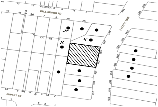
|
NOTIFICATION PLAN |
|
||
|
• PROPERTIES NOTIFIED
|
X SUBMISSIONS RECEIVED |
PROPERTY SUBJECT OF DEVELOPMENT |
|
Three submissions objected to the development, generally on the grounds that the development would result in:
· Privacy impacts;
· Construction impacts to adjoining properties;
· Noise impacts;
· Boundary fencing impacts;
· Inappropriate landscaping; and
· Devaluation of adjoining properties.
The merits of the matters raised in community submissions have been addressed in the body of the report with the exception of the following:
5.1.1 Concerns with proposed landscaping
A submission raises concerns with the proposed tree species Sydney Red Gum “Angophora costata” as it has a large canopy spread, grows to 20m and has potential to cause property damage to the adjoining property located 0.9m from the boundary fence.
To address these concerns, a condition of consent is recommended that the Sydney Red Gum “Angophora costata” located in the north-western corner of the site be replaced with the tree species identified as NSW Christmas bush “Ceratopetalum gummiferum” which has a mature height of 3 to 6m and provides privacy screening.
5.1.2 Property Values
A submission raises concerns that approval of the development would have detrimental effects on property values in the area. It should be noted that an assessment of this impact is not a matter for consideration under Section 79C of the Environmental Planning and Assessment Act, 1979. The proposal has been designed with appropriate setbacks, landscaping and privacy measures to minimise impacts on adjacent properties.
5.1.3 Construction impacts including Traffic, Parking, Noise and Dust
Conditions of consent are imposed which require appropriate control of dust and noise by way of limiting hours of construction and implementing erosion and sedimentation controls. Furthermore, a Construction Traffic Management Plan will be implemented by the developer.
5.1.4 Noise concerns
It is acknowledged that there would be an increase in noise from the addition of 11 dwellings. However, Australian Standard construction standards would assist in minimising noise impacts. The setbacks to adjoining dwellings and privacy mitigation measures implemented in the design are in accordance with HDCP requirements.
5.1.5 Dilapidation report
A submission raises concerns that excavation for the proposed basement could damage neighbouring properties.
Conditions of consent are recommended that a Dilapidation report be prepared by a chartered structural engineer detailing the structural condition of adjoining properties No. 507 Pacific Highway, No.3 Willarong Road and No. 2 Rupert Street, Mount Colah prior the issue of a Construction Certificate.
5.1.6 Boundary Fence
A submission from No.3 Willarong Road, which adjoins the rear boundary of the subject site, requests that a 40cm panel of lattice screening be installed above the 1.8m high boundary fence to maintain a reasonable level of privacy between the two properties.
Conditions of consent are recommended that 40cm of lattice be installed above the 1.8m high fence along the boundary with No.3 Willarong Road.
5.1.7 Removal of Boundary Fence
A submission raises concerns with the removal of the garage on No.505 Pacific Highway as it currently acts as a boundary fence and vegetable garden.
Conditions of consent are recommended that 1.8m boundary fencing must be erected along the northern property boundary and that alternative fencing may be erected along the northern boundary subject to the written agreement of the adjoining property owner.
5.2 Public Agencies
The development application was referred to the following Agencies for comment:
5.2.1 Roads and Maritime Services
As discussed in Section 2.4.1 of this report, RMS has reviewed the proposal and raises no objections subject to recommended conditions of consent.
6. THE PUBLIC INTEREST
Section 79C(1)(e) of the Act requires Council to consider “the public interest”.
The public interest is an overarching requirement, which includes the consideration of the matters discussed in this report. Implicit to the public interest is the achievement of future built outcomes adequately responding to and respecting the future desired outcomes expressed in environmental planning instruments and development control plans.
The application is considered to have satisfactorily addressed Council’s and relevant agencies’ criteria and would provide a development outcome that, on balance, would result in a positive impact for the community by providing additional housing opportunities and choice for a growing population. Accordingly, it is considered that the approval of the proposed development would be in the public interest.
CONCLUSION
The application seeks approval for the demolition of existing structures and construction of a multi dwelling housing development comprising 13 two-storey townhouses with attics and basement car parking.
The proposed development is generally in accordance with the development controls for the Pacific Highway Mount Colah and Asquith Precinct of the HDCP and would contribute to the desired residential character of the precinct, subject to recommended conditions of consent.
The proposal would result in a development that would be in keeping with the desired future character of the precinct.
Note: At the time of the completion of this planning report, no persons have made a Political Donations Disclosure Statement pursuant to Section 147 of the Environmental Planning and Assessment Act 1979 in respect of the subject planning application.
RESPONSIBLE OFFICER
The officer responsible for the preparation of this Report is the Manager – Development Assessments – Rodney Pickles, who can be contacted on 9847 6731.
|
Rod Pickles Manager - Development Assessment Planning Division |
James Farrington Group Manager Planning Division |
|
1.View |
Locality Map |
|
|
|
2.View |
Floor Plans |
|
|
|
3.View |
Roof Plan |
|
|
|
4.View |
Elevations |
|
|
|
5.View |
Landscape Plan |
|
|
|
6.View |
External Finishes |
|
|
File Reference: DA/306/2017
Document Number: D07270144
SCHEDULE 1
1. Deferred Commencement
Pursuant to Section 80(3) of the Environmental Planning and Assessment Act 1979, this consent does not operate until the following information is submitted to Council:
a) The registration and creation of an easement to drain water from the site over downstream properties at Lot 7 DP 1003239, Lot 6 DP 1003238, Lot 5 DP 656402, Nos. 497 to 501 Pacific Highway, Asquith.
Such information must be submitted within 3 years of the date of this notice.
Upon Council’s written satisfaction of the above information, the following conditions of development consent apply:
CONDITIONS OF APPROVAL
GENERAL CONDITIONS
The conditions of consent within this notice of determination have been applied to ensure that the use of the land and/or building is carried out in such a manner that is consistent with the aims and objectives of the relevant legislation, planning instruments and Council policies affecting the land and does not disrupt the amenity of the neighbourhood or impact upon the environment.
Note: For the purpose of this consent, the term ‘applicant’ means any person who has the authority to act on or the benefit of the development consent.
Note: For the purpose of this consent, any reference to an Act, Regulation, Australian Standard or publication by a public authority shall be taken to mean the gazetted Act or Regulation, or adopted Australian Standard or publication as in force on the date that the application for a construction certificate is made.
2. Approved Plans and Supporting Documentation
The development must be carried out in accordance with the plans and documentation listed below and endorsed with Council’s stamp, except where amended by Council and/or other conditions of this consent:
Approved Plans
|
Plan No. |
Issue |
Plan Title |
Drawn by |
Dated |
|
100 |
C |
Roof plan |
Mackenzie Architects |
15.09.2017 |
|
101 |
C |
Lower basement |
Mackenzie Architects |
15.09.2017 |
|
102 |
C |
Basement |
Mackenzie Architects |
15.09.2017 |
|
103 |
C |
Ground |
Mackenzie Architects |
15.09.2017 |
|
104 |
C |
First |
Mackenzie Architects |
15.09.2017 |
|
105 |
C |
Attic |
Mackenzie Architects |
15.09.2017 |
|
200 |
C |
West & North |
Mackenzie Architects |
15.09.2017 |
|
201 |
C |
East & South |
Mackenzie Architects |
15.09.2017 |
|
202 |
C |
Block A East & Block B West |
Mackenzie Architects |
15.09.2017 |
|
300 |
C |
Section 01 & 02 |
Mackenzie Architects |
15.09.2017 |
|
411 |
- |
Demolition & Erosion control |
Mackenzie Architects |
02.02.2017 |
|
LPDA 17 - 254 |
C |
Landscape plans |
Conzept landscape architects |
30.07.2017 |
|
LPDA 17 - 254 |
A |
Specification & detail |
Conzept landscape architects |
31.03.2017 |
Supporting Documents
|
Plan No. |
Issue |
Plan Title |
Drawn by |
Dated |
|
413 |
B |
Garbage truck turning path (Ground – In) |
Mackenzie Architects |
27.07.2017 |
|
414 |
B |
Garbage truck turning path (Ground – Out) |
Mackenzie Architects |
27.07.2017 |
|
415 |
B |
Garbage truck turning path (Basement – In) |
Mackenzie Architects |
27.07.2017 |
|
416 |
B |
Garbage truck turning path (Basement – Out) |
Mackenzie Architects |
27.07.2017 |
|
403 |
B |
Sample board |
Mackenzie Architects |
27.07.2017 |
|
301 |
B |
Longitudinal sections |
Mackenzie Architects |
27.07.2017 |
|
402 |
- |
Shadow diagram |
Mackenzie Architects |
02.02.2017 |
|
15022 |
- |
Traffic Report |
Terraffic pty ltd |
22.03.2017 |
|
- |
- |
Waste management plan |
Mackenzie Architects |
24.03.2017 |
|
- |
- |
Access report |
Obvius Access Disability Consultants |
24.03.2017 |
|
2017-088 |
- |
Acoustic Report |
Acoustic Noise & Vibration Solutions P/L |
24.03.2017 |
|
17-0232 |
A |
Nathers Assessment |
Efficient Living |
29.03.2017 |
|
808517M |
- |
BASIX Certificate |
Efficient Living |
29.03.2017 |
|
E23315 GA |
- |
Geotech report |
Werombi Properties Pty Ltd |
21.03.2017 |
|
414 |
B |
Cross Ventilation diagram for attic |
Mackenzie Architects |
27.07.2017 |
|
- |
- |
Solar study |
Mackenzie Architects |
- |
|
C02 |
5 |
Basement 2 drainage |
Greenview Consulting |
15.09.2017 |
|
C03 |
6 |
Basement 1 drainage |
Greenview Consulting |
15.09.2017 |
|
C04 |
6 |
Ground floor drainage |
Greenview Consulting |
15.09.2017 |
|
C05 |
5 |
Site stormwater details |
Greenview Consulting |
15.09.2017 |
|
C06 |
3 |
Street drainage plan |
Greenview Consulting |
15.09.2017 |
3. Amendment of Plans
a) The approved landscape plan LPDA 17 – 254, Rev C, prepared by Conzept landscape architects, dated 30.07.2017 must be amended as follows:
i) The tree species identified as Sydney Red Gum “Angophora costata” located in the north-western corner of the site must be replaced with the tree species identified as NSW Christmas bush “Ceratopetalum gummiferum”.
ii) As the On Site Detention System was amended to be underneath the driveway, the landscape plan must be amended by including medium to large trees along the southern side boundary that are the same tree species to the trees proposed along the northern boundary.
b) The approved basement plan, 102, Rev C, Prepared by Mackenzie architects dated 15.09.2017 must be amended to replace the swing doors providing access to the bin storage room.
c) These amended plans must be submitted with the application for the Construction Certificate.
4. Section 94 Development Contributions
a) In accordance with Section 80A(1) of the Environmental Planning and Assessment Act, 1979 and the Hornsby Shire Council Section 94 Development Contributions Plan 2014-2024, the following monetary contributions must be paid to Council to cater for the increased demand for community infrastructure resulting from the development:
|
Description |
Contribution (4) |
|
Roads |
$3,030.80 |
|
Open Space and Recreation |
$127,531.05 |
|
Community Facilities |
$49,026.85 |
|
Plan Preparation and Administration |
$411.30 |
|
TOTAL |
$180,000 |
being for 11 townhouses and a credit of 2 existing dwellings.
b) The value of this contribution is current as at 7 September 2017. If the contribution is not paid within the financial quarter that this condition was generated, the contribution payable will be adjusted in accordance with the provisions of the Hornsby Shire Council Section 94 Development Contributions Plan and the amount payable will be calculated at the time of payment in the following manner:
$CPY = $CDC x CPIPY
CPIDC
Where:
$CPY is the amount of the contribution at the date of Payment
$CDC is the amount of the contribution as set out in this Development Consent
CPIPY is the latest release of the Consumer Price Index (Sydney – All Groups) at the date of Payment as published by the ABS.
CPIDC is the Consumer Price Index (Sydney – All Groups) for the financial quarter at the date applicable in this Development Consent Condition.
c) The monetary contribution must be paid to Council:
i) prior to the issue of the Subdivision Certificate where the development is for subdivision; or
ii) prior to the issue of the first Construction Certificate where the development is for building work; or
iii) prior to issue of the Subdivision Certificate or first Construction Certificate, whichever occurs first, where the development involves both subdivision and building work; or
iv) prior to the works commencing where the development does not require a Construction Certificate or Subdivision Certificate.
Note: It is the professional responsibility of the Principal Certifying Authority to ensure that the monetary contributions have been paid to Council in accordance with the above timeframes.
Council’s Development Contributions Plan may be viewed at www.hornsby.nsw.gov.au or a copy may be inspected at Council’s Administration Centre during normal business hours.
5. Removal of Existing Trees
a) This development consent permits the removal of six trees identified on approved landscape plan LPDA 17 – 254, Rev C, prepared by Conzept landscape architects, dated 30.07.2017.
b) The removal of any other trees requires separate approval in accordance with the Tree and Vegetation Chapter 1B.6 Hornsby Development Control Plan (HDCP).
6. Construction Certificate
a) A Construction Certificate is required to be approved by Council or a Private Certifying Authority prior to the commencement of any works under this consent.
b) A separate Construction Certificate must be obtained from Council for all works within the public road reserve under S138 of the Roads Act.
c) A separate Construction Certificate must be obtained from Council for all works within drainage easements vested in Council.
d) The Construction Certificate plans must not be inconsistent with the Development Consent plans.
REQUIREMENTS PRIOR TO THE ISSUE OF A CONSTRUCTION CERTIFICATE
7. Building Code of Australia
All approved building work must be carried out in accordance with the relevant requirements of the Building Code of Australia.
8. Utility Services
The applicant must submit written evidence of the following service provider requirements:
a) Ausgrid (formerly Energy Australia) – a letter of consent demonstrating that satisfactory arrangements have been made to service the proposed development.
b) Telstra – a letter of consent demonstrating that satisfactory arrangements have been made to service the proposed development.
9. Contract of Insurance (Residential Building Work)
Where residential building work for which the Home Building Act 1989 requires there to be a contract of insurance in force in accordance with Part 6 of that Act, this contract of insurance must be in force before any building work authorised to be carried out by the consent commences.
10. Notification of Home Building Act 1989 Requirements
Residential building work within the meaning of the Home Building Act 1989 must not be carried out unless the principal certifying authority for the development to which the work relates (not being Council) has given Council written notice of the following information:
a) In the case of work for which a principal contractor is required to be appointed:
i) The name and licence number of the principal contractor; and
ii) The name of the insurer by which the work is insured under Part 6 of that Act.
b) In the case of work to be done by an owner-builder:
i) The name of the owner-builder; and
ii) If the owner-builder is required to hold an owner-builder’s permit under that Act, the number of the owner-builder’s permit.
Note: If arrangements for doing the residential building work are changed while the work is in progress so that the information notified becomes out of date, further work must not be carried out unless the principal certifying authority for the development to which the work relates (not being Council) has given Council written notification of the updated information.
11. Sydney Water – Approval
This application must be submitted to Sydney Water for approval to determine whether the development would affect any Sydney Water infrastructure, and whether further requirements are to be met.
Building plan approvals can be obtained online via Sydney Water Tap inTM through www.sydneywater.com.au under the Building and Development tab.
12. Dilapidation Report
A ‘Dilapidation Report’ is to be prepared by a ‘chartered structural engineer’ detailing the structural condition of adjoining properties at No. 507 Pacific Highway, No.3 Willarong Road and No.2 Rupert Street, Mount Colah.
13. Traffic Control Plan
A Traffic Control Plan (TCP) must be prepared by a qualified traffic controller in accordance with the Roads & Traffic Authority’s Traffic Control at Worksites Manual 1998 and Australian Standard 1742.3 for all work on a public road. The Traffic Management Plan shall be submitted and approved by Council’s Manager Traffic and Road Safety prior to the issue of a construction certificate. The TCP must detail the following:
a) Arrangements for public notification of the works;
b) Temporary construction signage;
c) Permanent post-construction signage;
d) Vehicle movement plans;
e) Traffic management plans; and
f) Pedestrian and cyclist access/safety.
14. Stormwater Drainage
The stormwater drainage system for the development must be designed in accordance with Council’s Civil Works – Design and Construction Specification 2005 and the following requirements:
a) An inter-allotment drainage system through downstream properties shall be designed and constructed and discharged directly to a Council controlled piped drainage system.
b) Connected to an existing Council piped drainage system with the following requirements ;-
i) A separate application under the Local Government Act, 1993 and the Roads Act, 1993 must be submitted to Council for approval for all works within the public road reserve
ii) Connection to Council’s drainage system shall include design and construction for the extension of the existing Council piped drainage system from the existing Council pit to a new Council kerb inlet pit directly in line with the inter-allotment drainage system in accordance with Council’s Design and Construction Specification 2005. The Applicant’s Engineer must prepare the design of system including location of proposed work in the plan. Three (3) copies of the plan shall be submitted with lodgement and payment of the Application;
15. On Site Stormwater Detention
An on-site stormwater detention system must be designed by a chartered civil engineer and constructed generally in accordance with Job No. 170230 Revision 5 dated 15.09.2017 by Greenview Consulting and the following requirements:
a) Have a capacity of not less than 21 cubic metres, and a maximum discharge (when full) of 63 litres per second.
b) Have a surcharge/inspection grate located directly above the outlet.
c) Discharge from the detention system to be controlled via 1 metre length of pipe, not less than 50 millimetres diameter or via a stainless plate with sharply drilled orifice bolted over the face of the outlet discharging into a larger diameter pipe capable of carrying the design flow to an approved Council system.
d) Where above ground and the average depth is greater than 0.3 metres, a ‘pool type’ safety fence and warning signs to be installed.
e) Not be constructed in a location that would impact upon the visual or recreational amenity of residents.
Note: A construction certificate shall be obtained prior to the commencement of these works and are to be completed prior to the issue of an occupation certificate.
16. Rainwater Tank
Stormwater quality treatment measures shall be designed generally in accordance with Hornsby Council’s DCP 2013 - Part 1.C.1.2 (j). A rainwater tank shall be provided with a minimum storage capacity of 3,000 litres per 100m2 of roof area of the development. The tanks shall be connected to the communal water system and to all dwellings for toilet flushing and laundry use. A design certificate from a qualified engineer shall be submitted to the principal certifying authority certifying that stormwater quality for the development has been designed in accordance with Hornsby Council’s DCP 2013 - Part 1.C.1.2.
17. Vehicular Crossing – Boundary Levels
A separate application under the Local Government Act, 1993 and the Roads Act 1993 being an “Application for Boundary Levels” must be submitted to Council to obtain design levels at the front boundary for the design of the internal driveway, prior to the issue of a construction Certificate.
Note: A separate application to construct the vehicular crossing being an “Application to Construct Vehicular Crossing from Roadway to Property” is required to be submitted to Council for approval and can only be made by one of Council’s Authorised Vehicular Crossing Contractors. You are advised to contact Council on 02 9847 6940 to obtain a list of contractors.
18. Road Works – Pacific Highway
A separate application under the Local Government Act, 1993 and the Roads Act, 1993 must be submitted to Council for approval of all works within the public road reserve. All road works approved under this consent must be designed in accordance with Council’s Civil Works Design and Construction Specification 2005 and the following requirements:
a) A concrete footpath to be constructed within the road verge with the remaining area turfed. The existing footpath along the full frontage of the development site in the Pacific Highway and a new concrete footpath constructed.
a) Kerb and gutter and pavement along the frontage of the development site in the Pacific Highway, necessary drainage and sealing of road pavement between the existing pavement and lip of the gutter shall be designed and constructed in accordance with the RMS requirements. Concurrence and approval of the RMS is required prior to the granting of approval for all works within Pacific Highway. Stamped approved plans from the RMS are to be submitted with the application.
b) A road occupancy license shall be obtained from RMS to carry out works in Pacific Highway.
19. Internal Driveway/Vehicular Areas
The driveway and parking areas on site must be designed, constructed and a Construction Certificate issued in accordance with Australian Standards 2890.1, 2890.2, 3727 and the following requirements:
a) Design levels at the front boundary be obtained from Council.
b) The driveway be a rigid pavement.
c) Conduit for utility services including electricity, water, gas and telephone be provided. All existing overhead assets including electricity and telecommunications cabling shall be relocated underground at no cost to Council;
d) Longitudinal sections along both sides of the access driveway shall be submitted to the principal certifying authority in accordance with the ground clearance requirements of the Australian Standards AS 2890.1 and AS 2890.2 – for small rigid vehicles. The driveway shall be a minimum 5.5 metres in width for a minimum distance of 6 metres from the property boundary and have a maximum 5% grade. The longitudinal sections shall incorporate the design levels obtained by Council.
e) Prior to the issue of a construction certificate, a certificate from a qualified engineer shall be submitted to the principal certifying authority certifying that the access driveway, parking and services areas have been designed in accordance with Australian Standards AS 2890.1 and AS 2890.2.
20. Construction Traffic Management Plan
To enable unencumbered movement of traffic in the public road during construction works, a Construction Management Plan, including a Traffic Management Plan and scaled construction plans prepared by a suitably Chartered and Qualified Chartered Civil Engineer and Qualified Worksite Traffic Controller shall be prepared and submitted to Hornsby Shire Council for approval according to the following requirements:-
a) A copy of the plans shall be submitted for consideration and written approval by Hornsby Shire Council prior to the release of the Construction Certificate.
b) The plans shall detail the order of construction works and arrangement of all construction machines and vehicles being used at the same time during all stages.
c) The CTMP plans shall be in accordance with the approved Development Application plans and the Development Consent conditions.
d) In order to prevent injury, accident and loss of property, no building materials, work sheds, vehicles, machines or the like shall be allowed to remain in the road reserve area without the written consent of Hornsby Shire Council.
e) The Plan shall be generally in compliance with the requirements of the Road and Traffic Authority’s “Traffic Control at Worksites Manual 1998” and detailing:
i) Public notification of proposed works;
ii) Long term signage requirements;
iii) Short term (during actual works) signage;
iv) Vehicle Movement Plans, where applicable;
v) Traffic Management Plans; and
vi) Pedestrian and Cyclist access and safety.
f) The plans shall indicate traffic controls including those used during non-working hours and shall provide pedestrian access and two-way traffic in the public road to be facilitated at all times.
g) The plans shall include the proposed truck routes to and from the site including details of the frequency of truck movements at the different stages of the development. The plan shall also include details of parking arrangements for all employees and contractors.
h) The Applicant and all employees of contractors on the site must obey any direction or notice from the Prescribed Certifying Authority or Hornsby Shire Council in order to ensure the above.
i) If there is a requirement to obtain a Work Zone, partial Road Closure or Crane Permit an application to Hornsby Shire Council is to be made prior to the issue the Construction Certificate.
21. Noise – Rail and Road Corridor
The development must be carried out in accordance with the requirements of the Department of Planning’s Development Near Rail Corridors and Busy Roads – Interim Guideline and RailCorp’s Interim Guidelines for Applicants.
Note: The Department of Planning’s document is available at www.planning.nsw.gov.au (development assessments). The RailCorp document is available at www.railcorp.nsw.gov.au/publications.
22. Waste Management Details
The following waste management details must be provided with the Construction Certificate Plans:
a) The bin storage room at the basement level must be accessibly by persons with a disability while comfortably holding at least 6 of 240L bins;
Note: a 240 L recycling bin is 600 mm wide by 750 mm deep; allow for ease around the bin – 75 mm is recommended. These dimensions do not include wall thickness, door thickness, ventilation ducting etc., which must be added. The door must be wide enough and positioned such that the bin can fit through. Every bin must be able to be accessed (so stacking of bins two or more deep).
b) A Waste Management Plan Section One – Demolition Stage and Section Three – Construction Stage, covering the scope of this project and including the following details, is required to be submitted to Council:
i) An estimate of the types and volumes of waste and recyclables to be generated;
ii) A site plan showing sorting and storage areas for demolition and construction waste and the vehicle access to these areas;
iii) How excavation, demolition and construction waste materials will be reused or recycled and where residual wastes will be disposed; and
iv) The total percentage (by weight) of demolition and construction waste that will be reused or recycled.
23. Identification of Survey Marks
A registered surveyor must identify all survey marks in the vicinity of the proposed development. Any survey marks required to be removed or displaced as a result of the proposed development shall be undertaken by a registered surveyor in accordance with Section 24 (1) of the Surveying and Spatial Information Act 2002 and following the Surveyor General’s Directions No.11 – "Preservation of Survey Infrastructure".
REQUIREMENTS PRIOR TO THE COMMENCEMENT OF ANY WORKS
24. Erection of Construction Sign
a) A sign must be erected in a prominent position on any site on which any approved work is being carried out:
i) Showing the name, address and telephone number of the principal certifying authority for the work;
ii) Showing the name of the principal contractor (if any) for any demolition or building work and a telephone number on which that person may be contacted outside working hours; and
iii) Stating that unauthorised entry to the work site is prohibited.
b) The sign is to be maintained while the approved work is being carried out and must be removed when the work has been completed.
25. Protection of Adjoining Areas
A temporary hoarding, fence or awning must be erected between the work site and adjoining lands before the works begin and must be kept in place until after the completion of the works if the works:
a) Could cause a danger, obstruction or inconvenience to pedestrian or vehicular traffic;
b) Could cause damage to adjoining lands by falling objects; and/or
c) Involve the enclosure of a public place or part of a public place.
Note: Notwithstanding the above, Council’s separate written approval is required prior to the erection of any structure or other obstruction on public land.
26. Toilet Facilities
To provide a safe and hygienic workplace, toilet facilities must be available or be installed at the works site before works begin and must be maintained until the works are completed at a ratio of one toilet for every 20 persons employed at the site.
27. Erosion and Sediment Control
To protect the water quality of the downstream environment, erosion and sediment control measures must be provided and maintained throughout the construction period in accordance with the manual ‘Soils and Construction 2004 (Bluebook)’, the approved plans, Council specifications and to the satisfaction of the principal certifying authority. The erosion and sediment control devices must remain in place until the site has been stabilised and revegetated.
Note: On the spot penalties may be issued for any non-compliance with this requirement without any further notification or warning.
REQUIREMENTS DURING DEMOLITION AND CONSTRUCTION
28. Construction Work Hours
All works on site, including demolition and earth works, must only occur between 7am and 5pm Monday to Saturday.
No work is to be undertaken on Sundays or public holidays.
29. Demolition
To protect the surrounding environment, all demolition work must be carried out in accordance with “Australian Standard 2601-2001 – The Demolition of Structures” and the following requirements:
a) Demolition material must be disposed of to an authorised recycling and/or waste disposal site and/or in accordance with an approved waste management plan; and
b) Demolition works, where asbestos material is being removed, must be undertaken by a contractor that holds an appropriate licence issued by SafeWork NSW in accordance with the Work Health and Safety Regulation 2017 and be appropriately transported and disposed of in accordance with the Protection of the Environment Operations (Waste) Regulation 2014; and
c) On construction sites where any building contain asbestos material, a standard commercially manufactured sign containing the words ‘DANGER ASBESTOS REMOVAL IN PROGRESS’ and measuring not less than 400mm x 300mm must be displayed in a prominent position visible from the street.
30. Environmental Management
The site must be managed in accordance with the publication ‘Managing Urban Stormwater – Landcom (March 2004) and the Protection of the Environment Operations Act 1997 by way of implementing appropriate measures. To prevent sediment run-off, excessive dust, noise or odour emanating from the site during the construction of the development.
31. Excavated Material
All excavated material removed from the site must be classified by a suitably qualified person in accordance with the Department of Environment, Climate Change and Water NSW Waste Classification Guidelines prior to disposal to an approved waste management facility and be reported to the principal certifying authority prior to the issue of an Occupation Certificate.
32. Landfill
Landfill must be constructed in accordance with Council’s ‘Construction Specification 2005’ and the following requirements:
a) Prior to fill material being imported to the site, a certificate shall be obtained from a suitable qualified environmental consultant confirming the fill wholly consists of Virgin Excavated Natural Material (VENM) as defined in Schedule 1 of the Protection of the Environment Operations Act, 1997 or material approved under the Department of Environment and Climate Change’s general resource recovery exemption.
b) A compaction certificate is to be obtained from a suitably qualified geotechnical engineer verifying that the specified compaction requirements have been met.
c) These certificates must be included with the application for an occupation certificate.
33. Street Sweeping
To protect the surrounding environment, Street sweeping must be undertaken following sediment tracking from the site along the Pacific Highway during works and until the site is established.
The street cleaning services must undertake a street ‘scrub and dry’ method of service and not a dry sweeping service that may cause sediment tracking to spread or cause a dust nuisance.
34. Council Property
To ensure that the public reserve is kept in a clean, tidy and safe condition during construction works, no building materials, waste, machinery or related matter is to be stored on the road or footpath.
Note: This consent does not give right of access to the site via Council’s park or reserve. Should such access be required, separate written approval is to be obtained from Council.
35. Disturbance of Existing Site
During construction works, the existing ground levels of open space areas and natural landscape features, (including natural rock-outcrops, vegetation, soil and watercourses) must not be altered unless otherwise nominated on the approved plans.
36. Survey Report
A report(s) must be prepared by a registered surveyor and submitted to the principal certifying authority;
a) Prior to the pouring of concrete at each level of the building certifying that:
i) The building, retaining walls and the like have been correctly positioned on the site; and
ii) The finished floor level(s) are in accordance with the approved plans.
b) Confirming that the waste collection vehicle turning area complies with AS2890.1 – 2004 and AS20890.2 – 2002 for small rigid vehicles (SRV).
37. Waste Management
Waste management during the demolition and construction phase of the development must be undertaken in accordance with the approved Waste Management Plan. Additionally written records of the following items must be maintained during the removal of any waste from the site and such information submitted to the Principal Certifying Authority within fourteen days of the date of completion of the works:
a) The identity of the person removing the waste.
b) The waste carrier vehicle registration.
c) Date and time of waste collection.
d) A description of the waste (type of waste and estimated quantity).
e) Details of the site to which the waste is to be taken.
f) The corresponding tip docket/receipt from the site to which the waste is transferred (noting date and time of delivery, description (type and quantity) of waste).
g) Whether the waste is expected to be reused, recycled or go to landfill.
Note: In accordance with the Protection of the Environment Operations Act 1997, the definition of waste includes any unwanted substance, regardless of whether it is reused, recycled or disposed to landfill.
38. Compliance During Construction Works
The development must be carried out in accordance with the following approved documents:
a) Traffic Control Plan (TCP); and
b) Construction Traffic Management Plan (CTMP).
39. Maintenance of Public Footpaths
Public footpaths must be maintained for the duration of works to ensure they are free of trip hazards, displacements, breaks or debris to enable pedestrians to travel along the footpath safely.
REQUIREMENTS PRIOR TO THE ISSUE OF AN OCCUPATION CERTIFICATE
Note: For the purpose of this consent, a reference to ‘occupation certificate’ shall not be taken to mean an ‘interim occupation certificate’ unless otherwise stated.
40. Fulfilment of BASIX Commitments
The applicant must demonstrate the fulfilment of BASIX commitments pertaining to the development.
41. Unit Numbering
All units are to be numbered consecutively commencing at No.1. The strata plan lot number is to coincide with the unit number, e.g Unit 1 = Lot 1. The allocated of unit numbering must be authorised by Council prior to the numbering of each units in the development.
42. Damage to Council Assets
To protect public property and infrastructure, any damage caused to Council’s assets as a result of the construction or demolition of the development must be rectified by the applicant in accordance with Council’s Civil Works Specifications. Rectification works must be undertaken prior to the issue of an Occupation Certificate, or sooner, as directed by Council.
43. Retaining Walls
All required retaining walls must be constructed as part of the development.
44. Creation of Easements
The following matter(s) must be nominated on the plan of subdivision under s88B of the Conveyancing Act 1919:
a) The creation of an appropriate "Positive Covenant" and "Restriction as to User" over the constructed on-site detention/retention systems, stormwater quality improvement devices and outlet works, within the lots in favour of Council in accordance with Council’s prescribed wording. The position of the on-site detention system and stormwater quality improvement devices is to be clearly indicated on the title.
b) To register the OSD easement, the restriction on the use of land “works-as-executed” details of the on-site-detention system and stormwater quality improvement devices must be submitted verifying that the required storage and discharge rates have been constructed in accordance with the design requirements. The details must show the invert levels of the on site system together with pipe sizes and grades. Any variations to the approved plans must be shown in red on the “works-as-executed” plan and supported by calculations.
Note: Council must be nominated as the authority to release, vary or modify any easement, restriction or covenant.
45. Garbage Collection Easement
For the purpose of waste collection, an easement entitling Council, its servants and agents and persons authorised by it, to enter upon the subject land and to operate thereon, vehicles and other equipment for the purposes of garbage collection must be granted to Council by the owner of the land.
Note: The easement must be in a form prescribed by Council and must include covenants to the effect that parties will not be liable for any damage caused to the subject land or any part thereof or to any property located therein or thereon by reason of the operation thereon of any vehicle or other equipment used in connection with the collection of garbage and to the effect that the owner for the time being of the subject land shall indemnify the Council, its servants, agents and persons authorised by it to collect garbage against liability in respect of any such claims made by any person whomsoever.
46. Works as Executed Plan
A works-as-executed plan(s) must be prepared by a registered surveyor and submitted to Council for completed road pavement, kerb & gutter, public drainage systems, driveways and on-site detention system.
47. Preservation of Survey Marks
A certificate by a Registered Surveyor must be submitted to the Principal Certifying Authority, certifying that there has been no removal, damage, destruction, displacement or defacing of the existing survey marks in the vicinity of the proposed development or otherwise the re-establishment of damaged, removed or displaced survey marks has been undertaken in accordance with the Surveyor General’s Direction No.11 – “Preservation of Survey Infrastructure”.
48. Boundary Fencing
Boundary fencing shall be installed as per the following requirements:
a) The fencing along the rear boundary (between the site and No.2 Rupert Street) shall be a maximum 1.8m high solid timber lapped and capped fence.
b) The fencing along the rear boundary (between the site and No.3 Willarong Road) shall be a maximum 1.8m high solid timber lapped and capped fence with an additional 40cm of lattice screen on top.
c) Fencing must be erected along the northern and southern boundaries behind the front building line to a height of 1.8m.
Note: Alternative fencing may be erected along the northern and southern boundaries subject to the written consent of the adjoining property owner(s).
49. Car Parking and Vehicular Areas
All vehicular areas within the site and the car parking must be constructed in accordance with Australian Standard AS 2890.1 – 2004 – Off Street Car Parking and Australian Standard 2890.2 - 2002 – Off Street Commercial and the following requirements:
a) The driveway to be designed in accordance with Condition 19 of this development consent;
b) The parking and driveway areas to be accessed by the garbage truck must comply with the requirements of AS2890.2 – 2002 for SRV;
Note: Encroachments of the small rigid vehicle turning path and low speed manoeuvring clearance (300 mm both sides) into parking spaces must not occur.
c) The 3.5 metre clearance height within the waste collection vehicle travel path must not be reduced by ducting, lights, pipes or anything else;
d) A certificate from an appropriately licensed contractor must be submitted to the principal certifying authority certifying that the service conduits have been installed in accordance with the relevant utility provider and Australian Standards;
e) All parking areas and driveways are to be sealed to an all-weather standard, line marked and signposted;
f) Residential parking spaces are to be secure spaces with access controlled by card or numeric pad;
g) Three visitors’ spaces are to be provided at the basement level. Visitors are to be able to access the basement car park by an audio/visual intercom system located at the top of the ramped driveway;
h) Three bicycle spaces are to be provided in the basement car park. Bicycle parking spaces are to be designed in accordance with AS 2890.3-1993;
i) One motorcycle parking space is to be provided within the basement car park, designed in accordance with AS 2890.5-1993;
j) The location of the driveway must maintain sight lines for the pedestrians.
50. External Lighting
a) To protect the amenity of adjacent premises, all external lighting must be designed and installed in accordance with Australian Standard AS 4282 – Control of the Obtrusive Effects of Outdoor Lighting.
b) Certification of compliance with this Standard must be obtained from a suitably qualified person and submitted to the PCA with the application for the Construction Certificate.
51. Construction of Engineering Works
All engineering works identified in this consent including stormwater works, retaining walls, driveway works, roadworks and the like are to be completed and a Compliance Certificate issued prior to the release of the Occupation Certificate.
52. Consolidation of Allotments
All allotments the subject of this consent must be consolidated into one allotment.
Note: The applicant is recommended to submit the plan of subdivision to consolidate allotments to the NSW Department of Lands at least 4-6 weeks prior to seeking an occupation certificate.
53. Provision for National Broadband Network (NBN)
Provision must be made for fibre ready passive infrastructure (pits and pipes) generally in accordance with NBN Co's pit and pipe installation guidelines to service the proposed development. A certificate from NBN Co or Telstra must be submitted to the PCA that the fibre optic cabling provided for the development complies with MDU Building Design Guides for Development.
54. Completion of Landscaping
A certificate must be submitted to the PCA by a practicing landscape architect, horticulturalist or person with similar qualifications and experience certifying that all required landscaping works have been satisfactorily completed in accordance with the approved landscape plan.
55. Final Certification – Acoustics
Following the final inspection a qualified Acoustic Consultant must provide certification that the building has been constructed in accordance with the requirements of the Department of Planning’s Development Near Rail Corridors and Busy Roads – Interim Guideline and RailCorp’s Interim Guidelines for Applicants.
56. Safety and Security
This site must include the following elements:
a) An intercom system must be installed at gate locations to ensure screening of persons entering the units;
b) The entry doors are is to be constructed of safety rated glass to enable residents a clear line of site before entering or exiting the dwellings;
c) Lighting is to be provided to pathways, building entries, driveways and common external spaces;
d) Security gate access is to be provided to the car parking areas allowing residents-only access to private car spaces;
e) CCTV cameras must be installed at the entry and exit point and the around the mailbox;
f) The communal open spaces within the site must be illuminated with high luminance by motion sensor lighting;
g) The driveway and basement car parking must be illuminated with low luminance at all times;
h) Security deadlocks are to be provided to each dwelling door; and
i) Peep holes are to be provided to individual apartment doors to promote resident safety.
57. Waste Management
The following waste management requirements must be complied with:
a) The bin storage room at the basement level must include water or a hose for cleaning, graded floors with drainage to sewer, robust doors, sealed and impervious surface, adequate lighting and ventilation, and must be lockable.
b) A report must be prepared by an appropriately qualified person, certifying the following:
i) A comparison of the estimated quantities of each waste type against the actual quantities of each waste type.
Note: Explanations of any deviations to the approved Waste Management Plan is required to be included in this report.
ii) That at least 60% of the waste generated during the demolition and construction phase of the development was reused or recycled.
Note: If the 60% diversion from landfill cannot be achieved in the Construction Stage, the Report is to include the reasons why this occurred and certify that appropriate work practices were employed to implement the approved Waste Management Plan. The Report must be based on documentary evidence such as tipping dockets/receipts from recycling depots, transfer stations and landfills, audits of procedures etc. which are to be attached to the report.
iii) All waste was taken to site(s) that were lawfully permitted to accept that waste.
c) Each dwelling must be provided with an indoor waste/recycling cupboard for the interim storage of waste with two separate 20 litre containers for general waste and recyclable materials.
d) Space must be provided for either individual compost containers for each unit or a communal compost container;
Note: The location of the compost containers should have regard for potential amenity impacts.
e) A bulky waste storage area of at least 8m2 is to be identified and marked with paint and signage;
f) “No parking” signs must be erected to prohibit parking in the waste collection loading bay and turning area;
g) Prior to an Occupation Certificate being issued or the use commencing, whichever is earlier, the Principal Certifying Authority must obtain Council’s approval of the waste and recycling management facilities provided in the development and ensure arrangements are in place for domestic waste collection by Council;
h) Site security measures implemented on the property, including electronic gates, must not prevent access to the collection point by waste removal services.
62. Maintain Canopy Cover
a) A minimum of 4 trees must be planted on Council’s nature strip and selected from the Council’s Indigenous species listing located in the Hornsby Shire DCP Tree Preservation Measures 1B.6 Table 1B.6(b) such as Angophora costata, Angophora floribunda and Eucalyptus resinifera.
c) The pot size of the replacement tree(s) must be a minimum 25 litres and replacement tree(s) must be maintained until they reach the height of 3 metres.
d) The replacement trees must reach a mature height greater than 15 metres.
e) All tree stock must meet the specifications outlined in ‘Specifying Trees’ (Ross Clark, NATSPEC Books).
f) Planting methods must meet professional (best practice) industry standards
g) The suitably qualified person holding a certificate III in Horticulture must submit to the principal certifying authority a statement confirming all landscaping requirements has been completed in accordance with approved landscape plans and conditions of consent.
58. Preservation of Survey Marks
Prior to the issue of an occupation certificate, a certificate by a Registered Surveyor shall be submitted to the Principal Certifying Authority, certifying that there has been no removal, damage, destruction, displacement or defacing of the existing survey marks in the vicinity of the proposed development or otherwise the re-establishment of damaged, removed or displaced survey marks has been undertaken in accordance with the Surveyor General’s Direction No.11 – “Preservation of Survey Infrastructure”.
OPERATIONAL CONDITIONS
59. Noise
All noise generated by the proposed development must be attenuated to prevent levels of noise being emitted to adjacent premises which possess tonal, beating and similar characteristics or which exceeds background noise levels by more than 5dB(A).
60. Fire Safety Statement - Annual
On at least one occasion in every 12 month period following the date of the first ‘Fire Safety Certificate’ issued for the property, the owner must provide Council with an annual ‘Fire Safety Certificate’ to each essential service installed in the building.
61. Landscape Establishment
The landscape works must be maintained into the future to ensure the establishment and successful growth of plant material to meet the intent of the landscape design. This must include but not limited to watering, weeding, replacement of failed plant material and promoting the growth of plants through standard industry practices.
62. Car Parking/Sight Lines and Deliveries
All car parking must be operated in accordance with Australian Standard AS 2890.1 – 2004 – Off Street Car Parking and Australian Standard 2890.2 - 2002 – Off Street Commercial and the following requirements:
a) All parking areas and driveways are to be sealed to an all-weather standard, line marked and signposted at all times.
b) Car parking, loading and manoeuvring areas to be used solely for nominated purposes.
c) Vehicles awaiting loading, unloading or servicing shall be parked on site and not on adjacent or nearby public roads;
d) All vehicular entry on to the site and egress from the site shall be made in a forward direction;
e) Minimum sight lines for pedestrian safety are to be provided at the driveway; and
f) Any proposed landscaping and/or fencing must not restrict sight distance to pedestrians and cyclists travelling along the footpath.
CONDITIONS OF CONCURRENCE – NSW Roads and Maritime Services
The following conditions of consent are from the nominated State Agency pursuant to Section 79b of the Environmental Planning and Assessment Act 1979 and must be complied with to the satisfaction of that Agency.
63. RMS Condition 1
Any redundant driveways on Pacific Highway shall be removed and replaced with kerb and gutter. The design and construction of the kerb and gutter crossing on Pacific Highway shall be in accordance with Roads and Maritime’s requirements. Details of these requirements should be obtained from Roads and Maritime’s Statewide Delivery Section (9598 7798).
All vehicular access to the subject development shall be restricted to left in/left out (LILO) movements on road safety and network efficiency grounds. In this regard, a triangular raised median should be constructed at the driveway (within the property boundary) and the driveway splayed/angled to physically prevent vehicles turning right to/from the development.
In accordance with AS 2890.1- 2004 (Parking Facilities, Part 1: Off-street car parking), the driveway shall be a minimum of 5.5 metres in width for a minimum distance of 6 metres from the property boundary. The driveway shall be splayed at the kerb line to allow the left-in and left-out manoeuvers to be fully contained within the kerb side lane.
Detailed design plans of the proposed works are to be submitted to Roads and Maritime for approval prior to the commencement of any road works. A plan checking fee and lodgement of a performance bond may be required from the applicant prior to the release of the approved road design plans by Roads and Maritime.
64. RMS Condition 2
Roads and Maritime has previously vested a strip of land as road along the Pacific Highway frontage of the subject property as shown by grey colour on the attached plan. The subject property is further affected by a road proposal as shown by pink colour on the attached plan.
All buildings and structures, together with any improvements integral to the future use of the site, are to be erected clear of the land acquired for road (unlimited in height or depth). The area required for road should be identified as a separate lot/part of the common property in any plan of subdivision.
65. RMS Condition 3
The developer is to submit design drawings and documents relating to the excavation of the site and support structures to Roads and Maritime for assessment, in accordance with Technical Direction GTD2012/001.
The developer is to submit all documentation at least six (6) weeks prior to commencement of construction and is to meet the full cost of the assessment by Roads and Maritime.
The report and any enquiries should be forwarded to:
Project Engineer, External Works
Sydney Asset Management
Roads and Maritime Services
PO Box 973 Parramatta CBD 2124.
Telephone 8849 2114
If it is necessary to excavate below the level of the base of the footings of the adjoining roadways, the person acting on the consent shall ensure that the owner/s of the roadway is/are given at least seven (7) day notice of the intention to excavate below the base of the footings. The notice is to include complete details of the work.
66. RMS Condition 4
Detailed design plans and hydraulic calculations of any changes to stormwater discharge onto Pacific Highway are to be submitted to Roads and Maritime for approval, prior to the commencement of any works.
Details should be forwarded to:
The Sydney Asset Management
Roads and Maritime Services
PO Box 973 Parramatta CBD 2124.
A plan checking fee will be payable and a performance bond may be required before Roads and Maritime approval is issued. With regard to the Civil Works requirement please contact the Roads and Maritime Project Engineer, External Works Ph: 8849 2114.
67. RMS Condition 5
A Road Occupancy Licence should be obtained from Transport Management Centre for any works that may impact on traffic flows on Pacific Highway during construction activities.
68. RMS Condition 6
A construction zone will not be permitted on Pacific Highway.
69. RMS Condition 7
A Road Occupancy Licence should be obtained from Transport Management Centre for any works that may impact on traffic flows on Pacific Highway during construction activities.
- END OF CONDITIONS -
ADVISORY NOTES
The following information is provided for your assistance to ensure compliance with the Environmental Planning and Assessment Act 1979 Environmental Planning and Assessment Regulation 2000, other relevant legislation and Council’s policies and specifications. This information does not form part of the conditions of development consent pursuant to Section 80A of the Act.
Environmental Planning and Assessment Act 1979 Requirements
The Environmental Planning and Assessment Act 1979 requires:
· The issue of a construction certificate prior to the commencement of any works. Enquiries can be made to Council’s Customer Services Branch on 9847 6760;
· a principal certifying authority to be nominated and Council notified of that appointment prior to the commencement of any works;
· Council to be given at least two days written notice prior to the commencement of any works;
· mandatory inspections of nominated stages of the construction inspected; and
· an occupation certificate to be issued before occupying any building or commencing the use of the land.
Long Service Levy
In accordance with Section 34 of the Building and Construction Industry Long Service Payments Act 1986, a ‘Long Service Levy’ must be paid to the Long Service Payments Corporation or Hornsby Council.
Note: The rate of the Long Service Levy is 0.35% of the total cost of the work.
Note: Hornsby Council requires the payment of the Long Service Levy prior to the issue of a construction certificate.
Tree and Vegetation Preservation
In accordance with Clause 5.9 of the Hornsby Local Environmental Plan 2013 a person must not ringbark, cut down, top, lop, remove, injure or wilfully destroy any tree or other vegetation protected under the Hornsby Development Control Plan 2013 without the authority conferred by a development consent or a permit granted by Council.
Notes: A tree is defined as a long lived, woody perennial plant with one or relatively few main stems with the potential to grow to a height greater than three metres (3M). (HDCP 1B.6.1.c).
Tree protection measures and distances are determined using the Australian Standard AS 4970:2009, “Protection of Trees on Development Sites”.
Fines may be imposed for non-compliance with both the Hornsby Local Environmental Plan 2013 and the Hornsby Development Control Plan 2013.
Dial Before You Dig
Prior to commencing any works, the applicant is encouraged to contact Dial Before You Dig on 1100 or www.dialbeforeyoudig.com.au for free information on potential underground pipes and cables within the vicinity of the development site.
Asbestos Warning
Should asbestos or asbestos products be encountered during demolition or construction works, you are advised to seek advice and information prior to disturbing this material. It is recommended that a contractor holding an asbestos-handling permit (issued by WorkCover NSW) be engaged to manage the proper handling of this material. Further information regarding the safe handling and removal of asbestos can be found at:
Alternatively, telephone the WorkCover Asbestos and Demolition Team on 8260 5885.
Disability Discrimination Act
The applicant’s attention is drawn to the existence of the Disability Discrimination Act. A construction certificate is required to be obtained for the proposed building/s, which will provide consideration under the Building Code of Australia, however, the development may not comply with the requirements of the Disability Discrimination Act. This is the sole responsibility of the applicant.
Covenants
The land upon which the subject building is to be constructed may be affected by restrictive covenants. Council issues this approval without enquiry as to whether any restrictive covenant affecting the land would be breached by the construction of the building, the subject of this consent. Applicants must rely on their own enquiries as to whether or not the building breaches any such covenant.
Telecommunications Act 1997 (Commonwealth)
If you are aware of any works or proposed works which may
affect or impact on Telstra’s assets in any way, you are required to
contact: Telstra’s Network Integrity Team on Phone Number
1800 810 443.
Group Manager’s Report No. PL38/17
Planning Division
Date of Meeting: 11/10/2017
12 DEVELOPMENT APPLICATION - SUDDIVISION OF AN EXISTING MULTI-UNIT HOUSING DEVELOPMENT - 9 BRAIDWOOD AVENUE, NORTH EPPING
EXECUTIVE SUMMARY
|
DA No: |
DA/531/2017 (Lodged on 29 May 2017) |
|
Description: |
Torrens title subdivision of an existing multi-unit housing development to create two allotments |
|
Property: |
Lot 11 DP 30369, No. 9 Braidwood Avenue, North Epping |
|
Applicant: |
Mr Albert Verdian |
|
Owner: |
Mr Albert Verdian and Mrs Rozek Verdian |
|
Estimated Value: |
Nil |
|
Ward: |
C |
· The application proposes the Torrens title subdivision of an existing multi-unit housing development comprising two detached dwellings into two allotments.
· The proposal does not comply with the Hornsby Shire Local Environmental Plan 2013 (HLEP) with regard to Clause 4.1 Minimum subdivision lot size. The applicant has made a submission in accordance with Clause 4.6 ‘Exceptions to development standards’ of the HLEP to vary the minimum 500m2 lot size development standard. The submission is considered well founded and is supported.
· One submission was received in respect of the application.
· It is recommended that the application be approved.
|
THAT Council assume the concurrence of the Secretary of the Department of Planning and Environment pursuant to Clause 4.6 of the Hornsby Local Environmental Plan 2013 and approve Development Application No. DA/531/2017 for the Torrens title subdivision of one allotment into two lots at Lot 11 DP 30369, No.9 Braidwood Avenue, North Epping subject to the conditions of consent detailed in Schedule 1 of Group Manager’s Report No. PL38/17. |
BACKGROUND
Upon gazettal of the then Hornsby Shire Local Environmental Plan (HSLEP) in July 1994, Hornsby Shire was exempted from the provisions of the now repealed NSW State Government’s urban consolidation policies, namely Sydney Regional Environmental Plan (SREP) No. 12 – Dual Occupancy and State Environmental Planning Policy (SEPP) No. 25 – Residential Allotment Sizes.
The exemption was granted as a result of the housing initiatives embodied within the HSLEP which presented an alternative solution to meet both local and State housing objectives. The HSLEP incorporated higher density residential zones around transport and employment nodes, such as the Hornsby Town Centre. The HSLEP also permitting multi-unit housing at a density of one dwelling per 350m2 of land area within the Residential A (Low Density) zone. In accordance with Clause 4(2) of the HSLEP, SEPP 25 and SREP 12 no longer applied to Hornsby Shire.
The then Minister for Urban Affairs and Planning subsequently repealed the right to separate titles on dual occupancy developments. However, despite the repeal of SREP No. 12 and SEPP No. 25, the subdivision of dual occupancies with reduced lot sizes was still possible under the HSLEP.
On 15 December 1995, to bring the HSLEP in accordance with State Government policies, HSLEP (Amendment No. 8) was gazetted to preclude the subdivision of multi-unit housing developments where proposed allotment sizes were less than the minimum allotment sizes under Clause 14 (Density).
In September 2013, the HLEP was gazetted which allowed a minimum allotment size of 500m2 and prohibited “multi-unit housing” and “dual occupancies” within the R2 Low Density Residential zone.
SITE HISTORY
On 14 November 2008, Council approved development application DA/1579/2007 for a two storey dwelling house and demolition of an existing dwelling subject to conditions. Condition No.12 of the consent stated that “the existing dwelling house is to be demolished prior to any Occupation Certificate being issued for the proposed dwelling house”.
On 17 May 2013, Council approved development application DA/1354/2012 for the retention of the existing dwelling and approved the one and two storey dwelling as a multi-unit housing development, permitted under the then HSLEP. The multi-unit housing development complied with Clause 14 (density – 1 dwelling per 350m2) and Clause 15 (FSR 0.4:1) of the HSLEP.
SITE
The subject site is located at the end of a cul-de-sac on the south-eastern corner of Braidwood Avenue, North Epping. The site has an area of 973.8m² and is a battle-axe shaped allotment. The subject site is 47.24m in depth and has a width of 19.2m. The site has a fall of 6.4m from north to south and a fall of 1.5m to the street.
The site includes a part one and part two storey brick and tile dwelling to the front of the site including a double garage. To the rear of the site is a single storey brick and rendered dwelling and detached single garage. Access to the site is via a driveway from Braidwood Avenue.
The surrounding development comprises one and two storey dwelling houses.
PROPOSAL
The application proposes the Torrens title subdivision of an existing multi-unit housing development into two allotments.
Proposed Lot 111 would be an irregular shaped, battle-axe lot with an area of 389.1m2, excluding the access handle and 519.5m2 including the handle.
Proposed Lot 112 would be an irregular shaped battle axe lot with an area of 456.3m2.
Access to the lots would be via a shared right-of-carriageway. A right-of-carriageway and easement would be created over Lot 111 in favour of Lot 112.
No alterations to the existing dwellings or any other physical works are proposed as part of the application.
ASSESSMENT
The development application has been assessed having regard to ‘A Plan for Growing Sydney’, the ‘Draft North District Plan’ and the matters for consideration prescribed under Section 79C of the Environmental Planning and Assessment Act 1979 (the Act). The following issues have been identified for further consideration.
1. STRATEGIC CONTEXT
1.1 A Plan for Growing Sydney and (Draft) North District Plan
A Plan for Growing Sydney has been prepared by the NSW State Government to guide land use planning decisions for the next 20 years. The Plan sets a strategy and actions for accommodating Sydney’s future population growth and identifies dwelling targets to ensure supply meets demand. The Plan identifies that the most suitable areas for new housing are in locations close to jobs, public transport, community facilities and services.
The NSW Government will use the subregional planning process to define objectives and set goals for job creation, housing supply and choice in each subregion. Hornsby Shire has been grouped with Hunters Hill, Ku-ring-gai, Lane Cove, Mosman, North Sydney, Ryde, Northern Beaches and Willoughby to form the North District. The Greater Sydney Commission has realised the draft North District Plan which includes priorities and actions for the Northern District for the next 20 years. The identified challenge for Hornsby Shire will be to provide an additional 4,350 dwellings by 2021 with further strategic supply targets to be identified to deliver 97,000 additional dwellings in the North District by 2036.
The proposed development would not be inconsistent with ‘A Plan for Growing Sydney’ and ‘Draft North District Plan’.
2. STATUTORY CONTROLS
Section 79C(1)(a) requires Council to consider “any relevant environmental planning instruments, draft environmental planning instruments, development control plans, planning agreements and regulations”.
2.1 Hornsby Local Environmental Plan 2013
The proposed development has been assessed having regard to the provisions of the Hornsby Local Environmental Plan 2013 (HLEP).
2.1.1 Zoning of Land and Permissibility
The subject land is zoned R2 (Low Density Residential) under the HLEP. The objectives of the zone are:
· To provide for the housing needs of the community within a low density residential environment.
· To enable other land uses that provide facilities or services to meet the day to day needs of residents.
The proposed development is defined as “subdivision” and is permissible in the zone with Council’s consent.
2.1.2 Minimum Lot Size
Clause 4.1 of the HLEP provides that the minimum allotment size for the subject site within the R2 Low Density Residential zone is 500m2. The proposal does not comply with this provision.
Proposed Lot 111 would have an area of 389.1m2 (excluding the access handle) which would result in a 22% variation to the minimum lot size requirement. Proposed Lot 112 would have an area of 456.3m2 and would result in a 9% variation to the minimum lot size requirement.
The application is supported by a submission pursuant to Clause 4.6 of the HLEP to vary the minimum 500m2 allotment size development standard and which is discussed below in Section 2.1.3 of this report.
2.1.3 Exceptions to Development Standards
Clause 4.6 of the HLEP provides flexibility in the application of development standards in circumstances where strict compliance with those standards would, in any particular case, be unreasonable or unnecessary or tend to hinder the attainment of the objectives of the zone.
The proposal fails to comply with the minimum subdivision lot size of 500m2 under the HLEP. The objectives of Clause 4.1 are:
· To provide for the subdivision of land at a density that is appropriate for the site constraints, development potential and infrastructure capacity of the land,
· To ensure that lots are of a sufficient size to accommodate development.
The applicant has made a submission in support of a variation to the development standard in accordance with Clause 4.6 of the HLEP. The applicant states the proposed variation is considered to be consistent with the objectives of the control and is justified as follows:
· The proposal would enable the existing dwellings to exist on individual lots and would allow dwellings to be either owner occupied or rented.
· The proposal would have no additional impact on the infrastructure capacity or serviceability of the land.
· The floor area of the existing dwelling would comply with the maximum floor area Part 3.1.1 of the Hornsby Development Control Plan 2013 (HDCP) for each of the subdivided lots.
· The proposed Torrens title subdivision is consistent with the second objective given the two dwellings presently exist on the property and no further development is proposed. As such, the resultant lots are of sufficient size to accommodate the existing development.
The applicant also notes that in the recent ‘Four2Five’ decision (Four2Five Pty Ltd v Ashfield Council [2015] NSW LEC 90), Commissioner Pearson outlined that a Clause 4.6 variation requires identification of grounds that are particular to the circumstances to the proposed development. That is to say that simply meeting the objectives of the development standard is insufficient justification of a Clause 4.6 variation.
The Court of Appeal upheld the Four2Five decision but expressly notes that the Commissioner’s decision on the point (that she was not “satisfied” because something more specific to the site was required) was simply a discretionary (subjective) opinion which was a matter for her alone to decide. This does not mean that a Clause 4.6 variation can only be allowed where there is some special or particular feature of the site that justifies the non-compliance. Whether there are “sufficient environmental planning grounds to justify contravening the development standard”, it is something that can be assessed on a case by case basis and is for the consent authority to determine for itself.
The particular feature of the subject site that differs from the surrounding development is that the site contains an existing multi-unit housing development.
A more recent appeal is the matter of Randwick City Council v Micaul Holdings Pty Ltd [2016] NSWLEC 7 should be considered. In this case, the Council appealed against the original decision, raising legal argument about whether each and every item of the Clause 4.6 of the LEP had to be considered and complied with in terms of the applicant’s written document and the Commissioner’s assessment. The Chief Judge of the Court dismissed the appeal, finding no fault in the Commissioner’s approval of large variations to the height and FRS controls.
While the judgement did not directly overturn the Four2Five v Ashfield decision, an important issue emerged. The Chief Judge noted that one of the consent authority’s obligations is to be satisfied that “compliance with the development standard is unreasonable or unnecessary in the circumstance of the case, and that there are sufficient environmental planning grounds to justify contravening the development standard”.
The proposed subdivision does not involve any physical works and in this regard, does not give rise to any adverse environmental planning grounds.
Consideration should also be given to the Land and Environment Court judgement of Wehbe v Pittwater Council 2007 which identified the five different ways in which an objection may be well founded and that approval of the objection may be consistent with the aims of the policy. State Government Guidelines on varying development standards recommend considering the provisions of Clause 4.6 of the LEP and the ‘five part test’ established by the Land and Environment Court as follows:
1. the objectives of the standard are achieved notwithstanding noncompliance with the standard;
2. the underlying objective or purpose of the standard is not relevant to the development and therefore compliance is unnecessary;
3. the underlying object of purpose would be defeated or thwarted if compliance was required and therefore compliance is unreasonable;
4. the development standard has been virtually abandoned or destroyed by the council’s own actions in granting consents departing from the standard and hence compliance with the standard is unnecessary and unreasonable;
5. the compliance with development standard is unreasonable or inappropriate due to existing use of land and current environmental character of the particular parcel of land. That is, the particular parcel of land should not have been included in the zone.
The applicant’s submission to vary the minimum subdivision lot size development standard is considered well founded for the following reasons:
· The proposal would convert a prohibited “multi-unit housing” development to a permissible use within the R2 Low Density Residential zone under the HLEP.
· No environmental or planning implications would arise should the application be approved.
· The proposal does not include any changes to the approved built form, and therefore, the proposal would not have any impact on the existing streetscape or the amenity of adjoining properties.
· Approval of the application for Torrens title subdivision would not alter the intensity or scale of the existing development on the site.
· The proposal is both site specific to the site and accords with the objective of the zone as the proposal would allow the existing dwellings to be on separate titles, thereby adding economic value and versatility to existing housing stock.
· The proposal would result in allotments consistent with the objectives of the development standard. This is evident as the existing dwellings on the site demonstrate that the proposed allotments are capable of accommodating dwelling houses with the necessary ancillary infrastructure provision.
Based on this assessment, it is considered that compliance with the development standard would be unreasonable and unnecessary in the circumstances of the case. The proposal would not result in a precedent given the unique circumstances of the site involving two existing dwellings. Accordingly, the Clause 4.6 submission is supported in this instance.
2.1.4 Heritage Conservation
Clause 5.10 of the HLEP sets out heritage conservation provisions for Hornsby Shire. The site does not include a heritage item and is not located in a heritage conservation area. Accordingly, no further assessment regarding heritage is necessary.
2.2 Sydney Regional Environmental Plan (Sydney Harbour Catchment) 2005
The application has been assessed against the requirements of Sydney Regional Environmental Plan (Sydney Harbour Catchment) 2005. This Policy provides general planning considerations and strategies to ensure that the catchment, foreshores, waterways and islands of Sydney Harbour are recognised, protected, enhanced and maintained.
The proposal does not involve any site works and therefore, the proposal would have minimal potential to impact on the Sydney Harbour Catchment.
2.3 State Environmental Planning Policy No. 55 – Remediation of Land
Clause 7 of State Environmental Planning Policy No. 55 - Remediation of Land (SEPP 55) requires Council to consider whether land is contaminated prior to granting consent to the carrying out of any development on that land. Should the land be contaminated, Council must be satisfied that the land is suitable in a contaminated state for the proposed use. If the land requires remediation to be undertaken to make the land suitable for the proposed use, Council must be satisfied that the land will be remediated before the land is used for that purpose.
The site history and a review of Council’s files and air photos indicate a history of residential development and therefore, it is not likely that the site has experienced any significant contamination. Accordingly, further assessment under SEPP 55 is not required.
2.4 Rural Fire Act 1997
The site is partly in a bushfire prone area with the fire threat to the west of the site from bushland within the North Epping nature reserve. Accordingly, the proposed subdivision is ‘integrated development’ subject to approval of the NSW Rural Fire Service for the issue of a Bush Fire Safety Authority pursuant to Section 100B of the Rural Fires Act 1997.
The NSW Rural Fire Service has raised no objections to the proposal and no conditions were recommended as part of the assessment.
2.5 Clause 74BA Environmental Planning and Assessment Act, 1979 - Purpose and Status of Development Control Plans
Clause 74BA of the Environmental Planning and Assessment Act, 1979 states that a DCP provision will have no effect if it prevents or unreasonably restricts development that is otherwise permitted and complies with the development standards in relevant Local Environmental Plans and State Environmental Planning Policies.
The principal purpose of a development control plan is to provide guidance on the aims of any environmental planning instrument that applies to the development; facilitate development that is permissible under any such instrument; and achieve the objectives of land zones. The provisions contained in a DCP are not statutory requirements and are for guidance purposes only. Consent authorities have flexibility to consider innovative solutions when assessing development proposals, to assist achieve good planning outcomes.
2.6 Hornsby Development Control Plan 2013
The proposed development has been assessed having regard to the relevant desired outcomes and prescriptive requirements within the Hornsby Development Control Plan 2013 (HDCP). The following table sets out the proposal’s compliance with the prescriptive requirements of the Plan:
|
HDCP – Part 3 Residential Development & 6.1 Subdivision |
|||
|
Control |
Proposal |
Requirement |
Complies |
|
Site Area |
975m2 |
N/A |
N/A |
|
Lot Area |
|
|
|
|
- Lot 111 (excluding access handle) |
389.1 m2 |
500m2 |
No |
|
- Lot 112
|
456.3m2 |
500m2 |
No |
|
Lot Width |
|
|
|
|
- Lot 111 - |
18m |
12m |
Yes |
|
- Lot 112 |
18m |
12m |
Yes |
|
Setbacks – Lot 111 |
|
|
|
|
- Side (north) |
3m |
0.9m |
Yes |
|
- Side (east) |
1m |
0.9m |
Yes |
|
- Rear |
1m |
3m |
No |
|
Setbacks - Lot 112 |
|
|
|
|
- Side (east) |
2.2m |
0.9m |
Yes |
|
- Side (west) |
1m |
0.9m |
Yes |
|
- Rear |
2m |
3m |
No |
|
Landscape Area |
|
|
|
|
- Lot 111 - |
6% %% |
20% |
No |
|
- Lot 112 |
7% |
20% |
No |
|
Private Open Space |
|
|
|
|
- Lot 111 - |
>24m2 |
24m2 |
Yes |
|
- Lot 112 - |
>24m2 |
24m2 |
Yes |
|
Car Parking |
|
|
|
|
- Lot 111 - |
2 spaces |
2 spaces |
Yes |
|
- Lot 112 - |
2 spaces |
2 spaces |
Yes |
As detailed in the above table, the proposed development does not comply with a number of prescriptive requirements within the HDCP. The matters of non-compliance are detailed below, as well as a brief discussion on compliance with relevant desired outcomes.
2.6.1 Residential Lands Subdivision
The desired outcomes of Part 6.2.1 Residential Land Subdivision states that “subdivision design should maintain appropriately shaped lots to accommodate a dwelling and associated development that is compatible with a low density residential environment”.
The proposed lots are an irregular shape and would result in an existing dwelling on each proposed lot. Though the lots are undersized, the proposed subdivision would not alter the physical relationship of the existing development with the site or the surrounding low density residential environment.
Lot Size
The prescriptive measure of Part 6.2.1(a) states that “the minimum lot size is depicted on the minimum lot size map as: 500m2”.
One submission raises concerns over the undersized allotments. In this instance, the proposal is not capable of meeting the lot size requirement. The existing development demonstrates that the proposed lots are of sufficient size and shape to accommodate the dwelling houses on the site. This issue is addressed in detail above in Section 2.1.3 of this report.
Lot Shape
The prescriptive measure of Part 6.2.1(d) states that “lot design should maintain a minimum lot width that is compatible with the subdivision pattern”.
The subject site is a battle axe shaped allotment with a lot width of 18 metres and a 4.4 metre wide access handle. The irregular shaped common boundary between proposed Lot 111 and Lot 112 follows the existing line of the retaining wall which divides the private open space of Lot 111 and front yard of Lot 112.
Access to the allotments would be via the existing shared concrete driveway. A reciprocal right of access would provide access to proposed Lot 112 over proposed Lot 111. The use of the access handle and onsite parking arrangements would remain the same as currently exists on the site.
The layout and design of the proposed subdivision would be in keeping with the existing built form on the site. The minor non-compliance with respect to the lot shape does not warrant refusal of the application.
2.6.2 Setbacks
The desired outcomes of Part 3.1.2 Setbacks of the HDCP encourage “setbacks that are compatible with adjacent development and complement the streetscape.”
Both existing dwellings would not meet the rear boundary setback requirements under the HDCP as a result of the subdivision. A small portion of the existing dwelling at proposed Lot 112 would be setback less than 3 metres from the rear. However, the majority of the dwelling is setback greater than 3 metres.
However, in this instance, the non-compliance is support as the dwellings exist on the site and the subdivision would not alter the amenity impacts of the existing dwelling houses on surrounding neighbours.
2.6.3 Landscaping
The proposal would not meet the landscaping requirements of Table 6.2(d) Minimum Landscape Area under the HDCP.
The proposed subdivision would not alter the provision of landscaping on the site. The proposal is considered acceptable as the landscaping on proposed Lot 111 and Lot 112 would remain the same as approved under DA/1354/2012.
2.7 Section 94 Contributions Plans
Hornsby Shire Council Section 94 Contributions Plan 2012-2021 does not apply to the development as no additional dwellings or allotments are proposed. A development contribution was levied and paid with respect to the previous application for the construction of the multi-unit housing development.
3. ENVIRONMENTAL IMPACTS
Section 79C(1)(b) of the Act requires Council to consider “the likely impacts of that development, including environmental impacts on both the natural and built environments, and social and economic impacts in the locality”.
3.1 Natural Environment
3.1.1 Tree and Vegetation Preservation
The proposed development does not necessitate the removal of any trees or vegetation on the site.
3.1.2 Stormwater Management
The stormwater on the site currently drains to the street via a 1 metre wide easement along the northern and western side boundary of the site and access handle.
A condition is recommended for the creation of a drainage easement over proposed Lot 111 for the benefit of proposed Lot 112. A condition is also recommended for a “Positive Covenant” and “Restriction as to User” over the constructed underground on-site detention system on proposed Lot 112 and associated outlets. The on-site detention is recommended to be indicated on the title.
Subject to the recommended conditions of consent, the proposed development would have no impact on the existing stormwater management of the site.
3.2 Built Environment
3.2.1 Built Form
The proposed development would not alter the existing built form on the site.
3.3 Social Impacts
The residential subdivision would improve housing mix in the locality by enabling the existing dwellings to be either owner occupied or rented. This is consistent with Council’s Housing Strategy which identifies the need to provide a mix of housing options to meet future demographic needs in Hornsby Shire.
3.4 Economic Impacts
The proposal would not result in an economic impact.
4. SITE SUITABILITY
Section 79C(1)(c) of the Act requires Council to consider “the suitability of the site for the development”.
4.1 Bushfire Risk
The land is identified as being subject to bushfire risk. The application was referred to the NSW Rural Fire Service seeking approval under Integrated Development in accordance with Section 91 of the Environmental Planning and Assessment Act 1979. No objections were raised to the development and no conditions were required under section 100B of the ‘Rural Fires Act 1997’.
5. PUBLIC PARTICIPATION
Section 79C(1)(d) of the Act requires Council to consider “any submissions made in accordance with this Act”.
5.1 Community Consultation
The proposed development was placed on public exhibition and was notified to adjoining and nearby landowners between 8 June 2017 and 14 July 2017 in accordance with the Notification and Exhibition requirements of the HDCP. During this period, Council received one submission. The submission was received from an anonymous person(s).
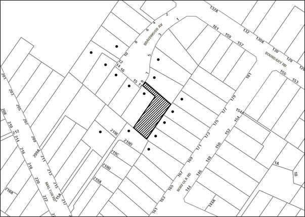
|
NOTIFICATION PLAN |
|
||
|
• PROPERTIES NOTIFIED
|
X SUBMISSIONS RECEIVED |
PROPERTY SUBJECT OF DEVELOPMENT |
|
|
One submission was received by Council from an anonymous person(s) |
|||
The submission objects to the development, generally on the grounds that the development would result in:
· Undersized lots;
· Excessive site coverage;
· Pressure on the street; and
· An illegal second dwelling on the site.
The merits of the matters raised in the submission have been addressed in the body of the report with the exception of the following:
5.2 Additional housing and land pressure
The submission raises concerns over the pressure an additional lot would have on the street and the legality of the second dwelling on the site.
The application does not propose an additional dwelling and only seeks to subdivide the existing land, to retain the two dwellings. The second dwelling on the site was approved under DA/1354/2007 as part of a multi-unit housing development.
5.3 Public Agencies
The development application was referred to the NSW Rural Fire Service for comment. No objections were raised to the proposed subdivision.
6. THE PUBLIC INTEREST
Section 79C(1)(e) of the Act requires Council to consider “the public interest”.
The public interest is an overarching requirement, which includes the consideration of the matters discussed in this report. Implicit to the public interest is the achievement of future built outcomes adequately responding to and respecting the future desired outcomes expressed in environmental planning instruments and development control plans.
The application is considered to have satisfactorily addressed Council’s and relevant agencies’ criteria and would provide a development outcome that, on balance, would result in a positive impact for the community. Accordingly, it is considered that the approval of the proposed development would be in the public interest.
CONCLUSION
The application proposes Torrens title subdivision of an existing multi-unit housing development comprising two detached dwellings.
The application does not comply with the Hornsby Local Environmental Plan 2013 in respect to the minimum 500m2 lot size. The applicant submitted a Clause 4.6 Variation to Development Standard to the minimum lot size development standards. The objection is considered well founded with regard to the existing development on the site and the principles established by the Land and Environment Court.
Council received one submission during the notification of the proposed subdivision.
Having regard to the circumstances of the case and consideration of the Clause 4.6 Variation to Development Standards, the application is recommended for approval.
Note: At the time of the completion of this planning report, no persons have made a Political Donations Disclosure Statement pursuant to Section 147 of the Environmental Planning and Assessment Act 1979 in respect of the subject planning application.
RESPONSIBLE OFFICER
The officer responsible for the preparation of this Report is the Manager – Development Assessments – Rodney Pickles, who can be contacted on 9847 6731.
|
Rod Pickles Manager - Development Assessment Planning Division |
James Farrington Group Manager Planning Division |
|
1.View |
Locality Map |
|
|
|
2.View |
Subdivision Plans |
|
|
File Reference: DA/531/2017
Document Number: D07262336
Conditions of Approval
GENERAL CONDITIONS
The conditions of consent within this notice of determination have been applied to ensure that the use of the land and/or building is carried out in such a manner that is consistent with the aims and objectives of the relevant legislation, planning instruments and Council policies affecting the land and does not disrupt the amenity of the neighbourhood or impact upon the environment.
Note: For the purpose of this consent, the term ‘applicant’ means any person who has the authority to act on or the benefit of the development consent.
Note: For the purpose of this consent, any reference to an Act, Regulation, Australian Standard or publication by a public authority shall be taken to mean the gazetted Act or Regulation, or adopted Australian Standard or publication as in force on the date that the application for a construction certificate is made.
1. Approved Plans and Supporting Documentation
The development must be carried out in accordance with the plans and documentation listed below and endorsed with Council’s stamp, except where amended by Council and/or other conditions of this consent:
|
Plan No. |
Drawn by |
Dated |
|
Existing Features, Levels & Contours, Sheet 1 of 2 |
Chase Burke Harvey Surveyors |
9-03-2017 |
|
Lot dimensions, Areas, Setbacks & Easements, Sheet 2 of 2 |
Chase Burke Harvey Surveyors |
9-03-2017 |
|
Document title |
Prepared by |
Dated |
|
Statement of Environmental Effects |
Ian Glendinning Planning Pty Ltd |
May 2017 |
REQUIREMENTS PRIOR TO THE ISSUE OF A SUBDIVISION CERTIFICATE
Note: For the purpose of this consent, a reference to ‘occupation certificate’ shall not be taken to mean an ‘interim occupation certificate’ unless otherwise stated:
2. Sydney Water – s73 Certificate
A s73 Certificate must be obtained from Sydney Water and submitted to the PCA.
Note: Sydney Water requires that s73 applications are to be made through an authorised Sydney Water Servicing Coordinator. Refer to www.sydneywater.com.au or telephone 13 20 92 for assistance.
3. Creation of Easements
The following matter(s) must be nominated on the plan of subdivision under s88B of the Conveyancing Act, 1919:
a) A right of access and easement for services over the access corridor;
b) An inter-allotment drainage easement(s) over each of the burdened lots;
c) The creation of an appropriate "Positive Covenant" and "Restriction as to User" over the constructed on-site detention/retention systems and outlet works, within the lots in favour of Council in accordance with Council’s prescribed wording. The position of the on-site detention system is to be clearly indicated on the title;
d) An easement for letterboxes shall be created over Lot 111 benefiting Lot 112. The 88b instrument shall be worded to reflect the obligations and responsibilities of the benefiting and burdening parties.
Note: Council must be nominated as the authority to release, vary or modify any easement, restriction or covenant.
- END OF CONDITIONS -
ADVISORY NOTES
The following information is provided for your assistance to ensure compliance with the Environmental Planning and Assessment Act 1979 Environmental Planning and Assessment Regulation 2000, other relevant legislation and Council’s policies and specifications. This information does not form part of the conditions of development consent pursuant to Section 80A of the Act.
Environmental Planning and Assessment Act 1979 Requirements
The Environmental Planning and Assessment Act 1979 requires:
· The issue of a construction certificate prior to the commencement of any works. Enquiries can be made to Council’s Customer Services Branch on 9847 6760;
· a principal certifying authority to be nominated and Council notified of that appointment prior to the commencement of any works;
· Council to be given at least two days written notice prior to the commencement of any works;
· mandatory inspections of nominated stages of the construction inspected; and
· an occupation certificate to be issued before occupying any building or commencing the use of the land.
Subdivision Certificate Requirements
A subdivision certificate application is required to be lodged with Council containing the following information:
· A surveyor’s certificate certifying that all structures within the subject land comply with the development consent in regard to the setbacks from the new boundaries.
· A surveyor’s certificate certifying that all services, drainage lines or access are located wholly within the property boundaries. Where services encroach over the new boundaries, easements are to be created.
· Certification that the requirements of relevant utility authorities have been met.
· A surveyor’s certificate certifying finished ground levels are in accordance with the approved plans.
Note: Council will not issue a subdivision certificate until all conditions of the development consent have been completed.
Note: At the present time Hornsby Shire Council is the only authority that can be appointed as a PCA for subdivision works within the Shire.
Fees and Charges – Subdivision
All fees payable to Council as part of any construction, compliance or subdivision certificate or inspection associated with the development (including the registration of privately issued certificates) are required to be paid in full prior to the issue of the subdivision certificate. Any additional Council inspections beyond the scope of any compliance certificate required to verify compliance with the terms of this consent will be charged at the individual inspection rate nominated in Council's Fees and Charges Schedule.
House Numbering
The house numbering for this subdivision shall be:
|
Lot |
Street Number |
Street Name |
Street Type |
Locality |
|
111 |
9 |
Braidwood |
Avenue |
North Epping |
|
112 |
9A |
Braidwood |
Avenue |
North Epping |
Group Manager's Report No. PL52/17
Planning Division
Date of Meeting: 11/10/2017
13 DEVELOPMENT APPLICATION - CHILDCARE CENTRE - 60-74 THE CRESCENT, CHELTENHAM
EXECUTIVE SUMMARY
|
DA No: |
DA/191/2017 (Lodged on 7 March 2017) |
|
Description: |
Construction of a 92 place childcare centre |
|
Property: |
Cheltenham Recreation Club, Nos 60-74 The Crescent, Cheltenham |
|
Applicant: |
Young Scholars @ Cheltenham Pty Ltd |
|
Owner: |
The Cheltenham Recreation Club Limited |
|
Estimated Value: |
$2,526,825 |
|
Ward: |
C |
· The application involves construction of a 92 place childcare centre.
· The application follows the lapsing of development consent for a 90 place childcare centre approved on the site by Council in July 2014.
· The proposal generally complies with Hornsby Local Environmental Plan 2013, State Environmental Planning Policy (Educational Establishments and Childcare Facilities) 2017 and Hornsby Development Control Plan 2013.
· Six submissions have been received in respect of the application.
· It is recommended that the application be approved.
|
THAT Development Application No. DA/191/2017 for construction of a 92 place childcare centre at Lots 1-5 DP 5440, Lot C DP 306966, Lot C DP 328704, Lot 1 DP 335423, Lot G DP 360935, Lot J DP 374758, Lot A DP 303812, Nos 60-74 The Crescent, Cheltenham be approved subject to the conditions of consent detailed in Schedule 1 of Group Manager’s Report No. PL52/17. |
BACKGROUND
On 9 July 2014, Council approved DA/754/2013 for construction of a 90 place childcare centre on the subject site. The development consent was subject to deferred consent commencement conditions for additional information which was not submitted within the required timeframe. The development consent therefore has lapsed.
The proposed development would essentially occupy the same building envelope as the approved proposal.
SITE
The site forms part of the grounds of the Cheltenham Recreation Club which has frontage to The Crescent, The Boulevard and to Lyne Road and includes the Club house, 6 tennis courts, croquet court, 2 bowling greens, landscaped gardens and car park with 35 car parking spaces. The grounds have an area of 1.7 hectares.
The club house building includes a telecommunications facility.
The grounds of the Cheltenham Recreation Club are an item of heritage of local significance. The site is within the Beecroft-Cheltenham Heritage Conservation Area. The site is in the vicinity of heritage items at No. 203 Beecroft Road, Cheltenham comprising a house ‘Edensor’ and at No. 1 The Boulevard, Cheltenham comprising Period Trees (2 x Norfolk Island Pines).
The site of the proposed childcare centre is located in the rear western corner of the Club grounds behind the bowling green and croquet court. The site comprises an open grassed area elevated to the surrounding grounds. An existing driveway off The Crescent extends along the south-eastern side of the clubhouse building to the site. Tennis courts fronting Lyne Road adjoin the south-eastern part of the site.
The development site has an average fall of 5% to the bowling green and croquet court.
The surrounding developments comprise dwelling houses on relatively large allotments. The majority of houses are Federation period dwellings.
The Cheltenham Railway Station and car park are opposite the northern part of the site.
PROPOSAL
The application proposes construction of a single storey childcare centre for 92 places comprising the following:
· 32 places - 0-2 years
· 30 places - 2-3 years
· 30 places - 3-5 years
The proposal includes 23 car parking spaces.
The operation of the centre would involve 17 staff and operating hours of 7am to 6pm Monday to Friday.
The proposal would involve the removal of five trees.
The proposed accessway is over the existing driveway for the Recreation Club. The proposal includes construction of car parking spaces and upgrading of the driveway for the proposed childcare centre.
The proposed childcare centre would be located 200m south of Cheltenham Railway Station.
ASSESSMENT
The development application has been assessed having regard to ‘A Plan for Growing Sydney’, the ‘Draft North District Plan’ and the matters for consideration prescribed under Section 79C of the Environmental Planning and Assessment Act 1979 (the Act). The following issues have been identified for further consideration.
1. STRATEGIC CONTEXT
1.1 A Plan for Growing Sydney and (Draft) North District Plan
A Plan for Growing Sydney has been prepared by the NSW State Government to guide land use planning decisions for the next 20 years. The Plan sets a strategy and actions for accommodating Sydney’s future population growth and identifies dwelling targets to ensure supply meets demand. The Plan identifies that the most suitable areas for new housing are in locations close to jobs, public transport, community facilities and services.
The NSW Government will use the subregional planning process to define objectives and set goals for job creation, housing supply and choice in each subregion. Hornsby Shire has been grouped with Hunters Hill, Ku-ring-gai, Lane Cove, Mosman, North Sydney, Ryde, Northern Beaches and Willoughby to form the North District. The Greater Sydney Commission has realised the draft North District Plan which includes priorities and actions for the Northern District for the next 20 years. The identified challenge for Hornsby Shire will be to provide an additional 4,350 dwellings by 2021 with further strategic supply targets to be identified to deliver 97,000 additional dwellings in the North District by 2036.
The proposed development would be consistent with ‘A Plan for Growing Sydney’ and ‘Draft North District Plan’, by providing additional services to support a growing population.
2. STATUTORY CONTROLS
Section 79C(1)(a) requires Council to consider “any relevant environmental planning instruments, draft environmental planning instruments, development control plans, planning agreements and regulations”.
2.1 Hornsby Local Environmental Plan 2013
The proposed development has been assessed having regard to the provisions of the Hornsby Local Environmental Plan 2013 (HLEP).
2.1.1 Zoning of Land and Permissibility
The subject land is zoned RE2 Private Recreation under the HLEP. The objectives of the RE2 zone are:
· To enable land to be used for private open space or recreational purposes.
· To provide a range of recreational settings and activities and compatible land uses.
· To protect and enhance the natural environment for recreational purposes.
The proposed development is defined as ‘childcare centre’ and is permissible in the zone with Council’s consent.
2.1.2 Height of Buildings
Clause 4.3 of the HLEP has the objective to permit a height of building appropriate to the site constraints, development potential and infrastructure capacity of the locality. The height of building is not to exceed the height shown for the land on the Height of Buildings Map.
A maximum building height is not shown for the subject land on the Height of Buildings Map.
The proposed building has a maximum height of 5.2m. The surrounding land has a maximum building height of 8.5m which is the maximum height applicable to the land in accordance with the prescriptive measures of Hornsby Development Control Plan 2013 (HDCP). Refer to discussion in Section 2.8.2.
The proposed building height is compatible with surrounding development and is satisfactory in respect to the objective of Clause 4.3.
2.1.3 Heritage Conservation
Clause 5.10 of the HLEP sets out heritage conservation provisions for Hornsby Shire. Council’s heritage assessment of the proposal notes that the property is listed as a heritage item (No. 296) Grounds - Cheltenham Recreation Club and located within the Beecroft/Cheltenham Heritage Conservation Area (HCA) under the provisions of Schedule 5 (Environmental Heritage) of the Hornsby Local Environmental Plan 2013 (HLEP).
The property is also located in the vicinity of heritage Items:
· No. 208 - Trees, two Norfolk Island Pines located at No.1 The Boulevard, Cheltenham; and
· No. 268 - Edensor house, garden, stable and wall at No. 203 Beecroft Road.
The Beecroft/Cheltenham HCA is characterised by well-articulated and predominantly single storey buildings from the Victorian, Federation and Inter-War periods. Large domestic gardens, mature trees and remnant tree forest communities combine to create the area’s characteristic landscape.
The Cheltenham Recreation Club grounds is a landmark feature within the local landscape with c1950-60 entry planting relating to the club house building, mature pine trees and important view corridors to the heritage listed trees on adjoining properties.
New building
The new building is contemporary in terms of design and materials. However, its simple form and scale is setback from the streetscape and would be suitably screened by existing buildings and trees.
The Statement of Heritage Impact (prepared by Colin Israel Heritage Advice, dated 16 December 2016) accurately describes the new building to be sympathetic to the building forms and materials evident in the early Federation and later Inter-War period buildings of the site. Accordingly, no heritage concerns are raised to the proposed new childcare building.
Materials, Colours and Finishes
The materials, colours and finishes include:
· Sandstone cladding - base and wall sections,
· Rendered brick work in dulux ‘snowy mountains white’,
· Mino-orb metal cladding in dulux ‘dune’ – under awning sections, and
· Colorbond metal skillion roof in ‘jasper’ (earth tone colour).
The materials and finishes would be compatible with the heritage colour schemes of the early 20th century and would be sympathetic to the existing buildings on site and its context within the HCA visual backdrop. Therefore, no objections are raised to the selected external colours and finishes (dwg no. a5001).
Landscaping
The application is accompanied by a detailed landscaping scheme specifying generous garden beds to boarder the new childcare building and carpark. The planting schedule contains a suitable mix of ground covers, shrubs and trees sympathetic to the established landscape character of the Recreational Club site and surrounding HCA.
Removal of 2 x Crepe Myrtles (Tree 1 and 2), 1 x Chinese Pinyin (Tree No. 3) and 2 x Lilli Pilli (Tree 6 and 7) would have a minor impact on the c1950-60 planting period within the site. However, the specimens are not formally connected to the significant entry planting group and the new planting scheme will mitigate the loss of greenery and canopy cover within the site.
Minor concern is raised to the exposed Colorbond boundary fence seen in views afforded from The Crescent. Whilst the fence is sympathetically designed with a stone retaining wall and suitable ‘evening haze’ colour scheme, a 1.8m solid boundary fence would have a visual impact. This has been suitably addressed within the statement of heritage impact by the deep setback and screening effect of the existing club house building and the retention of existing trees on site. Accordingly, no objections are raised to the proposed Landscaping Plans (dwg nos. 0598.GD.01-03).
Existing Buildings
The existing brick maintenance shed within the proposed childcare centre site is not included within this proposal and would be retained. It is suitably screened from within the complex and a separate path access has been provided.
Development in the Vicinity of a Heritage Item
The protection and preservation of the two heritage listed Norfolk Island Trees on the neighbouring property, No. 1 The Boulevard, Cheltenham is addressed by recommended tree protection conditions.
Council has received a submission from the owner of No. 203 Beecroft Road, Cheltenham, heritage item No. 268 - Edensor house, garden, stable and wall. The submission objects to the proposed garden bed adjacent the access driveway to the proposed childcare building. The driveway is identified to be the former entry drive to Edensor and a significant part of the heritage item’s curtilage and skyline vista.
The submission refers to a letter prepared by Tropman & Tropman Architects (dated 2 September 2013), that objected to construction of a proposed 2-storey to 3-storey building under the previous childcare centre proposal (DA/754/2013).
The Tropman & Tropman letter identifies the “frontage and north-east skyline vista from the driveway and entry path [to be] very important interpretation elements in maintaining the context and setting for ‘Edensor’ as a substantially intact house and garden. The ability to look along the axis of the former driveway and over the shrubbery to the open space beyond is supportive and respectful of the former entry drive coming in from The Crescent.”
Tropman & Tropman specified “the development should be a maximum of 1-storey (4 metres) in height to avoid being an intrusive element to ‘Edensor’s’ skyline vista.”
The Heritage Impact Statement submitted with the application has included a view analysis for the proposal. Figure 10 illustrates the open view line into the Recreational Club site from the heritage item Edensor, which is restricted by mature existing plantings. Figure 12 is a 1943 aerial photograph that illustrates the former entry drive to Edensor to be boarded by two long garden beds.
On review of the submission request and the original garden layout for the Edensor entry drive, the proposed location of a garden bed flanking the new carpark and existing driveway would have no impact on the significant views from Edensor house and garden. The majority of the important views are screened by mature plantings within the Edensor garden and are identified to be over existing shrubbery. Further, the former entry drive was originally planned with two bordering garden beds.
Summary
The proposed childcare centre would have a minimal impact on the heritage significance of the site and surrounding streetscapes. It has been designed to be sympathetic with the surrounding built environment and is compatible with the heritage guidelines within the HDCP.
The proposed landscaping scheme would have a minimal impact on the significant vistas afforded from the heritage listed item Edensor at No. 203 Beecroft Road, Cheltenham.
2.1.4 Earthworks
Clause 6.2 of the HLEP states that consent is required for proposed earthworks on site. Before granting consent for earthworks, Council is required to assess the impacts of the works on adjoining properties, drainage patterns and soil stability of the locality.
Council’s assessment of the proposed works and excavation concludes that the proposal involves minor excavation works. Subject to the recommended conditions for erosion and sediment control measures and construction of retaining walls, the proposal is acceptable in respect to Clause 6.2.
2.2 State Environmental Planning Policy No. 55 – Remediation of Land
State Environmental Planning Policy No. 55 (SEPP 55) requires that Council must not consent to the carrying out of development on land unless it has considered whether the land is contaminated or requires remediation for the proposed use.
The site was subject to previous assessment in regards to contamination for DA/753/2013. The site includes an area of fill contaminated with asbestos. Accordingly, a deferred consent commencement condition was imposed as follows:
Pursuant to Section 80(3) of the Environmental Planning and Assessment Act 1979, this consent does not operate until the following information is submitted to Council:
a) A Remedial Action Plan (RAP) must be prepared by a suitably qualified environmental consultant and submitted to Council. The report must be written in accordance with the NSW Environment Protection Authority’s Contaminated Sites – Guidelines for the NSW Site Auditor Scheme.
The applicant has submitted a Detailed Site Investigation Report dated 6 December 2016 together with a Remediation Action Plan (RAP) dated 6 December 2016. The investigation includes seven boreholes (BH) and analysis of 14 primary soil samples. The analysis determined the risk to human health and the environment to be low to negligible other than fill material at BH7 which requires remediation for asbestos contamination. The remediation involves the removal of approximately 12.5m3 of spoil containing fill material. The spoil is to be classified and disposed at a landfill facility licenced by the Environment Protection Authority.
The submitted RAP is acceptable in implementing remediation methods to ensure the site is suitable for the proposed use in accordance with regulatory requirements.
Subject to recommended conditions for implementation of the RAP and validation of the remediated site, the land would be suitable for the proposed development.
2.3 Sydney Regional Environmental Plan (Sydney Harbour Catchment) 2005
The site is located within the catchment of the Lane Cove River, part of the Sydney Harbour Catchment. The aim of the Regional Environmental Plan is to protect and enhance the catchment, promote ecologically sustainable urban development, protect watercourses, riparian lands and remnant vegetation.
Subject to the implementation of sediment and erosion control measures and stormwater management to protect water quality, the proposed development would comply with the relevant requirements of the Plan.
2.4 State Environmental Planning Policy (Educational Establishments and Childcare Facilities) 2017
State Environmental Planning Policy (Educational Establishments and Childcare Facilities) 2017 commenced on 1 September 2017. The Policy includes a savings provision whereby the Policy does not apply to childcare centre development applications made but not determined before commencement of the Policy. The subject application was lodged on 7 March 2017. Notwithstanding, Council must take into consideration the regulatory requirements and the National Quality Framework Assessment Checklist set out in Part 4 of the Childcare Planning Guideline.
The proposed centre is designed to comply with the design quality measures addressed by the Childcare Planning Guideline including fencing, laundry and hygiene facilities, unencumbered indoor and outdoor space, toilet and hygiene facilities, ventilation and natural light, administrative space, nappy change facilities, natural environment, shade and design for supervision. The National Quality Framework Assessment Checklist has been completed in this regard.
Neither the Policy nor the Guideline includes a maximum total for child placements. The proposed 92 place childcare centre would exceed the maximum 90 places prescribed by Hornsby Development Control Plan 2013.
At its meeting on 12 April 2017, Council considered Planning Report PL15/17 concerning draft State Environmental Planning Policy (Educational Establishments and Childcare Facilities) 2017. The report included the following discussion:
The Hornsby Childcare Planning Review 2006 addressed the required size of a centre to be viable. The review recommended a maximum size for childcare centres in residential areas of 60 children and rural areas of 90 children which is a requirement of Council’s HDCP. Since the completion of the above review, there have been various reforms to National and State controls for childcare centres, including the requirement for higher quality facilities, qualified staff, and lower staff to children ratios. These reforms, in addition to other development cost factors, are now generating the need for larger childcare centres to be viable.
The objective of the Draft SEPP is to respond to the demand for quality childcare centres and to require centres to be assessed on their merits, and not be constrained by an artificial cap on the scale of facilities.
Council resolved to exhibit amendments to the Hornsby Development Control Plan 2013 (HDCP) to provide consistency with SEPP (Educational Establishments and Childcare Facilities) 2017, including removal of the existing cap on the size of childcare facilities. Pending inclusion in a future Strategic Planning Program, notations are to be included in the HDCP Section 7 Community to refer to the relevant provisions of the Policy. Accordingly, the minor non-compliance with the maximum size for childcare centres under the HDCP, does not warrant refusal of the application.
2.5 Children (Education and Care Services) Supplementary Provisions Regulation 2012
NSW Education and Communities regulates the licensing and operation of childcare centres in accordance with the above Regulation. Clause 28 of the Regulation provides for the functional space requirements for childcare centre premises. The following table sets out the proposal’s compliance with the Regulation:
|
Control |
Proposal |
Compliance |
|
Consultation Room |
Staff Room / Reception Area |
No |
|
Respite Staff Room |
Staff Room |
Yes |
|
Sleeping Room 0-2 yr |
Cot Rooms |
Yes |
|
Min 3.25m2 Indoor Play Space per child |
3.25m2 |
Yes |
|
Min 7.0m2 Outdoor Play Space per child |
7m2 |
Yes |
|
Max 40 places 0-2 year old |
32 |
Yes |
|
Laundry |
Laundry |
Yes |
|
Separate Sink Craft Area |
Indoor play areas include craft sinks |
Yes |
|
Food Preparation Facilities |
Kitchen |
Yes |
|
Toilets and Washing Facilities |
Three bathrooms / seven toilets for children and two toilets for staff |
Yes |
|
Nappy Change Facilities |
Nappy Change Room |
Yes |
|
Storage Facilities |
Storerooms – Indoor and Outdoor |
Yes |
The proposal would generally meet NSW Education and Communities regulatory space requirements for the operation of a childcare centre. The applicant submits the requirement for a consultation room could be met by the proposed staff room, subject to licencing by NSW Education and Communities.
The centre would employ 17 staff members including two administrative staff, in compliance with the respective staff/child ratios as follows:
· 1:4 for children under 2 years (32 children = 8 staff)
· 1:8 for children between 2 and 3 years (30 children = 4 staff)
· 1:10 for children between 3 and 6 years (30 children = 3 staff)
A minimum of 4 qualified teaching staff would be required for the proposed centre.
A condition is recommended that the outdoor play space be adequately shaded in accordance with The Shade Handbook, published by the New South Wales Cancer Council in 2008 prior to the issue of the Occupation Certificate.
A condition is recommended for a registered architect to certify the Construction Certificate plans meet the design criteria for childcare centres in accordance with Children (Education and Care Services) Supplementary Provisions Regulation 2012.
2.6 Australian Radiation Protection and Nuclear Safety Agency (ARPANSA) – Radiation Protection Standard
The Cheltenham Recreation Club building includes a mobile phone telecommunications facility which includes five antennas. The submitted RFEME Prediction Report - Cheltenham prepared by Brendon Woods Consulting Pty dated 1-2-2017 includes testing of electromagnetic field levels on the site of the proposed childcare centre and along the accessway, in accordance with the ARPANSA Radiation Protection Standard – Maximum Exposure Levels to Radiofrequency Fields – 3 kHz to 300 GHz (2002) RPS3. The survey report includes the following conclusion:
“Calculated RFEME levels within the proposed childcare development are well below the ARPANSA RPS3 general public exposure limits and comply with council DA requirements.
Calculated RFEME levels using the ARPANAS methodology and the limits specified in the ARPANSA RPS3 standard within the proposed childcare development at 60-74 The Crescent, Cheltenham were estimated to be below 4.12% of the General Public Exposure limit (Refer Appendix Calculation Results Table). The value of 4.12% includes the existing and proposed upgrades of the mobile base station.
Calculated levels are typical of what is recorded within the general community:-
From 2007 to 2013 ARPANSA coordinated a survey of environmental radio frequency electromagnetic energy (RFEME) levels arising from mobile phone base station antennas.
The purpose of the surveys was to confirm that the highest levels of measured RE EME due to these antennas is within the limits set by the ARPANSA radiofrequency exposure standard RPS3 and consistent with the predictions made in the Environmental EME Report relevant to that installation.”
The maximum exposure levels for persons of all ages and health status determined by the NHMRC is 1000mG. The calculated RFEME levels within the proposed childcare centre site, is estimated to be 4.12% below the maximum exposure level. The existing telecommunications facility is required to operate in accordance with the Australian Communications Media Authority Radiocommunications Licence Conditions (Apparatus Licence) Determination 2003 which mandates the ARPANSA Radiation Protection Standard.
The site of the proposed childcare centre is therefore suitable in respect to the Commonwealth requirements for the operation of the existing telecommunications facility on the site.
2.7 Clause 74BA Environmental Planning and Assessment Act, 1979 - Purpose and Status of Development Control Plans
Clause 74BA of the Environmental Planning and Assessment Act, 1979 states that a DCP provision will have no effect if it prevents or unreasonably restricts development that is otherwise permitted and complies with the development standards in relevant Local Environmental Plans and State Environmental Planning Policies.
The principal purpose of a development control plan is to provide guidance on the aims of any environmental planning instrument that applies to the development; facilitate development that is permissible under any such instrument; and achieve the objectives of land zones. The provisions contained in a DCP are not statutory requirements and are for guidance purposes only. Consent authorities have flexibility to consider innovative solutions when assessing development proposals, to assist achieve good planning outcomes.
2.8 Hornsby Development Control Plan 2013
The proposed development has been assessed having regard to the relevant desired outcomes and prescriptive requirements within the Hornsby Development Control Plan 2013 (HDCP) for childcare centres. The following table sets out the proposal’s compliance with the prescriptive requirements of the Plan:
|
Hornsby Development Control Plan 2013 – Part 7 Community Uses |
|||
|
Control |
Proposal |
Requirement |
Compliance |
|
Site Area |
1.7 hectares |
N/A |
N/A |
|
Site Coverage |
8% |
Max. 30% |
Yes |
|
Height |
5.2m |
8.5m |
Yes |
|
Maximum Number of Places |
92 |
90 |
No |
|
% Places 0-2 yr |
35% |
25% min |
Yes |
|
Rear Setback |
1.5m |
3m |
No |
|
North West Side Setback |
1.46m - 2.35m |
3m |
No |
|
South East Side Setback |
4.3m |
3m |
Yes |
|
North East Setback (Front) |
> 6.5m |
6m |
Yes |
|
Outdoor Play Area |
7m2 per child |
15m2 per child |
No |
|
Indoor Play Area |
3.25m2 per child |
4.5m2 per child |
No |
|
Landscaping |
> 45% |
45% |
Yes |
|
Car Parking |
23 spaces |
23 spaces |
Yes |
As detailed in the above table, the proposed development does not comply with a number of the prescriptive measures within the HDCP which are discussed as follows.
2.8.1 Site Requirements
The proposed site within the Cheltenham Community Recreation Club grounds would be consistent with the HDCP site requirements for centres to be readily accessible, to minimise land use conflicts and be co-located with other community uses.
The proposed childcare centre site is on an existing battle-axe lot. The site could not be annexed as a separate holding due to the existing improvements over lot boundaries. The site of the proposed childcare centre would form part of the overall site of the Recreation Club and grounds. In this regard, the non-compliance with HDCP requirement for centres not to be located on battle-axe lots is acceptable.
The site is not in the vicinity of excessive noise sources or intensive or hazardous land uses.
The desired outcomes of the HDCP for site requirements for community uses would be met by the proposed childcare centre.
2.8.2 Scale
The proposed single storey building is sited on an existing allotment which forms part of the expansive grounds of the Cheltenham Recreation Club with an area of 1.7 hectares.
The proposed building would have an overall length of 42.5m at the rear elevation and the adjoining rear boundary of existing dwelling houses. The proposed building would be sited lower than existing ground level along the rear boundary and would be predominantly screened by the existing rear fence and screen planting. The proposed building would not have a significant visual impact.
The proposed building and the existing club premises buildings would result in total site coverage of 8%. The scale of development on the site would be substantially less than the surrounding low density residential area due to the expansive grounds of the recreation club. The proposal would comply with the maximum site coverage of 30% applicable to site areas of 1500m2 or larger in accordance with HDCP.
The proposed 92 place childcare centre would exceed the maximum of 90 places prescribed by HDCP for the RE2 Private Recreation zone. The proposed non-compliance is acceptable given the two additional places would not substantially increase the scale of the development. In this regard, the proposed development would occupy the same building footprint as the previous 90 place childcare centre approved for the site (DA/754/2013). Further, as discussed in Section 2.4, Council has resolved to amend the HDCP to remove the cap on the maximum number of places in accordance with State Government legislation.
The proposal would meet the desired outcome of HDCP for development of a scale compatible with the character of the area.
2.8.3 Setbacks
The proposed childcare centre would not comply with the required 3m setbacks from the rear and north-western side boundaries. The proposed rear and north-western side setbacks are the same setbacks approved for the previous childcare centre proposal (DA/754/2013).
The proposed building is set below the level of the rear boundary and would have a height 800mm above the 1.8m high fence at the rear elevation. The proposed setback would not result in a visual or privacy impact and is acceptable in maintaining the low density character of the area. Compliance with the required 3m rear setback would result in the existing landscaping bordering the croquet court being removed.
The proposed 1.46m – 2.35m setback to the north-western side boundary is similarly acceptable as the building elevation does not include any openings, is low in scale and would not detract from visual amenity or privacy. The proposed building would be generally screened by existing vegetation along the north-western side boundary.
The proposed building otherwise has frontage to the expansive grounds and sporting facilities of the Recreation Club fronting Lyne Road and The Crescent.
The proposed setbacks are acceptable in respect to low density residential amenity and would meet the HDCP desired outcomes for setbacks.
2.8.4 Landscaping
The proposed childcare centre site forms part of the grounds of the Cheltenham Recreation Club and includes lawn areas, trees and shrubs.
The site includes 16 trees including six trees adjoining the site. The proposal would require the removal of five trees, Tree Nos. 1, 2, 3, 6 and 7. None of these trees are identified as significant. Tree Nos. 1, 2 and 3 are structurally unsound exotic tree species. Tree Nos. 6 and 7 are locally indigenous (Acmena smithii – Lilli Pilli) but are immature trees with poor structural branch union. The removal of the five trees is acceptable for the proposal.
The proposed development would be within the tree protection zones of Trees Nos. 8, 9, 11 and 12 on adjoining land. The applicant has submitted details of root mapping and pier and beam construction demonstrating that these trees would be retained for the proposed development. Tree No. 11 is a significant tree (Araucaria heterophylla – Norfolk Island Pine), listed as a heritage item under HLEP.
Appropriate conditions are recommended for the protection of the trees to be retained including monitoring of Tree No. 10 (Lophostemon confertus – Brushbox) located within the proposed outdoor play area.
The submitted landscape plan includes appropriate plantings to soften the development in relation to the surrounding Recreation Club grounds. The proposed landscaping would comprise greater than 45% of the site area for the proposed building in accordance with the HDCP prescriptive measure.
The proposal would meet the HDCP desired outcome for landscaping subject to recommended conditions. Refer also to discussion in Section 2.8.7.
2.8.5 Open Space
The applicant submits that the proposed outdoor play area as detailed in the submitted landscape plan is designed with regard to the HDCP best practice guidelines for outdoor play space and includes:
· Open area for gross motor skills like running;
· Quiet area for focused play like a sandpit and formal quiet area for contained play like finger painting; and
· Active area for busy physical play like climbing.
The proposed outdoor play area includes a covered outdoor verandah area which comprises 30% of the proposed 644m2 outdoor play area. The proposed area equates to 7m2 per child. The HDCP prescriptive measure is for 15m2 per child for areas within recreation zones. The proposed non-compliance is acceptable with regard to the 7m2 per child prescribed by the Children (Education and Care Services) Supplementary Provisions Regulation 2012 and the Childcare Planning Guideline published with State Environmental Planning Policy (Educational Establishments and Childcare Facilities) 2017 on 1 September 2017, and the previous childcare centre proposal approved for 7m2 outdoor play space per child (DA/754/2013). As discussed in Section 2.4 the HDCP is to be amended to address inconsistency with the State Government legislation.
The proposed outdoor play area is screened by the proposed U-shaped building in relation to adjoining residents minimising land use conflicts.
The proposed outdoor play area is satisfactory in respect to the HDCP desired outcomes for open space.
2.8.6 Privacy, Security and Sunlight
The proposed childcare centre is single storey, is oriented away from adjoining properties and would not detract from residential amenity in respect to privacy and access to sunlight.
The proposed building layout and location of the centre provides a clearly defined access point and would promote casual surveillance of the building entry and car park.
The proposal would meet the HDCP desired outcome for privacy, security and sunlight.
2.8.7 Vehicle Access and Parking
The existing driveway along the southern side of the clubhouse is proposed for upgrading and extension for the proposed childcare centre. The proposed extension includes a turning area at the top of the driveway. The existing Club car park is located off the southern side of the driveway. The existing vehicle crossing is a single lane crossing.
The previous proposal (DA/754/2013) was subject to a condition for a passing bay at the frontage. The subject proposal is for a passing bay to be provided over the car park entry which the applicant submits is to avoid loss of existing landscaping at the frontage.
The Crescent adjoins a row of commuter car parking spaces alongside the railway opposite the existing driveway entry and is subject to vehicle manoeuvring for parking. To ensure traffic and road safety, a condition is recommended for provision of a passing bay at the frontage to limit vehicle queuing at the frontage.
A condition is recommended for the landscaping plan to be amended to address the widening of the driveway in the streetscape and to retain and protect existing trees.
The proposed car parking is for a row of 23 car parking spaces along the northern side of the extended driveway. The proposed car parking provision complies with the HDCP requirement for 1 space per 4 children. The proposed accessway includes a pathway for pedestrian access and landscaping.
Subject to recommended conditions, the proposal is satisfactory in meeting the HDCP desired outcomes for vehicle access and parking.
2.8.8 Design Details
The proposed low set building is single storey and designed around the outdoor play area. The proposed building includes minimal openings to neighbouring properties and is designed to minimise amenity impacts.
The proposed finishes include a mix of sandstone, rendered brick and metal cladding providing contrast in the presentation of the building.
The proposed indoor play area is less than the HDCP requirement for 4.5m2 per child applicable to the recreation zoned site. An area of 3.25m2 is applicable to urban zoned land. The required 3.25m2 is inconsistent with State Government legislation. The proposed non-compliance is acceptable as discussed in Section 2.8.5 above.
The proposed building is appropriately landscaped and would not detract from the visual quality of the surrounding residential area or the grounds of the recreation club. Refer also to Section 2.1.2.
2.8.9 Accessible Design
The application includes an Access and Compliance Requirements Assessment Report dated 8 December 2016 prepared by an accredited access consultant.
The Report states that the proposed childcare centre complies with the Disability (Access to Premises-Buildings) Standard 2010 in providing access to and within all areas normally used by the occupants including staff, children and visitors. Further, that the plans assessed reflect the accessibility / services / facilities of the building comply with AS 1428.1 – 2009 Design for access and mobility (public/common areas) and any other relevant Australian Standard.
The proposal complies with the accessible design general prescriptive measures of HDCP.
2.8.10 Waste Management
The proposed childcare centre includes appropriate design for waste management with a bin storage area at the rear of the building housing 4 x 240 litre bins (garbage waste), 5 x 240 litre bins (recyclables) and 2 x 240 litre bins (garden organics). Ventilated under bench bins within the 0-2 year nappy change area are proposed for direct collection by waste contractor.
The proposed waste management is for servicing by a commercial waste contractor at the frontage of the site.
The submitted Waste Management Plan is assessed as satisfactory for the proposal subject to recommended conditions.
2.8.11 Noise and Vibration
The application includes an Acoustic Assessment dated December 2016 prepared by an acoustical engineer.
The assessment establishes the noise level limit of 43 dB(A) for the proposed operating period for the childcare centre from 7am to 6pm Monday to Friday, which is 5dB(A) above the background noise level. The 43 dB(A) noise level limit is the same limit as that established by the previous noise level assessment (DA/754/2013).
The assessment includes drop-off and pick-up vehicle movement noise impacts on neighbouring residents; the noise level generated internally by the proposed centre’s operation; and the mitigation of the resulting noise level by the proposed building design, including with doors open to the outdoor play area. The resulting noise emission levels at neighbouring residences, from the operation of the car park and the internal noise generated by the childcare centre, are acceptable in respect to the established noise limit.
The assessment of the proposed outdoor play area external noise emission level is in accordance with the following criteria:
Two groups x 16 infants - 82 dB(A)
Two groups x 15 toddlers - 89 dB(A)
Two groups x 15 pre-schoolers - 92 dB(A)
The proposed building would mitigate the external noise levels to the upper level windows of the residences at No. 201C Beecroft Road, No. 201B Beecroft Road and No. 5 The Boulevard, Cheltenham to 36 dB(A) or less.
The external noise level at the upper level windows of the residence at No. 3A The Boulevard, Cheltenham is 51 dB(A). The noise level would be mitigated to 38 dB(A) subject to the recommended installation of a noise barrier extending from the north-west wing of the building to the north-eastern boundary. The submitted elevation plan (a5001) details a section of the recommended noise barrier.
The assessment also recommends dampening of the proposed metal deck roofing to mitigate noise impacts from rain. A Noise Management Plan is recommended for the operation of the proposed childcare centre.
Subject to recommended condition for implementation of the acoustic assessment recommendations, the proposed childcare centre would comply with the HDCP prescriptive measures for noise generating development.
2.8.12 Stormwater Management
The proposed stormwater drainage is for connection to the existing drainage system and to Council’s street drainage system in The Crescent. The proposed drainage system includes an on-site detention basin in accordance with the HDCP prescriptive measures.
Subject to recommended conditions, the proposed stormwater drainage would meet the HDCP desired outcomes for stormwater management.
2.9 Section 94 Contributions Plans
Hornsby Shire Council Section 94A Contributions Plan 2012 – 2021 applies to the development as the estimated costs of works is greater than $100,000. Should the application be approved, an appropriate condition of consent is recommended requiring the payment of a contribution in accordance with the Plan.
3. ENVIRONMENTAL IMPACTS
Section 79C(1)(b) of the Act requires Council to consider “the likely impacts of that development, including environmental impacts on both the natural and built environments, and social and economic impacts in the locality”.
3.1 Natural Environment
3.1.1 Tree and Vegetation Preservation
The proposed removal of Trees Nos. 1, 2, 3, 6 and 7 is acceptable given the structural condition of the trees. Refer to discussion in Section 2.8.4.
The submitted landscaping plan includes locally indigenous trees (9 x Blueberry Ash – Elaeocarpus reticulatus) and shrubs (44 x Callistemon) which would contribute to biodiversity and the natural environment.
3.1.2 Stormwater Management
The proposed stormwater management system is satisfactory in minimising impacts on downstream water quality.
3.2 Built Environment
3.2.1 Built Form
The proposed purpose built childcare centre building would be a low scale building designed to mitigate noise impacts on neighbouring residents and an appropriate design response to the setting of the site within the landscaped grounds of the Cheltenham Recreation Club.
3.2.2 Traffic
A traffic and parking assessment has been submitted with the proposal which estimates that the proposed development would generate an additional 74 vehicles during peak hour, ie. 37 vehicles in and 37 vehicles out, in accordance with the Roads and Maritime Services Guide to Traffic Generating Developments (GTGD) traffic generation rate of 0.8 peak hour vehicle trips per child.
The proposed traffic generation during the AM and PM peak hours is below the environmental capacity performance standard for local streets of 200 vehicles per hour and would not detract from the capacity of the local road network.
Council’s engineering assessment of the traffic impacts of the development concludes that the proposed layout of the driveway, car parking spaces and pedestrian access is adequate for the proposal subject to recommended condition for 6m wide vehicle accessway at the frontage.
3.3 Social Impacts
The proposed childcare centre would provide an extra 92 childcare spaces in close proximity to public transport and create employment opportunities with 16 staff required for the centre’s operation.
The proposal would therefore make a positive social contribution to the local community.
3.4 Economic Impacts
The proposal would have a minor positive impact on the local economy by generating an increase in demand for local services.
4. SITE SUITABILITY
Section 79C(1)(c) of the Act requires Council to consider “the suitability of the site for the development”.
The site is not identified as bushfire prone or flood prone land.
The site is considered to be suitable for the proposed development subject to remediation of contamination as discussed in Section 2.2.
5. PUBLIC PARTICIPATION
Section 79C(1)(d) of the Act requires Council to consider “any submissions made in accordance with this Act”.
5.1 Community Consultation
The proposed development was placed on public exhibition and was notified to adjoining and nearby landowners between 20 March and 5 April 2017 and was renotified between 16 May and 30 May 2017, in accordance with the Notification and Exhibition requirements of the HDCP. During this period, Council received six submissions. The map below illustrates the location of those nearby landowners who made a submission that are in close proximity to the development site.
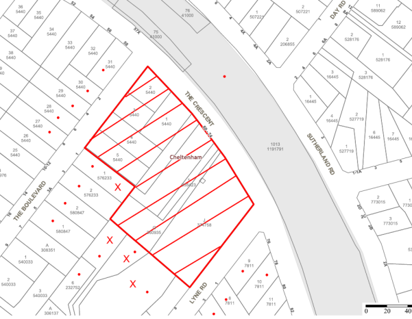
|
NOTIFICATION PLAN |
|
||
|
• PROPERTIES NOTIFIED
|
X SUBMISSIONS RECEIVED |
PROPERTY SUBJECT OF DEVELOPMENT |
|
|
TWO SUBMISSIONS RECEIVED OUT OF MAP RANGE |
|||
Six submissions objected to the development. The grounds for objection are addressed as follows:
5.1.1 Heritage Conservation
A submission raises concerns the proposed accessway over the existing driveway would detract from the historic connection of the driveway for ‘Edensor’ through the Cheltenham Recreation Club site.
The proposed accessway would maintain the former driveway connection and would not detract from the heritage significance of the item ‘Edensor’. Refer to discussion in Section 2.1.2.
5.1.2 Noise Attenuation
A submission raises concerns the noise emission level with all doors open would be 2 dB(A) over the established limit at the upper windows of an adjoining residence.
A condition is recommended for the installation of a noise barrier and a Noise Management Plan which is to limit noise emission below the established level of 43 dB(A) at the boundary. Refer to discussion in Section 2.8.11.
5.1.3 Stormwater Drainage
Submissions raise concerns the proposed retaining wall along the rear boundary will impact on stormwater drainage.
The adjoining properties have a gradual fall to the rear boundary.
A condition is recommended for the stormwater drainage behind the retaining wall to connect with the proposed stormwater drainage system and for the wall height not to extend above existing ground level.
Subject to recommended conditions the proposed retaining wall would not result in flooding of neighbouring properties.
5.1.4 Traffic and Car Parking
A submission raised concerns the proposal would reduce available parking in the locality.
The proposed on-site car parking provision is in accordance with Council’s requirements for the proposed childcare centre and would not necessitate parking in the street.
5.2 Public Agencies
The development application was not required to be referred to any Public Agencies for comment.
6. THE PUBLIC INTEREST
Section 79C(1)(e) of the Act requires Council to consider “the public interest”.
The public interest is an overarching requirement, which includes the consideration of the matters discussed in this report. Implicit to the public interest is the achievement of future built outcomes adequately responding to and respecting the future desired outcomes expressed in environmental planning instruments and development control plans.
The application is considered to have satisfactorily addressed Council’s and relevant agencies’ criteria and would provide a development outcome that, on balance, would result in a positive impact for the community. Accordingly, it is considered that the approval of the proposed development would be in the public interest.
CONCLUSION
The proposal is for construction of a 92 place childcare centre.
The proposed childcare centre is single storey and designed with regard to the previous childcare centre approved by Council on the site for which the development consent has lapsed.
The proposed childcare centre complies with Hornsby Local Environmental Plan 2013 and the Children (Education and Care Services) Supplementary Regulation 2012. The provisions of the recently published State Environmental Planning Policy (Education Establishments and Childcare Facilities) 2017 include a saving provision whereby the Policy does not apply to the undetermined application, notwithstanding the proposal would meet the recent Policy’s design criteria.
The proposal complies with the relevant provisions of the HDCP other than the required maximum number of childcare places and the minimum indoor and outdoor play area space per child. The non-compliance is acceptable with regard to compliance with the State regulatory requirements and to the Council’s resolution to amend the HDCP consistent with the State Environmental Planning Policy (Education Establishments and Childcare Facilities) 2017.
The application is satisfactory in respect to SEPP 55 and the submitted Remediation Action Plan.
Six submissions were received in response to notification of the application.
The application is recommended for approval subject to the recommended conditions in Schedule 1 of this report.
Note: At the time of the completion of this planning report, no persons have made a Political Donations Disclosure Statement pursuant to Section 147 of the Environmental Planning and Assessment Act 1979 in respect of the subject planning application.
RESPONSIBLE OFFICER
The officer responsible for the preparation of this Report is the Manager – Development Assessments – Rodney Pickles, who can be contacted on 9847 6731.
|
Rod Pickles Manager - Development Assessment Planning Division |
James Farrington Group Manager Planning Division |
|
1.View |
Locality Map |
|
|
|
2.View |
Site Plan |
|
|
|
3.View |
Floor Plan |
|
|
|
4.View |
Roof Plan |
|
|
|
5.View |
Elevations and Sections |
|
|
|
6.View |
Parking / Driveway |
|
|
|
7.View |
Materials and Finishes |
|
|
|
8.View |
Landscaping |
|
|
File Reference: DA/191/2017
Document Number: D07276183
SCHEDULE 1
GENERAL CONDITIONS
The conditions of consent within this notice of determination have been applied to ensure that the use of the land and/or building is carried out in such a manner that is consistent with the aims and objectives of the relevant legislation, planning instruments and council policies affecting the land and does not disrupt the amenity of the neighbourhood or impact upon the environment.
Note: For the purpose of this consent, the term ‘applicant’ means any person who has the authority to act on or the benefit of the development consent.
Note: For the purpose of this consent, any reference to an Act, Regulation, Australian Standard or publication by a public authority shall be taken to mean the gazetted Act or Regulation, or adopted Australian Standard or publication as in force on the date that the application for a construction certificate is made.
1. Approved Plans and Supporting Documentation
The development must be carried out in accordance with the plans and documentation listed below and endorsed with Council’s stamp, except where amended by Council and/or other conditions of this consent:
|
Plan No. |
Plan Title |
Drawn by |
Dated |
|
A0000 Rev A |
Title Page/Location Map |
RFA Architects |
14.02.17 |
|
A2001 Rev A |
Site Analysis Plan |
RFA Architects |
Feb 2017 |
|
A2100 Rev A |
Site Plan |
RFA Architects |
Feb 2017 |
|
A2101 Rev B |
Ground Floor Plan |
RFA Architects |
Feb 2017 |
|
A2102 Rev A |
Roof Plan |
RFA Architects |
Feb 2017 |
|
A3001 Rev A |
Elevations + Section 1 |
RFA Architects |
Feb 2017 |
|
A4001 Rev A |
Parking/Driveway Details |
RFA Architects |
Feb 2017 |
|
A5001 Rev A |
External Finishes & Colours |
RFA Architects |
Feb 2017 |
|
A6001 Rev A |
Waste Management Plan |
RFA Architects |
Feb 2017 |
|
0598.GD.01 |
Landscape Plan – Area 1 |
Greenland Design |
February 2017 |
|
0598.GD.02 |
Landscape Plan – Area 2 |
Greenland Design |
February 2017 |
|
0598.GD.03 |
Landscape Details & Specification |
Greenland Design |
February 2017 |
|
S10.01 |
General Notes |
Engineering Studio |
27.06.17 |
|
S11.01 |
Ground Slab Layout Plan |
Engineering Studio |
27.06.17 |
|
S11.02 |
Ground Details Sheet |
Engineering Studio |
27.06.17 |
|
Document Title |
Prepared by |
Dated |
|
Detailed Site Investigation ES6742 Rev 0 |
Aargus |
6 Dec 2016 |
|
Assessment of Significant Trees |
Malcolm Bruce |
11/01/2017 |
|
Root Mapping Report |
Birds Tree Consultancy |
16 June 2017 |
|
Tree Management Plan Lophostemon confertus |
Malcolm Bruce |
28/06/2017 |
|
RFEME Prediction Report - Cheltenham |
Brendon Woods Consulting |
1-2-2017 |
|
Acoustics Assessment |
BGMA Pty Ltd |
Dec 2016 |
|
Access and Compliance Assessment Report |
PSE Access Consulting |
8 Dec 2016 |
|
Waste Management Plan |
Joan E Stone |
28/2/17 |
2. Removal of Existing Trees
a) This development consent permits the removal of trees numbered 1, 2, 3, 6 and 7 as identified on the Tree Location Plan - Figure 3 of the Significant Tree Assessment prepared by Malcolm Bruce, dated 11/01/2017.
b) The removal of any other trees requires separate approval in accordance with the Tree and Vegetation Chapter 1B.6 Hornsby Development Control Plan (HDCP).
3. Tree Pruning
a) This development consent only permits the pruning of trees numbered 8 and 9 as identified on the Tree Location Plan – Figure 3 of the Significant Tree Assessment dated 11/01/2017 prepared by Malcolm Bruce.
b) All pruning works must be undertaken by an arborist with minimum AQF3 qualifications in accordance with AS4373-2007 – “Pruning of Amenity Trees”.
c) All pruning works must not significantly alter the structure of the tree(s)
d) Any pruning on trees must not exceed 20% of the total foliage area.
e) When undertaking tree works, the use of equipment that will wound the bark and conductive tissues shall not be used on, or in sections of a tree to be retained, (ie: spurs, spikes, hooks, chained platforms lowering systems or any other tools that will penetrate or severely bruise bark and conductive tissue)
f) Certification of the tree pruning must be submitted to the Principal Certifying Authority (PCA) within 7 days of the works being undertaken, confirming compliance with the relevant requirements of Australian Standard AS4373-2007 – “Pruning of Amenity Trees”.
Note: The pruning of any other trees from the site requires separate approval by Council in accordance with Part 1B.6 Tree and Vegetation Preservation of the Hornsby Development Control Plan 2013 (HDCP).
4. Amendment of Plans
To comply with Councils requirement in terms of landscaping and acoustics, the approved plans are to be amended as follows:
a) The landscaping plan is to be amended to address the required widening of the driveway in the streetscape and to retain and protect the existing trees fronting the driveway entry.
b) The landscaping plan is to be amended to retain and protect Tree No. 10 – Lophostemon confertus (Brushbox) in accordancd with the Tree Management Plan dated 28/06/2017 prepared by Malcolm Bruce.
c) A noise barrier is to be erected extending from the north-west wing of the building to the north-eastern boundary in accordance with the recommendations of the Acoustic Assessment prepared by BGMA dated December 2016.
d) These amended plans must be submitted with the application for the Construction Certificate.
5. Construction Certificate
a) A Construction Certificate is required to be approved by Council or a Private Certifying Authority (PCA) prior to the commencement of any works under this consent.
b) A separate Construction Certificate must be obtained from Council for all works within the public road reserve under S138 of the Roads Act.
c) A separate Construction Certificate must be obtained from Council for all works within drainage easements vested in Council.
d) The Construction Certificate plans must not be inconsistent with the Development Consent plans.
6. Section 94A Development Contributions
a) In accordance with Section 80A(1) of the Environmental Planning and Assessment Act, 1979 and the Hornsby Shire Council Section 94A Development Contributions Plan 2014-2024, $25,268.25 must be paid to Council to cater for the increased demand for community infrastructure resulting from the development, based on development costs of $2,526,825.
b) The value of this contribution is current as at 8 September 2017. If this contribution is not paid within the financial quarter that this condition was generated, the contribution payable will be adjusted in accordance with the provisions of the Hornsby Shire Council Section 94 Development Contributions Plan and the amount payable will be calculated at the time of payment in the following manner:
$CPY = $CDC x CPIPY
CPIDC
Where:
$CPY is the amount of the contribution at the date of Payment
$CDC is the amount of the contribution as set out in this Development Consent
CPIPY is the latest release of the Consumer Price Index (Sydney – All Groups) at the date of Payment as published by the ABS.
CPIDC is the Consumer Price Index (Sydney – All Groups) for the financial quarter at the date applicable in this Development Consent Condition.
c) The monetary contributions must be paid to Council:
i) prior to the issue of the Subdivision Certificate where the development is for subdivision; or
ii) prior to the issue of the first Construction Certificate where the development is for building work; or
iii) prior to issue of the Subdivision Certificate or first Construction Certificate, whichever occurs first, where the development involves both subdivision and building work; or
iv) prior to the works commencing where the development does not require a Construction Certificate or Subdivision Certificate.
Note: It is the professional responsibility of the Principal Certifying Authority to ensure that the monetary contributions have been paid to Council in accordance with the above timeframes.
Council’s S94A Development Contributions Plan may be viewed at www.hornsby.nsw.gov.au or a copy may be inspected at Council’s Administration Centre during normal business hours.
REQUIREMENTS PRIOR TO THE ISSUE OF A CONSTRUCTION CERTIFICATE
7. Building Code of Australia
All approved building work must be carried out in accordance with the relevant requirements of the Building Code of Australia.
8. Utility Services
The applicant must submit written evidence of the following service provider requirements:
a) Ausgrid (formerly Energy Australia) – a letter of consent demonstrating that satisfactory arrangements have been made to service the proposed development.
b) Telstra - a letter of consent demonstrating that satisfactory arrangements have been made to service the proposed development.
9. Sydney Water – Approval
This application must be submitted to Sydney Water for approval to determine whether the development would affect any Sydney Water infrastructure, and whether further requirements are to be met.
Note: Building plan approvals can be obtained online via Sydney Water Tap inTM through www.sydneywater.com.au under the Building and Development tab.
10. Appointment of a Project Arborist
c) A project arborist with AQF Level 5 qualifications must be appointed to provide monitoring and certification throughout the construction period.
d) Details of the appointed project arborist must be submitted to Council and the PCA for registration with the application for the construction certificate.
11. Construction Traffic Management Plan
In order to enable unencumbered movement of traffic in the public road during construction works, a Construction Management Plan, including a Traffic Management Plan and scaled construction plans prepared by a suitably Chartered and Qualified Chartered Civil Engineer and Qualified Worksite Traffic Controller shall be prepared and submitted to Hornsby Shire Council for approval according to the following requirements:
a) A copy of the plans shall be submitted for consideration and written approval by Hornsby Shire Council prior to the release of the Construction Certificate.
b) The plans shall detail the order of construction works and arrangement of all construction machines and vehicles being used at the same time during all stages.
c) The CTMP plans shall be in accordance with the approved Development Application plans and the Development Consent conditions.
d) In order to prevent injury, accident and loss of property, no building materials, work sheds, vehicles, machines or the like shall be allowed to remain in the road reserve area without the written consent of Hornsby Shire Council.
e) The Plan shall be generally in compliance with the requirements of the Road and Traffic Authority’s “Traffic Control at Worksites Manual 1998” and detailing:
i) Public notification of proposed works;
ii) Long term signage requirements;
iii) Short term (during actual works) signage;
iv) Vehicle Movement Plans, where applicable;
v) Traffic Management Plans;
vi) Pedestrian and Cyclist access and safety;
f) The plans shall indicate traffic controls including those used during non-working hours and shall provide pedestrian access and two-way traffic in the public road to be facilitated at all times.
g) The plans shall include the proposed truck routes to and from the site including details of the frequency of truck movements at the different stages of the development. The plan shall also include details of parking arrangements for all employees and contractors.
h) The Applicant and all employees of contractors on the site must obey any direction or notice from the Prescribed Certifying Authority or Hornsby Shire Council in order to ensure the above.
i) If there is a requirement to obtain a Work Zone, partial Road Closure or Crane Permit an application to Hornsby Shire Council is to be made prior to the issue the Construction Certificate
12. Stormwater Drainage
The stormwater drainage system for the development must be designed for an average recurrence interval (ARI) of 20 years and be gravity drained in accordance with the following requirements:
a) Australian Standards AS 3500.3 and Hornsby Shire Council’s Civil Works Design Specification.
b) A grated trench drain shall be provided at the front boundary alignment to collect surface water from the driveway.
c) Connected directly to Council’s street drainage system.
13. On Site Stormwater Detention
An on-site stormwater detention system must be designed by a chartered civil engineer and constructed generally in accordance with Job No. 14566 Drawing No. C00.01, C02.01, C02.02 Revision D dated 23.06.2017 by Engineering Studio and the following requirements:
a) Have a capacity of not less than 47 cubic metres, and a maximum discharge (when full) of 25 litres per second;
b) Have a surcharge/inspection grate located directly above the outlet;
c) Discharge from the detention system must be controlled via 1 metre length of pipe, not less than 50 millimetres diameter or via a stainless plate with sharply drilled orifice bolted over the face of the outlet discharging into a larger diameter pipe capable of carrying the design flow to an approved Council system;
d) Where above ground and the average depth is greater than 0.3 metres, a ‘pool type’ safety fence and warning signs must be installed; and
e) Not be constructed in a location that would impact upon the visual or recreational amenity of residents.
14. Vehicular Crossing
A separate application under the Local Government Act, 1993 and the Roads Act 1993 being an “Application for Boundary Levels” must be submitted to Council to obtain design levels at the front boundary for the design of the internal driveway, prior to the issue of a construction Certificate.
Note: A separate application to construct the vehicular crossing being an “Application to Construct Vehicular Crossing from Roadway to Property” is required to be submitted to Council for approval and can only be made by one of Council’s Authorised Vehicular Crossing Contractors. You are advised to contact Council on 02 9847 6940 to obtain a list of contractors.
15. Internal Driveway/Vehicular Areas
The driveway and parking areas on site must be designed in accordance with Australian Standards 2890.1, 2890.2, 3727 and the following requirements:
a) Design levels at the front boundary must be obtained from Council;
b) The driveway must be a rigid pavement;
c) A passing bay shall be provided at the front boundary alignment with a minimum width of 6 metres over a 6 metre length excluding transitions. The vehicular crossing shall be widened to enable two B99 vehicles to pass each other.
d) The driveway grade must not exceed 25 percent and changes in grade must not exceed 8 percent per plan metre
16. Acoustic Treatment
Acoustic treatment must be provided to the development in accordance with the recommendations contained within the Acoustics Assessment dated December 2016 prepared by BGMA Pty Ltd.
17. Childcare Centre Design
A registered architect must certify that the construction certificate plans meet the design criteria for childcare centres in accordance with Children (Education and Care Services) Supplementary Provisions Regulation 2012.
REQUIREMENTS PRIOR TO THE COMMENCEMENT OF ANY WORKS
18. Erection of Construction Sign
a) A sign must be erected in a prominent position on any site on which any approved work is being carried out:
i) Showing the name, address and telephone number of the principal certifying authority for the work;
ii) Showing the name of the principal contractor (if any) for any demolition or building work and a telephone number on which that person may be contacted outside working hours; and
iii) Stating that unauthorised entry to the work site is prohibited.
b) The sign is to be maintained while the approved work is being carried out and must be removed when the work has been completed.
19. Protection of Adjoining Areas
A temporary hoarding, fence or awning must be erected between the work site and adjoining lands before the works begin and must be kept in place until after the completion of the works if the works:
a) Could cause a danger, obstruction or inconvenience to pedestrian or vehicular traffic;
b) Could cause damage to adjoining lands by falling objects; and/or
c) Involve the enclosure of a public place or part of a public place.
Note: Notwithstanding the above, Council’s separate written approval is required prior to the erection of any structure or other obstruction on public land.
20. Toilet Facilities
a) To provide a safe and hygienic workplace, toilet facilities must be available or be installed at the works site before works begin and must be maintained until the works are completed at a ratio of one toilet for every 20 persons employed at the site.
b) Each toilet must:
i) be a standard flushing toilet connected to a public sewer; or
ii) be a temporary chemical closet approved under the Local Government Act 1993; or
iii) have an on-site effluent disposal system approved under the Local Government Act 1993.
21. Erosion and Sediment Control
To protect the water quality of the downstream environment, erosion and sediment control measures must be provided and maintained throughout the construction period in accordance with the manual ‘Soils and Construction 2004 (Bluebook)’, the approved plans, Council specifications and to the satisfaction of the principal certifying authority. The erosion and sediment control devices must remain in place until the site has been stabilised and revegetated.
Note: On the spot penalties may be issued for any non-compliance with this requirement without any further notification or warning.
22. Installation of Tree Protection
All tree protection fencing for the trees to be retained must have the protection measures for the ground, trunk and canopy installed in accordance with the relevant requirements of Australian Standard AS 4970-2009 - “Protection of Trees on Development Sites”.
REQUIREMENTS DURING CONSTRUCTION
23. Construction Work Hours
All works on site, including demolition and earth works, must only occur between 7am and 5pm Monday to Saturday.
No work is to be undertaken on Sundays or public holidays.
24. Demolition
To protect the surrounding environment, all demolition work must be carried out in accordance with “Australian Standard 2601-2001 – The Demolition of Structures” and the following requirements:
a) Demolition material must be disposed of to an authorised recycling and/or waste disposal site and/or in accordance with an approved waste management plan;
b) Demolition works, where asbestos material is being removed, must be undertaken by a contractor that holds an appropriate licence issued by WorkCover NSW in accordance with Chapter 10 of the Occupational Health and Safety Regulation 2001 and Clause 29 of the Protection of the Environment Operations (Waste) Regulation 2005 ;and
c) On construction sites where any building contain asbestos material, a standard commercially manufactured sign containing the words ‘DANGER ASBESTOS REMOVAL IN PROGRESS’ and measuring not less than 400mm x 300mm must be displayed in a prominent position visible from the street.
25. Environmental Management
The site must be managed in accordance with the publication ‘Managing Urban Stormwater – Landcom (March 2004) and the Protection of the Environment Operations Act 1997 by way of implementing appropriate measures. To prevent sediment run-off, excessive dust, noise or odour emanating from the site during the construction of the development.
26. Street Sweeping
To protect the surrounding environment, Street sweeping must be undertaken following sediment tracking from the site along adjacent streets during works and until the site is established.
The street cleaning services must undertake a street ‘scrub and dry’ method of service and not a dry sweeping service that may cause sediment tracking to spread or cause a dust nuisance.
27. Disturbance of Existing Site
During construction works, the existing ground levels of open space areas and natural landscape features, including natural rock-outcrops, vegetation, soil and watercourses must not be altered unless otherwise nominated on the approved plans.
28. Landfill
Landfill must be constructed in accordance with Council’s ‘Construction Specification 2005’ and the following requirements:
a) Prior to fill material being imported to the site, a certificate shall be obtained from a suitable qualified environmental consultant confirming the fill wholly consists of Virgin Excavated Natural Material (VENM) as defined in Schedule 1 of the Protection of the Environment Operations Act, 1997 or material approved under the Department of Environment and Climate Change’s general resource recovery exemption.
29. Excavated Material
All excavated material removed from the site must be classified by a suitably qualified person in accordance with the Department of Environment, Climate Change and Water NSW Waste Classification Guidelines prior to disposal to an approved waste management facility and be reported to the principal certifying authority prior to the issue of an Occupation Certificate.
30. Works within Tree Protection Zones
a) Root Pruning
All root pruning must be undertaken in accordance with the relevant requirements of Australian Standard AS 4970-2009 “Protection of Trees on Development Sites” - Sections 3.3.4, 4.5.4 and 4.5.5.
b) Footings
To minimise development impacts within the Tree Protection Zones of trees numbered 10 & 11 to be retained, the foundations/footings must be constructed in accordance with the approved plans prepared by Engineering Studio dated 27.06.17.
c) Excavation
Any necessary excavations within the Tree Protection Zone of trees to be retained on the approved plans, must be undertaken using construction techniques as prescribed in the Australian Standard AS 4970-2009 – “Protection of Trees on Development Sites” Section 4.5.5 under the supervision of the appointed project arborist.
d) Installing Services
To minimise the environmental impacts of the development within the Tree Protection Zone (TPZ) of trees to be retained on the approved plans:
i) The installation of any underground services which either enter or transect the designated TPZ must utilise sensitive methods such as directional drilling or manual excavation.
ii) The installation of any underground services must be inspected by the project arborist to monitor the likely impacts of the development on retained trees.
iii) For manual excavation of trenches the project arborist must advise on roots to be retained and must monitor the works. Manual excavation may include the use of pneumatic and hydraulic tools. Refer Section 4.5.3 of Australian Standard AS 4970-2009 – “Protection of Trees on Development Sites”
31. Building Materials and Site Waste
The filling or stockpiling of building materials, the parking of vehicles or plant, the disposal of cement slurry, waste water or other contaminants must be located outside the tree protection zones as prescribed in the conditions of this consent or the prescriptive measures of Part 1B.6.1 Tree Preservation of the Hornsby Development Control Plan, 2013, of any tree to be retained.
32. Works near trees certification
a) The project arborist must submit to the principal certifying authority on a monthly a certificate that the works have been carried out in compliance with the approved plans and specifications for tree protection.
b) Certification should include a statement of site attendance, the condition of the retained trees, details of any deviations from the approved tree protection measures and their impacts on trees.
Note: Copies of monitoring documentation may be required by the PCA and/or Council.
33. Traffic Control Plan
A Traffic Control Plan (TCP) must be prepared by a qualified traffic controller in accordance with the Roads & Traffic Authority’s Traffic Control at Worksites Manual 1998 and Australian Standard 1742.3 for all work on a public road and be submitted to Council. The TCP must detail the following:
c) Arrangements for public notification of the works.
d) Temporary construction signage.
e) Permanent post-construction signage.
f) Vehicle movement plans.
g) Traffic management plans.
h) Pedestrian and cyclist access/safety.
REQUIREMENTS PRIOR TO THE ISSUE OF AN OCCUPATION CERTIFICATE
Note: For the purpose of this consent, a reference to ‘occupation certificate’ shall not be taken to mean an ‘interim occupation certificate’ unless otherwise stated.
34. Final Certification Arborist
a) The suitably qualified person holding a certificate III in Horticulture must submit to the principal certifying authority a Statement/or/Certification confirming all tree replacement requirements have been completed in accordance with approved landscape plans and conditions of consent.
b) The Project supervisor must submit to the principal certifying authority all relevant certificates with the application for the occupation certificate stating compliance with all the conditions of this consent.
c) The Project arborist must submit to the principal certifying authority a certificate that all the completed works have been carried out in compliance with the approved plans and specifications for tree protection.
d) Certification must include a statement of overall site attendance, the condition of the retained trees, details of any deviations from the approved tree protection measures and their impacts on trees.
Note: Copies of monitoring documentation may be required.
35. Vehicular Crossing – Construction
A separate application under the Local Government Act, 1993 and the Roads Act 1993 being an “Application to Construct Vehicular Crossing from Roadway to Property” must be submitted to Council for the installation of a new vehicular crossing and the removal of the redundant crossing. The vehicular crossing must be constructed in accordance with Council’s Civil Works Design Specification 2005 and the following requirements:
a) Crossing levels at the front boundary must be constructed to the design levels obtained from Council;
b) Any redundant crossings must be replaced with integral kerb and gutter;
c) The footway area must be restored by turfing;
d) Approval must be obtained from all relevant utility providers that all necessary conduits be provided and protected under the crossing.
Note: An application for a vehicular crossing can only be made to one of Council’s Authorised Vehicular Crossing Contractors. You are advised to contact Council on 02 9847 6940 to obtain a list of contractors.
36. Retaining Walls
All required retaining walls must be constructed as part of the development in accordance with the approved plans. The finished level at the top of the retaining wall along the southern boundary shall be no higher than the existing ground level of the adjoining property. All subsoil drainage behind any retaining wall shall be drained to the approved stormwater drainage system.
37. Damage to Council Assets
Any damage caused to Council’s assets including the removal, damage, destruction, displacement or defacing of the existing survey marks as a result of the construction of the development must be rectified in accordance with Council’s written requirements and at the sole cost of the applicant.
38. Preservation of Survey Marks
A certificate by a Registered Surveyor shall be submitted to the Principal Certifying Authority, certifying that there has been no removal, damage, destruction, displacement or defacing of the existing survey marks in the vicinity of the proposed development or otherwise the re-establishment of damaged, removed or displaced survey marks has been undertaken in accordance with the Surveyor General’s Direction No.11 – “Preservation of Survey Infrastructure”.
39. Creation of Easements
The following matter(s) must be nominated on the plan of subdivision under s88B of the Conveyancing Act 1919:
a) The creation of an appropriate "Positive Covenant" and "Restriction as to User" over the constructed on-site detention/retention systems and outlet works, within the lots in favour of Council in accordance with Council’s prescribed wording. The position of the on-site detention system is to be clearly indicated on the title.
b) To register the OSD easement, the restriction on the use of land “works-as-executed” details of the on-site-detention system must be submitted verifying that the required storage and discharge rates have been constructed in accordance with the design requirements. The details must show the invert levels of the on-site system together with pipe sizes and grades. Any variations to the approved plans must be shown in red on the “works-as-executed” plan and supported by calculations.
Note: Council must be nominated as the authority to release, vary or modify any easement, restriction or covenant.
40. Works as Executed Plan
A works-as-executed plan(s) must be prepared by a registered surveyor and submitted to Council for completed on-site detention system. The plan(s) must be accompanied by a certificate from a registered surveyor certifying that all pipelines and associated structures lie wholly within any relevant easements.
41. Acoustic Certificate
On completion of all works and prior to the issue of an Occupation Certificate, the certifier is to be provided with a certificate from a qualified acoustic engineer/consultant certifying that all acoustic works have been completed in accordance with the recommendations contained in the Acoustics Assessment dated December 2016, prepared by BGMA Pty Ltd.
42. Site Remediation Verification
The applicant must provide documentation from a suitably qualified environmental consultant verifying that the site has been remediated in accordance with the NSW Environment Protection Authority’s Contaminated Sites – Guidelines for Consultants Reporting on Contaminated Sites, the Contaminated Sites- Sampling Design Guidelines Contaminated Sites – Guidelines for the NSW Site Auditor Scheme and the recommendations of the Remediation Action Plan prepared by Aargus, document number ES6742/2 Rev 0 dated 6 December 2016.
43. Outdoor Play Space
The outdoor play space must be adequately shaded in accordance with The Shade Handbook, published by the New South Wales Cancer Council in 2008.
44. Food Premises
The fit out and operation of that part of the building to be used for the manufacture, preparation or storage of food, must be in accordance with Australian Standard 4674-2004 – Design and fit out of food premises, the Food Act 2003, and the Food Regulation 2015 and the Food Standards Code developed by Food Standards Australia New Zealand. Food Standards 3.3.1. 3.2.2 and 3.2.3 are mandatory for all food businesses.
Note: Walls are to be of solid construction.
45. Kitchen Exhaust Installation
A kitchen exhaust system must be designed and installed to effectively prevent air pollution in accordance with the Protection of the Environment Operations Act 1997.
OPERATIONAL CONDITIONS
46. Use of Premises
a) The development approved under this consent shall be used for a childcare centre and not for any other purpose without Council’s separate written consent.
b) The childcare centre is to operate in accordance with the Noise Management Plan at Appendix A of the Acoustic Assessment dated December 2016 prepared by BGMA Pty Ltd.
47. Hours of Operation
The hours of operation of the premise are restricted to those times listed below:
Monday to Friday 7 am to 6 pm
(Other than 4 Saturdays per year for special occasions)
48. Noise
All noise generated by the proposed development must be attenuated to prevent levels of noise being emitted to adjacent premises which possess tonal, beating and similar characteristics or which exceeds background noise levels by more than 5dB(A).
49. Number of Children
The centre shall accommodate a maximum of 92 children with a minimum of 25% of children within the 0-2 age group as at 1 January of each calendar year.
50. Car Parking
All car parking must be constructed and operated in accordance with Australian Standard AS/NZS 2890.1:2004 – Off-street car parking and Australian Standard AS 2890.2:2002 – Off-street commercial vehicle facilities.
All parking areas and driveways are to be sealed to an all weather standard, line marked and signposted;
Car parking, loading and manoeuvring areas to be used solely for nominated purposes;
Vehicles awaiting loading, unloading or servicing shall be parked on site and not on adjacent or nearby public roads;
a) All vehicular entry on to the site and egress from the site shall be made in a forward direction.
b) All parking for people with disabilities is to comply with AS/NZS 2890.6:2009 Off-street parking for people with disabilities.
c) Any proposed landscaping and/or fencing must not restrict sight distance to pedestrians and cyclists travelling along the footpath.
51. Waste Management
The waste management on site must be in accordance with the following requirements:
a) All commercial tenant(s) must keep written evidence on site of a valid contract with a licensed waste contractor(s) for the regular collection and disposal of the waste and recyclables that are generated on site.
b) All commercial tenant(s) must have a sufficient number of bins to contain the volume of waste and recycling expected to be generated between collection services.
c) All bins must be placed along The Crescent for waste and recycling collection services evening before the day of the weekly garbage collection, and the bins are to be returned to the on-site bin storage area promptly afterwards.
d) A Work, Health & Safety (WHS) risk assessment is to be carried out by a suitably qualified person with qualifications in Work, Health & Safety Legislation with specific regard to waste management. The recommendations of the WHS Risk Assessment are to be implemented as required.
- END OF CONDITIONS -
ADVISORY NOTES
The following information is provided for your assistance to ensure compliance with the Environmental Planning and Assessment Act, 1979, Environmental Planning and Assessment Regulation 2000, other relevant legislation and Council’s policies and specifications. This information does not form part of the conditions of development consent pursuant to Section 80a of the Act.
Environmental Planning and Assessment Act 1979 Requirements
The Environmental Planning and Assessment Act 1979 requires:
The issue of a construction certificate prior to the commencement of any works. Enquiries can be made to Council’s Customer Services Branch on 9847 6760.
a) A principal certifying authority to be nominated and Council notified of that appointment prior to the commencement of any works.
b) Council to be given at least two days written notice prior to the commencement of any works.
c) Mandatory inspections of nominated stages of the construction inspected.
d) An occupation certificate to be issued before occupying any building or commencing the use of the land.
Long Service Levy
In accordance with Section 34 of the Building and Construction Industry Long Service Payments Act 1986, a ‘Long Service Levy’ must be paid to the Long Service Payments Corporation or Hornsby Council.
Note: The rate of the Long Service Levy is 0.35% of the total cost of the work.
Note: Hornsby Council requires the payment of the Long Service Levy prior to the issue of a construction certificate.
Asbestos Warning
Should asbestos or asbestos products be encountered during demolition or construction works, you are advised to seek advice and information prior to disturbing this material. It is recommended that a contractor holding an asbestos-handling permit (issued by WorkCover NSW) be engaged to manage the proper handling of this material. Further information regarding the safe handling and removal of asbestos can be found at:
Alternatively, telephone the WorkCover Asbestos and Demolition Team on 8260 5885.
Tree and Vegetation Preservation
In accordance with Clause 5.9 of the Hornsby Local Environmental Plan 2013 a person must not ringbark, cut down, top, lop, remove, injure or wilfully destroy any tree or other vegetation protected under the Hornsby Development Control Plan 2013 without the authority conferred by a development consent or a permit granted by Council.
Notes: A tree is defined as a long lived, woody perennial plant with one or relatively few main stems with the potential to grow to a height greater than three metres (3M). (HDCP 1B.6.1.c).
Tree protection measures and distances are determined using the Australian Standard AS 4970:2009, “Protection of Trees on Development Sites”.
Fines may be imposed for non-compliance with both the Hornsby Local Environmental Plan 2013 and the Hornsby Development Control Plan 2013.
Advertising Signage – Separate DA Required
This consent does not permit the erection or display of any advertising signs. Most advertising signs or structures require development consent. Applicants should make separate enquiries with Council prior to erecting or displaying any advertising signage.
Dial Before You Dig
Prior to commencing any works, the applicant is encouraged to contact Dial Before You Dig on 1100 or www.dialbeforeyoudig.com.au for free information on potential underground pipes and cables within the vicinity of the development site.
Telecommunications Act 1997 (Commonwealth)
If you are aware of any works or proposed works which may affect or impact on Telstra’s assets in any way, you are required to contact: Telstra’s Network Integrity Team on Phone Number 1800 810 443.
Food Authority Notification
The NSW Food Authority requires businesses to electronically notify the Authority prior to the commencement of its operation.
Note: NSW Food Authority can be contacted at www.foodnotify.nsw.gov.au.
Council Notification – Food Premises
Prior to the commencement of the business, the operator is requested to contact Council’s Environmental Health Team to arrange an inspection for compliance against the relevant legislation and guidelines outlined in this approval.
Note: Council’s Environmental Health Officer can be contacted on 02 9847 6745.
Group Manager's Report No. PL54/17
Planning Division
Date of Meeting: 11/10/2017
14 DEVELOPMENT APPLICATION - CONSTRUCTION OF A VEHICLE SALES PREMISES- 56 - 62 PACIFIC HIGHWAY, WAITARA
EXECUTIVE SUMMARY
|
DA No: |
DA/337/2017 (Lodged on 11 April 2017) |
|
Description: |
Construction of a two storey vehicle sales premises with associated workshop and signage |
|
Property: |
Lot 12 DP 804181, Nos. 56 – 62 Pacific Highway, Waitara |
|
Applicant: |
Williams River Steel |
|
Owner: |
Treehouse Holdings Pty Limited |
|
Estimated Value: |
$11,423,432 |
|
Ward: |
B |
· The application involves the construction of a two storey vehicle sales premises with associated workshop and signage.
· The proposal does not comply with Clause 4.3 “Height of Building” of the Hornsby Local Environmental Plan 2013 (HLEP). The applicant has made a submission in accordance with Clause 4.6 ‘Exceptions to development standards’ of the HLEP to vary Clause 4.3. The submission is considered well founded and is supported.
· No submissions have been received in respect of the application.
· It is recommended that the application be approved.
|
THAT Council assume the concurrence of the Secretary of the Department of Planning and Environment pursuant to Clause 4.6 of the Hornsby Local Environmental Plan 2013 and approve development application DA/337/2017 for the construction of a two storey vehicle sales premises with associated workshop at Lot 12 DP 804181, Nos. 56 – 62 Pacific Highway, Waitara subject to the conditions of consent detailed in Schedule 1 of Group Manager’s Report No. PL54/17. |
BACKGROUND
On 11 August 1993, Council approved DA/297/1993 for the part enclosure of an existing open display area to form a motor vehicle showroom.
On 28 August 2002, Council approved DA/530/2002 for alterations and additions to the existing motor showroom and increase in floor area.
On 27 April 2004, Council approved DA/110/2004 for internal alterations to the motor showroom.
On 14 November 2013, Council approved DA/1013/2013 for further internal alterations to the motor showroom.
On 21 September 2016, a pre-DA meeting was held between the Council officers and the applicant to discuss the proposed demolition of structures and construction of a new vehicle sales premises for BMW. At the meeting, Council raised concerns regarding exceedance of height and the lack of front setback.
On 11 April 2017, DA/337/2017 was lodged with Council.
On 22 May 2017, Council raised concerns regarding the proposed floor space, height and impacts on the rail corridor.
On 1 August 2017, the applicant submitted amended plans in response to Council’s concerns. The plans and documentation were referred to Sydney Trains for comments.
On 8 September 2017, the applicant lodged DA/991/2017 for demolition works on the site. The application was supported by owner’s consent from Sydney Trains.
On 12 September 2017, Council received comments from Sydney Trains.
SITE
The site comprises one allotment with an area of 2,747sqm and is located on the northern side of the Pacific Highway. The site has an average slope of 4.4% between the north-western corner (rear) to the south-eastern corner (front).
The existing improvements on the site include three independent motor vehicle sales premises with an integrated basement/lower level workshop facility, associated open car display areas and illuminated pole signs. The showrooms are operated by Renault, Nissan and Suzuki. The majority of the open car display area is elevated above the level of the Pacific Highway.
A concrete ramp provides access from the Pacific Highway down to the lower level workshop. A central median on the Pacific Highway excludes right turn movements in and out of the site.
A retaining wall runs along the length of the front boundary of the site with the height increasing from east to west. At the western end of the site, the retaining wall is set back 3m to 4m from the boundary. An electrical transmission kiosk is located near the south western corner of the site. The site is also affected by a variable width easement for batter (0.61m – 1.37m) along the front.
The northern boundary of the site adjoins the North Shore Railway corridor. This comprises an approximately 5m wide concrete hard stand area that abuts the northern elevation of the existing lower level workshop. The upper level suspended slab extends into the rail corridor at the northwest corner of the site. A concrete block retaining wall ranging in height between 1.3m - 1.5m extends along the northern side of the concrete paved corridor. Beyond this retaining wall is the existing vegetative embankment which slopes up to the railway line at average slope of about 30, with localised steeper and flatter areas. Medium to large trees canopy trees are accommodated in this embankment screening the rear of the site. As such, the rail corridor is well elevated and the motor showrooms are not highly visible from the northern part of the corridor. The hard stand area is currently utilised by the car dealerships for stack parking of cars as per the current lease arrangement with Sydney Trains.
The Pacific Highway streetscape on the northern side, in the near vicinity of the site, comprises a mix of uses. A vehicle sales premise operated by Mazda is located to the west of the site. A vehicle showroom and concrete car display area owned and operated by Toyota is located on the eastern side of the site.
Medium and high density residential buildings, being part of a seniors living development, are located on the opposite side of the Pacific Highway.
PROPOSAL
The application involves construction of a two storey vehicle sales premises over a basement level workshop for vehicle services and signage to be operated by BMW. The gross floor area of the development would be 2,739sqm.
The development area is restricted to the property at Nos. 56 – 62 Pacific Highway, Waitara and does not include the 5m wide concrete hard stand area at the rear of the site owned by Sydney Trains. A separate application DA/991/2017 has been recently lodged with Council to authorise the demolition works on the site and the adjoining rail corridor land.
The development specifics of the proposal are provided below.
· The basement level would comprise seven vehicle service hoists, two vehicle wash bays, parts store, oil store, warranty store, tool store, compressor/plant store, staff lunch room, services, service managers’ offices and waste collection area. The workshop would be split into two levels connected by a ramp and includes 33 car parking spaces and a motorbike space.
· The ground level would accommodate eleven offices, motor vehicle display areas including a fourteen vehicle driving gallery, being part of the BMW corporate image document, dedicated vehicle handover bay, reception desk, service desks, customer amenities, service areas, a vehicle lift connecting to the first floor and twelve customer parking spaces at the rear.
· The first floor level would comprise vehicle display areas, customer lounge area, eight offices, staff lunch room and training rooms, a terrace at the rear for staff and fifteen sales staff parking spaces at the rear accessed by the internal vehicle lift.
· A two way driveway would provide vehicular access to the site from the Pacific Highway. The covered driveway extends to the basement level workshop and across the rear boundary of the site to the ground level parking area. A vehicle lift is proposed to connect to the first floor level and provide sales staff parking to the rear of the site. Pedestrian access to the building would be provided via a disabled ramp and stairs off the Pacific Highway.
· Display cars would be stored at the Australian Motor Group’s dedicated pre-delivery/parts depot in the nearby Hornsby industrial area and driven to the site from this facility by staff members. The use of articulated car transporter vehicles for delivery is not proposed.
· The spare parts and accessories are to be transported to the site via vans (small rigid vehicles). The largest vehicles accessing the site would be 8.8m long medium rigid vehicles (MRV) to the workshop area.
· The proposal includes the following business identification signs:
o One x 7m high pylon sign at the Pacific Highway frontage;
o One x under awning sign (13m x 1m);
o The BMW logo on the rear wall (2.2m diameter); and
o One x wall sign on the eastern elevation (2.5 x 1.5m).
· The development would employ a total of 30 staff members on site during trading times. The proposed operating hours would be as follows:
o Vehicle sales premises
Monday – Saturday: 8.30am – 5.30pm
Sunday: 9.30am – 5.00pm
o Workshop Hours:
Monday - Friday: 7.30am – 5.00pm
Saturday: 8.30am – 12.00pm
Sunday: Closed
· The building is proposed to be of contemporary design with a silicon jointed glazed façade to the display areas, extending across the Pacific Highway frontage. The finishes and materials include pre-case concrete panels and Colorbond cladding.
ASSESSMENT
The development application has been assessed having regard to ‘A Plan for Growing Sydney’, the ‘Draft North District Plan’ and the matters for consideration prescribed under Section 79C of the Environmental Planning and Assessment Act 1979 (the Act). The following issues have been identified for further consideration.
1. STRATEGIC CONTEXT
1.1 A Plan for Growing Sydney and (Draft) North District Plan
A Plan for Growing Sydney has been prepared by the NSW State Government to guide land use planning decisions for the next 20 years. The Plan sets a strategy and actions for accommodating Sydney’s future population growth and identifies dwelling targets to ensure supply meets demand. The Plan identifies that the most suitable areas for new housing are in locations close to jobs, public transport, community facilities and services.
The NSW Government will use the subregional planning process to define objectives and set goals for job creation, housing supply and choice in each subregion. Hornsby Shire has been grouped with Hunters Hill, Ku-ring-gai, Lane Cove, Mosman, North Sydney, Ryde, Northern Beaches and Willoughby to form the North District. The Greater Sydney Commission has realised the draft North District Plan which includes priorities and actions for the Northern District for the next 20 years. The identified challenge for Hornsby Shire will be to provide an additional 4,350 dwellings by 2021 with further strategic supply targets to be identified to deliver 97,000 additional dwellings in the North District by 2036.
The proposed development would be consistent with ‘A Plan for Growing Sydney’ and ‘Draft North District Plan’, by providing additional services and employment opportunities to support a growing population.
2. STATUTORY CONTROLS
Section 79C(1)(a) requires Council to consider “any relevant environmental planning instruments, draft environmental planning instruments, development control plans, planning agreements and regulations”.
2.1 Hornsby Local Environmental Plan 2013
The proposed development has been assessed having regard to the provisions of the Hornsby Local Environmental Plan 2013 (HLEP).
2.1.1 Zoning of Land and Permissibility
The subject land is zoned B6 Enterprise Corridor under the HLEP. The objectives of the zone are:
· To promote businesses along main roads and to encourage a mix of compatible uses.
· To provide a range of employment uses (including business, office, retail and light industrial uses).
· To maintain the economic strength of centres by limiting retailing activity.
· To provide for residential uses, but only as part of a mixed use development.
The proposed development is defined as “vehicle sales and hire premises” and “vehicle repair station” and is permissible in the zone with Council’s consent.
2.1.2 Height of Buildings
Clause 4.3 of the HLEP provides that the height of a building on any land should not exceed the maximum height shown for the land on the Height of Buildings Map. The maximum permissible height for the subject site is 10.5m. The proposal would result in a maximum height of 11.75m along the eastern elevation and does not comply with this provision. The applicant has made a submission in accordance with Clause 4.6 ‘Exceptions to development standards’ of the HLEP 2013 to vary Clause 4.3. This matter is discussed in Section 2.1.4 of this report.
2.1.3 Floor Space Ratio
Clause 4.4(2) of the HLEP provides that the floor space ratio (FSR) on any land is not to exceed the maximum shown for the land on the Floor Space Ratio Map. The maximum permissible FSR for the precinct in accordance with the map is 1:1. The proposal would result in a maximum FSR of 0.99:1 and complies with this provision.
2.1.4 Exceptions to Development Standards
The application has been assessed against the requirements of Clause 4.6 of the HLEP. This clause provides flexibility in the application of the development standards in circumstances where strict compliance with those standards would, in any particular case, be unreasonable or unnecessary or tender to hinder the attainment of the objectives of the zone.
The proposal exceeds the Height of Building development standard.
The objective of the Height of Buildings control is to permit a height of building that is appropriate for the site constraints, development potential and infrastructure capacity of the locality.
The applicant has made a submission in support of a variation to the development standard in accordance with Clause 4.6 of the HLEP. The development application seeks to vary the development standard by 1.25m. The applicant states the proposed variation is consistent with the objectives of the control and is justified as follows:
· The proposal has been designed to optimise showroom access for pedestrian and vehicles.
· The western end of the proposed building is well within the established height controls and presents a similar height to the existing Nissan motor showroom building on the land. The variation to the building height of the eastern end is a direct result of the natural slope of the land.
· The historic subdivision pattern presents a site that is long with a narrow depth which dictates a building of similar proportions. The long nature of the building and inappropriateness of stepping the floor plates due to statutory requirements for disabled access result in the building being over the height limit where the natural land slopes away.
· An increase in depth to the lower workshop area would result in the excavation hitting groundwater. A Geotechnical investigation of the site concluded that ground water was present RL176.4 AHD and the current proposed workshop level is proposed at RL176.8 AHD.
· Professional advice has been sort and received from the structural engineer who has advised that even a minor increase of 500mm to the depth of the excavation and retaining wall would have a substantial effect on the structural design/construction method and therefore have expediential increases to construction costs.
· In comparison, if an identical project was constructed on a flat block of land, the proposal would be well below the height controls.
· The development provides a range of employment opportunities and would strengthen the existing motor dealership precinct.
· The immediately adjacent building to the west (Mazda) along with (Toyota) to the east present a similar or larger proportion to that proposed.
· The adjacent Toyota building has a building height of 11 metres.
· In context of the surrounding area having a height limit on the northern side of the rail corridor of 17.5m and 32.5m along with a height on the southern side of the Pacific Highway of 12m, the proposed development would not have a detrimental effect on the neighbouring properties.
· The proposal would result in a building form that compliments the existing and likely future built environment in terms of bulk and scale.
· Increase to the depth of the lower level would increase the geotechnical risk to the railway during construction and may to cause disruption to the rail operations.
Comment: The proposed height variation and the submitted Clause 4.6 variation have been assessed against the established principle in the case of Four2Five Pty Ltd v Ashfield Council [2015] NSWLEC 1009, by the Land and Environment Court. The decision established that “To accept a departure from the development standard, the context of the site should be considered and it should be demonstrated that the development promotes the proper and orderly development of land as contemplated by the controls applicable to the zone of the land, which is an objective of the Act (s 5(a)(ii)) and which it can be assumed is within the scope of the “environmental planning grounds” referred to in cl 4.6(4)(a)(i) of the LEP”. In accordance with the views expressed in this decision, sufficient environmental planning grounds, unique to a site, must be demonstrated by the applicant for the Clause 4.6 variation request to be upheld.
In this context, the submitted Clause 4.6 submission is considered well founded for the following reasons:
· The height of a building is defined under HLEP as “the vertical distance from ground level (existing) to the highest point of the building.” The site has been subject to previous earthworks to construct the existing buildings, basement workshop areas and the open car display areas. As a result of the prior site works, the ground levels on the eastern section of the site do not directly reflect the natural ground levels which exist on the boundaries of the site. The applicant has prepared a 3D height plane to illustrate the extent of the non-compliance. The analysis of the height variation as submitted by the applicant does not accurately indicate the extent of the variation sought. The applicant states the extent of the variation as 1.05m above the 10.5m height limit, primarily along the eastern section of the building. However, Council’s calculations conclude that the variation would be up to 1.25m in this section of the site.
· Notwithstanding the above, the definition of height of buildings adopts the existing ground level and it is anticipated that if an extrapolated natural ground level was used, the extent of the variation of the height limit would be less and the building may have resulted in a height that was within the permissible height limit applicable to the site.
· Given the nature of use of the site, accessible levels are required to be maintained throughout the building and a minimum floor to ceiling height would be required in associated with the use. Additionally, the driveway gradients are also required to comply with the relevant Australian Standard (AS2890.1). Consequently, there is minimum scope of stepping the roof or stepping the built form to follow the slope of the site.
· The proposal has been amended to reduce the height of the lift overrun and the height of the first floor level to be the minimum required, so as to reduce the building height to be below 10.5m wherever possible.
· The submitted report on Geotechnical Investigation prepared by JK Geotechnics advises that groundwater level underneath the site was observed at RL176.4 during borehole testing. Based on the groundwater measurements, the report concludes that groundwater would be encountered above the proposed bulk excavation level and seepage would be encountered during excavation, particularly after extended periods of wet weather. On the basis of this report, the proposal has been designed with the basement level to be at RL176.8. This would avoid groundwater seepage, pumping and complicated construction techniques to the basement slab. This would also minimise opportunity for any adverse impacts on the aquifer. The requirement to maintain the minimum basement level in conjunction with the minimum floor to ceiling heights has contributed to the overall building height for the proposal.
· The building height is a direct result of the existing ground levels, previous building works, ground water levels and the functional requirements of the building.
· Considering the unique characteristics and context of the site, the proposal achieves a reasonable environmental outcome and design excellence for the site. The proposal would provide a public benefit by generating employment in the area and promoting orderly and economic development of underutilised land with minimal detrimental impacts on the built form of the locality.
Given the above, it is considered that the development in its current form achieves compliance with the objectives of the development standard “height”, complies with the zone objectives and achieves the principle established by the Land and Environment Court with regard to Clause 4.6.
Based on this assessment, it is considered that compliance with the development standard would be unreasonable and unnecessary in the circumstances of the case. Accordingly, the proposed variation to the permissible height standard for the site is supported in this instance.
2.1.5 Architectural Roof Feature
Clause 5.6 of HLEP provides some flexibility in the application of maximum building height standards for roof features of visual interest whilst maintaining the majority of the roof within the maximum building height standard. The proposed building includes a 600mm high parapet which exceeds the permissible building height of 10.5m in certain sections of the building. The Applicant submits that the parapet comprises an architectural roof feature pursuant to Clause 5.6 of HLEP and therefore, compliance with the 10.5m height limit is not required. The above submission is acceptable for the following reasons:
· The non-compliant part the roof consists of a decorative roof element. The building could be designed to have a less interesting roof detail and fully comply with the height requirements.
· The architectural roof feature elements are not advertising structures.
· The minor projecting elements do not constitute floor space nor could they be converted to be floor space.
· The projecting element is minimal and relate to a small portion of the uppermost part of the proposed roof. The shadow cast by the architectural roof feature would be minimal and indiscernible to the scale of development expected at the site.
2.1.6 Heritage Conservation
Clause 5.10 of the HLEP sets out heritage conservation provisions for Hornsby Shire. The subject property is located in close proximity to heritage listed item (Item No. 757) Nos. 28 - 32 McAuley Place, Wahroonga and the heritage listed street trees (Item No. 772) of Alexandria Parade, Waitara under the provisions of Schedule 5 (Environmental Heritage) of the HLEP.
Given the physical separation of the street trees to the north of the subject site, due to railway corridor, minimal impact on the heritage listed trees is anticipated due to the proposed redevelopment of the site.
Similarly, the site is sufficiently separated from Nos. 28 - 32 McAuley Place on the opposite side of the Pacific Highway. Therefore, the proposed development would have minimal impact on the heritage significance of the item. The landscape plan submitted with the application includes a green strip along the Pacific Highway frontage which would soften the built edge of the development.
No further assessment in this regard is considered necessary.
2.1.7 Earthworks
Clause 6.2 of the HLEP states that consent is required for proposed earthworks on site. Before granting consent for earthworks, Council is required to assess the impacts of the works on adjoining properties, drainage patterns and soil stability of the locality.
The proposal would involve excavation below ground up to 4.5m to extend the lower ground floor car park on the western side. The application is supported by a Geotechnical Investigation prepared by JK Geotechnics. The geotechnical study includes recommendations for excavation methods, vibration monitoring, groundwater monitoring and disposal (if encountered), foundation design and basement slab design. A condition is recommended for the proposed development to be constructed in accordance with the recommendations of the geotechnical report.
A dilapidation assessment of adjoining properties to the east and west is required as a condition of consent.
2.2 State Environmental Planning Policy No. 55 – Remediation of Land
State Environmental Planning Policy No. 55 (SEPP 55) requires that consent must not be granted to the carrying out of any development on land unless the consent authority has considered whether the land is contaminated or requires remediation for the proposed use. Council’s records do not indicate any history of soil contamination associated with the site.
The application is supported by a Preliminary and Detailed Site Investigation Report which states that the no hydrocarbon impacts associated with the underground storage tank (UST), aboveground storage tank (AST) and bunded oil barrels, were detected on the site. A fill layer situated 0.2m below ground level containing asbestos (0.2 – 0.8m thickness) was encountered on the eastern portion of the site. The report advises that there should be no limitation to developing the site subject to management of the asbestos material. The report recommends the preparation of an Environmental Management Plan (EMP) outlining the risk and safety procedures in this regard.
The application is supported by an EMP. However, the report does not clearly identify asbestos removal methods. Accordingly, it is recommended that an Asbestos Management Plan be prepared prior to the release of the Construction certificate and that the site be remediated in accordance with this plan after the demolition of the buildings and prior to the commencement of any other building works on the site.
Conditions of consent, listed in Schedule 1 of this report, are recommended accordingly.
2.3 State Environmental Planning Policy (Infrastructure) 2007
The application has been assessed against the requirements of State Environmental Planning Policy (Infrastructure) 2007. This Policy contains State-wide planning controls for developments adjoining busy roads and railways and traffic generating development. The following matters are required to be considered pursuant to the SEPP.
2.3.1 Excavation Adjacent to Rail Corridors
Clause 86 of SEPP Infrastructure applies to the development as the proposal involves the penetration of ground to a depth of at least 2 metres within 25 metres of a rail corridor. The application was referred to Sydney Trains for concurrence in accordance with the provisions of this clause. Sydney Trains agreed to grant concurrence subject to conditions of consent requiring the submission of an electrolysis report, crane details and excavation details.
Subject to the fulfilment of the above conditions, the proposal is acceptable with respect to this clause.
2.3.2 Traffic Generating Developments and Frontage to a Classified Road
The development has frontage to a classified road, being the Pacific Highway. The development is classified as a Traffic Generating Development in accordance with Clause 104 and Schedule 3 of the SEPP as it would result in a development fronting a classified road that would accommodate more than 50 vehicles for ancillary parking accommodation.
A Traffic Impact Assessment Report has been submitted with the proposal which estimates that the proposed development would generate 19 vehicle trips per hour during commuter peak periods. However, given that there are three existing motor dealerships on the site currently, the submitted report concludes that there would not be any nett increase in traffic generation on the site.
Council’s traffic assessment concludes that the proposal would result in a larger vehicle display area when compared to the current floor area utilised for vehicle display purposes. Therefore, there is a potential to generate 30 vehicle trips per peak hour during commuter peak periods.
The Pacific Highway is a State Road which provides two to three traffic lanes in each direction in the vicinity of the site with a turning bay provided at the intersection with Carden Avenue to the east/Waitara Avenue to the west and restricted to a speed limit of 60km/hour. In terms of carriageway capacity, this equates to 3,800 vehicles per hour. The projected increase in traffic activities is minimal when compared to the maximum number of vehicles that is currently accommodated by the local road network surrounding the site. Therefore, the proposal would not have a negative impact on the built environment of the locality due to traffic generation and the application is assessed as satisfactory in this regard.
The development complies with the minimum number of car spaces required to be provided on-site pursuant to the Roads and Maritime Services (RMS) guidelines. The proposal was referred to RMS for concurrence. No objections have been raised subject to conditions of consent requiring submission of a Construction Traffic Management Plan, installation of a “No stopping” zone along the frontage of the site and all vehicles loading and unloading occurring within the site. The existing central median would only allow left in and left out vehicular movement for this redeveloped site.
Subject to the implementation of conditions of consent, the proposal would not have an adverse impact on the operation of the State Road and is assessed as satisfactory in this regard.
2.4 State Environmental Planning Policy No. 64 – Advertising and Signage
The application has been assessed against the requirements of State Environmental Planning Policy No. 64 (SEPP 64) which aims to improve the amenity of urban and natural settings by managing the impact of outdoor advertising. The Policy responds to growing concerns from the community, the advertising industry and local government that existing controls and guidelines were not effective.
In accordance with Part 3, Clause 9, the proposed signage is defined as a ‘business identification sign’ and the provisions of Part 3 of the Policy do not apply.
Clause 13(1)(b) of SEPP 64 requires that the advertising sign be assessed in accordance with the criteria in Schedule 1 as follows:
|
Criteria |
Compliance |
|
Character of the Area Is the proposal compatible with the existing or desired future character of the area or locality in which it is proposed to be located?
Is the proposal consistent with a particular theme for outdoor advertising in the area or locality? |
Yes The subject site fronts the Pacific Highway and is surrounded by mixed developments including vehicle sale premises located on both sides of the subject site, service stations and commercial premises. Signage of various forms is a character of the road in the near vicinity of the site. Given the level of activity on this major arterial road and the volume of traffic carried on the road, the proposed signage would reflect the business character of the area and be compatible with the existing and desired future character of the locality. Yes There is no particular theme for advertising within the locality. The business identification signs and advertisements relate to specific premises. Accordingly, the proposal is not inconsistent with an outdoor advertising theme for the area. |
|
Special Areas Does the proposal detract from the amenity or visual quality of any environmentally sensitive areas, heritage areas, natural or other conservation areas, open space areas, waterways, rural landscapes or residential areas?
|
No It is considered that the public domain visual catchment of the signage is predominantly restricted to the Pacific Highway corridor for a limited section of the road. The proposed signs would increase the visual interest of the wall and would be integral to the “Enterprise Corridor” zone objectives without detracting from the amenity and visual character of the surrounding residential areas, open spaces and the heritage items. |
|
Views and Vistas Does the proposal obscure or compromise important views Does the proposal dominate the skyline and reduce the quality of vistas? Does the proposal respect the viewing rights of other advertisers? |
No - There are no important view corridors in this area. No
Yes |
|
Streetscape, Setting or Landscape Is the scale, proportion and form of the proposal appropriate for the streetscape, setting or landscape? Does the proposal contribute to the visual interest of the streetscape, setting or landscape?
Does the proposal reduce clutter by rationalising and simplifying existing advertising? Does the proposal screen unsightliness? Does the proposal protrude above buildings, structures or tree canopies in the area or locality? Does the proposal require ongoing vegetation management? |
Yes - Given the varied nature of the streetscape fronting the site, the proposal would not be inappropriate for the immediate locality. Yes - It is considered that the proposed signs align with contemporary advertising structures and would create visual interest within the B6 zone and the transport corridor.
N/A - The sign does not replace any existing signage.
N/A
No
No |
|
Site and Building Is the proposal compatible with the scale, proportion and other characteristics of the site or building, or both, on which the proposed signage is to be located?
Does the proposal respect important features of the site or building, or both?
Does the proposal show innovation and imagination in its relationship to the site or building, or both? |
Yes
Yes
Yes - The advertising signage utilises the BMW corporate logo. Once installed, the signs would create visual interest in the immediate locality. |
|
Associated Devices and Logos Have any safety devices, platforms, lighting devices or logos been designed as an integral part of the signage or structure on which it is to be displayed |
Yes - The BMW logo integrates with the design of the signage.
|
|
Illumination Would illumination result in unacceptable glare? Would illumination affect safety for pedestrians, vehicles or aircraft? Would illumination detract from the amenity of any residence or other form of accommodation? Can the intensity of the illumination be adjusted, if necessary? Is the illumination subject to a curfew? |
N/A – The signs are not proposed to be illuminated.
|
|
Safety Would the proposal reduce the safety for any public road?
Would the proposal reduce the safety for pedestrians or bicyclists? Would the proposal reduce the safety for pedestrians, particularly children, by obscuring sightlines from public areas? |
No - The proposal was referred to Roads and Maritime Services and no objections were raised regarding road safety. No No |
2.5 Sydney Regional Environmental Plan No. 20 – Hawkesbury – Nepean River
The site is located within the catchment of the Hawkesbury Nepean River. Part 2 of this Plan contains general planning considerations and strategies requiring Council to consider the impacts of development on water quality, aquaculture, recreation and tourism.
Subject to the implementation of sediment and erosion control measures and stormwater management to protect water quality, the proposal would comply with the requirements of the Policy.
2.6 Clause 74BA Environmental Planning and Assessment Act, 1979 - Purpose and Status of Development Control Plans
Clause 74BA of the Environmental Planning and Assessment Act, 1979 states that a DCP provision will have no effect if it prevents or unreasonably restricts development that is otherwise permitted and complies with the development standards in relevant Local Environmental Plans and State Environmental Planning Policies.
The principal purpose of a development control plan is to provide guidance on the aims of any environmental planning instrument that applies to the development; facilitate development that is permissible under any such instrument; and achieve the objectives of land zones. The provisions contained in a DCP are not statutory requirements and are for guidance purposes only. Consent authorities have flexibility to consider innovative solutions when assessing development proposals, to assist achieve good planning outcomes.
2.7 Hornsby Development Control Plan 2013
The proposed development has been assessed having regard to the relevant desired outcomes and prescriptive requirements within the Hornsby Development Control Plan 2013 (HDCP). The following table sets out the proposal’s compliance with the prescriptive requirements of the Plan:
|
Hornsby Development Control Plan 2013 |
|||
|
Control |
Proposal |
Requirement |
Compliance |
|
Height |
3 storeys – 11.75m |
2 storeys – 10.5m |
No |
|
Basement protrusion above ground |
2m |
1m |
No |
|
Floor Space Ratio |
0.99:1 |
1:1 |
Yes |
|
Front Setback |
1.5m – 5.5m |
0m |
Yes |
|
Rear Setback |
0m |
0m |
Yes |
|
Side Setback (east and west) |
0.5m |
0m |
Yes |
|
Car Parking (150m2 of site area+ 6 car spaces/work bay) Bicycle parking Motorcycle Parking |
60
14 1 |
60
5 1 |
Yes
Yes Yes |
|
Signs Pylon Sign Flush Wall Sign 1 (side) Flush Wall Sign 2 (logo at the rear) Under awning Sign |
7.5m x 2m x 0.5m 3.75m2 3.79m2 1m (vertical height) >2m from boundary |
8m x 2m x 0.5m 5m2 5m2 0.5m 2m (min) |
Yes Yes Yes No Yes |
As detailed in the above table, the proposed development complies with the prescriptive requirements within the HDCP except the height and under awning signage dimension. The matter relating to the non-compliance is detailed below, as well as a brief discussion on compliance with relevant desired outcomes.
2.7.1 Scale
The proposed development would result in a two storey vehicle sales premises with a maximum height of 11.75m above ground level. The proposal does not comply with the permissible height limit of 10.5m, applicable to the site. The matter has been discussed in Section 2.1.4 of this report and the height non-compliance is supported.
The basement workshop level would protrude (in part) up to 2m above the ground level at the south-eastern corner of the site. Therefore, this section of the building constitutes a three storey structure. As discussed, the level of the basement cannot be lowered further as it would impact on the ground water. Due the slope of the land, basement protrusion cannot be avoided in this section. The protrusion of the basement level would not result in additional floor area as the section of the basement level located 1m above ground is to be utilised for parking and waste storage areas only. The actual workshop area would be below ground and would not add to the bulk and scale of the building.
The proposal would result in a floor space ratio of 0.99:1 which complies with the HLEP requirements.
Given the above, the non-compliance with regard to basement protrusion and number of storeys is acceptable.
2.7.2 Setbacks and Landscaping
The proposal complies with the setback requirements of HDCP. The built form would maintain a narrow landscape strip along the front setback. Landscaping comprises stepped hedges and palms to complement the appearance of the building.
2.7.3 Vehicular Access and Parking
2.7.3.1 Access
Vehicular access to the site is to be provided via a new two way driveway at the south-western corner. Additionally, a two way driveway is proposed at the north-western end to facilitate handing over of the vehicles and drive in/out of the ground level display area.
As discussed earlier in this report, vehicle freight and large part deliveries would occur off-site at the Australian Motor Group’s dedicated pre-delivery/parts depot in the nearby Hornsby industrial area. The cars would then be driven to the site individually by staff. A condition of consent is recommended that no car transporter access be permitted to the site for delivery of motor vehicles to the showroom.
The application includes swept path analysis which demonstrates that a medium rigid vehicle would be able to enter and exit the site in a forward direction from the workshop level.
The proposal incorporates a vehicle lift connecting the ground and first floor level. Accordingly, vehicle turning areas within the internal driveway are not required. The driveway aisle width, parking area dimensions, height clearances and turning areas are assessed as satisfactory in accordance with relevant Australian Standards.
The proposal includes accessible connections between all levels via lifts. Additionally, a disabled access ramp provides pedestrian access to the ground level display area from the Pacific Highway frontage along with stairs.
2.7.3.2 Parking
The submitted Traffic Impact Assessment Report states that the off-street car parking requirements for the proposed development should be calculated on the basis of parking requirements for vehicle sales or hire premises as the workshop is ancillary to this use. In accordance with the above, the development would require 60 on-site car spaces including one disabled space. The proposal complies with this provision.
The HDCP requires 1 space per 150m2 site area plus 6 spaces per work bay for vehicle sales premises and 1 space per 150m2 gross floor area plus 6 spaces per work bay for vehicle repair stations. Considering the actual display area for the cars and the two uses, the proposal would result in a total requirement of 79 car spaces (being 22 for vehicle sales use and 57 for the repair station use). Therefore, strict compliance with the HDCP provisions in accordance with the proposed uses would result in a shortfall of 19 spaces within the site.
The applicant has provided a parking survey of similar uses within the locality such as the adjoining Toyota dealership. Based on the survey figures and the peak parking demand for similar work bays, the parking requirement for the vehicle service component of the development would be 26 spaces, being 31 spaces less than the HDCP requirement. In excess of 26 spaces are available on the site to cater for the vehicle workshop.
Council’s traffic and parking assessment concludes that the primary use of the site would be for the purpose of “vehicle sales” and the workshop would be an ancillary use to provide service to customers. Consequently, it is reasonable to utilise the “vehicle sales premises” parking requirement of the HDCP to calculate car parking for the site. The proposal complies with the parking requirement for vehicle sales premises.
The workshop level also includes parking facilities for bicycles and motorbikes in accordance with the HDCP requirements.
It is considered that the parking provisions within the site are suitable for the land use and the proposal is assessed as satisfactory in this regard.
2.7.4 Overshadowing
The submitted shadow diagrams demonstrate that the proposed building would not result in overshadow any residential development or public areas. The public footpath in front of the site would receive 3 hours solar of access between 9am and 3pm during winter solstice.
2.7.5 Waste management
The applicant includes a waste management plan for the construction stage of the development. A waste collection area is provided at the basement level adjoining the driveway. The submitted Traffic Impact Assessment Report states that waste would be collected by a private contractor utilising a medium rigid vehicle which would ingress and egress the site from this level in a forward direction.
The application is assessed as satisfactory with regard to waste management.
2.7.6 Signage
2.7.6.1 Desired Outcome
The proposed signs are compatible with the commercial character of the site and the immediate locality and complement the scale of the building. The signage would not compromise pedestrian, cyclist or motorist safety.
2.7.6.2 Prescriptive Measures
The proposed signs comply with the prescribed measures in the following ways:
· The signs are consistent with the best practice guidelines associated with SEPP 64;
· The signs are related to, and integrated with, the architecture of the supporting building, do not obscure significant architectural features and maintain the dominance of the architecture;
· Cluttering, distraction and unnecessary repetition is avoided;
· The signs do not cover mechanical ventilation inlets or outlets;
· The development does not comprise a roof sign;
· The development does not compromise road or pedestrian safety;
· The pylon sign maintains a minimum height of 2.6 metres above the footpath; and
· The signs are generally compliant with the required sizes except the height of the under awning sign. Given the scale of the building, the non-compliance would not be discernible from the public domain and is acceptable.
2.8 Section 94 Contributions Plans
Hornsby Shire Council Section 94 Contributions Plan 2014-2024 defines “vehicle sales and hire premises” as retail floor space. Section 94 Contributions apply to the development as it would result in 1495 sqm of nett retail space (2218sqm vehicle display area – 723sqm existing display area) plus 343sqm of office space. Accordingly, the requirement for a monetary Section 94 contribution is recommended as a condition of consent.
3. ENVIRONMENTAL IMPACTS
Section 79C(1)(b) of the Act requires Council to consider “the likely impacts of that development, including environmental impacts on both the natural and built environments, and social and economic impacts in the locality”.
3.1 Natural Environment
3.1.1 Tree and Vegetation Preservation
The site does not contain any existing trees. The proposed excavation and building works would not have any impact on the vegetative embankment on the northern boundary of the site. No further assessment in this regard is necessary.
3.1.2 Stormwater and Trade Waste
The post development stormwater would be connected to the drainage system on the Pacific Highway via an on-site detention system and bio retention area. A low height retaining wall is proposed within the easement for batter marked as “X” on the survey plan. This retaining wall would form the boundary of the bio-retention area. Accordingly, a condition of consent recommends that the bio-retention area be relocated to be within the landscaped area adjoining the driveway at the south-eastern corner and that the stormwater overflow be piped and connected to this section of the site prior to discharging on to the street drainage system.
The details of the water quality treatment system and the associated MUSIC model, prepared by an accredited person, have been submitted and assessed as satisfactory.
The submitted plans indicate that the wastewater from the car wash bay area would be connected to the sewer system and an appropriate bund, wash down area and oil water separator would be provided in this regard. Details of the hydraulic design associate with the wash bay area would be provided at the Construction Certificate stage and have been recommended as a condition of consent.
Subject to the implementation of recommended conditions of consent, the proposal would not have an adverse impact on the natural environment of the locality.
3.2 Built Environment
3.2.1 Built Form
The building is proposed to be located in a precinct identified for future commercial developments of varying heights and scale. The proposed built form is a product of the functionality of the building and adopts a contemporary façade design. The extensive glazed surface facing the Pacific Highway would be consistent with other vehicle display premises to maximise the visibility of the cars whilst storing the vehicles in a covered area.
The building has been appropriately articulated wherever possible, to enhance the streetscape appearance whilst maintain the functionality of the use. Notwithstanding, the proposal would result in a 50m long glass façade fronting the Pacific Highway. An assessment of the adjoining buildings has been undertaken in this regard and it is noted that the building to the east (Toyota) includes a 54m long and a 60m curved building façade fronting the road. The building length for the Mazda showroom, on the western side, is approximately 32m.
It is evident from the above, that the building length would be consistent with adjoining motor showrooms along the northern side of the Pacific Highway and would reinforce the role and function of the precinct. The proposal is assessed as satisfactory with regard to its impact on the built environment of the locality.
3.2.2 Noise
The proposed land use is a not a noise generating development. Considering the proximity to the rail corridor and the background noise levels along the Pacific Highway, it is considered that the noise generated by this development would not have any adverse impact on the built environment of the locality.
3.2.3 Traffic
The matter has been discussed in Section 2.3.2 and Section 2.7.3 of this report.
3.3 Social Impacts
The social impacts of the development on the local and broader community have been considered with specific reference to the potential employment generation associated with the use. It is estimated that the development would generate 30 equivalent full time positions post construction. This is consistent with the State Government’s ‘A Plan for Growing Sydney’ which identifies the need to provide an additional 689,000 new jobs by 2031.
3.4 Economic Impacts
The proposal would have a positive impact on the local economy in conjunction with other similar uses in the locality by generating an increase in demand for local services.
4. SITE SUITABILITY
Section 79C(1)(c) of the Act requires Council to consider “the suitability of the site for the development”.
The subject site has not been identified as bushfire prone or flood prone land. The site is currently as a vehicle display and sale premises and is suitable for the proposed redevelopment. The scale of the proposed development is consistent with adjoining developments and is considered acceptable.
5. PUBLIC PARTICIPATION
Section 79C (1)(d) of the Act requires Council to consider “any submissions made in accordance with this Act”.
5.1 Community Consultation
The proposed development was placed on public exhibition and was notified to adjoining and nearby landowners between 27/04/2017 and 11/05/2017 in accordance with the Notification and Exhibition requirements of the HDCP. During this period, Council received no submissions. The map below illustrates the location of the notified landowners.
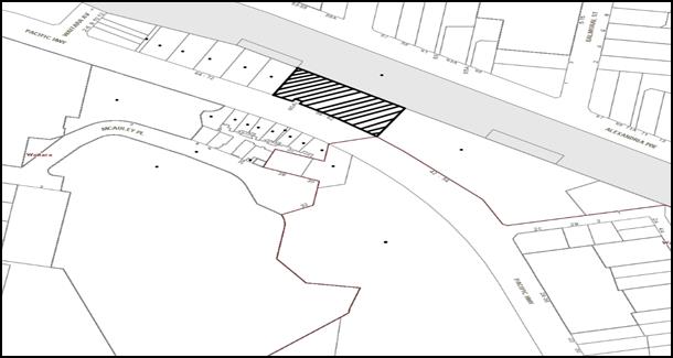
|
NOTIFICATION PLAN |
|
||
|
• PROPERTIES NOTIFIED
|
X SUBMISSIONS RECEIVED |
PROPERTY SUBJECT OF DEVELOPMENT |
|
5.2 Public Agencies
The development application was referred to the following Agencies for comment:
5.2.1 Roads and Maritime Services (RMS)
The application required concurrence from RMS pursuant to the provisions of State Environmental Planning Policy (Infrastructure) 2007 and Section 138 of the Roads Act 1993. The RMS reviewed the proposal and raised no objections subject to implementation of recommended conditions of consent.
5.2.2 Sydney Trains
The application was referred to Sydney Trains for concurrence pursuant to the provisions of State Environmental Planning Policy (Infrastructure) 2007. The matter is discussed in Section 2.3.1 of this report.
6. THE PUBLIC INTEREST
Section 79C(1)(e) of the Act requires Council to consider “the public interest”.
The public interest is an overarching requirement, which includes the consideration of the matters discussed in this report. Implicit to the public interest is the achievement of future built outcomes adequately responding to and respecting the future desired outcomes expressed in environmental planning instruments and development control plans.
The application is considered to have satisfactorily addressed Council’s and relevant agencies’ criteria and would provide a development outcome that, on balance, would result in a positive impact for the community. Accordingly, it is considered that the approval of the proposed development would be in the public interest.
CONCLUSION
The proposal involves construction of a two storey vehicle sales premises with a basement level workshop for vehicle services and associated signage. The building would accommodate seven work bays at the basement level and 60 on-site car parking spaces. The building design would adopt a contemporary built form with a glazed façade fronting the Pacific Highway. The proposal does not involve demotion works. Separate development consent is sought for this component.
The proposal does not comply with Clause 4.3 “Height of Building” of the Hornsby Local Environmental Plan 2013. The applicant has made a submission in accordance with Clause 4.6 ‘Exceptions to development standards’ of the Hornsby Local Environmental Plan 2013 to vary Clause 4.3. The submission is considered well founded and is supported.
The proposal is assessed as satisfactory against section 79(c) of the Environmental Planning and Assessment Act 1979 and generally complies with the provisions of the Hornsby Local Environmental Plan 2013 and Hornsby Development Control Plan 2013.
Accordingly, the proposed development is recommended for approval subject to conditions set out in Schedule 1 of this report.
Note: At the time of the completion of this planning report, no persons have made a Political Donations Disclosure Statement pursuant to Section 147 of the Environmental Planning and Assessment Act 1979 in respect of the subject planning application.
RESPONSIBLE OFFICER
The officer responsible for the preparation of this Report is the Manager – Development Assessments – Rodney Pickles, who can be contacted on 9847 6731.
|
Rod Pickles Manager - Development Assessment Planning Division |
James Farrington Group Manager Planning Division |
|
1.View |
Locality Map |
|
|
|
2.View |
Floor Plans |
|
|
|
3.View |
Landscape Plan |
|
|
|
4.View |
Survey Plan |
|
|
|
5.View |
Elevations and Sections |
|
|
|
6.View |
Shadow Plan |
|
|
|
7.View |
View Plans |
|
|
File Reference: DA/337/2017
Document Number: D07284233
SCHEDULE 1
GENERAL CONDITIONS
The conditions of consent within this notice of determination have been applied to ensure that the use of the land and/or building is carried out in such a manner that is consistent with the aims and objectives of the relevant legislation, planning instruments and council policies affecting the land and does not disrupt the amenity of the neighbourhood or impact upon the environment.
Note: For the purpose of this consent, the term ‘applicant’ means any person who has the authority to act on or the benefit of the development consent.
Note: For the purpose of this consent, any reference to an Act, Regulation, Australian Standard or publication by a public authority shall be taken to mean the gazetted Act or Regulation, or adopted Australian Standard or publication as in force on the date that the application for a construction certificate is made.
1. Approved Plans and Supporting Documentation
The development must be carried out in accordance with the plans and documentation listed below and endorsed with Council’s stamp, except where amended by Council and/or other conditions of this consent:
Architectural plans
|
Plan No. |
Rev |
Plan Title |
Drawn by |
Dated |
|
A03 |
1 |
Workshop Basement Level |
Williams River Steel |
28/07/2017 |
|
A04 |
1 |
Ground Floor Level |
Williams River Steel |
28/07/2017 |
|
A05 |
2 |
First Floor Level |
Williams River Steel |
28/07/2017 |
|
A06 |
3 |
Elevations |
Williams River Steel |
28/07/2017 |
|
A11 |
2 |
Section |
Williams River Steel |
28/07/2017 |
|
A12 |
0 |
Disabled Amenity Details |
Williams River Steel |
28/07/2017 |
|
A14 |
0 |
Erosion and Sediment Control Plan |
Williams River Steel |
28/07/2017 |
|
A15 |
3 |
Roof Plan |
Williams River Steel |
28/07/2017 |
|
A16 |
0 |
Enlarged Wash bay details |
Williams River Steel |
28/07/2017 |
|
A17 |
2 |
Schedule of Materials and Finishes |
Williams River Steel |
28/07/2017 |
|
A18 |
0 |
Internal workshop ramp details |
Williams River Steel |
28/07/2017 |
|
A19 andA20 |
1 |
External street level ramp details |
Williams River Steel |
28/07/2017 |
|
DA02 |
C |
Stormwater Drainage basement level |
Lindsay Dynan |
26/06/2017 |
|
DA03 |
D |
Stormwater Drainage ground level |
Lindsay Dynan |
28/07/2017 |
|
DA04 |
B |
Stormwater Details |
Lindsay Dynan |
28/07/2017 |
|
DAL01 |
A |
Landscape Plan |
Terras Landscape Architects |
2/03/2017 |
|
DAL02 |
A |
Planting Palette |
Terras Landscape Architects |
2/03/2017 |
Supporting Documents
|
Document No. |
Rev |
Document Title |
Prepared by |
Dated |
|
A00 |
- |
Title Page |
Williams River Steel |
28/07/2017 |
|
A01 |
0 |
Existing Site Plan |
Williams River Steel |
28/07/2017 |
|
A02 |
0 |
Demolition Plan |
Williams River Steel |
28/07/2017 |
|
A07, A08 |
2 |
Perspective Views |
Williams River Steel |
28/07/2017 |
|
A09 |
0 |
Vehicle Swept path |
Williams River Steel |
28/07/2017 |
|
A10 |
2 |
Shadow Diagrams |
Williams River Steel |
28/07/2017 |
|
A13 |
1 |
Floor Space Ratio Plan |
Williams River Steel |
28/07/2017 |
|
A21 |
1 |
Height Compliance 3D |
Williams River Steel |
28/07/2017 |
|
- |
- |
Clause 4.6 Variation |
Williams River Steel |
2/06/2017 |
|
|
B |
Topographical Survey |
Duggan Mathers Surveyors |
21/05/2017 |
|
- |
- |
Waste Management Plan |
Williams River Steel |
- |
|
16828 |
- |
Traffic and Parking Assessment Report |
Varga Traffic Parking |
17/03/2017 |
|
- |
- |
Statement of Environmental Effects |
Williams River Steel |
March 2017 |
|
- |
- |
MUSIC Link report |
- |
24/03/2017 |
|
29666Lrpt |
1 |
Geotechnical investigation report |
J K Geotechnics |
14/06/2017 |
|
- |
- |
Environmental Management Plan |
Williams River Steel |
15/03/2017 |
|
6571 |
01 |
Access Report - 01 |
Access Consulting |
16/03/2017 |
|
115022 |
01 |
Preliminary and Detailed Site Investigation prepared by dated |
Environmental Earth Sciences |
April 2015 |
|
|
|
Foundation Plan, Shoring Wall Plan and Workshop Plan |
- |
Received on 7/07/2017 |
|
17-S-017-SK-007 |
P3 |
Retaining Cross Section for Railcorp |
Phelan Shilo Partners |
June 2017 |
|
17-S-017-SK-008 |
P3 |
Retaining Cross Section for Railcorp |
Phelan Shilo Partners |
June 2017 |
|
17-S-017-SK-0010 |
P1 |
Retaining Cross Section for Railcorp |
Phelan Shilo Partners |
June 2017 |
|
17-S-017-SK-0011 |
P1 |
Retaining Cross Section for Railcorp |
Phelan Shilo Partners |
June 2017 |
2. Amendment of Plans
a) The approved plan DA03 – Rev D Stormwater Drainage Ground Level prepared by Lindsay Dynan dated 28/07/2017 is to be amended as follows:
i) Relocate the bio retention area and the associated retaining wall (as marked on the plan) outside the easement for batter marked “X” and within the landscaped area adjoining the access driveway at the south-eastern corner.
ii) The stormwater overflow is to be piped within this area prior to connecting to the discharge point.
iii) The proposed retaining wall within the area marked “X” must be deleted as no structures are permitted in this area.
b) The approved drawing DAL01 – rev A Landscape Plan prepared by Terras Landscape Architects dated 2/03/2017 must be amended to incorporate the details of the approved drawing A04 - Rev 1 Ground Floor Level prepared by Williams River Steel dated 28/07/2017.
c) These amended plans must be submitted with the application for the Construction Certificate.
3. Development Consent
a) This consent DOES NOT APPROVE any works within the railway corridor land adjoining the northern boundary of the site and currently utilised as a car yard in conjunction with the existing use of the site. Separate approval is to be obtained from Sydney Trains and Hornsby Shire Council to facilitate works within the rail corridor.
b) This consent does not approved demolition works on the site or within the adjoining rail corridor land.
c) This development consent does not include any works within the property at No. 60A Pacific Highway, Waitara accommodating a substation and located at the frontage of the site. The approved building works must not impact on the existing asset.
4. Construction Certificate
a) A Construction Certificate is required to be approved by Council or a Private Certifying Authority prior to the commencement of any works under this consent.
b) A separate Construction Certificate must be obtained from Council for all works within the public road reserve under S138 of the Roads Act.
c) A separate Construction Certificate must be obtained from Council for all works within drainage easements vested in Council.
d) The Construction Certificate plans must not be inconsistent with the Development Consent plans.
5. Section 94 Development Contributions
a) In accordance with Section 80A(1) of the Environmental Planning and Assessment Act, 1979 and the Hornsby Shire Council Section 94 Development Contributions Plan 2014-2024, the following monetary contributions must be paid to Council to cater for the increased demand for community infrastructure resulting from the development:
|
Description |
Contribution (4) |
|
Roads |
$ 304,761.95 |
|
Plan Preparation and Administration |
$ 616.25 |
|
TOTAL |
$305,378.20 |
being for 1495 sqm of nett retail space and 343sqm of office space.
b) The value of this contribution is current as at 1 September 2017. If the contribution is not paid within the financial quarter that this condition was generated, the contribution payable will be adjusted in accordance with the provisions of the Hornsby Shire Council Section 94 Development Contributions Plan and the amount payable will be calculated at the time of payment in the following manner:
$CPY = $CDC x CPIPY
CPIDC
Where:
$CPY is the amount of the contribution at the date of Payment
$CDC is the amount of the contribution as set out in this Development Consent
CPIPY is the latest release of the Consumer Price Index (Sydney – All Groups) at the date of Payment as published by the ABS.
CPIDC is the Consumer Price Index (Sydney – All Groups) for the financial quarter at the date applicable in this Development Consent Condition.
c) The monetary contribution must be paid to Council:
i) prior to the issue of the Subdivision Certificate where the development is for subdivision; or
ii) prior to the issue of the first Construction Certificate where the development is for building work; or
iii) prior to issue of the Subdivision Certificate or first Construction Certificate, whichever occurs first, where the development involves both subdivision and building work; or
iv) prior to the works commencing where the development does not require a Construction Certificate or Subdivision Certificate.
Note: It is the professional responsibility of the Principal Certifying Authority to ensure that the monetary contributions have been paid to Council in accordance with the above timeframes.
Council’s Development Contributions Plan may be viewed at www.hornsby.nsw.gov.au or a copy may be inspected at Council’s Administration Centre during normal business hours.
REQUIREMENTS PRIOR TO THE ISSUE OF A CONSTRUCTION CERTIFICATE
6. Demolition works
A separate Development Consent must be obtained for demolition of all structures within the subject site.
7. Asbestos Management Plan
As Asbestos Management Plan be prepared and submitted to Council for approval in accordance with the recommendations of the Preliminary and Detailed Site Investigation prepared by Environmental Earth Sciences dated April 2015.
8. Building Code of Australia
All approved building work must be carried out in accordance with the relevant requirements of the Building Code of Australia.
9. Utility Services
The applicant must submit written evidence of the following service provider requirements:
a) Ausgrid (formerly Energy Australia) – a letter of consent demonstrating that satisfactory arrangements have been made to service the proposed development.
10. Sydney Water – Approval
This application must be submitted to Sydney Water for approval to determine whether the development would affect any Sydney Water infrastructure, and whether further requirements are to be met.
Note: Building plan approvals can be obtained online via Sydney Water Tap inTM through www.sydneywater.com.au under the Building and Development tab.
11. Dilapidation Report
To record the structural condition of the adjoining properties at Nos. 42 – 54 Pacific Highway and Nos. 64 – 72 Pacific Highway adjoining the approved development, a ‘Dilapidation Report’ must be prepared by a suitably qualified structural engineer for inclusion with the application of the Construction Certificate.
12. Traffic Control Plan
A Traffic Control Plan (TCP) must be prepared by a qualified traffic controller in accordance with the Roads & Traffic Authority’s Traffic Control at Worksites Manual 1998 and Australian Standard 1742.3 for all work on a public road. The Traffic Management Plan shall be submitted and approved by Council’s Manager Traffic and Road Safety prior to the issue of a construction certificate. The TCP must detail the following:
a) Arrangements for public notification of the works;
b) Temporary construction signage;
c) Permanent post-construction signage;
d) Vehicle movement plans;
e) Traffic management plans; and
f) Pedestrian and cyclist access/safety.
13. Identification of Survey Marks
A registered surveyor must identify all survey marks in the vicinity of the proposed development. Any survey marks required to be removed or displaced as a result of the proposed development shall be undertaken by a registered surveyor in accordance with Section 24 (1) of the Surveying and Spatial Information Act 2002 and following the Surveyor General’s Directions No.11 – "Preservation of Survey Infrastructure".
14. Stormwater Drainage
The stormwater drainage system for the development must be designed in accordance with Council’s Civil Works – Design and Construction Specification 2005 and the following requirements:
a) Connected directly to the existing public piped drainage system in the Pacific Highway with the following requirements:
i) The point of discharge from the development site must be connected to a new grated gully pit in the Pacific Highway designed and constructed in accordance with the requirements of the Roads and Maritime Services.
ii) Roads and Maritime Services approval must be obtained prior to the commencement of the works within the Pacific Highway road reserve.
Note 1: A separate application under the Local Government Act, 1993 and the Roads Act 1993 must be lodged with Council for approval of any works within the road reserve.
Note 2: Prior to the issue of an Occupation Certificate a certificate must be obtained from Council for the connection to the public drainage system.
15. On Site Stormwater Detention
An on-site stormwater detention system must be designed by a chartered civil engineer and constructed in accordance with the following requirements:
a) Have a capacity of not less than 32.8 cubic metres, and a maximum discharge (when full) of 110.0 litres per second.
b) Have a surcharge/inspection grate located directly above the outlet.
c) Discharge from the detention system to be controlled via 1 metre length of pipe, not less than 50 millimetres diameter or via a stainless plate with sharply drilled orifice bolted over the face of the outlet discharging into a larger diameter pipe capable of carrying the design flow to an approved Council system.
d) Where above ground and the average depth is greater than 0.3 metres, a ‘pool type’ safety fence and warning signs to be installed.
e) Not be constructed in a location that would impact upon the visual or recreational amenity of residents.
16. Water Quality Treatment
Stormwater quality treatment measures must be designed by a qualified engineer and relocated to be clear of the existing easement for batter as required by the conditions of this development consent. The design engineer must prepare a validation report using MUSIC-link for Hornsby Council and design certificate must be submitted to the principal certifying authority certifying that the design meets the stormwater quality targets outlined in Table 1.C.1.2(b) in Hornsby Development Control Plan 2013.
17. Internal Driveway/Vehicular Areas
The driveway and parking areas on site must be designed in accordance with Australian Standards 2890.1, 2890.2, 3727 and the following requirements:
a) Design levels at the front boundary must be obtained from Council; and
b) The driveway must be a rigid pavement.
18. Footpath
A concrete footpath must be designed along the full frontage of the development site along the Pacific Highway in accordance Council’s Civil Works Design and Construction Specification 2005 and the following requirements:
a) The existing footpath being removed.
b) Pouring of the concrete footpath to the full frontage of the subject site.
c) The land adjoining the footpath to be fully turfed.
d) Any public utility adjustments to be carried out at the cost of the applicant and to the requirements of the relevant public authority.
19. Vehicular Crossing
A separate application under the Local Government Act, 1993 and the Roads Act 1993 being an “Application for Boundary Levels” must be submitted to Council to obtain design levels at the front boundary for the design of the internal driveways.
Note: A separate application to construct the vehicular crossing being an “Application to Construct Vehicular Crossing from Roadway to Property” is required to be submitted to Council for approval and can only be made by one of Council’s Authorised Vehicular Crossing Contractors. You are advised to contact Council on 02 9847 6940 to obtain a list of contractors.
20. Construction Management Plan (CMP)
To assist in the protection of the public, the environment and Council’s assets, a separate Construction Management Plan is to be prepared by a suitably qualified environmental consultant in consultation with a qualified traffic engineer, is to be submitted to Council’s Compliance Team for approval to be used by workers and Council as on-site reference during demolition, excavation and construction works, according to the following requirements:-
a) The CMP will detail the contact information for all development phases for developers, builder, site foremen, private certifier, environmental management consultant and any emergency details.
b) The plan will include a Construction Traffic Management Plan (CTMP) which will include information detailing the following:-
i) Truck movements to and from the site, including the routes used, swept path diagrams entering and exiting the site and implemented traffic control;
ii) Site plan showing site sheds, concrete pump location and crane location;
iii) The requirement for Work Zones, Road Openings, Road Closures, Crane Permits and Road Occupancy licenses;
iv) Safe pedestrian management details including during local school and commuter hours where the footpath is heavily frequented.
c) The plan will include Construction Waste Management information detailing the following:-
i) Details on the requirement for importation or excavation of soil and fill including the waste classification of the fill, disposal methods and locations of authorised disposal depots that will be used for the fill;
ii) Asbestos Information must be included on the requirement and procedures for removal and disposal from the site in accordance with Australian Standard: 2601–2001 – ‘The Demolition of Structures’, and the Protection of the Environment Operations (Waste) Regulation 2005;
iii) General construction waste details including construction waste skip bin locations and litter management for workers.
d) Information to be prepared on the management of stormwater disposal from any detention basin or trapped within the site throughout all development phases in accordance with the ANZECC Guidelines trigger values for the area.
e) Sediment and Erosion control details including the procedures during rainfall events and site plans included within the Appendices, all in accordance with the ‘Soils and Construction 2004 (Bluebook)’ and consistent to other development application approved environmental plans.
f) Information on air quality management on site, including but not limited to dust suppression measure throughout demolition and construction.
g) Details on the general operating procedures to manage environmental risk throughout all stages of works on the site;
h) To ensure the quality of Council’s footpath is maintained throughout the development, mitigation measures and information is to be included on procedures that will be implemented to keep the footpath clear and free of trip hazards and obstructions.
i) Information and details to be included on the requirement of a ‘Hoarding Permit’ for the use of Council’s verge at any stage during the development period, a plan showing the location and details of the hoarding are to be included in the Appendices.
j) Details on the requirement for any ‘Out of Hours’ permits during the development in cases such as concrete pours including the frequency and reasoning for the applications.
k) Noise and vibration control information to address any noise nuisances such as rock sawing or breaking, the mitigation methods implemented and how complaints will be managed or prevented.
21. Pedestrian Management Plan
A Pedestrian Access Management Plan (PAMP) detailing how pedestrian movements will be changed and managed during various stages of development, particularly during any partial or total closure of footpaths. The PAMP must be submitted to Council for approval.
22. Access Details and Geotechnical Details
The construction certificate plans must incorporate all the recommendations within the following reports:
a) Access Report - 01 prepared by Access Consulting dated 16/03/2017; and
b) Geotechnical investigation report prepared by J K Geotechnics dated 14/06/2017.
23. Trade waste connection
The Construction Certificate Plans must include details of the car wash bay, Bunding, oil separator and the trade waste connection prepared by a suitably qualified engineer. No waste water is to be connected to the proposed stormwater system.
REQUIREMENTS PRIOR TO THE COMMENCEMENT OF ANY WORKS
24. Erection of Construction Sign
a) A sign must be erected in a prominent position on any site on which any approved work is being carried out:
i) Showing the name, address and telephone number of the principal certifying authority for the work;
ii) Showing the name of the principal contractor (if any) for any demolition or building work and a telephone number on which that person may be contacted outside working hours; and
iii) Stating that unauthorised entry to the work site is prohibited.
b) The sign is to be maintained while the approved work is being carried out and must be removed when the work has been completed.
25. Protection of Adjoining Areas
A temporary hoarding, fence or awning must be erected between the work site and adjoining lands before the works begin and must be kept in place until after the completion of the works if the works:
a) Could cause a danger, obstruction or inconvenience to pedestrian or vehicular traffic;
b) Could cause damage to adjoining lands by falling objects; and/or
c) Involve the enclosure of a public place or part of a public place.
Note: Notwithstanding the above, Council’s separate written approval is required prior to the erection of any structure or other obstruction on public land.
26. Toilet Facilities
a) To provide a safe and hygienic workplace, toilet facilities must be available or be installed at the works site before works begin and must be maintained until the works are completed at a ratio of one toilet for every 20 persons employed at the site.
b) Each toilet must:
i) be a standard flushing toilet connected to a public sewer; or
ii) be a temporary chemical closet approved under the Local Government Act 1993; or
iii) have an on-site effluent disposal system approved under the Local Government Act 1993.
27. Erosion and Sediment Control
To protect the water quality of the downstream environment, erosion and sediment control measures must be provided and maintained throughout the construction period in accordance with the manual ‘Soils and Construction 2004 (Bluebook)’, the approved plans, Council specifications and to the satisfaction of the principal certifying authority. The erosion and sediment control devices must remain in place until the site has been stabilised and revegetated.
Note: On the spot penalties may be issued for any non-compliance with this requirement without any further notification or warning.
REQUIREMENTS DURING CONSTRUCTION
28. Remediation of site
The site must be suitably remediated in accordance with the recommendations approved Asbestos Management Plan conditions of this development consent prior to any works below ground.
29. Vehicular Crossing
A separate application under the Local Government Act, 1993 and the Roads Act 1993 being an “Application to Construct Vehicular Crossing from Roadway to Property” must be submitted to Council for the installation of a new vehicular crossing and the removal of the redundant crossing. The vehicular crossing must be constructed in accordance with Council’s Civil Works Design Specification 2005 and the following requirements:
a) Crossing levels at the front boundary must be constructed to the design levels obtained from Council;
b) Any redundant crossings must be replaced with integral kerb and gutter;
c) The footway area must be restored by turfing;
d) Approval must be obtained from all relevant utility providers that all necessary conduits be provided and protected under the crossing.
Note: An application for a vehicular crossing can only be made to one of Council’s Authorised Vehicular Crossing Contractors. You are advised to contact Council on 02 9847 6940 to obtain a list of contractors.
30. Construction Work Hours
All works on site, including demolition and earth works, must only occur between 7am and 5pm Monday to Saturday.
No work is to be undertaken on Sundays or public holidays.
31. Environmental Management
The site must be managed in accordance with the publication ‘Managing Urban Stormwater – Landcom (March 2004) and the Protection of the Environment Operations Act 1997 by way of implementing appropriate measures to prevent sediment run-off, excessive dust, noise or odour emanating from the site during the construction of the development.
32. Street Sweeping
To protect the surrounding environment, Street sweeping must be undertaken following sediment tracking from the site along the Pacific Highway during works and until the site is established.
The street cleaning services must undertake a street ‘scrub and dry’ method of service and not a dry sweeping service that may cause sediment tracking to spread or cause a dust nuisance.
33. Council Property
To ensure that the public reserve is kept in a clean, tidy and safe condition during construction works, no building materials, waste, machinery or related matter is to be stored on the road or footpath.
34. Landfill
Landfill must be constructed in accordance with Council’s ‘Construction Specification 2005’ and the following requirements:
a) Prior to fill material being imported to the site, a certificate shall be obtained from a suitably qualified environmental consultant confirming the fill wholly consists of Virgin Excavated Natural Material (VENM) as defined in Schedule 1 of the Protection of the Environment Operations Act, 1997 or material approved under the Department of Environment and Climate Change’s general resource recovery exemption.
b) A compaction certificate is to be obtained from a suitably qualified geotechnical engineer verifying that the specified compaction requirements have been met.
c) These certificates must be included with the application for an occupation certificate.
35. Excavated Material
All excavated material removed from the site must be classified by a suitably qualified person in accordance with the Department of Environment, Climate Change and Water NSW Waste Classification Guidelines prior to disposal to an approved waste management facility and be reported to the principal certifying authority prior to the issue of an Occupation Certificate.
36. Survey Report
A report(s) must be prepared by a registered surveyor and submitted to the principal certifying authority:
a) Prior to the pouring of concrete at each level of the building certifying that:
i) The building, retaining walls and the like have been correctly positioned on the site; and
ii) The finished floor level(s) are in accordance with the approved plans.
b) Confirming that the waste collection vehicle turning area complies with AS2890.1 – 2004 and AS20890.2 – 2002 for medium rigid vehicles (MRV).
37. Waste Management Details
Waste management during the construction phase of the development must be undertaken in accordance with the approved Waste Management Plan. Additionally written records of the following items must be maintained during the removal of any waste from the site and such information submitted to the Principal Certifying Authority within fourteen days of the date of completion of the works:
a) The identity of the person removing the waste.
b) The waste carrier vehicle registration.
c) Date and time of waste collection.
d) A description of the waste (type of waste and estimated quantity).
e) Details of the site to which the waste is to be taken.
f) The corresponding tip docket/receipt from the site to which the waste is transferred (noting date and time of delivery, description (type and quantity) of waste).
g) Whether the waste is expected to be reused, recycled or go to landfill.
Note: In accordance with the Protection of the Environment Operations Act 1997, the definition of waste includes any unwanted substance, regardless of whether it is reused, recycled or disposed to landfill.
38. Compliance with Construction Management Plan
The Council approved Construction Management Plan must be complied with for the duration of works, unless otherwise approved by Council.
39. Compliance during Construction works
The development must be carried out in accordance with the following approved documents:
a) Traffic Control Plan (TCP);
b) Construction Management Plan (CMP);
c) Pedestrian Access Management Plan (PAMP); and
d) The recommendations within the Geotechnical investigation report prepared by J K Geotechnics dated 14/06/2017 regarding Ground vibration. Excavation conditions, Groundwater control, Foundations and ground/basement slabs.
40. Maintenance of public footpaths
Public footpaths must be maintained for the duration of works to ensure they are free of trip hazards, displacements, breaks or debris to enable pedestrians to travel along the footpath safely.
REQUIREMENTS PRIOR TO THE ISSUE OF AN OCCUPATION CERTIFICATE
Note: For the purpose of this consent, a reference to ‘occupation certificate’ shall not be taken to mean an ‘interim occupation certificate’ unless otherwise stated.
41. Site Remediation Verification
The applicant must provide documentation from a suitably qualified environmental consultant verifying that the site has been remediated in accordance with the NSW Environment Protection Authority’s Contaminated Sites – Guidelines for Consultants Reporting on Contaminated Sites, the Contaminated Sites- Sampling Design Guidelines Contaminated Sites – Guidelines for the NSW Site Auditor Scheme and the recommendations of the Remedial Action Plan (if applicable).
42. Certification of WSUD Facilities
Prior to the issue of an Occupation Certificate a certificate from a Civil Engineer is to be obtained stating that the WSUD facilities have been constructed and will meet the water quality targets as specified in the Hornsby DCP 2013.
43. Damage to Council Assets
To protect public property and infrastructure, any damage caused to Council’s assets including the removal, damage, destruction, displacement or defacing of the existing survey marks as a result of the construction of the development must be rectified by the applicant in accordance with Council’s Civil Works Specifications. Rectification works must be undertaken prior to the issue of an Occupation Certificate, or sooner, as directed by Council.
44. Creation of Easements
The following matter(s) must be nominated on the plan of subdivision under s88B of the Conveyancing Act, 1919:
a) The creation of an appropriate "Positive Covenant" and "Restriction as to User" over the constructed on-site detention/retention systems, stormwater quality improvement devices and outlet works, within the lots in favour of Council in accordance with Council’s prescribed wording. The position of the on-site detention system and the stormwater quality improvement system is to be clearly indicated on the title;
b) To register the OSD easement, the restriction on the use of land “works-as-executed” details of the on-site-detention system and the stormwater quality improvement system must be submitted verifying that the required storage and discharge rates have been constructed in accordance with the design requirements. The details must show the invert levels of the on site system together with pipe sizes and grades. Any variations to the approved plans must be shown in red on the “works-as-executed” plan and supported by calculations;
Note: Council must be nominated as the authority to release, vary or modify any easement, restriction or covenant.
45. Sydney Water – s73 Certificate
A s73 Certificate must be obtained from Sydney Water and submitted to the PCA.
Note: Sydney Water requires that s73 applications are to be made through an authorised Sydney Water Servicing Coordinator. Refer to www.sydneywater.com.au or telephone 13 20 92 for assistance.
46. Preservation of Survey Marks
Prior to the issue of an occupation certificate, a certificate by a Registered Surveyor shall be submitted to the Principal Certifying Authority, certifying that there has been no removal, damage, destruction, displacement or defacing of the existing survey marks in the vicinity of the proposed development or otherwise the re-establishment of damaged, removed or displaced survey marks has been undertaken in accordance with the Surveyor General’s Direction No.11 – “Preservation of Survey Infrastructure”.
47. Construction of engineering works.
All engineering works identified in this consent are to be completed and a Compliance Certificate issued prior to the release of the Occupation Certificate or Subdivision Certificate
48. Completion of Landscaping
A certificate must be submitted to the PCA by a practicing landscape architect, horticulturalist or person with similar qualifications and experience certifying that all required landscaping works have been satisfactorily completed in accordance with the approved landscape plans.
Note: Advice on suitable species for landscaping can be obtained from Council’s planting guide ‘Indigenous Plants for the Bushland Shire’, available at www.hornsby.nsw.gov.au.
49. Retaining Walls
All required retaining walls must be constructed as part of the development.
50. External Lighting
a) To protect the amenity of adjacent premises, all external lighting must be designed and installed in accordance with Australian Standard AS 4282 – Control of the Obtrusive Effects of Outdoor Lighting.
b) Certification of compliance with this Standard must be obtained from a suitably qualified person and submitted to the PCA with the application for the Construction Certificate.
51. Car Parking and Deliveries
All car parking must be constructed and operated in accordance with Australian Standard AS 2890.1 – 2004 – Off Street Car Parking and Australian Standard 2890.2 - 2002 – Off Street Commercial and the following requirement:
a) Internal driveways and vehicular areas must be constructed in accordance with the approved plans and the conditions of this development consent;
b) The turning area and height clearance for the largest vehicle accessing the site (MRV) must comply with the approved plans;
c) All parking areas and driveways must be sealed to an all weather standard, line marked and signposted;
d) Car parking, loading and manoeuvring areas must be used solely for nominated purposes;
e) Sixty spaces dedicated to the customers and staff members are to be provided on the site. The customers and staff must have access to the spaces at all times.
f) Fourteen bicycle spaces are to be provided in the basement level. Bicycle parking spaces are to be designed in accordance with AS 2890.3-1993;
g) One motorcycle parking space is to be provided within the basement car park, designed in accordance with AS 2890.5-1993;
h) All parking for people with disabilities is to comply with AS/NZS 2890.6:2009 Off-street parking for people with disabilities;
i) Vehicles awaiting loading, unloading or servicing must be parked on site and not on adjacent or nearby public roads; and
j) All vehicular entry on to the site and egress from the site must be made in a forward direction.
52. Waste Management
The following waste management requirements must be complied with:
a) A report must be prepared by an appropriately qualified person, certifying the following:
i) A comparison of the estimated quantities of each waste type against the actual quantities of each waste type.
Note: Explanations of any deviations to the approved Waste Management Plan is required to be included in this report.
ii) That at least 60% of the waste generated during the demolition and construction phase of the development was reused or recycled.
Note: If the 60% diversion from landfill cannot be achieved in the Construction Stage, the Report is to include the reasons why this occurred and certify that appropriate work practices were employed to implement the approved Waste Management Plan. The Report must be based on documentary evidence such as tipping dockets/receipts from recycling depots, transfer stations and landfills, audits of procedures etc. which are to be attached to the report.
iii) All waste was taken to site(s) that were lawfully permitted to accept that waste.
b) “No parking” signs must be erected to prohibit parking in the waste collection loading bay.
c) The clearance height within the waste collection vehicle travel path must not be reduced by ducting, lights, pipes or any other services.
d) Site security measures implemented on the property, including electronic gates, must not prevent access to the collection point by waste removal services.
53. Final Certification – Access
Following the final inspection a qualified Access Consultant must provide certification that the building has been constructed in accordance with the recommendations of the submitted Access Report.
OPERATIONAL CONDITIONS
54. Advertising Signs
The advertising signage approved under this consent must not be illuminated, flash, move or display electronic images.
55. Use of Premises
The development approved under this consent shall be used for “vehicle sales and hire premises” and associated workshop with seven work bays at the basement level and not for any other purpose without Council’s separate written consent.
The proposed use must not accommodate more than 30 staff within the premises at any one time.
56. Hours of Operation
The hours of operation of the premise are restricted to those times listed below:
a) Vehicle sales premises
Monday – Saturday: 8.30am – 5.30pm
Sunday: 9.30am – 5.00pm
b) Workshop Hours:
Monday - Friday: 7.30am – 5.00pm
Saturday: 8.30am – 12.00pm
Sunday: Closed
57. Noise
All noise generated by the proposed development must be attenuated to prevent levels of noise being emitted to adjacent premises which possess tonal, beating and similar characteristics or which exceeds background noise levels by more than 5dB(A).
58. Fire Safety Statement - Annual
On at least one occasion in every 12 month period following the date of the first ‘Fire Safety Certificate’ issued for the property, the owner must provide Council with an annual ‘Fire Safety Certificate’ to each essential service installed in the building.
59. Articulated car-transporter access to site
This development consent does not permit articulated car transportation vehicles to the site to load or unload motor vehicles that relate to the use of the premises for a motor showroom.
60. Motor Vehicle Repairs
The operation of motor vehicle repairs at the premises must be carried out in accordance with the following requirements:
a) No motor vehicle or part of a motor vehicle which is in the custody of the person carrying on the motor vehicle repair business is to be left standing on any public road or place.
b) All work to vehicles must be undertaken within the confines of the building.
c) The removal and dismantling of all mechanical parts is to be conducted in a roofed, concrete floored area that is graded to a drainage point connected to Sydney Water’s sewer in accordance with its requirements.
61. Trade Waste
Liquid trade waste generated on the site must be discharged in accordance with a trade waste agreement with Sydney Water and by a licensed liquid trade waste contractor.
62. Storage of Flammable and Combustible Goods
Flammable and combustible liquids must be stored in accordance with Australian Standard 1940 – The Storage and Handling of Flammable and Combustible Liquids. A bund wall must be constructed around all work and liquid storage areas to prevent any spillage entering into the stormwater system. The bunded area must provide a volume equal to 110% of the largest container stored and graded to a blind sump so as to facilitate emptying and cleansing.
63. Maintenance of Wastewater Device
All wastewater and stormwater treatment devices (including drainage systems, sumps and traps) must be regularly maintained in order to remain effective. All solid and liquid wastes collected from the device must be disposed of in accordance with the Protection of the Environment Operations Act 1997.
CONDITIONS OF CONCURRENCE – ROADS AND MARITIME SERVICES
The following conditions of consent are from the nominated State Agency pursuant to Section 79b of the Environmental Planning and Assessment Act 1979 and must be complied with to the satisfaction of that Agency.
64. Land
Roads and Maritime has previously dedicated a strip of land as road along the Pacific Highway frontage of the subject property. All building and structures (including signage) together with any improvements integral to the future use of the site are to be wholly within the freehold property (unlimited in height and depth) along the Pacific Highway boundary.
65. Driveway Crossings
The redundant driveway on the Pacific Highway must be removed and replaced with kerb and gutter to match existing.
The design and construction of the kerb and gutter on Pacific Highway shall be in accordance with Roads and Maritime (RMS) requirements.
The details of RMS requirements must be obtained from Roads and Maritime State Wide Delivery (02) 9598 7798.
Detailed design plans of the gutter crossing are to be submitted to Roads and Maritime for approval prior to the issue of the Construction Certificate and commencement of any works.
A plan checking fee (amount to be advised) and lodgement of a performance bond may be required from the applicant prior to the release of the approved road design plans by RMS.
66. Vehicle movement
All vehicles are to enter and leave the site in a forward direction. Provision for vehicles to turn around must be provided within the property boundary.
67. Work Zone
Roads and Maritime does not support a works zone along the Pacific Highway site frontage to facilitate construction activities associated with the proposal. All construction works are to be contained wholly within the site. All construction vehicles must enter the site before stopping.
68. Construction Traffic Management Plan
A Construction traffic Management Plan detailing construction vehicle routes, number of trucks, hours of operation, access arrangements and traffic control should be submitted to Council for approval prior to the issue of a Construction Certificate.
69. Road Occupancy Licence
A road occupancy licence should be obtained from the Transport Management Centre for any works that may impact on traffic flows on the Pacific Highway during construction.
70. No stopping zone
Roads and Maritime requires the site frontage (Pacific Highway) to be dedicated a ‘no stopping zone’.
CONDITIONS OF CONCURRENCE – SYDNEY TRAINS
The following conditions of consent are from the nominated State Agency pursuant to Section 79b of the Environmental Planning and Assessment Act 1979 and must be complied with to the satisfaction of that Agency.
71. Conditions of consent
a) All excavation and construction works are to be undertaken in accordance with the details, methodology, advice, undertakings and recommendations detailed in the following documents:
i) Geotechnical Investigation prepared by JK Geotechnics (Ref: 29666Lrpt-REV1) dated 14 June 2017.
ii) Following Structural Drawings prepared by Phelan Shilo Partners:
a. 17-S-017-SK-007 – P3
b. 17-S-017-SK-008 – P3
c. 17-S-017-SK-0010 – P1
d. 17-S-017-SK-0011 – P1
The Principal Certifying Authority is not to issue the Construction Certificate until the measures detailed in the documents approved/certified by Sydney Trains under this Condition are incorporated into the construction drawings and specifications prior to the issuing of the Construction Certificate (unless amended and subsequently endorsed by Sydney Trains). Prior to the commencement of works the Principal Certifying Authority is to provide verification to Sydney Trains that this condition has been complied with.
b) No rock anchors/bolts are to be placed into RailCorp’s land or easements.
c) If required by Sydney Trains, a services search is to be undertaken prior to commencement of works. The Applicant is to contact the Sydney Trains Rail Corridor Management Group to confirm the need for this item.
d) All excavation works with 25m of the rail corridor are to be supervised by a geotechnical engineer experience with such excavation projects.
e) The following items are to be submitted to Sydney Trains for review and endorsement prior to the issuing of a Construction Certificate:
i) Machinery to be used during excavation/construction.
ii) Construction, Excavation and Demolition plan listing the vibration generating equipment, anticipated levels of vibration and proposed method of monitoring
The Principal Certifying Authority is not to issue the Construction Certificate until it has received written confirmation from Sydney Trains that this condition has been complied with.
f) Sydney Trains and Transport for NSW, and persons authorised by them for this purpose, are entitled to inspect the site of the approved development and all structures to enable it to consider whether those structures on that site have been or are being constructed and maintained in accordance with these conditions of consent, on giving reasonable notice to the principal contractor for the approved development or the owner or occupier of the part of the site to which access is sought.
g) Copies of any certificates, drawings or approvals given to or issued by Sydney Trains or Transport for NSW must be submitted to Council for its records.
h) Prior to the commencement of works and prior to the issue of the Occupation Certificate, a joint inspection of the rail infrastructure and property in the vicinity of the project is to be carried out by representatives from Sydney Trains and the Applicant. These dilapidation surveys will establish the extent of any existing damage and enable any deterioration during construction to be observed. The submission of a detailed dilapidation report will be required unless otherwise notified by Sydney Trains.
i) A final Electrolysis Report based on the final approved development is to be prepared prior to the issue of a construction certificate. The Applicant must incorporate in the development all the measures recommended in the report to control that risk.
j) The design, installation and use of lights, signs and reflective materials, whether permanent or temporary, which are (or from which reflected light might be) visible from the rail corridor must limit glare and reflectivity to the satisfaction of Sydney Trains. The Principal Certifying Authority is not to issue the Construction Certificate until written confirmation has been received from Sydney Trains confirming that this condition has been satisfied.
k) Prior to the issue of a Construction Certificate a Risk Assessment/Management Plan and detailed Safe Work Method Statements (SWMS) for the proposed works are to be submitted to Sydney Trains and Sydney Trains for review and comment on the impacts on rail corridor. The Principal Certifying Authority is not to issue the Construction Certificate until written confirmation has been received from Sydney Trains confirming that this condition has been satisfied.
l) Where the supporting elements are located between 10 metres and 20 metres of the rail line, an assessment of the risk of a derailed train colliding with the supporting elements of the structure will determine the category of collision loading in Australian Standard AS5100 that shall be applied to a support. This risk assessment shall be carried out prior to the issue of a Construction Certificate in accordance with 30ST164/3.0 TfNSW Enterprise Risk Management Standard. The Principal Certifying Authority is not to issue the Construction Certificate until written confirmation has been received from Sydney Trains confirming that this condition has been satisfied.
m) No metal ladders, tapes and plant/machinery, or conductive material are to be used within 6 horizontal metres of any live electrical equipment. This applies to the train pantographs and catenary, contact and pull-off wires of the adjacent tracks, and to any high voltage aerial supplies within or adjacent to the rail corridor.
n) Prior to the issuing of a Construction Certificate the Applicant is to submit to Sydney Trains a plan showing all craneage and other aerial operations for the development and must comply with all Sydney Trains. The Principal Certifying Authority is not to issue the Construction Certificate until written confirmation has been received from the Sydney Trains confirming that this condition has been satisfied.
o) Rainwater from the roof must not be projected and/or falling into the adjoining rail corridor and must be piped down the face of the building which faces the rail corridor.
p) Prior to the commencement of works appropriate fencing/hoarding is to be in place along the rail corridor to prevent unauthorised access. Details of the type of fencing/hoarding and the method of erection are to be to the satisfaction of Sydney Trains prior to the fencing/hoarding work being undertaken.
q) The development shall have appropriate fencing fit for the future usage of the development site to prevent unauthorised access to the rail corridor by future occupants of the development. Prior to the issuing of an Occupation Certificate the Applicant shall liaise with Sydney Trains regarding the adequacy of any existing fencing along the rail corridor boundary. Details of the type of new fencing to be installed and the method of erection are to be to the satisfaction of Sydney Trains prior to the fencing work being undertaken.
r) No scaffolding or hoarding is to be used facing the rail corridor unless prior written approval has been obtained from Sydney Trains. To obtain approval the proponent will be required to submit details of the scaffolding and hoarding, the means of erecting and securing this scaffolding, the material to be used, and the type of screening to be installed to prevent objects falling onto the rail corridor. Unless agreed to by Sydney Trains in writing, scaffolding shall not be erected without isolation and protection panels.
s) No drainage shall be discharged into the rail corridor.
t) Prior to the issue of a Construction Certificate the Applicant is to provide assessment of potential interference to rail signalling and communications systems. The design of external developments shall not introduce electro-magnetic interference to railway signalling and telecommunications systems. The Principle Certifying Authority is not to issue the Construction Certificate until written confirmation has been received from Sydney Trains confirming that this condition has been satisfied.
u) Prior to the issue of a Construction Certificate the Applicant is to submit to Sydney Trains the demolition, excavation and construction methodology and staging for review and endorsement. The Principle Certifying Authority is not to issue the Construction Certificate until written confirmation has been received from Sydney Trains confirming that this condition has been satisfied.
v) Prior to the undertaking of works or the issuing of a Construction Certificate (whichever occurs first), the Applicant must hold current public liability insurance cover for a sum to be determined by Sydney Trains. This insurance shall not contain any exclusion in relation to works on or near the rail corridor and rail infrastructure. The Applicant is to contact Sydney Trains Rail Corridor Management Group to obtain the level of insurance required for this particular proposal. Prior to issuing the Construction Certificate the Principal Certifying Authority must witness written proof of this insurance in conjunction with Sydney Trains written advice to the Applicant on the level of insurance required.
w) Prior to the undertaking of works or the issuing of a Construction Certificate (whichever occurs first), the Applicant is to contact Sydney Trains Rail Corridor Management Group to determine the need for the lodgement of a Bond or Bank Guarantee for the duration of the entire works. The Bond/Bank Guarantee shall be for the sum determined by Sydney Trains. Prior to the issuing of the Construction Certificate the Principal Certifying Authority must witness written advice from Sydney Trains confirming the lodgement of this Bond/Bank Guarantee.
x) Prior to the issue of a Construction Certificate the Applicant is to confirm that SMS-06-GD-0268 Guide Appendix A requirements will be maintained in the design of any construction mobile plants such as cranes, elevating work platforms (EWP) etc. adjacent to the rail 1500V DC OHW structures. The Principle Certifying Authority is not to issue the Construction Certificate until written confirmation has been received from Sydney Trains confirming that this condition has been satisfied.
y) Prior to the issuing of an Occupation Certificate the Applicant is to submit the as-built drawings to Sydney Trains and Council. The as-built drawings shall indicate that there has been no encroachment into Sydney Trains land or easements. The Principal Certifying Authority is not to issue the Occupation Certificate until written confirmation has been received from Sydney Trains confirming that this condition has been satisfied.
z) No work is permitted within the Sydney Trains land, or its easements, at any time unless prior approval or an Agreement has been entered into with Sydney Trains and/or Transport for NSW. Where the Applicant proposes to enter the rail corridor, the Principal Certifying Authority shall not issue a Construction Certificate until written confirmation has been received from those entities confirming that its approval has been granted.
aa) Where a condition of consent requires Sydney Trains or Transport for NSW endorsement the Principal Certifying Authority is not to issue a Construction Certificate or Occupancy Certificate, as the case may be, until written confirmation has been received from those entities that the particular condition has been complied with. The issuing of staged Construction Certificates dealing with specific works and compliance conditions can be issued subject to written agreement from those entities to which the relevant conditions applies.
- END OF CONDITIONS –
ADVISORY NOTES
The following information is provided for your assistance to ensure compliance with the Environmental Planning and Assessment Act, 1979, Environmental Planning and Assessment Regulation 2000, other relevant legislation and Council’s policies and specifications. This information does not form part of the conditions of development consent pursuant to Section 80a of the Act.
Environmental Planning and Assessment Act 1979 Requirements
The Environmental Planning and Assessment Act 1979 requires:
· The issue of a construction certificate prior to the commencement of any works. Enquiries can be made to Council’s Customer Services Branch on 9847 6760.
· A principal certifying authority to be nominated and Council notified of that appointment prior to the commencement of any works.
· Council to be given at least two days written notice prior to the commencement of any works.
· Mandatory inspections of nominated stages of the construction inspected.
· An occupation certificate to be issued before occupying any building or commencing the use of the land.
Long Service Levy
In accordance with Section 34 of the Building and Construction Industry Long Service Payments Act 1986, a ‘Long Service Levy’ must be paid to the Long Service Payments Corporation or Hornsby Council.
Note: The rate of the Long Service Levy is 0.35% of the total cost of the work.
Note: Hornsby Council requires the payment of the Long Service Levy prior to the issue of a construction certificate.
Disability Discrimination Act
The applicant’s attention is drawn to the existence of the Disability Discrimination Act. A construction certificate is required to be obtained for the proposed building/s, which will provide consideration under the Building Code of Australia, however, the development may not comply with the requirements of the Disability Discrimination Act. This is the sole responsibility of the applicant.
Covenants
The land upon which the subject building is to be constructed may be affected by restrictive covenants. Council issues this approval without enquiry as to whether any restrictive covenant affecting the land would be breached by the construction of the building, the subject of this consent. Applicants must rely on their own enquiries as to whether or not the building breaches any such covenant.
Dial Before You Dig
Prior to commencing any works, the applicant is encouraged to contact Dial Before You Dig on 1100 or www.dialbeforeyoudig.com.au for free information on potential underground pipes and cables within the vicinity of the development site.
Telecommunications Act 1997 (Commonwealth)
If you are aware of any works or proposed works which may affect or impact on Telstra’s assets in any way, you are required to contact: Telstra’s Network Integrity Team on Phone Number 1800810443.
Asbestos Warning
Should asbestos or asbestos products be encountered during demolition or construction works, you are advised to seek advice and information prior to disturbing this material. It is recommended that a contractor holding an asbestos-handling permit (issued by WorkCover NSW) be engaged to manage the proper handling of this material. Further information regarding the safe handling and removal of asbestos can be found at:
Alternatively, telephone the WorkCover Asbestos and Demolition Team on 8260 5885.
Group Manager's Report No. PL48/17
Planning Division
Date of Meeting: 11/10/2017
15 INDEPENDENT HEARING AND ASSESSMENT PANELS
EXECUTIVE SUMMARY
· The NSW State Government recently introduced legislation to require the establishment of Independent Hearing Assessment Panels (IHAPs) to determine development applications of high value, corruption risk, sensitivity or strategic importance.
· IHAPs must be in place by 1 March 2018, after which the elected Council will have no further role in the determination of development applications. Councils may constitute a single IHAP for their area, or share a panel with 2 or more councils.
· Panels will comprise a chair, two other expert members and a community representative. Council will be required to appoint the expert members from an approved pool of experts and a community representative from each Ward.
· It is recommended that Council make a submission to the Department Planning and Environment outlining additional matters that should be addressed in establishing IHAPs. Council should also indicate its intention to establish a stand-alone Panel and seek expressions of interest for the community representative positions on the Panel.
· The two local representative positions on the Sydney North Planning Panel also require renewal and expressions of interest should be sought concurrently with the advertising of the IHAP positions.
|
THAT: 1. Council make a submission to the Department Planning and Environment requesting that the matters outlined in Group Manager’s Report No. PL48/17 be addressed in finalising the guidelines for the establishment of Independent Hearing and Assessment Panels including additional community representation, cost recovery for the operational of the panel, and opportunity to refer additional matters of public interest to the panel. 2. Council indicate its intention to establish a stand-alone IHAP for Hornsby Shire and seek expressions of interest for a community representative from each Ward (and alternates) for the Panel. 3. Expressions of interest be sought for the two local representative positions on the Sydney North Planning Panel concurrently with the advertising of the IHAP positions. 4. The outcome of the expression of interest processes be reported to Council for its endorsement of the community representative Panel members. |
PURPOSE
The purpose of this report is to present recent amendments to planning legislation that mandate the establishment of Independent Hearing and Assessment Panels (IHAPs), to identify their implications for Hornsby Shire and to commence the nomination process for local representation on the IHAP and Sydney North Planning Panel.
BACKGROUND
An IHAP is a panel of independent expert members and a community member that assesses specified development applications (DAs) made to local councils.
On 10 August 2017, the NSW Government amended the Environmental Planning and Assessment Act 1979 to make IHAPs mandatory for councils in Sydney and Wollongong from 1 March 2018. When an IHAP is established, the consent authority functions for DAs submitted to the council can only be exercised by council staff under delegation, the local planning panel or the Sydney Planning Panel.
The NSW Government advises that IHAPs are to be in place so that the process of assessment and determination of DAs of high value (but not of regional significance), corruption risk, sensitivity or strategic importance is transparent and accountable. The panels will also be able to provide independent expert advice to councils on the merit of planning proposals.
Sydney Planning Panels are intended to complement the operation of IHAPs in that they determine regionally significant DAs and provide advice on other regional planning matters that are beyond the scope of local planning panels.
DISCUSSION
This report discusses the structure, functions and operation of IHAPs and their implications for Council, including the process for selecting community representatives to participate on the IHAP. The report also discusses the process for selecting new local members on the Sydney North Planning Panel given the current term of existing local members has expired.
1. Structure, Functions and Operation of IHAPs
All IHAPs will follow a standard model comprising a chair, two other expert members and a community representative. A person is not eligible to be a member of a local planning panel if they are a councillor, a property developer or a real estate agent.
The Minister for Planning will choose the chair for each panel from a pool of experts obtained through an expression of interest process which includes applicants nominating the council areas or Sydney Districts that they prefer to work within. The chair must have at least expertise in law or government and public administration. The Department of Planning and Environment (DP&E) has recently advertised for expressions of interest for the expert positions.
Council will be required to choose two expert members (and if desired alternate members) from the pool of experts approved by the Minister. Expert members must be qualified in at least one of the following fields: planning, architecture, heritage, environment, urban design, economics, traffic and transport, law, engineering, tourism or government and public administration. Councils will also need to choose a number of community representatives so that there is a representative present at any meeting to represent the interests of the ward in which a proposed development may take place.
The Minister for Planning will make a S117 Direction that sets out the primary functions of the IHAP, including the types of DAs to be determined by Panels, namely:
· DAs valued at more than $5 million (but less than $30 million as these will be determined by joint regional planning panels);
· DAs where the owner or applicant is the council, a councillor, a member of a councillor’s family, a member of council staff, or a State or Federal member of Parliament;
· DAs that receive 10 or more objections from different households;
· DAs accompanied by a proposed voluntary planning agreement;
· DAs seeking to depart by more than 10% from a development standard;
· DAs associated with a higher risk of corruption:
o residential flat buildings assessed under the Apartment Design Guide;
o demolition of heritage items;
o licensed places of public entertainment and sex industry premises; and
o designated development.
· Modification applications that meet the above criteria.
The panels will also be able to review planning proposals and provide independent expert advice to councils on the merit of the proposal. The final decision about whether to proceed with a planning proposal will remain with Council.
Statutory rules will govern the operation of the local planning panels, including the calling of meetings, the conduct of business, voting and the disclosure of pecuniary interests. It is also understood that the Minister for Planning will issue a S117 Direction that sets out the primary functions of IHAPs, a requirement for council staff delegations to be aligned with IHAP referral requirements to ensure all developments below the $5 million capital value threshold are determined under delegation.
Councils will be responsible for meeting the operating costs of the panel, including sitting fees for members and the provision of staff and facilities to enable the panel to exercise its functions. It is understood that the DP&E will soon be releasing general guidelines regarding the operations and governance of the IHAP, including a model code of conduct for Council’s review and adoption. Details concerning the conduct of meetings will be addressed in a future report.
2. Implications for Council
Various councils in NSW have already implemented IHAPs with informal feedback indicating they have delivered various benefits which, on balance, outweigh the issues associated with their operation. However, concerns raised relate to the cost and additional time involved with running panels as well as the potential for panel members to not fully understand or value local planning controls or local character.
Based on the current framework proposed by the NSW Government, the following concerns and suggested improvements are raised in relation to the membership and operation of the IHAPs:
a) Panel membership should be amended to include an additional community representative to provide a balance between community and expert representation. The following composition should be considered: Chair, two expert members and two community representatives.
b) Given the variety of built and natural environments and associated specialist planning issues likely to be encountered in Hornsby Shire, it would also be appropriate to enable Council to nominate additional specialists to serve on the local planning panel on an as needs basis.
c) Only those DAs specified in the Section 117 Direction will be able to be referred to the IHAP. There is no discretionary capacity to refer additional DA matters to the panel where determination by the panel is considered to be in the public interest. The model procedures should allow the referral of certain DAs if they are considered, in the opinion of the delegated Council planning officers (i.e. Group Manager Planning or Managers in the Planning Division), to be in the public interest.
d) The legislation that sets out the determining authority functions of IHAPs and JRPPs does not address Section 82A Reviews. To avoid potential Class 1 appeals to the Land and Environment Court (and the additional cost to councils), Section 82A reviews should be referred to the Panels, and if the DA was a matter determined by the Panel, then an alternate Panel should determine the review.
e) The DP&E estimates the annual operating costs of IHAPs to be approximately $100,000 per year which cannot be recovered from development application fees. It is recommended that the Environmental Planning and Assessment Regulation 2000 should be amended to include an appropriate fee to achieve cost recovery for applications referred to panels.
f) The requirement to have a community representative from the ward in which the proposal is to be located, will increase the cost of running the panels. For example, if an agenda for the panel included an item in each ward, Council would need to pay for the attendance of each of the three community representatives. Councils should be provided the opportunity to choose whether or not they appoint a community representative for each ward, or for the whole local government area.
g) A successful model already applied by some councils involves appointing a pool of three to five community representatives with only one being appointed to each panel and rotated each meeting. If they have a conflict of interest, an alternate can be appointed for that agenda.
h) The opportunity to refer planning proposals to IHAPs for advice will duplicate the existing role of Sydney Planning Panels who have a role in rezoning reviews and would add time to the plan making process. Currently, councils only have 90 days to resolve whether to support further evaluation of a planning proposal. This timeframe would be difficult to achieve if a proposal is required to be reported to the IHAP before a Council meeting. Should the NSW Government seek to retain this initiative, the pre-gateway review process should be amended to reflect the additional timeframe this referral process would add.
As the NSW Government is yet to release guidelines or issue a S117 Direction concerning the procedures for the operation of IHAPs, it is recommended that Council make a submission to the Department of Planning and Environment raising the above issues for consideration.
3. Selection of IHAP Community Representatives
The new IHAP legislation specifies that councils within the Greater Sydney Region must constitute a single local planning panel for the whole of a local government area but also provides the opportunity for a panel to be constituted by two or more councils. The sharing of a panel is likely to raise concerns about the operational arrangements for the panel including location, dates and times for meetings and the order of the agenda for the conduct of meetings. Furthermore, given the requirement that a community representative for each ward maybe present at a meeting, irrespective of how many matters in the corresponding wards are considered, the sharing of a panel is unlikely to result in any significant cost savings for Council.
Given the criteria for matters to be referred to the panel, it is anticipated that approximately five matters would be required to be reported to the panel each month. This would form a reasonable size agenda comparable to the size of agendas considered by the JRPP. Therefore, it is recommended Council indicate to the DP&E its intention to establish a stand-alone IHAP for Hornsby Shire.
The commencement of IHAPs from 1 March 2018 requires that councils immediately commence the selection process for community representative members to ensure the expression of interest and nomination process is completed prior to first meeting. Accordingly, it is recommended that Council seek expressions of interest for a community representative from each Ward (and alternates) for the Panel. The positions would be advertised in local newspapers and on Council’s website.
The period of appointment would be three years which is the same as the panel Chair and expert members. Community representatives may be re-appointed once and serve for a maximum of 6 years. Similar to criteria previously used to appoint the “local – non expert” panel member of the JRPP, panel members would be evaluated based on demonstrated experience, understanding of local issues and service to the Hornsby community. Suitable community representatives might include retired councillors, retired senior staff, retired members of specific community interest groups and/or general members of the community.
It is understood that the DP&E will shortly release its general guidelines for the operation of IHAPs and minimum pay rates for the chair, expert members and community representatives.
4. Selection of Sydney North Planning Panel - Local Members
In accordance with the Joint Regional Panels Operational Procedures, council is required to nominate two new persons to become members of the relevant Sydney Planning Panel for the council’s area at the end of each Panel term. Each council should also nominate an alternate member, who could replace a council nominee if unavailable.
It is a matter for councils to identify how the members are selected and how long they are appointed (up to three years) as provided for under the Environmental Planning and Assessment Act 1979.
The Sydney North Planning Panel commenced in November 2016. The Minister for Planning appointed Dr Deborah Dearing, North District Commissioner as Chair and Dr John Roseth and Mrs Sue Francis as members. At the time, local member representation was not renewed due to pending Council mergers. Given the NSW Government has decided not to proceed with the merger of Hornsby and Ku-ring-gai Councils, now is an opportune time to also seek expressions of interest for two local members and two alternate positions on the Sydney North Planning Panel.
The selection criteria for local members would be the same as when Council previously sought expressions of interest, namely:
· Term of three years;
· Senior level experience in dealing with multiple stakeholders;
· High level communication skills;
· Capability to drive high profile outcomes in a credible and authoritative manner;
· High level analytical skills; and
· Knowledge of the assessment of complex development and planning matters.
In addition, at least one of the local members and their alternate must have a high level of experience in one or more of the fields: planning, architecture, heritage, environment, urban design, land economics, traffic and transport, law, engineering, or tourism. These selection criteria are consistent with that used to select chairs and expert members on IHAPs.
BUDGET
The estimated annual cost of running an IHAP, including payment of the chair, expert panel and community representatives would be approximately $120,000 which is not currently cost recoverable.
The estimated annual cost of local members on the Sydney North Planning Panel is approximately $3,000 to $5,000, which is allocated from the Planning Division consultancy budget.
POLICY
There are no policy implications associated with this report.
CONCLUSION
IHAPs were recently established under State Government planning legislation to determine DAs of high value, corruption risk, sensitivity or strategic importance. Council is required to have an IHAP in place by 1 March 2018. Local membership of the Sydney North Planning Panel is also due for renewal and may be undertaken concurrently with the IHAP process.
A single IHAP may be constituted for one or more councils. Council should constitute a single, stand-alone IHAP. Local panels comprise a chair, two other expert members and a community representative from each ward of Council. The expert members will be required to be appointed by Council from an approved pool. Council will also be required to appoint a community representative for each ward. A person is not eligible to be a member of a local planning panel if they are a councillor of that or another council, a property developer or a real estate agent.
It is recommended that council make a submission to the Department of Planning and Environment requesting that the matters outlined in this report be addressed in finalising the guidelines for the establishment of IHAPs. It is also recommended that council prepare to establish a stand-alone IHAP for the Hornsby Shire and seek expressions of interest for community representatives and alternates for the panel concurrently with expressions of interest to renew the two local members and alternates for the Sydney North Planning Panel for a period of three years.
RESPONSIBLE OFFICER
The officer responsible for the preparation of this Report is Mr Jason Rawlin, Acting Manager Strategic Planning – who can be contacted on 9847 6737.
|
Jason Rawlin Principal Strategic Planner - Strategic Planning Planning Division |
James Farrington Group Manager Planning Division |
There are no attachments for this report.
File Reference: F2013/00295
Document Number: D07298160
Group Manager's Report No. PL50/17
Planning Division
Date of Meeting: 11/10/2017
16 DRAFT CITY OF PARRAMATTA SECTION 94 AND SECTION 94A CONTRIBUTIONS PLANS
EXECUTIVE SUMMARY
· In August 2017, the City of Parramatta Council (CoP) commenced exhibition of Draft Section 94 and Section 94A Development Contributions Plans for land formerly part of the Hornsby Local Government Area and within the wider Epping Town Centre. On commencement, the Plans would repeal the Hornsby Shire Council 2014-2024 Section 94 and Section 94A Contributions Plans as they apply to the subject land.
· The Draft City of Parramatta Council Section 94 Plan assumes that all monetary contributions paid to Hornsby Council within the transferred area would be remitted to the CoP. This assumption is inconsistent with ongoing consultation with the CoP regarding an apportionment methodology that would be consistent with the prevailing Hornsby Shire Section 94 Plans that applied at the time the contributions were received.
· It is recommended that Council forward a submission to the City of Parramatta Council requesting that agreement to an apportionment methodology be finalised prior to the commencement of the new Section 94 and Section 94A Plans as they apply to the transferred lands.
|
THAT a submission be forwarded to the City of Parramatta Council raising concern with the Draft Parramatta Section 94 and Section 94A Contribution Plans and addressing the major issues for Hornsby Shire identified in Group Manager’s Report No. PL46/17, including that: 1. Confirmation should be provided by the City of Parramatta Council to the draft principles for apportionment of monetary contributions between the Councils. 2. The Draft Plans should not be made until after there is an agreement between the councils in relation to the apportionment of existing funds. 3. The proposed development assumptions should be reviewed to ensure the draft Plans meet the relevant principles outlined in the Department of Planning and Environment’s Development Contributions Practice Notes – July 2005. 4. Any future refunds of monetary contributions to developers arising from the adoption of the proposed Section 94 Plans should be met entirely by the City of Parramatta. |
PURPOSE
The purpose of this report is to outline the Draft Section 94 and Section 94A Development Contributions Plans prepared by the City of Parramatta Council for land formerly part of the Hornsby Local Government Area and within the Epping Town Centre and identify implications for Hornsby Shire.
BACKGROUND
Section 94 of the Environmental Planning and Assessment Act 1979 (EP&A Act), allows councils to require the payment of a monetary contribution through conditions of consent for development which generates an increased demand on Council’s infrastructure, facilities and services.
This ensures that new development contributes to the cost of providing new facilities and services or maintaining a level of service in the Shire; and that existing ratepayers are not burdened with covering the costs of facilities required to service the additional population. The contributions can only be authorised under a Contributions Plan which forecasts future development and outlines a schedule of works, including costings, for any upgrades or new work required.
The funds on hand in Hornsby Council’s current Section 94 account relate to contributions collected under the Hornsby Shire Council 2012-2021 and 2014-2024 Section 94 and Section 94A Plans.
The Hornsby Shire Council Section 94 Development Contributions Plan 2012-2021 and Hornsby Shire Council Section 94A Development Contributions Plan 2012-2021 commenced on 5 September 2013. In 2015, these plans were repealed and replaced by new Section 94 and Section 94A Plans for the period 2014-2024 to account for increased dwelling and population forecasts associated with Council’s Housing Strategy Precincts, the Hornsby West Side Precinct and Epping Town Centre Urban Activation Precinct. The 2014-2024 Plans came into force on 5 December 2015.
The Hornsby S94 Development Contributions Plan 2014-2024 provides for new, enhanced or augmented community infrastructure based on forecast growth of 7,075 additional dwellings and 2,389 additional workers from 2014 to 2024. Demand for community infrastructure (the nexus) is informed by the following documents:
· Hornsby Active Living Strategy
· Hornsby Community and Cultural Strategic Plan
· Hornsby’s Shire Wide Traffic Model
Council’s Section 94 strategy for the delivery of open space and community facilities is based on a Shire wide approach and the strategy for road works is based on a regional and Shire wide approach.
Therefore, contributions for development south of the M2 motorway only partly cater for the demands of new development within the immediate locality itself. The contributions collected under the 2012 and 2014 Section 94 Plans were to be expended in accordance with the adopted works schedule, on the following basis:
· 2012-2021 Plan – to expend 5% of all monies received for facilities south of the M2; and
· 2014-2024 Plan – to expend 25% of all monies received for facilities south of the M2.
Section 94A of the EP&A Act allows councils to impose a levy based on a percentage of the proposed cost of carrying out development. Again, the contribution can only be authorised under a Contributions Plan. However, unlike a traditional Section 94 Plan, a Section 94A levy does not need to demonstrate a direct nexus between the works to be funded and the development to be levied. The Hornsby S94A Development Contributions Plan 2014-2024 (the S94A Plan) applies to all development other than new dwellings or commercial floor space.
On 12 May 2016, extensive council boundary changes occurred as part of the State-wide Council Boundary Review process. Under the new boundaries, the Hornsby Local Government Area south of the M2 became part of the City of Parramatta Council (CoP).
In accordance with the Local Government (City of Parramatta and Cumberland) Proclamation 2016, the Hornsby 2014-2024 S94 and S94A Contributions Plans continue to apply to the former Hornsby Shire Council area until amended or repealed. The Proclamation also states that a condition imposed under Section 94 or 94A that requires a monetary contribution to be paid wholly or partly for the benefit of an area, that consists of land within the new area, is to be apportioned in accordance with an agreement between the relevant councils.
DISCUSSION
This Section provides an overview of the Draft City of Parramatta Council Section 94 and Section 94A Plans and identifies their implications for Hornsby Shire.
1. CONTEXT
The City of Parramatta Council (CoP) has prepared the Draft City of Parramatta Council Section 94 Development Contributions Plan (Former Hornsby LGA Land and Epping Town Centre), and Draft City of Parramatta Council Section 94A Development Contributions Plan (Former Hornsby LGA Land and Epping Town Centre), to apply to land south of the M2 that was formerly within Hornsby Shire and part of the Epping Town Centre that was previously within the City of Parramatta Council’s LGA. On commencement, the Plans would repeal the Hornsby Shire Council Section 94 and Section 94A Contributions Plans as they apply to the subject land.
The Draft City of Parramatta Council Section 94 Development Contributions Plan would apply to new residential lots/dwellings and additional commercial gross floor area predominately as a result of growth within the Epping Town Centre. The assumptions supporting the forecast population growth from 24,703 (2016) to 42,785 (2026) persons is based on:
· 4,735 dwellings under construction and undetermined development applications;
· 2,500 dwellings from development applications not yet received in the Town Centre;
· 626 dwellings from Infill development (estimate – data not provided in S94 Plan); and
· 7,861 dwellings completed over 10 years.
The Draft Section 94 Plan includes a works schedule valued at $166 million, of which $131 million is expected to be funded by developer contributions. The City of Parramatta Council has not previously prepared a Section 94 Plan for the part of Epping that was historically located within its LGA. Rather, a Section 94A Plan applied to development in the CoP portion of Epping which results in a significantly lower contribution per dwelling. The methodology in the Draft Section 94 Plan assumes that all Section 94 funds paid for buildings completed after June 2016 within the transferred area will be remitted to the City of Parramatta Council.
The Draft City of Parramatta Council Section 94A Development Contributions Plan would apply to all other development that does not involve the creation of additional residential lots/dwellings or additional commercial gross floor area. The Section 94A Plan is proposed to fund projects where the apportionment under the City of Parramatta Council Section 94 Development Contributions Plan (Former Hornsby LGA Land and Epping Town Centre) is less than 100%.
2. CONSULTATION WITH the CITY OF PARRAMATTA COUNCIL
Following Proclamation, Council officers have been in discussions with officers from the CoP to determine an appropriate methodology for the apportionment of monetary contributions collected within the transferred area to be remitted to Parramatta. It was noted between the parties that any agreement would require a formal resolution by the respective Councils.
In September 2016, a discussion paper was prepared by senior planning officers and provided to the CoP to outline an apportionment methodology. The discussion paper proposed the continuation of the existing 2014-2024 Section 94 plan to enable the completion of the current works schedule, with the following principles:
· Immediate transfer of 25% of Funds on Hand to the City of Parramatta Council, to reflect the methodology of the adopted S94 Plan; and
· Future transfer of 25% of all monetary contributions collected under current 2014 Plan, from the entire former Hornsby LGA, for the life of the Plan to 2024.
In December 2016, the CoP provided a response requesting all funds received from developments south of the M2 under existing and former plans be remitted to Parramatta.
In February 2017, Council officers responded to the CoP advising that the proposal to transfer all funds collected since the commencement of the 2012 and 2014 Section 94 plans would not be supported. The Parramatta approach would have an unacceptable financial impact on the delivery of facilities identified in Council’s current contributions plan. It was advised that the apportionment of monetary contributions collected should be based on the adopted in force contributions plan.
In March 2017, CoP officers advised that they had reviewed their position and would support, in principle, an apportionment approach for all funds collected as the basis for future discussions. Meetings between the Councils were subsequently held.
On 20 June 2017, Hornsby Council officers wrote to the CoP confirming the outcome of discussions at a meeting held on 16 June 2017, that the principles for the apportionment of funds should be as follows:
· Total funds collected to date, rather than funds on hand, should form the basis of future negotiations;
· Funds should be apportioned in accordance with the percentage of works to be undertaken in the respective Council areas as identified in the Works Schedule for the Contributions Plan under which the funds were collected; and
· Apportionment of monetary contributions collected by either Council should continue until the current in force Contributions Plans are repealed by the commencement of a new plan(s) prepared by the CoP.
In July 2017, a report on the Draft City of Parramatta Council Section 94 Development Contributions Plan was prepared by CoP seeking endorsement to exhibit the draft Plan. The Draft Section 94 Plan assumes that all monetary contributions collected by Hornsby within the transferred area would be remitted to the CoP.
In August 2017, the CoP submitted a request for payment of outstanding debts which appear to comprise both rates and developer contributions. The notice of demand provides no detail on how the claim for payment was calculated or what proportion of the total amount related to monetary contributions. On 4 August 2017, a response letter was provided to the CoP requesting further detail of the request for funds. To date, a response has not been received.
3. ISSUES
The City of Parramatta Council is seeking feedback on the Draft Section 94 and Section 94A Plans. It is recommended that Council make a submission based on the following issues.
3.1 Assumption on remittance of Section 94 Income
The Draft City of Parramatta Council Section 94 Development Contributions Plan assumes that all Section 94 funds paid to Hornsby Shire Council within the transferred area would be remitted to the City of Parramatta Council. This is inconsistent with the discussions held to date as previously discussed in Part 2 of this report, and is inconsistent with the methodology within the Hornsby Shire Section 94 Plans that applied at the time the contributions were received.
Furthermore, the City of Parramatta request for the remittance of all income is inconsistent with the Local Government (City of Parramatta and Cumberland) Proclamation 2016, that states that a condition imposed under Section 94 that requires a monetary contribution to be paid wholly or partly for the benefit of an area, is to be apportioned in accordance with an agreement between the relevant councils.
Recommend: An agreement to an apportionment strategy should be finalised prior to the City of Parramatta Council progressing the Draft Section 94 and Section 94A Plans.
3.2 Inflated Projections within the Draft Section 94 Plan
The Draft Section 94 Plan projects a 73% increase in population south of the M2 between 2016-2026, from 24,703 (2016) to 42,785 (2026) residents. This population projection differs from Hornsby’s 2014-2024 Plan as it has been widened to include the part of Epping that was historically located within the CoP LGA and assumes an unprecedented level of future development over a 10 year period as detailed in Part 1 of this report.
The Draft Plan differs from the approach applied by Hornsby as it:
· does not account for developer credits for the redevelopment of existing residential or commercial sites;
· levies non-residential land uses towards all facility categories including open space and community facilities;
· projects a disproportionate number of larger units despite historical approvals in the Epping town centre for a greater mix of 1 and 2 bedroom units, and
· assumes an annual average growth rate of 786 dwellings over the next 10 years, more than 1.5 times the historical average annual growth rate for the entire Hornsby LGA.
Given these issues, there is a risk that the proposed works schedule would not be fully funded and further increase gap funding to be met by the CoP. Therefore, it is recommended that proposed development assumptions and plan methodology be reviewed to ensure the draft plans meet the relevant principles outlined in the Department of Planning and Environment’s Development Contributions Practice Notes – July 2005.
Recommend: The proposed development assumptions should be reviewed to ensure the draft plans meet the relevant principles outlined in the Department of Planning and Environment’s Development Contributions Practice Notes – July 2005.
3.3 Inconsistent Contribution Rates
The contribution rates within the Draft Parramatta Section 94 Plan are generally less than the contribution rates within the Hornsby Section 94 Plan. However, should the above issues be addressed, the contribution rates would increase to implement the proposed Works Schedule. A comparison of rates is summarised below:
|
Development Type |
Hornsby Section 94 Plan (at July 2017) |
Draft Parramatta Section 94 Plan |
|
Dwelling House |
$20,000.00 |
$20,000.00 |
|
Dual Occupancy/ Town Houses |
$20,000.00 |
$20,000.00 |
|
1 Bed Unit |
$10,221.86 |
$8,991.59 |
|
2 Bed Unit |
$16,335.16 |
$15,227.69 |
|
3 Bed Unit |
$20,000.00 |
$19,578.46 |
|
Secondary Dwelling/ Granny Flat |
$10,221.86 |
$8,991.59 |
|
Retail Premises per 100sqm GFA |
$18,571.18 |
$6,671.18 |
|
Business and Office per 100sqm GFA |
$4,287.72 |
$8,338.97 |
A potential consequence of lower contribution rates may involve applicants seeking modification of existing approvals to reduce a relevant condition that requires payment of S94 monetary contribution. Where payment has already been received, applicants may also seek a partial refund of contribution fees paid. This outcome may have a financial impact on Hornsby Council beyond the settlement of apportioned funds.
Recommend: Any future agreement with the City of Parramatta Council concerning the apportionment of monetary contributions should require that any refunds arising from the modification of development approvals be met entirely by the City of Parramatta.
3.4 Use of the Draft Section 94A Plan for Gap Funding
The Draft City of Parramatta Council Section 94A Development Contributions Plan (Section 94A Plan) does not have an independent works schedule but rather proposes to apply the levy towards gap funding in the Draft Section 94 Plan. The gap is the existing community’s share of the Section 94 works programme that is ordinarily funded from the Council’s general revenue or other grants. While the legality of the Draft Section 94A Plan is a matter for the City of Parramatta Council, the cross reference to the Section 94 Plan has implications for timing and making of the plan.
Recommend: That the City of Parramatta Council amend its Section 94A plan to identify a separate works program so that gap funding associated with the demands of the existing population is more appropriately funded from grants, general reserve funds or other sources.
BUDGET
Since the merger proclamation, the Acting General Manager and senior Management have been in discussions with the City of Parramatta Council officers to determine an appropriate apportionment of development contribution funds collected within the transferred area to be remitted. Upon agreement of a methodology for the apportionment monetary contributions collected by both Hornsby and Parramatta, the relevant funds may be transferred.
Hornsby Shire Council recently submitted two separate boundary adjustment proposals to the Minister for Local Government seeking the return of the former Hornsby Shire Council area south of the M2 Motorway or an alternative that would see the Epping business centre included in Hornsby Shire whilst the Carlingford business centre would be wholly retained within the City of Parramatta. It is appropriate that these proposals be considered and finalised by the NSW Government prior to any formal arrangement being resolved regarding the remittance of Section 94 monies.
Nevertheless, until the adjustment of boundaries proposals are determined by the NSW Government, it is appropriate to continue discussions with the City of Parramatta Council regarding the apportionment of Section 94 funds on a without prejudice basis.
POLICY
The City of Parramatta Council Section 94 and Section 94A Plans are currently draft plans. If the Plans are adopted, the Policy will come into effect and supersede Hornsby Council’s Development Contribution Plans as discussed in this report. This will require Hornsby Shire Council to update its contributions plans to exclude new development and works located south of the M2. The process of reviewing Hornsby Council’s Section 94 and Section 94A Plans has commenced and will be presented to Council in due course.
CONCLUSION
In August 2017, the City of Parramatta Council placed the Draft City of Parramatta Council Section 94 Development Contributions Plan (Former Hornsby LGA Land and Epping Town Centre), and Draft City of Parramatta Council Section 94A Development Contributions Plan (Former Hornsby LGA Land and Epping Town Centre), on public exhibition.
It is recommended that a submission be made to the City of Parramatta Council raising concern with key assumptions in the Draft City of Parramatta Council Section 94 Development Contributions Plan (Draft Section 94 Plan) regarding the remittance of Section 94 Income and key development assumptions.
In lieu of the issues outlined in this report, it is recommended that the City of Parramatta not proceed to finalise the Draft Section 94 and Section 94A Plans until an apportionment strategy is agreed.
RESPONSIBLE OFFICER
The officer responsible for the preparation of this Report is Mr James Farrington, Group Manager, Planning – who can be contacted on 9847 6750.
|
Fletcher Rayner Manager - Strategic Planning Planning Division |
James Farrington Group Manager Planning Division |
Attachments:
There are no attachments for this report.
File Reference: F2010/00015-03
Document Number: D07290898
Notice of Motion No. NOM10/17
Date of Meeting: 11/10/2017
18 ANNUAL DESIGN AWARDS
|
THAT Council investigate the feasibility of conducting annual Design Awards within our Shire, to recognise and promote excellence in architecture, design, sustainability, heritage and landscaping such that the initiative can be discussed at the Councillor Strategic Planning Weekend. Note from Councillor: The issues surrounding development, design, sustainable living, and the protection of our precious natural environment are key issues for our community and the greatest causes of concern for the future. It is appropriate that we explore ways in which we can promote good design and provide information for current and potential developers on the property issues for our residents. An important way that Council could achieve this would be through annual Design Awards within our Shire, to recognise and promote excellence in architecture, design, sustainability, heritage and landscaping. Council already conducts Annual Heritage Awards, and commemorates a former Councillor, Owen Nannelli, through the Owen Nannelli Memorial Award, which is awarded to a group or individual who has made an outstanding contribution to the education and promotion of heritage. The intention of this motion is to acknowledge the existing program and incorporate the heritage award into a broader program which will recognise good design, provide case studies and information to professionals and to the community and promote good design outcomes for Hornsby Shire. I believe that it is appropriate that Council investigate the scope, costing and feasibility, judging, possible schedule and promotional opportunities associated with the proposed awards. |
There are no attachments for this report.
File Reference: F2004/05841-02
Document Number: D07307525
Notice of Motion No. NOM11/17
Date of Meeting: 11/10/2017
19 CONSULTING WITH OUR COMMUNITY
|
THAT Council: 1. Investigate ways in which Council can improve community consultation and engagement with our community. 2. Amend the Order of Business at General Council Meetings to bring the Public Forum – Non Agenda Items ahead of the published agenda items. Note from Councillor: I have received feedback from our community that they feel isolated from Council’s decision making process and that there is broad dissatisfaction with the community engagement undertaken by Council. I believe that it is important that Council engage with and bring the community along with it in its decision making and therefore would like to explore ways in which Council can amend our existing processes and utilise industry best practice to address this issue. For example, at present Council only meets the minimum standard for council meetings – complying with the legislated minimum of ten council meetings per annum. Other neighbouring councils easily double the minimum standard and utilise a variety of alternative meeting formats to engage their communities on important decisions. Possible solutions may include but not be limited to: local area forums held in alternative locations to the Council Chamber; regularly scheduled forums/community briefing consultations on key issues held on designated ‘workshop’ evenings; and a regular ‘your say’ forum to be hosted on the proposed new Hornsby Council website. The investigative process should consider surveying our community using all existing avenues to hear the community’s views on the information they want from Council, how often and in what format. This investigation and process is intended to lead up to the Councillor Strategic Planning weekend. As an important first step in placing our community first, the Order of Business for all Ordinary Council Meetings should be amended to bring Public/Community Forums on non-agenda items ahead of the published agenda items, encouraging community participation. |
There are no attachments for this report.
File Reference: F2006/00508
Notice of Motion No. NOM12/17
Date of Meeting: 11/10/2017
20 ECONOMIC DEVELOPMENT PROGRAM
|
That Council investigate the options, costs and feasibility of providing a Council Economic Development Program such that the initiative can be discussed at the Councillor Strategic Planning Weekend. Note from Councillor: A strong local economy and vibrant business sector are important parts of any local community and I believe that it would be appropriate for Council to consider opportunities to implement an economic development program that would address marketing of Hornsby Shire as a great place to do business – and focus on our local businesses and entrepreneurs who deliver employment opportunities and foster innovation and creativity locally. Such a program could include, but not be limited to: · Town Centre/Commercial Centre/Industrial areas – developing strategies that can support our local businesses through periods of great change such as redevelopment · Provision of support for local businesses – such as access to grant information and local/regional demographic data · Connecting with local chambers of commerce and business support groups · Providing a regular forum for local businesses to connect with Council, particularly home-based and emerging business owners who may be unaware of existing support networks · Providing information to businesses on how they can improve their sustainability and save money through energy efficiency initiatives Consideration should also be given to joining existing programs offered by other councils to commence new partnerships that address the above issues such as: · The Better Business Partnership – a joint initiative by Ku-ring-gai, North Sydney and Willoughby Councils, together with Sydney Water and the NSW Government (via its Environmental Trust) designed to improve their environmental performance and recognise their actions · City Switch Program – a no-cost national service which supports commercial office tenants to improve office energy and waste efficiency through the provision of a range of services with the ultimate aim of achieving a 4 star or higher NABERS Energy rating. |
There are no attachments for this report.
File Reference: F2004/10055-02
Document Number: D07307530
