Hornsby Shire Council Table of Contents
Page 2
AGENDA AND SUMMARY OF RECOMMENDATIONS
Rescission Motions
Mayoral Minutes
ITEMS PASSED BY EXCEPTION / CALL FOR SPEAKERS ON AGENDA ITEMS
GENERAL BUSINESS
Office of the General Manager
Nil
Corporate Support Division
Item 1 CS35/17 Investments and Borowings for 2017/18 - Status for Period Ended 30 September 2017 1
Item 2 CS36/17 2016/17 Audited Financial Statements - Presentation to the Public................... 4
Item 3 CS39/17 Hornsby Shire Council Annual Report 2016/17................................................. 7
Item 4 CS40/17 Delivery Program for 2013-17 and Operational Plan (Budget) for 2017/18 - September 2017 Quarter Review.......................................................................................................... 10
Environment and Human Services Division
Nil
Planning Division
Item 5 PL53/17 Development Application - Construction of a Maintenance Building Ancillary to an Existing Educational Establishment - 28, 28A and 30 Unwin Road, Wahroonga......................... 13
Item 6 PL44/17 Development Application - Subdivision Six Allotments Into 13 Lots - 2A & 6 Judith Avenue and 589, 591, 591A & 593 Pacific Highway, Mount Colah ........................................... 51
Item 7 PL47/17 Development Application - Townhouse Development Comprising 17 Dwellings - 497 - 501 Pacific Highway, Mount Colah.................................................................................. 101
Item 8 PL49/17 Development Application - Townhouse Development Comprising 24 Dwellings - 12 to 18 Baldwin Avenue, Asquith......................................................................................... 143
Item 9 PL60/17 Further Report - Development Application - Childcare Centre - 60-74 The Crescent, Cheltenham............................................................................................................. 181
Item 10 PL57/17 Reporting Variations to Development Standards.......................................... 219
Infrastructure and Recreation Division
Item 11 IR16/17 Tender RFT19/2017 - Supply and Delivery of Concrete.................................. 222
Item 12 IR17/17 Request to Remove Tree - 20 Dean Street, West Pennant Hills....................... 225
Confidential Items
Item 13 CS41/17 Proposed Sale - Land Adjoining 57 Berowra Waters Road, Berowra
Item 14 EH6/17 Waste Collection Contract Update
PUBLIC FORUM – NON AGENDA ITEMS
Questions of Which Notice Has Been Given
Mayor's Notes
Item 15 MN9/17 Mayor's Notes from 1 to 31 August 2017...................................................... 228
Item 16 MN10/17 Mayor's Notes from 1 to 30 September 2017.............................................. 229
Item 17 MN11/17 Mayor's Notes from 1 to 31 October 2017.................................................. 231
Notices of Motion
Item 18 NOM13/17 Overdevelopment and Inappropriate Development in the Hornsby Shire..... 233
Item 19 NOM14/17 Expansion of Design Excellence Provisions............................................ 235
Item 20 NOM15/17 Adjacent Over Development Affecting Hornsby Shire............................... 236
SUPPLEMENTARY AGENDA
MATTERS OF URGENCY
QUESTIONS WITHOUT NOTICE
Hornsby Shire Council Agenda and Summary of Recommendations
Page 1
AGENDA AND SUMMARY OF RECOMMENDATIONS
PRESENT
NATIONAL ANTHEM
OPENING PRAYER/S
Pastor Brian Hall of St Peters Anglican Church in Hornsby will open tonights meeting in prayer.
Acknowledgement of RELIGIOUS DIVERSITY
Statement by the Chairperson:
"We recognise our Shire's rich cultural and religious diversity and we acknowledge and pay respect to the beliefs of all members of our community, regardless of creed or faith."
ABORIGINAL RECOGNITION
Statement by the Chairperson:
"We acknowledge we are on the traditional lands of the Darug and Guringai Peoples. We pay our respects to elders past and present."
AUDIO RECORDING OF COUNCIL MEETING
Statement by the Chairperson:
"I advise all present that tonight's meeting is being audio recorded for the purposes of providing a record of public comment at the meeting, supporting the democratic process, broadening knowledge and participation in community affairs, and demonstrating Council’s commitment to openness and accountability. The recordings of the non-confidential parts of the meeting will be made available on Council’s website once the Minutes have been finalised. All speakers are requested to ensure their comments are relevant to the issue at hand and to refrain from making personal comments or criticisms. No other persons are permitted to record the Meeting, unless specifically authorised by Council to do so."
APOLOGIES / LEAVE OF ABSENCE
political donations disclosure
Statement by the Chairperson:
“In accordance with Section 147 of the Environmental Planning and Assessment Act 1979, any person or organisation who has made a relevant planning application or a submission in respect of a relevant planning application which is on tonight’s agenda, and who has made a reportable political donation or gift to a Councillor or employee of the Council, must make a Political Donations Disclosure Statement.
If a Councillor or employee has received a reportable political donation or gift from a person or organisation who has made a relevant planning application or a submission in respect of a relevant planning application which is on tonight’s agenda, they must declare a non-pecuniary conflict of interests to the meeting, disclose the nature of the interest and manage the conflict of interests in accordance with Council’s Code of Conduct.”
declarations of interest
Clause 52 of Council’s Code of Meeting Practice (Section 451 of the Local Government Act, 1993) requires that a councillor or a member of a Council committee who has a pecuniary interest in a matter which is before the Council or committee and who is present at a meeting of the Council or committee at which the matter is being considered must disclose the nature of the interest to the meeting as soon as practicable. The disclosure is also to be submitted in writing (on the form titled “Declaration of Interest”).
The Councillor or member of a Council committee must not be present at, or in sight of, the meeting of the Council or committee:
(a) at any time during which the matter is being considered or discussed by the Council or committee.
(b) at any time during which the Council or committee is voting on any question in relation to the matter.
Clause 51A of Council’s Code of Meeting Practice provides that a Councillor, Council officer, or a member of a Council committee who has a non pecuniary interest in any matter with which the Council is concerned and who is present at a meeting of the Council or committee at which the matter is being considered must disclose the nature of the interest to the meeting as soon as practicable. The disclosure is also to be submitted in writing (on the form titled “Declaration of Interest”).
If the non-pecuniary interest is significant, the Councillor must:
a) remove the source of conflict, by relinquishing or divesting the interest that creates the conflict, or reallocating the conflicting duties to another Council official.
OR
b) have no involvement in the matter by absenting themself from and not taking part in any debate or voting on the issue as if the provisions of Section 451(2) of the Act apply.
If the non-pecuniary interest is less than significant, the Councillor must provide an explanation of why they consider that the interest does not require further action in the circumstances.
confirmation of minutes
THAT the Minutes of the General Meeting held on 11 October, 2017 be confirmed; a copy having been distributed to all Councillors.
Petitions
presentations
Rescission Motions
Mayoral Minutes
ITEMS PASSED BY EXCEPTION / CALL FOR SPEAKERS ON AGENDA ITEMS
Note:
Persons wishing to address Council on matters which are on the Agenda are permitted to speak, prior to the item being discussed, and their names will be recorded in the Minutes in respect of that particular item.
Persons wishing to address Council on non agenda matters, are permitted to speak after all items on the agenda in respect of which there is a speaker from the public have been finalised by Council. Their names will be recorded in the Minutes under the heading "Public Forum for Non Agenda Items".
GENERAL BUSINESS
· Items for which there is a Public Forum Speaker
· Public Forum for non agenda items
· Balance of General Business items
Office of the General Manager
Nil
Corporate Support Division
Page Number 1
Item 1 CS35/17 Investments and Borowings for 2017/18 - Status for Period Ended 30 September 2017
RECOMMENDATION
THAT the contents of Deputy General Manager’s Report No. C35/17 be received and noted.
Page Number 4
Item 2 CS36/17 2016/17 Audited Financial Statements - Presentation to the Public
RECOMMENDATION
THAT the 2016/17 General Purpose and Special Purpose Financial Statements and associated Auditor's Report, as presented to the public on 8 November 2017, be adopted.
Page Number 7
Item 3 CS39/17 Hornsby Shire Council Annual Report 2016/17
RECOMMENDATION
THAT:
1. The Hornsby Shire Council Annual Report 2016/17, which has been made available on Council’s website, be received and noted.
2. The Annual Report be supplemented by Council’s 2016/17 Audited Financial Statements once they are “presented to the public” at the 8 November 2017 General Meeting.
3. The Annual Report be supplemented by Council’s ‘A Snapshot of the Hornsby Shire in 2016’ publication, as updated in August 2017.
4. A copy of the final Annual Report 2016/17 be submitted to the Office of Local Government by 30 November 2017.
Page Number 10
Item 4 CS40/17 Delivery Program for 2013-17 and Operational Plan (Budget) for 2017/18 - September 2017 Quarter Review
RECOMMENDATION
THAT the September 2017 Quarter Review of the 2013-17 Delivery Program and the Operational Plan (Budget) for 2017/18 be received and noted.
Environment and Human Services Division
Nil
Planning Division
Page Number 13
Item 5 PL53/17 Development Application - Construction of a Maintenance Building Ancillary to an Existing Educational Establishment - 28, 28A and 30 Unwin Road, Wahroonga
RECOMMENDATION
THAT Development Application No. DA/321/2017 for construction of a new maintenance building for use in conjunction with an existing educational establishment at Lot 1 DP 528800, Lot 2 DP 528800 and Lot 3 DP 564798, Nos. 28, 28A and 30 Unwin Road, Wahroonga be approved as a deferred commencement consent pursuant to Section 80(3) of the Environmental Planning and Assessment Act 1979 subject to the conditions of consent detailed in Schedule 1 of Group Manager’s Report No. PL53/17.
Page Number 51
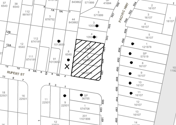
Item 6 PL44/17 Development Application - Subdivision Six Allotments Into 13 Lots - 2A & 6 Judith Avenue and 589, 591, 591A & 593 Pacific Highway, Mount Colah
RECOMMENDATION
THAT Development Application No. DA/633/2016 for demolition of existing structures and subdivision of six allotments into 13 lots in three stages and including two Torrens title lots and 11 community title lots, at Lot 16 DP 608064, Lot 12 DP 236455, Lot 29 DP 587660, Lot 2A DP 354709, Lot A DP 356749, Lot 3 DP 531091, No. 2A and No. 6 Judith Avenue and Nos. 589, 591, 591A and 593 Pacific Highway, Mount Colah be approved as a deferred commencement consent pursuant to Section 80(3) of the Environmental Planning and Assessment Act 1979 subject to the conditions of consent detailed in Schedule 1 of Group Manager’s Report No. PL44/17.
Page Number 101
Item 7 PL47/17 Development Application - Townhouse Development Comprising 17 Dwellings - 497 - 501 Pacific Highway, Mount Colah
RECOMMENDATION
THAT Development Application No. DA/706/2017 for demolition of existing structures and construction of 17, two-storey townhouses with attics over a basement carpark at Lot 6 DP 1003238, Nos. 497 – 501 Pacific Highway, Mount Colah be approved subject to the conditions of consent detailed in Schedule 1 of Group Manager’s Report No. PL47/17.
Page Number 143
Item 8 PL49/17 Development Application - Townhouse Development Comprising 24 Dwellings - 12 to 18 Baldwin Avenue, Asquith
RECOMMENDATION
THAT Development Application No. DA/394/2017 for demolition of existing structures and construction of 24, two-storey townhouses with attics over basement car parking at Lot 3 DP 17085, Lot 4 DP 17085, Lot D DP 403886 and Lot E DP 403886 – Nos.12-18 Baldwin Avenue, Asquith be approved as a deferred commencement pursuant to Section 80(3) of the Environmental Planning and Assessment Act 1979 subject to the conditions of consent detailed in Schedule 1 of Group Manager’s Report No.PL49/17.
Page Number 181
Item 9 PL60/17 Further Report - Development Application - Childcare Centre - 60-74 The Crescent, Cheltenham
RECOMMENDATION
THAT Development Application No. DA/191/2017 for construction of a 92 place childcare centre at Lots 1-5 DP 5440, Lot C DP 306966, Lot C DP 328704, Lot 1 DP 335423, Lot G DP 360935, Lot J DP 374758, Lot A DP 303812, Nos 60-74 The Crescent, Cheltenham be approved subject to the conditions of consent detailed in Schedule 1 of Group Manager’s Report No. PL60/17.
Page Number 219
Item 10 PL57/17 Reporting Variations to Development Standards
RECOMMENDATION
THAT the contents of Group Manager’s Report No. PL57/17 be received and noted.
Infrastructure and Recreation Division
Page Number 222
Item 11 IR16/17 Tender RFT19/2017 - Supply and Delivery of Concrete
RECOMMENDATION
THAT Council do not accept any tender and invite fresh tenders based on the same details for “Supply and Delivery of Concrete”.
Page Number 225
Item 12 IR17/17 Request to Remove Tree - 20 Dean Street, West Pennant Hills
RECOMMENDATION
THAT Council refuse consent to remove one Eucalyptus saligna (Sydney Blue Gum) located at the front of the property at 20 Dean Street, West Pennant Hills.
Confidential Items
Item 13 CS41/17 Proposed Sale - Land Adjoining 57 Berowra Waters Road, Berowra
This report should be dealt with in confidential session, under Section 10A (2) (c) of the Local Government Act, 1993. This report contains information that would, if disclosed, confer a commercial advantage on a person with whom the council is conducting (or proposes to conduct) business.
Item 14 EH6/17 Waste Collection Contract Update
This report should be dealt with in confidential session, under Section 10A (2) (c) of the Local Government Act, 1993. This report contains information that would, if disclosed, confer a commercial advantage on a person with whom the council is conducting (or proposes to conduct) business.
PUBLIC FORUM – NON AGENDA ITEMS
Questions of Which Notice Has Been Given
Mayor's Notes
Page Number 228
Item 15 MN9/17 Mayor's Notes from 1 to 31 August 2017
Page Number 229
Item 16 MN10/17 Mayor's Notes from 1 to 30 September 2017
Page Number 231
Item 17 MN11/17 Mayor's Notes from 1 to 31 October 2017
Notices of Motion
Page Number 233
Item 18 NOM13/17 Overdevelopment and Inappropriate Development in the Hornsby Shire
COUNCILLOR Del Gallego To Move
THAT:
1. A briefing for Councillors be conducted concerning options to address issues of over development and inappropriate development in Hornsby Shire. The briefing is to include an outline of Council’s obligations for future housing supply under the State Government’s Metropolitan Strategy and North District Plan, Council’s capacity for housing supply under its existing housing strategies, and infrastructure and environmental constraints that impact Council’s ability to meet future housing targets
2. Council make representations to, and request a meeting with, the Minister for Planning to discuss any agreed actions arising from the briefing to address Council’s future dwelling obligations and the type, density and quality of dwellings currently being built in the Shire.
3. A copy of the correspondence mentioned in point 2 above be sent to local, State and Federal Members of Parliament to seek their support.
Page Number 235
Item 19 NOM14/17 Expansion of Design Excellence Provisions
COUNCILLOR Heyde To Move
THAT a report be prepared for Council’s consideration presenting amendments to the Hornsby Local Environmental Plan 2013 and Hornsby Development Control Plan 2013 to expand the application of the Design Excellence provisions to town houses and all residential flat buildings.
Page Number 236
Item 20 NOM15/17 Adjacent Over Development Affecting Hornsby Shire
COUNCILLOR McIntosh To Move
THAT Council:
1. Write to the Hills Shire Council advising that Council has received a number of concerns from members of the community that the Planning Proposal for property No. 55 Coonara Avenue, West Pennant Hills would facilitate approval of a development which exceeds community expectations, place an unnecessary burden on local infrastructure and adversely impact on the natural environment.
2. Indicate that it welcomes the opportunity to review and make a submission on the Planning Proposal when it is placed on public exhibition with accompany supporting studies in accordance any requirements of any Gateway Determination.
SUPPLEMENTARY AGENDA
MATTERS OF URGENCY
QUESTIONS WITHOUT NOTICE
Deputy General Manager's Report No. CS35/17
Corporate Support Division
Date of Meeting: 8/11/2017
1 INVESTMENTS AND BOROWINGS FOR 2017/18 - STATUS FOR PERIOD ENDED 30 SEPTEMBER 2017
EXECUTIVE SUMMARY
· This Report provides details of Council’s investment performance for the period ended 30 September 2017 as well as the extent of its borrowings at the end of the same period.
· Council invests funds that are not, for the time being, required for any other purpose. The investments must be in accordance with relevant legislative requirements and Council’s policies and the Chief Financial Officer must report monthly to Council on the details of funds invested.
· All of Council’s investments have been made in accordance with the Local Government Act, the Local Government (General) Regulation and Council's Investment of Surplus Funds Policy and Investment Strategy.
· In respect of Council’s cash and term deposit investments, the annualised return for the month of September 2017 was 2.61% compared to the benchmark of 1.50%.
· In respect of Council borrowings, the weighted average interest rate payable on outstanding loans taken out from June 2008 to date, based on the principal balances outstanding is 7.10%.
|
THAT the contents of Deputy General Manager’s Report No. C35/17 be received and noted. |
PURPOSE
The purpose of this report is to advise Council of funds invested in accordance with Section 625 of the Local Government Act; to provide details as required by Clause 212(1) of the Local Government (General) Regulation and Council's Investment of Surplus Funds Policy; and to advise on the extent of Council’s current borrowings.
BACKGROUND
A report is required to be submitted for Council’s consideration each month detailing Council's investments and borrowings and highlighting the monthly and year to date performance of the investments. Initial investments and reallocation of funds are made, where appropriate, after consultation with Council's financial investment adviser and fund managers.
DISCUSSION
Council invests funds which are not, for the time being, required for any other purpose. Such investment must be in accordance with relevant legislative requirements and Council Policies, and the Chief Financial Officer must report monthly to Council on the details of the funds invested.
Council’s investment performance for the month ended 30 September 2017 is detailed in the attached document. In summary, the At-Call and Term Deposits achieved an annualised return of 2.61% for September 2017, compared to the benchmark of 1.50%.
In respect of Council borrowings, the weighted average interest rate payable on outstanding loans taken out from June 2008 to date, based on the principal balances outstanding is 7.10%. The Borrowings Schedule as at 30 September 2017 is also attached for Council’s information.
CONSULTATION
Appropriate consultation has occurred with Council's financial investment adviser in the preparation of this Report.
BUDGET
Budgeted investment income for 2017/18 is $3,500,000 with an average budgeted monthly income of $291,670. Total investment income for the period ended 30 September 2017 was $1,198,727. Approximately 38% of the investment income received by Council relates to externally restricted funds (e.g. Section 94 monies) and is required to be allocated to those funds. All investments have been made in accordance with the Local Government Act, the Local Government (General) Regulation and Council's Investment of Surplus Funds Policy and Investment Strategy.
CONCLUSION
The investment of Council funds and the extent of its borrowings as at 30 September 2017 are detailed in the documents attached to this Report. Council’s consideration of the Report and its attachments ensures that the relevant legislative requirements and Council protocols have been met in respect of those investments and borrowings.
RESPONSIBLE OFFICER
The officer responsible for the preparation of this Report is the Chief Financial Officer – Glen Magus, who can be contacted on 9847-6635.
|
Glen Magus Chief Financial Officer - Financial Services Corporate Support Division |
Gary Bensley Deputy General Manager - Corporate Support Corporate Support Division |
|
1.View |
HSC Investments Holdings Report - September 2017 |
|
|
|
2.View |
HSC Borrowings Schedule - September 2017 |
|
|
File Reference: F2004/06987-02
Document Number: D07288215
Deputy General Manager's Report No. CS36/17
Corporate Support Division
Date of Meeting: 8/11/2017
2 2016/17 AUDITED FINANCIAL STATEMENTS - PRESENTATION TO THE PUBLIC
EXECUTIVE SUMMARY
· In accordance with Sections 413, 415, 416 and 417 of the Local Government Act, Council must prepare and have audited its General Purpose and Special Purpose Financial Statements within four months of the end of each financial year.
· At the 11 October 2017 General Meeting, Council received and noted the 2016/17 Financial Statements and resolved to refer them for audit. Council also delegated authority to the Acting General Manager to fix the date at which the Financial Statements and Auditor’s Report would be presented to the public.
· Following receipt of the Auditor’s Report, the Acting General Manager determined that the Financial Statements and Auditor’s Report would be presented to the public at the 8 November 2017 General Meeting.
· Following formal presentation of the Financial Statements and Auditor's Reports to the public at the 8 November 2017 General Meeting, members of the public, in accordance with Section 420 of the Local Government Act, have seven days, i.e. until 15 November 2017, to make written submissions about the Statements.
· Any submissions that are received must be referred by Council to the Auditor for their response.
|
THAT the 2016/17 General Purpose and Special Purpose Financial Statements and associated Auditor's Report, as presented to the public on 8 November 2017, be adopted. |
PURPOSE
The purpose of this Report is to allow Council's 2016/17 General Purpose and Special Purpose Financial Statements and associated Auditor's Reports to be presented to the public in accordance with Section 419(1) of the Local Government Act.
BACKGROUND
In accordance with Sections 413, 415, 416 and 417 of the Local Government Act, Council must prepare and have audited its General Purpose and Special Purpose Financial Statements within four months of the end of each financial year.
At the 11 October 2017 General Meeting, Council considered Deputy General Manager’s Report No. CS30/17 – General Purpose and Special Purpose Financial Reports – 2016/17 Financial Year – and resolved that:
1. The 2016/17 General Purpose and Special Purpose Financial Reports be received and noted and referred for audit.
2. The Mayor and Deputy Mayor be authorised to sign the Statutory Statements in connection with the 2016/17 Financial Reports.
3. The 2016/17 Financial Reports be authorised for “presentation to the public” on receipt of the Auditor’s Report.
4. The General Manager be delegated authority to fix the date of the General Meeting at which the 2016/17 Financial Reports and Auditor’s Report are formally “presented to the public”.
DISCUSSION
Following the 11 October 2017 General Meeting, the 2016/17 General Purpose and Special Purpose Financial Statements were signed and referred to the Audit Office of New South Wales for audit. The Audit Office have subsequently issued an Auditor’s Report and identified no significant issues which required changes to the Financial Statements.
Following receipt of the Auditor's Report, the Acting General Manager authorised, in accordance with Council’s resolution of 11 October 2017, that presentation of the Financial Statements and Auditor’s Report to the public would occur at the 8 November 2017 General Meeting. As a result, public notices were placed in local newspapers and on Council's website in accordance with Section 418 of the Act.
Hard copies of the Financial Statements and Auditor's Report are available for viewing by members of the public at Council's Administration Centre and Branch Libraries. An electronic copy of the Financial Statements and Auditor's Reports has also been placed on Council's website at http://www.hornsby.nsw.gov.au/council/about-council/corporate-documents-and-reports/financial-statements and is available in Council’s electronic document management system (refer Trim Folder F2017/00104).
Following formal presentation of the Financial Statements and Auditor's Report to the public at the 8 November 2017 General Meeting, members of the public, in accordance with Section 420 of the Local Government Act have seven days, i.e. until 15 November 2017, to make submissions about the documents. Such submissions must be in writing and must be referred by Council to the Auditor for their response.
It is noted that Council's external auditor has indicated his availability to make a presentation about the Financial Statements, Auditor’s Report and Council's financial position at the 8 November 2017 General Meeting.
CONSULTATION
In the preparation of this Report there was consultation with Council’s External Auditor.
BUDGET
The Income Statement result for 2016/17 is a surplus before capital items and net gains from the disposal of assets of $8.720 million. This amount also includes an advanced receipt of the 2018 financial assistance grant of $2.2 million which needs to be deducted for the purposes of comparison to prior year’s results. The adjusted result for this purpose is $6.620 million.
This surplus is significantly less than the 2015/16 and 2014/15 results that were in excess of $14 million on the same basis. This reduction to prior years is a direct consequence of the NSW Government’s boundary adjustment with the City of Parramatta Council where Council has transferred net rates income of $9.1 million per annum. This is the start of a downward trend in the financial results of the Income Statement.
POLICY
There are no policy implications associated with this Report.
CONCLUSION
The presentation of the 2016/17 Financial Statements and Auditor’s Report to the public at the 8 November 2017 General Meeting will ensure that the requirements of the Local Government Act have been met and that the public have an opportunity to make any relevant submissions to Council about the documents.
RESPONSIBLE OFFICER
The officer responsible for the preparation of this Report is the Chief Financial Officer – Glen Magus, who can be contacted on 9847 6635.
|
Glen Magus Chief Financial Officer - Financial Services Corporate Support Division |
Gary Bensley Deputy General Manager - Corporate Support Corporate Support Division |
There are no attachments for this report.
File Reference: F2017/00104
Deputy General Manager's Report No. CS39/17
Corporate Support Division
Date of Meeting: 8/11/2017
3 HORNSBY SHIRE COUNCIL ANNUAL REPORT 2016/17
EXECUTIVE SUMMARY
· An annual report is one of the key points of accountability between a council and its community. In this regard, NSW councils are required to prepare an annual report within five months of the end of the financial year, place the report on their website and submit the report to the Office of Local Government (OLG).
· The Hornsby Shire Council Annual Report 2016/17 has been prepared in accordance with the requirements of the legislation (Local Government Act and Regulation) and the OLG. The Annual Report also includes information which ensures that annual reporting requirements imposed on Council by other legislation or statutory bodies are met.
· The 2016/17 Annual Report focuses on Council’s achievements in implementation of its Delivery Program. Council’s 2016/17 audited Financial Statements are to form part of the Annual Report once they are “presented to the public” at this 8 November 2017 General Meeting.
|
THAT: 1. The Hornsby Shire Council Annual Report 2016/17, which has been made available on Council’s website, be received and noted. 2. The Annual Report be supplemented by Council’s 2016/17 Audited Financial Statements once they are “presented to the public” at the 8 November 2017 General Meeting. 3. The Annual Report be supplemented by Council’s ‘A Snapshot of the Hornsby Shire in 2016’ publication, as updated in August 2017. 4. A copy of the final Annual Report 2016/17 be submitted to the Office of Local Government by 30 November 2017. |
PURPOSE
The purpose of this Report is to present the 2016/17 Annual Report for Council’s consideration.
BACKGROUND
Section 428 of the Local Government Act requires that a council prepare an annual report within five months of the end of the financial year. The council is required to place the report on its website and submit a copy to the OLG. The annual report must contain information required by the Act and the Local Government (General) Regulation as well as the Integrated Planning and Reporting guidelines developed by the OLG in line with section 406 of the Act.
DISCUSSION
The Hornsby Shire Council Annual Report 2016/17 has been prepared in accordance with the requirements of the Local Government Act, the Local Government (General) Regulation and the OLG’s Integrated Planning and Reporting Guidelines. The Annual Report also includes information to meet requirements imposed by other legislation and statutory bodies, including information on Voluntary Planning Agreements required by the Independent Commission Against Corruption and a report on implementation of recovery plans required under the Threatened Species Conservation Act 1995. A copy of the Annual Report is held in TRIM (refer Document No. PUB000261) and is also available for viewing on Council’s website at hornsby.nsw.gov.au/council/about-council/corporate-documents-and-reports/annual-report.
The Annual Report will formally be supplemented by Council’s audited financial statements once Council has considered Deputy General Manager’s Report No. CS36/17 – 2016/17 Audited Financial Statements – Presentation to the Public (at the 8 November 2017 General Meeting).
It will also include the ‘A Snapshot of the Hornsby Shire in 2016’ publication, received and noted by Council in August 2016 (Deputy General Manager’s Report No. CS24/17), which reflects back over the first four years of the previous Council’s term and contains information on the implementation and effectiveness of Council’s community strategic plan, including environmental outcomes. Inclusion of this publication (noting that it was updated in August 2017 to reflect the extended term of the previous Council) in the Annual Report ensures that the legislative requirements for end of term reporting and reporting on the state of the environment have been met.
A copy of the final Annual Report for 2016/17, including the 2016/17 Financial Statements and the ‘Snapshot’ publication, will then be provided to the OLG by 30 November 2017.
BUDGET
There are no budgetary implications associated with this Report.
POLICY
There are no policy implications associated with this Report.
CONCLUSION
Council’s consideration of this Report will ensure that the Hornsby Shire Council Annual Report 2016/17 is submitted to the OLG in line with statutory requirements.
RESPONSIBLE OFFICER
The officer responsible for the preparation of this Report is the Manager, Strategy and Communications – Julie Williams, who can be contacted on 9847 6790.
|
Julie Williams Manager - Strategy and Communications Corporate Support Division |
Gary Bensley Deputy General Manager - Corporate Support Corporate Support Division |
There are no attachments for this report.
File Reference: F2015/00473
Document Number: D07312473
Deputy General Manager's Report No. CS40/17
Corporate Support Division
Date of Meeting: 8/11/2017
4 DELIVERY PROGRAM FOR 2013-17 AND OPERATIONAL PLAN (BUDGET) FOR 2017/18 - SEPTEMBER 2017 QUARTER REVIEW
EXECUTIVE SUMMARY
· Accountable organisations like Council review their budget and operational performance at least each quarter. In this regard, the September 2017 Quarter Review of the 2013-17 Delivery Program, including the 2017/18 Operational Plan and Budget, is attached.
· The 2017/18 Original Budget forecast a surplus at 30 June 2018 of $78K. This September 2017 Review recommends favourable changes of $85K which improves the forecast 30 June 2018 Budget surplus to $163K.
· Progress against the adopted Delivery Program 2013-17 and the operational performance of the organisation has been in line with the service delivery standards adopted by Council.
|
THAT the September 2017 Quarter Review of the 2013-17 Delivery Program and the Operational Plan (Budget) for 2017/18 be received and noted. |
PURPOSE
The purpose of this Report is to present for Council’s consideration the September 2017 Quarter Review of the 2013-17 Delivery Program and the 2017/18 Operational Plan.
BACKGROUND
On 19 June 2013, Council adopted its four year Delivery Program 2013-17. Due to legal action by Ku-ring-gai Council opposing the NSW Government’s intention to amalgamate Hornsby and Ku-ring-gai Councils, the term of office for the former Council was extended past its original four years. Accordingly, the Operational Plan 2017/18 will continue to operate under Your Community Plan 2013-2023 and the four year Delivery Program 2013-2017 (see Circular No. 16-50 dated 21 December 2016 from the Office of Local Government). The annual Operational Plan and Fees and Charges for 2017/18 were adopted by Council on 14 June 2017. The Delivery Program and Operational Plan set out the manner in which Council intends to deliver services and measure performance.
In line with Office of Local Government requirements, a Quarterly Budget Review Statement (QBRS) must be submitted for Council’s consideration at the end of each quarter. The Statement must be based on key financial indicators and the estimate of income and expenditure set out in Council’s Operational Plan for the relevant year.
DISCUSSION
Operational Comment
Operational performance for the first quarter of 2017/18 has been satisfactory. Highlights achieved during the quarter included the reopening of Galston Aquatic and Leisure Centre in September after a full internal pool renovation, upgrade to change rooms and resurfacing of the concourse; and the delivery of a litter prevention education campaign in Pennant Hills. Other highlights are included in Attachment 1.
Budget Comment
This Review includes the first quarter results for 2017/18, comparing actual expenditure and income for the first quarter against the Budget. The Net Operating and Capital Result after internal funding movements showed a positive variance of $3.714 million. This positive variance is largely the result of timing differences associated with project related work and the initial phasing of the 2017/18 Budget.
The 2017/18 Original Budget forecast a surplus at 30 June 2018 of $78K. As this Review recommends favourable net budget changes of $85K, the forecast budget surplus at 30 June 2018 has been improved to $163K. The recommended budget change is largely the result of net revenue from the lease of digital signs. The predicted Budget result at 30 June 2018 is satisfactory in maintaining Council’s existing liquidity levels.
BUDGET
This Report provides the September 2017 Quarter Review of the 2017/18 Operational Plan (Budget), which, if adopted, will amend the original budget forecast surplus at 30 June 2018 to $163K
POLICY
There are no policy implications associated with this Report.
CONCLUSION
Council’s consideration of this Report ensures that relevant statutory requirements have been met. The September 2017 Quarter Review demonstrates that Council remains in a strong position to deliver local services and facilities in a financially responsible manner.
RESPONSIBLE OFFICER
The officers responsible for preparation of this Report are Julie Williams – Manager, Strategy and Communications and Glen Magus – Chief Financial Officer. They can be contacted on 9847 6790 and 9847 6635 respectively.
|
Gary Bensley Deputy General Manager - Corporate Support Corporate Support Division |
Stephen Fedorow Acting General Manager General Manager Division |
|
1.View |
Quarterly Review - September 2017 |
|
|
|
2.View |
30 September 2017 QBRS |
|
|
File Reference: F2016/00368
Document Number: D07315540
Group Manager's Report No. PL53/17
Planning Division
Date of Meeting: 8/11/2017
5 DEVELOPMENT APPLICATION - CONSTRUCTION OF A MAINTENANCE BUILDING ANCILLARY TO AN EXISTING EDUCATIONAL ESTABLISHMENT - 28, 28A AND 30 UNWIN ROAD, WAHROONGA
EXECUTIVE SUMMARY
|
DA No: |
DA/321/2017 (Lodged on 6 April 2017) |
|
Description: |
Demolition of existing structures on Lot 2 and construction of a maintenance building for use in conjunction with an existing educational establishment. |
|
Property: |
Lot 1 DP 528800, Lot 2 DP 528800 and Lot 3 DP 564798, Nos. 28, 28A and 30 Unwin Road, Wahroonga |
|
Applicant: |
The Council of Barker College |
|
Owner: |
Barker College |
|
Estimated Value: |
$3,467,350 |
|
Ward: |
B |
· The application involves the construction of a new maintenance building for use in conjunction with an existing educational establishment.
· The proposal generally complies with the Hornsby Local Environmental Plan 2013 and the Hornsby Development Control Plan 2013.
· Two submissions have been received in respect of the application.
· It is recommended that the application be approved as a deferred commencement consent requiring registration and creation of an easement for drainage over downstream properties.
|
THAT Development Application No. DA/321/2017 for construction of a new maintenance building for use in conjunction with an existing educational establishment at Lot 1 DP 528800, Lot 2 DP 528800 and Lot 3 DP 564798, Nos. 28, 28A and 30 Unwin Road, Wahroonga be approved as a deferred commencement consent pursuant to Section 80(3) of the Environmental Planning and Assessment Act 1979 subject to the conditions of consent detailed in Schedule 1 of Group Manager’s Report No. PL53/17. |
BACKGROUND
On 24 August 2017, a Complying Development Certificate (CD/857/2017) was issued for the demolition of the existing dwelling and attached carport on No. 28A Unwin Road Wahroonga.
The site comprising Nos. 28, 28A and 30 Unwin Road, Wahroonga was previously used for residential purposes.
SITE
The site comprises 3 allotments and covers an area of approximately 3,741m2. The site has a frontage of 27.795m to Unwin Road and the existing access handle driveway serving Lots 2 and 3 has a combined width of 6.1m.
The subject site forms part of the larger land holdings of Barker College which has existing facilities immediately to the north comprising a car park, preparatory school and administration facilities. The main school campus comprising school buildings, sports grounds and existing maintenance facilities are located further north on the other side of Clarke Road.
Development on the site comprised predominantly single storey dwellings on each of the allotments. Demolition works have commenced in accordance with the issued Complying Development Certificate (CD/857/2017). Residential development is located to the south, east and west of the site.
PROPOSAL
The application proposes the following works:
· Demolition of the existing dwelling on Lot 2 (No. 28A Unwin Road)
· Retention of the existing dwellings on Lots 1 and 3 (Nos. 28 and 30 Unwin Road)
· Construction of a 2 storey building to be connected to the existing dwelling on No. 28. The building will be used for school storage, wash bay, print facilities and offices
· Provision of a new compactor unit
· Landscaping works
· Stormwater management works
The storage areas will be used for grounds and maintenance works at the school, primarily for maintenance equipment and materials and will replace the existing facilities located within the main campus that will be demolished as part of the works proposed for the new sports hall in DA/275/2017 currently under assessment.
The new buildings are to be constructed of pre-finished wall panels, metal wall sheeting and pre-finished metal roof sheeting. The print room level will be clad in selected pre-finished wall panels and weatherboard cladding.
After lodgement of the application, the applicant obtained a Complying Development Certificate (CD/857/2017) for the demolition of the existing dwelling and attached carport on Lot 2 (No. 28A Unwin Road) and demolition works are currently being undertaken.
ASSESSMENT
The development application has been assessed having regard to ‘A Plan for Growing Sydney’, the ‘Draft North District Plan’ and the matters for consideration prescribed under Section 79C of the Environmental Planning and Assessment Act 1979 (the Act). The following issues have been identified for further consideration.
1. STRATEGIC CONTEXT
1.1 A Plan for Growing Sydney and (Draft) North District Plan
A Plan for Growing Sydney has been prepared by the NSW State Government to guide land use planning decisions for the next 20 years. The Plan sets a strategy and actions for accommodating Sydney’s future population growth and identifies dwelling targets to ensure supply meets demand. The Plan identifies that the most suitable areas for new housing are in locations close to jobs, public transport, community facilities and services.
The NSW Government will use the subregional planning process to define objectives and set goals for job creation, housing supply and choice in each subregion. Hornsby Shire has been grouped with Hunters Hill, Ku-ring-gai, Lane Cove, Mosman, North Sydney, Ryde, Northern Beaches and Willoughby to form the North District. The Greater Sydney Commission has realised the draft North District Plan which includes priorities and actions for the Northern District for the next 20 years. The identified challenge for Hornsby Shire will be to provide an additional 4,350 dwellings by 2021 with further strategic supply targets to be identified to deliver 97,000 additional dwellings in the North District by 2036.
The proposed development would be consistent with ‘A Plan for Growing Sydney’ and ‘Draft North District Plan’, by facilitating the provision of additional educational services to support a growing population.
2. STATUTORY CONTROLS
Section 79C(1)(a) requires Council to consider “any relevant environmental planning instruments, draft environmental planning instruments, development control plans, planning agreements and regulations”.
2.1 Hornsby Local Environmental Plan 2013
The proposed development has been assessed having regard to the provisions of the Hornsby Local Environmental Plan 2013 (HLEP).
2.1.1 Zoning of Land and Permissibility
The subject land is zoned R2 Low Density Residential under the HLEP. The objectives of the R2 zone are:
· To provide for the housing needs of the community within a low density residential environment.
· To enable other land uses, that provide facilities or services to meet the day to day needs of residents.
The proposed development is defined as ancillary to an ‘educational establishment’ under the HLEP and is permissible in the zone with Council’s consent. The proposed development would provide for ancillary facilities for the current and future college population, thereby providing an educational service to meet the day to day needs of the local residents and the school community. Therefore, the proposal is consistent with the objectives of the zone.
2.1.2 Height of Buildings
Clause 4.3 of the HLEP provides that the height of a building on any land should not exceed the maximum height shown for the land on the Height of Buildings Map. The maximum permissible building height for the subject site is 8.5 metres. The height of the proposed building would be 8.5m, which complies with the maximum height provision.
2.1.3 Heritage Conservation
Clause 5.10 of the HLEP sets out heritage conservation provisions for Hornsby Shire. The property is within the vicinity of properties No. 1A Clarke Road (house) and Nos. 27-31 Clarke Road, Waitara (house and garden) which are listed as heritage items of local significance under the provisions of Schedule 5 Part 1 (Heritage items) of the HLEP. The property is also within the vicinity of the Barker College Heritage Conservation Area listed under the provisions of Schedule 5 Part 2 (Heritage conservation areas) of the HLEP.
The proposal is separated from the heritage listed property at Nos. 27-31 Clarke Road by existing residential development fronting Marillian Avenue and located a sufficient distance from the heritage item at No. 1A Clarke Road that the proposal would not have an adverse impact upon the significance of these properties. Furthermore, the proposal is separated from the adjacent Barker College Heritage Conservation Area by the existing Prep School and adjoining residential development fronting Clarke Road. Accordingly, no objection is raised to the proposal on heritage grounds.
2.1.4 Earthworks
Clause 6.2 of the HLEP states that consent is required for proposed earthworks on site. Before granting consent for earthworks, Council is required to assess the impacts of the works on adjoining properties, drainage patterns and soil stability of the locality.
A geotechnical investigation was prepared JK Geotechnics, dated March 2017. The investigation makes a number of recommendations to be implemented during the construction phase of the development with respect to excavation (including dilapidation surveys, excavation techniques and vibrations and drainage); excavation support; earthworks (including site drainage, site preparation, subgrade preparation and engineered fill); retaining wall design parameters; footings; durability; on-grade floor slabs; external pavements and additional geotechnical input works.
A condition has been recommended for the development to be carried out in accordance with the comments and recommendations in Sections 4 and 5 of the geotechnical report. Further conditions are recommended for excavated material to be disposed of at a licenced facility and for all fill that is to be imported to the site to consist of Virgin Excavated Natural Material (VENM).
The proposal is assessed as satisfactory with regards to Clause 6.2 of the HLEP subject to conditions.
2.2 State Environmental Planning Policy No. 44 – Koala Habitat Protection
The proposal has been assessed against the provisions of State Environmental Planning Policy No. 44 Koala Habitat Protection (SEPP44) which aims to encourage the proper conservation and management of areas of natural vegetation that provide habitat for koalas.
The application includes an Arboricultural Impact Assessment (AIA) prepared by ArborSafe. The report does not identify the presence of any koala feed trees listed under Schedule 2 of the Policy. Council’s tree assessment concurs with the submitted AIA that the site is not considered a ‘potential koala habitat’ and no further investigations are required for the purpose of SEPP44.
2.3 State Environmental Planning Policy No. 55 – Remediation of Land
Under the provisions of Clause 7 of State Environmental Planning Policy No.55 Remediation of Land (SEPP55), a consent authority must not consent to the carrying out of any development on land unless it has considered whether the land is contaminated or requires remediation for the proposed use.
Historical information and an inspection of the site and surrounding areas indicate that the site has been used for residential housing and school purposes and no further investigations are required for the purpose of SEPP55.
2.4 State Environmental Planning Policy No. (Infrastructure) 2007
The application has been assessed against the requirements of State Environmental Planning Policy (Infrastructure) 2007 (SEPP Infrastructure). This Policy provides State-wide planning controls for development adjoining busy roads and rail corridors and at the time of lodgement of the development application included controls for development for the purpose of an educational establishment.
Part 3 Division 3 Educational establishments was subsequently repealed when State Environmental Planning Policy (Educational Establishments and Child Care Facilities) 2017 was gazetted and SEPP Infrastructure did not provide for any savings provisions. Notwithstanding, the proposed development did not satisfy the criteria for exempt nor complying development and further assessment is not required.
As the site is not located along a rail corridor or on classified road, Part 3 Divisions 15 and 17 are not applicable and further assessment is not required.
2.5 State Environmental Planning Policy (Educational Establishments and Childcare Facilities) 2017
Schedule 5 Savings and transitional provisions of State Environmental Planning Policy (Educational Establishments and Child Care Facilities) 2017 states that this Policy does not apply to or in respect of the determination of a development application made under Part 4 of the Act, but not finally determined before the commencement of this Policy. The application was lodged on 6 April 2017 and the SEPP was gazetted on 30 August 2017.
Whilst the proposal was not lodged as a complying development, an assessment against the complying development standards for educational establishments has been undertaken as a guideline for the assessment of the proposal. The following table sets out the proposal’s compliance with these standards.
|
SEPP (Educational Establishments and Childcare Facilities) 2017 - Schedule 2 |
|||
|
Control |
Proposal |
Requirement |
Compliance |
|
Height |
8.5m |
max. 22m |
Yes |
|
No. of storeys |
2 storeys |
max. 4 storeys |
Yes |
|
Setbacks (building height less than or equal to 12m) |
|||
|
Front Setback |
9m |
Av. of existing within 70m |
Yes |
|
Side Setback (north) |
Nil |
5m |
No |
|
Side Setback (south) |
7m-10m |
5m |
Yes |
|
Rear Setback |
unchanged |
5m |
Yes |
|
Landscape |
2m wide |
Min. 3m wide |
No |
As detailed in the above table, the proposed development does not comply with all of the complying standards of the SEPP.
Notwithstanding, the building proposed is lower in height and number of storeys than what would be permitted under the SEPP providing a better planning outcome for the development.
2.6 Sydney Regional Environmental Plan No. 20 – Hawkesbury – Nepean River
The site is located within the catchment of the Hawkesbury Nepean River. Part 2 of this Plan contains general planning considerations and strategies requiring Council to consider the impacts of development on water quality, aquaculture, recreation and tourism.
Subject to the implementation of sediment and erosion control measures and stormwater management to protect water quality, the proposal would comply with the requirements of the Policy.
2.7 Clause 74BA Environmental Planning and Assessment Act, 1979 - Purpose and Status of Development Control Plans
Clause 74BA of the Environmental Planning and Assessment Act, 1979 states that a DCP provision will have no effect if it prevents or unreasonably restricts development that is otherwise permitted and complies with the development standards in relevant Local Environmental Plans and State Environmental Planning Policies.
The principal purpose of a development control plan is to provide guidance on the aims of any environmental planning instrument that applies to the development; facilitate development that is permissible under any such instrument; and achieve the objectives of land zones. The provisions contained in a DCP are not statutory requirements and are for guidance purposes only. Consent authorities have flexibility to consider innovative solutions when assessing development proposals, to assist achieve good planning outcomes.
2.8 Hornsby Development Control Plan 2013
The proposed development has been assessed having regard to the relevant desired outcomes and prescriptive requirements within the Hornsby Development Control Plan 2013 (HDCP). The following table sets out the proposal’s compliance with the prescriptive requirements of the Plan:
|
Hornsby Development Control Plan 2013 |
|||
|
Control |
Proposal |
Requirement |
Compliance |
|
Site Area |
3,741m2 |
N/A |
N/A |
|
Height |
8.5m |
max. 8.5m |
Yes |
|
Floor Area |
1,498m2 |
N/A |
N/A |
|
Site Cover |
<30% |
30% |
Yes |
|
Setbacks |
|
|
|
|
Front Setback |
9m |
6m |
Yes |
|
Side Setback (north) |
Nil |
1m |
No |
|
Side Setback (south) |
7m-10m |
1m |
Yes |
|
Rear Setback |
unchanged |
5m |
Yes |
|
Landscape Area (% site) |
|
|
|
|
Development Site (3 lots) |
19% |
min. 45% |
No |
|
Consolidated Site |
>45% |
min. 45% |
Yes |
|
Parking |
4 spaces 1 motorbike space |
Parking Study |
Yes |
As detailed in the above table, the proposed development does not comply with the prescriptive requirements for side setbacks within the HDCP. The matters of non-compliance are detailed below, as well as a brief discussion on compliance with relevant desired outcomes.
2.8.1 Design
The proposed Services Facility buildings would be located to south of the existing Preparatory School site building. The buildings are proposed to house the relocated maintenance facilities functions of the school currently located at the corner of Unwin Road and The Avenue in the centre of the main campus. The applicant has provided the following information with respect to the floor area and building footprint of the existing facilities in comparison to the development proposed:
|
Comparison of the Existing Operation with Proposed Operation |
|||
|
|
Use |
Existing Floor Area |
Proposed Floor Area |
|
Materials storage |
Delivery point for the school includes racking for: · School materials and equipment · Furniture · Stationary · Electrical · Maintenance and school materials – timber, sheet materials · Bottled water · Cleaning equipment and products |
145m2 |
192m2 |
|
Vehicles |
|
145m2 |
Included in storage for ground staff & garden staff |
|
BCPA storage |
Parent Association storage comprising: · Banners · Light event equipment · Spring Fair material · Tents and shelters · Tables and chairs · BBQs |
140m2 |
195m2 |
|
Workshop |
· Work benches and work spaces · Machinery and equipment · Racking · Hardware stock · Tools · storage |
165m2 |
190m2 |
|
Print rooms |
· printers · stationary · storage · offices |
145m2 |
292m2 |
|
Ground staff |
· mowers · tractors · specialised machinery · tools · work benches and work spaces · storage |
110m2 |
121m2 |
|
Gardens staff |
· work benches and work spaces · vehicles · trailers · buggies and charges · storage |
55m2 |
62m2 |
|
Loading |
· forklift · palettes |
60m2 |
|
|
Washdown |
· specialised equipment for cleaning of vehicles, etc · compressor · water holding tanks · separating unit |
100m2 |
117m2 |
|
Waste compactus |
Replaces existing bins · loading bay · compactor |
60m2 |
55m2 |
|
Uniform/ equipment store |
· uniforms · school equipment |
|
|
|
- ground |
145m2 |
145m2 |
|
|
- first |
72m2 |
72m2 |
|
|
Covered outdoor area |
· Break out space for staff during breaks |
11m2 |
57m2 |
|
Total Floor area |
|
1353m2 |
1498m2 |
|
Total Building footprint |
|
1281m2 |
940m2 |
The proposed development complies with the maximum 8.5m building height requirement and the building would have a low pitched roof. The facades of the proposed building have been amended to include metal and weatherboard cladding with clear glass high level windows. The new facility would provide a more efficient and compact footprint and has been located to minimise its impact upon the streetscape by retaining the existing dwelling at the Unwin Road frontage.
It is considered that the proposal complements the existing residential buildings to be retained onsite for use as offices. The proposed development would not have a detrimental impact upon the adjoining residences and the existing streetscape of Unwin Road.
The proposal satisfies the building design requirements of the HDCP.
2.8.2 Setbacks
The proposed development complies with the setback requirements of the HDCP with the exception of the northern side boundary where the building has a nil setback to the adjoining car park within the preparatory school.
Barker College currently has an application lodged with Land and Property Information to consolidate the subject development site with the adjoining lots to the north that contain the existing Preparatory School and ancillary school buildings. Once the site is consolidated, the side setback non-compliance would not apply.
The setbacks proposed would be compatible with adjacent residential development and the plans have been amended to include a 2m wide landscaped strip along the southern boundary.
It is considered that the proposed buildings satisfy the ‘Setbacks’ requirement stipulated under the HDCP.
2.8.3 Landscaping
The HDCP requires a minimum of 45% of the site to be landscaped. Due to the hardstand area required for vehicular access to the new buildings, the existing 3 lots would not comply with the minimum 45% landscaping requirement, with approximately 19% of the site landscaped. Upon consolidation of the development site with the adjoining Preparatory School site, the proposed development would exceed the minimum required landscape area.
A revised landscape plan has been submitted providing a minimum 2m wide landscape strip adjacent to the southern boundary adjoining the residential development. This enables increased landscaping and screen hedge planting to be provided within the side setback. It is considered that the increased landscape plantings would be appropriate to sufficiently screen and reduce the impacts of the maintenance shed from the adjoining residential development and improve the visual amenity when viewed from the street.
The proposed landscaping has been designed to fit with the design of the buildings and is considered acceptable.
2.8.4 Privacy and Security and Sunlight
The proposed development is located adjacent to existing school grounds and is set well back from private residential boundaries. The proposed works include the erection of a 2.7m high acoustic fence along the southern boundary in accordance with the requirements of the noise impact assessment undertaken.
The closest residential properties are the existing dwellings located adjacent to the southern side boundary. The shadow diagrams indicate the shadows cast by the proposed buildings would fall predominantly within the development site. In addition, the proposed development would have no adverse impact on the privacy of adjoining residential properties given the acoustic barrier requirements and landscape planting.
The proposed development has been designed to minimise crime in accordance with Crime Prevention through Environmental Design (CPTED) principles by way of clear sightlines, windows that overlook the street, suitable pedestrian access for the users of the school faciluty and clearly defined building entry from Clarke Road and vehicular access.
The proposed development would meet the HDCP desired outcome for privacy, security and sunlight.
2.8.5 Vehicular Access and Parking
The proposed development was supported by a Traffic and Parking Impacts Report (TPIR) prepared by TEF Consulting. The TPIR states that there will be 4 parking spaces provided on site, together with parking being available at the adjacent Preparatory Site to the north.
The proposed car park will have vehicular access from Unwin Road via a combined 7.4m wide entry/exit driveway.
A Preparatory School Parking Accumulation Survey carried out in 2016 showed that maximum parking accumulation was 39 vehicles for 1 hour on a Friday morning. The peak of 34 vehicles observed in the afternoon was considered to be a more accurate representation of peak parking accumulation. The Preparatory School has a 45 vehicle capacity car park.
Council’s traffic assessment concluded that parking would not be an issue with the proposed relocation of the Services Facilities building given that the Preparatory School has a 45 vehicle capacity car park which is underutilised and would provide additional off-street parking for the services facilities buildings. Furthermore, the relocation of the existing facilities would not generate any additional trips and therefore, traffic generation is not considered to be an issue.
The HDCP has a requirement for motorcycle parking at the rate of 1 space per 50 car parking spaces, or part thereof, giving a requirement for 1 motorcycle space. One motorcycle parking space has been provided and is shown on the drawings.
The proposal satisfies the HDCP requirements of access and parking.
2.8.6 Waste Management
The proposal includes a waste compactus area that will handle all waste from Barker Colle which will be internally collected by staff on site as per current arrangements. The waste will be sorted on site and waste from the compactus will be removed by external contractors 2-3 times per month.
The development has been appropriately designed to ensure sufficient bin storage areas and access by waste collection vehicles. The bin storage area is large enough for the required number of bins.
Council’s waste assessment raised no objections to the proposed method of waste management subject to the recommended conditions in Schedule 1.
2.9 Section 94A Contributions Plans
Hornsby Shire Council Section 94A Contributions Plan 2014 - 2024 applies to the development as the estimated costs of works is greater than $100,000. Should the application be approved, an appropriate condition of consent is recommended requiring the payment of a contribution in accordance with the Plan.
3. ENVIRONMENTAL IMPACTS
Section 79C(1)(b) of the Act requires Council to consider “the likely impacts of that development, including environmental impacts on both the natural and built environments, and social and economic impacts in the locality”.
3.1 Natural Environment
3.1.1 Tree and Vegetation Preservation
The Arboricultural Impact Assessment prepared by ArborSafe identifies 21 trees within the site that may be impacted by the construction of the proposed buildings. The proposed development would necessitate the removal of 14 trees from the site. One of the trees proposed to be removed satisfies Council’s criteria for being an ‘Individually Significant Tree’ and the submitted Arboricultural Impact Assessment recommends tree planting to offset trees removed be undertaken elsewhere within the Barker College site to compensate for canopy and amenity loss.
Council’s tree assessment notes that whilst there is scope for replacement planting of 2 trees within the front setback of No. 28 Unwin Road, existing and proposed development within the greater Barker College site precludes the provision of additional tree planting due to building locations and the use of open space for recreational purposes by school students.
Seven trees are proposed to be retained and will require specific tree protection measures to facilitate their retention. Council’s assessment considers that these trees can be successfully retained through the use of sensitive methods of construction as prescribed in AS4970-2009 and the HDCP.
Overall, it is considered that the removal of the trees is acceptable in the circumstances of the case as a redesign of the buildings would result in the existing dwelling fronting Unwin Road being demolished and the development being relocated towards the street which would be incompatible with the residential streetscape of the locality and reduce replacement tree planting options within the front setback.
Schedule 1 includes a condition requiring the planting of 2 replacement trees within the front setback.
3.1.2 Stormwater Management
The applicant provided a Stormwater Concept Plan and Water Sensitive Urban Design Report prepared by ACOR Consultants dated April 2017. The Report demonstrates the intended drainage system for the proposed development, including the location, level and volume of the On-Site Detention System (OSD).
The Water Sensitive Urban Design Report indicates that upstream catchment and new development catchment areas would be directed to the rainwater reuse storage tanks. To improve the quality of the water stored for reuse and any overflow out to Council’s stormwater system, the proposal involves treatment of the rainwater runoff to reduce the possibility of pollutants entering the stormwater system.
Councils engineering assessment raises no issues regarding stormwater management, subject to the recommended conditions of consent which include a deferred commencement condition for the registration and creation of an easement to drain water from the site over 5 downstream properties comprising Lot 4 DP 236907, No 30A Unwin Road; Lot 5 DP 236907, No. 32 Unwin Road; Lot 6 DP 236907, No. 32A Unwin Road; Lot 7 DP 236907, No. 34 Unwin Road and Lot 8 DP 236907, No. 34A Unwin Road.
3.2 Built Environment
3.2.1 Built Form
A submission was received raising concerns with respect to the built form of the development.
The proposed buildings would be adequately separated from the adjoining residential properties. The design of the proposed development has been amended to include fenestration and façade treatment to be compatible with the surrounding residential development.
The proposed development relates to the site constraints and is acceptable with respect to the built environment.
3.2.2 Traffic
A traffic and parking assessment prepared by TEF Consulting has been submitted with the proposal. The report states that Barker College is pursuing a number of other development proposals at present. These proposals are listed below:
· New Preparatory School and expansion of the existing Junior School (DA/1194/2016 approved 13 July 2017).
· Relocation of the existing service facilities (grounds and maintenance buildings and print room, from The Avenue to new site on Unwin Road (subject application).
· Construction of a three storey sports hall comprising indoor netball/basketball courts, classrooms, fitness centre and function room and basement parking for 185 vehicles on the southern side of The Avenue. (DA/275/2017 lodged 27 March 2017)
The above proposals would result in changes in both trip generation and distribution on the road network. It is prudent to consider the cumulative effects of all proposals. The traffic consultant has developed a model which takes into account all of the above proposed developments.
The model uses all new and redistributed trips resulting from each proposal, combined in a single SIDRA Network model. The new and redistributed trips were overlaid on the base model for the existing conditions. The base model was developed following specifications set out by RMS and Hornsby Council. The results of modelling indicate that whilst there will be increase in average delays and queueing, these changes will be minor to moderate.
Council’s engineering assessment of the traffic impacts of the development concludes that the proposed development is acceptable subject to conditions.
3.2.3 Acoustics
A submission was received raising concerns with respect to noise impacts during the development stage.
An Environmental Noise Impact Assessment (ENIA) prepared by Renzo Tonin & Associates, dated 31 March 2017 was submitted with the application. ENIA notes that the hours of operation for Grounds and Maintenance is generally between 6am and 3pm Monday to Saturdays with 6 to 8 deliveries each day by small vehicles. The proposed compactor unit will be used once per day.
Whilst it is recognised that there would be some increase in noise associated with an increase in development on the site, it is considered that the noise increase would not be significant. Noise restrictions are set out in the Protection of the Environment Operations Act 1997 and noise generated by the development could be reasonably managed on site. The proposed buildings are set well back from the private residential boundaries and are located adjacent to established school grounds.
The ENIA includes recommendations for a 2.7m high acoustic barrier on the southern elevation adjoining the existing residential development and limits on the use of equipment and operations within the proposed buildings to occur only between 7am and 6pm, Monday to Saturday.
The application proposed the hours of operation to be 6am to 3pm Monday to Saturday. Given the location of the site adjoining residential development in conjunction with the recommendations of the ENIA to restrict the use prior to 7am, Schedule 1 incudes a condition restricting the hours of operation to the following:
· Monday to Friday 7 am to 4 pm
· Saturday 7 am to 3 pm
· Sunday & Public Holidays No work; and
· All deliveries must occur between 7 am and 3 pm Monday to Friday only.
Schedule 1 also includes a condition that all works on site, including demolition and earth works, must only occur between 7am and 5pm Monday to Saturday, with no work to be undertaken on Sundays or public holidays.
The proposal is considered satisfactory with respect to potential acoustic impacts subject to conditions.
3.2.4 Social Impacts
The proposed development would have a positive social impact upon the locality by facilitating educational use.
3.3 Economic Impacts
The proposal would have a positive economic impact on the locality in terms of employment generation during the construction phase of the development
4. SITE SUITABILITY
Section 79C(1)(c) of the Act requires Council to consider “the suitability of the site for the development”.
The subject site has not been identified as bushfire prone or flood prone land. The site is considered to be capable of accommodating the proposed development. The scale of the proposed development is consistent with the capability of the site and is considered acceptable.
5. PUBLIC PARTICIPATION
Section 79C(1)(d) of the Act requires Council to consider “any submissions made in accordance with this Act”.
5.1 Community Consultation
The proposed development was placed on public exhibition and was notified to adjoining and nearby landowners between 20 April 2017 and 4 May 2017 in accordance with the Notification and Exhibition requirements of the HDCP. During this period, Council received 2 submissions. The map below illustrates the location of those nearby landowners who made a submission that are in close proximity to the development site.
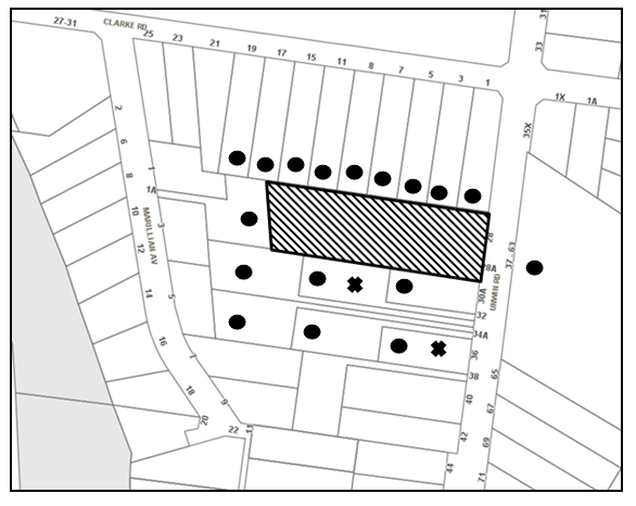
|
NOTIFICATION PLAN |
|||
|
• PROPERTIES NOTIFIED |
X SUBMISSIONS RECEIVED |
PROPERTY SUBJECT OF DEVELOPMENT |
|
One submission objects to the development, generally on the grounds that the development would result in:
· Development that is excessive in bulk and scale - the built form is incongruous with the surrounding residential development.
One submission is neutral to the development and requests the following to minimise the disruption to their day-to-day living:
· A higher fence to block noise and dust from trucks/buses coming into the wash bay or storage area.
· During development stage, noise be minimised before 8am and after 6pm, as there are elderly people living in the house.
The merits of the matters raised in community submissions have been addressed in the body of this report. Schedule 1 includes conditions for construction work hours (condition No. 30); acoustic treatment (condition No. 49) and hours of operation (condition No. 64).
5.2 Public Agencies
The development application was not referred to any Public Agencies for comment.
6. THE PUBLIC INTEREST
Section 79C(1)(e) of the Act requires Council to consider “the public interest”.
The public interest is an overarching requirement, which includes the consideration of the matters discussed in this report. Implicit to the public interest is the achievement of future built outcomes adequately responding to and respecting the future desired outcomes expressed in environmental planning instruments and development control plans.
The application is considered to have satisfactorily addressed Council’s and relevant agencies’ criteria and would provide a development outcome that, on balance, would result in a positive impact for the community. Accordingly, it is considered that the approval of the proposed development would be in the public interest.
CONCLUSION
The application involves demolition of an existing dwelling and construction of a maintenance building ancillary to an existing educational establishment.
The proposal has been assessed against the heads of consideration in Section 79C of the Environmental Planning and Assessment Act 1979. It is considered that the proposed development would not result in any unreasonable impacts and is suitable for the site.
Approval of the application is recommended.
Note: At the time of the completion of this planning report, no persons have made a Political Donations Disclosure Statement pursuant to Section 147 of the Environmental Planning and Assessment Act 1979 in respect of the subject planning application.
RESPONSIBLE OFFICER
The officer responsible for the preparation of this Report is the Manager – Development Assessments – Rodney Pickles, who can be contacted on 9847 6731.
|
Rod Pickles Manager - Development Assessment Planning Division |
James Farrington Group Manager Planning Division |
|
1.View |
Locality Map |
|
|
|
2.View |
Floor Plans |
|
|
|
3.View |
Shadow Diagram |
|
|
|
4.View |
Elevations and Sections |
|
|
|
5.View |
Perspectives |
|
|
|
6.View |
Site Plan |
|
|
File Reference: DA/321/2017
Document Number: D07276780
SCHEDULE 1
GENERAL CONDITIONS
The conditions of consent within this notice of determination have been applied to ensure that the use of the land and/or building is carried out in such a manner that is consistent with the aims and objectives of the relevant legislation, planning instruments and council policies affecting the land and does not disrupt the amenity of the neighbourhood or impact upon the environment.
Note: For the purpose of this consent, the term ‘applicant’ means any person who has the authority to act on or the benefit of the development consent.
Note: For the purpose of this consent, any reference to an Act, Regulation, Australian Standard or publication by a public authority shall be taken to mean the gazetted Act or Regulation, or adopted Australian Standard or publication as in force on the date that the application for a construction certificate is made.
1. Deferred Commencement
Pursuant to Section 80(3) of the Environmental Planning and Assessment Act 1979, this consent does not operate until the following information is submitted to Council:
a) The registration and creation of an easement to drain water from the site over downstream properties being Lot 4 DP 236907, Lot 5 DP 236907, Lot 6 DP 236907, Lot 7 DP 236907 and Lot 8 DP 236907.
Such information must be submitted within 36 months of the date of this notice.
Upon Council’s written satisfaction of the above information, the following conditions of development consent apply:
2. Approved Plans and Supporting Documentation
The development must be carried out in accordance with the plans and documentation listed below and endorsed with Council’s stamp, except where amended by Council and/or other conditions of this consent:
|
Plan No. |
Plan Title |
Drawn by |
Dated |
|
21627.01/A |
Site Plan |
Priestleys architects |
30 March 2017 |
|
21627.02/C |
Ground Floor Plan |
Priestleys architects |
7 September 2017 |
|
21627.03/A |
First Floor Plan |
Priestleys architects |
30 March 2017 |
|
21627.04/B |
Elevations 1 |
Priestleys architects |
28 August 2017 |
|
21627.05/B |
Elevations 2 |
Priestleys architects |
28 August 2017 |
|
21627.06/A |
Sections |
Priestleys architects |
30 March 2017 |
|
21627.07/A |
Storage Shed Floor Plans |
Priestleys architects |
30 March 2017 |
|
C3.01 Issue B |
Erosion & Sediment Control Plan |
ACOR |
31 March 2017 |
|
C1.06 Issue B |
Details Sheet 2 |
ACOR |
31 March 2017 |
|
H1.00 Issue DA01 |
Hydraulic Services Ground Floor Trade Waste Drainage Plan |
ACOR |
8 June 2017 |
|
Document Title |
Prepared by |
Dated |
|
Traffic and Parking Impact Report No. 17004 01 |
TEF Consulting |
23 March 2017 |
|
Arboricultural Impact Assessment |
Arborsafe |
30 March 2017 |
|
Environmental Noise Impact Assessment Ref: TJ574-01F01 |
Renzo Tonin & Associates |
31 March 2017 |
|
Geotechnical Investigation Report Ref: 30175ZHrpt |
JK Geotechnics |
31 March 2017 |
|
BCA Assessment Report Ref: 107932-BCA-r2 |
BCA Logic |
31 March 2017 |
|
Stormwater Management Report Rev B |
ACOR Consultants |
April 2017 |
|
Waste Management Plan |
Barker College |
6 April 2017 |
3. Amendment of Plans
a) The approved plans are to be amended as follows:
i) Plan No. 21627.01/A Site Plan, prepared by Priestleys architects, dated 30 March 2017, is to be amended to show the increased landscape area along the southern boundary detailed in approved Plan No. Plan No. 21627.02/C Ground Floor Plan, prepared by Priestleys architects dated 7 September 2017.
b) These amended plans must be submitted with the application for the Construction Certificate.
4. Appointment of a Project Arborist
A project arborist with AQF Level 5 qualifications must be appointed to provide monitoring and certification throughout the construction period.
Details of the appointed project arborist must be submitted to Council and the PCA for registration with the application for the construction certificate.
5. Removal of Trees
This development consent permits the removal of trees numbered 795-808 as identified in the Arboricultural Impact Assessment submitted by Arborsafe dated 30/7/2017 (D07191510).
Note: The removal of any other trees from the site requires separate approval by Council in accordance with Part 1B.6 Tree and Vegetation Preservation of the Hornsby Development Control Plan, 2013 (HDCP).
6. Construction Certificate
a) A Construction Certificate is required to be approved by Council or a Private Certifying Authority prior to the commencement of any works under this consent.
b) A separate Construction Certificate must be obtained from Council for all works within the public road reserve under S138 of the Roads Act.
c) The Construction Certificate plans must not be inconsistent with the Development Consent plans.
7. Section 94A Development Contributions
a) In accordance with Section 80A(1) of the Environmental Planning and Assessment Act, 1979 and the Hornsby Shire Council Section 94A Development Contributions Plan 2014-2024, $34,673.50 must be paid to Council to cater for the increased demand for community infrastructure resulting from the development, based on development costs of $3,467,350.
b) The value of this contribution is current as at 12 September 2017. If this contribution is not paid within the financial quarter that this condition was generated, the contribution payable will be adjusted in accordance with the provisions of the Hornsby Shire Council Section 94 Development Contributions Plan and the amount payable will be calculated at the time of payment in the following manner:
$CPY = $CDC x CPIPY
CPIDC
Where:
$CPY is the amount of the contribution at the date of Payment
$CDC is the amount of the contribution as set out in this Development Consent
CPIPY is the latest release of the Consumer Price Index (Sydney – All Groups) at the date of Payment as published by the ABS.
CPIDC is the Consumer Price Index (Sydney – All Groups) for the financial quarter at the date applicable in this Development Consent Condition.
c) The monetary contributions must be paid to Council:
i) prior to the issue of the Subdivision Certificate where the development is for subdivision; or
ii) prior to the issue of the first Construction Certificate where the development is for building work; or
iii) prior to issue of the Subdivision Certificate or first Construction Certificate, whichever occurs first, where the development involves both subdivision and building work; or
iv) prior to the works commencing where the development does not require a Construction Certificate or Subdivision Certificate.
Note: It is the professional responsibility of the Principal Certifying Authority to ensure that the monetary contributions have been paid to Council in accordance with the above timeframes.
Council’s S94A Development Contributions Plan may be viewed at www.hornsby.nsw.gov.au or a copy may be inspected at Council’s Administration Centre during normal business hours.
REQUIREMENTS PRIOR TO THE ISSUE OF A CONSTRUCTION CERTIFICATE
8. Building Code of Australia
All approved building work must be carried out in accordance with the relevant requirements of the Building Code of Australia.
9. Utility Services
The applicant must submit written evidence of the following service provider requirements:
a) Ausgrid (formerly Energy Australia) – a letter of consent demonstrating that satisfactory arrangements have been made to service the proposed development.
10. Sydney Water – Approval
This application must be submitted to Sydney Water for approval to determine whether the development would affect any Sydney Water infrastructure, and whether further requirements are to be met.
Note: Building plan approvals can be obtained online via Sydney Water Tap inTM through www.sydneywater.com.au under the Building and Development tab.
11. Dilapidation Report
To record the structural condition of all properties adjoining the approved development, a dilapidation report must be prepared by a suitably qualified structural engineer for inclusion with the application of the Construction Certificate.
12. Geotechnical Requirements
The development must be carried out in accordance with the recommendations provided in Sections 4 and 5 of the submitted Geotechnical Investigation Report Ref: 30175ZHrpt, prepared by JK Geotechnics dated 31 March 2017. Details are to be provided to the Principal Certifying Authority with the application for a Construction Certificate.
13. Identification of Survey Marks
A registered surveyor must identify all survey marks in the vicinity of the proposed development. Any survey marks required to be removed or displaced as a result of the proposed development shall be undertaken by a registered surveyor in accordance with Section 24 (1) of the Surveying and Spatial Information Act 2002 and following the Surveyor General’s Directions No.11 – "Preservation of Survey Infrastructure".
14. Stormwater Drainage
The stormwater drainage system for the development must be designed for an average recurrence interval (ARI) of 20 years and be gravity drained via an on-site detention and water quality treatment facility in accordance with the following requirements:
a) Connected directly to a Council’s piped system through downstream property/ties.
b) Be designed by a Chartered Professional Civil/ Hydraulic Engineer of the Institution of Engineers, Australia
c) An application for approval to Connect stormwater to Council’s system is to be submitted.
15. On Site Stormwater Detention
An on-site stormwater detention system must be designed by a chartered civil engineer and constructed in accordance with the following requirements:
a) Storage capacity to accommodate volume from up to 20 years ARI (average recurrence interval) storms and a maximum discharge (when full) limited to 5 years pre development rate.
b) Have a surcharge/inspection grate located directly above the outlet. Discharge from the detention system to be controlled via 1 metre length of pipe, not less than 50 millimetres diameter or via a stainless plate with sharply drilled orifice bolted over the face of the outlet discharging into a larger diameter pipe capable of carrying the design flow to an approved Council system.
c) Where above ground system is proposed and the average depth is greater than 0.3 metres, a ‘pool type’ safety fence and warning signs to be installed
d) Not be constructed in a location that would impact upon the visual or recreational amenity of residents.
e) Detail calculations are to be shown in construction certificate plan.
f) An overflow/escape path shall be incorporated in the design.
16. Water Quality
a) Stormwater discharging from the development site is to be treated to achieve the quality specified in Council’s Development Control Plan 2012 (table 1C.1.2(b) Urban Stormwater Quality Targets) or utilise one of the deemed to comply solutions. MUSIC model and Hornsby Shire Council Music- link report are to be submitted for Council’s endorsement prior to issue of a construction certificate Council’s parameters are to be used in the model.
b) Prior to occupation of the premises, a Chartered Civil/Hydraulic Engineer of the Institution of Engineers, Australia is to certify that works have been completed in accordance with the approved construction plan and the measures will achieve the targets specified in the condition.
17. Vehicular Crossing
A separate application under the Local Government Act 1993 and the Roads Act 1993 must be submitted to Council for the installation/extension of a new/existing vehicular crossing and the removal of the redundant crossing. The vehicular crossing must be constructed in accordance with Council’s Civil Works Design 2005 and the following requirements:
a) Design levels at the front boundary must be obtained from Council for the design on the internal driveway;
b) Any redundant crossings must be replaced with integral kerb and gutter;
c) The footway area must be restored by turfing;
d) Approval must be obtained from all relevant utility providers that all necessary conduits be provided and protected under the crossing
Note: An application for a vehicular crossing can only be made to one of Council’s Authorised Vehicular Crossing Contractors. You are advised to contact Council on 02 9847 6940 to obtain a list of contractors.
18. Internal Driveway/Vehicular Areas
The driveway and parking areas on site must be designed, constructed and a Construction Certificate issued in accordance with Australian Standards 2890.1, 2890.2, 3727 and the following requirements:
a) Design levels at the front boundary shall be obtained from Council if a private accredited certifier is engaged to obtain a construction certificate for these works.
b) The driveway be a rigid pavement.
c) Conduit for utility services including electricity, water, gas and telephone be provided. All existing overhead assets including electricity and telecommunications cabling shall be relocated underground at no cost to Council. A certificate from an appropriately licensed contractor shall be submitted to the principal certifying authority certifying that the service conduits have been installed in accordance with the relevant utility provider and Australian Standards.
d) Longitudinal sections along both sides of the access driveway shall be submitted to the principal certifying authority in accordance with the relevant sections of AS 2890.1. The maximum grade shall not exceed 1 in 4 (25%) with the maximum changes of grade of 1 in 8 (12.5%) for summit grades and 1 in 6.7 (15%) for sag grades. Any transition grades shall have a minimum length of 2 metres. The longitudinal sections shall incorporate the design levels obtained by Council.
19. Traffic Control Plan
A Traffic Control Plan (TCP) must be prepared by a qualified traffic controller in accordance with the Roads & Traffic Authority’s Traffic Control at Worksites Manual 1998 and Australian Standard 1742.3 for all work on a public road. The Traffic Management Plan shall be submitted and approved by Council’s Manager Traffic and Road Safety prior to the issue of a construction certificate. The TCP must detail the following:
a) Arrangements for public notification of the works;
b) Temporary construction signage;
c) Permanent post-construction signage;
d) Vehicle movement plans;
e) Traffic management plans; and
f) Pedestrian and cyclist access/safety.
20. Construction Management Plan (CMP)
To assist in the protection of the public, the environment and Council’s assets, a separate Construction Management Plan is to be prepared by a suitably qualified environmental consultant in consultation with a qualified traffic engineer, is to be submitted to Council’s Compliance Team for approval to be used by workers and Council as on-site reference during demolition, excavation and construction works, according to the following requirements:
a) The CMP will detail the contact information for all development phases for developers, builder, site foremen, private certifier, environmental management consultant and any emergency details.
b) The plan will include a Construction Traffic Management Plan (CTMP) which will include information detailing the following:-
i) Truck movements to and from the site, including the routes used, swept path diagrams entering and exiting the site and implemented traffic control;
ii) Site plan showing site sheds, concrete pump location and crane location;
iii) The requirement for Work Zones, Road Openings, Road Closures, Crane Permits and Road Occupancy licenses;
iv) Safe pedestrian management details including during local school and commuter hours where the footpath is heavily frequented.
c) The plan will include Construction Waste Management information detailing the following:-
i) Details on the requirement for importation or excavation of soil and fill including the waste classification of the fill, disposal methods and locations of authorised disposal depots that will be used for the fill;
ii) Asbestos Information must be included on the requirement and procedures for removal and disposal from the site in accordance with Australian Standard: 2601–2001 – ‘The Demolition of Structures’, and the Protection of the Environment Operations (Waste) Regulation 2005;
iii) General construction waste details including construction waste skip bin locations and litter management for workers.
d) Information to be prepared on the management of stormwater disposal from any detention basin or trapped within the site throughout all development phases in accordance with the ANZECC Guidelines trigger values for the area.
e) Sediment and Erosion control details including the procedures during rainfall events and site plans included within the Appendices, all in accordance with the ‘Soils and Construction 2004 (Bluebook)’ and consistent to other development application approved environmental plans.
f) Information on air quality management on site, including but not limited to dust suppression measure throughout demolition and construction.
g) Details on the general operating procedures to manage environmental risk throughout all stages of works on the site;
h) To ensure the quality of Council’s footpath is maintained throughout the development, mitigation measures and information is to be included on procedures that will be implemented to keep the footpath clear and free of trip hazards and obstructions.
i) Information and details to be included on the requirement of a ‘Hoarding Permit’ for the use of Council’s verge at any stage during the development period, a plan showing the location and details of the hoarding are to be included in the Appendices.
j) Details on the requirement for any ‘Out of Hours’ permits during the development in cases such as concrete pours including the frequency and reasoning for the applications.
k) Noise and vibration control information to address any noise nuisances such as rock sawing or breaking, the mitigation methods implemented and how complaints will be managed or prevented.
21. Waste Management Plan
The following waste management requirements must be complied with:
a) A Waste Management Plan Section One – Demolition Stage and Section Three – Construction Stage, covering the scope of this project and including the following details, is required to be submitted to Council:
i) An estimate of the types and volumes of waste and recyclables to be generated;
ii) A site plan showing sorting and storage areas for demolition and construction waste and the vehicle access to these areas;
iii) How excavation, demolition and construction waste materials will be reused or recycled and where residual wastes will be disposed;
iv) The total percentage (by weight) of demolition and construction waste that will be reused or recycled.
22. Certification of Traffic Engineer
Prior to the issue of a Construction Certificate, a Certificate from an appropriate qualified Traffic Engineer is to be submitted to the Principal Certifying Authority (PCA) certifying that the parking modules, loading areas and garbage collection areas comply with AS 2890.1, AS 2890.2 and the approved Development Consent plans and conditions.
REQUIREMENTS PRIOR TO THE COMMENCEMENT OF ANY WORKS
23. Erection of Construction Sign
a) A sign must be erected in a prominent position on any site on which any approved work is being carried out:
i) Showing the name, address and telephone number of the principal certifying authority for the work;
ii) Showing the name of the principal contractor (if any) for any demolition or building work and a telephone number on which that person may be contacted outside working hours; and
iii) Stating that unauthorised entry to the work site is prohibited.
b) The sign is to be maintained while the approved work is being carried out and must be removed when the work has been completed.
24. Protection of Adjoining Areas
A temporary hoarding, fence or awning must be erected between the work site and adjoining lands before the works begin and must be kept in place until after the completion of the works if the works:
a) Could cause a danger, obstruction or inconvenience to pedestrian or vehicular traffic;
b) Could cause damage to adjoining lands by falling objects; and/or
c) Involve the enclosure of a public place or part of a public place.
Note: Notwithstanding the above, Council’s separate written approval is required prior to the erection of any structure or other obstruction on public land.
25. Toilet Facilities
a) To provide a safe and hygienic workplace, toilet facilities must be available or be installed at the works site before works begin and must be maintained until the works are completed at a ratio of one toilet for every 20 persons employed at the site.
b) Each toilet must:
i) be a standard flushing toilet connected to a public sewer; or
ii) be a temporary chemical closet approved under the Local Government Act 1993; or
iii) have an on-site effluent disposal system approved under the Local Government Act 1993.
26. Erosion and Sediment Control
To protect the water quality of the downstream environment, erosion and sediment control measures must be provided and maintained throughout the construction period in accordance with the manual ‘Soils and Construction 2004 (Bluebook)’, the approved plans, Council specifications and to the satisfaction of the principal certifying authority. The erosion and sediment control devices must remain in place until the site has been stabilised and revegetated.
Note: On the spot penalties may be issued for any non-compliance with this requirement without any further notification or warning.
27. Installation of Tree Protection
a) All tree protection fencing for the trees to be retained must have the protection measures for the ground, trunk and canopy installed in accordance with the relevant requirements of Australian Standard AS 4970-2009 - “Protection of Trees on Development Sites”.
b) All tree protection fencing for the trees to be retained must be erected around trees numbered 809-815 as specified in the submitted Arboricultural Impact Assessment provided by Arborsafe dated 30/7/2017 (TRIM: D07191510).
28. Tree Protection Zone - Ground Protection
a) All tree protection zones for the trees to be retained must have a layer of wood-chip mulch installed prior to works commencing.
b) The wood-chip mulch must be maintained throughout the period of construction at a depth of between 150mm and 300mm, using material that complies with the relevant requirements of Australian Standard AS 4454 – “Composts, Soil Conditioners and Mulches”.
29. Tree Protection Certification
To ensure that all tree protection measures are correctly installed, a certificate from the appointed project arborist must be submitted to the Principal Certifying Authority confirming compliance with the tree protection requirements of this consent.
REQUIREMENTS DURING DEMOLITION AND CONSTRUCTION
30. Construction Work Hours
All works on site, including demolition and earth works, must only occur between 7am and 5pm Monday to Saturday.
No work is to be undertaken on Sundays or public holidays.
31. Construction Vehicles
All construction vehicles associated with the proposed development are to be contained on site or in a Local Traffic Committee (LTC) approved “Works Zone” and comply with the following:
a) The site supervisor to be advised that the Works Zone will be deemed to be in effect, and fees will apply, between the dates nominated by the supervisor, or when parking spaces are managed for the sole use of construction vehicles associated with the site.
b) The Works Zone signs shall be in effect only apply for the times approved by Council, and the time is to be noted on the sign. Eg; ‘Works Zone Mon – Sat 7.00 am – 5.00 pm’.
c) The applicant is required to supply a sign posting installation plan for referral to the Local Traffic Committee, noting on it the duration of the Works Zone.
d) The Works Zone is only to be used for the loading and unloading of vehicles. Parking of workers’ vehicles, or storage of materials, is not permitted.
32. Waste Management Details
Waste management during the demolition and construction phase of the development must be undertaken in accordance with the approved Waste Management Plan. Additionally written records of the following items must be maintained during the removal of any waste from the site and such information submitted to the Principal Certifying Authority within fourteen days of the date of completion of the works:
a) The identity of the person removing the waste.
b) The waste carrier vehicle registration.
c) Date and time of waste collection.
d) A description of the waste (type of waste and estimated quantity).
e) Details of the site to which the waste is to be taken.
f) The corresponding tip docket/receipt from the site to which the waste is transferred (noting date and time of delivery, description (type and quantity) of waste).
g) Whether the waste is expected to be reused, recycled or go to landfill.
Note: In accordance with the Protection of the Environment Operations Act 1997, the definition of waste includes any unwanted substance, regardless of whether it is reuse.
33. Demolition
To protect the surrounding environment, all demolition work must be carried out in accordance with “Australian Standard 2601-2001 – The Demolition of Structures” and the following requirements:
a) Demolition material must be disposed of to an authorised recycling and/or waste disposal site and/or in accordance with an approved waste management plan; and
b) Demolition works, where asbestos material is being removed, must be undertaken by a contractor that holds an appropriate licence issued by SafeWork NSW in accordance with the Work Health and Safety Regulation 2017 and be appropriately transported and disposed of in accordance with the Protection of the Environment Operations (Waste) Regulation 2014; and
c) On construction sites where any building contain asbestos material, a standard commercially manufactured sign containing the words ‘DANGER ASBESTOS REMOVAL IN PROGRESS’ and measuring not less than 400mm x 300mm must be displayed in a prominent position visible from the street.
34. Asbestos and Soil Contamination
Should the presence of asbestos or soil contamination, not recognised during the application process be identified during works, the applicant must immediately notify the Principal Certifying Authority (PCA) and Council.
35. Environmental Management
The site must be managed in accordance with the publication ‘Managing Urban Stormwater – Landcom (March 2004) and the Protection of the Environment Operations Act 1997 by way of implementing appropriate measures to prevent sediment run-off, excessive dust, noise or odour emanating from the site during the construction of the development.
36. Street Sweeping
To protect the surrounding environment, Street sweeping must be undertaken following sediment tracking from the site along adjacent streets during works and until the site is established.
The street cleaning services must undertake a street ‘scrub and dry’ method of service and not a dry sweeping service that may cause sediment tracking to spread or cause a dust nuisance.
37. Works Near Trees
a) No consent is granted for any works within the Structural Root Zone of tree numbered 809.
b) To maintain tree health and condition, the appointed project arborist must monitor and record any and all necessary remedial actions required for trees numbered 809-815 on the approved plans.
c) The maintenance and monitoring of all tree protection techniques must be recorded by the appointed project arborist during the period of construction for submission with the application for the occupation certificate.
38. Works within Tree Protection Zones (only used for an encroachment exceeding 10%)
a) All root pruning must be undertaken in accordance with the relevant requirements of Australian Standard AS 4970-2009 “Protection of Trees on Development Sites” - Sections 3.3.4, 4.5.4 and 4.5.5.
b) Any and all necessary excavations within the Tree Protection Zone of trees to be retained numbered 809-815 in the approved plans, must be undertaken using construction techniques as prescribed in the Australian Standard AS 4970-2009 – “Protection of Trees on Development Sites” Section 4.5.5.
c) To minimise the environmental impacts of the development within the Tree Protection Zone (TPZ) of trees to be retained, numbered 809-815 on the approved plans:
i) The installation of any underground services which either enter or transect the designated TPZ must utilise sensitive methods such as directional drilling or manual excavation.
ii) The installation of any underground services must be inspected by the project arborist to monitor the likely impacts of the development on retained trees.
iii) For manual excavation of trenches the project arborist must advise on roots to be retained and must monitor the works. Manual excavation may include the use of pneumatic and hydraulic tools. Refer Clause 4.5.3.
39. Building materials and Site Waste
The filling or stockpiling of building materials, the parking of vehicles or plant, the disposal of cement slurry, waste water or other contaminants must be located outside the tree protection zones as prescribed in the conditions of this consent or the prescriptive measures of Part 1B.6.1 Tree Preservation of the Hornsby Development Control Plan, 2013, of any tree to be retained.
40. Works near trees certification
a) The project arborist must submit to the principal certifying authority on a monthly a certificate that the works have been carried out in compliance with the approved plans and specifications for tree protection.
b) Certification should include a statement of site attendance, the condition of the retained trees, details of any deviations from the approved tree protection measures and their impacts on trees.
Note: Copies of monitoring documentation may be required by the PCA and/or Council.
41. Council Property
To ensure that the public reserve is kept in a clean, tidy and safe condition during construction works, no building materials, waste, machinery or related matter is to be stored on the road or footpath.
Note: This consent does not give right of access to the site via Council’s park or reserve. Should such access be required, separate written approval is to be obtained from Council.
42. Disturbance of Existing Site
During construction works, the existing ground levels of open space areas and natural landscape features, including natural rock-outcrops, vegetation, soil and watercourses must not be altered unless otherwise nominated on the approved plans.
43. Landfill
Landfill must be constructed in accordance with Council’s ‘Construction Specification 2005’ and the following requirements:
a) Prior to fill material being imported to the site, a certificate shall be obtained from a suitably qualified environmental consultant confirming the fill wholly consists of Virgin Excavated Natural Material (VENM) as defined in Schedule 1 of the Protection of the Environment Operations Act, 1997 or material approved under the Department of Environment and Climate Change’s general resource recovery exemption.
b) These certificates must be included with the application for an occupation certificate.
44. Excavated Material
All excavated material removed from the site must be classified by a suitably qualified person in accordance with the Department of Environment, Climate Change and Water NSW Waste Classification Guidelines prior to disposal to an approved waste management facility and be reported to the principal certifying authority prior to the issue of an Occupation Certificate.
45. Survey Report
A report(s) must be prepared by a registered surveyor and submitted to the principal certifying authority:
a) Prior to the pouring of concrete at each level of the building certifying that:
i) The building, retaining walls and the like have been correctly positioned on the site; and
ii) The finished floor level(s) are in accordance with the approved plans.
46. Waste Management
All work must be carried out in accordance with the approved waste management plan.
47. Maintenance of public footpaths
Public footpaths must be maintained for the duration of works to ensure they are free of trip hazards, displacements, breaks or debris to enable pedestrians to travel along the footpath safely.
48. Compliance with Construction Management Plan
The Council approved Construction Management Plan must be complied with for the duration of works, unless otherwise approved by Council.
REQUIREMENTS PRIOR TO THE ISSUE OF AN OCCUPATION CERTIFICATE
Note: For the purpose of this consent, a reference to ‘occupation certificate’ shall not be taken to mean an ‘interim occupation certificate’ unless otherwise stated.
49. Acoustic Treatment
A certificate from an appropriately qualified person must be submitted to the Principal Certifying Authority PCA, certifying that the acoustic treatment of the site is installed in accordance with the recommendations contained in Section 6.2 of the Environmental Noise Impact Assessment prepared by Renzo Tonin and Associates dated 31 March 2017.
50. Geotechnical Certification
A certificate from an appropriately qualified person must be submitted to the Principal Certifying Authority, certifying that the development was constructed in accordance with the recommendations provided in Sections 4 & 5 of the submitted Geotechnical Investigation Report Ref: 30175ZHrpt, prepared by JK Geotechnics dated 31 March 2017. Details are to be provided to the Principal Certifying Authority with the application for a Construction Certificate.
51. Waste Management Details
The following waste management requirements must be complied with:
a) A report must be prepared by an appropriately qualified person, certifying the following:
i) A comparison of the estimated quantities of each waste type against the actual quantities of each waste type.
Note: Explanations of any deviations to the approved Waste Management Plan is required to be included in this report
ii) That at least 60% of the waste generated during the demolition and construction phase of the development was reused or recycled.
Note: If the 60% diversion from landfill cannot be achieved in the Construction Stage, the Report is to include the reasons why this occurred and certify that appropriate work practices were employed to implement the approved Waste Management Plan. The Report must be based on documentary evidence such as tipping dockets/receipts from recycling depots, transfer stations and landfills, audits of procedures etc. which are to be attached to the report.
iii) All waste was taken to site(s) that were lawfully permitted to accept that waste.
b) The compactor unit must be fitted with a cover over the loading chamber.
52. Damage to Council Assets
To protect public property and infrastructure, any damage caused to Council’s assets as a result of the construction or demolition of the development must be rectified by the applicant in accordance with Council’s Civil Works Specifications. Rectification works must be undertaken prior to the issue of an Occupation Certificate, or sooner, as directed by Council.
53. External Lighting
a) To protect the amenity of adjacent premises, all external lighting must be designed and installed in accordance with Australian Standard AS 4282 – Control of the Obtrusive Effects of Outdoor Lighting.
b) Certification of compliance with this Standard must be obtained from a suitably qualified person and submitted to the PCA with the application for the Construction Certificate.
54. Works as Executed Plan
A works-as-executed plan(s) must be prepared by a registered surveyor and submitted to Council for completed on-site detention and water quality treatment systems. The plan(s) must be accompanied by a certificate from a registered surveyor certifying that all pipelines and associated structures lie wholly within any relevant easements.
55. Damage to Council Assets, Footpath and Kerb and Gutter
To protect public property and infrastructure, any damage caused to Council’s assets, including kerb and gutter and footpath as a result of the construction or demolition of the development must be rectified by the applicant in accordance with Council’s Civil Works Specifications. Rectification works must be undertaken prior to the issue of an Occupation Certificate, or sooner, as directed by Council.
56. Creation of Easements
The following matter(s) must be nominated on the plan of subdivision under s88B of the Conveyancing Act 1919:
a) The creation of an appropriate "Positive Covenant" and "Restriction as to User" over the constructed on-site detention and water quality treatment systems and outlet works, within the lots in favour of Council in accordance with Council’s prescribed wording. The position of the on-site detention system and water quality treatment system is to be clearly indicated on the title.
b) To register the positive covenant and the restriction on the use of land, “works-as-executed” details of the on-site-detention system and water quality treatment system must be submitted verifying that the required storage and discharge rates and water quality treatment measures have been constructed in accordance with the design requirements. The details must show the invert levels of the on-site system together with pipe sizes and grades and details of water quality treatment measures. Any variations to the approved plans must be shown in red on the “works-as-executed” plan and supported by calculations
57. Preservation of Survey Infrastructure
Prior to the issue of a occupation certificate, a registered surveyor shall identify all survey marks in the vicinity of the proposed development. Any survey marks required to be removed or displaced as a result of the proposed development shall be undertaken by a registered surveyor in accordance with Section 24 (1) of the Surveying and Spatial Information Act 2002 and following the Surveyor General’s Directions No.11 – "Preservation of Survey Infrastructure".
58. Completion of Works and Compliance Certificate
All engineering works identified in this consent are to be completed and a Compliance Certificate issued prior to the release of occupation certificate.
59. Consolidation of Allotments
All allotments the subject of this consent must be consolidated into one allotment.
Note: The applicant is recommended to submit the plan of subdivision to consolidate allotments to the NSW Department of Lands at least 4-6 weeks prior to seeking an occupation certificate.
60. Maintain Canopy Cover
a) To maintain canopy cover, a minimum of 2 trees are to be planted within the front setback of Lot 1 DP 528800, No. 28 Unwin Road Waitara. The trees must be species selected from the Council’s Indigenous species listing located in the Hornsby DCP Tree Preservation Measures 1B.6 Table 1B.6(b) such as Angophora costata, Angophora floribunda, Eucalyptus elata, Banksia integrifolia.
b) The location and size of plantings must comply with the following requirements:
i) Replacement Trees must be located in front or rear setbacks and setback 4 metres or greater from the foundation walls of any approved development on the site.
ii) The replacement trees must be a minimum 3 metres in height when planted.
iii) The replacement trees must reach a mature height greater than 15 metre.
iv) All tree stock must meet the specifications outlined in ‘Specifying Trees’ by Ross Clark (NATSPEC Books).
v) Planting methods must meet professional (best practice) industry standards
c) The suitably qualified person holding a certificate III in Horticulture must submit to the principal certifying authority a statement confirming all landscaping requirements have been completed in accordance with approved landscape plans and conditions of consent.
Note: Advice on suitable species for landscaping can be obtained from Council’s planting guide ‘Indigenous Plants for the Bushland Shire’, available at www.hornsby.nsw.gov.au.
61. Final Certification Arborist
a) The suitably qualified person holding a certificate III in Horticulture must submit to the principal certifying authority a Statement/or/Certification confirming all Tree Replacement Requirements have been completed in accordance with approved landscape plans and conditions of consent.
b) The Project supervisor must submit to the principal certifying authority all relevant certificates with the application for the occupation certificate stating compliance with all the conditions of this consent.
c) The Project arborist must submit to the principal certifying authority a certificate that all the completed works have been carried out in compliance with the approved plans and specifications for tree protection.
d) Certification must include a statement of overall site attendance, the condition of the retained trees, details of any deviations from the approved tree protection measures and their impacts on trees.
Note: Copies of monitoring documentation may be required.
OPERATIONAL CONDITIONS
62. Use of Premises
The development approved under this consent shall be used for a maintenance and services facility ancillary to an educational establishment and not for any other purpose without Council’s separate written consent.
63. Fire Safety Statement - Annual
On at least one occasion in every 12 month period following the date of the first ‘Fire Safety Certificate’ issued for the property, the owner must provide Council with an annual ‘Fire Safety Certificate’ certifying each essential service installed in the building.
64. Hours of Operation
a) The hours of operation of the premise are restricted to those times listed below:
Monday to Friday 7 am to 4 pm
Saturday 7 am to 3 pm
Sunday & Public Holidays No work
b) All deliveries must occur between 7 am and 3 pm Monday to Friday only.
65. Site Management
The use of the premise must be managed in accordance with the recommendations of the Environmental Noise Impact Assessment prepared by Renzo Tonin and Associates dated 31 March 2017. A management plan must be prepared and adhered to in accordance with the recommendations of the acoustic report.
66. Noise
All noise generated by the proposed development must be attenuated to prevent levels of noise being emitted to adjacent premises which possess tonal, beating and similar characteristics or which exceeds background noise levels by more than 5dB(A).
67. Storage of Flammable and Combustible Goods
Flammable and combustible liquids must be stored in accordance with Australian Standard 1940 – The Storage and Handling of Flammable and Combustible Liquids. A bund wall must be constructed around all work and liquid storage areas to prevent any spillage entering into the stormwater system. The bunded area must provide a volume equal to 110% of the largest container stored and graded to a blind sump so as to facilitate emptying and cleansing.
68. Trade Waste
Liquid trade waste generated on the site must be discharged in accordance with a trade waste agreement with Sydney Water and by a licensed liquid trade waste contractor.
69. Maintenance of Wastewater Device
All wastewater and stormwater treatment devices (including drainage systems, sumps and traps) must be regularly maintained in order to remain effective. All solid and liquid wastes collected from the device must be disposed of in accordance with the Protection of the Environment Operations Act 1997.
70. Car Parking and Deliveries
All car parking must be constructed and operated in accordance with Australian Standard AS 2890.1 – 2004 – Off Street Car Parking and Australian Standard 2890.2 - 2002 – Off Street Commercial and the following requirement:
a) All parking areas and driveways must be sealed to an all weather standard, line marked and signposted;
b) Car parking, loading and manoeuvring areas must be used solely for nominated purposes;
c) Vehicles awaiting loading, unloading or servicing must be parked on site and not on adjacent or nearby public roads; and
d) All motorcycle parking spaces are to be designed in accordance with AS/NZS 2890.1:2004 Figure 2.7.
e) All vehicular entry on to the site and egress from the site must be made in a forward direction.
71. Waste Management
The waste management on site must be in accordance with the following requirements:
a) All commercial tenants must keep written evidence on site of a valid contract with a licensed waste contractor(s) for the regular collection and disposal of the waste and recyclables that are generated on site.
b) The commercial tenants must have a sufficient number of bins to contain the volume of waste and recycling expected to be generated between collection services.
c) The transport of waste on public roads must be in accordance with legislation. This includes, but is not limited to, covered loads.
d) The compactor unit must not be operated or picked up (for disposal of waste) or returned (empty) outside the following hours: 7 AM to 8 PM weekdays and 8 AM to 8 PM weekends.
e) The cover over the loading chamber of the compaction unit must be kept closed whenever the loading chamber is not in use.
72. Sight lines
Any proposed landscaping and/or fencing must not restrict sight distance to pedestrians and cyclists travelling along the footpath.
73. No Stopping Sign
If the proposed driveway impacts on the location of the NO STOPPING sign on the north side of the existing driveway then this sign is to be relocated to the north side of the proposed driveway.
74. Landscape establishment
The landscape works must be maintained into the future to ensure the establishment and successful growth of plant material to meet the intent of the landscape design. This must include but not be limited to watering, weeding, replacement of failed plant material and promoting the growth of plants through standard industry practices.
- END OF CONDITIONS -
ADVISORY NOTES
The following information is provided for your assistance to ensure compliance with the Environmental Planning and Assessment Act 1979, Environmental Planning and Assessment Regulation 2000, other relevant legislation and Council’s policies and specifications. This information does not form part of the conditions of development consent pursuant to Section 80a of the Act.
Environmental Planning and Assessment Act 1979 Requirements
The Environmental Planning and Assessment Act 1979 requires:
· The issue of a construction certificate prior to the commencement of any works. Enquiries can be made to Council’s Customer Services Branch on 9847 6760.
· A principal certifying authority to be nominated and Council notified of that appointment prior to the commencement of any works.
· Council to be given at least two days written notice prior to the commencement of any works.
· Mandatory inspections of nominated stages of the construction inspected.
· An occupation certificate to be issued before occupying any building or commencing the use of the land.
Long Service Levy
In accordance with Section 34 of the Building and Construction Industry Long Service Payments Act 1986, a ‘Long Service Levy’ must be paid to the Long Service Payments Corporation or Hornsby Council.
Note: The rate of the Long Service Levy is 0.35% of the total cost of the work.
Note: Hornsby Council requires the payment of the Long Service Levy prior to the issue of a construction certificate.
Tree and Vegetation Preservation
In accordance with Clause 5.9 of the Hornsby Local Environmental Plan 2013 a person must not ringbark, cut down, top, lop, remove, injure or wilfully destroy any tree or other vegetation protected under the Hornsby Development Control Plan 2013 without the authority conferred by a development consent or a permit granted by Council.
Notes: A tree is defined as a long lived, woody perennial plant with one or relatively few main stems with the potential to grow to a height greater than three metres (3M). (HDCP 1B.6.1.c).
Tree protection measures and distances are determined using the Australian Standard AS 4970:2009, “Protection of Trees on Development Sites”.
Fines may be imposed for non-compliance with both the Hornsby Local Environmental Plan 2013 and the Hornsby Development Control Plan 2013.
Disability Discrimination Act
The applicant’s attention is drawn to the existence of the Disability Discrimination Act. A construction certificate is required to be obtained for the proposed building/s, which will provide consideration under the Building Code of Australia, however, the development may not comply with the requirements of the Disability Discrimination Act. This is the sole responsibility of the applicant.
Covenants
The land upon which the subject building is to be constructed may be affected by restrictive covenants. Council issues this approval without enquiry as to whether any restrictive covenant affecting the land would be breached by the construction of the building, the subject of this consent. Applicants must rely on their own enquiries as to whether or not the building breaches any such covenant.
Dial Before You Dig
Prior to commencing any works, the applicant is encouraged to contact Dial Before You Dig on 1100 or www.dialbeforeyoudig.com.au for free information on potential underground pipes and cables within the vicinity of the development site.
Telecommunications Act 1997 (Commonwealth)
If you are aware of any works or proposed works which may affect or impact on Telstra’s assets in any way, you are required to contact: Telstra’s Network Integrity Team on Phone Number 1800810443.
Asbestos Warning
Should asbestos or asbestos products be encountered during demolition or construction works, you are advised to seek advice and information prior to disturbing this material. It is recommended that a contractor holding an asbestos-handling permit (issued by WorkCover NSW) be engaged to manage the proper handling of this material. Further information regarding the safe handling and removal of asbestos can be found at:
Alternatively, telephone the WorkCover Asbestos and Demolition Team on 8260 5885.
Group Manager’s Report No. PL44/17
Planning Division
Date of Meeting: 8/11/2017
6 DEVELOPMENT APPLICATION - SUBDIVISION SIX ALLOTMENTS INTO 13 LOTS - 2A & 6 JUDITH AVENUE AND 589, 591, 591A & 593 PACIFIC HIGHWAY, MOUNT COLAH
EXECUTIVE SUMMARY
|
DA No: |
DA/633/2016 (Lodged on 19 May 2016) |
|
Description: |
Demolition of existing structures and subdivision of six allotments into 13 lots in three stages and including two Torrens title lots and 11 community title lots. |
|
Property: |
Lot 16 DP 608064, Lot 12 DP 236455, Lot 29 DP 587660, Lot 2A DP 354709, Lot A DP 356749, Lot 3 DP 531091, Nos. 2A and 6 Judith Avenue and Nos. 589, 591, 591A and 593 Pacific Highway, Mount Colah |
|
Applicant: |
Rutlin Pty Ltd |
|
Owner: |
DCRM Management Services Pty Ltd |
|
Estimated Value: |
$2m |
· The application involves demolition of existing structures and subdivision of six allotments into 13 lots in three stages and including two Torrens title lots and 11 community title lots.
· The proposal generally complies with the Hornsby Local Environmental Plan 2013 minimum lot size development standard. The proposal is satisfactory in respect to State Environmental Planning Policy No. 55 – Remediation of Land and the Rural Fire Act 1997. The proposal generally complies with the Hornsby Development Control Plan 2013 requirements for residential subdivision, vegetation preservation and stormwater management.
· Six submissions have been received in respect of the application.
· It is recommended that the application be approved as a deferred commencement consent for the submission of an Integrated Bushfire and Vegetation Management Plan.
|
THAT Development Application No. DA/633/2016 for demolition of existing structures and subdivision of six allotments into 13 lots in three stages and including two Torrens title lots and 11 community title lots, at Lot 16 DP 608064, Lot 12 DP 236455, Lot 29 DP 587660, Lot 2A DP 354709, Lot A DP 356749, Lot 3 DP 531091, No. 2A and No. 6 Judith Avenue and Nos. 589, 591, 591A and 593 Pacific Highway, Mount Colah be approved as a deferred commencement consent pursuant to Section 80(3) of the Environmental Planning and Assessment Act 1979 subject to the conditions of consent detailed in Schedule 1 of Group Manager’s Report No. PL44/17. |
BACKGROUND
The site is in close proximity to Mount Colah Railway Station and was initially included in Council’s Housing Strategy in 2010 for rezoning for high density housing but was deferred following concerns raised by the NSW Rural Fire Service.
On 15 October 2015, the applicant attended a Pre DA Meeting concerning the proposed subdivision (PL92/2015). At the meeting the applicant was requested to address matters relating to bushfire prone land, proximity to watercourse, variation to lot size, bushland biodiversity, waste management, stormwater management, pedestrian access design and landscaping.
On 19 May 2016, Development Application No. DA/633/2016 was lodged for demolition of existing structures and subdivision of six allotments into 18 lots in three stages.
On 9 September 2016, the NSW Rural Fire Service (RFS) requested additional information to address setbacks to unmanaged vegetation and a Vegetation Management Plan.
On 16 November 2016, the applicant submitted additional information to address the RFS requirements.
On 15 December 2016, the RFS requested additional information to address Asset Protection Zone compliance with Planning for Bushfire Protection Guidelines 2006.
On 12 May 2017 the applicant submitted amended plans reducing the number of proposed lots to 14 and additional information to address RFS requirements. The amended plans were notified for 14 days.
On 6 June 2017, the RFS requested a revised bushfire assessment report for vegetation classification as forest and information to demonstrate that the proposed APZ could be accommodated within the site.
On 25 July 2017, the applicant submitted amended plans reducing the number of proposed lots to 13.
On 28 July 2017, the RFS granted approval for a Bushfire Safety Authority subject to recommended conditions.
SITE
The irregular shaped site comprises six existing lots, has an area of approximately 3.05 hectares and has a frontage of 130m to the western side of the Pacific Highway. The site includes two existing dwelling houses one of which is derelict. The north east corner of the site includes an area of B1 Neighbourhood Centre zoned land (approx. 500m2) which is vacant land adjoining the Mount Colah shops opposite the railway station.
The site has a westerly aspect and is relatively level at the Pacific Highway frontage where the land is predominantly cleared with scattered trees. The eastern half of the site is zoned R2 Low Density Residential. The western half of the site falls steeply to a watercourse and comprises bushland within an E3 Environmental Management zone. The watercourse is a tributary of Berowra Creek. The bushland is identified as Peppermint-Angophora Forest vegetation community.
The site is within a bushfire prone area.
Judith Avenue is a cul-de-sac with 11 dwelling houses. A bushland reserve zoned RE1 Public Recreation adjoins the houses at the rear of the cul-de-sac. The bushland reserve adjoins the southern boundary of the E3 zoned area of the site.
The bushland area extends through a valley north and south of the site and forms part of a continuous bushland area with the Berowra Valley National Park north of the site. The bushland area adjoining the northern boundary of the site is zoned E3 Environmental Management.
The rear, western boundary of the site adjoins a narrow bushland reserve zoned RE1 Public Recreation which adjoins dwelling houses fronting Northview Place, Mount Colah on the western side of the valley.
The site adjoins the Mount Colah neighbourhood shops (B1 zone) fronting the Pacific Highway north of the site and is located opposite Mount Colah Railway Station on the eastern side of the Highway. The station provides public transport connection on the Sydney Trains network.
South of the railway station, the residential area between the Pacific Highway and the rail corridor is zoned R4 High Density Residential and is undergoing redevelopment for 5 storey residential flat buildings (Pacific Highway, Mount Colah Precinct).
The residential area on the western side of the Pacific Highway and south of Judith Avenue includes single and two storey dwelling houses within an R2 Low Density Residential zone.
PROPOSAL
The application proposes the demolition of existing structures and subdivision of 6 allotments into 13 lots in three stages. The proposed subdivision involves the construction of a private road off Judith Avenue. Access off the Pacific Highway is not proposed other than the existing access for No. 593 Pacific Highway which is maintained for proposed Lot 101.
The proposed subdivision is in three stages.
Stage One involves the creation of two Torrens title lots as follows:
Proposed Lot 101 comprises the B1 Neighbourhood Centre zoned area of the site. The lot is a battle axe lot with an existing access handle 5.16m wide off the Pacific Highway. The handle has a length of 17.4m. The lot is vacant commercial land and has an area of 500m2. The lot includes Trees Nos. 21 and 22.
The proposed residue lot forms the remainder of the site.
Stage Two involves the subdivision of the Stage One residue lot into two Torrens title lots as follows:
Lot 102 is an irregular shaped corner of 604m2 with an extended frontage to the private road involving a <12m wide wedge shaped section of land with a 2.5m frontage to Judith Avenue. The lot has a maximum depth of 21.7m. The lot has an average fall of 18% to the frontage. Trees Nos. 30, 31, 32, 33, 34 and 53 would be removed for the indicative building envelope.
The proposed residue lot forms the remainder of the site.
Stage Two includes the construction of the private road and stormwater drainage works.
Stage Three involves the subdivision of the Stage Two residue lot into 11 community title lots as follows:
Lot 1 is the community lot and comprises the proposed 8.6m wide private road and includes a 4m wide pedestrian link to the Pacific Highway frontage for resident access to shops and the railway station. The community lot includes the proposed residue bushland areas zoned R2 and E3, and a right of carriageway (ROC) for Lot 2, Lot 3 and Lot 4. Trees Nos. 3, 5, 17, 20, 41, 43 and 67 would be removed.
Lot 2 is an irregular shaped lot with an area of 522.6m2. The 19.3m rear boundary adjoins the Pacific Highway. The lot is accessed off the private road via a right of carriageway which also provides connection to the community pedestrian link to the Pacific Highway frontage along the 36.3m southern boundary of the lot. The 12.6m western boundary adjoins the E3 zoned bushland area. The 38.1m northern boundary adjoins proposed Lot 101 which is land zoned B1. The lot has an average fall of 8% to the western boundary.
Lot 3 is an irregular shaped lot with an area of 509.4m2. The 18.1m rear boundary adjoins the Pacific Highway. The 14.6m western boundary fronts the right of carriageway off the private road. The 33m northern boundary adjoins the pedestrian link to the Pacific Highway. The lot has an average fall of 7% to the western boundary.
Lot 4 is an irregular shaped lot with an area of 509.4m2. The 15.7m rear boundary adjoins the Pacific Highway. The 12m western boundary fronts the right of carriageway off the private road. The lot has an average fall of 7% to the western boundary.
Lot 5 is an irregular shaped lot with an area of 512.1m2. The 16m rear boundary adjoins the Pacific Highway. The lot has frontage to the private road and a depth of 32m. The lot has an average fall of 3% to the north-west corner of the lot. Tree No. 6 would be removed for the proposed building envelope.
Lot 6 is an irregular shaped lot with an area of 501m2. The 14m rear boundary adjoins the Pacific Highway. The lot has a depth of 32m and a frontage of 17.9m to the private road. The lot is relatively level with no trees.
Lot 7 is an irregular shaped lot with an area of 503.2m2. The 16.1m rear boundary adjoins the Pacific Highway. The lot has a depth of 32m and a frontage of 15.5m to the private road. The lot is relatively level with no trees.
Lot 8 is an irregular shaped corner lot with an area of 607.6m2. The lot has a frontage of 19.4m/5.3m/10.6m to the Pacific Highway and Judith Avenue, and a frontage of 7.5m/15.8m to the private road. The lot has a maximum depth of 32.7m. The lot has an average fall of 4% to the Pacific Highway. Tree No. 2 would be removed for the proposed building envelope.
Lot 9 is an irregular shaped lot of 502m2 and a frontage of 18.1m to the private road. The 26.6m southern side boundary adjoins the rear of existing dwelling houses at No 2 and No. 4 Judith Avenue. The lot has an average fall of 15% to the rear boundary.
Lot 10 is an irregular shaped lot of 502m2 and curved frontage of 16.7m/18.7m/2.0m to the private road. The lot has a maximum depth of 27m and an average fall of 20% to the frontage. Tree Nos. 65 and 66 would be removed.
Lot 11 is an irregular shaped corner lot of 1,091m2 and a curved frontage of 36.1m/17.7m/19m to the private road. The lot has a maximum depth of 21.7m and an average fall of 20% to the frontage. Trees Nos 62, 63 and 64 would be removed.
Stage 3 includes further inter-allotment drainage and utility works for the community title lots, landscaping and construction of a palisade style fence along the Pacific Highway frontage.
ASSESSMENT
The development application has been assessed having regard to ‘A Plan for Growing Sydney’, the ‘Draft North District Plan’ and the matters for consideration prescribed under Section 79C of the Environmental Planning and Assessment Act 1979 (the Act). The following issues have been identified for further consideration.
1. STRATEGIC CONTEXT
1.1 A Plan for Growing Sydney and (Draft) North District Plan
A Plan for Growing Sydney has been prepared by the NSW State Government to guide land use planning decisions for the next 20 years. The Plan sets a strategy and actions for accommodating Sydney’s future population growth and identifies dwelling targets to ensure supply meets demand. The Plan identifies that the most suitable areas for new housing are in locations close to jobs, public transport, community facilities and services.
The NSW Government will use the subregional planning process to define objectives and set goals for job creation, housing supply and choice in each subregion. Hornsby Shire has been grouped with Hunters Hill, Ku-ring-gai, Lane Cove, Mosman, North Sydney, Ryde, Northern Beaches and Willoughby to form the North District. The Greater Sydney Commission has realised the draft North District Plan which includes priorities and actions for the Northern District for the next 20 years. The identified challenge for Hornsby Shire will be to provide an additional 4,350 dwellings by 2021 with further strategic supply targets to be identified to deliver 97,000 additional dwellings in the North District by 2036.
The proposed development would be consistent with ‘A Plan for Growing Sydney’ and ‘Draft North District Plan’ by providing additional residential lots and would contribute to housing opportunities in the locality.
2. STATUTORY CONTROLS
Section 79C(1)(a) requires Council to consider “any relevant environmental planning instruments, draft environmental planning instruments, development control plans, planning agreements and regulations”.
2.1 Hornsby Local Environmental Plan 2013
The proposed development has been assessed having regard to the provisions of the Hornsby Local Environmental Plan 2013 (HLEP).
2.1.1 Zoning of Land and Permissibility
The subject land is zoned part R2 Low Density Residential, part B1 Neighbourhood Centre and part E3 Environmental Management under the HLEP. The objectives of the R2 zone are:
· To provide for the housing needs of the community within a low density residential environment.
· To enable other land uses that provide facilities or services to meet the day to day needs of residents.
The objectives of the B1 Neighbourhood Centre zone are:
· To provide a range of small-scale retail, business and community uses that serve the needs of people who live or work in the surrounding neighbourhood.
The objectives of the E3 Environmental Management are:
· To protect, manage and restore areas with special ecological, scientific, cultural or aesthetic values.
· To provide for a limited range of development that does not have an adverse effect on those values.
· To protect the natural environment of steep lands and floodplains within the catchment of the Hawkesbury River.
The proposed subdivision is permissible in the R2 zone with Council’s consent pursuant to Clause 4.1 of the HLEP. The proposed community lot (Lot 1) comprises a split zone and would comply with the Clause 4.1B provision for all the E3 Environmental Management zoned land to be within the one allotment.
2.1.2 Minimum Subdivision Lot Size
Clause 4.1 of the HLEP provides that the size of any lot resulting from the subdivision of land, excluding the area of the access handle, must not be less than the minimum size shown on the Lot Size Map.
The minimum lot size for the R2 Low Density Residential zoned land is 500m2. The proposed Torrens title lot 102 and the proposed community title lots 2, 3, 4, 5, 6, 7, 8, 9, 10 and 11 comply with this requirement.
The minimum lot size for the E3 Environmental Management zone is 4 hectares. The proposed community lot (Lot 1) has an area of 2.33 hectares and includes all the land on the site within the E3 zone. Pursuant to Clause 4.1B of HLEP the E3 zoned land may be subdivided subject to the proposed R2 Residential zoned lots being in compliance with the minimum lot size and all the E3 zoned land being contained within the one allotment (Lot 1). The proposed subdivision complies with this provision.
A minimum lot size is not applicable to the B1 Neighbourhood Centre zone (Proposed Lot 101).
2.1.3 Heritage Conservation
Clause 5.10 of the HLEP sets out heritage conservation provisions for Hornsby Shire. The site does not include a heritage item and is not located in a heritage conservation area. Accordingly, no further assessment regarding heritage is necessary.
2.1.4 Earthworks
Clause 6.2 of the HLEP states that consent is required for proposed earthworks on site. Before granting consent for earthworks, Council is required to assess the impacts of the works on adjoining properties, drainage patterns and soil stability of the locality.
The construction of the proposed accessway would require earthworks and landform modification.
Council’s assessment of the proposed earthworks and land modification concludes that subject to recommended conditions for soil and water management and retaining walls, the proposal would not impact on adjoining properties, drainage patterns or soil stability.
2.2 State Environmental Planning Policy No. 19 – Bushland In Urban Areas
The application has been assessed against the requirements of SEPP 19 which applies to local government areas within the Sydney metropolitan area. The aim of the Policy is to protect and preserve bushland in urban areas for its natural heritage, aesthetic, recreational, educational and scientific values.
The site has bushland reserves adjoining the southern boundary and the western boundary which are subject to the provisions of the Policy pursuant to Clause 9, being land zoned RE1 Public Recreation under the HLEP. Under the Policy, before granting consent to development, Council must consider the effect of the development on bushland and the protection and preservation of bushland within the reserves.
The proposed development requires the implementation of bushfire protection measures with the creation of an Asset Protection Zone (APZ). The APZ would be wholly within the subject land and would not involve any loss of bushland within the adjoining reserves.
The APZ is subject to an Integrated Bushfire and Vegetation Management Plan to maintain the biodiversity of the site through removal of weeds, regeneration of bushland and management for bushfire protection.
The proposed development therefore satisfies the aims of the Policy to protect and preserve bushland in urban areas.
2.3 State Environmental Planning Policy No. 44 – Koala Habitat
The Policy is applicable as the site is greater than one hectare in size. The site is partly cleared. The bushland area of the site includes Koala feed trees (Eucalyptus tereticornis – Forest Red Gum) listed in Schedule 2 of the Policy. The feed trees however constitute less than 15% of the trees on the site. In this regard, the bushland area of the site does not meet the criteria of the Policy for potential koala habitat.
Accordingly no further assessment is required in this regard.
2.4 State Environmental Planning Policy No. 55 – Remediation of Land
State Environmental Planning Policy No. 55 (SEPP 55) requires that consent must not be granted to the carrying out of any development on land unless it has considered whether the land is contaminated or requires remediation for the proposed use.
The submitted Preliminary Contamination Assessment Report prepared by GeoEnviro Consultancy Pty Ltd dated March 2016 identifies fill areas on the site, asbestos and some lead contamination. The report includes the following comment:
To ensure the suitability of the subject site for the proposed development, the site should be remediated by excavation and removal of all surface and buried rubbish fill and asbestos impacted fill and disposal to a NSW EPA approved landfill.
As the site is thickly covered with weeds and vegetation making it difficult to assess the full extent of fill and asbestos impacted areas, we recommend the site first be cleared of all weeds and vegetation to expose the ground surface and additional investigation by test pitting, sampling and laboratory analysis may be carried out to more accurately assess the extent of contamination.
The contamination identified involves contaminated fill and the built upon areas of the site. As recommended, the extent of contamination should be ascertained following demolition and vegetation clearing.
A condition is recommended requiring a detailed contamination assessment report and Remedial Action Plan prior to the commencement of civil works on the site.
2.5 State Environmental Planning Policy (Infrastructure) 2007
The site has frontage to the Pacific Highway which is a classified road. Pursuant to Clause 101 of the State Environmental Planning Policy (Infrastructure) 2007 Council must not grant consent to development with frontage to a classified road unless it is satisfied that:
(a) Where practicable, vehicular access to the land is provided by a road other than the classified road, and
(b) The safety, efficiency and ongoing operation of the classified road will not be adversely affected by the development as a result of:
(i) the design of the vehicular access to the land, or
(ii) the emission of smoke or dust from the development, or
(iii) the nature, volume or frequency of vehicles using the classified road to gain access to the land, and
(c) The development is of a type that is not sensitive to traffic noise or vehicle emissions, or is appropriately located and designed, or includes measures, to ameliorate potential traffic noise or vehicle emissions within the site of the development arising from the adjacent classified road.
The proposed subdivision would be accessed from Judith Avenue which connects to the Pacific Highway. The proposed private road complies with Council’s accessway design criteria in accordance with Hornsby Development Control Plan 2013. The proposed subdivision would generate 10.2 vehicle trips peak hour and would not detract from the operation of the Pacific Highway.
The development provides for future dwelling houses. The Pacific Highway does not carry traffic volumes that warrant noise mitigation pursuant to Clause 102 of the Policy. Refer also to Section 2.11.8 and Section 3.2.2.
The Roads and Maritime Services (RMS) in commenting on the proposal in respect to the Policy raised no objection to the proposed subdivision on traffic and safety grounds subject to recommended conditions for kerb and gutter construction, stormwater management and construction management.
The proposed subdivision satisfies the requirements of Clause 101 of the Policy.
2.6 Sydney Regional Environmental Plan No. 20 – Hawkesbury – Nepean River
The site is located within the catchment of the Hawkesbury Nepean River. Part 2 of this Plan contains general planning considerations and strategies requiring Council to consider the impacts of development on water quality, aquaculture, recreation and tourism.
Subject to the implementation of sediment and erosion control measures, stormwater management to protect water quality and vegetation management plan, the proposal would comply with the requirements of the Policy.
2.7 Rural Fires Act 1997
The proposed subdivision is classified as integrated development being bushfire prone land. Approval of the NSW Rural Fire Service for the issue of a Bush Fire Safety Authority is required pursuant to Section 100B of the Rural Fires Act 1997.
The NSW Rural Fire Service raised no objections and has issued a Bush Fire Safety Authority for the proposed subdivision subject to conditions including asset protection zones, water and utilities, and access in compliance with the Planning for Bushfire Protection Guidelines 2006.
The proposed subdivision is designed in accordance with the requirements of the NSW Rural Fire Service including the setbacks of the proposed indicative building envelopes and the width of the proposed accessway.
2.8 Water Management Act 2000
The site is traversed by a watercourse that is a tributary of Berowra Creek. Pursuant to Clause 91 of the Act, a ‘controlled activity’ permit from the Department of Primary Industries – Water (DPI - Water) is required for development within 40m of a watercourse.
DPI Water advised the proposed activity is not occurring on waterfront land (not within 40m). No further assessment is warranted for the purposes of the Water Management Act 2000.
2.9 Threatened Species Conservation Act 1995
The application includes an Assessment of Flora and Fauna Report dated April 2016 prepared by Aquila Ecological Surveys, and based on the seven factors pursuant to Section 5A of the Environmental Planning and Assessment Act, 1979.
The assessment found the area of the site subject of the proposed lots and stormwater treatment has been cleared for some time and has no particular conservation significance. The remaining area of the site has no threatened flora or fauna species listed under the Threatened Species Conservation Act 1995 or the Environment Protection and Biodiversity Conservation Act 1999. Council’s environmental assessment concurs with the report. Accordingly, a Species Impact Statement is not required for the proposal.
Refer also to comments in Section 3.1.1.
2.10 Clause 74BA Environmental Planning and Assessment Act, 1979 – Purpose and Status of Development Control Plans
Clause 74BA of the Environmental Planning and Assessment Act, 1979 states that a DCP provision will have no effect if it prevents or unreasonably restricts development that is otherwise permitted and complies with the development standards in relevant Local Environmental Plans and State Environmental Planning Policies.
The principal purpose of a development control plan is to provide guidance on the aims of any environmental planning instrument that applies to the development; facilitate development that is permissible under any such instrument; and achieve the objectives of land zones. The provisions contained in a DCP are not statutory requirements and are for guidance purposes only. Consent authorities have flexibility to consider innovative solutions when assessing development proposals, to assist in achieving good planning outcomes.
2.11 Hornsby Development Control Plan 2013
The proposed subdivision has been assessed having regard to the relevant desired outcomes and prescriptive requirements within the Hornsby Development Control Plan 2013 (HDCP). The following table sets out the proposal’s compliance with the prescriptive requirements of the Plan:
|
Hornsby Development Control Plan 2013 |
|||
|
Control |
Proposal |
Requirement |
Compliance |
|
Residential Lot Size (Allotment sizes excluding Lot 1 – Community Lot)
|
Lot 2 – 522.6m2 Lot 3 – 509.4m2 Lot 4 – 509.4m2 Lot 5 – 512.1m2 Lot 6 – 501m2 Lot 7 – 503.2m2 Lot 8 – 607.6m2 Lot 9 – 502m2 Lot 10 – 502m2 Lot 11 – 1,091m2 Lot 102 – 604m2 |
500m2 (min) |
Yes |
|
Private Road Width Accessway Width Lots 2, 3 & 4 |
8.6m 5m |
6.65m (min) 3.5m |
Yes Yes |
|
Indicative Building Envelope |
200.3m2 – 229.2m2 |
200m2 |
Yes |
As detailed in the above table, the proposed subdivision complies with prescriptive requirements within the HDCP. The following is a brief discussion on compliance with relevant desired outcomes.
2.11.1 General Provisions - Subdivision
The HDCP includes the following desired outcomes.
a. Subdivision design that provides usable allotments that relate to site conditions.
b. Subdivision design that provides for the retention of significant landscape features and respects site constraints including: significant trees, remnant bushland, steep topography, watercourses, riparian land and stormwater overland flow paths, and bushfire hazard asset protection zones.
c. Subdivision design that provides for all necessary services and facilities, including any required extension or amplification to Council infrastructure.
The proposed subdivision layout and lot design have regard to the sloping topography and the westerly aspect of the site and the Pacific Highway, and would provide useable areas for a range of low density housing types, retain significant trees and provide for bushfire protection.
2.11.2 Residential Lands Subdivision
The HDCP includes the following desired outcomes:
a. Subdivision design should maintain appropriately shaped lots to accommodate a dwelling and associated development that is compatible with a low density residential environment.
b. Subdivision design should provide setbacks to developable areas that will: complement the streetscape, provide for landscaping, protect landscape features, and provide separation between existing and future dwellings.
The proposed lots are appropriately shaped to conform to the configuration of the site and the proposed private road. The proposed lots comply with the 12m minimum lot width prescriptive measure and would accommodate a 200m2 indicative building envelope clear of required setbacks to boundaries and trees to be retained. The proposed indicative building envelopes would enable the provision of private open space and on-site car parking in accordance with the HDCP prescriptive measures.
2.11.3 Accessway Design
The HDCP includes the following desired outcomes:
a. To ensure access along private accessways to all new lots is simple, safe and direct.
b. Driveway should not be visually intrusive to the existing streetscape.
c. To limit the number of driveway crossings and additional dwellings with direct access to main roads to limit the cumulative impacts on traffic flows and safety.
The proposed 8.6m wide private road is a curvilinear two way road with 6.5m wide kerb to kerb pavement. The road intersects with Judith Avenue on the eastern side of No. 2 Judith Avenue and on the western of No. 4 Judith Avenue. The road provides access to all the proposed Community Title lots and includes a 5m wide right of carriageway off the private road for access for proposed Lots 2, 3 and 4. The private road would enable access for Council’s waste collection vehicle and complies with maximum road gradients.
The eastern intersection of the private road with Judith Avenue is 23m from the Pacific Highway intersection allowing sufficient queue length for vehicles turning right into the private road. The road features a roll top kerb allowing for visitor parking on the verge.
Refer also to discussion in Section 3.2.2.
The proposed private road would meet the HDCP desired outcomes for accessway design.
2.11.4 Stormwater Management
The proposed stormwater drainage system includes a bio retention dispersal system for natural drainage to the watercourse through the site. The proposed drainage system includes on-site stormwater detention and stormwater quality treatment.
The proposed bio retention dispersal system would be located within the Community Lot 1. The proposed facility would be managed in conjunction with the establishment of the Asset Protection Zone for bushfire and vegetation management as addressed in the Integrated Bushfire and Vegetation Management Plan.
The proposed stormwater management system satisfies the HDCP desired outcomes for stormwater management subject to recommended conditions.
2.11.5 Watercourses
The proposed stormwater drainage system is designed to maintain natural environmental flow characteristics and downstream water quality.
The existing watercourse through the site is located within the bushland area of the proposed Community Lot. The recommended Integrated Vegetation and Bushfire Management Plan would maintain the natural features of the site including the watercourse and surrounding bushland.
The proposal satisfies the HDCP desired outcomes for watercourses.
2.11.6 Earthworks and Slope
A number of the proposed residential lots and the accessway include areas of existing fill.
The application includes a Preliminary Geotechnical Assessment dated March 2016 prepared by Martens Consulting Engineers. In respect to the topography of the proposed residential lots, the assessment includes the following comment:
The site has slopes of up to approximately 10-15% with west and north westerly aspects. Two relatively flatter areas with grades lower than approximately 10% are separated by steeper banks and sandstone boulder rubble. Areas downslope of the scarpment have significantly steeper slopes of up to 50% to the northwest.
The assessment included the drilling of five boreholes up to 3.25m below ground level and analysis of subsurface materials which determined the eastern, southern and western portions of the site are covered by fill material to a depth of approximately 2.0m. The fill is over residual soil up to 1.2m thickness on sandstone bedrock.
The assessment found the fill material comprises ‘silty / gravelly sand and sandy clay with timber, metal, concrete and burnt wood inclusions’. Refer to SEPP 55 discussion in Section 2.4.
The assessment notes there is no visible evidence of significant slope instability or ground movement but recommends further assessment at the construction stage to assess subsurface conditions. A condition is recommended for the geotechnical recommendations to be implemented for construction of the subdivision.
Subject to satisfying the geotechnical engineers recommendations the proposed subdivision would meet the HDCP desired outcomes for earthworks and slope. Refer to Condition No. 23.
2.11.7 Waste Management
The proposed accessway is designed for Council’s waste collection vehicle to service the proposed allotments.
The submitted Waste Management Plan is satisfactory in achieving State government targets for recycling and reuse of materials.
2.11.8 Noise and Vibration
The Pacific Highway at Mount Colah carries an average daily traffic count of 19,184 vehicles and is not considered a major road in respect to noise sensitive development, in accordance with Section 101 of State Environmental Planning Policy (Infrastructure) 2007.
An acoustic assessment of the proposed subdivision is not warranted in this regard.
2.11.9 Crime Prevention
The proposed subdivision design would promote casual surveillance of the public domain.
The subdivision includes a right of carriageway for proposed Lots 2, 3 and 4 off the private road together with a pedestrian access link to the Pacific Highway. To ensure the ROA and pedestrian link are well defined public spaces, a condition is recommended for the pavement treatment, landscaping and lighting be provided to promote the public use.
The site adjoins public and privately owned land where the boundaries are not discernible due to bushland, steep topography and lack of fencing. To ensure the boundaries of the site are well defined but permeable for wildlife, a condition is recommended for the unfenced site boundaries of the R2 Residential zoned land to be fenced with open style post and wire fencing.
Subject to recommended conditions the proposal is satisfactory in respect to the HDCP desired outcomes for crime prevention.
2.11.10 Landscaping
The proposed community lot (Lot 1) includes a substantial open space bushland area comprising Peppermint-Angophora Forest vegetation community that includes invasive weeds, significant trees and involves topography exceeding a gradient of 20%. The community lot is subject to RFS bushfire protection measures and includes the proposed stormwater bio-retention system. A deferred commencement condition is recommended for an Integrated Bushfire and Vegetation Management Plan to be submitted to address the RFS requirements, stormwater management, weed control and to maintain the biodiversity of the Peppermint-Angophora Forest vegetation community.
The application includes a landscaping masterplan for the community title subdivision that includes decorative fencing along the Pacific Highway frontage and gateway treatment of the private road. A deferred commencement condition is recommended requiring a detailed landscaping plan to be submitted that incorporates local indigenous tree species, has regard to the Integrated Bushfire and Vegetation Management Plan and provides for maintenance of the fencing and landscaping along the Pacific Highway frontage.
Refer also to comments in Section 3.1.1.
2.11.11 Business Lands
Proposed Lot 101 is vacant commercial land within the B1 Neighbourhood Centre zone.
The proposed lot includes two existing trees Nos. 21 and 22 – Ficus macrophylla (Moreton Bay Fig). The trees are exempt species under vegetation preservation provisions of the HDCP.
The proposed lot is within the Pacific Highway (Parklands Road), Mount Colah Neighbourhood Centre area. A maximum floor space ratio of 0.5:1 and a maximum building height of 8.5m apply to the proposed lot. The proposed lot would accommodate a range of commercial and residential land uses with development consent.
Proposed Lot 101 is satisfactory in respect to HDCP Part 4 - Business Lands.
2.12 Section 94 Contributions Plans
Hornsby Shire Council Section 94 Contributions Plan 2012-2021 applies to the development as it would result in an additional five residential lots in lieu of the six existing lots. A contribution is not applicable for the proposed community lot (non-residential) or the proposed commercial lot which would attract Section 94 contribution with future floor space.
Accordingly, the requirement for a monetary Section 94 contribution is recommended as a condition of consent.
3. ENVIRONMENTAL IMPACTS
Section 79C(1)(b) of the Act requires Council to consider “the likely impacts of that development, including environmental impacts on both the natural and built environments, and social and economic impacts in the locality”.
3.1 Natural Environment
3.1.1 Tree and Vegetation Preservation
The site includes 71 trees within the urban zoned area of the site. The proposed development including the indicative building envelopes would necessitate the removal of 26 trees from the site. Six trees proposed to be removed (Trees Nos. 6, 17, 20, 34, 41 and 43) are identified as locally indigenous and are subject to the Tree and Vegetation provisions of the HDCP. The application has been supported by an Arborist report that assesses five of the six existing trees as having good health and vigour and moderate to high landscape significance. Tree No. 17 is in fair condition and is recommended for removal.
The Arborist report recommends a further 6 locally indigenous trees for removal due to poor health (Tree Nos. 35, 47, 50, 51, 52 and 69).
Council’s assessment of the proposal includes a detailed examination of the existing trees on site and supports the proposed tree removal subject to recommended conditions for replacement tree planting (20 trees) within the community lot (Lot 1).
It is considered that the proposed removal of the 12 locally indigenous trees is acceptable in the circumstances of the case with regard to the recommended replacement tree planting and Integrated Bushfire and Vegetation Management Plan to enhance the biodiversity of the Peppermint-Angophora Forest vegetation community on the site.
3.1.2 Stormwater Management
The proposed stormwater bio-retention basin would function as an on-site detention system and is designed with regard to the geotechnical assessment of the site. The proposed discharge point is over bedrock reducing the risk of erosion. The proposed bio-retention basin includes extended detention for water quality treatment.
The applicant submitted water quality modelling which demonstrates the proposed system would meet the performance targets for reduction of pollution loads in accordance with the HDCP prescriptive measures.
The proposed system is subject to the recommended Integrated Bushfire and Vegetation Management Plan for revegetation of disturbed areas and the bio-retention basin area.
Subject to recommended conditions the proposed stormwater management system is satisfactory in minimising impacts on the watercourse through the site and downstream water quality.
3.2 Built Environment
3.2.1 Built Form
The locality is undergoing transition with five storey residential flat development on the eastern side of the Pacific Highway south of Mount Colah Railway Station. The proposed subdivision would provide for low density residential development. The proposed landscaping and fencing along the Pacific Highway frontage would contribute to the streetscape.
3.2.2 Traffic
The proposed residential lots would each accommodate one dwelling house and result in 10.2 vehicle trips peak hour in accordance with the RMS Guide To Traffic Generating Development (GTGD). The additional traffic generated in Judith Avenue would be well below the GTGD environmental goal of 200 vehicles per hour.
The intersection of the proposed private road with Judith Avenue would be approximately 23m from the Pacific Highway kerb line giving sufficient length for three vehicles to queue on Judith Avenue before turning right into the private road. The proposed private road would not detract from traffic safety on the Pacific Highway.
The proposed subdivision does not involve the creation of any additional access onto the Pacific Highway. A restriction-as-to-user is recommended on Lots 2 to 8 to prohibit direct vehicular access to the Pacific Highway.
The RMS raised no objection to the proposal subject to recommended conditions.
3.3 Social Impacts
The proposed subdivision would provide additional housing opportunities in close proximity to public transport and would be of positive social impact.
3.4 Economic Impacts
The proposal would have a minor positive impact on the local economy in conjunction with other new residential development in the locality by generating an increase in demand for local services.
4. SITE SUITABILITY
Section 79C(1)(c) of the Act requires Council to consider “the suitability of the site for the development”.
4.1 Bushfire Risk
The site forms part of a steeply sloping bushland valley and is bush fire prone land.
The proposed residential lots are designed with regard to bushfire protection measures endorsed by the NSW Rural Fire Service as recommended in Schedule 1 of this report.
5. PUBLIC PARTICIPATION
Section 79C(1)(d) of the Act requires Council to consider “any submissions made in accordance with this Act”.
5.1 Community Consultation
The proposed development was placed on public exhibition and was notified to adjoining and nearby landowners between 2 June 2016 and 2 July 2016 in accordance with the Notification and Exhibition requirements of the HDCP. Amended plans were notified between 18 May 2017 and 1 June 2017. During these periods, Council received six submissions. The map below illustrates the location of those nearby landowners who made a submission that are in close proximity to the development site.
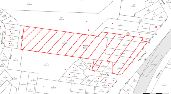
|
NOTIFICATION PLAN |
|
||
|
• PROPERTIES NOTIFIED
|
X SUBMISSIONS RECEIVED |
PROPERTY SUBJECT OF DEVELOPMENT |
|
|
TWO SUBMISSIONS RECEIVED OUT OF MAP RANGE |
|||
Six submissions objected to the development. The grounds for objection are addressed as follows.
5.1.1 High Density Site
A submission raises concerns the current low density residential zoning should be reassessed in response to the site’s proximity to the commercial area, Mount Colah Railway Station and the rezoned R4 High Density Residential precinct.
The site was initially included in Council’s Housing Strategy in 2010 but was deferred following concerns raised by the RFS. The RFS has recently advised that the CSIRO has completed research into the technical requirements for high rise buildings in bushfire prone areas. Further strategic assessment however is required to be undertaken by the RFS including Evacuation Risk Modelling/Management Planning for the deferred precincts at Mount Colah and Berowra to be considered for rezoning.
5.1.2 Stormwater Management
A submission raises concerns the proposed stormwater discharge would impact on the downstream property.
The proposed stormwater drainage system involves on-site dispersal. Subject to recommended conditions the proposed system would not result in flooding impact on neighbouring residents.
5.1.3 Risk of Accidents
A submission raises concerns the cliff area of the site would be unsafe.
The proposed community lot includes bushland and steep terrain and would be subject to a community management scheme for the proposed residential lots. A condition is recommended for an appropriate warning sign to be erected at the top of the cliff area.
A condition is also recommended for fencing of the boundaries of the residential zoned land on the site and for post markers to delineate the boundaries of the land within the environment protection zone.
5.1.4 Invasive Weeds
A submission raises concerns the site should be subject to weed management.
A condition is recommended for preparation of an Integrated Bushfire and Vegetation Management Plan which includes measures to control weeds on the site.
5.1.5 Traffic, Parking & Road Safety
A submission raises issues regarding traffic and parking in Judith Avenue.
The proposed private road is two way and would have a roll back kerb which would enable on-street car parking. The proposed traffic generated by the residential subdivision is within the capacity of the intersection of Judith Avenue with the Pacific Highway.
5.1.6 Boundary Fence
A submission raises concerns regarding the need for fencing to minimise privacy impacts from the operation of the private road.
It is considered to be a reasonable request that the applicant be required to construct the boundary fence at nil cost to the neighbouring property owners. A recommended condition of consent has been included in Schedule 1.
5.1.7 Remediation of Land
A submission raised concerns the site had been subject to unauthorised land fill.
The submitted Preliminary Geotechnical Report dated March 2016 and Preliminary Contamination Investigation dated March 2016 identifies the area, depth and nature of the fill material on the site. The fill material comprised mainly building waste. The selected samples analysed were below detectable limits for potential contaminants other than for zinc (heavy metals) and asbestos. Further additional investigation is recommended following demolition of the existing structures on the site. The proposed subdivision construction works would enable excavation and removal of the fill material. The site remediation is required to be validated as suitable for residential use prior to the commencement of civil works on the site.
5.2 Public Agencies
The development application was referred to the following Agencies for comment:
5.2.1 Roads and Maritime Services (RMS)
The RMS granted concurrence for the proposal subject to conditions including condition for kerb and gutter construction along the Pacific Highway frontage.
5.2.2 Rural Fire Service (RFS)
The proposed subdivision of bushfire prone land is integrated development subject to approval of the RFS.
The RFS grants approval for a Bushfire Safety Authority subject to recommended conditions in Schedule 1 of this report.
5.2.3 Department Primary Industries – Water (DPI - Water)
The proposed subdivision involving land traversed by a watercourse is integrated development subject to approval of the DPI – Water.
The Department advised the proposed subdivision works are more than 40m of the watercourse and are not subject to assessment under the Water Management Act 2000.
6. THE PUBLIC INTEREST
Section 79C(1)(e) of the Act requires Council to consider “the public interest”.
The public interest is an overarching requirement, which includes the consideration of the matters discussed in this report. Implicit to the public interest is the achievement of future built outcomes adequately responding to and respecting the future desired outcomes expressed in environmental planning instruments and development control plans.
The application is considered to have satisfactorily addressed Council’s and relevant agencies’ criteria and would provide a development outcome that, on balance, would result in a positive impact for the community. Accordingly, it is considered that the approval of the proposed development would be in the public interest.
CONCLUSION
The proposal is for demolition of existing structures and subdivision of six allotments into 13 lots, in three stages.
The subject site is in close proximity to Mount Colah Railway Station and is bushfire prone land. The proposed subdivision complies with the HLEP minimum lot size development standard applicable to the subject R2 Low Density Residential zone and is satisfactory in meeting the bushfire protection measures of the RFS subject to an integrated vegetation management plan to maintain the site’s biodiversity. A deferred consent commencement condition is recommended in this regard.
The site includes contaminated landfill. Subject to remediation and validation for residential use the proposed subdivision is satisfactory in respect to SEPP 55.
The proposed subdivision in three stages is satisfactory for the orderly development of the site including the Stage 1 creation of the commercial zoned allotment (Lot 101), the Stage 2 demolition, remediation, construction of the private road and stormwater drainage works and creation of Lot 102, and the Stage 3 construction of inter-allotment drainage, fencing, landscaping and creation of the community title lots (Lots 1 to 11).
The proposal generally complies with the requirements of the HDCP and is satisfactory in respect to vegetation preservation, stormwater management, landscaping, residential lands subdivision and accessway design, subject to recommended conditions.
Six submissions were received in response to notification of the proposed subdivision.
The application is recommended for approval subject to deferred consent commencement condition.
Note: At the time of the completion of this planning report, no persons have made a Political Donations Disclosure Statement pursuant to Section 147 of the Environmental Planning and Assessment Act 1979 in respect of the subject planning application.
RESPONSIBLE OFFICER
The officer responsible for the preparation of this Report is the Manager – Development Assessments – Rodney Pickles, who can be contacted on 9847 6731.
|
Rod Pickles Manager - Development Assessment Planning Division |
James Farrington Group Manager Planning Division |
|
1.View |
Locality Plan |
|
|
|
2.View |
Survey Plan |
|
|
|
3.View |
Zoning Plan |
|
|
|
4.View |
Subdivision Plan |
|
|
|
5.View |
Building Envelope Plan |
|
|
|
6.View |
Landscape Plan |
|
|
File Reference: DA/633/2016
Document Number: D07281349
SCHEDULE 1
GENERAL CONDITIONS
The conditions of consent within this notice of determination have been applied to ensure that the use of the land and/or building is carried out in such a manner that is consistent with the aims and objectives of the relevant legislation, planning instruments and council policies affecting the land and does not disrupt the amenity of the neighbourhood or impact upon the environment.
Note: For the purpose of this consent, the term ‘applicant’ means any person who has the authority to act on or the benefit of the development consent.
Note: For the purpose of this consent, any reference to an Act, Regulation, Australian Standard or publication by a public authority shall be taken to mean the gazetted Act or Regulation, or adopted Australian Standard or publication as in force on the date that the application for a construction certificate is made.
1. Deferred Commencement
Pursuant to Section 80(3) of the Environmental Planning and Assessment Act 1979, this consent does not operate until the following information is submitted to Council:
a) An Integrated Bushfire and Vegetation Management Plan (Plan) must be prepared for the proposed Community Lot (Lot 1) which includes the stormwater management facilities and Asset Protection Zone requirements of the NSW Rural Fire Service.
The Plan shall address the management of the Asset Protection Zones and stormwater management facilities in perpetuity for the development. Establishment of the Asset Protection Zones and stormwater facilities are required prior to the issue of the subdivision certificate and shall be incorporated into the Plan’s Schedule of Works.
The Plan shall include but not be limited to the following:
i) Strategies to manage, maintain and conserve the bushland including;
a. On-going weed control and suppression using bush regeneration methods.
b. Habitat protection including hollow-bearing tree retention.
c. The restoration of all disturbed areas using bush regeneration techniques.
ii) Strategies for management of the Asset Protection Zones in a manner that has the least impact on the natural environment and maintains indigenous vegetation for the benefit of the local bushland corridor function. This has to be undertaken in consultation with a Bushfire Management Consultant.
iii) Hand Removal of Bushfire Fuel;
a. Any clearing for bushfire protection within the approved Asset Protection Zones shall be undertaken using manual methods including manual removal of dead timber, raking and removal of leaf litter (fine fuel), manual slashing of understorey vegetation such as a hand held brushcutter and other methods that ensure minimal environmental damage and erosion whilst maintaining the vegetation at a low fuel reduced state. Indigenous vegetation including trees and shrubs shall be retained in partially thinned scattered clumps to ensure the vegetation is non-continuous. Underscrubbing is to retain 15 centimetres of groundcover vegetation (including grass and herbaceous species) and all vegetation greater than three metres in height is to be otherwise retained. No removal of native vegetation shall occur within 10 metres of a natural watercourse. Clearing is not permitted in bushland outside the asset protection zone. No mulch or garden waste is to be deposited in bushland.
iv) The key performance criteria are to read ‘Noxious Weeds to be less that 2% cover at the end of each maintenance visit. Other weed species to be less than 4% cover at the end of each maintenance visit.’ Primary and secondary weeding of noxious weeds is required prior to issue of the subdivision certificate.
a. Weeds of particular concern are:
· Pampas Grass (Cortaderia selloana)
· Broad-leaf Privet (Ligustrum lucidum)
· Small-leaf Privet (Ligustrum sinense)
· Lantana, Rhus (Toxicodendron succedaneum)
· Scotch Broom (Cytisus scoparius)
· Camphor Laurel (Cinnamomum camphora)
· Ground Asparagus (Asparagus aethiopicus)
· Morning Glory (Ipomoea indica)
· Japanese Honeysuckle (Lonicera japonica)
· Mother-of-Millions (Bryophyllum delagoense)
· Ochna (Ochna serrulata)
· African Feather Grass (Pennisetum macrourum)
v) Provide details of any revegetation works and species/ densities to be used within biofiltration basins (separate to the Landscape Masterplan).
vi) Schedule of works including timeframes and responsibilities for management actions. Provide a cost schedule to undertake all rehabilitation actions, including maintenance.
vii) Erosion, sediment and stormwater runoff controls including the management of impacts of run-off from all impervious surfaces including pavement areas. Management and maintenance of approved stormwater facilities and drainage areas.
viii) Appropriate aerial map of the site including a weed map.
ix) Details of qualifications and experience of company preparing the plan. The plan shall be prepared by a qualified and experienced bushland restoration consultant and shall be consistent with the approved bushfire assessment report. The pan shall be submitted to Council’s Natural Resources Unit for approval.
x) Details of site monitoring including the submission of monitoring reports to Council of bushland management and restoration.
xi) All on-ground works must be managed by a suitably qualified bush regenerator or restoration ecologist who is to be a vegetation management specialist and to have at least 4 years experience in the management of native bushland and at least a TAFE Certificate III in Bush Regeneration or Conservation and Land Management – Natural Area Restoration qualifications.
xii) Maintenance visits are to be conducted at 3-monthly intervals for the first year after consent and 6-monthly intervals for the subsequent years.
b) The submitted Landscape Masterplan is to be revised in accordance with the approved subdivision plan and the following:
i) The landscape plan is to include planting dominated by locally indigenous native plant species consistent with Peppermint-Angophora Forest vegetation community as described by Smith & Smith (2008). The use of tube stock is recommended and plant stock that be obtained from a recognised native nursery.
ii) The ‘Vegetation Planting Outline’ on the ‘Vegetation Management Plan’ sheet prepared by Environment Peninsula Issue EP 327/A provided management actions within identified Zone V2 and V3. These zone shall be superceded by the specifications of the ‘Integrated Bushfire and Vegetation Management Plan’ endorsed by Council under Condition No. 1.
iii) The landscape plan must include a Schedule Works and generic specification for planting survival, establishment, maintenance and replenishment (due to natural mortality). The schedule of works shall indicate the timing of landscaping works in relation to important development time frames for the staged development to assist in compliance and certification.
iv) The landscape plan must include pavement treatment, lighting and plantings to promote and define public space within the development.
v) The brick pier and palisade fence along the Pacific Highway frontage to be setback 0.5m and landscaped. The fence and landscaping are to be subject to an easement for maintenance by the Community Management Scheme.
Such information must be submitted within 24 months of the date of this notice.
Upon Council’s written satisfaction of the above information, the following conditions of development consent apply:
2. Approved Plans and Supporting Documentation
The development must be carried out in accordance with the plans and documentation listed below and endorsed with Council’s stamp, except where amended by Council and/or other conditions of this consent:
|
Plan No. |
Plan Title |
Drawn by |
Dated |
|
15360 Judith |
Plan Illustrating Proposed Lots and Staging |
Michael Kirkwood and Associates Pty Ltd |
24/07/17 |
|
Issue EP 327/A |
Landscape Masterplan |
Mark Eriksson |
May 2016 |
|
Issue 327/2A |
Elevations / Cross Sections |
Mark Eriksson |
April 2016 |
|
Issue 327/2A |
Elevations / Cross Sections |
Mark Eriksson |
April 2016 |
|
Issue 327/1A/A |
Schematic Landscape Plan |
Mark Eriksson |
April 2016 |
|
Document Title |
Prepared by |
Dated |
|
Bushfire Assessment Report |
Advanced Bushfire Performance Solutions |
4 April 2017 |
|
Bushfire Assessment Report |
Advanced Bushfire Performance Solutions |
May 2016 |
|
Stormwater Management Plan |
Storm Consulting Pty Ltd |
15/4/16 |
|
Preliminary Contamination Investigation |
GeoEnviro Consulting Pty Ltd |
March 2016 |
|
Arboricultural Impact Report |
Guy Paroissien |
15 March 2016 |
|
Assessment of Fauna and Flora |
Aquila Ecological Surveys |
April 2016 |
|
Preliminary Geotechnical Assessment |
Martens Consulting Engineers |
March 2016 |
|
Waste Management Plan |
Lindsay Dyce |
15/9/2017 |
3. Amendment of Plans
a) To comply with Councils requirement in terms of landscaping, the approved Landscape Masterplan is to be revised in accordance with the approved subdivision plan and the following:
i) The landscape plan is to include planting dominated by locally indigenous native plant species consistent with Peppermint-Angophora Forest vegetation community as described by Smith & Smith (2008). The use of tube stock is recommended and plant stock that be obtained from a recognised native nursery.
ii) The ‘Vegetation Planting Outline’ on the ‘Vegetation Management Plan’ sheet prepared by Environment Peninsula Issue EP 327/A provided management actions within identified Zone V2 and V3. These zone shall be superceded by the specifications of the ‘Integrated Bushfire and Vegetation Management Plan’ endorsed by Council under Condition No. 1.
iii) The landscape plan must include a Schedule Works and generic specification for planting survival, establishment, maintenance and replenishment (due to natural mortality). The schedule of works shall indicate the timing of landscaping works in relation to important development time frames for the staged development to assist in compliance and certification.
iv) The landscape plan must include pavement treatment, lighting and plantings to promote and define public space within the development.
v) The brick pier and palisade fence along the Pacific Highway frontage to be setback 0.5m and landscaped. The fence and landscaping are to be subject to an easement for maintenance by the Community Management Scheme.
b) These amended plans must be submitted with the application for the Construction Certificate.
4. Removal of Existing Trees
a) This development consent permits the removal of trees numbered 2, 3, 5, 6, 17, 20, 30, 31, 32, 33, 34, 35, 41, 43, 47, 50, 51, 52, 53, 62, 63, 64, 65, 66, 67 and 69 as identified in the Arboricultural Impact Report dated 15 March 2016 prepared by Guy Paroissien.
b) The removal of any other trees requires separate approval in accordance with the Tree and Vegetation Chapter 1B.6 Hornsby Development Control Plan (HDCP).
5. Construction Certificate
a) A Construction Certificate is required to be approved by Council or a Private Certifying Authority prior to the commencement of any works under this consent.
b) A separate Construction Certificate must be obtained from Council for all works within the public road reserve under S138 of the Roads Act.
c) A separate Construction Certificate must be obtained from Council for all works within drainage easements vested in Council.
d) The Construction Certificate plans must not be inconsistent with the Development Consent plans.
STAGE ONE – LOT 101 & RESIDUE
6. Sydney Water – s73 Certificate
A s73 Certificate must be obtained from Sydney Water and submitted to the PCA.
Note: Sydney Water requires that s73 applications are to be made through an authorised Sydney Water Servicing Coordinator. Refer to www.sydneywater.com.au or telephone 13 20 92 for assistance.
7. Creation of Easements
The following matter(s) must be nominated on the plan of subdivision under s88B of the Conveyancing Act, 1919:
a) An inter-allotment drainage easement(s) over each of the burdened lots.
STAGE TWO – LOT 102 & RESIDUE
8. Section 94 Development Contributions
a) In accordance with Section 80A(1) of the Environmental Planning and Assessment Act, 1979 and the Hornsby Shire Council Section 94 Development Contributions Plan 2014-2024, the following monetary contributions must be paid to Council to cater for the increased demand for community infrastructure resulting from the development:
|
Description |
Contribution (4) |
|
Roads |
$1,902.47 |
|
Open Space and Recreation |
$13,041.80 |
|
Community Facilities |
$5,013.66 |
|
Plan Preparation and Administration |
$42.07 |
|
TOTAL |
$20,000.00 |
being for one residential lot.
b) The value of this contribution is current as at 10 October 2017. If the contribution is not paid within the financial quarter that this condition was generated, the contribution payable will be adjusted in accordance with the provisions of the Hornsby Shire Council Section 94 Development Contributions Plan and the amount payable will be calculated at the time of payment in the following manner:
$CPY = $CDC x CPIPY
CPIDC
Where:
$CPY is the amount of the contribution at the date of Payment
$CDC is the amount of the contribution as set out in this Development Consent
CPIPY is the latest release of the Consumer Price Index (Sydney – All Groups) at the date of Payment as published by the ABS.
CPIDC is the Consumer Price Index (Sydney – All Groups) for the financial quarter at the date applicable in this Development Consent Condition.
c) The monetary contribution must be paid to Council:
i) prior to the issue of the Subdivision Certificate where the development is for subdivision; or
ii) prior to the issue of the first Construction Certificate where the development is for building work; or
iii) prior to issue of the Subdivision Certificate or first Construction Certificate, whichever occurs first, where the development involves both subdivision and building work; or
iv) prior to the works commencing where the development does not require a Construction Certificate or Subdivision Certificate.
Note: It is the professional responsibility of the Principal Certifying Authority to ensure that the monetary contributions have been paid to Council in accordance with the above timeframes.
Council’s Development Contributions Plan may be viewed at www.hornsby.nsw.gov.au or a copy may be inspected at Council’s Administration Centre during normal business hours.
REQUIREMENTS PRIOR TO THE ISSUE OF A CONSTRUCTION CERTIFICATE
9. Building Code of Australia
All approved building work must be carried out in accordance with the relevant requirements of the Building Code of Australia.
10. Utility Services
The applicant must submit written evidence of the following service provider requirements:
a) Ausgrid (formerly Energy Australia) – a letter of consent demonstrating that satisfactory arrangements have been made to service the proposed development.
b) Telstra - a letter of consent demonstrating that satisfactory arrangements have been made to service the proposed development.
11. Traffic Control Plan
A Traffic Control Plan (TCP) must be prepared by a qualified traffic controller in accordance with the Roads & Traffic Authority’s Traffic Control at Worksites Manual 1998 and Australian Standard 1742.3 for all work on a public road. The Traffic Management Plan shall be submitted and approved by Council’s for any works near or within the adjacent public roads. This plan is to be submitted with any application for construction within the public road. The TCP must detail the following:
a) Arrangements for public notification of the works;
b) Temporary construction signage;
c) Permanent post-construction signage;
d) Vehicle movement plans;
e) Traffic management plans; and
f) Pedestrian and cyclist access/safety.
12. Construction Environmental Management Plan
The site must be managed in accordance with the publication ‘Managing Urban Stormwater – Landcom (March 2004) and the Protection of the Environment Operations Act 1997 by way of implementing appropriate measures to prevent sediment run-off, excessive dust, noise or odour emanating from the site during the construction of the development.
The applicant shall prepare a Construction Environmental Management Plan (CEMP) which shall be submitted to Council for approval. The CEMP shall be prepared by a suitably qualified and experienced person. The plan shall include the following:
a) Scaled survey plan of the site showing the development footprint in relation to the remnant trees and other bushland proposed for retention,
b) Location of protective fencing (1.8m high cyclone mesh) installed around bushland areas proposed for retention and to be clearly delineated from building works areas,
c) Location of tree protection fences for specific trees approved for retention,
d) Location of temporary and permanent trenches required for installation of services,
e) Location and specification of sediment and erosion control fencing to prevent degradation of bushland occurring immediately down-slope of the proposed stormwater facilities and other development (in accordance with Council’s Blue Book – Sustainable Water Best Practices),
f) Location of soil, mulch, waste and building material stock piles,
g) Location of dedicated construction vehicle parking areas,
h) Specifications of approved cut and fill,
i) Location of road-base only within the approved development foot print (i.e. driveway),
j) Notation describing ‘that no mulch is to be applied within remnant bushland areas’,
k) Phytophthora management protocols,
l) A qualified arborist (AQF5 level) shall supervise the severance of any roots greater than 40mm,
m) Notations describing that an ecologist shall be on site during tree clearing works to ensure fauna is relocated. Prior to the approved removal of hollow bearing trees the applicant is to carry out the following actions to prevent harm to native wildlife:
i) . Ensure the trees are removed in sections by a qualified Tree Surgeon just prior to dusk when roosting animals would be alert and likely to disperse ‘naturally’ from the site. Ensure that trees are knocked several times (with a hammer etc.) to alert any roosting animals of the possibility of danger. Ensure that all tree hollows are be examined prior to and immediately after their removal to ensure roosting animals are free from danger.
ii) WIRES (Wildlife Rescue) volunteers can be contacted on (02) 8977 3333 or Wildlife Services Sydney Metropolitan volunteers can be contacted on (02) 9413 4300. Information on animal nesting boxes can be gained from WIRES, Kalkari Information Centre in Ku-Ring-Gai Chase National Park, or Birds Australia web site – www.birdsaustralia.com.au
n) Provide a Schedule of Works (table format) noting the required environmental protection measures during certain stages/ milestones of the works and who is responsible for undertaking them,
o) Provide environmental inductions to other civil works and building contractors working on the site, and
p) Provide details of monitoring for impacts to water quality and protection of native vegetation prior to commencement of any works (to be undertaken by an appointed Project Ecologist before, during and after the completion of the works). Compliance with the CEMP shall be signed off by Council’s Natural Resources Unit Team following the provision of written confirmation from the Project Ecologist prior to issue of the Occupation Certificate.
13. Appointment of Environmental Experts
The applicant shall notify Council’s Natural Resources Unit the details of the engaged Project Ecologist, Arborist, Bushfire Consultant and Bush Regenerator that will be involved with the environmental protection works during the construction of the approved development. These environmental experts will assist in ensuring compliance with the conditions of consent and provide monitoring reports to Council at various stages of the Project as identified with the forthcoming Construction Environment Management Plan and Integrated Bushfire and Vegetation Management Plan.
14. Asset Protection Zones Marked Boundary
To ensure that the Asset Protection Zone requiring treatment is clearly defined as an area separate to retained trees and other native vegetation, the boundary of the Asset Protection Zone for bushfire protection shall be marked with permanent metal stakes to prevent fuel reduction activities and vegetation clearing from encroaching into native bushland and the riparian zone. The engaged bushfire consultant shall confirm the locations of the APZ as specified within the Integrated Bushfire and Vegetation Management Plan.
15. Primary Weed Control
Primary weed control measures as directed within the approved shall be implemented within the creek line prior to the release of the Construction Certificate. Weed removal works shall only be undertaken by a qualified and experienced bush regeneration company and certification provided to Council. The works shall be inspected by Council’s Bushland Biodiversity Team for approval.
16. Identification of Survey Marks
A registered surveyor must identify all survey marks in the vicinity of the proposed development. Any survey marks required to be removed or displaced as a result of the proposed development shall be undertaken by a registered surveyor in accordance with Section 24 (1) of the Surveying and Spatial Information Act 2002 and following the Surveyor General’s Directions No.11 – "Preservation of Survey Infrastructure".
17. Stormwater Drainage
The stormwater drainage system for the development must be designed in accordance with Council’s Civil Works – Design and Construction Specification 2005 and the following requirements:
a) Connected directly to the proposed On Site Detention and WSUD system.
b) All allotments are to be provided with a stormwater drainage pit, unless direct drainage to the internal or external roads is available.
c) The proposed drainage system be piped to contain the 20 year Average Recurrence.
d) The proposed discharge point is to be provided with a level spreader so that stormwater drainage is evenly dispersed.
18. On Site Stormwater Detention/Water Saving Urban Design
An on-site stormwater detention (OSD) system and water saving urban design (WSUD) is to be constructed generally in accordance with the stormwater drainage report prepared by Storm Civil Engineers Project No 1824 dated May 2015 and the following requirements.
a) Provision of a level spreader to control the discharge from the OSD and Bio Retention area;
b) The proposed bio retention system is to be designed in accordance with Councils WSUD reference guide;
c) Vegetation to be used within the bio retention area is to be planted at a minimum of 8 plants per square meter and the plant species are to be in accordance with Councils WSUD reference guide;
d) Where the depth of the bio retention OSD is greater than 0.3 metres, a ‘pool type’ safety fence and warning signs must be installed.
19. Internal Driveway/Vehicular Areas
The driveway and parking areas on site must be designed, constructed and a Construction Certificate issued in accordance with Australian Standards 2890.1, 2890.2, 3727 and the following requirements:
a) Design levels at the front boundary be obtained from Council.
b) The driveway be a rigid pavement.
c) All lots are to be accessed from the proposed community title road except for proposed lot 101 which is accessed from the Pacific Highway.
d) The driveway grade must not exceed 15.4% percent and all changes of grade are to have appropriate transitions or suitable vertical curves.
e) A roll type kerb is to be provided on each side on the communal driveway..
f) Retaining walls required to support the carriageway and the compaction of all fill batters to be in accordance with the requirements of a chartered structural engineer.
g) The provision of safety rails where there is a level difference more than 0.3 metres and a 1:4 batter cannot be achieved.
h) Conduit for utility services including electricity, water, gas and telephone be provided. All existing overhead assets including electricity and telecommunications cabling shall be relocated underground at no cost to Council. A certificate from an appropriately licensed contractor shall be submitted to the principal certifying authority certifying that the service conduits have been installed in accordance with the relevant utility provider and Australian Standards.
20. Vehicular Crossing
A separate application under the Local Government Act, 1993 and the Roads Act 1993 must be submitted to Council for the installation of a new vehicular crossing and the removal of the redundant crossing. The vehicular crossing must be constructed in accordance with Council’s Civil Works Design 2005 and the following requirements:
a) Design levels at the front boundary must be obtained from Council for the design on the internal driveway(s);
b) Any redundant crossings must be replaced with integral kerb and gutter;
c) The footway area must be restored by turfing;
d) Approval must be obtained from all relevant utility providers that all necessary conduits be provided and protected under the crossing.
Note: An application for a vehicular crossing can only be made to one of Council’s Authorised Vehicular Crossing Contractors. You are advised to contact Council on 02 9847 6940 to obtain a list of contractors.
21. Water Saving Urban Design
A Water Saving Urban Design (WSUD) is to be constructed generally in accordance with the engineering report and plans Storm Civil Engineers Project No 1824 dated May 2015. The Water Quality Targets as detailed within the report and Hornsby Shire Councils DCP are to be achieved in the design and supported by a MUSIC model.
22. Construction Management Plan (CMP)
To assist in the protection of the public, the environment and Council’s assets, a separate Construction Management Plan is to be prepared by a suitably qualified environmental consultant in consultation with a qualified traffic engineer, is to be submitted to Council’s Compliance Team for approval to be used by workers and Council as on-site reference during demolition, excavation and construction works, according to the following requirements:-
a) The CMP will detail the contact information for all development phases for developers, builder, site foremen, private certifier, environmental management consultant and any emergency details.
b) The plan will include a Construction Traffic Management Plan (CTMP) which will include information detailing the following:-
i) Truck movements to and from the site, including the routes used, swept path diagrams entering and exiting the site and implemented traffic control;
ii) Site plan showing site sheds, concrete pump location and crane location;
iii) The requirement for Work Zones, Road Openings, Road Closures, Crane Permits and Road Occupancy licenses;
iv) Safe pedestrian management details including during local school and commuter hours where the footpath is heavily frequented.
c) The plan will include Construction Waste Management information detailing the following:-
i) Details on the requirement for importation or excavation of soil and fill including the waste classification of the fill, disposal methods and locations of authorised disposal depots that will be used for the fill;
ii) Asbestos Information must be included on the requirement and procedures for removal and disposal from the site in accordance with Australian Standard: 2601–2001 – ‘The Demolition of Structures’, and the Protection of the Environment Operations (Waste) Regulation 2005;
iii) General construction waste details including construction waste skip bin locations and litter management for workers.
d) Information to be prepared on the management of stormwater disposal from any detention basin or trapped within the site throughout all development phases in accordance with the ANZECC Guidelines trigger values for the area.
e) Sediment and Erosion control details including the procedures during rainfall events and site plans included within the Appendices, all in accordance with the ‘Soils and Construction 2004 (Bluebook)’ and consistent to other development application approved environmental plans.
f) Information on air quality management on site, including but not limited to dust suppression measure throughout demolition and construction.
g) Details on the general operating procedures to manage environmental risk throughout all stages of works on the site;
h) To ensure the quality of Council’s footpath is maintained throughout the development, mitigation measures and information is to be included on procedures that will be implemented to keep the footpath clear and free of trip hazards and obstructions.
i) Information and details to be included on the requirement of a ‘Hoarding Permit’ for the use of Council’s verge at any stage during the development period, a plan showing the location and details of the hoarding are to be included in the Appendices.
j) Details on the requirement for any ‘Out of Hours’ permits during the development in cases such as concrete pours including the frequency and reasoning for the applications.
k) Noise and vibration control information to address any noise nuisances such as rock sawing or breaking, the mitigation methods implemented and how complaints will be managed or prevented.
23. Excavation
A detailed geotechnical assessment of the site by a chartered structural engineer is to be undertaken for the design of the subdivision, in accordance with the recommendations of the Geotechnical Assessment prepared by Marten Consulting Engineers dated March 2016.
REQUIREMENTS PRIOR TO THE COMMENCEMENT OF ANY WORKS
24. Erection of Construction Sign
a) A sign must be erected in a prominent position on any site on which any approved work is being carried out:
i) Showing the name, address and telephone number of the principal certifying authority for the work;
ii) Showing the name of the principal contractor (if any) for any demolition or building work and a telephone number on which that person may be contacted outside working hours; and
iii) Stating that unauthorised entry to the work site is prohibited.
b) The sign is to be maintained while the approved work is being carried out and must be removed when the work has been completed.
25. Protection of Adjoining Areas
A temporary hoarding, fence or awning must be erected between the work site and adjoining lands before the works begin and must be kept in place until after the completion of the works if the works:
a) Could cause a danger, obstruction or inconvenience to pedestrian or vehicular traffic;
b) Could cause damage to adjoining lands by falling objects; and/or
c) Involve the enclosure of a public place or part of a public place.
Note: Notwithstanding the above, Council’s separate written approval is required prior to the erection of any structure or other obstruction on public land.
26. Toilet Facilities
a) To provide a safe and hygienic workplace, toilet facilities must be available or be installed at the works site before works begin and must be maintained until the works are completed at a ratio of one toilet for every 20 persons employed at the site.
b) Each toilet must:
i) be a standard flushing toilet connected to a public sewer; or
ii) be a temporary chemical closet approved under the Local Government Act 1993; or
iii) have an on-site effluent disposal system approved under the Local Government Act 1993.
27. Erosion and Sediment Control
To protect the water quality of the downstream environment, erosion and sediment control measures must be provided and maintained throughout the construction period in accordance with the manual ‘Soils and Construction 2004 (Bluebook)’, the approved plans, Council specifications and to the satisfaction of the principal certifying authority. The erosion and sediment control devices must remain in place until the site has been stabilised and revegetated.
Note: On the spot penalties may be issued for any non-compliance with this requirement without any further notification or warning.
28. Installation of Tree Protection
a) All trees retained on site must have tree protection measures for the ground, trunk and canopy installed in accordance with the Australian Standard ‘Protection of Trees on Development Sites (AS 4970-2009).
b) Tree protection zone fencing must be erected around trees numbered 1, 7-11, 13-16, 21-26, 39, 40, 42, 44-46, 48-49 and 55-58 as specified in the Arboricultural Impact Assessment prepared by Guy Paroissien dated 15 March 2016.
29. Tree Protection Zone Ground Protection
All Tree Protection Zones must have a layer of wood-chip mulch installed prior to works commencing and must be maintained throughout the period of construction at a depth of 150mm – 300mm using material that complies with Australian Standard AS 4454.
30. Tree Protection Certification
A certificate from the project arborist must be submitted to the Principal Certifying Authority and Council stating compliance with the relevant tree protection conditions of this consent.
REQUIREMENTS DURING CONSTRUCTION
31. Detailed Contamination Report and Remedial Action Plan
Prior to the commencement of any civil works on the site a detailed investigation of the proposed development site must be prepared by a suitably qualified environmental consultant. Such investigation must be undertaken in accordance with NSW Environment Protection Authority’s Contaminated Sites – Guidelines for Consultants Reporting on Contaminated Sites and Contaminated Sites – Sampling Design Guidelines.
A Remedial Action Plan (RAP) must be prepared by a suitably qualified environmental consultant and submitted to Council should the detailed investigation reveal contamination exceeding criteria prescribed by the NSW Environment Protection Authority’s Contaminated Sites – Guidelines for the NSW Site Auditor Scheme.
32. Construction Work Hours
All works on site, including demolition and earth works, must only occur between 7am and 5pm Monday to Saturday.
No work is to be undertaken on Sundays or public holidays.
33. Demolition
To protect the surrounding environment, all demolition work must be carried out in accordance with “Australian Standard 2601-2001 – The Demolition of Structures” and the following requirements:
a) Demolition material must be disposed of to an authorised recycling and/or waste disposal site and/or in accordance with an approved waste management plan; and
b) Demolition works, where asbestos material is being removed, must be undertaken by a contractor that holds an appropriate licence issued by SafeWork NSW in accordance with the Work Health and Safety Regulation 2017 and be appropriately transported and disposed of in accordance with the Protection of the Environment Operations (Waste) Regulation 2014; and
c) On construction sites where any building contain asbestos material, a standard commercially manufactured sign containing the words ‘DANGER ASBESTOS REMOVAL IN PROGRESS’ and measuring not less than 400mm x 300mm must be displayed in a prominent position visible from the street.
34. Environmental Management
The site must be managed in accordance with the publication ‘Managing Urban Stormwater – Landcom (March 2004) and the Protection of the Environment Operations Act 1997 by way of implementing appropriate measures to prevent sediment run-off, excessive dust, noise or odour emanating from the site during the construction of the development.
35. Street Sweeping
To protect the surrounding environment, Street sweeping must be undertaken following sediment tracking from the site along Judith Avenue during works and until the site is established.
The street cleaning services must undertake a street ‘scrub and dry’ method of service and not a dry sweeping service that may cause sediment tracking to spread or cause a dust nuisance.
36. Works Near Trees
a) Maintaining Tree Health
The project arborist must monitor and record any necessary remedial actions for maintaining tree health and condition required for trees numbered 1, 7-11, 13-16, 21-26, 39, 40, 42, 44-46, 48-49 and 55-58.
b) Maintenance and Monitoring of Tree protection
The appointed project arborist must monitor and record all changes or modifications to required tree protection measures for the period of construction.
37. Works Within Tree Protection Zones - Trees Numbered: 7-9, 11, 13-16, 23, 28 and 55
a) Root Pruning
All Root pruning must be recorded and undertaken as specified in Australian Standard AS 4970-2009 Sections 3.3.4, 4.5.4 and 4.5.5. Add Project Arborist.
b) Driveway/Concrete Slabs (no-strip footing)
i) A New driveway must be constructed above grade using sensitive methods such as piers or screw pilings to minimise compaction within the tree protection zone.
ii) All imported material must be distributed by hand.
c) Deck/House Foundation/Footings
New foundation/footing must provide a 100mm clearance above soil and be of sensitive construction techniques such as screw pilings or piers, cantilevered or suspended slab design.
d) Excavation
Any necessary excavation must be undertaken by sensitive methods such as pneumatic or by hand as prescribe in AS 4970-2007 Sections 4.5.5.
e) Changing of Grade (minor/major)
Existing grade must be retained within the TPZ of all trees being retained.
f) Installing Services
i) The installation of all services which enter or transects a designated TPZ must utilise sensitive methods of installation such as directional drilling or in manually excavated trenches.
ii) The process must be monitored by the project arborist to assess the likely impacts of boring and bore pits on retained trees.
iii) For manual excavation of trenches the project arborist must advise on roots to be retained and must monitor the works. Manual excavation may include the use of pneumatic and hydraulic tools. Refer Clause 4.5.3.
38. Building Materials and Site Waste (Minor/Major)
The filling or stockpiling of building materials, the parking of vehicles or plant, the disposal of cement slurry, waste water or other contaminants must be located outside the tree protection zones as prescribed in the conditions of this consent or the prescriptive measures of Part 1B.6.1 Tree Preservation of the Hornsby Development Control Plan 2013, of any tree to be retained.
39. Works Near Trees Certification
The project arborist must submit to the principal certifying authority on a monthly a certificate that the works have been carried out in compliance with the approved plans and specifications for tree protection. Certification should include a statement of site attendance, the condition of the retained trees, details of any deviations from the approved tree protection measures and their impacts on trees. Copies of monitoring documentation may be required.
40. Bushland and Watercourse Protection
All works shall comply with the approved Construction Environment Management Plan AND Integrated Bushfire and Vegetation Management Plan.
Monitoring reports shall be prepared by the Project Ecologist during critical stages of the construction works as identified within the Schedule of Works contained within the approved Construction Environment Management Plan.
A qualified and experienced bushfire consultant shall tag the trees approved for removal as part of the Asset Protection Zone. Bushland protection and sediment control fencing type and location (as specified in the Construction Environment Management Plan) shall be maintained and remain in place during the entire period of the construction works.
41. Removal of Hollow Bearing Trees
Prior to the approved removal of hollow bearing trees the Project Ecologist is to carry out the following actions to prevent harm to native wildlife:
a) Capture wildlife from the hollows with traps set at a minimum one or two nights prior to tree removal. Any wildlife captured shall be relocated locally into a nesting box.
b) Arrange for a Wildlife Carers Organisation to be present on site during tree felling to assist in the event of fauna injury due to the presence of tree hollows that provide habitat for native fauna.
c) Ensure the trees are removed in sections by a qualified Tree Surgeon just prior to dusk when roosting animals would be alert and likely to disperse ‘naturally’ from the site. Ensure that trees are knocked several times (with a hammer etc.) to alert any roosting animals of the possibility of danger. Ensure that all tree hollows are be examined prior to and immediately after their removal to ensure roosting animals are free from danger.
Information Note: WIRES (Wildlife Rescue) volunteers can be contacted on (02) 8977 3333 or Wildlife Services Sydney Metropolitan volunteers can be contacted on (02) 9413 4300. Information on animal nesting boxes can be gained from WIRES, Kalkari Information Centre in Ku-Ring-Gai Chase National Park, or Birds Australia web site – www.birdsaustralia.com.au
42. Disturbance of Existing Site
During construction works, the existing ground levels of open space areas and natural landscape features, including natural rock-outcrops, vegetation, soil and watercourses must not be altered unless otherwise nominated on the approved plans.
43. Construction Management Plan Compliance
The development must be carried out in accordance with the submitted and approved construction management plan.
44. Landfill
Landfill must be constructed in accordance with Council’s ‘Construction Specification 2005’ and the following requirements:
a) Prior to fill material being imported to the site, a certificate shall be obtained from a suitably qualified environmental consultant confirming the fill wholly consists of Virgin Excavated Natural Material (VENM) as defined in Schedule 1 of the Protection of the Environment Operations Act, 1997 or material approved under the Department of Environment and Climate Change’s general resource recovery exemption.
b) A compaction certificate is to be obtained from a suitably qualified geotechnical engineer verifying that the specified compaction requirements have been met.
c) These certificates must be included with the application for an occupation certificate.
45. Excavated Material
All excavated material removed from the site must be classified by a suitably qualified person in accordance with the Department of Environment, Climate Change and Water NSW Waste Classification Guidelines prior to disposal to an approved waste management facility and be reported to the principal certifying authority prior to the issue of an Occupation Certificate.
46. Waste Management
All work must be carried out in accordance with the approved waste management plan.
REQUIREMENTS PRIOR TO THE ISSUE OF A SUBDIVISION CERTIFICATE
Note: For the purpose of this consent, a reference to ‘occupation certificate’ shall not be taken to mean an ‘interim occupation certificate’ unless otherwise stated.
47. Sydney Water – s73 Certificate
A s73 Certificate must be obtained from Sydney Water and submitted to the PCA..
Note: Sydney Water requires that s73 applications are to be made through an authorised Sydney Water Servicing Coordinator. Refer to www.sydneywater.com.au or telephone 13 20 92 for assistance.
48. Certification of WSUD Facilities
Prior to the issue of a Subdivision Certificate a certificate from a Civil Engineer is to be obtained stating that the WSUD facilities have been constructed and will meet the water quality targets as specified in the Hornsby Shire Councils DCP.
49. Damage to Council Assets
To protect public property and infrastructure, any damage caused to Council’s assets as a result of the construction or demolition of the development must be rectified by the applicant in accordance with Council’s Civil Works Specifications. Rectification works must be undertaken prior to the issue of an Occupation Certificate, or sooner, as directed by Council.
50. Creation of Easements
The following matter(s) must be nominated on the plan of subdivision under s88B of the Conveyancing Act, 1919:
a) An inter-allotment drainage easement(s) over each of the burdened lots;
b) The creation of an appropriate "Positive Covenant" and "Restriction as to User" over the constructed on-site detention/retention systems and bio retention area, in favour of Council in accordance with Council’s prescribed wording. The position of the on-site detention and bio retention system is to be clearly indicated on the title;
c) To register the OSD easement, the restriction on the use of land “works-as-executed” details of the on-site-detention system and bio retention must be submitted verifying that the required storage and discharge rates have been constructed in accordance with the design requirements. The details must show the invert levels of the on site system together with pipe sizes and grades. Any variations to the approved plans must be shown in red on the “works-as-executed” plan and supported by calculations;
Note: Council must be nominated as the authority to release, vary or modify any easement, restriction or covenant.
51. Retaining Walls
All required retaining walls must be constructed as part of the development.
52. Works as Executed Plan
A works-as-executed plan(s) must be prepared by a registered surveyor and submitted to Council for completed road pavement, kerb & gutter, public drainage systems, driveways and on-site detention system. The plan(s) must be accompanied by a certificate from a registered surveyor certifying that all pipelines and associated structures lie wholly within any relevant easements.
53. Site Remediation Verification
Where a RAP is required as in Condition No. 40, the applicant must provide documentation from a suitably qualified environmental consultant verifying that the site has been remediated in accordance with the NSW Environment Protection Authority’s Contaminated Sites – Guidelines for Consultants Reporting on Contaminated Sites, the Contaminated Sites - Sampling Design Guidelines Contaminated Sites – Guidelines for the NSW Site Auditor Scheme and the recommendations of the approved Remedial Action Plan.
54. Naming of Private Roads
The proposed name of the community title road must be submitted to Council for approval.
Note: The Geographical Names Board provides guidelines for the naming of roads at: www.gnb.nsw.gov.au.
55. Preservation of Survey Marks
A certificate by a Registered Surveyor must be submitted to the Principal Certifying Authority, certifying that there has been no removal, damage, destruction, displacement or defacing of the existing survey marks in the vicinity of the proposed development or otherwise the re-establishment of damaged, removed or displaced survey marks has been undertaken in accordance with the Surveyor General’s Direction No.11 – “Preservation of Survey Infrastructure”.
56. Construction of engineering works.
All engineering works identified in this consent are to be completed and a Compliance Certificate issued prior to the release of the Occupation Certificate or Subdivision Certificate
STAGE THREE – LOT 1 (Community Lot) & LOTS 2-11
57. Section 94 Development Contributions
a) In accordance with Section 80A(1) of the Environmental Planning and Assessment Act, 1979 and the Hornsby Shire Council Section 94 Development Contributions Plan 2014-2024, the following monetary contributions must be paid to Council to cater for the increased demand for community infrastructure resulting from the development:
|
Description |
Contribution (4) |
|
Roads |
$7,609.88 |
|
Open Space and Recreation |
$52,167.20 |
|
Community Facilities |
$20,054.64 |
|
Plan Preparation and Administration |
$168.28 |
|
TOTAL |
$80,000.00 |
being for 10 residential lots and including a credit of six existing residential lots.
b) The value of this contribution is current as at 10 October 2017. If the contribution is not paid within the financial quarter that this condition was generated, the contribution payable will be adjusted in accordance with the provisions of the Hornsby Shire Council Section 94 Development Contributions Plan and the amount payable will be calculated at the time of payment in the following manner:
$CPY = $CDC x CPIPY
CPIDC
Where:
$CPY is the amount of the contribution at the date of Payment
$CDC is the amount of the contribution as set out in this Development Consent
CPIPY is the latest release of the Consumer Price Index (Sydney – All Groups) at the date of Payment as published by the ABS.
CPIDC is the Consumer Price Index (Sydney – All Groups) for the financial quarter at the date applicable in this Development Consent Condition.
c) The monetary contribution must be paid to Council:
i) prior to the issue of the Subdivision Certificate where the development is for subdivision; or
ii) prior to the issue of the first Construction Certificate where the development is for building work; or
iii) prior to issue of the Subdivision Certificate or first Construction Certificate, whichever occurs first, where the development involves both subdivision and building work; or
iv) prior to the works commencing where the development does not require a Construction Certificate or Subdivision Certificate.
Note: It is the professional responsibility of the Principal Certifying Authority to ensure that the monetary contributions have been paid to Council in accordance with the above timeframes.
Council’s Development Contributions Plan may be viewed at www.hornsby.nsw.gov.au or a copy may be inspected at Council’s Administration Centre during normal business hours.
REQUIREMENTS PRIOR TO THE ISSUE OF A CONSTRUCTION CERTIFICATE
58. Building Code of Australia
All approved building work must be carried out in accordance with the relevant requirements of the Building Code of Australia.
59. Utility Services
The applicant must submit written evidence of the following service provider requirements:
a) Ausgrid (formerly Energy Australia) – a letter of consent demonstrating that satisfactory arrangements have been made to service the proposed development.
b) Telstra - a letter of consent demonstrating that satisfactory arrangements have been made to service the proposed development.
60. Traffic Control Plan
A Traffic Control Plan (TCP) must be prepared by a qualified traffic controller in accordance with the Roads & Traffic Authority’s Traffic Control at Worksites Manual 1998 and Australian Standard 1742.3 for all work on a public road. The Traffic Management Plan shall be submitted and approved by Council’s for any works near or within the adjacent public roads. This plan is to be submitted with any application for construction within the public road. The TCP must detail the following:
a) Arrangements for public notification of the works;
b) Temporary construction signage;
c) Permanent post-construction signage;
d) Vehicle movement plans;
e) Traffic management plans; and
f) Pedestrian and cyclist access/safety.
61. Identification of Survey Marks
A registered surveyor must identify all survey marks in the vicinity of the proposed development. Any survey marks required to be removed or displaced as a result of the proposed development shall be undertaken by a registered surveyor in accordance with Section 24 (1) of the Surveying and Spatial Information Act 2002 and following the Surveyor General’s Directions No.11 – "Preservation of Survey Infrastructure".
62. Stormwater Drainage
The stormwater drainage system for the development must be designed in accordance with Council’s Civil Works – Design and Construction Specification 2005 and the following requirements:
a) Connected directly to the proposed On Site Detention and WSUD system.
b) All allotments are to be provided with a stormwater drainage pit, unless direct drainage to the internal or external roads is available.
c) The proposed drainage system be piped to contain the 20 year Average Recurrence.
d) The proposed discharge point is to be provided with a level spreader so that stormwater drainage is evenly dispersed.
REQUIREMENTS PRIOR TO THE COMMENCEMENT OF ANY WORKS
63. Erection of Construction Sign
a) A sign must be erected in a prominent position on any site on which any approved work is being carried out:
i) Showing the name, address and telephone number of the principal certifying authority for the work;
ii) Showing the name of the principal contractor (if any) for any demolition or building work and a telephone number on which that person may be contacted outside working hours; and
iii) Stating that unauthorised entry to the work site is prohibited.
b) The sign is to be maintained while the approved work is being carried out and must be removed when the work has been completed.
64. Protection of Adjoining Areas
A temporary hoarding, fence or awning must be erected between the work site and adjoining lands before the works begin and must be kept in place until after the completion of the works if the works:
a) Could cause a danger, obstruction or inconvenience to pedestrian or vehicular traffic;
b) Could cause damage to adjoining lands by falling objects; and/or
c) Involve the enclosure of a public place or part of a public place.
Note: Notwithstanding the above, Council’s separate written approval is required prior to the erection of any structure or other obstruction on public land.
65. Toilet Facilities
a) To provide a safe and hygienic workplace, toilet facilities must be available or be installed at the works site before works begin and must be maintained until the works are completed at a ratio of one toilet for every 20 persons employed at the site.
b) Each toilet must:
i) be a standard flushing toilet connected to a public sewer; or
ii) be a temporary chemical closet approved under the Local Government Act 1993; or
iii) have an on-site effluent disposal system approved under the Local Government Act 1993.
66. Erosion and Sediment Control
To protect the water quality of the downstream environment, erosion and sediment control measures must be provided and maintained throughout the construction period in accordance with the manual ‘Soils and Construction 2004 (Bluebook)’, the approved plans, Council specifications and to the satisfaction of the principal certifying authority. The erosion and sediment control devices must remain in place until the site has been stabilised and revegetated.
Note: On the spot penalties may be issued for any non-compliance with this requirement without any further notification or warning.
67. Installation of Tree Protection
a) All trees retained on site must have tree protection measures for the ground, trunk and canopy installed in accordance with the Australian Standard ‘Protection of Trees on Development Sites (AS 4970-2009).
b) Tree protection zone fencing must be erected around trees numbered 1, 7-11, 13-16, 21-26, 39, 40, 42, 44-46, 48-49 and 55-58 as specified in the Arboricultural Impact Assessment prepared by Guy Paroissien dated 15 March 2016.
68. Tree Protection Zone Ground Protection
All Tree Protection Zones must have a layer of wood-chip mulch installed prior to works commencing and must be maintained throughout the period of construction at a depth of 150mm – 300mm using material that complies with Australian Standard AS 4454.
69. Tree Protection Certification
A certificate from the project arborist must be submitted to the Principal Certifying Authority and Council stating compliance with the relevant tree protection conditions of this consent.
REQUIREMENTS DURING CONSTRUCTION
70. Construction Work Hours
All works on site, including demolition and earth works, must only occur between 7am and 5pm Monday to Saturday.
No work is to be undertaken on Sundays or public holidays.
71. Environmental Management
The site must be managed in accordance with the publication ‘Managing Urban Stormwater – Landcom (March 2004) and the Protection of the Environment Operations Act 1997 by way of implementing appropriate measures to prevent sediment run-off, excessive dust, noise or odour emanating from the site during the construction of the development.
72. Street Sweeping
To protect the surrounding environment, Street sweeping must be undertaken following sediment tracking from the site along Judith Avenue during works and until the site is established.
The street cleaning services must undertake a street ‘scrub and dry’ method of service and not a dry sweeping service that may cause sediment tracking to spread or cause a dust nuisance.
73. Works Near Trees
a) Maintaining Tree Health
The project arborist must monitor and record any necessary remedial actions for maintaining tree health and condition required for trees numbered 1, 7-11, 13-16, 21-26, 39, 40, 42, 44-46, 48-49 and 55-58.
b) Maintenance and Monitoring of Tree protection
The appointed project arborist must monitor and record all changes or modifications to required tree protection measures for the period of construction.
74. Works Within Tree Protection Zones - Trees Numbered: 7-9, 11, 13-16, 23, 28 and 55
a) Root Pruning
All Root pruning must be recorded and undertaken as specified in Australian Standard AS 4970-2009 Sections 3.3.4, 4.5.4 and 4.5.5. Add Project Arborist.
b) Driveway/Concrete Slabs (no-strip footing)
i) A New driveway must be constructed above grade using sensitive methods such as piers or screw pilings to minimise compaction within the tree protection zone.
ii) All imported material must be distributed by hand.
c) Deck/House Foundation/Footings
New foundation/footing must provide a 100mm clearance above soil and be of sensitive construction techniques such as screw pilings or piers, cantilevered or suspended slab design.
d) Excavation
Any necessary excavation must be undertaken by sensitive methods such as pneumatic or by hand as prescribe in AS 4970-2007 Sections 4.5.5.
e) Changing of Grade (minor/major)
Existing grade must be retained within the TPZ of all trees being retained.
f) Installing Services
i) The installation of all services which enter or transects a designated TPZ must utilise sensitive methods of installation such as directional drilling or in manually excavated trenches.
ii) The process must be monitored by the project arborist to assess the likely impacts of boring and bore pits on retained trees.
iii) For manual excavation of trenches the project arborist must advise on roots to be retained and must monitor the works. Manual excavation may include the use of pneumatic and hydraulic tools. Refer Clause 4.5.3.
75. Building Materials and Site Waste (Minor/Major)
The filling or stockpiling of building materials, the parking of vehicles or plant, the disposal of cement slurry, waste water or other contaminants must be located outside the tree protection zones as prescribed in the conditions of this consent or the prescriptive measures of Part 1B.6.1 Tree Preservation of the Hornsby Development Control Plan 2013, of any tree to be retained.
76. Works Near Trees Certification
The project arborist must submit to the principal certifying authority on a monthly a certificate that the works have been carried out in compliance with the approved plans and specifications for tree protection. Certification should include a statement of site attendance, the condition of the retained trees, details of any deviations from the approved tree protection measures and their impacts on trees. Copies of monitoring documentation may be required.
77. Disturbance of Existing Site
During construction works, the existing ground levels of open space areas and natural landscape features, including natural rock-outcrops, vegetation, soil and watercourses must not be altered unless otherwise nominated on the approved plans.
78. Construction Management Plan Compliance
The development must be carried out in accordance with the submitted and approved construction management plan.
79. Landfill
Landfill must be constructed in accordance with Council’s ‘Construction Specification 2005’ and the following requirements:
a) Prior to fill material being imported to the site, a certificate shall be obtained from a suitably qualified environmental consultant confirming the fill wholly consists of Virgin Excavated Natural Material (VENM) as defined in Schedule 1 of the Protection of the Environment Operations Act, 1997 or material approved under the Department of Environment and Climate Change’s general resource recovery exemption.
b) A compaction certificate is to be obtained from a suitably qualified geotechnical engineer verifying that the specified compaction requirements have been met.
c) These certificates must be included with the application for an occupation certificate.
80. Excavated Material
All excavated material removed from the site must be classified by a suitably qualified person in accordance with the Department of Environment, Climate Change and Water NSW Waste Classification Guidelines prior to disposal to an approved waste management facility and be reported to the principal certifying authority prior to the issue of an Occupation Certificate.
81. Waste Management
All work must be carried out in accordance with the approved waste management plan.
REQUIREMENTS PRIOR TO THE ISSUE OF A SUBDIVISION CERTIFICATE
82. Sydney Water – s73 Certificate
A s73 Certificate must be obtained from Sydney Water and submitted to the PCA..
Note: Sydney Water requires that s73 applications are to be made through an authorised Sydney Water Servicing Coordinator. Refer to www.sydneywater.com.au or telephone 13 20 92 for assistance.
83. Damage to Council Assets
To protect public property and infrastructure, any damage caused to Council’s assets as a result of the construction or demolition of the development must be rectified by the applicant in accordance with Council’s Civil Works Specifications. Rectification works must be undertaken prior to the issue of an Occupation Certificate, or sooner, as directed by Council.
84. Creation of Easements
The following matter(s) must be nominated on the plan of subdivision under s88B of the Conveyancing Act, 1919:
a) An inter-allotment drainage easement(s) over each of the burdened lots;
Note: Council must be nominated as the authority to release, vary or modify any easement, restriction or covenant.
85. Retaining Walls
All required retaining walls must be constructed as part of the development.
86. Works as Executed Plan
A works-as-executed plan(s) must be prepared by a registered surveyor and submitted to Council for completed road pavement, kerb & gutter, public drainage systems, driveways and on-site detention system. The plan(s) must be accompanied by a certificate from a registered surveyor certifying that all pipelines and associated structures lie wholly within any relevant easements.
87. Preservation of Survey Marks
A certificate by a Registered Surveyor must be submitted to the Principal Certifying Authority, certifying that there has been no removal, damage, destruction, displacement or defacing of the existing survey marks in the vicinity of the proposed development or otherwise the re-establishment of damaged, removed or displaced survey marks has been undertaken in accordance with the Surveyor General’s Direction No.11 – “Preservation of Survey Infrastructure”.
88. Construction of engineering works.
All engineering works identified in this consent are to be completed and a Compliance Certificate issued prior to the release of the Occupation Certificate or Subdivision Certificate
89. Weed Control and Asset Protection Zone Maintenance
To ensure that exotic weeds and lawn do not become invasive in the bushland on the site the following shall apply:
a) All works shall comply with the approved Construction Environment Management Plan AND Integrated Bushfire and Vegetation Management Plan.
b) A concise monitoring report prepared by the Project Ecologist shall be provided to Council’s Natural Resources Unit certifying that the works have complied with the approved plans and describing any remedial actions undertaken where necessary.
90. Restriction as to User – Vehicular Access Pacific Highway
To inform current and future owners that vehicular access to the Pacific Highway is not available, a Restriction as to User must be created under Section 88B of the Conveyancing Act, 1919 on the title of Lots 2, 3, 4, 5, 6, 7 and 8, to deny vehicular access to the Pacific Highway.
Note: The wording of the Restriction as to User must be to Council’s satisfaction and Council must be nominated as the authority to release, vary or modify the Restriction.
91. Maintain Canopy Cover
a) A minimum of 20 trees must be planted and must be species selected from the Council’s Indigenous species listing located in the Hornsby Shire DCP Tree Preservation Measures 1B.6 Table 1B.6(b) such as Angophora costata, Angophora floribunda, Eucalyptus racemose.
b) Location and Size of Plantings
i) Replacement Trees for must be located in front or rear setbacks and setback 4 metres or greater from the foundation walls of the approved development.
ii) The pot size of the replacement tree(s) must be a minimum 25 litres and replacement tree(s) must be maintained until they reach the height of 3 metres.
iii) The replacement trees must reach a mature height greater than 15 metre.
iv) All tree stock must meet the specifications outlined in ‘Specifying Trees’ (Ross Clark, NATSPEC Books).
v) Planting methods must meet professional (best practice) industry standards
c) The suitably qualified person holding a Certificate III in Horticulture must submit to the principal certifying authority a statement confirming all landscaping requirements has been completed in accordance with approved landscape plans and conditions of consent.
92. Completion of Landscaping
A certificate must be provided by a practicing landscape architect, horticulturalist or person with similar qualifications and experience certifying that all required landscaping works have been satisfactorily completed in accordance with the approved landscape plans.
93. Warning Sign
Appropriate warning signs are to be erected to warn persons near the top of the cliff area.
94. Boundary Fencing
a) The common boundaries of the site within the R2 Low Density Residential zone must be fenced with 1.8m high fencing at nil cost to the neighbouring property owner.
b) Permanent 1.8m high post markers @ 10m intervals are to delineate the common boundaries of the site where the land is within the E3 Environmental Management zone.
Note: Alternative fencing may be erected subject to the written consent of the adjoining property owner(s).
OPERATIONAL CONDITIONS
95. Noise
All noise generated by the proposed development must be attenuated to prevent levels of noise being emitted to adjacent premises which possess tonal, beating and similar characteristics or which exceeds background noise levels by more than 5dB(A).
GENERAL TERMS OF APPROVAL – NSW RURAL FIRE SERVICE
The following conditions of consent are General Terms of Approval from the nominated State Agency pursuant to Section 91A of the Environmental Planning and Assessment Act 1979 and must be complied with to the satisfaction of that Agency.
96. Asset Protection Zones
96.1 At the issue of a subdivision certificate, and in perpetuity, Lot 1 shall be managed as an inner protection area (IPA) and outer protection area (OPA) as shown in the diagram on page 2 of the letter prepared by Advanced Bushfire Performance Solutions dated 4 April 2017. This should be as outlined within section 4.1.3 and Appendix 5 of ‘Planning for Bush Fire Protection 2006’ and the NSW Rural Fire Service’s document ‘Standards for asset protection zones’.
Community title documentation for the subdivision should include appropriate provisions for the ongoing management of the land as required.
96.2 At the issue of a subdivision certificate, and in perpetuity, the entirety of Lots 2 to 12 shall be managed as an inner protection area (IPA) as outlined within section 4.1.3 and appendix 5 of ‘Planning for Bush Fire Protection 2006’ and the NSW Rural Fire Service’s document ‘Standards for asset protection zones’.
96.3 At the issue of a subdivision certificate, suitable instruments shall be created pursuant to Section 88 of the Conveyancing Act 1919 to prohibit the construction of a residential dwelling on the proposed lots as follows:
· To the north or west of the setback lines on Lot 2;
· To the west setback lines on Lots 3 and 4;
· To the north of the setback lines on Lot 10;
· To the north and west of the setback lines on Lot 11; and
· To the west of the setback lines on Lot 12,
as shown on drawing titled ‘Plan illustrating Proposed Lots and Staging’ with reference ‘15360 JUDITH’ and dated 24/07/2017.
Hornsby Council shall be nominated as the prescribed authority for variation or removal of the instruments.
97. Water and Utilities
The provision of water, electricity and gas shall comply with section 4.1.3 of ‘Planning for Bush Fire Protection 2006’.
98. Access
The proposed access road shall comply with Section 4.1.3 (1) of ‘Planning for Bush Fire Protection 2006’.
CONDITIONS OF CONCURRENCE – ROADS AND MARITIME SERVICES
The following conditions of consent are from the nominated State Agency pursuant to Section 79B of the Environmental Planning and Assessment Act 1979 and must be complied with to the satisfaction of that Agency.
99. Roads and Maritime Services
99.1 Roads and Maritime require the proponent to construct kerb and gutter on Pacific Highway. The design and construction of the kerb and gutter on Pacific Highway shall be in accordance Road and Maritime requirements. Details of these requirements should be obtained from Roads and Maritime Services, Manager Developer Works, Statewide Delivery, Parramatta (telephone 9598 7798).
Detailed design plans of the proposed kerb and gutter are to be submitted to Roads and Maritime for any subdivision certificate.
A plan checking fee (amount to be advised) and lodgement of a performance bond may be required from the applicant prior to the release of the approved road design plans by Roads and Maritime.
99.2 Should there be changes to stormwater discharge onto Pacific Highway then detailed design plans and hydraulic calculations of eth stormwater drainage system are to be submitted to Roads and Maritime for approval, prior to the commencement of any works.
A plan checking fee will be payable and a performance bond may be required before Roads and Maritime’s approval is issued. With regard to the Civil Works requirement please contact the Roads and Maritime’s Project Engineer, External Works Ph: 8849 2114.
99.3 All demolition and construction vehicles are to be contained wholly within the site and vehicles must enter the site before stopping. A construction zone will not be permitted on Pacific Highway.
99.4 A Road Occupancy Licence should be obtained from Transport Management Centre for any works that may impact on traffic flows on Pacific Highway during construction activities.
- END OF CONDITIONS –
ADVISORY NOTES
The following information is provided for your assistance to ensure compliance with the Environmental Planning and Assessment Act, 1979, Environmental Planning and Assessment Regulation 2000, other relevant legislation and Council’s policies and specifications. This information does not form part of the conditions of development consent pursuant to Section 80a of the Act.
Environmental Planning and Assessment Act 1979 Requirements
The Environmental Planning and Assessment Act 1979 requires:
· The issue of a construction certificate prior to the commencement of any works. Enquiries can be made to Council’s Customer Services Branch on 9847 6760.
· A principal certifying authority to be nominated and Council notified of that appointment prior to the commencement of any works.
· Council to be given at least two days written notice prior to the commencement of any works.
· Mandatory inspections of nominated stages of the construction inspected.
· An occupation certificate to be issued before occupying any building or commencing the use of the land.
Long Service Levy
In accordance with Section 34 of the Building and Construction Industry Long Service Payments Act 1986, a ‘Long Service Levy’ must be paid to the Long Service Payments Corporation or Hornsby Council.
Note: The rate of the Long Service Levy is 0.35% of the total cost of the work.
Note: Hornsby Council requires the payment of the Long Service Levy prior to the issue of a construction certificate.
Covenants
The land upon which the subject building is to be constructed may be affected by restrictive covenants. Council issues this approval without enquiry as to whether any restrictive covenant affecting the land would be breached by the construction of the building, the subject of this consent. Applicants must rely on their own enquiries as to whether or not the building breaches any such covenant.
Subdivision Certificate Requirements
A subdivision certificate application is required to be lodged with Council containing the following information:
· A surveyor’s certificate certifying that all structures within the subject land comply with the development consent in regard to the setbacks from the new boundaries.
· A surveyor’s certificate certifying that all services, drainage lines or access are located wholly within the property boundaries. Where services encroach over the new boundaries, easements are to be created.
· The proposed subdivision is to be in accordance Community Land Development Act 1989.
· Certification that the requirements of relevant utility authorities have been met.
· A surveyor’s certificate certifying finished ground levels are in accordance with the approved plans.
Note: Council will not issue a subdivision certificate until all conditions of the development consent have been completed.
Fees and Charges – Subdivision
All fees payable to Council as part of any construction, compliance or subdivision certificate or inspection associated with the development (including the registration of privately issued certificates) are required to be paid in full prior to the issue of the subdivision certificate. Any additional Council inspections beyond the scope of any compliance certificate required to verify compliance with the terms of this consent will be charged at the individual inspection rate nominated in Council's Fees and Charges Schedule.
Dial Before You Dig
Prior to commencing any works, the applicant is encouraged to contact Dial Before You Dig on 1100 or www.dialbeforeyoudig.com.au for free information on potential underground pipes and cables within the vicinity of the development site.
Telecommunications Act 1997 (Commonwealth)
If you are aware of any works or proposed works which may affect or impact on Telstra’s assets in any way, you are required to contact: Telstra’s Network Integrity Team on Phone Number 1800810443.
Group Manager’s Report No. PL47/17
Planning Division
Date of Meeting: 8/11/2017
7 DEVELOPMENT APPLICATION - TOWNHOUSE DEVELOPMENT COMPRISING 17 DWELLINGS - 497 - 501 PACIFIC HIGHWAY, MOUNT COLAH
EXECUTIVE SUMMARY
|
DA No: |
DA/706/2017 (Lodged on 6 July 2017) |
|
Description: |
Demolition of existing structures and construction of a two-storey, multi dwelling housing development with attics comprising 17 townhouses over a basement carpark. |
|
Property: |
Lot 6 DP 1003238, Nos. 497 – 501 Pacific Highway, Mount Colah |
|
Applicant: |
Australian Consulting Architects Pty Ltd |
|
Owner: |
Mrs Giuseppina Fonti, Mr Givanni Fonti, Mr Andrew Werner Hartmann, Mr Mark-Anthony Basha |
|
Estimated Value: |
$5,764,858 |
· The application involves demolition of existing structures and construction of a two-storey, multi dwelling housing development with attics comprising 17 townhouses over a basement carpark.
· The proposal generally complies with the Hornsby Local Environmental Plan 2013 and Hornsby Development Control Plan 2013.
· One submission has been received in respect of the application.
· It is recommended that the application be approved.
|
THAT Development Application No. DA/706/2017 for demolition of existing structures and construction of 17, two-storey townhouses with attics over a basement carpark at Lot 6 DP 1003238, Nos. 497 – 501 Pacific Highway, Mount Colah be approved subject to the conditions of consent detailed in Schedule 1 of Group Manager’s Report No. PL47/17. |
BACKGROUND
The subject land was rezoned from Residential A (Low Density) to R3 (Medium Density Residential) on 2 September 2011 as part of Council’s Housing Strategy.
On 21 February 2017, a pre-lodgement meeting was held between the applicant and Council officers for a development comprising 19 townhouses with attics over a basement car park. Design changes were recommended to achieve adequate setbacks, deep soil planting, private open space and a development presenting to both street frontages.
On 6 July 2017, a development application was lodged proposing construction of 17 two storey townhouses with attics over a common basement carpark. This application is the subject of this report.
Following an initial assessment of the application, a request for additional information was made on 16 August 2017 for minor amendments to the stormwater plan and waste bin storage areas.
An amended stormwater plan was received by Council on 18 August 2017 addressing the stormwater matters raised by Council. An amended site plan was received by Council on 28 August 2017 addressing waste matters.
The adjacent northern site, comprising Nos.503 to 505 Pacific Highway, Mount Colah is also subject to a development application for the erection of 13 townhouses over basement car parking. This application was approved by Council at its meeting on 11 October 2017.
SITE
The site comprises three allotments located on the western side of the Pacific Highway at the corner of Rupert Street. The site has an area of 2,524.4m2, with a frontage of 57m to the Pacific Highway and 43m to Rupert Street. The site falls from the northern boundary to Rupert Street on the southern boundary with an average grade of 6%.
Existing improvements on the site include three dwelling-houses with associated garages, with access off the Pacific Highway and Rupert Street via existing driveways. The site accommodates 23 trees including 2 locally native and 21 exotic species.
The site is located approximately 1.1km north of Asquith Railway Station and the Asquith Commercial Centre. The surrounding area includes low density single and two storey residential dwellings on both sides of the Pacific Highway and forms part of a redevelopment precinct zoned for two storey townhouse style developments which is undergoing transition. The western boundary of the site adjoins an allotment zoned R2 Low Density Residential containing a single storey dwelling house.
PROPOSAL
The application proposes the demolition of the existing structures, lot consolidation and construction of a two-storey multi dwelling housing development with attics comprising 17 townhouses. Car parking is proposed within a single level basement with the driveway access from Rupert Street.
The development has been designed to present to both street frontages. Two rows of 6 town houses are sited parallel to the Pacific Highway. One row of 5 town houses is sited parallel to Rupert Street. The unit configuration includes 13 x 3 bedroom dwellings and 4 x 4 bedroom dwellings with ground level open space within the front, side and rear setbacks.
A common pedestrian entry is provided from the Pacific Highway with another from Rupert Street at the site’s south-western corner. Pedestrian access is also provided direct from the street for individual units fronting the Pacific Highway and Rupert Street.
A total of 38 car spaces are proposed within the basement, comprising 34 residential spaces in a stacked arrangement, 4 visitor spaces, bicycle and motorcycle parking. Individual access stairs from the basement level car spaces is proposed for eight of the dwellings. A lift would provide access from the basement to the communal open space area with paths and ramps to access dwellings.
The application proposes the removal of 23 trees from the site to accommodate the development.
ASSESSMENT
The development application has been assessed having regard to ‘A Plan for Growing Sydney’, the ‘Draft North District Plan’ and the matters for consideration prescribed under Section 79C of the Environmental Planning and Assessment Act 1979 (the Act). The following issues have been identified for further consideration.
1. STRATEGIC CONTEXT
1.1 A Plan for Growing Sydney and (Draft) North District Plan
A Plan for Growing Sydney has been prepared by the NSW State Government to guide land use planning decisions for the next 20 years. The Plan sets a strategy and actions for accommodating Sydney’s future population growth and identifies dwelling targets to ensure supply meets demand. The Plan identifies that the most suitable areas for new housing are in locations close to jobs, public transport, community facilities and services.
The NSW Government will use the subregional planning process to define objectives and set goals for job creation, housing supply and choice in each subregion. Hornsby Shire has been grouped with Hunters Hill, Ku-ring-gai, Lane Cove, Mosman, North Sydney, Ryde, Northern Beaches and Willoughby to form the North District. The Greater Sydney Commission has realised the draft North District Plan which includes priorities and actions for the Northern District for the next 20 years. The identified challenge for Hornsby Shire will be to provide an additional 4,350 dwellings by 2021 with further strategic supply targets to be identified to deliver 97,000 additional dwellings in the North District by 2036.
The proposed development would be consistent with ‘A Plan for Growing Sydney’ and ‘Draft North District Plan’ by providing 14 additional dwellings and would contribute to housing choice in the locality.
2. STATUTORY CONTROLS
Section 79C(1)(a) requires Council to consider “any relevant environmental planning instruments, draft environmental planning instruments, development control plans, planning agreements and regulations”.
2.1 Hornsby Local Environmental Plan 2013
The proposed development has been assessed having regard to the provisions of the Hornsby Local Environmental Plan 2013 (HLEP).
2.1.1 Zoning of Land and Permissibility
The subject land is zoned R3 Medium Density Residential under the HLEP. The objectives of the zone are:
· To provide for the housing needs of the community within a medium density residential environment.
· To provide a variety of housing types within a medium density residential environment.
· To enable other land uses that provide facilities or services to meet the day to day needs of residents.
The proposed development is defined as ‘multi dwelling housing’ and is permissible in the zone with Council’s consent. The proposal would increase the housing stock levels within the medium density residential precinct and is consistent with the objectives of the zone.
2.1.2 Height of Buildings
Clause 4.3 of the HLEP provides that the height of a building on any land should not exceed the maximum height shown for the land on the Height of Buildings Map. The maximum permissible building height for the subject site is 10.5 metres. The proposal reaches a maximum building height of 10.5 metres and complies with this provision.
2.1.3 Heritage Conservation
Clause 5.10 of the HLEP sets out heritage conservation provisions for Hornsby Shire. The site does not include a heritage item and is not located in a heritage conservation area. Accordingly, no further assessment regarding heritage is necessary.
2.1.4 Earthworks
Clause 6.2 of the HLEP states that consent is required for proposed earthworks on site. Before granting consent for earthworks, Council is required to assess the impacts of the works on adjoining properties, drainage patterns and soil stability of the locality.
Council’s assessment of the proposed earthworks and excavation concludes that the proposal is satisfactory subject to conditions regarding submission of a dilapidation report assessing the impact of the excavation on the adjoining properties. A condition requires that excavated material removed from the site must be classified by a suitably qualified person in accordance with the Department of Environment, Climate Change and Water NSW Waste Classification Guidelines prior to disposal to an approved waste management facility. A further condition requires certification be obtained from a suitable qualified environmental consultant confirming all fill imported to the site consists of Virgin Excavated Natural Material (VENM).
2.2 State Environmental Planning Policy No. 55 – Remediation of Land
This Policy provides State-wide planning controls requiring that consent must not be granted to the carrying out of any development on land unless it has considered whether the land is contaminated or requires remediation for the proposed use.
A search of Council’s records and aerial images reveals that the property has been used exclusively for residential purposes with no record of site contamination. Given this, the site would be suitable for the proposed use and no further assessment in relation to SEPP 55 is required.
2.3 State Environmental Planning Policy (Building Sustainability Index – BASIX)
The application has been assessed against the requirements of State Environmental Planning Policy (Building Sustainability Index: BASIX) 2004. The proposal includes a BASIX Certificate for the proposed units and is considered to be satisfactory.
2.4 State Environmental Planning Policy (Infrastructure) 2007
This application has been assessed against the requirements of State Environmental Planning Policy (Infrastructure) 2007. This Policy contains State-wide planning controls for developments adjoining busy roads and railways. The development has frontage to a classified road corridor (Pacific Highway). The following matters are required to be considered pursuant to the SEPP (Infrastructure).
2.4.1 Development with Frontage to a Classified Road
The proposal has been assessed against the requirements of Clause 101 as the site has frontage to the Pacific Highway. The objective of this Clause is:
(a) to ensure that new development does not compromise the effective and ongoing operation and function of classified roads, and
(b) to prevent or reduce the potential impact of traffic noise and vehicle emission on development adjacent to classified roads.
The compliance of the proposal with the objectives of this Clause is discussed below.
2.4.1.1 Frontage to Classified Road
The site has a frontage to the Pacific Highway and Rupert Street. The application proposes vehicular access to the basement carpark via Rupert Street. The proposal was referred to the Roads and Maritime Services (RMS) under the provisions of Section 138 of the Roads Act 1993. The RMS raised no objections to the proposal subject to recommended conditions of consent.
A Traffic and Parking Impact Assessment submitted with the proposal estimates the traffic generation from the existing site and proposed development using Roads and Maritime Services (RMS) traffic generation rates. It is anticipated that the proposed development will generate up to 11 vehicle movements during the AM and PM peak hours. The report states that the net traffic generation is estimated to be 8 vehicle trips per hour in the AM and PM peak hours due to the three existing dwellings on the site. The increase in traffic is negligible when compared with the traffic volumes on the adjacent road network.
In the vicinity of the development site, the Pacific Highway has two vehicular lanes per direction. In terms of carriageway capacity, this equates to 3,800 vehicles per hour. Based on the observed traffic flows, the estimated volume to capacity ratio (the degree of congestion) of the Pacific Highway has been established to be less than 0.50 which is less than 50% of nominal capacity.
Although peak hour traffic generation of the development may appear to be negligible when compared with the traffic volumes on the adjacent road network for this development alone, the cumulative traffic impacts of all sites earmarked for redevelopment in the precinct will be more significant. A number of traffic improvements for the Asquith precinct detailed in the HDCP have been included in the Section 94 contributions plan. This matter is discussed in further detail in Section 3.2.2 of this report.
It is considered that the proposed development would not have an adverse impact on the safety, efficiency and ongoing operation of the Pacific Highway.
2.4.1.2 Impact of Vehicle Emissions
The proposed development would have frontage to a State Road and the impact of vehicle emissions on sensitive land uses is required to be considered.
The current improvements on the site include dwelling houses that would currently be impacted upon by vehicle emissions and airborne dust particles due to the current traffic flow. The rezoning of the land to R3 - Medium Density Residential pursuant to Council’s Housing Strategy has been the subject of consultation with the RMS and endorsed by the Department of Planning, who have not raised concern with regard to air quality in this area.
The proposed development includes setbacks, landscaping, deep soil zones generally in accordance with the requirements of the Hornsby Shire Housing Strategy Development Control Plan which would ameliorate the impacts of noise and emissions. The proposed development would result in the net increase of 11 vehicles during peak hours and therefore, the additional impact due to vehicle emissions would be negligible.
The design of the development responds to the site context, being in the vicinity of a busy road and is designed in accordance with the recommendations with the document “Development Near Rail Corridors and Busy Roads – Interim Guidelines 2008”. This includes setbacks, landscaping and deep soil zones that would ameliorate the impacts of noise and emission related impacts.
The application is assessed as satisfactory in this regard.
2.4.2 Impact of Noise
Assessment of the impact of road noise on a residential use is required pursuant to Clause 102 of SEPP Infrastructure where a development fronts a road with an annual average daily traffic volume of more than 40,000 vehicles. The subject site has a frontage to Pacific Highway where the average daily traffic volume on the Pacific Highway in the vicinity of the site does not exceed 40,000 vehicles. Notwithstanding, it is appropriate to ensure reasonable acoustic amenity is achieved for future residents within the development.
A condition is recommended for an Acoustic Report to be prepared by a suitably qualified consultant detailing any specific measures (such as upgrades to windows, doors, walls and roofs) to ensure the development is constructed to satisfy the noise levels required by Clause 102 of the State Environmental Planning Policy (Infrastructure) 2007 and the NSW Department of Planning’s Development Near Rail Corridors and Busy Roads – Interim Guideline. A further condition is recommended for an Acoustic Consultant to certify that the measures recommended with the report are implemented prior to an Occupation Certificate. Subject to this condition, the proposal would provide reasonable acoustic amenity for future residents and is acceptable.
2.4.3 Traffic Generating Developments
The development is not classified as a Traffic Generating Development in accordance with Clause 104 and Schedule 3 of SEPP Infrastructure as it would not result in more than 75 dwellings fronting a classified road.
2.5 Sydney Regional Environmental Plan No. 20 – Hawkesbury – Nepean River
The site is located within the catchment of the Hawkesbury Nepean River. Part 2 of this Plan contains general planning considerations and strategies requiring Council to consider the impacts of development on water quality, aquaculture, recreation and tourism.
Subject to the implementation of sediment and erosion control measures and stormwater management to protect water quality, the proposal would comply with the requirements of the Policy.
2.6 Clause 74BA Environmental Planning and Assessment Act, 1979 - Purpose and Status of Development Control Plans
Clause 74BA of the Environmental Planning and Assessment Act, 1979 states that a DCP provision will have no effect if it prevents or unreasonably restricts development that is otherwise permitted and complies with the development standards in relevant Local Environmental Plans and State Environmental Planning Policies.
The principal purpose of a development control plan is to provide guidance on the aims of any environmental planning instrument that applies to the development; facilitate development that is permissible under any such instrument; and achieve the objectives of land zones. The provisions contained in a DCP are not statutory requirements and are for guidance purposes only. Consent authorities have flexibility to consider innovative solutions when assessing development proposals, to assist achieve good planning outcomes.
2.7 Hornsby Development Control Plan 2013
The proposed development has been assessed having regard to the relevant desired outcomes and prescriptive requirements within the Hornsby Development Control Plan 2013 (HDCP). The following table sets out the proposal’s compliance with the prescriptive requirements of the Plan:
|
Hornsby Development Control Plan 2013 |
|||
|
Control |
Proposal |
Requirement |
Compliance |
|
Site Width |
43m |
30m |
Yes |
|
Height |
10.5m |
10.5m |
Yes` |
|
No. storeys |
2 storeys + attic |
2 storeys + attic |
Yes |
|
Height of Basement Above Ground |
1m |
1m (max) |
Yes |
|
Roof pitch |
25 degrees |
25 degrees (max) |
Yes |
|
Dormer Windows Max. width Min. separation |
1.8m >2m |
2m (max) 2m |
Yes Yes |
|
Front Setback (east) |
9m |
9m |
Yes |
|
Balcony encroachment (east) |
1.6m |
1.6m |
Yes |
|
Front Setback (south) |
7.6m |
7.6m |
Yes |
|
Balcony encroachment (south) |
1.6m |
1.6m |
Yes |
|
Side Setback (north) |
3m |
3m |
Yes |
|
Side Setback (west) |
6m |
6m |
Yes |
|
Separation between townhouses |
2.4-8m |
6-12m |
No |
|
Underground Parking Setback |
7.4m (east) 6m (south) 4.4m (west) 3m (north) |
6m-front 6m front 4m-rear 3m-side |
Yes Yes Yes Yes |
|
Basement Ramp Setback |
6m |
2m |
Yes |
|
Deep Soil Landscaped Areas |
6m(east) 6m (south) 4.4-6m (west) 3m (north) |
6m-front 6m-front 4m-rear 3m-side |
Yes Yes Yes Yes |
|
Principle Private Open Space with minimum dimension 3m |
24m2 |
Min. 24m2 |
Yes |
|
Parking |
34 resident spaces 4 visitor space 6 bicycle racks 1 motorbike space |
34 resident spaces 4 visitor spaces 6 bicycle racks 1 motorbike space |
Yes Yes Yes Yes |
|
Solar Access |
70.5% (12/17) |
70% receive 3 hours |
Yes |
|
Housing Choice |
1br – 0% 2br – 0% 3br – 76%(13/17) 4br – 24%(4/17) |
1br – 10% 2br – 10% 3br – 10% N/A |
No No Yes N/A |
|
Adaptable Units |
11% (2/17) |
10% |
Yes |
As detailed in the above table, the proposed development does not comply with the dwelling mix and separation prescriptive requirements within the HDCP. The matters of non-compliance are detailed below, as well as a brief discussion on compliance with relevant desired outcomes.
2.7.1 Desired Future Character
The proposed development is generally in accordance with the desired future character for the area for well-articulated two-storey multi dwelling houses with attics and residential flat buildings in garden settings with basement car parking, pitched roofs with wide eaves and additional floor area within the roof space.
2.7.2 Site Requirements
The proposal satisfies the HDCP requirement for sites to have a minimum frontage of 30 metres. The consolidation of three lots is appropriate to achieve the minimum site frontage.
The development would not result in isolation of any site, as Nos. 503 and 505 Pacific Highway to the north of the site has been approved (under DA/306/2017) for the erection of 13 townhouses over basement car parking. The site is bounded by the Pacific Highway to the east, Rupert Street to the south and adjoins land zoned R2 Low Density Residential to the west.
2.7.3 Height
The proposal reaches a maximum height of 10.5 metres, comprising a built form of two storeys with attics. The basement would not protrude more than 1m above natural ground level.
2.7.4 Roof and Attic Design
All dwellings incorporate attic levels that will provide additional floor space wholly within the dimensions of the roof. The proposal adopts a contemporary attic built form with a skillion roof and exposed gable end. The built form of the roof complies with the HDCP control that requires roof pitches to be less than 25 degrees.
The dwellings fronting the Pacific Highway contain a dormer window presenting to the street and a clerestory window within the skillion roof form orientated to the rear. The dwellings fronting Rupert Street take the opposite approach, with the clerestory window orientated to the street and dormer windows at the rear. The high sill windows within the attic are sufficiently recessed in the roof so as not to appear dominant from the street and provide articulation to the built form. The proposal provides for contemporary design and variety in the built form of the medium density developments within the precinct.
The proposed development is satisfactory in respect to roof design and the two-storey built form with attics.
2.7.5 Setbacks
The HDCP prescribes that developments with a corner frontage achieve front boundary setbacks to all street frontages and side boundary setbacks to all other boundaries. The setbacks are assessed under the relevant headings:
Front Setback (Pacific Highway)
The proposal has a primary frontage to the Pacific Highway where a 9m front setback control applies. The building line complies with this requirement. However, porch elements over entries marginally encroach into the setback area. These porch elements are minor protrusions to the building line and are acceptable as they provide appropriate articulation to the building. Balconies encroach up to a maximum 1.6m for a maximum of 50% of the building frontage in accordance with the HDCP requirements.
Front Setback (Rupert Street)
The building frontage to Rupert Street has a setback of 7.6m in accordance with the front setback requirements for local roads. Similar to the Pacific Highway frontage, porch elements marginally encroach however, this is assessed as acceptable as they provide articulation to the building. Balconies encroach up to a maximum 1.6m for a maximum of 50% of the building frontage in accordance with the HDCP requirements.
The external waste storage area would be setback 2m from Rupert Street and encroaches into the prescribed front setback. The waste storage area would be 3.2m wide (frontage to Rupert St), 7 metres deep and enclosed by a 1.8m high fence. Plantings within a 2m wide landscape verge along southern side of the enclosure would also provide screening from the street. The bin enclosure is a low scale structure and would not appear dominant in the streetscape when considered with respect to the scale of the overall development and the 43 metre frontage to Rupert Street. The waste storage area adjacent to Rupert Street would allow for direct access from Rupert Street for waste collection and is acceptable.
Side Setback (west)
The building is setback 6m from the western boundary which complies with the minimum 6m side setback provision for townhouses in the HDCP. External structures such as the common waste bin enclosure and a pedestrian ramp located within the south-western corner of the site encroach within the prescribed 6m setback area.
The pedestrian access ramp from Rupert Street would be setback 1.5m from the western side boundary and the waste storage area would be setback 2.8m from this boundary. Waste storage facilities are not listed as permissible encroachments in the HDCP, however pedestrian ramps are permitted to encroach to 2m from the side boundary where it adjoins a 2m wide landscape verge. A 1.5m wide landscape verge is provided along the western side boundary, being slightly less than the minimum 2m wide verge prescribed in the HDCP. Despite these minor non-compliances, appropriate plantings along the western boundary have been indicated in the landscape plan, which would screen the structures from the western adjoining properties and contribute to the landscape amenity of the site. The encroachments are in the form of low scale structures and would not appear excessive or dominant when viewed from surrounding areas.
Side Setbacks – North
The HDCP permits a 3m side setback where windows and openings are orientated toward the front and rear and not the side boundaries. There is a minor non-compliance with this requirement as Units 11 and 12 are setback 3m from the northern boundary and contain windows and openings orientated to this boundary. Further, a portion of the private open space for these units is along the northern boundary.
There would be no unreasonable privacy or amenity impact resulting from this minor non-compliance as the living room windows and open space are located at ground level. The landscape plan includes a screen of vegetation along the northern boundary which, combined with a 1.8m dividing fence, would minimise any privacy impact associated with this setback.
The approved town house development on the northern adjoining property at No. 503-505 Pacific Highway, includes an access driveway and two units along the southern elevation. The living room windows, openings and private open space for dwellings in this development are orientated to the front and rear and not the southern side boundary. Further, a 2-3m wide strip of land adjoining the southern side boundary is reserved for an onsite detention system for stormwater drainage and would not function as private open space for any of the units within the development. As a result, the location of windows and doors and a portion of private open space on the northern elevation of units 11 and 12 would not cause any unreasonable privacy or amenity issue between future residents of the respective town house developments.
2.7.6 Articulation
The proposal adopts an articulated form with both vertical and horizontal design elements. The use of varying building materials, strategically placed planters, protruding balconies, indentations and projections on the alignment of the external walls achieves an articulation and variety in the built form.
The materials and finishes proposed are contemporary in character and will be consistent with similar types of development within the Hornsby Shire. The range of materials also contributes to the articulation of the building and reduces the perceived bulk and massing of the development.
A physical break is provided between the two rows of townhouses parallel to the Pacific Highway and the townhouses fronting Rupert Street. This break is 2.4 – 4m wide for the depth of the site and provides for a pedestrian access path from the Pacific Highway. This design minimises the perceived building mass when viewed from the Pacific Highway and provides for articulation in the built form.
The HDCP prescribes wall planes of buildings should not exceed 6m in length for facades facing the street. Non-compliance is noted along the eastern elevation of unit 5 where a continuous building length of 14m is proposed. The façade includes an upper floor balcony, ground level deck, windows and openings and variety in the roof form, providing reasonable articulation to this façade. Further, the planting of 7 x Blue Berry Ash trees with a mature height 8m along the property boundaries near the corner of Rupert Street and Pacific Highway would provide for screening from the street. This proposal is acceptable with respect to the impact on the streetscape and the public domain.
2.7.7 Landscaping
The landscaping provisions of the HDCP prescribe that 4m - 6m wide landscaped areas be provided at the front and rear and 3m wide landscaped areas be provided along the side boundaries. Appropriate setbacks from boundaries would achieve deep soil areas, with a >6m wide landscape verge along the two street frontages, a minimum 4m wide landscape area along the western boundary and 3m wide landscape area along the northern side boundary.
There is a minor incursion to the deep soil area at the south-western corner of the site, adjacent to Rupert Street with the location of a pedestrian access ramp and bin enclosure within the 4 metre deep soil area. This is a minor encroachment and would not compromise the landscape setting of the site. A 1.5m landscape verge is maintained between the access ramp and the western side boundary, with the plantings of 5 x Blue Berry Ash Trees along this boundary as indicated on the landscape plan.
The proposal does not provide a 4m wide landscaped strip with a minimum 2m dimension in between the three buildings. Landscaping opportunities are limited in this section due to provision for access paths, ramps, a common lift and small courtyards for dwellings. The proposal includes planter boxes and garden beds with appropriate plantings to achieve a landscape setting. Notwithstanding the numerical non-compliance, the proposal includes appropriate planting between the buildings to provide privacy for between buildings and is assessed as satisfactory.
The proposed landscaping works incorporate canopy trees, feature trees, screen plantings and raised planter beds in appropriate locations. The landscaping of the site would reduce the perceived physical bulk of the proposal when viewed from the Pacific Highway, Rupert Street or surrounding areas. The landscaping of the site would enhance privacy levels for future residents and adjoining properties and achieve a landscape setting consistent with the desired future character. The landscaping works would integrate the proposal within the context of the site and its surrounds.
2.7.8 Open Space
The HDCP requires 24m2 of private open space (POS) to be provided for each dwelling with a minimum dimension of 3m. All of the dwellings include open space areas in excess of the requirement of 24m2.
Some of the units have two components of private open space at the front and rear of the dwelling, with the major component satisfying the minimum 24m2 requirement and the additional area functioning as extra space for alternate uses by the occupants. Two of the dwellings however (Unit 1 and 11) provide a component of POS with an area of 23.5 and 23.2m2 respectively, which is slightly below the 24sqm requirement of the HDCP. Both of these units provide second component of POS, which when added together, exceed the 24sqm POS requirement and is this minor non-compliance is acceptable.
The components of private open space areas facing the Pacific Highway and Rupert Street are screened by shrubs, canopy trees and low height fencing (1.2m). The location and design of the open space is considered appropriate for the respective dwellings in respect to dwelling size, aspect, unit configuration and amenity. The private open space provided centrally between the three buildings would be screened by 1.8m high fencing and planter boxes.
2.7.9 Privacy and Security
The HDCP stipulates the following separation requirements:
· 12m between unscreened habitable rooms/balconies/private open space
· 6m between non-habitable rooms (including blank walls)
The proposed internal separation between buildings would not strictly comply with the above requirements.
The development has been designed to present to both street frontages. Two rows of 6 town houses are sited parallel to the Pacific Highway and row of 5 town houses is sited parallel to Rupert Street. This design has resulted in non-compliances with the building separation requirements as discussed below.
The HDCP prescribes a 6 metre building separation between non habitable rooms including blank walls. This requirement is not achieved, as unit 4 is separated between 2.4 – 4m from unit 17; and unit 5 is separated 2.4 – 4.2m from unit 6. This matter of non-compliance is assessed as acceptable for the following reasons:
· This encroachment is at ground level only and would not result in any privacy issue due to the absence of windows or openings on the southern elevations of units 6 and 17. Fencing and planter boxes on the northern side of units 4 and 5 would minimise potential privacy or amenity impacts.
· The first floor of the above mentioned units would be separated 5.6 metres, which is only marginally below the required 6m building separation requirement. Bedroom windows are offset so as to not directly oppose each other, thereby minimising privacy issues.
· The development has been designed to present to both street frontages and contributes positively to the streetscape. An alternative design would comprise two rows of townhouses parallel to the Pacific Highway. Although this alternative may resolve this non-compliance, this would not positively present to Rupert Street and would result in a building excessive in length when viewed from Pacific Highway. In this regard, the proposed design is considered to be a better development outcome and the minor non-compliance with building separation is acceptable.
The proposal achieves appropriate levels of privacy by incorporating adequate setbacks, building separation, consideration of window and balcony placement, internal design of units as well as fencing and landscaping at ground level.
The ground floor accommodates the more active areas including living/dining area, kitchen, laundry and direct access to private open space from living areas. The more passive areas including bedrooms and bathrooms are located on the first floor. Some of the units contain first floor balconies. These balconies are orientated to Pacific Highway and Rupert Street and not the rear or side boundaries.
In accordance with the HDCP, a 12m building separation applies to unscreened habitable rooms, balconies and private open space. The two rows of townhouses sited parallel to the Pacific Highway are separated 7-8m. Within the central area, some of the units comprise small courtyards which would be fenced and surrounded by landscaping, effectively providing privacy screening between units. There are no opposing habitable rooms or balconies windows at the first level that present a privacy issue. First floor bedroom and bathroom windows have been offset from opposing windows to alleviate any privacy impacts. The design incorporates appropriate privacy measures and the proposal is acceptable with respect to the building separation requirements.
The first floor balconies are orientated towards the street frontages, providing passive surveillance over the public domain. The pedestrian and vehicular entry points are secured and visibly prominent from the street.
The proposal includes an assessment of the development against crime prevention controls having regard to surveillance, access/egress control, territorial reinforcement and space management. Subject to the implementation of recommended conditions of consent, the proposal is assessed as satisfactory with regard to privacy and safety.
2.7.10 Sunlight and Ventilation
The HDCP stipulates that, between 9am and 3pm on 22 June, at least 70% of the dwellings should receive a minimum of 3 hours of unobstructed solar access to 50% of the private open space areas and the north facing living areas.
The applicant has provided shadow diagrams at 9am, 12 noon and 3pm which indicate that 12 of the 17 units receive at least 3 hours of unobstructed sunlight on 22 June.
All of the 17 dwellings would be cross ventilated.
2.7.11 Housing Choice
The proposal does not satisfy the housing mix requirements of the HDCP, which requires the development to comprise a minimum of 10% of each 1 bedroom, 2 bedroom and 3 bedroom dwellings. The proposal contains 13 x 3 bedroom dwellings and 4 x 4 bedroom dwellings.
The provision of 3 and 4 bedroom dwellings is proposed to respond to the current market demand for town house developments The proposal provides for a variety of unit sizes and although 1 and 2 bedroom dwellings are not proposed, the precincts of Mount Colah, Asquith and Hornsby presently undergoing redevelopment comprise a number of residential flat buildings where 1 and 2 bedroom units comprise the majority of units constructed. Having regard to the overall development precincts, a mix in units types have been achieved to cater for the demographic diversity of the Hornsby Shire.
The dwelling mix will help to enhance the housing choice within the Mount Colah/Asquith area as well as increase the amount of housing stock.
Two of the units (unit 11 and 12) are proposed as adaptable units and a further two units (unit 1 and 5) are capable of complying with the Universal Design Housing requirements in accordance with the Liveable Housing Guidelines (2012) silver level design features. Conditions have been recommended to ensure the accessibility requirements for these dwellings are satisfied.
2.7.12 Vehicular Access and Parking
The proposal provides for a total of 38 parking spaces within the basement level that will be accessed via a double width crossover, driveway and graded access ramp located at western side via Rupert Street. The basement contains a garage and storage space for all dwellings.
Two car spaces are allocated to each dwelling, with most of the spaces being provided in a stacked arrangement. Eight of the dwellings are also provided with a garage with direct access stairs to the dwellings above. The proposal provides for 4 visitor car spaces, 2 accessible car spaces, 6 bicycle spaces and 1 motorcycle requirement in accordance with the parking requirements of the HDCP.
2.7.13 Waste Management
The proposal includes a waste management plan for the demolition phase and the construction phase of building works.
The proposed communal waste storage area is proposed at ground level within the south-western corner of the site between the pedestrian access path and driveway entry from Rupert Street. The development requires 5 x 240 litre garbage bins serviced two times per week and 5 x 240 litre recycling bins serviced weekly. The proposed bin enclosure is of sufficient size to accommodate the required number of bins and an 8m2 bulky waste storage area. All dwellings are less than 75m walking distance from the bin bay via an internal path and the bin enclosure is accessible for persons with a disability. This location of the bin enclosure 2m from Rupert Street ensures that bins can easily be accessed on collection days.
Subject to recommended conditions, the proposed development is satisfactory with regard to waste management and collection.
2.7.14 Pacific Highway, Mount Colah and Asquith Precinct
The strategy for redevelopment of this precinct is to incorporate predominantly one or two storey multi dwelling housing in garden settings with parking in basements and reflect the established pattern of detached dwellings by dividing the floor space of new buildings into well-articulated pavilion forms.
The development provides for a townhouse developing presenting to both the Pacific Highway and Rupert Street frontages with landscaped setbacks. The development would provide for a landscaped setting and a built-form that is consistent with the desired future outcome for the precinct.
2.8 Section 94 Contributions Plans
Hornsby Shire Council Section 94 Contributions Plan 2012-2021 applies to the development as it would result in an additional 17 residential dwellings in lieu of the 3 existing residences. Accordingly, the requirement for a monetary Section 94 contribution is recommended as a condition of consent.
3. ENVIRONMENTAL IMPACTS
Section 79C(1)(b) of the Act requires Council to consider “the likely impacts of that development, including environmental impacts on both the natural and built environments, and social and economic impacts in the locality”.
3.1 Natural Environment
3.1.1 Tree and Vegetation Preservation
An Arboricultural Impact Assessment (AIA) was submitted with the application addressing the development’s impact on trees on site.
The proposed development would necessitate the removal of 23 trees. Of the 23 trees assessed, 21 species are exotic species and are exempt under the Tree and Vegetation provisions of the HDCP. Two trees identified as Glochidion ferdinandi (Cheese Tree), are young, planted, locally indigenous species less than 4m in height. These trees (numbered 5 & 6) are located adjacent to the Pacific Highway frontage of the site. The AIA does not identify these trees as significant and the report recommends removal of these trees. Council’s tree assessment concurs with the recommendations of the AIA and subject to conditions for compensatory plantings of locally occurring species in accordance with the landscape plan.
The landscape plan includes replacement planting with a range of locally native plant species with a mix of small, medium and large canopy trees, shrub layers and ground covers. A total of 36 trees are proposed to be planted, compensating for the loss of 23 trees from the site. Of the 36 trees to be planted, 14 trees would be locally indigenous trees, including 2 x Smooth barked apple trees with a mature height of 15 metres and 12 x Blue berry ash trees with a mature height of 8m. Other replacement trees included in the landscape plan include 6 x Crepe Mytrle trees and 16 x Capital callery pear trees with a mature growth height of 5-6 metres.
Subject to conditions requiring the on-going maintenance of the landscaped areas, the development would achieve a landscape setting and would be acceptable with respect to the natural environment.
3.1.2 Stormwater Management
The development proposes to connect to Council’s street drainage system located within Rupert Street via an on-site detention (OSD) and a rainwater tank system to control discharge of water from the site.
One component of the OSD is an open grassed area which forms part of the private open space of unit 5. The second component is a tank proposed partly beneath the pedestrian access path from Pacific Highway and partly beneath the terrace serving unit 5 located on the building’s eastern elevation.
The proposal incorporates Water Sensitive Urban Design (WSUD) principles which seek to minimise and manage the impact of stormwater on the site and within the area. The details of the water quality treatment system and the associated MUSIC model, prepared by an accredited person, have been submitted and assessed as satisfactory by Council, subject to the implementation of recommended conditions of consent.
The proposal demonstrates the efficient management of stormwater and is acceptable subject to recommended conditions.
3.2 Built Environment
3.2.1 Built Form
The proposal provides for a contemporary built from that would respond to the topography of the site and the streetscape. The proportions, alignments and articulation provide an appropriate scale relationship between dwellings and create streetscape interest. The proposed external finishes would provide a variety in built form and result in a development outcome consistent with the desired character of the medium density precinct.
3.2.2 Traffic
The site has frontage to a state road, the Pacific Highway and a local road, Rupert Street. The impact of the traffic generated by the proposal, on the local road network has been discussed in Section 2.3 of this report.
Council has undertaken an assessment of the overall traffic impact of the redeveloped precinct on the locality. A Traffic Management Improvement Plan is included in the HDCP relating to the Asquith precinct. This includes the extension of Wattle Street to Amor Street, construction of a new roundabout at the junction of Wattle Street, Amor Street and Lords Avenue and restriction of left in, left out movements from Amor Street to Pacific Highway.
The precinct plan also includes provisions of a signalised pedestrian crossing between Rupert Street and Mills Avenue to service the medium density developments. These improvements have been included in the Works Schedule in Council’s Section 94 Development Contribution Plan 2012 – 2021 for implementation. These works would provide for the increase in traffic in the area and ease of traffic flow within the existing network.
3.3 Social Impacts
The town house development would improve housing choice in the locality by providing a range of house hold types.
3.4 Economic Impacts
The proposal would have a minor positive impact on the local economy in conjunction with other new residential development in the locality by generating an increase in demand for local services.
4. SITE SUITABILITY
Section 79C(1)(c) of the Act requires Council to consider “the suitability of the site for the development”.
The subject site has not been identified as bushfire prone or flood prone land. The site is considered to be capable of accommodating the proposed development. The scale of the proposed development is consistent with the capability of the site and is considered acceptable.
5. PUBLIC PARTICIPATION
Section 79C(1)(d) of the Act requires Council to consider “any submissions made in accordance with this Act”.
5.1 Community Consultation
The proposed development was placed on public exhibition and was notified to adjoining and nearby landowners between 18 July 2017 and 3 August 2017 in accordance with the Notification and Exhibition requirements of the HDCP. During this period, Council received one submission. The map below illustrates the location of those nearby landowner who made a submission.
|
|
|
||||
|
NOTIFICATION PLAN |
|
|||
|
• PROPERTIES NOTIFIED
|
X SUBMISSIONS RECEIVED |
PROPERTY SUBJECT OF DEVELOPMENT |
|
|
The submission objected to the development, generally on the grounds:
· Unacceptable traffic on Rupert Street;
· Vehicular entry to the basement car parking from Rupert should be provided from Pacific Highway;
· Waste collection vehicles stopping on Rupert street would adversely impact on traffic flow;
· The net increase in traffic on Rupert Street is greater than stated in the traffic report, as two of the existing dwellings on the site have access from the Pacific Highway and not Rupert St;
· The traffic report does not address the cumulative impact of future town house development in close proximity to Rupert Street;
· Visitor parking in the basement is insufficient and will lead to people parking on streets, reducing the availability of on street parking for existing local residents; and
· Stacked parking within the basement is not practical and will lead to residents parking on the street.
The merits of the matters raised in community submissions have been addressed in the body of the report and as follows:
5.1.1 Traffic and Parking Impacts on Rupert St
The traffic impacts associated with the development have been addressed in Section 2.4 and 3.2.2 of this report. With respect to the particular matters raised in the community submission, the following is noted:
· The provision of the driveway access to the basement from Rupert Street is consistent with the Pacific Highway, Mount Colah and Asquith Precinct plan with the HDCP which promotes access and servicing from local streets.
· The existing site contains two dwellings with driveways from Pacific Highway and one dwelling with driveway access from Rupert Street. The matter raised in the submission with respect to the net increase in traffic on Rupert Street was considered in Council’s Traffic assessment. It was concluded that the traffic impacts associated with the development on Rupert Street are acceptable.
· The RMS does not support vehicle access to the Pacific Highway where alternative access is available from a local road.
· Kerb side waste collection on Rupert Street has been assessed as acceptable in Council’s traffic assessment.
· Stacked car parking within the basement is acceptable for individual units and the proposal complies with the minimum number of resident and visitor car spaces under the HDCP. Given the basement design complies with the minimum car parking requirements of the HDCP and relevant Australian Standards, the proposal is acceptable with respect to traffic and parking.
· The upgrades nominated in the Traffic Management Improvement Plan for the Asquith precinct would provide for the cumulative impact of traffic from developments of the precinct and ease of traffic flow within the existing network. This matter was addressed in Section 3.2.2 of this report.
5.2 Public Agencies
The development application was referred to the following Agencies for comment:
5.2.1 Roads and Maritime Services
As discussed in Section 2.3 of this report, RMS has reviewed the proposal and raised no objections subject to recommended conditions of consent.
6. THE PUBLIC INTEREST
Section 79C(1)(e) of the Act requires Council to consider “the public interest”.
The public interest is an overarching requirement, which includes the consideration of the matters discussed in this report. Implicit to the public interest is the achievement of future built outcomes adequately responding to and respecting the future desired outcomes expressed in environmental planning instruments and development control plans.
The application is considered to have satisfactorily addressed Council’s and relevant agencies’ criteria and would provide a development outcome that, on balance, would result in a positive impact for the community. Accordingly, it is considered that the approval of the proposed development would be in the public interest.
CONCLUSION
The application seeks approval for the demolition of existing structures and construction of a multi dwelling housing development comprising 17 two storey townhouses with attics over a single level basement car park.
The proposed development is generally in accordance with the development controls for the Pacific Highway Mount Colah and Asquith Precinct of the HDCP and would contribute to the desired residential character of the precinct, subject to recommended conditions of consent.
The proposal would result in a development that would be in keeping with the desired future character of the precinct.
Note: At the time of the completion of this planning report, no persons have made a Political Donations Disclosure Statement pursuant to Section 147 of the Environmental Planning and Assessment Act 1979 in respect of the subject planning application.
RESPONSIBLE OFFICER
The officer responsible for the preparation of this Report is the Manager – Development Assessments – Rodney Pickles, who can be contacted on 9847 6731.
|
Rod Pickles Manager - Development Assessment Planning Division |
James Farrington Group Manager Planning Division |
|
1.View |
Locality Map |
|
|
|
2.View |
Site Plan |
|
|
|
3.View |
Landscape Plans |
|
|
|
4.View |
Floor Plans |
|
|
|
5.View |
Elevations |
|
|
|
6.View |
Shadow Plan |
|
|
|
7.View |
Perspectives |
|
|
|
8.View |
Stormwater Plan |
|
|
File Reference: DA/706/2017
Document Number: D07291158
SCHEDULE 1
GENERAL CONDITIONS
The conditions of consent within this notice of determination have been applied to ensure that the use of the land and/or building is carried out in such a manner that is consistent with the aims and objectives of the relevant legislation, planning instruments and council policies affecting the land and does not disrupt the amenity of the neighbourhood or impact upon the environment.
Note: For the purpose of this consent, the term ‘applicant’ means any person who has the authority to act on or the benefit of the development consent.
Note: For the purpose of this consent, any reference to an Act, Regulation, Australian Standard or publication by a public authority shall be taken to mean the gazetted Act or Regulation, or adopted Australian Standard or publication as in force on the date that the application for a construction certificate is made.
1. Approved Plans and Supporting Documentation
The development must be carried out in accordance with the plans and documentation listed below and endorsed with Council’s stamp, except where amended by Council and/or other conditions of this consent:
Approved Plans:
|
Plan No. |
Rev. |
Plan Title |
Drawn by |
Dated |
|
A01-03 |
B |
Site Plan |
Australian Consulting Architects (ACA) |
24/08/2017 |
|
A01-03A |
B |
Site Plan A |
ACA |
24/08/2017 |
|
A01-03B |
B |
Site Plan B |
ACA |
24/08/2017 |
|
A03-01B |
B |
Basement Floor Plan |
ACA |
24/08/2017 |
|
A03-01AB |
B |
Basement Floor Plan A |
ACA |
24/08/2017 |
|
A03-01B |
B |
Basement Floor Plan B |
ACA |
24/08/2017 |
|
A03-02 |
B |
Ground Floor Plan |
ACA |
24/08/2017 |
|
A03-02A |
B |
Ground Floor Plan A |
ACA |
24/08/2017 |
|
A03-02B |
B |
Ground Floor Plan B |
ACA |
24/08/2017 |
|
A03-03 |
A |
First Floor Roof & Attic Plan |
ACA |
04/07/2017 |
|
A03-03A |
A |
First Floor Plan A |
ACA |
04/07/2017 |
|
A03-03B |
A |
First Floor Plan B |
ACA |
04/07/2017 |
|
A03-03C |
A |
Attic Floor Plan A |
ACA |
04/07/2017 |
|
A03-03D |
A |
Attic Floor Plan B |
ACA |
04/07/2017 |
|
A03-04 |
A |
Roof Level Plan |
ACA |
04/07/2017 |
|
A05-01 |
A |
Street Elevations |
ACA |
04/07/2017 |
|
A05-02 |
A |
Side & Rear Elevation
|
ACA |
04/07/2017 |
|
A05-03 |
A |
Communal Open Space Elevations |
ACA |
04/07/2017 |
|
A06-01 |
A |
Section 1 & 2 |
ACA |
04/07/2017 |
|
A06-02 |
A |
Section 3 & 4 |
ACA |
4/07/2017 |
|
A02-01 |
A |
Demolition Plan |
ACA |
4/07/2017 |
|
D01 |
A |
Basement Stormwater Drainage Details
|
Loka Consulting Engineers |
18/04/2017 |
|
D02 |
A |
Basement Stormwater Drainage Details |
Loka Consulting Engineers |
18/04/2017 |
|
D03 |
B |
Ground Floor / Site Stormwater Drainage Plan |
Loka Consulting Engineers |
16/08/2017 |
|
DA04 |
A |
Site Stormwater Drainage Details |
Loka Consulting Engineers |
18/04/2017 |
|
D05 |
A |
Erosion and Sediment Control Plan |
Loka Consulting Engineers |
18/04/2017 |
|
L-01/2 |
B |
Landscape Plan |
RFA Landscape Architects |
23/06/2017 |
|
L-02/2 |
B |
Landscape Plan |
RFA Landscape Architects |
23/06/2017 |
Supporting Documents:
|
No. |
Issue |
Plan Title |
Drawn by |
Dated |
|
A00-01 |
A |
Cover Sheet |
ACA |
04/07/2017 |
|
A01-01 |
A |
Survey Plan |
ACA |
04/07/2017 |
|
A01-02 |
A |
Site Analysis |
ACA |
04/07/2017 |
|
A11-01 |
A |
External Finishes |
ACA |
04/07/2017 |
|
A05-04 |
A |
Privacy Analysis – COS Elevation |
ACA |
04/07/2017 |
|
A08-01 |
A |
Shadow Diagram (POS & COS) |
ACA |
04/07/2017 |
|
A08-02 |
- |
Shadow – Ground Floor Plan |
ACA |
04/07/2017 |
|
A08-03 |
A |
Shadow – East Elevation |
ACA |
04/07/2017 |
|
A08-04 |
A |
Shadow – North and North COS Elevation |
ACA |
04/07/17 |
|
A08-05 |
A |
Shadow – West Elevation |
ACA |
04/07/2017 |
|
A10-02 |
A |
Perspective Views |
ACA |
04/07/2017 |
|
A07-01 |
|
Window & Door Schedule |
ACA |
04/07/2017 |
|
A03-05 |
A |
Typical Unit Plan |
ACA |
04/07/2017 |
|
A04-01 |
A |
Pre & Post Adaptable Unit 11 |
ACA |
04/07/2017 |
|
A04-02 |
A |
Pre & Post Adaptation Unit 12 |
ACA |
04/07/17 |
|
A11-01 |
A |
Finishes Schedule |
ACA |
04/07/2017 |
|
D00 |
A |
Cover sheet, notes and Drainage Schedule |
Loka Consulting Engineers |
18/04/2017 |
|
D06 |
A |
Music Result and Details |
Loka Consulting Engineers |
18/04/2017 |
|
D07 |
A |
Music Link Report |
Loka Consulting Engineers |
18/04/2017 |
|
- |
- |
Arboricultural Impact Assessment Report |
Glenyss Laws Consulting Arborist |
5/05/2017 |
|
5130-16 DET |
- |
Survey Plan (Appendix F of Arboricultural Report) |
C & A Surveyors |
5/12/2016 |
|
- |
- |
Traffic and Car Parking Assessment Report |
B Traffic Solutions |
5/06/2017
|
|
17NL076-A3 |
- |
Access Report |
Loka Consulting Engineers |
06/06/2017 |
|
825770M |
- |
BASIX Certificate |
Eco Certificates Pty Ltd |
14/06/2017 |
|
0001575802 |
- |
NatHERS Certificate |
Eco Certificates Pty Ltd |
14/06/2017 |
|
|
- |
Statement of Environmental Effects |
Think Planners |
28/06/2017 |
|
A09-01 |
B |
Waste Management Plan |
Australian Consulting Architects |
24/08/2017 |
|
- |
- |
Waste Management Plan Report |
Australian Consulting Architects |
26/06/2017 |
2. Removal of Existing Trees
a) This development consent permits the removal of trees numbered 1-23 as identified in Appendix F of the Arboricultural Impact Assessment prepared by Glenyss Laws Consulting Arborist, dated 05/05/2017.
b) The removal of any other trees requires separate approval in accordance with the Tree and Vegetation Chapter 1B.6 Hornsby Development Control Plan (HDCP).
3. Amendment of Plans
a) The approved Landscape Plan is to be amended as follows:
i) Inclusion of the revised location of the bin storage area in accordance with approved site plan.
b) This amended plan must be submitted with the application for the Construction Certificate.
4. Construction Certificate
a) A Construction Certificate is required to be approved by Council or a Private Certifying Authority prior to the commencement of any works under this consent.
b) A separate Construction Certificate must be obtained from Council for all works within the public road reserve under S138 of the Roads Act.
c) A separate Construction Certificate must be obtained from Council for all works within drainage easements vested in Council.
d) The Construction Certificate plans must not be inconsistent with the Development Consent plans.
5. Section 94 Development Contributions
a) In accordance with Section 80A(1) of the Environmental Planning and Assessment Act, 1979 and the Hornsby Shire Council Section 94 Development Contributions Plan 2014-2024, the following monetary contributions must be paid to Council to cater for the increased demand for community infrastructure resulting from the development:
|
Description |
Contribution (4) |
|
Roads |
$4,856.90 |
|
Open Space and Recreation |
$198,279.10 |
|
Community Facilities |
$76,224.55 |
|
Plan Preparation and Administration |
$639.45 |
|
TOTAL |
$280,000 |
being for 14 additional dwellings.
b) The value of this contribution is current as at 18 September 2017. If the contribution is not paid within the financial quarter that this condition was generated, the contribution payable will be adjusted in accordance with the provisions of the Hornsby Shire Council Section 94 Development Contributions Plan and the amount payable will be calculated at the time of payment in the following manner:
$CPY = $CDC x CPIPY
CPIDC
Where:
$CPY is the amount of the contribution at the date of Payment
$CDC is the amount of the contribution as set out in this Development Consent
CPIPY is the latest release of the Consumer Price Index (Sydney – All Groups) at the date of Payment as published by the ABS.
CPIDC is the Consumer Price Index (Sydney – All Groups) for the financial quarter at the date applicable in this Development Consent Condition.
c) The monetary contribution must be paid to Council:
i) prior to the issue of the Subdivision Certificate where the development is for subdivision; or
ii) prior to the issue of the first Construction Certificate where the development is for building work; or
iii) prior to issue of the Subdivision Certificate or first Construction Certificate, whichever occurs first, where the development involves both subdivision and building work; or
iv) prior to the works commencing where the development does not require a Construction Certificate or Subdivision Certificate.
Note: It is the professional responsibility of the Principal Certifying Authority to ensure that the monetary contributions have been paid to Council in accordance with the above timeframes.
Council’s Development Contributions Plan may be viewed at www.hornsby.nsw.gov.au or a copy may be inspected at Council’s Administration Centre during normal business hours.
REQUIREMENTS PRIOR TO THE ISSUE OF A CONSTRUCTION CERTIFICATE
6. Building Code of Australia
All approved building work must be carried out in accordance with the relevant requirements of the Building Code of Australia.
7. Contract of Insurance (Residential Building Work)
Where residential building work for which the Home Building Act, 1989 requires there to be a contract of insurance in force in accordance with Part 6 of that Act, this contract of insurance must be in force before any building work authorised to be carried out by the consent commences.
8. Notification of Home Building Act, 1989 Requirements
Residential building work within the meaning of the Home Building Act 1989 must not be carried out unless the principal certifying authority for the development to which the work relates (not being Council) has given Council written notice of the following information:
a) In the case of work for which a principal contractor is required to be appointed:
i) The name and licence number of the principal contractor; and
ii) The name of the insurer by which the work is insured under Part 6 of that Act.
b) In the case of work to be done by an owner-builder:
i) The name of the owner-builder; and
ii) If the owner-builder is required to hold an owner-builder’s permit under that Act, the number of the owner-builder’s permit.
Note: If arrangements for doing the residential building work are changed while the work is in progress so that the information notified becomes out of date, further work must not be carried out unless the principal certifying authority for the development to which the work relates (not being Council) has given Council written notification of the updated information.
9. Utility Services
The applicant must submit written evidence of the following service provider requirements:
a) Ausgrid (formerly Energy Australia) – a letter of consent demonstrating that satisfactory arrangements have been made to service the proposed development.
b) Telstra - a letter of consent demonstrating that satisfactory arrangements have been made to service the proposed development.
10. Sydney Water – Approval
This application must be submitted to Sydney Water for approval to determine whether the development would affect any Sydney Water infrastructure, and whether further requirements are to be met.
Note: Building plan approvals can be obtained online via Sydney Water Tap inTM through www.sydneywater.com.au under the Building and Development tab.
11. Dilapidation Report
A ‘Dilapidation Report’ is to be prepared by a ‘chartered structural engineer’ detailing the structural condition of No. 2 Rupert Street Mount Colah.
a) To record the structural condition of all properties adjoining the approved development, a dilapidation report must be prepared by a suitably qualified structural engineer for inclusion with the application of the Construction Certificate.
12. Traffic Control Plan
A Traffic Control Plan (TCP) must be prepared by a qualified traffic controller in accordance with the Roads & Traffic Authority’s Traffic Control at Worksites Manual 1998 and Australian Standard 1742.3 for all work on a public road. The Traffic Management Plan shall be submitted and approved by Council’s Manager Traffic and Road Safety prior to the issue of a construction certificate. The TCP must detail the following:
a) Arrangements for public notification of the works;
b) Temporary construction signage;
c) Permanent post-construction signage;
d) Vehicle movement plans;
e) Traffic management plans; and
f) Pedestrian and cyclist access/safety.
13. Identification of Survey Marks
A registered surveyor must identify all survey marks in the vicinity of the proposed development. Any survey marks required to be removed or displaced as a result of the proposed development shall be undertaken by a registered surveyor in accordance with Section 24 (1) of the Surveying and Spatial Information Act 2002 and following the Surveyor General’s Directions No.11 – "Preservation of Survey Infrastructure".
14. Stormwater Drainage
The stormwater drainage system for the development must be designed for an average recurrence interval (ARI) of 20 years and be gravity drained via an on-site detention and water quality treatment facility or one of the deemed to comply measures in accordance with the following requirements:
a) Connected directly to a Council’s street gutter
b) The distances between rectangular hollow sections discharging stormwater to Council gutter must be a minimum 1m.
c) Be designed by a Chartered Professional Civil/ Hydraulic Engineer of the Institution of Engineers, Australia
d) A Construction Certificate application is to be submitted to Council if extension of Council‘s drainage line is proposed.
15. On Site Stormwater Detention
An on-site stormwater detention system must be designed by a chartered civil engineer and constructed in accordance with the following requirements:
a) Storage capacity to accommodate volume from up to 20 years ARI (average recurrence interval) storms and a maximum discharge (when full) limited to 5 years pre development rate.
b) Have a surcharge/inspection grate located directly above the outlet. Discharge from the detention system to be controlled via 1 metre length of pipe, not less than 50 millimetres diameter or via a stainless plate with sharply drilled orifice bolted over the face of the outlet discharging into a larger diameter pipe capable of carrying the design flow to an approved Council system.
c) Where above ground system is proposed and the average depth is greater than 0.3 metres, a ‘pool type’ safety fence and warning signs to be installed.
d) Not be constructed in a location that would impact upon the visual or recreational amenity of residents.
e) Detail calculations are to be shown in construction certificate plan.
f) An overflow/escape path shall be incorporated in the design.
16. Water Quality System
a) Stormwater discharging from the development site is to be treated to achieve the quality specified in Council’s Development Control Plan 2013 (table 1C.1.2(b) Urban Stormwater Quality Targets.
b) The design is to be based on Council’s parameters that are to be obtained from Hornsby Council Music Link.
c) Council approval is to be obtained for the system prior to the issue of a Construction Certificate. All related files and hard copies of the program are to be submitted to Council.
17. Vehicular Crossing
A separate application under the Local Government Act, 1993 and the Roads Act 1993 must be submitted to Council for the installation of a new vehicular crossing and the removal of the redundant crossing. The vehicular crossing must be constructed in accordance with Council’s Civil Works Design 2005 and the following requirements:
a) Design levels at the front boundary must be obtained from Council for the design on the internal driveway;
b) Any redundant crossings must be replaced with integral kerb and gutter;
c) The footway area must be restored by turfing;
d) Approval must be obtained from all relevant utility providers that all necessary conduits be provided and protected under the crossing.
e) Concurrence and approval from the RMS is required prior to approval of any construction certificate for all works within Pacific Highway. Approved stamped plans are to be submitted with the application.
Note: An application for a vehicular crossing can only be made to one of Council’s Authorised Vehicular Crossing Contractors. You are advised to contact Council on 02 9847 6940 to obtain a list of contractors.
18. Internal Driveway/Vehicular Areas
The driveway and parking areas on site must be designed, constructed and a Construction Certificate issued in accordance with Australian Standards 2890.1, 2890.2, 3727 and the following requirements:
a) Design levels at the front boundary shall be obtained from Council if a private accredited certifier is engaged to obtain a construction certificate for these works.
b) The driveway be a rigid pavement.
c) Conduit for utility services including electricity, water, gas and telephone be provided. All existing overhead assets including electricity and telecommunications cabling shall be relocated underground at no cost to Council. A certificate from an appropriately licensed contractor shall be submitted to the principal certifying authority certifying that the service conduits have been installed in accordance with the relevant utility provider and Australian Standards.
d) Longitudinal sections along both sides of the access driveway shall be submitted to the principal certifying authority in accordance with the relevant sections of AS 2890.1. The maximum grade shall not exceed 1 in 4 (25%) with the maximum changes of grade of 1 in 8 (12.5%) for summit grades and 1 in 6.7 (15%) for sag grades. Any transition grades shall have a minimum length of 2 metres. The longitudinal sections shall incorporate the design levels obtained by Council.
19. Road Works
All road works approved under this consent must be designed in accordance with Council’s Civil Works Design and Construction Specification 2005 and the following requirements:
a) Kerb and gutter shall be constructed along the frontage of Pacific Highway to the requirements of RMS. The design shall incorporate all necessary works for the bus stop in front of the development as required by RMS. Details are to be submitted.
b) The existing footpath along Pacific Highway is to be removed and a new footpath constructed.
c) The existing road pavement to be saw cut a minimum of 300 mm from the existing edge of the bitumen and reconstructed.
d) No work is to commence within the road reserve until approval under Section 138 of the Roads Act is obtained from Hornsby Shire Council. In this regard a construction certificate application is to be submitted to Council.
e) Concurrence and approval of the RMS is required prior to approval of any construction certificate for all works within Pacific Highway. Approved stamped plans from the authority are to be submitted with the application.
f) Necessary road occupancy permit is to be obtained from RMS to carry out works in Pacific Highway.
20. Work Zone
All construction vehicles associated with the proposed development are to be contained on site or in a Local Traffic Committee (LTC) approved “Work Zone”.
a) The site supervisor to be advised that the Works Zone will be deemed to be in effect, and fees will apply, between the dates nominated by the supervisor, or when parking spaces are managed for the sole use of construction vehicles associated with the site.
b) The Works Zone signs shall be in effect only for the times approved by Council, and the time is to be noted on the sign. Eg, ‘Works Zone Mon – Sat 7am – 5pm’.
c) The applicant is required to supply a sign posting installation plan for referral to the Local Traffic Committee, noting on it the duration of the Works Zone.
d) The Works Zone is only to be used for the loading unloading of vehicles. Parking of workers’ vehicles, or storage of materials, is not permitted.
21. Construction Traffic Management Plan
In order to enable unencumbered movement of traffic in the public road during construction works, a Construction Management Plan, including a Traffic Management Plan and scaled construction plans prepared by a suitably Chartered and Qualified Chartered Civil Engineer and Qualified Worksite Traffic Controller shall be prepared and submitted to Hornsby Shire Council for approval according to the following requirements:
a) A copy of the plans shall be submitted for consideration and written approval by Hornsby Shire Council prior to the release of the Construction Certificate.
b) The plans shall detail the order of construction works and arrangement of all construction machines and vehicles being used at the same time during all stages.
c) The CTMP plans shall be in accordance with the approved Development Application plans and the Development Consent conditions.
d) In order to prevent injury, accident and loss of property, no building materials, work sheds, vehicles, machines or the like shall be allowed to remain in the road reserve area without the written consent of Hornsby Shire Council.
e) The Plan shall be generally in compliance with the requirements of the Road and Traffic Authority’s “Traffic Control at Worksites Manual 1998” and detailing:
i) Public notification of proposed works;
ii) Long term signage requirements;
iii) Short term (during actual works) signage;
iv) Vehicle Movement Plans, where applicable;
v) Traffic Management Plans;
vi) Pedestrian and Cyclist access and safety;
f) The plans shall indicate traffic controls including those used during non-working hours and shall provide pedestrian access and two-way traffic in the public road to be facilitated at all times.
g) The plans shall include the proposed truck routes to and from the site including details of the frequency of truck movements at the different stages of the development. The plan shall also include details of parking arrangements for all employees and contractors.
h) The Applicant and all employees of contractors on the site must obey any direction or notice from the Prescribed Certifying Authority or Hornsby Shire Council in order to ensure the above.
i) If there is a requirement to obtain a Work Zone, partial Road Closure or Crane Permit an application to Hornsby Shire Council is to be made prior to the issue the Construction Certificate.
22. Pedestrian Access Management Plan
A Pedestrian Access Management Plan (PAMP) is to be prepared detailing how pedestrian movements will be changed and managed during various stages of development, particularly during any partial or total closure of footpaths. Council will review the PAMP, agree any modifications with the proponent and enforce the PAMP during construction.
23. Acoustic Report
A report is to be prepared by a suitably qualified acoustic consultant detailing any specific measures (such as upgrades to windows, doors, walls and roofs) to ensure the development is constructed to satisfy the noise levels required by Clause 102 of the State Environmental Planning Policy (Infrastructure) 2007 and the NSW Department of Planning’s Development Near Rail Corridors and Busy Roads – Interim Guideline.
Note: The Department of Planning’s document is available at www.planning.nsw.gov.au (development assessments).
24. Accessible Design
Details must be submitted to the PCA demonstrating compliance with the following:
a) Unit 11 and 12 are to be Adaptable Housing.
b) Unit 1 and 5 are to be Universal Design housing in accordance with the Liveable Housing Guidelines (2012) silver design features.
25. Waste Management Details
The following waste management requirements must be complied with:
a) The approved on-going waste management system must not be amended without the written consent of Council.
b) There must be a bin storage bay at the ground level within 5m of the Rupert Street boundary that must:
i) Be accessible by persons with a disability after the garbage bins and recycling bins are installed; and
ii) comfortably house the required 5 of 240 L garbage bins and 5 of 240 L recycling bins with every bin been accessible (no stacking of bins 2 or more deep, minimum aisle width of 1.55m); and
iii) Have door(s) wide enough and positioned so that the 240 L bins can fit through;
iv) be located no more than 75 m walking distance from each dwelling or 50 m from each adaptable/accessible dwelling. The walking path from each dwelling to the bin storage room must not include the public footpath, that is must be wholly within the site; and
v) have a wall height of 1.8m.
Note: a 240 L recycling bin is 600 mm wide by 750 mm deep; allow for ease around the bin – 75 mm is recommended. The door must be wide enough and positioned such that all the bins can fit through. Every bin must be able to be accessed (no stacking of bins two or more deep).
c) There must be a bulky waste storage area of at least 8 square metres at the ground level.
d) The waste carting route from each dwelling to the ground level bin bay must be an accessible path of travel for persons with a disability, must be direct (not via the basement) and must be wholly within the site (not via the public footpath or road).
e) The bin carting route from the bin storage bay to the truck parking location on the street must not include any steps.
f) A Waste Management Plan Section One – Demolition Stage and Section Three – Construction Stage, covering the scope of this project and including the following details, is required to be submitted to Council:
i) An estimate of the types and volumes of waste and recyclables to be generated;
ii) A site plan showing sorting and storage areas for demolition and construction waste and the vehicle access to these areas;
iii) How excavation, demolition and construction waste materials will be reused or recycled and where residual wastes will be disposed;
iv) The total percentage (by weight) of demolition and construction waste that will be reused or recycled.
Note: the site(s) to which the waste materials are taken must be legally able to accept those wastes.
REQUIREMENTS PRIOR TO THE COMMENCEMENT OF ANY WORKS
26. Erection of Construction Sign
a) A sign must be erected in a prominent position on any site on which any approved work is being carried out:
i) Showing the name, address and telephone number of the principal certifying authority for the work;
ii) Showing the name of the principal contractor (if any) for any demolition or building work and a telephone number on which that person may be contacted outside working hours; and
iii) Stating that unauthorised entry to the work site is prohibited.
b) The sign is to be maintained while the approved work is being carried out and must be removed when the work has been completed.
27. Protection of Adjoining Areas
A temporary hoarding, fence or awning must be erected between the work site and adjoining lands before the works begin and must be kept in place until after the completion of the works if the works:
a) Could cause a danger, obstruction or inconvenience to pedestrian or vehicular traffic;
b) Could cause damage to adjoining lands by falling objects; and/or
c) Involve the enclosure of a public place or part of a public place.
Note: Notwithstanding the above, Council’s separate written approval is required prior to the erection of any structure or other obstruction on public land.
28. Toilet Facilities
a) To provide a safe and hygienic workplace, toilet facilities must be available or be installed at the works site before works begin and must be maintained until the works are completed at a ratio of one toilet for every 20 persons employed at the site.
b) Each toilet must:
i) be a standard flushing toilet connected to a public sewer; or
ii) be a temporary chemical closet approved under the Local Government Act 1993; or
iii) have an on-site effluent disposal system approved under the Local Government Act 1993.
29. Erosion and Sediment Control
To protect the water quality of the downstream environment, erosion and sediment control measures must be provided and maintained throughout the construction period in accordance with the manual ‘Soils and Construction 2004 (Bluebook)’, the approved plans, Council specifications and to the satisfaction of the principal certifying authority. The erosion and sediment control devices must remain in place until the site has been stabilised and revegetated.
Note: On the spot penalties may be issued for any non-compliance with this requirement without any further notification or warning.
30. Waste Management Details
Prior to the commencement of any works, the domestic waste service with Council must be cancelled and the domestic bins retrieved by Council.
REQUIREMENTS DURING DEMOLITION AND CONSTRUCTION
31. Construction Work Hours
All works on site, including demolition and earth works, must only occur between 7am and 5pm Monday to Saturday.
No work is to be undertaken on Sundays or public holidays.
32. Demolition
To protect the surrounding environment, all demolition work must be carried out in accordance with “Australian Standard 2601-2001 – The Demolition of Structures” and the following requirements:
a) Demolition material must be disposed of to an authorised recycling and/or waste disposal site and/or in accordance with an approved waste management plan;
b) Demolition works, where asbestos material is being removed, must be undertaken by a contractor that holds an appropriate licence issued by WorkCover NSW in accordance with Chapter 10 of the Occupational Health and Safety Regulation 2001 and Clause 29 of the Protection of the Environment Operations (Waste) Regulation 2005 ;and
c) On construction sites where any building contain asbestos material, a standard commercially manufactured sign containing the words ‘DANGER ASBESTOS REMOVAL IN PROGRESS’ and measuring not less than 400mm x 300mm must be displayed in a prominent position visible from the street.
33. Environmental Management
The site must be managed in accordance with the publication ‘Managing Urban Stormwater – Landcom (March 2004) and the Protection of the Environment Operations Act 1997 by way of implementing appropriate measures to prevent sediment run-off, excessive dust, noise or odour emanating from the site during the construction of the development.
34. Street Sweeping
To protect the surrounding environment, Street sweeping must be undertaken following sediment tracking from the site along the Pacific Highway and Rupert Street during works and until the site is established.
The street cleaning services must undertake a street ‘scrub and dry’ method of service and not a dry sweeping service that may cause sediment tracking to spread or cause a dust nuisance.
35. Council Property
To ensure that the public reserve is kept in a clean, tidy and safe condition during construction works, no building materials, waste, machinery or related matter is to be stored on the road or footpath.
36. Excavated Material
All excavated material removed from the site must be classified by a suitably qualified person in accordance with the Department of Environment, Climate Change and Water NSW Waste Classification Guidelines prior to disposal to an approved waste management facility and be reported to the principal certifying authority prior to the issue of an Occupation Certificate.
37. Landfill
Landfill must be constructed in accordance with Council’s ‘Construction Specification 2005’ and the following requirements:
a) Prior to fill material being imported to the site, a certificate shall be obtained from a suitably qualified environmental consultant confirming the fill wholly consists of Virgin Excavated Natural Material (VENM) as defined in Schedule 1 of the Protection of the Environment Operations Act, 1997 or material approved under the Department of Environment and Climate Change’s general resource recovery exemption.
b) A compaction certificate is to be obtained from a suitably qualified geotechnical engineer verifying that the specified compaction requirements have been met.
c) These certificates must be included with the application for an occupation certificate.
38. Survey Report
A report(s) must be prepared by a registered surveyor and submitted to the principal certifying authority:
a) Prior to the pouring of concrete at each level of the building certifying that:
i) The building, retaining walls and the like have been correctly positioned on the site; and
ii) The finished floor level(s) are in accordance with the approved plans.
b) Confirming that the waste collection vehicle turning area complies with AS2890.1 – 2004 and AS20890.2 – 2002 for small rigid vehicles (SRV).
39. Waste Management
Waste management during the demolition and construction phase of the development must be undertaken in accordance with the approved Waste Management Plan. Additionally written records of the following items must be maintained during the removal of any waste from the site and such information submitted to the Principal Certifying Authority within fourteen days of the date of completion of the works:
a) The identity of the person removing the waste.
b) The waste carrier vehicle registration.
c) Date and time of waste collection.
d) A description of the waste (type of waste and estimated quantity).
e) Details of the site to which the waste is to be taken.
f) The corresponding tip docket/receipt from the site to which the waste is transferred (noting date and time of delivery, description (type and quantity) of waste).
g) Whether the waste is expected to be reused, recycled or go to landfill.
Note: In accordance with the Protection of the Environment Operations Act 1997, the definition of waste includes any unwanted substance, regardless of whether it is reused, recycled or disposed to landfill.
40. Disturbance of Existing Site
During construction works, the existing ground levels of open space areas and natural landscape features, including natural rock-outcrops, vegetation, soil and watercourses must not be altered unless otherwise nominated on the approved plans.
41. Traffic Control Plan Compliance
The development must be carried out in accordance with the following approved documents:
a) Traffic Control Plan (TCP); and
b) Construction Traffic Management Plan (CTMP).
42. Maintenance of public footpaths
Public footpaths must be maintained for the duration of works to ensure they are free of trip hazards, displacements, breaks or debris to enable pedestrians to travel along the footpath safely.
REQUIREMENTS PRIOR TO THE ISSUE OF AN OCCUPATION CERTIFICATE
Note: For the purpose of this consent, a reference to ‘occupation certificate’ shall not be taken to mean an ‘interim occupation certificate’ unless otherwise stated.
43. Fulfilment of BASIX Commitments
The applicant must demonstrate the fulfilment of BASIX commitments pertaining to the development.
44. Water Saving Urban Design
The Water Quality Targets as detailed within the Hornsby Shire Councils DCP are to be achieved in the design and supported by a MUSIC model.
Prior to the issue of an Occupation Certificate a certificate from a Civil Engineer is to be obtained stating that the WSUD facilities have been constructed and will meet the water quality targets as specified in the Hornsby Shire Councils DCP.
45. Unit Numbering
All units are to be numbered consecutively commencing at No.1. The strata plan lot number is to coincide with the unit number, e.g Unit 1 = Lot 1. The allocated of unit numbering must be authorised by Council prior to the numbering of each units in the development.
46. Damage to Council Assets
To protect public property and infrastructure, any damage caused to Council’s assets as a result of the construction or demolition of the development must be rectified by the applicant in accordance with Council’s Civil Works Specifications. Rectification works must be undertaken prior to the issue of an Occupation Certificate, or sooner, as directed by Council.
47. Creation of Easements
The following matter(s) must be nominated on the plan of subdivision under s88B of the Conveyancing Act, 1919:
a) The creation of an appropriate "Positive Covenant" and "Restriction as to User" over the constructed on-site detention and water quality treatment systems and outlet works, within the lots in favour of Council in accordance with Council’s prescribed wording. The position of the on-site detention system and water quality treatment system is to be clearly indicated on the title.
b) To register the positive covenant and the restriction on the use of land, “works-as-executed” details of the on-site-detention system and water quality treatment system must be submitted verifying that the required storage and discharge rates and water quality treatment measures have been constructed in accordance with the design requirements. The details must show the invert levels of the on- site system together with pipe sizes and grades and details of water quality treatment measures. Any variations to the approved plans must be shown in red on the “works-as-executed” plan and supported by calculations.
Note: Council must be nominated as the authority to release, vary or modify any easement, restriction or covenant.
48. Works as Executed Plan
A works-as-executed plan(s) must be prepared by a registered surveyor and submitted to Council for completed road pavement, kerb & gutter, public drainage systems, driveways and on-site detention system.
49. Preservation of Survey Marks
A certificate by a Registered Surveyor must be submitted to the Principal Certifying Authority, certifying that there has been no removal, damage, destruction, displacement or defacing of the existing survey marks in the vicinity of the proposed development or otherwise the re-establishment of damaged, removed or displaced survey marks has been undertaken in accordance with the Surveyor General’s Direction No.11 – “Preservation of Survey Infrastructure”.
50. Construction of Engineering Works
All engineering works identified in this consent including stormwater works, retaining walls, driveway works, roadworks and the like are to be completed and a Compliance Certificate issued prior to the release of the Occupation Certificate.
51. Consolidation of Allotments
All allotments the subject of this consent must be consolidated into one allotment.
Note: The applicant is recommended to submit the plan of subdivision to consolidate allotments to the NSW Department of Lands at least 4-6 weeks prior to seeking an occupation certificate.
52. Provision for National Broadband Network (NBN)
Provision must be made for fibre ready passive infrastructure (pits and pipes) generally in accordance with NBN Co's pit and pipe installation guidelines to service the proposed development. A certificate from NBN Co or Telstra must be submitted to the PCA that the fibre optic cabling provided for the development complies with MDU Building Design Guides for Development.
53. Retaining Walls
All required retaining walls must be constructed as part of the development.
54. Boundary Fencing
Boundary fencing should be installed as per the following requirements:
a) Fencing must be erected along the northern and western boundaries behind the front building line to a height of 1.8m.
Note: Alternative fencing may be erected along the northern and southern boundaries subject to the written consent of the adjoining property owner(s).
55. Certification by Acoustic Consultant
A certificate is to be obtained from an Acoustic consultant confirming that the measures recommended in the Acoustic Report (as prescribed by condition No. 23 of this consent) have been implemented in the construction of the development.
56. Car Parking and Vehicular Areas
All vehicular areas within the site and the car parking must be constructed in accordance with Australian Standard AS 2890.1 – 2004 – Off Street Car Parking and Australian Standard 2890.2 - 2002 – Off Street Commercial and the following requirements:
a) All parking areas and driveways are to be sealed to an all-weather standard, line marked and signposted;
b) Car Parking, loading and manoeuvring areas to be used solely for nominated purposes.
c) Vehicles awaiting loading, unloading or servicing shall be parked on site and not on adjacent or nearby public roads;
d) All vehicular entry on to the site and egress from the site shall be made in a forward direction.
e) Residential parking spaces are to be secure spaces with access controlled by card or numeric pad;
f) Four visitors’ spaces are to be provided at the basement level. Visitors are to be able to access the basement car park by an audio/visual intercom system located at the top of the ramped driveway;
g) Six bicycle spaces are to be provided in the basement car park. Bicycle parking spaces are to be designed in accordance with AS 2890.3-1993;
h) One motorcycle parking space is to be provided within the basement car park, designed in accordance with AS 2890.5-1993;
i) Any proposed landscaping and/or fencing must not restrict sight distance to pedestrians and cyclists travelling along the footpath.
57. Completion of Landscaping
A certificate must be submitted to the PCA by a practicing landscape architect, horticulturalist or person with similar qualifications and experience certifying that all required landscaping works and replacement plantings have been satisfactorily completed in accordance with the approved landscape plans and the following requirements:
a) The pot size of the replacement trees must be a minimum 25 litres and replacement trees must be maintained until they reach the height of 3 metres;
b) All tree stock must meet the specifications outlined in ‘Specifying Trees’ (Ross Clark, NATSPEC Books);
c) Planting methods must meet professional (best practice) industry standards.
Note: Advice on suitable species for landscaping can be obtained from Council’s planting guide ‘Indigenous Plants for the Bushland Shire’, available at www.hornsby.nsw.gov.au.
Note: Applicants are advised to pre-order plant material required in pot sizes 45 litre or larger to ensure Nurseries have stock available at the time of install.
58. External Lighting
a) To protect the amenity of adjacent premises, all external lighting must be designed and installed in accordance with Australian Standard AS 4282 – Control of the Obtrusive Effects of Outdoor Lighting.
b) Certification of compliance with this Standard must be obtained from a suitably qualified person and submitted to the PCA with the application for the Construction Certificate.
59. Garbage Collection Easement
For the purpose of waste collection, an easement entitling Council, its servants and agents and persons authorised by it, to enter upon the subject land and to operate thereon, vehicles and other equipment for the purposes of garbage collection must be granted to Council by the owner of the land.
Note: The easement must be in a form prescribed by Council and must include covenants to the effect that parties will not be liable for any damage caused to the subject land or any part thereof or to any property located therein or thereon by reason of the operation thereon of any vehicle or other equipment used in connection with the collection of garbage and to the effect that the owner for the time being of the subject land shall indemnify the Council, its servants, agents and persons authorised by it to collect garbage against liability in respect of any such claims made by any person whomsoever.
60. Waste Management
The following waste management requirements must be complied with:
a) The bin storage room at the basement level must include water or a hose for cleaning, graded floors with drainage to sewer, robust doors, sealed and impervious surface, adequate lighting and ventilation, and must be lockable.
b) A report must be prepared by an appropriately qualified person, certifying the following:
i) A comparison of the estimated quantities of each waste type against the actual quantities of each waste type.
Note: Explanations of any deviations to the approved Waste Management Plan is required to be included in this report.
ii) That at least 60% of the waste generated during the demolition and construction phase of the development was reused or recycled.
Note: If the 60% diversion from landfill cannot be achieved in the Construction Stage, the Report is to include the reasons why this occurred and certify that appropriate work practices were employed to implement the approved Waste Management Plan. The Report must be based on documentary evidence such as tipping dockets/receipts from recycling depots, transfer stations and landfills, audits of procedures etc. which are to be attached to the report.
iii) All waste was taken to site(s) that were lawfully permitted to accept that waste.
c) Each dwelling must be provided with an indoor waste/recycling cupboard for the interim storage of waste with two separate 20 litre containers for general waste and recyclable materials.
d) Space must be provided for either individual compost containers for each unit or a communal compost container;
Note: The location of the compost containers should have regard for potential amenity impacts.
e) A bulky waste storage area of at least 8m2 is to be identified and marked with paint and signage;
f) The bin storage bay must be accessible by persons with a disability while comfortably housing no less than 10 of 240 L bins.
g) Prior to an Occupation Certificate being issued or the use commencing, whichever is earlier, the Principal Certifying Authority must obtain Council’s approval of the waste and recycling management facilities provided in the development and ensure arrangements are in place for domestic waste collection by Council;
Note: Waste and recycling management facilities includes everything required for on-going waste management on the site. For example the bin storage areas, bulky waste storage area, bin collection area, waste collection vehicle access, doors wide enough to fit the bin through, accessibility, bin carting route etc.
h) The bin carting routes must be devoid of any steps.
Note: Ramps between different levels are acceptable
61. Final Certification – Acoustics
Following the final inspection a qualified Acoustic Consultant must provide certification that the building has been constructed in accordance with the requirements of the Department of Planning’s Development Near Rail Corridors and Busy Roads – Interim Guideline and RailCorp’s Interim Guidelines for Applicants.
62. Safety and Security
This site must include the following elements:
a) An intercom system must be installed at gate locations to ensure screening of persons entering the units;
b) The entry doors are is to be constructed of safety rated glass to enable residents a clear line of site before entering or exiting the dwellings;
c) Lighting is to be provided to pathways, building entries, driveways and common external spaces;
d) Security gate access is to be provided to the car parking areas allowing residents-only access to private car spaces;
e) CCTV cameras must be installed at the entry and exit point and the around the mailbox;
f) The communal open spaces within the site must be illuminated with high luminance by motion sensor lighting;
g) The driveway and basement car parking must be illuminated with low luminance at all times;
h) Security deadlocks are to be provided to each dwelling door; and
i) Peep holes are to be provided to individual apartment doors to promote resident safety.
OPERATIONAL CONDITIONS
63. Noise
All noise generated by the proposed development must be attenuated to prevent levels of noise being emitted to adjacent premises which possess tonal, beating and similar characteristics or which exceeds background noise levels by more than 5dB(A).
64. Fire Safety Statement - Annual
On at least one occasion in every 12 month period following the date of the first ‘Fire Safety Certificate’ issued for the property, the owner must provide Council with an annual ‘Fire Safety Certificate’ to each essential service installed in the building.
65. Landscape Establishment
The landscape works must be maintained into the future to ensure the establishment and successful growth of plant material to meet the intent of the landscape design. This must include but not limited to watering, weeding, replacement of failed plant material and promoting the growth of plants through standard industry practices.
CONDITIONS OF CONCURRENCE – ROADS AND MARITIME SERVICES
The following conditions of consent are from the nominated State Agency pursuant to Section 79B of the Environmental Planning and Assessment Act 1979 and must be complied with to the satisfaction of that Agency.
66. Roads and Maritime has previously acquired a strip of land for road along the Pacific Highway frontage of the subject property, as shown by blue colour on the attached Aerial – ‘X’.
Roads and Maritime has also previously resumed and dedicated a strip of land as road along the Pacific Highway frontage of the subject property as shown by grey colour on the attaced Aerial – ‘X’.
Therefore, all buildings and structures together with any improvements integral to the future use of the site are to be wholly within the freehold property unlimited in height or depth along the Pacific Highway boundary.
67. Roads and Maritime require the proponent to construct kerb and gutter on Pacific Highway, The redundant driveways on Pacific Highway shall be removed and replaced with kerb and gutter. The design and construction of the kerb and gutter on Pacific Highway shall be in accordance with Roads and Maritime Requirements. Details of these requirements should be obtained from Roads and Maritime Services, Manager Developer Works, Statewide Delivery, Parramatta (telephone 9598 7789).
Detailed design plans of the proposed kerb and gutter are to be submitted to Roads and Maritime for approval prior to the issue of a Construction Certificate and commencement of any road works. A plan checking fee (amount to be advised) and lodgement of a performance bond may be required from the applicant prior to the release of the approved road design plans by Roads and Maritime.
68. The developer is to submit design drawings and documents relating to the excavation of the site and support structures to Roads and Maritime for assessment, in accordance with Technical Direction GTD2012/001.
The developer is to submit all documentation at least six (6) weeks prior to commencement of construction and is to meet the full cost of the assessment by Roads and Maritime.
The report and any enquiries should be forwarded to:
Project Engineer, External Works
Sydney Asset Management
Roads and Maritime Services
PO Box 973 Parramatta CBD 2124
Telephone 8849 2114
Fax 8849 2766
If it is necessary to excavate below the base of the footings of the adjoining roadways, the person acting on the consent shall ensure that the owner/s of the roadway is/are given at lease seven (7) days notice of the intention to excavate below the base of the footings. The notice is to include complete details of the work.
69. Should there be changes to the Roads and Maritime’s drainage system then detailed design plans and hydraulic calculations of the stormwater drainage system are to be submitted to Roads and Maritime for approval, prior to the commencement of any works.
70. All demolition and construction vehicles are to be contained wholly within the site and vehicles must ever the site before stopping. A construction zone will not be permitted on Pacific Highway.
71. A Road Occupancy Licence should be obtained from Transport Management Centre for any works that may impact on traffic flows on Pacific Highway during construction activities.
- END OF CONDITIONS -
ADVISORY NOTES
The following information is provided for your assistance to ensure compliance with the Environmental Planning and Assessment Act, 1979, Environmental Planning and Assessment Regulation 2000, other relevant legislation and Council’s policies and specifications. This information does not form part of the conditions of development consent pursuant to Section 80a of the Act.
Environmental Planning and Assessment Act 1979 Requirements
The Environmental Planning and Assessment Act 1979 requires:
· The issue of a construction certificate prior to the commencement of any works. Enquiries can be made to Council’s Customer Services Branch on 9847 6760.
· A principal certifying authority to be nominated and Council notified of that appointment prior to the commencement of any works.
· Council to be given at least two days written notice prior to the commencement of any works.
· Mandatory inspections of nominated stages of the construction inspected.
· An occupation certificate to be issued before occupying any building or commencing the use of the land.
Long Service Levy
In accordance with Section 34 of the Building and Construction Industry Long Service Payments Act 1986, a ‘Long Service Levy’ must be paid to the Long Service Payments Corporation or Hornsby Council.
Note: The rate of the Long Service Levy is 0.35% of the total cost of the work.
Note: Hornsby Council requires the payment of the Long Service Levy prior to the issue of a construction certificate.
Tree and Vegetation Preservation
In accordance with Clause 5.9 of the Hornsby Local Environmental Plan 2013 a person must not ringbark, cut down, top, lop, remove, injure or wilfully destroy any tree or other vegetation protected under the Hornsby Development Control Plan 2013 without the authority conferred by a development consent or a permit granted by Council.
Notes: A tree is defined as a long lived, woody perennial plant with one or relatively few main stems with the potential to grow to a height greater than three metres (3M). (HDCP 1B.6.1.c).
Tree protection measures and distances are determined using the Australian Standard AS 4970:2009, “Protection of Trees on Development Sites”.
Fines may be imposed for non-compliance with both the Hornsby Local Environmental Plan 2013 and the Hornsby Development Control Plan 2013.
Group Manager’s Report No. PL49/17
Planning Division
Date of Meeting: 8/11/2017
8 DEVELOPMENT APPLICATION - TOWNHOUSE DEVELOPMENT COMPRISING 24 DWELLINGS - 12 TO 18 BALDWIN AVENUE, ASQUITH
EXECUTIVE SUMMARY
|
DA No: |
DA/394/2017 (Lodged 1 May 2017) |
|
Description: |
Demolition of existing structures and construction of a two-storey, multi dwelling housing development with attics comprising 24 townhouses over basement car parking |
|
Property: |
Lot 3 DP 17085, Lot 4 DP 17085, Lot D DP 403886 and Lot E DP 403886 – Nos.12-18 Baldwin Avenue, Asquith |
|
Applicant: |
Baldwin Group (Aust) Pty Ltd |
|
Owner: |
Baldwin Group (Aust) Pty Ltd, Miss Kirsty Orr and Mr Christopher George Kent |
|
Estimated Value: |
$7,698,763 |
|
Ward: |
A |
· The proposal generally complies with the Hornsby Local Environmental Plan 2013 and Hornsby Development Control Plan 2013.
· Three submissions have been received in respect of the application.
· It is recommended that the application be approved as a deferred commencement consent subject to the creation of an easement for stormwater to drain to an existing drainage easement located within Asquith Girls High School.
|
THAT Development Application No. DA/394/2017 for demolition of existing structures and construction of 24, two-storey townhouses with attics over basement car parking at Lot 3 DP 17085, Lot 4 DP 17085, Lot D DP 403886 and Lot E DP 403886 – Nos.12-18 Baldwin Avenue, Asquith be approved as a deferred commencement pursuant to Section 80(3) of the Environmental Planning and Assessment Act 1979 subject to the conditions of consent detailed in Schedule 1 of Group Manager’s Report No.PL49/17. |
BACKGROUND
The subject land was rezoned from Residential A (Low Density) to R3 (Medium Density Residential) on 2 September 2011 as part of Council’s Housing Strategy.
On 9 March 2016, DA/276/2016 was lodged for demolition of existing structures and erection of two residential flat buildings containing 43 units located above a split-level basement car park. Council received 68 submissions objecting to the development generally on the grounds of:
· Bulk, height and scale;
· Setbacks and building separation;
· Solar access, privacy, traffic impacts and;
· Design of the development.
On 8 June 2016, the applicant appealed to the Land and Environment Court of NSW against Council’s deemed refusal of DA/276/2016.
On 27 June 2016, DA/276/2016 was refused by Council.
During the Section 34 conciliation, amended plans were submitted by the applicant. Council’s Urban Design Consultant raised issues with the amended plans.
On 22 March 2017, the applicant agreed to discontinue the Appeal and pay Council’s costs.
On 1 May 2017, DA/394/2017 was lodged for demolition of existing structures and construction of a two-storey, multi dwelling housing development with attics comprising 25 townhouses over basement car parking. The proposed development seeks to address the reasons for refusal outlined in DA/276/2016 by proposing an entirely new development to address the outcomes of negotiation and discussion with Council and advice from Council’s Urban Design Consultant.
Following an initial assessment of the application by Council and Council’s Urban Design Consultant, requests for additional information were sent to the applicant on 30 May 2017 and 4 September 2017 raising concerns regarding the design of the development, waste management, trees on neighbouring property, landscape plan and the Statement of Environmental Effects.
Amended plans were received on 28 July 2017, 16 August 2017 and 20 September 2017 \ incorporating a break in the townhouses, reducing the unit numbers from 25 to 24, providing greater articulation, increased landscaping along the frontage and a modified stormwater design.
On 26 September 2017, Council’s Urban Design Consultant advised that the amended plans demonstrate satisfactory urban design quality and have addressed the urban design quality issues in relation to the previous development application and earlier versions of the current proposal.
SITE
The site comprises four allotments located on the southern side of Baldwin Avenue, Asquith. The site has an area of 3,274m2 and a 66.11m frontage to the road. The site experiences an average gradient of 6% from the front to the rear property boundary.
Existing improvements on the site include four dwelling-houses with associated garages and carports accessed off Baldwin Avenue via existing driveways. The site and adjoining property contains exotic, native (exempt species) and protected locally occurring tree species.
The site is located approximately 300m east of Asquith Railway Station and the Asquith Commercial Centre. The site is within a redevelopment precinct zoned for two storey townhouse style developments which is undergoing transition. To the north of the site, on the opposite side of Baldwin Avenue, are dwelling houses in an R2 Low Density Residential zone. To the south and east, the site adjoins Asquith Girls High School which is within an R2 Low Density Residential zone and to the west are dwelling houses on land zoned R3 Medium Density.
The site is not bushfire prone, flood prone and does not contain significant bushland.
PROPOSAL
The application proposes the demolition of the existing structures and construction of a two-storey multi dwelling housing development with attics comprising 24 townhouses over basement car parking. The townhouses are proposed in two rows with a central courtyard accommodating private open space areas and a common walkway.
The unit configuration includes 1 x 2 bedroom dwellings, 22 x 3 bedroom dwellings and a 1 x 4 bedroom dwelling with ground level open space fronting the street and rear setbacks. Pedestrian access to the basement carpark is provided via a lift and stairwell within the central courtyard.
The development would be accessed from Baldwin Avenue via a driveway located in the middle of the site. A total of 53 car parking spaces are proposed including 49 residential car spaces, with 4 disabled car spaces, 4 visitor car spaces, 8 bicycle spaces and 1 motorcycle space.
It is proposed to drain stormwater to an existing drainage easement located within the Asquith Girls High School via an on-site detention tank located below ground within the rear setback.
A waste storage room is provided in the basement and a bin collection and bulky goods storage area would be provided in the front setback area for Council garbage collection.
ASSESSMENT
The development application has been assessed having regard to ‘A Plan for Growing Sydney’, the ‘Draft North District Plan’ and the matters for consideration prescribed under Section 79C of the Environmental Planning and Assessment Act 1979 (the Act). The following issues have been identified for further consideration.
1. STRATEGIC CONTEXT
1.1 A Plan for Growing Sydney and (Draft) North District Plan
A Plan for Growing Sydney has been prepared by the NSW State Government to guide land use planning decisions for the next 20 years. The Plan sets a strategy and actions for accommodating Sydney’s future population growth and identifies dwelling targets to ensure supply meets demand. The Plan identifies that the most suitable areas for new housing are in locations close to jobs, public transport, community facilities and services.
The NSW Government will use the subregional planning process to define objectives and set goals for job creation, housing supply and choice in each subregion. Hornsby Shire has been grouped with Hunters Hill, Ku-ring-gai, Lane Cove, Mosman, North Sydney, Ryde, Northern Beaches and Willoughby to form the North District. The Greater Sydney Commission has realised the draft North District Plan which includes priorities and actions for the Northern District for the next 20 years. The identified challenge for Hornsby Shire will be to provide an additional 4,350 dwellings by 2021 with further strategic supply targets to be identified to deliver 97,000 additional dwellings in the North District by 2036.
The proposed development would be consistent with ‘A Plan for Growing Sydney’, by providing 20 additional dwellings and would contribute to housing choice in the locality.
2. STATUTORY CONTROLS
Section 79C(1)(a) requires Council to consider “any relevant environmental planning instruments, draft environmental planning instruments, development control plans, planning agreements and regulations”.
2.1 Hornsby Local Environmental Plan 2013
The proposed development has been assessed having regard to the provisions of the Hornsby Local Environmental Plan 2013 (HLEP).
2.1.1 Zoning of Land and Permissibility
The subject land is zoned R3 Medium Density Residential under the HLEP. The objectives of the zone are:
· To provide for the housing needs of the community within a medium density residential environment.
· To provide a variety of housing types within a medium density residential environment.
· To enable other land uses that provide facilities or services to meet the day to day needs of residents.
The proposed development is defined as “multi dwelling housing” and is permissible in the zone with Council’s consent.
2.1.2 Height of Buildings
Clause 4.3 of the HLEP provides that the height of a building on any land should not exceed the maximum height shown for the land on the Height of Buildings Map. The maximum permissible height for the subject site is 10.5m. The proposal complies with this provision.
2.1.3 Earthworks
Clause 6.2 of the HLEP states that consent is required for proposed earthworks on site. Before granting consent for earthworks, Council is required to assess the impacts of the works on adjoining properties, drainage patterns and soil stability of the locality.
Council’s assessment of the proposed earthworks and excavation concludes that the proposal is satisfactory subject to conditions regarding submission of a dilapidation report assessing the impact of the excavation on the adjoining property at No.10 Baldwin Avenue. A condition is recommended requiring excavated material to be classified by a suitably qualified person in accordance with the Department of Environment, Climate Change and Water NSW Waste Classification Guidelines to an approved waste management facility and a condition requiring certification be obtained from a suitable qualified environmental consultant confirming all fill imported to the site consists of Virgin Excavated Natural Material (VENM).
2.1.4 Design Excellence
Clause 6.8 of the Hornsby Local Environmental Plan 2013, Design Excellence, sets out matters for consideration to determine whether a proposed development exhibits a high standard of design.
Clause 6.8 states that development consent must not be granted to development to which this Clause applies unless, in the opinion of the consent authority, the proposed development exhibits design excellence.
Council has established a panel of suitably qualified architecture and urban design professionals to undertake a review of the design quality of relevant developments.
The Clause applies to development proposals on land with a proposed height over 29.6m. Whilst the proposed height of the townhouse development does not trigger the requirement of this clause, given that the original development application for the site (DA/276/2016) was refused on predominately urban design grounds, the subject application was referred to Brett Newbold Urban Planning Design Pty Ltd to undertake an independent urban design review of the proposal.
Preparation of the current plans has followed court proceedings which were commenced by the applicant, but which related to an entirely different development proposal. The current proposal has refined essential elements of design solutions which were agreed by urban design experts during the Court proceedings.
The applicant provided numerous sets of amended plans to address urban design concerns raised by the urban design consultant by incorporating the following design elements:
· Providing dormer windows, projecting balconies, deleting a dwelling at the rear and providing two rows of townhouses which are broken into four building forms to contribute to articulation,
· Providing a façade that is well-composed between the ground floor and first floor by incorporating large bay windows,
· Integrating site services with the design of landscaped areas and front facades by disguising the basement ramp with an overhanging dwelling, providing the on-site detention system in the rear yard disguised by turf and mass plantings, providing feature walls and landscaping to the bin enclosure along the street frontage,
· Providing a solar access study indicating satisfactory sunlight is achieved,
· Including privacy screening, incorporating highlight windows and providing living and dining rooms at the ground floor to ensure residential neighbours will not be overlooked,
· Providing hedge plantings along the frontage and large canopy trees placed in strategic locations across the site to contribute directly to streetscape quality and accentuate the separation and articulation of building forms,
· Improving interior layouts of the dwellings with configuration of the floor plans sufficient size to accommodate furniture and circulation.
Council’s urban design consultant reviewed the amended plans and advised that the plans demonstrate satisfactory urban design quality, and have provided positive responses to urban design considerations that are specified by the local controls (in particular, by Chapter 3.2 of Hornsby DCP 2013).
2.2 Sydney Regional Environmental Plan No. 20 – Hawkesbury – Nepean River
The site is located within the catchment of the Hawkesbury Nepean River. Part 2 of this Plan contains general planning considerations and strategies requiring Council to consider the impacts of development on water quality, aquaculture, recreation and tourism.
Subject to the implementation of sediment and erosion control measures and stormwater management to protect water quality, the proposal would comply with the requirements of the Policy.
2.3 State Environmental Planning Policy No. 55 – Remediation of Land
The application has been assessed against the requirements of State Environmental Planning Policy No. 55. This Policy provides State-wide planning controls requiring that consent must not be granted to the carrying out of any development on land unless it has considered whether the land is contaminated or requires remediation for the proposed use.
A search of Council’s records and aerial images reveals that the properties have been used exclusively for residential purposes with no record of site contamination. Given this, the site would be suitable for the proposed use and no further assessment in relation to this SEPP is required.
2.4 State Environmental Planning Policy (Building Sustainability Index – BASIX) 2004
The application has been assessed against the requirements of State Environmental Planning Policy (Building Sustainability Index – BASIX) 2004. The proposal includes a BASIX Certificate for the proposed units and is considered to be satisfactory.
2.5 Clause 74BA Environmental Planning and Assessment Act, 1979 - Purpose and Status of Development Control Plans
Clause 74BA of the Environmental Planning and Assessment Act, 1979 states that a DCP provision will have no effect if it prevents or unreasonably restricts development that is otherwise permitted and complies with the development standards in relevant Local Environmental Plans and State Environmental Planning Policies.
The principal purpose of a development control plan is to provide guidance on the aims of any environmental planning instrument that applies to the development; facilitate development that is permissible under any such instrument; and achieve the objectives of land zones. The provisions contained in a DCP are not statutory requirements and are for guidance purposes only. Consent authorities have flexibility to consider innovative solutions when assessing development proposals, to assist achieve good planning outcomes.
2.6 Hornsby Development Control Plan 2013
The proposed development has been assessed having regard to the relevant desired outcomes and prescriptive requirements within the Hornsby Development Control Plan 2013 (HDCP). The following table sets out the proposal’s compliance with the prescriptive requirements of the Plan:
|
Hornsby Development Control Plan 2013 |
|||
|
Control |
Proposal |
Requirement |
Compliance |
|
Site Width |
66.1m |
30m |
Yes |
|
Height |
10.5m |
10.5m |
Yes |
|
No. storeys |
2 storeys + attic |
2 storeys + attic |
Yes |
|
Height of Basement Above Ground |
0m |
1m (max) |
Yes |
|
Roof pitch |
30 degrees |
25 degrees (max) |
No |
|
Dormer Windows Max. width Min. separation |
2m 2m |
2m 2m |
Yes Yes |
|
Front Setback |
8.8m |
7.6m |
Yes |
|
Balcony encroachment |
6.2m |
6m (max) |
Yes |
|
Side Setback (east) |
3m |
3m |
Yes |
|
Side Setback (west) |
3m |
3m |
Yes |
|
Rear Setback |
6m |
6m |
Yes |
|
Separation between units |
9.5m - 12m |
6m (between screened habitable rooms & balconies) |
Yes |
|
Deep Soil Landscaped Areas |
6m-front 4.3m - 6m-rear 3m - 6m-(east) 3m – 4.6m-(west) |
6m-front 4m-rear 3m-sides 3m-sides |
Yes Yes Yes Yes |
|
Principle Private Open Space with minimum dimension 3m |
>24m2 |
Min. 24m2 |
Yes |
|
Parking |
49 resident spaces 4 visitor space 8 bicycle racks 1 motorbike space |
36 resident spaces 3 visitor spaces 3 bicycle racks 1 motorbike space |
Yes Yes Yes Yes |
|
Solar Access
|
62.5%
|
70% receive 3 hours |
No |
|
Housing Choice |
0% - 1br 4% - 2br 92% - 3br 4% - 4br |
10% of each type (min) |
No |
|
Adaptable Units |
12.5% |
10% |
Yes |
As detailed in the above table, the proposed development does not comply with the 25 degree roof pitch requirement, housing mix and solar access to private open spaces within the HDCP. The matters of non-compliance are detailed in Section 2.1.4 of the report above and below, as well as a brief discussion on compliance with relevant desired outcomes.
2.6.1 Desired Future Character
The proposed development is in accordance with the desired future character for the area for well-articulated two-storey townhouse buildings in garden settings with basement car parking, pitched roofs with wide eaves and additional floor area within the roof space.
2.6.2 Site Requirements
The HDCP requires sites to have a minimum frontage of 30 metres. The subject site complies with this requirement.
The development would not result in isolation of any site as the site adjoins Asquith Girls High School to the east and Nos.8 and 10 Baldwin Avenue to the west of the site have sufficient area to redevelop together in the future.
2.6.3 Setbacks
The setbacks are assessed under the relevant headings:
Front Setback (Baldwin Avenue)
The proposed townhouses would be setback 8.8m to the Baldwin Avenue with balconies encroaching to 6.2m for 50% of the total building frontage to allow for building articulation. The encroachment of the balconies would not have an adverse impact on the streetscape and would enhance the building façade fronting the street by including offsets and indents and would comply with the HDCP setback encroachments for balconies fronting the street.
Side Setbacks
The HDCP permits a 3m side setback where windows and openings are orientated toward the front and rear and not the side boundaries. Units 12 and 24 would be setback 3 metres from the western side boundary. These units contain living rooms and open space at ground level, with the upper levels reserved for bedrooms and bathrooms. Units 12 and 24 would contain living room windows orientated towards the western side boundary, however, there would be no unreasonable privacy or amenity impacts on the adjoining property given these are positioned at ground level. The landscape plan includes screen vegetation along the western boundary which, combined with a 1.8m dividing fence, would minimise impacts associated with this setback.
Rear Setback
The proposed townhouses would be setback 6m to the rear boundary which complies with the minimum 6m rear setback provision for townhouses in the HDCP.
2.6.4 Roof Design
The development incorporates pitched roofs with wide eaves extending to the front and rear of each unit. The roof pitch would be 30 degrees which does not comply with the HDCP requirements which state that it should be a maximum of 25 degrees.
With respect to this, the minor non-compliance does not add bulk to the building and dormer windows at the attic level on all the elevations provide additional articulation in the roof and in particular, within the front elevation of the building.
The design of the roof is generally in accordance with Council’s requirements and Council’s urban design consultant advises that the roof pitch does not contribute to unnecessary bulk and scale of the building. Accordingly, the proposed development is satisfactory in respect to the two storey built form with attics.
2.6.5 Building Separation
The building separation between the two rows of townhouses would vary from 9.5m to 12m. The HDCP requires a minimum distance of 12m between unscreened habitable rooms, balconies and principal private open spaces and 6m separation between screened habitable rooms, balconies and principal private open spaces.
The proposed townhouses are positioned in two rows across the site and are designed to avoid privacy conflicts between dwellings by incorporating a variety of different design components. These design elements include indentations and projections in the alignment of the external walls, highlight windows, vegetation screening and screening between habitable and non-habitable rooms which would minimise privacy conflicts between the dwellings and achieve adequate building separation.
The building design would alleviate overlooking opportunities and maintain amenity to the current and future dwellings. The proposal complies with the intent of the ‘Building separation’ control and would result in a reasonable design outcome for the site. The proposal complies with the minimum 6 and 12m building separation control between each row of townhouses as required by the HDCP.
2.6.6 Housing Mix
The housing mix of the proposed development would include 1 x 2 bedroom dwellings, 22 x 3 bedroom dwellings and 1 x 4 bedroom dwellings which does not comply with the HDCP which encourages 10% mix of each dwelling type where more than 10 townhouses are proposed.
The proposal would provide 2 adaptable units and consist of predominately three bedroom dwellings with 1 four bedroom dwelling. The overall size and diversity of townhouses will provide for a variety of dwelling sizes and types to meet the needs of a wide range of residents whilst also providing various pricing points to contribute to affordability within the Mount Colah area. As a consequence, the variation is acceptable.
2.6.7 Privacy and Security
The HDCP encourages the location of primary living areas and private open space areas at the front or rear. The development is designed to orientate the first floor level balconies and the ground level private open space areas to the front and rear of each dwelling with a north-south orientation. Screen planting around the private open space areas between dwellings would restrict overlooking opportunities to adjoining properties.
The proposal comprises safe, clear and direct pedestrian entrances to each dwelling from Baldwin Avenue. Passive surveillance is achieved by the orientation of private open spaces and living room windows to Baldwin Avenue and to the communal areas of the site.
Subject to the implementation of recommended conditions of consent, the proposal is assessed as satisfactory with regard to privacy and safety.
2.6.8 Solar Access
The prescriptive measure of the HDCP requires at least 70% of the dwellings to receive 3 or more hours of sunlight to living room windows and private open space between 9am and 3pm on 22 June.
The applicant engaged Steven King Consulting to prepare a detailed solar access report. Steven King is a respected solar access consultant who regularly appears as a Court appointed expert on the subject of solar access.
The submitted solar access analysis indicated that 100% of the proposed townhouses will receive over 3 hours of sun to varying areas of glazing of the ground floor living areas. However, 15 out of 24 units (62.5%) would achieve complying solar access to private open space areas.
A minor variation to solar access is considered acceptable given the proposal incorporates two rows of townhouses which reduces sunlight access to the dwellings at the rear row due to the north-south orientation of the site. The townhouses would receive extended hours of solar access from the east where there are no adjoining buildings.
The minor non-compliance with the prescriptive measures for sunlight does not warrant refusal of the application.
2.6.9 Adaptable Housing
The proposed development provides three dwellings (12.5%) as adaptable housing which complies with the HDCP requirement for at least 10% of proposed dwellings being designed for adaptable housing and five dwellings (20%) incorporate silver level design features in accordance with the Universal Design Housing Guidelines.
An Access/Compliance Report was submitted with the application to support the proposed development
Five dwellings, (Units 13, 14, 15, 16 and 17), 20%, have been designed as adaptable housing with silver level design features with an open ground floor layout. The units have the potential to be used as adaptable housing should they be required by a future tenant. The internal access for these units would accommodate disabled access with two foldable platform lifts providing access to the basement car park.
Subject to recommended conditions, the application is assessed as satisfactory with regard to the HDCP.
2.6.10 Landscaping
The landscaping provisions of the HDCP prescribe that 4m - 6m wide landscaped areas are to be provided at the front and rear and 3m wide landscaped areas be provided along the side boundaries.
The landscaping would include planting of locally indigenous trees in suitable locations that would contribute to the streetscape setting and the local tree canopy. Dense landscaping is proposed along all boundaries and includes medium and large canopy trees intercepted by hedges and shrubs within the deep soil areas which acts as a buffer between the proposed building and adjoining developments and contributes to the streetscape setting and the local tree canopy.
The proposed canopy trees along the Baldwin Avenue street frontage would include 3x watergums with a mature height of 5-7m to complement existing street trees. Landscaping proposed within the courtyards facing Baldwin Avenue would comprise 8x Fire Wheel trees with a mature height of 15 to 20m, 2 x Spotted Gums with a mature height of 15-20m and 5x Japanese Maple trees with a mature height of 4-6m.
The proposed canopy trees along the side and rear boundaries and the courtyard areas in the middle of the site would include 1x Manchurian Pear tree with a mature height of 9-12m, 1x turpentine tree with a mature height of 18-25m, a minimum of 13x Blueberry Ash trees with a mature height of 6-8m, a minimum of 6x Tuckeroo trees with a mature height of 5-7m, a minimum of 10x Coast Banksia Trees with a mature height of 12-15m, a minimum of 5x Crepe Myrtle trees with a mature height of 5-6m and a minimum of 2x Japanese Maple trees with a mature height of 4-6m with hedges and shrubs between located throughout the site.
The landscaping provides planting of locally indigenous trees in suitable locations that would contribute to the streetscape setting and the local tree canopy.
Subject to recommended conditions, the proposal is assessed as satisfactory in this regard.
2.6.11 Open Space
Each dwelling includes more than 24m2 of open space which complies with the HDCP open space requirements. Private open space for each dwelling would have a depth in excess of 3m and includes reasonable sized courtyards and an open lawn area. The private open spare areas would be accessed off living/dining areas at the ground floor and would be suitable for use as an extension to living areas. The components of private open space areas facing Baldwin Avenue are well setback and screened by dense landscaping, canopy trees and low height fencing (1.5m).
It is considered that the proposed private open space areas achieve the desired outcome of the HDCP and are assessed as satisfactory.
2.6.12 Vehicular Access and Parking
Vehicle access to the proposed basement car park is via a 6.1 wide driveway off Baldwin Avenue. The parking provision within the basement is in accordance with the minimum number of car spaces prescribed by the HDCP.
The driveway width, ramp gradients and aisle widths are assessed as satisfactory as they generally comply with the Australian Standards 2890.1, 2890.2 and comply with Australian and New Zealand Standards 2890.6:2009 for Off-street parking for people with disabilities. The basement level includes storage areas for residents and bicycle/motor cycle parking areas.
Subject to recommended conditions, the proposal is considered satisfactory in respect to the HDCP requirements for vehicle access and parking.
2.6.13 Waste Management
The proposal includes a waste management plan with details of waste management during the demolition phase and the construction phase of building works.
A waste storage room is proposed to be provided in the basement and a bin collection and bulky goods storage area is proposed to be provided close to the street frontage on each side of the driveway entrance for garbage collection.
A pedestrian walkway connects the building to a garbage bin area. The site would be serviced by heavy ridge waste collection vehicles which would collect from the street.
Subject to conditions of consent, the proposed development is assessed as satisfactory with regard to on-going waste management operations on site and service vehicles access.
2.6.14 Baldwin Avenue Asquith Precinct
The strategy for redevelopment of this precinct is to incorporate predominantly one or two storey multi dwelling housing in garden settings with parking in basements and reflect the established pattern of detached dwellings by dividing the floor space of new buildings into well-articulated pavilion forms.
The development proposes two rows of townhouses with landscaped setbacks. The development would provide for a landscaped setting and a built-form that is consistent with the desired future outcome for the precinct.
2.7 Section 94 Contributions Plans
Hornsby Shire Council Section 94 Contributions Plan 2014-2024 applies to the development as it would result in an additional 20 residential dwellings in lieu of the 4 existing residences. Accordingly, the requirement for a monetary Section 94 contribution is recommended as a condition of consent.
3. ENVIRONMENTAL IMPACTS
Section 79C(1)(b) of the Act requires Council to consider “the likely impacts of that development, including environmental impacts on both the natural and built environments, and social and economic impacts in the locality”.
3.1 Natural Environment
3.1.1 Tree and Vegetation Preservation
The proposed development would necessitate the removal of seven trees to facilitate the construction of the townhouses.
The application was supported by an arborist report which identified that the existing site comprises exotic trees and accordingly none of the trees to be removed are identified as ‘significant trees’ in accordance with the Tree and Vegetation provisions of the HDCP. The trees may be removed without the consent of Council.
A landscape plan was submitted with the application which includes replacement tree planting. The replacement trees would include a range of medium to large locally native tree species and non-native trees with a mature height between 3m and 25m.
3x watergums are proposed along the street frontage to complement the existing street trees and along the front boundary, the private open space of each individual dwelling is setback 1.5m from the boundary to allow for planting of eight canopy trees (Fire Wheel Trees) with a mature height of 15 to 20m which would provide a positive streetscape presentation along Baldwin Avenue in a garden setting and allows for common ownership and maintenance of street front landscaping.
Conditions are recommended requiring protection of 3x Brushbox trees located in the neighbouring school site during the installation of the inter-allotment drainage easement. Subject to conditions requiring the on-going maintenance of the landscaped areas and tree protection conditions during construction, the development would achieve a landscape setting and would be acceptable with respect to the natural environment.
3.1.2 Stormwater Management
The development is proposed to be connected to an existing downstream easement located within Asquith Girls High School via a below ground on-site detention system and a rainwater tank system at the rear of the property to control discharge of water from the site.
As no written permission from the owners of the downstream properties was submitted with the development application and the creation of an easement to drain water over Lot 1 DP 122314 (Asquith Girls High School) has not been registered with NSW Land Property Information, a deferred commencement condition is recommended in the consent
Subject to recommended conditions, the proposal would be satisfactory with regard to stormwater management.
3.2 Built Environment
3.2.1 Built Form
The built form responds to the existing streetscape and the slope of the site. The proportions, alignments and articulation provide an appropriate scale relationship between dwellings and create streetscape interest. The proposed external finishes would provide a variety of built form and blend with the existing developments in the street.
The proposal has been assessed as acceptable by Council’s urban design consultant in terms of the built form, scale and its relation to the desired future character.
3.2.2 Traffic
A Traffic and Parking Impact Assessment submitted with the proposal estimates the traffic generation from the existing site and proposed development using Roads and Maritime Services (RMS) traffic generation rates. It is anticipated that the proposed development will generate up to 9 vehicle movements during the AM and PM peak hours.
Council has undertaken an assessment of the overall traffic impact of the redeveloped precinct on the locality. A Traffic Management Improvement Plan is included in the HDCP relating to the Asquith precinct. This includes provision of a signalised intersection between Sherbrook Road, Royston Parade and Baldwin Avenue to service the medium density developments.
These improvements have been included in the Works Schedule in Council’s Section 94 Development Contribution Plan 2012 – 2021 for implementation. Plans and design for these works is currently being progressed by Council. These works would provide for the increase in traffic in the area and ease of traffic flow within the existing network.
It is considered that the proposed development would not have an adverse impact on the safety, efficiency and ongoing operation of Baldwin Avenue.
3.3 Social Impacts
The residential development would improve housing choice in the locality by providing a range of household types. This is consistent with Council’s Housing Strategy which identifies the need to provide a mix of housing options to meet future demographic needs in Hornsby Shire.
3.4 Economic Impacts
The proposal would have a minor positive impact on the local economy in conjunction with other new low density residential development in the locality by generating an increase in demand for local services.
4. SITE SUITABILITY
Section 79C(1)(c) of the Act requires Council to consider “the suitability of the site for the development”.
The subject site has not been identified as bushfire prone or flood prone land. The site is considered to be capable of accommodating the proposed development. The scale of the proposed development is consistent with the capability of the site and is considered acceptable.
5. PUBLIC PARTICIPATION
Section 79C(1)(d) of the Act requires Council to consider “any submissions made in accordance with this Act”.
5.1 Community Consultation
The proposed development was placed on public exhibition and was notified to adjoining and nearby landowners between 25 May 2017 and 8 June 2017 in accordance with the Notification and Exhibition requirements of the HDCP. During this period, Council received three submissions. The map below illustrates the location of those nearby landowners who made a submission that are in close proximity to the development site.
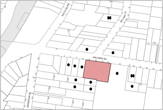
|
NOTIFICATION PLAN |
|
||
|
• PROPERTIES NOTIFIED
|
X SUBMISSIONS RECEIVED |
PROPERTY SUBJECT OF DEVELOPMENT |
|
|
One submission received out of map range |
|||
Three submissions objected to the development, generally on the following grounds:
· Notification of application,
· Overdevelopment for site,
· Underground car parking impacts,
· Development should comply with Key Development Principals Diagram for Baldwin Avenue,
· Traffic and parking impacts,
· Location of development is unacceptable,
· Concerns over the design,
· Stormwater concerns,
· Adaptable housing concerns,
· Construction Traffic Management concerns,
The merits of the matters raised in community submissions have been addressed in the body of the report with the exception of the following:
5.1.1 Construction impacts
Conditions of consent are recommended which require appropriate control of dust and noise by way of limiting hours of construction and implementing erosion and sedimentation controls. Furthermore, a condition is recommended that a Construction Traffic Management Plan (CTMP) be implemented by the developer and overseen by Council’s Compliance Team which actively manages construction vehicle movements generated from medium and high density precincts in the shire.
5.1.2 Issues with zoning, overdevelopment in a low density area
A submission raises concerns with regard to the location of the development and that the design of the townhouses does fit in with the surrounding area.
The area bounded by Baldwin Avenue, Sherbrook Road, Stokes Avenue and Asquith Girls High School, Asquith was rezoned R3 Medium Density Residential in September 2011 as part of Council’s Housing Strategy. Medium density residential development is guided by the Hornsby Development Control Plan 2013. The medium density residential zone introduced in Asquith by the Housing Strategy permits townhouses and residential flat buildings to a height of 2 storeys (plus attic) with consent. Chapter 3.2 of the Plan includes building envelope controls such as height, setbacks and building separation to limit the bulk and scale of townhouse and residential flat building development.
It is considered that the proposed development generally complies with the desired outcomes and prescriptive measures of Part 3.2 Medium Density Housing of the HDCP as discussed in the report above and is acceptable.
5.1.3 Notification
A submission raised concerns regarding the notification process.
As discussed in Section 5.1 of the report above, the proposed development was placed on public exhibition and was notified to adjoining and nearby landowners between 25 May 2017 and 8 June 2017 in accordance with the Notification and Exhibition requirements of the HDCP. This included the placement of a yellow notification sign along the Baldwin Avenue frontage, advertisement in the local newspaper and letters to adjoining and adjacent properties.
5.1.4 Built form
A submission raised concerns with regard to the design of the development and that it is an overdevelopment for the site.
The proposal has been assessed as acceptable by Council’s urban design consultant in terms of the built form, scale and its relation to the desired future character of the Baldwin Avenue medium density precinct.
5.2 Public Agencies
The development application was not referred to any Public Agencies for comment.
6. THE PUBLIC INTEREST
Section 79C(1)(e) of the Act requires Council to consider “the public interest”.
The public interest is an overarching requirement, which includes the consideration of the matters discussed in this report. Implicit to the public interest is the achievement of future built outcomes adequately responding to and respecting the future desired outcomes expressed in environmental planning instruments and development control plans.
The application is considered to have satisfactorily addressed Council’s and relevant agencies’ criteria and would provide a development outcome that, on balance, would result in a positive impact for the community by providing additional housing opportunities and choice for a growing population. Accordingly, it is considered that the approval of the proposed development would be in the public interest.
CONCLUSION
The application seeks approval for the demolition of existing structures and construction of a multi dwelling housing development comprising 24 two-storey townhouses with attics and basement car parking.
The proposed development is generally in accordance with the development controls for the Baldwin Avenue Asquith Precinct of the HDCP and would contribute to the desired residential character of the precinct, subject to recommended conditions of consent.
The proposal would result in a development that would be in keeping with the desired future character of the precinct.
Note: At the time of the completion of this planning report, no persons have made a Political Donations Disclosure Statement pursuant to Section 147 of the Environmental Planning and Assessment Act 1979 in respect of the subject planning application.
RESPONSIBLE OFFICER
The officer responsible for the preparation of this Report is the Manager – Development Assessments – Rodney Pickles, who can be contacted on 9847 6731.
|
James Farrington Group Manager Planning Division |
Rod Pickles Manager - Development Assessment Planning Division |
|
1.View |
Locality Plan |
|
|
|
2.View |
Site Plan |
|
|
|
3.View |
Floor Plans |
|
|
|
4.View |
Elevations |
|
|
|
5.View |
Shadow Plans |
|
|
|
6.View |
Other |
|
|
File Reference: DA/394/2017
Document Number: D07301169
SCHEDULE 1
1. Deferred Commencement
Pursuant to Section 80(3) of the Environmental Planning and Assessment Act 1979, this consent does not operate until the following information is submitted to Council:
a) The registration and creation of an easement to drain water from the site over Lot 1 DP 122314.
Such information must be submitted within 36 months of the date of this notice.
Upon Council’s written satisfaction of the above information, the following conditions of development consent apply:
CONDITIONS OF APPROVAL
GENERAL CONDITIONS
The conditions of consent within this notice of determination have been applied to ensure that the use of the land and/or building is carried out in such a manner that is consistent with the aims and objectives of the relevant legislation, planning instruments and Council policies affecting the land and does not disrupt the amenity of the neighbourhood or impact upon the environment.
Note: For the purpose of this consent, the term ‘applicant’ means any person who has the authority to act on or the benefit of the development consent.
Note: For the purpose of this consent, any reference to an Act, Regulation, Australian Standard or publication by a public authority shall be taken to mean the gazetted Act or Regulation, or adopted Australian Standard or publication as in force on the date that the application for a construction certificate is made.
2. Approved Plans and Supporting Documentation
The development must be carried out in accordance with the plans and documentation listed below and endorsed with Council’s stamp, except where amended by Council and/or other conditions of this consent:
Approved Plans
|
Plan No. |
Issue |
Plan Title |
Drawn by |
Dated |
|
100 |
E |
Existing site & Demolition plan |
Jim Watt-smith |
09/07/2017 |
|
200 |
E |
Proposed site plan |
Jim Watt-smith |
09/07/2017 |
|
300 |
E |
Basement |
Jim Watt-smith |
09/07/2017 |
|
301 |
E |
Ground floor |
Jim Watt-smith |
09/08/2017 |
|
302 |
F |
First floor |
Jim Watt-smith |
10/09/2017 |
|
303 |
E |
Attic |
Jim Watt-smith |
09/07/2017 |
|
304 |
E |
Roof plan |
Jim Watt-smith |
09/08/2017 |
|
400 |
F |
Elevation South & North |
Jim Watt-smith |
10/09/2017 |
|
401 |
F |
Elevations South & North – Inner buildings |
Jim Watt-smith |
10/09/2017 |
|
402 |
F |
Side elevations |
Jim Watt-smith |
10/09/2017 |
|
403 |
E |
Section 1 |
Jim Watt-smith |
09/07/2017 |
|
404 |
F |
Colour schedule |
Jim Watt-smith |
10/09/2017 |
|
405 |
E |
North & South elevations fence detail |
Jim Watt-smith |
09/07/2017 |
|
406 |
E |
North & South elevations building B fence detail |
Jim Watt-smith |
09/08/2017 |
|
408 |
E |
Detailed section |
Jim Watt-smith |
09/08/2017 |
|
1 |
C |
Masterplan |
Paul Scrivener landscape architect |
06/10/2017 |
|
2 |
C |
South detail plan |
Paul Scrivener landscape architect |
06/10/2017 |
|
3 |
C |
North detail plan |
Paul Scrivener landscape architect |
06/10/2017 |
|
4 |
C |
Planting plan |
Paul Scrivener landscape architect |
06/10/2017 |
|
5 |
C |
Landscape soil area |
Paul Scrivener landscape architect |
06/10/2017 |
Supporting Documents
|
Plan No. |
Issue |
Plan Title |
Drawn by |
Dated |
|
000 |
E |
Analysis plan |
Jim Watt-smith |
09/08/17 |
|
205 |
E |
Shadow diagram |
Jim Watt-smith |
09/07/17 |
|
407 |
F |
Renders |
Jim Watt-smith |
10/09/17 |
|
- |
- |
Waste management plan |
Baldwin group |
14/08/2017 |
|
818409M |
- |
BASIX Certificate |
ECOMODE Design |
08/05/2017 |
|
E293765 |
- |
MUSIC-link Report |
Donovan Associates |
28/04/2017 |
|
1730.2 |
- |
Arborist report (Addendum) |
Redgum Horticultural |
27/07/2017 |
|
1730 |
- |
Arborist report |
Redgum Horticultural |
2/3/2016 |
|
- |
- |
Amenity Compliance Solar Access |
Steven King |
26/07/2017 |
|
- |
- |
Access report |
PSE Access Consulting |
24/04/2017 |
|
- |
- |
Access/compliance/design statement |
PSE Access Consulting |
15/08/2017 |
|
E2893765 |
- |
WSUD Strategy report |
Donovan Associates |
01/05/2017 |
|
E2893765 |
- |
WSUD Maintenance manual |
Donovan Associates |
01/05/2017 |
|
17250 |
- |
Traffic and parking report |
Varga Traffic Planning |
01/05/2017 |
|
E293765D1 – D8 |
B |
Stormwater concept plan |
Donovan Associates |
03/08/2017 |
3. Section 94 Development Contributions
a) In accordance with Section 80A(1) of the Environmental Planning and Assessment Act, 1979 and the Hornsby Shire Council Section 94 Development Contributions Plan 2014-2024, the following monetary contributions must be paid to Council to cater for the increased demand for community infrastructure resulting from the development:
|
Description |
Contribution (4) |
|
Roads |
$7,913.95 |
|
Open Space and Recreation |
$279,928.05 |
|
Community Facilities |
$107,612.85 |
|
Plan Preparation and Administration |
$902.80 |
|
TOTAL |
$396,357.65 |
being for 24 townhouses and a credit of 4 existing dwellings.
b) The value of this contribution is current as at 10 October 2017. If the contribution is not paid within the financial quarter that this condition was generated, the contribution payable will be adjusted in accordance with the provisions of the Hornsby Shire Council Section 94 Development Contributions Plan and the amount payable will be calculated at the time of payment in the following manner:
$CPY = $CDC x CPIPY
CPIDC
Where:
$CPY is the amount of the contribution at the date of Payment
$CDC is the amount of the contribution as set out in this Development Consent
CPIPY is the latest release of the Consumer Price Index (Sydney – All Groups) at the date of Payment as published by the ABS.
CPIDC is the Consumer Price Index (Sydney – All Groups) for the financial quarter at the date applicable in this Development Consent Condition.
c) The monetary contribution must be paid to Council:
i) prior to the issue of the Subdivision Certificate where the development is for subdivision; or
ii) prior to the issue of the first Construction Certificate where the development is for building work; or
iii) prior to issue of the Subdivision Certificate or first Construction Certificate, whichever occurs first, where the development involves both subdivision and building work; or
iv) prior to the works commencing where the development does not require a Construction Certificate or Subdivision Certificate.
Note: It is the professional responsibility of the Principal Certifying Authority to ensure that the monetary contributions have been paid to Council in accordance with the above timeframes.
Council’s Development Contributions Plan may be viewed at www.hornsby.nsw.gov.au or a copy may be inspected at Council’s Administration Centre during normal business hours.
4. Appointment of a Project Arborist
a) A project arborist with AQF Level 5 qualifications must be appointed to provide monitoring and certification throughout the construction period.
b) Details of the appointed project arborist must be submitted to Council and the PCA for registration with the application for the construction certificate.
5. Removal of Existing Trees
a) This development consent permits the removal of tree(s) numbered 3-10 as identified in the Aboricultural Impact Assessment submitted by Redgum Horticultural dated 2/3/2016.
6. Construction Certificate
a) A Construction Certificate is required to be approved by Council or a Private Certifying Authority prior to the commencement of any works under this consent.
b) A separate Construction Certificate must be obtained from Council for all works within the public road reserve under S138 of the Roads Act.
c) A separate Construction Certificate must be obtained from Council for all works within drainage easements vested in Council.
d) The Construction Certificate plans must not be inconsistent with the Development Consent plans.
REQUIREMENTS PRIOR TO THE ISSUE OF A CONSTRUCTION CERTIFICATE
7. Building Code of Australia
All approved building work must be carried out in accordance with the relevant requirements of the Building Code of Australia.
8. Utility Services
The applicant must submit written evidence of the following service provider requirements:
a) Ausgrid (formerly Energy Australia) – a letter of consent demonstrating that satisfactory arrangements have been made to service the proposed development.
b) Telstra – a letter of consent demonstrating that satisfactory arrangements have been made to service the proposed development.
9. Contract of Insurance (Residential Building Work)
Where residential building work for which the Home Building Act 1989 requires there to be a contract of insurance in force in accordance with Part 6 of that Act, this contract of insurance must be in force before any building work authorised to be carried out by the consent commences.
10. Notification of Home Building Act 1989 Requirements
Residential building work within the meaning of the Home Building Act 1989 must not be carried out unless the principal certifying authority for the development to which the work relates (not being Council) has given Council written notice of the following information:
a) In the case of work for which a principal contractor is required to be appointed:
i) The name and licence number of the principal contractor; and
ii) The name of the insurer by which the work is insured under Part 6 of that Act.
b) In the case of work to be done by an owner-builder:
i) The name of the owner-builder; and
ii) If the owner-builder is required to hold an owner-builder’s permit under that Act, the number of the owner-builder’s permit.
Note: If arrangements for doing the residential building work are changed while the work is in progress so that the information notified becomes out of date, further work must not be carried out unless the principal certifying authority for the development to which the work relates (not being Council) has given Council written notification of the updated information.
11. Sydney Water – Approval
This application must be submitted to Sydney Water for approval to determine whether the development would affect any Sydney Water infrastructure, and whether further requirements are to be met.
Building plan approvals can be obtained online via Sydney Water Tap inTM through www.sydneywater.com.au under the Building and Development tab.
12. Dilapidation Report
A ‘Dilapidation Report’ is to be prepared by a ‘chartered structural engineer’ detailing the structural condition of the adjoining property at No. 10 Baldwin Avenue, Asquith.
13. Traffic Control Plan
A Traffic Control Plan (TCP) must be prepared by a qualified traffic controller in accordance with the Roads & Traffic Authority’s Traffic Control at Worksites Manual 1998 and Australian Standard 1742.3 for all work on a public road. The Traffic Management Plan shall be submitted and approved by Council’s Manager Traffic and Road Safety prior to the issue of a construction certificate. The TCP must detail the following:
a) Arrangements for public notification of the works;
b) Temporary construction signage;
c) Permanent post-construction signage;
d) Vehicle movement plans;
e) Traffic management plans; and
f) Pedestrian and cyclist access/safety.
14. Stormwater Drainage
The stormwater drainage system for the development must be designed in accordance with Council’s Civil Works – Design and Construction Specification 2005 and the following requirements:
a) The roof and stormwater drainage system from the proposed development to be connected to the proposed inter-allotment drainage system.
15. On Site Stormwater Detention
An on-site stormwater detention system must be designed by a chartered civil engineer and constructed in accordance with the following requirements:
a) Have a capacity of not less than 33.7 cubic metres, and a maximum discharge (when full) of 105 litres per second;
b) Have a surcharge/inspection grate located directly above the outlet;
c) Discharge from the detention system must be controlled via 1 metre length of pipe, not less than 50 millimetres diameter or via a stainless plate with sharply drilled orifice bolted over the face of the outlet discharging into a larger diameter pipe capable of carrying the design flow to an approved Council system;
d) Not be constructed in a location that would impact upon the visual or recreational amenity of residents.
16. Internal Driveway/Vehicular Areas
The driveway and parking areas on site must be designed, constructed and a Construction Certificate issued in accordance with Australian Standards 2890.1, 2890.2, 3727 and the following requirements:
a) Design levels at the front boundary shall be obtained from Council if a private accredited certifier is engaged to obtain a construction certificate for these works.
b) The driveway be a rigid pavement.
c) The driveway grade must not exceed 25 percent and changes in grade must not exceed 8 percent.
17. Water Saving Urban Design
A Water Saving Urban Design (WSUD) is to be constructed generally in accordance with the engineering report and plans prepared by Donovan & Associates Job Reference E2893765. The Water Quality Targets as detailed within the report and Hornsby Shire Councils DCP are to be achieved in the design and supported by a MUSIC model.
18. Footpath
A concrete footpath must be designed across the full frontage of the subject site in accordance Council’s Civil Works Design and Construction Specification 2005 and the following requirements:
a) The existing footpath being removed.
b) Pouring of the concrete footpath to the full frontage of the subject site.
c) The land adjoining the footpath to be fully turfed.
d) Any public utility adjustments to be carried out at the cost of the applicant and to the requirements of the relevant public authority.
19. Vehicular Crossing
A separate application under the Local Government Act, 1993 and the Roads Act 1993 must be submitted to Council for the installation of a new vehicular crossing and the removal of the redundant crossing. The vehicular crossing must be constructed in accordance with Council’s Civil Works Design 2005 and the following requirements:
a) Design levels at the front boundary must be obtained from Council for the design on the internal driveway;
Note: An application for a vehicular crossing can only be made to one of Council’s Authorised Vehicular Crossing Contractors. You are advised to contact Council on 02 9847 6940 to obtain a list of contractors.
20. Road Works
All road works approved under this consent must be designed in accordance with Council’s Civil Works Design and Construction Specification 2005 and the following requirements:
a) The existing kerb and gutter is to be removed and reconstructed across the full frontage of the site.
b) The existing road pavement to be saw cut a minimum of 500 mm from the existing edge of the bitumen and reconstructed.
21. Construction Traffic Management Plan
To enable unencumbered movement of traffic in the public road during construction works, a Construction Management Plan, including a Traffic Management Plan and scaled construction plans prepared by a suitably Chartered and Qualified Chartered Civil Engineer and Qualified Worksite Traffic Controller shall be prepared and submitted to Hornsby Shire Council for approval according to the following requirements:
a) A copy of the plans shall be submitted for consideration and written approval by Hornsby Shire Council prior to the release of the Construction Certificate.
b) The plans shall detail the order of construction works and arrangement of all construction machines and vehicles being used at the same time during all stages.
c) The CTMP plans shall be in accordance with the approved Development Application plans and the Development Consent conditions.
d) In order to prevent injury, accident and loss of property, no building materials, work sheds, vehicles, machines or the like shall be allowed to remain in the road reserve area without the written consent of Hornsby Shire Council.
e) The Plan shall be generally in compliance with the requirements of the Road and Traffic Authority’s “Traffic Control at Worksites Manual 1998” and detailing:
i) Public notification of proposed works;
ii) Long term signage requirements;
iii) Short term (during actual works) signage;
iv) Vehicle Movement Plans, where applicable;
v) Traffic Management Plans; and
vi) Pedestrian and Cyclist access and safety.
f) The plans shall indicate traffic controls including those used during non-working hours and shall provide pedestrian access and two-way traffic in the public road to be facilitated at all times.
g) The plans shall include the proposed truck routes to and from the site including details of the frequency of truck movements at the different stages of the development. The plan shall also include details of parking arrangements for all employees and contractors.
h) The Applicant and all employees of contractors on the site must obey any direction or notice from the Prescribed Certifying Authority or Hornsby Shire Council in order to ensure the above.
i) If there is a requirement to obtain a Work Zone, partial Road Closure or Crane Permit an application to Hornsby Shire Council is to be made prior to the issue the Construction Certificate.
22. Waste Management Details
a) A Waste Management Plan Section One – Demolition Stage and Section Three – Construction Stage, covering the scope of this project and including the following details, is required to be submitted to Council:
i) An estimate of the types and volumes of waste and recyclables to be generated;
ii) A site plan showing sorting and storage areas for demolition and construction waste and the vehicle access to these areas;
iii) How excavation, demolition and construction waste materials will be reused or recycled and where residual wastes will be disposed; and
iv) The total percentage (by weight) of demolition and construction waste that will be reused or recycled.
23. Identification of Survey Marks
A registered surveyor must identify all survey marks in the vicinity of the proposed development. Any survey marks required to be removed or displaced as a result of the proposed development shall be undertaken by a registered surveyor in accordance with Section 24 (1) of the Surveying and Spatial Information Act 2002 and following the Surveyor General’s Directions No.11 – "Preservation of Survey Infrastructure".
REQUIREMENTS PRIOR TO THE COMMENCEMENT OF ANY WORKS
24. Erection of Construction Sign
a) A sign must be erected in a prominent position on any site on which any approved work is being carried out:
i) Showing the name, address and telephone number of the principal certifying authority for the work;
ii) Showing the name of the principal contractor (if any) for any demolition or building work and a telephone number on which that person may be contacted outside working hours; and
iii) Stating that unauthorised entry to the work site is prohibited.
b) The sign is to be maintained while the approved work is being carried out and must be removed when the work has been completed.
25. Protection of Adjoining Areas
A temporary hoarding, fence or awning must be erected between the work site and adjoining lands before the works begin and must be kept in place until after the completion of the works if the works:
a) Could cause a danger, obstruction or inconvenience to pedestrian or vehicular traffic;
b) Could cause damage to adjoining lands by falling objects; and/or
c) Involve the enclosure of a public place or part of a public place.
Note: Notwithstanding the above, Council’s separate written approval is required prior to the erection of any structure or other obstruction on public land.
26. Toilet Facilities
To provide a safe and hygienic workplace, toilet facilities must be available or be installed at the works site before works begin and must be maintained until the works are completed at a ratio of one toilet for every 20 persons employed at the site.
27. Erosion and Sediment Control
To protect the water quality of the downstream environment, erosion and sediment control measures must be provided and maintained throughout the construction period in accordance with the manual ‘Soils and Construction 2004 (Bluebook)’, the approved plans, Council specifications and to the satisfaction of the principal certifying authority. The erosion and sediment control devices must remain in place until the site has been stabilised and revegetated.
Note: On the spot penalties may be issued for any non-compliance with this requirement without any further notification or warning.
28. Installation of Tree Protection
a) All tree protection fencing for the trees to be retained must have the protection measures for the ground, trunk and canopy installed in accordance with the relevant requirements of Australian Standard AS 4970-2009 - “Protection of Trees on Development Sites”.
b) All tree protection fencing for the trees to be retained must be erected around trees numbered A, B and C as specified in the submitted Arboricultural Impact Assessment provided by Redgum Horticultural dated 27/7/2017.
29. Tree Protection Zone - Ground Protection
a) All tree protection zones for the trees to be retained must have a layer of wood-chip mulch installed prior to works commencing.
b) The wood-chip mulch must be maintained throughout the period of construction at a depth of between 150mm and 300mm, using material that complies with the relevant requirements of Australian Standard AS 4454 – “Composts, Soil Conditioners and Mulches”.
30. Tree Protection Certification
To ensure that all tree protection measures are correctly installed, a certificate from the appointed project arborist must be submitted to the Principal Certifying Authority confirming compliance with the tree protection requirements of this consent.
REQUIREMENTS DURING DEMOLITION AND CONSTRUCTION
31. Construction Work Hours
All works on site, including demolition and earth works, must only occur between 7am and 5pm Monday to Saturday.
No work is to be undertaken on Sundays or public holidays.
32. Demolition
To protect the surrounding environment, all demolition work must be carried out in accordance with “Australian Standard 2601-2001 – The Demolition of Structures” and the following requirements:
a) Demolition material must be disposed of to an authorised recycling and/or waste disposal site and/or in accordance with an approved waste management plan; and
b) Demolition works, where asbestos material is being removed, must be undertaken by a contractor that holds an appropriate licence issued by SafeWork NSW in accordance with the Work Health and Safety Regulation 2017 and be appropriately transported and disposed of in accordance with the Protection of the Environment Operations (Waste) Regulation 2014; and
c) On construction sites where any building contain asbestos material, a standard commercially manufactured sign containing the words ‘DANGER ASBESTOS REMOVAL IN PROGRESS’ and measuring not less than 400mm x 300mm must be displayed in a prominent position visible from the street.
33. Sydney Water – s73 Certificate
A section 73 Certificate must be obtained from Sydney Water and submitted to the PCA.
Note: Sydney Water requires that s73 applications are to be made through an authorised Sydney Water Servicing Coordinator. Refer to www.sydneywater.com.au or telephone 13 20 92 for assistance.
34. Certification of WSUD Facilities
Prior to the issue of an Occupation Certificate a certificate from a Civil Engineer is to be obtained stating that the WSUD facilities have been constructed and will meet the water quality targets as specified in the Hornsby Shire Councils DCP.
35. Environmental Management
The site must be managed in accordance with the publication ‘Managing Urban Stormwater – Landcom (March 2004) and the Protection of the Environment Operations Act 1997 by way of implementing appropriate measures. To prevent sediment run-off, excessive dust, noise or odour emanating from the site during the construction of the development.
36. Excavated Material
All excavated material removed from the site must be classified by a suitably qualified person in accordance with the Department of Environment, Climate Change and Water NSW Waste Classification Guidelines prior to disposal to an approved waste management facility and be reported to the principal certifying authority prior to the issue of an Occupation Certificate.
37. Landfill
Landfill must be constructed in accordance with Council’s ‘Construction Specification 2005’ and the following requirements:
a) Prior to fill material being imported to the site, a certificate shall be obtained from a suitable qualified environmental consultant confirming the fill wholly consists of Virgin Excavated Natural Material (VENM) as defined in Schedule 1 of the Protection of the Environment Operations Act, 1997 or material approved under the Department of Environment and Climate Change’s general resource recovery exemption.
b) A compaction certificate is to be obtained from a suitably qualified geotechnical engineer verifying that the specified compaction requirements have been met.
c) These certificates must be included with the application for an occupation certificate.
38. Street Sweeping
To protect the surrounding environment, Street sweeping must be undertaken following sediment tracking from the site along Baldwin Avenue during works and until the site is established.
The street cleaning services must undertake a street ‘scrub and dry’ method of service and not a dry sweeping service that may cause sediment tracking to spread or cause a dust nuisance.
39. Council Property
To ensure that the public reserve is kept in a clean, tidy and safe condition during construction works, no building materials, waste, machinery or related matter is to be stored on the road or footpath.
Note: This consent does not give right of access to the site via Council’s park or reserve. Should such access be required, separate written approval is to be obtained from Council.
40. Disturbance of Existing Site
During construction works, the existing ground levels of open space areas and natural landscape features, (including natural rock-outcrops, vegetation, soil and watercourses) must not be altered unless otherwise nominated on the approved plans.
41. Survey Report
A report(s) must be prepared by a registered surveyor and submitted to the principal certifying authority;
a) Prior to the pouring of concrete at each level of the building certifying that:
i) The building, retaining walls and the like have been correctly positioned on the site; and
ii) The finished floor level(s) are in accordance with the approved plans.
42. Waste Management
Waste management during the demolition and construction phase of the development must be undertaken in accordance with the approved Waste Management Plan. Additionally written records of the following items must be maintained during the removal of any waste from the site and such information submitted to the Principal Certifying Authority within fourteen days of the date of completion of the works:
a) The identity of the person removing the waste.
b) The waste carrier vehicle registration.
c) Date and time of waste collection.
d) A description of the waste (type of waste and estimated quantity).
e) Details of the site to which the waste is to be taken.
f) The corresponding tip docket/receipt from the site to which the waste is transferred (noting date and time of delivery, description (type and quantity) of waste).
g) Whether the waste is expected to be reused, recycled or go to landfill.
Note: In accordance with the Protection of the Environment Operations Act 1997, the definition of waste includes any unwanted substance, regardless of whether it is reused, recycled or disposed to landfill.
43. Compliance During Construction Works
The development must be carried out in accordance with the following approved documents:
a) Traffic Control Plan (TCP); and
b) Construction Traffic Management Plan (CTMP).
44. Maintenance of Public Footpaths
Public footpaths must be maintained for the duration of works to ensure they are free of trip hazards, displacements, breaks or debris to enable pedestrians to travel along the footpath safely.
45. Works Near Trees
a) No consent is granted for any works within the Structural Root Zone of trees numbered 1, 2, A, B and C.
b) To maintain tree health and condition, the appointed project arborist must monitor and record any and all necessary remedial actions required for trees numbered 1, 2, A, B and C on the approved plans.
c) The maintenance and monitoring of all tree protection techniques must be recorded by the appointed project arborist during the period of construction for submission with the application for the occupation certificate.
46. Works within Tree Protection Zones (only used for an encroachment exceeding 10%)
a) Root Pruning
All root pruning must be undertaken in accordance with the relevant requirements of Australian Standard AS 4970-2009 “Protection of Trees on Development Sites” - Sections 3.3.4, 4.5.4 and 4.5.5.
b) Excavation
Any and all necessary excavations within the Tree Protection Zone of trees to be retained numbered 1, 2, A, B and C on the approved plans, must be undertaken using construction techniques as prescribed in the Australian Standard AS 4970-2009 – “Protection of Trees on Development Sites” Section 4.5.5.
c) Changing of Grade
All grades within the Tree Protection Zone of trees numbered 1, 2, A, B and C on the approved plans, must remain unaltered.
d) Installing Services
To minimise the environmental impacts of the development within the Tree Protection Zone (TPZ) of trees to be retained, numbered 1, 2, A, B and C on the approved plans:
i) The installation of any underground services which either enter or transect the designated TPZ must utilise sensitive methods such as directional drilling or manual excavation.
ii) The installation of any underground services must be inspected by the project arborist to monitor the likely impacts of the development on retained trees.
iii) For manual excavation of trenches the project arborist must advise on roots to be retained and must monitor the works. Manual excavation may include the use of pneumatic and hydraulic tools. Refer Clause 4.5.3.
47. Building materials and Site Waste
The filling or stockpiling of building materials, the parking of vehicles or plant, the disposal of cement slurry, waste water or other contaminants must be located outside the tree protection zones as prescribed in the conditions of this consent or the prescriptive measures of Part 1B.6.1 Tree Preservation of the Hornsby Development Control Plan, 2013, of any tree to be retained.
48. Works near trees certification
a) The project arborist must submit to the principal certifying authority on a monthly a certificate that the works have been carried out in compliance with the approved plans and specifications for tree protection.
b) Certification should include a statement of site attendance, the condition of the retained trees, details of any deviations from the approved tree protection measures and their impacts on trees.
REQUIREMENTS PRIOR TO THE ISSUE OF AN OCCUPATION CERTIFICATE
Note: For the purpose of this consent, a reference to ‘occupation certificate’ shall not be taken to mean an ‘interim occupation certificate’ unless otherwise stated.
49. Fulfilment of BASIX Commitments
The applicant must demonstrate the fulfilment of BASIX commitments pertaining to the development.
50. Unit Numbering
All units are to be numbered consecutively commencing at No.1. The strata plan lot number is to coincide with the unit number, e.g Unit 1 = Lot 1. The allocated of unit numbering must be authorised by Council prior to the numbering of each units in the development.
51. Damage to Council Assets
To protect public property and infrastructure, any damage caused to Council’s assets as a result of the construction or demolition of the development must be rectified by the applicant in accordance with Council’s Civil Works Specifications. Rectification works must be undertaken prior to the issue of an Occupation Certificate, or sooner, as directed by Council.
52. Retaining Walls
All required retaining walls must be constructed as part of the development.
53. Creation of Easements
The following matter(s) must be nominated on the plan of subdivision under s88B of the Conveyancing Act 1919:
a) The creation of an appropriate "Positive Covenant" and "Restriction as to User" over the constructed on-site detention/retention systems, stormwater quality improvement devices and outlet works, within the lots in favour of Council in accordance with Council’s prescribed wording. The position of the on-site detention system and stormwater quality improvement devices is to be clearly indicated on the title.
b) To register the OSD easement, the restriction on the use of land “works-as-executed” details of the on-site-detention system and stormwater quality improvement devices must be submitted verifying that the required storage and discharge rates have been constructed in accordance with the design requirements. The details must show the invert levels of the on site system together with pipe sizes and grades. Any variations to the approved plans must be shown in red on the “works-as-executed” plan and supported by calculations.
Note: Council must be nominated as the authority to release, vary or modify any easement, restriction or covenant.
54. Works as Executed Plan
A works-as-executed plan(s) must be prepared by a registered surveyor and submitted to Council for completed road pavement, kerb & gutter, public drainage systems, driveways and on-site detention system.
55. Preservation of Survey Marks
A certificate by a Registered Surveyor must be submitted to the Principal Certifying Authority, certifying that there has been no removal, damage, destruction, displacement or defacing of the existing survey marks in the vicinity of the proposed development or otherwise the re-establishment of damaged, removed or displaced survey marks has been undertaken in accordance with the Surveyor General’s Direction No.11 – “Preservation of Survey Infrastructure”.
56. Boundary Fencing
Boundary fencing shall be installed as per the following requirements:
a) The fencing along the rear boundary (between the site and Asquith Girls High School) shall be a maximum 1.8m high solid timber lapped and capped fence.
b) Fencing must be erected along the eastern and western side boundaries behind the front building line to a height of 1.8m.
c) Front fencing must be a maximum 1.5m high with any individual solid element of the fence being no more than 350mm in width with a minimum aperture of 25mm.
Note: Alternative fencing may be erected along the northern and southern boundaries subject to the written consent of the adjoining property owner(s).
57. Car Parking and Vehicular Areas
All vehicular areas within the site and the car parking must be constructed in accordance with Australian Standard AS 2890.1 – 2004 – Off Street Car Parking and Australian Standard 2890.2 - 2002 – Off Street Commercial and the following requirements:
a) The driveway to be designed in accordance with Condition 16 of this development consent;
b) A certificate from an appropriately licensed contractor must be submitted to the principal certifying authority certifying that the service conduits have been installed in accordance with the relevant utility provider and Australian Standards;
c) All parking areas and driveways are to be sealed to an all-weather standard, line marked and signposted;
d) Residential parking spaces are to be secure spaces with access controlled by card or numeric pad;
e) Three visitors’ spaces are to be provided at the basement level. Visitors are to be able to access the basement car park by an audio/visual intercom system located at the top of the ramped driveway;
f) Eight bicycle spaces are to be provided in the basement car park. Bicycle parking spaces are to be designed in accordance with AS 2890.3-1993;
g) One motorcycle parking space is to be provided within the basement car park, designed in accordance with AS 2890.5-1993;
h) The location of the driveway must maintain sight lines for the pedestrians.
58. External Lighting
a) To protect the amenity of adjacent premises, all external lighting must be designed and installed in accordance with Australian Standard AS 4282 – Control of the Obtrusive Effects of Outdoor Lighting.
b) Certification of compliance with this Standard must be obtained from a suitably qualified person and submitted to the PCA with the application for the Construction Certificate.
59. Construction of Engineering Works
All engineering works identified in this consent including stormwater works, retaining walls, driveway works, roadworks and the like are to be completed and a Compliance Certificate issued prior to the release of the Occupation Certificate.
60. Consolidation of Allotments
All allotments the subject of this consent must be consolidated into one allotment.
Note: The applicant is recommended to submit the plan of subdivision to consolidate allotments to the NSW Department of Lands at least 4-6 weeks prior to seeking an occupation certificate.
61. Provision for National Broadband Network (NBN)
Provision must be made for fibre ready passive infrastructure (pits and pipes) generally in accordance with NBN Co's pit and pipe installation guidelines to service the proposed development. A certificate from NBN Co or Telstra must be submitted to the PCA that the fibre optic cabling provided for the development complies with MDU Building Design Guides for Development.
62. Safety and Security
This site must include the following elements:
a) An intercom system must be installed at gate locations to ensure screening of persons entering the units;
b) The entry doors are is to be constructed of safety rated glass to enable residents a clear line of site before entering or exiting the dwellings;
c) Lighting is to be provided to pathways, building entries, driveways and common external spaces;
d) Security gate access is to be provided to the car parking areas allowing residents-only access to private car spaces;
e) CCTV cameras must be installed at the entry and exit point and the around the mailbox;
f) The communal open spaces within the site must be illuminated with high luminance by motion sensor lighting;
g) The driveway and basement car parking must be illuminated with low luminance at all times;
h) Security deadlocks are to be provided to each dwelling door; and
i) Peep holes are to be provided to individual apartment doors to promote resident safety.
63. Waste Management
The following waste management requirements must be complied with:
a) The bin storage room at the basement level must include water or a hose for cleaning, graded floors with drainage to sewer, robust doors, sealed and impervious surface, adequate lighting and ventilation, and must be lockable.
b) A report must be prepared by an appropriately qualified person, certifying the following:
i) A comparison of the estimated quantities of each waste type against the actual quantities of each waste type.
Note: Explanations of any deviations to the approved Waste Management Plan is required to be included in this report.
ii) That at least 60% of the waste generated during the demolition and construction phase of the development was reused or recycled.
Note: If the 60% diversion from landfill cannot be achieved in the Construction Stage, the Report is to include the reasons why this occurred and certify that appropriate work practices were employed to implement the approved Waste Management Plan. The Report must be based on documentary evidence such as tipping dockets/receipts from recycling depots, transfer stations and landfills, audits of procedures etc. which are to be attached to the report.
iii) All waste was taken to site(s) that were lawfully permitted to accept that waste.
c) Each dwelling must be provided with an indoor waste/recycling cupboard for the interim storage of waste with two separate 20 litre containers for general waste and recyclable materials.
d) Space must be provided for either individual compost containers for each unit or a communal compost container;
Note: The location of the compost containers should have regard for potential amenity impacts.
e) A bulky waste storage area of at least 8m2 is to be identified and marked with paint and signage;
f) “No parking” signs must be erected to prohibit parking in the waste collection loading bay and turning area;
g) Prior to an Occupation Certificate being issued or the use commencing, whichever is earlier, the Principal Certifying Authority must obtain Council’s approval of the waste and recycling management facilities provided in the development and ensure arrangements are in place for domestic waste collection by Council;
h) Site security measures implemented on the property, including electronic gates, must not prevent access to the collection point by waste removal services.
64. Final Certification Arborist
a) The Project supervisor must submit to the principal certifying authority all relevant certificates with the application for the occupation certificate stating compliance with all the conditions of this consent.
b) Certification must include a statement of overall site attendance, the condition of the retained trees, details of any deviations from the approved tree protection measures and their impacts on trees.
65. Completion of Landscaping
A certificate must be submitted to the PCA by a practicing landscape architect, horticulturalist or person with similar qualifications and experience certifying that all required landscaping works have been satisfactorily completed in accordance with the approved landscape plans prepared by ‘Paul Scrivener landscape architect’, Sheet Nos.1 to 5, Issue C, dated 6 October 2017.
OPERATIONAL CONDITIONS
66. Noise
All noise generated by the proposed development must be attenuated to prevent levels of noise being emitted to adjacent premises which possess tonal, beating and similar characteristics or which exceeds background noise levels by more than 5dB(A).
67. Fire Safety Statement - Annual
On at least one occasion in every 12 month period following the date of the first ‘Fire Safety Certificate’ issued for the property, the owner must provide Council with an annual ‘Fire Safety Certificate’ to each essential service installed in the building.
68. Landscape Establishment
The landscape works must be maintained into the future to ensure the establishment and successful growth of plant material to meet the intent of the landscape design. This must include but not limited to watering, weeding, replacement of failed plant material and promoting the growth of plants through standard industry practices.
69. Car Parking/Sight Lines and Deliveries
All car parking must be operated in accordance with Australian Standard AS 2890.1 – 2004 – Off Street Car Parking and Australian Standard 2890.2 - 2002 – Off Street Commercial and the following requirements:
a) All parking areas and driveways are to be sealed to an all-weather standard, line marked and signposted at all times.
b) Car parking, loading and manoeuvring areas to be used solely for nominated purposes.
c) Vehicles awaiting loading, unloading or servicing shall be parked on site and not on adjacent or nearby public roads;
d) All vehicular entry on to the site and egress from the site shall be made in a forward direction;
e) Minimum sight lines for pedestrian safety are to be provided at the driveway; and
f) Any proposed landscaping and/or fencing must not restrict sight distance to pedestrians and cyclists travelling along the footpath.
- END OF CONDITIONS -
ADVISORY NOTES
The following information is provided for your assistance to ensure compliance with the Environmental Planning and Assessment Act 1979 Environmental Planning and Assessment Regulation 2000, other relevant legislation and Council’s policies and specifications. This information does not form part of the conditions of development consent pursuant to Section 80A of the Act.
Environmental Planning and Assessment Act 1979 Requirements
The Environmental Planning and Assessment Act 1979 requires:
· The issue of a construction certificate prior to the commencement of any works. Enquiries can be made to Council’s Customer Services Branch on 9847 6760;
· a principal certifying authority to be nominated and Council notified of that appointment prior to the commencement of any works;
· Council to be given at least two days written notice prior to the commencement of any works;
· mandatory inspections of nominated stages of the construction inspected; and
· an occupation certificate to be issued before occupying any building or commencing the use of the land.
Long Service Levy
In accordance with Section 34 of the Building and Construction Industry Long Service Payments Act 1986, a ‘Long Service Levy’ must be paid to the Long Service Payments Corporation or Hornsby Council.
Note: The rate of the Long Service Levy is 0.35% of the total cost of the work.
Note: Hornsby Council requires the payment of the Long Service Levy prior to the issue of a construction certificate.
Tree and Vegetation Preservation
In accordance with Clause 5.9 of the Hornsby Local Environmental Plan 2013 a person must not ringbark, cut down, top, lop, remove, injure or wilfully destroy any tree or other vegetation protected under the Hornsby Development Control Plan 2013 without the authority conferred by a development consent or a permit granted by Council.
Notes: A tree is defined as a long lived, woody perennial plant with one or relatively few main stems with the potential to grow to a height greater than three metres (3M). (HDCP 1B.6.1.c).
Tree protection measures and distances are determined using the Australian Standard AS 4970:2009, “Protection of Trees on Development Sites”.
Fines may be imposed for non-compliance with both the Hornsby Local Environmental Plan 2013 and the Hornsby Development Control Plan 2013.
Dial Before You Dig
Prior to commencing any works, the applicant is encouraged to contact Dial Before You Dig on 1100 or www.dialbeforeyoudig.com.au for free information on potential underground pipes and cables within the vicinity of the development site.
Asbestos Warning
Should asbestos or asbestos products be encountered during demolition or construction works, you are advised to seek advice and information prior to disturbing this material. It is recommended that a contractor holding an asbestos-handling permit (issued by WorkCover NSW) be engaged to manage the proper handling of this material. Further information regarding the safe handling and removal of asbestos can be found at:
Alternatively, telephone the WorkCover Asbestos and Demolition Team on 8260 5885.
Disability Discrimination Act
The applicant’s attention is drawn to the existence of the Disability Discrimination Act. A construction certificate is required to be obtained for the proposed building/s, which will provide consideration under the Building Code of Australia, however, the development may not comply with the requirements of the Disability Discrimination Act. This is the sole responsibility of the applicant.
Covenants
The land upon which the subject building is to be constructed may be affected by restrictive covenants. Council issues this approval without enquiry as to whether any restrictive covenant affecting the land would be breached by the construction of the building, the subject of this consent. Applicants must rely on their own enquiries as to whether or not the building breaches any such covenant.
Telecommunications Act 1997 (Commonwealth)
If you are aware of any works or proposed works which may affect or impact on Telstra’s assets in any way, you are required to contact: Telstra’s Network Integrity Team on Phone Number 1800 810 443.
Group Manager's Report No. PL60/17
Planning Division
Date of Meeting: 8/11/2017
9 FURTHER REPORT - DEVELOPMENT APPLICATION - CHILDCARE CENTRE - 60-74 THE CRESCENT, CHELTENHAM
EXECUTIVE SUMMARY
|
DA No: |
DA/191/2017 (Lodged on 7 March 2017) |
|
Description: |
Construction of a 92 place childcare centre |
|
Property: |
Cheltenham Recreation Club, Nos 60-74 The Crescent, Cheltenham |
|
Applicant: |
Young Scholars @ Cheltenham Pty Ltd |
|
Owner: |
The Cheltenham Recreation Club Limited |
|
Estimated Value: |
$2,526,825 |
|
Ward: |
C |
· At its meeting on 11 October 2017, Council deferred the application to enable an onsite meeting with residents to better observe the implications of the proposed development.
· An onsite meeting was conducted on 23 October 2017 and the applicant subsequently amended the proposal in respect to the acoustic barrier, the retaining wall and driveway with the adjoining heritage property Edensor.
· The application follows the lapsing of development consent for a 90 place childcare centre approved on the site by Council in July 2014.
· The proposal generally complies with Hornsby Local Environmental Plan 2013, State Environmental Planning Policy (Educational Establishments and Childcare Facilities) 2017 and Hornsby Development Control Plan 2013.
· Six submissions have been received in respect of the application.
· It is recommended that the application be approved.
|
THAT Development Application No. DA/191/2017 for construction of a 92 place childcare centre at Lots 1-5 DP 5440, Lot C DP 306966, Lot C DP 328704, Lot 1 DP 335423, Lot G DP 360935, Lot J DP 374758, Lot A DP 303812, Nos 60-74 The Crescent, Cheltenham be approved subject to the conditions of consent detailed in Schedule 1 of Group Manager’s Report No. PL60/17. |
BACKGROUND
On 9 July 2014, Council approved DA/754/2013 for construction of a 90 place childcare centre on the subject site. The development consent was subject to deferred consent commencement conditions for additional information which was not submitted within the required timeframe. The development consent therefore has lapsed.
The proposed development would essentially occupy the same building envelope as the approved proposal.
At the Council Meeting on 11 October 2017 Council considered the subject development application under Group Manager’s Report No. PL52/17 and resolved as follows:
THAT consideration of Development Application No. DA/191/2017 – Childcare Centre – 60-74 The Crescent, Cheltenham be deferred until the 8 November 2017 General Meeting to allow an onsite meeting to be held between the applicant, Council officers and available Councillors. The intent of the deferral and onsite meeting is to better observe the implications of the development on the surrounding properties and neighbourhood and to allow the owners of No. 1 The Boulevard, Cheltenham to submit the acoustic report mentioned during discussion on this item and have it considered by Council officers and Councillors.
The onsite meeting was held on 23 October 2017. Following the meeting the applicant submitted additional information to address the matters raised including; acoustic barrier extension, retaining wall construction, waste storage facility, replacement of a garden bed with a gate for ‘Edensor’ and air conditioning plant setback.
SITE
The site forms part of the grounds of the Cheltenham Recreation Club which has frontage to The Crescent, The Boulevard and to Lyne Road and includes the Club house, 6 tennis courts, croquet court, 2 bowling greens, landscaped gardens and car park with 35 car parking spaces. The grounds have an area of 1.7 hectares.
The club house building includes a telecommunications facility.
The grounds of the Cheltenham Recreation Club are an item of heritage of local significance. The site is within the Beecroft-Cheltenham Heritage Conservation Area. The site is in the vicinity of heritage items at No. 203 Beecroft Road, Cheltenham comprising a house ‘Edensor’ and at No. 1 The Boulevard, Cheltenham comprising Period Trees (2 x Norfolk Island Pines).
The site of the proposed childcare centre is located in the rear western corner of the Club grounds behind the bowling green and croquet court. The site comprises an open grassed area elevated to the surrounding grounds. An existing driveway off The Crescent extends along the south-eastern side of the clubhouse building to the site. Tennis courts fronting Lyne Road adjoin the south-eastern part of the site.
The development site has an average fall of 5% to the bowling green and croquet court.
The surrounding developments comprise dwelling houses on relatively large allotments. The majority of houses are Federation period dwellings.
The Cheltenham Railway Station and car park are opposite the northern part of the site.
PROPOSAL
The application proposes construction of a single storey childcare centre for 92 places comprising the following:
· 32 places - 0-2 years
· 30 places - 2-3 years
· 30 places - 3-5 years
The proposal includes 23 car parking spaces.
The operation of the centre would involve 17 staff and operating hours of 7am to 6pm Monday to Friday.
The proposal would involve the removal of five trees.
The proposed accessway is over the existing driveway for the Recreation Club. The proposal includes construction of car parking spaces and upgrading of the driveway for the proposed childcare centre.
The proposed childcare centre would be located 200m south of Cheltenham Railway Station.
ASSESSMENT
The development application has been assessed having regard to ‘A Plan for Growing Sydney’, the ‘Draft North District Plan’ and the matters for consideration prescribed under Section 79C of the Environmental Planning and Assessment Act 1979 (the Act). The following issues have been identified for further consideration.
1. STRATEGIC CONTEXT
1.1 A Plan for Growing Sydney and (Draft) North District Plan
A Plan for Growing Sydney has been prepared by the NSW State Government to guide land use planning decisions for the next 20 years. The Plan sets a strategy and actions for accommodating Sydney’s future population growth and identifies dwelling targets to ensure supply meets demand. The Plan identifies that the most suitable areas for new housing are in locations close to jobs, public transport, community facilities and services.
The NSW Government will use the subregional planning process to define objectives and set goals for job creation, housing supply and choice in each subregion. Hornsby Shire has been grouped with Hunters Hill, Ku-ring-gai, Lane Cove, Mosman, North Sydney, Ryde, Northern Beaches and Willoughby to form the North District. The Greater Sydney Commission has realised the draft North District Plan which includes priorities and actions for the Northern District for the next 20 years. The identified challenge for Hornsby Shire will be to provide an additional 4,350 dwellings by 2021 with further strategic supply targets to be identified to deliver 97,000 additional dwellings in the North District by 2036.
The proposed development would be consistent with ‘A Plan for Growing Sydney’ and ‘Draft North District Plan’, by providing additional services to support a growing population.
2. STATUTORY CONTROLS
Section 79C(1)(a) requires Council to consider “any relevant environmental planning instruments, draft environmental planning instruments, development control plans, planning agreements and regulations”.
2.1 Hornsby Local Environmental Plan 2013
The proposed development has been assessed having regard to the provisions of the Hornsby Local Environmental Plan 2013 (HLEP).
2.1.1 Zoning of Land and Permissibility
The subject land is zoned RE2 Private Recreation under the HLEP. The objectives of the RE2 zone are:
· To enable land to be used for private open space or recreational purposes.
· To provide a range of recreational settings and activities and compatible land uses.
· To protect and enhance the natural environment for recreational purposes.
The proposed development is defined as ‘childcare centre’ and is permissible in the zone with Council’s consent.
2.1.2 Height of Buildings
Clause 4.3 of the HLEP has the objective to permit a height of building appropriate to the site constraints, development potential and infrastructure capacity of the locality. The height of building is not to exceed the height shown for the land on the Height of Buildings Map.
A maximum building height is not shown for the subject land on the Height of Buildings Map.
The proposed building has a maximum height of 5.2m. The surrounding land has a maximum building height of 8.5m which is the maximum height applicable to the land in accordance with the prescriptive measures of Hornsby Development Control Plan 2013 (HDCP). Refer to discussion in Section 2.8.2.
The proposed building height is compatible with surrounding development and is satisfactory in respect to the objective of Clause 4.3.
2.1.3 Heritage Conservation
Clause 5.10 of the HLEP sets out heritage conservation provisions for Hornsby Shire. Council’s heritage assessment of the proposal notes that the property is listed as a heritage item (No. 296) Grounds - Cheltenham Recreation Club and located within the Beecroft/Cheltenham Heritage Conservation Area (HCA) under the provisions of Schedule 5 (Environmental Heritage) of the Hornsby Local Environmental Plan 2013 (HLEP).
The property is also located in the vicinity of heritage Items:
· No. 208 - Trees, two Norfolk Island Pines located at No.1 The Boulevard, Cheltenham; and
· No. 268 - Edensor house, garden, stable and wall at No. 203 Beecroft Road.
The Beecroft/Cheltenham HCA is characterised by well-articulated and predominantly single storey buildings from the Victorian, Federation and Inter-War periods. Large domestic gardens, mature trees and remnant tree forest communities combine to create the area’s characteristic landscape.
The Cheltenham Recreation Club grounds is a landmark feature within the local landscape with c1950-60 entry planting relating to the club house building, mature pine trees and important view corridors to the heritage listed trees on adjoining properties.
New Building
The new building is contemporary in terms of design and materials. However, its simple form and scale is setback from the streetscape and would be suitably screened by existing buildings and trees.
The Statement of Heritage Impact (prepared by Colin Israel Heritage Advice, dated 16 December 2016) accurately describes the new building to be sympathetic to the building forms and materials evident in the early Federation and later Inter-War period buildings of the site. Accordingly, no heritage concerns are raised to the proposed new childcare building.
Materials, Colours and Finishes
The materials, colours and finishes include:
· Sandstone cladding - base and wall sections,
· Rendered brick work in dulux ‘snowy mountains white’,
· Mino-orb metal cladding in dulux ‘dune’ – under awning sections, and
· Colorbond metal skillion roof in ‘jasper’ (earth tone colour).
The materials and finishes would be compatible with the heritage colour schemes of the early 20th century and would be sympathetic to the existing buildings on site and its context within the HCA visual backdrop. Therefore, no objections are raised to the selected external colours and finishes (dwg no. a5001).
Landscaping
The application is accompanied by a detailed landscaping scheme specifying generous garden beds to boarder the new childcare building and carpark. The planting schedule contains a suitable mix of ground covers, shrubs and trees sympathetic to the established landscape character of the Recreational Club site and surrounding HCA.
Removal of 2 x Crepe Myrtles (Tree 1 and 2), 1 x Chinese Pinyin (Tree No. 3) and 2 x Lilli Pilli (Tree 6 and 7) would have a minor impact on the c1950-60 planting period within the site. However, the specimens are not formally connected to the significant entry planting group and the new planting scheme will mitigate the loss of greenery and canopy cover within the site.
Minor concern is raised to the exposed Colorbond boundary fence seen in views afforded from The Crescent. Whilst the fence is sympathetically designed with a stone retaining wall and suitable ‘evening haze’ colour scheme, a 1.8m solid boundary fence would have a visual impact. This has been suitably addressed within the statement of heritage impact by the deep setback and screening effect of the existing club house building and the retention of existing trees on site. Accordingly, no objections are raised to the proposed Landscaping Plans (dwg nos. 0598.GD.01-03).
Existing Buildings
The existing brick maintenance shed within the proposed childcare centre site is not included within this proposal and would be retained. It is suitably screened from within the complex and a separate path access has been provided.
Development in the Vicinity of a Heritage Item
The protection and preservation of the two heritage listed Norfolk Island Trees on the neighbouring property, No. 1 The Boulevard, Cheltenham is addressed by recommended tree protection conditions.
Council has received a submission from the owner of No. 203 Beecroft Road, Cheltenham, heritage item No. 268 - Edensor house, garden, stable and wall. The submission objects to the proposed garden bed adjacent the access driveway to the proposed childcare building. The driveway is identified to be the former entry drive to Edensor and a significant part of the heritage item’s curtilage and skyline vista.
The submission refers to a letter prepared by Tropman & Tropman Architects (dated 2 September 2013), that objected to construction of a proposed 2-storey to 3-storey building under the previous childcare centre proposal (DA/754/2013).
The Tropman & Tropman letter identifies the “frontage and north-east skyline vista from the driveway and entry path [to be] very important interpretation elements in maintaining the context and setting for ‘Edensor’ as a substantially intact house and garden. The ability to look along the axis of the former driveway and over the shrubbery to the open space beyond is supportive and respectful of the former entry drive coming in from The Crescent.”
Tropman & Tropman specified “the development should be a maximum of 1-storey (4 metres) in height to avoid being an intrusive element to ‘Edensor’s’ skyline vista.”
The Heritage Impact Statement submitted with the application has included a view analysis for the proposal. Figure 10 illustrates the open view line into the Recreational Club site from the heritage item Edensor, which is restricted by mature existing plantings. Figure 12 is a 1943 aerial photograph that illustrates the former entry drive to Edensor to be boarded by two long garden beds.
On review of the submission request and the original garden layout for the Edensor entry drive, the proposed location of a garden bed flanking the new carpark and existing driveway would have no impact on the significant views from Edensor house and garden. The majority of the important views are screened by mature plantings within the Edensor garden and are identified to be over existing shrubbery. Further, the former entry drive was originally planned with two bordering garden beds.
A condition is recommended to replace the proposed garden bed across the entry drive with a fixed non-openable gate designed with regard to the heritage significance of Edensor.
Summary
The proposed childcare centre would have a minimal impact on the heritage significance of the site and surrounding streetscapes. It has been designed to be sympathetic with the surrounding built environment and is compatible with the heritage guidelines within the HDCP.
The proposed landscaping scheme would have a minimal impact on the significant vistas afforded from the heritage listed item Edensor at No. 203 Beecroft Road, Cheltenham.
2.1.4 Earthworks
Clause 6.2 of the HLEP states that consent is required for proposed earthworks on site. Before granting consent for earthworks, Council is required to assess the impacts of the works on adjoining properties, drainage patterns and soil stability of the locality.
Council’s assessment of the proposed works and excavation concludes that the proposal involves minor excavation works. Subject to the recommended conditions for erosion and sediment control measures and construction of retaining walls, the proposal is acceptable in respect to Clause 6.2.
2.2 State Environmental Planning Policy No. 55 – Remediation of Land
State Environmental Planning Policy No. 55 (SEPP 55) requires that Council must not consent to the carrying out of development on land unless it has considered whether the land is contaminated or requires remediation for the proposed use.
The site was subject to previous assessment in regards to contamination for DA/753/2013. The site includes an area of fill contaminated with asbestos. Accordingly, a deferred consent commencement condition was imposed as follows:
Pursuant to Section 80(3) of the Environmental Planning and Assessment Act 1979, this consent does not operate until the following information is submitted to Council:
a) A Remedial Action Plan (RAP) must be prepared by a suitably qualified environmental consultant and submitted to Council. The report must be written in accordance with the NSW Environment Protection Authority’s Contaminated Sites – Guidelines for the NSW Site Auditor Scheme.
The applicant has submitted a Detailed Site Investigation Report dated 6 December 2016 together with a Remediation Action Plan (RAP) dated 6 December 2016. The investigation includes seven boreholes (BH) and analysis of 14 primary soil samples. The analysis determined the risk to human health and the environment to be low to negligible other than fill material at BH7 which requires remediation for asbestos contamination. The remediation involves the removal of approximately 12.5m3 of spoil containing fill material. The spoil is to be classified and disposed at a landfill facility licenced by the Environment Protection Authority.
The submitted RAP is acceptable in implementing remediation methods to ensure the site is suitable for the proposed use in accordance with regulatory requirements.
Subject to recommended conditions for implementation of the RAP and validation of the remediated site, the land would be suitable for the proposed development.
2.3 Sydney Regional Environmental Plan (Sydney Harbour Catchment) 2005
The site is located within the catchment of the Lane Cove River, part of the Sydney Harbour Catchment. The aim of the Regional Environmental Plan is to protect and enhance the catchment, promote ecologically sustainable urban development, protect watercourses, riparian lands and remnant vegetation.
Subject to the implementation of sediment and erosion control measures and stormwater management to protect water quality, the proposed development would comply with the relevant requirements of the Plan.
2.4 State Environmental Planning Policy (Educational Establishments and Childcare Facilities) 2017
State Environmental Planning Policy (Educational Establishments and Childcare Facilities) 2017 commenced on 1 September 2017. The Policy includes a savings provision whereby the Policy does not apply to childcare centre development applications made but not determined before commencement of the Policy. The subject application was lodged on 7 March 2017. Notwithstanding, Council must take into consideration the regulatory requirements and the National Quality Framework Assessment Checklist set out in Part 4 of the Childcare Planning Guideline.
The proposed centre is designed to comply with the design quality measures addressed by the Childcare Planning Guideline including fencing, laundry and hygiene facilities, unencumbered indoor and outdoor space, toilet and hygiene facilities, ventilation and natural light, administrative space, nappy change facilities, natural environment, shade and design for supervision. The National Quality Framework Assessment Checklist has been completed in this regard.
Neither the Policy nor the Guideline includes a maximum total for child placements. The proposed 92 place childcare centre would exceed the maximum 90 places prescribed by Hornsby Development Control Plan 2013.
At its meeting on 12 April 2017, Council considered Planning Report PL15/17 concerning draft State Environmental Planning Policy (Educational Establishments and Childcare Facilities) 2017. The report included the following discussion:
The Hornsby Childcare Planning Review 2006 addressed the required size of a centre to be viable. The review recommended a maximum size for childcare centres in residential areas of 60 children and rural areas of 90 children which is a requirement of Council’s HDCP. Since the completion of the above review, there have been various reforms to National and State controls for childcare centres, including the requirement for higher quality facilities, qualified staff, and lower staff to children ratios. These reforms, in addition to other development cost factors, are now generating the need for larger childcare centres to be viable.
The objective of the Draft SEPP is to respond to the demand for quality childcare centres and to require centres to be assessed on their merits, and not be constrained by an artificial cap on the scale of facilities.
Council resolved to exhibit amendments to the Hornsby Development Control Plan 2013 (HDCP) to provide consistency with SEPP (Educational Establishments and Childcare Facilities) 2017, including removal of the existing cap on the size of childcare facilities. Pending inclusion in a future Strategic Planning Program, notations are to be included in the HDCP Section 7 Community to refer to the relevant provisions of the Policy. Accordingly, the minor non-compliance with the maximum size for childcare centres under the HDCP, does not warrant refusal of the application.
2.5 Children (Education and Care Services) Supplementary Provisions Regulation 2012
NSW Education and Communities regulates the licensing and operation of childcare centres in accordance with the above Regulation. Clause 28 of the Regulation provides for the functional space requirements for childcare centre premises. The following table sets out the proposal’s compliance with the Regulation:
|
Control |
Proposal |
Compliance |
|
Consultation Room |
Staff Room / Reception Area |
No |
|
Respite Staff Room |
Staff Room |
Yes |
|
Sleeping Room 0-2 yr |
Cot Rooms |
Yes |
|
Min 3.25m2 Indoor Play Space per child |
3.25m2 |
Yes |
|
Min 7.0m2 Outdoor Play Space per child |
7m2 |
Yes |
|
Max 40 places 0-2 year old |
32 |
Yes |
|
Laundry |
Laundry |
Yes |
|
Separate Sink Craft Area |
Indoor play areas include craft sinks |
Yes |
|
Food Preparation Facilities |
Kitchen |
Yes |
|
Toilets and Washing Facilities |
Three bathrooms / seven toilets for children and two toilets for staff |
Yes |
|
Nappy Change Facilities |
Nappy Change Room |
Yes |
|
Storage Facilities |
Storerooms – Indoor and Outdoor |
Yes |
The proposal would generally meet NSW Education and Communities regulatory space requirements for the operation of a childcare centre. The applicant submits the requirement for a consultation room could be met by the proposed staff room, subject to licencing by NSW Education and Communities.
The centre would employ 17 staff members including two administrative staff, in compliance with the respective staff/child ratios as follows:
· 1:4 for children under 2 years (32 children = 8 staff)
· 1:8 for children between 2 and 3 years (30 children = 4 staff)
· 1:10 for children between 3 and 6 years (30 children = 3 staff)
A minimum of 4 qualified teaching staff would be required for the proposed centre.
A condition is recommended that the outdoor play space be adequately shaded in accordance with The Shade Handbook, published by the New South Wales Cancer Council in 2008 prior to the issue of the Occupation Certificate.
A condition is recommended for a registered architect to certify the Construction Certificate plans meet the design criteria for childcare centres in accordance with Children (Education and Care Services) Supplementary Provisions Regulation 2012.
2.6 Australian Radiation Protection and Nuclear Safety Agency (ARPANSA) – Radiation Protection Standard
The Cheltenham Recreation Club building includes a mobile phone telecommunications facility which includes five antennas. The submitted RFEME Prediction Report - Cheltenham prepared by Brendon Woods Consulting Pty dated 1-2-2017 includes testing of electromagnetic field levels on the site of the proposed childcare centre and along the accessway, in accordance with the ARPANSA Radiation Protection Standard – Maximum Exposure Levels to Radiofrequency Fields – 3 kHz to 300 GHz (2002) RPS3. The survey report includes the following conclusion:
“Calculated RFEME levels within the proposed childcare development are well below the ARPANSA RPS3 general public exposure limits and comply with council DA requirements.
Calculated RFEME levels using the ARPANAS methodology and the limits specified in the ARPANSA RPS3 standard within the proposed childcare development at 60-74 The Crescent, Cheltenham were estimated to be below 4.12% of the General Public Exposure limit (Refer Appendix Calculation Results Table). The value of 4.12% includes the existing and proposed upgrades of the mobile base station.
Calculated levels are typical of what is recorded within the general community:-
From 2007 to 2013 ARPANSA coordinated a survey of environmental radio frequency electromagnetic energy (RFEME) levels arising from mobile phone base station antennas.
The purpose of the surveys was to confirm that the highest levels of measured RE EME due to these antennas is within the limits set by the ARPANSA radiofrequency exposure standard RPS3 and consistent with the predictions made in the Environmental EME Report relevant to that installation.”
The maximum exposure levels for persons of all ages and health status determined by the NHMRC is 1000mG. The calculated RFEME levels within the proposed childcare centre site, is estimated to be 4.12% below the maximum exposure level. The existing telecommunications facility is required to operate in accordance with the Australian Communications Media Authority Radiocommunications Licence Conditions (Apparatus Licence) Determination 2003 which mandates the ARPANSA Radiation Protection Standard.
The site of the proposed childcare centre is therefore suitable in respect to the Commonwealth requirements for the operation of the existing telecommunications facility on the site.
2.7 Clause 74BA Environmental Planning and Assessment Act, 1979 - Purpose and Status of Development Control Plans
Clause 74BA of the Environmental Planning and Assessment Act, 1979 states that a DCP provision will have no effect if it prevents or unreasonably restricts development that is otherwise permitted and complies with the development standards in relevant Local Environmental Plans and State Environmental Planning Policies.
The principal purpose of a development control plan is to provide guidance on the aims of any environmental planning instrument that applies to the development; facilitate development that is permissible under any such instrument; and achieve the objectives of land zones. The provisions contained in a DCP are not statutory requirements and are for guidance purposes only. Consent authorities have flexibility to consider innovative solutions when assessing development proposals, to assist achieve good planning outcomes.
2.8 Hornsby Development Control Plan 2013
The proposed development has been assessed having regard to the relevant desired outcomes and prescriptive requirements within the Hornsby Development Control Plan 2013 (HDCP) for childcare centres. The following table sets out the proposal’s compliance with the prescriptive requirements of the Plan:
|
Hornsby Development Control Plan 2013 – Part 7 Community Uses |
|||
|
Control |
Proposal |
Requirement |
Compliance |
|
Site Area |
1.7 hectares |
N/A |
N/A |
|
Site Coverage |
8% |
Max. 30% |
Yes |
|
Height |
5.2m |
8.5m |
Yes |
|
Maximum Number of Places |
92 |
90 |
No |
|
% Places 0-2 yr |
35% |
25% min |
Yes |
|
Rear Setback |
1.5m |
3m |
No |
|
North West Side Setback |
1.46m - 2.35m |
3m |
No |
|
South East Side Setback |
4.3m |
3m |
Yes |
|
North East Setback (Front) |
> 6.5m |
6m |
Yes |
|
Outdoor Play Area |
7m2 per child |
15m2 per child |
No |
|
Indoor Play Area |
3.25m2 per child |
4.5m2 per child |
No |
|
Landscaping |
> 45% |
45% |
Yes |
|
Car Parking |
23 spaces |
23 spaces |
Yes |
As detailed in the above table, the proposed development does not comply with a number of the prescriptive measures within the HDCP which are discussed as follows.
2.8.1 Site Requirements
The proposed site within the Cheltenham Community Recreation Club grounds would be consistent with the HDCP site requirements for centres to be readily accessible, to minimise land use conflicts and be co-located with other community uses.
The proposed childcare centre site is on an existing battle-axe lot. The site could not be annexed as a separate holding due to the existing improvements over lot boundaries. The site of the proposed childcare centre would form part of the overall site of the Recreation Club and grounds. In this regard, the non-compliance with HDCP requirement for centres not to be located on battle-axe lots is acceptable.
The site is not in the vicinity of excessive noise sources or intensive or hazardous land uses.
The desired outcomes of the HDCP for site requirements for community uses would be met by the proposed childcare centre.
2.8.2 Scale
The proposed single storey building is sited on an existing allotment which forms part of the expansive grounds of the Cheltenham Recreation Club with an area of 1.7 hectares.
The proposed building would have an overall length of 42.5m at the rear elevation and the adjoining rear boundary of existing dwelling houses. The proposed building would be sited lower than existing ground level along the rear boundary and would be predominantly screened by the existing rear fence and screen planting. The proposed building would not have a significant visual impact.
The proposed building and the existing club premises buildings would result in total site coverage of 8%. The scale of development on the site would be substantially less than the surrounding low density residential area due to the expansive grounds of the recreation club. The proposal would comply with the maximum site coverage of 30% applicable to site areas of 1500m2 or larger in accordance with HDCP.
The proposed 92 place childcare centre would exceed the maximum of 90 places prescribed by HDCP for the RE2 Private Recreation zone. The proposed non-compliance is acceptable given the two additional places would not substantially increase the scale of the development. In this regard, the proposed development would occupy the same building footprint as the previous 90 place childcare centre approved for the site (DA/754/2013). Further, as discussed in Section 2.4, Council has resolved to amend the HDCP to remove the cap on the maximum number of places in accordance with State Government legislation.
The proposal would meet the desired outcome of HDCP for development of a scale compatible with the character of the area.
2.8.3 Setbacks
The proposed childcare centre would not comply with the required 3m setbacks from the rear and north-western side boundaries. The proposed rear and north-western side setbacks are the same setbacks approved for the previous childcare centre proposal (DA/754/2013).
The proposed building is set below the level of the rear boundary and would have a height 800mm above the 1.8m high fence at the rear elevation. The proposed setback would not result in a visual or privacy impact and is acceptable in maintaining the low density character of the area. Compliance with the required 3m rear setback would result in the existing landscaping bordering the croquet court being removed.
The proposed 1.46m – 2.35m setback to the north-western side boundary is similarly acceptable as the building elevation does not include any openings, is low in scale and would not detract from visual amenity or privacy. The proposed building would be generally screened by existing vegetation along the north-western side boundary.
The proposed building otherwise has frontage to the expansive grounds and sporting facilities of the Recreation Club fronting Lyne Road and The Crescent.
The proposed setbacks are acceptable in respect to low density residential amenity and would meet the HDCP desired outcomes for setbacks.
2.8.4 Landscaping
The proposed childcare centre site forms part of the grounds of the Cheltenham Recreation Club and includes lawn areas, trees and shrubs.
The site includes 16 trees including six trees adjoining the site. The proposal would require the removal of five trees, Tree Nos. 1, 2, 3, 6 and 7. None of these trees are identified as significant. Tree Nos. 1, 2 and 3 are structurally unsound exotic tree species. Tree Nos. 6 and 7 are locally indigenous (Acmena smithii – Lilli Pilli) but are immature trees with poor structural branch union. The removal of the five trees is acceptable for the proposal.
The proposed development would be within the tree protection zones of Trees Nos. 8, 9, 11 and 12 on adjoining land. The applicant has submitted details of root mapping and pier and beam construction demonstrating that these trees would be retained for the proposed development. Tree No. 11 is a significant tree (Araucaria heterophylla – Norfolk Island Pine), listed as a heritage item under HLEP.
Appropriate conditions are recommended for the protection of the trees to be retained including monitoring of Tree No. 10 (Lophostemon confertus – Brushbox) located within the proposed outdoor play area.
The submitted landscape plan includes appropriate plantings to soften the development in relation to the surrounding Recreation Club grounds. The proposed landscaping would comprise greater than 45% of the site area for the proposed building in accordance with the HDCP prescriptive measure.
The proposal would meet the HDCP desired outcome for landscaping subject to recommended conditions. Refer also to discussion in Section 2.8.7.
2.8.5 Open Space
The applicant submits that the proposed outdoor play area as detailed in the submitted landscape plan is designed with regard to the HDCP best practice guidelines for outdoor play space and includes:
· Open area for gross motor skills like running;
· Quiet area for focused play like a sandpit and formal quiet area for contained play like finger painting; and
· Active area for busy physical play like climbing.
The proposed outdoor play area includes a covered outdoor verandah area which comprises 30% of the proposed 644m2 outdoor play area. The proposed area equates to 7m2 per child. The HDCP prescriptive measure is for 15m2 per child for areas within recreation zones. The proposed non-compliance is acceptable with regard to the 7m2 per child prescribed by the Children (Education and Care Services) Supplementary Provisions Regulation 2012 and the Childcare Planning Guideline published with State Environmental Planning Policy (Educational Establishments and Childcare Facilities) 2017 on 1 September 2017, and the previous childcare centre proposal approved for 7m2 outdoor play space per child (DA/754/2013). As discussed in Section 2.4 the HDCP is to be amended to address inconsistency with the State Government legislation.
The proposed outdoor play area is screened by the proposed U-shaped building in relation to adjoining residents minimising land use conflicts.
The proposed outdoor play area is satisfactory in respect to the HDCP desired outcomes for open space.
2.8.6 Privacy, Security and Sunlight
The proposed childcare centre is single storey, is oriented away from adjoining properties and would not detract from residential amenity in respect to privacy and access to sunlight.
The proposed building layout and location of the centre provides a clearly defined access point and would promote casual surveillance of the building entry and car park.
The proposal would meet the HDCP desired outcome for privacy, security and sunlight.
2.8.7 Vehicle Access and Parking
The existing driveway along the southern side of the clubhouse is proposed for upgrading and extension for the proposed childcare centre. The proposed extension includes a turning area at the top of the driveway. The existing Club car park is located off the southern side of the driveway. The existing vehicle crossing is a single lane crossing.
The previous proposal (DA/754/2013) was subject to a condition for a passing bay at the frontage. The subject proposal is for a passing bay to be provided over the car park entry which the applicant submits is to avoid loss of existing landscaping at the frontage.
The Crescent adjoins a row of commuter car parking spaces alongside the railway opposite the existing driveway entry and is subject to vehicle manoeuvring for parking. To ensure traffic and road safety, a condition is recommended for provision of a passing bay at the frontage to limit vehicle queuing at the frontage.
A condition is recommended for the landscaping plan to be amended to address the widening of the driveway in the streetscape and to retain and protect existing trees.
The proposed car parking is for a row of 23 car parking spaces along the northern side of the extended driveway. The proposed car parking provision complies with the HDCP requirement for 1 space per 4 children. The proposed accessway includes a pathway for pedestrian access and landscaping.
Subject to recommended conditions, the proposal is satisfactory in meeting the HDCP desired outcomes for vehicle access and parking.
2.8.8 Design Details
The proposed low set building is single storey and designed around the outdoor play area. The proposed building includes minimal openings to neighbouring properties and is designed to minimise amenity impacts.
The proposed finishes include a mix of sandstone, rendered brick and metal cladding providing contrast in the presentation of the building.
The proposed indoor play area is less than the HDCP requirement for 4.5m2 per child applicable to the recreation zoned site. An area of 3.25m2 is applicable to urban zoned land. The required 3.25m2 is inconsistent with State Government legislation. The proposed non-compliance is acceptable as discussed in Section 2.8.5 above.
The proposed building is appropriately landscaped and would not detract from the visual quality of the surrounding residential area or the grounds of the recreation club. Refer also to Section 2.1.2.
2.8.9 Accessible Design
The application includes an Access and Compliance Requirements Assessment Report dated 8 December 2016 prepared by an accredited access consultant.
The Report states that the proposed childcare centre complies with the Disability (Access to Premises-Buildings) Standard 2010 in providing access to and within all areas normally used by the occupants including staff, children and visitors. Further, that the plans assessed reflect the accessibility / services / facilities of the building comply with AS 1428.1 – 2009 Design for access and mobility (public/common areas) and any other relevant Australian Standard.
The proposal complies with the accessible design general prescriptive measures of HDCP.
2.8.10 Waste Management
The proposed childcare centre includes appropriate design for waste management with a bin storage area at the rear of the site housing 4 x 240 litre bins (garbage waste), 5 x 240 litre bins (recyclables) and 2 x 240 litre bins (garden organics). Ventilated under bench bins within the 0-2 year nappy change area are proposed for direct collection by waste contractor.
The proposed waste management is for servicing by a commercial waste contractor at the frontage of the site.
The submitted Waste Management Plan is assessed as satisfactory for the proposal subject to recommended conditions.
2.8.11 Noise and Vibration
The application includes an Acoustic Assessment dated December 2016 prepared by an acoustical engineer.
The assessment establishes the noise level limit of 43 dB(A) for the proposed operating period for the childcare centre from 7am to 6pm Monday to Friday, which is 5dB(A) above the background noise level. The 43 dB(A) noise level limit is the same limit as that established by the previous noise level assessment (DA/754/2013).
The assessment includes drop-off and pick-up vehicle movement noise impacts on neighbouring residents; the noise level generated internally by the proposed centre’s operation; and the mitigation of the resulting noise level by the proposed building design, including with doors open to the outdoor play area. The resulting noise emission levels at neighbouring residences, from the operation of the car park and the internal noise generated by the childcare centre, are acceptable in respect to the established noise limit.
The assessment of the proposed outdoor play area external noise emission level is in accordance with the following criteria:
Two groups x 16 infants - 82 dB(A)
Two groups x 15 toddlers - 89 dB(A)
Two groups x 15 pre-schoolers - 92 dB(A)
The proposed building would mitigate the external noise levels to the upper level windows of the residences at No. 201C Beecroft Road, No. 201B Beecroft Road and No. 5 The Boulevard, Cheltenham to 36 dB(A) or less.
The external noise level at the upper level windows of the residence at No. 3A The Boulevard, Cheltenham is 51 dB(A). The noise level would be mitigated to 38 dB(A) subject to the recommended installation of a noise barrier extending from the north-west wing of the building to the north-eastern boundary. The submitted elevation plan (a5001) details a section of the recommended noise barrier.
A condition is recommended for the noise barrier to the extended to RL 109.4m in accordance with the acoustic consultant’s recommendation following the onsite meeting on 23 October 2017, to ensure a noise level of 43 dB(A) is not exceeded at the first floor of the residence at No. 1 The Boulevard, Cheltenham.
The assessment also recommends dampening of the proposed metal deck roofing to mitigate noise impacts from rain. A Noise Management Plan is recommended for the operation of the proposed childcare centre.
A condition is recommended for a further acoustic assessment following the commencement of the centre’s operation.
Subject to recommended condition for implementation of the acoustic assessment recommendations, the proposed childcare centre would comply with the HDCP prescriptive measures for noise generating development.
2.8.12 Stormwater Management
The proposed stormwater drainage is for connection to the existing drainage system and to Council’s street drainage system in The Crescent. The proposed drainage system includes an on-site detention basin in accordance with the HDCP prescriptive measures.
Subject to recommended conditions, the proposed stormwater drainage would meet the HDCP desired outcomes for stormwater management.
2.9 Section 94 Contributions Plans
Hornsby Shire Council Section 94A Contributions Plan 2012 – 2021 applies to the development as the estimated costs of works is greater than $100,000. Should the application be approved, an appropriate condition of consent is recommended requiring the payment of a contribution in accordance with the Plan.
3. ENVIRONMENTAL IMPACTS
Section 79C(1)(b) of the Act requires Council to consider “the likely impacts of that development, including environmental impacts on both the natural and built environments, and social and economic impacts in the locality”.
3.1 Natural Environment
3.1.1 Tree and Vegetation Preservation
The proposed removal of Trees Nos. 1, 2, 3, 6 and 7 is acceptable given the structural condition of the trees. Refer to discussion in Section 2.8.4.
The submitted landscaping plan includes locally indigenous trees (9 x Blueberry Ash – Elaeocarpus reticulatus) and shrubs (44 x Callistemon) which would contribute to biodiversity and the natural environment.
3.1.2 Stormwater Management
The proposed stormwater management system is satisfactory in minimising impacts on downstream water quality.
3.2 Built Environment
3.2.1 Built Form
The proposed purpose built childcare centre building would be a low scale building designed to mitigate noise impacts on neighbouring residents and an appropriate design response to the setting of the site within the landscaped grounds of the Cheltenham Recreation Club.
3.2.2 Traffic
A traffic and parking assessment has been submitted with the proposal which estimates that the proposed development would generate an additional 74 vehicles during peak hour, ie. 37 vehicles in and 37 vehicles out, in accordance with the Roads and Maritime Services Guide to Traffic Generating Developments (GTGD) traffic generation rate of 0.8 peak hour vehicle trips per child.
The proposed traffic generation during the AM and PM peak hours is below the environmental capacity performance standard for local streets of 200 vehicles per hour and would not detract from the capacity of the local road network.
Council’s engineering assessment of the traffic impacts of the development concludes that the proposed layout of the driveway, car parking spaces and pedestrian access is adequate for the proposal subject to recommended condition for 6m wide vehicle accessway at the frontage.
3.3 Social Impacts
The proposed childcare centre would provide an extra 92 childcare spaces in close proximity to public transport and create employment opportunities with 16 staff required for the centre’s operation.
The proposal would therefore make a positive social contribution to the local community.
3.4 Economic Impacts
The proposal would have a minor positive impact on the local economy by generating an increase in demand for local services.
4. SITE SUITABILITY
Section 79C(1)(c) of the Act requires Council to consider “the suitability of the site for the development”.
The site is not identified as bushfire prone or flood prone land.
The site is considered to be suitable for the proposed development subject to remediation of contamination as discussed in Section 2.2.
5. PUBLIC PARTICIPATION
Section 79C(1)(d) of the Act requires Council to consider “any submissions made in accordance with this Act”.
5.1 Community Consultation
The proposed development was placed on public exhibition and was notified to adjoining and nearby landowners between 20 March and 5 April 2017 and was renotified between 16 May and 30 May 2017, in accordance with the Notification and Exhibition requirements of the HDCP. During this period, Council received six submissions. The map below illustrates the location of those nearby landowners who made a submission that are in close proximity to the development site.
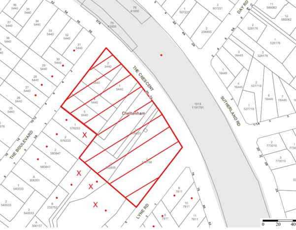
|
NOTIFICATION PLAN |
|
||
|
• PROPERTIES NOTIFIED
|
X SUBMISSIONS RECEIVED |
PROPERTY SUBJECT OF DEVELOPMENT |
|
|
TWO SUBMISSIONS RECEIVED OUT OF MAP RANGE |
|||
Six submissions objected to the development. The grounds for objection are addressed as follows:
5.1.1 Heritage Conservation
A submission raises concerns the proposed accessway over the existing driveway would detract from the historic connection of the driveway for ‘Edensor’ through the Cheltenham Recreation Club site.
The proposed accessway would maintain the former driveway connection and would not detract from the heritage significance of the item ‘Edensor’. Refer to discussion in Section 2.1.2.
5.1.2 Noise Attenuation
A submission raises concerns the noise emission level with all doors open would be 2 dB(A) over the established limit at the upper windows of an adjoining residence.
A condition is recommended for the installation of a noise barrier and a Noise Management Plan which is to limit noise emission below the established level of 43 dB(A) at the boundary. Refer to discussion in Section 2.8.11.
5.1.3 Stormwater Drainage
Submissions raise concerns the proposed retaining wall along the rear boundary will impact on stormwater drainage. Further to the onsite meeting on 23 October 2017 the ground floor plan (Dwg No. a2101) and elevations drawing (Dwg No. a3001) has been amended to detail the retaining wall on the subject site.
The adjoining properties have a gradual fall to the rear boundary.
A condition is recommended for the stormwater drainage behind the retaining wall to connect with the proposed stormwater drainage system and for the wall height not to extend above existing ground level.
Subject to recommended conditions the proposed retaining wall would not result in flooding of neighbouring properties.
5.1.4 Traffic and Car Parking
A submission raised concerns the proposal would reduce available parking in the locality.
The proposed on-site car parking provision is in accordance with Council’s requirements for the proposed childcare centre and would not necessitate parking in the street.
5.2 Public Agencies
The development application was not required to be referred to any Public Agencies for comment.
6. THE PUBLIC INTEREST
Section 79C(1)(e) of the Act requires Council to consider “the public interest”.
The public interest is an overarching requirement, which includes the consideration of the matters discussed in this report. Implicit to the public interest is the achievement of future built outcomes adequately responding to and respecting the future desired outcomes expressed in environmental planning instruments and development control plans.
The application is considered to have satisfactorily addressed Council’s and relevant agencies’ criteria and would provide a development outcome that, on balance, would result in a positive impact for the community. Accordingly, it is considered that the approval of the proposed development would be in the public interest.
CONCLUSION
The proposal is for construction of a 92 place childcare centre.
The proposed childcare centre is single storey and designed with regard to the previous childcare centre approved by Council on the site for which the development consent has lapsed.
The proposed childcare centre complies with Hornsby Local Environmental Plan 2013 and the Children (Education and Care Services) Supplementary Regulation 2012. The provisions of the recently published State Environmental Planning Policy (Education Establishments and Childcare Facilities) 2017 include a saving provision whereby the Policy does not apply to the undetermined application, notwithstanding the proposal would meet the recent Policy’s design criteria.
The proposal complies with the relevant provisions of the HDCP other than the required maximum number of childcare places and the minimum indoor and outdoor play area space per child. The non-compliance is acceptable with regard to compliance with the State regulatory requirements and to the Council’s resolution to amend the HDCP consistent with the State Environmental Planning Policy (Education Establishments and Childcare Facilities) 2017.
The application is satisfactory in respect to SEPP 55 and the submitted Remediation Action Plan.
Six submissions were received in response to notification of the application.
The application is recommended for approval subject to the recommended conditions in Schedule 1 of this report.
Note: At the time of the completion of this planning report, no persons have made a Political Donations Disclosure Statement pursuant to Section 147 of the Environmental Planning and Assessment Act 1979 in respect of the subject planning application.
RESPONSIBLE OFFICER
The officer responsible for the preparation of this Report is the Manager – Development Assessments – Rodney Pickles, who can be contacted on 9847 6731.
|
James Farrington Group Manager Planning Division |
|
|
1.View |
Locality Map |
|
|
|
2.View |
Site Plan |
|
|
|
3.View |
Floor Plan |
|
|
|
4.View |
Roof Plan |
|
|
|
5.View |
Elevations and Sections |
|
|
|
6.View |
Parking / Driveway |
|
|
|
7.View |
Materials and Finishes |
|
|
|
8.View |
Landscaping |
|
|
File Reference: DA/191/2017
Document Number: D07323210
‘
SCHEDULE 1
GENERAL CONDITIONS
The conditions of consent within this notice of determination have been applied to ensure that the use of the land and/or building is carried out in such a manner that is consistent with the aims and objectives of the relevant legislation, planning instruments and council policies affecting the land and does not disrupt the amenity of the neighbourhood or impact upon the environment.
Note: For the purpose of this consent, the term ‘applicant’ means any person who has the authority to act on or the benefit of the development consent.
Note: For the purpose of this consent, any reference to an Act, Regulation, Australian Standard or publication by a public authority shall be taken to mean the gazetted Act or Regulation, or adopted Australian Standard or publication as in force on the date that the application for a construction certificate is made.
1. Approved Plans and Supporting Documentation
The development must be carried out in accordance with the plans and documentation listed below and endorsed with Council’s stamp, except where amended by Council and/or other conditions of this consent:
|
Plan No. |
Plan Title |
Drawn by |
Dated |
|
A0000 Rev A |
Title Page/Location Map |
RFA Architects |
14.02.17 |
|
A2001 Rev A |
Site Analysis Plan |
RFA Architects |
Feb 2017 |
|
A2100 Rev A |
Site Plan |
RFA Architects |
Feb 2017 |
|
A2101 Rev C |
Ground Floor Plan |
RFA Architects |
Feb 2017 |
|
A2102 Rev B |
Roof Plan |
RFA Architects |
Feb 2017 |
|
A3001 Rev B |
Elevations + Section 1 |
RFA Architects |
Feb 2017 |
|
A4001 Rev A |
Parking/Driveway Details |
RFA Architects |
Feb 2017 |
|
A5001 Rev A |
External Finishes & Colours |
RFA Architects |
Feb 2017 |
|
A6001 Rev B |
Waste Management Plan |
RFA Architects |
Feb 2017 |
|
0598.GD.01 Issue 2 |
Landscape Plan – Area 1 |
Greenland Design |
February 2017 |
|
0598.GD.02 |
Landscape Plan – Area 2 |
Greenland Design |
February 2017 |
|
0598.GD.03 |
Landscape Details & Specification |
Greenland Design |
February 2017 |
|
S10.01 |
General Notes |
Engineering Studio |
27.06.17 |
|
S11.01 |
Ground Slab Layout Plan |
Engineering Studio |
27.06.17 |
|
S11.02 |
Ground Details Sheet |
Engineering Studio |
27.06.17 |
|
Document Title |
Prepared by |
Dated |
|
Detailed Site Investigation ES6742 Rev 0 |
Aargus |
6 Dec 2016 |
|
Assessment of Significant Trees |
Malcolm Bruce |
11/01/2017 |
|
Root Mapping Report |
Birds Tree Consultancy |
16 June 2017 |
|
Tree Management Plan Lophostemon confertus |
Malcolm Bruce |
28/06/2017 |
|
RFEME Prediction Report - Cheltenham |
Brendon Woods Consulting |
1-2-2017 |
|
Acoustics Assessment |
BGMA Pty Ltd |
26 Dec 2016 & 25 Oct 2017 |
|
Access and Compliance Assessment Report |
PSE Access Consulting |
8 Dec 2016 |
|
Waste Management Plan |
Joan E Stone |
28/2/17 |
2. Removal of Existing Trees
a) This development consent permits the removal of trees numbered 1, 2, 3, 6 and 7 as identified on the Tree Location Plan - Figure 3 of the Significant Tree Assessment prepared by Malcolm Bruce, dated 11/01/2017.
b) The removal of any other trees requires separate approval in accordance with the Tree and Vegetation Chapter 1B.6 Hornsby Development Control Plan (HDCP).
3. Tree Pruning
a) This development consent only permits the pruning of trees numbered 8 and 9 as identified on the Tree Location Plan – Figure 3 of the Significant Tree Assessment dated 11/01/2017 prepared by Malcolm Bruce.
b) All pruning works must be undertaken by an arborist with minimum AQF3 qualifications in accordance with AS4373-2007 – “Pruning of Amenity Trees”.
c) All pruning works must not significantly alter the structure of the tree(s)
d) Any pruning on trees must not exceed 20% of the total foliage area.
e) When undertaking tree works, the use of equipment that will wound the bark and conductive tissues shall not be used on, or in sections of a tree to be retained, (ie: spurs, spikes, hooks, chained platforms lowering systems or any other tools that will penetrate or severely bruise bark and conductive tissue)
f) Certification of the tree pruning must be submitted to the Principal Certifying Authority (PCA) within 7 days of the works being undertaken, confirming compliance with the relevant requirements of Australian Standard AS4373-2007 – “Pruning of Amenity Trees”.
Note: The pruning of any other trees from the site requires separate approval by Council in accordance with Part 1B.6 Tree and Vegetation Preservation of the Hornsby Development Control Plan 2013 (HDCP).
4. Amendment of Plans
To comply with Councils requirement in terms of landscaping and acoustics, the approved plans are to be amended as follows:
a) The landscaping plan is to be amended to address the required widening of the driveway in the streetscape and to retain and protect the existing trees fronting the driveway entry.
b) The landscaping plan is to be amended to retain and protect Tree No. 10 – Lophostemon confertus (Brushbox) in accordancd with the Tree Management Plan dated 28/06/2017 prepared by Malcolm Bruce.
c) The landscaping plan is to be amended to delete and replace the proposed garden bed across the driveway with a fixed non openable gate generally in accordance with the drawing attached to the Heritage Advice letter dated 25 October 2017.
d) A noise barrier is to be erected extending from the north-west wing of the building to the north-eastern boundary at an RL 109.4m in accordance with the recommendations of the Acoustic Assessments prepared by BGMA dated December 2016 and 25 October 2017.
· These amended plans must be submitted with the application for the Construction Certificate.
5. Construction Certificate
a) A Construction Certificate is required to be approved by Council or a Private Certifying Authority (PCA) prior to the commencement of any works under this consent.
b) A separate Construction Certificate must be obtained from Council for all works within the public road reserve under S138 of the Roads Act.
c) A separate Construction Certificate must be obtained from Council for all works within drainage easements vested in Council.
d) The Construction Certificate plans must not be inconsistent with the Development Consent plans.
6. Section 94A Development Contributions
a) In accordance with Section 80A(1) of the Environmental Planning and Assessment Act, 1979 and the Hornsby Shire Council Section 94A Development Contributions Plan 2014-2024, $25,268.25 must be paid to Council to cater for the increased demand for community infrastructure resulting from the development, based on development costs of $2,526,825.
b) The value of this contribution is current as at 8 September 2017. If this contribution is not paid within the financial quarter that this condition was generated, the contribution payable will be adjusted in accordance with the provisions of the Hornsby Shire Council Section 94 Development Contributions Plan and the amount payable will be calculated at the time of payment in the following manner:
$CPY = $CDC x CPIPY
CPIDC
Where:
$CPY is the amount of the contribution at the date of Payment
$CDC is the amount of the contribution as set out in this Development Consent
CPIPY is the latest release of the Consumer Price Index (Sydney – All Groups) at the date of Payment as published by the ABS.
CPIDC is the Consumer Price Index (Sydney – All Groups) for the financial quarter at the date applicable in this Development Consent Condition.
c) The monetary contributions must be paid to Council:
i) prior to the issue of the Subdivision Certificate where the development is for subdivision; or
ii) prior to the issue of the first Construction Certificate where the development is for building work; or
iii) prior to issue of the Subdivision Certificate or first Construction Certificate, whichever occurs first, where the development involves both subdivision and building work; or
iv) prior to the works commencing where the development does not require a Construction Certificate or Subdivision Certificate.
Note: It is the professional responsibility of the Principal Certifying Authority to ensure that the monetary contributions have been paid to Council in accordance with the above timeframes.
Council’s S94A Development Contributions Plan may be viewed at www.hornsby.nsw.gov.au or a copy may be inspected at Council’s Administration Centre during normal business hours.
REQUIREMENTS PRIOR TO THE ISSUE OF A CONSTRUCTION CERTIFICATE
7. Building Code of Australia
All approved building work must be carried out in accordance with the relevant requirements of the Building Code of Australia.
8. Utility Services
The applicant must submit written evidence of the following service provider requirements:
a) Ausgrid (formerly Energy Australia) – a letter of consent demonstrating that satisfactory arrangements have been made to service the proposed development.
b) Telstra - a letter of consent demonstrating that satisfactory arrangements have been made to service the proposed development.
9. Sydney Water – Approval
This application must be submitted to Sydney Water for approval to determine whether the development would affect any Sydney Water infrastructure, and whether further requirements are to be met.
Note: Building plan approvals can be obtained online via Sydney Water Tap inTM through www.sydneywater.com.au under the Building and Development tab.
10. Appointment of a Project Arborist
a) A project arborist with AQF Level 5 qualifications must be appointed to provide monitoring and certification throughout the construction period.
b) Details of the appointed project arborist must be submitted to Council and the PCA for registration with the application for the construction certificate.
11. Construction Traffic Management Plan
In order to enable unencumbered movement of traffic in the public road during construction works, a Construction Management Plan, including a Traffic Management Plan and scaled construction plans prepared by a suitably Chartered and Qualified Chartered Civil Engineer and Qualified Worksite Traffic Controller shall be prepared and submitted to Hornsby Shire Council for approval according to the following requirements:
a) A copy of the plans shall be submitted for consideration and written approval by Hornsby Shire Council prior to the release of the Construction Certificate.
b) The plans shall detail the order of construction works and arrangement of all construction machines and vehicles being used at the same time during all stages.
c) The CTMP plans shall be in accordance with the approved Development Application plans and the Development Consent conditions.
d) In order to prevent injury, accident and loss of property, no building materials, work sheds, vehicles, machines or the like shall be allowed to remain in the road reserve area without the written consent of Hornsby Shire Council.
e) The Plan shall be generally in compliance with the requirements of the Road and Traffic Authority’s “Traffic Control at Worksites Manual 1998” and detailing:
i) Public notification of proposed works;
ii) Long term signage requirements;
iii) Short term (during actual works) signage;
iv) Vehicle Movement Plans, where applicable;
v) Traffic Management Plans;
vi) Pedestrian and Cyclist access and safety;
f) The plans shall indicate traffic controls including those used during non-working hours and shall provide pedestrian access and two-way traffic in the public road to be facilitated at all times.
g) The plans shall include the proposed truck routes to and from the site including details of the frequency of truck movements at the different stages of the development. The plan shall also include details of parking arrangements for all employees and contractors.
h) The Applicant and all employees of contractors on the site must obey any direction or notice from the Prescribed Certifying Authority or Hornsby Shire Council in order to ensure the above.
i) If there is a requirement to obtain a Work Zone, partial Road Closure or Crane Permit an application to Hornsby Shire Council is to be made prior to the issue the Construction Certificate
12. Stormwater Drainage
The stormwater drainage system for the development must be designed for an average recurrence interval (ARI) of 20 years and be gravity drained in accordance with the following requirements:
a) Australian Standards AS 3500.3 and Hornsby Shire Council’s Civil Works Design Specification.
b) A grated trench drain shall be provided at the front boundary alignment to collect surface water from the driveway.
c) Connected directly to Council’s street drainage system.
13. On Site Stormwater Detention
An on-site stormwater detention system must be designed by a chartered civil engineer and constructed generally in accordance with Job No. 14566 Drawing No. C00.01, C02.01, C02.02 Revision D dated 23.06.2017 by Engineering Studio and the following requirements:
a) Have a capacity of not less than 47 cubic metres, and a maximum discharge (when full) of 25 litres per second;
b) Have a surcharge/inspection grate located directly above the outlet;
c) Discharge from the detention system must be controlled via 1 metre length of pipe, not less than 50 millimetres diameter or via a stainless plate with sharply drilled orifice bolted over the face of the outlet discharging into a larger diameter pipe capable of carrying the design flow to an approved Council system;
d) Where above ground and the average depth is greater than 0.3 metres, a ‘pool type’ safety fence and warning signs must be installed; and
e) Not be constructed in a location that would impact upon the visual or recreational amenity of residents.
14. Vehicular Crossing
A separate application under the Local Government Act, 1993 and the Roads Act 1993 being an “Application for Boundary Levels” must be submitted to Council to obtain design levels at the front boundary for the design of the internal driveway, prior to the issue of a construction Certificate.
Note: A separate application to construct the vehicular crossing being an “Application to Construct Vehicular Crossing from Roadway to Property” is required to be submitted to Council for approval and can only be made by one of Council’s Authorised Vehicular Crossing Contractors. You are advised to contact Council on 02 9847 6940 to obtain a list of contractors.
15. Internal Driveway/Vehicular Areas
The driveway and parking areas on site must be designed in accordance with Australian Standards 2890.1, 2890.2, 3727 and the following requirements:
a) Design levels at the front boundary must be obtained from Council;
b) The driveway must be a rigid pavement;
c) A passing bay shall be provided at the front boundary alignment with a minimum width of 6 metres over a 6 metre length excluding transitions. The vehicular crossing shall be widened to enable two B99 vehicles to pass each other.
d) The driveway grade must not exceed 25 percent and changes in grade must not exceed 8 percent per plan metre
16. Acoustic Treatment
Acoustic treatment must be provided to the development in accordance with the recommendations contained within the Acoustics Assessments dated December 2016 and 25 October 2017 prepared by BGMA Pty Ltd.
17. Childcare Centre Design
A registered architect must certify that the construction certificate plans meet the design criteria for childcare centres in accordance with Children (Education and Care Services) Supplementary Provisions Regulation 2012.
REQUIREMENTS PRIOR TO THE COMMENCEMENT OF ANY WORKS
18. Erection of Construction Sign
a) A sign must be erected in a prominent position on any site on which any approved work is being carried out:
i) Showing the name, address and telephone number of the principal certifying authority for the work;
ii) Showing the name of the principal contractor (if any) for any demolition or building work and a telephone number on which that person may be contacted outside working hours; and
iii) Stating that unauthorised entry to the work site is prohibited.
b) The sign is to be maintained while the approved work is being carried out and must be removed when the work has been completed.
19. Protection of Adjoining Areas
A temporary hoarding, fence or awning must be erected between the work site and adjoining lands before the works begin and must be kept in place until after the completion of the works if the works:
a) Could cause a danger, obstruction or inconvenience to pedestrian or vehicular traffic;
b) Could cause damage to adjoining lands by falling objects; and/or
c) Involve the enclosure of a public place or part of a public place.
Note: Notwithstanding the above, Council’s separate written approval is required prior to the erection of any structure or other obstruction on public land.
20. Toilet Facilities
a) To provide a safe and hygienic workplace, toilet facilities must be available or be installed at the works site before works begin and must be maintained until the works are completed at a ratio of one toilet for every 20 persons employed at the site.
b) Each toilet must:
i) be a standard flushing toilet connected to a public sewer; or
ii) be a temporary chemical closet approved under the Local Government Act 1993; or
iii) have an on-site effluent disposal system approved under the Local Government Act 1993.
21. Erosion and Sediment Control
To protect the water quality of the downstream environment, erosion and sediment control measures must be provided and maintained throughout the construction period in accordance with the manual ‘Soils and Construction 2004 (Bluebook)’, the approved plans, Council specifications and to the satisfaction of the principal certifying authority. The erosion and sediment control devices must remain in place until the site has been stabilised and revegetated.
Note: On the spot penalties may be issued for any non-compliance with this requirement without any further notification or warning.
22. Installation of Tree Protection
All tree protection fencing for the trees to be retained must have the protection measures for the ground, trunk and canopy installed in accordance with the relevant requirements of Australian Standard AS 4970-2009 - “Protection of Trees on Development Sites”.
REQUIREMENTS DURING CONSTRUCTION
23. Construction Work Hours
All works on site, including demolition and earth works, must only occur between 7am and 5pm Monday to Saturday.
No work is to be undertaken on Sundays or public holidays.
24. Demolition
To protect the surrounding environment, all demolition work must be carried out in accordance with “Australian Standard 2601-2001 – The Demolition of Structures” and the following requirements:
a) Demolition material must be disposed of to an authorised recycling and/or waste disposal site and/or in accordance with an approved waste management plan;
b) Demolition works, where asbestos material is being removed, must be undertaken by a contractor that holds an appropriate licence issued by WorkCover NSW in accordance with Chapter 10 of the Occupational Health and Safety Regulation 2001 and Clause 29 of the Protection of the Environment Operations (Waste) Regulation 2005 ;and
c) On construction sites where any building contain asbestos material, a standard commercially manufactured sign containing the words ‘DANGER ASBESTOS REMOVAL IN PROGRESS’ and measuring not less than 400mm x 300mm must be displayed in a prominent position visible from the street.
25. Environmental Management
The site must be managed in accordance with the publication ‘Managing Urban Stormwater – Landcom (March 2004) and the Protection of the Environment Operations Act 1997 by way of implementing appropriate measures. To prevent sediment run-off, excessive dust, noise or odour emanating from the site during the construction of the development.
26. Street Sweeping
To protect the surrounding environment, Street sweeping must be undertaken following sediment tracking from the site along adjacent streets during works and until the site is established.
The street cleaning services must undertake a street ‘scrub and dry’ method of service and not a dry sweeping service that may cause sediment tracking to spread or cause a dust nuisance.
27. Disturbance of Existing Site
During construction works, the existing ground levels of open space areas and natural landscape features, including natural rock-outcrops, vegetation, soil and watercourses must not be altered unless otherwise nominated on the approved plans.
28. Landfill
Landfill must be constructed in accordance with Council’s ‘Construction Specification 2005’ and the following requirements:
a) Prior to fill material being imported to the site, a certificate shall be obtained from a suitable qualified environmental consultant confirming the fill wholly consists of Virgin Excavated Natural Material (VENM) as defined in Schedule 1 of the Protection of the Environment Operations Act, 1997 or material approved under the Department of Environment and Climate Change’s general resource recovery exemption.
29. Excavated Material
All excavated material removed from the site must be classified by a suitably qualified person in accordance with the Department of Environment, Climate Change and Water NSW Waste Classification Guidelines prior to disposal to an approved waste management facility and be reported to the principal certifying authority prior to the issue of an Occupation Certificate.
30. Works within Tree Protection Zones
a) Root Pruning
All root pruning must be undertaken in accordance with the relevant requirements of Australian Standard AS 4970-2009 “Protection of Trees on Development Sites” - Sections 3.3.4, 4.5.4 and 4.5.5.
b) Footings
To minimise development impacts within the Tree Protection Zones of trees numbered 10 & 11 to be retained, the foundations/footings must be constructed in accordance with the approved plans prepared by Engineering Studio dated 27.06.17.
c) Excavation
Any necessary excavations within the Tree Protection Zone of trees to be retained on the approved plans, must be undertaken using construction techniques as prescribed in the Australian Standard AS 4970-2009 – “Protection of Trees on Development Sites” Section 4.5.5 under the supervision of the appointed project arborist.
d) Installing Services
To minimise the environmental impacts of the development within the Tree Protection Zone (TPZ) of trees to be retained on the approved plans:
i) The installation of any underground services which either enter or transect the designated TPZ must utilise sensitive methods such as directional drilling or manual excavation.
ii) The installation of any underground services must be inspected by the project arborist to monitor the likely impacts of the development on retained trees.
iii) For manual excavation of trenches the project arborist must advise on roots to be retained and must monitor the works. Manual excavation may include the use of pneumatic and hydraulic tools. Refer Section 4.5.3 of Australian Standard AS 4970-2009 – “Protection of Trees on Development Sites”.
31. Building Materials and Site Waste
The filling or stockpiling of building materials, the parking of vehicles or plant, the disposal of cement slurry, waste water or other contaminants must be located outside the tree protection zones as prescribed in the conditions of this consent or the prescriptive measures of Part 1B.6.1 Tree Preservation of the Hornsby Development Control Plan, 2013, of any tree to be retained.
32. Works near trees certification
a) The project arborist must submit to the principal certifying authority on a monthly a certificate that the works have been carried out in compliance with the approved plans and specifications for tree protection.
b) Certification should include a statement of site attendance, the condition of the retained trees, details of any deviations from the approved tree protection measures and their impacts on trees.
Note: Copies of monitoring documentation may be required by the PCA and/or Council.
33. Traffic Control Plan
A Traffic Control Plan (TCP) must be prepared by a qualified traffic controller in accordance with the Roads & Traffic Authority’s Traffic Control at Worksites Manual 1998 and Australian Standard 1742.3 for all work on a public road and be submitted to Council. The TCP must detail the following:
c) Arrangements for public notification of the works.
d) Temporary construction signage.
e) Permanent post-construction signage.
f) Vehicle movement plans.
g) Traffic management plans.
h) Pedestrian and cyclist access/safety.
REQUIREMENTS PRIOR TO THE ISSUE OF AN OCCUPATION CERTIFICATE
Note: For the purpose of this consent, a reference to ‘occupation certificate’ shall not be taken to mean an ‘interim occupation certificate’ unless otherwise stated.
34. Final Certification Arborist
a) The suitably qualified person holding a certificate III in Horticulture must submit to the principal certifying authority a Statement/or/Certification confirming all tree replacement requirements have been completed in accordance with approved landscape plans and conditions of consent.
b) The Project supervisor must submit to the principal certifying authority all relevant certificates with the application for the occupation certificate stating compliance with all the conditions of this consent.
c) The Project arborist must submit to the principal certifying authority a certificate that all the completed works have been carried out in compliance with the approved plans and specifications for tree protection.
d) Certification must include a statement of overall site attendance, the condition of the retained trees, details of any deviations from the approved tree protection measures and their impacts on trees.
Note: Copies of monitoring documentation may be required.
35. Vehicular Crossing – Construction
A separate application under the Local Government Act, 1993 and the Roads Act 1993 being an “Application to Construct Vehicular Crossing from Roadway to Property” must be submitted to Council for the installation of a new vehicular crossing and the removal of the redundant crossing. The vehicular crossing must be constructed in accordance with Council’s Civil Works Design Specification 2005 and the following requirements:
a) Crossing levels at the front boundary must be constructed to the design levels obtained from Council;
b) Any redundant crossings must be replaced with integral kerb and gutter;
c) The footway area must be restored by turfing;
d) Approval must be obtained from all relevant utility providers that all necessary conduits be provided and protected under the crossing.
Note: An application for a vehicular crossing can only be made to one of Council’s Authorised Vehicular Crossing Contractors. You are advised to contact Council on 02 9847 6940 to obtain a list of contractors.
36. Retaining Walls
All required retaining walls must be constructed as part of the development in accordance with the approved plans. The finished level at the top of the retaining wall along the southern boundary shall be no higher than the existing ground level of the adjoining property. All subsoil drainage behind any retaining wall shall be drained to the approved stormwater drainage system.
37. Damage to Council Assets
Any damage caused to Council’s assets including the removal, damage, destruction, displacement or defacing of the existing survey marks as a result of the construction of the development must be rectified in accordance with Council’s written requirements and at the sole cost of the applicant.
38. Preservation of Survey Marks
A certificate by a Registered Surveyor shall be submitted to the Principal Certifying Authority, certifying that there has been no removal, damage, destruction, displacement or defacing of the existing survey marks in the vicinity of the proposed development or otherwise the re-establishment of damaged, removed or displaced survey marks has been undertaken in accordance with the Surveyor General’s Direction No.11 – “Preservation of Survey Infrastructure”.
39. Creation of Easements
The following matter(s) must be nominated on the plan of subdivision under s88B of the Conveyancing Act 1919:
a) The creation of an appropriate "Positive Covenant" and "Restriction as to User" over the constructed on-site detention/retention systems and outlet works, within the lots in favour of Council in accordance with Council’s prescribed wording. The position of the on-site detention system is to be clearly indicated on the title.
b) To register the OSD easement, the restriction on the use of land “works-as-executed” details of the on-site-detention system must be submitted verifying that the required storage and discharge rates have been constructed in accordance with the design requirements. The details must show the invert levels of the on-site system together with pipe sizes and grades. Any variations to the approved plans must be shown in red on the “works-as-executed” plan and supported by calculations.
Note: Council must be nominated as the authority to release, vary or modify any easement, restriction or covenant.
40. Works as Executed Plan
A works-as-executed plan(s) must be prepared by a registered surveyor and submitted to Council for completed on-site detention system. The plan(s) must be accompanied by a certificate from a registered surveyor certifying that all pipelines and associated structures lie wholly within any relevant easements.
41. Acoustic Certificate
On completion of all works and prior to the issue of an Occupation Certificate, the certifier is to be provided with a certificate from a qualified acoustic engineer/consultant certifying that all acoustic works have been completed in accordance with the recommendations contained in the Acoustics Assessments dated December 2016 and 25 October 2017, prepared by BGMA Pty Ltd.
42. Site Remediation Verification
The applicant must provide documentation from a suitably qualified environmental consultant verifying that the site has been remediated in accordance with the NSW Environment Protection Authority’s Contaminated Sites – Guidelines for Consultants Reporting on Contaminated Sites, the Contaminated Sites- Sampling Design Guidelines Contaminated Sites – Guidelines for the NSW Site Auditor Scheme and the recommendations of the Remediation Action Plan prepared by Aargus, document number ES6742/2 Rev 0 dated 6 December 2016.
43. Outdoor Play Space
The outdoor play space must be adequately shaded in accordance with The Shade Handbook, published by the New South Wales Cancer Council in 2008.
44. Food Premises
The fit out and operation of that part of the building to be used for the manufacture, preparation or storage of food, must be in accordance with Australian Standard 4674-2004 – Design and fit out of food premises, the Food Act 2003, and the Food Regulation 2015 and the Food Standards Code developed by Food Standards Australia New Zealand. Food Standards 3.3.1. 3.2.2 and 3.2.3 are mandatory for all food businesses.
Note: Walls are to be of solid construction.
45. Kitchen Exhaust Installation
A kitchen exhaust system must be designed and installed to effectively prevent air pollution in accordance with the Protection of the Environment Operations Act 1997.
OPERATIONAL CONDITIONS
46. Use of Premises
a) The development approved under this consent shall be used for a childcare centre and not for any other purpose without Council’s separate written consent.
b) The childcare centre is to operate in accordance with the Noise Management Plan at Appendix A of the Acoustic Assessment dated December 2016 prepared by BGMA Pty Ltd.
47. Hours of Operation
The hours of operation of the premise are restricted to those times listed below:
Monday to Friday 7 am to 6 pm
(Other than 4 Saturdays per year for special occasions)
48. Noise – Plant and Machinery
The level of total continuous noise emanating from operation of all the plant, including air conditioning units and processes in all buildings (LA10) (measured for at least 15 minutes) in or on the above premises, must not exceed the background level by more than 5dB(A) when measured at all property boundaries.
An acoustic assessment is to be undertaken by a suitably qualified environmental consultant within 60 days of occupying the site in accordance with the Environment NSW Industrial Noise Policy (2000), Council’s Policy and Guidelines for Noise and Vibration Generating Development (Acoustic Guidelines V.5, 2000) and the DECC’s Noise Guide for Local Government (2004). The assessment must be submitted to Council for review. Should the assessment find that noise from the premise exceeds 5dB(A) above background noise levels, appropriate measures must be employed to rectify excessive noise.
49. Noise
All noise generated by the proposed development must be attenuated to prevent levels of noise being emitted to adjacent premises which possess tonal, beating and similar characteristics or which exceeds background noise levels by more than 5dB(A).
50. Number of Children
The centre shall accommodate a maximum of 92 children with a minimum of 25% of children within the 0-2 age group as at 1 January of each calendar year.
51. Car Parking
All car parking must be constructed and operated in accordance with Australian Standard AS/NZS 2890.1:2004 – Off-street car parking and Australian Standard AS 2890.2:2002 – Off-street commercial vehicle facilities.
All parking areas and driveways are to be sealed to an all weather standard, line marked and signposted;
Car parking, loading and manoeuvring areas to be used solely for nominated purposes;
Vehicles awaiting loading, unloading or servicing shall be parked on site and not on adjacent or nearby public roads;
a) All vehicular entry on to the site and egress from the site shall be made in a forward direction.
b) All parking for people with disabilities is to comply with AS/NZS 2890.6:2009 Off-street parking for people with disabilities.
c) Any proposed landscaping and/or fencing must not restrict sight distance to pedestrians and cyclists travelling along the footpath.
52. Waste Management
The waste management on site must be in accordance with the following requirements:
a) All commercial tenant(s) must keep written evidence on site of a valid contract with a licensed waste contractor(s) for the regular collection and disposal of the waste and recyclables that are generated on site.
b) All commercial tenant(s) must have a sufficient number of bins to contain the volume of waste and recycling expected to be generated between collection services.
c) All bins must be placed along The Crescent for waste and recycling collection services evening before the day of the weekly garbage collection, and the bins are to be returned to the on-site bin storage area promptly afterwards.
d) A Work, Health & Safety (WHS) risk assessment is to be carried out by a suitably qualified person with qualifications in Work, Health & Safety Legislation with specific regard to waste management. The recommendations of the WHS Risk Assessment are to be implemented as required.
- END OF CONDITIONS -
ADVISORY NOTES
The following information is provided for your assistance to ensure compliance with the Environmental Planning and Assessment Act, 1979, Environmental Planning and Assessment Regulation 2000, other relevant legislation and Council’s policies and specifications. This information does not form part of the conditions of development consent pursuant to Section 80a of the Act.
Environmental Planning and Assessment Act 1979 Requirements
The Environmental Planning and Assessment Act 1979 requires:
The issue of a construction certificate prior to the commencement of any works. Enquiries can be made to Council’s Customer Services Branch on 9847 6760.
a) A principal certifying authority to be nominated and Council notified of that appointment prior to the commencement of any works.
b) Council to be given at least two days written notice prior to the commencement of any works.
c) Mandatory inspections of nominated stages of the construction inspected.
d) An occupation certificate to be issued before occupying any building or commencing the use of the land.
Long Service Levy
In accordance with Section 34 of the Building and Construction Industry Long Service Payments Act 1986, a ‘Long Service Levy’ must be paid to the Long Service Payments Corporation or Hornsby Council.
Note: The rate of the Long Service Levy is 0.35% of the total cost of the work.
Note: Hornsby Council requires the payment of the Long Service Levy prior to the issue of a construction certificate.
Asbestos Warning
Should asbestos or asbestos products be encountered during demolition or construction works, you are advised to seek advice and information prior to disturbing this material. It is recommended that a contractor holding an asbestos-handling permit (issued by WorkCover NSW) be engaged to manage the proper handling of this material. Further information regarding the safe handling and removal of asbestos can be found at:
Alternatively, telephone the WorkCover Asbestos and Demolition Team on 8260 5885.
Tree and Vegetation Preservation
In accordance with Clause 5.9 of the Hornsby Local Environmental Plan 2013 a person must not ringbark, cut down, top, lop, remove, injure or wilfully destroy any tree or other vegetation protected under the Hornsby Development Control Plan 2013 without the authority conferred by a development consent or a permit granted by Council.
Notes: A tree is defined as a long lived, woody perennial plant with one or relatively few main stems with the potential to grow to a height greater than three metres (3M). (HDCP 1B.6.1.c).
Tree protection measures and distances are determined using the Australian Standard AS 4970:2009, “Protection of Trees on Development Sites”.
Fines may be imposed for non-compliance with both the Hornsby Local Environmental Plan 2013 and the Hornsby Development Control Plan 2013.
Advertising Signage – Separate DA Required
This consent does not permit the erection or display of any advertising signs. Most advertising signs or structures require development consent. Applicants should make separate enquiries with Council prior to erecting or displaying any advertising signage.
Dial Before You Dig
Prior to commencing any works, the applicant is encouraged to contact Dial Before You Dig on 1100 or www.dialbeforeyoudig.com.au for free information on potential underground pipes and cables within the vicinity of the development site.
Telecommunications Act 1997 (Commonwealth)
If you are aware of any works or proposed works which may affect or impact on Telstra’s assets in any way, you are required to contact: Telstra’s Network Integrity Team on Phone Number 1800 810 443.
Food Authority Notification
The NSW Food Authority requires businesses to electronically notify the Authority prior to the commencement of its operation.
Note: NSW Food Authority can be contacted at www.foodnotify.nsw.gov.au.
Council Notification – Food Premises
Prior to the commencement of the business, the operator is requested to contact Council’s Environmental Health Team to arrange an inspection for compliance against the relevant legislation and guidelines outlined in this approval.
Note: Council’s Environmental Health Officer can be contacted on 02 9847 6745.
Group Manager's Report No. PL57/17
Planning Division
Date of Meeting: 8/11/2017
10 REPORTING VARIATIONS TO DEVELOPMENT STANDARDS
EXECUTIVE SUMMARY
· In accordance with the Department of Planning and Environment’s Planning Circular PS 08‑14, Council is required to report variations to development standards for development applications approved under delegated authority, which relied upon State Environmental Planning Policy No. 1 – Development Standards (SEPP 1) or Clause 4.6 of the Hornsby Local Environmental Plan - 2013 (HLEP).
· Council’s consideration of this report ensures Council’s obligation to monitor variations to development standards is complied with.
|
THAT the contents of Group Manager’s Report No. PL57/17 be received and noted. |
PURPOSE
The purpose of this report is to advise Council of determined development applications under delegated authority involving a SEPP 1 or Clause 4.6 variation to a development standard for the period 1 June 2017 to 30 September 2017.
DISCUSSION
Department of Planning and Environment’s Circular B1, issued in March 1989, requested that councils monitor the use of the Secretary’s assumed concurrence under SEPP 1 on a quarterly basis. This reporting requirement remains effective.
Monitoring of variations to development standards is important to provide the Department and councils with an overview of the manner in which established development standards are being varied and whether the assumed concurrence is being used as intended. This enables Council and the Department to determine whether development standards are appropriate, or whether changes are required.
The Department issued Circular PS 08–014 on 14 November 2008. The purpose of the Circular was to remind councils of their responsibilities to monitor the use of the Secretary’s assumed concurrence under SEPP 1. Councils were reminded of the need to keep accurate records of the use of SEPP 1 and to report on a quarterly basis.
The Circular also provides that councils are required to adopt the following four measures:
1. Establish a register of development applications determined with variations in standards under SEPP 1.
2. Require all development applications where there has been a variation greater than 10% in standards under SEPP 1 to be determined by full council (rather than General Manager or nominated staff member).
3. Provide a report to Council on the development applications determined where there had been a variation in standards under SEPP 1.
4. Make the register of development applications determined with variations in standards under SEPP 1 available to the public on the council’s website.
In accordance with Point 3 of Department Circular, attached is a list of development applications determined between 1 June 2017 to 30 September 2017.
A copy of the attachment to this report is also reproduced on Council’s website.
BUDGET
There are no budget implications.
POLICY
This report addresses Council’s reporting obligations for development applications determined where there has been a variation in standards under SEPP 1. Under the HLEP 2013, the application of the provisions of SEPP 1 has been replaced by Clause 4.6 (exceptions to development standards). The Department of Planning and Environment has advised that the reporting practice for variation to development standards applies to applications involving a submission pursuant to Clause 4.6 of the HLEP 2013.
CONCLUSION
Council is required to monitor the manner in which development standards are being varied. This assists in determining whether changes are required to relevant standards. This report provides advice to Council on standards varied under delegated authority which relied upon SEPP 1 or Clause 4.6 of the HLEP during the reporting period from 1 June 2017 to 30 September 2017.
RESPONSIBLE OFFICER
The officer responsible for the preparation of this report is the Group Manager Planning Division – James Farrington, who can be contacted on 9847 6750.
|
James Farrington Group Manager Planning Division |
|
|
1.View |
SEPP 1 Returns Quarter - 1 June 2017 to 30 September 2017 |
|
|
File Reference: F2004/07599
Document Number: D07316274
Deputy General Manager's Report No. IR16/17
Infrastructure and Recreation Division
Date of Meeting: 8/11/2017
11 TENDER RFT19/2017 - SUPPLY AND DELIVERY OF CONCRETE
EXECUTIVE SUMMARY
· The proposed contract for “Supply and Delivery of Concrete” is required to service Council’s needs in carrying out construction and maintenance of kerb and gutters, footpaths, crossings, and drainage structures etc. Council uses a substantial amount of concrete in its annual roads and drainage construction and maintenance program.
· Council does not have the specialist personnel and equipment required to produce concrete and therefore open tenders have recently been called in accordance with the Local Government Act. Given the work available in the future works program, it is essential that two tenderers be selected to allow for the work to be carried out efficiently and effectively and to allow for programming flexibility.
· The proposed contract will be for 24 months duration with an option to extend the contract for a further 12 month period. No tender has been recommended for acceptance for this tender.
|
THAT Council do not accept any tender and invite fresh tenders based on the same details for “Supply and Delivery of Concrete”. |
PURPOSE
The purpose of this Report is to provide a recommendation for not accepting any tender for “Supply and Delivery of Concrete”.
BACKGROUND
Supply and delivery concrete is a specialised service and currently the works are being carried out by Hanson Construction Materials Pty Ltd and Able Metromix Concrete. The term of current contract expires soon and the purpose of this tender is to enter into new contracts through a public tender process.
DISCUSSION
Tender T19/2017 is a Schedule of Rates tender. A summary, together with full evaluation details are in Folder F2017/00110. Excepting this report, the summary and details of the tenders received are to be treated as confidential in accordance with the Local Government Act.
The objective of the tender is to determine suitable contractors who can provide Council value for money for supply and delivery of concrete.
A public tender notice was advertised in the Sydney Morning Herald, relevant local newspapers together with Tenderlink. The tender was issued in May 2017 with a closing date of 25 May 2017.
One (1) tender was received for Tender T19/2017 from the Able Metromix Concrete.
TENDER EVALUATION
Council needs a minimum of two contractors for supply and delivery of concrete to meet the demand for ready-mix concrete from Design and Construction Branch and Asset Branch. The requirements of concrete include orders which have volumes varying from less than 1m³ to volumes above 10m³. Council has had a panel of two contractors for supply of concrete over last 15-20 years and this arrangement is essential to cater for the demand and to get the construction jobs completed in a timely manner.
The current suppliers for supply and delivery of concrete to Hornsby Council are Able Metromix Pty Ltd and Hanson Construction Materials Pty Ltd.
Considering Council’s requirements for ready-mix concrete and how the supplies have been managed over the last 15-20 years, having only one supplier for the construction and maintenance of Council’s assets will be problematic and result in efficiencies. The total estimated work under this contract is in the order of $500,000 per annum. Full details of the tender evaluation are on folder F2017/00110.
BUDGET
There are no budgetary implications associated with this Report.
POLICY
There are no policy implications associated with this Report.
CONCLUSION
Based on the evaluation, the evaluation Panel has recommended that Council do not accept any tender for RFT19/2017 and call for fresh tenders based on same details.
RESPONSIBLE OFFICER
The officer responsible for the preparation of this Report is the Manager Design and Construction, Mr. Robert Rajca who can be contacted on 9847 6675.
|
Rob Rajca Manager - Design & Construction Infrastructure and Recreation Division |
Robert Stephens Deputy General Manager - Infrastructure and Recreation Infrastructure and Recreation Division |
|
1.View |
Confidential Memo - Tender RFT19/2017 - Supply and Delivery of Concrete - This attachment should be dealt with in confidential session, under Section 10A (2) (d) of the Local Government Act, 1993. This report contains commercial information of a confidential nature that would, if disclosed (i) prejudice the commercial position of the person who supplied it; or (ii) confer a commercial advantage on a competitor of the council; or (iii) reveal a trade secret. |
|
|
|
2.View |
Tender Evaluation Report - This attachment should be dealt with in confidential session, under Section 10A (2) (d) of the Local Government Act, 1993. This report contains commercial information of a confidential nature that would, if disclosed (i) prejudice the commercial position of the person who supplied it; or (ii) confer a commercial advantage on a competitor of the council; or (iii) reveal a trade secret. |
|
|
File Reference: F2017/00110
Document Number: D07314908
Deputy General Manager's Report No. IR17/17
Infrastructure and Recreation Division
Date of Meeting: 8/11/2017
12 REQUEST TO REMOVE TREE - 20 DEAN STREET, WEST PENNANT HILLS
EXECUTIVE SUMMARY
· The owners of 20 Dean Street, West Pennant Hills have sought Council approval for the removal of one Eucalyptus saligna (Sydney Blue Gum) located at the front of the property.
· An initial application in 2014 (TA/820/2014) requested the removal of Tree 1, a Eucalyptus saligna (Sydney Blue Gum) and pruning of Tree 2, a Eucalyptus pilularis (Blackbutt) on the basis of presence of deadwood, termite damage and branches overhanging the garage.
· A partial approval was granted which refused the removal of
Tree 1 (due to insufficient evidence); but consented to the pruning of Tree 1
and Tree 2.
· In March 2015 an appeal was lodged (TA/820/2014/A) seeking review of Council’s decision to allow for removal of Tree 1. The appeal was accompanied with an Arborist Report. Council Officers were not satisfied the report proved conclusively that the tree was defective at the major trunk union. As a result Council requested additional information in the form of a sonic tomograph testing. The additional information was not received and the appeal application was subsequently refused.
· In 2016 a further application TA/350/2016 was lodged seeking removal of Tree 1, supported with additional information which was provided in the form of the sonic tomograph testing. This test confirmed the base of the tree was sound.
· The tree applied for under this application is a species characteristic of Blue Gum High Forest (BGHF), adjoins a mapped heritage listed streetscape under Council’s Development Control Plan and forms part of the vegetation buffer for an Endangered Ecological Community area.
· The owner requested that the matter be considered at a General Meeting of Council and a report was tabled to the meeting of 12 July 2017. Council resolved that the matter be deferred to allow an onsite meeting between the applicant, relevant Council officers and interested Councillors. The matter was expected to be resubmitted to Council for a decision.
· An outcome of the onsite meeting was that the applicant was to provide an arborist report that had been prepared previously and not submitted with the original application, or alternatively, obtain a new arborist report. An arborist report has since been provided which supports the Council officer’s’ recommendation that the tree can be retained.
|
THAT Council refuse consent to remove one Eucalyptus saligna (Sydney Blue Gum) located at the front of the property at 20 Dean Street, West Pennant Hills. |
PURPOSE
The purpose of this Report is to provide Council with the information required to consider an application by the owner of 20 Dean Street, West Pennant Hills to remove one Eucalyptus saligna (Sydney Blue Gum), located in the front yard of the property.
BACKGROUND
At the Council meeting of 12 July 2017 (Attachment 1), resolved:
“THAT consideration of Deputy General Manager’s Report No. IR5/17 be deferred to allow an onsite meeting between the applicant, relevant Council officers and interested Councillors to discuss the Eucalyptus saligna (Sydney Blue Gum) located at the front of the property at 20 Dean Street, West Pennant Hills.”
A site meeting occurred on 24 July 2017 with staff, two Councillors, a resident of 18 Dean Street and the owners of 20 Dean Street present.
At this meeting the merits of the proposed removal were outlined by the property owners and an adjoining neighbour. The opportunity for tree replacement was also discussed should council support the removal of the tree.
As an outcome of the meeting the applicant was requested to provide council an arborist report that was known to have been prepared when a sonic tomograph test (internal radar) was undertaken, or alternatively, a new report be obtained. An arborist report was subsequently submitted (Attachment 2), which concluded that:
“Based on the results from the aerial inspection regarding the “active cracks” and the adjacent cavity, the tree can be retained”.
DISCUSSION
The remanent trees located in Dean Street are listed as heritage items in Council’s HLEP as components of the BGHF, an Endangered Ecological Community (EEC) listed for protection by the Commonwealth Environment Protection and Biodiversity Conservation Act and the NSW Threatened Species Conservation Act.
The statement of significance for the HLEP heritage listing describes this corridor of trees as providing dramatic scale and size which contributes to a sense of place and outstanding aesthetic quality to the streetscape. Whilst the public street trees are nominated in this listing, the subject Sydney Blue Gum located at 20 Dean Street is also included within the heritage item inventory as the site contains remnant trees that also contribute to the value of this group of trees.
The Sydney Blue Gum has been inspected by three different Council officers for each different application or review who have concluded the tree does not pose a risk to human life or is causing or likely to cause substantial damage to property. The tree has also been assessed by two different arborists engaged by the applicant who also conclude the tree can be retained. A third arborist report provided by the applicant recommends the tree be removed without reference to the investigative testing that has been completed.
The subject tree is located within the front yard and less than one metre from the edge of the nature strip. The subject tree was retained when the property was redeveloped in 2010 and maintains a setback from the dwelling of approximately 14 metres.
For trees in the urban environment arborists are able to undertake risk assessments by following industry accepted risk assessment criteria. Council’s tree officers have applied these criteria in their assessments and determined the risk rating to be ‘low’ and ‘acceptable’.
The applicant maintains that the tree poses a threat to the safety of their family and should be removed.
POLICY
The recommendation contained within the Report is consistent with Council’s Tree Preservation Measures (HDCP) that provides protection to trees that are indigenous to Hornsby Shire such as the Eucalyptus saligna (Sydney Blue Gum) and only permits removal of a tree in the case of safety concerns if there are signs that the tree is diseased, dying or dangerous.
CONCLUSION
The Sydney Blue Gum is a mature and healthy specimen that forms part of the remnant BGHF Community in West Pennant Hills. The tree also contributes to the streetscape which is a listed heritage item.
The tree was determined to be in good condition and the risk posed by the tree was assessed in the field using the QTRA system which concluded the risk to be low and acceptable. The suitability of retaining the tree is supported and documented by two arborists engaged by the owner.
There is no reason to believe that the tree is at imminent risk of failure or decline and, therefore, can be retained.
Council officers conclude that the tree is worthy of retention and therefore it is recommended that Council refuse the application for consent to the Eucalyptus saligna (Sydney Blue Gum) tree located at the frontage of 20 Dean Street, West Pennant Hills.
RESPONSIBLE OFFICER
The officer responsible for the preparation of this Report is the Manager, Parks and Recreation – David Sheils - who can be contacted on 9847 6792.
|
David Sheils Manager - Parks and Recreation Infrastructure and Recreation Division |
Robert Stephens Deputy General Manager - Infrastructure and Recreation Infrastructure and Recreation Division |
|
1.View |
Attachment 1 to IR17/17 - Request to Remove Tree - 20 Dean Street - West Pennant Hills - Report IR5_17 |
|
|
|
2.View |
Attachment 2 to IR17/2017 - 20 Dean St Black Forest Tree Service |
|
|
File Reference: TA/350/2016
Document Number: D07318288
Mayor's Note No. MN9/17
Date of Meeting: 8/11/2017
15 MAYOR'S NOTES FROM 1 TO 31 AUGUST 2017
Note: These are the functions that the Mayor, or his representative, has attended in addition to the normal Council Meetings, Workshops, Mayoral Interviews and other Council Committee Meetings.
Friday 4 August 2017 – The Mayor attended the Annual Knit In at Hornsby Library.
Friday 11 August 2017 – On behalf of the Mayor, Councillor Cox attended Arden Anglican School’s Visual Arts Exhibition at Epping.
Saturday 12 August 2017 – On behalf of the Mayor, Councillor Browne attended the Hornsby Junior Rugby Club’s “Red, Black and Gold Ball” at Hornsby RSL Club.
Monday 14 August 2017 – The Mayor attended the Blue Datto Foundation Keeping Safe Program presentation at Loreto Normanhurst.
Tuesday 15 August 2017 – The Mayor hosted three Citizenship Ceremonies in the Council Chambers.
Sunday 20 August 2017 – On behalf of the Mayor, Deputy Mayor Councillor Hutchence attended Berowra RSL Sub Branch’s Annual Service to Commemorate Victory in the Pacific and Vietnam Veterans Day at Berowra Heights.
Friday 25 August 2017 – On behalf of the Mayor, Councillor Cox attended Cheltenham Girls’ High School’s Official Launch of ‘In the Pink’ and the Official Opening of the 60th Anniversary Celebrations at the School.
Friday 25 August 2017 – The Mayor hosted Hornsby/Ku-ring-gai Rural Fire District’s Mayoral Dinner at Hornsby RSL Club.
Friday 25 August 2017 – On behalf of the Mayor, Councillor Cox attended Arden Anglican School’s Music Ensembles Showcase at the School.
Saturday 26 August 2017 – On behalf of the Mayor, Councillor Azizi unveiled the new Sundial at Beecroft Village Green for Beecroft Rotary Club.
Monday 28 August 2017 – On behalf of the Mayor, Deputy Mayor Councillor Hutchence presented trophies at the Northern Suburbs District Women’s Bowling Association’s Annual Hornsby Shire Trophy Competition at West Pennant Hills Bowling Club in Cherrybrook.
File Reference: F2004/07053
Document Number: D07318188
Mayor's Note No. MN10/17
Date of Meeting: 8/11/2017
16 MAYOR'S NOTES FROM 1 TO 30 SEPTEMBER 2017
Note: These are the functions that the Mayor, or his representative, has attended in addition to the normal Council Meetings, Workshops, Mayoral Interviews and other Council Committee Meetings.
Friday 15 September 2017 – On behalf of the Mayor, Councillor Tilbury attended Berowra Community School’s Band Festival at the Berowra Community Centre.
Saturday 16 September 2017 – On behalf of the Mayor, Councillor Tilbury attended the Annual General Meeting of LinC Hornsby at St Mark’s Anglican Church in Berowra.
Saturday 16 September 2017 – On behalf of the Mayor, Councillor Tilbury attended Berowra Netball Club’s Junior and Senior Presentation Ceremonies at Club Berowra.
Sunday 17 September 2017 – The Mayor attended Pennant Hills Junior Australian Football Club’s New Scoreboard Commissioning Ceremony at Ern Holmes Oval, Pennant Hills Park.
Sunday 17 September 2017 – On behalf of the Mayor, Councillor Tilbury attended 1st Hornsby Heights/Normanhurst Venturer Unit’s Queen Scout Presentation at Crosslands Reserve in Hornsby Heights.
Sunday 17 September 2017 – On behalf of the Mayor, Councillor Browne attended the Friends of Lisgar Gardens’ Teddy Bears Picnic at Lisgar Gardens in Hornsby. The Mayor also called in during the afternoon.
Sunday 17 September 2017 – On behalf of the Mayor, Councillor Browne presented the Hornsby Shire Bowling Cup at the Hornsby Shire Men’s Bowling Competition held at Asquith Bowling Club.
Monday 18 September 2017 – The Mayor attended Arden Anglican School’s TAS Showcase ‘ICON’ at the school in Epping.
Wednesday 20 September 2017 – The Mayor attended the Official Opening of the new Woolworths supermarket at Beecroft Place in Beecroft.
Wednesday 20 September 2017 – The Mayor attended the Official Opening of Beecroft Place in Beecroft.
Wednesday 20 September 2017 – On behalf of the Mayor, Councillor Waddell attended Wisemans Ferry Sunshine Group’s 26 Year Birthday Celebrations at Wisemans Ferry. The Mayor joined the celebrations for lunch.
Thursday 21 September 2017 – The Mayor attended Asquith Boys’ High School’s Welcome Luncheon for 2018 Scholarships at the school in Asquith.
Thursday 21 September 2017 – The Mayor attended the Launch of the Cities Leadership Institute in Sydney.
Friday 22 September 2017 – The Mayor attended Hornsby Ku-ring-gai Community College’s Art Exhibition at the College in Hornsby.
Saturday 23 September 2017 – The Mayor attended Ku-ring-gai Netball Association’s 50th Anniversary Celebration Dinner at Terry Hills Golf and Country Club.
Saturday 30 September 2017 – The Mayor and Mrs Ruddock attended Hornsby Musical Society’s Production of the ‘The Music Man’ at Hornsby RSL Club.
File Reference: F2004/07053
Document Number: D07319542
Mayor's Note No. MN11/17
Date of Meeting: 8/11/2017
17 MAYOR'S NOTES FROM 1 TO 31 OCTOBER 2017
Note: These are the functions that the Mayor, or his representative, has attended in addition to the normal Council Meetings, Workshops, Mayoral Interviews and other Council Committee Meetings.
Sunday 1 October 2017 – The Mayor and Mrs Ruddock attended Cheltenham Girls’ High School Old Girls Association 60th Anniversary Dinner at Pennant Hills Golf Club.
Tuesday 3 October 2017 – The Mayor attended the Launch of Hornsby Kuringgai Women’s Shelter’s Apron Project at Westfield Hornsby.
Thursday 5 October 2017 – The Mayor opened Beecroft Uniting Church’s Healthy Retirement Expo at the Church in Beecroft.
Saturday 7 October 2017 – The Mayor attended the Little India Deepavali Fair – Indian Festival of Lights in Harris Park.
Saturday 7 October 2017 – The Mayor attended Diwali in the Hills at Castle Hill.
Sunday 8 October 2017 – The Mayor officiated at the Motorcycle Awareness Day, flagging off riders at Berowra on their journey to Cessnock.
Saturday 14 October 2017 – The Mayor attended Dural & District Historical Society’s Annual General Meeting at Galston.
Saturday 14 October 2017 – The Mayor attended the opening night of Hornsby RSL Sub-Branch’s Art Exhibition “ARTEX, PACIFIC BATTLES WORLD WAR II” at Hornsby War Memorial Hall.
Sunday 15 October 2017 – The Mayor officiated at the San RunforLife at Sydney Adventist Hospital in Wahroonga.
Sunday 15 October 2017 – The Mayor attended the 200th Anniversary of the Birth of Baha’u’llah at the Baha’i House of Worship in Ingleside.
Tuesday 17 October 2017 – The Mayor attended the Hornsby Women’s Leadership Forum Breakfast in Hornsby.
Friday 20 October 2017 – The Mayor officially opened Hornsby Shire Festival of the Arts and the 2017 Hornsby Shire Emerging Artist Exhibition at Wallarobba Arts and Cultural Centre.
Saturday 21 October 2017 – The Mayor officially opened the Galston Spring Fair at Galston.
Tuesday 24 October 2017 – The Mayor hosted two Citizenship Ceremonies in the Council Chambers.
Wednesday 25 October 2017 – The Mayor presented awards at the 2017 Hornsby Local Business Awards Presentation Evening at Hornsby RSL Club.
Sunday 29 October 2017 – The Mayor attended Our Lady of the Rosary Spring Fair at Waitara.
File Reference: F2004/07053
Document Number: D07320164
Notice of Motion No. NOM13/17
Date of Meeting: 8/11/2017
18 OVERDEVELOPMENT AND INAPPROPRIATE DEVELOPMENT IN THE HORNSBY SHIRE
There are no attachments for this report.
File Reference: F2013/00811-10
Document Number: D07324439
Notice of Motion No. NOM14/17
Date of Meeting: 8/11/2017
19 EXPANSION OF DESIGN EXCELLENCE PROVISIONS
|
THAT a report be prepared for Council’s consideration presenting amendments to the Hornsby Local Environmental Plan 2013 and Hornsby Development Control Plan 2013 to expand the application of the Design Excellence provisions to town houses and all residential flat buildings. Note from Councillor: Council has Design Excellence provisions embodied in the Hornsby Local Environmental Plan (HLEP) 2013 that aim to deliver a high standard of architectural and urban design for new buildings with a height of 10 storeys or higher. To accompany the Design Excellence provisions in the LEP, Council has established a panel of suitably qualified architecture and urban design professionals who are available on an as needs basis to undertake a review of the design quality of development. I understand that Council also has in place a number of development guidelines in the Hornsby Development Control Plan (HDCP) 2013 seeking to promote high quality building design throughout both residential and commercial areas in the Shire. I have received numerous representations from constituents concerned with the design quality of town houses and other medium to high density multi-storey apartments in the Shire. Given that a large percentage of Council’s recently gazetted Housing Strategy precincts promote housing forms less than ten storeys in height and in response to concern expressed to me by members of the community regarding the standard of design of these buildings, it would be appropriate to consider extending the application of the Design Excellence provisions in the LEP to town houses and medium to high density multi-storey apartments. A report should be prepared for Council’s consideration which presents a process and financial implications for amending the HLEP and HDCP to expand the Design Excellence provisions. |
There are no attachments for this report.
File Reference: F2013/00811-10
Document Number: D07324494
Notice of Motion No. NOM15/17
Date of Meeting: 8/11/2017
20 ADJACENT OVER DEVELOPMENT AFFECTING HORNSBY SHIRE
|
THAT Council: 1. Write to the Hills Shire Council advising that Council has received a number of concerns from members of the community that the Planning Proposal for property No. 55 Coonara Avenue, West Pennant Hills would facilitate approval of a development which exceeds community expectations, place an unnecessary burden on local infrastructure and adversely impact on the natural environment. 2. Indicate that it welcomes the opportunity to review and make a submission on the Planning Proposal when it is placed on public exhibition with accompany supporting studies in accordance any requirements of any Gateway Determination.
Note from Councillor: I have received considerable feedback from our community regarding a proposal to amend the Hills Shire Local Environment Plan 2012 to allow for medium and high density residential development at property No. 55 Coonara Avenue West, Pennant Hills. The proposal involves a rezoning of land to facilitate the construction of 400 apartments and 200 townhouses in buildings up to 6 storeys in height. This site is currently zoned B7 (Business Park) and was formerly the IBM site, utilised as a data and disaster recovery centre. The site is adjacent to the nearby Cumberland State Forest and a significant part of the site includes critically endangered Blue Gum High Forest and Sydney Turpentine Ironbark Forest. Powerful owls and Glossy Black Cockatoos have been sighted by local residents. In July 2017, The Hills Council resolved to seek a Gateway Determination from the Department of Planning and Environment to facilitate further evaluation of the proposal and its exhibition for community comment. Specifically, I understand that in resolving to support further consideration of the Proposal, The Hills Council has requested further studies to address issues including urban design, ecology, geotechnical constraints, bushfire and a voluntary planning agreement for the delivery of open space. Although the planning proposal has not been formally exhibited for public comment, I have received a number of concerns raised by constituents that should be considered in evaluation of the proposal. These concerns include that the intensity of development is in excess of the area surrounding it and while areas of public recreation are proposed, the areas of environmental conservation are inadequate for the protection of significant mature trees, flora and fauna. To ensure our suburbs are not simply the dormitory of Sydney and to support local economic development, it is also vital to maintain business zonings where possible and to encourage provision of significant employment sites adjacent to railway stations. Already Hornsby Shire residents are concerned about the increased density, traffic and infrastructure impacts that will be created by the Cherrybrook Priority Precinct. This proposed new development would exacerbate these existing issues. I am aware that Council would be formally consulted should a planning proposal be placed on exhibition. However, as an important step in advocating on behalf of our residents and to assist in ensuring their concerns are considered in the evaluation and plan preparation process, I believe Hornsby Shire Council should make a submissions to The Hills Council raising concerns on behalf of our residents to this proposal. As an important step in advocating on behalf of our residents, I believe Hornsby Shire Council should oppose this proposed amendment to the Hills Shire LEP which would facilitate this development. Already Hornsby Shire residents are concerned about the increased density, traffic and infrastructure impacts that will be created by the Cherrybrook Priority Precinct |
There are no attachments for this report.
File Reference: F2015/00054
Document Number: D07325138