BUSINESS PAPER
Hornsby Independent Hearing and Assessment Panel meeting
Wednesday 28 March 2018
at 6:30pm
BUSINESS PAPER
Hornsby Independent Hearing and Assessment Panel meeting
Wednesday 28 March 2018
at 6:30pm
Hornsby Shire Council Table of Contents
Page 1
GENERAL BUSINESS
(IHAP) Planning Division
Item 1 IHAP1/18 Development Application - Shop Top Housing Comprising 15 Residential Units and two Commercial tenancies - 16 Kita Road, Berowra Heights................................................. 1
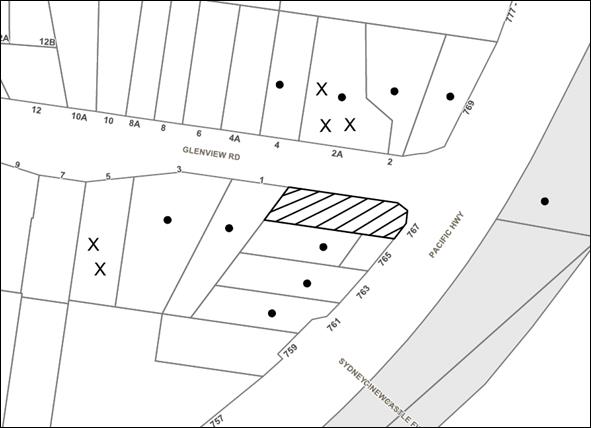
Item 2 IHAP2/18 Development Application - Alterations and additions and conversion of an existing building to a boarding house - 767 Pacific Highway, Mount Kuring-gai......................... 46
Item 3 IHAP3/18 Development application - alterations and additions to a dwelling house - No.7 Kooringal Avenue Thornleigh..................................................................................................... 74
Item 4 IHAP4/18 Development Application - Torrens title subdivision one allotment into two.... 98
IHAP Report No. IHAP1/18
IHAP - Planning Division
Date of Meeting: 28/03/2018
1 DEVELOPMENT APPLICATION - SHOP TOP HOUSING COMPRISING 15 RESIDENTIAL UNITS AND TWO COMMERCIAL TENANCIES - 16 KITA ROAD, BEROWRA HEIGHTS
EXECUTIVE SUMMARY
|
DA No: |
DA/216/2017 (Lodged on 13 March 2017) |
|
Description: |
Demolition existing structures and construction shop top housing development comprising 15 residential units and 2 commercial tenancies |
|
Property: |
Lot 101 DP 1043150, No. 16 Kita Road, Berowra Heights |
|
Applicant: |
Architecture Design Studio |
|
Owner: |
Berowra Heights Estate Pty Ltd |
|
Estimated Value: |
$6,416,079 |
· The application involves demolition of existing structures and construction of a shop top housing development comprising 15 residential units and 2 commercial tenancies.
· The proposal complies with the provisions of the Hornsby Local Environmental Plan 2013 (HLEP) other than the maximum building height development standard. The applicant has made a submission in accordance with Clause 4.6 ‘Exceptions to development standards’ of the Hornsby Local Environmental Plan 2013 to vary the 8.5m maximum building height. The submission is considered well founded and is supported.
· Two submissions have been received in respect of the application.
· The application is required to be determined by the Hornsby Shire Council IHAP as the development would contravene the HLEP maximum building height development standard by more than 10 percent, and SEPP 65 applies.
· It is recommended that the application be approved as a deferred commencement consent subject to the submission of a geotechnical assessment.
|
THAT the Hornsby Shire Council Planning Panel assume the concurrence of the Secretary of the Department of Planning and Environment pursuant to Clause 4.6 of the Hornsby Local Environmental Plan 2013 and approve Development Application No. DA/216/2017 for demolition of existing structures and construction of a shop top housing development including 15 residential units and two commercial tenancies at Lot 101 DP 1043150, No. 16 Kita Road, Berowra Heights as a deferred commencement pursuant to Section 4.16 (3) of the Environmental Planning and Assessment Act 1979 subject to the condition of consent detailed in Schedule 1 of IHAP Report No. IHAP1/18. |
BACKGROUND
On 13 September 2016 the applicant attended a Pre DA Meeting (PL/93/2016) with Council officers regarding a shop top housing development on the subject site. At the meeting the applicant was requested to ensure the design qualified as ‘shop top housing’, complied with the maximum 8.5m building height and the maximum 0.6:1 floor space ratio for the residential component.
SITE
The irregular shaped commercial site has an area of 2,501m2 and forms part of the older Turner Road shopping centre at Berowra Heights. The site is occupied by a warehouse style building which has a floor area of 426m2 and is currently vacant. The building was previously used for a hardware store. An ancillary building on the site adjoining the shopping centre is used for a barbers shop. The site includes a telecommunications facility including antennas on the existing warehouse building and equipment shed on the northern side of the existing building. A small masonry outbuilding is located at the Kita Road frontage. The site is burdened by a 6.7m wide right of carriageway which divides the site.
The eastern boundary of the site has frontage to the shopping centre open area car park. The Kita Road frontage forms the western boundary of the site. The site is burdened by an existing right of carriageway off Turner Road which benefits the adjoining shopping centre. The existing accessway off Turner Road services the adjoining shop top housing development at Nos. 25-29 Turner Road, Berowra Heights and provides access to the adjoining shopping centre lower ground floor car park through the site. The site also has access off the open area car park of the adjoining shopping centre at Nos. 19-23 Turner Road, Berowra Heights.
The surrounding developments include the recently constructed two storey shop top housing development at Nos. 25-29 Turner Road adjoining the northern boundary. The existing shopping centre adjoining the southern boundary is a single storey building with a lower ground floor car park. The adjoining shopping centre includes a hairdresser, bakery, café, pet store, chemist, medical and business premises. The supermarket at the centre has been vacant since an electrical fire in 2015.
The western side of Kita Road and the northern side of Turner Road include low density housing. Medium density townhouse developments occupy the area between the old Berowra Heights shopping centre and the larger new Berowra Village shopping centre east of the site. The new centre completed in 2007 includes a Coles supermarket, medical centre, chemist, bank, restaurant, newsagency, post office, liquor outlet, shops and business premises. The centre includes a basement car park and an open area car park. A hotel is located off Turner Road at the rear of the new shopping centre.
The site has an average gradient of 5% to the Kita Road frontage. The area of the site between the right of carriageway and Kita Road is vacant land.
There are no significant trees on the site. A number of existing locally indigenous trees were planted along the existing pedestrian pathway off Turner Road adjoining the site.
The site is not heritage listed, is not in the vicinity of a heritage item or within a heritage conservation area. The site is not bushfire prone or subject to flooding.
The site is in the vicinity of a bus stop on Turner Road serviced by Routes 597 and 599 which provide public transport connection with Berowra Railway Station 1.95 km south east of the site.
PROPOSAL
The proposal is for demolition of existing structures and construction of a two and three storey shop top housing development.
The housing development comprises single and two storey dwellings above ground floor commercial space. The proposed housing includes 3 x 1 bedroom, 9 x 2 bedroom and 3 x 3 bedroom dwellings. The proposed dwellings have a separate ground floor lobby, lift access and common open space at the first floor level.
The proposed ground floor commercial space includes two commercial tenancies with areas of 688.33m2 and 198.91m2 respectively. The ground floor includes loading bay and waste storage areas. Vehicular access is off the right of carriageway (ROC) via Nos. 25-29 Turner Road. The proposed basement car park includes commercial and residential car parking spaces with separate commercial and residential lift access.
The existing right of carriageway (ROC) and accessway through the site would be maintained.
The proposed building would address the Kita Road frontage of the site and front the eastern side of the 6.7m wide accessway through the site. The southern wall of the proposed building would adjoin the wall of the existing shopping centre. The eastern wall would adjoin the boundary with the shopping centre open area car park.
The site’s existing open space area on the western side of the accessway and fronting Kita Road is proposed to be retained and landscaped as a public open space with an area of 447.2m2.
ASSESSMENT
The development application has been assessed having regard to the ‘A Plan for Growing Sydney’, the ‘Draft North District Plan’ and the matters for consideration prescribed under Section 4.15 of the Environmental Planning and Assessment Act 1979 (the Act). The following issues have been identified for further consideration.
1. STRATEGIC CONTEXT
1.1 A Plan for Growing Sydney and (Draft) North District Plan
A Plan for Growing Sydney has been prepared by the NSW State Government to guide land use planning decisions for the next 20 years. The Plan sets a strategy and actions for accommodating Sydney’s future population growth and identifies dwelling targets to ensure supply meets demand. The Plan identifies that the most suitable areas for new housing are in locations close to jobs, public transport, community facilities and services.
The NSW Government will use the subregional planning process to define objectives and set goals for job creation, housing supply and choice in each subregion. Hornsby Shire has been grouped with Hunters Hill, Ku-ring-gai, Lane Cove, Mosman, North Sydney, Ryde, Northern Beaches and Willoughby to form the North District. The Greater Sydney Commission has realised the draft North District Plan which includes priorities and actions for the Northern District for the next 20 years. The identified challenge for Hornsby Shire will be to provide an additional 4,350 dwellings by 2021 with further strategic supply targets to be identified to deliver 97,000 additional dwellings in the North District by 2036.
The proposed development would be consistent with ‘A Plan for Growing Sydney’ and ‘Draft North District Plan’ by providing additional dwellings and would contribute to housing choice in the locality.
2. STATUTORY CONTROLS
Section 4.15 (1)(a) requires Council to consider “any relevant environmental planning instruments, draft environmental planning instruments, development control plans, planning agreements and regulations”.
2.1 Hornsby Local Environmental Plan 2013
The proposed development has been assessed having regard to the provisions of the Hornsby Local Environmental Plan 2013 (HLEP).
2.1.1 Zoning of Land and Permissibility
The subject land is zoned B2 Local Centre under the HLEP. The objectives of the B2 zone are:
· To provide a range of retail, business, entertainment and community uses that serve the needs of people who live in, work in and visit the local area.
· To encourage employment opportunities in accessible locations.
· To maximise public transport patronage and encourage walking and cycling.
The proposed development is defined as ‘shop top housing’ and is permissible in the zone with Council’s consent.
2.1.2 Height of Buildings
Clause 4.3 of the HLEP provides that the height of a building on any land should not exceed the maximum height shown for the land on the Height of Buildings Map. The maximum permissible height for the subject site is 8.5m. The proposed maximum building height of 9.85m does not comply with this provision and would result in a variation to the development standard of 15.8%.
The application includes a written request seeking to justify the contravention of the maximum building height development standard, pursuant to Clause 4.6 of HLEP. Refer to discussion in Section 2.1.4.
2.1.3 Floor Space Ratio
Clause 4.4 of the HLEP provides that the maximum floor space ratio for a building on any land should not exceed the floor space ratio shown for the land on the Floor Space Ratio Map. The maximum floor space ratio for the site is 1:1. The clause makes further provision for residential accommodation for the site shown as Area 6 on the Map, not to exceed a floor space ratio of 0.6:1.
The proposed shop top housing development has a total floor space ratio of 0.89:1 including the residential component which has a floor space ratio of 0.54:1.
The proposed floor space ratio is in compliance with the floor space ratio development standard pursuant to Clause 4.4 of HLEP.
2.1.4 Exceptions to Development Standards
The application has been assessed against the requirements of Clause 4.6 of the HLEP. The objective of this clause is to provide an appropriate degree of flexibility in applying certain development standards to particular development to achieve better planning outcomes.
The proposed development exceeds the maximum building height development standard by 15.8%.
The applicant has made a submission in support of a variation to the development standard in accordance with Clause 4.6(3) of the HLEP. The development application seeks to vary the development standard by 1.35m. The applicant states the proposed variation is justified for the following reasons:
· The proposed building height results from the transfer of floor area that could otherwise have been spread across the site in the absence of the variable width right-of-carriageway that burdens a substantial portion of the site, effectively rendering a portion of the site undevelopable. As such, it is considered that this height is an appropriate response that balances the imposition of a significant site constraint and the development potential of the site.
· Notwithstanding the additional storey, the proposed building height will not cause unacceptable loss of privacy, overshadowing or a loss of sky exposure to the adjoining properties or surrounding public domain.
· The proposed building represents a high quality urban form. The architectural detailing and proposed materials and finishes will realise a building of distinction that will make a significant contribution to the quality of the urban streetscape character and appearance. Further, the internal amenity for residents will be of a high standard, with the levels of solar access and natural ventilation exceeding the design criteria under the Apartment Design Guide.
· The part of the building which exceeds the height limit to the greatest extent is located in the middle of the building and is set well back from the site boundaries. As such, the portion of the building that exceeds the height limit presents as an appropriate scale and built form in terms of the character of the area.
The NSW Land and Environment Court in decisions involving variation of development standards under the Clause 4.6 provision has established a ‘four part test’ as follows:
1. Compliance with the relevant development standard must be unreasonable or unnecessary in the circumstances of the case;
2. There are sufficient environmental planning grounds to justify contravening the development standard;
3. The applicant’s written request has adequately addressed the matters required to be demonstrated by Clause 4.6(3); and
4. The proposed development would be in the public interest because it is consistent with the objectives of the particular standard and the objectives for development within the relevant zone.
The applicant’s submission to vary the maximum building height development standard has adequately addressed the matters for consideration under Clause 4.6(3) and is considered satisfactory in justifying contravention of the development standard for the following reasons:
· The existing right of carriageway through the site involves a residue area of 447.2m2 between the right of carriageway and Kita Road which, due to Council’s 3m setback control is substantially reduced as a developable area. The transfer of floor space to the developable area of the site east of the right of carriageway is an appropriate response to the site constraint.
· The proposed design response to the site constraint involving the right of carriageway is a better planning outcome in providing an open aspect to the low density area opposite the site on Kita Road than would otherwise occur should built form be proposed on the western side of the right of carriageway.
· The proposed exceedance of the building height limit is confined to the central part of the development, relates to a fall in the topography and would not be inconsistent with the surrounding built form or detract from the character of the surrounding area.
Pursuant to HLEP Clause 4.3 Height of Buildings, the objective of the height of buildings development standard is as follows:
To permit a height of buildings that is appropriate for the site constraints, development potential and infrastructure capacity of the locality.
For the reasons noted above the proposed development would be consistent with the objectives of the development standard and in this regard would be in the public interest. The proposed shop-top housing development would also be consistent with the objectives of the subject B2 Local Centre zone in providing additional commercial floor space and housing opportunities in close proximity to public transport.
In respect to the Director-General’s considerations under Clause 4.6(5), the proposed variation would not raise any matter of significance for State or regional environmental planning. To require strict compliance with the standard would not result in an acceptable planning outcome for the subject site which is burdened by the existing ROC and would not be in the public interest.
The applicant’s written request for variation of the maximum building height development standard is therefore satisfactory in respect to Clause 4.6 and meets the ‘four part test’ established by the Land and Environment Court.
The proposed exception to the development standard is therefore supported.
2.1.5 Heritage Conservation
Clause 5.10 of the HLEP sets out heritage conservation provisions for Hornsby Shire. The site does not include a heritage item and is not located in a heritage conservation area.
The site is in the vicinity of heritage item No. 188 (House, ‘Whitianga’ No. 24 Turner Road, Berowra Heights) listed under Schedule 5 of HLEP. The subject site is within a commercial area separated from the heritage item by Turner Road and existing development. The proposed shop-top housing development would not detract from the heritage significance of the item.
2.1.6 Earthworks
Clause 6.2 of the HLEP states that consent is required for proposed earthworks on site. Before granting consent for earthworks, Council is required to assess the impacts of the works on adjoining properties, drainage patterns and soil stability of the locality.
The site is relatively level. The proposal includes excavation works for a basement car park. The geology of the site is identified as Wianamatta Group Hawkesbury Sandstone comprising medium to coarse grained quartz sandstone with minor shale and laminate lenses. The site geology would provide a low risk stable bedrock formation. The proposal involves excavation works on the boundary with the adjoining shopping centre.
A deferred consent commencement condition is recommended for a detailed geotechnical assessment of the site by a chartered structural engineer, to be undertaken for the design of the basement excavation and support, groundwater drainage, basement and foundation design and to maintain the structural integrity of the adjoining shopping centre.
A condition is recommended for a dilapidation report to be prepared in respect to adjoining properties and the right of carriageway.
The proposed earthworks are satisfactory in respect to Clause 6.2 of the HLEP subject to recommended conditions.
2.2 State Environmental Planning Policy No. 55 – Remediation of Land
State Environmental Planning Policy No. 55 – Remediation of Land (SEPP 55) requires that Council must not consent to the carrying out of development on land unless it has considered whether the land is contaminated or requires remediation for the proposed use. The site history is for use for a shopping centre, hardware store and car park.
The application includes a Preliminary Site Investigation dated 12-01-17 to determine the potential for site contamination. The investigation determined potential contamination sources to be from fill material, previous farming use, leaks from vehicles in car parking areas and storage of paint materials, oil bottles and gas cylinders from the previous hardware store on the site. The potential contamination could result in a low to moderate risk to human health.
A Detailed Site Investigation dated 30-01-17 found that the site does not present a risk to human health or the environment in a ‘standard residential with garden/accessible soil’ setting.
The proposed development involves demolition of the existing structures and site excavation works which would remove potential for contamination, subject to recommended condition for classification of excavation material prior to disposal, in accordance with the Department of Environment, Climate Change and Water NSW Waste Classification Guidelines.
Subject to recommended conditions the site is suitable for the proposed use and would not require remediation for the proposed development.
2.3 State Environmental Planning Policy No. 65 – Design Quality of Residential Apartment Development
The Policy provides for design principles to improve the design quality of residential flat development and for consistency in planning controls across the State.
The applicant has submitted a “Design Verification Statement” prepared by a qualified Architect stating how the proposed development achieves the design principles of SEPP 65. The design principles of SEPP 65 and the submitted design verification statement are addressed in the following table.
|
Principle |
Compliance |
|
1. Context and neighbourhood character |
Yes |
|
The site is located within the local shopping centre at Berowra Heights which includes an area planned for medium density housing. The proposed shop top housing development responds to the commercial context of the site and the surrounding residential area. An existing shop top housing development adjoins the site. |
|
|
2. Built form and scale |
Yes |
|
The development achieves a scale consistent with the HDCP desired outcome for development with a height, scale and intensity compatible with the role and function of the centre. The proposal incorporates commercial ground floor and apartments above first floor units and townhouse units. The second floor of the townhouse units form a secondary element in the built form. Whilst the proposed 9.85m maximum height exceeds the permissible 8.5m building height, the built form is in response to the site constraint created by the location of the right of carriageway and results in an open space frontage to Kita Road which contributes to the streetscape. |
|
|
3. Density |
Yes |
|
The HLEP floor space ratio (FSR) development standard for the site is 1:1. The proposed 0.9:1 FSR is compliant. The proposed density achieves a high level of amenity for residents and surrounding development. The density is in response to the required building height and setback controls. The proposed density responds to the regional context, availability of infrastructure, public transport, community facilities and environmental quality and is acceptable in terms of density. |
|
|
4. Sustainability |
Yes |
|
The proposal includes good sustainable design including the use of natural cross ventilation and sunlight for amenity of residents. The applicant has submitted BASIX Certificate No. 792914M for the proposed development. In achieving the required BASIX targets for sustainable water use, thermal comfort and energy efficiency, the proposed development would achieve efficient use of natural resources, energy and water throughout its full life cycle, including demolition and construction. |
|
|
5. Landscape |
Yes |
|
The proposal includes a landscape concept plan which provides deep soil landscaping along the Kita Road frontage and on-slab planting of common open space first floor areas. The deep soil plantings include locally indigenous tree species suitable in the streetscape and retain an existing open space area. The proposed landscaping of common open space areas would enhance residential amenity, complement the development and provide an appropriate landscape setting. |
|
|
6. Amenity |
Yes |
|
The proposed units are generally designed with appropriate room dimensions and layout to maximise amenity for future residents. The proposal incorporates good design in terms of achieving natural ventilation, solar access and acoustic privacy. All units incorporate adequate indoor and outdoor spaces with balconies accessible from living areas and privacy has been achieved through appropriate design and orientation of balconies and living areas. Storage areas have been provided within each unit and the basement levels. The proposal would provide efficient and safe access to service areas and to all residential and commercial units via lifts connecting the basement with the floors above. |
|
|
7. Safety |
Yes |
|
The design orientates the balconies and windows of individual apartments towards Kita Street and the adjoining shopping centre car park, providing passive surveillance of the public domain and communal open space areas. Both the pedestrian and vehicular entry points are secured. The proposal includes a Crime Risk Assessment of the development against crime prevention controls. The Crime Risk Assessment has regard to Crime Prevention Through Environmental Design Principles (CPTED). Appropriate conditions of consent are recommended to ensure there is a positive relationship between public and private spaces achieved through clearly defined secure access points and well-lit and visible areas which are easily maintained. |
|
|
8. Housing diversity and social interaction |
Yes |
|
The proposal incorporates a range of unit sizes to cater for different demographics, living needs and household budgets. The proposal complies with the housing choice requirements of the HDCP by providing a component of adaptable housing and a mix of 1, 2 and 3 bedroom dwellings. The proposal responds to the social context in terms of providing a range of dwelling sizes with good access to social facilities and services as the site is located in close proximity to Berowra Heights shopping centre and connecting bus to Berowra railway station. The communal open spaces include seating arrangements and lawn areas providing opportunities for social interaction amongst residents. |
|
|
9. Aesthetics |
Yes |
|
The architectural treatment of the building incorporates contrasting materials and finishes to exterior walls with a greater second floor setback providing articulation. The roof is flat to minimise building height and incorporates louvered awnings at the western elevation for summer shade and winter sun. The articulation of the building, composition of building elements, textures and colours would achieve a built form generally consistent with the design principles contained within the Apartment Design Guide and the HDCP. |
|
2.4 State Environmental Planning Policy No. 65 – Apartment Design Guide
SEPP 65 also requires consideration of the Apartment Design Guide, NSW Planning & Environment 2015. The Guide includes development objectives and design guidance for achieving the design principles of SEPP 65. The following table sets out the proposal’s compliance with the Guide:
|
Apartment Design Guide |
|||
|
Control |
Proposal |
Requirement |
Compliance |
|
Deep Soil Zone |
18% (447m2) |
7% (175m2) |
Yes |
|
Communal Open Space |
34% |
25% |
Yes |
|
Minimum Dwelling Size |
1 br – 50.7m2 - 75m2 2 br – 80.0m2 – 85m2 3 br – 100m2 -115m2 |
1 br – 50m2 2 br – 75m2 3 br – 95m2 |
Yes Yes Yes |
|
Maximum Kitchen Distance |
8m
|
8m |
Yes |
|
Minimum Balcony Depth |
2.5m |
2m |
Yes |
|
Minimum Ceiling Height |
2.8m |
2.7m |
Yes |
|
Total Storage Area |
1 bed - 6m3 (Min) 2 bed - 8m3 (Min) 3 bed - 10m3 (Min)
|
1 bed - 6m3 (Min) 2 bed - 8m3 (Min) 3 bed - 10m3 (Min)
50% accessible from the apartments |
Yes |
|
Dual Aspect and Cross Ventilation |
100% |
60% |
Yes |
|
Adaptable Housing / Universal Design |
33% |
10% / 20% |
Yes |
As detailed in the above table, the proposed development complies with the prescriptive measures within the Apartment Design Guide (ADG). Below is a brief discussion regarding the relevant development controls and best practice guidelines.
2.4.1 Mixed Use
The proposed commercial premises would not directly activate the Kita Road frontage being substantially setback and fronting the accessway through the site.
Kita Road has limited commercial activity involving ground floor premises and live/work apartments within the adjoining shop-top housing development on the corner with Turner Road, and two small lower ground floor tenancies of the adjoining shopping centre; and would not facilitate retail use.
The proposed ground floor commercial space is identified for business or office use and includes 887.24m2 of commercial space. The proposed use would be complemented by the proposed landscaped public open space at the frontage, the proposed pedestrian access off Kita Road, and the active frontage to the ROC.
The proposal would contribute to the commercialisation of the eastern side of Kita Road consistent with the objectives of the subject B2 Local Centre zone.
The commercial component of the proposed shop-top housing development is separated from the residential apartments by the provision of separate lifts, fire stairs, car parking and separate ground floor residential lobby.
The proposed commercial and residential units would share the same outlook to the proposed open space at the north western elevation. In this regard the proposed residential terraces include screens with the unit setback providing privacy. The proposed terraces extend over the pedestrian access to the commercial tenancies limiting direct interface between residents and users of the commercial space.
The proposed shop-top housing development is satisfactory in respect to the ADG mixed use design guidelines.
2.4.2 Apartment Layout
The proposed apartments include single level units and two storey units accessed off a central corridor and lift lobby.
The proposed single level units include 3 x 1 bedroom units and 2 x 2 bedroom units at the eastern elevation with one of the units having dual aspect. The units have functional layouts with combined kitchen/living areas opening onto private open space and are separated from bedrooms and bathrooms. The units have a high level of internal amenity and privacy.
The proposed two storey units include 7 x 2 bedroom units and 3 x 3 bedroom units. The units are dual aspect with private open space at the western elevation. On the lower level the units feature kitchen and living areas opening onto private open space and on the upper level bedrooms and bathrooms; providing a functional layout and good internal amenity.
2.4.3 Solar Access and Ventilation
The proposed units would meet the ADG design criteria for natural ventilation and sunlight access other than four of the proposed single level units which would not receive sunlight in mid-winter due to the extent of the proposed roof over the terrace areas.
A condition is recommended for the section of roof over the terrace areas of Units 12, 13, 14 and 15 to be redesigned to allow winter sun and summer shade to the terrace and the living room windows of Units 12, 14 and 15 and to the terrace of Unit 13.
Subject to recommended condition No. 3(a) ii) the proposal is satisfactory in respect to the ADG design criteria.
2.4.4 Internal Circulation
The number of units off a central core on a single level exceeds the ADG design maximum of 12 units. The non-compliance is acceptable given there are only 15 units in the building and the design merit of the internal circulation space with access to natural light and lobby access to common open space, meeting the ADG design objective.
2.4.5 Acoustic Privacy
The internal layout of the proposed units effectively separates quiet areas from noisier areas and would meet the ADG objective.
The site is subject to noise emissions from traffic on Turner Road, the operation of the adjoining shopping centre car park, the right of way through the site and the adjoining shop-top housing development.
The proposed development would generate noise impact from the operation of the loading bay, basement driveway operation and ground floor commercial units.
The submitted Environmental Noise Impact Assessment dated May 15, 2017 included the following background noise levels:
|
Time Period |
Background Level |
Background + 5 dBA |
|
Day (7am to 6pm) |
41 dBA |
46 dBA |
|
Evening (6pm to 10pm) |
42 dBA |
47 dBA |
|
Night (10pm to 12pm) |
36 dBA |
41 dBA |
Noise generated would be considered intrusive should the background noise level be exceeded by 5 dBA.
The assessment calculated the noise levels from the operation of the loading dock would be within acceptable limits for the residents of the proposed development, the residents of the adjoining shop-top housing development at Nos. 25-29 Turner Road, and the adjoining dwelling house at No. 17 Turner Road, Berowra Heights; subject to the loading dock being operated only during the day (7am to 6pm). Accordingly, a condition is recommended to limit the hours of operation of the loading dock.
The assessment calculated the noise levels from the proposed building’s mechanical plant, basement car park roller doors and basement ventilation system and includes recommendations to mitigate noise levels to acceptable levels. Appropriate conditions are recommended for certification of the necessary acoustic works in accordance with the recommendations of the submitted Environmental Noise Impact Assessment.
Subject to recommended conditions the proposal is acceptable in regard to the ADG design criteria for acoustic privacy and noise impacts.
2.4.6 Storage
The proposed units include built-in robes and linen cupboard storage. The basement includes residential storage areas. The proposal would comply with the ADG storage area requirements subject to the allocation of equivalent storage area for size of dwelling (i.e. for a minimum of 6m3 of storage area for one bedroom units, 8m3 for two bedroom units and 10m3 for three bedroom units) in accordance with the ADG design criteria. A condition is recommended in this regard.
2.5 Sydney Regional Environmental Plan No. 20 – Hawkesbury – Nepean River
The site is located within the catchment of the Hawkesbury Nepean River. Part 2 of this Plan contains general planning considerations and strategies requiring Council to consider the impacts of development on water quality, aquaculture, recreation and tourism.
Subject to the implementation of sediment and erosion control measures and stormwater management to protect water quality, the proposal would comply with the requirements of the Policy.
2.6 Section 3.42 Environmental Planning and Assessment Act, 1979 - Purpose and Status of Development Control Plans
Section 3.42 of the Environmental Planning and Assessment Act, 1979, states that a DCP provision will have no effect if it prevents or unreasonably restricts development that is otherwise permitted and complies with the development standards in relevant Local Environmental Plans and State Environmental Planning Policies.
The principal purpose of a development control plan is to provide guidance on the aims of any environmental planning instrument that applies to the development; facilitate development that is permissible under any such instrument; and achieve the objectives of land zones. The provisions contained in a DCP are not statutory requirements and are for guidance purposes only. Consent authorities have flexibility to consider innovative solutions when assessing development proposals, to assist achieve good planning outcomes.
2.7 Hornsby Development Control Plan 2013
The proposed development has been assessed having regard to the relevant desired outcomes and prescriptive requirements within the Hornsby Development Control Plan 2013 (HDCP). The following table sets out the proposal’s compliance with the prescriptive requirements of the Plan:
|
Hornsby Development Control Plan 2013 |
|||
|
Control |
Proposal |
Requirement |
Compliance |
|
Site Width |
50m |
N/A |
N/A |
|
Height |
2-3 storeys – 9.85m |
2 storeys – 8.5m |
No |
|
Floor Space Ratio |
Com – 0.354:1 Res – 0.54:1 TOTAL – 0.89:1 |
1:1 |
Yes |
|
Front Setback – Kita Road |
13.5m |
3m |
Yes |
|
Side Setbacks |
0m |
0m |
Yes |
|
Rear Setback |
0m |
0m |
Yes |
|
Minimum Private Open Space |
1 br – 8.12m2 2 br – 10.0m2 3 br – 10.0m2 |
1 br - 8m2 2 br – 10m2 3 br – 12m2 |
Yes Yes No |
|
Communal Open Space |
374.2m2 |
50m2 |
Yes |
|
Sunlight Access – 22 June |
P Domain – 6 hrs Units – 86% Cmn Space – 6 hrs |
2 hours 70% 2 hrs |
Yes Yes Yes |
|
Cross Ventilation |
86% |
60% |
Yes |
|
Housing Choice |
1 br – 20% 2 br – 60% 3 br – 20% |
1 br – 10% min 2 br – 10% min 3 br – 10% min |
Yes Yes Yes |
|
Adaptable Units |
33% |
10% |
Yes |
|
Underground Parking Setback |
13.5m-front 0m-rear 0m-side (north) 0m-side (south) |
3m-front 0m-rear 0m-side (north) 0m-side (south) |
Yes Yes Yes Yes |
|
Parking |
24 res spaces 3 visitor spaces 23 comm spaces 7 bicycle racks 1 motorbike space |
21 res spaces 3 visitor spaces 23 comm spaces 5 bicycle racks 1 motorbike space |
Yes Yes Yes Yes Yes |
As detailed in the above table, the proposed development does not comply with a number of prescriptive requirements within the HDCP. The matters of non-compliance are detailed below, as well as a brief discussion on compliance with relevant desired outcomes.
2.7.1 Scale
The proposed two and three storey shop-top housing development is medium density in scale. The third floor component would not be a dominant element in relation to surrounding developments due to the setback to Kita Road and the setback from the podium level in relation to the shopping centre car park. The proposed building would not be a defining element in the Kita Road streetscape or the Turner Road streetscape.
The proposed building height exceeds the maximum 8.5m building height applicable to the site. The non-compliance is however acceptable with regard to the similar scale of the adjoining shop-top housing development (No. 25-29 Turner Road, Berowra Heights) and the compliance with the maximum floor space ratio applicable to the site.
Further, the existing ROC renders the area of the site fronting Kita Road undevelopable. The effective transfer of the applicable floor space to the developable area is a better planning outcome for the site as discussed in Section 2.1.4.
The proposed scale is consistent with the HDCP desired outcome.
2.7.2 Setbacks
The proposed building is setback 13.5m from Kita Road. The ROC through the site reduces the area feasible for development fronting Kita Road which is subject to a 3m front setback. The proposed basement car park is similarly setback. The proposed development has 0m setback to the rear and side boundaries in accordance with HDCP. At the north east corner the proposed building is setback 4.0m to retain existing trees on adjoining land.
The setback to Kita Road is appropriate to the site in maintaining the existing vacant land area for public open space.
The proposed setbacks meet the HDCP desired outcome.
2.7.3 Open Spaces
The proposal includes an area of open space at the Kita Road frontage which would be available to the public and contribute to the streetscape.
A resident communal open space area is proposed over the podium at the eastern elevation which includes landscaping and outdoor recreation facilities.
The proposed private open space areas comply with the HDCP prescriptive measures other than the 10m2 private open space of Unit 2 (3 bedroom unit) which requires 12m2 as a minimum for private open space. A condition is recommended for the plans to be amended to provide additional private open space area at the second floor eastern elevation of Unit 2.
The proposal is satisfactory for open space provision in accordance with HDCP subject to recommended condition.
2.7.4 Landscaping
The proposal would retain existing trees on the Kita Road nature strip and on adjoining land. Refer to discussion in Section 3.1.1.
The submitted landscaping plan includes an area of 349m2 for deep soil planting at the Kita Road frontage with a range of locally indigenous trees and shrubs.
The on-slab landscaping of the communal open space areas includes appropriate species for summer shade and winter sun. Conditions are recommended for landscape planter design and landscaping maintenance.
A condition is recommended for the landscape plan to be amended to retain and protect Trees Nos. 6, 7, 8, 9 and 10.
Subject to recommended conditions the proposal meets the HDCP desired outcome for landscaping.
2.7.5 Privacy and Security
The proposed building separation with the adjoining shop-top housing development is 12m to the ground floor commercial premises and 10.5m to the balustrade of opposing first floor Units Nos. 9, 10 and 11.
The existing units opposite proposed Units 9, 10 and 11 include two storey units with ground floor open space and small highlight first floor windows. The ground floor open space areas are enclosed by 1.8m high Colorbond fencing.
The proposed units would not significantly detract from the privacy of the existing shop-top housing units opposite. The proposed building separation is acceptable.
The proposed terrace areas of single level Units Nos. 12, 13, 14 and 15 at the eastern elevation would be screened from the common open space area by proposed landscaping and are acceptable in respect to privacy.
The terrace areas of proposed Units 1, 2, 3, 4, 5, 6, 7 and 8 would have an outlook to the public open space and to Kita Road and are acceptable in respect to privacy.
The proposed development is designed for clear separation between the commercial and residential uses and the public domain. The residential units have separate secured access for appropriate security.
The applicant’s Crime Prevention Through Environmental Design (CPTED) submission is acceptable in demonstrating the proposal’s adherence of the design principles of surveillance, access control, territorial reinforcement and space management; to minimise opportunity for crime. Appropriate conditions are recommended to ensure the security of the development.
2.7.6 Sunlight and Ventilation
The proposed units would comply with the HDCP prescriptive measures for sunlight access and ventilation subject to a recommended condition for the section of roof over the terrace areas of Units 12, 13, 14 and 15 to be redesigned to allow winter sun and summer shade to the terrace and the living room windows of Units 12, 14 and 15 and to the terrace of Unit 13.
2.7.7 Housing Choice
The proposal includes a mix of one, two and three bedroom units in accordance with the HDCP prescriptive measures.
The proposal includes adaptable housing Units Nos. 1, 12, 13, 14 and 15. A condition is recommended for Units Nos. 13, 14 and 15 to be designed to meet the requirements for Universal Design Housing in compliance with HDCP requirements for 10% adaptable housing units and 20% Universal Design Housing.
2.7.8 Vehicle Access and Parking
The proposed basement car park includes all the car parking for the proposed commercial premises and the residential units. The proposed car parking provision includes stacked car parking which is satisfactory in providing for the nominated uses in accordance with the HDCP prescriptive measure.
The proposed vehicle access to the basement car park and the loading bay off Turner Road via the ROC is in accordance with AS2890.2 – Parking facilities off-street commercial vehicles and the HDCP prescriptive measures and is satisfactory in maintaining access to adjoining developments off the ROC.
2.7.9 Accessible Design
An access report has been submitted for the proposal which identifies the compliance status of the development with the requirements of the Building Code of Australia, the Disability (Access to Premises – Building) Standards 2010 and the HDCP.
The report states the development is designed capable of compliance with the relevant access requirements and includes recommendations for compliance for access for people with a disability.
A condition is recommended for implementation of the report recommendations.
2.7.10 Waste Management
The proposed waste collection loading bay enables waste collection by heavy rigid vehicle (HRV) and complies with AS2890.2-2002 dimension requirements. The loading bay is at a different level requiring ramps to the commercial units and to the residential lift lobby. The proposed ramps are satisfactory for loading goods, waste and recycling between the different levels.
The proposed commercial bin room, residential bin room and bulky waste area are of sufficient size to accommodate the required number of bins and recycling.
A garbage chute and recycling chute are provided for the residential unit.
The proposed development is satisfactory in meeting the HDCP waste management requirements subject to recommended conditions.
2.8 Section 94 Contributions Plans
Hornsby Shire Council Section 7.11 Contributions Plan 2012-2021 applies to the development as it would result in an additional 15 residential dwellings and 905.4m2 of commercial floor space. Accordingly, the requirement for a monetary Section 7.11 contribution is recommended as a condition of consent.
3. ENVIRONMENTAL IMPACTS
Section 4.15 (1)(b) of the Act requires Council to consider “the likely impacts of that development, including environmental impacts on both the natural and built environments, and social and economic impacts in the locality”.
3.1 Natural Environment
3.1.1 Tree and Vegetation Preservation
The site includes planted native trees and shrubs including Trees Nos 1, 2, 10 and 11 Callistemon viminalis (Bottebrush), Trees Nos. 3, 4 and 5 Acacia binervia (Myall Wattle), Trees Nos. 6 & 9 Corymbia gummifera (Red Bloodwood), and Trees Nos. 7 & 8 Eucalyptus racemose (Scribbly Gum).
Trees Nos. 3, 4, 5 and Tree No. 12 (exotic species Photinia robusta) would be removed. None of the trees are significant.
Trees Nos. 6, 7, 8, 9, 10 and 11 are located on the adjoining land and would be retained. Appropriate conditions are recommended to protect the trees to be retained.
The submitted landscape plan includes six indigenous canopy tree plantings (2 x Angophora costata, 2 x Eucalyptus sideroxylon & 2 x Syncarpia glomulifera) that would contribute to the local tree canopy and the natural environment.
3.1.2 Stormwater Management
The proposed stormwater drainage system includes an on-site stormwater detention system and water quality treatment facility. The proposed stormwater system is satisfactory in mitigating impacts on downstream water quality subject to recommended conditions.
3.2 Built Environment
3.2.1 Built Form
The proposed two and three storey shop-top housing development is designed with regard to the context of the site. The proposed building is consistent in height and scale with the recently completed shop-top housing development adjoining the site. The proposed residential and commercial uses are functionally separate providing appropriate amenity for future residents.
A traffic and parking assessment has been submitted with the proposal which estimates that the development would generate an additional 27 vehicle trips per hour (vtph) during the AM and PM peak periods, in accordance with the RMS Guide to Traffic Generating Developments. The traffic generation should be discounted by the existing hardware store which generated 18 vtph. The net traffic generation is therefore 9 vtph.
The proposed traffic generation would not detract from the efficiency of the local road network.
Council’s engineering assessment of the traffic impacts of the development concurs with the traffic and parking assessment and recommends conditions for construction and operation the development in respect to traffic and car parking management.
3.3 Social Impacts
The proposal would be of positive social impact through the provision of additional commercial floor space generating local employment opportunities and the additional dwellings improving housing choice in the locality.
3.4 Economic Impacts
The proposed development would result in an increase in commercial floor space and dwellings within the Turner Road commercial centre contributing to the vitality of the centre as a place to live, work and shop.
4. SITE SUITABILITY
Section 4.15 (1)(c) of the Act requires Council to consider “the suitability of the site for the development”.
The subject site has not been identified as bushfire prone or flood prone land.
The site is considered to be capable of accommodating the proposed development. The scale of the proposed development is consistent with the capability of the site and is considered acceptable.
5. PUBLIC PARTICIPATION
Section 4.15 (1)(d) of the Act requires Council to consider “any submissions made in accordance with this Act”.
5.1 Community Consultation
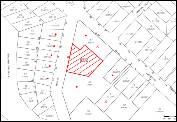
The proposed development was placed on public exhibition and was notified to adjoining and nearby landowners between 23 March and 13 April 2017 in accordance with the Notification and Exhibition requirements of the HDCP. During this period, Council received two submissions. The map below illustrates the location of those nearby landowners who made a submission that are in close proximity to the development site.
|
NOTIFICATION PLAN |
|
||
|
• PROPERTIES NOTIFIED
|
X SUBMISSIONS RECEIVED |
PROPERTY SUBJECT OF DEVELOPMENT |
|
Two submissions objected to the development. The grounds for objection are addressed as follows:
5.1.1 Building Height
A submission raised concerns the proposed building height was non-compliant and unacceptable.
The proposed non-compliance with the 8.5m maximum building height is the subject of the applicant’s request for variation of the development standard pursuant to Clause 4.6 of HLEP.
The variation in height involves an increase of 1.35m for a section of the proposed building. The proposed variation would enable a better planning outcome for the site as discussed in Section 2.1.4.
5.1.2 Gas Supply
A submission raised concerns the proposed development relied on gas supply which is unavailable at Berowra Heights.
The application has been amended for electric appliances and water heating and is satisfactory regarding energy efficiency.
5.1.3 Truck Access
A submission raised concerns the proposed loading dock would reduce traffic safety on the right of carriageway.
The proposed loading dock and truck access is in compliance with Council’s design criteria as discussed in Section 2.7.8.
5.1.4 Commercial Frontage
A submission raised concerns the proposed development relied on frontage to the adjoining shopping centre car park.
The active frontage for the proposed commercial floor space is to the right of carriageway through the site. All car parking required for the proposed development is within the basement car park.
5.1.5 Waste Storage
A submission raised concerns the proposed waste storage facility was inefficient.
The proposed waste storage area is in compliance with Council’s design criteria as discussed in Section 2.7.10.
5.1.6 Noise Mitigation
A submission raised concerns the operation of the proposed loading dock would not be adequately managed to minimise noise impacts.
The proposed loading dock is within the building and is designed to mitigate noise impacts. A condition is recommended for the operation of the loading dock to be restricted to 7am to 6pm Monday to Friday and 8am to 6pm weekends.
5.1.7 Mobile Phone Tower
A submission raised concerns the proposal would remove the existing telecommunications facility and reduce mobile phone coverage.
The applicant has advised Council the lease for the telecommunications facility ended on 30 March 2016 and has not been renewed. Any loss of mobile phone coverage is a matter for the service provider.
5.2 Public Agencies
The development application was not referred to any Public Agencies for comment.
6. THE PUBLIC INTEREST
Section 4.15 (1)(e) of the Act requires Council to consider “the public interest”.
The public interest is an overarching requirement, which includes the consideration of the matters discussed in this report. Implicit to the public interest is the achievement of future built outcomes adequately responding to and respecting the future desired outcomes expressed in environmental planning instruments and development control plans.
The application is considered to have satisfactorily addressed Council’s and relevant agencies’ criteria and would provide a development outcome that, on balance, would result in a positive impact for the community. Accordingly, it is considered that the approval of the proposed development would be in the public interest.
CONCLUSION
The proposal is for demolition of existing structures and construction of a two and three storey shop top housing development on an existing commercial site. The irregular shaped site is subject to development constraint due to a right of carriageway through the central part of the site.
The proposed development generally complies with HLEP other than the proposed maximum building height which exceeds the applicable 8.5m maximum height. The applicant’s request for variation pursuant to Clause 4.6 of HLEP is supported with regard to the design response to the site constraint which results in an acceptable planning outcome for the site.
The proposal is satisfactory in respect to SEPP 65 and complies with the Apartment Design Guide criteria for mixed use development, apartment layout, internal circulation, acoustic amenity and storage. The proposal meets the desired outcomes of the HDCP controls for scale, setbacks, open space, landscaping, privacy and security, sunlight and ventilation, housing choice, vehicle access and parking, accessible design and waste management; subject to recommended conditions.
A deferred commencement consent condition is recommended for submission of a detailed geotechnical report.
Two submissions were received in response to notification of the application.
The application is recommended for approval.
Note: At the time of the completion of this planning report, no persons have made a Political Donations Disclosure Statement pursuant to Section 10.4 of the Environmental Planning and Assessment Act 1979 in respect of the subject planning application.
RESPONSIBLE OFFICER
The officer responsible for the preparation of this Report is Garry Mahony.
|
Cassandra Williams Team Leader - Major Applications Planning Division |
Rod Pickles Manager - Development Assessment Planning Division |
|
1.⇨ |
Locality Plan |
|
|
|
2.⇨ |
Survey Plan |
|
|
|
3.⇨ |
Site Plan |
|
|
|
4.⇨ |
Basement Plan |
|
|
|
5.⇨ |
Commercial Ground Floor plan |
|
|
|
6.⇨ |
Residential Floor Plans |
|
|
|
7.⇨ |
Elevations |
|
|
|
8.⇨ |
Landscape Plans |
|
|
File Reference: DA/216/2017
Document Number: D07405729
SCHEDULE 1
GENERAL CONDITIONS
The conditions of consent within this notice of determination have been applied to ensure that the use of the land and/or building is carried out in such a manner that is consistent with the aims and objectives of the relevant legislation, planning instruments and council policies affecting the land and does not disrupt the amenity of the neighbourhood or impact upon the environment.
Note: For the purpose of this consent, the term ‘applicant’ means any person who has the authority to act on or the benefit of the development consent.
Note: For the purpose of this consent, any reference to an Act, Regulation, Australian Standard or publication by a public authority shall be taken to mean the gazetted Act or Regulation, or adopted Australian Standard or publication as in force on the date that the application for a construction certificate is made.
1. Deferred Commencement
Pursuant to Section 4.16 (3) of the Environmental Planning and Assessment Act 1979, this consent does not operate until the following information is submitted to Council:
a) A detailed geotechnical assessment of the site by a chartered structural engineer is to be undertaken for the design of the basement excavation, ground vibration, excavation support, design parameters for support systems and anchor design, groundwater and foundation design, to maintain the structural integrity of adjoining buildings.
Such information must be submitted within 36 months of the date of this notice.
Upon Council’s written satisfaction of the above information, the following conditions of development consent apply:
2. Approved Plans and Supporting Documentation
The development must be carried out in accordance with the plans and documentation listed below and endorsed with Council’s stamp, except where amended by Council and/or other conditions of this consent:
|
Plan No. |
Plan Title |
Drawn by |
Dated |
|
0000 Rev B |
Title Sheet |
Architecture Design Studio |
5/06/2017 |
|
1001 Rev B |
Site Plan |
Architecture Design Studio |
23/01/2018 |
|
1101 Rev B |
Basement Level |
Architecture Design Studio |
23/01/018 |
|
1201 Rev B |
Ground Floor |
Architecture Design Studio |
23/01/2018 |
|
1301 Rev B |
First Floor |
Architecture Design Studio |
23/01/2018 |
|
1302 Rev B |
Second Floor |
Architecture Design Studio |
23/01/2018 |
|
1501 Rev B |
Elevations 1 |
Architecture Design Studio |
23/01/2018 |
|
1502 Rev B |
Elevations 2 |
Architecture Design Studio |
23/01/2018 |
|
1601 Rev B |
Section 01 |
Architecture Design Studio |
5/06/2017 |
|
1602 Rev B |
Ramp Section |
Architecture Design Studio |
5/06/2017 |
|
Pn_0633 |
Finishes Schedule |
Architecture Design Studio |
Undated |
|
000 Issue C |
Coversheet |
Site Image Landscape Architects |
16.11.2017 |
|
101 Issue E |
Landscape Plan Ground Floor |
Site Image Landscape Architects |
16.11.2017 |
|
102 Issue D |
Landscape Plan Level 1 |
Site Image Landscape Architects |
16.11.2017 |
|
501 Issue B |
Landscape Details |
Site Image Landscape Architects |
17.01.2017 |
|
Document Title |
Prepared by |
Dated |
|
BASIX Certificate No. 79294M_02 |
Positive Eco |
4 Oct 2017 |
|
Access Report |
Code Performance |
21 Feb 2017 |
|
Environmental Noise Impact Assessment |
Acoustic Noise & Vibration Solutions P/L |
15 May 2017 |
|
Preliminary Site Investigation |
Australian Geotechnical |
12-01-17 |
|
Detailed Site Investigation |
Australian Geotechnical |
30-01-17 |
|
Traffic and Parking Assessment Report |
Terraffic Pty Ltd |
23 Feb 2017 |
|
SEPP 65 Design Verification |
Architecture Design Studio |
Feb 2017 |
|
Waste Management Plan (D07218580) |
Architecture Design Studio |
Undated |
3. Amendment of Plans
a) To comply with Councils requirement in terms of amenity, the approved plans are to be amended as follows:
i) The first floor windows at the north west elevation are to include canter lever aluminium louvers to provide summer shade and winter sun to the first floor windows;
ii) The section of roof over the terrace areas of Units 12, 13, 14 and 15 are to be amended to allow winter sun and summer shade to the terrace and living room windows of Units 12, 14 and 15 and to the terrace of Unit 13.
iii) Private open space with a minimum depth of 2.4m is to be added to the second floor of Unit 2 at the eastern elevation in the form of a recessed balcony and the eastern bedroom redesigned, in compliance with the ADG criteria.
iv) The design of adaptable housing Units Nos. 13, 14 and 15 is to be revised to Universal Design Housing in accordance with the Liveable Housing Guidelines (2012) silver level design features.
v) The landscape plan is to be amended to retain and protect Trees Nos. 6, 7, 8, 9 and 10.
b) These amended plans must be submitted with the application for the Construction Certificate.
4. Construction Certificate
a) A Construction Certificate is required to be approved by Council or a Private Certifying Authority prior to the commencement of any works under this consent.
b) A separate Construction Certificate must be obtained from Council for all works within the public road reserve under S138 of the Roads Act.
c) A separate Construction Certificate must be obtained from Council for all works within drainage easements vested in Council.
d) The Construction Certificate plans must not be inconsistent with the Development Consent plans.
5. Section 7.11 Development Contributions
a) In accordance with Section 4.17 (1) of the Environmental Planning and Assessment Act, 1979 and the Hornsby Shire Council Section 94 Development Contributions Plan 2014-2024, the following monetary contributions must be paid to Council to cater for the increased demand for community infrastructure resulting from the development:
|
Description |
Contribution (4) |
|
Roads |
$27,771.75 |
|
Open Space and Recreation |
$166,428.20 |
|
Community Facilities |
$63,980.05 |
|
Plan Preparation and Administration |
$785.65 |
|
TOTAL |
$258,965.65 |
being for 3 x 1 bedroom units, 9 x 2 bedroom units, 3 x 3 bedroom units and 497.4m2 of commercial space (includes credit for existing space 426m2).
b) The value of this contribution is current as at 10 November 2017. If the contribution is not paid within the financial quarter that this condition was generated, the contribution payable will be adjusted in accordance with the provisions of the Hornsby Shire Council Section 94 Development Contributions Plan and the amount payable will be calculated at the time of payment in the following manner:
$CPY = $CDC x CPIPY
CPIDC
Where:
$CPY is the amount of the contribution at the date of Payment
$CDC is the amount of the contribution as set out in this Development Consent
CPIPY is the latest release of the Consumer Price Index (Sydney – All Groups) at the date of Payment as published by the ABS.
CPIDC is the Consumer Price Index (Sydney – All Groups) for the financial quarter at the date applicable in this Development Consent Condition.
c) The monetary contribution must be paid to Council:
i) prior to the issue of the Subdivision Certificate where the development is for subdivision; or
ii) prior to the issue of the first Construction Certificate where the development is for building work; or
iii) prior to issue of the Subdivision Certificate or first Construction Certificate, whichever occurs first, where the development involves both subdivision and building work; or
iv) prior to the works commencing where the development does not require a Construction Certificate or Subdivision Certificate.
Note: It is the professional responsibility of the Principal Certifying Authority to ensure that the monetary contributions have been paid to Council in accordance with the above timeframes.
Council’s Development Contributions Plan may be viewed at www.hornsby.nsw.gov.au or a copy may be inspected at Council’s Administration Centre during normal business hours.
REQUIREMENTS PRIOR TO THE ISSUE OF A CONSTRUCTION CERTIFICATE
6. Building Code of Australia
All approved building work must be carried out in accordance with the relevant requirements of the Building Code of Australia.
7. Contract of Insurance (Residential Building Work)
Where residential building work for which the Home Building Act, 1989 requires there to be a contract of insurance in force in accordance with Part 6 of that Act, this contract of insurance must be in force before any building work authorised to be carried out by the consent commences.
8. Notification of Home Building Act, 1989 Requirements
Residential building work within the meaning of the Home Building Act 1989 must not be carried out unless the principal certifying authority for the development to which the work relates (not being Council) has given Council written notice of the following information:
a) In the case of work for which a principal contractor is required to be appointed:
i) The name and licence number of the principal contractor; and
ii) The name of the insurer by which the work is insured under Part 6 of that Act.
b) In the case of work to be done by an owner-builder:
i) The name of the owner-builder; and
ii) If the owner-builder is required to hold an owner-builder’s permit under that Act, the number of the owner-builder’s permit.
Note: If arrangements for doing the residential building work are changed while the work is in progress so that the information notified becomes out of date, further work must not be carried out unless the principal certifying authority for the development to which the work relates (not being Council) has given Council written notification of the updated information.
9. Utility Services
The applicant must submit written evidence of the following service provider requirements:
a) Ausgrid (formerly Energy Australia) – a letter of consent demonstrating that satisfactory arrangements have been made to service the proposed development.
b) Telstra - a letter of consent demonstrating that satisfactory arrangements have been made to service the proposed development.
10. Sydney Water – Approval
This application must be submitted to Sydney Water for approval to determine whether the development would affect any Sydney Water infrastructure, and whether further requirements are to be met.
Note: Building plan approvals can be obtained online via Sydney Water Tap inTM through www.sydneywater.com.au under the Building and Development tab.
11. Dilapidation Report
A ‘Dilapidation Report’ is to be prepared by a ‘chartered structural engineer’ detailing the structural condition of the following adjoining properties including vehicular access subject of right of way:
a) SP 47866, Nos. 19-23 Turner Road, Berowra Heights; and
b) SP 89840, Nos. 25-29 Turner Road, Berowra Heights.
12. Noise
The development must be carried out in accordance with the recommendations contained within the acoustic report submitted with the development application, titled Environmental Noise Impact Assessment, prepared by Acoustic Noise & Vibration Solutions P/L and dated 15 May 2017.
13. Accessibility
The development must be carried out in accordance with the recommendations contained within the access report submitted with the development application, titled Access Report, prepared by Code Performance and dated 21 February 2017.
14. Adaptable/Liveable Housing
The details of Adaptable/Liveable Housing Units Nos. 1, 12, 13, 14 and 15 must be provided with the Construction Certificate Plans.
15. Storage
Each dwelling within the development must have a minimum area for storage (not including kitchen and bedroom cupboards) of 6m³ for one bedroom units, 8m³ for two bedroom units and 10m³ for three bedroom units, where at least 50% is required to be located within the apartment and accessible from either the hall or living area. Details must be submitted with the Construction Certificate plans.
16. Waste Management Details
The following waste management requirements must be complied with:
a) The approved on-going waste management system must not be amended without the written consent of Council.
b) A bulky waste storage area of at least 8 square metres must be provided.
c) The residential chute service room (where the garbage chute and recycling chute terminate) at the ground level must have:
i) Sufficient space to comfortably house the 660L garbage bin under the garbage chute and the 660L recycling bin under the recycling chute, and sufficient space to access and manoeuvre these bins in and out of position; and
ii) The gradient of the garbage chute and the recycling chute must be no less than the minimum gradient recommended by the chute manufacturer.
d) The residential component and non-residential component of the development must have separate and self-contained waste management systems, including separate bin storage rooms. Commercial tenants must not have access to the residential waste/recycling bins and vice versa.
e) All bin carting routes must not include any steps, and must be wholly within the site. The use of the public footpath or road to cart bins is not permitted.
Note: a goods lift or bin hoist is recommended.
f) There must be a waste facility (garbage chute and the recycling chute in a cupboard or small room) on each residential level. Each waste facility must:
i) Be accessible by persons with a disability after the garbage chute and recycling chute are installed; and
ii) Comfortably house the required garbage chute and recycling chute; and
iii) Have door(s) wide enough and positioned so that the 240 L recycling bin can fit through; and
iv) Commercial tenants must not be able to access any residential waste facility.
Note: The chute system supplier must be consulted for chute space requirements. AS 1428.1 requires at least 800 mm clear doorway opening for wheelchair access.
g) The access way (including ramp, vehicle turning area, loading dock/service bay and site entry/exit) to be used by waste collection vehicles, must be designed in compliance with Australian Standard AS2890.2-2002 Parking Facilities Part 2: Off-street Commercial Vehicle Facilities for heavy rigid vehicles.
Note: AS2890.2-2002 includes a maximum gradient of 1:8.5 for reverse travel, a minimum vertical clearance of 4.5 m, and minimum loading dock/service bay dimensions of 3.5 m x 12.5 m. These dimensions do not include wall thickness, support columns, ventilation shafts etc which must be added. AS2890.2-2002 also requires that when a loading dock/service bay is of minimum width a driver needs to be able to place the body of the vehicle or trailer into its final alignment at the point of entry into the bay.
h) A Waste Management Plan Section One – Demolition Stage and Section Three – Construction Stage, covering the scope of this project and including the following details, is required to be submitted to Council:
i) An estimate of the types and volumes of waste and recyclables to be generated;
ii) A site plan showing sorting and storage areas for demolition and construction waste and the vehicle access to these areas;
iii) How excavation, demolition and construction waste materials will be reused or recycled and where residual wastes will be disposed;
iv) The total percentage (by weight) of demolition and construction waste that will be reused or recycled.
i) The width of the door opening to the loading bay must be no less than 6.5m.
17. Certification of Traffic Engineer
Prior to the issue of a Construction Certificate, a Certificate from an appropriate qualified Traffic Engineer is to be submitted to the Principal Certifying Authority (PCA) certifying that the parking modules, loading areas and garbage collection areas comply with AS 2890.1, AS 2890.2 and the approved Development Consent plans and conditions.
18. Stormwater Drainage
The stormwater drainage system for the development must be designed in accordance with Council’s Civil Works – Design and Construction Specification 2005 and the following requirements:
a) Connected to an existing Council piped drainage system with the following requirements ;-
i) A separate Application must be made to Council for ‘Approval To Connect Stormwater Drainage Outlet To Council’s System’ with all fees paid, prior to connecting to Council’s drainage system;
ii) The connection to Council’s drainage pit or pipeline in accordance with Councils Design Standard Drawing No. 6 must be inspected by a Council Engineer from Council’s Planning Division;
Note: An inspection booking can be made by calling Council on 9847 6760 quoting the Application reference number commencing SD
iii) Connection to Council’s drainage system shall include design and construction of Council’s standard kerb inlet / raised / flush / grated / concrete filled pit top in accordance with Council’s Design and Construction Specification 2005. The Applicant’s Engineer must prepare the design of system including location of proposed work in the plan. Three (3) copies of the plan shall be submitted with lodgement and payment of the Application.
19. Footpath
A separate application under the Local Government Act, 1993 and the Roads Act, 1993 must be submitted to Council for approval of all works within the public road reserve. A concrete footpath must be designed and constructed along the full frontage of the development site in Kita Road in accordance Council’s Civil Works Design and Construction Specification 2005 and the following requirements:
a) The existing footpath being removed.
b) Pouring of the concrete footpath to the full frontage of the subject site.
c) The land adjoining the footpath to be fully turfed.
d) Any public utility adjustments to be carried out at the cost of the applicant and to the requirements of the relevant public authority.
20. On Site Stormwater Detention
An on-site stormwater detention system must be designed by a chartered civil engineer and constructed generally in accordance with Drawing No. 16Kitt-HYD Revision C dated 19.06.2017 by Allied Consultants and the following requirements:
a) Have a capacity of not less than 33.1 cubic metres, and a maximum discharge (when full) of 30.0 litres per second.
b) Have a surcharge/inspection grate located directly above the outlet.
c) Discharge from the detention system to be controlled via 1 metre length of pipe, not less than 50 millimetres diameter or via a stainless plate with sharply drilled orifice bolted over the face of the outlet discharging into a larger diameter pipe capable of carrying the design flow to an approved Council system.
d) Where above ground and the average depth is greater than 0.3 metres, a ‘pool type’ safety fence and warning signs to be installed.
e) Not be constructed in a location that would impact upon the visual or recreational amenity of residents.
Note: A construction certificate shall be obtained prior to the commencement of these works and are to be completed prior to the issue of an occupation certificate.
21. Water Quality Treatment
Stormwater quality treatment measures shall be designed generally in accordance with Drawing No. 16KITT-HYD-4 Revision C dated 19.06.2017 by Allied Consultants. A qualified engineer shall prepare a validation report using MUSIC-link for Hornsby Council and a design certificate shall be submitted to the principal certifying authority certifying that the design meets the stormwater quality targets outlined in Table 1.C.1.2(b) in Hornsby Council’s Development Control Plan 2013.
22. Internal Driveway/Vehicular Areas
The driveway and parking areas on site must be designed, constructed and a Construction Certificate issued in accordance with Australian Standards 2890.1, 2890.2, 3727 and the following requirements:
a) The driveway be a rigid pavement.
b) Longitudinal sections along both sides of the access driveway shall be submitted to the principal certifying authority in accordance with the relevant sections of AS 2890.1. The maximum grade shall not exceed 1 in 4 (25%) with the maximum changes of grade of 1 in 8 (12.5%) for summit grades and 1 in 6.7 (15%) for sag grades. Any transition grades shall have a minimum length of 2 metres.
23. Traffic Control Plan
A Traffic Control Plan (TCP) must be prepared by a qualified traffic controller in accordance with the Roads & Traffic Authority’s Traffic Control at Worksites Manual 1998 and Australian Standard 1742.3 for all work on a public road. The Traffic Management Plan shall be submitted and approved by Council’s Manager Traffic and Road Safety prior to the issue of a construction certificate. The TCP must detail the following:
a) Arrangements for public notification of the works;
b) Temporary construction signage;
c) Permanent post-construction signage;
d) Vehicle movement plans;
e) Traffic management plans; and
f) Pedestrian and cyclist access/safety.
24. Identification of Survey Marks
A registered surveyor must identify all survey marks in the vicinity of the proposed development. Any survey marks required to be removed or displaced as a result of the proposed development shall be undertaken by a registered surveyor in accordance with Section 24 (1) of the Surveying and Spatial Information Act 2002 and following the Surveyor General’s Directions No.11 – "Preservation of Survey Infrastructure".
25. Construction Management Plan (CMP)
To assist in the protection of the public, the environment and Council’s assets, a separate Construction Management Plan is to be prepared by a suitably qualified environmental consultant in consultation with a qualified traffic engineer, is to be submitted to Council’s Compliance Team for approval to be used by workers and Council as on-site reference during demolition, excavation and construction works, according to the following requirements:-
a) The CMP will detail the contact information for all development phases for developers, builder, site foremen, private certifier, environmental management consultant and any emergency details.
b) The plan will include a Construction Traffic Management Plan (CTMP) which will include information detailing the following:-
i) Truck movements to and from the site, including the routes used, swept path diagrams entering and exiting the site and implemented traffic control;
ii) Site plan showing site sheds, concrete pump location and crane location;
iii) The requirement for Work Zones, Road Openings, Road Closures, Crane Permits and Road Occupancy licenses;
iv) Safe pedestrian management details including during local school and commuter hours where the footpath is heavily frequented.
v) Operational management to maintain vehicular access of the right of way through the site.
c) The plan will include Construction Waste Management information detailing the following:-
i) Details on the requirement for importation or excavation of soil and fill including the waste classification of the fill, disposal methods and locations of authorised disposal depots that will be used for the fill;
ii) Asbestos Information must be included on the requirement and procedures for removal and disposal from the site in accordance with Australian Standard: 2601–2001 – ‘The Demolition of Structures’, and the Protection of the Environment Operations (Waste) Regulation 2005;
iii) General construction waste details including construction waste skip bin locations and litter management for workers.
d) Information to be prepared on the management of stormwater disposal from any detention basin or trapped within the site throughout all development phases in accordance with the ANZECC Guidelines trigger values for the area.
e) Sediment and Erosion control details including the procedures during rainfall events and site plans included within the Appendices, all in accordance with the ‘Soils and Construction 2004 (Bluebook)’ and consistent to other development application approved environmental plans.
f) Information on air quality management on site, including but not limited to dust suppression measure throughout demolition and construction.
g) Details on the general operating procedures to manage environmental risk throughout all stages of works on the site;
h) To ensure the quality of Council’s footpath is maintained throughout the development, mitigation measures and information is to be included on procedures that will be implemented to keep the footpath clear and free of trip hazards and obstructions.
i) Information and details to be included on the requirement of a ‘Hoarding Permit’ for the use of Council’s verge at any stage during the development period, a plan showing the location and details of the hoarding are to be included in the Appendices.
j) Details on the requirement for any ‘Out of Hours’ permits during the development in cases such as concrete pours including the frequency and reasoning for the applications.
k) Noise and vibration control information to address any noise nuisances such as rock sawing or breaking, the mitigation methods implemented and how complaints will be managed or prevented.
REQUIREMENTS PRIOR TO THE COMMENCEMENT OF ANY WORKS
26. Erection of Construction Sign
a) A sign must be erected in a prominent position on any site on which any approved work is being carried out:
i) Showing the name, address and telephone number of the principal certifying authority for the work;
ii) Showing the name of the principal contractor (if any) for any demolition or building work and a telephone number on which that person may be contacted outside working hours; and
iii) Stating that unauthorised entry to the work site is prohibited.
b) The sign is to be maintained while the approved work is being carried out and must be removed when the work has been completed.
27. Protection of Adjoining Areas
A temporary hoarding, fence or awning must be erected between the work site and adjoining lands before the works begin and must be kept in place until after the completion of the works if the works:
a) Could cause a danger, obstruction or inconvenience to pedestrian or vehicular traffic;
b) Could cause damage to adjoining lands by falling objects; and/or
c) Involve the enclosure of a public place or part of a public place.
Note: Notwithstanding the above, Council’s separate written approval is required prior to the erection of any structure or other obstruction on public land.
28. Toilet Facilities
a) To provide a safe and hygienic workplace, toilet facilities must be available or be installed at the works site before works begin and must be maintained until the works are completed at a ratio of one toilet for every 20 persons employed at the site.
b) Each toilet must:
i) be a standard flushing toilet connected to a public sewer; or
ii) be a temporary chemical closet approved under the Local Government Act 1993; or
iii) have an on-site effluent disposal system approved under the Local Government Act 1993.
29. Erosion and Sediment Control
To protect the water quality of the downstream environment, erosion and sediment control measures must be provided and maintained throughout the construction period in accordance with the manual ‘Soils and Construction 2004 (Bluebook)’, the approved plans, Council specifications and to the satisfaction of the principal certifying authority. The erosion and sediment control devices must remain in place until the site has been stabilised and revegetated.
Note: On the spot penalties may be issued for any non-compliance with this requirement without any further notification or warning.
30. Waste Management Details
Prior to the commencement of any works, the on-going waste collection service must be cancelled and the bins retrieved by the waste collection service provider.
REQUIREMENTS DURING CONSTRUCTION
31. Construction Work Hours
All work on site (including demolition and earth works) must only occur between 7am and 5pm Monday to Saturday (unless otherwise approved in writing by Council due to extenuating circumstances). No work is to be undertaken on Sundays or public holidays.
32. Demolition
To protect the surrounding environment, all demolition work must be carried out in accordance with “Australian Standard 2601-2001 – The Demolition of Structures” and the following requirements.
a) Demolition material must be disposed of to an authorised recycling and/or waste disposal site and/or in accordance with an approved waste management plan; and
b) Demolition works, where asbestos material is being removed, must be undertaken by a contractor that holds an appropriate licence issued by SafeWork NSW in accordance with the Work Health and Safety Regulation 2017 and be appropriately transported and disposed of in accordance with the Protection of the Environment Operations (Waste) Regulation 2014; and
c) On construction sites where any building contain asbestos material, a standard commercially manufactured sign containing the words ‘DANGER ASBESTOS REMOVAL IN PROGRESS’ and measuring not less than 400mm x 300mm must be displayed in a prominent position visible from the street.
33. Environmental Management
To prevent sediment run-off, excessive dust, noise or odour emanating from the site during the construction, the site must be managed in accordance with the publication ‘Managing Urban Stormwater – Landcom (March 2004) and the Protection of the Environment Operations Act 1997.
34. Street Sweeping
To protect the surrounding environment, Street sweeping must be undertaken following sediment tracking from the site along Turner Road during works and until the site is established.
The street cleaning services must undertake a street ‘scrub and dry’ method of service and not a dry sweeping service that may cause sediment tracking to spread or cause a dust nuisance.
35. Council Property
To ensure that the public reserve is kept in a clean, tidy and safe condition during construction works, no building materials, waste, machinery or related matter is to be stored on the road or footpath.
Note: This consent does not give right of access to the site via Council’s park or reserve. Should such access be required, separate written approval is to be obtained from Council.
36. Landfill
Landfill must be constructed in accordance with Council’s ‘Construction Specification 2005’ and the following requirements:
a) Prior to fill material being imported to the site, a certificate shall be obtained from a suitably qualified environmental consultant confirming the fill wholly consists of Virgin Excavated Natural Material (VENM) as defined in Schedule 1 of the Protection of the Environment Operations Act, 1997 or material approved under the Department of Environment and Climate Change’s general resource recovery exemption.
b) A compaction certificate is to be obtained from a suitably qualified geotechnical engineer verifying that the specified compaction requirements have been met.
c) These certificates must be included with the application for an occupation certificate.
37. Excavated Material
All excavated material removed from the site must be classified by a suitably qualified person in accordance with the Department of Environment, Climate Change and Water NSW Waste Classification Guidelines prior to disposal to an approved waste management facility and be reported to the principal certifying authority prior to the issue of an Occupation Certificate.
38. Survey Report
A report(s) must be prepared by a registered surveyor and submitted to the principal certifying authority:
a) Prior to the pouring of concrete at each level of the building certifying that:
i) The building, retaining walls and the like have been correctly positioned on the site; and
ii) The finished floor level(s) are in accordance with the approved plans.
b) Confirming that the waste collection vehicle turning area complies with AS2890.1 – 2004 and AS20890.2 – 2002 for small rigid vehicles (SRV).
39. Waste Management Details
Waste management during the demolition and construction phase of the development must be undertaken in accordance with the approved Waste Management Plan. Additionally written records of the following items must be maintained during the removal of any waste from the site and such information submitted to the Principal Certifying Authority within fourteen days of the date of completion of the works:
a) The identity of the person removing the waste.
b) The waste carrier vehicle registration.
c) Date and time of waste collection.
d) A description of the waste (type of waste and estimated quantity).
e) Details of the site to which the waste is to be taken.
f) The corresponding tip docket/receipt from the site to which the waste is transferred (noting date and time of delivery, description (type and quantity) of waste).
g) Whether the waste is expected to be reused, recycled or go to landfill.
Note: In accordance with the Protection of the Environment Operations Act 1997, the definition of waste includes any unwanted substance, regardless of whether it is reused, recycled or disposed to landfill.
40. Construction Vehicles
All construction vehicles associated with the proposed development are to be contained on site or in a Local Traffic Committee (LTC) approved “Works Zone”.
a) The site supervisor to be advised that the Works Zone will be deemed to be in effect, and fees will apply, between the dates nominated by the supervisor, or when parking spaces are managed for the sole use of construction vehicles associated with the site.
b) The Works Zone signs shall be in effect only for the times approved by Council, and the time is to be noted on the sign. Eg, ‘Works Zone Mon – Sat 7am – 5pm’.
c) The applicant is required to supply a sign posting installation plan for referral to the Local Traffic Committee, noting on it the duration of the Works Zone.
d) The Works Zone is only to be used for the loading and unloading of vehicles. Parking of workers’ vehicles, or storage of materials, is not permitted.
41. Construction Management Plan Compliance
The development must be carried out in accordance with the submitted Construction Management Plan (CMP).
42. Maintenance of public footpaths
Public footpaths must be maintained for the duration of works to ensure they are free of trip hazards, displacements, breaks or debris to enable pedestrians to travel along the footpath safely.
43. Waste Management
All work must be carried out in accordance with the approved waste management plan.
REQUIREMENTS PRIOR TO THE ISSUE OF AN OCCUPATION OR SUBDIVISION CERTIFICATE
Note: For the purpose of this consent, a reference to ‘occupation certificate’ shall not be taken to mean an ‘interim occupation certificate’ unless otherwise stated.
44. Fulfilment of BASIX Commitments
The applicant must demonstrate the fulfilment of BASIX commitments pertaining to the development.
45. Sydney Water – s73 Certificate
A s73 Certificate must be obtained from Sydney Water and submitted to the PCA..
Note: Sydney Water requires that s73 applications are to be made through an authorised Sydney Water Servicing Coordinator. Refer to www.sydneywater.com.au or telephone 13 20 92 for assistance.
46. Certification of WSUD Facilities
Prior to the issue of an Occupation Certificate a certificate from a Civil Engineer is to be obtained stating that the WSUD facilities have been constructed and will meet the water quality targets as specified in the Hornsby Shire Councils DCP.
47. Creation of Easements
The following matter(s) must be nominated on the plan of subdivision under s88B of the Conveyancing Act 1919:
a) The creation of an appropriate "Positive Covenant" and "Restriction as to User" over the constructed on-site detention/retention systems, stormwater quality improvement devices and outlet works, within the lots in favour of Council in accordance with Council’s prescribed wording. The position of the on-site detention system and stormwater quality improvement devices is to be clearly indicated on the title.
b) To register the OSD easement, the restriction on the use of land “works-as-executed” details of the on-site-detention system and stormwater quality improvement devices must be submitted verifying that the required storage and discharge rates have been constructed in accordance with the design requirements. The details must show the invert levels of the onsite system together with pipe sizes and grades. Any variations to the approved plans must be shown in red on the “works-as-executed” plan and supported by calculations.
Note: Council must be nominated as the authority to release, vary or modify any easement, restriction or covenant.
48. Unit Numbering
All units are to be numbered consecutively commencing at No.1. The strata plan lot number is to coincide with the unit number, e.g Unit 1 = Lot 1. The allocated of unit numbering must be authorised by Council prior to the numbering of each units in the development.
49. Works as Executed Plan
A works-as-executed plan(s) must be prepared by a registered surveyor and submitted to Council for completed public road and drainage works, stormwater quality improvement devices and on-site detention system. The plan(s) must be accompanied by a certificate from a registered surveyor certifying that all pipelines and associated structures lie wholly within any relevant easements.
50. Construction of engineering works.
All engineering works identified in this consent are to be completed and a Compliance Certificate issued prior to the release of the Occupation Certificate.
51. Damage to Council Assets
To protect public property and infrastructure, any damage caused to Council’s assets including the removal, damage, destruction, displacement or defacing of the existing survey marks as a result of the construction or demolition of the development must be rectified by the applicant in accordance with Council’s Civil Works Specifications. Rectification works must be undertaken prior to the issue of an Occupation Certificate, or sooner, as directed by Council.
52. Preservation of Survey Marks
Prior to the issue of an occupation certificate, a certificate by a Registered Surveyor shall be submitted to the Principal Certifying Authority, certifying that there has been no removal, damage, destruction, displacement or defacing of the existing survey marks in the vicinity of the proposed development or otherwise the re-establishment of damaged, removed or displaced survey marks has been undertaken in accordance with the Surveyor General’s Direction No.11 – “Preservation of Survey Infrastructure”.
53. Planter Boxes / On Slab Planting
On slab planter boxes must include waterproofing, subsoil drainage (proprietary drainage cell, 50mm sand and filter fabric) automatic irrigation, minimum 500mm planting soil for shrubs and minimum 1000mm planting soil for trees and palms and 75mm mulch.
54. Completion of Landscaping
A certificate must be submitted to the PCA by a practicing landscape architect, horticulturalist or person with similar qualifications and experience certifying that all required landscaping works have been satisfactorily completed in accordance with the approved landscape plans.
Note: Advice on suitable species for landscaping can be obtained from Council’s planting guide ‘Indigenous Plants for the Bushland Shire’, available at www.hornsby.nsw.gov.au.
55. Retaining Walls
All required retaining walls must be constructed as part of the development.
56. Installation of Air Conditioner
a) To protect the amenity of adjacent properties, the condenser unit for the air conditioner must be sited a minimum of 3 metres from the property boundary of any adjoining residential premises.
b) Alternatively, a certificate must be submitted to the PCA by a suitably qualified person confirming that the unit has been tested for heating and cooling on the highest settings and that the noise levels generated do not exceed 5 dB(A) above background noise levels when tested at the property boundary between 8 pm and 10 pm.
57. External Lighting
a) To protect the amenity of adjacent premises, all external lighting must be designed and installed in accordance with Australian Standard AS 4282 – Control of the Obtrusive Effects of Outdoor Lighting.
b) Certification of compliance with this Standard must be obtained from a suitably qualified person and submitted to the PCA with the application for the Construction Certificate.
58. Garbage Collection Easement
For the purpose of waste collection, an easement entitling Council, its servants and agents and persons authorised by it to enter upon the subject land and to operate thereon, vehicles and other equipment for the purposes of garbage collection must be granted to Council by the owner of the land.
Note: The easement must be in a form prescribed by Council and must include covenants to the effect that parties will not be liable for any damage caused to the subject land or any part thereof or to any property located therein or thereon by reason of the operation thereon of any vehicle or other equipment used in connection with the collection of garbage and to the effect that the owner for the time being of the subject land shall indemnify the Council, its servants, agents and persons authorised by it to collect garbage against liability in respect of any such claims made by any person whomsoever.
59. Garbage Collection Easement
The following waste management requirements must be complied with:
a) Prior to an Occupation Certificate being issued or the use commencing, whichever is earlier, the Principal Certifying Authority must obtain Council’s approval of the waste and recycling management facilities provided in the development and ensure arrangements are in place for domestic waste collection by Council.
Note: Waste and recycling management facilities includes everything required for on-going waste management on the site. For example the garbage chute system, volume handling equipment, bin lifter, lift to ground level bin store, garbage waste facility (garbage chute and recycling bin) on each residential level, bin storage areas, bulky waste storage area, bin collection area, waste collection vehicle access, doors wide enough to fit the bin through, separate self-contained waste management systems for the residential and commercial/retail components, etc, as applicable to the development.
b) The residential chute service room at the ground level, the residential bin storage room at the ground level and the commercial bin storage room at the ground level must include water or a hose for cleaning, graded floors with drainage to sewer, sealed and impervious surface, adequate lighting and ventilation, and must be lockable. The residential waste facility (garbage chute and recycling chute in cupboards) on the first floor level must include sealed and impervious surface, adequate lighting and ventilation, and robust door(s).
c) Report must be prepared by an appropriately qualified person, certifying the following:
i) A comparison of the estimated quantities of each waste type against the actual quantities of each waste type.
Note: Explanations of any deviations to the approved Waste Management Plan is required to be included in this report.
ii) That at least 60% of the waste generated during the demolition and construction phase of the development was reused or recycled.
Note: If the 60% diversion from landfill cannot be achieved in the Construction Stage, the Report is to include the reasons why this occurred and certify that appropriate work practices were employed to implement the approved Waste Management Plan. The Report must be based on documentary evidence such as tipping dockets/receipts from recycling depots, transfer stations and landfills, audits of procedures etc. which are to be attached to the report.
iii) All waste was taken to site(s) that were lawfully permitted to accept that waste.
d) Each residential unit must be provided with an indoor waste/recycling cupboard for the interim storage of waste with two separate 20 litre containers, one each for general waste and recyclable materials.
e) There must be a residential bulky waste storage area of at least 8 square metres on site.
f) Space must be provided for either individual compost containers for each unit or a communal compost container;
Note: The location of the compost containers should have regard for potential amenity impacts.
g) The bin carting routes must be devoid of any steps and be wholly within the site.
Note: Ramps between different levels are acceptable. The use of public footpath to cart bins is not acceptable.
h) The residential waste facilities (garbage chute and recycling chute in a cupboard) on the first floor level must be accessible by persons with a disability.
i) A survey of the finished access way (including ramp, waste collection vehicle turning area, loading bay and site entry/exit) to be used by HRV waste collection vehicle, must be carried out by a registered surveyor and submitted to the principal certifying authority. The survey is to include dimensions, gradients and vertical clearance. Written confirmation must be submitted to the Principal certifying authority from a qualified Traffic Engineer, that this survey confirms the finished access way within the waste collection vehicle turning path was designed and constructed in compliance with Australian Standard AS2890.2-2002 Parking Facilities Part 2: Off-street Commercial Vehicle Facilities for heavy rigid vehicles with minimum dimensions of 10.6m overall length, 5.8m wheelbase, 1.5m front overhang, 3.3m rear overhang.
Note: encroachments into the heavy rigid vehicle turning path and low speed manoeuvring clearance (300 mm both sides) cannot be tolerated.
j) The 4.5 metre clearance height within the waste collection vehicle travel path must not be reduced by ducting, lights, pipes, signs or anything else.
k) “No parking” signs must be erected to prohibit parking in the waste collection loading bay and turning area.
l) Site security measures implemented on the property, including electronic gates, must not prevent access to the collection point by waste removal services.
60. Acoustic Certificate
On completion of all works and prior to the issue of an Occupation Certificate, the certifier is to be provided with a certificate from a qualified acoustic engineer/consultant certifying that all acoustic works have been completed in accordance with the recommendations contained in the Environmental Noise Impact Assessment Reference No.:2017-002 prepared by Acoustic Noise & Vibration Solutions P/L dated 15 May 2017.
61. Safety and Security
a) Fire exist doors to the development must be fitted with single cylinder locksets (Australia and New Zealand Standard – Lock Sets) to restrict unauthorized access to the development.
b) A graffiti management plan must be incorporated into the maintenance plan for the development for graffiti to be removed within a forty-eight hour period.
c) The basement residential entry must be secured access control to allow visitor access to the residential level.
d) Lighting of pedestrian pathways throughout the development must comply with Australia and New Zealand Lighting Standard 1158.1 – Pedestrian.
e) The residential entry lobby doors are to be a security door with access being restricted to an intercom, code or card lock system.
f) The street number of the building is to be readily identifiable from Kita Road.
g) Quality mail box doors and non-tamper proof locks must be fitted to the mail boxes.
h) The bicycle racks are to have secure locking loops bolted into the concrete flooring.
i) Storage cages are to be constructed of quality steel mesh, welded to a sturdy metal frame and provided with a total of 3 hinges and 3 locking points. A secure locking loop bolted into the concrete floor is also required to be provided to enable use of padlocks.
j) The internal portions of the basement are to be illuminated in accordance with the AS1158.1, AS1680 and AS2890.1.
62. Provision for National Broadband Network (NBN)
Provision must be made for fibre ready passive infrastructure (pits and pipes) generally in accordance with NBN Co's pit and pipe installation guidelines to service the proposed development. A certificate from NBN Co or Telstra must be submitted to the PCA that the fibre optic cabling provided for the development complies with MDU Building Design Guides for Development.
63. Installation of Privacy Devices
The following device(s) must be installed to maintain an element of privacy.
a) All glass balustrades must be translucent glass;
b) Outdoor clothes drying area must be screened from view of publicly accessible areas.
OPERATIONAL CONDITIONS
64. Facility Management
The use of the facility must be managed in accordance with the recommendations of the Environmental Noise Impact Assessment prepared by Acoustic Noise & Vibration Solutions P/L dated 15 May 2017. A management plan must be prepared and adhered to in accordance with the recommendations of the acoustic report.
65. Loading Dock Hours of Operation
Deliveries to the loading dock and waste removal from the loading dock are only to occur between the hours of 7:00am to 6:00pm Monday to Saturday and 8:00am to 6:00pm Sundays and Public Holidays.
66. Noise
All noise generated by the proposed development must be attenuated to prevent levels of noise being emitted to adjacent premises which possess tonal, beating and similar characteristics or which exceeds background noise levels by more than 5dB(A).
67. Waste Management
The waste management on site must be in accordance with the following requirements:
a) A site caretaker must be employed and be responsible for moving bins where and when necessary, washing bins and maintaining waste storage areas, ensuring the chute system and related devices are maintained in effective and efficient working order, managing the communal composting area, managing the bulky item storage area, arranging the prompt removal of dumped rubbish and bulky waste, ensuring the commercial waste and recycling is kept separate from the residential waste and recycling (and vice versa), ensuring the recycling bins are free of contamination (which includes but is not limited to garbage, plastic bags, clothing, etc), ensuring all residents and commercial tenants are informed of the use of the waste management system, and managing the loading dock to ensure that it is sufficiently available for all necessary waste collection services to take place. The site caretaker must be employed for a sufficient number of hours each week to allow all waste management responsibilities to be carried out to a satisfactory standard.
b) The approved on-going waste management practise for the site must not be amended without consent from Council.
c) All commercial (non-residential) tenants must keep written evidence on site of a valid contract with a licensed waste contractor(s) for the regular collection and disposal of the waste and recyclables that are generated on site.
d) All commercial tenants must have a sufficient number of bins to contain the volume of waste and recycling expected to be generated between collection services.
e) The residential component and non-residential component of the development must have separate and self-contained waste management systems, including separate bin storage rooms. Commercial tenants must be prevented (via signage, locked doors and other means) from using the residential waste/recycling bins and vice versa.
f) Waste collection services must not take place outside the following hours: 6 AM to 8 PM weekdays and 8 AM to 8 PM weekends.
68. Car Parking / Traffic Management
All car parking must be constructed and operated in accordance with Australian Standard AS/NZS 2890.1:2004 – Off-street car parking, and Australian Standard 2890.2 - 2002 – Off-street commercial vehicle facilities and the following requirement:
a) All parking areas and driveways are to be sealed to an all weather standard, line marked and signposted.
b) Car parking, loading and manoeuvring areas to be used solely for nominated purposes.
c) Vehicles awaiting loading, unloading or servicing shall be parked on site and not on adjacent or nearby public roads;
d) All vehicular entry on to the site and egress from the site shall be made in a forward direction.
e) Any proposed landscaping and/or fencing must not restrict sight distance to pedestrians and cyclists travelling along the footpath.
f) Residential parking spaces are to be secure spaces, both vehicular and pedestrian, with access controlled by card or numeric pad.
g) Visitors must be able to access the visitor parking spaces in the basement car park at all times.
h) All parking for people with disabilities is to comply with AS/NZS 2890.6:2009 Off-street parking for people with disabilities.
i) Bicycle parking spaces are to be designed in accordance with AS 2890.3-1993 Bicycle parking facilities.
j) Motorcycle parking spaces are to be designed in accordance with AS/NZS 2890.1:2004 Figure 2.7.
k) Access for garbage vehicles is to satisfy the requirements of Council’s Waste Management Branch.
69. Landscape Establishment
The landscape works must be maintained into the future to ensure the establishment and successful growth of plant material to meet the intent of the landscape design. This must include but not be limited to watering, weeding, replacement of failed plant material and promoting the growth of plants through standard industry practices.
70. Fire Safety Statement - Annual
On at least one occasion in every 12 month period following the date of the first ‘Fire Safety Certificate’ issued for the property, the owner must provide Council with an annual ‘Fire Safety Certificate’ to each essential service installed in the building.
- END OF CONDITIONS –
ADVISORY NOTES
The following information is provided for your assistance to ensure compliance with the Environmental Planning and Assessment Act, 1979, Environmental Planning and Assessment Regulation 2000, other relevant legislation and Council’s policies and specifications. This information does not form part of the conditions of development consent pursuant to Section 4.17 of the Act.
Environmental Planning and Assessment Act 1979 Requirements
The Environmental Planning and Assessment Act 1979 requires:
· The issue of a construction certificate prior to the commencement of any works. Enquiries can be made to Council’s Customer Services Branch on 9847 6760.
· A principal certifying authority to be nominated and Council notified of that appointment prior to the commencement of any works.
· Council to be given at least two days written notice prior to the commencement of any works.
· Mandatory inspections of nominated stages of the construction inspected.
· An occupation certificate to be issued before occupying any building or commencing the use of the land.
Long Service Levy
In accordance with Section 34 of the Building and Construction Industry Long Service Payments Act 1986, a ‘Long Service Levy’ must be paid to the Long Service Payments Corporation or Hornsby Council.
Note: The rate of the Long Service Levy is 0.35% of the total cost of the work.
Note: Hornsby Council requires the payment of the Long Service Levy prior to the issue of a construction certificate.
Disability Discrimination Act
The applicant’s attention is drawn to the existence of the Disability Discrimination Act. A construction certificate is required to be obtained for the proposed building/s, which will provide consideration under the Building Code of Australia, however, the development may not comply with the requirements of the Disability Discrimination Act. This is the sole responsibility of the applicant.
Tenancy Fit-Out – Separate DA Required
This consent does not permit the fit-out of individual tenancies. A separate development application is required for the fit-out of individual tenancies prior to the occupation of the building.
Use of Building – Separate DA Required
This consent does not permit the use of the premises for any purpose. Separate development consent is required for the use of the premises prior to the occupation of the building.
Advertising Signage – Separate DA Required
This consent does not permit the erection or display of any advertising signs. Most advertising signs or structures require development consent. Applicants should make separate enquiries with Council prior to erecting or displaying any advertising signage.
Dial Before You Dig
Prior to commencing any works, the applicant is encouraged to contact Dial Before You Dig on 1100 or www.dialbeforeyoudig.com.au for free information on potential underground pipes and cables within the vicinity of the development site.
Telecommunications Act 1997 (Commonwealth)
If you are aware of any works or proposed works which may affect or impact on Telstra’s assets in any way, you are required to contact: Telstra’s Network Integrity Team on Phone Number 1800810443.
Asbestos Warning
Should asbestos or asbestos products be encountered during demolition or construction works, you are advised to seek advice and information prior to disturbing this material. It is recommended that a contractor holding an asbestos-handling permit (issued by WorkCover NSW) be engaged to manage the proper handling of this material. Further information regarding the safe handling and removal of asbestos can be found at:
Alternatively, telephone the WorkCover Asbestos and Demolition Team on 8260 5885.
Unit Numbering (Strata Units)
All units are to be numbered consecutively commencing at No1. The strata plan lot No is to coincide with the unit number. Eg Unit 1 = Lot 1.
IHAP Report No. IHAP2/18
IHAP - Planning Division
Date of Meeting: 28/03/2018
2 DEVELOPMENT APPLICATION - ALTERATIONS AND ADDITIONS AND CONVERSION OF AN EXISTING BUILDING TO A BOARDING HOUSE - 767 PACIFIC HIGHWAY, MOUNT KURING-GAI
EXECUTIVE SUMMARY
|
DA No: |
DA/645/2017 (28 June 2017) |
|
Description: |
Alterations and additions and conversion of an existing building to a boarding house, comprising four bedrooms to accommodate seven lodgers |
|
Property: |
Pt Lot A DP 367447, No. 767 Pacific Highway, Mount Kuring-gai |
|
Applicant: |
Mr G. W. Hunt |
|
Owners: |
Mr G. W. Hunt and Ms L. Gould |
|
Estimated Value: |
$40,000 |
|
Ward: |
A |
· The application involves alterations and additions and conversion of an existing building to a boarding house accommodating seven lodgers.
· The proposal generally complies with the State Environmental Planning Policy (Affordable rental Housing) 2009, the Hornsby Local Environmental Plan 2013, and the Hornsby Development Control Plan 2013.
· Ten submissions have been received objecting to the application.
· It is recommended that the application be approved.
|
THAT Development Application No. DA/645/2017 for alterations and additions and conversion of an existing building to a boarding house, comprising four bedrooms to accommodate seven lodgers at Pt Lot A DP 367447, No. 767 Pacific Highway, Mount Kuring-gai be approved subject to the conditions of consent detailed in Schedule 1 of IHAP Report No. IHAP2/18. |
BACKGROUND
On 1 May 1950, Council approved Building Application No. 472-A-172 for a fibro clad dwelling and a garage on the site.
On 26 October 2012, Development Application No. DA/1125/2012 was lodged for the regularisation of the unauthorised use of the dwelling-house as a multi-unit housing development comprising three attached dwellings.
On 18 December 2012, the applicant was advised that Council would not support the proposal on the basis that proposal fails to comply with the density provisions of the Hornsby Shire Local Environmental Plan 1994 and the private open space and car parking provisions of the Low Density Multi-Unit Housing Development Control Plan. The applicant was requested to withdraw the application or submit amended plans for a multi-unit housing development comprising two dwellings.
On 26 July 2013, the applicant submitted amended plans for a multi-unit housing development comprising two dwellings.
On 27 February 2014, Council approved Development Application No. DA/1125/2012 for regularisation of the unauthorised use of a dwelling house as a multi-unit housing development comprising two attached dwellings with minor internal alterations and driveway works. The consent requires the development to be physically commenced within two years of the date of the notice. The consent lapsed on 27 February 2016.
On 25 February 2016, a Section 95A application was lodged for an extension of the lapsing date of Development Consent No. DA/1125/2012. On 23 March 2016, Council granted an extension of one year until 27 February 2017. The consent granted to Development Application No. DA/1125/2012 has now lapsed.
On 28 June 2017, Development Application No. DA/645/2017 was lodged for alterations and additions to an existing unauthorised multi-dwelling housing and conversion to a boarding house for seven lodgers.
On 11 July 2017, Council wrote to the applicant requesting a cheque for referral of the application to the Rural Fire Service as the site has been identified as a bushfire prone area.
On 29 August 2017, Council wrote to the applicant raising issues regarding non-compliance with the State Environmental Planning Policy (Affordable Rental Housing) 2009 (SEPP Affordable Housing) with respect to landscape treatments, minimum dimension of private open space area, accommodation size provisions and maximum boarding room size.
On 27 September 2017, the applicant submitted amended plans addressing Council’s concerns regarding non-compliance with SEPP Affordable Housing.
On 20 November 2017, Council obtained legal advice whether the development would be properly characterised as a boarding house to which the provisions of Division 2 of Part 3 of the SEPP Affordable Housing apply.
SITE
The site is located on the corner of Pacific Highway and Glenview Road, Mount Kuring-gai. The site is irregular in shape and has an area of 826m2.
The site has a 17 metre frontage to Pacific Highway and a length of 55 metres along Glenview Road. The site experiences a moderate slope from Pacific Highway towards the rear of the property.
The current improvement on the site includes a single storey building with a floor area of 144.8m2. The existing dwelling house has been separated into three unauthorised units, as follows:
· 2 x 1 bedroom dwelling units and 1 x 2 bedroom dwelling unit;
· The eastern portion contains a living room, separate kitchen, one bedroom, bathroom, external laundry and a wide entry veranda.
· The central portion of the building contains a living room, kitchen, two bedrooms and bathroom. Entry to this unit is via a northern side entry door.
· The western portion of the existing building contains a small combined living and kitchen area, one bedroom and one bathroom.
At the rear of the site, there is a single garage with an attached laundry room.
Glenview Street is a local street. The built environment within this street is a mixture of single or two-storey brick houses. The Pacific Highway frontage accommodates a high traffic generated area.
The site is in close proximity to the Mount Ku-ring-gai neighbourhood shopping centre and is located 400m north-west of Mount Ku-ring-gai Railway station.
PROPOSAL
The proposed involves alterations and additions and conversion of an existing building to a four room boarding house accommodating seven lodgers.
The proposed boarding house comprises the following:
· Four self-contained boarding rooms, 3 double occupancy rooms and 1 single occupancy room.
· Each boarding room would be provided with its own kitchen and bathroom. There would be a storeroom, shared laundry and car parking space provided for one vehicle. Access to the car parking space is provided via an existing driveway fronting Glenview Road.
Additions to the existing building are proposed including the following:
· A 4 metre extension to the eastern elevation of Boarding Room 1. This extension would contain an accessible bathroom and laundry for Boarding Room.
· A new pathway and access ramp is proposed to Boarding Room 1.
· A 900mm extension to the western elevation of Boarding Room 4.
A motorbike and bicycle parking area is to be provided on the western side boundary.
No trees would be removed or impacted by the development.
ASSESSMENT
The development application has been assessed having regard to ‘A Plan for Growing Sydney’, the ‘Draft North District Plan’ and the matters for consideration prescribed under Section 4.15 of the Environmental Planning and Assessment Act 1979 (the Act). The following issues have been identified for further consideration.
1. STRATEGIC CONTEXT
1.1 A Plan for Growing Sydney and (Draft) North District Plan
A Plan for Growing Sydney has been prepared by the NSW State Government to guide land use planning decisions for the next 20 years. The Plan sets a strategy and actions for accommodating Sydney’s future population growth and identifies dwelling targets to ensure supply meets demand. The Plan identifies that the most suitable areas for new housing are in locations close to jobs, public transport, community facilities and services.
The NSW Government will use the subregional planning process to define objectives and set goals for job creation, housing supply and choice in each subregion. Hornsby Shire has been grouped with Hunters Hill, Ku-ring-gai, Lane Cove, Mosman, North Sydney, Ryde, Northern Beaches and Willoughby to form the North District. The Greater Sydney Commission has realised the draft North District Plan which includes priorities and actions for the Northern District for the next 20 years. The identified challenge for Hornsby Shire will be to provide an additional 4,350 dwellings by 2021 with further strategic supply targets to be identified to deliver 97,000 additional dwellings in the North District by 2036.
The proposed development would be consistent with ‘A Plan for Growing Sydney’ and ‘Draft North District Plan’ by providing additional housing and would contribute to housing choice in the locality.
2. STATUTORY CONTROLS
Section 4.15(1)(a) requires Council to consider “any relevant environmental planning instruments, draft environmental planning instruments, development control plans, planning agreements and regulations”.
2.1 Hornsby Local Environmental Plan 2013
The proposed development has been assessed having regard to the provisions of the Hornsby Local Environmental Plan 2013 (HLEP).
2.1.1 Zoning of Land and Permissibility
The site is zoned R2 Low Density Residential pursuant to the Land Use Table of the HLEP. The proposed development is defined as a boarding house and is permissible within the R2 Low Density Residential zone.
The objectives of the R2 zone are:
· To provide for the housing needs of the community within a low density residential environment; and
· To enable other land uses that provide facilities or services to meet the day to day needs of residents.
Pursuant to HLEP a “boarding house” is defined as follows:
‘boarding house’ means a building that:
(a) is wholly or partly let in lodgings, and
(b) provides lodgers with a principal place of residence for 3 months or more, and
(c) may have shared facilities, such as a communal living room, bathroom, kitchen or laundry, and
(d) has rooms, some or all of which may have private kitchen and bathroom facilities, that accommodate one or more lodgers,
but does not include backpackers’ accommodation, a group home, hotel or motel accommodation, seniors housing or a serviced apartment.
Note. Boarding houses are a type of residential accommodation.
Council sought legal advice as to whether the proposed development can properly be characterised as a boarding house or a multi-dwelling housing. The legal advice states that the development as proposed in Development Application No. DA/645/2017 would be properly characterised as a boarding house to which the provisions of Division 2 of Part 3 of the State Environmental Planning Policy (Affordable Rental Housing) apply and would also be development for the purpose of a boarding house that is permitted with consent under the provisions of HLEP.
In considering whether the proposed development can properly be characterised as a “boarding house”, the legal advice addresses each element of the boarding house definition.
“(a) is wholly or partly let in lodgings”
Neither the phrase “wholly or partly let in lodgings” nor its constituent parts are defined in HLEP, and as a result must be given their ordinary meaning in the context in which they appear. While dictionaries are not determinative of the meaning of a word or phrase, they may be used to assist in determining the meaning (see House of Peace Pty Limited v Bankstown City Council [2000] NSWCA 44 at [28]). The Macquarie Dictionary defines “lodgings” as follows:
“…a room or rooms hired for residence in another’s house.”
In our view, it would seem to be reasonably arguable that the proposal will comprise “…a room or rooms hired for residence in another’s house.” While no particular details are provided about the arrangements that will be entered into between the owners and lodgers for the occupation of the premises in the material that has been provided to us, we note that the Plan of Management (“POM”) does refer to a “minimum lease period” in clause 5 of “6 months” and identifies the maximum occupancy of each of the four boarding rooms. In this way, it seems that the building will be “wholly or partly let in lodgings”.
“(b) provides lodgers with a principal place of residence for 3 months or more”
It seems reasonably arguable that each of the rooms shown on the plans submitted to Council are capable of constituting lodgers’ “principal place of residence” (emphasis added) in so far as bedroom, bathroom, kitchen and laundry facilities are provided in respect of each.
In addition to this, as noted above, the POM does specify a minimum lease period of 6 months. Accordingly, the proposal appears to satisfy this component of the definition.
“(c) may have shared facilities” and
(d) has rooms, some or all of which may have private kitchen and bathroom facilities, that accommodate one or more lodgers”
The definition does not mandate that a “boarding house” contain either shared or private facilities – it merely notes that a “boarding house” may contain either. Accordingly, as indicated on the plans submitted to Council and the Statement of Environmental Effects (“SEE”), the provision of private kitchen and bathroom facilities for each boarding room and a shared laundry facility for rooms 2, 3 and 4 located within the detached garage building would seem to be satisfactory.
The SEE and POM also indicate that the maximum number of lodgers for rooms 1, 2 and 3 is two (2) and one (1) for room 4. The requirement to “accommodate one or more lodgers” seems to be addressed.
Having regard to the above, it seems reasonably arguable that the proposed development would meet the requirements of the definition of “boarding house” in the HLEP.”
2.1.2 Height of Buildings
Clause 4.3 of the HLEP provides that the height of a building on any land is not to exceed the maximum height shown for the land on the Height of Buildings Map. The maximum permissible height for the subject site is 8.5 metres. The proposed development involves no increase in height of the existing building and therefore complies with this requirement.
2.1.3 Heritage Conservation
Clause 5.10 of the HLEP sets out heritage conservation provisions for Hornsby Shire. The property is not listed as a heritage item in Schedule 5 of the HLEP and is not within a heritage conservation area. However, the site is located in the vicinity of heritage item No. 584 (House) at No. 3 Glenview Road. It is considered that the proposed development would not have an adverse impact on the significance of the heritage item.
2.2 State Environmental Planning Policy No. 55 – Remediation of Land
The application has been assessed against the requirements of State Environmental Planning Policy No. 55 (Remediation of Land) under which consent must not be granted to the carrying out of any development on land unless the consent authority has considered whether the land is contaminated or requires remediation for the proposed use.
The site has been used primarily for residential use purposes and is unlikely to be contaminated.
The proposed development includes a minor extension of the existing building and no substantial excavation. However, the existing dwelling may contain asbestos. A condition of consent is recommended regarding the disposal of demolished building waste.
No further assessment is considered necessary in this regard.
2.3 State Environmental Planning Policy (Building Sustainability Index: BASIX) 2004
The application has been assessed against the requirements of State Environmental Planning Policy (Building Sustainability Index: BASIX) 2004. The submitted BASIX Certificate for the proposed boarding house is satisfactory.
2.4 State Environmental Planning Policy (Infrastructure) 2007
Clause 101 of the SEPP Infrastructure applies to development fronting a classified road. The Clause seeks to ensure that new development does not compromise the ongoing operation and functionality of classified road as well preventing potential traffic noise and emissions on development adjacent classified roads.
The proposed development would gain access from the existing driveway fronting Glenview Road and referral to the RMS is not considered necessary.
Clause 102 of the SEPP Infrastructure applies to buildings used for residential purposes “on land in or adjacent to the road corridor for a freeway, a tollway or a transit way or any other road with an annual average daily traffic volume of more than 40,000 vehicles (based on the traffic volume data published on the website of the RMS) and that the consent authority considers is likely to be adversely affected by road noise or vibration”. The site is located on corner of Glenview Road and Pacific Highway which has an average daily traffic numbers of 19,060 per day (as per the RMS daily traffic map). In this regard, the provisions of SEPP Infrastructure do not apply to the proposed development given that the average daily traffic volumes of Pacific Highway are not greater than 40,000 vehicles. Therefore, an acoustic report is not considered necessary.
2.5 State Environmental Planning Policy (Affordable Rental Housing) 2009
The Hornsby Development Control Plan 2013 states that all proposals for boarding houses must comply with the requirements of the State Environmental Planning Policy (Affordable Rental Housing) 2009 (SEPP Affordable Housing).
Division 3 of Part 2 of the SEPP Affordable Housing permits development for the purposes of “boarding houses” on land in R2 Low Density Residential zone if the land is within an “accessible area”. Clauses Nos. 29-30A provide the development standards for the assessment of a boarding house.
Accordingly, the application has been assessed against the requirements of the SEPP Affordable Housing. The Policy includes development standards and applies criteria for boarding house development.
The following table sets out the proposal’s compliance with the prescriptive standards of the Policy:
|
SEPP - Affordable Rental Housing Clause 29: Standards that cannot be used to refuse consent |
|||
|
Control |
Proposal |
Requirement |
Compliance |
|
Site Area |
826.3m2 |
N/A |
N/A |
|
Floor Space Ratio A consent authority must not refuse consent to development to which this Division applies on the grounds of density or scale if the density and scale of the buildings when expressed as a floor space ratio are not more than: · The existing maximum floor space ratio for any form of residential accommodation permitted on the land. |
N/A |
HLEP does not incorporate any floor space ratio development standard for the R2 Low Density Residential zone |
N/A |
|
Building Height |
6.5m (single storey) |
8.5m |
Yes |
|
Landscape Area
|
35% (Deep soil landscaping provided in front setback to Pacific Highway and Glenview Road. |
Landscape treatment of the front setback area is compatible with the streetscape |
Yes |
|
Private Open Space for Lodgers |
43.3m2 with a minimum dimension of 3m |
>20m2 with a minimum dimension of 3m |
Yes |
|
Car Parking |
1 space |
1 space (@ 0.2 spaces per room) |
Yes |
|
Min. size of boarding room |
|
|
|
|
- Single lodger |
>12m2 |
12m2 |
Yes |
|
- Double lodger |
>16m2 |
16m2 |
Yes |
|
Max. size of boarding room |
<25m2 |
25m2 |
Yes |
|
Private kitchen and bathroom facilities |
All rooms contain private kitchen and bathroom facilities |
A boarding house may have private kitchen or bathroom facilities in each boarding room but is not required to have those facilities in any boarding room |
Yes |
|
SEPP - Affordable Rental Housing Clause 30: Standards for boarding houses |
|||
|
Control |
Proposal |
Requirement |
Compliance |
|
Communal Living area |
There would be 4 boarding rooms. A communal living room is not required. |
1 communal living area per 5 boarding rooms |
Yes |
|
Maximum number of 2 adult lodgers per room |
1-2 lodgers Per room |
2 lodgers Per room |
Yes |
|
Bathroom and Kitchen Facilities |
Each room is self-contained with a kitchen and bathroom |
Adequate bathroom and kitchen facilities will be available within the boarding house for the use of each lodger, |
Yes |
|
Boarding House Manager |
There would be a maximum of 7 lodgers Manager not required |
Boarding house manager for 20 or more lodgers |
Yes |
|
Bicycle and Motorcycle Parking |
1 bicycle space and 1 motorcycle spaces |
1 bicycle space and 1 space for motorcycle, for every 5 boarding rooms |
Yes |
As detailed in the above table, the proposed boarding house generally complies with the relevant prescriptive standards within the Policy. Below is a brief discussion concerning the proposal and the mandatory and prescriptive provisions of the SEPP Affordable Housing.
2.5.1 Accessible Area
Clause 27 SEPP Affordable Housing requires the subject site to be located within an accessible area.
Clause 4 of the SEPP Affordable Housing defines an “Accessible Area” as follows:
accessible area means land that is within:
1. 800 metres walking distance of a public entrance to a railway station or a wharf from which a Sydney Ferries ferry service operates, or
2. 400 metres walking distance of a public entrance to a light rail station or, in the case of a light rail station with no entrance, 400 metres walking distance of a platform of the light rail station, or
3. 400 metres walking distance of a bus stop used by a regular bus service (within the meaning of the Passenger Transport Act 1990) that has at least one bus per hour servicing the bus stop between 06.00 and 21.00 each day from Monday to Friday (both days inclusive) and between 08.00 and 18.00 on each Saturday and Sunday.
The site is located approximately within 400m walking distance of the entrance of the Mount Kuring-gai Railway Station. It is considered that the site would meet the accessible area criteria applicable for boarding house development in accordance with Clause 27 of the SEPP Affordable Housing.
2.5.2 Density
The SEPP Affordable Housing stipulates that the floor space ratio of any development for a boarding house should not exceed the maximum permissible floor space ratio for any form of residential accommodation in the zone.
The HLEP does not incorporate any floor space ratio development standard for the R2 Low Density Residential zone. The density of developments in the zone is guided by the height, maximum floor area of a dwelling house, landscaping and site coverage requirements within the HDCP.
The HDCP prescribed maximum site coverage of 50% for the site, maximum gross floor area of 380m2 for a dwelling house and 60m2 for an outbuilding. The proposed gross floor area of the building is 156 m2 and the outbuilding accommodating the storage and laundry is 28m2. The total site coverage for the site would be 24%.
Given the above, it is considered that the proposal complies with the desired density within the R2 Low Density Residential zone.
2.5.3 Building Height
A maximum building height of 8.5m is a prescriptive standard pursuant to SEPP Affordable Housing and the HLEP. The proposal does not involve a change to height of the existing single storey building. The proposal complies with this requirement.
2.5.4 Landscape Area
The SEPP Affordable Housing requires that landscape treatment of the front setback should be compatible with the streetscape. The proposed front setback of 14.4m to Pacific Highway incorporates existing dense landscaping which is consistent with the established streetscape of Pacific Highway and Glenview Road.
2.5.5 Solar Access
The SEPP Affordable Housing prescriptive measure is for one communal living room to receive a minimum of 3 hours of direct sunlight between 9am and 3pm in mid-winter. The proposal involves the provision of 4 boarding rooms. Therefore, a communal living room is not required.
2.5.6 Private Open Space
Clause 29(2)(d)(i) of SEPP Affordable Housing requires one area of private open space to be provided of at least 20m2 with a minimum dimension of 3m for the use of the lodgers. The proposal includes 283.4m2 of useable open space area at the front of the site and 43.3m2 of open space area at the rear of the site.
The proposal would comply with the minimum private open space requirements.
2.5.7 Accommodation Size
The proposal includes 1 single lodger room and 3 dual lodger rooms with bathroom and kitchen facilities. Each boarding room includes a wardrobe providing storage facilities for the residents. The accommodation size complies with the objectives of the SEPP Affordable Housing.
2.5.8 Character of Local Area
Clause 30A of the SEPP Affordable Housing is as follows:
“A consent authority must not consent to development to which this Division applies unless it has taken into consideration whether the design of the development is compatible with the character of the local area.”
An assessment of the proposed development against the local character of the area is provided below:
· The proposal involves the retention of an existing single storey building and use as a boarding house. The proposed boarding house and the outbuildings occupy less than the 50% of the site and include a gross floor area less than the permissible 380m2 for a dwelling house in the R2 Low Density Residential zone.
· The built form of the proposed development is similar to the built form for a dwelling housing, which is a permissible in the R2 zone.
· The development would maintain the existing setbacks to Glenview Road and is comparable to the existing front setbacks along Pacific Highway.
· The proposed landscaping, driveway and car parking are similar to those existing within the area; thereby respecting both the existing and future character of the area.
· The proposed development does not create unreasonable environmental impacts to adjoining development with regard to visual bulk, overshadowing, solar access or privacy impacts.
It is considered that the development has regard to the context of the local area and would be compatible with the existing residential character.
2.6 Sydney Regional Environmental Plan No. 20 – Hawkesbury – Nepean River
The site is located within the catchment of the Hawkesbury Nepean River. Part 2 of this Plan contains general planning considerations and strategies requiring Council to consider the impacts of development on water quality, aquaculture, recreation and tourism.
Subject to the implementation of sediment and erosion control measures and stormwater management to protect water quality, the proposal would comply with the requirements of the Policy.
2.7 Clause 3.42 Environmental Planning and Assessment Act, 1979 - Purpose and Status of Development Control Plans
Clause 74BA of the Environmental Planning and Assessment Act 1979 states that a DCP provision will have no effect if it prevents or unreasonably restricts development that is otherwise permitted and complies with the development standards in relevant Local Environmental Plans and State Environmental Planning Policies.
The principal purpose of a development control plan is to provide guidance on the aims of any environmental planning instrument that applies to the development; facilitate development that is permissible under any such instrument; and achieve the objectives of land zones. The provisions contained in a DCP are not statutory requirements and are for guidance purposes only. Consent authorities have flexibility to consider innovative solutions when assessing development proposals, to assist achieve good planning outcomes.
2.8 Hornsby Development Control Plan 2013
As stated above, the Hornsby Development Control Plan requires that boarding houses comply with the planning controls within the SEPP Affordable Housing. The application has been assessed as satisfactory in this regard.
2.9 Section 7.11 Contributions Plans
Hornsby Shire Council Section 94A Contributions Plan 2014-2024 does not apply to the development as the estimated costs of works is less than $100,000. Therefore, payment of a contribution in accordance with the Plan is not required.
3. ENVIRONMENTAL IMPACTS
Section 4.15(1)(b) of the Act requires Council to consider “the likely impacts of that development, including environmental impacts on both the natural and built environments, and social and economic impacts in the locality”.
3.1 Natural Environment
3.1.1 Tree and Vegetation Preservation
There are 10 trees on the site of the proposed boarding house. The proposed development would not necessitate the removal of any trees from the site.
The site is located within the Rural Fire Service 10/50 Code area. All trees within the subject site are either low value exotic and native species, many of which are covered by the 10/50 Vegetation Clearing Code of Practice.
Six mature trees are located on the nature strip near the corner of Pacific Highway and Glenview Street. The proposal does not involve works within the tree protection zones for these trees. However, conditions of consent have been recommended requiring no excavation to occur and no building materials, equipment and waste to be placed within the tree protection zones of trees to be retained.
3.2 Built Environment
3.2.1 Built Form
The proposed boarding house involves the conversion of the existing single storey building. The proposed development would generally maintain the existing presentation of the site in respect to the low density character of the locality.
3.2.2 Traffic
The proposed boarding house is not categorised as a traffic generating development pursuant to the provisions of State Environmental Planning Policy (Infrastructure) 2007.
Due to the proximity of the site to public transport and the expected occupants of the site, it is anticipated that the volume of vehicular traffic created by this development would be minor.
The proposal is acceptable having regard to traffic generation in the locality.
3.3 Social Impacts
The proposal is a form of affordable housing permissible within the R2 Low Density Residential zone pursuant to the provisions of the HLEP and SEPP Affordable Housing. The development would provide housing choice in the locality and would result in affordable short term residential accomodation in close proximity to public transport.
3.4 Economic Impacts
The proposal would have a minor positive impact on the local economy in conjunction with other new low density residential development in the locality by generating an increase in demand for local services.
4. SITE SUITABILITY
Section 4.15(1)(c) of the Act requires Council to consider “the suitability of the site for the development”.
4.1 Bushfire Risk
The subject site has not been identified as bushfire prone land. In accordance with Section 4.46 of the Environmental Planning and Assessment Act 1979, the applicant was referred to the Rural Fire Service (RFS). The RFS raised no objections to the proposal subject to conditions.
The site’s attributes are conducive to the proposed development and the proposal is compatible with the established residential environment.
5. PUBLIC PARTICIPATION
Section 4.15(1)(d) of the Act requires Council to consider “any submissions made in accordance with this Act”.
5.1 Community Consultation
The proposed development was placed on public exhibition and was notified to adjoining and nearby landowners between 10 July to 27 July 2017 in accordance with the Notification and Exhibition requirements of the HDCP. During this period, Council received 10 submissions. The map below illustrates the location of those nearby landowners who made a submission that are in close proximity to the development site.
|
NOTIFICATION PLAN |
|
||
|
• PROPERTIES NOTIFIED
|
X SUBMISSIONS RECEIVED |
PROPERTY SUBJECT OF DEVELOPMENT |
|
|
FIVE SUBMISSIONS RECEIVED OUT OF MAP RANGE |
|||
Ten submissions objected to the development, generally on the grounds that the development would result in:
· Development is out of character and incompatible with the surrounding area
· No on-site manager
· Lack of parking on site
· Lack of support infrastructure and services for residents
· Development would set an unacceptable precedent
· Development would raise public safety concerns
· There is minimal lighting along Glenview Road
The merits of the matters raised in community submissions have been addressed in the body of the report with the exception of the following:
5.1.1 Development is not in keeping with the residential zone and out of character with the area
The proposal is a form of affordable housing permissible within the R2 Low Density Residential zone. The development would provide housing choice in the locality and would result in affordable short term residential accommodation in close proximity to public transport.
Further, consideration of Clause 30A states that a ‘consent authority must not consent to development which this Division applies unless it has taken into consideration whether the design of the development is compatible with the character of the local area’. As discussed in detail under Section 1.6.8 of this report, the proposal is considered to be a design outcome which is within the residential context of the surrounding area.
5.1.2 No on-site manager
A number of submissions have raised concerns that there would be no on-site manager.
The provisions of SEPP Affordable Housing require a boarding house manager to be provided on site for 20 or more lodgers. The proposal would accommodate a maximum of seven lodgers and therefore, an on-site manager would not be required. However, the applicant has submitted a draft Plan of Management for the site which includes the responsibilities of the off-site manager, who has overall responsibility for the operation, administration, cleanliness, maintenance and fire safety of the premises. Conditions of consent are recommended requiring an off-site manager to be contactable 24 hour seven days a week and the contact details of any off-site manager to be included in the Plan of Management. Conditions have also been applied to ensure compliance with noise restrictions.
5.1.3 Boarding house is not a suitable use for the site and creates an undesirable precedent in the area
A number of submissions have raised concerns that the proposed boarding house is not a suitable use for the site and creates an undesirable precedent for other sites in the area. The proposed boarding house is a permissible use in the R2 Low Density Residential zone, and the site is within close proximity to Mount Kuring-gai Railway Station. Any future applications for similar development in the area would be required to assessed by Council on its merits in accordance with the requirements of SEPP Affordable Housing.
5.1.4 Safety concerns
Boarding houses are an alternative type of residential accommodation that is permissible in the R2 Low Density Residential zone that addresses the needs of various sections of the community. The applicant has provided a draft Plan of Management which provides house rules to ensure the safety and amenity of future occupants and adjoining residents is maintained. If the premises are operated in accordance with the consent and the approved Plan of Management, it is unlikely that the use will adversely impact upon the surrounding area above that of any other form of residential development permitted in the zone.
Further, to address the concern regarding of lack of street light in Glenview Road. A condition is recommended to require lighting to be provided to pathways, building entries, driveways, parking and common external spaces.
5.1.5 Inadequate car parking provided on site
A number of submissions have raised concerns regarding lack of car parking provided on site for the proposed development. Clause 29(2)(e) of SEPP Affordable Housing requires that the proposal provides at least 0.2 car parking spaces for each boarding room proposed. The proposal seeks consent for five boarding rooms. In accordance with the rates as required by this clause, the proposal is to provide one car parking space. The proposal complies with the car parking requirements of the SEPP Affordable Housing.
Further, the site is located within close proximity to Mount Kuring-gai Railway station and the Mount Ku-ring-gai neighbourhood shopping centre. As such, it is anticipated that lodgers would either use public transport or walk to such locations.
5.2 Public Agencies
The development application was not referred to any Public Agencies for comment.
6. THE PUBLIC INTEREST
Section 4.15(1)(e) of the Act requires Council to consider “the public interest”.
The public interest is an overarching requirement, which includes the consideration of the matters discussed in this report. Implicit to the public interest is the achievement of future built outcomes adequately responding to and respecting the future desired outcomes expressed in environmental planning instruments and development control plans.
The application is considered to have satisfactorily addressed Council’s and relevant agencies’ criteria and would provide a development outcome that, on balance, would result in a positive impact for the community. Accordingly, it is considered that the approval of the proposed development would be in the public interest.
CONCLUSION
The application proposes alterations and additions and conversion of an existing building to a four room boarding house accommodating seven lodgers.
The development generally meets the desired outcomes of Council’s planning controls and is satisfactory having regard to the matters for consideration under Section 4.15 of the Environmental Planning and Assessment Act 1979.
Council received 10 submissions during the public notification period. The matters raised have been addressed in the body of the report.
Conditions are recommended to minimise disruption to residential amenity.
Having regard to the circumstances of the case, approval of the application is recommended.
Note: At the time of the completion of this planning report, no persons have made a Political Donations Disclosure Statement pursuant to Section 10.4 of the Environmental Planning and Assessment Act 1979 in respect of the subject planning application.
RESPONSIBLE OFFICER
The officer responsible for the preparation of this Report is Caroline Maeshian.
|
Cassandra Williams Team Leader - Major Applications Planning Division |
Rod Pickles Manager - Development Assessment Planning Division |
|
1.⇨ |
Locality Plan |
|
|
|
2.⇨ |
Site Plan |
|
|
|
3.⇨ |
Floor Plans |
|
|
|
4.⇨ |
Elevations |
|
|
File Reference: DA/645/2017
Document Number: D07405989
SCHEDULE 1
GENERAL CONDITIONS
The conditions of consent within this notice of determination have been applied to ensure that the use of the land and/or building is carried out in such a manner that is consistent with the aims and objectives of the relevant legislation, planning instruments and council policies affecting the land and does not disrupt the amenity of the neighbourhood or impact upon the environment.
Note: For the purpose of this consent, the term ‘applicant’ means any person who has the authority to act on or the benefit of the development consent.
Note: For the purpose of this consent, any reference to an Act, Regulation, Australian Standard or publication by a public authority shall be taken to mean the gazetted Act or Regulation, or adopted Australian Standard or publication as in force on the date that the application for a construction certificate is made.
1. Approved Plans and Supporting Documentation
The development must be carried out in accordance with the plans and documentation listed below and endorsed with Council’s stamp, except where amended by Council and/or other conditions of this consent:
|
Plan No. |
Plan Title |
Drawn by |
Dated |
|
1138-1A |
Site Plan |
Thorsette Pty Ltd |
June 2017 |
|
1138-3B |
Proposed Floor Plan |
Thorsette Pty Ltd |
September 2017 |
|
1138-4A |
North and East Elevations |
Thorsette Pty Ltd |
June 2017 |
|
1138-5A |
South and West Elevations |
Thorsette Pty Ltd |
June 2017 |
|
Document Title |
Prepared by |
Dated |
|
Bushfire Hazard Assessment Report |
Building Code & Bushfire Hazard Solutions Pty Ltd |
14 June 2017 |
|
Draft Plan of Management Boarding House |
Ian Glendinning Planning Pty Ltd |
September 2017 |
|
Existing Floor Plan (Reference No. 1138-2A) |
Thorsette Pty Ltd |
June 2017 |
|
Proposed Floor Plan with Furniture (Reference No. 1138-SK-3A) |
Thorsette Pty Ltd |
September 2017 |
|
Bushfire Safety Authority – Ref: D17/2722 DA17081508725 KV |
NSW Rural Fire Service |
29 August 2017 |
2. Removal of Existing Trees
a) This development consent does not permit the removal of any trees.
b) The removal of any trees requires separate approval in accordance with the Tree and Vegetation Chapter 1B.6 Hornsby Development Control Plan 2013 (HDCP).
3. Amendment of Documentation
a) The Plan of Management prepared by Ian Glendinning Planning Pty Ltd and dated September 2017, is to be amended to include the following:
i) The off-site manager must be contactable 24 hours for seven days a week.
ii) The contact details of any off-site manager must be included in the Plan of Management.
b) The amended Plan of Management must be submitted with the application for the Construction Certificate.
4. Construction Certificate
a) A Construction Certificate is required to be approved by Council or a Private Certifying Authority prior to the commencement of any works under this consent.
b) A separate Construction Certificate must be obtained from Council for all works within the public road reserve under S138 of the Roads Act.
c) A separate Construction Certificate must be obtained from Council for all works within drainage easements vested in Council.
d) The Construction Certificate plans must not be inconsistent with the Development Consent plans.
REQUIREMENTS PRIOR TO THE ISSUE OF A CONSTRUCTION CERTIFICATE
All approved building work must be carried out in accordance with the relevant requirements of the Building Code of Australia.
6. Contract of Insurance (Residential Building Work)
Where residential building work for which the Home Building Act 1989 requires there to be a contract of insurance in force in accordance with Part 6 of that Act, this contract of insurance must be in force before any building work authorised to be carried out by the consent commences.
7. Notification of Home Building Act 1989 Requirements
Residential building work within the meaning of the Home Building Act 1989 must not be carried out unless the principal certifying authority for the development to which the work relates (not being Council) has given Council written notice of the following information:
a) In the case of work for which a principal contractor is required to be appointed:
i) The name and licence number of the principal contractor; and
ii) The name of the insurer by which the work is insured under Part 6 of that Act.
b) In the case of work to be done by an owner-builder:
i) The name of the owner-builder; and
ii) If the owner-builder is required to hold an owner-builder’s permit under that Act, the number of the owner-builder’s permit.
Note: If arrangements for doing the residential building work are changed while the work is in progress so that the information notified becomes out of date, further work must not be carried out unless the principal certifying authority for the development to which the work relates (not being Council) has given Council written notification of the updated information.
The applicant must submit written evidence of the following service provider requirements:
a) Ausgrid (formerly Energy Australia) – a letter of consent demonstrating that satisfactory arrangements have been made to service the proposed development.
b) Telstra - a letter of consent demonstrating that satisfactory arrangements have been made to service the proposed development.
9. Sydney Water – Approval
This application must be submitted to Sydney Water for approval to determine whether the development would affect any Sydney Water infrastructure, and whether further requirements are to be met.
Note: Building plan approvals can be obtained online via Sydney Water Tap inTM through www.sydneywater.com.au under the Building and Development tab.
REQUIREMENTS PRIOR TO THE COMMENCEMENT OF ANY WORKS
10. Erection of Construction Sign
a) A sign must be erected in a prominent position on any site on which any approved work is being carried out:
i) Showing the name, address and telephone number of the principal certifying authority for the work;
ii) Showing the name of the principal contractor (if any) for any demolition or building work and a telephone number on which that person may be contacted outside working hours; and
iii) Stating that unauthorised entry to the work site is prohibited.
b) The sign is to be maintained while the approved work is being carried out and must be removed when the work has been completed.
11. Protection of Adjoining Areas
A temporary hoarding, fence or awning must be erected between the work site and adjoining lands before the works begin and must be kept in place until after the completion of the works if the works:
a) Could cause a danger, obstruction or inconvenience to pedestrian or vehicular traffic;
b) Could cause damage to adjoining lands by falling objects; and/or
c) Involve the enclosure of a public place or part of a public place.
Note: Notwithstanding the above, Council’s separate written approval is required prior to the erection of any structure or other obstruction on public land.
a) To provide a safe and hygienic workplace, toilet facilities must be available or be installed at the works site before works begin and must be maintained until the works are completed at a ratio of one toilet for every 20 persons employed at the site.
b) Each toilet must:
i) be a standard flushing toilet connected to a public sewer; or
ii) be a temporary chemical closet approved under the Local Government Act 1993; or
iii) have an on-site effluent disposal system approved under the Local Government Act 1993.
13. Erosion and Sediment Control
To protect the water quality of the downstream environment, erosion and sediment control measures must be provided and maintained throughout the construction period in accordance with the manual ‘Soils and Construction 2004 (Bluebook)’, the approved plans, Council specifications and to the satisfaction of the principal certifying authority. The erosion and sediment control devices must remain in place until the site has been stabilised and revegetated.
Note: On the spot penalties may be issued for any non-compliance with this requirement without any further notification or warning.
14. Works Near Trees
No consent is granted for any works within the Structural Root Zone of trees numbered T.4 – T.9.
REQUIREMENTS DURING DEMOLITION AND CONSTRUCTION
All works on site, including demolition and earth works, must only occur between 7am and 5pm Monday to Saturday.
No work is to be undertaken on Sundays or public holidays.
16. Demolition
To protect the surrounding environment, all demolition work must be carried out in accordance with Australian Standard AS2601-2001 – The Demolition of Structures and the following requirements:
a) Demolition material must be disposed of to an authorised recycling and/or waste disposal site and/or in accordance with an approved waste management plan; and
b) Demolition works, where asbestos material is being removed, must be undertaken by a contractor that holds an appropriate licence issued by SafeWork NSW in accordance with the Work Health and Safety Regulation 2017 and be appropriately transported and disposed of in accordance with the Protection of the Environment Operations (Waste) Regulation 2014; and
c) On construction sites where any building contain asbestos material, a standard commercially manufactured sign containing the words ‘DANGER ASBESTOS REMOVAL IN PROGRESS’ and measuring not less than 400mm x 300mm must be displayed in a prominent position visible from the street.
17. Environmental Management
To prevent sediment run-off, excessive dust, noise or odour emanating from the site during the construction, the site must be managed in accordance with the publication ‘Managing Urban Stormwater – Landcom (March 2004) and the Protection of the Environment Operations Act 1997.
a) All works, including driveways and retaining walls within nominated Tree Protection Zone of any trees to be retained (whether or not on the subject property, and pursuant to this consent or the Tree Preservation Order), must be carried out under the supervision of an ‘AQF Level 5 Arborist’.
b) A certificate must be submitted to the principal certifying authority detailing the method(s) used to preserve these tree(s) during the course of construction..
Note: Except as provided above, the applicant is to ensure that no excavation, filling or stockpiling of building materials, parking of vehicles or plant, disposal of cement slurry, waste water or other contaminants occurs within the nominated Tree Protection Zone of any tree to be retained.
19. Council Property
To ensure that the public reserve is kept in a clean, tidy and safe condition during construction works, no building materials, waste, machinery or related matter is to be stored on the road or footpath.
20. Disturbance of Existing Site
During construction works, the existing ground levels of open space areas and natural landscape features, including natural rock-outcrops, vegetation, soil and watercourses must not be altered unless otherwise nominated on the approved plans.
Landfill must be constructed in accordance with Council’s ‘Construction Specification 2005’ and the following requirements:
a) Prior to fill material being imported to the site, a certificate shall be obtained from a suitably qualified environmental consultant confirming the fill wholly consists of Virgin Excavated Natural Material (VENM) as defined in Schedule 1 of the Protection of the Environment Operations Act 1997 or material approved under the Department of Environment and Climate Change’s general resource recovery exemption.
All excavated material removed from the site must be classified by a suitably qualified person in accordance with the Department of Environment, Climate Change and Water NSW Waste Classification Guidelines prior to disposal to an approved waste management facility and be reported to the principal certifying authority prior to the issue of an Occupation Certificate.
23. Building materials and Site Waste
The filling or stockpiling of building materials, the parking of vehicles or plant, the disposal of cement slurry, waste water or other contaminants must be located outside the tree protection zones as prescribed in the conditions of this consent or the prescriptive measures of Part 1B.6.1 Tree Preservation of the Hornsby Development Control Plan, 2013, of any tree to be retained.
REQUIREMENTS PRIOR TO THE ISSUE OF AN OCCUPATION CERTIFICATE
Note: For the purpose of this consent, a reference to ‘occupation certificate’ shall not be taken to mean an ‘interim occupation certificate’ unless otherwise stated.
24. Fulfilment of BASIX Commitments
The applicant must demonstrate the fulfilment of BASIX commitments pertaining to the development.
25. Damage to Council Assets
To protect public property and infrastructure, any damage caused to Council’s assets as a result of the construction or demolition of the development must be rectified by the applicant in accordance with Council’s Civil Works Specifications. Rectification works must be undertaken prior to the issue of an Occupation Certificate, or sooner, as directed by Council.
a) To protect the amenity of adjacent premises, all external lighting must be designed and installed in accordance with Australian Standard AS 4282 – Control of the Obtrusive Effects of Outdoor Lighting.
b) Certification of compliance with this Standard must be obtained from a suitably qualified person and submitted to the PCA with the application for the Construction Certificate.
27. Safety and Security
This site must include the following elements:
a) Lighting is to be provided to pathways, building entries, driveways and common external spaces;
b) The driveway and car parking areas must be illuminated with low luminance at all times; and
c) Security deadlocks are to be provided to the main entry door and the individual room doors.
28. Car Parking and Deliveries
All car parking must be constructed and operated in accordance with Australian Standard AS 2890.1 – 2004 – Off Street Car Parking and Australian Standard 2890.2 - 2002 – Off Street Commercial and the following requirements:
a) All parking areas and driveways must be sealed to an all weather standard, line marked and signposted;
b) Car parking, loading and manoeuvring areas must be used solely for nominated purposes;
c) Vehicles awaiting loading, unloading or servicing must be parked on site and not on adjacent or nearby public roads;
d) A minimum of one car space is to be provided on site;
e) A minimum of one bicycle space is to be provided on the site. Bicycle parking spaces are to be designed in accordance with AS 2890.3-1993;
f) One motorcycle parking space is to be provided within the site and be designed in accordance with AS 2890.5-1993; and
g) Any proposed landscaping and/or fencing must not restrict sight distance to pedestrians and cyclists travelling along the footpath.
The exact location, design and costing for the erection of boundary fencing are to be the subject of negotiation and agreement in accordance with the relevant requirements of the Dividing Fences Act 1991.
Fencing must be erected along all property boundaries behind the front building alignment to a height of 1.8 metres.
Note: Alternative fencing may be erected subject to the written consent of the adjoining property owner(s).
OPERATIONAL CONDITIONS
30. Noise
a) All noise generated by the proposed development must be attenuated to prevent levels of noise being emitted to adjacent premises which possess tonal, beating and similar characteristics or which exceeds background noise levels by more than 5dB(A).
b) The boarding house is to be controlled so that any emitted noise is at a level so as not to create an “offensive noise” as defined in the Protection of the Environment Operations Act 1997 to any affected receiver.
31. Use of Premises
The development approved under this consent shall be used for the purpose of a ‘Boarding House’ as defined by Hornsby Local Environmental Plan 2013 and not for any other purpose without Council’s separate written consent. The use of the premises must comply with the following requirements:
a) Is wholly or partly let in lodgings;
b) Provides lodgers with a principal place of residence for 3 months or more; and
c) Includes four (4) boarding rooms with kitchen and bathroom in each boarding room; and
d) Accommodates a maximum of seven (7) lodgers at any one time.
Note: The premises must not be used as backpackers’ accommodation, a group home, hotel or motel accommodation, seniors housing or a serviced apartment as defined by Hornsby Local Environmental Plan 2013.
32. Boarding House Management
The use of the premise must be managed in accordance with the Plan of Management as approved under this development consent.
33. Waste Management
A site caretaker must be employed and be responsible for, washing bins and maintaining waste storage areas, managing the communal composting area(s), managing the bulky item storage area(s), arranging the prompt removal of dumped rubbish, and ensuring all residents are informed of the use of the waste management system. The site caretaker must be employed for a sufficient number of hours each week to allow all waste management responsibilities to be carried out to a satisfactory standard.
34. Fire Safety Statement - Annual
On at least one occasion in every 12 month period following the date of the first ‘Fire Safety Certificate’ issued for the property, the owner must provide Council with an annual ‘Fire Safety Certificate’ to each essential service installed in the building.
35. Landscape Establishment
The landscape works must be maintained into the future to ensure the establishment and successful growth of plant material to meet the intent of the landscape design. This must include but not limited to watering, weeding, replacement of failed plant material and promoting the growth of plants through standard industry practices.
GENERAL TERMS OF APPROVAL – RURAL FIRE SERVICE
The following conditions of consent are General Terms of Approval from the nominated State Agency pursuant to Section 4.47 of the Environmental Planning and Assessment Act 1979 and must be complied with to the satisfaction of that Agency.
36. Asset Protection Zones
At the commencement of building works and in perpetuity, the entire property shall be managed as an inner protection area (IPA) as outlined within section 4.1.3 and Appendix 5 of ‘Planning for Bush Fire Protection 2006’ and the NSW Rural Fire Service's document 'Standards for asset protection zones'.
37. Water and Utilities
New water, electricity and gas services shall comply with section 4.1.3 of ‘Planning for Bush Fire Protection 2006’.
38. Evacuation and Emergency Management
A Bush Fire Emergency Management and Evacuation Plan shall be prepared consistent with 'Development Planning- A Guide to Developing a Bush Fire Emergency Management and Evacuation Plan December 2014'.
39. Design and Construction
The intent of measures is that buildings are designed and constructed to withstand the potential impacts of bush fire attack. To achieve this, the following conditions shall apply:
a) New construction on the northern, eastern and western elevations and the roof shall comply with section 3 and section 7 (BAL 29) Australian Standard AS3959-2009 ‘Construction of buildings in bush fire-prone areas’ or NASH Standard (1.7.14 updated) ‘National Standard Steel Framed Construction in Bushfire Areas – 2014’ as appropriate and section A3.7 Addendum Appendix 3 of 'Planning for Bush Fire Protection' 2006’.
b) New construction on the southern elevation shall comply with section 3 and section 6 (BAL 19) Australian Standard AS3959-2009 ‘Construction of buildings in bush fire-prone area’ or NASH Standard (1.7.14 updated) ‘National Standard Steel Framed Construction in Bushfire Areas – 2014’ as appropriate and section A3.7 Addendum Appendix 3 of 'Planning for Bush Fire Protection' 2006’.
c) The existing building shall be upgraded to improve ember protection. This is to be achieved by enclosing all openings (excluding roof tile spaces) or covering openings with a non-corrosive metal screen. Where applicable, this includes any sub floor areas, openable windows, doors, vents, weepholes and eaves. In this regard, the existing dwelling shall comply with the following recommendations in the ‘Bushfire Hazard Assessment Report’ prepared by Building Code & Bushfire Hazard Solutions Pty Limited dated 14 June 2017 and referenced 120171C:
i) All openable windows on the existing dwelling and garage, not subject to the proposed alterations and additions, shall be screened with aluminium, steel or bronze metal mesh having an aperture of size less than or equal to 2 millimetres (mm) so that the entire opening remains screened when in open position.
ii) All vents and weepholes on the existing dwelling and garage, not subject to the proposed alterations and additions, shall be screened with aluminium, steel or bronze metal mesh having an aperture of size less than or equal to 1.8mm.
iii) All external hinged doors on the existing dwelling and garage, not subject to the proposed alterations and additions, shall be provided with a draught excluder having a flammability Index of no greater than 5 when tested in accordance with Australian Standard AS1530.21993 'Methods for Fire Tests on Building Materials, Components and Structures Test for Flammability of Materials'.
iv) Entry door to the existing garage shall be repaired and fitted with planted jambs or draught excluders to have no gap greater than 2mm when in closed position.
40. Landscaping
Future landscaping to the site is to comply with the principles of Appendix 5 of 'Planning for Bush Fire Protection 2006'.
- END OF CONDITIONS -
ADVISORY NOTES
The following information is provided for your assistance to ensure compliance with the Environmental Planning and Assessment Act 1979, Environmental Planning and Assessment Regulation 2000, other relevant legislation and Council’s policies and specifications. This information does not form part of the conditions of development consent pursuant to Section 4.17 of the Act.
Environmental Planning and Assessment Act 1979 Requirements
The Environmental Planning and Assessment Act 1979 requires:
· The issue of a construction certificate prior to the commencement of any works. Enquiries can be made to Council’s Customer Services Branch on 9847 6760.
· A principal certifying authority to be nominated and Council notified of that appointment prior to the commencement of any works.
· Council to be given at least two days written notice prior to the commencement of any works.
· Mandatory inspections of nominated stages of the construction inspected.
· An occupation certificate to be issued before occupying any building or commencing the use of the land.
Long Service Levy
In accordance with Section 34 of the Building and Construction Industry Long Service Payments Act 1986, a ‘Long Service Levy’ must be paid to the Long Service Payments Corporation or Hornsby Council.
Note: The rate of the Long Service Levy is 0.35% of the total cost of the work.
Note: Hornsby Council requires the payment of the Long Service Levy prior to the issue of a construction certificate.
Tree and Vegetation Preservation
In accordance with Clause 5.9 of the Hornsby Local Environmental Plan 2013 a person must not ringbark, cut down, top, lop, remove, injure or wilfully destroy any tree or other vegetation protected under the Hornsby Development Control Plan 2013 without the authority conferred by a development consent or a permit granted by Council.
Notes: A tree is defined as a long lived, woody perennial plant with one or relatively few main stems with the potential to grow to a height greater than three metres (3M). (HDCP 1B.6.1.c).
Tree protection measures and distances are determined using the Australian Standard AS 4970:2009, “Protection of Trees on Development Sites”.
Fines may be imposed for non-compliance with both the Hornsby Local Environmental Plan 2013 and the Hornsby Development Control Plan 2013.
The applicant’s attention is drawn to the existence of the Disability Discrimination Act 1992. A construction certificate is required to be obtained for the proposed building/s, which will provide consideration under the Building Code of Australia, however, the development may not comply with the requirements of the Disability Discrimination Act 1992. This is the sole responsibility of the applicant.
The land upon which the subject building is to be constructed may be affected by restrictive covenants. Council issues this approval without enquiry as to whether any restrictive covenant affecting the land would be breached by the construction of the building, the subject of this consent. Applicants must rely on their own enquiries as to whether or not the building breaches any such covenant.
Prior to commencing any works, the applicant is encouraged to contact Dial Before You Dig on 1100 or www.dialbeforeyoudig.com.au for free information on potential underground pipes and cables within the vicinity of the development site.
Telecommunications Act 1997 (Commonwealth)
If you are aware of any works or proposed works which may affect or impact on Telstra’s assets in any way, you are required to contact: Telstra’s Network Integrity Team on Phone Number 1800810443.
Should asbestos or asbestos products be encountered during demolition or construction works, you are advised to seek advice and information prior to disturbing this material. It is recommended that a contractor holding an asbestos-handling permit (issued by WorkCover NSW) be engaged to manage the proper handling of this material. Further information regarding the safe handling and removal of asbestos can be found at:
Alternatively, telephone the WorkCover Asbestos and Demolition Team on 8260 5885.
IHAP Report No. IHAP3/18
IHAP - Planning Division
Date of Meeting: 28/03/2018
3 DEVELOPMENT APPLICATION - ALTERATIONS AND ADDITIONS TO A DWELLING HOUSE - NO.7 KOORINGAL AVENUE THORNLEIGH
EXECUTIVE SUMMARY
|
DA No: |
DA/1124/2017 (Lodged on 13 October 2017) |
|
Description: |
Alterations and additions to a dwelling house |
|
Property: |
Lot 61, DP 213986, No. 7 Kooringal Avenue Thornleigh |
|
Applicant: |
Red Gum Town Planning Services |
|
Owner: |
Mr Nicholas John Blackwell and Mrs Robyn Louise Blackwell |
|
Estimated Value: |
$221,600 |
|
Ward: |
B |
· The application involves alterations and additions to a dwelling house consisting of an upper storey addition and an extension to the rear, ground floor.
· The proposal generally complies with the Hornsby Development Control Plan, 2013 and Hornsby Local Environmental Plan, 2013 other than the number of storeys.
· Thirteen (13) submissions have been received in respect of the application.
· The application is required to be determined by the Hornsby IHAP as there are ten or more submissions by way of objection.
· It is recommended that the application be approved.
|
THAT Development Application No. DA/1124/2017 for alterations and additions at Lot 61, DP 213986, No.7 Kooringal Avenue Thornleigh be approved, subject to the conditions of consent detailed in Schedule 1 of IHAP Report No. IHAP3/18. |
BACKGROUND
On 10 November 2017, Council requested amended plans to be submitted to address concerns regarding the setbacks, height, sunlight access and privacy impacts of the proposal.
Amended plans were lodged on 23 January 2018 reconfiguring the proposed first floor addition and addressing a number of non-compliances. These amended plans form the basis of this assessment.
The amended plans were re-notified to all objectors between 24 January 2018 and 12 February 2018 to allow for further submissions to be received.
SITE
The 766.3m2 rectangular shaped site is located on the western side of Kooringal Avenue Thornleigh and contains a split level dwelling house and attached decks at the front and rear of the dwelling.
The site has a street frontage of 17.22 metres and an average grade of 13.4 towards the front, south-eastern corner.
The site contains 6 trees comprising native and introduced species. The majority of the trees are located within the front setback and along the western rear boundary.
The site constitutes bushfire prone land.
Adjoining developments comprise a mixture of one and two storey detached dwelling houses in a low density residential zone. To the rear of the site is a large area of land owned by Sydney Water which comprises a 120 metre wide area of native vegetation immediately to the west of the subject site.
PROPOSAL
The application proposes alterations and additions to the existing dwelling house as follows:
· The construction of a first floor addition consisting of two bedrooms, an en-suite, a walk in robe and a bathroom;
· The construction of a rear, ground floor addition consisting of a kitchen, family room and a fireplace;
· The construction of new stairs linking the existing ground floor to the first floor addition;
· The refurbishment of the existing front deck; and
· The addition of new windows, a bi-fold door, two window awnings and a skillion roof.
Part of the existing dwelling house, roof and deck would be demolished.
No trees would be removed or impacted by the proposal.
ASSESSMENT
The development application has been assessed having regard to the ‘A Plan for Growing Sydney’, the ‘Draft North District Plan’ and the matters for consideration prescribed under Section 4.15 of the Environmental Planning and Assessment Act 1979 (the Act). The following issues have been identified for further consideration.
1. STRATEGIC CONTEXT
1.1 A Plan for Growing Sydney and (Draft) North District Plan
A Plan for Growing Sydney has been prepared by the NSW State Government to guide land use planning decisions for the next 20 years. The Plan sets a strategy and actions for accommodating Sydney’s future population growth and identifies dwelling targets to ensure supply meets demand. The Plan identifies that the most suitable areas for new housing are in locations close to jobs, public transport, community facilities and services.
The NSW Government will use the subregional planning process to define objectives and set goals for job creation, housing supply and choice in each subregion. Hornsby Shire has been grouped with Hunters Hill, Ku-ring-gai, Lane Cove, Mosman, North Sydney, Ryde, Northern Beaches and Willoughby to form the North District. The Greater Sydney Commission has realised the draft North District Plan which includes priorities and actions for the Northern District for the next 20 years. The identified challenge for Hornsby Shire will be to provide an additional 4,350 dwellings by 2021 with further strategic supply targets to be identified to deliver 97,000 additional dwellings in the North District by 2036.
The proposed development would be consistent with ‘A Plan for Growing Sydney’ and ‘Draft North District Plan’, by providing additional services to support a growing population.
2. STATUTORY CONTROLS
Section 4.15(1)(a) requires Council to consider “any relevant environmental planning instruments, draft environmental planning instruments, development control plans, planning agreements and regulations”.
2.1 Hornsby Local Environmental Plan 2013
The proposed development has been assessed having regard to the provisions of the Hornsby Local Environmental Plan 2013 (HLEP).
2.1.1 Zoning of Land and Permissibility
The subject land is zoned R2 Low Density Residential under the HLEP. The objectives of the zone are:
· To provide for the housing needs of the community within a low density residential environment; and
· To enable other land uses that provide facilities or services to meet the day to day needs of residents.
The proposed development is defined as a dwelling house and is permissible with Council’s consent. The proposed development meets the objectives of the R2 zone.
2.1.2 Height of Buildings
Clause 4.3 of the HLEP provides that the height of a building on any land should not exceed the maximum height shown for the land on the Height of Buildings Map. The maximum permissible height for the subject site is 8.5m. The proposed dwelling complies with this provision.
2.1.3 Heritage Conservation
Clause 5.10 of the HLEP sets out heritage conservation provisions for Hornsby Shire. The site does not contain a heritage listed item, is not within a heritage conservation area and is not in the vicinity to a heritage listed item.
Accordingly, no further assessment regarding heritage is required.
2.1.4 Earthworks
The objective of Clause 6.2 Earthworks in the HLEP is “to ensure that earthworks for which development consent is required will not have a detrimental impact on environmental functions and processes, neighbouring uses, cultural or heritage items or features of the surrounding land”.
Clause 6.2 of the HLEP states that consent is required for proposed earthworks on site. Before granting consent for earthworks, Council is required to assess the impacts of the works on adjoining properties, drainage patterns and soil stability of the locality.
The proposed dwelling ground floor additions would be constructed on brick piers and would require minor excavation for the concrete footings. No cut or fill is required to construct the development.
The proposal is assessed as satisfactory with regards to Clause 6.2 of the HLEP.
2.2 State Environmental Planning Policy (Building Sustainability Index – BASIX) 2004
The application has been assessed against the requirements of State Environmental Planning Policy (Building Sustainability Index: BASIX) 2004. The proposal includes a BASIX Certificate for the proposed alterations and additions which is considered to be satisfactory.
2.3 State Environmental Planning Policy (Exempt and Complying Development Codes) 2008 – NSW Housing Code
The application has been considered against the requirements of State Environmental Planning Policy (Exempt and Complying Development Codes) 2008 – NSW Housing Code. The Policy provides exempt and complying development codes that have State-wide application. The Policy also identifies types of development that are of minimal environmental impact that may be carried out without the need for development consent and types of Complying Development (including dwelling houses) that may be carried out in accordance with a Complying Development Certificate.
The site is subject to bushfire risk which precludes the development from being approved as Complying Development. The proposed dwelling house additions would otherwise comply with the numerical standards for Complying Development contained within the SEPP.
2.4 State Environmental Planning Policy No. 55 – Remediation of Land
The policy provides guidelines for the remediation of contaminated land for the purpose of reducing the risk of harm to human health or any other aspect of the environment. Clause 7 requires Council to consider whether land is contaminated prior to granting consent to the carrying out of any development on that land.
Should the land be contaminated, Council must be satisfied that the land is suitable in a contaminated state for the proposed use. If the land requires remediation to be undertaken to make the land suitable for the proposed use, Council must be satisfied that the land will be remediated before the land is used for that purpose.
A review of Council’s records and aerial photographs indicate that the site has been historically used for residential purposes. It is not likely that the site has experienced any significant contamination, and further assessment under SEPP 55 is not required.
2.5 Sydney Regional Environmental Plan No. 20 – Hawkesbury – Nepean River
The site is located within the catchment of the Hawkesbury Nepean River. Part 2 of this Plan contains general planning considerations and strategies requiring Council to consider the impacts of development on water quality, aquaculture, recreation and tourism.
Subject to the implementation of sediment and erosion control measures and stormwater management to protect water quality, the proposal would comply with the requirements of the Policy.
2.6 Section 3.42 Environmental Planning and Assessment Act, 1979 - Purpose and Status of Development Control Plans
Section 3.42 of the Environmental Planning and Assessment Act, 1979 states that a DCP provision will have no effect if it prevents or unreasonably restricts development that is otherwise permitted and complies with the development standards in relevant Local Environmental Plans and State Environmental Planning Policies.
The principal purposes of a development control plan are to provide guidance on the aims of any environmental planning instrument that applies to the development, facilitate development that is permissible under any such instrument and achieve the objectives of land zones. Consent authorities have flexibility to consider innovative solutions when assessing development proposals to achieve good planning outcomes.
2.7 Hornsby Development Control Plan 2013
The proposed development has been assessed having regard to the relevant desired outcomes and prescriptive requirements within the Hornsby Development Control Plan 2013 (HDCP). The following table sets out the proposal’s compliance with the prescriptive requirements of the Plan:
|
HDCP – Part 3.1 Dwelling Houses |
|||
|
Control |
Proposal |
Requirement |
Complies |
|
Site Area |
766.3m2 |
N/A |
N/A |
|
Building Height |
8.39m |
8.5m |
Yes |
|
No. storeys |
3 |
max. 2 + attic |
No |
|
Site Coverage |
19% |
50% max |
Yes |
|
Floor Area |
252m2 |
380m2 max |
Yes |
|
Setbacks |
|
|
|
|
- Front (east) |
No change |
Existing |
Yes |
|
- Side (south) |
|
|
|
|
Ground floor |
No change |
Existing |
Yes |
|
First floor |
1.6m |
1.5m |
Yes |
|
- Side (north) |
|
|
|
|
Ground floor |
No change |
Existing |
Yes |
|
First floor |
8.2m |
1.5m |
Yes |
|
- Rear (west) |
|
|
|
|
Ground floor |
12.3m |
3m |
Yes |
|
First floor |
12.3m |
8m |
Yes |
|
Landscaped Area (% of lot size) |
72% |
30% min |
Yes |
|
Private Open Space - minimum area - minimum dimension |
>24m2 3m |
24m2 3m |
Yes |
|
Car Parking |
2 spaces |
2 spaces |
Yes |
As detailed in the above table, the proposed development generally complies with the prescriptive measures within the HDCP. A brief discussion on compliance with relevant performance requirements and Part 1C General Controls is provided below.
2.7.1 Scale
The desired outcome of Part 3.1.1 Scale of the HDCP is for ‘development with a height, bulk and scale that is compatible with a low density residential environment’.
This is supported by the prescriptive measures which state that “sites with the maximum building heights under Clause 4.3 of the HDCP should comply with the maximum number of storeys in Table 3.1.1(a). The maximum storeys (excluding basement car parking) is two storeys plus attic.
In addition it is stated that ‘buildings should respond to the topography of the site by;
· Minimising earthworks (cut and fill); and
· Siting the floor level of the lowest residential storey a maximum of 1.5 metres above natural ground level”.
The proposed development at one point contains a third storey element. This area is shown as bedroom 4, which is located above the existing lower ground level garage. The garage floor level is excavated however a portion of the garage extends one metre above ground level and is not regarded as a basement.
In support of the three storey non-compliance, it is noted that the slope of the site, in particular the fall from north to south, is a significant constraint for any development. It is also noted that the proposed addition has been designed to complement the natural slope of the land and avoid cut and fill on the site by utilising pier construction. The dwelling additions include a skillion roof to minimise the overall height of the building.
An objection was received raising concerns that the height would be 9.05 metres. A review of the plans overlayed with the submitted survey plan show that the proposed first floor additions would result in a maximum building height of 8.39 metres and would be of a height, bulk and scale that is compatible with the surrounding low density residential zone. As a consequence, no objections are raised to the scale of the proposal on planning grounds.
The proposal meets the desired outcomes of Part 3.1.1 Scale and is considered acceptable.
2.7.2 Privacy
The desired outcomes of Part 3.1.6 Privacy of the HDCP is for development “that is designed to provide reasonable privacy to adjacent properties” this is supported by the prescriptive measures where “a proposed window in a dwelling house should have a privacy screen if;
· it is a window to a habitable room, other than a bedroom, that has a floor level of more than 1 metre above existing ground level;
· the window is setback less than 3 metres from a side or rear boundary; and
· the window has a sill height of less than 1.5 metres”.
The application proposes three windows on the ground floor level of the southern elevation to serve the living room and kitchen that are 0.7 metres above ground level and have a sill height of less than 1 metre.
Amended plans were received proposing louvres on the two windows to the living room and obscure glazing to the kitchen window. In addition to the above, it is noted that these privacy treatments, combined with the existing boundary fence and vegetation along the side boundary would provide effective privacy screening.
The proposal meets the desired outcomes of Part 3.1.6 Privacy and is considered acceptable.
2.7.3 Bushfire
The desired outcomes of Part 1C.3.1 Bushfire of the HDCP are to encourage “development that is located and designed to minimise the risk to life and property from bushfires”.
The site is bushfire prone and the proposed addition would be located within an area with a Bushfire Attack Level (BAL) of BAL 40 at the rear of the site and a rating of BAL 29 at the front.
The application was referred to the N.S.W Rural Fire Service (RFS) in accordance with Section 79BA of the ‘Environmental Planning and Assessment Act 1979’ for comment.
The RFS raised no objections to the development, subject to the conditions listed in Schedule 1 of this report.
The proposal meets the desired outcomes of Part 1C.3.1 Bushfire of the HDCP and is considered acceptable, subject to conditions that require the additions to comply with Australian Standard AS3959 ‘Construction in Bushfire Prone Areas”.
2.7.4 Fireplace
The application proposes the installation of a fireplace within the living/dining room of the proposed dwelling.
As specified under Section 4.9 of the ‘AS/NZS 2918:2001 Domestic Solid Fuel Burning Appliances – Installation’ BCA standard, “the flue exit shall be located outside the building in which the appliance is installed so that:
a) the flue pipe shall extend not less than 4.6m above the top of the floor protector;
b) the minimum height of the flue system within 3m distance from the highest point of the roof shall be 600mm above that point;
c) the minimum height of a flue system further than 3m from the highest point of the roof shall be 1000mm above roof penetration;
d) no part of the building lies in or above a circular area described by a horizontal radius of 3m about the flue system exit”.
Whilst, the application has not provided detail drawings of the flue system to serve the proposed fire place, a condition is recommended in Schedule 1 of this report requiring that this system be designed in accordance with the BCA Section 3.7 and Section 4.9 of the ‘AS/NZS 2918:2001 Domestic Solid Fuel Burning Appliances – Installation in the documentation for the construction certificate.
2.8 Section 7.11 Contributions Plans
Hornsby Shire Council Section 94A Contributions Plan 2014 – 2024 applies to the development as the estimated costs of works is greater than $100,000. Should the application be approved, an appropriate condition of consent is recommended requiring the payment of a contribution in accordance with the Plan.
3. ENVIRONMENTAL IMPACTS
Section 4.15(1)(b) of the Act requires Council to consider “the likely impacts of that development, including environmental impacts on both the natural and built environments, and social and economic impacts in the locality”.
3.1 Natural Environment
3.1.1 Tree and Vegetation Preservation
Part 1B6.1 Tree Preservation of the HDCP lists protected tree species indigenous to the Hornsby Shire. This is supported by the prescriptive measures where “To damage or remove any tree under this DCP is prohibited without written consent of Council”.
The site contains 6 trees. Of these, tree T1, an Angophora Costata (Sydney Red Gum) would be subject to a minor encroachment into the Tree Protection Zone (TPZ) of less than 10%. This encroachment by the rear ground floor extension which would be located 5.3 metres away from the trunk of T1. It is noted that the rear, ground floor extension would be constructed using pier and beam construction which would result in minimal excavation. Notwithstanding, tree protection measures for T1 are recommended in compliance with Australian Standard as 4970:2009, “Protection of Trees on Development Sites”.
The proposal meets the desired outcomes of Part 1B6.1 Tree and Vegetation Preservation and is considered acceptable, subject to conditions.
3.1.2 Stormwater Management
The residential development would have a minor positive impact on the natural environment with stormwater being directed to the street which would in-turn be directed to the Hawkesbury-Nepean River catchment.
3.2 Social Impacts
The residential development would improve housing choice in the locality by providing a range of house hold types. This is consistent with Council’s Housing Strategy which identifies the need to provide a mix of housing options to meet future demographic needs in Hornsby Shire.
3.3 Economic Impacts
The proposal would have a minor positive impact on the local economy in conjunction with other new low density residential development in the locality by generating an increase in demand for local services.
4. SITE SUITABILITY
Section 4.15(1)(c) of the Act requires Council to consider “the suitability of the site for the development”.
4.1 Bushfire Risk
As noted in Part 2.6.3 Bushfire of this report, the land is identified as being subject to bushfire risk. The proposed addition would be located within an area with a Bushfire Attack Level (BAL) of BAL 40 at the rear of the site and a rating of BAL 29 at the front.
The application was referred to the N.S.W Rural Fire Service (RFS) in accordance with Section 79BA of the ‘Environmental Planning and Assessment Act 1979’ for comment.
The RFS raised no objections to the development, subject to the conditions listed in Schedule 1 of this report.
5. PUBLIC PARTICIPATION
Section 4.15(1)(d) of the Act requires Council to consider “any submissions made in accordance with this Act”.
5.1 Community Consultation
The proposed development was placed on public exhibition and was notified to adjoining and nearby landowners between 16 October 2017 and 2 November 2017 in accordance with the Notification and Exhibition requirements of the HDCP. During this period, Council received 5 submissions.
Council re-notified amended plans between 24 January 2018 and 31 January 2018 to those persons who made a submission during the original notification period. Council received 2 submissions.
An additional 6 submissions were received after the notification period resulting in a total of 13 submissions being made. The map below illustrates the location of those nearby landowners who made a submission that are in close proximity to the development site.
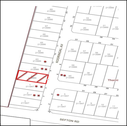
|
NOTIFICATION PLAN |
|
||
|
X PROPERTIES NOTIFIED
|
• SUBMISSIONS RECEIVED |
PROPERTY SUBJECT OF DEVELOPMENT |
|
|
7 SUBMISSIONS RECEIVED OUT OF MAP RANGE |
|||
Thirteen submissions objected to the development, generally on the grounds that the development would result in:
· Unacceptable overshadowing of adjoining properties;
· Asbestos and waste disposal impacts;
· Privacy Impacts;
· Stormwater Impacts;
· Increase in utility costs and increase in mould;
· Loss of light to windows in approved development application
· Bushfire construction concerns;
· Damage to retaining wall on boundary between No.5 and No.7 Kooringal Avenue;
· An increase in noise;
· Non-compliance of the proposal with the development standards listed in the HDCP and HLEP; and
· Development that is excessive in bulk and scale.
The merits of the matters raised in community submissions have been addressed in the body of the report with the exception of the following:
5.2 Sunlight Access
Submissions were received raising concerns with respect to overshadowing from the proposal on the adjacent properties No’s 3 and 5 Kooringal Avenue and questioning the accuracy of the shadow plans provided.
The desired outcomes of Part 3.1.5 Sunlight Access is for “dwelling houses to be designed to provide solar access to open space areas” and “development is designed to provide reasonable sunlight to adjacent properties”.
This is supported by the prescriptive measures which state that “On 22 June, 50 percent of the required principal private open space area should receive 3 hours of unobstructed sunlight access between 9am and 3pm”.
The applicant provided detailed shadow diagrams in accordance with the ‘CSRIO Bulletin – Technical Report 92/2 – Sunshine & Shade in Australasia’ to indicate the extent of overshadowing on the adjacent property No.5 Kooringal Avenue on 21 June (winter solstice). The shadow diagrams confirm that the rear yard and private open space (POS) of the adjacent premises No.5 Kooringal Avenue and No. 3 Kooringal Avenue would receive more than 3 hours of sunlight on the 22 June over the minimum 24m2 amount of private open space.
In terms of the loss of sunlight to the habitable rooms at No.5 Kooringal Avenue, the HDCP does not have any prescriptive measures to assess with respect to provision of natural light to windows serving habitable rooms of adjacent dwellings. It is also noted that No.5 Kooringal Avenue has no north facing windows. With regards to loss of sunlight to solar panels, this is not a matter for assessment under the Environmental Planning and Assessment Act, 1979.
The proposal complies with Part 3.1.4 Sunlight Access of the HDCP and is considered acceptable.
5.3 Potential for mould and increase in utility costs
Submissions have been received raising concerns regarding the potential increase in mould and higher cost of utilities due to the development.
This is not a matter for assessment under the Environmental Planning and Assessment Act, 1979.
5.4 Loss of light to windows in approved development application
A submission has been received raising concerns regarding the loss of light for windows approved to be but yet to be constructed in a development application at No.5 Kooringal Avenue.
An inspection of the site revealed that the windows shown on the approved Construction Certificate plans (CC/568/2010) have not been built. The plans show two north facing windows to the family room. The proposed carport extension along the northern side of the family room has also not been built. Should the adjoining No.5 Kooringal Avenue complete the approved works, the carport roof would screen the family room windows and block any direct sunlight to the family room.
In this regard, the proposed addition at 7 Kooringal Avenue would not impact on direct sunlight access to the approved windows.
5.5 Asbestos/Waste Disposal
Submissions have been received raising concerns regarding the disposal of asbestos from the property and the storage of waste in the front of the property near the existing bus stop on Kooringal Avenue.
To address these concerns, an appropriate condition is recommended in Schedule 1 of this report which requires waste to be disposed in accordance with the approved waste management plan and that asbestos be removed by an appropriately licenced technician. It is also noted that no consent is given for waste to be stored on Council’s road verge and that waste must be disposed of in accordance with the approved waste management plan.
The proposal is considered to be acceptable and complies with Part 1C.2.3 Waste Management of the Hornsby Development Control Plan 2013, subject to conditions.
5.6 Privacy
Submissions have been received raising concerns regarding loss of privacy from window (W14) within bedroom 5 on the proposed first floor and the windows on the southern elevation of the proposed ground floor extension in relation to the private open space of both No.5 and No.9 Kooringal Avenue. These submissions suggested that privacy screening or window treatments be considered to mitigate privacy impacts.
The desired outcomes of Part 3.1.6 Privacy of the HDCP is for development “that is designed to provide reasonable privacy to adjacent properties” this is supported by the prescriptive measures where “a proposed window in a dwelling house should have a privacy screen if;
· it is a window to a habitable room, other than a bedroom, that has a floor level of more than 1 metre above existing ground level;
· the window is setback less than 3 metres from a side or rear boundary; and
· the window has a sill height of less than 1.5 metres”.
In regards to window (W14) in Bedroom 5 on the proposed first floor, although this window has a sill height of 200mm and is orientated towards the side, western boundary it is considered that the 18 metre setback from this window to the private open space at No.9 Kooringal Avenue is sufficient and the proposal complies in this regard.
In regards to the windows on the southern elevation of the proposed ground floor addition, the application plans have been amended to provide screen louvres as addressed in section 2.6.2 Privacy of this report.
The proposal meets the desired outcomes of Part 3.1.6 Privacy of the HDCP and is considered acceptable.
5.7 Scale
Submissions have been received raising concerns with respect to the height and bulk of the proposal.
In response to this it is noted that a maximum building height of 8.5 metres is permissible. The applicant has submitted amended plans that provide accurate spot levels and ridge heights which confirm that the proposed dwelling additions would not be higher than 8.39 metres above existing ground level.
This issue has been addressed in section 2.6.1 Scale of this report.
5.8 Stormwater
Submissions have been received raising concerns regarding the disposal of stormwater..
To address this concern, an appropriate condition is recommended in Schedule 1 of this report requiring that the stormwater from the proposal be directed to the street drainage system.
The proposal meets the desired outcomes of 1C.1.2 Stormwater Management of the HDCP and is considered acceptable.
5.9 Bushfire Construction
Submissions have been received raising concerns regarding the adequacy of the proposed external finishes with bushfire construction requirements.
This matter has been addressed in section 2.6.3 Bushfire of this report.
5.10 Increase in Noise
Submissions have been received raising concerns that additional noise would be generated from the proposed development.
The proposed additions are for residential use and any additional noise would be part of the domestic use of the property. Any issues with respect to noise arising from the use of this development would be investigated in accordance with the requirements of the Protection of the Environment Operations Act, 1997.
The proposal meets the desired outcomes of Part 1C.2.5 Noise and Vibration of the HDCP and is considered acceptable.
5.11 Retaining wall at No.5 Kooringal Avenue
Submissions have been received raising concerns that the proposed development would compromise the structural integrity of the existing retaining wall at No.5 Kooringal Avenue and that confirmation be provided that the retaining wall not be damaged. The submission also noted that if the retaining wall were to be damaged it should be replaced at the expense of the applicant.
In addressing these concerns it is noted that the ground floor of the proposal would be constructed using pier and beam construction with minimal excavation required resulting in minimal impacts to the surrounding land. Consequently, a dilapidation report is not required.
5.12 Setbacks
Submissions have been received raising concerns with respect to the proposed first floor 1.1 metre southern side boundary setback. Amended plans were received increasing the southern side setback to 1.6 metres.
These amendments comply with the minimum 1.5 metre side setback requirement for two storey development listed in Table 3.1.2 (a) Minimum Boundary Setbacks.
The proposal meets the desired outcomes of Part 3.1.2 Privacy of the HDCP and is considered acceptable.
5.13 Survey Plan
Submissions have been received raising concerns that no survey plan was provided with the proposal. The submissions noted that the lack of an accurate survey plan made it difficult to determine the actual height of the proposed development and that this also affected the accuracy of the provided shadow diagrams.
In addressing these concerns it is noted that a survey plan based on Australian Height Datum (AHD) was submitted to Council. In addition, the applicant submitted additional amended architectural plans with accurate ridge heights, reduced levels, a height plane, spot levels and shadow diagrams based on the survey plan to enable an accurate assessment of the proposed development.
6. THE PUBLIC INTEREST
Section 4.15(1)(e) of the Act requires Council to consider “the public interest”.
The public interest is an overarching requirement, which includes the consideration of the matters discussed in this report. Implicit to the public interest is the achievement of future built outcomes adequately responding to and respecting the future desired outcomes expressed in environmental planning instruments and development control plans.
The application is considered to have satisfactorily addressed Council’s and relevant agencies’ criteria and would provide a development outcome that, on balance, would result in a positive impact for the community. Accordingly, it is considered that the approval of the proposed development would be in the public interest.
CONCLUSION
The application proposes alterations and additions to a dwelling house.
The development generally meets the desired outcomes of Council’s planning controls and is satisfactory having regard to the matters for consideration under Section 4.15 of the Environmental Planning and Assessment Act 1979.
Council received thirteen submissions during the public notification period. The matters raised have been addressed in the body of the report.
Conditions are recommended to minimise disruption to residential amenity.
Note: At the time of the completion of this planning report, no persons have made a Political Donations Disclosure Statement pursuant to Section 10.4 of the Environmental Planning and Assessment Act 1979 in respect of the subject planning application.
RESPONSIBLE OFFICER
The officer responsible for the preparation of this report is Tomasz Mojsiejuk.
|
Philip Vergison Team Leader - Development Assessment Planning Division |
Rod Pickles Manager - Development Assessment Planning Division |
|
1.⇨ |
Locality Plan |
|
|
|
2.⇨ |
Site and Shadow Plan |
|
|
|
3.⇨ |
Floor Plans |
|
|
|
4.⇨ |
Elevations and Sections |
|
|
|
5.⇨ |
Survey Plan |
|
|
File Reference: DA/1124/2017
Document Number: D07406228
SCHEDULE 1
CONDITIONS OF CONSENT
GENERAL CONDITIONS
The conditions of consent within this notice of determination have been applied to ensure that the use of the land and/or building is carried out in such a manner that is consistent with the aims and objectives of the relevant legislation, planning instruments and Council policies affecting the land and does not disrupt the amenity of the neighbourhood or impact upon the environment.
Note: For the purpose of this consent, the term ‘applicant’ means any person who has the authority to act on or the benefit of the development consent.
Note: For the purpose of this consent, any reference to an Act, Regulation, Australian Standard or publication by a public authority shall be taken to mean the gazetted Act or Regulation, or adopted Australian Standard or publication as in force on the date that the application for a construction certificate is made.
1. Approved Plans and Supporting Documentation
The development must be carried out in accordance with the plans and documentation listed below and endorsed with Council’s stamp, except where amended by Council and/or other conditions of this consent:
|
Plan No. |
Plan Title |
Drawn by |
Dated |
|
1/5 |
Ground/First Floor Plan |
Unknown |
Dec 2017 |
|
2/5 |
Elevations |
Unknown |
Dec 2017 |
|
3/5 |
Sections |
Unknown |
Dec 2017 |
|
4/5 |
Site Plan and Shadow Plan |
Unknown |
Dec 2017 |
|
6/6 |
Plan showing Building Height Plane |
Unknown |
Dec 2017 |
|
Document title |
Prepared by |
Dated |
|
Waste Management Plan |
Red Gum Town Planning |
October 2017 |
|
BASIX Certificate No: A387217 |
John Apted |
16 July 2017 |
2. Construction Certificate
a) A Construction Certificate is required to be approved by Council or a Private Certifying Authority prior to the commencement of any works under this consent.
b) The Construction Certificate plans must not be inconsistent with the Development Consent plans.
3. Appointment of a Project Arborist
a) A project arborist with AQF Level 5 qualifications must be appointed to provide monitoring and certification throughout the construction period.
b) Details of the appointed project arborist must be submitted to Council and the PCA for registration with the application for the construction certificate.
4. Section 94A Development Contributions
a) In accordance with Section 80A(1) of the Environmental Planning and Assessment Act, 1979 and the Hornsby Shire Council Section 94A Development Contributions Plan 2014-2024, $2,216.00 must be paid to Council to cater for the increased demand for community infrastructure resulting from the development, based on development costs of $221,600.
b) The value of this contribution is current as at 25 January 2018. If this contribution is not paid within the financial quarter that this condition was generated, the contribution payable will be adjusted in accordance with the provisions of the Hornsby Shire Council Section 94 Development Contributions Plan and the amount payable will be calculated at the time of payment in the following manner:
$CPY = $CDC x CPIPY
CPIDC
Where:
$CPY is the amount of the contribution at the date of Payment
$CDC is the amount of the contribution as set out in this Development Consent
CPIPY is the latest release of the Consumer Price Index (Sydney – All Groups) at the date of Payment as published by the ABS.
CPIDC is the Consumer Price Index (Sydney – All Groups) for the financial quarter at the date applicable in this Development Consent Condition.
1. c) The monetary contributions must be paid to Council:
(i) prior to the issue of the Subdivision Certificate where the development is for subdivision; or
(ii) prior to the issue of the first Construction Certificate where the development is for building work; or
(iii) prior to issue of the Subdivision Certificate or first Construction Certificate, whichever occurs first, where the development involves both subdivision and building work; or
(iv) prior to the works commencing where the development does not require a Construction Certificate or Subdivision Certificate.
Note: It is the professional responsibility of the Principal Certifying Authority to ensure that the monetary contributions have been paid to Council in accordance with the above timeframes.
Note: Council’s S94A Development Contributions Plan may be viewed at www.hornsby.nsw.gov.au or a copy may be inspected at Council’s Administration Centre during normal business hours.
REQUIREMENTS PRIOR TO THE ISSUE OF A CONSTRUCTION CERTIFICATE
5. Building Code of Australia
All approved building work must be carried out in accordance with the relevant requirements of the Building Code of Australia.
6. Contract of Insurance (Residential Building Work)
Where residential building work for which the Home Building Act 1989 requires there to be a contract of insurance in force in accordance with Part 6 of that Act, this contract of insurance must be in force before any building work authorised to be carried out by the consent commences.
7. Notification of Home Building Act 1989 Requirements
Residential building work within the meaning of the Home Building Act 1989 must not be carried out unless the principal certifying authority for the development to which the work relates (not being Council) has given Council written notice of the following information:
a) In the case of work for which a principal contractor is required to be appointed:
i) The name and licence number of the principal contractor; and
ii) The name of the insurer by which the work is insured under Part 6 of that Act.
b) In the case of work to be done by an owner-builder:
i) The name of the owner-builder; and
ii) If the owner-builder is required to hold an owner-builder’s permit under that Act, the number of the owner-builder’s permit.
Note: If arrangements for doing the residential building work are changed while the work is in progress so that the information notified becomes out of date, further work must not be carried out unless the principal certifying authority for the development to which the work relates (not being Council) has given Council written notification of the updated information.
8. Stormwater Drainage
The stormwater drainage system for the development must be designed for an average recurrence interval (ARI) of 20 years, be gravity drained and be connected to the street drainage system.
9. Design and Construction - Bushfire Attack Category
a) New construction proposed for the ground floor and first floor additions must comply with the current Australian Standard AS3959 ‘Construction of Buildings in Bush Fire-prone Areas’ Sections 3 and 8 (BAL 40) or NASH Standard (1.7.14 updated) ‘National Standard Steel Framed Construction in Bushfire Areas – 2014’ as appropriate and Section A3.7 Addendum Appendix 3 of ‘Planning for Bushfire Protection 2006’.
b) New construction proposed for the ground floor and first floor additions must comply with the current Australian Standard AS3959 ‘Construction of Buildings in Bush Fire-prone Areas’ Sections 3 and 7 (BAL 29) or NASH Standard (1.7.14 updated) ‘National Standard Steel Framed Construction in Bushfire Areas – 2014’ as appropriate and Section A3.7 Addendum Appendix 3 of ‘Planning for Bushfire Protection 2006’.
c) Any new landscaping to the site is to comply with the principles of Appendix 5 of ‘Planning for Bush Fire Protection 2006’.
Notes: Timbers treated with an applied intumescent paint are no longer recognised by the Rural Fire Service as a fire retardant treated timber or a performance option to increase fire resistance.
10. Domestic Solid Fuel Burning Appliances
a) The fire place and chimney/flue must be installed in accordance with Part 3.7.3 of the Building Code of Australia.
b) The domestic solid-fuel heater must comply with the with the Clean Air (Domestic Solid Fuel Heaters) Regulation 1997 and AS 4013-1992 Domestic solid fuel burning appliances - Method for determination of flue gas emission.
REQUIREMENTS PRIOR TO THE COMMENCEMENT OF ANY WORKS
11. Erection of Construction Sign
a) A sign must be erected in a prominent position on any site on which any approved work is being carried out:
i) Showing the name, address and telephone number of the principal certifying authority for the work;
ii) Showing the name of the principal contractor (if any) for any demolition or building work and a telephone number on which that person may be contacted outside working hours; and
iii) Stating that unauthorised entry to the work site is prohibited.
b) The sign is to be maintained while the approved work is being carried out and must be removed when the work has been completed.
12. Toilet Facilities
To provide a safe and hygienic workplace, toilet facilities must be available or be installed at the works site before works begin and must be maintained until the works are completed at a ratio of one toilet for every 20 persons employed at the site.
13. Erosion and Sediment Control
To protect the water quality of the downstream environment, erosion and sediment control measures must be provided and maintained throughout the construction period in accordance with the manual ‘Soils and Construction 2004 (Bluebook)’, the approved plans, Council specifications and to the satisfaction of the principal certifying authority. The erosion and sediment control devices must remain in place until the site has been stabilised and revegetated.
Note: On the spot penalties may be issued for any non-compliance with this requirement without any further notification or warning.
14. Bushfire Management – Protection Zones
At the commencement of building works the entire property must be managed as an Inner Protection Area (IPA) as outlined within section 4.1.3 and Appendix 5 of “Planning for Bush Fire Protection 2006” and the NSW Rural Fire Service’s document “Standards for asset protection zones”
Note: Further information concerning planning for bush fire protection can be found at: www.rfs.nsw.gov.au.
15. Installation of Tree Protection
a) Tree protection fencing for the trees to be retained in the road reserve must have protection measures for the ground, canopy installed in accordance with the relevant requirements of Australian Standard AS 4970-2009 - “Protection of Trees on Development Sites”.
b) Tree protection fencing must be erected around trees numbered T1 in accordance with Part 1B.6.1(i) Tree Root Zone of the HDCP.
16. Tree Protection Certification
To ensure that all tree protection measures are correctly installed, a certificate from the appointed project arborist must be submitted to the Principal Certifying Authority confirming compliance with the tree protection requirements of this consent.
REQUIREMENTS DURING DEMOLITION AND CONSTRUCTION
17. Construction Work Hours
All works on site, including demolition and earth works, must only occur between 7am and 5pm Monday to Saturday. No work is to be undertaken on Sundays or public holidays.
To protect the surrounding environment, all demolition work must be carried out in accordance with “Australian Standard 2601-2001 – The Demolition of Structures” and the following requirements
a) Demolition material must be disposed of to an authorised recycling and/or waste disposal site and/or in accordance with an approved waste management plan;
b) Demolition works, where asbestos material is being removed, must be undertaken by a contractor that holds an appropriate licence issued by WorkCover NSW in accordance with Chapter 10 of the Occupational Health and Safety Regulation 2001 and Clause 29 of the Protection of the Environment Operations (Waste) Regulation 2005 ;and
c) On construction sites where any building contain asbestos material, a standard commercially manufactured sign containing the words ‘DANGER ASBESTOS REMOVAL IN PROGRESS’ and measuring not less than 400mm x 300mm must be displayed in a prominent position visible from the street.
To prevent sediment run-off, excessive dust, noise or odour emanating from the site during the construction, the site must be managed in accordance with the publication ‘Managing Urban Stormwater – Landcom (March 2004) and the Protection of the Environment Operations Act 1997.
20. Council Property
To ensure that the public reserve is kept in a clean, tidy and safe condition during construction works, no building materials, waste, machinery or related matter is to be stored on the road or footpath.
21. Disturbance of Existing Site
During construction works, the existing ground levels of open space areas and natural landscape features, (including natural rock-outcrops, vegetation, soil and watercourses) must not be altered unless otherwise nominated on the approved plans.
22. Waste Management
All work must be carried out in accordance with the approved waste management plan.
23. Works Near Trees
a) No consent is granted for any works within the Structural Root Zone of trees T1.
b) To maintain tree health and condition, the appointed project arborist must monitor and record any and all necessary remedial actions required for tree T1.
c) The maintenance and monitoring of all tree protection techniques must be recorded by the appointed project arborist during the period of construction for submission with the application for the occupation certificate.
24. Works within Tree Protection Zones
a) Root Pruning
Any root pruning must be undertaken in accordance with the relevant requirements of Australian Standard AS 4970-2009 “Protection of Trees on Development Sites” - Sections 3.3.4, 4.5.4 and 4.5.5.
b) Excavation
Any and all necessary excavations within the Tree Protection Zone of tree numbered T1 must be undertaken using construction techniques as prescribed in the Australian Standard AS 4970-2009 – “Protection of Trees on Development Sites” Section 4.5.5.
c) Changing of Grade
All grades within the Tree Protection Zone of trees T1 on the approved Site Plan must remain unaltered.
d) Installing Services
To minimise the environmental impacts of the development within the Tree Protection Zone (TPZ) of trees numbered T1 on the approved Site Plan.
i) The installation of any underground services which either enter or transect the designated TPZ must utilise sensitive methods such as directional drilling or manual excavation.
ii) The installation of any underground services must be inspected by the project arborist to monitor the likely impacts of the development on retained trees.
iii) For manual excavation of trenches the project arborist must advise on roots to be retained and must monitor the works.
Note: Manual excavation may include the use of pneumatic and hydraulic tools. Refer to Clause 4.5.3. of Australian Standard AS 4970-2009 – “Protection of Trees on Development Sites”.
25. Building Materials and Site Waste
The filling or stockpiling of building materials, the parking of vehicles or plant, the disposal of cement slurry, waste water or other contaminants must be located outside the tree protection zones as prescribed in the conditions of this consent or the prescriptive measures of Part 1B.6.1 Tree Preservation of the Hornsby Development Control Plan, 2013, of any tree to be retained.
REQUIREMENTS PRIOR TO THE ISSUE OF AN OCCUPATION CERTIFICATE
Note: For the purpose of this consent, a reference to ‘occupation certificate’ shall not be taken to mean an ‘interim occupation certificate’ unless otherwise stated:
26. Fulfilment of BASIX Commitments
The applicant must demonstrate the fulfilment of BASIX commitments pertaining to the development.
27. Damage to Council Assets
To protect public property and infrastructure, any damage caused to Council’s assets as a result of the construction or demolition of the development must be rectified by the applicant in accordance with Council’s Civil Works Specifications. Rectification works must be undertaken prior to the issue of an Occupation Certificate, or sooner, as directed by Council.
28. Smoke Alarms – Dwelling Additions
To warn the occupants of the development in the event of a fire, smoke alarms must be installed in the existing building and the proposed additions in accordance with the requirements of the Building Code of Australia.
29. Final Certification Arborist
a) The Project arborist must submit to the principal certifying authority all relevant certificates with the application for the occupation certificate stating compliance with all the conditions of this consent.
b) The Project arborist must submit to the principal certifying authority a certificate that all the completed works have been carried out in compliance with the approved plans and specifications for tree protection.
c) Certification must include a statement of overall site attendance, the condition of the retained trees, details of any deviations from the approved tree protection measures and their impacts on trees.
Note: Copies of monitoring documentation may be required.
- END OF CONDITIONS -
ADVISORY NOTES
The following information is provided for your assistance to ensure compliance with the Environmental Planning and Assessment Act 1979 Environmental Planning and Assessment Regulation 2000, other relevant legislation and Council’s policies and specifications. This information does not form part of the conditions of development consent pursuant to Section 80A of the Act.
Environmental Planning and Assessment Act 1979 Requirements
The Environmental Planning and Assessment Act 1979 requires:
· The issue of a construction certificate prior to the commencement of any works. Enquiries can be made to Council’s Customer Services Branch on 9847 6760;
· a principal certifying authority to be nominated and Council notified of that appointment prior to the commencement of any works;
· Council to be given at least two days written notice prior to the commencement of any works;
· mandatory inspections of nominated stages of the construction inspected; and
· an occupation certificate to be issued before occupying any building or commencing the use of the land.
Long Service Levy
In accordance with Section 34 of the Building and Construction Industry Long Service Payments Act 1986, a ‘Long Service Levy’ must be paid to the Long Service Payments Corporation or Hornsby Council.
Note: The rate of the Long Service Levy is 0.35% of the total cost of the work.
Note: Hornsby Council requires the payment of the Long Service Levy prior to the issue of a construction certificate.
Tree and Vegetation Preservation
In accordance with Clause 5.9 of the Hornsby Local Environmental Plan 2013 a person must not ringbark, cut down, top, lop, remove, injure or wilfully destroy any tree or other vegetation protected under the Hornsby Development Control Plan 2013 without the authority conferred by a development consent or a permit granted by Council.
Notes: A tree is defined as a long lived, woody perennial plant with one or relatively few main stems with the potential to grow to a height greater than three metres (3M). (HDCP 1B.6.1.c).
Tree protection measures and distances are determined using the Australian Standard AS 4970:2009, “Protection of Trees on Development Sites”.
Fines may be imposed for non-compliance with both the Hornsby Local Environmental Plan 2013 and the Hornsby Development Control Plan 2013.
Dial Before You Dig
Prior to commencing any works, the applicant is encouraged to contact Dial Before You Dig on 1100 or www.dialbeforeyoudig.com.au for free information on potential underground pipes and cables within the vicinity of the development site.
Asbestos Warning
Should asbestos or asbestos products be encountered during demolition or construction works, you are advised to seek advice and information prior to disturbing this material. It is recommended that a contractor holding an asbestos-handling permit (issued by WorkCover NSW) be engaged to manage the proper handling of this material. Further information regarding the safe handling and removal of asbestos can be found at:
Alternatively, telephone the WorkCover Asbestos and Demolition Team on 8260 5885.
IHAP - Planning Division
Date of Meeting: 28/03/2018
4 DEVELOPMENT APPLICATION - TORRENS TITLE SUBDIVISION ONE ALLOTMENT INTO TWO
EXECUTIVE SUMMARY
|
DA No: |
DA/103/2017 (Lodged on 13 February 2017) |
|
Description: |
Torrens title subdivision of an approved multi-unit housing development to create two allotments |
|
Property: |
Lot 2 DP 1160459, No. 110 Dartford Road, Thornleigh |
|
Applicant: |
Mr. Bradley Scott Buchel |
|
Owner: |
Mr. Bradley Scott Buchel |
|
Estimated Value: |
$17,500 |
|
Ward: |
B |
· The application proposes the Torrens title subdivision of an approved multi-unit housing development comprising two detached dwellings into two allotments.
· The proposal does not comply with the Hornsby Shire Local Environmental Plan 2013 (HLEP) with regard to Clause 4.1 Minimum subdivision lot size. The applicant has made a submission in accordance with Clause 4.6 ‘Exceptions to development standards’ of the HLEP to vary the minimum 500m2 lot size development standard. The submission is considered well founded and is supported.
· The application is required to be determined by the Hornsby Shire Council IHAP as the development would contravene the HLEP minimum allotment size by more than 10 percent.
· One submission was received in respect of the application.
· It is recommended that the application be approved.
|
THAT the Hornsby Shire Council Planning Panel assume the concurrence of the Secretary of the Department of Planning and Environment pursuant to Clause 4.6 of the Hornsby Local Environmental Plan 2013 and approve Development Application No. DA/103/2017 for the Torrens title subdivision of one allotment into two lots at No. 110 Dartford Road Thornleigh (Lot 2 DP1160459) as a deferred commencement pursuant to Section 4.16(3) of the Environmental Planning and Assessment Act 1979 subject to the conditions of consent detailed in Schedule 1 of IHAP Report No. IHAP4/18 |
BACKGROUND
Upon gazettal of the then Hornsby Shire Local Environmental Plan 1994 (HSLEP) in July 1994, Hornsby Shire was exempted from the provisions of the now repealed NSW State Government’s urban consolidation policies, namely Sydney Regional Environmental Plan No. 12 – Dual Occupancy (SREP12) and State Environmental Planning Policy No. 25 – Residential Allotment Sizes (SEPP25).
The exemption was granted as a result of the housing initiatives embodied within the HSLEP which presented an alternative solution to meet both local and State housing objectives. The HSLEP incorporated higher density residential zones around transport and employment nodes, such as the Hornsby Town Centre. The HSLEP also permitting multi-unit housing at a density of one dwelling per 350m2 of land area within the Residential A (Low Density) zone. In accordance with Clause 4(2) of the HSLEP, SEPP 25 and SREP 12 no longer applied to Hornsby Shire.
The then Minister for Urban Affairs and Planning subsequently repealed the right to separate titles on dual occupancy developments. However, despite the repeal of SREP12 and SEPP25, the subdivision of dual occupancies with reduced lot sizes was still possible under the HSLEP.
On 15 December 1995, to bring the HSLEP in accordance with State Government policies, HSLEP (Amendment No. 8) was gazetted to preclude the subdivision of multi-unit housing developments where proposed allotment sizes were less than the minimum allotment size under Clause 14 (Density).
In September 2013, the HLEP was gazetted which allowed a minimum allotment size of 500m2 and prohibited “multi-unit housing” and “dual occupancies” within the R2 Low Density Residential zone.
SITE HISTORY
On 23 May 2010, Council approved Development Application DA/315/2010 for the demolition of outbuildings, the Torrens title subdivision of two allotments into four and relocation of an existing house at Lot 5 and 6 DP 21884 (Nos. 108 and 110) Dartford Road Thornleigh.
On 4 January 2011, Council approved Section 96 Application DA/315/2010/A for an amendment to the configuration of the approved common turning area over Lot 1 DP 1160459 and Lot 2 DP 1160459, Nos. 108 and 110 Dartford Road Thornleigh.
On 24 March 2011, Council approved Section 96 Application DA/315/2010/B for the modification of the approved development, summarised as follows:
· Retrospective approval of the landscape plans undertaken within the site including a 2-2.5 metre high retaining wall supporting the hard stand parking area within Lot 2, a flat and level section of land in front of this retaining wall instead of the stepped area previously proposed.
· Stepped landscaping along the northern side of this area adjoining the common driveway
· Retention of the hardstand car parking areas and the vehicular crossover within Lot 1
On 6 April 2011, Council approved Development Application DA/1510/2010 for multi-unit housing in the form of an additional two storey dwelling house to the front of an existing dwelling house at Lot 2 DP 1160459 (No. 110 Dartford Road Thornleigh). The approval included a separate vehicular access and driveway servicing the approved dwelling from Dartford Road.
On 22 March 2013, Council approved Section 96 Application DA/1510/2010/A to modify the deferred commencement condition to enable an additional 24 months for the provision of the requested registered plan of subdivision from NSW Land and Property Information. The plan of subdivision was registered with NSW Land and Property Information on 12 March 2013.
On 6 October 2017, Council approved Construction Certificate Application CC/361/2017 for dual occupancy development in the form of an additional dwelling house approved as part of Development Application DA/1510/2010.
APPLICATION HISTORY
On 2 March 2017, Council requested the submission of a cheque for the sum of $320 made out to the NSW Rural Fire Service, as the site is bushfire prone and the proposed subdivision is ‘integrated development’ subject to approval of the NSW Rural Fire Service for the issue of a Bush Fire Safety Authority pursuant to Section 100B of the Rural Fires Act 1997.
On 10 May 2017, Council requested additional information in the form of written/photographic evidence demonstrating that physical works had commenced in relation to Development Application No. DA/1510/2010 for dual occupancy development. On 30 May 2017, Council received evidence demonstrating that physical of works had commenced, which included a letter from Ausgrid notifying of the satisfactory provision of electricity supply to the lots, a letter from Sydney Water authorising to connect to the wastewater connection point and photographic/written evidence from the applicant indicating the provision of Ausgrid meter box services, stormwater connection points, the construction of a vehicular crossing to service the approved dwelling and a 1.8m high timber boundary fence between the existing and approved dwellings. It is considered that the consent for multi-unit housing development on the site is still valid as physical works had commenced within 5 years of the date of determination.
On 9 June 2017, Council requested additional information in the form of a Subdivision Plan prepared by a registered surveyor and a Clause 4.6 request for a variation to the ‘minimum subdivision lot size’ development standard.
SITE
The 1,106m2 site is located on the western side of Dartford Road Thornleigh and contains a single storey dwelling house built on poles with a sub floor area. The dwelling house is located on the flatter section of the site with a considerable setback from the street.
The site experiences a fall of 13 metres to the eastern, front boundary and is not flood prone; however it is bushfire prone.
The site benefits from a 3.7m wide and variable width easement to drain water and reciprocal right of access servicing Lots 1, 2, 3 and 4 of DP 1160459, which traverses along the northern side boundary.
The site does not contain a heritage item, is not in the vicinity of a heritage listed item and is not located within a heritage conservation area.
The surrounding development comprises one and two storey dwelling houses.
PROPOSAL
The application proposes the Torrens title subdivision of an approved multi-unit housing development into two allotments.
Proposed Lot 21 would have an area of 432m2 excluding the Right of Access.
Proposed Lot 22 would have an area of 515m2 excluding the Right of Access.
No physical works are proposed as part of the application.
ASSESSMENT
The development application has been assessed having regard to ‘A Plan for Growing Sydney’, the ‘Draft North District Plan’ and the matters for consideration prescribed under Section 4.15 of the Environmental Planning and Assessment Act 1979 (the Act). The following issues have been identified for further consideration.
1. STRATEGIC CONTEXT
1.1 A Plan for Growing Sydney and (Draft) North District Plan
A Plan for Growing Sydney has been prepared by the NSW State Government to guide land use planning decisions for the next 20 years. The Plan sets a strategy and actions for accommodating Sydney’s future population growth and identifies dwelling targets to ensure supply meets demand. The Plan identifies that the most suitable areas for new housing are in locations close to jobs, public transport, community facilities and services.
The NSW Government will use the subregional planning process to define objectives and set goals for job creation, housing supply and choice in each subregion. Hornsby Shire has been grouped with Hunters Hill, Ku-ring-gai, Lane Cove, Mosman, North Sydney, Ryde, Northern Beaches and Willoughby to form the North District. The Greater Sydney Commission has realised the draft North District Plan which includes priorities and actions for the Northern District for the next 20 years. The identified challenge for Hornsby Shire will be to provide an additional 4,350 dwellings by 2021 with further strategic supply targets to be identified to deliver 97,000 additional dwellings in the North District by 2036.
The proposed development would not be inconsistent with ‘A Plan for Growing Sydney’ and ‘Draft North District Plan’.
2. STATUTORY CONTROLS
Section 4.15(1)(a) requires Council to consider “any relevant environmental planning instruments, draft environmental planning instruments, development control plans, planning agreements and regulations”.
2.1 Hornsby Local Environmental Plan 2013
The proposed development has been assessed having regard to the provisions of the Hornsby Local Environmental Plan 2013 (HLEP).
2.1.1 Zoning of Land and Permissibility
The subject land is zoned R2 (Low Density Residential) under the HLEP. The objectives of the zone are:
· To provide for the housing needs of the community within a low density residential environment.
· To enable other land uses that provide facilities or services to meet the day to day needs of residents.
The proposed development is defined as “subdivision” and is permissible in the zone with Council’s consent.
2.1.2 Minimum Lot Size
Clause 4.1 of the HLEP provides that the minimum allotment size for the subject site within the R2 Low Density Residential zone is 500m2. The proposal does not comply with this provision.
Proposed Lot 21 would have an area of 432m2 excluding the right of access which would result in a 13.6% variation to the minimum lot size requirement. Proposed Lot 22 would have an area of 515m2 excluding the right of access and would comply with the minimum lot size requirement.
The application is supported by a submission pursuant to Clause 4.6 of HLEP to vary the minimum 500m2 allotment size development standard, which is discussed below in Section 2.1.3 of this report.
2.1.3 Exceptions to Development Standards
Clause 4.6 of the HLEP provides flexibility in the application of development standards in circumstances where strict compliance with those standards would, in any particular case, be unreasonable or unnecessary or tend to hinder the attainment of the objectives of the zone.
The proposal fails to comply with the minimum subdivision lot size of 500m2 under the HLEP. The objectives of Clause 4.1 are:
· To provide for the subdivision of land at a density that is appropriate for the site constraints, development potential and infrastructure capacity of the land,
· To ensure that lots are of a sufficient size to accommodate development.
The applicant has made a submission in support of a variation to the development standard in accordance with Clause 4.6 of the HLEP. The applicant states the proposed variation is considered to be consistent with the objectives of the control and is justified as follows:
· The approval of two dwellings on the site (DA/1510/2010 for a multi-unit housing development) demonstrates that the site is capable of accommodating this extent of development, being low density residential development which is responsive to the environmental considerations of this site and its immediate locality.
· The approval for dwellings on this site (DA/1510/2010) also provides assurance that the proposed lots are capable of being appropriately serviced with regard to infrastructure, as evidenced by the documentation submitted in support of this subject application which includes photographs of infrastructure and services already constructed on the site submitted to Council and dated 24.05.2017. The site is capable of being serviced with respect to stormwater, water, sewer, electricity and phone.
· The proposed subdivision permits the land to achieve its full development potential, which would otherwise not be achieved if the land were maintained as a single allotment.
· The proposed subdivision is consistent with the scale of density in the immediate vicinity which is also for single dwelling houses per each allotment, as evidence by recently approved dwellings and/or subdivisions at Nos. 104 Dartford Road, 106 Dartford Road and 108 Dartford Road, Thornleigh.
· The proposed lots are of a sufficient size to accommodate development of a low density scale including appropriately sized vehicular access, parking, dwelling size and lot coverage, private open space, landscaped area, height, setbacks and solar access. This is evidenced by the approval for dwellings on this land (DA/1510/2010 for a multi-unit housing development). The proposed lots will not impact on nearby existing residential properties.
· The site is in an existing low density residential locality where the development will provide residential dwellings on their own individual allotments which promote the orderly and economic use and development of land that reflects the intended nature of this land use zone.
· The proposal is consistent with the objectives of the development standard as provided in Clause 4.1 (1) of HLEP.
· The numerical exceedance of the minimum subdivision lot size is minor and does not compromise the quality of the development outcome, being residential dwellings which contribute to the residential character of Dartford Road.
· If not for the right of way which is required to be excluded from the calculation of the site area, the proposal would comply with the development standard.
· The site has a nature strip with a generous depth of approximately 6m, which equates to 90m2. This far exceeds the average width of the nature strip further along Dartford Road. If this were to form part of proposed Lot 21, the minimum lot size would be numerically achieved.
· The proposed subdivision and associated multi-unit housing development on this site does not result in adverse environmental impacts on the site or surrounding properties in terms of bulk and scale, access, view impacts, privacy or overshadowing.
· The proposed subdivision and approved multi-unit housing development (DA/1510/2010) are consistent with the intent of subdivision under the HDCP 2013, Part 6, Subdivision, with regard to layout, provision of a right of way, setback from the primary frontage and lot width.
· There are no visual or physical impacts associated with the proposed subdivision as there will be no change to the built form as a result of this proposed subdivision.
· There is no impact on the density or scale of development on the site, as the multi-unit housing development is already approved.
· The proposed subdivision results in an outcome which is in keeping with the existing scale and character of the locality.
· Strict compliance with the development standard would not result in an improved development outcome and would not deliver any additional benefits to the owners or occupants of the surrounding properties or the general public and in this particular circumstance there are sufficient environmental planning grounds to warrant the proposed variation to the minimum lot size control.
The applicant also notes that in the recent ‘Four2Five’ decision (Four2Five Pty Ltd v Ashfield Council [2015] NSW LEC 90), Commissioner Pearson outlined that a Clause 4.6 variation requires identification of grounds that are particular to the circumstances to the proposed development. That is to say that simply meeting the objectives of the development standard is insufficient justification of a Clause 4.6 variation.
The Court of Appeal upheld the Four2Five decision but expressly notes that the Commissioner’s decision on the point (that she was not “satisfied” because something more specific to the site was required) was simply a discretionary (subjective) opinion which was a matter for her alone to decide. This does not mean that a Clause 4.6 variation can only be allowed where there is some special or particular feature of the site that justifies the non-compliance. Whether there are “sufficient environmental planning grounds to justify contravening the development standard”, it is something that can be assessed on a case by case basis and is for the consent authority to determine for itself.
The particular feature of the subject site that differs from the surrounding development is that multi-unit housing development has been approved on the site, albeit not yet constructed.
A more recent appeal is the matter of Randwick City Council v Micaul Holdings Pty Ltd [2016] NSWLEC 7 should be considered. In this case, the Council appealed against the original decision, raising legal argument about whether each and every item of the Clause 4.6 of the LEP had to be considered and complied with in terms of the applicant’s written document and the Commissioner’s assessment. The Chief Judge of the Court dismissed the appeal, finding no fault in the Commissioner’s approval of large variations to the height and FSR controls.
While the judgement did not directly overturn the Four2Five v Ashfield decision, an important issue emerged. The Chief Judge noted that one of the consent authority’s obligations is to be satisfied that “compliance with the development standard is unreasonable or unnecessary in the circumstance of the case, and that there are sufficient environmental planning grounds to justify contravening the development standard”.
The proposed subdivision does not involve any physical works and in this regard, does not give rise to any adverse impacts with regard to environmental planning grounds.
Consideration should also be given to the Land and Environment Court judgement of Wehbe v Pittwater Council 2007 which identified the five different ways in which an objection may be well founded and that approval of the objection may be consistent with the aims of the policy. State Government Guidelines on varying development standards recommend considering the provisions of Clause 4.6 of the LEP and the ‘five part test’ established by the Land and Environment Court as follows:
1. the objectives of the standard are achieved notwithstanding noncompliance with the standard;
2. the underlying objective or purpose of the standard is not relevant to the development and therefore compliance is unnecessary;
3. the underlying object of purpose would be defeated or thwarted if compliance was required and therefore compliance is unreasonable;
4. the development standard has been virtually abandoned or destroyed by the council’s own actions in granting consents departing from the standard and hence compliance with the standard is unnecessary and unreasonable;
5. the compliance with development standard is unreasonable or inappropriate due to existing use of land and current environmental character of the particular parcel of land. That is, the particular parcel of land should not have been included in the zone.
The applicant’s submission to vary the minimum subdivision lot size development standard is considered well founded for the following reasons:
· The proposal would convert a prohibited “multi-unit housing” development to a permissible use within the R2 Low Density Residential zone under the HLEP.
· No environmental or planning implications would arise should the application be approved.
· The proposal does not include any changes to the approved built form, and therefore, the proposal would not have any impact on the existing streetscape or the amenity of adjoining properties.
· Approval of the application for Torrens title subdivision would not alter the intensity or scale of the existing development on the site.
· The proposal is both site specific and accords with the objective of the zone as the proposal would allow the existing dwellings to be on separate titles, thereby adding economic value and versatility to existing housing stock.
· The proposal would result in allotments consistent with the objectives of the development standard. This is evident as the approved multi-unit housing development on the site demonstrates that the proposed allotments are capable of accommodating dwelling houses with the necessary ancillary infrastructure provision.
Based on this assessment, it is considered that compliance with the development standard would be unreasonable and unnecessary in the circumstances of the case. The proposal would not result in a precedent given the unique circumstances of the site involving an approved multi-unit housing development on the site. Accordingly, the Clause 4.6 submission is supported in this instance.
2.1.4 Heritage Conservation
Clause 5.10 of the HLEP sets out heritage conservation provisions for Hornsby Shire. The site does not include a heritage item and is not located in a heritage conservation area. Accordingly, no further assessment regarding heritage is necessary.
2.2 State Regional Environmental Policy No. 20 – Hawkesbury-Nepean River
The site is located with the catchment of the Hawkesbury Nepean River. Part 2 of this Plan contains general planning considerations and strategies requiring Council to consider the impacts of development on water quality, aquaculture, recreation and tourism.
Subject to the implementation of sediment and erosion control measures and stormwater management to protect water quality, the proposal would comply with the requirement of the Policy. No changes are proposed in this regard.
2.3 State Environmental Planning Policy No. 55 – Remediation of Land
Clause 7 of State Environmental Planning Policy No. 55 - Remediation of Land (SEPP55) requires Council to consider whether land is contaminated prior to granting consent to the carrying out of any development on that land. Should the land be contaminated, Council must be satisfied that the land is suitable in a contaminated state for the proposed use. If the land requires remediation to be undertaken to make the land suitable for the proposed use, Council must be satisfied that the land will be remediated before the land is used for that purpose.
The site history and a review of Council’s files and air photos indicate a history of residential development and therefore, it is not likely that the site has experienced any significant contamination. Accordingly, further assessment under SEPP55 is not required.
2.4 Rural Fire Act 1997
The site is partly bushfire prone with the fire threat to the east of the site from bushland within the Waitara Creek nature reserve. Accordingly, the proposed subdivision is ‘integrated development’ subject to approval of the NSW Rural Fire Service for the issue of a Bush Fire Safety Authority pursuant to Section 100B of the Rural Fires Act 1997.
The NSW Rural Fire Service has raised no objections to the proposal, subject to the implementation of conditions involving the management of the proposed lots as an inner protection area (IPA) and compliance with the water, electricity and gas service requirements of Section 4.1.3 of Planning for Bush Fire Protection 2006.
2.5 Section 3.42 Environmental Planning and Assessment Act 1979 - Purpose and Status of Development Control Plans
Section 3.42 of the Environmental Planning and Assessment Act 1979 states that a DCP provision will have no effect if it prevents or unreasonably restricts development that is otherwise permitted and complies with the development standards in relevant Local Environmental Plans and State Environmental Planning Policies.
The principal purpose of a development control plan is to provide guidance on the aims of any environmental planning instrument that applies to the development; facilitate development that is permissible under any such instrument; and achieve the objectives of land zones. The provisions contained in a DCP are not statutory requirements and are for guidance purposes only. Consent authorities have flexibility to consider innovative solutions when assessing development proposals, to assist achieve good planning outcomes.
2.6 Hornsby Development Control Plan 2013
The proposed development has been assessed having regard to the relevant desired outcomes and prescriptive requirements within the Hornsby Development Control Plan 2013 (HDCP). The following table sets out the proposal’s compliance with the prescriptive requirements of the Plan:
|
HDCP – Part 3 Residential Development & 6.1 Subdivision |
|||
|
Control |
Proposal |
Requirement |
Complies |
|
Site Area |
1,106m2 |
N/A |
N/A |
|
Lot Area |
|
|
|
|
- Lot 21 (excluding Right of Access) |
432m2 |
500m2 |
No |
|
- Lot 22 (excluding Right of Access) |
515m2 |
500m2 |
Yes |
|
Lot Width |
|
|
|
|
- Lot 21 - |
15.39m |
12m |
Yes YesYes |
|
- Lot 22 |
15.24m |
12m |
Yes |
|
Setbacks Lot 21 (approved dwelling) |
|
|
|
|
- Front |
6.5m |
6m |
Yes
Yes |
|
- Side (north) |
1.5m |
0.9m |
Yes |
|
- Side (south) |
1m |
0.9m |
Yes |
|
- Rear |
9.5m |
5m |
Yes |
|
Setbacks Lot 22 |
|
|
|
|
- Front (battle-axe) |
6m |
0.9m |
Yes |
|
- Side (north) |
0.9m |
0.9m |
Yes |
|
- Side (south) |
2m |
0.9m |
Yes |
|
- Rear |
13m |
5m |
Yes |
|
Landscape Area |
|
|
|
|
- Lot 21 (approved dwelling) - |
50% %% |
20% |
Yes YesYe
Yes |
|
- Lot 22 |
24% |
20% |
Yes |
|
Private Open Space |
|
|
|
|
- Lot 21 (approved dwelling) - |
120m2 |
24m2 |
Yes |
|
- Lot 22 - |
120m2 |
24m2 |
Yes |
|
Car Parking |
|
|
|
|
- Lot 21 (approved dwelling) - |
2 spaces |
2 spaces |
Yes |
|
- Lot 22 |
2 spaces |
2 spaces |
Yes |
|
Floor Area |
|
|
|
|
- Lot 21 (approved dwelling) - |
209m2 |
270m2 |
Yes |
|
- Lot 22 |
162.9m2 |
330m2 |
Yes |
|
Site Coverage |
|
|
|
|
- Lot 21 (approved dwelling) - |
29% |
55% |
Yes |
|
- Lot 22 |
31% |
50% |
Yes |
As detailed in the above table, the proposed development and the development approved as part of Development Application No. DA/1510/2010 complies with the prescriptive requirements within the HDCP, with the exception of the minimum lot size requirement. The matters of non-compliance are detailed below, as well as a brief discussion on compliance with relevant desired outcomes.
2.6.1 Lot Size
The prescriptive measure of Part 6.2.1(a) states that “the minimum lot size is depicted on the minimum lot size map as: 500m2”.
One submission raises concerns over the undersized allotments. In this instance, the proposal is not capable of meeting the lot size requirement. As discussed under Sections 2.1.2 and 2.1.3 of this report, the approved dual occupancy development demonstrates that the proposed lots are of sufficient size and shape to accommodate dwelling houses on the site.
The proposal would not have any impact on the existing streetscape or the amenity of adjoining properties and is considered acceptable in this regard.
2.7 Section 7.11 Contributions Plans
The proposed development would result in the creation of one additional allotment. Accordingly, a condition has been recommended requiring that a Section 7.11 Contribution be levied prior to the issue of the Subdivision Certificate.
It is noted that a Section 7.11 Contribution (formerly known as a S94 Contribution) was levied and is payable with regard to the approved development on the site. In the instance that an Occupation Certificate were to be obtained for the approved dwelling house (DA/1510/2010), consideration would be given by Council for the deletion of this conditional requirement via a Section 96 Application, to prevent the duplication of fees.
3. ENVIRONMENTAL IMPACTS
Section 4.15(1)(b) of the Act requires Council to consider “the likely impacts of that development, including environmental impacts on both the natural and built environments, and social and economic impacts in the locality”.
3.1 Natural Environment
3.1.1 Tree and Vegetation Preservation
The proposed development does not necessitate the removal of any trees or vegetation on the site.
3.1.2 Stormwater Management
The stormwater on the site currently drains to the street via an easement to drain water along the northern side boundary.
It is noted that the on-site stormwater detention system approved as part of the approved dual occupancy development is suitable for the proposed development; however physical construction of the OSD has not been completed. Conditions have been recommended for the construction of an on-site stormwater detention system prior to the issue of a Construction Certificate.
Subject to the recommended conditions of consent, the proposed development would have no impact on the existing stormwater management of the site.
3.2 Built Environment
3.2.1 Built Form
The proposed development would not alter the existing built form on the site.
3.3 Social Impacts
The residential subdivision would improve housing mix in the locality by enabling the existing dwellings to be either owner occupied or rented. This is consistent with Council’s Housing Strategy which identifies the need to provide a mix of housing options to meet future demographic needs in Hornsby Shire.
3.4 Economic Impacts
The proposal would not result in an economic impact.
4. SITE SUITABILITY
Section 4.15(1)(c) of the Act requires Council to consider “the suitability of the site for the development”.
4.1 Bushfire Risk
The land is identified as being subject to bushfire risk. The application was referred to the NSW Rural Fire Service seeking approval under Integrated Development in accordance with Section 91 of the Environmental Planning and Assessment Act 1979. No objections were raised, subject to the implementation of conditions in accordance with section 100B of the Rural Fires Act 1997.
5. PUBLIC PARTICIPATION
Section 4.15(1)(d) of the Act requires Council to consider “any submissions made in accordance with this Act”.
5.1 Community Consultation
The proposed development was placed on public exhibition and was notified to adjoining and nearby landowners between 6 February 2017 and 7 March 2017 in accordance with the Notification and Exhibition requirements of the HDCP. During this period, Council received one submission.
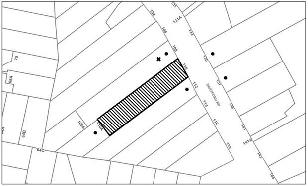
|
NOTIFICATION PLAN |
|
||
|
• PROPERTIES NOTIFIED |
X SUBMISSIONS RECEIVED |
PROPERTY SUBJECT OF DEVELOPMENT |
|
One submission was received by Council from No. 108 Dartford Road, Thornleigh The submission objects to the development, generally on the grounds that the development would result in:
· An undersized allotment;
· The floor space ratio of the existing dwelling is not considered within this application; and
· Development Application No. DA/1510/2010 for multi-unit housing development on the site in the form of an additional two storey dwelling house has expired;
The merits of the matters raised in the submission have been addressed in the body of the report with the exception of the following:
5.1.1 DA Consent Expiration
The submission raises concerns that Development Application No. DA/1510/2010 for multi-unit housing development on the site has expired.
In addressing this concern, it is noted that Construction Certificate Application No. CC/361/2017 has been issued for the approved development and it is considered that physical commencement of the approved works has occurred, evidenced by the provision of Sydney Water sewer and Ausgrid meter box services, stormwater connection points, the construction of a vehicular crossing to service the approved dwelling and erection of a 1.8m high timber boundary fence. It is considered that the consent for dual occupancy development on the site has not lapsed.
5.2 Public Agencies
The development application was referred to the NSW Rural Fire Service for comment. No objections were raised to the proposed subdivision.
6. THE PUBLIC INTEREST
Section 4.15(1)(e) of the Act requires Council to consider “the public interest”.
The public interest is an overarching requirement, which includes the consideration of the matters discussed in this report. Implicit to the public interest is the achievement of future built outcomes adequately responding to and respecting the future desired outcomes expressed in environmental planning instruments and development control plans.
The application is considered to have satisfactorily addressed Council’s and relevant agencies’ criteria and would provide a development outcome that, on balance, would result in a positive impact for the community. Accordingly, it is considered that the approval of the proposed development would be in the public interest.
CONCLUSION
The application proposes Torrens title subdivision of an approved multi-unit housing development comprising two detached dwellings.
The application does not comply with the Hornsby Local Environmental Plan 2013 in respect to the minimum 500m2 lot size. The applicant submitted a Clause 4.6 Variation to Development Standard to the minimum lot size development standards. The objection is considered well founded with regard to the approved development on the site and the principles established by the Land and Environment Court.
Council received one submission during the notification of the proposed subdivision.
Having regard to the circumstances of the case and consideration of the Clause 4.6 Variation to Development Standards, the application is recommended for approval.
Note: At the time of the completion of this planning report, no persons have made a Political Donations Disclosure Statement pursuant to Section 147 of the Environmental Planning and Assessment Act 1979 in respect of the subject planning application.
RESPONSIBLE OFFICER
The officer responsible for the preparation of this Report is Thomas Dales.
|
Rod Pickles Manager - Development Assessment Planning Division |
Cassandra Williams Team Leader - Major Applications Planning Division |
|
1.⇨ |
Locality Plan |
|
|
|
2.⇨ |
Subdivision Plan |
|
|
|
3.⇨ |
Supporting documents - Request to vary Clause 4.6 |
|
|
|
4.⇨ |
Supporting documents - Ausgrid referral coments |
|
|
|
5.⇨ |
Supporting documents - Sydney Water Application |
|
|
|
6.⇨ |
Supporting documents - Response to HSC |
|
|
File Reference: DA/103/2017
Document Number: D07406310
SCHEDULE 1
GENERAL CONDITIONS
The conditions of consent within this notice of determination have been applied to ensure that the use of the land and/or building is carried out in such a manner that is consistent with the aims and objectives of the relevant legislation, planning instruments and Council policies affecting the land and does not disrupt the amenity of the neighbourhood or impact upon the environment.
Note: For the purpose of this consent, the term ‘applicant’ means any person who has the authority to act on or the benefit of the development consent.
Note: For the purpose of this consent, any reference to an Act, Regulation, Australian Standard or publication by a public authority shall be taken to mean the gazetted Act or Regulation, or adopted Australian Standard or publication as in force on the date that the application for a construction certificate is made.
1. Approved Plans and Supporting Documentation
The development must be carried out in accordance with the plans and documentation listed below and endorsed with Council’s stamp, except where amended by Council and/or other conditions of this consent:
Approved Plans:
|
Plan No. |
Plan Title |
Drawn by |
Dated |
|
14680 |
Subdivision Plan |
Bissett & Wright |
20 July 2017 |
2. Construction Certificate
a) A Construction Certificate is required to be approved by Council or a Private Certifying Authority prior to the commencement of any works under this consent.
b) A separate Construction Certificate must be obtained from Council for all works within the public road reserve under S138 of the Roads Act 1993.
c) A separate Construction Certificate must be obtained from Council for all works within drainage easements vested in Council.
d) The Construction Certificate plans must not be inconsistent with the Development Consent plans.
3. Section 7.11 Development Contributions
a) In accordance with Section 4.17(1) of the Environmental Planning and Assessment Act 1979 and the Hornsby Shire Council Section 94 Development Contributions Plan 2014-2024, the following monetary contributions must be paid to Council to cater for the increased demand for community infrastructure resulting from the development:
|
Description |
Contribution (4) |
|
Roads |
$1,994.75 |
|
Open Space and Recreation |
$12,975.30 |
|
Community Facilities |
$4,988.10 |
|
Plan Preparation and Administration |
$41.85 |
|
TOTAL |
$20,000 |
being for the subdivision of one allotment into two lots.
b) The value of this contribution is current as at 12 March 2018. If the contribution is not paid within the financial quarter that this condition was generated, the contribution payable will be adjusted in accordance with the provisions of the Hornsby Shire Council Section 94 Development Contributions Plan and the amount payable will be calculated at the time of payment in the following manner:
$CPY = $CDC x CPIPY
CPIDC
Where:
$CPY is the amount of the contribution at the date of Payment
$CDC is the amount of the contribution as set out in this Development Consent
CPIPY is the latest release of the Consumer Price Index (Sydney – All Groups) at the date of Payment as published by the ABS.
CPIDC is the Consumer Price Index (Sydney – All Groups) for the financial quarter at the date applicable in this Development Consent Condition.
c) The monetary contribution must be paid to Council:
i) prior to the issue of the Subdivision Certificate where the development is for subdivision; or
ii) prior to the issue of the first Construction Certificate where the development is for building work; or
iii) prior to issue of the Subdivision Certificate or first Construction Certificate, whichever occurs first, where the development involves both subdivision and building work; or
iv) prior to the works commencing where the development does not require a Construction Certificate or Subdivision Certificate.
Note: It is the professional responsibility of the Principal Certifying Authority to ensure that the monetary contributions have been paid to Council in accordance with the above timeframes. Council’s Development Contributions Plan may be viewed at www.hornsby.nsw.gov.au or a copy may be inspected at Council’s Administration Centre during normal business hours.
REQUIREMENTS PRIOR TO THE ISSUE OF A CONSTRUCTION CERTIFICATE
4. On Site Stormwater Detention
An on-site stormwater detention system must be designed by a chartered civil engineer and constructed in accordance with the following requirements:
a) Have a capacity of not less than 5 cubic metres, and a maximum discharge (when full) of 8 litres per second.
b) Have a surcharge/inspection grate located directly above the outlet.
c) Discharge from the detention system to be controlled via 1 metre length of pipe, not less than 50 millimetres diameter or via a stainless plate with sharply drilled orifice bolted over the face of the outlet discharging into a larger diameter pipe capable of carrying the design flow to an approved Council system.
d) Where above ground and the average depth is greater than 0.3 metres, a ‘pool type’ safety fence and warning signs to be installed.
e) Not be constructed in a location that would impact upon the visual or recreational amenity of residents.
5. Water/Electricity Utility Services
The applicant must submit written evidence of the following service provider requirements:
a) Energy Australia – a letter of consent demonstrating that satisfactory arrangements have been made to service the proposed development.
b) Sydney Water – the submission of a ‘Notice of Requirements’ under s73 of the Sydney Water Act 1994.
Note: Sydney Water requires that s73 applications are to be made through an authorised Sydney Water Servicing Coordinator. Refer to www.sydneywater.com.au or telephone 13 20 92 for assistance.
6. Sydney Water – Approval
This application must be submitted to Sydney Water for approval to determine whether the development would affect any Sydney Water infrastructure, and whether further requirements are to be met.
Note: Building plan approvals can be obtained online via Sydney Water Tap inTM through www.sydneywater.com.au under the Building and Development tab.
REQUIREMENTS PRIOR TO THE COMMENCEMENT OF ANY WORKS
7. Erection of Construction Sign
a) A sign must be erected in a prominent position on any site on which any approved work is being carried out:
i) Showing the name, address and telephone number of the principal certifying authority for the work;
ii) Showing the name of the principal contractor (if any) for any demolition or building work and a telephone number on which that person may be contacted outside working hours; and
iii) Stating that unauthorised entry to the work site is prohibited.
b) The sign is to be maintained while the approved work is being carried out and must be removed when the work has been completed.
8. Protection of Adjoining Areas
A temporary hoarding, fence or awning must be erected between the work site and adjoining lands before the works begin and must be kept in place until after the completion of the works if the works:
a) Could cause a danger, obstruction or inconvenience to pedestrian or vehicular traffic;
b) Could cause damage to adjoining lands by falling objects; and/or
c) Involve the enclosure of a public place or part of a public place.
Note: Notwithstanding the above, Council’s separate written approval is required prior to the erection of any structure or other obstruction on public land.
9. Toilet Facilities
a) To provide a safe and hygienic workplace, toilet facilities must be available or be installed at the works site before works begin and must be maintained until the works are completed at a ratio of one toilet for every 20 persons employed at the site.
b) Each toilet must:
i) be a standard flushing toilet connected to a public sewer; or
ii) be a temporary chemical closet approved under the Local Government Act 1993; or
iii) have an on-site effluent disposal system approved under the Local Government Act 1993.
10. Erosion and Sediment Control
To protect the water quality of the downstream environment, erosion and sediment control measures must be provided and maintained throughout the construction period in accordance with the manual ‘Soils and Construction 2004 (Bluebook)’, the approved plans, Council specifications and to the satisfaction of the principal certifying authority. The erosion and sediment control devices must remain in place until the site has been stabilised and revegetated.
Note: On the spot penalties may be issued for any non-compliance with this requirement without any further notification or warning.
REQUIREMENTS DURING DEMOLITION AND CONSTRUCTION
11. Construction Work Hours
All works on site, including demolition and earth works, must only occur between 7am and 5pm Monday to Saturday.
No work is to be undertaken on Sundays or public holidays.
12. Environmental Management
To prevent sediment run-off, excessive dust, noise or odour emanating from the site during the construction, the site must be managed in accordance with the publication ‘Managing Urban Stormwater – Landcom (March 2004) and the Protection of the Environment Operations Act 1997.
13. Council Property
To ensure that the public reserve is kept in a clean, tidy and safe condition during construction works, no building materials, waste, machinery or related matter is to be stored on the road or footpath.
Note: This consent does not give right of access to the site via Council’s park or reserve. Should such access be required, separate written approval is to be obtained from Council.
14. Disturbance of Existing Site
During construction works, the existing ground levels of open space areas and natural landscape features, (including natural rock-outcrops, vegetation, soil and watercourses) must not be altered unless otherwise nominated on the approved plans.
REQUIREMENTS PRIOR TO THE ISSUE OF A SUBDIVISION CERTIFICATE
The following matter(s) must be nominated on the plan of subdivision under s88B of the Conveyancing Act 1919:
a) The creation of an appropriate "Positive Covenant" and "Restriction as to User" over the constructed on-site detention/retention systems and outlet works, within the lots in favour of Council in accordance with Council’s prescribed wording. The position of the on-site detention system is to be clearly indicated on the title.
b) To register the OSD easement, the restriction on the use of land “works-as-executed” details of the on-site-detention system must be submitted verifying that the required storage and discharge rates have been constructed in accordance with the design requirements. The details must show the invert levels of the on site system together with pipe sizes and grades. Any variations to the approved plans must be shown in red on the “works-as-executed” plan and supported by calculations.
Note: Council must be nominated as the authority to release, vary or modify any easement, restriction or covenant.
16. Works as Executed Plan
A works-as-executed plan must be prepared by a registered surveyor and submitted to Council for completed road pavement, kerb and gutter, public drainage systems, driveways and on-site detention system. The plan must be accompanied by a certificate from a registered surveyor certifying that all pipelines and associated structures lie wholly within any relevant easements.
17. Sydney Water – s73 Certificate
A s73 Certificate must be obtained from Sydney Water and submitted to the PCA.
Note: Sydney Water requires that s73 applications are to be made through an authorised Sydney Water Servicing Coordinator. Refer to www.sydneywater.com.au or telephone 13 20 92 for assistance.
18. Preservation of Survey Marks
A certificate by a Registered Surveyor must be submitted to the Principal Certifying Authority, certifying that there has been no removal, damage, destruction, displacement or defacing of the existing survey marks in the vicinity of the proposed development or otherwise the re-establishment of damaged, removed or displaced survey marks has been undertaken in accordance with the Surveyor General’s Direction No.11 – “Preservation of Survey Infrastructure”.
19. Damage to Council Assets
To protect public property and infrastructure, any damage caused to Council’s assets as a result of the construction or demolition of the development must be rectified by the applicant in accordance with Council’s Civil Works Specifications. Rectification works must be undertaken prior to the issue of an Occupation Certificate, or sooner, as directed by Council.
GENERAL TERMS OF APPROVAL – NSW RURAL FIRE SERVICE
The following conditions of consent are General Terms of Approval from the nominated State Agency pursuant to Section 4.47 of the Environmental Planning and Assessment Act 1979 and must be complied with to the satisfaction of that Agency.
20. Asset Protection Zones
At the issue of subdivision certificate and in perpetuity, each of the proposed lots shall be managed as an inner protection area (IPA) as outlined within section 4.1.3 and Appendix 5 of ‘Planning for Bush Fire Protection 2006’ and the NSW Rural Fire Service's document 'Standards for asset protection zones'.
21. Water and Utilities
New water, electricity and gas services shall comply with section 4.1.3 of ‘Planning for Bush Fire Protection 2006’.
- END OF CONDITIONS -
ADVISORY NOTES
The following information is provided for your assistance to ensure compliance with the Environmental Planning and Assessment Act 1979, Environmental Planning and Assessment Regulation 2000, other relevant legislation and Council’s policies and specifications. This information does not form part of the conditions of development consent pursuant to Section 4.17 of the Act.
Environmental Planning and Assessment Act 1979 Requirements
The Environmental Planning and Assessment Act 1979 requires:
· The issue of a construction certificate prior to the commencement of any works. Enquiries can be made to Council’s Customer Services Branch on 9847 6760;
· a principal certifying authority to be nominated and Council notified of that appointment prior to the commencement of any works;
· Council to be given at least two days written notice prior to the commencement of any works;
· mandatory inspections of nominated stages of the construction inspected; and
· an occupation certificate to be issued before occupying any building or commencing the use of the land.
Subdivision Certificate Requirements
A subdivision certificate application is required to be lodged with Council containing the following information:
· A surveyor’s certificate certifying that all structures within the subject land comply with the development consent in regard to the setbacks from the new boundaries.
· A surveyor’s certificate certifying that all services, drainage lines or access are located wholly within the property boundaries. Where services encroach over the new boundaries, easements are to be created.
· Certification that the requirements of relevant utility authorities have been met.
· A surveyor’s certificate certifying finished ground levels are in accordance with the approved plans.
Note: Council will not issue a subdivision certificate until all conditions of the development consent have been completed.
Note: At the present time Hornsby Shire Council is the only authority that can be appointed as a PCA for subdivision works within the Shire.
Fees and Charges – Subdivision
All fees payable to Council as part of any construction, compliance or subdivision certificate or inspection associated with the development (including the registration of privately issued certificates) are required to be paid in full prior to the issue of the subdivision certificate. Any additional Council inspections beyond the scope of any compliance certificate required to verify compliance with the terms of this consent will be charged at the individual inspection rate nominated in Council's Fees and Charges Schedule.
Tree and Vegetation Preservation
In accordance with Clause 5.9 of the Hornsby Local Environmental Plan 2013 a person must not ringbark, cut down, top, lop, remove, injure or wilfully destroy any tree or other vegetation protected under the Hornsby Development Control Plan 2013 without the authority conferred by a development consent or a permit granted by Council.
Notes: A tree is defined as a long lived, woody perennial plant with one or relatively few main stems with the potential to grow to a height greater than three metres (3M). (HDCP 1B.6.1.c).
Tree protection measures and distances are determined using the Australian Standard AS 4970:2009, “Protection of Trees on Development Sites”.
Fines may be imposed for non-compliance with both the Hornsby Local Environmental Plan 2013 and the Hornsby Development Control Plan 2013.
Covenants
The land upon which the subject building is to be constructed may be affected by restrictive covenants. Council issues this approval without enquiry as to whether any restrictive covenant affecting the land would be breached by the construction of the building, the subject of this consent. Applicants must rely on their own enquiries as to whether or not the building breaches any such covenant.
Dial Before You Dig
Prior to commencing any works, the applicant is encouraged to contact Dial Before You Dig on 1100 or www.dialbeforeyoudig.com.au for free information on potential underground pipes and cables within the vicinity of the development site.
Asbestos Warning
Should asbestos or asbestos products be encountered during demolition or construction works, you are advised to seek advice and information prior to disturbing this material. It is recommended that a contractor holding an asbestos-handling permit (issued by WorkCover NSW) be engaged to manage the proper handling of this material. Further information regarding the safe handling and removal of asbestos can be found at:
Alternatively, telephone the WorkCover Asbestos and Demolition Team on 8260 5885.
The house numbering for this subdivision shall be:
|
Lot |
Street Number |
Street Name |
Street Type |
Locality |
|
22 |
110 |
Dartford |
Road |
Thornleigh |
|
21 |
110B |
Dartford |
Road |
Thornleigh |