
BUSINESS PAPER
Local Planning Panel meeting
Thursday 24 May 2018
at 6:30pm
BUSINESS PAPER
Local Planning Panel meeting
Thursday 24 May 2018
at 6:30pm
Hornsby Shire Council Table of Contents
Page 1
GENERAL BUSINESS
Local Planning Panel
Item 1 LPP14/18 Development Application - Alterations and Additions to a Dwelling House - 8 Fallon Drive, Dural.......................................................................................................................... 1
Item 2 LPP16/18 Development Application - Alterations and Additions to a Dwelling House and Change of Use to a 28 Place Child Care Centre - 34 Malsbury Road, Normanhurst........................ 24
Item 3 LPP17/18 Development Application - Construction of a Dwelling House, Driveway and Swimming Pool - No. 65D Malton Road, Beecroft....................................................................... 64
LPP Report No. LPP14/18
Local Planning Panel
Date of Meeting: 24/05/2018
1 DEVELOPMENT APPLICATION - ALTERATIONS AND ADDITIONS TO A DWELLING HOUSE - 8 FALLON DRIVE, DURAL
EXECUTIVE SUMMARY
|
DA No: |
DA/11/2017 (Lodged on 10 January 2017) |
|
Description: |
Alterations and additions to a dwelling house |
|
Property: |
Lot 38, DP 746020, No. 8 Fallon Drive, Dural |
|
Applicant: |
Mr Adamo Ruspandini |
|
Owners: |
Mr Adamo Ruspandini and Mrs Angela Jaine Ruspandini |
|
Estimated Value: |
$370,000 |
|
Ward: |
A |
· This application involves alterations and additions consisting of a two storey extension to the rear of the dwelling house.
· The proposal generally complies with the provisions of the Hornsby Local Environmental Plan 2013 (HLEP) and Hornsby Development Control Plan 2013 (HDCP).
· Eighteen submissions have been received in respect of the application.
· The application is required to be determined by the Hornsby Shire Council Local Planning Panel as 10 or more unique submissions were received by way of objection.
· It is recommended that the application be approved.
|
THAT Development Application No. DA/11/2017 for alterations and additions to a dwelling house at Lot 8538, DP 746020, No. 8 Fallon Drive, Dural be approved subject to the conditions of consent detailed in Schedule 1 of LPP Report No. LPP14/18. |
BACKGROUND
On 11 January 2017, plans were submitted for alterations and additions to the rear, south-east corner of the dwelling house including a “wet bar”, laundry, bathroom, balcony and associated habitable rooms together with a second garage at the lower ground floor level with access from a second driveway and supporting retaining walls off Kenneth Place.
Concerns were raised on planning grounds with respect to the possible use of the addition as a secondary dwelling, excessive height, bulk and scale, a loss of privacy and sunlight access, the removal of trees and traffic safety issues arising from the use of the second garage and driveway.
Subsequent meetings with Council and requests to address these concerns have resulted in the submission of amended plans on 3 March 2018, reducing the height of the development to 8.5 metres, proposing the erection of privacy screens to the balcony and deleting the “wet bar”, second driveway and garage.
To address concerns with respect to the potential future use of the basement level “open void”, further amended plans were submitted on the 10 May 2018, deleting all reference to the extent of excavation, concrete block retaining walls, doorway and stairway to provide access to the floor levels above.
These plans are the subject of this assessment.
THE SITE
The wedge-shaped, 850m2 site is located on the southern side of Fallon Drive Dural and contains a two storey dwelling house. The site faces both Fallon Drive at the front and Kenneth Place at the rear and experiences a fall of 12 metres towards the Kenneth Place boundary.
The site is burdened by a “Drainage easement 2.5 wide” adjacent to the eastern side boundary and an “Easement for support – variable width” along the Kenneth Place boundary. The site comprises bushfire prone land.
The site supports a significant group of fifteen remnant Turpentine trees identified as being part of the Angophora Woodland vegetation community. These trees are growing within and below a sandstone retaining wall along the rear, southern boundary.
Surrounding development is characterised by a predominance of contemporary styled, two storey dwelling houses located on steeply sloping sites, enhanced by well-established trees and landscaped yards.
The site comprises bushfire prone land.
PROPOSAL
The application is for a two storey addition to the south-eastern side of the dwelling house comprising:
· a rumpus room with access via a sliding door to a deck, a flight of stairs off this deck to provide access to the rear yard, a guest bedroom, a bathroom and a laundry with a doorway providing access to the existing dwelling house at ground floor level; and
· a bedroom, a stairway and a multi-purpose room providing access via sliding doors, to a balcony facing Kenneth Place at the upper floor level.
No trees would be removed or impacted by the development.
ASSESSMENT
The development application has been assessed having regard to the ‘A Plan for Growing Sydney’, the ‘Draft North District Plan’ and the matters for consideration prescribed under Section 4.15 of the Environmental Planning and Assessment Act, 1979 (the Act). The following issues have been identified for further consideration.
1. STRATEGIC CONTEXT
1.1 A Metropolis of Three Cities – the Greater Sydney Region Plan and North District Plan
A Metropolis of Three Cities - the Greater Sydney Region Plan has been prepared by the NSW State Government to guide land use planning decisions for the next 40 years (to 2056). The Plan sets a strategy and actions for accommodating Sydney’s future population growth and identifies dwelling targets to ensure supply meets demand. The Plan identifies that the most suitable areas for new housing are in locations close to jobs, public transport, community facilities and services.
The NSW Government will use the subregional planning process to define objectives and set goals for job creation, housing supply and choice in each subregion. Hornsby Shire has been grouped with Hunters Hill, Ku-ring-gai, Lane Cove, Mosman, North Sydney, Ryde, Northern Beaches and Willoughby to form the North District. The Greater Sydney Commission has released the North District Plan which includes priorities and actions for the Northern District for the next 20 years. The identified challenge for Hornsby Shire will be to provide an additional 4,350 dwellings by 2021 with further strategic supply targets to be identified to deliver 97,000 additional dwellings in the North District by 2036.
The proposed development would be consistent with A Metropolis of Three Cities - the Greater Sydney Region Plan and the North District Plan by contributing to achieving the dwelling targets for the region.
2. STATUTORY CONTROLS
Section 4.15(1)(a) of the Act requires Council to consider “any relevant environmental planning instruments, draft environmental planning instruments, development control plans, planning agreements and regulations”.
2.1 Hornsby Local Environmental Plan 2013
The proposed development has been assessed having regard to the provisions of the Hornsby Local Environmental Plan 2013 (HLEP).
2.1.1 Zoning of Land and Permissibility
The subject land is zoned R2 Low Density Residential under the HLEP. The objectives of the zone are:
· To provide for the housing needs of the community within a low density residential environment.
· To enable other land uses that provides facilities or services to meet the day to day needs of residents.
The proposed development is defined as a “dwelling house” and is permissible in the zone with Council’s consent. The proposal is consistent with the objectives of the zone to provide additional housing opportunities.
2.1.2 Height of Buildings
Clause 4.3 of the HLEP provides that the height of a building on any land should not exceed the maximum height shown for the land on the Height of Buildings Map.
The maximum permissible height for the subject site is 8.5 metres.
The proposed development would have a maximum height of 8.2 metres, which complies with this provision.
2.1.3 Heritage Conservation
Clause 5.10 of the HLEP sets out heritage conservation provisions for Hornsby Shire.
The site does not include a heritage item, is not located in the vicinity of a heritage listed item and is not within heritage conservation area.
As a consequence, no heritage assessment is necessary.
2.1.4 Earthworks
Clause 6.2 of the HLEP states that consent is required for proposed earthworks on site. Before granting consent for earthworks, Council is required to assess the impacts of the works on adjoining properties, drainage patterns and soil stability of the locality.
The proposal would involve excavations to establish foundation levels for the footings to support the development. Noting that such footings excavations would be 3.4 metres from the nearest dwelling house at No. 10 Fallon Drive, the extent of these earthworks would not impact on adjacent properties, drainage patterns or soil stability.
The proposal is assessed as satisfactory with regards to Clause 6.2 of the HLEP.
2.2 State Environmental Planning Policy No. 55 – Remediation of Land
State Environmental Planning Policy No. 55 (SEPP 55) requires that consent must not be granted to the carrying out of any development on land unless Council has considered whether the land is contaminated or requires remediation for the proposed use.
A search of Council’s records and aerial photos indicates the site has a history of residential use. Accordingly, it is not likely that the site has experienced any significant contamination and further assessment under SEPP 55 is not required.
2.3 State Environmental Planning Policy (Building Sustainability Index – BASIX) 2004
The application has been assessed against the requirements of State Environmental Planning Policy (Building Sustainability Index: BASIX) 2004.
The proposal includes an updated BASIX Certificate for the proposed development and is considered to be satisfactory.
2.4 Sydney Regional Environmental Plan No. 20 – Hawkesbury – Nepean River
The site is located within the catchment of the Hawkesbury Nepean River. Part 2 of this Plan contains general planning considerations and strategies requiring Council to consider the impacts of development on water quality, aquaculture, recreation and tourism.
Subject to the implementation and maintenance of sediment and erosion control measures and stormwater management to protect water quality, the proposal would comply with the requirements of the Policy.
2.5 State Environmental Planning Policy (Exempt and Complying Development Codes) 2008 – NSW Housing Code
The application has been considered against the requirements of State Environmental Planning Policy (Exempt and Complying Development Codes) 2008 – NSW Housing Code. This Policy provides exempt and complying development codes that have State-wide application.
The Policy also identifies types of development that are of minimal environmental impact that may be carried out without the need for development consent and types of Complying Development (including dwelling houses) that may be carried out in accordance with a Complying Development Certificate.
The site has a Bushfire Attack Level (BAL) 29 risk rating and apart from bushfire, the proposed dwelling house would otherwise comply with the numerical standards for Complying Development contained within the SEPP.
Section 3.42 Environmental Planning and Assessment Act, 1979 - Purpose and Status of Development Control Plans
Section 3.42 of the Environmental Planning and Assessment Act, 1979 states that a DCP provision will have no effect if it prevents or unreasonably restricts development that is otherwise permitted and complies with the development standards in relevant Local Environmental Plans and State Environmental Planning Policies.
The principal purpose of a development control plan is to provide guidance on the aims of any environmental planning instrument that applies to the development; facilitate development that is permissible under any such instrument; and achieve the objectives of land zones.
The provisions contained in a DCP are not statutory requirements and are for guidance purposes only. Consent authorities have flexibility to consider innovative solutions when assessing development proposals, to assist achieve good planning outcomes.
2.6 Hornsby Development Control Plan 2013
The proposed development has been assessed having regard to the relevant desired outcomes and prescriptive requirements within the Hornsby Development Control Plan 2013 (HDCP). The following table sets out the proposal’s compliance with the prescriptive requirements of the Plan:
|
HDCP – Part 3.1 Dwelling Houses |
|||
|
Control |
Proposal |
Requirement |
Complies |
|
Site Area |
850m2 |
N/A |
N/A |
|
Building Height |
8.2m |
8.5m |
Yes |
|
No. of storeys |
2 storeys |
max. 2 + attic |
Yes |
|
Site Coverage |
31% |
50% |
Yes |
|
Floor Area |
325m2 |
380m2 |
Yes |
|
Landscaped Area (% of lot size) |
50% |
>30% |
Yes |
|
Private Open Space |
|
|
|
|
- minimum area
minimum dimension |
>24m2 |
24m2 |
Yes |
|
- minimum dimension |
>3m |
3m |
Yes |
|
Car Parking |
2 spaces |
2 spaces |
Yes |
|
Setbacks |
|
|
|
|
- Front
minimum dimension |
Unchanged |
6m |
Yes |
|
- Side (east) |
|
|
|
|
Ground floor |
2.7m |
900mm |
Yes |
|
First floor |
2.5m |
1.5m |
Yes |
|
- Side (west) |
|
|
|
|
Ground floor |
11m |
900mm |
Yes |
|
First floor |
11m |
1.5m |
Yes |
|
- Rear (south) |
|
|
|
|
Ground floor |
8m |
3m |
Yes |
|
First floor |
9.7m |
8m |
Yes |
As detailed in the above table, the proposal complies with prescriptive measures of the HDCP. Any previous matters of non-compliance are addressed below, together with discussion on compliance with the concerns raised by the owners of adjoining premises in terms of scale, privacy, sunlight access, earthworks and slope and vehicle access and parking.
2.6.1 Scale
The desired outcome of Part 3.1.1 Scale of the HDCP 2013 is to encourage development “with a height, bulk and scale that is compatible with a low density residential development.”
2.6.1.1 Number of Storeys
Submissions have raised concerns with regard to the 3 storey design of the proposed development.
The prescriptive measures of Part 3.1.1(a) of the HDCP states that all buildings should be a maximum of 2 storeys in height plus an attic above (excluding basement car parking).
The previous proposal showed a portion of the development when viewed from the Kenneth Place, to comprise of a lower level “open void”, and the southern elevations of the development at ground floor and upper floor appeared as a three storey structure.
On the 10 May 2018, the applicant submitted amended plans removing the “open void” and enclosing the foundations with brick to address the concerns raised in the submissions.
With regards to the proposal, it is noted as follows:
· The site is physically constrained by its steep topography, with a fall of 12 metres from the front to the rear boundary;
· The design of the proposal, including this “open void” is an unavoidable consequence of this physical constraint;
· The ground and upper floor levels of the proposed extension have been positioned to match the floor levels of the existing dwelling house; and
· The upper floor level would be stepped back 1.7 metres and 3.4 metres from the southern and eastern facades respectively of the ground floor level, further reducing its visual impact.
As a consequence of these matters, the development would have minimal visual impacts when viewed from adjacent development or Kenneth Place and would not be inconsistent in terms of height with the appearance of similar dwelling houses in the immediate neighbourhood.
The proposal meets the desired outcome of Part 3.1.1 Scale of the HDCP 2013 and is considered acceptable.
2.6.1.2 Height
Submissions have raised concerns with respect to the height of the development.
To address these concerns, amended plans were submitted at Council’s request, lowering the height of the proposal to comply with the maximum 8.5 metre prescriptive measure. The proposed building height would be 8.2 metres at its maximum point.
The proposal meets the desired outcome of Part 3.1.1 Scale of the HDCP 2013 in terms of height and is considered acceptable.
2.6.1.3 Floor Area
Submissions have raised concerns over the floor area of the development and the inclusion of the car port in this calculation.
Council addressed the issue of floor area by requesting amended plans to reduce the floor area.
The proposal would have a total floor area of 350m2, which complies with the prescriptive measure under the HDCP.
It is noted that amended plans deleting the second driveway and garage were re-notified up to the 18 April 2018. In response, Council received a further two submissions reiterating concerns with respect to the floor area and bulk and scale of the extension. The floor area calculation of the proposal would equate to 325m2 which would comply with the prescriptive measure.
The proposal meets the desired outcome of Part 3.1.1 Scale of the HDCP 2013 in terms of the maximum floor area and is considered acceptable.
2.6.2 Privacy
Objections have raise concerns with respect to privacy impacts on adjoining property at No.10 Fallon Drive. These impacts are addressed below as follows:
2.6.2.1 Ground Floor
The ground floor level of the development proposes a rumpus room, a guest bedroom, a bathroom, a flight of stairs and a laundry.
The windows serving the rumpus room and the guest bedroom are within the southern and western elevations only, are orientated towards the rear yard of the subject premises and Kenneth Place beyond and would not allow a direct line of sight towards the private open space or living rooms of the adjacent dwelling house at No. 10 Fallon Drive. As a consequence, no privacy measures with respect to these windows are required.
The windows to provide the required amount of natural light and ventilation to the bathroom and laundry are within the eastern elevation, facing No. 10 Fallon Drive. Given that these two rooms are classified as non-habitable, no privacy measures are required.
The flight of stairs would be served by a window within the northern elevation. Given that this window would serve a non-habitable space and is not orientated towards the adjacent premises No. 10 Fallon Drive, no privacy measures are required.
2.6.2.2 Upper Floor
The upper floor level of the development proposes a balcony, a multi-purpose room, a bedroom and a flight of stairs.
To prevent overlooking from the balcony into the adjacent premises at No. 10 Fallon Drive, a 2.1 metre high privacy screen is proposed along the eastern side of the balcony. A condition is recommended in Schedule 1 of this report to further restrict overlooking.
The multi-purpose room would be served by windows within the eastern and southern elevations. Whilst the window within the eastern elevation is orientated towards No. 10 Fallon Drive, it is of a highlight style with a sill height of 1.5 metres above floor level. This sill height complies with the prescriptive measures of Part 3.1.6 b of the HDCP and no further privacy measures are required.
The upper floor level bedroom would be served by two windows within the eastern and northern elevations.
Notwithstanding that bedrooms are classified as non-active use rooms and would have negligible privacy impacts on adjoining properties, the window within the eastern elevation, orientated towards No. 10 Fallon Drive is a “highlight style” with a sill height of 1.5 metres above the finished floor level. This height complies with the prescriptive measures of Part 3.1.6 b of the HDCP and no further privacy measures are required.
The upper floor level bedroom window within the northern elevation is orientated towards Fallon Drive and would not allow direct overlooking into No. 10 Fallon Drive. Given this orientation and noting that this bedroom is classified as non-active, no privacy measures with respect to this window are required.
The flight of stairs at the upper level is served by a window within the northern elevation. Given that this window would provide natural light to a non-habitable space and is not orientated towards the adjacent premises No. 10 Fallon Drive, no privacy measures are required.
The proposal meets the desired outcomes of Part 3.1.6 Privacy of the HDCP and is considered acceptable.
2.6.3 Sunlight Access
Submissions have been received with respect to sunlight access to the adjoining properties No.6 and No.10 Fallon Drive.
The prescriptive measures of Part 3.1.5 Sunlight Access of the HDCP state that on “22 June, 50% of the required principal private open space should receive 3 hours of unobstructed sunlight between 9am and 3pm” and that on “22 June, 50% of the required principal open space of an adjoining property should receive 3 hours of unobstructed sunlight between 9am and 3pm.”
In assessing the sunlight access impacts of the proposal on adjacent properties, the “required principal open space” on a residential allotment in the R2 Low Density zone is deemed to be 24m2.
Diagrams submitted on 14 June 2017 show the extent of overshadowing as a consequence of the development at 9am, 12 noon and 3pm on 22 June (the winter solstice). These diagrams demonstrate that no shadows would be cast over the private open space of the adjacent property No.6 Fallon Drive from midday onwards.
At 3pm, the height of the dwelling house at No.6 Fallon Drive creates overshadowing of its own private open space. It is noted that there would be overshadowing of the back yard of No.6 Fallon Drive as a consequence of the proposal but that it would be within acceptable limits in terms of the “required principal open space”.
A further set of amended plans were re-notified up to the 18 April 2018 and Council received two submissions with regards to sunlight access and overshadowing, notwithstanding that the height and design of the proposal in these amended plans had not been altered.
The assessment of the shadow diagrams that accompanied these amended plans confirm that the shadows cast by the development between 9am and 12 noon would provide more than 50% sunlight access to the “required principal open space” of No.10 Fallon Drive for more than 3 hours on the winter solstice and that during the period from 12 noon to 3pm, the shadow cast over the private open space would cover approximately 50% of the rear yard, including the swimming pool.
In summary, given the orientation of the subject dwelling house and the slope of the land in the vicinity of this development, it is inevitable that there would be some overshadowing of the adjacent properties No.6 and No. 10 Fallon Drive but that this overshadowing would be within acceptable limits and would comply with the relevant prescriptive measures as they relate to the 24m2 of “required principal open space”.
The proposal meets the desired outcomes of Part 3.1.5 Sunlight Access of the HDCP and is considered acceptable.
2.6.4 Earthworks and Slope
Submissions have been received raising concerns with respect to the proposed excavations for the driveway and basement level garage in relation to land stability.
As noted in Part 2.6.1.1 Number of Storeys in this report, amended plans were submitted on 10 May 2018 that enclose the subfloor area with brick and delete any reference to the excavation, the concrete block retaining walls and the doorway and stairway that would have allowed access to the floor levels above. These amended plans now only indicate the position and depth of footings needed to support the structure above.
As a consequence, there would be minimal impacts with respect to land stability and land slip. The proposed excavation works for the footings would be set back 2.8 metres from the eastern side boundary of the adjoining property No.10 Fallon Drive and the preparation of a dilapidation report is not required.
The proposal meets the desired outcomes of the Part 1C 1.4 Earthworks and Slope of the HDCP and is considered acceptable.
2.6.5 Vehicle Access and Parking
Three submissions raised concerns with respect to traffic generation, vehicle safety, visibility and noise as a result of the use of the Kenneth Place frontage as the location for a second driveway entrance.
Amended plans excluding the second driveway and basement level garage were re-notified up to the 18 April 2018 and Council received a further three submissions with respect to the possible future use of basement level void as a “garage” area.
Noting that the driveway and garage have been deleted from the proposal and that further amended plans deleting the concrete block retaining walls and the doorway and stairway to provide access to the floor levels above have also been submitted as referred to in Part 2.6.4 Earthworks and Slope above, there would be no impacts with respect to traffic generation, vehicle safety, visibility and noise from vehicle movements in Kenneth Place.
The proposal meets the desired outcomes of Part 3.1.7 Vehicle Access and Parking and is considered acceptable.
2.7 Section 7.12 - Contributions Plans
Hornsby Shire Council Section 94 Contributions Plan 2012 – 2021 applies to the development as the estimated costs of works is greater than $100,000. As a consequence, an appropriate condition is recommended in Schedule 1 of this report requiring the payment of a contribution in accordance with the Plan.
3. ENVIRONMENTAL IMPACTS
Section 4.15(1)(b) of the Act requires Council to consider “the likely impacts of that development, including environmental impacts on both the natural and built environments, and social and economic impacts in the locality”.
3.1 Natural Environment
3.1.1 Tree and Vegetation Preservation
The desired outcomes of Part 3.1.3 Landscaping of the HDCP is to encourage “landscaping that integrates the built form with soft landscaping and retains and enhances tree canopy” and “development that retains existing landscape features.”
The proposal would not require the removal of, or impact on, any trees growing on the site or adjacent land.
It is noted that a stand of Turpentine trees identified as being part of the Angophora Woodland vegetation community, is growing within and below a sandstone retaining wall along the rear, southern boundary.
To protect these trees during the construction phase, an appropriate condition is recommended in Schedule 1 of this report.
The proposal meets the desired outcomes of Part 3.1.3 Landscaping of the HDCP and is considered acceptable.
3.1.2 Stormwater Management
Objections were received to the original submission with respect to stormwater run-off and the encroachment of the proposed vehicular turning bay into the “Drainage easement 2.5 wide” that burdens this site adjacent to the eastern side boundary.
The amended plans deleting all reference to this turning bay and encroachment into this drainage easement were re-notified up to 18 April 2018 and no objections were received.
As the site slopes towards the rear boundary, a condition is recommended in Schedule 1 of this report, requiring all collected stormwater to be drained to a point of discharge in the kerb and gutter in Kenneth Place.
The proposal meets the desired outcomes of Part 1C.1.2 Stormwater Management of the HDCP and is considered acceptable.
3.2 Built Environment
The impacts of the proposed development on the built environment of the locality have been discussed in Section 2.7 of this report.
The design of the alterations and additions to the dwelling house would complement the established character of the area. The design responds appropriately to the steep topography of the site and maintains a reasonable and acceptable level of amenity and privacy for adjoining properties in terms of visual impact, privacy and sunlight access.
3.3 Social Impacts
The proposal would provide a positive social outcome by providing additional housing choice in the locality and is consistent with Council’s Housing Strategy which identifies the need to provide a mix of housing options to meet future demographic needs in Hornsby Shire.
3.4 Economic Impacts
The proposal would have a minor positive impact on the local economy in conjunction with other new low density residential development in the locality by generating an increase in demand for local services.
4. SITE SUITABILITY
Section 4.15(1)(c) of the Act requires Council to consider “the suitability of the site for the development”. The scale of the proposed development is consistent with the capability of the site and is considered acceptable.
4.1 Bushfire
Two submissions have been received raising concerns with respect to the “self-assessed” bushfire report submitted with the application.
The desired outcomes of Part 1C.3.1 Bushfires of the HDCP is to encourage “development that is located and designed to minimise the risk to life and property from bushfires.”
In accordance with the Hornsby Shire Council Development Application Submission Guideline booklet, a bushfire report should be provided with an application for development on a property within bushfire prone land.
As the site is bushfire prone, a bushfire report was submitted with the application, which calculated the bushfire attack level (BAL) for the development to be BAL-29.
A review of this report by Council’s Building Certifications Team confirmed that the assessment calculations were correct and that amended plans or further information with respect to bushfire protection was not required.
It should be noted that development on bushfire prone land must comply with the relevant requirements of Australian Standard AS3959 ‘Construction of Buildings in bush fire-prone Areas’ and be constructed in accordance with Section A3.7 - Addendum Appendix 3 of “Planning for Bushfire Protection 2006”.
To ensure compliance with these fire protection requirements, appropriate conditions are recommended in Schedule 1 of this report.
The proposal meets the desired outcomes of Part 1C.3.1 Bushfires of the HDCP and is considered acceptable.
5. PUBLIC PARTICIPATION
Section 4.15(1)(d) of the Act requires Council to consider “any submissions made in accordance with this Act”.
5.1 Community Consultation
The proposed development was placed on public exhibition and was notified to adjoining and nearby landowners between 16 January 2017 and 2 February 2017 in accordance with the Notification and Exhibition requirements of the HDCP. During this period, Council received seven submissions.
The amended plans received on the 2 March 2017 were not formally re-notified to neighbours however, Council received one submission.
Further amended plans were submitted on 4 August 2017 which were re-notified to adjoining neighbours until 18 September 2017.
A further five submissions were received.
Amended plans were re-notified to the 18 April 2018 and Council received five submissions.
A further set of amended plans were received on the 10 May 2018. These plans showed minor changes to enclose the subfloor area and were not required to be re-notified.
The map below illustrates the location of those nearby landowners who made a submission that are in close proximity to the development site.

|
NOTIFICATION PLAN |
|||
|
• PROPERTIES NOTIFIED
|
X SUBMISSIONS RECEIVED |
PROPERTY SUBJECT OF DEVELOPMENT |
|
As a consequence of Council’s notifications, eighteen submissions were received, objecting to the proposal, generally on the grounds that the development would result in:
· Unacceptable traffic and noise generation in Kenneth Place as a result of the second driveway and vehicular access. (Note that this driveway and the second garage originally proposed have now been deleted from the proposal);
· Unacceptable visual impacts due to excessive bulk and scale;
· Development that would be “narrow” and “unsafe”;
· A loss of sunlight access to adjacent properties;
· The removal of, and impacts on, protected trees;
· Unacceptable stormwater drainage impacts; and
· A loss of privacy to adjacent properties.
The merits of the matters raised in these submissions have been addressed in the body of the report, with the exception of the following:
5.1.1 Use as a Secondary dwelling/Dual occupancy
Submissions have been received raising concerns that there is scope for the future use of the proposed extension as a secondary dwelling.
Council has addressed this issue by requesting amended plans deleting the second kitchen and requiring the development to be a more integral and accessible extension to the existing dwelling house.
Council is satisfied that the current design with internal access to the existing dwelling house through the four doorways and the stairway between the ground floor and upper floor level, together with the deletion of the stairs that would have allowed access from the basement level “open void” stair case.
Notwithstanding, an appropriate condition is recommended in Schedule 1 of this report which states that the development cannot be used as a secondary dwelling under this consent.
5.2 Sydney Water
Submissions have been received with respect of the Sydney Water sewer line which bisects the rear, southern portion of the site.
In addressing these concerns, it is noted that the applicant must submit the approved plans to Sydney Water for consideration prior to obtaining a construction certificate. It is also incumbent on the applicant to ensure that the assets of Sydney Water are not damaged and remain accessible at all times to Sydney Water.
Notwithstanding, an appropriate condition is recommended in Schedule 1 of this report which requires the applicant to submit the approved plans to Sydney Water for consideration.
6. THE PUBLIC INTEREST
Section 4.15(1)(e) of the Act requires Council to consider “the public interest”.
The public interest is an overarching requirement, which includes the consideration of the matters discussed in this report. Implicit to the public interest is the achievement of future built outcomes adequately responding to and respecting the future desired outcomes expressed in environmental planning instruments and development control plans.
The application is considered to have satisfactorily addressed Council’s and relevant agencies’ criteria and would provide a development outcome that, on balance, would result in a positive impact for the community. Accordingly, it is considered that the approval of the proposed development would be in the public interest.
7. CONCLUSION AND STATEMENT OF REASONS
The application proposes alterations and additions to a dwelling house comprising a two storey addition to the rear, south-east corner.
The development generally complies with the provisions of the Hornsby Local Environmental Plan 2013 and meets the desired outcomes within the Hornsby Development Control Plan 2013. The proposal has also been assessed as satisfactory, having regard to the matters for listed consideration under Section 79C of the Environmental Planning and Assessment Act, 1979.
Council received eighteen submissions during the public notification periods. The matters raised have been addressed in the body of the report and where appropriate, conditions have been recommended to minimise disruption to residential amenity.
Having regard to the circumstances of the case, approval of the application is recommended, subject to conditions.
The reasons for this recommendation are:
· The proposed development complies with the requirements of the relevant environmental planning instruments and the Hornsby Development Control Plan.
· The proposed development is consistent with the objectives of the State Governments “A Metropolis of Three Cities” - the Greater Sydney Region Plan and “North District Plan”.
· The proposed development does not create unreasonable environmental impacts to adjoining development with regard to visual bulk, overshadowing, solar access, amenity or privacy impacts.
Note: At the time of the completion of this planning report, no persons have made a Political Donations Disclosure Statement pursuant to Section 10.4 of the Environmental Planning and Assessment Act 1979 in respect of the subject planning application.
RESPONSIBLE OFFICER
The officer responsible for the preparation of this report is Jasmin Blazevic who can be contacted on 9847 6760.
Reminder - delete when attached below if applicable
|
Philip Vergison Team Leader - Minor Applications Planning Division |
Rod Pickles Manager - Development Assessment Planning Division |
|
1.⇨ |
Locality Plan |
|
|
|
2.⇨ |
Site Plan |
|
|
|
3.⇨ |
Floor Plans |
|
|
|
4.⇨ |
Elevations and sections |
|
|
|
5.⇨ |
Shadow Plan |
|
|
|
6.⇨ |
Site Analysis |
|
|
File Reference: DA/11/2017
Document Number: D07422781
SCHEDULE 1
CONDITIONS OF APPROVAL
GENERAL CONDITIONS
The conditions of consent within this notice of determination have been applied to ensure that the use of the land and/or building is carried out in such a manner that is consistent with the aims and objectives of the relevant legislation, planning instruments and Council policies affecting the land and does not disrupt the amenity of the neighbourhood or impact upon the environment.
Note: For the purpose of this consent, the term ‘applicant’ means any person who has the authority to act on or the benefit of the development consent.
Note: For the purpose of this consent, any reference to an Act, Regulation, Australian Standard or publication by a public authority shall be taken to mean the gazetted Act or Regulation, or adopted Australian Standard or publication as in force on the date that the application for a construction certificate is made.
1. Approved Plans and Supporting Documentation
The development must be carried out in accordance with the plans and documentation listed below and endorsed with Council’s stamp, except where amended by Council and/or other conditions of this consent:
|
Plan No. |
Plan Title |
Drawn by |
Dated |
|
No.2 of 13 |
Site Plan |
Style Homes |
9/05/2018 |
|
No.3 of 13 |
Basement Plan |
Style Homes |
9/05/2018 |
|
No.4 of 13 |
Ground Floor Plan |
Style Homes |
9/05/2018 |
|
No.5 of 13 |
Upper Floor Plan |
Style Homes |
9/05/2018 |
|
No.6 of 13 |
Elevation 1 |
Style Homes |
9/05/2018 |
|
No.7 of 13 |
Elevation 2 |
Style Homes |
9/05/2018 |
|
No.8 of 13 |
Elevation 3 |
Style Homes |
9/05/2018 |
|
No.9 of 13 |
Elevation 4 |
Style Homes |
9/05/2018 |
|
No.10 of 13 |
Section A and B |
Style Homes |
9/05/2018 |
|
No.11 of 13 |
Shadow Diagrams |
Style Homes |
9/05/2018 |
|
No.12 of 13 |
Site Analysis |
Style Homes |
9/05/2018 |
|
Document title |
Prepared by |
Dated |
|
Bushfire Hazard Self-Assessment |
Giulio Ranieri |
19 December 2016 |
|
Waste Management Plan |
Style Homes |
15 December 2016 |
2. Amendment of Plans
a) To comply with Council’s requirement in terms of privacy by minimising a direct line of sight to the adjacent property, No.10 Fallon Drive Dural, the proposed 2.1 metre high privacy screen to be erected along the eastern elevation of the upper floor level deck, as shown on approved plans, must incorporate individual openings no more than 30mm wide and have a total area of all openings less than 30% of the surface area of the screen.
b) These amended plans must be submitted with the application for the construction certificate.
3. Construction Certificate
a) A Construction Certificate is required to be approved by Council or a Private Certifying Authority prior to the commencement of any works under this consent.
b) The Construction Certificate plans must not be inconsistent with the Development Consent plans.
4. Section 7.12 Development Contributions
a) In accordance with Section 4.17(1) of the Environmental Planning and Assessment Act, 1979 and the Hornsby Shire Council Section 94A Development Contributions Plan 2014-2024, $3,700.00 must be paid to Council to cater for the increased demand for community infrastructure resulting from the development, based on development costs of $370,000.
b) The value of this contribution is current as at 20 April 2018. If this contribution is not paid within the financial quarter that this condition was generated, the contribution payable will be adjusted in accordance with the provisions of the Hornsby Shire Council Section 94 Development Contributions Plan and the amount payable will be calculated at the time of payment in the following manner:
$CPY = $CDC x CPIPY
CPIDC
Where:
$CPY is the amount of the contribution at the date of Payment
$CDC is the amount of the contribution as set out in this Development Consent
CPIPY is the latest release of the Consumer Price Index (Sydney – All Groups) at the date of Payment as published by the ABS.
CPIDC is the Consumer Price Index (Sydney – All Groups) for the financial quarter at the date applicable in this Development Consent Condition.
c) The monetary contributions must be paid to Council:
(i) prior to the issue of the Subdivision Certificate where the development is for subdivision; or
(ii) prior to the issue of the first Construction Certificate where the development is for building work; or
(iii) prior to issue of the Subdivision Certificate or first Construction Certificate, whichever occurs first, where the development involves both subdivision and building work; or
(iv) prior to the works commencing where the development does not require a Construction Certificate or Subdivision Certificate.
Note: It is the professional responsibility of the Principal Certifying Authority to ensure that the monetary contributions have been paid to Council in accordance with the above timeframes.
Note: Council’s S94A Development Contributions Plan may be viewed at www.hornsby.nsw.gov.au or a copy may be inspected at Council’s Administration Centre during normal business hours.
REQUIREMENTS PRIOR TO THE ISSUE OF A CONSTRUCTION CERTIFICATE
5. Building Code of Australia
All approved building work must be carried out in accordance with the relevant requirements of the Building Code of Australia.
6. Contract of Insurance (Residential Building Work)
Where residential building work for which the Home Building Act 1989 requires there to be a contract of insurance in force in accordance with Part 6 of that Act, this contract of insurance must be in force before any building work authorised to be carried out by the consent commences.
7. Notification of Home Building Act 1989 Requirements
Residential building work within the meaning of the Home Building Act 1989 must not be carried out unless the principal certifying authority for the development to which the work relates (not being Council) has given Council written notice of the following information:
a) In the case of work for which a principal contractor is required to be appointed:
i) The name and licence number of the principal contractor; and
ii) The name of the insurer by which the work is insured under Part 6 of that Act.
b) In the case of work to be done by an owner-builder:
i) The name of the owner-builder; and
ii) If the owner-builder is required to hold an owner-builder’s permit under that Act, the number of the owner-builder’s permit.
Note: If arrangements for doing the residential building work are changed while the work is in progress so that the information notified becomes out of date, further work must not be carried out unless the principal certifying authority for the development to which the work relates (not being Council) has given Council written notification of the updated information.
8. Sydney Water – Approval
This application must be submitted to Sydney Water for approval to determine whether the development would affect any Sydney Water infrastructure, and whether further requirements are to be met.
Note: Building plan approvals can be obtained online via Sydney Water Tap inTM through www.sydneywater.com.au under the Building and Development tab.
9. Stormwater Drainage – Dwellings
a) The stormwater drainage system for the development must be designed for an average recurrence interval (ARI) of 20 years and be gravity drained and connected to the kerb and gutter in Kenneth Place.
b) A stormwater plan to this effect must be submitted with the application for the construction certificate.
10. Design and Construction - Bushfire Attack Category
New construction must comply with the current Australian Standard AS3959 Construction of Buildings in Bush Fire-prone Areas Section 3 and 7 (BAL 29) and Section A3.7 Addendum Appendix 3 of Planning for Bushfire Protection 2006.
Notes: Timbers treated with an applied intumescent paint are no longer recognised by the Rural Fire Service as a fire retardant treated timber or a performance option to increase fire resistance.
REQUIREMENTS PRIOR TO THE COMMENCEMENT OF ANY WORKS
11. Erection of Construction Sign
a) A sign must be erected in a prominent position on any site on which any approved work is being carried out:
i) Showing the name, address and telephone number of the principal certifying authority for the work;
ii) Showing the name of the principal contractor (if any) for any demolition or building work and a telephone number on which that person may be contacted outside working hours; and
iii) Stating that unauthorised entry to the work site is prohibited.
b) The sign is to be maintained while the approved work is being carried out and must be removed when the work has been completed.
12. Protection of Adjoining Areas
A temporary hoarding, fence or awning must be erected between the work site and adjoining lands before the works begin and must be kept in place until after the completion of the works if the works:
a) Could cause a danger, obstruction or inconvenience to pedestrian or vehicular traffic;
b) Could cause damage to adjoining lands by falling objects; and/or
c) Involve the enclosure of a public place or part of a public place.
Note: Notwithstanding the above, Council’s separate written approval is required prior to the erection of any structure or other obstruction on public land.
To provide a safe and hygienic workplace, toilet facilities must be available or be installed at the works site before works begin and must be maintained until the works are completed at a ratio of one toilet for every 20 persons employed at the site.
14. Erosion and Sediment Control
a) To protect the water quality of the downstream environment, erosion and sediment control measures must be provided and maintained throughout the construction period in accordance with the manual ‘Soils and Construction 2004 (Bluebook)’, the approved plans, Council specifications and to the satisfaction of the principal certifying authority.
b) The erosion and sediment control devices must remain in place until the site has been stabilised and revegetated.
Note: On the spot penalties may be issued for any non-compliance with this requirement without any further notification or warning.
15. Bushfire Management – Protection Zones
At the commencement of building works the entire property must be managed as an Inner Protection Area (IPA) as outlined within section 4.1.3 and Appendix 5 of Planning for Bush Fire Protection 2006 and the NSW Rural Fire Service’s document Standards for asset protection zones.
Note: Further information concerning planning for bush fire protection can be found at: www.rfs.nsw.gov.au.
REQUIREMENTS DURING DEMOLITION AND CONSTRUCTION
16. Construction Work Hours
All works on site, including demolition and earth works, must only occur between 7am and 5pm Monday to Saturday. No work is to be undertaken on Sundays or public holidays.
To protect the surrounding environment, all demolition work must be carried out in accordance with Australian Standard 2601-2001 – The Demolition of Structures and the following requirements:
a) Demolition material must be disposed of to an authorised recycling and/or waste disposal site and/or in accordance with an approved waste management plan;
b) Demolition works, where asbestos material is being removed, must be undertaken by a contractor that holds an appropriate licence issued by WorkCover NSW in accordance with Chapter 10 of the Occupational Health and Safety Regulation 2001 and Clause 29 of the Protection of the Environment Operations (Waste) Regulation 2005 ;and
c) On construction sites where any building contain asbestos material, a standard commercially manufactured sign containing the words ‘DANGER ASBESTOS REMOVAL IN PROGRESS’ and measuring not less than 400mm x 300mm must be displayed in a prominent position visible from the street.
To prevent sediment run-off, excessive dust, noise or odour emanating from the site during the construction, the site must be managed in accordance with the publication ‘Managing Urban Stormwater – Landcom (March 2004) and the Protection of the Environment Operations Act 1997.
19. Installation of Tree Protection
Tree protection fencing must be erected around all retained trees on the site and have the protection measures for the ground, trunk and canopy installed in accordance with the relevant requirements of Australian Standard AS 4970-2009 - “Protection of Trees on Development Sites”.
20. Protection of Trees
To protect the Turpentine trees that are growing within and below the sandstone retaining wall along the rear, southern boundary of the subject premises, the delivery and/or removal of building equipment and materials from the Kenneth Place property boundary is strictly prohibited.
21. Council Property
To ensure that the public reserve is kept in a clean, tidy and safe condition during construction works, no building materials, waste, machinery or related matter is to be stored on the road or footpath.
22. Disturbance of Existing Site
During construction works, the existing ground levels of open space areas and natural landscape features, (including natural rock-outcrops, vegetation, soil and watercourses) must not be altered unless otherwise nominated on the approved plans.
Any landfill imported to the site must be in accordance with Council’s ‘Construction Specification 2005’ and the following requirements:
a) Prior to fill material being imported to the site, a certificate must be obtained from a suitably qualified environmental consultant confirming the fill wholly consists of Virgin Excavated Natural Material (VENM) as defined in Schedule 1 of the Protection of the Environment Operations Act 1997 or material approved under the Department of Environment and Climate Change’s general resource recovery exemption.
b) A compaction certificate must be obtained from a suitably qualified geotechnical engineer verifying that the specified compaction requirements have been met.
c) These certificates must be included with the application for an occupation certificate.
Any excavated material removed from the site must be classified by a suitably qualified person in accordance with the Department of Environment, Climate Change and Water NSW Waste Classification Guidelines prior to disposal to an approved waste management facility and be reported to the principal certifying authority prior to the issue of an Occupation Certificate.
REQUIREMENTS PRIOR TO THE ISSUE OF AN OCCUPATION CERTIFICATE
Note: For the purpose of this consent, a reference to ‘occupation certificate’ shall not be taken to mean an ‘interim occupation certificate’ unless otherwise stated:
25. Fulfilment of BASIX Commitments
a) The applicant must demonstrate the fulfilment of BASIX commitments pertaining to the development.
26. Damage to Council Assets
To protect public property and infrastructure, any damage caused to Council’s assets as a result of the construction or demolition of the development must be rectified by the applicant in accordance with Council’s Civil Works Specifications. Rectification works must be undertaken prior to the issue of an Occupation Certificate, or sooner, as directed by Council.
27. Smoke Alarms – Dwelling Additions
To warn the occupants of the development in the event of a fire, smoke alarms must be installed in the existing building and the proposed additions in accordance with the requirements of the Building Code of Australia.
OPERATIONAL CONDITIONS
28. Use of Premises
The development approved under this consent must be used for a single dwelling occupancy only and not for any other purpose without Council’s prior written consent.
- END OF CONDITIONS -
ADVISORY NOTES
The following information is provided for your assistance to ensure compliance with the Environmental Planning and Assessment Act 1979, Environmental Planning and Assessment Regulation 2000, other relevant legislation and Council’s policies and specifications. This information does not form part of the conditions of development consent pursuant to Section 4.17 of the Act.
Environmental Planning and Assessment Act 1979 Requirements
The Environmental Planning and Assessment Act 1979 requires:
· The issue of a construction certificate prior to the commencement of any works.
Note: Enquiries can be made to Council’s Customer Services Branch on 9847 6760.
· a principal certifying authority to be nominated and Council notified of that appointment prior to the commencement of any works;
· Council to be given at least two days written notice prior to the commencement of any works;
· mandatory inspections of nominated stages of the construction inspected; and
· an occupation certificate to be issued before occupying any building or commencing the use of the land.
Long Service Levy
In accordance with Section 34 of the Building and Construction Industry Long Service Payments Act 1986, a ‘Long Service Levy’ must be paid to the Long Service Payments Corporation or Hornsby Council.
Note: The rate of the Long Service Levy is 0.35% of the total cost of the work.
Note: Hornsby Council requires the payment of the Long Service Levy prior to the issue of a construction certificate.
The land upon which the subject building is to be constructed may be affected by restrictive covenants. Council issues this approval without enquiry as to whether any restrictive covenant affecting the land would be breached by the construction of the building, the subject of this consent. Applicants must rely on their own enquiries as to whether or not the building breaches any such covenant.
Dial Before You Dig
Prior to commencing any works, the applicant is encouraged to contact Dial Before You Dig on 1100 or www.dialbeforeyoudig.com.au for free information on potential underground pipes and cables within the vicinity of the development site.
Asbestos Warning
Should asbestos or asbestos products be encountered during demolition or construction works, you are advised to seek advice and information prior to disturbing this material. It is recommended that a contractor holding an asbestos-handling permit (issued by WorkCover NSW) be engaged to manage the proper handling of this material. Further information regarding the safe handling and removal of asbestos can be found at:
Alternatively, telephone the WorkCover Asbestos and Demolition Team on 8260 5885.
LPP Report No. LPP16/18
Local Planning Panel
Date of Meeting: 24/05/2018
2 DEVELOPMENT APPLICATION - ALTERATIONS AND ADDITIONS TO A DWELLING HOUSE AND CHANGE OF USE TO A 28 PLACE CHILD CARE CENTRE - 34 MALSBURY ROAD, NORMANHURST
EXECUTIVE SUMMARY
|
DA No: |
DA/526/2017 (Lodged on 26 May 2017) |
|
Description: |
Alterations and additions to a dwelling house and change of use to a 28 place child care centre |
|
Property: |
Lot 2 DP 516775, No. 34 Malsbury Road, Normanhurst |
|
Applicant: |
Koter Pty Ltd |
|
Owner: |
Y Lu and C Gu |
|
Estimated Value: |
$605,000 |
|
Ward: |
B |
· The application involves alterations and additions to a dwelling house and change of use to a 28 place child care centre.
· The proposed child care centre complies with the Hornsby Local Environment Plan 2013 and the Children (Education and Care Services) Supplementary Provisions Regulation 2012. The proposal would be consistent with State Environmental Planning Policy (Educational Establishments and Child Care Facilities) 2017 and the Child Care Planning Guideline.
· 13 submissions and a petition with 23 signatures objecting to the proposal were received.
· The application is required to be determined by the Hornsby Shire Council Local Planning Panel as 10 or more unique submissions were received by way of objection.
· It is recommended that the application be approved.
|
THAT Development Application No. DA/526/2016 for alterations and additions to a dwelling house and change of use to a 28 place child care centre at Lot 2 DP 516775, No. 34 Malsbury Road, Normanhurst be approved pursuant to Section 4.16(3) of the Environmental Planning and Assessment Act 1979 subject to the conditions of consent detailed in Schedule 1 of LPP Report No. LPP16/18 |
BACKGROUND
On 1 August 2017, Council wrote to the applicant raising concerns regarding safe vehicle access to the site, turning and parking areas, pedestrian access, outdoor play space, acoustics, and waste collection. In response to these concerns, the applicant submitted revised acoustic traffic and parking report and site plan.
On 16 October 2017, Council wrote to the applicant and requested the application be amended to address minimum outdoor play space, acoustics and landscaping. On 16 October 2017, the requested information was submitted to Council.
On 24 November 2017, Council wrote to the applicant and requested the application be amended in regard to traffic and parking and acoustics. Council also requested an air quality assessment and a hazardous materials report. The requested information was submitted to Council.
On 7 February 2018, Council requested a detailed road survey and a median island design in order to limit right hand turns into and out of the site. On 3 April the requested information was submitted to Council.
On 2 March 2018, Council requested additional details regarding waste collection. On 6 March 2018, the requested information as submitted to Council.
On 27 March 2018, wrote to the applicant and requested the application be amended in regard to setbacks, excavation and landscaping. On 28 April 2018, the requested information was submitted to Council. The amended application proposed a reduction from 30 child care places to 28.
On 2 May 2018, Council wrote to the applicant and requested the site plan and landscape plan be amended to include acoustic fences, additional landscaping and a single vehicular crossover. On 3 May 2018 the requested information was submitted to Council.
SITE
The 823.3m2 site is located on the western side of Malsbury Road and contains a single storey dwelling house and two outbuildings. Malsbury Road is a regional road which links Normanhurst and Hornsby.
The site is generally regular in shape with a 15.685m frontage to Malsbury Road. The site experiences a 2.5m fall to Waitara Creek located 35m to the north. The existing driveway entry to the site is on the lower, northern side of the site.
The eastern side of Malsbury Road adjoins the Northern Railway line and includes street trees listed as a heritage item of local significance within Schedule 5 of the Hornsby Local Environmental Plan 2013.
The site adjoins low density residential housing to the north, south and west.
The existing dwelling house is Post War brick veneer and tile construction, comprises four bedrooms and includes an attached garage.
The site is located 620m north of Normanhurst Railway Station.
PROPOSAL
The application proposes alterations and additions to the existing dwelling house and change of use to a 28 place child care centre.
The internal layout of the childcare centre would include an entry hallway, office and staff room, a total of 6 play areas, cot room, kitchen, disabled and staff water closet, water closet with nappy change facilities and a laundry.
The front of the site would be converted into a 7 space car parking area including one disabled space and a pedestrian walkway. Minor earthworks and retaining walls are proposed.
Pedestrian access to the centre would be via a pathway parallel to the southern boundary of the site. Vehicular access would be to Malsbury Road via a 6.2 metre wide driveway. Landscaping is proposed adjacent to the front and northern side boundary of the carpark. A 1.8m high front boundary fence and gate would be installed.
A median island is proposed to be installed in Malsbury Road to restrict vehicles to left turn out only when exiting and no right turn into the centre. No stopping signs are proposed on Malsbury Road adjacent to the centre and No. 36 Malsbury Road.
The rear of the site would comprise an outdoor bathroom, shaded and unshaded grass play areas and an equipment store. A 1.8m high acoustic fence is proposed on the northern and western elevations. Screening trees are proposed on the southern and western boundary of the outdoor play area.
Three trees are proposed to be removed as part of the development. The two outbuildings located at the rear of the yard would be demolished.
The proposed operating hours of the centre are 7:30am – 6:30pm Monday to Friday (excluding public holidays).
The 30 child places would include the following mix of age groups:
· 0-2 years – 4 children
· 2-3 years – 8 children
· 3-5 years – 16 children
No signage is proposed as part of this application.
ASSESSMENT
The development application has been assessed having regard to ‘A Metropolis of Three Cities” and the ‘Draft North District Plan’ and the matters for consideration prescribed under Section 4.15 of the Environmental Planning and Assessment Act 1979 (the Act). The following issues have been identified for further consideration.
1. STRATEGIC CONTEXT
1.1 A Metropolis of Three Cities – the Greater Sydney Region Plan and North District Plan
A Metropolis of Three Cities – the Greater Sydney Region Plan has been prepared by the NSW State Government to guide land use planning decisions for the next 40 years (to 2056). The Plan sets a strategy and actions for accommodating Sydney’s future population growth and identifies key targets such as dwelling numbers, infrastructure planning, liability, sustainability and productivity.
Part 3 of the strategy relates to “Infrastructure and Collaboration” and a key objective is to provide services and infrastructure to meet communities’ changing needs. The strategy anticipates the number of infants aged between 0-4 years are projected to increase by 85,000 between 2016 and 2036 and as a consequence the number of early education and child care facilities will need to increase.
Further, the strategy cites changing demographics will affect the types and distribution of services required in neighbourhoods. The location of the proposed childcare centre would be accessible for nearby residents and is in close proximity to Normanhurst Railway Station.
The proposed development would be consistent with A Metropolis of Three Cities, by providing additional services including job creation within a local neighbourhood to support a growing youth population.
The North District Plan provides a 20-year plan to manage growth and achieve the 40-year vision, while enhancing Greater Sydney’s liveability, productivity and sustainability into the future. It is a guide for implementing A Metropolis of Three Cities - the Greater Sydney Region Plan at a District level and is a bridge between regional and local planning.
Hornsby Shire has been grouped with Hunters Hill, Ku-ring-gai, Lane Cove, Mosman, North Sydney, Ryde, Northern Beaches and Willoughby to form the North District.
Over the 20 years to 2036, projections show an expected increase of 6,150 children aged four years and under. The identified challenge for Hornsby Shire will be to provide additional infrastructure for students and young people. The proposed child care centre could be consistent with the objectives of the strategy by providing 28 additional child care places to support a growing population.
2. STATUTORY CONTROLS
Section 4.15(1)(a) requires Council to consider “any relevant environmental planning instruments, draft environmental planning instruments, development control plans, planning agreements and regulations”.
2.1 Hornsby Local Environmental Plan 2013
The proposed development has been assessed having regard to the provisions of the Hornsby Local Environmental Plan 2013 (HLEP).
2.1.1 Zoning of Land and Permissibility
The subject land is zoned R2 (Low Density Residential) under the HLEP. The objectives of the zone are:
· To provide for the housing needs of the community within a low density residential environment.
· To enable other land uses that provide facilities or services to meet the day to day needs of residents.
The proposed development is defined as a “child care centre” and is permissible in the zone with Council’s consent. The proposal is consistent with the objectives of the zone as it provides additional services to meet the day to day needs of residents in the locality.
2.1.2 Height of Buildings
Clause 4.3 of the HLEP provides that the height of a building on any land should not exceed the maximum height shown for the land on the Height of Buildings Map. The maximum permissible height for the subject site is 8.5m. The proposal would have a height of 3.95m and complies with this requirement.
2.1.3 Heritage Conservation
Clause 5.10 of the HLEP sets out heritage conservation provisions for Hornsby Shire.
The site is located within the immediate vicinity of heritage item No. 598 – Street Trees on Malsbury Road, listed under Schedule 5 of the HLEP. The site is also located within the wider vicinity of two heritage items at No. 40 Malsbury Road (item no. 599) and No. 44 Malsbury Road (item no. 600), a Federation period dwelling and an intact early 20th century bungalow.
There are no significant trees located within the private garden or on the public verge in front of the subject property. Accordingly, the widened driveway crossing would have no heritage impact.
The existing dwelling house is Post War brick veneer and tile construction with an attached garage at the frontage. It is not listed as a local heritage item or located within a heritage conservation area.
The proposal is not located within the visual catchment of the nearby heritage listed dwellings at No. 40 and 44 Malsbury Road. The proposed alterations and additions to the exterior materials and finishes would have no adverse effect to the heritage items’ visual backdrop or setting.
In summary, the proposed alterations and additions and change of use to a childcare centre would have no heritage impact to the heritage listed items located within the local vicinity and is considered acceptable in regard to Clause 5.10 of the HLEP.
2.1.4 Earthworks
Clause 6.2 of the HLEP notes that consent is required for proposed earthworks on site. Before granting consent for earthworks, Council is required to assess the impacts of the works on adjoining properties, drainage patterns and soil stability of the locality.
Submissions have been received raising concerns with the soil stability of the site and the potential earthworks involved for the car park and pedestrian access way.
In response to concerns regarding pedestrian access, amended plans include the pedestrian pathway proposed at RL 151.75. The pathway would require up to 0.5m of cut adjacent to the southern boundary of the site. In response to concerns regarding earthworks for the construction of the car park and driveway, the level of earthworks required would to be less than 1 metre and is considered acceptable subject to recommended conditions of consent for the design and construction in accordance with Council’s Civil Works Design.
Conditions are recommended that all retaining walls and stormwater drainage be designed by suitably qualified engineer and constructed as part of the development.
2.1.5 Flood Planning
Clause 6.3 of the HLEP notes that consent must not be granted to development on land to which this clause applies to unless Council is satisfied that the development is compatible with flood hazard.
Submissions have been received noting that the site is a flood risk given the proximity to Waitara Creek.
In response to this concern, the site is not mapped as flood prone in accordance with Council’s Flooding Study and no further assessment is necessary.
2.2 State Environmental Planning Policy (Infrastructure) 2007
Applications involving more than 2m of excavation within 25m of a rail corridor require referral to Sydney Trains pursuant to State Environmental Planning Policy (Infrastructure) 2007 (ISEPP). As the application proposes less than 2m of excavation, no referral is required to Sydney Trains.
Malsbury Road is a regional road which links Normanhurst and Hornsby. As the road is “unclassified” no referral is required to the Roads and Maritime Services (RMS). Notwithstanding, on 24 July 2017 the application was referred to The RMS and no objections were raised to the development and noted that the proposal is unlikely to have a significant traffic impact on the classified road network.
2.3 State Environmental Planning Policy (Vegetation in Non-Rural Areas) 2017
State Environmental Planning Policy (Vegetation in Non-Rural Areas) 2017 (Vegetation SEPP) commenced 25 August 2017 and aims to protect the biodiversity and amenity values of trees within non-rural areas of the state.
Part 3 of the Vegetation SEPP states that a development control plan may make a declaration in any manner relating to species, size, location and presence of vegetation. Accordingly, Part 1B.6.1 of the Hornsby Development Control Plan 2013 (HDCP) prescribes works that can be undertaken with or without consent to trees.
Part 3.1.1 of this report provides an assessment in accordance with Part 1B.6.1 of the HDCP.
2.4 State Environmental Planning Policy No. 55 – Remediation of Land
State Environmental Planning Policy No. 55 (SEPP 55) requires that consent must not be granted to the carrying out of any development on land unless Council has considered whether the land is contaminated or requires remediation for the proposed use.
A hazardous building materials survey report was submitted with the application prepared by SLR global environmental solutions. The assessment was based on internal and external inspections as well as soil, paint and dust samples. The assessment found that no asbestos materials, lead within paint, PCBs or synthetic material fibres were located on site. Notwithstanding, the assessment identified elevated lead dust levels within the ceiling cavity. While this is noted as low-risk, the report recommends that a competent person carries out 6 monthly inspections to investigate any potential situations that may cause migration of lead dust to occupied areas. Conditions are recommended that the development comply with the recommendations of this report.
A search of Council’s records and aerial photos indicate that the site has a history of residential use.
Based on the above, it is not likely that the site has experienced any significant contamination and further assessment under SEPP 55 is not required.
2.5 Sydney Regional Environmental Plan No. 20 – Hawkesbury – Nepean River
The site is located within the catchment of the Hawkesbury Nepean River. Part 2 of this Plan contains general planning considerations and strategies requiring Council to consider the impacts of development on water quality, aquaculture, recreation and tourism.
Subject to the implementation of sediment and erosion control measures and stormwater management to protect water quality, the proposal would comply with the requirements of the Policy.
2.6 State Environmental Planning Policy (Educational Establishments and Childcare Facilities) 2017
State Environmental Planning Policy (Educational Establishments and Childcare Facilities) 2017 (Education SEPP) commenced on 1 September 2017. The Policy includes a savings provision whereby the Policy does not apply to child care centre development applications made but not determined before commencement of the Policy. Notwithstanding, Council must take into consideration the regulatory requirements and the National Quality Framework Assessment Checklist set out in Part 4 of the Child Care Planning Guideline.
The proposed centre is considered acceptable with the space requirements of the Education and Care Services National Regulations and the Children (Education and Care Services) Supplementary Provisions Regulation 2012.
The proposed centre is designed to comply with the design quality measures addressed by the Child Care Planning Guideline including fencing, laundry and hygiene facilities, unencumbered indoor and outdoor space, toilet and hygiene facilities, ventilation and natural light, administrative space, nappy change facilities, natural environment, shade and design for supervision. The child care centre would comply with the National Quality Framework Assessment Checklist.
A submission has been received noting that the proposal is within the close vicinity of other child care centres. In response to this concern, Clause 25(a) the SEPP states that “the development may be located at any distance from an existing or proposed early childhood education and care facility”. As a consequence, the distance of the child care centre from any existing centre is not a matter for consideration.
2.7 Children (Education and Care Services) Supplementary Provisions Regulation 2012
NSW Education and Communities regulates the licensing and operation of child care centres in accordance with the above Regulation. Clause 28 of the Regulation provides for the functional space requirements for child care centre premises. The following table sets out the proposal’s compliance with the Regulation:
|
Control |
Proposal |
Compliance |
|
Consultation Room |
Staff room / Sign in table |
Yes |
|
Respite Staff Room |
Staff room |
Yes |
|
Sleeping Room 0-2 yr |
Cot Rooms |
Yes |
|
Min 3.25m2 Indoor Play Space per child |
3.84m2 per child |
Yes |
|
Min 7.0m2 Outdoor Play Space per child |
7.8m2 per child |
Yes |
|
Max 40 places 0-2 year old |
4 places |
Yes |
|
Laundry |
Laundry |
Yes |
|
Separate Sink Craft Area |
Not included on floor plan |
No |
|
Food Preparation Facilities |
Kitchen |
Yes |
|
Toilets and Washing Facilities |
Four bathrooms / separate toilets for children for staff |
Yes |
|
Nappy Change Facilities |
Nappy Change Room |
Yes |
|
Storage Facilities |
Storerooms |
Yes |
As per the above table the proposal would meet NSW Education and Communities regulatory space requirements for the operation of a child care centre with the exception of separate sinks for craft storage areas. Conditions are recommended that the proposal comply with the provisions of Children (Education and Care Services) Supplementary Provisions Regulations 2012.
Submissions have been received that raise concerns with maximum number of children, the indoor and outdoor storage, indoor and outdoor play space and the proposed laundry and nappy change facilities.
In response to these submissions amended plans have been received that comply with the required indoor and outdoor play space and reduce the maximum number of children. Additionally, the proposed nappy change facilities would not be located directly next to food preparation areas. Amended plans were submitted to include the provision of indoor storage.
Conditions are recommended that the kitchen comply with Australian Standard 4674-2004 – Design and fit out of food premises, the Food Act 2003, Food Regulation 2015 and the Food Standards Code developed by Food Standards Australia New Zealand.
A covered indoor/outdoor play space is proposed on the south-western corner of the site with coverage of approximately 21m2 and a tree would provide shading in the north-western corner. A condition is recommended that the outdoor play space be adequately shaded in accordance with The Shade Handbook, published by the New South Wales Cancer Council in 2008 prior to the issue of an Occupation Certificate.
The application would require a total of 4 staff members and is consistent with the ‘Staff to Child Ratio’ requirements within the Regulation.
In summary, the proposal is considered satisfactory subject to conditions requiring compliance with the provisions of Children (Education and Care Services) Supplementary Provisions Regulations 2012.
2.8 Section 3.42 Environmental Planning and Assessment Act 1979 - Purpose and Status of Development Control Plans
Section 3.42 of the Act states that a DCP provision will have no effect if it prevents or unreasonably restricts development that is otherwise permitted and complies with the development standards in relevant Local Environmental Plans and State Environmental Planning Policies.
The principal purpose of a development control plan is to provide guidance on the aims of any environmental planning instrument that applies to the development; facilitate development that is permissible under any such instrument; and achieve the objectives of land zones. The provisions contained in a DCP are not statutory requirements and are for guidance purposes only. Consent authorities have flexibility to consider innovative solutions when assessing development proposals, to assist achieve good planning outcomes.
2.9 Hornsby Development Control Plan 2013
The proposed development has been assessed having regard to the relevant desired outcomes and prescriptive requirements within the Hornsby Development Control Plan 2013 (HDCP). The following table sets out the proposal’s compliance with the prescriptive requirements of the Plan:
|
Hornsby Development Control Plan 2013 |
|||
|
Control |
Proposal |
Requirement |
Compliance |
|
Site Area |
823.3m2 |
N/A |
N/A |
|
Floor Area |
235m2 |
380m2 |
Yes |
|
Site Coverage |
28.5% |
50% |
Yes |
|
Height |
3.95m -1 storey |
8.5m - 2 storey |
Yes |
|
Number of Children |
28 |
30 |
Yes |
|
Recreation Space - Indoor - Outdoor |
3.84m2 per child 7.8m2 per child |
3.25m2 per child 7m2 per child |
Yes Yes |
|
Landscaping |
31.7% (261m2) |
30% (247m2) |
Yes |
|
Car Parking (@ 1/ 4 children) |
7 spaces |
7 spaces |
Yes |
|
Setbacks (To buildings) - Front (east-Denison Street) - Side (north) - Side (south) - Rear (west) |
16m (existing) 2m (existing) 940mm (existing) 3.2m |
6m 0.9m 0.9m 3m |
Yes Yes Yes Yes |
As detailed in the above table, the proposed development complies with the prescriptive requirements within the HDCP. Matters of non-compliances are detailed below, as well as a brief discussion on compliance with relevant desired outcomes.
2.9.1 Site Requirements
The HDCP provides selection criteria that aim to encourage the location of community land uses on sites with the lowest potential social and environmental impacts. The proposed development is located within a low density residential area within the Hornsby Shire.
Submissions have been received objecting to the location of the child care centre on Malsbury Road given it is within a residential zone.
The HDCP provides suggestions that community uses should not be located on battle-axe allotments, in a portion of a street ending in a cul-de-sac and separated from intensive offensive or hazardous land uses. It also suggests that the preferred location would be corner sites, sites adjacent to non-residential uses and sites with a frontage to a park
Whilst the site is not located adjacent to a park or on a corner, it is not located at the end of a cul-de-sac, on a battle-axe allotment and separate from intensive, offensive and hazard land uses. Being located in a residential zone, the child care centre would service the population of the Hornsby catchment. Furthermore, the site is not identified as bushfire or flood prone and therefore is not considered to have any significant environmental constraints.
The proposal complies with the HDCP desired outcome to locate community uses in a manner that contributes to the desired urban design outcomes for the zone, is readily accessible to uses and minimises potential land use conflicts.
2.9.2 Scale
Table 7.1.2(a) of the HDCP notes that scale controls for child care centres located within the R2 – Low Density Zone should be consistent with Part 3.1 relating to dwelling houses.
The development would comply with the requirements of Part 3.1 in the HDCP regarding height, roof design, site coverage and floor area and is compatible with a low-density residential area.
2.9.3 Setbacks
Submissions have been received raising concerns about the setbacks of the proposed child care centre to adjacent residential development. In response to this concern, amended plans have been received increasing the front setback, carpark setback and the rear setback to comply with the HDCP.
Table 7.1.3(a) of the HDCP notes that setbacks for dwelling house to child care centre conversions within an R2 – Low Density Residential Zone should be assessed in accordance with Part 3.1 controls. Section 7.1.4 of the HDCP requires in residential areas, that car parking should be visually recessive and preferably located at basement level to maintain the landscaped setting. Where parking in the front setback is compatible with the streetscape, car parking forward of the building line should provide a 2 metre minimum landscaped setback from all property boundaries.
An assessment in accordance with these controls is provided below:
Front boundary
The HDCP requires a 6m setback from the front boundary for buildings. The existing dwelling house currently has a front setback of 16m and complies with this requirement.
The proposal would incorporate 7 car parking spaces to the front and side of the dwelling house with a minimum front setback of 4m. There is an existing 1.8m high Colorbond fence along the front boundary which is to be replaced with a similar fence. The proposed open carpark would not be visible from Malsbury Road. In addition, landscaping planting is proposed adjacent to the front and side boundaries of the car park to reduce its visual impact.
The proposal complies with the requirements of the HDCP in this regard.
Side boundary
The HDCP requires a 900mm setback for buildings. The dwelling house is currently 2m from the northern boundary and 940mm from the southern side boundary and complies with this control.
The car park would have a minimum setback of 380mm from the northern boundary and 1.2m from the southern boundary. The minimum setback of 380mm from the northern boundary is required in order for vehicles to turn on site and leave in a forward direction. Car parking space P3 would not comply with the 2 metre side setback, for its 5.4m length. Notwithstanding, landscaping is provided adjacent to the northern side boundary for the entire length of the driveway and a 1.8m high acoustic fence would be required to extend along the northern side boundary adjoining the car parking space.
Subject to the provision of fencing and landscape planting, in accordance with the submitted landscape plan, the proposal would meet the objectives of the HDCP.
Rear boundary
The HDCP requires a 3m setback from the rear boundary for buildings. The amended proposal would have a rear setback of 3.2m and complies with this requirement.
In summary, the setbacks of the development would be consistent with the surrounding low density residential environment and on balance are considered acceptable.
2.9.4 Open Space
The proposal complies with the requirements of Clause 28 (Space requirements) of the Children (Education and Care Services) Supplementary Provisions Regulation 2012. The indoor play areas include unencumbered play space. The outdoor play area comprises unencumbered open space suitable for the small scale centre. The proposed outdoor play area is useable and accessible by children of all age groups.
The HDCP provides that outdoor play areas should be located within the side or the rear setbacks, to limit conflict with the neighbouring properties. The proposal complies with this requirement.
2.9.5 Privacy and Security
A submission has been received raising concerns that the centre would reduce the level of privacy of adjoining properties. The northern, southern and western boundaries of the site adjoin private property.
Given the proposed centre would be single storey and would include screen planting and acoustic fencing surrounding the outdoor play areas, no privacy and security issues are anticipated. In addition, fencing is recommended to be extended along the side boundaries to screen the car parking area to minimise privacy and amenity impacts.
2.9.6 Sunlight and Ventilation
The proposed development would utilise an existing single storey residential development. As a consequence no adverse overshadowing or ventilation issues are anticipated.
2.9.7 Noise and Vibrations
Submissions have been received objecting to the proposal based on potential noise emissions of the outdoor play area on adjacent residential development.
In accordance with the provision of Part 1C.2.5 of the HDCP, the applicant has submitted an acoustic assessment prepared by BGMA Pty Ltd detailing measures to minimise noise. Two amended reports were submitted dated 29/08/2017 and 29/01/2018 respectively. The updated report includes further details relating to external noise intrusion into the centre and noise mitigation strategies.
Council’s noise assessment is as follows:
Outdoor Play Area
The acoustic assessment adopted noise limit for the adjacent development to be 46 dB(A) based on the location of adjacent residential development and an intrusive noise limit of background levels + 5 dB(A) (43 (background)+5) or 48 dB (A).
The acoustic advice submitted notes that the development would comply with the 46 dB(A) limit for adjacent properties subject to either 1.8m high acoustic fencing and two different outdoor play sessions for the pre-school children or a 1.8m high acoustic fence plus a 300mm acrylic panel. The report recommends acoustic fencing comprising of close fitted Colorbond, masonry, or sealed lapped and capped paling fence.
The applicant has advised that they wish to install a 300mm acrylic panel on the acoustic fencing instead of splitting the pre-school children. No objections are raised in this regard as it is a permanent solution to limit noise. The 300mm acrylic panel is not considered to be a detriment to amenity for neighbouring properties given the proposed and existing landscaping on the subject and adjoining sites.
Based on the assumptions contained within the acoustic assessment, no objections are raised to external noise from the outdoor play area subject to conditions requiring a certificate be obtained prior to occupation stating that the acoustic reports recommendation are met.
Car Park
The assessment anticipates ‘free-field’ noise levels from the car park to likely reach 30 dB(A) to No. 32 Malsbury Road and 41 dB(A) to No. 36 Malsbury Road. This level is considered acceptable given the existing noise levels from passing traffic on Malsbury Road have been measured to be 53 and 55 dB (A) to the side facades of each adjacent premises. A condition of consent is recommended to require a 1.8 metre high acoustic fence to be installed along the side boundaries to screen the car parking area to minimise amenity impacts.
External Noise Intrusion
The assessment recommends that external noise intrusion into the child care centre from vehicle traffic and the adjacent train line is considered acceptable.
Summary
The development would comply with set noise criteria and subject to acoustic treatment is considered satisfactory. The following conditions are recommended:
· Prior to the issue of an Occupation Certificate for the premises, a certificate is obtained from a qualified acoustic consultant certifying that all acoustic works have been completed.
· The centre be managed in accordance with the recommendations of the acoustic assessment requiring split play groups and acoustic treatment.
· All plant and machinery must not exceed background noise + 5 dB(A).
2.9.8 Heritage
As discussed in Section 2.1.3 of this report, the proposed alterations and additions and change of use to a childcare centre would have no heritage impact to the heritage listed items located within the local vicinity. As a consequence, no objections are raised on heritage grounds.
2.9.9 Waste Management
The applicant has submitted an “Environmental Site Management Plan & Waste management Plan” for the construction stage of the development in accordance with Council requirements. Notwithstanding, it has been assessed that a more comprehensive plan be provided before the issue of a Construction Certificate.
Objections have been received raising concerns about garbage collection, in particular the time taken for kerbside waste collection. In response to this concern, Council requested details regarding waste collection.
The amended application includes details of private waste collection from “Waste Wise Environmental” instead of kerbside collection. It is proposed that a mini rear loader (2.08 H x 6.4m L x 1.7m W) will service the centre. The application includes a swept path diagram displaying the vehicle manoeuvring on site. The applicant has provided the following details regarding private waste collection:
· Waste Wise Environmental will service this site strictly between 10:30am to 11:30am, Monday to Friday.
· Waste and Recycling bins will not be serviced on the street
· Our vehicle has a turning circle of 13 metres kerb to kerb.
· The Waste Wise Mini Rear Loader can service any Mobile Garbage Bin from 120 Litre to 1100 Litres.
No objections are raised to private waste collection subject to conditions requiring the waste be collected outside of peak drop off times and signage be installed within the car park in order to keep car parking spaces 5-6 free during waste collection times.
Subject to conditions, the application is considered acceptable in regard to the waste requirements of the HDCP.
2.9.10 Signage
The applicant has advised that no signage is proposed as part of this application.
2.10 Section 7.11 Contributions Plans
Hornsby Shire Council Section 94A Contributions Plan 2014 – 2024 applies to the development as the estimated costs of works is greater than $100,000. Should the application be approved, a Section 7.12A contribution would be payable in accordance with the Plan.
3. ENVIRONMENTAL IMPACTS
Section 4.15(1)(b) of the Act requires Council to consider “the likely impacts of that development, including environmental impacts on both the natural and built environments, and social and economic impacts in the locality”.
3.1 Natural Environment
3.1.1 Tree and Vegetation Preservation
Part 1B.6.1 of the HDCP prescribes works that can be undertaken with or without consent relating to trees.
Objections received note that existing vegetation has been removed from the front yard and that the existing Chinese tallow tree in the rear yard is not suitable for a child care centre as it drops seeds.
The submitted landscape plan prepared by Serenscapes proposed the removal of the liquidambar tree within the front setback of the site and the retention of the Chinese tallow tree within the rear yard. Based on aerial maps, the liquidambar tree within the front setback was removed between 12 March 2017 and 18 July 2017. Council notes that liquid amber trees were not protected trees under the Hornsby DCP at that time.
An arboricultural report prepared by Ezigrow was submitted with the application. The submitted arborist report notes all trees on adjacent sites can be retained with appropriate tree protection. Conditions are recommended in this regard. The following trees are identified on and adjacent to the site:
· Tree 1 – Sapium sebiferum (Chinese tallow) located within the rear of the site.
· Tree 2 – Elaeocarpus reticulatus (Blueberry Ash) located on the southern premises (No. 36 Malsbury Road) adjacent to the existing dwelling house.;
· Tree 3 – Angophora costata (Sydney Red Gum) located on northern premises (No. 32 Malsbury Road) adjacent to the proposed carpark;
· Tree 4 – Jacaranda mimosifolia (Jacaranda) located on northern premises (No. 32 Malsbury Road) adjacent to the proposed carpark;
· Tree 5– Syzigium sp. located on southern premises (No. 36 Malsbury Road) adjacent to the proposed carpark;
· Tree 6 – Eucalyptus saligna (Sydney Blue Gum) located on southern premises (No. 36 Malsbury Road) adjacent to the proposed carpark;
· Tree 7 – A small tibouchina bush located within the front setback adjacent to the front boundary;
· Tree 8 – A pencil pine located within the rear yard adjacent to the southern boundary; and
· Tree 9 – A shrub located within the rear yard adjacent to the southern boundary.
The submitted landscape plan by Serenscapes proposes the following tree and vegetation planting as part of the development:
· Northern boundary of carpark: Up to 41 x red Fountain grass shrubs (mature height 1m);
· Front boundary of carpark: 6 x red fountain grass shrubs (mature height 1m), 8 x white correa (mature height 1.5m), 5 x emerald lustre (mature height 4m), 4 x cut-leaf daisy plants (mature height 0.4m), 1 x Blueberry ash (mature height 8m) and 21 x mingo plants (mature height 0.2m);
· Southern boundary adjacent to the existing dwelling house: 23 x Gardenias (mature height 2m);
· Southern and western adjacent to the play area; 29 x Setsugekka Camellias (mature height 3m), 17 x mingo plants (mature height 0.2m) and 4 x purple coral pea plants (mature height 0.2m).
It is recommended that the three small trees identified as trees 7-9 on the subject site be removed in order for replacement planting to occur as detailed above. No objections are raised to the retention of the Chinese tallow tree within the rear yard as it is a mature species.
Overall Council considers that the replacement vegetation sufficiently offsets the removal of any vegetation on site and would provide appropriate screening for adjacent properties.
Conditions of consent are recommended that all trees retained are to be protected in accordance with the provisions of Australian Standard AS 4970 Protection of Trees on Development Sites and the recommendations contained within the submitted arborist report.
3.1.2 Landscaping
Submissions have been received raising concerns that the site would not contain sufficient landscaped area and that the existing boundary fences are not suitable. In response to these submissions, a discussion is provided below in regard to the prescriptive measures of Part 7.1.4 of the HDCP.
a) Landscaping should be provided around the site to soften the development when viewed from adjoining land.
Comment: The proposal includes vegetation surrounding the development as detailed in Part 3.1.1 of this report.
b) Within the R2 Low Density Residential Zone and the RU5 Rural Village Zone, the minimum landscaped area should be 30% of the site area.
Comment: Amended plans include 31.7% of landscaped area and comply with this control.
c) Where a children’s outdoor play space adjoins a residential property, screen planting along the common boundary with the residence should be provided.
Comment: The submitted landscape includes screen planting surrounding the southern and western boundary. Conditions are recommended that planting also be provided adjoining the northern boundary.
d) In residential areas car parking should be visually recessive and preferably located at basement level to maintain the landscaped setting. Where parking in the front setback is compatible with the streetscape, car parking forward of the building line should provide a 2 metre minimum landscaped setback from all property boundaries.
Comment: The car parking would be located within the existing front setback to the building. Car parking spaces would have a minimum front boundary setback of 4m, a southern setback of 1.2m and a northern side setback of 380mm and would not comply with this control.
In support of this variation, for the car park to comply with this control a car spaces would be required to be deleted. Further, the proposed screen planting and front boundary fence is considered sufficient to maintain a visually consistent streetscape and meet the desired outcomes of the controls.
e) Fencing should comply with the relevant controls for developments that are otherwise applicable to the locality.
Comment: In regard to the front boundary fence, the application proposes a 1.8m high front boundary fence and 1.8m acoustic fencing on the side and rear boundary. No objections are raised the front boundary fence as the existing is currently at 1.8m which is typical on Malsbury Road. No objections are raised to the proposed 1.8m high side boundary fences as they are typical within a low-density residential zone.
In summary, the proposal would incorporate appropriate landscaping surrounding noise sensitive land uses. The proposal generally meets the desired outcomes of Part 7.1.4 Landscaping of the HDCP and is considered acceptable.
3.2 Built Environment
3.2.1 Car Parking And Safety
Submissions have been received that raise concerns with the number of car parking spaces, lack of on street parking, turning circles, vehicle and pedestrian safety.
Council engaged an independent traffic consultant, the Transport Planning Partnership to review the application. The review and comments are summarised as follows:
Layout
Drop off spaces should be amended to 2.6m wide in accordance with User Class 3 in section 2.4 of AS 2890.1:2004 Parking facilities- Off-street parking.
Comment: Amended plans indicate P5-7 would be drop-off spaces and have a width of 2.6m in compliance with the Australian Standard. Smaller spaces are marked as staff parking.
The swept paths show that entry into spaces P1 and P3 require the use of the drop off spaces to complete the turn. A condition should be imposed to require a management plan which shows how car spaces will be left clear to allow vehicles to enter and leave the site in a forward gear.
Comment: P1 and P3 are dedicated staff car parking spaces and would be occupied before the drop-off spaces are filled. A condition is recommended that car parking signage be provided noting rear to kerb only.
Access
The footpath connection seems as if it would be at a higher level than the car park but on the layout plan, the footpaths seem at the same level as the car park.
Comment: Amended plans indicate the footpath would be at a slightly higher level than the car parking spaces. No objections are raised in this regard subject to a recommended condition requiring all retaining walls be constructed as part of the development. The proposed median island would not impact the manoeuvring of the truck on-site.
Sight Distance
Adequate sight distance is provided in this instance as long as garbage trucks don’t enter the site in which case the sight distance would be substandard.
Comment: A small private garage truck is proposed to enter the site. Sight distances would not be an issue given the proposal would include the provision of a median island to prevent right turn in and out.
Provision of a Median Island
Sight distance to the right for vehicles leaving the site is adequate so a median to prevent the right turn is in my view unnecessary. I have also run a traffic model with the estimated traffic flows and a right turning vehicle could comfortably find gaps in the traffic to undertake a right turn either in or out of the site with no queues resulting on either Malsbury Road or on the site access.
However concern is raised regarding the existing sight stopping distance on Malsbury Road. The existing alignment of Malsbury Road is such that vehicles travelling north along Malsbury Road do experience a blind spot.
As such the stopping sight distance to the car turning right into child care might not be available, and cars travelling northbound may not see this car on the approach to the driveway and may not be able to stop to avoid a collision with the right turning car.
Therefore there is a sufficient reason to require a median island to be provided to prevent the right turn in. Whilst I have noted that the provision of a median island is a safety hazard itself, it is understood that council has confirmed that the legibility of the median can be solved with advance medians provided where there is sufficient sight distance. The advance medians can be located between driveways so access to other properties are not affected.
A condition should therefore be imposed that the applicant to come up with detailed median/advanced median design based on topographic survey of road for (Local Traffic Committee) LTC consideration.
Comment: The applicant has submitted a median island, advanced median design, “no stopping” signs and a topographic survey. A condition is recommended that the median and traffic signs obtain LTC approval prior to issuing of a Construction Certificate for the childcare centre.
In addition to the independent assessment detailed above, the applicant has submitted an assessment prepared by Transport and Traffic Planning Associates. Council’s Traffic assessment is provided below.
Car Parking
The applicants parking report notes that the development would comply with the numerical requirements of the HDCP being 1 space per 4 children. The swept path diagrams included in the report indicate that vehicles can ingress and egress the site in a forward direction.
The amended plans include a separate pedestrian pathway which provides accessible entry to the child care centre.
Council raises no objections on parking grounds subject to conditions requiring compliance with the applicable Australian Standards.
Vehicle Access
The application proposes to limit the development to left-turn in and left-turn exit in order to increase vehicle safety. In order to limit cars turning right, the application proposes a median island outside the subject site on Malsbury Road. No objections are raised in this regard subject to LTC approval.
On Street Parking
The potential pickup/drop off operations on Malsbury Road for the proposed child care centre will cause issues for vehicles entering the site. Council’s traffic assessment therefore recommends the installation of “No Stopping, 7am – 9am, 3pm – 7pm, Mon – Fri” signs between the driveways of No.36 Malsbury Road and the proposed childcare centre to allow vehicles to queue and turn left into the site without disrupting the traffic flow on Malsbury Road. The installation of “No Stopping, 7am – 9am, 3pm – 7pm, Mon – Fri” signs will be referred to Hornsby Local Traffic Committee for approval.
Pedestrian Safety
The application includes separate pedestrian access to the site. No objections are raised in this regard.
Traffic Generation
The Roads and Maritime Services (RMS) Guide to Traffic generating Developments has an AM peak 2 hour period traffic generation of 0.8 trips per child and a PM peak 2 hour traffic generation rate of 0.7 trips per child. Assuming 75% of the trips to collect or drop off children would occur in the peak 2 hour period this gives a trip generation rate of 17 vehicles in the AM peak and 15 vehicles in the PM peak.
Council’s traffic assessment considers that the local road network has sufficient capacity to accommodate the additional traffic flow and no objections are raised on traffic grounds.
As the development would cater for a 28 child places, it is not categorised as traffic generating development pursuant to the provisions of State Environmental Planning Policy (Infrastructure) 2007 and therefore does not require referral to the RMS.
The proposal is acceptable having regard to traffic generation in the locality.
3.2.2 Stormwater Management
The application includes a stormwater management plan prepared by GNG. The plan recommends an on-site detention system be installed and all stormwater from the centre and driveway be drained to Council’s street drainage system in Malsbury Road.
Subject to recommended conditions including that the drainage system be designed by a qualified hydraulic engineer to meet Councils standards, the proposed stormwater drainage system is considered acceptable.
3.3 Built Environment
3.3.1 Access and Mobility
Submissions have been received noting that the proposal did not include accessible access and bathrooms. In response to this concern, the applicant submitted revised plans. The revised plans include barrier free pedestrian access ramps, a disabled bathroom and a disabled car parking space.
No objections are raised to these plans based on accessibility subject to conditions ensuring that the proposal complies with AS1428 and Disability Discrimination Act 1992.
Submissions have been received noting that the development would result in reduced safety for pedestrians.
In response to this concern, the applicant submitted revised plans including a separate pedestrian entry to the site adjacent to the eastern boundary. This pedestrian walkway would include internal access from the carpark. No objections are raised to the amended plans regarding pedestrian safety given separate access is provided from the internal carpark and from Malsbury Road.
3.3.2 Building Works
Objections have been raised that the development would not comply with the Building Code of Australia (BCA) and fire safety.
In response to this concern, conditions are recommended that require the development to comply with the BCA prior to the issue of an Occupation Certificate.
3.4 Social Impacts
The amended application proposes a 28 place child care centre. The development would make a positive social contribution to the local community by providing services for the needs of local residents. This is consistent with the State Government’s ‘A Metropolis of Three Cities’ which identifies the need to provide an additional 850,000 childcare places by 2036.
3.5 Economic Impacts
The proposal would have a minor positive impact on the local economy by generating an increase in demand for local services.
4. SITE SUITABILITY
Section 4.15(1)(c) of the Act requires Council to consider “the suitability of the site for the development”.
The subject site has not been identified as bushfire prone or flood prone land. The site is considered to be capable of accommodating the proposed development. The scale of the proposed development is consistent with the capability of the site and is considered acceptable.
5. PUBLIC PARTICIPATION
Section 4.15(1)(d) of the Act requires Council to consider “any submissions made in accordance with this Act”.
5.1 Community Consultation
The proposed development was placed on public exhibition and was notified to adjoining and nearby landowners between 13 June 2017 and 29 June 2017 in accordance with the Notification and Exhibition requirements of the HDCP. During this period, Council received 13 submissions and a petition with 23 signatures. The map below illustrates the location of those nearby landowners who made a submission that are in close proximity to the development site.
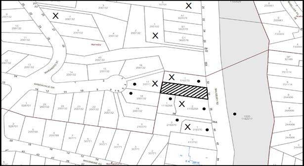
|
NOTIFICATION PLAN |
|
||
|
• PROPERTIES NOTIFIED
|
X SUBMISSIONS RECEIVED |
PROPERTY SUBJECT OF DEVELOPMENT |
|
|
6 SUBMISSIONS RECEIVED OUT OF MAP RANGE |
|||
13 submissions and a petition with 23 signatures submissions objected to the development, generally on the grounds that the development would result in:
· Unacceptable traffic on local streets;
· Unacceptable parking;
· Unacceptable road safety;
· Unacceptable noise from activities at the centre;
· Too many children;
· Location of child care not appropriate;
· Pedestrian Safety;
· Privacy;
· Landscaping;
· Outdoor play space;
· Tree removal;
· Flooding;
· Geology and earthworks;
· Waste collection;
· Fencing;
· Setbacks;
· Building Code of Australia compliance; and
· Disability access.
The merits of the matters raised in community submissions have been addressed in the body of the report with the exception of the following:
5.1.1 Magpie Habitat
A submission has been received noting that native magpies reside within the direct locality and could be impacted by the development.
The development would require the removal of 3 small non-native trees that would not impact on the habitat of native bird species.
5.1.2 Child Safety (falling off fence and nearby creek)
A submission has been received noting that children may be unsafe if they access Waitara Creek to the south and if they fall from boundary fences.
The proposed boundary fences surrounding the outdoor play areas would be 1.8m in height and not considered a climbing hazard.
5.1.3 Hours of operation
A submission has been received noting that the proposed hours of operation are excessive.
The proposed operating hours of the centre are 7:30am – 6:30pm Monday to Friday (excluding public holidays).
These hours are considered acceptable with reference to residential noise restrictions prescribed within the Protection of the Environment (Noise Control) Regulation 2008 and consistent with other centres.
6. THE PUBLIC INTEREST
Section 4.15(1)(e) of the Act requires Council to consider “the public interest”.
The public interest is an overarching requirement, which includes the consideration of the matters discussed in this report. Implicit to the public interest is the achievement of future built outcomes adequately responding to and respecting the future desired outcomes expressed in environmental planning instruments and development control plans.
The application is considered to have satisfactorily addressed Council’s and relevant agencies’ criteria and would provide a development outcome that, on balance, would result in a positive impact for the community. Accordingly, it is considered that the approval of the proposed development would be in the public interest.
CONCLUSION AND STATEMENT OF REASONS
The amended application proposes alterations and additions to an existing dwelling house and change of use to a 28 place child care centre.
A total of 13 submissions and a petition with 23 signatures were received objecting to the proposal generally on grounds of traffic, parking, safety, noise, privacy and landscaping.
The proposed size of the child care centre complies with the maximum permissible under the HDCP controls. The development is permissible in the zone and is considered to be within the environmental capacity of the site.
Accordingly, the proposed development is recommended for approval.
The reasons for this recommendation are:
· The proposed development generally complies with the requirements of the relevant environmental planning instruments and the Hornsby Development Control Plan.
· The proposal is considered acceptable in regard to traffic safety subject to Local Traffic Committee approval for a road median and no stopping signs.
· The proposed development would provide a positive social contribution to the local community by providing additional child care facilities which is consistent with the objectives of the State Governments “A Metropolis of Three Cities – the Greater Sydney Region Plan” and “North District Plan”.
Note: At the time of the completion of this planning report, no persons have made a Political Donations Disclosure Statement pursuant to Section 10.4 of the Environmental Planning and Assessment Act 1979 in respect of the subject planning application.
RESPONSIBLE OFFICER
The officer responsible for the preparation of this Report is Stephen Dobbs who can be contacted on 9847 6760.
|
Cassandra Williams Team Leader - Major Applications Planning Division |
Rod Pickles Manager - Development Assessment Planning Division |
|
1.⇨ |
Locality Plan |
|
|
|
2.⇨ |
Site / Floor Plan |
|
|
|
3.⇨ |
Landscape Plans |
|
|
|
4.⇨ |
Elevations |
|
|
|
5.⇨ |
Stormwater Plan |
|
|
|
6.⇨ |
Civil Works - Single crossover |
|
|
|
7.⇨ |
Carparking Grades |
|
|
|
8.⇨ |
Tree Protection Plan |
|
|
File Reference: DA/526/2017
Document Number: D07427948
SCHEDULE 1
GENERAL CONDITIONS
The conditions of consent within this notice of determination have been applied to ensure that the use of the land and/or building is carried out in such a manner that is consistent with the aims and objectives of the relevant legislation, planning instruments and council policies affecting the land and does not disrupt the amenity of the neighbourhood or impact upon the environment.
Note: For the purpose of this consent, the term ‘applicant’ means any person who has the authority to act on or the benefit of the development consent.
Note: For the purpose of this consent, any reference to an Act, Regulation, Australian Standard or publication by a public authority shall be taken to mean the gazetted Act or Regulation, or adopted Australian Standard or publication as in force on the date that the application for a construction certificate is made.
1. Approved Plans and Supporting Documentation
The development must be carried out in accordance with the plans and documentation listed below and endorsed with Council’s stamp, except where amended by Council and/or other conditions of this consent:
Approved plans
|
Plan No. |
Plan Title |
Drawn by |
Dated |
|
260/110E |
Play & Park Plan |
DCBF |
03/05/2018 |
|
260/105A |
Proposed North Elevation |
DCBF |
27/04/2018 |
|
260/106A |
Proposed South Elevation |
DCBF |
27/04/2018 |
|
260/107 |
Proposed East Elevation |
DCBF |
31/03/2017 |
|
260/108 |
Proposed West Elevation |
DCBF |
31/03/2017 |
|
17271/L-01-L-05 - B |
Landscape Plans |
Serenescapes |
06/04/2017 |
|
20150266/C201/D |
External Civil Works |
DCBF |
05/04/2018 |
|
EZ12 - TM901 |
Tree Management Plan |
Ezigrow |
12/07/2017 |
Supporting Documents
|
Document Title |
Prepared by |
Dated |
|
Stormwater Management Plan A1/17.G03-SMP |
GNG |
20/02/2017 |
|
Plan of Management |
N/A |
05/2017 |
|
Environmental Site Management Plan & Waste Management Plan 260/112 |
DCBF |
31/03/2017 |
|
Acoustic Assessment BGMA 170319 A |
BGMA Pty Ltd |
05/2017 |
|
Acoustic Assessment BGMA 170319 A |
BGMA Pty Ltd |
29/08/2017 |
|
Acoustic Assessment BGMA 170319 A |
BGMA Pty Ltd |
29/01/2018 |
|
Air Quality Assessment 18.1035.L1V1 |
Northstar Air Quality |
23/01/2018 |
|
Hazardous Building Materials Survey Report 610.17865.00000-R01-ASR |
SLR |
29/01/2017 |
|
Waste Management Process |
Waste Wise Environmental |
05/0/2018 |
|
Arboricultural Impact Appraisal and Method Statement |
Ezigrow |
13/07/2017 |
a) To comply with Councils requirement in terms of vehicular access, the approved plans are to be amended as follows:
i) The External Civil Works Plan referenced 20150266/C201/D, prepared by DCBF, dated 05/04/2018 must be amended to show a single vehicular crossing consistent with the approved Play & Park Plan.
b) These amended plans must be submitted with the application for the Construction Certificate.
3. Section 7.12 Development Contributions
a) In accordance with Section 4.17(1) of the Environmental Planning and Assessment Act 1979 and the Hornsby Shire Council Section 94A Development Contributions Plan 2014-2024, $6,050.00 must be paid to Council to cater for the increased demand for community infrastructure resulting from the development, based on development costs of $605,000.
b) The value of this contribution is current as at 30 April 2018. If this contribution is not paid within the financial quarter that this condition was generated, the contribution payable will be adjusted in accordance with the provisions of the Hornsby Shire Council Section 94 Development Contributions Plan and the amount payable will be calculated at the time of payment in the following manner:
$CPY = $CDC x CPIPY
CPIDC
Where:
$CPY is the amount of the contribution at the date of Payment
$CDC is the amount of the contribution as set out in this Development Consent
CPIPY is the latest release of the Consumer Price Index (Sydney – All Groups) at the date of Payment as published by the ABS.
CPIDC is the Consumer Price Index (Sydney – All Groups) for the financial quarter at the date applicable in this Development Consent Condition.
a) c) The monetary contributions must be paid to Council:
(i) prior to the issue of the Subdivision Certificate where the development is for subdivision; or
(ii) prior to the issue of the first Construction Certificate where the development is for building work; or
(iii) prior to issue of the Subdivision Certificate or first Construction Certificate, whichever occurs first, where the development involves both subdivision and building work; or
(iv) prior to the works commencing where the development does not require a Construction Certificate or Subdivision Certificate.
Note: It is the professional responsibility of the Principal Certifying Authority to ensure that the monetary contributions have been paid to Council in accordance with the above timeframes.
Council’s S94A Development Contributions Plan may be viewed at www.hornsby.nsw.gov.au or a copy may be inspected at Council’s Administration Centre during normal business hours.
4. Appointment of a Project Arborist
a) A project arborist with AQF Level 5 qualifications must be appointed to provide monitoring and certification throughout the construction period.
b) Details of the appointed project arborist must be submitted to Council and the PCA for registration with the application for the construction certificate.
5. Removal of Existing Trees
a) This development consent permits the removal of tree numbered 7-9 identified in the approved Tree Management Plan, prepared by Ezigrow, referenced TM901 dated 12/07/2017.
b) The removal of any other trees requires separate approval in accordance with the Tree and Vegetation Chapter 1B.6 Hornsby Development Control Plan 2013 (HDCP).
6. Construction Certificate
a) A Construction Certificate is required to be approved by Council or a Private Certifying Authority prior to the commencement of any works under this consent.
b) A separate Construction Certificate must be obtained from Council for all works within the public road reserve under S138 of the Roads Act 1993.
c) A separate Construction Certificate must be obtained from Council for all works within drainage easements vested in Council.
d) The Construction Certificate plans must not be inconsistent with the Development Consent plans.
REQUIREMENTS PRIOR TO THE ISSUE OF A CONSTRUCTION CERTIFICATE
The development must be carried out in accordance with the recommendations contained within the acoustic report submitted with the development application, prepared by BGMA, referenced 170319 A and dated 29/01/2018 and the requirements of the Department of Planning’s Development Near Rail Corridors and Busy Roads – Interim Guideline and RailCorp’s Interim Guidelines for Applicants.
Note: The Department of Planning’s document is available at www.planning.nsw.gov.au (development assessments). The RailCorp document is available at www.railcorp.nsw.gov.au/publications.
8. Identification of Survey Marks
A registered surveyor must identify all survey marks in the vicinity of the proposed development. Any survey marks required to be removed or displaced as a result of the proposed development shall be undertaken by a registered surveyor in accordance with Section 24 (1) of the Surveying and Spatial Information Act 2002 and following the Surveyor General’s Directions No.11 – "Preservation of Survey Infrastructure".
9. Building Code of Australia
All approved building work must be carried out in accordance with the relevant requirements of the Building Code of Australia.
10. Sydney Water – Approval
This application must be submitted to Sydney Water for approval to determine whether the development would affect any Sydney Water infrastructure, and whether further requirements are to be met.
Note: Building plan approvals can be obtained online via Sydney Water Tap inTM through www.sydneywater.com.au under the Building and Development tab.
11. Children (Education and Care Services) Supplementary Provisions Regulation 2004
Documentation prepared by a registered architect is to be submitted with the Construction Certificate to certify that the proposed development is in accordance with the requirements of the Children and Young Persons (Care & Protection) Act 1998 and the Children’s Services Regulation 2012.
12. Retaining Walls
All required retaining walls must be designed and constructed a suitably qualified engineer.
13. Stormwater Drainage
The stormwater drainage system for the development must be designed in accordance with Council’s Civil Works – Design and Construction Specification 2005 and the following requirements:
a) Connected directly to Council’s street drainage system.
b) The stormwater drainage system must be designed by a qualified hydraulic engineer.
14. On Site Stormwater Detention
An on-site stormwater detention system must be designed by a chartered civil engineer and constructed in accordance with the following requirements:
a) Have a capacity of not less than 5 cubic metres, and a maximum discharge (when full) of 8 litres per second;
b) Have a surcharge/inspection grate located directly above the outlet;
c) Discharge from the detention system must be controlled via 1 metre length of pipe, not less than 50 millimetres diameter or via a stainless plate with sharply drilled orifice bolted over the face of the outlet discharging into a larger diameter pipe capable of carrying the design flow to an approved Council system;
d) Where above ground and the average depth is greater than 0.3 metres, a ‘pool type’ safety fence and warning signs must be installed; and
e) Not be constructed in a location that would impact upon the visual or recreational amenity of residents.
15. Median and No Stopping Signs
Written approval from the Local Traffic Committee (LTC) must be obtained for the installation of the proposed median island and “no stopping” signs on Malsbury Road detailed in the approved “External Civil Works” plan prepared by DCBF, reference “20150266/C201/D”, dated 05/04/2018 prior to the issuing of a Construction Certificate.
16. Internal Driveway/Car Parking
The driveway and parking areas on site must be designed, constructed and a Construction Certificate issued in accordance with Australian Standards 2890.1, 2890.2, 3727 and the following requirements:
a) Design levels at the front boundary shall be obtained from Council if a private accredited certifier is engaged to obtain a construction certificate for these works.
b) The driveway be a rigid pavement.
c) All parking for people with disabilities is to comply with AS/NZS 2890.6:2009 Off-street parking for people with disabilities.
d) Any proposed landscaping and/or fencing must not restrict sight distance to pedestrians and cyclists travelling along the footpath. A sight triangle is to be provided at the property boundary in accordance with AS/NZS 2890.1:2004. See Figure 3.3 for reference.
e) A vehicle safety barrier be installed adjoining the northern side of car parking space P3.
17. Vehicular Crossing
A separate application under the Local Government Act, 1993 and the Roads Act 1993 must be submitted to Council for the installation of a new vehicular crossing. The vehicular crossing must be constructed in accordance with Council’s Civil Works Design 2005 and the following requirements:
a) Design levels at the front boundary must be obtained from Council for the design on the internal driveway;
b) Any redundant crossings must be replaced with integral kerb and gutter;
c) The footway area must be restored by turfing;
d) Approval must be obtained from all relevant utility providers that all necessary conduits be provided and protected under the crossing.
Note: An application for a vehicular crossing can only be made to one of Council’s Authorised Vehicular Crossing Contractors. You are advised to contact Council on 02 9847 6940 to obtain a list of contractors.
18. Waste Management Details
The following waste management requirements must be complied with:
a) There must be a bin storage area on site that is sufficient for no less than 4 x 240L bins. The path/aisle to access and manoeuvre the bins in and out of their storage position must be no less than 1.5m wide. The bins must not be visible from the street when in the storage area.
b) A Waste Management Plan Section One – Demolition Stage and Section Three – Construction Stage, covering the scope of this project and including the following details, is required to be submitted to Council:
i) An estimate of the types and volumes of waste and recyclables to be generated;
ii) A site plan showing sorting and storage areas for demolition and construction waste and the vehicle access to these areas;
iii) How excavation, demolition and construction waste materials will be reused or recycled and where residual wastes will be disposed;
iv) The total percentage (by weight) of demolition and construction waste that will be reused or recycled.
c) All bin carting routes must not include any steps, and must be smooth hard surface.
Note: Smooth hard surface includes, but is not limited to, concrete, tiles, floorboards etc, but does not include carpet, grass, pebbles etc.
19. Construction Management Plan (CMP)
To assist in the protection of the public, the environment and Council’s assets, a Construction Management Plan must be prepared by a suitably qualified environmental consultant in consultation with a qualified traffic engineer, and submitted to Council’s Compliance Team (compliance@Hornsby.nsw.gov.au) for approval to be used by workers and Council as on-site reference during demolition, excavation and construction works, according to the following requirements:
a) The CMP must detail the contact information for all development phases for developers, builder, site foremen, private certifier, environmental management consultant and any emergency details.
b) The plan must include the following:
i) Truck movements to and from the site, including the routes used, swept path diagrams entering and exiting the site and implemented traffic control,
ii) The use of the Denison Street site frontage for the parking, storage or deliveries of any vehicles or machinery is not permitted, the plan must reflect this,
iii) Site plan showing site sheds, concrete pump location and crane location; and
iv) Safe pedestrian management details including during local school and commuter hours where the footpath is heavily frequented.
c) The plan must also include Construction Waste Management information detailing the following:
i) Details of the requirement for importation or excavation of soil and fill including the waste classification of the fill, disposal methods and locations of authorised disposal depots that will be used for the fill;
ii) Asbestos Information must be included on the requirement and procedures for removal and disposal from the site in accordance with Australian Standard: 2601–2001 – ‘The Demolition of Structures’, and the Protection of the Environment Operations (Waste) Regulation 2005;
iii) General construction waste details including construction waste skip bin locations and litter management for workers.
REQUIREMENTS PRIOR TO THE COMMENCEMENT OF ANY WORKS
20. Erection of Construction Sign
a) A sign must be erected in a prominent position on any site on which any approved work is being carried out:
i) Showing the name, address and telephone number of the principal certifying authority for the work;
ii) Showing the name of the principal contractor (if any) for any demolition or building work and a telephone number on which that person may be contacted outside working hours; and
iii) Stating that unauthorised entry to the work site is prohibited.
b) The sign is to be maintained while the approved work is being carried out and must be removed when the work has been completed.
21. Protection of Adjoining Areas
A temporary hoarding, fence or awning must be erected between the work site and adjoining lands before the works begin and must be kept in place until after the completion of the works if the works:
a) Could cause a danger, obstruction or inconvenience to pedestrian or vehicular traffic;
b) Could cause damage to adjoining lands by falling objects; and/or
c) Involve the enclosure of a public place or part of a public place.
Note: Notwithstanding the above, Council’s separate written approval is required prior to the erection of any structure or other obstruction on public land.
22. Toilet Facilities
a) To provide a safe and hygienic workplace, toilet facilities must be available or be installed at the works site before works begin and must be maintained until the works are completed at a ratio of one toilet for every 20 persons employed at the site.
b) Each toilet must:
i) be a standard flushing toilet connected to a public sewer; or
ii) be a temporary chemical closet approved under the Local Government Act 1993; or
iii) have an on-site effluent disposal system approved under the Local Government Act 1993.
23. Sediment and Sediment Control
To protect the water quality of the downstream environment, erosion and sediment control measures must be provided and maintained throughout the construction period in accordance with the manual ‘Soils and Construction 2004 (Bluebook)’, the approved plans, Council specifications and to the satisfaction of the principal certifying authority. The erosion and sediment control devices must remain in place until the site has been stabilised and revegetated.
Note: On the spot penalties may be issued for any non-compliance with this requirement without any further notification or warning.
24. Installation of Tree Protection
Tree protection fencing, root zone protection and trunk protection must be erected around all retained trees on the site in accordance with Appendix 4 and 5 of the Arboricultural Impact Appraisal and Method Statement, prepared by Ezigrow dated 13/07/2017, unless protected by boundary fencing.
25. Tree Protection Zone - Ground Protection
a) All tree protection zones for the trees to be retained must have a layer of wood-chip mulch installed prior to works commencing.
b) The wood-chip mulch must be maintained throughout the period of construction at a depth of between 150mm and 300mm, using material that complies with the relevant requirements of Australian Standard AS 4454 – “Composts, Soil Conditioners and Mulches”.
26. Tree Protection Certification
To ensure that all tree protection measures are correctly installed, a certificate from the appointed project arborist must be submitted to the Principal Certifying Authority confirming compliance with the tree protection requirements of this consent.
REQUIREMENTS DURING CONSTRUCTION
27. Construction Traffic Management Plan Compliance
The development must be carried out in accordance with the approved Construction Traffic Management Plans.
28. Construction Work Hours
All works on site, including demolition and earth works, must only occur between 7am and 5pm Monday to Saturday.
No work is to be undertaken on Sundays or public holidays.
29. Demolition
To protect the surrounding environment, all demolition work must be carried out in accordance with Australian Standard AS2601-2001 – The Demolition of Structures and the following requirements:
a) Demolition material must be disposed of to an authorised recycling and/or waste disposal site and/or in accordance with an approved waste management plan; and
b) Demolition works, where asbestos material is being removed, must be undertaken by a contractor that holds an appropriate licence issued by SafeWork NSW in accordance with the Work Health and Safety Regulation 2017 and be appropriately transported and disposed of in accordance with the Protection of the Environment Operations (Waste) Regulation 2014; and
c) On construction sites where any building contain asbestos material, a standard commercially manufactured sign containing the words ‘DANGER ASBESTOS REMOVAL IN PROGRESS’ and measuring not less than 400mm x 300mm must be displayed in a prominent position visible from the street.
30. Environmental Management
The site must be managed in accordance with the publication ‘Managing Urban Stormwater – Landcom (March 2004) and the Protection of the Environment Operations Act 1997 by way of implementing appropriate measures. To prevent sediment run-off, excessive dust, noise or odour emanating from the site during the construction of the development.
31. Council Property
To ensure that the public reserve is kept in a clean, tidy and safe condition during construction works, no building materials, waste, machinery or related matter is to be stored on the road or footpath.
32. Disturbance of Existing Site
During construction works, the existing ground levels of open space areas and natural landscape features, including natural rock-outcrops, vegetation, soil and watercourses must not be altered unless otherwise nominated on the approved plans.
33. Landfill
Landfill must be constructed in accordance with Council’s ‘Construction Specification 2005’ and the following requirements:
a) Prior to fill material being imported to the site, a certificate shall be obtained from a suitably qualified environmental consultant confirming the fill wholly consists of Virgin Excavated Natural Material (VENM) as defined in Schedule 1 of the Protection of the Environment Operations Act 1997 or material approved under the Department of Environment and Climate Change’s general resource recovery exemption.
b) A compaction certificate is to be obtained from a suitably qualified geotechnical engineer verifying that the specified compaction requirements have been met.
34. Excavated Material
All excavated material removed from the site must be classified by a suitably qualified person in accordance with the Department of Environment, Climate Change and Water NSW Waste Classification Guidelines prior to disposal to an approved waste management facility and be reported to the principal certifying authority prior to the issue of an Occupation Certificate.
35. Maintenance of Public Footpaths
Public footpaths must be maintained for the duration of works to ensure they are free of trip hazards, displacements, breaks or debris to enable pedestrians to travel along the footpath safely.
36. Works Near Trees
a) To maintain tree health and condition, the appointed project arborist must monitor and record any and all necessary remedial actions required for trees on site and adjoining properties.
b) All works within the designated tree protection zone must be in accordance with Appendix 6 of the Arboricultural Impact Appraisal and Method Statement, prepared by Ezigrow dated 13/07/2017.
c) The maintenance and monitoring of all tree protection techniques must be recorded by the appointed project arborist during the period of construction for submission with the application for the occupation certificate.
37. Building materials and Site Waste
The filling or stockpiling of building materials, the parking of vehicles or plant, the disposal of cement slurry, waste water or other contaminants must be located outside the tree protection zones as prescribed in the conditions of this consent or the prescriptive measures of Part 1B.6.1 Tree Preservation of the Hornsby Development Control Plan 2013, of any tree to be retained.
38. Waste Management Details
Waste management during the demolition and construction phase of the development must be undertaken in accordance with the approved Waste Management Plan. Additionally written records of the following items must be maintained during the removal of any waste from the site and such information submitted to the Principal Certifying Authority within fourteen days of the date of completion of the works:
a) The identity of the person removing the waste.
b) The waste carrier vehicle registration.
c) Date and time of waste collection.
d) A description of the waste (type of waste and estimated quantity).
e) Details of the site to which the waste is to be taken.
f) The corresponding tip docket/receipt from the site to which the waste is transferred (noting date and time of delivery, description (type and quantity) of waste).
g) Whether the waste is expected to be reused, recycled or go to landfill.
Note: In accordance with the Protection of the Environment Operations Act 1997, the definition of waste includes any unwanted substance, regardless of whether it is reused, recycled or disposed to landfill.
REQUIREMENTS PRIOR TO THE ISSUE OF AN OCCUPATION CERTIFICATE
Note: For the purpose of this consent, a reference to ‘occupation certificate’ shall not be taken to mean an ‘interim occupation certificate’ unless otherwise stated.
39. Damage to Council Assets
To protect public property and infrastructure, any damage caused to Council’s assets as a result of the construction or demolition of the development must be rectified by the applicant in accordance with Council’s Civil Works Specifications. Rectification works must be undertaken prior to the issue of an Occupation Certificate, or sooner, as directed by Council.
40. Landscaping Requirements
A certificate must be submitted to the PCA and to Council by a practicing landscape architect, horticulturalist or person with similar qualifications and experience certifying that the landscaping works have been satisfactorily completed in accordance with the approved landscape plan.
41. Final Certification Arborist
a) The Project supervisor must submit to the principal certifying authority all relevant certificates with the application for the occupation certificate stating compliance with all the conditions of this consent.
b) The Project arborist must submit to the principal certifying authority a certificate that all the completed works have been carried out in compliance with the approved plans and specifications for tree protection.
c) Certification must include a statement of overall site attendance, the condition of the retained trees, details of any deviations from the approved tree protection measures and their impacts on trees.
42. External Lighting
a) To protect the amenity of adjacent premises, all external lighting must be designed and installed in accordance with Australian Standard AS 4282 – Control of the Obtrusive Effects of Outdoor Lighting.
b) Certification of compliance with this Standard must be obtained from a suitably qualified person and submitted to the PCA with the application for the Construction Certificate.
All required retaining walls must be constructed as part of the development.
44. Works as Executed Plan
A works-as-executed plan(s) must be prepared by a registered surveyor and submitted to Council for completed road pavement, kerb & gutter, public drainage systems, driveways and on-site detention system.
45. Preservation of Survey Marks
A certificate by a Registered Surveyor must be submitted to the Principal Certifying Authority, certifying that there has been no removal, damage, destruction, displacement or defacing of the existing survey marks in the vicinity of the proposed development or otherwise the re-establishment of damaged, removed or displaced survey marks has been undertaken in accordance with the Surveyor General’s Direction No.11 – “Preservation of Survey Infrastructure”.
46. Construction of Engineering Works
All engineering works identified in this consent are to be completed and a Compliance Certificate issued prior to the release of the Occupation Certificate.
47. Food Premises
a) A food premises notification form must be submitted to Council prior to the commencement of operation.
Note: Hornsby Shire Council’s Food Premises notification form can be found at http://www.hornsby.nsw.gov.au
b) The fit out and operation of that part of the building to be used for the preparation of food must be in accordance with Australian Standard 4674-2004 – Design and fit out of food premises, the Food Act 2003, Food Regulation 2015 and the Food Standards Code developed by Food Standards Australia New Zealand. Food Standards 3.3.1, 3.2.2 and 3.2.3 are mandatory for all food businesses.
Note: Walls are to be of solid construction.
c) Prior to the commencement of the child care centre, the operator is requested to contact Council’s Compliance & Certification Team to arrange an inspection for compliance against the relevant legislation and guidelines outlined in this approval. Contact Council’s Administration Officer on 9847 6784.
d) A kitchen exhaust system must be designed and installed to effectively prevent air pollution in accordance with the Protection of the Environment Operations Act 1997.
48. Hazardous Materials Report
A Hazardous Materials Report must be prepared by a suitably qualified Occupational Hygienist and submitted to Council and the Principal Certifying Authority prior to the issue of an Occupation Certificate. The report must conclude that the site is clear of contamination and suitable for the intended use as a child care centre. The survey is to be undertaken in accordance with the Work Health and Safety Regulation 2011 (NSW) including laboratory analysis for asbestos and lead on the site and within the soil.
49. Waste Management Details
The following waste management requirements must be complied with:
a) A report must be prepared by an appropriately qualified person, certifying the following:
i) A comparison of the estimated quantities of each waste type against the actual quantities of each waste type.
Note: Explanations of any deviations to the approved Waste Management Plan is required to be included in this report.
ii) That at least 60% of the waste generated during the demolition and construction phase of the development was reused or recycled.
Note: If the 60% diversion from landfill cannot be achieved in the Construction Stage, the Report is to include the reasons why this occurred and certify that appropriate work practices were employed to implement the approved Waste Management Plan. The Report must be based on documentary evidence such as tipping dockets/receipts from recycling depots, transfer stations and landfills, audits of procedures etc. which are to be attached to the report.
iii) All waste was taken to site(s) that were lawfully permitted to accept that waste.
b) The child care centre must be provided with an indoor waste/recycling cupboard for the interim storage of a minimum one day’s waste generation with separate containers for general waste and recyclable materials.
c) The bin carting routes must be devoid of any steps.
Note: Ramps between different levels are acceptable
50. Outdoor Play Area
The outdoor play space must be adequately shaded in accordance with The Shade Handbook, published by the New South Wales Cancer Council in 2008.
51. Acoustic Treatment and Certification
a) Acoustic treatment including boundary fencing must be provided to the proposed development in accordance with the recommendations contained within Acoustic Assessment Amendment prepared by BGMA Pty Ltd and dated 28 November 2017.
b) On completion of all works and prior to the issue of an Occupation Certificate, the certifier is to be provided with a certificate from a qualified acoustic consultant certifying that all acoustic treatments including boundary fences have been completed in accordance with the recommendations contained within the approved Acoustic Assessments prepared by BGMA Pty Ltd.
52. Fencing
a) In addition to the fencing required by condition 51, 1.8 metre high acoustic fences must be installed along the northern and southern side boundaries as indicated in red on the Play and Park Plan Dwg No.110F, dated 31/03/2017 to maintain privacy and amenity to adjoining properties.
OPERATIONAL CONDITIONS
53. Use of Premises
a) The development approved under this consent shall be used for ‘child care centre’ and not for any other purpose without Council’s separate written consent.
b) The child care centre shall accommodate a maximum of 28 children. The age mix of children as at 1 January of each calendar year shall be in accordance with the following:
i) 0-2 years – 4 children
ii) 2-3 years – 8 children
iii) 3-5 years – 16 children
c) The hours of operation of the “child care centre” are restricted to those times listed below:
i) Monday to Friday – 7:30am to 6:30 pm
54. Child Care Centre Management – Noise
All noise generated by the development must be attenuated to prevent levels of noise being emitted to adjacent premises which possess tonal, beating and similar characteristics or which exceeds background noise levels by more than 5dB(A).
55. Hazardous Materials Report
The centre must be managed in accordance with the recommendations of the Hazardous Materials Report prepared by SLR dated 29/01/2017 and the following requirements:
a) A competent person carries out regular inspections (6 monthly) to investigate any potential situations that may cause migration of lead dust from the ceiling or wall cavities to occupied areas.
b) Access must be restricted to ceiling space where elevated levels of lead in dust are likely to occur. The ceiling manhole must be labelled to indicate the presence of lead in the ceiling dust.
c) Any persons wishing to access ceiling cavities containing elevated levels of dust are to undertake a suitable and sufficient Risk Assessment prior to doing so, the results of which may include the use of appropriate Personal Protective Equipment (PPE) such as disposable coveralls and respiratory protection.
d) Annual Airborne lead monitoring to ensure that all controls in place are sufficient. Consideration is given to conducting baseline airborne lead monitoring and swab testing occupied areas below the ceiling cavity in the interim.
e) The operators of the childcare centre must keep a register on site with the details of each inspection.
56. Creation of Easements
The following matter(s) must be nominated under s88B of the Conveyancing Act, 1919:
a) The creation of a “Positive Covenant” over the existing lot requiring an on-site detention system. The on-site detention system is to have a storage capacity of 5 cubic metres and a maximum discharge of 8 litres per second into Council’s drainage system in accordance with Council’s prescribed wording.
Note: Council must be nominated as the authority to release, vary or modify any easement, restriction or covenant.
57. Waste Management
The waste management on site must be in accordance with the following requirements:
a) All commercial tenant(s) must keep written evidence on site of a valid contract with a licensed waste contractor(s) for the regular collection and disposal of the waste and recyclables that are generated on site.
b) Waste collection must occur between 10:30am and 1:30pm Monday to Friday on site.
c) Signage must be installed within the carpark to ensure that car spaces 5 and 6 are free when waste collection occurs.
d) All commercial tenant(s) must have a sufficient number of bins to contain the volume of waste and recycling expected to be generated between collection services.
e) All bins must be returned to the on-site bin storage area promptly after waste and recycling collection services.
f) A Work, Health & Safety (WHS) risk assessment is to be carried out by a suitably qualified person with qualifications in Work, Health & Safety Legislation with specific regard to waste management. The recommendations of the WHS Risk Assessment are to be implemented as required.
58. Car Parking
All car parking must be operated in accordance with Australian Standard AS/NZS 2890.1:2004 – Off-street car parking and Australian Standard AS 2890.2:2002 – Off-street commercial vehicle facilities.
a) All parking areas and driveways are to be sealed to an all-weather standard, line marked and signposted. P1 and P3 must be marked as rear to kerb only.
b) Car parking, loading and manoeuvring areas to be used solely for nominated purposes.
c) Vehicles awaiting loading, unloading or servicing shall be parked on site and not on adjacent or nearby public roads.
d) All vehicular entry on to the site and egress from the site shall be made in a forward direction.
e) All parking for people with disabilities is to comply with AS/NZS 2890.6:2009 Off-street parking for people with disabilities.
f) Any proposed landscaping and/or fencing must not restrict sight distance to pedestrians and cyclists travelling along the footpath. A sight triangle is to be provided at the property boundary in accordance with AS/NZS 2890.1:2004. See Figure 3.3 for reference.
59. Fire Safety Statement - Annual
On at least one occasion in every 12 month period following the date of the first ‘Fire Safety Certificate’ issued for the property, the owner must provide Council with an annual ‘Fire Safety Certificate’ to each essential service installed in the building.
ADVISORY NOTES
The following information is provided for your assistance to ensure compliance with the Environmental Planning and Assessment Act, 1979, Environmental Planning and Assessment Regulation 2000, other relevant legislation and Council’s policies and specifications. This information does not form part of the conditions of development consent pursuant to Section 4.17 of the Act.
Environmental Planning and Assessment Act 1979 Requirements
The Environmental Planning and Assessment Act 1979 requires:
The issue of a construction certificate prior to the commencement of any works. Enquiries can be made to Council’s Customer Services Branch on 9847 6760.
· A principal certifying authority to be nominated and Council notified of that appointment prior to the commencement of any works.
· Council to be given at least two days written notice prior to the commencement of any works.
· Mandatory inspections of nominated stages of the construction inspected.
· An occupation certificate to be issued before occupying any building or commencing the use of the land.
Long Service Levy
In accordance with Section 34 of the Building and Construction Industry Long Service Payments Act 1986, a ‘Long Service Levy’ must be paid to the Long Service Payments Corporation or Hornsby Council.
Note: The rate of the Long Service Levy is 0.35% of the total cost of the work.
Note: Hornsby Council requires the payment of the Long Service Levy prior to the issue of a construction certificate.
Tree and Vegetation Preservation
In accordance with Hornsby Development Control Plan 2013 a person must not ringbark, cut down, top, lop, remove, injure or wilfully destroy any tree or other vegetation protected without the authority conferred by a development consent or a permit granted by Council.
Notes: A tree is defined as a long lived, woody perennial plant with one or relatively few main stems with the potential to grow to a height greater than three metres (3m). (HDCP 1B.6.1.c).
Tree protection measures and distances are determined using the Australian Standard AS 4970:2009, “Protection of Trees on Development Sites”.
Fines may be imposed for non-compliance with both the Hornsby Local Environmental Plan 2013 and the Hornsby Development Control Plan 2013.
Disability Discrimination Act
The applicant’s attention is drawn to the existence of the Disability Discrimination Act. A construction certificate is required to be obtained for the proposed building/s, which will provide consideration under the Building Code of Australia, however, the development may not comply with the requirements of the Disability Discrimination Act. This is the sole responsibility of the applicant.
Covenants
The land upon which the subject building is to be constructed may be affected by restrictive covenants. Council issues this approval without enquiry as to whether any restrictive covenant affecting the land would be breached by the construction of the building, the subject of this consent. Applicants must rely on their own enquiries as to whether or not the building breaches any such covenant.
Dial Before You Dig
Prior to commencing any works, the applicant is encouraged to contact Dial Before You Dig on 1100 or www.dialbeforeyoudig.com.au for free information on potential underground pipes and cables within the vicinity of the development site.
Telecommunications Act 1997 (Commonwealth)
If you are aware of any works or proposed works which may affect or impact on Telstra’s assets in any way, you are required to contact: Telstra’s Network Integrity Team on Phone Number 1800810443.
Advertising Signage – Separate DA Required
This consent does not permit the erection or display of any advertising signs. Most advertising signs or structures require development consent. Applicants should make separate enquiries with Council prior to erecting or displaying any advertising signage.
Asbestos Warning
Should asbestos or asbestos products be encountered during demolition or construction works, you are advised to seek advice and information prior to disturbing this material. It is recommended that a contractor holding an asbestos-handling permit (issued by WorkCover NSW)be engaged to manage the proper handling of this material. Further information regarding the safe handling and removal of asbestos can be found at:
Alternatively, telephone the WorkCover Asbestos and Demolition Team on 8260 5885.
Food Premises
The following facilities are required in the food preparation area to ensure food handler hygiene and the cleaning and sanitising of food contact utensils:
1. A hand wash basin and a double bowl sink or
LPP Report No. LPP17/18
Local Planning Panel
Date of Meeting: 24/05/2018
3 DEVELOPMENT APPLICATION - CONSTRUCTION OF A DWELLING HOUSE, DRIVEWAY AND SWIMMING POOL - NO. 65D MALTON ROAD, BEECROFT
EXECUTIVE SUMMARY
|
DA No: |
DA/1344/2017 (Lodged on 1 December 2017) |
|
Description: |
Construction of a dwelling house, driveway and swimming pool |
|
Property: |
Lot 2 DP 703067 – No. 65D Malton Road, Beecroft |
|
Applicant: |
Nicolas Tedesco – NKT Architecture Pty Ltd |
|
Owners: |
Mr J Pennington and Mrs K Pennington |
|
Estimated Value: |
$2,500,000 |
|
Ward: |
C Ward |
· The application involves the construction of a dwelling house, driveway and swimming pool.
· The proposal fails to comply with the provisions of the Hornsby Local Environmental Plan 2013 (HLEP) and the Hornsby Development Control Plan 2013 (HDCP) with regard height of buildings, terrestrial Biodiversity, earthworks, stormwater management, vehicular access, bushfire and heritage.
· The request to vary the height of buildings development standard submitted under Clause 4.6 of the HLEP fails to demonstrate that there are sufficient environmental planning grounds to justify the contravention of the development standard.
· The proposal is required to be determined by the Hornsby Shire Council Local Planning Panel as the development proposes variation to a development standard by more than 10 percent and more than 10 unique submissions have been received objecting to the proposal.
· It is recommended that the application be refused.
|
THAT Development Application No. DA/1344/2017 for the construction of a dwelling house, driveway and swimming pool at Lot 2 DP 703067, No. 65D Malton Road Beecroft be refused, subject to the reasons of refusal detailed in Schedule 1 of the LPP Report No. LPP17/18. |
BACKGROUND
· On 6 March 2017, pre lodgement application PL/18/2017 was submitted for the erection of a dwelling house on the subject site. A pre-lodgement meeting was held in May, with further written advice provided to the applicant on 15 August 2017.
The general advice provided by Council outlined the maximum height, scale and appropriate finished floor levels applicable to the proposed dwelling house. Advice was also provided regarding vehicle access and parking, emphasising that the applicant would need to demonstrate the safety and efficiency of the design upon the submission of a development application.
· The applicant was also advised to submit detailed information regarding the environmental impact of the proposal, including an aboricultural impact assessment report and a flora and fauna assessment report.
· On 1 December 2017, the subject development application was lodged with Council for assessment
SITE
The vacant, 4,693m2 landlocked site is located on the northern side of Malton Road Beecroft. The site has a steep north-easterly gradient with a series of sandstone cliffs and rock outcrops falling toward a creek line within the adjoining Public Reserve to the north. The site is heavily vegetated with numerous semi-mature and mature trees. Trees on the site comprise mostly locally-indigenous species with a few planted non-local native and exotic (introduced) species within the access handle.
Access to the site would be provided by way of a 3.5 metre wide right of carriageway, currently unformed, located on the adjacent property No. 65C Malton Road.
The site experiences an average grade of 35.8 percent towards the rear northern boundary. The right of carriageway within No. 65C Malton Road experiences an average grade of 28 percent sloping away from Malton Road.
The site is burdened by a 1.83 metre wide drainage easement, which dissects the north western portion of the allotment. The site is bushfire prone, with a bushfire attack level of BAL – FZ (Flame Zone).
The site is located within the Beecroft/Cheltenham Heritage Conservation Area and is in the vicinity of a heritage item, namely the street trees and bushland located within the road reserve of Malton Road, which is listed as item No. 114 in Schedule 5 of the Hornsby Local Environmental Plan 2013.
PROPOSAL
The application proposes the construction of a three storey dwelling house, a driveway and a swimming pool.
· The uppermost, ground floor level would comprise a four car garage, a study/guest room with an ensuite and a living room.
· Basement Level 1 below would comprise two bedrooms with walk in robes, a bedroom with an east facing deck, a bathroom, a laundry and a master bedroom with walk in robe, an ensuite, a north eastern facing balcony, and a south facing, elevated planter box.
· Basement Level 2 further below would comprise a games room with bar and external deck, a cellar, kitchen, pantry, dining/family room, sauna, bathroom, foyer and a north-facing deck.
· The swimming pool and spa would be located adjacent to the dining/family room. A common central staircase and elevator would connect the three levels. A covered visitor car parking area is proposed above the garage.
· A driveway is proposed to be constructed within the right of carriageway over adjoining land (65C Malton Road Beecroft) from the street level of Malton Road to the ground floor level of the dwelling house.
· A total of 28 trees have been identified by the applicant for removal.
ASSESSMENT
The development application has been assessed having regard to the ‘A Metropolis of Three Cities – the Greater Sydney Region Plan, the ‘North District Plan’ and the matters for consideration prescribed under Section 4.15 of the Environmental Planning and Assessment Act 1979 (the Act). The following issues have been identified for further consideration.
1. STRATEGIC CONTEXT
1.1 A Metropolis of Three Cities and North District Plan
A Metropolis of Three Cities - the Greater Sydney Region Plan has been prepared by the NSW State Government to guide land use planning decisions for the next 40 years (to 2056). The Plan sets a strategy and actions for accommodating Sydney’s future population growth and identifies dwelling targets to ensure supply meets demand. The Plan also identifies that the most suitable areas for new housing are in locations close to jobs, public transport, community facilities and services.
The NSW Government will use the subregional planning process to define objectives and set goals for job creation, housing supply and choice in each subregion. Hornsby Shire has been grouped with Hunters Hill, Ku-ring-gai, Lane Cove, Mosman, North Sydney, Ryde, Northern Beaches and Willoughby to form the North District.
The Greater Sydney Commission has released the North District Plan which includes priorities and actions for the Northern District for the next 20 years. The identified challenge for Hornsby Shire will be to provide an additional 4,350 dwellings by 2021 with further strategic supply targets to be identified to deliver 97,000 additional dwellings in the North District by 2036.
The proposed development would be consistent with A Metropolis of Three Cities and the North District Plan by contributing to achieving the dwelling targets for the region.
2. STATUTORY CONTROLS
Section 4.15(1)(a) requires Council to consider “any relevant environmental planning instruments, draft environmental planning instruments, development control plans, planning agreements and regulations”.
2.1 Environmental Planning and Assessment Regulation 2000
The proposed development has been assessed having regard to the provisions of the Environmental Planning and Assessment Regulation 2000 (EPAR).
Clause 49 of the EPAR “Persons who can make a development application” outlines that a development application may be made:
(a) by the owner of the land to which the development application relates, or
(b) by any other person, with the consent in writing of the owner of that land.
Clause 1(i) of Schedule 1 of the EPAR outlines that a development application must contain “evidence that the owner of the land on which the development is to be carried out consents to the application, but only if the application is made by a person other than the owner and the owner’s consent is required by this Regulation”.
The proposal includes development, namely the construction of a driveway (within the right-of-carriageway) within the adjoining property No.65C Malton Road, for which owner’s consent has not been provided with the development application. In this regard, the consent authority does not have the legal power to approve the development application.
2.2 Hornsby Local Environmental Plan 2013
The proposed development has been assessed having regard to the provisions of the Hornsby Local Environmental Plan 2013 (HLEP).
2.2.1 Zoning of Land and Permissibility
The subject land is zoned R2 – Low density residential under the HLEP. The objectives of the zone are:
· To provide for the housing needs of the community within a low density residential environment.
· To enable other land uses that provides facilities or services to meet the day to day needs of residents.
The proposed development is defined as a “dwelling house” and is permissible in the zone with Council’s consent. The proposed development would be consistent with objectives of the zone to provide additional housing in the locality.
2.2.2 Height of Buildings
Clause 4.3 of the HLEP provides that the height of a building on any land should not exceed the maximum height shown for the land on the Height of Buildings Map.
The maximum permissible height for the subject site is 8.5 metres. The application proposes a dwelling house with a maximum height of 15.74 metres, which does not comply with this provision. The development application is accompanied by a Clause 4.6 variation to request a variation to the standard.
2.2.3 Exceptions to Development Standards – Height of Buildings
The application has been assessed against the requirements of Clause 4.6 of the HLEP. This clause provides flexibility in the application of the development standards in circumstances where strict compliance with those standards would, in any particular case, be unreasonable or unnecessary or tender to hinder the attainment of the objectives of the zone.
The proposal exceeds the maximum permissible height of buildings as defined by the height of buildings map.
The objective of Clause 4.3 of the HLEP is “to permit a height of buildings that is appropriate for the site constraints, development potential and infrastructure capacity of the locality.”
The applicant has made a submission in support of a variation to the development standard in accordance with Clause 4.6 of the HLEP. The development application seeks to vary the development standard by 85% to permit a maximum building height of 15.74 metres.
The applicant states that the proposed variation is consistent with the objectives of the control and is justified as follows:
· “The underlying intent of the control is considered to be achieved despite non-compliance;
· The building is compatible with the desired future character of the area, and manages bulk and scale in compliance with design controls;
· Strict compliance would not allow the desired flexibility to deal with the slope and to create level floors to sit above the land;
· Strict compliance would unduly constrain the site responsive design. This design provides a good balance between residential and environmental needs and provides for reasonable project/economic viability. The scale is not extensive, with consideration of the very large overall site area;
· The design has been carefully considered so that the building will be 2 storeys or less from the street frontage and perspective of adjoining houses. The visitor car parking is the only 2 storey portion from upper level view;
· The cantilevered construction type will prevent the kind of earthworks which could de-stabilise the land and increase erosion into the bush. This construction type will assist in the protection of the established trees and minimise disturbance on the existing land and water based ecology;
· The proposed design provides a high standard of amenity for the occupants;
· The development promotes site sustainability, utilising an altered area;
· The proposal has been designed to consider the protection of adjoining properties;
· The proposal is considered to provide a better planning outcome. The design suits the topography and minimises the impact on the land and the need for cut and fill. This meets Council’s LEP and the HDCP objectives and environmental planning objectives and frameworks;
· This design is considered to be in line with the objectives of Clause 4.6 which allows flexibility in assessment of designs where it is difficult to comply due to natural constraints and topography;
· The built form is contained in an effort to minimise additional landform modification and the retention of trees and bushland. This will contain the ‘footprint’ and restrict the impact of the works from the bushland and the public domain;
· The proposal has been designed to respect the form of surrounding properties and to protect the amenities of adjoining houses;
· The proposal represents high quality and environmentally responsive and sustainable architectural design, which is encouraged in naturally important areas;
· The application provides for the orderly and economic development of land, improvement of housing and the protection of the environment, consistent with Council’s planning objectives;
· Good residential amenity is provided as well as energy efficiency and consistency with Council’s ecological guidelines;
· Strict numeric compliance would not materially change the development or improve the planning outcome and would unduly constrain the creative design and the connection between the building and the site;
· The variation is minor in nature and is not considered to contribute significantly to the bulk and scale of the development which will be concentrated to the rear and will be screened by trees. Limited sections push over, due to the steep fall of the land underneath these parts;
· The elevations will be stepped and articulated in character to the front and the sides, presenting mainly as one and two storey in scale. The rear section is also well articulated with glass, decks and varied materials. The rear is divided into pavilions which are differently angled to look at the bushland. Consequently, the elevations and roof forms are broken up;
· The variation is considered to be well-founded and to create a better planning outcome, the additional space being provided as height will reduce the footprint of the building in relation to the natural environment; and
· The intent of Clause 4.6 is to allow flexibility to facilitate meritorious architectural examples which may struggle to numerically comply, so as to create high quality built outcomes. Quality outcomes are considered to be preferable to numeric compliance.”
State Government Guidelines on varying development standards recommend considering the provisions of Clause 4.6 of the HLEP and the ‘five part test’ established by the Land and Environment Court as follows:
1. the objectives of the standard are achieved notwithstanding noncompliance with the standard;
2. the underlying objective or purpose of the standard is not relevant to the development and therefore compliance is unnecessary;
3. the underlying object of purpose would be defeated or thwarted if compliance was required and therefore compliance is unreasonable;
4. the development standard has been virtually abandoned or destroyed by the council’s own actions in granting consents departing from the standard and hence compliance with the standard is unnecessary and unreasonable; and
5. compliance with development standard is unreasonable or inappropriate due to existing use of land and current environmental character of the particular parcel of land. That is, the particular parcel of land should not have been included in the zone.
The applicant’s submission to vary the height of buildings development standard fails to demonstrate that compliance with this development standard is unreasonable or unnecessary in the circumstances of this case or that there are sufficient environmental planning grounds to justify contravening the development standard to the extent requested.
The justification included within the applicant’s submission is discussed in detail below.
2.2.4 Environmental Concerns
The applicant’s submission states that due to the topographical constraints of the site and environmental concerns, the proposed non-compliant building height should be accepted, as it condenses the footprint of the dwelling house and reduces the overall environmental impact. Whilst it is accepted that the verticality of the design would reduce the overall footprint of the dwelling house when compared to a one or two storey design, the request fails to adequately demonstrate the environmental benefit of the proposed dwelling design, when compared to a compliant dwelling house.
A total of 28 trees have been identified by the applicant for removal. Of these 28 trees, 11 are located within the footprint of the dwelling house or would be in close proximity to the cut and fill works required to construct the dwelling house. The remaining 17 trees to be removed are growing within the right of carriageway that traverses the eastern side boundary of the adjoining residential allotment. 65C Malton Road.
In addition to these 28 trees, an unknown number of additional trees would need to be removed from the site, to establish an effective Asset Protection Zone (APZ) around the proposed dwelling house that complies with the bushfire protection requirements.
The Bushfire Assessment Report, prepared by Building Code & Bushfire Hazard Solutions Pty Limited, dated 20 October 2017 recommends the establishment of an APZ around the dwelling house.
Due to the bushfire attack level (BAL) calculated for the dwelling house of FZ (Flame Zone), the application was referred to the NSW Rural Fire Service (RFS) for comment.
The RFS recommended that an APZ should be established and maintained in perpetuity around the dwelling house in accordance with the following requirements:
· North up to property boundary as an Inner Protection Area;
· East up to property boundary as an Inner Protection Area;
· South up to property boundary as an Inner Protection Area; and
· West for a distance of 31 metres as an Inner Protection Area.
It is noted that the maximum tree, shrub and understory coverage for an APZ should be no more than 20% of the area of the APZ as per the NSW Rural Fire Service’s document “Standards for Asset Protection Zones”.
Whilst it is noted that any dwelling house located on the subject site would likely require the implementation of an APZ, the request from the applicant to vary the height requirement fails to adequately demonstrate how the proposed design minimises the environmental impact of the creation of an APZ when compared to a compliant building design or how the non-compliant building height contributes to the retention or protection of any vegetation on the site.
2.2.4.1 Built Form
The dwelling house would comprise a contemporary styled, three storey dwelling house with a floor area of 625.4m2. The three storey element of the design exceeds the maximum permissible 2 storey building form prescribed by Part 3.1.1 Scale of the Hornsby Development Control Plan (HDCP). Additionally, the 625.4m2 floor area exceeds the maximum permissible 430m2 prescribed in Part 3.1.1 of the HDCP.
The three storey design and enlarged floor area of the dwelling house directly contribute to the non-compliant building height. Insufficient justification has been provided to demonstrate the environmental planning benefit from the non-compliant floor area or the three storey height.
The applicant’s written submission states further that the non-compliant building height is as a consequence of the steep topography of the subject site. Whilst noting that the site experiences a fall of approximately 8 metres across the building footprint, it is not accepted that the height of the building is an unavoidable consequence of this constraint and that a compliant building could not be achieved, despite this topography.
The architectural design of the three storey dwelling house with extended skillion roof forms, elevated floor plates above natural ground and minimum 3.3 metre floor to ceiling heights further contribute to the non-compliance with the height requirement.
It is considered that a more compliant dwelling house design could be achieved via stepping down the floor plates of the building to respond to the topography of the slope and the written request fails to demonstrate why this would not be possible in this circumstance.
2.2.4.2 Residential Amenity
The applicant’s written submission states that the design would offer a high level of amenity for the occupants of the proposed dwelling house and the surrounding residential environment despite the height non-compliance. Whilst noting that the proposed dwelling house would offer a high level of amenity for future occupants, it is not accepted that this level of amenity is directly resultant from the non-compliant building height. The applicant’s written submission fails to demonstrate how the non-compliant building height contributes to the amenity of the dwelling house or how a compliant building would offer an unacceptable amenity level to future occupants.
Based on the assessment of the applicant’s written submission, it is concluded that insufficient justification has been provided on planning grounds to effectively demonstrate that compliance with the development standard would be unreasonable and unnecessary in the circumstances of the case.
Further, the applicant’s written submission fails to demonstrate that there are sufficient, substantive environmental planning grounds to justify the contravention to the development standard to the extent proposed.
Accordingly, the Clause 4.6 submission is not supported.
2.2.4.3 Heritage Conservation
Clause 5.10 of the HLEP sets out heritage conservation provisions for Hornsby Shire. The site is located within the Beecroft-Cheltenham Heritage Conservation Area (HCA) and is within the vicinity of a heritage item, namely the street trees and bushland located within the road reserve of Malton Road, which are listed as Heritage Item 114 in Schedule 5 of the Hornsby Local Environmental Plan, 2013.
Whilst the dwelling house is of a contemporary design and would have no visual connection to any building or structure of heritage significance, the scale of the proposed dwelling house would have a detrimental and unacceptable effect on the remnant bushland growing on the site and would disrupt characteristic views from existing residential development at Nos. 65A, 65B and 65C Malton Road.
Further, the design and position of the elevated driveway would have a detrimental impact on the vegetated setting of the HCA, including views to and from Malton Road, views from the neighbouring development at Nos. 65A, 65B and 65C Malton Road and would have a destructive impact on the remnant forest communities of natural heritage significance in the locality.
Insufficient justification has been provided on heritage grounds to support the development on the proposed access handle and how its design would have the least visual and ecological impact on the environmental setting and streetscape of Malton Road.
The proposal does not adequately conserve the environmental heritage of Hornsby Shire or the heritage significance of the Beecroft-Cheltenham Heritage Conservation Area, including the associated fabric, settings and views.
The proposal does not meet the objectives of Clause 5.10 Heritage Conservation of the HLEP and is considered unacceptable.
2.2.4.4 Earthworks
Clause 6.2 of the HLEP states that consent is required for proposed earthworks on site. Before granting consent for earthworks, Council is required to assess the impacts of the works on adjoining properties, drainage patterns and soil stability of the locality.
Council’s assessment of the proposed works and excavation has determined that the Statement of Environmental Effects, fails to adequately address Clause 6.2 of the HLEP and contains insufficient detail to enable a full and proper assessment of the proposal’s compliance with the objective of this clause.
No details have been provided on any of the matters that are listed for consideration in Clause 6.2(3) beyond cursory statements detailing that “excavation is considered to be consistent with the objectives of the LEP”.
The proposal fails to satisfy the requirements of Clause 6.2 of the HLEP and is considered unacceptable.
2.2.4.5 Terrestrial Biodiversity
The subject site is identified as “Biodiversity” on the HLEP Terrestrial Biodiversity Map. As a consequence, Clause 6.4 of the HLEP applies to the development.
The objective of Clause 6.4 of the HLEP is to maintain terrestrial biodiversity by:
· protecting native fauna and flora,
· protecting the ecological processes necessary for their continued existence, and
· encouraging the conservation and recovery of native fauna and flora and their habitats.
Before determining a development application for development on land to which this clause applies, the consent authority must consider:
(a) whether the development is likely to have:
(i) any adverse impact on the condition, ecological value and significance of the fauna and flora on the land, and
(ii) any adverse impact on the importance of the vegetation on the land to the habitat and survival of native fauna, and
(iii) any potential to fragment, disturb or diminish the biodiversity structure, function and composition of the land, and
(iv) any adverse impact on the habitat elements providing connectivity on the land, and
(b) any appropriate measures proposed to avoid, minimise or mitigate the impacts of the development.
Additionally, development consent must not be granted to development on land to which this clause applies, unless the consent authority is satisfied that:
(a) the development is designed, sited and will be managed to avoid any significant adverse environmental impact, or
(b) if that impact cannot be reasonably avoided by adopting feasible alternatives—the development is designed, sited and will be managed to minimise that impact, or
(c) if that impact cannot be minimised—the development will be managed to mitigate that impact.
The proposal was accompanied by a Biodiversity Impact Assessment report, prepared by ACS Environmental Pty Ltd. This report details the impacts of the proposal on the biodiversity of the subject site as well as the broader connected environment.
Whilst the survey of threatened species undertaken within this report was considered to be satisfactory, the report does not take into consideration the additional environmental impacts as a consequence of establishing an Asset Protection Zone (APZ) in accordance with the requirements of the NSW Rural Fire Service.
The submitted Bushfire Assessment Report, prepared by Building Code & Bushfire Hazard Solutions Pty Limited, dated 20th October 2017 recommends the establishment and maintenance of an APZ around the dwelling house. The biodiversity impact assessment noted that this APZ would require structural modification of the vegetation downslope of the proposed dwelling house and determined that the required clearing for the dwelling house and APZ would represent less than 0.01% of the Coastal Enriched Sandstone Moist Forest ecological community. This impact was determined to be “not significant.”
Council’s biodiversity assessment identifies that the specific trees and vegetation required for removal to create the APZ have not yet been identified. As per the requirements of the NSW Rural Fire Service’s document “Standards for Asset Protection Zones”, the maximum tree, shrub and understorey coverage for an APZ should be no more than 20% of the area of the APZ. Consequently, significant clearing of native vegetation and habitat would be required to create the APZ.
As the volume of tree, vegetation and habitat removal has not been adequately quantified, a detailed assessment in accordance with the requirements of Clause 6.4(3)(a) cannot be undertaken. Consequently, Council is not satisfied that the development is designed to avoid any significant adverse environmental impacts.
Council is also unable to assess whether any feasible alternatives could be adopted to minimise the impact and cannot assess whether any measures would be required to mitigate the impacts of the development on Terrestrial Biodiversity.
Therefore, as per the requirements of Clause 6.4(4) of the HLEP, Council cannot support the development in its current form.
2.3 State Environmental Planning Policy (Vegetation in Non-Rural Areas) 2017
State Environmental Planning Policy (Vegetation in Non-Rural Areas) 2017 took effect on 25 August 2017 and aims to protect the biodiversity and amenity values of trees within non-rural areas of the state.
Part 3 of the SEPP states that a development control plan may make a declaration in any manner relating to species, size, location and presence of vegetation. Accordingly, Part 1B.6.1 of the Hornsby Development Control Plan 2013 (HDCP) prescribes works that can be undertaken with or without consent to trees.
Section 3.1.1 of this report provides an assessment in accordance with Part 1B.6.1 of the HDCP.
2.4 State Environmental Planning Policy No. 55 Remediation of Land
The application has been assessed against the requirements of State Environmental Planning Policy No. 55. The policy provides guidelines for the remediation of contaminated land for the purpose of reducing the risk of harm to human health or any other aspect of the environment. Clause 7 requires Council to consider whether land is contaminated prior to granting consent to the carrying out of any development on that land.
Should the land be contaminated, Council must be satisfied that the land is suitable in a contaminated state for the proposed use. If the land requires remediation to be undertaken to make the land suitable for the proposed use, Council must be satisfied that the land would be remediated before the land is used for that purpose.
A search of Council’s records and aerial photographs indicate that the site has been historically vacant and consequently it is not likely that the site has experienced any significant contamination. Accordingly, further assessment under SEPP 55 is not required.
2.5 State Environmental Planning Policy (Building Sustainability Index – BASIX) 2004
The application has been assessed against the requirements of State Environmental Planning Policy (Building Sustainability Index: BASIX) 2004. The proposal includes a BASIX Certificate for the proposed dwelling house and is considered to be satisfactory.
2.6 Sydney Regional Environmental Plan (Sydney Harbour Catchment) 2005
The application has been assessed against the requirements of Sydney Regional Environmental Plan (Sydney Harbour Catchment) 2005. This Policy provides general planning considerations and strategies to ensure that the catchment, foreshores, waterways and islands of Sydney Harbour are recognised, protected, enhanced and maintained.
Subject to the installation and maintenance of sediment and erosion control measures and stormwater management to protect water quality, the proposal would have minimal potential to impact on the Sydney Harbour Catchment during construction. However, as outlined in Section 3.1.2 and 3.1.3 of this report, the proposed stormwater disposal system could contribute to erosion and siltation of Byles Creek, a tributary of Sydney Harbour. Whilst it is noted that the effects of any erosion and sedimentation are likely to be localised, a more environmentally sensitive system would have to be installed at this location to adequately ensure that the catchment of Sydney Harbour is protected and maintained.
2.7 Section 3.42 Environmental Planning and Assessment Act, 1979 - Purpose and Status of Development Control Plans
Section 3.42 of the Environmental Planning and Assessment Act, 1979 states that a DCP provision will have no effect if it prevents or unreasonably restricts development that is otherwise permitted and complies with the development standards in relevant Local Environmental Plans and State Environmental Planning Policies.
The principal purpose of a development control plan is to provide guidance on the aims of any environmental planning instrument that applies to the development; facilitate development that is permissible under any such instrument; and achieve the objectives of land zones.
The provisions contained in a DCP are not statutory requirements and are for guidance purposes only. Consent authorities have flexibility to consider innovative solutions when assessing development proposals, to assist achieving good planning outcomes.
2.8 Hornsby Development Control Plan 2013
The proposed development has been assessed having regard to the relevant desired outcomes and prescriptive requirements within the Hornsby Development Control Plan 2013 (HDCP). The following table sets out the proposal’s compliance with the prescriptive requirements of the Plan:
|
Hornsby Development Control Plan 2013 |
|||
|
Control |
Proposal |
Requirement |
Compliance |
|
Site Area |
4,693m2 |
N/A |
N/A |
|
Building Height |
15.74m |
8.5m |
No |
|
No. storeys |
3 |
max. 2 + attic |
No |
|
Site Coverage |
7.5% |
30% |
Yes |
|
Floor Area |
625.4m2 |
430m2 |
Yes |
|
Setbacks |
|
|
|
|
- Southern Side |
2.4m |
1.5m |
Yes |
|
- Eastern Side |
1.5m |
1.5m |
Yes |
|
- Western Side |
>30m |
1.5m |
Yes |
|
- Rear |
16.38m |
8m |
Yes |
|
Landscaped Area (% of lot size) |
75% |
45% |
Yes |
|
Private Open Space - minimum area - minimum dimension |
>24m2 >3m |
24m2 3m |
Yes |
|
Car Parking |
6 spaces |
2 spaces |
Yes |
As detailed in the above table, the proposed development does not comply with the height requirement prescriptive measure within the HDCP. This matter of non-compliance is detailed below, as well as a discussion on compliance with the relevant desired outcomes.
2.8.1 Notification and Exhibition
Submissions have raised concerns regarding the notification of the development. These concerns noted the notification period length, the availability of documentation relating to the application on Council’s website on the notification start date and the time of year in which the application was notified. Concerns were also raised regarding the placement of the yellow notification sign on the property boundary.
Part 1B.5.2 Notification of Applications of the HDCP states that local development involving dwelling houses should be exhibited for a period of 14 days, have notification letters sent out to adjoining property owners and have a Council issued yellow notification sign affixed in a prominent position on the site to advertise the development.
The application was notified to adjoining property owners on 4 December 2017, for a period of two weeks. On the 5 December 2017, Council received correspondence from members of the public indicating that they were unable to view documentation relating to the development application on Council’s website. It was also noted in correspondence that the Council issued yellow notification signage was not obviously displayed on the site.
In response to these concerns, Council extended the exhibition period for the development until 5 January 2018 and made available all applicable documents on Councils website. Council also requested that the yellow sign be affixed at the front property boundary. On the 20 December 2017, the applicant provided photographic evidence of the Council issued yellow signage affixed to the front property boundary.
The proposal has been notified in accordance with part 1B.5.2 of the HDCP.
2.8.2 Earthworks and Slope
Submissions have raised concerns that the proposed development would impact on the stability of the slope of the subject site and adjoining residential allotments.
The applicable desired outcomes of Part 1C.1.4 Earthworks and Slope of the HDCP is for “Development that is designed to respect the natural landform characteristics and protects the stability of land” and for “Development that limits landform modification to maintain the amenity of adjoining properties and streetscape character”.
These outcomes are supported by prescriptive measures which states that “earthworks involving filling should not exceed 1 metre in height from the existing ground level” and that “sloping sites with a gradient in excess of 20% require certification from a geotechnical engineer as to the stability of the slope in regard to the proposed design”.
The application proposes fill up to 3.8 metres in height, with significant volumes of fill located under the driveway immediately adjacent to the proposed four car garage, and beneath Basement Level 2 to create a level building platform.
In addition to this extensive fill, the development site, including the driveway access, is located on land with a slope in excess of 20%. No geotechnical assessment has been provided to certify that the siting of the proposed dwelling and swimming would be located on a stable section of the site and that the proposed dwelling house would not contribute to any instability of the slope.
The proposal fails to meet the desired outcomes of Part 1C.1.4 Earthworks and Slope of the HDCP and cannot be supported in its current form.
2.8.3 Transport and Parking
Submissions have raised concerns regarding the design of the access way servicing the development.
The applicable desired outcome of Part 1C.2.1 Transport and Parking of the HDCP is for “development with simple, safe and direct vehicular access”.
The proposed vehicular access comprises of a 65 metre long driveway that would be located within the right of carriageway that traverses the south-eastern side boundary of No. 65C Malton Road.
The proposed access arrangements are not considered to be satisfactory for the following reasons:
· Insufficient evidence has been provided to demonstrate that the easement on the title of No. 65C Malton Road Beecroft, has not been abandoned. Therefore Council cannot assess the currency of the easement and is not satisfied that the easement is available for utilisation as a means of access.
· Consent from the owners of No. 65C Malton Road Beecroft, has not been provided for the proposed construction works on their land.
· Legal advice would need to be obtained by the applicant with regard to improvements that have been made within the right of carriageway that would be required to be demolished.
· The driveway would have a maximum grade of 33%, which does not comply with the HDCP and Australian Standards AS 2890.1. In this regard, the proposed driveway design may be unsafe for use by vehicles and pedestrians.
· The proposed driveway intersects with the access way that currently serves the adjacent residential allotments known as 65A, 65B and 65C Malton Road. Due to the topography of the site, at the intersection of the proposed driveway and existing access way the land falls away steeply from Malton Road. Intersecting the two driveways at this location does not allow for adequate sightlines to be established as vehicles would be traversing a steep incline. Vehicles leaving either access way would have poor visibility in the vicinity of the intersection which could result in vehicle conflicts and would present as a danger to pedestrians.
· As the furthest point of the proposed dwelling house would be located at a distance of more than 70 metres from the nearest fire hydrant. The driveway is required to comply with Section 4.1.3(2) of the NSW Rural Fire Services document, Planning for Bushfire Protection 2006. This document prescribes a minimum carriage width of 4 metres in urban areas, and a maximum fall of 15 degrees for sealed roads. The minimum carriageway width would be 2.4 metres with a maximum gradient of 18 degrees, which does not meet these minimum standards.
For the reasons outlined above, the proposed vehicular access does not meet the desired outcomes of Part 1C.2.1 Transport and Parking of the HDCP and is considered unacceptable.
2.8.4 Scale
Submissions have raised concerns with respect to the scale of the proposed development.
The desired outcome of Part 3.1.1 Scale of the HDCP is for “Development with a height, bulk and scale that is compatible with a low density residential environment”.
This desired outcome is supported by a number of prescriptive measures to control the scale of development. As outlined in the above table, the proposed development exceeds the maximum permissible building height, the number of storeys and floor area controls contained within Part 3.1.1 of the HDCP.
The 15.74 metre height would directly impact on the amenity of the adjoining residential allotments Nos. 65C and 65B Malton Road by obscuring the bushland views currently enjoyed by these allotments.
The non-compliant building height is a direct result of both the sweeping architectural roof forms and the non-compliant, three storey building design. Further, the elevated nature of the floor plates of dwelling house and driveway/entry area, directly contribute to the bulk and scale of the dwelling house and exceed the maximum permissible 1.5 metre height limit for underfloor areas.
The floor plan of Basement Level 1 and Basement Level 2 demonstrate that a dwelling house could be situated on the site that achieves the maximum permissible floor area within a permissible two storey building envelope. Consequently, the addition of a third storey is not supported, as the additional height of the building increases the amenity impacts on adjoining residential allotments.
The proposal fails to meet the desired outcomes of Part 3.1.1 Scale of the HDCP and is considered unacceptable.
2.8.5 Landscaping
Submissions have raised concerns that the proposed landscaping does not meet the prescriptive requirements of Part 3.1.3 Landscaping of the HDCP. Particular concern was raised that the “front yard” of the property does not meet the 50% required landscaping prescription.
As detailed on Figure 3.1(e) of the HDCP, the front yard is the area located between the dwelling house and the primary frontage. The dwelling house would be located at the rear of No. 65C Malton Road and due to the steep fall in topography away from Malton Road, the proposed dwelling house and landscaped gardens would largely be hidden from the established streetscape. Consequently, the need for a large landscaped area at the front of the dwelling house to maintain the streetscape character of Malton Road is considered unnecessary.
2.8.6 Setbacks
Submissions have raised concerns that the proposed setbacks for the dwelling house and driveway would impact on the amenity of adjoining properties.
As outlined in the table above, the setbacks of the proposed dwelling house are compliant with the prescribed setbacks listed in Part 3.1.2 of the HDCP. It is therefore considered that the setbacks distances for the proposed development of the dwelling house are acceptable.
With reference to the proposed driveway, it is noted that Part 3.1.2(i) of the HDCP outlines that a driveway between an onsite parking area and a public road is permitted to encroach within the minimum 900mm setback distance for structures to side boundaries. The proposed driveway would be compliant with this control.
2.8.7 Privacy
Submissions have raised concerns that the development would impact on the privacy on adjoining residential allotments.
The desired outcome of Part 3.1.6 Privacy of the HDCP is for “Development that is designed to provide reasonable privacy to adjacent properties”.
The internal living rooms, and external decks and entertaining areas of the dwelling house are primarily orientated to the north and west of the subject site, with views towards the adjoining bushland reserve. No internal living or entertaining area would have unobstructed views directly into any adjoining residential allotment.
Submissions also raised concerns that the proposed driveway would impact on the privacy of the private open spaces of adjoining residential allotments. The HDCP does not contain any specific controls relating to privacy impacts from driveways. The applicant has included a 2.3 metre high privacy screen adjacent to the rear private open space of 65C Malton road that would adequately prevent views into this property
The proposal would meet the desired outcomes of Part 3.1.6 Privacy of the HDCP and is considered to be acceptable in this regard.
2.8.8 Heritage
Submissions have raised concerns that the development would impact on the built and environmental heritage values of Beecroft.
The desired outcome of Part 9.3.1 General Design Provisions, of the HDCP is for “Development that complements and is sympathetic to the existing character of the conservation area and the elements that are significant to that character”.
The site is located within the Beecroft/Cheltenham Heritage Conservation Area – Gullies Precinct and is in the vicinity of a heritage item, namely the street trees and bushland located within the road reserve of Malton Road, which is listed as Heritage Item 114 in Schedule 5 of the Hornsby Local Environmental Plan 2013.
Council’s heritage assessment concluded that the proposed works would have negligible impacts on the heritage listed street trees and vegetation in Malton Road.
With respect to the Beecroft/Cheltenham Heritage Conservation Area (HCA), concern is raised regarding vegetation loss to facilitate the development of the dwelling house. Further, the design and position of the elevated driveway serving the dwelling house would have a detrimental impact on the vegetated setting of the HCA, including views to and from Malton Road, views from the neighbouring development at Nos. 65A, 65B and 65C Malton Road and would have a destructive impact on the remnant forest communities of natural heritage significance in the locality.
The removal of remnant forest canopies on the subject site, as well as landscaping and mature trees located on No. 65C Malton Road, would not positively contribute to the desired future character of the Beecroft/Cheltenham Heritage Conservation Area and would have a detrimental impact on the environmental heritage of the area.
Consequently, the development is considered to be unacceptable on environmental heritage grounds.
2.9 Section 7.11 - Contributions Plans
Hornsby Shire Council Section 94A Contributions Plan 2014 – 2024 applies to the development as the estimated costs of works is greater than $100,000.
As the application is recommended for refusal, no payment would be required in accordance with the Plan.
3. ENVIRONMENTAL IMPACTS
Section 4.15(1)(b) of the Act requires Council to consider “the likely impacts of that development, including environmental impacts on both the natural and built environments, and social and economic impacts in the locality”.
3.1 Natural Environment
3.1.1 Biodiversity and Tree and Vegetation Preservation
Submissions have raised concerns that the proposed development would have detrimental impacts on the biodiversity of the subject site including the local flora and fauna that are either located on the subject site, or are known to range within the subject site. Particular concern was raised in relation to the native vegetation on the subject site, the impact on the watercourse known as Byles Creek located in the adjacent allotment and the impact on threatened fauna species including the Powerful Owl.
As outlined in Section 2.2.6 of this report, Council’s biodiversity assessment of the proposal concluded that the proposed development contains insufficient information in order to adequately assess the environmental impact of the proposal as the extent of native vegetation removal has not been quantified in the supplied documentation.
The proposal fails to meet the desired outcomes of Part 1C.1.1 Biodiversity of the HDCP and is considered unacceptable.
3.1.2 Stormwater Management
The desired outcome of Part 1C.1.2 Stormwater Management is for “Development that protects waterways from erosion, pollution and sedimentation, and maintains or improves water quality and aquatic habitats.”
The proposed method of stormwater disposal on site is via an on-site dispersal trench.
The proposed stormwater disposal system does not utilise an on-site detention system to limit the discharge flow rate of water leaving the system. Consequently, in peak flow times, water being disposed of via the system could cause scouring and erosion at the disposal point.
A natural drainage line flows adjacent to the subject site in the adjoining bushland reserve which would drain the overland flow from the site and water leaving the stormwater system. As no detention system is proposed to limit the discharge flow rate, erosion and sedimentation impacts could detrimentally impact this waterway.
The proposal fails to meet the desired outcome of Part 1C.1.2 Stormwater Management of the HDCP and is unacceptable.
3.1.3 Watercourses
Submissions raised concerns that the proposed development would impact on the watercourse located on the vacant allotment to the north of the site, known as Byles Creek.
The desired outcomes of Part 1C.1.3 Watercourses of the HDCP is for “watercourses such as creeks and rivers are retained and enhanced to promote the improvement, and protection of the environment.” And that “Native riparian vegetation areas are retained and enhanced, and degraded riparian areas are rehabilitated.”
The proposed development would not clear any native vegetation within the riparian zone of the adjacent natural drainage line as all proposed clearing to facilitate the dwelling house and APZ would be confined to the subject site. As outlined in Section 3.1.2 of this report, the stormwater drainage system in its current form may contribute to erosion and sedimentation of the subject site which has the potential to impact on the adjacent watercourse.
The proposal does not adequately demonstrate how the adjacent Byles Creek would be enhanced and protected by the proposed development.
The proposal fails to meet the desired outcomes of Part 1C.1.3 Watercourses of the HDCP and is considered unacceptable.
3.2 Social and Economic Impacts
The proposal, if approved, would have a minor additional impact on the local economy and the local community. The dwelling house would provide a single residential occupancy which would generate a marginal increase in demand for local services.
4. SITE SUITABILITY
Section 4.15(1)(c) of the Act requires Council to consider “the suitability of the site for the development”. The suitability of the site is discussed in detail below.
4.1 Bushfire Risk
The site is bushfire prone, with a Bushfire attack level (BAL) of BAL FZ (Flames Zone) applicable to the entirety of the site. Submissions have raised concerns regarding the risk of bushfire on the subject site.
The application was accompanied by a Bushfire Assessment Report, prepared by Building Code & Bushfire Hazard Solutions Pty Limited, dated 20th October 2017. The application was referred to the NSW Rural Fire Service (RFS) for comment.
Due to the furthest part of the dwelling house being more than 70 metres from the nearest hydrant access point, the RFS prescribed the following access requirements:
“The intent of measures for property access is to provide safe access to/from the public road system for fire fighters providing property protection during a bush fire and for occupants faced with evacuation. To achieve this, the following conditions shall apply:
Property access roads shall comply with the following requirements of Section 4.1.3 (2) of 'Planning for Bush Fire Protection 2006'.
· Roads shall not traverse a wetland or other land potentially subject to periodic inundation (other than a flood or storm surge).
· A minimum carriageway width of 4 metres shall be provided for urban areas with a distance of greater than 70 metres from the nearest hydrant point to the most external part of a proposed building (or footprint).
· Any carriageway constriction along the property access road shall be no less than 3.5 metres in width and for a distance of no greater than 30 metres.
· A minimum vertical clearance of 4 metres shall be provided to any overhanging obstruction, including tree branches.
· Internal roads shall provide a loop road around any dwelling or incorporate a turning circle with a minimum 12 metre outer radius.
· Curves shall have a minimum inner radius of 6 metres and shall be minimal in number to allow for rapid access and egress.
· The minimum distance between the inner and outer curves shall be 6 metres.
· The cross fall shall not exceed 10 degrees.
· Maximum grades for sealed roads shall not exceed 15 degrees and shall not be more than 10 degrees for unsealed roads.
As outlined in Section 2.8.3 Transport and Parking of this report, the proposed access way does not meet the minimum 4 metre width or maximum gradient requirements. As a consequence, the proposal in its current form does not offer safe access for bushfire fighting purposes and does not comply with the access requirements outlined in Planning for Bushfire Protection 2006, or the requirements of the RFS.
The proposal fails to meet the desired outcomes of Part 1C.3.1 Bushfire of the HDCP and is considered unacceptable.
5. PUBLIC PARTICIPATION
Section 4.15(1)(d) of the Act requires Council to consider “any submissions made in accordance with this Act”.
5.1 Community Consultation
The proposed development was placed on public exhibition and was notified to adjoining and nearby landowners between 4 December 2017 and 5 January 2018 in accordance with the Notification and Exhibition requirements of the HDCP.
During this period, Council received 30 unique submissions. The map below illustrates the location of those nearby landowners who made a submission that are in close proximity to the development site.
|
NOTIFICATION PLAN |
|
||
|
• PROPERTIES NOTIFIED |
X SUBMISSIONS RECEIVED |
PROPERTY SUBJECT OF DEVELOPMENT |
|
|
24 SUBMISSIONS RECEIVED OUT OF MAP RANGE |
|||
The submissions objected to the development, generally on the grounds that the development would result in:
· Environmental impacts including tree removal and impacts on native flora and fauna species;
· Detrimental impact on the adjoining natural drainage line;
· Impacts on bushfire safety;
· Detrimental impact on the environmental heritage character of the area;
· Geotechnical concerns including instability arising from the extent of the proposed cut and fill;
· Privacy and amenity loss;
· Construction impacts including waste disposal and the potential for construction damage to neighbouring properties; and
· Health hazards arising from the nearby power supply lines.
· Lack of planning justification in the Clause 4.6 variation request;
· The zoning of the site being inappropriate;
· Council should acquire the site; and
· The notification process.
The merits of the matters raised in community submissions have been addressed in the body of the report with the exception of the following:
5.1.1 Construction Impacts
Submissions have raised concerns that the construction phase would result in detrimental environmental and amenity impacts including inappropriate waste disposal and damage to neighbouring properties.
In response to this concern, it is noted that if the proposal was recommended for approval, appropriate conditioning of the development, in line with Council’s policies, would adequately manage construction waste generated by the development.
5.1.2 Powerlines
A submission raised concerns that the high voltage powerlines located adjacent to the development site could present as a health hazard to occupants of the proposed dwelling house.
In response to this concern, it is noted that the power supply lines in question would be located at a distance of approximately 100 metres from the proposed dwelling house and are sited on the adjoining publically owned allotment.
Current scientific evidence compiled by the Australian Radiation Protection and Nuclear Safety Agency does not establish that exposure to the electric and magnetic fields found near powerlines causes health effects.
5.1.3 Site zoning
Submissions have raised concerns that the R2 – Low Density Residential zoning is inappropriate for the subject site.
It is noted that the proposed development is for a dwelling house and structures ancillary to a dwelling house only. An assessment of the appropriateness of the current zoning for this site is not in the scope of assessment under Section 4.15 of the Environmental Planning and Assessment Act for consideration of a development application.
5.1.4 Acquisition of the site
Submissions have suggested that Council should acquire the site to preserve the remnant bushland located on the site.
This is not a matter for assessment under Section 4.15 of the Environmental Planning and Assessment Act for consideration of a development application.
5.2 Public Agencies
The development application was referred to the following public agency for comment:
5.2.1 Rural Fire Service
The site is bushfire prone, with a bushfire attack level (BAL) of Flame Zone (FZ). The application was referred to the NSW Rural Fire Service (RFS) for concurrence.
The RFS raised no objections to the proposal subject to conditions. As discussed in Section 4.1 Bushfire Risk of this report, the width of the right of carriageway is less than 4 metres and would not satisfy the requirements of Section 4.1.3 (2) of 'Planning for Bush Fire Protection 2006'.
6. THE PUBLIC INTEREST
Section 4.15(1)(e) of the Act requires Council to consider “the public interest”.
The public interest is an overarching requirement, which includes the consideration of the matters discussed in this report. Implicit to the public interest is the achievement of future built outcomes adequately responding to and respecting the future desired outcomes expressed in environmental planning instruments and development control plans.
The application fails to satisfactorily address Council’s and relevant agencies’ criteria and would provide a development outcome that, on balance, would result in a negative impact for the community. Accordingly, it is considered that the refusal of the proposed development would be in the public interest.
CONCLUSION and statement of reasons
The proposed development is for the construction of a dwelling house, a driveway and a swimming pool.
Thirty submissions were received objecting to the proposal. The main concerns raised in the submissions were with respect to the detrimental environmental impacts of the proposal and the bulk and scale of the development.
The proposed development fails to demonstrate adequate compliance with the requirements of the Hornsby Local Environmental Plan 2017, the Hornsby Development Control Plan 2013 and NSW Rural Fire Service’s document, “Planning for Bushfire Protection 2006”.
Accordingly, the proposed development is recommended for refusal.
The reasons for this recommendation are:
· The proposal fails to comply with the provisions of the Hornsby Local Environmental Plan 2013 (HLEP) and the Hornsby Development Control Plan 2013 (HDCP) with regard height of buildings, terrestrial Biodiversity, earthworks, stormwater management, vehicular access, bushfire and heritage.
· The request to vary the height of buildings development standard submitted under Clause 4.6 of the HLEP fails to demonstrate that there are sufficient environmental planning grounds to justify the contravention of the development standard.
· The application contains insufficient information with respect to Clause 1(i) of Schedule 1 of the Environmental Planning and Assessment Regulation 2000 as consent from the owners of 65C Malton Road has not been provided for construction works within the right-of-carriageway.
Note: At the time of the completion of this planning report, no persons have made a Political Donations Disclosure Statement pursuant to Section 10.4 of the Environmental Planning and Assessment Act 1979 in respect of the subject planning application.
RESPONSIBLE OFFICER
The officer responsible for the preparation of this report is Ben Jones, who can be contacted on 9847 6760.
|
Philip Vergison Team Leader - Minor Applications Planning Division |
Rod Pickles Manager - Development Assessment Planning Division |
|
1.⇨ |
Locality Plan |
|
|
|
2.⇨ |
Site plan |
|
|
|
3.⇨ |
Landscape Plan |
|
|
|
4.⇨ |
Floor Plans |
|
|
|
5.⇨ |
Elevations and sections |
|
|
|
6.⇨ |
Shadow Plans |
|
|
|
7.⇨ |
Perspectives |
|
|
File Reference: DA/1344/2017
Document Number: D07432265
SCHEDULE 1
REASONS FOR REFUSAL
1. The proposal contains insufficient information in respect to Clause 1(i) of Schedule 1 of the Environmental Planning and Assessment Regulation 2000 as consent from the owners of No. 65C Malton Road has not been provided for provided for construction works within the right-of-carriageway.
2. The proposal is unsatisfactory in respect to Section 4.15(1)(a)(i) of the Environmental Planning and Assessment Act 1979 as pursuant to Clause 6.4(4) Terrestrial Biodiversity of the Hornsby Local Environmental Plan 2013. Consent cannot be granted as a detailed assessment of the requirements of Clause 6.4(3)(a) cannot be undertaken by Council due to the provision of insufficient information.
3. The proposal is unsatisfactory in respect to Section 4.15(1)(a)(i) of the Environmental Planning and Assessment Act 1979 as the variation under Clause 4.6 of the Hornsby Local Environmental Plan 2013 does not demonstrate that there are sufficient environmental planning grounds to justify the contravention of the height of buildings development standard within Clause 4.3 of the Hornsby Local Environmental Plan 2013.
4. The proposal is unsatisfactory in respect to Section 4.15(1)(a)(i) of the Environmental Planning and Assessment Act 1979 as the development fails comply with the provisions of Clause 6.2 Earthworks of the Hornsby Local Environmental Plan 2013.
5. The proposal is unsatisfactory in respect to Section 4.15(1)(a)(i) of the Environmental Planning and Assessment Act 1979 as the development does not comply with Clause 5.10 Heritage Conservation of the Hornsby Local Environmental Plan 2013 which aims to conserve the environmental heritage of Hornsby.
6. The proposal is unsatisfactory in respect to the provisions of Section 4.15(1)(a)(iii) of the Environmental Planning and Assessment Act 1979, as the proposal does not comply with the requirements of the Hornsby Development Control Plan 2013 as outlined below:
6.1 Insufficient information has been submitted regarding the extent of tree, vegetation and habitat loss in accordance with the requirements of Part 1C.1.1 Biodiversity;
6.2 The proposed development does not meet the desired outcomes of Part 1C.1.2 Stormwater Management, as the proposed stormwater disposal system would contribute to erosion and sedimentation of the Byles Creek catchment;
6.3 The proposed development does not meet the desired outcomes of Part 1C.1.3 Watercourses, as the proposed stormwater disposal system would not adequately protect or enhance the Byles Creek catchment;
6.4 The proposed development does not meet the desired outcomes of Part 1C.1.4 Earthworks and Slope, as the application fails to demonstrate that the proposed development would protect the stability of the land, respect the natural landform and limit natural landform modification;
6.5 The proposed development does not meet the desired outcomes of Part 1C.2.1 Transport and Parking, due to the inadequate width and excessive gradient of the proposed driveway;
6.6 The proposed development does not meet the desired outcomes of Part 1C.3.1 Bushfire, as the development does not comply with the access requirements outlined in Planning for Bushfire Protection 2006;
6.7 The proposed development does not meet the desired outcomes of Part 3.1.1 Scale, due to the excessive to the height, number of storeys and floor area of the proposed dwelling house; and
6.8 The proposed development is inconsistent with the character statement contained within Part 9.3.6 Beecroft/Cheltenham Heritage Conservation Area Gullies Precinct as the development would unacceptably impact on the environmental heritage of Malton Road.
7. Pursuant to Section 4.15(1) (e) of the Environmental Planning and Assessment Act 1979, the development is considered not to be in the public interest.


