
BUSINESS PAPER
Local Planning Panel meeting
Wednesday 27 June 2018
at 6:30pm
BUSINESS PAPER
Local Planning Panel meeting
Wednesday 27 June 2018
at 6:30pm
Hornsby Shire Council Table of Contents
Page 1
GENERAL BUSINESS
Local Planning Panel
Item 1 LPP12/18 Development Application - Demolition of a Dwelling and Construction of a 60 Place Child Care Centre with Basement Car Parking - 2A Berowra Road, Mount Colah...................... 1
Item 2 LPP18/18 Demolition of Existing Structures and Erection of a 5 storey Residential Flat Building Comprising 38 Units With A Rooftop Terrace And Basement Car Park - 21 - 27 Station Street, Thornleigh................................................................................................................. 40
Item 3 LPP21/18 Further Report - Alterations and Additions to a Dwelling House - 7 Kooringal Avenue, Thornleigh................................................................................................................. 91
Item 4 LPP22/18 Dwelling House - No. 17 Cannan Close, Cherrybrook................................. 116
LPP Report No. LPP12/18
Local Planning Panel
Date of Meeting: 27/06/2018
1 DEVELOPMENT APPLICATION - DEMOLITION OF A DWELLING AND CONSTRUCTION OF A 60 PLACE CHILD CARE CENTRE WITH BASEMENT CAR PARKING - 2A BEROWRA ROAD, MOUNT COLAH
EXECUTIVE SUMMARY
|
DA No: |
DA/712/2017 (Lodged on 7 July 2017) |
|
Description: |
Demolition of a dwelling and construction of a 60 place purpose built child care centre with basement car parking |
|
Property: |
Lot 11 DP 551828, No. 2A Berowra Road, Mount Colah |
|
Applicant: |
Macro Plan Dimasi |
|
Owner: |
Park Land Colless Pty Ltd |
|
Estimated Value: |
$2,645,188 |
|
Ward: |
A |
· The application proposes demolition of an existing dwelling and construction of a 60 place purpose built child care centre with basement car parking.
· The proposed child care centre generally complies with the Hornsby Local Environment Plan 2013 and the Children (Education and Care Services) Supplementary Provisions Regulation 2012. The proposal would be consistent with State Environmental Planning Policy (Educational Establishments and Child Care Facilities) 2017 and the Child Care Planning Guideline.
· The original proposal received 13 submissions and a petition with 87 signatures objecting to the proposal. The amended plans received 9 submissions objecting to the proposal.
· The application is required to be determined by the Hornsby IHAP as 10 or more unique submissions were received by way of objection.
· It is recommended that the application be approved.
|
THAT Development Application No. DA/712/2017 for demolition of an existing dwelling and construction of a purpose built 56 place child care centre with basement car parking at Lot 11 DP 551828, No.2A Berowra Road, Mount Colah be approved as detailed in Schedule 1 of LPP Report No. LPP12/18. |
BACKGROUND
On 2 March 2017, the applicant attended a pre-lodgement meeting (PL/12/2017) with Council officers regarding a proposed child care centre. At the meeting, the applicant was requested to address car parking, traffic impacts, acoustic impacts, stormwater management and land acquisition.
On 7 July 2017, the subject application was lodged proposing demolition of an existing dwelling and construction of a 62 place child care centre with a basement carpark for 14 vehicles.
On 2 August 2017, Council wrote to the applicant identifying a number of concerns with the proposal including:
· A shortfall of 2 car parking spaces,
· Management of noise and acoustic impacts,
· Design of the front façade not in keeping with the surrounding low density environment,
· Configuration of the child care centre,
· Bin storage area not shown on plans,
· Details of boundary fencing not shown on plans.
On 16 October 2017, a meeting was arranged between Council staff and the applicant to discuss Councils request for information letter dated 2 August 2017. Subsequently, the applicant submitted amended plans and supporting documents on 19 February 2018. The amended proposal included a redesign of the child care centre to locate noise generating components towards Belmont Parade, deleting the ‘Reading Courtyard’ along the side boundary, incorporating a mix of building materials and additional windows along the front facade to address the surrounding low density environment, reduction of proposed places from 62 to 60 children, increase car parking spaces and locating the bin storage area within the basement.
The following consultant reports were amended to reflect the redesign of the proposal:
· Traffic and Parking Report
· Acoustic Report
· Accessibility Report
· Civil Engineering Drawings
· Schedule of Finishes
· Architectural Plans
· Drainage Plan and Analysis
On 3 May 2018, Council wrote to the applicant and raised concerns with regard to insufficient landscaping as a consequence of the basement car park, Council recommended the applicant amend their plans to address the following:
· Include canopy trees within the front setback areas,
· Include 2m wide landscape strips along the perimeter of the development,
· Additional landscaping details to be provided by a landscape architect on the provision of planter boxes, including details of soil depth and type of species that could be planted,
On 5 June 2018, Council received amended plans which included the following modifications:
· Raised the ground floor by 300mm and amended the basement design which includes car parking spaces to be constructed at a 1:22 gradient to enable landscaping at ground level. The design of the basement slopes to the rear of the site which allows deep soil landscaping within the rear of the site to a depth of 2m.
· Additional details provided by a landscape architect on planter boxes above the basement level, details on soil depth and type of species that could be planted above basement level,
· The amended landscape plan submitted includes 16 trees, 136 shrubs, 299 ground covers and 137 grasses.
On 13 June 2018, the applicant submitted amended architectural plans, amended landscape design and a supporting acoustic letter.
SITE
The 815m2 site is a rectangular shaped corner allotment located on the eastern side of Belmont Parade and the southern side of Berowra Road. The site has a frontage of 48.7m to Belmont Parade and 16m to Berowra Road. To the south of the site adjoins land dedicated as a road reserve which is identified as future link from the Pacific Highway to the M1 Motorway.
The site experiences a minor 0.3m fall from west to east.
A 60m2 portion of land, towards the secondary frontage along Belmont Parade, is identified for future road acquisition by Roads and Maritime Services. For the purposes of this assessment, the 60m2 dedicated area has been deducted from the 815m2 site area calculations.
The site contains a single storey dwelling house and has a 1.5m boundary fence to Belmont Parade and the adjoining road reserve. Vehicular access to the site is via an existing driveway from Berowra Road.
Surrounding developments consist of single storey residential dwelling houses. The site is located 22m from the Northern Railway Line, approximately 500m from Mount Colah Train Station and 300m to the south of Mount Colah Public School. In addition, the site is located 50m to the east of the Mount Colah five storey residential housing precinct.
PROPOSAL
The proposal involves the demolition of an existing dwelling and construction of a two storey, 60 place purpose built child care centre with basement car parking for 15 vehicles.
The details of the proposal are provided below:
The child care centre would have a capacity of 60 places and employ 12 staff, comprising:
· 0-2 years: 24 children (6 staff)
· 2-3 years: 16 children (4 staff)
· 3-5 years: 20 children (2 staff)
A basement car park comprising 14 spaces including 1 accessible space is proposed with access from Berowra Road. A temporary drop off area is proposed at the rear of the basement within the vehicle turning area. A lift and stairwell along the north-western corner of the basement would provide access to the child care centre from the basement car park and a disabled access ramp along the front elevation would provide access from Berowra Road to the entrance of the centre.
The ground floor of the child care centre would comprise two separate indoor play areas to cater for two age groups (2-3 years and 3-5 years) and include toilets, reception, staff room and a kitchen. An outdoor play area would be located on the ground floor comprising a grassed area with landscaping.
The first floor of the child care centre would comprise two separate indoor play areas to cater for two age groups (0-1 years and 1-2 years) and include a cot room for 8 babies, toilets and storage. An outdoor play area would be located on the first floor.
The proposed hours of operation would be 7.00am to 6.00pm Monday to Friday.
No signage is proposed as part of this application.
ASSESSMENT
The development application has been assessed having regard to ‘A Metropolis of Three Cities’, the ‘North District Plan’ and the matters for consideration prescribed under Section 4.15 of the Environmental Planning and Assessment Act 1979 (the Act). The following issues have been identified for further consideration.
1. STRATEGIC CONTEXT
1.1 A Metropolis of Three Cities and North District Plan
A Metropolis of Three Cities has been prepared by the NSW State Government to guide land use planning decisions for the next 40 years (to 2056). The Plan sets a strategy and actions for accommodating Sydney’s future population growth and identifies key targets such as dwelling numbers, infrastructure planning, liability, sustainability and productivity.
Part 3 of the strategy relates to “Infrastructure and Collaboration” and a key objective is to provide services and infrastructure to meet communities changing needs. The strategy anticipates the number of infants aged between 0-4 years are projected to increase by 85,000 between 2016 and 2036 and as a consequence the number the number of early education and child care facilities will need to increase.
Further, the strategy cites changing demographics will affect the types and distribution of services required in neighbours. The location of the proposed child care centre would be accessible for nearby residents and is in close proximity to Mount Colah Train Station and the Mount Colah five storey residential housing precinct. The proposed development would be consistent with ‘A Metropolis of Three Cities, by providing additional services including job creation within a local neighbourhood to support a growing youth population.
The North District Plan provides a 20-year plan to manage growth and achieve the 40-year vision, while enhancing Greater Sydney’s liveability, productivity and sustainability into the future. It is a guide for implementing A Metropolis of Three Cities - the Greater Sydney Region Plan at a District level and is a bridge between regional and local planning.
The NSW Government will use the subregional planning process to define objectives and set goals for job creation, housing supply and choice in each subregion. Hornsby Shire has been grouped with Hunters Hill, Ku-ring-gai, Lane Cove, Mosman, North Sydney, Ryde, Northern Beaches and Willoughby to form the North District. Over the 20 years to 2036, projections show an expected increase of 6,150 children aged four years and under, with more than half of this growth in Ryde and Ku-ring-gai local government areas.
The identified challenge for Hornsby Shire will be to provide an additional 2,120 education places within the North District by 2036.
The proposed development would be consistent with ‘A Metropolis of Three Cities and the ‘North District Plan’ by providing 60 additional child care places to support a growing population.
2. STATUTORY CONTROLS
Section 4.15(1)(a) requires Council to consider “any relevant environmental planning instruments, draft environmental planning instruments, development control plans, planning agreements and regulations”.
2.1 Hornsby Local Environmental Plan 2013
The proposed development has been assessed having regard to the provisions of the Hornsby Local Environmental Plan 2013 (HLEP).
2.1.1 Zoning of Land and Permissibility
The subject land is zoned R2 Low Density Residential under the HLEP. The objectives of the zone are:
· To provide for the housing needs of the community within a low density residential environment.
· To enable other uses that provide facilities or services to meet the day to day needs of the residents.
The proposed development is defined as a “centre-based child care facility” and is permissible in the zone with Council’s consent. The proposal is consistent with the objectives of the zone as it provides additional services to meet the day to day needs of residents in the locality.
2.1.2 Height of Buildings
Clause 4.3 of the HLEP provides that the height of a building on any land should not exceed the maximum height shown for the land on the Height of Buildings Map. The maximum permissible height for the subject site is 8.5m. The proposal would have a height of 8.5m and would comply with this requirement.
2.1.3 Heritage Conservation
Clause 5.10 of the HLEP sets out heritage conservation provisions for Hornsby Shire. The site does not include a heritage item and is not located in a heritage conservation area. Accordingly, no further assessment regarding heritage is necessary.
2.1.4 Earthworks
Clause 6.2 of the HLEP states that consent is required for proposed earthworks on site. Before granting consent for earthworks, Council is required to assess the impacts of the works on adjoining properties, drainage patterns and soil stability of the locality.
The site is relatively level. The proposal includes excavation works for a basement car park. The geology of the site is identified as Hawkesbury Sandstone comprising medium to coarse grained quartz sandstone with minor shale and laminate lenses. The site geology would provide a low risk stable bedrock formation.
Council’s assessment concludes that the proposal would be satisfactory in regards to earthworks subject to appropriate conditions regarding preparation of a dilapidation report detailing the structural condition of the adjoining property at No.2B Berowra Road.
The proposed earthworks are satisfactory in respect to Clause 6.2 of the HLEP subject to recommended conditions.
2.2 State Environmental Planning Policy (Infrastructure) 2007
The application has been assessed against the requirements of State Environmental Planning Policy (Infrastructure) 2007 (Infrastructure SEPP).
The proposed development is located adjacent to the Great Northern Railway and was referred to Sydney Trains for concurrence as the development involves the penetration of ground to a depth of at least 2m below ground level and is on land located within 25m of a rail corridor.
In accordance with Section 86(4) of the Infrastructure SEPP, Sydney Trains provided their concurrence subject to conditions which are recommended in Schedule 1.
2.3 State Environmental Planning Policy No. 55 Remediation of Land
The application has been assessed against the requirements of State Environmental Planning Policy No. 55 Remediation of Land (SEPP 55). This Policy requires that Council must not consent to the carrying out of any development on land unless it has considered whether the land is contaminated or requires remediation for the proposed use.
A search of Council’s records and aerial images reveals that the property has been used exclusively for residential purposes with no record of site contamination. Furthermore, taking into consideration the excavation required to accommodate the proposed basement car park, much of the existing soil would be removed from the site.
Given this, the site would be suitable for the proposed use and no further assessment in relation to this SEPP is required. Conditions are recommended requiring all demolition material to be disposed of to an authorised recycling or waste disposal site and where asbestos material is removed a contractor must hold and appropriate licence issued by SafeWork NSW, that excavated material must classified by a suitably qualified person in accordance with the Department of Environment, Climate Change and Water NSW Waste Classification Guidelines to an approved waste management facility and a condition requiring certification be obtained from a suitable qualified environmental consultant confirming all fill imported to the site consists of Virgin Excavated Natural Material (VENM).
2.4 Sydney Regional Environmental Plan No. 20 – Hawkesbury – Nepean River
The application has been assessed against the requirements of the Sydney Regional Environmental Plan No. 20 – Hawkesbury Nepean River as the land is located with the catchment of the river. The proposed development would have a minimal potential to impact on the water quality of the catchment.
Subject to the implementation of sediment and erosion control measures and stormwater management to protect water quality, the proposal would comply with the requirements of the Policy.
2.5 State Environmental Planning Policy (Vegetation in Non-Rural Areas) 2017
State Environmental Planning Policy (Vegetation in Non-Rural Areas) 2017 commenced 25 August 2017 and aims to protect the biodiversity and amenity values of trees within non-rural areas of the state.
Part 3 of the SEPP states that a development control plan may make a declaration in any manner relating to species, size, location and presence of vegetation. Accordingly, Part 1B.6.1 of the Hornsby Development Control Plan 2013 (HDCP) prescribes works that can be undertaken with or without consent to trees.
Part 3.1.1 of this report provides an assessment in accordance with Part 1B.6.1 of the HDCP.
2.6 State Environmental Planning Policy (Educational Establishments and Childcare Facilities) 2017
State Environmental Planning Policy (Educational Establishments and Childcare Facilities) 2017 commenced on 1 September 2017. The Policy includes a savings provision whereby the Policy does not apply to child care centre development applications made but not determined before commencement of the Policy. Notwithstanding, Council must take into consideration the regulatory requirements and the National Quality Framework Assessment Checklist set out in Part 4 of the Child Care Planning Guideline.
The proposed centre is in compliance with the space requirements of the Education and Care Services National Regulations and the Children (Education and Care Services) Supplementary Provisions Regulation 2012.
The proposed centre is designed to comply with the design quality measures addressed by the Child Care Planning Guideline including fencing, laundry and hygiene facilities, unencumbered indoor and outdoor space, toilet and hygiene facilities, ventilation and natural light, administrative space, nappy change facilities, natural environment, shade and design for supervision. It is considered that the child care centre generally complies with the National Quality Framework Assessment Checklist.
2.7 Children (Education and Care Services) Supplementary Provisions Regulation 2012
Compliance with the Regulation is required for the licencing of child care centres by the NSW Department of Education and Communities.
The proposed development has been designed in accordance with Clause 107 and 108 of the Regulation which requires the provision of 3.25 square metres of unencumbered indoor play area per child and 7 square metres of useable outdoor play area per child.
The centre would employ 12 staff members to comply with the educator to children ratio prescribed by the Regulation. Shade structures are proposed in the outdoor play areas which are considered adequate. The proposal is assessed as acceptable with respect to the provisions of the Regulation.
2.8 Section 3.42 Environmental Planning and Assessment Act 1979 - Purpose and Status of Development Control Plans
Section 3.42 of the Environmental Planning and Assessment Act 1979 states that a DCP provision will have no effect if it prevents or unreasonably restricts development that is otherwise permitted and complies with the development standards in relevant Local Environmental Plans and State Environmental Planning Policies.
The principal purpose of a development control plan is to provide guidance on the aims of any environmental planning instrument that applies to the development; facilitate development that is permissible under any such instrument; and achieve the objectives of land zones. The provisions contained in a DCP are not statutory requirements and are for guidance purposes only. Consent authorities have flexibility to consider innovative solutions when assessing development proposals, to assist achieve good planning outcomes.
2.9 Hornsby Development Control Plan 2013
The proposed development has been assessed having regard to the relevant desired outcomes and prescriptive requirements within the Hornsby Development Control Plan 2013 (HDCP). The following table sets out the proposal’s compliance with the prescriptive requirements of the Plan:
|
Hornsby Development Control Plan 2013 – Part 7 Community |
|||
|
Control |
Proposal |
Requirement |
Compliance |
|
Site Area |
815m2 reduced to 755m2 with Road Acquisition) |
N/A |
N/A |
|
Height |
8.5m |
8.5m |
Yes |
|
Storeys |
2 storeys |
2 storeys |
Yes |
|
Scale · Floor Area · Site Coverage |
380m2 50% |
Max 380m2 Max 50% |
Yes Yes |
|
Number of Children |
60 24 places for 0-2 year olds |
Max 60 (33% of all places 0-2 year olds) |
Yes Yes |
|
Recreation Space · Indoor: 3.25m2 child · Outdoor: 15m2 per child |
219m2 421m2 |
195m2 900m2 |
Yes No (See discussion) |
|
Setbacks (To building) · Front (Berowra Road) · Secondary Frontage (Belmont Parade) · Side (East) - Ground floor - First floor · Rear - Ground floor - First floor |
6.6m-11m 1.7m-2.89m
2m 2m
15.8m 21m |
6m 3m
2m 2m
3m 8m |
Yes No (See discussion)
Yes Yes
Yes Yes |
|
Setbacks (To structures) · Ground floor patio (Front)
· Ground floor awning (Rear) |
4.5m
18.56m |
4.5m for 1/3 of building width 3m |
Yes
Yes |
|
Landscaped Area (755m2 site area) |
41% or 313m2 (not including land acquisition) |
30% |
Yes |
|
Parking (1 space per 4 children) |
14 spaces |
15 spaces |
No (See discussion) |
As detailed in the above table, the proposed development generally complies with the prescriptive requirements within the HDCP with the exception of setbacks and landscaping. Matters of non-compliances are detailed below, as well as a brief discussion on compliance with relevant desired outcomes.
2.9.1 Site Requirements
The HDCP provides selection criteria that aim to encourage the location of community land uses on sites with the lowest potential social and environmental impacts. The proposed development is located within a low density residential area within Hornsby Shire.
A number of submissions received objecting to the application advise that Berowra Road is not an appropriate location for a child care centre.
The HDCP provides suggestions for the preferred location of community uses. This includes corner sites, sites adjacent to non-residential uses and sites with frontage to a park. The site is located on the corner of Belmont Parade and Berowra Road, adjoins a road reserve to the south and is consistent with the preferred location criteria.
The site is within walking distance of a local public school, being sited approximately 300m from Mount Colah Public School, is approximately 500m from Mount Colah Railway Station and 50m to the east of the Mount Colah five storey residential housing precinct. Being located in a residential zone, the child care centre would service the population of the Mount Colah catchment. Furthermore, the site is not steeply sloping, is not bushfire or flood prone and therefore is not considered to have any significant environmental constraints.
The proposal complies with the HDCP desired outcome to locate community uses in a manner that contributes to the desired urban design outcomes for the zone, is readily accessible to uses and minimises potential land use conflicts. Accordingly, the attributes of the site are considered conducive to the proposed development.
2.9.2 Landscaping
The prescriptive measures of Part 7.1.4 Landscaping (Community section of the HDCP specify that where a children’s outdoor play space adjoins a residential property, screen planting along the common boundary with the residence should be provided and in residential areas car parking should be visually recessive and preferably located at basement level to maintain the landscaped setting.
The proposed setback of the basement car park would be to 0m to the eastern side boundary and 0.8m to the rear boundary which would not allow for deep soil landscaping within these areas. To compensate for this, the design of the basement slopes to the rear boundary which enables the entire rear yard to be utilised as landscaped area which is capable of growing plants, grasses and trees as opposed to a non-permeable area typical in child care centre playgrounds which only provide artificial grass.
The landscape plan includes planting of 16 trees, 136 shrubs, 299 ground covers and 137 grasses and has incorporated a 2m wide screen planting along the side boundary adjoining No.2B Berowra Road and provided 5x Magnolia trees planted in planter boxes along the eastern side of the child care building as well as numerous types of shrubs and trees to be planted in the rear yard.
It is considered that the proposed landscaping is in keeping with the low density environment of the surrounding residential development.
2.9.3 Scale
The HDCP provides controls to limit the scale of development and to have a height, scale and intensity that is compatible with the character of the area. The intent of the numerical controls is to ensure that child care centres in predominantly residential areas are of a scale comparable to a dwelling house.
A number of submissions raise concerns that the child care centre is out of character for the low density area and is too large.
It is acknowledged that the proposed two storey element of the child care centre which includes a basement car park would not be consistent with surrounding dwellings on Berowra Road which are predominately single storey in height, however the child care centre complies with the applicable maximum building height, floor area provision, site coverage controls within the HDCP and would complement the zone objectives in providing a service that meets the day to day needs of surrounding residents. The proposed materials and colours for the front façades facing Berowra Road and Belmont Parade would complement the existing streetscape and would be in keeping with the anticipated revitalisation of Berowra Road and the scale of development permitted in the R2 low Density zone.
The HDCP permits purpose built centres in low density zones to be of a scale to accommodate 60 children where 33% of all places are provided for 0-2 year olds. The proposed facility would accommodate 60 children and 40% of all places are provided for 0-2 year olds. The capacity of the proposed child care centre is consistent with the intent of the planning controls.
The proposed development is of a scale, density and intensity that would ensure compatibility with the low density residential character of the surrounding locality.
2.9.4 Open Space
The proposal complies with the requirements of Clause 28 (Space requirements) of the Children (Education and Care Services) Supplementary Provisions Regulation 2012. The indoor play areas are separated into two separate rooms in accordance with the children’s age groups and include unencumbered play space. The proposed outdoor play area is useable and accessible by children of all age groups.
The HDCP provides that outdoor play areas should be located within the side or the rear setbacks to limit conflict with neighbouring properties. The proposed design orientates the outdoor open area towards Belmont Parade and the rear boundary adjoining RMS land which is considered suitable as it would provide minimal acoustic and amenity impacts to adjoining residential properties. 75% of the first floor adjoining the eastern side boundary would incorporate a building structure and not a play area to comply with acoustics to the adjoining property.
The proposed outdoor play areas on the ground and first floor level provides 420m2 of outdoor play area which equates to 7m2 per child which complies with the Children (Education and Care Services) Supplementary Provisions Regulation 2012 requirement.
The HDCP recommends that 15m2 of outdoor recreation space should be required per child for outdoor learning areas. Notwithstanding, the proposal complies with the Children (Education and Care Services) Supplementary Provisions Regulation 2012 and SEPP (Educational Establishments and Child Care Facilities) 2017 requirement for 7m2 outdoor recreational space per child and includes sufficient outdoor areas for activities and services ancillary to the operation of the child care centre, no objections are raised to the HDCP non-compliance.
2.9.5 Vehicular Access and Parking
The Vehicular Access and Parking controls within the HDCP require development to have simple, safe and direct vehicular and pedestrian access.
A number of submissions raise concerns that insufficient parking for parents would be available considering that staff may utilise more than half of the available parking and that vehicles would not be able to turn around in the basement and the child care centre would generate traffic and parking problems for the surrounding area.
In accordance with the requirements of the HDCP, 1 car space is required to be provided per 4 children. The proposed development includes 14 car spaces and 1 ‘temporary peak drop off car park’ within a basement car park which does not comply with the required 15 car parking spaces for a childcare centre accommodating 60 children. The car space marked ‘temporary peak drop off car park’ would be located within the vehicle turning area of 4 car spaces adjoining the rear of the basement and is not supported.
In evaluating the one non-compliant car parking space required for the childcare centre, it is considered appropriate to limit the amount of children attending the childcare centre to 56 children to be consistent with Council’s HDCP parking controls for a childcare centre which requires 15 car parking spaces. Furthermore, it is considered that construction of a purpose built child centre, regardless of site constraints does not warrant a shortfall in car parking.
Subject to the child care centre being reduced in numbers to a maximum of 56 children and the ‘temporary peak drop off car park’ being deleted from the approved plans, Council’s engineering and traffic assessment has concluded that vehicles would be able to enter and leave the basement in a forward direction and vehicles can safely manoeuvre in the basement in accordance with Australian Standard 2890.1 and 2890.2.
A condition of consent is recommended that the car parking space marked ‘Temporary peak drop off carpark’ in the south-western corner of the basement level be deleted as this space would be difficult for parents to manoeuvre vehicles in and out of and is required for vehicle manoeuvring and is therefore not supported.
The parking provision on the site has been assessed as acceptable in Council’s traffic and parking assessment and satisfies the parking requirements of the HDCP subject to conditions.
2.9.6 Design Details
Section 7.1.8 Design details of the HDCP states that “buildings should provide elevations that address the street.”
The original proposal included extensive blank walls with minimal window openings and an unarticulated front elevation presented to the street, the design reflected an industrial/commercial appearance. Council requested amended plans which better addressed the residential street frontage and concerns raised by surrounding residents.
The applicant provided amended plans which modified the roof pitch from a flat roof to a gable roof, provided additional windows within the front façade, provided contrasting materials to the front façade with a mix of timber, metal and brick finishes which provides a contrast in the presentation of the building.
It is considered that the amended plans are more in keeping with the existing and anticipated future residential character of the street and reflect a residential design in keeping with the area. The bulk and scale of the child care centre is considered acceptable with regard to the HDCP controls and the amended design would reduce the impacts to neighbouring residential properties.
2.9.7 Setbacks
The setbacks are assessed under the relevant headings:
Front Setback (Berowra Road)
The proposed building and fire exit from the basement are setback 6.6m to 11m to Berowra Road and are consistent with the setback of the adjacent property at No.2B Berowra Road.
Secondary Setback (Belmont Parade)
The proposed building would have a variable secondary setback to Belmont Parade of 1.7m to 2.89m which does not comply with the minimum 3m setback to secondary boundaries. The proposed non-compliance would not result in visual or privacy impacts to adjoining properties and is acceptable in maintaining the low density character of the area. Given the setback non-compliance occurs towards Belmont Parade for only 50% of the first floor and does not face another dwelling, there would be no unreasonable privacy, acoustic or amenity impacts as a result of the non-compliance. In addition, the site is constrained due to RMS acquisition requirement which has limited the design and extent of outdoor open space areas that can be provided on the ground and first floor level.
Side Setback (Adjoining No.2B Berowra Road)
The building would be setback 2m to the side boundary which complies with the minimum 2m boundary setback requirement.
Rear Setback (Adjoining RMS Road Reserve)
The building would be setback 22m to the rear boundary which complies with the minimum 8m rear boundary setback requirement.
Basement Setback
The basement car park would be setback 0m to the eastern side boundary and 0.8m from the rear boundary which does not comply with the minimum 2m HDCP setback requirement to allow for screen landscaping to adjoining residential properties. The non-compliance is considered acceptable as the design of the basement slopes to the rear boundary which enables sufficient landscaping to be achieved with planter boxes proposed within the side setback of the building and sufficient soil achieved to enable grasses, shrubs and trees. This is discussed in greater detail above in Section 2.9.2 Landscaping of the report.
Furthermore, to provide additional deep soil landscaping within the rear boundary, a condition is recommended that the rear wall of the basement car park be setback an additional 360mm from the rear boundary, reducing the aisle width for the 4 car spaces along the rear wall of the basement from 6.2m to 5.8m. It is considered that this minor amendment would comply with minimum Australian Standard AS 2890.1 for vehicle turning movements and provide a 1.1m rear setback for the basement component.
Subject to conditions, the setbacks of the development are considered appropriate for the site and surrounding area.
2.9.8 Acoustics
The application includes an Acoustic Assessment prepared by Cundall Acoustics, dated 12 February 2018.
The acoustic report provides an assessment of external noise intrusion into the child care centre, as well as contributed noise emission levels from noise sources associated with the development at nearby residential receivers. The report made a number of recommendations, including the installation of fixed glass panels along the eastern elevation, installation of a 2.2m high acoustic fence along the outdoor recreation area on the ground floor adjoining No.2B Berowra Road and installation of a 1.5m high acoustic fence along the first floor play area adjoining the eastern boundary.
The building has been designed in conjunction with recommendations of the Acoustic report to limit noise impacts to neighbouring properties as follows:
· No windows would be located along the ground floor, eastern side elevation,
· The single window along the first floor, eastern side elevation is proposed to be fixed glass to allow for light penetration into the indoor recreation area only.
· Boundary fencing be continuous with no gaps or holes and be a minimum height of 2.2m above ground level,
· Acoustic fencing along the first floor play area to be 1.5m high to provide a barrier to sound transfer
· Locating the main entrance to the childcare centre and reception area towards the western side of the building to minimise noise impact on adjoining properties.
Council’s environmental noise assessment of the child care centre concurs with the recommendations within the submitted noise assessment and raises no objections to the proposal subject to conditions recommending implementation of the acoustic assessment recommendations.
2.9.9 Sunlight Access
The prescriptive measures state that on “22 June, 50% of the required principal open space of an adjoining property should receive 3 hours of unobstructed sunlight between 9am and 3pm.”
Given the north-south orientation of the site, it is not anticipated that No.2B Berowra Road, located towards the eastern boundary would encounter significant overshadowing issues to their private open space as a result of the child care building. The shadow diagrams submitted with the application indicate that a minimum of 6 hours of unobstructed sunlight on 22 June between 9am and 3pm would be received to the private open space area at No.2B Berowra Road.
The proposal meets the desired outcomes of Part 3.1.5 Sunlight Access and is considered acceptable.
2.9.10 Privacy and Security
The proposed recreation play areas on the ground and first floor level are oriented towards Belmont Parade and the rear RMS land and would not detract from residential amenity in respect to privacy. The eastern elevation adjoining the nearest residential property, No.2B Berowra Road, incorporates 1 single window to allow for light penetration only, the window is proposed to be fixed glass which would cause negligible privacy impacts.
The proposed building layout, orientation and location of the child care centre provides a clearly defined access point, with 1 single window located along the eastern elevation for light penetration only, further reducing privacy impacts to neighbouring properties and would promote casual surveillance of the building entry and car park.
Given the nature of a child care centre as a place for learning and day care for small children, it is anticipated that negligible privacy impacts would be generated from the centre.
The proposal would meet the HDCP desired outcome for privacy, security and sunlight.
2.9.11 Waste Management
The applicant has submitted a Waste Management plan for the demolition and construction phases of the development in accordance with the requirements of the HDCP.
The plans show a bin storage room at the eastern side of the basement to allow ease of access to Berowra Road. The applicant has stated that a licensed nappy disposal company would remove sealed bins at regular intervals to maintain cleanliness standards within the site.
The child care centre would be serviced by Council contractors in respect to waste disposal.
The application is assessed as satisfactory with regard to waste management.
2.9.12 Accessible Design
The proposed development includes barrier free access and continuous paths of travel. An accessible car parking space, lift and an accessible toilet has been incorporated into the development. A condition of consent requires compliance with the Building Code of Australia which includes the relevant requirements of the Disability (Access Premises–Buildings) Standards 2010. The application is assessed as satisfactory with regard to the Accessible Design controls within the HDCP.
2.10 Section 7.12 Contributions Plans
Hornsby Shire Council Section 94A Contributions Plan 2014 – 2024 applies to the development as the estimated costs of works is greater than $100,000. Should the application be approved, an appropriate condition of consent is recommended requiring the payment of a contribution in accordance with the Plan.
3. ENVIRONMENTAL IMPACTS
Section 4.15(1)(b) of the Act requires Council to consider “the likely impacts of that development, including environmental impacts on both the natural and built environments, and social and economic impacts in the locality”.
3.1 Natural Environment
3.1.1 Tree and Vegetation Preservation
Part 1B.6.1 of the HDCP prescribes works that can be undertaken with or without consent relating to trees.
The site contains 6 non-indigenous trees. Two of these trees are identified for removal on the landscape plan. As a consequence of the basement and driveway works which would be located within the structural root zone of these trees, Council recommends the removal of all 6 trees as the trees are not mature species, are approximately 3-4m in height, are non-native and are not identified as ‘significant trees’ in accordance with the Tree and Vegetation provisions of the HDCP.
Whilst tree loss is not ideal, the landscape plan proposes to offset this loss by planting 16 trees, 136 shrubs, 299 ground covers and 137 grasses to compensate for the trees to be removed.
Overall Council considers that the replacement vegetation sufficiently offsets the removal of the vegetation on site and would provide appropriate screening for adjacent properties.
Conditions of consent are recommended that all trees on adjoining sites are to be protected in accordance with the provisions of Australian Standard AS 4970 Protection of Trees on Development Sites.
3.1.2 Stormwater Management
The proposed development would be gravity drained to Berowra Road via an on-site detention system to control peak flow rates from the site. A condition of consent requiring the inclusion of an on-site stormwater detention system to be designed by a civil engineer is included in Schedule 1.
Subject to recommended conditions, the proposal would not adversely impact on the natural water flow in the area and is acceptable.
3.2 Built Environment
3.2.1 Built Form
The proposed development is a two storey child care centre with an internal and outdoor play area of sufficient size in accordance with the Children (Education and Care Services) Supplementary Provisions Regulation 2012. The setbacks provide for sufficient landscape screening to retain the privacy of the adjoining properties.
It is considered that the design is sympathetic to the existing streetscape and amenity of the locality and is acceptable in this regard.
3.2.2 Traffic
A number of submissions raise concerns with respect to traffic impacts associated with the development. In particular, concern is raised with respect to the number of car parking spaces provided, traffic generation and existing and proposed traffic flows on Berowra Road.
The applicant submitted a Traffic and Parking Assessment (TPA) prepared by Varga Traffic Planning to support the proposal. The assessment estimates traffic generation from the proposed development using Roads and Maritime Services (RMS) traffic generation rates. The net traffic generation is estimated to be 35 additional vehicle trips in the AM peak hour and 31 vehicle trips in the PM peak hour.
The RMS Guide to Traffic Generating Developments gives an environmental capacity for a local residential street of 200 vehicles per hour during peak hours. When existing traffic volumes are taken into account, the 35 vehicle trips in the AM peak hour and 31 vehicle trips in the PM peak hour generated by the proposed child care centre would not exceed the environmental capacity of Berowra Road and accordingly, additional traffic generation is not considered an issue.
Council’s traffic and road safety assessment of the proposal notes that additional traffic along Berowra Road and surrounding streets would continue to operate at an acceptable level of service with the additional vehicles generated by the childcare centre.
As demonstrated in the traffic survey submitted by the applicant, the arrival and departure times of children at long day care centres are commonly staggered over a few hours in the morning and afternoon. This differs to the situation of the nearby Mount Colah Public School which has a set start and finish time, resulting in a large number of students arriving and leaving the area within a short period of time.
Traffic associated with a child care centre is limited to a small morning peak and afternoon peak associated with parents dropping off or collecting their children. For the bulk of the day, the centre would generate minimal traffic movement. The application is considered acceptable with regards to traffic.
3.3 Social Impacts
The proposed child care centre would provide an extra 56 child care spaces in the locality. The development would make a positive social contribution to the local community by providing additional child care options.
3.4 Economic Impacts
The proposal would have a minor positive impact on the local economy by generating an increase in demand for local services.
4. SITE SUITABILITY
Section 4.15(1)(c) of the Act requires Council to consider “the suitability of the site for the development”.
The site is considered to be capable of accommodating the proposed development. The scale of the proposed development is consistent with the capability of the site and is considered acceptable. The subject site has not been identified as flood prone land and is not subject to bushfire risk.
5. PUBLIC PARTICIPATION
Section 4.15(1)(d) of the Act requires Council to consider “any submissions made in accordance with this Act”.
5.1 Community Consultation
The proposed development was placed on public exhibition and was notified to adjoining and nearby landowners between 7 July 2017 and 17 August 2017 in accordance with the Notification and Exhibition requirements of the HDCP. During the notification period, Council received 13 submissions and 1 petition with 87 signatures.
The amended development was placed on public exhibition between 21 February 2018 and 13 March 2018 to adjoining and nearby landowners and to residents that made an original submission. During the re-notification period, Council received 9 submissions objecting to the amended development.
The map below illustrates the location of those nearby landowners who made a submission that are in close proximity to the development site.
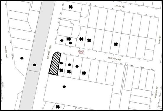
|
NOTIFICATION PLAN |
|||
|
• PROPERTIES NOTIFIED |
X SUBMISSIONS RECEIVED |
PROPERTY SUBJECT OF DEVELOPMENT |
|
|
8 SUBMISSIONS RECEIVED OUT OF MAP RANGE |
|||
The submissions and petition objected to the development, generally on the grounds that the development would result in:
· Unacceptable traffic on local streets;
· Unacceptable parking;
· Unacceptable overshadowing of adjoining properties;
· Unacceptable noise from activities at the centre;
· Development that is excessive in bulk and scale.
· Number of children;
· Design of child care centre;
· Notification period;
· Location of child care;
· Road safety;
· Privacy.
The merits of the matters raised in community submissions have been addressed in the body of the report with the exception of the following:
5.1.1 Evacuation
A submission raised concerns about potential evacuation procedures for the child care centre in case of a bushfire threat. The proposed child care is not located in land mapped bushfire prone.
Accordingly, no further assessment with regard to bushfire evacuation management is necessary.
5.1.2 Number of child care centres in area
A submission states that there is no need for an additional child care centre in the area. The submission suggests that if additional placements are required, existing child care centres should increase numbers instead of creating new centres.
The number of child care centres already existing in the area is not a matter for consideration in this assessment in accordance with Section 4.15 of the Environmental Planning and Assessment Act 1979. Any proposal for an existing child care centre to increase numbers would require additional car parking, indoor and outdoor recreation space in accordance with the HDCP and child care regulations. Site constraints of existing child care centres may not allow significant increase in numbers.
5.2 Public Agencies
The development application was referred to the following Agencies for comment:
5.2.1 Roads and Maritime Services
The application was referred to the RMS as a portion of the site, towards the south-western boundary is affected by a future road proposal. The RMS raised no objections to the proposed child care centre, subject to a condition restricting any new buildings or structures within the dedicated area.
The design of the child care centre has taken into consideration the affected land and no building or structure is located within this affected area. The design of the proposal has also excluded this area from all numerical controls within the HDCP and Children (Education and Care Services) Supplementary Provisions Regulation 2012.
5.2.2 Sydney Trains
The application was referred to Sydney Trains as a portion of the basement is located within 25 metres of the Northern Railway Corridor. Sydney Trains raised no objections to the proposal subject to conditions.
6. THE PUBLIC INTEREST
Section 4.15(1)(e) of the Act requires Council to consider “the public interest”.
The public interest is an overarching requirement, which includes the consideration of the matters discussed in this report. Implicit to the public interest is the achievement of future built outcomes adequately responding to and respecting the future desired outcomes expressed in environmental planning instruments and development control plans.
The application is considered to have satisfactorily addressed Council’s and relevant agencies’ criteria and would provide a development outcome that, on balance, would result in a positive impact for the community. Accordingly, it is considered that the approval of the proposed development would be in the public interest.
CONCLUSION AND REASONS FOR RECOMENDATION
The application seeks approval for demolition of existing structures and construction of a purpose built child care centre accommodating 60 child placements. Subject to a reduction in the number of children to 56 the proposed development would have sufficient car parking spaces in accordance with the Hornsby DCP.
A total of 20 submissions and a petition with 87 signatures were received objecting to the proposal on the grounds of traffic, parking, bulk and scale, safety, noise and landscaping. The issues raised are addressed in the body of the report and the relevant consent
Accordingly, the proposed development is recommended for approval.
The reasons for this recommendation are:
· The proposed development complies with the requirements of the relevant environmental planning instruments and development control plan,
· The proposed development would provide a positive social contribution to the local community by providing additional child care options, and
· The applicant has amended the proposal from that originally submitted to address issues relating to acoustics, landscaping and design to provide a better outcome for adjoining developments and the functioning of the site.
Note: At the time of the completion of this planning report, no persons have made a Political Donations Disclosure Statement pursuant to Section 10.4 of the Environmental Planning and Assessment Act 1979 in respect of the subject planning application.
RESPONSIBLE OFFICER
The officer responsible for the preparation of this report is Matthew Miles who can be contacted on 9847 6760.
|
Cassandra Williams Team Leader - Major Applications Planning Division |
Rod Pickles Manager - Development Assessment Planning Division |
|
1.⇨ |
Locality Map |
|
|
|
2.⇨ |
Site Analysis |
|
|
|
3.⇨ |
Floor Plans |
|
|
|
4.⇨ |
Sections and Elevations |
|
|
|
5.⇨ |
Landscape Plans |
|
|
|
6.⇨ |
Site Access and Drop off |
|
|
File Reference: DA/712/2017
Document Number: D07414552
SCHEDULE 1
GENERAL CONDITIONS
The conditions of consent within this notice of determination have been applied to ensure that the use of the land and/or building is carried out in such a manner that is consistent with the aims and objectives of the relevant legislation, planning instruments and Council policies affecting the land and does not disrupt the amenity of the neighbourhood or impact upon the environment.
Note: For the purpose of this consent, the term ‘applicant’ means any person who has the authority to act on or the benefit of the development consent.
Note: For the purpose of this consent, any reference to an Act, Regulation, Australian Standard or publication by a public authority shall be taken to mean the gazetted Act or Regulation, or adopted Australian Standard or publication as in force on the date that the application for a construction certificate is made.
1. Approved Plans and Supporting Documentation
The development must be carried out in accordance with the plans and documentation listed below and endorsed with Council’s stamp, except where amended by Council and/or other conditions of this consent:
|
Plan No. |
Issue |
Plan Title |
Drawn by |
Dated |
|
103 |
7 |
Site Analysis |
Place Studio |
12.06.2018 |
|
120 |
11 |
Excavation plan |
Place Studio |
01.06.2018 |
|
121 |
11 |
Demolition ground floor |
Place Studio |
17.05.2018 |
|
201 |
7 |
Basement plan |
Place Studio |
12.06.2018 |
|
202 |
7 |
Ground floor plan |
Place Studio |
12.06.2018 |
|
203 |
7 |
First floor plan |
Place Studio |
12.06.2018 |
|
204 |
7 |
Roof plan |
Place Studio |
12.06.2018 |
|
205 |
7 |
Site access + drop off |
Place Studio |
12.06.2018 |
|
300 |
7 |
Section 1 |
Place Studio |
12.06.2018 |
|
301 |
7 |
Ramp Section |
Place Studio |
12.06.2018 |
|
302 |
7 |
Section 2 |
Place Studio |
12.06.2018 |
|
400 |
7 |
Front elevation |
Place Studio |
12.06.2018 |
|
401 |
7 |
Left elevation |
Place Studio |
12.06.2018 |
|
402 |
7 |
Right elevation |
Place Studio |
12.06.2018 |
|
403 |
7 |
Right elevation (no fence) |
Place Studio |
12.06.2018 |
|
404 |
7 |
Rear elevation |
Place Studio |
12.06.2018 |
|
206 |
7 |
Landscape plan |
Place Studio |
12.06.2018 |
|
L-01 |
E |
Site plan |
Site design + studios |
13.06.2018 |
|
L-02 |
E |
Detailed plan |
Site design + studios |
13.06.2018 |
|
L-03 |
E |
Detailed plan |
Site design + studios |
13.06.2018 |
|
L-04 |
E |
Planting Schedule |
Site design + studios |
13.06.2018 |
|
L-05 |
E |
Planting Details |
Site design + studios |
13.06.2018 |
|
Document Title |
Prepared by |
Dated |
|
External finishes schedule |
Place Studio |
09.02.18 |
|
Acoustic report Ref: 1015422 Rev. E |
Cundall |
12.02.18 |
|
Traffic and parking assessment Ref: 17302 Final 2 |
Varga traffic planning |
30.08.17 |
|
Stormwater & Erosion Plan Nos. 2996H, Sheets 1-6 Rev. A |
NiTmA Consulting |
08.02.2018 |
|
Survey Plan No. 160416D1 |
NGEO Surveys |
16.04.2016 |
|
Waste management plan |
Spaces and Places |
June 2017 |
|
Access report Ref: 108254-Access 2 |
BCA Logic |
08.02.2018 |
|
NSW RMS Concurrence Ref: SYD17/01086 |
NSW Roads and Maritime Service |
31.08.2017 |
|
Sydney Trains Concurrence letter |
Sydney Trains |
16.05.2018 |
|
Space configurations Ref: 207 7 |
Place Studio |
12.06.2018 |
|
Acoustics review of boundary fence height Ref 1015422 |
Cundall |
08.06.2018 |
a) To comply with Councils requirement in terms of car parking and landscaping, the approved plans are to be amended as follows:
i) The car parking space marked ‘Temporary peak drop off carpark’ in the south-western corner of the basement level must be deleted as this space is for vehicle manoeuvring.
ii) To provide additional deep soil landscaping within the rear boundary, the rear wall of the basement car park is to be setback from the rear boundary by an additional 360mm which would reduce the aisle width from 6.2m to 5.8m within the basement and provide a rear setback of 1.1m
b) These amended plans must be submitted with the application for the Construction Certificate.
3. Removal of Existing Trees
a) This development consent permits the removal of trees numbered T1, T2, T3, T5 T6 and T7 as identified on plan number L-01E, Site plan prepared by site design + studios, dated 13/6/2018.
b) The removal of any other trees requires separate approval in accordance with the Tree and Vegetation Chapter 1B.6 Hornsby Development Control Plan 2013.
4. Appointment of a Project Arborist
a) A project arborist with AQF Level 5 qualifications must be appointed to provide scheduled monitoring and certification throughout the construction period.
b) Details of the appointed project arborist including dates of the monitoring schedule must be submitted to Council and the PCA for registration with the application for the construction certificate.
5. Construction Certificate
a) A Construction Certificate is required to be approved by Council or a Private Certifying Authority prior to the commencement of any works under this consent.
b) The Construction Certificate plans must not be inconsistent with the Development Consent plans.
6. Section 7.12 Development Contributions
a) In accordance with Section 4.17(1) of the Environmental Planning and Assessment Act, 1979 and the Hornsby Shire Council Section 94A Development Contributions Plan 2014-2024, $26,451.85 must be paid to Council to cater for the increased demand for community infrastructure resulting from the development, based on development costs of $2,645,188.
b) The value of this contribution is current as at 3 April 2018. If this contribution is not paid within the financial quarter that this condition was generated, the contribution payable will be adjusted in accordance with the provisions of the Hornsby Shire Council Section 94 Development Contributions Plan and the amount payable will be calculated at the time of payment in the following manner:
$CPY = $CDC x CPIPY
CPIDC
Where:
$CPY is the amount of the contribution at the date of Payment
$CDC is the amount of the contribution as set out in this Development Consent
CPIPY is the latest release of the Consumer Price Index (Sydney – All Groups) at the date of Payment as published by the ABS.
CPIDC is the Consumer Price Index (Sydney – All Groups) for the financial quarter at the date applicable in this Development Consent Condition.
c) c) The monetary contributions must be paid to Council:
i) prior to the issue of the Subdivision Certificate where the development is for subdivision; or
ii) prior to the issue of the first Construction Certificate where the development is for building work; or
iii) prior to issue of the Subdivision Certificate or first Construction Certificate, whichever occurs first, where the development involves both subdivision and building work; or
iv) prior to the works commencing where the development does not require a Construction Certificate or Subdivision Certificate.
Note: It is the professional responsibility of the Principal Certifying Authority to ensure that the monetary contributions have been paid to Council in accordance with the above timeframes.
Council’s S94A Development Contributions Plan may be viewed at www.hornsby.nsw.gov.au or a copy may be inspected at Council’s Administration Centre during normal business hours.
7. Dilapidation Report (Prior to demolition)
A ‘Dilapidation Report’ is to be prepared prior to demolition by a ‘chartered structural engineer’ detailing the structural condition of Lot 12 DP 551828, No. 2B Berowra Road, Mount Colah.
REQUIREMENTS PRIOR TO THE ISSUE OF A CONSTRUCTION CERTIFICATE
8. Building Code of Australia
All approved building work must be carried out in accordance with the relevant requirements of the Building Code of Australia.
9. Children (Education and Care Services) Supplementary Provisions Regulation 2004
Documentation prepared by a registered architect is to be submitted with the Construction Certificate to certify that the proposed development is in accordance with the requirements of the Children and Young Persons (Care & Protection) Act 1998 and the Children’s Services Regulation 2012.
10. Identification of Survey Marks
A registered surveyor must identify all survey marks in the vicinity of the proposed development. Any survey marks required to be removed or displaced as a result of the proposed development shall be undertaken by a registered surveyor in accordance with Section 24 (1) of the Surveying and Spatial Information Act 2002 and following the Surveyor General’s Directions No.11 – "Preservation of Survey Infrastructure".
11. Sydney Water – Approval
This application must be submitted to Sydney Water for approval to determine whether the development would affect any Sydney Water infrastructure, and whether further requirements are to be met.
Note: Building plan approvals can be obtained online via Sydney Water Tap inTM through www.sydneywater.com.au under the Building and Development tab.
12. Stormwater Drainage
The stormwater drainage system for the development must be designed in accordance with Council’s Civil Works – Design and Construction Specification 2005 and the following requirements:
a) Connected to the existing Council drainage pit within Berowra Road with the following requirements:
i) A separate Application must be made to Council for ‘Approval To Connect Stormwater Drainage Outlet To Council’s System’ with all fees paid, prior to connecting to Council’s drainage system;
13. Construction Management Plan (CMP)
To assist in the protection of the public, the environment and Council’s assets, a separate Construction Management Plan must be prepared by a suitably qualified environmental consultant in consultation with a qualified traffic engineer, and submitted to Council’s Compliance Team at compliance@hornsby.nsw.gov.au, according to the following requirements:
a) The CMP must detail the contact information for developers, builder, private certifier and any emergency details during and outside work hours.
b) The plan must include a Construction Traffic Management Plan (CTMP) including the following:
i) Truck movements to and from the site, including the routes used, swept path diagrams entering and exiting the site and implemented traffic control;
ii) Survey plan showing site sheds, concrete pump location, crane location and existing survey marks;
iii) Work Zones, Road Openings, Road Closures, Crane Permits and Road Occupancy licenses, or any intentions to obtain such approvals; and
iv) Safe pedestrian management details including during local school and commuter hours where the footpath is heavily frequented.
c) The plan must also include a Construction Waste Management Plan detailing the following:
i) Details of the importation or excavation of soil and fill, the classification of the fill, disposal methods and authorised disposal depots that will be used for the fill;
ii) Asbestos management requirement and procedures for removal and disposal from the site in accordance with AS 2601–2001 – ‘The Demolition of Structures’, and the Protection of the Environment Operations (Waste) Regulation 2005;
iii) General construction waste details including construction waste skip bin locations and litter management for workers.
d) Management of stormwater disposal from the detention basin or basement throughout all development phases in accordance with the ANZECC Guidelines trigger values for the area.
e) Sediment and Erosion control including during rainfall events and site plans showing entry to or exits from the site, all in accordance with the ‘Soils and Construction 2004 (Bluebook)’.
f) Air quality management on site, including dust suppression measures during demolition and construction.
g) Details on the general operating procedures to manage environmental risk throughout all stages of works on the site;
h) To ensure Council assets are maintained throughout the development, a detailed survey plan showing existing survey marks, vehicle entry, footpath and hoarding (fencing) locations; and
i) Noise and vibration control information to address any noise nuisances such as rock sawing or breaking, the mitigation methods implemented and how complaints will be managed or prevented.
14. On Site Stormwater Detention
An on-site stormwater detention system must be designed by a chartered civil engineer and constructed in accordance with the following requirements:
a) Have a capacity of not less than 10.7 cubic metres, and a maximum discharge (when full) of 13 litres per second;
b) Have a surcharge/inspection grate located directly above the outlet;
c) Discharge from the detention system must be controlled via 1 metre length of pipe, not less than 50 millimetres diameter or via a stainless plate with sharply drilled orifice bolted over the face of the outlet discharging into a larger diameter pipe capable of carrying the design flow to an approved Council system;
d) Not be constructed in a location that would impact upon the visual or recreational amenity of residents.
15. Internal Driveway/Vehicular Areas
The driveway and parking areas on site must be designed, constructed and a Construction Certificate issued in accordance with Australian Standards 2890.1, 2890.2, 3727 and the following requirements:
a) Design levels at the front boundary shall be obtained from Council if a private accredited certifier is engaged to obtain a construction certificate for these works.
b) The driveway be a rigid pavement.
16. Vehicular Crossing
A separate application under the Local Government Act, 1993 and the Roads Act 1993 must be submitted to Council for the installation of a new vehicular crossing and the removal of the redundant crossing. The vehicular crossing must be constructed in accordance with Council’s Civil Works Design 2005 and the following requirements:
a) Design levels at the front boundary must be obtained from Council for the design on the internal driveway;
b) Any redundant crossings must be replaced with integral kerb and gutter;
c) The footway area must be restored by turfing;
d) Approval must be obtained from all relevant utility providers that all necessary conduits be provided and protected under the crossing.
Note: An application for a vehicular crossing can only be made to one of Council’s Authorised Vehicular Crossing Contractors. You are advised to contact Council on 02 9847 6940 to obtain a list of contractors.
REQUIREMENTS PRIOR TO THE COMMENCEMENT OF ANY WORKS
17. Erection of Construction Sign
a) A sign must be erected in a prominent position on any site on which any approved work is being carried out:
i) Showing the name, address and telephone number of the principal certifying authority for the work;
ii) Showing the name of the principal contractor (if any) for any demolition or building work and a telephone number on which that person may be contacted outside working hours; and
iii) Stating that unauthorised entry to the work site is prohibited.
b) The sign is to be maintained while the approved work is being carried out and must be removed when the work has been completed.
18. Protection of Adjoining Areas
a) A temporary hoarding, fence or awning must be erected between the work site and adjoining lands before the works begin and must be kept in place until after the completion of the works if the works:
b) Could cause a danger, obstruction or inconvenience to pedestrian or vehicular traffic;
c) Could cause damage to adjoining lands by falling objects; and/or
d) Involve the enclosure of a public place or part of a public place.
e) Have been identified as requiring a temporary hoarding, fence or awning within the Council approved Construction Management Plan (CMP).
Note: Notwithstanding the above, Council’s separate written approval is required prior to the erection of any structure or other obstruction on public land.
a) To provide a safe and hygienic workplace, toilet facilities must be available or be installed at the works site before works begin and must be maintained until the works are completed at a ratio of one toilet for every 20 persons employed at the site.
b) Each toilet must:
i) be a standard flushing toilet connected to a public sewer; or
ii) be a temporary chemical closet approved under the Local Government Act 1993; or
iii) have an on-site effluent disposal system approved under the Local Government Act 1993.
20. Erosion and Sediment Control
To protect the water quality of the downstream environment, erosion and sediment control measures must be provided and maintained throughout the construction period in accordance with the manual ‘Soils and Construction 2004 (Bluebook)’, the approved plans, Council specifications and to the satisfaction of the principal certifying authority. The erosion and sediment control devices must remain in place until the site has been stabilised and revegetated.
Note: On the spot penalties may be issued for any non-compliance with this requirement without any further notification or warning.
21. Installation of Tree Protection
All tree protection measures for the trees to be retained must have the protection measures for the ground, trunk and canopy installed in accordance with the relevant requirements of Australian Standard AS 4970-2009 - “Protection of Trees on Development Sites”.
22. Tree Protection Zone - Ground Protection
a) All tree protection zones for the trees to be retained must have a layer of wood-chip mulch installed prior to works commencing.
b) The wood-chip mulch must be maintained throughout the period of construction at a depth of between 150mm and 300mm, using material that complies with the relevant requirements of Australian Standard AS 4454 – “Composts, Soil Conditioners and Mulches”.
23. Tree Protection Certification
To ensure that all tree protection measures are correctly installed, a certificate from an appointed project arborist must be submitted to the Principal Certifying Authority confirming compliance with the tree protection requirements of this consent.
REQUIREMENTS DURING DEMOLITION AND CONSTRUCTION
24. Construction Work Hours
All works on site, including demolition and earth works, must only occur between 7am and 5pm Monday to Saturday.
No work is to be undertaken on Sundays or public holidays.
25. Maintenance of Public Footpaths
Public footpaths must be maintained for the duration of works to ensure they are free of trip hazards, displacements, breaks or debris to enable pedestrians to travel along the footpath safely.
26. Construction Traffic Management Plan Compliance
The development must be carried out in accordance with the submitted Construction Traffic Management Plans.
27. Street Sweeping
a) To protect the surrounding environment, Street sweeping must be undertaken following sediment tracking from the site along adjacent streets during works and until the site is established.
b) The street cleaning services must undertake a street ‘scrub and dry’ method of service and not a dry sweeping service that may cause sediment tracking to spread or cause a dust nuisance.
28. Asbestos and Soil Contamination
Should the presence of asbestos or soil contamination, not recognised during the application process be identified during works, the applicant must immediately notify the Principal Certifying Authority (PCA) and Council.
To protect the surrounding environment, all demolition work must be carried out in accordance with Australian Standard 2601-2001 – The Demolition of Structures and the following requirements:
a) Demolition material must be disposed of to an authorised recycling and/or waste disposal site and/or in accordance with an approved waste management plan;
b) Demolition works, where asbestos material is being removed, must be undertaken by a contractor that holds an appropriate licence issued by WorkCover NSW in accordance with Chapter 10 of the Occupational Health and Safety Regulation 2001 and Clause 29 of the Protection of the Environment Operations (Waste) Regulation 2005 ;and
c) On construction sites where any building contain asbestos material, a standard commercially manufactured sign containing the words ‘DANGER ASBESTOS REMOVAL IN PROGRESS’ and measuring not less than 400mm x 300mm must be displayed in a prominent position visible from the street.
To prevent sediment run-off, excessive dust, noise or odour emanating from the site during the construction, the site must be managed in accordance with the publication ‘Managing Urban Stormwater – Landcom (March 2004) and the Protection of the Environment Operations Act 1997.
31. Works Near Trees
a) No consent is granted for any works within the Structural Root Zone of trees numbered T4 on the adjoining property at No.2B Berowra Road.
b) To maintain tree health and condition, the appointed project arborist must monitor and record any and all necessary remedial actions required for trees numbered T4 on the approved plans.
c) The maintenance and monitoring of all tree protection measures must be recorded by the appointed project arborist during the period of construction for submission with the application for the occupation certificate.
d) Any and all necessary excavations within the Tree Protection Zone of trees to be retained numbered T4 on the approved plans, must be undertaken as prescribed in Section 4 clause 4.5.4 in the Australian Standard AS 4970-2009 – “Protection of Trees on Development Sites”.
e) To minimise the environmental impacts of the development within the Tree Protection Zone (TPZ) of trees to be retained, numbered T4 on the approved plans:
i) The installation of any underground services which either enter or transect the designated TPZ must utilise sensitive methods such as directional drilling or manual excavation.
ii) The installation of any underground services must be inspected by the project arborist to monitor the likely impacts of the development on retained trees.
iii) For manual excavation of trenches the project arborist must advise on roots to be retained and must monitor the works. Manual excavation may include the use of pneumatic and hydraulic tools as prescribed in the Australian Standard AS 4970-2009 – “Protection of Trees on Development Sites” Section 4 clause 4.5.5.
f) Where scaffolding is required it must be erected outside the TPZ and in accordance with AS 4970-2009 Section 4 clause 4.5.6.
32. Building Materials and Site Waste
The filling or stockpiling of building materials, the parking of vehicles or plant, the disposal of cement slurry, waste water or other contaminants must be located outside the tree protection zones as prescribed the prescriptive measures of Part 1B.6.1 Tree Preservation of the Hornsby Development Control Plan, 2013, of any tree to be retained.
33. Works Near Trees Certification
a) The project arborist must submit to the principal certifying authority on a monthly a certificate that the works have been carried out in compliance with the approved plans and specifications for tree protection.
b) Certification should include a statement of site attendance, the condition of the retained trees, details of any deviations from the approved tree protection measures and their impacts on trees.
c) Note: Copies of monitoring documentation may be required by the PCA and/or Council.
34. Council Property
To ensure that the public reserve is kept in a clean, tidy and safe condition during construction works, no building materials, waste, machinery or related matter is to be stored on the road or footpath.
Note: This consent does not give right of access to the site via Council’s park or reserve. Should such access be required, separate written approval is to be obtained from Council.
35. Disturbance of Existing Site
During construction works, the existing ground levels of open space areas and natural landscape features, (including natural rock-outcrops, vegetation, soil and watercourses) must not be altered unless otherwise nominated on the approved plans.
Landfill must be constructed in accordance with Council’s ‘Construction Specification 2005’ and the following requirements:
a) Prior to fill material being imported to the site, a certificate shall be obtained from a suitably qualified environmental consultant confirming the fill wholly consists of Virgin Excavated Natural Material (VENM) as defined in Schedule 1 of the Protection of the Environment Operations Act 1997 or material approved under the Department of Environment and Climate Change’s general resource recovery exemption.
b) A compaction certificate is to be obtained from a suitably qualified geotechnical engineer verifying that the specified compaction requirements have been met.
c) These certificates must be included with the application for an occupation certificate.
All excavated material removed from the site must be classified by a suitably qualified person in accordance with the Department of Environment, Climate Change and Water NSW Waste Classification Guidelines and Protection of the Environment Operations (Waste) Regulation 2014 prior to disposal to an approved waste management facility and tipping dockets submitted to the Principal Certifier prior to the issue of an Occupation Certificate.
38. Survey Report
A report(s) must be prepared by a registered surveyor and submitted to the principal certifying authority;
a) Prior to the pouring of concrete at each level of the building certifying that:
i) The building, retaining walls and the like have been correctly positioned on the site; and
ii) The finished floor level(s) are in accordance with the approved plans.
REQUIREMENTS PRIOR TO THE ISSUE OF AN OCCUPATION CERTIFICATE
Note: For the purpose of this consent, a reference to ‘occupation certificate’ shall not be taken to mean an ‘interim occupation certificate’ unless otherwise stated:
39. Damage to Council Assets
To protect public property and infrastructure, any damage caused to Council’s assets as a result of the construction or demolition of the development must be rectified by the applicant in accordance with Council’s Civil Works Specifications. Rectification works must be undertaken prior to the issue of an Occupation Certificate, or sooner, as directed by Council.
40. Landscaping Requirements
A certificate must be submitted to the PCA by a practicing landscape architect, horticulturalist or person with similar qualifications and experience certifying that the proposed landscaping works have been satisfactorily completed in accordance with the approved landscape plans.
41. Planter Boxes / On slab planting
On slab planter boxes must include waterproofing, subsoil drainage (proprietary drainage cell, 50mm sand and filter fabric) automatic irrigation, minimum 500mm planting soil for shrubs and minimum 1000mm planting soil for trees and palms and 75mm mulch to ensure sustainable landscape is achieved.
42. Final Certification Arborist
a) The suitably qualified person holding a certificate III in Horticulture must submit to the principal certifying authority a Statement/or/Certification confirming all Tree Replacement Requirements have been completed in accordance with approved landscape plans and conditions of consent.
b) The Project supervisor must submit to the principal certifying authority all relevant certificates with the application for the occupation certificate stating compliance with all the conditions of this consent.
c) The Project arborist must submit to the principal certifying authority a certificate which states all schedules inspections have been undertaken and that all the completed works have been carried out in compliance with the approved plans and specifications for tree protection.
d) The Project Arborist Certification must include all recorded information from scheduled inspections and statement of overall site attendance, the condition of the retained trees, details of any deviations from the approved tree protection measures and their impacts on trees.
Note: Copies of monitoring documentation may be required.
43. Retaining Walls
All required retaining walls must be constructed as part of the development.
The following matter(s) must be nominated on the plan of subdivision under s88B of the Conveyancing Act, 1919:
a) The creation of an appropriate "Positive Covenant" and "Restriction as to User" over the constructed on-site detention/retention systems and outlet works, within the lots in favour of Council in accordance with Council’s prescribed wording. The position of the on-site detention system is to be clearly indicated on the title;
b) To register the OSD easement, the restriction on the use of land “works-as-executed” details of the on-site-detention system must be submitted verifying that the required storage and discharge rates have been constructed in accordance with the design requirements. The details must show the invert levels of the on site system together with pipe sizes and grades. Any variations to the approved plans must be shown in red on the “works-as-executed” plan and supported by calculations;
Note: Council must be nominated as the authority to release, vary or modify any easement, restriction or covenant.
A works-as-executed plan(s) must be prepared by a registered surveyor and submitted to Council for completed road pavement, kerb & gutter, public drainage systems, driveways and on-site detention system.
46. Outdoor Play Area
The outdoor play space must be adequately shaded in accordance with The Shade Handbook, published by the New South Wales Cancer Council in 2008.
47. Boundary Fencing
Boundary fencing should be installed as per the following requirements:
a) Boundary fencing must only be installed behind the front building alignment,
b) The boundary fencing must be a maximum 2.2m high in the Acoustic Report, Reference No. 1015422 Rev E prepared by Cundall dated 12 February 2018,
c) Fencing within the front boundary, in-front of the child care building must be a maximum 1.2m high,
d) The acoustic fencing along the first floor play area must be a minimum 1.5m high from the finished floor level.
48. Acoustic Treatment and Certification
Acoustic treatment including boundary fencing must be provided to the proposed development in accordance with the recommendations contained within the Acoustic Report, Reference No. 1015422 Rev E prepared by Cundall dated 12 February 2018 and must include the following:
a) No windows located along the ground floor, eastern side elevation,
b) The single window along the first floor, eastern side elevation to be fixed glass to allow for light penetration into the indoor recreation area only.
c) Boundary fencing be continuous with no gaps or holes and be a minimum height of 2.2m above ground level,
d) Acoustic fencing along first floor play area to be 1.5m high to provide a barrier to sound transfer,
e) On completion of all works and prior to the issue of an Occupation Certificate, the PCA must be provided with a certificate from a qualified acoustic consultant certifying that all acoustic works have been completed in accordance with the recommendations contained within the Acoustic Report, Reference No. 1015422 Rev E prepared by Cundall dated 12 February 2018.
49. Waste Management Details
The following waste management requirements must be complied with:
a) A report must be prepared by an appropriately qualified person, certifying the following:
i) A comparison of the estimated quantities of each waste type against the actual quantities of each waste type.
Note: Explanations of any deviations to the approved Waste Management Plan is required to be included in this report.
ii) That at least 60% of the waste generated during the demolition and construction phase of the development was reused or recycled.
Note: If the 60% diversion from landfill cannot be achieved in the Construction Stage, the Report is to include the reasons why this occurred and certify that appropriate work practices were employed to implement the approved Waste Management Plan. The Report must be based on documentary evidence such as tipping dockets/receipts from recycling depots, transfer stations and landfills, audits of procedures etc. which are to be attached to the report.
iii) All waste was taken to site(s) that were lawfully permitted to accept that waste.
b) The child care centre must be provided with an indoor waste/recycling cupboard for the interim storage of a minimum one day’s waste generation with separate containers for general waste and recyclable materials.
c) The bin carting routes must be devoid of any steps.
Note: Ramps between different levels are acceptable
50. Food Premises
a) A food premises notification form must be submitted to Council prior to the commencement of operation.
Note: Hornsby Shire Council’s Food Premises notification form can be found at http://www.hornsby.nsw.gov.au
b) The fit out and operation of that part of the building to be used for the manufacture, preparation or storage of food for sale, must be in accordance with Australian Standard 4674-2004 – Design and fit out of food premises, the Food Act 2003, and the Food Regulation 20010 and the Food Standards Code developed by Food Standards Australia New Zealand. Food Standards 3.3.1. 3.2.2 and 3.2.3 are mandatory for all food businesses.
Note: Walls are to be of solid construction.
c) Prior to the commencement of the child care centre, the operator is requested to contact Council’s Compliance & Certification Team to arrange an inspection for compliance against the relevant legislation and guidelines outlined in this approval. Contact Council’s Administration Officer on 9847 6784.
d) A kitchen exhaust system must be designed and installed to effectively prevent air pollution in accordance with the Protection of the Environment Operations Act 1997.
OPERATIONAL CONDITIONS
51. Use of Premises
a) The development approved under this consent shall be used for ‘child care centre’ and not for any other purpose without Council’s separate written consent.
b) The child care centre shall accommodate a maximum of 56 children. The age mix of children as at 1 January of each calendar year shall be in accordance with the following:
i) 0-2 years: 20 children
ii) 2-3 years: 16 children
iii) 3-5 years: 20 children
c) The hours of operation of the “child care centre” are restricted to those times listed below:
i) Monday to Friday – 7:00am to 6:00 pm
ii) Saturday, Sunday & Public Holidays - No work (Other than for 4 Saturdays per year for special occasions).
52. Car Parking
a) All car parking must be constructed and operated in accordance with Australian Standard AS/NZS 2890.1:2004 – Off-street car parking and Australian Standard AS 2890.2:2002 – Off-street commercial vehicle facilities.
b) All parking areas and driveways are to be sealed to an all weather standard, line marked and signposted;
c) Car parking, loading and manoeuvring areas to be used solely for nominated purposes;
d) Vehicles awaiting loading, unloading or servicing shall be parked on site and not on adjacent or nearby public roads;
e) All vehicular entry on to the site and egress from the site shall be made in a forward direction.
f) All parking for people with disabilities is to comply with AS/NZS 2890.6:2009 Off-street parking for people with disabilities.
g) Any proposed landscaping and/or fencing must not restrict sight distance to pedestrians and cyclists travelling along the footpath.
53. Child Care Centre Management
The child care centre must be managed in accordance with the recommendations of the Acoustic Report for DA Submission Report No. 1015422 Rev E prepared by Cundall dated 12 February 2018. A management plan must be prepared and adhered to in accordance with the recommendations of the acoustic report.
54. Waste Management
The waste management on site must be in accordance with the following requirements:
a) All commercial tenant(s) must keep written evidence on site of a valid contract with a licensed waste contractor(s) for the regular collection and disposal of the waste and recyclables that are generated on site.
b) All commercial tenant(s) must have a sufficient number of bins to contain the volume of waste and recycling expected to be generated between collection services.
c) All bins must be returned to the on-site bin storage area promptly after waste and recycling collection services.
d) A Work, Health & Safety (WHS) risk assessment is to be carried out by a suitably qualified person with qualifications in Work, Health & Safety Legislation with specific regard to waste management. The recommendations of the WHS Risk Assessment are to be implemented as required.
55. Fire Safety Statement - Annual
On at least one occasion in every 12 month period following the date of the first ‘Fire Safety Certificate’ issued for the property, the owner must provide Council with an annual ‘Fire Safety Certificate’ to each essential service installed in the building.
CONDITIONS OF CONCURRENCE – RMS
The following conditions of consent are from the nominated State Agency pursuant to Section 4.13 of the Environmental Planning and Assessment Act 1979 and must be complied with to the satisfaction of that Agency.
56. RMS 1
A strip of land has previously been dedicated as Public Road by private subdivision (DP 551828) at the corner of Berowra Road & Belmont Parade of the subject property as shown by yellow in the attached Aerial –“X”
The subject property is affected by a road proposal as shown by pink colour in the attached Aerial –“X” and defined by DP 248871
Therefore any new buildings or substantial structures together with any improvements integral to the future use of the site are to be erected clear of the land required for road unlimited in height or depth. The area required for road should be identified as separate lot on any plan of subdivision.
CONDITIONS OF CONCURRENCE – Sydney Trains
The following conditions of consent are from the nominated State Agency pursuant to Section 4.13 of the Environmental Planning and Assessment Act 1979 and must be complied with to the satisfaction of that Agency.
57. Sydney Trains 1
The proposed development is to comply with the deemed-to-satisfy provisions in the Department of Planning’s document titled “Development Near Rail Corridors and Busy Roads- Interim Guidelines”.
58. Sydney Trains 2
Prior to the issue of a Construction Certificate the Applicant is to engage an Electrolysis Expert to prepare a report on the Electrolysis Risk to the development from stray currents. The Applicant must incorporate in the development all the measures recommended in the report to control that risk. A copy of the report is to be provided to the Principal Certifying Authority with the application for a Construction Certificate.
59. Sydney Trains 3
Prior to the commencement of works, the Applicant shall provide certification from a qualified Geotechnical and Structural Engineers stating that the proposed works are to have no negative impact on the rail corridor and associated rail infrastructure.
60. Sydney Trains 4
If a crane is to be used at any stage of the proposed works, prior to the issuing of a Construction Certificate the Applicant is to submit to Sydney Trains a plan showing all craneage and other aerial operations for the development and must comply with all Sydney Trains requirements. The Principal Certifying Authority shall not issue the Construction Certificate until written confirmation has been received from Sydney Trains confirming that this condition has been satisfied.
61. Sydney Trains 5
The applicant shall not at any stage block the corridor access gate on Belmont Parade, and should make provision for easy and ongoing 24/7 access by rail vehicles, plant and equipment to support maintenance and emergency activities.
62. Sydney Trains 6
Sydney Trains and Transport for NSW, and persons authorised by them for this purpose, are entitled to inspect the site of the approved development and all structures to enable it to consider whether those structures on that site have been or are being constructed and maintained in accordance with these conditions of consent, on giving reasonable notice to the principal contractor for the approved development or the owner or occupier of the part of the site to which access is sought.
63. Sydney Trains 7
No work is permitted within the Sydney Trains land, or its easements, at any time unless prior approval or an Agreement has been entered into with Sydney Trains and/or Transport for NSW. Where the Applicant proposes to enter the rail corridor, the Principal Certifying Authority shall not issue a Construction Certificate until written confirmation has been received from those entities confirming that its approval has been granted. Unless advised by Sydney Trains in writing, all excavation, shoring and piling works within 25m of the rail corridor are to be supervised by a geotechnical engineer experienced with such excavation projects.
64. Sydney Trains 8
Copies of any certificates, drawings, approvals/certification or documents endorsed by, given to or issued by Sydney Trains must be submitted to Council for its records prior to the issuing of a Construction Certificate.
65. Sydney Trains 9
Any conditions issued as part of Sydney Trains approval/certification of any documentation for compliance with the Sydney Trains conditions of consent, those approval/certification conditions will also form part of the consent conditions that the Applicant is required to comply with.
- END OF CONDITIONS -
ADVISORY NOTES
The following information is provided for your assistance to ensure compliance with the Environmental Planning and Assessment Act 1979, Environmental Planning and Assessment Regulation 2000, other relevant legislation and Council’s policies and specifications. This information does not form part of the conditions of development consent pursuant to Section 4.17 of the Act.
Environmental Planning and Assessment Act 1979 Requirements
The Environmental Planning and Assessment Act 1979 requires:
· The issue of a construction certificate prior to the commencement of any works. Enquiries can be made to Council’s Customer Services Branch on 9847 6760;
· a principal certifying authority to be nominated and Council notified of that appointment prior to the commencement of any works;
· Council to be given at least two days written notice prior to the commencement of any works;
· mandatory inspections of nominated stages of the construction inspected; and
· an occupation certificate to be issued before occupying any building or commencing the use of the land.
Long Service Levy
In accordance with Section 34 of the Building and Construction Industry Long Service Payments Act 1986, a ‘Long Service Levy’ must be paid to the Long Service Payments Corporation or Hornsby Council.
Note: The rate of the Long Service Levy is 0.35% of the total cost of the work.
Note: Hornsby Council requires the payment of the Long Service Levy prior to the issue of a construction certificate.
Tree and Vegetation Preservation
In accordance with Hornsby Development Control Plan 2013 a person must not ringbark, cut down, top, lop, remove, injure or wilfully destroy any tree or other vegetation protected under the Hornsby Development Control Plan 2013 without the authority conferred by a development consent or a permit granted by Council.
Notes: A tree is defined as a long lived, woody perennial plant with one or relatively few main stems with the potential to grow to a height greater than three metres (3M). (HDCP 1B.6.1.c).
Tree protection measures and distances are determined using the Australian Standard AS 4970:2009, “Protection of Trees on Development Sites”.
Fines may be imposed for non-compliance with the Hornsby Development Control Plan 2013.
The land upon which the subject building is to be constructed may be affected by restrictive covenants. Council issues this approval without enquiry as to whether any restrictive covenant affecting the land would be breached by the construction of the building, the subject of this consent. Applicants must rely on their own enquiries as to whether or not the building breaches any such covenant.
Dial Before You Dig
Prior to commencing any works, the applicant is encouraged to contact Dial Before You Dig on 1100 or www.dialbeforeyoudig.com.au for free information on potential underground pipes and cables within the vicinity of the development site.
Asbestos Warning
Should asbestos or asbestos products be encountered during demolition or construction works, you are advised to seek advice and information prior to disturbing this material. It is recommended that a contractor holding an asbestos-handling permit (issued by SafeWork NSW) be engaged to manage the proper handling of this material. Further information regarding the safe handling and removal of asbestos can be found at:
Alternatively, telephone the SafeWork NSW Asbestos and Demolition Team on 8260 5885.
Advertising Signage – Separate DA Required
This consent does not permit the erection or display of any advertising signs. Most advertising signs or structures require development consent. Applicants should make separate enquiries with Council prior to erecting or displaying any advertising signage.
Food Premises
Prior to the commencement of the business, the operator is requested to contact Council’s Compliance and Certification Team to arrange an inspection for compliance against the relevant legislation and guidelines outlined in this approval. Contact Council’s Administration Officer on 9847 6784.
Disability Discrimination Act
The applicant’s attention is drawn to the existence of the Disability Discrimination Act. A construction certificate is required to be obtained for the proposed building/s, which will provide consideration under the Building Code of Australia, however, the development may not comply with the requirements of the Disability Discrimination Act. This is the sole responsibility of the applicant.
LPP Report No. LPP18/18
Local Planning Panel
Date of Meeting: 27/06/2018
2 DEMOLITION OF EXISTING STRUCTURES AND ERECTION OF A 5 STOREY RESIDENTIAL FLAT BUILDING COMPRISING 38 UNITS WITH A ROOFTOP TERRACE AND BASEMENT CAR PARK - 21 - 27 STATION STREET, THORNLEIGH
EXECUTIVE SUMMARY
|
DA No: |
DA/147/2018 (Lodged 23 February 2018) |
|
Description: |
Demolition of existing structures and erection of a 5 storey residential flat building comprising 38 units with a rooftop terrace and basement car park |
|
Property: |
Lots 28 and 29 Sec 3 DP 1854 and Lots 300 and 301 DP 1193643, Nos. 21–27 Station Street, Thornleigh |
|
Applicant: |
Propoint Developments No2 Pty Ltd |
|
Owner: |
Propoint Developments No2 Pty Ltd |
|
Estimated Value: |
$11,998,128 |
|
Ward: |
B |
· The proposal complies with the provisions of the Hornsby Local Environmental Plan 2013 (HLEP) other than the maximum building height development standard. The applicant has made a submission in accordance with Clause 4.6 ‘Exceptions to development standards’ of the Hornsby Local Environmental Plan 2013 to vary the 17.5m maximum building height. Two submissions have been received in respect of the application.
· The application is required to be determined by the Hornsby Shire Council IHAP as the development is for a residential flat building to which SEPP 65 applies and the development would contravene the HLEP maximum building height development standard by more than 10 percent.
· It is recommended that the application be approved.
|
THAT the Hornsby Shire Council Local Planning Panel assume the concurrence of the Secretary of the Department of Planning and Environment pursuant to Clause 4.6 of the Hornsby Local Environmental Plan 2013 and approve Development Application No. DA/147/2018 for demolition of existing structures and erection of a 5 storey residential flat building comprising 38 units with a rooftop garden and basement car park at Lots 28 and 29 Sec 3 DP 1854 and Lots 300 and 301 DP 1193643, Nos. 21–27 Station Street, Thornleigh subject to the conditions of consent detailed in Schedule 1 of LPP Report No. LPP18/18. |
BACKGROUND
The subject land was rezoned from Residential A (Low Density) to R4 (High Density Residential) on 2 September 2011 as part of Council’s Housing Strategy.
The subject application was lodged with Council on 23 February 2018 for demolition of existing structures and erection of a 5 storey residential flat building and initially comprised 44 units with a rooftop garden and basement car park.
In March 2018, the application was referred to an urban designer for comprehensive design advice. Following an assessment of the application by Council’s Urban Design Consultant, a request for additional information was sent to the applicant on 28 March 2018 raising concerns regarding private open space at ground level, further improvement for direct street access to units without compromising privacy, further consideration for location of the substation, stormwater tanks and hydrant booster valves to screen them from the public domain and integrate with landscaping, removal of additional car spaces to improve amenity of basement for waste access, bike storage and unit storage, internal redesign to improve amenity and layout issues with bedrooms, additional landscape treatment required for entry foyer and entrance to building, sunlight issues to kitchens and private open space areas of units, improvement to car park entry ramp and insufficient unit mix for 3 bedrooms.
In addition to urban design comments, Council raised issues regarding waste disposal, no geotechnical report, concerns with minimal landscaping within deep soil areas, requirement for additional native canopy trees with a growth height of 12m+ and lack of native trees shown on the landscape plan, submission of an arborist report, requirement for a 4x4 indent towards Station Street to break up the visual mass of the building, additional landscape treatment on the rooftop garden to assist with privacy to adjoining properties, further privacy measures to adjoining development, cross ventilation concerns, providing a mix of 3 bedroom units and reducing the awnings above the foyer to assist in breaking up the building mass.
On 02 May 2018, Council received amended plans addressing urban design issues and part of Council’s issues.
On 11 May 2018, Council sent a further request for information reinforcing that a mix of 3 bedroom units should be provided. On 25 May 2018, Council received amended plans which provided a 10% mix of 3 bedroom units and reduced the number of overall units from 42 units to 40 units.
On 8 June 2018, the applicant provided amended plans to address Council’s concerns regarding the 5th storey setback, unit sizes, building indent, landscaping ownership, front fencing and waste issues. The amended plans also reduced the overall number of units to 38.
The amended plans are subject to this report.
SITE
The 1896.4m2 site comprises four allotments, Nos. 21, 23, 25 and 27 Station Street, Thornleigh. The site is located on the northern corner of Station Street and western corner of Wood Street. The site has a minor cross fall of 2m from the northern corner of the site to the southern corner to Station Street. Overhead power lines exist along the Station Street frontage and a footpath exists along both street frontages.
The site contains four dwelling-houses with associated outbuildings and landscaping and a number of exotic, native and locally indigenous trees.
Approximately 150m to the west of the site is the intersection of Pennant Hills Road, ALDI supermarket complex and other retail and commercial premises. To the north is Thornleigh Marketplace that accommodates Woolworths. The site is also within walking distance of Thornleigh Train Station, which is approximately 300m to the west, on the opposite side of Pennant Hills Road.
Bus stops with regular services to Hornsby, Castle Hill and Parramatta are located along Pennant Hills Road in close proximity to the site.
The surrounding area includes single dwellings houses and is undergoing transition for high density housing development. A recently constructed five storey residential flat building (DA/1337/2015) comprising 24 units adjoins the northern boundary at Nos. 14-18 Bellevue Street and DA/1545/2016 for construction of a five storey residential flat building comprising 17 units at Nos. 20-22 Bellevue Street is currently being assessed by Council.
PROPOSAL
The proposal involves the demolition of existing structures and construction of a five storey residential flat building comprising 38 units with 2 levels of basement car parking.
The unit mix would comprise 10 x 1 bedroom, 24 x 2 bedroom and 4 x 3 bedroom units. The units would be accessed via a lift centrally located in the building and would include balconies fronting the street, rear and side property boundaries.
The development would be accessed from Station Street via a driveway located along the western boundary of the site. A separate pedestrian entry centrally located at the front of the property would provide access to all levels of the building via a landscaped pathway. A total of 49 car parking spaces, including 9 visitors’ parking spaces, 6 accessible spaces, 9 bicycle and 2 motorbike parking spaces are proposed in two basement levels. Four existing vehicle crossings would be removed, 3 along Station Street and 1 along Wood Street and replaced by 1 vehicle crossing to Station Street.
ASSESSMENT
The development application has been assessed having regard to the ‘Greater Sydney Region Plan - A Metropolis of Three Cities’, the North District Plan’ and the matters for consideration prescribed under Section 4.15 of the Environmental Planning and Assessment Act 1979 (the Act). The following issues have been identified for further consideration.
1. STRATEGIC CONTEXT
1.1 Greater Sydney Region Plan - A Metropolis of Three Cities and North District Plan
The Greater Sydney Region Plan - A Metropolis of Three Cities has been prepared by the NSW State Government to guide land use planning decisions for the next 40 years (to 2056). The Plan sets a strategy and actions for accommodating Sydney’s future population growth and identifies dwelling targets to ensure supply meets demand. The Plan also identifies that the most suitable areas for new housing are in locations close to jobs, public transport, community facilities and services.
The NSW Government will use the subregional planning process to define objectives and set goals for job creation, housing supply and choice in each subregion. Hornsby Shire has been grouped with Hunters Hill, Ku-ring-gai, Lane Cove, Mosman, North Sydney, Ryde, Northern Beaches and Willoughby to form the North District. The Greater Sydney Commission has released the North District Plan which includes priorities and actions for the Northern District for the next 20 years. The identified challenge for Hornsby Shire will be to provide an additional 4,350 dwellings by 2021 with further strategic supply targets to be identified to deliver 97,000 additional dwellings in the North District by 2036.
The proposed development would be consistent with the Greater Sydney Region Plan - A Metropolis of Three Cities and the North District Plan by contributing to achieving the dwelling targets for the region.
2. STATUTORY CONTROLS
Section 4.15(1)(a) requires Council to consider “any relevant environmental planning instruments, draft environmental planning instruments, development control plans, planning agreements and regulations”.
2.1 Hornsby Local Environmental Plan 2013
The proposed development has been assessed having regard to the provisions of the Hornsby Local Environmental Plan 2013 (HLEP).
2.1.1 Zoning of Land and Permissibility
The subject land is zoned R4 (High Density Residential) under the HLEP. The objectives of the zone are as follows:
· To provide for the housing needs of the community within a high density residential environment.
· To promote a variety of housing types within a high density residential environment.
· To enable other land uses that provide facilities or services to meet the day to day needs of residents. The proposed development is defined as and is permissible in the zone with Council’s consent.
The proposed development is a high density residential development and complies with the zone objectives by providing a variety of housing types and new housing stock. The proposed development is defined as a ‘residential flat building’ under the HLEP and is permissible in the zone with the consent of Council.
2.1.2 Height of Buildings
Clause 4.3 of the HLEP provides that the height of a building on any land should not exceed the maximum height show for the land on the Height of Buildings Map. The maximum permissible height for the subject site is 17.5m. The proposed building has a maximum height of 15.7m to 16.1m which complies with the height provision, however the lift overrun, stairwell and unisex toilet would be 19.9m which does not comply with this provision. The non-compliance is addressed below under Section 2.1.3 of this report.
2.1.3 Exceptions to Development Standards
The application has been assessed against the requirements of Clause 4.6 of the HLEP. This clause provides flexibility in the application of development standards in circumstances where strict compliance with those standards would, in any particular case, be unreasonable or unnecessary or tend to hinder the attainment of the objectives of the zone.
The proposed development exceeds the maximum building height development standard of 17.5m by 2.4m or 13%.
The objective of the height of buildings development standard under Clause 4.3 of HLEP is as follows:
To permit a height of buildings that is appropriate for the site constraints, development potential and infrastructure capacity of the locality.
The applicant has made a submission in support of a variation to the development standard in accordance with Clause 4.6 of the HLEP. The applicant states the proposed variation is considered to be consistent with the objectives of the control and is justified as follows:
· The proposed height is an appropriate response to the site constraints as the access core is required to provide universal access to the rooftop terrace. Providing accessible and secure communal open space on the group level is difficult in this particular instance as the subject site is located on an exposed corner allotment. In addition, the non-compliant pergola is necessary to provide shade and amenity for the rooftop communal open space;
· Regardless of the centralised non-compliance, the proposed height is also appropriate for the development potential of the locality. The site is located within the Station Street, Thornleigh precinct which has been earmarked for high density residential development. Importantly, the proposal is consistent with the DCP height provision of five storeys. As the areas of non-compliance are centralised and not readily visible from the street, the proposal will present a compliant height which is consistent with surrounding new development;
· The areas of non-compliance do not provide additional units;
· The proposal, as viewed from the public domain, will have the appearance of a compliant form with the height exceedance occurring towards the middle. The proposal seeks flexibility in this instance as the proposed height will achieve a better outcome for the development by allowing access and amenity for the communal open space. The proposed pergola can be considered a lightweight structure that will not significantly contribute to the bulk and scale of the building;
· Strict compliance with the numerical provisions of the height of buildings development standard will significantly reduce the amenity of the building and the feasibility of the redevelopment. The existing development on the site is incompatible with the desired future character of the area. Enforcing strict compliance may result in the need to reduce the number of storeys to provide the required secure and accessible communal open space. This would be inconsistent with Council’s controls and with the desired future five storey character of the precinct;
· In addition, a reduction in the height may require additional excavation at the lower basement level. This would create further design complications and may have adverse geotechnical implications;
· The objectives of the zone aim to provide a variety of housing types to meet the demand of the community within a high density environment. The non-compliances will improve the amenity of the development by providing shade and universal access to the rooftop communal open space. This will assist in meeting the objectives of the locality by improving the quality of new dwellings. The proposed non-compliances contribute to a architecturally designed, high density residential flat building that will assist in meeting demand in the area, consistent with the zone objectives;
· The proposal has been designed in accordance with the desired future character of the Station Street, Thornleigh precinct and provides modulated facades with wrap-around balconies and stepped back upper levels. Regardless of the height non-compliance, this will result in a superior streetscape outcome;
· The proposed non-compliances constitute an improved planning outcome by facilitating disabled access to the roof level through the provision of the lift core. In addition, the proposed pergola will enhance the amenity for residents by providing weather protection. This will enhance the functionality of the communal open space, facilitating greater social interaction and physical activity. Accordingly, the proposed non-compliances contribute to an improved planning outcome by providing universal access and promoting the physical and social wellbeing of residents;
· It is therefore our opinion that non-compliance will not be inconsistent with existing and future planning objectives for the locality, and that there are sufficient environmental planning grounds to justify contravening the development standard in the particular circumstances of this case; and
· The proposal is not considered to raise any matter of significance for State or regional environmental planning. The height non-compliance is considered to be in the public interest as it will enhance the amenity and functionality of the proposed residential flat building without significantly impacting neighbouring properties. The proposal provides 38 units which will contribute to meeting the demand for housing and is considered in the public interest.
State Government Guidelines on varying development standards recommend considering the provisions of Clause 4.6 of the LEP and the ‘five part test’ established by the Land and Environment Court as follows:
1. The objectives of the standard are achieved notwithstanding noncompliance with the standard;
2. The underlying objective or purpose of the standard is not relevant to the development and therefore compliance is unnecessary;
3. The underlying object of purpose would be defeated or thwarted if compliance was required and therefore compliance is unreasonable;
4. The development standard has been virtually abandoned or destroyed by the council’s own actions in granting consents departing from the standard and hence compliance with the standard is unnecessary and unreasonable;
5. The compliance with development standard is unreasonable or inappropriate due to existing use of land and current environmental character of the particular parcel of land. That is, the particular parcel of land should not have been included in the zone.
The applicant’s submission to vary the Height of Buildings development standard is considered well founded for the following reasons:
· The extent of the non-compliance is primarily within the lift overrun, stairwell and unisex toilet serving the rooftop garden. Although a rooftop terrace is not permitted as per the HDCP, in this instance, the use of a rooftop terrace results in communal open space with more usable space for residents, reduced massing of the building, better solar access, and is more accessible to residents;
· The bulk of the building is contained within the 17.5m height limit with the roof terrace floor level having a height of between 15.7m to 16.1m and the lift overrun, stairs and unisex toilet having a maximum height of 19.9m. The non-compliance is restricted to a 2.8m wide x 13.8m length that exceeds the height limit by 2.4m and comprises approximately 36.6m2 of the 578m2 roof area which represents approximately 6% of the entire roof that exceeds the height limit;
· The proposal achieves a reasonable design outcome for the site and the built form generally follows the slope of the site;
· Due to the topography of the site, the height non-compliance is located in the centre of the building and would not be readily visible from Station Street. Given the overall height of the development in the future context of the redeveloped precinct, this non-compliance would be imperceptible;
· There would be no undue environmental impacts to adjoining properties that arise from the proposed non-compliance. The design concept of the building incorporates environmental sustainable design principles including planting on structures such as a feature sheltered rooftop garden which provides for amenity, improves air quality and microclimate, and reduces direct energy use and stormwater runoff;
· To minimise overlooking to the adjoining properties from the rooftop communal open space, raised planter boxes are proposed on the northern and western sides of this space;
· The lift overrun, stair well and unisex toilet allows access for people with disabilities and other residents to use the rooftop facilities;
· Hornsby Council’s urban design consultant raised no objections to the rooftop terrace and exceedance in building height and stated the following “A Clause 4.6 Variation sought for the height non-compliance, and given this provides for access and amenities on a well-conceived roof terrace and there are no significant environmental impacts, the minor height exceedance can be supported”;
· A compliant development could be achieved on the site, however would result in the deletion of the rooftop communal open space, the private open space available for residents on the ground floor would be significantly reduced to accommodate a 4-metre-wide landscaped area and could result in provision of a bulkier building with a mezzanine level.
· The standard is unreasonable and unnecessary in this instance as the exceedance in building height would not result in any additional overshadowing of adjoining properties and would not be perceptible when viewed from Station Street or Wood Street given the height exceedance occurs in the middle of the building; and
· The proposal is considered to be in the public interest as it achieves consistency with the objectives of the R4 High Density Residential Zone and the objective of the Height of Buildings development standard.
Commissioner Pearson of the Land & Environment Court passed a judgement in the matter of Four2Five Pty Ltd v Ashfield Council [2015] NSWLEC 2009, which established that ‘to accept a departure from the development standard, the context of the site should be considered and it should be demonstrated that the development promotes the proper and orderly development of land as contemplated by the controls applicable to the zone of the land, which is an objective of the Act (s 5 (a)(ii)) and which it can be assumed is within the scope of the “environmental planning grounds” referred to in cl 4.6(4)(a)(i) of the LEP”.
The judgement addressed that environmental planning grounds, such as the public benefits arising from the additional housing and employment opportunities identified in a written request are not considered to be particular to the circumstances of a proposed development on a site. In accordance with the views expressed in this decision, sufficient environmental planning grounds, unique to a site, must be demonstrated by the applicant, for the Clause 4.6 variation request to be upheld.
The submitted Clause 4.6 request demonstrates that the development is consistent with the objectives of this Clause and the environmentally sustainable design concept of the building with an accessible rooftop garden and unisex toilets with a non-compliance which only makes up 6% of the overall building envelope is considered to be sufficient environmental planning grounds.
Council is satisfied that applicant’s Clause 4.6 Statement adequately addresses the matter in Clause 4.6(3)(a) of the HLEP and has provided a suitable argument as why the standard is unreasonable and unnecessary in this case.
Based on this assessment, the Clause 4.6 submission is supported.
2.1.4 Heritage Conservation
Clause 5.10 of the HLEP sets out heritage conservation provisions for Hornsby Shire. The site does not include a heritage item, is not located in a heritage conservation area or within the vicinity of a heritage item. Accordingly, no further assessment in this regard is necessary.
2.1.5 Earthworks
Clause 6.2 of the HLEP states that consent is required for proposed earthworks on site. Before granting consent for earthworks, Council is required to assess the impacts of the works on adjoining properties, drainage patterns and soil stability of the locality.
The site has a gradual fall to the south-eastern boundary. The application includes a Geotechnical Investigation Report dated 4 May 2018 which identifies the geology of the site as Ashfield Shale -comprising residual clayey soils, dark grey siltstone and laminite. The report includes core sample analysis, site assessment and recommendations for excavation conditions, excavation stability and support, site classification, foundation conditions and groundwater.
A condition is recommended for a detailed geotechnical assessment of the site by a chartered structural engineer, to be undertaken for the design of the basement excavation and support, groundwater drainage, basement and foundation design.
A condition is recommended for a dilapidation report to be prepared in respect to adjoining properties.
Subject to recommended conditions the proposal is satisfactory in respect to Clause 6.2 of the HLEP.
2.2 State Environmental Planning Policy No. 55 – Remediation of Land
The application has been assessed against the requirements of State Environmental Planning Policy No. 55. This Policy provides State-wide planning controls requiring that consent must not be granted to the carrying out of any development on land unless it has considered whether the land is contaminated or requires remediation for the proposed use.
A search of Council’s records and aerial images reveals that the property has been used exclusively for residential purposes with no record of any site contamination. Given this, the site would be suitable for the proposed use and no further assessment in relation to this SEPP is required.
It is also noted that due to the age of the existing fibro clad dwelling houses and the associated outbuildings, there is potential for the existing buildings to contain asbestos. Appropriate conditions are included to require all asbestos to be removed from the site. Furthermore, taking into account the significant excavation required to accommodate the proposed basement car park, much of the existing soil would be removed from the site.
2.3 State Environmental Planning Policy (Building Sustainability Index – BASIX)
The application has been assessed against the requirements of State Environmental Planning Policy (Building Sustainability Index: BASIX) 2004. The proposal includes a BASIX Certificate for the proposed units and is considered to be satisfactory.
2.4 State Environmental Planning Policy (Vegetation in Non-Rural Areas) 2017
The application has been assessed against the requirements of State Environmental Planning Policy (Vegetation in Non-Rural Areas) 2017 (Vegetation SEPP). This Policy seeks to protect the biodiversity values of trees and other vegetation in non-rural areas of the State, and to preserve the amenity of non-rural areas of the State through the preservation of trees and other vegetation.
Part 3 of the Vegetation SEPP states that a development control plan may make a declaration in any manner relating to species, size, location and presence of vegetation. Accordingly, Part 1B.6.1 of the Hornsby Development Control Plan 2013 (HDCP) prescribes works that can be undertaken with or without consent to trees.
Part 3.1.1 of this report provides an assessment in accordance with Part 1B.6.1 of the HDCP.
2.5 State Environmental Planning Policy (Sydney Harbour Catchment) 2005
The application has been assessed against the requirements of Sydney Regional Environmental Plan (Sydney Harbour Catchment) 2005. This Policy provides general planning considerations and strategies to ensure that the catchment, foreshores, waterways and islands of Sydney Harbour are recognised, protected, enhanced and maintained.
Subject to the implementation of installation of sediment and erosion control measures and stormwater management to protect water quality, the proposal would have minimal potential to impact on the Sydney Harbour Catchment.
2.6 State Environmental Planning Policy No. 65 – Design Quality of Residential Flat Development
The Policy provides for design principles to improve the design quality of residential flat development and for consistency in planning controls across the State.
The SEPP adopts the Apartment Design Guide which prevails in the event of any inconsistency with a Development Control Plan. The SEPP includes objectives to meet housing and population targets, affordable housing and to facilitate timely and efficient assessment of development application. The SEPP makes further provision for design review panels; include additional provisions for the determination of development application and for standards for car parking, visual privacy, solar and daylight access, common circulation and spaces, apartment size and layout, ceiling heights, private open space and balconies, natural ventilation and storage, which cannot be used as grounds for refusal of development consent.
Design Quality Principles
The applicant has submitted a “Design Verification Statement” prepared by a qualified Architect stating how the proposed development achieves the design principles of SEPP 65. The design principles of SEPP 65 and the submitted design verification statement are addressed in the following table.
|
Principle |
Compliance |
|
1. CONTEXT |
Yes |
|
Comment: The site is located within a precinct planned for five storey residential flat buildings in close proximity to Thornleigh Railway Station and commercial centre. The proposal responds to the desired future character of the precinct as envisaged by Council for residential flat buildings in landscaped settings with underground car parking. Once the development of the precinct is completed, the proposal would integrate with the surrounding sites and would be in keeping with the future urban form. The proposed building would respond and contribute to the identity and future character of the precinct and its context. |
|
|
2. BUILT FORM AND SCALE |
Yes |
|
Comment: The scale, bulk and height of the development is appropriate for the desired future character of five storey development within the precinct noting its consistency with the LEP and DCP controls. Site planning, building volume/ mass presentation and detailing are satisfactory noting the urban design advice. The proposed building generally complies with the height and setback dimensions prescribed within the HDCP. The development achieves a scale consistent with the desired outcome for well-articulated buildings that are set back to incorporate landscaping, open space and separation between buildings.
The proposal incorporates high quality facades with a balanced composition of varied building elements including a defined base, middle and top of the building and achieves an appropriate built form for the site and its purpose, in terms of building alignments, proportions, and the manipulation of building elements. A rooftop garden is proposed with an increased top storey setback to minimise bulk and height of the building as required by the HDCP. The side and internal setbacks ensure appropriate building separation for future RFBs on neighbouring properties. Windows that encroach within the 1/3rd 4m setback are treated with privacy measures such as fixed translucent glazing. |
|
|
4. DENSITY |
Yes |
|
Comment: The HLEP does not incorporate floor space ratio requirements for the site. The density of the development is governed by the height of the building and the required setbacks. The proposed density is considered to be sustainable as it responds to the regional context, availability of infrastructure, public transport, community facilities and environmental quality and is acceptable in terms of density. |
|
|
5. RESOURCE, ENERGY AND WATER EFFICIENCY |
Yes |
|
Comment: The application includes good sustainable design including the use of natural cross ventilation and sunlight for amenity and liveability of residents. The applicant has submitted a BASIX Certificate for the proposed development. In achieving the required BASIX targets for sustainable water use, thermal comfort and energy efficiency, the proposed development would achieve efficient use of natural resources, energy and water throughout its full life cycle, including demolition and construction. |
|
|
6. LANDSCAPE |
Yes |
|
Comment: The application includes a landscape concept plan which provides landscaping along the both street frontages, both side boundaries and the rooftop. Medium to large trees are proposed along the street frontages intercepted by shrubs and hedges which would soften the appearance of the development when viewed from the streets. Deep soil areas that incorporate canopy trees are provided around the building envelope which would enhance the development’s natural environmental performance and provide an appropriate landscaped setting. |
|
|
7. AMENITY |
Yes |
|
Comment: The proposed units are designed with appropriate room dimensions and layout to maximise amenity for future residents. The proposal incorporates good design in terms of achieving natural ventilation, solar access and acoustic privacy. All units incorporate adequate indoor and outdoor spaces with balconies accessible from living areas and privacy has been achieved through appropriate design and orientation of balconies and living areas. Storage areas have been provided within each unit and in the basement levels. The proposal would provide efficient and safe access to service areas and all residential units via a central lift connecting the basement and all other levels. |
|
|
8. SAFETY AND SECURITY |
Yes |
|
Comment: The design orientates balconies and windows of individual apartments towards the both street boundaries, providing passive surveillance of the public domain. Both the pedestrian and vehicular entry points are secure and visibly prominent from the street. The proposal includes an assessment of the development against crime prevention controls in the Statement of Environmental Effects (SEE). The SEE has regard to Crime Prevention Through Environmental Design Principles (CPTED) and includes details of surveillance, access control, territorial reinforcement and space management such as artificial lighting in public places; attractive landscaping whilst maintaining clear sight lines; security coded door lock or swipe card entry; physical or symbolic barriers to attract, channel or restrict the movement of people; security controlled access to basement car park; intercom access for pedestrians; and security cameras located at the entrance of the building. Appropriate conditions of consent are recommended to ensure that there is a positive relationship between public and private spaces achieved through clearly defined secure access points and well-lit and visible areas that are easily maintained. |
|
|
9. SOCIAL DIMENSIONS AND HOUSING AFFORDABILITY |
Yes |
|
Comment: The proposal incorporates a range of unit sizes to cater for different demographics, living needs and household budgets. The development complies with the housing choice requirements of the HDCP by providing a component of adaptable housing and a mix of 1, 2 and 3 bedroom dwellings. The proposal responds to the social context in terms of providing a range of dwelling sizes with good access to social facilities and services as the site is located in close proximity to Thornleigh Railway Station and commercial centre. The communal open space area at the rooftop with seating arrangements and lawn areas provide opportunities for social interaction amongst residents. |
|
|
10. AESTHETICS |
Yes |
|
Comment: The architectural treatment of the building incorporates indentations and projections in the exterior walls with balcony projections to articulate the facades. The roof is flat to minimise building height and incorporates eaves to provide shade across the top storey wall. The articulation of the building, composition of building elements, textures, recycled materials and colours would achieve a built form generally consistent with the design principles contained within the Apartment Design Guideline and the HDCP. |
|
2.7 Apartment Design Guide
Amendment No. 3 of the SEPP 65 also requires consideration of the Apartment Design Guide, NSW Department of Planning and Environment 2015. The Guide includes development controls and best practice benchmarks for achieving the design principles of SEPP 65. The following table sets out the proposal’s compliance with the Guide:
|
Apartment Design Guide |
|||
|
Control |
Proposal |
Requirement |
Compliance |
|
Deep Soil Zone |
44% |
7% of site area |
Yes |
|
Communal Open Space |
25% |
25% |
Yes |
|
Ground Level Private Open Space |
>15m2 Min Depth of 3m |
15m2 Min Depth of 3m |
Yes Yes |
|
Solar Access (Living rooms and private open space areas) |
71% (27/38) |
2 hours for 70% of units |
Yes |
|
No Solar Access allowable for units |
18% (7/38) |
15% of units (max) |
No |
|
Natural Cross Ventilation |
61% (23/38) |
60% |
Yes |
|
Minimum Dwelling Size |
1 br – 50m2 - 57m2 2 br – 75m2 - 92m2 3 br – 95m2- 110m2 |
1 br – 50m2 2 br – 70m2 3 br – 90m2 + 5m2 for additional bathrooms |
Yes Yes Yes
Yes |
|
Habitable room depth from a window for open plan layout |
4m to 8m |
8m from a window (max) |
Yes |
|
Minimum Ceiling Height |
2.7m |
2.7m (habitable rooms) 2.4m (non-habitable rooms) |
Yes |
|
Minimum Balcony Size
|
1 bedroom 8m² 2 bedroom 10m² 3 bedroom 12m² |
1 bedroom 8m² 2 bedroom 10m² 3 bedroom 12m² |
Yes Yes Yes |
|
Maximum Number of Units on a Single Level |
9 units |
8 units off a circulation core |
No |
|
Total Storage Area |
1 bed - 6m3 (Min) 2 bed - 8m3 (Min) 3 bed - 10m3 (Min)
50% accessible from the apartments |
1 bed - 6m3 (Min) 2 bed - 8m3 (Min) 3 bed - 10m3 (Min)
50% accessible from the apartments |
Yes Yes Yes
Yes |
As detailed in the above table, the proposed development generally complies with the prescriptive measures within the Apartment Design Guide (ADG). Below is a brief discussion regarding the relevant development controls and best practice guidelines.
2.7.1 Solar Access and Ventilation
The proposal demonstrates that 71% of units would receive at least 2 hours of solar access during the winter solstice which complies with the minimum 70% requirement under the ADG. The ADG also requires that not more than 15% of apartments receive no solar access. The proposal does not comply with this requirement as 18% of units (7/38) receive no solar access. To achieve the minimum 15% compliance, 1 additional unit would have to receive solar access. To improve amenity to these units, oversized balconies have been provided and large areas of glazing to improve natural light to the living areas.
Notwithstanding, the proposed development achieves 71% overall solar access which is considered satisfactory given the east-west orientation of the site and the 39.8m building length. The roof terrace provides 100% solar access and offers additional amenity to future residents, including to the 7 units that do not achieve solar access.
The proposed development has incorporated wrap around balconies to promote solar access and the only units not achieving full compliance are located along the southern elevation only which is unavoidable given the orientation of the site. The current unit layouts, in combination with the communal roof terrace would combine to produce a building with good amenity for users and provide a benchmark for future developments in the immediate precinct and beyond.
As the proposed design achieves better design and amenity, the non-compliance to the solar access requirement is supported.
2.7.2 Apartment Size and Layout
The proposed residential flat building incorporates a mix of single aspect and corner units comprising of one, two and three bedroom apartments. The majority of apartments would be well ventilated with some corner units provided with dual aspect balconies.
The proposed layout of all units consist of open plan living/dining rooms that have a minimum width of 3.6m for one bedroom units and a minimum width of 4m for two and three bedroom units and all window areas in habitable rooms are greater than 10%. This complies with the controls of the ADG. As the majority of units have also been designed for adequate cross ventilation, it is considered that these layouts are well designed and functional for a majority of units.
The ADG also prescribes that master bedrooms have a minimum size of 10m² with a minimum dimension of 3m excluding wardrobes and all other bedrooms to have a minimum size of 9m² with a minimum dimension of 2.8m. The proposed bedroom sizes comply with these requirements. Conditions of consent are recommended to ensure that the wardrobes are sized in accordance with the requirements of the ADG.
The proposed outdoor living areas comply with the minimum dimensions required by the ADG on all floors and are readily accessible from the primary living areas.
2.7.3 Internal Circulation
The proposed development includes access to all floors via a lift. The internal corridors meet the AGD requirements with regard to ventilation and the number of units at each level.
2.7.4 Acoustic Privacy
The internal layout of the residential units are designed such that noise generating areas would adjoin each other wherever possible. Storage or circulation zones would act as a buffer between units. Bedroom and service areas such as kitchens, bathrooms and laundries would be grouped together wherever possible. The proposal is consistent with the ADG in regard to acoustic privacy.
2.7.5 Storage
The proposed residential flat building includes storage areas within the apartments, accessed from either circulation or living areas and within the basement levels complying with the ADG requirements. To ensure that the storage provided is proportional to the size of the apartment, a condition is recommended that each dwelling within the development has a minimum storage area of 6m³ for one bedroom units, 8m³ for two bedroom units and 10m³ for three bedroom units, where at least 50% is required to be located within the apartment and provided in addition to storage in kitchens, bathrooms and bedrooms.
2.7.6 Facades
The proposed residential flat building incorporates high quality facades with a balanced composition of varied building elements including a defined base, middle and top of the building. The facades are well composed with horizontal and vertical elements with varied textures that provide visual interest along the street while respecting the character of the local area. The proposal is consistent with the ADG with regard to facades.
2.7.7 Common Circulation
A total of 9 units are proposed to be located on Levels 2 - 4 which does not comply with the ADG requirement which stipulates that a maximum of 8 units should be located off a circulation core. Notwithstanding, it is considered that natural light and ventilation is achieved to the entry lobby and common circulation areas throughout all levels with the addition of glazing above the entry foyer which extends to Level 5 in the middle of the building with the lift core adjoining this area. In addition the circulation core incorporates a 2m wide corridor foyer area with spaces for seating to achieve a high level of amenity to the corridor area.
2.7.8 Landscape Design and Planting on Structures
The proposal incorporates a landscape design that is viable and sustainable with the implementation of a rooftop garden which conforms with the design guidance of the ADG.
To ensure that the landscape design of the rooftop garden is viable into the lifetime of the building, a condition is recommended requiring the on slab planter boxes to include waterproofing, subsoil drainage, automatic irrigation, minimum 500mm planting soil for shrubs and minimum 1000mm planting soil for trees and palms and 75mm mulch prior to the issue of the Occupation Certificate.
In addition, a condition is recommended that the landscape works must be maintained into the future to ensure the establishment and successful growth of plant material to meet the intent of the landscape design. This must include but not be limited to watering, weeding, replacement of failed plant material and promoting the growth of plants through standard industry practices.
Subject to conditions, the proposal is consistent with the ADG with regard to Landscape Design and Planting on Structures.
2.8 Section 3.42 Environmental Planning and Assessment Act 1979 - Purpose and Status of Development Control Plans
Section 3.42 of the Environmental Planning and Assessment Act 1979 states that a DCP provision will have no effect if it prevents or unreasonably restricts development that is otherwise permitted and complies with the development standards in relevant Local Environmental Plans and State Environmental Planning Policies.
The principal purpose of a development control plan is to provide guidance on the aims of any environmental planning instrument that applies to the development; facilitate development that is permissible under any such instrument; and achieve the objectives of land zones. The provisions contained in a DCP are not statutory requirements and are for guidance purposes only. Consent authorities have flexibility to consider innovative solutions when assessing development proposals, to assist achieve good planning outcomes.
2.9 Hornsby Development Control Plan 2013
The proposed development has been assessed having regard to the relevant desired outcomes and prescriptive requirements within the Hornsby Development Control Plan 2013 (HDCP). The following table sets out the proposal’s compliance with the prescriptive requirements of the Plan:
|
Hornsby Development Control Plan 2013 |
|||
|
Control |
Proposal |
Requirement |
Compliance |
|
Site Width |
52m |
30m |
Yes |
|
Height |
5 storeys – 19.9m |
5 storeys – 17.5m |
No |
|
Maximum Floorplate Dimension |
24.5m (N/S) 39.8m ( E/W) |
35m 35m |
Yes No |
|
Building Indentation |
4m x 4m |
4m x 4m |
Yes |
|
Height of Basement Above Ground |
1m |
1m (max) |
Yes |
|
Front Setback (Station Street) |
10m 8m (for 13.2m) < 1/3 frontage 7m (balconies) |
10m 8m (for 13.2m) < 1/3 frontage 7m (balconies) |
Yes |
|
Front Setback (Wood Street) |
10m 8m (for 7.8m) < 1/3 frontage 7m (balconies) |
10m 8m (for 7.9m) < 1/3 frontage 7m (balconies) |
Yes |
|
Side Setback (Northern) |
6m 4m (for 8.6m) < 1/3 frontage 6m (balconies) |
6m 4m (for 13.2m) < 1/3 frontage 6m (balconies) |
Yes |
|
Side Setback (Western) |
6m 4m (for 7.5m) < 1/3 frontage 6m (balconies) |
6m 4m (for 8.2m) < 1/3 frontage 6m (balconies) |
Yes |
|
Top Storey Setback from Ground Floor |
3m |
3m |
Yes |
|
Basement Ramp Setback |
2m |
2m |
Yes |
|
Deep Soil Landscaped Areas |
7m- both frontages 4m-side (north) 4m-side (west) |
7m- both frontages 4m-sides 2m-side (west) |
Yes Yes No |
|
Communal Open Space with Minimum Dimensions 4m |
>50m2 (min) 25% |
50m2 (min) 25% |
Yes |
|
Parking |
39 resident spaces 9 visitor spaces 14 bicycle racks 2 motorbike space |
38 resident spaces 8 visitor spaces 14 bicycle racks 1 motorbike space |
Yes Yes Yes Yes |
|
Solar Access |
71% |
70% |
Yes |
|
Housing Choice |
10% of each type (min) |
10% of each type (min) |
Yes |
|
Adaptable Units |
10% |
10% |
Yes |
As detailed in the above table, the proposed development does not comply with a number of prescriptive requirements within the HDCP. The matters of non-compliance are detailed below, as well as a brief discussion on compliance with relevant desired outcomes.
2.9.1 Desired Future Character
The site is included in the Station Street, Thornleigh precinct which was rezoned from Residential A (Low Density) to R4 (High Density Residential) as part of Council’s Housing Strategy.
Council has established a panel of suitably qualified architecture and urban design professionals to undertake a review of the design quality of relevant developments. Accordingly, the application was referred to Jon Johansen and Associates to undertake an independent urban design review of the proposal. A copy of the advice was subsequently referred to the applicant, and it was requested that the matters raised be addressed as well as additional Council concerns. The applicant subsequently provided amended plans which have satisfactory addressed the urban design comments and Council concerns.
The proposed building is designed in accordance with the key principles for the precinct for well-articulated five storey residential flat buildings in garden settings with basement car parking. The building is generally well articulated, stepped to the topography of the site and is setback to provide appropriate landscaping and streetscape presentation.
2.9.2 Site Requirements
The HDCP requires sites to have a minimum frontage of 30m. The subject site has a frontage of 52m to Station Street and 36.8m to Wood Street and complies with this requirement. The existing lots within the Thornleigh precinct are considerably smaller when compared to similar 5 storey precincts elsewhere within the Shire. Therefore, it is anticipated that the development pattern nearby would comprise amalgamation of primarily three lots. This development would not compromise the amalgamation pattern for adjoining sites to the west at Nos. 15, 17 and 19 Station Street which are zoned R4 High Density Residential.
2.9.3 Height
The proposed building would not comply with the maximum permissible height limit applicable to the site. As discussed in Section 2.1.3 of this report, the applicant has made a submission in accordance with Clause 4.6 ‘Exceptions to development standards’ of the HLEP to vary Clause 4.3 ‘Height of Buildings’. The submission is considered well founded and is supported.
2.9.4 Setbacks
As noted in the table above, the proposal generally complies with most of the building setback controls. The HDCP requires 5-storey residential flat buildings to incorporate a 3m additional setback for the top storey on all elevations. The development complies with the prescriptive measures and is assessed as satisfactory with regard to setbacks.
The northern underground basement setback is only 2m from the western property boundary which does not comply with the minimum 4m side setback as required by the HDCP. However, the HDCP allows vehicular entrances to the basement car park to encroach 2m to the side property boundary. As the entry ramp to the basement extends to the middle of the building, the provision of a 4m basement setback is not viable for vehicle movements.
Notwithstanding, given the development provides 1 surplus car parking space and surplus storage areas, to achieve a greater percentage of deep soil landscaping within the side setback, a condition is recommended deleting 1 visitor space along the north-western corner of the basement and 6 storage spaces below to achieve 4m of deep soil landscaping along a section of the western side boundary.
Subject to conditions, the non-compliance is assessed as satisfactory.
2.9.5 Built Form and Separation
Building indentation
The HDCP requires a 4m x 4m building indentation to be provided on all buildings with a floor-plate dimension of 25m. The proposal incorporates a floor-plate dimension of 39.8m along the east west axis which requires the 4m x 4m building indentations to be provided on the northern and southern facades. The proposed northern 3.3m to 4m x 4m and southern 4 metre x 3 metre building indentations do not full comply with this measure. However, balconies are located either adjoining or within the building indentation towards the southern elevation and a large void area are proposed towards the southern elevation which would enhance depth to the overall form, resulting in a 4m x 6.5m indentation for the northern façade and 4m x 8m indentation for the southern façade. In addition, varying setbacks and additional indentations have resulted in modulation to the facades and the building has been designed to achieve the required ‘pavilion’ effect as required by the HDCP. In this regard, the non-compliance is considered satisfactory. The building design and articulation are supported by Council’s urban design consultant “The 4m x 4m indent to the northern elevation achieves the intent for articulation as per HDCP”.
Building separation
The ADG and HDCP require a building separation of 6m between non-habitable rooms, 9m between habitable and non-habitable rooms, 12m between habitable rooms or balconies increasing to 18m from the fifth level, for two residential buildings on adjoining sites. Accordingly, all proposed developments are required to provide half of the building separation, as setbacks from boundaries.
The development would adjoin future five storey developments on both sides towards the northern and western boundary. The building complies with the building separation requirements on all sides and at all levels. The building is predominately orientated towards both street frontages, away from adjoining properties with windows facing adjoining sites typically smaller and balconies indented with fixed translucent glazing used to achieve privacy to adjoining developments along the northern and western elevations where technical non-compliance with the ADG cannot be achieved.
The proposed development is assessed as satisfactory with regard to building separation and the minor non-compliances are considered acceptable.
Articulation
The articulation of the building facades has been achieved in the following ways:
· The facades have been divided into vertical ‘panels’;
· Indentations and projections in the alignment of exterior walls;
· The inclusion of wrap around balconies that project from exterior walls, vertical block elements, stepped levels of the building, rooftop terrace with landscaping above and large proportion of openings at the topmost storey; and
· The building would incorporate a varied use of finishes including 30% of facebrick, light render columns, light render edge of slabs and a dark toned colour palette with lightweight balconies.
The design of the floor-plate, the proposed indentations and the articulation of the facades are in accordance with the “Design” element of the HDCP.
2.9.6 Privacy and Security
The proposed development is appropriately designed for privacy with the majority of units having an orientation to the street or the northern side boundary. Habitable rooms and balconies have been strategically located to provide adequate building separation with the same approved for the residential flat buildings on the northern adjoining property. Appropriate privacy mitigation measures including fixed translucent glazing have been implemented on the northern facades where the building separation is less than the minimum 12 metres as required by the ADG.
The proposed development would provide for casual surveillance of the public domain. Appropriate conditions are recommended for security access and crime prevention.
Subject to conditions, the proposal complies with the requirements of the HDCP.
2.9.7 Landscaping
The landscaping provisions of the HDCP prescribe that a 7m wide landscaped area should be provided at the front and a 4m wide landscaped area to be provided along side boundaries.
The design of the basement generally achieves the prescribed setbacks along the boundaries. However, it is noted that the driveway ramp has a setback of 2m from the western, side boundary. Therefore, the width of the deep soil landscape area along this boundary has been reduced. Given that the HDCP allows driveway encroachment up to 2m within the side setbacks, this is considered acceptable subject to a condition deleting 1 visitor space along the north-western corner of the basement and 6 storage spaces below to achieve 4m of deep soil landscaping along a section of the western side boundary.
The landscape plan proposes 12 canopy trees to be planted at ground level intercepted by hedges and shrubs and 7 trees to be planted on the rooftop terrace. The landscaping would include planting of locally indigenous trees in suitable locations that would contribute to the streetscape setting and the local tree canopy. In addition to the landscape plan, Council’s Landscape Architect recommends additional trees within the front boundary setbacks comprising 3x Waterhousia floribunda within the Station Street front setback and 2x Waterhousia floribunda within the Wood Street front setback.
A communal open space area with associated small to medium trees is located on the rooftop which provides additional landscaping for the site and would provide a communal space that is readily accessed by the residents.
The submitted landscape plan is considered acceptable and would provide medium to large sized trees along the periphery of the development enhancing the tree canopy of the locality and providing privacy to adjoining development.
2.9.8 Open Space
The HDCP prescribes that “communal open space should be provided at ground level, equivalent to a minimum of 25% of the site area”. A rooftop terrace is proposed which does not technically comply with the ground level control.
The area surrounding the subject site to the north, west and south comprises a mix of new and future residential flat buildings.
The rooftop terrace would comprise 475m2 and provides a landscaping concept for environmental sustainability and provides optimal outcomes for residential apartments by incorporating areas for residents to gather and interact with each other. The rooftop terrace is considered to be a “common circulation space” in accordance with the ADG as the space provides opportunities for casual social interaction among residents. The landscaping concept is also included as a design element under the ADG. The common circulation space on the rooftop proposes seating areas at either side of the rooftop. The use of a rooftop terrace would result in a communal open area with more usable space, better solar access, is more accessible to residents and allows the ground floor units to be provided with greater amenity and privacy.
Given that the site is a corner allotment with 2 side boundaries, provision of ground level communal open space area equivalent to 25% of the site area is not readily achievable and it would have unreasonable amenity and privacy impacts to ground floor units, therefore a rooftop terrace is proposed as a suitable alternative.
The proposed rooftop open space would not add any additional bulk and scale to the appearance of the building within the streetscape and the bulk is centralised within the footprint, Council’s independent design excellence consultant raised no objections to the rooftop terrace as ‘the proposed communal terrace area is an acceptable alternative to provision at ground level’.
To minimise overlooking to adjoining properties from the rooftop communal open space, 1m to 3m wide raised planter boxes are proposed on the northern and western sides of this space to limit the potential for overlooking to adjoining properties.
In addition to the above, the HDCP recommends that ground level units should be provided with a minimum 15m2 of private open space.
All ground floor units achieve the 15m2 criteria and are provided with ground level balconies as well as private landscaped areas. No concerns are raised to the private landscaped areas for ground floor units as the balconies adjoining each unit provide adequate area for privacy from units above and communal landscaping measuring 2.5m to 6.5m wide would be located along the periphery of the development within the front setbacks.
2.9.9 Sunlight and Ventilation
71% of residential apartments would receive a minimum of two hours of direct sunlight between 9.00 am and 3.00 pm in mid-winter and 61% are naturally cross ventilated which complies with the HDCP and ADG requirements.
2.9.10 Housing Choice
As stated in the above table, the proposed development includes a mix of one, two and three bedroom units including adaptable units complying with the prescriptive measures of the HDCP.
2.9.11 Vehicular Access and Parking
The proposed basement car park is over two levels and is accessed via a 6m wide driveway from Station Street.
Parking provision within the basement levels is in accordance with the minimum number of car spaces prescribed by the HDCP. The basement level includes storage areas for residents, bicycle/motor cycle parking areas, visitors and resident parking spaces and 6 accessible car spaces.
Subject to recommended conditions, the proposal is considered satisfactory in respect to the HDCP requirements for vehicle access and parking.
2.9.12 Waste Management
The proposal includes a waste management plan with details of waste management during the demolition phase and the construction phase of building works. The site will require 4 x 660 litre garbage bins serviced twice a week and 10 x 240 litre recycling bins serviced weekly with sufficient space provided for additional bin capacity in the garbage room.
A dual garbage chute has been provided on each residential level. Each waste facility is accessible by persons with a disability. The garbage chute terminates in the garbage room in the basement. Volume handling equipment is required but compaction is not necessary. A 2 x 660 L bin linear or diverter is acceptable. Appropriate conditions of consent have been recommended in this regard. A bulky waste storage area measuring 24m² has also been included in the basement underneath the driveway ramp.
The site is to be serviced by Council’s HRV waste collection vehicle which is to reverse onto the site. The first 6 m of the driveway must be no steeper than 1:20 (in accordance with AS 2890) to allow for the safe manoeuvring of the bins on the driveway.
All bin transfers between the waste facility on each level, the chute service rooms, bin storage areas and the bin collection points would be carried out by the site caretaker. A bin hoist has been provided to enable the bins to be transferred safely between the basement and lower ground levels.
The collection area is sufficiently separated from the ground floor units and would not result in adverse amenity impacts due to noise and odour. The truck would only utilise the driveway area twice weekly and would not restrict useability of the access way by residents of the building.
Subject to conditions, the proposed development is assessed as satisfactory with regard to on-going waste management operations on site and service vehicle access.
2.10 Section 7.11 Contributions Plans
Hornsby Shire Council Section 94 Contributions Plan 2014-2024 applies to the development as it would result in an additional 34 residential dwellings in lieu of the 4 existing residences. Accordingly, the requirement for a monetary Section 7.11 contribution is recommended as a condition of consent.
3. ENVIRONMENTAL IMPACTS
Section 4.15(1)(b) of the Act requires Council to consider “the likely impacts of that development, including environmental impacts on both the natural and built environments, and social and economic impacts in the locality”.
3.1 Natural Environment
3.1.1 Tree and Vegetation Preservation
The subject site and adjoining land contains exotic tree species not native to Hornsby Shire comprising a pear tree (T1), a Golden Robinia tree (T2 & T3), a Cypress tree (T4), a Jacaranda (T5), a Camphor Laurel (T6), a Hills Weeping Fig (T7), a Weeping Lillypilly (T8) and a Loquat (T9).
Of these trees, 4 trees on the subject site are proposed to be removed to accommodate the building footprint, identified as T1, T7, T8 and T9.
The application is supported by an Arboricultural Impact Assessment prepared by Urban Forestry Australia, dated April 2018.
Council’s tree assessment of the proposal raised no objections to the removal of these trees subject to the replacement planting of a minimum 5 trees and conditions requiring tree protection fencing, ground protection and sensitive construction techniques used during construction.
In addition to the four trees to be removed for the building footprint, Council’s Landscape Architect recommends the removal of 3 existing non-indigenous street trees that do not contribute to the streetscape, identified as T2, T3 and T4 with replacement trees comprising 3x Angophora costata at 5 metre spacing along Woods Avenue and 5x Callistemon salignus at 5 metre spacing along Station Street.
3.1.2 Stormwater Management
The proposed stormwater drainage system includes an on-site stormwater detention system and water quality treatment facility. The proposed stormwater system is satisfactory in mitigating impacts on downstream water quality subject to recommended conditions.
3.2 Built Environment
3.2.1 Built Form
The development achieves a scale consistent with the desired outcome for well-articulated buildings that are set back to incorporate landscaping, open space and separation between buildings. The proposal incorporates a high quality facade with a balanced composition of varied building elements including the use of vertical concrete building blocks extending from the ground level to level 5, a mix of dark bricks and a mix of materials and colours to break up the development and reduce the overall bulk, which achieves an appropriate built form for the site and its purpose, in terms of building alignments, proportions, and the manipulation of building elements. A green terraced roof has been adopted with an increased top storey setback on the external facades to minimise bulk and height of the building as required by the HDCP.
The proposed scheme has been designed to aesthetically fit within the envisaged future streetscape and character of the area and would present as a contemporary and coherent development. The façade structure and design would complement the surrounding and envisaged streetscape and respect the amenity of adjacent forms. Softscape landscaping has also been used to soften the edges of the site and provide privacy for existing residential dwellings to the east and west and existing and proposed units to the north and south.
The building would be located within a precinct identified with a future character of five storey residential flat buildings in a garden setting with underground car parking. The built form of the proposal would be consistent with the desired future character of the precinct.
3.2.2 Traffic
The site has a frontage to Station and Wood Streets, which are local roads. The site is also located in close proximity to Pennant Hills Road. A Traffic and Parking Impact Assessment submitted with the proposal has estimated traffic generation of the existing site and proposed development using RMS TDT 2013/04a. Council’s traffic assessment concludes that the nett traffic generation is estimated to be 13 vehicle trips in the AM peak hour and 9 vehicle trips in the PM peak hour which is negligible when compared with the traffic volumes on the adjacent road network.
Although this additional traffic may appear to be negligible when compared with the traffic volumes on the adjacent road network for this development alone, the cumulative traffic impacts of all sites earmarked for redevelopment in the precinct would be significant. The cumulative impact has been considered in the strategic transport model for Council’s Housing Strategy and the required traffic management improvements have been included in Council’s Section 94 contributions plan. The State Government has committed funding to address regional traffic growth, including the construction of NorthConnex to provide important infrastructure for freight traffic and the wider connectivity within NSW to reduce congestion and improve traffic flow along Pennant Hills Road.
3.3 Social Impacts
The residential development would improve housing choice in the locality by providing a range of house hold types. This is consistent with Council’s Housing Strategy which identifies the need to provide a mix of housing options to meet future demographic needs in Hornsby Shire.
The location of the development is in close proximity to Thornleigh Railway Station and Thornleigh Marketplace, ALDI supermarket complex, recreational, health and education facilities for future residents.
3.4 Economic Impacts
The proposal would have a minor positive impact on the local economy in conjunction with other new high density residential development in the locality by generating an increase in demand for local services.
4. SITE SUITABILITY
Section 4.15(1)(c) of the Act requires Council to consider “the suitability of the site for the development”.
The subject site has not been identified as bushfire prone or flood prone land. The site is considered to be capable of accommodating the proposed development. The scale of the proposed development is consistent with the capability of the site and is considered acceptable.
5. PUBLIC PARTICIPATION
Section 4.15(1)(d) of the Act requires Council to consider “any submissions made in accordance with this Act”.
5.1 Community Consultation
The proposed development was placed on public exhibition and was notified to adjoining and nearby landowners between 6 March 2018 and 22 March 2018 in accordance with the Notification and Exhibition requirements of the HDCP. During this period, Council received 2 submissions. The map below illustrates the location of those nearby landowners who made a submission that are in close proximity to the development site.
|
NOTIFICATION PLAN |
|||
|
• PROPERTIES NOTIFIED
|
X SUBMISSIONS RECEIVED |
PROPERTY SUBJECT OF DEVELOPMENT |
|
|
1 SUBMISSION RECEIVED OUT OF MAP RANGE |
|||
Two submissions objected to the development, generally on the grounds that the development would result in:
5.1.1 Unacceptable Notification
A submission raised concerns that given the building includes windows facing the R2 zone and that the design includes a rooftop terrace, as a consequence additional properties should be notified.
Council notified the proposed development to all affected property owners in accordance with the notification and exhibition requirements of the Hornsby Development Control Plan 2013.
5.1.2 Overshadowing
A submission raised concerns regarding whether Council takes into consideration overshadowing.
Shadow diagrams submitted with the proposed development indicate that between the hours of 9am to 3pm, the majority of overshadowing would fall over both street frontages and front yards of southern properties only. Accordingly, the proposal is considered to provide appropriate level of solar access to adjoining properties adjoining a high density area.
5.1.3 Necessity of a Residential Flat Building
A submission raised concerns regarding whether a RFB at this site is necessary at this point in time.
The subject land was rezoned from Residential A (Low Density) to R4 (High Density Residential) on 2 September 2011 as part of Council’s Housing Strategy, the development meets the intent of the strategy to provide additional housing opportunities within the Thornleigh area close to transport and shopping areas.
5.1.4 Scale
A submission raised concerns regarding whether the scale of the development is compatible with similar sites
This is discussed in further detail in the report above under Section 5.2.1.
6. THE PUBLIC INTEREST
Section 4.15(1)(e) of the Act requires Council to consider “the public interest”.
The public interest is an overarching requirement, which includes the consideration of the matters discussed in this report. Implicit to the public interest is the achievement of future built outcomes adequately responding to and respecting the future desired outcomes expressed in environmental planning instruments and development control plans.
The application is considered to have satisfactorily addressed Council’s and relevant agencies’ criteria and would provide a development outcome that, on balance, would result in a positive impact for the community. Accordingly, it is considered that the approval of the proposed development would be in the public interest.
CONCLUSION AND REASONS FOR APPROVAL
The proposal is for demolition of existing structures and erection of a 5 storey residential flat building comprising 38 units with a rooftop garden and basement car park.
The proposed development generally complies with HLEP other than the proposed maximum building height which exceeds the applicable 8.5m maximum height. The applicant’s request for variation pursuant to Clause 4.6 of HLEP is supported with regard to the design response to the site constraint which results in an acceptable planning outcome for the site.
The proposal is satisfactory in respect to SEPP 65 and complies with the Apartment Design Guide criteria for mixed use development, apartment layout, internal circulation, acoustic amenity and storage. The proposal meets the desired outcomes of the HDCP controls for scale, setbacks, open space, landscaping, privacy and security, sunlight and ventilation, housing choice, vehicle access and parking, accessible design and waste management; subject to recommended conditions.
Council received two submissions during the public notification period. The matters raised have been addressed in the body of the report and where appropriate, conditions have been recommended to minimise disruption to residential amenity.
Having regard to the circumstances of the case, approval of the application is recommended, subject to conditions.
The reasons for this recommendation are:
· The proposal results in appropriate scale of development and satisfactorily complies with the relevant provisions SEPP65 and the HDCP.
· That the request under Clause 4.6 of Hornsby Local Environmental Plan 2013 to vary to the maximum building height is well founded. Strict compliance with the development standard in unreasonable and unnecessary in the circumstances of the case and that there are sufficient environmental planning grounds to justify the variation to the development standard.
· The proposed development does not create unreasonable environmental impacts to adjoining development with regard to visual bulk, overshadowing, solar access, amenity or privacy impacts.
Note: At the time of the completion of this planning report, no persons have made a Political Donations Disclosure Statement pursuant to Section 10.4 of the Environmental Planning and Assessment Act 1979 in respect of the subject planning application.
RESPONSIBLE OFFICER
The officer responsible for the preparation of this Report is Matthew Miles who can be contacted on 9847 6760.
|
Cassandra Williams Team Leader - Major Applications Planning Division |
Rod Pickles Manager - Development Assessment Planning Division |
|
1.⇨ |
Locality Map |
|
|
|
2.⇨ |
Site Plan |
|
|
|
3.⇨ |
Floor and Basement Plans |
|
|
|
4.⇨ |
Elevations and Sections |
|
|
|
5.⇨ |
Shadow Diagrams |
|
|
|
6.⇨ |
Landscape Plans |
|
|
|
7.⇨ |
Clause 4.6 |
|
|
File Reference: DA/147/2018
Document Number: D07442136
Schedule 1
GENERAL CONDITIONS
The conditions of consent within this notice of determination have been applied to ensure that the use of the land and/or building is carried out in such a manner that is consistent with the aims and objectives of the relevant legislation, planning instruments and Council policies affecting the land and does not disrupt the amenity of the neighbourhood or impact upon the environment.
Note: For the purpose of this consent, the term ‘applicant’ means any person who has the authority to act on or the benefit of the development consent.
Note: For the purpose of this consent, any reference to an Act, Regulation, Australian Standard or publication by a public authority shall be taken to mean the gazetted Act or Regulation, or adopted Australian Standard or publication as in force on the date that the application for a construction certificate is made.
1. Approved Plans and Supporting Documentation
The development must be carried out in accordance with the plans and documentation listed below and endorsed with Council’s stamp, except where amended by Council and/or other conditions of this consent:
|
Plan No. |
Plan Title |
Drawn by |
Dated |
|
DA01, Issue C |
Context plan |
Aleksandar Design Group |
08/06/18 |
|
DA02, Issue B |
Site analysis & demolition plan |
Aleksandar Design Group |
02.05.18 |
|
DA03, Issue B |
Basement 02 plan |
Aleksandar Design Group |
02.05.18 |
|
DA04, Issue C |
Basement 01 plan |
Aleksandar Design Group |
08.06.18 |
|
DA05, Issue D |
Level 01 (ground plan) |
Aleksandar Design Group |
08.06.18 |
|
DA06, Issue C |
Level 02 plan |
Aleksandar Design Group |
08.06.18 |
|
DA07, Issue C |
Level 03 plan |
Aleksandar Design Group |
08.06.18 |
|
DA08, Issue C |
Level 04 plan |
Aleksandar Design Group |
08.06.18 |
|
DA09, Issue C |
Level 05 plan |
Aleksandar Design Group |
08.06.18 |
|
DA10, Issue D |
Rooftop terrace |
Aleksandar Design Group |
08.06.18 |
|
DA11, Issue C |
Section A-A & B-B |
Aleksandar Design Group |
08.06.18 |
|
DA12, Issue C |
North & East elevations |
Aleksandar Design Group |
08.06.18 |
|
DA13, Issue E |
South & West elevations |
Aleksandar Design Group |
08.06.18 |
|
DA15, Issue C |
Adaptable and living units |
Aleksandar Design Group |
08.06.18 |
|
DA17, Issue C |
Schedule of external finishes |
Aleksandar Design Group |
08.06.18 |
|
DA18, Issue D |
Site plan |
Aleksandar Design Group |
08.06.18 |
|
SK01, Issue B |
Waste management |
Aleksandar Design Group |
02.05.18 |
|
SK08, Issue B |
Street elevations |
Aleksandar Design Group |
08.06.18 |
|
SK07, Issue B |
1:20 Section |
Aleksandar Design Group |
06.08.18 |
|
LPDA 18-163, Rev F, Page 1 |
Landscape plan – Ground floor |
Conzept landscape architects |
08.06.18 |
|
LPDA 18-163, Rev I, Page 2 |
Landscape plan – Ground floor |
Conzept landscape architects |
08.06.18 |
|
LPDA 18-163, Rev G, Page 3 |
Landscape plan – Rooftop |
Conzept landscape architects |
08.06.18 |
|
LPDA 18-163, Rev C, Page 4 |
Details & Specification |
Conzept landscape architects |
07.05.18 |
|
Document Title |
Prepared by |
Dated |
|
D00, Issue B, Drawing schedule |
Australian Consulting Engineers |
22.01.18 |
|
D01, Issue B, Basement 2 stormwater |
Australian Consulting Engineers |
29.01.18 |
|
D02, Issue E, Basement 1 stormwater |
Australian Consulting Engineers |
31.05.18 |
|
D03, Issue F, Ground floor stormwater |
Australian Consulting Engineers |
08.06.18 |
|
D04, Issue C, Roof stormwater |
Australian Consulting Engineers |
23.04.18 |
|
D05, Issue C, Stormwater section 1 |
Australian Consulting Engineers |
29.01.18 |
|
D06, Issue D, Stormwater section 2 |
Australian Consulting Engineers |
08.06.18 |
|
D07, Issue C, WSUD details |
Australian Consulting Engineers |
31.05.18 |
|
D10, Issue A, Erosion control |
Australian Consulting Engineers |
22.01.18 |
|
DA00, Issue D, Cover page & Calculations |
Aleksandar Design Group |
08.06.18 |
|
BASIX Cert No.897598M_03 |
Outsource Ideas P/L |
08.06.18 |
|
Construction Management plan, SK01 |
Aleksandar Design Group |
JAN 2018 |
|
BCA Report, 108584-bca-r2 |
BCA Logic |
09.01.2018 |
|
Access report |
Accessible building solutions |
29.11.2017 |
|
Waste management report |
Michael Moyat |
- |
|
Traffic impact assessment, 17.397r01v3 |
Traffix |
Jan 2018 |
|
Design Verification Statement |
Aleksandar Design Group |
Jan 2018 |
|
Geotechnical report, E23803.G03 |
Ei australia |
04.05.18 |
|
Aboricultural Impact Assessment |
Urban Forestry Australia |
April 2018 |
|
Ausgrid assessment response, 1900077533 |
Ausgrid |
22.09.2017 |
|
Supporting letter (fire safety) |
Innova services |
01.06.18 |
2. Amendment of Plans
a) To comply with Councils requirement in terms of deep soil landscaping, the approved plans are to be amended as follows:
i) Basement 01 plan, DA04, Issue C, dated 08.06.18 and Basement 02, DA03, Issue B, dated 02.05.18 must be amended as by deleting 1 visitor space along the north-western corner and deleting 6 storage spaces below to achieve 4m of deep soil landscaping along the side boundary indicated in red on the approved plans.
b) These amended plans must be submitted with the application for the Construction Certificate.
3. Removal of Trees
a) This development consent permits the removal of trees numbered 1, 7, 8 and 9 as identified on page 34 of Appendix F contained in the Aboricultural Impact Assessment submitted by Urban Forestry Australia dated 24/4/2018.
b) To achieve a consistent tree canopy within the streetscape, trees Nos. T2, T3 and T4 must be removed as identified on page 34 of Appendix F contained in the Aboricultural Impact Assessment submitted by Urban Forestry Australia dated 24/4/2018.
c) No consent is granted for the removal of trees numbered T5 and T6 as these trees contribute to the established landscape amenity of the area/streetscape.
Note: The removal of any other trees from the site requires separate approval by Council in accordance with Part 1B.6 Tree and Vegetation Preservation of the Hornsby Development Control Plan, 2013 (HDCP).
4. Project Arborist
a) A project arborist with AQF Level 5 qualifications must be appointed to provide monitoring and certification throughout the construction and demolition period.
b) Details of the appointed project arborist must be submitted to Council and the PCA for registration with the application for the construction certificate.
5. Construction Certificate
a) A Construction Certificate is required to be approved by Council or a Private Certifying Authority prior to the commencement of any works under this consent.
b) A separate Construction Certificate must be obtained from Council for all works within the public road reserve under S138 of the Roads Act.
c) A separate Construction Certificate must be obtained from Council for all works within drainage easements vested in Council.
d) The Construction Certificate plans must not be inconsistent with the Development Consent plans.
6. Section 7.11 Development Contributions
a) In accordance with Section 4.17(1) of the Environmental Planning and Assessment Act 1979 and the Hornsby Shire Council Section 94 Development Contributions Plan 2014-2024, the following monetary contributions must be paid to Council to cater for the increased demand for community infrastructure resulting from the development:
|
Description |
Contribution (4) |
|
Roads |
$12,029.65 |
|
Open Space and Recreation |
$353,394.90 |
|
Community Facilities |
$135,855.60 |
|
Plan Preparation and Administration |
$1,139.90 |
|
TOTAL |
$502,420.05 |
Being for 38 units comprising 10 x 1 bedroom units, 24 x 2 bedroom units and 4 x 3 bedroom units and 4 lots to credit.
b) The value of this contribution is current as at 13 June 2018. If the contribution is not paid within the financial quarter that this condition was generated, the contribution payable will be adjusted in accordance with the provisions of the Hornsby Shire Council Section 94 Development Contributions Plan and the amount payable will be calculated at the time of payment in the following manner:
$CPY = $CDC x CPIPY
CPIDC
Where:
$CPY is the amount of the contribution at the date of Payment
$CDC is the amount of the contribution as set out in this Development Consent
CPIPY is the latest release of the Consumer Price Index (Sydney – All Groups) at the date of Payment as published by the ABS.
CPIDC is the Consumer Price Index (Sydney – All Groups) for the financial quarter at the date applicable in this Development Consent Condition.
c) The monetary contribution must be paid to Council:
i) prior to the issue of the Subdivision Certificate where the development is for subdivision; or
ii) prior to the issue of the first Construction Certificate where the development is for building work; or
iii) prior to issue of the Subdivision Certificate or first Construction Certificate, whichever occurs first, where the development involves both subdivision and building work; or
iv) prior to the works commencing where the development does not require a Construction Certificate or Subdivision Certificate.
Note: It is the professional responsibility of the Principal Certifying Authority to ensure that the monetary contributions have been paid to Council in accordance with the above timeframes.
Council’s Development Contributions Plan may be viewed at www.hornsby.nsw.gov.au or a copy may be inspected at Council’s Administration Centre during normal business hours.
7. Dilapidation Report (Prior to demolition)
A ‘Dilapidation Report’ is to be prepared prior to demolition works by a ‘chartered structural engineer’ detailing the structural condition of the adjoining properties before the commencement of works:
a) Lot 27, Sec 3, DP 1854, No. 19 Station Street, Thornleigh,
b) CP SP 93482, No.14 Bellevue Street, Thornleigh,
c) Lot 17, Sec, DP 1854, No.20 Bellevue Street, Thornleigh; and
d) Lot 18, Sec 3, DP 1854, No.22 Bellevue Street, Thornleigh.
REQUIREMENTS PRIOR TO THE ISSUE OF A CONSTRUCTION CERTIFICATE
8. Building Code of Australia
All approved building work must be carried out in accordance with the relevant requirements of the Building Code of Australia.
9. Identification of Survey Marks
A registered surveyor must identify all survey marks in the vicinity of the proposed development. Any survey marks required to be removed or displaced as a result of the proposed development shall be undertaken by a registered surveyor in accordance with Section 24 (1) of the Surveying and Spatial Information Act 2002 and following the Surveyor General’s Directions No.11 – "Preservation of Survey Infrastructure".
10. Contract of Insurance (Residential Building Work)
Where residential building work for which the Home Building Act 1989 requires there to be a contract of insurance in force in accordance with Part 6 of that Act, this contract of insurance must be in force before any building work authorised to be carried out by the consent commences.
11. Notification of Home Building Act 1989 Requirements
Residential building work within the meaning of the Home Building Act 1989 must not be carried out unless the principal certifying authority for the development to which the work relates (not being Council) has given Council written notice of the following information:
a) In the case of work for which a principal contractor is required to be appointed:
i) The name and licence number of the principal contractor; and
ii) The name of the insurer by which the work is insured under Part 6 of that Act.
b) In the case of work to be done by an owner-builder:
i) The name of the owner-builder; and
ii) If the owner-builder is required to hold an owner-builder’s permit under that Act, the number of the owner-builder’s permit.
Note: If arrangements for doing the residential building work are changed while the work is in progress so that the information notified becomes out of date, further work must not be carried out unless the principal certifying authority for the development to which the work relates (not being Council) has given Council written notification of the updated information.
12. Sydney Water – Approval
This application must be submitted to Sydney Water for approval to determine whether the development would affect any Sydney Water infrastructure, and whether further requirements are to be met.
Note: Building plan approvals can be obtained online via Sydney Water Tap inTM through www.sydneywater.com.au under the Building and Development tab.
The applicant must submit written evidence of the following service provider requirements:
a) Ausgrid – a letter of consent demonstrating that satisfactory arrangements have been made to service the proposed development.
b) Telstra - a letter of consent demonstrating that satisfactory arrangements have been made to service the proposed development.
14. Stormwater Drainage
The stormwater drainage system for the development must be designed in accordance with Council’s Civil Works – Design and Construction Specification and the following requirements:-
a) Connected directly to Council’s street drainage system;
b) Connected to an existing Council piped drainage system with the following requirements:
i) A separate Application must be made to Council for a Section 138 Roads Act 1993 approval to undertake road works. This is also known as a Subdivisions Construction Certificate (SCC) Application;
ii) Connection to Council’s drainage system shall include removal of the existing letterbox pit and design and construction of Council’s standard 1.2m kerb inlet pit in accordance with Council’s Design and Construction Specification . The Applicant’s Engineer shall prepare the design of system including location of proposed work in the plan. Three (3) copies of the plan shall be submitted with lodgement and payment of the Application;
iii) Where public assets and utilities are impacted by proposed works, the Applicant shall relocate or reconstruct the asset or utility in accordance with the relevant standard at the Applicant’s cost;
iv) Prior to the issue of an Occupation Certificate a Compliance Certificate must be obtained from Council for the completed road and drainage works.
15. On Site Stormwater Detention and Water Quality Systems
A Water Quality and On-site Stormwater Detention (OSD) system must be designed by a chartered civil engineer and constructed in accordance with the following requirements:-
a) The water quality treatment system must be designed by a suitably qualified Engineer and constructed in accordance with Council’s HDCP2013 Section 1C.1.2.i;
b) The OSD system shall have a capacity of not less than 22 cubic metres, and a maximum discharge (when full) of 45 litres per second;
c) Have a surcharge/inspection grate located directly above the outlet;
d) Discharge from the detention system must be controlled via 1 metre length of pipe, not less than 50 millimetres diameter or via a stainless plate with sharply drilled orifice bolted over the face of the outlet discharging into a larger diameter pipe capable of carrying the design flow to an approved Council system;
e) Not be constructed in a location that would impact upon the visual or recreational amenity of residents.
16. Internal Driveway/Vehicular Areas
The driveway and parking areas on site must be designed, constructed and a Construction Certificate issued in accordance with Australian Standards AS2890.1, AS2890.2, AS3727 and the following requirements:-
a) Design levels at the front boundary shall be obtained from Council via separate application to Council’s Infrastructure and Recreation Division for Crossing Levels;
b) The driveway be a rigid pavement and designed and constructed with the internal drainage system;
c) Longitudinal sections along the driveway shall be submitted to the principal certifying authority in accordance with the relevant sections of AS 2890.1 or AS2890.2.
17. Road Works
All road works approved under this consent must be designed by the Engineer and constructed in accordance with Council’s Civil Works Design and Construction Specification and the following requirements;-
a) The works are the subject of a separate application to Hornsby Council pursuant to Section 138 Roads Act 1993. A copy of the proposed road works plans shall be provided to Council for a Subdivision Construction Certificate (SCC) quote (Ph-9847 6689). After quotation, the SCC Application shall be submitted to Council for consideration and approval prior to commencement of those road works;
b) The existing vehicular crossings and concrete footpath along the entire frontage of the subject site shall be removed and the footpath verge be regraded with a crossfall of approximately 3% between the boundary and the kerb and gutter;
c) All existing services and utilities affected by all civil and regrading works shall be adjusted to match with finished ground levels at the Applicant’s cost;
d) Council’s 100 mm thick standard 1.2m wide concrete paved footpath shall be designed and constructed along with two new pram ramps to match continued footpath at the intersection of Wood Street and Station Street;
e) The footpath verge area shall be topsoiled and turfed and restored to Council’s standard;
f) The existing kerb and gutter shall be removed from the Station Street and Wood Street frontage of the site and Council’s standard 150mm high integral kerb and gutter shall be designed by the Engineer and constructed across the frontage on similar alignments and levels;
g) In order to match the proposed kerb construction to existing road shoulder levels, the first 1.0m of road shoulder pavement shall be neatly sawcut, removed and reconstructed as Council’s standard 300mm thick flexible road shoulder pavement;
h) The submission of a compaction certificate from a geotechnical engineer for any fill within road reserves, and all road sub-grade and road pavement materials.
18. Adaptable Units/Letter Boxes/Storage
The following details must be provided with the Construction Certificate plans.
a) The development is required to provide 4 units designed as adaptable housing pursuant to the requirements of 1C.2.2 of the Hornsby Development Control Plan 2013. In this regard, 4 car parking spaces are to be designed for people with a disability and allocated to 4 accessible units;
b) The letter boxes must be located as shown on the approved plan DA05, Level 01 Ground Plan, Issue D, dated 08/06/2018;
c) The details of front fences must be in accordance with SK08, Street Elevation, Issue B, dated 08/06/2018; and
d) Each dwelling within the development must have a minimum area for storage (not including kitchen and bedroom cupboards) of 6m3 for one bedroom units, 8m3 for two bedroom units and 10m3 for three bedroom units, where 50% is required to be located within the apartment and accessible from either the hall or living area.
19. Waste Management Details
The following waste management details must be provided with the Construction Certificate Plans:
a) The waste facilities on each residential level must be accessible by persons with a disability (a garbage bin and recycling bin in a cupboard), must have internal dimensions of no less than 1.5 m wide by 0.9 m deep, and double doors of width no less than 1.5 m.
Note: Internal dimensions do not include wall thickness, door thickness, ventilation ducting etc., which must be added.
20. Construction Management Plan (CMP)
To assist in the protection of the public, the environment and Council’s assets, a separate Construction Management Plan is to be prepared by a suitably qualified environmental consultant in consultation with a qualified traffic engineer, is to be submitted to Council’s Compliance Team at compliance@hornsby.nsw.gov.au for approval to be used by workers and Council as on-site reference during demolition, excavation and construction works, according to the following requirements:
a) The CMP will detail the contact information for all development phases for developers, builder, site foremen, private certifier, environmental management consultant and any emergency details.
b) The plan will include a Construction Traffic Management Plan (CTMP) which will include information detailing the following:-
i) Truck movements to and from the site, including the routes used, swept path diagrams entering and exiting the site and implemented traffic control;
ii) Site plan showing site sheds, concrete pump location and crane location;
iii) The requirement for Work Zones, Road Openings, Road Closures, Crane Permits and Road Occupancy licenses;
iv) Safe pedestrian management details including during local school and commuter hours where the footpath is heavily frequented.
c) The plan will include Construction Waste Management information detailing the following:-
i) Details on the requirement for importation or excavation of soil and fill including the waste classification of the fill, disposal methods and locations of authorised disposal depots that will be used for the fill;
ii) Asbestos Information must be included on the requirement and procedures for removal and disposal from the site in accordance with Australian Standard: 2601–2001 – ‘The Demolition of Structures’, and the Protection of the Environment Operations (Waste) Regulation 2005;
iii) General construction waste details including construction waste skip bin locations and litter management for workers.
d) Information to be prepared on the management of stormwater disposal from any detention basin or trapped within the site throughout all development phases in accordance with the ANZECC Guidelines trigger values for the area.
e) Sediment and Erosion control details including the procedures during rainfall events and site plans included within the Appendices, all in accordance with the ‘Soils and Construction 2004 (Bluebook)’ and consistent to other development application approved environmental plans.
f) Information on air quality management on site, including but not limited to dust suppression measure throughout demolition and construction.
g) Details on the general operating procedures to manage environmental risk throughout all stages of works on the site;
h) To ensure the quality of Council’s footpath is maintained throughout the development, mitigation measures and information is to be included on procedures that will be implemented to keep the footpath clear and free of trip hazards and obstructions.
i) Information and details to be included on the requirement of a ‘Hoarding Permit’ for the use of Council’s verge at any stage during the development period, a plan showing the location and details of the hoarding are to be included in the Appendices.
j) Details on the requirement for any ‘Out of Hours’ permits during the development in cases such as concrete pours including the frequency and reasoning for the applications.
k) Noise and vibration control information to address any noise nuisances such as rock sawing or breaking, the mitigation methods implemented and how complaints will be managed or prevented.
21. Waste Management Plan
A Waste Management Plan Section One – Demolition Stage and Section Three – Construction Stage, covering the scope of this project and including the following details, is required to be submitted to Council’s waste team for approval:
a) An estimate of the types and volumes of waste and recyclables to be generated;
b) A site plan showing sorting and storage areas for demolition and construction waste and the vehicle access to these areas;
c) How excavation, demolition and construction waste materials will be reused or recycled and where residual wastes will be disposed;
d) The total percentage (by weight) of demolition and construction waste that will be reused or recycled.
REQUIREMENTS PRIOR TO THE COMMENCEMENT OF ANY WORKS
22. Erection of Construction Sign
a) A sign must be erected in a prominent position on any site on which any approved work is being carried out:
i) Showing the name, address and telephone number of the principal certifying authority for the work;
ii) Showing the name of the principal contractor (if any) for any demolition or building work and a telephone number on which that person may be contacted outside working hours; and
iii) Stating that unauthorised entry to the work site is prohibited.
b) The sign is to be maintained while the approved work is being carried out and must be removed when the work has been completed.
23. Protection of Adjoining Areas
A temporary hoarding, fence or awning must be erected between the work site and adjoining lands before the works begin and must be kept in place until after the completion of the works if the works:
a) Could cause a danger, obstruction or inconvenience to pedestrian or vehicular traffic;
b) Could cause damage to adjoining lands by falling objects; and/or
c) Involve the enclosure of a public place or part of a public place.
d) Have been identified as requiring a temporary hoarding, fence or awning within the Council approved Construction Management Plan (CMP).
Note: Notwithstanding the above, Council’s separate written approval is required prior to the erection of any structure or other obstruction on public land.
24. Installation of Tree Protection Fencing
a) All tree protection measures for the trees to be retained must have the protection measures for the ground, trunk and canopy installed in accordance with the relevant requirements of Australian Standard AS 4970-2009 - “Protection of Trees on Development Sites”.
b) All tree protection fencing for the trees to be retained must be erected around trees numbered T5 and T6 as specified in the submitted Arboricultural Impact Assessment provided by Arboricultural Impact Assessment submitted by Urban Forestry Australia dated 24/4/2018.
25. Tree Protection Zone - Ground Protection
a) All tree protection zones for the trees to be retained must have a layer of wood-chip mulch installed prior to works commencing.
b) The wood-chip mulch must be maintained throughout the period of construction at a depth of between 150mm and 300mm, using material that complies with the relevant requirements of Australian Standard AS 4454 – “Composts, Soil Conditioners and Mulches”.
26. Protection Certification
To ensure that all tree protection measures are correctly installed, a certificate from the appointed project arborist must be submitted to the Principal Certifying Authority confirming compliance with the tree protection requirements of this consent.
27. Toilet Facilities
a) To provide a safe and hygienic workplace, toilet facilities must be available or be installed at the works site before works begin and must be maintained until the works are completed at a ratio of one toilet for every 20 persons employed at the site.
b) Each toilet must:
i) be a standard flushing toilet connected to a public sewer; or
ii) be a temporary chemical closet approved under the Local Government Act 1993; or
iii) have an on-site effluent disposal system approved under the Local Government Act 1993.
28. Erosion and Sediment Control
To protect the water quality of the downstream environment, erosion and sediment control measures must be provided and maintained throughout the construction period in accordance with the manual ‘Soils and Construction 2004 (Bluebook)’, the approved plans, Council specifications and to the satisfaction of the principal certifying authority. The erosion and sediment control devices must remain in place until the site has been stabilised and revegetated.
Note: On the spot penalties may be issued for any non-compliance with this requirement without any further notification or warning.
REQUIREMENTS DURING DEMOLITION AND CONSTRUCTION
29. Construction Work Hours
All work on site (including demolition and earth works) must only occur between 7am and 5pm Monday to Saturday (unless otherwise approved in writing by Council due to extenuating circumstances). No work is to be undertaken on Sundays or public holidays.
30. Maintenance of public footpaths
Public footpaths must be maintained for the duration of works to ensure they are free of trip hazards, displacements, breaks or debris to enable pedestrians to travel along the footpath safely.
31. Compliance with Construction Management Plan
The Council approved Construction Management Plan must be complied with for the duration of works, unless otherwise approved by Council.
To protect the surrounding environment, Street sweeping must be undertaken following sediment tracking from the site in all areas during works and until the site is established.
The street cleaning services must undertake a street ‘scrub and dry’ method of service and not a dry sweeping service that may cause sediment tracking to spread or cause a dust nuisance.
33. Demolition
To protect the surrounding environment, all demolition work must be carried out in accordance with Australian Standard 2601-2001 – The Demolition of Structures and the following requirements:
a) Demolition material must be disposed of to an authorised recycling and/or waste disposal site and/or in accordance with an approved waste management plan;
b) Demolition works, where asbestos material is being removed, must be undertaken by a contractor that holds an appropriate licence issued by WorkCover NSW in accordance with Chapter 10 of the Occupational Health and Safety Regulation 2001 and Clause 29 of the Protection of the Environment Operations (Waste) Regulation 2005 ;and
c) On construction sites where any building contain asbestos material, a standard commercially manufactured sign containing the words ‘DANGER ASBESTOS REMOVAL IN PROGRESS’ and measuring not less than 400mm x 300mm must be displayed in a prominent position visible from the street.
34. Waste Management
Waste management during the demolition and construction phase of the development must be undertaken in accordance with the approved Waste Management Plan. Additionally written records of the following items must be maintained during the removal of any waste from the site and such information submitted to the Principal Certifying Authority within fourteen days of the date of completion of the works:
a) The identity of the person removing the waste.
b) The waste carrier vehicle registration.
c) Date and time of waste collection.
d) A description of the waste (type of waste and estimated quantity).
e) Details of the site to which the waste is to be taken.
f) The corresponding tip docket/receipt from the site to which the waste is transferred (noting date and time of delivery, description (type and quantity) of waste).
g) Whether the waste is expected to be reused, recycled or go to landfill.
Note: In accordance with the Protection of the Environment Operations Act 1997, the definition of waste includes any unwanted substance, regardless of whether it is reused, recycled or disposed to landfill.
35. Environmental Management
To prevent sediment run-off, excessive dust, noise or odour emanating from the site during the construction, the site must be managed in accordance with the publication ‘Managing Urban Stormwater – Landcom (March 2004) and the Protection of the Environment Operations Act 1997.
36. Council Property
To ensure that the public reserve is kept in a clean, tidy and safe condition during construction works, no building materials, waste, machinery or related matter is to be stored on the road or footpath.
Note: This consent does not give right of access to the site via Council’s park or reserve. Should such access be required, separate written approval is to be obtained from Council.
37. Disturbance of Existing Site
During construction works, the existing ground levels of open space areas and natural landscape features, (including natural rock-outcrops, vegetation, soil and watercourses) must not be altered unless otherwise nominated on the approved plans.
38. Landfill
Landfill must be constructed in accordance with Council’s ‘Construction Specification 2005’ and the following requirements:
a) Prior to fill material being imported to the site, a certificate shall be obtained from a suitably qualified environmental consultant confirming the fill wholly consists of Virgin Excavated Natural Material (VENM) as defined in Schedule 1 of the Protection of the Environment Operations Act 1997 or material approved under the Department of Environment and Climate Change’s general resource recovery exemption.
b) A compaction certificate is to be obtained from a suitably qualified geotechnical engineer verifying that the specified compaction requirements have been met.
c) These certificates must be included with the application for an occupation certificate.
39. Excavated Material
All excavated material removed from the site must be classified by a suitably qualified person in accordance with the Department of Environment, Climate Change and Water NSW Waste Classification Guidelines and Protection of the Environment Operations (Waste) Regulation 2014 prior to disposal to an approved waste management facility and tipping dockets submitted to the Principal Certifier prior to the issue of an Occupation Certificate.
40. Survey Report
A report(s) must be prepared by a registered surveyor and submitted to the principal certifying authority;
a) The building, retaining walls and the like have been correctly positioned on the site;
b) The finished floor level(s) are in accordance with the approved plans; and
41. Works Near Trees
a) No consent is granted for any works within the Structural Root Zone of trees numbered T5 and T6.
b) To maintain tree health and condition, the appointed project arborist must monitor and record any and all necessary remedial actions required for trees numbered T5 and T6 on the approved plans.
c) The maintenance and monitoring of all tree protection techniques must be recorded by the appointed project arborist during the period of construction for submission with the application for the occupation certificate.
42. Maintaining Tree protections zones
The Tree Protection Zone must be maintained in accordance with Section 4.6 requirements of Australian Standard AS 4970-2009 Protection of Trees on Development Sites.
43. Works within Tree Protection Zones
a) All root pruning must be undertaken in accordance with the relevant requirements of Australian Standard 4970-2009 Protection of Trees on Development Sites Sections 3.3.4, 4.5.4 and 4.5.5.
b) Where scaffolding is required it must be erected outside the TPZ and in accordance with Australian Standard 4970-2009 section 4.5.6.
44. Building materials and Site Waste
The filling or stockpiling of building materials, the parking of vehicles or plant, the disposal of cement slurry, waste water or other contaminants must be located outside the tree protection zones as prescribed in the conditions of this consent or the prescriptive measures of Part 1B.6.1 Tree Preservation of the Hornsby Development Control Plan, 2013, of any tree to be retained.
45. Works near trees certification
a) The project arborist must submit to the principal certifying authority on a monthly a certificate that the works have been carried out in compliance with the approved plans and specifications for tree protection.
b) Certification should include a statement of site attendance, the condition of the retained trees, details of any deviations from the approved tree protection measures and their impacts on trees.
Note: Copies of monitoring documentation may be required by the PCA and/or Council.
REQUIREMENTS PRIOR TO THE ISSUE OF AN OCCUPATION CERTIFICATE
Note: For the purpose of this consent, a reference to ‘occupation certificate’ shall not be taken to mean an ‘interim occupation certificate’ unless otherwise stated:
46. Maintain Canopy Cover /or/ Replacement Tree Requirements
In addition to trees identified on the landscape plan, the following trees must be planted within the front boundary setbacks of the site:
a) Southern (Station Street) boundary - 3 x Waterhousia floribunda. Trees shall be installed at minimum 75 litre pot size.
b) Eastern (Wood Street) boundary - 2 x Waterhousia floribunda. Trees shall be installed at minimum 75 litre pot size.
c) All replacement plantings must be species selected from the Council’s Indigenous species listing located in the HDCP 2013, Tree Preservation Measures 1B.6 Table 1B.6(b)
d) Location and Size of Plantings
i) All replacement trees must be located in front or rear setbacks and planted 4 metres or greater from the foundation walls of the approved development.
ii) The pot size of the replacement trees must be a minimum 25 litres
iii) All replacement trees must be a minimum of 3 metres in height with calliper consistent with those prescribed in the NATSPEC guidelines.
iv) All replacement trees must have the potential to reach a mature height greater than 10 metres.
v) All tree stock must meet the specifications outlined in ‘Specifying Trees’ by Ross Clark, Publisher NATSPEC Books).
vi) Planting methods must meet professional (best practice) industry standards.
47. Planter Boxes / On slab planting
On slab planter boxes must include waterproofing, subsoil drainage (proprietary drainage cell, 50mm sand and filter fabric) automatic irrigation, minimum 500mm planting soil for shrubs and minimum 1000mm planting soil for trees and palms and 75mm mulch to ensure sustainable landscape is achieved.
48. Street Tree Plantings
a) Woods Avenue: All existing street trees must be removed from the front verge along Woods Avenue. Replacement planting to this front verge must comprise three (3) Angophora costata at 5 metre spacing.
b) Station Street: All existing street trees must be removed from the front verge along Station Street. Replacement planting to this front verge must be comprise (5) Callistemon salignus at 5 metre spacing.
c) Trees are to be installed at minimum 75 Litre pot size and located in mulched planted beds 1000mm long and min 600mm wide, with 3 x hardwood stakes. Trees are to be located to ensure sight lines for cars leaving driveway are safe.
d) Trees must be maintained and/or replaced until they reach a height of 3m.
49. Final Certification Arborist
a) The suitably qualified person holding a certificate III in Horticulture must submit to the principal certifying authority a Statement/or/Certification confirming all Tree Replacement Requirements have been completed in accordance with approved landscape plans and conditions of consent.
b) The Project supervisor must submit to the principal certifying authority all relevant certificates with the application for the occupation certificate stating compliance with all the conditions of this consent.
c) The Project arborist must submit to the principal certifying authority a certificate that all the completed works have been carried out in compliance with the approved plans and specifications for tree protection.
d) Certification must include a statement of overall site attendance, the condition of the retained trees, details of any deviations from the approved tree protection measures and their impacts on trees.
Note: Copies of monitoring documentation may be required.
50. Completion of landscaping
A certificate must be provided by a practicing landscape architect, horticulturalist or person with similar qualifications and experience certifying that all required landscaping works have been satisfactorily completed in accordance with the approved landscape plans.
Note: Applicants are advised to pre-order plant material required in pot sizes 45 litre or larger to ensure Nurseries have stock available at the time of install.
51. Fulfilment of BASIX Commitments
The applicant must demonstrate the fulfilment of BASIX commitments pertaining to the development.
52. Sydney Water – s73 Certificate
A s73 Certificate must be obtained from Sydney Water and submitted to the PCA.
Note: Sydney Water requires that s73 applications are to be made through an authorised Sydney Water Servicing Coordinator. Refer to www.sydneywater.com.au or telephone 13 20 92 for assistance.
53. Identification of Survey Marks
A registered surveyor must certify that all survey marks in the vicinity of the proposed development have been preserved or restored to the requirements of Section 24 (1) of the Surveying and Spatial Information Act 2002 and following the Surveyor General’s Directions No.11 – "Preservation of Survey Infrastructure".
54. Certification of Water Quality Treatment Facility
Prior to the issue of an Occupation Certificate a certificate from a Civil Engineer is to be obtained stating that the water quality & WSUD facilities have been constructed and will meet the water quality targets as specified in the Hornsby Shire Councils DCP.
55. Consolidation of Allotments
All allotments the subject of this consent must be consolidated into one allotment. The address of the consolidated lot shall be noted on Administration Sheets as ‘21 Station Street Thornleigh NSW 2120’
Note: The applicant is recommended to submit the plan of subdivision to consolidate allotments to NSW Land Registry Services at least 4-6 weeks prior to seeking an occupation certificate.
56. Creation of Easements
The following matter(s) must be nominated on the plan of consolidation, strata or by dealing under s88 of the Conveyancing Act 1919:
a) The creation of an appropriate "Positive Covenant" and "Restriction as to User" over the constructed water quality treatment system and on-site detention/retention systems and outlet works, within the lot in favour of Council in accordance with Council’s prescribed wording. The position of the on-site detention system is to be clearly indicated on the title;
b) To register the OSD easement, the restriction on the use of land “works-as-executed” details of the on-site-detention system must be submitted verifying that the required storage and discharge rates have been constructed in accordance with the design requirements. The details must show the invert levels of the on site system together with pipe sizes and grades. Any variations to the approved plans must be shown in red on the “works-as-executed” plan and supported by calculations;
Note: Council must be nominated as the authority to release, vary or modify any easement, restriction or covenant.
57. Garbage Collection Easement
For the purpose of waste collection, an easement entitling Council, its servants and agents and persons authorised by it, to enter upon the subject land and to operate thereon, vehicles and other equipment for the purposes of garbage collection must be granted to Council by the owner of the land.
Note: The easement must be in a form prescribed by Council and must include covenants to the effect that parties will not be liable for any damage caused to the subject land or any part thereof or to any property located therein or thereon by reason of the operation thereon of any vehicle or other equipment used in connection with the collection of garbage and to the effect that the owner for the time being of the subject land shall indemnify the Council, its servants, agents and persons authorised by it to collect garbage against liability in respect of any such claims made by any person whomsoever.
58. Works as Executed Plan
A works-as-executed plan(s) must be prepared by a registered surveyor and submitted to Hornsby Shire Council for completed assets in the public land including road pavement, footpath, kerb & gutter, and public drainage systems.
59. Waste Management
The following waste management requirements must be complied with:
a) The bin storage room at the basement level must include water or a hose for cleaning, graded floors with drainage to sewer, robust doors, sealed and impervious surface, adequate lighting and ventilation, and must be lockable. The waste facility rooms/cupboards at each residential level must include sealed and impervious surface, adequate lighting and ventilation.
b) A report must be prepared by an appropriately qualified person, certifying the following:
i) A comparison of the estimated quantities of each waste type against the actual quantities of each waste type.
Note: Explanations of any deviations to the approved Waste Management Plan is required to be included in this report.
ii) That at least 60% of the waste generated during the demolition and construction phase of the development was reused or recycled.
Note: If the 60% diversion from landfill cannot be achieved in the Construction Stage, the Report is to include the reasons why this occurred and certify that appropriate work practices were employed to implement the approved Waste Management Plan. The Report must be based on documentary evidence such as tipping dockets/receipts from recycling depots, transfer stations and landfills, audits of procedures etc. which are to be attached to the report.
iii) All waste was taken to site(s) that were lawfully permitted to accept that waste.
c) Each unit must be provided with an indoor waste/recycling cupboard for the interim storage of waste with two separate 20 litre containers for general waste and recyclable materials.
d) Space must be provided for either individual compost containers for each unit or a communal compost container;
Note: The location of the compost containers should have regard for potential amenity impacts.
e) A bulky waste storage area of at least 8m2 is to be identified and marked with paint and signage.
f) The bin carting routes must be devoid of any steps.
Note: Ramps between different levels are acceptable.
g) The bin holding area must be screened with shrubs as required by this development consent.
h) Prior to an Occupation Certificate being issued or the use commencing, whichever is earlier, the Principal Certifying Authority must obtain Council’s approval of the waste and recycling management facilities provided in the development and ensure arrangements are in place for domestic waste collection by Council.
i) Motorised bin carting equipment must be provided to assist the site caretaker in the safe transfer of bins between the basement and ground levels.
i) Motorised bin lifting equipment must be provided to assist the site caretaker in the safe decanting of the 240L garbage bins into the 660L garbage bins.
Note: Examples of motorised bin carting equipment include bin tug, electric bin trolley and forklift.
ii) The waste facilities (a garbage bin and recycling bin in a cupboard) on each residential level must be accessible by persons with a disability while comfortably housing one 240 L garbage bin and one 240 L recycling bin.
Note: 240L recycling and garbage bins are 600mm wide by 750mm deep; allow for ease around the bin – 75mm is recommended.
60. Damage to Council Assets
To protect public property and infrastructure, any damage caused to Council’s assets as a result of the construction or demolition of the development must be rectified by the applicant in accordance with Council’s Civil Works Specifications. Rectification works must be undertaken prior to the issue of an Occupation Certificate, or sooner, as directed by Council.
61. Retaining Walls
All required retaining walls must be constructed as part of the development.
62. Car Parking and Vehicular Areas
All vehicular areas within the site and the car parking must be constructed in accordance with Australian Standard AS 2890.1 – 2004 – Off Street Car Parking and Australian Standard 2890.2 - 2002 – Off Street Commercial and the following requirements:
a) The driveway must be designed in accordance with Condition No.16 of this development consent;
b) All parking areas and driveways are to be sealed to an all-weather standard, line marked and signposted;
c) Residential parking spaces are to be secure spaces with access controlled by card or numeric pad;
d) 8 visitor car spaces must be provided. Visitors are to be able to access the basement car park by an audio/visual intercom system located at the top of the ramped driveway;
e) 14 bicycle spaces (resident and visitor) are to be provided in the basement car park. Bicycle parking spaces are to be designed in accordance with AS 2890.3-1993;
f) One motorcycle parking space is to be provided within the basement car park, designed in accordance with AS 2890.5-1993;
g) All parking for people with disabilities is to comply with AS/NZS 2890.6:2009 Off-street parking for people with disabilities; and
h) Any proposed landscaping and/or fencing must not restrict sight distance to pedestrians and cyclists travelling along the footpath. Refer to AS/NZS 2890.1:2004 Figure 3.3.
63. Boundary Fencing
a) All fences except for the side boundary fences are to be 50% open.
b) Fencing must be erected along the northern and western property boundaries behind the front building alignment to a height of 1.8 metres.
c) Fencing along the Station and Wood Street frontages must be installed in accordance with the approved plan SK08, Issue B, dated 08/06/2018 And the approved landscape plan, dwg No. lpda18-163, page 4, Rev C prepared by Conzept landscape.
d) The exact location, design and costing for the erection of boundary fencing are to be the subject of negotiation and agreement in accordance with the relevant requirements of the Dividing Fences Act, 1991.
Note: Alternative fencing may be erected subject to the written consent of the adjoining property owner(s).
64. External Lighting
a) To protect the amenity of adjacent premises, all external lighting must be designed and installed in accordance with Australian Standard AS 4282 – Control of the Obtrusive Effects of Outdoor Lighting.
b) Certification of compliance with this Standard must be obtained from a suitably qualified person and submitted to the PCA with the application for the Construction Certificate.
65. Unit Numbering
All units are to be numbered consecutively commencing at No.1. The strata plan lot number is to coincide with the unit number, e.g. Unit 1 = Lot 1. The allocation of unit numbering must be authorised by Council prior to the numbering of each units in the development.
66. Provision for National Broadband Network (NBN)
Provision must be made for fibre ready passive infrastructure (pits and pipes) generally in accordance with NBN Co's pit and pipe installation guidelines to service the proposed development. A certificate from NBN Co or Telstra must be submitted to the PCA that the fibre optic cabling provided for the development complies with MDU Building Design Guides for Development.
67. Safety and Security
This site must include the following elements:
a) An intercom system must be installed at gate locations to ensure screening of persons entering the units;
b) The entry doors to the pedestrian foyer is to be constructed of safety rated glass to enable residents a clear line of site before entering or exiting the residential apartments;
c) Lighting is to be provided to pathways, building foyer entries, driveways and common external spaces;
d) Security gate access is to be provided to the car parking areas allowing residents-only access to private car spaces;
e) CCTV cameras must be installed at the entry and exit point and the around the mailbox;
f) The communal open spaces within the site must be illuminated with high luminance by motion sensor lighting;
g) The driveway and basement car parking must be illuminated with low luminance at all times;
h) Security deadlocks are to be provided to each apartment door; and
i) Peep holes are to be provided to individual apartment doors to promote resident safety.
OPERATIONAL CONDITIONS
68. Noise
All noise generated by the proposed development must be attenuated to prevent levels of noise being emitted to adjacent premises which possess tonal, beating and similar characteristics or which exceeds background noise levels by more than 5dB(A).
69. Fire Safety Statement - Annual
On at least one occasion in every 12 month period following the date of the first ‘Fire Safety Certificate’ issued for the property, the owner must provide Council with an annual ‘Fire Safety Certificate’ to each essential service installed in the building.
70. Landscape Establishment
The landscape works must be maintained into the future to ensure the establishment and successful growth of plant material to meet the intent of the landscape design. This must include but not limited to watering, weeding, replacement of failed plant material and promoting the growth of plants through standard industry practices.
71. Car Parking and Deliveries
All car parking must be operated in accordance with Australian Standard AS 2890.1 – 2004 – Off Street Car Parking and Australian Standard 2890.2 - 2002 – Off Street Commercial and the following requirements:
a) All parking areas and driveways are to be sealed to an all-weather standard, line marked and signposted at all times.
b) Car parking, loading and manoeuvring areas to be used solely for nominated purposes.
c) Vehicles awaiting loading, unloading or servicing shall be parked on site and not on adjacent or nearby public roads;
d) All vehicular entry on to the site and egress from the site shall be made in a forward direction.
72. Sight Lines
Minimum sight lines for pedestrian safety are to be provided at the driveway. Any proposed landscaping and/or fencing must not restrict sight distance to pedestrians and cyclists travelling along the footpath.
73. Waste Management
The waste management on site must be in accordance with the following requirements:
a) A site caretaker must be employed and be responsible for moving bins where and when necessary, washing bins and maintaining waste storage areas, ensuring the chute system and related devices are maintained in effective and efficient working order, managing the communal composting area, managing the bulky item storage area, arranging the prompt removal of dumped rubbish, and ensuring cars do not park in the loading bay and that all residents are informed of the use of the waste management system.
b) The approved on-going waste management practise for the site must not be amended without consent from Council.
- END OF CONDITIONS -
ADVISORY NOTES
The following information is provided for your assistance to ensure compliance with the Environmental Planning and Assessment Act 1979, Environmental Planning and Assessment Regulation 2000, other relevant legislation and Council’s policies and specifications. This information does not form part of the conditions of development consent pursuant to Section 4.17 of the Act.
Environmental Planning and Assessment Act 1979 Requirements
The Environmental Planning and Assessment Act 1979 requires:
· The issue of a construction certificate prior to the commencement of any works. Enquiries can be made to Council’s Customer Services Branch on 9847 6760;
· a principal certifying authority to be nominated and Council notified of that appointment prior to the commencement of any works;
· Council to be given at least two days written notice prior to the commencement of any works;
· mandatory inspections of nominated stages of the construction inspected; and
· an occupation certificate to be issued before occupying any building or commencing the use of the land.
Long Service Levy
In accordance with Section 34 of the Building and Construction Industry Long Service Payments Act 1986, a ‘Long Service Levy’ must be paid to the Long Service Payments Corporation or Hornsby Council.
Note: The rate of the Long Service Levy is 0.35% of the total cost of the work.
Note: Hornsby Council requires the payment of the Long Service Levy prior to the issue of a construction certificate.
Tree and Vegetation Preservation
In accordance with the Hornsby Development Control Plan 2013 a person must not ringbark, cut down, top, lop, remove, injure or wilfully destroy any tree or other vegetation protected under the Hornsby Development Control Plan 2013 without the authority conferred by a development consent or a permit granted by Council.
Notes: A tree is defined as a long lived, woody perennial plant with one or relatively few main stems with the potential to grow to a height greater than three metres (3M). (HDCP 1B.6.1.c).
Tree protection measures and distances are determined using the Australian Standard AS 4970:2009, “Protection of Trees on Development Sites”.
Fines may be imposed for non-compliance with the Hornsby Development Control Plan 2013.
Covenants
The land upon which the subject building is to be constructed may be affected by restrictive covenants. Council issues this approval without enquiry as to whether any restrictive covenant affecting the land would be breached by the construction of the building, the subject of this consent. Applicants must rely on their own enquiries as to whether or not the building breaches any such covenant.
Dial Before You Dig
Prior to commencing any works, the applicant is encouraged to contact Dial Before You Dig on 1100 or www.dialbeforeyoudig.com.au for free information on potential underground pipes and cables within the vicinity of the development site.
Asbestos Warning
Should asbestos or asbestos products be encountered during demolition or construction works, you are advised to seek advice and information prior to disturbing this material. It is recommended that a contractor holding an asbestos-handling permit (issued by Safe Work NSW) be engaged to manage the proper handling of this material. Further information regarding the safe handling and removal of asbestos can be found at:
Alternatively, telephone the Safe Work NSW Asbestos and Demolition Team on 8260 5885.
Occupation Certificate Requirements
An occupation certificate application is required to be lodged with the Principal Certifying Authority (PCA) containing the following information:
· A certificate by a Registered Surveyor certifying that all structures within the subject land comply with the development consent in regard to the setbacks from boundaries;
· A certificate by a Registered Surveyor shall be submitted to the Principal Certifying Authority (PCA), certifying that there has been no removal, damage, destruction, displacement or defacing of the existing survey marks in the vicinity of the proposed development, or otherwise certifying that the necessary re-establishment of any damaged, removed or displaced survey marks has been undertaken in accordance with the Surveyor General’s Direction No. 11 – “Preservation of Survey Infrastructure”.
Note: The PCA will not issue an occupation certificate until all conditions of the development consent have been completed.
Telecommunications Act 1997 (Commonwealth)
If you are aware of any works or proposed works which may affect or impact on Telstra’s assets in any way, you are required to contact: Telstra’s Network Integrity Team on Phone Number 1800810443.
Given the proposed location of the vehicular access, and to assist on-board navigation systems, the consolidated allotments shall be addressed on the consolidation plan Administration Sheet as ‘21 Station Street, Thornleigh NSW 2120’
House numbering can only be authorised by Council. Before proceeding to number each premise in the development, the allocation of numbers is required to be obtained from Council's Planning Division prior to the issue of a Subdivision Certificate. The authorised numbers are required to comply with Council’s Property Numbering Policy and be displayed in a clear manner at or near the main entrance to each premise.
Disability Discrimination Act
The applicant’s attention is drawn to the existence of the Disability Discrimination Act. A construction certificate is required to be obtained for the proposed building/s, which will provide consideration under the Building Code of Australia, however, the development may not comply with the requirements of the Disability Discrimination Act. This is the sole responsibility of the applicant.
LPP Report No. LPP21/18
Local Planning Panel
Date of Meeting: 27/06/2018
3 FURTHER REPORT - ALTERATIONS AND ADDITIONS TO A DWELLING HOUSE - 7 KOORINGAL AVENUE, THORNLEIGH
EXECUTIVE SUMMARY
|
DA No: |
DA/1124/2017 (Lodged on 13 October 2017) |
|
Description: |
Alterations and additions to a dwelling house |
|
Property: |
Lot 61, DP 213986, No. 7 Kooringal Avenue Thornleigh |
|
Applicant: |
Red Gum Town Planning Services |
|
Owner: |
Mr Nicholas Blackwell and Mrs Robyn Blackwell |
|
Estimated Value: |
$221,600 |
|
Ward: |
B |
· The application involves alterations and additions to a dwelling house consisting of an upper storey addition and an extension to the rear, ground floor.
· On 28 March 2018 the Hornsby Shire Local Planning Panel considered Report No. IHAP3/18 for alterations and additions to a dwelling house and resolved to defer the matter to enable plans to be lodged. The applicant submitted amended plans to address the height and privacy issues raised by the Panel.
· The proposal does not comply with the maximum building height development standard. The applicant has made a submission in accordance with Clause 4.6 ‘Exceptions to development standards’ of the Hornsby Local Environmental Plan 2013 to vary the development standard for height. The submission is considered well founded and is supported.
· Council received two submissions objecting to the amended proposal.
· It is recommended that the application be approved.
|
THAT the Hornsby Shire Local Planning Panel assume the concurrence of the Secretary of the Department of Planning and Environment pursuant to Clause 4.6 of the Hornsby Local Environmental Plan 2013 and approve Development Application No. DA/1124/2017 for alterations and additions at Lot 61, DP 213986, No.7 Kooringal Avenue Thornleigh, subject to the conditions of consent detailed in Schedule 1 of Local Planning Panel Report No. LPP21/18. |
History of application
On 13 October 2017 the subject application was lodged for alterations and additions to a dwelling house.
On 10 November 2017, Council requested amended plans to be submitted to address concerns regarding the setbacks, height, sunlight access and privacy impacts of the proposal.
Amended plans were lodged on 23 January 2018 reconfiguring the proposed first floor addition and addressing a number of non-compliances. The amended plans were re-notified to all objectors between 24 January 2018 and 12 February 2018 to allow for further submissions to be received.
On 28 March 2018, the Hornsby Shire Local Planning Panel considered Report No. IHAP3/18 for alterations and additions to a dwelling house and resolved that determination of the matter be deferred until additional information has been received.
The reasons for the decision of the Panel were due to the following reasons:
· “Based on the information submitted by the applicant, the Panel was unable to accurately determine the maximum building height.
· To the address the issue of window 14. The panel requires amended plans to be submitted showing the minimum sill height of 1.5 metres above finished floor level of window 14 which serves first floor level, bedroom 5.
· Council officers are to redraft conditions to reflect the revised tree preservation requirements of the Hornsby DCP.”
On 20 April 2018, the applicant submitted amended plans and a Clause 4.6 variation statement.
The amended plans were re-notified to all objectors between 27 April 2018 and 11 May 2018.
SITE
The 766.3m2 rectangular shaped site is located on the western side of Kooringal Avenue Thornleigh and contains a split level dwelling house and attached decks at the front and rear of the dwelling.
The site has a street frontage of 17.22 metres and an average grade of 13.4% towards the front, south-eastern corner.
The site contains 6 trees comprising native and introduced species. The majority of the trees are located within the front setback and along the western rear boundary.
The site constitutes bushfire prone land.
Adjoining developments comprise a mixture of one and two storey detached dwelling houses in a low density residential zone. To the rear of the site is a large area of land owned by Sydney Water which comprises a 120 metre wide area of native vegetation immediately to the west of the subject site.
PROPOSAL
The application proposes alterations and additions to the existing dwelling house as follows:
· The construction of a first floor addition consisting of two bedrooms, an en-suite, a walk in robe and a bathroom;
· The construction of a rear, ground floor addition consisting of a kitchen, family room and a fireplace;
· The construction of new stairs linking the existing ground floor to the first floor addition;
· The refurbishment of the existing front deck; and
· The addition of new windows, a bi-fold door, two window awnings and a skillion roof.
Part of the existing dwelling house, roof and deck would be demolished.
No trees would be removed or impacted by the proposal.
ASSESSMENT
The development application has been assessed having regard to the ‘A Metropolis of Three Cities’, the ‘Draft North District Plan’ and the matters for consideration prescribed under Section 4.15 of the Environmental Planning and Assessment Act 1979 (the Act). The following issues have been identified for further consideration.
1. STRATEGIC CONTEXT
1.1 Greater Sydney Region Plan - A Metropolis of Three Cities and North District Plan
The Greater Sydney Region Plan - A Metropolis of Three Cities has been prepared by the NSW State Government to guide land use planning decisions for the next 40 years (to 2056). The Plan sets a strategy and actions for accommodating Sydney’s future population growth and identifies dwelling targets to ensure supply meets demand. The Plan also identifies that the most suitable areas for new housing are in locations close to jobs, public transport, community facilities and services.
The NSW Government will use the subregional planning process to define objectives and set goals for job creation, housing supply and choice in each subregion. Hornsby Shire has been grouped with Hunters Hill, Ku-ring-gai, Lane Cove, Mosman, North Sydney, Ryde, Northern Beaches and Willoughby to form the North District. The Greater Sydney Commission has released the North District Plan which includes priorities and actions for Northern District for the next 20 years. The identified challenge for Hornsby Shire will be to provide an additional 4,350 dwellings by 2021 with further strategic supply targets to be identified to deliver 97,000 additional dwellings in the North District by 2036.The proposed development would be consistent with the Greater Sydney Region Plan - A Metropolis of Three Cities and North District Plan, by providing renewed housing stock to meet the demands of a changing demographic and household types.
2. STATUTORY CONTROLS
Section 4.15(1)(a) requires Council to consider “any relevant environmental planning instruments, draft environmental planning instruments, development control plans, planning agreements and regulations”.
2.1 Hornsby Local Environmental Plan 2013
The proposed development has been assessed having regard to the provisions of the Hornsby Local Environmental Plan 2013 (HLEP).
2.1.1 Zoning of Land and Permissibility
The subject land is zoned R2 Low Density Residential under the HLEP. The objectives of the zone are:
· To provide for the housing needs of the community within a low density residential environment; and
· To enable other land uses that provide facilities or services to meet the day to day needs of residents.
The proposed development is defined as a dwelling house and is permissible with Council’s consent. The proposed development meets the objectives of the R2 zone.
2.1.2 Height of Buildings
Clause 4.3 of the HLEP provides that the height of a building on any land should not exceed the maximum height shown for the land on the Height of Buildings Map. The maximum permissible height for the subject site is 8.5 metres. The proposal does not comply with this provision.
2.1.3 Exceptions to Development Standards
The application has been assessed against the requirements of Clause 4.6 of the HLEP. This clause provides flexibility in the application of development standards in circumstances where strict compliance with those standards would, in any particular case, be unreasonable or unnecessary or hinder the attainment of the objectives of the zone.
A portion of the dwelling above the existing garage which has a height of 8.72 metres which exceeds the maximum building height prescribed under Clause 4.3 “Height of Buildings” map stipulated under the HLEP.
The objective of the Height of Buildings control is to permit building heights that are appropriate for the site constrains; development potential and infrastructure capacity of the locality.
The applicant has made a submission in support of the variation to the development standard in accordance with Clause 4.6 of the HLEP. The development application seeks to vary the development standard by 220mm (2.5%).The application states the proposed variation is considered to be consistent with the objectives of the control and is justified as follows:
· The highest point of the variation is located close to the centre of the proposed building, which is setback from the front, side and rear boundaries, and is therefore not highly visible from the public realm or adjacent properties;
· The exceedance of the height control is extremely minor (22mm) and is close to being visually imperceptible when compared to a fully compliant proposal;
· The exceedance arises due to the addition sitting (in part) above an existing partially excavated garage element constructed at the time of the original dwelling due to the slope of the site.
· Isometric ‘terrain’ diagrams indicating the proposed addition relative to an 8.5m height limit derived from existing ground levels shows that the proposed additions generally sits entirely within the 8.5 metre envelope.
State Government Guidelines on varying development standards recommend considering the provisions of Clause 4.6 of the LEP and the ‘five part test’ established by the Land and Environment Court as follows:
1. the objectives of the standard are achieved notwithstanding noncompliance with the standard;
2. the underlying objective or purpose of the standard is not relevant to the development and therefore compliance is unnecessary;
3. the underlying object of purpose would be defeated or thwarted if compliance was required and therefore compliance is unreasonable;
4. the development standard has been virtually abandoned or destroyed by the council’s own actions in granting consents departing from the standard and hence compliance with the standard is unnecessary and unreasonable;
5. the compliance with development standard is unreasonable or inappropriate due to existing use of land and current environmental character of the particular parcel of land. That is, the particular parcel of land should not have been included in the zone.
The applicant’s submission to vary the 8.5 metre development standard is considered well founded for the following reasons:
· The Hornsby Development Control Plan 2013 Part 3.1.1 Scale permits two storey dwellings with an attic.
· The building is designed with 2.4 metre high ceilings and a skillion roof to minimise the overall height.
· The maximum building height is measured from the ‘existing ground level’ which requires the building height to be measured from the base of the excavated garage level. This excavated portion would result in the building measuring 8.72 metres. The isometric terrain drawings provided demonstrate the height of the dwelling when compared to the existing contour levels of the site, excluding the excavated garage. The isometric drawing indicates that if the garage area was not excavated to the current level, the proposal would be below the maximum 8.5 metre height standard. In this regard it is considered unreasonable to adopt a height limit relative to the existing excavated ground level. The section of the building that exceeds the height standard would not be discernible when viewed from adjoining properties.
· The area of the building that exceeds the height standard equates to 10m2 in area and would result in minimal impact on the amenity to neighbours. The proposed addition is consistent with the requirements for the R2 Low Density Residential zone and would not result in any impacts to the streetscape.
· Strict compliance with the height standard would potentially hinder the attainment of the objects of the Environmental Planning and Assessment Act 1979 and not result in the orderly and economic use and development of land
· The proposed development generally meets the objectives of Clause 4.3 Height of Buildings of the Hornsby Local Environmental Plan 2013 by way of being appropriate with respect to the constraints of the site and in regard to the development potential of the site.
Based on this assessment, it is considered that compliance with the development standard would be unreasonable and unnecessary in the circumstances of the case. Accordingly, the Clause 4.6 submission is supported.
2.1.4 Heritage Conservation
Clause 5.10 of the HLEP sets out heritage conservation provisions for Hornsby Shire. The site does not include a heritage item and is not located in a heritage conservation area. Accordingly, no further assessment regarding heritage is necessary.
2.1.5 Earthworks
Clause 6.2 of the HLEP states that consent is required for proposed earthworks on site. Before granting consent for earthworks, Council is required to assess the impacts of the works on adjoining properties, drainage patterns and soil stability of the locality.
Council’s assessment of the proposed works and excavation concludes that impacts would be minimal. The proposed ground floor additions would be constructed on brick piers and would require minor excavation for the concrete footings. No cut of fill is required to construct the development. The proposal is assessed as satisfactory with regards to Clause 6.2 of the HLEP.
2.2 Sydney Regional Environmental Plan No. 20 – Hawkesbury – Nepean River
The site is located within the catchment of the Hawkesbury Nepean River. Part 2 of this Plan contains general planning considerations and strategies requiring Council to consider the impacts of development on water quality, aquaculture, recreation and tourism.
Subject to the implementation of sediment and erosion control measures and stormwater management to protect water quality, the proposal would comply with the requirements of the Policy.
2.3 State Environmental Planning Policy (Exempt and Complying Development Codes) 2008 – NSW Housing Code
The application has been considered against the requirements of State Environmental Planning Policy (Exempt and Complying Development Codes) 2008 – NSW Housing Code. The Policy provides exempt and complying development codes that have State-wide application. The Policy also identifies types of development that are of minimal environmental impact that may be carried out without the need for development consent and types of Complying Development (including dwelling houses) that may be carried out in accordance with a Complying Development Certificate.
The site is subject to bushfire risk and is in exceedance of the maximum building height which precludes the development from being approved as Complying Development. The proposed dwelling house additions would otherwise comply with the numerical standards for Complying Development contained within the SEPP.
2.4 State Environmental Planning Policy No. 55 – Remediation of Land
The policy provides guidelines for the remediation of contaminated land for the purpose of reducing the risk of harm to human health or any other aspect of the environment. Clause 7 requires Council to consider whether land is contaminated prior to granting consent to the carrying out of any development on that land.
Should the land be contaminated, Council must be satisfied that the land is suitable in a contaminated state for the proposed use. If the land requires remediation to be undertaken to make the land suitable for the proposed use, Council must be satisfied that the land will be remediated before the land is used for that purpose.
A review of Council’s records and aerial photographs indicate that the site has been historically used for residential purposes. It is not likely that the site has experienced any significant contamination, and further assessment under SEPP 55 is not required.
2.5 State Environmental Planning Policy (Vegetation in non-rural areas) 2017
The application has been assessed against the requirements of State Environmental Planning Policy (Vegetation in Non-Rural Areas) 2017. This Policy seeks to protect the biodiversity values of trees and other vegetation in non-rural areas of the State, and to preserve the amenity of non-rural areas of the State through the preservation of trees and other vegetation.
Part 3 of the Vegetation SEPP states that a development control plan may make a declaration in any manner relating to species, size, location and presence of vegetation. Accordingly, Part 1B.6.1 of the Hornsby Development Control Plan 2013 (HDCP) prescribes works that can be undertaken with or without consent to trees.
Part 3.1.1 of this report provides an assessment in accordance with Part 1B.6.1 of the HDCP.
2.6 Section 3.42 Environmental Planning and Assessment Act, 1979 - Purpose and Status of Development Control Plans
Section 3.42 of the Environmental Planning and Assessment Act, 1979 states that a DCP provision will have no effect if it prevents or unreasonably restricts development that is otherwise permitted and complies with the development standards in relevant Local Environmental Plans and State Environmental Planning Policies.
The principal purpose of a development control plan is to provide guidance on the aims of any environmental planning instrument that applies to the development; facilitate development that is permissible under any such instrument; and achieve the objectives of land zones. The provisions contained in a DCP are not statutory requirements and are for guidance purposes only. Consent authorities have flexibility to consider innovative solutions when assessing development proposals, to assist achieve good planning outcomes.
2.7 Hornsby Development Control Plan 2013
The proposed development has been assessed having regard to the relevant desired outcomes and prescriptive requirements within the Hornsby Development Control Plan 2013 (HDCP). The following table sets out the proposal’s compliance with the prescriptive requirements of the Plan:
|
HDCP – Part 3.1 Dwelling Houses |
|||
|
Control |
Proposal |
Requirement |
Complies |
|
Site Area |
766.3m2 |
N/A |
N/A |
|
Building Height |
8.72m |
8.5m |
No |
|
No. storeys |
2-3 |
max. 2 + attic |
No |
|
Site Coverage |
19% |
50% max |
Yes |
|
Floor Area |
252m2 |
380m2 max |
Yes |
|
Setbacks |
|
|
|
|
- Front (east) |
No change |
Existing |
Yes |
|
- Side (south) |
|
|
|
|
Ground floor |
No change |
Existing |
Yes |
|
First floor |
1.6m |
1.5m |
Yes |
|
- Side (north) |
|
|
|
|
Ground floor |
No change |
Existing |
Yes |
|
First floor |
8.2m |
1.5m |
Yes |
|
- Rear (west) |
|
|
|
|
Ground floor |
12.3m |
3m |
Yes |
|
First floor |
12.3m |
8m |
Yes |
|
Landscaped Area (% of lot size) |
72% |
30% min |
Yes |
|
Private Open Space - minimum area - minimum dimension |
>24m2 3m |
24m2 3m |
Yes |
|
Car Parking |
2 spaces |
2 spaces |
Yes |
As detailed in the above table, the proposed development complies with the prescriptive measures within the HDCP. A brief discussion on compliance with relevant performance requirements and Part 1C General Controls is provided below.
2.7.1 Scale
The desired outcome of Part 3.1.1 Scale of the HDCP is for ‘development with a height, bulk and scale that is compatible with a low density residential environment’.
This is supported by the prescriptive measures which state that “sites with the maximum building heights under Clause 4.3 of the HLEP should comply with the maximum number of storeys in Table 3.1.1(a).
In addition it is stated that ‘buildings should respond to the topography of the site by;
· Minimising earthworks (cut and fill); and
· Siting the floor level of the lowest residential storey a maximum of 1.5 metres above natural ground level”.
The proposed development at one point contains a third storey element that has a height of 8.72 metres above ground level. This area of non-compliance is limited within bedroom 4 and measures 2.5 metres by 4 metres or 10m2 in total area is located above the existing excavated lower ground level garage.
In support of this non-compliance, it is noted that the slope of the site is a significant constraint for any development. It is also noted that the proposed addition has been designed to complement the natural slope of the land and avoid cut and fill on the site by utilising pier construction.
The applicant has submitted a variation pursuant to Clause 4.6 of the HLEP which has adequately addressed this non-compliance which is discussed above in Part 2.1.3.
The proposal generally complies with the maximum building height of 8.5 metres despite the minor area above the excavated garage and contained within bedroom 4. The proposal would be of a height, bulk and scale that is compatible within the low density residential zone. The supplied isometric drawings indicate that the proposal when compared to the natural slope of the site not including the excavated basement would generally be less than 8.5 metres and would not impact the streetscape. As a consequence, no objections are raised to the proposal on planning grounds.
The proposal meets the desired outcomes of Part 3.1.1 Scale and is considered acceptable.
2.7.2 Privacy
The desired outcomes of Part 3.1.6 Privacy of the HDCP is for development “that is designed to provide reasonable privacy to adjacent properties” this is supported by the prescriptive measures where “a proposed window in a dwelling house should have a privacy screen if;
· it is a window to a habitable room, other than a bedroom, that has a floor level of more than 1 metre above existing ground level;
· the window is setback less than 3 metres from a side or rear boundary; and
· the window has a sill height of less than 1.5 metres”.
The application proposes three windows on the ground floor of the southern elevation to the living room and kitchen that are 0.7 metres above ground level and have a sill height of less than 1 metre.
It is also noted that submissions have been received raising concerns with respect to overlooking from the floor to ceiling window W14 serving bedroom 5 into the adjacent premises at No.9 Kooringal Avenue.
In assessing these concerns, it is noted that:
· No privacy concerns are raised with respect to the three ground floor windows serving the kitchen and living room along the southern elevation. The submitted plans indicate that the two windows to living room will contain privacy louvres and that the kitchen window would be constructed with obscure glazing.
· A privacy concern has been raised regarding the proposed floor to ceiling window of bedroom 5 facing the northern side boundary. Proposed bedroom 5 on the first floor level contains two windows, one on the northern side elevation and a window on the rear elevation. The proposed window on the northern elevation overlooks the private open space of the adjoining property at No 9 Kooringal Avenue. In this regard, it is recommended that the sill height of this window be increased to 1.5m above the respective finished floor level to mitigate the privacy impact.
The proposal meets the desired outcome of Part 3.1.6 Privacy of the HDCP and is considered acceptable, subject to conditions.
2.7.3 Bushfire
The desired outcomes of Part 1C.3.1 Bushfire of the HDCP are to encourage “development that is located and designed to minimise the risk to life and property from bushfires”
As the subject site is identified as being bushfire prone, the application was referred to the NSW Rural Fire Service for comment.
Conditions of concurrence provided by the RFS have been recommended under Schedule 1 of this report with regard to the utilisation of BAL-40 and BAL-29 fire retardant construction materials and the maintenance of the entire property as an Inner Protection Area (IPA) in perpetuity.
The existing trees on the site do not form a continuous canopy and there is no understorey vegetation. In this regard, the site would already comply with the requirements of Planning for Bushfire Protection 2006 for an Inner Protection Area.
The proposal meets the desired outcomes of Part 1C.3.1 Bushfire of the HDCP and is considered acceptable, subject to conditions.
2.7.4 Fireplace
As part of the application, the installation of a fireplace is proposed along within the living/dining room of the proposed dwelling.
As specified under Section 4.9 of the ‘AS/NZS 2918:2001 Domestic Solid Fuel Burning Appliances – Installation’ BCA standard, “the flue exit shall be located outside the building in which the appliance is installed so that:
a) the flue pipe shall extend not less than 4.6m above the top of the floor protector;
b) the minimum height of the flue system within 3m distance from the highest point of the roof shall be 600mm above that point;
c) the minimum height of a flue system further than 3m from the highest point of the roof shall be 1000mm above roof penetration;
d) no part of the building lies in or above a circular area described by a horizontal radius of 3m about the flue system exit”.
The application has not provided detail drawings of the flue system to serve the proposed fire place. A condition is recommended in Schedule 1 of this report requiring that this system be designed in accordance with the BCA Section 3.7 and Section 4.9 of the ‘AS/NZS 2918:2001 Domestic Solid Fuel Burning Appliances – Installation in the documentation for the construction certificate.
2.8 Section 7.11 Contributions Plans
Hornsby Shire Council Section 94A Contributions Plan 2014 – 2024 applies to the development as the estimated costs of works is greater than $100,000. Should the application be approved, an appropriate condition of consent is recommended requiring the payment of a contribution in accordance with the Plan.
3. ENVIRONMENTAL IMPACTS
Section 4.15(1)(b) of the Act requires Council to consider “the likely impacts of that development, including environmental impacts on both the natural and built environments, and social and economic impacts in the locality”.
3.1 Natural Environment
3.1.1 Tree and Vegetation Preservation
The prescriptive measures of Part 1B.6.1 Tree Preservation of the HDCP state that:
a) “the prescribed trees that are protected by the Vegetation SEPP and/or Clause 5.10 of the HLEP and this section of the DCP include:
· all trees except exempt tree species in Hornsby Shire as listed in Table 1B.6 (a) or subject to a Biodiversity Offset Scheme,
· all trees on land within a heritage conservation area described within the HLEP, and
· all trees on land comprising heritage items listed within the HLEP”.
b) “To damage or remove any tree protected under this HDCP is prohibited without the written consent of Council, except in accordance with the exemptions prescribed in this part (under the heading ‘Exempt Tree Work’)”.
The site contains 6 trees and no trees would be required to be removed for the development to meet the requirements for Planning for Bushfire Protection 2006 to form an inner protection area. However, one tree, tree T1, an Angophora Costata (Sydney Red Gum) located at the rear of the site would be subject to a minor encroachment into the Tree Protection Zone (TPZ) of less than 10%. This encroachment by the rear ground floor extension would be located 6 metres away from the trunk of T1. It is noted that the rear, ground floor extension would be constructed using pier and beam construction which is a construction method that involves minimal excavation.
Conditions are recommended in Schedule 1 of this report requiring the appointment of a Project Arborist to oversee any construction works within the TPZ of T1, the erection of tree protection fencing for the trees to be retained and to carry out remedial action to ensure the health and protection of trees to be retained.
Subject to conditions, the proposal on balance has an acceptable impact on the natural environment and achieves an outcome that retains a number of trees whilst facilitating the provision of additional housing consistent with the objectives of the residential zone.
The proposal meets the desired outcomes of Part 1B6.1 Tree and Vegetation Preservation and is considered acceptable, subject to conditions.
3.1.2 Stormwater Management
The residential development would have a minor positive impact on the natural environment with stormwater being directed to the street which would in-turn be directed to the Hawkesbury-Nepean River catchment.
3.2 Built Environment
3.2.1 Built Form
The proposal would generally be consistent with the built form of the surrounding low density residential area which consists of dwelling houses ranging from single storey, split level, two storey and three storeys with excavated garages.
3.3 Social Impacts
The residential development would improve housing choice in the locality by providing a range of house hold types. This is consistent with Council’s Housing Strategy which identifies the need to provide a mix of housing options to meet future demographic needs in Hornsby Shire.
3.4 Economic Impacts
The proposal would have a minor positive impact on the local economy in conjunction with other new low density residential development in the locality by generating an increase in demand for local services.
4. SITE SUITABILITY
Section 4.15(1)(c) of the Act requires Council to consider “the suitability of the site for the development”.
4.1 Bushfire Risk
As noted in Part 2.6.3 Bushfire of this report, the subject site is identified as being bushfire prone, the application was referred to the NSW Rural Fire Service for comment.
Conditions of concurrence provided by the RFS have been recommended under Schedule 1 of this report with regard to the utilisation of BAL-40 and BAL-29 fire retardant construction materials and the maintenance of the entire property as an Inner Protection Area (IPA) in perpetuity.
5. PUBLIC PARTICIPATION
Section 4.15(1)(d) of the Act requires Council to consider “any submissions made in accordance with this Act”.
5.1 Community Consultation
The proposed development was placed on public exhibition and was notified to adjoining and nearby landowners between 16 October 2017 and 2 November 2017 in accordance with the Notification and Exhibition requirements of the HDCP. During this period, Council received 5 submissions.
Council re-notified amended plans between 24 January 2018 and 31 January 2018 to those persons who made a submission during the original notification period. Council received 13 submissions.
Council re-notified the amended plans and the Clause 4.6 Exception to Development Standards submission between 27 April 2018 and 11 May 2018 to those persons who made a submission during the original notification period. Council received an additional 2 submissions.
The map below illustrates the location of those nearby landowners who made a submission that are in close proximity to the development site.
|
NOTIFICATION PLAN |
|
||
|
• PROPERTIES NOTIFIED |
X SUBMISSIONS RECEIVED |
PROPERTY SUBJECT OF DEVELOPMENT |
|
|
7 SUBMISSIONS RECEIVED OUT OF MAP RANGE |
|||
Two submissions objected to the amended proposal, generally on the grounds that the development would result in:
· Unacceptable overshadowing of adjoining properties;
· Privacy Impacts;
· Increase in utility costs and increase in mould;
· Non-compliance of the proposal with the development standards listed in the HDCP and HLEP; and
· Development that is excessive in bulk and scale.
The merits of the matters raised in community submissions have been addressed in the body of the report with the exception of the following:
5.2 Sunlight Access
Submissions were received raising concerns with respect to overshadowing from the proposal on the adjacent properties No’s 3 and 5 Kooringal Avenue and questioning the accuracy of the shadow plans provided.
The desired outcomes of Part 3.1.5 Sunlight Access is for “dwelling houses to be designed to provide solar access to open space areas” and “development is designed to provide reasonable sunlight to adjacent properties”.
This is supported by the prescriptive measures which state that “On 22 June, 50 percent of the required principal private open space area should receive 3 hours of unobstructed sunlight access between 9am and 3pm”.
The applicant provided detailed shadow diagrams in accordance with the ‘CSIRO Bulletin – Technical Report 92/2 – Sunshine & Shade in Australasia’ to indicate the extent of overshadowing on the adjacent property No.5 Kooringal Avenue on 21 June (winter solstice). The shadow diagrams confirm that the rear yard and private open space (POS) of the adjacent premises No.5 Kooringal Avenue and No. 3 Kooringal Avenue would receive more than 3 hours of sunlight on the 22 June over the minimum 24m2 amount of private open space.
In terms of the loss of sunlight to the habitable rooms at No.5 Kooringal Avenue, the HDCP does not have any prescriptive measures to assess with respect to provision of natural light to windows serving habitable rooms of adjacent dwellings. It is also noted that No.5 Kooringal Avenue has no north facing windows. With regards to loss of sunlight to solar panels, this is not a matter for assessment under the Environmental Planning and Assessment Act, 1979.
The proposal complies with Part 3.1.4 Sunlight Access of the HDCP and is considered acceptable.
5.3 Potential for increase in utility costs
Submissions have been received raising concerns regarding the potential higher cost of utilities due to the development.
This is not a matter for assessment under the Environmental Planning and Assessment Act, 1979.
5.4 Privacy
Submissions have been received raising concerns regarding the loss of privacy from windows (W13) within the hallway and (W14) within bedroom 5 on the proposed first floor in relation overlooking into to the private open space of No.9 Kooringal Avenue. These submissions suggested that the sill heights be raised to mitigate the impacts from overlooking.
In regards to window (W13) serving the hallway on the proposed first floor it is considered that no privacy impacts would be experienced as this window serves a non-habitable hallway. It is also considered that the 18 metre setback from this window to the private open space within No.9 Kooringal Avenue is sufficient separation and the proposal complies with privacy in this regard.
Regarding, window (W14) on the northern elevation of the first floor, a condition has been recommended requiring window (W14) be amended to provide a sill height of 1.5 metres above finished floor level as addressed in section 2.7.2 Privacy of this report.
The proposal meets the desired outcomes of Part 3.1.6 Privacy of the HDCP and is considered acceptable.
5.5 Scale
Submissions have been received raising concerns with respect to the height and bulk of the proposal.
The applicant has submitted amended plans and a Clause 4.6 Exception to Development Standards which has been considered by Council on its merits and is supported.
This issue has been addressed in sections 2.1.3 Exceptions to Development Standards and 2.6.1 Scale of this report.
5.6 Court Cases cited in Clause 4.6 submission
A submission has been received questioning the relevance of the court cases cited in the applicants Clause 4.6 Exceptions to Development Standards submission and their relevance to the proposal.
In response to this, it is noted that the Council has considered the cases cited in the Clause 4.6 Exceptions to Development Standards submission. It is considered that the judgements made by the Land and Environment Court are relevant to the application with respect to the planning principles and matters for consideration under Clause 4.6 of the Hornsby Local Environmental Plan 2013.
5.7 Inaccuracy of Isometric Drawings
A submission has been received raising concerns with the accuracy of the supplied isometric drawings not depicting the breach to the height limit. In response to this concern, the isometric drawings have been provided to demonstrate natural ground level prior to the site being excavated for the garage.
6. THE PUBLIC INTEREST
Section 4.15(1)(e) of the Act requires Council to consider “the public interest”.
The public interest is an overarching requirement, which includes the consideration of the matters discussed in this report. Implicit to the public interest is the achievement of future built outcomes adequately responding to and respecting the future desired outcomes expressed in environmental planning instruments and development control plans.
The application is considered to have satisfactorily addressed Council’s and relevant agencies’ criteria and would provide a development outcome that, on balance, would result in a positive impact for the community. Accordingly, it is considered that the approval of the proposed development would be in the public interest.
CONCLUSION
The application proposes alterations and additions to a dwelling house.
The development generally meets the desired outcomes of Council’s planning controls other than the building height and is satisfactory having regard to the matters for consideration under Section 4.15 of the Environmental Planning and Assessment Act 1979. A variation to the height standard has been made pursuant to Clause 4.6 of the HLEP. The submission is well founded and supported.
Council received fifteen submissions during the public notification period. The matters raised have been addressed in the body of the report.
Conditions are recommended to minimise disruption to residential amenity.
Note: At the time of the completion of this planning report, no persons have made a Political Donations Disclosure Statement pursuant to Section 10.4 of the Environmental Planning and Assessment Act 1979 in respect of the subject planning application.
RESPONSIBLE OFFICER
The officer responsible for the preparation of this report is Tomasz Mojsiejuk.
|
Caroline Maeshian Senior Town Planner - Major Applications Planning Division |
Rod Pickles Manager - Development Assessment Planning Division |
|
1.⇨ |
Locality Plan |
|
|
|
2.⇨ |
Survey Plan |
|
|
|
3.⇨ |
Site and Shadow Plan |
|
|
|
4.⇨ |
Floor Plans |
|
|
|
5.⇨ |
Sections and Elevations |
|
|
|
6.⇨ |
Clause 4.6 Submission |
|
|
|
7.⇨ |
Isometric Drawing South-East 3D Perspective |
|
|
|
8.⇨ |
Isometric Drawing North-East 3D Perspective |
|
|
File Reference: DA/1124/2017
Document Number: D07450788
SCHEDULE 1
CONDITIONS OF APPROVAL
GENERAL CONDITIONS
The conditions of consent within this notice of determination have been applied to ensure that the use of the land and/or building is carried out in such a manner that is consistent with the aims and objectives of the relevant legislation, planning instruments and Council policies affecting the land and does not disrupt the amenity of the neighbourhood or impact upon the environment.
Note: For the purpose of this consent, the term ‘applicant’ means any person who has the authority to act on or the benefit of the development consent.
Note: For the purpose of this consent, any reference to an Act, Regulation, Australian Standard or publication by a public authority shall be taken to mean the gazetted Act or Regulation, or adopted Australian Standard or publication as in force on the date that the application for a construction certificate is made.
1. Approved Plans and Supporting Documentation
The development must be carried out in accordance with the plans and documentation listed below and endorsed with Council’s stamp, except where amended by Council and/or other conditions of this consent:
|
Plan No. |
Plan Title |
Drawn by |
Dated |
|
1/5 |
Ground/First Floor Plan |
Unknown |
Dec 2017 |
|
2/5 |
Elevations |
Unknown |
Dec 2017 |
|
3/5 |
Sections |
Unknown |
Dec 2017 |
|
4/5 |
Site Plan and Shadow Plan |
Unknown |
Dec 2017 |
|
Unknown |
Plan showing Building Height Plane |
Unknown |
Dec 2017 |
|
Unknown |
Section (North/South) |
Unknown |
Not dated |
|
Document title |
Prepared by |
Dated |
|
Clause 4.6 Variation to Development Standard |
Red Gum Town Planning |
Not dated |
|
Waste Management Plan |
Red Gum Town Planning |
October 2017 |
|
BASIX Certificate No: A387217 |
John Apted |
16 July 2017 |
2. Amendment of Plans
a) To comply with Councils requirement in terms of privacy, the approved plans are to be amended as follows:
i) The sill heights of the window W14 to bedroom 5 must be increased to a minimum height of 1.5 metres above the finished floor level;
b) These amended plans must be submitted with the application for the Construction Certificate.
3. Construction Certificate
a) A Construction Certificate is required to be approved by Council or a Private Certifying Authority prior to the commencement of any works under this consent.
b) The Construction Certificate plans must not be inconsistent with the Development Consent plans.
4. Section 94A Development Contributions
a) In accordance with Section 80A(1) of the Environmental Planning and Assessment Act, 1979 and the Hornsby Shire Council Section 94A Development Contributions Plan 2014-2024, $2,216.00 must be paid to Council to cater for the increased demand for community infrastructure resulting from the development, based on development costs of $221,600.
b) The value of this contribution is current as at 25 January 2018. If this contribution is not paid within the financial quarter that this condition was generated, the contribution payable will be adjusted in accordance with the provisions of the Hornsby Shire Council Section 94 Development Contributions Plan and the amount payable will be calculated at the time of payment in the following manner:
$CPY = $CDC x CPIPY
CPIDC
Where:
$CPY is the amount of the contribution at the date of Payment
$CDC is the amount of the contribution as set out in this Development Consent
CPIPY is the latest release of the Consumer Price Index (Sydney – All Groups) at the date of Payment as published by the ABS.
CPIDC is the Consumer Price Index (Sydney – All Groups) for the financial quarter at the date applicable in this Development Consent Condition.
c) The monetary contributions must be paid to Council:
i) prior to the issue of the Subdivision Certificate where the development is for subdivision; or
ii) prior to the issue of the first Construction Certificate where the development is for building work; or
iii) prior to issue of the Subdivision Certificate or first Construction Certificate, whichever occurs first, where the development involves both subdivision and building work; or
iv) prior to the works commencing where the development does not require a Construction Certificate or Subdivision Certificate.
Note: It is the professional responsibility of the Principal Certifying Authority to ensure that the monetary contributions have been paid to Council in accordance with the above timeframes.
Note: Council’s S94A Development Contributions Plan may be viewed at www.hornsby.nsw.gov.au or a copy may be inspected at Council’s Administration Centre during normal business hours.
5. Appointment of a Project Arborist
a) A project arborist with AQF Level 5 qualifications must be appointed to provide monitoring and certification throughout the construction period.
b) Details of the appointed project arborist must be submitted to Council and the PCA for registration with the application for the construction certificate.
REQUIREMENTS PRIOR TO THE ISSUE OF A CONSTRUCTION CERTIFICATE
6. Building Code of Australia
All approved building work must be carried out in accordance with the relevant requirements of the Building Code of Australia.
7. Contract of Insurance (Residential Building Work)
Where residential building work for which the Home Building Act 1989 requires there to be a contract of insurance in force in accordance with Part 6 of that Act, this contract of insurance must be in force before any building work authorised to be carried out by the consent commences.
8. Notification of Home Building Act 1989 Requirements
Residential building work within the meaning of the Home Building Act 1989 must not be carried out unless the principal certifying authority for the development to which the work relates (not being Council) has given Council written notice of the following information:
a) In the case of work for which a principal contractor is required to be appointed:
i) The name and licence number of the principal contractor; and
ii) The name of the insurer by which the work is insured under Part 6 of that Act.
b) In the case of work to be done by an owner-builder:
i) The name of the owner-builder; and
ii) If the owner-builder is required to hold an owner-builder’s permit under that Act, the number of the owner-builder’s permit.
Note: If arrangements for doing the residential building work are changed while the work is in progress so that the information notified becomes out of date, further work must not be carried out unless the principal certifying authority for the development to which the work relates (not being Council) has given Council written notification of the updated information.
9. Stormwater Drainage
The stormwater drainage system for the development must be designed for an average recurrence interval (ARI) of 20 years, be gravity drained and be connected to the street drainage system.
10. Design and Construction - Bushfire Attack Category
a) New construction proposed for the ground floor and first floor additions must comply with the current Australian Standard AS3959 ‘Construction of Buildings in Bush Fire-prone Areas’ Sections 3 and 8 (BAL 40) or NASH Standard (1.7.14 updated) ‘National Standard Steel Framed Construction in Bushfire Areas – 2014’ as appropriate and Section A3.7 Addendum Appendix 3 of ‘Planning for Bushfire Protection 2006’.
b) New construction proposed for the ground floor and first floor additions must comply with the current Australian Standard AS3959 ‘Construction of Buildings in Bush Fire-prone Areas’ Sections 3 and 7 (BAL 29) or NASH Standard (1.7.14 updated) ‘National Standard Steel Framed Construction in Bushfire Areas – 2014’ as appropriate and Section A3.7 Addendum Appendix 3 of ‘Planning for Bushfire Protection 2006’.
c) Any new landscaping to the site is to comply with the principles of Appendix 5 of ‘Planning for Bush Fire Protection 2006’.
Notes: Timbers treated with an applied intumescent paint are no longer recognised by the Rural Fire Service as a fire retardant treated timber or a performance option to increase fire resistance.
11. Domestic Solid Fuel Burning Appliances
a) The fire place and chimney/flue must be installed in accordance with Part 3.7.3 of the Building Code of Australia.
b) The domestic solid-fuel heater must comply with the with the Clean Air (Domestic Solid Fuel Heaters) Regulation 1997 and AS 4013-1992 Domestic solid fuel burning appliances - Method for determination of flue gas emission.
REQUIREMENTS PRIOR TO THE COMMENCEMENT OF ANY WORKS
12. Protection of Adjoining Areas
A temporary hoarding, fence or awning must be erected between the work site and adjoining lands before the works begin and must be kept in place until after the completion of the works if the works:
a) Could cause a danger, obstruction or inconvenience to pedestrian or vehicular traffic;
b) Could cause damage to adjoining lands by falling objects; and/or
c) Involve the enclosure of a public place or part of a public place.
d) Have been identified as requiring a temporary hoarding, fence or awning within the Council approved Construction Management Plan (CMP).
Note: Notwithstanding the above, Council’s separate written approval is required prior to the erection of any structure or other obstruction on public land.
13. Erection of Construction Sign
a) A sign must be erected in a prominent position on any site on which any approved work is being carried out:
i) Showing the name, address and telephone number of the principal certifying authority for the work;
ii) Showing the name of the principal contractor (if any) for any demolition or building work and a telephone number on which that person may be contacted outside working hours; and
iii) Stating that unauthorised entry to the work site is prohibited.
b) The sign is to be maintained while the approved work is being carried out and must be removed when the work has been completed.
14. Toilet Facilities
To provide a safe and hygienic workplace, toilet facilities must be available or be installed at the works site before works begin and must be maintained until the works are completed at a ratio of one toilet for every 20 persons employed at the site.
15. Erosion and Sediment Control
To protect the water quality of the downstream environment, erosion and sediment control measures must be provided and maintained throughout the construction period in accordance with the manual ‘Soils and Construction 2004 (Bluebook)’, the approved plans, Council specifications and to the satisfaction of the principal certifying authority. The erosion and sediment control devices must remain in place until the site has been stabilised and revegetated.
Note: On the spot penalties may be issued for any non-compliance with this requirement without any further notification or warning.
16. Bushfire Management – Protection Zones
At the commencement of building works the entire property must be managed as an Inner Protection Area (IPA) as outlined within section 4.1.3 and Appendix 5 of “Planning for Bush Fire Protection 2006” and the NSW Rural Fire Service’s document “Standards for asset protection zones”
Note: Further information concerning planning for bush fire protection can be found at: www.rfs.nsw.gov.au.
17. Installation of Tree Protection
a) Tree protection fencing for the tree T1 to be retained must have protection measures for the ground, canopy installed in accordance with the relevant requirements of Australian Standard AS 4970-2009 - “Protection of Trees on Development Sites”.
b) Tree protection fencing must be erected around trees numbered T1 in accordance with Part 1B.6.1(i) Tree Root Zone of the HDCP.
18. Tree Protection Zone - Ground Protection
a) The tree protection zone for T1 to be retained must have a layer of wood-chip mulch installed prior to works commencing as recommended by the project arborist.
b) The wood-chip mulch must be maintained throughout the period of construction at a depth of between 150mm and 300mm, using material that complies with the relevant requirements of Australian Standard AS 4454 – “Composts, Soil Conditioners and Mulches”.
19. Tree Protection Certification
To ensure that all tree protection measures are correctly installed, a certificate from the appointed project arborist must be submitted to the Principal Certifying Authority confirming compliance with the tree protection requirements of this consent.
REQUIREMENTS DURING DEMOLITION AND CONSTRUCTION
20. Construction Work Hours
All works on site, including demolition and earth works, must only occur between 7am and 5pm Monday to Saturday. No work is to be undertaken on Sundays or public holidays.
21. Demolition
To protect the surrounding environment, all demolition work must be carried out in accordance with “Australian Standard 2601-2001 – The Demolition of Structures” and the following requirements
a) Demolition material must be disposed of to an authorised recycling and/or waste disposal site and/or in accordance with an approved waste management plan;
b) Demolition works, where asbestos material is being removed, must be undertaken by a contractor that holds an appropriate licence issued by WorkCover NSW in accordance with Chapter 10 of the Occupational Health and Safety Regulation 2001 and Clause 29 of the Protection of the Environment Operations (Waste) Regulation 2005 ;and
c) On construction sites where any building contain asbestos material, a standard commercially manufactured sign containing the words ‘DANGER ASBESTOS REMOVAL IN PROGRESS’ and measuring not less than 400mm x 300mm must be displayed in a prominent position visible from the street.
22. Environmental Management
To prevent sediment run-off, excessive dust, noise or odour emanating from the site during the construction, the site must be managed in accordance with the publication ‘Managing Urban Stormwater – Landcom (March 2004) and the Protection of the Environment Operations Act 1997.
23. Council Property
To ensure that the public reserve is kept in a clean, tidy and safe condition during construction works, no building materials, waste, machinery or related matter is to be stored on the road or footpath.
24. Disturbance of Existing Site
During construction works, the existing ground levels of open space areas and natural landscape features, (including natural rock-outcrops, vegetation, soil and watercourses) must not be altered unless otherwise nominated on the approved plans.
25. Works Near Trees
a) No consent is granted for any works within the Structural Root Zone of trees T1.
b) To maintain tree health and condition, the appointed project arborist must monitor and record any and all necessary remedial actions required for tree T1 on the approved plans.
c) The maintenance and monitoring of all tree protection techniques must be recorded by the appointed project arborist during the period of construction for submission with the application for the occupation certificate.
26. Maintaining Tree protection zones
The Tree Protection Zone must be maintained in accordance with section 4.6 requirements of Australian Standard AS 4970-2009 - “Protection of Trees on Development Sites”
27. Building Materials and Site Waste
The filling or stockpiling of building materials, the parking of vehicles or plant, the disposal of cement slurry, waste water or other contaminants must be located outside the tree protection zones as prescribed in the conditions of this consent or the prescriptive measures of Part 1B.6.1 Tree Preservation of the Hornsby Development Control Plan, 2013, of any tree to be retained.
28. Waste Management
All work must be carried out in accordance with the approved waste management plan.
REQUIREMENTS PRIOR TO THE ISSUE OF AN OCCUPATION CERTIFICATE
Note: For the purpose of this consent, a reference to ‘occupation certificate’ shall not be taken to mean an ‘interim occupation certificate’ unless otherwise stated:
29. Fulfilment of BASIX Commitments
The applicant must demonstrate the fulfilment of BASIX commitments pertaining to the development.
30. Damage to Council Assets
To protect public property and infrastructure, any damage caused to Council’s assets as a result of the construction or demolition of the development must be rectified by the applicant in accordance with Council’s Civil Works Specifications. Rectification works must be undertaken prior to the issue of an Occupation Certificate, or sooner, as directed by Council.
31. Smoke Alarms – Dwelling Additions
To warn the occupants of the development in the event of a fire, smoke alarms must be installed in the existing building and the proposed additions in accordance with the requirements of the Building Code of Australia.
32. Final Certification Arborist
a) The Project arborist must submit to the principal certifying authority all relevant certificates with the application for the occupation certificate stating compliance with all the conditions of this consent.
b) The Project arborist must submit to the principal certifying authority a certificate that all the completed works have been carried out in compliance with the approved plans and specifications for tree protection.
c) Certification must include a statement of overall site attendance, the condition of the retained trees, details of any deviations from the approved tree protection measures and their impacts on trees.
Note: Copies of monitoring documentation may be required.
- END OF CONDITIONS -
ADVISORY NOTES
The following information is provided for your assistance to ensure compliance with the Environmental Planning and Assessment Act 1979 Environmental Planning and Assessment Regulation 2000, other relevant legislation and Council’s policies and specifications. This information does not form part of the conditions of development consent pursuant to Section 80A of the Act.
Environmental Planning and Assessment Act 1979 Requirements
The Environmental Planning and Assessment Act 1979 requires:
· The issue of a construction certificate prior to the commencement of any works. Enquiries can be made to Council’s Customer Services Branch on 9847 6760;
· a principal certifying authority to be nominated and Council notified of that appointment prior to the commencement of any works;
· Council to be given at least two days written notice prior to the commencement of any works;
· mandatory inspections of nominated stages of the construction inspected; and
· an occupation certificate to be issued before occupying any building or commencing the use of the land.
Long Service Levy
In accordance with Section 34 of the Building and Construction Industry Long Service Payments Act 1986, a ‘Long Service Levy’ must be paid to the Long Service Payments Corporation or Hornsby Council.
Note: The rate of the Long Service Levy is 0.35% of the total cost of the work.
Note: Hornsby Council requires the payment of the Long Service Levy prior to the issue of a construction certificate.
Tree and Vegetation Preservation
In accordance with Clause 5.9 of the Hornsby Local Environmental Plan 2013 a person must not ringbark, cut down, top, lop, remove, injure or wilfully destroy any tree or other vegetation protected under the Hornsby Development Control Plan 2013 without the authority conferred by a development consent or a permit granted by Council.
Notes: A tree is defined as a long lived, woody perennial plant with one or relatively few main stems with the potential to grow to a height greater than three metres (3M). (HDCP 1B.6.1.c).
Tree protection measures and distances are determined using the Australian Standard AS 4970:2009, “Protection of Trees on Development Sites”.
Fines may be imposed for non-compliance with both the Hornsby Local Environmental Plan 2013 and the Hornsby Development Control Plan 2013.
Dial Before You Dig
Prior to commencing any works, the applicant is encouraged to contact Dial Before You Dig on 1100 or www.dialbeforeyoudig.com.au for free information on potential underground pipes and cables within the vicinity of the development site.
Asbestos Warning
Should asbestos or asbestos products be encountered during demolition or construction works, you are advised to seek advice and information prior to disturbing this material. It is recommended that a contractor holding an asbestos-handling permit (issued by Safework NSW) be engaged to manage the proper handling of this material. Further information regarding the safe handling and removal of asbestos can be found at:
Alternatively, telephone the Safework NSW Asbestos and Demolition Team on 8260 5885.
LPP Report No. LPP22/18
Local Planning Panel
Date of Meeting: 27/06/2018
4 DWELLING HOUSE - NO. 17 CANNAN CLOSE, CHERRYBROOK
EXECUTIVE SUMMARY
|
DA No: |
DA/1312/2017 (Lodged 27 November 2017) |
|
Description: |
Dwelling house |
|
Property: |
Lot 2 DP 1230664 – No. 17 Cannan Close, Cherrybrook |
|
Applicant: |
Rawson Homes Pty Ltd |
|
Owner: |
Mr Zhiqiang Hao |
|
Estimated Value: |
$538,310 |
|
Ward: |
C |
· The application involves the construction of a two storey dwelling house.
· The proposal generally complies with the provisions of the Hornsby Local Environmental Plan 2013 (HLEP) and the Hornsby Development Control Plan 2013 (HDCP).
· Ten submissions have been received in respect of the application.
· The application is required to be determined by the Hornsby Shire Council Local Planning Panel as 10 or more unique submissions were received by way of objection.
· It is recommended that the application be approved.
|
THAT Development Application No. DA/1312/2017 for the construction of a two storey dwelling house at Lot 2 DP 1230664, No. 17 Cannan Close Cherrybrook be approved subject to the conditions of consent detailed in Schedule 1 of LPP Report No. LPP22/18. |
BACKGROUND
On 13 July 2016, Council refused Development Application No. DA/314/2016 for the subdivision of one allotment into two at 17 Cannan Close Cherrybrook.
On 17 October 2016, the applicant appealed the decision to the Land and Environment Court.
In response to concerns raised during the hearing, the applicant offered an additional condition, which provides a building envelope and design parameters to ensure a future dwelling house reflects the existing built form of Cannan Close.
The appeal was upheld and on 1 November 2016 and the development was approved, subject to conditions. The building envelope and design parameters for a future dwelling were included as a condition of consent to be indicated on the deposited plan of the newly created allotment as a restrictive covenant. Details of the restrictive covenants are discussed in further detail in Section 2.7.4 of this report.
On the 27 June 2017, subdivision certificate SC/27/2017 was approved, creating the subject site.
SITE
The 556.7m2 site is located on the northern side of Cannan Close Cherrybrook and is currently vacant. A garden bed of five trees is located adjacent to the front boundary, with a further single tree located adjacent to the western side boundary.
The site experiences a fall of two metres towards the rear, northern boundary.
The site is burdened by a 1 metre wide easement to drain water adjacent to the rear, northern boundary. The site is further burdened by two restrictions on the use of land relating to the design and siting of any future dwelling house. These restrictions are discussed in further detail in Section 2.7.4 of this report.
The site does not contain a heritage listed item, is not in the vicinity of a heritage listed item and is not located within a heritage conservation area.
The site is not bushfire or flood prone
PROPOSAL
The development application proposes the construction of a two storey dwelling house.
The ground floor would comprise a double garage, lounge / study, bedroom with attached ensuite, laundry, kitchen, open plan lounge room / dining room / family room and a south east facing alfresco area.
The first floor would comprise three bedrooms, a leisure room with south facing deck, a bathroom and a master bedroom with walk in robe and ensuite.
Landscaping works would comprise a driveway, front and rear soft landscaping areas including lawn areas, planted garden beds, and a Koi pond in the rear yard.
Six trees are proposed to be removed to facilitate the development.
ASSESSMENT
The development application has been assessed having regard to the ‘The Greater Sydney Region Plan - A Metropolis of Three Cities, the ‘North District Plan’ and the matters for consideration prescribed under Section 4.15 of the Environmental Planning and Assessment Act 1979 (the Act). The following issues have been identified for further consideration.
1. STRATEGIC CONTEXT
1.1 Greater Sydney Region Plan - A Metropolis of Three Cities and North District Plan
The Greater Sydney Region Plan - A Metropolis of Three Cities has been prepared by the NSW State Government to guide land use planning decisions for the next 40 years (to 2056). The Plan sets a strategy and actions for accommodating Sydney’s future population growth and identifies dwelling targets to ensure supply meets demand. The Plan also identifies that the most suitable areas for new housing are in locations close to jobs, public transport, community facilities and services.
The NSW Government will use the subregional planning process to define objectives and set goals for job creation, housing supply and choice in each subregion. Hornsby Shire has been grouped with Hunters Hill, Ku-ring-gai, Lane Cove, Mosman, North Sydney, Ryde, Northern Beaches and Willoughby to form the North District. The Greater Sydney Commission has released the North District Plan which includes priorities and actions for Northern District for the next 20 years. The identified challenge for Hornsby Shire will be to provide an additional 4,350 dwellings by 2021 with further strategic supply targets to be identified to deliver 97,000 additional dwellings in the North District by 2036.
The proposed development would be consistent with the Greater Sydney Region Plan - A Metropolis of Three Cities and the North District Plan, by contributing to the dwelling targets for the region.
2. STATUTORY CONTROLS
Section 4.15(1)(a) requires Council to consider “any relevant environmental planning instruments, draft environmental planning instruments, development control plans, planning agreements and regulations”.
2.1 Hornsby Local Environmental Plan 2013
The proposed development has been assessed having regard to the provisions of the Hornsby Local Environmental Plan 2013 (HLEP).
2.1.1 Zoning of Land and Permissibility
The subject land is zoned R2 – Low density residential under the HLEP. The objectives of the zone are:
· To provide for the housing needs of the community within a low density residential environment.
· To enable other land uses that provide facilities or services to meet the day to day needs of residents.
The proposed development is defined as a dwelling house and is permissible in the zone with Council’s consent.
It is considered that the development application is consistent with the objectives of the zone as the proposed dwelling house would assist in providing the housing needs of the community and would not hinder the establishment of any facilities or services to meet the needs of the existing low density residential environment.
2.1.2 Height of Buildings
Clause 4.3 of the HLEP provides that the height of a building on any land should not exceed the maximum height shown for the land on the Height of Buildings Map. The maximum permissible height for the subject site is 8.5 metres. The proposed dwelling house would have a maximum height of 8.4 metres which complies with Clause 4.3.
2.1.3 Heritage Conservation
Clause 5.10 of the HLEP sets out heritage conservation provisions for Hornsby Shire. The site does not include a heritage item and is not located in a heritage conservation area. Accordingly, no further assessment regarding heritage is necessary.
2.1.4 Earthworks
Clause 6.2 of the HLEP states that consent is required for proposed earthworks on site. Before granting consent for earthworks, Council is required to assess the impacts of the works on adjoining properties, drainage patterns and soil stability of the locality.
The proposed earthworks on the site are limited to a maximum cut depth of 525mm, and a maximum fill depth of 275mm to create a level building platform. It is considered that the proposed earth works are minor in nature and would have negligible impact upon adjoining properties, drainage patterns and soil stability of the locality.
To ensure long term stability of the site, an appropriate condition of consent has been recommended in Schedule 1 of this report that all retaining walls are completed prior to the issuing of an Occupation Certificate for the dwelling.
2.1.5 Suspension of covenants, agreements and instruments
Clause 1.9A(1) of the HLEP states that;
“For the purpose of enabling development on land in any zone to be carried out in accordance with this Plan or with a consent granted under the Act, any agreement, covenant or other similar instrument that restricts the carrying out of that development does not apply to the extent necessary to serve that purpose.”
Section 2.7.4 of this report assesses the development application’s compliance with two restrictive covenants placed upon the title at the time of subdivision on 27 June 2017. These covenants were implemented at the request of the applicant during the subdivision of the site with the intention of ensuring that a future dwelling house was compliant with the existing built character of Cannan Close
It is noted that as per Clause 1.9A of the HLEP, these restrictions are not considered to be necessary to enable development to be carried out in accordance with the HLEP.
However, sub clause 2(a) states that;
“This clause does not apply to a covenant imposed by the Council or that the Council requires to be imposed...”
As per sub clause 2(a) Council required the imposition of the restrictive covenants on the dwelling house design to minimise the impact upon the streetscape of Cannan Close and as such, the applicant has designed the dwelling house to be generally compliant with these requirements.
2.2 State Environmental Planning Policy (Exempt and Complying Development Codes) 2008 – NSW Housing Code
The application has been considered against the requirements of State Environmental Planning Policy (Exempt and Complying Development Codes) 2008 – NSW Housing Code. The Policy provides exempt and complying development codes that have State-wide application. The Policy also identifies types of development that are of minimal environmental impact that may be carried out without the need for development consent and types of Complying Development (including dwelling houses) that may be carried out in accordance with a Complying Development Certificate.
The eastern side boundary setback for the first floor does not comply with the numerical standard contained within the SEPP. The proposed dwelling house also does not comply with the requirements for privacy screens to be erected on first floor windows with a sill height of less than 1.5 metres. The proposed dwelling house additions would otherwise comply with the numerical standards for Complying Development contained within the SEPP.
2.3 State Environmental Planning Policy (Vegetation in Non-Rural Areas) 2017
State Environmental Planning Policy (Vegetation in Non-Rural Areas) 2017 (Vegetation SEPP) commenced 25 August 2017 and aims to protect the biodiversity and amenity values of trees within non-rural areas of the state.
Part 3 of the Vegetation SEPP states that a development control plan may make a declaration in any manner relating to species, size, location and presence of vegetation. Accordingly, Part 1B.6.1 of the Hornsby Development Control Plan 2013 (HDCP) prescribes works that can be undertaken with or without consent to trees.
Part 3.1.1 of this report provides an assessment in accordance with Part 1B.6.1 of the HDCP.
2.4 State Environmental Planning Policy No. 55 – Remediation of Land
State Environmental Planning Policy No. 55 (SEPP 55) requires that consent must not be granted to the carrying out of any development on land unless Council has considered whether the land is contaminated or requires remediation for the proposed use.
A search of Council’s records and aerial photographs indicates the site has a history of residential use. Accordingly it is not considered likely that the site has experienced any significant contamination and further assessment under SEPP 55 is not required.
2.5 Sydney Regional Environmental Plan No. 20 – Hawkesbury – Nepean River
The site is located within the catchment of the Hawkesbury Nepean River. Part 2 of this Plan contains general planning considerations and strategies requiring Council to consider the impacts of development on water quality, aquaculture, recreation and tourism.
Subject to the implementation of sediment and erosion control measures and stormwater management to protect water quality, the proposal would comply with the requirements of the Policy.
2.6 Section 3.42 Environmental Planning and Assessment Act, 1979 - Purpose and Status of Development Control Plans
Section 3.42 of the Environmental Planning and Assessment Act, 1979 states that a DCP provision will have no effect if it prevents or unreasonably restricts development that is otherwise permitted and complies with the development standards in relevant Local Environmental Plans and State Environmental Planning Policies.
The principal purpose of a development control plan is to provide guidance on the aims of any environmental planning instrument that applies to the development; facilitate development that is permissible under any such instrument; and achieve the objectives of land zones. The provisions contained in a DCP are not statutory requirements and are for guidance purposes only. Consent authorities have flexibility to consider innovative solutions when assessing development proposals, to assist achieve good planning outcomes.
2.7 Hornsby Development Control Plan 2013
The proposed development has been assessed having regard to the relevant desired outcomes and prescriptive requirements within the Hornsby Development Control Plan 2013 (HDCP). The following table sets out the proposal’s compliance with the prescriptive requirements of the Plan:
|
HDCP – Part 3.1 Dwelling Houses |
|||
|
Control |
Proposal |
Requirement |
Complies |
|
Site Area |
556.7m2 |
N/A |
N/A |
|
Building Height |
8.4m |
8.5m |
Yes |
|
No. storeys |
2 |
max. 2 + attic |
Yes |
|
Site Coverage |
32.6% |
50% |
Yes |
|
Floor Area |
311.2m2 |
330m2 |
Yes |
|
Setbacks |
|
|
|
|
- Front |
9m |
9m |
Yes |
|
- Eastern Side |
|
|
|
|
Ground floor |
1.5m |
900mm |
Yes |
|
First floor |
1.5m |
1.5m |
Yes |
|
- Western Side |
|
|
|
|
Ground floor |
950mm |
900mm |
Yes |
|
First floor |
1.88m |
1.5m |
Yes |
|
- Rear |
|
|
|
|
Ground floor |
12.5m |
3m |
Yes |
|
First floor |
16.3m |
8m |
Yes |
|
Landscaped Area (% of lot size) |
40.5% |
20% |
Yes |
|
Private Open Space |
|
|
|
|
- minimum area |
>24m2 |
24m2 |
Yes |
|
- minimum dimension |
>3m |
3m |
Yes |
|
Car Parking |
2 spaces |
2 spaces |
Yes |
As detailed in the above table, the proposed generally development complies with the prescriptive requirements within the HDCP. A discussion on compliance with relevant desired outcomes of the Hornsby Development Control Plan is provided below.
2.7.1 Setbacks
Submissions were received objecting to the location of the proposed dwelling house on the subject site.
As noted within the compliance table in Section 2.6 of this report, the building location complies with the HDCP setback requirements.
The building location was amended during the assessment of the development application to more closely comply with the requirements of the restrictive covenant imposed on the title. This amendment moved the dwelling house towards the rear of the site by 1.2 metres. The amended building location, as outlined in the table above, is compliant with the setback requirements of the HDCP and is considered to be compatible with the streetscape character of Cannan Close.
The proposal meets the desired outcomes of Part 3.1.2 Setbacks of the HDCP and is considered acceptable.
2.7.2 Privacy
Submissions were received outlining privacy concerns arising from the location of windows on the first floor of the proposed dwelling house, with particular concerns raised regarding the western facing window of Bedroom 1. Submissions contest that this window would have views towards the private open space of No. 15 Cannan Close Cherrybrook.
In assessing this objection, it is noted that Part 3.1.6 Privacy the HDCP states that a window in a dwelling house should have privacy screen if:
· It is a window to a habitable room, other than a bedroom, that has a floor level of more than 1 metre above existing ground level,
· The window is setback less than 3 metres from a side or rear boundary, and
· The window has a sill height of less than 1.5 metres.
As per the above requirements, no specific privacy devices are required for the window servicing Bedroom 1. Despite this, the application proposes the window would have fixed translucent glazing, to a height of 1.5 metres above the finished floor level.
The addition of translucent glazing is supported as it will assist in establishing and maintaining a reasonable level of privacy between the subject site and No. 15 Cannan Close.
The proposed dwelling house would contain a first floor leisure room, which does not comply with the prescriptive measures for privacy. In support of this variation, it is noted that the leisure room would be serviced by a south facing deck, with no windows facing into any adjoining private open space or internal living areas. The south facing deck would look out over the streetscape of Cannan Close, and would not permit any views into any adjoining private open space or internal living areas of neighbouring residential allotments
The proposal meets the desired outcomes of Part 3.1.6 Privacy of the HDCP and is considered acceptable.
2.7.3 Landscaping
Submissions raised concerns that the planting of Jacaranda trees in the rear yard, as indicated on the landscape plan, would be inappropriate because of potential impacts to sewer infrastructure and that a mature Jacaranda tree could contribute leaves and debris to a neighbouring swimming pool located at No. 15 Cannan Close.
In response to this concern, it is noted that Part 3.1.3 Landscaping of Council’s HDCP contains no controls relating to the selection of tree species for landscaping that are applicable to the subject site. Further the planting of a tree is not development which requires consent under any environmental planning instrument applicable to the subject site.
Consequently, no objections are raised to the placement of the proposed Jacaranda trees.
Submissions also raised concerns regarding the proposed front fence and gate. It is noted that during the assessment process, the applicant removed the front fence and gates from the plans and is no longer seeking consent for these elements.
2.7.4 Dwelling House Design
Submissions were received objecting to the design of the dwelling house, with particular reference to the restrictive covenants located on the title of the subject site.
As noted in Section 2.7 of this report the proposed dwelling house is compliant with the prescriptive measures contained within Part 3 of the HDCP in regards to dwelling houses. As the site is not located within a heritage conservation area, no specific architectural design requirements are contained within the HDCP.
The HDCP contains general design requirements within Section 3.1.8 Design Details. It is considered that the proposed dwelling house is fully compliant with these requirements.
Despite originally submitting a compliant dwelling house design, to assist in maintaining the streetscape character of Cannan Close the applicant redesigned the proposed dwelling house to be more accommodating to the restrictive covenants placed upon the title of the site. An assessment of the proposed dwelling house design against the relevant restrictive covenants is provided below.
|
Restriction No. 1 |
Comment |
|
No dwelling shall be erected on the burdened lot that extends beyond the development envelope depicted in Smith & Tzannes drawing 16_073 SD-A-SK004 annexed to the joint report filed in Land and Environment Court proceedings No. 2016/165887 on 23 September 2016 |
The proposed dwelling house is generally compliant with the building envelopes as depicted on Smith & Tzannes referenced drawing. The building envelope identifies a developable area for the first and second floors of a future dwelling house including; - A 9 metre front setback to the ground floor and 12 metre front setback to the second floor; - A 1 metre side setback to the ground floor, and 1.5 metre setback to the first floor; and - A 13.4 metre rear setback to the ground floor and 16.8 metre setback to the first floor.
Minor encroachments beyond the building envelopes are present on the first floor of the dwelling house and into the rear setback. No objections are raised to these minor non-compliant building portions as the design of the dwelling house, including the front façade treatment, window design and roof pitch assist in allowing the dwelling house to compliment the streetscape of Cannan Close and are similar to architectural features present on surrounding dwelling houses.
|
|
Restriction No. 2 |
Comment |
|
No dwelling shall be erected on the burdened lot unless the dwelling has been designed by a Registered Architect and the Architect has certified that in the Architects opinion: i. The dwelling will have face brick construction on all external walls. ii. The dwelling will have pitched roofs similar to that of adjoining properties. iii The dwelling will have a layered gable roofing similar to adjoining properties (but smaller scale). iv. The dwelling will feature windows of vertical proportion in a ratio generally consistent with 1:1.6. v. The vertical proportions of the dwelling front façade will be horizontally broken into two or more elements that express the internal functions of the dwelling. vi. There will be a finial on the dwelling’s dominant leading gable roof facia |
In response to Restriction No. 2, the applicant submitted Architectural Certification from Architecture and Urban Planning Firm, Smith & Tzannes certifying that the design of the dwelling house complies with the requirements listed in Restriction No. 2. Councils architectural review of the proposed dwelling house concurs with the certification provided. |
As outlined above, it is considered that the proposed dwelling house design is suitable for the subject site and is generally compliant with the architectural design parameters contained within the restrictive covenants.
Consequently, Council raises no objection to the design of the proposed dwelling house.
2.8 Section 7.11 Contributions Plans
Hornsby Shire Council Section 94 Contributions Plan 2014-2024 applies to the development as it would result in an additional residential dwelling. Fees were levied on the subdivision of the site under development application No. DA/314/2017. Accordingly, the requirement for a monetary Section 94 contribution for the dwelling house is not applicable.
3. ENVIRONMENTAL IMPACTS
Section 4.15(1)(b) of the Act requires Council to consider “the likely impacts of that development, including environmental impacts on both the natural and built environments, and social and economic impacts in the locality”.
3.1 Natural Environment
3.1.1 Tree and Vegetation Preservation
The proposed development would necessitate the removal of six trees from the site. Council’s Aboricultural assessment raised no objections to the removal of these trees. The trees proposed for removal comprise a garden bed of mixed plantings of Robinina pseudoacacia, Magnolia champaca and a row of mature Lilly Pillys. The function of this garden bed was to screen a tennis court formally located on the subject site, prior to the creation of the allotment.
These trees were assessed to be in a fair condition, however are unlikely to develop into large mature specimens. The proposed landscaping plan indicates the replanting of three trees, two of which would be located in the rear yard. To offset the loss of the five trees and ensure that the streetscape of Cannan Close is maintained, a condition of consent is recommended in Schedule 1 of this report for the replanting of two trees on the subject site, and one tree within the road reserve of Cannan Close.
3.1.2 Stormwater Management
All stormwater is proposed to be drained to the existing inter allotment easement located adjacent to the rear boundary of the subject site. An appropriate condition of consent has been recommended in Schedule 1 of this report to ensure that the stormwater disposal system is adequately designed and disposed of via the existing stormwater easement.
3.2 Built Environment
The impact of the proposed development on the built environment of the locality is discussed in Section 2.7 of this report.
With regards to the immediate locality of Cannan Close, it is considered that the proposed dwelling house design generally complies with the restrictions placed upon the title of the site and would be compatible with the design and streetscape of Cannan Close.
3.3 Social Impacts
The proposal would provide a minor positive social outcome by providing additional housing choice in the locality and is consistent with Council’s Housing Strategy which identifies the need to provide a mix of housing options to meet future demographic needs in Hornsby Shire.
3.4 Economic Impacts
The proposal would have a minor positive impact on the local economy in conjunction with other new low density residential development in the locality by generating an increase in demand for local services.
4. SITE SUITABILITY
Section 4.15(1)(c) of the Act requires Council to consider “the suitability of the site for the development”.
The subject site has not been identified as bushfire prone or flood prone land. The site is considered to be capable of accommodating the proposed development. The scale of the proposed development is consistent with the capability of the site and is considered acceptable.
5. PUBLIC PARTICIPATION
Section 4.15(1)(d) of the Act requires Council to consider “any submissions made in accordance with this Act”.
5.1 Community Consultation
The proposed development was placed on public exhibition and was notified to adjoining and nearby landowners on two occasions in accordance with the Notification and Exhibition requirements of the HDCP.
The first notification period commenced on 28 November 2017, and concluded on 15 December 2017. During this time two submissions were received.
Following a redesign of the dwelling house, the amended plans were placed on exhibition for a second period from 3 April 2018 until 20 April 2018. During this time 8 submissions were received.
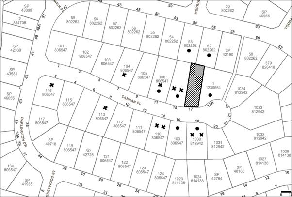
|
NOTIFICATION PLAN |
|
||
|
• PROPERTIES NOTIFIED
|
X SUBMISSIONS RECEIVED |
PROPERTY SUBJECT OF DEVELOPMENT |
|
Ten submissions objected to the development, generally on the grounds that the development would result in:
· Unacceptable privacy impacts, with particular reference to privacy impacts to No. 15 Cannan Close;
· Inconsistent dwelling house design;
· Construction damage; and
· Landscaping Impacts;
The merits of the matters raised in community submissions have been addressed in the body of the report with the exception of the following:
5.1.1 Construction Damage
Submissions raised concerns that the proposed development could cause damage to a retaining wall located on the adjoining property, No. 15 Cannan Close. To ensure that the proposed works do not contribute to instability of this wall, an appropriate condition of consent has been recommended in Schedule 1 of this report for a dilapidation report to be prepared prior to construction commencing on site.
5.2 Public Agencies
The development application was not required to be referred to any Public Agencies for comment.
6. THE PUBLIC INTEREST
Section 4.15(1)(e) of the Act requires Council to consider “the public interest”.
The public interest is an overarching requirement, which includes the consideration of the matters discussed in this report. Implicit to the public interest is the achievement of future built outcomes adequately responding to and respecting the future desired outcomes expressed in environmental planning instruments and development control plans.
The application is considered to have satisfactorily addressed Council’s criteria and would provide a development outcome that, on balance, would result in a positive impact for the community. Accordingly, it is considered that the approval of the proposed development would be in the public interest.
CONCLUSION AND STATEMENT OF REASONS
The application proposes the construction of a dwelling house, driveway and associated landscaping.
The development complies with the provisions of the Hornsby Local Environmental Plan 2013 and meets the desired outcomes within the Hornsby Development Control Plan 2013. The proposal has also been assessed as satisfactory, having regard to the matters for listed consideration under Section 79C of the Environmental Planning and Assessment Act, 1979.
Council received ten submissions during the public notification periods. The matters raised have been addressed in the body of the report and where appropriate, conditions have been recommended to minimise disruption to residential amenity.
Having regard to the circumstances of the case, approval of the application is recommended, subject to conditions.
The reasons for this recommendation are:
· The proposed development complies with the requirements of the relevant environmental planning instruments and the Hornsby Development Control Plan.
· The proposed development is consistent with the objectives of the State Governments “A Metropolis of Three Cities” - the Greater Sydney Region Plan and “North District Plan” by providing additional housing.
Note: At the time of the completion of this planning report, no persons have made a Political Donations Disclosure Statement pursuant to Section 10.4 of the Environmental Planning and Assessment Act 1979 in respect of the subject planning application.
RESPONSIBLE OFFICER
The officer responsible for the preparation of this Report is Ben Jones, who can be contacted on 9847 6799.
|
Caroline Maeshian Senior Town Planner - Major Applications Planning Division |
Rod Pickles Manager - Development Assessment Planning Division |
|
1.⇨ |
Locality Map |
|
|
|
2.⇨ |
Site Plan |
|
|
|
3.⇨ |
Floor Plans |
|
|
|
4.⇨ |
Landscape Plan |
|
|
|
5.⇨ |
Elevations and Sections |
|
|
|
6.⇨ |
Erosion and Analysis |
|
|
|
7.⇨ |
88B Instrument |
|
|
|
8.⇨ |
Compliant Concept Plan |
|
|
|
9.⇨ |
Architectural Certification |
|
|
File Reference: DA/1312/2017
Document Number: D07451058
SCHEDULE 1
GENERAL CONDITIONS
The conditions of consent within this notice of determination have been applied to ensure that the use of the land and/or building is carried out in such a manner that is consistent with the aims and objectives of the relevant legislation, planning instruments and Council policies affecting the land and does not disrupt the amenity of the neighbourhood or impact upon the environment.
Note: For the purpose of this consent, the term ‘applicant’ means any person who has the authority to act on or the benefit of the development consent.
Note: For the purpose of this consent, any reference to an Act, Regulation, Australian Standard or publication by a public authority shall be taken to mean the gazetted Act or Regulation, or adopted Australian Standard or publication as in force on the date that the application for a construction certificate is made.
1. Approved Plans and Supporting Documentation
The development must be carried out in accordance with the plans and documentation listed below and endorsed with Council’s stamp, except where amended by Council and/or other conditions of this consent:
|
Plan No. |
Plan Title |
Drawn by |
Dated |
|
2 (Issue F) |
Site Plan |
Rawson Homes |
31.07.17 |
|
3 (Issue F) |
Ground Floor Plan |
Rawson Homes |
31.07.17 |
|
4 (Issue F) |
First Floor Plan |
Rawson Homes |
31.07.17 |
|
5 (Issue F) |
Elevations 1-2 |
Rawson Homes |
31.07.17 |
|
6 (Issue F) |
Elevations 3-4 |
Rawson Homes |
31.07.17 |
|
7 (Issue F) |
Sections |
Rawson Homes |
31.07.17 |
|
10 (Issue F) |
Erosion / Analysis |
Rawson Homes |
31.07.17 |
|
L01 (Issue B) |
Landscape Plan |
Susan Read Landscapes |
21/11/2017 |
|
L02 (Issue B) |
Landscape Details |
Susan Read Landscapes |
21/11/2017 |
|
Document Title |
Prepared by |
Dated |
|
BASIX Certificate |
Energy Ratings Australia Pty Ltd |
28 March 2018 |
2. Removal of Existing Trees
a) This development consent permits the removal of six trees as identified on the approved Landscape Plan, prepared by Susan Read Landscapes, and dated 21/11/2017.
b) The removal of any other trees requires separate approval in accordance with the Tree and Vegetation Chapter 1B.6 Hornsby Development Control Plan 2013.
3. Construction Certificate
a) A Construction Certificate is required to be approved by Council or a Private Certifying Authority prior to the commencement of any works under this consent.
b) The Construction Certificate plans must not be inconsistent with the Development Consent plans.
REQUIREMENTS PRIOR TO THE ISSUE OF A CONSTRUCTION CERTIFICATE
4. Building Code of Australia
All approved building work must be carried out in accordance with the relevant requirements of the Building Code of Australia.
5. Contract of Insurance (Residential Building Work)
Where residential building work for which the Home Building Act 1989 requires there to be a contract of insurance in force in accordance with Part 6 of that Act, this contract of insurance must be in force before any building work authorised to be carried out by the consent commences.
6. Notification of Home Building Act 1989 Requirements
Residential building work within the meaning of the Home Building Act 1989 must not be carried out unless the principal certifying authority for the development to which the work relates (not being Council) has given Council written notice of the following information:
a) In the case of work for which a principal contractor is required to be appointed:
i) The name and licence number of the principal contractor; and
ii) The name of the insurer by which the work is insured under Part 6 of that Act.
b) In the case of work to be done by an owner-builder:
i) The name of the owner-builder; and
ii) If the owner-builder is required to hold an owner-builder’s permit under that Act, the number of the owner-builder’s permit.
Note: If arrangements for doing the residential building work are changed while the work is in progress so that the information notified becomes out of date, further work must not be carried out unless the principal certifying authority for the development to which the work relates (not being Council) has given Council written notification of the updated information.
7. Sydney Water – Approval
This application must be submitted to Sydney Water for approval to determine whether the development would affect any Sydney Water infrastructure, and whether further requirements are to be met.
Note: Building plan approvals can be obtained online via Sydney Water Tap inTM through www.sydneywater.com.au under the Building and Development tab.
8. Stormwater Drainage
The stormwater drainage system for the development must be designed for an average recurrence interval (ARI) of 20 years and be gravity drained to the existing inter-allotment drainage system.
9. Internal Driveway/Vehicular Areas
The driveway and parking areas on site must be designed, in accordance with Australian Standards 2890.1, 2890.2, 3727 and the following requirements:
a) Design levels at the front boundary shall be obtained from Council if a private accredited certifier is engaged to obtain a construction certificate for these works.
b) Design levels at the front boundary be obtained from Council.
c) The driveway be a rigid pavement.
d) The driveway grade must not exceed 25 percent and changes in grade must not exceed 8 percent.
10. Vehicular Crossing
A separate application under the Local Government Act 1993 and the Roads Act 1993 must be submitted to Council for the installation of a new vehicular crossing and the removal of the redundant crossing. The vehicular crossing must be constructed in accordance with Council’s Civil Works Design 2005 and the following requirements:
a) Design levels at the front boundary must be obtained from Council for the design on the internal driveway;
b) Any redundant crossings must be replaced with integral kerb and gutter;
c) The footway area must be restored by turfing;
Note: An application for a vehicular crossing can only be made to one of Council’s Authorised Vehicular Crossing Contractors. You are advised to contact Council on 02 9847 6940 to obtain a list of contractors.
REQUIREMENTS PRIOR TO THE COMMENCEMENT OF ANY WORKS
11. Erection of Construction Sign
a) A sign must be erected in a prominent position on any site on which any approved work is being carried out:
i) Showing the name, address and telephone number of the principal certifying authority for the work;
ii) Showing the name of the principal contractor (if any) for any demolition or building work and a telephone number on which that person may be contacted outside working hours; and
iii) Stating that unauthorised entry to the work site is prohibited.
b) The sign is to be maintained while the approved work is being carried out and must be removed when the work has been completed.
12. Protection of Adjoining Areas
A temporary hoarding, fence or awning must be erected between the work site and adjoining lands before the works begin and must be kept in place until after the completion of the works if the works:
a) Could cause a danger, obstruction or inconvenience to pedestrian or vehicular traffic;
b) Could cause damage to adjoining lands by falling objects; and/or
c) Involve the enclosure of a public place or part of a public place.
Note: Notwithstanding the above, Council’s separate written approval is required prior to the erection of any structure or other obstruction on public land.
13. Toilet Facilities
a) To provide a safe and hygienic workplace, toilet facilities must be available or be installed at the works site before works begin and must be maintained until the works are completed at a ratio of one toilet for every 20 persons employed at the site.
b) Each toilet must:
i) be a standard flushing toilet connected to a public sewer; or
ii) be a temporary chemical closet approved under the Local Government Act 1993; or
iii) have an on-site effluent disposal system approved under the Local Government Act 1993.
Before the commencement of works, a ‘Dilapidation Report’ is to be prepared by a ‘chartered structural engineer’ detailing the structural condition of all retaining walls located adjacent to the eastern boundary of the adjoining property, known as 15 Cannan Close Cherrybrook.
15. Erosion and Sediment Control
To protect the water quality of the downstream environment, erosion and sediment control measures must be provided and maintained throughout the construction period in accordance with the manual ‘Soils and Construction 2004 (Bluebook)’, the approved plans, Council specifications and to the satisfaction of the principal certifying authority. The erosion and sediment control devices must remain in place until the site has been stabilised and revegetated.
Note: On the spot penalties may be issued for any non-compliance with this requirement without any further notification or warning.
REQUIREMENTS DURING DEMOLITION AND CONSTRUCTION
16. Construction Work Hours
All works on site, including demolition and earth works, must only occur between 7am and 5pm Monday to Saturday.
No work is to be undertaken on Sundays or public holidays.
17. Environmental Management
To prevent sediment run-off, excessive dust, noise or odour emanating from the site during the construction, the site must be managed in accordance with the publication ‘Managing Urban Stormwater – Landcom (March 2004) and the Protection of the Environment Operations Act 1997.
18. Council Property
To ensure that the public reserve is kept in a clean, tidy and safe condition during construction works, no building materials, waste, machinery or related matter is to be stored on the road or footpath.
Note: This consent does not give right of access to the site via Council’s park or reserve. Should such access be required, separate written approval is to be obtained from Council.
19. Disturbance of Existing Site
During construction works, the existing ground levels of open space areas and natural landscape features, (including natural rock-outcrops, vegetation, soil and watercourses) must not be altered unless otherwise nominated on the approved plans.
20. Landfill
Landfill must be constructed in accordance with Council’s ‘Construction Specification 2005’ and the following requirements:
a) Prior to fill material being imported to the site, a certificate shall be obtained from a suitably qualified environmental consultant confirming the fill wholly consists of Virgin Excavated Natural Material (VENM) as defined in Schedule 1 of the Protection of the Environment Operations Act 1997 or material approved under the Department of Environment and Climate Change’s general resource recovery exemption.
b) A compaction certificate is to be obtained from a suitably qualified geotechnical engineer verifying that the specified compaction requirements have been met.
c) These certificates must be included with the application for an occupation certificate.
21. Excavated Material
All excavated material removed from the site must be classified by a suitably qualified person in accordance with the Department of Environment, Climate Change and Water NSW Waste Classification Guidelines and Protection of the Environment Operations (Waste) Regulation 2014 prior to disposal to an approved waste management facility and tipping dockets submitted to the Principal Certifier prior to the issue of an Occupation Certificate
22. Survey Report
A report(s) must be prepared by a registered surveyor and submitted to the principal certifying authority;
a) Prior to the pouring of concrete at each level of the building certifying that:
i) The building, retaining walls and the like have been correctly positioned on the site; and
ii) The finished floor level(s) are in accordance with the approved plans.
REQUIREMENTS PRIOR TO THE ISSUE OF AN OCCUPATION CERTIFICATE
Note: For the purpose of this consent, a reference to ‘occupation certificate’ shall not be taken to mean an ‘interim occupation certificate’ unless otherwise stated:
23. Fulfilment of BASIX Commitments
The applicant must demonstrate the fulfilment of BASIX commitments pertaining to the development.
24. Damage to Council Assets
To protect public property and infrastructure, any damage caused to Council’s assets as a result of the construction or demolition of the development must be rectified by the applicant in accordance with Council’s Civil Works Specifications. Rectification works must be undertaken prior to the issue of an Occupation Certificate, or sooner, as directed by Council.
25. Retaining Walls
All required retaining walls must be constructed as part of the development.
26. Installation of Air Conditioner
a) To protect the amenity of adjacent properties, the condenser unit for the air conditioner must be sited a minimum of 3 metres from the property boundary of any adjoining residential premises.
b) Alternatively, a certificate must be submitted to the PCA by a suitably qualified person confirming that the unit has been tested for heating and cooling on the highest settings and that the noise levels generated do not exceed 5 dB(A) above background noise levels when tested at the property boundary between 8 pm and 10 pm.
27. Replacement Tree Requirements
a) All trees approved to be removed as part of this consent must be replaced by a minimum of 3 trees.
b) Location and Size of Plantings
i) Two of the replacement trees must be located in front or rear setbacks of the development site and planted 4 metres or greater from the foundation walls of the approved development.
ii) To maintain the streetscape character of Cannan Close, the third tree must be planted in the road reserve in front of the development site.
iii) The pot size of the replacement tree(s) must be a minimum 25 litres
iv) All replacement tree(s) must be a minimum of 3 metres in height with calliper consistent with those prescribed in the NATSPEC guidelines.
v) All replacement trees must have the potential to reach a mature height greater than 10 metres.
vi) All tree stock must meet the specifications outlined in ‘Specifying Trees’ by Ross Clark, Publisher NATSPEC Books).
vii) Planting methods must meet professional (best practice) industry standards
c) The suitably qualified person holding a certificate III in Horticulture must submit to the principal certifying authority a Statement/or/Certification confirming all Tree Replacement Requirements have been completed in accordance with approved landscape plans and conditions of consent.
- END OF CONDITIONS -
ADVISORY NOTES
The following information is provided for your assistance to ensure compliance with the Environmental Planning and Assessment Act 1979, Environmental Planning and Assessment Regulation 2000, other relevant legislation and Council’s policies and specifications. This information does not form part of the conditions of development consent pursuant to Section 4.17 of the Act.
Environmental Planning and Assessment Act 1979 Requirements
The Environmental Planning and Assessment Act 1979 requires:
· The issue of a construction certificate prior to the commencement of any works. Enquiries can be made to Council’s Customer Services Branch on 9847 6760;
· a principal certifying authority to be nominated and Council notified of that appointment prior to the commencement of any works;
· Council to be given at least two days written notice prior to the commencement of any works;
· mandatory inspections of nominated stages of the construction inspected; and
· an occupation certificate to be issued before occupying any building or commencing the use of the land.
Long Service Levy
In accordance with Section 34 of the Building and Construction Industry Long Service Payments Act 1986, a ‘Long Service Levy’ must be paid to the Long Service Payments Corporation or Hornsby Council.
Note: The rate of the Long Service Levy is 0.35% of the total cost of the work.
Note: Hornsby Council requires the payment of the Long Service Levy prior to the issue of a construction certificate.
Tree and Vegetation Preservation
In accordance with Clause 5.9 of the Hornsby Local Environmental Plan 2013 a person must not ringbark, cut down, top, lop, remove, injure or wilfully destroy any tree or other vegetation protected under the Hornsby Development Control Plan 2013 without the authority conferred by a development consent or a permit granted by Council.
Notes: A tree is defined as a long lived, woody perennial plant with one or relatively few main stems with the potential to grow to a height greater than three metres (3M). (HDCP 1B.6.1.c).
Tree protection measures and distances are determined using the Australian Standard AS 4970:2009, “Protection of Trees on Development Sites”.
Fines may be imposed for non-compliance with both the Hornsby Local Environmental Plan 2013 and the Hornsby Development Control Plan 2013.
Covenants
The land upon which the subject building is to be constructed may be affected by restrictive covenants. Council issues this approval without enquiry as to whether any restrictive covenant affecting the land would be breached by the construction of the building, the subject of this consent. Applicants must rely on their own enquiries as to whether or not the building breaches any such covenant.
Dial Before You Dig
Prior to commencing any works, the applicant is encouraged to contact Dial Before You Dig on 1100 or www.dialbeforeyoudig.com.au for free information on potential underground pipes and cables within the vicinity of the development site.
Asbestos Warning
Should asbestos or asbestos products be encountered during demolition or construction works, you are advised to seek advice and information prior to disturbing this material. It is recommended that a contractor holding an asbestos-handling permit (issued by Safework NSW) be engaged to manage the proper handling of this material. Further information regarding the safe handling and removal of asbestos can be found at:
Alternatively, telephone the Safework NSW Asbestos and Demolition Team on 8260 5885.


