
BUSINESS PAPER
Local Planning Panel meeting
Wednesday 25 July 2018
at 6:30pm

BUSINESS PAPER
Local Planning Panel meeting
Wednesday 25 July 2018
at 6:30pm
Hornsby Shire Council Table of Contents
Page 1
GENERAL BUSINESS
Local Planning Panel
Item 1 LPP20/18 Development Application - Proposed Subdivision One Lot Into Seven - 62 Manor Road, Hornsby..................................................................................................................... 1
Item 2 LPP24/18 Further Report - Alterations and Additions To a Dwelling House and Change of Use To a 24 Place Childcare Centre - 41 Denison Street, Hornsby.............................................. 20
Item 3 LPP26/18 Further Report - Animal Boarding Establishment and Use of Horse Arena for Private Recreational Purposes - 35 Blacks Road, Arcadia....................................................... 59
LPP Report No. LPP20/18
Local Planning Panel
Date of Meeting: 25/07/2018
1 DEVELOPMENT APPLICATION - PROPOSED SUBDIVISION ONE LOT INTO SEVEN - 62 MANOR ROAD, HORNSBY
EXECUTIVE SUMMARY
|
DA No: |
DA/151/2018 (Lodged on 23 February 2018) |
|
Description: |
Demolition of existing structures and Community Title subdivision of one lot into seven residential lots and one community lot |
|
Property: |
Lot 3 DP 524288, No. 62 Manor Road, Hornsby |
|
Applicant: |
Dr Peter Alexander Robinson |
|
Owner: |
Dr Peter Alexander Robinson |
|
Estimated Value: |
$500,000 |
|
Ward: |
A |
· The application involves demolition of existing structures and Community Title subdivision of one lot into seven residential lots and one community lot.
· The proposed residential subdivision is inconsistent with the Hornsby Local Environmental Plan 2013 provisions for land zoned RE1 Public Recreation and with Council’s policies for community land. The proposal is integrated development for which approval of the NSW Rural Fire Service has not been obtained for residential subdivision in a bushfire prone area. The proposal does not meet the Hornsby Development Control 2013 criteria for urban subdivision, accessway design, tree protection and biodiversity.
· 34 submissions have been received in respect of the application.
· The development application is subject to an appeal in the Land and Environment Court against Council’s deemed refusal of the application.
· It is recommended that the application be refused.
|
THAT Development Application No. DA/151/2018 for demolition of existing structures and Community Title subdivision of one lot into seven residential lots plus one community lot at Lot 3 DP 524288, No. 62 Manor Road, Hornsby be refused on the grounds detailed in Schedule 1 of LPP Report No. LPP20/18. |
BACKGROUND
The proposed subdivision is integrated development subject to General Terms of Approval of the NSW Rural Fire Service for the issue of a Bush Fire Safety Authority pursuant to Section 100B of the Rural Fires Act 1997.
On 17 April 2018 the NSW Rural Fire Service (NSW RFS) advised Council the proposal does not conform to requirements for multi lot residential subdivision in bush fire prone areas.
On 8 May 2018 the applicant filed an appeal in the Land and Environment Court against Council’s deemed refusal of the development application (Case No. 2018/00143762).
SITE
The site comprises an existing battle axe lot with an area of 1.083 hectares. The lot handle has a length of 38.1m and a frontage of 12.19m to the north western side of Manor Road. The lot has an overall width of 48.765m and a maximum depth of 277.05m.
The site includes two existing single storey detached dwellings.
The lot occupies a steep north facing slope with a more even gradient on the upper part of the site which includes the access handle off Manor Road. The site has an average fall of 25% to the rear boundary. The site topography slopes down to Berowra Creek 110m north-west of the site.
The upper part of the site is zoned R2 Low Density Residential involving an area of approximately 5,176m2. The steeper lower part of the site is zoned RE1 Public Recreation and is identified as land subject to acquisition for public purposes under the Hornsby Local Environmental Plan 2013.
The majority of the lower and middle part of the site is natural bushland identified as Peppermint-Angophora Forest. The rear boundary of the site adjoins the Berowra Valley National Park which occupies an extensive area of sandstone ridges and the Berowra Creek valley to the north, west and south of the site.
The site is within a bush fire prone area.
The surrounding properties include dwelling houses accessed off Manor Road. The subdivision pattern of original lots fronting Manor Road such as the subject site has been modified by later battle-axe subdivisions.
The site is in the vicinity of items of heritage including Item No. 466 – Sandstone fence, No. 2 Dilkera Close, Item No. 467 – House, No. 4 Dilkera Close and Item No. 494 – Street trees, Manor Road Road Reserve.
The Mount Wilga Private Rehabilitation Hospital and the Hornsby Rifle Range are located off Rosamond Street, 650m north-east of the site. The Diatreme Hornsby Quarry is located 300m south-east of the site.
The site is located 1.4 km north-west of Hornsby Railway Station.
PROPOSAL
The proposal is for the demolition of existing dwellings and the Community Title subdivision of one lot into seven residential lots and a community lot for the proposed accessway and residue bushland open space area.
The proposed lots are detailed as follows:
|
Lot No |
Area |
Description |
|
1 |
500.85m2 |
Triangular shaped lot with a frontage of 30m a maximum depth of 25m and an average fall of 4% to the accessway. The lot includes Tree No. 9 – Angophora costata (Sydney Red Gum) which would be removed. |
|
2 |
540.34m2 |
Irregular shaped lot with a frontage of 12m a depth of 30m and an average fall of 5% to the accessway. The lot includes Tree No. 17 – Cupressus (Cypress), Tree No. 18 – Angophora costata (Sydney Red Gum), Tree No. 19 – Eucalyptus resinifera (Red Mahogany) and Tree No. 20 – Angophora costata (Sydney Red Gum). Trees Nos. 17, 18 and 19 would be removed. |
|
3 |
501.6m2 |
Irregular shaped lot with a frontage of 41.19m and a maximum depth of 20m. The lot has an average fall of 10% to the accessway. The lot includes Tree No. 25 – Ligustrum lucidum (Large Leaf Privet), and adjoining Tree No. 26 - Angophora costata (Sydney Red Gum) and Tree No. 27 – Jacaranda. Tree No. 25 would be removed. |
|
4 |
1,050.2m2 (incl ROW turning head) |
Triangular shaped lot with partial frontage to the accessway which includes the accessway turning head (56m2). The lot includes land zoned RE1 Public Recreation (approx. 518m2) subject to acquisition. The lot has an average gradient of 24% to the northern boundary. The lot includes Trees Nos. 41, 53, 44, 45, 46, 47, 48, 49, 52, 53, 54, 55, 56, 57, 69, 70, 71, 72, 73, 74, 75, 76, 77, 78, 79, 80, 90, 90.1 and 91. Trees Nos. 41, 43, 44, 45, 46, 47, 48, 49, 53, 54, 55, 56, 70, 80, 90, 90.1 and 91 would be removed (Refer AIA - Footprint Green). |
|
5 |
648.28m2 |
Generally uniform shaped lot with a frontage of 13.31m to the accessway and a depth of 42.05+m. The lot includes an area of approx. 48m2 zoned RE1 Public Recreation subject to acquisition. The lot has an average gradient of 28% to the rear boundary. The lot includes Trees Nos. 34, 35, 37, 38, 39, 40, 40.1, 42, 58, 59, 62, 63, 64, 65 and 66. Trees Nos. 34, 35, 37, 38, 39, 40, 40.1, 42, 58, 59, 64 and 65 would be removed (Refer AIA - Footprint Green). |
|
6 |
624.45m2 |
Irregular shaped lot with a frontage of 12.0m to the accessway. The lot has a maximum depth of 35.02m at the rear boundary. The lot has an average gradient of 30% to the north east corner. The lot includes Trees Nos. 22, 23, 24, 28, 29, 30, 31, 32, 33, 34, 36, 60, 61 and 61.1. Trees Nos. 22, 23, 24, 33, 34, and 36 would be removed (Refer AIA - Footprint Green). |
|
7 |
539.83m2 |
Irregular shaped lot with a frontage of 42.93m to the accessway. The lot has a maximum depth of 21m and an average fall of 6% to the north east corner. The lot includes Trees Nos. 11, 12, 13, 14 and 21. Trees Nos. 31 and 21 would be removed (Refer AIA - Footprint Green). |
|
Community Lot |
6,422.5m2 |
The lot includes the existing handle, the proposed accessway and the residue bushland area of the site. The proposed accessway has a width of 7.5m and a pavement width of 6.5m. The accessway and handle includes Trees Nos. 1, 2, 3, 4, 5, 6, 7, 8, 10, 15 and 16. Trees Nos. 2, 3, 6, 7, 8, 10, 15 and 16 would be removed. |
The proposal involves the creation of an Asset Protection Zone (APZ) for Bush Fire Protection which includes the creation of an easement for bushfire protection over adjoining lands owned by Hornsby Shire Council including Lot 3 DP 543342, Lot 3 DP 543562 and Lot 7 DP 826842.
The proposed APZ involves the removal of Trees Nos. 49, 50, 68, 83, 85, 92, 94, 95, 98, 104, 105, 109, 113, 114, 114.1, 115, 118, 125, 130, 131, 139, 142 and 152.
ASSESSMENT
The development application has been assessed having regard to the Greater Sydney Region Plan - A Metropolis of Three Cities, the North District Plan and the matters for consideration prescribed under Section 4.15 of the Environmental Planning and Assessment Act 1979 (the Act). The following issues have been identified for further consideration.
1. STRATEGIC CONTEXT
1.1 Greater Sydney Region Plan - A Metropolis of Three Cities and North District Plan
The Greater Sydney Region Plan - A Metropolis of Three Cities has been prepared by the NSW State Government to guide land use planning decisions for the next 40 years (to 2056). The Plan sets a strategy and actions for accommodating Sydney’s future population growth and identifies dwelling targets to ensure supply meets demand. The Plan also identifies that the most suitable areas for new housing are in locations close to jobs, public transport, community facilities and services.
The NSW Government will use the subregional planning process to define objectives and set goals for job creation, housing supply and choice in each subregion. Hornsby Shire has been grouped with Hunters Hill, Ku-ring-gai, Lane Cove, Mosman, North Sydney, Ryde, Northern Beaches and Willoughby to form the North District. The Greater Sydney Commission has released the North District Plan which includes priorities and actions for Northern District for the next 20 years. The identified challenge for Hornsby Shire will be to provide an additional 4,350 dwellings by 2021 with further strategic supply targets to be identified to deliver 97,000 additional dwellings in the North District by 2036.
The proposed development would be consistent with the Greater Sydney Region Plan - A Metropolis of Three Cities and the North District Plan, by contributing to achieving the dwelling targets for the region.
2. STATUTORY CONTROLS
Section 4.15(1)(a) requires Council to consider “any relevant environmental planning instruments, draft environmental planning instruments, development control plans, planning agreements and regulations”.
2.1 Hornsby Local Environmental Plan 2013
The proposed development has been assessed having regard to the provisions of the Hornsby Local Environmental Plan 2013 (HLEP).
2.1.1 Zoning of Land and Permissibility
The subject land is zoned R2 Low Density Residential and RE1 Public Recreation under the HLEP.
The objectives of the R2 Low Density Residential zone are:
· To provide for the housing needs of the community within a low density residential environment.
· To enable other land uses that provide facilities or services to meet the day to day needs of residents.
The objectives of the RE1 Public Recreation zone are:
· To enable land to be used for public open space or recreational purposes.
· To provide a range of recreational settings and activities and compatible land uses.
· To protect and enhance the natural environment for recreational purposes.
· To protect and maintain areas of bushland that have ecological value.
The proposed development is defined as ‘subdivision of land’ pursuant to Section 6.2 of the Environmental Planning and Assessment Act 1979 and is permissible in the R2 zone with Council’s consent.
The use of RE1 Public Recreation zoned land for residential purposes is prohibited under the HLEP.
2.1.2 Minimum Subdivision Lot Size For Community Title Schemes
Clause 4.1AA applies to the R2 Low Density Residential zone and requires a minimum lot size of 500m2 for an allotment within a Community Title scheme other than a community lot.
The proposed Lots 1, 2, 3, 5, 6 and 7 would comply with the minimum lot size area requirement of 500m2 for land zoned R2 Low Density Residential.
Proposed Lot 4 has an area of 1,050.2m2. The lot area includes an area of 518m2 zoned RE1 Public Recreation which is not land subject to Clause 4.1AA and is subject to Land Reservation Acquisition. The R2 zoned area of the lot includes a 56m2 ROW area for the proposed accessway turning head which should be excluded from the lot area. The exclusion of the two areas would result in a residential zoned area of 476.2m2.
Proposed Lot 4 is questioned in respect to compliance with the minimum subdivision lot size for land zoned R2 Low Density Residential.
2.1.3 Land Reservation Acquisition
Clause 5.1 identifies State authorities responsible for acquisition of lands identified on the Land Reservation Acquisition Map as land reserved for a public purpose. The site includes land zoned RE1 Public Recreation which is identified on the Land Reservation Acquisition Map for acquisition for Local Open Space. Council is the responsible authority for the acquisition.
Acquisition is subject to the owner-initiated acquisition provisions of the Land Acquisition (Just Terms Compensation) Act 1991 pursuant to Part 2 Division 3 of that Act. The submitted Statement of Environmental Effects states that pursuant to Clause 5.1 of the HLEP the proposal is for Council to acquire the area of unmodified land located at the rear part of the site.
The applicant’s proposal would include Land Reservation Acquisition/RE1 Public Recreation zoned land within proposed Lot 4 (approx. 518m2) and proposed Lot 5 (approx. 48m2). The proposed residential use of the RE1 Public Recreation zoned land for a future dwelling house would be prohibited development within the RE1 zone under HLEP and inconsistent with the reservation of the land for acquisition for Local Open Space.
2.1.4 Heritage Conservation
Clause 5.10 of the HLEP sets out heritage conservation provisions for Hornsby Shire.
The subject site is located in the vicinity of a number of listed heritage items under Schedule 5 of the HLEP as follows:
· Item No. 466 – Sandstone fence, No. 2 Dilkera Close, Hornsby;
· Item No.467 – House, No.4 Dilkera Close Hornsby; and
· Item No.494 – Street trees, Manor Road, Hornsby.
Council’s heritage assessment of the application in accordance with the guidelines of the Hornsby Development Control Plan 2013 (HDCP) noted the following:
Heritage Items in the vicinity
The subject site is located in close proximity to the heritage listed street trees within Manor Road. The street trees are listed for the following significance:
“The tall native trees along Manor Road form an integral part of the local visual catchment along this prominent ridgeline. The group is dominated by Blackbutt (Eucalyptus pilularis), Smooth-barked Apple (Angophora costata) and Turpentine (Syncarpia glomulifera). These remnant components (including canopy, sub-canopy and understorey species) are typical of the Blackbutt Gully Forest community. Although common within the Hornsby Shire, this community is poorly conserved outside the local area. Blackbutt Gully Forest is considered to be of local significance in Hornsby Shire (Smith & Smith 2007 and HSBCS 2006). This community has previously been described as Western Sandstone Gully Forest (DE&CC 2002) and Sydney Sandstone Gully Forest (Map Unit 10agii) (Benson & Howell 1994). The Manor Road group has significance in terms of its natural, representative, rarity, ecological/ biodiversity, genetic, visual and aesthetic values. Manor Road traverses the steep ridgeline overlooking Old Mans Valley (to the south) and this remnant community makes an important visual and aesthetic contribution to the natural bushland character of this area.”
The heritage inventory sheet also notes the following in the physical description heading: “This native tree group has been retained/ protected within the public verges and adjoining private gardens along Manor Road. Native canopy species include the following:- Smooth-barked Apple (Angophora costata); Blackbutt (Eucalyptus pilularis); Red Mahogany (Eucalyptus resinifera subsp. resinifera); and Turpentine (Syncarpia glomulifera.”
The proposal in its current form is not strictly in accordance with Part 9.4.1 (Development in the Vicinity of Heritage) of the HDCP. The front portion of the site contains a number of canopy trees which are all being removed for the proposed accessway and community lot (Trees Nos 2, 3 and 8). These trees although not individually listed form part of the setting of the heritage item (Manor Road street trees) and are also remnant forest species. It is preferable that as many of these trees be retained where possible.
Indigenous/Aboriginal Heritage
The subject site below the two existing detached dwellings is highly vegetated, contains rock ledges/outcrops, steep terrain, forest and is within 200 metres of Berowra Creek within the adjoining Berowra Valley National Park. An assessment of Aboriginal Heritage has not been submitted with the application for referral to the Hornsby Aboriginal and Torres Strait Islander Consultative Committee, in accordance with Part 9.5 of the HDCP.
Council’s heritage assessment concluded that the proposed subdivision would have a negative impact on the setting of the heritage listed street trees within Manor Road.
2.1.5 Earthworks
Clause 6.2 of the HLEP states that consent is required for proposed earthworks on site. Before granting consent for earthworks, Council is required to ensure the earthworks will not have a detrimental impact on environmental functions and processes, neighbouring uses, cultural or heritage items or features of the surrounding land.
The proposed subdivision includes lots with gradients exceeding 20%. The sandstone formation of the site would generally provide for stable foundation subject to geotechnical design for future dwellings and the proposed accessway.
The site includes rock outcrops subject to heritage impact assessment for Aboriginal culture. Refer to discussion in Section 2.1.3.
The impact of the proposed subdivision on potential Aboriginal heritage has not been assessed.
2.2 State Environmental Planning Policy No. 55 – Remediation of Land
The application has been assessed against the requirements of State Environmental Planning Policy No. 55 – Remediation of Land under which consent must not be granted to the carrying out of any development on land unless the consent authority has considered whether the land is contaminated or requires remediation for the proposed use.
A search of Council records including aerial photographs reveals that the property has been used exclusively for residential purposes with no record of site contamination.
No further assessment is warranted in this regard.
2.3 Sydney Regional Environmental Plan No. 20 – Hawkesbury – Nepean River
The site is located within the catchment of the Hawkesbury Nepean River. Part 2 of this Plan contains general planning considerations and strategies requiring Council to consider the impacts of development on water quality, aquaculture, recreation and tourism.
Subject to the implementation of sediment and erosion control measures and stormwater management to protect water quality, the proposal would comply with the requirements of the Policy.
2.4 Rural Fires Act 1997
The proposed development is within a bushfire prone area and is subject to the approval of the NSW Rural Fire Service (RFS) for the issue of a Bushfire Safety Authority pursuant to Section 100B of the Rural Fire Act 1997.
In this regard the NSW Rural Fire Service in a letter to Council dated 17 April 2018 advised as follows:
The proposal in its current form does not conform to the specifications, or justify any deviations from, the requirements of the NSW RFS Fact Sheet ‘Multi Lot Residential Subdivisions in Bush Fire Prone Areas’. The NSW RFS requests the consultant to review their assessment and re-lodge it through Council for further consideration.
Furthermore, the proposed asset protection zones as an easement upon Council land requires confirmation from Hornsby Council to verify the willingness of Council to accept the applicant or Council to manage the land.
The proposal involves the creation of an Asset Protection Zone (APZ) for Bush Fire Protection which includes the creation of an easement for bushfire protection over adjoining lands owned by Hornsby Shire Council including Lot 3 DP 543342, Lot 3 DP 543562 and Lot 7 DP 826842. These lands form part of the Arrionga Place Bushland Natural Area which is classified as Community Land under the Local Government Act 1993 and administered by Council under the Generic Plan of Management for Community Land and Crown Reserves Planning District Three and Nine. Section 3.5 of Part II of the Management Plan provides for bush fire management and states that asset protection zones in new land releases, subdivisions and developments are provided on private property in areas adjoining bushland reserves.
The HDCP includes prescriptive requirement in Section 1C.1.1 for bushfire protection measures to be on private land not on public land zoned for public open space.
The proposed APZs over the adjoining bushland reserves are contrary to the Council’s Plan of Management for Community Land and HDCP.
Council has advised the RFS that Council would not support the granting of an easement for the proposed APZ over Council land and also of the appeal in the Land and Environment Court against Council’s deemed refusal of the application.
2.5 Guidelines for Developments Adjoining Land Managed by the Office of Environment and Heritage (OEH Guidelines)
The northern boundary of the site adjoins the Berowra Valley National Park.
The OEH Guidelines address issues to be considered by Council’s when assessing development applications, to minimise impacts on the natural environment of National Parks, to protect flora and fauna, natural features and cultural landscapes.
The proposed subdivision would involve substantial modification of Peppermint-Angohora Forest vegetation community adjoining the national park. The submitted Statement of Environmental Effects has not addressed the OEH Guidelines in respect to the proposed impacts on the adjoining National Park.
2.6 Section 3.42 Environmental Planning and Assessment Act, 1979 - Purpose and Status of Development Control Plans
In accordance with Section 3.42 of the Environmental Planning and Assessment Act, 1979, a DCP provision will have no effect if it prevents or unreasonably restricts development that is otherwise permitted and complies with the development standards in relevant Local Environmental Plans and State Environmental Planning Policies.
The principal purpose of a development control plan is to provide guidance on the aims of any environmental planning instrument that applies to the development; facilitate development that is permissible under any such instrument; and achieve the objectives of land zones. The provisions contained in a DCP are not statutory requirements and are for guidance purposes only. Consent authorities have flexibility to consider innovative solutions when assessing development proposals, to achieve good planning outcomes.
2.7 Hornsby Development Control Plan 2013
The proposed development has been assessed having regard to the relevant desired outcomes and prescriptive requirements within the Hornsby Development Control Plan 2013 (HDCP).
2.7.1 Residential Lands Subdivision
The proposed subdivision site includes significant trees and steep landform. The site includes an exposed sandstone rock formation which forms a significant landscape feature across the site.
The proposed lots whilst meeting the HDCP minimum lot size area requirement of 500m2 are irregular in shape, include steeply sloping land and large trees. The HDCP requires a 500m2 lot to have a minimum lot width of 12m. The proposed lots include irregular triangular shaped areas less than 12m in width including 60m2 of Lot 1, 70m2 of Lot 3, and 40m2 of Lot 7, which would be less useable areas but areas that contribute to achievable floor space. The proposed indicative building envelopes for Lots 1, 2, 3 and 7 do not comply with the HDCP 5m rear setback requirement. Proposed Lots 5 and 6 would result in substantial landform modification and the loss of the sandstone landscape feature. The proposed lot size and shape does not have adequate regard to the site constraints including significant trees, steep slope and landscape features. The proposed lots would result in further environmental impacts given the maximum achievable floor area in accordance with the NSW Housing Code and HDCP is greater than the 200m2 indicative building envelope.
Proposed lots 4 and 5 include land zoned RE1 Public Recreation which is land where dwelling houses would not be permissible in accordance with HLEP. The inclusion of land zoned RE1 in residential subdivision would be prohibited development. Refer to discussion in Section 2.1.2 and Section 2.1.3.
The proposed lot design would be inconsistent with the pattern of adjoining residential lots and, given the site constraints, particularly Lots 4, 5 and 6, which would result in considerable landform modification, additional tree loss, impacts on amenity of adjoining residents and development inconsistent with the residential character of the area.
2.7.2 Accessway Design
The proposed accessway is 6.5m wide and has a length of 145m. An accessway width of 6.65m is required in accordance with HDCP.
The accessway gradient is steepest between chainage 100.00 and 145.00 which includes the accessway turning head. The turning head is subject to a ROC over proposed Lot 4.
The proposed turning head design would not allow Council’s heavy rigid vehicle (HRV) waste collection truck to manoeuvre forward in forward out and exceeds the gradient requirement for safe access for Council’s waste collection (12.5%).
The proposed accessway involves cut and fill works. The proposed turning heard adjoins the western boundary and would be above existing ground level in relation to the adjoining dwelling house. The operation of the proposed turning head would detract from the adjoining residential amenity.
Design details have not been submitted for proposed driveways off the steeper section of the accessway for proposed Lot 4 and Lot 5.
The proposed accessway design is non-compliant with the HDCP width requirement and design for HRV waste collection vehicle.
2.7.3 Stormwater Management
The proposed stormwater drainage system involves a trench dispersal system on land zoned RE1 Public Recreation within proposed Lot 4. The proposed use of the RE1 zoned land for residential development is prohibited pursuant to HLEP. Refer to discussion in Section 2.1.3.
The applicant has not demonstrated the proposed stormwater drainage and management system is satisfactory in respect to the HDCP requirements for Water Sensitive Urban Design and to maintain environmental flow rates.
The proposed stormwater drainage system is unsatisfactory in meeting the HDCP desired outcomes for stormwater management.
3. ENVIRONMENTAL IMPACTS
Section 4.15(1)(b) of the Act requires Council to consider “the likely impacts of that development, including environmental impacts on both the natural and built environments, and social and economic impacts in the locality”.
3.1 Natural Environment
3.1.1 Tree and Vegetation Preservation
The site contains Peppermint-Angophora Forest vegetation comprising remnant trees on the upper southern portion of the site and denser shrub and canopy tree cover on the lower northern portion of the site. Tree canopy across the site is generally connective providing a vegetated corridor between the northern and southern sides of Manor Road linking vegetation in the Berowra Valley National Park with Old Man’s Valley and Hornsby Quarry. The site is bounded on the north-east and south-west by Council bushland reserves and to the north-west by Berowra Valley National Park.
Significant clearing work has already occurred on the site under the RFS 10/50 Vegetation Clearing Code works, with numerous trees having been removed beyond the distances permitted by the Code. Clearing has also occurred on lands with slopes greater than 18 degrees. There are no Council records of any permits or development approvals for the removal of vegetation on the site.
The proposed subdivision would result in the removal of a minimum 75 trees not including understorey vegetation. As detailed in the submitted Arboricultural Impact Assessment, 50 percent of these trees are rated with a Safe Useful Life Expectancy (SULE) of 15 to 40 years and Moderate-Very High Landscape Value. The majority of the trees are proposed to be removed to accommodate future dwellings and APZ requirements rather than to remove hazardous or defective trees.
The placement of a stormwater level spreader within retained trees is also likely to result in tree impacts reducing their viability.
The proposed modification of vegetation for an APZ on RE1 Public Recreation zoned land for the purpose of residential subdivision is inconsistent with the HLEP objectives for the RE1 zoned land to protect and maintain areas of bushland that have ecological value and to protect and enhance the natural environment for recreational purposes. The proposed modification of vegetation for the creation of an APZ to enable residential subdivision is not consistent with the objectives of the RE1 zone.
The submitted Flora and Fauna Assessment notes the site as potential habitat for 13 threatened fauna species including 10 hollow dependent species. One threatened and hollow dependent species, the Powerful Owl, was observed on the site. Two hollow bearing trees and four stag trees would be removed within the development area. The site contains 1.11 hectares of Peppermint-Angophora Forest vegetation of which 0.81 hectares (73%) is proposed to be removed or modified. The loss of hollow bearing trees and the clearing of native vegetation are listed as key threatening processes under the Biodiversity Conservation Act 2016.
The submitted Arboricultural Impact Assessment states that there are 151 trees within the development footprint and on adjacent lands. The proposal would require the removal of 75 trees including four trees on adjacent properties. Six hollow bearing trees were tested for their structural integrity with only one tree identified as being compromised. It should also be noted that the proposed road and indicative dwelling construction would likely impact on several trees on adjoining properties.
The HDCP provides general controls for the protection of the natural environment in Section 1C.1.1 Biodiversity which outlines development control measures to conserve biodiversity and maintain habitat by avoiding fragmentation of vegetation and retaining environmental features. The proposed development is unsatisfactory in promoting biodiversity as the existing vegetation corridor would be discontinued by the proposed tree removal.
The application does not include any information to address how the proposed loss of vegetation and habitat could be offset or to have regard to Council’s Green Offsets Code.
The proposed development would result in the clearing or modification of 73% of vegetation on the site. The main reason for this impact is the scale of development and the requirement to provide an APZ over the subject property and adjoining lands. The extent of proposed works and associated impacts are inconsistent with the HDCP biodiversity measures to protect the natural environment.
3.1.2 Stormwater Management
The proposed stormwater drainage system is unsatisfactory in meeting the HDCP desired outcomes for stormwater management. Refer to Section 2.7.3.
3.2 Built Environment
3.2.1 Built Form
The proposed subdivision is inconsistent with the pattern of residential subdivision in the locality and would result in built form inconsistent with the character of the area.
3.2.2 Traffic
The proposed subdivision would generate 54 daily vehicle trips in accordance with the RMS Guide to Traffic Generating Developments.
The proposed traffic generation would not detract from the efficiency of the local road network.
3.3 Social Impacts
The proposed subdivision would provide additional housing opportunities in the locality.
3.4 Economic Impacts
The proposal would have a minor positive impact on the local economy in conjunction with other new low density residential development in the locality by generating an increase in demand for local services.
4. SITE SUITABILITY
Section 4.15(1)(c) of the Act requires Council to consider “the suitability of the site for the development”.
The subject site is bushfire prone land and adjoins bushland reserves and the Berowra Valley National Park. The site is considered to be constrained in accommodating the proposed development due to the need to provide bushfire protection measures with regard to the natural environment.
5. PUBLIC PARTICIPATION
Section 4.15(1)(d) of the Act requires Council to consider “any submissions made in accordance with this Act”.
5.1 Community Consultation
The proposed development was placed on public exhibition and was notified to adjoining and nearby landowners between 8 March 2018 and 7 April 2018 in accordance with the Notification and Exhibition requirements of the HDCP. During this period, Council received 34 submissions. The map below illustrates the location of those nearby landowners who made a submission that are in close proximity to the development site.
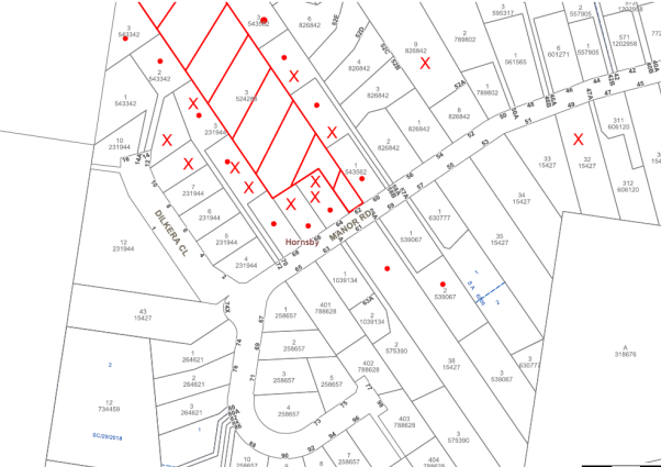
|
NOTIFICATION PLAN |
|
||
|
• PROPERTIES NOTIFIED
|
X SUBMISSIONS RECEIVED |
PROPERTY SUBJECT OF DEVELOPMENT |
|
|
22 SUBMISSIONS RECEIVED OUT OF MAP RANGE |
|||
34 submissions objected to the development. The grounds for objection are addressed as follows.
5.1.1 Loss of Trees, Biodiversity and Habitat
The submissions raised concerns the proposed loss of 70+ trees would result in unacceptable impacts on biodiversity and natural habitat.
The proposed subdivision would result in removal or modification of 73% of the Peppermint-Angophora Forest on the site with resulting loss of habitat for threatened species, identified as a key threatening process in accordance with the Biodiversity Conservation Act 2017. Refer to discussion in Section 3.1.1.
5.1.2 Heritage Street Trees
The submissions raised concerns the proposed removal of remnant trees at the Manor Road frontage of the site would reduce the significance of the heritage listed street trees in Manor Road.
The site includes remnant canopy trees at the frontage (Trees Nos 2, 3 and 8) which contribute to the street tree canopy. The street trees in Manor Road are identified as Heritage Item No. 494 under Schedule 5 of HLEP. Refer to discussion in Section 2.1.4.
5.1.3 Aboriginal Heritage
The submissions raised concerns the proposal would impact on Aboriginal heritage.
The site includes undisturbed land within 200m of a watercourse and would be subject to an assessment of Aboriginal heritage for the proposed subdivision in accordance with Part 9.5 of the HDCP. An assessment has not been submitted for the proposal as discussed in Section 2.1.4 of the report.
5.1.4 Loss Visual Quality
The submissions raised concerns the proposed removal of 70+ trees would detract from the visual quality and residential amenity of the area.
This local tree canopy matter has been addressed in the body of the report.
5.1.5 Residential Character and Amenity
The submissions raised concerns the proposed lot size and layout would be inconsistent with the residential character of the area and impact on residential amenity.
The locality includes relatively large residential lots with remnant canopy trees along the ridge line of Manor Road and rear yards of houses which establish the residential character of the area. The proposed subdivision would be inconsistent with the character of the area as discussed in Section 2.7.1 of the report.
5.1.6 Land Zoned RE1 Public Recreation
The submissions raised concerns the proposed subdivision was prohibited on land zoned RE1 Public Recreation.
The site includes land zoned RE1 Public Recreation which is subject to acquisition by Council for local open space. The application includes stormwater drainage works within the RE1 zone ancillary to the proposed residential use and would be prohibited. Refer to discussion in Section 2.1.3.
5.1.7 Community Land
The submissions raised concerns the proposed subdivision relied on easements for bushfire protection over adjoining Council reserves which alienated community land.
The RE1 Public Recreation zoned land owned by Council subject to the proposed easement is ‘community land’ under the Local Government Act 1993. Refer to discussion in Section 2.4.
5.1.8 Non-Compliance HDCP
The submissions raised concerns the proposed indicative building envelopes and accessway width are in non-compliance with HDCP.
The proposed allotments would not comply with the HDCP prescriptive measures for residential subdivision design and access. Refer to discussion in Section 2.7.1 and Section 2.7.2.
5.1.9 Non-Compliance Planning for Bushfire Protection Guidelines
The submissions raise concern the proposed subdivision involves non-compliance with the Planning for Bushfire Protection Guidelines 2006 concerning APZ on slopes greater than 18 degrees, turning area location and design, water hydrant supply access, accessway width, proposed BAL 29 rating and APZ on adjoining land.
These concerns are matters subject to assessment by NSW Rural Fire Service, who do not support the proposed development as discussed in Section 2.4 of the report.
5.1.10 Green Offsets Policy
The submissions raise concern the proposed subdivision is subject to Council’s Green Off-sets Code.
Council’s Green Off-sets Policy would be subject to a Voluntary Planning Agreement which has not been proposed by the applicant to offset the proposed tree loss.
5.2 Public Agencies
The development application was referred to the following Agencies for comment:
5.2.1 NSW Rural Fire Service
The integrated development application was referred to the NSW Rural Fire Service pursuant to Section 100B of the Rural Fires Act 1997.
As discussed in Section 2.4 the Rural Fire Service has not provided General Terms of Approval.
6. THE PUBLIC INTEREST
Section 4.15(1)(e) of the Act requires Council to consider “the public interest”.
The public interest is an overarching requirement, which includes the consideration of the matters discussed in this report. Implicit to the public interest is the achievement of future built outcomes adequately responding to and respecting the future desired outcomes expressed in environmental planning instruments and development control plans.
The proposed residential subdivision is contrary to Council’s planning controls and the requirements of the NSW Rural Fire Service. Accordingly, it is considered that the proposed development would not be in the public interest.
CONCLUSION
The proposal is for the demolition of existing dwellings and the Community Title subdivision of one lot into seven residential lots and one community lot for the proposed accessway and residue bushland open space area. The residue bushland area of the site is subject to provision for acquisition for public open space under the HLEP.
The proposal is subject to an easement being granted over adjoining Council owned RE1 Public Recreation zoned land for provision of an Asset Protection Zone for bushfire mitigation.
The proposal is unsatisfactory in respect to proposed Lot 4 and Lot 5 which involve the use of RE1 Public Recreation zoned land for residential purposes which is prohibited in the zone in accordance with HLEP.
The land owned by Council subject of the proposed easement for bushfire mitigation is identified as ‘community land’ under the Local Government Act 1993 and cannot be alienated for private use.
The proposal is integrated development subject to approval of the NSW Rural Fire Service for residential subdivision in a bushfire prone area which has not been obtained.
The proposal involves removal and modification of bushland adjoining Berowra Valley National Park and removal of canopy trees that connect with the Old Man’s Valley bushland area. The proposal would result in unacceptable impacts on biodiversity and habitat for threatened species.
The proposed subdivision lot size, layout and accessway design is unsatisfactory in respect to the prescriptive measures for residential subdivision in accordance with HDCP.
34 submissions have been received by Council objecting to the proposal. More than 10 of the submissions received are unique in respect to the concerns raised regarding the proposal. The Local Planning Panel is the determining authority for the application.
The application is recommended for refusal.
Note: At the time of the completion of this planning report, no persons have made a Political Donations Disclosure Statement pursuant to Section 10.4 of the Environmental Planning and Assessment Act 1979 in respect of the subject planning application.
RESPONSIBLE OFFICER
The officer responsible for the preparation of this Report is Garry Mahony, Senior Town Planner who can be contacted on 9847 6760.
|
Cassandra Williams Team Leader - Major Applications Planning Division |
Rod Pickles Manager - Development Assessment Planning Division |
|
1.⇨ |
Locality Plan |
|
|
|
2.⇨ |
Subdivision Plan |
|
|
|
3.⇨ |
Tree Retention and Removal Plan |
|
|
|
4.⇨ |
Zoning Plan/Landscape Reservation Plan |
|
|
|
5.⇨ |
Asset Protection Zone Plan |
|
|
|
6.⇨ |
NSW Rural Fire Service letter |
|
|
File Reference: DA/151/2018
Document Number: D07450049
SCHEDULE 1
1. The proposed development is unsatisfactory in respect to Section 4.15C(1)(a)(i) of the Environmental Planning and Assessment Act 1979 as the proposed residential allotments include land zoned RE1 Public Recreation under Hornsby Local Environmental Plan 2013.
1.1 The use of RE1 Public Recreation zoned land within proposed Lot 4 and Lot 5 for residential use is prohibited under Hornsby Local Environmental Plan 2013. In addition to the prohibition of use, the proposed development is contrary to the objectives of the RE 1 Public Recreation zoning.
1.2 The proposed use of RE1 Public Recreation zoned land within proposed Lot 4 for stormwater drainage infrastructure for the proposed residential subdivision is prohibited under Hornsby Local Environmental Plan 2013.
1.3 The proposed community title scheme involving the use of RE1 Public Recreation zoned land is inconsistent with Clause 4.1AA of Hornsby Local Environmental Plan 2013 which does not apply to RE1 Public Recreation zoned land for community title scheme development.
1.4 The RE1 Public Recreation zoned land within proposed Lots 4 and 5 is land required to be reserved for public purposes and acquired by Council pursuant to Clause 5.1 of Hornsby Local Environmental Plan 2013.
1.5 The use of RE1 Public Recreation zoned land for the proposed Asset Protection Zone for bushfire mitigation involves tree clearing inconsistent with the objectives of the zone to protect and maintain areas of bushland that have ecological value.
2. The proposed development is unsatisfactory in respect to Section 4.15C(1)(a)(i) of the Environmental Planning and Assessment Act 1979 as the proposed Lot 4 includes less than 500m2 area of land shown on the Lot Size Map in accordance with Clause 4.1AA of Hornsby Local Environmental Plan 2013.
2.1 Proposed Lot 4 area of 1,050.2m2 includes approx. 518m2 of RE1 zone land and 56m2 subject to a right of carriageway for the proposed accessway turning head. The remaining 476.2m2 is less than the minimum area required for an allotment within the R2 Low Density Residential zone pursuant to Clause 4.1AA of Hornsby Local Environmental Plan 2013.
3. The proposed subdivision is unsatisfactory in respect to Section 4.15(1)(a)(iii) of the Environmental Planning and Assessment Act 1979 as the proposed residential subdivision does not meet the requirements of the Hornsby Development Control Plan 2013.
3.1 Proposed Lots 1, 3 and 7 are irregular in shape with areas less than 12m in width which is the minimum width for urban residential subdivision in accordance with Section 6.2 of the Hornsby Development Control Plan 2013. The proposed lot size and shape does not have adequate regard to the site constraints to accommodate future dwellings in accordance with the NSW Housing Code on the proposed lot areas.
3.2 The indicative building envelopes on proposed Lot 3 and Lot 7 do not comply with the required 5m rear setback in accordance with Section 6.2 of the Hornsby Development Control Plan 2013 or the requirement for 50% of the landscaped area to be located behind the building line.
3.3 Proposed Lots 4, 5 and 6 would result in considerable landform modification, with substantial loss of trees and amenity impacts on adjoining residents.
3.4 The proposed accessway has a width of 6.5m. A width of 6.65m is required for the 7 proposed lots in accordance with Section 6.4 of the Hornsby Development Control Plan 2013.
3.5 The proposed turning head is not designed for heavy rigid vehicle (HRV) access to allow Council’s waste collection vehicle to access the site.
3.6 The proposed accessway is elevated to the western boundary adjoining No. 72 Manor Road, Hornsby and would detract from the amenity of adjoining residents.
3.7 The proposed accessway has not been endorsed by the NSW Rural Fire Service as acceptable for bushfire operations.
3.8 Driveway access to proposed Lots 4, 5 and 6 has not been adequately demonstrated in respect to the accessway gradient and the site topography.
3.9 An assessment of Aboriginal heritage has not been carried out for the proposed subdivision in accordance with Hornsby Development Control Plan 2013 Section 9.5 which requires an assessment for undisturbed land within 200m of a watercourse.
4. The proposed subdivision is unsatisfactory in respect to Section 4.15(1)(a)(i) of the Environmental Planning and Assessment Act 1979 as the proposed residential subdivision would detract from the heritage significance of street trees in Manor Road, Hornsby listed under Schedule 5 of Hornsby Local Environmental Plan 2013.
4.1 The proposed removal of Tree No. 2 and Tree No. 3 identified as Angophora costata (Sydney Red Gum) would detract from the significance of Heritage Item No. 494 – Street trees – Manor Road, listed in Schedule 5 of Hornsby Local Environmental Plan 2013.
5. The proposed subdivision is unsatisfactory in respect to Section 4.15(1)(b)&(c) of the Environmental Planning and Assessment Act 1979 as the site includes remnant trees and bushland and is unsuitable for the proposed residential subdivision due to the proposed loss of biodiversity.
5.1 The proposal involves significant clearing of native vegetation identified as Peppermint-Angophora Forest and involving the loss of hollow bearing trees. The proposed clearing is a threatening process under the Biodiversity Conservation Act 2016.
5.2 The site contains 1.11 hectares of Peppermint-Angophora Forest vegetation of which 0.81 hectares (73%) would be removed or modified.
5.3 The site is identified as potential habitat for 13 threatened fauna species including 10 species dependent on hollow bearing trees.
5.4 The tree canopy across the site is connective providing a vegetation corridor between the northern and southern sides of Manor Road, Hornsby, linking vegetation in the Berowra Valley National Park with the Old Man’s Valley and Hornsby Quarry area which is zoned RE1 Public Recreation.
5.5 The proposed subdivision would fragment existing native vegetation and result in the loss of significant groups of trees and habitat and is contrary to Section 1C.1 of the Hornsby Development Control Plan 2018 requirement for development to incorporate a buffer to habitat for threatened species, to locally significant bushland and groups of remnant indigenous trees.
5.6 The proposed subdivision would result in the removal of a minimum of 75 trees not including understorey vegetation. 50 percent of these trees are rated with a Safe Useful Life Expectancy (SULE) of 15 to 40 years and Moderate-Very High Landscape Value, as detailed in the Arboricultural Impact Assessment prepared by Footprint Green dated 19 February 2018.
6. The proposed subdivision is unsatisfactory in respect to Section 4.15(c) of the Environmental Planning and Assessment Act 1979 as the site is within a bushfire prone area and is unsuitable for the proposed development.
6.1 The proposed subdivision is integrated development subject to approval of the NSW Rural Fire Service for a Bushfire Safety Authority pursuant to Section 100B of the Rural Fires Act 1997. The approval of the NSW Rural Fire Service has not been obtained for the proposed subdivision.
6.2 The proposed subdivision is subject to an easement of an Asset Protection Zone being granted over adjoining Council owned land including Lot 3 DP 543342, Lot 3 DP 543562 and Lot 7 DP 826842 for which the consent of the Council has not been obtained for granting an easement.
6.3 The Council owned land subject to the proposed easement is classified as Community Land under the Local Government Act 1993 and is administered by Council in accordance with the Generic Plan of Management for Community Land and Crown Reserves Planning District Three and Nine. Section 3.5 of Part II of the Plan of Management provides for bush fire management and states that asset protection zones in new land releases, subdivisions and developments are provided on private property in areas adjoining bushland reserves.
6.4 The proposed Asset Protection Zone is contrary to Section 1C.1.1 of the Hornsby Development Control Plan 1993 prescriptive measure for development within or adjoining land zoned or reserved for public open space to minimize bushland disturbance and to provide buffers for bushfire protection on private land.
7. The proposed subdivision is unsatisfactory in respect to Section 4.15(1)(e) of the Environmental Planning and Assessment Act 1979 as the proposed residential subdivision is not in the public interest.
7.1 The public submissions received in response to the application objecting to the proposed development in respect to applicable planning controls.
7.2 It is not in the public interest for land that is zoned RE 1 Public Recreation, having regard to the objectives of the relevant zoning, and classified as Community Land pursuant to the Local Government Act 1993 to be used in conjunction with private residential land.
LPP Report No. LPP24/18
Local Planning Panel
Date of Meeting: 25/07/2018
2 FURTHER REPORT - ALTERATIONS AND ADDITIONS TO A DWELLING HOUSE AND CHANGE OF USE TO A 24 PLACE CHILDCARE CENTRE - 41 DENISON STREET, HORNSBY
EXECUTIVE SUMMARY
|
DA No: |
DA/1006/2017 (Lodged on 13 September 2017) |
|
Description: |
Alterations and additions to a dwelling house and change of use to a 24 place child care centre |
|
Property: |
Lot 16 DP 240447, No. 41 Denison Street Hornsby |
|
Applicant: |
RPDC Pty Ltd |
|
Owner: |
Mr G C Chen and Ms J Q Liang |
|
Estimated Value: |
$100,000 |
|
Ward: |
B |
· The application involves alterations and additions to a dwelling house and change of use to a 24 place child care centre.
· On 26 April 2018 the Hornsby Shire Local Planning Panel considered Report No. IHAP10/18 for alterations and additions to a dwelling house and change of use to a 28 place child care centre and resolved to defer the matter to enable amended plans to be submitted to provide additional landscaping along the frontage, relocation of the bin storage area and increasing the side and rear setbacks of the acoustic awning. The applicant submitted amended plans to address the issues raised by the Panel.
· The proposal generally complies with the provisions of the Hornsby Local Environmental Plan 2013 (HLEP) and the Hornsby Development Control Plan 2013 (HDCP).
· Council received five submissions objecting to the amended proposal.
· It is recommended that the application be approved.
|
THAT Development Application No. DA/1006/2017 for alterations and additions to a dwelling house and change of use to a 24 place child care centre at Lot 16 DP 240447, No. 41 Denison Street Hornsby be approved subject to the conditions of consent detailed in Schedule 1 of LPP Report No. LPP24/18. |
HISTORY OF THE APPLICATION
On 13 September 2017, the subject application was lodged for alterations and additions to a dwelling house and change of use to a 30 place child care centre.
On 26 April 2018, the Hornsby Shire Council Local Planning Panel considered IHAP Report No. IHAP10/18 for alterations and additions to a dwelling house and change of use to a 28 place child care centre and resolved:
“That consideration of the application be deferred to enable the submission of amended plans and details that address the following:
1. The provision of additional landscaping along the frontage of the site with a minimum depth of 2 metres.
2. The relocation of the bin storage area from its front boundary location.
3. The acoustic awning having a minimum setback of 2 metres from the western side boundary, with the setback area being sufficient to allow sustainable landscaping and access for maintenance.
4. The acoustic awning having a minimum setback of 3 metres from the northern rear boundary, with the setback area being landscaped.
5. The Panel notes that the above amendments to plans may necessitate a reduction in the number of children able to be accommodated at the proposed childcare centre. Accordingly, an amended acoustic report is to be submitted to address the potential reduction in the height the eastern boundary acoustic wall having regard to any reduced child numbers.
6. A landscape plan prepared by a qualified landscape architect is to be submitted, with the plan to include a minimum of 2 canopy trees within the front setback area and 1 tree in the north western corner of the site.”
On 14 May 2018, the applicant submitted additional information and amended plans to address the above points in the Hornsby IHAP resolution and reduced the proposed number of children from 28 to 24.
On 13 June 2018, Council requested an amended acoustic report and plans regarding boundary fence height. On 29 June 2018, amended plans were received reducing the eastern boundary acoustic fence height from 2.1m to 1.8m, the northern boundary fence from 2.4m to 2.1m and the western fence adjacent to the carpark from 2.4m to 2.1m.
On 5 July 2018, Council requested the amended landscape plan be updated as per advice from Council’s Tree Management Group. On 8 July 2018, the requested information was submitted to Council.
SITE
The 784.1m2 site is located on the northern side of Denison Street and contains a single storey dwelling house and an unauthorised outbuilding with an attached awning. Unauthorised additions have been completed to the rear of the dwelling house.
The site is regular in shape and measures 15.24m by 51.82m and is generally level with a gentle fall to the eastern, side boundary. The site is not bushfire or flood prone.
The site does not contain a heritage item, is not in the vicinity of a heritage listed item and is not located within a heritage conservation area.
An electrical substation is located at Nos. 47-51 Bridge Road Hornsby with two street frontages to the south of the site. The area directly surrounding the site includes a mix of single and two storey detached dwelling houses.
PROPOSAL
The application proposes alterations and additions to an existing dwelling house and change of use to a 24 place child care centre.
The internal layout of the child care centre would include a sign in table, entrance room with shelving, indoor play area, cot room, two classrooms, four bathrooms, kitchen, food storage room, laundry, office, two storage rooms, and a staff room. Unauthorised additions to the rear of the building would be re-constructed in order to meet the requirements of the Building Code of Australia.
The front of the site would comprise a car park, pedestrian footpath and garbage bin storage. The car park would have 6 car parking spaces including one disabled space. Screening trees would be planted surrounding the car park including two Yellow Bloodwood trees adjacent to the front boundary. A 1.8m high acoustic fence and retaining would be installed on the eastern elevation of the car park as well as a 1m high front boundary fence. A 2.1m high acoustic fence would be installed adjacent to the western boundary of the car park for a length of 5m.
The rear of the site would comprise an outdoor play area. A 1.8m high acoustic fence and soft landscaping would be installed surrounding the eastern boundary while a 2.1-2.4m high acoustic fence is proposed surrounding the outdoor play area adjacent to the northern and western boundary. An acoustic awning would be installed within the western portion of the outdoor play area. The existing unauthorised outbuilding would be demolished.
Five trees would be removed as part of the development. Twenty two trees are proposed to be planted on the site.
The proposed operating hours of the child care centre would be 7:00am – 6:00pm Monday to Friday.
A 1500mm wide by 600mm high business identification sign is proposed on the front boundary fence.
The 24 child places would include the following mix of age groups:
· 0-2 years 8 children
· 2-3 years 8 children
· 3-5 years 8 children
ASSESSMENT
The development application has been assessed having regard to ‘A Metropolis of Three Cities’, the ‘North District Plan’ and the matters for consideration prescribed under Section 4.15 of the Environmental Planning and Assessment Act 1979 (the Act). The following issues have been identified for further consideration.
1. STRATEGIC CONTEXT
1.1 A Metropolis of Three Cities – the Greater Sydney Region Plan and North District Plan
A Metropolis of Three Cities – the Greater Sydney Region Plan has been prepared by the NSW State Government to guide land use planning decisions for the next 40 years (to 2056). The Plan sets a strategy and actions for accommodating Sydney’s future population growth and identifies key targets such as dwelling numbers, infrastructure planning, liability, sustainability and productivity.
Part 3 of the strategy relates to “Infrastructure and Collaboration” and a key objective is to provide services and infrastructure to meet communities’ changing needs. The strategy anticipates the number of infants aged between 0-4 years are projected to increase by 85,000 between 2016 and 2036 and as a consequence the number of early education and child care facilities will need to increase.
Further, the strategy cites changing demographics will affect the types and distribution of services required in neighbourhoods. The location of the proposed childcare centre would be accessible for nearby residents.
The proposed development would be consistent with A Metropolis of Three Cities, by providing additional services including job creation within a local neighbourhood to support a growing youth population.
The North District Plan provides a 20-year plan to manage growth and achieve the 40-year vision, while enhancing Greater Sydney’s liveability, productivity and sustainability into the future. It is a guide for implementing A Metropolis of Three Cities - the Greater Sydney Region Plan at a District level and is a bridge between regional and local planning.
Hornsby Shire has been grouped with Hunters Hill, Ku-ring-gai, Lane Cove, Mosman, North Sydney, Ryde, Northern Beaches and Willoughby to form the North District.
Over the 20 years to 2036, projections show an expected increase of 6,150 children aged four years and under. The identified challenge for Hornsby Shire will be to provide additional infrastructure for students and young people. The proposed child care centre could be consistent with the objectives of the strategy by providing 24 additional child care places to support a growing population.
2. STATUTORY CONTROLS
Section 4.15(1)(a) requires Council to consider “any relevant environmental planning instruments, draft environmental planning instruments, development control plans, planning agreements and regulations”.
2.1 Hornsby Local Environmental Plan 2013
The proposed development has been assessed having regard to the provisions of the Hornsby Local Environmental Plan 2013 (HLEP).
2.1.1 Zoning of Land and Permissibility
The subject land is zoned R2 Low Density Residential under the HLEP. The objectives of the R2 zone are:
· To provide for the housing needs of the community within a low density residential environment.
· To enable other land uses that provide facilities or services to meet the day to day needs of residents.
The proposed development is defined as a “centre-based child care facility” and is permissible in the zone with Council’s consent. The proposal is consistent with the objectives of the zone as it provides additional services to meet the day to day needs of residents in the locality.
2.1.2 Height of Buildings
Clause 4.3 of the HLEP provides that the height of a building on any land should not exceed the maximum height shown for the land on the Height of Buildings Map. The maximum permissible height for the subject site is 8.5m. The proposal would comply with this requirement.
2.1.3 Heritage Conservation
Clause 5.10 of the HLEP sets out heritage conservation provisions for Hornsby Shire. The site does not include a heritage item and is not located in a heritage conservation area. Accordingly, no further assessment regarding heritage is necessary.
2.1.4 Earthworks
Clause 6.2 of the HLEP states that consent is required for proposed earthworks on site. Before granting consent for earthworks, Council is required to assess the impacts of the works on adjoining properties, drainage patterns and soil stability of the locality. No substantial earthworks are proposed as part of this development and therefore an assessment in respect to Clause 6.2 of the HLEP is not required.
2.2 State Environmental Planning Policy (Vegetation in Non-Rural Areas) 2017
State Environmental Planning Policy (Vegetation in Non-Rural Areas) 2017 (Vegetation SEPP) commenced 25 August 2017 and aims to protect the biodiversity and amenity values of trees within non-rural areas of the state.
Part 3 of the Vegetation SEPP states that a development control plan may make a declaration in any manner relating to species, size, location and presence of vegetation. Accordingly, Part 1B.6.1 of the Hornsby Development Control Plan 2013 (HDCP) prescribes works that can be undertaken with or without consent to trees.
Part 3.1.1 of this report provides an assessment in accordance with Part 1B.6.1 of the HDCP.
2.3 State Environmental Planning Policy No. 55 – Remediation of Land
State Environmental Planning Policy No. 55 (SEPP 55) requires that consent must not be granted to the carrying out of any development on land unless Council has considered whether the land is contaminated or requires remediation for the proposed use.
Council’s records and aerial photos indicate the site has a history of residential use. A hazardous building materials survey was submitted with the application prepared by SESA, dated 12 September 2017. The report notes that while no asbestos was found within the existing dwelling house or outbuilding, lead was found within the paint of the outbuilding. As this is a potential health risk, the demolition of the outbuilding is supported.
The application also included a SafeWork NSW report indicating that no records exist of the storage of any hazardous chemicals on site. A condition is recommended that another SafeWork NSW report be completed and submitted to Council prior to the issue of a Construction Certificate for the electrical substation to the south of the site. Should it be found that dangerous goods are located within 100 metres of the proposed development, a Risk Assessment, Emergency Plan and Evacuation Plan for the proposed child care centre due to potential impacts in the event of a leak, spill or similar emergency caused by the dangerous goods must be submitted and approved by Council prior to the issue of a Construction Certificate.
Based on the above, it is not likely that the site has experienced any significant contamination and further assessment under SEPP 55 is not required.
2.4 State Environmental Planning Policy (Educational Establishments and Childcare Facilities) 2017
State Environmental Planning Policy (Educational Establishments and Childcare Facilities) 2017 commenced on 1 September 2017.
Clause 23 of the SEPP states that before determining a development application, the consent authority must take into consideration any applicable provisions of the Child Care Planning Guideline, in relation to the proposed development. The proposed centre is generally in compliance with the design quality measures of this Guideline including fencing, laundry and hygiene facilities, unencumbered indoor and outdoor space, toilet and hygiene facilities, ventilation and natural light, administrative space, nappy change facilities, natural environment, shade, and design for supervision and the National Quality Framework Assessment Checklist.
Clause 25 of the SEPP contains non-discretionary development standards. This prevents the consent authority from imposing more onerous standards or refusing an application on the basis that they have not been complied with. An assessment of the application against Clause 25 of the SEPP has been carried out below:
Centre-based child care—non-discretionary development standards
(a) location - the development may be located at any distance from an existing or proposed early childhood education and care facility;
Comment: Submissions have been received noting that the proposal is within the close vicinity of other child care centres on Denison Street, Railway Parade and Sherbrook Road. Notwithstanding, the child care centre can be located at any distance from existing or proposed childhood education and care facility in accordance with Clause 25(a) of the SEPP.
(b) indoor or outdoor space
(i) for development to which clause 107 (indoor unencumbered space requirements) or 108 (outdoor unencumbered space requirements) of the Education and Care Services National Regulations applies—the unencumbered area of indoor space and the unencumbered area of outdoor space for the development complies with the requirements of those clauses, or
(ii) for development to which clause 28 (unencumbered indoor space and useable outdoor play space) of the Children (Education and Care Services) Supplementary Provisions Regulation 2012 applies—the development complies with the indoor space requirements or the useable outdoor play space requirements in that clause;
Comment: The regulations require a minimum of 3.25m2 of unencumbered indoor play area and a minimum of 7m2 of unencumbered outdoor play area per child. Submissions have been received noting that the application does not comply with the required 7m2 of outdoor play space. In response to this concern, the proposed number of children was reduced from 30 to 24 places. The amended plans comply with both the required indoor and outdoor play area.
(c) site area, site coverage and site dimensions—the development may be located on a site of any size, cover any part of the site and have any length of street frontage or any allotment depth;
Comment: The site has an area of 784.1m2 and is considered acceptable.
(d) colour of building materials or shade structures—the development may be of any colour or colour scheme unless it is a heritage item or in a heritage conservation area,
Comment: The proposed colour scheme is consistent with the surrounding residential area and is not a heritage item or within a heritage conservation area.
(e) design - the development satisfies the design criteria in the Child Care Planning Guideline.
Comment: The design of the development generally complies with the requirements of the Guidelines.
The proposed centre-based child care centre would generally comply with the SEPP provisions and is assessed as satisfactory in this regard.
2.5 Children (Education and Care Services) Supplementary Provisions Regulation 2012
NSW Education and Communities regulates the licensing and operation of child care centres in accordance with the above Regulation. Clause 28 of the Regulation provides for the functional space requirements for child care centre premises. The following table sets out the proposal’s compliance with the Regulation:
|
Control |
Proposal |
Compliance |
|
Consultation Room |
Staff room / Sign in table |
Yes |
|
Respite Staff Room |
Staff room |
Yes |
|
Sleeping Room 0-2 yr |
Cot Rooms |
Yes |
|
Min 3.25m2 Indoor Play Space per child |
4.5m2 |
Yes |
|
Min 7.0m2 Outdoor Play Space per child |
7m2 |
Yes |
|
Max 40 places 0-2 year old |
8 (0-2 year old children) |
Yes |
|
Laundry |
Laundry |
Yes |
|
Separate Sink Craft Area |
Indoor play areas include craft sinks |
Yes |
|
Food Preparation Facilities |
Kitchen |
Yes |
|
Toilets and Washing Facilities |
Four bathrooms / separate toilets for children for staff |
Yes |
|
Nappy Change Facilities |
Nappy Change Room |
Yes |
|
Storage Facilities |
Storerooms |
Yes |
As per the above table the proposal would meet NSW Education and Communities regulatory space requirements for the operation of a child care centre.
A covered outdoor play space and awning are proposed on the north-western corner of the site with coverage of approximately 70m2. This covered space is considered adequate for shading. Notwithstanding, a condition is recommended that the outdoor play space be adequately shaded in accordance with The Shade Handbook, published by the New South Wales Cancer Council in 2008 prior to the issue of the Occupation Certificate.
The ‘Staff to Child Ratio’ requirements within the Regulation indicate that at least 4 staff members would be required for this facility. A condition of consent is recommended requiring compliance with the provisions of the Children (Education and Care Services) Supplementary Provisions Regulations 2012, in this regard.
2.6 State Environmental Planning Policy No. 64 – Advertising and Signage
The proposed sign has been assessed against the requirements of State Environmental Planning Policy 64 - Advertising and Signage (SEPP 64). This Policy provides State-wide planning controls for advertising signs and prevails over other environmental planning instruments including the HLEP and the Hornsby Development Control Plan 2013. The aims of the Policy are to ensure that advertising and signage is compatible with the desired amenity and visual character of an area, to provide effective communication in suitable locations and to ensure signage is of high quality design and finish.
The proposed 1500mm wide by 600mm high sign is a ‘business identification sign’ as defined under SEPP 64 and is subject to assessment under the provisions of Schedule 1 of the Policy. The proposal’s compliance with the Policy is detailed in the table below:
|
State Environmental Planning Policy No. 64 – Schedule 1 Assessment Criteria |
||
|
Control |
Requirement |
Compliance |
|
Character of the area |
Is the proposal compatible with the existing or desired future character of the area or locality in which it is proposed to be located? |
The flush mounted sign would be generally compatible with the surrounding area given its small scale. |
|
|
Is the proposal consistent with a particular theme for outdoor advertising in the area or locality? |
The sign is orientated towards the street frontage of Denison Street. Although there is no particular theme for outdoor advertising in the area, the proposal is compatible in scale and form with similar signage for community facilities in the Hornsby Shire. |
|
Special areas |
Does the proposal detract from the amenity or visual quality of any environmentally sensitive areas, heritage areas, natural or other conservation areas, open space areas, waterways, rural landscapes or residential areas? |
The proposed sign would not detract from the amenity or visual quality of the residential area. The site does not adjoin a heritage item, is not within a heritage conservation area and would not impact on any environmentally sensitive or other special areas. |
|
Views and vistas |
Does the proposal obscure or compromise important views? |
No important views would be impact |
|
|
Does the proposal dominate the skyline and reduce the quality of vistas? |
The proposed signage would be 600mm high and located flush on a front boundary fence. The sign would not protrude above the height of screening trees and would not dominate the skyline or impact on vistas. |
|
|
Does the proposal respect the viewing rights of other advertisers? |
The signage would not impact on the viewing rights of other existing signage. |
|
Streetscape, setting or landscape |
Is the scale, proportion and form of the proposal appropriate for the streetscape, setting or landscape? |
The scale and form of the signage is appropriate for the streetscape and setting, noting the signage is low scale. |
|
|
Does the proposal contribute to the visual interest of the streetscape, setting or landscape? |
The signage would identify the child care centre and not adversely impact on the streetscape setting. |
|
|
Does the proposal reduce clutter by rationalising and simplifying existing advertising? |
The proposal is for a small scale single sign that is appropriate to identify the child care centre. |
|
|
Does the proposal screen unsightliness? |
There is no unsightliness that requires screening. |
|
|
Does the proposal protrude above buildings, structures or tree canopies in the area or locality? |
The sign would not protrude above the proposed child care centre. |
|
|
Does the proposal require ongoing vegetation management? |
No ongoing vegetation management would be required. |
|
Site and building |
Is the proposal compatible with the scale, proportion and other characteristics of the site or building, or both, on which the proposed signage is to be located? |
The proposed sign is compatible with the scale and proportion of the proposed building on the site and is compatible with the residential area. |
|
|
Does the proposal respect important features of the site or building, or both? |
The proposed sign would respect the features of the site. |
|
|
Does the proposal show innovation and imagination in its relationship to the site or building, or both |
The location of the sign and placement flush on the front boundary fence is considered acceptable. |
|
Associated devices and logos |
Have any safety devices, platforms, lighting devices or logos been designed as an integral part of the signage or structure on which it is to be displayed? |
No |
|
Illumination |
N/A – Signs are not proposed to be illuminated. |
A condition is recommended to ensure that the sign is not illuminated. |
|
Safety |
Would the proposal reduce the safety for any public road? |
The sign would not reduce the safety of roads. |
|
Would the proposal reduce the safety for pedestrians or bicyclists? |
No |
|
|
|
Would the proposal reduce the safety for pedestrians, particularly children, by obscuring sightlines from public areas? |
No |
2.7 Sydney Regional Environmental Plan No. 20 – Hawkesbury – Nepean River
The site is located within the catchment of the Hawkesbury Nepean River. Part 2 of this Plan contains general planning considerations and strategies requiring Council to consider the impacts of development on water quality, aquaculture, recreation and tourism.
Subject to the implementation of sediment and erosion control measures and stormwater management to protect water quality, the proposal would comply with the requirements of the Policy.
2.8 Section 3.42 Environmental Planning and Assessment Act 1979 - Purpose and Status of Development Control Plans
In accordance with Section 3.42 of the Environmental Planning and Assessment Act 1979 a DCP provision will have no effect if it prevents or unreasonably restricts development that is otherwise permitted and complies with the development standards in relevant Local Environmental Plans and State Environmental Planning Policies.
The principal purpose of a development control plan is to provide guidance on the aims of any environmental planning instrument that applies to the development; facilitate development that is permissible under any such instrument; and achieve the objectives of land zones. The provisions contained in a DCP are not statutory requirements and are for guidance purposes only. Consent authorities have flexibility to consider innovative solutions when assessing development proposals, to assist achieve good planning outcomes.
2.9 Hornsby Development Control Plan 2013
The proposed development has been assessed having regard to the relevant desired outcomes and prescriptive requirements within the Hornsby Development Control Plan 2013 (HDCP). The following table sets out the proposal’s compliance with the prescriptive requirements of the Plan:
|
Hornsby Development Control Plan 2013 – Part 7 Community Uses |
|||
|
Control |
Proposal |
Requirement |
Compliance |
|
Site Area |
784.1m2 |
N/A |
N/A |
|
Floor Area |
267.5m2 |
380m2 |
Yes |
|
Site Coverage |
34% |
50% |
Yes |
|
Height |
4.5m -1 storey |
8.5m - 2 storey |
Yes |
|
Number of Children |
24 |
Max. 30 |
Yes |
|
Recreation Space - Indoor - Outdoor |
4.5m2 per child 7m2 per child |
3.25m2 per child 7m2 per child |
Yes Yes |
|
Landscaping |
15.8% (124.5m2) |
30% (235m2) |
No |
|
Car Parking (@ 1/ 4 children) |
6 spaces |
6 spaces |
Yes |
|
Setbacks (To buildings) - Denison Street (front) - Eastern - Western - Rear |
12.8m 700mm (existing) 730mm (existing) 3m |
6m 0.9m 0.9m 3m |
Yes No No Yes |
As detailed in the above table, the proposed development generally complies with the prescriptive measures within the HDCP with the exception of setbacks and landscaping. A brief discussion on compliance with relevant performance requirements and Part 1C General Controls is provided below.
2.9.1 Site Requirements
The desired outcomes of Part 7.1.1 Site Requirements of the HDCP are to encourage “community uses with a site area that contributes to the achievement of desired urban design outcomes” and “community uses located to be readily accessible to users, promote the health and safety of the future occupants of the facility and minimise potential land use conflicts”.
In support of these outcomes, the HDCP provides selection criteria that aim to encourage the location of community land uses on sites with the lowest potential social and environmental impacts. The proposed development is located within a low density residential area within Hornsby Shire.
Submissions have been received objecting to the location of the child care centre on Denison Street.
The HDCP recommends that community uses should not be located on battle-axe allotments, in a portion of a street ending in a cul-de-sac and separated from intensive offensive or hazardous land uses. It also suggests that the preferred location for community uses would be corner sites, sites adjacent to non-residential uses and sites with a frontage to a park
Whilst the site is not located adjacent to a park or on a corner, it is not located at the end of a cul-de-sac, on a battleaxe allotment and is separate from intensive, offensive and hazardous land uses. Being located in a residential zone, the child care centre would service the population of the Hornsby catchment. Furthermore, the site is not steeply sloping, is not bushfire or flood prone and therefore is not considered to have any significant environmental constraints.
The proposal complies with the HDCP desired outcome to locate community uses in a manner that contributes to the desired urban design outcomes for the zone, is readily accessible to uses and minimises potential land use conflicts.
2.9.2 Scale
Table 7.1.2(a) of the HDCP notes that scale controls for centres within an R2 – Low Density Zone should apply controls within Part 3.1 of the HDCP.
As detailed in the table above, the development would comply with all scale requirements of Part 3.1 in the HDCP including height, roof design, site coverage and floor area.
2.9.3 Setbacks
The revised plans provide an increase in the front car park setback and an increase in side and rear setbacks for the proposed acoustic awning within the rear yard.
Submissions have been received raising concerns regarding the setbacks of the proposed child care centre to the western adjacent premises, No. 39 Denison Street and other surrounding residential uses.
Table 7.1.3(a) of the HDCP notes that setbacks for dwelling house to child care centre conversions within an R2 – Low Density Residential Zone should be assessed in accordance with Part 3.1 controls. An assessment in accordance with these controls is provided below:
Front boundary
The HDCP requires a 6m setback from the fount boundary for buildings. The existing dwelling house currently has a front setback of 12.8m and complies with the control.
Amended plans propose a reduction of 1 car parking space within the front of the site to 6 car parking spaces. The amended plans increase the carpark setback from 710mm to 3.25m. Two Yellow Bloodwood trees are proposed adjacent to the front boundary and screening trees are proposed adjacent to the side boundaries of the car park to reduce its visual impact.
The proposed development complies with the HDCP requirements for front setbacks.
Side boundary
The HDCP requires a 900mm setback for buildings. The dwelling house is currently 700mm from the eastern boundary and 1.13m from the western boundary and does not comply with this control. Notwithstanding, the building is existing and no building setback reductions are proposed. As the building is located within 900mm of the side boundaries, a condition is recommended that fire safety upgrading for the existing windows of the building be completed prior to the issue of an occupation certificate in accordance with the Building Code of Australia.
The car park would have a setback 2m from the eastern boundary and the driveway would be 1.13m from the western side boundary. The Hornsby DCP permits encroachments into building setbacks for driveways. This is considered acceptable given that the existing front yard is fully paved and the proposed setbacks would provide for screen planting along the front and both side boundaries.
The outdoor play area would be setback 800mm from the eastern boundary and screen planting is proposed.
An acoustic awning is proposed within the north-western portion of the backyard in order to provide a shaded area and reduce the noise from the outdoor play area to surrounding residential land uses. Amended plans increase the setback of the awning from 900mm to 2m from the western boundary.
Rear boundary
The HDCP requires a 3m setback from the rear boundary for buildings. The amended plans comply with this control.
In summary, the setbacks of the development would be consistent with the surrounding low density residential environment and on balance are considered acceptable.
2.9.4 Open Space
The proposal complies with the requirements of Clause 28 (Space requirements) of the Children (Education and Care Services) Supplementary Provisions Regulation 2012. The indoor play areas include unencumbered play space. The outdoor play area comprises unencumbered open space suitable for the small scale centre. The proposed outdoor play area is useable and accessible by children of all age groups. The play area includes a covered patio and awning for shade.
The HDCP provides that outdoor play areas should be located within the side or the rear setbacks, to limit conflict with the neighbouring properties. The proposal complies with this requirement.
2.9.5 Privacy and Security
The northern, eastern and western boundaries of the site adjoin private property including a secondary dwelling located at No. 39 Denison Street adjacent to the outdoor play area.
Given the proposed centre would be single storey and would include screen planting, an awning and acoustic fencing surrounding the outdoor play areas, no substantial privacy and security issues are anticipated.
2.9.6 Sunlight and Ventilation
The prescriptive measures state that on “22 June, 50% of the required principal open space of an adjoining property should receive 3 hours of unobstructed sunlight between 9am and 3pm.”
Given the proposal has been amended to reduce the boundary fence height and the development would utilise an existing single storey residential development no adverse overshadowing or ventilation issues are anticipated.
The proposal meets the desired outcomes of Part 3.1.5 Sunlight Access and is considered acceptable.
2.9.7 Noise and Vibrations
An amended acoustic assessment prepared by Blackett Acoustic, dated June 2018 has been submitted in accordance with the reduction in child places to 24. The acoustic assessment provides an assessment of external noise intrusion into the child care centre, as well as contributed noise emission levels from noise sources associated with the development at nearby residential receivers including outdoor play areas, mechanical services and vehicle traffic. The assessment measured existing background levels for the residential area over a one week period to be approximately 37dBA.
Submissions have been received objecting to the proposal based on potential noise emissions of the outdoor play area on adjacent residential development. An additional submission notes that Figure 5-2 of the submitted assessment is inaccurate as to the location of dwellings. In addressing these submissions, a noise assessment is provided below. Further, Council raises no objections to the accuracy of Figure 5-2 in the noise assessment as it displays the approximate location of noise sensitive locations.
Outdoor Play Area
The amended acoustic assessment adopted a noise criteria of +10dBA above background noise levels for up to two hours duration (47dBA) for the outdoor play areas and + 5dBA for unlimited duration (42dBA). The adopted noise criteria is above the NSW Industrial Noise Policy measure of +5dBA above background noise levels. The disparity between industrial noise and noise generated by groups of children has been a consideration in decisions of the Land and Environment Court. A measure of + 10 dBA has been adopted in Court decisions concerning child care centre developments (Janusz Usien v Hornsby Shire Council). The adopted noise level is therefore acceptable.
The report assumes that the outdoor play area would be restricted to 1 hour play in the morning and 1 hour in the afternoon with the children being split into two groups. The predicted noise level from the outdoor play areas would be a maximum of 46dBA at No. 28 Arthur Street. This report concludes that the centre would comply with the adopted noise criteria, subject to the following recommended conditions:
· The 8 children from the 2-3 year age group would not be permitted outside at the same time as the 8 children from the 3-5 year age group.
· A 1.8m high acoustic fence installed on the eastern boundary. The wall is proposed from 50mm painted AAC panels.
· A 2.1m acoustic fence surrounding the outdoor play on the northern boundary installed on the existing boundary fence constructed of painted 50mm AAC panels;
· A 2.4m acoustic fence surrounding the outdoor play area on the western elevation constructed of painted 50mm AAC panels.
· The proposed metal awning is to be extended to the main building. A solid barrier is to be constructed between each post for the western side of the free standing awning. Absorptive panels with a minimum NRC of 0.8 are to be installed on the underside of the ceiling.
Car Park
The assessment provides noise criteria of + 5dBA above background noise levels for the drop-off and pick-up areas (max. 42dBA). The assessment concludes that the predicted noise levels would comply with this criteria subject to a 5m brick wall adjacent to the western boundary of the site. The wall is to match the existing brickwork.
External Noise Intrusion
The assessment recommends that external noise intrusion into the child care centre from vehicle traffic is considered acceptable subject to 4mm glazing being installed on windows within the front portion of the building.
Summary
The development would meet set noise criteria subject to acoustic treatment and is considered satisfactory with regard to potential acoustic impacts subject to the following conditions:
· A noise management plan be submitted and approved by Council prior to the issue of a Construction Certificate.
· Prior to the issue of an Occupation Certificate for the premises, a certificate is obtained from a qualified acoustic consultant certifying that all acoustic works have been completed.
· All plant and machinery must not exceed background noise + 5dBA.
· An acoustic assessment be undertaken between 60 and 90 days of occupying the site to assess the compliance of the operation with the acoustic criteria specified in this development consent.
2.9.8 Waste Management
The applicant has submitted a waste management plan for the construction stage of the development in accordance with Council requirements. Notwithstanding, it has been assessed that a more comprehensive plan be provided before the issue of a Construction Certificate given the rear of the building is required to be re-constructed.
Council’s waste management assessment for the centre has determined that the development would require 4x240L garbage bins serviced weekly and 2x240L recycling bins served fortnightly, collected kerbside.
The amended plans propose the garbage storage area located behind the front landscaped area would not be visible from the street.
Subject to conditions, the application meets the desired outcomes of Part 1C2.3 of the HDCP and is considered acceptable.
2.9.9 Signage
The proposed signage would be 1500mm wide by 600mm in height and would be located flush on the existing front boundary fence. The size and placement of the sign is considered appropriate for the site and enables the centre to be identified. The signage would comprise the centre logo and business name. A condition is recommended to ensure that the sign would not be illuminated and be used for business identification purposes only.
3. ENVIRONMENTAL IMPACTS
Section 4.15(1)(b) of the Act requires Council to consider “the likely impacts of that development, including environmental impacts on both the natural and built environments, and social and economic impacts in the locality”.
3.1 Natural Environment
3.1.1 Tree and Vegetation Preservation
o Part 1B.6.1 of the HDCP prescribes works that can be undertaken with or without consent relating to trees.
The application proposes the removal of 5 trees within the front and rear setback of the site as follows:
· Tree 1 – A Liquid amber tree within the south-eastern corner of the site with an approximate height of 13m and requires consent from Council;
· Tree 2 – A Liquid amber tree within the south-eastern corner of the site with an approximate height of 12m and requires consent from Council;
· Tree 3 – A small tree adjacent to the dwelling house with an approximate height of 4m; and
· Tree 4 – A small tree located within 3m of the rear of the dwelling with an approximate height of 4m and requires consent from Council.
· Tree 5 – A small tree located within 3m of the rear of the dwelling with an approximate height of 4m and requires consent from Council.
Submissions have been received objecting to the removal of a large Liquid amber tree (tree 1) within the front setback of the site noting that replacement planting is not provided to offset its removal.
An Arboricultural Impact Assessment (AIA), prepared by Seasoned Tree Consulting was submitted with the application. The arborist report states that tree 1 is approximately 13m tall, has a diameter at breast high of 700mm and has previously been topped off at a height of 8m. The report recommends the removal of this tree due to its average health and its position within the proposed car park.
No objections are raised to the removal of trees 1-5 given the following:
· Amended landscape plans include acceptable replacement planting in the form of 22 trees including 3 lemon Yellow Bloodwood trees (2 within the front setback and 1 within the rear) as well as Lilly pilly, Magnolia and Leptospermum screening trees.
· At the time of lodgement no consent was required from Council for the removal of trees 1-2 as they are not native. Consent was subsequently required under changes to Council’s Tree Preservation Schedule on 22 February 2018.
· Tree 3 does not require consent from Council for its removal given it is located within 3m of an approved building foundation.
· Conditions are recommended that all remaining trees on site and on adjacent sites be protected during any construction works.
Conditions of consent are recommended that all trees on adjacent sites are to be protected in accordance with the provisions of Australian Standard AS 4970 2009 Protection of Trees on Development Sites and that a project arborist be appointed for monitoring and guidance.
3.1.2 Landscaping
Submissions have been received raising concerns that the site would not contain sufficient landscaped area and sufficient screening has not been provided. In response to these submissions, a discussion is provided below in regard to the prescriptive measures of Part 7.1.4 of the HDCP.
a) Landscaping should be provided around the site to soften the development when viewed from adjoining land.
Comment: The original submitted proposal did not contain sufficient landscaping surrounding the site. Amended plans include sufficient screen and vegetation planting and are considered acceptable in regard to Part 7.1.4(a) of the HDCP.
b) Within the R2 Low Density Residential Zone and the RU5 Rural Village Zone, the minimum landscaped area should be 30% of the site area.
Comment: In accordance with the HCDP requirements, the centre should contain at least 235m2 of landscaped area. Amended plans increase the proposed landscaped area from 85 to 124.5m2 however would still not comply with this measure.
Notwithstanding, the proposal would comply if the 168m2 of external outdoor play area (constructed of artificial turf) were to be included in the calculation. Given the artificial turf would still be permeable, and would be more suitable for a children’s outdoor play area, no objections are raised in this regard.
c) Where a children’s outdoor play space adjoins a residential property, screen planting along the common boundary with the residence should be provided.
Comment: Amended plans submitted to Council include screen planting surrounding the northern, western and eastern boundaries and is considered acceptable.
d) In residential areas car parking should be visually recessive and preferably located at basement level to maintain the landscaped setting. Where parking in the front setback is compatible with the streetscape, car parking forward of the building line should provide a 2 metre minimum landscaped setback from all property boundaries.
Comment: Amended plans submitted to Council increase the front setback to a compliant 3.25m and include sufficient vegetation planting.
The western side setback would include 1.13m of landscaping within the front setback which represents an increase over the existing paved driveway which is not subject to this control. The provision of a 1.13m landscaped setback would provide for the planting of 5 Lilli pillys and 10 Kangaroo Paws and is considered acceptable.
The Eastern setback would include 1m of landscaping comprising a Leptospermum, 11 Doamella caerilea plants, Lilli pillys, and 12 Lomandra longifolia plants and is considered acceptable given the 2m setback to the carpark.
e) Fencing should comply with the relevant controls for developments that are otherwise applicable to the locality.
Comment: A submission has been received in regard to the front, side and rear boundary fences proposed.
In regard to the front boundary, the application proposes a predominantly 1m high rendered brick fence. A section of the fence adjacent to the driveway would be 1.8m in height and display the business identification sign. The predominantly low scale fence is considered acceptable in regard to the surrounding residential environment and is consistent with the existing front fence.
In regard to the rear boundary, amended plans reduce the rear boundary fence to 2.1m in height for a portion of 8.4m.This 8.4m length of fence is not anticipated to result in any overshadowing or amenity impact. Given the fence would be required in order to limit noise to the northern adjacent properties, no objections are raised to the fence height.
In regard to the eastern boundary, the fence has been reduced to 1.8m due to the reduction in child numbers. This is considered acceptable in regard to the surrounding residential environment.
In regard to the western boundary, a 2.1m high acoustic fence is proposed adjacent to the dwelling house at No. 39 Denison Street within the front carpark. No objections are raised in this regard as it would not be predominantly forward of the building line and would not substantially impact the streetscape.
In summary, the proposal would incorporate appropriate landscaping surrounding noise sensitive land uses. The proposal generally meets the desired outcomes of Part 7.1.4 Landscaping of the HDCP and is considered acceptable.
3.1.3 Stormwater Management
The proposed stormwater drainage is for connection to Council’s existing drainage system in Denison Street via gravity.
Subject to recommended conditions including that the drainage system be designed by a qualified hydraulic engineer, the proposed stormwater drainage would meet the HDCP desired outcomes for stormwater management and is considered acceptable.
3.2 Built Environment
3.2.1 Parking
Submissions have been received that raise concerns with the number of car parking spaces and pedestrian safety. In response to these concerns, amended plans and a parking report were submitted.
On 6 December 2017, amended plans and an independent parking and traffic report dated, November 2017 were submitted to Council. The report notes that the development would comply with the numerical requirements of the HDCP being 1 space per 4 children. The swept path diagrams included in the report indicate that vehicles can ingress and egress the site in a forward direction. The amended plans include a separate pedestrian pathway which provides accessible entry to the child care centre.
As a consequence of these changes, Council’s traffic and parking assessment raised no objections on parking and safety grounds subject to conditions requiring compliance with the applicable Australian Standards. The proposal complies with the car parking provisions of the Hornsby DCP.
3.2.2 Traffic and Safety
Submissions have been received noting the development would result in additional traffic on Denison Street. In response to this concern, Council officers have undertaken the following traffic assessment of the proposal.
The Roads and Maritime Services (RMS) Guide to Traffic generating Developments has an AM peak 2 hour period traffic generation of 0.8 trips per child and a PM peak 2 hour traffic generation rate of 0.7 trips per child. Assuming 75% of the trips to collect or drop off children would occur in the peak 2 hour period this gives a trip generation rate of 14 vehicles in the AM peak and 13 vehicles in the PM peak.
Council’s traffic assessment considers that the local road network has sufficient capacity to accommodate the additional traffic flow and no objections are raised on traffic grounds.
As the development would cater for 24 child care places, it is not categorised as traffic generating development pursuant to the provisions of State Environmental Planning Policy (Infrastructure) 2007 and therefore does not require referral to the RMS.
The proposal is acceptable having regard to traffic generation in the locality.
3.2.3 Access and Mobility
Submissions have been received noting that the proposal did not include accessible access and bathrooms. In response to this concern, the applicant submitted revised plans. The revised plans include barrier free pedestrian access ramps, a disabled bathroom and a disabled car parking space.
No objections are raised to these plans based on accessibility subject to conditions ensuring that the proposal complies with AS1428 and the Disability Discrimination Act 1992.
Submissions have been received noting that the development would result in reduced safety for pedestrians.
In response to this concern, the applicant submitted revised plans including a separate pedestrian entry to the site adjacent to the eastern boundary. This pedestrian walkway would be screened by trees and includes internal access from the carpark. No objections are raised to the amended plans regarding pedestrian safety given separate access is provided from the internal carpark and from Denison Street.
3.2.4 Building Works
Objections have been raised that the development does not currently meet the Building Code of Australia.
In response to this concern, Council officers have assessed the existing building and determined that fire safety upgrades would be required for the child care centre given it is located less than 900mm from the side boundaries. Further, it has been assessed that unauthorised additions have been completed to the rear of the building and an unauthorised outbuilding.
In response to this assessment, Council requested amended plans with details of fire safety upgrades and existing building materials. On 26 February 2018, the requested information was submitted to Council.
Council has assessed the amended plans and no objections are raised subject to conditions requiring the re-construction of the rear of the dwelling and skillion roof and that all windows be upgraded to meet fire safety regulations.
Subject to conditions, the application is considered acceptable in regard compliance with the Building Code of Australia.
3.3 Social Impacts
The proposed child care centre would provide 24 child care spaces. The development would make a positive social contribution to the local community by providing services for the needs of local residents. This is consistent with the State Government’s ‘A Metropolis of Three Cities’ which identifies the need to provide an additional 689,000 new jobs by 2031.
3.4 Economic Impacts
The proposal would have a minor positive impact on the local economy by generating an increase in demand for local services.
4. SITE SUITABILITY
Section 4.15(1)(c) of the Act requires Council to consider “the suitability of the site for the development”.
The subject site has not been identified as bushfire prone or flood prone land. The site is considered to be capable of accommodating the proposed development. The scale of the proposed development is consistent with the capability of the site and is considered acceptable.
5. PUBLIC PARTICIPATION
Section 4.15(1)(d) of the Act requires Council to consider “any submissions made in accordance with this Act”.
5.1 Community Consultation
The proposed development was placed on public exhibition and was notified to adjoining and nearby landowners between 13 September 2017 and 12 October 2017 in accordance with the Notification and Exhibition requirements of the HDCP. During this period, Council received 19 submissions and a petition containing 114 signatures.
An amended proposal was placed on public exhibition and was notified to adjoining and nearby landowners between 15 February 2018 and 8 March 2018. During this period, Council received 4 submissions objecting to the amended development.
The further amended proposal, the subject of this report was placed on public exhibition and was notified to adjoining and nearby landowners between 23 May 2018 and 12 June 2018. During this period, Council received 5 submissions objecting to the amended development.
The map below illustrates the location of those nearby landowners who made a submission that are in close proximity to the development site.
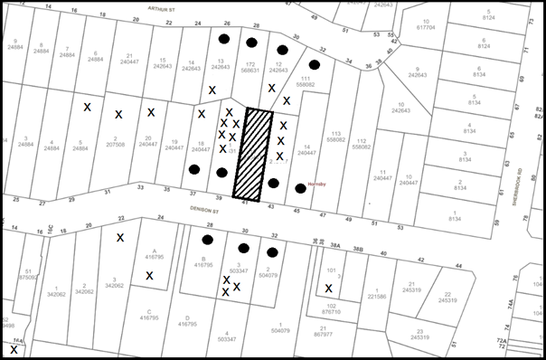
|
NOTIFICATION PLAN |
|
||
|
• PROPERTIES NOTIFIED
|
X SUBMISSIONS RECEIVED |
PROPERTY SUBJECT OF DEVELOPMENT |
|
|
5 SUBMISSIONS RECEIVED OUT OF MAP RANGE |
|||
The submissions and petition objected to the development, generally on the grounds that the development would result in:
· Unacceptable traffic on local streets.
Comment: Amended plans submitted to Council have reduced the number of child care places. Council’s traffic assessment considers that the local road network has sufficient capacity to accommodate the additional traffic flow.
· Unacceptable parking;
Comment: Amended plans submitted to Council have reduced the number of child care places. The proposal complies with parking requirements within the HDCP.
· Pedestrian and road safety;
Comment: Amended plans submitted to Council include a separate pedestrian entrance. Conditions are recommended that the carpark comply with current Australian Standards relating to safety.
· Unacceptable noise from activities at the centre;
Comment: The submitted acoustic report concludes that the centre would comply with relevant noise criteria. Submissions are recommended to ensure compliance with noise limits.
· Unacceptable fence heights;
Comment: Amended plans submitted to Council have reduced the proposed acoustic fence heights to an acceptable level in context with the surrounding residential environment.
· Number of children;
Comment: Amended plans submitted to Council have reduced the number of child care places from an originally proposed 30 to 24.
· Design of child care centre;
Comment: The proposed centre would utilise an existing dwelling house. No substantial changes are anticipated to occur to the streetscape.
· Location of child care not appropriate in context to existing centres;
Comment: The location of the centre is considered acceptable in regard to Clause 25 of the State Environmental Planning Policy (Educational Establishments and Childcare Facilities) 2017 and Part 7.1.1 of the HDCP.
· Unauthorised works and Building Code of Australia;
Comment: The existing unauthorised outbuilding and additions would be demolished as part of the development. Conditions are recommended that the centre comply with the Building Code of Australia.
· Unacceptable privacy;
Comment: The single storey development is not anticipated to result in unacceptable loss privacy for adjoining properties.
· Landscaping and tree removal;
Comment: The amended proposal includes 22 replacement trees including 3 canopy trees within the front and rear setbacks.
· Indoor and outdoor play space;
Comment: The proposal complies with the minimum indoor and outdoor play space requirements of the State Environmental Planning Policy (Educational Establishments and Childcare Facilities) 2017.
The merits of the matters raised in community submissions have been further addressed in the body of the report with the exception of the following:
5.1.1 Devaluation of adjoining properties
Submissions have been received raising concerns that the development would result in the devaluation of adjoining properties.
Property value of adjacent development is not a matter of consideration under Section 4.15 of the Environmental Planning and Assessment Act 1979.
5.1.2 Existing Development
Submissions have been received raising concerns regarding a recent increase in development within the locality including the construction of secondary dwellings.
Existing development within the locality is not a matter of consideration as part of this development.
5.1.3 Conflict of interest
A submission received notes that the owner of the subject premises is employed by the company “RPDC Pty Ltd” whom listed as the applicant. The submission states that this may be conflict of interest.
Council is not aware of any conflict of interest that would affect the assessment of the application.
6. THE PUBLIC INTEREST
Section 4.15(1)(e) of the Act requires Council to consider “the public interest”.
The public interest is an overarching requirement, which includes the consideration of the matters discussed in this report. Implicit to the public interest is the achievement of future built outcomes adequately responding to and respecting the future desired outcomes expressed in environmental planning instruments and development control plans.
The application is considered to have satisfactorily addressed Council’s and relevant agencies’ criteria and would provide a development outcome that, on balance, would result in a positive impact for the community. Accordingly, it is considered that the approval of the proposed development would be in the public interest.
7. CONCLUSION and statement of reasons
The application seeks approval for alterations and additions to a dwelling house and change of use to a child care centre accommodating 24 children.
The amended proposal reduces the number of child care places from 28 to 24 and increased front, side and rear setbacks for the centre.
A total of 28 submissions and a petition with 114 signatures were received objecting to the proposal on the grounds of traffic, parking, safety, unauthorised works, proximity to other centres, landscaping, setbacks, privacy and noise. The issues raised are addressed in the body of the report and by way of recommended conditions of consent.
The proposed size of the child care centre complies with the maximum permissible under the HDCP controls. The development is permissible in the zone and is considered to be within the environmental capacity of the site.
Accordingly, the proposed development is recommended for approval.
The reasons for this recommendation are
· The proposed development generally complies with the requirements of the relevant environmental planning instruments and development control plan,
· The proposed development would provide a positive social contribution to the local community by providing additional child care places, and
· The applicant has amended the proposal to address issues relating to car parking, acoustics, landscaping and design to provide a better outcome for adjoining developments and the functioning of the site.
Note: At the time of the completion of this planning report, no persons have made a Political Donations Disclosure Statement pursuant to Section 10.4 of the Environmental Planning and Assessment Act 1979 in respect of the subject planning application.
RESPONSIBLE OFFICER
The officer responsible for the preparation of this report is Stephen Dobbs.
|
Cassandra Williams Team Leader - Major Applications Planning Division |
Rod Pickles Manager - Development Assessment Planning Division |
|
1.⇨ |
Locality Plan |
|
|
|
2.⇨ |
Site Plan |
|
|
|
3.⇨ |
Landscape Plan |
|
|
|
4.⇨ |
Plans Architectural |
|
|
|
5.⇨ |
Acoustic Report |
|
|
File Reference: DA/1006/2017
Document Number: D07455906
SCHEDULE 1
GENERAL CONDITIONS
The conditions of consent within this notice of determination have been applied to ensure that the use of the land and/or building is carried out in such a manner that is consistent with the aims and objectives of the relevant legislation, planning instruments and council policies affecting the land and does not disrupt the amenity of the neighbourhood or impact upon the environment.
Note: For the purpose of this consent, the term ‘applicant’ means any person who has the authority to act on or the benefit of the development consent.
Note: For the purpose of this consent, any reference to an Act, Regulation, Australian Standard or publication by a public authority shall be taken to mean the gazetted Act or Regulation, or adopted Australian Standard or publication as in force on the date that the application for a construction certificate is made.
1. Approved Plans and Supporting Documentation
The development must be carried out in accordance with the plans and documentation listed below and endorsed with Council’s stamp, except where amended by Council and/or other conditions of this consent:
Approved plans
|
Plan No. |
Plan Title |
Drawn by |
Dated |
|
1718-028 (A1)-C |
Site Analysis |
RPDC |
12/05/2018 |
|
1718-028 (A2)-C |
Site Plan |
RPDC |
12/05/2018 |
|
1718-028 (A3)-C |
Childcare Floor Plan1 |
RPDC |
12/05/2018 |
|
1718-028 (A4)-C |
Childcare Floor Plan1 |
RPDC |
12/05/2018 |
|
1718-028 (A5)-C |
Building Elevations |
RPDC |
12/05/2018 |
|
1718-028 (A6)-C |
Building Elevations |
RPDC |
12/05/2018 |
|
1718-028 (A7)-C |
Building Section & Front Fence |
RPDC |
12/05/2018 |
|
1718-028 (S1)-C |
Stormwater Management Plan |
RPDC |
12/05/2018 |
|
1718-018 (K1)-A |
Kitchen Plan |
RPDC |
18/12/2017 |
Supporting Documents
|
Document Title |
Prepared by |
Dated |
|
Landscape Plan, List & Detail 1718-028 (A8), Revision B |
SASA LIANG |
08/07/2018 |
|
Hazardous Building Materials Survey J17-1264R1 |
SESA |
12/09/2017 |
|
Noise Assessment BA180509 - B |
Blackett Acoustics |
06/2018 |
|
Arboricultural Impact Assessment |
Seasoned Tree Consulting |
25/08/2017 |
|
Assessment of Traffic and Parking Implications 17246-B |
Transport and Traffic Planning Associates |
11/2017 |
2. Appointment of a Project Arborist
a) A project arborist with AQF Level 5 qualifications must be appointed to provide monitoring and certification throughout the construction period of the development within the vicinity of trees.
b) Details of the appointed project arborist must be submitted to Council and the PCA for registration with the application for the construction certificate.
3. Removal of Existing Trees
a) This development consent permits the removal of trees numbered 1-5 identified in the Landscape Plan, prepared by SASA LIANG, referenced 1718-028 (A8)-B.
b) The removal of any other trees requires separate approval in accordance with the Tree and Vegetation Chapter 1B.6 Hornsby Development Control Plan 2013 (HDCP).
4. Construction Certificate
a) A Construction Certificate is required to be approved by Council or a Private Certifying Authority prior to the commencement of any works under this consent.
b) A separate Construction Certificate must be obtained from Council for all works within the public road reserve under S138 of the Roads Act 1993.
c) A separate Construction Certificate must be obtained from Council for all works within drainage easements vested in Council.
d) The Construction Certificate plans must not be inconsistent with the Development Consent plans.
REQUIREMENTS PRIOR TO THE ISSUE OF A CONSTRUCTION CERTIFICATE
5. Identification of Survey Marks
A registered surveyor must identify all survey marks in the vicinity of the proposed development. Any survey marks required to be removed or displaced as a result of the proposed development shall be undertaken by a registered surveyor in accordance with Section 24 (1) of the Surveying and Spatial Information Act 2002 and following the Surveyor General’s Directions No.11 – "Preservation of Survey Infrastructure".
6. Building Code of Australia
All approved building work must be carried out in accordance with the relevant requirements of the Building Code of Australia.
7. Noise Management Plan
a) An ongoing noise management plan must be submitted to and written approval provided by Council prior to the issue of a Construction Certificate.
b) The ongoing noise management plan must include details of how the child care centre will limit noise to adjoining properties, complaint procedures and how it will implement the recommendations contained within the Noise assessment prepared by Blackett Acoustics, Report No. BA180509, dated June 2018.
Note: details are to be sent to Council’s Compliance team via email at compliance@hornsby.nsw.gov.au.
8. Fire Safety Upgrade - Windows
Unless a performance solution (prepared by a qualified fire safety practitioner to Section C of the National Construction Code – Building Code of Australia) is obtained that provides an alternative means of protection, window openings situated along the eastern and western boundaries are required to be protected with:
a) Wall-wetting sprinklers with windows that are automatic closing or permanently fixed in the closed position, or,
b) FRL -/60/- fire windows that are automatic closing or permanently fixed in the closed position.
c) FRL -/60/- automatic closing fire shutters.
Note: Details are to be included with the application for a construction certificate.
9. Reconstruction of Rear Addition - Rear Dwelling Skillion Roof
a) As indicated on the plan: Childcare Floor Plan 1, dated 05/03/2017, drawing No. A3 prepared by RPDC, the area hatched blue is to be reconstructed to meet the National Construction Code – Building Code of Australia requirements. Reconstruction of this area includes the roof and its supporting members, ceiling and walls.
b) Reconstruction works include the slab unless a practicing structural engineer’s certificate is obtained for the use of the slab verifying that it is structurally sound, can withstand design loads in accordance with AS 1170 and has been provided with a suitable water proof barrier/ membrane.
Note: Details of the reconstruction specifications are to be included with the application for a construction certificate.
10. Sydney Water – Approval
This application must be submitted to Sydney Water for approval to determine whether the development would affect any Sydney Water infrastructure, and whether further requirements are to be met.
Note: Building plan approvals can be obtained online via Sydney Water Tap inTM through www.sydneywater.com.au under the Building and Development tab.
11. Safe Work NSW
a) Documentation must be provided to Council that shows that the nearest point of the proposed development site is not within 100 metres of dangerous goods of a quantity requiring notification to Safe Work NSW.
b) Should it be found that dangerous goods are located within 100 metres of the proposed development, a Risk Assessment, Emergency Plan and Evacuation Plan for the proposed child care centre due to potential impacts in the event of a leak, spill or similar emergency caused by the dangerous goods must be submitted and approved by Council prior to the issue of a construction certificate.
Note: details are to be sent to Council’s Compliance Team via email at compliance@hornsby.nsw.gov.au.
12. Stormwater Drainage
The stormwater drainage system for the development must be designed for an average recurrence interval (ARI) of 20 years and be gravity drained in accordance with the following requirements:
a) Connected directly to Council’s street drainage system.
b) The stormwater drainage system must be designed by a qualified hydraulic engineer.
13. Internal Driveway/Vehicular Areas
The driveway and parking areas on site must be designed, constructed and a Construction Certificate issued in accordance with Australian Standards 2890.1, 2890.2, 3727 and the following requirements:
a) Design levels at the front boundary shall be obtained from Council if a private accredited certifier is engaged to obtain a construction certificate for these works.
b) The driveway be a rigid pavement.
14. Vehicular Crossing
A separate application under the Local Government Act 1993 and the Roads Act 1993 must be submitted to Council for the installation of a new vehicular crossing and the removal of the redundant crossing. The vehicular crossing must be constructed in accordance with Council’s Civil Works Design 2005 and the following requirements:
a) Design levels at the front boundary must be obtained from Council for the design on the internal driveway;
b) The crossing must have a minimum width of 6.2m;
c) Any redundant crossings must be replaced with integral kerb and gutter;
d) The footway area must be restored by turfing;
e) Approval must be obtained from all relevant utility providers that all necessary conduits be provided and protected under the crossing.
Note: An application for a vehicular crossing can only be made to one of Council’s Authorised Vehicular Crossing Contractors. You are advised to contact Council on 02 9847 6940 to obtain a list of contractors.
15. Waste Management Details
The following waste management requirements must be complied with:
a) There must be a bin storage area on site that is sufficient for no less than 4 x 240L bins. The path/aisle to access and manoeuvre the bins in and out of their storage position must be no less than 1.5m wide. The bins must not be visible from the street when in the storage area.
b) A Waste Management Plan Section One – Demolition Stage and Section Three – Construction Stage, covering the scope of this project and including the following details, is required to be submitted to Council:
i) An estimate of the types and volumes of waste and recyclables to be generated;
ii) A site plan showing sorting and storage areas for demolition and construction waste and the vehicle access to these areas;
iii) How excavation, demolition and construction waste materials will be reused or recycled and where residual wastes will be disposed;
iv) The total percentage (by weight) of demolition and construction waste that will be reused or recycled.
c) All bin carting routes must not include any steps, and must be smooth hard surface.
Note: Smooth hard surface includes, but is not limited to, concrete, tiles, floorboards etc, but does not include carpet, grass, pebbles etc.
16. Construction Management Plan (CMP)
To assist in the protection of the public, the environment and Council’s assets, a Construction Management Plan is to be prepared by a suitably qualified environmental consultant in consultation with a qualified traffic engineer, is to be submitted to Council’s Compliance Team (compliance@hornsby.nsw.gov.au) for approval to be used by workers and Council as on-site reference during demolition, excavation and construction works, according to the following requirements:
a) The CMP will detail the contact information for all development phases for developers, builder, site foremen, private certifier, environmental management consultant and any emergency details.
b) The plan must include the following:
i) Truck movements to and from the site, including the routes used, swept path diagrams entering and exiting the site and implemented traffic control,
ii) The use of the Denison Street site frontage for the parking, storage or deliveries of any vehicles or machinery is not permitted, the plan must reflect this,
iii) Site plan showing site sheds, concrete pump location and crane location,
iv) Safe pedestrian management details including during local school and commuter hours where the footpath is heavily frequented.
c) The plan will include Construction Waste Management information detailing the following:
i) Details on the requirement for importation or excavation of soil and fill including the waste classification of the fill, disposal methods and locations of authorised disposal depots that will be used for the fill;
ii) Asbestos Information must be included on the requirement and procedures for removal and disposal from the site in accordance with Australian Standard: 2601–2001 – The Demolition of Structures, and the Protection of the Environment Operations (Waste) Regulation 2005;
iii) General construction waste details including construction waste skip bin locations and litter management for workers.
REQUIREMENTS PRIOR TO THE COMMENCEMENT OF ANY WORKS
17. Erection of Construction Sign
a) A sign must be erected in a prominent position on any site on which any approved work is being carried out:
i) Showing the name, address and telephone number of the principal certifying authority for the work;
ii) Showing the name of the principal contractor (if any) for any demolition or building work and a telephone number on which that person may be contacted outside working hours; and
iii) Stating that unauthorised entry to the work site is prohibited.
b) The sign is to be maintained while the approved work is being carried out and must be removed when the work has been completed.
18. Protection of Adjoining Areas
A temporary hoarding, fence or awning must be erected between the work site and adjoining lands before the works begin and must be kept in place until after the completion of the works if the works:
a) Could cause a danger, obstruction or inconvenience to pedestrian or vehicular traffic;
b) Could cause damage to adjoining lands by falling objects; and/or
c) Involve the enclosure of a public place or part of a public place.
Have been identified as requiring a temporary hoarding, fence or awning within the Council approved Construction Management Plan (CMP).
Note: Notwithstanding the above, Council’s separate written approval is required prior to the erection of any structure or other obstruction on public land.
19. Toilet Facilities
a) To provide a safe and hygienic workplace, toilet facilities must be available or be installed at the works site before works begin and must be maintained until the works are completed at a ratio of one toilet for every 20 persons employed at the site.
b) Each toilet must:
i) be a standard flushing toilet connected to a public sewer; or
ii) be a temporary chemical closet approved under the Local Government Act 1993; or
iii) have an on-site effluent disposal system approved under the Local Government Act 1993.
20. Erosion and Sediment Control
To protect the water quality of the downstream environment, erosion and sediment control measures must be provided and maintained throughout the construction period in accordance with the manual ‘Soils and Construction 2004 (Bluebook)’, the approved plans, Council specifications and to the satisfaction of the principal certifying authority. The erosion and sediment control devices must remain in place until the site has been stabilised and revegetated.
Note: On the spot penalties may be issued for any non-compliance with this requirement without any further notification or warning.
21. Installation of Tree Protection
Tree protection fencing must be erected around all retained trees on the site and have the protection measures for the ground, trunk and canopy installed in accordance with the relevant requirements of Australian Standard AS 4970-2009 - “Protection of Trees on Development Sites”.
22. Tree Protection Zone - Ground Protection
a) All tree protection zones for the trees to be retained must have a layer of wood-chip mulch installed prior to works commencing.
b) The wood-chip mulch must be maintained throughout the period of construction at a depth of between 150mm and 300mm, using material that complies with the relevant requirements of Australian Standard AS 4454 2012 – “Composts, Soil Conditioners and Mulches”.
23. Tree Protection Certification
To ensure that all tree protection measures are correctly installed, a certificate from the appointed project arborist must be submitted to the Principal Certifying Authority confirming compliance with the tree protection requirements of this consent.
REQUIREMENTS DURING CONSTRUCTION
24. Construction Management Plan Compliance
The development must be carried out in accordance with the submitted and approved Construction Management Plans.
25. Construction Work Hours
All works on site, including demolition and earth works, must only occur between 7am and 5pm Monday to Saturday.
No work is to be undertaken on Sundays or public holidays.
26. Demolition
To protect the surrounding environment, all demolition work must be carried out in accordance with Australian Standard 2601-2001 – The Demolition of Structures and the following requirements:
a) Demolition material must be disposed of to an authorised recycling and/or waste disposal site and/or in accordance with an approved waste management plan;
b) Demolition works, where asbestos material is being removed, must be undertaken by a contractor that holds an appropriate licence issued by WorkCover NSW in accordance with Chapter 10 of the Occupational Health and Safety Regulation 2001 and Clause 29 of the Protection of the Environment Operations (Waste) Regulation 2005 ;and
c) On construction sites where any building contain asbestos material, a standard commercially manufactured sign containing the words ‘DANGER ASBESTOS REMOVAL IN PROGRESS’ and measuring not less than 400mm x 300mm must be displayed in a prominent position visible from the street.
27. Environmental Management
The site must be managed in accordance with the publication ‘Managing Urban Stormwater – Landcom (March 2004) and the Protection of the Environment Operations Act 1997 by way of implementing appropriate measures. To prevent sediment run-off, excessive dust, noise or odour emanating from the site during the construction of the development.
28. Council Property
To ensure that the public reserve is kept in a clean, tidy and safe condition during construction works, no building materials, waste, machinery or related matter is to be stored on the road or footpath.
Note: This consent does not give right of access to the site via Council’s park or reserve. Should such access be required, separate written approval is to be obtained from Council.
29. Disturbance of Existing Site
During construction works, the existing ground levels of open space areas and natural landscape features, including natural rock-outcrops, vegetation, soil and watercourses must not be altered unless otherwise nominated on the approved plans.
30. Landfill
Landfill must be constructed in accordance with Council’s ‘Construction Specification 2005’ and the following requirements:
a) Prior to fill material bring imported to the site, a certificate shall be obtained from a suitable qualified environmental consultant confirming the fill wholly consists of Virgin Excavated Natural Material (VENM) as defined in Schedule 1 of the Protection of the Environment Operations Act, 1997 or material approved under the NSW Environmental Protection Authority’s general resource recover order and exemption.
b) A compaction certificate is to be obtained from a suitably qualified geotechnical engineer verifying that the specified compaction requirements have been met.
c) These certificates must be included with the application for an occupation certificate.
31. Excavated Material
All excavated material removed from the site must be classified by a suitably qualified person in accordance with the NSW Environmental Protection Authority’s Waste Classification Guidelines and Protection of the Environment Operations (Waste) Regulation 2014 prior to disposal to an approved waste management facility and be reported to the principal certifying authority prior to the issue of an Occupation Certificate.
32. Maintenance of Public Footpaths
Public footpaths must be maintained for the duration of works to ensure they are free of trip hazards, displacements, breaks or debris to enable pedestrians to travel along the footpath safely.
33. Works Near Trees
a) The appointed project arborist must monitor and record any and all necessary remedial actions required for trees on site and adjoining properties.
b) Any root pruning must be undertaken in accordance with the relevant requirements of Australian Standard AS 4970-2009 “Protection of Trees on Development Sites” - Sections 3.3.4, 4.5.4 and 4.5.5.
c) The maintenance and monitoring of all tree protection techniques must be recorded by the appointed project arborist during the period of construction for submission with the application for the occupation certificate.
34. Building materials and Site Waste
Any works, or activities, including but not limited to the filling or stockpiling of building materials, the parking of vehicles or plant, the disposal of cement slurry, waste water or other contaminants must be located outside the tree protection zones as prescribed in the conditions of this consent or the prescriptive measures of Part 1B.6.1 Tree Preservation of the Hornsby Development Control Plan 2013, of any tree to be retained.
35. Waste Management Details
Waste management during the demolition and construction phase of the development must be undertaken in accordance with the approved Waste Management Plan. Additionally written records of the following items must be recorded during the removal of any waste from the site and such information submitted to the Principal Certifying Authority within fourteen days of the date of completion of the works:
a) The identity of the person removing the waste.
b) The waste carrier vehicle registration.
c) Date and time of waste collection.
d) Waste classification (type of waste and quantity).
e) Details of the site to which the waste is to be taken.
f) The corresponding tip docket/receipt from the site to which the waste is transferred (noting date and time of delivery, description (type and quantity) of waste).
g) Whether the waste is to be reused, recycled or go to landfill.
Note: In accordance with the Protection of the Environment Operations Act 1997, the definition of waste includes any unwanted substance, regardless of whether it is reused, recycled or disposed to landfill.
REQUIREMENTS PRIOR TO THE ISSUE OF AN OCCUPATION CERTIFICATE
Note: For the purpose of this consent, a reference to ‘occupation certificate’ shall not be taken to mean an ‘interim occupation certificate’ unless otherwise stated.
36. Damage to Council Assets
To protect public property and infrastructure, any damage caused to Council’s assets as a result of the construction or demolition of the development must be rectified by the applicant in accordance with Council’s Civil Works Specifications. Rectification works must be undertaken prior to the issue of an Occupation Certificate, or sooner, as directed by Council.
37. Landscaping Requirements
A certificate must be submitted to the PCA and to Council by a practicing landscape architect, horticulturalist or person with similar qualifications and experience certifying that the landscaping works have been satisfactorily completed in accordance with the approved landscape plan.
38. Final Certification Arborist
a) The Project supervisor must submit to the principal certifying authority all relevant certificates with the application for the occupation certificate stating compliance with all the conditions of this consent.
b) The Project arborist must submit to the principal certifying authority a certificate that all the completed works have been carried out in compliance with the approved plans and specifications for tree protection.
c) Certification must include a statement of overall site attendance, the condition of the retained trees, details of any deviations from the approved tree protection measures and their impacts on trees.
39. External Lighting
a) To protect the amenity of adjacent premises, all external lighting must be designed and installed in accordance with Australian Standard AS 4282 – Control of the Obtrusive Effects of Outdoor Lighting.
b) Certification of compliance with this Standard must be obtained from a suitably qualified person and submitted to the PCA with the application for the Construction Certificate.
40. Works as Executed Plan
A works-as-executed plan(s) must be prepared by a registered surveyor and submitted to Council for completed road pavement, kerb & gutter, public drainage systems, driveways and on-site detention system.
41. Preservation of Survey Marks
A certificate by a Registered Surveyor must be submitted to the Principal Certifying Authority, certifying that there has been no removal, damage, destruction, displacement or defacing of the existing survey marks in the vicinity of the proposed development or otherwise the re-establishment of damaged, removed or displaced survey marks has been undertaken in accordance with the Surveyor General’s Direction No.11 – “Preservation of Survey Infrastructure”.
42. Construction of Engineering Works
All engineering works identified in this consent are to be completed and a Compliance Certificate issued prior to the release of the Occupation Certificate or Subdivision Certificate
43. Food Premises
a) A food premises notification form must be submitted to Council prior to the commencement of operation.
Note: Hornsby Shire Council’s Food Premises notification form can be found at http://www.hornsby.nsw.gov.au
b) The fit out and operation of that part of the building to be used for the preparation of food must be in accordance with Australian Standard 4674-2004 – Design and fit out of food premises, the Food Act 2003, Food Regulation 2015 and the Food Standards Code developed by Food Standards Australia New Zealand. Food Standards 3.3.1, 3.2.2 and 3.2.3 are mandatory for all food businesses.
Note: Walls are to be of solid construction.
c) Prior to the commencement of the child care centre, the operator is requested to contact Council’s Compliance & Certification Team to arrange an inspection for compliance against the relevant legislation and guidelines outlined in this approval. Contact Council’s Administration Officer on 9847 6784.
d) A kitchen exhaust system must be designed and installed to effectively prevent air pollution in accordance with the Protection of the Environment Operations Act 1997.
44. Hazardous Materials Report
A Hazardous Materials Report must be prepared by a suitably qualified Occupational Hygienist and submitted to Council and the Principal Certifying Authority prior to the issue of an Occupation Certificate. The report must confirm that the site is clear of contamination and suitable for the intended use as a child care centre. The survey is to be undertaken in accordance with the Work Health and Safety Regulation 2011 (NSW) including laboratory analysis for asbestos and lead on the site and within the soil.
45. Retaining Walls
All required retaining walls must be constructed as part of the development.
46. Waste Management Details
The following waste management requirements must be complied with:
a) A report must be prepared by an appropriately qualified person and be submitted to the principal certifying authority, certifying the following:
i) A comparison of the estimated quantities of each waste type against the actual quantities of each waste type.
Note: Explanations of any deviations to the approved Waste Management Plan is required to be included in this report.
ii) That at least 60% of the waste generated during the demolition and construction phase of the development was reused or recycled.
Note: If the 60% diversion from landfill cannot be achieved in the Construction Stage, the Report is to include the reasons why this occurred and certify that appropriate work practices were employed to implement the approved Waste Management Plan. The Report must be based on documentary evidence such as tipping dockets/receipts from recycling depots, transfer stations and landfills, audits of procedures etc. which are to be attached to the report.
iii) All waste was taken to site(s) that were lawfully permitted to accept that waste.
b) The child care centre must be provided with an indoor waste/recycling cupboard for the interim storage of a minimum one day’s waste generation with separate containers for general waste and recyclable materials.
c) The bin carting routes must be devoid of any steps.
Note: Ramps between different levels are acceptable
47. Outdoor Play Area
The outdoor play space must be adequately shaded in accordance with The Shade Handbook, published by the New South Wales Cancer Council in 2008.
48. Acoustic Treatment and Certification
a) Acoustic fencing must be installed in accordance with the approved plans by RPDC, revision C, 12/05/2018 and the following requirements:
i) The AAC panel fences must be painted a colour natural to the surrounding neighbourhood; and
ii) The 2.1m northern acoustic fence must be installed on the inside of the existing boundary fence.
b) Acoustic treatment must be installed for the proposed development in accordance with the recommendations contained within the Noise assessment prepared by Blackett Acoustics, Report No. BA180509, dated June 2018.
c) On completion of all works and prior to the issue of an Occupation Certificate, the certifier is to be provided with a certificate from a qualified acoustic consultant certifying that all acoustic works have been completed in accordance with the recommendations contained within the Noise assessment prepared by Blackett Acoustics, Report No. BA180509, dated June 2018 and this consent.
OPERATIONAL CONDITIONS
49. Use of Premises
a) The development approved under this consent shall be used for ‘child care centre’ and not for any other purpose without Council’s separate written consent.
b) The child care centre shall accommodate a maximum of 24 children. The age mix of children as at 1 January of each calendar year shall be in accordance with the following:
i) 0-2 years 8 children
ii) 2-3 years 8 children
iii) 3-5 years 8 children
c) The hours of operation of the ‘child care centre’ are restricted to those times listed below:
Monday to Friday 7:00am to 6:00 pm
Saturday, Sunday and Public Holidays No work
d) A maximum of 8 children in the 2-3 year or 3-5 year age group are permitted to play in the outdoor play area at any one time.
e) The outdoor play period is limited to a maximum 2 hours playtime per day where noise exceeds background +5dB(A).
50. Child Care Centre Management
The child care centre must be managed in accordance with the recommendations of the Acoustic Assessment prepared by Blackett Acoustics, Report No. BA180509, dated June 2018.
51. Noise Management
a) An acoustic assessment is to be undertaken by a suitably qualified environmental consultant (being a consultant who has not been involved in consideration of the DA) to assess the compliance of the operation with the acoustic criteria specified in this development consent. The assessment must be undertaken within 60 to 90 days of operation.
b) The compliance report is to the provided to Council for review and approval within 10 working days of the testing. Any non-compliance with require rectification within 14 days followed by a further test.
c) The noise management plan approved by Council prior to the issue of a Construction Certificate must be complied with.
d) The cumulative noise generation from the use of the premises (including mechanical plant) is not to exceed background +10 dB(A) up to a total of 2 hours per day with background +5dB(A) for the remainder of the day when assessed as an Leq (15 minute) noise contribution at any point on the residential side of the common boundaries or at any point in or on the adjacent residential properties
52. Waste Management
The waste management on site must be in accordance with the following requirements:
a) All commercial tenant(s) must keep written evidence on site of a valid contract with a licensed waste contractor(s) for the regular collection and disposal of the waste and recyclables that are generated on site.
b) All commercial tenant(s) must have a sufficient number of bins to contain the volume of waste and recycling expected to be generated between collection services.
c) All bins must be returned to the on-site bin storage area promptly after waste and recycling collection services.
d) A Work, Health & Safety (WHS) risk assessment is to be carried out by a suitably qualified person with qualifications in Work, Health & Safety Legislation with specific regard to waste management. The recommendations of the WHS Risk Assessment are to be implemented as required.
53. Car Parking
All car parking must be constructed and operated in accordance with Australian Standard AS/NZS 2890.1:2004 – Off-street car parking and Australian Standard AS 2890.2:2002 – Off-street commercial vehicle facilities.
a) All parking areas and driveways are to be sealed to an all-weather standard, line marked and signposted.
b) Car parking, loading and manoeuvring areas to be used solely for nominated purposes.
c) Vehicles awaiting loading, unloading or servicing shall be parked on site and not on adjacent or nearby public roads.
d) All vehicular entry on to the site and egress from the site shall be made in a forward direction.
e) All parking for people with disabilities is to comply with AS/NZS 2890.6:2009 Off-street parking for people with disabilities.
f) Any proposed landscaping and/or fencing must not restrict sight distance to pedestrians and cyclists travelling along the footpath. A sight triangle is to be provided at the property boundary in accordance with AS/NZS 2890.1:2004. See Figure 3.3 for reference.
The advertising signage approved under this consent must not be illuminated, flash, move or display electronic images.
55. Fire Safety Statement - Annual
On at least one occasion in every 12 month period following the date of the first ‘Fire Safety Certificate’ issued for the property, the owner must provide Council with an annual ‘Fire Safety Certificate’ to each essential service installed in the building.
ADVISORY NOTES
The following information is provided for your assistance to ensure compliance with the Environmental Planning and Assessment Act, 1979, Environmental Planning and Assessment Regulation 2000, other relevant legislation and Council’s policies and specifications. This information does not form part of the conditions of development consent pursuant to Section 4.17 of the Act.
Environmental Planning and Assessment Act 1979 Requirements
The Environmental Planning and Assessment Act 1979 requires:
The issue of a construction certificate prior to the commencement of any works. Enquiries can be made to Council’s Customer Services Branch on 9847 6760.
A principal certifying authority to be nominated and Council notified of that appointment prior to the commencement of any works.
Council to be given at least two days written notice prior to the commencement of any works.
Mandatory inspections of nominated stages of the construction inspected.
An occupation certificate to be issued before occupying any building or commencing the use of the land.
Long Service Levy
In accordance with Section 34 of the Building and Construction Industry Long Service Payments Act 1986, a ‘Long Service Levy’ must be paid to the Long Service Payments Corporation or Hornsby Council.
Note: The rate of the Long Service Levy is 0.35% of the total cost of the work.
Note: Hornsby Council requires the payment of the Long Service Levy prior to the issue of a construction certificate.
Tree and Vegetation Preservation
A person must not ringbark, cut down, top, lop, remove, injure or wilfully destroy any tree or other vegetation protected under the Hornsby Development Control Plan 2013 without the authority conferred by a development consent or a permit granted by Council.
Notes: A tree is defined as a long lived, woody perennial plant with one or relatively few main stems with the potential to grow to a height greater than three metres (3M). (HDCP 1B.6.1.c).
Tree protection measures and distances are determined using the Australian Standard AS 4970:2009, “Protection of Trees on Development Sites”.
Fines may be imposed for non-compliance with the Hornsby Development Control Plan 2013.
Disability Discrimination Act
The applicant’s attention is drawn to the existence of the Disability Discrimination Act. A construction certificate is required to be obtained for the proposed building/s, which will provide consideration under the Building Code of Australia, however, the development may not comply with the requirements of the Disability Discrimination Act. This is the sole responsibility of the applicant.
Covenants
The land upon which the subject building is to be constructed may be affected by restrictive covenants. Council issues this approval without enquiry as to whether any restrictive covenant affecting the land would be breached by the construction of the building, the subject of this consent. Applicants must rely on their own enquiries as to whether or not the building breaches any such covenant.
Dial Before You Dig
Prior to commencing any works, the applicant is encouraged to contact Dial Before You Dig on 1100 or www.dialbeforeyoudig.com.au for free information on potential underground pipes and cables within the vicinity of the development site.
Telecommunications Act 1997 (Commonwealth)
If you are aware of any works or proposed works which may affect or impact on Telstra’s assets in any way, you are required to contact: Telstra’s Network Integrity Team on Phone Number 1800810443.
Should asbestos or asbestos products be encountered during demolition or construction works, you are advised to seek advice and information prior to disturbing this material. It is recommended that a contractor holding an asbestos-handling permit (issued by SafeWork NSW) be engaged to manage the proper handling of this material. Further information regarding the safe handling and removal of asbestos can be found at:
Alternatively, telephone the SafeWork NSW Asbestos and Demolition Team on 8260 5885.
Food Premises
The following facilities are required in the food preparation area to ensure food handler hygiene and the cleaning and sanitising of food contact utensils:
· A hand wash basin and a double bowl sink or
· A hand wash basin, washing up sink and a dishwasher.
LPP Report No. LPP26/18
Local Planning Panel
Date of Meeting: 25/07/2018
3 FURTHER REPORT - ANIMAL BOARDING ESTABLISHMENT AND USE OF HORSE ARENA FOR PRIVATE RECREATIONAL PURPOSES - 35 BLACKS ROAD, ARCADIA
EXECUTIVE SUMMARY
|
DA No: |
DA/83/2018 (Lodged on 5 February 2018) |
|
Description: |
Fit-out and change of use of an existing farm building to animal boarding establishment and use of an existing horse riding arena for private recreational purposes |
|
Property: |
Lot 1 DP 221916, No.35 Blacks Road, Arcadia |
|
Applicant: |
Ms Belinda Gai Sibley |
|
Owner: |
Ms Belinda Gai Sibley |
|
Estimated Value: |
$46,500 |
|
Ward: |
A |
· On 26 April 2018 Hornsby Shire Council Local Planning Panel considered Report No. IHAP13/18 for change of use and fit-out of an existing farm building to animal boarding establishment and use of an existing horse riding arena for private recreational purposes and resolved to defer the matter to enable amended information to be submitted.
· The proposal generally complies with the Hornsby Local Environmental Plan 2013 and the Hornsby Development Control Plan 2013.
· The original proposal received 15 submissions objecting to the proposal, 3 submissions were received after the development was deferred by the Hornsby Shire Local Planning Panel. The amended plans received 7 submissions objecting to the proposal. The application is required to be determined by the Hornsby Shire Local Planning Panel as 10 or more unique submissions were received by way of objection.
· It is recommended that the application be approved.
|
THAT Development Application No. DA/83/2018 for fit-out and change of use of an existing farm building to an animal boarding establishment and use of an existing horse riding arena for private recreational purposes at Lot 1 DP 221916, No.35 Blacks Road, Arcadia be approved subject to the conditions of consent detailed in Schedule 1 of LPP Report No. LPP26/18. |
BACKGROUND
On 28 July 2010, Council approved DA/307/2010 for demolition of a rural shed, the erection of a rural shed and driveway and minor landform modification works including the construction of a dam. This consent has since lapsed as no works were physically commenced within five years of determination.
On 23 January 2018, Council’s Compliance Team issued an order to cease unauthorised use of the recently constructed animal shelter/shed erected in close proximity to the northern side boundary and to either remove the structure or lodge a Building Certificate. As a result of this order, a Building Certificate was lodged with Council and was subsequently refused on 7 May 2018.
On 1 February 2018, Council’s Compliance Team issued an order to cease unauthorised use of the recently constructed shed as a boarding kennel and recently constructed horse arena and to lodge a development application for their respective use. As a result of this order, the subject development application was lodged for use of the existing farm building at the rear for an animal boarding establishment and use of the horse arena for private horse riding activities. Upon lodgement of the development application, the construction works for the boarding kennel and horse arena had been completed.
On 7 March 2018, Council sent a request for additional information requesting an acoustic report for the animal boarding establishment, an updated survey plan, additional information regarding odour management and operational procedures regarding animal excrement and further information on grey water.
On 29 March 2018, Council received additional information in the form of a Noise Impact Assessment and a revised survey plan and additional operational management information.
On 26 April 2018, the Hornsby Shire Local Planning Panel considered Report No. IHAP13/18 for change of use of an existing farm building to an animal boarding establishment and use of an existing horse riding arena for private recreational purposes and resolved that determination of the matter be deferred until additional information has been received.
The reasons for the decision of the Panel were to enable the submission of amended plans and details as follows:
1. An appropriate site survey plan showing all existing structures and improvements on the site as well as adjoining dwellings.
2. Detailed plans and elevations drawn to a standard scale showing all existing and proposed structures and improvements on the site.
3. Detailed wastewater disposal plans.
4. Stormwater management assessment plans and details.
5. Plan of management consistent with the Land and Environment Court’s Planning Principle for plans of management, including the proposed complaints handling process.
6. Landscape plan prepared by a suitably qualified landscape consultant including suitable screen hedging along the southern side of the access driveway and tree planting in the vicinity of the horse arena.
On 19 June 2018 amended plans and supporting documents were submitted seeking to address the panels concerns with the proposal. The amended plans and supporting documents were re-notified between 19 June 2018 to 6 July 2018.
SITE
The site has an area of 20,200m², is regular in shape and has an average fall of 7% to the south western boundary. The site is located north west of Blacks Road. There are two Endangered Ecological Communities which exist on the site. Along the north eastern property boundary, there is a Turpentine Iron Bark Forest and along the south eastern corner of the site and the middle and south western portion of the site is a Blue Gum Shale Forest.
The site is characterised by an existing single storey brick dwelling house, a detached horse stable, horse arena, a detached garage and farm building to the rear of the dwelling house and a gravel driveway providing access from Blacks Road. Rural residential properties exist to the north, west and south of the site.
PROPOSAL
The application proposes fit-out and change of use of an existing farm building to an ‘animal boarding establishment’ for cats and dogs and use of an existing open horse riding arena for private recreation purposes.
The animal boarding establishment would be for small dogs only (i.e. not more than 15 kg) and cats. The boarding facility would accommodate no more than 8 dogs at any one time and no more than 6 cats at any one time. The boarding establishment would cater for 2 dogs from the same family to board together and for 2 cats from the same family to board together rather than traditional boarding establishments which separate each animal.
The existing shed includes the following built structures:
· Four individual indoor rooms for dogs measuring 3m x 3m, each with individual 3m x 3m undercover outdoor areas and a 3m x 3m grassed area,
· A 60m x 30m dog exercise yard is proposed at the rear of the site.
· Acoustic treatment provided inside the dog kennels,
The proposed fit-out would comprise the following:
· Four individual indoor rooms for cats measuring 3m x 2m, each with individual 2m x 2m outdoor areas,
· A hallway with individual door openings for the dog and cat kennels to avoid visual disturbance or acoustic conflicts between each pet,
· An office and food preparation area is proposed at the front of the boarding facility.
The animal boarding establishment would employ a maximum of one person at any one time.
The proposed hours of operation for collect and drop off of pets are detailed as follows:
· Monday to Saturday 8:00am to 5:00pm.
· Sundays and Public Holidays 4pm to 5pm. (late pick-ups)
The period between 12pm to 4pm daily is proposed for quiet time to allow pets to relax without any disturbance of entering pets.
The existing horse riding arena measures 20m x 40m and comprises a sand and fibre wool mix. It is proposed to use this arena for private recreation purposes.
In addition to the above, the application proposes wastewater management and stormwater works.
No animal training or animal grooming services are proposed as part of this application.
ASSESSMENT
The development application has been assessed having regard to the matters for consideration prescribed under Section 4.15 of the Environmental Planning and Assessment Act 1979 (the Act). The following issues have been identified for further consideration.
1. STATUTORY CONTROLS
Section 4.15(1)(a) requires Council to consider “any relevant environmental planning instruments, draft environmental planning instruments, development control plans, planning agreements and regulations”.
1.1 Hornsby Local Environmental Plan 2013
The proposed development has been assessed having regard to the provisions of the Hornsby Local Environmental Plan 2013 (HLEP).
1.1.1 Zoning of Land and Permissibility
The subject land is zoned RU4 Primary Production under the HLEP. The objectives of the zone are:
· To enable sustainable primary industry and other compatible land uses.
· To encourage and promote diversity and employment opportunities in relation to primary industry enterprises, particularly those that require smaller lots or that are more intensive in nature.
· To minimise conflict between land uses within this zone and land uses within adjoining zones.
· To encourage land uses that support primary production, including low-scale and low-intensity tourist and visitor accommodation and the provision of farm produce direct to the public.
· To ensure that development does not unreasonably increase the demand for public infrastructure, services or facilities.
The proposed animal boarding facility is defined as ‘animal boarding and training establishment’ and the proposed horse riding arena is defined as ‘outdoor recreation facility’. Both uses are permissible in the RU4 zone with Council’s consent. The proposal meets the objectives of the zone as it encourages and promotes diversity and employment opportunities, minimises conflict between land uses within the zone and adjoining zones, does not unreasonable increase demand for public infrastructure, services or facility and is a compatible land use within the rural area subject to conditions.
1.1.2 Height of Buildings
Clause 4.3 of the HLEP provides that the height of a building on any land should not exceed the maximum height shown for the land on the Height of Buildings Map. The maximum permissible height for the subject site is 10.5 metres. The application is for change of use and fit-out of an existing farm building, accordingly, no further assessment regarding height is necessary.
1.1.3 Heritage Conservation
Clause 5.10 of the HLEP sets out heritage conservation provisions for Hornsby Shire. The site does not include a heritage item and is not located in a heritage conservation area. Accordingly, no further assessment regarding heritage is necessary.
1.1.4 Earthworks
Clause 6.2 of the HLEP states that consent is required for proposed earthworks on site. Before granting consent for earthworks, Council is required to assess the impacts of the works on adjoining properties, drainage patterns and soil stability of the locality.
The existing horse arena has been constructed by cut and fill of approximately 1m to 2m to create a level pad for the horse arena with no additional fill imported to the site. Documentation received from Equestrian Services Pty Ltd confirm that the riding surface is made with a fine high grade equestrian silica sand blended with polyester, nylon and polypropylene fibre and laid at a depth of 125mm.
All fill has been compacted to the manufacturer’s specifications using both excavators and compaction rollers.
Council’s assessment of the existing earthworks and excavation for the horse arena concludes that the proposal is satisfactory and appropriate for use as a horse arena. In addition, it is considered that the earthworks for the horse arena would create negligible impacts to natural drainage patterns of the site and to downstream properties which is discussed in greater detail in the report below under Section 3.1.
1.2 Sydney Regional Environmental Plan No. 20 – Hawkesbury – Nepean River
The site is located within the catchment of the Hawkesbury Nepean River. Part 2 of this Plan contains general planning considerations and strategies requiring Council to consider the impacts of development on water quality, aquaculture, recreation and tourism.
The application proposes minor fit-out works and stormwater and wastewater management works to accommodate the animal boarding facility. The proposal involves the boarding of 4-8 dogs and 4-6 cats within the existing farm building. A dog exercise yard would be located at the rear of the farm building.
On 19 June 2018, a wastewater assessment prepared by Martens Consulting Engineers was submitted which included borehole investigations, inspection of the partially constructed kennels and collection of soil samples and made recommendations for wastewater disposal. The borehole samples were drilled to a depth of 1m and indicated that no bedrock was present and the site is suitable for an effluent disposal area comprising an absorption trench. It is recommended that a septic tank with pump be installed for treatment of all generated wastewater from the animal boarding facility with treated wastewater to connect to an effluent disposal area comprising an absorption trench with a width and depth of 600mm and a minimum 150mm topsoil cover. The effluent disposal area indicated on the proposed site plan would be more than 12m from any property boundary, more than 40m from any dam or drainage channel and more than 20m to natural bushland in accordance with Australian Standard AS1547 – Onsite Domestic Wastewater Management (2000) and Environment & Health Protection Guidelines – Onsite Sewage Management for Single Households (1998).
A condition is recommended in Schedule 1 of this report requiring the on-site sewage management system to be separately approved under the Local Government Act 1993 and installed, commissioned and certified by a licensed plumber.
A waste management plan was submitted as part of the application and addresses the appropriate disposal of animal excrement and ancillary waste by proposing animal waste to be collected two times a day, placed in sealed plastic bags and disposed in Council bins.
All waste water collected from cleaning of animals would be directed to the onsite waste water management system, separate from the existing system servicing the dwelling.
Subject to conditions, the proposal would not result in an adverse impact on the water quality of the Hawkesbury Nepean Catchment.
1.3 State Environmental Planning Policy No. 55 Remediation of Land
The application has been assessed against the requirements of State Environmental Planning Policy No. 55 Remediation of Land (SEPP 55). This Policy requires that Council must not consent to the carrying out of any development on land unless it has considered whether the land is contaminated or requires remediation for the proposed use.
A search of Council’s records including aerial photographs reveals that the property has been used exclusively for rural-residential purposes with no record of any site contamination. Council has not received any evidence to suggest that the materials used for the horse riding arena is contaminated or that any fill was imported onto the site. In addition, Council received a statement from Equestrian Services Pty Ltd which constructed the horse arena which confirmed that the surface installed for the horse arena comprises a mixture of fine sand and synthetic fibre blended together. Given this, the site would be suitable for the proposed use and no further assessment in relation to SEPP 55 is required.
1.3.1 State Environmental Planning Policy (Exempt and Complying Development Codes) 2008
The existing ‘farm building’ in which the proposed use would be undertaken was erected is erected in accordance with the exempt development provisions within SEPP (Exempt and Complying Development Codes) 2008 and approval for this structure is not required.
It is noted that the change of use and fit-out of a farm shed to an animal boarding establishment is subject to this application.
1.4 Section 3.42 Environmental Planning and Assessment Act, 1979 - Purpose and Status of Development Control Plans
In accordance with Section 3.42 of the Environmental Planning and Assessment Act 1979, a DCP provision will have no effect if it prevents or unreasonably restricts development that is otherwise permitted and complies with the development standards in relevant Local Environmental Plans and State Environmental Planning Policies.
The principal purpose of a development control plan is to provide guidance on the aims of any environmental planning instrument that applies to the development; facilitate development that is permissible under any such instrument; and achieve the objectives of land zones. The provisions contained in a DCP are not statutory requirements and are for guidance purposes only. Consent authorities have flexibility to consider innovative solutions when assessing development proposals, to assist achieve good planning outcomes.
1.5 Hornsby Development Control Plan 2013
The proposed development has been assessed having regard to the relevant desired outcomes and prescriptive requirements within the Hornsby Development Control Plan 2013 (HDCP). The following table sets out the proposal’s compliance with the prescriptive requirements of the Plan:
|
HDCP – Part 2.1 Rural Buildings |
|||
|
Control |
Proposal |
Requirement |
Complies |
|
Site Area |
20,200m² |
N/A |
N/A |
|
Setbacks of Animal Boarding Facility to nearest sensitive land uses (dwellings) |
|
|
|
|
- No.33 Blacks Road |
140m |
100m |
Yes |
|
- No.37 Blacks Road |
100m |
100m |
Yes |
|
- No.7 Roscommon Road |
178m to dwelling & 100m to rural workers dwelling |
100m |
Yes |
|
- No.9 Roscommon Road |
150m |
100m |
Yes |
|
Car Parking |
>5 spaces |
Parking study |
Yes |
As detailed in the above table, the proposed development complies with the prescriptive measures within the HDCP. A brief discussion on compliance with relevant performance requirements and Part 1C General Controls is provided below.
1.5.1 Animal Boarding or Training Establishments
On 29 March 2018, Council received additional information in the form of a Noise Impact Assessment prepared by Noise and Sound Services. On 19 June 2018, a site survey plan was provided identifying all existing structures and improvements on the site as well as adjoining dwellings.
The desired outcome for Animal Boarding or Training establishments within Part 2.2.4 of the HDCP seek to ensure that the keeping of animals and their associated activities are sympathetic to the rural character of the area and do not impact on surrounding residents or the environment.
Table 2.2.4(a) of HDCP states that animal boarding and training establishments for cats and dogs should be located 100m from sensitive land uses, including dwelling houses and places of public worship. The proposed animal boarding and training establishment would be located considerable distance from adjoining dwellings as follows: approximately 140m north of the dwelling at No.33 Blacks Road, 100m south of the dwelling at No.37 Blacks Road, 150m east of the dwelling at No.9 Roscommon Road and 178m east of the dwelling at No.9 Roscommon Road.
The NSW Environmental Protection Authority’s Noise Policy for Industry 2017 advises that sleep disturbance occurs where night-time noise levels at a residential location exceed
· 40 dB(A) LAeq,15 minute, or the prevailing RBL plus 5 dB, whichever is the greater, and/or
· 52 dB(A) LAFmax, or the prevailing RBL plus 15 dB, whichever is the greater,
The acoustic report measured existing background and ambient noise levels at the site on Monday 12th March 2018 to Monday 19th March 2018 for the time periods Day 7:00 am – 6:00 pm, Evening 6:00 pm – 10:00 pm and Night: 10:00 pm – 7:00 am. The following noise levels were recorded.
|
Time of Day |
Background Noise Levels (Laf90) |
Ambient Noise Levels (LAeq) Dba |
|
Daytime (07:00 – 18:00) |
34 |
51 |
|
Evening Time (18:00 – 22:00) |
41 |
59 |
|
Night Time (22:00 – 07:00) |
44 |
61 |
It was concluded that existing noise levels were higher at night time than during day time hours due to frog noise generating from a neighbouring pond.
With regards to the dog and cat boarding facility, the acoustic report concluded the following:
During the day/evening time, for noise from 8 dogs barking simultaneously outdoors at 100 metres, without taking a barrier into account, the predicted noise level (LAeq, 15 minute) is 30 dBA. For noise from 8 dogs barking simultaneously outdoors at 40 metres, taking a 1.8metre high barrier into account, the predicted noise level is 31 dBA.
During night time when the dogs would be restricted inside only, the noise from 8 dogs barking simultaneously indoor at 40 metres, without taking a barrier into account, the predicted level (LAeq, 15 minute) is 16 dBA.
Council concurs with the submitted noise report and considers the proposed development acceptable with regard to noise generation as the worst case noise emissions of the proposed dog and cat boarding establishment is compliant with the noise requirements within the HDCP 2013, the Hornsby Shire Council Policy and Guidelines for Noise and Vibration Generating Development (2000), EPA’s Industrial Noise Policy (2000) and EPA’s Noise Policy for Industry (2017).
1.5.2 Car Parking
There are no requirements for vehicle parking in association with the use of the property as an animal boarding establishment in Council’s DCP. In this instance, a parking study would not be required as there is suitable parking on the site for customers and staff to park vehicles.
It is anticipated that customers would either collect or drop off pets by appointment and there would be no demand for a long term parking arrangement for customers on the site. There is suitable area on the site for two parking spaces in association with the dwelling and a third space for the employee. All parking can be contained on the site and 5 car spaces would be provided in-front of the animal boarding facility. It is anticipated that the pick-up and drop off periods would be quick and it is considered that there is ample on-site car parking to cater for the demand generated by staff and customers. Appointments would be made for drop offs and pick-ups to avoid car parking conflicts.
Car parking for the development is assessed as satisfactory.
1.5.3 Setbacks and Visual Appearance of Horse Arena
The desired outcome of Part 2.1.2 Setbacks of the HDCP is to encourage development that complement the rural character and allow for separation between neighbouring rural developments and retain natural landscaping features.
The proposed horse riding arena would be located 35m from the front boundary and 13 to 14m from the southern side boundary which complies with Council’s HDCP controls for setbacks.
The applicant states that the location of the horse riding arena has been selected to mitigate impacts to existing drainage patterns and is responsive to site constraints associated with topography to reduce the amount of cut and fill required.
Council received amended plans on 19 June 2018 in the form of a landscape plan which includes planting of 30 Tuckeroo trees, 85 viburnum trees, 100 Lomandra trees, 45 Jasmine trees and 45 Camellia trees to be planted across the entire site to screen the horse arena, gravel driveway and animal boarding establishment.
It is considered that sufficient landscaping is proposed to screen the horse arena and the animal boarding facility from the streetscape and adjoining properties. The horse arena would be in keeping with the surrounding rural area and complies with the objectives of the zone. No objections would be raised to the use of this area for private horse riding recreation purposes.
1.5.4 Hornsby Shire Council Code for the Keeping of Animals and Plan of Management
The proposal has been assessed having regard to Council’s Code for the Keeping of Animals and the Land and Environment Court’s Planning Principle for plans of management, including the proposed complaints handling process.
On 19 June 2018, the applicant submitted an amended plan of management for the animal boarding establishment to address the Land and Environmental Court’s Planning Principles established in Renaldo Plus 3 Pty Limited v Hurstville City Council regarding the adequacy and appropriateness of a plan of management.
Although the Code for the Keeping of Animals does not provide specific controls for the boarding of cats in rural areas, Part 6 provides provisions for the boarding of dogs in rural areas. Accordingly, a merit-based assessment in conjunction with an assessment of the relevant provisions within Part 6 is provided below.
Part 6 of the Code provides specific controls for the boarding of animals in rural areas, including:
· Buildings used for the housing of animals is to be soundly constructed and sound-proofed to prevent any noise nuisance;
· All feed is to be stored and prepared in a properly constructed building capable of being easily cleansed, maintained and kept free of vermin.
· All excremental waste is to be disposed of appropriately and not buried or incinerated on the premise.
The submitted plan of management includes sufficient information addressing the 8 planning principles established by the LEC as follows:
Do the requirements in the Management Plan relate to the proposed use and complement any conditions of approval?
Comment: Yes the plan of management relates to an animal boarding facility and appropriate conditions are recommended restricting number of cats and dogs, hours of operation, operational standards, noise minimisation, food preparation, storage, washing up, control of animal waste, food waste and management of complaints.
Do the requirements in the Management Plan require people to act in a manner that would be unlikely or unreasonable in the circumstances of the case?
Comment: No, the plan of management is considered simple and easy to understand and would not place any unreasonable requirements on the manager of the boarding facility.
Can the source of any breaches of the Management Plan be readily identified to allow for any enforcement action?
Comment: Yes, an operational condition is recommended in schedule 1 requiring any complaints regarding the operation of the facility to be directed to the manager of the business and a log book of the date and time of the complaint, contact details of the person making the complaint and the nature of the complaint to be documented. This logbook must be readily available to Council and contact details must be provided on a website or alternatively all adjoining properties must be notified in writing of relevant contact details of the manager.
Do the requirements in the Management Plan require absolute compliance to achieve an acceptable outcome?
Comment: No, the small scale of the proposed boarding facility, it setbacks from the two adjoining properties to the north, south and east and the site’s location in a rural zoned area and proposed wastewater system all assist in providing an acceptable environmental location for the proposed use. The Plan of Management’s proposed procedures and operational limitations would ensure that the standard of the operation would achieve an acceptable environmental outcome.
Can the people the subject of the Management Plan be reasonably expected to know of its requirements?
Comment: Yes, an operation condition is recommended in Schedule 1 requiring the submitted operational plan to be adhered to.
Is the Management Plan to be enforced as a condition of consent?
Comment: Yes, an operation condition is recommended in Schedule 1 requiring the submitted operational plan to be adhered to.
Does the Management Plan contain complaint management procedures?
Comment: Yes, complaints would be directed to the manager who will investigate any complaints and keep a log book of the date and time of the complaint, contact details of the person making the complaint and any action taken.
Is there a procedure for updating?
Comment: Yes, should complaints occur, the operational plan can be updated.
2. ENVIRONMENTAL IMPACTS
Section 4.15(1)(b) of the Act requires Council to consider “the likely impacts of that development, including environmental impacts on both the natural and built environments, and social and economic impacts in the locality”.
2.1 Natural Environment
2.1.1 Stormwater Management
On 19 June 2018, the applicant submitted a stormwater management plan and supporting documents prepared by Martens Consulting Engineers to address stormwater concerns for the existing farm building. The proposed stormwater plans and supporting documents were referred to Council’s engineers for assessment.
The roof water from the existing farm building proposes to connect into an on-site absorption trench to drain all roof areas.
Council’s engineering assessment concluded that subject to recommended conditions requiring construction of an on-site absorption trench to Council’s Civil Works Specification, the proposal is considered acceptable and would not adversely impact on the natural water flow in the area.
2.1.2 Trees and Vegetation
No trees would be removed or adversely affected by the proposed development. A condition is recommended in Schedule 1 that the waste disposal area be located a minimum 20m from indigenous trees growing along the southern boundary of the site to avoid any unnecessary weeds near trees. The location of the absorption area would be clear of tree protection zones.
2.1.3 Wastewater
Submissions raise concerns with regard to effluent disposal for the site. The existing dwelling and other buildings on the site are connected to an existing septic system and irrigation area located to the southern side of the dwelling.
As discussed in Section 1.2 of this report, wastewater collected from cleaning of animals as well as excrement from dogs is proposed to be drained to a new onsite waste water management system used for the animal boarding establishment only.
On 19 June 2018, Council received a wastewater assessment prepared by Martens Consulting Engineers which included borehole investigations, inspection of the partially constructed kennels and collection of soil samples. The report includes recommendations for installation of a septic system with pump servicing the animal boarding establishment with treated wastewater disposed via an absorption trench.
A condition is recommended that a septic tank with pump be installed for treatment of all generated wastewater from the animal boarding facility with treated wastewater to connect to an effluent disposal area comprising an absorption trench with a width and depth of 600mm and a minimum 150mm topsoil cover. The effluent disposal area indicated on the proposed site plan would be more than 12m from any property boundary, more than 40m from any dam or drainage channel and more than 20m to natural bushland in accordance with Australian Standard AS1547 – Onsite Domestic Wastewater Management (2000) and Environment & Health Protection Guidelines – Onsite Sewage Management for Single Households (1998).
In addition to the above, it is considered that the location of the absorption trench, located approximately 80m from the downstream dam would not generate detrimental environmental impacts to any natural drainage channel or downstream properties.
A condition is recommended in Schedule 1 of this report requiring the on-site sewage management system to be separately approved under the Local Government Act 1993 and installed, commissioned and certified by a licensed plumber.
2.2 Built Environment
2.2.1 Built Form
The proposal is for fit-out and use of an existing farm building for an animal boarding establishment and use of a horse riding arena for private recreation purposes. There would be no change to the existing built form and the proposed development would generally maintain the existing rural character of the locality.
2.2.2 Traffic
The proposed animal boarding establishment is not categorised as a traffic generating development pursuant to the provisions of State Environmental Planning Policy (Infrastructure) 2007.
A number of submissions raise concerns with respect to traffic impacts associated with the development.
Due to the nature of the site being used for animal boarding establishment, it is anticipated that the volume of vehicular traffic created by this development would be minor. The arrival and departure times of dogs and cats at animal boarding establishments are commonly staggered throughout the day, for the bulk of the day the boarding establishment would generate minimal traffic. Given the small scale nature of the development, it is not considered necessary to upgrade the driveway access to a sealed driveway.
It is considered that additional traffic along Arcadia Road and surrounding streets would continue to operate at an acceptable level of service with the additional vehicles generated by the animal boarding establishment.
The proposal is acceptable having regard to traffic generation in the locality.
2.3 Social Impacts
The proposed animal boarding facility would make a positive social contribution to the local community by providing a demand for additional animal boarding facilities for surrounding residents and providing potential employment generation.
2.4 Economic Impacts
The proposal would have a minor positive impact on the local economy in conjunction with other new rural development in the locality by generating an increase in demand for local services.
3. SITE SUITABILITY
Section 4.15(1)(c) of the Act requires Council to consider “the suitability of the site for the development”.
3.1 Flooding
Whilst the site is not identified as being flood prone, it was noted from site inspections and an examination of the plans that the existing farm shed is located adjacent to an existing drainage swale that conveys stormwater from the north to the south of the site.
In this regard a flood study was submitted on 19 June 2018 by Martens Consulting Engineers to determine the 1 in 100 year ARI flows within the existing drainage swale. The flood study identified the width and depth of the stormwater flow and made recommendations to ensure that the 1 in 100 flows do not inundate the proposed animal boarding establishment.
Council’s engineer raised no concerns with the location of the proposed animal boarding establishment in relation to the overland flow path subject to conditions requiring construction of a defined overland flow path to ensure the existing and proposed floor levels of the animal boarding establishment is a minimum of 300mm above the 1 in 100 year ARI flood level and construction of retaining walls.
With regards to concerns that the construction of the horse arena would affect drainage patterns in the locality, Council’s engineering assessment does not consider that the horse arena would alter existing drainage patterns or flows to downstream properties and stormwater would continue to drain to an existing Council stormwater pit located at the front of the property.
3.2 Bushfire Risk
A small portion at the front of the property is identified as being subject to bushfire risk. The proposed animal boarding establishment would be located clear of this area and no further assessment regarding bushfire is necessary.
4. PUBLIC PARTICIPATION
Section 4.15(1)(d) of the Act requires Council to consider “any submissions made in accordance with this Act”.
4.1 Community Consultation
The proposed development was placed on public exhibition and was notified to adjoining and nearby landowners between 22 February 2018 and 15 March 2018 in accordance with the Notification and Exhibition requirements of the HDCP. During the notification period, Council received 15 submissions objecting to the proposal. Council received a further 3 submissions after the development was deferred by the Hornsby Shire Local Planning Panel.
The amended development was placed on public exhibition between 19 June 2018 to 6 July 2018 to adjoining and nearby landowners and to residents that made an original submission. During the re-notification period, Council received 7 submissions.
The map below illustrates the location of those nearby landowners who made a submission that are in close proximity to the development site.
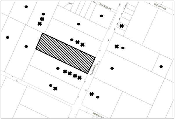
|
NOTIFICATION PLAN |
|
||
|
• PROPERTIES NOTIFIED
|
X SUBMISSIONS RECEIVED |
PROPERTY SUBJECT OF DEVELOPMENT |
|
|
14 SUBMISSIONS RECEIVED OUT OF MAP RANGE |
|||
The submissions objected to the development, generally on the grounds that the development would result in:
· Unacceptable traffic on local streets and increased vehicular movements;
· Unacceptable noise;
· Odour;
· Lighting;
· Landform modification;
· The use is not in keeping with the amenity enjoyed by neighbouring properties;
· Not consistent with zone objectives;
· Devaluation of adjoining properties;
· The existing use operating without consent;
· The use being in close proximity to the “Arcadia Primary School” on corner of Blacks and Arcadia Road;
· Stormwater concerns;
· Acoustic concerns;
· Waste management issues with particular reference to effluent disposal;
· Concerns no details on animal training or animal grooming services;
· Safety.
The merits of the matters raised in community submissions have been addressed in the body of the report with the exception of the following:
4.2 Existing Uses Operating Without Consent
On 23 January 2018, Council’s Compliance Team issued an order to cease unauthorised use of the recently constructed animal shelter erected in close proximity to the northern side boundary and to either remove the structure or lodge a building certificate. As a result of this order, a building certificate was lodged and was subsequently refused by Council.
On 1 February 2018, Council’s Compliance Team issued an order to cease unauthorised use of the recently constructed shed as a boarding kennel and partially constructed horse arena and to lodge a development application for their respective use. As a result of this order, the subject development application was lodged for use of the existing farm building at the rear of the site for an animal boarding establishment and use of the horse arena for horse riding activities.
With regards to concerns of an existing dog grooming business, the applicant has stated they would operate this business as a home occupation under SEPP (Exempt and Complying Development Codes) 2008 and approval for this use is not required.
4.3 Devaluation of land values
Submissions raise concerns regarding the potential adverse impacts upon the land values of adjoining properties.
This is not a relevant matter for consideration under section 4.15 of the Environmental Planning and Assessment Act 1979. No evidence has been submitted to indicate that an adverse impact on land values would occur. It is considered that the proposal would not result in a negative economic impact on the locality.
4.4 Dust
A submission raised concerns that the material used for the horse riding arena could be toxic or ‘carcinogenic’.
Council has received documentation from Equestrian Services Pty Ltd advising that the arena was constructed using cut and fill with no additional fill being imported to the site. The riding surface is made with a fine high grade equestrian silica sand blended with polyester, nylon and polypropylene fibre and laid at a depth of 125mm. The materials used for the riding surface does not contain any toxic additives.
Given that the materials used in construction of the arena and separation from adjoining properties there is no evidence to suggest that the development would be harmful to surrounding residents.
4.5 Privacy
A submission raised concerns that the horse arena would create privacy impacts.
The horse arena is similar in appearance to other horse riding arenas in Arcadia Road, notably No.33 Arcadia Road adjoining this site and No.28 Arcadia Road. Horse arenas for private recreational use are typical in the rural area and it is not envisaged that this arena would create detrimental privacy impacts to adjoining properties.
On 19 June 2018, a landscape plan was submitted which includes landscape screening along each side of the horse arena and along the access driveway to the animal boarding facility which would provide privacy to adjoining properties.
4.6 View loss
The change of use would not cause loss of iconic or significant views for adjoining properties in accordance with the NSW planning principles for view sharing.
4.7 Insufficient documentation
Submissions raise concerns that no survey plan or acoustic report were provided.
Council received an acoustic report on 19 March 2018. On 19 June 2018, the applicant submitted an amended operational plan, architectural plans, wastewater documents, stormwater plans and landscape plans which were considered sufficient to enable an assessment of the proposal.
4.8 Offensive Lighting
A submission raises concerns regarding offensive lighting of the animal boarding establishment.
The proposal is for use of an existing farm building only and a condition is recommended requiring operating hours for public to attend the site be restricted to 5pm before dusk. The horse arena is not proposed to be illuminated.
4.9 Proximity to ‘Arcadia Public School
A submission raises concerns regarding the proximity of the animal boarding establishment to Arcadia Primary School located approximately 80m north of the subject property.
The animal boarding establishment including the dog exercise yard would be located in excess of 100m from the recreation area of the primary school and in excess of 200m from the nearest school building. The dogs would be contained within the designated areas of the building the majority of the time. The application also states that the dogs would be supervised onsite at all times by a member of staff. As stated above, there would be a maximum of eight dogs and six cats onsite at any one time.
Accordingly, it is considered that the proposal would not have a detrimental effect on the primary school.
4.10 Development is not in keeping with the rural zone and out of character with the area
The proposed animal boarding house is a permissible land use within the RU4 Primary Production zone. The proposed development would provide a positive social and economic contribution to the local rural community by providing an additional service in the rural area and is compatible with the rural character and the visual landscape of the site.
As discussed in detail of this report, the location and low intensity of the animal boarding establishment is considered to result in a positive outcome for the community which is within the rural context of the surrounding area and compatible with the character of the local area.
4.11 Animal welfare
A submission raises concerns regarding that animals might contract diseases.
This is not a matter for consideration under Environmental Planning Assessment Act 1979.
4.12 Safety
A submission raises concerns regarding safety with vehicles driving down the access driveway and suggested that Viburnum odoratissimum trees should be planted along the length of the driveway to provide privacy.
The applicant provided a landscape plan on 19 June 2018 which included planting of 85 viburnum odoratissimum trees with a mature height of 3m landscaping along the driveway access handle.
4.13 Sealing of driveway
A submission states that the driveway should be sealed given increased traffic movements.
Given the small scale of the proposal, it is anticipated that minimal traffic movements throughout the day would occur as a result of the animal boarding establishment, it is therefore considered that a sealed driveway would not be warranted in this instance.
4.14 Incompatible zoning
A submission raises concerns that the animal boarding facility does not meet the zoning objectives given it states that a proposal needs to ‘minimise conflict between land uses within this zone and land uses within adjoining zones’.
It is considered that the animal boarding establishment meets the zone objectives as discussed in section 1.1.1 of the report and is compatible in the zone. The animal boarding establishment would minimise conflict between adjoining land uses as demonstrated by its location being more then 100m from adjoining residential properties and compliance with the prescriptive measures in the HDCP.
The site is considered to be capable of accommodating the proposed development. The scale of the proposed development is consistent with the capability of the site and is considered acceptable
4.15 Operating hours
A submission raises concerns with the proposed operating hours noting that it is not compatible with the rural area.
The animal boarding establishment would operate throughout daylight hours only and is considered acceptable.
4.16 Animal Training or Grooming Services
A submission raises concerns were raised that no details on animal training or grooming services have been provided.
The application proposes animal boarding establishment and no animal training establishment or grooming services are proposed as part of this application.
5. THE PUBLIC INTEREST
Section 4.15(1)(e) of the Act requires Council to consider “the public interest”.
The public interest is an overarching requirement, which includes the consideration of the matters discussed in this report. Implicit to the public interest is the achievement of future built outcomes adequately responding to and respecting the future desired outcomes expressed in environmental planning instruments and development control plans.
The application is considered to have satisfactorily addressed Council’s and relevant agencies’ criteria and would provide a development outcome that, on balance, would result in a positive impact for the community. Accordingly, it is considered that the approval of the proposed development would be in the public interest.
CONCLUSION AND REASONS FOR recommendation
The application proposes change of use of an existing farm building to animal boarding establishment and use of an existing horse riding arena for private recreational purposes.
The design and location of the development complies with the relevant requirements of Council’s HDCP and meets the objectives of the rural zoning stipulated in the HLEP. It is considered that the development would have a positive impact upon the rural landscape, would be in keeping with the built form of the area and is satisfactory having regard to the matters for consideration under Section 4.15 of the Environmental Planning and Assessment Act 1979.
A total of 25 submissions have been received in respect of the application. The matters raised have been addressed in the body of the report.
Having regard to the circumstances of the case, approval of the application is recommended. The reasons for this recommendation are:
· The proposed development generally complies with the requirements of the relevant environmental planning instruments and the Hornsby Development Control Plan,
· The proposed development is compatible with the rural character and the visual landscape of the site.
Note: At the time of the completion of this planning report, no persons have made a Political Donations Disclosure Statement pursuant to Section 10.4 of the Environmental Planning and Assessment Act 1979 in respect of the subject planning application.
RESPONSIBLE OFFICER
The officer responsible for the preparation of this report is Matthew Miles who can be contacted on 9847 6760.
|
Cassandra Williams Team Leader - Major Applications Planning Division |
Rod Pickles Manager - Development Assessment Planning Division |
|
1.⇨ |
Locality Plan |
|
|
|
2.⇨ |
Architectural Plans |
|
|
|
3.⇨ |
Site Survey Plans |
|
|
|
4.⇨ |
Management Plan |
|
|
File Reference: DA/83/2018
Document Number: D07473744
Schedule 1
GENERAL CONDITIONS
The conditions of consent within this notice of determination have been applied to ensure that the use of the land and/or building is carried out in such a manner that is consistent with the aims and objectives of the relevant legislation, planning instruments and Council policies affecting the land and does not disrupt the amenity of the neighbourhood or impact upon the environment.
Note: For the purpose of this consent, the term ‘applicant’ means any person who has the authority to act on or the benefit of the development consent.
Note: For the purpose of this consent, any reference to an Act, Regulation, Australian Standard or publication by a public authority shall be taken to mean the gazetted Act or Regulation, or adopted Australian Standard or publication as in force on the date that the application for a construction certificate is made.
1. Approved Plans and Supporting Documentation
The development must be carried out in accordance with the plans and documentation listed below and endorsed with Council’s stamp, except where amended by Council and/or other conditions of this consent:
|
Plan No. |
Plan Title |
Drawn by |
Dated |
|
SK 002 |
Site plan/ Analysis |
Raw Concept Designs |
18.06.2018 |
|
SK 003 |
Existing ground floor |
Raw Concept Designs |
18.06.2018 |
|
SK 004 |
Proposed ground floor |
Raw Concept Designs |
18.06.2018 |
|
SK 005 |
North/East elevation |
Raw Concept Designs |
18.06.2018 |
|
SK 006 |
South/West elevation |
Raw Concept Designs |
18.06.2018 |
|
Document Title |
Prepared by |
Dated |
|
Preliminary wastewater assessment |
Martens consulting engineers |
June 2018 |
|
Concept stormwater management |
Martens consulting engineers |
June 2018 |
|
Operation management plan |
Ms Belinda Sibley |
June 2018 |
|
Sediment and erosion control plan, PS01-B3HH00 and B310 Issue A |
Martens consulting engineers |
15.06.2018 |
|
Drainage plan layout, PS01-E100, Issue A |
Martens consulting engineers |
15.06.2018 |
|
Swale details, PS01-E201, Issue A |
Martens consulting engineers |
15.06.2018 |
|
Absorption trench details, PS01-E202, Issue A |
Martens consulting engineers |
15.06.2018 |
|
Acoustical Assessment, Report No.22792 |
Noise and Sound Services |
March 2018 |
|
Survey Report No.180304, Sheet 1 and Sheet 2 |
Iredale and Associates |
06 May 2018 |
|
Waste management plan |
Belinda Sibley |
5/02/18 |
|
Equestrian arena letter confirmation on material |
Equestrian Services |
06/11/17 |
2. Construction Certificate
a) A Construction Certificate is required to be approved by Council or a Private Certifying Authority prior to the commencement of any works under this consent.
b) The Construction Certificate plans must not be inconsistent with the Development Consent plans.
REQUIREMENTS PRIOR TO THE ISSUE OF A CONSTRUCTION CERTIFICATE
3. Building Code of Australia
All approved building work must be carried out in accordance with the relevant requirements of the Building Code of Australia.
REQUIREMENTS PRIOR TO THE COMMENCEMENT OF ANY WORKS
4. Erection of Construction Sign
a) A sign must be erected in a prominent position on any site on which any approved work is being carried out:
i) Showing the name, address and telephone number of the principal certifying authority for the work;
ii) Showing the name of the principal contractor (if any) for any demolition or building work and a telephone number on which that person may be contacted outside working hours; and
iii) Stating that unauthorised entry to the work site is prohibited.
b) The sign is to be maintained while the approved work is being carried out and must be removed when the work has been completed.
5. Protection of Adjoining Areas
A temporary hoarding, fence or awning must be erected between the work site and adjoining lands before the works begin and must be kept in place until after the completion of the works if the works:
a) Could cause a danger, obstruction or inconvenience to pedestrian or vehicular traffic;
b) Could cause damage to adjoining lands by falling objects; and/or
c) Involve the enclosure of a public place or part of a public place.
Note: Notwithstanding the above, Council’s separate written approval is required prior to the erection of any structure or other obstruction on public land.
To provide a safe and hygienic workplace, toilet facilities must be available or be installed at the works site before works begin and must be maintained until the works are completed at a ratio of one toilet for every 20 persons employed at the site.
7. Erosion and Sediment Control
To protect the water quality of the downstream environment, erosion and sediment control measures must be provided and maintained throughout the construction period in accordance with the manual ‘Soils and Construction 2004 (Bluebook)’, the approved plans, Council specifications and to the satisfaction of the principal certifying authority. The erosion and sediment control devices must remain in place until the site has been stabilised and revegetated.
Note: On the spot penalties may be issued for any non-compliance with this requirement without any further notification or warning.
8. Stormwater Drainage
The stormwater drainage system for the development must be designed for an average recurrence interval (ARI) of 20 years and be gravity drained in accordance with the following requirements:
a) The overflow from the rainwater tank and roof stormwater must be disposed of in accordance with Council’s design specification “On Site Absorption System”, the Concept Stormwater Management Plan P1806582JR0V01 dated June 2018 prepared by Martens and Associates and the following requirements:
i) The trench or trenches must be laid on contour;
ii) The trench must be a minimum of 0.6 metres wide, 0.6 metres deep and 1 metre long for every 25 square metres of impervious area; and
iii) Overland flow from the trench must be spread evenly over the site so as not to discharge water in a concentrated manner onto adjoining land.
iv) The stormwater drainage system must be designed by a qualified hydraulic engineer.
9. Overland Flow Path
An overland flow path is to be designed to convey the 1 in 100 year ARI storm flows through the site in the vicinity of the existing shed. The overland flow path is to be designed by a suitably qualified civil engineer in accordance with the Concept Stormwater Management Plan P1806582JR0V01 dated June 2018 option 1 prepared by Martens and Associates. The design of the overland flow path is to ensure that the existing and proposed floor levels of the animal boarding facility are a minimum of 300mm above the 1 in 100 year ARI flood level.
10. Buildings Adjacent to the Overland Flow Path
The proposed additions are to be clear of the 1 in 100 year ARI flood limits.
All required retaining walls that form part of the overland flow path must be designed and constructed as part of the development.
REQUIREMENTS DURING CONSTRUCTION
12. Construction Work Hours
All works on site, including demolition and earth works, must only occur between 7am and 5pm Monday to Saturday.
No work is to be undertaken on Sundays or public holidays.
To prevent sediment run-off, excessive dust, noise or odour emanating from the site during the construction, the site must be managed in accordance with the publication ‘Managing Urban Stormwater – Landcom (March 2004) and the Protection of the Environment Operations Act 1997.
14. Council Property
To ensure that the public reserve is kept in a clean, tidy and safe condition during construction works, no building materials, waste, machinery or related matter is to be stored on the road or footpath.
Note: This consent does not give right of access to the site via Council’s park or reserve. Should such access be required, separate written approval is to be obtained from Council.
15. Disturbance of Existing Site
During construction works, the existing ground levels of open space areas and natural landscape features, (including natural rock-outcrops, vegetation, soil and watercourses) must not be altered unless otherwise nominated on the approved plans.
All excavated material removed from the site must be classified by a suitably qualified person in accordance with the Department of Environment, Climate Change and Water NSW Waste Classification Guidelines prior to disposal to an approved waste management facility and be reported to the principal certifying authority prior to the issue of an Occupation Certificate.
REQUIREMENTS PRIOR TO THE ISSUE OF AN OCCUPATION CERTIFICATE
Note: For the purpose of this consent, a reference to ‘occupation certificate’ shall not be taken to mean an ‘interim occupation certificate’ unless otherwise stated:
17. Wastewater System Approval – Boarding Facility and Grooming Operation
Prior to operation of the boarding facility and grooming operation the following must be approved under the Local Government Act 1993 and installed:
a) An on-site sewage management system for the animal boarding establishment, separately approved under the Local Government Act 1993, must be installed, commissioned and certified by a licensed plumber in accordance with Australian Standard AS1547 – Onsite Domestic Wastewater Management (2000) and Environment & Health Protection Guidelines – Onsite Sewage Management for Single Households (1998).
b) The absorption trench or disposal area must be located a minimum 20m from any indigenous trees growing along the southern boundary of the site to avoid excess weeds within this area.
c) The effluent disposal area is to be suitably identified with signage and protected by way of a fence as detailed on the site plan/site analysis plan dated 18/06/2018 prepared by Raw Concept Designs
d) The certificate must be submitted to Council.
18. Acoustic Certification
Prior to occupation of the animal boarding facility, a certificate must be obtained from a suitably qualified Acoustic Consultant and submitted to Council confirming that the building used for the housing of dogs is soundproofed to prevent any noise nuisance from barking dogs. Noise levels emitted from the premises are not to exceed 5dB(A) above the existing background levels.
19. Damage to Council Assets
To protect public property and infrastructure, any damage caused to Council’s assets as a result of the construction or demolition of the development must be rectified by the applicant in accordance with Council’s Civil Works Specifications. Rectification works must be undertaken prior to the issue of an Occupation Certificate, or sooner, as directed by Council.
20. Retaining Walls
All required retaining walls must be constructed as part of the development.
A works-as-executed plan(s) must be prepared by a registered surveyor and submitted to the PCA for constructed overland flow path and the on-site absorption system.
22. Construction of Engineering Works.
All engineering works identified in this consent are to be completed and a Compliance Certificate issued prior to the release of the Occupation Certificate.
23. Certification of Engineering Works
The following certificate is to be submitted to the PCA prior to the issue of any Occupation Certificate:
a) A certificate from an appropriately qualified civil engineer confirming that the overland flow path has been constructed to convey the 1 in 100 year ARI flows and that the floor levels of the animal boarding facility are 300mm above the 1 in 100 year ARI flood level and that all structures are clear of the 1 in 100 year ARI flood limits.
OPERATIONAL CONDITIONS
24. Effluent Disposal
The effluent disposal area is to be suitably identified with signage and protected by way of a fence as detailed on the site plan/site analysis plan dated 18/06/2018 prepared by Raw Concept Designs to prevent human or animal contact, minimize health risk and avoid compaction of the soil.
25. Hours of Operation
The hours of operation for the public to collect and drop off cats and dogs are restricted to those times listed below
Monday to Saturday 8:00am to 5:00pm.
Sundays and Public Holidays 4pm to 5pm
26. Number of Dogs/Cats
a) A maximum of eight dogs only are permitted onsite at any one time.
b) A maximum of six cats only are permitted onsite at any one time.
27. Operational Conditions
The operation of the animal boarding establishment must be undertaken in accordance with the approved operational management plan prepared by Ms Belinda Sibley, dated June 2018 and the following:
a) Any dogs left unaccompanied during the day must be housed in the kennel building.
b) No dog is to be outside the kennel building between 5:00pm and 8:00am.
c) Cat and dog excrement must be picked up and the area cleaned twice daily.
d) Customers must drop off and pick up pets by appointment only.
e) The horse arena must be used for private recreational purposes only and must not be used between the hours of 7pm to 7am.
f) Any complaints regarding the operation of the facility must be directed to the manager of the business and a log book of the date and time of the complaint, contact details of the person making the complaint and the nature of the complaint must be documented. This logbook must be readily available to Council and:
i) Contact details must be provided on a website or alternatively all adjoining properties must be notified in writing of relevant contact details of the manager of the animal boarding establishment.
ii) A phone must be linked to the dwelling on site to ensure monitoring and caring for animals should complaints arise.
28. Noise
a) All noise generated by the proposed development must be attenuated to prevent levels of noise being emitted to adjacent premises which possess tonal, beating and similar characteristics or which exceeds background noise levels by more than 5dB(A).
b) An acoustic assessment is to be undertaken by a suitably qualified environmental consultant within 60 days of occupying the site in accordance with the Environment Protection Authority’s Noise Policy for Industry (2017), Council’s Policy and Guidelines for Noise and Vibration Generating Development (Acoustic Guidelines V.5, 2000) and the DECC’s Noise Guide for Local Government (2004). The assessment must be held on site for review by Council if necessary. Should the assessment find that noise from the premise exceeds 5dB(A) above background noise levels, appropriate measures must be employed to rectify excessive noise.
- END OF CONDITIONS -
ADVISORY NOTES
The following information is provided for your assistance to ensure compliance with the Environmental Planning and Assessment Act 1979, Environmental Planning and Assessment Regulation 2000, other relevant legislation and Council’s policies and specifications. This information does not form part of the conditions of development consent pursuant to Section 4.17 of the Act.
Environmental Planning and Assessment Act 1979 Requirements
The Environmental Planning and Assessment Act 1979 requires:
· The issue of a construction certificate prior to the commencement of any works. Enquiries can be made to Council’s Customer Services Branch on 9847 6760;
· a principal certifying authority to be nominated and Council notified of that appointment prior to the commencement of any works;
· Council to be given at least two days written notice prior to the commencement of any works;
· mandatory inspections of nominated stages of the construction inspected; and
· an occupation certificate to be issued before occupying any building or commencing the use of the land.
Long Service Levy
In accordance with Section 34 of the Building and Construction Industry Long Service Payments Act 1986, a ‘Long Service Levy’ must be paid to the Long Service Payments Corporation or Hornsby Council.
Note: The rate of the Long Service Levy is 0.35% of the total cost of the work.
Note: Hornsby Council requires the payment of the Long Service Levy prior to the issue of a construction certificate.
Tree and Vegetation Preservation
A person must not ringbark, cut down, top, lop, remove, injure or wilfully destroy any tree or other vegetation protected under the Hornsby Development Control Plan 2013 without the authority conferred by a development consent or a permit granted by Council.
Notes: A tree is defined as a long lived, woody perennial plant with one or relatively few main stems with the potential to grow to a height greater than three metres (3M). (HDCP 1B.6.1.c).
Tree protection measures and distances are determined using the Australian Standard AS 4970:2009, “Protection of Trees on Development Sites”.
Fines may be imposed for non-compliance with the Hornsby Development Control Plan 2013.
The land upon which the subject building is to be constructed may be affected by restrictive covenants. Council issues this approval without enquiry as to whether any restrictive covenant affecting the land would be breached by the construction of the building, the subject of this consent. Applicants must rely on their own enquiries as to whether or not the building breaches any such covenant.
Prior to commencing any works, the applicant is encouraged to contact Dial Before You Dig on 1100 or www.dialbeforeyoudig.com.au for free information on potential underground pipes and cables within the vicinity of the development site.
Telecommunications Act 1997 (Commonwealth)
If you are aware of any works or proposed works which may affect or impact on Telstra’s assets in any way, you are required to contact: Telstra’s Network Integrity Team on Phone Number 1800810443.
Asbestos Warning
Should asbestos or asbestos products be encountered during demolition or construction works, you are advised to seek advice and information prior to disturbing this material. It is recommended that a contractor holding an asbestos-handling permit (issued by SafeWork NSW) be engaged to manage the proper handling of this material. Further information regarding the safe handling and removal of asbestos can be found at:
Alternatively, telephone the SafeWork NSW Asbestos and Demolition Team on 8260 5885.

