
BUSINESS PAPER
Local Planning Panel meeting
Wednesday 27 March 2019
at 6:30pm
BUSINESS PAPER
Local Planning Panel meeting
Wednesday 27 March 2019
at 6:30pm
Hornsby Shire Council Table of Contents
Page 1
GENERAL BUSINESS
Local Planning Panel
Item 1 LPP4/19 Development Application - Construction of three buildings comprised of a total of 10 townhouses and 46 multi dwelling housing - 172-174B Sherbrook Road, Asquith............ 1
Item 2 LPP6/19 Development Application - Demolition of a dwelling house and construction of a two storey 72 place child care centre with basement car parking and associated landscaping 21
Item 3 LPP7/19 Development Application - The demolition of all existing structures, the construction of 2 x two storey boarding house buildings comprising a total of 8 rooms accommodating 15 lodgers, and the construction of a carport...................................................................................... 43
LPP Report No. LPP4/19
Local Planning Panel
Date of Meeting: 27/03/2019
1 DEVELOPMENT APPLICATION - CONSTRUCTION OF THREE BUILDINGS COMPRISED OF A TOTAL OF 10 TOWNHOUSES AND 46 MULTI DWELLING HOUSING - 172-174B SHERBROOK ROAD, ASQUITH
![]() EXECUTIVE SUMMARY
EXECUTIVE SUMMARY
|
DA No: |
DA/1338/2016 (28 October 2016) |
|
Description: |
Demolition of existing structures and the construction of three buildings comprised of a total of 10 townhouses and 46 multi-dwelling housing with basement car parking |
|
Property: |
Lots 1 and 3 DP 747423 and Lots 1, 2 and 3 DP 883943, Nos. 172, 172A, 174, 174A and 174B Sherbrook Road Asquith |
|
Applicant: |
Mr J. Watt-Smith |
|
Owner: |
Sherbrook Group Pty Ltd |
|
Estimated Value: |
$13,920,080 |
|
Ward: |
A |
· The application involves construction of three buildings comprised of a total of 10 townhouses and 46 multi-dwellings housing with basement car parking.
· The proposal does not comply with the Height of Buildings development standard under Hornsby Local Environmental Plan 2013 and a Clause 4.6 variation request has not been submitted by the Applicant. The proposal is inconsistent with the provision of the Hornsby DCP and is not supportable as these non-compliances would result in significant adverse streetscape and amenity impacts.
· Thirty-nine submissions have been received in respect of the amended application.
· It is recommended that the application be refused.
|
THAT Development Application No. DA/1338/2016 for construction of three buildings comprised of a total of 10 townhouses and 46 multi-dwelling housing with basement car parking at Lots 1 and 3 DP 747423 and Lots 1, 2 and 3 DP 883943, Nos. 172, 172A, 174, 174A and 174B Sherbrook Road Asquith be refused subject to the reasons for refusal detailed in Schedule 1 of LPP Report No. LPP4/19. |
BACKGROUND
On 28 October 2016, DA/1338/2016 was lodged for demolition of existing structures and erection of three, two storey residential flat buildings containing a total of 56 units located above a basement car park. Council received 36 submissions objecting to the development generally on the grounds of:
· Bulk, height and scale;
· Setbacks and building separation;
· Solar access, privacy, parking issues, traffic impacts and;
· Design of the development.
Following an initial assessment of the application by Council and Council’s Urban Design Consultant, requests for additional information were sent to the applicant on 12 December 2016, 2 February 2017 and 18 December 2017 raising concerns regarding design of development and site planning, bulk and scale, amenity and building separation, front setback and landscape issues, solar access, accessibility, waste management, garbage truck access and engineering issues.
Council received numerous sets of amended plans on 29 May 2017, 14 September 2017, 3 October 2017 and 14 June 2018.
On 27 July 2018, the applicant submitted the final set of amended plans. The amended proposal involves the erection of three x two-storey with attics multi dwelling housing development comprising 10 townhouses and residential flat buildings with 46 units over a basement car park. Council received 38 submissions objecting to the amended development.
The amended plans were notified to the affected property owners and objectors between 6 August to 7 September 2018. During this period, Council received 39 submissions.
Following numerous requests, the revised Statement of Environmental Effects was submitted on 30 October 2018.
The amended plans and documents were referred to the urban design consultant for review.
SITE
The subject site is legally defined as Lots 1 & 2 in DP 7477423 and Lots 1, 2 & 3 in DP 883943, and is known as No. 172-174 Sherbrook Road Asquith. The development site is a regular shaped land parcel that is located adjacent to the Asquith Girls High School along the rear boundary.
The subject site comprises of five separate allotments and once consolidated would have a combined primary street frontage of 36.68m to Sherbrook Road with a lot depth of approximately 124.94m. This results in a total site area of approximately 4,569.3m2.
The site has a fall of approximately 10m from the front of the site towards the rear. The subject site currently accommodates five single storey dwelling-houses that are to be demolished as part of the proposal.
The site is 260m south east of Asquith village centre and approximately 2.3km north of Hornsby Town Centre, with bus stops to Hornsby situated within a 240m walking radius to the subject site.
The subject land was rezoned from Residential A (Low Density) to R3 (Medium Density Residential) on 2 September 2011 as part of Council’s Housing Strategy.
PROPOSAL
The amended application proposes the demolition of the existing structures and construction of three, two-storey multi-dwelling housing buildings with attics comprising 10 attached townhouses and 46 units over basement car parking.
The unit configuration includes 6 x 2 bedroom dwellings, 41 x 2 bedroom dwellings, 8 x 3 bedroom dwellings and 1 x 4 bedroom dwelling with ground level open space fronting the street and rear setbacks. Pedestrian access to the basement carpark is provided via a chairlift and stairwell within the central courtyards.
The development would be accessed from Sherbrook Road via a driveway located along the southern boundary of the site. A total of 67 car parking spaces are proposed including 59 residential car spaces with 8 visitor car spaces.
The site is proposed to drain stormwater to an existing drainage easement located within the Asquith Girls High School via an on-site detention tank located below ground within the rear setback.
ASSESSMENT
The development application has been assessed having regard to the Greater Sydney Plan - a Metropolis of Three Cities, the North District Plan and the matters for consideration prescribed under Section 4.15 of the Environmental Planning and Assessment Act 1979 (the Act). The following issues have been identified for further consideration.
1. STRATEGIC CONTEXT
1.1 Greater Sydney Region Plan - A Metropolis of Three Cities and North District Plan
The Greater Sydney Region Plan - A Metropolis of Three Cities has been prepared by the NSW State Government to guide land use planning decisions for the next 40 years (to 2056). The Plan sets a strategy and actions for accommodating Sydney’s future population growth and identifies dwelling targets to ensure supply meets demand. The Plan also identifies that the most suitable areas for new housing are in locations close to jobs, public transport, community facilities and services.
The NSW Government will use the subregional planning process to define objectives and set goals for job creation, housing supply and choice in each subregion. Hornsby Shire has been grouped with Hunters Hill, Ku-ring-gai, Lane Cove, Mosman, North Sydney, Ryde, Northern Beaches and Willoughby to form the North District. The Greater Sydney Commission has released the North District Plan which includes priorities and actions for Northern District for the next 20 years. The identified challenge for Hornsby Shire will be to provide an additional 4,350 dwellings by 2021 with further strategic supply targets to be identified to deliver 97,000 additional dwellings in the North District by 2036.
The proposed development would be consistent with the Greater Sydney Region Plan - A Metropolis of Three Cities and the North District Plan, by contributing to achieving the dwelling targets for the region.
2. STATUTORY CONTROLS
Section 4.15(1)(a) requires Council to consider “any relevant environmental planning instruments, draft environmental planning instruments, development control plans, planning agreements and regulations”.
2.1 Hornsby Local Environmental Plan 2013
The proposed development has been assessed having regard to the provisions of the Hornsby Local Environmental Plan 2013 (HLEP).
2.1.1 Zoning of Land and Permissibility
The subject land is zoned R3 Medium Density Residential under the HLEP. The objectives of the zone are:
· To provide for the housing needs of the community within a medium density residential environment.
· To provide a variety of housing types within a medium density residential environment.
· To enable other land uses that provide facilities or services to meet the day to day needs of residents.
The proposed development is defined as “town houses” and “multi dwelling housing” and is permissible in the zone with Council’s consent.
2.1.2 Height of Buildings
Clause 4.3 of the HLEP provides that the height of a building on any land should not exceed the maximum height shown for the land on the Height of Buildings Map. The maximum permissible height for the subject site is 10.5m.
The applicant has failed to provide ridge RLs to allow Council to undertake a proper assessment of the application. The amended plans do not clearly confirm proposed building heights, in that the ridge heights have not been specified on the roof plan, as well as on all elevations and sections.
Based on Council’s calculations proposed Building A has a maximum building height of 10.7 metres, Building B has a building height of 10.8m and Building C has a building height of 10.7m from the existing ground level. The proposal fails to comply with the maximum height control of 10.5m.
2.1.3 Exceptions to Development Standards
Clause 4.6 of HLEP provides some flexibility in the application of development standards subject to written justification by the Applicant that compliance with the standard is unreasonable and that there are sufficient planning grounds for exception to the standard. The Applicant has not identified the exceedance of the height control and submitted an objection against Council’s adherence to the development standard under Clause 4.3 of the HLEP for a maximum building height of 10.5 metres. Accordingly, the applicantion is recommended for refusal.
Clause 5.10 of the HLEP sets out heritage conservation provisions for Hornsby Shire. The site is located in close proximity to the Street Trees of Sherbrook Road (Item No.30) and No.178 Sherbrook Road (Item No. 33 - house).
The heritage assessment found that the proposed development would not impact on the heritage listed street trees of Sherbrook Road and the other item which is in close proximity.
2.1.5 Earthworks
The proposal involves excavation to approximately 3 metres below existing ground level. The Applicant has not submitted a geotechnical study although excavation to this depth is typically not considered to be problematic.
Before granting consent for earthworks, Council is required to assess the impacts of the works on adjoining properties, drainage patterns and soil stability of the locality. Council’s assessment of the proposed earthworks and excavation concludes that the proposal is satisfactory subject to conditions regarding submission of a dilapidation report assessing the impact of the excavation on the adjoining properties.
2.2 State Environmental Planning Policy No. 55 – Remediation of Land
State Environmental Planning Policy No. 55 (SEPP 55) requires that consent must not be granted to the carrying out of any development on land unless it has considered whether the land is contaminated or requires remediation for the proposed use.
A search of Council’s records and aerial images reveals that the properties have been used exclusively for residential purposes with no record of site contamination. Given this, the site would be suitable for the proposed use and no further assessment in relation to this SEPP is required.
2.3 State Environmental Planning Policy (Building Sustainability Index – BASIX) 2004
The application has been assessed against the requirements of State Environmental Planning Policy (Building Sustainability Index – BASIX) 2004. The proposal includes an amended BASIX Certificate for the proposed units and is considered to be satisfactory.
2.4 Sydney Regional Environmental Plan No. 20 – Hawkesbury – Nepean River
The site is located within the catchment of the Hawkesbury Nepean River. Part 2 of this Plan contains general planning considerations and strategies requiring Council to consider the impacts of development on water quality, aquaculture, recreation and tourism.
Subject to the implementation of sediment and erosion control measures and stormwater management to protect water quality, the proposal would comply with the requirements of the Policy.
2.5 Section 3.42 Environmental Planning and Assessment Act, 1979 - Purpose and Status of Development Control Plans
Section 3.42 of the Environmental Planning and Assessment Act 1979 states that a DCP provision will have no effect if it prevents or unreasonably restricts development that is otherwise permitted and complies with the development standards in relevant Local Environmental Plans and State Environmental Planning Policies.
The principal purpose of a development control plan is to provide guidance on the aims of any environmental planning instrument that applies to the development; facilitate development that is permissible under any such instrument; and achieve the objectives of land zones. The provisions contained in a DCP are not statutory requirements and are for guidance purposes only. Consent authorities have flexibility to consider innovative solutions when assessing development proposals, to assist achieve good planning outcomes.
2.6 Hornsby Development Control Plan 2013
The proposed development has been assessed having regard to the relevant desired outcomes and prescriptive requirements within the Hornsby Development Control Plan 2013 (HDCP). The following table sets out the proposal’s compliance with the prescriptive requirements of the Plan:
|
Hornsby Development Control Plan 2013 – Part 3.2 Medium Density |
|||
|
Control |
Proposal |
Requirement |
Compliance |
|
Site Width |
36.58m |
30m |
Yes |
|
Height Building A Building B Building C |
10.7m 10.8m 10.7m |
10.5 m |
No |
|
No. storeys |
2 storeys + attic |
2 storeys + attic |
Yes |
|
Roof pitch |
30 degrees |
25 degrees (max) |
No |
|
Height of Basement Above Ground |
1.3m (Building B) |
1m (max) |
No |
|
Front Setback (Sherbrook Road) |
7.5m 7.7m (balcony) |
7.6m (Ground floor) 6m Balconies |
Yes |
|
Rear Setback (Building C) |
6m |
6m |
Yes |
|
Side Setback (North) Building A
Buildings B and C
|
2.5m to 3m
2.8m to 8.5m |
3m for dwellings oriented to front and rear
6m (3m for 1/3 building length)
|
No
No |
|
Side Setback (South) Building A
Buildings B and C |
2.5m to 3m
2m to 8.5m |
3m for dwellings oriented to front and rear 6m (3m for 1/3 building length)
|
No
No |
|
Basement Parking Setbacks |
5.9m to front
boundary 1.6m to 2.2m fire stairs 6m |
6m 2m 3m from side boundaries 4m from rear boundary |
No No No Yes |
|
Deep Soil Landscaped Areas |
5.9m 1.6m to 3m with pathways intercepting landscape areas 6.7m |
Front = 6m min. Side = 3m min.
Rear = 4m min. |
No No
Yes |
|
Building Separation |
10.2m between habitable room of Building A and balconies of Building B 10.2m between balconies of Building B and C |
Between Unscreened Balconies and private open space = 12m2 |
No |
|
Articulation |
10.5m
20m |
Street facade = 8m-wide max. vertical panels Other facades = 12m-wide max. vertical panels |
No
No |
|
Private Open Space |
1 br = >10m2 min. 2 br = 10m2 min.
Townhouses = <24m2 |
1 br = 10m2 min. 2 br = 12m2 min. Min. width 2.5m Townhouse 24m2 min. Min. width 3m |
Yes No
No |
|
Parking |
61 resident spaces 8 visitor spaces 4 accessible spaces 18 bicycle tracks 1 motorbike space |
59 resident spaces 8 visitor spaces 6 accessible spaces 17 bicycle racks 2 motorbike space |
Yes Yes No Yes No |
|
Solar Access |
39.3%
All townhouses are cross ventilated
63% |
Dwellings = 70% to receive 3+ hours of unobstructed sunlight to at least half of principal living room windows and principal private open space area between 9am and 3pm (22 June) All townhouses to be cross ventilated. 60% of units to have dual aspect and cross ventilation |
No
Yes
Yes
|
|
Housing Choice |
>10% >10% >10% |
1 br – 10% 2 br – 10% 3 br – 10% |
Yes Yes Yes |
|
Adaptable Units |
10% |
10% (6 Units) |
Yes |
As detailed in the above table, the proposed development does not comply with a number of prescriptive requirements within the HDCP. The matters of non-compliance are detailed below, as well as a brief discussion on compliance with relevant desired outcomes.
2.6.1 Desired Future Character and Height
The site is included in the Baldwin Avenue, Asquith precinct and is rezoned R3 Medium Density.
Council has established a panel of suitably qualified architecture and urban design professionals to undertake a review of the design quality of relevant developments. Accordingly, the application was referred to Brett Newbold to undertake an independent urban design review of the proposal. A meeting was held and a copy of the urban design advice was referred to the applicant, and it was requested that the matters raised at the meeting be addressed. The applicant subsequently provided amended plans.
The amended plans were referred to the urban design consultant. Concerns have been raised that the amended plans have not demonstrated satisfactory design quality as required by Section 3.2.1 of HDCP. The amended architectural plans have been poorly-drafted and do not provide sufficient information to allow a proper assessment of the application.
As previously discussed at Section 2.1.2 of this report, the development exceeds the 10.5m building height development standard and a Clause 4.6 variation request has not been submitted.
2.6.2 Site Requirements
The HDCP requires sites to have a minimum frontage of 30 metres. The subject site complies with this requirement. The development would not result in isolation of any site
2.6.3 Side Setbacks and Deep Soil Landscaping
The proposal does not comply with the side setback Control 3.2.4(a) of HDCP as follows:
· 50% along the northern side setback to Buildings A, B and C is less than 3m; and
· 70% along the southern side setback to Buildings A, B and C is less than 3m.
A number of pathways, fire stairs and ramps are located within the side setbacks which do not allow for adequate deep soil landscaping to be established on the site.
In addition, the proposal does not comply with Controls 3.2.4(e) and 3.2.4(f) of the HDCP as follows:
· The proposed basement ramp is 6.1m wide and encroaches to within 1.8m from the northern side boundary. There is no opportunity for any adequate landscaping along this part of the eastern boundary;
· The proposed OSD tank is located within the rear setback adjacent to Building C and does not allow for deep soil landscaping; and
· The proposed fire stair adjacent to Buildings B and C are set back only 1.6m from the northern and southern side setbacks and reduces the capacity of deep soil landscaping.
Furthermore, the proposal does not comply with Controls 3.2.6(4) of the HDCP as the amended plans reveal that, for a development of this size, the proposed development does not provide suitable landscaped areas between Buildings A and B and Buildings B and C. The dimensions of landscape areas are not sufficient. An increase in landscape area may require some reduction in the size of some of the private ground level terraces.
The independent urban design consultant has raised a number of concerns with respect to the amended proposal. One of the main concerns is that the landscape information provided on the architectural plans is distracting and does not allow Council to undertake a proper assessment of the application, and to eliminate potential inconsistency with the landscape plans. An outline of the paved terraces and pathways together with finished levels that are consistent with landscape plans and sections has not been shown on the plans. A plan has not been provided to confirm the deep soil areas and no details of the raised planters has been provided.
Given the above reasons, the proposed setback and landscaping variations cannot be supported in this instance.
2.6.4 Building Separation
The HDCP requires a minimum distance of 12m between unscreened habitable rooms, balconies and principal private open spaces and 6m separation between screened habitable rooms, balconies and principal private open spaces.
The building separation between the unscreened balconies/living rooms of Buildings A and B is 10.2m and the unscreened balconies of Buildings B and C are less than the 12m required. This proximity of the buildings without adequate screening or off setting of windows/balconies is a poor design outcome that would result in negative amenity impacts for future residents in terms of visual outlook and solar access.
2.6.5 Building Form
Whilst the design amendments have partly responded to previous design issues, it is considered that the amended proposal would still compromise the streetscape presentation and design quality. Council’s urban design consultant raised the following issues with respect to the amended plans:
· The ground and first floor plans incorporate numerous living rooms that extend to faces of balconies, which produces an undesirably bulky character for east and west-facing facades.
· Locations of several living rooms and indented courtyards are not coordinated with gaps between balconies above, which compromises the articulation effect of gaps between balconies, and also is likely to result in ad-hoc construction detailing.
· Matching the alignment of living room walls to the faces of balconies also contributes to an undesirably-bulky appearance.
· The side elevations have a bulky and repetitive appearance which would compromise desired streetscape character:
a. Forms and compositions of all end walls are near identical. Each of the three buildings should incorporate exterior finishes which are sufficiently-different to suggest a cluster of separate buildings.
b. Materials and finishes are identical for all buildings. The two storey link elements of Buildings B and C, articulation of these buildings should be accentuated by darker finishes which would create a recessive appearance for central elements of the side elevations.
c. The end walls of Building A incorporate small windows which results in an excessive proportion of plain masonry walls. The compositions of the gable-end walls to each building should be varied by altering patterns and proportions of windows.
d. Details of the supporting structure above the driveway and beneath Building A are not clearly explained (and are not shown on the ground floor plans).
The proposal does not comply with Control 3.2.5(c) of the HDCP that requires articulation of walls with a maximum of 8 metre wide modules presenting to the street and 12 metre wide modules presenting to the side and rear. The roof forms for the proposed buildings do not comply with this provision and results in a detrimental visual bulk and scale. The proposal incorporates the use of balconies, pergolas and window hoods which alone are not considered to be sufficient to achieve the desired future character of buildings in this locality.
Furthermore, concern is raised that sufficient information has not been provided on the architectural plans to allow Council to undertake a proper assessment of the application, including the following:
· Ridge heights have not been specified on the roof plan, as well as on all elevations and sections.
· Level information provided on plans, sections and elevations are either incomplete, incorrect or inconsistent.
· Landscaping should be deleted to reveal details which are significant for development assessment, and to eliminate potential inconsistency with the landscape plans.
· FFL’s shown on the elevations for Building A are not consistent with floorplans.
· Dotted outlines of basements and overhanging balconies should be added.
· Outlines of all paved terraces and pathways should be shown together with finished levels that are consistent with landscape plans and sections.
· Section lines are not shown on all plans.
2.6.6 Open Space
The proposal does not comply with the open space Control 3.2.7(a) of HDCP as follows:
· Units 36, 37, 52 and 53 (in Building C) do not comply with the minimum area of 12m2. The proposed private open space areas of Units 36 and 37 are not accessible from the living area.
· All the proposed townhouses, with the exception of Units 40 and 43, do not comply with the minimum private open space area of 24m2 with a minimum dimension of 3m.
Given the non-compliances with other key provisions of the HDCP, the non-compliance with the private open space area control is considered unacceptable.
2.6.7 Privacy and Security
The HDCP encourages the location of primary living areas and private open space areas at the front or rear. The development is designed to orientate the first floor level balconies and the ground level private open space areas generally to the front and rear of each dwelling with an east-west orientation. The private open space and balconies of the link apartments in Buildings B and C are oriented towards the side boundaries.
The amended plans do not fully demonstrate how privacy would be achieved by a stepped development on a sloping site. Sufficient cross-sections through front and rear setbacks, and through the two courtyards between buildings A, B and C has not been provided to allow a proper assessment of the application.
Details have not been provided to illustrate how the landscaping, screens or courtyard fences would provide satisfactory privacy for the terraces which are below common pathways. In addition, adequate details have not been provided for the design treatment of front setbacks which would provide for the privacy of ground floor apartments whilst satisfying the desired character of street frontages for the Baldwin Avenue precinct.
The townhouses have windows which directly adjoin the common walkways, and consequently privacy of the living areas and bedrooms would be compromised. To address this issue, some of the pathways would be required to be moved away from facades. However, this would have an impact on landscaping along the side boundaries.
The attic bedrooms in eight units (27, 28, 33, 34, 49, 50, 55 and 56) are compromised by the proximity of windows to neighbouring dormers. The acoustic privacy of these units would be compromised by proximity of the bedroom windows which are less than 1m from the adjacent units.
The proposal fails to provide clear and direct pedestrian entrances to each dwelling. The applicant has failed to demonstrate that passive surveillance could be achieved by the appropriate orientation of private open spaces and living room windows and to the communal areas of the site.
Based on the above concerns, the proposal is assessed as unsatisfactory with regard to privacy and security.
2.6.8 Sunlight
The prescriptive measure of the HDCP requires at least 70% of the dwellings to receive 3 or more hours of sunlight to living room windows and private open space between 9am and 3pm on 22 June.
The proposal does not achieve the solar access requirements of the HDCP. The solar access plans demonstrate that 39% of the units fully satisfy the specified requirements of 3 hours of solar access to both living room windows and principal areas of private open space. The solar access plans show extended hours for solar access. However, an accurate evaluation of solar access has not been submitted to demonstrate why the development is not capable of complying with the solar access controls and would rely on sunlight from extended hours.
The shadow diagrams are not accurate when taking into account the approved townhouse developments at Nos.176 and 178 Sherbrook Road and No.2 Baldwin Avenue (DA/587/2017), Nos. 4 and 6 Baldwin Avenue (DA/456/2017) and Nos.8 and 10 Baldwin Avenue (DA/1239/2017).
It is considered that the development fails to demonstrate that reasonable solar amenity for the proposed units could be achieved on the site.
2.6.9 Housing Choice
The proposal satisfies the housing mix requirements of the HDCP, which requires the development to comprise a minimum of 10% of each 1 bedroom, 2 bedroom and 3 bedroom dwellings.
An Access Report was submitted with the application to support the proposed development. The HDCP requires the provision of least 10% of proposed dwellings should be Adaptable Housing, designed to meet the needs of residents as they age and at least 20% of proposed dwellings should be Universal Design housing in accordance with the Liveable Housing Guidelines (2012) silver level design features.
In accordance with the requirements of the HDCP, 6 of the units are proposed as adaptable units. Concern is raised that the entry passage of Units 5 and 7 is narrow and would hinder wheelchair accessibility. The development does not nominate which units would comply with the Universal Design Housing requirements in accordance with the Liveable Housing Guidelines (2012) silver level design features. Chair lifts have not been clearly indicated on the plans.
A wheelchair accessible stairway platform lift is proposed to be provided, for residents/visitors to form part of an accessible path of travel from the basement parking to the ground floor common area between the buildings.
2.6.10 Vehicular Access and Parking
The HDCP has a residential parking requirement of 0.75 spaces/dwelling for 0-1 bedroom units, 1 space/dwelling for 2 bedroom units and 1.5 spaces/bedroom for 3 or more bedroom units, and 1 visitor space per 7 dwellings where the development is < 800 metres from a Railway Station.
In accordance with the HDCP there is a requirement for 67 car parking spaces, being 59 residential and 8 visitor car parking spaces. Seventy one parking spaces have been provided and are shown on the drawings. Parking spaces are not marked to separate residential parking spaces and visitor parking spaces.
The HDCP requires that at least one third of adaptable units (i.e. 10% of all units) are to be provided with a parking space designed for people with a disability. Therefore, 6 parking spaces designed for people with disabilities are required. Four accessible parking spaces have been provided in the basement level car park under Building A, having a shortfall of 2 accessible parking space. Two more accessible car parking spaces would be required to be provided.
Council has received submissions concerning the basement car park design. In particular, concern has been raised regarding the entry width of the driveway, parking widths, ramp grades and swept turning paths. In response to the concerns, Council’s Traffic and Road Safety Branch provided the following comments:
· Based on the Australian Standard AS2890.1:2004, the entry width of the access driveway is required to be 6.0 to 9.0 metres. The proposed development provides a 6.1 metres wide access driveway width, which complies with the Australian Standard.
· The Australian Standard states that for residential car parking facilities with a 5.8 metres parking aisle, the minimum width of parking spaces required for 90 degree parking bay is 2.4 m. The proposal complies with parking bay width requirement of the Australian Standard.
· Australian Standard AS2890.1:2004 has the maximum grades of 1 in 4 (25%) for residential car parks. Adequate details of the internal ramp grades have not been shown on the drawings. No cross section of the entry ramp has been provided to confirm that the proposal would not exceed the maximum ramp grade for residential development.
· A swept path analysis was carried out by Council. The analysis showed that an inbound B99 vehicle was unable to pass an outbound B85 vehicle in the entrance driveway to the development, around the double 90 degree bends. The entrance driveway would be required to be redesigned to allow an entering B99 vehicle to pass an outbound B85 vehicle.
Based on the above concerns, the proposal is assessed as unsatisfactory with regards to the access ramp and the design of the basement car park.
2.6.11 Waste Management
A waste storage room is proposed to be provided in the basement and a bin collection and bulky goods storage area is proposed to be provided within the street frontage. The bin collection area would be located adjacent to the driveway entrance.
Council’s waste management assessment has concluded that the proposed bin collection area on the ground floor is substantially undersized in that it does not provide sufficient space to access and manoeuvre the bins. In addition, the pathway residents are required to use to access the bulky waste area is not clear due to landscaping details shown on the architectural plans.
The proposed development is assessed as unsatisfactory with regard to on-going waste management operations on site.
2.6.12 Baldwin Avenue Asquith Precinct
The strategy for redevelopment of this precinct is to incorporate predominantly one or two storey multi dwelling housing in garden settings with parking in basements and reflect the established pattern of detached dwellings by dividing the floor space of new buildings into well-articulated pavilion forms.
Based on the reasons provided in this report, the proposed development would not provide for a built-form that is consistent with the desired future outcome for the precinct.
2.7 Section 7.11 Contributions Plans
Hornsby Shire Council Section 94 Contributions Plan 2014-2024 applies to the development as it would result in an additional 51 residential dwellings in lieu of the 5 existing residences. Accordingly, should the application be approved a monetary Section 7.11 contribution would be recommended as a condition of consent.
3. ENVIRONMENTAL IMPACTS
Section 4.15(1)(b) of the Act requires Council to consider “the likely impacts of that development, including environmental impacts on both the natural and built environments, and social and economic impacts in the locality”.
3.1 Natural Environment
3.1.1 Tree and Vegetation Preservation
An Arboricultural Impact Assessment (AIA) has been provided with the proposal. The report identified that all the trees on the site would be required to be removed to accommodate the proposed development and one tree (numbered T1) a Callistemon citrinus (Endeavour Bottlebrush) located on the nature strip would be preserved and retained.
Whilst Council considers the trees on the site to have low retention value, concern is raised that not all the trees on the adjacent sites have been included in the supplied AIA. Therefore, the impacts to the trees on the neighbouring properties has not been considered in the design of the development.
3.1.2 Stormwater Management
The application proposes to drain stormwater from the development to an OSD system and thereafter into an existing pipeline located within the Asquith Girls High School. The proposal shows that the development is to be drained via an Easement (annotated E) on the stormwater plan. Council’s engineering assessment has indicated that the applicant has not demonstrated how the easement benefits Lots 1 and 2 DP 747423 of the subject site. An interallotment drainage easement would be required to be created which benefits all the subject site lots. The consent of the NSW Department of Education to the creation of the easement has not been provided in accordance with the HDCP.
3.2 Built Environment
3.2.1 Built Form
The proposal does not comply with numerous built form provisions of HDCP and these non-compliances are not considered acceptable in this instance as they would result in an inferior development that would have adverse streetscape, landscaping and visual privacy impacts in the locality.
3.2.2 Traffic
A vast majority of submissions raise concerns about the impact of the development on the local traffic network.
A Traffic and Parking Impact Assessment submitted with the proposal estimates the traffic generation from the existing site and proposed development using Roads and Maritime Services (RMS) traffic generation rates. It is anticipated that the proposed development will generate up to 11 vehicle movements during the AM peak hours and 9 vehicle movements during the PM peak period.
Council has undertaken an assessment of the overall traffic impact of the redeveloped precinct on the locality. A Traffic Management Improvement Plan is included in the HDCP relating to the Asquith precinct. This includes provision of a signalised intersection between Sherbrook Road, Royston Parade and Baldwin Avenue to service the medium density developments.
These improvements have been included in the Works Schedule in Council’s Section 94 Development Contribution Plan 2014–2024 for implementation. Plans and design for these works is currently being progressed by Council. These works would accommodate the increase in traffic in the area and ease of traffic flow within the existing network.
3.3 Social Impacts
Whilst the proposal would provide additional housing supply in the locality, it is considered that the development would on balance have negative social impacts due to the significant number of non-compliances with the built form controls under the HDCP.
3.4 Economic Impacts
The proposal would not give rise to any adverse economic impacts.
4. SITE SUITABILITY
Section 4.15(1) (c) of the Act requires Council to consider “the suitability of the site for the development”.
The subject site has not been identified as bushfire prone, bushfire risk or flood prone land. The site is considered to be capable of accommodating a medium density development. However, the scale of the proposed development is inconsistent with the capability of the site and is considered unacceptable.
5. PUBLIC PARTICIPATION
Section 4.15(1) (d) of the Act requires Council to consider “any submissions made in accordance with this Act”.
5.1 Community Consultation
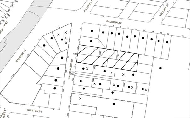
The proposed development was placed on public exhibition and was notified to adjoining and nearby landowners between 10 and 24 November 2016 in accordance with the Notification and Exhibition requirements of the HDCP. During this period, Council received 35 submissions. The amended plans were notified to the affected property owners and objectors between 6 August to 7 September 2018. During this period, Council received 39 submissions. The map below illustrates the location of those nearby landowners who made a submission to the amended proposal that are in close proximity to the development site.
|
NOTIFICATION PLAN |
|||
|
• PROPERTIES NOTIFIED
|
X SUBMISSIONS RECEIVED |
PROPERTY SUBJECT OF DEVELOPMENT |
|
|
27 SUBMISSIONS RECEIVED OUT OF MAP RANGE |
|||
Thirty-nine submissions objected to the development, generally on the grounds that the development would result in:
· Unacceptable traffic on local streets;
· Unacceptable overshadowing of adjoining properties;
· Development that is excessive in bulk and scale and inconsistent with the future character of the area
· Insufficient building setbacks and lack of building separation;
· Inadequate landscaping and open space;
· Overdevelopment for site;
· Road safety impacts;
· Location of development is unacceptable;
· Stormwater management issues;
· Loss of privacy;
· Loss of trees;
· Insufficient accessible dwellings and adequacy of chair platforms;
· Inadequate internal layout and design;
· Width of parking spaces;
· Width of entry/exit driveway to underground car spaces;
· Inadequate traffic management details;
· BCA compliance issues; and
· Garbage truck access.
The merits of the matters raised in community submissions have been addressed in the body of the report.
5.2 Public Agencies
The development application was not referred to any Public Agencies for comment.
6. THE PUBLIC INTEREST
Section 4.15(1) (e) of the Act requires Council to consider “the public interest”.
The public interest is an overarching requirement, which includes the consideration of the matters discussed in this report. Implicit to the public interest is the achievement of future built outcomes adequately responding to and respecting the future desired outcomes expressed in environmental planning instruments and development control plans.
The application is considered not to have satisfactorily addressed Council’s criteria and would provide a development outcome that, on balance, would result in a negative impact for the community. Accordingly, it is considered that the approval of the proposed development would not be in the public interest.
CONCLUSION
The application seeks approval for the demolition of existing structures and construction of three buildings comprising 46 units and 10 townhouses with basement car parking.
The proposal does not comply with the maximum Height of Buildings development standard pursuant to Clause 4.3 of Hornsby Local Environmental Plan 2013 and a Clause 4.6 variation request has not been submitted.
The proposed development does not comply with the desired future character, height, setbacks, building articulation, deep soil landscaping, private open space, communal open space, privacy and sunlight under the HDCP and is not supportable as these non-compliances would result in significant adverse streetscape and amenity impacts.
Accordingly, the proposed development is recommended for refusal subject to the reasons set out at Schedule 1.
Note: At the time of the completion of this planning report, no persons have made a Political Donations Disclosure Statement pursuant to Section 10.4 of the Environmental Planning and Assessment Act 1979 in respect of the subject planning application.
RESPONSIBLE OFFICER
The officer responsible for the preparation of this Report is Caroline Maeshian.
|
Cassandra Williams Team Leader - Major Applications Planning Division |
Rod Pickles Manager - Development Assessment Planning Division |
|
1.⇨ |
Locality Plan |
|
|
|
2.⇨ |
Plans Architectural |
|
|
|
3.⇨ |
Landscape Plans |
|
|
|
4.⇨ |
Stormwater Management |
|
|
File Reference: DA/1338/2016
Document Number: D07607736
SCHEDULE 1
1. The proposed development does not comply with the Height of Buildings development standard pursuant to Clause 4.3 of Hornsby Local Environmental Plan 2013. A Clause 4.6 variation request has not been submitted.
2. The proposed development is unsatisfactory in respect to the provisions of Section 4.15(1)(a)(iii) of the Environmental Planning and Assessment Act 1979 as the proposal does not meet the requirements of the Hornsby Development Control Plan 2013 (HDCP) as follows:
a) The proposal is contrary to Section 1C.1.2 Stormwater Management as:
i) The application has not demonstrated that an interallotment drainage easement has been created which benefits all the subject site lots and connects to a Council-controlled drainage easement.
ii) The consent of the NSW Department of Education to the creation of the easement has not been provided in accordance with the HDCP.
b) The proposal is contrary to Section 1C.2.1 Waste Management as the waste storage area is inadequate.
c) The proposal is contrary to Section 1C.2.3 Transport and Parking as the basement car park has not been designed in accordance with Australian Standard AS2890.1.
d) The proposal is contrary to Section 3.2.1 Desired Future Character as the proposal has a bulky form and scale, is inadequately setback from neighbouring properties and has a compromised landscape setting.
e) The proposal is contrary to Section 3.2.3 Height as the proposal exceeds the maximum building height.
f) The proposal is contrary to Section 3.2.4 Setbacks as the proposal exceeds the minimum boundary setbacks and would result in a detrimental impact on privacy and overshadowing.
g) The proposal is contrary to Section 3.2.5 Building Form and Separation as the development does not comply with the minimum separation between residential buildings and articulation.
h) The proposal is contrary to Section 3.2.6 Landscaping as inadequate deep soil landscaping is provided in the side and rear setback areas.
i) The proposal is contrary to Section 3.2.7 Open Spaces as some of the balconies are too small and the communal open space area has a poor level of amenity.
j) The proposal is contrary to Section 3.2.8 Privacy and Security as the privacy of the attic bedrooms are compromised by the proximity of windows to neighbouring dormers, adequate privacy has not been provided to the townhouses and the proposal fails to provide clear and direct pedestrian entrances to each dwelling.
k) The proposal is contrary to Section 3.2.9 Sunlight and Ventilation as the proposed units do not achieve the required solar access.
l) The proposal is contrary to Section 3.2.11 Housing Choice as no units have been nominated as Universal Design Housing.
m) The proposal is contrary to Section 3.2.12 Vehicle Access and Parking as the proposal does not provide sufficient accessible car parking spaces.
3. The development application is inconsistent with Clause 50 of the Environmental Planning and Assessment Regulation 2000 as follows:
a) The Existing Site Plan and the Arboricultural Impact Assessment do not locate the existing trees on the adjoining properties.
b) The Site Plan does not locate the buildings on adjacent properties.
c) Elevations and sections showing proposed heights of the proposed buildings are not provided.
d) Exterior Finished Ground Levels are not specified.
e) Adequate details of the internal ramp grades have not been shown on the drawings.
4. The proposed development is unsatisfactory in respect to the provisions of Section 4.15(1) (e) of the Environmental Planning and Assessment Act 1979 and the public submissions received in response to the proposal.
LPP Report No. LPP6/19
Local Planning Panel
Date of Meeting: 27/03/2019
2 DEVELOPMENT APPLICATION - DEMOLITION OF A DWELLING HOUSE AND CONSTRUCTION OF A TWO STOREY 72 PLACE CHILD CARE CENTRE WITH BASEMENT CAR PARKING AND ASSOCIATED LANDSCAPING
![]() EXECUTIVE SUMMARY
EXECUTIVE SUMMARY
|
DA No: |
DA/653/2018 (Lodged on 12 July 2018) |
|
Description: |
Demolition of a dwelling house and construction of a two storey 72 place child care centre with basement car parking and associated landscaping |
|
Property: |
Lot 141 DP 790351, No. 19 Old Berowra Road Hornsby |
|
Applicant: |
19 Hornsby Development Pty Ltd |
|
Owner: |
19 Hornsby Development Pty Ltd |
|
Estimated Value: |
$2,843,809 |
|
Ward: |
A |
· The application involves the demolition of a dwelling house and construction of a two storey 72 place child care centre with basement car parking and associated landscaping.
· The proposed child care centre does not comply with the Hornsby Local Environment Plan 2013, the Child Care Guideline 2018 and the Hornsby Development Control Plan 2013.
· 23 submissions have been received objecting to the proposal and 1 submission has been received in favour.
· The application is required to be determined by the Hornsby Local Planning Panel as 10 or more unique submissions have been received.
· On 21 March 2019, a Class 1 appeal was lodged with the Land Environment Court (Case No. 2019/57874) pursuant to Section 8.7 of the Environmental Planning and Assessment Act 1979 for the deemed refusal of the application.
· It is recommended that the application be refused.
|
THAT Development Application No. DA/653/2018 for the demolition of a dwelling house and construction of a two storey 72 place child care centre with basement car parking and associated landscaping at Lot 141 DP 790351, No. 19 Old Berowra Road Hornsby be refused subject to the reasons for refusal detailed in Schedule 1 of LPP Report No. LPP6/19 |
BACKGROUND
On 7 April 2016, Council approved DA/1642/2014 for the demolition of an existing dwelling-house, construction of five attached, two storey townhouses with basement car parking, and the Torrens title subdivision of one into five lots. Council records indicate the consent has not been acted upon.
On 12 July 2018, the subject application was lodged.
On 21 August 2018, Council requested the following additional information and revised plans; a root mapping investigation, kitchen plan, additional landscaping surrounding outdoor play areas, larger setbacks to side and front boundaries, revised architectural plans indicating the extent of acoustic screening, lower boundary fences, reduced overshadowing, revised building façade and a Construction Traffic Management Plan. On 10 December 2018, amended architectural plans, Arborist Report, Landscape Plan, Stormwater Plan and Statement of Environmental Effects were submitted to Council. The amended application reduced the proposed number of child care places from 76 to 72. The applicant advised Council they would not be providing a Construction Traffic Management Plan.
On 26 September 2018, Council requested more extensive details of proposed earthworks, a detailed contamination report, a remedial action plan if required and a revised acoustic report. On 10 December 2018, a revised acoustic report was submitted to Council. A detailed site contamination report and more extensive earthworks details have not been provided.
On 10 December 2018, Council requested an amended basement layout reducing potential pedestrian/vehicle conflict as well as a traffic study. On 10 December 2018, the applicant advised Council they would not be providing a traffic study or amending the basement layout.
On 21 March 2019, a Class 1 appeal was lodged with the Land Environment Court (Case No. 2019/57874) pursuant to Section 8.7 of the Environmental Planning and Assessment Act 1979 for the deemed refusal of the application.
SITE
The 1,034m2 site is located on the western side of Old Berowra Road with a secondary frontage to Clarinda Street. The site is rectangular in shape with a 20.4m frontage to Old Berowra Road and a 53.14m frontage to Clarinda Street.
The site contains a single storey, brick and tile dwelling house with a detached single garage.
The site is surrounded by multi-unit housing to its southern and western boundaries, low density residential to the north and Storey Park to the east.
The site experiences an average fall of 6% to the western boundary.
The site is not located within bushfire prone land and is not flood prone.
The property is located in the vicinity of four heritage items listed under provisions of Schedule 5 (Environmental Heritage) of the Hornsby Local Environmental Plan 2013 (HLEP) known as:
· No. 498 - an Inter-war period house (built c1940) at No. 27 Old Berowra Road, Hornsby;
· No. 499 - a Georgian style Federation period house (built c1905) at No. 29 Old Berowra Road, Hornsby;
· No. 481 - a Federation period cottage (built c1900) at No. 9 Galston Road, Hornsby; and
· No. 482 – a Victorian period cottage (built c1890) at No. 10 Galston Road, Hornsby
The site is not burdened by any easements or restrictions.
PROPOSAL
The application proposes demolition of existing structures and construction of a purpose built two storey child care centre with basement car parking.
The centre would cater for a maximum of 72 children with the following age grounds:
· 0-2 years 17 Children
· 2-3 years 35 Children
· 3-5 years 20 Children
The basement car park would be accessible from a double width vehicle crossover on the north-western side of the site, off Clarinda Street. The car park would comprise a total of 18 spaces with 13 visitor spaces (1 accessible) and 5 staff spaces. The basement would also include 3 bicycle spaces a stairwell, lift core, plant room and a waste bin storage area.
Two pedestrian entrances to the centre are proposed, one from Old Berowra Road and one from Clarinda Street.
The ground floor of the centre would comprise an entry porch, foyer, reception, office, two bathrooms, laundry, cot room, nappy room, two store rooms, two indoor play rooms with craft sinks and three outdoor play areas.
The first floor would comprise a staff room, kitchen, bathroom, store room two indoor play areas and an outdoor play area.
10 trees would be removed and 16 trees and 345 shrubs would be planted.
1.8m high acoustic fences would be installed on the southern and western boundaries with a 300mm perspex addition on the eastern portion of the southern boundary.
The proposed operating hours of the child care centre would be 7:00am – 7:00pm Monday to Friday.
No signage is proposed as part of this assessment.
ASSESSMENT
The development application has been assessed having regard to ‘A Metropolis of Three Cities’, the ‘North District Plan’ and the matters for consideration prescribed under Section 4.15 of the Environmental Planning and Assessment Act 1979 (the Act). The following issues have been identified for further consideration.
1. STRATEGIC CONTEXT
1.1 Greater Sydney Region Plan - A Metropolis of Three Cities and North District Plan
A Metropolis of Three Cities – the Greater Sydney Region Plan has been prepared by the NSW State Government to guide land use planning decisions for the next 40 years (to 2056). The Plan sets a strategy and actions for accommodating Sydney’s future population growth and identifies key targets such as dwelling numbers, infrastructure planning, liability, sustainability and productivity.
Part 3 of the strategy relates to “Infrastructure and Collaboration” and a key objective is to provide services and infrastructure to meet communities’ changing needs. The strategy anticipates the number of infants aged between 0-4 years are projected to increase by 85,000 between 2016 and 2036 and as a consequence the number of early education and child care facilities will need to increase.
Further, the strategy cites changing demographics will affect the types and distribution of services required in neighbourhoods. The location of the proposed childcare centre would be accessible for nearby residents.
The proposed development would generally be consistent with A Metropolis of Three Cities, by providing additional services including job creation within a local neighbourhood.
The North District Plan provides a 20-year plan to manage growth and achieve the 40-year vision, while enhancing Greater Sydney’s liveability, productivity and sustainability into the future. It is a guide for implementing A Metropolis of Three Cities - the Greater Sydney Region Plan at a District level and is a bridge between regional and local planning.
Hornsby Shire has been grouped with Hunters Hill, Ku-ring-gai, Lane Cove, Mosman, North Sydney, Ryde, Northern Beaches and Willoughby to form the North District.
Over the 20 years to 2036, projections show an expected increase of 6,150 children aged four years and under. The identified challenge for Hornsby Shire will be to provide additional infrastructure for students and young people. The proposed child care centre would generally be consistent with the objectives of the strategy by providing 72 additional child care places.
2. STATUTORY CONTROLS
Section 4.15(1)(a) requires Council to consider “any relevant environmental planning instruments, draft environmental planning instruments, development control plans, planning agreements and regulations”.
2.1 Hornsby Local Environmental Plan 2013
The proposed development has been assessed having regard to the provisions of the Hornsby Local Environmental Plan 2013 (HLEP).
2.1.1 Zoning of Land and Permissibility
The subject land is zoned R3 Low Density Residential under the HLEP. The objectives of the R3 zone are:
· To provide for the housing needs of the community within a medium density residential environment.
· To provide a variety of housing types within a medium density residential environment.
· To enable other land uses that provide facilities or services to meet the day to day needs of residents.
The proposed development is defined as a “centre based child care centre” and is permissible in the zone with Council’s consent.
2.1.2 Height of Buildings
Clause 4.3 of the HLEP provides that the height of a building on any land should not exceed the maximum height shown for the land on the Height of Buildings Map. The maximum permissible height for the subject site is 10.5m. The proposed building would be a maximum of 8.35m in height and would comply with this requirement.
2.1.3 Heritage Conservation
Clause 5.10 of the HLEP sets out heritage conservation provisions for the Hornsby Shire. The property is located in the vicinity of 4 heritage items listed under provisions of Schedule 5 (Environmental Heritage) of the Hornsby Local Environmental Plan 2013 (HLEP) known as:
· No. 498 - an Inter-war period house (built c1940) at No. 27 Old Berowra Road, Hornsby;
· No. 499 - a Georgian style Federation period house (built c1905) at No. 29 Old Berowra Road, Hornsby;
· No. 481 - a Federation period cottage (built c1900) at No. 9 Galston Road, Hornsby; and
· No. 482 – a Victorian period cottage (built c1890) at No. 10 Galston Road, Hornsby.
The site would be located at least 80m away from the closest heritage item and separated by Clarinda Street and three dwellings to the north.
Council considers that development would not impact the heritage significance of the nearby items given sufficient separation currently exists between the subject site and nearby items. Accordingly, no further assessment under Clause 5.10 is required.
2.1.4 Earthworks
The objectives of Clause 6.2 of the HLEP are to ensure that earthworks do not have a detrimental impact on the surrounding natural and built environment.
The application proposes up to 3.5m of excavation in order to construct a basement level carpark. The carpark would extend outside the building envelope, would be set back 1.5m from the northern and southern boundaries and would have a total floor area of approximately 660m2. The submitted waste management plan indicates approximately 365m3 (620) tones of materials would be required to be excavated. This is not considered accurate given the dimensions of the proposed basement. Accordingly, Council requested a Construction Traffic Management Plan (CTMP) with details regarding construction vehicle movements to and from the site and further details regarding cut and fill on the site including detailed calculations. These details were not submitted to Council.
Whilst the completed earthworks may not cause significant impacts to the surrounding natural and built environment in terms of drainage patterns or soil stability, adequate details have not been provided in order to assess the degree of impact construction works would have.
Accordingly, the development does not comply with Clause 6.2(3)(h) of the HLEP which requires Council to consider if appropriate measures are proposed in order to minimise the impact of the development.
2.2 State Environmental Planning Policy (Educational Establishments and Childcare Facilities) 2017
State Environmental Planning Policy (Educational Establishments and Childcare Facilities) 2017 (Childcare SEPP) commenced on 1 September 2017.
Clause 23 of the Childcare SEPP requires Council to consider the relevant provisions of the Child Care Planning Guideline 2017 (CCPG).
The CCPG will generally take precedence over the HDCP with the exception of building height, side and rear setbacks and car parking rates. An assessment of the application against Part 1.3 Planning objectives, Part 2 Design quality principles, Part 3 Matters for consideration and Part 4 Applying the National Regulations to development proposals is provided below:
· 1.3 What are the planning objectives
The planning objectives contained within Part 1.3 of the CCPG include requirements that child care facilities are compatible with the existing streetscape, context and neighbouring land uses and that they seek to minimise adverse impacts of development on adjoining properties and the neighbourhood.
As per the discussion provided in response to Part 3 of the CCPG, the proposal is considered contrary to these objectives as the development would not provide sufficient setbacks, create visual and acoustic conflict, overshadow and not be consistent with the existing streetscape.
· 2 Design quality principles
As per the discussion provided in response to Part 3 of the CCPG, the proposal is considered contrary to the design quality principles of Part 2 in relation to built form, landscaping and amenity.
· 3.1 Site selection and location
Generally, Council raises no objections to the site location in respect to Section 3.1 of the CCPG.
Child care centres are a permissible land use within the subject R3 residential zone. Whilst the site is not directly located near public transportation nodes, it is located on a corner of two local roads, is generally level and opposite a public park. The site is not bushfire or floor prone, does not adjoin a state road and is not within close proximity to incompatible development. The site is not located within the vicinity of any known heavy or hazardous industries, waste depots, service stations or the like.
· 3.2 Local, character, streetscape and the public domain interface
It is considered that the proposal does not meet the objectives of Section 3.2 of the CCPG due to inconsistent building and basement setbacks.
The child care centre would be surrounded by medium-density housing on the southern and western elevations, a public park on the eastern elevation and detached low density residential to the north.
Whilst the centre would be consistent in height with the surrounding medium density developments, the proposed building setback of 3m to Clarinda Street is substantially less than Council’s 7.6m control which results in a building out of character with the western adjacent development. It is noted that the townhouse development approved on the subject site under DA/1642/2014 provided a larger 6m building setback to Clarinda Street and a 7.3m setback to Old Berowra Road. The proposal does not comply with Objective C12 of the CCPG which encourages setbacks that are consistent with the existing street character.
Further, in assessing the developments context it is noted that Council’s controls encourage 6m basement setbacks to front boundaries and 3m setbacks to side boundaries. The proposed basement setbacks of 1.5m to Clarinda Street and the southern side boundary limit the ability for deep soil planting and large trees to be provided within the front setback and is not consistent with adjacent development.
The large 250m2 first floor outdoor play area located 3m from Clarinda Street would not be in keeping with the residential streetscape and is considered out of character. Any first floor balconies within the surrounding medium density vicinity would typically be low in scale as they are not encouraged within Council’s HDCP for townhouse developments. Further, the transparent first floor balcony’s clear “Perspex” fencing provides no significant screening to the open outdoor play area from the streetscape.
The façade of the centre would utilise a mix of facebrick, concrete cladding as well as grey and yellow tone paints. The proposed materials and finishes of the centre would not be out of character with other buildings in the locality.
The application is supported by an Access Review Report, prepared by Loka Consulting engineers. The report concludes that the two pedestrian entrances from Old Berowra Road and Clarida Street are capable of complying with relevant Australian Standards relating to access requirements. No objections are raised in this regard.
· 3.3 Building orientation, envelope and design
The design and orientation of the child care centre results in unacceptable noise, privacy and amenity impacts to adjoining properties that could be avoided with a better design, in this regard the proposal does not comply with Section 3.3 of the CCPG.
The elevated ground floor outdoor play space with a 1.9m high acoustic wall would have a minimum boundary setback of 1.5m and is not consistent with the HDCP which prescribes that buildings should be setback 3m.
The minimum 1.5m southern boundary setback and large building length would result in the overshadowing of the private open space of the southern townhouse development at No. 17 Old Berowra Road, specifically, Unit No. 2 which would not receive the required 3 hours of sunlight in mid-winter. The development does not comply with Objective C11 of the CCPG which seeks to avoid overshadowing of adjoining residential properties.
The large 250m2 first floor outdoor play area located 3m from Clarinda Street would not be in keeping with the residential streetscape and is considered out of character. The first floor outdoor play area is also considered to have a detrimental impact on the amenity of adjoining properties to the south as a minimal 3m setback is proposed.
The scale of the building is not considered consistent with dwelling houses to the north. The floor area is significantly over Council’s floor area controls for a residential dwelling which for a site of this size should be 430m2. The total floor area including the 1.8m high acoustic barrier component of the first floor, but excluding the basement and ground floor play area would be 715m2 which is a significant departure from surrounding development. Further, the small boundary setbacks and large building mass exceed nearby medium density development to the south and west. The proposal is not considered to meet Objective C15 of the CCPG as it does not respond to the adjacent built form and neighbourhood character.
· 3.4 Landscaping
The objectives of Part 3.4 CCPG include providing landscaping that contributes to the streetscape and amenity. Council considers that the proposal does not comply with these objectives as landscaping is not proposed along the entire perimeter of the outdoor play space and that sufficient deep soil areas are not provided that would support canopy trees consistent with the neighbourhood.
The application proposes the removal of 10 trees including one street tree in order to construct the centre. The submitted landscape plan, prepared by Greenland Design proposes a total of 16 trees being 1x Glochidion ferdinandi (Cheese tree), 9x Hymenosporum flavum (frangipani), 2x Magnolia grandiflora (Magnolia) and 4x Syzygium (Pinnacle Lilly Pilly). The cheese tree proposed to be planted within the south-western corner of the site is located within the same area as the proposed above ground on-site detention tank which is not satisfactory. All 6 of the frangipani trees would be located adjacent to the Old Berowra Road and Clarinda Street frontages which is not considered consistent with the existing vegetation in the neighbourhood.
The application proposes generally acceptable shrub and groundcover planting to the ground floor western and south-western corners of the centre. Notwithstanding, sufficient vegetation screening is not proposed adjacent to the passive play area.
The basement car park setback extends to 1.5m from the front boundary and 1.5m from the southern boundary which reduces the ability to provide deep soil landscaping and the ability to provide sufficient canopy trees to screen the child care centre, create a cool outdoor environment and blend in with the landscaping within the existing streetscape and local character of the area.
· 3.5 Visual and Acoustic Privacy and 3.6 Noise and air pollution
The proposal is not considered acceptable in regard to visual and acoustic privacy.
The finished floor level of the ground floor outdoor play area would be located up to 1.5m above the existing ground level while only being setback 1.5m from the southern boundary.
The first floor outdoor play areas would be located up to 4.5m from the existing ground level with a 3m setback to the southern boundary. It is considered that the location of the outdoor play areas are within close proximity of the private open spaces of the townhouse development of No. 17 Old Berowra Road which creates detrimental acoustic and amenity impacts.
Council considers that the proposal does not comply with Objective C11 of the CCPG which prescribes that outdoor play areas should be located away from residential dwellings and other sensitive uses and C12 which prescribes that setbacks should allow for adequate privacy for neighbours and children at the proposed child care facility. The ground floor “passive play” areas would be located at a 0m setback to the southern boundary with minimal landscape planting provided.
The proposal is not considered consistent with Objective C24 of the CCPG as the submitted Acoustic Report prepared by Hofly Constructions Pty Ltd has the following inconsistencies and errors:
· The residential receiver R1 is a town house complex containing more than one dwelling and not a dwelling house. R1 (17 Old Berowra Rd, Hornsby) is comprised of 7 townhouses and consideration should be taken in the report to each town house which may be impacted.
· Residential receiver R2 has been mentioned however no consideration has been made to any other dwellings in the surrounding area, despite there being the likelihood for more to be impacted particularly by increased traffic noise.
· No. 21 Old Berowra Rd, Hornsby and No. 2 Clarinda Street have not been identified as receptor locations despite the driveway to the development being located across from the properties and the fact they are likely to be impacted by the increase in traffic noise.
· The report states that “from our analysis, the predicted vehicle noise level would comply with the EPA noise limits at the rear yard of each of the adjoining residential properties”. The noise limits are to comply at any boundary or location of the receptor properties.
· Table 11 is only for carpark noise and only addresses impacts on No. 1 Clarinda Street. All traffic noise, inclusive of traffic arriving to the development, door slams and noise from parking on the street is to be addressed.
· The report indicates that additional traffic would not “increase the existing traffic noise levels by more than 2dB”. No calculations or reputable source is provided for this opinion to be based upon.
The report acknowledges that based on the expected maximum number of children that the centre would exceed recommended noise limits. Therefore, in order to limit noise, it recommends a maximum of 20 children at one time in either the first floor or ground floor play areas, various acoustic barriers, the enclosure of the ground level play area on the western façade and sound absorption material on the underside of the ground floor play area ceiling. Notwithstanding these recommendations, the report indicates that predicted noise levels on both the R1 and R2 receivers could exceed the recommended 46dBA limit if children are utilising both the ground and first floor play areas at once by up to 2dB.
In summary, the proposal does not contain sufficient evidence to ensure that the centre could provide adequate acoustic privacy to adjoining properties and would not be practical to limit the number of children outside to 20 at a time. The proposal is not considered to meet the objectives of the CCPG relating to acoustic privacy.
· 3.7 Hours of operation
No objections are raised to the proposed hours of operation as they are consistent with Objective C29 of the CCPG which limits hours of operation between 7am to 7pm on weekdays.
· 3.8 Traffic, parking and pedestrian circulation
The amended proposal has been reduced in size from 76 to 72 child places and therefore complies with the minimum car parking rates of 1 space per 4 children as prescribed in Objective C31.
Objective C1 of the CCPG encourages Council to consider the traffic and parking impacts on residential amenity. A traffic assessment was not provided with the application and therefore an appropriate assessment cannot be undertaken. Council considers the submission of a traffic report important given the size of the centre and proposed Council road works on the Peats Ferry Road and Old Berowra Road intersection.
In summary and as per the above comments, Council considers that the development fails to meet key objectives of Part 3 of the CCPG and cannot be supported.
The following table sets out the proposal’s compliance with the measures of Part 4 of the CCPG:
|
Child Care Planning Guideline 2017 – Part 4 |
|||
|
Control |
Proposal |
Requirement |
Compliance |
|
Unencumbered indoor space |
3.3m2 per child |
3.25m2 per child |
Yes |
|
Unencumbered outdoor space |
7.17m2 per child |
7m2 per child |
Yes |
|
Storage - External - Internal |
0.15m3 per child 0.26m3 per child |
0.3m3 per child 0.2m3 per child |
No Yes |
|
On site laundry |
Provided on site |
Provided on site |
Yes |
|
Child toilet facilities |
Provided on site |
Provided on site |
Yes |
|
Administration space |
Provided on site |
Provided on site |
Yes |
|
Nappy change facilities |
Provided on site |
Provided on site |
Yes |
|
Solar Access for outdoor play |
Unknown |
30-60% solar access |
No |
As detailed in the above table, the proposed development generally complies with Part 4 of the CCPG with the exception of outdoor storage and solar access.
The provision of additional outdoor storage would reduce the total outdoor play space. Council is unable to calculate solar access for outdoor play areas as no solar diagrams or calculations were provided.
Clause 25 of the SEPP contains non-discretionary development standards. This prevents the consent authority from imposing more onerous standards or refusing an application on the basis that they have not been complied with. An assessment of the application against Clause 25 of the SEPP has been carried out below:
Centre-based child care—non-discretionary development standards
(a) location - the development may be located at any distance from an existing or proposed early childhood education and care facility;
Comment: Whilst there are other child care centres within the vicinity of the site on Galston Road, the child care centre can be located at any distance from existing or proposed childhood education and care facility in accordance with Clause 25(a) of the Childcare SEPP.
(b) indoor or outdoor space
(i) for development to which clause 107 (indoor unencumbered space requirements) or 108 (outdoor unencumbered space requirements) of the Education and Care Services National Regulations applies—the unencumbered area of indoor space and the unencumbered area of outdoor space for the development complies with the requirements of those clauses, or
(ii) for development to which clause 28 (unencumbered indoor space and useable outdoor play space) of the Children (Education and Care Services) Supplementary Provisions Regulation 2012 applies—the development complies with the indoor space requirements or the useable outdoor play space requirements in that clause;
Comment: The regulations require a minimum of 3.25m2 of unencumbered indoor play area and a minimum of 7m2 of unencumbered outdoor play area per child. The submitted plans indicate compliance with these requirements.
(c) site area, site coverage and site dimensions—the development may be located on a site of any size, cover any part of the site and have any length of street frontage or any allotment depth;
Comment: The site has an area of 1,034m2 and is considered acceptable.
(d) colour of building materials or shade structures—the development may be of any colour or colour scheme unless it is a heritage item or in a heritage conservation area,
Comment: The façade of the centre would utilise a mix of facebrick, concrete cladding as well as grey and yellow tone paints. Generally, no objections are raised in this regard. The centre would not be located within a heritage conservation area and is sited more than 80m from heritage items in the vicinity.
In summary, the proposed centre-based child care centre would not comply with key Childcare SEPP provisions and is assessed as non-satisfactory in this regard.
2.3 Children (Education and Care Services) Supplementary Provisions Regulation 2012
NSW Education and Communities regulates the licensing and operation of child care centres in accordance with the above Regulation. Clause 28 of the Regulation provides for the functional space requirements for child care centre premises. The following table sets out the proposal’s compliance with the Regulation:
|
Control |
Proposal |
Compliance |
|
Consultation Room |
Staff room / Sign in table |
Yes |
|
Respite Staff Room |
Staff room |
Yes |
|
Sleeping Room 0-2 yr |
Cot Rooms |
Yes |
|
Min 3.25m2 Indoor Play Space per child |
3.3m2 per child |
Yes |
|
Min 7.0m2 Outdoor Play Space per child |
7.17m2 per child |
Yes |
|
Max 40 places 0-2 year old |
17 (0-2 year old children) |
Yes |
|
Laundry |
Laundry |
Yes |
|
Separate Sink Craft Area |
Indoor play areas include craft sinks |
Yes |
|
Food Preparation Facilities |
Kitchen |
Yes |
|
Toilets and Washing Facilities |
Four bathrooms / separate toilets for children for staff |
Yes |
|
Nappy Change Facilities |
Nappy Change Room |
Yes |
|
Storage Facilities |
Storerooms |
Yes |
As per the above table the proposal would meet NSW Education and Communities regulatory space requirements for the operation of a child care centre.
If approval were recommended, a condition would be included requiring outdoor play space be adequately shaded in accordance with The Shade Handbook, published by the New South Wales Cancer Council in 2008 prior to the issue of the Occupation Certificate.
The ‘Staff to Child Ratio’ requirements within the Regulation indicate that at least 14 staff members would be required for this facility. If approval were recommended, a condition would be included requiring compliance with the provisions of the Children (Education and Care Services) Supplementary Provisions Regulations 2012, in this regard.
2.4 State Environmental Planning Policy (Vegetation in Non-Rural Areas) 2017
State Environmental Planning Policy (Vegetation in Non-Rural Areas) 2017 (Vegetation SEPP) commenced 25 August 2017 and aims to protect the biodiversity and amenity values of trees within non-rural areas of the state.
Part 3 of the Vegetation SEPP states that a development control plan may make a declaration in any manner relating to species, size, location and presence of vegetation. Accordingly, Part 1B.6.1 of the Hornsby Development Control Plan 2013 (HDCP) prescribes works that can be undertaken with or without consent to trees.
Objections are raised in regard to the inconsistency of arboricultural advice provided. The original arborist report prepared by Redgum Horticultral recommended root mapping be undertaken in order to assess the survivability of tree No. 5 Eucalyptus acmenoides and tree No. 6 Liquidambar styraciflua. The report states that “this investigation may not support the development, depending on the extent of root growth in the direction of the proposed excavation, these specimens may not be able to be retained”. Root mapping was subsequently undertaken and submitted to Council. The root mapping report recommends the basement setback to tree No. 5 be extended a further 6m from the originally proposed 6m (12m in total). Subsequent amended plans have re-located the basement to only 6.43m from tree No. 5. The amended plans are supported by a different arborist (Lee Handcock) who supports an incursion into the tree protection zone greater than 10% which is in contradiction to the report by Redgum. Whilst it is noted that the submitted arborist advice is inconsistent, Council’s tree preservation assessment generally agrees with the recommendations of the Lee Handcock report and if approved, conditions would be recommended requiring its retention through tree sensitive construction techniques.
The proposal indicates the removal of a total of 10 trees, however the details of 8 of these trees are not contained within either arborist report. The first report, prepared by Redgum Horticultural indicates that these tree are “exempt”, however as their species are not listed it is not possible to determine if they are exempt from Council’s tree preservation order. It is noted that while some trees listed for removal may have consent under DA/1642/2014, Council has no indication that the consent has been acted upon and the trees currently remain. Accordingly, their removal is required to be considered as part of this application.
Council considers that the application does not contain sufficient information in order to undertake an appropriate assessment and therefore does not comply with the objectives of the Vegetation SEPP.
2.5 State Environmental Planning Policy No. 55 – Remediation of Land
State Environmental Planning Policy No. 55 (SEPP 55) requires that consent must not be granted to the carrying out of any development on land unless Council has considered whether the land is contaminated or requires remediation for the proposed use.
A preliminary site investigation report, prepared by Eiaustralia was submitted with the application. The preliminary report indicates the potential presence of asbestos and other hazardous material on the site within the existing dwelling house. In order to make the site suitable for its intended use it recommends a Hazardous Materials Survey be undertaken prior to demolition of the dwelling house.
In response to potentially contaminated materials on site, and in accordance with Part 1C.3.4 of the HDCP, Council requested a more detailed contamination report in accordance with NSW Environment Protection Authority’s Contaminated Sites – Guidelines for Consultants Reporting on Contaminated Sites and Contaminated Sites – Sampling Design Guidelines and a remedial action plan if needed.
No further details regarding contamination were submitted. Accordingly, Council is unable to determine if the site is suitable for the intended use as a childcare centre.
2.6 Sydney Regional Environmental Plan No. 20 – Hawkesbury – Nepean River
The site is located within the catchment of the Hawkesbury Nepean River. Part 2 of this Plan contains general planning considerations and strategies requiring Council to consider the impacts of development on water quality, aquaculture, recreation and tourism.
Subject to the implementation of sediment and erosion control measures and stormwater management to protect water quality, the proposal would comply with the requirements of the Policy.
2.7 Section 3.42 Environmental Planning and Assessment Act, 1979 - Purpose and Status of Development Control Plans
Section 3.42 of the Environmental Planning and Assessment Act, 1979 states that a DCP provision will have no effect if it prevents or unreasonably restricts development that is otherwise permitted and complies with the development standards in relevant Local Environmental Plans and State Environmental Planning Policies.
The principal purpose of a development control plan is to provide guidance on the aims of any environmental planning instrument that applies to the development; facilitate development that is permissible under any such instrument; and achieve the objectives of land zones. The provisions contained in a DCP are not statutory requirements and are for guidance purposes only. Consent authorities have flexibility to consider innovative solutions when assessing development proposals, to assist achieve good planning outcomes.
2.8 Hornsby Development Control Plan 2013
The proposed development has been assessed having regard to the relevant desired outcomes and prescriptive requirements within the Hornsby Development Control Plan 2013 (HDCP). The following table sets out the proposal’s compliance with the prescriptive requirements of the Plan:
|
Hornsby Development Control Plan 2013 – Part 7 Community Uses |
|||
|
Control |
Proposal |
Requirement |
Compliance |
|
Site Area |
1,034m2 |
N/A |
N/A |
|
Height |
8.35m |
10.5m |
Yes |
|
Floorplate Dimension |
21m (excluding outdoor play area) |
Max. 35m |
Yes |
|
Number of Children |
72 |
Max. 40 |
No |
|
Recreation Space - Indoor - Outdoor |
3.3m2 per child 7.17m2 per child |
3.25m2 per child 7m2 per child |
Yes Yes |
|
Landscaping |
27.6% (285m2) |
40% (434m2) |
No |
|
Car Parking (@ 1/ 4 children) |
18 spaces |
18 spaces |
Yes |
|
Setbacks (To buildings) - Old Berowra (front) - Clarinda (front) - Southern (side) - Western (side) |
6.25m 3m 1.5m 8m |
7.6m 7.6m 3m 3m |
No No No Yes |
|
Setbacks (Basement) - Old Berowra (front) - Clarinda (front) - Southern (side) - Western (side) |
6.25m 1.5m 1.5m 2m |
6m 6m 3m 3m |
Yes No No No |
As detailed in the above table, the proposed development does not comply with a number of prescriptive requirements within the HDCP. The matters of non-compliance are detailed below, as well as a brief discussion on compliance with relevant desired outcomes. It is also noted that the CCPG will generally take precedence over the HDCP with the exception of building height, side and rear setbacks and car parking rates.
2.8.1 Scale
Table 7.1.2(b) of the HDCP provides intensity controls to limit the size of child care centres. In residential zones, a maximum of 40 children is permitted for a purpose built centre. The controls permit a capacity of 60 children when at least 33% of places are provided for 0-2 year olds. The application proposes up to 72 children which does not comply with the above HDCP requirement.
As a consent authority cannot apply more onerous standards than required under the Childcare SEPP, the intensity controls of the HDCP as detailed above have no effect since commencement of the SEPP. The ages, age ratios, or numbers of children is not a matter for consideration in the SEPP or Guideline.
2.8.2 Transport and Parking
The proposed child care centre includes 18 off-street car spaces at the basement level which compiles with the HDCP requirement of 1 space per 4 children.
The applicant submitted a car parking traffic report prepared by Loka Consulting and concludes that the proposed basement would comply with relevant Australian Standards. In accordance with Part 7.1.7(b) of the HDCP, Council requested a detailed traffic report given the centre would have more than 30 children. The applicant subsequently advised Council that they would not be providing a report.
Although the centre would provide a sufficient number of car parking spaces, Council considers that the application does not contain sufficient information in order to undertake an appropriate assessment of potential traffic impacts.
2.8.3 Setbacks
As per the above table there a number of setback non-compliances with the HDCP.
The elevated ground floor play space would not comply with the minimum 3m side boundary setback. The floor level of the play space would be located at up to 1.5m above the existing ground level and include a 1.9m high acoustic barrier. This non-compliance would have a detrimental impact on the privacy and amenity of the southern townhouse development.
It is also noted that the “Streetscape – Elevation 1” diagram displayed in the architectural plans (drawing 07) does not display this elevated play space and is considered misleading.
The proposed basement would not comply with the minimum required southern and western setbacks respectively. Council considers that the lack of basement setbacks reduces the ability for deep soil planting and thus limits future landscaping.
The proposal does not comply with setback controls contained within the HDCP and is not considered acceptable.
2.8.4 Waste
The application proposes a bin storage area located within the basement car park and the submitted waste management plan indicates that the bins will be taken by staff to the kerbside for collection. This can be done via the vehicular ramp or via the lift and the accessible path to Clarinda Street.
Council’s waste management assessment raise no objections in this regard however if approval were recommended, a conditions would be imposed requiring the doorway to be extended to at least 960mm wide in order allow 660L bins through.
2.8.5 Acoustics
A discussion regarding acoustics is provided in Section 2.2 of this report.
2.9 Section 7.12 Contributions Plans
Hornsby Shire Council Section 94A Contributions Plan 2014 – 2024 applies to the development as the estimated costs of works is greater than $100,000. Should the application were approved, a condition of consent would be recommended requiring the payment of a contribution in accordance with the Plan.
3. ENVIRONMENTAL IMPACTS
Section 4.15(1)(b) of the Act requires Council to consider “the likely impacts of that development, including environmental impacts on both the natural and built environments, and social and economic impacts in the locality”.
3.1 Natural Environment
3.1.1 Tree and Vegetation Preservation
Part 1B.6.1 of the HDCP prescribes works that can be undertaken with or without consent relating to trees. A further discussion regarding landscaping is provided in Section 2.4 of this report.
3.1.2 Landscaping
The application would comply with the minimum required landscaped area of 40% in the HDCP. Notwithstanding, there is no minimum required landscaped area contained within the CCPG and therefore this control has no effect. However, Council considers that a more appropriately designed centre could incorporate more landscaping and deep soil planting areas as discussed in Section 2.2 of this report.
3.1.3 Stormwater
The application is supported by a stormwater concept plan prepared by Loka Consulting engineers.
The plan includes details of a pump out system for the basement and for all stormwater to be drained to Council’s street drainage system on Clarinda Street via an above ground on-site detention system.
Generally, no objections are raised in this regard.
3.2 Built Environment
The proposal is considered to have a negative impact on the surrounding built environment as the proposal would not provide sufficient setbacks, deep soil planning, create visual and acoustic conflict, overshadow and not be consistent with the existing streetscape.
3.3 Social Impacts
The proposed modification to the child care centre would provide 72 child care spaces in the locality which is considered to be a positive social contribution to the wider local community. Notwithstanding, Council considers that the proposal would have a detrimental impact to the surrounding development as described in Section 2.2 of this report.
3.4 Economic Impacts
The proposal would have a minor positive impact on the local economy by generating an increase in demand for local services.
4. SITE SUITABILITY
Section 4.15(1)(c) of the Act requires Council to consider “the suitability of the site for the development”.
The subject site has not been identified as bushfire prone or flood prone land. The site is considered to be capable of accommodating a child care centre. Notwithstanding, the scale of the proposed development is not considered consistent with the capability of the site.
5. PUBLIC PARTICIPATION
Section 4.15(1)(d) of the Act requires Council to consider “any submissions made in accordance with this Act”.
5.1 Community Consultation
The proposed development was placed on public exhibition and was notified to adjoining and nearby landowners between 10 August 2018 and 23 August 2018 as per the Notification and Exhibition requirements of the HDCP. During this period 20 submissions were received. Amended plans were notified between 9 January 2019 and 24 January 2019 and a further 4 submissions were received.
The map below illustrates the location of those nearby landowners who made a submission that are in close proximity to the development site.
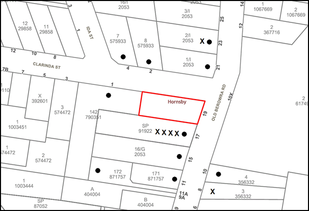

|
NOTIFICATION PLAN |
|||
|
• PROPERTIES NOTIFIED
|
X SUBMISSIONS RECEIVED |
PROPERTY SUBJECT OF DEVELOPMENT |
|
|
18 SUBMISSIONS RECEIVED OUT OF MAP RANGE |
|||
23 submissions objected to the development, generally on the grounds that the development would result in:
· An overdevelopment of the site
Comment: Whilst the proposal would comply with the maximum height allowance of 10.5m, Council considers that the boundary setbacks and large floor area of the building would be not be consistent in the streetscape context.
A further discussion is provided in Section 2.2 of this report.
· Unacceptable increase in traffic and traffic safety
Comment: A traffic report was not submitted with the application and an appropriate assessment of traffic was unable to be undertaken.
· Unacceptable off and on street car parking
Comment: The proposal complies with Council’s numerical standards for car parking which takes into amount child numbers and staff. Accordingly there is no requirement to provide on-street parking. No objections are raised in regard to parking.
· Unacceptable impact on the character of the street
Comment: Council considers that the limited setbacks to Clarinda Street and lack of deep soil planting would be out of character with the existing streetscape.
A further discussion is provided in Section 2.2 of this report.
· Unacceptable Pedestrian Safety
Comment: The parking assessment provided concludes that the proposal would be compliant with relevant Australian Standards regarding car parking spaces. Further, the centre would have separate pedestrian entrances on Clarinda Street and Old Berowra Road. No objections are raised in this regard.
· There are existing child care centres within the vicinity of the site
Comment: The child care centre can be located at any distance from existing or proposed childhood education and care facility in accordance with Clause 25(a) of the Childcare SEPP. No objections are raised in this regard.
· Unacceptable noise impacts from the centre and increased traffic
Comment: Council considers that the submitted acoustic report does not satisfactorily address potential acoustic concerns for surrounding residential land uses. The submitted acoustic report acknowledges that the centre would be likely to marginally exceed the recommended noise criteria for outdoor play areas for residential receivers.
A further discussion is provided in Section 2.2 of this report.
· Unacceptable hours of operation
Comment: No objections are raised to the proposed hours of operation as they are consistent with Objective C29 of the Child Care Planning Guideline (CCPG) which limits hours of operation between 7am to 7pm on weekdays.
· The proposal is contrary to zoning
Comment: ‘Child care centres’ are permissible with consent within the R3 Medium Density zone pursuant to the Hornby Local Environmental Plan 2013.
· The development would overshadow No. 17 Old Berowra Road
Comment: Council considers that the development would result in the overshadowing of the private open space of the southern townhouse development at No. 17 Old Berowra Road, specifically, Unit No. 2 which would not receive 3 hours of sunlight in mid-winter.
· The location is not acceptable for a child care centre
Comment: Council considers that the location of the centre is generally acceptable with respect to Part 3.1 of the CCPG.
A further discussion is provided in Section 2.2 of this report.
· Unacceptable location of the outdoor play areas
Comment: Council considers that the location of the outdoor play areas is not acceptable and would result in privacy, amenity and acoustic conflict for the southern adjoining property.
A further discussion is provided in Section 2.2 of this report.
· Unacceptable maximum number of children
Comment: The CCPG does not limit the maximum number of children for a child care centre. Notwithstanding, Council considers that a reduction in children could result in a building of smaller scale more appropriately suited to the site context.
· The development would result in the removal of many trees
Comment: The development would result in the removal of up to 10 trees. Council considers that there is not sufficient information in order to be able to undertake an appropriate tree assessment.
A further discussion is provided in Section 2.4 of this report.
· The submitted documents provide conflicting and not enough information
Comment: Council considers that the submitted documentation is not sufficient, specifically there is conflicting information regarding the preservation of trees, lack of detail and errors within the acoustic report, elevation plans, no traffic assessment and lack of information regarding earthworks and site remediation.
· Unacceptable construction impacts
Comment: Council requested a Construction Traffic Management Plan given large quantities of soil would be required to be removed from the site. This information was not provided and an appropriate assessment was unable to be undertaken.
· No shade cover for the first floor play area
Comment: Amended plans indicate the location of shade structures. No objections are raised in this regard give the centre would require licencing before operation in accordance with the provisions of the Children (Education and Care Services) Supplementary Provisions Regulations 2012.
· High voltage power lines within the vicinity of children
Comment: There is no known high voltage, or easements within the vicinity of the site. Ausgrid state their street power lines comply with relevant health standards.
· The boundary fences being more than 1.8m
Comment: Revised plans indicate 1.8m boundary fences on the western and southern boundary. A 300mm Perspex extension would be provided on the southern façade. Generally, no objections are raised in this regard.
5.2 Public Agencies
The development application was not required to be referred to any Public Agencies for comment.
6. THE PUBLIC INTEREST
Section 4.15(1)(e) of the Act requires Council to consider “the public interest”.
The public interest is an overarching requirement, which includes the consideration of the matters discussed in this report. Implicit to the public interest is the achievement of future built outcomes adequately responding to and respecting the future desired outcomes expressed in environmental planning instruments and development control plans.
The proposed child care centre is contrary to Council’s planning controls, the Child Care Planning Guideline 2017 and does not contain sufficient information. Accordingly, it is considered that the proposed development would not be in the public interest.
CONCLUSION
The application proposes demolition of existing structures and construction of a 72 place purpose built child care centre. The centre would be two storeys with a basement car park comprising 18 spaces.
The proposal is contrary to the planning objectives within Part 1.3 of the Childcare Planning Guideline 2017 in that the proposal is not compatible within the existing streetscape and the proposal does not adequately minimise adverse impacts on adjoining properties and the neighbourhood. The proposal is contrary to the design principles of Part 2 in relation to built form, landscaping and amenity. The proposal is contrary to the Part 3 considerations of the guideline with respect to Part 3.2 local character, streetscape and the public domain interface, Part 3.3 building orientation, envelope and design, Part 3.4 landscaping, Part 3.5 visual and acoustic privacy, Part 3.6 noise and pollution and Part 3.8 traffic, parking and pedestrian circulation.
The proposal is contrary to local planning controls and does not comply with the HDCP prescriptive measures for building and basement setbacks, minimum landscaped area and maximum number of children.
23 submissions have been received by Council objecting to the proposal. More than 10 of the submissions received are unique in respect to the concerns raised regarding the proposal. The Local Planning Panel is the determining authority for the application.
The application is recommended for refusal.
Note: At the time of the completion of this planning report, no persons have made a Political Donations Disclosure Statement pursuant to Section 10.4 of the Environmental Planning and Assessment Act 1979 in respect of the subject planning application.
RESPONSIBLE OFFICER
The officer responsible for the preparation of this report is Stephen Dobbs.
Attachments:
|
Cassandra Williams Team Leader - Major Applications Planning Division |
Rod Pickles Manager - Development Assessment Planning Division |
|
1.⇨ |
Locality Plan |
|
|
|
2.⇨ |
Plans Architectural |
|
|
File Reference: DA/653/2018
Document Number: D07613182
SCHEDULE 1
1. In accordance with Section 4.15(1)(a)(i) of the Environmental Planning and Assessment Act 1979, the proposal does not comply with Clause 23 of State Environmental Planning Policy (Educational Establishments and Childcare Facilities) 2017 and the Child Care Planning Guideline 2017 as:
1.1 The proposal is contrary to the planning objectives within Part 1.3 of the Guideline in that the proposal is not compatible within the existing streetscape and the proposal does not adequately minimise adverse impacts on adjoining properties and the neighbourhood.
1.2 The proposal is contrary to the design principles of Part 2 of the Guideline in relation to built form, landscaping and amenity.
1.3 The proposal is contrary to the Part 3 considerations of the guideline with respect to Part 3.2 Local Character, Streetscape and the public domain interface, Part 3.3 Building Orientation, Envelope and Design, Part 3.4 Landscaping, Part 3.5 Visual and Acoustic Privacy, Part 3.6 Noise and Pollution and Part 3.8 Traffic, Parking and Pedestrian Circulation.
1.4 The proposal is contrary to Part 4 of the Guideline in respect to outdoor storage.
2. In accordance with Section 4.15(1)(a)(i) of the Environmental Planning and Assessment Act 1979, the proposal contains insufficient information in order for an assessment to be undertaken in accordance with the State Environmental Planning Policy (Vegetation in Non-Rural Areas) 2017.
3. In accordance with Section 4.15(1)(a)(i) of the Environmental Planning and Assessment Act 1979, the proposal contains insufficient information in order for an assessment to be undertaken in accordance with State Environmental Planning Policy No. 55 – Remediation of Land.
4. In accordance with Section 4.15(1)(a)(i) of the Environmental Planning and Assessment Act 1979, the proposal contains insufficient information in order for an assessment to be undertaken in accordance with Clause 6.2 Earthworks of the Hornsby Local Environmental Plan 2013.
5. Pursuant to Section 4.15(1)(b) of the Environmental Planning and Assessment Act 1979, the development would result in an adverse environmental and amenity impact on the surrounding built environment as the proposal would not provide sufficient setbacks, deep soil planning, create visual and acoustic conflict, overshadow and not be consistent with the existing streetscape.
6. Pursuant to Section 4.15(1)(e) of the Environmental Planning and Assessment Act 1979, the development would not be in the public interest as the proposal is contrary to the local planning controls.
7. In accordance with Section 4.15(1)(a)(iii) of the Environmental Planning and Assessment Act 1979, the proposal does not comply with the desired outcomes or the prescriptive measures of the Hornsby Development Control Plan 2013 in respect to Part 7.1.3 Setbacks.
- END OF REASONS FOR REFUSAL -
LPP Report No. LPP7/19
Local Planning Panel
Date of Meeting: 27/03/2019
3 DEVELOPMENT APPLICATION - THE DEMOLITION OF ALL EXISTING STRUCTURES, THE CONSTRUCTION OF 2 X TWO STOREY BOARDING HOUSE BUILDINGS COMPRISING A TOTAL OF 8 ROOMS ACCOMMODATING 15 LODGERS, AND THE CONSTRUCTION OF A CARPORT
![]() EXECUTIVE SUMMARY
EXECUTIVE SUMMARY
|
DA No: |
DA/933/2018 (Lodged on 20 September 2018) |
|
Description: |
The demolition of all existing structures, the construction of 2 x two storey boarding house buildings comprising a total of 8 rooms accommodating 15 lodgers and the construction of a carport structure |
|
Property: |
Lot 4 DP 101099 – No. 4 Northcote Road, Hornsby |
|
Applicant: |
Mr Z. Huang |
|
Owner: |
Mr J. Lin |
|
Estimated Value: |
$1,720,507 |
|
Ward: |
B |
· The application involves the demolition of all existing structures, the construction of 2 x two storey boarding house buildings comprising a total of 8 rooms accommodating 15 lodgers, and the construction of a carport structure comprising 4 car parking spaces.
· The proposal generally complies with State Environmental Planning Policy (Affordable Rental Housing) 2009, the Hornsby Local Environmental Plan 2013, and the Hornsby Development Control Plan 2013.
· Thirty-two submissions have been received in respect of the application.
· It is recommended that the application be approved.
|
THAT Development Application No. DA/933/2018 for the demolition of all existing structures, the construction of 2 x two storey boarding house buildings comprising a total of 8 rooms accommodating 15 lodgers, and the construction of a carport structure at Lot 4 DP 101099, No. 4 Northcote Road Hornsby be approved subject to the conditions of consent detailed in Schedule 1 of LPP Report No. LPP7/19. |
BACKGROUND
On 20 September 2018, the subject Development Application (DA/933/2018) was lodged with Council.
On 29 November 2018, Council requested amended plans from the applicant raising concerns regarding non-compliance with State Environmental Planning Policy (Affordable Rental Housing) 2009 (SEPP Affordable Housing) and the HDCP with respect to on-site parking, letterboxes, privacy, noise and vibration, disabled access, landscaping, windows, estimated cost of works, bin storage and the provision of laundry facilities.
On 7 December 2018, Council requested the provision of additional information in the form of a Water Quality Treatment System plan and the submission of architectural plans to ensure that vehicles could enter and leave the site in a forward direction.
On 12 February 2019, Council received amended plans and additional information addressing Council’s concerns regarding non-compliance with SEPP Affordable Housing and the HDCP, as requested by Council on 29 November 2018 and 7 December 2018.
On 15 February 2019, Council requested further amendments to the architectural plans to address concerns raised with regard to the articulation of the southern elevation of the rear building, overlooking from the first floor windows to adjacent properties and the relocation of the bin storage area to a location more suitable to the low density residential character of Northcote Road. On 18 February 2019, Council received the requested amended plans addressing Council’s concerns.
On 18 February 2019, the amended Development Application was renotified.
On 6 March 2019, Council received amended Architectural Plans (Revision D) demonstrating the deletion of the garage outbuilding, car stacker system and vehicle turn table and replacement with a 4 car carport structure. In addition, Council received a Plan of Management, an amended Landscape Plan and an amended BASIX Certificate.
SITE
The 1,034.7m2 site is rectangular in shape and is located on the northern side of Northcote Road Hornsby and contains a single storey dwelling house to the front, and a garage outbuilding to the rear.
The site has a width of 15.24m along the frontage, with a depth of 67.895m along the side boundaries.
The site experiences a fall of 1.5 metres to the front, south-western corner.
The adjoining site to the east at No. 2 Northcote Road contains a two storey dwelling house with garage outbuilding. The adjoining site to the west at No. 6 Northcote Road contains a single storey dwelling house with a garage outbuilding to the rear. The adjoining site to the rear at No. 8 Northcote Road contains a townhouse development.
Northcote Road is a local street with a streetscape comprising a mixture of single and two storey dwelling houses, multiple townhouse developments, a childcare centre at Nos. 36-38 Northcote Road, a multi-unit housing development at No. 12 Northcote Road and Hornsby Hospital which is located to the east at the intersection of Northcote Road and Palmerston Road.
A boarding house at No. 31 Northcote Road Hornsby has recently been approved approximately 300m west of the subject site, although construction has not yet commenced.
The site is located approximately 50m to the ‘575’ route bus stops on either side of Northcote Road, regularly serviced daily by Transport NSW to and from Hornsby Station and nearby shopping centres.
The site is not bushfire or flood prone and is not burdened by any easements or restrictions.
The site does not contain a heritage item, is not in the vicinity of a heritage listed item and is not located within a heritage conservation area.
PROPOSAL
The application proposes the demolition of all existing structures, the construction of 2 x two storey boarding house buildings comprising a total of 8 rooms accommodating 15 lodgers, and the construction of a carport comprising 4 car parking spaces.
The front boarding house building would comprise the following:
· Four self-contained boarding rooms, each comprising two lodgers with shared kitchen, bathroom and laundry. Rooms 1 and 2 on the ground floor would have access to a private balcony along the eastern elevation;
· Internal stairs connecting to common pathways on the ground and first floor levels, providing access to the rooms;
· One of the rooms would be ‘accessible’, comprising a bedroom, bathroom, kitchen, laundry and balcony
The rear boarding house building would comprise the following:
· Four self-contained boarding rooms, each comprising two lodgers with shared kitchen, bathroom and laundry. Lodgers 4 and 6 on the ground floor would have access to a private balcony along the eastern elevation;
· Internal stairs connecting to common pathways on the ground and first floor levels, providing access to the rooms
The carport would comprise a total of 4 car parking spaces, including 1 accessible car parking space.
A bicycle and motorbike parking area would be provided to the front of the site, within a partially enclosed vehicular entrance.
A common bin storage area is proposed adjacent to the eastern side boundary, approximately 15m to the front boundary.
One tree would be removed to facilitate the proposed development. One replacement tree is proposed to be planted within the front setback.
ASSESSMENT
The development application has been assessed having regard to the Greater Sydney Region Plan - A Metropolis of Three Cities, the North District Plan and the matters for consideration prescribed under Section 4.15 of the Environmental Planning and Assessment Act 1979 (the Act). The following issues have been identified for further consideration.
1. STRATEGIC CONTEXT
1.1 Greater Sydney Region Plan - A Metropolis of Three Cities and North District Plan
The Greater Sydney Region Plan - A Metropolis of Three Cities has been prepared by the NSW State Government to guide land use planning decisions for the next 40 years (to 2056). The Plan sets a strategy and actions for accommodating Sydney’s future population growth and identifies dwelling targets to ensure supply meets demand. The Plan also identifies that the most suitable areas for new housing are in locations close to jobs, public transport, community facilities and services.
The NSW Government will use the subregional planning process to define objectives and set goals for job creation, housing supply and choice in each subregion. Hornsby Shire has been grouped with Hunters Hill, Ku-ring-gai, Lane Cove, Mosman, North Sydney, Ryde, Northern Beaches and Willoughby to form the North District. The Greater Sydney Commission has released the North District Plan which includes priorities and actions for Northern District for the next 20 years. The identified challenge for Hornsby Shire will be to provide an additional 4,350 dwellings by 2021 with further strategic supply targets to be identified to deliver 97,000 additional dwellings in the North District by 2036.
The proposed development would be consistent with the Greater Sydney Region Plan - A Metropolis of Three Cities and the North District Plan, by contributing to achieving the dwelling targets and providing affordable rental housing in the region.
2. STATUTORY CONTROLS
Section 4.15(1)(a) requires Council to consider “any relevant environmental planning instruments, draft environmental planning instruments, development control plans, planning agreements and regulations”.
2.1 Hornsby Local Environmental Plan 2013
The proposed development has been assessed having regard to the provisions of the Hornsby Local Environmental Plan 2013 (HLEP).
2.1.1 Zoning of Land and Permissibility
The site is zoned R2 Low Density Residential pursuant to the Land Use Table of the HLEP. The proposed development is defined as a boarding house and is permissible within the R2 Low Density Residential Zone.
The objectives of the R2 zone are:
· To provide for the housing needs of the community within a low density residential environment; and
· To enable other land uses that provide facilities or services to meet the day to day needs of residents.
Pursuant to the HLEP a ‘boarding house’ is defined as follows:
‘boarding house’ means a building that:
(a) Is wholly or partly let in lodgings, and
(b) Provides lodgers with a principal place of residence for 3 months or more, and
(c) May have shared facilities, such as a communal living room, bathroom, kitchen or laundry, and
(d) Has rooms, some or all of which may have private kitchen and bathroom facilities, that accommodate one or more lodgers,
but does not include backpackers’ accommodation, a group home, hotel or motel accommodation, seniors housing or a serviced apartment.
Subject to a recommended operational condition requiring that lodgers reside within the rooms for a minimum of 3 months; and that the boarding house buildings be wholly or partly let in lodgings, the proposed development would meet the requirements of the definition of a ‘boarding house’ in the HLEP.
2.1.2 Height of Buildings
Clause 4.3 of the HLEP provides that the height of a building on any land should not exceed the maximum height shown for the land on the Height of Buildings Map. The maximum permissible height for the subject site is 8.5m. The proposed development would have a maximum height of 7.5m above the existing ground level and would comply with this requirement.
2.1.3 Heritage Conservation
Clause 5.10 of the HLEP sets out heritage conservation provisions for Hornsby Shire. The site does not include a heritage item, is not located in a heritage conservation area and is not in the vicinity of a heritage listed item. Accordingly, no further assessment regarding heritage is necessary.
2.1.4 Earthworks
Clause 6.2 of the HLEP states that consent is required for proposed earthworks on site. Before granting consent for earthworks, Council is required to assess the impacts of the works on adjoining properties, drainage patterns and soil stability of the locality.
The development would require excavation of a maximum depth of 400mm and a maximum fill of 450mm. Council’s engineering assessment has concluded that the extent of the proposed earthworks is minor and would be acceptable given the gentle slope of the land. It is considered that the adjacent properties would be unaffected by the proposal with regard to stormwater flows and soil stability.
A condition has been recommended requiring that all landfill be Virgin Excavated Natural Material and all excavated material removed from the in accordance with NSW Waste Classification Guidelines and Protection of the Environment Operations (Waste) Regulation 2014 and that all excavated material removed from the site in accordance with the Department of Environment, Climate Change and Water NSW Waste Classification Guidelines.
Subject to compliance with the recommended conditions, the proposal is considered acceptable in this regard.
2.2 State Environmental Planning Policy (Vegetation in Non-Rural Areas) 2017
State Environmental Planning Policy (Vegetation in Non-Rural Areas) 2017 (Vegetation SEPP) commenced 25 August 2017 and aims to protect the biodiversity and amenity values of trees within non-rural areas of the state.
Part 3, Clause 9(2) of the Vegetation SEPP states that a Development Control Plan may make a declaration in any manner relating to species, size, location and presence of vegetation. Accordingly, Part 1B.6.1 of the HDCP prescribes works that can be undertaken with or without consent to trees and objectives for tree preservation.
Part 3.1.1 of this report provides an assessment in accordance with Part 1B.6.1 of the HDCP.
2.3 Sydney Regional Environmental Plan No. 20 – Hawkesbury – Nepean River
The site is located within the catchment of the Hawkesbury Nepean River. Part 2 of this Plan contains general planning considerations and strategies requiring Council to consider the impacts of development on water quality, aquaculture, recreation and tourism.
Subject to the implementation of sediment and erosion control measures and stormwater management to protect water quality, the proposal would comply with the requirements of the Policy.
2.4 State Environmental Planning Policy (Building Sustainability Index – BASIX) 2004
The application has been assessed against the requirements of State Environmental Planning Policy (Building Sustainability Index: BASIX) 2004. The proposal includes a BASIX Certificate for the proposed development and is considered to be satisfactory.
2.5 State Environmental Planning Policy No. 55 Remediation of Land
The application has been assessed against the requirements of State Environmental Planning Policy No. 55 – Remediation of Land under which consent must not be granted to the carrying out of any development on land unless the consent authority has considered whether the land is contaminated or requires remediation for the proposed use.
Should the land be contaminated Council must be satisfied that the land is suitable in a contaminated state for the proposed use. If the land requires remediation to be undertaken to make the land suitable for the proposed use, Council must be satisfied that the land will be remediated before the land is used for that purpose.
An examination of Council’s records and aerial photography has determined that the site has been historically used for residential purposes. It is not likely that the site has experienced any significant contamination, and further assessment under SEPP 55 is not required.
2.6 State Environmental Planning Policy (Affordable Rental Housing) 2009
Division 3 of Part 2 of SEPP Affordable Housing permits development for the purposes of “boarding houses” on land in R2 Low Density Residential zone if the land is within an “accessible area”. Clause Nos. 29-30A provide the development standards for the assessment of a boarding house.
Accordingly, the application has been assessed against the requirements of the SEPP Affordable Housing. The Policy includes development standards and applies criteria for boarding house development.
The following table sets out the proposal’s compliance with the prescriptive standards of the Policy:
|
SEPP - Affordable Rental Housing Clause 29: Standards that cannot be used to refuse consent |
|||
|
Control |
Proposal |
Requirement |
Compliance |
|
Site Area |
1,034.7m2 |
N/A |
N/A |
|
Floor Space Ratio A consent authority must not refuse consent to development to which this Division applies on the grounds of density or scale if the density and scale of the buildings when expressed as a floor space ratio are not more than: · The existing maximum floor space ratio for any form of residential accommodation permitted on the land. |
N/A |
HLEP does not incorporate any floor space ratio development standard for the R2 Low Density Residential zone |
N/A |
|
Building Height |
7.5m |
8.5m |
Yes |
|
Landscape Area
|
37.5% of the site is landscaped. 1 large tree is be planted in front setback |
Landscape treatment of the front setback area is compatible with the streetscape |
Yes |
|
Private Open Space for Lodgers |
63m2 with a minimum dimension of 3.8m |
>20m2 with a minimum dimension of 3m |
Yes |
|
Car Parking |
4 spaces (including 1 disabled) |
4 spaces (@ 0.5 spaces per room) |
Yes |
|
Min. size of boarding room |
|
|
|
|
Single lodger (Room 1) |
21.5m2 |
Min. 12m2 |
Yes |
|
Double lodger (Rooms 2 – 8) |
25m2 |
Min. 16m2 |
Yes |
|
Max. size of boarding room |
25m2 |
25m2 |
Yes |
|
Private kitchen and bathroom facilities |
All rooms contain private kitchens and bathroom facilities |
A boarding house may have private kitchen or bathroom facilities in each boarding room but is not required to have those facilities in any boarding room |
Yes |
|
SEPP - Affordable Rental Housing Clause 30: Standards for boarding houses |
|||
|
Control |
Proposal |
Requirement |
Compliance |
|
Communal Living area |
A communal living room is proposed to the ground and first floors of the front building |
At least 1 communal living area if a boarding house has more than 5 boarding rooms |
Yes |
|
Number of Adult Lodgers Per Room |
1-2 lodgers per room |
Max. 2 lodgers per room |
Yes |
|
Bathroom and Kitchen Facilities |
Each room is self-contained with a kitchen and bathroom |
Adequate bathroom and kitchen facilities will be available within the boarding house for the use of each lodger |
Yes |
|
Boarding House Manager |
There would be a maximum of 15 lodgers. A manager is not required |
Boarding house manager for 20 or more lodgers |
Yes |
|
Bicycle and Motorcycle Parking |
Adequate parking space for 2 bicycles and 2 motorcycles within the enclosed vehicular entrance |
1 bicycle space and 1 space for motorcycle, for every 5 boarding rooms |
Yes |
As detailed in the above table, the proposed boarding house complies with the relevant prescriptive standards within the Policy. Below is a brief discussion concerning the proposal and the mandatory and prescriptive provisions of SEPP Affordable Housing.
2.6.1 Accessible Area
Clause 27 SEPP Affordable Housing requires the subject site to be located within an accessible area.
Clause 4 of the SEPP Affordable Housing defines an “Accessible Area” as follows:
accessible area means land that is within:
1. 800 metres walking distance of a public entrance to a railway station or a wharf from which a Sydney Ferries ferry service operates, or
2. 400 metres walking distance of a public entrance to a light rail station or, in the case of a light rail station with no entrance, 400 metres walking distance of a platform of the light rail station, or
3. 400 metres walking distance of a bus stop used by a regular bus service (within the meaning of the Passenger Transport Act 1990) that has at least one bus per hour servicing the bus stop between 06.00 and 21.00 each day from Monday to Friday (both days inclusive) and between 08.00 and 18.00 on each Saturday and Sunday.
The site is located approximately 50m to the ‘575’ route bus stops on either side of Northcote Road, serviced by Transport NSW to and from Hornsby Station and nearby shopping centres. A search of the Transport NSW website has revealed that at least one bus per hour would service the bus stops between 06.00 and 21.00 each day from Monday to Friday and between 08.00 and 18.00 on each Saturday and Sunday.
The site would meet the accessible area criteria applicable for boarding house development in accordance with Clause 27 of SEPP Affordable Housing.
2.6.2 Density
SEPP Affordable Housing stipulates that the floor space ratio of any development for a boarding house should not exceed the maximum permissible floor space ratio for any form of residential accommodation in the zone.
The HLEP does not incorporate any floor space ratio development standard for the R2 Low Density Residential zone. The density of developments in the zone is guided by the height, maximum floor area of a dwelling house, landscaping and site coverage requirements within the HDCP.
The HDCP prescribed maximum site coverage of 40% for the site, maximum gross floor area of 430m2 for a dwelling house and 100m2 for an outbuilding. The proposed gross floor area of the buildings is a total of 427m2. The total site coverage for the site would be 26%.
Given the above, it is considered that the proposal complies with the desired density within the R2 Low Density Residential zone.
2.6.3 Building Height
A maximum building height of 8.5m is a prescriptive standard pursuant to SEPP Affordable Housing and the HLEP. The proposed development would have a maximum height of 7.5m above the existing ground level and would comply with this requirement.
2.6.4 Landscape Area
A submission has been received raising concerns that the proposed landscaping does not comply with SEPP Affordable Housing.
SEPP Affordable Housing requires that landscape treatment of the front setback should be compatible with the streetscape. As indicated on the Landscape Plan, the proposed front setback of 7.4m to Northcote Road incorporates dense landscaping which is consistent with the established streetscape of Northcote Road and is considered acceptable in this regard.
2.6.5 Solar Access
SEPP Affordable Housing prescriptive measure for solar access requires one communal living room to receive a minimum of 3 hours of direct sunlight between 9am and 3pm in mid-winter. The ground and first floor communal living spaces of the front building includes the provision of windows which enable direct sunlight in accordance with the requirements of SEPP Affordable Housing.
2.6.6 Private Open Space
Clause 29(2)(d)(i) of SEPP Affordable Housing requires one area of private open space to be provided of at least 20m2 with a minimum dimension of 3m for the use of the lodgers. As indicated on the submitted Landscape Plan, the proposal includes a 63m2 private open space area to the rear of the site with a minimum dimension of 3.8m. In addition, Room Nos. 1 – 4 on the ground floor each contain a 10m2 private balcony.
The proposal would comply with the minimum private open space requirements.
2.6.7 Parking
Submissions have been received raising concerns that there is a lack of parking on-site and on Northcote Road and that the proposal does not have an adequate turning area for vehicles to exit the site in a forward direction.
Clause 29(2)(e)(iia) of SEPP Affordable Housing states that in the case where a boarding house development is not carried out by or on behalf of a social housing provider, at least 0.5 parking spaces are to be provided for each boarding room. Given the proposed development comprises a total of 8 rooms; the proposal requires the provision of 4 car parking spaces.
The carport would comprise a total of 4 car parking spaces, including 1 accessible car parking space and would comply with SEPP Affordable Housing in this regard. It is anticipated that the lodgers will predominantly make use of the nearby public transport, posing a minimal impact to on-street parking.
It is considered that the proposal meets the parking requirements of SEPP Affordable Housing.
2.6.8 Accommodation Size
The proposal includes 1 single lodger room and 7 dual lodger rooms with bathroom, laundry and kitchen facilities. Each boarding room includes a wardrobe providing storage facilities for the residents. The accommodation size complies with the objectives of SEPP Affordable Housing.
2.6.9 Character of Local Area
Submissions have been received raising concerns that the development would be contrary to the character of the area.
Clause 30A of SEPP Affordable Housing is as follows:
“A consent authority must not consent to development to which this Division applies unless it has taken into consideration whether the design of the development is compatible with the character of the local area.”
An assessment of the proposed development against the local character of the area is provided below:
· The proposed boarding house buildings and the garage outbuilding would have a site coverage less than 26%. The boarding house buildings would have a gross floor area less than the permissible 430m2 for a dwelling house in the R2 Low Density Residential zone.
· The built form of the proposed development is similar to the built form for a dwelling housing, which is a permissible in the R2 zone.
· The development exhibits boundary setbacks that comply with the HDCP setback requirements for dwelling houses in the R2 zone and is comparable to the existing front setbacks along Northcote Road.
· The proposed landscaping, driveway and car parking are similar to those existing within the area; thereby respecting both the existing and future character of the area.
· The proposed development does not create unreasonable environmental impacts to adjoining development with regard to visual bulk, overshadowing, solar access or privacy impacts.
It is considered that the development has regard to the context of the local area and would be compatible with the existing residential character.
2.6.10 Boarding Houses in Zone R2 Low Density Residential
On 28 February 2019, amendments were made to SEPP Affordable Housing, with the inclusion of Clause 30AA which states that a consent authority must not grant development consent to a boarding house on land within Zone R2 Low Density Residential or within a land use zone that is equivalent to that zone unless it is satisfied that the boarding house has no more than 12 boarding rooms.
Further, Clause 54C as part of the amended SEPP provides a ‘savings provision’ in which in the instance that a development application was made before the commencement of the amending SEPP and was not determined by a consent authority, all the provisions of the SEPP are to be applied by the consent authority during assessment of the development application.
The proposed development includes the provision of 8 boarding rooms and meets the provisions of Clause 30AA of the SEPP.
2.7 Section 3.42 Environmental Planning and Assessment Act, 1979 - Purpose and Status of Development Control Plans
Section 3.42 of the Environmental Planning and Assessment Act 1979 states that a DCP provision will have no effect if it prevents or unreasonably restricts development that is otherwise permitted and complies with the development standards in relevant Local Environmental Plans and State Environmental Planning Policies.
The principal purpose of a development control plan is to provide guidance on the aims of any environmental planning instrument that applies to the development; facilitate development that is permissible under any such instrument; and achieve the objectives of land zones. The provisions contained in a DCP are not statutory requirements and are for guidance purposes only. Consent authorities have flexibility to consider innovative solutions when assessing development proposals, to assist achieve good planning outcomes.
2.8 Hornsby Development Control Plan 2013
As stated above, the Hornsby Development Control Plan requires that boarding houses comply with the planning controls within the SEPP Affordable Housing. The application has been assessed as satisfactory in this regard.
2.9 Section 7.12 Contributions
Hornsby Shire Council Section 94A Contributions Plan 2014 – 2024 applies to the development as the estimated costs of works is greater than $100,000. Should the application be approved, an appropriate condition of consent is recommended requiring the payment of a contribution in accordance with the Plan.
3. ENVIRONMENTAL IMPACTS
Section 4.15(1)(b) of the Act requires Council to consider “the likely impacts of that development, including environmental impacts on both the natural and built environments, and social and economic impacts in the locality”.
3.1 Natural Environment
3.1.1 Tree and Vegetation Preservation
A submission has been received raising concerns that numerous trees would be removed to facilitate the development.
The proposed development would necessitate the removal of 1 tree from the site, identified as tree No. 1 within Appendix F of the submitted Arborist Report.
As indicated in the submitted Arborist Report, Tree No. 1 is a non-indigenous ‘Date Palm’ tree of a mature age with a ‘medium’ estimated life expectancy and of ‘fair’ condition. The report concludes that the tree is not worthy of retention and would be required to be removed to facilitate the proposed development. Council’s tree assessment concurs with the conclusion of the report, subject to a recommended condition requiring the implementation of the Landscape Plan, which indicates the planting of 1 tree to the front setback and 2 trees within the rear setback.
The proposed development would be located within close proximity to four trees on adjacent properties, identified as trees Nos. 2 (Native Daphne), 3 (Weeping Bottlebrush), 4 (Weeping Bottlebrush) and 5 (Weeping Bottlebrush) within Appendix F of the submitted Arborist Report. To ensure the protection of these trees during construction, conditions have been recommended requiring that a Project Arborist be appointed to oversee the installation of tree protection fencing and to provide any remedial actions for works within the TPZ of these trees.
It is noted that the submitted Landscape Plan (Issue C) indicates the planting of 3 trees within the front and rear setbacks, resulting in a net increase of 2 trees and additional tree canopy on the site.
Subject to conditions, the proposal is considered acceptable with regard to tree and vegetation preservation.
3.1.2 Stormwater Management
The proposed development would be drained via an on-site stormwater detention system to Council’s stormwater system along Northcote Road.
On 30 January 2019, Council requested additional information from the applicant in the form of engineering plans indicating the provision of a Water Quality Treatment System for the proposed development. On 12 February 2019, Council received the requested plans to address Council’s water quality concerns.
Council’s assessment of the Stormwater Drainage Plan (prepared by PL Civil Engineering dated 11 February 2019) has determined that the proposal in its current form would not meet the water quality requirements of Part 1C.1.2(j) of the HDCP. To address this issue, a condition has been recommended in Schedule 1 requiring that a suitably qualified engineer design a Water Quality Treatment System and validation report certifying that the design meets the stormwater quality targets of the HDCP.
Council’s stormwater assessment has deemed the proposed method of stormwater dispersal as acceptable and would not pose a detrimental flooding impact on adjacent properties or the subject site, subject to recommended conditions.
3.2 Built Environment
3.2.1 Built Form
The proposed two storey boarding house buildings are similar in built form as a dwelling house, which is a permissible in the R2 zone. The proposed development would generally maintain the existing presentation of the site in respect to the low density character of the locality.
3.2.2 Traffic
A submission has been received raising concerns that the development would increase traffic and reduce road safety on Northcote Road.
The proposed boarding house development is not categorised as a traffic generating development pursuant to the provision of State Environmental Planning Policy (Infrastructure) 2007.
Council acknowledges that Northcote Road experiences traffic due to the close proximity of Hornsby Hospital and the numerous townhouse developments, the childcare centre and the multi-unit housing development on Northcote Road.
Given that 4 on-site car parking spaces are proposed to service the development, Council’s traffic assessment has determined that a total of 8 vehicle trips would be generated by the proposed development during AM and PM peak hours. Due to the proximity of the site to public transport and the expected number of occupants on the site, it is anticipated that the volume of vehicular traffic generated by the development would be minor and in keeping with the surrounding area.
The application is acceptable having regard to traffic generation in the locality.
3.3 Social Impacts
The proposal is a form of affordable housing permissible within the R2 zone pursuant to the provisions of the HLEP and SEPP Affordable Housing. The development would provide housing choice in the locality and would result in affordable short term residential accommodation in close proximity to public transport.
3.4 Economic Impacts
The proposal would have a minor positive impact on the local economy in conjunction with other low density residential development in the locality by generating an increase in demand for local services.
4. SITE SUITABILITY
Section 4.15(1)(c) of the Act requires Council to consider “the suitability of the site for the development”.
The subject site has not been identified as bushfire prone or flood prone land. The site is considered to be capable of accommodating the proposed development. The scale of the proposed development is consistent with the capability of the site and is considered acceptable.
5. PUBLIC PARTICIPATION
Section 4.15(1)(d) of the Act requires Council to consider “any submissions made in accordance with this Act”.
5.1 Community Consultation
The proposed development was placed on public exhibition and was notified to adjoining and nearby landowners between 4 October 2018 and 26 October 2018 in accordance with the Notification and Exhibition requirements of the HDCP. During this period, Council received 6 submissions. The proposal was substantially amended, and accordingly, the application was re-notified to the public between 18 February 2019 and 5 March 2019. During this period, Council received 16 submissions. Council notes that an additional 10 submissions were received outside of the notification periods and have nonetheless been addressed below. The map below illustrates the location of those nearby landowners who made a submission that are in close proximity to the development site.
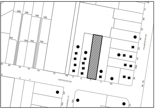
|
NOTIFICATION PLAN |
|||
|
• PROPERTIES NOTIFIED
|
X SUBMISSIONS RECEIVED |
PROPERTY SUBJECT OF DEVELOPMENT |
|
|
16 SUBMISSIONS RECEIVED OUT OF MAP RANGE |
|||
Thirty-two submissions objected to the development, generally on the grounds that the development would result in:
· Lack of parking on-site and on Northcote Road;
· The development would be contrary to the character of the area;
· Numerous trees would be removed to facilitate the development;
· The development would pose a detrimental privacy impact to adjacent properties;
· A boarding house has already been approved by Council at No. 31 Northcote Road and the proposed development would generate a saturation of affordable housing;
· The development would negatively impact property values of nearby properties;
· The development would overshadow adjacent properties;
· The development would pose an unreasonable impact to noise, disturbance and safety of nearby residents;
· The development would increase traffic and reduce road safety on Northcote Road;
· A Plan of Management has not been submitted with the application;
· The estimated cost of works has been undervalued;
· Residents of the development may pose a safety concern to nearby residents;
· The proposed landscaping does not comply with the SEPP Affordable Housing;
· The proposal does not have an adequate turning area for vehicles to exit the site in a forward direction;
· The proposal does not include enough communal areas for boarders to utilise;
· There is not enough space to store bins on-site and on Council’s nature strip;
· The vehicle car stacker system within the proposed garage would generate unreasonable noise to adjacent properties;
· The western side boundary fence is proposed to be 1.5m high, which would pose a privacy concern to the adjacent property;
· The ground floor level pathways along the western elevation of the boarding house buildings would facilitate overlooking into the adjacent property at No. 6 Northcote Road.
The merits of the matters raised in the community submissions have been addressed in the body of the report with the exception of the following:
5.1.1 Privacy
Submissions have been received raising concerns that the proposed development would pose a detrimental privacy impact to the adjacent residential properties at Nos. 2 and 6 Northcote Road.
Council’s assessment of the originally submitted architectural plans (revision A) raised concerns with regard to privacy impacts to Nos. 2 and 6 Northcote Road. In particular, issues were raised with the proposed first floor balconies, the external stairs, the first floor level pathways and the windows on both boarding house buildings.
Subsequent to Council’s request to address these issues, Council received and notified Revision C of the architectural plans to the public. The amended plans indicated the deletion of the first floor level balconies, the conversion of the external stairs to be internal, the enclosure of the first floor level pathways, and the provision of highlight windows to the ground and first floor levels along the western elevations.
Council’s assessment notes that the windows along the eastern elevations of the first floors would be located 4m from the eastern side boundary and would not pose a detrimental privacy impact to the adjacent property at No. 2 Northcote Road.
The finished floor level of the ground floor level pathways along the western elevation of the boarding house buildings would be located 200mm - 500mm above the existing natural ground level and it is anticipated that the 1.8m high boundary fence would prevent overlooking into the adjacent property at No. 6 Northcote Road.
The proposal as amended is considered acceptable with regard to privacy.
5.1.2 Saturation of Affordable Housing on Northcote Road
A submission has been submitted raising concerns that a boarding house has already been approved by Council at No. 31 Northcote Road and the proposed development would generate a saturation of affordable housing.
In addressing this concern, the SEPP Affordable Housing does not provide any provisions that prohibit or restrict the development of boarding houses on the basis of saturation. The proposed development would be consistent with the Greater Sydney Region Plan - A Metropolis of Three Cities and the North District Plan, by contributing to achieving the dwelling targets and providing affordable rental housing in the region.
Accordingly, the application is considered acceptable in this regard.
5.1.3 Property Values
A submission has been received raising concerns that the development would negatively impact property values of nearby properties.
In addressing this concern, Section 4.15 of the Environmental Planning and Assessment Act 1979 and SEPP Affordable Housing does not require Council to take into consideration the impact of a development on the value of nearby properties. Nonetheless, Council acknowledges that the boarding house development complies with the development standards of the SEPP and is designed to maintain the low density character of the area.
5.1.4 Overshadowing
Submissions have been received raising concerns that the proposed development would overshadow the adjacent properties at Nos. 2 and 6 Northcote Road.
The submitted shadow diagrams indicate that all adjacent properties would receive a minimum of 3 hours of sunlight access between 9am and 3pm on 22 June. The proposed development would comply with the density and height requirements of the SEPP and would have substantial setbacks to the side boundaries.
The proposal is considered acceptable with regard to overshadowing.
5.1.5 Noise, Safety and Disturbance
Submissions have been received raising concerns that the development would pose an unreasonable impact to noise, disturbance and safety of nearby residents.
Consideration has been given to the minimisation of noise and disturbance of adjacent properties through the enclosure of the first floor level pathways and stairs and the provision of highlight windows along the western elevations of the buildings.
With regard to safety and disturbance, a condition has been recommended requiring that the submitted Plan of Management be enforced which provides measures to reduce disturbance and improve safety to adjacent properties, including:
· No loud music or television noise is permitted after 10.00pm.
· No parties or gatherings are permitted upon the premises after 10.00pm.
· No visitors other than residents of the property are permitted after 10.00pm.
· No use of the outdoor areas is permitted after 10.00pm.
· No smoking in areas which may affect the amenity of other residents of the boarding house or of residents of neighbouring properties.
· Motor bike engines are to be turned off before entering the site and pushed to the parking area. Bikes shall only be started at the front setback area at the driveway.
5.1.6 Plan of Management
A submission has been received raising concern that a Plan of Management has not been submitted with the application to determine how the boarding house would be effectively managed.
On 6 March 2019, the applicant submitted a Plan of Management which provides management policies with regard to the duties of the off-site manager (owner), maximum number of lodgers, minimum lease period, minimising impacts on residents, display of house rules, fire safety, cleaning and maintenance, waste management, and safety and security.
A condition has been recommended in Schedule 1 requiring that the Plan of Management be enforced in perpetuity.
5.1.7 Estimated Cost of Works
A submission has been received raising concern that the estimated cost of works has been undervalued at $700,000.
To confirm the accuracy of the estimated costs of works, Council requested the submission of a Detailed Cost Report prepared by a registered Quantity Surveyor in accordance with in accordance with the Australian Cost Management Manuals from the Australian Institute of Quantity Surveyors.
The submitted Cost Report has provided a revised estimated cost of works of $1,720,507 and is considered to be accurately costed.
5.1.8 Communal Areas
A submission has been received raising concerns that the proposal does not include enough communal areas for lodgers to utilise.
The SEPP Affordable Housing requires that at least 1 communal living area be provided if a boarding house has more than 5 boarding rooms. The proposed development includes a communal living area to the ground and first floor level of the front building and would comply with this requirement.
5.1.9 Bin Storage
A submission has been received raising concern that is not enough space to store bins on-site and on Council’s nature strip.
The SEPP Affordable Housing does not provide any provisions with regard to bin storage, and accordingly a merit assessment has been undertaken in this regard.
A concrete common bin storage area is proposed adjacent to the eastern side boundary which is capable of storing all bins on the site, approximately 15m to the front boundary.
The lot width is 12m excluding the driveway, which is determined to be of adequate width to store the bins prior to collection and is considered acceptable in this regard.
5.1.10 Vehicle Stacker
A submission has been received raising concerns that the vertical car stacker system providing two car parking spaces within the garage (As indicated on the Ground & First Floor Plan, Revision C) would generate unacceptable levels of noise to neighbouring residents.
Council received amended plans (Ground & First Floor Plan, Revision D) indicating that the garage outbuilding and car stacker system would be deleted from the proposal and replaced by a lightweight carport structure accommodating 4 car parking spaces, including one disabled car parking space.
As the car stacker system has been omitted from the latest iteration of the proposal, Council’s assessment has determined that the noise generated by the development would be significantly reduced and in keeping with adjacent residential landuses.
5.1.11 Boundary Fence
A submission has been received raising concerns that the western side boundary fence is proposed to be 1.5m high, which would pose privacy concerns to the adjacent property at No. 6 Northcote Road.
Council notes that the exact location, design and costing for the erection of boundary fencing are to be the subject of negotiation and agreement with adjacent landowners in accordance with the relevant requirements of the Dividing Fences Act 1991. Nonetheless, the latest iteration of the architectural plans (revision D) demonstrates that the western side boundary fence would be 1.8m high and is considered to provide adequate privacy to the adjacent property at No. 6 Northcote Road.
5.2 Public Agencies
The development application was not referred to any Public Agencies for comment.
6. THE PUBLIC INTEREST
Section 4.15(1)(e) of the Act requires Council to consider “the public interest”.
The public interest is an overarching requirement, which includes the consideration of the matters discussed in this report. Implicit to the public interest is the achievement of future built outcomes adequately responding to and respecting the future desired outcomes expressed in environmental planning instruments and development control plans.
The application is considered to have satisfactorily addressed Council’s and relevant agencies’ criteria and would provide a development outcome that, on balance, would result in a positive impact for the community. Accordingly, it is considered that approval of the proposed development would be in the public interest.
CONCLUSION
The application proposes the demolition of all existing structures, the construction of 2 x two storey boarding house buildings comprising a total of 8 rooms accommodating 15 lodgers, and the construction of a carport structure comprising 4 car parking spaces.
The development generally meets the desired outcomes of Council’s planning controls and is satisfactory having regard to the matters for consideration under Section 4.15 of the Environmental Planning and Assessment Act 1979.
Council received 32 submissions during the public notification period. The matters raised have been addressed in the body of the report.
Conditions are recommended to minimise disruption to residential amenity.
Having regard to the circumstances of the case, approval of the application is recommended.
Note: At the time of the completion of this planning report, no persons have made a Political Donations Disclosure Statement pursuant to Section 10.4 of the Environmental Planning and Assessment Act 1979 in respect of the subject planning application.
RESPONSIBLE OFFICER
The officer responsible for the preparation of this report is Thomas Dales.
|
Cassandra Williams Team Leader - Major Applications Planning Division |
Rod Pickles Manager - Development Assessment Planning Division |
|
1.⇨ |
Locality Plan |
|
|
|
2.⇨ |
Plans Architectural |
|
|
|
3.⇨ |
Landscape Plans |
|
|
|
4.⇨ |
Management Plan |
|
|
File Reference: DA/933/2018
Document Number: D07615330
SCHEDULE 1
The conditions of consent within this notice of determination have been applied to ensure that the use of the land and/or building is carried out in such a manner that is consistent with the aims and objectives of the relevant legislation, planning instruments and Council policies affecting the land and does not disrupt the amenity of the neighbourhood or impact upon the environment.
Note: For the purpose of this consent, the term ‘applicant’ means any person who has the authority to act on or the benefit of the development consent.
Note: For the purpose of this consent, any reference to an Act, Regulation, Australian Standard or publication by a public authority shall be taken to mean the gazetted Act or Regulation, or adopted Australian Standard or publication as in force on the date that the application for a construction certificate is made.
1. Approved Plans and Supporting Documentation
The development must be carried out in accordance with the plans and documentation listed below and endorsed with Council’s stamp, except where amended by Council and/or other conditions of this consent:
Approved Plans
|
Plan No. |
Plan Title |
Drawn by |
Dated |
|
Page 1, Rev D |
Site Plan & Location Plan |
Everising Design |
3.05.2018 |
|
Page 2, Rev D |
Ground & First Floor Plans |
Everising Design |
3.05.2018 |
|
Page 3, Rev D |
Elevations, Sections & Finishes |
Everising Design |
3.05.2018 |
|
2017-028, Issue C |
Landscape Plan |
True Form Landscape Architects |
7.03.2019 |
Supporting Documents
|
Document Title |
Prepared by |
Dated |
Council Reference |
|
Plan of Management |
Everising Pty Ltd |
6.03.2019 |
D07626472 |
|
BASIX Certificate No. 873095M_03 |
Certified Energy |
7.03.2019 |
D07626470 |
|
Arboricultural Impact Assessment |
Redgum Horticultural |
10.09.2018 |
D07529001 |
|
Shadow Diagrams, Rev D |
Everising Design |
3.05.2018 |
D07626471 |
2. Construction Certificate
a) A Construction Certificate is required to be approved by Council or a Private Certifying Authority prior to the commencement of any works under this consent.
b) A separate Construction Certificate must be obtained from Council for all works within the public road reserve under S138 of the Roads Act.
c) A separate Construction Certificate must be obtained from Council for all works within drainage easements vested in Council.
d) The Construction Certificate plans must not be inconsistent with the Development Consent plans.
3. Section 7.12 Development Contributions
a) In accordance with Section 4.17(1) of the Environmental Planning and Assessment Act 1979 and the Hornsby Shire Council Section 94A Development Contributions Plan 2014-2024, $17,205.05 must be paid to Council to cater for the increased demand for community infrastructure resulting from the development, based on development costs of $1,720,507.
b) The value of this contribution is current as at 4 March 2019. If this contribution is not paid within the financial quarter that this condition was generated, the contribution payable will be adjusted in accordance with the provisions of the Hornsby Shire Council Section 94 Development Contributions Plan and the amount payable will be calculated at the time of payment in the following manner:
$CPY = $CDC x CPIPY
CPIDC
Where:
$CPY is the amount of the contribution at the date of Payment
$CDC is the amount of the contribution as set out in this Development Consent
CPIPY is the latest release of the Consumer Price Index (Sydney – All Groups) at the date of Payment as published by the ABS.
CPIDC is the Consumer Price Index (Sydney – All Groups) for the financial quarter at the date applicable in this Development Consent Condition.
a) c) The monetary contributions must be paid to Council:
(i) prior to the issue of the Subdivision Certificate where the development is for subdivision; or
(ii) prior to the issue of the first Construction Certificate where the development is for building work; or
(iii) prior to issue of the Subdivision Certificate or first Construction Certificate, whichever occurs first, where the development involves both subdivision and building work; or
(iv) prior to the works commencing where the development does not require a Construction Certificate or Subdivision Certificate.
Note: It is the professional responsibility of the Principal Certifying Authority to ensure that the monetary contributions have been paid to Council in accordance with the above timeframes. Council’s S94A Development Contributions Plan may be viewed at www.hornsby.nsw.gov.au or a copy may be inspected at Council’s Administration Centre during normal business hours.
4. Appointment of a Project Arborist
a) A project arborist with AQF Level 5 qualifications must be appointed to provide monitoring and certification throughout the construction period.
b) Details of the appointed project arborist must be submitted to Council and the PCA for registration with the application for the construction certificate.
5. Removal of Trees
This development consent permits the removal of one tree numbered 1 as identified on page 15 contained in the Arboricultural Impact Assessment prepared by Redgum Horticultural dated 17 August 2018.
Note: The removal of any other trees from the site requires separate approval by Council in accordance with Part 1B.6 Tree and Vegetation Preservation of the Hornsby Development Control Plan, 2013 (HDCP).
REQUIREMENTS PRIOR TO THE ISSUE OF A CONSTRUCTION CERTIFICATE
The stormwater drainage system for the development must be designed in accordance with Council’s Civil Works – Design and Construction Specification 2005 and the following requirements:
a) Connected to an existing Council piped drainage system with the following requirements:
i) A separate Application must be made to Council for ‘Approval To Connect Stormwater Drainage Outlet To Council’s System’ with all fees paid, prior to connecting to Council’s drainage system;
ii) The connection to Council’s drainage pit or pipeline in accordance with Councils Design Standard Drawing No. 6 must be inspected by a Council Engineer from Council’s Planning Division;
Note: An inspection booking can be made by calling Council on 9847 6760 quoting the Application reference number commencing SD.
iii) Prior to the issue of an Occupation Certificate a Compliance Certificate must be obtained from Council for the connection to Council’s drainage system.
7. Water Quality Treatment
a) A Water Quality Treatment System must be designed for the development in accordance with the requirements of Part 1C.1.2(j) of the Hornsby Council Development Control Plan 2013 and submitted to Council for approval prior to the issue of the Construction Certificate.
b) A suitably qualified engineer must prepare a validation report using MUSIC-link for Hornsby Council certifying that the design meets the stormwater quality targets outlined in Table 1.C.1.2(b) of the Hornsby Council Development Control Plan 2013, or utilise one of the following deemed to comply solutions:
i) 80% of the roof area of the development is to drain to a tank(s) that has a capacity of 3,000 litres per 100m2 of roof area of the development. The tank(s) is to be connected to the communal water system, and to all dwellings for toilet flushing and laundry, or
ii) Provide a bioretention system(s) which is at least 1.5% of the total impervious.
8. On Site Stormwater Detention
An on-site stormwater detention system must be designed by a chartered civil engineer and constructed in accordance with the following requirements:
a) Have a capacity of not less than 9.2 cubic metres, and a maximum discharge (when full) of 18.0 litres per second.
b) Have a surcharge/inspection grate located directly above the outlet.
c) Discharge from the detention system to be controlled via 1 metre length of pipe, not less than 50 millimetres diameter or via a stainless plate with sharply drilled orifice bolted over the face of the outlet discharging into a larger diameter pipe capable of carrying the design flow to an approved Council system.
d) Where above ground and the average depth is greater than 0.3 metres, a ‘pool type’ safety fence and warning signs to be installed.
e) Not be constructed in a location that would impact upon the visual or recreational amenity of residents.
Note: A construction certificate shall be obtained prior to the commencement of these works and are to be completed prior to the issue of an occupation certificate.
9. Vehicular Crossing – Boundary Levels
A separate application under the Local Government Act 1993 and the Roads Act 1993 being an “Application for Boundary Levels” must be submitted to Council to obtain design levels at the front boundary for the design of the internal driveway, prior to the issue of a construction Certificate.
Note: A separate application to construct the vehicular crossing being an “Application to Construct Vehicular Crossing from Roadway to Property” is required to be submitted to Council for approval and can only be made by one of Council’s Authorised Vehicular Crossing Contractors. You are advised to contact Council on 02 9847 6940 to obtain a list of contractors.
10. Internal Driveway/Vehicular Areas
The driveway and parking areas on site must be designed in accordance with Australian Standards 2890.1, 2890.2, 3727 and the following requirements:
a) Design levels at the front boundary must be obtained from Council;
b) The driveway must be a rigid pavement;
c) Prior to the issue of a construction certificate, a certificate from a qualified engineer shall be submitted to the principal certifying authority certifying that the access driveway, parking and services areas have been designed in accordance with Australian Standards AS 2890.1 and AS 2890.2.
Note: A construction certificate shall be obtained prior to the commencement of these works and are to be completed prior to the issue of an occupation certificate.
11. Car Parking and Deliveries
All car parking must be constructed and operated in accordance with Australian Standard AS 2890.1 – 2004 – Off Street Car Parking and Australian Standard AS2890.2 - 2002 – Off Street Commercial and the following requirements:
a) All parking areas and driveways must be sealed to an all-weather standard, line marked and signposted;
b) Car parking, loading and manoeuvring areas must be used solely for nominated purposes;
c) Vehicles awaiting loading, unloading or servicing must be parked on site and not on adjacent or nearby public roads; and
d) All vehicular entry on to the site and egress from the site must be made in a forward direction.
12. Building Code of Australia
All approved building work must be carried out in accordance with the relevant requirements of the Building Code of Australia.
13. Contract of Insurance (Residential Building Work)
Where residential building work for which the Home Building Act 1989 requires there to be a contract of insurance in force in accordance with Part 6 of that Act, this contract of insurance must be in force before any building work authorised to be carried out by the consent commences.
14. Notification of Home Building Act 1989 Requirements
Residential building work within the meaning of the Home Building Act 1989 must not be carried out unless the principal certifying authority for the development to which the work relates (not being Council) has given Council written notice of the following information:
a) In the case of work for which a principal contractor is required to be appointed:
i) The name and licence number of the principal contractor; and
ii) The name of the insurer by which the work is insured under Part 6 of that Act.
b) In the case of work to be done by an owner-builder:
i) The name of the owner-builder; and
ii) If the owner-builder is required to hold an owner-builder’s permit under that Act, the number of the owner-builder’s permit.
Note: If arrangements for doing the residential building work are changed while the work is in progress so that the information notified becomes out of date, further work must not be carried out unless the principal certifying authority for the development to which the work relates (not being Council) has given Council written notification of the updated information.
The applicant must submit written evidence of the following service provider requirements:
a) Ausgrid (formerly Energy Australia) – a letter of consent demonstrating that satisfactory arrangements have been made to service the proposed development.
b) Telstra / NBN - a letter of consent demonstrating that satisfactory arrangements have been made to service the proposed development.
16. Sydney Water – Approval
This application must be submitted to Sydney Water for approval to determine whether the development would affect any Sydney Water infrastructure, and whether further requirements are to be met.
Note: Building plan approvals can be obtained online via Sydney Water Tap inTM through www.sydneywater.com.au under the Building and Development tab.
17. Disabled Access
The new buildings are required to meet the requirements of the Disability (Access to Premises Buildings) Standards 2010.
REQUIREMENTS PRIOR TO THE COMMENCEMENT OF ANY WORKS
18. Installation of Tree Protection Fencing
a) All tree protection measures for the trees to be retained must have the protection measures for the ground, trunk and canopy installed in accordance with the relevant requirements of Australian Standard AS 4970-2009 - “Protection of Trees on Development Sites”.
a) All tree protection fencing for the trees to be retained must be erected around trees numbered 2, 3, 4 and 5 as specified in the submitted Arboricultural Impact Assessment prepared by Redgum Horticultural dated 17 August 2018.
b) To facilitate construction works in the vicinity of trees Nos. 2, 3, 4 and 5, the tree protection fencing may be temporarily moved under the supervision of the project arborist. The fencing must be re-positioned upon completion of the construction works in the vicinity of these trees.
19. Tree Protection Certification
To ensure that all tree protection measures are correctly installed, a certificate from the appointed project arborist must be submitted to the Principal Certifying Authority confirming compliance with the tree protection requirements of this consent.
20. Erection of Construction Sign
a) A sign must be erected in a prominent position on any site on which any approved work is being carried out:
i) Showing the name, address and telephone number of the principal certifying authority for the work;
ii) Showing the name of the principal contractor (if any) for any demolition or building work and a telephone number on which that person may be contacted outside working hours; and
iii) Stating that unauthorised entry to the work site is prohibited.
b) The sign is to be maintained while the approved work is being carried out and must be removed when the work has been completed.
21. Protection of Adjoining Areas
A temporary hoarding, fence or awning must be erected between the work site and adjoining lands before the works begin and must be kept in place until after the completion of the works if the works:
a) Could cause a danger, obstruction or inconvenience to pedestrian or vehicular traffic;
b) Could cause damage to adjoining lands by falling objects; and/or
c) Involve the enclosure of a public place or part of a public place.
Have been identified as requiring a temporary hoarding, fence or awning within the Council approved Construction Management Plan (CMP).
Note: Notwithstanding the above, Council’s separate written approval is required prior to the erection of any structure or other obstruction on public land.
22. Toilet Facilities
a) To provide a safe and hygienic workplace, toilet facilities must be available or be installed at the works site before works begin and must be maintained until the works are completed at a ratio of one toilet for every 20 persons employed at the site.
b) Each toilet must:
i) be a standard flushing toilet connected to a public sewer; or
ii) be a temporary chemical closet approved under the Local Government Act 1993; or
iii) have an on-site effluent disposal system approved under the Local Government Act 1993.
23. Erosion and Sediment Control
To protect the water quality of the downstream environment, erosion and sediment control measures must be provided and maintained throughout the construction period in accordance with the manual ‘Soils and Construction 2004 (Bluebook)’, the approved plans, Council specifications and to the satisfaction of the principal certifying authority. The erosion and sediment control devices must remain in place until the site has been stabilised and revegetated.
Note: On the spot penalties may be issued for any non-compliance with this requirement without any further notification or warning.
REQUIREMENTS DURING DEMOLITION AND CONSTRUCTION
24. Vehicular Crossing - Construction
A separate application under the Local Government Act, 1993 and the Roads Act 1993 being an “Application to Construct Vehicular Crossing from Roadway to Property” must be submitted to Council for the installation of a new vehicular crossing and the removal of the redundant crossing. The vehicular crossing must be constructed in accordance with Council’s Civil Works Design Specification 2005 and the following requirements:
a. Crossing levels at the front boundary must be constructed to the design levels obtained from Council;
b. Any redundant crossings must be replaced with integral kerb and gutter;
c. The footway area must be restored by turfing;
d. Approval must be obtained from all relevant utility providers that all necessary conduits be provided and protected under the crossing.
Note: An application for a vehicular crossing can only be made to one of Council’s Authorised Vehicular Crossing Contractors. You are advised to contact Council on 02 9847 6940 to obtain a list of contractors.
25. Construction Work Hours
All works on site, including demolition and earth works, must only occur between 7am and 5pm Monday to Saturday.
No work is to be undertaken on Sundays or public holidays.
26. Demolition
To protect the surrounding environment, all demolition work must be carried out in accordance with Australian Standard AS2601-2001 – The Demolition of Structures and the following requirements:
a) Demolition material must be disposed of to an authorised recycling and/or waste disposal site and/or in accordance with an approved waste management plan; and
b) Demolition works, where asbestos material is being removed, must be undertaken by a contractor that holds an appropriate licence issued by SafeWork NSW in accordance with the Work Health and Safety Regulation 2017 and be appropriately transported and disposed of in accordance with the Protection of the Environment Operations (Waste) Regulation 2014; and
c) On construction sites where any building contain asbestos material, a standard commercially manufactured sign containing the words ‘DANGER ASBESTOS REMOVAL IN PROGRESS’ and measuring not less than 400mm x 300mm must be displayed in a prominent position visible from the street.
27. Environmental Management
To prevent sediment run-off, excessive dust, noise or odour emanating from the site during the construction, the site must be managed in accordance with the publication ‘Managing Urban Stormwater – Landcom (March 2004) and the Protection of the Environment Operations Act 1997.
28. Council Property
To ensure that the public reserve is kept in a clean, tidy and safe condition during construction works, no building materials, waste, machinery or related matter is to be stored on the road or footpath.
Note: This consent does not give right of access to the site via Council’s park or reserve. Should such access be required, separate written approval is to be obtained from Council.
29. Disturbance of Existing Site
During construction works, the existing ground levels of open space areas and natural landscape features, including natural rock-outcrops, vegetation, soil and watercourses must not be altered unless otherwise nominated on the approved plans.
30. Landfill
Landfill must be constructed in accordance with Council’s ‘Construction Specification 2005’ and the following requirements:
a) Prior to fill material being imported to the site, a certificate shall be obtained from a suitably qualified environmental consultant confirming the fill wholly consists of Virgin Excavated Natural Material (VENM) as defined in Schedule 1 of the Protection of the Environment Operations Act 1997 or material approved under the Department of Environment and Climate Change’s general resource recovery exemption.
b) A compaction certificate is to be obtained from a suitably qualified geotechnical engineer verifying that the specified compaction requirements have been met.
c) These certificates must be included with the application for an occupation certificate.
31. Excavated Material
All excavated material removed from the site must be classified by a suitably qualified person in accordance with the Department of Environment, Climate Change and Water NSW Waste Classification Guidelines and Protection of the Environment Operations (Waste) Regulation 2014 prior to disposal to an approved waste management facility and be reported to the principal certifying authority prior to the issue of an Occupation Certificate.
32. Survey Report
A report(s) must be prepared by a registered surveyor and submitted to the principal certifying authority:
a) Prior to the pouring of concrete at each level of the building certifying that:
i) The building, retaining walls and the like have been correctly positioned on the site; and
ii) The finished floor level(s) are in accordance with the approved plans.
33. Construction Waste Management
All work must be carried out in accordance with the waste management plan.
34. Works Near Trees
a) All works within the Tree Protection Zone (TPZ) of trees numbered 2, 3, 4 and 5 indicated in the Arborist Report are to be undertaken under the supervision of the project arborist.
b) To maintain tree health and condition, the appointed project arborist must monitor and record any and all necessary remedial actions required for trees numbered 2, 3, 4 and 5 for submission with the application for the Occupation Certificate.
35. Maintaining Tree protections zones
The Tree Protection Zone must be maintained in accordance with Section 4.6 requirements of Australian Standard AS 4970-2009 - “Protection of Trees on Development Sites”.
36. Building materials and Site Waste
The filling or stockpiling of building materials, the parking of vehicles or plant, the disposal of cement slurry, waste water or other contaminants must be located outside the tree protection zones as prescribed in the conditions of this consent or the prescriptive measures of Part 1B.6.1 Tree Preservation of the Hornsby Development Control Plan 2013, of any tree to be retained.
REQUIREMENTS PRIOR TO THE ISSUE OF AN OCCUPATION CERTIFICATE
Note: For the purpose of this consent, a reference to ‘occupation certificate’ shall not be taken to mean an ‘interim occupation certificate’ unless otherwise stated.
a) To protect the amenity of adjacent premises, all external lighting must be designed and installed in accordance with Australian Standard AS 4282 – Control of the Obtrusive Effects of Outdoor Lighting.
b) Certification of compliance with this Standard must be obtained from a suitably qualified person and submitted to the PCA with the application for the Construction Certificate.
38. Safety and Security
This site must include the following elements:
a) Automatic lighting is to be provided to pathways, building entries, driveways and common external spaces;
b) The driveway and car parking areas must be illuminated with low luminance at all times; and
c) Security deadlocks are to be provided to the main entry door and the individual room doors.
The exact location, design and costing for the erection of boundary fencing are to be the subject of negotiation and agreement in accordance with the relevant requirements of the Dividing Fences Act 1991.
Fencing must be erected along all property boundaries behind the front building alignment to a height of 1.8 metres.
Note: Alternative fencing may be erected subject to the written consent of the adjoining property owner(s).
40. Replacement Tree Requirements
a) The trees approved for removal under this consent must be offset through replacement planting of a minimum of 1 tree on the site.
a) All replacement plantings must be trees indigenous to Hornsby Shire, as identified at: http://www.hornsby.nsw.gov.au/environment/flora-and-fauna/tree-management/indigenous-trees
b) The location and size of plantings must comply with the following requirements:
i) All replacement trees must be located in front or rear setbacks and planted 4 metres or greater from the foundation walls of the approved development.
ii) The pot size of the replacement trees must be a minimum 25 litres
iii) All replacement trees must be a minimum of 3 metres in height.
iv) All replacement trees must have the potential to reach a mature height greater than 8 metres.
41. Final Certification Arborist
a) The suitably qualified person holding a certificate III in Horticulture must submit to the principal certifying authority a Statement/or/Certification confirming all Tree Replacement Requirements have been completed in accordance with approved landscape plans and conditions of consent.
b) The Project supervisor must submit to the principal certifying authority all relevant certificates with the application for the occupation certificate stating compliance with all the conditions of this consent.
c) The Project arborist must submit to the principal certifying authority a certificate that all the completed works have been carried out in compliance with the approved plans and specifications for tree protection.
d) Certification must include a statement of overall site attendance, the condition of the retained trees, details of any deviations from the approved tree protection measures and their impacts on trees.
Note: Copies of monitoring documentation may be required.
42. Sydney Water – s73 Certificate
A s73 Certificate must be obtained from Sydney Water and submitted to the PCA..
Note: Sydney Water requires that s73 applications are to be made through an authorised Sydney Water Servicing Coordinator. Refer to www.sydneywater.com.au or telephone 13 20 92 for assistance.
43. Creation of Easements
The following matter(s) must be nominated on the plan of subdivision under s88B of the Conveyancing Act 1919:
a) The creation of an appropriate "Positive Covenant" and "Restriction as to User" over the constructed on-site detention/retention systems, stormwater quality improvement devices and outlet works, within the lots in favour of Council in accordance with Council’s prescribed wording. The position of the on-site detention system and stormwater quality improvement devices is to be clearly indicated on the title.
b) To register the OSD easement, the restriction on the use of land “works-as-executed” details of the on-site-detention system and stormwater quality improvement devices must be submitted verifying that the required storage and discharge rates have been constructed in accordance with the design requirements. The details must show the invert levels of the on-site system together with pipe sizes and grades. Any variations to the approved plans must be shown in red on the “works-as-executed” plan and supported by calculations.
44. Certification of WSUD Facilities
Prior to the issue of an Occupation Certificate a certificate from a Civil Engineer is to be obtained stating that the WSUD facilities have been constructed and will meet the water quality targets as specified in the Hornsby Shire Councils DCP.
Note: Council must be nominated as the authority to release, vary or modify any easement, restriction or covenant.
45. Construction of Engineering Works
All engineering works identified in this consent are to be completed and a Compliance Certificate issued prior to the release of the Occupation Certificate or Subdivision Certificate.
46. Preservation of Survey Marks
Prior to the issue of an occupation certificate, a certificate by a Registered Surveyor shall be submitted to the Principal Certifying Authority, certifying that there has been no removal, damage, destruction, displacement or defacing of the existing survey marks in the vicinity of the proposed development or otherwise the re-establishment of damaged, removed or displaced survey marks has been undertaken in accordance with the Surveyor General’s Direction No.11 – “Preservation of Survey Infrastructure”.
47. Fulfilment of BASIX Commitments
The applicant must demonstrate the fulfilment of BASIX commitments pertaining to the development.
48. Damage to Council Assets
To protect public property and infrastructure, any damage caused to Council’s assets as a result of the construction or demolition of the development must be rectified by the applicant in accordance with Council’s Civil Works Specifications. Rectification works must be undertaken prior to the issue of an Occupation Certificate, or sooner, as directed by Council.
49. Smoke Alarms
To warn the occupants of the development in the event of a fire, smoke alarms must be installed in the approved development in accordance with the requirements of the Building Code of Australia.
OPERATIONAL CONDITIONS
50. Boarding House Management
The use of the premise must be managed in accordance with the Plan of Management as approved under this development consent.
51. Noise
a) All noise generated by the proposed development must be attenuated to prevent levels of noise being emitted to adjacent premises which possess tonal, beating and similar characteristics or which exceeds background noise levels by more than 5dB(A).
b) The boarding house is to be managed so that any emitted noise is at a level so as not to create an “offensive noise” as defined in the Protection of the Environment Operations Act 1997 to any affected receiver.
52. Use of Premises
The development approved under this consent shall be used for the purpose of a ‘Boarding House’ as defined by Hornsby Local Environmental Plan 2013 and not for any other purpose without Council’s separate written consent. The use of the premises must comply with the following requirements:
a) Is wholly or partly let in lodgings;
b) Provides lodgers with a principal place of residence for 3 months or more;
c) Includes 8 boarding rooms with kitchen and bathroom in each boarding room; and
d) Accommodates a maximum of 15 lodgers at any one time.
Note: The premises must not be used as backpackers’ accommodation, a group home, hotel or motel accommodation, seniors housing or a serviced apartment as defined by Hornsby Local Environmental Plan 2013.
53. Waste Management
As indicated in the approved Plan of Management, the owner (or off-site manager) is to be responsible for the collection arrangements, including making sure that the waste containers are placed adjacent to the kerb on the day of collection and returned back to the on-site bin storage area promptly after collection.
54. Landscape Establishment
The landscape works must be maintained into the future to ensure the establishment and successful growth of plant material to meet the intent of the landscape design. This must include but not limited to watering, weeding, replacement of failed plant material and promoting the growth of plants through standard industry practices.
55. Car Parking
All car parking must be constructed and operated in accordance with Australian Standard AS 2890.1 – 2004 – Off Street Car Parking and Australian Standard 2890.2 - 2002 – Off Street Commercial and the following requirements:
a) All parking areas and driveways must be sealed to an all-weather standard, line marked and signposted;
b) Car parking, loading and manoeuvring areas must be used solely for nominated purposes;
c) Vehicles awaiting loading, unloading or servicing must be parked on site and not on adjacent or nearby public roads;
d) All vehicular entry on to the site and egress from the site shall be made in a forward direction.
e) Any proposed landscaping and/or fencing must not restrict sight distance to pedestrians and cyclists travelling along the footpath.
f) All parking for people with disabilities is to comply with AS/NZS 2890.6:2009 Off-street parking for people with disabilities.
g) Two bicycle parking spaces are to be provided and designed in accordance with AS 2890.3-1993 Bicycle parking facilities.
h) Two motorcycle parking spaces are to be provided and designed in accordance with AS/NZS 2890.1:2004 Figure 2.7.
ADVISORY NOTES
The following information is provided for your assistance to ensure compliance with the Environmental Planning and Assessment Act 1979, Environmental Planning and Assessment Regulation 2000, other relevant legislation and Council’s policies and specifications. This information does not form part of the conditions of development consent pursuant to Section 4.17 of the Act.
Environmental Planning and Assessment Act 1979 Requirements
The Environmental Planning and Assessment Act 1979 requires:
· The issue of a construction certificate prior to the commencement of any works. Enquiries can be made to Council’s Customer Services Branch on 9847 6760.
· A principal certifying authority to be nominated and Council notified of that appointment prior to the commencement of any works.
· Council to be given at least two days written notice prior to the commencement of any works.
· Mandatory inspections of nominated stages of the construction inspected.
· An occupation certificate to be issued before occupying any building or commencing the use of the land.
Long Service Levy
In accordance with Section 34 of the Building and Construction Industry Long Service Payments Act 1986, a ‘Long Service Levy’ must be paid to the Long Service Payments Corporation or Hornsby Council.
Note: The rate of the Long Service Levy is 0.35% of the total cost of the work.
Note: Hornsby Council requires the payment of the Long Service Levy prior to the issue of a construction certificate.
Tree and Vegetation Preservation
A person must not ringbark, cut down, top, lop, remove, injure or wilfully destroy any tree or other vegetation protected under the Hornsby Development Control Plan 2013 without the authority conferred by a development consent or a permit granted by Council.
Notes: A tree is defined as a long lived, woody perennial plant with one or relatively few main stems with the potential to grow to a height greater than three metres (3M). (HDCP 1B.6.1.c).
Tree protection measures and distances are determined using the Australian Standard AS 4970:2009, “Protection of Trees on Development Sites”.
Fines may be imposed for non-compliance with the Hornsby Development Control Plan 2013.
Prior to commencing any works, the applicant is encouraged to contact Dial Before You Dig on 1100 or www.dialbeforeyoudig.com.au for free information on potential underground pipes and cables within the vicinity of the development site.
Should asbestos or asbestos products be encountered during demolition or construction works, you are advised to seek advice and information prior to disturbing this material. It is recommended that a contractor holding an asbestos-handling permit (issued by SafeWork NSW) be engaged to manage the proper handling of this material. Further information regarding the safe handling and removal of asbestos can be found at:
Alternatively, telephone the SafeWork NSW Asbestos and Demolition Team on 8260 5885.


