
BUSINESS PAPER
Local Planning Panel meeting
Wednesday 28 August 2019
at 6:30pm
BUSINESS PAPER
Local Planning Panel meeting
Wednesday 28 August 2019
at 6:30pm
Hornsby Shire Council Table of Contents
Page 0
Local Planning Panel
Item 1 LPP12/19 Demolition of Existing Dwelling House and Construction of a Purpose Built Child Care Centre for 40 Children................................................................................................. 1
Item 2 LPP20/19 Subdivision of 1 Lot into 2 Lots, Alterations & Additions to Dwelling on Lot 1 and Construction of a Dwelling on Lot 2............................................................................ 49
LPP Report No. LPP12/19
Local Planning Panel
Date of Meeting: 28/08/2019
1 DEMOLITION OF EXISTING DWELLING HOUSE AND CONSTRUCTION OF A PURPOSE BUILT CHILD CARE CENTRE FOR 40 CHILDREN
EXECUTIVE SUMMARY
|
DA No: |
DA/1348/2018 (Lodged on 20 December 2018) |
|
Description: |
Demolition of existing structures and construction of a 40-place single storey child care centre |
|
Property: |
Lot 30 DP 253532, No. 18 Tecoma Drive, Glenorie |
|
Applicant: |
ArtMade Architects |
|
Owner: |
Mr S A Z Gobrial and Mrs E Gobrial |
|
Estimated Value: |
$812,240 |
|
Ward: |
A |
· The application involves the demolition of existing structures and construction of a 40-place purpose-built child-care centre.
· The proposal generally complies with State Environmental Planning Policy (Educational Establishments and Childcare Facilities) 2017, the Child Care Planning Guideline 2017, the Hornsby Local Environmental Plan 2013 and the Hornsby Development Control Plan 2013.
· 14 submissions have been received in respect of the application.
· It is recommended that the application be approved.
|
THAT Development Application No. DA/1348/2018 for demolition of existing structures and construction of a 40-place child care centre at Lot 30 DP 253532, No. 18 Tecoma Drive, Glenorie be approved subject to the conditions of consent detailed in Schedule 1 of LPP Report No. LPP12/19 |
BACKGROUND
On 20 December 2018, the subject Development Application was lodged with Council.
On 4 January 2019, Council’s site inspection revealed that the notification sign was affixed to the telegraph pole to the frontage of an adjacent property, contrary to the DA notification requirements of the HDCP.
On 16 January 2019, Council requested additional information and revised plans in the form of a Construction Traffic Management Plan (CTMP), a Plan of Management, photographic evidence of the notification sign appropriately erected at the front of the property and the amendment of the submitted Floor Plan to indicate the provision of nappy change facilities. On 6 February 2019, Council received the requested information, with the exception of the CTMP whereby written justification was provided supporting its omission.
On 22 March 2019, Council requested additional information in the form of amended plans and documents to address concerns raised with regard to side boundary setbacks, the lack of landscaping within the side setbacks, traffic and parking, the positioning and scale of the proposed acoustic barrier and tree and vegetation preservation. On 12 April 2019, Council received the requested additional information and re-notified the application for 14 days.
On 7 June 2019 and 1 July 2019, Council received amended plans (Revisions D and E, respectively) to address concerns raised by Council including the minimum play space requirements of the Child Care Planning Guideline, inadequate landscaping along the front boundary and side setbacks forward of the front building line, pedestrian/vehicle conflicts in the carpark, and the obstruction of the bin carting route.
On 5 July 2019, Council engaged acoustic consultants Renzo Tonin & Associates to provide an independent peer review of the submitted Architectural Plans and the Environmental Noise Assessment prepared by Day Design Pty Ltd.
On 13 August 2019, the applicant submitted revised plans to provide the addition of a pergola to outdoor play area 2 to address acoustics, relocation of sand pit closer to the northern boundary to outdoor play area 2 to encourage quiet play, addition of perspex screen and extended wall of deck area to mitigate noise produced by children playing, existing dilapidated fence to be replaced by new lapped and capped fence and the unencumbered area to indoor play room 3 amended to comply with indoor open space requirements.
SITE
The 1,034m2 site is located on the eastern side of Tecoma Drive Glenorie and contains a single storey dwelling house and shed outbuildings to the rear.
The site is irregular in shape with a curved front boundary of 33m Arc and a rear boundary of 12m.
The site experiences an average fall of 7% to the rear, north-eastern corner.
Tecoma Drive is a low-density residential street with a streetscape predominantly comprising single storey dwelling houses.
The adjoining site to the south at No. 16 Tecoma Drive contains a single storey dwelling house with a garage outbuilding to the front. The adjoining site to the north at No. 20 Tecoma Drive contains a stepped two storey dwelling house. The adjacent property to the rear at No. 6 Wirra Place contains a single storey dwelling house. The secondary frontage of Glenorie Public School is located directly to the west of the subject site.
The site is bushfire prone and is burdened by a 2-metre-wide easement to drain water, which traverses the rear of the property in a north-south orientation.
The site does not contain a heritage item, is not in the vicinity of a heritage listed item and is not located within a heritage conservation area.
PROPOSAL
The application proposes demolition of existing structures and construction of a purpose-built single storey child care centre.
The centre would cater for a maximum of 40 children with the following age groups:
· 0-2 years 8 Children
· 2-3 years 12 Children
· 3-6 years 20 Children
The child care centre would comprise a nappy change room, 3 indoor play rooms, cot room, kitchen, laundry, kid’s toilet, accessible toilet, 3 storage rooms, office, staff room, an external storage outbuilding and a bin storage platform. The indoor playrooms would have direct access to an expansive rear deck to the rear elevation of the building. The two outdoor play areas to the rear of the site would be serviced by stairs and an accessibility ramp.
An open carpark would be provided to the front of the site comprising 10 car parking spaces, including 1 disabled space. Motorcycle parking and a bicycle rack would be provided to the front of the site.
A pedestrian access is proposed to the southern side of the frontage in the form of an accessible ramp, which would provide direct access to the front entry of the centre.
Eighteen trees are proposed to be removed to facilitate the proposed development. Landscaping is proposed within the front, side and rear setbacks, including the planting of 4 large trees along the front boundary. Additionally, 393 shrubs would be planted to the perimeter of the site.
A 2.4m high acoustic barrier would be installed to the rear potion of the northern and southern side boundaries and along the entirety of the rear boundary. The fencing would be offset 500mm from the boundaries and would entirely comprise of 1.1m high transparent Perspex sheeting to the upper portion, supported by steel posts.
The proposed operating hours of the child care centre would be 7:00am to 7:00pm, Monday to Friday (excluding public holidays). The centre would be operated by a maximum of 7 educators.
No signage is proposed as part of this application.
ASSESSMENT
The development application has been assessed having regard to the A Metropolis of Three Cities - the Greater Sydney Region Plan, the North District Plan and the matters for consideration prescribed under Section 4.15 of the Environmental Planning and Assessment Act 1979 (the Act). The following issues have been identified for further consideration.
1. STRATEGIC CONTEXT
1.1 Greater Sydney Region Plan - A Metropolis of Three Cities and North District Plan
A Metropolis of Three Cities – the Greater Sydney Region Plan has been prepared by the NSW State Government to guide land use planning decisions for the next 40 years (to 2056). The Plan sets a strategy and actions for accommodating Sydney’s future population growth and identifies key targets such as dwelling numbers, infrastructure planning, liability, sustainability and productivity.
Part 3 of the strategy relates to “Infrastructure and Collaboration” and a key objective is to provide services and infrastructure to meet communities’ changing needs. The strategy anticipates the number of infants aged between 0-4 years are projected to increase by 85,000 between 2016 and 2036 and as a consequence the number of early education and child care facilities will need to increase.
Further, the strategy cites changing demographics will affect the types and distribution of services required in neighbourhoods. The location of the proposed childcare centre would be accessible for nearby residents.
The proposed development would generally be consistent with A Metropolis of Three Cities, by providing additional services including job creation within a local neighbourhood.
The North District Plan provides a 20-year plan to manage growth and achieve the 40-year vision, while enhancing Greater Sydney’s liveability, productivity and sustainability into the future. It is a guide for implementing A Metropolis of Three Cities - the Greater Sydney Region Plan at a District level and is a bridge between regional and local planning.
Hornsby Shire has been grouped with Hunters Hill, Ku-ring-gai, Lane Cove, Mosman, North Sydney, Ryde, Northern Beaches and Willoughby to form the North District.
Over the 20 years to 2036, projections show an expected increase of 6,150 children aged four years and under. The identified challenge for Hornsby Shire will be to provide additional infrastructure for students and young people. The proposed child care centre would generally be consistent with the objectives of the strategy by providing 40 additional child care places.
2. STATUTORY CONTROLS
Section 4.15(1)(a) requires Council to consider “any relevant environmental planning instruments, draft environmental planning instruments, development control plans, planning agreements and regulations”.
2.1 Hornsby Local Environmental Plan 2013
The proposed development has been assessed having regard to the provisions of the Hornsby Local Environmental Plan 2013 (HLEP).
2.1.1 Zoning of Land and Permissibility
The subject land is zoned R2 (Low Density Residential) under the HLEP. The objectives of the zone are:
· To provide for the housing needs of the community within a low-density residential environment.
· To enable other land uses that provide facilities or services to meet the day to day needs of residents.
The proposed development is defined as a “child care centre” and is permissible in the zone with Council’s consent. The proposal is consistent with the objectives of the zone as it provides additional services to meet the day to day needs of residents in the locality.
2.1.2 Height of Buildings
Clause 4.3 of the HLEP provides that the height of a building on any land should not exceed the maximum height show for the land on the Height of Buildings Map. The maximum permissible height for the subject site is 8.5m. The proposal would have a height of 5.1m and complies with this provision.
2.1.3 Heritage Conservation
Clause 5.10 of the HLEP sets out heritage conservation provisions for Hornsby Shire. The site does not include a heritage item and is not located in a heritage conservation area. Accordingly, no further assessment regarding heritage is necessary.
2.1.4 Earthworks
Clause 6.2 of the HLEP notes that consent is required for proposed earthworks on site. Before granting consent for earthworks, Council is required to assess the impacts of the works on adjoining properties, drainage patterns and soil stability of the locality.
An assessment is provided below in accordance with Clause 6.2 of the HLEP.
(a) The likely disruption of, or any detrimental effect on, drainage patterns and soil stability in the locality of the development.
Comment: The proposed earthworks are unlikely to have any detrimental effect on the drainage patterns or soil stability in the locality as the proposed development would dispose of stormwater at an acceptable grade to the existing inter-allotment drainage system to the rear of the site.
(b) The effect of the development on the likely future use or redevelopment of the land.
Comment: The earthworks would not likely restrict future use or redevelopment of the land.
(c) The quality of the fill or the soil to be excavated, or both.
Comment: There would be a maximum fill of 500mm to facilitate the proposed child care centre building. The outdoor play areas would not require landform modification.
(d) The effect of the development on the existing and likely amenity of adjoining properties.
Comment: The proposed development would be located 1 to 2 metres from the adjacent properties to the north and south. The proposed setbacks are in keeping with surrounding residential development and are considered acceptable with regard to amenity.
(e) The source of any fill material and the destination of any excavated material.
Comment: The submitted Waste Management Plan indicates that concrete obtained from the demolition of the existing buildings would be reused as fill onsite. A condition has been recommended requiring that all surplus excavated material be disposed to an approved waste management facility.
(f) The likelihood of disturbing relics.
Comment: Council records do not indicate that any relics are likely to occur on site.
(g) The proximity to, and potential for adverse impacts on, any waterway, drinking water catchment or environmentally sensitive area.
Comment: The site is not located in close proximity to any significant catchment or environmentally sensitive area.
(h) Any appropriate measures proposed to avoid, minimise or mitigate the impacts of the development.
Comment: A condition has been recommended in Schedule 1 requiring that erosion and sediment control measures be provided and maintained throughout the construction period in accordance with the manual ‘Soils and Construction 2004 (Bluebook)’, the approved plans and Council specifications prior to the commencement of any works.
The proposed earthworks would not detrimentally impact the surrounding natural and built environment with regard to drainage patterns and soil stability of the locality.
The proposal complies with Clause 6.2(3)(h) of the HLEP and is considered acceptable in this regard.
2.2 State Environmental Planning Policy (Educational Establishments and Childcare Facilities) 2017
State Environmental Planning Policy (Educational Establishments and Childcare Facilities) 2017 (Childcare SEPP) commenced on 1 September 2017.
Clause 23 of the Childcare SEPP requires Council to consider the relevant provisions of the Child Care Planning Guideline 2017 (CCPG).
The CCPG will generally take precedence over the HDCP with the exception of building height, side and rear setbacks and car parking rates.
An assessment of the application against Part 1.3 Planning objectives, Part 2 Design quality principles, Part 3 Matters for consideration and Part 4 Applying the National Regulations to development proposals is provided below:
Part 1.3 - What are the planning objectives?
The planning objectives contained within Part 1.3 of the CCPG include requirements that child care facilities are compatible with the existing streetscape, context and neighbouring land uses and that they seek to minimise adverse impacts of development on adjoining properties and the neighbourhood.
As per the discussion provided in response to Part 3 of the CCPG, the proposal is considered consistent with these objectives as the development would minimise adverse impacts with adjacent land uses and would be consistent with the existing streetscape.
Part 2 - Design quality principles
As per the discussion provided in response to Part 3 of the CCPG, the proposal is considered consistent with the design quality principles of Part 2 in relation to built form, landscaping and amenity, subject to conditions.
Part 3.1 - Site selection and location
Child care centres are a permissible land use within the subject R2 low density residential zone. The site is located approximately 400m from the ‘637’ route bus stops along Old Northern Road. The site is not flood prone, does not adjoin a state road and is not within close proximity to incompatible development. The site is not located within the vicinity of any known heavy or hazardous industries, waste depots, service stations or the like.
The site is located adjacent to Glenorie Public School which would facilitate convenient drop-off and pick-up arrangements for parents with children enrolled in both the school and the proposed childcare centre.
The proposal meets the objectives of Part 3.1 of the CCPG and no concerns are raised with respect to site selection and location.
Part 3.2 - Local character, streetscape and the public domain interface
A submission has been received raising concerns that the development is out of character with the area.
Tecoma Drive is a low-density residential street with a streetscape predominantly comprising single storey dwelling houses. The adjoining site to the south at No. 16 Tecoma Drive contains a single storey dwelling house with a garage outbuilding to the front. The adjoining site to the north at No. 20 Tecoma Drive contains a stepped two storey dwelling house. The adjacent property to the rear at No. 6 Wirra Place contains a single storey dwelling house. The secondary frontage of Glenorie Public School is located directly to the west of the subject site.
The proposed development would be consistent in height with the surrounding low-density developments. The proposal also complies with Objective C12 of the CCPG which encourages setbacks that are consistent with the existing street character.
The façade of the childcare centre would utilise a mix of facebrick, concrete render as well as beige and brown tone paints. The proposed materials and finishes of the centre would not be out of character with other buildings in the locality. It is noted that the proposed acoustic barrier would be installed along the perimeter of the rear yard and would not be visible from the street.
Part 3.3 - Building orientation, envelope and design
The proposed child care centre would be orientated towards Tecoma Drive and would satisfactorily address the street frontage by virtue of the 8.45m front setback and the single storey bulk and scale. The scale of the proposed development would be consistent with the adjacent low-density residential development and the built form would positively contribute to the streetscape.
The outdoor play areas would be located to the rear of the site and would not be visible from Tecoma Street or the adjacent properties.
In addition, the single storey development would not pose a detrimental impact to adjacent properties with respect to sunlight access and is considered acceptable in this regard.
The development generally complies with Part 3.3 of the CCPG and is deemed appropriate in this respect.
Part 3.4 - Landscaping
Submissions have been received raising concerns that:
· Sufficient space exists within the front setback to accommodate large canopy trees rather than the proposed medium size trees; and
· All trees removed should be replaced with the same number and type of trees, not with grasses and groundcovers.
The objectives of Part 3.4 CCPG include providing landscaping that contributes to the streetscape and amenity.
An amended landscape plan prepared by Michael Siu Landscape Architects was submitted on 27 June 2019. The landscape plan indicates the planting of vegetation within the front, side and rear setbacks, including the planting of 4 large trees along the front boundary. Of the 4 trees, 2 are ‘Lagerstroemia indica (Crepe-myrtle)’ trees and the remaining 2 are ‘Tristaniopsis laurina (Water Gum)’ trees with an expected mature height of 6m. The four trees are not considered canopy trees; accordingly a condition has been recommended in Schedule 1 requiring that the Landscape Plan be amended indicating the replacement of the two Crepe-myrtle trees with indigenous trees with a mature height greater than 10m.
The site contains 27 trees, 18 of which are proposed to be removed to facilitate the proposed development. It is considered that a residential site, when compared to an equivalent sized site accommodating a child care centre, would have a vastly different capability of supporting vegetation given the constraints of such a development. In the instance of the proposed development, the child care centre by necessity requires the removal of trees to facilitate the pedestrian access along the side boundary, the construction of the car park, and synthetic turf to the rear of the site in the place of lawn.
Section 4.10 Regulation 113 of the CCPG states that “Shrubs and trees selected for the play space must be safe for children. Avoid plant species that risk the health, safety and welfare of the facilities occupants, such as those which… drop branches”. To minimise the probability of falling branches and to improve child safety within the rear play areas, it is determined that the rear yard is not an appropriate area to provide replacement canopy trees on child safety grounds. Built shade structures are considered a more appropriate method of providing shade in this instance.
The application proposes the planting of 393 shrubs to the perimeter of the site. The shrubs would positively contribute to the streetscape and would provide for an appropriate landscaped area to the rear of the site, incorporating with the proposed outdoor play areas.
It is acknowledged that the shrubs proposed to be planted along the frontage of the site have an anticipated mature height of between 300mm and 600mm. As a fence has not been proposed along the front boundary, it is considered that planting shrubs with a greater mature height would provide improved screening of the car park and soften the interaction of the development with the streetscape. In this regard, a condition has been recommended requiring that the Landscape Plan be amended to replace these shrubs with native evergreen shrubs with a minimum expected mature height of 1.5m.
Between the boundary fence and acoustic barrier, Murraya paniculate hedge would be planted to screen the 2.4m high acoustic barrier. The space between the fence and barrier along the side and rear boundaries is 250mm. It is recommended that the separation between the fence and acoustic barrier be increased to 500mm to enable sufficient width for the hedge to grow. A condition is recommended in this regard.
A discussion with regard to the proposed tree removal is provided in Section 2.4 of this report.
The proposal meets the objectives of Part 3.4 of the CCPG and is considered acceptable in this regard.
Part 3.5 - Visual and Acoustic Privacy and Part 3.6 - Noise and Air Pollution
Sections 2.9.5 and 2.9.6 of this report address privacy, noise and vibration.
The proposal meets the objectives of Parts 3.5 and 3.6 of the CCPG and is considered acceptable, subject to conditions.
Part 3.7 Hours of operation
Submissions received raise concerns that the proposed 7am opening time would generate excessive noise during the early morning to neighbouring properties.
The submitted acoustic report indicates that during the 6am to 7am period, the existing noise level is above 60 dBA, which is higher than the 52-dBA limit. The acoustic report has determined that the existing sleep disturbance exceedance is a result of vehicle movements for work. A number of staff would arrive at the centre prior to 7am, with more staff and parents arriving after 7am. It is considered that given the existing traffic already exceeds the criteria, the actual impact of four staff arriving before 7am will pose a negligible impact to sleep disturbance in the vicinity.
No objections are raised to the proposed hours of operation as they are consistent with Objective C29 of the CCPG which limits hours of operation between 7am to 7pm on weekdays.
Part 3.8 Traffic, parking and pedestrian circulation
As discussed in Section 2.9.3 of this report, parking, traffic and pedestrian circulation have been deemed acceptable, subject to conditions.
The following table sets out the proposal’s compliance with the measures of Part 4 of the CCPG:
|
Child Care Planning Guideline 2017 – Part 4 |
|||
|
Control |
Proposal |
Requirement |
Compliance |
|
Unencumbered indoor space |
3.25m2 per child |
3.25m2 per child |
Yes |
|
Unencumbered outdoor space |
7.14m2 per child |
7m2 per child |
Yes |
|
Storage |
|
|
|
|
- External |
0.81m3 per child |
0.3m3 per child |
Yes |
|
- Internal |
0.35m3 per child |
0.2m3 per child |
Yes |
|
On site laundry |
Provided on site |
Provided on site |
Yes |
|
Child toilet facilities |
Provided on site |
Provided on site |
Yes |
|
Administration space |
Provided on site |
Provided on site |
Yes |
|
Nappy change facilities |
Provided on site |
Provided on site |
Yes |
|
Solar Access for outdoor play |
33% |
30-60% solar access |
Yes |
As detailed in the above table, the proposed development complies with Part 4 of the CCPG.
Clause 25 of the SEPP contains non-discretionary development standards. This prevents the consent authority from imposing more onerous standards or refusing an application on the basis that they have not been complied with. An assessment of the application against Clause 25 of the SEPP has been carried out below:
Centre-based child care - non-discretionary development standards
(a) location – the development may be located at any distance from an existing or proposed early childhood education and care facility;
Comment:
A submission has been received raising concerns that a saturation of similar types of facilities in the vicinity exists.
Whilst there are other child care centres within the vicinity of the site on Old Northern Road, the child care centre can be located at any distance from an existing or proposed childhood education and care facility in accordance with Clause 25(a) of the Childcare SEPP.
(b) indoor or outdoor space
(i) for development to which clause 107 (indoor unencumbered space requirements) or 108 (outdoor unencumbered space requirements) of the Education and Care Services National Regulations applies - the unencumbered area of indoor space and the unencumbered area of outdoor space for the development complies with the requirements of those clauses, or
(ii) for development to which clause 28 (unencumbered indoor space and useable outdoor play space) of the Children (Education and Care Services) Supplementary Provisions Regulation 2012 applies - the development complies with the indoor space requirements or the useable outdoor play space requirements in that clause;
Comment: The regulations require a minimum of 3.25m2 of unencumbered indoor play area and a minimum of 7m2 of unencumbered outdoor play area per child. Section 2.2 of this report addresses this requirement.
(c) site area, site coverage and site dimensions—the development may be located on a site of any size, cover any part of the site and have any length of street frontage or any allotment depth;
Comment: The site has an area of 1,034m2 and is considered acceptable.
(d) colour of building materials or shade structures—the development may be of any colour or colour scheme unless it is a heritage item or in a heritage conservation area,
Comment: The façade of the centre would utilise a mix of facebrick, concrete render as well as beige and brown tone paints. The proposed materials and finishes of the centre would not be out of character with other buildings in the locality. Generally, no objections are raised in this regard. The centre would not be located within a heritage conservation area and is sited more than 90m from the landscape heritage item at No. 1729 Old Northern Road.
In summary, the proposed centre-based child care centre complies with the Childcare SEPP provisions and is assessed as satisfactory in this regard.
2.3 Children (Education and Care Services) Supplementary Provisions Regulation 2012
NSW Education and Communities regulates the licensing and operation of child care centres in accordance with the above Regulation. Clause 28 of the Regulation provides for the functional space requirements for child care centre premises. The following table sets out the proposal’s compliance with the Regulation:
|
Control |
Proposal |
Compliance |
|
Consultation Room |
Office / Staff room / Sign in table |
Yes |
|
Respite Staff Room |
Staff room |
Yes |
|
Sleeping Room 0-2 yr |
Cot Room |
Yes |
|
Min 3.25m2 Indoor Play Space per child |
3.25m2 per child |
Yes |
|
Min 7.0m2 Outdoor Play Space per child |
7.14m2 per child |
Yes |
|
Max 40 places 0-2-year-old |
40 (0-2-year-old children) |
Yes |
|
Laundry |
Laundry |
Yes |
|
Separate Sink Craft Area |
Indoor play areas include craft sinks |
Yes |
|
Food Preparation Facilities |
Kitchen |
Yes |
|
Toilets and Washing Facilities |
Accessible toilet and Kids Toilets |
Yes |
|
Nappy Change Facilities |
Nappy Change Room |
Yes |
|
Storage Facilities |
3 Indoor Storerooms and 1 Outdoor Storage Room |
Yes |
As per the above table the proposal meets the NSW Education and Communities regulatory space requirements for the operation of a child care centre.
Outdoor play space will be adequately shaded in accordance with The Shade Handbook, published by the New South Wales Cancer Council in 2008. The proposal would be consistent with the ‘Staff to Child Ratio’ requirements of the Regulation as at least 7 staff members would be available at any one time.
2.4 State Environmental Planning Policy (Vegetation in Non-Rural Areas) 2017
State Environmental Planning Policy (Vegetation in Non-Rural Areas) 2017 (Vegetation SEPP) commenced 25 August 2017 and aims to protect the biodiversity and amenity values of trees within non-rural areas of the state.
Part 3 of the Vegetation SEPP states that a development control plan may make a declaration in any manner relating to species, size, location and presence of vegetation. Accordingly, Part 1B.6.1 of the Hornsby Development Control Plan 2013 (HDCP) prescribes works that can be undertaken with or without consent to trees.
Section 3.1.1 of this report addresses proposed tree removal.
2.5 State Environmental Planning Policy No. 55 – Remediation of Land
The application has been assessed against the requirements of State Environmental Planning Policy No. 55 Remediation of Land (SEPP 55) under which consent must not be granted to the carrying out of any development on land unless the consent authority has considered whether the land is contaminated or requires remediation for the proposed use.
Should the land be contaminated Council must be satisfied that the land is suitable in a contaminated state for the proposed use. If the land requires remediation to be undertaken to make the land suitable for the proposed use, Council must be satisfied that the land will be remediated before the land is used for that purpose.
An examination of Council’s records and aerial photography has determined that the site has been historically used for residential purposes. It is not likely that the site has experienced any significant contamination, and further assessment under SEPP 55 is not required.
2.6 Sydney Regional Environmental Plan No. 20 – Hawkesbury-Nepean River
The site is located within the catchment of the Hawkesbury Nepean River. Part 2 of this Plan contains general planning considerations and strategies requiring Council to consider the impacts of development on water quality, aquaculture, recreation and tourism.
Subject to the implementation of sediment and erosion control measures and stormwater management to protect water quality, the proposal would comply with the requirements of the Policy.
2.7 Rural Fire Act 1997
The site is partly bushfire prone with the fire threat to the north of the site.
Accordingly, the proposed child care centre constitutes ‘integrated development’ subject to approval of the NSW Rural Fire Service for the issue of General Terms of Approval under Division 4.8 of the Environmental Planning and Assessment Act 1979 and a Bush Fire Safety Authority pursuant to Section 100B of the Rural Fires Act 1997.
A Bushfire Assessment prepared by Roy Mock accompanied the application, which was subsequently referred to the NSW Rural Fire Service (RFS) for comment regarding bushfire protection.
The RFS raised no concerns with the proposed development and provided General Terms of Approval and a Bush Fire Safety Authority, subject to conditions including the establishment of an Asset Protection Zone, the preparation of an Emergency Evacuation Plan and the requirement that all building works be constructed in accordance with the BAL 12.5 requirements of Australian Standard AS3959-2009 Construction of buildings in bush fire-prone areas.
2.8 Section 3.42 Environmental Planning and Assessment Act 1979 - Purpose and Status of Development Control Plans
Section 3.42 of the Environmental Planning and Assessment Act, 1979 states that a DCP provision will have no effect if it prevents or unreasonably restricts development that is otherwise permitted and complies with the development standards in relevant Local Environmental Plans and State Environmental Planning Policies.
The principal purpose of a development control plan is to provide guidance on the aims of any environmental planning instrument that applies to the development; facilitate development that is permissible under any such instrument; and achieve the objectives of land zones. The provisions contained in a DCP are not statutory requirements and are for guidance purposes only. Consent authorities have flexibility to consider innovative solutions when assessing development proposals, to assist achieve good planning outcomes.
2.9 Hornsby Development Control Plan 2013
The proposed development has been assessed having regard to the relevant desired outcomes and prescriptive requirements within the Hornsby Development Control Plan 2013 (HDCP). The following table sets out the proposal’s compliance with the prescriptive requirements of the Plan:
|
Hornsby Development Control Plan 2013 |
|||
|
Control |
Proposal |
Requirement |
Compliance |
|
Site Area |
1,034m2 |
N/A |
N/A |
|
Floor Area |
255m2 |
430m2 |
Yes |
|
Site Coverage |
30% |
40% |
Yes |
|
Height |
5.4m |
8.5m - 2 storey |
Yes |
|
Number of Children |
40 Children |
Max. 40 Children |
Yes |
|
Recreation Space |
|
|
|
|
- Indoor |
3.25m2 per child |
3.25m2 per child |
Yes |
|
- Outdoor |
7.14m2 per child |
7m2 per child |
Yes |
|
Landscaping |
17% |
Min. 40% (413.6m2) |
No |
|
Car Parking (@ 1/ 4 children) |
10 spaces |
10 spaces |
Yes |
|
Setbacks (To Buildings) |
|
|
|
|
- Front |
8.45m |
6m |
Yes |
|
- Side (north) |
2m |
2m |
Yes |
|
- Side (south) |
2m |
2m |
Yes |
|
- Rear |
16m |
3m |
Yes |
|
- Carpark |
Min. 0.5m |
2m |
No |
As detailed in the above table, the proposed development generally complies with the prescriptive requirements within the HDCP, with the exception of minimum landscaped area and carpark setbacks.
The matters of non-compliance are detailed below, as well as a brief discussion on compliance with relevant desired outcomes.
Note: The Child Care Planning Guideline (CCPG) will generally take precedence over the HDCP with the exception of building height, side and rear setbacks and car parking rates.
2.9.1 Site Requirements
The HDCP provides selection criteria that aim to encourage the location of community land uses on sites with the lowest potential social and environmental impacts. The proposed development is located within a low-density residential area within the Hornsby Shire.
The HDCP provides suggestions that community uses should not be located on battle-axe allotments, in a portion of a street ending in a cul-de-sac and separated from intensive offensive or hazardous land uses. It also suggests that the preferred location would be corner sites, sites adjacent to non-residential uses and sites with a frontage to a park
Whilst the site is not located adjacent to a park or on a corner it is located opposite Glenorie Public School. The site is not located at the end of a cul-de-sac, on a battle-axe allotment and separate from intensive, offensive and hazard land uses. Being located in a residential zone, the child care centre would service the population of the Hornsby catchment. Furthermore, the proposal would provide a community land use in a manner that contributes to the desired urban design outcomes for the zone.
The proposal complies with Part 7.1.1 Site Requirements of the HDCP and is considered acceptable in this regard.
2.9.2 Scale
The HDCP requires that scale controls for child care centres located within the R2 Low Density Residential zone should be consistent with Part 3.1 relating to dwelling houses.
The development would comply with the requirements of Part 3.1 in the HDCP regarding height, roof design, site coverage and floor area and is compatible with a low-density residential area.
Note: The HDCP takes precedence over the Child Care Planning Guideline with regard to building height.
2.9.3 Transport and Parking
Submissions have been received raising the following concerns:
· The development would pose a detrimental impact to traffic, vehicle movements, on-street car parking and safety in the vicinity.
· Inadequate number of on-site staff car parking spaces to cater for the proposed number of staff and visitors.
· The site is unsuitable for the proposed development due to pedestrian and vehicular traffic from the adjacent Glenorie Public School.
In accordance with the submission requirements of the HDCP, a Traffic Impact Assessment prepared by Traffix & Transport Planners has been submitted with the application.
Subsequent amendments to the report and plans have been received to enable Council to undertake a comprehensive traffic and parking assessment, including the provision of information with respect to parking space dimensions, the existing children’s crossing, parking signs, the interaction between future vehicle access and the children’s crossing and the potential pedestrian/vehicle conflict within the car park.
Traffic Generation
The RMS Guide to Traffic Generating Developments (GTGD) prescribes a rate of 0.8 vehicle trips per child during the 7am to 9m peak period and 0.7 vehicle trips per child during the 4pm to 6pm peak period for child care centres. Accordingly, the development would generate 32 trips in the AM peak and 28 trips in the PM peak.
The proposed development has an evening peak period that occurs after 4pm. This does not coincide with the afternoon peak period of the adjacent Glenorie Public School of 2:30pm to 4pm. As such, Council’s concerns primarily relate to the morning peak period, where these peaks coincide for the hour between 8am and 9am.
To address Council’s concerns with regard to traffic conflicts with Glenorie Public School during the morning peak period, additional information was received in the form of a traffic survey prepared by Traffix & Transport Planners, excerpted as follows:
· A site inspection and survey were conducted during the morning peak period between 7:45am and 9:30am on 7th June 2019. The survey results have demonstrated very moderate traffic and pedestrian activity in this locality and the results are summarised below.
· A peak traffic volume of 40 veh/hr occurred between the hours of 8:30am and 9:30am with a northbound/southbound split of 21/19 veh/hr. These volumes are clearly minimal and will have insignificant impacts on traffic movements into/from the subject development as discussed in further detail below.
· Pedestrian counts at the subject crossing demonstrated that a total of 6 pedestrians crossed the road between 7:45am and 9:30am will all pedestrian movements between the hours of 8:30am and 9:30am. Pedestrian volumes at the crossing are minimal and represent a single pedestrian movement every 10 minutes during the morning peak period. Subsequently, the limited pedestrian activity resulted in no queuing along Tecoma Drive.
· No southbound or northbound queuing was observed at the pedestrian crossing between the hours of 7:45am and 9:30am.
· School buses (Hillsbus Routes 3156 and 3176) utilising the bus zone on the western side of Tecoma Drive were shown to stop for approximately 45 seconds to drop-off school children. This is clearly a relatively short time period which would have minimal impacts on the critical northbound traffic movements as discussed in further detail below.
· Parent/guardian drop-offs were observed to peak between 8:30am and 9:30am and resulted in only 12 vehicles stopping within unrestricted parking to drop-off children. This represents a single vehicle every 3 minutes stopping along Tecoma Drive to drop-off children.
As there is a quantified total of 40 vehicle movements in the morning peak period, Council is satisfied that the morning peak hour between 8am and 9am that coincides with the adjacent Glenorie Public School would pose a negligible impact to traffic and is considered acceptable in this respect.
The submitted Traffic Impact Assessment has identified the intersection of Cairnes Road with Old Northern Road as the intersection to be most affected by traffic generated by the development. Council’s traffic assessment concurs with the Traffic Impact Assessment that this intersection is currently operating at a Level of Service (LoS) A, which is the highest standard Level of Service identified by the SIDRA traffic model. The Level of Service would continue to operate at LoS A with the traffic generated by the child care centre and is considered acceptable in this regard.
Sight Distances/Safety
The submitted Traffic Impact Assessment indicates that the sight distance from the driveway is compliant with the 45-metre minimum required in Australian Standard AS 2890.1 (2004), with a stopping sight distance (SSD) of 98 metres to/from the north and 57 metres to/from the south.
Despite the satisfactory sight distances, the Traffic Impact Assessment has identified an opportunity to enhance sight distances through the relocation of the existing ‘no stopping’ sign, excerpted as follows:
There is an existing ‘No Stopping’ sign adjacent to the existing driveway that is located 7.2 metres from the existing children’s crossing. This sign does not conform with the requirements of AS 1742.10 (2009) which requires that the ‘No Stopping’ sign on the approach to a crossing to be a minimum 14 metres from the crossing ‘hold’ line.
Having regard for this existing deficiency and proposed driveway design, it is recommended that this ‘No Stopping’ sign be moved a distance of 8.3 metres further north to achieve compliance with the standard and to ensure the sign is clear of the proposed driveway.
It is also recommended that the existing ‘no stopping’ sign adjacent to the driveway be amended to commence at 7am in the morning; and end at 6pm in the evening on weekdays. This will ensure that sight lines are maintained during peak hours of the child care centre.
Council’s traffic assessment raises no concerns with regard to sight distance. To improve sight distances and safety, a condition has been recommended requiring that the ‘No Stopping’ sign be moved a distance of 8.3m further north and be amended to be between 7am - 10am and 3pm - 6pm on weekdays. The relocation of the sign would be subject to approval from the Hornsby Shire Local Traffic Committee prior to the issue of an Occupation Certificate.
On Site Parking
The HDCP requires a minimum of 1 on-site car parking space per 4 children (which equates to 10 spaces for the proposed 40 children). The car park would comprise of 10 car parking spaces including one disabled parking space and four allocated staff car parking spaces, which would comply with this requirement.
As discussed in Section 2.9.9 of this report, a condition has been recommended requiring the deletion of parking space No. 5 to comply with minimum front setbacks and a reduction in the maximum child capacity from 40 to 36 to facilitate additional landscaping to the front of the site. As a 36-place child care centre generates a demand for 9 parking spaces, the proposal as amended would comply with the requirement and is considered acceptable in this regard.
On Street Parking
Kerbside parking is permitted along most of Tecoma Drive on both sides of the road. In the vicinity of the site however, ‘No Stopping’ restrictions operate between 9am - 10am and 3pm - 4pm School Days to facilitate a Children’s Crossing.
As the proposed development complies with the on-site parking rates of the HDCP, it is anticipated that the proposed on-site car parking would provide ample parking spaces to prevent the use of on-street parking.
2.9.4 Waste Management
The submitted Ground Floor Plan indicates that the bin storage area would be located adjacent to the proposed rear deck along the northern side boundary. A 1m wide bin carting route is proposed between the bin storage area and the front boundary at a minor gradient and is deemed acceptable.
The submitted Plan of Management indicates that the centre’s waste and recycling would be removed on a regular basis by the centre’s private waste contractor.
No objections are raised to private waste collection, subject to recommended conditions requiring the Plan of Management be amended to indicate the collection of waste outside of the peak drop-off and pick-up hours of 7am to 9am and 4pm to 6pm in order to avoid pedestrian/vehicle conflict. Further, conditions are recommended that limit waste collected to no later than 6pm as it is considered more appropriate on amenity grounds.
2.9.5 Noise and Vibration
The HDCP requires that child care centres be accompanied by an Acoustic Report that demonstrates the development is sited and designed to minimise the effect of noise and vibration on surrounding sensitive land uses.
The original submitted Architectural Plans and Acoustic Report proposed the installation of a 2.7m high acoustic barrier along the perimeter of the rear yard. Concerns were raised by Council with regard to the height of the acoustic barrier.
In addressing the concerns raised by Council, the applicant submitted amended Architectural Plans indicating the installation of a 2.4m high acoustic barrier set back 250mm from the side and rear boundaries. In addition, an amended Acoustic Report was submitted which provided anticipated noise levels assuming an equal distribution of all children across the outdoor play areas.
To provide an independent acoustic assessment of the proposal as amended, Council engaged acoustic consultants Renzo Tonin & Associates to peer review the Environmental Noise Assessment prepared by Day Design Pty Ltd dated 9 April 2019. The key findings of the independent review are discussed below:
· The hours of operation indicated in the acoustic report are to align with the 7am to 7pm operating hours of the Statement of Environmental Effects.
· The amended architectural plans indicate a decision to reduce the total capacity of children to 38 (from 40), which should be reflected in a revised acoustic report.
· The logging completed for ambient and background noise levels were deemed appropriate.
· The determination of the noise criterion for Glenorie Public School was not presented.
· The guideline, policy and method of assessment used in the acoustic report was deemed appropriate.
· The child care centre would have occasional deliveries, which has not been included as a main source of noise.
· Noise calculations were only undertaken for the ground floor level of the nearest residential dwellings. The review recommends that additional upper floor level receptor locations such as No. 20 Tecoma Drive and No. 8 Wirra Place be considered and presented.
· The final recommendation of the acoustic report assumes that a 2.7m high acoustic barrier would be installed, rather than a 2.4m high barrier as indicated on the architectural plans. The review recommends that the inconsistency be rectified in the report.
· The calculated noise levels are to be updated to reflect the relocated ‘staff only’ car parking spaces as per the most recent architectural plans.
· The prediction methodology for the on-road traffic is not presented.
· The assumptions and methodology used in the assessment were deemed insufficient especially without consideration of the upper level receptor locations.
· The recommendations of the acoustic report were deemed acceptable from an acoustic point of view, however it is recommended that alternate methods of reducing noise are further investigated, such as the provision of pergolas or the like;
· Reducing the number of children and staggering children’s outdoor play times would not be effective in this case as it will require outdoor play of more than 2 hours per day and with a small number of children per session, which would be impractical for the operation of the centre.
· It is considered that a 1-2 dB exceedance is minimal and generally acceptable, given that a variance of less than 3dB is indiscernible to the human ear. It is noted that a reduction of 2 children (age 2-3) would have a minimal impact (<0.5 dB).
In response to the review provided by Council’s independent acoustic review, the applicant submitted an amended acoustic report dated 13 August 2019 to address the concerns raised in the review.
An assessment of the amended acoustic report is provided below:
Outdoor Play Areas
Part 6.4.3 of the amended report provides calculated noise levels for the outdoor play areas for two distinct acoustic barrier options, detailed as follows:
|
Proposed 2.4m High Acoustic Barrier and 2.1m sound barrier to pergola |
|||
|
Receptor Location |
Calculated Noise Level (dBA) |
Noise Criterion |
Compliance |
|
No. 20 Tecoma Drive |
46 |
46 |
Yes |
|
No. 16 Tecoma Drive |
46 |
46 |
Yes |
|
No. 6 Wirra Place |
45 |
46 |
Yes |
|
No. 8 Wirra Place |
42 |
46 |
Yes |
|
Glenorie Public School |
30 |
46 |
Yes |
The acoustic assessment recommends that a 1.8m high lapped and capped fence be installed along the side and rear boundaries of the outdoor play area and a 2.4m high acoustic barrier set back 250mm from the boundaries and a 2.1m sound barrier to the pergola. Quiet play areas in the form of sand pits have been provided along the northern and southern side boundaries to reduce sound levels.
Subject to these measures the noise generated from the outdoor play areas would comply with the acceptable noise levels for the duration of outdoor play (up to 2 hours).
Traffic and Car Park Noise
In accordance with the recommendations of the independent acoustic review, the amended acoustic report includes consideration of delivery vehicle movements in the car park and street. The amended acoustic report indicates that the noise levels received on adjacent properties generated by the proposed car park would not exceed 38 dBA, which is within the acceptable 41 dBA limit.
As indicated in the acoustic report, the additional vehicular traffic generated by the proposed development would be minimal and would result in a maximum calculated noise level of 46 dBA to adjacent receptors, which is within the 55-dBA noise criterion.
Sleep Disturbance
The review of an unattended noise monitor to the front yard of the subject site revealed that during the 6am to 7am period, the existing noise level is above 60 dBA, which is higher than the 52 dBA limit. The acoustic report has determined that the existing sleep disturbance exceedance is a result of vehicle movements for work.
A number of staff would arrive at the centre prior to 7am, with more staff and parents arriving after 7am. It is considered that given the existing traffic already exceeds the criteria, the actual impact of four staff arriving before 7am will pose a negligible impact to sleep disturbance in the vicinity.
Conclusion
The amended acoustic report prepared by Day Design Pty Ltd adequately addresses each of the concerns raised by Renzo Tonin & Associates in its independent peer review.
In addition, page No. 6 of the submitted Plan of Management provides noise management procedures in accordance with the recommendations of the submitted Acoustic Report, excerpted as follows:
· All staff will be trained (and children educated) to ensure that people enter and leave the premises in a quiet and reasonable way.
· Staff will ensure that people respect surrounding properties and park safely and legally.
· Ensuring all staff and parents are provided with a copy of the Centre’s noise management plan and its implications for them during their time at the Centre.
· Neighbours should be provided with the name and contact details of the centre’s manager, and the invitation to contact the person anytime the Centre is operating.
· Ensuring a sufficient number of educators are provided to supervise children’s outside play to discourage unnecessarily loud activities.
· Facilitating children’s small group play when outside and encouraging educators to engage in children’s play and facilitate friendships between children.
· Crying children should be comforted as soon as possible and moved indoors.
A condition is recommended requiring the replacement of the existing dilapidated 1.8m timber fence with a 1.8m high ‘lapped and capped’ timber fence.
Council raises no concerns with the proposed noise management procedures of the Plan of Management, and accordingly, a condition has been recommended in Schedule 1 requiring that the Plan of Management be enforced in perpetuity and that cumulative noise generation from the use of the premises is not to exceed background +10 dB(A) up to a total of 2 hours per day.
The proposal meets the objectives of the CCPG and the HDCP and is considered acceptable, subject to conditions.
2.9.6 Privacy
The windows servicing the indoor playrooms along the northern and southern elevations would be opaque and would maintain privacy to the open space and internal living areas of the adjacent residential properties at Nos. 16 and 20 Tecoma Drive.
The southern elevation of the proposed rear deck would be located 600mm above the existing natural ground level. Amended plans have been submitted to extend the wall along the length of the rear deck to screen the users of the deck and will ensure visual privacy to the adjacent residential property to the south at No. 16 Tecoma Drive.
The northern elevation of the rear deck would be located 1.15m - 1.7m above the existing natural ground level and would be sited approximately 2.5m and 4.4m from the private open space and dwelling house at No. 20 Tecoma Drive, respectively. A full height Perspex privacy screen is proposed to be installed to the northern elevation of the rear deck. Insufficient detail has been provided with regard to whether the Perspex is to be opaque. To address this issue, a condition has been recommended in Schedule 1 requiring that the Architectural Plans be amended to indicate the use of an opaque finish to the Perspex screen.
The outdoor play areas would be located at grade. The proposed fencing and landscaping along the side and rear boundaries would maintain privacy to adjoining properties.
2.9.7 Open Space
The HDCP requires that play spaces be located away from adjoining noise sensitive land uses and located to the side or rear setbacks of the site.
The proposed outdoor play areas would be located to the rear of the site, within close proximity to the adjacent residential land uses at Nos. 16 and 20 Tecoma Drive and No. 6 Wirra Place. The property at No.20 Tecoma Drive has a large metal shed adjoining the outdoor play area. The installation of an acoustic barrier to the perimeter of the rear yard would effectively reduce noise received on adjacent properties to be within acceptable limits.
The proposal complies with Part 7.1.5 of the HDCP and is considered acceptable, subject to conditions requiring the installation of a 2.4m high acoustic barrier.
2.9.8 Minimum Landscaped Area
The provisions of the HDCP requires that a minimum of 40% of the site is to be landscaped area. The proposed development would result in a landscaped area on the site of 17% (excluding the artificial turf play areas) which would be contrary to the requirements of the HDCP.
Notwithstanding, the proposal would numerically comply if the external outdoor play areas were to be included in this calculation. As these surfaces would still be permeable and would be more suitable for a children’s outdoor play area, no objections are raised in this regard.
2.9.9 Landscaping (Front Setback)
The HDCP requires that car parking for child care centres should be visually recessive and preferably located at basement level to maintain the landscaped setting. An at grade car park is proposed within the frontage of the site, the HDCP requires that a minimum 2m landscaped setback be provided from all property boundaries within the front setback area.
Within the frontage of the site, the proposal would include a 1m wide landscaped setback to the northern side boundary, a 500mm-8.5m landscaped area to the front boundary and a 2m-7.3m landscaped area to the southern side boundary.
Revisions A and B of the submitted plans indicated the construction of a 1m wide pathway along the northern side boundary to provide a suitable bin carting route from the bin storage area to the to the front boundary. The most recent revision of the plans (Revision E) indicates the redirection of the pathway so as to allow for the provision of a 1m wide landscaped area along the northern side boundary. Consideration has been given to increasing the landscaping along the northern side boundary from 1m to 2m by means of shifting car parking spaces Nos. 1-4 in a southward’s direction. It is acknowledged that the proposed 5.9m wide driveway would be of the minimum width allowable in Australian Standards AS2890.1 and AS2890.2, and as a consequence shifting these parking spaces would result in a subsequent 1m shift of the driveway and vehicular access in a southwards direction. Relocation of the vehicular access towards the children’s crossing area to Glenorie Public School would result in the relocation of a ‘No Stopping sign’ on Council’s nature strip. On balance, the provision of a 1m wide landscaped area along the northern side boundary is considered acceptable to maintain the safe use of the children’s crossing.
With regard to the landscaped area to the front boundary, Council raises concern that the 500mm- 1.5m wide strip of landscaping adjacent to parking space No. 5 would not provide adequate vegetation density and screening along this section of the frontage to appropriately screen the parking spaces from Tecoma Drive. To provide for additional landscaping along the frontage of the site, a condition has been recommended requiring that the plans be amended to delete parking space No. 5. Deletion of this parking space would result in a reduction in the maximum number of children permitted from 40 to 36, as the HDCP requires 1 car parking space for every 4 children. Accordingly, a condition has been recommended in this regard requiring the reduction of the approved number of child care places to 36.
2.9.10 Sunlight Access
The HDCP states that on 22 June 50% of the principal private open space on any adjoining residential property should receive a minimum of 3 hours of unobstructed solar access between 9am and 3pm. The proposed child care centre would be a single storey building and would achieve a substantial 2m setback from the side boundaries.
The proposal would meet the sunlight access provisions of the HDCP and is considered acceptable in this regard.
2.10 Section 7.12 Contributions Plans
Hornsby Shire Council Section 94A Contributions Plan 2014 - 2024 applies to the development as the estimated costs of works is greater than $100,000. Should the application be approved, an appropriate condition of consent is recommended requiring the payment of a contribution in accordance with the Plan.
3. ENVIRONMENTAL IMPACTS
Section 4.15(1)(b) of the Act requires Council to consider “the likely impacts of that development, including environmental impacts on both the natural and built environments, and social and economic impacts in the locality”.
3.1 Natural Environment
3.1.1 Tree and Vegetation Preservation
Submissions have been received raising concerns that:
· The 3 indigenous trees Nos. 17, 18 and 19 should be retained as they are not within the building footprint, contribute to the streetscape and would not pose a risk to the safety of children utilising the play areas; and
· Insufficient information has been provided in the Arborist Report with regard to tree protection fencing and the lack of adherence within the report to Australian Standard AS4970 Protection of Trees on Development Sites.
Eighteen trees are proposed to be removed as part of the development application, identified as tree Nos. 1 (Bottlebrush), 2 (Bottlebrush), 3 (Liquidambar), 4 (Cammellia), 5 (Cypress), 6 (Cammellia), 7 (Cypress), 9 (Chinese Hawthorn), 10 (Chinese Hawthorn), 11 (Chinese Hawthorn), 12 (Chinese Hawthorn),13 (Chinese Hawthorn), 16 (Oleander), 17 (Lemon Scented Tea Tree), 18 (Sydney Blue Gum), 23 (Oleander), 25 (Hawthorn) and 26 (Bottlebrush).
Of the 18 trees proposed to be removed, Part 4.3 of the submitted Arborist Report has assessed that eleven of these trees are in poor condition (trees Nos. 1, 2, 3, 4, 6, 9, 10, 11, 12, 13 and 18). The seven trees proposed to be removed identified as trees Nos. 5, 7, 16, 17, 23, 25 and 26 have been assessed to be of fair condition.
Tree Nos. 17 and 18 would be located within close proximity to the acoustic barrier and it is considered that the location of these trees would prevent its installation at the location proposed. Further, the removal of these two trees would mitigate the probability of falling branches and improve child safety within the rear play areas, particularly as tree No. 18 has been identified of poor condition with branch dieback. Accordingly, no concerns are raised to the removal of tree Nos. 17 and 18.
The Arborist Report concludes that the proposed development would necessitate the removal of eighteen trees and no concerns have been raised to their removal, subject to replacement planting as indicated on the submitted Landscape Plan. Council’s tree assessment concurs with the recommendations of the Arborist Report in this regard.
The proposed development, including the acoustic barrier, would be located within close proximity of 10 trees to be retained on the subject site and adjacent sites, identified as 8, 14, 15, 19, 20, 21, 22, 24, 27, 28 and 29 in the submitted Arborist Report. To ensure the protection of these trees during construction, conditions have been recommended including that a Project Arborist be appointed to oversee the installation of tree protection fencing, that stockpiling be prohibited within the TPZ in accordance with AS4970-2009, and to provide any remedial actions for works within the TPZ of these trees.
The submitted Landscape Plan indicates the removal of trees Nos. 14 and 15 on the adjacent property at No. 16 Tecoma Drive, which is inconsistent with the recommendations within the Arborist Report that these trees be retained. To ensure the retention of these two trees, a condition has been recommended that the Landscape Plan be amended to indicate the retention of these trees.
To provide compensatory planting on the site, the submitted Landscape Plan indicates the planting of 4 trees (comprising 2 canopy trees and 2 medium trees) within the front setback and the planting of 393 shrubs and groundcovers along the perimeter of the site. A minimum of 5 native trees are required to be planted to offset the removal of native trees.
Subject to conditions, the proposal is considered acceptable with regard to tree and vegetation preservation.
3.1.2 Stormwater Management
A Stormwater Concept Plan was submitted with the application prepared by United Consulting Engineers Pty Ltd. The plan indicates the installation of an on-site detention system with all stormwater from the development drained to the existing drainage easement to the rear of the site.
Subject to conditions including that the on-site drainage system be designed by a qualified hydraulic engineer to meet Council’s standards, the proposed stormwater drainage system is considered acceptable.
3.2 Built Environment
3.2.1 Access and Mobility
The application is supported by an Access Report prepared by Credwell Consulting. The report concludes that the proposed development complies with the relevant accessibility provisions of Disability (Access to Premises – Building) Standards 2010, with the exception of the accessible car parking space which encroaches into the external wall of the accessible toilet. The report concludes that a ‘Performance Solution’ be utilised to rectify the issue at a later stage of development.
Accordingly, a condition has been recommended requiring that a ‘Performance Solution’ be provided by an Access Consultant prior to the issue of a Construction Certificate.
No concerns are raised with respect to Access and Mobility, subject to conditions.
3.3 Social Impacts
The proposed child care centre would make a positive social contribution to the local community by providing services for the needs of local residents. This is consistent with the State Government’s ‘A Metropolis of Three Cities’ which identifies the need to provide an additional 850,000 childcare places by 2036.
3.4 Economic Impacts
The proposal would have a minor positive impact on the local economy by generating an increase in employment opportunities.
4. SITE SUITABILITY
Section 4.15(1)(c) of the Act requires Council to consider “the suitability of the site for the development”.
The site is capable of accommodating the proposed development. The scale of the proposed development is consistent with the capability of the site and is considered acceptable.
5. PUBLIC PARTICIPATION
Section 4.15(1)(d) of the Act requires Council to consider “any submissions made in accordance with this Act”.
5.1 Community Consultation
The proposed development was placed on public exhibition and was notified to adjoining and nearby landowners between 10 January 2019 and 6 February 2019 in accordance with the Notification and Exhibition requirements of the HDCP. During this period, Council received 12 submissions. A further 2 submissions were received upon receipt of amended plans.
The map below illustrates the location of those nearby landowners who made a submission that are in close proximity to the development site.
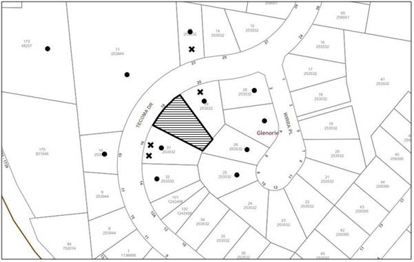
|
NOTIFICATION PLAN |
|||
|
• PROPERTIES NOTIFIED
|
X SUBMISSIONS RECEIVED |
PROPERTY SUBJECT OF DEVELOPMENT |
|
|
10 SUBMISSIONS RECEIVED OUT OF MAP RANGE |
|||
14 submissions objected to the development, generally on the grounds that the development would result in:
· A negative impact to the value of adjacent properties;
· The development would pose a detrimental impact to traffic, vehicle movements, on-street car parking and safety in the vicinity;
· Inadequate number of on-site staff car parking spaces to cater for the proposed number of staff and visitors;
· Miscalculations with regard to the anticipated vehicle movements in the submitted Traffic Report
· The proposed 7am opening time would unacceptably generate noise during the early morning to neighbouring properties and would be out of character in the street;
· The 3 indigenous trees Nos. 17, 18 and 19 should be retained as they are not within the building footprint, contribute to the streetscape and would not pose a risk to the safety of children utilising the play areas;
· Insufficient information submitted with regard to how the proposed development would connect to the sewerage system;
· The proposed 1.2m high southern side boundary fence located within the frontage would obstruct the line of sight of vehicles exiting the driveway of the adjacent property at No. 16 Tecoma Drive;
· Concerns are raised that the proposed 1.8m high Colorbond fence along the southern side boundary would be unsightly and should alternatively be constructed of timber;
· Clarification is sought as to why the side boundary fence needs to be of varying heights, ranging from 1.2m to 1.8m;
· Clarification is sought as to whether any costs would be incurred in the construction of the boundary of the fence by the owners of No. 16 Tecoma Drive;
· A saturation of similar types of facilities in the vicinity exists;
· A Construction Traffic Management Plan (CTMP) was not submitted with the application;
· Replacement trees should be planted on Council land at the expense of the applicant, if there is no space on the site;
· All trees removed should be replaced with the same number and type of trees, not with grasses and groundcovers;
· The notification sign was incorrectly affixed to the telegraph pole to the frontage of an adjacent property;
· Insufficient information has been provided in the Arborist Report with regard to tree protection fencing and the lack of adherence to Australian Standard AS4970 Protection of trees on development sites.
· The site is unsuitable for the proposed development due to pedestrian and vehicular traffic from the adjacent Glenorie Public School.
· The development is out of character with the area;
· Eighteen trees are proposed to be removed and only four replacement trees are proposed, which is contrary to Council’s ‘Green Offsets Code’;
· The majority of the replacement trees on the Landscape Plan are non-native;
· There is sufficient space within the front setback to accommodate large canopy trees rather than the proposed medium size trees;
· The development should be setback from the sides of the property to provide sufficient room for landscaping; and
· Not all trees on adjacent properties within 10m of the proposed development are included in the submitted Arborist Report
The merits of the matters raised in community submissions have been addressed in the body of the report with the exception of the following:
5.1.1 Property Value
Submissions have been received raising concerns that the proposed development would detrimentally affect the value of neighbouring properties.
In addressing this concern, Section 4.15 of the Environmental Planning and Assessment Act 1979 does not require Council to take into consideration the impact of a development on the value of nearby properties. Nonetheless, Council acknowledges that the child care centre generally complies with the requirements of the relevant controls and is designed to maintain the low-density character of the local area.
5.1.2 Miscalculations in Traffic Report
A submission has been received raising concerns that the submitted Traffic Report underestimates the anticipated vehicle movements for the proposed development.
In addressing this concern, the submitted Traffic Impact Assessment has utilised the RMS Guide to Traffic Generating Developments recommendation of an hourly trip generation rate of 0.8 vehicle trips per child during the morning peak period and 0.7 vehicle trips per child during the evening peak period for child care centres.
The submitted traffic report has been reviewed by Council’s Traffic and Safety Team and was found to be acceptable.
5.1.3 Sewerage System
A submission has been received raising concerns that insufficient information has been submitted with regard to how the proposed development would connect to the sewerage system.
The subject site is connected to Sydney Water pressure sewerage system. A condition has been recommended requiring that Sydney Water approval be obtained prior to the issue of the Construction Certificate.
5.1.4 Boundary Fence
A submission has been received raising concerns that:
· The proposed 1.2m high southern side boundary fence located within the frontage would obstruct the line of sight of vehicles exiting the driveway of the adjacent property at No. 16 Tecoma Drive.
· The proposed 1.8m high Colorbond fence along the southern side boundary would be unsightly and should alternatively be constructed of timber.
· Clarification is sought as to why the side boundary fence needs to be of varying heights, ranging from 1.2m to 1.8m.
· Clarification is sought as to whether any costs would be incurred in the construction of the boundary of the fence by the owners of No. 16 Tecoma Drive.
Amended plans have been submitted to provide a 1.8m high lapped and capped timber fence along the side and rear boundaries of the rear play area. It is recommended that the 1.8m high fence lapped and capped fence be provided for the full length of the side boundaries behind the front building line and tapering down to 1.2m in height to the end of car space 1.
Council’s Traffic and Safety assessment considers that the 1.2m side boundary fence within the frontage of the site would not obstruct the line of sight of vehicles exiting the driveway of the adjacent property at No. 16 Tecoma Drive.
5.1.5 Construction Traffic Management Plan (CTMP)
A submission has been received raising concerns that a Construction Traffic Management Plan (CTMP) was not submitted with the application.
In addressing this concern, it is noted that each of the Environmental Planning and Assessment Regulation 2000, the Hornsby Development Control Plan 2013 and the Hornsby DA submission Guideline do not require the submission of a CTMP for a child care centre development.
5.1.6 Notification Sign
A submission has been received raising concerns that the notification sign was incorrectly affixed to the telegraph pole to the frontage of an adjacent property.
On 16 January 2019, Council requested photographic evidence of the notification sign appropriately erected at the front of the property. On 2 May 2019, Council received photographic evidence of the sign correctly affixed along the front boundary.
5.1.7 Green Offsets Code
Submissions have been received raising concerns that of the 18 trees proposed to be removed, only 4 replacement trees are proposed, which is contrary to Council’s ‘Green Offsets Code’.
In addressing this submission, it is noted that Part 1.2 of the Hornsby Shire Green Offset Code is to provide guidance on the approach to conducting offsets for the loss of protected native trees and vegetation.
The proposed development would necessitate the removal of 5 native trees from the site, with 4 replacement trees proposed to be planted within the front setback. The planting of additional trees would not be appropriate within the rear setback area and it would be more suitable to provide shade structures due to child safety reasons.
A condition has been recommended requiring that 5 replacement trees be planted within the front setback area.
5.1.8 Non-Indigenous Replacement Trees
A submission has been received raising concerns that the majority of the replacement trees on the Landscape Plan are non-native.
The landscape plan indicates the planting of 265 indigenous shrubs and groundcovers and 2 native trees within the front setback. As discussed in Section 2.2 of this report, a condition has been recommended requiring that the Landscape Plan be amended to indicate the replacement of the two Crepe-myrtle trees with indigenous trees with an expected mature height greater than 10m.
5.1.9 Side Setback Landscaping
A submission has been received raising concerns that the development should be setback from the sides of the property to provide sufficient room for landscaping.
Amended plans have been submitted to delete the concrete pathways along the side boundaries. Whilst a minimum 1m side setback is proposed along the northern side boundary, sufficient space is provided for landscaping taking into consideration the setback of the adjoining residence and existing trees along the boundary.
5.1.10 Arborist Report
A submission has been received raising concerns that some trees on adjacent properties within 10m of the proposed development have been excluded from the submitted Arborist Report.
Council’s inspection of the site and a review of aerial photography did not identify any trees within 10m of the proposed development that were excluded from the Arborist Report.
5.2 Public Agencies
The site is bushfire prone with the fire threat to the north of the site.
Accordingly, the proposed child care centre constitutes ‘integrated development’ subject to approval of the NSW Rural Fire Service (RFS) for the issue of General Terms of Approval under Division 4.8 of the Environmental Planning and Assessment Act 1979 and a Bush Fire Safety Authority pursuant to Section 100B of the Rural Fires Act 1997.
The RFS raised no bushfire safety concerns with the proposed development, subject to conditions.
6. THE PUBLIC INTEREST
Section 4.15(1)(e) of the Act requires Council to consider “the public interest”.
The public interest is an overarching requirement, which includes the consideration of the matters discussed in this report. Implicit to the public interest is the achievement of future built outcomes adequately responding to and respecting the future desired outcomes expressed in environmental planning instruments and development control plans.
The application is considered to have satisfactorily addressed Council’s and relevant agencies’ criteria and would provide a development outcome that, on balance, would result in a positive impact for the community. Accordingly, it is considered that the approval of the proposed development would be in the public interest.
CONCLUSION
The application proposes demolition of existing structures and construction of a 40 place single storey purposed built child care centre.
The development generally meets the desired outcomes of Council’s planning controls and is satisfactory having regard to the matters for consideration under Section 4.15 of the Environmental Planning and Assessment Act 1979.
Council received 14 submissions during the public notification period. The matters raised have been addressed in the body of the report.
Conditions are recommended to minimise impacts to residential amenity including provision of acoustic fencing, landscaping, plan of management, deletion of a car space and reduction in the number of child care places to 36.
Having regard to the circumstances of the case, approval of the application is recommended.
Note: At the time of the completion of this planning report, no persons have made a Political Donations Disclosure Statement pursuant to Section 10.4 of the Environmental Planning and Assessment Act 1979 in respect of the subject planning application.
RESPONSIBLE OFFICER
The officer responsible for the preparation of this report is Thomas Dales.
|
Cassandra Williams Major Development Manager Planning and Compliance Division |
Rod Pickles Manager - Development Assessments Planning and Compliance Division |
|
1.⇨ |
Locality Plan |
|
|
|
2.⇨ |
Plans Architectural |
|
|
|
3.⇨ |
Landscape Plan |
|
|
|
4.⇨ |
Plan of Management |
|
|
File Reference: DA/1348/2018
Document Number: D07678095
SCHEDULE 1
The conditions of consent within this notice of determination have been applied to ensure that the use of the land and/or building is carried out in such a manner that is consistent with the aims and objectives of the relevant legislation, planning instruments and Council policies affecting the land and does not disrupt the amenity of the neighbourhood or impact upon the environment.
Note: For the purpose of this consent, the term ‘applicant’ means any person who has the authority to act on or the benefit of the development consent.
Note: For the purpose of this consent, any reference to an Act, Regulation, Australian Standard or publication by a public authority shall be taken to mean the gazetted Act or Regulation or adopted Australian Standard or publication as in force on the date that the application for a construction certificate is made.
1. Approved Plans and Supporting Documentation
The development must be carried out in accordance with the plans and documentation listed below and endorsed with Council’s stamp, except where amended by Council and/or other conditions of this consent:
Approved Plans
|
Plan No. |
Plan Title |
Drawn by |
Dated |
Council Reference |
|
A02.01, Issue E |
Demolition & Site Plan |
Artmade Architects |
13.08.2019 |
|
|
A03.01, Issue F |
Ground Floor Plan |
Artmade Architects |
13.08.2019 |
|
|
A04.01, Issue E |
Elevations |
Artmade Architects |
13.08.2019 |
|
|
A05.01, Issue E |
Sections & External Finishes |
Artmade Architects |
13.08.2019 |
|
|
L01/1 |
Landscape Planting Plan |
Michael Siu Landscape Architects |
27.06.2019 |
|
Supporting Documentation
|
Document Title |
Prepared by |
Dated |
Council Reference |
|
Waste Management Plan |
Artmade Architects |
19.11.2018 |
D07585673 |
|
Bushfire Report |
Roy Mock |
11.12.2018 |
D07585674 |
|
Plan of Management |
Urbanesque Planning |
January 2019 |
D07608808 |
|
Environmental Noise Assessment No. 6630.1R Rev B |
Day Design Pty Ltd |
23.07.2019 |
D07719604 |
|
Environmental Noise Assessment Report No. 6630.1.2L |
Day Design Pty Ltd |
13.08.2019 |
D07733374 |
|
Traffic Report – Addendum Ref: 18.577r02v02 |
Traffix |
7.06.2019 |
D07691033 |
|
Traffic Impact Assessment Ref: 18.577r01v03 |
Traffix |
April 2019 |
D07654040 |
|
Access Report |
Credwell Consulting |
16.11.2018 |
D07585669 |
a) To comply with Councils requirement in terms of tree protection, replacement planting, privacy and waste management, the approved plans are to be amended as follows:
i) The approved Landscape Plan is to be amended to indicate the replacement of the 2x Crepe-myrtle trees with indigenous trees with an expected mature height greater than 10m.
ii) The approved Landscape Plan be amended to indicate the replacement of the shrubs proposed to be planted along the frontage of the site with native evergreen shrubs with a minimum expected mature height of 1.5m.
iv) The landscape plan is to be amended to indicate that no artificial turf is be installed within the structural root zones of trees T19 - T22 and T24.
v) The approved Architectural Plans be amended to indicate the use of an opaque finish to the Perspex screen along the southern elevation of the rear deck.
vi) The Plan of Management is to be amended to indicate a maximum capacity of 36 children.
vii) To improve amenity in to adjacent properties, the Plan of Management is to be amended to indicate the collection of waste on weekends only and no later than 6pm in order to avoid pedestrian/vehicle conflict.
viii) The approved Landscape Plan be amended to indicate the retention of trees Nos. 14 and 15.
ix) The site plan and landscape plan be amended to set back the acoustic barrier a minimum 500mm from the side and rear boundaries.
b) These amended plans must be submitted with the application for the Construction Certificate.
3. Appointment of a Project Arborist
a) A project arborist with AQF Level 5 qualifications must be appointed to provide monitoring and certification throughout the construction period.
b) Details of the appointed project arborist must be submitted to Council and the PCA for registration with the application for the construction certificate.
c) Proposed inspection schedule to assess tree health and provide certification for the various stages of development such as site establishment (includes demolition and installation of tree protection measures), construction work, hard and soft landscaping practical completion and occupancy certification.
4. Removal of Trees
This development consent permits the removal of eighteen trees numbered 1-13, 16-18, 23 and 25-26 as identified on the approved Landscape Plan prepared by Michael Siu dated 27 June 2019.
Note: The removal of any other trees from the site requires separate approval by Council in accordance with Part 1B.6 Tree and Vegetation Preservation of the Hornsby Development Control Plan, 2013 (HDCP).
5. Construction Certificate
a) A Construction Certificate is required to be approved by Council or a Private Certifying Authority prior to the commencement of any works under this consent.
b) The Construction Certificate plans must not be inconsistent with the Development Consent plans.
6. Section 7.12 Development Contributions
a) In accordance with Section 4.17(1) of the Environmental Planning and Assessment Act, 1979 and the Hornsby Shire Council Section 94A Development Contributions Plan 2014-2024, $8,122.40 must be paid to Council to cater for the increased demand for community infrastructure resulting from the development, based on development costs of $812,240.
b) The value of this contribution is current as at 29 July 2019. If this contribution is not paid within the financial quarter that this condition was generated, the contribution payable will be adjusted in accordance with the provisions of the Hornsby Shire Council Section 94 Development Contributions Plan and the amount payable will be calculated at the time of payment in the following manner:
$CPY = $CDC x CPIPY
CPIDC
Where:
$CPY is the amount of the contribution at the date of Payment
$CDC is the amount of the contribution as set out in this Development Consent
CPIPY is the latest release of the Consumer Price Index (Sydney – All Groups) at the date of Payment as published by the ABS.
CPIDC is the Consumer Price Index (Sydney – All Groups) for the financial quarter at the date applicable in this Development Consent Condition.
c) The monetary contributions must be paid to Council:
(i) prior to the issue of the Subdivision Certificate where the development is for subdivision; or
(ii) prior to the issue of the first Construction Certificate where the development is for building work; or
(iii) prior to issue of the Subdivision Certificate or first Construction Certificate, whichever occurs first, where the development involves both subdivision and building work; or
(iv) prior to the works commencing where the development does not require a Construction Certificate or Subdivision Certificate.
Note: It is the professional responsibility of the Principal Certifying Authority to ensure that the monetary contributions have been paid to Council in accordance with the above timeframes. Council’s S94A Development Contributions Plan may be viewed at www.hornsby.nsw.gov.au or a copy may be inspected at Council’s Administration Centre during normal business hours.
7. Identification of Survey Marks
A registered surveyor must identify all survey marks in the vicinity of the proposed development. Any survey marks required to be removed or displaced as a result of the proposed development shall be undertaken by a registered surveyor in accordance with Section 24 (1) of the Surveying and Spatial Information Act 2002 and following the Surveyor General’s Directions No.11 – "Preservation of Survey Infrastructure"
8. Vehicular Crossing
A separate application under the Local Government Act 1993 and the Roads Act 1993 must be submitted to Council for the installation of a new vehicular crossing and the removal of the redundant crossing. The vehicular crossing must be constructed in accordance with Council’s Civil Works Design 2005 and the following requirements:
a) Design levels at the front boundary must be obtained from Council via a separate Application to Council for a Vehicular Crossing;
b) Any redundant crossings must be replaced with integral kerb and gutter;
c) The footway area must be restored by turfing;
Note: An application for a vehicular crossing can only be made to one of Council’s Authorised Vehicular Crossing Contractors. You are advised to contact Council on 02 9847 6940 to obtain a list of contractors.
9. Internal Driveway/Vehicular Areas
The driveway and parking areas on site must be designed, constructed and a Construction Certificate issued in accordance with Australian Standards AS2890.1, AS3727 and the following requirements:
a) Design levels at the front boundary shall be obtained from Council;
b) The driveway shall be designed and constructed as a rigid pavement;
c) The driveway pavement shall be designed by the civil or structural Engineer;
d) The pavement must have a kerb constructed with provision for drainage and connection to the internal drainage system;
10. On Site Stormwater Detention
An on-site stormwater detention system must be designed by a chartered civil engineer and constructed in accordance with the following requirements:
a) Have a capacity of not less than 5 cubic metres, and a maximum discharge (when full) of 8 litres per second;
b) Have a surcharge/inspection grate located directly above the outlet;
c) Discharge from the detention system must be controlled via 1 metre length of pipe, not less than 50 millimetres diameter or via a stainless plate with sharply drilled orifice bolted over the face of the outlet discharging into a larger diameter pipe capable of carrying the design flow to an approved Council system;
d) Where above ground and the average depth is greater than 0.3 metres, a ‘pool type’ safety fence and warning signs must be installed; and
e) Not be constructed in a location that would impact upon the visual or recreational amenity of residents.
11. Stormwater Drainage
The stormwater drainage system for the development must be designed in accordance with Council’s Civil Works – Design and Construction Specification and the following requirements:
a) Connected directly to the existing inter-allotment drainage system.
12. Education and Care Services National Regulations
Documentation prepared by a registered architect shall be submitted with the Construction Certificate to certify that the proposed development complies with the requirements of Part 4.3 Physical Environment of the Education and Care Services National Regulations.
13. Access and Mobility
As the accessible car parking space encroaches into the external wall of the child care centre, a ‘Performance Solution’ is to be utilised to rectify the issue in accordance with the submitted Access Report prepared by Credwell Consulting dated 16 November 2018.
14. Mechanical Equipment
A mechanical plant noise assessment for all proposed mechanical equipment and site-specific equipment must be undertaken by a suitably qualified Acoustic Consultant and a report submitted to the principal certifying authority (PCA) certifying that the operation of all proposed equipment will not exceed background noise levels by more than 5dB(A) at all property boundaries.
15. Fire Safety Schedule
A schedule of all proposed essential fire safety measures to be installed in the building (e.g. hydrants, hose reels, emergency warning systems etc.) shall be submitted with the Construction Certificate application.
16. Building Code of Australia
All approved building work must be carried out in accordance with the relevant requirements of the Building Code of Australia.
17. Sydney Water – Approval
This application must be submitted to Sydney Water for approval to determine whether the development would affect any Sydney Water infrastructure, and whether further requirements are to be met.
Note: Building plan approvals can be obtained online via Sydney Water Tap inTM through www.sydneywater.com.au under the Building and Development tab.
REQUIREMENTS PRIOR TO THE COMMENCEMENT OF ANY WORKS
Prior to the commencement of any works, the on-going waste collection service must be cancelled, and the bins retrieved by the waste collection service provider.
Note: For residential properties, Council is the waste collection service provider.
19. Installation of Tree Protection Fencing
a) All trees numbered 8, 14, 15, 19, 20, 21, 22, 24, 27, 28 and 29 must have tree protection measures for the ground, trunk and canopy installed by the project arborist.
b) All tree protection measures for the ground, trunk and canopy installed by the project arborist must be set in accordance with Australian Standard AS 4970-2009 - Protection of trees on development sites”.
20. Tree Trunk and Branch Protection
a) Tree crown protection measures are required and must be installed by the project arborist.
b) The measures must be applied in accordance with the relevant requirements of Section 3.3.6 Crown protection of Australian Standard AS 4970-2009 - Protection of trees on development sites”
c) The circumference of the trunk and or branches must be wrapped in hessian or similar material to provide cushioning for the installation of timber planks (50 x100mm or similar).
d) Timber Planks must be spaced at 100mm intervals and must be attached using adjustable ratchet straps.
21. Tree Protection Zone - Ground Protection
a) The tree protection zones of all trees to be retained on the subject site must have a layer of wood-chip mulch at a depth of between 150mm and 300mm in accordance with the relevant requirements of Australian Standard AS 4454 Composts, Soil Conditioners and Mulches installed prior to works commencing.
b) Where fencing cannot be installed inside the TPZ, the wood-chip must be covered with a layer of geotextile fabric and rumble boards to allow for small plant movement and/or placement of storage of material.
22. Protection Certification
To ensure that all tree protection measures are correctly installed, a certificate from the appointed project arborist must be submitted to the Principal Certifying Authority confirming compliance with the tree protection requirements of this consent.
23. Erection of Construction Sign
a) A sign must be erected in a prominent position on any site on which any approved work is being carried out:
i) Showing the name, address and telephone number of the principal certifying authority for the work;
ii) Showing the name of the principal contractor (if any) for any demolition or building work and a telephone number on which that person may be contacted outside working hours; and
iii) Stating that unauthorised entry to the work site is prohibited.
b) The sign is to be maintained while the approved work is being carried out and must be removed when the work has been completed.
24. Protection of Adjoining Areas
A temporary hoarding, fence or awning must be erected between the work site and adjoining lands before the works begin and must be kept in place until after the completion of the works if the works:
a) Could cause a danger, obstruction or inconvenience to pedestrian or vehicular traffic;
b) Could cause damage to adjoining lands by falling objects; and/or
c) Involve the enclosure of a public place or part of a public place.
d) Have been identified as requiring a temporary hoarding, fence or awning within the Council approved Construction Management Plan (CMP).
Note: Notwithstanding the above, Council’s separate written approval is required prior to the erection of any structure or other obstruction on public land.
25. Toilet Facilities
a) To provide a safe and hygienic workplace, toilet facilities must be available or be installed at the works site before works begin and must be maintained until the works are completed at a ratio of one toilet for every 20 persons employed at the site.
b) Each toilet must:
i) be a standard flushing toilet connected to a public sewer; or
ii) be a temporary chemical closet approved under the Local Government Act 1993; or
iii) have an on-site effluent disposal system approved under the Local Government Act 1993.
26. Erosion and Sediment Control
To protect the water quality of the downstream environment, erosion and sediment control measures must be provided and maintained throughout the construction period in accordance with the manual ‘Soils and Construction 2004 (Bluebook)’, the approved plans, Council specifications and to the satisfaction of the principal certifying authority. The erosion and sediment control devices must remain in place until the site has been stabilised and revegetated.
Note: On the spot penalties may be issued for any non-compliance with this requirement without any further notification or warning.
REQUIREMENTS DURING DEMOLITION AND CONSTRUCTION
27. Maintenance of Public Footpaths
Public footpaths must be maintained for the duration of works to ensure they are free of trip hazards, displacements, breaks or debris to enable pedestrians to travel along the footpath safely.
28. Prohibited Actions Within the Tree Protection Zone
In accordance with Australian Standard AS4970-2009, the following is prohibited within the fenced area of the TPZ for all trees to be retained:
a) Stockpiling storage or mixing of materials
b) The parking, storing, washing and repairing of tools, equipment and machinery
c) The disposal of liquids and refuelling
d) The disposal of building materials
e) The siting of offices or sheds
f) Any action leading to the impact on tree health or structure
29. Works Near Trees
a) No consent is granted for any works within the Structural Root Zone (SRZ) of trees numbered 8, 14, 15, 19, 20, 21, 24, 27, 28 and 29.
b) To maintain tree health and condition for trees numbered 8, 14, 15, 19, 20, 21, 22, 24, 27, 28 and 29 on the approved plans, the appointed project arborist must monitor and record any and all necessary remedial actions required.
c) The maintenance and monitoring of all tree protection techniques must be recorded by the appointed project arborist during the period of construction for submission with the application for the Occupation Certificate.
30. Maintaining Tree Protections Zones
The Tree Protection Zones must be maintained by the project arborist in accordance with section 4.6 requirements of Australian Standard AS 4970-2009 - “Protection of Trees on Development Sites”
31. Works Within Tree Protection Zones
a) All root pruning must be undertaken in accordance with the relevant requirements of Australian Standard AS 4970-2009 “Protection of Trees on Development Sites” - Sections 3.3.4, 4.5.4 and 4.5.5.
b) Any necessary excavations within the Tree Protection Zone of trees numbered 8, 14, 15, 19, 20, 21, 22, 24, 27, 28 and 29 on the approved plans not associated with installation of services must be undertaken manually as prescribed in the Australian Standard AS 4970-2009 – “Protection of Trees on Development Sites” Section 4.5.5.
c) To minimise impacts within the Tree Protection Zone (TPZ) of trees numbered 8, 14, 15, 19, 20, 21, 22, 24, 27, 28 and 29 on the approved plans the installation of services must be undertaken as follows:
i) The installation of any underground services which either enter or transect the designated TPZ must utilise sensitive methods such as manual excavation.
ii) For manual excavation of trenches the project arborist must advise on roots to be retained. Manual excavation may include the use of pneumatic and hydraulic tools. Refer Clause 4.5.3.
d) Where scaffolding is required it must be erected outside the TPZ and in accordance with Australian Standard AS 4970-2009 section 4.5.6.
32. Building Materials and Site Waste
The filling or stockpiling of building materials, the parking of vehicles or plant, the disposal of cement slurry, waste water or other contaminants must be located outside the tree protection zones as prescribed in the conditions of this consent or the prescriptive measures of Part 1B.6.1 Tree Preservation of the Hornsby Development Control Plan 2013, of any tree to be retained.
33. Works Near Trees Certification
a) The project arborist must submit to the principal certifying authority a certificate that all works have been carried out in compliance with the approved plans and conditions or specifications for tree protection.
b) Certification should include a statement of site attendance, the condition of retained trees, details of any deviations from the approved tree protection measures and their impacts on trees.
Note: Copies of monitoring documentation may be required by the PCA and/or Council.
34. Construction Work Hours
All works on site, including demolition and earth works, must only occur between 7am and 5pm Monday to Saturday.
No work is to be undertaken on Sundays or public holidays.
35. Demolition
To protect the surrounding environment, all demolition work must be carried out in accordance with Australian Standard AS2601-2001 – The Demolition of Structures and the following requirements:
a) Demolition material must be disposed of to an authorised recycling and/or waste disposal site and/or in accordance with an approved waste management plan; and
b) Demolition works, where asbestos material is being removed, must be undertaken by a contractor that holds an appropriate licence issued by SafeWork NSW in accordance with the Work Health and Safety Regulation 2017 and be appropriately transported and disposed of in accordance with the Protection of the Environment Operations (Waste) Regulation 2014; and
c) On construction sites where any building contains asbestos material, a standard commercially manufactured sign containing the words ‘DANGER ASBESTOS REMOVAL IN PROGRESS’ and measuring not less than 400mm x 300mm must be displayed in a prominent position visible from the street.
d) Should the presence of asbestos or soil contamination, not recognised during the application process be identified during any stage of works, the applicant must immediately notify the PCA and Council.
36. Environmental Management
To prevent sediment run-off, excessive dust, noise or odour emanating from the site during the construction, the site must be managed in accordance with the publication ‘Managing Urban Stormwater – Landcom (March 2004) and the Protection of the Environment Operations Act 1997.
37. Council Property
To ensure that the public reserve is kept in a clean, tidy and safe condition during construction works, no building materials, waste, machinery or related matter is to be stored on the road or footpath.
Note: This consent does not give right of access to the site via Council’s park or reserve. Should such access be required, separate written approval is to be obtained from Council.
38. Disturbance of Existing Site
During construction works, the existing ground levels of open space areas and natural landscape features, including natural rock-outcrops, vegetation, soil and watercourses must not be altered unless otherwise nominated on the approved plans.
39. Landfill
Landfill must be constructed in accordance with Council’s ‘Construction Specification 2005’ and the following requirements:
a) As indicated in the approved Waste Management Plan, concrete obtained from the demolition of the existing buildings is to be reused as fill on-site.
b) Prior to additional fill material being imported to the site, a certificate shall be obtained from a suitably qualified environmental consultant confirming the fill wholly consists of Virgin Excavated Natural Material (VENM) as defined in Schedule 1 of the Protection of the Environment Operations Act 1997 or material approved under the Department of Environment and Climate Change’s general resource recovery exemption.
c) A compaction certificate is to be obtained from a suitably qualified geotechnical engineer verifying that the specified compaction requirements have been met.
d) These certificates must be included with the application for an occupation certificate.
40. Excavated Material
All excavated material removed from the site must be classified by a suitably qualified person in accordance with the Department of Environment, Climate Change and Water NSW Waste Classification Guidelines and Protection of the Environment Operations (Waste) Regulation 2014 prior to disposal to an approved waste management facility and be reported to the principal certifying authority prior to the issue of an Occupation Certificate.
41. Survey Report
A report(s) must be prepared by a registered surveyor and submitted to the principal certifying authority:
a) Prior to the pouring of concrete at each level of the building certifying that:
i) The building, retaining walls and the like have been correctly positioned on the site; and
ii) The finished floor level(s) are in accordance with the approved plans.
42. Waste Management
All work must be carried out in accordance with the approved waste management plan.
REQUIREMENTS PRIOR TO THE ISSUE OF AN OCCUPATION CERTIFICATE
Note: For the purpose of this consent, a reference to ‘occupation certificate’ shall not be taken to mean an ‘interim occupation certificate’ unless otherwise stated.
43. Survey Infrastructure
A certificate by a Registered Surveyor shall be submitted to the Principal Certifying Authority, certifying that there has been no removal, damage, destruction, displacement or defacing of the existing survey marks in the vicinity of the proposed development, or otherwise certifying that the necessary re-establishment of any damaged, removed or displaced survey marks has been undertaken in accordance with the Surveyor General’s Direction No. 11 – “Preservation of Survey Infrastructure”.
The following matter(s) must be nominated on the title under s88 of the Conveyancing Act 1919:
a) The creation of an appropriate "Positive Covenant" and "Restriction as to User" over the constructed on-site detention/retention systems and outlet works, within the lots in favour of Council in accordance with Council’s prescribed wording. The position of the on-site detention system is to be clearly indicated on the title;
b) To register the OSD easement, the restriction on the use of land “works-as-executed” details of the on-site-detention system must be submitted verifying that the required storage and discharge rates have been constructed in accordance with the design requirements. The details must show the invert levels of the on-site system together with pipe sizes and grades. Any variations to the approved plans must be shown in red on the “works-as-executed” plan and supported by calculations;
Note: Council must be nominated as the authority to release, vary or modify any easement, restriction or covenant.
45. Relocation of ‘No Stopping Sign’
To improve safety and sight distances in accordance with the recommendations of the submitted Traffic Impact Assessment prepared by Traffix & Transport Planners dated 9 April 2019, the ‘no stopping’ sign to the front of the site is to be relocated subject to approval from the Hornsby Shire Local Traffic Committee, as follows:
a) The ‘No Stopping’ sign to the front of the site is to be moved a distance of 8.3 metres further north, or at any other distance at the discretion of the Committee.
b) The sign be amended to indicate “No Stopping between 7am – 10am and 3pm - 6pm on weekdays, or at any other time period at the discretion of the Committee.
46. Lapped and Capped Boundary Fence
A 1.8m lapped and capped timber fence must be erected along the side and rear boundaries of the proposed childcare centre behind the front building line. The fence must tapper to 1.2m to the end of car space 1.
The cost of the fence is to be borne by the applicant.
47. External Lighting
a) To protect the amenity of adjacent premises, all external lighting must be designed and installed in accordance with Australian Standard AS 4282 Control of the Obtrusive Effects of Outdoor Lighting.
b) Certification of compliance with this Standard must be obtained from a suitably qualified person and submitted to the PCA with the application for the Construction Certificate.
48. Food Premises
a) A food premises notification form must be submitted to Council prior to the commencement of operation.
Note: Hornsby Shire Council’s Food Premises notification form can be found at http://www.hornsby.nsw.gov.au
b) The fit out and operation of that part of the building to be used for the preparation of food must be in accordance with Australian Standard 4674-2004 – Design and fit out of food premises, the Food Act 2003, Food Regulation 2015 and the Food Standards Code developed by Food Standards Australia New Zealand. Food Standards 3.3.1, 3.2.2 and 3.2.3 are mandatory for all food businesses.
Note: Walls are to be of solid construction.
c) Prior to the commencement of the child care centre, the operator is requested to contact Council’s Compliance & Certification Team to arrange an inspection for compliance against the relevant legislation and guidelines outlined in this approval. Contact Council’s Administration Officer on 9847 6784.
d) A kitchen exhaust system must be designed and installed to effectively prevent air pollution in accordance with the Protection of the Environment Operations Act 1997.
49. Outdoor Play Area
The outdoor play space must be adequately shaded in accordance with The Shade Handbook, published by the New South Wales Cancer Council in 2008.
50. Acoustic Treatment and Certification
a) A 2.4m high acoustic barrier must be installed to enclose the rear play areas as shown on plan A3.01, Issue E prepared by ArtMade.
b) Acoustic treatment must be installed for the proposed development in accordance with Part 7 - Noise Control Recommendations contained within the Environmental Noise Assessment report prepared by Day Design Pty Ltd, summarised as follows:
i) Implementation of the Plan of Management prepared by Urbanesque Planning dated January 2019;
ii) The external glazing for the indoor play areas of the 3-5 years olds is to have a minimum Rw 32
c) Certification must be provided that all plant and mechanical equipment will not have an acoustic impact of greater than 5dBA above Rating Background Level (RBL) at all property boundaries.
d) On completion of all works and prior to the issue of an Occupation Certificate, the PCA is to be provided with a certificate from a qualified acoustic consultant certifying that all required acoustic works have been completed in accordance with Part 7 - Noise Control Recommendations contained within the Environmental Noise Assessment report prepared by Day Design Pty Ltd referred to in condition 1 of this consent.
51. Landscaping Requirements
a) The trees approved for removal under this consent must be offset through replacement planting of a minimum of 5 native trees within the front setback.
b) The site is to be landscaped in accordance with the approved Landscape Plan prepared by Michael Siu dated 27 June 2019 (as amended).
i) Landscape screen planting must be provided between the boundary fence and acoustic barrier to achieve a minimum growth height of 2.5 metres.
c) All replacement plantings must be trees indigenous to Hornsby Shire, as identified at: http://www.hornsby.nsw.gov.au/environment/flora-and-fauna/tree-management/indigenous-trees
d) The location and size of the 5 replacement trees are to be as follows:
i) All replacement trees must be located in the front setback and planted 4 metres or greater from the foundation walls of the approved centre.
ii) The pot size of the replacement trees must be a minimum 45 litres
iii) All replacement trees must be a minimum of 3 metres in height at planting.
iv) All replacement trees must have the potential to reach a mature height greater than 10 metres.
v) Planting methods must meet professional (best practice) industry standards
52. Final Certification
The AQF 5 Project arborist must submit to the principal certifying authority a certificate that states the following:
a) All the tree protection requirements comply with the tree protection plan
b) All completed works have been carried out in compliance with the conditions of consent and approved plans.
c) Dates and times and reasons for site attendance.
d) The post development condition of the health for the retained tree number 1.
e) Details necessary work to maintain tree health.
f) Details of tree protection zone maintenance.
g) Tree replacements meet NATSPEC guidelines and the approved landscape plan.
Note: Copies of monitoring documentation may be requested throughout DA process.
53. Fire Safety Statement – Final
In accordance with the Environmental Planning and Assessment Regulation 2000, upon completion of the building, the owner must provide Council with a certificate in relation to each fire safety measure implemented in the building.
54. Damage to Council Assets
To protect public property and infrastructure, any damage caused to Council’s assets as a result of the construction or demolition of the development must be rectified by the applicant in accordance with Council’s Civil Works Specifications. Rectification works must be undertaken prior to the issue of an Occupation Certificate, or sooner, as directed by Council.
All required retaining walls must be constructed as part of the development.
OPERATIONAL CONDITIONS
56. Operational Noise Requirements
a) The child care centre must be managed in accordance with the recommendations of the Noise Control Recommendations contained within the Environmental Noise Assessment prepared by Day Design Pty Ltd dated 9 April 2019.
b) The cumulative noise generation from the use of the premises (including mechanical plant) is not to exceed background +10 dB(A) up to a total of 2 hours per day with background +5dB(A) for the remainder of the day when assessed as an Leq (15 minute) noise contribution at any point on the residential side of the common boundaries or at any point in or on the adjacent residential properties.
57. Use of Premises
a) The development approved under this consent shall be used for ‘child care centre’ and not for any other purpose without Council’s separate written consent.
b) The child care centre shall accommodate a maximum of 36 children.
c) The hours of operation of the “child care centre” are restricted to those times listed below:
i) Monday to Friday – 7:00am to 7:00pm
d) Waste collection must not occur during the following times:
i) During school drop off and pickup hours of 7.30am to 9.30am and 2.30pm to 4.00pm.
ii) After 6pm Monday to Friday; and
iii) At no time on Saturday or Sunday
58. Car Parking
All car parking must be operated in accordance with Australian Standard AS/NZS 2890.1:2004 – Off-street car parking and Australian Standard AS 2890.2:2002 – Off-street commercial vehicle facilities.
a) All parking areas and driveways are to be sealed to an all-weather standard, line marked and signposted.
b) Car parking, loading and manoeuvring areas are to be used solely for nominated purposes.
c) Vehicles awaiting loading, unloading or servicing shall be parked on site and not on adjacent or nearby public roads.
d) All vehicular entry on to the site and egress from the site shall be made in a forward direction.
e) All parking for people with disabilities is to comply with AS/NZS 2890.6:2009 Off-street parking for people with disabilities.
59. Child Care Centre Management
The child care centre must be managed in accordance with the Plan of Management as approved under this development consent.
60. Waste Management
The waste management on site must be in accordance with the following requirements:
a) All commercial tenant(s) must keep written evidence on site of a valid contract with a licensed waste contractor(s) for the regular collection and disposal of the waste and recyclables that are generated on site.
b) All commercial tenant(s) must have a sufficient number of bins to contain the volume of waste and recycling expected to be generated between collection services.
c) All bins must be returned to the on-site bin storage area promptly after waste and recycling collection services.
d) A Work, Health & Safety (WHS) risk assessment is to be carried out by a suitably qualified person with qualifications in Work, Health & Safety Legislation with specific regard to waste management. The recommendations of the WHS Risk Assessment are to be implemented as required.
61. Fire Safety Statement - Annual
On at least one occasion in every 12-month period following the date of the first ‘Fire Safety Certificate’ issued for the property, the owner must provide Council with an annual ‘Fire Safety Certificate’ certifying each essential service installed in the building.
GENERAL TERMS OF APPROVAL – NSW RURAL FIRE SERVICE
The following conditions of consent are General Terms of Approval from the nominated State Agency pursuant to Section 4.47 of the Environmental Planning and Assessment Act 1979 and must be complied with to the satisfaction of that Agency.
62. Asset Protection Zones
At the commencement of building works, and in perpetuity, the entire property shall be managed as an Inner Protection Area (IPA) as outlined within section 4.1.3 and Appendix 5 of 'Planning for Bush Fire Protection 2006' and the NSW Rural Fire Service's document 'Standards for asset protection zones'.
63. Water and Utilities
Water, electricity and gas are to comply with the requirements of section 4.1.3 of “Planning for Bush Fire Protection 2006”.
64. Evacuation and Emergency Management
Arrangements for emergency and evacuation are to comply with section 4.2.7 of 'Planning for Bush Fire Protection 2006', including the preparation of an emergency/evacuation plan consistent with the NSW Rural Fire Service document titled 'Guidelines for the Preparation of Emergency/Evacuation plan'.
65. Design and Construction
New construction shall comply with Sections 3 and 5 (BAL 12.5) Australian Standard AS3959-2009 'Construction of buildings in bush fire-prone areas' or NASH Standard (1.7.14 updated) ‘National Standard Steel Framed Construction in Bushfire Areas – 2014’ as appropriate and section A3.7 Addendum Appendix 3 of 'Planning for Bush Fire Protection 2006'.
66. Landscaping
Landscaping to the site is to comply with the principles of Appendix 5 of “Planning for Bush Fire Protection 2006”.
ADVISORY NOTES
The following information is provided for your assistance to ensure compliance with the Environmental Planning and Assessment Act 1979, Environmental Planning and Assessment Regulation 2000, other relevant legislation and Council’s policies and specifications. This information does not form part of the conditions of development consent pursuant to Section 4.17 of the Act.
Environmental Planning and Assessment Act 1979 Requirements
The Environmental Planning and Assessment Act 1979 requires:
· The issue of a construction certificate prior to the commencement of any works. Enquiries can be made to Council’s Customer Services Branch on 9847 6760.
· A principal certifying authority to be nominated and Council notified of that appointment prior to the commencement of any works.
· Council to be given at least two days written notice prior to the commencement of any works.
· Mandatory inspections of nominated stages of the construction inspected.
· An occupation certificate to be issued before occupying any building or commencing the use of the land.
Long Service Levy
In accordance with Section 34 of the Building and Construction Industry Long Service Payments Act 1986, a ‘Long Service Levy’ must be paid to the Long Service Payments Corporation or Hornsby Council.
Note: The rate of the Long Service Levy is 0.35% of the total cost of the work.
Note: Hornsby Council requires the payment of the Long Service Levy prior to the issue of a construction certificate.
Tree Preservation in Hornsby Shire
Hornsby Development Control Plan Tree Preservation provisions have been developed under Council’s authorities contained in the State Environmental Planning Policy (Vegetation in Non-Rural Area’s) 2017 under the Environmental Planning and Assessment Act 1979.
In accordance with these provisions a person must not cut down, fell, uproot, kill, poison, ringbark, burn or otherwise destroy the vegetation, lop or otherwise remove a substantial part of the trees or vegetation to which any such development control plan applies without the authority conferred by a development consent or a permit granted by Council.
Fines may be imposed for non-compliance with the HDCP.
Note: A tree is defined as a long lived, woody perennial plant with one or relatively few main stems with the potential to grow to a height greater than three metres (3m). (HDCP 1B.6.1.c).
Dial Before You Dig
Prior to commencing any works, the applicant is encouraged to contact Dial Before You Dig on 1100 or www.dialbeforeyoudig.com.au for free information on potential underground pipes and cables within the vicinity of the development site.
Should asbestos or asbestos products be encountered during demolition or construction works, you are advised to seek advice and information prior to disturbing this material. It is recommended that a contractor holding an asbestos-handling permit (issued by SafeWork NSW) be engaged to manage the proper handling of this material. Further information regarding the safe handling and removal of asbestos can be found at:
Alternatively, telephone the SafeWork NSW Asbestos and Demolition Team on 8260 5885.
Disability Discrimination Act
The applicant’s attention is drawn to the existence of the Disability Discrimination Act. A construction certificate is required to be obtained for the proposed building/s, which will provide consideration under the Building Code of Australia, however, the development may not comply with the requirements of the Disability Discrimination Act. This is the sole responsibility of the applicant.
Advertising Signage – Separate DA Required
This consent does not permit the erection or display of any advertising signs. Most advertising signs or structures require development consent. Applicants should make separate enquiries with Council prior to erecting or displaying any advertising signage.
Food Premises
The following facilities are required in the food preparation area to ensure food handler hygiene and the cleaning and sanitising of food contact utensils:
1. A hand wash basin and a double bowl sink or
2. A hand wash basin, washing up sink and a dishwasher.
LPP Report No. LPP20/19
Local Planning Panel
Date of Meeting: 28/08/2019
2 SUBDIVISION OF 1 LOT INTO 2 LOTS, ALTERATIONS & ADDITIONS TO DWELLING ON LOT 1 AND CONSTRUCTION OF A DWELLING ON LOT 2
![]()
EXECUTIVE SUMMARY
|
DA No: |
DA/139/2019 (Lodged on 28 February 2019) |
|
Description: |
Torrens title subdivision of one lot into two lots, alterations and additions to the existing dwelling house on proposed Lot 1, and the construction of a two-storey dwelling house on proposed Lot 2 |
|
Property: |
Lot 12 DP 16855, No. 82 Boronia Place, Cheltenham |
|
Applicant: |
Mr. Seetharam Bhat |
|
Owner: |
Mrs. R I Gunasena and Mr. S Bhat |
|
Estimated Value: |
$649,000 |
|
Ward: |
C |
· The proposal does not comply with the minimum subdivision lot size development standard in Clause 4.1 of the Hornsby Local Environmental Plan 2013. The applicant has made a submission in accordance with Clause 4.6 ‘Exceptions to development standards’ of the Hornsby Local Environmental Plan 2013 to vary the minimum subdivision lot size development standard. The submission is considered not well founded and is not supported.
· The proposed development does not comply with State Environmental Planning Policy (Vegetation in Non-Rural Areas) 2017, the Hornsby Local Environmental Plan 2013 and the Hornsby Development Control Plan 2013.
· Seventeen submissions (8 pro-forma submissions in support; and 9 unique submissions in objection) have been received in respect of the application.
· The application is required to be determined by the Hornsby Local Planning Panel as the development contravenes the HLEP minimum subdivision lot size development standard by more than 10%.
· It is recommended that the application be refused.
|
THAT Development Application No. DA/139/2019 for Torrens title subdivision of one Lot into two Lots, alterations and additions to the existing dwelling house on Lot 1, and the construction of a dwelling house on Lot 2 at Lot 12 DP 16855, No. 82 Boronia Place Cheltenham be refused subject to the reasons for refusal detailed in Schedule 1 of Local Planning Panel Report No. LPP20/19 |
BACKGROUND
On 6 February 2017, Development Application No. DA/69/2017 was lodged for the demolition of the existing dwelling house and Torrens title subdivision of one lot into two.
On 19 May 2017, Development Application No. DA/69/2017 was refused on the following grounds:
a) Pursuant to Section 79C(1)(a)(i) of the Environmental Planning and Assessment Act 1979 as the development does not satisfy the Clause 4.1 Minimum Subdivision Lot Size, Clause 4.6 Exceptions to development standard, Clause 5.9 which aims to preserve the amenity of the area through the preservation of trees and Clause 5.10 Heritage Conservation which aims to conserve the environmental heritage of Hornsby Shire of the Hornsby Local Environmental Plan 2013.
b) The proposal is unsatisfactory in respect to Section 79C(1)(a)(iii) of the Environmental Planning and Assessment Act 1979 as the development does not meet the prescriptive measures of Part 6.2.1 Lot size and Part 1.B.6.2 Vegetation Preservation of the Hornsby Development Control Plan 2013.
c) Pursuant to Section 79C(1)(b) and (e) of the Environmental Planning and Assessment Act 1979, the development would not be in the public interest as the proposal would have a detrimental impact on the natural environment, is contrary to the local planning controls and would set an undesirable precedent for minimum lot sizes within the Residential R2 Low density residential zone.
d) The proposed development would be inconsistent with the objectives of the minimum allotment size for the R2 Low Density Residential Zone.
e) The Clause 4.6 variation does not demonstrate environmental planning grounds to justify contravening the development standard particular to the subject site.
f) The Clause 4.6 variation does not demonstrate that compliance with the development standard is unreasonable or unnecessary in the circumstances of the case.
On 15 November 2017, a Class 1 Appeal against the refusal of Development Application No. DA/69/2017 was lodged with the NSW Land and Environment Court.
On 30 April 2018, a conciliation conference was held in these proceedings. The revised “without prejudice” plans and further information provided by the applicant prior to the conciliation conference were discussed at length during the conciliation conference. The applicant was informed that the amended plans and information did not address any of Council’s contentions, and that all contentions remained in dispute, namely:
1. Inadequate minimum subdivision lot size.
2. Adverse impact on streetscape and character as a result of the inadequate lot size and future dwellings to be proposed on the site.
3. Concerns in relation to the ability to build an additional dwelling on proposed Lot 2 and undertake alterations to the dwelling on Lot 1 with sufficient amenity afforded to the residents of those dwellings and without adversely impacting on surrounding existing residences.
4. Impacts on the heritage conservation area as a result of the inadequate lot size, proposed future dwelling and tree removal.
5. Adverse environmental impacts associated with proposed tree removal.
At the conclusion of the conciliation the applicant sought additional time to provide further information for Council’s consideration.
On 7 May 2018, a Notice of Discontinuance was filed by the applicant with the NSW Land and Environment Court to discontinue the appeal.
SITE
The site is described as Lot 12 DP 16855, No.82 Boronia Place, Cheltenham.
The site has a 15.6m street frontage to Boronia Place and a 15.24m street frontage to Castle Howard Road. The site is generally regular in shape with an area of 1151.8m2. The site includes an existing part two storey dwelling house with detached carport. The site also includes a number of locally indigenous trees identified as significant. The site experiences a 12m fall towards Castle Howard Road.
The site is within the Beecroft-Cheltenham Heritage Conservation Area, listed under Schedule 5 of Hornsby Local Environmental Plan 2013 (HLEP), which is characterised as containing buildings from the Victorian, Federation, Arts and Crafts, Inter-War and Post-War eras and with the early residential fabric and streetscapes generally intact.
The site adjoins heritage listed street trees along Castle Howard Road listed as item No.69 under Schedule 5 of the HLEP.
The site is partially within a bushfire prone area.
Surrounding development in Boronia Place and Castle Howard Road is characterised by predominantly single storey dwellings from the Inter and Post War periods. Large domestic gardens amongst mature trees and remnant tree forest communities combine to create the area’s characteristic landscape. The land is typically sloping and includes bluffs and rock outcrops.
PROPOSAL
The application proposes Torrens title subdivision of one allotment into two Lots, alterations and additions to the existing dwelling house on proposed Lot 1 and the construction of a two-storey dwelling house on proposed Lot 2.
Proposed Lot 1 would have an area of 614.3m2 and would have a 15.69m frontage to Boronia Place to the north.
Proposed Lot 2 would have an area of 537.5m2 and would have a 14.24m frontage to Howard Castle Road.
The proposed alterations and additions to the dwelling house on proposed Lot 1 are as follows:
· The inclusion of an ensuite and walk-in-robe to Bedroom 1.
· Replacement of the existing paving to the front (north) of the dwelling house.
· The installation of a 1350mm high privacy screen along the width of the terrace and windows located on ground floor of the southern elevation.
· The construction of timber framed bi-fold doors to the northern elevation.
· The installation of a 3,000L rainwater tank in accordance with the BASIX specifications.
· The replacement of the existing driveway with a 3m wide concrete driveway.
The lower ground floor of the proposed dwelling house on Lot 2 would comprise a double garage, two bedrooms, a water closet, a master bedroom with ensuite and a bar with rumpus. The ground floor would comprise a living room, dining room, kitchen with walk in pantry, laundry, water closet, two bedrooms with ensuite, walk in wardrobe, a balcony to the southern elevation and an alfresco to the northern elevation.
Vehicular access to the dwelling house on Lot 2 would be via a proposed driveway and vehicular crossing located to the western side of the Castle Howard Road frontage.
Stormwater from each allotment is proposed to be drained to the street drainage system in Castle Howard Road via a proposed 1m wide drainage easement located along the eastern side boundary of proposed Lot 2. The drainage easement and associated 150mm diameter pipe are to be provided as part of the proposed subdivision works. A 500mm wide service trench will exist underneath the proposed driveway in Lot 2 to service the new dwelling with water, gas and electricity.
The proposal includes landscaping of the site in accordance with the Landscape Plan prepared by Iscape Landscape Architecture.
Ten trees are proposed to be removed to facilitate the proposed development.
ASSESSMENT
The development application has been assessed having regard to A Metropolis of Three Cities - the Greater Sydney Region Plan, the North District Plan and the matters for consideration prescribed under Section 4.15 of the Environmental Planning and Assessment Act 1979 (the Act). The following issues have been identified for further consideration.
1. STRATEGIC CONTEXT
1.1 Greater Sydney Region Plan - A Metropolis of Three Cities and North District Plan
A Metropolis of Three Cities – the Greater Sydney Region Plan has been prepared by the NSW State Government to guide land use planning decisions for the next 40 years (to 2056). The Plan sets a strategy and actions for accommodating Sydney’s future population growth and identifies key targets such as dwelling numbers, infrastructure planning, liability, sustainability and productivity.
The NSW Government will use the subregional planning process to define objectives and set goals for job creation, housing supply and choice in each subregion. Hornsby Shire has been grouped with Hunters Hill, Ku-ring-gai, Lane Cove, Mosman, North Sydney, Ryde, Northern Beaches and Willoughby to form the North District. The Greater Sydney Commission has released the North District Plan which includes priorities and actions for Northern District for the next 20 years. The identified challenge for Hornsby Shire will be to provide an additional 4,350 dwellings by 2021 with further strategic supply targets to be identified to deliver 97,000 additional dwellings in the North District by 2036.
Whilst the proposed development would be consistent with A Metropolis of Three Cities – the Greater Sydney Region Plan and the North District Plan, by providing housing choice in the locality, the applicant has failed to demonstrate that the undersized allotment combined with the large building footprint would allow for replacement canopy trees on the site, posing a detrimental impact to the values of the Beecroft Cheltenham Heritage Conservation Area (HCA) and setting an undesirable precedent for additional undersized allotments in the HCA.
2. STATUTORY CONTROLS
Section 4.15(1)(a) requires Council to consider “any relevant environmental planning instruments, draft environmental planning instruments, development control plans, planning agreements and regulations”.
2.1 Hornsby Local Environmental Plan 2013
The proposed development has been assessed having regard to the provisions of the Hornsby Local Environmental Plan 2013 (HLEP).
2.1.1 Zoning of Land and Permissibility
The subject land is zoned R2 Low Density Residential under the HLEP. The objectives of the R2 zone are:
· To provide for the housing needs of the community within a low-density residential environment.
· To enable other land uses that provide facilities or services to meet the day to day needs of residents.
The proposed development is defined as “subdivision” and “dwelling house” and is permissible in the zone with Council’s consent. The proposal would pose a detrimental amenity impact to adjacent properties as a result of the undersized allotment and is not consistent with the objectives of the zone.
2.1.2 Clause 4.1 - Minimum Subdivision Lot Size
Clause 4.1 of the HLEP prescribes that the minimum subdivision lot size is not to be less than the minimum size shown for the land on the Minimum Lot Size Map, which is 600m2.
The proposed subdivision would result in Lot 1 having an area of 614.3m2 and Lot 2 having an area of 537.5m2. Proposed Lot 2 would result in a 10.41% variation to the minimum lot size requirement.
The application is accompanied by a submission pursuant to Clause 4.6 of the HLEP to vary the minimum 600m2 allotment size development standard, which is discussed below in Section 1.2.4 of this report.
2.1.3 Clause 4.3 - Height of Buildings
Clause 4.3 of the HLEP provides that the height of a building on any land should not exceed the maximum height show for the land on the Height of Buildings Map. The maximum permissible height for the subject site is 8.5m.
In undertaking an assessment of the height of a building, Council is required to calculate the height difference between the roof of the structure and the existing natural ground level. In calculating the height, the vertical section with the greatest height difference is taken to be the height of the structure.
The submitted Architectural Plans provides no indication of the Reduced Level (RL) of the roof ridge of the proposed dwelling house on Lot 2. To accurately undertake an assessment of the height of the dwelling house, Council requires the inclusion of an RL at the roof’s ridge.
Based on the submitted plans, Council has estimated the height of the dwelling house on Lot 2 to be approximately 8.3m.
Insufficient information has been provided to accurately determine the height of the proposed development.
2.1.4 Clause 4.6 - Exceptions to Development Standards
The application has been assessed against the requirements of Clause 4.6 of the HLEP. This clause provides flexibility in the application of the development standards in circumstances where strict compliance with those standards would, in any particular case, be unreasonable or unnecessary or tender to hinder the attainment of the objectives of the zone.
Clause 4.6 applies to this development as proposed Lot 2 would have an area of 537.5m2 and would not comply with the development standard for ‘minimum subdivision lot size’ which requires a 600m2 minimum lot size.
Clause 4.6 Variation Request and Council’s Response
The applicant has made a submission in support of a variation to the development standard in accordance with Clause 4.6 of the HLEP. As proposed Lot 2 has an area of 537.5m2, the development application seeks to vary the development standard by 10.41%. The applicant states the proposed variation is considered to be consistent with the objectives of the control.
1. What are the objectives of Clause 4.6 and is the proposal consistent with them.
The objectives of Clause 4.6 of the LEP are:
(a) to provide an appropriate degree of flexibility in applying certain development standards to particular development, and
(b) to achieve better outcomes for and from development by allowing flexibility in particular circumstances.
It is the applicant’s opinion that the proposed variation is consistent with the objectives of this clause in that through the application of flexibility as to the required allotment size that an additional dwelling house allotment can be created, and a dwelling constructed.
It is submitted that in relation to achieving a better outcome that this is achieved by applying flexibility so as to allow for a site with an area of 1,151.8m2 and having two street frontages to be subdivided with an integrated dwelling design.
The subdivision in the manner proposed will also allow for the retention of the significant tree located forward of the existing dwelling located upon proposed Lot 1.
Comment:
It is considered that the proposed development would be contrary to the objectives of Clause 4.6 of the HLEP as there are insufficient environmental planning grounds to justify contravening the development standard and the proposal is not in the public interest.
Approval of the application would result in an undesirable precedent for similar undersized allotments in the Beecroft-Cheltenham Heritage Conservation Area.
2. Is the standard to be varied a Development Standard to which Clause 4.6 applies.
Clause 4.1 of the HLEP states that;
4.1. Minimum subdivision lot size
(1) The objectives of this clause are as follows:
(a) to provide for the subdivision of land at a density that is appropriate for the site constraints, development potential and infrastructure capacity of the land,
(b) to ensure that lots are of a sufficient size to accommodate development.
(2) This clause applies to a subdivision of any land shown on the Lot Size Map that requires development consent
(3) The size of any lot resulting from a subdivision of land to which this clause applies is not to be less than the minimum size shown on the Lot Size Map in relation to that land.
(3A) If a lot is a battle-axe lot or other lot with an access handle, the area of the access handle is not to be included in calculating the lot size.
(4) This clause does not apply in relation to the subdivision of any land:
(a) by the registration of a strata plan or strata plan of subdivision under the Strata Schemes Development Act 2015, or
(b) by any kind of subdivision under the Community Land Development Act 1989.
The applicant submits that the wording of the Clause is consistent with previous decisions of the Land & Environment Court of NSW in relation to matters which constitute development standards.
It is also noted that Clause 4.1 does not contain a provision which specifically excludes the application of Clause 4.6.
On this basis it is considered that Clause 4.1 is a development standard for which Clause 4.6 applies.
Comment:
Council acknowledges that Clause 4.1 Minimum Subdivision Lot Size of the HLEP is a Development Standard that may be varied subject to a written request under Clause 4.6 whereby the applicant adequately demonstrates that compliance with the development standard is unreasonable or unnecessary (cl4.6(3)(a)), and that there are sufficient environmental planning grounds to justify the contravention (cl4.6(3)(b)). The consent authority must also be directly satisfied that the proposed development will be in the public interest because it is consistent with the objectives of the development standard and the objectives for development within the relevant zone (cl4.6(4)(a)(ii)).
3. Is compliance with the development standard unreasonable or unnecessary in the circumstances of this case
· The applicant submits that compliance with the requirements of Clause 4.1 is both unreasonable and unnecessary in the circumstances of this case for the following reasons:
o The proposed subdivision will provide for the provision of an additional parcel of land capable of supporting a dwelling as demonstrated by the proposed dwelling design which is commensurate with dwellings in the locality and the surrounding character.
Comment:
Council does not support the argument that because a dwelling can be erected on a smaller allotment it is therefore appropriate to vary the minimum allotment size.
The minimum 600m2 allotment size is specific to the Beecroft Cheltenham HCA which is designed to ensure that the significant natural features of the conservation area such as the landscaped setting can be retained while allowing for the construction of a dwelling house. In the regard the proposed subdivision would result in the removal of the majority of trees on the site.
· The applicant submits that the subject land has an area of 1,151.8m2 which is significantly larger than the area of adjoining and nearby allotments.
Comment:
The adjacent properties at Nos. 38, 40 and 42 Lyne Road, Nos. 8 and 10 Castle Howard Road and No. 80 Boronia Place have lot sizes of 878.9m2, 834.7m2, 695.6m2, 790.4m2, 695.6m2 and 765.1m2, respectively.
Proposed Lot 2 would have an area of 537.5m2 and would be significantly smaller than the adjoining lots.
· The applicant submits that the subject land as a result of its lot size and two street frontages is inconsistent with the prevailing subdivision pattern of the locality.
Comment:
The property at No. 74 Boronia Place, 40m to the west of the subject site, has an area of 1366m2 with a 15m wide frontage to Boronia Place and a 20m frontage to Castle Howard Road and forms part of the subdivision pattern. Similarly, No. 78 Boronia Place is a battle-axe allotment with frontages to Boronia Place and Castle Howard Road. The subject site is not an exception to the prevailing subdivision pattern in the vicinity.
· The applicant submits that the subject land having two street frontages is clearly suited to subdivision into two parcels of land having lot sizes that better reflect the surrounding subdivision pattern.
Comment:
Council acknowledges that the subdivision of land with two street frontages is preferable as it allows for a dwelling on each lot to be orientated towards the street and address the streetscape.
· The applicant submits that the subject site is located within a locality which includes a number of allotments having an area of less than 600m2. Such allotments exist at 30D Castle Howard Road (452m2), 20A Lyne Road (469m2), 22 Lyne Road (509m2), 17A Lyne Road (497m2), 1C Redmill Close (432m2), 1D Redmill Close (447m2), 1B Redmill Close (488m2), 25 Old Beecroft Road (463m2), 25A Old Beecroft Road (510㎡), 31 Old Beecroft Road (471m2), 33 Old Beecroft Road (456m2), 39, 41 & 43 Sutherland Road (under 600m2), 20 Old Beecroft Road (363m2), 20 Old Beecroft Road (363m2), 20A Old Beecroft Road (542m2), 28A Old Beecroft Road (315m2).
Comment:
The above developments were approved under Sydney Regional Environmental Plan No. 12 – Dual Occupancy (SREP12) and State Environmental Planning Policy No. 25 – Residential Allotment Sizes (SEPP25) which applied to Hornsby Shire between 1988 to 2014.
The then Minister for Urban Affairs and Planning subsequently repealed the right to separate titles on dual occupancy developments. However, despite the repeal of SREP12 and SEPP25, the subdivision of dual occupancies with reduced lot sizes was still permissible under the HSLEP 1994 until December 1995.
On 15 December 1995, to bring the HSLEP in accordance with State Government policies, HSLEP (Amendment No. 8) was gazetted to preclude the subdivision of multi-unit housing developments where proposed allotment sizes were less than the minimum allotment size.
In September 2013, the current HLEP was gazetted which allowed a minimum allotment size of 600m2 in Heritage Conservation Areas and prohibited “multi-unit housing” and “dual occupancies” within the R2 Low Density Residential zone.
The above allotments were approved prior to the gazettal of the HLEP, and consequently, prior to the development standard for a minimum 600m2 lot size in the vicinity. In this regard, the above examples cannot be provided as justification for precedence for the creation of undersized allotments in the Hornsby Shire.
· The applicant submits that the proposed allotments are both considered capable of supporting development as demonstrated in the architectural plans which comply with the requirements of the Council for a dwelling house.
Comment:
The dwelling house on proposed Lot 1 would not comply with the western side and rear boundary setback requirements of the HDCP. In addition, concerns are raised that the undersized allotment combined with the large building footprint would restrict the appropriate siting of large replacement canopy trees on the site, posing a detrimental impact to the treed landscape setting and values of the Beecroft Cheltenham HCA. In addition, the proposed development would result in non-compliances with respect to privacy and overshadowing to adjoining properties. As discussed in Section 2.8.8 of this report, the sizable dwelling house on Lot 2 would result in the removal of 10 trees and a ‘major encroachment’ into the Tree Protection Zone of five trees.
Proposed Lot 2 is not capable of supporting the proposed dwelling house and evidently does not comply with the requirements of the HDCP
· The applicant submits that the proposed subdivision will provide for the retention of a very significant tree on Lot 1 and other significant trees upon the site, which are worthy of preservation and contribute to the character of the Heritage Conservation Area whilst providing for orderly development.
Comment:
Council acknowledges that the proposal would allow for the retention of the significant tree No. 1 on Lot 1. Nonetheless, the application proposes the removal of 10 trees from the site, including the removal of the three significant trees Nos. 16, 17 and 22.
The proposed development would result in ‘major’ TPZ encroachments for trees Nos. 21, 24 and 25 which are of moderate impact, while tree No. 26 is of moderate-high impact and tree No. 27 is of high impact. As discussed in Section 2.8.8 of this report, it is uncertain as to whether these trees would be able to be retained on the site.
· The applicant submits that each of the allotments resulting from the proposed subdivision is capable of being provided with vehicular access in accordance with the requirements of Council and the applicable Australian Standards.
Comment:
Council acknowledges that the subdivision is capable of being provided with vehicular access in accordance with the requirements of the HDCP and the applicable Australian Standards. However, concerns are raised to the proposed removal of significant trees Nos. 18, 19 and 22 and 23 to facilitate the construction of the driveway servicing proposed Lot 2.
· The applicant submits that the proposed subdivision will not result in any unreasonable impacts upon adjoining properties or the streetscape.
Comment:
The application proposes the removal of 7 trees within the frontage of Lot 2, identified as tree Nos. 15, 16, 17, 18, 19, 22, 23. Council’s tree assessment has identified these that these trees are predominantly native and positively contribute to the streetscape as a result of their size and canopy cover, with heights ranging from 6-17m. The undersized allotment combined with the large building footprint would restrict the appropriate siting of large replacement canopy trees on the site.
4. Are there sufficient environmental planning grounds to justify contravening the development standard.
· The applicant submits that a contravention of the development standard is justified on environmental planning grounds given that the proposal will provide for the orderly and economic development of land through the creation of an additional parcel of land which will increase housing supply within the locality.
Comment:
Although the proposed development would increase housing supply in the locality, the increase in housing supply will be at the detriment of heritage value, tree retention, lot size and amenity.
· The applicant submits that the subject land has an area of 1,151.8m2 which is significantly larger than the area of adjoining and nearby allotments.
Comment:
With the exception of No. 36 Lyne Road across the street which has an area of 1,170m2, the subject site is the largest of the directly adjacent sites. The adjacent properties at Nos. 38, 40 and 42 Lyne Road, Nos. 8 and 10 Castle Howard Road and No. 80 Boronia Place have lot sizes of 878.9m2, 834.7m2, 695.6m2, 790.4m2, 695.6m2 and 765.1m2, respectively.
Proposed Lot 2 would have an area of 537.5m2 and would be significantly smaller than immediate adjoining lots.
· The applicant submits that the subject land as a result of its lot size and two street frontages is inconsistent with the prevailing subdivision pattern of the locality.
Comment:
The property at No. 74 Boronia Place, 40m to the west of the subject site, has an area of 1366m2 with a 15m wide frontage to Boronia Place and a 20m frontage to Castle Howard Road and forms part of the subdivision pattern. Similarly, No. 78 Boronia Place is a battle-axe allotment with frontages to Boronia Place and Castle Howard Road. The subject site is not an exception to the prevailing subdivision pattern in the vicinity.
· The applicant submits that the subject land having two street frontages is clearly suited to subdivision into two parcels of land having lot sizes that better reflect the surrounding subdivision pattern.
Comment:
Council acknowledges that the subdivision of land with two street frontages is preferable as it allows for a dwelling on each lot to address the street and negates the requirement for a shared accessway.
· The applicant submits that the subdivision will allow for the retention of all significant trees located upon the site.
Comment:
The application proposes the removal of 10 trees from the site, including the removal of the three significant trees Nos. 16, 17 and 22.
5. Is the proposed development in the public interest because it is consistent with the objectives of the particular standard and the objectives for development within the zone in which the development is proposed to be carried out.
· The applicant submits that the proposed development is in the public interest because it is compliant with the zone objectives and the objectives of the particular standard.
In this regard the proposal is considered to be consistent with the relevant objectives of the R2 Low Density zone as detailed below.
o To provide for the housing needs of the community within a low-density residential environment.
Comment: The proposal will in the applicant’s opinion provide for an additional allotment which is ultimately capable of supporting a dwelling house consistent with the requirements of the Council for a low-density residential environment.
o To enable other land uses that provide facilities or services to meet the day to day needs of residents.
Comment: Not applicable.
Comment:
The proposed development would provide for the housing needs of the community through the creation of an additional lot, albeit at the detriment of the character of the Beecroft Cheltenham Heritage Conservation Area, the streetscape and the removal of significant canopy trees and vegetation to facilitate the construction of the dwelling house and driveway on Lot 2. In addition, the undersized allotment combined with the large building footprint would restrict the appropriate siting of large replacement canopy trees on the site.
· In relation to the objectives of Clause 4.1 of the LEP the following assessment is provided:
(a) to provide for the subdivision of land at a density that is appropriate for the site constraints, development potential and infrastructure capacity of the land.
Given that proposed Lot 1 complies with the requirements of the Council, this assessment is relevant to Lot 2 only. In this regard it is considered that Lot 2 as demonstrated by the accompanying architectural plans is capable of providing for a development outcome which is otherwise consistent with the requirements of the Council.
It is also not considered that there are any site constraints or the like which would warrant a larger (compliant) allotment size noting that the accompanying architectural plans demonstrate that the new dwelling proposed on Lot 2 addresses the escarpment located towards the rear of the allotment and will continue to support a significant number of mature trees.
Comment:
The proposed alterations and additions to the dwelling house on Lot 1 do not comply with the side and rear setback requirements of the HDCP.
The proposed subdivision would result in a density on Lot 2 which is not in keeping with the predominantly single storey residential character of the Beecroft Cheltenham Heritage Conservation Area. Adjacent and nearby properties to the subject site comprise large lot sizes with established garden settings. Additionally, the proposed undersized allotment would significantly reduce the capacity for a ‘garden setting’ to be created on the subject site, and the proposal in this regard would be out of character with the Heritage Conservation Area and the character of Boronia Place and Castle Howard Road.
In addition, the undersized allotment combined with the large building footprint would restrict the appropriate siting of large replacement canopy trees on the site.
The site constraints include significant vegetation and the landscaped character of the Heritage Conservation Area. It is considered that lot sizes greater than 600m2 would better correspond to the site constraints and are inherently suited to maintaining the ‘garden setting’ and canopy cover expected in the Beecroft-Cheltenham HCA.
(b) to ensure that lots are of a sufficient size to accommodate development.
As detailed above, proposed Lot 2 is capable of supporting future development which complies with the requirements of the Council notwithstanding the non-compliance with the minimum allotment size requirement.
Comment:
Proposed Lot 2 is not capable of supporting a development which complies with the HDCP, as demonstrated by the proposed removal of 10 trees to facilitate the proposed works, the reduced capacity for a ‘garden setting’ to be created on the subject site and the large building footprint would restrict the appropriate siting of large replacement canopy trees on the site.
Allotment sizes greater than 600m2 would better correspond to the site constraints and are inherently suited to maintaining the ‘garden setting’ and canopy cover expected in the HCA.
6. Whether contravention of the development standard raises any matter of significance for state or regional environmental planning.
The applicant submits that contravention of the standard does not raise any matters of significance for State or Regional environmental planning.
Comment:
It is considered that contravention of the standard does not raise any matters of significance for State or Regional environmental planning.
7. What is the public benefit of maintaining the development standard.
The applicant submits that there is no public benefit in maintaining the development standard in this instance given the absence of any unreasonable detrimental impacts and the public benefit that arises from the provision of one additional allotment.
Comment:
Approval of the application would not be in the public’s interest or of public benefit as the undersized allotment would result in an undesirable precedent for similar undersized allotments in the locality. The proposal is contrary to the values and character of the Beecroft Cheltenham Heritage Conservation Area, which is synonymous with large allotments with abundant vegetation and tree canopy cover.
Summary
The applicant’s justification to vary the ‘minimum subdivision lot size’ development standard is not well founded and cannot be supported for the following reasons:
· The proposal would not comply with the objectives of Clause 4.1 Minimum Subdivision Lot Size in that the development fails to provide a subdivision that is appropriate for the site having regard to tree removal, replacement canopy cover and the ‘garden setting’ of the Heritage Conservation Area.
· The written request from the applicant inadequately demonstrates that compliance with the development standard is unreasonable or unnecessary, and that there are sufficient environmental planning grounds to justify the contravention.
· The proposed subdivision would not be in the public interest because it is not consistent with the objectives of the ‘minimum subdivision lot size’ development standard and the objectives for development within the zone; and
· The site is not suitable for the proposal which would set an undesirable precedent for similar undersized residential allotments.
· Due to the constraints of the site, the proposal results in a development which is not within the capacity of the land and would result in non-compliance with the prescriptive controls within the HDCP.
It is considered that the applicant’s submission pursuant to Clause 4.6 of the HLEP does not satisfactorily address the matters required by this clause and that compliance with the development standard would not be unreasonable and unnecessary in the circumstances of the case. Accordingly, the Clause 4.6 submission is not supported.
2.1.5 Heritage Conservation
Submissions have been received raising concerns that the proposed development would be out of character with the values of the Heritage Conservation Area (HCA) with regard to vegetation preservation and lot size.
Clause 5.10 of the HLEP sets out heritage conservation provisions for Hornsby Shire.
The site is located within the Beecroft Cheltenham Heritage Conservation Area listed under Part 2 of Schedule 5 of Hornsby Local Environmental Plan 2013.
The application has been supported by a Heritage Impact Statement prepared by Weir Phillips Heritage and Planning.
Council’s heritage assessment notes that the site slopes considerably to the rear and has two street frontages. The primary frontage is to Boronia Place and the secondary, rear boundary frontage is to Castle Howard Road. The existing single storey red face brick and tile Post War Austerity style dwelling on the site fronts Boronia Place and is set well back from the street in a treed landscape setting. The rear of the lot is undeveloped and contains several native and non-native mature trees.
Neither Boronia Place nor Castle Howard Road include the Victorian, Federation and Inter-War dwellings that define the built form character of the Heritage Conservation Area (HCA). Both streets, however, demonstrate the characteristic mature tree and remnant forest community landscape values of the HCA.
Works to Existing Dwelling
The proposed works to the existing dwelling includes an ensuite to bedroom 1, privacy screening to the existing rear upper terrace and lower rear windows, extended front terracing forward of the front building line, new doors opening to the new front terrace area and replacement of the wheel strip driveway with a 3m wide concrete driveway.
Council’s heritage assessment raises no issues to the proposed alterations and additions to the dwelling house or the proposed new terracing. The works are minor and would not compromise the ability of the current dwelling to contribute to the HCA. No trees would be removed.
The replacement of the current wheel strip driveway, however, with a 3m wide concrete driveway is not supported. Wheel strip driveways are characteristic of the HCA and their retention is a prescriptive requirement of the HDCP. The current wheel strip driveway should be retained, or a new wheel strip driveway provided.
Proposed New Dwelling
A face brick render and stone clad part single/two storey dwelling with a skillion Colourbond sheet roof and double garage within the building envelope is proposed for the newly created Lot 2. The two-storey element would front Castle Howard Road and be setback between 7.6m and 10.4m. Landscaping is proposed to both the rear and front yards and a new tapered 3-5m concrete driveway is proposed from the double garage to the vehicular crossing.
The dwelling would be located below and to the rear of the existing dwelling on the site and would not be visible from Boronia Place. Accordingly, the proposed dwelling would not adversely impact the built form heritage values along Boronia Place.
With regard to the Castle Howard Road streetscape, it is considered that the proposed new part single/two storey dwelling is not consistent with the predominantly single storey character of the HCA as a whole and would be contrary to the built form heritage values along Castle Howard Road. The new dwelling would be out of character in the Castle Howard Road streetscape as it of a modern design comprising a skillion Colourbond sheet roof and excessive use of rendered external walls.
Consequently, concerns are raised on heritage grounds with regard to the form, materials and style of the proposed new dwelling.
Vegetation
The landscape plan indicates that ten trees would be removed to accommodate the new dwelling, driveway and landscaping and that six of those trees would be forward of the front building line.
These trees presently contribute the character and aesthetic significance of the ‘Beecroft-Cheltenham Plateau’ and the elements that are significant to the character of the heritage area, including large domestic gardens amongst mature trees and remnant tree forest communities, all of which combine to create the area’s characteristic landscape.
The proposed replacement trees forward of the front building line have an expected mature height of less than 3m and would not provide adequate replacement canopy cover to the site and streetscape. To ensure the property continues to contribute to the treed landscape setting and values of the HCA, the planting of larger canopy trees forward of the front building line of the new dwelling is required. Concerns are raised that the undersized allotment combined with the large building footprint would restrict the appropriate siting of larger canopy trees on the site.
Proposed Subdivision
The HDCP requires subdivision to retain the characteristic subdivision pattern of the precinct and to prevent intrusive developments that would result in uncharacteristic changes to the subdivision pattern. New lots should also be capable of development that is compatible with the established character of the HCA.
Historically, the pattern of subdivision along Lyne Road, Boronia Avenue and Castle Howard Road is a mix of single and double frontage allotments. Albeit having a double frontage, the subject site (Lot 12 of DP 16855) is irregular and smaller in shape and has not been subdivided to date due to being numerically undersized in comparison to the adjacent allotments. The existing minimum size allotment within DP16855 is approximately 700m2, with the majority being 800m2 or over.
Undersized allotments would compromise any future potential for appropriate alterations and additions to the existing dwelling and development on the newly proposed allotment to be compatible with the established character of the HCA in accordance with the heritage policies of the HDCP.
Additionally, replacement planting within the front and rear setbacks would be difficult to accommodate replacement canopy trees given the small allotment size of Lot 2. The proposed undersized subdivision would significantly reduce the capacity for a ‘garden setting’ to be created on the subject site, and the proposal in this regard would be out of character with the Heritage Conservation Area and the character of Castle Howard Road.
2.1.6 Earthworks
Clause 6.2 of the HLEP notes that consent is required for proposed earthworks on site. Before granting consent for earthworks, Council is required to assess the impacts of the works on adjoining properties, drainage patterns and soil stability of the locality.
An assessment is provided below in accordance with Clause 6.2 of the HLEP.
(a) The likely disruption of, or any detrimental effect on, drainage patterns and soil stability in the locality of the development.
Comment: The proposed earthworks are unlikely to have any detrimental effect on the drainage patterns or soil stability in the locality as the proposed development would dispose of stormwater at an acceptable grade to the inter-allotment drainage system to the rear of the site.
(b) The effect of the development on the likely future use or redevelopment of the land.
Comment: The earthworks would not likely restrict future use or redevelopment of the land.
(c) The quality of the fill or the soil to be excavated, or both.
Comment: There would be a maximum fill of 900mm to facilitate the construction of the dwelling house on proposed Lot 2. In the instance that the application was to be approved, a condition would be recommended requiring that only Virgin Excavated Natural Material (VENM) be imported to the site.
(d) The effect of the development on the existing and likely amenity of adjoining properties.
Comment: The proposed earthworks would be minor and would not impact on the amenity of adjoining properties.
(e) The source of any fill material and the destination of any excavated material.
Comment: In the instance that the application was to be approved, a condition would be recommended requiring that all excavated material be delivered to an approved waste management facility and be reported to the principal certifying authority prior to the issue of an Occupation Certificate.
(f) The likelihood of disturbing relics.
Comment: Council records do not indicate that any relics are likely to occur on site.
(g) The proximity to, and potential for adverse impacts on, any waterway, drinking water catchment or environmentally sensitive area.
Comment: The site is not located in close proximity to any significant catchment or environmentally sensitive area.
(h) Any appropriate measures proposed to avoid, minimise or mitigate the impacts of the development.
Comment: Erosion and sediment control measures would be required to be provided and maintained throughout the construction period should the application be approved.
The proposed earthworks would not detrimentally impact the surrounding natural and built environment with regard to drainage patterns and soil stability of the locality.
The proposal complies with Clause 6.2(3)(h) of the HLEP and is considered acceptable in this regard.
2.2 Rural Fire Act 1997
The site is partly bushfire prone. Accordingly, the proposed development constitutes ‘integrated development’ subject to approval of the NSW Rural Fire Service for the issue of General Terms of Approval under Division 4.8 of the Environmental Planning and Assessment Act 1979 and a Bush Fire Safety Authority pursuant to Section 100B of the Rural Fires Act 1997.
A Bushfire Assessment prepared by Building Code & Bushfire Hazard Solutions accompanied the application, which was subsequently referred to the NSW Rural Fire Service (RFS) for comment regarding bushfire protection.
The RFS raised no concerns with the proposed development and provided General Terms of Approval and a Bush Fire Safety Authority, subject to conditions including the establishment of an Asset Protection Zone, upgrading of the dwelling house on Lot 1 to improve ember protection, and the requirement that the proposed dwelling house be constructed in accordance with the BAL 29 requirements of Australian Standard AS3959-2009 'Construction of buildings in bush fire-prone areas.
2.3 State Environmental Planning Policy No. 55 Remediation of Land
The application has been assessed against the requirements of State Environmental Planning Policy No. 55 Remediation of Land (SEPP 55) under which consent must not be granted to the carrying out of any development on land unless the consent authority has considered whether the land is contaminated or requires remediation for the proposed use.
Should the land be contaminated, Council must be satisfied that the land is suitable in a contaminated state for the proposed use. If the land requires remediation to be undertaken to make the land suitable for the proposed use, Council must be satisfied that the land will be remediated before the land is used for that purpose.
An examination of Council’s records and aerial photography has determined that the site has been historically used for residential purposes. It is not likely that the site has experienced any significant contamination, and further assessment under SEPP 55 is not required.
2.4 State Environmental Planning Policy (Building Sustainability Index – BASIX) 2004
The application has been assessed against the requirements of State Environmental Planning Policy (Building Sustainability Index: BASIX) 2004. The proposal includes a BASIX Certificate for the proposed development and is considered to be satisfactory.
2.5 State Environmental Planning Policy (Vegetation in Non-Rural Areas) 2017
State Environmental Planning Policy (Vegetation in Non-Rural Areas) 2017 (Vegetation SEPP) aims to protect the biodiversity and amenity values of trees within non-rural areas of the state.
Part 3, Clause 9(2) of the Vegetation SEPP states that a Development Control Plan may make a declaration in any manner relating to species, size, location and presence of vegetation. Accordingly, Part 1B.6.1 of the Hornsby Development Control Plan 2013 (HDCP) prescribes works that can be undertaken with or without consent to trees and objectives for tree preservation.
The application has been assessed against the requirements of the Vegetation SEPP and it has been determined that the proposal would be contrary to the objectives of the Vegetation SEPP. This matter is addressed in Section 2.8.9 of this report.
2.6 Sydney Regional Environmental Plan (Sydney Harbour Catchment) 2005
The application has been assessed against the requirements of Sydney Regional Environmental Plan (Sydney Harbour Catchment) 2005. This Policy provides general planning considerations and strategies to ensure that the catchment, foreshores, waterways and islands of Sydney Harbour are recognised, protected, enhanced and maintained.
Subject to the implementation of installation of sediment and erosion control measures and stormwater management to protect water quality, the proposal would have minimal potential to impact on the Sydney Harbour Catchment.
2.7 Section 3.42 Environmental Planning and Assessment Act 1979 - Purpose and Status of Development Control Plans
Section 3.42 of the Environmental Planning and Assessment Act, 1979 states that a DCP provision will have no effect if it prevents or unreasonably restricts development that is otherwise permitted and complies with the development standards in relevant Local Environmental Plans and State Environmental Planning Policies.
The principal purpose of a development control plan is to provide guidance on the aims of any environmental planning instrument that applies to the development; facilitate development that is permissible under any such instrument; and achieve the objectives of land zones. The provisions contained in a DCP are not statutory requirements and are for guidance purposes only. Consent authorities have flexibility to consider innovative solutions when assessing development proposals, to assist achieve good planning outcomes.
2.8 Hornsby Development Control Plan 2013
The proposed development has been assessed having regard to the relevant desired outcomes and prescriptive requirements within the Hornsby Development Control Plan 2013 (HDCP). The following table sets out the proposal’s compliance with the prescriptive requirements of the Plan:
Subdivision of one lot into two:
|
HDCP – Part 6 – Subdivision |
|||
|
Control |
Proposal |
Requirement |
Complies |
|
Site Area |
1151.8m2 |
N/A |
N/A |
|
Lot Area |
|
|
|
|
- Lot 1 |
614.3m2 |
600m2 |
Yes |
|
- Lot 2 |
537.5m2 |
600m2 |
No |
|
Minimum Lot Width at Frontage |
|
|
|
|
- Lot 1 |
15.69m |
15m |
Yes |
|
- Lot 2 |
15.24m |
15m |
Yes |
Alterations and additions to the dwelling house on proposed (Lot 1):
|
HDCP – Part 3.1 Dwelling Houses |
|||
|
Control |
Proposal |
Requirement |
Complies |
|
Site Area (Lot 1) |
614.3m2 |
N/A |
N/A |
|
Building Height |
As existing |
8.5m |
Yes |
|
No. storeys |
2 storeys |
max. 2 + attic |
Yes |
|
Site Coverage |
21% |
50% |
Yes |
|
Floor Area |
161.8m2 |
380m2 |
Yes |
|
Setbacks |
|
|
|
|
- Front |
22.5m (as existing) |
6m |
Yes |
|
- Side (west) |
|
|
|
|
Lower Ground Floor |
1m |
900mm |
Yes |
|
Ground Floor |
1m |
1.5m |
No |
|
- Side (east) |
|
|
|
|
Lower Ground Floor |
1.8m (as existing) |
900mm |
Yes |
|
Ground Floor |
1.8m (as existing) |
1.5m |
Yes |
|
- Rear
|
|
|
|
|
1.5m 5 |
3m |
No |
|
|
Ground Floor |
1.5m |
8m |
No |
|
Landscaped Area (% of lot size) |
50% |
30% |
Yes |
|
Private Open Space |
|
|
|
|
- minimum area |
>24m2 |
24m2 |
Yes |
|
- minimum dimension |
>3m |
3m |
Yes |
|
Car Parking |
2 spaces |
2 spaces |
Yes |
Construction of a dwelling house on proposed (Lot 2):
|
HDCP – Part 3.1 Dwelling Houses |
|||
|
Control |
Proposal |
Requirement |
Complies |
|
Site Area (Lot 2) |
537.5m2 |
N/A |
N/A |
|
Dwelling House height |
Approx. 8.3m |
8.5m |
Yes |
|
No. storeys |
2 storeys |
max. 2 + attic |
Yes |
|
Site Coverage |
34% |
50% |
Yes |
|
Floor Area |
329m2 |
330m2 |
Yes |
|
Setbacks |
|
|
|
|
- Front |
7.6m |
6m |
Yes |
|
- Side (west) |
|
|
|
|
Lower Ground Floor floor |
1.5m |
900mm |
Yes |
|
Ground Floor
|
1.5m |
1.5m |
Yes |
|
- Side (east) |
|
|
|
|
Lower Ground Floor |
1.5m |
900mm |
Yes |
|
Ground Floor |
1.5m |
1.5m |
Yes |
|
- Rear
|
8m |
8m |
Yes |
|
Landscaped Area (% of lot size) |
46.4% |
20% |
Yes |
|
Private Open Space |
|
|
|
|
- minimum area |
>24m2 |
24m2 |
Yes |
|
- minimum dimension |
>3m |
3m |
Yes |
|
Car Parking |
2 spaces |
2 spaces |
Yes |
As detailed in the above table, the proposed development does not comply with a number of prescriptive requirements within the HDCP. The matters of non-compliance are detailed below, as well as a brief discussion on compliance with relevant desired outcomes.
2.8.1 Lot Size
Submissions have been received raising concerns that the creation of an undersized allotment (Lot 2) would set an undesirable precedent in the vicinity and throughout Shire.
The proposed subdivision would result in the creation of an undersized lot, with proposed Lot 2 having an area of 537.5m2. The proposal would not comply with the HDCP requirement for a 600m2 minimum lot size in this regard.
Sections 2.1.2 and 2.2.4 of this report address this non-compliance.
2.8.2 Setbacks
The HDCP requires that a dwelling house be setback from the side boundary a minimum of 900mm at the ground floor and 1.5m at the first floor. Similarly, the setback from the rear boundary is to be a minimum of 3m at the ground floor and 8m at the first-floor level.
The proposed subdivision would result in the upper floor of the existing dwelling house having a setback of 1m from the western side boundary and 1.5m from the rear boundary, which would be contrary to the prescriptive requirements of the HDCP.
As the upper floor level should be setback 8m from the rear boundary, it is considered that the 1.5m rear setback would result in adverse privacy and overshadowing impacts to the principal private open space of the proposed dwelling on Lot 2. These impacts are further discussed in Sections 2.8.6 and 2.8.7 of this report.
In addition, by virtue of the close proximity and elevated positioning of the two-storey dwelling house on Lot 1, the dwelling would pose a detrimental amenity impact as a result of its dominant bulk and scale. A stand of trees with a mature height of 3m have been proposed along the rear boundary of Lot 2 to mitigate this issue, however these trees would only screen the lower floor and would not provide an effective visual barrier between the dwelling on Lot 1 and the open space on Lot 2.
It is noted that a compliant rear boundary setback would allow for the planting of reasonably sized vegetation screening along the rear boundary to reduce privacy and amenity impacts to Lot 2.
The proposal does not meet the desired outcomes of Part 3.1.2 Setbacks of the HDCP and is considered unacceptable.
2.8.3 Height
As discussed in Section 2.1.3 of this report, the submitted Architectural Plans provides no indication of the Reduced Level (RL) of the roof ridge of the proposed dwelling house on Lot 2. To accurately undertake an assessment of the height of the dwelling house, Council requires the inclusion of an RL at the roofs ridge.
Insufficient information has been provided to accurately determine the height of the proposed development.
2.8.4 Heritage
Submissions have been received raising concerns that the proposed development would be out of character with the values of the Heritage Conservation Area with regard to vegetation preservation and lot size.
Section 2.1.5 of this report address heritage.
2.8.5 Noise and Vibration
Submissions have been received raising concerns that the proposed dwelling house would facilitate unacceptable noise impacts to the adjacent properties at Nos. 40 and 42 Lyne Road and No. 2 Castle Howard Road.
The proposed development would be setback in accordance with the side boundary setback requirements of the HDCP, with the exception of the ground floor of the existing dwelling on Lot 1 which is setback 1m from the western side boundary. This is an existing non-compliance and no concerns are raised in this regard.
Council raises no concerns with respect to noise generation as the proposed development would provide side setbacks in keeping with adjacent residential development.
2.8.6 Sunlight Access
Submissions have been received raising concerns that the proposed dwelling house would result in unacceptable overshadowing to the adjacent properties at No. 38 Lyne Road and No. 2 Castle Howard Road.
The HDCP requires that on 22 June, 50 percent of the required principal private open space on any adjoining property should receive 3 hours of unobstructed sunlight access between 9am and 3pm. Council’s assessment of the submitted Shadow Diagrams has determined that the open space on Lot 2 would not comply with this requirement, which can largely be attributed to the non-compliant rear setback of the dwelling on Lot 1.
The proposed development would not pose a detrimental overshadowing impact to any other adjacent properties, including No. 38 Lyne Road and No. 2 Castle Howard Road.
The proposal does not meet the desired outcomes of Part 3.1.5 Sunlight Access of the HDCP and is considered unacceptable.
2.8.7 Privacy
Submissions have been received raising concerns that the proposed dwelling house would facilitate unacceptable privacy impacts to the adjacent properties at Nos. 38 and 40 Lyne Road and No. 2 Castle Howard Road.
The application proposes the installation of a 1.35m high privacy screen to the rear elevation of the existing upper floor balcony, as a means of providing privacy to the private open space of Lot 2. The HDCP defines a privacy screen as “a screen that is at least 1.5m high”. In this regard, the privacy screen is deemed insufficient as it would allow for overlooking at a downward angle and would not provide reasonable privacy to the adjacent open space.
It is noted that the windows along the side elevations of the existing dwelling house on Lot 1 would remain unchanged and the proposal would not pose a privacy impact on this regard.
The first-floor level windows along the eastern elevation of the dwelling on Lot 2 service a living room, ensuite and bedroom. Concerns are raised that the two full-size windows servicing the living room, as well as the alfresco, would facilitate overlooking into the private open space and swimming pool located to the rear of the adjacent properties at Nos. 40 and 42 and No. 2 Castle Howard Road.
Further, it is considered that a compliant rear boundary setback on Lot 1 would allow for the planting of reasonably sized vegetation screening along the rear boundary to reduce privacy and amenity impacts to Lot 2.
The proposal does not meet the desired outcomes of Part 3.1.6 Privacy of the HDCP and is considered unacceptable.
2.8.8 Tree and Vegetation Preservation
Submissions have been received raising concerns that:
· The removal of significant native vegetation would be required to facilitate development on Lot 2;
· The proposed development would result in a determinantal impact to significant native vegetation proposed to be retained on the site.
The application has been accompanied by an Arboricultural Impact Assessment prepared by Landscape Matrix dated 21 December 2018.
All trees on the site are protected pursuant to Clause 1B.6.1 of the HDCP and State Environmental Planning Policy (Vegetation in Non-Rural Areas) 2017, due to the site being within a Heritage Conservation Area.
The site also contains trees which satisfy the Council’s criteria for being individually “significant” trees, having regard to clause 1.B.6.1(i) and (j) of the HDCP, comprising:
· Tree numbers 7, 21, 22 and 24 are individually significant trees; and
· Tree numbers 16, 20, 21, 22 and 24 comprise a “grouping” of trees which satisfy the Council’s criteria for being a significant group which are worthy of protection.
Tree Removal
As indicated on the submitted Landscape Plan, the application proposes the removal of 10 trees from the site to facilitate the proposed works, identified as trees Nos. 12 – Lombardy Poplar, 13 – Large Leaved Privet, 14 – Cotoneaster, 15 – Sydney Red Gum, 16 – Native Daphne, 17 – Liquidambar, 18 – Sydney Peppermint Gum, 19 – Red Bloodwood, 22 – Hoop Pine and 23 – Sydney Red Gum.
Section 4 of the submitted Arborist Report states that trees Nos. 16, 17 and 22 are of moderate to high landscape significance with a medium to long life expectancy and should be considered for retention/protection if possible. Similarly, the report has described tree No. 18 as of moderate health and landscape significance. Council’s tree assessment concurs with the conclusions of the Arborist Report with regard to the significance and retention of tree Nos. 16, 17, 18 and 22. Of the 10 trees proposed to be removed, Council’s assessment has determined two trees to be of particular significance, with tree No. 22 being individually significant and tree No. 16 being part of a significant grouping.
Although the submitted Arborist Report recommends the retention of tree Nos. 16, 17 and 22, the submitted Landscape Plan and Statement of Environmental Effects contradicts and disregards this expert advice and instead indicates the removal of these three significant trees. Given the significance of tree Nos. 16 and 22 to the landscaped setting, the removal of these trees cannot be supported.
Tree Retention
With the regard to the impact of the development on trees to be retained on-site and adjacent sites, Council’s tree assessment concurs with the conclusions of the submitted Arborist Report that the proposed development would encroach into the Tree Protection Zone (TPZ) of the following trees at the distances specified below:
· Tree No. 21 - The proposed driveway is located 3.13 metres from the tree at the closest point and is calculated to encroach within 27.21m2 or 17.89% of the tree’s identified TPZ.
· Tree No. 24 – The proposed driveway is located 3.12 metres from the tree at the closest point and is calculated to encroach within 14.91m2 or 17.03% of the tree’s identified TPZ.
· Tree No. 25 – The proposed dwelling house and driveway would pose a cumulative impact to the TPZ of around 18.37%.
· Tree No. 26 – The proposed stormwater pit is located 0.76 metres from the tree and the stormwater line is located 0.95 metres from the tree at the closest points – these structures combined are calculated to encroach within 4.02m2 or 20.48% of the tree’s identified TPZ.
· Tree No. 27 – The proposed stormwater line is located 0.9 metres from the tree and is calculated to encroach within 5.66m2 or 28.84% of the tree’s identified TPZ.
The Arborist Report indicates that the TPZ encroachments for trees Nos. 21, 24 and 25 are of moderate impact, while tree No. 26 is of moderate-high impact and tree No. 27 is of high impact. The report recommends the utilisation of sensitive construction techniques such as hand digging and the retention of roots greater than 25mm under the supervision of a project arborist.
Within Australian Standard AS4970-2009 it indicates that an incursion of any more than 10% of the calculated TPZ is considered a 'major' encroachment and recommends root mapping, design revisions or low impact construction methods to protect trees. As tree root distribution and density is rarely uniform, Council considers that the provision of additional information in the form of a root mapping report would be valuable in providing a level of certainty in determining the exact extent of TPZ encroachment on tree Nos. 21, 24, 25, 26 and 27.
As a root mapping report has not been submitted, Council’s assessment of the impact of the development on trees to be retained is limited to the findings and indicated TPZ encroachments of the Arborist Report. As the development would pose a ‘major encroachment’ into the TPZ of 5 trees, including 2 individually significant trees (tree Nos. 21 and 24), it is considered that the proposal would unreasonably impact upon the life expectancy and health of these trees and cannot be supported.
2.8.9 Landscaping
The application proposes the following landscaping on proposed Lots 1 and 2:
· 11 x ‘Heath Banksia’ trees to the rear of Lot 2 with an expected mature height of 3m;
· 2 x ‘Blueberry Ash’ trees to the rear of Lot 2 with an expected mature height of 5m; and
· 9 x ‘Dwarf Lilli Pilli’ trees to the front of Lot 2 with an expected mature height of 3m;
In addition, 146 shrubs/groundcovers have been proposed on both proposed Lots 1 and 2.
The replacement trees within the frontage of Lot 2 would have an expected mature height of 3m and would not provide adequate replacement canopy cover to the site and streetscape. To ensure the property continues to contribute to the treed landscape setting and values of the HCA, the planting of larger canopy trees forward of the front building line of the new dwelling is required.
Concerns are raised that the undersized allotment combined with the large building footprint would restrict the appropriate siting of larger canopy trees on the site, which is inconsistent with the character of the area.
Further, the NSW Rural Fire Service (RFS) requirement for the property to be maintained as an inner protection zone will also reduce the effectiveness of future landscape screening.
2.8.10 Private Open Space
The existing dwelling house currently contains two identifiable private open space areas, with the first located to the front elevation of the dwelling and is paved and directly accessible from the dining room. The second private open space is located to the rear of the dwelling and is grassed and contains a clothes line.
The proposed development would effectively reduce the size of the rear private open space to a width of 1.5m, which is contrary to the HDCP minimum private open space width requirement of 3m. Nonetheless, it is acknowledged that the principal private open space would be located to the front of the site, as is evidenced by the proposed replacement of the paving with new paving. No concerns are raised with the private open space on Lot 1.
With regard to the proposed dwelling house on Lot 2, the 100m2 private open space to the rear of the dwelling is substantial and would meet the requirements of the HDCP.
2.9 Section 7.11 Contributions Plans
Hornsby Shire Council Section 94 Contributions Plan 2014-2024 applies to the development as it would result in the creation of an additional allotment. Accordingly, the requirement for a monetary Section 94 contribution would be imposed if Council were minded to grant consent.
3. ENVIRONMENTAL IMPACTS
Section 4.15(1)(b) of the Act requires Council to consider “the likely impacts of that development, including environmental impacts on both the natural and built environments, and social and economic impacts in the locality”.
3.1 Natural Environment
3.1.1 Tree and Vegetation Preservation
Tree and vegetation preservation are addressed in Section 2.8.8 of this report.
3.1.2 Stormwater Management
Council’s stormwater assessment raises no concerns with regard to the proposed method of stormwater disposal, subject to conditions requiring the construction of an inter-allotment drainage system to be connected to Council’s street drainage system along Castle Howard Road.
3.2 Built Environment
3.2.1 Built Form
The proposed dwelling house on Lot 2 is face brick, render and stone clad part single/two storey dwelling with a skillion colourbond sheet roof and double garage within the building footprint. The new dwelling would not be out of character in the Castle Howard Road streetscape that contains a mix of late twentieth century single and part two storey dwellings of varying styles, materials and street set-backs.
The alterations and additions to the existing dwelling on Lot 1 are considered of minor scale and pose a neutral impact with regard to built form and scale.
3.3 Social Impacts
The proposal would have a detrimental social impact as the creation of an undersized allotment (Lot 2) would not be in keeping with the HCA and would set an undesirable precedent in the Shire.
3.4 Economic Impacts
The proposal would have a minor positive impact on the local economy in conjunction with other new low-density residential development in the locality by generating an increase in demand for local services.
4. SITE SUITABILITY
Section 4.15(1)(c) of the Act requires Council to consider “the suitability of the site for the development”.
The creation of an undersized allotment (Lot 2) would not in keeping with the character and values of the Beecroft-Cheltenham HCA and would set an undesirable precedent in the Shire. The undersized allotment combined with the large building footprint would restrict the appropriate siting of large replacement canopy trees on the site.
The site is considered unsuitable for the proposed development.
5. PUBLIC PARTICIPATION
Section 4.15(1)(d) of the Act requires Council to consider “any submissions made in accordance with this Act”.
5.1 Community Consultation
The proposed development was placed on public exhibition and was notified to adjoining and nearby landowners between 11 March 2019 and 4 April 2019 in accordance with the Notification and Exhibition requirements of the HDCP. During this period, Council received 17 submissions (8 pro-forma submissions in support; and 9 unique submissions in objection). The map below illustrates the location of those nearby landowners who made a submission that are in close proximity to the development site.
|
NOTIFICATION PLAN |
|||
|
• PROPERTIES NOTIFIED |
X SUBMISSIONS RECEIVED |
|
|
|
8 SUBMISSIONS RECEIVED OUT OF MAP RANGE |
|||
Nine submissions objected to the development, generally on the grounds that the development would result in:
· The creation of an undersized allotment (Lot 2), which is not in keeping with the Heritage Conservation Area and would set an undesirable precedent in the Shire;
· The submitted Clause 4.6 Variation has not included evidence of prior court judgements that have resulted in a subdivision of land with an undersized allotment;
· The removal of significant native vegetation to facilitate development on Lot 2;
· A determinantal impact to significant native vegetation proposed to be retained on the site;
· The ‘green’ outlook from the rear of the adjacent properties at Nos. 42 and 44 Lyne Road would be significantly impacted;
· The loss of native fauna as a result of the proposed removal of habitat including hollow bearing trees, including the loss of the Powerful Owl;
· Incorrect statements and assumptions are presented within the submitted Statement of Environmental Effects with regard to justification of lot size, tree removal and the perceived impact of the proposed dwelling on Lot 2;
· The proposed dwelling house would result in unacceptable noise, privacy, overshadowing and stormwater runoff impacts to the adjacent property at No. 42 Lyne Road;
· The proposed dwelling house would result in detrimental privacy and overshadowing impacts to the adjacent properties at No. 38 Lyne Road;
· The proposed dwelling house would result in detrimental privacy and noise to the adjacent property at No. 40 Lyne Road;
· The proposed dwelling house would result in unacceptable noise, privacy and overshadowing to the adjacent property at 2 Castle Howard Road;
· The proposed dwelling house would result in the loss of the ‘green’ outlook currently enjoyed from the rear of the adjacent properties at Nos. 38, 40, 42 and 2 Castle Howard Road;
· A detrimental impact to the health of an immune compromised resident at the adjacent property at No. 2 Castle Howard Road as a result of dust accumulation during construction works; and
· The proposed development would result in additional traffic movement from Castle Howard Road.
Eight pro-forma submissions supported, or were neutral to the development and made the following observations:
· The submitted Heritage Impact Report confirms there’s no impact to heritage and it’s considered that the proposal will not impact upon the amenity of adjoining properties or upon the character of the surrounding area;
· The DA considers all points raised by locals and Council previously, is in the best interest of the public, and will not set a precedence;
· The new dwelling house will positively impact Castle Howard Road’s streetscape;
· A new dwelling will eliminate loitering of young people who currently use the space;
· The application commits to preserve significant trees on the property and the Angophora (Tree No. 1);
· The DA ensures privacy utilising privacy screens and a range of other measures of all bordering houses;
· The dwelling would provide diversity in housing in the Beecroft Cheltenham area;
· The land on Castle Howard Road is unutilised and looks like an empty lot. With the block split by elevation and with two street frontages, this application is the perfect candidate for Clause 4.6 variation.
The merits of the matters raised in community objections have been addressed in the body of the report with the exception of the following:
5.1.1 View Sharing
Submissions have been received raising concerns that the ‘green’ outlook from the rear of the adjacent properties at Nos. 40 Lyne Road and No. 2 Castle Howard Road would be significantly impacted by the development.
In addressing these concerns, it is acknowledged that residents in the vicinity currently enjoy uninterrupted views of the vegetation to the rear of the subject site. The HDCP requires that a development allow for reasonable sharing of ‘significant’ views, including water views and iconic views. Although the vegetation contributes to the amenity of the area, the removal of these trees would not impact upon any ‘significant’ views and is considered acceptable in this regard.
5.1.2 Loss of Fauna
Submissions have been received raising concerns that the proposed removal of vegetation would result in the loss of native fauna, including the threatened Powerful Owl.
It is considered that the removal of native trees from the site would have a minor detrimental impact to native fauna. Nonetheless, the loss of habitat is insignificant given the close proximity of nature reserves including Lane Cove National Park and Lyne Road Reserve.
5.1.3 Errors in Submitted Documents
Submissions have been received raising concerns that there are numerous errors and incorrect statements in the submitted documents, including the Statement of Environmental Effects and Clause 4.6 Variation.
In addressing these concerns, it is acknowledged that these documents have been prepared on behalf of the applicant and do not express Council’s views.
5.1.4 Health of Adjacent Residents
A submission has been received raising concerns that construction works on the subject site would pose a serious risk to an immune compromised occupant at the adjacent property at No. 2 Castle Howard Road.
Council acknowledges that during construction works, dust and other particulates may become airborne and affect adjacent properties. In the instance that the development were to be approved, conditions would be recommended requiring the installation of sediment control fencing to minimise this issue.
5.1.5 Traffic
A submission has been received raising concerns that the proposed development would result in additional vehicular traffic movement along Castle Howard Road.
As two car parking spaces have been proposed on Lot 2, it is anticipated that two vehicle movements would be occur in the morning and two movements in the evening. Accordingly, the proposed development would not pose an unreasonable impact to traffic along Castle Howard Road and is considered acceptable.
5.2 Public Agencies
The site is bushfire prone. Accordingly, the proposed development constitutes ‘integrated development’ subject to approval of the NSW Rural Fire Service (RFS) for the issue of General Terms of Approval under Division 4.8 of the Environmental Planning and Assessment Act 1979 and a Bush Fire Safety Authority pursuant to Section 100B of the Rural Fires Act 1997.
As discussed in Section 2.2 of this report, the RFS raised no concerns with the proposed development, subject to conditions.
6. THE PUBLIC INTEREST
Section 4.15(1)(e) of the Act requires Council to consider “the public interest”.
The public interest is an overarching requirement, which includes the consideration of the matters discussed in this report. Implicit to the public interest is the achievement of future built outcomes adequately responding to and respecting the future desired outcomes expressed in environmental planning instruments and development control plans.
The application fails to satisfactorily address Council’s criteria and would provide a development outcome that, on balance, would result in a negative impact for the community. Refusal of the proposal would be in the public interest.
CONCLUSION
The application proposes the Torrens title subdivision of one lot into two lots, alterations and additions to the existing dwelling house on proposed Lot 1 and the construction of a two-storey dwelling house on proposed Lot 2.
The development does not meet the desired outcomes of Council’s planning controls and is unsatisfactory having regard to the matters for consideration under Section 4.15 of the Environmental Planning and Assessment Act 1979.
Council received 9 objections during the public notification period. The matters raised have been addressed in the body of the report.
Having regard to the circumstances of the case, refusal of the application is recommended.
Note: At the time of the completion of this planning report, no persons have made a Political Donations Disclosure Statement pursuant to Section 10.4 of the Environmental Planning and Assessment Act 1979 in respect of the subject planning application.
RESPONSIBLE OFFICER
The officer responsible for the preparation of this report is Thomas Dales.
|
Cassandra Williams Major Development Manager Planning and Compliance Division |
Rod Pickles Manager - Development Assessments Planning and Compliance Division |
|
1.⇨ |
Locality Plan |
|
|
|
2.⇨ |
Site Plan |
|
|
|
3.⇨ |
Plans Architectual |
|
|
|
4.⇨ |
Subdivision Plan |
|
|
|
5.⇨ |
Shadow Diagram |
|
|
File Reference: DA/139/2019
Document Number: D07713928
SCHEDULE 1
1. The proposed development is unsatisfactory in respect to Section 4.15(1)(a)(i) of the Environmental Planning and Assessment Act 1979 with regard to the Hornsby Local Environmental Plan 2013 as follows:
1.1 The proposal would result in an undersized allotment and is unacceptable with respect to Clause 4.1 ‘Minimum Subdivision Lot Size’ of the HLEP.
1.2 Insufficient information has been provided to determine the height of the proposed dwelling house on Lot 2 and thus the proposal is unacceptable with respect to Clause 4.3 ‘Height of Buildings’ of the HLEP.
1.3 The proposal is unacceptable with regard to Clause 4.6 ‘Exceptions to development standards’ of the HLEP as the submitted justification to vary the ‘Minimum Subdivision Lot Size’ development standard is not well founded.
1.4 The proposal would significantly reduce the capacity for a ‘garden setting’ to be created on the subject site would be out of character with the Heritage Conservation Area and is unacceptable with respect to Clause 5.10 ‘Heritage Conservation’ of the HLEP.
1.5 The proposed development is contrary to the zone objectives of the R2 Low Density Residential Zone of the HLEP.
2. The proposed development is unsatisfactory in respect to Section 4.15(1)(a)(i) of the Environmental Planning and Assessment Act 1979 with regard to State Environmental Planning Policy (Vegetation in Non-Rural Areas) 2017 as ten trees would be removed to facilitate the development and numerous trees proposed to be retained would be detrimentally impacted by the development.
3. In accordance with Section 4.15(1)(a)(iii) of the Environmental Planning and Assessment Act 1979, the proposal does not comply with the desired outcome and the prescriptive measures of Hornsby Development Control Plan 2013 (HDCP) as follows:
3.1 The proposal does not comply with the ‘Tree and Vegetation Preservation’ prescriptive measures within Parts 1B.6.1(a) (i) (j) and (k) of the HDCP as ten trees would be removed to facilitate the development and trees proposed to be retained would be detrimentally impacted by the development.
3.2 The proposal does not comply with the ‘Landscaping’ prescriptive measures within Parts 1C.2.9(a) and (b) and Part 3.1.3(e) of the HDCP as the undersized lot is not capable of providing for appropriate replacement canopy trees.
3.3 The proposal does not comply with the ‘Setbacks’ prescriptive measure within Part 3.1.2(a) of the HDCP with regard to the side and rear setbacks of the proposed alterations and additions to the dwelling on Lot 1.
3.4 The proposal does not comply with the ‘Privacy’ prescriptive measures within Parts 3.1.6(a) (b) and (d) of the HDCP as the upper floor balcony of the dwelling on Lot 1 and the first-floor windows to the eastern elevation of the dwelling on Lot 2 would result in overlooking into adjacent properties.
3.5 The proposal does not comply with the ‘Sunlight Access’ prescriptive measure within Part 3.1.5(a) of the HDCP as the open space on Lot 2 would not receive adequate sunlight.
3.6 The proposal does not comply with the ‘Residential Land Subdivision’ prescriptive measure within Parts 6.2.1(a) and (c) of the HDCP as proposed Lot 2 would be undersized and does not adequately address the site constraints.
3.7 The proposal does not comply with the ‘Heritage’ prescriptive measure within Parts 9.3.1(a)(d)(f) and 9.3.3(a)(c)(d) and 9.3.5(b) of the HDCP as the proposed development would be out of character with the values of the Heritage Conservation Area with regard to vegetation preservation and lot size.
4. In accordance with Section 4.15(1)(c) of Environmental Planning and Assessment Act 1979, it is considered that the site is not suitable for the proposed development.
5. Pursuant to the provisions of Section 4.15(1)(b) and (e) of Environmental Planning and Assessment Act 1979, it is considered that the proposed development would not be in the public interest and would result in undesirable environmental impacts.

