
BUSINESS PAPER
Local Planning Panel meeting
Thursday 19 December 2019
at 6:30pm
BUSINESS PAPER
Local Planning Panel meeting
Thursday 19 December 2019
at 6:30pm
Hornsby Shire Council Table of Contents
Page 1
GENERAL BUSINESS
Local Planning Panel
Item 1 LPP24/19 Development Application - Torrens Title Subdivision of One Lot into Four - 231 - 233 New Line Road, Dural................................................................................................. 1
Item 2 LPP31/19 Development Application - Telecommunications Facility - Railway Land, Opposite Beryl Avenue, Mount Colah....................................................................................... 47
LPP Report No. LPP24/19
Local Planning Panel
Date of Meeting: 19/12/2019
1 DEVELOPMENT APPLICATION - TORRENS TITLE SUBDIVISION OF ONE LOT INTO FOUR - 231 - 233 NEW LINE ROAD, DURAL
EXECUTIVE SUMMARY
|
DA No: |
DA/1335/2018 (Lodged 19 December 2018) |
|
Description: |
Torrens title subdivision of one lot into four |
|
Property: |
Lot B DP 389094, No. 231 - 233 New Line Road, Dural |
|
Applicant: |
Lyon Group |
|
Owner: |
Statewide Property Ventures Pty Ltd |
|
Estimated Value: |
$534,912 |
|
Ward: |
A |
· The proposal generally complies with the requirements of the Hornsby Local Environmental Plan 2013 and Hornsby Development Control Plan 2013.
· A total of 25 submissions have been received in respect of the application.
· The application is required to be determined by the Hornsby Council Local Planning Panel as 10 or more unique submissions were received by way of objection.
· It is recommended that the application be approved.
|
THAT Development Application No. DA/1335/2018 for Torrens title subdivision of one lot into four at Lot B DP 389094, No. 231 - 233 New Line Road, Dural be approved subject to the conditions of consent detailed in Schedule 1 of LPP Report No. LPP24/19. |
BACKGROUND
Site History
Historical aerial imagery shows that in 1943 the site was vacant of buildings or a formalised driveway and used for forestry purposes with rows of Pine trees evident throughout the central portion of the site. Council estimates that an area of 2 hectares was utilised as a Pine Tree plantation, with the remainder of the site comprising densely populated Blackbutt Gully Forest and Sydney Turpentine Ironbark Forest (STIF). In 1996, the continued use of the site as a Pine Tree plantation was identified in Development Application No. 55/96 which indicated the presence of a “Pine Tree Plantation in the centre of the site”.
Aerial photography of the site dated 20 October 2009 (NearMap) indicates that the central portion of the site is completely vacant of any vegetation. It is understood that the Pine Tree plantation would have been cleared between 1996 and 2009. ‘Forestry’ was permitted without consent under the Hornsby Planning Ordinance Scheme between 1997 and 1994.
From as early as 22 January 2011, aerial photography (NearMap) reveals Pine Tree and Wattle Tree regrowth in an uneven clustered pattern throughout the central portion of the site. An inspection of the site and current aerial photography has revealed Pine trees and juvenile Wattle trees with a height ranging from 4-15m at the location of the regrowth.
Application History
On 2 November 2018, a Pre-Lodgement Meeting (PL/86/2018) was held at Council for the Torrens title subdivision of 1 allotment into 4 lots.
On 19 December 2018, the subject Development Application (DA/1335/2018) was lodged with Council.
On 4 January 2019, Council requested the provision of additional information in the form of a Waste Management Plan.
On 10 May 2019, Council received General Terms of Approval (GTA) from the NSW RFS. Condition No. 5 of the GTA required “a minimum carriageway width of 6.5 metres, with an additional 1.5 metre either side of the carriageway to be managed as an IPA”. The excessive accessway width was deemed to pose an additional and unnecessary detrimental impact to trees along the proposed accessway, when compared to a 4m wide access on rural properties in accordance with 'Planning for Bush Fire Protection 2006'. On 24 May 2019, the applicant sought a review from the RFS to enable the construction of a 4m wide accessway without the provision of an Inner Protection Area (IPA). On 1 July 2019, the RFS provided a revised GTA permitting the construction of a 4m wide accessway without an IPA. On 30 July 2019, Council received amended plans in accordance with the requirements of the revised RFS GTA.
On 14 October 2019, Council requested the provision of additional information in the form of an ‘Integrated Bushfire and Vegetation Management Plan’ (IBVMP) to demonstrate how the APZ requirements of the RFS would be implemented, offset planting requirements, ongoing vegetation management and weed removal. In addition, Council requested amendments to the submitted Arborist Report to be consistent with the latest revision of the subdivision and civil works plans. The requested information was submitted to Council on 11 November 2019 and 4 November 2019, respectively.
On 11 November 2019, the amended Development Application was re-notified.
On 26 November 2019, Council received an amended ‘Integrated Bushfire and Vegetation Management Plan’ (Revision B) which rectified an error in Figure 1.1 whereby the ‘conservation area’ was incorrectly shown to be on adjacent sites and at the location of the proposed accessway. The revised plan (Revision B) has rectified this issue and correctly indicates that the conservation areas are to be outside of the Fire Trail on the subject site.
On 26 November 2019, the amended ‘Integrated Bushfire and Vegetation Management Plan’ (Revision B) was made public on Council’s website. As the amended IBVMP does not differ significantly from the original version, re-notification was not undertaken in accordance with the requirement of Part 1B.5.2(u) of the HDCP.
On 2 December 2019, an amended ‘Concept Plan’ and ‘Submission Plan’ (dated 29/11/2019) was submitted and made public on Council’s website. The revisions relate to an increase in turning circle at the cul-de-sac, from 8.5m to 13m in radius in accordance with the RFS requirements. As the amended plans does not differ significantly from the original version, re-notification was not undertaken.
SITE
The 8.976ha site is located on the western side of New Line Road Dural. There are no existing buildings on the site. The site experiences a fall of 32m to the south-western corner, representing a gradient of approximately 12%.
The site is bushfire prone and the south-eastern portion of the site is mapped as containing a creek and subject to an overland flow path.
The site is not burdened by any easements or restrictions.
The site is adjacent to a heritage listed item namely ‘Street Trees’ which is listed in Schedule 5 of the HLEP.
The site contains Blackbutt Gully Forest and Sydney Turpentine Ironbark Forest (STIF), the latter which is listed as Endangered Ecological Community under the Commonwealth Environment Protection and Biodiversity Conservation Act 1995 and a Critically Endangered Ecological Community under the NSW Biodiversity Conservation Act 2016.
The centre of the site is a cleared paddock comprising a scattering of small Pine trees and Wattle. The site contains an abundance of Lantana sp. (Lantana), Cortaderia selloana (Pampus Grass) and Ligustrum sp. (Privet) which makes up the predominant understorey vegetation over the entire site.
The site is surrounded by rural and environmental land uses. On the other side of New Line Road to the north-east and south-east are low density residential land and general industrial uses. The surrounding rural land uses include large lot residential land with a mixture of cleared and vegetated lands with larger dwellings.
PROPOSAL
The application proposes Torrens title subdivision of 1 allotment into 4 lots, detailed as follows:
· Lot 1 has an area of 2.007ha excluding access
· Lot 2 has an area of 2.0492ha excluding access
· Lot 3 has an area of 2.4432ha excluding access
· Lot 4 has an area of 2.0071ha excluding access
Each of the lots will be accessed from New Line Road by the formalisation of the existing access track. The access track would be located on Lot 4 with an easement for access and services benefiting Lots 1-3.
To facilitate the subdivision of the land the following works are also proposed:
· Selective clearing to create an Asset Protection Zone (APZ)
· Construction of a 4m wide shared accessway
· Creation of an internal fire trail
· Installation of services comprising the construction of a stormwater culvert pipe and on-site absorption system with level spreader.
ASSESSMENT
The development application has been assessed having regard to the Greater Sydney Region Plan – A Metropolis of Three Cities, the North District Plan and the matters for consideration prescribed under Section 4.15 of the Environmental Planning and Assessment Act 1979 (the Act). The following issues have been identified for further consideration.
1. STRATEGIC CONTEXT
1.1 Greater Sydney Region Plan - A Metropolis of Three Cities and North District Plan
The Greater Sydney Region Plan - A Metropolis of Three Cities has been prepared by the NSW State Government to guide land use planning decisions for the next 40 years (to 2056). The Plan sets a strategy and actions for accommodating Sydney’s future population growth and identifies dwelling targets to ensure supply meets demand. The Plan also identifies that the most suitable areas for new housing are in locations close to jobs, public transport, community facilities and services.
The NSW Government will use the subregional planning process to define objectives and set goals for job creation, housing supply and choice in each subregion. Hornsby Shire has been grouped with Hunters Hill, Ku-ring-gai, Lane Cove, Mosman, North Sydney, Ryde, Northern Beaches and Willoughby to form the North District. The Greater Sydney Commission has released the North District Plan which includes priorities and actions for Northern District for the next 20 years. The identified challenge for Hornsby Shire will be to provide an additional 4,350 dwellings by 2021 with further strategic supply targets to be identified to deliver 97,000 additional dwellings in the North District by 2036.
The proposed development would be consistent with the Greater Sydney Region Plan - A Metropolis of Three Cities and the North District Plan, by contributing to achieving the dwelling targets for the region.
2. STATUTORY CONTROLS
Section 4.15(1)(a) requires Council to consider “any relevant environmental planning instruments, draft environmental planning instruments, development control plans, planning agreements and regulations”.
2.1 Environmental Planning and Assessment Act 1979 - Section 4.46
The proposed subdivision is ‘integrated development’ subject to approval of the NSW Rural Fire Service for the issue of a Bushfire Safety Authority under the Rural Fires Act 1997 and the NSW Office of Water for the issue of a Controlled Activity Approval under the Water Management Act 2000.
The approval of the NSW Rural Fire Service has been obtained for the issue of a Bushfire Safety Authority subject to recommended conditions.
The approval of the Natural Resources Access Regulator has been obtained for the issue of a Controlled Activity Approval subject to the General Terms of Approval.
2.2 Hornsby Local Environmental Plan 2013
The proposed development has been assessed having regard to the provisions of the Hornsby Local Environmental Plan 2013 (HLEP).
2.2.1 Zoning of Land and Permissibility
The proposed development is defined as ‘subdivision’ and is permissible with Council’s consent.
The subject land is split zoned comprising part RU2 Rural Landscape and part E3 Environmental Management under the HLEP.
The objectives of the RU2 Rural Landscape zone are:
· To encourage sustainable primary industry production by maintaining and enhancing the natural resource base.
· To maintain the rural landscape character of the land.
· To provide for a range of compatible land uses, including extensive agriculture.
· To encourage land uses that support primary industry, including low-scale and low-intensity tourist and visitor accommodation and the provision of farm produce direct to the public.
· To ensure that development does not unreasonably increase the demand for public infrastructure, services or facilities.
The objectives of the E3 Environmental Management zone are:
· To protect, manage and restore areas with special ecological, scientific, cultural or aesthetic values.
· To provide for a limited range of development that does not have an adverse effect on those values.
· To protect the natural environment of steep lands and floodplains within the catchment of the Hawkesbury River.
The lot layout and configuration of the proposed development has been designed to maintain the rural landscape character of the land and provide for a range of compatible land uses, whilst protecting and managing areas with special ecological and aesthetic values. Accordingly, the proposed development is consistent with the zone objectives.
2.2.2 Minimum Lot Size
Submissions have been received raising concerns that the HLEP requires that the entirety of E3 zoned land is to be retained within one lot rather than split up amongst the resultant lots.
Council acknowledges that previous versions of the HLEP required that E3 zoned land be completely located within a single lot rather than split amongst the resultant lots. In line with Council’s strategic direction, the HLEP was subsequently amended to allow for split zoning on each lot and to allow for the retention of a portion of remnant vegetation on each lot.
Clause 4.1 prescribes a minimum lot size of 2ha in the RU2 Rural Landscape zone and 40ha in the E3 Environmental Management zone. Clause 4.1B applies to subdivision for certain split zone lots as the original lot contains land in a rural zone and land in the E3 Environmental Management zone.
Clause 4.1B (3) states:
‘Despite clauses 4.1, 4.1AA and 4.1A, development consent may be granted to subdivide an original lot to create other lots (the resulting lots) if:
(a) Each resulting lot containing land in both a relevant rural zone (being Zone RU1 Primary Production, Zone RU2 Rural Landscape or Zone RU5 Primary Production Small Lots) and Zone E3 Environmental Management will have:
(i) an area that is not less than the minimum size shown on the Lot Size Map in relation to that land in the relevant rural zone, and
(ii) at least 20% of the land in the relevant rural zone….’
The proposed subdivision of the site includes the provision of 4 residential lots, with the proposed lot sizing indicated in the table below:
|
Lot |
Size (m2) |
Zoned RU2 (m2) |
RU2 (%) |
|
Lot 1 |
20,070 |
12,556 |
62 |
|
Lot 2 |
20,492 |
14,297 |
70 |
|
Lot 3 |
24,432 |
17,845 |
73 |
|
Lot 4 |
20,071 |
15,142 |
75 |
Accordingly, the proposed development complies with the minimum lot size requirement of Clause 4.1B of the HLEP.
2.2.3 Heritage Conservation
Clause 5.10 of the HLEP sets out heritage conservation provisions for Hornsby Shire. The site is adjacent to a heritage listed item namely ‘street trees’ which is listed as item No. 343 in Schedule 5 of the HLEP.
A Submission has been received raising concerns that the pine tree plantation is listed on Hornsby Council’s heritage register and should not be removed due to their heritage significance.
Although the subject site is adjacent to the heritage listed street trees, the proposed works would not be located within close proximity to any trees along the road reserve and would not detract from the heritage significance of the item. In addressing the submission, the Pine Tree plantation on the subject site is not heritage listed and is not protected by Clause 5.10 of the HLEP which prescribes additional tree protection to heritage listed trees.
The proposal is considered acceptable with regard to the Heritage Conservation requirements of Clause 5.10 the HLEP.
2.2.4 Earthworks
Clause 6.2 of the HLEP states that consent is required for proposed earthworks on site. Before granting consent for earthworks, Council is required to assess the impacts of the works on adjoining properties, drainage patterns and soil stability of the locality.
Earthworks are proposed on the site to allow for the residential component of the development to be accessible by vehicle as per the accessway gradient requirements of the HDCP. In addition, minor earthworks are required for the construction of the fire trail around the perimeter of the APZ. The submitted bulk earthworks plan indicates an approximate excavation of 1,760m3 and fill of 2,060m3, equating to a balance of 400m3 of imported fill.
Council’s engineering assessment has concluded that the extent of the proposed earthworks is minor and would be acceptable given the gentle slope of the land. It is considered that the adjacent properties would be unaffected by the proposal with regard to stormwater flows and soil stability.
A condition has been recommended requiring that all landfill be Virgin Excavated Natural Material as defined in Schedule 1 of the Protection of the Environment Operations Act 1997.
Subject to compliance with the recommended conditions, the proposal is considered acceptable in this regard.
2.2.5 Flood Planning
2.2.6 Terrestrial Biodiversity
The site is not within an area mapped in the HLEP as containing terrestrial biodiversity. Nonetheless, a Biodiversity Assessment Report (BAR) has been prepared for the development. An avoidance strategy has been adopted for the development with the minimum clearing required to facilitate the orderly and economic development of the land. The BAR details the proposed clearing of vegetation. Less than 0.5ha of native vegetation will be cleared because of the proposed development and trees will be retained where possible in the APZ. This matter is discussed further in Section 3.1.1 of the report.
2.3 State Environmental Planning Policy No. 44 – Koala Habitat Protection
State Environmental Planning Policy No. 44 (SEPP 44) provides for the conservation and management of koala habitat and requires that Council must consider whether land of more than one hectare is potential koala habitat or core koala habitat, before granting consent to development.
Potential koala habitat is defined as areas of native vegetation where the trees listed in Schedule 2 constitute at least 15% of the total number of trees in the upper and lower strata of the tree component. Whilst the submitted Biodiversity Assessment Report (BAR) found one koala feed tree species (Eucalyptus punctata (Grey Gum)) listed under Schedule 2 of SEPP 44 recorded within the study area, no koala feed trees make up at least 15% of the total number of trees in the upper and lower strata of the tree component. Accordingly, no potential koala habitat will be impacted upon by the proposal.
The BAR notes that no resident populations were identified, and no recent records occur within or immediately adjacent the site indicating evidence of koalas on the site. Council’s Natural Resources Team inspected the site and raised no objection to the development in regard to koala habitat protection.
Accordingly, it is unlikely the site represents core koala habitat. A koala plan of management is therefore not required for the proposal.
2.4 State Environmental Planning Policy No. 55 – Remediation of Land
The application has been assessed against the requirements of State Environmental Planning Policy No. 55 Remediation of Land (SEPP 55). This Policy requires that Council must not consent to the carrying out of any development on land unless it has considered whether the land is contaminated or requires remediation for the proposed use.
Should the land be contaminated Council must be satisfied that the land is suitable in a contaminated state for the proposed use. If the land requires remediation to be undertaken to make the land suitable for the proposed use, Council must be satisfied that the land will be remediated before the land is used for that purpose.
A search of Council’s records including aerial photographs reveals that the property has been used exclusively as a pine tree plantation since at least 1943, as evidenced by the historical aerial photograph shown in Section 5.5 of the submitted Statement of Environmental Effects. It is not likely that the site has experienced any significant contamination, and further assessment under SEPP 55 is not required.
2.5 State Environmental Planning Policy (Infrastructure) 2007
2.6 State Environmental Planning Policy (Vegetation in Non-Rural Areas) 2017
State Environmental Planning Policy (Vegetation in Non-Rural Areas) 2017 (Vegetation SEPP) aims to protect the biodiversity and amenity values of trees within non-rural areas of the state. The Vegetation SEPP does not apply to the ‘RU2 - Rural Landscape’ zone portion of the site; however, it applies to that portion of the land zoned ‘E3 - Environmental Management’.
The application has been assessed against the requirements of the Vegetation SEPP and it has been determined that 2 trees (tree Nos. 260 - 261) would be impacted or removed on land zoned E3 to facilitate the proposed development and RFS General Terms of Approval.
This matter is addressed further in Section 3.1.1 of this report.
2.7 Sydney Regional Environmental Plan No. 20 – Hawkesbury – Nepean River
The site is located within the catchment of the Hawkesbury Nepean River. Part 2 of this Plan contains general planning considerations and strategies requiring Council to consider the impacts of development on water quality, aquaculture, recreation and tourism.
The proposed subdivision involves minimal earthworks. Subject to the implementation of sediment and erosion control measures and stormwater management to protect water quality, in conjunction with revegetation works and protection of significant bushland, the proposal would comply with the requirements of the Policy.
2.8 Section 3.42 Environmental Planning and Assessment Act 1979 - Purpose and Status of Development Control Plans
Section 3.42 of the Environmental Planning and Assessment Act 1979 states that a DCP provision will have no effect if it prevents or unreasonably restricts development that is otherwise permitted and complies with the development standards in relevant Local Environmental Plans and State Environmental Planning Policies.
The principal purpose of a development control plan is to provide guidance on the aims of any environmental planning instrument that applies to the development; facilitate development that is permissible under any such instrument; and achieve the objectives of land zones. The provisions contained in a DCP are not statutory requirements and are for guidance purposes only. Consent authorities have flexibility to consider innovative solutions when assessing development proposals, to assist achieve good planning outcomes.
2.9 Hornsby Development Control Plan 2013
The proposed development has been assessed having regard to the relevant desired outcomes and prescriptive requirements within the Hornsby Development Control Plan 2013 (HDCP). The following table sets out the proposal’s compliance with the prescriptive requirements of the Plan:
|
Hornsby Development Control Plan 2013 – Part 6.3 Rural Subdivision |
|||
|
Control |
Proposal |
Requirement |
Compliance |
|
Site Area |
8.976ha |
N/A |
N/A |
|
|
|
|
|
|
- Lot 1 |
20,070m2 |
min 2ha |
Yes |
|
- Lot 2 |
20,492m2 |
min 2ha |
Yes |
|
- Lot 3 |
24,432m2 |
min 2ha |
Yes |
|
- Lot 4 |
20,071m2 |
min 2ha |
Yes |
|
% RU2 land to E3 |
|
|
|
|
- Lot 1 |
62% |
>20% |
Yes |
|
- Lot 2 |
70% |
>20% |
Yes |
|
- Lot 3 |
73% |
>20% |
Yes |
|
- Lot 4 |
75% |
>20% |
Yes |
|
Building Envelope |
|
|
|
|
- Lot 1 |
2,025m2 |
min 200m2 |
Yes |
|
- Lot 2 |
2,025m2 |
min 200m2 |
Yes |
|
- Lot 3 |
1,575m2 |
min 200m2 |
Yes |
|
- Lot 4 |
1,575m2 |
min 200m2 |
Yes |
|
Private Open Space |
|
|
|
|
- Lot 1 |
>24m2 |
24m2 |
Yes |
|
- Lot 2 |
>24m2 |
24m2 |
Yes |
|
- Lot 3 |
>24m2 |
24m2 |
Yes |
|
- Lot 4 |
>24m2 |
24m2 |
Yes |
As detailed in the above table, the proposed development complies with the prescriptive requirements within the HDCP. The matters of non-compliance are detailed below, as well as a brief discussion on compliance with relevant desired outcomes.
2.9.1 Lot Size and Shape
Submissions have been received raising concerns that the HDCP requires that the entirety of E3 zoned land is to be retained within one lot rather than split up amongst the resultant lots.
Each of the proposed lots would incorporate a portion of RU2 and E3 zoned land, detailed in the following table:
|
Lot |
Size (m2) |
Zoned RU2 (m2) |
RU2 (%) |
|
Lot 1 |
20,070 |
12,556 |
62% |
|
Lot 2 |
20,492 |
14,297 |
70% |
|
Lot 3 |
24,432 |
17,845 |
73% |
|
Lot 4 |
20,071 |
15,142 |
75% |
The total area of each new lot is greater than 2ha and the RU2 zoning makes up at least 20% (4,000m2) of each lot, which would comply with the prescriptive requirements of the HDCP. The subdivision layout provides for generally equal sized lots, whereby the least vegetated central portion of the site would be utilised for the construction of future dwellings and associated structures.
The lot design identifies a suitable developable area of at least 35m x 45m on each lot, which is considered sufficient space to accommodate the disposal of on-site effluent and stormwater. In accordance with the requirements of the HDCP, the subdivision layout provides for adequate space for the parking of two vehicles behind the building line of future dwellings.
2.9.2 Setbacks
Submissions have been received raising concerns that the proposed boundary setbacks would not be in accordance with the HDCP.
The proposed building envelopes range between 1,575m2 and 2,025m2, which exceed Council’s requirement for a minimum 200m2 building envelope to be indicated on the plans. It is considered that the proposed lots are capable of accommodating buildings greater than 200m2 whilst complying with the 15m rear and 10m side boundary setback requirements of the HDCP.
Further, the proposed building envelope complies with the minimum separation distances to intensive rural activities as per Part 2 of the HDCP.
2.9.3 Accessway Design
Submissions have been received raising concerns that the proposed 8.5m radius turning area would be insufficient to cater for garbage removal, construction vehicle access and RFS vehicles.
A vehicular crossing has not been proposed along New Line Road. Council’s Civil Works Design 2005 mandates the construction of a new vehicular crossing for all subdivision developments incorporating a shared accessway. Accordingly, a condition has been recommended in Schedule 1 requiring the construction of a new vehicular crossing to service the proposed accessway.
The accessway as amended would be 4m in width and would incorporate 4 passing bays and an 13m radius cul-de-sac to accommodate large vehicle and fire truck access.
The HDCP requires that a passing bay be provided every 40m along a common driveway. The proposed development would include 4 passing bays at varying distances along the accessway, ranging between 40m and 92m. The passing bays have been spaced at varying distances to minimise impacts to significant trees along the access. On balance, it is determined that the non-compliant passing bay distances would facilitate the preservation of vegetation that would otherwise be impacted upon and would provide for vehicular access that is simple, safe and direct.
The proposal meets the desired outcomes of Part 6.4 Accessway Design of the HDCP and complies with the RFS requirements for a minimum 12m vehicle turning radius.
2.9.4 Open Space
The subdivision design will allow for at a minimum of 24m2 of principle open space on each lot and with a minimum depth of 3m.
The proposal meets the open space requirements of the HDCP and is considered acceptable in this regard.
2.9.5 Heritage
As discussed in Section 2.2.3, the site is adjacent to a heritage listed item namely ‘street trees’ which is listed as item No. 343 in Schedule 5 of the HLEP.
The proposed works would not be located within close proximity to any trees along the road reserve and would not detract from the heritage significance of the item. No trees are proposed to be removed along the street frontage.
2.10 Section 7.11 Contributions Plans
Hornsby Shire Council Section 94 Contributions Plan 2014-2024 applies to the development as it would result in an additional 3 lots in lieu of the 1 existing lot. Accordingly, the requirement for a monetary Section 7.11 contribution is recommended as a condition of consent.
3. ENVIRONMENTAL IMPACTS
Section 4.15(1)(b) of the Act requires Council to consider “the likely impacts of that development, including environmental impacts on both the natural and built environments, and social and economic impacts in the locality”.
3.1 Natural Environment
3.1.1 Tree and Vegetation Preservation
Submissions have been received raising concerns with tree and vegetation preservation, on the following grounds:
· The number of trees proposed to be removed to facilitate the development is excessive and includes the removal of Blackbutt Gully Forest, Sydney Turpentine Ironbark Forest and Blue Gum High Forest.
· The number of proposed replacement trees is inadequate.
· The removal of vegetation would pose a detrimental impact to biodiversity and to the habitat of local wildlife including Powerful Owls. Nesting boxes should be provided to accommodate displaced fauna.
· Submissions have been received raising concerns that as native trees are proposed to be removed, replacement trees are required to be planted in accordance with the Hornsby Green Offsets Code.
· To ensure the survival of replacement trees there needs to be continuing maintenance protection afforded to all the replacement trees.
· The proposed driveway would pose a detrimental impact to the mapped Sydney Turpentine Ironbark Forest.
· A covenant should be imposed on any consent requiring that the vegetation outside of the fire trail be protected in perpetuity.
Vegetation on the site has been mapped as Blackbutt Gully Forest which is noted as locally significant and Sydney Turpentine Ironbark Forest, which is listed as a Critically Endangered Ecological Community under the NSW Biodiversity Conservation Act 2016, and Critically Endangered under the Commonwealth Environmental Protection and Biodiversity Conservation Act 1999. No threatened fauna species have previously been recorded on the site however there is potential habitat for several species including Red-crowned Toadlet, Powerful Owl, Little Eagle, Grey-headed Flying-fox, and Dural Land Snail. Two watercourses are located on the site, one along the western boundary and the second along the eastern boundary and across the accessway.
The proposal involves the subdivision of one lot into four, the provision of driveway and perimeter fire trail. While design and construction of dwellings will occur separately to the subdivision, the fire trail and Asset Protection Zone (APZ) are required to be implemented at the issue of the subdivision certificate. The accessway is proposed to have a 4m wide carriageway with 4 passing bays and the fire trail would have a width of 4m and passing bays in accordance with RFS requirements.
The tree survey within the Arboricultural Impact Assessment (AIA) report prepared by McArdle Arborist Consultancy indicates that 501 trees are to be removed from the site, including the 308 trees forming the plantation within the central portion of the site (259 Pine Trees and 49 Wattle Trees). Of the 501 to be removed from the site, two trees are within the E3 zoned portion of the site adjacent to the accessway, identified as tree Nos. 260 and 261 (Turpentine).
With revised conditions from the RFS consenting to a reduction in accessway width from 6.5m to 4m and the deletion of the requirement for a 1.5m wide APZ along either side of the accessway, and detailed design for the location of the fire trail, as indicated in Civil Works Plan prepared by Chrisp Consulting (dated 15.07.19, Rev F), the impact on trees and vegetation would be less than originally predicted. The originally submitted Arborist Report indicated the removal of 50 trees to facilitate the construction of the accessway. The latest revision of the report proposes the removal of 23 trees along the driveway.
Biodiversity
The Biodiversity Assessment Report (BAR) prepared by WSP (dated 13 December 2018) notes the site contains 6.15ha of native vegetation of which 0.38 ha is to be removed or modified. Trees and vegetation to be removed as part of the APZ works are shown in Figure 4.1 of the BAR. Blackbutt Gully Forest and Acacia regrowth vegetation would be affected by the APZ while Sydney Turpentine Ironbark Forest (STIF) would be affected by the accessway. Vegetation within the proposed dwelling footprints is dominated by a Pine tree plantation and limited acacia regrowth. Mitigation measures proposed by the BAR include:
· Marking the limits of clearing and provision of protective fencing
· Retention of Dural Land Snail habitat
· Implement clearing protocols
· Appropriate stockpiling and storage of materials
· Replacement planting of 165 native trees comprising Angophora costata and Eucalyptus pilularis
Green Offsets Code 2015
The Biodiversity Assessment Report (BAR) notes that the development does not trigger the Biodiversity Offset Scheme however impacts are still required to be offset in accordance with Council’s Green Offsets Code 2015 (GOC). The application of the GOC is defined by the Conservation Significance Assessment (CSA) map which is based on the vegetation mapping by Smith & Smith 2008/9. The central area of the site comprising Pine and Wattle trees is not included in the CSA map. Accordingly, the proposed development is not required to provide an offset with regard to the removal of trees within the central portion of the site in accordance with the GOC.
The E3 zoned patch of vegetation to the perimeter of the site is mapped as Core Local on the CSA map associated with the GOC with an offset ratio of 6:1, requiring an offset area of 2.28ha (0.38ha x 6) to be enhanced and protected. The GOC permits an offset for Local Core to comprise a mix of conservation actions including ‘enhance and protect’ being the ongoing protection and enhancement of vegetation on the site. For this action, receiving sites are enhanced and managed to improve their ecological integrity and viability over time. Protection and ongoing management are an integral part of this action. Protection actions involve a legal mechanism that binds future owners of that land to manage the land for conservation and for its habitat values. Protection can take place on the proponent's land or on adjacent land. Conditions have been recommended in this regard.
The BAR notes that 0.38ha of native vegetation will be cleared or modified with 5.77ha retained on the site. It is considered that the protection and enhancement of the retained vegetation on the site would provide a good biodiversity outcome and comply with the requirements of the GOC.
It is considered that the proposed offsetting complies with the requirements of Council’s Green Offsets Code 2015 with respect to the area enhanced and protected and the ongoing management and protection of that land.
Integrated Bushfire Vegetation Management Plan
Trees and other vegetation removed as a result of the accessway and fire trail and the ongoing management of the APZ would be offset through the implementation of the submitted Integrated Bushfire and Vegetation Management Plan (IBVMP). The IBMVP proposes the replacement planting of 165 native trees comprising Angophora costata and Eucalyptus pilularis on the site within the outer APZ. It has been assessed that there is adequate space within the outer APZ area and conservation area to accommodate these replacement trees whilst adhering to the RFS requirement for an inner protection area (IPA) as outlined in “Planning for Bush Fire Protection 2006”.
Section 3.2 of the submitted IBVMP provides recommended management actions including, but not limited to:
· All subcanopy woody plants are to be removed by either hand felling and / or machinery.
· Portions of trees / tree hollows over 500mm are to be placed in the conservation area.
· The Fire Access Trail is to be constructed in accordance with specifications outlined in the Fire Trail Design, Construction and Maintenance Manual (NSW Rural Fire Service 2017). Road base or a similar material is to be applied to prevent the proliferation of weeds and to allow for continual access for firefighting purposes.
· All Priority Weeds under the Biosecurity Act 2015 and weeds listed as High Threat Weeds are to be treated within the APZ and Conservation Area.
· The planting of 165 native trees comprising 85 x Angophora costata and 80 x Eucalyptus pilularis in the outer APZ.
· The placement of microbat nest boxes at a rate of 1 box/0.25 ha within the Conservation Area.
Council’s tree assessment concurs with the conclusions of the submitted IBVMP, subject to the implementation of the ‘management actions’ within Section 3.2 of the report. In this regard, a condition has been recommended requiring that the IBVMP be implemented from the date of the Subdivision Certificate for a period of 3 years. Monitoring of the site after the initial 3 years is to occur annually with reports provided to Council for review.
To ensure that future development is confined to the ‘building envelope’ areas, a condition has been recommended in Schedule 1 requiring the creation of a ‘Positive Covenant’ over Lots 1-4 to be managed in accordance with the Integrated Bushfire and Vegetation Management Plan and a ‘Restriction as to User’ created over the portion of the site outside of the APZ.
On balance, whilst the proposal would result in the removal of a substantial number of trees, it is considered that the implementation of the IBVMP would have a net positive benefit on the ecological value and quality of vegetation on the site and is deemed acceptable in this instance.
Submissions have been received raising concerns that the stormwater system may not be able to cope with high volume water flows and may result in flooding of adjacent properties and impacts to trees.
The driveway would be gravity drained to a proposed stormwater culvert located along the accessway. Stormwater from future dwellings would be directed to an on-site absorption systems with level spreaders located clear of any proposed building area and any onsite sewerage disposal area.
It is determined that the proposed allotments are of considerable size and achieve adequate separation to adjacent properties. In this regard, Council’s stormwater assessment concludes that the proposed method of stormwater disposal would not contribute to the flooding of adjacent properties and raises no concern, subject to recommended conditions.
3.1.3 Effluent Disposal
A submission has been received raising concerns that the proposal does not show how effluent run-off from future septic systems will be prevented from polluting vegetation on the site.
The installation of a sewerage management system has not been proposed as part of this application.
Council’s environmental protection assessment is satisfied that there is sufficient area within each lot to facilitate on-site effluent management systems whilst allowing for the construction of future buildings. These measures would be subject to a separate application approved under the Local Government Act 1993.
The vast majority of trees to be retained on-site are located to the outside of the fire trail, approximately 35m and 46m from the indicative building envelopes. The trees to be retained within the fire trail perimeter would be entirely located to the outer APZ. It is considered that there is scope to locate future on-site effluent management systems on the proposed allotments whilst maintaining the health of these trees.
3.1.4 Bushfire
Submissions have been received raising concerns that the proposal and submitted bushfire report do not comply with bushfire regulations including ‘Planning for Bushfire Protection 2006’ and Australian Standard AS 339-2009 as there are insufficient APZ’s, fire truck access, lack of perimeter roads, incorrectly calculated Bushfire Attack Levels (BAL), inadequate turning circle, large building envelopes, lack of an alternate access road, flood inundation of the accessway and vertical clearance issues.
A Bushfire Hazard Assessment has been prepared by Bushfire Planning and Design dated 23 November 2018. The assessment includes the provision of an Asset Protection Zone (APZ) on the site to the east, south, and west of the development footprint and the provision of a perimeter fire trail for firefighting purposes.
The 39m APZ will achieve a Bushfire Attack Level (BAL) 29. Consideration has been given to achieving a reduced APZ by increasing the BAL imposed on future buildings, however ‘Planning for Bushfire Protection 2006’ does not permit the subdivision of rural land whereby the Bushfire Attack Level is greater than BAL-29.
The NSW Rural Fire Service (RFS) raise no concerns with the proposed development, subject to General Terms of Approval (GTA) including the imposition of a positive covenant on the title to ensure future dwelling construction to BAL 29 and the establishment of a 39m APZ from the outside edge of the proposed fire trail to the building envelopes.
3.1.5 Watercourse
One 1st order tributary is located adjacent to the site along its eastern boundary which leads into the 2nd order tributary Georges Creek. Georges Creek runs along the western boundary of the site.
Driveway works within 40 metres of the 1st order would require a Controlled Activity Approval from Natural Resources Access Regulator (NRAR) as discussed in Section 5.2.3 of the report.
3.2 Built Environment
3.2.1 Built Form
The proposal does not include details of the construction of dwelling on each of the lots. This would be subject to separate development applications. Works are proposed within the access handle to facilitate vehicular access and the provision of services to each of the lots.
The design of the accessway has been designed to minimise the impacts to existing vegetation and would have a negligible impact upon the New Line Road streetscape.
3.2.2 Traffic
Submissions have been received raising concerns that the proposed subdivision would increase traffic in the vicinity, vehicle access to the site should only be ‘left in’ and ‘left out’ for safety reasons and that the submitted Traffic Report provides outdated traffic generation estimates.
A traffic and parking assessment has been submitted with the proposal which estimates that the proposed development would generate approximately 4 vehicles per hour during morning peak periods and 4 vehicles per hour during evening peak periods. The report anticipates that under normal operating conditions there will be a negligible impact on the existing traffic conditions on New Line Road and nearby major roads. Council’s engineering assessment concurs with the traffic report and concludes that the additional traffic movements are minimal and would not pose a detrimental traffic impact on New Line Road and neighbouring roads.
The submitted civil works plans indicates the provision of a “left turn only” exit sign within the property boundary. The application was referred to Roads and Maritime Services (RMS) for comment on traffic, access and safety matters, including ingress and egress from the site. The RMS raised no concerns in this regard. Waste Management.
The HDCP requires that waste bins be stored behind the building line of each future dwelling and collected from the road frontage by Council’s waste collection vehicles. The submitted Statement of Environmental Effects indicates that the garbage bins will be moved to New Line Road on pick up days by residents. Alternatively, the proposed 4m wide accessway is suitable to accommodate Council’s ‘Heavy Rigid Vehicle’ (HRV) for waste collection if required.
Council’s waste management assessment raises no concerns with regard to waste collection.
3.3 Social Impacts
The proposed subdivision would improve housing opportunities in the locality by providing additional allotments capable of accommodating future dwelling houses and rural buildings.
3.4 Economic Impacts
The proposal would have a minor positive impact on the local economy in conjunction with other new low-density rural development in the locality by generating an increase in demand for local services.
4. SITE SUITABILITY
Section 4.15(1)(c) of the Act requires Council to consider “the suitability of the site for the development”.
The site is considered to be capable of accommodating the proposed subdivision. The scale of the proposed development is in accordance with the minimum allotment size under the Hornsby Local Environmental Plan and the site constraints.
5. PUBLIC PARTICIPATION
Section 4.15(1)(d) of the Act requires Council to consider “any submissions made in accordance with this Act”.
5.1 Community Consultation
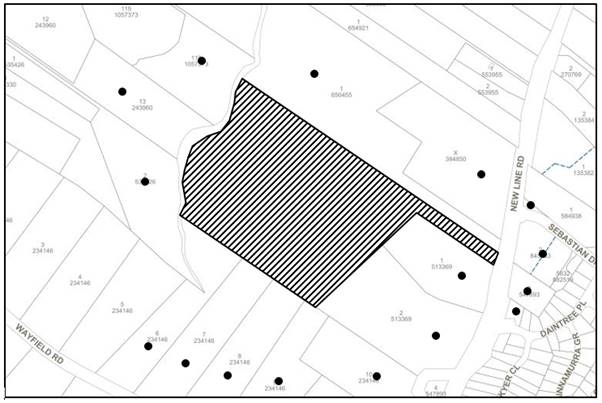
The proposed development was placed on public exhibition and was notified to adjoining and nearby landowners between 22 January 2019 and 6 February 2019 in accordance with the Notification and Exhibition requirements of the HDCP. During this period, Council received 23 submissions. The proposal was substantially amended, and accordingly, the application was renotified to the public between 11 November 2019 and 29 November 2019. Council received 2 submissions objecting to the proposal as amended. The map below illustrates the location of those nearby landowners who made a submission that are in close proximity to the development site.
|
NOTIFICATION PLAN |
|||
|
• PROPERTIES NOTIFIED |
X SUBMISSIONS RECEIVED |
|
|
|
All 25 SUBMISSIONS RECEIVED OUT OF MAP RANGE |
|||
25 submissions objected to the development, generally on the grounds that:
· The number of trees proposed to be removed to facilitate the development is excessive and includes the removal of Blackbutt Gully Forest, Sydney Turpentine Ironbark Forest and Blue Gum High Forest.
· The number of proposed replacement trees is inadequate.
· The removal of vegetation would pose a detrimental impact to biodiversity and to the habitat of local wildlife including Powerful Owls. Nesting boxes should be provided to accommodate displaced animals and birds.
· To ensure the survival of replacement trees there needs to be continuing maintenance protection afforded to all the replacement trees.
· The critically endangered Dural Land Snail exists in Blackbutt Gully Forest and a field study has not be undertaken.
· The proposal does not show how effluent run-off from future septic systems will be prevented from polluting vegetation on the site.
· The proposal and submitted bushfire report does not comply with bushfire regulations including ‘Planning for Bushfire Protection 2006’ and Australian Standard AS 339-2009 as there are insufficient APZ’s, fire truck access, lack of perimeter roads, incorrectly calculated Bushfire Attack Levels (BAL), inadequate turning circle, lack of an alternate access road, flood inundation of the accessway and vertical clearance issues.
· Vehicle crossings should be located to preserve natural vegetation.
· The proposed subdivision would increase traffic in the vicinity.
· As New Line Road is particularly busy, vehicle access to the site should only be ‘left in’ and ‘left out’.
· The proposed turning area would be insufficient to cater for garbage removal or construction vehicle access.
· The submitted Arboricultural Report is inadequate, misleading and incomplete as it omits trees from the Tree Survey Map, has grouped trees together rather than listed them individually and fails to adequately provide for replacement planting.
· The application has not included the submission of a Landscape Plan or an Aboriginal Heritage Assessment.
· All land in the E3 zone is to be retained within one lot rather than split up amongst the resultant lots.
· Given that native trees are proposed to be removed, replacement trees are to be planted in accordance with the Hornsby Green Offsets Code.
· The pine tree plantation is listed on Hornsby Council’s heritage register and should not be removed due to their heritage significance.
· The indicative building envelopes shown on the concept subdivision plan are larger than the 200m2 minimum requirement of the HDCP, thus increasing the required APZ.
· The first order creek which traverses the accessway should be left as an open creek and not piped.
· The construction of future dwelling houses on the proposed lots will result in the removal of additional trees.
· The proposed boundary setbacks would not be in accordance with the HDCP.
· The proposed driveway would pose a detrimental impact to the mapped Sydney Turpentine Ironbark Forest.
· The on-site stormwater absorption system with level spreader may not be able to cope with high volume water flows and may result in flooding of adjacent properties and impacts to trees.
· A covenant should be imposed on any consent requiring that the vegetation outside of the fire trail be protected in perpetuity.
· The proposal will ‘open the gate’ for the complete rezoning of South Dural.
· The three trees identified as tree Nos. 182-184 are located on the heritage listed road reserve and should be retained.
· The submitted Biodiversity Assessment Report is misleading and has not provided information with regard to mid-storey and understorey plant species found on the site or how fauna will be protected.
The merits of the matters raised in community submissions have been addressed in the body of the report with the exception of the following:
5.1.1 Location of Vehicular Crossing and Access
A submission has been received raising concerns that the vehicle crossing and accessway should be located to preserve natural vegetation.
The site has historically been used as a pine tree plantation and continues to be vacant of any buildings or structures. The site does not contain an existing formalised concrete driveway. Consideration has been given to the relocation of the driveway to the southern side of the battle-axe handle, however the majority of trees identified in the submitted Arborist Report are of ‘high’ or ‘significant’ retention value.
The 4 passing bays along the access have been spaced at varying distances to minimise impacts to clusters of significant trees.
Given the above, the proposed location of the accessway is considered acceptable.
5.1.2 Inadequate Arboricultural Report
Submissions have been received raising concerns that the submitted Arboricultural Report is inadequate, misleading and incomplete as it omits trees from the Tree Survey Map, has grouped trees together rather than listing them individually and fails to adequately provide for replacement planting.
The submitted Arboricultural Impact Assessment was prepared by McArdle Arboricultural Consultancy (DipArb AQF 5).
The submitted Survey Plan prepared by Chadwickcheng Consulting Surveyors has plotted trees on the subject site and adjacent sites. The Tree Management Plans within the submitted Arborist Report effectively overlay the survey plan with annotations including which trees are proposed to be removed or retained. Council’s arborist has reviewed the documentation and plans submitted with the development application and raises no concern with regard to their adequacy for assessment purposes.
Council acknowledges that the Arborist Report has ‘grouped’ trees together for convenience, for instance the Pine Tree plantation which is grouped as Tree No. 375 in the report although comprising numerous individual trees. The trees on the site comprise clusters of spindly regrowth Acacia and small Pine trees. The grouping of trees is deemed appropriate given the vast number of trees referred to in the report and the tree clustering observed on site.
Section 3.1.1 of this planning report addresses replacement tree planting.
5.1.3 Lack of Submitted Plans & Documentation
Submissions have been received raising concerns that the application has not included the submission of a Landscape Plan or an Aboriginal Heritage Assessment.
In accordance with Clause 5.10(8) of the HLEP and Part 9.5.1 of the HDCP, Council must consider the impact of the proposed development on the heritage significance of the place and any Aboriginal object known or reasonably likely to be located at the place by means of an adequate investigation. A review of the NSW Department of Planning, Industry and Environment Aboriginal Heritage Information Management System (AHIMS) has not revealed the presence of Aboriginal objects or places within the subject site. Likewise, Council’s heritage register does not indicate the presence of Aboriginal objects or places. The provision of an Aboriginal Heritage Assessment is not warranted in this instance and given the RU2 Zoned land has been disturbed by previous activities.
With regard to the absent Landscape Plan, Council’s Development Application Submission Guideline 2013 and the DA submission requirements within Schedule 1 of Environmental Planning and Assessment Regulation 2000 do not require the submission of a Landscape Plan for developments proposing the subdivision of land.
5.1.4 Inadequate Biodiversity Assessment Report
The submitted Biodiversity Assessment Report is misleading and has provided insufficient information with regard to methodology used or how fauna will be protected.
The submitted Biodiversity Assessment Report was prepared by Allan Richardson (BSc (Hons)) and Tanya Bangel (BSc (Hons), Dip CLM) of WSP.
Section 7 of the Biodiversity Assessment Report provides impact mitigation measures with regard to habitat loss and fauna protection, including checking hollow-bearing trees for the presence of bird nests and arboreal mammals and removing them prior to felling and the provision of nest boxes and salvaging tree hollows. These recommendations are also provided within the submitted Integrated Bushfire and Vegetation Management Plan prepared by WSP.
Council’s biodiversity assessment raises no concerns with regard to the findings and mitigation measures within the Biodiversity Assessment Report, subject to recommended conditions.
5.1.5 Future Tree Removal
A submission has been received raising concerns that the construction of future dwelling houses on the proposed lots will result in the removal of additional trees.
The application proposes the removal of all trees within the indicative building envelope areas and replacement planting outside the developable areas of each lot. In addition, a condition has been recommended requiring that a Restriction to User be created restricting future development to the indicative building envelope areas.
Accordingly, the developable areas of each proposed allotment would be clear of any trees and the construction of future dwelling houses would not require the removal of additional trees.
5.1.6 Inconsistency Amongst Reports
Submissions have been received raising concerns that the submitted Arborist Report, Biodiversity Assessment Report (BAR) and Integrated Bushfire and Vegetation Management Plan (IBVMP) are inconsistent with each other, including discrepancies between replacement planting locations and the number of replacement trees to be planted.
In addressing these submissions, Council acknowledges that the Arborist Report and Biodiversity Assessment Report recommend that replacement planting is to occur outside of the APZ, whilst the IBVMP recommends replacement planting in the outer APZ. Council’s biodiversity assessment raises no concern with replacement planting within the outer APZ and the conservation area, subject to meeting the requirements of the NSW RFS.
With regard to the number of trees to be replaced, the submitted Arborist Report recommends 145 replacement trees on-site, while the IBVMP recommends 165 native trees comprising Angophora costata and Eucalyptus pilularis be planted on-site. To rectify this inconsistency, a condition has been recommended requiring that 165 native trees comprising Angophora costata and Eucalyptus pilularis be planted on-site in the outer APZ and conservation area.
5.2 Public Agencies
The development application was referred to the following Agencies for comment:
5.2.1 Roads and Maritime Services
The application was referred to Roads and Maritime Services (RMS) as the site has a frontage to a classified road. RMS raised no objections to the proposal subject to conditions of concurrence recommended in Schedule 1.
5.2.2 Rural Fire Service
The application is integrated development in accordance with Section 4.46 of the Environmental Planning and Assessment Act 1979 as the site is subject to bushfire risk. The proposal was referred to the NSW Rural Fire Service (RFS) for General Terms of Approval. The RFS provided a Bushfire Safety Authority as required under section 100b of the 'Rural Fires Act 1997' and the General Terms of Approval have been included in Schedule 1 of the report.
5.2.3 Natural Resources Access Regulator
The proposal involves works within 40m of the watercourse and is therefore integrated development for the purpose of the Water Management Act 2000. The NRAR provided General Terms of Approval which are included in Schedule 1 of the report.
Submissions have been received raising concerns that the first order creek which traverses the accessway should be left as an open creek and not piped. An inspection of the site revealed that this section is not an open creek and has been filled in the past. The proposed construction of a stormwater culvert along this section of the accessway would restore uninterrupted overland stormwater flow downstream whilst providing safe vehicular access.
6. THE PUBLIC INTEREST
Section 4.15(1)(e) of the Act requires Council to consider “the public interest”.
The public interest is an overarching requirement, which includes the consideration of the matters discussed in this report. Implicit to the public interest is the achievement of future built outcomes adequately responding to and respecting the future desired outcomes expressed in environmental planning instruments and development control plans.
The application is considered to have satisfactorily addressed Council’s and relevant agencies’ criteria and would provide a development outcome that, on balance, would result in a positive impact for the community. Accordingly, it is considered that the approval of the proposed development would be in the public interest.
CONCLUSION
The application proposes the Torrens title subdivision of one allotment into four lots.
The development generally meets the desired outcomes of Council’s planning controls and is satisfactory having regard to the matters for consideration under Section 4.15 of the Environmental Planning and Assessment Act 1979.
Council received 25 submissions during the public notification period. The matters raised have been addressed in the body of the report.
Conditions are recommended to minimise disruption to residential amenity.
Having regard to the circumstances of the case, approval of the application is recommended.
The reasons for this decision are:
· The proposed development complies with the requirements of the relevant environmental planning instruments and the Hornsby Development Control Plan 2013.
· The proposed development does not create unreasonable environmental impacts to adjoining development with regard to heritage conservation, tree and vegetation preservation, bushfire risk, stormwater, effluent disposal, vehicle access, earthworks, amenity or privacy.
Note: At the time of the completion of this planning report, no persons have made a Political Donations Disclosure Statement pursuant to Section 10.4 of the Environmental Planning and Assessment Act 1979 in respect of the subject planning application.
RESPONSIBLE OFFICER
The officer responsible for the preparation of this report is Thomas Dales.
|
Cassandra Williams Major Development Manager - Development Assessments Planning and Compliance Division |
Rod Pickles Manager - Development Assessments Planning and Compliance Division |
|
1.⇨ |
Subdivision Plan |
|
|
|
2.⇨ |
Concept Plan |
|
|
|
3.⇨ |
Civil Works Plan |
|
|
|
4.⇨ |
Bushfire and Vegetation Management Plan |
|
|
|
5.⇨ |
Arborist Report Plan |
|
|
File Reference: DA/1335/2018
Document Number: D07755080
SCHEDULE 1
GENERAL CONDITIONS
The conditions of consent within this notice of determination have been applied to ensure that the use of the land and/or building is carried out in such a manner that is consistent with the aims and objectives of the relevant legislation, planning instruments and council policies affecting the land and does not disrupt the amenity of the neighbourhood or impact upon the environment.
Note: For the purpose of this consent, the term ‘applicant’ means any person who has the authority to act on or the benefit of the development consent.
Note: For the purpose of this consent, any reference to an Act, Regulation, Australian Standard or publication by a public authority shall be taken to mean the gazetted Act or Regulation, or adopted Australian Standard or publication as in force on the date that the application for a construction certificate is made.
1. Approved Plans and Supporting Documentation
The development must be carried out in accordance with the plans and documentation listed below and endorsed with Council’s stamp, except where amended by Council and/or other conditions of this consent:
Approved Plans:
|
Plan No. |
Plan Title |
Drawn by |
Dated |
Council Reference |
|
38070/PSU-2 |
Subdivision Plan |
Simon P. Cheng |
29/11/2019 |
D07810242 |
|
Unknown |
Concept Plan |
Jacobs |
Undated |
D07810243 |
|
C200, Rev F |
Sheet Layout Plan |
Chrisp Consulting |
15/07/2019 |
D07713966 |
|
C201, Rev F |
Civil Works Plan – 1 of 2 |
Chrisp Consulting |
15/07/2019 |
D07713966 |
|
C202, Rev C |
Civil Works Plan – 2 of 2 |
Chrisp Consulting |
15/07/2019 |
D07713966 |
|
C209, Rev F |
Sediment & Erosion Control Plan |
Chrisp Consulting |
15/07/2019 |
D07713966 |
Supporting Documents:
|
Document Title |
Prepared by |
Dated |
Council Reference |
|
Arboricultural Impact Assessment |
McArdle Arboricultural Consultancy |
1/11/2019 |
D07791137 |
|
RFS letter Ref: D19/86 DA190110016903MA |
NSW Rural Fire Serve |
01/07/209 |
D07705184 |
|
NRAR GTAs Ref: IDAS1112220 |
Natural Resources Access Regulator |
01/05/2019 |
D07663994 |
|
RMS letter Ref: SYD19/00021/02 (A26093043) |
Roads and Maritime Services |
04/03/2019 |
D07623342 |
|
Integrated Bushfire & Vegetation Management Plan (IBVMP), Rev B |
WSP |
19/11/2019 |
D07806011 |
|
Biodiversity Assessment Report, Rev B |
WSP |
13/12/2018 |
D07583681 |
|
Bushfire Hazard Assessment |
Bushfire Planning & Design |
14/12/2018 |
D07583652 |
a) To comply with Councils requirement in terms of vehicular access, the approved ‘Sheet Layout Plan’ (C200) and Civil Works Plans (C201 and C202) prepared by Chrisp Consulting are to be amended as follows:
i) The vehicle turning area at the end of the cul-de-sac is to have a radius of 13m to be consistent with the approved Subdivision Plan and Concept Plan.
b) These amended plans must be submitted with the application for the Construction Certificate.
3. Appointment of a Project Arborist / Ecologist
a) A project arborist with AQF Level 5 qualifications must be appointed to provide monitoring and certification throughout the construction period.
b) A project bush regenerator/ecologist must be appointed to be involved in the environmental protection works during the construction of the development.
c) Details of the appointed project arborist and bush regenerator/ecologist must be submitted to Council and the PCA for registration with the application for the construction certificate.
4. Removal of Trees
a) This development consent permits the removal of 326 trees as identified in the ‘Impacts Table 2’ on page 26 within the Arboricultural Impact Assessment prepared by McArdle Arboricultural Consultancy dated 1 November 2019.
b) No consent is granted for the removal of trees as identified in the ‘Impacts Table 2’ on page 26 within the Arboricultural Impact Assessment to be retained as these trees contribute to the established landscape amenity of the area/streetscape.
Note: The removal of any other trees from the site requires separate approval by Council in accordance with Part 1B.6 Tree and Vegetation Preservation of the Hornsby Development Control Plan, 2013 (HDCP).
5. Implementation of Integrated Bushfire and Vegetation Management Plan (IBVMP)
a) The IBVMP is to be implemented from the date of the Subdivision Certificate and is to be in place for 3 years from the date of subdivision certificate.
b) The IBVMP is to be reviewed by Council’s Natural Resources Team upon completion of the initial 3 year period and updated for a further 3 years.
Note: Contact Council’s Natural Resources Team on 984 7608 to initiate the review.
c) Monitoring should occur at a minimum of every 3 months for the first 3 years to ensure that weed control is well managed and plantings have established.
d) Monitoring of the site after the initial 3 years is to occur annually. Reporting on the implementation of the IBVMP is to occur annually with the annual reports provided to Council.
Reason: The development of a consolidated IBVMP will provide the developer and current and future landowners with a single document describing the required vegetation management actions across the site.
6. Construction Certificate
a) A construction certificate must be approved by either Council or a Private Certifying Authority (PCA) prior to the commencement of any works on the site approved under this development consent.
b) The plans submitted with the application for the construction certificate must not be inconsistent with the plans approved under this development consent.
7. Section 7.11 Development Contributions
a) In accordance with Section 4.17(1) of the Environmental Planning and Assessment Act 1979 and the Hornsby Shire Council Section 94 Development Contributions Plan 2014-2024, the following monetary contributions must be paid to Council to cater for the increased demand for community infrastructure resulting from the development:
|
Description |
Contribution (4) |
|
Roads |
$5,984.25 |
|
Open Space and Recreation |
$38,925.90 |
|
Community Facilities |
$14,964.30 |
|
Plan Preparation and Administration |
$125.55 |
|
TOTAL |
$60,000 |
being for three additional allotments.
b) The value of this contribution is current as at 3 December 2019. If the contribution is not paid within the financial quarter that this condition was generated, the contribution payable will be adjusted in accordance with the provisions of the Hornsby Shire Council Section 94 Development Contributions Plan and the amount payable will be calculated at the time of payment in the following manner:
$CPY = $CDC x CPIPY
CPIDC
Where:
$CPY is the amount of the contribution at the date of Payment
$CDC is the amount of the contribution as set out in this Development Consent
CPIPY is the latest release of the Consumer Price Index (Sydney – All Groups) at the date of Payment as published by the ABS.
CPIDC is the Consumer Price Index (Sydney – All Groups) for the financial quarter at the date applicable in this Development Consent Condition.
c) The monetary contribution must be paid to Council:
i) Prior to the issue of the Subdivision Certificate where the development is for subdivision; or
ii) Prior to the issue of the first Construction Certificate where the development is for building work; or
iii) Prior to issue of the Subdivision Certificate or first Construction Certificate, whichever occurs first, where the development involves both subdivision and building work; or
iv) Prior to the works commencing where the development does not require a Construction Certificate or Subdivision Certificate.
Note: It is the professional responsibility of the Principal Certifying Authority to ensure that the monetary contributions have been paid to Council in accordance with the above timeframes.
Council’s Development Contributions Plan may be viewed at www.hornsby.nsw.gov.au or a copy may be inspected at Council’s Administration Centre during normal business hours.
REQUIREMENTS PRIOR TO THE ISSUE OF A CONSTRUCTION CERTIFICATE
8. Traffic Control Plan
A Traffic Control Plan (TCP) must be prepared by a qualified traffic controller in accordance with the Roads & Traffic Authority’s Traffic Control at Worksites Manual 1998 and Australian Standard 1742.3 for all work on a public road. The Traffic Management Plan shall be submitted and approved by Council’s Manager Traffic and Road Safety via TrafficBranch@hornsby.nsw.gov.au prior to the issue of a construction certificate. The TCP must detail the following:
a) Arrangements for public notification of the works
b) Temporary construction signage
c) Permanent post-construction signage
d) Vehicle movement plans
e) Traffic management plans
f) Pedestrian and cyclist access/safety
9. Obtain Approvals from Public Authorities
The General Terms of Approval issued by NRAR do not constitute an approval under the Water Management Act 2000. The development consent holder must apply to NRAR for a Controlled Activity approval after consent has been issued by Council and before the commencement of any work or activity.
The applicant must submit written evidence of the following service provider requirements:
a) Ausgrid (formerly Energy Australia) – a letter of consent demonstrating that satisfactory arrangements have been made to service the proposed development.
b) Telstra - a letter of consent demonstrating that satisfactory arrangements have been made to service the proposed development.
11. Identification of Survey Marks
A registered surveyor must identify all survey marks in the vicinity of the proposed development. Any survey marks required to be removed or displaced as a result of the proposed development shall be undertaken by a registered surveyor in accordance with Section 24 (1) of the Surveying and Spatial Information Act 2002 and following the Surveyor General’s Directions No.11 – "Preservation of Survey Infrastructure".
12. Stormwater Drainage – Access Driveway
The stormwater drainage system from the access driveway must be designed for an average recurrence interval (ARI) of 20 years and be gravity drained in accordance with the following requirements:
i) The proposed pipe culvert is to be designed for an average recurrence interval (ARI) of 100 years. The maximum depth of overland flow over the culvert shall be 0.2m with a maximum velocity x depth product of 0.4m/s. Safety rails shall be provided on each side of the culvert where there is vertical level difference greater than 0.3m.
ii) For those areas of the access driveway that do not drain to the culvert the stormwater is to be directed to an on-site absorption system with level spreader. The on-site absorption system with level spreader is to be located clear of any proposed building area and any onsite sewerage disposal area.
iii) The stormwater drainage system must be designed by a qualified hydraulic engineer.
13. Internal Driveway/Vehicular Areas
The driveway and parking areas on site must be designed, constructed and a Construction Certificate issued in accordance with Australian Standards AS2890.1, AS2890.2, AS3727 and the following requirements:
a) Design levels at the front boundary be obtained from Council.
b) The driveway be a rigid pavement.
c) The driveway grade must not exceed 25 percent and changes in grade must not exceed 8 percent.
d) To protect tree Nos. 249, 250, 254, 256, 278, 208A, 309B, the driveway must be built above grade using sensitive construction techniques such as piers or screw pilings consistent with the relevant requirements of Australian Standard AS4970-2009 Protection of trees on development sites.
e) The driveway pavement shall have a width of 4.0 metres and be 0.15 metres thick reinforced concrete with F72 steel reinforcing fabric and a 0.15 metre sub-base.
f) The pavement have a roll top kerb to one side and a one-way cross fall with a minimum gradient of 2 percent and a lintel and pit provided at the low points.
g) Retaining walls required to support the carriageway and the compaction of all fill batters to be in accordance with the requirements of a chartered structural engineer. All batters are to be located within the subject land and no encroachment over adjacent land permitted.
h) The provision of safety rails where there is a level difference more than 0.3 metres and a 1:4 batter cannot be achieved.
i) Conduits for utility services including electricity, water, gas and telephone be provided. All existing overhead assets including electricity and telecommunications cabling shall be relocated underground at no cost to Council. A certificate from an appropriately licensed contractor shall be submitted to the principal certifying authority certifying that the service conduits have been installed in accordance with the relevant utility provider and Australian Standards.
j) A common turning area to service the proposed subdivision in accordance with Australian Standards AS 2890.1 to ensure vehicles can enter and leave the site in a forward direction. A right of access shall be created over the turning area to ensure access is maintained at all times.
k) The accessway shall comply with the requirements of ‘Planning for Bush Fire Protection 2006’.
14. Fire Trail Construction
The required fire trail shall be constructed in accordance with the requirements of the NSW Rural Fire Service and comply with Section 4.1.3 (3) of the “Planning for Bush Fire Protection 2006.”
15. Vehicular Crossing
A separate application under the Local Government Act 1993 and the Roads Act 1993 must be submitted to Council for the installation of a new vehicular crossing and the removal of the redundant crossing. The vehicular crossing must be constructed in accordance with Council’s Civil Works Design 2005 and the following requirements:
a) Design levels at the front boundary must be obtained from Council for the design on the internal driveway.
b) The footway area must be restored by turfing.
c) Approval must be obtained from all relevant utility providers that all necessary conduits be provided and protected under the crossing.
d) The proposed access driveway is to be located at least 1 metre from the existing power pole in New Line Road.
Note: An application for a vehicular crossing can only be made to one of Council’s Authorised Vehicular Crossing Contractors. You are advised to contact Council on 02 9847 6940 to obtain a list of contractors.
REQUIREMENTS PRIOR TO THE COMMENCEMENT OF ANY WORKS
16. Erection of Construction Sign
a) A sign must be erected in a prominent position on any site on which any approved work is being carried out:
i) Showing the name, address and telephone number of the principal certifying authority for the work.
ii) Showing the name of the principal contractor (if any) for any demolition or building work and a telephone number on which that person may be contacted outside working hours.
iii) Stating that unauthorised entry to the work site is prohibited.
b) The sign is to be maintained while the approved work is being carried out and must be removed when the work has been completed.
17. Protection of Adjoining Areas
A temporary hoarding, fence or awning must be erected between the work site and adjoining lands before the works begin and must be kept in place until after the completion of the works if the works:
a) Could cause a danger, obstruction or inconvenience to pedestrian or vehicular traffic.
b) Could cause damage to adjoining lands by falling objects; and/or
c) Involve the enclosure of a public place or part of a public place.
d) Have been identified as requiring a temporary hoarding, fence or awning within the Council approved Construction Management Plan (CMP).
Note: Notwithstanding the above, Council’s separate written approval is required prior to the erection of any structure or other obstruction on public land.
a) To provide a safe and hygienic workplace, toilet facilities must be available or be installed at the works site before works begin and must be maintained until the works are completed at a ratio of one toilet for every 20 persons employed at the site.
b) Each toilet must:
i) Be a standard flushing toilet connected to a public sewer; or
ii) Be a temporary chemical closet approved under the Local Government Act 1993; or
iii) Have an on-site effluent disposal system approved under the Local Government Act 1993.
19. Erosion and Sediment Control
To protect the water quality of the downstream environment, erosion and sediment control measures must be provided and maintained throughout the construction period in accordance with the manual ‘Soils and Construction 2004 (Bluebook)’, the approved plans, Council specifications and to the satisfaction of the principal certifying authority. The erosion and sediment control devices must remain in place until the site has been stabilised and revegetated.
Note: On the spot penalties may be issued for any non-compliance with this requirement without any further notification or warning.
20. Bushfire Management – Asset Protection Zones
At the commencement of building works the Asset Protection Zone (APZ) is to be delineated on the site through the use of permanent markers.
Reason: To provide certainty for the developer, current and future landowners, Council and contractors, during and after construction, as to the boundaries of the asset protection zone and those areas associated with different management requirements.
21. Installation of Tree Protection Fencing Around Perimeter of Subdivided Lots
a) All trees identified to be retained must have tree protection fencing as identified in the Tree Management Plan on pages 30-31 in the Arborist Report, which is to be installed by the project arborist.
b) All tree protection measures for the ground, trunk and canopy installed by the project arborist must be set in accordance with Australian Standard AS4970-2009 Protection of trees on development sites.
22. Tree Trunk and Branch Protection for Trees Located on the Accessway
a) Tree crown and trunk protection measures are required for trees along the access handle and must installed by the project arborist.
b) Must be applied in accordance with the relevant requirements section 3.3.6 Crown protection of Australian Standard AS4970-2009 Protection of trees on development sites.
c) The circumference of the trunk and or branches must be wrapped in hessian or similar material to provide cushioning for the installation of timber planks (50 x100mm or similar).
d) Timber Planks must be spaced at 100mm intervals and must be attached using adjustable ratchet straps.
23. Tree Protection Zone - Ground Protection
a) All tree protection zones must have a layer of wood-chip mulch at a depth of between 150mm and 300mm that complies with the relevant requirements of Australian Standard AS4454-2012 Composts, Soil Conditioners and Mulches installed prior to works commencing.
b) Where fencing cannot be installed inside the TPZ the wood-chip must be covered with a layer of geotextile fabric and rumble boards to allow for small plant movement and/or placement of storage of material.
24. Installation of Designated Haulage Roads
Where there is a designated access path, a haulage road must be installed in accordance with the relevant requirements of Australian Standard AS4970-2009 Protection of trees on development sites.
25. Tree Protection Certification
To ensure that all tree protection measures are correctly installed, a certificate from the appointed project arborist must be submitted to the Principal Certifying Authority confirming compliance with the tree protection requirements of this consent.
REQUIREMENTS DURING CONSTRUCTION
All works on site, including demolition and earth works, must only occur between 7am and 5pm Monday to Saturday.
No work is to be undertaken on Sundays or public holidays.
27. Environmental Management
To prevent sediment run-off, excessive dust, noise or odour emanating from the site during the construction, the site must be managed in accordance with the publication ‘Managing Urban Stormwater – Landform (March 2004) and the Protection of the Environment Operations Act 1997.
To ensure that the public reserve is kept in a clean, tidy and safe condition during construction works, no building materials, waste, machinery or related matter is to be stored on the road or footpath.
29. Disturbance of Existing Site
During construction works, the existing ground levels of open space areas and natural landscape features, including natural rock-outcrops, vegetation, soil and watercourses must not be altered unless otherwise nominated on the approved plans.
30. Excavated Material
All excavated material removed from the site must be classified by a suitably qualified person in accordance with the Department of Environment, Climate Change and Water NSW Waste Classification Guidelines and Protection of the Environment Operations (Waste) Regulation 2014 prior to disposal to an approved waste management facility and be reported to the principal certifying authority prior to the issue of an Occupation Certificate.
31. Prohibited Actions Within the Tree Protection Zone
a) In accordance with Australian Standard AS4970-2009 Protection of trees on development sites, the following is prohibited within the fenced area of TPZ:
i) Soil cut or fill including excavation and trenching
ii) Soil cultivation, disturbance or compaction
iii) Stockpiling storage or mixing of materials
iv) The parking, storing, washing and repairing of tools, equipment and machinery
v) The disposal of liquids and refuelling
vi) The disposal of building materials
vii) The siting of offices or sheds
viii) Any action leading to the impact on tree health or structure
32. Works Near Trees
a) No consent is granted for any works within the Structural Root Zone of retained trees (except as specified by Condition No. 34).
b) To maintain tree health and condition for retained trees on the approved plans, the appointed project arborist must monitor and record any and all necessary remedial actions required.
c) The maintenance and monitoring of all tree protection techniques must be recorded by the appointed project arborist during the period of construction for submission with the application for the occupation certificate.
33. Maintaining Tree Protection Zones
The Tree Protection Zone must be maintained by the project arborist in accordance with the requirements of section 4.6 of Australian Standard AS4970-2009 Protection of trees on development sites.
34. Works Within Tree Protection Zones
a) All root pruning must be undertaken in accordance with the relevant requirements of Australian Standard AS 4970-2009 Protection of trees on development sites’ - Sections 3.3.4, 4.5.4 and 4.5.5.
b) Driveway/concrete slabs (no-strip footing) requirements:
i) To minimise soil compaction within the Tree Protection Zone/structural root zones of trees within the access handle of the approved plans, the driveway must be built above grade using sensitive construction techniques such as piers or screw pilings consistent with the relevant requirements of Australian Standard AS4970-2009 Protection of trees on development sites.
ii) To minimise soil compaction within the Tree Protection Zone of trees to be retained on the approved plans, all imported material in the vicinity of the replacement driveway must be distributed by hand.
c) Any necessary excavations within the Tree Protection Zone of retained trees on the approved plans not associated with installation of services must be undertaken manually as prescribed in Section 4.5.5 of Australian Standard AS4970-2009 Protection of trees on development sites.
d) To minimise impacts within the Tree Protection Zone (TPZ) on retained trees on the approved plans the installation of services must be undertaken as follows:
i) The installation of any underground services which either enter or transect the designated TPZ must utilise sensitive methods such as manual excavation.
ii) For manual excavation of trenches the project arborist must advise on roots to be retained. Manual excavation may include the use of pneumatic and hydraulic tools. Refer Clause 4.5.3.
35. Building Materials and Site Waste
The filling or stockpiling of building materials, the parking of vehicles or plant, the disposal of cement slurry, waste water or other contaminants must be located outside the tree protection zones as prescribed in the conditions of this consent of any tree to be retained.
36. Works Near Trees Certification
a) The project arborist must submit to the principal certifying authority a certificate that all works have been carried out in compliance with the approved plans and conditions or specifications for tree protection.
b) Certification should include a statement of site attendance, the condition of retained trees, details of any deviations from the approved tree protection measures and their impacts on trees.
Note: Copies of monitoring documentation may be required by the PCA and/or Council.
REQUIREMENTS PRIOR TO THE ISSUE OF A SUBDIVISION CERTIFICATE
The following matter(s) must be nominated on the plan of subdivision under s88B of the Conveyancing Act 1919:
a) A right of access and easement for services over the access corridor.
b) An inter-allotment drainage easement(s) over each of the burdened lots.
c) A Restriction to User is to be created on the Plan of Subdivision restricting development (except class 10b structures) to the building areas as described on the undated and unreferenced plans by prepared by Jacobs;
d) A Restriction to User is to be created on the plan of subdivision restricting that any new dwelling be constructed to BAL 29 standards in accordance with AS3959-2009;
e) A Positive Covenant is to be created on the final plan of subdivision requiring that all owners and future owners shall manage the area from the accessway to the fire trail as an inner protection area (IPA) as outlined in “Planning for Bush Fire Protection 2006” and the NSW Rural Fire Service’s document “Standards for Asset Protection Zones;
f) A Restriction to User is to be created on the final plan of subdivision for a 39 metre asset protection zone (APZ) prohibiting the construction of buildings other than class 10b structures within the APZ. The APZ is defined as that area from the edge of the proposed building envelopes to the fire trail;
g) A Positive Covenant is to be created on the final plan of subdivision requiring that all owners and future owners shall provide a:
i) A 20,000 litre water supply tank. An above ground tank shall be constructed of concrete or metal (plastic tanks are not permitted), any below ground tank is to be provided with a access hole of a minimum size of 200mm to allow tanks to refill direct from the tank. The tank is to be for firefighting purposes only;
ii) A 65mm storz valve is to be provided with a gate or ball valve;
iii) The gate or ball valve, pipes and tank penetrations are adequate for full 50mm inner diameter water flow through the Storz fitting and are metal; All associated fittings to the tank are to be non-combustible;
iv) A 5hp or 3kw petrol or diesel pump shall be made available to the water supply. A 19mm (internal diameter) fire hose and reel shall be connected to the pump;
v) A SWS marker shall be obtained from the local Rural Fire Service and positioned for ease of identification by brigade personnel and other users of the SWS. The markers must be fixed in a suitable position and be highly visible and should be located adjacent to the most appropriate access for the static water supply;
vi) All reticulated or bottled gas is to be installed and maintained in accordance with AS/NZS 1596:2014. Electricity shall comply with section 4.1.3 of Planning for Bush Fire Protection;
vii) To maintain the fire trail in accordance with Section 4.1.3 (3) ‘Planning for Bush Fire Protection 2006’;
h) An easement for letterboxes shall be created over Lot 4 benefiting lots 1, 2 & 3. The 88b instrument shall be worded to reflect the obligations and responsibilities of the benefiting and burdening parties.
Note: Council must be nominated as the authority to release, vary or modify any easement, restriction or covenant.
A works-as-executed plan(s) must be prepared by a registered surveyor and submitted to Council for completed road pavement, kerb & gutter, public drainage systems, driveways and on-site detention system. The plan(s) must be accompanied by a certificate from a registered surveyor certifying that all pipelines and associated structures lie wholly within any relevant easements.
39. Preservation of Survey Marks
A certificate by a Registered Surveyor must be submitted to the Principal Certifying Authority, certifying that there has been no removal, damage, destruction, displacement or defacing of the existing survey marks in the vicinity of the proposed development or otherwise the re-establishment of damaged, removed or displaced survey marks has been undertaken in accordance with the Surveyor General’s Direction No.11 – “Preservation of Survey Infrastructure”.
40. Construction of Engineering Works
All engineering works identified in this consent are to be completed and a Compliance Certificate issued prior to the release of the Subdivision Certificate.
41. Sydney Water – s73 Certificate
A s73 Certificate must be obtained from Sydney Water and submitted to the PCA.
Note: Sydney Water requires that s73 applications are to be made through an authorised Sydney Water Servicing Coordinator. Refer to www.sydneywater.com.au or telephone 13 20 92 for assistance.
42. Damage to Council Assets
To protect public property and infrastructure, any damage caused to Council’s assets as a result of the construction or demolition of the development must be rectified by the applicant in accordance with Council’s Civil Works Specifications. Rectification works must be undertaken prior to the issue of an Occupation Certificate, or sooner, as directed by Council.
43. Restriction as to User – Protection of Land from Future Development
To inform current and future owners that the areas of the site not affected by the APZ are to be protected from future development, a Restriction as to User must be created under Section 88B of the Conveyancing Act 1919. The area affected by this restriction is to be the area of the site outside of the APZ as shown on the approved Subdivision Plan.
Reason: To inform current and future landowners of the restriction of building structures within the asset protection zone.
Note: The wording of the Restriction as to User must be to Council’s satisfaction and Council must be nominated as the authority to release, vary or modify the Restriction.
44. Positive Covenant for Implementation of the Approved Integrated Bushfire and Vegetation Management Plan (IBVMP)
The following matter(s) must be nominated on the plan of subdivision under s88E of the Conveyancing Act 1919:
a) The creation of a “Positive Covenant” over Lots 1-4 to be managed in accordance with the Integrated Bushfire and Vegetation Management Plan.
Reason: To inform current and future landowners of the ongoing management requirements of the asset protection zone and retained vegetation on the sit
Note: The wording of the Positive Covenant must be to Council’s satisfaction and Council must be nominated as the authority to release, vary or modify the Restrict
45. Replacement Tree and Bushland Regeneration Requirements
a) The trees approved for removal under this consent must be offset through replacement planting of 165 native trees comprising Angophora costata and Eucalyptus pilularis in accordance with the approved Integrated Bushfire Vegetation Management Plan (IBVMP).
b) The location and size of any replacement plantings must comply with the following requirements:
i) All replacement trees must be located within retained vegetation patches in the outer APZ and Conservation Area in accordance with the approved Integrated Bushfire Vegetation Management Plan.
ii) Planting methods must meet professional (best practice) industry standards
c) A certificate prepared by a suitably qualified ecologist must be submitted with the application for the Subdivision Certificate certifying that:
i) The 165 replacement trees comply with the Inner Protection Area (IPA) requirements as outlined in “Planning for Bush Fire Protection 2006” and the NSW Rural Fire Service’s document “Standards for Asset Protection Zones; and
ii) Section 3 of the approved Integrated Bushfire and Vegetation Management Plan has been complied with, regarding:
a. Subcanopy and tree removal;
b. Fire trail installation;
c. Weed treatment;
d. Offset tree planting;
e. Retaining existing vegetation; and
f. Habitat enhancement.
46. Final Tree Certification
The AQF 5 Project arborist must submit to the principal certifying authority a certificate that states the following:
a) All the tree protection requirements comply with the tree protection plan
b) All completed works have been carried out in compliance with the conditions of consent and approved plans.
c) Dates and times and reasons for site attendance.
d) The post development condition of the health of retained trees within the APZ, developable areas and adjacent to the accessway.
e) Details necessary work to maintain tree health.
f) Details of tree protection zone maintenance.
g) Tree replacements meet NATSPEC guidelines and the approved landscape plan.
Note: Copies of monitoring documentation may be requested throughout DA process.
GENERAL TERMS OF APPROVAL – NSW RURAL FIRE SERVICE
The following conditions of consent are General Terms of Approval from the nominated State Agency pursuant to Section 4.47 of the Environmental Planning and Assessment Act 1979 and must be complied with to the satisfaction of that Agency.
47. Building Envelope Restriction
At the issue of a subdivision certificate, a suitably worded instrument(s) shall be created pursuant to section 88 of the Conveyancing Act 1919 over proposed Lots 1, 2, 3 and 4 which require any new dwelling house or other structure (except class 10b structures) constructed on the lot(s) to be built within the building envelope(s) indicated on the plan of subdivision prepared by Jacobs to ensure construction to BAL 29 standards or lower, in accordance with Australian Standard AS3959-2009 'Construction of buildings in bush fire-prone areas' or NASH Standard (1.7.14 updated) ‘National Standard Steel Framed Construction in Bushfire Areas - 2014’ as appropriate and section A3.7 Addendum Appendix 3 of 'Planning for Bush Fire Protection 2006' (or equivalent).
48. Asset Protection Zones
The intent of measures is to provide sufficient space and maintain reduced fuel loads so as to ensure radiant heat levels of buildings are below critical limits and to prevent direct flame contact with a building. To achieve this, the following conditions shall apply:
a) At the issue of a subdivision certificate, the area within proposed Lots 1, 2, 3 and 4 up to the proposed fire trail shall be managed as an inner protection area (IPA) in perpetuity as outlined in ‘Planning for Bush Fire Protection 2006’ and the NSW Rural Fire Service's document 'Standards for asset protection zones'.
b) At the issue of a subdivision certificate, a suitably worded instrument(s) pursuant to section 88 of the Conveyancing Act 1919 shall be placed on proposed Lots 1, 2, 3, and 4 requiring the provision of a 39 metre asset protection zone (APZ) from the outside edge of the proposed fire trail to the building envelopes and which prohibits the construction of buildings other than class 10b structures within this APZ. The APZ shall be provided as indicated on the plan of subdivision prepared by Jacobs and be managed as an inner protection area (IPA) as outlined in Planning for Bush Fire Protection 2006 and the NSW Rural Fire Service's document 'Standards for asset protection zones'. The name of authority empowered to release, vary or modify the instrument shall be Hornsby Shire Council.
49. Water and Utilities
The intent of measures is to provide adequate services of water for the protection of buildings during and after the passage of a bush fire, and to locate gas and electricity so as not to contribute to the risk of fire to a building. To achieve this, the following conditions shall apply:
a) Water and gas are to comply with the following requirements of section 4.1.3 of 'Planning for Bush Fire Protection 2006':
i) In recognition that an unreliable water supply exists, a 20000-litre water supply shall be provided for firefighting purposes for each lot.
ii) If an above ground tank is to be installed it shall be manufactured of concrete or metal and raised tanks are to have their stands protected. Plastic tanks shall not be used.
iii) If an underground tanks is to be installed it shall have an access hole of 200mm to allow tankers to refill direct from the tank.
iv) A 65mm metal Storz outlet with a gate or ball valve shall be provided.
v) The gate or ball valve, pipes and tank penetration are adequate for full 50mm inner diameter water flow through the Storz fitting and are metal.
vi) All associated fittings to the tank shall be non-combustible.
vii) A minimum 5hp or 3kW petrol or diesel powered pump shall be made available to the water supply. A 19mm (internal diameter) fire hose and reel shall be connected to the pump.
viii) An 'SWS' marker shall be obtained from the local NSW Rural Fire Service and positioned for ease of identification by brigade personnel and other users of the SWS. In this regard:
a. Markers must be fixed in a suitable location so as to be highly visible; and
b. Markers should be positioned adjacent to the most appropriate access for the static water supply
ix) Reticulated or bottled gas is to be installed and maintained in accordance with Australian Standard AS/NZS 1596:2014: 'The storage and handling of LP gas' and the requirements of relevant authorities. Metal piping is to be used.
b) Electricity shall comply with section 4.1.3 of 'Planning for Bush Fire Protection 2006'.
50. Public Road Access
The intent of measures for public roads is to provide safe operational access to structures and water supply for emergency services, while residents are seeking to evacuate from an area. To achieve this, the following conditions shall apply:
a) Public road access shall comply with the following requirements of 'Planning for Bush Fire Protection 2006':
i) A minimum carriageway width of four metres with roll top kerbs shall be provided.
ii) The carriageway shall be a two wheel drive all weather road.
iii) Passing bays at 100 metre intervals for the access road shall be in place of which shall be 20 metres long by two metres wide, making a trafficable width of six metres at the passing bay.
iv) A minimum vertical clearance of four metres to any overhanging obstructions, including tree branches.
v) A minimum 12 metre outer radius turning circle shall be provided at the end of the road.
vi) The crossfall is not more than 10 degrees
vii) Traffic management devices are constructed to facilitate access by emergency services vehicles.
51. Fire Trail Access
The intent of measures for fire trails is to provide suitable access for fire management purposes and maintenance of APZs. To achieve this, the following conditions shall apply:
a) Fire trails shall comply with section 4.1.3 (3) of 'Planning for Bush Fire Protection 2006'.
b) A suitable worded instrument pursuant to section 88 of the Conveyancing Act 1919 shall be placed on proposed Lots 1, 2, 3, and 4 to ensure ongoing maintenance of the proposed fire trail to comply with section 4.1.3 (3) of ‘Planning for Bush Fire Protection 2006’. Hornsby Shire Council shall be named the authority to vary modify or delete the instrument.
GENERAL TERMS OF APPROVAL – NATURAL RESOURCES ACCESS REGULATOR
The following conditions of consent are General Terms of Approval from the nominated State Agency pursuant to Section 4.47 of the Environmental Planning and Assessment Act 1979 and must be complied with to the satisfaction of that Agency.
52. GT0009 - Design of works and structures
Before commencing any proposed controlled activity on waterfront land, an application must be submitted to Natural Resources Access Regulator, and obtained, for a controlled activity approval under the Water Management Act 2000.
53. GT0006 - Erosion and sediment controls
The following plan(s): Erosion and Sediment Controls Plan must be:
a) prepared in accordance with Managing Urban Stormwater: Soils and Construction, Volume 1 (Landcom, 2004), as amended or replaced from time to time, and
b) submitted with an application for a controlled activity approval.
54. GT0014 - Erosion and sediment controls
a) The consent holder must ensure that any proposed materials or cleared vegetation, which may:
i) obstruct water flow, or
ii) wash into the water body, or
iii) cause damage to river banks, are not stored on waterfront land, unless in accordance with a plan held by Natural Resources Access Regulator as part of a controlled activity approval.
b) When the carrying out of the controlled activity has been completed, surplus materials must be removed from waterfront land.
55. GT0021 - Erosion and sediment controls
The proposed erosion and sediment control works must be inspected and maintained throughout the construction period of the controlled activity and must not be removed until the site is fully stabilised.
56. GT0002 - Plans, standards and guidelines
a) This General Terms of Approval (GTA) only applies to the proposed controlled activity(s) described in the plans and associated documents relating to Development Application as provided by Council to Natural Resources Access Regulator.
b) Any amendments or modifications to the proposed controlled activity(s) may render the GTA invalid. If the proposed controlled activity is amended or modified, Natural Resources Access Regulator, Parramatta Office, must be notified in writing to determine if any variations to the GTA will be required.
57. GT0023 - Rehabilitation and maintenance
Vegetation clearance associated with the proposed controlled activity must be limited to where the controlled activity is to be carried out, as shown on the approved plan(s).
CONDITIONS OF CONCURRENCE - ROADS AND MARITIME SERVICES
The following conditions of consent are from the nominated State Agency pursuant to Section 4.13 of the Environmental Planning and Assessment Act 1979 and must be complied with to the satisfaction of that Agency
58. RMS 1
The applicant is advised that any modification to the layback would require concurrence under Section 138 of the Roads Act 1993.
59. RMS 2
The proposed additional driveway concrete slab and pedestrian footpath works within the road reserve are to be completed to Council’s satisfaction.
60. RMS 3
All buildings and structures, together with any improvements integral to the future use of the site are to be wholly within the freehold property (unlimited in height or depth), along the New Line Road boundary.
61. RMS 4
a) Detailed design plans and hydraulic calculations of any changes to Roads and Maritime’s stormwater drainage system are to be submitted to Roads and Maritime for approval, prior to the commencement of any works. Please send all documentation to development.sydney@rms.nsw.gov.au
b) A plan checking fee will be payable and a performance bond may be required before Roads and Maritime approval is issued.
62. RMS 5
In accordance with AS 2890.1- 2004 (Parking Facilities, Part 1: Off-street car parking), the driveway shall be a minimum of 5.5 metres in width for a minimum distance of 6 metres from the property boundary.
63. RMS 6
All vehicles are to enter and leave the site in a forward direction. Provision for vehicles to turn around must be provided within the property boundary.
64. RMS 7
All vehicles are to be wholly contained on site before being required to stop.
65. RMS 8
All demolition and construction vehicles are to be contained wholly within the site. A construction zone will not be permitted on New Line Road.
66. RMS 9
A Road Occupancy Licence (ROL) should be obtained from Transport Management Centre for any works that may impact on traffic flows on New Line Road during construction activities. A ROL can be obtained through https://myrta.com/oplinc2/pages/security/oplincLogin.jsf
67. RMS 10
The developer shall be responsible for all public utility adjustment/relocation works, necessitated by the above work and as required by the various public utility authorities and/or their agents.
- END OF CONDITIONS –
ADVISORY NOTES
The following information is provided for your assistance to ensure compliance with the Environmental Planning and Assessment Act, 1979, Environmental Planning and Assessment Regulation 2000, other relevant legislation and Council’s policies and specifications. This information does not form part of the conditions of development consent pursuant to Section 4.17 of the Act.
Environmental Planning and Assessment Act 1979 Requirements
The Environmental Planning and Assessment Act 1979 requires:
· The issue of a construction certificate prior to the commencement of any works. Enquiries can be made to Council’s Customer Services Branch on 9847 6760.
· A principal certifying authority to be nominated and Council notified of that appointment prior to the commencement of any works.
· Council to be given at least two days written notice prior to the commencement of any works.
· Mandatory inspections of nominated stages of the construction inspected.
· An occupation certificate to be issued before occupying any building or commencing the use of the land.
Long Service Levy
In accordance with Section 34 of the Building and Construction Industry Long Service Payments Act 1986, a ‘Long Service Levy’ must be paid to the Long Service Payments Corporation or Hornsby Council.
Note: The rate of the Long Service Levy is 0.35% of the total cost of the work.
Note: Hornsby Council requires the payment of the Long Service Levy prior to the issue of a construction certificate.
Tree and Vegetation Preservation
Hornsby Development Control Plan Tree Preservation provisions have been developed under Council’s authorities contained in the State Environmental Planning Policy (Vegetation in Non-Rural Area’s) 2017 under the Environmental Planning and Assessment Act, 1979.
In accordance with these provisions a person must not cut down, fell, uproot, kill, poison, ringbark, burn or otherwise destroy the vegetation, lop or otherwise remove a substantial part of the trees or vegetation to which any such development control plan applies without the authority conferred by a development consent or a permit granted by Council.
Fines may be imposed for non-compliance with the HDCP.
Note: A tree is defined as a long lived, woody perennial plant with one or relatively few main stems with the potential to grow to a height greater than three metres (3m). (HDCP 1B.6.1.c).
The land upon which the subject building is to be constructed may be affected by restrictive covenants. Council issues this approval without enquiry as to whether any restrictive covenant affecting the land would be breached by the construction of the building, the subject of this consent. Applicants must rely on their own enquiries as to whether or not the building breaches any such covenant.
Subdivision Certificate Requirements
A subdivision certificate application is required to be lodged with Council containing the following information:
· A surveyor’s certificate certifying that all structures within the subject land comply with the development consent in regard to the setbacks from the new boundaries.
· A surveyor’s certificate certifying that all services, drainage lines or access are located wholly within the property boundaries. Where services encroach over the new boundaries, easements are to be created.
· Certification that the requirements of relevant utility authorities have been met.
· A surveyor’s certificate certifying finished ground levels are in accordance with the approved plans.
Note: Council will not issue a subdivision certificate until all conditions of the development consent have been completed.
Note: At the present time Hornsby Shire Council is the only authority that can be appointed as a PCA for subdivision works within the Shire.
Fees and Charges – Subdivision
All fees payable to Council as part of any construction, compliance or subdivision certificate or inspection associated with the development (including the registration of privately issued certificates) are required to be paid in full prior to the issue of the subdivision certificate. Any additional Council inspections beyond the scope of any compliance certificate required to verify compliance with the terms of this consent will be charged at the individual inspection rate nominated in Council's Fees and Charges Schedule.
Prior to commencing any works, the applicant is encouraged to contact Dial Before You Dig on 1100 or www.dialbeforeyoudig.com.au for free information on potential underground pipes and cables within the vicinity of the development site.
Telecommunications Act 1997 (Commonwealth)
If you are aware of any works or proposed works which may affect or impact on Telstra’s assets in any way, you are required to contact: Telstra’s Network Integrity Team on Phone Number 1800810443.
Should asbestos or asbestos products be encountered during demolition or construction works, you are advised to seek advice and information prior to disturbing this material. It is recommended that a contractor holding an asbestos-handling permit (issued by SafeWork NSW) be engaged to manage the proper handling of this material. Further information regarding the safe handling and removal of asbestos can be found at:
Alternatively, telephone the SafeWork NSW Asbestos and Demolition Team on 8260 5885.
The house numbering for this subdivision shall be:
|
Lot |
Street Number |
Street Name |
Street Type |
Locality |
|
235A |
New Line |
Road |
Dural |
|
|
Lot 2 |
233A |
New Line |
Road |
Dural |
|
Lot 3 |
233 |
New Line |
Road |
Dural |
|
Lot 4 |
235 |
New Line |
Road |
Dural |
LPP Report No. LPP31/19
Local Planning Panel
Date of Meeting: 19/12/2019
2 DEVELOPMENT APPLICATION - TELECOMMUNICATIONS FACILITY - RAILWAY LAND, OPPOSITE BERYL AVENUE, MOUNT COLAH
EXECUTIVE SUMMARY
|
DA No: |
DA/413/2019 (Lodged on 28 May 2019) |
|
Description: |
Telecommunications Facility |
|
Property: |
Lot 1029 DP 1192343 Pacific Highway, Mount Colah |
|
Applicant: |
Telstra Corporation Limited |
|
Owner: |
Rail Corporation New South Wales |
|
Estimated Value: |
$250,000 |
|
Ward: |
A |
· The application involves the construction of a 16-metre free standing lattice tower, two panel antennas, fencing and ancillary telecommunication equipment.
· The proposal generally complies with the Hornsby Local Environmental Plan 2013, State Environmental Planning Policy (Infrastructure) 2007, Telecommunications Act 1997, NSW Telecommunications Facilities Guideline 2010 and the Hornsby Development Control Plan 2013.
· A total of 11 submissions have been received in respect of the application.
· The application is required to be determined by the Hornsby Council Local Planning Panel as 10 or more unique submissions were received by way of objection.
· It is recommended that the application be approved.
|
THAT Development Application No. DA/413/2019 for the construction of a telecommunications facility fencing and ancillary telecommunication equipment at Lot 1029 DP 1192343 Pacific Highway, Mount Colah be approved subject to the conditions of consent detailed in Schedule 1 of LPP Report No. LPP31/19 |
SITE
The site comprises a single allotment of approximately 35 metres in width and 800 metres in length which comprises part of the Northern Railway Line and associated infrastructure including power distribution facilities, access tracks, signalling devices and the like.
The site is located adjacent to the Pacific Highway and experiences a fall of approximately 2 metres to the eastern boundary of the site.
The site contains remnant vegetation consistent with the Bloodwood-Scribbly Gum Woodland.
The eastern and southern portions of the site are bushfire prone.
The northern portion of the site is identified as flood prone.
The site does not contain a heritage listed item and is not located within a heritage conservation area. Heritage listed item No. 575 Hunt Reserve, is located to the west of the site.
PROPOSAL
The proposed development comprises the construction of a 16-metre lattice tower, two panel antennas, fencing and ancillary telecommunication equipment. The two panel antennas would be affixed to the top of the tower and a small fenced area would be located at the base of the tower which would house cabinetry containing telecommunications equipment.
ASSESSMENT
The development application has been assessed having regard to the Greater Sydney Region Plan – A Metropolis of Three Cities, the North District Plan and the matters for consideration prescribed under Section 4.15 of the Environmental Planning and Assessment Act 1979 (the Act). The following issues have been identified for further consideration.
1. STRATEGIC CONTEXT
1.1 Greater Sydney Region Plan - A Metropolis of Three Cities and North District Plan
The Greater Sydney Region Plan - A Metropolis of Three Cities has been prepared by the NSW State Government to guide land use planning decisions for the next 40 years (to 2056). The Plan sets a strategy and actions for accommodating Sydney’s future population growth and identifies dwelling targets to ensure supply meets demand. The Plan also identifies that the most suitable areas for new housing are in locations close to jobs, public transport, community facilities and services.
The NSW Government will use the subregional planning process to define objectives and set goals for job creation, housing supply and choice in each subregion. Hornsby Shire has been grouped with Hunters Hill, Ku-ring-gai, Lane Cove, Mosman, North Sydney, Ryde, Northern Beaches and Willoughby to form the North District. The Greater Sydney Commission has released the North District Plan which includes priorities and actions for Northern District for the next 20 years. The identified challenge for Hornsby Shire will be to provide an additional 4,350 dwellings by 2021 with further strategic supply targets to be identified to deliver 97,000 additional dwellings in the North District by 2036.
The Greater Sydney Commission has released the North District Plan which includes priorities and actions for Northern District for the next 20 years.
Planning priority N1 of the North District Plan is to provide infrastructure that supports forecast population growth. In this regard the proposed telecommunications facility accords with Planning Priority N1.
2. STATUTORY CONTROLS
Section 4.15(1)(a) requires Council to consider “any relevant environmental planning instruments, draft environmental planning instruments, development control plans, planning agreements and regulations”.
2.1 Hornsby Local Environmental Plan 2013
The proposed development has been assessed having regard to the provisions of the Hornsby Local Environmental Plan 2013 (HLEP).
2.1.1 Zoning of Land and Permissibility
The subject land is zoned SP2 Rail Infrastructure Facility under the HLEP. The objectives of the zone are:
· To provide for infrastructure and related uses.
· To prevent development that is not compatible with or that may detract from the provision of infrastructure.
The proposed development is defined as a “telecommunication facility” and is a prohibited land use under the HLEP within the SP2 Infrastructure zone. Notwithstanding, the proposal is permitted pursuant to Clause 115(1) of State Environmental Planning Policy (Infrastructure) 2007 which states:
“development for the purposes of telecommunications facilities, other than development in clause 114 or development that is exempt development under clause 20 or 116, may be carried out by any person with consent on any land”.
The provisions of State Environmental Planning Policy (Infrastructure) 2007 prevail to the extent of any inconsistency with the HLEP.
2.1.2 Height of Buildings
Clause 4.3 of the HLEP states that the height of a building on any land should not exceed the maximum height show for the land on the Height of Buildings Map. There is no maximum building height control for the subject site as it is zoned SP2 Infrastructure.
The proposed 16m tower (16.2m with antennas) is considered a communication device and is excluded from the maximum building height control under the HLEP.
The proposed equipment shelter would be approximately 2m in height with the enclosing fencing having a height of 2.5m which is considered acceptable as these elements would not be highly visible from surrounding land uses.
2.1.3 Heritage Conservation
The site is located in the vicinity of heritage item No. 575, of local significance, which is identified as Hunt Reserve located on the western side of the Pacific Highway. The Inventory Sheet for item No. 575, contained within Council’s heritage register, describes the heritage item as a “Park in prominent location conserving significant indigenous trees and commemorating first shire president.”
The applicable objective of Clause 5.10(4) of the HLEP are “to conserve the environmental heritage of Hornsby”, and “to conserve the heritage significance of heritage items and heritage conservation areas, including associated fabric, settings and views,”.
The telecommunications facility would be located approximately 60 metres to the east of the heritage item, separated by both the four-lane Pacific Highway and the Northern Railway Line. Views of the telecommunications facility from Hunt Reserve would be partially screened by existing vegetation located adjacent to the rail corridor. This screening vegetation, combined with the significant distance between the heritage item and the proposed development site, would visually and spatially separate the proposed development from the heritage item, and it is considered that the proposal would have negligible impact on the heritage significance of Hunt Reserve or any associated fabric, settings or views.
2.1.4 Flood Planning
Clause 6.3 of the HLEP notes that consent must not be granted for development on land to which this clause applies to unless Council is satisfied that the development is compatible with flood hazard.
Part of the site is mapped as containing 1 in 100-year average recurrence interval (ARI) overland flow paths. The proposed telecommunications facility would be located on the southern portion of Lot 1029 that is not flood affected and accordingly no objections are raised regarding Clause 6.3 of the HLEP.
2.2 Development on Bushfire Prone Land
Section 4.14 ‘Consultation and development consent certain bush fire prone land’ of the Environmental Planning and Assessment Act 1979 states that development consent cannot be granted for any purpose on bushfire prone land unless the consent authority is satisfied that the development conforms to the specifications and requirements of the version the document entitled Planning for Bush Fire Protection prepared by the NSW Rural Fire Service in co-operation with the Department. The applicant submitted a Bushfire Protection Assessment report, prepared by Ecological Australia, dated 26 November 2019, which assessed Section 4.3.6.f of Planning for Bush Fire Protection 2006 (PBP) and the Building Code of Australia (BCA). The report noted that these documents do not provide for any bushfire specific performance requirements for construction of a telecommunications tower.
It is therefore considered that the provisions of Section 4.14 of the Environmental Planning and Assessment Act 1979, do not apply to the development. Notwithstanding, an assessment of the bushfire risk applicable to the proposal is contained within Part 2.9.4 of this report, in accordance with the precautionary approach outlined in the NSW Rural Fire Service’s Practice Note 1/11 “Telecommunication Towers in Bush Fire Prone Areas”.
2.3 Telecommunication Act 1997
Under Division 1 of Part 1 of Schedule 3 of the Telecommunications Act 1997 a carrier has the right to install a telecommunications facility for purposes connected with the supply of a carriage service if:
“(i) The carrier is authorised to do so by a facility installation permit
(ii) The facility is a low impact facility
(iii) The facility is a temporary facility for use by a defence organisation for defence purposes.
(iv) The facility is installed before 1 July 2000 for the sole purpose of connecting a building, structure, caravan or mobile home to a line that forms part of a telecommunications network that was in existence on 30 June 1997.”
Under Division 1 of Part 1 of Schedule 3 of the Telecommunications Act 1997 the proposal does not qualify as a ‘low impact facility’ installation. Therefore, the development is not exempt and requires consent under the Environmental Planning and Assessment Act 1997.
2.4 State Environmental Planning Policy (Infrastructure) 2007
2.4.1 Development Adjacent to Rail Corridors
The telecommunications tower would be located within a rail corridor. As the development involves the placement of a metallic structure on a rail corridor used by electric trains, Clause 85 “Development Adjacent to Rail Corridors” of State Environmental Planning Policy (Infrastructure) 2007 (SEPP Infrastructure) applies to the development.
Clause 85 requires the development to be referred to Sydney Trains for comment. The application was referred to Sydney Trains to comment on 11 June 2019. Sydney Trains provided conditions of consent which are discussed in further detail in Part 4.2.1 of this report.
2.4.2 Development Adjacent to Road Corridors
The telecommunications tower would be located adjacent to a road corridor, being the Pacific Highway and M1 Motorway. Access to the site would be via existing maintenance / access gates located on the Pacific Highway. Clause 101 of SEPP Infrastructure contains provisions that a consent authority must be satisfied with prior to granting consent to development with frontage a classified road. Council considers that the safety, efficiency and ongoing operation of the classified road will not be adversely affected by the development, and that the development is not of a type that is sensitive to traffic noise. Additionally, no practical alternative vehicular access is available from the site and consequently, the existing maintenance / access gates located on the Pacific Highway are the most appropriate access points for the development.
2.4.3 Telecommunications Facilities
SEPP Infrastructure contains provisions that allow telecommunications carriers to install telecommunication facilities as either exempt or complying development subject to a range of criteria including health and amenity considerations. Under Clause 116 and 116A, the proposed development is not exempt or complying development as the facility is not existing and the development is not carried out on land in Zone IN1, IN2, IN3, RU1, RU2, RU3 or RU4 or an equivalent land use zone.
Notwithstanding, the proposal is permitted with development consent pursuant to Clause 115(1) of SEPP Infrastructure which states:
“development for the purposes of telecommunications facilities, other than development in clause 114 or development that is exempt development under clause 20 or 116, may be carried out by any person with consent on any land”.
Under Clause 115 (3), when determining a proposal for a telecommunications facility, Council “must take into consideration any guidelines concerning site selection, design, construction or operating principles for telecommunications facilities that are issued by the Director-General for the purposes of this clause and published in the Gazette”. Consequently, the telecommunication facility is required to be assessed against the ‘NSW Telecommunications Facilities Guideline including Broadband – July 2010’. An assessment is provided below.
2.4.3.1 NSW Telecommunications Facilities Guideline (including Broadband) 2010
Principle 1: A telecommunications facility is to be designed and sited to minimise visual impact.
Comment: The supplied Statement of Environmental Effects, (SEE) prepared by Service Stream states that the height of the tower has been selected to achieve the stated goal of improving mobile phone coverage within the locality, with a focus on improving continuous reception availability for rail commuters. The 16.2 metre height of the tower is considered to have minimal visual impact due to the location of the facility on the eastern side of the rail line and the co-location of the tower with other infrastructure including railway booms, high voltage powerlines and existing vegetation which provides some screening. The SEE indicates that the tower can be painted to decrease visual impact. Whilst this is acknowledged, Council does not suggest a colour for the tower in this instance due to the lack of any unifying colour scheme present at the site that would warrant the re-colouring of the tower.
It is further noted that due to the stated goal of improving rail commuter reception, the tower is located in a relatively flat location close to the train line, in preference to a hilltop or elevated location which are commonly chosen for telecommunication facilities.
In accordance with the Land and Environment Court judgement Telstra Corporation Limited v Clarence Valley Council [2012] NSWLEC 1125, the fact that the facility would be visible from some adjoining areas is not sufficient grounds to refuse consent. The facility would not obstruct any high-quality views to water, significant landmarks or significant scenic areas.
Principle 2: Telecommunications facilities should be co-located wherever practical.
Comment: The submitted Statement of Environmental Effects (SEE) states the following with respect to potential co-location;
A search of the Radio Frequency National Site Archive (RFNSA) web site indicated a lack of potential colocation opportunities existing near the search area. Telstra determined that no suitable co-location options exist in the location that could satisfy the radiofrequency coverage objectives to provide mobile phone service to commuters at the railway platform and on trains moving through the area. Therefore, this greenfield candidate site was investigated.
Specific assessment of the site was undertaken in the SEE which identified that the chosen site was considered suitable for the following reasons:
· The lattice tower only needs to be 16.2 metres tall to achieve the specific radiofrequency objectives.
· The lattice tower is an equilateral triangular prism with each side only 970mm wide, presenting a relatively unobtrusive visual effect to the railway corridor and surrounds.
· The location benefits from a wide infrastructure corridor and heavy vegetation cover, that provides opportunities for visual screening with the vegetation blocking the facility from some viewpoints, and visual blending with the facility being obscured by the mature trees to be retained beyond the immediate site area.
· Other nearby infrastructure, land uses and topography provides ‘visual clutter’, including the overhead power lines, overpasses and railway infrastructure. There is a collection of other tall structures and land uses that mitigate the visual impact of the proposed facility, rather than the tower standing alone in a flat and featureless landscape.
· Land tenure can be secured with the registered landowner ‘Rail Corporation New South Wales’, now known as Sydney Trains.
The supplied SEE outlines that co-location of the tower is not a possibility in this instance and the chosen site is suitable for achieving the desired network service coverage. As the primary purpose of this tower is to service rail commuters, Council considers that the proposed site is acceptable and co-location is not considered to be feasible for this development.
Principle 3: Health standards for exposure to radio emissions must be met.
Comment: In 2002, Australian Radiation Protection and Nuclear Safety Agency (ARPANSA) published the standard: Radiation Protection Standard - Maximum Exposure Levels to Radiofrequency Fields - 3 kHz to 300 GHz. The ARPANSA RF Standard sets limits for human exposure to Radiofrequency Electromagnetic Radiation (RF EMR) in the frequency range 3 kHz to 300 GHz. The Standard also includes requirements for protection of the general public and the management of risk in occupational exposure, together with additional information on measurement and assessment of compliance. This Standard was most recently reviewed in 2014 by an independent panel who found that the exposure limits in the RF Standard continue to provide a high degree of protection against known health effects of RF electromagnetic fields.
The proposal was accompanied by an “Environmental EME Report” which provides a summary of levels of radiofrequency electromagnetic energy around the wireless base station. These levels have been calculated by Telstra using methodology developed by ARPANSA.
The SEE further details that the predictions in the Environmental EME Report assume a worst-case scenario including:
· Base station transmitters are operating at maximum power (no automatic power reduction).
· Simultaneous telephone calls on all channels.
· An unobstructed line of sight view to the antennas.
The SEE states that in practice, a worst-case scenario is rarely the case. There are often trees and buildings in the immediate vicinity, and cellular networks automatically adjust transmit power to suit the actual telephone traffic. The level of EME may also be affected where significant landscape features are present and predicted EME levels might not be the absolute maximum at all locations.
The suppled report details that at 50-100 metres the maximum EME level calculated would be 1.43% out of 100% of the public exposure limit, and at 100-200 metres the exposure would be 1.22%. All other distances would have figures of less than 0.5% of the public exposure limit.
The proposed telecommunications tower would therefore be compliant with the Maximum Exposure Levels to Radiofrequency Fields developed by ARPANSA.
Principle 4: Minimise disturbance and risk and maximise compliance.
Comment: The proposal has been designed to minimise disturbance of the locality and is sited in a location that is easily accessible for construction and maintenance within the rail corridor. Conditions are recommended to control construction activities and minimise disturbance of the locality.
It is considered that the applicant has had regard to the above principles and the development is consistent with the matters outlined within the guidelines.
2.5 State Environmental Planning Policy (Vegetation in Non-Rural Areas) 2017
State Environmental Planning Policy (Vegetation in Non-Rural Areas) 2017 (Vegetation SEPP) commenced 25 August 2017 and aims to protect the biodiversity and amenity values of trees within non-rural areas of the state.
Part 3 of the Vegetation SEPP states that a development control plan may make a declaration in any manner relating to species, size, location and presence of vegetation. Accordingly, Part 1B.6.1 of the Hornsby Development Control Plan 2013 (HDCP) prescribes works that can be undertaken with or without consent to trees.
No trees would be removed as part of the development and accordingly no further assessment under the Vegetation SEPP is required.
2.6 Sydney Regional Environmental Plan No. 20 – Hawkesbury – Nepean River
The site is located within the catchment of the Hawkesbury Nepean River. Part 2 of this Plan contains general planning considerations and strategies requiring Council to consider the impacts of development on water quality, aquaculture, recreation and tourism.
Subject to the implementation of sediment and erosion control measures and stormwater management to protect water quality, the proposal would comply with the requirements of the Policy.
2.7 State Environmental Planning Policy No. 55 – Remediation of Land
State Environmental Planning Policy No. 55 (SEPP 55) requires that consent must not be granted to the carrying out of any development on land unless Council has considered whether the land is contaminated or requires remediation for the proposed use.
A search of Council’s records and aerial photos indicates the portion of the site where the facility would be located has historically been used as a rail line. No current contamination events are recorded for the site and the site does not appear on the Environmental Protection Agency ‘List of Notified Sites’. The proposed tower design does not require significant soil disturbance or excavation and accordingly, it is not likely that the development would disturb any potential contamination. Further assessment under SEPP 55 is not required for the proposed use as a telecommunications facility.
2.8 Section 3.42 Environmental Planning and Assessment Act, 1979 - Purpose and Status of Development Control Plans
Section 3.42 of the Environmental Planning and Assessment Act 1979 states that a DCP provision will have no effect if it prevents or unreasonably restricts development that is otherwise permitted and complies with the development standards in relevant Local Environmental Plans and State Environmental Planning Policies.
The principal purpose of a development control plan is to provide guidance on the aims of any environmental planning instrument that applies to the development; facilitate development that is permissible under any such instrument; and achieve the objectives of land zones. The provisions contained in a DCP are not statutory requirements and are for guidance purposes only. Consent authorities have flexibility to consider innovative solutions when assessing development proposals, to assist achieve good planning outcomes.
2.9 Hornsby Development Control Plan 2013
The proposed development has been assessed having regard to the relevant desired outcomes and prescriptive requirements within the Hornsby Development Control Plan 2013 (HDCP). The proposed development generally complies with the prescriptive measures within the HDCP. A discussion on compliance with relevant requirements of Part 1 General, Part 7 Community and Part 9 Heritage is provided below.
2.9.1 Telecommunications
Part 7.3 of the HDCP relates to telecommunications and promotes the co-location of facilities in order to limit visual impact and the careful selection of sites in order to minimise the impact of electromagnetic radiation on sensitive land uses.
An assessment regarding the prescriptive measures of Part 7.3 of the HDCP is provided below:
|
HDCP Control |
Comment |
|
7.3.1(a) The facility should be consistent with the Australian Communications Industry Forum (ACIF) Code, including consideration of alternative locations and infrastructure to minimise electromagnetic radiation. |
The submitted documentation confirms that the facility is designed as per the industry code. The application satisfactorily addresses alternative locations and demonstrates compliance with RF EME exposure limits. |
|
7.3.1(b) Telecommunications facilities should be located: · on business and industrial sites, or · on existing infrastructure sites, and · to avoid locations within or at the termination of a significant vista or focal point of a streetscape, and · to avoid heritage conservation areas or items. |
As per Part 2.4.3.1 of this report, alternative locations have been considered however due to the specific brief of the project, no suitable alternative were available. As outlined in Part 2.1.3 of this report, the development would have negligible impact on the adjoining heritage item. |
|
7.3.1(c) Where practical, antennae and similar structures should be co-located or attached to existing structures, such as buildings, public utility structures, poles, towers or other telecommunication facilities to minimise visual impact. |
As per Part 2.4.3.1 of this report, alternative locations have been considered however due to the specific brief of the project, no suitable alternative were available.
|
|
7.3.1(d) If a facility is proposed not to be co-located, the proponent should demonstrate that co-location is not practical or desirable considering the ACIF Code exclusions. |
As per Part 2.4.3.1 of this report, alternative locations have been considered however due to the specific brief of the project, no suitable alternative were available.
|
|
7.3.2(a) Telecommunications facilities should be designed in accordance with industry best practice. |
The submitted documentation states that the facility will be designed and installed in accordance with industry best practice. |
|
7.3.2(b) Telecommunications facilities should be integrated with the design, appearance and scale of the building or structure on which it is located with regards to colour, texture, material and built form. |
The proposed tower would have a metallic finish. No prevailing design exists in the immediate locality that would warrant the design of the tower to be amended. |
|
7.3.2(c) Ground level ancillary structures (such as equipment huts) should be screened with native landscaping. |
Existing vegetation partially screens the ground level cabinetry. Due to the location of the tower within an active rail corridor, further landscaping is not considered appropriate. |
2.9.2 Access
Access to the site for construction and ongoing maintenance is available via existing access track location on the eastern side of the railway line. The applicant describes that all site access is to be undertaken with the prior agreement and supervision of Sydney Trains.
It is considered that access to the site is satisfactory, with future site access to be controlled by Sydney Trains as required.
2.9.3 Traffic and Parking
The proposed facility would not generate traffic volumes above the capacity of the local road network and would have little impact on the level of service of the local roads.
2.9.4 Waste Management
The proposed facility would not generate ongoing waste and therefore would not require regular waste collection.
2.9.5 Heritage
As per Part 2.1.3 of this report, Council considers that the facility would not have an adverse impact on the heritage significance of the adjoining Heritage Item, Hunt Reserve.
2.9.6 Bushfire
The eastern portion of the development site is located on bushfire prone land with bushfire prone vegetation located to the east of the site on the opposite side of the M1 Motorway. Council’s bushfire prone land mapping identifies that the proposed telecommunication tower site would be located 100 metres from this vegetation, with a corresponding Bushfire Attack Level (BAL) of BAL LOW applicable to the development.
The applicant submitted a Bushfire Protection Assessment report, prepared by Ecological Australia to support this development application. This report identified a BAL level of BAL FZ for the development. The difference in the identified BAL level between the supplied Bushfire Protection Assessment report and Council’s assessment arises as the Bushfire Protection Assessment report has assessed the remnant vegetation located adjacent to the existing rail line as bushfire prone vegetation. Council’s mapping does not include this vegetation as bushfire prone.
In assessing the applicable Bushfire Level, and determining the appropriate bushfire protection requirements, the Bushfire Protection Assessment report assessed Section 4.3.6.f of Planning for Bush Fire Protection 2006 (PBP) and the Building Code of Australia (BCA). It is noted that these documents do not provide for any bushfire specific performance requirements for construction of a telecommunications tower. The asset protection zone and building construction requirements specified within PBP and AS 3959-2009 Construction of buildings in bushfire-prone areas do not apply as Deemed-to-Satisfy provisions for bushfire protection for this development.
The RFS provides clarification on the expectations for bushfire protection measures for telecommunication towers in Practice Note 1/11. Such facilities are defined as critical infrastructure for fire-fighting and emergency communications, and for providing warnings and other information to the community during bushfire emergencies. As such, the RFS have Deemed-to-Satisfy (DtS) bushfire protection solutions relating to asset protection zones and building construction standards. The deemed to satisfy provisions for a telecommunications tower are for the establishment of a 10 metre Asset Protection Zone and the construction of the tower and associated infrastructure (excluding access paths and fencing) to a BAL 40 level.
Practice Note 1/11 states that a 'precautionary approach' should be taken with respect to telecommunication towers in Bush Fire Prone Areas as the NSW RFS considers that telecommunications towers are critical infrastructure for firefighting communications and for providing warnings, information and communication channels for people in bush fire prone areas during bush fire emergencies.
With respect to the proposed telecommunication tower, it is noted that due to its specific intended use of improving reception outcomes for rail commuters, the proposed tower would offer limited assistance in a bushfire emergency to the Mount Colah community. Other existing telecommunications sites that currently provide coverage to the Mount Colah region would be more critical in conveying emergency messages. However, Council’s Bushfire Assessment of the proposal adopts the principle of the 'precautionary approach' and considers that despite Council’s mapping indicating the vegetation on the subject site is not bushfire prone, inclusion and assessment of the remnant vegetation located within the rail corridor as bushfire prone vegetation is consistent with taking a precautionary approach to bushfire protection at the site.
The supplied Bushfire Protection Assessment Report recommends the establishment of a 2 metre APZ, and construction requirements for the tower, cabinetry and electronic devices so that these elements can withstand BAL-FZ intensities.
It is noted that the proposed 2 metre APZ is a departure from the 10 metre APZ requirement stipulated in Practice Note 1/11. The Bushfire Protection Assessment Report notes that due to the presence of forest vegetation surrounding the proposed tower, an APZ of at least 31 metres would be required to ensure it is not located within the flame zone. An APZ of 31 metres would not be feasible on the subject site, as this would extend into neighbouring allotments. The report proposes that new tower, cabinet and associated infrastructure be designed to withstand the expected bushfire attack (i.e. flame zone), which would provide a better bushfire protection outcome when compared to the Deemed to Satisfy Provisions outlined in Practice Note 1/11 (e.g. 10 m APZ and 40 kW/m2) as designing the cabinetry to withstand BAL-40 would be inadequate in this instance.
Council supports the recommendations for the establishment of an Asset Protection Zone and bushfire construction requirements recommended in the Bushfire Protection Assessment report despite the location of the tower being on a portion of the site that is not identified as Bushfire Prone by Councils mapping. It is considered that the inclusion of these measures are consistent with undertaking a precautionary approach to the bushfire protection of the development. Appropriate conditions of consent in accordance with the requirements of the Bushfire Protection Assessment report are recommended in Schedule 1 of this report.
2.10 Section 7.11 Contributions Plans
Hornsby Shire Council Section 94A Contributions Plan 2014 – 2024 applies to the development as the estimated costs of works is greater than $100,000. Should the application be approved, an appropriate condition of consent is recommended requiring the payment of a contribution in accordance with the Plan.
3. ENVIRONMENTAL IMPACTS
Section 4.15(1)(b) of the Act requires Council to consider “the likely impacts of that development, including environmental impacts on both the natural and built environments, and social and economic impacts in the locality”.
3.1 Natural Environment
3.1.1 Tree and Vegetation Preservation
Vegetation removal associated with the proposal would be confined to the removal of sporadic grass covers / clumps and pruning of a trees where these trees are within the 2 metres asset protection zone. No tree removal is required to facilitate the development.
A condition of consent is included in Schedule 1 of this report for no works to be undertaken within the Tree Protection Zones of any trees in the vicinity of the development site. An additional condition of consent is included in Schedule 1 of this report to ensure that the pruning of trees is undertaken by an appropriately skilled arborist in accordance with Australian Standard AS4373-2007 Pruning of Amenity Trees.
The development would have a negligible impact on the surrounding natural environment.
3.2 Built Environment
3.2.1 Built Form
The location, design and visual impact of the proposal are discussed in the report above under Part 2.4.3.1. The location, design and visual impact of the proposed structure and ancillary buildings are considered acceptable in the context of the site.
3.3 Social Impacts
The proposed telecommunication facility would have a positive social impact in that it would significantly increase the level of telecommunications service to the local community and rail commuters.
3.4 Economic Impacts
There would be negligible economic impacts resulting from the proposed development.
4. SITE SUITABILITY
Section 4.15(1)(c) of the Act requires Council to consider the suitability of the site for the development.
Council considers the site is both suitable and capable of accommodating the proposed development. The telecommunications facility would not result in tree loss, diminished landscaping or significant earthworks. Whilst the facility would be partially visible from nearby residential developments, it is considered that the proposal would not cause a significant adverse impact to the amenity of residents in the immediate area by loss of significant views.
5. PUBLIC PARTICIPATION
Section 4.15(1)(d) of the Act requires Council to consider “any submissions made in accordance with this Act”.
5.1 Community Consultation
The proposed development was placed on public exhibition and was notified to adjoining and nearby landowners between 14 June 2019 until 28 June 2019 in accordance with the Notification and Exhibition requirements of the HDCP. The applicant submitted further information that more accurately depicted the location of the proposed tower with respect to the Pacific Highway and Beryl Avenue on 26 June 2019. Council re-exhibited the development application from 30 July to 23 August to allow for further community comment on the tower location.
The map below illustrates the location of those nearby landowners who made a submission that are in close proximity to the development site.
|
NOTIFICATION PLAN |
|||
|
• PROPERTIES NOTIFIED |
X SUBMISSIONS RECEIVED |
|
|
|
3 SUBMISSIONS RECEIVED OUT OF MAP RANGE Note: Properties to the east of the subject site are crown land allotments / allotments located within the Ku-ring-gai Chase National Park. The Land and Property Management Authority and National Parks Service were notified of the development. No submissions were received from these public bodies. |
|||
A total of 13 submission were received objecting to the development. Of these 13 submissions, two duplicates were provided reducing the total number of unique submissions to 11. Submissions raised concerns on the grounds of:
· Health Impacts
· Aesthetics
· Inadequate Notification
· Property Devaluation
The merits of the matters raised in community submissions have been addressed in the body of the report with health impacts and aesthetic considerations discussed in Part 2.4.3. Concerns not addressed in the body of the report are addressed below.
5.1.1 Inadequate Notification
Submitters raised objections that the proposal was notified to an inadequate number of local residents and potentially effected local residences were not informed of the proposal.
In response to this concern, the proposed development was notified in accordance with Part 1B.5.2 ‘Notification of Applications’ of the Hornsby Development Control Plan 2013 (HDCP), which included letters sent to adjoining property owners, an advertisement of the development in the local paper, providing a “notification sign” on the property and an exhibition period of 14 days. In addition to the requirements listed in Part 1B.5.2 of the HDCP, Council exhibited the development application for an additional period upon receiving further information from the applicant which further clarified the location of the tower, hosted the development application on its website for public viewing and accepted the submission of objections outside of the formal exhibition period.
It is considered that the development was exhibited in accordance with the requirements of the HDCP.
5.1.2 Property Devaluation
Submitters raised objections that the proposal would devalue residential development in the locality.
In addressing this concern, Section 4.15 of the Environmental Planning and Assessment Act 1979 does not require Council to take into consideration the impact of development on the value of nearby properties.
5.2 Public Agencies
The development application was referred to the following Agencies for comment:
5.2.1 Sydney Trains
As outlined in Part 2.4.1 of this report, Clause 85 of State Environmental Planning Policy (Infrastructure) 2007 requires the development to be referred to Sydney Trains for comment. The application was referred to Sydney Trains on 11 June 2019. Sydney Trains requested further information to enable a further assessment to be undertaken. Additional information was requested of the applicant, including geotechnical investigation, further plan details, and technical data relating to the potential interference with existing Sydney Trains radio devices. The applicant provided the requested information on 7 November 2019 and Sydney Trains provided comment on the proposal on 29 November 2019 including conditions of consent to be applied in the advent that the application be approved. As approval is recommended in this instance, the conditions provided by Sydney Trains have been included in the recommended conditions of consent.
6. THE PUBLIC INTEREST
Section 4.15(1)(e) of the Act requires Council to consider “the public interest”.
The public interest is an overarching requirement, which includes the consideration of the matters discussed in this report. Implicit to the public interest is the achievement of future built outcomes adequately responding to and respecting the future desired outcomes expressed in environmental planning instruments and development control plans.
The application is considered to have satisfactorily addressed Council’s and relevant agencies’ criteria and would provide a development outcome that, on balance, would result in a positive impact for the community by improving the mobile network coverage for local residents and commuters. Accordingly, it is considered that the approval of the proposed development would be in the public interest.
CONCLUSION
The application proposes the construction of a of a 16-metre-high telecommunications tower, antenna, fencing and ancillary telecommunication equipment within the rail corridor at Mount Colah.
A total of 11 unique submissions have been received in respect of the application by way of objection. The matters raised have been addressed in the body of this report.
Having regard to the circumstances of the case, approval of the application is recommended. The reasons for this recommendation are:
· The proposal generally complies with the Hornsby Local Environmental Plan 2013, State Environmental Planning Policy (Infrastructure 2007), Telecommunications Act 1997, NSW Telecommunications Facilities Guideline 2010 and the Hornsby Development Control Plan 2013.
· The proposal would provide a positive impact on the local community and rail commuters by improving the mobile network coverage in the locality.
· The design, height and site location of the telecommunications tower is appropriate with respect to servicing the rail corridor, lack of suitable colocation facilities in the locality and surrounding topography.
Note: At the time of the completion of this planning report, no persons have made a Political Donations Disclosure Statement pursuant to Section 10.4 of the Environmental Planning and Assessment Act 1979 in respect of the subject planning application.
RESPONSIBLE OFFICER
The officer responsible for the preparation of this report is – Ben Jones.
|
Cassandra Williams Major Development Manager - Development Assessments Planning and Compliance Division |
Rod Pickles Manager - Development Assessments Planning and Compliance Division |
|
1.⇨ |
Locality Plan |
|
|
|
2.⇨ |
Site Plan |
|
|
|
3.⇨ |
Survey Plan |
|
|
|
4.⇨ |
Plans Architectural |
|
|
|
5.⇨ |
Base Plans |
|
|
File Reference: DA/413/2019
Document Number: D07805380
SCHEDULE 1
GENERAL CONDITIONS
The conditions of consent within this notice of determination have been applied to ensure that the use of the land and/or building is carried out in such a manner that is consistent with the aims and objectives of the relevant legislation, planning instruments and council policies affecting the land and does not disrupt the amenity of the neighbourhood or impact upon the environment.
Note: For the purpose of this consent, the term ‘applicant’ means any person who has the authority to act on or the benefit of the development consent.
Note: For the purpose of this consent, any reference to an Act, Regulation, Australian Standard or publication by a public authority shall be taken to mean the gazetted Act or Regulation or adopted Australian Standard or publication as in force on the date that the application for a construction certificate is made.
1. Approved Plans and Supporting Documentation
The development must be carried out in accordance with the plans and documentation listed below and endorsed with Council’s stamp, except where amended by Council and/or other conditions of this consent:
|
Plan No. |
Plan Title |
Drawn by |
Dated |
Council Reference |
|
N110924 S1 |
Site Access and Site Layout |
Service Stream |
26/08/2019 |
D07809585 |
|
N110924 S1-1 |
Detail 1 |
Service Stream |
26/08/2019 |
D07809585 |
|
N110924 S1-2 |
Detail 2 |
Service Stream |
26/08/2019 |
D07809585 |
|
N110924 S1-3 |
Antenna Layout |
Service Stream |
26/08/2019 |
D07809585 |
|
N110924 S3 |
South West Elevation |
Service Stream |
26/08/2019 |
D07809585 |
|
N110924 T2 |
Compacted Fill Sub-Base |
Service Stream |
25/11/19 |
D07812565 |
|
N110924 T2 -1 |
Various |
Service Stream |
25/11/19 |
D07812565 |
|
Document Title |
Prepared by |
Dated |
Council Reference |
|
Plan of Level and Detail Survey No. 431936-161-DS01 |
Veris |
28/08/2019 |
D07757445 |
|
Site Locality Plan |
Service Stream |
19/03/19 |
D07721846 |
|
Environmental EME Report |
Telstra |
2/2/2019 |
D07685491 |
|
Geotechnical Investigation |
Martens Consulting Engineers |
August 2019 |
D07809585 |
|
Intermodulation Study Report |
Radhaz Consulting |
13 June 2019 |
D07809585 |
|
Certificate of Compliance |
Gamcorp |
26/08/2019 |
D07809585 |
|
Authorised Engineering Organisation (AEO) Structural Design Certification No. 30084855 WO28 |
GHD |
26 November 2019 |
D07812565 |
|
Electrical and Earthing Design Report |
Service Stream |
13/11/2019 |
D07812565 |
|
Electrolysis Desktop Study |
Corrosion Control Engineering |
11/11/2019 |
D07812565 |
|
Civil and Structural Design Report |
Service Stream |
10/09/2019 |
D07812565 |
2. Section 7.12 Development Contributions
a) In accordance with Section 4.17(1) of the Environmental Planning and Assessment Act, 1979 and the Hornsby Shire Council Section 94A Development Contributions Plan 2014 - 2024, $2,500 must be paid towards the provision, extension or augmentation of public amenities or public services, based on development costs of $250,000.
b) The value of this contribution is current as at 2 December 2019. If this contribution is not paid within the financial quarter that this condition was generated, the contribution payable will be adjusted in accordance with the provisions of the Hornsby Shire Council Section 94 Development Contributions Plan and the amount payable will be calculated at the time of payment in the following manner:
$CPY = $CDC x CPIPY
CPIDC
Where:
$CPY is the amount of the contribution at the date of Payment
$CDC is the amount of the contribution as set out in this Development Consent
CPIPY is the latest release of the Consumer Price Index (Sydney – All Groups) at the date of Payment as published by the ABS.
CPIDC is the Consumer Price Index (Sydney – All Groups) for the financial quarter at the date applicable in this Development Consent Condition.
c) The monetary contributions must be paid to Council:
(i) Prior to the issue of the Subdivision Certificate where the development is for subdivision; or
(ii) Prior to the issue of the first Construction Certificate where the development is for building work; or
(iii) Prior to issue of the Subdivision Certificate or first Construction Certificate, whichever occurs first, where the development involves both subdivision and building work; or
Prior to the works commencing where the development does not require a Construction Certificate or Subdivision Certificate.
Note: It is the professional responsibility of the Principal Certifying Authority to ensure that the monetary contributions have been paid to Council in accordance with the above timeframes.
Council’s S94A Development Contributions Plan may be viewed at www.hornsby.nsw.gov.au or a copy may be inspected at Council’s Administration Centre during normal business hours.
3. Construction Certificate
a) A construction certificate must be approved by either Council or a Private Certifying Authority (PCA) prior to the commencement of any works on the site approved under this development consent.
b) The plans submitted with the application for the construction certificate must not be inconsistent with the plans approved under this development consent.
REQUIREMENTS PRIOR TO THE ISSUE OF A CONSTRUCTION CERTIFICATE
Note: In addition to the conditions outlined in this section, further requirements are to be met to the satisfaction of Sydney Trains, which are outlined at the end of this document.
All approved building work must be carried out in accordance with the relevant requirements of the Building Code of Australia.
5. Design and Construction - Bushfire Attack Category
a) New construction must comply with the bushfire requirements outlined in Section 2.2.4 ‘Alternative Solution’ of the Bushfire Protection Assessment Report, prepared by Ecological Australia, dated 26 November 2019.
b) A certificate prepared by a suitably qualified person is to be provided to the Certifying Authority prior to the issue of a Construction Certificate confirming that the design of the telecommunications facility is in accordance with this condition of consent.
REQUIREMENTS PRIOR TO THE COMMENCEMENT OF ANY WORKS
6. Erection of Construction Sign
a) A sign must be erected in a prominent position on any site on which any approved work is being carried out:
i) Showing the name, address and telephone number of the principal certifying authority for the work;
ii) Showing the name of the principal contractor (if any) for any demolition or building work and a telephone number on which that person may be contacted outside working hours; and
iii) Stating that unauthorised entry to the work site is prohibited.
b) The sign is to be maintained while the approved work is being carried out and must be removed when the work has been completed.
7. Protection of Adjoining Areas
A temporary hoarding, fence or awning must be erected between the work site and adjoining lands before the works begin and must be kept in place until after the completion of the works if the works:
a) Could cause a danger, obstruction or inconvenience to pedestrian or vehicular traffic;
b) Could cause damage to adjoining lands by falling objects; and/or
c) Involve the enclosure of a public place or part of a public place.
d) Have been identified as requiring a temporary hoarding, fence or awning within the Council approved Construction Management Plan (CMP).
Note: Notwithstanding the above, Council’s separate written approval is required prior to the erection of any structure or other obstruction on public land.
8. Bushfire Management – Protection Zones
At the commencement of building works the entire lease area, as depicted on the “Plan of Level and Detail Survey No. 431936-161-DS01” prepared by Veris, dated 28/08/2019 must be managed as an Inner Protection Area (IPA) to a minimum distance of 2 metres in accordance with the requirements of Section 4.1.3 and Appendix 5 of Planning for Bush Fire Protection 2006 and the NSW Rural Fire Service’s document Standards for asset protection zones.
9. Toilet Facilities
a) To provide a safe and hygienic workplace, toilet facilities must be available or be installed at the works site before works begin and must be maintained until the works are completed at a ratio of one toilet for every 20 persons employed at the site.
b) Each toilet must:
i) be a standard flushing toilet connected to a public sewer; or
ii) be a temporary chemical closet approved under the Local Government Act 1993; or
iii) have an on-site effluent disposal system approved under the Local Government Act 1993.
10. Erosion and Sediment Control
To protect the water quality of the downstream environment, erosion and sediment control measures must be provided and maintained throughout the construction period in accordance with the manual ‘Soils and Construction 2004 (Bluebook)’, the approved plans, Council specifications and to the satisfaction of the principal certifying authority. The erosion and sediment control devices must remain in place until the site has been stabilised and revegetated.
Note: On the spot penalties may be issued for any non-compliance with this requirement without any further notification or warning.
REQUIREMENTS DURING CONSTRUCTION
11. Construction Work Hours
All works on site, including demolition and earth works, must only occur between 7am and 5pm Monday to Saturday.
No work is to be undertaken on Sundays or public holidays.
12. Tree Pruning
a) This development consent only permits the pruning of trees as required to create the required 2 metre Asset Protection Zone with the lease area as depicted on the “Plan of Level and Detail Survey No. 431936-161-DS01” prepared by Veris, dated 28/08/2019.
b) Works can be undertaken in the form of canopy modification as prescribed in Australian Standard AS4373-2007 Pruning of Amenity Trees.
c) All specified pruning works must be less than 10 percent.
d) All pruning work must be undertaken by an arborist with minimum AQF3 qualifications.
e) Certification of the tree pruning must be submitted to the Principal Certifying Authority (PCA) within 7 days of the works being undertaken, confirming compliance with the relevant requirements of Australian Standard AS4373-2007 Pruning of Amenity Trees.
13. Council Property
To ensure that the public reserve is kept in a clean, tidy and safe condition during construction works, no building materials, waste, machinery or related matter is to be stored on the road or footpath.
14. Prohibited Actions Within the Tree Protection Zone
To protect the health and longevity of trees in the vicinity of the development and in accordance with the AS4970-2009 Protection of trees on development sites, the following be prohibited within the fenced area of the tree protection zone:
i) Soil cut or fill including excavation and trenching.
ii) Soil cultivation, disturbance or compaction.
iii) Stockpiling storage or mixing of materials.
iv) The parking, storing, washing and repairing of tools, equipment and machinery.
v) The disposal of liquids and refuelling.
vi) The disposal of building materials.
vii) The siting of offices or sheds.
viii) Any action leading to the impact on tree health or structure.
15. Environmental Management
To prevent sediment run-off, excessive dust, noise or odour emanating from the site during the construction, the site must be managed in accordance with the publication ‘Managing Urban Stormwater – Landcom (March 2004) and the Protection of the Environment Operations Act 1997.
16. Excavated Material
Any excavated material removed from the site must be classified by a suitably qualified person in accordance with the Department of Environment, Climate Change and Water NSW Waste Classification Guidelines and Protection of the Environment Operations (Waste) Regulation 2014 prior to disposal to an approved waste management facility and be reported to the principal certifying authority prior to the issue of an Occupation Certificate.
REQUIREMENTS PRIOR TO THE ISSUE OF AN OCCUPATION CERTIFICATE
17. Damage to Council Assets
To protect public property and infrastructure, any damage caused to Council’s assets because of the construction or demolition of the development must be rectified by the applicant in accordance with Council’s Civil Works Specifications. Rectification works must be undertaken prior to the issue of an Occupation Certificate, or sooner, as directed by Council.
18. Preservation of Survey Marks
A certificate by a Registered Surveyor must be submitted to the Principal Certifying Authority, certifying that there has been no removal, damage, destruction, displacement or defacing of the existing survey marks in the vicinity of the proposed development or otherwise the re-establishment of damaged, removed or displaced survey marks has been undertaken in accordance with the Surveyor General’s Direction No.11 – “Preservation of Survey Infrastructure”.
19. Bushfire Protection Certification
To ensure the recommended bushfire mitigation measures were installed at the site, a certificate is to be prepared by a suitably qualified person and provided to the Certifying Authority, certifying that the site was constructed in accordance with the conditions of consent for bushfire protection prior to the issue of any Occupation Certificate for the site.
OPERATIONAL CONDITIONS
20. EME Report
A report is to be submitted to Council with measurement of EME levels in the vicinity of the site. The EME levels are to comply with the standard specified in the Australian Radiation Protection and Nuclear Safety Agency 2002 ‘Radiation Protection Standard: Maximum exposure levels to Radiofrequency Fields – 3 kHz to 300 GHz’, Radiation Protection Series No 3. Mitigation measures are to be proposed to Council for implementation if levels are found to not comply with the standard. The report is to be submitted to Council within 30 days of commissioning the facility and be prepared by a suitably qualified person with relevant experience in EME measurement using the methodology developed by the Australian Radiation Protection and Nuclear Safety Agency.
Note: The report is to be sent electronically to Council’s development mailbox at devmail@hornsby.nsw.gov.au
21. Telecommunications Facility
The telecommunications facility on the site must be operated in compliance with, but not limited to:
a) Australian Radiation Protection and Nuclear Safety Agency’s (ARPANSA) ‘Radiation Protection Standard for Maximum Exposure Levels to Radiofrequency Fields – 3kHz to 300 GHz’, (2002).
b) The Australian Communication Industry Forum Code (ACIF), Industry Code C564:2004, Deployment of Mobile Phone Network Infrastructure, (2002).
c) The Australian Communications Authority (ACA), Radiocommunications (Electromagnetic Radiation – Human Exposure) Standard, (2003).
CONDITIONS OF CONCURRENCE – Sydney Trains
The following conditions of consent are from the nominated State Agency pursuant to Section 4.13 of the Environmental Planning and Assessment Act 1979 and must be complied with to the satisfaction of that Agency
22. Sydney Trains Condition 1
Unless amendments are required in order to obtain approval/certification/ compliance from Sydney Trains in relation to any of the Sydney Trains related conditions of consent, all excavation and construction works are to be undertaken in accordance with the details, methodology, advice, undertakings and recommendations detailed in the following documents:
a) Drawings as per the following table:
|
|
Drawing Nos. |
|
1 |
N110924 Sheet S1 prepared by Service Stream dated 12.11.19 |
|
2 |
N110924 Sheet S1-1 prepared by Service Stream dated 12.11.19 |
|
3 |
N110924 Sheet S1-2 prepared by Service Stream dated 12.11.19 |
|
4 |
N110924 Sheet S3 prepared by Service Stream dated 12.11.19 |
|
5 |
N110924 Sheet T2 prepared by Service Stream dated 12.11.19 |
|
6 |
N110924 Sheet T2-1 prepared by Service Stream dated 12.11.19 |
|
8 |
431936-161-DS01 Issue A dated 20.08.19 prepared by Veris |
b) Geotechnical Investigation Report prepared by Martens dated 20.08.19.
c) Authorised Engineering Organisation (AEO) Structural Design Certification prepared by GHD Reference no. 30084855 WO28, dated 26 November 2019.
d) Intermodulation Study Report prepared by Radahz Report No. 23706-1 (ISSUE A) 13 June 2019.
e) Electrical and Earthing Design Report Revision 3 prepared by Service Stream dated 13.11.19.
f) Electrolysis desktop study prepared by Corrosion Control Engineering dated 11.11.19.
g) Civil and Structural Design Report Revision 3 prepared by Service Stream dated 10.09.19.
The Certifying Authority is not to issue the Construction Certificate until the measures detailed in the documents approved/certified by Sydney Trains under this Condition are incorporated into the construction drawings and specifications prior to the issuing of the Construction Certificate. Prior to the commencement of works the Principal Certifying Authority is to provide verification to Sydney Trains that this condition has been complied with.
23. Sydney Trains Condition No. 2 – Supervision
Unless advised by Sydney Trains in writing, all excavation, shoring and piling works in and within 25m of the rail corridor are to be supervised by a geotechnical engineer experienced with such excavation projects and who holds current professional indemnity insurance.
24. Sydney Trains Condition No. 3 – Further Assessment
a) If additional electrodes are required, final electrode design shall be submitted to Sydney Trains and approval obtained from Sydney Trains prior to commencement of those works.
b) Prior to the issue a construction certificate, evidence shall be submitted to Sydney Train that a blowout report will not be required. The Certifying Authority is not to issue the Construction Certificate until written confirmation has been received from Sydney Trains confirming that this condition has been satisfied.
25. Sydney Trains Condition No. 4 – Services Search
a) Prior to the issue of a Construction Certificate, the Applicant shall undertake a services search to establish the existence and location of any rail services. Persons performing the service search shall use equipment that will not have any impact on rail services and signalling. Should rail services be identified within the subject development site, the Applicant must discuss with Sydney Trains as to whether these services are to be relocated or incorporated within the development site.
b) Prior to the issue of a Construction Certificate the applicant shall confirm that there is no HV aerial or HV earthing systems in the vicinity of the proposed telecommunication facility.
26. Sydney Trains Condition No. 5 – Design
a) The Applicant is to ensure that the development incorporates appropriate anti-graffiti measures. It is the responsivity of the applicant to remove graffiti immediately in case graffiti is applied.
b) The design, installation and use of lights, signs and reflective materials, whether permanent or temporary, which are (or from which reflected light might be) visible from the rail corridor must limit glare and reflectivity to the satisfaction of Sydney Trains. The Certifying Authority is not to issue the Construction Certificate until written confirmation has been received from Sydney Trains confirming that this condition has been satisfied.
27. Sydney Trains Condition No. 6 – Construction
a) No metal ladders, tapes, and plant, machinery, or conductive material are to be used within 6 horizontal metres of any live electrical equipment. This applies to the train pantographs and catenary, contact and pull-off wires of the adjacent tracks, and to any aerial power supplies within or adjacent to the rail corridor. Prior to work commencing, the applicant must discuss with Sydney Trains and obtain electrical permits and/or other approvals in case any issue arises regarding compliance with this condition.
b) No work is permitted within the rail corridor, or any easements which benefit Sydney Trains/RailCorp, at any time, unless the prior approval of, or an Agreement with, Sydney Trains/RailCorp has been obtained by the Applicant. The Certifying Authority is not to issue the Construction Certificate until written confirmation has been received from Sydney Trains confirming that this condition has been satisfied.
c) Prior to the issuing of a Construction Certificate, the following rail specific items are to be submitted to Sydney Trains for review and endorsement:
i) Machinery to be used during excavation/construction.
ii) Demolition, excavation and construction methodology and staging.
The Certifying Authority is not to issue the Construction Certificate until it has received written confirmation from Sydney Trains that this condition has been complied with.
d) If required by Sydney Trains, prior to the issue of a Construction Certificate a Risk Assessment/Management Plan and detailed Safe Work Method Statements (SWMS) for the proposed works are to be submitted to Sydney Trains for review and comment on the impacts on rail corridor. It is the responsibility of the applicant to be aware of any existing contamination on the site and work must be carried out in accordance with Safe Work NSW requirements. The Certifying Authority is not to issue the Construction Certificate until written confirmation has been received from Sydney Trains confirming that this condition has been satisfied.
e) Prior to the issuing of a Construction Certificate the Applicant must submit to Sydney Trains a plan showing all lift methodology and other aerial operations for the development and must comply with all Sydney Trains requirements. If required by Sydney Trains, the Applicant must amend the plan showing all lift methodology and other aerial operations to comply with all Sydney Trains requirements. The Certifying Authority is not to issue the Construction Certificate until written confirmation has been received from the Sydney Trains confirming that this condition has been satisfied.
f) No scaffolding is to be used in the rail corridor unless prior written approval has been obtained from Sydney Trains. To obtain approval the Applicant will be required to submit details of the scaffolding, the means of erecting and securing this scaffolding, the material to be used, and the type of screening to be installed to prevent objects falling onto the rail corridor. Unless agreed to by Sydney Trains in writing, scaffolding shall not be erected without isolation and protection panels.
g) If required, prior to the issue of a Construction Certificate the Applicant is to contact Sydney Trains to determine the need for public liability insurance cover. If insurance cover is deemed necessary this insurance be for sum as determined by Sydney Trains and shall not contain any exclusion in relation to works on or near the rail corridor, rail infrastructure and must be maintained for the duration specified by Sydney Trains. The Applicant is to contact Sydney Trains Engineering Management Interfaces to obtain the level of insurance required for this particular proposal. Prior to issuing the Construction Certificate the Principal Certifying Authority must witness written proof of this insurance in conjunction with Sydney Trains written advice to the Applicant on the level of insurance required.
h) Excess soil is not allowed to enter, be spread or stockpiled within the rail corridor (and its easements) and must be adequately managed/disposed of.
28. Sydney Trains Condition No. 7 – Consultation
a) The Applicant must ensure that at all times they have a representative (which has been notified to Sydney Trains in writing), who:
i) Oversees the carrying out of the Applicant’s obligations under the conditions of this consent and in accordance with correspondence issued by Sydney Trains.
ii) Acts as the authorised representative of the Applicant.
iii) Is available (or has a delegate notified in writing to Sydney Trains that is available) on a 7 day a week basis to liaise with the representative of Sydney Trains, as notified to the Applicant.
b) Without in any way limiting the operation of any other condition of this consent, the Applicant must, during excavation and construction works, consult in good faith with Sydney Trains in relation to the carrying out of the development works and must respond or provide documentation as soon as practicable to any queries raised by Sydney Trains in relation to the works.
c) Where a condition of consent requires consultation with Sydney Trains, the Applicant shall forward all requests and/or documentation to the relevant Sydney Trains external party interface team. In this instance the relevant interface team is Central Coast Project Team and they can be contacted via email on centralcoastmobilewifi@transport.nsw.gov.au.
29. Sydney Trains Condition No. 8 – Documentation
Copies of any certificates, drawings, approvals/certification or documents endorsed by, given to or issued by Sydney Trains or RailCorp must be submitted to Council for its records prior to the issuing of the Construction Certificate
30. Sydney Trains Condition No. 9 – Environmental Protection
During all stages of the development the Applicant must take extreme care to prevent any form of pollution entering the railway corridor. Any form of pollution that arises as a consequence of the development activities shall remain the full responsibility of the Applicant.
31. Sydney Trains Condition No. 10 – Inspections
a) If required by Sydney Trains, prior to the commencement of works or at any time during the excavation and construction period deemed necessary by Sydney Trains, a joint inspection of the rail infrastructure and property in the vicinity of the project is to be carried out by representatives from Sydney Trains and the Applicant. These dilapidation surveys will establish the extent of any existing damage and enable any deterioration during construction to be observed. The submission of a detailed dilapidation report will be required within 10 days following the undertaking of the inspection, unless otherwise notified by Sydney Trains.
b) If required by Sydney Trains, the Applicant must give Sydney Trains written notice at least 5 business days before any of the following events occur in or within 25 metres of the rail corridor land:
i) Site investigations.
ii) Foundation, pile and anchor set out.
iii) Set out of any other structures below ground surface level or structures which will transfer any load or bearing.
iv) Foundation, pile and anchor excavation.
v) Other excavation.
vi) Surveying of foundation, pile and anchor excavation and surveying of as-built excavations.
vii) Other concreting; or
viii) Any other event that Sydney Trains has notified to the Applicant.
32. Sydney Trains Condition No. 11 – Other
Any conditions issued as part of Sydney Trains approval/certification of any documentation for compliance with the Sydney Trains conditions of consent, those approval/certification conditions will also form part of the consent conditions that the Applicant is required to comply with.
ADVISORY NOTES
The following information is provided for your assistance to ensure compliance with the Environmental Planning and Assessment Act, 1979, Environmental Planning and Assessment Regulation 2000, other relevant legislation and Council’s policies and specifications. This information does not form part of the conditions of development consent pursuant to Section 4.17 of the Act.
Environmental Planning and Assessment Act 1979 Requirements
The Environmental Planning and Assessment Act 1979 requires:
· The issue of a construction certificate prior to the commencement of any works. Enquiries can be made to Council’s Customer Services Branch on 9847 6760.
· A principal certifying authority to be nominated and Council notified of that appointment prior to the commencement of any works.
· Council to be given at least two days written notice prior to the commencement of any works.
· Mandatory inspections of nominated stages of the construction inspected.
· An occupation certificate to be issued before occupying any building or commencing the use of the land.
Long Service Levy
In accordance with Section 34 of the Building and Construction Industry Long Service Payments Act 1986, a ‘Long Service Levy’ must be paid to the Long Service Payments Corporation or Hornsby Council.
Note: The rate of the Long Service Levy is 0.35% of the total cost of the work.
Note: Hornsby Council requires the payment of the Long Service Levy prior to the issue of a construction certificate.
Dial Before You Dig
Prior to commencing any works, the applicant is encouraged to contact Dial Before You Dig on 1100 or www.dialbeforeyoudig.com.au for free information on potential underground pipes and cables within the vicinity of the development site.
Telecommunications Act 1997 (Commonwealth)
If you are aware of any works or proposed works which may affect or impact on Telstra’s assets in any way, you are required to contact: Telstra’s Network Integrity Team on Phone Number 1800810443.
Asbestos Warning
Should asbestos or asbestos products be encountered during demolition or construction works, you are advised to seek advice and information prior to disturbing this material. It is recommended that a contractor holding an asbestos-handling permit (issued by SafeWork NSW) be engaged to manage the proper handling of this material. Further information regarding the safe handling and removal of asbestos can be found at:
Alternatively, telephone the SafeWork NSW Asbestos and Demolition Team on 8260 5885.

