
BUSINESS PAPER
Local Planning Panel meeting
Wednesday 29 July 2020
at 6:30PM
BUSINESS PAPER
Local Planning Panel meeting
Wednesday 29 July 2020
at 6:30PM
Hornsby Shire Council Table of Contents
Page 1
GENERAL BUSINESS
Local Planning Panel
Item 1 LPP9/20 Development Application - Alterations and Additions to the ‘Thornleigh Marketplace’ Shopping Centre......................................................................................................... 1
Item 2 LPP13/20 Development Application - Subdivision One Lot into Two and Construction of a Dwelling - 101-103 Wongala Crescent, Pennant Hills.................................................. 46
LPP Report No. LPP9/20
Local Planning Panel
Date of Meeting: 29/07/2020
1 DEVELOPMENT APPLICATION - ALTERATIONS AND ADDITIONS TO THE ‘THORNLEIGH MARKETPLACE’ SHOPPING CENTRE
EXECUTIVE SUMMARY
|
DA No: |
DA/1047/2019 (Lodged on 14 November 2019) |
|
Description: |
Alterations and additions to the ‘Thornleigh Marketplace’ shopping centre including the construction of a second-floor level comprising additional retail floorspace |
|
Property: |
Lot 100 DP 608646, No. 17 Bellevue Street, Thornleigh |
|
Applicant: |
Holdmark NSW Pty Ltd |
|
Owner: |
357 Thornleigh Place Pty Ltd |
|
Estimated Value: |
$16,422,776 |
|
Ward: |
B |
· The proposal does not comply with the Hornsby Shire Local Environmental Plan 2013 (HLEP) with regard to Clause 4.3 ‘Height of Buildings’ and Clause 4.4 ‘Floor Space Ratio’. The applicant has made a submission in accordance with Clause 4.6 ‘Exceptions to development standards’ of the HLEP to vary the building height and FSR development standards. The submission is considered well founded and is supported.
· The application is required to be determined by the Hornsby Council Local Planning Panel as the proposal would contravene the HLEP ‘Floor Space Ratio’ development standard by more than 10 percent.
· The proposal generally complies with the Hornsby Development Control Plan 2013.
· Two submissions have been received in respect of the application.
· It is recommended that the application be approved.
|
THAT Council assume the concurrence of the Secretary of the Department of Planning and Environment pursuant to Clause 4.6 of the Hornsby Local Environmental Plan 2013 and approve Development Application No. DA/1047/2019 for alterations and additions to the ‘Thornleigh Marketplace’ shopping centre including the construction of a second-floor level comprising additional retail floorspace at Lot 100 DP 608646, No. 17 Bellevue Street Thornleigh subject to the conditions of consent detailed in Schedule 1 of LPP Report No. LPP9/20. |
BACKGROUND
Site History
On 23 June 2003, Council received Development Application No. DA/1152/2003 for the refurbishment of the existing Parkway Plaza Shopping Centre including partial demolition, excavation, basement carparking, refurbishment of the centre, fitout of supermarket and liquor store, and the preparation of specialty shops for fitout.
An appeal was lodged by the applicant with the NSW Land and Environment Court against Council’s deemed refusal of Development Application No. DA/1152/03.
On 12 May 2004, the appeal was upheld, and development consent was granted by NSW Land and Environment Court in Fabcot Pty Ltd v Hornsby Shire Council [2004] NSWLEC 358. The approved hours of operation for the centre are as follows:
Monday to Saturday 7.00AM to 12.00PM Midnight.
Sunday 8.00AM to 10.00PM.
Subsequent Modification Applications have been approved (DA/1152/2003/A, DA/1152/2003/B and DA/1152/2003/C) for the modification of the approved alterations and additions to the shopping centre comprising the reconfiguration of the carpark, landscaping, access and the extension of work hours.
Application History
On 2 April 2019, Council held a pre-lodgement meeting with the applicant (PL/17/2019) to discuss the merits of a future development application proposing alterations and additions to the shopping centre including the construction of a second-floor level comprising additional retail floorspace.
On 14 November 2019, the subject application (DA/1047/2019) was lodged with Council.
On 6 February 2020, Council requested additional information from the applicant raising concerns with regard to inconsistencies between the submitted architectural plans and the recommendations of the acoustic, access and traffic reports. Concerns were also raised with the submitted Clause 4.6 variation request which did not adequately address the development standards under Clause 4.6(3) of the Hornsby Local Environmental Plan 2013 (HLEP).
On 26 February 2020, Council requested additional information in the form of a Construction Traffic Management Plan (CTMP) to address the unique characteristics of the site including limited parking spots available on the surrounding roads, adjacent residential properties, the 3-tonne limit along the Comenarra Parkway and the trees along the footpaths that could be impacted during scaffolding or construction works.
On 3 March 2020, Council requested additional information in the form of revised Transport Management Delivery Plan (TMDP) to ensure that the operations of the loading dock would not adversely impact upon the amenity of adjacent residential properties along Bellevue Street. In addition, amendments to the submitted architectural plans were requested by Council to indicate the provision of motorcycle spaces within the proposed first floor level car park.
On 23 March 2020, Council received the requested plans and documentation including the submission of revised architectural plans, TMDP and a revised Clause 4.6 variation request.
On 23 March 2020, the amended Development Application was renotified.
On 27 March 2020, Council raised concerns with the applicant that the submitted acoustic report utilised incompatible noise criteria in calculating the anticipated noise generated from the proposed second floor level terraces. Accordingly, Council requested the submission of a revised acoustic report to address Council’s concerns.
On 6 April 2020, Council received a revised acoustic report and a revised CTMP addressing the tree concerns, a supporting letter clarifying the truck route concerns, and written justification requesting that the location of site sheds, concrete pumps and storage areas be provided as a condition of consent rather than during the DA assessment process. Although Council agreed that the tree concerns could be addressed as a condition of consent, Council maintained that the CTMP would need to be amended to indicate the location of site sheds, concrete pumps and storage areas at the DA assessment stage and that the truck route issues be rectified.
On 7 April 2020, Council received the revised TMDP.
On 8 April 2020, Council raised concerns that the revised Acoustic Report uses ILGA criteria instead of the typical background + 5dBA intrusive criteria and whether the adjacent residential receivers would receive acceptable noise levels when the proposed terraces are at full capacity (76 people on the eastern terrace, 65 people on the northern terrace).
On 9 April 2020, Council received the requested revised CTMP.
On 20 April 2020, Council engaged an acoustic consultant to review the submitted Acoustic Report.
On 14 May 2020, Council requested amendments to the revised CTMP to address concerns that the concrete trucks and loading zone would be positioned on Wood Street within a bus zone and ‘no stopping’ zone. Council requested that alternate locations be sought for the concrete trucks and loading zone.
On 18 May 2020, the applicant provided written justification to Council stating that permits would be sought from Council and TfNSW to seek exemption from providing the concrete pumps and loading zone within the bus zone and no stopping zone along Wood Street. Council agreed that the CTMP would not need to be amended to indicate relocation of the concrete pumps and loading zone and that permits would instead be sought for the use of Wood Street during construction.
On 18 May 2020, Council completed an assessment of the revised Clause 4.6 variation noting the caselaw established in Four2Five Pty Ltd v Ashfield Council [2015] which underlined that consent authorities must be directly satisfied that the applicant’s written request has adequately addressed the matters required to be demonstrated by subclause (3) of Clause 4.6 i.e. that compliance with the development standard is unreasonable or unnecessary in the circumstances of the case and that there are sufficient environmental planning grounds to justify contravening the development standard. Accordingly, Council raised concerns that the request did not satisfy Clause 4.6(4)(i) of HLEP in that the applicant’s written request provided insufficient environmental planning grounds to justify contravening the development standard.
Accordingly, Council requested that the variation statement be substantially expanded upon to demonstrate how and why the development would not result in impacts to the streetscape, heritage, setbacks, separation, sunlight access, privacy, bulk and scale and any other relevant environmental planning matters.
On 20 May 2020, Council received the requested revised Clause 4.6 variation.
On 20 May 2020, Council received the external acoustic peer review from Acoustic Logic. The review indicated that the acoustic report had discrepancies, inaccurate unattended noise monitoring data and a lack of information regarding sleep disturbance. Consequently, Council forwarded the acoustic review to the applicant and advised that the review raised significant concerns with the submitted Acoustic Report that would need to be addressed.
On 1 June 2020, Council received a revised Clause 4.6 written request.
On 12 June 2020, Council received the requested revised Acoustic Report and cover letter.
On 24 June 2020, Council received the external acoustic peer review of the revised acoustic report.
SITE
The site comprises an allotment known as Lot 100 DP 608646 (No. 17) Bellevue Street Thornleigh and has a frontage to The Comenarra Parkway, Wood Street and Bellevue Street.
The site has an area of 8,208 m2 and experiences a fall from east to west to the frontage at Wood Street. Consequently, the grade of the site with cross fall from east to west and subsequent development for one large building (shopping centre) results in the existing built form protruding at a height greater at the eastern (Wood Street) frontage.
The existing shopping centre comprises a basement carpark with vehicular access from Wood Street. A vehicle access ramp to a rooftop carparking area is also accessed from Wood Street. Travellators provide pedestrian access from both the basement and roof top carparking areas to the main ground floor retail floor area. A number of smaller specialty shops are located on the ground floor. The majority of the ground floor retail floorspace is occupied by a Woolworths Supermarket and Dan Murphy’s liquor store. A small number of specialty shops are located adjacent to the entry point to the travellator from the rooftop carparking area.
The delivery area and truck loading docks for the shopping centre are situated within a partly covered area accessed from Bellevue Street.
The site is not bushfire or flood prone.
The site is burdened by a 3m wide right of carriageway (limited in height), a 5.5m wide easement for car parking (limited in height and depth), variable width right of access (limited in height and depth) and a 5.5m wide easement for electricity substation.
The site is located adjacent to a heritage listed ‘house’ of local significance at No. 14 The Comenarra Parkway, listed as item No. 720 in Schedule 5 of the HLEP.
The site adjoins the ‘R4 High Density Residential’ zone to the southern side of Bellevue Street, up-zoned from ‘R2 Low Density Residential’ when the in force HLEP was gazetted in 2013. The HLEP permits a maximum building height of 17.5m within the R4 zone. At present, the up-zoned southern side of Bellevue Street comprises a predominant low density residential built form with the exception of a recently completed residential flat building at No. 14 Bellevue Street and ALDI supermarket at the corner of Bellevue Street and Pennant Hills Road.
The site is bounded by low density residential development to the eastern side of Wood Street and northern side of The Comenarra Parkway. Fronting Pennant Hills Road to the west of the site are a number of small-scale commercial tenancies.
The site is located approximately 400m walking distance from Thornleigh Railway Station.
PROPOSAL
The application proposes alterations and additions to the ‘Thornleigh Marketplace’ shopping centre, detailed as follows:
· Demolition of existing building elements that project above the first-floor level carparking area including:
o Small specialty shops.
o Corner tower elements.
o Various projections on the external façade of the building.
· Construction of a proposed second floor level above the existing first floor level rooftop carpark comprising:
o An additional 3,777.73m2 of retail floorspace and a 475.61m2 mezzanine for services.
o Specialty shops.
o Food courts.
o Two rooftop terraces associated with the food courts.
o Amenities.
o Travellator for pedestrian access to the carpark.
o Access to the goods lift from the loading dock.
· Reconfiguration of the existing rooftop carpark resulting in a reduction from 333 to 321 car parking spaces.
· Installation of a goods lift within the existing loading dock.
· Construction of fire stairs and services within the south-east corner of the building.
· Installation of a travellator from the rooftop carpark to the proposed second floor level.
· Recladding of the external façade of the shopping centre.
Note: The application does not propose the fitout and use of the shops within the proposed second floor level.
ASSESSMENT
The development application has been assessed having regard to the Greater Sydney Region Plan – A Metropolis of Three Cities, the North District Plan and the matters for consideration prescribed under Section 4.15 of the Environmental Planning and Assessment Act 1979 (the Act). The following issues have been identified for further consideration.
1. STRATEGIC CONTEXT
1.1 Greater Sydney Region Plan - A Metropolis of Three Cities and North District Plan
The Greater Sydney Region Plan - A Metropolis of Three Cities has been prepared by the NSW State Government to guide land use planning decisions for the next 40 years (to 2056). The Plan sets a strategy and actions for accommodating Sydney’s future population growth and identifies dwelling targets to ensure supply meets demand. The Plan also identifies that the most suitable areas for new housing are in locations close to jobs, public transport, community facilities and services.
The NSW Government will use the subregional planning process to define objectives and set goals for job creation, housing supply and choice in each subregion. Hornsby Shire has been grouped with Hunters Hill, Ku-ring-gai, Lane Cove, Mosman, North Sydney, Ryde, Northern Beaches and Willoughby to form the North District. The Greater Sydney Commission has released the North District Plan which includes priorities and actions for Northern District for the next 20 years. The identified challenge for Hornsby Shire will be to provide an additional 4,350 dwellings by 2021 with further strategic supply targets to be identified to deliver 97,000 additional dwellings in the North District by 2036.
The proposed development would be consistent with the Greater Sydney Region Plan - A Metropolis of Three Cities and North District Plan, by providing additional services to support a growing population and generating additional employment options for workers in the locality.
2. STATUTORY CONTROLS
Section 4.15(1)(a) requires Council to consider “any relevant environmental planning instruments, draft environmental planning instruments, development control plans, planning agreements and regulations”.
2.1 Hornsby Local Environmental Plan 2013
The proposed development has been assessed having regard to the provisions of the Hornsby Local Environmental Plan 2013 (HLEP).
2.1.1 Zoning of Land and Permissibility
The subject land is zoned B2 Local Centre pursuant to the Land Use Table of the HLEP.
The objectives of the B2 zone are:
· To provide a range of retail, business, entertainment and community uses that serve the needs of people who live in, work in and visit the local area.
· To encourage employment opportunities in accessible locations.
· To maximise public transport patronage and encourage walking and cycling.
Pursuant to the HLEP a ‘retail premises’ is defined as follows:
‘Retail Premises’ means a building or place used for the purpose of selling items by retail, or hiring or displaying items for the purpose of selling them or hiring them out, whether the items are goods or materials (or whether also sold by wholesale), and includes any of the following:
(a) (Repealed)
(b) cellar door premises
(c) food and drink premises
(d) garden centres
(e) hardware and building supplies
(f) kiosks
(g) landscaping material supplies
(h) markets
(i) plant nurseries
(j) roadside stalls
(k) rural supplies
(l) shops
(la) specialised retail premises
(m) timber yards
(n) vehicle sales or hire premises
But does not include highway service centres, service stations, industrial retail outlets or restricted premises.
The proposed development is defined as ‘retail premises’ and is permissible within the B2 Local Centre zone with Council’s consent.
2.1.2 Height of Buildings
Clause 4.3 of the HLEP provides that the height of a building on any land should not exceed the maximum height shown for the land on the Height of Buildings Map. The maximum permissible height for the subject site is 12m.
The proposal would result in a maximum height of 13.2m, representing a departure of 10% from the development standard.
The application is accompanied by a submission pursuant to Clause 4.6 of the HLEP to vary the Height of Buildings development standard, which is discussed below in Section 2.1.4 of this report.
2.1.3 Floor Space Ratio
Clause 4.4(2) of the HLEP provides that the floor space ratio (FSR) on any land is not to exceed the maximum shown for the land on the Floor Space Ratio Map. The maximum permissible FSR for the precinct in accordance with the map is 1:1.
The existing development achieves an FSR of 0.88:1. The proposal would result in a maximum FSR of 1.38:1, representing a 38% variation to the development standard.
The application is accompanied by a submission pursuant to Clause 4.6 of the HLEP to vary the Floor Space Ratio development standard, which is discussed below in Section 2.1.4 of this report.
2.1.4 Exceptions to Development Standards
A submission has been received raising concerns that the originally submitted Clause 4.6 submission is flawed in that there are insufficient environmental planning grounds to justify contravening the development standards. On 23 March 2020, Council received a revised Clause 4.6 variation submission to address Council’s concerns that the submission did not adequately address the development standards under Clause 4.6(3) of the HLEP.
In response to the revised Clause 4.6 variation statement, a submission was received on 6 April 2020 from the same objector raising the following concerns:
· The benefits of the proposal cannot be environmental planning grounds.
· The applicant has not demonstrated that the additional floor space ratio or building height is required to achieve these benefits.
· The applicant has not advanced any environmental planning grounds or any justification in support for the increased intensity.
· There is nothing particular or unique about the subject site that warrants a variation of the controls.
On 1 June 2020, Council received a revised Clause 4.6 variation which expanded upon the environmental planning grounds for varying the development standards provided within the previous variation requests.
The application has been assessed against the requirements of Clause 4.6 of the HLEP. This clause provides flexibility in the application of the development standards in circumstances where strict compliance with those standards would, in any particular case, be unreasonable or unnecessary or tend to hinder the attainment of the objectives of the zone.
Clause 4.6 of the HLEP applies to this development as the proposed development would:
· Have a maximum building height of 13.2m, representing a departure of 10% from the ‘Height of Buildings’ development standard.
· Have a Floor Space Ratio (FSR) of 1.38:1, representing a 38% variation to the ‘Floor Space Ratio’ development standard.
The applicant has made a submission in support of a variation to the development standards in accordance with Clause 4.6 of the HLEP. The applicant states the proposed variation is considered to be consistent with the objectives of the control and is justified as follows:
· Our opinion is that the relatively modest additional height proposed contributes to the delivery of a high-quality development on this site by transferring ground level GFA that may have negative impacts with regard to ground level activity and converting this to high quality commercial GFA. The proposed height variation realises the development potential of the site and provides a higher quality outcome than the alternative solution.
· It is clear that the objectives of the standard are able to be achieved, notwithstanding the additional height, and that a superior development outcome would result.
· The underlying objective or purpose of the standard is relevant to this development but, as illustrated in the plans submitted with the development application, it is achieved through the height variation with a higher quality urban planning and urban design outcome. The variation to FSR is inconsequential in the scheme of overall bulk and scale of the development.
· The underlying object or purpose of the standard would not be defeated or thwarted if compliance was required. However, strict compliance with the development standard would result in a missed opportunity specific to this site to develop a high-quality development that will present in a positive manner to the adjoining street.
· The proposal maintains the economic viability of the existing shopping centre development while catering for the needs of the increasing population in the Thornleigh commercial precinct and other higher density residential precincts created under the planning instrument. The additional Gross Floor Area responds accordingly to the increase in population density in the immediate vicinity of the site as a consequence of recent zoning changes under the Hornsby Shire Housing Strategy.
· Council has departed on the development standard in historic planning circumstances on the site. The existing building contains a number of building elements that currently exceed the maximum height standard.
· Likewise, the court supported an increase above the maximum FSR in permitting the current development. The current proposal responds to recent changes in housing density that has occurred in close proximity to the site.
· The merit-based justification above in this request provides strong evidence that the proposed height variation would have clear positive outcomes including provision of a high-quality public domain, protection and enhancement of identified values specific to the site and provision of high-quality commercial development in the locality.
· Our opinion is that the additional height & FSR is a negligible issue within the context of the greater planning benefit, including opportunities for activation of the public domain, protection and enhancement of local values and provision of high-quality development that would result from the minor variation to the height standard. In this regard, there are sufficient environmental planning grounds specific to this site to justify the proposed minor departure from the development standard.
· The underlying objective of the height standard is to minimise potential adverse environmental impacts of development of the site on the surrounding residential area. It is noted that the height standard was applied to the site at a time historically when the site was surrounded predominantly by low-density residential development. Since the historic application of the height standard on the site, the council has undertaken rezoning of a number of the surrounding lands to permit increased residential densities and increases in the height of development on the adjoining lands. In other words, the character of the surrounding area to the site has changed substantially since the current height standard was applied to the site. It could be argued that the current height standard is inappropriate when accounting for changes to height controls that have occurred in recent years on surrounding lands.
· The underlying objectives of the height standard are to minimise adverse environmental impacts upon the surrounding [sic] by impacts from overshadowing, overlooking, intensity of development (e.g. noise impacts). The height variation occurs on the lower (eastern) portion of the site only. The majority of the development proposed complies with the maximum height standard.
· Although the proposal breaches the height of buildings control, the development achieves appropriate building envelopes and separation to the adjacent residential land. It is also worth noting that the development does comply with solar access, site coverage and other similar requirements adopted by Council.
· The additional building height allows for the efficient and economic use of the site. The minor noncompliance with the height standard is essentially a response to the local topography and does not exacerbate any likely adverse impacts from the development on surrounding lands.
· The existing setbacks of the shopping centre are maintained and consequently, the reduction in the height (in part) of the existing building is considered to be an improvement to the external appearance of the building and will reduce the bulk and scale by the removal of a number of existing elements of the shopping centre that currently exceed the height control.
· Consideration of the proposed building height must be taken in the context of the existing development of the site compared to the proposed built form. The existing rooftop car park provides overlooking onto a number of the surrounding residential properties. The part of the building that will exceed the height standard will not exacerbate issues relating to overlooking and privacy to the surrounding residential areas.
· The opportunity to ‘step’ the design of the building does not exist for the existing or proposed purpose of the building, namely a shopping centre. The extent of the non-compliance with the height standard will not result in any adverse environmental outcomes and will essentially be inconsequential when considering the resultant built form of a fully compliant building with the height standard.
· Clause 5.6 of the LEP permits variations to the building height standard for ‘roof features of visual interest’. Subclause 5.6(3) of the LEP prescribes matters for the consent authority to give consideration to when permitting architectural roof features that exceed the height standard. The element of the building that will exceed the height standard is considered to be consistent with the matters for consideration prescribed under clause 5.6(3) of the LEP.
· The Hornsby DCP does not prescribe any building setbacks for the site nor is there any requirement for a podium to be provided in the building design. The desired outcome under the scale element of the DCP is to ensure that development maintains a height, scale and intensity compatible with the role and function of the centre under the commercial centre’s hierarchy. As stated above, the height proposed is considered to be consistent with the desired outcome of the ‘scale element’ under section 4.2.1 of the DCP.
· Improvements in the external design and appearance of the building will assist in reducing the bulk and scale of the existing building by the removal of a number of building elements that currently add to the vertical scale of the building. The proposed built form will not detrimentally impact on any identified heritage items in the Thornleigh locality.
· Floor space ratio is a ‘crude’ planning mechanism that is used in planning instruments to control the bulk and scale of buildings. The non-compliance with the FSR control does not contribute to an increase in bulk and scale that is out of character with the development (current and proposed) in the surrounding locality.
· The underlining objective of the FSR that applies to the subject site is to ensure that the resultant bulk and scale of the building is appropriate for the site in its context to the surrounding development. The proposal involves an overall reduction on building height and a general compliance with the adopted height standard across the majority of the site. In fact, the bulk and scale of the building will be reduced when compared to the existing building which will result in a better urban design outcome. The acceptability of the proposed floor space on the site is also regulated by the building’s general compliance across the majority of the site to the adopted height standard.
· Floor space ratio is simply a control of the ratio of floor space to the site area. This presumes that controlling factors are equally important and of the same proportion across the site in its entirety. A building that is fully compliant with the FSR could result in the ‘stacking’ of floor area in one part of the site in the absence of a height control.
· The development proposal will result in a gross floor area that will effectively match the resultant development volume to transport and other infrastructure for the site.
· It is considered that the public benefit will not be undermined by varying the height and FSR development standards. The proposed development is considered to be generally consistent with the adopted planning controls for the site.
State Government Guidelines on varying development standards recommend considering the provisions of Clause 4.6 of the LEP and the ‘five-part test’ established by the Land and Environment Court as follows:
1. The objectives of the standard are achieved notwithstanding non-compliance with the standard.
2. The underlying objective or purpose of the standard is not relevant to the development and therefore compliance is unnecessary.
3. The underlying object of purpose would be defeated or thwarted if compliance was required and therefore compliance is unreasonable.
4. The development standard has been virtually abandoned or destroyed by the council’s own actions in granting consents departing from the standard and hence compliance with the standard is unnecessary and unreasonable.
5. The compliance with development standard is unreasonable or inappropriate due to existing use of land and current environmental character of the particular parcel of land. That is, the particular parcel of land should not have been included in the zone.
The applicant’s submission to vary the minimum subdivision lot size development standard is considered well founded for the following reasons:
· The height variation predominately occurs to the eastern portion of the site as a response to the local topography. The site slopes to the corner of The Comenarra Parkway and Wood Street, with a 2.4m fall along The Comenarra Parkway frontage and a 1.2m fall along Wood Street frontage. The height non-compliance is greatest along the shorter Wood Street frontage (13.2m), along the portion of the site with the lowest natural ground level.
· For accessibility reasons, the opportunity to ‘step’ the design of the building does not exist for the use of the building as a shopping centre.
· The existing setbacks of the shopping centre are maintained. Although the proposal breaches the height of buildings control, the development achieves appropriate building envelopes and separation to the adjacent residential land. The expansive road reserves and road along The Comenarra Parkway, Wood St and Bellevue St result in a 20m setback of the development to the adjacent residential properties.
· Despite height and FSR non-compliances, the development complies with the HDCP requirements including solar access, number of storeys, privacy, traffic, parking, acoustic amenity, setbacks and commercial centre hierarchy and would pose in imperceptible impact to bulk and scale when compared to a compliant development.
· An area of height non-compliance is as a result of the provision of a platform dedicated to services at the roof level. The platform is setback 17.85m from the nearest boundary (The Comenarra Parkway) and covers a relatively small area (350m2). Due to the nil setback of the building to all frontages, the platform would not be visible from any adjacent properties.
· The existing building comprises 3 decorative roof turrets proposed to be demolished, each located at the corners of the site. The existing turrets achieve a maximum roof RL of 181.88 AHD, with the turret on the corner of Wood St and The Comenarra Parkway calculated to be 14m above ground level. The proposed building would be a maximum height of 13.2m at its highest point. The overall reduction in the height of the existing building is considered to be an improvement to the external appearance of the building and will reduce the bulk and scale by the removal of a number of existing elements of the shopping centre that currently exceed the height control and add to the vertical scale of the building.
· The site is defined as a village in the commercial hierarchy in the HDCP and is the preferred location for small and medium scale commercial/retail uses. It is considered that the redeveloped shopping centre would continue to act as a village with improved services, reinforcing the role and function of the village in the hierarchy. The development maintains a height, scale and intensity compatible with the role and function of the village under the commercial centre’s hierarchy.
· The proposed built form will not detrimentally impact on any heritage items in the Thornleigh locality.
· The 32% FSR variance only translates to a 10% height variance and does not appreciably translate to a significant increase in the bulk and scale of the development that is out of character with the development in the surrounding locality. It is noted that the HLEP permits a building height of 17.5m to the southern side of Bellevue Street.
· The proposal involves a reduction of the building height and complies with the adopted height standard across the majority of the site. The bulk and scale of the building will be reduced when compared to the existing building which will result in a better urban design outcome.
· The increase in retail floorspace correlates to retail demand and recent residential up-zonings in the vicinity since the construction of the original centre (notably along Bellevue, Station and Thornleigh Street) and would provide additional employment opportunities in accordance with the State Government’s Greater Sydney Region Plan - A Metropolis of Three Cities.
· It is considered that the public benefit will not be undermined by varying the height and FSR development standards.
Based on this assessment, it is considered that compliance with the development standards would be unreasonable and unnecessary in the circumstances of the case. The proposal would not result in a precedent given the unique circumstances of the site. Accordingly, the submitted Clause 4.6 submission is supported in this instance.
2.1.5 Heritage Conservation
Clause 5.10 of the HLEP sets out heritage conservation provisions for Hornsby Shire.
The site is located adjacent to a heritage listed ‘house’ of local significance at No. 14 The Comenarra Parkway, listed as item No. 720 in Schedule 5 of the HLEP. The ‘house’ is described as a ‘good’ example of a vernacular weatherboard cottage from circa 1890 featuring a steep pitched iron roof and double hung windows.
The proposed development would be located approximately 20m from the heritage item and is considered to be of comparable bulk and scale to the existing shopping centre when viewed from The Comenarra Parkway. The proposal would maintain public domain views to and from the heritage item and would maintain adequate space around the heritage item to allow for its interpretation. Council’s heritage assessment has determined that the proposed development would not detract from the heritage significance of the item.
The proposal is considered acceptable with regard to the Heritage Conservation requirements of Clause 5.10 the HLEP.
2.1.6 Earthworks
Clause 6.2 of the HLEP states that consent is required for proposed earthworks on site. Before granting consent for earthworks, Council is required to assess the impacts of the works on adjoining properties, drainage patterns and soil stability of the locality.
The application does not propose any works within the existing basement carpark level. Minor demolition works are proposed at the ground floor level comprising the demolition of a tenancy at the south-eastern corner, and the demolition of the façade supports along the northern and eastern elevations. Adjacent properties would be unaffected by the proposal with regard to stormwater flows and soil stability.
The proposal is considered acceptable with regard to Clause 6.2 Earthworks of the HLEP.
2.1 State Environmental Planning Policy (Vegetation in Non-Rural Areas) 2017
State Environmental Planning Policy (Vegetation in Non-Rural Areas) 2017 (Vegetation SEPP) commenced 25 August 2017 and aims to protect the biodiversity and amenity values of trees within non-rural areas of the state.
Part 3, Clause 9(2) of the Vegetation SEPP states that a Development Control Plan may make a declaration in any manner relating to species, size, location and presence of vegetation. Accordingly, Part 1B.6.1 of the HDCP prescribes works that can be undertaken with or without consent to trees and objectives for tree preservation.
There are no trees affected by the proposed development and no further consideration is required under the Vegetation SEPP.
2.2 State Environmental Planning Policy No. 55 Remediation of Land
The application has been assessed against the requirements of State Environmental Planning Policy No. 55 Remediation of Land under which consent must not be granted to the carrying out of any development on land unless the consent authority has considered whether the land is contaminated or requires remediation for the proposed use.
Should the land be contaminated Council must be satisfied that the land is suitable in a contaminated state for the proposed use. If the land requires remediation to be undertaken to make the land suitable for the proposed use, Council must be satisfied that the land will be remediated before the land is used for that purpose.
An examination of Council’s records and aerial photography has determined that the site has been historically used for commercial purposes. It is not likely that the site has experienced any significant contamination, and further assessment under SEPP 55 is not required.
2.3 State Environmental Planning Policy (Infrastructure) 2007
The application has been assessed against the requirements of State Environmental Planning Policy (Infrastructure) 2007 (ISEPP). This Policy contains State-wide planning controls for developments adjoining busy roads and railways and traffic generating development. The following matters are required to be considered pursuant to ISEPP.
2.3.1 Traffic Generating Developments
The development is classified as a Traffic Generating Development in accordance with Clause 104 and Schedule 3 of ISEPP as it would result in a development that would have parking accommodation of more than 200 vehicles and a gross floor area greater than 10,000m2.
The development complies with the minimum number of car spaces required to be provided on-site pursuant to the Transport for NSW (TfNSW) guidelines and no concerns are raised by Council regarding the parking provision within the site. The proposal was referred to TfNSW for concurrence in accordance with the provisions of the ISEPP. The following comments were received from TfNSW:
· A Construction Traffic Management Plan detailing construction vehicle routes, number of trucks, hours of operation, access arrangements and traffic control should be submitted to Council for approval prior to the issue of a Construction Certificate.
· A Road Occupancy Licence (ROL) should be obtained from Transport Management Centre for any works that may impact on traffic flows on Pennant Hills Road and The Comenarra Parkway during construction activities. A ROL can be obtained through https://myrta.com/oplinc2/pages/security/oplincLogin.jsf
· All demolition and construction vehicles are to be contained wholly within the site and vehicles must enter the site before stopping. A construction zone will not be permitted on Pennant Hills Road and The Comenarra Parkway.
The relevant matters in relation to traffic generation have been discussed in Section 3.2.2 of this report and appropriate conditions of consent are included in Schedule 1.
2.4 Sydney Regional Environmental Plan (Sydney Harbour Catchment) 2005
The application has been assessed against the requirements of Sydney Regional Environmental Plan (Sydney Harbour Catchment) 2005. This Policy provides general planning considerations and strategies to ensure that the catchment, foreshores, waterways and islands of Sydney Harbour are recognised, protected, enhanced and maintained.
The proposed development does not require any earthworks and would not impact on the Sydney Harbour Catchment.
2.5 Section 3.42 Environmental Planning and Assessment Act 1979 - Purpose and Status of Development Control Plans
Section 3.42 of the Environmental Planning and Assessment Act 1979 states that a DCP provision will have no effect if it prevents or unreasonably restricts development that is otherwise permitted and complies with the development standards in relevant Local Environmental Plans and State Environmental Planning Policies.
The principal purpose of a development control plan is to provide guidance on the aims of any environmental planning instrument that applies to the development; facilitate development that is permissible under any such instrument; and achieve the objectives of land zones. The provisions contained in a DCP are not statutory requirements and are for guidance purposes only. Consent authorities have flexibility to consider innovative solutions when assessing development proposals, to assist achieve good planning outcomes.
2.6 Hornsby Development Control Plan 2013
The proposed development has been assessed having regard to the relevant desired outcomes and prescriptive requirements within the Hornsby Development Control Plan 2013 (HDCP). The following table sets out the proposal’s compliance with the prescriptive requirements of the Plan:
|
Hornsby Development Control Plan 2013 |
|||
|
Control |
Proposal |
Requirement |
Compliance |
|
Height |
13.2m |
12m |
No |
|
Number of Storeys |
3 Storeys + Basement |
3 Storeys + Basement |
Yes |
|
Floor Space Ratio (FSR) |
1.38:1 |
1:1 |
No |
|
Setbacks |
|
|
|
|
· Bellevue Street |
0m |
0m |
Yes |
|
· The Comenarra Parkway |
0m |
0m |
Yes |
|
· Wood Street |
0.9m |
0m |
Yes |
|
· Side Setback (west) |
0m |
0m |
Yes |
|
Car Parking |
|
|
|
|
· Total |
321 spaces |
291 spaces |
Yes |
|
· Motorcycle Parking |
11 spaces |
7 spaces |
Yes |
|
· Accessible Spaces |
12 spaces |
7 spaces |
Yes |
As detailed in the above table, the proposed development complies with the prescriptive requirements within the HDCP, with the exception of building height and floor space ratio. The matters of non-compliance are detailed below, as well as a brief discussion on compliance with relevant desired outcomes.
2.6.1 Commercial Centres Hierarchy
The HDCP stipulates that ‘Villages and small villages’ such as the subject site should be the preferred location for small and medium scale commercial/retail uses that serve the local community and should only have limited office and bulky good retail functions.
Council’s assessment concludes that the proposed development would provide residents with a broadened range of specialty retail shops, food and drink premises and alfresco dining, conveniently located with enhanced parking and access arrangements. The proposal would also promote greater competition between commercial tenancies and reduce the need for local residents to undertake shopping trips at more distant retail centres.
It is considered that the redeveloped shopping centre would continue to act as a village with improved services, thus reinforcing the role and function of the village in the hierarchy.
2.6.2 Scale
The proposed development would result in a 3-storey shopping centre with basement level achieving a maximum height of 13.2m above ground and a floor space ratio (FSR) of 1.38:1, which would not comply with the HLEP requirements.
Sections 2.1.2, 2.1.3 and 2.1.4 of this report address the HLEP development standard non-compliances with regard to building height and FSR.
2.6.3 Setbacks
The development retains the existing setbacks along the southern, eastern, northern and western boundaries and would comply with the setback requirements of the HDCP. The proposed setbacks would complement the streetscape and maintain the amenity of the adjoining residential and commercial land uses.
The proposal is considered acceptable with regard to the setback requirements of the HDCP.
2.6.4 Landscaping
The provisions of the HDCP encourage commercial street frontages to be landscaped to contribute to the environmental character of the commercial centre and to provide shade along pedestrian footpaths.
Condition Nos. 58 and 59 of DA/1152/2003 as amended required the establishment of landscaping on the adjoining street verges. An inspection of the site and aerial photography revealed the presence of mature canopy trees and shrubs along each of the street frontages. The application does not propose any alterations to the established landscaping located at the ground floor level.
At the first-floor level car park and second floor level terraces, the application proposes the establishment of landscaping within planter boxes. The landscaping at the second-floor level terraces would comprise the planting of 7 x Magnolia trees, 161 x shrubs and 242 x groundcovers.
The proposal meets the desired landscaping outcomes of the HDCP and is considered acceptable in this respect.
2.6.5 Sunlight Access
The submitted shadow diagrams demonstrate that adjacent commercial and residential properties would receive a minimum of 3 hours of direct sunlight between 9am and 3pm in mid-winter. Specifically, overshadowing of adjacent properties is limited to the front setbacks of these properties for a period less than 3 hours.
It is anticipated that the open space areas of surrounding residential properties would receive greater than 3 hours of direct sunlight during the winter solstice in accordance with the sunlight access requirements of the HDCP.
2.6.6 Vehicle Access and Parking
An assessment of the proposal against the vehicle access, loading dock and parking requirements of the HDCP is provided below.
2.6.6.1 Parking
The proposed development would provide 321 car parking spaces, 11 motorcycle spaces and 12 accessible spaces within the basement car park and first floor level car park (inclusive of the existing basement parking). The proposal meets the parking rates of the HDCP and is considered acceptable with regard to on-site parking provision.
2.6.6.2 Vehicle Access
The application does not propose any modification to the location or number of existing vehicular access points.
The existing vehicular access to the basement car park will be maintained from Wood Street. In addition, the proposed first floor level car park would be accessed via the existing ramp to the southern end of the Wood Street frontage. The existing height restriction to the basement car park will remain unaltered with 4WD’s, vans and high vehicles to be directed to the ramp of the first-floor level car park.
As requested by Council, the architectural plans as amended indicate the provision of a double barrier (BB) centreline to the first-floor level vehicle ramp to provide greater separation width between the ingress and egress lanes and improved manoeuvrability.
2.6.6.3 Loading Dock
The existing vehicular access servicing the loading dock along Bellevue Street would be maintained as part of this application. The existing loading dock would continue to operate with a total of 3 service bays, with 2 allocated to the supermarket / liquor store and 1 used by the speciality shops.
The development consent (DA/1152/2003) granted by the NSW Land and Environment Court for the refurbishment of the existing Parkway Plaza Shopping Centre includes a ‘Transport Management Delivery Plan’ (TMDP) that regulates the operations of the loading dock. The TMDP was adopted under DA/1152/2003 to ensure that the operations of the loading dock did not adversely impact upon the amenity of residential properties opposite the site in Bellevue Street.
Condition No. 98A of Development Application No. DA/1152/2003 requires that the loading dock be operated as follows:
The unloading of goods, materials and the like into the premises and the despatch of goods, material and the like from the premises via the loading docks on Bellevue Street shall take place only between the following hours:
o Weekdays 7:00am to 10:00pm
o Saturdays 7:00am to 10:00pm
o Sundays 8:00am to 6:00pm
To demonstrate that the additional deliveries to the loading dock generated by the additional retail floorspace could effectively function whilst not adversely impacting upon the amenity of adjacent residential properties along Bellevue Street, Council requested the submission of additional information in the form of a TMDP.
The submitted TMDP (Issue C) prepared by Key Urban Planning has been summarised as follows:
· Seeks to maintain the existing approved loading dock operating times of:
o Monday to Friday 7:00am to 10:00pm
o Saturday 7:00am to 10:00pm
o Sunday 8:00am to 6:00pm
· It is anticipated that the proposed development would result in an additional 20 truck deliveries a day, with the predominant delivery times between 7.00am to 7.00pm.
· The size of delivery vehicles must not be greater than 14.2m Articulated.
· The use of the specialty shop dock shall be limited to 5.2m (3 tonne Pantec)
· Vehicles must not queue in Bellevue Street.
· A sign shall be erected in the loading dock stating “this Loading Dock is within hearing of people’s homes. Please make as little noise as possible”.
Council’s assessment has determined that utilisation of the existing approved loading dock operating hours would be appropriate given the close proximity of residential properties on the opposite side of Bellevue Street. A further discussion on the acoustic and traffic considerations with respect to the loading dock are discussed in Sections 3.2.2 and 3.3.3 of this report.
2.6.7 Waste Management
The proposed development would utilise a ‘Roll On/Off’ garbage compactor within the existing loading bay accessed via Bellevue Street. A total of 2 x 3m3 bins for paper/cardboard and mixed recycling would be required by future retail tenancies.
Council’s waste management assessment raises no concerns to the proposed development, subject to recommended conditions in Schedule 1 including an operational condition requiring that waste collection services not be undertaken between 8PM and 7AM weekdays or 8PM and 8AM on weekends to maintain the acoustic amenity of the adjacent residential land uses.
2.6.8 Accessible Design
The application has been supported by an access design assessment report prepared by Design Confidence dated 13 November 2019.
The development proposes accessible pathways and lifts providing an internal connection to all levels of the shopping centre. Existing accessible pedestrian entrances are located on the ground floor level addressing the Bellevue Street and The Comenarra Parkway frontages.
In accordance with the accessible parking rates of the HDCP, a total of 12 accessible car parking spaces would be provided at the basement (5 spaces) and first floor level (7 spaces) car parks, respectively.
The submitted access report concludes that proposed development is capable of achieving compliance with the relevant accessibility provisions of the National Construction Code – Building Code of Australia, subject to recommendations provided in Section 3.0 of the report. Council’s assessment concurs with the conclusions of the access report, subject to recommended conditions in Schedule 1 requiring that the proposed building work achieves compliance with the National Construction Code - Building Code of Australia.
2.6.9 Privacy and Security
The HDCP stipulates that development at the interface of a commercial area and a residential zone should encourage views from the commercial area to the horizon rather than downward onto residential areas.
The second-floor level open-air terraces would be located to the northern and eastern elevations of the shopping centre and would adjoin low density residential zoning across Wood Street and The Comenarra Parkway. The two terraces have been located away from the adjacent high-density residential zoning along Bellevue Street.
The installation of 1.8m high glass acoustic barriers have been proposed along the north and east elevations of the terraces to provide acoustic amenity and privacy to the adjoining residential properties. To ensure that the acoustic barriers would provide privacy to the adjoining properties, a condition has been recommended in Schedule 1 requiring that the glass be finished in a translucent finish.
The proposal is deemed acceptable with regard to the privacy provisions of the HDCP.
The application does not include any modifications to the existing ground floor level pedestrian entrances fronting Bellevue Street and The Comenarra Parkway.
The proposed development is considered acceptable with regard to the security requirements of the HDCP.
2.6.10 Pedestrian Access
The existing pedestrian access points to the shopping centre along The Comenarra Parkway and Bellevue Street would be maintained.
The Comenarra Parkway entrance is located adjacent to the signalised intersection of The Comenarra Parkway and Wood Street and would continue to provide suitable pedestrian access to the east. The existing Bellevue Street pedestrian entrance provides pedestrian access to the high-density residential allotments to the southern side of Bellevue Street and further south on Station and Thornleigh Streets.
To encourage pedestrians to cross at a highly visible section of the street, existing ‘kerb blisters’ are located along both sides of Bellevue Street adjacent to its intersection with Wood Street. Since the establishment of the shopping centre, the ‘kerb blisters’ have continually provided a safe pedestrian link from the shopping centre to the low-density residential housing at the southern side of Bellevue Street. Nonetheless, Council’s traffic assessment raises concerns that the ‘kerb blisters’ have reached their useful life expectancy, given the recent up-zoning of the southern side of Bellevue Street to high density residential. The up-zoning has progressively resulted in an increase in pedestrian traffic along this connection.
To ensure the future safety of pedestrians along Bellevue Street, a condition has been recommended in Schedule 1 requiring that the kerb blisters be replaced with a ‘wombat crossing’ in accordance with TfNSW and Austroads guidelines.
The proposal is considered acceptable with regard to pedestrian access requirements of the HDCP, subject to the implementation of the above requirements.
2.7 Section 7.11 Contributions Plans
Hornsby Shire Council Section 94 Contributions Plan 2014 - 2024 requires a Section 7.11 Contribution levy for Non-Residential Development (excluding Industrial Development) which results in new or additional floor space. The shopping centre is located in the South Catchment where Section 7.11 contributions towards local road works are calculated on a Peak Vehicle Trip (PVT) basis and contributions towards plan administration are based on a per worker rate. In addition, a contribution is required towards plan preparation and administration based on a retail worker occupancy rate of 4/100m2 GFA.
Accordingly, the requirement for a monetary Section 7.11 contribution is recommended as a condition of consent.
3. ENVIRONMENTAL IMPACTS
Section 4.15(1)(b) of the Act requires Council to consider “the likely impacts of that development, including environmental impacts on both the natural and built environments, and social and economic impacts in the locality”.
3.1 Natural Environment
3.1.1 Tree and Vegetation Preservation
The application would not necessitate the removal of any trees to facilitate the proposed development.
The proposed ground floor level demolition and construction works would be minimal and would be located at a significant distance from the trees to be retained along The Comenarra Parkway, Wood Street and Bellevue Street frontages. In addition, Council’s tree assessment concurs with the revised CTMP that the movement of construction vehicles would not pose a detrimental impact to the existing vegetation along the frontages.
To ensure the protection of the vegetation during construction, conditions have been recommended in Schedule 1 requiring that the storage of materials be prohibited within the TPZ of all trees.
3.1.2 Stormwater Management
The existing site includes a stormwater management system connecting to the Council controlled street drainage system. As demonstrated on the submitted stormwater concept plans, the proposed development would connect to the existing stormwater system.
Council’s stormwater assessment raises no concerns with the proposed method of stormwater disposal, subject to recommended conditions in Schedule 1 requiring that the proposed development be connected to the existing stormwater drainage system and be designed by a qualified hydraulic engineer.
3.2 Built Environment
3.2.1 Built Form
The shopping centre building would maintain existing setbacks to The Comenarra Parkway, Wood Street and Bellevue Street and would address the street as a three-storey commercial built form. The proposed recladding of the external façade would be of a contemporary style with varied finishes and articulation. The proposed building would be compatible with the existing and desired future character of the locality.
3.2.2 Traffic
Traffic
Thornleigh Marketplace primarily services the residential precinct bound by Pennant Hills to the west and Scout Creek to the east.
The Comenarra Parkway performs a regional road function linking Ryde Road Pymble in the south-east and Pennant Hills Road/Parkes Street Thornleigh in the north-west. The Comenarra Parkway comprises a dual carriageway providing two through lanes of traffic in each direction adjacent to the subject site. A vehicle weight restriction of 3 tonnes and a 60km/h speed limit apply along this route.
Wood Street performs a local road function and accommodates one through lane of traffic in each direction restricted by a 50km/h speed limit. Wood Street intersects with Bellevue Street adjacent to the south-eastern corner of the site under ‘Stop’ signage control with Bellevue Street forming the priority route. Bellevue Street is defined as a local road and forms a 9m wide pavement servicing two-way traffic in conjunction with parallel parking along both kerb alignments. Traffic flow within Bellevue Street is restricted by a sign posted speed limit of 50km/h.
The application is supported by a traffic impact assessment prepared by TSA. The report surveyed peak hour traffic demands which were undertaken between 3.00pm – 6.00pm (with the peak hour identified to be between 3.00pm – 4.00pm) on 1 August 2019. The key findings of the report include the following:
· The proposed development is expected to generate 78 additional evening peak hour vehicle trips to and from the site.
· The majority of traffic generated by the subject site have been observed to originate from the east via The Comenarra Parkway. This existing travel pattern/behaviour is anticipated to remain unaltered following the expansion of Thornleigh marketplace.
· The existing level of service at the modelled intersections is projected to remain unaltered and it is not envisaged that the performance of the surrounding road network would be impacted to any noticeable extent.
· The immediately adjoining and surrounding road network has been assessed to perform with a good level of service during peak periods based on existing peak hour traffic volumes.
· The existing traffic signals at The Comenarra Parkway, Wood Street and Bellevue Street are expected to continue to provide motorists with safe and efficient conditions.
· The additional trips generated by the subject development have been objectively assessed to not have any unreasonable impacts on the level of safety and efficiency afforded by the surrounding road network.
Council’s traffic assessment concurs with the conclusions of the submitted traffic study and agrees that an additional 78 vehicle trips during the 3:00pm to 4:00pm peak hour would have minimal impact to the ‘Level of Service’ (LoS) experienced at the intersections of Wood Street with The Comenarra Parkway and Bellevue Street.
In addition to the conclusions of the submitted traffic report, Council’s traffic records have revealed that a considerable volume of vehicle movements occur from the shopping centre to Pennant Hills Road via the non-signalised intersections of Station Street and Thornleigh Street to circumvent the traffic lights at the signalised intersections of Bellevue Street and The Comenarra Parkway. For safety reasons, Council’s traffic assessment encourages the flow of traffic to Pennant Hills Road via the signalised intersections of Bellevue Street and The Comenarra Parkway. To encourage the use of these signalised intersections, a condition has been recommended requiring that a ‘single lane treatment’ be constructed on Wood Street south of its intersection with Bellevue Street.
Construction Traffic
As indicated in the revised CTMP, the anticipated construction period is 52 weeks with an estimated 30 passenger vehicles and 23 trucks arriving at the site daily.
General vehicle access will remain via the basement parking off Wood Street. The current roof top parking will be unsafe for patrons during construction and will therefore be unavailable and signposted accordingly. Access to the construction site is proposed via the loading dock in Bellevue Street. The parking of vehicles associated with the construction of Thornleigh Marketplace will be permitted for up to 30 minutes, unless deemed otherwise by the dock manager/supervisor.
There is limited provision on-site for articulated vehicles to exit in a forward direction and they will be required to utilise the Work Zone on Bellevue Street. All heavy goods and machinery, plant and the hoarding will be delivered outside of peak traffic hours. No oversized loads or vehicles are anticipated during the demolition phase.
It is envisaged that the use of a mobile crane will be required for a number of days and will utilise either the work zone and/or the south eastern corner of the loading dock. A mobile crane will be required for spoil removal and material placement during construction. These operations will be subject to a separate application for crane usage with Council.
The Statement of Environmental Effects (SEE) that accompanied the application indicates that the development does not propose the fitout and use of the shops within the proposed second floor level, which would be subject to future consent.
The approved hours of operation for the shopping centre are as follows:
Monday to Saturday 7:00AM 12:00AM Midnight
Sunday 8:00AM 10:00PM
Although the approved operating hours are as listed above, the existing retail tenancies and food outlets currently operate between 7:00AM to 10:00PM daily.
The site is bounded by residential zoning to the eastern side of Wood Street, the northern side of The Comenarra Parkway and the southern side of Bellevue Street.
The development is characterised as a ‘noise generating development’. The application is supported by a Noise Impact Assessment Report prepared by DK Acoustics Pty Ltd which has assessed the impact of the noise generated by the redeveloped site on the surrounding locality.
Council raised concerns that the Acoustic Report (Original version and Revision A) utilised ILGA criteria instead of the typical background + 5dBA intrusive criteria and questioned whether the adjacent residential receivers would receive acceptable noise levels when the proposed second floor level terraces are at full capacity (76 people on the eastern terrace, 65 people on the northern terrace). The intrusiveness of a noise source may generally be considered acceptable if the level of noise from the source (represented by the LAeq descriptor), measured over 15 minutes, does not exceed the background noise level by more than 5dB when beyond a minimum threshold.
To provide an independent acoustic assessment of the proposal as amended, Council engaged acoustic consultants ‘Acoustic Logic’ to peer review the Noise Impact Assessment Report (Revision A). The review raised numerous issues with Acoustic Report including discrepancies, inaccurate unattended noise monitoring data, a lack of information regarding sleep disturbance, noise levels at closing time and a lack of calculations to support the use of the 1.8m acoustic barrier to the perimeter of the terraces.
In response to the peer review provided by Council’s independent acoustic consultant, the applicant submitted an amended Acoustic Report (Revision B) to address the concerns raised. The revised Acoustic Report (Revision B) was subsequently referred to ‘Acoustic Logic’ for further peer review. The peer review raised no concerns with the revised Acoustic Report and indicated:
The peer review has found the revised "Environmental Noise Impact Assessment, Proposed Thornleigh Marketplace Extension 17 Bellevue Street, Thornleigh" (Ref: 190807 Rev B) dated 12 June 2020 is generally satisfactory with the requirements of local council, the NSW EPA 'Noise Policy for Industry', 'Independent Liquor and Gaming Authority (ILGA)' and the NSW 'Road Noise Policy'.
A summary of the revised Acoustic Report (Revision B) and proposal as amended is provided below:
· The report has calculated noise emissions for the centre under the assumption that the new restaurants will operate until 12:00AM, Monday to Sunday;
· The report has calculated noise emissions for the centre assuming that a maximum of 76 people will be on the eastern terrace, up to 65 people will be on the northern terrace, up to 200 people inside the cafes and restaurants fronting the eastern terrace and a maximum of 100 people inside the cafes and restaurants fronting the northern terrace;
· The following noise sources have been identified as part of this development that may potentially affect the neighbouring properties:
o Music playing inside the new cafes/restaurants on Level 2.
o People talking in the new outdoor dining areas on Level 2.
o Cars entering and leaving the premises.
o Mechanical plant.
· It is proposed to install a 1.8m high sound barrier wall around the terrace areas on Level 2;
· The noise emission from the development complies with the noise criteria at all residential receivers between the hours of 7:00AM to 12:00AM, including the three residential receivers nearest to the second-floor terraces;
· The three nearest residential properties will receive the following noise levels between 10:00PM and 12:00AM:
o Receptor No. 1 would receive a cumulative noise level of 44dB(A) and would comply with the 47dB(A) noise trigger level.
o Receptor No. 2 would receive a cumulative noise level of 44dB(A) and would comply with the 47dB(A) noise trigger level.
o Receptor No. 3 would receive a cumulative noise level of 43dB(A) and would comply with the 43dB(A) noise trigger level.
As supported by Council’s independent acoustic review, the Acoustic Report provides recommendations to minimise nose emission from the development comprising:
· The proposed 1.8 metres high sound barrier wall, to be built around the new outdoor areas on Level 2 and constructed using masonry and glass panels.
· Mechanical plant should be acoustically treated, if required, to reduce the noise emission level at the nearby residences.
· The following maximum number of people will be acceptable inside the new cafes and restaurants and in the outdoor dining areas:
o Up to 76 people on the eastern terrace.
o Up to 65 people on the northern terrace.
o Up to 200 people inside the cafes and restaurants fronting the eastern terrace.
o Up to 100 people inside the cafes and restaurants fronting the northern terrace.
· Background music playing inside the cafes and restaurants and on the terraces, with a Leq sound level of 70dB(A) at 3 metres from the speakers is the maximum permitted.
· It is recommended that the new cafes and restaurants close no later than 11:30PM so that patrons may leave the premises by 12:00AM.
· It is recommended that the drainage grates installed across the driveways into the premises be securely locked or bolted down to reduce the noise emission resulting from cars driving over the grates.
The use of the second-floor level terraces would not be subject to future development consent and accordingly the imposition of operating hours has been recommended under this application.
Although the application has been demonstrated that the emission of noise from the development complies with the noise criteria at all residential receivers between the hours of 7:00AM to 12:00AM, a condition has been recommended in Schedule 1 requiring that the terraces be operational between 7:00AM to 11:30PM Monday to Saturday and 8:00AM to 10:00PM Sunday to ensure that patrons have existed these areas within the existing approved operating hours of the shopping centre.
Whilst the SEE states that the use and fitout of the proposed additional floor space is not part of the application, the assessment of the additional floor area proposed is based on the land use of ‘retail premise’. Accordingly, it is appropriate to condition hours of operation for the second-floor area consistent with the recommendations of the acoustic report and operating hours permitted for new retail uses under the NSW Commercial Complying Development of 7:00AM to 10:00PM Monday to Saturday and 7:00AM to 8:00PM on Sunday.
In summary, Council raises no concerns with the proposal as amended on acoustic grounds, subject to the imposition of recommended conditions consistent with the conclusions of the Acoustic report and the operation of the terraces between 7:00AM to 11:30PM Monday to Saturday and 8:00AM to 10:00PM Sunday.
3.3 Social Impacts
The social impacts of the development on the local and broader community have been considered with specific reference to the potential employment generation within the complex. It is estimated that the additional 3,777.73m2 of retail floorspace would meaningfully contribute to employment in the locality. This is consistent with the State Government’s Greater Sydney Region Plan - A Metropolis of Three Cities’ which identifies the need to provide an additional 689,000 new jobs by 2031.
There would be a number of multiplier effects that the development would provide throughout the local and regional economies. These multiplier effects would result from the sourcing of goods and services from suppliers to businesses within the shopping centre as well as the increased consumption generated by the increase of employment in the area. The development is likely to provide employment opportunities to younger age groups, which typically have higher unemployment rates within the region.
3.4 Economic Impacts
The proposed development would result in a notable increase in the total retail floor space within the Thornleigh Marketplace shopping centre.
The proposal maintains the economic viability of the existing shopping centre development while catering for the needs of the increasing population in the Thornleigh commercial precinct and satisfying the additional demands created by recently rezoned high-density residential development in the locality. The centre would continue in its role as a village with broadened and improved services and facilities.
The proposal is acceptable having regard to its economic impact on the locality.
4. SITE SUITABILITY
Section 4.15(1)(c) of the Act requires Council to consider “the suitability of the site for the development”.
The proposal is a permissible use on the site. The proposed development is also consistent with the use and function of the existing development located on the site. The application has adequately demonstrated that variations to the building height and FSR development standards of the HLEP would be appropriate given the circumstances of the case.
The proposed development suitably responds to the additional demand for retail tenancies in the locality as a result of the recent high-density residential rezoning along Bellevue Street.
The scale of the proposed development is consistent with the capability of the site and is considered acceptable.
5. PUBLIC PARTICIPATION
Section 4.15(1)(d) of the Act requires Council to consider “any submissions made in accordance with this Act”.
5.1 Community Consultation
The proposed development was placed on public exhibition and was notified to adjoining and nearby landowners between 25 November 2019 and 20 December 2019 in accordance with the Notification and Exhibition requirements of the HDCP. During this period, Council received 1 submission. The proposal was amended, and accordingly, the application was re-notified to the public between 23 March 2020 and 7 April 2020. During this period, Council received 1 submission from the same objector. The map below illustrates the location of those nearby landowners who made a submission that are in close proximity to the development site.

|
NOTIFICATION PLAN |
|||
|
• PROPERTIES NOTIFIED |
X SUBMISSIONS RECEIVED |
|
|
Two submissions from the same submitter objected to the development, generally on the grounds that:
· The revised Clause 4.6 variation statement has not adequately demonstrated that there are sufficient environmental planning grounds to justify contravening the height and FSR development standards of the HLEP.
· The building height and FSR controls applicable to the subject site and adjoining business zoned lands should be reviewed by Council via the Planning Proposal process rather than through the use of a Clause 4.6 variation on the site. It is argued that a review of the planning controls on the subject site and adjoining business zones should be undertaken collectively.
The merits of the matters raised in community submissions have been addressed in the body of the report with the exception of the following:
5.1.1 Planning Proposal
A submission has been received raising concerns that the building height and FSR controls applicable to the subject site and adjoining business zoned lands should be reviewed by Council via the Planning Proposal process (spot rezoning) rather than through the use of a Clause 4.6 variation on the site. It is argued that a review of the planning controls on the subject site and adjoining business zones should be undertaken collectively.
In addressing this submission, the application has included the submission of a Clause 4.6 variation request seeking to vary the HLEP building height and FSR development standards with regard to the proposed development. As discussed in Section 2.1.4 of this report, the Clause 4.6 variation request is considered appropriate and well-founded given the circumstances of the case.
Council acknowledges that although spot rezoning is an alternate mechanism to achieve the same objective, Council cannot dictate to the applicant the mechanism that is to be used, whether it be a spot rezoning or Clause 4.6 variation request.
5.2 Public Agencies
The development application was referred to the following Agencies for comment:
5.2.1 Transport for NSW
The application was referred to Transport for NSW (TfNSW) as the proposed development is classified a traffic-generating development in accordance with Schedule 3 of State Environmental Planning Policy (Infrastructure) 2007. Section 2.3 of this report addresses this matter.
6. THE PUBLIC INTEREST
Section 4.15(1)(e) of the Act requires Council to consider “the public interest”.
The public interest is an overarching requirement, which includes the consideration of the matters discussed in this report. Implicit to the public interest is the achievement of future built outcomes adequately responding to and respecting the future desired outcomes expressed in environmental planning instruments and development control plans.
The application is considered to have satisfactorily addressed Council’s and relevant agencies’ criteria and would provide a development outcome that, on balance, would result in a positive impact for the community. Accordingly, it is considered that the approval of the proposed development would be in the public interest.
CONCLUSION
The application is for the redevelopment of the ‘Thornleigh Marketplace’ shopping centre including the construction of a second-floor level providing an additional 3,777.73m2 of retail floorspace comprising specialty shops, food courts and rooftop terraces.
The proposed additional commercial floor space does not impact upon the retail hierarchy and would result in negligible impact on competing retail centres.
The development generally meets the desired outcomes of Council’s planning controls and is satisfactory having regard to the matters for consideration under Section 4.15 of the Environmental Planning and Assessment Act 1979.
Council received 2 submissions during the public notification period. The matters raised have been addressed in the body of the report.
Having regard to the circumstances of the case, approval of the application is recommended.
The reasons for this decision are:
· The request under Clause 4.6 of Hornsby Local Environmental Plan 2013 to vary the ‘Height of Buildings’ and ‘Floor Space Ratio’ Development Standards is well founded. Strict compliance with the development standard is unreasonable and unnecessary in the circumstances of the case and there are sufficient environmental planning grounds to justify the variation to the development standards.
· The proposed development generally complies with the requirements of the relevant environmental planning instruments and the Hornsby Development Control Plan 2013.
· The proposed development does not create unreasonable environmental impacts to adjoining development with regard to visual bulk, overshadowing, amenity, privacy, noise, traffic and security.
Note: At the time of the completion of this planning report, no persons have made a Political Donations Disclosure Statement pursuant to Section 10.4 of the Environmental Planning and Assessment Act 1979 in respect of the subject planning application.
RESPONSIBLE OFFICER
The officer responsible for the preparation of this report is Thomas Dales.
|
Cassandra Williams Major Development Manager - Development Assessments Planning and Compliance Division |
Rod Pickles Manager - Development Assessments Planning and Compliance Division |
|
Locality Map |
|
|
|
|
Amended Clause 4.6 Variation |
|
|
|
|
Amended Architectural Plans |
|
|
|
|
Landscape Plan |
|
|
File Reference: DA/1047/2019
Document Number: D07890135
SCHEDULE 1
The conditions of consent within this notice of determination have been applied to ensure that the use of the land and/or building is carried out in such a manner that is consistent with the aims and objectives of the relevant legislation, planning instruments and Council policies affecting the land and does not disrupt the amenity of the neighbourhood or impact upon the environment.
Note: For the purpose of this consent, the term ‘applicant’ means any person who has the authority to act on or the benefit of the development consent.
Note: For the purpose of this consent, any reference to an Act, Regulation, Australian Standard or publication by a public authority shall be taken to mean the gazetted Act or Regulation or adopted Australian Standard or publication as in force on the date that the application for a construction certificate is made.
1. Approved Plans and Supporting Documentation
The development must be carried out in accordance with the plans and documentation listed below and endorsed with Council’s stamp, except where amended by Council and/or other conditions of this consent:
|
Plan No. |
Plan Title |
Drawn by |
Dated |
Council Reference |
|
DA004, Rev 04 |
Site Plan |
MSK Architects |
20.03.20 |
|
|
DAD111, Rev 04 |
Demolition – Ground Floor |
MSK Architects |
20.03.20 |
|
|
DAD112, Rev 04 |
Demolition – First Floor |
MSK Architects |
20.03.20 |
|
|
DAD113, Rev 04 |
Demolition - Roof |
MSK Architects |
20.03.20 |
|
|
DAD114, Rev 04 |
Sections 01 – Demolition Works |
MSK Architects |
20.03.20 |
|
|
DAD115, Rev 04 |
Sections 02 – Demolition Works |
MSK Architects |
20.03.20 |
|
|
DAP120, Rev 04 |
Basement Floor Plan |
MSK Architects |
20.03.20 |
|
|
DAP121, Rev 04 |
Ground Floor Plan |
MSK Architects |
20.03.20 |
|
|
DAP122, Rev 04 |
First Floor Plan |
MSK Architects |
20.03.20 |
|
|
DAP123, Rev 04 |
Second Floor Plan |
MSK Architects |
20.03.20 |
|
|
DAP124, Rev 04 |
Roof Plan |
MSK Architects |
20.03.20 |
|
|
DAP126, Rev 04 |
Loading Area |
MSK Architects |
20.03.20 |
|
|
DAP200, Rev 04 |
Sections 01 |
MSK Architects |
20.03.20 |
|
|
DAP201, Rev 04 |
Sections 02 |
MSK Architects |
20.03.20 |
|
|
DAP300, Rev 04 |
North & East Elevations |
MSK Architects |
20.03.20 |
|
|
DAP301, Rev 04 |
South & West Elevations |
MSK Architects |
20.03.20 |
|
|
101, Issue A |
Stormwater Plan – Level 1 |
Australian Consulting Engineers |
30.08.19 |
|
|
102, Issue A |
Stormwater Plan – Level 2 |
Australian Consulting Engineers |
30.08.19 |
|
|
103, Issue A |
Stormwater Plan – Roof |
Australian Consulting Engineers |
30.08.19 |
|
|
000, Issue B |
Landscape Coversheet |
Site Image Landscape Architects |
24.10.19 |
|
|
101, Issue B |
Landscape Plan |
Site Image Landscape Architects |
24.10.19 |
|
|
Document Title |
Prepared by |
Dated |
Council Reference |
|
Environmental Noise Impact Assessment, Rev B |
DK Acoustics Pty Ltd |
12.06.20 |
D07934018 |
|
Construction Traffic Management Plan |
Road Delay Solutions |
2.04.20 |
D07896467 |
|
Transport Management Delivery Plan (TMDP), Issue C |
Key Urban Planning |
3.04.20 |
D07894560 |
|
Access Design Assessment Report |
Design Confidence |
13.11.19 |
D07804898 |
|
Waste Management Plan, Revision B |
Elephants Foot |
24.10.19 |
D07804897 |
|
Traffic Impact Assessment |
TSA |
23.08.19 |
D07804896 |
|
BCA Report |
Michael Wynn-Jones & Associates |
3.09.19 |
D07804882 |
2. Construction Certificate
a) A Construction Certificate is required to be approved by Council or a Private Certifying Authority prior to the commencement of any construction works under this consent.
b) The Construction Certificate plans must not be inconsistent with the Development Consent plans.
3. Section 7.11 Development Contributions
a) In accordance with Section 4.17(1) of the Environmental Planning and Assessment Act 1979 and the Hornsby Shire Council Section 94 Development Contributions Plan 2014-2024, the following monetary contributions must be paid to Council to cater for the increased demand for community infrastructure resulting from the development:
|
Description |
Contribution (4) |
|
Roads |
$406,207.30 |
|
Open Space and Recreation |
$0 |
|
Community Facilities |
$0 |
|
Plan Preparation and Administration |
$653.15 |
|
TOTAL |
$406,860.45 |
being for the shopping centre expansion comprising 2,089.39m2 GFA of additional retail floorspace and based on a PVT rate of 7 PVT per 100m2 GFA for the roads contribution.
b) The value of this contribution is current as at 30 June 2020. If the contribution is not paid within the financial quarter that this condition was generated, the contribution payable will be adjusted in accordance with the provisions of the Hornsby Shire Council Section 94 Development Contributions Plan and the amount payable will be calculated at the time of payment in the following manner:
$CPY = $CDC x CPIPY
CPIDC
Where:
$CPY is the amount of the contribution at the date of Payment
$CDC is the amount of the contribution as set out in this Development Consent
CPIPY is the latest release of the Consumer Price Index (Sydney – All Groups) at the date of Payment as published by the ABS.
CPIDC is the Consumer Price Index (Sydney – All Groups) for the financial quarter at the date applicable in this Development Consent Condition.
c) The monetary contribution must be paid to Council:
i) Prior to the issue of the Subdivision Certificate where the development is for subdivision; or
ii) Prior to the issue of the first Construction Certificate where the development is for building work; or
iii) Prior to issue of the Subdivision Certificate or first Construction Certificate, whichever occurs first, where the development involves both subdivision and building work; or
iv) Prior to the works commencing where the development does not require a Construction Certificate or Subdivision Certificate.
Note: It is the professional responsibility of the Principal Certifying Authority to ensure that the monetary contributions have been paid to Council in accordance with the above timeframes.
Council’s Development Contributions Plan may be viewed at www.hornsby.nsw.gov.au or a copy may be inspected at Council’s Administration Centre during normal business hours.
REQUIREMENTS PRIOR TO THE ISSUE OF A CONSTRUCTION CERTIFICATE
The stormwater drainage system for the development must be designed for an average recurrence interval (ARI) of 20 years and be gravity drained in accordance with the following requirements:
a) Connected to the existing system.
b) The stormwater drainage system must be designed by a qualified hydraulic engineer.
5. Building Code of Australia
Detailed plans, specifications and supporting information is required to be submitted to the certifying authority detailing how the proposed building work achieves compliance with the National Construction Code - Building Code of Australia. All building work must be carried out in accordance with the requirements of the National Construction Code - Building Code of Australia.
6. Fire Safety Upgrade
a) To ensure the protection of persons using the building and to facilitate egress from the building in the event of a fire, the application for a construction certificate must demonstrate that the building addition will integrate with the performance solution, fire resistance levels and fire suppression equipment of the existing structure. An appropriately qualified practicing fire engineer shall determine that the existing structure is able to provide adequate means of fire compartmentation, smoke spread, fire suppression and egress. Details shall be provided with the construction certificate application.
b) The existing steel beams and posts that are situated toward the rear of the basement carpark are not fire protected. The posts and beams shall be included in upgrade of the existing structure and shall be treated in accordance with Specification C1.1 of the National Construction Code - Building Code of Australia. Details of the upgrade shall be submitted with the construction certificate application.
7. Fire Safety Schedule
A schedule of all proposed essential fire safety measures to be installed in the building (e.g. hydrants, hose reels, emergency warning systems etc.) must be submitted with the construction certificate application. The schedule shall distinguish between existing and proposed fire safety measures.
8. Sydney Water – Approval
This application must be submitted to Sydney Water for approval to determine whether the development would affect any Sydney Water infrastructure, and whether further requirements are to be met.
Note: Building plan approvals can be obtained online via Sydney Water Tap inTM through www.sydneywater.com.au under the Building and Development tab.
9. Pedestrian Access Management Plan
A Pedestrian Access Management Plan (PAMP) is to be submitted with the Construction Certificate application detailing how pedestrian movements will be altered and managed during construction works, particularly during any partial or total closure of footpaths. The PAMP must be consistent with the Council approved CMP.
10. Construction Management Plan (CMP)
To assist in the protection of the public, the environment and Council’s assets, a separate Construction Management Plan must be prepared by a suitably qualified environmental consultant in consultation with a qualified traffic engineer and AQF 5 arborist, and submitted to Council’s Compliance Team at compliance@hornsby.nsw.gov.au for review and approval according to the following requirements:
a) The CMP must detail the contact information for developers, builder, private certifier and any emergency details during and outside work hours.
b) A Construction Traffic Management Plan (CTMP) detailing the following:
i) A detailed survey plan showing existing survey marks, vehicle access points and surrounding pedestrian footpaths.
ii) The order of construction works and arrangement of all construction machines and vehicles being used at the same time during all stages.
iii) A statement to confirm that no building materials, work sheds, vehicles or machinery shall remain in the road reserve without the written consent of Hornsby Shire Council.
iv) In accordance with the Roads and Maritime Services “Traffic control at work sites Manual 2018”, detail:
a) Public notification of proposed works.
b) Long term signage requirements.
c) Short term (during actual works) signage.
d) Vehicle Movement Plans, where applicable.
e) Traffic Management Plans.
f) Pedestrian and Cyclist access and safety.
v) Traffic controls including those used during non-working hours and shall provide pedestrian access and two-way traffic in the public road to be facilitated at all times.
vi) A plan showing the proposed location of site sheds, concrete pumps, crane and hoarding fencing locations, unloading and loading areas, and waste and storage areas throughout all stages of works.
vii) Details of parking arrangements for all employees and contractors, including layover areas for large trucks during all stages of works.
viii) The proposed truck routes to and from the site including details of the frequency of truck movements for all stages of the development.
ix) A statement confirming that the applicant and all employees of contractors on the site will obey any direction or notice from the Prescribed Certifying Authority or Hornsby Shire Council in order to ensure the above.
x) Details of the requirement for any Work Zones, Out of Hours permits, partial Road Closures or Crane Permits, and a statement that an application to Hornsby Shire Council will be made to obtain such a permit. Any applicable approvals from RMS for use of RMS roads must also be submitted.
c) A Construction Waste Management Plan detailing the following:
i) Asbestos management requirement and procedures for removal and disposal from the site in accordance with AS 2601–2001 – ‘The Demolition of Structures’, and the Protection of the Environment Operations (Waste) Regulation 2005.
ii) General construction waste details including construction waste skip bin locations and litter management for workers.
d) A Construction Noise and Vibration Management Plan (CNMP) which includes:
i) Existing noise and vibration levels within the proximity of the proposed development site.
ii) The duration of each stage of works where the maximum level of noise and vibration are predicted to be emitted for.
iii) Details of mitigation measures that will meet acoustic standards and guidelines at each stage of works.
iv) Details of a complaints handling process for the surrounding neighbourhood for each stage of works.
e) Dust suppression measures during demolition, excavation and construction.
f) Details on the general operating procedures to manage environmental risk throughout all stages of works on the site.
REQUIREMENTS PRIOR TO THE COMMENCEMENT OF ANY WORKS
11. Erection of Construction Sign
a) A sign must be erected in a prominent position on any site on which any approved work is being carried out:
i) Showing the name, address and telephone number of the principal certifying authority for the work.
ii) Showing the name of the principal contractor (if any) for any demolition or building work and a telephone number on which that person may be contacted outside working hours.
iii) Stating that unauthorised entry to the work site is prohibited.
b) The sign is to be maintained while the approved work is being carried out and must be removed when the work has been completed.
12. Protection of Adjoining Areas
A temporary hoarding, fence or awning must be erected between the work site and adjoining lands before the works begin and must be kept in place until after the completion of the works if the works:
a) Could cause a danger, obstruction or inconvenience to pedestrian or vehicular traffic.
b) Could cause damage to adjoining lands by falling objects.
c) Involve the enclosure of a public place or part of a public place.
d) Have been identified as requiring a temporary hoarding, fence or awning within the Council approved Construction Management Plan (CMP).
Note: Notwithstanding the above, Council’s separate written approval is required prior to the erection of any structure or other obstruction on public land.
13. Toilet Facilities
a) To provide a safe and hygienic workplace, toilet facilities must be available or be installed at the works site before works begin and must be maintained until the works are completed at a ratio of one toilet for every 20 persons employed at the site.
b) Each toilet must:
i) Be a standard flushing toilet connected to a public sewer.
ii) Be a temporary chemical closet approved under the Local Government Act 1993.
iii) Have an on-site effluent disposal system approved under the Local Government Act 1993.
14. Garbage Receptacle
a) A garbage receptacle must be provided at the work site before works begin and must be maintained until all works are completed.
b) The garbage receptacle must have a tight-fitting lid and be suitable for the reception of food scraps and papers.
c) The receptacle lid must be kept closed at all times, other than when garbage is being deposited.
d) Food scraps must be placed in a garbage receptacle and not in demolition and construction waste bins.
REQUIREMENTS DURING DEMOLITION AND CONSTRUCTION
15. Building Materials and Site Waste
The filling or stockpiling of building materials, the parking of vehicles or plant, the disposal of cement slurry, waste water or other contaminants must be located outside the tree protection zones as prescribed in the prescriptive measure of Part 1B.6.1(h) Tree Preservation of the Hornsby Development Control Plan, 2013, of any tree to be retained.
16. Maintenance of Public Footpaths
Public footpaths must be maintained for the duration of works to ensure they are free of trip hazards, displacements, breaks or debris to enable pedestrians to travel along the footpath safely.
17. Construction Work Hours
All works on site, including demolition and earth works, must only occur between 7am and 5pm Monday to Saturday.
No work is to be undertaken on Sundays or public holidays.
18. Demolition
To protect the surrounding environment, all demolition work must be carried out in accordance with Australian Standard AS2601-2001 – The Demolition of Structures and the following requirements:
a) Demolition material must be disposed of to an authorised recycling and/or waste disposal site and/or in accordance with an approved waste management plan.
b) Demolition works, where asbestos material is being removed, must be undertaken by a contractor that holds an appropriate licence issued by SafeWork NSW in accordance with the Work Health and Safety Regulation 2017 and be appropriately transported and disposed of in accordance with the Protection of the Environment Operations (Waste) Regulation 2014.
c) On construction sites where any building contain asbestos material, a standard commercially manufactured sign containing the words ‘DANGER ASBESTOS REMOVAL IN PROGRESS’ and measuring not less than 400mm x 300mm must be displayed in a prominent position visible from the street.
19. Environmental Management
To prevent sediment run-off, excessive dust, noise or odour emanating from the site during the construction, the site must be managed in accordance with the publication ‘Managing Urban Stormwater – Landcom (March 2004) and the Protection of the Environment Operations Act 1997.
20. Council Property
To ensure that the public reserve is kept in a clean, tidy and safe condition during construction works, no building materials, waste, machinery or related matter is to be stored on the road or footpath.
Note: This consent does not give right of access to the site via Council’s park or reserve. Should such access be required, separate written approval is to be obtained from Council.
21. Survey Report
A report(s) must be prepared by a registered surveyor and submitted to the principal certifying authority:
a) Prior to the pouring of concrete at each level of the building certifying that:
i) The building, walls and the like have been correctly positioned on the site.
ii) The finished floor level(s) are in accordance with the approved plans.
22. Waste Management
All work must be carried out in accordance with the approved waste management plan.
23. Waste Management Details
Requirements of the approved Waste Management Plan shall be complied with during all site preparation works, demolition and throughout all construction works. When implementing the Waste Management Plan, the developer is to ensure:
a) The disposal of any demolition and construction waste must be undertaken in accordance with the requirements of the Protection of Environment Operations Act 1997.
b) All waste on site is to be stored, handled and disposed of in such a manner as to not create air pollution, offensive noise or pollution of land and water as defined by the Protection of Environment Operations Act 1997.
c) Generation, storage, treatment and disposal of hazardous waste is conducted in accordance with the relevant waste legislation administered by the EPA and relevant Occupational Health and Safety legislation administered by WorkCover NSW.
d) All waste generated (including excavated materials) which cannot be reused or recycled must be transported to a facility which can lawfully accept it.
e) All materials and resources that are to be stored on site during construction works are contained on the site. The provisions of the Protection of Environment Operations Act 1997 must be complied with when placing/stock piling loose material, disposal of concrete waste or activities which have potential to pollute drains and water courses.
f) The storage of waste and recycling containers must be within the boundaries of the development site at all times. Public footways and roads must not be used for the storage of any waste and must be kept clear of obstructions during all construction works.
g) Additionally, written records of the following items must be maintained during the removal of any waste from the site and such information submitted to the Principal Certifying Authority within fourteen days of the date of completion of the works:
i) The identity of the person removing the waste.
ii) The waste carrier vehicle registration.
iii) Date and time of waste collection.
iv) A description of the waste (type of waste and estimated quantity).
v) Details of the site to which the waste is to be taken.
vi) The corresponding tip docket/receipt from the site to which the waste is transferred (noting date and time of delivery, description (type and quantity) of waste).
vii) Whether the waste is expected to be reused, recycled or go to landfill.
Note: In accordance with the Protection of the Environment Operations Act 1997, the definition of waste includes any unwanted substance, regardless of whether it is reused, recycled or disposed to landfill.
24. Local Traffic Committee – Works Zone
All construction vehicles associated with the proposed development are to be contained on site or in a Local Traffic Committee (LTC) approved “Works Zone”, and the following requirements:
a) The site supervisor to be advised that the Works Zone will be deemed to be in effect, and fees will apply, between the dates nominated by the supervisor, or when parking spaces are managed for the sole use of construction vehicles associated with the site.
b) The Works Zone signs shall be in effect only apply for the times approved by Council, and the time is to be noted on the sign. E.g., ‘Works Zone Mon – Sat 7am – 5pm’.
c) The applicant is required to supply a sign posting installation plan for referral to the Local Traffic Committee, noting on it the duration of the Works Zone.
d) The Works Zone is only to be used for the loading and unloading of vehicles. Parking of workers’ vehicles, or storage of materials, is not permitted.
25. Compliance with CMP and PAMP
The approved Construction Management Plan (CMP) and Pedestrian Access Management Plan (PAMP) must be complied with for the duration of works, unless otherwise approved by Council.
26. Installation of Acoustic Barriers
A 1.8m high sound barrier wall is to be installed to the outer perimeter of the second-floor level terraces and constructed using masonry and translucent glass panels.
27. Driveway Drainage Grates
In accordance with the recommendations of the approved Acoustic Report, the drainage grates installed across the driveways and carpark are to be securely locked or bolted down to reduce the noise emission resulting from cars driving over the grates.
28. Damage to Council Assets
To protect public property and infrastructure, any damage caused to Council’s assets as a result of the construction or demolition of the development must be rectified by the applicant in accordance with AUS-SPEC Specifications - (www.hornsby.nsw.gov.au/property/build/aus-spec-terms-and-conditions). Rectification works must be undertaken prior to the issue of an Occupation Certificate, or sooner, as directed by Council.
29. Fire Safety Statement – Final
In accordance with the Environmental Planning & Assessment Regulation 2000, upon completion of the building the owner must provide Council with a certificate in relation to each fire safety measure implemented in the building.
30. Waste Management Details
The following waste management requirements must be complied with:
a) A report must be prepared by an appropriately qualified person, certifying the following:
i) A comparison of the estimated quantities of each waste type against the actual quantities of each waste type.
Note: Explanations of any deviations to the approved Waste Management Plan is required to be included in this report.
ii) That at least 60% of the waste generated during the demolition and construction phase of the development was reused or recycled.
Note: If the 60% diversion from landfill cannot be achieved in the Construction Stage, the Report is to include the reasons why this occurred and certify that appropriate work practices were employed to implement the approved Waste Management Plan. The Report must be based on documentary evidence such as tipping dockets/receipts from recycling depots, transfer stations and landfills, audits of procedures etc. which are to be attached to the report.
iii) All waste was taken to site(s) that were lawfully permitted to accept that waste.
b) The bin storage area(s) must include water or a hose for cleaning, graded floors with drainage to sewer, sealed and impervious surface, adequate lighting and ventilation.
c) The bin carting routes must be devoid of any steps and must be wholly within the site.
Note: Ramps, lifts etc between different levels are acceptable. The use of the public footpath is not acceptable.
31. Car Parking
All car parking must be constructed in accordance with Australian Standard AS/NZS 2890.1:2004 – Off-street car parking and Australian Standard AS 2890.2:2002 – Off-street commercial vehicle facilities, and the following requirements:
a) All parking areas and driveways are to be sealed to an all-weather standard, line marked and signposted.
b) All parking for people with disabilities is to comply with AS/NZS 2890.6:2009 Off-street parking for people with disabilities.
32. External Lighting
a) To protect the amenity of adjacent properties, all external lighting must be designed and installed in accordance with Australian Standard AS 4282 – Control of the Obtrusive Effects of Outdoor Lighting.
b) Certification of compliance with this Standard must be obtained from a suitably qualified person and submitted to the PCA with the application for the Occupation Certificate.
33. Final Certification - Acoustics
Following the final inspection, a qualified Acoustic Consultant must provide certification that the building has been constructed in accordance with the recommendations of the approved Noise Assessment Report prepared by Acoustic Logic dated 12 June 2020.
OPERATIONAL CONDITIONS
This consent does not permit the fit-out and use of individual tenancies. A separate development application is required for the fit-out and use of individual tenancies prior to the occupation of the tenancies.
35. Hours of Operation
The hours of operation of the premises are restricted to those times listed below:
a) Retail Operating Hours (existing approved shops)
i) Monday to Saturday 7:00AM to 12:00AM (Midnight)
ii) Sunday 8:00AM to 10:00PM
b) Retail Operating Hours (proposed retail premises)
i) Monday to Saturday 7:00AM to 10:00PM
ii) Sunday 7:00AM to 8:00PM
c) Second Floor Level Terraces
i) Monday to Saturday 7:00AM to 11:30PM
ii) Sunday 8:00AM to 10:00PM
d) Loading Dock
i) Monday to Saturday 7:00AM to 10:00PM
ii) Sunday 8:00AM to 6:00PM
36. Fire Safety Statement - Annual
On at least one occasion in every 12-month period following the date of the first ‘Fire Safety Certificate’ issued for the property, the owner must provide Council with an annual ‘Fire Safety Certificate’ certifying each essential service installed in the building.
37. Waste Management
The waste management on site must be in accordance with the following requirements:
a) The manoeuvring areas adjacent to the main loading dock and the specialty loading dock shall be kept clear at all times to ensure that adequate area is available for delivery vehicles and waste collection vehicles to manoeuvre. No materials, bins or waste receptacles or compactors are to be stored in the manoeuvring area of the loading dock at any time other than as approved by Hornsby Shire Council.
b) All commercial tenant(s) must keep written evidence on site of a valid contract with a licensed waste contractor(s) for the regular collection and disposal of the waste and recyclables that are generated on site.
c) All commercial tenant(s) must have a sufficient number of bins to contain the volume of waste and recycling expected to be generated between collection services.
d) Waste collection services must not take place between 8PM and 7AM weekdays or 8PM and 8AM on weekends and public holidays.
e) A Work, Health & Safety (WHS) risk assessment is to be carried out by a suitably qualified person with qualifications in Work, Health & Safety Legislation with specific regard to waste management. The recommendations of the WHS Risk Assessment are to be implemented as required.
38. Car Parking
All car parking must be operated in accordance with Australian Standard AS/NZS 2890.1:2004 – Off-street car parking and Australian Standard AS 2890.2:2002 – Off-street commercial vehicle facilities, and the following requirements:
a) All parking areas and driveways are to be sealed to an all-weather standard, line marked and signposted.
b) Car parking, loading and manoeuvring areas to be used solely for nominated purposes.
c) Vehicles awaiting loading, unloading or servicing shall be parked on site and not on adjacent or nearby public roads.
d) All vehicular entry on to the site and egress from the site shall be made in a forward direction.
39. Road Works
a) Subject to approval by the Hornsby Local Traffic Committee (LTC), the kerb blisters on Bellevue Street at the entrance to the shopping centre are to be replaced with a Wombat Crossing. The Wombat Crossing is to be designed in accordance with TfNSW and Austroads Guidelines and submitted to Council for LTC approval.
b) Subject to approval by the Hornsby Local Traffic Committee (LTC), a single lane treatment is to be constructed on Wood Street 8m south of Bellevue Street. The single lane treatment is to be designed in accordance with TfNSW and Austroads Guidelines and submitted to Council for LTC approval.
c) Any proposed landscaping and/or fencing must not restrict sight distance to pedestrians and cyclists travelling along the footpath.
d) A continuous BB centreline is to be provided from the Wood Street boundary to the first-floor level car park.
e) Car parking spaces are not to be used for car wash activities.
40. Mechanical Plant Operation
a) The number of mechanical plants on the roof of the building is restricted to the following numbers:
i) Five commercial condensing units above the food/retail outlets near the eastern terrace.
ii) Five commercial condensing units above the food/retail outlets near the northern terrace.
iii) Two kitchen exhaust fans above the food/retail outlets near the eastern terrace.
iv) Two kitchen exhaust fans above the food/retail outlets near the northern terrace.
b) The air conditioning unit must not exceed a Sound Power Level greater than 80 dB(A).
c) The kitchen exhaust fans must not exceed a Sound Power Level greater than 90 dB(A).
d) The kitchen exhaust fans must be acoustically treated using internally lined ductwork and/or silencers.
41. Noise Management
a) All noise generated by the proposed development must be attenuated to prevent levels of noise being emitted to adjacent premises which possess tonal, beating and similar characteristics or which exceeds background noise levels by more than 5dB(A).
b) The level of total continuous noise emanating from operation of all mechanical plant, including air conditioning units and processes in all buildings (LA10) (measured for at least 15 minutes) in or on the above premises, must be acoustically treated to reduce the noise emission level at nearby residences so that noise does not exceed the background level by more than 5dB(A) when measured at residential property boundaries.
c) An acoustic assessment is to be undertaken by a suitably qualified environmental consultant within 60 days of commencement of the use of the first and second floor level retail premises in accordance with the Environment Protection Authority’s Noise Policy for Industry (2017), Council’s Policy and Guidelines for Noise and Vibration Generating Development (Acoustic Guidelines V.5, 2000) and the DECC’s Noise Guide for Local Government (2004). The assessment must be held on site for review by Council if necessary. Should the assessment find that noise from the premise exceeds 5dB(A) above background noise levels at neighbouring receivers, appropriate measures must be employed to rectify excessive noise.
d) The following maximum number of people are permitted inside the new cafes and restaurants and in the outdoor dining areas:
i) Up to 76 people on the eastern terrace.
ii) Up to 65 people on the northern terrace.
iii) Up to 200 people inside the cafes and restaurants fronting the eastern terrace.
iv) Up to 100 people inside the cafes and restaurants fronting the northern terrace.
v) The Leq sound level of background music must not exceed 75dB(A) at 3 metres from the speakers.
CONDITIONS OF CONCURRENCE – TRANSPORT FOR NSW (TfNSW)
The following conditions of consent are from the nominated State Agency pursuant to Section 4.13 of the Environmental Planning and Assessment Act 1979 and must be complied with to the satisfaction of that Agency.
42. TfNSW Condition No. 1
A Construction Traffic Management Plan detailing construction vehicle routes, number of trucks, hours of operation, access arrangements and traffic control should be submitted to Council for approval prior to the issue of a Construction Certificate.
43. TfNSW Condition No. 2
A Road Occupancy Licence (ROL) should be obtained from Transport Management Centre for any works that may impact on traffic flows on Pennant Hills Road and The Comenarra Parkway during construction activities. A ROL can be obtained through https://myrta.com/oplinc2/pages/security/oplincLogin.jsf
44. TfNSW Condition No. 3
All demolition and construction vehicles are to be contained wholly within the site and vehicles must enter the site before stopping. A construction zone will not be permitted on Pennant Hills Road and The Comenarra Parkway.
ADVISORY NOTES
The following information is provided for your assistance to ensure compliance with the Environmental Planning and Assessment Act 1979, Environmental Planning and Assessment Regulation 2000, other relevant legislation and Council’s policies and specifications. This information does not form part of the conditions of development consent pursuant to Section 4.17 of the Act.
Environmental Planning and Assessment Act 1979 Requirements
The Environmental Planning and Assessment Act 1979 requires:
· The issue of a construction certificate prior to the commencement of any works. Enquiries can be made to Council’s Customer Services Branch on 9847 6760.
· A principal certifying authority to be nominated and Council notified of that appointment prior to the commencement of any works.
· Council to be given at least two days written notice prior to the commencement of any works.
· Mandatory inspections of nominated stages of the construction inspected.
· An occupation certificate to be issued before occupying any building or commencing the use of the land.
Long Service Levy
In accordance with Section 34 of the Building and Construction Industry Long Service Payments Act 1986, a ‘Long Service Levy’ must be paid to the Long Service Payments Corporation or Hornsby Council.
Note: The rate of the Long Service Levy is 0.35% of the total cost of the work.
Note: Hornsby Council requires the payment of the Long Service Levy prior to the issue of a construction certificate.
Tree and Vegetation Preservation
A person must not ringbark, cut down, top, lop, remove, injure or wilfully destroy any tree or other vegetation protected under the Hornsby Development Control Plan 2013 without the authority conferred by a development consent or a permit granted by Council.
Notes: A tree is defined as a long lived, woody perennial plant with one or relatively few main stems with the potential to grow to a height greater than three metres (3M). (HDCP 1B.6.1.c).
Tree protection measures and distances are determined using the Australian Standard AS 4970:2009, “Protection of Trees on Development Sites”.
Fines may be imposed for non-compliance with the Hornsby Development Control Plan 2013.
Prior to commencing any works, the applicant is encouraged to contact Dial Before You Dig on 1100 or www.dialbeforeyoudig.com.au for free information on potential underground pipes and cables within the vicinity of the development site.
Should asbestos or asbestos products be encountered during demolition or construction works, you are advised to seek advice and information prior to disturbing this material. It is recommended that a contractor holding an asbestos-handling permit (issued by SafeWork NSW) be engaged to manage the proper handling of this material. Further information regarding the safe handling and removal of asbestos can be found at:
Alternatively, telephone the SafeWork NSW on 13 10 50.
Disability Discrimination Act
The applicant’s attention is drawn to the existence of the Disability Discrimination Act. A construction certificate is required to be obtained for the proposed building/s, which will provide consideration under the Building Code of Australia, however, the development may not comply with the requirements of the Disability Discrimination Act. This is the sole responsibility of the applicant.
Covenants
The land upon which the subject building is to be constructed may be affected by restrictive covenants. Council issues this approval without enquiry as to whether any restrictive covenant affecting the land would be breached by the construction of the building, the subject of this consent. Applicants must rely on their own enquiries as to whether or not the building breaches any such covenant.
Tenancy Fit-Out – Separate DA Required
This consent does not permit the fit-out and use of individual tenancies. A separate development application is required for the fit-out of individual tenancies prior to the occupation of the building.
Advertising Signage – Separate DA Required
This consent does not permit the erection or display of any advertising signs. Most advertising signs or structures require development consent. Applicants should make separate enquiries with Council prior to erecting or displaying any advertising signage.
LPP Report No. LPP13/20
Local Planning Panel
Date of Meeting: 29/07/2020
2 DEVELOPMENT APPLICATION - SUBDIVISION ONE LOT INTO TWO AND CONSTRUCTION OF A DWELLING - 101-103 WONGALA CRESCENT, PENNANT HILLS
EXECUTIVE SUMMARY
|
DA No: |
DA/847/2019 (Lodged on 18 September 2019) |
|
Description: |
Torrens title subdivision one lot into two and construction of new dwelling |
|
Property: |
Lot 15 DP 10463, Nos. 101-103 Wongala Crescent, Pennant Hills |
|
Applicant: |
Ms Megan Christine Neumann |
|
Owner: |
Mr Jeremy Joel Lung Ms Megan Christine Neumann |
|
Estimated Value: |
$750,000 |
|
Ward: |
C |
· The application involves the Torrens title subdivision of one lot into two lots and demolition of a deck and construction of a two-storey dwelling on the vacant lot.
· The proposal is inconsistent with the provisions and objectives of the Hornsby Local Environmental Plan 2013 for land zoned R2 Low Density Residential.
· The proposal does not meet the prescriptive measures of the Hornsby Development Control 2013 for urban subdivision, tree and vegetation preservation, biodiversity and heritage.
· 13 submissions have been received in respect of the application.
· The application is required to be determined by the Hornsby Shire Council Local Planning Panel as 10 or more unique submissions were received by way of objection.
· It is recommended that the application be refused.
|
THAT Development Application No. DA/847/2019 for Torrens title subdivision of one lot into two, demolition of a deck and construction of a two-storey dwelling at Lot 15 DP 10463, Nos.101-103 Wongala Crescent, Pennant Hills be refused subject to the reasons for refusal detailed in Schedule 1 of LPP Report No. LPP13/20. |
BACKGROUND
On 22 August 2018, the Hornsby Local Planning Panel refused DA/1202/2017 for Torrens title subdivision of one lot into two and partial demolition of a deck, construction of a driveway and ancillary road works. The application was refused on the following grounds:
1. The proposed development is unsatisfactory in respect to Section 4.15(1)(a)(i) of the Environmental Planning and Assessment Act 1979, as the proposal is inconsistent with the objectives of Clause 5.10 Heritage Conservation under the Hornsby Local Environmental Plan 2013 as:
a) The design and form of the driveway would be out of character with the streetscape within the Beecroft Cheltenham Heritage Conservation Area.
b) The tree removal and landform changes proposed would result in a negative impact on the bushland character of the Beecroft Cheltenham Heritage Conservation Area and setting of the heritage listed bushland in the vicinity of the site.
2. The proposed development is unsatisfactory in respect to Section 4.15(1)(a)(i) of the Environmental Planning and Assessment Act 1979 as the proposal is inconsistent with the objectives of Clause 6.2 Earthworks under the Hornsby Local Environmental Plan 2013 as:
a) Information has been submitted regarding the likely impact of excavation on soil stability as a result of modifying the drainage channel and construction of the driveway.
3. The proposed development is unsatisfactory in respect to Section 4.15(1)(a)(i) of the Environmental Planning and Assessment Act 1979 as the proposal is inconsistent with the objectives of Clause 6.4 Terrestrial Biodiversity under the Hornsby Local Environmental Plan 2013 as:
a) There is insufficient information to demonstrate the proposal would protect ecological processes necessary for the retention of the Blue Gum High Forest which is listed as critically endangered.
b) The proposed subdivision would not encourage conservation and recovery of native fauna and flora and their natural habitats.
c) The proposed construction and earthworks would alter the soil moisture levels and growing conditions of vegetation on site.
d) There is insufficient information regarding the impact of earthworks on existing fauna.
4. The proposed subdivision is unsatisfactory in respect to Section 4.15(1)(a)(iii) of the Environmental Planning and Assessment Act 1979 as the proposed residential subdivision does not meet the requirements of the Hornsby Development Control Plan 2013.
a) Proposed Lot 151 would have a lot width less than 15 metres which is the minimum width for urban residential subdivision in accordance with Part 6.2 of the Hornsby Development Control Plan 2013.
b) The proposed lot size does not have adequate regard to the site constraints to accommodate a future dwelling in accordance with the HDCP.
c) The proposed subdivision would result in considerable land form modification in the form of driveway construction and works within the drainage channel with substantial loss of trees and amenity impacts on adjoining residents.
d) The proposed driveway turning head would not provide safe and easy manoeuvring of two standard vehicles to enter and exit in a forward direction.
5. In accordance with Section 4.15(1)(a)(iii) of the Environmental Planning and Assessment Act 1979, the proposal does not comply with the prescriptive measures of Part 1B.6.1 and 1B.6.2 Tree and Vegetation Preservation Clauses of the Hornsby Development Control Plan 2013 (HDCP) as:
a) The removal of, or work to, trees is not consistent with the provision of the HLEP, Vegetation SEPP and HDCP.
b) The proposal has not considered cumulative impacts on threatened species, populations and ecological communities.
6. The proposed subdivision is unsatisfactory in respect to Section 4.15(c) of the Environmental Planning and Assessment Act 1979 as the site is within a bushfire prone area and is unsuitable for the proposed development and would require an Asset Protection Zone for bushfire mitigation involving tree clearing inconsistent with the objectives of the zone to protect and maintain areas of bushland that have ecological value.
7. Pursuant to Section 4.15(1) (e) of the Environmental Planning and Assessment Act 1979, the development is considered not to be in the public interest.
On 22 February 2017, a Pre-lodgement meeting (PL/41/2019) was held at Council to discuss a proposal for subdivision and construction of a dwelling on the proposed new lot. Written advice was provided to the applicant on 7 April 2017.
On 18 September 2019, the subject development application DA/847/2019 was lodged with Council for the Torrens title subdivision of one lot into two and construction of a new dwelling.
On 5 February 2020, a request for additional information was sent to the applicant regarding concerns over the proposal and the impact on individual trees and long-term impacts on the Blue Gum High Forest (BGHF) Community. Council raised concerns over the removal of 14 trees, 2 of which were characteristic of the BGHF species and the overall loss of significant landscape features. Council also raised concerns over the heritage impacts as a result of the subdivision, driveway and garage being intrusive within the Beecroft/Cheltenham Heritage Conservation Area (HCA).
On 15 May 2020, the applicant submitted an amended Statement of Environmental Effects and an additional Arboricultural Assessment Report, however no design changes were made to the proposal.
SITE
The 1446m2 site is located on the northern side of Wongala Crescent and contains a one and two storey split level dwelling on the site.
The site experiences a fall of 6 metres to southern, front boundary of Wongala Crescent and has a natural depression through the middle of the site.
The site contains an existing drainage channel through the middle of the site which is not identified as a natural watercourse by NSW Department of Primary Industries. The intermittent drainage line discharges stormwater to a pipe and headwall directing flow under Wongala Crescent then into Byles Creek.
The site is identified as flood prone land.
The site is heavily vegetated with numerous mature trees across the western half of the site. Trees on the site comprise mostly locally-indigenous species. The site contains a Critically Endangered Ecological vegetation community, Blue Gum High Forest (BGHF).
The site is located within 100 metres of the Byles Creek bushland reserve and is bushfire prone.
The site is adjacent to the Northern Railway line on the southern side of Wongala Crescent.
The site is located within the Beecroft North Precinct of the Beecroft/Cheltenham Heritage Conservation Area listed under Schedule 5 (Environmental Heritage) of the Hornsby Local Environmental Plan 2013 (HLEP). The property is also located in the immediate vicinity of Heritage Item No. 688, a remnant section of indigenous Bushland located within the roadside of Wongala Crescent, Pennant Hills.
The site is not burdened or benefitted by any easements or restrictions on the title of the land.
PROPOSAL
The development application proposes the Torrens title subdivision of one lot into two and demolition of a deck, construction of a two-storey dwelling and associated works. The application comprises the following:
· Subdivision of one lot into two allotments:
o Proposed Lot 1 (No.101 Wongala) would have an area of 640m2 and have street frontage to Wongala Crescent. The site would be accessed via a driveway and right of way over Lot 2.
o Proposed Lot 2 (No. 103 Wongala) would have an area of 756m2 (excluding the right of way) and have frontage and access to Wongala Crescent via the existing driveway. The existing dwelling would be retained.
· The construction of a two-storey dwelling on Lot 1 which would comprise of a lower ground level including a double car garage, two bedrooms, bathroom and stair case to the upper level. The lower ground level would require a maximum cut of 1 metre along the western side. The upper level would include two bedrooms, an en-suite, laundry, bathroom, kitchen and lounge room, pantry and an alfresco area at the rear.
· Construction of a partially suspended driveway giving access to Lot 1, over Lot 2 from Wongala Crescent.
· Demolition of the existing deck attached to the western side of the existing dwelling to accommodate the subdivision.
· Partial demolition of the existing guardrail along Wongala Crescent to create a gap for the driveway of Lot 1.
· Channelise and re-engineer the drainage channel within proposed Lot 1.
Eleven trees would be removed to accommodate the construction of the dwelling, driveway and drainage channel works.
ASSESSMENT
The development application has been assessed having regard to the Greater Sydney Region Plan – A Metropolis of Three Cities, the North District Plan and the matters for consideration prescribed under Section 4.15 of the Environmental Planning and Assessment Act 1979 (the Act). The following issues have been identified for further consideration.
1. STRATEGIC CONTEXT
1.1 Greater Sydney Region Plan - A Metropolis of Three Cities and North District Plan
The Greater Sydney Region Plan - A Metropolis of Three Cities has been prepared by the NSW State Government to guide land use planning decisions for the next 40 years (to 2056). The Plan sets a strategy and actions for accommodating Sydney’s future population growth and identifies dwelling targets to ensure supply meets demand. The Plan also identifies that the most suitable areas for new housing are in locations close to jobs, public transport, community facilities and services.
The NSW Government will use the subregional planning process to define objectives and set goals for job creation, housing supply and choice in each subregion. Hornsby Shire has been grouped with Hunters Hill, Ku-ring-gai, Lane Cove, Mosman, North Sydney, Ryde, Northern Beaches and Willoughby to form the North District. The Greater Sydney Commission has released the North District Plan which includes priorities and actions for Northern District for the next 20 years. The identified challenge for Hornsby Shire will be to provide an additional 4,350 dwellings by 2021 with further strategic supply targets to be identified to deliver 97,000 additional dwellings in the North District by 2036.
The proposed development would be inconsistent with the Greater Sydney Region Plan - A Metropolis of Three Cities and inconsistent with Planning Priority N16 of the North District Plan to protect and enhance bushland and biodiversity as the development would result in the loss of critically endangered Blue Gum High Forest.
2. STATUTORY CONTROLS
Section 4.15(1)(a) requires Council to consider “any relevant environmental planning instruments, draft environmental planning instruments, development control plans, planning agreements and regulations”.
2.1 Hornsby Local Environmental Plan 2013
The proposed development has been assessed having regard to the provisions of the Hornsby Local Environmental Plan 2013 (HLEP).
2.1.1 Zoning of Land and Permissibility
The subject land is zoned R2 Low Density Residential under the HLEP. The objectives of the zone are:
· To provide for the housing needs of the community within a low-density residential environment.
· To enable other land uses that provide facilities or services to meet the day to day needs of residents.
The proposed development is defined as ‘subdivision’ and ‘dwelling house’ which is permissible in the zone with Council’s consent.
Whilst the proposed development would provide for an additional lot and a dwelling, there would be detrimental impacts on the environment and residential amenity of the area as a result.
The proposal has failed to demonstrate that a compliant lot and dwelling could be built on the vacant allotment that complies with lot width, tree preservation, biodiversity and heritage requirements of the HDCP.
2.1.2 Minimum Lot Size
Clause 4.1 of the HLEP provides that the minimum allotment size for the subject site within the R2 Low Density Residential zone is 600m2. The proposal complies with this provision.
Proposed Lot 1 would have an area of 640m2 and proposed Lot 2 would have an area for 756m2, which would comply with the minimum lot size requirement under the HLEP.
2.1.3 Height of Buildings
Clause 4.3 of the HLEP provides that the height of a building on any land should not exceed the maximum height shown for the land on the Height of Buildings Map. The maximum permissible height for the subject site is 8.5 metres. The proposed dwelling would have a height of 6.7 metres which complies with this provision.
2.1.4 Heritage Conservation
Clause 5.10 of the HLEP sets out heritage conservation provisions for Hornsby Shire.
The site does not include a heritage item; however, it is located within the Beecroft North Precinct of the Beecroft/Cheltenham Heritage Conservation Area listed under Schedule 5 (Environmental Heritage) of the HLEP. The property is also located in the immediate vicinity of Heritage Item No. 688, a remnant section of indigenous bushland located within the roadside of Wongala Crescent, Pennant Hills.
On 25 February 2020, Council raised concerns that the proposed subdivision and two storey dwelling would have a detrimental impact on the existing built and landscape character of the Beecroft North Precinct, given the intrusive design of the dwelling, garage, driveway and overall loss of vegetation across the site.
An amended Statement of Environmental Effect (SEE) was submitted on the 15 May 2020. Councils assessment determined the proposed development would have an adverse impact on the heritage significance of the Beecroft Heritage Conservation Area (North Precinct) and the adjacent heritage item, and that the amended SEE and architectural plans had not addressed Council’s concerns.
Proposed Lot 1 would be 13.71 metres wide, which does not comply with the prescriptive measures in Part 6.2.1 of the HDCP which states the frontage width should be a minimum of 15 metres.
Whilst Council raises no objection to the materials and finishes of the dwelling, the frontage of the dwelling on Lot 1 is considered to be intrusive and dominated by the proposed suspended driveway, which is of a design and form that is not in keeping with the surrounding area. Cumulatively, this would result in a development that is incompatible with the character of the conservation area.
The proposed dwelling on Lot 1 would also be located 1.2 metres forward of the adjacent front setback of the existing dwelling on the site and approximately 7 metres in front of the immediately adjoining building to the south. This results in a front setback which is inconsistent with the character of the HCA and which is also inconsistent with Part 9.3.1 of the HDCP.
The proposal would result in unacceptable adverse impacts on the natural elements significant to the landscape character of the conservation area in that there would be removal of important vegetation, an adverse impact on the vegetation on the site and major encroachment into the protection zones of significant trees.
The proposal would negatively impact the contributory bushland character and setting of the heritage listed item No. 688 which is located adjacent to the site along the Wongala Crescent road reserve. The natural features of the site, including the indigenous trees and open topography, are directly associated with the adjoining item, and contribute to its setting.
Councils heritage assessment concludes that the proposal would have a negative impact on the HCA and is not consistent with objectives (1)(a) and (1)(b) of clause 5.10 and Clause 5.10(4) of the HLEP.
2.1.5 Earthworks
Clause 6.2 of the HLEP states that consent is required for proposed earthworks on site. Before granting consent for earthworks, Council is required to assess the impacts of the works on adjoining properties, drainage patterns and soil stability of the locality.
2.1.5.1 Channelisation of the Drainage Line
The proposed formalisation of the drainage channel would involve the construction of a 2-metre-wide channel that would vary in depth due to the variation in soil levels along the existing drainage line. The height of the proposed retaining walls to run along either side of the drainage line would reach a maximum height of 1.2 metres. In order to achieve this there would be maximum excavation of approximately 1.2 metres. While the construction of the drainage line itself would be feasible, the depth and proximity of excavation would have a detrimental impact on the BGHF community, specifically Tree 24 which would have the retaining wall on the edge of its structural root zone (SRZ). Inadequate engineering details have been provided in relation to the level of excavation surrounding this tree and as a result the impacts of these works cannot be properly assessed.
2.1.5.2 Driveway
The proposed driveway would be laid on grade along the eastern, front boundary of the site and partially suspended above ground over the drainage channel. In order to limit potential impacts to soil stability, drainage patterns and impact on Trees 3 and 4; the driveway slab would be constructed using suspended slabs with piers to minimise root disturbance. It is noted that the driveway would be located within the Tree Protection Zone (TPZ) and on the edge of the Structural root zone (SRZ) of Tree 22 which proposes to be suspended concrete with piers. However, the construction details in terms of pier placement and location have not been specified for the driveway.
2.1.5.3 On-Site Detention
The proposed on-site detention (OSD) system is to be constructed beneath the existing ground, underneath the suspended slab of the driveway.
The OSD system is proposed to be 13.28m3 and have a surface area of 16m2 and be constructed underneath the proposed slab and entrance into the garage. In order to achieve an accessible depth of 1 metre, part of the OSD tank will be constructed below the existing natural levels. Council also anticipates that the OSD would have impact on the flow of water through the topsoil. In terms of soil stability Council has determined that the OSD would not adversely impact adjoining neighbours land.
Council’s assessment of the proposed works concludes that while the earthworks involved would not affect adjoining properties and soil stability, the works would have detrimental impact on the environmentally sensitive vegetation across the site given the proximity of earthworks and changing soil moisture levels.
Noting the proximity of the works to sensitive trees on site the changes in soil moisture, there are inadequate engineering details provided in relation to the construction of the drainage channel and the application cannot be supported on these grounds.
2.1.6 Flood Planning
Clause 6.3 of the HLEP states that consent authority must consider if development is compatible with the flood hazard on the site and consider appropriate measures to manage risk to life from flood.
The site is identified as a flood control lot that features an overland path through the middle where the natural depression occurs across the site. The lot is generally larger in area than other lots in the vicinity due to the 1 in 100-year average recurrence interval (ARI) storm flow through the site.
The proposed construction of the dwelling and channelisation of the drainage line would result in the appropriate management of the overland flow path through Lot 1 and allow water to flow through to the headwall and under Wongala Crescent such that it would not pose a threat to life or other properties. Council raises no objections on engineering grounds to the channelisation of the drainage line and overland flow path to be connected to the existing 750mm pipe to flow under Wongala Crescent.
If the application were to be approved conditions of consent would be recommended that the drainage works would be designed in accordance with AUS-SPEC Specifications and constructed to contain the 1 in 100-year Average Recurrence Interval storm.
To protect occupants of both lots, a condition would be recommended that all areas within the design 100-year Average Recurrence Interval (ARI) stormflow path that exceed a velocity x depth product of 0.4 m2/s, or where a drop exceeds 1 metre, shall be appropriately fenced with protective pool-type fencing.
2.1.7 Terrestrial Biodiversity
The subject site is identified as ‘Biodiversity’ on the HLEP Terrestrial Biodiversity Map. Whilst only a small portion of the rear boundary is identified to include Terrestrial Biodiversity, Clause 6.4 of the HLEP would still apply to the development.
The objective of Clause 6.4 of the HLEP is to maintain terrestrial biodiversity by:
· Protecting native fauna and flora.
· Protecting the ecological processes necessary for their continued existence.
· Encouraging the conservation and recovery of native fauna and flora and their habitats.
Before determining a development application for development on land to which this clause applies, the consent authority must consider:
(a) Whether the development is likely to have:
i) Any adverse impact on the condition, ecological value and significance of the fauna and flora on the land.
ii) Any adverse impact on the importance of the vegetation on the land to the habitat and survival of native fauna.
iii) Any potential to fragment, disturb or diminish the biodiversity structure, function and composition of the land.
iv) Any adverse impact on the habitat elements providing connectivity on the land.
(b) Any appropriate measures proposed to avoid, minimise or mitigate the impacts of the development.
Additionally, development consent must not be granted to development on land to which this clause applies, unless the consent authority is satisfied that:
(a) The development is designed, sited and will be managed to avoid any significant adverse environmental impact.
(b) If that impact cannot be reasonably avoided by adopting feasible alternatives, the development is designed, sited and will be managed to minimise that impact.
(c) If that impact cannot be minimised, the development will be managed to mitigate that impact.
The subject site contains the ecological community known as ‘Blue Gum High Forest in the Sydney Basin Bioregion’ (‘BGHF’) which is listed as critically endangered under Schedule 2 of the Biodiversity Conservation Act (BC Act).
The Flora and Fauna Assessment report prepared by Cumberland Ecology dated 27 August 2019, identifies 0.08 hectares of BGHF located on the site comprising nine remnant canopy trees, shrub and groundcover species. Of the fourteen native trees on the site nine are to be removed including two BHGF species. The proposal involves the removal of Tree 6 and Tree 11 being characteristic of the BGHF community which would result in a disturbance to the community on the site including those trees to be retained. The loss of these trees is not supported as this would encourage a key threatening process (the clearing of native vegetation) recognised by the BC Act.
Given the environmental constraints and proposed construction works, the proposal would also result in the long-term, declining health of Trees 2, 3, 4, 15 19, 22 and 24, proposed to be retained which form part of the site and the BGHF.
The Flora and Fauna report has assessed impacts on threatened species including Powerful Owl, Eastern Freetail-Bat, and Magenta Lilly Pilly (Syzygium paniculatum) and concluded there would be no significant impact on these threatened species or their habitat. The report states that it is unlikely the trees to be removed are hollow-bearing and therefore unlikely their removal would result in habitat loss. However, there is insufficient information to ascertain if the tree removal would have a direct and long-term effect on existing fauna species found on the site. Information has not been provided to ascertain that the remaining BGHF species that may contain fauna would remain viable and healthy in the long-term given the proposed works and changes to soil conditions. There is also insufficient information regarding the impact on construction of the proposed drainage channel on the flora and fauna which exist in this location.
The long-term and cumulative effects of the development on the BGHF has not been adequately determined and a detailed assessment in accordance with the requirements of Clause 6.4 cannot be undertaken. It has not been demonstrated that the proposal will not have an unacceptable adverse impact on biodiversity including the critically endangered BGHF species, remnant indigenous trees and possible habitat for native wildlife.
2.2 State Environmental Planning Policy No. 55 Remediation of Land
The application has been assessed against the requirements of State Environmental Planning Policy No. 55 Remediation of Land under which consent must not be granted to the carrying out of any development on land unless the consent authority has considered whether the land is contaminated or requires remediation for the proposed use.
A search of Council records including aerial photographs reveals that the property has been used exclusively for residential purposes with no record of site contamination.
No further assessment is warranted in this regard.
2.3 State Environmental Planning Policy (Infrastructure) 2007
The application has been assessed against the requirements of Clause 85 Development adjacent to rail corridors of State Environmental Planning Policy (Infrastructure) 2007 (ISEPP).
While the proposed development does not show ground penetration of more than 2 metres in depth the works involving the drainage channel would be piped to a Council drained pipe which would occur within the rail corridor. The application was therefore notified to Sydney Trains who provided conditions of consent should the application be approved.
2.4 State Environmental Planning Policy (Vegetation in Non-Rural Areas) 2017
State Environmental Planning Policy (Vegetation in Non-Rural Areas) 2017 (Vegetation SEPP) commenced 25 August 2017 and aims to protect the biodiversity and amenity values of trees within non-rural areas of the state.
Part 3 of the Vegetation SEPP states that a development control plan may make a declaration in any manner relating to species, size, location and presence of vegetation. Accordingly, Part 1B.6.1 of the Hornsby Development Control Plan 2013 (HDCP) prescribes works that can be undertaken with or without consent to trees.
Section 3.1.1.1 of this report provides an assessment in accordance with Part 1B.6.1 of the HDCP.
2.5 Sydney Regional Environmental Plan (Sydney Harbour Catchment) 2005
The application has been assessed against the requirements of Sydney Regional Environmental Plan (Sydney Harbour Catchment) 2005. This Policy provides general planning considerations and strategies to ensure that the catchment, foreshores, waterways and islands of Sydney Harbour are recognised, protected, enhanced and maintained.
Subject to conditions of consent for the installation and maintenance of sediment and erosion control measures and stormwater management to protect water quality, impacts on the water quality of the Sydney Harbour Catchment during construction can be minimised.
2.6 Rural Fires Act 1997
The proposed development is within a bushfire prone area and is subject to the approval of the NSW Rural Fire Service (RFS) pursuant to Section 100B of the Rural Fire Act 1997.
The RFS recommends that the lots in their entirety where not built upon must be managed as an Inner Protection Area (IPA) requiring trees and shrubs do not take up more than 20 percent and tree canopies not to cover more than 15 percent of the area.
New construction to the north, east and west elevations of the new dwelling as well as to the roof of the new dwelling must comply with section 3 and section 7 (BAL 29) and construction to the south to comply with BAL 19, Australian Standard AS3959-2009 ‘Construction of buildings in bush fire-prone areas’ or NASH Standard (1.7.14 updated) ‘National Standard Steel Framed Construction in Bushfire Areas - 2014’ as appropriate and section A3.7 Addendum Appendix 3 of Planning for Bush Fire Protection 2006’ (PBP).
The Bushfire Assessment Report prepared by Building Code & Bushfire Hazard Solutions dated 7 August 2019 notes that the vegetation retained and proposed planting in the Landscape Plan is consistent with the requirements of an Asset Protection Zone (Inner Protection area) within the site and no further vegetation modification is required to meet this requirement. The report states that the proposed and existing dwellings comply with IPA requirements for BAL 29 as per PBP 2006 and AS 3959-2009 for residential subdivision which is consistent with the RFS conditions.
Subject to compliance with RFS conditions the proposal is considered satisfactory in this regard.
2.7 Section 3.42 Environmental Planning and Assessment Act 1979 - Purpose and Status of Development Control Plans
In accordance with Section 3.42 of the Environmental Planning and Assessment Act 1979 a DCP provision will have no effect if it prevents or unreasonably restricts development that is otherwise permitted and complies with the development standards in relevant Local Environmental Plans and State Environmental Planning Policies.
The principal purpose of a development control plan is to provide guidance on the aims of any environmental planning instrument that applies to the development; facilitate development that is permissible under any such instrument; and achieve the objectives of land zones. The provisions contained in a DCP are not statutory requirements and are for guidance purposes only. Consent authorities have flexibility to consider innovative solutions when assessing development proposals, to assist achieve good planning outcomes.
2.8 Hornsby Development Control Plan 2013
The proposed development has been assessed having regard to the relevant desired outcomes and prescriptive requirements within the Hornsby Development Control Plan 2013 (HDCP). The following table sets out the proposal’s compliance with the prescriptive requirements of the Plan:
|
HDCP – Part 3 Residential and Part 6 – Subdivision |
|||
|
Control |
Proposal |
Requirement |
Complies |
|
Lot Size |
|
|
|
|
- Lot 1 (No.101) |
640m2 |
600m2 |
Yes |
|
- Lot 2 (No.103) |
756m2 (ex. ROW) |
600m2 |
Yes |
|
Minimum Lot Width |
|
|
|
|
- Lot 1 |
13.3m |
15m |
No |
|
- Lot 2 |
17.1m |
15m |
Yes |
|
Height |
|
|
|
|
- Lot 1 |
6.5m |
8.5m |
Yes |
|
- Lot 2 |
Existing |
8.5m |
Yes |
|
Setbacks Lot 1 |
|
|
|
|
- Front |
8.8m |
7.6m or greater |
See discussion 2.8.1 |
|
- Side (north) |
|||
|
Ground floor |
2.2m |
0.9m
|
Yes |
|
First floor |
2.2m |
0.9m
|
Yes |
|
- Side (south) |
|
|
|
|
Ground floor |
0.9m |
0.9m
|
Yes |
|
First floor |
0.9m |
1.5m
|
No |
|
- Rear |
|
||
|
Subfloor |
13m |
3m
|
Yes |
|
First Floor -
|
12.8m |
8m |
Yes
|
|
Setbacks Lot 2 |
|
|
|
|
- Front |
14.3m |
6m |
Yes |
|
- Side (north) |
1.2m |
0.9m |
Yes |
|
- Side (south) |
0.9m |
0.9m
|
Yes |
|
- Rear -
|
14.1m |
3m |
Yes
|
|
Potential Landscaped Area |
|
|
|
|
- Lot 1 |
44% |
30% (180m2) |
Yes |
|
- Lot 2 |
65% |
30% (180m2) |
Yes |
|
Potential Private Open Space |
|
|
|
|
- Lot 1 |
24m2 |
24m2 (min width 3m) |
Yes |
|
- Lot 2 |
24m2 |
24m2 (min width 3m) |
Yes |
|
Car Parking |
2 spaces |
2 spaces |
Yes |
As detailed in the above table, the proposed development does not comply with the Lot 1 minimum lot width and side setback prescriptive requirements within the HDCP. The matters of non-compliance are detailed below, as well as a brief discussion on compliance with relevant desired outcomes.
2.8.1 Setbacks
Submissions raised concerns over the setback non-compliance of the proposed dwelling and resulting solar access and amenity concerns.
The proposal is inconsistent with the front setback requirement of Part 3.2.1 of the HDCP which states, “on local roads, where an existing setback of 7.6m or greater exists, it may be necessary to conform to this setback to maintain the streetscape character”. The proposed dwelling would have a front setback of 8.8 metres while the neighbouring dwelling to the north has a setback 13 metres and the dwelling to the south has a setback of 11 metres. In this regard, approval of the proposal would result in a negative impact on the streetscape as the proposed dwelling would be inconsistent with adjoining properties.
The proposed dwelling on Lot 1 does not comply with required side setbacks requirement under Part 3.2.1 of the HDCP, being 1.5 metres for the 2nd storey element, above 4.5 metres from ground level. In this instance half of the first-floor level and roof would exceed 4.5 metres from ground level and therefore the required setback should be implemented. The southern side, upper floor level of the dwelling is setback only 0.9 metres from the side boundary which is a variation of 0.6 metres. In this instance due to the reduced site width the first-floor level of the development would not comply. To allow for greater amenity and privacy to neighbours on the south the first-floor level of the dwelling should be setback 1.5 metres from the side boundary.
With regard to solar access to adjoining properties, the proposed development would not result in unacceptable overshadowing of the neighbour’s property and private open space to the south. The majority of shadow cast during the day would be over the roof and front yard of the neighbouring property at No. 99 Wongala Crescent.
The proposal is considered inconsistent with the prescriptive measures of Part 3.2.1 Setbacks of the HDCP.
2.8.2 Residential Lands Subdivision
Whilst the proposed lots meet the HDCP minimum lot size area requirement of 600m2 and are a rectangular in shape, proposed Lot 1 would not meet the minimum lot width requirement of 15 metres.
The site is characterised by a number of large significant trees and a drainage channel that runs through the middle of the site. The existing dwelling is proposed to be retained on proposed Lot 2, which given its existing location and the drainage channel results in a larger lot width of 17.3 metres at the front. As a result, Lot 1 is restricted to a lot width of 13.4 metres which does not comply with the HDCP lot width requirement.
The proposed lot design would be inconsistent with the pattern of adjoining residential lots and, given the site constraints, development inconsistent with the residential character of the area.
2.8.3 Accessway Design
The proposal involves the construction of a right of access to service Lot 1 which would include partial demolition of the guardrail along Wongala Crescent and the construction of an internal driveway suspended by piers.
Part 1C.2.1 and Part 6.4.1 of the HDCP requires accessway and turning paths to be designed in accordance with the Australian Standard, AS2890.1 and AS2890.2. Council has determined that the proposed turning bay would not allow for two standard vehicles to enter and exit the site in a forward direction.
If the proposal were to be approved conditions of consent would be recommended that the accessway and turning area would be designed to comply with the standards in accordance with AS2890.1 and AS2890.2.
2.8.4 Heritage
The proposal is inconsistent with the desired outcomes and requirements under the HDCP with regards to Part 9 Heritage Conservation Area and Heritage Item in the Vicinity. Refer to Section 2.1.4 of this report.
2.9 Section 7.11 Contributions Plans
Hornsby Shire Council Section 94 Contributions Plan 2014-2024 applies to the development as it would result in the creation of one additional allotment. Should the application be approved a condition would be required for the payment of a monetary Section 7.11 contribution in accordance with Council’s Plan.
3. ENVIRONMENTAL IMPACTS
Section 4.15(1)(b) of the Act requires Council to consider “the likely impacts of that development, including environmental impacts on both the natural and built environments, and social and economic impacts in the locality”.
3.1 Natural Environment
3.1.1 Tree and Vegetation Preservation
Concerns were raised in submissions over the detrimental impacts of development on protected trees and vegetation on the site.
3.1.1.1 Tree removal
The original application was accompanied by an Arboricultural Impact report prepared by Arboreport dated 13 July 2019 which proposed the removal of twelve trees across the site.
An additional Arboricultural Impact Assessment (AIA) report prepared by Jackson Nature Works dated 12 May 2020 was submitted which identified 11 trees numbered 6, 7, 8, 9, 10, 11, 12, 13, 14, 20 and 21 would necessitate removal for the construction of the dwelling, driveway and channelisation of the drainage line.
Of the trees for removal, 2 trees, Tree 6 (Angophora costata) and Tree 11 (Allocasuarina litloralis) are characteristic of the BGHF community. The proposed removal of these trees would have an adverse and detrimental effect on the BGHF community across this site.
3.1.1.2 Replacement planting
Council has determined that given the existing site constraints, overland flow, drainage channel works and location of the proposed dwelling, there is no area appropriate for off-set replacement planting on proposed Lot 1, in turn any replacement planting would need to occur across both lots. Replacement planting recommendations provided within the AIA are considered non-specific and do not identify a ratio to off-set the loss of canopy trees, as proposed.
3.1.1.3 Construction impacts
The AIA provided information to support that it would be feasible to construct a future dwelling and driveway using piers and suspended slabs consistent with sensitive methods of construction as prescribed in AS4970-2009 Protection of trees on development sites however construction details of specification related to the location and depth of piers was undetermined.
The construction of the dwelling, driveway and drainage channel would require plant machinery to be used across the constrained site over Lot 2, which would result in compaction of soil. The movement of construction machinery within the Tree Protection Zone (TPZ) of Tree 22 (Eucalyptus saligna) would have a negative and detrimental impact on the root system of Tree 22. The tree is considered to have high retention value with a TPZ of 12.2 metres and a Structural Root Zone SRZ of 3.8 metres.
Engineering details have not been provided to sufficiently demonstrate the impact of the construction of the proposed driveway using suspended slabs and piers, including how this would impact Tree 4 and Tree 22. In this regard, the construction associated with the proposed driveway would have a 23.7% and 22% encroachment within the TPZs respectively for Trees 4 and 22.
Council raised concerns over the location of stockpile within the TPZ of Tree 3 (Eucalyptus saligna). The location of the proposed stock pile would have a negative impact on Tree 3 and the detrimental impact on the root system as shown in the Sediment and Erosion Control Plan, Rev D prepared by Martens & Associates. The proposed garage and stairs would have a 15.9% encroachment into the TPZ of Tree 3. This encroachment, together with the proposed stockpiling would have detrimental cumulative impacts on Tree 3. Inadequate engineering details have been provided in relation to the construction of the drainage channel and the impacts of this component of the development on trees and vegetation on the site cannot therefore be properly assessed.
3.1.1.4 Channelisation of the Drainage Line
While the construction of the drainage line would be feasible, the depth and proximity of excavation would have a detrimental impact on the BGHF community, specifically Tree 24 which would have the retaining wall of the channel on the edge of its structural root zone (SRZ). The AIA prepared by Jackson and Nature Works states that impacts can be minimised by the use of a different retaining wall systems, however there is a lack of information regarding the type of retaining wall construction to ensure retention of Tree 24.
Furthermore, the impacts of the proposal on soil moisture levels across the site have not been sufficiently addressed in the development application. It has not been demonstrated that the placement of a building structure will not cause a reduction in moisture availability for trees being retained on site, given that a formal drainage channel and On-Site Detention (OSD) will also be constructed.
It is determined that there is potential for changes in the distribution of soil moisture content at the rear and front of the proposed dwelling and hence variation in the availability of soil moisture for the remnant trees. This will then increase drought like conditions and exacerbate any period of drought which may occur; whilst these species are adapted to surviving periods of drought often it results in reduced health, resistance to pest and disease and shedding of limbs.
Given the expected changes to growing conditions, the proposal does not identify future and cumulative impacts of the development on the health and longevity of BGHF trees to be retained on the site including Trees 1, 2, 3, 4, 15, 19, 22, 24 and 25.
Council considers that the outcomes of this proposal are inconsistent with the requirements under the HDCP and HLEP which aims to ensure development explores all options to avoid, minimise and mitigate impacts to trees.
3.1.2 Biodiversity
Submissions raised concerns over the detrimental impacts on existing flora and fauna as a result of the proposed subdivision.
The site contains Blue Gum High Forest (BGHF) which is listed as Critically Endangered under the Commonwealth Environment Protection and Biodiversity Conservation Act 1995 and a Critically Endangered Ecological Community under the NSW Biodiversity Conservation Act 2016. BGHF species on the site include Smooth-barked Apple (Angophora costata), Blackbutt (Eucalyptus pilularis), Sydney Blue Gum (E. saligna), Grey Ironbark (E. paniculata) and Grey Myrtle (Backhousia myrtifolia).
The NSW Biodiversity Conservation Regulation 2017 sets out thresholds for when the Biodiversity Offsets Scheme (BOS) would be triggered. The Flora and Fauna Assessment report prepared by Cumberland Ecology dated 27 August 2019, has concluded that the BOS does not apply in this case.
The Flora and Fauna Assessment report identifies 0.08 ha of BGHF on the site comprising 9 remnant canopy trees and some shrub and groundcover species. Of the Eleven native trees on the site 9 are to be removed including two BHGF species.
Previous comments by Council have identified the offset ratio for the site as 5:1 which would require 45 replacement trees. Due to the constraints of the site (lot size, bush fire prone land, existing canopy trees) offset planting should occur across both subdivided lots and should incorporate a diversity of strata. The Landscape Plan indicates the planting of 10 small trees and shrubs, 90 herbaceous and 15 climbing species characteristic of BGHF and an additional 99 native shrubs. The replanting and weed management will be guided by a 5-year Vegetation Management Plan implemented over both proposed lots. It is considered that the replanting, weed management and monitoring as proposed in the VMP is consistent with the objectives of Council’s Green Offsets Code.
3.1.2.1 Fauna
The report has assessed impacts on threatened species including fauna like the Powerful Owl and the threatened ecological community BGHF and concluded there would be no significant impact. The report found that foraging habitats were likely to be located within the adjacent reserve to the north where large hollow trees were observed. The report noted that while mature BGHF trees may provide foraging habitat for bats and native birds, a majority of these trees are being retained as part of the development and a lack of hollow bearing trees on the site indicated it was unlikely to house fauna. The report states that removal of habitat features within the site would only be used for highly mobile species who would not solely rely on the habitat within the subject site. Despite this, there is no certainty that the remaining BGHF species that may be habitat for fauna would remain viable and healthy in the long-term given the proposed works and changes to soil conditions.
3.1.2.2 Protected Vegetation
Notwithstanding the above, consideration of direct impacts of development and indirect long-term impacts have determined that the proposal would result in immediate loss of BGHF trees and future loss of many more across Lot 1.
The loss of Trees 6 and 11 would have an adverse impact on the BGHF community and approval of the development application would, therefore, support a key threatening process (the clearing of native vegetation) recognised by the BC Act.
As discussed, the proposal would result in the long-term, declining health of Trees 2, 3, 4, 15, 19, 22 and 24, proposed to be retained which form part of the site and are characteristic of the Blue Gum High Forest (BGHF) community in the area. The proposal would result in long-term impacts on the retained BGHF trees due to construction works (machinery piers, formalisation of channel) and long-term changes to the growing conditions and soil moisture across the site.
The site is a constrained site due to several environmental features including the presence of BGHF and the overland flow path. The assumption made in the Response prepared by Martens that tree removal is acceptable simply because the HDCP does not preclude it is considered lacking in any justification. The HDCP states that development should seek to avoid adverse impacts on biodiversity and that development should seek to retain unique environmental features of the site including watercourse, drainage lines and riparian land and groups of significant trees and vegetation. As such the response is considered inadequate in justifying impacts on biodiversity.
While the application has made an attempt to retain another BGHF tree, concerns are held regarding the long-term impacts on retained trees due to construction and long-term changes to the growing conditions. The submitted AIA by Jacksons Nature Works and Arboreport have not adequately demonstrated that there will be no long-term impacts on retained trees and BGHF community.
The proposal is found to be inconsistent with the desired outcomes and requirement under Part 1C.1.1 Biodiversity of the HDCP and is considered unacceptable.
3.1.3 Flooding
Concerns were raised in submissions regarding the potential flooding impacts of the proposed development and channelisation of the drainage line.
Refer to Section 2.1.6 of this report.
3.1.4 Stormwater Management
Concerns were raised in submissions regarding the stormwater management of the site. The drainage channel would be formalised and connected to the existing Council 750mm pipe to be directed to the head wall and under Wongala Crescent. The formalisation of the drainage channel would provide adequate stormwater drainage through to the property and out to Wongala Crescent, subject to conditions. Conditions would be recommended that all areas within the design 100-year Average Recurrence Interval (ARI) stormflow path and that inter-allotment stormwater drainage system would be required to service the subdivision.
The proposal is consistent with the desired outcomes of Part 1C.1.2 Stormwater Management and is considered acceptable.
3.2 Built Environment
3.2.1 Built Form
The proposed subdivision is inconsistent with the pattern of residential subdivision in the locality and would result in a dwelling which is inconsistent with the character of the area given the width of proposed Lot 1 and the dominance of the suspended driveway and garage within the streetscape.
3.2.2 Traffic
Concerns were raised in submissions regarding the increase traffic safety risk as result of the driveway location, removal of the guard rail and visibility when travelling down Wongala Crescent.
The site is located at the base of a ‘dip’ on Wongala Crescent. The site has an existing guard rail barrier along the road frontage which would be partially removed to allow for driveway access.
A Traffic Impact Assessment (TIA) was prepared by Winning Traffic Solutions dated July 2019 and previously in December 2017 a Speed Survey was submitted with refused application DA/1202/2017.
The Speed survey carried out in December 2017 showed the maximum 85th percentile speed was 54.7 km/h between 6am and 7am, with 85th percentile speeds in the 50 to 52 km/h during the day. Therefore, this is considered acceptable and speeding is not considered an issue of concern in the 50km/h zone. Under the previous refused application speed humps were recommended, however, in this application, given the relocation of the driveway they are not required.
The reduced length of the road guard rail will continue to provide safety for pedestrians and vehicles alike through the dip in Wongala Crescent.
Council’s assessment of traffic safety supports the recommendations within the TIA and raises no objections to the proposal, subject to conditions. If the application were to be approved conditions would be recommended that the driveway is to be constructed in accordance with Australian Standard AS2890.1:2004 and that the end of the guardrail created by removal of a length of the existing guard rail should be fitted with end terminals that conform with NCHRP 350.
The proposal is considered acceptable with regards to the traffic safety.
3.3 Social Impacts
The proposed subdivision would not provide sustainable housing in the locality given the constraints of the site.
3.4 Economic Impacts
The proposal would not have a positive impact on the local economy as the site is not capable of accommodating an additional dwelling.
4. SITE SUITABILITY
Section 4.15(1)(c) of the Act requires Council to consider “the suitability of the site for the development”.
The subject site is bushfire prone, flood prone and features critically endangered tree and vegetation communities. The site is considered to be constrained in accommodating the proposed development due to the need to protect significant trees, vegetation and biodiversity whilst provide bushfire adequate flood management through the site. As a result of these constraints the proposed development would be out of character within the streetscape.
5. PUBLIC PARTICIPATION
Section 4.15(1)(d) of the Act requires Council to consider “any submissions made in accordance with this Act”.
5.1 Community Consultation
The proposed development was placed on public exhibition and was notified to adjoining and nearby landowners between the 27 September 2019 to the 25 October 2019 in accordance with the Notification and Exhibition requirements of the HDCP. The notification period was extended for another 2 weeks from the 16 October 2019 to the 8 November 2019. During this period, Council received 13 submissions. The map below illustrates the location of those nearby landowners who made a submission that are in close proximity to the development site.
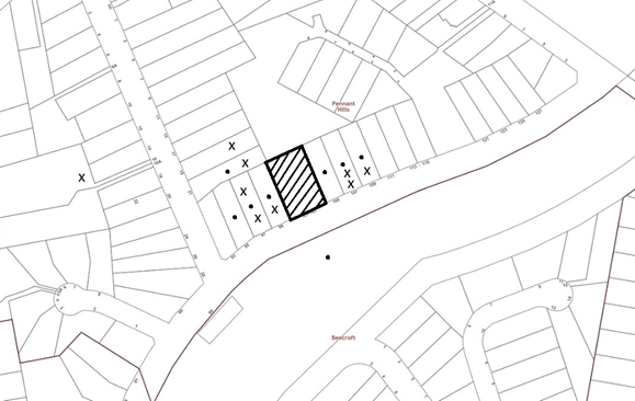
|
NOTIFICATION PLAN |
|||
|
• PROPERTIES NOTIFIED |
X SUBMISSIONS RECEIVED |
PROPERTY SUBJECT OF DEVELOPMENT |
|
|
4 submission received out of map range |
|||
Thirteen submissions objected to the development, on ground listed through this report and generally on the grounds that the development would result in:
5.1.1 Loss of Trees and Fauna Habitat
The submissions raised concerns the proposed loss of trees would result in unacceptable impacts on biodiversity and natural habitat. A submission raised specific concern over the cockatoo species previously found on the subject site and in the area.
The Flora and Fauna report submitted assessed impacts on threatened species including Powerful Owl, Syzygium paniculatum and the threatened ecological community BGHF and concluded there would be no significant impact. It was found that foraging habitats were likely to be located within the adjacent reserve to the north where large hollow trees were observed. The report noted that while mature BGHF trees may provide foraging habitat for bats and native birds, a majority of these trees are being retained as part of the development and a lack of hollow bearing trees on the site indicated it was unlikely to house fauna. Despite this there is a lack of information surrounding fauna within the drainage channel and the long-term effects of BGHF loss across the site on existing fauna species.
The matter has been discussed in detail at Section 3.1.2 and 3.1.3 of the report.
5.1.2 Loss Visual Quality and Amenity
The submissions raised concerns the proposed removal of significant and mature trees would detract from the visual quality and residential amenity of the area.
The proposal would have detrimental impacts on the existing natural landscape which in turn would not be consistent with the heritage character of the Beecroft-Cheltenham Conservation Area.
This matter has been addressed in Section 2.1.3 and Section 3.1.1 of the report.
5.1.3 Devaluation of adjoining properties;
The submissions raised concerns over the devaluation of neighbouring properties as a result of the development.
This is not a matter for consideration under the Section 4.15 of the Environmental Planning and Assessment Act 1979.
5.2 Public Agencies
The development application was referred to any Public Agencies for comment.
5.2.1 NSW Rural Fire Service
The integrated development application was referred to the NSW Rural Fire Service pursuant to Section 100B of the Rural Fires Act 1997.
As discussed in Section 2.5 the Rural Fire Service has provided General Terms of Approval if the application is to be approved.
5.2.2 Sydney Trains
Pursuant to Clause 85 of the ISEPP the application was notified to Sydney Trains
As discussed in Section 2.3 the Sydney Trains have provided conditions of concurrence if the application is to be approved.
6. THE PUBLIC INTEREST
Section 4.15(1)(e) of the Act requires Council to consider “the public interest”.
The public interest is an overarching requirement, which includes the consideration of the matters discussed in this report. Implicit to the public interest is the achievement of future built outcomes adequately responding to and respecting the future desired outcomes expressed in environmental planning instruments and development control plans.
The proposed subdivision and construction of a dwelling is contrary to Council’s planning controls and would result in development that would have a negative impact on the environment.
Accordingly, it is considered that the proposed development would not be in the public interest.
CONCLUSION
The proposal is for the Torrens title subdivision of one lot into two, construction of a two-storey dwelling, demolition of the existing deck and associated road works.
The development does not meet desired outcomes of Council’s planning controls and is unsatisfactory having regard to the matters for consideration under Section 4.15 of the Environmental Planning and Assessment Act 1979.
Thirteen submissions have been received by Council objecting to the proposal. These matters have been addressed in the body of the report
The application is recommended for refusal. The reasons for this decision are:
· The proposed development does not comply with the requirements of the relevant environmental planning instruments and the Hornsby Development Control Plan 2013.
· The proposed development creates unreasonable environmental and amenity impacts to adjoining development with regard to amenity and streetscape appearance within the heritage conservation area.
· The proposed development would result in unacceptable environmental impact on protected trees and threatened biodiversity community.
· The proposed development would result in a dwelling house inconsistent with the streetscape and inconsistent with residential subdivision width under the HDCP.
Note: At the time of the completion of this planning report, no persons have made a Political Donations Disclosure Statement pursuant to Section 10.4 of the Environmental Planning and Assessment Act 1979 in respect of the subject planning application.
RESPONSIBLE OFFICER
The officer responsible for the preparation of this report is Jasmin Blazevic.
Note: At the time of the completion of this planning report, no persons have made a Political Donations Disclosure Statement pursuant to Section 10.4 of the Environmental Planning and Assessment Act 1979 in respect of the subject planning application.
|
Cassandra Williams Major Development Manager - Development Assessments Planning and Compliance Division |
Rod Pickles Manager - Development Assessments Planning and Compliance Division |
|
Locality Map |
|
|
|
|
Architectural Plans |
|
|
|
|
Stormwater Management |
|
|
|
|
Landscape Plan |
|
|
File Reference: DA/847/2019
Document Number: D07939132
SCHEDULE 1
1. The proposed development is unsatisfactory in respect to Section 4.15(1)(a)(i) of the Environmental Planning and Assessment Act 1979, as the proposal is inconsistent with the objectives and requirements of Clause 5.10 Heritage Conservation under the Hornsby Local Environmental Plan 2013 as:
a) The frontage of the dwelling and driveway on proposed Lot 1 would be intrusive and dominated by the proposed suspended driveway, which is not in keeping with the character of the Beecroft Cheltenham Heritage Conservation Area (north precinct).
b) The proposal would result in unacceptable adverse impacts on the natural elements significant to the landscape character of the conservation area in that there would be removal of important vegetation.
c) The proposal would negatively impact the contributory bushland character and setting of the heritage listed item No. 688 which is located adjacent to the site along the Wongala Crescent road reserve.
2. The proposed development is unsatisfactory in respect to Section 4.15(1)(a)(i) of the Environmental Planning and Assessment Act 1979 as the proposal is inconsistent with the objectives and requirements of Clause 6.2 Earthworks under the Hornsby Local Environmental Plan 2013 as:
a) The proposed earthworks would alter the soil moisture levels and growing conditions of vegetation across the site which would result in an adverse impact on vegetation.
b) Inadequate engineering details have been provided in relation to the construction of the drainage channel and the impact of this on trees and vegetation cannot be properly assessed.
c) The drainage channel works would have detrimental impact on significant Blue Gum High Forest (BGHF) trees in close proximity of the excavation works.
3. The proposed development is unsatisfactory in respect to Section 4.15(1)(a)(i) of the Environmental Planning and Assessment Act 1979 as the proposal is inconsistent with the objectives and requirements of Clause 6.4 Terrestrial Biodiversity under the Hornsby Local Environmental Plan 2013 as:
a) The proposed development includes the removal and disturbance of Blue Gum High Forest (BGHF) community on the site and in the vicinity.
b) The proposal would result in the long-term, declining health of Trees 2, 3, 4, 15, 19, 22 and 24, (proposed to be retained) which form part of the site and are characteristic of the BGHF community in the area.
c) There is insufficient information to demonstrate the proposal would protect ecological processes necessary for the retention of the BGHF which is listed as critically endangered on the site and adjoining properties to the rear.
d) There is insufficient information regarding the impact of the proposal on existing fauna (having regard to the impacts on flora on the site) with respect to long-term tree loss.
e) The proposed subdivision would have detrimental impacts on existing critically endangered vegetation communities that exist on site.
f) There is insufficient information regarding the impact of construction of the drainage channel and earthworks on existing fauna on the site.
4. The proposed development is unsatisfactory in respect to Section 4.15(1)(a)(iii) of the Environmental Planning and Assessment Act 1979 as the proposal does not comply with the prescriptive measures of Part 6.2.1 Residential Lands Subdivision of the Hornsby Development Control Plan 2013 (HDCP) as:
a) Proposed Lot 1 would have a lot width less than 15 metres which is the minimum width for urban residential subdivision.
5. The proposed development is unsatisfactory in respect to Section 4.15(1)(a)(iii) of the Environmental Planning and Assessment Act 1979, as the proposal does not comply with the prescriptive measures of Part 3.2.1 Setbacks of the Hornsby Development Control Plan 2013 (HDCP) as:
a) The proposed dwelling is located 1.2 metres forward of the building line of adjoining properties which is not consistent with desired outcomes of the HDCP.
b) The proposed dwelling does not comply with the southern side setback requirement for the first-floor level of the dwelling (being the 2nd storey element).
6. The proposed development is unsatisfactory in respect to Section 4.15(1)(a)(iii) of the Environmental Planning and Assessment Act 1979, as the proposal does not comply with the prescriptive measures of Part 1B.6.1 and 1B.6.2 Tree and Vegetation Preservation of the Hornsby Development Control Plan 2013 (HDCP) as:
a) The removal of, or work to, trees is not consistent with the provision of the HLEP, Vegetation SEPP and HDCP.
b) The development would result in the removal of eleven trees across the site, two which are BGHF species.
c) There is no area appropriate for off-set replacement planting on proposed Lot 1.
d) The replacement planting recommendations are non-specific and do not identify a ratio to offset the loss of canopy trees (as proposed).
e) There would be significant encroachments into the Tree Protection Zone of trees 3, 4, 22 and 24 as a result of dwelling, driveway, drainage channel and use of plant machinery across the site.
f) The impacts of the proposal on soil moisture levels across the site have not been sufficiently addressed in the development application.
7. The proposed development is unsatisfactory in respect to Section 4.15(1)(a)(iii) of the Environmental Planning and Assessment Act 1979, as the proposal does not comply with the prescriptive measures of Part 1C.1.1 Biodiversity of the Hornsby Development Control Plan 2013 (HDCP) as:
a) The development does not preserve the biodiversity values on the site.
b) The proposal would result in the removal of two BGHF trees.
c) The proposal would have long-term adverse impacts on the BGHF community.
8. The proposed development is unsatisfactory in respect to Section 4.15(1) (e) of the Environmental Planning and Assessment Act 1979, the development is considered not to be in the public interest.

