
BUSINESS PAPER
General Meeting
Wednesday 12 August 2020
at 6:30PM
BUSINESS PAPER
General Meeting
Wednesday 12 August 2020
at 6:30PM
Hornsby Shire Council Table of Contents
Page 1
AGENDA AND SUMMARY OF RECOMMENDATIONS
Rescission Motions
Mayoral Minutes
ITEMS PASSED BY EXCEPTION / CALL FOR SPEAKERS ON AGENDA ITEMS
GENERAL BUSINESS
Office of the General Manager
Item 1 GM17/20 COVID-19 Pandemic - Update on Council's Response................................... 1
Corporate Support Division
Item 2 CS19/20 Councillor Expenses and Facilities Policy - Reporting Required by Section 15 of the Policy......................................................................................................................... 5
Item 3 CS21/20 Investments and Borrowings (Pre-audit) for 2019/20 - Status for Period Ending 30 June 2020................................................................................................................ 12
Community and Environment Division
Item 4 EH2/20 Single Use Plastics Policy.............................................................................. 15
Item 5 EH7/20 Byles Creek Land Acquisition Strategy Review............................................... 19
Planning and Compliance Division
Item 6 PL5/20 Vegetation Mapping Options.......................................................................... 24
Infrastructure and Major Projects Division
Item 7 IR3/20 Hornsby Shire Signage Strategy...................................................................... 36
Confidential Items
Item 8 CS22/20 Compulsory Acquisition of Land by Sydney Metro for the North West Rail Link
PUBLIC FORUM – NON AGENDA ITEMS
Questions on Notice
Mayor's Notes
Notices of Motion
Item 9 NOM13/20 Cherrybrook Station Height of Building Concerns....................................... 40
SUPPLEMENTARY AGENDA
MATTERS OF URGENCY
Hornsby Shire Council Agenda and Summary of Recommendations
Page 1
AGENDA AND SUMMARY OF RECOMMENDATIONS
PRESENT
NATIONAL ANTHEM
OPENING PRAYER/S
Acknowledgement of RELIGIOUS DIVERSITY
Statement by the Chairperson:
"We recognise our Shire's rich cultural and religious diversity and we acknowledge and pay respect to the beliefs of all members of our community, regardless of creed or faith."
ABORIGINAL RECOGNITION
Statement by the Chairperson:
"We acknowledge we are on the traditional lands of the Darug and Guringai Peoples. We pay our respects to elders past and present."
Video and AUDIO RECORDING OF COUNCIL MEETING
Statement by the Chairperson:
"I advise all present that tonight's meeting is being video streamed live via Council’s website and also audio recorded for the purposes of providing a record of public comment at the meeting, supporting the democratic process, broadening knowledge and participation in community affairs, and demonstrating Council’s commitment to openness and accountability. The audio and video recordings of the non-confidential parts of the meeting will be made available on Council’s website once the Minutes have been finalised. All speakers are requested to ensure their comments are relevant to the issue at hand and to refrain from making personal comments or criticisms. No other persons are permitted to record the Meeting, unless specifically authorised by Council to do so."
APOLOGIES / LEAVE OF ABSENCE
political donations disclosure
Statement by the Chairperson:
“In accordance with Section 10.4 of the Environmental Planning and Assessment Act 1979, any person or organisation who has made a relevant planning application or a submission in respect of a relevant planning application which is on tonight’s agenda, and who has made a reportable political donation or gift to a Councillor or employee of the Council, must make a Political Donations Disclosure Statement.
If a Councillor or employee has received a reportable political donation or gift from a person or organisation who has made a relevant planning application or a submission in respect of a relevant planning application which is on tonight’s agenda, they must declare a non-pecuniary conflict of interests to the meeting, disclose the nature of the interest and manage the conflict of interests in accordance with Council’s Code of Conduct.”
declarations of interest
4.16 A councillor who has a pecuniary interest in any matter with which the council is concerned, and who is present at a meeting of the council or committee at which the matter is being considered, must disclose the nature of the interest to the meeting as soon as practicable.
4.17 The councillor must not be present at, or in sight of, the meeting of the council or committee:
a) at any time during which the matter is being considered or discussed by the council or committee, or
b) at any time during which the council or committee is voting on any question in relation to the matter.
Clause 5.10 and 5.11 of Council’s Code of Conduct for Councillors requires that a councillor or a member of a Council committee who has a non pecuniary interest in a matter which is before the Council or committee and who is present at a meeting of the Council or committee at which the matter is being considered must disclose the nature of the interest to the meeting as soon as practicable. The disclosure is also to be submitted in writing (on the form titled “Declaration of Interest”).
5.10 Significant non-pecuniary conflict of interests must be managed in one of two ways:
a) by not participating in consideration of, or decision making in relation to, the matter in which you have the significant non-pecuniary conflict of interest and the matter being allocated to another person for consideration or determination, or
b) if the significant non-pecuniary conflict of interest arises in relation to a matter under consideration at a council or committee meeting, by managing the conflict of interest as if you had a pecuniary interest in the matter by complying with clauses 4.16 and 4.17.
5.11 If you determine that you have a non-pecuniary conflict of interest in a matter that is not significant and does not require further action, when disclosing the interest you must also explain in writing why you consider that the non-pecuniary conflict of interest is not significant and does not require further action in the circumstances.
confirmation of minutes
THAT the Minutes of the General Meeting held on 8 July, 2020 be confirmed; a copy having been distributed to all Councillors.
THAT the Minutes of the Extraordinary General Meeting held on 15 July, 2020 be confirmed; a copy having been distributed to all Councillors.
Petitions
presentations
Rescission Motions
Mayoral Minutes
ITEMS PASSED BY EXCEPTION / CALL FOR SPEAKERS ON AGENDA ITEMS
Note:
Persons wishing to address Council on matters which are on the Agenda are permitted to speak, prior to the item being discussed, and their names will be recorded in the Minutes in respect of that particular item.
Persons wishing to address Council on non agenda matters, are permitted to speak after all items on the agenda in respect of which there is a speaker from the public have been finalised by Council. Their names will be recorded in the Minutes under the heading "Public Forum for Non Agenda Items".
GENERAL BUSINESS
· Items for which there is a Public Forum Speaker
· Public Forum for non agenda items
· Balance of General Business items
Office of the General Manager
Page Number 1
Item 1 GM17/20 COVID-19 Pandemic - Update on Council's Response
RECOMMENDATION
THAT the contents of the General Manager’s Report No. GM17/20 be received and noted.
Corporate Support Division
Page Number 5
Item 2 CS19/20 Councillor Expenses and Facilities Policy - Reporting Required by Section 15 of the Policy
RECOMMENDATION
THAT Council note that details regarding the provision of Councillor expenses and facilities for the period from 1 July 2019 to 30 June 2020 have been tabled in accordance with the Councillors’ Expenses and Facilities Policy.
Page Number 12
Item 3 CS21/20 Investments and Borrowings (Pre-audit) for 2019/20 - Status for Period Ending 30 June 2020
RECOMMENDATION
THAT the contents of Director’s Report No. CS 21/20 be received and noted.
Community and Environment Division
Page Number 15
Item 4 EH2/20 Single Use Plastics Policy
RECOMMENDATION
THAT Council endorses the Draft Single Use Plastics Policy 2020 and accompanying Waste Management Guidelines for Event Organisers 2020 for the purposes of public exhibition.
Page Number 19
Item 5 EH7/20 Byles Creek Land Acquisition Strategy Review
RECOMMENDATION
THAT:
1. The contents of Director’s Report No. EH7/20 be received and noted.
2. Council reaffirm the extent of the current RE1 zoning in the Byles Creek corridor, noting that the current extent has been assessed as sufficient to preserve the biodiversity values and ecosystem functions of the Byles Creek corridor.
Planning and Compliance Division
Page Number 24
Item 6 PL5/20 Vegetation Mapping Options
RECOMMENDATION
THAT Council:
1. Adopt (Council to nominate Option 1, 2 or 3) as outlined in Director’s Report No. PL5/20 as the basis for the preparation of a Planning Proposal to update the Terrestrial Biodiversity Map within the Hornsby Local Environmental Plan 2013.
2. Undertake community consultation (Council to nominate before or after Gateway Determination) to seek public comment on the Planning Proposal as part of the Plan making process.
3. Consult the Hornsby Local Planning Panel in the preparation of the Planning Proposal and the comments of the Panel be addressed in a report to Council presenting the Proposal.
Infrastructure and Major Projects Division
Page Number 36
Item 7 IR3/20 Hornsby Shire Signage Strategy
RECOMMENDATION
THAT Council adopt the family of signs as presented in Attachment 1 of Deputy General Manager’s Report No. IR3/20.
Confidential Items
Item 8 CS22/20 Compulsory Acquisition of Land by Sydney Metro for the North West Rail Link
This report should be dealt with in confidential session, under Section 10A (2) (c) of the Local Government Act, 1993. This report contains information that would, if disclosed, confer a commercial advantage on a person with whom the council is conducting (or proposes to conduct) business. (Discussion of the matter in an open Meeting would, on balance, be contrary to the public interest because it may prevent Council from achieving best value outcomes for the community. )
PUBLIC FORUM – NON AGENDA ITEMS
Questions on Notice
Mayor's Notes
Notices of Motion
Page Number 40
Item 9 NOM13/20 Cherrybrook Station Height of Building Concerns
COUNCILLOR Del Gallego To Move
THAT Council:
1. Write to the Department of Planning, Environment and Industry and Landcom to:
1.1 Express concerns that false statements about Council’s position on heights within the Cherrybrook Station State Significant Precinct Rezoning have been included in consultation material and requesting that the documents be immediately removed from publication and circulation.
1.2 Request that any future consultation material to be distributed by either the Department or Landcom as part of planning for the Cherrybrook Precinct that includes statements about the position of Council, be prepared in consultation with Council.
1.3 Confirm Council’s position that any proposal should be consistent with the Cherrybrook Structure Plan 2013 and Precinct Vision and Implementation Plan which note buildings height of 3-6 storeys.
1.4 Seek confirmation of the telephone survey parameters and demographics including areas covered, age groups, existing property owners, how numbers were obtained to ensure the survey results provide a reliable understanding of the views of our community.
2. A copy of the letters be provided to the Minister for Planning and Public Spaces and local State and Federal Members of Parliament.
SUPPLEMENTARY AGENDA
MATTERS OF URGENCY
General Manager's Report No. GM17/20
Office of the General Manager
Date of Meeting: 12/08/2020
1 COVID-19 PANDEMIC - UPDATE ON COUNCIL'S RESPONSE
EXECUTIVE SUMMARY
· Throughout July/August 2020 the organisational impacts of the COVID-19 Pandemic have stabilised with all Council facilities remaining open, although with amended service levels.
· The majority of staff have now returned to their office locations on a split work-from-office, work-from-home basis in accordance with the COVID-safe plans developed for each work site.
· The dramatic escalation of COVID-19 cases in Victoria is of concern and the emergence of cases in Sydney is being monitored daily. If required, rapid decisions will be made to change our staff working structures if the COVID-19 cases in Sydney continue to escalate beyond an acceptable level of risk tolerance.
|
THAT the contents of the General Manager’s Report No. GM17/20 be received and noted. |
PURPOSE
The purpose of this Report is to provide an update on Council’s current response to the COVID-19 Pandemic.
BACKGROUND
The World Health Organisation has declared the COVID-19 virus as a pandemic. As the pandemic is expected to impact on Council’s operations for an extended period, an ongoing status report will be provided to each ordinary Council Meeting for the duration of the pandemic and through the recovery phases.
DISCUSSION
Status of Pandemic Response
Over the period of mid-July to mid-August 2020, the various pandemic containment measures implemented by Federal, State and Local Governments have greatly assisted in stabilising the spread of the virus in NSW and all other States and Territories, with the exception of Victoria. The rapid escalation of virus cases in Victoria is of great concern and a reminder that ongoing vigilance is required to ensure that widespread community transmission does not return in NSW.
Throughout the past month, all Council facilities have remained opened to the public but remain subject to limitations on gatherings and social distancing requirements. The main functional service of Council which cannot be delivered at this point is the provision of public domain community events.
Implementation of Action Plan
The Pandemic Action Plan has not required significant revision since the previous status report to the General Meeting on 8 July 2020. The Pandemic Coordination Team (PCT) continues to give consideration to how we manage the operation of facilities and services in line with Government guidelines.
Status of Operations over July/August 2020
Limitations on the size of gatherings and requirements to maintain social distance are mostly impacting the hirers of our community centres as larger gatherings are currently not possible. The main functional service of Council which cannot be delivered at this point is the provision of public domain community events.
A return to pre-COVID operations is not expected for a considerable time as we will continue to be guided by relevant Federal and State Government requirements. For this reason, some facilities will continue to operate on reduced hours of opening to facilitate the appropriate rostering of staff.
At the present time, Council Meetings are expected to remain online until the September General Meeting consistent with current restrictions on Council Meetings. Whilst these restrictions are in place an upgrade of the air-conditioning system at the Council Chambers will be undertaken through July and August.
Impacts on Local Business and a Community Support Package
As previously reported, local businesses have been actively registering on the Hornsby Localised platform. Council is posting important COVID-19 related information on Localised such as the details of free business support webinars and information on grants and support services for businesses. Other local businesses are also starting to use the platform to promote their services and products to other businesses. Once a critical mass of businesses have registered for use of Localised, a buy local campaign will be developed.
Emerging Risks
Income and expenditure levels compared to the budget will be monitored throughout 2020/21 as part of the quarterly review process.
Ongoing Virus Transmission
It is evident from the significant escalation of virus cases in Victoria over the past month, and ongoing spread of the virus through most countries of the world, that we cannot become complacent in our own organisational response. It is expected that the next few weeks will be critical for NSW as to whether we are able to contain the spread of the virus. As an organisation, we will need to remain agile and flexible in responding to any increase in the risk of virus transmission in the workplace or local community. The Pandemic Coordination Team and EXCO are in regular contact each week to evaluate the current risks. The PCT team are currently evaluating the risks and benefits of enhanced capacity to respond to any possible infection of a staff member to minimise disruption to customers, other staff and to business continuity
Recovery Actions
The following Principles continue to underpin each and every decision in relation to when our services and facilities will be fully returned to pre-COVID operations:
1. Health and safety of the public and staff aligned with State Government advice.
2. Facilitating recovery and reopening of services to the community without unnecessary delay.
3. Acknowledging financial and resource limitations and uncertainty.
Whilst Council will progressively resume normal operations it is nevertheless anticipated that the previous levels of demand for our facilities and services will take some time to return to normal.
Local Government will be a significant resource in supporting the recovery and rebuilding of our communities and promoting economic activity. In this regard, staff are compiling information on potential projects that can support any stimulus funding that becomes available in either the immediate future or as longer-term recovery efforts commence. Based on known and adopted priorities, these opportunities are being conveyed to State and Federal Governments.
A supplementary report will be provided should circumstances between the publishing of this report and the August meeting require further consideration by Council of COVID-19 related matters.
BUDGET
The budgetary impacts associated with the COVID-19 pandemic are outlined in this report.
POLICY
There are no immediate policy implications associated with this Report. A number of matters contained in this report, however, will be subject to further reporting.
CONCLUSION
Council has activated it business continuity plans for its operations in response to the COVID-19 pandemic and implemented the various containment measures of Federal and State Governments. Council’s response to the pandemic is assessed on a regular basis.
RESPONSIBLE OFFICER
The officer responsible for the preparation of this Report is the General Manager – Steven Head.
|
Steven Head General Manager Office of the General Manager |
|
There are no attachments for this report.
File Reference: F2009/00827
Document Number: D07959336
Director's Report No. CS19/20
Corporate Support Division
Date of Meeting: 12/08/2020
2 COUNCILLOR EXPENSES AND FACILITIES POLICY - REPORTING REQUIRED BY SECTION 15 OF THE POLICY
EXECUTIVE SUMMARY
· The Councillors’ Expenses and Facilities Policy, which is modelled on the Office of Local Government’s Better Practice Template, requires that a report on the provision of facilities and payment of expenses to Councillors is to be tabled at a Council Meeting at six monthly intervals.
· Council last considered the required report at the General Meeting of 12 February 2020 which covered the six-month period from 1 July 2019 to 31 December 2019.
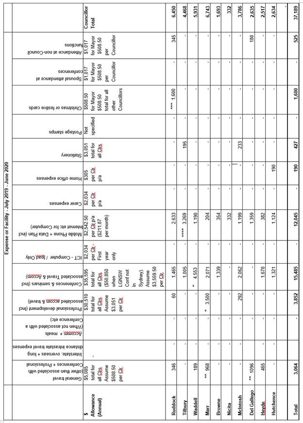
· This report covers the full 12-month period from 1 July 2019 to 30 June 2020. Details are provided of expenditure grouped according to specific categories, summarised by individual Councillor and as a total for all Councillors.
· It is recommended that Council note the contents of the Report.
|
THAT Council note that details regarding the provision of Councillor expenses and facilities for the period from 1 July 2019 to 30 June 2020 have been tabled in accordance with the Councillors’ Expenses and Facilities Policy. |
PURPOSE
The purpose of this Report is to comply with Clause 15 of the Councillors’ Expenses and Facilities Policy which requires regular reporting of the details of expenses incurred, and cost of facilities provided, for each Councillor. The Report is to include expenditure grouped according to specific categories, summarised by individual Councillor and as a total for all Councillors.
BACKGROUND
The Councillors’ Expenses and Facilities Policy requires that a report on the provision of expenses and facilities to Councillors be tabled at a Council Meeting at regular intervals. The relevant Clause states:
15.1 Council will report on the provision of expenses and facilities to councillors as required in the act and regulations.
15.2 Detailed reports on the provision of expenses and facilities to councillors will be publicly tabled at a council meeting every six months and published in full on council’s website. These reports will include expenditure summarised by individual councillor and as a total for all councillors.
Council last considered a report on Councillors’ Expenses and Facilities at the 12 February 2020 General Meeting (Report No. CS2/20) which covered the six-month period from 1 July 2019 to 31 December 2019. Reporting takes place on a six-monthly basis in accordance with Section 15 of the Policy, in August and February each year. This Report includes expenses incurred in the six-month period from 1 January 2020 to 30 June 2020 and covers the full twelve-month period from 1 July 2019 to 30 June 2020.
The main categories of expenses facilities are summarised in the table below. As stated in the Policy Summary, the amounts originally included when the Policy was first adopted in 2018 are to be increased by CPI each year. The table below shows the amounts which apply to the financial year 2019/2020.
|
Expense or facility |
Maximum amount |
Frequency |
|
General travel expenses (other than travel associated with Conferences and Professional Development) |
$5,085 total for all Councillors |
Per year |
|
Interstate, overseas and long-distance intrastate travel expenses |
$0 |
Per year |
|
Accommodation and meals |
As per the NSW Crown Employees (Public Service Conditions of Employment) Reviewed Award 2009, adjusted annually |
Per meal/night |
|
Professional development (includes associated travel and subsistence where applicable) |
$30,510 total for all Councillors |
Per year |
|
Conferences and seminars (includes associated travel and subsistence where applicable) |
$35,595 total for all Councillors (Increased to $50,850 in the years where the LGNSW Conference is held outside the Sydney metropolitan region.) |
Per year |
|
ICT expenses |
$4,576 per Councillor
$2,542 per Councillor |
Per year (first year of election) Per year (following years of election) |
|
Carer expenses |
$2,034 per Councillor |
Per year |
|
Home office expenses (equipment and facilities other than stationery) |
$305 per Councillor |
Per year |
|
Stationery |
$3,051 total for all Councillors |
Per year |
|
Postage stamps |
Provided by Council |
Not relevant |
|
Christmas or festive cards |
$508 for the Mayor $508 total for all other Councillors |
Per year |
|
Access to facilities in a Councillor common room |
Provided to all Councillors |
Not relevant |
|
Council vehicle and fuel card |
Provided to the Mayor |
Not relevant |
|
One reserved parking space at Council offices One shared parking space at Council offices |
Provided to the Mayor Shared by all Councillors |
Not relevant |
|
Furnished office |
Provided to the Mayor |
Not relevant |
|
Number of exclusive staff supporting Mayor and Councillors |
Provided to the Mayor and Councillors |
Two |
|
Spousal attendance at conferences |
$1,017 for the Mayor $508 per Councillor |
Per year |
|
Attendance at non-Council functions |
$1,017 for the Mayor $508 per Councillor |
Per year |
DISCUSSION
When Council last reviewed its Councillors’ Expenses and Facilities Policy in August 2018, it was required to ensure that the Policy was in line with, and modelled on, the “Councillor Expenses and Facilities Policy – Better Practice Template” issued by the Office of Local Government (OLG).
To ensure greater accountability across councils, and public availability of information regarding expenditure on councillor expenses and facilities, the OLG’s Better Practice Template, and subsequently Council’s adopted Policy, incorporates a requirement to record expenditure for each individual Councillor, as well as a total for all Councillors, across the categories detailed in the above table. This reporting is required to occur at six monthly intervals and is generally provided in August and February each year.
[N.B. The reporting requirements of the Councillors Expenses and Facilities Policy are in addition to, and provide greater detail than, those which are required by Section 217 of the Local Government (General) Regulation to be included in Council’s Annual Report.]
Council officers have established appropriate administrative procedures to ensure that the relevant information is captured in a manner which satisfies the reporting requirements of the Policy.
The table below provides the required information for the twelve-month period from 1 July 2019 to 30 June 2020. Where an explanation or clarification is required about particular expenditures (marked with an * in the table), comments are provided in the text following the table.
Notes:
Council last considered the required reporting of Councillors’ Expenses and Facilities at the General Meeting of February 2020 – Report No. CS2/20 - which related to the period 1 July 2019 – 31 December 2019. As this Report relates to the full 2019/20 financial year some of the notes provided in the previous Report regarding expenses for individual Councillors are still relevant to this full year of reporting and are therefore repeated below:
* Under the Policy, Councillors are entitled to combine their allocations for Professional Development with Conferences and Seminars. Although the amounts expended by Councillor Marr (for Professional Development) and Councillor Waddell (for Conferences) exceed the specific allocations for these individual categories, each of their total expenditures for the combined categories are below the combined amount allocated.
** Although the expenses shown for General Travel for Councillors Marr and Del Gallego are above the individual councillor allocation for that item, the total amount for General Travel incurred by Councillors is less than 50% of the annual allocation. The total allocation for General Travel may need to be reviewed once a greater historical picture of actual expenditure has been established, as noted generally below.
*** In supporting the expenditure of $1,600 on Christmas and Festive cards, it was recognised that the sending of the cards by the Mayor represented, at least in part, festive greetings on behalf of the General Manager, Councillors and staff across the organisation.
**** The total expenditure for Councillor Tilbury in respect of mobile telephones exceeds the individual councillor allocated allowance. The extra expenditure relates to the requirement to purchase a new mobile phone due to faults with the existing phone.
It is recognised that refinement of allocations between specific categories may be required as more historical data about actual expenditure becomes available. Where required during this reporting period, the General Manager has utilised his delegation to approve minor variances of expenditure against budget for individual Councillors and within individual categories, noting that overall expenditure falls well within the budgeted allocation.
BUDGET
The categorisation and reporting of expenditure in respect of councillors’ expenses and facilities in the manner required and presented within this Report assists with the monitoring of expenses for that provision within Council’s adopted budget. The overall total expenses reported for the 12-month period from July 2019 to June 2020 of $37,189 is considerably less than the total budget provision for the financial year ($150,000). All expenses have been approved as required by the General Manager or other staff under delegation.
POLICY
The Report meets the requirements of the provisions of Section 15 of Council’s Councillors’ Expenses and Facilities Policy.
CONCLUSION
The Councillors’ Expenses and Facilities Policy requires details of expenditure and the provisions of facilities to Councillors, summarised by individual Councillor and expense category, as well as a total for all Councillors, to be presented to Council at an open meeting. The expenditure by Councillors for the period July 2019 to June 2020 is well within the budget provision and requirements of the Policy. This Report provides the relevant information as required by the Policy and ensures all statutory requirements are met.
RESPONSIBLE OFFICER
The officer responsible for the preparation of this Report is the Manager, Governance and Customer Service Branch – Robyn Abicair - who can be contacted on 9847 6608
|
Robyn Abicair Manager - Governance and Customer Service Corporate Support Division |
Glen Magus Director - Corporate Support Corporate Support Division |
There are no attachments for this report.
File Reference: F2004/09552-02
Document Number: D07943747
Director's Report No. CS21/20
Corporate Support Division
Date of Meeting: 12/08/2020
3 INVESTMENTS AND BORROWINGS (PRE-AUDIT) FOR 2019/20 - STATUS FOR PERIOD ENDING 30 JUNE 2020
EXECUTIVE SUMMARY
· This Report provides details of Council’s investment performance for the period ending 30 June 2020 as well as the extent of its borrowings at the end of the same period.
· Council invests funds that are not, for the time being, required for any other purpose. The investments must be in accordance with relevant legislative requirements and Council’s policies and the Chief Financial Officer must report monthly to Council on the details of funds invested.
· All of Council’s investments have been made in accordance with the Local Government Act, the Local Government (General) Regulation and Council's Investment of Surplus Funds Policy and Investment Strategy.
· In respect of Council’s cash and term deposit investments, the portfolio achieved an annualised return for June 2020 of 2.08% which includes yields from unrealised gains from TCorp Managed Funds and Floating Rate Notes.
· There is a 2019/20 financial year to date return of 2.00%. This relates to accumulated investment income of $5,982,361 which includes an unrealised loss of $44,662 from TCorp Managed Funds and an unrealised gain from Floating Rate Notes of $82,338.
|
THAT the contents of Director’s Report No. CS 21/20 be received and noted. |
PURPOSE
The purpose of this Report is to advise Council of funds invested in accordance with Section 625 of the Local Government Act; to provide details as required by Clause 212(1) of the Local Government (General) Regulation and Council's Investment of Surplus Funds Policy; and to advise on the extent of Council’s current borrowings.
BACKGROUND
Legislation requires that a report be submitted for Council’s consideration each month detailing Council's investments and borrowings and highlighting the monthly and year to date performance of the investments. Initial investments and reallocation of funds are made, where appropriate, after consultation with Council's financial investment adviser and fund managers.
DISCUSSION
Council invests funds which are not, for the time being, required for any other purpose. Such investment must be in accordance with relevant legislative requirements and Council Policies, and the Chief Financial Officer must report monthly to Council on the details of the funds invested.
Council’s investment performance for the month ending 30 June 2020 is detailed in the attached document. In summary, the portfolio achieved an annualised return for June 2020 of 2.08% and year to date 2.00%.
In respect of Council borrowings, the weighted average interest rate payable on outstanding loans taken out from June 2010 to date, based on the principal balances outstanding is 6.17%. The Borrowings Schedule as at 30 June 2020 is also attached for Council’s information.
BUDGET
Budgeted investment income year to date at June 2020 is $6,397,008. Net investment income for the month ended 30 June 2020 was $534,994 which includes interest income of $369,878, an unrealised gain of $82,778 from TCorp Managed Funds and an unrealised gain of $82,338 from Floating Rate Notes. Total investment income year to date at 30 June 2020 was $5,982,361 which includes a year to date net loss of $44,662 from TCorp Managed Funds, an unrealised gain of $82,338 from Floating Rate Notes and a one-off receipt of $319,902 in relation to a class action against Standard and Poor’s for compensation of losses incurred on structured investment products during the global financial crisis.
Approximately 29% of the investment income received by Council relates to externally restricted funds (e.g. Section 7.11 and Section 7.12 development contribution funds) and is required to be allocated to those funds. All investments have been made in accordance with the Local Government Act, the Local Government (General) Regulation and Council's Investment of Surplus Funds Policy and Investment Strategy.
Current market instability caused by uncertainty over current external factors have led to a further cut in the cash rate in March 2020 to 0.25%. The consequence of this rate cut will have an impact on the reinvestment of term deposit rates. While the returns from TCorp Managed Funds are presently experiencing significant market volatility due to Covid-19 Pandemic, this product has a 7-year investment horizon and will therefore reflect marked to market valuations on a monthly basis. Advice from Council’s Independent Investment Advisor, Prudential Investment Services is to hold this investment for the 7-year timeframe as originally planned. This is due to the anticipated net positive performance returns that will be gained over the long term for this investment.
CONCLUSION
The investment of Council funds and the extent of its borrowings as at 30 June 2020 are detailed in the documents attached to this Report. Council’s consideration of the Report and its attachments ensures that the relevant legislative requirements and Council protocols have been met in respect of those investments and borrowings.
RESPONSIBLE OFFICER
The officer responsible for the preparation of this Report is the Chief Financial Officer – Duncan Chell - who can be contacted on 9847 6822.
|
Duncan Chell Chief Financial Officer Corporate Support Division |
Glen Magus Director - Corporate Support Corporate Support Division |
|
Schedule of Borrowings as at 30 June 2020 (Pre-audit) |
|
|
|
|
Investment Summary report June 2020 (Pre-audit) |
|
|
File Reference: F2004/06987-02
Document Number: D07953232
Director's Report No. EH2/20
Community and Environment Division
Date of Meeting: 12/08/2020
4 SINGLE USE PLASTICS POLICY
EXECUTIVE SUMMARY
· At its July 2019 General Meeting, Council considered NOM8/19 – Single Use Plastics Policy, and resolved in-part that a draft policy to be developed for Council’s consideration seeking to address single-use plastics in Council operations and events.
· A draft Single Use Plastics Policy (the draft policy) has been prepared that responds to Council’s resolution and seeks to progressively transition towards the elimination of single-use plastics within Council operations and at all events held on Council owned or managed land by 2022.
· Single use plastics addressed in the draft policy include plastic water bottles, plastic drinking straws, single-use plastic bags, coffee cups (with plastic lining), ready-to-eat plastic serving containers / utensils and balloons.
· The draft policy is supported by new Waste Management Guidelines for Event Managers that provide clear direction to all event managers and provide a framework for managing waste and recycling at events. An Alternative Supplier and Product List is included within the Guidelines as a simple and practical tool for event managers and stallholders to source alternatives to single-use plastics.
· IMPORTANT NOTE: This DRAFT policy and the accompanying Waste Management Guidelines were developed pre-COVID-19. During COVID-19, NSW Public Health Orders, COVID Safety Management Plans and safe work practices related to COVID-19 requirements take precedence.
|
THAT Council endorses the Draft Single Use Plastics Policy 2020 and accompanying Waste Management Guidelines for Event Organisers 2020 for the purposes of public exhibition. |
PURPOSE
The purpose of this Report is to is to present for Council’s consideration a draft Single Use Plastics Policy (Attachment 1) and Waste Management Guidelines for Event Organisers (Attachment 2).
BACKGROUND
1. A draft policy be developed for Council’s consideration seeking to address single-use plastics in Council operations and events.
DISCUSSION
The Impacts of Single-Use Plastics
Plastics play an important role in our modern society, however can also have a negative impact on our environment. Single-use plastics in particular – are widely recognised as having long-term detrimental impacts on the environment.
Globally, 141 million tonnes of packaging waste was created in 2015, of which only 14% was recycled. In NSW, 1.1 million tonnes of plastic (mainly packaging and household items) was consumed in 2017/18, with an average only 10% of that plastic being recycled.
In NSW, the EPA estimate that there are 27 plastic items littered per every 1000 square metres, that despite efforts often is not captured and spreads into our environment.
A Strategic Approach to Eliminating Single Use Plastics
The objective of the draft policy is to progressively transition towards the elimination of single-use plastics in council operations and events by 2022. This approach recognises that an outright ban on products is seldom achievable or successful. Therefore, a strategic, planned and incremental approach has been employed to deliver a long-term structural transition towards alternatives.
This approach is consistent with recommendations in local research on single-use plastics undertaken by Sydney University in mid- 2019 with Hornsby Markets customers and stallholders. This research is covered in further detail in the consultation section of this report.
Resources to Assist Event Managers
Two new resources have been developed to assist with the successful implementation of the draft policy.
New Waste Management Guidelines for Event Managers have been developed to provide clear direction to all event managers and provide a framework for managing waste and recycling at events. A dedicated Waste Management Plan will be required for all events which expect to have over 300 attendees.
The Alternative Supplier and Product List included within the Waste Management Guidelines for Event Managers is a simple and practical tool for event managers and stallholders which enables them to identify and access alternative products to single use plastics. It is designed to work specifically in conjunction with the Waste Management Guidelines for Event Managers. This resource will be provided to all internal and external event managers to facilitate their sustainable procurement processes.
Utilising Learning from Other Local Councils
Council officers have reviewed similar existing policies from other local councils to use as points of reference. The key elements of these policies were considered and incorporated where appropriate. Staff from various other councils were also canvassed as to how their strategies were being applied in practice to ensure a realistic and practical approach.
CONSULTATION
To ensure successful buy-in across the organisation, an Internal Reference Group (IRG) was convened to provide input and advice on the development of a draft policy on single-use plastics.
Subsequently, two IRG meetings were held in August and October of 2019. Feedback from across the organisation was incorporated into the development of this draft policy.
External Consultation
The development of this policy has been guided in part by research undertaken between April and August 2019 by Associate Professor Ruth Barcan (University of Sydney – Sydney Environment Institute). Professor Barcan consulted extensively with stallholders and community customers at the weekly Hornsby Organic Food Markets, held in Hornsby Mall.
The research comprised: site visits and observations; customer surveys and informal conversations; stallholder surveys and detailed conversations; structured conversations; a stallholder focus group and subsequent analysis.
The report provides qualitative data a range of recommendations for waste reduction at public events, on general education and support, and a specific range of range of actions for Hornsby Farmers markets.
The final report – Single-Use Plastics and Food Waste at Hornsby Farmers Markets and Community Events can be found at https://www.hornsby.nsw.gov.au/property/waste/recycling/recycle-right.
BUDGET
It is anticipated that the costs to implement this policy across Council operations and activities would be accommodated within existing budgets.
POLICY
The draft policy is will provide a valuable tool to avoid unnecessary single use packaging in council operations and events and is
It will act in conjunction with Council’s Sustainable Procurement Determination 2013 to support a more sustainable approach to operations and events.
Externally delivered community events will also be required to comply with the Guidelines for Event Managers.
CONCLUSION
The adoption and implementation of this policy is an important step in providing leadership to the community in the avoidance of unnecessary and polluting single use plastic products. It will operate as a springboard to further demonstrable action and support that will enable the business sector, event managers and Council itself to minimise impacts on the environment that result from the use and inappropriate disposal of single use plastics.
The creation of this policy aligns with specific dedicated actions in the Waste Matters Strategy 2020.
RESPONSIBLE OFFICER
The officer responsible for the preparation of this Report is the Manager – Waste Management, Chris Horsey, who can be contacted on 9847 4816.
|
Chris Horsey Manager - Waste Management Community and Environment Division |
Stephen Fedorow Director - Community and Environment Community and Environment Division |
|
DRAFT Policy - Single Use Plastics 2020 |
|
|
|
|
Waste Management Guidelines for Event Organisers 2020 |
|
|
File Reference: F2018/00082
Document Number: D07848494
Director's Report No. EH7/20
Community and Environment Division
Date of Meeting: 12/08/2020
5 BYLES CREEK LAND ACQUISITION STRATEGY REVIEW
EXECUTIVE SUMMARY
· At the General Meeting on 12 June 2019, Council resolved to review the Byles Creek Land Acquisition Strategy (Strategy Review).
· The Strategy Review has been prepared by DFP Planning and Cumberland Ecology following an assessment of the environmental and social values of the Byles Creek corridor.
· Environmental values identified in the corridor include the presence of a small area of a Critically Endangered Ecological Community listed under the NSW Biodiversity Conservation Act 2016 and Commonwealth Environment Protection and Biodiversity Conservation Act 1999 on land already owned by Council; habitat suitable for use by various fauna species; the presence of threatened fauna species and vegetation community connectivity to conservation reserves.
· Social values within the corridor were evident due to the presence of informal walking trails. Formalising walking trails in the future would have to consider feasibility, site constraints, community values and conservation objectives at this location.
· Based on the ecological and social values of the corridor, the Strategy Review concluded that the current extent of the RE1 zoning is appropriate to protect the biodiversity values and ecosystem functionality of the corridor; and that the current zoning is sufficient in terms of satisfying the objectives of the HELP 2013 provisions relating to terrestrial biodiversity.
|
THAT: 1. The contents of Director’s Report No. EH7/20 be received and noted. 2. Council reaffirm the extent of the current RE1 zoning in the Byles Creek corridor, noting that the current extent has been assessed as sufficient to preserve the biodiversity values and ecosystem functions of the Byles Creek corridor. |
PURPOSE
The purpose of this Report is to present for Council’s consideration the outcomes of the Byles Creek Land Acquisition Strategy Review.
BACKGROUND
In October 1995 the Byles Creek Catchment Environmental Study (the Study) was prepared. The Study related to an area comprising approximately 350 hectares of publicly and privately-owned land in Beecroft. The Study identified that the Open Space A zoning 1, which applied to the corridor area, should be retained due to the high environmental quality, aesthetic and heritage value to the local community and the Shire in general.
In May 1998 the Study led to the preparation of the Byles Creek development control plan (DCP) which came into force 19 May 1998. The Byles Creek DCP included development controls relating to setbacks, soil and water management based on the characteristics of the soil type, environmental protection, fencing, bushfire management, treatments relating to development on land with an interface with an urban watercourse and controls to ensure development was compatible with the land capability and sensitivity, particularly in relation to topography, drainage and soil dispersibility.
In 2006 an Open Space Review evaluated all lands in Hornsby Shire in private ownership which were zoned Open Space A (under the now repealed Hornsby Shire LEP 1994) to ensure that only land that met community needs for open space, or that preserved the environmental quality of the Hornsby area is zoned Open Space A, and that a financial strategy was in place for the acquisition of privately owned lands only (noting some land could be owned by agencies or the Crown). Overall, the Open Space Review found that there was a total of 660 properties within Hornsby Shire that were zoned Open Space A. Of these, 65 properties were privately owned. These 65 properties (69 parcels) had a total area of 112.77 hectares.
In conjunction with the open space audit, Council also prepared an inventory of land zoned Open Space A, including a Sensitive Urban Lands (SULs) rating of the land as part of the Open Space Review. With respect to land within the Byles Creek corridor, the 2006 report recommended retention of open space zoning for Byles Creek due to the high environmental, social, aesthetic and heritage values expressed by the community. The liability associated with acquisition was also acknowledged.
The Hornsby Development Control Plan (Hornsby DCP 2013) was adopted on 19 December 2012 by Council and came into effect on 11 October 2013. The Hornsby DCP 2013 applies to all land within the Hornsby Local Government Area, including land to which the Byles Creek DCP previously applied.
At its June 2019 General Meeting, Council resolved to review the Byles Creek Catchment Land Acquisition Strategy as part of the broader review of Council's Local Environmental Plan. In response DFP Planning Consultants and Cumberland Ecology were commissioned to undertake an assessment of the environmental and social values of Byles Creek corridor in order to review the strategic approach towards land acquisition within the catchment of Byles Creek.
DISCUSSION
The Strategy Review considered the environmental, social and heritage values of land within the Byles Creek corridor having regard to background reports, previous studies and investigations undertaken by others and relevant planning controls and legislation.
These investigations were supplemented by an updated ecological assessment undertaken by Cumberland Ecology who provided an assessment of the ecological characteristics and values of the study area to inform the Strategy Review. As part of the ecological assessment, Cumberland Ecology undertook a review of ecological literature, reports, site inspections, habitat assessments and mapping relevant to the corridor.
Following these assessments, Cumberland Ecology found that most of the vegetation in the study area comprises of intact native forest vegetation despite the presence of weed invasions (generally adjacent to residential dwellings), informal tracks, drainage lines and sewerage infrastructure.
The vegetation coverage supports several environmental values, identified by Cumberland Ecology, including:
· A range of habitat features suitable for use by native flora and fauna species.
· The presence of threatened fauna species.
· Connectivity to conservation reserves, either directly via intact vegetation or via ‘stepping stone’ habitat.
Based on the ecological values of the corridor, Cumberland Ecology concluded that the current extent of the RE1 zoning is appropriate due to the biodiversity values present and current integrity and functionality of the corridor; and that the current zoning is sufficient in terms of satisfying the objectives of the HELP 2013 provisions relating to terrestrial biodiversity. In summary, Cumberland Ecology did not find that there was a need to extend the extent of the current RE1 zoning in the Byles Creek corridor.
Further, the current RE1 zoning will ensure the ecological values of the corridor are protected and enhanced, whilst still allowing for the limited passive recreational activities (namely informal walking trails) that are present. Informal walking trails largely follow sewer pipelines and are adjacent to creeks which periodically flood sections of the trails. Any future formalisation of walking trails in the area would have to consider these site constraints, community values and conservation objectives at this location.
Although there is land mapped as having terrestrial biodiversity values adjoining the corridor which is not zoned RE1, the Strategy Review found that extension of the RE1 zone over this land is not considered necessary for the following reasons:
· The majority of the properties mapped as having terrestrial biodiversity value have already been developed or have valid approvals for development including subdivision and new dwellings.
· The objectives and provisions of clause 6.4 of Hornsby LEP 2013 will continue to operate in relation to land mapped as having terrestrial biodiversity values. The provisions of clause 6.4 are ably supported by other relevant legislation and planning policies that would need to be considered in relation to any new development proposals on land having terrestrial biodiversity values.
· The purpose of the RE1 zone is to enhance and maintain the natural environment and facilitate public access to the land. The current RE1 zoned land is appropriate for the purpose of achieving these objectives. No additional is required to be zoned RE1 in order to maintain and preserve the ecological values of the corridor.
The ecological values of the land adjoining the RE1 zoned land that is mapped as having terrestrial biodiversity values (and zoned R2) does not need to be zoned RE1 in order to maintain these values and there is no requirement to increase the extent of publicly accessible land along the corridor.
· The southern boundary of the RE1 zoned land is generally uniform and defines the publicly accessible land within corridor. Public access to the corridor is available from the west, north and east. Additional land for the purposes of public recreation is not considered necessary.
Whilst not recommending any additional land for acquisition, the Strategy Review identified a number of opportunities for ecological restoration in the Byles Creek corridor including weed and feral animal management, installation of nest boxes, fire management, signage, rubbish removal and compliance checks for illegal clearing and encroachment.
BUDGET
As the Strategy Review did not recommend the inclusion of any additional land for acquisition, there are no new budgetary implications associated with land acquisition arising from this Report. The Strategy Review did however recommend that Council develop a financial strategy in relation to current RE1 zoned land within the corridor which is yet to be purchased by Council.
Expanded ecological restoration works in the Byles Creek corridor beyond their current level would require additional funding that could be considered at a Quarterly Budget Review or during the development of Council’s annual Operational Plan where all priorities of Council are considered.
POLICY
There are no policy implications associated with this Report.
CONCLUSION
DFP Planning and Cumberland Ecology were engaged to review Council’s Byles Creek Land Acquisition Strategy having regard to the environmental and social values of the Byles Creek corridor.
Based on the ecological values of the corridor, the Strategy Review found that current extent of the RE1 zoning is appropriate due to the biodiversity values present and current integrity and functionality of the corridor; and that the current zoning is sufficient in terms of satisfying the objectives of the HELP 2013 provisions relating to terrestrial biodiversity.
The Strategy Review did however recommend the development of a financial strategy in relation to current RE1 zoned land within the corridor that is yet to be purchased by Council, along with opportunities for ecological restoration works to take place within the corridor.
RESPONSIBLE OFFICER
The officer responsible for the preparation of this Report is the Manager Natural Resources, Dr Peter Coad who can be contacted on 9847 6766.
|
Peter Coad Manager - Natural Resources Community and Environment Division |
Stephen Fedorow Director - Community and Environment Community and Environment Division |
|
Byles Creek Land Acquisition Strategy Review |
|
|
|
|
Byles Creek Ecological Assessment |
|
|
File Reference: F2011/00859
Document Number: D07952541
Director's Report No. PL5/20
Planning and Compliance Division
Date of Meeting: 12/08/2020
6 VEGETATION MAPPING OPTIONS
EXECUTIVE SUMMARY
· At its meeting on 11 December 2019, Council resolved to prepare a Planning Proposal to replace the current Terrestrial Biodiversity Map within the Hornsby Local Environmental Plan 2013 with an updated vegetation map with the inclusion of 10m buffers.
· Council also resolved to undertake community consultation to seek feedback on the revised mapping for consideration by Council in progressing a formal Planning Proposal.
· On 4 March 2020, the options and implications of updating the vegetation mapping were presented to Councillors at an informal workshop to enable discussion about the community consultation and drafting of the Planning Proposal.
· It is recommended that Council adopt one of the three options discussed in this Report to inform the community consultation and preparation of the Planning Proposal to update the Terrestrial Biodiversity Map within the Hornsby Local Environmental Plan 2013.
|
THAT Council: 1. Adopt (Council to nominate Option 1, 2 or 3) as outlined in Director’s Report No. PL5/20 as the basis for the preparation of a Planning Proposal to update the Terrestrial Biodiversity Map within the Hornsby Local Environmental Plan 2013. 2. Undertake community consultation (Council to nominate before or after Gateway Determination) to seek public comment on the Planning Proposal as part of the Plan making process. 3. Consult the Hornsby Local Planning Panel in the preparation of the Planning Proposal and the comments of the Panel be addressed in a report to Council presenting the Proposal. |
PURPOSE
The purpose of this Report is to present options to update the Hornsby Local Environmental Plan 2013 (HLEP 2013) Terrestrial Biodiversity Map and the implications associated with each to clarify the scope of the Planning Proposal and associated messaging for community consultation.
BACKGROUND
Currently, the HLEP 2013 includes a Terrestrial Biodiversity Map and a corresponding Clause (6.4 Terrestrial Biodiversity) that details matters for consideration that must be addressed when assessing a development application on land within the mapped area. The current Terrestrial Biodiversity Map identifies National, State and Regionally significant vegetation communities based on Smith and Smith Vegetation Communities of Hornsby Shire Mapping (2008 Update) plus ‘Bushland Protection’ land previously recognised under the Hornsby Shire Local Environmental Plan 1994 (HSLEP 1994).
In 2017, Council engaged the services of Ecological Australia to update the vegetation mapping referred to as the ELA Vegetation Map 2017. On 27 November 2019, the vegetation map updates were presented to Councillors at an informal workshop. Discussion included options to update the HLEP 2013 Terrestrial Biodiversity Map to include additional vegetation communities.
At its meeting on 11 December 2019, Council considered Mayoral Minute No. MM13/19 concerning opportunities to strengthen protection of biodiversity and tree canopy and resolved that:
1. Council prepare a Planning Proposal to replace the current Terrestrial Biodiversity Map within the Hornsby Local Environmental Plan 2013 with a new Map using updated vegetation mapping prepared on behalf of Council by Eco Logical Australia with the inclusion of 10 metre buffers.
2. Council consult the Hornsby Local Planning Panel in the preparation of the Planning Proposal and the comments of the Panel be addressed in the report to Council presenting the Proposal.
3. When the Planning Proposal is submitted to the Department of Planning, Industry and Environment, Council request the matter be expedited to ensure practical effect is given to the updated vegetation mapping in consideration of all development applications, tree and vegetation permits, and development processes.
4. Until such time as the Planning Proposal has been gazetted, all development applications involving tree removal within the area shown on the updated vegetation map be assessed comprehensively in accordance with the tree preservation controls within the Hornsby Development Control Plan.
5. Whilst the Planning Proposal is being prepared, Council undertake a communication exercise to seek broad feedback that can be incorporated/considered when Council considers adopting the formal Planning Proposal.
In accordance with Council’s resolution, preparation of a Planning Proposal commenced. However, in drafting the Planning Proposal and preparing a consultation strategy to seek community feedback, it became apparent that there are several options for incorporating the Hornsby Vegetation Map 2017 into the HLEP 2013 Terrestrial Biodiversity Map with differing implications for each option.
Accordingly, on 4 March 2020, a Councillor workshop was held to discuss the various options and implications. At the workshop, a range of views were expressed by Councillors and it was generally agreed that a report should be presented to Council to confirm the scope of the Planning Proposal.
DISCUSSION
This report discusses options and implications for updating the HLEP 2013 Terrestrial Biodiversity Map. The main difference between the options is whether the threshold of National, State and Regional significance should be maintained, or whether all vegetation communities should be added to the LEP Map.
1. Strategic Context
This report considers the merit of updating the Terrestrial Biodiversity Map within the HLEP 2013 in relation to State and local planning policies and legislation. The relevant policy and legislation are discussed below.
1.1. Greater Sydney Region Plan - A Metropolis of Three Cities
A Metropolis of Three Cities – the Greater Sydney Region Plan (GSRP) has been prepared by the NSW State Government to guide land use planning decisions for the next 40 years (to 2056).
The vegetation mapping update is consistent with the GSRP, in particular the following objective and strategy:
Objective 27: Biodiversity is protected, urban bushland and remnant vegetation is enhanced.
Strategy 27.1 Protects and enhance biodiversity by:
· Supporting landscape-scale biodiversity conservation and the restoration of bushland corridors.
· Managing urban bushland and remnant vegetation as green infrastructure.
· Managing urban development and urban bushland to reduce edge-effect impacts.
The vegetation mapping update is generally consistent with the above objective and strategy as it provides continued protection to vegetation of high biodiversity significance.
1.2. North District Plan
The North District Plan is a 20-year plan to manage growth and achieve the 40-year vision of the Greater Sydney Region Plan. The North District Plan provides the strategic link between the GSRP and Council’s local strategies and plans. The proposed updates to the Terrestrial Biodiversity Map give effect to the following priorities and actions:
Planning Priority N16 – Protecting and enhancing bushland and biodiversity
Planning Priority N17 – Protecting and enhancing scenic and cultural landscapes
Planning Priority N19 – Increasing urban tree canopy cover and delivering Green Grid connections
Action 66. Protect and enhance bushland and biodiversity by:
a) Support landscape-scale biodiversity conservation and the restoration of bushland corridors
b) Managing urban bushland and remnant vegetation as green infrastructure
c) Managing urban development and urban bushland to reduce edge-effect impacts
Action 67. Identify and protect scenic and cultural landscapes
Action 71. Expand urban tree canopy in the public realm
1.3. Hornsby Community Strategic Plan - Your Vision Your Future 2028
The Hornsby Community Strategic Plan ‘Your Vision Your Future 2028’ is a 10-year vision that identifies the main priorities and aspirations for the future of Hornsby Shire and is Council’s long-term plan to deliver the best possible services for Hornsby Shire including:
FA6 Valuing green spaces and landscapes
FA8 Adapting to a changing environment
The proposed updates to the Terrestrial Biodiversity Map are generally consistent with the above focus areas of the Community Strategic Plan by improving the management and protection of significant vegetation communities throughout the Shire.
1.4. Hornsby Local Strategic Planning Statement
On 12 February 2020, Council adopted the Hornsby Local Strategic Planning Statement (LSPS) which identifies its 20-year land use vision for managing growth and change over that time. The following priorities are key considerations for this mapping update:
Sustainable Priority 1. Improving the overall health of our natural environment and ecosystem.
Sustainable Priority 2. Protecting and increasing the extent and quality of natural areas.
Sustainable Priority 5. Embedding biodiversity conservation principles throughout local planning policies.
2. Mapping
The following section outlines the background to Council’s current vegetation mapping.
2.1 Smith and Smith Mapping
The native vegetation communities of the Hornsby Local Government Area (excluding National Parks and Wildlife Service lands) were identified and mapped by P & J Smith Ecological Consultants (Smith and Smith) in 1990-1993 using aerial photo interpretation and extensive field checking.
A further study conducted between 2006 and 2008 by Smith and Smith identified errors in the original mapping and updated the classification and mapping of vegetation communities recognised in legislation.
The Smith and Smith 2008 survey mapped 15,520 hectares of vegetation and identified 34 native vegetation communities, including 24 communities of National, State or Regional significance. These comprised 3 Critically Endangered Ecological Communities (CEECs) and 10 Endangered Ecological Communities (EECs) listed under State and Federal legislation. A further 11 vegetation communities were identified as being Regionally significant. The remaining 10 communities are local/common species.
2.2 ELA Mapping
The ELA Vegetation Report 2017 maps 16,352 hectares of vegetation and identifies 35 native vegetation communities, including 26 communities of National, State and Regional significance. These comprise 4 CEECs and 10 EECs listed under State and Federal legislation. A further 12 vegetation communities are identified as being Regionally significant. The remaining 9 communities are local/common species.
The ELA Report applies the existing, accepted vegetation communities classified by Smith & Smith with the following updates:
· An additional vegetation community of mixed ‘urban native exotic/remnant vegetation’, consistent with the Sydney Metropolitan vegetation mapping that overlaps part of the Hornsby Shire study area. In total, 648 hectares are identified as ‘urban native/exotic. However, the proportion of exotics is highly variable and field validation is recommended to ground truth the data. Therefore, this vegetation community is not included within the total calculated area of native vegetation communities as recommended by the ELA 2017 Report.
· The addition of Cumberland Plain Woodland vegetation community. This is a CEEC identified under both Federal and State legislation and remnants within Hornsby Shire have now been included in the mapping.
· The upgrading of the conservation status of Angophora Woodlands from local to Regionally significant based on the NSW Plant Community Type equivalent.
2.3 Comparison of Mapping
A comparison of the 2008 and 2017 Mapping is provided in the table below. The ELA 2017 mapping applies a broader vegetation definition in comparison to Smith and Smith 2008 mapping and has consequently captured more vegetation, as it accounts for remnant vegetation without a native understorey, particularly in the urban and rural residential boundaries with bushland. This is known as relictual occurrences. A total of 232 hectares has been identified as potential relictual CEEC and EEC, subject to field validation.
The figures are based on the Smith and Smith 2008 and ELA 2017 Reports and will be further refined using GIS data subject to the option chosen by Council.
|
|
Smith and Smith 2008 |
ELA 2017 |
||
|
Vegetation Significance |
Area (ha) |
Number of Vegetation communities |
Area (ha)** |
Number of Vegetation communities |
|
Commonwealth (CEEC and EEC) |
337 |
3 |
607 |
4 |
|
NSW (CEEC and EEC) |
236 |
10 |
279 |
10 |
|
Regionally Significant (Sydney Region) |
822 |
11 |
943 |
12 |
|
Sub-total Area |
1,395 |
24 |
1,829 |
26 |
|
Locally Significant (Hornsby Shire) |
1,267 |
4 |
1,384 |
3 |
|
Common Species |
12, 858 |
6 |
13,139 |
6 |
|
Urban Native Exotic/remnant vegetation* |
N/A |
N/A |
648* |
1* |
|
Total Area |
15,520*** |
34 |
16,352 |
35 |
|
Total Area incl. 10-metre buffer zone |
N/A |
34 |
18,221 |
35 |
*Urban Native/Exotic remnant vegetation was identified as an additional vegetation group within the ELA 2017 Report. However, it is not included within the total calculated area or total number of vegetation communities proposed to be mapped within the HLEP 2013 Terrestrial Biodiversity Map (refer to discussion).
**Increased area (ha) is predominately due to the addition of relictual occurrences of vegetation (i.e. vegetation with no native understorey) within the ELA 2017 Report, which was not accounted for within Smith and Smith 2008.
*** The Smith and Smith Mapping includes land located south of the M2 Motorway. This land was not included within the ELA 2017 Map as it was transferred to Parramatta Council through the Council amalgamation process.
3. Hornsby Local Environmental Plan
The following discussion outlines the planning controls for mapped vegetation.
3.1 Current HLEP Terrestrial Biodiversity Map
Currently, the Terrestrial Biodiversity Map within the HLEP 2013 identifies vegetation of National, State and Regional significance plus approximately 50 ha of ‘Bushland Protection’ land previously recognised under the HSLEP 1994 which was mapped under past localised precinct planning studies in the 1990’s.
Approximately 1,750 properties (either in part or in full) are currently identified on this mapping, for which the following land use implications apply:
State Environmental Planning Policy (Exempt and Complying Development Codes) 2008 (Codes SEPP)
Land that is mapped on Council’s HLEP 2013 Terrestrial Biodiversity Map is taken to be land to which the Codes SEPP does not apply. This means that complying development is not permitted on that land. In the event that a portion of a property is identified on the HLEP 2013 Terrestrial Biodiversity Map, exempt or complying development could lawfully be carried out on that part of the lot which is not affected by the mapping (unless it is excluded by one of the other exclusions listed under the provisions of the Codes SEPP by clause 1.19). Development could still be undertaken within the mapped area although it would be subject to a development application.
However, it should be noted that, in selecting any option for updates to the mapping of vegetation in the HLEP 2013, it would be open for Council to confirm as part of the associated Planning Proposal whether complying development should be permitted within the mapped area depending on the vegetation type.
Hornsby Local Environmental Plan 2013
For development proposed on land that is mapped on Council’s HLEP 2013 Terrestrial Biodiversity Map, development applications must have regard to the provisions of Clause 6.4 Terrestrial Biodiversity of the HLEP 2013 which reads (in part) as follows:
(a) Whether the development is likely to have:
(i) Any adverse impact on the condition, ecological value and significance of the fauna and flora on the land, and
(ii) Any adverse impact on the importance of the vegetation on the land to the habitat and survival of native fauna, and
(iii) Any potential to fragment, disturb or diminish the biodiversity structure, function and composition of the land, and
(iv) Any adverse impact on the habitat elements providing connectivity on the land, and
(b) Any appropriate measures proposed to avoid, minimise or mitigate the impacts of the development.
(4) Development consent must not be granted to development on land to which this clause applies unless the consent authority is satisfied that:
(a) The development is designed, sited and will be managed to avoid any significant adverse environmental impact, or
(b) If that impact cannot be reasonably avoided by adopting feasible alternatives—the development is designed, sited and will be managed to minimise that impact, or
(c) If that impact cannot be minimised—the development will be managed to mitigate that impact.
Hornsby Development Control Plan
For land that is mapped on Council’s HLEP 2013 Terrestrial Biodiversity Map, proposals should have regard to the Hornsby Development Control Plan (HDCP) as follows:
· Exempt tree works listed under part 1B.6.1 (d) of the HDCP do not apply (see Part 1B.6.1 (e)) which has implications including:
o The removal of species listed under the NSW Biosecurity Act 2015 require consent.
o All tree works require a tree permit including removal of dead trees, pruning of a tree by less than 10%, removal of trees under 3 metres, removal of or pruning of a tree where the base of the trunk of the tree at ground level is located within 3 metres of the foundation of an approved building and removal of trees that pose a threat to life or property.
o The removal of, or pruning of, trees on Council owned or managed land by either Council or Council authorised agents is not permitted, unless appropriate approval has been obtained.
· Exemptions for vegetation clearing (excluding trees) as per table 1B.6.2 (a) do not apply to land within 50 metres of, and including, land identified on the Terrestrial Biodiversity Map. Current exemptions include vegetation clearing once every 5 years up to 30m2 in rural areas and 10m2 in residential, business and industrial zones.
· Development is required to have regard to the provisions of Part 1C.1.1 Biodiversity of the HDCP which has implications including:
o A Flora and Fauna Assessment is required for development which may impact land identified on the Terrestrial Biodiversity Map. Council can also request a Flora and Fauna Assessment for a development application for proposals adjacent to the mapped area if the proposed development may impact on mapped vegetation.
o Development should provide a 20m buffer for any works, structures and earthworks from endangered ecological communities and regionally significant vegetation identified on the Terrestrial Biodiversity Map (see table Part 1C.1.1 (a) of the HDCP).
10/50 Vegetation Clearing Code of Practice for New South Wales
The 10/50 Vegetation Clearing Entitlement still applies to land mapped on the HLEP Terrestrial Biodiversity Map unless it meets the criteria for vegetation that cannot be cleared under the 10/50 Vegetation Clearing Code. Within the Hornsby Shire, these include:
· SEPP 14 Coastal Wetlands.
· Wetlands in the Sydney Regional Environmental Plan (Sydney Harbour Catchment) 2005.
· Wetlands in the Sydney Regional Environmental Plan 20 – Hawkesbury Nepean River (No 2 – 1997).
· SEPP 26 Littoral Rainforest (not including the 100-metre buffer).
· Specified Koala habitat mapped in Comprehensive Koala Plans of Management.
· Ramsar Wetlands.
· Within 100 metres of the coastline or estuaries of NSW.
· Records of Critically Endangered Plants as mapped and provided by the Office of Environment and Heritage.
· Land mapped as Critical Habitat.
· The following Critically Endangered Ecological Communities:
o Blue Gum High Forest in the Sydney Basin Bioregion.
o Cumberland Plain Woodland in the Sydney Basin Bioregion.
o Shale Sandstone Transition Forest in the Sydney Basin Bioregion.
o Any other Critically Endangered Ecological Community, if mapped and provided by the Office of Environment and Heritage.
· Any land that is dedicated or reserved or acquired for the purpose of dedication or reservation under the National Parks and Wildlife Act 1974.
· World Heritage.
· Vegetation of high environmental significance identified as part of the bio-certification of the Sydney Region Growth Centres.
· Mangroves and coastal saltmarsh as described in NSW Department of Primary Industries Primefact 746 May 2008 – Mangroves, and Primefact 1256 March 2013 – Coastal saltmarsh.
3.2 Proposed update to HLEP Terrestrial Biodiversity Map
Due to changes in vegetation patterns and updates to State and Federal legislation and community classifications since the Smith and Smith 2008 mapping, there is no dispute that the HLEP 2013 Terrestrial Biodiversity Map requires updating. However, clarification is required as to whether the update should be like for like (i.e. maintaining the current threshold of National, State and Regional significance for identification in the LEP), or whether all vegetation communities should be identified on the LEP Map.
To maintain the current threshold, a like for like update would involve the identification of an additional 434 hectares of vegetation and 2 additional communities to represent 26 National, State and Regionally significant communities (refer to table 2.3 Comparison of Mapping above).
Alternatively, if all vegetation communities are identified on the LEP Map with a 10m buffer, the update would involve the identification of an additional 16,827 hectares of vegetation and 11 additional communities to represent 35 National, State, Regional, locally significant and common species.
Given the large difference, consideration should be given to the implications of each approach in the context of the objects of the Environmental Planning and Assessment Act which include the orderly and economic use and development of land and the protection of the environment, including the conservation of threatened species and ecological communities.
OPTIONS and implications
Three options are outlined below, with a discussion on the implications for each. The main difference between the options is whether the threshold of National, State and Regional significance should be maintained, or whether all vegetation communities should be added and identified on the LEP map.
Option 1: Use updated ELA Vegetation Mapping with existing rationale identifying National, State and Regionally significant communities
This option would involve the identification of an additional 434 hectares and 2 additional communities to represent 1,829 hectares of vegetation comprising 26 National, State and Regionally significant communities and is consistent with the current LEP mapping rationale.
Land use implications would remain the same (as listed above in 2.1 Current HLEP Terrestrial Biodiversity Map). However, this option would increase the number of properties affected from approximately 1,750 to approximately 4,100.
Locally significant vegetation communities would continue to be protected under Section 1B.6 Tree and Vegetation Preservation of the HDCP.
Option 2: Use updated ELA Vegetation Mapping to expand the mapped communities to include all vegetation with application of a 10m buffer
This option would involve the identification of all vegetation communities on the HLEP 2013 Terrestrial Biodiversity Map with a 10m buffer, representing additional 16,826 hectares and 11 additional communities with a total 18,221 hectares of vegetation comprising 35 National, State, Regional, locally significant and common species.
Land use implications would remain the same (as listed above in 2.1 Current HLEP Terrestrial Biodiversity Map). However, this option would increase the number of properties affected from approximately 1,750 to approximately 12,150 and extends the DCP buffer required for works from vegetation from the current 20m to 30m (i.e. with the inclusion of the 10m additional mapping buffer).
The 10/50 Vegetation Clearing Entitlement would potentially still apply to mapped areas, unless it meets the criteria for vegetation that cannot be cleared under the 10/50 Vegetation Clearing Code (listed above under 2.1 Current HLEP Terrestrial Biodiversity Map).
Due to the increased number of properties that would be included in the updated vegetation mapping under the HLEP 2013, consideration should be given to the resource implications for Council assessing tree applications and development applications which would now require Council consent.
Option 3: Use updated ELA Vegetation Mapping with High and Local Significance distinction
This option would involve identification of all vegetation communities within the HLEP 2013 Terrestrial Biodiversity Map, but it would distinguish between areas of high biodiversity significance (updated ELA Mapping of National, State and Regionally significant communities) and areas of locally significant vegetation plus a 10-metre buffer.
The land use implications for this option would be the same (as listed above in 2.1 Current HLEP Terrestrial Biodiversity Map) for the approximately 4,100 properties identified as being of high biodiversity significance.
The approximately 8,050 properties identified as being of the lower threshold of local significance and common species (plus a 10-metre buffer) would not be excluded for the purposes of the Codes SEPP or the provisions of the HLEP for Terrestrial Biodiversity. However, the provisions of the HDCP for tree and vegetation preservation would apply with an extension of the DCP buffer required for works from vegetation from the current 20m to 30m (i.e. with the inclusion of the 10m additional mapping buffer).
The 10/50 Vegetation Clearing Entitlement would potentially still apply to mapped areas, unless it meets the criteria for vegetation that cannot be cleared under the 10/50 Vegetation Clearing Code.
Under this option, consideration should also be given to the resource implications for Council assessing tree applications and development applications which would now require Council consent.
Comparison of Options
A comparison of the three mapping options to update the HLEP 2013 Terrestrial Biodiversity Map is provided in the table below. Each option applies the ELA 2017 mapping through different methodologies.
The table below outlines the approximate number of properties which would be affected by each mapping option compared to those currently affected.
|
Map |
Significant Communities (plus ‘Bushland Protection’ from HSLEP 1994) |
Buffer |
No. of properties affected (approx.) |
Base Vegetation Map |
|
Current LEP Map |
National, State and Regional |
Nil |
1,750 |
Smith and Smith 2008 |
|
Option 1 (using existing rationale and maintain the same thresholds) |
National, State and Regional |
Nil |
4,100 |
ELA 2017 |
|
Option 2 (update and expand the threshold to map all communities) |
National State, Regional, local and common species |
10m |
12,150 |
ELA 2017 |
|
Option 3 (update to map all communities but distinguish to lessen implications for local and common species) |
National State, Regional local and common species |
10m |
12,150 (8,050 DCP implications) (4,100 Complying Development, LEP and DCP implications) |
ELA 2017 |
The main difference between the options is whether the threshold of National, State and Regional significance should be maintained, or whether all vegetation communities should be added to the LEP map and the difference between the number of properties affected in term of the State Government’s Code SEPP, the HLEP and the HDCP. The difference between Options 2 and 3 is that under Option 3, Complying Development would be permitted in areas of locally significant vegetation plus a 10-metre buffer.
CONSULTATION
The Department of Planning, Industry and Environment (DPIE) was consulted prior to the preparation of this Report in relation to the guidelines for the types of vegetation communities that can be included within a Terrestrial Biodiversity Map. DPIE representatives have confirmed that advice on the mapping will be provided when a Planning Proposal is formally submitted for a Gateway Determination outlining the proposed updates to the Terrestrial Biodiversity Map and associated rationale and implications.
In accordance with Council’s resolution from its meeting on 11 December 2019, a communication exercise is required to be undertaken while a Planning Proposal is being prepared to seek feedback that can be considered when Council considers adopting the formal Planning Proposal. In undertaking this consultation exercise, letters would be sent to affected property owners that would be identified in updated vegetation mapping. Information would also be available on Council’s website.
Given the limited guidance received from the State Government, caution is required when considering a communication exercise. Depending on the Option chosen, there is a risk that a Planning Proposal may not be supported by the State Government. If the Planning Proposal does not receive support, a communication exercise prior to Gateway Determination could unnecessarily cause community angst.
Once a Gateway Determination is approved, Council would undertake mandatory community consultation with affected landowners and seek feedback which would be considered and reported to Council.
BUDGET
There are no budgetary implications associated with Council’s consideration of this Report.
POLICY
Following Council’s resolution to progress this planning proposal, updates may be required to be made to Part 1C.1.1 Biodiversity of the HDCP. The range of amendments to the HDCP, if any, will be assessed a result of the mapping update option chosen as part of this reporting process.
A separate report will be prepared for Council’s consideration if amendments to the HDCP are required.
CONCLUSION
This report presents three options for updating the HLEP Terrestrial Biodiversity Map based on ELA 2017 mapping for Council’s consideration.
It is recommended that Council adopts one of the three options to inform the preparation of a Planning Proposal and community consultation.
RESPONSIBLE OFFICER
The officer responsible for the preparation of this Report is the Manager of Strategic Land Use Planning – Katherine Vickery who can be contacted on 6744.
|
Katherine Vickery Manager - Strategic Landuse Planning Planning and Compliance Division |
James Farrington Director - Planning and Compliance Planning and Compliance Division |
There are no attachments for this report.
File Reference: F2013/00497#01
Document Number: D07874285
Deputy General Manager's Report No. IR3/20
Infrastructure and Major Projects Division
Date of Meeting: 12/08/2020
7 HORNSBY SHIRE SIGNAGE STRATEGY
EXECUTIVE SUMMARY
· Following a Council resolution adopting gateway and suburb sign forms in November 2019, a palette or family of signs has been developed for application at Council managed facilities such as Hornsby Mall, community centres, parks and bushland areas.
· The adoption of the family of signs will ensure Council can install consistent signage across the shire meeting identification, wayfinding and interpretive requirements.
· Council is proceeding with the construction of the gateway and suburb signs in accordance with the resolution of November 2019. Tenders have been called and contractors are expected to commence construction shortly.
· Further design work is required to ensure the family of signs are adequately documented to ensure all new signage is consistently implemented.
|
THAT Council adopt the family of signs as presented in Attachment 1 of Deputy General Manager’s Report No. IR3/20. |
PURPOSE
To seek adoption of the palette, or family, of signs as presented in this report.
BACKGROUND
Council engaged consultants to prepare public domain guidelines and a signage strategy in December 2018. The brief called for the development of a complete hierarchy of outdoor identification, wayfinding, directional and interpretive signs with the objective that any future signage shall form part of a family of signs, that provide a strong clear identity for Hornsby Shire Council.
In November 2019 (IR1/19) it was resolved in part,
“THAT Council:
1. Endorse the design of proposed gateway and suburb signs.
2. Use the proposed designs for gateway and suburb signs to inform the palette of signs for community facilities, parks and wayfinding throughout the Shire.”
Council has called tenders for the construction of the gateway and suburb signs and it is expected that construction will commence shortly.
DISCUSSION
Following Council adoption of Gateway and Suburb marker signs in November 2019, design concepts for a comprehensive family of signs have been further developed, building on the established design themes.
The concepts presented in Attachment 1 include the adopted gateway and suburb markers and a range of smaller signs designed to cover Council’s core signage needs. They do not include road and traffic signage as these are controlled by NSW Transport regulations. It is expected that in time the palette of signs included in the attachment will replace existing signs that are in variable condition. In many cases, these signs are tired and worn out and present contrasting imagery.
The designs as presented follow a bushland shire theme through references to the gum leaf in the shapes and colours portrayed. Key aspects are the distinctive curved form of the gateway and suburb markers and the two-tone green colour arrangement and graphic form.
While the larger facility signs retain the curved form references, the smaller and more minor signs have a simplified rectangular form with the gum leaf referenced in the graphic design.
The signs are scaled based upon their intended use, with larger signs legible to someone approaching in a car and the smaller signs meeting pedestrian wayfinding requirements. Many of the signs utilise a similar scale and form to ensure efficiencies in construction and asset management.
Attachment 1 demonstrates the sign family including:
· Gateway Marker signs (adopted 2019)
· Suburb Marker Signs (adopted 2019)
· Town Centre, Village and Neighbourhood markers
· Park and Reserve Markers; Facilities signs
· Information Markers
· Wayfinding Signs
· Regulatory Signs
· Trail Markers
· Interpretive Markers
Following a presentation at a Councillor Workshop on 29 April 2020, the family of signs presented in the attachment have been reviewed to ensure they meet dementia friendly design requirements and minor changes have been made to the graphic layouts. This has been achieved by reference to the requirements of the ‘Integrated age-friendly planning toolkit’ published by Local Government NSW. The specific recommendations of this guideline are addressed in page 7 of Attachment 1 where it sets out requirements for all new signs to comply with the Design Principles according to LGNSW – Wayfinding and Signage.
It is noted that further design development is required to ensure the signs are constructed to a consistent standard and meet Council’s asset management requirements. This design work is proceeding and will result in a signage manual that will form part of Council’s forthcoming Public Domain Guidelines.
In this regard, it is noted that Council has received representations from the Brooklyn-Mooney Mooney Marketing Collective who have expressed an interest in working with Council to roll out a replacement and enhancement of tourism related signage associated with businesses on the Hawkesbury River. In this respect, the Collective have offered to fund the replacement of existing signage when Council provides signage designs consistent with the new suite of signage.
CONSULTATION
The November 2019 Council report indicated details of Council engagements in 2019 where community feedback showed strong support for a bushland theme. Respondents also indicated a mixed appreciation of the existing range of Council signs.
Consultation this year has been focused on communicating the design concepts to relevant Council staff to ensure that the palette of signs meet operational requirements.
BUDGET
Council has identified funding of $317,000 in the 2020/21 Operational Plan for signage replacement which is being utilised for the construction of the gateway and suburb marker signs. It is not proposed that the other signs included in the signage family will be delivered as part of a shire-wide roll out, but rather they will be installed as part of recent/ future developments or asset management requirements.
POLICY
The signage family will form an adopted policy document contained in the forthcoming Public Domain Guidelines. Attachment 1 presents a range of signs that will establish a clear and consistent set of rules that will guide the replacement and refurbishment of signs across the Shire.
CONCLUSION
Council has developed a distinctive family of signs that reference the adopted gateway and suburb signs. The developed sign forms and graphics respond to the popular themes of the bushland shire identified by our community during engagements undertaken in early 2019. The sign types reflect the broad range of Council signage requirements with a minimum number of unique construction types. It is proposed that Council adopt the attached family of signs to direct the installation of an attractive, distinct and consistent suite of signs that will progressively replace the existing aged, unattractive and inconsistent signs over time.
RESPONSIBLE OFFICER
The officer responsible for the preparation of this Report is the Landscape/Urban Design Team Leader – Kurt Henkel - who can be contacted on 9847 6887.
|
Robert Stephens Deputy General Manager - Infrastructure and Major Projects Infrastructure and Major Projects Division |
|
|
Attachment 1 - Hornsby Shire Public Domain Signage Typology |
|
|
File Reference: F2020/00032
Document Number: D07956495
Notice of Motion No. NOM13/20
Date of Meeting: 12/08/2020
9 CHERRYBROOK STATION HEIGHT OF BUILDING CONCERNS
Attachments:
|
Landcom Cherrybrook Station Factsheet |
|
|
File Reference: F2020/00123