
BUSINESS PAPER
Local Planning Panel meeting
Wednesday 26 August 2020
at 6:30PM
BUSINESS PAPER
Local Planning Panel meeting
Wednesday 26 August 2020
at 6:30PM
Hornsby Shire Council Agenda and Summary of Recommendations
Page 1
GENERAL BUSINESS
Local Planning Panel
Item 1 LPP12/20 Development Application - Demolition and Construction of a Five Storey Boarding House Development Comprising 45 Units - 20 and 22 Bellevue Street, Thornleigh.............. 1
Item 2 LPP15/20 Development Application - Demolition and Construction of New Dwelling house - 6 The Promenade Cheltenham..................... 55
Item 3 LPP16/20 Development Application - Demolition of Existing Structures and Construction of an 11 Room Boarding House - 87 Palmerston Road, Hornsby 77
LPP Report No. LPP12/20
Local Planning Panel
Date of Meeting: 26/08/2020
1 DEVELOPMENT APPLICATION - DEMOLITION AND CONSTRUCTION OF A FIVE STOREY BOARDING HOUSE DEVELOPMENT COMPRISING 45 UNITS - 20 AND 22 BELLEVUE STREET, THORNLEIGH
EXECUTIVE SUMMARY
|
DA No: |
DA/860/2019 (Lodged on 23 September 2019) |
|
Description: |
Demolition of existing structures and construction of a 5-storey boarding house development comprising 45 units over a three-level basement and associated landscaping. |
|
Property: |
Lot 17 Sec 3 DP 1854 and Lot 18 Sec 3 DP 1854, Nos. 20 and 22 Bellevue Street, Thornleigh |
|
Applicant: |
Design Cubicle Pty Ltd |
|
Owner: |
Skyblue Developments Pty Ltd |
|
Estimated Value: |
$5,533,827 |
|
Ward: |
B |
· The application involves demolition of existing structures and construction of a 5-storey boarding house development comprising 45 boarding rooms.
· The proposal complies with State Environmental Planning Policy (Affordable Rental Housing) 2009 and the Hornsby Local Environmental Plan 2013 and generally complies with the Hornsby Development Control Plan 2013.
· A total of 19 submissions by way of objection have been received in respect of the application.
· The application is required to be determined by the Hornsby Council Local Planning Panel as 10 or more unique submissions were received by way of objection.
· It is recommended that the application be approved.
|
THAT Development Application No. DA/860/2019 for demolition of existing structures and construction of a 5-storey boarding house development comprising 45 units over a three-level basement and associated landscaping at Lot 17 Sec 3 DP 1854 and Lot 18 Sec 3 DP 1854, Nos. 20 and 22 Bellevue Street Thornleigh be approved subject to the conditions of consent detailed in Schedule 1 of Report No. LPP12/20. |
BACKGROUND
On the 2 September 2011, the subject land was rezoned from Residential A (Low Density) to R4 High Density Residential as part of Council’s Housing Strategy.
On 6 August 2018, a Complying Development Certificate was issued by a private certifier for the demolition of the dwelling house at No. 22 Bellevue Street Thornleigh.
On 19 December 2018, the Hornsby Local Planning Panel resolved to approve DA/1545/2016 for the demolition of existing structures and construction of a 5-storey residential flat building comprising 17 units with basement car parking.
On 20 May 2019, Council provided pre-lodgement advice (PL/35/2019) for the construction of a 5-storey boarding house comprising 48 units, communal areas and basement car parking.
On 23 September 2019, the subject application was lodged.
On 7 November 2019, the application was considered by the Hornsby Design Excellence Panel (DEP) comprising 3 independent urban design consultants. Generally, the panel suggested the following amendments be made to the proposal; additional articulation and a redesigned external façade to adequately reflect the ‘character of the area’, additional community areas and common areas to facilitate social interaction, and reconfiguration of some of the boarding rooms to increase living areas.
On 16 January 2020, Council requested a construction traffic management plan (CTMP). On 12 June 2020 a CTMP was submitted.
On 20 January 2020, the applicant submitted amended architectural plans in response to the advice from the DEP. Amendments included; a revised schedule of finishes and changes to the external facade, an increase in setbacks of the basement levels and an additional basement level (basement 3), deletion of 1 unit on Level 4, courtyards for Units 7 and 8, redesigned common lounge on Level 4, relocated managers unit, redesigned Units 8, 19, 30 and 41, revised windows, revised entry driveway, additional landscaping and screening to the electrical kiosk and a sprinkler pump room added to the basement.
On 26 February 2020, the application was re-considered by the DEP. The panel concluded that the amended proposal provided positive responses to the recommendations from the DEP meeting in November 2019. Notwithstanding, the DEP recommended minor changes to the proposal including an updated landscape plan, revised balconies, revised inconsistencies between plans and changes to the cantilevered slab above the driveway.
On 8 April 2020, the applicant submitted amended architectural plans in response to the second DEP advice. The amendments and additional information included; a revised landscape plan to reflect the updated architectural plans, revised 3D perspectives, squared balcony and balustrade building elements, horizontal screening to the southern balconies, changes to materials and finishes and a pergola structure under the cantilevered slab.
On 14 April 2020, Council requested amended plans to address waste management concerns and minimum double room size. On 30 April 2020 an amended waste management plan and amended architectural plans were submitted increasing the size of the basement waste room and slight increases to the minimum room size of the double rooms to comply with the minimum requirement.
On 3 June 2020, Council requested amended plans in order to provide direct lobby access to the rear of the site. On 5 June 2020, the amended plans were submitted to Council.
On 24 June 2020, Council requested a revised CTMP and requested details of the fire hydrant pump room and sprinkler system. On 3 July 2020 the requested information was submitted.
On 13 July 2020, Council requested the CTMP be further revised. On 15 July 2020, the revised CTMP was submitted.
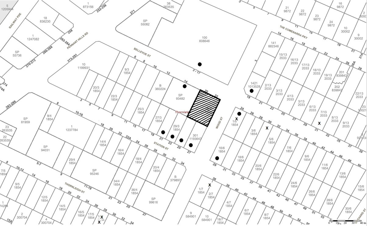
SITE
The subject site is legally defined as Lots 17 & 18 Sec 3 DP 1854, and is known as Nos. 20 and 22 Bellevue Street, Thornleigh. The development site is a rectangular shaped corner land parcel located at the intersection of Wood Street and Bellevue Street.
The site has a 27.43m frontage to Bellevue Street and 36.6m frontage to Wood Street. The total site area is 1,004m2.
The subject site historically accommodated two detached dwellings. One of the dwellings at No. 22 Bellevue Street has been demolished and the lot is currently vacant. The existing dwelling at No. 20 Bellevue Street is to be demolished as part of this proposal.
The site contains numerous exotic and locally occurring trees.
Approximately 150m to the west of the site is the intersection of Pennant Hills Road, an ALDI supermarket complex and other retail and commercial premises. To the north is Thornleigh Marketplace that accommodates Woolworths and specialty shops. The site is also within walking distance of Thornleigh Railway Station, which is approximately 300m to the west, on the opposite side of Pennant Hills Road.
Bus stops with regular services to Hornsby, Castle Hill and Parramatta are located along Pennant Hills Road in close proximity to the site.
The surrounding area includes single dwelling houses and is undergoing transition to high density housing development. A recently constructed 5 storey residential flat building comprising 24 units adjoins the northern boundary at Nos. 14-18 Bellevue Street (DA/1337/2015) and an approved development for construction of a 5-storey residential flat building comprising 38 units with 2 levels of basement car parking (DA/147/2018) adjoins the rear boundary at Nos. 21-27 Station Street, Thornleigh.
PROPOSAL
The proposal involves demolition of a dwelling house and associated structures, tree removal, construction of a 5-storey boarding house development comprising 45 boarding rooms over a three-level basement car park and landscaping works.
The boarding room mix would comprise 39 double and 6 single units for up to 82 lodgers and a site manager. The units would be accessed via a lift centrally located in the building and would include balconies fronting the street, rear and side property boundaries.
Vehicle access to the boarding house would be from Bellevue Street via a driveway located along the western boundary of the site. A separate pedestrian entry centrally located at the front of the property would provide access to all levels of the building via a landscaped pathway.
A total of 23 car parking spaces including 5 accessible spaces, 15 bicycle and 10 motorcycle spaces are proposed in 3 basement levels. Two existing vehicle crossings would be removed along Bellevue Street and replaced by one vehicle crossing to Bellevue Street.
8 trees are proposed to be removed to facilitate the development and 19 trees are proposed to be planted.
The external façade of the 5-storey building would comprise a mix of face brick, rendered finishes, glass balustrades and powder coated aluminium pergolas and privacy screens.
ASSESSMENT
The development application has been assessed having regard to the Greater Sydney Region Plan, ‘A Metropolis of Three Cities’, the ‘North District Plan’ and the matters for consideration prescribed under Section 4.15 of the Environmental Planning and Assessment Act 1979 (the Act). The following issues have been identified for further consideration.
1. STRATEGIC CONTEXT
1.1 Greater Sydney Region Plan - A Metropolis of Three Cities and North District Plan
The Greater Sydney Region Plan - A Metropolis of Three Cities has been prepared by the NSW State Government to guide land use planning decisions for the next 40 years (to 2056). The Plan sets a strategy and actions for accommodating Sydney’s future population growth and identifies dwelling targets to ensure supply meets demand. The Plan also identifies that the most suitable areas for new housing are in locations close to jobs, public transport, community facilities and services.
The NSW Government will use the subregional planning process to define objectives and set goals for job creation, housing supply and choice in each subregion. Hornsby Shire has been grouped with Hunters Hill, Ku-ring-gai, Lane Cove, Mosman, North Sydney, Ryde, Northern Beaches and Willoughby to form the North District. The Greater Sydney Commission has released the North District Plan which includes priorities and actions for Northern District for the next 20 years. The identified challenge for Hornsby Shire will be to provide an additional 4,350 dwellings by 2021 with further strategic supply targets to be identified to deliver 97,000 additional dwellings in the North District by 2036.
The proposed development would be consistent with the Greater Sydney Region Plan - A Metropolis of Three Cities and the North District Plan, by providing affordable rental housing in the region.
2. STATUTORY CONTROLS
Section 4.15(1)(a) requires Council to consider “any relevant environmental planning instruments, draft environmental planning instruments, development control plans, planning agreements and regulations”.
2.1.1 Zoning of Land and Permissibility
The site is zoned R4 High Density Residential pursuant to the Land Use Table of the HLEP. The proposed development is defined as a ‘boarding house’ and is permissible within the R4 High Density Residential zone.
The objectives of the R4 zone are:
· To provide for the housing needs of the community within a high-density residential environment.
· To provide a variety of housing types within a high-density residential environment.
· To enable other land uses that provide facilities or services to meet the day to day needs of residents.
Pursuant to the HLEP a ‘boarding house’ is defined as follows:
‘boarding house’ means a building that:
(a) Is wholly or partly let in lodgings, and
(b) Provides lodgers with a principal place of residence for 3 months or more, and
(c) May have shared facilities, such as a communal living room, bathroom, kitchen or laundry, and
(d) Has rooms, some or all of which may have private kitchen and bathroom facilities, that accommodate one or more lodgers.
but does not include backpackers’ accommodation, a group home, hotel or motel accommodation, seniors housing or a serviced apartment.
Subject to a recommended operational condition requiring that lodgers reside within the rooms for a minimum of 3 months, and that the boarding house buildings be wholly or partly let in lodgings, the proposed development would meet the requirements of the definition of a ‘boarding house’ in the HLEP.
2.1.2 Height of Buildings
Clause 4.3 of the HLEP provides that the height of a building on any land should not exceed the maximum height show for the land on the Height of Buildings Map. The maximum permissible height for the subject site is 17.5m. The proposed building has a maximum height of 16.4m which complies with the development standard.
2.1.3 Heritage Conservation
Clause 5.10 of the HLEP sets out heritage conservation provisions for Hornsby Shire. The site does not include a heritage item and is not located in a heritage conservation area. However, Council received public submissions raising concerns about the demolition of a dwelling house at property No. 22 Bellevue Street, Thornleigh.
No. 22 Bellevue Street is not a heritage item or located within a heritage conservation area under Council’s planning instrument and on 6 August 2018, a Complying Development Certificate was issued by a private certifier for the demolition of the dwelling.
Given the level of community interest in this matter, Council engaged an external heritage specialist to undertake a preliminary heritage assessment of the dwelling as part of the assessment of DA/1545/2016. Council at an extraordinary meeting held on 14 August 2018 considered the preliminary heritage assessment and Mayoral Minute No. MM20/18 and Late Item Memo No. LM12/18.
Council considered that whilst the heritage assessment does not identify the dwelling as having heritage significance, the work by Nurse Jane Starkey Dawes is worthy of recognition as “it is through an understanding of our history and the events of the past we may better connect our community to earlier generations and their way of life”. Therefore, Council resolved to continue to work with the developer to explore opportunities to recognise the important life and work of Nurse Jane Starkey Dawes through a local history initiative.
Council has been informed that the family of Nurse Jane Starkey Dawes was given the opportunity to walk through the property to remove fittings/ fixtures of sentimental value including doors, windows, fireplace and cast-iron bath. The developer arranged a photographic archival record (interior and exterior) of the property with a copy provided to both the family and Council.
2.1.4 Earthworks
Clause 6.2 of the HLEP states that consent is required for proposed earthworks on site. Before granting consent for earthworks, Council is required to assess the impacts of the works on adjoining properties, drainage patterns and soil stability of the locality.
The site is relatively level. The proposal includes excavation works for the basement car park. The geology of the site is identified as black to dark-grey shale and laminate. A condition is recommended for a detailed geotechnical assessment of the site by a chartered structural engineer, to be undertaken for the design of the basement excavation and support, groundwater drainage, basement and foundation design and to maintain the structural integrity of the adjoining properties.
Subject to compliance with the recommended conditions, the proposal is considered acceptable in this regard.
2.2 State Environmental Planning Policy (Affordable Rental Housing) 2009
Clause 26 of State Environmental Planning Policy (Affordable Rental Housing) 2009 (SEPP ARH) permits development for the purposes of “boarding houses” on land in a R4 High Density Residential zone.
Clause Nos. 29-30A provide the development standards for the assessment of a boarding house. The following tables set out the proposal’s compliance with the prescriptive standards of the Policy:
|
SEPP Affordable Rental Housing Clause 29: Standards that cannot be used to refuse consent |
|||
|
Control |
Proposal |
Requirement |
Compliance |
|
Site Area |
1,004m2 |
N/A |
N/A |
|
Floor Space Ratio A consent authority must not refuse consent to development to which this Division applies on the grounds of density or scale if the density and scale of the buildings when expressed as a floor space ratio are not more than: · The existing maximum floor space ratio for any form of residential accommodation permitted on the land. |
N/A |
HLEP does not incorporate any floor space ratio development standard for the R4 High Density Residential zone |
N/A |
|
Building Height |
16.4m |
17.5m |
Yes |
|
Landscape Area
|
The proposed landscaping for both street frontages are considered compatible with the desired future character of the streetscape |
Landscape treatment of the front setback area is compatible with the streetscape |
Yes |
|
Solar Access |
More than 3 hours of sunlight to common lounge |
One living room min. 3 hours sunlight
|
Yes |
|
Private Open Space for Lodgers |
34.1m2 common lounge & 24m2 for manager |
>20m2 with a minimum dimension of 3m & 8m2 for manager |
Yes |
|
Car Parking |
23 spaces (including 5 disabled) |
22.5 spaces (@ 0.5 spaces per room) |
Yes |
|
Min. size of boarding room (exc. kitchen & bathroom) |
|
|
|
|
Single lodger (Room 1) |
12m (multiple rooms) |
Min. 12m2 |
Yes |
|
Double lodger (Rooms 2 - 8) |
min. 16m2 (multiple rooms) |
Min. 16m2 |
Yes |
|
Max. size of boarding room (exc. kitchen & bathroom) |
22m2 (Unit Nos. 20, 31 & 42) |
Max. 25m2 |
Yes |
|
Private kitchen and bathroom facilities |
All rooms contain private kitchens and bathroom facilities |
A boarding house may have private kitchen or bathroom facilities in each boarding room but is not required to have those facilities in any boarding room |
Yes |
|
SEPP Affordable Rental Housing Clause 30: Standards for boarding houses |
|||
|
Control |
Proposal |
Requirement |
Compliance |
|
Communal Living area |
Communal living areas provided on ground and 4th floor. |
At least 1 communal living area if a boarding house has more than 5 boarding rooms |
Yes |
|
Number of Adult Lodgers Per Room |
1-2 lodgers per room |
Max. 2 lodgers per room |
Yes |
|
Bathroom and Kitchen Facilities |
Each room is self-contained with a kitchen and bathroom |
Adequate bathroom and kitchen facilities will be available within the boarding house for the use of each lodger |
Yes |
|
Boarding House Manager |
Boarding house provided for manager |
Boarding house manager for 20 or more lodgers |
Yes |
|
Bicycle and Motorcycle Parking |
15 bicycles and 10 motorcycles spaces within the basement car parking |
1 bicycle space and 1 space for motorcycle, for every 5 boarding rooms |
Yes |
As detailed in the above table, the proposed boarding house complies with the relevant prescriptive standards within the Policy. Below is a brief discussion concerning the proposal regarding mandatory and prescriptive provisions of SEPP ARH.
2.2.1 Density
SEPP ARH stipulates that the floor space ratio of any development for a boarding house should not exceed the maximum permissible floor space ratio for any form of residential accommodation in the zone.
The HLEP does not incorporate any floor space ratio development standard for the R4 High Density Residential zone. The density of developments in the zone is guided by the height, setbacks, landscaping and building plate controls of the HDCP.
2.2.2 Building Height
A maximum building height of 17.5m is a prescriptive standard pursuant to SEPP ARH and the HLEP. The proposed development would have a maximum height of 16.4m above the existing ground level and would comply with this requirement.
2.2.3 Landscape Area
SEPP ARH requires that landscape treatment of the front setback should be compatible with the streetscape. As indicated on the Landscape Plan, the proposed front setback of 8-10m to Bellevue Street and 6m to Wood Street incorporates sufficient landscaping which is compatible with the desired future character of the area.
This view is echoed by the Hornsby Design Excellence Panel (DEP), who stated in their review on 7 November 2019 that: “In relation to desired landscaping, the landscape plan illustrates a satisfactory arrangement of canopy trees: proposed street setbacks are sufficient to accommodate canopy trees facing both street frontages - notwithstanding the relatively shallow setback from Wood Street”.
2.2.4 Solar Access
SEPP ARH prescriptive measure for solar access requires one communal living room to receive a minimum of 3 hours of direct sunlight between 9am and 3pm in mid-winter. The 4th floor communal living space includes north facing windows which enable direct sunlight in accordance with the requirements of SEPP ARH.
The DEP has assessed that the shadow impacts for the neighbouring residential development at Nos. 21-27 Station Street appear to be satisfactory as indicated in the provided architectural plans given:
· The majority of approved north-facing apartments would receive midwinter sunlight from 10.30am onwards.
· Living rooms in apartments at the north-eastern corner would receive midwinter sunlight from approximately 11.30am.
2.2.5 Private Open Space
Clause 29(2)(d)(i) of SEPP ARH requires one area of private open space to be provided of at least 20m2 with a minimum dimension of 3m for the use of the lodgers. As indicated on the submitted plans, the proposal includes 2 private open space areas of 34.1m2 and 24m2, with a minimum dimension of more than 3m. The proposal also includes individual private open space for selected boarding rooms.
The proposal complies with the minimum private open space requirements.
The DEP initially raised concerns with a single common lounge on Level 4 in their review on 7 November 2019. In response to this concern, amended plans incorporated a large common lounge at the building entry and a lounge and dining room on Level 4 which is served by a kitchen and a disabled toilet. The DEP on their second review of the proposal noted that the amendments provide for enhanced social interaction.
2.2.6 Parking
Clause 29(2)(e)(ii)(a) of SEPP ARH states that in the case where a boarding house development is not carried out by or on behalf of a social housing provider, at least 0.5 parking spaces are to be provided for each boarding room. Given the proposed development comprises a total of 45 rooms; the proposal requires the provision of 22.5 car parking spaces.
The basement would comprise a total of 23 car parking spaces, including 5 accessible car parking spaces and would comply with SEPP ARH in this regard.
2.2.7 Accommodation Size
The proposal includes 6 single lodger room and 39 dual lodger rooms with bathroom, laundry and kitchen facilities. Each boarding room includes storage facilities for the residents. The accommodation size complies with the definition within SEPP ARH which excludes areas for the purpose of private kitchen or bathroom facilities.
2.2.8 Character of Local Area
Clause 30A of SEPP ARH states:
“A consent authority must not consent to development to which this Division applies unless it has taken into consideration whether the design of the development is compatible with the character of the local area.”
The site is included in the Station Street, Thornleigh precinct which was rezoned from Residential A (Low Density) to R4 High Density Residential as part of Council’s Housing Strategy. It is envisioned that the area is characterised by 5 storey residential flat buildings in landscaped settings with underground car parking.
In order to ensure that development meets a high architectural standard and is in character with a local area, Council established a panel of suitably qualified architecture and urban design professionals to undertake reviews of development 3 storeys and above. Accordingly, the application was referred to the DEP on 7 November 2019 and for a subsequent review on 26 February 2020.
With regard to local character and built form, the first review on 7 November, the DEP noted the following:
· Upon this prominent corner site, the design of future development must demonstrate a transition between characters of the high-density residential zone along the western side of Wood Street and that of the low-density residential zone along the eastern side of the street.
· Landscaped setbacks, and their capability to accommodate canopy trees around the development, are fundamental elements of existing and desired characters for this locality.
· In relation to desired landscaping, the landscape plan illustrates a satisfactory arrangement of canopy trees: proposed street setbacks are sufficient to accommodate canopy trees facing both street frontages - notwithstanding the relatively shallow setback from Wood Street.
· However, in terms of proposed building form and compositions of street facades in particular, a significant number of elements accentuate scale and contribute to a bulky appearance - outcomes which are contrary to the desired character that is illustrated or described by section 3.4 of the DCP.
· In terms of composition, the arrangement and design of architectural elements is not sufficiently coherent - and this contributes to undesirable mass and scale plus a bulky appearance.
· In general, facades require comprehensive redesign of architectural elements in order to address desired character controls - and in that way, to demonstrate appropriate compatibility with character of the local area.
· Advantage should be taken of Wood Street elevation to create landscaped courtyards that would be similar in character to the landscape setting of adjacent ADG-related apartment buildings.
A copy of the advice was provided to the applicant, and it was requested that the matters raised be addressed in amended plans. Amended plans were provided to Council and further reviewed by the DEP on 26 February 2020. The DEP acknowledged the following positive external amendments had been made to the proposal:
· Articulation of the Bellevue Street elevation by three ‘stacks’ of balconies.
· Articulation of the Wood Street elevation by two stepped wall planes and a corner ‘stack’ of balconies.
· Moderation of scale by stepping the top storey, together with the addition of awnings and screens around balconies.
· Elimination of a bulky appearance by redesign of windows and spandrels to reduce the proportion of planar masonry walls.
· Ground floor boarding rooms facing Wood Street open onto shallow courtyards and provide a better-activated street address.
The 26 February 2020 review suggested that further minor amendments be made to the balcony form, screening and external materials in order to reduce the perceived scale. Overall, the DEP review on 26 February 2020 made the following conclusions and recommendations:
· The amended proposal has provided positive responses to recommendations from the DEP meeting in November 2019.
· However, plans reveal a number of inconsistencies together with a need for refinement of some new details:
o Landscape plans reflect a previous version of the architectural plans and should be updated for consistency.
o Architectural elevations are not consistent with some aspects of the 3D views - the latter demonstrate superior resolution of elements such as balconies and windows, and detailed design refinements have been recommended in the body of this report.
o Architectural plans should be supplemented by a lateral section together with detailed design sections in order to clearly explain details which are illustrated by the 3D views.
o Architectural plans currently comprise a substantial unsupported cantilever above the driveway, and any structural solution which might be proposed in order to address that situation must not compromise streetscape character or residential amenity.
In response to the second review, the following amendments and details were provided to Council:
· An amended landscape plan was lodged with Council to be constant with the updated architectural plans.
· Amended 3D elevations to match the updated architectural plans.
· Minor façade treatment (squared balconies, revised screening, revised pergolas and recessed brick spandrels).
· Structural beams and columns have been provided in the form of a pergola to provide to support the cantilevered driveway.
Overall, the proposed building is in accordance with the key principles for the precinct for well-articulated 5 storey residential buildings in garden settings with basement car parking and has satisfied concerns raised in the two DEP meetings. The proposal is considered acceptable with regard to the character of the area.
2.3 State Environmental Planning Policy No. 55 Remediation of Land
The application has been assessed against the requirements of State Environmental Planning Policy No. 55 (SEPP 55). This Policy provides State-wide planning controls requiring that consent must not be granted to the carrying out of any development on land unless it has considered whether the land is contaminated or requires remediation for the proposed use.
A search of Council’s records and aerial images reveals that the property has been used exclusively for residential purposes with no record of any site contamination. Given this, the site would be suitable for the proposed use and no further assessment in relation to SEPP 55 is required.
It is noted that due to the age of the existing dwelling house and the associated outbuildings, there is potential for the existing buildings to contain asbestos. Appropriate conditions are included to require all asbestos to be removed from the site. Furthermore, considering the significant excavation required to accommodate the proposed basement car park, much of the existing soil would be removed from the site.
2.4 State Environmental Planning Policy (Building Sustainability Index: BASIX) 2004
The application has been assessed against the requirements of State Environmental Planning Policy (Building Sustainability Index: BASIX) 2004. The proposal includes a BASIX Certificate and is considered to be satisfactory subject to conditions ensuring its recommendations are complied with.
2.5 State Environmental Planning Policy (Vegetation in Non-Rural Areas) 2017
The application has been assessed against the requirements of State Environmental Planning Policy (Vegetation in Non-Rural Areas) 2017 (Vegetation SEPP). This Policy seeks to protect the biodiversity values of trees and other vegetation in non-rural areas of the State, and to preserve the amenity of non-rural areas of the State through the preservation of trees and other vegetation.
Part 3 of the Vegetation SEPP states that a development control plan may make a declaration in any manner relating to species, size, location and presence of vegetation. Accordingly, Part 1B.6.1 of the Hornsby Development Control Plan 2013 (HDCP) prescribes works that can be undertaken with or without consent to trees.
Section 3.1.1 of this report provides an assessment in accordance with Part 1B.6.1 of the HDCP.
2.6 State Environmental Planning Policy (Sydney Harbour Catchment) 2005
The application has been assessed against the requirements of Sydney Regional Environmental Plan (Sydney Harbour Catchment) 2005. This Policy provides general planning considerations and strategies to ensure that the catchment, foreshores, waterways and islands of Sydney Harbour are recognised, protected, enhanced and maintained.
Subject to the implementation of installation of sediment and erosion control measures and stormwater management to protect water quality, the proposal would have minimal potential to impact on the Sydney Harbour Catchment.
2.7 Clause 3.42 Environmental Planning and Assessment Act 1979 - Purpose and Status of Development Control Plans
Clause 3.42 of the Environmental Planning and Assessment Act 1979 states that a DCP provision will have no effect if it prevents or unreasonably restricts development that is otherwise permitted and complies with the development standards in relevant Local Environmental Plans and State Environmental Planning Policies.
The principal purpose of a development control plan is to provide guidance on the aims of any environmental planning instrument that applies to the development; facilitate development that is permissible under any such instrument; and achieve the objectives of land zones. The provisions contained in a DCP are not statutory requirements and are for guidance purposes only. Consent authorities have flexibility to consider innovative solutions when assessing development proposals, to assist achieve good planning outcomes.
2.8 Hornsby Development Control Plan 2013
The Hornsby Development Control Plan 2013 (HDCP) requires that boarding houses comply with the planning controls within the SEPP ARH and also encourages development with a bulk, scale and intensity that is compatible with the character of the area. Given the site is located within a 5-storey high density precinct, a merit-based assessment against the scale and intensity controls for 5 storey residential buildings is provided below.
|
HDCP 2013 - Part 3.4 Residential Flat Buildings (5 Storeys) |
|||
|
Control |
Proposal |
Requirement |
Compliance |
|
Height |
5 storeys - 16.4m |
5 storeys - 17.5m |
Yes |
|
Maximum Floorplate Dimension |
22.5m |
25m |
Yes |
|
Height of Basement Above Ground |
<1m |
1m (max) |
Yes |
|
Front Setback (Bellevue Street) |
10m 8m (for 4.2m)
7m (balconies) |
10m 8m (for 5.2m) < 1/3 building width (including balconies) |
Yes Yes
No |
|
Front Setback (Wood Street) |
6m to 8m 5m (balconies) |
10m 8m (for 7.5) < 1/3 building width (including balconies |
No No |
|
South Side Setback |
6m 4m (for 8.5m) < 1/3 Building |
6m 4.5m (for 5.2m) < 1/3 building width |
Yes No |
|
North West Side Setback |
6m 4.5m (for 8.5m)
|
6m 4.5m (for 7.5m) < 1/3 building width |
Yes Yes |
|
Top Storey Setback from Ground Floor |
0m - Bellevue Street 3m - Wood Street 5m - South 3m - North-West |
3m |
No Yes Yes |
|
Basement Ramp Setback |
2m |
2m |
Yes |
|
Deep Soil Landscaped Areas |
5m-front (Bellevue St) 4m-4.4m front (Wood St) 4m side (south) |
7m wide 7m wide 4m wide |
No No Yes |
As detailed in the above table, the proposed development generally complies with the prescriptive requirements for 5 storey residential flat buildings within the HDCP exception of some setbacks and deep soil landscaping control. A merit-based assessment is discussed below for non-compliances with the above table, as well as a brief discussion on compliance with other relevant desired outcomes.
2.8.1 Desired Future Character
The site is included in the Station Street, Thornleigh precinct which was rezoned from Residential A (Low Density) to R4 High Density Residential as part of Council’s Housing Strategy.
A discussion regarding the character is provided under Section 2.4.8 of this report.
2.8.2 Height
The height of the proposed building is in accordance with the HDCP maximum 17.5m building height. The proposed basement car park would not project more than 1.5m above finished ground level which is compliant with the HDCP numerical controls.
2.8.3 Setbacks
As noted in the table above, sections of the building do not strictly comply with the setback requirements for 5 storey residential flat buildings. A discussion regarding each non-compliant elevation is provided below. Council notes however that the current building generally maintains the previously Local Planning Panel approved setbacks as DA/1545/2016 for a 5-storey residential flat building on the same site.
2.8.3.1 Front Northern Setback (Bellevue Street)
The HDCP requires a minimum building front setback of 10m, which can be reduced to 8m for a maximum of 1/3 of the building width. The HDCP historically allowed reduced setbacks for balconies, however on 10 January 2019 the HDCP was amended so that they would be included in the 10m building setback.
The front building setback is 8m to 10m and compliant with the HDCP with the exception of selected portions of balconies within a minimum setback of 7m. The proposed setback maintains the approved minimum front setback (Bellevue Street) of the 5-storey residential flat building under DA/1545/2016 which was considered sufficient to enable the planting of large trees.
Council and the DEP consider the front facade is well articulated, and the proposed setbacks acceptable with regard to the context of the site and building line of adjacent development.
2.8.3.2 Front Setback (Wood Street)
The proposed development would provide a setback of 8m for a portion of the building that aligns with the approved building to the south-west. The proposed building then provides a transition to 7m and 6m setbacks.
The proposal does not strictly comply with the front setback requirements of the HDCP with regard to the Wood Street frontage. Notwithstanding, the minimum setback is maintained from the approved 5 storey residential flat building under DA/1545/2016. It was acknowledged through the assessment of DA/1545/2016 that the relatively small allotment could not be amalgamated with adjacent lots and that the proposed setback would be sufficient in size for adequate landscaping.
The building articulation, vertical and horizontal elements and wrap around balconies presents a well-articulated front façade to Wood Street. The landscape plan indicates that additional trees are to be planted and the existing mature street trees located along the Wood Street frontage are to be retained. These trees would obscure the eastern front façade of the proposed building. In this regard, the setback is considered to be acceptable by both Council and the DEP.
2.8.3.3 Side Setback (south)
The proposal does not strictly comply with the southern side setback as more than 1/3 of the building width would encroach up to 4m from the boundary. In support of the minor non-compliance, the proposal would maintain 10m of building separation from the approved development at Nos. 25-27 Station Street with an acceptable level of solar access being maintained. The proposed 4-6m setbacks would allow for sufficient deep soil planning and amenity for its occupants.
2.8.3.4 Top Storey Setback
The top storey of the building incorporates an additional 3m building setback for the front (Wood Street), rear and side setbacks. However, portions of the front setback (Bellevue) do not comply with the numerical requirements of the HDCP.
The top storey comprises a substantially lower gross floor area than the levels below. The portion of non-compliance is limited to the common lounge which incorporates a distinctive vertical treatment through powder coated aluminium pergola and privacy screening.
It is considered that the overall intent of the top storey setbacks provision is achieved given that the proposal includes a well-articulated built form and is therefore considered to be acceptable by both Council and the DEP.
2.8.4 Built Form, Separation and Privacy
The HDCP requires building separation to comply with Part 2F Building Separation of the SEPP 65 Design Quality of Apartment Development, Apartment Design Guide (ADG). Although the ADG does not strictly apply to the development, it can be used for a merit assessment as the proposed building encapsulates the built form of a residential flat building.
The ADG requires buildings up to 8 storeys to have a 9m separation between non-habitable to non-habitable rooms, 12m between habitable to non-habitable rooms and 18m between habitable rooms. Council notes that achieving 18m building separation would not be reasonable given the relatively small size of the corner site.
The development would adjoin an existing 5 storey development to the west and a future 5 storey development to the south.
The proposed building would provide a 10-12m separation on both the north-west and the southern elevation which is generally between bedrooms and bathrooms. To address the encroachment and to alleviate any overlooking opportunities, privacy screening has been included on southern facing window. This matter was further addressed by the DEP who noted that:
· Potential privacy impacts for neighbouring and approved residential flat buildings in Bellevue and Station Streets appear to be satisfactory.
· Floorplans of the proposed development incorporate montaged floorplans of both neighbouring developments.
· Although separation distances between opposing windows are less than specified by the ADG, most setbacks for the proposed building are half of the ADG separation distance, and screening is proposed to prevent overlooking from the major windows.
The proposed development is assessed as satisfactory with regard to building separation and the minor non-compliances are considered acceptable.
2.8.5 Security
In terms of security, the proposal has been designed to provide a safe, clear and direct pedestrian entrance from Bellevue Street. Passive surveillance is achieved by the orientation of courtyards and balconies to the street.
2.8.6 Landscaping
The landscaping provisions of the HDCP prescribe that a 7m wide landscaped deep soil area be provided at the front and a 4m wide landscaped area be provided along the side boundaries. The proposal does not strictly comply with the front deep soil setback requirement of the HDCP, however maintains the approved basement setbacks of DA/1545/2016.
The front deep soil setback would have an encroachment of 2m to Bellevue Street and 2.6m-3m to Wood Street. Notwithstanding, over 30% of the site is available for deep soil planting in natural ground and further provision has been made for planter boxes over the basement slab. Both Council’s landscape architects and the DEP consider the development has provided sufficient deep soil area in order to provide sufficient sized vegetation to grow.
The driveway ramp has a setback of 2m from the north-western boundary. Therefore, the width of the deep soil landscaped area along this boundary has been reduced considerably. Given that the HDCP allows driveway encroachment up to 2m within the side setbacks, this is considered acceptable.
Landscaping along the Bellevue Street and Wood Street frontage would include canopy trees intercepted by hedges and shrubs. The landscaping would include planting of locally indigenous trees in suitable locations that would contribute to the streetscape setting and the local tree canopy. To ensure that canopy trees are planted that will reach a substantial mature height, a condition is recommended that an additional 3 trees Angophora costata (Red Gum) and / or Syncarpia glomulifera (Turpentine) be planted along the street frontages.
2.8.7 Sunlight and Ventilation
The HDCP does not provide sunlight and ventilation controls for boarding houses. Notwithstanding, as detailed in Section 2.4.4 of this report, the proposal is considered satisfactory in regard to the sunlight controls of SEPP ARH.
2.8.8 Vehicular Access, Parking and Traffic
A discussion on the HDCP requirements for vehicle access, parking and traffic is provided below:
2.8.8.1 Vehicle Access and Parking
The proposed basement car park is over 3 levels and is accessed via a 6m wide driveway from Bellevue Street.
Parking provision within the basement levels is in accordance with the minimum number of car spaces prescribed by SEPP ARH (23 spaces). The basement levels also include 5 accessible spaces, bicycle/motorcycle parking areas and waste management areas.
Subject to recommended conditions, the proposal is considered satisfactory in respect to the HDCP requirements for vehicle access and parking.
2.8.8.2 Traffic
Based on the Roads and Maritime Service Guide to Traffic Generating Development, Council’s Traffic assessment calculates that the boarding house would generate up to 20 vehicle trips during the AM and PM peak hours, which equates to a trip every 3 minutes on average. Council’s Traffic Branch considers proposed traffic generation as acceptable with regard to the surrounding road network.
Additionally, the cumulative impact of the Thornleigh Railway Station precinct was considered in the strategic transport model for Council’s Housing Strategy and the required traffic management improvements have been included in Council’s Section 7.11 Contributions Plan. The State Government has committed funding to address regional traffic growth, including the construction of NorthConnex to provide important infrastructure for freight traffic and the wider connectivity within NSW to reduce congestion and improve traffic flow along Pennant Hills Road.
The proposed boarding house development is not categorised as a traffic generating development pursuant to State Environmental Planning Policy (Infrastructure) 2007 and referral to Transport for NSW (formally Roads and Maritime Services) is not required.
2.8.9 Waste Management
The proposal includes a waste management plan with details of waste management during the demolition phase and the construction phase of building works as well as an ongoing waste management plan.
Council calculates that the site will require 3 x 660 litre garbage bins serviced two times per week and 6 x 660 litre recycling bins serviced weekly. A garbage and recycling chute would be provided at each residential level. A garbage room is proposed within the upper level of the basement along with a bulky waste storage area. The size of the garbage room is sufficient to store the required number of bins; however, the bulky waste storage area is marginally under the required 8m2. Accordingly, conditions are recommended that it be increased to at least 8m2.
The site manager will be required to cart the bins from the basement level to the ground level holding bay for servicing and return the bins afterwards. To ensure that this can be done safely, motorised bin carting equipment will need to be provided. Conditions are recommended in this regard.
The waste collection vehicle (being a Small Rigid Vehicle) would reverse onto the truck standing area and egress in a forward direction. The collection area is sufficiently separated from the ground floor units and would not result in adverse amenity impacts due to noise and odour. The truck would only utilise the driveway area twice weekly and would not restrict useability of the access way by the residents of the building.
Subject to conditions of consent, the proposed development is assessed as satisfactory with regard to on-going waste management operations on site and service vehicle access.
2.8.10 Station Street, Thornleigh Precinct
The strategy for redevelopment of this precinct is to incorporate 5 storey residential flat buildings in garden settings with parking in basements. Although the proposal is for a boarding house, it would be similar in appearance to a residential flat building. The development responds appropriate to the site constraints and would provide for a landscaped setting and a built form that is consistent with the desired outcome for the Station Street, Thornleigh precinct.
2.9 Section 7.12 Contributions Plans
Hornsby Shire Council Section 7.12 Contributions Plan 2019-2029 applies to the development as the estimated costs of works is greater than $100,000. Should the application be approved, an appropriate condition of consent is recommended requiring the payment of a contribution in accordance with the Plan.
3. ENVIRONMENTAL IMPACTS
Section 4.15(1)(b) of the Act requires Council to consider “the likely impacts of that development, including environmental impacts on both the natural and built environments, and social and economic impacts in the locality”.
3.1 Natural Environment
3.1.1 Tree and Vegetation Preservation
Seven trees within the property and one street tree would be removed to facilitate the construction of the proposed building and driveway. None of the trees to be removed are locally indigenous trees or considered highly worthy of retention. Appropriate conditions are recommended to ensure all retained trees are protected during construction works.
A landscape plan has been submitted with the application that includes replacement planting with a range of locally native plant species with a mix of small, medium and large canopy trees, shrub layers and ground covers. The landscape plan proposes 19 trees to be planted at ground level intercepted by hedges and shrubs. Subject to conditions requiring the on-going maintenance of the landscaped areas, the development would achieve a landscape setting and would be acceptable with respect to the natural environment.
3.1.2 Stormwater Management
The proposed stormwater drainage system includes an on-site stormwater detention system and water quality treatment facility. The proposed stormwater system is satisfactory in mitigating impacts on downstream water quality subject to recommended conditions.
3.2 Built Environment
3.2.1 Built Form
The development achieves a scale consistent with the desired outcome for well-articulated buildings with appropriate setbacks to incorporate landscaping, open space and separation between buildings. The proposal incorporates a high-quality facade with a balanced composition of varied building elements including the use of vertical screening from the ground level to Level 4, a pergola on Level 4, a mix of face bricks, render, and powered coated materials to break up the development and reduce the overall bulk. Both Council and the DEP consider that the proposal achieves an appropriate built form for the site and its purpose in terms of building alignments, proportions, and the manipulation of building elements.
The proposed scheme has been designed to aesthetically fit within the envisaged future streetscape and character of the area and would present as a contemporary 5 storey flat building. The facade structure and design would complement the surrounding and envisaged streetscape and respect the amenity of adjacent existing and future developments. Landscaping has also been used to soften the edges of the site and provide privacy for existing residential dwellings to the east and the existing units to the west.
The building would be located within a precinct identified with a future character of 5 storey residential flat buildings in a garden setting with underground car parking. The built form of the proposal would be consistent with the desired future character of the precinct.
3.3 Social Impacts
The residential development would improve housing choice in the locality by providing affordable accommodation for its occupants within close proximity to public transport, main roads and facilities.
The location of the development is in close proximity to Thornleigh Railway Station and Thornleigh Marketplace, ALDI supermarket complex, recreational, health and education facilities for future residents.
This is consistent with Council’s Housing Strategy which identifies the need to provide a mix of housing options to meet future demographic needs in Hornsby Shire.
3.4 Economic Impacts
The proposal would have a minor positive impact on the local economy in conjunction with other new high-density residential development in the locality by generating an increase in demand for local services.
4. SITE SUITABILITY
Section 4.15(1)(c) of the Act requires Council to consider “the suitability of the site for the development”.
The subject site has not been identified as bushfire prone or flood prone land. The site is considered to be capable of accommodating the proposed development. The scale of the proposed development is consistent with the capability of the site and is considered acceptable.
5. PUBLIC PARTICIPATION
Section 4.15(1)(d) of the Act requires Council to consider “any submissions made in accordance with this Act”.
5.1 Community Consultation
The proposed development was first placed on public exhibition between 4 October 2019 and 1 November 2019 in accordance with the Hornsby Community Participation Plan and 15 submissions were received. The application was re-notified between 23 January 2020 and 8 February 2020 and a further 8 submissions were received. A total of 19 submissions oppose the development, 3 are neutral to the development and 1 is in support. The map below illustrates the location of those nearby landowners who made a submission that are in close proximity to the development site.
|
NOTIFICATION PLAN |
|||
|
• PROPERTIES NOTIFIED |
X SUBMISSIONS RECEIVED |
|
|
|
19 SUBMISSIONS RECEIVED OUT OF MAP RANGE |
|||
A discussion is provided below regarding the 19 objections received.
5.1.1 Traffic, Parking and Vehicle Access
Submissions have been received raising concerns with lack of car parking provided, increases in traffic, and pedestrian and vehicle safety.
In response to parking concerns, the proposal complies with the minimum number of car parking spaces prescribed within SEPP ARH and cannot be used as grounds for refusal. Additionally, the boarding house would be very close to public transport and local shops including supermarkets.
In regard to traffic, pedestrian and vehicle safety, Council’s Traffic Branch have assessed the proposal as acceptable on traffic and pedestrian safety. Conditions are recommended to ensure that landscaping does not compromise pedestrian sight lines when exiting the basement car park.
This matter is further discussed in Part 2.8.8 of this report.
5.1.2 Nurse Jane Starkey Residence
Submissions have been received noting that the site contained a dwelling house once occupied by Nurse Jane Starkey. A discussion in this regard has been provided under Part 2.1.3 of this report.
Submissions also note that the name of the boarding house if approved should be “Starkey Boarding House”. Council would raise no objections to the naming of the boarding house after Nurse Starkey if agreeable by the developer.
5.1.3 Notification Sign
A submission raised concerns that the Council notification sign was not displayed on both existing properties.
In response to this concern, Council only requires one notification sign per development proposal.
5.1.4 Definition of Development
Multiple submissions raise concerns over the term “boarding house” and whether the proposal would be for short or long-term housing, the types of people who would live in the units, an whether the proposal is a private or public enterprise. A further submission raises concerns that Thornleigh does not have sufficient “support services” for the types of residents who would occupy the boarding house.
A discussion regarding permissibility is provided in Part 2.1.1 of this report which describes the definition of a boarding house. Council notes that there might be some confusion from objectors mispresenting the proposal as a group home (permanent) or group home (transitional).
In further addressing the submissions, the proposal is a private enterprise with a minimum occupant stay of three months. Additionally, there is no requirement for the subject proposal to be located within the vicinity of “support services”. Notwithstanding, the proposal would be within walking distances of multiple shops, recreation facilities and public transport.
5.1.5 Management, Noise, Safety and Disturbance
Submissions have been received raising concerns that the development would pose an unreasonable impact to noise, disturbance and safety of nearby residents and security management.
Consideration has been given to the minimisation of noise and disturbance of adjacent properties through the enclosure of the first-floor level pathways and stairs and the provision of highlight windows along the western elevations of the buildings.
With regard to safety and disturbance, a condition has been recommended requiring that the submitted Plan of Management be enforced which provides measures to reduce disturbance and improve safety to adjacent properties, including:
· The appointment of a permanent on-site manager who would be contactable 24 hours a day and 7 days a week. Contact details are to be provided at the front of the property. The manager would be responsible for external complaint handling and record keeping. The manager’s contract would be reviewed annually.
· Continued maintenance of common areas with an external cleaner appointed.
· Limitation of use of common areas to between 7am to 10pm with no alcohol allowed to be consumed.
· House rules that relate to:
o The emission of noise (from within the boarding house and the external spaces).
o Prohibition of large gatherings and parties on the premises.
o Interference with the peace and quiet of other residents and neighbours.
o Volume of television and music players.
o Control of alcohol intake and prohibition of illegal substances.
o Anti-social behaviour.
o Parking of vehicles.
5.1.6 Schedule of Finishes
Two submissions raise concerns over the proposed schedule of finishes and recommended certain colours and materials.
In response to this concern, the schedule of finishes, and materials have been refined as part of two Design Excellence Panel reviews since the original objection. The current schedule of finishes is considered acceptable which includes a mix of face brick, rendered finishes, glass balustrades and powder coated aluminium pergolas and privacy screens.
5.1.7 Size of Units
A submission raises concerns over the size of the units. This matter is discussed in Part 2.4.7 of this report and the proposal is considered compliant with SEPP ARH controls.
5.1.8 Property Prices
A submission has been received raising concerns that the development would negatively impact property values of nearby properties.
In addressing this concern, Section 4.15 of the Environmental Planning and Assessment Act 1979 and SEPP Affordable Housing does not require Council to take into consideration the impact of a development on the value of nearby properties. Nonetheless, Council acknowledges that the boarding house development complies with the development standards of the SEPP and is designed to maintain the high-density character of the area.
5.1.9 Number of Units
Submissions raises concerns that the development has too many units for the site.
Council notes that there are no numerical controls that limit the number of boarding rooms per site. Notwithstanding, as demonstrated in this report, the proposal complies with the SEPP ARH standards regarding scale, solar access, car parking and generally comply with HDCP built form controls for 5 storey residential flat buildings. Accordingly, the proposal is considered acceptable from a site capacity perspective.
5.1.10 Permissibility and Height
A submission raises concerns over the permissibility of the proposal in a 4-storey zone.
In response to this concern the site has a 17.5m height limit and the future character of the area is envisioned in the HDCP for 5 storey buildings. Further, the proposed use a boarding house is a permissible land use pursuant to the HLEP.
5.1.11 Privacy
A submission raises concerns that the proposal would result in a loss of privacy due to balconies on the Wood Street frontage.
In response to this concern, two balconies per level would be provided for units on Levels 1-4. Each balcony would be limited in width to approximately 1m with the exception of Unit No. 44. The limited width of the balconies would not promote outdoor entertaining and only occasional use. The units would also be located more than 30m from the nearest residential property to the east. Accordingly, the privacy impact of the balconies on the Wood Street frontage is considered acceptable.
5.1.12 Construction Management
A submission suggests certain registrations relating to construction management.
In response to this concern, the applicant has submitted a preliminary Construction Traffic Management Plan to address traffic and pedestrian management, equipment storing areas and truck routes during the demolition and construction phase of the development. Council’s assessment in this regard concludes that the implementation of the plan would mitigate impacts subject to conditions of consent requiring a detailed plan to be prepared prior to commencement of works and the copies of plan to be provided to all contractors working on the site. Subject to implementation of this condition, the proposal would not have an unreasonable impact on the residents of the neighbouring properties due to construction traffic and unloading of goods.
5.1.13 Certification
A submission suggests that Council should be appointed as the Principal Certifier for the development. Council is unable to recommend conditions relating to who would be appointed as the certifier for the development.
5.1.14 Solar Panels and BASIX
A submission suggests that the proposal should incorporate solar panels and raises concerns that a fire sprinkler system would not be installed.
In response to this concern, neither the submitted BASIX certificate or the HDCP mandates the installation of solar panels.
Further, Council acknowledges that the Building Code of Australia requires sprinkler systems for buildings above 4 storeys in height. Conditions are recommended that the proposal comply in this regard.
5.1.15 Ground Floor Security
A submission raises concerns that the ground floor units would not be secure.
In response to this concern, the treatment of the ground floor courtyards was raised by the Hornsby Design Excellence. In response, amended plans have included screen planting surrounding each courtyard which is consistent with adjacent approved development and offers residents some additional privacy and security.
5.1.16 Public Interest
Submissions raise concerns that the proposal is not in the public interest and represents developer greed. A discussion regarding public interest is provided in Part 7 of this report below. The profitability of the development is not a matter of consideration as part of the assessment.
5.2 Public Agencies
The development application was not referred to any Public Agencies for comment.
6. THE PUBLIC INTEREST
Section 4.15(1)(e) of the Act requires Council to consider “the public interest’s
The public interest is an overarching requirement, which includes the consideration of the matters discussed in this report. Implicit to the public interest is the achievement of future built outcomes adequately responding to and respecting the future desired outcomes expressed in environmental planning instruments and development control plans.
The application is considered to have satisfactorily addressed Council’s and relevant agencies’ criteria and would provide a development outcome that, on balance, would result in a positive impact for the community. Accordingly, it is considered that the approval of the proposed development would be in the public interest.
CONCLUSION
The application proposes demolition of a dwelling house and associated structures and construction of a 5-storey boarding house development comprising 45 units over a 3-level basement car park and associated landscaping works.
The development generally meets the desired outcomes of Council’s planning controls and is satisfactory having regard to the matters for consideration under Section 4.15 of the Environmental Planning and Assessment Act 1979.
Council received a total of 23 submissions. The matters raised have been addressed in the body of the report.
Having regard to the circumstances of the case, approval of the application is recommended.
The reasons for this decision are:
· The proposed development complies with the requirements of State Environmental Planning Policy (Affordable Rental Housing) 2009 and the Hornsby Local Environmental Plan 2013.
· The proposed variation to building setbacks contained within the Hornsby Development Control Plan 2013 are consistent with the approved residential flat building approved for this site.
· The proposed development does not create unreasonable environmental impacts to adjoining development with regard to visual bulk, overshadowing, solar access, amenity or privacy.
Note: At the time of the completion of this planning report, no persons have made a Political Donations Disclosure Statement pursuant to Section 10.4 of the Environmental Planning and Assessment Act 1979 in respect of the subject planning application.
RESPONSIBLE OFFICER
The officer responsible for the preparation of this report is Stephen Dobbs.
|
Cassandra Williams Major Development Manager - Development Assessments Planning and Compliance Division |
Rod Pickles Manager - Development Assessments Planning and Compliance Division |
|
Locality Plan |
|
|
|
|
Photomontage |
|
|
|
|
Architectural Plans |
|
|
|
|
Landscape Plans |
|
|
|
|
Plan of Management |
|
|
File Reference: DA/860/2019
Document Number: D07915608
SCHEDULE 1
GENERAL CONDITIONS
The conditions of consent within this notice of determination have been applied to ensure that the use of the land and/or building is carried out in such a manner that is consistent with the aims and objectives of the relevant legislation, planning instruments and council policies affecting the land and does not disrupt the amenity of the neighbourhood or impact upon the environment.
Note: For the purpose of this consent, the term ‘applicant’ means any person who has the authority to act on or the benefit of the development consent.
Note: For the purpose of this consent, any reference to an Act, Regulation, Australian Standard or publication by a public authority shall be taken to mean the gazetted Act or Regulation or adopted Australian Standard or publication as in force on the date that the application for a construction certificate is made.
1. Approved Plans and Supporting Documentation
The development must be carried out in accordance with the plans and documentation listed below and endorsed with Council’s stamp, except where amended by Council and/or other conditions of this consent:
Approved Plans
|
Plan No. |
Plan Title |
Drawn by |
Dated |
Council Reference |
|
160748 - Issue K - DA100 |
Site Plan |
Design Cubicle |
24/06/2020 |
|
|
160748 - Issue K - DA200 |
Basement 01 Plan |
Design Cubicle |
24/06/2020 |
|
|
160748 - Issue K - DA201 |
Basement 02 Plan |
Design Cubicle |
24/06/2020 |
|
|
160748 - Issue K - DA202 |
Basement 03 Plan |
Design Cubicle |
24/06/2020 |
|
|
160748 - Issue K - DA203 |
Ground Floor Plan |
Design Cubicle |
24/06/2020 |
|
|
160748 - Issue K - DA204 |
Level 01 Plan |
Design Cubicle |
24/06/2020 |
|
|
160748 - Issue K - DA205 |
Level 02 Plan |
Design Cubicle |
24/06/2020 |
|
|
160748 - Issue K - DA206 |
Level 03 Plan |
Design Cubicle |
24/06/2020 |
|
|
160748 - Issue K - DA207 |
Level 04 Plan |
Design Cubicle |
24/06/2020 |
|
|
160748 - Issue K - DA208 |
Roof Plan |
Design Cubicle |
24/06/2020 |
|
|
160748 - Issue K - DA300 |
Elevations 1 of 2 |
Design Cubicle |
24/06/2020 |
|
|
160748 - Issue K - DA301 |
Elevations 2 of 2 |
Design Cubicle |
24/06/2020 |
|
|
160748 - Issue K - DA302 |
Sections 1/2 |
Design Cubicle |
24/06/2020 |
|
|
160748 - Issue K - DA303 |
Sections 2/2 |
Design Cubicle |
24/06/2020 |
|
|
19/2095 - Issue E -Sheets 1-4 |
Landscape Plans |
Paul Scrivener Landscape Architecture |
|
|
Supporting Documents
|
Document Title |
Prepared by |
Dated |
Council Reference |
|
Plan of Management |
Think Planners |
07/2019 |
D07768262 |
|
Arboricultural Impact Assessment - 2602 |
Red Gum Horticultural Services |
7/9/2019 |
D07768277 |
|
Operational Waste Management Plan - SO470 - E |
Elephants Foot Recycling Solutions |
22/05/2020 |
D07919911 |
|
DA Acoustic Assessment 20190907.1/0309A/R0/JM |
Acoustic Logic |
03/09/2019 |
D07946146 |
|
BASIX Certificate No. 1035681M |
ESD Synergy |
16/09/2019 |
D07768280 |
|
Stormwater Plans - 2192-DA |
Mance Arraj |
04/09/2019 |
D07768268 |
|
Sediment and Erosion Control Plan- 2192-DA |
Mance Arraj |
04/09/2019 |
D07768266 |
2. Removal of Trees
a) This development consent permits the removal of trees numbered 7, 8, 9, 10, 11, 12, 13 and 14 as identified on page 16 of Appendix C contained in the Arboricultural Impact Assessment prepared by Red Gum Horticultural Services dated 7/9/2019.
b) No consent is granted for the removal of tree(s) numbered 1-6 as these trees contribute to the established landscape amenity of the area/streetscape.
Note: The removal of any other trees from the site requires separate approval by Council in accordance with Part 1B.6 Tree and Vegetation Preservation of the Hornsby Development Control Plan, 2013 (HDCP).
3. Section 7.12 Development Contributions
(a) In accordance with Section 4.17(1) of the Environmental Planning and Assessment Act 1979 and the Hornsby Shire Council Section 7.12 Development Contributions Plan 2019-2029, $55,338.25 must be paid towards the provision, extension or augmentation of public amenities or public services, based on development costs of $5,533,827.
(b) The value of this contribution is current as of 8 July 2020. If the contributions are not paid within the financial quarter that this consent is granted, the contributions payable will be adjusted in accordance with the provisions of the Hornsby Shire Council Section 7.12 Development Contributions Plan and the amount payable will be calculated at the time of payment in the following manner:
|
$CPY |
= |
|
|
$CDC x CPIPY |
|
|
|
|
|
CPIDC |
Where:
$CPY is the amount of the contribution at the date of Payment
$CDC is the amount of the contribution as set out in this Development Consent
CPIPY is the latest release of the Consumer Price Index (Sydney - All Groups) at the date of Payment as published by the ABS.
CPIDC is the Consumer Price Index (Sydney - All Groups) for the financial quarter at the date of this Development Consent.
(c) The monetary contributions shall be paid to Council:
(i) Prior to the issue of the Subdivision Certificate where the development is for subdivision; or
(ii) Prior to the issue of the first Construction Certificate where the development is for building work; or
(iii) Prior to issue of the Subdivision Certificate or first Construction Certificate, whichever occurs first, where the development involves both subdivision and building work; or
(iv) Prior to the works commencing where the development does not require a Construction Certificate or Subdivision Certificate.
Note: It is the professional responsibility of the Principal Certifying Authority to ensure that the monetary contributions have been paid to Council in accordance with the above timeframes.
Note: The Hornsby Shire Council Section 7.12 Development Contributions Plan may be viewed at www.hornsby.nsw.gov.au or a copy may be inspected at Council’s Administration Centre during normal business hours.
4. Retaining Walls
To ensure the stability of the site, structural details of all required retaining walls must be submitted with the application of the Construction Certificate.
5. Powerlines
The powerlines within the road reserves along the road frontages of the site to be undergrounded subject to the approval of Ausgrid.
6. Construction Certificate
a) A Construction Certificate is required to be approved by Council or a Private Certifying Authority prior to the commencement of any construction works under this consent.
b) A separate Subdivision Works Certificate must be obtained from Council for all works within the public road reserve under S138 of the Roads Act 1993.
c) A separate Construction Certificate must be obtained from Council for all works within drainage easements vested in Council.
d) The Construction Certificate plans must be consistent with the Development Consent plans.
REQUIREMENTS PRIOR TO THE ISSUE OF A CONSTRUCTION CERTIFICATE
7. Building Code of Australia
Detailed plans, specifications and supporting information is required to be submitted to the certifying authority detailing how the proposed building work achieves compliance with the National Construction Code - Building Code of Australia. All building work must be carried out in accordance with the requirements of the National Construction Code - Building Code of Australia.
8. Electrical Kiosks and Fire Booster Assemblies
Electrical kiosks and fire booster assemblies shall be visually softened by a built screen and/ or landscaping so as not to impact on the streetscape. Drawings shall be submitted that document the location of and screening treatment surrounding these utilities.
9. Fire Safety Schedule
A schedule of all proposed essential fire safety measures to be installed in the building (e.g. hydrants, hose reels, emergency warning systems etc.) shall be submitted with the construction certificate application.
10. Sydney Water - Approval
This application must be submitted to Sydney Water for approval to determine whether the development would affect any Sydney Water infrastructure, and whether further requirements are to be met.
Note: Building plan approvals can be obtained online via Sydney Water Tap inTM through www.sydneywater.com.au under the Building and Development tab.
11. Dilapidation Report
A ‘Dilapidation Report’ is to be prepared by a ‘chartered structural engineer’ detailing the structural condition of the adjoining properties CP SP 93482, No.14 Bellevue Street, Thornleigh and Lot 29 Sec 3 DP 1854, Lots 300 and 301 DP 1193643, Nos. 23, 25 and 27 Station Street, Thornleigh prior to issue of the Construction Certificate.
12. Identification of Survey Marks
A registered surveyor must identify all survey marks in the vicinity of the proposed development. Any survey marks required to be removed or displaced as a result of the proposed development shall be undertaken by a registered surveyor in accordance with Section 24 (1) of the Surveying and Spatial Information Act 2002 and following the Surveyor General’s Directions No.11 - "Preservation of Survey Infrastructure".
13. Stormwater Drainage
The stormwater drainage system for the development must be designed for an average recurrence interval (ARI) of 20 years, be gravity drained via an on-site detention and water quality treatment facility/rain water tank and be designed by a Chartered Professional Civil/ Hydraulic Engineer of the Institution of Engineers, Australia
14. On Site Stormwater Detention
An on-site stormwater detention system must be designed by a chartered civil engineer and constructed in accordance with the following requirements:
a) Storage capacity to accommodate volume from up to 20 years ARI (average recurrence interval) storms, not less than 16.30m3 and a maximum discharge (when full) limited to 5 years predevelopment rate, not more than 20 litres per second.
b) Have a surcharge/inspection grate located directly above the outlet. Discharge from the detention system to be controlled via 1 metre length of pipe, not less than 50 millimetres diameter or via a stainless plate with sharply drilled orifice bolted over the face of the outlet discharging into a larger diameter pipe capable of carrying the design flow to an approved Council system.
c) Where above ground system is proposed, and the average depth is greater than 0.3 metres, a ‘pool type’ safety fence and warning signs to be installed.
d) Not be constructed in a location that would impact upon the visual or recreational amenity of residents.
e) Detail calculations are to be shown in construction certificate plan.
f) An overflow/escape path shall be incorporated in the design.
15. Water Quality/Bio Retention System
Stormwater discharging from the development site is to be treated to achieve the quality specified in in the Hornsby Development Control Plan 2013 (table 1C.1.2(b) Urban Stormwater Quality Targets) or utilise one of the deemed to comply solutions. MUSIC model files and Hornsby Shire Council Music- link report prepared by a Chartered Civil/Hydraulic Engineer of the Institution of Engineers, Australia are to be submitted to the PCA for approval prior to issue of a Construction Certificate. Council’s parameters are to be used in the model.
16. Vehicular Crossing
A separate application under the Local Government Act 1993 and the Roads Act 1993 must be submitted to Council for the installation of a new vehicular crossing and the removal of the redundant crossing. The vehicular crossing must be constructed in accordance with AUS-SPEC Specifications (www.hornsby.nsw.gov.au/property/build/aus-spec-terms-and-conditions) and the following requirements:
a) Design levels at the front boundary must be obtained from Council for the design on the internal driveway.
b) Any redundant crossings must be replaced with integral kerb and gutter.
c) The footway area must be restored by turfing.
d) Approval must be obtained from all relevant utility providers that all necessary conduits be provided and protected under the crossing.
Note: An application for a vehicular crossing can only be made to one of Council’s Authorised Vehicular Crossing Contractors. You are advised to contact Council on 02 9847 6940 to obtain a list of contractors.
17. Internal Driveway/Vehicular Areas
The driveway and parking areas on site must be designed, constructed and a Construction Certificate issued in accordance with Australian Standards 2890.1, 2890.2, 3727 and the following requirements:
a) Design levels at the front boundary shall be obtained from Council if a private accredited certifier is engaged to obtain a construction certificate for these works.
b) The driveway be a rigid pavement.
c) Conduit for utility services including electricity, water, gas and telephone be provided. All existing overhead assets including electricity and telecommunications cabling shall be relocated underground at no cost to Council. A certificate from an appropriately licensed contractor shall be submitted to the principal certifying authority certifying that the service conduits have been installed in accordance with the relevant utility provider and Australian Standards.
d) Longitudinal sections along both sides of the access driveway shall be submitted to the principal certifying authority in accordance with the relevant sections of AS 2890.1. The maximum grade shall not exceed 1 in 4 (25%) with the maximum changes of grade of 1 in 8 (12.5%) for summit grades and 1 in 6.7 (15%) for sag grades. Any transition grades shall have a minimum length of 2 metres. The longitudinal sections shall incorporate the design levels obtained by Council.
18. Road Works
All road works approved under this consent must be designed in accordance with Council’s Civil Works Design and Construction Specification 2005 and the following requirements:
a) The existing footpath and kerb and gutter along the frontage of the development are to be replaced with new ones.
b) The existing road pavement to be saw cut a minimum of 300mm from the existing edge of the bitumen and reconstructed.
c) The submission of a compaction certificate from a geotechnical engineer for any fill within road reserves, and all road sub-grade and road pavement materials.
d) No work is to commence within the road reserve until approval under Section 138 of the Roads Act 1993 is obtained from Council. In this regard a construction certificate application is to be submitted to Council.
19. Mechanical Equipment
A mechanical plant noise assessment for all proposed mechanical equipment and site-specific equipment must be undertaken by a suitably qualified Acoustic Consultant and a report certifying that the operation of all proposed equipment will not exceed the noise criteria levels at any boundary upon installation be submitted to the PCA.
20. Construction Management Plan (CMP)
To assist in the protection of the public, the environment and Council’s assets, a separate Construction Management Plan must be prepared by a suitably qualified environmental consultant in consultation with a qualified traffic engineer and AQF 5 arborist, and submitted to Council’s Compliance Team at compliance@hornsby.nsw.gov.au for review and approval according to the following requirements:
a) The CMP must detail the contact information for developers, builder, private certifier and any emergency details during and outside work hours.
b) A Construction Traffic Management Plan (CTMP) including the following:
i) The order of construction works and arrangement of all construction machines and vehicles being used during all stages.
ii) The CTMP plans shall be in accordance with all other plans submitted to Council as part of this development proposal.
iii) A statement confirming that no building materials, work sheds, vehicles, machines or the like shall be allowed to remain in the road reserve area without the written consent of Hornsby Shire Council.
iv) The Plan shall be in compliance with the requirements of the Roads and Maritime Services Traffic control at work sites Manual 2018 and detail:
a) Public notification of proposed works.
b) Long term signage requirements.
c) Short term (during actual works) signage.
d) Vehicle Movement Plans, where applicable.
e) Traffic Management Plans.
f) Pedestrian and Cyclist access and safety.
v) Traffic controls including those used during non-working hours. Pedestrian access and two-way traffic in the public road must be able to be facilitated at all times.
vi) Details of parking arrangements for all employees and contractors, including layover areas for large trucks during all stages of works. The parking or stopping of truck and dog vehicles associated with the development will not be permitted other than on the site and the plan must demonstrate this will be achieved.
vii) Confirmation that a street ‘scrub and dry’ service will be in operation during all stages of works.
viii) Proposed truck routes to and from the site including details of the frequency of truck movements for all stages of the development.
ix) Swept path analysis for ingress and egress of the site for all stages of works.
x) Site plans for all stages of works including the location of site sheds, concrete pump and crane locations, unloading and loading areas, waste and storage areas, existing survey marks, vehicle entry, surrounding pedestrian footpaths and hoarding (fencing) locations.
xi) The total quantity and size of trucks for all importation and exportation of fill on site throughout all stages of works, and a breakdown of total quantities of trucks for each stage of works.
xii) The number of weeks trucks will be accessing and leaving the site with excavated or imported fill material.
xiii) The maximum number of trucks travelling to and from the site on any given day for each stage of works.
xiv) The maximum number of truck movements on any given day during peak commuting periods for all stages of works.
xv) The source site location of any proposed fill to be imported to the site, for all stages of works.
xvi) The Plan must state that the applicant and all employees of contractors on the site must obey any direction or notice from the Prescribed Certifying Authority or Hornsby Shire Council in order to ensure the above.
xvii) If there is a requirement to obtain a Work Zone, Out of Hours permit, partial Road Closure or Crane Permit, the Plan must detail these requirements and include a statement that an application to Hornsby Shire Council will be made to obtain such a permit.
c) A Construction Waste Management Plan detailing the following:
i) Details of the importation or excavation of soil and fill, the classification of the fill, disposal methods and authorised disposal depots that will be used for the fill.
ii) Asbestos management requirement and procedures for removal and disposal from the site in accordance with AS 2601-2001 - ‘The Demolition of Structures’, and the Protection of the Environment Operations (Waste) Regulation 2005.
iii) General construction waste details including construction waste skip bin locations and litter management for workers.
d) A Tree Protection Plan (TPP) prepared by an AQF 5 Arborist in accordance with any approved Arboricultural Impact Assessment and tree location plans, detailing the following:
iv) A site plan showing tree protection zones (TPZ) and structural root zones (SRZ) of trees to be retained and specific details of tree protection measures inclusive of distances (in metres) measured from tree trunks.
v) Construction methodology to avoid damage to trees proposed to be retained during construction works.
vi) Specifications on tree protection materials used and methods within the TPZ or SRZ.
vii) Location of dedicated material storage space on site outside of TPZ’s and SRZ’s for retained trees.
e) A Construction Noise and Vibration Management Plan (CNMP) which includes:
i) Existing noise and vibration levels within the proximity of the proposed development site.
ii) Details of the extent of rock breaking or rock sawing works forming part of the proposed development works.
iii) The maximum level of noise and vibration predicted to be emitted during each stage of construction.
iv) The duration of each stage of works where the maximum level of noise and vibration are predicted to be emitted for.
v) Details of mitigation measures, inclusive of respite periods, that will meet acoustic standards and guidelines at each stage of works.
vi) Details of a complaints handling process for the surrounding neighbourhood for each stage of works.
f) Identification of approved sediment and erosion control measures.
21. Waste Management Details
The following waste management requirements must be complied with:
a) The approved on-going waste management system must not be amended without the written consent of Council.
b) A design certificate and detailed plans are to accompany any Construction Certificate application, which demonstrate that the waste storage room at the basement level has been designed to be constructed in accordance with the Waste Management Plan and including the following requirements:
i) The floor is to be constructed of concrete at least 75mm thick and adequately graded to drain to a Sydney Water approved drainage fitting.
ii) The floor must be finished so that it is non-slip, sealed and impervious, and has a smooth and even surface covered at all intersections.
iii) The walls and any ceilings must be finished with smooth faced non-absorbent material capable of being cleaned.
iv) The room is to be provided with artificial light controllable within the room and adequate ventilation.
v) The room is to be provided with an adequate supply of hot and cold water mixed through a centralised mixing valve with hose cock.
vi) The bin storage room must have door(s) wide enough and positioned so that the 660 L bins can fit through.
vii) The doors are to be robust and lockable (but able to be opened from the inside without a key), with a door opening of no less than 2.0m.
c) A design certificate and detailed plans are to accompany any Construction Certificate application, which confirms that each chute system for each building can be constructed to satisfy the Manufacturer’s standard installation guidelines and specifically the following requirements:
i) Chutes, service openings and charging devices are constructed of metal or a smooth faced surface which is fire resistant and of impervious material.
ii) Chute is cylindrical in section, vertical and without bends as it passes through the floors.
iii) Chutes must terminate in the building’s residential waste room and discharge into a waste bin.
iv) The chute system must comply with the manufacturers technical specifications and operational limitations.
v) The gradient of the garbage chute and the recycling chute must be no less than the minimum gradient recommended by the chute manufacturer.
vi) The chute service rooms must have sufficient space to comfortably house the required volume handling equipment and to load/unload bins from this equipment, and sufficient space to store the spare garbage and recycling bins for that building and to access and manoeuvre the bins.
vii) The required volume handling equipment for each chute system must not include compaction.
Note: The required volume handling equipment is: 3 x660L bin linear or equivalent under garbage chute, and 3 x660L bin linear or equivalent under the recycling chute.
Note that 660L bins are 1370mm wide, 850mm deep, 1260mm high; allow 75 mm between bins for ease of manoeuvring and to avoid damage to walls and doors from bins scraping against them; increase the allowance between bins to 200mm if there are to be brackets on bins for bin tugs.
d) For the bin holding bay at the ground level:
i) The doorway must face the driveway be no less than 2.0m wide.
ii) There must be no step(s) between the bin bay and the driveway.
iii) The bin bay must be at the same level as the driveway.
iv) The bin carting route from the front bin holding bays to the street must not exceed a gradient of 1:20 and must be no less than 2.0m wide and must not include any steps.
v) The bin holding bays must be integrated into the overall design of the development and landscaping to minimise impact on the streetscape, and include screening to a height of no less than 1.5 m.
vi) The internal dimensions of the ground level bin holding bay must be no less than 1.8m x 9.0m. Internal dimensions do not include wall thickness, support columns, ventilation shafts etc which must be added.
Note: a 240 L recycling bin is 600 mm wide by 750 mm deep; allow for 75 mm ease around the bin to avoid damage to walls etc from scraping. The door must be wide enough and positioned such that all the bins can fit through. Every bin must be able to be accessed (no stacking of bins two or more deep). Internal dimensions do not include wall thickness, door thickness etc, which must be added.
e) The first 6m of the driveway must have a gradient no steeper than 1:20 and must be designed to carry the load of a heavy rigid waste collection vehicle.
f) There must be no steps along any bin carting route.
g) A dedicated bulky waste storage area of at least 8m2 internal area is to be provided. The internal area does not include wall thickness, door thickness etc which must be added.
h) Should there be any conflict or confusion between approved plans and/or consent conditions related to the on-going waste management system, then written clarification must be obtained from Council.
i) A Waste Management Plan Section One - Demolition Stage and Section Three - Construction Stage, covering the scope of this project and including the following details, is required to be submitted to Council:
j) An estimate of the types and volumes of waste and recyclables to be generated.
i) A site plan showing sorting and storage areas for demolition and construction waste and the vehicle access to these areas.
ii) How excavation, demolition and construction waste materials will be reused or recycled and where residual wastes will be disposed.
iii) The total percentage (by weight) of demolition and construction waste that will be reused or recycled.
Note: the site(s) to which the waste materials are taken must be legally able to accept those wastes.
22. Geotechnical Report
A detailed geotechnical assessment of the site by a chartered structural engineer, is to be undertaken for the design of the basement excavation and support, groundwater drainage, basement and foundation design.
23. Appointment of a Project Arborist
a) To ensure the trees that must be retained are protected, a project arborist with AQF Level 5 qualifications must be appointed to assist in ensuring compliance with the conditions of consent and provide monitoring reports as specified by the conditions of consent.
b) Details of the appointed project arborist must be submitted to Council and the PCA with the application for the construction certificate/subdivision works certificate.
REQUIREMENTS PRIOR TO THE COMMENCEMENT OF ANY WORKS
24. Erection of Construction Sign
a) A sign must be erected in a prominent position on any site on which any approved work is being carried out:
i) Showing the name, address and telephone number of the principal certifying authority for the work.
ii) Showing the name of the principal contractor (if any) for any demolition or building work and a telephone number on which that person may be contacted outside working hours.
iii) Stating that unauthorised entry to the work site is prohibited.
b) The sign is to be maintained while the approved work is being carried out and must be removed when the work has been completed.
25. Protection of Adjoining Areas
A temporary hoarding, fence or awning must be erected between the work site and adjoining lands before the works begin and must be kept in place until after the completion of the works if the works:
a) Could cause a danger, obstruction or inconvenience to pedestrian or vehicular traffic.
b) Could cause damage to adjoining lands by falling objects.
c) Involve the enclosure of a public place or part of a public place.
d) Have been identified as requiring a temporary hoarding, fence or awning within the Council approved Construction Management Plan (CMP).
Note: Notwithstanding the above, Council’s separate written approval is required prior to the erection of any structure or other obstruction on public land.
a) To provide a safe and hygienic workplace, toilet facilities must be available or be installed at the works site before works begin and must be maintained until the works are completed at a ratio of one toilet for every 20 persons employed at the site.
b) Each toilet must:
i) Be a standard flushing toilet connected to a public sewer.
ii) Be a temporary chemical closet approved under the Local Government Act 1993.
iii) Have an on-site effluent disposal system approved under the Local Government Act 1993.
27. Erosion and Sediment Control
To protect the water quality of the downstream environment, erosion and sediment control measures must be provided and maintained throughout the construction period in accordance with the manual ‘Soils and Construction 2004 (Bluebook)’, the approved plans, Council specifications and to the satisfaction of the principal certifying authority. The erosion and sediment control devices must remain in place until the site has been stabilised and revegetated.
Note: On the spot penalties may be issued for any non-compliance with this requirement without any further notification or warning.
28. Waste Management Details
Prior to the commencement of any works, the on-going waste collection service must be cancelled, and the bins retrieved by the waste collection service provider.
Note: For residential properties, Council is the waste collection service provider.
29. Garbage receptacle
a) A garbage receptacle must be provided at the work site before works begin and must be maintained until all works are completed.
a) The garbage receptacle must have a tight-fitting lid and be suitable for the reception of food scraps and papers.
b) The receptacle lid must be kept closed at all times, other than when garbage is being deposited.
c) Food scraps must be placed in the garbage receptacle and not in demolition and construction waste bins.
30. Installation of Tree Protection Measures
a) Trees to be retained and numbered 1-6 as identified on the Tree Management Plan prepared by Red Gum Horticultural Services dated 7/9/2019 must have tree protection measures for the ground, trunk and canopy installed by the project arborist as follows:
i) For the duration of demolition works, in accordance with the Tree Protection Plan for prepared by Red Gum Horticultural Services dated 7/9/2019.
ii) For the duration of construction works, in accordance with Tree Protection Plan prepared by Red Gum Horticultural Services dated 7/9/2019.
b) Tree protection fencing for the trees to be retained numbered 1-6 must be installed by the engaged AQF 5 project arborist and consist of 1.8m high temporary fencing panels installed in accordance with Australian Standard AS4687-2007 Temporary fencing and hoardings.
c) The installation of all required tree protection fencing must include shade cloth attached to the fencing to reduce transport of dust, particulates and liquids from entering the tree protection zone.
d) The installation of all required tree protection fencing must have a TPZ radius as listed in the Table below:
|
Tree number |
TPZ radius from centre of tree |
|
1-5 |
4.8m |
|
6 |
2m |
e) Tree crown protection measures are required and must be installed by the AQF 5 project arborist.
f) The circumference of the trunk(s) must be wrapped in hessian material to provide cushioning for the installation of timber planks.
g) Timber planks (50 x100mm) must be spaced at 100mm intervals and must be attached using adjustable ratchet straps.
h) All tree protection zones must have a layer of wood-chip mulch at a depth of between 150mm and 300mm.
i) Where wood-chip mulch is permitted by Council instead of tree protection fencing within the tree protection zones, the wood-chip must be covered with a layer of geotextile fabric and rumble boards.
REQUIREMENTS DURING CONSTRUCTION
31. Construction Work Hours
All work on site (including demolition and earth works) must only occur between 7am and 5pm Monday to Saturday (unless otherwise approved in writing by Council due to extenuating circumstances). No work is to be undertaken on Sundays or public holidays.
32. Work Zone
All construction vehicles associated with the proposed development are to be contained on site or in a Local Traffic Committee (LTC) approved “Works Zone”.
a) The site supervisor to be advised that the Works Zone will be deemed to be in effect, and fees will apply, between the dates nominated by the supervisor, or when parking spaces are managed for the sole use of construction vehicles associated with the site.
b) The Works Zone signs shall be in effect only for the times approved by Council, and the time is to be noted on the sign. E.g. ‘Works Zone Mon - Sat 7am - 5pm’.
c) The applicant is required to supply a sign posting installation plan for referral to the Local Traffic Committee, noting on it the duration of the Works Zone.
d) The Works Zone is only to be used for the loading and unloading of vehicles. Parking of workers’ vehicles, or storage of materials, is not permitted.
33. Demolition
To protect the surrounding environment, all demolition work must be carried out in accordance with Australian Standard AS2601-2001 Demolition of Structures and the following requirements:
a) Demolition material must be disposed of to an authorised recycling and/or waste disposal site and/or in accordance with an approved waste management plan; and
b) Demolition works, where asbestos material is being removed, must be undertaken by a contractor that holds an appropriate licence issued by SafeWork NSW in accordance with the Work Health and Safety Regulation 2017 and be appropriately transported and disposed of in accordance with the Protection of the Environment Operations (Waste) Regulation 2014; and
c) On construction sites where any building contain asbestos material, a standard commercially manufactured sign containing the words ‘DANGER ASBESTOS REMOVAL IN PROGRESS’ and measuring not less than 400mm x 300mm must be displayed in a prominent position visible from the street.
34. Environmental Management
To prevent sediment run-off, excessive dust, noise or odour emanating from the site during the construction, the site must be managed in accordance with the publication ‘Managing Urban Stormwater - Landcom (March 2004) and the Protection of the Environment Operations Act 1997.
The street cleaning services must undertake a street ‘scrub and dry’ method of service and not a dry sweeping service that may cause sediment tracking to spread or cause a dust nuisance.
36. Council Property
To ensure that the public reserve is kept in a clean, tidy and safe condition during construction works, no building materials, waste, machinery or related matter is to be stored on the road or footpath.
37. Disturbance of Existing Site
During construction works, the existing ground levels of open space areas and natural landscape features, including natural rock-outcrops, vegetation, soil and watercourses must not be altered unless otherwise nominated on the approved plans.
38. Excavated Material
All excavated material removed from the site must be classified by a suitably qualified environmental consultant in accordance with the NSW Environment Protection Authority’s Waste Classification Guidelines and Protection of the Environment Operations (Waste) Regulation 2014 prior to disposal to a licensed waste management facility. Tipping dockets for the total volume of excavated material that are received from the licensed waste management facility must be provided to the principal certifying authority prior to the issue of an Occupation Certificate.
39. Compliance with Construction Management Plan
The Council approved Construction Management Plan must be complied with for the duration of works, unless otherwise approved by Council.
40. Survey Report
A report(s) must be prepared by a registered surveyor and submitted to the principal certifying authority:
a) Prior to the pouring of concrete at each level of the building certifying that:
i) The building, retaining walls and the like have been correctly positioned on the site.
ii) The finished floor level(s) are in accordance with the approved plans.
b) Confirming that the waste collection vehicle turning area complies with Australian Standard AS2890.1 - 2004 and AS20890.2 - 2002 for small rigid vehicles (SRV).
41. Waste Management Details
Requirements of the approved Waste Management Plan shall be complied with during all site preparation works, demolition and throughout all construction works. When implementing the Waste Management Plan, the developer is to ensure:
a) The disposal of any demolition and construction waste must be undertaken in accordance with the requirements of the Protection of Environment Operations Act 1997.
b) All waste on site is to be stored, handled and disposed of in such a manner as to not create air pollution, offensive noise or pollution of land and water as defined by the Protection of Environment Operations Act 1997.
c) Generation, storage, treatment and disposal of hazardous waste is conducted in accordance with the relevant waste legislation administered by the EPA and relevant Occupational Health and Safety legislation administered by WorkCover NSW.
d) All waste generated (including excavated materials) which cannot be reused or recycled must be transported to a facility which can lawfully accept it.
e) All materials and resources that are to be stored on site during construction works are contained on the site. The provisions of the Protection of Environment Operations Act 1997 must be complied with when placing/stock piling loose material, disposal of concrete waste or activities which have potential to pollute drains and water courses.
f) The storage of waste and recycling containers must be within the boundaries of the development site at all times. Public footways and roads must not be used for the storage of any waste and must be kept clear of obstructions during all construction works.
g) Additionally, written records of the following items must be maintained during the removal of any waste from the site and such information submitted to the Principal Certifying Authority within fourteen days of the date of completion of the works:
i) The identity of the person removing the waste.
ii) The waste carrier vehicle registration.
iii) Date and time of waste collection.
iv) A description of the waste (type of waste and estimated quantity).
v) Details of the site to which the waste is to be taken.
vi) The corresponding tip docket/receipt from the site to which the waste is transferred (noting date and time of delivery, description (type and quantity) of waste).
vii) Whether the waste is expected to be reused, recycled or go to landfill.
Note: In accordance with the Protection of the Environment Operations Act 1997, the definition of waste includes any unwanted substance, regardless of whether it is reused, recycled or disposed to landfill.
42. Prohibited actions within the fenced tree protection zone
The following activities are prohibited within the approved fenced tree protection zones unless otherwise approved by Council:
a) Soil cutting or filling, including excavation and trenching.
b) Soil cultivation, disturbance or compaction.
c) Stockpiling storage or mixing of materials.
d) The parking, storing, washing and repairing of tools, equipment and machinery.
e) The disposal of liquids and refuelling.
f) The disposal of building materials.
g) The siting of offices or sheds.
h) Any action leading to the impact on tree health or structure.
43. Maintaining the health of trees approved for retention
The appointed project arborist must monitor and record any and all necessary actions required to maintain tree health and condition for trees numbered 1-6 on the approved plans.
44. Maintaining Tree Protection Measures
Tree Protection Measures must be maintained by the project arborist in accordance with Condition No. 3 of this consent for the duration of works.
45. Approved Works within Tree Protection Zone incursions
a) Where tree root pruning is required for the installation of piers, driveway or underground services, the pruning must be overseen by the AQF 5 project arborist and must be undertaken as follows:
i) Using sharp secateurs, pruners, handsaws or chainsaws with the final cut being clean.
ii) The maximum diameter of roots permitted to be cut is << mm>>.
b) No changes of grade within the Tree Protection Zone of trees to be retained numbered 1-6 on the approved plans, are permitted.
c) To minimise impacts within the Tree Protection Zone (TPZ) of trees numbered 1-6 on the approved plans, the installation of services must be undertaken as follows:
i) The AQF 5 project arborist must be present to oversee the installation of any underground services which enter or transect the tree protection.
ii) The installation of any underground services which either enter or transect the designated TPZ must utilise directional drilling only.
d) Where scaffolding is required, ground protection must be installed beneath the scaffolding in the following order:
i) Installation of a 100mm deep layer of woodchip.
ii) Installation of geotextile fabric ground covering.
iii) Installation of scaffold boarding above the woodchip and geotextile fabric.
46. Building Materials and Site Waste
The stockpiling of building materials, the parking of vehicles or plant, the disposal of cement slurry, waste water or other contaminants must be located outside the tree protection zones as prescribed in the conditions of this consent of any tree to be retained.
REQUIREMENTS PRIOR TO THE ISSUE OF AN OCCUPATION CERTIFICATE
47. Fulfilment of BASIX Commitments
The applicant must demonstrate the fulfilment of BASIX commitments pertaining to the development.
48. Sydney Water - s73 Certificate
A s73 Certificate must be obtained from Sydney Water and submitted to the PCA.
Note: Sydney Water requires that s73 applications are to be made through an authorised Sydney Water Servicing Coordinator. Refer to www.sydneywater.com.au or telephone 13 20 92 for assistance.
49. Works as Executed Plan
Works-as-executed plan(s) must be prepared by a registered surveyor and submitted to Council for completed kerb & gutter (if any), footpath, driveway, on-site detention and water quality treatment systems/rain water tank. The plan(s) must be accompanied by a certificate from a registered surveyor certifying that all pipelines and associated structures lie wholly within any relevant easements.
Prior to the issuance of an Occupation Certificate, a Chartered Civil/Hydraulic Engineer of the Institution of Engineers, Australia must certify that works have been completed in accordance with the approved stormwater plans and the water quality treatment measures will achieve the targets specified in the Hornsby Development Control Plan 2013.
51. Damage to Council Assets
To protect public property and infrastructure, any damage caused to Council’s assets as a result of the construction or demolition of the development must be rectified by the applicant in accordance with AUS-SPEC Specifications (www.hornsby.nsw.gov.au/property/build/aus-spec-terms-and-conditions. Rectification works must be undertaken prior to the issue of an Occupation Certificate, or sooner, as directed by Council.
52. Acoustic Treatment and Certification
a) Acoustic treatment must be installed for the proposed development in accordance with the recommendations contained within Section 4.3 of the Acoustic Assessment prepared by Acoustic Logic, dated 3 September 2019.
b) On completion of all works and prior to the issue of an Occupation Certificate, the certifier is to be provided with a certificate from a qualified acoustic consultant certifying that all acoustic works have been completed in accordance with the recommendations contained within the Acoustic Assessment prepared by Acoustic Logic, dated 3 September 2019 and this consent.
53. Creation of Easements
The following matter(s) must be nominated on the plan of subdivision under s88B of the Conveyancing Act 1919:
a) The creation of an appropriate "Positive Covenant" and "Restriction as to User" over the constructed on-site detention/retention and water quality treatment systems/ rain water tank and outlet works, within the lots in favour of Council in accordance with Council’s prescribed wording. The position of the systems are to be clearly indicated on the title.
b) To register the positive covenant and the restriction on the use of land, “works-as-executed” details of the on-site-detention system and water quality treatment system/ rain water tank must be submitted verifying that the required storage and discharge rates and water quality treatment measures have been constructed in accordance with the design requirements. The details must show the invert levels of the on- site system together with pipe sizes and grades and details of water quality treatment measures/rain water tank. Any variations to the approved plans must be shown in red on the “works-as-executed” plan and supported by calculations.
c) For the purpose of waste collection, an easement entitling Council, its servants and agents and persons authorised by it to enter upon the subject land and to operate thereon, vehicles and other equipment for the purposes of waste collection must be granted to Council by the owner of the land. The waste collection easement must be registered with the NSW Land Registry Services prior to issue of the occupation certificate or the use commencing, whichever is earlier.
Note: The waste collection easement must be in a form prescribed by Council and must include covenants to the effect that parties will not be liable for any damage caused to the subject land or any part thereof or to any property located therein or thereon by reason of the operation thereon of any vehicle or other equipment used in connection with the collection of garbage and to the effect that the owner for the time being of the subject land shall indemnify the Council, its servants, agents and persons authorised by it to collect garbage against liability in respect of any such claims made by any person whomsoever.
54. Fire Safety Statement - Final
In accordance with the Environmental Planning and Assessment Regulation 2000, upon completion of the building, the owner must provide Council with a certificate in relation to each fire safety measure implemented in the building.
55. Preservation of Survey Marks
A certificate by a Registered Surveyor must be submitted to the Principal Certifying Authority, certifying that there has been no removal, damage, destruction, displacement or defacing of the existing survey marks in the vicinity of the proposed development or otherwise the re-establishment of damaged, removed or displaced survey marks has been undertaken in accordance with the Surveyor General’s Direction No.11 - ‘Preservation of Survey Infrastructure’.
56. Completion of Works and Compliance Certificate
All engineering works identified in this consent are to be completed and a Compliance Certificate issued prior to the release of occupation permit.
57. Planter Boxes / On slab planting
On slab planter boxes must include waterproofing, subsoil drainage (proprietary drainage cell, 50mm sand and filter fabric) automatic irrigation, minimum 500mm planting soil for shrubs and minimum 1000mm planting soil for trees and palms and 75mm mulch to ensure sustainable landscape is achieved.
58. Planting – Front and Side Setbacks
Additional planting is required within the front (northern) setback to include 1 x native tree, such as Angophora costata (Red Gum) and / or Syncarpia glomulifera (Turpentine), installed at no smaller pot size than 25 litres.
Additional planting is required within the secondary frontage (eastern setback) to include 2 x native trees, such as Angophora costata (Red Gum) and / or Syncarpia glomulifera (Turpentine), installed at no smaller pot size than 25 litres.
59. Completion of landscaping
A certificate must be provided by a practicing landscape architect, horticulturalist or person with similar qualifications and experience certifying that all required landscaping works have been satisfactorily completed in accordance with the approved landscape plans.
Note: Applicants are advised to pre-order plant material required in pot sizes 45 litre or larger to ensure nurseries have stock available at the time of install.
60. Boundary Fencing
a) The exact location, design and costing for the erection of boundary fencing are to be the subject of negotiation and agreement in accordance with the relevant requirements of the Dividing Fences Act 1991.
b) Fencing must be erected along all property boundaries behind the front building alignment to a height of 1.8 metres.
Note: Alternative fencing may be erected subject to the written consent of the adjoining property owner(s).
a) To protect the amenity of adjacent premises, all external lighting must be designed and installed in accordance with Australian Standard AS4282 Control of the obtrusive effects of outdoor lighting.
b) Certification of compliance with this Standard must be obtained from a suitably qualified person and submitted to the PCA with the application for the Occupation Certificate.
62. Unit Numbering
All units are to be numbered consecutively commencing at No.1. The strata plan lot number is to coincide with the unit number, e.g. Unit 1 = Lot 1. The allocated of unit numbering must be authorised by Council prior to the numbering of each units in the development.
63. Consolidation of Allotments
All allotments the subject of this consent must be consolidated into one allotment.
Note: The applicant is recommended to submit the plan of subdivision to consolidate allotments to the NSW Department of Lands at least 4-6 weeks prior to seeking an occupation certificate.
64. Construction of Engineering Works
All engineering works including but not be limited to the stormwater works, on-site detention system, construction of retaining walls and road works identified in this consent are to be completed and a Compliance Certificate issued prior to the release of the Occupation Certificate.
65. Provision for National Broadband Network (NBN)
Provision must be made for fibre ready passive infrastructure (pits and pipes) generally in accordance with NBN Co's pit and pipe installation guidelines to service the proposed development. A certificate from NBN Co or Telstra must be submitted to the PCA that the fibre optic cabling provided for the development complies with MDU Building Design Guides for Development.
66. Safety and Security
This site must include the following elements:
a) An intercom system must be installed at gate locations to ensure screening of persons entering the units.
b) The entry doors to the pedestrian foyer is to be constructed of safety rated glass to enable residents a clear line of site before entering or exiting the residential apartments.
c) Lighting is to be provided to pathways, building foyer entries, driveways and common external spaces.
d) Security gate access is to be provided to the car parking areas allowing residents-only access to private car spaces.
e) CCTV cameras must be installed at the entry and exit point and the around the mailbox.
f) The communal open spaces within the site must be illuminated with high luminance by motion sensor lighting.
g) The driveway and basement car parking must be illuminated with low luminance at all times.
h) Security deadlocks are to be provided to each apartment door.
i) Peep holes are to be provided to individual apartment doors to promote resident safety.
67. Hydrant Booster Screening
Screening of any required fire hydrants must be designed to comply with Australian Standard AS2419.1:2017 Fire hydrant installations System design, installation and commissioning as adopted by the current version of the Building Code of Australia.
68. Final Certification
The AQF 5 Project arborist must submit to the Principal Certifying Authority a certificate that includes the following:
a) All tree protection requirements complied with the as approved tree protection plan for the duration of demolition and/or construction works.
b) All completed works relating to tree protection and maintenance have been carried out in compliance with the conditions of consent and approved plans.
c) Dates, times and reasons for all site attendance.
d) All works undertaken to maintain the health of retained trees.
e) Details of tree protection zone maintenance for the duration of works.
Note: Copies of monitoring documentation may be requested throughout DA process.
69. Waste Management Details
The following waste management requirements must be complied with:
a) Prior to an Occupation Certificate being issued or the use commencing, whichever is earlier, the Principal Certifying Authority must obtain Council’s approval of the waste and recycling management facilities provided in the development and ensure arrangements are in place for domestic waste collection by Council.
Note: Waste and recycling management facilities includes everything required for on-going waste management on the site. For example, the bin storage areas, bulky waste storage area, bin collection area, waste collection vehicle access, doors wide enough to fit the bin through, accessibility, bin carting route etc.
b) Prior to an Occupation Certificate being issued or the use commencing, whichever is earlier, all external works including but not limited to the vehicular crossover and footpath, must be completed.
c) A report must be prepared by an appropriately qualified person, certifying the following:
i) A comparison of the estimated quantities of each waste type against the actual quantities of each waste type.
Note: Explanations of any deviations to the approved Waste Management Plan is required to be included in this report
ii) That at least 60% of the waste generated during the demolition and construction phase of the development was reused or recycled.
Note: If the 60% diversion from landfill cannot be achieved in the Construction Stage, the Report is to include the reasons why this occurred and certify that appropriate work practices were employed to implement the approved Waste Management Plan. The Report must be based on documentary evidence such as tipping dockets/receipts from recycling depots, transfer stations and landfills, audits of procedures etc. which are to be attached to the report.
iii) All waste was taken to site(s) that were lawfully permitted to accept that waste.
d) Each boarding room must be provided with an indoor waste/recycling cupboard for the interim storage of waste with two separate 10-20 litre containers installed, one each for general waste and recyclable materials.
e) The bin storage room(s) at the basement level must include water or a hose for cleaning, graded floors with drainage to sewer, sealed and impervious surface, robust door(s), adequate lighting and ventilation.
f) Space must be provided for either individual compost containers for each unit or a communal compost container.
Note: The location of the compost containers should have regard for potential amenity impacts.
g) Each chute must be fitted with automatic volume handling equipment that automatically changes the bin under the chute when it becomes full, thereby providing no less than 3 days bin capacity under the chute. Access to the automatic volume handling equipment by unauthorised persons (including residents and waste collectors) must be prevented. The automatic volume handling equipment on each chute system must not include compaction.
Note: For 3 days bin capacity, the garbage chute requires a 3x660L linear and the recycling chute requires a 3x660L bin linear or equivalent.
h) The chute systems must be installed in accordance with the manufacturers specifications, the approved plans, and the Building Code of Australia.
i) There must be a bulky waste storage area of at least 8 square metres.
j) A motorised bin cart, trolley or similar equipment must be provided to enable the site caretaker to safely cart the bins around the site. This equipment must be suitable for the ramp grades along the bin carting route.
OPERATIONAL CONDITIONS
70. Use of Premises
The development approved under this consent shall be used for the purpose of a ‘Boarding House’ as defined by Hornsby Local Environmental Plan 2013 and not for any other purpose without Council’s separate written consent. The use of the premises must comply with the following requirements:
a) Is wholly or partly let in lodgings.
b) Provides lodgers with a principal place of residence for 3 months or more.
c) Includes 45 boarding rooms with kitchen and bathroom facilitates in each boarding room.
d) Accommodates a maximum of 85 lodgers at any one time, with a maximum of one person leasing any lodging.
Note: The premises must not be used as backpackers’ accommodation, a group home, hotel or motel accommodation, seniors housing or a serviced apartment as defined by Hornsby Local Environmental Plan 2013.
71. Boarding House Management
The use of the premise must be managed in accordance with the recommendations of the approved Boarding House Plan of Management & House Rules as approved under this development consent and the following.
a) The name and contact number of the Boarding House Manager must be displayed on a sign provided both within the communal area and adjacent to the front boundary of the site and viewable from Harold Avenue in accordance with the following:
i) The sign is to be no larger than A4 size.
ii) The assigned manager must be contactable between the hours of 8am to 10pm, seven days a week.
72. Noise
All noise generated by the proposed development must be attenuated to prevent levels of noise being emitted to adjacent premises which possess tonal, beating and similar characteristics or which exceeds background noise levels by more than 5dB(A).
73. Fire Safety Statement - Annual
On at least one occasion in every 12-month period following the date of the first ‘Fire Safety Certificate’ issued for the property, the owner must provide Council with an annual ‘Fire Safety Certificate’ to each essential service installed in the building.
74. Landscape Establishment
The landscape works must be maintained into the future to ensure the establishment and successful growth of plant material to meet the intent of the landscape design. This must include but not limited to watering, weeding, replacement of failed plant material and promoting the growth of plants through standard industry practices.
75. Sight Lines
Minimum sight lines for pedestrian safety are to be provided at the driveway. Any proposed landscaping and/or fencing must not restrict sight distance to pedestrians and cyclists travelling along the footpath.
76. Car Parking
All car parking must be constructed and operated in accordance with Australian Standard AS/NZS 2890.1:2004 Off-street car parking and Australian Standard AS 2890.2:2002 Off-street commercial vehicle facilities.
a) All parking areas and driveways are to be sealed to an all-weather standard, line marked and signposted.
b) Car parking, loading and manoeuvring areas to be used solely for nominated purposes.
c) Vehicles awaiting loading, unloading or servicing shall be parked on site and not on adjacent or nearby public roads.
d) All vehicular entry on to the site and egress from the site shall be made in a forward direction.
e) All parking for people with disabilities is to comply with AS/NZS 2890.6:2009 Off-street parking for people with disabilities.
f) Bicycle parking spaces are to be designed in accordance with AS 2890.3-2015 Bicycle parking facilities.
g) Motorcycle parking spaces are to be designed in accordance with AS/NZS 2890.1:2004 Figure 2.7.
77. Waste Management
The waste management on site must be in accordance with the following requirements:
a) A site caretaker must be employed and be responsible for moving bins where and when necessary, washing bins and maintaining waste storage areas, managing the communal composting area, managing the bulky item storage area, arranging the prompt removal of dumped rubbish, arranging for shopping trolleys to be promptly returned to the local shopping centre(s), ensuring the chute systems and related devices are regularly checked and maintained in effective and efficient working order, checking and maintaining all waste management equipment (e.g. bin cart), ensuring the recycling bins are free of contamination (which includes but is not limited to garbage, plastic bags, clothing, etc), addressing overflowing bins and pest infestations, and ensuring all residents are informed of the use of the waste management system. The site caretaker must be employed for a sufficient number of hours each week to allow all waste management responsibilities to be carried out to a satisfactory standard.
b) Bins must not be permanently stored in the ground level waste collection/bin holding area.
Note: bins are to be placed in the holding area the day before the collection day, then returned to the basement bin storage rooms promptly after servicing.
c) There must be a sufficient number of bins on site to contain the volume of waste and recycling expected to be generated between collection services.
- END OF CONDITIONS -
ADVISORY NOTES
The following information is provided for your assistance to ensure compliance with the Environmental Planning and Assessment Act 1979, Environmental Planning and Assessment Regulation 2000, other relevant legislation and Council’s policies and specifications. This information does not form part of the conditions of development consent pursuant to Section 4.17 of the Act.
Environmental Planning and Assessment Act 1979 Requirements
The Environmental Planning and Assessment Act 1979 requires:
· The issue of a construction certificate prior to the commencement of any works. Enquiries can be made to Council’s Customer Services Branch on 9847 6760.
· A principal certifying authority to be nominated and Council notified of that appointment prior to the commencement of any works.
· Council to be given at least two days written notice prior to the commencement of any works.
· Mandatory inspections of nominated stages of the construction inspected.
· An occupation certificate to be issued before occupying any building or commencing the use of the land.
Long Service Levy
In accordance with Section 34 of the Building and Construction Industry Long Service Payments Act 1986, a ‘Long Service Levy’ must be paid to the Long Service Payments Corporation or Hornsby Council.
Note: The rate of the Long Service Levy is 0.35% of the total cost of the work.
Note: Hornsby Council requires the payment of the Long Service Levy prior to the issue of a construction certificate.
Tree and Vegetation Preservation
Hornsby Development Control Plan 2013 Tree and Vegetation Preservation provisions have been developed under Council’s authorities contained in State Environmental Planning Policy (Vegetation in Non-Rural Areas) 2017 and the Environmental Planning and Assessment Act 1979.
In accordance with these provisions a person must not cut down, fell, uproot, kill, poison, ringbark, burn or otherwise destroy the vegetation, lop or otherwise remove a substantial part of the trees or vegetation to which any such development control plan applies without the authority conferred by a development consent or a permit granted by Council.
Fines may be imposed for non-compliance with the Hornsby Development Control Plan 2013.
Note: A tree is defined as a long lived, woody perennial plant with one or relatively few main stems with the potential to grow to a height greater than three metres (3m). (HDCP 1B.6.1.c).
The applicant’s attention is drawn to the existence of the Disability Discrimination Act 1992. A construction certificate is required to be obtained for the proposed building/s, which will provide consideration under the Building Code of Australia, however, the development may not comply with the requirements of the Disability Discrimination Act 1992. This is the sole responsibility of the applicant.
The land upon which the subject building is to be constructed may be affected by restrictive covenants. Council issues this approval without enquiry as to whether any restrictive covenant affecting the land would be breached by the construction of the building, the subject of this consent. Applicants must rely on their own enquiries as to whether or not the building breaches any such covenant.
Prior to commencing any works, the applicant is encouraged to contact Dial Before You Dig on 1100 or www.dialbeforeyoudig.com.au for free information on potential underground pipes and cables within the vicinity of the development site.
Telecommunications Act 1997 (Commonwealth)
If you are aware of any works or proposed works which may affect or impact on Telstra’s assets in any way, you are required to contact: Telstra’s Network Integrity Team on Phone Number 1800810443.
Should asbestos or asbestos products be encountered during demolition or construction works, you are advised to seek advice and information prior to disturbing this material. It is recommended that a contractor holding an asbestos-handling permit (issued by SafeWork NSW) be engaged to manage the proper handling of this material. Further information regarding the safe handling and removal of asbestos can be found at:
Alternatively, telephone the SafeWork NSW on 13 10 50
Unit Numbering (Strata Units)
All units are to be numbered consecutively commencing at No1. The strata plan lot number is to coincide with the unit number. E.g. Unit 1 = Lot 1.
LPP Report No. LPP15/20
Local Planning Panel
Date of Meeting: 26/08/2020
2 DEVELOPMENT APPLICATION - DEMOLITION AND CONSTRUCTION OF NEW DWELLING HOUSE - 6 THE PROMENADE CHELTENHAM
EXECUTIVE SUMMARY
|
DA No: |
DA/1265/2018 (Lodged on 3 December 2018) |
|
Description: |
Demolition of existing structures and construction of new dwelling house |
|
Property: |
Lot 87 DP 9085, No. 6 The Promenade, Cheltenham |
|
Applicant: |
David Ballie Architects |
|
Owner: |
Not displayed due to privacy issues |
|
Estimated Value: |
$881,250 |
|
Ward: |
C |
· The application involves the demolition of existing structures and the construction of a two-storey dwelling house and a swimming pool.
· The proposal does not comply with the desired outcome of Part 1C.3.2 Flooding of the Hornsby Development Control Plan 2013 which encourages “development that is located and designed to minimise the risk to life, property and the environment from flooding” as the development would be located within the extents of an overland flow path.
· A total of 12 submissions have been received in respect of the application.
· The application is required to be determined by the Hornsby Council Local Planning Panel as 10 or more unique submissions were received by way of objection.
· It is recommended that the application be refused.
|
THAT Development Application No. DA/1265/2018 for the demolition of existing structures and the construction of a dwelling house at Lot 87 DP 9085, No. 6 The Promenade, Cheltenham be refused for the reasons detailed in Schedule 1 of LPP Report No. LPP15/20. |
BACKGROUND
On 3 December 2018, the subject application was lodged with Council.
On 7 January 2019, Council requested swimming pool details and an Arboricultural Impact Assessment (AIA) to enable a full and proper assessment to be made.
On 19 February 2019, the applicant submitted swimming pool details and an AIA.
On 22 February 2019, the application was publicly notified until 13 March 2019.
On 21 June 2019, Council requested an amended Overland Flow Study, an amended AIA, a landscape plan and an amended Statement of Environmental Effects (SEE) to address Council’s engineering and tree management concerns.
On 29 August 2019, the applicant submitted amended architectural plans and an amended SEE.
On 10 October 2019, the application was publicly re-notified until 29 October 2019.
On 7 November 2019, Council officers met with the applicant to discuss concerns regarding the overland flow path, tree impacts, landscaping and public submissions received.
On 17 January 2020, Council officers met with the applicant to discuss deficiencies found in the submitted Overland Flow Study and further draft amendments to dwelling house design to address flooding issues and concerns raised by public submissions.
On 12 May 2020, the applicant submitted amended architectural plans illustrating a revised dwelling house design and an amended Overland Flow Study.
On 19 May 2020, the application was re-notified until 11 June 2020.
On 23 June 2020, Council requested a further amended Overland Flow Study, an amended AIA, an amended Landscape Plan and amended Stormwater Plans to reflect the revised dwelling house design.
On 26 June 2020, the applicant submitted amended architectural plans demonstrating façade changes to address Council’s heritage concerns.
On 17 July 2020, the applicant submitted an amended Overland Flow Study, AIA, Landscape Plan and Stormwater Plan.
SITE
The 986.4m2 site is located on the south-western side of The Promenade, Cheltenham and contains a single storey dwelling house and a detached garage. The site falls 1 metre from the south to the north.
The site is located within the Beecroft/Cheltenham Plateau precinct of the Beecroft-Cheltenham Heritage Conservation Area (HCA) and is in the vicinity of local heritage Item No. 266, Former church and grounds at No. 179 Beecroft Road, Item No. 267, Garden at No. 183 Beecroft Road and Item No. 298, Street trees along The Promenade road reserve. .
The locality is characterised by one and two storey brick dwelling houses in a landscaped setting reflective of a low-density residential area.
The site is not bushfire prone, however, the site is subject to overland flows.
PROPOSAL
The application proposes the demolition of existing structures and the construction of a two-storey dwelling house and an in-ground swimming pool.
The ground floor would comprise a double garage with storage area, a bedroom, an ensuite, a water closet, an open kitchen, dining and living area, a pantry, a laundry, a family room and an alfresco area.
The first floor would comprise four bedrooms, a walk-in wardrobe, an ensuite, a bathroom, a study and a library.
The swimming pool would be 10.8 metres in length, up to 5.3 metres in width and have a depth ranging from 1.3 metres to 1.8 metres.
Six trees would be removed with another one impacted by the development.
ASSESSMENT
The development application has been assessed having regard to the Greater Sydney Region Plan – A Metropolis of Three Cities, the North District Plan and the matters for consideration prescribed under Section 4.15 of the Environmental Planning and Assessment Act 1979 (the Act). The following issues have been identified for further consideration.
1. STRATEGIC CONTEXT
1.1 Greater Sydney Region Plan - A Metropolis of Three Cities and North District Plan
The Greater Sydney Region Plan - A Metropolis of Three Cities has been prepared by the NSW State Government to guide land use planning decisions for the next 40 years (to 2056). The Plan sets a strategy and actions for accommodating Sydney’s future population growth and identifies dwelling targets to ensure supply meets demand. The Plan also identifies that the most suitable areas for new housing are in locations close to jobs, public transport, community facilities and services.
The NSW Government will use the subregional planning process to define objectives and set goals for job creation, housing supply and choice in each subregion. Hornsby Shire has been grouped with Hunters Hill, Ku-ring-gai, Lane Cove, Mosman, North Sydney, Ryde, Northern Beaches and Willoughby to form the North District. The Greater Sydney Commission has released the North District Plan which includes priorities and actions for Northern District for the next 20 years. The identified challenge for Hornsby Shire will be to provide an additional 4,350 dwellings by 2021 with further strategic supply targets to be identified to deliver 97,000 additional dwellings in the North District by 2036.
The proposed development would be consistent with the Greater Sydney Region Plan - A Metropolis of Three Cities and the North District Plan, by maintaining the housing supply targets for the region.
2. STATUTORY CONTROLS
Section 4.15(1)(a) requires Council to consider “any relevant environmental planning instruments, draft environmental planning instruments, development control plans, planning agreements and regulations”.
2.1 Hornsby Local Environmental Plan 2013
The proposed development has been assessed having regard to the provisions of the Hornsby Local Environmental Plan 2013 (HLEP).
2.1.1 Zoning of Land and Permissibility
The subject land is zoned R2 Low Density Residential under the HLEP. The objectives of the R2 zone are:
· To provide for the housing needs of the community within a low-density residential environment.
· To enable other land uses that provide facilities or services to meet the day to day needs of residents.
The proposed development is defined as a ‘dwelling house’ and is permissible in the zone with Council’s consent.
2.1.2 Height of Buildings
Clause 4.3 of the HLEP provides that the height of a building on any land should not exceed the maximum height shown for the land on the Height of Buildings Map. The maximum permissible height for the subject site is 8.5 metres. The proposal complies with this provision with a maximum height of 8.46 metres.
2.1.3 Heritage Conservation
Clause 5.10 of the HLEP sets out heritage conservation provisions for Hornsby Shire. The site does not include a heritage item but is located in the Beecroft/Cheltenham Plateau precinct of the Beecroft-Cheltenham Heritage Conservation Area (HCA) identified in Schedule 5 of the HLEP.
The precinct is characterised by well-articulated and predominantly single storey buildings from the Victorian, Federation and Inter-War periods, large domestic gardens amongst mature trees and remnant native tree forest communities.
The proposal seeks approval for the demolition of the current dwelling house known as ‘Chevron’ and ancillary structures on the site and the construction of a new two storey dwelling house with double garage and rear swimming pool. A Heritage Impact Statement (HIS) was submitted with the application to address heritage impacts arising from the proposal.
Council’s heritage assessment noted that the proposed demolition of ‘Chevron’ is regrettable but there are no heritage grounds to dispute the HIS that concludes it is of little heritage value. Post war buildings are not identified in Table 9.3.6(a) of the HDCP as a building style to be retained in the HCA as a whole. However, ‘Chevron’ represents a type of post-war period housing in the locality that is increasingly being lost and it should be recorded photographically, and the records archived prior to demolition.
Council’s heritage assessment raised no objections on heritage grounds to the general form of the ‘traditional’ front component of the proposed dwelling as it would be set well back from the front boundary and located behind the front building line of adjacent properties. Its perpendicular tiled gable roof, façade treatment including horizontal corner and garage windows and entry articulation are consistent with the traditional character of surrounding structures and the HCA generally and would allow the envelope, general form and aesthetics of the new dwelling to present to the street in a similar way to ‘Chevron’.
The rear ‘contemporary’ component would be unlikely to be seen from the street or dominate the traditional form of the front part of the dwelling due to its rear yard location, angled orientation, stepped façade modulation and the extensive mature screen plantings in the front garden.
The proposal would not impact any listed street trees on The Promenade or impact their setting as the generous building setback and landscaped front setting characteristics of the subject site would be retained. The development would not affect the identified heritage values of the former church at the corner of Beecroft Road and The Promenade as the properties are separated by two lots and substantial tree planting in rear yards obscures visibility to and from each.
Subject to conditions, no heritage objections are raised to the proposal.
2.1.4 Earthworks
The objective of Clause 6.2 of the HLEP is to ensure that earthworks for which development consent is required would not have a detrimental impact on environmental functions and processes, neighbouring uses, cultural or heritage items or features of the surrounding land.
An assessment is provided below in accordance with Clause 6.2 of the HLEP.
(a) The likely disruption of, or any detrimental effect on, drainage patterns and soil stability in the locality of the development.
Comment: The proposed excavations are unlikely to have a detrimental effect on the drainage patterns given that all stormwater from the development would be directed towards an existing stormwater pit on The Promenade. Further, landform modification to the front yard and north-eastern side boundary would be minimal to preserve existing site conditions to avoid altering an overland flow path which runs through the site and north-east towards downstream properties, Nos. 8 and 10 The Promenade.
The scale of earthworks proposed would not adversely impact on the soil stability within the immediate area of the proposal.
(b) The effect of the development on the likely future use or redevelopment of the land.
Comment: The earthworks are required to facilitate the redevelopment of the land for the proposed construction of a dwelling house.
(c) The quality of the fill or the soil to be excavated, or both.
Comment: A portion of material excavated from the site to accommodate the proposed dwelling house and swimming pool would be reused as fill to support landscaping works. Any excavated material exported from the site would be classified by a suitably qualified person and disposed of at an approved waste management facility.
(d) The effect of the development on the existing and likely amenity of adjoining properties.
Comment: The architectural plans and landscape plan indicate that there would be minimal landform modification within the front yard and north-eastern side boundary to avoid impacting the existing overland flow path which runs through the site and towards the downstream properties, Nos. 8 and 10 The Promenade.
(e) The source of any fill material and the destination of any excavated material.
Comment: Were this application to be approved, a condition would be recommended that all excavated material removed from the site must be classified by a suitably qualified person and disposed of at an approved waste management facility.
(f) The likelihood of disturbing relics.
Comment: Council records do not show the property as being host to any relics.
(g) The proximity to, and potential for adverse impacts on, any waterway, drinking water catchment or environmentally sensitive area.
Comment: The proposed works would not be located in proximity to any environmentally sensitive area. Subject to appropriate erosion and sediment conditions, it is considered that any adverse impacts can be mitigated.
(h) Any appropriate measures proposed to avoid, minimise or mitigate the impacts of the development.
Comment: Conditions would be recommended that erosion and sediment controls be in place prior to the commencement of any works.
In summary, the proposal is acceptable with respect to Clause 6.2 of the HLEP.
2.1.5 Flood Planning
The objective of Clause 6.3 of the HLEP is to minimise the flood risk to life and property associated with the use of land, to allow for development on land that is compatible with the flood hazard and to avoid significant adverse impacts on flood behaviour and the environment.
An assessment is provided below in accordance with Clause 6.3 of the HLEP.
(a) Is compatible with the flood hazard of the land,
Comment: The application includes an Overland Flow Study Report prepared by RGH Consulting Group dated 14 August 2018 which was revised on 6 April 2020 and again on 14 July 2020. The report identifies that the site is affected by an overland flow path that runs from west to east towards downstream properties at Nos. 8 and 10 The Promenade. The report determines the highest flood level (1% Annual Exceedance Probability, AEP) of the overland flow path to be 112.78 metres AHD with the ‘flood planning level’ of the subject site to be 113.28 metres AHD. Architectural plans show that the finished ground floor level of the proposed dwelling house would be at least 113.30 metres AHD, which is 20mm above the flood planning level for the site.
Notwithstanding, elements of the proposed dwelling house would be located within the overland flow path which would alter current flood levels and flood extents. The report reasons that this is acceptable as the flow regimes through the overland flow path would be comparable pre- and post-development, meaning that the impact of the development is negligible.
However, Council’s engineering assessment has determined that the report does not provide satisfactory information to support the claim that there would be no adverse impacts to adjoining properties. It is considered that the use of HEC-RAS modelling of the flood behaviour of the overland flow path with respect to this development may not be accurate due to the presence of numerous structures within the flow path. Council’s recommendation for flood mapping and terrain modelling using LIDAR or TUFLOW software to determine the overall effects of flooding was not explored by the applicant.
Noting that the existing dwellings located on downstream properties at Nos. 8 and 10 The Promenade lack adequate freeboard above the existing 1% AEP flood level and the inadequacy of the submitted report in demonstrating that the proposal would not adversely impact these adjoining properties, Council does not support the application.
(b) Will not significantly adversely affect flood behaviour resulting in detrimental increases in the potential flood affectation of other development or properties,
Comment: The proposed building footprint and alfresco area would be located within the existing overland flow path which would result in increased flood levels and flood extents within the subject site and adjoining properties. The report does not provide any details on how the effects shall be mitigated to ensure that there are no adverse impacts on adjoining downstream properties.
(c) Incorporates appropriate measures to manage risk to life from flood,
Comment: The application does not incorporate appropriate measures to manage risk to life from flood.
(d) Will not significantly adversely affect the environment or cause avoidable erosion, siltation, destruction of riparian vegetation or a reduction in the stability of river banks or watercourses, and
Comment: The proposed works would not be located in proximity to any environmentally sensitive area. Subject to appropriate erosion and sediment control measures, it is considered that any adverse impacts can be mitigated.
(e) Is not likely to result in unsustainable social and economic costs to the community as a consequence of flooding.
Comment: The applicant has failed to demonstrate to Council’s satisfaction, that the proposal would not have any adverse impacts on adjoining downstream properties. Due to the floor levels of the adjoining dwellings on Nos. 8 and 10 The Promenade, if the proposed development were to be approved, there is a possibility that these downstream properties may sustain damage in a major storm event.
In summary, the proposal is not acceptable with respect to Clause 6.3 of the HLEP.
2.2 State Environmental Planning Policy (Building Sustainability Index - BASIX) 2004
The application has been assessed against the requirements of State Environmental Planning Policy (Building Sustainability Index - BASIX) 2004. The proposal includes a BASIX Certificate (Cert. No. 931447S) for the proposed development which meets the requirements of the SEPP.
2.3 State Environmental Planning Policy (Vegetation in Non-Rural Areas) 2017
The application has been assessed against the requirements of State Environmental Planning Policy (Vegetation in Non-Rural Areas) 2017 (Vegetation SEPP). This Policy seeks to protect the biodiversity values of trees and other vegetation in non-rural areas of the State, and to preserve the amenity of non-rural areas of the State through the preservation of trees and other vegetation.
Part 3 of the Vegetation SEPP states that a development control plan may make a declaration in any manner relating to species, size, location and presence of vegetation. Accordingly, Part 1B.6.1 of the Hornsby Development Control Plan 2013 (HDCP) prescribes works that can be undertaken with or without consent to trees.
Section 2.6.2 of this report provides an assessment in accordance with Part 1B.6.1 of the HDCP.
2.4 State Regional Environmental Policy (Sydney Harbour Catchment) 2005
The application has been assessed against the requirements of Sydney Regional Environmental Plan (Sydney Harbour Catchment) 2005. This Policy provides general planning considerations and strategies to ensure that the catchment, foreshores, waterways and islands of Sydney Harbour are recognised, protected, enhanced and maintained.
Subject to the implementation of installation of sediment and erosion control measures and stormwater management to protect water quality, the proposal would have minimal potential to impact on the Sydney Harbour Catchment.
2.5 Section 3.42 Environmental Planning and Assessment Act 1979 - Purpose and Status of Development Control Plans
Section 3.42 of the Environmental Planning and Assessment Act 1979 states that a DCP provision will have no effect if it prevents or unreasonably restricts development that is otherwise permitted and complies with the development standards in relevant Local Environmental Plans and State Environmental Planning Policies.
The principal purpose of a DCP is to provide guidance on the aims of any environmental planning instrument that applies to the development; facilitate development that is permissible under any such instrument; and achieve the objectives of land zones. The provisions contained in a DCP are not statutory requirements and are for guidance purposes only. Consent authorities have flexibility to consider innovative solutions when assessing development proposals, to assist achieve good planning outcomes.
2.6 Hornsby Development Control Plan 2013
The proposed development has been assessed having regard to the relevant desired outcomes and prescriptive requirements within the Hornsby Development Control Plan 2013 (HDCP). The following table sets out the proposal’s compliance with the prescriptive requirements of the Plan:
|
HDCP – Part 3.1 Dwelling Houses |
|||
|
Control |
Proposal |
Requirement |
Complies |
|
Site Area |
986.4m2 |
N/A |
N/A |
|
Building Height |
8.46m |
8.5m |
Yes |
|
No. storeys |
2 |
max. 2 + attic |
Yes |
|
Site Coverage |
27% |
40% |
Yes |
|
Floor Area |
403m2 |
430m2 |
Yes |
|
Setbacks |
|
|
|
|
- Front |
18m |
6m |
Yes |
|
- Side (north-east) |
|
|
|
|
Ground floor |
2.3m |
0.9m |
Yes |
|
First floor |
2.9m |
1.5m |
Yes |
|
- Side (south-west) |
|
|
|
|
Ground floor |
0.9m |
0.9m |
Yes |
|
First floor |
3.5m |
1.5m |
Yes |
|
- Rear |
|
|
|
|
Ground floor |
8m |
3m |
Yes |
|
First floor |
8m |
8m |
Yes |
|
Landscaped Area (% of lot size) |
41% |
40% |
Yes |
|
Private Open Space |
|
|
|
|
- minimum area |
>24m2 |
24m2 |
Yes |
|
- minimum dimension |
>3m |
3m |
Yes |
|
Car Parking |
2 spaces |
2 spaces |
Yes |
As detailed in the above table, the proposed development complies with the prescriptive measures within the HDCP. The discussion on compliance with relevant performance requirements and Part 1C General Controls is provided below.
2.6.1 Flooding
The desired outcome of Part 1C.3.2 Flooding of the HDCP is to encourage “development that is located and designed to minimise the risk to life, property and the environment from flooding”.
This outcome is supported by prescriptive measure 1C.3.2(b) which states that “the overland flow path should not be built upon and should have minimal planting. Development is required to demonstrate that any overland flow is maintained for 1 in 100-year average recurrence internal (ARI) flood.”
To address impacts arising from the proposal on the overland flow path that runs through the property, the application included an Overland Flow Study Report Rev. B prepared by RGH Consulting Group dated 14 August 2018.
The key assertions of the report are outlined below:
· An overland flow path dissects the subject site from west to east.
· The hydraulic modelling of the overland flow path through the site was conducted using the linear flow analysis programme HEC-RAS.
· Through modelling, the highest flood level (1% Annual Exceedance Probability, AEP) adjacent to the proposed dwelling house is 112.78 metres AHD.
· The finished ground floor level of the proposed dwelling, 113.30 metres AHD, would exceed the required flood planning level (113.28 metres AHD, 0.5 metres above 1% AEP flood level).
· While the proposed development is affected by flood waters in both the pre- and post-development conditions, modelling indicates that the Provisional Hydraulic and Hazard Classification for the overland flow path through the subject site is ‘low hazard’ in both pre- and post-development scenarios as described by the NSW Floodplain Development Manual therefore, the impact of the development is negligible.
· The proposed dwelling has been designed to withstand flows and velocities in the 1% AEP storm event and that the floor levels would be a minimum 500mm above the critical flood level as per Council’s requirements.
Submissions were received raising the following flooding concerns:
· In light of severe storm events experienced in 2007 and 2010, the proposal should comply strictly with the measures prescribed in the HDCP.
· Any structures built within the overland flow path would obstruct or narrow the overland flow path which would have detrimental effects to downstream properties due to raised flood water levels.
· The development would be located within the overland flow path which does not comply with the prescriptive measures set out under Part 1C.3.2 Flooding of the HDCP.
· The proposed swimming pool, pool fencing, pool equipment and alfresco would be within the overland flow path.
· Any flows that enter and cross No. 6 The Promenade also flow through Nos. 8, 10 and 12 as well as properties which front Cheltenham Road.
· The dwelling houses at Nos. 8 and 10 The Promenade have not been built with floor levels greater than the recommended flood planning level.
· A peer-review of the Overland Flow Study Report conducted by Craig & Rhodes dated 20 March 2019 identifies that the raised alfresco area, pool fencing, and pool filtration cupboards were not considered as obstructions in the modelling.
In response to the concerns raised by Council in addition to those raised in submissions, the applicant amended the dwelling house design (Revision E, dated 12 May 2020) relocating the swimming pool, pool fencing, pool equipment and alfresco area to the rear of the property. Revisions to the Overland Flow Study Report were also made on 6 April 2020 (Rev. D) and again on 14 July 2020 (Rev. E).
Council received a second peer-review from a submitter, of Rev. D of the Overland Flow Study Report conducted by Storm Consulting dated 10 June 2020. The peer-review placed into question the methodology and a number of assumptions adopted for the report. The peer-review suggests that due to the nature of the overland flow path, the 1-dimensional assumptions adopted in the HEC-RAS modelling may underestimate the potential flooding impacts of the proposed development to downstream properties.
An internal peer-review of Council’s engineering assessment was also undertaken on 3 August 2020. In reviewing the flood report and submissions received, the following observations are made:
· The proposed dwelling house and alfresco area would be located within the extents of an overland flow path in contravention to prescriptive measure 1C.3.2(b). The structures would impede the existing flow and adversely impact on adjoining and downstream properties.
· The Overland Flow Study Report only analyses the flow through the subject site and north-eastern adjoining property, No. 8 The Promenade. Impacts to further downstream properties such as at No. 10 The Promenade are not addressed or assumed as not being impacted.
· The overland flow path has been modelled with a flow split to the north and south of No. 8 The Promenade, but no explanation has been given for the reasoning behind this assumption.
· The modelling has been conducted with an assumption of uniform roughness irrespective of the presence of trees in the flow path which is considered conservative.
· While the report asserts that the water levels in pre- and post-development scenarios would be similar, it does not provide details regarding changes in ground level, slope or roughness factor nor the mitigation works necessary to achieve the figures.
In consideration of the information presented, it is clear that the proposal is located within existing overland flow path extents. Additionally, the Overland Flow Study Report does not provide satisfactory information to support the claim that there would be no adverse impacts on adjoining properties.
Consequently, Council does not support approval of the proposal on the grounds that the application does not demonstrate that it would not increase the risk to life, property and the environment from flooding.
2.6.2 Tree Preservation
Part 1B.6 Tree and Vegetation of the HDCP seeks to protect prescribed trees listed under the State Environmental Planning Policy (Vegetation in Non-Rural Areas) 2017.
To identify and address the tree impacts arising from the proposal, the application included an Arboricultural Impact Assessment (AIA) prepared by McArdle Arboricultural Consultancy dated 15 February 2019, further revised on 12 July 2019 and again on 13 July 2020.
The report identifies 31 trees on the subject site and adjoining properties and recommends for the removal of 6 trees and transplanting of 1 located on the subject site.
Trees numbered 5 and 13 (Camellia, Camellia japonica), 14 (Prunus Tree, Prunus sp.) and 15 (Ornamental sp.) would be removed because they would be located within the proposed concrete driveway.
Trees numbered 18 (Camellia, Camellia japonica) and 19 (Magnolia, Magnolia sp.) would be subject to major encroachments into their tree protection zones (TPZ) from the proposed alfresco which would impact their health and stability. They have been elected for removal to facilitate the proposed works.
Tree numbered 17 (Frangipani, Plumeria alba) is located within the footprint of the proposed works but has been nominated for transplanting to another location on site.
The remaining trees have been assessed as being subject to no impacts or of less than 10 per cent encroachment into their TPZs and can be successfully retained and protected. If the application were to be recommended for approval, conditions would be recommended requiring the appointment of a project arborist, the installation of tree protection measures prior to demolition and construction and use of sensitive construction techniques where necessary.
To offset the loss of 6 trees, the submitted landscape plan proposes 6 replacement plantings of 3 Camellias (Camellia japonica), a Magnolia (Magnolia grandiflora), a Crepe Myrtle (Lagerstroemia indica) and a Sweet Viburnum hedge (Viburnum odoratissimum) with locations nominated within the front and rear yards.
Subject to appropriate conditions, no objections are raised to the proposal in terms of its anticipated impact on trees.
2.6.3 Sunlight Access
The desired outcomes of Part 3.1.5 Sunlight Access of the HDCP is to encourage “dwelling houses designed to provide solar access to open space areas” and “development designed to provide reasonable sunlight to adjacent properties”.
This is supported by the prescriptive measure 3.1.5(a) requiring 50 per cent of the principal private open space of the subject site to receive at least 3 hours of unobstructed sunlight access between 9am and 3pm during the day of the winter solstice and prescriptive measure 3.1.5(b) requiring 50 per cent of the principal private open space on any adjoining property to receive at least 3 hours of unobstructed sunlight access between 9am and 3pm.
An assessment of the shadow diagrams confirms that the subject site and the south-western adjoining property, No. 4 The Promenade would receive at least 3 hours of unobstructed sunlight access between 9am and 3pm.
Submissions were received raising the following sunlight access concerns:
· The active use rooms, private open space and swimming pool of the dwelling at No. 4 The Promenade would be entirely shadowed between 9am and noon.
· The overshadowing of the dwelling at No. 4 The Promenade would decrease its energy efficiency.
· Shadow diagrams prepared for other times of day and year should be provided.
To address these concerns, the following matters are considered:
· The area set aside on residential allotments for use as the “principal private open space” as described in the HDCP, should be sited behind the front building line and be directly accessible from the living area of the dwelling house. An examination of aerial photography and the shadow diagrams illustrate that the principal private open space of the dwelling house at No. 4 The Promenade would not be subject to significant overshadowing during the winter months.
· The shadow diagrams illustrate shadows cast by the proposed development on the day of the Winter solstice (22 June), the shortest day of the year, with the intent to show their maximum extent. Shadows cast by the development on any other day of the year would not exceed those shown in the shadow diagrams and would have a lesser impact on all adjoining properties.
The proposal meets the desired outcomes of Part 3.1.5 Sunlight Access of the HDCP and is considered acceptable.
2.6.4 Privacy
The desired outcome of Part 3.1.6 Privacy of the HDCP is to encourage “development that is designed to provide reasonable privacy to adjacent properties”.
Submissions were received raising the following privacy concerns:
· The ground floor living room, family room, music room and alfresco area would be oriented towards the north-eastern side boundary and the adjoining property, No. 8 The Promenade. The first-floor study, master bedroom and bedroom 2 would directly face and overlook habitable rooms and private open space as well.
· The first-floor breakout/library and bedrooms 3 and 4 would look directly into the private open space of the south-western adjoining property, No. 4 The Promenade.
· The dwelling house has been oriented towards side boundaries and not to the street and rear boundaries.
· The perspectives provided by the applicant are misleading, manipulated to show a higher level of privacy than what is actually proposed.
· The secondary storey element of the dwelling would allow for overlooking towards the rear adjoining properties, Nos. 46 and 48 Cheltenham Road.
The prescriptive measure of Part 3.1.6(a) of the HDCP states that “Living and entertaining areas of dwelling houses should be located on the ground floor and oriented towards the private open space of the dwelling house and not side boundaries”.
Prescriptive measure 3.1.6(b) requires the implementation of privacy screening to a window if:
· It is a window to a habitable room, other than a bedroom, that has a floor level of more than 1 metre above existing ground level, and
· The window is setback less than 3 metres from a side or rear boundary, and
· The window has a sill height of less than 1.5 metres.
The application proposes a first-floor library and study which would not comply with the prescriptive measures.
To address this non-compliance, the architectural plans illustrate the installation of north-oriented vertical privacy screens to first floor windows numbered W111 and W112 which would serve the proposed library and study with the purpose of preventing opportunities for overlooking into the private open space at the rear of the north-eastern adjoining property, No. 8 The Promenade. Notwithstanding, the windows would still allow for overlooking towards the existing dwelling house at No. 8 The Promenade with direct lines-of-sight to ground and first floor windows.
Consequently, were the application to be recommended for approval, a condition would have been required for the implementation of obscured glazing to windows numbered W111 and W112 up to 1.5 metres above finished first floor level.
The proposed first floor library would also be served by a window on the south-western elevation. However, the architectural plans demonstrate that this window would have a sill height greater than 1.5 metres above finished first floor level which would minimise opportunities for overlooking into the habitable rooms and private open space of the south-western adjoining property, No. 4 The Promenade.
The prescriptive measure of Part 3.1.6(c) states that “A deck, balcony, terrace or the like should be located within 600mm of existing ground level where possible to minimise potential visual and acoustic privacy conflicts”. Part 3.1.6(d) follows to state that “Decks and the like that need to be located more than 600mm above existing ground should not face a window of another habitable room, balcony or private open space of another dwelling located within 9 metres of the proposed deck unless appropriately screened”.
The application proposes a rear alfresco that would be elevated up to 0.65 metres above existing ground level which would not comply with the prescriptive measures.
In support of this non-compliance, it is noted that the alfresco would generally be within 0.6 metres above existing ground level except in the north-western stepped area. It is considered that the 50mm non-compliance would have negligible impacts to the levels of privacy currently enjoyed by No. 8 The Promenade.
Additionally, the submitted landscape plan illustrates the planting of a Sweet Viburnum hedge along the north-eastern boundary which, when mature, would provide natural screening up to 4 metres for the proposed alfresco area and swimming pool from the rear yard of No. 8 The Promenade.
It is acknowledged that the proposed dwelling house as currently designed, would not strictly comply with Council’s prescriptive measures for privacy. However, it is considered that subject to conditions, the proposal meets the desired outcome of Part 3.1.6 Privacy of the HDCP and would not unreasonably impact the levels of privacy currently enjoyed by adjoining properties.
2.6.5 Heritage
The desired outcome of Part 9.3.1 General Design Provisions of the HDCP is to encourage “development that complements and is sympathetic to the existing character of the conservation area and the elements that are significant to that character”.
To address the heritage impacts arising from the proposal, the applicant submitted a Heritage Impact Statement prepared by Edwards Heritage Consultants dated 15 November 2018.
The key assertions of the report are outlined below:
· ‘Chevron’ provides historical evidence of the continued evolution of the domestic forms and development of Cheltenham and surrounding locality, though this evidence is not exclusive to the site. The building displays form and detailing that is typical of the Post-War period and of the ‘Post War Waterfall Austerity’ architectural style. While pleasant, is not a remarkable example of the architectural style.
· The property does not satisfy the NSW Heritage Assessment criteria in demonstrating historical, associative, aesthetic, social, technical, rarity or representative significance.
· The trees elected for removal are not considered to have any heritage landscape value. Their removal would have a negligible visual impact and sense of diminution to the landscaped setting.
· The proposed dwelling has been designed as a single entity but can be ‘read’ in two distinct halves.
· The front half adopts a single storey and more traditional form, with a gabled tile clad roof and horizontally arranged windows. The double garage door has been designed to integrate into the front elevation with horizontal window panels. The front elevation reads similarly to ‘Chevron’ and could be considered as an interpretation. The large front setback allows for the maintenance of the landscaped front gardens.
· The rear half adopts a more contemporary architectural form being two storeys and oriented to have a predominantly angled relationship to the side boundaries. Although larger in scale compared to ‘Chevron’, the proposed dwelling integrates with the prevalent pattern of development.
· The proposed dwelling would incorporate a palette of contemporary materials and finishes but is considered complementary to the material finishes of dwellings in the vicinity.
Submissions were received raising the following heritage concerns:
· The rear structure would be completely visible from the street and would alter the aesthetics of the streetscape.
· The façade of the dwelling would be dominated by a double garage with little to no setback from the front building line.
· The dwelling house design is not sympathetic to the character of the Beecroft-Cheltenham heritage conservation area.
· The bulk and scale of the dwelling house is not consistent with existing development in the locality.
· The Camellia and Magnolia located along the north-eastern side boundary, numbered T18 and T19 respectively should not be removed as they are significant trees.
As presented in Section 2.1.3 of this report, Council’s assessment raises no objection to the proposal on heritage grounds and the application can be supported.
2.7 Section 7.12 Contributions Plans
Hornsby Shire Council Section 7.12 Contributions Plan 2019-2029 applies to the development as the estimated costs of works is greater than $100,000. Were the application to be recommended for approval, an appropriate condition of consent would be applied requiring the payment of a contribution in accordance with the Plan.
3. ENVIRONMENTAL IMPACTS
Section 4.15(1)(b) of the Act requires Council to consider “the likely impacts of that development, including environmental impacts on both the natural and built environments, and social and economic impacts in the locality”.
3.1 Natural Environment
3.1.1 Tree and Vegetation Preservation
The proposed development would necessitate the removal of six trees from the site. All trees to be removed are ‘prescribed trees’ in accordance with the Tree and Vegetation provisions of the HDCP as the site is located in a heritage conservation area. The application has been supported by an Arboricultural Impact Assessment (AIA) that assesses all 6 trees to be removed as possessing low to moderate retention value, having been heavily pruned and of poor development.
The AIA concludes that the 6 trees should be removed to facilitate the proposed works and for the loss of these trees to be offset by 6 replacement plantings as discussed in Section 2.6.2 of this report.
Council’s assessment of the proposal supports the conclusions of the AIA and it is considered that the removal of the 6 trees is acceptable in the circumstances of the case as there would be no net loss of trees from the site and would allow for new plantings to enhance the landscaped setting of the locality.
Roof water collected from the proposed dwelling house is to be connected to two rainwater tanks having a combined capacity of 10,000 litres, in accordance with BASIX requirements. Overflow from the rainwater tank would be disposed via a connection to Council’s existing street drainage system along The Promenade.
Council’s engineering assessment raises no objection to the proposed stormwater concept plan, subject to conditions were the application to be recommended for approval.
3.2 Built Environment
3.2.1 Built Form
As identified under Section 2.6 of this report, the proposed dwelling house complies with all prescriptive measures that relate to height, bulk and scale for development in low density residential areas.
An assessment of the proposal and its impacts to the Beecroft-Cheltenham HCA has been discussed in Section 2.1.3 of this report.
3.2.2 Traffic
The proposed dwelling house accommodates two car parking spaces which complies with Council’s off-street parking requirements for residential developments.
3.3 Social Impacts
The proposed dwelling house would make a positive social contribution by providing for the housing needs of the community within a low-density residential environment. However, as evidenced by the number of objections received and Council’s assessment of flooding, the proposal in its current form would be detrimental to the residential amenity of immediate properties.
3.4 Economic Impacts
The proposal would have a minor positive impact on the local economy in conjunction with other new low-density residential development in the locality by generating an increase in demand for local services.
4. SITE SUITABILITY
Section 4.15(1)(c) of the Act requires Council to consider “the suitability of the site for the development”.
In its current form, the development would not be suitable for the site as the building footprint would be located within part of the land that is identified as being below the 1 in 100-year ARI flood level. This is considered unacceptable as it would result in adverse amenity impacts to the immediate downstream neighbours.
It would be more suitable to locate the dwelling house outside of the overland flow path extents.
5. PUBLIC PARTICIPATION
Section 4.15(1)(d) of the Act requires Council to consider “any submissions made in accordance with this Act”.
5.1 Community Consultation
The proposed development was placed on public exhibition and was notified to adjoining and nearby landowners on 3 occasions between 22 February 2019 to 13 March 2019, 10 October 2019 to 29 October 2019 and 19 May 2020 to 11 June 2020 in accordance with the Notification and Exhibition requirements of the HDCP. During these periods, Council received 12 unique submissions by way of objection. The map below illustrates the location of those nearby landowners who made a submission that are in close proximity to the development site.
|
NOTIFICATION PLAN |
|||
|
• PROPERTIES NOTIFIED |
X SUBMISSIONS RECEIVED |
|
|
12 submissions objected to the development, generally on the grounds that the development would result in:
· Unacceptable impacts to the overland flow path that is present on site which would also affect downstream properties.
· Development that is excessive in bulk and scale.
· Unacceptable privacy impacts to adjoining properties.
· Unacceptable overshadowing of adjoining properties.
· A dwelling house that would be unsympathetic to the streetscape and the character of the Beecroft-Cheltenham HCA.
· The removal of trees.
· Traffic impacts to The Promenade during demolition and construction works.
The merits of the matters raised in community submissions have been addressed in the body of the report with the exception of the following:
5.1.1 Traffic Impacts
A submission was received raising concerns that traffic movements associated with the construction of the proposed dwelling house would exacerbate existing congestion along The Promenade and may obstruct the street and the driveway which serve Cheltenham Girls High School located directly opposite.
To address these concerns, the applicant submitted an amended Statement of Environmental Effects outlining that deliveries or collections involving heavy vehicles would be limited to be outside school hours with all associated activities to be conducted within site boundaries.
Were the application to be recommended for approval, appropriate conditions would be applied.
With respect to residential traffic, the proposed dwelling house incorporates a double garage which satisfies Council’s residential car parking requirements and a turning area within the front setback to allow for forward entry and exit from the property.
5.1.2 Public Notification
The application was placed on public notification 3 times during its assessment between 22 February 2019 to 13 March 2019, 10 October 2019 to 29 October 2019 and 19 May 2020 to 11 June 2020. The applicant was able to provide photographic proof of an erected notification sign for all 3 periods.
5.2 Public Agencies
The development application was not referred to any Public Agencies for comment.
6. THE PUBLIC INTEREST
Section 4.15(1)(e) of the Act requires Council to consider “the public interest”.
The public interest is an overarching requirement, which includes the consideration of the matters discussed in this report. Implicit to the public interest is the achievement of future built outcomes adequately responding to and respecting the future desired outcomes expressed in environmental planning instruments and development control plans.
CONCLUSION
The application proposes the demolition of existing structures and the construction of a two-storey dwelling house and a swimming pool.
Council received 12 submissions by way of objection during the public notification periods. The matters raised have been addressed in the body of the report.
Having regard to the circumstances of the case, refusal of the application is recommended.
The reasons for this recommendation are:
· The proposal does not satisfy the objectives of Clause 6.3 Flooding of the Hornsby Local Environmental Plan 2013 as it fails to demonstrate that the development would not adversely affect flood behaviour resulting in detrimental increases in the potential flood affection of other development or properties, nor does it incorporate appropriate measures to manage risk to life from flood.
· The proposal does not meet the desired outcomes of Part 1C.3.2 Flooding of the Hornsby Development Control Plan 2013 as the development would be located within the extents of a stormwater overland flow path that runs through the site.
Note: At the time of the completion of this planning report, no persons have made a Political Donations Disclosure Statement pursuant to Section 10.4 of the Environmental Planning and Assessment Act 1979 in respect of the subject planning application.
RESPONSIBLE OFFICER
The officer responsible for the preparation of this report is Lawrence Huang.
|
Cassandra Williams Major Development Manager - Development Assessments Planning and Compliance Division |
Rod Pickles Manager - Development Assessments Planning and Compliance Division |
|
Locality Map |
|
|
|
|
Architectural Plans |
|
|
|
|
Landscape Plan |
|
|
|
|
Pre and Post Development Flood Extents |
|
|
File Reference: DA/1265/2018
Document Number: D07955259
SCHEDULE 1
1.1 The proposal fails to demonstrate that the development would not adversely affect flood behaviour resulting in detrimental increases in the potential flood affection of other development or properties.
1.2 The proposal fails to demonstrate that appropriate measures to manage risk to life from flood have been incorporated into the design.
2. The proposed development is unsatisfactory with respect to Section 4.15(1)(iii) of the Environmental Planning and Assessment Act 1979 as it does not comply with Part 1C.3.2 Flooding of the Hornsby Development Control Plan 2013. The proposed dwelling house would be located within the extents of a stormwater overland flow path that runs through the site.
3. The proposed development is unsatisfactory with respect to Section 4.15(c) of the Environmental Planning and Assessment Act 1979 as the site is not suitable for the proposed development.
3.1 The proposal fails to respond satisfactorily to the flood affectation of the site as the development would encroach within the extents of the stormwater overland flow path resulting in adverse amenity impacts to the immediate downstream properties.
4. The proposed development is unsatisfactory with respect to Section 4.15(1)(b) and (e) of the Environmental Planning and Assessment Act 1979 as the proposed development would not be in the public interest and would result in undesirable environmental and social impacts.
- END OF REASONS FOR REFUSAL -
LPP Report No. LPP16/20
Local Planning Panel
Date of Meeting: 26/08/2020
3 DEVELOPMENT APPLICATION - DEMOLITION OF EXISTING STRUCTURES AND CONSTRUCTION OF AN 11 ROOM BOARDING HOUSE - 87 PALMERSTON ROAD, HORNSBY
EXECUTIVE SUMMARY
|
DA No: |
DA/741/2019 (Lodged on 19 August 2019) |
|
Description: |
Demolition of all existing structures and construction of a two-storey boarding house containing 11 boarding rooms, accommodating 17 lodgers and basement parking |
|
Property: |
Lot B DP 339544, No.87 Palmerston Road, Hornsby |
|
Applicant: |
Mr Gordon Xue |
|
Owner: |
Mr Zhang Dun Xue Ms Mika Akamine |
|
Estimated Value: |
$1,408,804 |
|
Ward: |
B |
· The application involves the demolition and construction of a two-storey boarding house comprising 11 rooms accommodating 17 lodgers, and basement parking.
· The proposal generally complies with State Environmental Planning Policy (Affordable Rental Housing) 2009, the Hornsby Local Environmental Plan 2013, and the Hornsby Development Control Plan 2013.
· Thirty-three submissions have been received in respect of the application.
· The application is required to be determined by the Hornsby Council Local Planning Panel as 10 or more unique submissions were received by way of objection.
· It is recommended that the application be approved as a deferred commencement subject to registration of a drainage easement over a downstream property.
|
THAT Development Application No. 87 Palmerston Road, Hornsby for demolition of all existing structures and construction of a two-storey boarding house containing 11 boarding rooms, accommodating 17 lodgers and basement parking at Lot B DP 339544, No.87 Palmerston Road, Hornsby be approved as a deferred commencement subject to the conditions of consent detailed in Schedule 1 of LPP Report No. LPP16/20. |
BACKGROUND
On 7 June 2019, a pre-lodgement application was held at Council for a 12-room boarding house at the subject site.
On 19 August 2019 the subject Development Application (DA/741/2019) was lodged with Council for a boarding house comprising 12 rooms and basement parking for 6 cars.
The application was notified from 26 August 2019 until the 20 September 2019 and then re-notified from 25 September 2019 until 10 October 2019 due to community concerns that the notification sign was not erected on the property. The applicant supplied photo evidence of the sign erected on the property on the 12 October 2019. Accordingly, the application was notified for a third time from 15 October 2019 until the 24 October 2018 to ensure that the notification sign was displayed during the specified notification period.
On 11 November 2019, Council requested amended plans to demonstrate protection of Trees 8 and 10 and additional information regarding stormwater drainage.
On 7 January 2020, Council requested amended plans to demonstrate an additional 2 visitor parking spaces on the site and a signage plan showing a ‘Give Way’ and ‘No Stopping’ sign to be erected near the intersection. The letter also requested further clarification of details within the submitted Construction Traffic Management Report and clarification with regards to the proposed acoustic treatment of the dwelling.
On 22 April 2020, Council received amended architectural plans showing a revised boarding house design with additional car parking at the rear, a revised façade and roof design.
Council requested further amendments to the building design and requested each room within the boarding house be labelled to demonstrate compliance with the State Environmental Planning Policy (Affordable Rental Housing) 2009 (SEPP Affordable Housing) with respect to room sizes.
On 11 June 2019, Council received amended architectural and stormwater plans, and additional information including a revised Arboricultural Impact Assessment (AIA), acoustic report, traffic report, landscape plan and a BASIX certificate. The revised architectural plans provided a reduction in boarding rooms from 12 to 11 rooms. An additional 2 visitor car parking spaces were also provided in the rear yard accessed by a driveway along the northern side boundary.
On 25 June 2020, Council requested confirmation regarding the applicants submitted BASIX certificate, given the development application is classed as a ‘large boarding’ house which required alternative assessment under Section J of BASIX as per instructions by the Department of Planning.
On 8 July 2020, the applicant submitted a National Construction Code 2019, Section J report.
On 10 July 2020, the applicant submitted a line marking plan as per Council’s previous request for additional information.
On 14 July 2020, the applicant submitted a revised Construction Traffic Management plan as per Councils previous request for clarification.
On 4 August 2020, the applicant submitted a revised BASIX certificate subject of an Alternative Assessment by the Department of Planning and an updated National Construction Code Section J compliance assessment report. The applicant also submitted a revised stormwater concept plan.
On 11 August 2020, the applicant submitted a revised Plan of Management.
SITE
The 1,052.2m2 site is rectangular in shape and is located on the western side of Palmerston Road Hornsby and contains a split-level single storey dwelling.
The site has a width of 19.615m with a depth of 53.645m along the side boundaries.
The site experiences a fall of 4m to the northern, side boundary.
The site is 115m north-west of James Park which provides an area for public open space and is within walking distance of the site.
Palmerston Road is a local street with a streetscape comprising a mixture of single and 2 storey dwelling houses, townhouse developments in the vicinity and Hornsby Hospital which is located at the intersection of Northcote Road and Palmerston Road.
A boarding house at No. 4 and No. 31 Northcote Road Hornsby has recently been approved approximately 300m south of the subject site, although construction has not yet commenced.
The site is located approximately 260m from the ‘575’ route bus stops on either side of Palmerston Road and is regularly serviced daily by Transport NSW buses to and from Hornsby Station and nearby shopping centres.
The site is not bushfire or flood prone and is not burdened by any easements or restrictions.
The site does not contain a heritage item and is not within a heritage conservation area. The site is within the vicinity of item No.528 being ‘street trees’ along Palmerston Road as identified under Schedule 5 of the Hornsby Local Environmental Plan 2013.
PROPOSAL
The application proposes demolition of all existing structures, the construction of a 2-storey boarding house comprising a total of 11 rooms accommodating 17 lodgers, and basement parking for 6 cars and 2 visitor parking spaces at the rear.
The ground floor level would comprise:
· A total of 5 self-contained boarding rooms, including 2 double rooms and 3 single rooms, with 1 dedicated as an accessible room ‘Room 5’ and a manager’s room ‘Room 2’.
· 27m2 communal living area accessed from the front entrance.
· A bulky garbage area and bin storage area screened within the front yard, alongside the entry path.
· A lift and internal stairs case for access from the basement through to first floor level.
· A driveway with vehicle access from Palmerston Road which leads to the basement level and along the northern side boundary to 2 visitor spaces in the rear yard.
The first-floor level would comprise:
· A total of 6 self-contained boarding rooms, including one dedicated as an accessible room. ‘Room 9’.
· A lift and internal stair case for access from the basement through to first floor level.
The basement level would comprise:
· 6 car spaces including one disabled space, 2 motorcycle spaces and 2 bicycle spaces.
· A laundry room.
· A lift and internal stairs case for access from the basement through to first floor level.
The basement would require a maximum cut of 2.5m. An additional 2 visitor car parking spaces are proposed in the rear of the site.
Seven trees would be removed to facilitate the proposed development. The application includes extensive landscaping in the front yard and the retention of a total of 6 trees on the site.
ASSESSMENT
The development application has been assessed having regard to the Greater Sydney Region Plan – A Metropolis of Three Cities, the North District Plan and the matters for consideration prescribed under Section 4.15 of the Environmental Planning and Assessment Act 1979 (the Act). The following issues have been identified for further consideration.
1. STRATEGIC CONTEXT
1.1 Greater Sydney Region Plan - A Metropolis of Three Cities and North District Plan
The Greater Sydney Region Plan - A Metropolis of Three Cities has been prepared by the NSW State Government to guide land use planning decisions for the next 40 years (to 2056). The Plan sets a strategy and actions for accommodating Sydney’s future population growth and identifies dwelling targets to ensure supply meets demand. The Plan also identifies that the most suitable areas for new housing are in locations close to jobs, public transport, community facilities and services.
The NSW Government will use the subregional planning process to define objectives and set goals for job creation, housing supply and choice in each subregion. Hornsby Shire has been grouped with Hunters Hill, Ku-ring-gai, Lane Cove, Mosman, North Sydney, Ryde, Northern Beaches and Willoughby to form the North District. The Greater Sydney Commission has released the North District Plan which includes priorities and actions for Northern District for the next 20 years. The identified challenge for Hornsby Shire will be to provide an additional 4,350 dwellings by 2021 with further strategic supply targets to be identified to deliver 97,000 additional dwellings in the North District by 2036.
The proposed development would be consistent with the Greater Sydney Region Plan - A Metropolis of Three Cities and the North District Plan, by providing affordable rental housing in the region.
2. STATUTORY CONTROLS
Section 4.15(1)(a) requires Council to consider “any relevant environmental planning instruments, draft environmental planning instruments, development control plans, planning agreements and regulations”.
2.1 Hornsby Local Environmental Plan 2013
The proposed development has been assessed having regard to the provisions of the Hornsby Local Environmental Plan 2013 (HLEP).
2.1.1 Zoning of Land and Permissibility
The site is zoned R2 Low Density Residential pursuant to the Land Use Table of the HLEP. The proposed development is defined as a boarding house and is permissible within the R2 Low Density Residential Zone.
The objectives of the R2 zone are:
· To provide for the housing needs of the community within a low-density residential environment; and
· To enable other land uses that provide facilities or services to meet the day to day needs of residents.
Pursuant to the HLEP a ‘boarding house’ is defined as follows:
‘boarding house’ means a building that:
(a) Is wholly or partly let in lodgings, and
(b) Provides lodgers with a principal place of residence for 3 months or more, and
(c) May have shared facilities, such as a communal living room, bathroom, kitchen or laundry, and
(d) Has rooms, some or all of which may have private kitchen and bathroom facilities, that accommodate one or more lodgers,
but does not include backpackers’ accommodation, a group home, hotel or motel accommodation, seniors housing or a serviced apartment.
Subject to a recommended operational condition requiring that lodgers reside within the rooms for a minimum of 3 months; and that the boarding house buildings be wholly or partly let in lodgings, the proposed development would meet the requirements of the definition of a ‘boarding house’ in the HLEP.
2.1.2 Height of Buildings
Clause 4.3 of the HLEP provides that the height of a building on any land should not exceed the maximum height shown for the land on the Height of Buildings Map. The maximum permissible height for the subject site is 8.5m. The proposed development would have a maximum height of 8m above the existing ground level and would comply with this requirement.
2.1.3 Heritage Conservation
Clause 5.10 of the HLEP sets out heritage conservation provisions for Hornsby Shire. The site does not include a heritage item and is not located in a heritage conservation area.
The site is within the vicinity of item No.528 being ‘street trees’ along Palmerston Road as identified under Schedule 5 of the HLEP. The significant trees include a Brush Box located at the southern end of Palmerston Road, opposite Hornsby Hospital. In this instance no street trees would be removed or impacted by the development. Accordingly, no further assessment regarding heritage is required.
2.1.4 Earthworks
Clause 6.2 of the HLEP states that consent is required for proposed earthworks on site. Before granting consent for earthworks, Council is required to assess the impacts of the works on adjoining properties, drainage patterns and soil stability of the locality.
The development would require excavation of a maximum depth of 2.5m to accommodate the basement level at the south-eastern corner of dwelling. The amount of excavation at this corner of the basement is the greatest as a result of the slope of land which falls away to the north-western corner of the site.
Council’s engineering assessment has concluded that the extent of the proposed earthworks would be acceptable given the gradual slope of the land across the site towards the north-western corner. It is considered that the adjacent properties would be unaffected by the proposal with regard to stormwater flow and soil stability.
Subject to compliance with the recommended conditions, the proposal is considered acceptable in this regard.
2.2 State Environmental Planning Policy (Affordable Rental Housing) 2009
Division 3 of Part 2 of State Environmental Planning Policy (Affordable Rental Housing) 2009 (SEPP ARH) permits development for the purposes of “boarding houses” on land in R2 Low Density Residential zone if the land is within an “accessible area”. Clause Nos. 29-30A provide the development standards for the assessment of a boarding house.
Accordingly, the application has been assessed against the requirements of the SEPP ARH. The Policy includes development standards and applies criteria for boarding house development.
The following table sets out the proposal’s compliance with the prescriptive standards of the Policy:
|
SEPP Affordable Rental Housing Clause 29: Standards that cannot be used to refuse consent |
|||
|
Control |
Proposal |
Requirement |
Compliance |
|
Site Area |
1,052.2m2 |
N/A |
N/A |
|
Floor Space Ratio A consent authority must not refuse consent to development to which this Division applies on the grounds of density or scale if the density and scale of the buildings when expressed as a floor space ratio are not more than: · The existing maximum floor space ratio for any form of residential accommodation permitted on the land. |
N/A |
HLEP does not incorporate any floor space ratio development standard for the R2 Low Density Residential zone |
N/A |
|
Building Height |
8m |
8.5m |
Yes |
|
Landscape Area
|
443m2 of the site is landscaped which equates to 44% of the site. |
Landscape treatment of the front setback area is compatible with the streetscape |
Yes |
|
Private Open Space for Lodgers |
300m2 with a minimum dimension of 7m |
>20m2 with a minimum dimension of 3m |
Yes |
|
Car Parking |
6 spaces (including 1 disabled) and 2 visitor |
4 spaces (@ 0.5 spaces per room) |
Yes |
|
Min. size of boarding room (Gross Floor Area) |
|
|
|
|
Single lodger (Room 2) |
13.4m2 |
Min. 12m2 |
Yes |
|
Single lodger (Room 3) |
15.7m2 |
Min. 12m2 |
Yes |
|
Single lodger (Room 4) |
15.9m2 |
Min. 12m2 |
Yes |
|
Single lodger (Room 6) |
14.2m2 |
Min. 12m2 |
Yes |
|
Single lodger (Room 7) |
16.1m2 |
Min. 12m2 |
Yes |
|
Double lodger (Rooms 1) |
18.0m2 |
Min. 16m2 |
Yes |
|
Double lodger (Rooms 8) |
17.8m2 |
Min. 16m2 |
Yes |
|
Double lodger (Rooms 9) |
19.8m2 |
Min. 16m2 |
Yes |
|
Double lodger (Rooms 10) |
22.7m2 |
Min. 16m2 |
Yes |
|
Double lodger (Rooms 11) |
22.5m2 |
Min. 16m2 |
Yes |
|
Max. size of boarding room (GFA) |
22.7m2 |
25m2 |
Yes |
|
Private kitchen and bathroom facilities |
All rooms contain private kitchens and bathroom facilities |
A boarding house may have private kitchen or bathroom facilities in each boarding room but is not required to have those facilities in any boarding room |
Yes |
|
SEPP Affordable Rental Housing Clause 30: Standards for boarding houses |
|||
|
Control |
Proposal |
Requirement |
Compliance |
|
Communal Living area |
A communal living room is proposed to the ground and first floors of the front building |
At least 1 communal living area if a boarding house has more than 5 boarding rooms |
Yes |
|
Number of Adult Lodgers Per Room |
1-2 lodgers per room |
Max. 2 lodgers per room |
Yes |
|
Bathroom and Kitchen Facilities |
Each room is self-contained with a kitchen and bathroom |
Adequate bathroom and kitchen facilities will be available within the boarding house for the use of each lodger |
Yes |
|
Boarding House Manager |
There would be a maximum of 17 lodgers. A manager’s room is proposed although not required. |
Boarding house manager for 20 or more lodgers |
Yes |
|
Bicycle and Motorcycle Parking |
Adequate parking space for 2 bicycles and 2 motorcycles within the basement |
1 bicycle space and 1 space for motorcycle, for every 5 boarding rooms |
Yes |
As detailed in the above table, the proposed boarding house complies with the relevant prescriptive standards within the Policy. Below is a brief discussion concerning the proposal and the mandatory and prescriptive provisions of SEPP ARH.
2.2.1 Accessible Area
Clause 27 SEPP ARH requires the subject site to be located within an accessible area.
Clause 4 of the SEPP Affordable Housing defines an “Accessible Area” as follows:
accessible area means land that is within:
1. 800 metres walking distance of a public entrance to a railway station or a wharf from which a Sydney Ferries ferry service operates, or
2. 400 metres walking distance of a public entrance to a light rail station or, in the case of a light rail station with no entrance, 400 metres walking distance of a platform of the light rail station, or
3. 400 metres walking distance of a bus stop used by a regular bus service (within the meaning of the Passenger Transport Act 1990) that has at least one bus per hour servicing the bus stop between 06.00 and 21.00 each day from Monday to Friday (both days inclusive) and between 08.00 and 18.00 on each Saturday and Sunday.
The site is located approximately 260m to the ‘575’ route bus stops on either side of Northcote Road, serviced by Transport NSW to and from Hornsby Railway Station and nearby shopping centres. A search of the Transport NSW website has revealed that at least one bus per hour would service the bus stops between 06.00 and 21.00 each day from Monday to Friday and between 08.00 and 18.00 on each Saturday and Sunday.
The site would meet the accessible area criteria applicable for boarding house development in accordance with Clause 27 of SEPP ARH.
2.2.2 Density
SEPP ARH stipulates that the floor space ratio of any development for a boarding house should not exceed the maximum permissible floor space ratio for any form of residential accommodation in the zone.
The HLEP does not incorporate any floor space ratio development standard for the R2 Low Density Residential zone. The density of developments in the zone is guided by the height, maximum floor area of a dwelling house, landscaping and site coverage requirements within the HDCP.
The HDCP prescribed maximum site coverage of 40% for the site, maximum gross floor area of 430m2 for a dwelling house.
The proposed gross floor area of the building is a total of 360m2. The total site coverage for the site would be 20% which would comply with the requirement under the HDCP.
Given the above, it is considered that the proposal complies with the density parameters within the R2 zone.
2.2.3 Building Height
A maximum building height of 8.5m is a prescriptive standard pursuant to SEPP ARH and the HLEP. The proposed development would have a maximum height of 8m above the existing ground level and would comply with this requirement.
2.2.4 Landscape Area
A submission has been received raising concerns that the proposed landscaping does not comply with SEPP ARH and is out of character with the streetscape.
SEPP ARH requires that landscape treatment of the front setback should be compatible with the streetscape. As indicated on the Landscape Plan prepared by Conzept Landscape Architects, the proposed front setback of 10.8m incorporates dense landscaping and the retention of 3 trees which is consistent with the established streetscape of Palmerston Road and is considered acceptable in this regard.
2.2.5 Solar Access
SEPP ARH prescriptive measure for solar access requires 1 communal living room to receive a minimum of 3 hours of direct sunlight between 9am and 3pm in mid-winter. The ground level communal living spaces includes the provision of 2 windows within the northern elevation which enable direct sunlight in accordance with the requirements of SEPP ARH.
2.2.6 Private Open Space
Clause 29(2)(d)(i) of SEPP ARH requires one area of private open space to be provided of at least 20m2 with a minimum dimension of 3m for the use of the lodgers. As indicated on the submitted Architectural and Landscape Plans, the proposal includes a 300m2 private open space area to the rear of the site with a minimum dimension of 7m.
The proposal would comply with the minimum private open space requirements.
2.2.7 Parking
Submissions have been received raising concerns that there is a lack of parking on-site and on Palmerston Road.
Clause 29(2)(e)(iia) of SEPP ARH states that in the case where a boarding house development is not carried out by or on behalf of a social housing provider, at least 0.5 parking spaces are to be provided for each boarding room. Given the proposed development comprises a total of 11 rooms; the proposal requires the provision of 6 car parking spaces.
In addition to this, Council’s traffic assessment recommended that given the high on-street parking demand in the vicinity, 2 additional visitor parking spaces should be provided on site. This is supported within the Traffic and Parking Impact Assessment prepared by Transport and Traffic Planning Associates (dated May 2020) which states that the demand for on-street parking at the Palmerston Road cul-de-sac is high, given there is also a 2-hour parking limit surrounding the hospital which leads many hospital staff and visitors to park within the Palmerston Road cul-de-sac.
The latest architectural plans (Issue A) demonstrates 6 parking spaces within the basement level, including 1 accessible car parking space and 2 additional visitor spaces in the rear yard to alleviate parking concerns in Palmerston Road. In addition, a signage plan was submitted proposing a ‘No stopping’ sign and ‘Give way’ sign at the intersection of Palmerston and King Road which would be subject to approval by the Local Traffic Committee, at the request of Council.
The proposal would comply with SEPP ARH parking requirement and would satisfy Council’s Traffic Branch. It is anticipated that the lodgers would also make use of the nearby public transport, resulting in minimal impact to on-street parking.
It is considered that the proposal meets the parking requirements of SEPP ARH.
2.2.8 Accommodation Size
The proposal includes 5 single lodger rooms and 6 dual lodger rooms with bathroom, laundry and kitchen facilities. Each boarding room includes a wardrobe providing storage facilities for the residents. The accommodation size complies with the room size requirements of SEPP ARH.
2.2.9 Character of Local Area
Submissions have been received raising concerns that the development would be contrary to the character of the area.
Clause 30A of SEPP ARH is as follows:
“A consent authority must not consent to development to which this Division applies unless it has taken into consideration whether the design of the development is compatible with the character of the local area.”
An assessment of the proposed development against the local character of the area is provided below:
· The proposed boarding house and basement parking would have a site coverage less than the required 40%. The proposed boarding house would have a gross floor area less than the permissible 430m2 for a dwelling house in the R2 Low Density Residential zone and therefore complies with both the site coverage and floor area requirements under the HDCP.
· The built form of the proposed development is similar to the built form of a 2-storey dwelling house in the vicinity, which is a permissible in the R2 zone. The proposed development complies with the overall maximum height requirement of 8.5m which includes a 2-storey building plus a basement level.
· The proposed development exhibits boundary setbacks that generally comply with the HDCP setback requirements for dwelling houses in the R2 zone.
· The car parking would be concealed within the basement and at the rear of the site.
· A screened bin storage area would be provided within 1m of the front setback. The bin area would include a 1.5m-high white fibre clad screen and extensive landscaping in front of it for additional screening. This is acceptable given a number of properties within the street feature a white picket front fencing between 1.2m-1.5m high.
The bin area is also required to be within 5m from the front boundary and within 30m of every boarding room which complies with this requirement.
· The proposed landscaping, driveway and car parking are similar to those existing within the area; thereby respecting both the existing and future character of the area. The driveway and additional parking spaces in the rear would not be highly visible from the street.
· The proposed development does not create unreasonable environmental impacts to adjoining development with regard to visual bulk, overshadowing, solar access or privacy impacts.
It is considered that the development has regard to the context of the local area and would be compatible with the existing residential character.
2.2.10 Boarding Houses in Zone R2 Low Density Residential
On 28 February 2019, amendments were made to SEPP ARH, with the inclusion of Clause 30AA which states that a consent authority must not grant development consent to a boarding house on land within Zone R2 Low Density Residential or within a land use zone that is equivalent to that zone unless it is satisfied that the boarding house has no more than 12 boarding rooms.
Further, Clause 54C as part of the amended SEPP ARH provides a ‘savings provision’ in which in the instance that a development application was made before the commencement of the amended SEPP ARH and was not determined by a consent authority, all the provisions of SEPP ARH are to be applied by the consent authority during assessment of the development application.
The proposed development includes the provision of 11 boarding rooms and meets the provisions of Clause 30AA of SEPP ARH.
2.3 State Environmental Planning Policy No. 55 Remediation of Land
The application has been assessed against the requirements of State Environmental Planning Policy No. 55 Remediation of Land (SEPP 55) under which consent must not be granted to the carrying out of any development on land unless the consent authority has considered whether the land is contaminated or requires remediation for the proposed use.
An examination of Council’s records and aerial photography has determined that the site has been historically used for residential purposes with no record of any site contamination. Given this, it is unlikely that the site has experienced any significant contamination, and further assessment under SEPP 55 is not required.
It is noted that due to the age of the existing dwelling house and associated outbuildings, there is potential for the existing structures to contain asbestos. Appropriated conditions are included in Schedule 1 to require all asbestos to be removed from the site.
2.4 State Environmental Planning Policy (Building Sustainability Index: BASIX) 2004
The application has been assessed against the requirements of State Environmental Planning Policy (Building Sustainability Index: BASIX) 2004.
On 4 August 2020, Council received BASIX certificate subject of an Alternative Assessment by the Department of Planning and an updated National Construction Code Section J compliance assessment report.
The proposal includes a BASIX Certificate and Section J compliance assessment report for the proposed development which is considered to be satisfactory.
2.5 State Environmental Planning Policy (Vegetation in Non-Rural Areas) 2017
State Environmental Planning Policy (Vegetation in Non-Rural Areas) 2017 (Vegetation SEPP) commenced 25 August 2017 and aims to protect the biodiversity and amenity values of trees within non-rural areas of the state.
Part 3, Clause 9(2) of the Vegetation SEPP states that a Development Control Plan may make a declaration in any manner relating to species, size, location and presence of vegetation. Accordingly, Part 1B.6.1 of the HDCP prescribes works that can be undertaken with or without consent to trees and objectives for tree preservation.
Part 3.1.1 of this report provides an assessment in accordance with Part 1B.6.1 of the HDCP.
2.6 Sydney Regional Environmental Plan No. 20 Hawkesbury-Nepean River
The site is located within the catchment of the Hawkesbury Nepean River. Part 2 of this Plan contains general planning considerations and strategies requiring Council to consider the impacts of development on water quality, aquaculture, recreation and tourism.
Subject to the implementation of sediment and erosion control measures and stormwater management to protect water quality, the proposal would comply with the requirements of the Policy.
2.7 Section 3.42 Environmental Planning and Assessment Act 1979 - Purpose and Status of Development Control Plans
Section 3.42 of the Environmental Planning and Assessment Act 1979 states that a DCP provision will have no effect if it prevents or unreasonably restricts development that is otherwise permitted and complies with the development standards in relevant Local Environmental Plans and State Environmental Planning Policies.
The principal purpose of a development control plan is to provide guidance on the aims of any environmental planning instrument that applies to the development; facilitate development that is permissible under any such instrument; and achieve the objectives of land zones. The provisions contained in a DCP are not statutory requirements and are for guidance purposes only. Consent authorities have flexibility to consider innovative solutions when assessing development proposals, to assist achieve good planning outcomes.
2.8 Hornsby Development Control Plan 2013
2.9 Section 7.12 Contributions
Hornsby Shire Council Section 7.12 Contributions Plan 2019-2029 applies to the development as the estimated costs of works is greater than $100,000. A condition of consent is recommended requiring the payment of a contribution in accordance with the Plan.
3. ENVIRONMENTAL IMPACTS
Section 4.15(1)(b) of the Act requires Council to consider “the likely impacts of that development, including environmental impacts on both the natural and built environments, and social and economic impacts in the locality”.
3.1 Natural Environment
3.1.1 Tree and Vegetation Preservation
Submissions have been received raising concerns that a number of trees would be removed to facilitate the development.
3.1.1.1 Tree removal
The proposed development would necessitate the removal of 7 trees from the site identified as tree No. 5 (Wallangarra White Gum), 6 (Radiata Pine), 7 (Box Elder), 8 (Cadaghi), 9 (Bottle Palm), 11 (Grey Gum) and 12 (Mexican Weeping Pine).
Councils original assessment raised concerns over the proposed removal of Tree Nos. 8 (Cadaghi) and 10 (Sydney Blue Gum) on the site stating these were both of high retention trees and requested they be retained. Amended architectural plans (Issue A) dated 27 June 2020 were submitted which demonstrated that tree No. 8 and No.10 would be retained on the site and that the additional car parking required would be designed so as not to impact tree No.10. A revised Arboricultural Impact Assessment Report and Method Statement was provided by Glenyss Laws Consulting Arborist dated May 2020 which stated that tree Nos.8 and 10 could be retained using tree sensitive construction for the driveway and that the incursion of the basement on Tree No.10 of 16.3% would be marginal.
Despite the recommendation within the revised AIA by Glenyss Laws, Council’s assessment determined that there would be significant impacts to tree No. 8 directly associated with driveway incursion. Whilst the driveway would be designed to be suspended above grade with the use of screw piers, the excavation required for this would occur within the 3.4 metre Structural Root Zone (SRZ) of the tree. It is determined that the combined area of encroachment of the driveway and dwelling would equate to 42% encroachment into the Tree Protection Zone (TPZ) of tree No. 8 which is considered a significant and detrimental incursion into this native tree. As a result, the retention of this tree is not appropriate given the extent of the incursion and constrained space left for future growth of this tree.
The remaining trees to be removed are considered of ‘low to medium’ retention value comprising of mostly non-indigenous species or trees showing signs of decline like Tree No.11 which is a Grey Gum species.
3.1.1.2 Protection and replacement planting
Whilst the loss of this trees is not ideal, there is adequate area on the site to provide 4 compensatory trees of locally-occurring species within the front and rear setback.
The proposed building and basement carpark are offset approximately 4.8m from Tree No. 10 which equates to a TPZ encroachment of 16.3%, with no encroachment into the SRZ. The 16.3% “marginal” encroachment is considered within an acceptable level of tolerance given the specimen is of good condition and vitality, and Eucalyptus species are moderately tolerant to root loss.
A condition is recommended that the root mapping investigation be undertaken to identify any roots that may be impacted by the proposed basement level and to ensure Tree No.10 remains viable.
The proposed development would be located within close proximity of trees Nos.1, 2 and 3 and tree Nos.13 and 14 located at the rear. It is determined that these trees would remain viable subject to conditions requiring tree protection measures.
One neighbouring tree (Tree No. 1A shown on Stormwater Plans) located at No. 89 Palmerston Road would be located 3m away from the proposed inter-allotment drainage easement. In this instance the tree would remain viable during the construction of the drainage line subject to tree protection fencing and tree sensitive construction techniques for works within the TPZ of this tree.
To ensure the protection of trees during construction, conditions have been recommended requiring that a Project Arborist be appointed to oversee the installation of tree protection fencing for all retained trees and for the use of tree sensitive construction methods in accordance with AS4970-2009 for works within the TPZ tree No.10 and neighbouring tree No. 1A, subject to owners’ consent.
Subject to conditions, the proposal is considered acceptable with regard to tree and vegetation preservation.
3.1.2 Landscaping
The proposed development would allow for 44% of the site to have landscaped area which would comply with the HDCP requirement of 40%.
In this instance the driveway along the northern side boundary, behind the dwelling, would be located 300mm from the northern, side boundary to avoid impact to the TPZ of Tree No.10. This would not comply with Part 3.1.7 Vehicle Access and Parking under the HDCP which states that a minimum of 500mm of landscaping should be provided along the driveway. In this instance the variation of 200mm is considered negligible as soft landscaping would still be provided between the driveway and boundary fence.
A Landscape Plan (Issue H) prepared by Conzept Landscape Architects provides for extensive screen planting along the boundaries of the site and 1x Blueberry ash tree proposed in the south-west corner. The landscape plan indicates that a Star Jasmine shrub which is capable of attaching to the side boundary fence would be planted in this 300mm landscape area would provide screening from adjoining neighbours. In addition, a row of Resilience Lily Pilly planting would be planted along the rear boundary which would reach a height of 3 metres.
A total of 105 trees and shrubs are proposed to be planted as part of the landscape plan. In addition, a condition of consent is recommended requiring 4 trees to be planted on the site to compensate for the overall loss of trees.
3.1.3 Stormwater Management
Collected stormwater from the proposed development would be drained to an on-site detention system and an inter-allotment drainage easement over downstream properties to Councils street drainage system.
The original stormwater drainage plan submitted with the application showed a drainage line alongside the northern boundary to connect to Council’s piped drainage network in Palmerston Road.
On 4 November 2019, Council requested additional information with respect to the stormwater drainage plan requesting that the plan be designed with an inter-allotment drainage system given the natural fall of the site to the north-western corner. Council also requested stormwater plans to indicate the provision of a Water Quality Treatment System to be designed in accordance with Part 1C.1.2 of the HDCP.
On 11 June 2020, Council received the requested plans to address the inter-allotment drainage line design and water quality treatment concerns.
On 16 July 2020, Council requested further details and a finalised stormwater plan with a minor change to plans.
On 4 August 2020, the applicant submitted the requested stormwater plans.
Owners consent has not been obtained for the creation of the drainage easement and therefore approval of this application would be subject to a deferred commencement condition requiring consent for the easement through the property at No. 89 Palmerston Road, Hornsby.
Council’s assessment of the Stormwater Drainage Plans (prepared by Nitma Consulting Engineers dated 16 July 2020) has determined that the proposal in its current form would meet the design requirements for an on-site stormwater detention system and Water Quality Treatment system of Part 1C.1.2 Stormwater Management of the HDCP.
Council’s stormwater assessment has deemed the proposed method of stormwater dispersal as acceptable, subject to conditions requiring owners consent and stormwater drainage and Water Quality Treatment design conditions.
3.2 Built Environment
3.2.1 Built Form
Submissions were received raising concern over the scale and appearance of the boarding house being out of character with the streetscape.
The proposed 2 storey boarding house would be similar in-built form as a standard dwelling house, which is a permissible in the R2 zone. The proposed development would generally maintain the existing presentation of the site in respect to the low-density character of the locality.
3.2.2 Vehicle Access and Parking
Submissions were received raising concern over a lack of car parking on-site considering there would be potential for maximum of 17 borders within the proposed boarding house.
While the proposed development complies with the car parking requirement under the SEPP Affordable Housing of 6 spaces, Council’s assessment concluded that in order to reduce the demand for on-street parking an additional 2 spaces should be provided on the site as discussed at Section 2.6.7 of this report. Two additional spaces proposed at the rear of the site would alleviate the demand for street parking by residents of the boarding house, noting again that they would also rely on public transport.
Subject to conditions, the application is considered satisfactory within regard to vehicle access and parking.
3.2.3 Traffic
Submissions were received raising concern over increased traffic congestion along Palmerston Road as a result of the development and increase traffic during construction.
The proposed boarding house development is not categorised as a traffic generating development pursuant to the provision of State Environmental Planning Policy (Infrastructure) 2007.
Council acknowledges that Palmerston Road in the vicinity of the hospital experiences high traffic activities, while the cul-de-sac section of Palmerston road (north) caries only minor traffic activities due to the disconnection from the southern precinct. The submitted Traffic Impact Assessment states that traffic activities on King Road are considered moderate and largely comprised of movement associated with the industrial area to the north and movement out to Sherbrook Road.
It is determined that a total of 3 trips would be generated in the AM and 4 trips within the PM which are not expected to present any adverse traffic impacts.
Due to the proximity of the site to public transport and the expected number of occupants on the site, it is anticipated that the volume of vehicular traffic generated by the development would be minor and in keeping with the surrounding area.
3.2.3.1 Construction Traffic Management
Submissions were received raising concerns over the increase in traffic during demolition, excavation and construction of the development along Palmerston Road.
Council’s assessment concludes that the details within the provided CTMP are satisfactory for the development application stage. Notwithstanding, a condition is recommended that a Construction Management Plan be provided which includes greater details with respect to construction vehicle movements, quantity of excavation, waste bin and stock pile location and a Tree Protection Plan to be submitted to Council’s Compliance Team for written approval, prior to issue of a Construction Certificate.
Subject to conditions requiring compliance with the Construction Management Plan, the application is considered satisfactory with regards to construction traffic generation and ongoing traffic management in the locality.
3.2.4 Solar Access
A submission raised concerns over significant loss of sunlight to the southern neighbours’ private open space at No. 85 Palmerston road.
The proposed development would cast a shadow over the private open space of No. 85 Palmerston Road during the morning period at 9am as per the Shadow Diagrams dated 27 May 2020.
In this instance, the development would comply with Part 3.1.5 Sunlight Access requirements under the HDCP in that 50 percent of the required principal private open space on any adjoining property should receive 3 hours of unobstructed sunlight access between 9 am and 3 pm. As demonstrated in the shadow diagrams, the adjoining property at No. 85 Palmerston Road receives full sunlight access from 12pm onwards to its private open space.
The proposed development would comply with the density and height requirements of SEPP ARH and would have compliant setbacks to the side boundaries so as not the impact on sunlight access to neighbours.
The proposal is assessed as satisfactory with regards to sunlight access and overshadowing.
3.2.5 Noise, Safety and Disturbance
Submissions raised concerns over excessive noise produced from the lodgers residing at the premises. The submissions raised concern that the development would pose an unreasonable impact to noise, disturbance and general safety of nearby residents.
Consideration has been given to the minimisation of noise and disturbance of adjacent properties through design by proposing all windows that serve habitable rooms be orientated to the front and rear of the site so as not to face any side neighbours. The development does not feature any external private open space in the form of balconies and all residential noise would be generally contained within the building.
An Acoustic Assessment report was prepared by Envirotech (dated 20 May 2020) and submitted with the application which determined construction noise impacts, basement car park noise, and on-going noise generated from the use on the nearest residential receivers. The report determined that the residence would meet acceptable levels of the Noise Amenity Criteria during the day, evening and night period at the nearest residential receptor.
The internal communal living area would be located approximately 19m from centre of the living area to the boundary of nearest residence to the north. To attenuate noise levels from this area the report recommends that wall and window construction treatments could be implemented to achieve compliance of 54dB(A) when measures at the nearest boundary.
The application does not propose any air-conditioning units to be installed at the development however the report recommends that all mechanical plant (air conditioners) feature an acoustic enclosure and not exceed noise levels greater than 40dB(A) at the boundary.
The report determined that basement car parking would achieve acceptable noise levels of 58.8dB(A) subject to the use of concrete tilt slab or equivalent when measured from the nearest sensitive received located approximately 23m away.
On 29 June 2020, an additional Acoustic Statement was prepared by Acouras Consulting (dated 29 July 2020) that assessed the noise impacts of the additional 2 visitor parking spaces at the rear of the site. The statement analysed the findings from the report prepared by Envirotech and the submitted traffic report and determined that for nearest residential receiver at No. 34, No. 34A King Road and No. 89 Palmerston Road the predicted traffic noise levels would be acceptable and would comply with the EPA noise criteria during the morning and night period.
Conditions are recommended in Schedule 1 that the recommendations within the Acoustic Assessment report prepared by Envirotech be implemented for the duration of the works and ongoing management of the premises and that overall noise generated from the premises not exceed 5dB(A) above background levels.
3.2.5.1 Plan of Management
On 11 August 2020, the applicant submitted a Plan of Management prepared by Cubic Construction Management which provides management policies with regard to the roles and responsibilities of the manager, maximum number of lodgers, minimum lease period, minimising impacts on residents, display of house rules, fire safety, cleaning and maintenance, waste management, safety and security and dealing with complaints.
With regard to safety, disturbance and anti-social behaviour, a condition has been recommended requiring that the submitted Plan of Management be enforced which provides measures to reduce disturbance and improve safety to adjacent properties, including:
· Residents must act in a responsible and considerate manner at all times. Drunken behaviour may result in eviction.
· Management has the right to cease any gathering in the common room/ communal area at any time where it deems that the group is of a size that could cause a possible nuisance.
· Residents are not to congregate on the street.
· When noisy activities are occurring in the indoor communal area, doors and windows must be closed. The volume of the television or any noise generating device must be kept within reasonable levels.
· Time restrictions will be implemented to certain communal areas if a reduction in noise level is not feasible.
· All activities within the building including music are to be confined so it does not exceed 3dB above the background level between the hours of 12 midnight to 7am.
An assessment against the Land and Environment Court’s Planning Principle for plans of management is provided below:
Do the requirements in the Management Plan relate to the proposed use and complement any conditions of approval?
Comment: Yes, the plan of management relates to a boarding home and includes operational procedures including duties of the owner, maximum number of lodgers, noise restrictions, house rules, fire safety, cleaning, furniture, waste management, safety and management of complaints. An operational condition is recommended that the Plan of Management must be adhered to.
Do the requirements in the Management Plan require people to act in a manner that would be unlikely or unreasonable in the circumstances of the case?
Comment: No, the plan of management is considered simple and easy to understand and would not place any unreasonable requirements on the owner of the group home.
Can the source of any breaches of the Management Plan be readily identified to allow for any enforcement action?
Comment: Yes, an operational condition is recommended in Schedule 1 requiring any complaints regarding the operation of the boarding house be directed to the owner of the business and a log book of the date and time of the complaint, contact details of the person making the complaint and the nature of the complaint to be documented. This logbook must be readily available to Council and contact details must be provided on a website of relevant contact details of the owner/manager.
Do the requirements in the Management Plan require absolute compliance to achieve an acceptable outcome?
Comment: Yes, the Plan of Management’s proposed procedures and operational limitations would ensure that the standard of the operation would achieve an acceptable amenity and environmental outcome.
Can the people the subject of the Management Plan be reasonably expected to know of its requirements?
Comment: Yes, the Plan of Management requires the display of ‘house rules’ in each room and the common areas. An operational condition is recommended in Schedule 1 requiring the submitted Plan of Management to be adhered to.
Is the Management Plan to be enforced as a condition of consent?
Comment: Yes, an operational condition is recommended in Schedule 1 requiring the submitted Plan of Management to be adhered to.
Does the Management Plan contain complaint management procedures?
Comment: Yes, complaints would be directed to the manager who will investigate any complaints and keep a log book of the date and time of the complaint, contact details of the person making the complaint and any action taken. A condition has been recommended in Schedule 1 accordingly.
Is there a procedure for updating?
Comment: Yes, should complaints occur, the operational plan can be updated through a modification of the consent.
Conditions are recommended that the operational noise recommendations within the Acoustic Assessment report be implemented in addition to the operational requirements of the Plan of Management.
3.3 Social Impacts
The proposal is a form of affordable housing permissible within the R2 zone pursuant to the provisions of the HLEP and SEPP Affordable Housing. The development would provide housing choice in the locality and would result in affordable short-term residential accommodation in close proximity to public transport.
3.4 Economic Impacts
The proposal would have a minor positive impact on the local economy in conjunction with other low-density residential development in the locality by generating an increase in demand for local services.
4. SITE SUITABILITY
Section 4.15(1)(c) of the Act requires Council to consider “the suitability of the site for the development”.
The subject site is not identified as bushfire prone or flood prone land. The site is considered to be capable of accommodating the proposed development. The scale of the proposed development is consistent with the capability of the site and is considered acceptable.
5. PUBLIC PARTICIPATION
Section 4.15(1)(d) of the Act requires Council to consider “any submissions made in accordance with this Act”.
5.1 Community Consultation
The proposed development was placed on public exhibition and was notified to adjoining and nearby landowners between 26 August 2019 until the 20 September 2019 and then re-notified from 25 September 2019 until 10 October 2019 due to neighbour complaints the notification sign was not erected on the property. The application was notified for a third time from 15 October 2019 until the 24 October 2019 due to complaints the notification sign was not erected correctly within the correct timeframe.
The amended application was notified between 23 July 2020 until the 6 August 2020 in accordance with the Hornsby Community Participation Plan.
During the entire period of notification, Council received a total of 33 submissions. The map below illustrates the location of those nearby landowners who made a submission that are in close proximity to the development site.
|
NOTIFICATION PLAN |
|||
|
• PROPERTIES NOTIFIED |
X SUBMISSIONS RECEIVED |
|
|
|
8 SUBMISSIONS RECEIVED OUT OF MAP RANGE |
|||
33 submissions objected to the development, generally on the grounds that the development would result in:
· Lack of parking on-site for maximum 17 lodgers resulting in increase in street parking.
· Lack of street parking along Palmerston Road.
· Increased traffic congestion along Palmerston Road.
· The development would be contrary to the character of the area and an overdevelopment of the site.
· The development would encourage anti-social behaviour and encourage criminal activities by residents.
· The development would pose an unreasonable impact to noise, disturbance and safety of nearby residents.
· Numerous large trees would be removed to facilitate the development.
· The development would pose a detrimental privacy impact to adjacent properties.
· A boarding house has already been approved in the vicinity along Northcote Road and the proposed development would generate a saturation of affordable housing.
· The development would negatively impact property values of nearby properties.
· The development would overshadow adjacent properties.
· The estimated cost of works has been undervalued.
· The proposal does not include enough communal areas for boarders to utilise resulting in congregation elsewhere.
The merits of the matters raised in the community submissions have been addressed in the body of the report with the exception of the following:
5.1.1 Privacy
A submission raised concerns over privacy impacts to adjacent properties to the north and south.
As discussed in Section 3.2.5 of this report, all first-floor level windows which serves habitable rooms are orientated to the eastern front boundary and western rear boundary. the windows within the southern elevation only serve two bathrooms and the building would be setback 1.5m from this southern side boundary.
The proposal is considered acceptable with regard to privacy.
5.1.2 Antisocial behaviour
Submissions raised concerns that the development would attract criminals and encourage anti-social behaviour.
SEPP Affordable Housing does not provide any provisions that prohibit or restrict the type of residents at the premises. In this instance the boarding house would be managed by a private entity. The proposed development would rely on compliance with the Plan of Management and on-going monitoring by the on-site manager at the residence.
5.1.3 Saturation of Affordable Housing in the area
A submission has been received raising concerns that a boarding house has already been approved by Council in the vicinity of Palmerston Road, and the proposed development would generate a saturation of affordable housing.
In addressing this concern, the SEPP Affordable Housing does not provide any provisions that prohibit or restrict the development of boarding houses on the basis of saturation. The proposed development would be consistent with the Greater Sydney Region Plan - A Metropolis of Three Cities and the North District Plan, by contributing to achieving the dwelling targets and providing affordable rental housing in the region.
Accordingly, the application is considered acceptable in this regard.
5.1.4 Property Values
A submission has been received raising concerns that the development would negatively impact property values of nearby properties.
In addressing this concern, Section 4.15 of the Environmental Planning and Assessment Act 1979 and SEPP Affordable Housing does not require Council to take into consideration the impact of a development on the value of nearby properties. Nonetheless, Council acknowledges that the boarding house development complies with the development standards of the SEPP and is designed to maintain the low-density character of the area.
5.1.5 Communal Areas
A submission has been received raising concerns that the proposal does not include enough communal areas for lodgers to utilise which would force them to congregate outside.
SEPP ARH requires that at least 1 communal living area be provided if a boarding house has more than 5 boarding rooms. The proposed development includes a communal living area at ground level to the front of the building and would comply with this requirement.
5.2 Public Agencies
The development application was not referred to any Public Agencies for comment.
6. THE PUBLIC INTEREST
Section 4.15(1)(e) of the Act requires Council to consider “the public interest”.
The public interest is an overarching requirement, which includes the consideration of the matters discussed in this report. Implicit to the public interest is the achievement of future built outcomes adequately responding to and respecting the future desired outcomes expressed in environmental planning instruments and development control plans.
The application is considered to have satisfactorily addressed Council’s and relevant agencies’ criteria and would provide a development outcome that, on balance, would result in a positive impact for the community. Accordingly, it is considered that the approval of the proposed development would be in the public interest.
CONCLUSION
The application proposes demolition of all existing structures and construction of a two-storey boarding house containing 11 boarding rooms, accommodating 17 lodgers and basement car parking.
The development generally meets the desired outcomes of Council’s planning controls and is satisfactory having regard to the matters for consideration under Section 4.15 of the Environmental Planning and Assessment Act 1979.
Council received 33 submissions during the public notification period. The matters raised have been addressed in the body of the report.
Having regard to the circumstances of the case, approval as a deferred commencement of the application is recommended.
The reasons for this decision are:
· The proposed development complies with the requirements of the relevant environmental planning instruments including the State Environmental Planning Policy (Affordable Rental Housing) 2009 and the Hornsby Local Environmental Plan 2013.
· The proposed development is consistent with the Hornsby Development Control Plan 2013.
· The proposed development does not create unreasonable environmental impacts to adjoining development with regard to visual bulk, overshadowing, solar access, amenity or privacy.
Note: At the time of the completion of this planning report, no persons have made a Political Donations Disclosure Statement pursuant to Section 10.4 of the Environmental Planning and Assessment Act 1979 in respect of the subject planning application.
RESPONSIBLE OFFICER
The officer responsible for the preparation of this report is Jasmin Blazevic.
Reminder - delete when attached below if applicable
Attachments:
1. Locality Plan
2. Architectural Plans
3. Landscape Plan
4. Plan of Management
5. Stormwater Drainage Plan
|
Cassandra Williams Major Development Manager - Development Assessments Planning and Compliance Division |
Rod Pickles Manager - Development Assessments Planning and Compliance Division |
|
Locality Plan |
|
|
|
|
Architectural Plans |
|
|
|
|
Landscape Plan |
|
|
|
|
Plan of Management |
|
|
|
|
Stormwater Drainage Plan |
|
|
File Reference: DA/741/2019
Document
Number: D07957355
SCHEDULE 1
1. Deferred Commencement
Pursuant to Section 4.16(3) of the Environmental Planning and Assessment Act 1979, this consent does not operate until the following information is submitted to Council:
a) The registration and creation of an easement to drain water from the site over Lot A DP 339544 (SP 39123), No. 89 Palmerston Road, Hornsby.
Such information must be submitted within 36 months of the date of this notice.
Upon Council’s written satisfaction of the above information, the following conditions of development consent apply:
GENERAL CONDITIONS
The conditions of consent within this notice of determination have been applied to ensure that the use of the land and/or building is carried out in such a manner that is consistent with the aims and objectives of the relevant legislation, planning instruments and council policies affecting the land and does not disrupt the amenity of the neighbourhood or impact upon the environment.
Note: For the purpose of this consent, the term ‘applicant’ means any person who has the authority to act on or the benefit of the development consent.
Note: For the purpose of this consent, any reference to an Act, Regulation, Australian Standard or publication by a public authority shall be taken to mean the gazetted Act or Regulation or adopted Australian Standard or publication as in force on the date that the application for a construction certificate is made.
2. Approved Plans and Supporting Documentation
The development must be carried out in accordance with the plans and documentation listed below and endorsed with Council’s stamp, except where amended by Council and/or other conditions of this consent:
Approved Plans
|
Plan No. |
Plan Title |
Drawn by |
Dated |
Council Reference |
|
No. A0.02, Issue A |
Demolition Plan |
Moma Architecture |
27/05/2020 |
|
|
No. A1.00, Issue A |
Site Plan/Roof Plan |
Moma Architecture |
27/05/2020 |
|
|
No. A1.01, Issue A |
Basement Level |
Moma Architecture |
27/05/2020 |
|
|
No. A1.02, Issue A |
Visitor Carspaces |
Moma Architecture |
27/05/2020 |
|
|
No. A1.03, Issue A |
Ground Level |
Moma Architecture |
27/05/2020 |
|
|
No. A1.04, Issue A |
Level 1 |
Moma Architecture |
27/05/2020 |
|
|
No. A2.00, Issue A |
Elevation – North |
Moma Architecture |
27/05/2020 |
|
|
No. A2.01, Issue A |
Elevations – South |
Moma Architecture |
27/05/2020 |
|
|
No. A2.02, Issue A |
Elevations – East |
Moma Architecture |
27/05/2020 |
|
|
No. A2.02B, Issue A |
Elevations – East – Garage Screening |
Moma Architecture |
27/05/2020 |
|
|
No. A2.03, Issue A |
Elevations – West |
Moma Architecture |
27/05/2020 |
|
|
No. A3.00, Issue A |
Sections East to West |
Moma Architecture |
27/05/2020 |
|
|
No. A3.01, Issue A |
Sections North to South |
Moma Architecture |
27/05/2020 |
|
|
No. A3.02, Issue A |
Northern Driveway |
Moma Architecture |
27/05/2020 |
|
|
Issue H, LPDA 19-250/2 |
Landscape Plan |
Conzept Landscape Architects |
22/05/2020 |
|
|
Issue H, LPDA 19-250/3 |
Landscape Details |
Conzept Landscape Architects |
22/05/2020 |
|
|
Sheet 2, Issue B |
Erosion and Sediment Control Plan |
Nitma Consulting |
16/07/2020 |
|
|
Sheet 3, Issue B |
Ground Floor Drainage Plan |
Nitma Consulting |
16/07/2020 |
|
|
Sheet 4, Issue B |
Basement Drainage Plan |
Nitma Consulting - as amended by Council |
16/07/2020 |
|
Supporting Documentation
|
Document Title |
Prepared by |
Dated |
Council Reference |
|
Schedule of Materials & Finishes |
Moma Architecture |
27/05/2020 |
D07933509 |
|
Rainwater Tank and OSD Plan, Sheet 5, Issue B |
Nitma Consulting |
16/07/2020 |
D07972006 |
|
Rainwater Tank and OSD Plan, Sheet 5, Issue B |
Nitma Consulting |
16/07/2020 |
D07972006 |
|
Basix Certificate No.1022452M_03 |
LC Consulting Engineers |
4 August 2020 |
D07971335 |
|
NCC2019 Section J Compliance Assessment Report |
LC Consulting Engineers |
3 August 2020 |
D07971336 |
|
Construction Traffic Management Plan |
Transport and Traffic Planning Associates |
July 2020 |
D07957133 |
|
Traffic and Parking Impact Assessment |
Transport and Traffic Planning Associates |
May 2020 |
D07933512 |
|
Acoustic Assessment |
Envirotech |
20 May 2020 |
D07933521 |
|
Plan of Management |
Cubic Construction Management |
11 August 2020 |
D07975977 |
|
Acoustic Statement |
Acouras Consultancy |
29/7/2020 |
D07967820 |
|
Arboricultural Impact Assessment Report & Method Statement, Rev B |
Glenyss Laws |
May 2020 |
D07933518 |
|
Waste Management Plan |
Dickens Solutions |
May 2020 |
D07933514 |
|
Proposed Signage and Line Marking Plan |
Transport and Traffic Planning Associates |
8/07/2020 |
D07950330 |
3. Construction Certificate
a) A Construction Certificate is required to be approved by Council or a Private Certifying Authority prior to the commencement of any construction works under this consent.
b) A separate approval must be obtained from Council for all works within the public road reserve under S138 of the Roads Act.
c) The Construction Certificate plans must be consistent with the Development Consent plans.
4. Road Opening Permit
A road opening permit shall be obtained from the Council to permit a person to dig into Council assets, such as roads, footpaths and nature strips. The applicable fees for the restoration of any public asset by Council shall be at the applicant’s full expense.
This development consent permits the removal of trees numbered 5, 6, 7, 8, 9, 11 and 12 as identified Arboricultural Impact Assessment Report & Method Statement provided by Glenyss Laws Consulting Arborist dated May 2020.
Note: The removal of any other trees from the site requires separate approval by Council in accordance with Part 1B.6 Tree and Vegetation Preservation of the Hornsby Development Control Plan, 2013.
a) As construction or excavation work is proposed within the Tree Protection Zones (TPZ) of tree numbered 10 on the subject site, a Root Mapping Report must be prepared by an AQF5 qualified arborist and submitted to Council’s Tree Management Team at devmail@hornsby.nsw.gov.au for review and written approval prior to issue of the Construction Certificate.
b) The Root Mapping Report must be prepared in accordance with Council’s report guidelines: http://hscenquiry.hornsby.nsw.gov.au/temp/001_000X_0J190SOQ2E31_ITGOMGYD.PDF
7. Tree Pruning
a) This development consent only permits the pruning of tree No.10 as identified in the Tree Location Plan Arboricultural Impact Assessment Report & Method Statement provided by Glenyss Laws Consulting Arborist dated May 2020.
b) Works can be undertaken in the form of canopy modification as follows:
|
Tree number |
Work prescribed |
|
10 |
Removal of eastern first order scaffold |
c) All pruning work must be undertaken by an arborist with minimum AQF3 qualifications.
Note: The pruning of any other trees from the site requires separate approval by Council in accordance with Part 1B.6 Tree and Vegetation Preservation of the Hornsby Development Control Plan 2013 (HDCP).
8. Section 7.12 Development Contributions
a) In accordance with Section 4.17(1) of the Environmental Planning and Assessment Act 1979 and the Hornsby Shire Council Section 94A Development Contributions Plan 2014-2024, $14,088.05 must be paid to Council to cater for the increased demand for community infrastructure resulting from the development, based on development costs of $1,408,804.
b) The value of this contribution is current as at 5 August 2020. If this contribution is not paid within the financial quarter that this condition was generated, the contribution payable will be adjusted in accordance with the provisions of the Hornsby Shire Council Section 94 Development Contributions Plan and the amount payable will be calculated at the time of payment in the following manner:
$CPY = $CDC x CPIPY
CPIDC
Where:
$CPY is the amount of the contribution at the date of Payment
$CDC is the amount of the contribution as set out in this Development Consent
CPIPY is the latest release of the Consumer Price Index (Sydney – All Groups) at the date of Payment as published by the ABS.
CPIDC is the Consumer Price Index (Sydney – All Groups) for the financial quarter at the date applicable in this Development Consent Condition.
(i) c) The monetary contributions must be paid to Council:
(i) prior to the issue of the Subdivision Certificate where the development is for subdivision; or
(ii) prior to the issue of the first Construction Certificate where the development is for building work; or
(iii) prior to issue of the Subdivision Certificate or first Construction Certificate, whichever occurs first, where the development involves both subdivision and building work; or
(iv) prior to the works commencing where the development does not require a Construction Certificate or Subdivision Certificate.
Note: It is the professional responsibility of the Principal Certifying Authority to ensure that the monetary contributions have been paid to Council in accordance with the above timeframes. Council’s S94A Development Contributions Plan may be viewed at www.hornsby.nsw.gov.au or a copy may be inspected at Council’s Administration Centre during normal business hours.
REQUIREMENTS PRIOR TO THE ISSUE OF A CONSTRUCTION CERTIFICATE
9. Appointment of a Project Arborist
a) A project arborist with AQF Level 5 qualifications must be appointed.
b) Details of the appointed project arborist must be submitted to Council and the PCA for registration with the application for the construction certificate.
10. Vehicular Crossing – Boundary Levels
A separate application under the Local Government Act 1993 and the Roads Act 1993 being an “Application for Boundary Levels” must be submitted to Council to obtain design levels at the front boundary for the design of the internal driveway, prior to the issue of a construction Certificate.
Note: A separate application to construct the vehicular crossing being an “Application to Construct Vehicular Crossing from Roadway to Property” is required to be submitted to Council for approval and can only be made by one of Council’s Authorised Vehicular Crossing Contractors. You are advised to contact Council on 02 9847 6940 to obtain a list of contractors.
11. Vehicular Crossing - Construction
A separate application under the Local Government Act 1993 and the Roads Act 1993 being an “Application to Construct Vehicular Crossing from Roadway to Property” must be submitted to Council for the installation of a new vehicular crossing and the removal of the redundant crossing, prior to issue of the Construction Certificate. The vehicular crossing must be constructed in accordance with AUS-SPEC Specifications and the following requirements:
a. Crossing levels at the front boundary must be constructed to the design levels obtained from Council;
b. Any redundant crossings must be replaced with integral kerb and gutter;
c. The footway area must be restored by turfing;
d. Approval must be obtained from all relevant utility providers that all necessary conduits be provided and protected under the crossing.
Note: An application for a vehicular crossing can only be made to one of Council’s Authorised Vehicular Crossing Contractors. You are advised to contact Council on 02 9847 6940 to obtain a list of contractors.
12. Internal Driveway/Vehicular Areas
The driveway and parking areas on site must be designed in accordance with Australian Standards 2890.1, 2890.2, 3727 and the following requirements:
a) Design levels at the front boundary must be obtained from Council;
b) The driveway must be a rigid pavement;
c) Prior to the issue of a construction certificate, a certificate from a qualified engineer shall be submitted to the principal certifying authority certifying that the access driveway, parking and services areas have been designed in accordance with Australian Standards AS 2890.1 and AS 2890.2.
Note: A construction certificate shall be obtained prior to the commencement of these works and are to be completed prior to the issue of an occupation certificate.
13. Stormwater Drainage
The stormwater drainage system for the development must be designed in accordance with AUS-SPEC Specifications (www.hornsby.nsw.gov.au/property/build/aus-spec-terms-and-conditions) and the following requirements:
a) Connected directly to Council’s street drainage system.
b) An inter-allotment stormwater drainage system within Lot A DP 339544 (SP 39123), No. 89 Palmerston Road, Hornsby to service the proposed development with pits being cast in situ or pre-cast concrete pits being used.
14. On Site Stormwater Detention
An on-site stormwater detention system must be designed by a chartered civil engineer and constructed generally in accordance with Project No. 3760H Sheet No. 1 to 7 Issue B dated 16.07.2020 by Nitma Consulting Engineers and the following requirements:
a) Have a capacity of not less than 15.7 cubic metres, and a maximum discharge (when full) of 24.0 litres per second.
b) Have a surcharge/inspection grate located directly above the outlet.
c) Discharge from the detention system to be controlled via 1 metre length of pipe, not less than 50 millimetres diameter or via a stainless plate with sharply drilled orifice bolted over the face of the outlet discharging into a larger diameter pipe capable of carrying the design flow to an approved Council system.
d) Not be constructed in a location that would impact upon the visual or recreational amenity of residents.
Note: A construction certificate shall be obtained prior to the commencement of these works and are to be completed prior to the issue of an occupation certificate.
15. Water Quality Treatment
Stormwater quality treatment measures shall be designed generally in accordance with Project No. 3760H Sheet No. 1 to 7 Issue B dated 16.07.2020 by Nitma Consulting Engineers. A qualified engineer shall prepare a validation report using MUSIC-link for approval by Hornsby Council and a design certificate shall be submitted to the principal certifying authority prior to issue of the Construction Certificate certifying that the design meets the stormwater quality targets outlined in Table 1.C.1.2(b) in Hornsby Council’s Development Control Plan 2013.
16. Footpath
A concrete footpath must be designed along the full frontage of the development site in Palmerston Road in accordance with the AUS-SPEC Specifications (www.hornsby.nsw.gov.au/property/build/aus-spec-terms-and-conditions) and the following requirements:
a) The existing concrete footpath along the full frontage of the development site in Palmerston Road shall be removed and reconstructed.
b) Pouring of the concrete footpath to the full frontage of the subject site.
c) The land adjoining the footpath to be fully turfed.
d) Any public utility adjustments to be carried out at the cost of the applicant and to the requirements of the relevant public authority.
Note: A construction certificate shall be obtained prior to the commencement of these works and are to be completed prior to the issue of an occupation certificate.
17. Waste Bin Area
The location and design of the waste bin area must comply with the following requirements:
a) There must be no steps along any bin carting route.
b) All bin carting routes (including door openings and paths) are to be no less than 1.5m wide.
c) A Bulky waste storage area of at least 8 square metres must be provided.
d) The bin storage bay must:
i) be located within 5m of the front boundary; and
ii) comfortably house the required number of bins for the building with every bin being accessible (that is, no stacking of bins 2 or more deep, and a minimum aisle width of 1.55m); and
iii) have door(s) wide enough and positioned so that the 240 L bins can fit through; and
iv) be located no more than 30 m walking distance from each boarding room. The walking path from each accessible/adaptable boarding room to the bin storage must be an accessible path of travel. The walking path from each boarding room to the bin storage must not include the public footpath, that is must be wholly within the site.
e) Should there be any conflict or confusion between approved plans and/or consent conditions related to the on-going waste management system facilities, then written clarification must be obtained from Council.
Note: a 240 L recycling bin is 600 mm wide by 750 mm deep; allow for 75 mm ease around the bin to avoid damage to walls etc from scraping. The door must be wide enough and positioned such that all the bins can fit through. Every bin must be able to be accessed (no stacking of bins two or more deep). The 240L bins have one set of wheels and can only be manoeuvred forwards and backwards not sideways.
18. Construction Management Plan (CMP)
To assist in the protection of the public, the environment and Council’s assets, a separate Construction Management Plan must be prepared by a suitably qualified environmental consultant in consultation with a qualified traffic engineer and AQF 5 arborist, and submitted to Council’s Compliance Team at compliance@hornsby.nsw.gov.au for review and approval according to the following requirements:
a) The CMP must detail the contact information for developers, builder, private certifier and any emergency details during and outside work hours.
b) A Construction Traffic Management Plan (CTMP) including the following:
i) The order of construction works and arrangement of all construction machines and vehicles being used during all stages.
ii) The CTMP plans shall be in accordance with all other plans submitted to Council as part of this development proposal.
iii) A statement confirming that no building materials, work sheds, vehicles, machines or the like shall be allowed to remain in the road reserve area without the written consent of Hornsby Shire Council.
iv) The Plan shall be in compliance with the requirements of the Roads and Maritime Services Traffic control at work sites Manual 2018 and detail:
a) Public notification of proposed works;
b) Long term signage requirements;
c) Short term (during actual works) signage;
d) Vehicle Movement Plans, where applicable;
e) Traffic Management Plans;
f) Pedestrian and Cyclist access and safety.
v) Traffic controls including those used during non-working hours. Pedestrian access and two-way traffic in the public road must be able to be facilitated at all times.
vi) Details of parking arrangements for all employees and contractors, including layover areas for large trucks during all stages of works. The parking or stopping of truck and dog vehicles associated with the development will not be permitted other than on the site and the plan must demonstrate this will be achieved.
vii) Confirmation that a street ‘scrub and dry’ service will be in operation during all stages of works.
viii) Proposed truck routes to and from the site including details of the frequency of truck movements for all stages of the development.
ix) Swept path analysis for ingress and egress of the site for all stages of works.
x) Site plans for all stages of works including the location of site sheds, concrete pump and crane locations, unloading and loading areas, waste and storage areas, existing survey marks, vehicle entry, surrounding pedestrian footpaths and hoarding (fencing) locations.
xi) The total quantity and size of trucks for all importation and exportation of fill on site throughout all stages of works, and a breakdown of total quantities of trucks for each stage of works.
xii) The number of weeks trucks will be accessing and leaving the site with excavated or imported fill material.
xiii) The maximum number of trucks travelling to and from the site on any given day for each stage of works.
xiv) The maximum number of truck movements on any given day during peak commuting periods for all stages of works.
xv) The source site location of any proposed fill to be imported to the site, for all stages of works.
xvi) The Plan must state that the applicant and all employees of contractors on the site must obey any direction or notice from the Prescribed Certifying Authority or Hornsby Shire Council in order to ensure the above.
xvii) If there is a requirement to obtain a Work Zone, Out of Hours permit, partial Road Closure or Crane Permit, the Plan must detail these requirements and include a statement that an application to Hornsby Shire Council will be made to obtain such a permit.
c) A Construction Waste Management Plan detailing the following:
i) Details of the importation or excavation of soil and fill, the classification of the fill, disposal methods and authorised disposal depots that will be used for the fill.
ii) Asbestos management requirement and procedures for removal and disposal from the site in accordance with AS 2601–2001 – ‘The Demolition of Structures’, and the Protection of the Environment Operations (Waste) Regulation 2005.
iii) General construction waste details including construction waste skip bin locations and litter management for workers.
d) A Tree Protection Plan (TPP) prepared by an AQF 5 Arborist in accordance with any approved Arboricultural Impact Assessment and tree location plans, detailing the following:
i) A site plan showing tree protection zones (TPZ) and structural root zones (SRZ) of trees to be retained and specific details of tree protection measures inclusive of distances (in metres) measured from tree trunks.
ii) Construction methodology to avoid damage to trees proposed to be retained during construction works.
iii) Specifications on tree protection materials used and methods within the TPZ or SRZ.
iv) Location of dedicated material storage space on site outside of TPZ’s and SRZ’s for retained trees.
e) A Construction Noise and Vibration Management Plan (CNMP) which includes:
i) Existing noise and vibration levels within the proximity of the proposed development site.
ii) Details of the extent of rock breaking or rock sawing works forming part of the proposed development works.
iii) The maximum level of noise and vibration predicted to be emitted during each stage of construction.
iv) The duration of each stage of works where the maximum level of noise and vibration are predicted to be emitted for.
v) Details of mitigation measures, inclusive of respite periods, that will meet acoustic standards and guidelines at each stage of works.
vi) Details of a complaints handling process for the surrounding neighbourhood for each stage of works.
f) A Pedestrian Access Management Plan (PAMP) which includes:
i) Details of how pedestrian movements will be changed and managed during various stages of development, particularly during any partial or total closure of footpaths.
g) Identification of approved sediment and erosion control measures.
19. Acoustic Treatment
a) The proposed development is to be constructed in accordance with Part 6 Noise Assessment recommendations within the Acoustic Assessment report prepared by Envirotech dated 20 May 2020.
b) Details demonstrating compliance with the recommendations are to be shown on the construction certificate plans.
20. Mechanical Equipment
A mechanical plant (air-conditioner) predicted noise assessment for all proposed mechanical equipment and site-specific equipment must be undertaken by a suitably qualified Acoustic Consultant and a report certifying that the operation of all proposed equipment will not exceed 5dB(A) at any boundary upon installation, be submitted to the PCA.
21. Signage Plan
The give way facility at the intersection of King Road with Palmerston Road is to be approved by the Local Traffic Committee and implemented prior to issue of the first Construction Certificate.
22. Construction Vehicles
a) All construction vehicles associated with the proposed development are to be contained on site or in a Local Traffic Committee (LTC) approved “Works Zone”.
Note: The Works Zone will be deemed to be in effect, and fees will apply, between the dates nominated by the LTC, or when parking spaces are managed for the sole use of construction vehicles associated with the site.
The Works Zone signs shall be in effect only for the times approved by Council, and the time is to be noted on the sign. E.g. ‘Works Zone Mon – Sat 7am – 5pm’.
The applicant is required to supply a sign posting installation plan for referral/ approval to the Local Traffic Committee, noting on it the duration of the Works Zone.
b) The Works Zone is only to be used for the loading and unloading of vehicles. Parking of workers’ vehicles, or storage of materials, is not permitted.
23. Building Code of Australia
Detailed plans, specifications and supporting information is required to be submitted to the certifying authority detailing how the proposed building work achieves compliance with the National Construction Code - Building Code of Australia. All building work must be carried out in accordance with the requirements of the National Construction Code - Building Code of Australia.
24. Fire Safety Schedule
Where necessary a schedule of all proposed essential fire safety measures to be installed in the building (e.g. hydrants, hose reels, emergency warning systems etc.) shall be submitted with the construction certificate application. The schedule shall distinguish between existing and proposed fire safety measures.
25. Contract of Insurance (Residential Building Work)
Where residential building work for which the Home Building Act 1989 requires there to be a contract of insurance in force in accordance with Part 6 of that Act, this contract of insurance must be in force before any building work authorised to be carried out by the consent commences.
26. Notification of Home Building Act 1989 Requirements
Residential building work within the meaning of the Home Building Act 1989 must not be carried out unless the principal certifying authority for the development to which the work relates (not being Council) has given Council written notice of the following information:
a) In the case of work for which a principal contractor is required to be appointed:
i) The name and licence number of the principal contractor; and
ii) The name of the insurer by which the work is insured under Part 6 of that Act.
b) In the case of work to be done by an owner-builder:
i) The name of the owner-builder; and
ii) If the owner-builder is required to hold an owner-builder’s permit under that Act, the number of the owner-builder’s permit.
Note: If arrangements for doing the residential building work are changed while the work is in progress so that the information notified becomes out of date, further work must not be carried out unless the principal certifying authority for the development to which the work relates (not being Council) has given Council written notification of the updated information.
27. Sydney Water – Approval
This application must be submitted to Sydney Water for approval to determine whether the development would affect any Sydney Water infrastructure, and whether further requirements are to be met.
Note: Building plan approvals can be obtained online via Sydney Water Tap inTM through www.sydneywater.com.au under the Building and Development tab.
REQUIREMENTS PRIOR TO THE COMMENCEMENT OF ANY WORKS
28. Erection of Construction Sign
a) A sign must be erected in a prominent position on any site on which any approved work is being carried out:
i) Showing the name, address and telephone number of the principal certifying authority for the work;
ii) Showing the name of the principal contractor (if any) for any demolition or building work and a telephone number on which that person may be contacted outside working hours; and
iii) Stating that unauthorised entry to the work site is prohibited.
b) The sign is to be maintained while the approved work is being carried out and must be removed when the work has been completed.
29. Protection of Adjoining Areas
A temporary hoarding, fence or awning must be erected between the work site and adjoining lands before the works begin and must be kept in place until after the completion of the works if the works:
a) Could cause a danger, obstruction or inconvenience to pedestrian or vehicular traffic;
b) Could cause damage to adjoining lands by falling objects; and/or
c) Involve the enclosure of a public place or part of a public place; and/or
d) Have been identified as requiring a temporary hoarding, fence or awning within the Council approved Construction Management Plan (CMP).
Note: Notwithstanding the above, Council’s separate written approval is required prior to the erection of any structure or other obstruction on public land.
30. Toilet Facilities
a) To provide a safe and hygienic workplace, toilet facilities must be available or be installed at the works site before works begin and must be maintained until the works are completed at a ratio of one toilet for every 20 persons employed at the site.
b) Each toilet must:
i) be a standard flushing toilet connected to a public sewer; or
ii) be a temporary chemical closet approved under the Local Government Act 1993; or
iii) have an on-site effluent disposal system approved under the Local Government Act 1993.
31. Erosion and Sediment Control
To protect the water quality of the downstream environment, erosion and sediment control measures must be provided and maintained throughout the construction period in accordance with the manual ‘Soils and Construction 2004 (Bluebook)’, the approved plans, Council specifications and to the satisfaction of the principal certifying authority. The erosion and sediment control devices must remain in place until the site has been stabilised and revegetated.
Note: On the spot penalties may be issued for any non-compliance with this requirement without any further notification or warning.
32. Installation of Tree Protection Measures
a) Trees to be retained numbered 1, 2, 3, 10, 13 and 14 as identified on the Tree Location Plan prepared by Arboricultural Impact Assessment Report & Method Statement provided by Glenyss Laws Consulting Arborist dated May 2020 and Tree No.1A in red identified on Basement Stormwater Plans prepared by Nitma Consulting must have tree protection measures for the ground, trunk and canopy installed by the project arborist as follows:
i) For the duration of demolition works, in accordance with the Tree Protection Plan page 23 in the Arboricultural Impact Assessment Report & Method Statement provided by Glenyss Laws Consulting Arborist dated May 2020 (TRIM:D07933518).
ii) For the duration of construction works, in accordance with Tree Protection Plan page 23 in the Arboricultural Impact Assessment Report & Method Statement provided by Glenyss Laws Consulting Arborist dated May 2020 (TRIM:D07933518).
b) Tree protection fencing for the tree to be retained numbered 10 must be installed by the engaged AQF 5 project arborist and consist of 1.8m high temporary fencing panels installed in accordance with Australian Standard AS4687-2007 Temporary fencing and hoardings.
c) The installation of all required tree protection fencing must include shade cloth attached to the fencing to reduce transport of dust, particulates and liquids from entering the tree protection zone.
d) Tree crown protection measures are required and must be installed by the AQF 5 project arborist.
e) The circumference of the trunk must be wrapped in hessian material to provide cushioning for the installation of timber planks.
f) Timber planks (50 x100mm) must be spaced at 100mm intervals and must be attached using adjustable ratchet straps.
g) All tree protection zones must have a layer of wood-chip mulch at a depth of between 150mm and 300mm.
h) Where wood-chip mulch is permitted by Council instead of tree protection fencing within the tree protection zones, the wood-chip must be covered with a layer of geotextile fabric and rumble boards.
33. Waste Management Details
Prior to the commencement of any works, the domestic waste service with Council must be cancelled and the domestic bins retrieved by Council.
34. Garbage receptacle (Construction)
a) To ensure appropriate construction site waste management and to avoid injury to wildlife, a garbage receptacle must be provided at the work site before works begin and must be maintained until all works are completed.
b) The garbage receptacle must have a tight-fitting lid and be suitable for the reception of food scraps and papers.
c) The receptacle lid must be kept closed at all times, other than when garbage is being deposited.
d) Food scraps must be placed in the garbage receptacle and not in demolition and construction waste bins.
REQUIREMENTS DURING DEMOLITION AND CONSTRUCTION
All works on site, including demolition and earth works, must only occur between 7am and 5pm Monday to Saturday.
No work is to be undertaken on Sundays or public holidays.
36. Demolition
To protect the surrounding environment, all demolition work must be carried out in accordance with Australian Standard AS2601-2001 – The Demolition of Structures and the following requirements:
a) Demolition material must be disposed of to an authorised recycling and/or waste disposal site and/or in accordance with an approved waste management plan; and
b) Demolition works, where asbestos material is being removed, must be undertaken by a contractor that holds an appropriate licence issued by SafeWork NSW in accordance with the Work Health and Safety Regulation 2017 and be appropriately transported and disposed of in accordance with the Protection of the Environment Operations (Waste) Regulation 2014; and
c) On construction sites where any building contain asbestos material, a standard commercially manufactured sign containing the words ‘DANGER ASBESTOS REMOVAL IN PROGRESS’ and measuring not less than 400mm x 300mm must be displayed in a prominent position visible from the street.
37. Environmental Management
To prevent sediment run-off, excessive dust, noise or odour emanating from the site during the construction, the site must be managed in accordance with the publication ‘Managing Urban Stormwater – Landcom (March 2004) and the Protection of the Environment Operations Act 1997.
38. Council Property
To ensure that the public reserve is kept in a clean, tidy and safe condition during construction works, no building materials, waste, machinery or related matter is to be stored on the road or footpath.
Note: This consent does not give right of access to the site via Council’s park or reserve. Should such access be required, separate written approval is to be obtained from Council.
39. Disturbance of Existing Site
During construction works, the existing ground levels of open space areas and natural landscape features, including natural rock-outcrops, vegetation, soil and watercourses must not be altered unless otherwise nominated on the approved plans.
40. Excavated Material
All excavated material removed from the site must be classified by a suitably qualified person in accordance with the Department of Environment, Climate Change and Water NSW Waste Classification Guidelines and Protection of the Environment Operations (Waste) Regulation 2014 prior to disposal to an approved waste management facility and be reported to the principal certifying authority prior to the issue of an Occupation Certificate.
41. Landfill
The importation of fill material associated with landform modification, or structural or engineering works, is not permitted as part of this consent.
42. Survey Report
A report(s) must be prepared by a registered surveyor and submitted to the principal certifying authority:
a) Prior to the pouring of concrete at each level of the building certifying that:
i) The building, retaining walls and the like have been correctly positioned on the site; and
ii) The finished floor level(s) are in accordance with the approved plans.
43. Compliance with Construction Management Plan
The Council approved Construction Management Plan must be complied with for the duration of works, unless otherwise approved by Council.
44. Waste Management Details
Requirements of the approved Waste Management Plan shall be complied with during all site preparation works, demolition and throughout all construction works. When implementing the Waste Management Plan, the developer is to ensure:
a) The disposal of any demolition and construction waste must be undertaken in accordance with the requirements of the Protection of Environment Operations Act 1997.
b) All waste generated (including excavated materials) which cannot be reused or recycled must be transported to a facility which can lawfully accept it.
c) Additionally, written records of the following items must be maintained during the removal of any waste from the site and such information submitted to the Principal Certifying Authority within fourteen days of the date of completion of the works:
i) The identity of the person removing the waste.
ii) The waste carrier vehicle registration.
iii) Date and time of waste collection.
iv) A description of the waste (type of waste and estimated quantity).
v) Details of the site to which the waste is to be taken.
vi) The corresponding tip docket/receipt from the site to which the waste is transferred (noting date and time of delivery, description (type and quantity) of waste).
vii) Whether the waste is expected to be reused, recycled or go to landfill.
Note: In accordance with the Protection of the Environment Operations Act 1997, the definition of waste includes any unwanted substance, regardless of whether it is reused, recycled or disposed to landfill.
45. Prohibited actions within the fenced tree protection zone
The following activities are prohibited within the approved fenced tree protection zones unless otherwise approved by Council:
a) Soil cutting or filling, including excavation and trenching
b) Soil cultivation, disturbance or compaction
c) Stockpiling storage or mixing of materials
d) The parking, storing, washing and repairing of tools, equipment and machinery
e) The disposal of liquids and refuelling
f) The disposal of building materials
g) The siting of offices or sheds
h) Any action leading to the impact on tree health or structure
46. Maintaining the Health of Trees Approved for Retention
The appointed project arborist must monitor and record any and all necessary actions required to maintain tree health and condition for tree numbered 10 on the approved plans.
47. Maintaining Tree Protection Measures
Tree Protection Measures must be maintained by the project arborist in accordance with conditions of consent for the duration of works.
48. Approved Works within Tree Protection Zone incursions
a) Where tree root pruning is required for the installation of piers, driveway or underground services, the pruning must be overseen by the AQF 5 project arborist and must be undertaken as follows:
i) Using sharp secateurs, pruners, handsaws or chainsaws with the final cut being clean.
ii) The maximum diameter of roots permitted to be cut is 70 mm.
b) Approved excavations within the Tree Protection Zone of tree numbered 10 not associated with installation of services must be undertaken as follows:
i) Excavations associated with the basement and building footprint and within the Tree Protection Zone of tree numbered 10 must be overseen by the AQF 5 project arborist undertaken manually to a depth of 1 metre to locate roots identified in the Root Mapping Report and allow for pruning in accordance with condition 48(a).
c) Grade changes in the form of filling are permissible outside the Structural Root Zone of tree numbered 10, in conjunction with piers.
d) To minimise impacts within the Tree Protection Zone (TPZ) of trees numbered 10 and 1A on the approved plans, the installation of services must be undertaken as follows:
i) The AQF 5 project arborist must be present to oversee the installation of any underground services which enter or transect the TPZ.
ii) The installation of any underground services which either enter or transect the designated TPZ must utilise directional drilling only.
e) Where scaffolding is required, ground protection must be installed beneath the scaffolding in the following order:
i) Installation of a 100mm deep layer of woodchip; and
ii) Installation of geotextile fabric ground covering; and
iii) Installation of scaffold boarding above the woodchip and geotextile fabric.
49. Building materials and Site Waste
The stockpiling of building materials, the parking of vehicles or plant, the disposal of cement slurry, waste water or other contaminants must be located outside the tree protection zones as prescribed in the conditions of this consent of any tree to be retained.
To protect the surrounding environment, Street sweeping must be undertaken following sediment tracking from the site along the Palmerston Road street frontage to the intersection with King Road Hornsby during works and until the site is established.
The street cleaning services must undertake a street ‘scrub and dry’ method of service and not a dry sweeping service that may cause sediment tracking to spread or cause a dust nuisance.
51. Fulfilment of BASIX Commitments
The applicant must demonstrate the fulfilment of BASIX commitments pertaining to the development.
52. Sydney Water – s73 Certificate
A s73 Certificate must be obtained from Sydney Water and submitted to the PCA.
Note: Sydney Water requires that s73 applications are to be made through an authorised Sydney Water Servicing Coordinator. Refer to www.sydneywater.com.au or telephone 13 20 92 for assistance.
53. Certification of WSUD Facilities
Prior to the issue of an Occupation Certificate a certificate from a Civil Engineer is to be obtained stating that the WSUD facilities have been constructed and will meet the water quality targets as specified in the Hornsby Development Control Plan 2013.
54. Creation of Easements
The following matter(s) must be nominated on the plan of subdivision under s88B of the Conveyancing Act 1919:
a) The creation of an appropriate "Positive Covenant" and "Restriction as to User" over the constructed on-site detention/retention systems, stormwater quality improvement devices and outlet works, within the lots in favour of Council in accordance with Council’s prescribed wording. The position of the on-site detention system and stormwater quality improvement devices is to be clearly indicated on the title.
b) To register the OSD easement, the restriction on the use of land “works-as-executed” details of the on-site-detention system and stormwater quality improvement devices must be submitted verifying that the required storage and discharge rates have been constructed in accordance with the design requirements. The details must show the invert levels of the onsite system together with pipe sizes and grades. Any variations to the approved plans must be shown in red on the “works-as-executed” plan and supported by calculations.
Note: Council must be nominated as the authority to release, vary or modify any easement, restriction or covenant.
55. Damage to Council Assets
To protect public property and infrastructure, any damage caused to Council’s assets as a result of the construction or demolition of the development must be rectified by the applicant in accordance with AUS-SPEC Specifications (www.hornsby.nsw.gov.au/property/build/aus-spec-terms-and-conditions. Rectification works must be undertaken prior to the issue of an Occupation Certificate, or sooner, as directed by Council.
56. Clothes Drying Area
The site must include an outdoor clothes drying area which is to be provided behind the building, in the rear yard.
57. External Lighting
a) To protect the amenity of adjacent premises, all external lighting must be designed and installed in accordance with Australian Standard AS4282 Control of the Obtrusive Effects of Outdoor Lighting.
b) Certification of compliance with this Standard must be obtained from a suitably qualified person and submitted to the PCA with the application for the Occupation Certificate.
58. Safety and Security
This site must include the following elements:
a) Automatic lighting is to be provided to pathways, building entries, driveways and common external spaces;
b) Security deadlocks are to be provided to the main entry door and the individual room doors.
59. Replacement Tree Requirements
a) The trees approved for removal under this consent, being trees numbered 5, 6, 7, 8, 9, 11 and 12 must be offset through replacement planting of a minimum of 4 trees in addition to the planting to be provided by Landscape Plan prepared by Conzept Landscape Architects (dated 22/5/2020).
b) All replacement plantings must be species selected from the ‘Trees Indigenous to Hornsby Shire (as of 1 September 2011)’ document available for viewing on the Hornsby Council’s website http://www.hornsby.nsw.gov.au/environment/flora-and-fauna/tree-management/indigenous-trees
c) The location and size of tree replacement planting must comply with the following:
i) All replacement trees must be located in either front or rear setbacks and planted 4 metres or greater from the foundation walls of the approved development.
ii) The pot size of the replacement trees must be a minimum 45 litres
iii) All replacement trees must be a minimum of 3 metres in height.
iv) All replacement trees must have the potential to reach a mature height greater than 10 metres.
60. Final Certification
The AQF 5 Project arborist must submit to the Principal Certifying Authority a certificate that includes the following:
a) All tree protection requirements complied with the as approved tree protection plan for the duration of demolition and construction works and;
b) All completed works relating to tree protection and maintenance have been carried out in compliance with the conditions of consent and approved plans and;
c) Dates, times and reasons for all site attendance and;
d) All works undertaken to maintain the health of retained trees and;
e) Details of tree protection zone maintenance for the duration of works and;
f) A statement to confirm that tree replacement planting meets NATSPEC guidelines and the approved Landscape Plan prepared by Conzept Landscape Architects (dated 22/5/2020) in addition to the 4 trees required to be planted.
Note: Copies of monitoring documentation may be requested throughout DA process.
61. Waste Management
The following waste management requirements must be complied with:
a) Prior to an Occupation Certificate being issued or the use commencing, whichever is earlier, all external works including but not limited to the vehicular crossover and footpath, must be completed.
b) A report must be prepared by an appropriately qualified person, certifying the following:
i) A comparison of the estimated quantities of each demolition and construction waste type against the actual quantities of each waste type.
Note: Explanations of any deviations to the approved Waste Management Plan is required to be included in this report
ii) That at least 60% of the waste generated during the demolition and construction phase of the development was reused or recycled.
Note: If the 60% diversion from landfill cannot be achieved in the Construction Stage, the Report is to include the reasons why this occurred and certify that appropriate work practices were employed to implement the approved Waste Management Plan. The Report must be based on documentary evidence such as tipping dockets/receipts from recycling depots, transfer stations and landfills, audits of procedures etc. which are to be attached to the report.
iii) All waste was taken to site(s) that were lawfully permitted to accept that waste.
c) Every boarding room must be provided with an indoor waste/recycling cupboard for the interim storage of waste with two separate 10-20 litre containers installed, one each for general waste and recyclable materials.
d) The bin storage bay must include water or a hose for cleaning, sealed and impervious surfaces, and adequate lighting.
e) The bin storage bay must be accessible by persons with a disability while comfortably housing all of the required bins.
f) Prior to an Occupation Certificate being issued or the use commencing, whichever is earlier, the Principal Certifying Authority must obtain Council’s approval of the waste and recycling management facilities provided in the development and ensure arrangements are in place for domestic waste collection by Council.
Note: Waste and recycling management facilities includes everything required for on-going waste management on the site. For example, the bin storage areas, bulky waste storage area, bin collection area, waste collection vehicle access, doors wide enough to fit the bin through, accessibility, bin carting route etc.
62. Construction of Engineering Works
All engineering works identified in this consent are to be completed and a Compliance Certificate issued prior to the release of the Occupation Certificate or Subdivision Certificate.
63. Preservation of Survey Marks
Prior to the issue of an occupation certificate, a certificate by a Registered Surveyor shall be submitted to the Principal Certifying Authority, certifying that there has been no removal, damage, destruction, displacement or defacing of the existing survey marks in the vicinity of the proposed development or otherwise the re-establishment of damaged, removed or displaced survey marks has been undertaken in accordance with the Surveyor General’s Direction No.11 Preservation of Survey Infrastructure.
All required retaining walls must be constructed as part of the development.
65. Fire Safety Statement – Final
In accordance with the Environmental Planning & Assessment Regulation 2000, upon completion of the building and where fire safety measures have been implemented, the owner must provide Council with a certificate in relation to each fire safety measure implemented in the building
66. Acoustic Certification
On completion of all works and prior to the issue of an Occupation Certificate, the certifier is to be provided with a certificate from a qualified acoustic consultant certifying that all acoustic works have been completed in accordance with the recommendations in Part 6 and Part 7 of the Acoustic Assessment report prepared by Envirotech, dated 20 May 2020 and this consent.
OPERATIONAL CONDITIONS
67. Use of Premises
The development approved under this consent shall be used for the purpose of a ‘Boarding House’ as defined by Hornsby Local Environmental Plan 2013 and not for any other purpose without Council’s separate written consent. The use of the premises must comply with the following requirements:
a) Is wholly or partly let in lodgings;
b) Provides lodgers with a principal place of residence for 3 months or more;
c) Includes 11 boarding rooms with kitchen and bathroom in each boarding room; and
d) Accommodates a maximum of 17 lodgers at any one time.
Note: The premises must not be used as backpackers’ accommodation, a group home, hotel or motel accommodation, seniors housing or a serviced apartment as defined by Hornsby Local Environmental Plan 2013.
68. Boarding House Management
The use of the premise must be managed in accordance with the Plan of Management as approved under this development consent and the following:
a) Any complaints regarding the operation of the boarding house must be directed to the Boarding House Manager and details recorded in a log book with the date and time of the complaint, contact details of the person making the complaint and the nature of the complaint. This logbook must be readily available to Council; and
b) Contact details for the Boarding House Manager must be permanently displayed at the front of the property and be visible from the road.
69. Noise
a) All noise generated by the proposed development must be attenuated to prevent levels of noise being emitted to adjacent premises which possess tonal, beating and similar characteristics or which exceeds background noise levels by more than 5dB(A).
b) The boarding house is to be managed so that any emitted noise is at a level so as not to create an “offensive noise” as defined in the Protection of the Environment Operations Act 1997 to any affected receiver.
70. Waste Management
a) A site caretaker/or manager must be employed and be responsible for the following:
i) Putting the bins out and returning them to the bin storage area on bin collection day,
ii) washing bins and maintaining waste storage areas,
iii) managing the communal composting area,
iv) managing the bulky item storage areas,
v) arranging the prompt removal of dumped rubbish,
vi) arranging for shopping trolleys to be promptly returned to the local shopping centre(s),
vii) ensuring the recycling bins are free of contamination (which includes but is not limited to garbage, plastic bags, clothing),
viii) addressing overflowing bins and pest infestations, and
ix) ensuring all residents are informed of the use of the waste management system.
b) The site caretaker/manager must be employed for a sufficient number of hours each week to allow all waste management responsibilities to be carried out to a satisfactory standard.
71. Landscape Establishment
The landscape works must be maintained by the proprietor of the boarding house to ensure the establishment and successful growth of plant material to meet the intent of the landscape design. This must include but not limited to watering, weeding, replacement of failed plant material and promoting the growth of plants through standard industry practices.
72. Fire Safety Statement - Annual
On at least one occasion in every 12-month period following the date of the first ‘Fire Safety Certificate’ issued for the property, the owner must provide Council with an annual ‘Fire Safety Certificate’ to each essential service installed in the building.
73. Boarding House Register
Within 6 months of the commencement of operation of the boarding house the proprietor of the boarding house must notify the Commissioner for Fair Trading, Department of Finance, Services and Innovation of the boarding house particulars in accordance with the department’s guidelines.
74. Council Inspection
Following successful registration and within twelve months registration of the boarding house with the Commissioner, Fair Trading, Department of Finance, Services and Innovation, the proprietor of the boarding house must notify Council of the existence of the boarding house and arrange an initial inspection by Council’s Building Certifications Team.
Note: Council’s Building Certifications team can be contacted via customer service on 9847 6760.
75. Car Parking
All car parking must be constructed and operated in accordance with Australian Standard AS 2890.1-2004 Off Street Car Parking and Australian Standard 2890.2 - 2002 – Off Street Commercial vehicle facilities and the following requirements:
a) All parking areas and driveways must be sealed to an all-weather standard, line marked and signposted;
b) Car parking, loading and manoeuvring areas must be used solely for nominated purposes;
c) Vehicles awaiting loading, unloading or servicing must be parked on site and not on adjacent or nearby public roads;
d) All vehicular entry on to the site and egress from the site shall be made in a forward direction.
e) Any proposed landscaping and/or fencing must not restrict sight distance to pedestrians and cyclists travelling along the footpath.
f) All parking for people with disabilities is to comply with AS/NZS 2890.6:2009 Off-street parking for people with disabilities.
g) Bicycle parking spaces are to be designed in accordance with AS 2890.3-2015 Bicycle parking facilities
h) Motorcycle parking spaces are to be designed in accordance with AS/NZS 2890.1:2004 Figure.
- END OF CONDITION -
1. ADVISORY NOTES
2. The following information is provided for your assistance to ensure compliance with the Environmental Planning and Assessment Act 1979, Environmental Planning and Assessment Regulation 2000, other relevant legislation and Council’s policies and specifications. This information does not form part of the conditions of development consent pursuant to Section 4.17 of the Act.
Environmental Planning and Assessment Act 1979 Requirements
The Environmental Planning and Assessment Act 1979 requires:
· The issue of a construction certificate prior to the commencement of any works. Enquiries can be made to Council’s Customer Services Branch on 9847 6760.
· A principal certifying authority to be nominated and Council notified of that appointment prior to the commencement of any works.
· Council to be given at least two days written notice prior to the commencement of any works.
· Mandatory inspections of nominated stages of the construction inspected.
· An occupation certificate to be issued before occupying any building or commencing the use of the land.
Long Service Levy
In accordance with Section 34 of the Building and Construction Industry Long Service Payments Act 1986, a ‘Long Service Levy’ must be paid to the Long Service Payments Corporation or Hornsby Council.
Note: The rate of the Long Service Levy is 0.35% of the total cost of the work.
Note: Hornsby Council requires the payment of the Long Service Levy prior to the issue of a construction certificate.
Tree and Vegetation Preservation
A person must not ringbark, cut down, top, lop, remove, injure or wilfully destroy any tree or other vegetation protected under the Hornsby Development Control Plan 2013 without the authority conferred by a development consent or a permit granted by Council.
Notes: A tree is defined as a long lived, woody perennial plant with one or relatively few main stems with the potential to grow to a height greater than 3 metres. (HDCP 1B.6.1.c).
Tree protection measures and distances are determined using the Australian Standard AS 4970:2009, “Protection of Trees on Development Sites”.
Fines may be imposed for non-compliance with the Hornsby Development Control Plan 2013.
Disability Discrimination Act
The applicant’s attention is drawn to the existence of the Disability Discrimination Act 1992. A construction certificate is required to be obtained for the proposed building/s, which will provide consideration under the Building Code of Australia, however, the development may not comply with the requirements of the Disability Discrimination Act 1992. This is the sole responsibility of the applicant.
Covenants
The land upon which the subject building is to be constructed may be affected by restrictive covenants. Council issues this approval without enquiry as to whether any restrictive covenant affecting the land would be breached by the construction of the building, the subject of this consent. Applicants must rely on their own enquiries as to whether or not the building breaches any such covenant.
Dial Before You Dig
Prior to commencing any works, the applicant is encouraged to contact Dial Before You Dig on 1100 or www.dialbeforeyoudig.com.au for free information on potential underground pipes and cables within the vicinity of the development site.
Asbestos Warning
Should asbestos or asbestos products be encountered during demolition or construction works, you are advised to seek advice and information prior to disturbing this material. It is recommended that a contractor holding an asbestos-handling permit (issued by SafeWork NSW) be engaged to manage the proper handling of this material. Further information regarding the safe handling and removal of asbestos can be found at: