
BUSINESS PAPER
Local Planning Panel meeting
Wednesday 30 September 2020
at 3:00PM
BUSINESS PAPER
Local Planning Panel meeting
Wednesday 30 September 2020
at 3:00PM
Hornsby Shire Council Table of Contents
Page 1
GENERAL BUSINESS
Local Planning Panel
Item 1 LPP18/20 Development Application - Boundary Adjustment between Two Torrens Title Allotments - Nos. 1B and 3 Pine Valley Road, Galston.................................................. 1
Item 2 LPP24/20 Development Application - Alterations and Additions to the Size and Capacity of an Existing Concrete Batching Plant - 11 - 17 Salisbury Road, Hornsby............................ 27
Item 3 LPP25/20 Development Application - Demolition of Existing Structures and Torrens Title Subdivision of Three Lots into Four - 1131 - 1133 Pacific Highway, Cowan................... 58
Item 4 LPP28/20 Development Application - Alterations and Additions - Carport and Replacement Deck - 2 Nicholas Crescent, Normanhurst.................................................................. 78
Item 5 LPP27/20 Reporting Development Applications for Determination by the Hornsby Local Planning Panel over 180 Days................................................................................. 106
LPP Report No. LPP18/20
Local Planning Panel
Date of Meeting: 30/09/2020
1 DEVELOPMENT APPLICATION - BOUNDARY ADJUSTMENT BETWEEN TWO TORRENS TITLE ALLOTMENTS - NOS. 1B AND 3 PINE VALLEY ROAD, GALSTON
EXECUTIVE SUMMARY
|
DA No: |
DA/293/2020 (Lodged on 23 April 2020) |
|
Description: |
Boundary adjustment between two Torrens title allotments |
|
Property: |
Lot 1 DP 1088474 and Lot 2 DP 1088474, Nos. 1B and 3 Pine Valley Road, Galston |
|
Applicant: |
Mr Cornelius Jansen Schutte |
|
Owner: |
Mrs Aletta Johanna Magdalena Schutte Mr Cornelius Jansen Schutte Mrs Suzanne Delma Young |
|
Estimated Value: |
Nil |
|
Ward: |
A |
· The proposal does not comply with the Hornsby Shire Local Environmental Plan 2013 (HLEP) with regard to Clause 4.1 ‘Minimum subdivision lot size’. The applicant has made a submission in accordance with Clause 4.6 ‘Exceptions to development standards’ of the HLEP to vary the minimum 2ha lot size development standard. The submission is considered well founded and is supported.
· The application is required to be determined by the Hornsby Council Local Planning Panel as the proposal would contravene the HLEP development standard for minimum subdivision lot size by more than 10 percent.
· No submissions have been received in respect of the application.
· It is recommended that the application be approved.
|
THAT the Hornsby Shire Council Local Planning Panel assume the concurrence of the Secretary of the Department of Planning and Environment pursuant to Clause 4.6 of the Hornsby Local Environmental Plan 2013 and approve Development Application No. DA/293/2020 for a boundary adjustment between two Torrens title allotments at Lot 1 DP 1088474 and Lot 2 DP 1088474, Nos. 1B and 3 Pine Valley Road, Galston subject to the conditions of consent detailed in Schedule 1 of LPP Report No. LPP18/20. |
BACKGROUND
On 11 August 1997, the then Department of Land and Water Conservation ordered a partial road closure of Pine Valley Road under the Roads Act 1993.
In closing the road, the Department created two allotments (then known as Lots 262 and 263, DP 47974) which were subsequently sold. The two allotments were created without development consent and did not meet the minimum allotment size of 2 hectares in the then Rural B zone of the repealed Hornsby Shire Local Environmental Plan 1994 (HSLEP 1994). As the allotments were created without development consent, Council did not have the opportunity to assess the subdivision against the zone objectives contained within the repealed HSLEP 1994. At the time, Council received advice from its solicitor who indicated that the subdivision had been legally created. The road closure resulted in the creation of Lot 263 DP 232363 (currently known as No. 1B Pine Valley Road) with a lot size of 804.6m2.
On 5 October 2000, Council approved Development Application No. DA/1376/2000 for a boundary adjustment between No. 1B Pine Valley Road and No. 3 Pine Valley Road resulting in the increase in the lot size of No. 1B Pine Valley Road to 1,598m2.
No. 1B Pine Valley Road
On 20 August 2013, Council approved Development Application No. DA/1302/2012 for the erection of a predominantly single storey dwelling-house, a detached double garage, driveway and associated landscaping. It is noted that the approved works were not commenced, and a Construction Certificate was not issued in association with these works.
On 10 December 2015, Council approved Development Application No. DA/1567/2014 for the construction of a single storey dwelling-house, a secondary dwelling and a hardstand car parking area to the south-eastern corner of the site.
On 5 July 2019, Council approved DA/1567/2014/A for the modification of the approved principal dwelling house and a secondary dwelling including the rearrangement of the floor plan layout of the principal and secondary dwellings, and the replacement of the hardstand parking area with a detached triple garage.
On 20 March 2020, Council approved DA/1567/2014/B for the modification of the approved triple garage through the rotation of the structure in a clockwise direction.
On 31 March 2020, Council approved Vehicular Crossing Application No. VAC/26/2020 for the construction of an additional vehicular crossing to the western side of the frontage to serve the secondary dwelling.
On 24 April 2020, Council approved DA/1567/2014/C for modifications to the approved garage outbuilding through an increase in the height and finished floor level of the structure by 875mm and the reconfiguration of the garage roller doors.
No. 3 Pine Valley Road
The dwelling house on No. 3 Pine Valley Road was constructed in the late 1980’s with alterations and additions incorporated in 1997. Improvements to the site were added in 1990 in the form of a cabana outbuilding and tennis court.
On 27 November 2007, Council approved Development Application No. DA/1554/2007 for the enclosure of the carport to provide a garage.
On 12 January 2010, Complying Development Application No. CDP/27/2010 was approved for alterations and additions to the internal areas of the dwelling house.
SITE
The 2.278ha subject site is located on the northern side of Pine Valley Road Galston and comprises two allotments legally described as Lot 1 DP 1088474 (No. 1B Pine Valley Road) and Lot 2 DP 1088474 (No. 3 Pine Valley Road).
Lot 1 is a triangular shaped allotment with an area of 1,598m² and contains a single storey dwelling house, a detached secondary dwelling and a garage outbuilding.
Lot 2 is an irregular shaped allotment with an area of 2.1185ha and contains a single storey dwelling house, cabana outbuilding, detached carport, tennis court and an inground swimming pool.
The site experiences a fall of 32 metres to the eastern boundary representing an average gradient of 11%.
The site is mapped as bushfire prone with predominant Category 1 vegetation prevailing to the south and west. The eastern portion of the site comprises vegetation mapped as Peppermint-Angophora Forest of local significance.
The site is not flood prone.
The allotments are connected to an inter-allotment stormwater drainage easement over Lot 2 DP 1088474 (No. 3 Pine Valley Road) which captures and disposes overland flow from both lots to a dam at the south-eastern corner of the site.
The site is not serviced by Sydney Water’s sewer infrastructure.
PROPOSAL
The application proposes a boundary adjustment boundary between two Torrens title allotments comprising Lot 1 DP 1088474 (No. 1B Pine Valley Road) and Lot 2 DP 1088474 (No. 3 Pine Valley Road).
The alignment of the common boundary would be repositioned further to the east represented through a 10m eastward shift at its intersection with the rear boundary. The frontage width of both allotments would remain unchanged as part of this proposal.
The proposed boundary adjustment would result in an increase in lot size for Lot 1 DP 1088474 (No. 1B Pine Valley Road) by 219m2.
A comparison of the existing and proposed allotment sizes is provided as follows:
|
|
Existing Lot Size |
Proposed Lot Size |
|
No. 1B |
1,598m2 |
1,817m2 |
|
No. 3 |
2.1185ha |
2.097ha (rounded up to 2.1ha on survey) |
There are no physical works associated with this application with the exception of boundary fencing to follow the new boundary alignment.
The proposed boundary adjustment would not require the removal of any trees on the site.
ASSESSMENT
The development application has been assessed having regard to the Greater Sydney Region Plan – A Metropolis of Three Cities, the North District Plan and the matters for consideration prescribed under Section 4.15 of the Environmental Planning and Assessment Act 1979 (the Act). The following issues have been identified for further consideration.
1. STRATEGIC CONTEXT
1.1 Greater Sydney Region Plan - A Metropolis of Three Cities and North District Plan
The Greater Sydney Region Plan - A Metropolis of Three Cities has been prepared by the NSW State Government to guide land use planning decisions for the next 40 years (to 2056). The Plan sets a strategy and actions for accommodating Sydney’s future population growth and identifies dwelling targets to ensure supply meets demand. The Plan also identifies that the most suitable areas for new housing are in locations close to jobs, public transport, community facilities and services.
The NSW Government will use the subregional planning process to define objectives and set goals for job creation, housing supply and choice in each subregion. Hornsby Shire has been grouped with Hunters Hill, Ku-ring-gai, Lane Cove, Mosman, North Sydney, Ryde, Northern Beaches and Willoughby to form the North District. The Greater Sydney Commission has released the North District Plan which includes priorities and actions for Northern District for the next 20 years.
The subject site is located within a ‘Metropolitan Rural Area’ as identified within the North District Plan. The North District’s rural areas contribute to habitat and biodiversity, support productive agriculture, provide mineral and energy resources, and sustain local rural towns and villages. The rural objectives of the Plan are to ensure environmental, social and economic values in rural areas are protected and enhanced. Of particular relevance, the Plan stipulates that limited growth of rural residential development could be considered where there are no adverse impacts on the amenity of the local area.
The proposal would have a negligible impact on the environmental, social and economic values of the ‘Metropolitan Rural Area’ and would be consistent with the Greater Sydney Region Plan - A Metropolis of Three Cities and the North District Plan.
2. STATUTORY CONTROLS
Section 4.15(1)(a) requires Council to consider “any relevant environmental planning instruments, draft environmental planning instruments, development control plans, planning agreements and regulations”.
2.1 Environmental Planning and Assessment Act 1979 - Section 4.46
The proposed boundary adjustment is ‘integrated development’ subject to approval of the NSW Rural Fire Service for the issue of a Bushfire Safety Authority under the Rural Fires Act 1997.
The approval of the NSW Rural Fire Service has been obtained for the issue of a Bushfire Safety Authority subject to General Terms of Approval (GTAs). Section 3.1.1 of this report discusses the RFS GTAs and the implications regarding tree preservation.
2.2 Hornsby Local Environmental Plan 2013
The proposed development has been assessed having regard to the provisions of the Hornsby Local Environmental Plan 2013 (HLEP).
2.2.1 Zoning of Land and Permissibility
The proposed development is defined as ‘subdivision’ and is permissible with Council’s consent.
The subject land is split zoned comprising part RU4 Primary Production Small Lots and part E3 Environmental Management under the HLEP.
The objectives of the RU4 Primary Production Small Lots zone are:
· To enable sustainable primary industry and other compatible land uses.
· To encourage and promote diversity and employment opportunities in relation to primary industry enterprises, particularly those that require smaller lots or that are more intensive in nature.
· To minimise conflict between land uses within this zone and land uses within adjoining zones.
· To encourage land uses that support primary production, including low-scale and low-intensity tourist and visitor accommodation and the provision of farm produce direct to the public.
· To ensure that development does not unreasonably increase the demand for public infrastructure, services or facilities.
The objectives of the E3 Environmental Management zone are:
· To protect, manage and restore areas with special ecological, scientific, cultural or aesthetic values.
· To provide for a limited range of development that does not have an adverse effect on those values.
· To protect the natural environment of steep lands and floodplains within the catchment of the Hawkesbury River.
The boundary adjustment would maintain the rural landscape character of the land and provide for a range of compatible land uses, whilst protecting the ecological value of the vegetation to the east of the site. Accordingly, the proposed development is consistent with the zone objectives.
2.2.2 Minimum Subdivision Lot Size
Clause 4.1 of the HLEP prescribes a minimum lot size of 2ha in the RU4 Primary Production Small Lots zone and 40ha in the E3 Environmental Management zone.
The proposed boundary adjustment would result in proposed Lot 11 having an area of 1,817m2, equating to a 166% (18,183m2) variation to the minimum lot size development standard. Proposed Lot 12 would have an area of 2.097ha which would comply with the minimum lot size development standard.
The application is supported by a submission pursuant to Clause 4.6 of HLEP to vary the minimum subdivision lot size development standard, which is discussed below in Section 2.2.5 of this report.
2.2.3 Minimum Lot Size for Certain Split Zone Lots
Clause 4.1B applies to subdivision for certain split zone lots as the original lot (Lot 2 DP 1088474, No. 3 Pine Valley Road) contains land in a rural zone and land in the E3 Environmental Management zone. Clause 4.1B (3) states:
‘Despite clauses 4.1, 4.1AA and 4.1A, development consent may be granted to subdivide an original lot to create other lots (the resulting lots) if:
(a) Each resulting lot containing land in both a relevant rural zone (being Zone RU1 Primary Production, Zone RU2 Rural Landscape or Zone RU4 Primary Production Small Lots) and Zone E3 Environmental Management will have:
(i) An area that is not less than the minimum size shown on the Lot Size Map in relation to that land in the relevant rural zone, and
(ii) At least 20% of the land in the relevant rural zone...’
The proposed boundary adjustment would result in the following lot sizes and proportion of land zoned RU4 and E3:
|
Lot |
Size |
Area Zoned RU4 |
RU4 (%) |
|
Lot 11 |
1,817m2 |
1,817m2 |
100% |
|
Lot 12 |
2.097ha |
1.45ha |
69% |
Accordingly, the proposed development complies with the minimum lot size requirement of Clause 4.1B of the HLEP.
2.2.4 Height of Buildings
Clause 4.3 of the HLEP provides that the height of a building on any land should not exceed the maximum height shown for the land on the Height of Buildings Map. The maximum permissible height for the subject site is 10.5m. The existing dwellings on both allotments are single storey development and less than 10.5m in height.
Accordingly, the proposal complies with Clause 4.3 of the HLEP.
2.2.5 Exceptions to Development Standards
The application has been assessed against the requirements of Clause 4.6 of the HLEP. This clause provides flexibility in the application of the development standards in circumstances where strict compliance with those standards would, in any particular case, be unreasonable or unnecessary or tend to hinder the attainment of the objectives of the zone.
Clause 4.6 applies to this development as proposed Lot 11 would have an area of 1,817m2, equating to a 166% (18,183m2) variation to the minimum lot size development standard. The applicant has made a submission in support of a variation to the development standard in accordance with Clause 4.6 of the HLEP. The applicant states the proposed variation is considered to be consistent with the objectives of the control and is justified as follows:
1. What are the objectives of Clause 4.6 and is the proposal consistent with them.
The objectives of Clause 4.6 of the LEP are:
(a) To provide an appropriate degree of flexibility in applying certain development standards to particular development, and
To achieve better outcomes for and from development by allowing flexibility in particular circumstances.
The applicant submits that the proposed variation is consistent with the objectives of this clause in that the proposal involves the increasing in size of an existing undersized allotment.
2. Is the standard to be varied a Development Standard to which Clause 4.6 applies.
Clause 4.1 is contained within Part 4 of the Hornsby LEP 2013 and which is titled Principal Development Standards provides:
41. Minimum subdivision lot size
(1) The objectives of this clause are as follows:
(a) To provide for the subdivision of land at a density that is appropriate for the site constraints, development potential and infrastructure capacity of the land.
(b) To ensure that lots are of a sufficient size to accommodate development.
(2) This clause applies to a subdivision of any land shown on the Lot Size Map that requires development consent and that is carried out after the commencement of this Plan.
(3) The size of any lot resulting from a subdivision of land to which this clause applies is not to be less than the minimum size shown on the Lot Size Map in relation to that land.
(3A) If a lot is a battle-axe lot or other lot with an access handle, the area of the access handle is not to be included in calculating the lot size.
(4) This clause does not apply in relation to the subdivision of any land:
(a) By the registration of a strata plan or strata plan of subdivision under the Strata Schemes Development Act 2015, or
(b) By any kind of subdivision under the Community Land Development Act 1989.
The applicant submits that the wording of the Clause is consistent with previous decisions of the Land & Environment Court of NSW in relation to matters which constitute development standards.
It is also noted that Clause 4.1 does not contain a provision which specifically excludes the application of Clause 4.6.
On this basis it is considered that Clause 4.1 is a development standard for which Clause 4.6 applies.
3. Is compliance with the development standard unreasonable or unnecessary in the circumstances of this case
The applicant submits that compliance with the requirements of Clause 4.1 is both unreasonable and unnecessary in the circumstances of this case for the following reasons:
· The proposal will result in the area of an existing undersized allotment having an area of 1,598m2 being increased to have an area of 1,817m2.
· The proposal will result in the existing donor property located at 3 Pine Valley Road continuing to have an area which meets the minimum 2ha requirement.
· Both properties support existing dwelling houses and improvements which will be unaffected by the proposal.
On this basis the applicant submits that strict compliance with the standard is unreasonable and unnecessary in the circumstances of this case.
4. Are there sufficient environmental planning grounds to justify contravening the development standard.
The applicant submits that a contravention of the development standard is justified on environmental planning grounds given that:
· The proposal will result in the area of an existing undersized allotment having an area of 1,598m2 being increased to have an area of 1,817m2.
· The proposal will result in the existing donor property located at 3 Pine Valley Road continuing to have an area which meets the minimum 2ha requirement.
5. Is the proposed development in the public interest because it is consistent with the objectives of the particular standard and the objectives for development within the zone in which the development is proposed to be carried out.
The applicant submits that the proposed development is in the public interest because it is compliant with the zone objectives and the objectives of the particular standard.
The applicant submits that the proposal is consistent with the relevant objectives of the RU4 - Primary Production Small Lots zone as detailed below.
· To enable sustainable primary industry and other compatible land uses.
Applicant’s Comment: The proposed boundary adjustment will not reduce or limit the ability for this objective to be satisfied.
· To encourage and promote diversity and employment opportunities in relation to primary industry enterprises, particularly those that require smaller lots or that are more intensive in nature.
Applicant’s Comment: The proposed boundary adjustment will not reduce or limit the ability for this objective to be satisfied.
· To minimise conflict between land uses within this zone and land uses within adjoining zones.
Applicant’s Comment: The proposed boundary adjustment will not reduce or limit the ability for this objective to be satisfied.
· To encourage land uses that support primary production, including low-scale and low-intensity tourist and visitor accommodation and the provision of farm produce direct to the public.
Applicant’s Comment: The proposed boundary adjustment will not reduce or limit the ability for this objective to be satisfied.
· To ensure that development does not unreasonably increase the demand for public infrastructure, services or facilities.
Applicant’s Comment: The proposed boundary adjustment will not reduce or limit the ability for this objective to be satisfied.
In relation to the objectives of Clause 4.1 of the LEP the following assessment is provided:
(a) To provide for the subdivision of land at a density that is appropriate for the site constraints, development potential and infrastructure capacity of the land.
Applicant’s Comment: The proposal will result in the area of an existing undersized allotment having an area of 1,598m2 being increased to have an area of 1,817m2. The proposal will result in the existing donor property located at 3 Pine Valley Road continuing to have an area which meets the minimum 2ha requirement. It is not considered that there are any site constraints, development potential and infrastructure capacity of the land which will be affected by the proposal.
(b) To ensure that lots are of a sufficient size to accommodate development.
Applicant’s Comment: Both properties support existing dwelling houses and improvements which will be unaffected by the proposal.
The applicant submits that the proposal is consistent with the applicable objectives of both Clause 4.1 of the LEP and the RU4 Zone.
6. Whether contravention of the development standard raises any matter of significance for state or regional environmental planning.
The applicant submits that contravention of the standard does not raise any matters of significance for State or Regional environmental planning.
7. What is the public benefit of maintaining the development standard.
The applicant submits that there is no public benefit in maintaining the development standard in this instance given the absence of any unreasonable detrimental impacts.
Conclusion
The applicant submits that a variation of the minimum allotment size requirement for proposed Lot 11 as required by Clause 4.1 of the Hornsby Local Environmental Plan 2013 is appropriate in this instance.
State Government Guidelines on varying development standards recommend considering the provisions of Clause 4.6 of the LEP and the ‘five-part test’ established by the Land and Environment Court as follows:
1. The objectives of the standard are achieved notwithstanding non-compliance with the standard.
2. The underlying objective or purpose of the standard is not relevant to the development and therefore compliance is unnecessary.
3. The underlying object of purpose would be defeated or thwarted if compliance was required and therefore compliance is unreasonable.
4. The development standard has been virtually abandoned or destroyed by the council’s own actions in granting consents departing from the standard and hence compliance with the standard is unnecessary and unreasonable.
5. The compliance with development standard is unreasonable or inappropriate due to existing use of land and current environmental character of the particular parcel of land. That is, the particular parcel of land should not have been included in the zone.
The applicant’s submission to vary the minimum subdivision lot size development standard is considered well founded for the following reasons:
· The proposed development may be undertaken as exempt development pursuant to State Environmental Planning Policy (Exempt and Complying Development Codes) 2008 if it were not for the requirement to upgrade the ember protection of the dwelling house on proposed Lot 12 in accordance with Planning for Bush Fire Protection 2019.
· The proposed variation is consistent with the objectives of Clause 4.6 of the HLEP in that the proposal seeks an appropriate degree of flexibility in increasing the size of an existing undersized allotment.
· The proposal will result in an existing undersized allotment having an area of 1,598m2 being increased to have an area of 1,817m2.
· The proposal will result in the allotment at No. 3 Pine Valley Road having a lot size which would continue to be consistent with the 2ha Minimum Subdivision Lot Size development standard.
· Both allotments accommodate existing dwelling houses and improvements which would be unaffected by the proposal.
· The proposed development is in the public interest because it is compliant with the zone objectives and the objectives of the Minimum Subdivision Lot Size development standard, primarily including:
o That the boundary adjustment would not unreasonably increase the demand for public infrastructure, services or facilities.
o That the proposal would not pose a detrimental impact to the ecological, scientific, cultural and aesthetic values of the vegetation mapped as Peppermint-Angophora Forest.
o That the boundary adjustment would provide land at a density that is appropriate for the site constraints, development potential and infrastructure capacity of the land.
o That the resultant lots are of sufficient size to accommodate existing and future development.
· The proposal includes no changes to the approved built form, and therefore, the proposal would have a neutral impact on the existing streetscape or the amenity of adjoining properties.
· No environmental or planning implications would arise should the application be approved.
Based on the submitted Clause 4.6 submission, Council considers that compliance with the development standard would be unreasonable and unnecessary in the circumstances of the case. The proposal would not result in a precedent given the unique circumstances of the site involving an increase in the size of a currently undersized allotment.
Accordingly, the submitted Clause 4.6 submission is supported in this instance.
2.2.6 Heritage Conservation
Clause 5.10 of the HLEP sets out heritage conservation provisions for Hornsby Shire. The site does not include a heritage item and is not located in a heritage conservation area. Accordingly, no further assessment regarding heritage is necessary.
2.2.7 Earthworks
Clause 6.2 of the HLEP states that consent is required for proposed earthworks on site. Before granting consent for earthworks, Council is required to assess the impacts of the works on adjoining properties, drainage patterns and soil stability of the locality.
There are no physical works associated with this application other than the relocation of fencing to facilitate the new boundary alignment. It is considered that the extent of the earthworks required for the realignment of boundary fencing would be minor and consistent with Clause 6.2 of the HLEP.
Subject to compliance with the recommended conditions, the proposal is considered acceptable in this regard.
2.2.8 Flood Planning
The site is not identified as a flood planning area on the Flood Planning Map and further assessment under Clause 6.3 of the HLEP is not required.
2.2.9 Terrestrial Biodiversity
The site is not within an area mapped in the HLEP as containing terrestrial biodiversity and further assessment under Clause 6.4 of the HLEP is not required.
2.2.10 State Environmental Planning Policy (Exempt and Complying Development Codes) 2008
State Environmental Planning Policy (Exempt and Complying Development Codes) 2008 (Codes SEPP) provides exempt and complying development codes that have State-wide application. Of particular relevance, the policy identifies types of development that are of minimal environmental impact that may be carried out without the need for development consent, specified as ‘exempt development’.
Clause 2.75 of the Codes SEPP stipulates that a boundary adjustment may be undertaken without development consent in the following instances:
(a) Widening a public road
(b) A realignment of boundaries
(i) That is not carried out in relation to land on which a heritage item or draft heritage item is situated, and
(ii) That will not create additional lots or increase the number of lots with a dwelling entitlement or increase the opportunity for additional dwellings, and
(iii) That will not result in any lot that is smaller than the minimum size specified in an environmental planning instrument in relation to the land concerned (other than a lot that was already smaller than that minimum size), and
(iv) That will not adversely affect the provision of existing services on a lot, and
(v) That will not result in any increased fire risk to existing buildings, and
(vi) If located in Zone RU1, RU2, RU3, RU4, RU6, E1, E2, E3 or E4 - that will not result in more than a minor change in the area of any lot, and
(vii) If located in any other zone - that will not result in a change in the area of any lot by more than 10%.
(c) (Repealed)
(d) Rectifying an encroachment on a lot.
(e) Creating a public reserve.
(f) Excising from a lot land that is, or is intended to be, used for public purposes, including drainage purposes, rural fire brigade or other emergency service purposes or public toilets.
The proposal in this application may not be undertaken as exempt development as the proposed boundary adjustment would require the upgrade of the dwelling house on proposed Lot 12 to improve ember protection in accordance with Planning for Bush Fire Protection 2019. Section 2.6.5 of this report discusses the specific bushfire requirements.
2.3 State Environmental Planning Policy No. 55 Remediation of Land
The application has been assessed against the requirements of State Environmental Planning Policy No. 55 Remediation of Land (SEPP 55) under which consent must not be granted to the carrying out of any development on land unless the consent authority has considered whether the land is contaminated or requires remediation for the proposed use.
Should the land be contaminated, Council must be satisfied that the land is suitable in a contaminated state for the proposed use. If the land requires remediation to be undertaken to make the land suitable for the proposed use, Council must be satisfied that the land will be remediated before the land is used for that purpose.
An examination of Council’s records and aerial photography has determined that the site has been historically vacant or used for residential purposes. It is not likely that the site has experienced any significant contamination, and further assessment under SEPP 55 is not required.
2.4 State Environmental Planning Policy (Koala Habitat Protection) 2019
State Environmental Planning Policy (Koala Habitat Protection) 2019 (KHP SEPP) commenced 1 March 2020 and applies to the Hornsby Shire. The aim of the policy is to encourage the conservation and management of areas of that contain natural vegetation that provide habitat for koalas.
As both existing lots are identified on the “Koala Development Application Map”, and existing Lot 2 DP 1088474 (No. 3 Pine Valley Road) is more than 1 hectare in size, Clause 9(2) of the KHP SEPP applies which states the following:
(2) Before a council may grant consent to a development application for consent to carry out development on the land, the council must take into account:
(a) The requirements of the Guideline, or
(b) Information, prepared by a suitably qualified and experienced person in accordance with the Guideline, provided by the applicant to the council demonstrating that:
(i) The land does not include any trees belonging to the feed tree species listed in Schedule 2 for the relevant koala management area, or
(ii) The land is not core koala habitat.
In response to Clause 9(2), it is noted that the eastern portion of the site contains vegetation mapped as Peppermint-Angophora Forest comprising tree species that are listed as a feed tree species in Schedule 2 of the SEPP. Accordingly, an assessment against the requirements of Part 3 of the Koala Habitat Protection Guideline (Guideline) has been undertaken. Part 3.1 of the Guideline stipulates that development which can demonstrate compliance with the following requirements are considered to be of ‘low or no direct impact on koalas or koala habitat’:
1. Indirect impacts that will not result in clearing of native vegetation within koala habitat.
2. The development is below the Biodiversity Offsets Scheme threshold under the BC Act.
3. There is no native vegetation removal.
4. The development footprint will not impede movement between koala habitat.
5. Adequate mitigation measures such as those listed in Table 1 below are implemented as necessary.
The proposal would not necessitate the removal of vegetation within the mapped Peppermint-Angophora Forest portion of the site and would comply with the above requirements.
Accordingly, Council is satisfied that the proposal meets the requirements of State Environmental Planning Policy (Koala Habitat Protection) 2019 and consent may be granted to the development.
2.5 Sydney Regional Environmental Plan No. 20 Hawkesbury-Nepean River
The site is located within the catchment of the Hawkesbury Nepean River. Part 2 of this Plan contains general planning considerations and strategies requiring Council to consider the impacts of development on water quality, aquaculture, recreation and tourism.
As no physical works are proposed, the proposed boundary adjustment would have no impact on water quality within the catchment of the Hawkesbury Nepean River.
2.6 Section 3.42 Environmental Planning and Assessment Act 1979 - Purpose and Status of Development Control Plans
Section 3.42 of the Environmental Planning and Assessment Act 1979 states that a DCP provision will have no effect if it prevents or unreasonably restricts development that is otherwise permitted and complies with the development standards in relevant Local Environmental Plans and State Environmental Planning Policies.
The principal purpose of a development control plan is to provide guidance on the aims of any environmental planning instrument that applies to the development; facilitate development that is permissible under any such instrument; and achieve the objectives of land zones. The provisions contained in a DCP are not statutory requirements and are for guidance purposes only. Consent authorities have flexibility to consider innovative solutions when assessing development proposals, to assist achieve good planning outcomes.
2.7 Hornsby Development Control Plan 2013
The proposed development has been assessed having regard to the relevant desired outcomes and prescriptive requirements within the Hornsby Development Control Plan 2013 (HDCP). The following table sets out the proposal’s compliance with the prescriptive requirements of the Plan:
Assessment of Subdivision/ Boundary Adjustment
|
Hornsby Development Control Plan 2013 – Part 6.3 Rural Subdivision |
|||
|
Control |
Proposal |
Requirement |
Compliance |
|
Site Area |
2.278ha |
N/A |
N/A |
|
|
|
|
|
|
- Lot 11 |
1,817m2 |
Min. 2ha |
No |
|
- Lot 12 |
2.097ha |
Min. 2ha |
Yes |
|
% RU4 land to E3 |
|
|
|
|
- Lot 11 |
100% |
>20% |
Yes |
|
- Lot 12 |
69% |
>20% |
Yes |
|
Private Open Space |
|
|
|
|
- Lot 11 |
>24m2 |
24m2 |
Yes |
|
- Lot 12 |
>24m2 |
24m2 |
Yes |
Assessment of existing development on proposed Lot 11:
|
HDCP – Part 2.1 Rural Buildings |
|||
|
Control |
Proposal |
Requirement |
Complies |
|
Dwelling House height |
4.4m |
10.5m |
Yes |
|
No. storeys |
1 storey |
max. 2 + attic |
Yes |
|
Site Coverage |
15.5% |
40% |
Yes |
|
Setbacks |
|
|
|
|
- Front |
2.17m (existing) |
10m |
No |
|
- Side (east) |
3.15m |
5m |
No |
|
- Rear
|
1.5m (existing) |
10m |
No |
|
Private Open Space |
|
|
|
|
- minimum area |
>24m2 |
24m2 |
Yes |
|
- minimum dimension |
>3m |
3m |
Yes |
|
Car Parking |
3 spaces |
2 spaces |
Yes |
Assessment of existing development on proposed Lot 12:
|
HDCP - Part 2.1 Rural Buildings |
|||
|
Control |
Proposal |
Requirement |
Complies |
|
Dwelling House height |
5m |
10.5m |
Yes |
|
No. storeys |
1 storey |
max. 2 + attic |
Yes |
|
Site Coverage |
3.4% |
On merit |
Yes |
|
Setbacks |
|
|
|
|
- Front |
10.5 - 15.5m (existing) |
15m |
No |
|
- Side (east) |
55m (existing) |
10m |
Yes |
|
- Side (west)
|
22m |
10m |
Yes |
|
- Rear |
17m (existing) |
15m |
Yes |
|
Private Open Space |
|
|
|
|
- minimum area |
>24m2 |
24m2 |
Yes |
|
- minimum dimension |
>3m |
3m |
Yes |
|
Car Parking |
4 spaces |
2 spaces |
Yes |
As detailed in the above table, the proposed development generally complies with the prescriptive measures within Parts 2.1 and 6 of the HDCP, with the exception of the boundary setbacks of the existing buildings on proposed Lots 11 and 12. The matters of non-compliance are detailed below, as well as a brief discussion on compliance with relevant desired outcomes and Part 1C General Controls.
2.7.1 Lot Size
As discussed in Section 2.2.2 of this report, proposed Lot 11 would not comply with the minimum 2ha lot size development standard of the HLEP.
The existing development demonstrates that the site is of sufficient size and shape to accommodate rural buildings including residential accommodation. The proposed boundary adjustment comprising a 219m2 transfer of land from No. 3 Pine Valley Road to No. 1B Pine Valley Road would not alter the intensity or scale of the existing development on the site.
The proposal would not have a detrimental impact on the existing streetscape, lot shape or the amenity of adjoining properties and is considered acceptable in this regard.
2.7.2 Setbacks
2.7.2.1 Proposed Lot 11 - No. 1B Pine Valley Road
Note: The land survey undertaken in preparing the submitted Survey Plan was completed on 17 February 2020, prior to the construction of the approved garage outbuilding (DA/1567/2014/C) at No. 1B Pine Valley Road. Despite its omission from the Survey Plan, Council acknowledges the presence of the constructed garage outbuilding in its assessment of the proposed setbacks.
Front and side boundary setbacks
The garage outbuilding to be retained on proposed Lot 11 is setback 2.17m from the front boundary and would be setback 3.15m from the eastern side boundary, contrary to the 10m front boundary and 5m side boundary setback requirements of the HDCP.
The garage outbuilding is currently setback 1.5m from the existing eastern side boundary of No. 1B Pine Valley Road (Lot 1 DP 1088474). The proposed boundary adjustment would effectively increase the setback to 3.15m which is considered an improvement with regard to building separation and the desired setback arrangements of the HDCP.
With respect to the existing 2.17m front setback of the garage outbuilding at No. 1B Pine Valley Road (Lot 1 DP 1088474), it is acknowledged that Pine Valley Road is a cul-de-sac which serves a total of 12 rural properties to the east of the subject site. Vehicular and pedestrian traffic along Pine Valley Road is minimal and the garage would be infrequently viewed from the streetscape. The proposal would not alter the existing front setback on the site.
Rear boundary setback
The secondary dwelling to be retained on proposed Lot 11 is located 1.5m from the existing rear boundary fence, contrary to the minimum 10m rear boundary setback requirement of the HDCP.
In support of this variation, it is noted that the rear boundary setback would remain unchanged as a result of the proposal. Accordingly, the proposal would not adversely contribute to bulk and scale and would not pose a detrimental impact to the privacy and amenity of adjacent properties.
The setback would not pose a detrimental impact on the amenity of adjoining properties and is supported in this instance.
2.7.2.2 Proposed Lot 12 - No. 3 Pine Valley Road
The existing tennis court on proposed Lot 12 is setback between 10.5m-15.5m from the front boundary, which would not comply with the 15m front setback requirement of the HDCP.
In support of this variation, it is noted that the front boundary setback would remain unchanged as a result of the proposal. The proposal would not contribute to bulk and scale and would not pose a detrimental impact to the privacy and amenity of adjacent properties.
The proposed setbacks would not have any impact on the amenity of adjoining properties or the streetscape and is considered acceptable in this regard.
2.7.3 Transport and Parking
The application proposes to retain the existing vehicular crossings serving Nos. 1B and 3 Pine Valley Road. Council’s engineering assessment has determined that the existing crossings would provide safe and suitable vehicular access to both properties and no concerns are raised to their retention.
The existing two-bedroom dwelling house and two-bedroom secondary dwelling on proposed Lot 11 generate a demand for a total of 2 car parking spaces on-site in accordance with the parking provisions of the HDCP. The existing garage outbuilding accommodates 3 car parking spaces, in excess of the requirements of the HDCP.
Likewise, the four-bedroom dwelling house on proposed Lot 12 generates a demand for 2 car parking spaces on-site in accordance with the parking provisions of the HDCP. The existing garage outbuilding accommodates 4 car parking spaces and the proposal would comply with the HDCP in this regard.
The proposal meets the transport and parking requirements of the HDCP and is considered acceptable in this respect.
2.7.4 Open Space
The boundary adjustment will allow for a minimum of 24m2 of principle open space on each lot with a minimum depth of 3m.
The proposal meets the open space requirements of the HDCP and is considered acceptable in this regard.
2.7.5 Bushfire
A Bushfire Hazard Assessment has accompanied the application prepared by Building Code & Bushfire Hazard Solutions Pty Ltd dated 7 April 2020.
The approval of the NSW Rural Fire Service (RFS) has been obtained for the issue of a Bushfire Safety Authority. The NSW RFS raise no concerns with the proposed development, subject to General Terms of Approval (GTA) requiring the establishment of an Inner Protection Area (IPA) on proposed Lots 11 and 12 and the upgrade of the dwelling house on proposed Lot 12 to improve ember protection.
Section 3.1.1 of this report discusses the RFS GTA and its implications with regard to tree preservation.
2.8 Section 7.11 Contributions Plans
A Section 7.11 Contribution is not applicable as the development would not increase demand for services and no additional lots are proposed.
3. ENVIRONMENTAL IMPACTS
Section 4.15(1)(b) of the Act requires Council to consider “the likely impacts of that development, including environmental impacts on both the natural and built environments, and social and economic impacts in the locality”.
3.1 Natural Environment
3.1.1 Tree and Vegetation Preservation
The application does not propose the removal of vegetation to facilitate the proposed boundary adjustment.
The eastern portion of proposed Lot 12 comprises vegetation mapped as Peppermint-Angophora Forest, located approximately between 12m-23m from the existing dwelling house on the site. It is noted that the RFS General Terms of Approval (GTAs) requires the establishment of an Inner Protection Area (IPA) for a distance of 12m to the east of the existing dwelling on proposed Lot 12 and to the property boundary in all other directions. Council’s tree and vegetation preservation assessment has determined that the mapped Peppermint-Angophora Forest would be located predominantly outside of the IPA and it is considered that no trees would be removed to facilitate the IPA in accordance with the RFS GTAs and Planning for Bushfire Protection 2019.
The proposal meets the desired outcomes of the tree and vegetation preservation measures of the HDCP and is considered acceptable in this regard.
3.1.2 Stormwater Management
The existing allotments are connected to an inter-allotment stormwater drainage system over Lot 2 DP 1088474 (No. 3 Pine Valley Road) which captures and disposes overland flow from both lots to a dam at the south-eastern corner of the site.
Council’s stormwater assessment has determined that the existing method of stormwater disposal would be suitable to service the proposed boundary adjustment.
The proposal meets the desired outcomes of Part 1C.1.2 Stormwater Management of the HDCP and is deemed acceptable in this regard.
3.1.3 Effluent Disposal
The site is not serviced by Sydney Water sewer infrastructure.
Council’s environmental protection assessment has determined that the existing on-site effluent management systems are appropriate to accommodate the proposed development and are located wholly within each of the lots.
3.2 Built Environment
3.2.1 Built Form
The application would not alter the existing built form on the site, with the exception of the relocation of boundary fencing to correlate with the new boundary alignment.
The proposal is considered acceptable in this regard.
3.2.2 Traffic
The proposed boundary adjustment would not result in an increase in density on the site as the existing buildings would be retained. Accordingly, it is anticipated that the proposal would pose a neutral impact to traffic in the locality and is considered acceptable.
3.3 Social Impacts
The allotments would continue to support the existing residential land use whilst retaining their compatibility to accommodate future residential and rural land uses in keeping with the objectives of the zone.
It is considered that the proposal would have a neutral social impact in the locality.
3.4 Economic Impacts
The realignment of the boundary fence and upgrade works to the dwellings for ember protection would have a minor positive impact on the local economy in conjunction with other new rural development in the locality by generating an increase in demand for local services.
4. SITE SUITABILITY
Section 4.15(1)(c) of the Act requires Council to consider “the suitability of the site for the development”.
The site is mapped as bushfire prone with predominant Category 1 vegetation prevailing to the south and west. The eastern portion of the site comprises vegetation mapped as Peppermint-Angophora Forest of local significance. It is assessed that the RFS General Terms of Approval (GTA) requirement for the establishment of an Inner Protection Area (IPA) on proposed Lots 11 and 12 would not result in the removal of trees on the site.
As the application does not propose any physical construction works with the exception of the realignment of boundary fencing, it is considered that the proposal would have a neutral impact with regard to privacy, amenity, streetscape, tree preservation, vehicular access and stormwater management.
The site is determined to be capable of accommodating the proposed boundary adjustment.
5. PUBLIC PARTICIPATION
Section 4.15(1)(d) of the Act requires Council to consider “any submissions made in accordance with this Act”.
5.1 Community Consultation
The proposed development was placed on public exhibition and was notified to adjoining and nearby landowners between 30 April 2020 and 21 May 2020 in accordance with the requirements of the Hornsby Community Participation Plan. During this period, Council received nil submissions. The map below illustrates the location of those nearby landowners who were directly notified of the subject application.

|
NOTIFICATION PLAN |
|||
|
• PROPERTIES NOTIFIED |
X SUBMISSIONS RECEIVED |
|
|
5.2 Public Agencies
The development application was referred to the following Agencies for comment:
5.2.1 NSW Rural Fire Service
The application is integrated development in accordance with Section 4.46 of the Environmental Planning and Assessment Act 1979 as the site is subject to bushfire risk. The proposal was referred to the NSW Rural Fire Service (RFS). The RFS provided a Bushfire Safety Authority as required under Section 100b of the Rural Fires Act 1997 and the General Terms of Approval have been included in Schedule 1 of the report.
6. THE PUBLIC INTEREST
Section 4.15(1)(e) of the Act requires Council to consider “the public interest”.
The public interest is an overarching requirement, which includes the consideration of the matters discussed in this report. Implicit to the public interest is the achievement of future built outcomes adequately responding to and respecting the future desired outcomes expressed in environmental planning instruments and development control plans.
The application is considered to have satisfactorily addressed Council’s and relevant agencies’ criteria and would provide a development outcome that, on balance, would result in a positive impact for the community. Accordingly, it is considered that the approval of the proposed development would be in the public interest.
CONCLUSION
The application proposes a boundary adjustment boundary between two Torrens Title allotments comprising Lot 1 DP 1088474 (No. 1B Pine Valley Road Galston) and Lot 2 DP 1088474 (No. 3 Pine Valley Road Galston).
The development meets the desired outcomes of Council’s planning controls and is satisfactory having regard to the matters for consideration under Section 4.15 of the Environmental Planning and Assessment Act 1979.
Having regard to the circumstances of the case, approval of the application is recommended.
The reasons for this decision are:
· The proposed development generally complies with the requirements of the relevant environmental planning instruments and the Hornsby Development Control Plan 2013.
· The request under Clause 4.6 of the Hornsby Local Environmental Plan 2013 to vary the Minimum Subdivision Lot Size standard is well founded. Strict compliance with the development standard is unreasonable and unnecessary in the circumstances of the case and there are sufficient environmental planning grounds to justify the variation to the development standard.
· The proposed development does not create unreasonable environmental impacts with regard to amenity, rural character, preservation of agricultural land, tree preservation, streetscape and stormwater management.
Note: At the time of the completion of this planning report, no persons have made a Political Donations Disclosure Statement pursuant to Section 10.4 of the Environmental Planning and Assessment Act 1979 in respect of the subject planning application.
RESPONSIBLE OFFICER
The officer responsible for the preparation of this report is Thomas Dales.
|
Cassandra Williams Major Development Manager - Development Assessments Planning and Compliance Division |
Rod Pickles Manager - Development Assessments Planning and Compliance Division |
|
Locality Map |
|
|
|
|
Clause 4.6 Variaton (within SEE) |
|
|
|
|
Proposed Subdivision Plans |
|
|
File Reference: DA/293/2020
Document Number: D07977461
SCHEDULE 1
The conditions of consent within this notice of determination have been applied to ensure that the use of the land and/or building is carried out in such a manner that is consistent with the aims and objectives of the relevant legislation, planning instruments and Council policies affecting the land and does not disrupt the amenity of the neighbourhood or impact upon the environment.
Note: For the purpose of this consent, the term ‘applicant’ means any person who has the authority to act on or the benefit of the development consent.
Note: For the purpose of this consent, any reference to an Act, Regulation, Australian Standard or publication by a public authority shall be taken to mean the gazetted Act or Regulation, or adopted Australian Standard or publication as in force on the date that the application for a construction certificate is made.
1. Approved Plans and Supporting Documentation
The development must be carried out in accordance with the plans and documentation listed below and endorsed with Council’s stamp, except where amended by Council and/or other conditions of this consent:
Approved Plan
|
Plan No. |
Plan Title |
Drawn by |
Dated |
Council Reference |
|
1 of 3, Rev C |
Subdivision Plan |
Survey Plus |
19.03.2020 |
|
Supporting Documents
|
Document Title |
Prepared by |
Dated |
Council Reference |
|
RFS General Terms of Approval No. DA20200625002245 |
NSW Rural Fire Service |
03.08.2020 |
D07969710 |
|
Bushfire Assessment Report Ref: 201263 |
Building Code & Bushfire Hazard Solutions Pty Ltd |
07.04.2020 |
D07904552 |
2. Sydney Water – s73 Certificate
A s73 Certificate must be obtained from Sydney Water and submitted to the PCA.
Note: Sydney Water requires that s73 applications are to be made through an authorised Sydney Water Servicing Coordinator. Refer to www.sydneywater.com.au or telephone 13 20 92 for assistance.
All necessary changes in the location of existing easements are to be shown on the Deposited Plan (DP).
4. Damage to Council Assets
To protect public property and infrastructure, any damage caused to Council’s assets as a result of the boundary adjustment must be undertaken prior to the issue of a subdivision certificate.
5. Bushfire Protection - Subdivision
The following matter(s) must be nominated on the plan of subdivision under s88B of the Conveyancing Act 1919:
a) The creation of a “Positive Covenant” over Lot 11 requiring that the entire lot be managed as an Inner Protection Area (IPA) as outlined within Appendix 4 of Planning for Bush Fire Protection 2019.
b) The creation of a “Positive Covenant” over Lot 12 requiring that the land surrounding the existing dwelling to a distance of 12 metres to the east and to the property boundary in all other directions, be managed as an Inner Protection Area (IPA) as outlined within Appendix 4 of Planning for Bush Fire Protection.
6. Certification of RFS Requirements
Certification of compliance with NSW Rural Fire Service General Terms of Approval (condition Nos. 7-9) must be obtained from a suitably qualified bushfire consultant and submitted to the PCA prior to the issue of the Subdivision Certificate.
GENERAL TERMS OF APPROVAL – NSW RURAL FIRE SERVICE
The following conditions of consent are General Terms of Approval from the nominated State Agency pursuant to Section 4.47 of the Environmental Planning and Assessment Act 1979 and must be complied with to the satisfaction of that Agency.
7. RFS Condition 1
At the issue of a subdivision certificate, and in perpetuity to ensure ongoing protection from the impact of bush fires, proposed Lot 11 must be managed as an inner protection area (IPA) in accordance with the requirements of Appendix 4 of Planning for Bush Fire Protection 2019. When establishing and maintaining an IPA the following requirements apply:
a) Tree canopy cover should be less than 15% at maturity.
b) Trees at maturity should not touch or overhang the building.
c) Lower limbs should be removed up to a height of 2m above the ground.
d) Tree canopies should be separated by 2 to 5m.
e) Preference should be given to smooth barked and evergreen trees.
f) Large discontinuities or gaps in vegetation should be provided to slow down or break the progress of fire towards buildings.
g) Shrubs should not be located under trees.
h) Shrubs should not form more than 10% ground cover.
i) Clumps of shrubs should be separated from exposed windows and doors by a distance of at least twice the height of the vegetation.
j) Grass should be kept mown (as a guide grass should be kept to no more than 100mm in height).
k) Leaves and vegetation debris should be removed.
8. RFS Condition 2
At the issue of a subdivision certificate, and in perpetuity to ensure ongoing protection from the impact of bush fires, the site around the existing dwelling on proposed Lot 12 must be managed as an inner protection area (IPA), in accordance with the requirements of Appendix 4 of Planning for Bush Fire Protection 2019, for a distance of 12 metres to the east and to the property boundary in all other directions. When establishing and maintaining an IPA the following requirements apply:
a) Tree canopy cover should be less than 15% at maturity.
b) Trees at maturity should not touch or overhang the building.
c) Lower limbs should be removed up to a height of 2m above the ground.
d) Tree canopies should be separated by 2 to 5m.
e) Preference should be given to smooth barked and evergreen trees.
f) Large discontinuities or gaps in vegetation should be provided to slow down or break the progress of fire towards buildings.
g) Shrubs should not be located under trees.
h) Shrubs should not form more than 10% ground cover.
i) Clumps of shrubs should be separated from exposed windows and doors by a distance of at least twice the height of the vegetation.
j) Grass should be kept mown (as a guide grass should be kept to no more than 100mm in height).
k) Leaves and vegetation debris should be removed.
9. RFS Condition 3
The existing dwelling on proposed Lot 12 must be upgraded to improve ember protection by enclosing all openings (excluding roof tile spaces) or covering openings with a non-corrosive metal screen mesh with a maximum aperture of 2mm. Where applicable, this includes any sub floor areas, openable windows, vents, weepholes and eaves. External doors are to be fitted with draft excluders.
- END OF CONDITIONS -
ADVISORY NOTES
The following information is provided for your assistance to ensure compliance with the Environmental Planning and Assessment Act 1979, Environmental Planning and Assessment Regulation 2000, other relevant legislation and Council’s policies and specifications. This information does not form part of the conditions of development consent pursuant to Section 4.17 of the Act.
Environmental Planning and Assessment Act 1979 Requirements
The Environmental Planning and Assessment Act 1979 requires:
· The issue of a construction certificate prior to the commencement of any works. Enquiries can be made to Council’s Customer Services Branch on 9847 6760.
· A principal certifying authority to be nominated and Council notified of that appointment prior to the commencement of any works.
· Council to be given at least two days written notice prior to the commencement of any works.
· Mandatory inspections of nominated stages of the construction inspected.
· An occupation certificate to be issued before occupying any building or commencing the use of the land.
Tree and Vegetation Preservation
A person must not ringbark, cut down, top, lop, remove, injure or wilfully destroy any tree or other vegetation protected under the Hornsby Development Control Plan 2013 without the authority conferred by a development consent or a permit granted by Council.
Notes: A tree is defined as a long lived, woody perennial plant with one or relatively few main stems with the potential to grow to a height greater than three metres (3M). (HDCP 1B.6.1.c).
Tree protection measures and distances are determined using the Australian Standard AS 4970:2009, “Protection of Trees on Development Sites”.
Fines may be imposed for non-compliance with the Hornsby Development Control Plan 2013.
Prior to commencing any works, the applicant is encouraged to contact Dial Before You Dig on 1100 or www.dialbeforeyoudig.com.au for free information on potential underground pipes and cables within the vicinity of the development site.
Should asbestos or asbestos products be encountered during demolition or construction works, you are advised to seek advice and information prior to disturbing this material. It is recommended that a contractor holding an asbestos-handling permit (issued by SafeWork NSW) be engaged to manage the proper handling of this material. Further information regarding the safe handling and removal of asbestos can be found at:
Alternatively, telephone SafeWork NSW on 13 10 50.
Subdivision Certificate Requirements
A subdivision certificate application is required to be lodged with Council containing the following information:
· A surveyor’s certificate certifying that all structures within the subject land comply with the development consent in regard to the setbacks from the new boundaries.
· A surveyor’s certificate certifying that all services, drainage lines or access are located wholly within the property boundaries. Where services encroach over the new boundaries, easements are to be created.
· Certification that the requirements of relevant utility authorities have been met.
Note: Council will not issue a subdivision certificate until all conditions of the development consent have been completed.
Fees and Charges – Subdivision
All fees payable to Council as part of any construction, compliance or subdivision certificate or inspection associated with the development (including the registration of privately issued certificates) are required to be paid in full prior to the issue of the subdivision certificate. Any additional Council inspections beyond the scope of any compliance certificate required to verify compliance with the terms of this consent will be charged at the individual inspection rate nominated in Council's Fees and Charges Schedule.
House Numbering
|
Proposed Lot |
Street Number |
Street Name |
Street Type |
Locality |
|
Lot 11 |
1B |
Pine Valley |
Road |
Galston |
|
Lot 12 |
3 |
Pine Valley |
Road |
Galston |
LPP Report No. LPP24/20
Local Planning Panel
Date of Meeting: 30/09/2020
2 DEVELOPMENT APPLICATION - ALTERATIONS AND ADDITIONS TO THE SIZE AND CAPACITY OF AN EXISTING CONCRETE BATCHING PLANT - 11 - 17 SALISBURY ROAD, HORNSBY
EXECUTIVE SUMMARY
|
DA/1175/2018 (Lodged on 15 November 2018) |
|
|
Description: |
Upgrade of the existing concrete batching plant equipment to increase the total annual production from 47,500 tonnes per year to 320,000 tonnes per year including demolition of existing batching infrastructure and construction of new batching house, modification to above ground storage bays, installation of conveyor system, aggregate hoppers, slump stands and washout area and 24-hour operations |
|
Property: |
Lot 6 and 7 DP 237296, Nos.11 - 17 Salisbury Road, Hornsby |
|
Applicant: |
Metromix |
|
Owner: |
Readymix Industries Pty Ltd |
|
Estimated Value: |
$3,000,000 |
|
Ward |
B |
· The proposal does not comply with the minimum height development standard. The applicant has made a submission in accordance with Clause 4.6 ‘Exceptions to development standards’ of the Hornsby Local Environmental Plan 2013 to vary the maximum height development standard. The submission is considered well founded and is supported.
· No submissions have been received in respect of the application.
· The application is required to be determined by the Hornsby Council Local Planning Panel as the application is designated development and the height exceeds the maximum 10% threshold.
· It is recommended that the application be approved.
|
THAT the Hornsby Shire Council Local Planning Panel assume the concurrence of the Secretary of the Department of Planning and Environment pursuant to Clause 4.6 of the Hornsby Local Environmental Plan 2013 and approve Development Application No. DA/1175/2018 for upgrade of the existing concrete batching plant equipment to increase the total annual production from 47,500 tonnes per year to 320,000 tonnes per year including demolition of existing concrete batching infrastructure and construction of new batching house, modification to above ground storage bays, installation of conveyor system, aggregate hoppers, slump stands and washout area and 24 hour operations at Lot 6 and 7 DP 237296, Nos.11-17 Salisbury Road, Hornsby subject to the conditions of consent detailed in Schedule 1 of LPP Report No. LPP24/20. |
BACKGROUND
On 27 April 1978, Council granted consent to DA No. 60/78 for the erection of a factory building for the storage and distribution of landscape materials, building hardware and cement batching, provided the concrete mixer trucks are not more than 2 tonnes unladen weight.
On 15 February 1979, Council approved DA No. 23/79 for the installation of an underground fuel tank.
On 28 September 2018, Council approved Section 4.55(2) modification to DA No. 60/78 in order to allow 6 x 30-50 tonne trucks to enter the site between 6pm-6am, 7 days a week for the delivery and unloading of aggregates and sand with a maximum quantity of 300 tonnes per day.
On 17 October 2018, Council approved Section 4.55(1) modification to DA No. 60/78 to correct an error to the wording of Condition 9(b)
On 30 December 1999, Council approved DA No. 1298/98 for construction of a fly ash silo for an existing concrete batching plant.
On 9 February 2018, a pre-lodgement meeting (PL/16/2018) was held with the applicant to discuss a proposed Section 4.55 application to modify DA No. 60/78 for the existing concrete batching plant as follows:
DA 1 - 24/7 Operations
The first DA will seek 24/7 operations for the existing facility. There would be no increase in hourly, daily or annual production, no changes to plant equipment, and no changes to total vehicle numbers. A total of 47,500 tonnes per year (500 tonnes per day) are produced.
DA 2 - Plant Upgrade
The second DA will seek upgrade to the plant equipment with the purpose to increase in total production to 320,000 tonnes per year (3000 tonnes per day).
Advice provided to the applicant indicated that the proposed works for DA 1 and DA 2 above would require a new development application to be lodged and that DA 2 would trigger designated development.
On 21 March 2018, the Department of Planning and Environment issued Secretary’s Environmental Assessment Requirements (SEARs) for the proposed works.
SITE
The irregular shaped site has an area of approximately 2,570m2 and a frontage of 55m to the western side of Salisbury Road opposite the T intersection with Leighton Place. The site includes two existing allotments.
The site includes an existing factory building and concrete batching plant. The land is zoned IN2 Light Industrial
The northern boundary of the site adjoins Hornsby Creek and land zoned RE1 Public Recreation.
The surrounding developments include a range of industrial uses involving mechanical services and repairs, smash repairs, coffee roastery, bakery, aluminium fabrication, engineering supplies and plumbing supplies.
The industrial area adjoins low density residential development 65m west of the site.
PROPOSAL
The proposal seeks development consent for the upgrade to concrete plant equipment with the purpose of increasing total production from 47,500 tonnes per year (300 tonnes per day) to 320,000 tonnes per year (3,000 tonnes per day).
The proposal would include modification to the site layout to improve production efficiency of manufacturing and the flow of on-site traffic. The proposed works include the following:
· Demolition of the existing concrete batching infrastructure.
· Construction of a new batching house to be located adjacent to the existing office building. The batching house would be larger in size than the existing batching house and would contain one loading point. Cement and fly ash silos would be located above the batching house at a height of 20m. The location of the batching house in this area would allow larger trucks to be filled at the site.
· Installation of new aggregate hoppers along the northern boundary of the site. These hoppers would be installed at 3m below ground level allowing easier access for the front-end loader.
· Modification to above ground storage bays for increased storage capacity. The design of these bays would be similar to the existing bays.
· Installation of a conveyor system to transfer the aggregate materials to the batching house.
· Installation of two slump stands.
· Installation of a washout area along the southern boundary.
The application seeks consent for 24-hour operation, 7 days per week to enable the plant to respond to demand or contractual arrangements. However, the application states that the plant will generally operate between 6am and 6pm, with the use of front-end loaders and conveyor use during the day time only with the condition that no concrete trucks are used at night between 10pm to 7am.
The application states that the proposed upgrade would result in an increase of staff from 8 to 12.
ASSESSMENT
The development application has been assessed having regard to the Greater Sydney Region Plan – A Metropolis of Three Cities, the North District Plan and the matters for consideration prescribed under Section 4.15 of the Environmental Planning and Assessment Act 1979 (the Act). The following issues have been identified for further consideration.
1. STRATEGIC CONTEXT
1.1 Greater Sydney Region Plan - A Metropolis of Three Cities and North District Plan
The Greater Sydney Region Plan - A Metropolis of Three Cities has been prepared by the NSW State Government to guide land use planning decisions for the next 40 years (to 2056). The Plan sets a strategy and actions for accommodating Sydney’s future population growth and identifies dwelling targets to ensure supply meets demand. The Plan also identifies that the most suitable areas for new housing are in locations close to jobs, public transport, community facilities and services.
The NSW Government will use the subregional planning process to define objectives and set goals for job creation, housing supply and choice in each subregion. Hornsby Shire has been grouped with Hunters Hill, Ku-ring-gai, Lane Cove, Mosman, North Sydney, Ryde, Northern Beaches and Willoughby to form the North District. The Greater Sydney Commission has released the North District Plan which includes priorities and actions for Northern District for the next 20 years. The identified challenge for Hornsby Shire will be to provide an additional 4,350 dwellings by 2021 with further strategic supply targets to be identified to deliver 97,000 additional dwellings in the North District by 2036.
The proposed development would be consistent with the Greater Sydney Region Plan - A Metropolis of Three Cities and North District Plan, by providing essential construction materials for the building and construction industry to support a growing population.
2. STATUTORY CONTROLS
Section 4.15(1)(a) requires Council to consider “any relevant environmental planning instruments, draft environmental planning instruments, development control plans, planning agreements and regulations”.
2.1 Designated Development
Pursuant to Clause 4.10 of the Environmental Planning and Assessment Act 1979 concrete batching plants are listed as designated development. The Act declares development to be designated development as listed in Section 14 of Schedule 3 of the Environmental Planning and Assessment Regulation 2000 which provides that:
Concrete Works
(1) Concrete works that produce pre-mixed concrete or concrete products and:
(a) That have an intended production capacity of more than 150 tonnes per day or 30,000 tonnes per year of concrete or concrete products, or
(b) That are located:
(i) Within 100 metres of a natural waterbody or wetland, or
(ii) Within 250 metres of a residential zone or dwelling not associated with the development.
(2) This clause does not apply to concrete works located or adjacent to a construction site exclusively providing material to the development carried out on that site:
(a) For a period of less than 12 months, or
(b) For which the environmental impacts were previously assessed in an environmental impact statement prepared for that development.
The proposal is considered designated development for the following reasons:
· The proposal would be located within 100m of Cockle creek being a natural waterbody.
· The proposal would be located within 250m of a residential zone.
· The proposal would exceed production capacity of more than 150 tonnes per day or 30,000 tonnes per year.
In accordance with the Environmental Planning and Assessment Act 1979, Council has given written notice of the development application to public authorities and adjoining property owners/occupiers. A notice was placed on the land which could be read from a public place.
A notice was published in in accordance with the regulations in a newspaper circulating in the locality.
An Environmental Impact Statement has been submitted with the application pursuant to Schedule 2 of the Environmental Planning and Assessment Regulation 2000.
2.2 Hornsby Local Environmental Plan 2013
The proposed development has been assessed having regard to the provisions of the Hornsby Local Environmental Plan 2013 (HLEP).
2.2.1 Zoning of Land and Permissibility
The subject land is zoned IN2 Light Industrial under the HLEP. The objectives of the IN2 zone are:
· To provide a wide range of light industrial, warehouse and related land uses.
· To encourage employment opportunities and to support the viability of centres.
· To minimise any adverse effect of industry on other land uses.
· To enable other land uses that provide facilities or services to meet the day to day needs of workers in the area.
· To support and protect industrial land for industrial uses.
The proposed development is defined as ‘general industry’ and ‘industrial activity’ and is permissible in the zone with Council’s consent.
The proposal is consistent with the objectives of the IN1 zone in that it would contribute to providing a wide range of light industrial, warehouse and related land uses, maintain employment opportunities and support the viability of centres; continue to enable other land uses that provide facilities or services to meet the day to day needs of workers in the area and would support and protect industrial land for industrial uses.
2.2.2 Height of Buildings
Clause 4.3 of the HLEP provides that the height of a building on any land should not exceed the maximum height shown for the land on the Height of Buildings Map. The maximum permissible height for the subject site is 14.5m. The proposal has a maximum height of 20.28m and does not comply with the maximum height development standard.
The applicant has submitted justification for the non-compliance in accordance with Clause 4.6 of the HLEP as discussed in Section 2.2.4.
2.2.3 Floor Space Ratio
Clause 4.4 of the HLEP provides that the floor space ratio of a building on any land should not exceed the maximum floor space ratio shown for the land on the Floor Space Ratio Map. The maximum permissible floor space ratio for the subject site is 1:1. The proposed upgrade works does not involve any changes to the existing building or floor space ratio.
2.2.4 Exceptions to Development Standards
Clause 4.6 of the HLEP provides for a degree of flexibility in applying development standards to achieve better planning outcomes and applies to standards under the HLEP.
The proposed silo structure has a height of 20.28m and exceeds the 14.5m maximum building height permissible on the land in accordance with Clause 4.3 of HLEP.
The applicant has submitted written justification for contravention of the building height development standard pursuant to Clause 4.6 (3) of HLEP to demonstrate:
(a) That compliance with the development standard is unreasonable or unnecessary in the circumstances of the case, and
(b) That there are sufficient environmental planning grounds to justify contravening the development standard.
The applicant’s justification is summarised as follows:
· The proposed development will be situated at the bottom of a slope with the height of the silos appearing to be lower than the maximum height allowable of 14.5m.
· Hornsby LEP 2013 Part 4 clause 4.3 gives an explanation for the setting of height restrictions being appropriate for the site constraints, development potential and infrastructure capacity of the locality. The topographic nature of the site permits a greater development potential, giving the silos an appearance of being lower than the allowable council height, at the nearest resident and industrial receivers surrounding the site.
· Due to the small footprint and proposed location of the silos shadowing over neighbouring premises would be unlikely. The proposed silos have a greater storage capacity than those presently in use, which means, conversely, less site deliveries (by truck) and thus less traffic per unit of production. Any reduction of trucking frequency reduces associated noise impacts.
· This fulfils clause 4.6(1)b by, providing a better outcome for the proponent, that respects the amenity of neighbouring residents and businesses, with a development that is compatible with the character and nature of the locality (light industrial IN2).
· For the reasons outlined above, strict compliance with the development standard is unreasonable and unnecessary for this site’s circumstances. The variation would enable the construction of silos exceeding the height control such that given the site’s topography would have negligible impact on the surrounding receivers in terms of overshadowing and visual amenity.
· It is reasonable to conclude that ‘there are sufficient environmental planning grounds to justify contravening the development standard’ given the site’s settings and the design of the proposed development is compatible with the height, bulk and scale of the surrounding properties and would result in no loss of visual amenity, privacy or solar access at surrounding premises.
· Clause 4 a(ii) The proposed development will be in the public interest because it is consistent with the objectives of the particular standard and the objectives for development within the zone in which the development is proposed to be carried out. The objectives of height development standards are to minimise visual impact, loss of privacy, loss of solar access by surrounding premises and the adjoining public space from buildings. It also to ensure buildings are compatible with the height, bulk and scale of the surrounding residential localities and commercial/light industrial centres within Hornsby Shire and that do not alter the nature and character of the surrounding locality.
· The proposal furthers the objectives of the height control particularly noting that:
o The height of the silos is compatible with the character of the locality. There is no adverse view loss, privacy or solar access impact arising from the variation.
o No heritage impacts arise as the site is not within a heritage conservation area, and no heritage items are listed for adjoining or opposite properties.
o The site comfortably accommodates the proposed height.
· This proposal fulfils the zone objectives by:
o Providing a business service to local, shire and surrounding communities.
o Providing work and employment opportunities.
o The site’s redevelopment and modernisation will add further protection to surrounding natural and human environments such as the installation of the 50,000L retention tank that captures and recycles first flush stormwater and a reduction in truck movements resulting in less noise.
The applicant’s submission is supported in respect to Clause 4.6(3)(a) as the existing height of the silos on the site and concrete batching plants in the vicinity substantially exceed the maximum 14.5m height development standard. Further, the submission is supported in respect to Clause 4.6(3)(b) as the proposed silos would not substantially alter the form or scale of the existing concrete batching plant or impact on the visual amenity of Salisbury Road or nearby residential properties located approximately 63m to the west.
Strict compliance with the height development standard is unreasonable as the height of the silos cannot be reduced due to design requirements for storage capacity and truck clearance. The variation would allow the orderly and economic use of the land in accordance with the land zoning, facilitating the delivery of a key infrastructure projects within the area.
Accordingly, the proposed exception to the maximum building height development standard is well founded and acceptable.
2.2.5 Heritage Conservation
Clause 5.10 of the HLEP sets out heritage conservation provisions for Hornsby Shire. The site does not include a heritage item and is not located in a heritage conservation area. Accordingly, no further assessment regarding heritage is necessary.
2.2.6 Earthworks
Clause 6.2 of the HLEP states that consent is required for proposed earthworks on site. Before granting consent for earthworks, Council is required to assess the impacts of the works on adjoining properties, drainage patterns and soil stability of the locality.
Earthworks are proposed that require minor excavation to establish footings for the batching house, conveyor system, transfer point and aggregate hoppers as well as excavation of the water treatment pits.
Council’s assessment of the proposed works and excavation concludes that the earthworks would not result in detrimental amenity impacts to adjoining properties or streetscape character and would retain the natural landform characteristics of the site whilst protecting the stability of the site.
2.3 Protection of the Environment Operations Act 1997
The Protection of the Environment Operations Act 1997 (PoEO Act), previously provided an integrated system of licensing for cement or lime handling activities for the purposes of concrete batching.
Under Clause 92 of the Protection of the Environment Operations (General) Regulation 2009, NSW Environmental Protection Authority (EPA) is the appropriate environmental regulatory authority (ARA) for non-scheduled activities involving the production of premixed concrete or concrete products (such as concrete batching plants) in NSW that have a capacity to produce more than 30,000 tonnes per year of concrete or concrete products
On 5 July 2019, amendments were made to Schedule 1 of the PoEO Act which included a change to the definition of cement and lime handling activities that require a licence. Under the amendment, cement and lime handling activities that occur as part of the production of pre-mixed concrete (concrete batching) no longer require a licence.
Council referred the application to EPA on 15 April 2020 for comment as the EPA remains the appropriate regulatory authority for the delicensed concrete batching plant. On 15 May 2020, the EPA provided recommended conditions which are included in Schedule 1 of this consent. In addition, the EPA’s suggested conditions are discussed further in the report below.
2.4 Water Management Act 2000
The development triggers the integrated development provisions of the Environmental Planning and Assessment Act 1979 in relation to the Water Management Act 2000 as the proposed development adjoins Hornsby Creek which is located within 40m from the site.
The application was referred to Natural Resources Access Regulator (NRAR) for General Terms of Approval (GTAs) for part of the proposed development that requires a Controlled Activity approval. On 21 May 2019, NRAR issued GTAs. These conditions are included in Schedule 1.
2.5 State Environmental Planning Policy No. 33 - Hazardous and Offensive Development
State Environmental Planning Policy No. 33 - Hazardous and Offensive Development (SEPP 33) requires Council to specifically assess the hazards and risks associated with a proposed development before approval is given for the construction of the operation. Two of the relevant aims of the Policy are:
(a) To ensure that in determining whether a development is a hazardous or offensive industry, any measures proposed to be employed to reduce the impact of the development are taken into account, and
(b) To ensure that in considering any application to carry out potentially hazardous or offensive development, the consent authority has sufficient information to assess whether the development is hazardous or offensive and to impose conditions to reduce or minimise any adverse impact, and
A preliminary risk screening assessment of the proposed development in accordance with SEPP 33, merit-based assessment guidelines, risk screening methods and thresholds (e.g. types and quantities of hazardous materials and dangerous goods, location, distance to boundaries and vehicle movements) was included in the Environmental Impact Statement which indicated that quantities of dangerous goods do not exceed the threshold quantities for applying SEPP 33. Therefore, a Preliminary Hazard Analysis (PHA) is not required as no hazardous materials or dangerous goods would be stored or used on-site.
Subject to compliance with the Environmental Management Plan requirements in Schedule 1, the proposal has addressed the requirements of SEPP 33.
2.6 State Environmental Planning Policy No. 55 Remediation of Land
State Environmental Planning Policy No. 55 (SEPP 55) requires that Council must not consent to the carrying out of any development on land unless it has considered whether the land is contaminated or requires remediation for the proposed use.
The site has been used for a concrete batching plant since 1958. A Phase 1 Environmental Site Assessment was undertaken and found that the land is unlikely to be contaminated. Accordingly, the proposal maintains the current use of the site and further assessment in this regard is not warranted.
2.7 Sydney Regional Environmental Plan No. 20 Hawkesbury-Nepean River
The site is located within the catchment of the Hawkesbury Nepean River. Part 2 of SREP 20 contains general planning considerations and strategies requiring Council to consider the impacts of development on environmentally sensitive areas, water quality, cultural heritage, flora and fauna and riverine scenic quality.
The application was supported by a water management plan that details proposed methods of treating surface water runoff to avoid pollution into Hornsby Creek. The water management plan was submitted to the EPA for comment and EPA’s recommended conditions to manage water pollution to Hornsby Creek are detailed below and included as conditions of consent in Schedule 1:
· No water is to escape from the premises from process and reclaimed water storages during heavy rainfall or due to the failure of containment tanks and systems.
· No rainfall run off from contaminated areas may be permitted to flow directly off the premises.
· Activities conducted on the clean areas must not cause water pollution.
· First flush storage must maintain suitable freeboard to capture the first flush design rainfall.
· No water is permitted to be discharged from the premises from the first flush storage tank without water quality testing.
· No water is permitted to be discharged from the premises from the water treatment system.
· Sediment must not be tracked by trucks leaving the premises.
· Groundwater encountered during construction must not cause water pollution.
Subject to the above-mentioned recommended conditions requiring implementation of the EPA recommended conditions, preparation of an environmental management plan, sediment erosion control the proposal is satisfactory in respect to SREP 20.
2.8 Sydney Regional Environmental Planning Policy (Vegetation in Non-Rural Areas) 2017
The application has been assessed against the requirements of State Environmental Planning Policy (Vegetation in Non-Rural Areas) 2017 (Vegetation SEPP). This Policy seeks to protect the biodiversity values of trees and other vegetation in non-rural areas of the State, and to preserve the amenity of non-rural areas of the State through the preservation of trees and other vegetation.
Part 3 of the Vegetation SEPP states that a development control plan may make a declaration in any manner relating to species, size, location and presence of vegetation. Accordingly, Part 1B.6.1 of the Hornsby Development Control Plan 2013 (HDCP) prescribes works that can be undertaken with or without consent to trees and outlines the objectives for tree preservation.
The application has been assessed against the requirements of the Vegetation SEPP and it has been determined that the proposal would meet the objectives of the Vegetation SEPP as no trees are proposed to be removed.
2.9 Sydney Regional Environmental Planning Policy No. 44 (Koala Habitat Protection)
State Environmental Planning Policy No. 44 Koala Habitat Protection (SEPP 44) aims to encourage the proper conservation and management of areas of natural vegetation that provide habitat for Koalas.
Hornsby Local Government Area is listed in Schedule 1 of SEPP 44 and therefore the SEPP applies to the project. SEPP 44 requires consideration as to whether the site is a potential koala habitat and a core koala habitat. If the site is core koala habitat, a koala management plan must be provided.
SEPP 44 defines a potential koala habitat as:
‘areas of native vegetation where the trees of the types listed in Schedule 2 constitute at least 15% of the total number of trees in the upper or lower strata of the tree component.’
The site is not identified as containing Koala Habitat as there are no trees located on the subject site and the HLEP Terrestrial Biodiversity Map does not identify any critical habitat on the subject site.
2.10 Hornsby Development Control Plan 2013
The proposed development has been assessed having regard to the relevant desired outcomes and prescriptive requirements within the Hornsby Development Control Plan 2013 (HDCP) as follows:
2.10.1 Stormwater Management
The proposal would not generate additional stormwater runoff.
The on-site stormwater is subject to water quality treatment as discussed in Section 2.7 which is considered acceptable.
2.10.2 Transport and Parking
The existing approval under DA/60/1978/B allows 6 x 30-50 tonne trucks to enter the site between 6pm-6am, 7 days a week for the delivery and unloading of aggregates and sand with a maximum quantity of 30 tonnes per day.
The submitted traffic and parking impact assessment for the proposed development anticipates 205 trucks to the site during a 24-hour period with 178 trucks to the site from 7am to 10pm and a maximum of 27 trucks to the site between 10pm to 7am with no concrete agitator trucks to enter the site during 10pm to 7am
The traffic report identifies that the proposed concrete batching plant would generate an average hourly traffic volume of 23 truck movements during the daytime off peak periods and 20 truck movements during the night time off-peak periods. During the AM and PM peak hour periods, maximum truck trips would include 26 trips during the AM peak and 22 trips during the PM peak. The traffic report provides SIDRA modelling of the intersection of Sherbrook Road with Salisbury Road which indicates that all turn movements have a Level of Service A (good operation) or B (acceptable delays and spare capacity) for both peak hours and the additional trips do not change the level of service of any turn movements.
To ensure trucks don’t use Sherbrook Road between Bridge Road and Baldwin Avenue which are low density residential streets with limited load capacity, an operational condition is recommended that no vehicle with total weight of 3 tonnes or more should use Sherbrook Road between Bridge Road and Baldwin Avenue.
2.10.3 Noise and Vibration
An acoustic impact assessment report prepared by Benbow Environmental accompanied the application.
The acoustic report states that proposal seeks 24/7 use of the site as the existing operation uses majority of small capacity trucks, typically for small jobs such as residential developments that are carried out during the day time and the proposed upgrade will allow larger capacity trucks to enter the site to cater for larger construction jobs requiring some jobs to occur during the night in order to avoid disruptions to traffic. In addition, the applicant advises that once water is mixed with the cement and aggregate, the concrete works ideally should be completed within 1.5 hours to prevent the mix from drying out. Therefore 24/7 operations are sought to provide the flexibility to supply concrete to out of hours construction works with no aggregate cement trucks occurring from 10pm to 7am.
During the day time, (7am to 6pm), front end loaders would load material into aggregate hoppers which would convey into the overhead bins on top of the batching house. These overhead bins have a large capacity allowing them to be filled with material and batching to occur during the night time. The acoustic report states that the use of frontend loaders, outdoor cement blowers, aggregate hopper loading, and conveyors will not be permitted to operate during the evening and night periods (6pm‐7am) and that the site will be unique in that the blower used to pressurise the bulk tanker and cause the product (cement, fly ash or Eco-Cement) to be transferred to overhead storage silos would be housed at the site for night‐time activities with a pressurised air hose connecting to the tanker upon arrival. Housing the blower in this batching house on the site enables noise to be reduced at nearby residential receivers during the night‐time cement transfer process.
The report predicts that noise levels within the site would be met at all surrounding sensitive receivers during the evening and night time periods with the exception of three receptors which exceed the sleep disturbance criteria by 1dB(A) due to truck movements which is considered negligible. This is achieved by the following mitigation measures:
· A 4m high Colorbond wall must be installed around the western slump stand as indicated in blue on Figure 6-1 of the submitted acoustic report.
· The following equipment is not proposed to operate at night:
o Front end loader.
o Outdoor truck mounted cement blower.
o Aggregate hopper loading and conveyor.
· The blower for cement transfer must be located inside the batching house.
· The batching house is recommended to be constructed of 0.5 mm Colorbond, the material must have a minimum Rw of 22dB. The opening to the batching house must have an automatic roller door that automatically closes when not being driven through.
· A batching house alarm must not be used.
· It is recommended the reverse pulse dust filter be selected to minimise noise impacts.
· The following measures are recommended for truck movements on site:
o Prohibition of extended periods of on‐site revving/idling.
o Minimisation of the use of truck exhaust brakes on site.
o Enforcement of low on‐site speed limits.
o Signs to encourage quiet operations during the night period.
o On‐site vehicles to be maintained in accordance with a preventative maintenance program to ensure optimum performance and early detection of wearing or noisy components.
o On‐site hardstand surface to be maintained in a smooth condition.
o An operational noise management plan will be required and must include the recommended mitigation measures listed above include measures to reduce noise impacts from vehicle movements.
The application was referred to the NSW Environmental Protection Authority (EPA) being the appropriate regulatory authority (ARA) for the premises. The EPA raised no objections to the proposal subject to suggested conditions included in Schedule 1 of this report relating to operation, complaints handing, air quality, noise limitation and the following restrictions relating to hours of operation:
· Cement tanker movements to and from the site and batching activities must not be undertaken at the same time during the evening and night periods (6pm to 7am).
· Front end loaders, outdoor cement blowers, aggregate hopper loading, and conveyors are not permitted to operate during the evening and night periods (6pm to 7am).
· Concrete trucks are not permitted to enter or exit the site during the evening and night periods (6pm -7am)
· Trucks are not permitted to queue on or around surrounding roads within the vicinity of the development, this is inclusive of residential streets used to access the site.
Council’s noise assessment raises no objections to the batching plant operating for 24 hours, subject to compliance with EPA recommended operational conditions and a restriction on trucks over 3 Tons using Bridge and King Roads during 10pm to 7am to protect the amenity of residents.
2.10.4 Air Quality
An air quality impact assessment was submitted with the application.
The existing air quality mitigation measures for dust control for the subject site include water sprays at aggregate and sand delivery and storage areas, all overhead bins are enclosed on top, conveyors for transfer of aggregates between storage bins, weigh hoppers and the batching house are three quarters enclosed (one side is open for maintenance purposes), the batching house building, where the transfer of cement, aggregate and sand to weigh hoppers and agitator trucks occurs is enclosed except for the truck access doorway, an additional dust/fume extractor is installed inside the batching house building to collect dust during the loading of cement, aggregates and sand into the trucks. The dust is transferred back into the cement silos, separate air filters are installed on cement silos so that powders remain in the silos when displaced air is escaping during filling, truck wash facilities are present on site and sweeping of traffic areas is in practice, where required.
A key risk from the proposal is that dust from the expanded concrete batching plant could adversely impact the surrounding community and the airshed. It is therefore integral that the applicant implements best practice measures to minimise the risk of dust generation. Accordingly, the following control measures in addition to existing practices of the batching plant described above are recommended by EPA and have been included in the Air Quality Impact Assessment recommendations which are included as a condition in Schedule 1:
· Material conveyors must be fully covered, rather than partially, a proposed.
· All overhead silos and hoppers must be fully enclosed, including a roof.
· All silos and hoppers must have over fill and auto shut‐off protection fitted.
· Silo alarms and pressure valves must be tested regularly.
· Records must be kept of all testing and must be made available to the EPA and Council officers upon request.
Subject to implementation of conditions recommended by the EPA, the proposal is satisfactory in respect to air quality.
2.10.5 Industrial Land
The proposed additions to the concrete batching plant are considered satisfactory in respect to the HDCP industrial land prescriptive measures for scale, setbacks, landscaping and vehicle access and parking. Accordingly, the proposal would not be visibly intrusive in the streetscape and would be consistent with the character of the industrial area.
2.11 Section 7.12 Contributions Plans
Hornsby Shire Council Section 7.12 Contributions Plan 2019-2029 applies to the development as the estimated costs of works is greater than $100,000. Should the application be approved, an appropriate condition of consent is recommended requiring the payment of a contribution in accordance with the Plan.
3. ENVIRONMENTAL IMPACTS
Section 4.15(1)(b) of the Act requires Council to consider “the likely impacts of that development, including environmental impacts on both the natural and built environments, and social and economic impacts in the locality”.
3.1 Built Environment
3.1.1 Built Form
The proposed silos would be attached to the existing silos at the rear of the concrete batching plant and would not be readily visible from residential properties on the southern side of Salisbury Road.
The proposed silo structures are consistent with the existing plant and the character of the industrial area.
3.2 Social Impacts
The proposal would not result in any social impact.
3.3 Economic Impacts
The proposal would improve the capacity of the existing concrete batching plant. The proposal would facilitate the implementation of nearby infrastructure projects and be of positive economic impact.
4. SITE SUITABILITY
Section 4.15(1)(c) of the Act requires Council to consider “the suitability of the site for the development”.
The site is existing and suitable for the concrete batching plant.
5. PUBLIC PARTICIPATION
Section 4.15(1)(d) of the Act requires Council to consider “any submissions made in accordance with this Act”.
5.1 Community Consultation
The proposed development was placed on public exhibition and was notified to adjoining and nearby landowners between 24 January 2019 to 21 February 2019 in accordance with the Notification and Exhibition requirements of the HDCP. During this period, Council did not receive any submissions. The map below illustrates the location of the adjoining and nearby landowners notified of the development site.
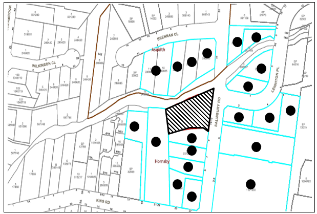
|
NOTIFICATION PLAN |
|||
|
• PROPERTIES NOTIFIED |
X SUBMISSIONS RECEIVED |
|
|
6. THE PUBLIC INTEREST
Section 4.15(1)(e) of the Act requires Council to consider “the public interest”.
The public interest is an overarching requirement, which includes the consideration of the matters discussed in this report. Implicit to the public interest is the achievement of future built outcomes adequately responding to and respecting the future desired outcomes expressed in environmental planning instruments and development control plans.
The application is considered to have satisfactorily addressed Council’s and relevant agencies’ criteria and would provide a development outcome that, on balance, would result in a positive impact for the community. Accordingly, it is considered that the approval of the proposed development would be in the public interest.
CONCLUSION
The application proposes the upgrade of the existing concrete batching plant equipment to increase the total annual production from 47,500 tonnes per year to 320,000 tonnes per year including demolition of existing batching infrastructure and construction of new batching house, modification to above ground storage bays, installation of conveyor system, aggregate hoppers, slump stands and washout area and 24-hour operation.
The development generally meets the desired outcomes of Council’s planning controls and is satisfactory having regard to the matters for consideration under Section 4.15 of the Environmental Planning and Assessment Act 1979.
Having regard to the circumstances of the case, approval/refusal of the application is recommended.
The reasons for this decision are:
· The proposed development complies with the requirements of the relevant environmental planning instruments and the Hornsby Development Control Plan 2013.
· The request under Clause 4.6 of the Hornsby Local Environmental Plan 2013 to vary the Maximum Building Height standard is well founded. Strict compliance with the development standard is unreasonable and unnecessary in the circumstances of the case and there are sufficient environmental planning grounds to justify the variation to the development standard.
· The proposed development does not create unreasonable environmental impacts to adjoining development with regard to visual bulk, overshadowing, solar access, amenity or privacy.
· The proposed development would facilitate the implementation of nearby infrastructure projects and be of positive economic impact.
Note: At the time of the completion of this planning report, no persons have made a Political Donations Disclosure Statement pursuant to Section 10.4 of the Environmental Planning and Assessment Act 1979 in respect of the subject planning application.
RESPONSIBLE OFFICER
The officer responsible for the preparation of this report is Matthew Miles.
|
Cassandra Williams Major Development Manager - Development Assessments Planning and Compliance Division |
Rod Pickles Manager - Development Assessments Planning and Compliance Division |
|
Locality Map |
|
|
|
|
Clause 4.6 Variation Request |
|
|
|
|
Revised Site Plan |
|
|
|
|
Demolition Plan |
|
|
File Reference: DA/1175/2018
Document Number: D07991045
SCHEDULE 1
GENERAL CONDITIONS
The conditions of consent within this notice of determination have been applied to ensure that the use of the land and/or building is carried out in such a manner that is consistent with the aims and objectives of the relevant legislation, planning instruments and Council policies affecting the land and does not disrupt the amenity of the neighbourhood or impact upon the environment.
Note: For the purpose of this consent, the term ‘applicant’ means any person who has the authority to act on or the benefit of the development consent.
Note: For the purpose of this consent, any reference to an Act, Regulation, Australian Standard or publication by a public authority shall be taken to mean the gazetted Act or Regulation or adopted Australian Standard or publication as in force on the date that the application for a construction certificate is made.
1. Approved Plans and Supporting Documentation
The development must be carried out in accordance with the plans and documentation listed below and endorsed with Council’s stamp, except where amended by Council and/or other conditions of this consent:
Approved Plans
|
Plan No. |
Plan Title |
Drawn by |
Dated |
Council Reference |
|
Drawing No.100 |
Demolition plan and general arrangement and site plan |
Able concrete and sand |
Feb 98 |
|
|
E1926-0001, Rev G |
Proposed plant layout day time |
CMQ Engineering Pty Ltd |
03.19 |
|
|
E1926-0031, Rev B |
Proposed plant layout night time |
CMQ Engineering Pty Ltd |
04.19 |
|
|
Plan No. E1926-0002, Rev B |
Proposed plant elevations |
CMQ Engineering Pty Ltd |
09.18 |
|
Supporting Documentation
|
Document Title |
Prepared by |
Dated |
Council Reference |
|
Water Management Plan No. 191267 Rev6 |
Benbow Environmental |
4.09.2020 |
D07993793 |
|
Acoustic report, 171178_NIA_Rev5 |
Benbow Environmental |
4.09.2020 |
D07993793 |
|
Air Quality report, 171178_AQIA_Rev4 |
Benbow Environmental |
4.09.2020 |
D07993793 |
|
EPA Conditions |
NSW EPA |
15.05.2020 |
D07917044 |
|
Survey plan |
C&A surveyors NSW |
23.03.2019 |
D07646091 |
|
General Terms of Approval, Ref No. IDAS1112500 |
Natural Resources Access Regulator |
21.05.2019 |
D07677211 |
2. Construction Certificate
a) A Construction Certificate is required to be approved by Council or a Private Certifying Authority prior to the commencement of any construction works under this consent.
b) The Construction Certificate plans must be consistent with the Development Consent plans.
3. Section 7.12 Development Contributions
(a) In accordance with Section 4.17(1) of the Environmental Planning and Assessment Act 1979 and the Hornsby Shire Council Section 7.12 Development Contributions Plan 2019-2029, $30,000 must be paid towards the provision, extension or augmentation of public amenities or public services, based on development costs of $3,000,000.
(b) The value of this contribution is current as of 10 September 2020. If the contributions are not paid within the financial quarter that this consent is granted, the contributions payable will be adjusted in accordance with the provisions of the Hornsby Shire Council Section 7.12 Development Contributions Plan and the amount payable will be calculated at the time of payment in the following manner:
|
$CPY |
= |
|
|
$CDC x CPIPY |
|
|
|
|
|
CPIDC |
Where:
$CPY is the amount of the contribution at the date of Payment.
$CDC is the amount of the contribution as set out in this Development Consent.
CPIPY is the latest release of the Consumer Price Index (Sydney – All Groups) at the date of Payment as published by the ABS.
CPIDC is the Consumer Price Index (Sydney – All Groups) for the financial quarter at the date of this Development Consent.
(c) The monetary contributions shall be paid to Council:
(i) Prior to the issue of the Subdivision Certificate where the development is for subdivision; or
(ii) Prior to the issue of the first Construction Certificate where the development is for building work; or
(iii) Prior to issue of the Subdivision Certificate or first Construction Certificate, whichever occurs first, where the development involves both subdivision and building work; or
(iv) Prior to the works commencing where the development does not require a Construction Certificate or Subdivision Certificate.
Note: It is the professional responsibility of the Principal Certifying Authority to ensure that the monetary contributions have been paid to Council in accordance with the above timeframes.
Note: The Hornsby Shire Council Section 7.12 Development Contributions Plan may be viewed at www.hornsby.nsw.gov.au or a copy may be inspected at Council’s Administration Centre during normal business hours.
REQUIREMENTS PRIOR TO THE ISSUE OF A CONSTRUCTION CERTIFICATE
All approved building work must be carried out in accordance with the relevant requirements of the Building Code of Australia.
5. Sydney Water – Approval
This application must be submitted to Sydney Water for approval to determine whether the development would affect any Sydney Water infrastructure, and whether further requirements are to be met.
Note: Building plan approvals can be obtained online via Sydney Water Tap inTM through www.sydneywater.com.au under the Building and Development tab.
6. Construction Management Plan (CMP)
To assist in the protection of the public, the environment and Council’s assets, a separate Construction Management Plan must be prepared by a suitably qualified environmental consultant in consultation with a qualified traffic engineer and AQF 5 arborist, and submitted to Council’s Compliance Team at compliance@hornsby.nsw.gov.au for review and approval according to the following requirements:
a) The CMP must detail the contact information for developers, builder, private certifier and any emergency details during and outside work hours.
b) A Construction Traffic Management Plan (CTMP) including the following:
i) The order of construction works and arrangement of all construction machines and vehicles being used during all stages.
ii) The CTMP plans shall be in accordance with all other plans submitted to Council as part of this development proposal.
iii) A statement confirming that no building materials, work sheds, vehicles, machines or the like shall be allowed to remain in the road reserve area without the written consent of Hornsby Shire Council.
iv) The Plan shall be in compliance with the requirements of the Roads and Maritime Services Traffic control at work sites Manual 2018 and detail:
a. Public notification of proposed works;
b. Long term signage requirements;
c. Short term (during actual works) signage;
d. Vehicle Movement Plans, where applicable;
e. Traffic Management Plans;
f. Pedestrian and Cyclist access and safety.
v) Traffic controls including those used during non-working hours. Pedestrian access and two-way traffic in the public road must be able to be facilitated at all times.
vi) Details of parking arrangements for all employees and contractors, including layover areas for large trucks during all stages of works. The parking or stopping of truck and dog vehicles associated with the development will not be permitted other than on the site and the plan must demonstrate this will be achieved.
vii) Confirmation that a street ‘scrub and dry’ service will be in operation during all stages of works.
viii) Proposed truck routes to and from the site including details of the frequency of truck movements for all stages of the development.
ix) Swept path analysis for ingress and egress of the site for all stages of works.
x) Site plans for all stages of works including the location of site sheds, concrete pump and crane locations, unloading and loading areas, waste and storage areas, existing survey marks, vehicle entry, surrounding pedestrian footpaths and hoarding (fencing) locations.
xi) The total quantity and size of trucks for all importation and exportation of fill on site throughout all stages of works, and a breakdown of total quantities of trucks for each stage of works.
xii) The number of weeks trucks will be accessing and leaving the site with excavated or imported fill material.
xiii) The maximum number of trucks travelling to and from the site on any given day for each stage of works.
xiv) The maximum number of truck movements on any given day during peak commuting periods for all stages of works.
xv) The source site location of any proposed fill to be imported to the site, for all stages of works.
xvi) The Plan must state that the applicant and all employees of contractors on the site must obey any direction or notice from the Prescribed Certifying Authority or Hornsby Shire Council in order to ensure the above.
xvii) If there is a requirement to obtain a Work Zone, Out of Hours permit, partial Road Closure or Crane Permit, the Plan must detail these requirements and include a statement that an application to Hornsby Shire Council will be made to obtain such a permit.
c) A Construction Waste Management Plan detailing the following:
i) Details of excavation of soil and fill, the classification of the fill, disposal methods and authorised disposal depots that will be used for the fill.
ii) Asbestos management requirement and procedures for removal and disposal from the site in accordance with AS 2601–2001 – ‘The Demolition of Structures’, and the Protection of the Environment Operations (Waste) Regulation 2005.
iii) General construction waste details including construction waste skip bin locations and litter management for workers.
e) A Construction Noise and Vibration Management Plan (CNMP) which includes:
i) Existing noise and vibration levels within the proximity of the proposed development site.
ii) Details of the extent of rock breaking or rock sawing works forming part of the proposed development works.
iii) The maximum level of noise and vibration predicted to be emitted during each stage of construction.
iv) The duration of each stage of works where the maximum level of noise and vibration are predicted to be emitted for.
v) Details of mitigation measures, inclusive of respite periods, that will meet acoustic standards and guidelines at each stage of works.
vi) Details of a complaints handling process for the surrounding neighbourhood for each stage of works.
f) Identification of approved sediment and erosion control measures.
REQUIREMENTS PRIOR TO THE COMMENCEMENT OF ANY WORKS
7. Erection of Construction Sign
a) A sign must be erected in a prominent position on any site on which any approved work is being carried out:
i) Showing the name, address and telephone number of the principal certifying authority for the work;
ii) Showing the name of the principal contractor (if any) for any demolition or building work and a telephone number on which that person may be contacted outside working hours; and
iii) Stating that unauthorised entry to the work site is prohibited.
b) The sign is to be maintained while the approved work is being carried out and must be removed when the work has been completed.
8. Protection of Adjoining Areas
A temporary hoarding, fence or awning must be erected between the work site and adjoining lands before the works begin and must be kept in place until after the completion of the works if the works:
a) Could cause a danger, obstruction or inconvenience to pedestrian or vehicular traffic;
b) Could cause damage to adjoining lands by falling objects; and/or
c) Involve the enclosure of a public place or part of a public place.
Note: Notwithstanding the above, Council’s separate written approval is required prior to the erection of any structure or other obstruction on public land.
9. Toilet Facilities
a) To provide a safe and hygienic workplace, toilet facilities must be available or be installed at the works site before works begin and must be maintained until the works are completed at a ratio of one toilet for every 20 persons employed at the site.
b) Each toilet must:
i) Be a standard flushing toilet connected to a public sewer; or
ii) Be a temporary chemical closet approved under the Local Government Act 1993; or
iii) Have an on-site effluent disposal system approved under the Local Government Act 1993.
10. Erosion and Sediment Control
To protect the water quality of the downstream environment, erosion and sediment control measures must be provided and maintained throughout the construction period in accordance with the manual ‘Soils and Construction 2004 (Bluebook)’, the approved plans, Council specifications and to the satisfaction of the principal certifying authority. The erosion and sediment control devices must remain in place until the site has been stabilised and revegetated.
Note: On the spot penalties may be issued for any non-compliance with this requirement without any further notification or warning.
REQUIREMENTS DURING DEMOLITION AND CONSTRUCTION
11. Construction Work Hours
All works on site, including demolition and earth works, must only occur between 7am and 5pm Monday to Saturday.
No work is to be undertaken on Sundays or public holidays.
12. Demolition
To protect the surrounding environment, all demolition work must be carried out in accordance with Australian Standard AS2601-2001 Demolition of structures and the following requirements:
a) Demolition material must be disposed of to an authorised recycling and/or waste disposal site and/or in accordance with an approved waste management plan; and
b) Demolition works, where asbestos material is being removed, must be undertaken by a contractor that holds an appropriate licence issued by SafeWork NSW in accordance with the Work Health and Safety Regulation 2017 and be appropriately transported and disposed of in accordance with the Protection of the Environment Operations (Waste) Regulation 2014; and
c) On construction sites where any building contains asbestos material, a standard commercially manufactured sign containing the words ‘DANGER ASBESTOS REMOVAL IN PROGRESS’ and measuring not less than 400mm x 300mm must be displayed in a prominent position visible from the street.
13. Environmental Management
The site must be managed in accordance with the publication ‘Managing Urban Stormwater – Landcom (March 2004) and the Protection of the Environment Operations Act 1997 by way of implementing appropriate measures. To prevent sediment run-off, excessive dust, noise or odour emanating from the site during the construction of the development.
To protect the surrounding environment, Street sweeping must be undertaken following sediment tracking from the site along Salisbury Road and surrounding streets during works and until the site is established.
The street cleaning services must undertake a street ‘scrub and dry’ method of service and not a dry sweeping service that may cause sediment tracking to spread or cause a dust nuisance.
15. Council Property
To ensure that the public reserve is kept in a clean, tidy and safe condition during construction works, no building materials, waste, machinery or related matter is to be stored on the road or footpath.
16. Waste
a) All waste for construction and demolition as operational activities must be classified in accordance with the Waste Classification Guidelines, published by the EPA and as in force from time to time, and lawfully disposed of.
b) Waste must be managed on site so that dust and noise is minimised. Breaking up of set waste concrete should be avoided.
17. Landfill not Permitted
The importation of fill material associated with earthworks, or structural or engineering works, is not permitted as part of this consent.
18. Excavated Material
All excavated material removed from the site must be classified by a suitably qualified environmental consultant in accordance with the NSW Environment Protection Authority’s Waste Classification Guidelines and Protection of the Environment Operations (Waste) Regulation 2014 prior to disposal to a licensed waste management facility. Tipping dockets for the total volume of excavated material that are received from the licensed waste management facility must be provided to the principal certifying authority prior to the issue of an Occupation Certificate.
19. Compliance with Construction Management Plan
The Council approved Construction Management Plan must be complied with for the duration of works, unless otherwise approved by Council.
REQUIREMENTS PRIOR TO THE ISSUE OF AN OCCUPATION CERTIFICATE
20. Damage to Council Assets
To protect public property and infrastructure, any damage caused to Council’s assets as a result of the construction or demolition of the development must be rectified by the applicant in accordance with AUS-SPEC Specifications (www.hornsby.nsw.gov.au/property/build/aus-spec-terms-and-conditions. Rectification works must be undertaken prior to the issue of an Occupation Certificate, or sooner, as directed by Council.
21. Trade Waste – Cementitious Catchment
Liquid trade waste generated from the cementitious catchment system must be reused onsite or discharged in accordance with a trade waste agreement with Sydney Water and by a licensed liquid trade waste contractor.
22. Submission of Excavated Material Tipping Dockets to Principal Certifying Authority
Tipping dockets for the total volume of excavated material that are received from the licensed waste facility must be provided to the Principal Certifying Authority prior to the issue of an Occupation Certificate.
23. Certification of Air Quality control measures
Prior to the issue of an occupation certificate, certification is to be provided to the Principal Certifying Authority that the air quality control measures specified in the Air Quality Impact Assessment prepared by Benbow dated 4 September 2020 have been appropriately installed, confirming:
a) Material conveyors are fully covered, rather than partially; and
b) All overhead silos and hoppers are fully enclosed, including a roof; and
c) All silos and hoppers have over fill and auto shut‐off protection fitted.
24. Certification of Acoustic treatments and control measures
Prior to the issue of an occupation certificate, certification is to be provided to the Principal Certifying Authority confirming that the acoustic treatments control measures specified in the Noise Impact Assessment prepared by Benbow dated 4 September 2020 have been appropriately installed and confirming;
a) The installation of a 4m noise wall around the western slump stand, in accordance with figure 6-1; and
b) The cement transfer blower has been installed inside the batching house; and
c) The batching house has been constructed of a material with a minimum RW of 22dB; and
d) Automatic doors have been installed on the batching house and
e) An operational noise management plan has been prepared by a suitably qualified acoustic consultant and includes measures to reduce noise impacts from vehicle movements. The management plan is to be made available to Council and the EPA upon request.
OPERATIONAL CONDITIONS
25. Operational Hours and Restrictions
This consent allows the facility to operate for 24 hours as follows:
b) Front end loaders, outdoor cement blowers, aggregate hopper loading, and conveyors are not permitted to operate during the evening and night periods (6pm to 7am).
c) Concrete trucks are not permitted to enter or exit the site during the evening and night periods (6pm -7am)
d) Trucks are not permitted to queue on or around surrounding roads within the vicinity of the development, this is inclusive of residential streets used to access the site.
26. Monitoring and Management
The proponent must submit to Council, prior to the commencement of operations under this consent and every 12 months after the endorsed date of this consent, an Environmental Management Plan in which Council is to approve expressing their satisfaction of the overall performance and management of the operation.
The Environmental Management Plan should refer to the objectives and principles of Ecologically Sustainable Development and address the following matters:
a) Acquisition of all necessary licences and permits and an indication of how compliance with licensing and approval requirements will be achieved and due diligence attained.
b) On site materials Management including management of operational impacts and if appropriate, include such as:
i) Management of explosives, chemicals and fuel and their use,
ii) Maintenance and site security plans,
c) Water Management.
d) Acoustic Management.
e) Air quality Management.
f) Transport routes, access & movements.
g) Soil Conservation including geo-technical appraisal of tailing systems and erosion and sediment controls.
h) Social impact management including consultation with community groups, nearby residents and monitoring of complaints received.
i) Identification, assessment and evaluation of risks, safeguards and the confidence level of contingency / emergency plans.
j) Statement of Compliance with the approved EIS documentation, conditions of this consent and the objectives of Councils DCP – Part 5 Industrial.
k) Advice and recommendations of all relevant state government agencies.
l) Reference to International Standards (ISO) 14001-14004 relating to Environmental Management Systems, which should address issues such as:
i) The capacity and support mechanisms necessary to implement and achieve the proponent company’s environmental policy, objectives and targets; and
ii) The means by which the proponent company measure, monitor and evaluate its environmental performance.
m) Recommendations to adjust operation procedures to improve the overall performance of the operations.
n) Strategies to feed information from the monitoring program back into the management practices and action plans to improve the environmental performance and sustainability of all components of the proposal.
o) Training programs for operational staff and incentives for environmentally sound performance.
Note: The review and approval of these documents may incur a fee in line with Councils Fees and Charges.
27. Compliance with Air Quality Impact Recommendations
The recommendations specified within the Council approved Air Quality Impact Assessment prepared by Benbow dated 4 September 2020 is to be complied with in perpetuity, unless otherwise approved by Council.
28. Compliance with Water Management Plan
The recommendations specified within the Council approved Water Management Plan prepared by Benbow dated 4 September 2020 must be complied with in perpetuity, unless otherwise approved by Council.
29. Compliance with the Noise Impact Assessment recommendations
The recommendations specified within the Council approved Noise Impact Assessment prepared by Benbow dated 4 September 2020 must be complied with in perpetuity, unless otherwise approved by Council.
30. Noise
All noise generated by the proposed development must be attenuated to prevent levels of noise being emitted to adjacent premises which possess tonal, beating and similar characteristics or which exceeds background noise levels by more than 5dB(A).
31. Parking and site distances
a) Any proposed landscaping and/or fencing must not restrict sight distance to pedestrians and cyclists travelling along the footpath.
b) Motorcycle parking spaces are to be designed in accordance with AS/NZS 2890.1:2004 Figure 2.7.
32. Restriction on Truck movement
No vehicle with total weight of 3 Tons or more should use Sherbrook Road between Bridge Road and Baldwin Avenue to access or leave the site.
33. Materials storage and handling
Failsafe controls must be installed on overhead storage silos to prevent overfilling and accidental emission of cement or fly ash.
GENERAL TERMS OF APPROVAL - NATURAL RESOURCES ACCESS REGULATOR
The following conditions of consent are General Terms of Approval from the nominated State Agency pursuant to Section 4.47 of the Environmental Planning and Assessment Act 1979 and must be complied with to the satisfaction of that Agency.
34. Design of works and structures
Before commencing any proposed controlled activity on waterfront land, an application must be submitted to Natural Resources Access Regulator, and obtained, for a controlled activity approval under the Water Management Act 2000.
35. Erosion and sediment controls
The following plan(s): - Erosion and Sediment Controls Plan must be:
a) Prepared in accordance with Managing Urban Stormwater: Soils and Construction, Volume 1 (Landcom, 2004), as amended or replaced from time to time, and
b) Submitted with an application for a controlled activity approval.
36. Plans, standards and guidelines
a) This General Terms of Approval (GTA) only applies to the proposed activity described in the plans and associated documents found in Schedule One, relating to Development Application 2019 provided by Council to Natural Resources Access Regulator.
b) Any amendments or modifications to the proposed activity may render the GTA invalid. If the proposed controlled activity is amended or modified, Natural Resources Access Regulator, Parramatta Office, must be notified in writing to determine if any variations to the GTA will be required.
c) The application for a controlled activity approval must include the following document(s):
i) Outlet structures.
ii) Erosion and Sediment Control Plan.
iii) Soil and Water Management Plan.
37. Reporting requirements
The consent holder must inform Natural Resources Access Regulator in writing when the proposed construction of the controlled activity has been completed.
38. Site Plan
The plans and associated documentation listed in this schedule are referred to in general terms of approval (GTA) issued by NRAR for integrated development associated with DA1175/2018 as provided by Council:
a) Site Plan Proposed
ADVISORY NOTES
The following information is provided for your assistance to ensure compliance with the Environmental Planning and Assessment Act, 1979, Environmental Planning and Assessment Regulation 2000, other relevant legislation and Council’s policies and specifications. This information does not form part of the conditions of development consent pursuant to Section 4.17 of the Act.
Environmental Planning and Assessment Act 1979 Requirements
The Environmental Planning and Assessment Act 1979 requires:
· The issue of a construction certificate prior to the commencement of any works. Enquiries can be made to Council’s Customer Services Branch on 9847 6760.
· A principal certifying authority to be nominated and Council notified of that appointment prior to the commencement of any works.
· Council to be given at least two days written notice prior to the commencement of any works.
· Mandatory inspections of nominated stages of the construction inspected.
· An occupation certificate to be issued before occupying any building or commencing the use of the land.
Long Service Levy
In accordance with Section 34 of the Building and Construction Industry Long Service Payments Act 1986, a ‘Long Service Levy’ must be paid to the Long Service Payments Corporation or Hornsby Council.
Note: The rate of the Long Service Levy is 0.35% of the total cost of the work.
Note: Hornsby Council requires the payment of the Long Service Levy prior to the issue of a construction certificate.
Tree and Vegetation Preservation
Hornsby Development Control Plan 2013 Tree and Vegetation Preservation provisions have been developed under Council’s authorities contained in State Environmental Planning Policy (Vegetation in Non-Rural Areas) 2017 and the Environmental Planning and Assessment Act 1979.
In accordance with these provisions a person must not cut down, fell, uproot, kill, poison, ringbark, burn or otherwise destroy the vegetation, lop or otherwise remove a substantial part of the trees or vegetation to which any such development control plan applies without the authority conferred by a development consent or a permit granted by Council.
Fines may be imposed for non-compliance with the Hornsby Development Control Plan 2013.
Note: A tree is defined as a long lived, woody perennial plant with one or relatively few main stems with the potential to grow to a height greater than three metres (3m). (HDCP 1B.6.1.c).
The applicant’s attention is drawn to the existence of the Disability Discrimination Act 1992. A construction certificate is required to be obtained for the proposed building/s, which will provide consideration under the Building Code of Australia, however, the development may not comply with the requirements of the Disability Discrimination Act 1992. This is the sole responsibility of the applicant.
The land upon which the subject building is to be constructed may be affected by restrictive covenants. Council issues this approval without enquiry as to whether any restrictive covenant affecting the land would be breached by the construction of the building, the subject of this consent. Applicants must rely on their own enquiries as to whether or not the building breaches any such covenant.
Dial Before You Dig
Prior to commencing any works, the applicant is encouraged to contact Dial Before You Dig on 1100 or www.dialbeforeyoudig.com.au for free information on potential underground pipes and cables within the vicinity of the development site.
Telecommunications Act 1997 (Commonwealth)
If you are aware of any works or proposed works which may affect or impact on Telstra’s assets in any way, you are required to contact: Telstra’s Network Integrity Team on Phone Number 1800810443.
Asbestos Warning
Should asbestos or asbestos products be encountered during demolition or construction works, you are advised to seek advice and information prior to disturbing this material. It is recommended that a contractor holding an asbestos-handling permit (issued by SafeWork NSW) be engaged to manage the proper handling of this material. Further information regarding the safe handling and removal of asbestos can be found at:
Alternatively, telephone the SafeWork NSW on 13 10 50.
LPP Report No. LPP25/20
Local Planning Panel
Date of Meeting: 30/09/2020
3 DEVELOPMENT APPLICATION - DEMOLITION OF EXISTING STRUCTURES AND TORRENS TITLE SUBDIVISION OF THREE LOTS INTO FOUR - 1131 - 1133 PACIFIC HIGHWAY, COWAN
EXECUTIVE SUMMARY
|
DA No: |
DA/1072/2018 (Lodged on 19 October 2018) |
|
Description: |
Demolition of existing structures and Torrens title subdivision of three lots into four |
|
Property: |
Lot 1 DP 576031, Lot 2 DP 576031 and Lot 1 DP 203139, Nos. 1131-1133 Pacific Highway, Cowan |
|
Applicant: |
Mr Stuart Crabb |
|
Owner: |
Tardos Investments Pty Ltd |
|
Estimated Value: |
$100,000 |
|
Ward: |
A |
· The application involves the demolition of existing structures and Torrens title subdivision of three lots into four.
· The proposal does not comply with Clause 4.1 Minimum Subdivision Lot Size under the Hornsby Local Environmental Plan 2013 and the applicant has not made a submission in accordance with Clause 4.6 ‘Exceptions to development standards’ of the Hornsby Local Environmental Plan 2013 to vary the development standard.
· The proposal does not comply with State Environmental Planning Policy No.55 Remediation of Land in that there is insufficient information to assess the proposal.
· No submissions were received in respect of the application during the notification period.
· The application is required to be determined by the Hornsby Council Local Planning Panel as the variation to the development standard (minimum lot size) is greater than 10 percent.
· It is recommended that the application be refused.
|
THAT Development Application No. 1072/2018 for demolition of existing structures and Torrens title subdivision of three lots into four at Lot 1 DP 576031, Lot 2 576031 and Lot 1 DP 203139 be refused for the reasons detailed in Schedule 1 of LPP Report No. LPP25/20 |
Site HiSTORY
A review of aerial photos from 1961 show a service station and a kiosk situated on the western side of the site. The images show two separate dispensing bowsers identified in the middle of the site.
On 10 July 1975, Council granted consent No.86/1975 for the conversion of a Caltex Service Station into a showroom for the display, repair workshop and sale of boats and marine equipment and a caretaker residence, subject to conditions.
On 23 July 1975, Council approved a Building Application BA/257/1975 for an extension to the boat sales showroom.
On 28 September 2018, DA/943/2018 for the Torrens title subdivision of three lots into four at the site was rejected by Council in accordance with Schedule 1 of the Environmental Planning and Assessment Regulation 2000 and a lack of information with respect to a contamination report.
Application BACKGROUND
A preliminary contamination report prepared by ERM Services on the 18th October 2018 was provided with the application. The preliminary report identified potential for contamination, raising concerns over the lack of information regarding the status of the Underground Storage Tanks and recommending that a detailed contamination investigation take place.
On 10 January 2019, Council requested a Detailed Site Investigation report in accordance with the NSW Environment Protection Authority’s Contaminated Sites – Guidelines on Significant Risk of Harm from Contaminated Land and a Remedial Action Plan (RAP).
In addition to this information, the NSW Rural Fire Service (RFS) requested owners consent and details of the proposed Asset Protection Zone (APZ) easement over adjoining land to the west.
On 6 February 2019, Council requested further information and amendment to plans in response to a Roads and Maritime Services (RMS) request that the development be re-designed so that “the new residential lots have single shared access and that all vehicles enter and leave the site in a forward direction”.
On 6 February 2019, Council officers held a meeting at Council with the applicant to discuss the latest requests from Council, RMS and the RFS.
On 5 April 2019, the applicant submitted an email response from the Metropolitan Local Aboriginal Land Council (MLALC) dated 31/08/2018 giving approval, in principal, for the proposed easement for an APZ over their land to the west of the site.
On 18 April 2019, the applicant submitted revised engineering plans which were forwarded to the RMS for their concurrence.
On 29 April 2019, the applicant submitted revised subdivision plans to Council showing two shared driveways to service the four proposed lots off Pacific Highway.
On 29 April 2019, the RFS responded to Council stating the information regarding the APZ easement was insufficient and this information was forwarded onto the applicant.
In May 2019, the applicant directly liaised with the RFS in regard to the requirements for an APZ on adjoining land.
On 20 May 2019, the RFS responded to Council granting General Terms of Approval and conditions requiring the formalisation of the easement over adjoining land and a Positive Covenant for the Inner Protection Area should the application be approved.
On 28 May 2019, Council sent an email to the applicant requesting an update on the Detailed Site Investigation report as requested in January 2019.
On 5 June 2019, the applicant submitted a Preliminary Site Investigation report (dated 3/06/2019).
On 24 June 2019, a new applicant (Stuart Crabb) was appointed and replaced the previous applicant Vogue Construction (applicant).
On 4 July 2019, Council received concurrence from RMS referencing the design for two shared driveways on engineering plans, Issue C prepared by Australian Consulting Engineers.
On 4 July 2019, Council sent a letter request stating that the Preliminary Site Investigation report was insufficient and noted a number of discrepancies. Council requested a Detailed Site Investigation report (Stage 2) be prepared and a Remedial Action Plan (RAP).
On 8 August 2019, the applicant submitted a Detailed Site and Soil/UPSS Investigation report (dated 25/07/2019).
On 23 August 2019, the application provided a letter prepared by iEnvironmental Australia in response to Council’s letter identifying discrepancies with the report.
On 12 September 2019, Council responded stating that the information within the Detailed Site Investigation report was insufficient and that further sampling of the site be carried out in accordance with the EPA sampling guidelines.
On 15 October 2019, the applicant’s environmental consultant sent an email requesting that approval be given subject to a condition that additional contamination testing and remediation works be requested as a condition of consent.
On 16 October 2019, Council emailed the applicant advising that approval of the proposed development cannot be supported without the appropriate contamination testing and remediation of the site, noting the history of the site as a petrol station and boat repair shop. Council also stated the application would be determined after 14 days if the appropriate information had not been provided.
On 21 October 2019, Council called the applicant to inform him the application would progress to being determined if information was not forthcoming and offered that the application be withdrawn. The applicant requested greater time to submit a response to Council which was granted given the circumstances of this application.
Council did not receive any correspondence from the applicant during November 2019.
In December 2019, Council noted that the submitted subdivision plan and supporting information including the Statement of Environmental Effects had not correctly considered the split zoning of R2 and SP2 area on the site in its calculation of individual lot sizes.
On 9 December 2019, Council submitted a further letter requesting a revised subdivision plan confirming the lot sizes, confirmation of the calculation of minimum lot size given the split zone and a Clause 4.6 Exceptions to development standards submission. The letter suggested the applicant engage an appropriate planning consultant to assist in writing the submission and for the outstanding contamination report and remedial action plan.
In January 2020, Council requested an update from the applicant.
On 6 January 2020, the applicant stated that there was a personal funding issue and that he was in the midst of engaging a planner to assist.
On 26 February 2020, the applicant advised that Don Fox Planning (DFP) was engaged as the planning consultant to provide the required information.
On 1 March 2020, Council liaised with the applicant’s planner on the phone and discussed all outstanding information that was required that had not been provided to date.
On 22 April 2020, the applicant submitted a contamination report fee quote and scope of works document.
On 23 April 2020, Council responded to the email stating that Councils previous letter requests still apply which include the correct number of test sampling point across the site in accordance with the EPA sampling guidelines and at the completion of additional sampling a remedial action plan (RAP) outlining all recommendations (letter dated August 2019).
On 7 May 2020, Council requested an update from the applicant and consulting planner.
On 8 May 2020, the applicant’s planner advised that there was a delay due to COVID-19 restrictions and that the requested information would be submitted to Council by the end of May 2020.
Council did not receive any correspondence from the applicant or planning consultant in May 2020.
On 22 June 2020, Council received a revised subdivision plan (dated 24/3/2020) from a draftsperson with no description. Council sent an email to the planning consultant and applicant asking for an explanation and requesting an update.
On 22 June 2020, the applicants planning consultant replied to the email stating that a full package of information would be submitted to Council.
Since then Council has not received any correspondence with respect to the requested information from the applicant or the applicant’s planning consultant.
In June 2020, Council received a phone call and email from the owner of the site who advised Council that the nominated applicant may be relinquished from the application due to funding issues.
Council did not receive any correspondence from the applicant during July 2020.
On 3 September 2020, the application was brought to Council’s Development Advisory Panel (DAP) who recommended that given the length of time taken to provide Council with satisfactory information the application should progress to being determined.
On 3 September 2020, Council sent a letter request to both the applicant and owner of the site which stated that if the requested information was not submitted to Council by the 10 September 2020, the application would proceed to be determined at the Local Planning Panel meeting on 30 September 2020. Council again gave the opportunity for the application to also be withdrawn and for a partial refund of assessment fees.
Council also called the applicant and owner to advise them of Council’s letter and final position on the matter.
The requested information was not provided during that time and has not been provided to date.
SITE
The 2,428m2 rectangular site is located western side of Pacific Highway, Cowan and currently comprises a single storey dwelling used as a shop for boat and marine equipment. The site is relatively flat with a gradual fall of 2 metres to the rear western boundary.
The site is comprised of three allotments legally described as Lot 1 and Lot 2 DP 576031, which are both zoned residential and Lot 1 DP 203139 which is zoned as SP2 Infrastructure. This portion of the land is no longer required by the RMS.
The site has a frontage of 60 metres to Pacific Highway and a depth of 28.9 metres.
The site is identified as bushfire prone land.
The site is not identified as a flood prone. The site is not burdened or benefitted by any easements or restrictions.
The site also has a number of exotic trees across the site and along its boundaries. The site is located adjacent to Narrow Leaved Scribbly Gum Woodland and Peppermint Angophora Forest within a bushland area owned by Metropolitan Local Aboriginal Land Council (MLALC).
A fire trail entrance is located in the Crown land to the north and continues southward parallel with the subject site and adjacent lands.
PROPOSAL
The application proposes the demolition of existing structures, Torrens Titles subdivision of three lots into four allotments as follows:
· Proposed Lot A would have a total area of 607.15m2
· Proposed Lot B would have a total area of 607.15m2
· Proposed Lot C would have a total area of 607.15m2
· Proposed Lot D would have a total area of 606.81m2
The proposed lots would have access from Pacific Highway via two shared driveways. Each lot would have a turning bay to allow for entry and exit in a forward direction.
Ten trees would be removed as a result of the development.
ASSESSMENT
The development application has been assessed having regard to the Greater Sydney Region Plan – A Metropolis of Three Cities, the North District Plan and the matters for consideration prescribed under Section 4.15 of the Environmental Planning and Assessment Act 1979 (the Act). The following issues have been identified for further consideration.
1. STRATEGIC CONTEXT
1.1 Greater Sydney Region Plan - A Metropolis of Three Cities and North District Plan
The Greater Sydney Region Plan - A Metropolis of Three Cities has been prepared by the NSW State Government to guide land use planning decisions for the next 40 years (to 2056). The Plan sets a strategy and actions for accommodating Sydney’s future population growth and identifies dwelling targets to ensure supply meets demand. The Plan also identifies that the most suitable areas for new housing are in locations close to jobs, public transport, community facilities and services.
The NSW Government will use the subregional planning process to define objectives and set goals for job creation, housing supply and choice in each subregion. Hornsby Shire has been grouped with Hunters Hill, Ku-ring-gai, Lane Cove, Mosman, North Sydney, Ryde, Northern Beaches and Willoughby to form the North District. The Greater Sydney Commission has released the North District Plan which includes priorities and actions for Northern District for the next 20 years. The identified challenge for Hornsby Shire will be to provide an additional 4,350 dwellings by 2021 with further strategic supply targets to be identified to deliver 97,000 additional dwellings in the North District by 2036.
The proposed development would be consistent with the Greater Sydney Region Plan - A Metropolis of Three Cities and the North District Plan and Planning Priority N5 in that the development would provide additional housing allotments, subject to addressing the issue of site contamination and complying with the minimum lot size development standard.
2. STATUTORY CONTROLS
Section 4.15(1)(a) requires Council to consider “any relevant environmental planning instruments, draft environmental planning instruments, development control plans, planning agreements and regulations”.
2.1 Hornsby Local Environmental Plan 2013
The proposed development has been assessed having regard to the provisions of the Hornsby Local Environmental Plan 2013 (HLEP).
2.1.1 Zoning of Land and Permissibility
The subject land is zoned both R2 Low Density Residential and SP2 Infrastructure under the HLEP. The objectives of the R2 zone are:
· To provide for the housing needs of the community within a low-density residential environment.
· To enable other land uses that provide facilities or services to meet the day to day needs of residents.
The proposed development is defined as ‘subdivision’ and ‘demolition’ which is permissible in the zone with Council’s consent.
Whilst the proposed development would provide for an additional allotments Council is not satisfied the proposed development would be consistent with the low-density residential character given the previous commercial use of the land as a petrol station and boat repair shop and the application has failed to demonstrate that the site can be remediated for the intended residential use.
The proposal has failed to demonstrate that the lots would meet the objectives of the R2 Low Density Zone under the HLEP.
The objectives of the SP2 zone are:
· To provide for infrastructure and related uses.
· To prevent development that is not compatible with or that may detract from the provision of infrastructure.
Letters received in 2019 from NSW Roads and Maritime Services (RMS) did not indicate any special use of the SP2 zoned portion of the land.
On 17 December 2019, Council received confirmation from Transport for NSW (TfNSW), formerly known as RMS, that stated the SP2 area within the allotment is not required for any current infrastructure project and is not affected by any future acquisition of land by TfNSW.
In this instance, the use of the SP2 portion of the site would be dedicated to being used for the shared driveway to service each allotment.
2.1.2 Minimum Lot Size
Clause 4.1 of the HLEP states that the minimum lot size applicable to the R2 Low Density land zone as indicated on the HLEP map is 600m2.
A Subdivision Plan dated 10 September 2018 prepared by Project Services was submitted with the original application which indicated each lot achieved the 600m2 minimum lot size with an individual access to Pacific Highway for each allotment. The lot design on these plans did not indicate the split SP2 and R2 zoning of the site.
Engineering plans were submitted to Council and prepared by Australian Consulting Engineers (dated 18/04/2019) which indicated two driveways from Pacific Highway which would be shared (one driveway to service two lots) and allow for ingress and egress in a forward direction. The lot design on these plans did not indicate the split SP2 and R2 zoning of the site.
On 22 June 2020, Council received a revised subdivision plan prepared by Wollongong Drafting which showed two shared driveways and indicative building envelopes within the R2 portion of the site. The subdivision plan indicated the following zoning calculations:
· Lot A would have R2 area of 434m2 and SP2 of 173.15m2
· Lot B would have an R2 area of 436.97m2 and an SP2 area of 170.18m2
· Lot C would have an R2 area of 436.97m2 and an SP2 area of 170.18m2
· Lot D would have an R2 area of 436.68m2 and an SP2 area of 170.13m2
Given the SP2 land zone does not have a prescribed minimum lot size under the HLEP, Council would rely on the R2 component of the site for the lot size calculation. The proposed subdivision plan indicates that the R2 component of each allotment would not meet the minimum lot size requirement of 600m2 under the HLEP.
Council notes that the engineering plans (dated 18/4/2019) demonstrate a different driveway turning area than the latest proposed subdivision plan.
As such, the development does not satisfy the objectives of Clause 4.1 Minimum Subdivision Lot Size under the HLEP.
Given the above, a Clause 4.6 submission was requested by Council. To date, Council has also not received a Clause 4.6 Exceptions to Development Standards submission with the application as discussed below at Section 2.1.3 of this report.
2.1.3 Exceptions to Development Standards
The application has been assessed against the requirements of Clause 4.6 of the HLEP. This clause provides flexibility in the application of the development standards in circumstances where strict compliance with those standards would, in any particular case, be unreasonable or unnecessary or tender to hinder the attainment of the objectives of the zone.
The proposed development does not comply with the minimum lot size requirement of 600m2.
The applicant has not made a submission to seek a variation to Council’s development standards in accordance with Clause 4.6 of the HLEP. The variation can therefore not be considered by Council.
2.1.4 Heritage Conservation
Clause 5.10 of the HLEP sets out heritage conservation provisions for Hornsby Shire. The site does not include a heritage item and is not located in a heritage conservation area. The subject site and the adjoining land to the west does not indicate the presence of any aboriginal heritage or archaeological items.
2.1.5 Earthworks
Clause 6.2 of the HLEP states that consent is required for proposed earthworks on site. Before granting consent for earthworks, Council is required to assess the impacts of the works on adjoining properties, drainage patterns and soil stability of the locality.
Council’s assessment of the proposed works and excavation concludes that only construction of the shared driveway would be required as part of the proposed subdivision works. Given the slope of the land which is relatively flat along the frontage, the proposal would drain to Councils street drainage system once dwellings are proposed on the lots.
Council notes that the engineering plans (dated 18/4/2019) demonstrate a different turning area arrangement than the latest proposed subdivision plan. If the application were to be approved Council would request updated engineering plans to be consistent with the latest subdivision plan.
2.2 State Environmental Planning Policy No. 55 Remediation of Land
State Environmental Planning Policy No. 55 Remediation of Land (SEPP 55) requires that Council must not consent to the carrying out of any development on land unless it has considered whether the land is contaminated or requires remediation for the proposed use.
Part 6 of SEPP 55 states:
In preparing an environmental planning instrument, a planning authority is not to include in a particular zone (within the meaning of the instrument) any land specified in subclause (4) if the inclusion of the land in that zone would permit a change of use of the land, unless:
(a) The planning authority has considered whether the land is contaminated, and
(b) If the land is contaminated, the planning authority is satisfied that the land is suitable in its contaminated state (or will be suitable, after remediation) for all the purposes for which land in the zone concerned is permitted to be used, and
(c) If the land requires remediation to be made suitable for any purpose for which land in that zone is permitted to be used, the planning authority is satisfied that the land will be so remediated before the land is used for that purpose.
A search of Council records and aerial photos indicated the site was previously a Caltex Petrol station until 1973 and is currently a showroom, boat parts and repair shop which has been operating since 1975.
On 8 August 2019, the applicant submitted a Detailed Site and Soil/UPSS Investigation report (DSI) dated 25 July 2019, prepared by iEnvironmental Australia which tested 4 soil locations and 1 groundwater sample.
The applicant’s consultants visited the site to undertake soil sampling targeting the 4 soil sample locations (3 on site and 1 on adjoining land) which were adjacent to the Underground Petroleum Storage System (UPSS) used previously by the Caltex Petrol Station. Ground penetrating radar (GPR) confirmed the 5 underground storage tanks (USTs) (including 1 x 4,500L and 4 x 18,000L) were still present in the ground, but disconnected and likely abandoned. In total, 10 primary soil samples were collected using auger sampling from the 4 locations at depths of 0.5 metres below ground surface (mbgs) and 1 groundwater sample was collected from a borehole. The site investigation report recommended the following based on their findings:
· It is preferable that soil should be excavated up to a depth of 1.0 mbgs in the area surrounding the bowsers and fuel lines during the resurfacing process as part of the development of residential dwellings onsite and clay layering should be carried out during the resurfacing process to create a capping of the soil; and
· The USTs and all remaining parts of the UPSS should be removed prior to commencement of residential use of the site and surrounding soil validated.
On 21 August 2019, Council raised the following concerns, requesting clarification and further testing in a letter which stated:
· The site is approximately 0.2 hectares in size. The number of sampling points recommended for an allotment this size is 7. The EPA definition of sampling point is ‘The lateral location at which a soil sample is collected’. 4 bore holes were tested, 3 on site and 1 located to the north-west of the rear allotment boundary. Although testing was carried out at various depths at each bore hole, the previous use of the site as a service station warrants further sample locations to be conducted.
· Only 1 ground water sample was collected and tested. Additional ground water samples should be collected and tested due to the site previously being used as a service station with the UST’s still insitu.
· The recommendation to excavate the soil up to a depth of 1.0 mbgs in the area surrounding the bowsers and fuel lines during the resurfacing process and proposed clay layering to cap the site is not clear. Further detailed information regarding the dimensions and locality of this process on the site should be submitted for assessment.
On 23 August 2018, the applicant submitted a letter responding to Councils request. The consultant clarified discrepancies within the Site Investigation report stating, “our report will be reissued after confirmation”. In response to Council’s request for further testing to be undertaken in accordance with the EPA guidelines the applicant’s letter stated:
The argument for 7 sample locations is likely based on AS4482.1 Table E1, Circular Hotspots. AS4482.1 states that consultants’ judgement should be used. This investigation was based on a targeted approach of the single identified contamination source, confirmed during sampling to be the disused UPSS. As such a targeted (non-randomised) sampling program was developed, using site history, regional and government database information, and ground-penetrating radar information. Additionally, the sample results across the site is in proximity to the UPSS, and all soils (clays and weathered rock) sampled at or below the encountered groundwater level were all below detection.
Since that time Council has not received the revised contamination report from the applicant despite the above comment.
On 12 September 2019, Council sent a letter request and concluded that insufficient sampling had been carried out on site in accordance with the EPA sampling guidelines for the allotment size. Council again requested further testing to be carried out to accurately ascertain how the site would be made suitable for residential use. The Council letter requested the following:
1. Further sampling of the site is to be carried out in accordance with the EPA sampling guidelines.
2. At the completion of additional sampling and analysis, a revised detailed site investigation report shall be submitted to Council for assessment.
3. At the completion of additional sampling a remedial action plan (RAP) outlining all recommendations made within the report shall be submitted to Council for assessment.
Council sent a final letter request on the 3rd September 2020 which indicated that the above information was outstanding. Council stated that given the length of time and opportunity given to address these matters Council requests that the additional information requested above be provided within 7 days from the date of this letter (due by 10 September 2020). If no such information is provided Council must proceed to put the application up to be determined at the Local Planning Panel meeting on the 30 September 2020.
Given the insufficient number of test sample points across the site (being only 3) and recommendations made within the report suggesting excavation and capping the area around the bowsers, Council cannot be satisfied the site is suitable for residential use. Furthermore, at the completion of further testing, the recommendations within the DSI were required to form part of a RAP which was requested by Council in January 2019.
To date, no further information has been provided to Council.
Without the information provided, Council cannot be satisfied, as the consent authority, that the site is suitable and safe for residential use.
The application has been assessed as unsatisfactory and does not meet the objectives of the SEPP 55.
2.3 State Environmental Planning Policy (Vegetation in Non-Rural Areas) 2017
State Environmental Planning Policy (Vegetation in Non-Rural Areas) 2017 (Vegetation SEPP) aims to protect the biodiversity and amenity values of trees within non-rural areas of the state.
Part 3, Clause 9(2) of the Vegetation SEPP states that a Development Control Plan may make a declaration in any manner relating to species, size, location and presence of vegetation. Accordingly, Part 1B.6.1 of the Hornsby Development Control Plan 2013 (HDCP) prescribes works that can be undertaken with or without consent to trees and objectives for tree preservation.
The application has been assessed against the requirements of the Vegetation SEPP and it has been determined that while trees are permitted to be removed from the subject site, no trees are permitted for removal on adjoining land without owners’ consent. In this instance, an APZ is to be achieved over adjoining land to the west which would require the removal of a number of trees. Council has not received a Vegetation Management Plan or consent from adjoining MLALC land for the removal of these trees.
Further trees 2, 3, 4, 5, 6 and 7 as identified on the submitted Arboricultural Impact Assessment dated 17/10/2018 are located on adjoining properties and are proposed to be removed. Council cannot grant consent for the removal of these trees without owners’ consent and therefore these trees would not be removed.
Notwithstanding, with respect to the trees on the subject property the development would be consistent with the objectives of the Vegetation SEPP.
This matter is addressed in detail Section 7.6.5 of this report.
2.4 Rural Fire Services Act 1997
The application was referred to Rural Fire Service (RFS) for comment. The RFS provided General Terms of Approval (GTAs) under Section 4.46 of the Environmental Planning and Assessment Act 1979 and under Section 100B of the Rural Fires Act 1997.
A condition requests a positive covenant and restriction on the use of land shall be created in accordance with section 88B of the 'Conveyancing Act 1919’, over the area to the west, north-west and south-west of the subject site to the distance of 60m.
These conditions would from part of the consent if the application were to be approved.
2.5 State Environmental Planning Policy (Infrastructure) 2007
The application has been assessed against the requirements of State Environmental Planning Policy (Infrastructure) 2007. The development has frontage to a state classified road Pacific Highway. The site has a frontage to the Pacific Highway with access being provided via two shared driveways. The site is also adjacent to a rail corridor
The application was referred to the Roads and Maritime Services (RMS) under the provisions of Section 138 of the Roads Act 1993 and no objections are raised regarding the location and number of driveway points along Pacific Highway subject to conditions if the application were to be approved.
the application was referred to Sydney Trains for pursuant to Clause 85 Development adjacent to rail corridors of the ISEPP. At the time of writing the report, Sydney Trains have not provided a response.
2.6 Sydney Regional Environmental Plan No. 20 Hawkesbury- Nepean River
The application has been assessed against the requirements of the Sydney Regional Environmental Plan No. 20 Hawkesbury Nepean River as the land is located with the catchment of the river. The proposed development would have negligible impact on the water quality of the catchment; subject to remediation of the site and the implementation of erosion and sediment control management measures for the construction phase of the development should the application be approved.
2.7 Section 3.42 Environmental Planning and Assessment Act 1979 - Purpose and Status of Development Control Plans
Section 3.42 of the Environmental Planning and Assessment Act 1979 states that a DCP provision will have no effect if it prevents or unreasonably restricts development that is otherwise permitted and complies with the development standards in relevant Local Environmental Plans and State Environmental Planning Policies.
The principal purpose of a development control plan is to provide guidance on the aims of any environmental planning instrument that applies to the development; facilitate development that is permissible under any such instrument; and achieve the objectives of land zones. The provisions contained in a DCP are not statutory requirements and are for guidance purposes only. Consent authorities have flexibility to consider innovative solutions when assessing development proposals, to assist achieve good planning outcomes.
2.8 Hornsby Development Control Plan 2013
The proposed development has been assessed having regard to the relevant desired outcomes and prescriptive requirements within the Hornsby Development Control Plan 2013 (HDCP). The following table sets out the proposal’s compliance with the prescriptive requirements of the Plan:
|
HDCP – Part 6 – Subdivision |
|||
|
Control |
Proposal |
Requirement |
Complies |
|
Site Area |
2,428.1m2 |
N/A |
N/A |
|
Lot Area |
|
|
|
|
- Lot A |
434m2 (R2 zoned land) |
600m2 |
No, see discussion below at Section 2.8.1 |
|
- Lot B |
436.97m2 (R2 zoned land) |
600m2 |
|
|
- Lot C |
436.97m2 (R2 zoned land) |
600m2 |
|
|
- Lot D |
436.68m2 (R2 zoned land) |
600m2 |
|
|
Minimum Lot Width |
|
|
|
|
- Lot A |
15.09m |
15m |
Yes |
|
- Lot B |
15.09m |
15m |
Yes |
|
- Lot C |
15.09m |
15m |
Yes |
|
- Lot D |
15.09m |
15m |
Yes |
|
Setbacks Lot A (Envelope) |
|
|
|
|
- Front (east) |
11m |
9m (designated) |
Yes |
|
- Side (north) |
1.5m |
900mm |
Yes |
|
- Side (west) |
1.5m |
900mm
|
Yes |
|
- Rear -
|
8m m |
3m |
Yes
|
|
Setbacks Lot B (Envelope) |
|
|
|
|
- Front (east) |
11m |
9m (designated) |
Yes |
|
- Side (north) |
1.5m |
900mm |
Yes |
|
- Side (west) |
1.5m |
900mm
|
Yes |
|
- Rear -
|
8m m |
5m |
Yes
|
|
Setbacks Lot C (Envelope) |
|
|
|
|
- Front (east) |
11m |
9m (designated) |
Yes |
|
- Side (north) |
1.5m |
900mm |
Yes |
|
- Side (west) |
1.5m |
900mm
|
Yes |
|
- Rear -
|
8m m |
3m |
Yes
|
|
Setbacks Lot D (Envelope) |
|
|
|
|
- Front (east) |
11m |
9m (designated) |
Yes |
|
- Side (north) |
1.5m |
900mm |
Yes |
|
- Side (west) |
1.5m |
900mm
|
Yes |
|
- Rear -
|
8m m |
5m |
Yes
|
|
Landscaped Area (% of Lot size) |
|
|
|
|
- Lot A |
45% |
30% |
Yes |
|
- Lot B |
45% |
30% |
Yes |
|
- Lot C |
45% |
30% |
Yes |
|
- Lot D |
45% |
30% |
Yes |
|
Private Open Space |
|
|
|
|
- Lot A |
>24m2 |
24m2 |
Yes |
|
- Lot B |
>24m2 |
24m2 |
Yes |
|
- Lot C |
>24m2 |
24m2 |
Yes |
|
- Lot D |
>24m2 |
24m2 |
Yes |
As detailed in the above table, the proposed development does not comply with a number of prescriptive requirements within the HDCP. The matters of non-compliance are detailed below, as well as a brief discussion on compliance with relevant desired outcomes.
2.8.1 Lot Shape and setbacks
As discussed at Section 7.1.1 of this report the application has not demonstrated that the proposed allotments comply with the minimum 600m2 allotment size prescribed in the HLEP.
While a subdivision plan (dated 24/3/2020) showing shared driveways, indicative developable area and provision for 2 car spaces on each allotment was provided the lots are considered undersized with respect to the R2 zone of the land. It is also noted that the subdivision plan provided is inconsistent with the civil engineering plans (dated 19/4/2019) which shows a different driveway design, stormwater information and lot layout.
2.8.2 Land Contamination
As discussed at Section 7.2 of this report, the site is identified to have potential land contamination as a result of the previous use of the site as a petrol service station and current use as a boat repair shop.
The application was originally accompanied by a preliminary contamination report which identified that UST were present underground, and that further testing was required. The preliminary report identified the need for a detailed site investigation report and a RAP.
In accordance with Councils HDCP, a detailed site investigation was to be undertaken in accordance with the NSW EPA guidelines for contaminated sites. Council requested this in January 2019 and since then Council has not received an adequate DSI in accordance with the EPA requirements or a Remedial Action Plan based on those recommendations within the report.
As such, the proposal is inconsistent with the desired outcomes of Part 1C.3.4 Land Contamination and is considered unacceptable.
2.9 Section 7.11 Contributions Plans
Hornsby Shire Council Section 94 Contributions Plan 2014-2024 applies to the development as it would result in an additional allotment. Accordingly, the requirement for a monetary Section 7.11 contribution is recommended as a condition of consent if the application were to be approved.
3. ENVIRONMENTAL IMPACTS
Section 4.15(1)(b) of the Act requires Council to consider “the likely impacts of that development, including environmental impacts on both the natural and built environments, and social and economic impacts in the locality”.
3.1 Natural Environment
3.1.1 Tree and Vegetation Preservation
An Arboricultural Impact Assessment (AIA) was prepared by Advances Treescape Consulting dated 17 October 2018 and submitted with the application.
The report determines that 10 trees identified as trees 2, 3, 4, 5, 6, 7, 8, 9, 10, 11 in the AIA are proposed to be removed. Of these, trees 2, 3, 4, 5, 6 and 7 are located on the adjoining property to the north and one on property to the west. Trees 4 to 11 are identified as a Privet, Camphor Laurel, and Coco Palm which are listed as exempt species within Hornsby Shire.
Given that owners consent for the removal of these neighbouring trees has not be provided with the application, Council cannot grant consent to their removal.
As such Council can only grant consent to the removal of trees located on the subject site being tree 8, 9, 10 and 11 which are identified as exotic species.
If the application were to be approved Council would recommend conditions for removal and replacement planting as conditions of consent.
3.1.2 Biodiversity
The site is located adjacent to Narrow Leaved Scribbly Gum Woodland and Peppermint Angophora Forest. The adjacent bushland to the west of the site has full connectivity to Muogamarra Nature Reserve.
To ensure long term conservation of biodiversity values and to offset for the loss of vegetation, it is proposed that a restricted development area and positive covenant be put on the title to restrict future development and that replacement of native vegetation would occur in the rear yard, in accordance with the Council’s Green Offsets Code, if the application were to be approved.
Vegetation removal on the adjoining land to the west has not been individually identified with this application as discussed below.
3.1.3 Vegetation and Bushfire Management
The Ecological Assessment prepared by Cumberland Ecology, dated 9/10/2018, supports the arborist’s recommendations that in order to meet APZ requirements, no native trees would need to be removed.
The Bushfire Risk Assessment prepared by Bushfire Planning Services, dated 20/07/2018, states that the northern, eastern and southern APZ have already been met, with the western setback subject to negotiations with the adjacent land owner of Lot 1 DP 1198235 (MLALC) to permit the burden of an asset protection zone within their land.
The adjacent property to the west contains good quality bushland to the east of the fire trail and encroachment by some weeds. As per the bushfire report and conditions from the RFS, the proposal requires the creation of an APZ of 60 metres.
An email from MLALC dated 31 August 2018 was provided with the development application which stated, in part, that the proposed easement is approved in principal.
Should the APZ be permitted and registered on the adjacent land, Council is in agreeance with the ecology report, and supports the removal of any weed species to meet APZ requirements in the first instance, followed by removal of dead native vegetation to meet minimum APZ requirements, subject to this the proposal would be considered satisfactory with regards to vegetation removal.
Any vegetation clearing as a result of the APZ would need to be offset in accordance with Council’s Green Offsets Code. In order to facilitate this management strategy, the adjoining land owner is required to consent for the APZ to be managed on their land and therefore Council would request an integrated Bushfire and Vegetation Management Plan (IBVMP) be prepared to identify specific trees and shrubbery to be removed and submitted to Council as a deferred commencement condition prior to the consent being activated. The IBVMP would establish precise requirements for vegetation removal and ongoing management to meet the APZ requirements in accordance with the RFS.
3.1.4 Stormwater Management
The application proposed each individual lot to be gravity drained and connected directly to Council’s kerb drainage system on Pacific Highway. Council raises no objections to this form of drainage and would provide conditions if the application were to be approved.
3.2 Social Impacts
The proposed development would make a positive social contribution to the local community in that it would allow for additional residential allotments and increased housing choice, however in its current form the site would not be suitable for residential use without appropriate remediation of land.
4. SITE SUITABILITY
Section 4.15(1)(c) of the Act requires Council to consider “the suitability of the site for the development”.
4.1 Contaminated Lands
As discussed at Section 2.2 of this report the proposal is considered unsuitable in its current state for residential use. Given the history of the site used for general industrial and commercial purposes the application has not satisfactorily demonstrated compliance with the objectives of SEPP 55 Remediation of Land.
5. PUBLIC PARTICIPATION
Section 4.15(1)(d) of the Act requires Council to consider “any submissions made in accordance with this Act”.
5.1 Community Consultation
The proposed development was placed on public exhibition and was notified to adjoining and nearby landowners between 6 November 2018 to 30 November 2018 in accordance with the Hornsby Community Participation Plan. During this period, Council did not receive any submissions. The map below illustrates the location of those nearby landowners who were notified of the application in close proximity to the development site.
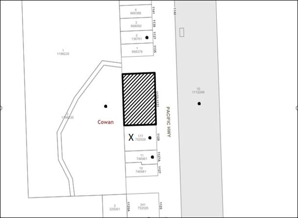
|
NOTIFICATION PLAN |
|||
|
• PROPERTIES NOTIFIED |
X SUBMISSIONS RECEIVED |
|
|
One submission was received on the 24 June 2019, outside of the notification period. Notwithstanding the submission is addressed below:
5.1.1 Site Boundaries
A submission raised concerns over the supposed incorrect boundaries of the site. The site boundaries can only be confirmed by a site survey of the land. The application is accompanied by a Survey Plan prepared by RGM Property dated 13/04/2018 which corresponds to Councils information and deposited survey plan.
Should the neighbour wish to investigate the matter further they may be required to engage their own surveyor.
5.2 Public Agencies
The development application was referred to the following Agencies for comment:
5.2.1 NSW Rural Fire Service
The integrated development application was referred to the NSW Rural Fire Service pursuant to Section 100B of the Rural Fires Act 1997.
As discussed in Section 2.4 the Rural Fire Service has provided General Terms of Approval if the application is to be approved.
5.2.2 Roads and Maritime Services
Pursuant to Clause 101 Development with frontage to a classified road of the ISEPP, the application was referred to the RMS for concurrence in accordance with Section 138 of the Roads Act, 1993. As discussed in Section 2.5 the RMS provided concurrence for two driveways if the application is to be approved.
5.2.3 Sydney Trains
Pursuant to Clause 85 Development adjacent to rail corridors of the ISEPP the application was referred to Sydney Trains for concurrence. At the time of writing the report, Sydney Trains have not provided a response.
6. THE PUBLIC INTEREST
Section 4.15(1)(e) of the Act requires Council to consider “the public interest”.
The public interest is an overarching requirement, which includes the consideration of the matters discussed in this report. Implicit to the public interest is the achievement of future built outcomes adequately responding to and respecting the future desired outcomes expressed in environmental planning instruments and development control plans.
The proposed development is contrary to Council’s planning controls and would result in development that would be considered unsafe for residential use. Accordingly, it is considered that the proposed development would not be in the public interest.
CONCLUSION
The development does not meet the desired outcomes of Council’s planning controls and is not satisfactory having regard to the matters for consideration under Section 4.15 of the Environmental Planning and Assessment Act 1979.
Having regard to the circumstances of the case, refusal of the application is recommended.
The reasons for this decision are:
· There is insufficient information to assess the development against the provisions of the State Environmental Planning Policy No.55 Remediation of Land and therefore the development does not meet the objectives of SEPP 55.
· The development does not meet the objectives of Clause 4.1.1 Minimum Lot Size under the Hornsby Local Environmental Plan 2013.
· The proposed development does not comply with the requirements of the relevant environmental planning instruments and the Hornsby Development Control Plan 2013.
Note: At the time of the completion of this planning report, no persons have made a Political Donations Disclosure Statement pursuant to Section 10.4 of the Environmental Planning and Assessment Act 1979 in respect of the subject planning application.
RESPONSIBLE OFFICER
The officer responsible for the preparation of this report is Jasmin Blazevic.
|
Cassandra Williams Major Development Manager - Development Assessments Planning and Compliance Division |
Rod Pickles Manager - Development Assessments Planning and Compliance Division |
|
Locality Map |
|
|
|
|
Amended Subdivision Plan |
|
|
|
|
Amended Plans |
|
|
File Reference: DA/1072/2018
Document Number: D07992514
SCHEDULE 1
1. The proposed development is unsatisfactory having regard to Section 4.15(1)(a)(i) of the Environmental Planning and Assessment Act 1979 as the proposal does not meet the objectives of Clause 4.1 Minimum Subdivision Lot Size of the Hornsby Local Environmental Plan 2013 in that:
1.1 The proposal has not demonstrated compliance with the minimum lot size requirement as shown on the Lot Size Map being 600m2.
2. The proposed development is unsatisfactory having regard to Section 4.15(1)(a)(i) of the Environmental Planning and Assessment Act 1979 the applicant failed to supply a written request in accordance with Clause 4.6 Exceptions to Development Standards of the Hornsby Local Environmental Plan 2013 to contravene the minimum lot size.
3. The proposed development is unsatisfactory having regard to Section 4.15(1)(a)(i) Section 4.15(1)(a)(i) of the Environmental Planning and Assessment Act 1979 the proposal does not meet the objectives of the State Environmental Planning Policy No.55 Remediation of Land in that:
3.1 The application does not satisfactorily address that the site is not contaminated and thereby suitable for future residential use.
4. The proposed development is unsatisfactory having regard to Section 4.15(1)(a)(iii) of the Environmental Planning and Assessment Act 1979, the proposal does not comply with the desired outcomes and the prescriptive measures of Part 6 Subdivision of the Hornsby Development Control Plan 2013 (HDCP) in that the proposal does not meet the minimum lot size and design requirement.
5. The proposed development is unsatisfactory having regard to Section 4.15(1)(a)(iii) of the Environmental Planning and Assessment Act 1979, the proposal does not comply with the desired outcome of Part 1C.3.1 Bushfire of the Hornsby Development Control Plan 2013 (HDCP) in that:
5.1 The development is not designed to minimise the need for bushfire hazard reduction within native vegetation areas.
5.2 There is insufficient information to ascertain the vegetation impact to achieve the Bushfire Asset Protection Zone which is located on the adjoining land to the west.
6. The proposed development is unsatisfactory having regard to Section 4.15(1)(a)(iii) of the Environmental Planning and Assessment Act 1979, the proposal does not comply with the desired outcomes of Part 1C.3.4 Land Contamination of the Hornsby Development Control Plan 2013 (HDCP) in that:
6.1 Insufficient sampling in accordance with NSW Environment Protection Authority’s Contaminated Sites – Guidelines on Significant Risk of Harm from Contaminated Land has been undertaken.
7. The proposed development is unsatisfactory having regard to Section 4.15(1)(a)(iii) of the Environmental Planning and Assessment Act 1979, in that there is insufficient engineering information that accurately reflects the proposed subdivision plan and driveway arrangement.
8. The proposed development is unsatisfactory having regard to Section 4.15(1)(c) of the Environmental Planning and Assessment Act 1979, it is considered that the site is not suitable for the proposed development.
LPP Report No. LPP28/20
Local Planning Panel
Date of Meeting: 30/09/2020
4 DEVELOPMENT APPLICATION - ALTERATIONS AND ADDITIONS - CARPORT AND REPLACEMENT DECK - 2 NICHOLAS CRESCENT, NORMANHURST
EXECUTIVE SUMMARY
|
DA No: |
DA/579/2020 (Lodged on 27 July 2020) |
|
Description: |
Alterations and additions to a dwelling house. |
|
Property: |
Lot 100 DP 732242, No. 2 Nicholas Crescent Normanhurst |
|
Applicant: |
Mrs Natalie Elizabeth Ritcher |
|
Owner: |
Mr Andrew Graham Gibson Mrs Tracey Anne Gibson |
|
Estimated Value: |
$100,000 |
|
Ward: |
B |
· The proposal does not comply with Clause 4.3 Building Height of the Hornsby Local Environmental Plan 2013. The applicant has made a submission in accordance with Clause 4.6 ‘Exceptions to development standards’ of the Hornsby Local Environmental Plan 2013 to vary the development standard for height of 8.5 metres by 11.8% to 9.5 metres. The submission is considered well founded and is supported.
· No submissions have been received in respect of the application.
· The application is required to be determined by the Hornsby Council Local Planning Panel as the proposed development seeks a Clause 4.6 variation to the “Height of Buildings” development standard that is greater than 10%.
· It is recommended that the application be approved.
|
THAT the Hornsby Shire Council Local Planning Panel assume the concurrence of the Secretary of the Department of Planning and Environment pursuant to Clause 4.6 of the Hornsby Local Environmental Plan 2013 and approve Development Application No. DA/579/2020 for alterations and additions to a dwelling house at Lot 100 DP 732242, No. 2 Nicholas Crescent Normanhurst, subject to the conditions of consent detailed in Schedule 1 of LPP Report No. LPP28/20. |
BACKGROUND
On 10 June 2009, Council approved DA/393/2009 for alterations and additions to a dwelling house consisting of an upper storey addition. Under this application a SEPP 1 submission to vary the then building height development standard of 9 metres to 9.9 metres was supported on planning grounds. The building additions approved under this consent have been completed.
On 22 July 2020, the subject application DA/579/2020 was lodged.
SITE
The 1,016m2 site is located on the north-eastern side of Nicholas Crescent Normanhurst and contains a two-storey dwelling house with an attached deck.
The site has a fall of eleven metres from the front, western boundary towards, the rear eastern boundary which translates to a gradient of 22%.
The site is bushfire prone and the front of the site is burdened by an easement for support.
PROPOSAL
The application proposes alterations and additions to the existing dwelling house as follows:
· The construction of double carport on the western side of the dwelling house.
· The construction of an attached deck and roof at the rear of the dwelling house.
· The installation of a 3,000-litre rainwater tank.
The existing rear deck would be demolished under this application.
One tree is proposed to be removed and five trees would be impacted by the proposal.
ASSESSMENT
The development application has been assessed having regard to the Greater Sydney Region Plan – A Metropolis of Three Cities, the North District Plan and the matters for consideration prescribed under Section 4.15 of the Environmental Planning and Assessment Act 1979 (the Act). The following issues have been identified for further consideration.
1. STRATEGIC CONTEXT
1.1 Greater Sydney Region Plan - A Metropolis of Three Cities and North District Plan
The Greater Sydney Region Plan - A Metropolis of Three Cities has been prepared by the NSW State Government to guide land use planning decisions for the next 40 years (to 2056). The Plan sets a strategy and actions for accommodating Sydney’s future population growth and identifies dwelling targets to ensure supply meets demand. The Plan also identifies that the most suitable areas for new housing are in locations close to jobs, public transport, community facilities and services.
The NSW Government will use the subregional planning process to define objectives and set goals for job creation, housing supply and choice in each subregion. Hornsby Shire has been grouped with Hunters Hill, Ku-ring-gai, Lane Cove, Mosman, North Sydney, Ryde, Northern Beaches and Willoughby to form the North District. The Greater Sydney Commission has released the North District Plan which includes priorities and actions for Northern District for the next 20 years. The identified challenge for Hornsby Shire will be to provide an additional 4,350 dwellings by 2021 with further strategic supply targets to be identified to deliver 97,000 additional dwellings in the North District by 2036.
The proposed development would be consistent with the Greater Sydney Region Plan - A Metropolis of Three Cities and the North District Plan.
2. STATUTORY CONTROLS
Section 4.15(1)(a) requires Council to consider “any relevant environmental planning instruments, draft environmental planning instruments, development control plans, planning agreements and regulations”.
2.1 Hornsby Local Environmental Plan 2013
The proposed development has been assessed having regard to the provisions of the Hornsby Local Environmental Plan 2013 (HLEP).
2.1.1 Zoning of Land and Permissibility
The subject land is zoned R2 Low Density Residential under the HLEP. The objectives of the R2 zone are:
· To provide for the housing needs of the community within a low-density residential environment; and
· To enable other land uses that provide facilities or services to meet the day to day needs of residents.
The proposed development is defined as a dwelling house and is permissible with Council’s consent. The proposed development meets the objectives of the R2 zone.
2.1.2 Height of Buildings
Clause 4.3 of the HLEP provides that the height of a building on any land should not exceed the maximum height shown for the land on the Height of Buildings Map. The maximum permissible height for the subject site is 8.5 metres. The proposal has a maximum height of 9.5 metres and does not comply with the maximum height development standard.
The applicant has submitted justification for the non-compliance in accordance with Clause 4.6 of the HLEP as discussed in Section 2.1.3.
2.1.3 Exceptions to Development Standards
The application has been assessed against the requirements of Clause 4.6 of the HLEP. This clause provides flexibility in the application of the development standards in circumstances where strict compliance with those standards would, in any particular case, be unreasonable or unnecessary or tender to hinder the attainment of the objectives of the zone.
The proposal exceeds the Height of Buildings development standard for the R2 Low density residential zone which is 8.5 metres as prescribed under Clause 4.3 ‘Height of Buildings’ of the HLEP.
The objective of the Height of Buildings control is to permit building heights that are appropriate for the site constrains; development potential and infrastructure capacity of the locality.
The applicant has made a submission in support of a variation to the development standard in accordance with Clause 4.6 of the HLEP. The development application seeks to vary the development standard by 11.8% to 9.5 metres. The applicant states the proposed variation is considered to be consistent with the objectives of the control and is justified as follows:
· The proposal is consistent with the general aims in that it improves the site in terms of the existing high quality, high amenity environment which protects the important natural character of the area.
· The proposed deck is sized to provide the occupants of the existing dwelling with a new, more functional private open space directly connected to the living area of the dwelling. This replaces an existing external elevated deck, which is weathered and in need of replacement. The proposed replacement deck has been designed with bushfire expertise to improve the bushfire resilience of the dwelling in this direction (the direction of the threat). It is considered reasonable to have a roof for weather protection and to maximise useability given that this is an elevated property at the rear of the site. This is considered to be a reasonable upgrade which has planning and environmental merit.
· The replacement deck does not seek a significant change to the situation but would provide an improved external covered open space area which would improve the amenity of the house, increase the useability and enjoyment of the rear bushland and provide a private open space area (POS) which accords with Council’s DCP controls. This area, being covered, increases the useability, is consistent with surrounding rear decks and allows the space to be used in various weather situations. The rear deck is well separated from properties and has appropriate screening to ensure privacy.
· The deck is commensurate in scale with the dwelling, accords with the balance of other design and scale controls and is suitable for the subject R2 zone and the setting. Despite the minor numeric variation which occurs above the steep topography, the outcome is reasonable and consistent with the objectives of the LEP.
State Government Guidelines on varying development standards recommend considering the provisions of Clause 4.6 of the LEP and the ‘five-part test’ established by the Land and Environment Court as follows:
1. The objectives of the standard are achieved notwithstanding noncompliance with the standard.
2. The underlying objective or purpose of the standard is not relevant to the development and therefore compliance is unnecessary.
3. The underlying object of purpose would be defeated or thwarted if compliance was required and therefore compliance is unreasonable.
4. The development standard has been virtually abandoned or destroyed by the council’s own actions in granting consents departing from the standard and hence compliance with the standard is unnecessary and unreasonable.
5. The compliance with development standard is unreasonable or inappropriate due to existing use of land and current environmental character of the particular parcel of land. That is, the particular parcel of land should not have been included in the zone.
The applicant’s submission to vary the 8.5 metre building height development standard is considered well founded for the following reasons:
· The proposal does not increase the overall height of the dwelling and does not create any external change to the view of the dwelling from Nicholas Crescent. The proposed deck is at the rear of the dwelling, is not visible from the street and is well separated from adjoining properties.
· The proposal is consistent with the objectives of the height standard which are to manage form and scale and to protect amenity and area character.
· There is no change in the overall height, bulk or scale of the existing dwelling. The ridgeline of the new deck is lower that the ridgeline of the main living area of the dwelling and the desired roof profile for weather protection above the deck. This is considered reasonable for the space proposed.
· The proposal respects the form of surrounding properties and the amenities of directly adjoining houses. Minimal external changes are proposed. The rear deck is generally compliant and is modest and reasonable having regard for the existing house and surrounding structures.
· The exceedance is only a function of the steep drop-off at the rear of the dwelling, noting that only the outer edge of the roof is numerically non-compliant, the remainder is compliant as the ground level steps up towards the house via the existing retaining wall and paved area under the house. Consequently, the proposal which involves only a minor change to the existing deck in terms of width and is not considered to create any adverse amenity or scale impacts.
· The proposal will not create any additional scale or visual issues. A privacy screen is proposed along the outer edge of the side of the balcony to ensure privacy for occupants of the dwelling and their neighbours. The deck is not visible from the street and screen to the rear by the existing mature trees.
· Strict numeric compliance would not materially change the development or improve the residential living amenity of the house. It would unduly constrain the indoor/outdoor living amenity of the dwelling without reasonable cause.
· Strict numeric compliance would result in the detrimental changes and is not considered necessary as the proposal will not change the appearance or scale of the site within the local context and the dwelling is consistent with the relevant planning objectives.
· The application provides for the orderly and economic development of land, improvement of living conditions of the existing low-density residence and adequate protection of the environment and public interest.
· The proposed development generally meets the objectives of Clause 4.3 Height of Buildings of the Hornsby Local Environmental Plan 2013 by way of being appropriate with respect to the constraints of the site and in regard to the development potential of the site.
Based on this assessment, it is considered that compliance with the development standard would be unreasonable and unnecessary in the circumstances of the case. Accordingly, the Clause 4.6 submission is supported.
2.1.4 Heritage Conservation
Clause 5.10 of the HLEP sets out heritage conservation provisions for Hornsby Shire. The site does not include a heritage item and is not located in a heritage conservation area. Accordingly, no further assessment regarding heritage is necessary.
2.1.5 Earthworks
Clause 6.2 of the HLEP states that consent is required for proposed earthworks on site. Before granting consent for earthworks, Council is required to assess the impacts of the works on adjoining properties, drainage patterns and soil stability of the locality.
Council’s assessment of the proposed works and excavation concludes that that impacts would be minimal. The proposed deck extension would be constructed using posts and would require minor excavation for the concrete footings. No cut of fill is required to construct the development. The proposal is assessed as satisfactory with regards to Clause 6.2 of the HLEP.
2.3 State Environmental Planning Policy (Exempt and Complying Development Codes) 2008 – NSW Housing Code
The application has been considered against the requirements of State Environmental Planning Policy (Exempt and Complying Development Codes) 2008 (NSW Housing Code). The Policy provides exempt and complying development codes that have State-wide application. The Policy also identifies types of development that are of minimal environmental impact that may be carried out without the need for development consent and types of Complying Development (including dwelling houses) that may be carried out in accordance with a Complying Development Certificate.
The site is subject to bushfire risk and is in exceedance of the maximum building height which precludes the development from being approved as Complying Development. The proposed dwelling house additions would otherwise comply with the numerical standards for Complying Development contained within the SEPP.
2.4 State Environmental Planning Policy No. 55 Remediation of Land
The policy provides guidelines for the remediation of contaminated land for the purpose of reducing the risk of harm to human health or any other aspect of the environment. Clause 7 requires Council to consider whether land is contaminated prior to granting consent to the carrying out of any development on that land.
Should the land be contaminated, Council must be satisfied that the land is suitable in a contaminated state for the proposed use. If the land requires remediation to be undertaken to make the land suitable for the proposed use, Council must be satisfied that the land will be remediated before the land is used for that purpose.
A review of Council’s records and aerial photographs indicate that the site has been historically used for residential purposes. It is not likely that the site has experienced any significant contamination, and further assessment under SEPP 55 is not required.
2.5 State Environmental Planning Policy (Vegetation in non-rural areas) 2017
The application has been assessed against the requirements of State Environmental Planning Policy (Vegetation in Non-Rural Areas) 2017 (Vegetation SEPP). This Policy seeks to protect the biodiversity values of trees and other vegetation in non-rural areas of the State, and to preserve the amenity of non-rural areas of the State through the preservation of trees and other vegetation.
Part 3 of the Vegetation SEPP states that a development control plan may make a declaration in any manner relating to species, size, location and presence of vegetation. Accordingly, Part 1B.6.1 of the Hornsby Development Control Plan 2013 (HDCP) prescribes works that can be undertaken with or without consent to trees.
Part 3.1.1 Tree and Vegetation Preservation of this report provides an assessment in accordance with Part 1B.6.1 of the HDCP.
2.6 Sydney Regional Environmental Plan (Sydney Harbour Catchment) 2005
The site is located with the catchment of the Lane Cove River. Division 2 of this Plan contains general planning considerations and strategies requiring Council to consider the impacts of development on water quality, aquaculture, recreation and tourism.
Subject to the implementation of sediment and erosion control measures and stormwater management to protect water quality, the proposal would comply with the requirement of the Policy. No changes are proposed in this regard.
2.7 Section 3.42 Environmental Planning and Assessment Act, 1979 - Purpose and Status of Development Control Plans
Section 3.42 of the Environmental Planning and Assessment Act 1979 states that a DCP provision will have no effect if it prevents or unreasonably restricts development that is otherwise permitted and complies with the development standards in relevant Local Environmental Plans and State Environmental Planning Policies.
The principal purpose of a development control plan is to provide guidance on the aims of any environmental planning instrument that applies to the development; facilitate development that is permissible under any such instrument; and achieve the objectives of land zones. The provisions contained in a DCP are not statutory requirements and are for guidance purposes only. Consent authorities have flexibility to consider innovative solutions when assessing development proposals, to assist achieve good planning outcomes.
2.8 Hornsby Development Control Plan 2013
The proposed development has been assessed having regard to the relevant desired outcomes and prescriptive requirements within the Hornsby Development Control Plan 2013 (HDCP). The following table sets out the proposal’s compliance with the prescriptive requirements of the Plan:
|
HDCP – Part 3.1 Dwelling Houses |
|||
|
Control |
Proposal |
Requirement |
Complies |
|
Site Area |
1,016m2 |
N/A |
N/A |
|
Building Height |
9.5m |
8.5m |
No |
|
No. storeys |
2 |
max. 2 + attic |
Yes |
|
Site Coverage |
No change |
Existing |
N/A |
|
Floor Area |
No change |
Existing |
N/A |
|
|
|
|
|
|
- Front (west) |
No change |
Existing |
N/A |
|
- Side (north) |
1.67m |
900mm |
Yes |
|
- Side (south) |
|
|
|
|
Ground floor |
4m |
900mm |
Yes |
|
First floor |
2.16m |
1.5m |
Yes |
|
- Rear (east) |
|
|
|
|
Ground floor |
13.7m |
3m |
Yes |
|
First floor |
13.7m |
8m |
Yes |
|
Landscaped Area (% of lot size) |
No change |
Existing |
Yes |
|
Private Open Space |
|
|
|
|
- minimum area |
24m2 |
24m2 |
Yes |
|
- minimum dimension |
3m |
3m |
Yes |
|
Car Parking |
3 spaces |
2 spaces |
Yes |
As detailed in the above table, the proposed development generally complies with the prescriptive measures within the HDCP with the exception of the building height control. A brief discussion on this non-compliance is provided below, along with a discussion on the relevant performance requirements and Part 1C General Controls.
2.8.1 Scale
The desired outcome of Part 3.1.1 Scale of the HDCP is for ‘development with a height, bulk and scale that is compatible with a low-density residential environment’.
This is supported by the prescriptive measures which state that ‘sites with the maximum building heights under Clause 4.3 of the HLEP should comply with the maximum number of storeys in Table 3.1.1(a).’
In addition, it is stated that ‘buildings should respond to the topography of the site by;
· Minimising earthworks (cut and fill); and
· Siting the floor level of the lowest residential storey a maximum of 1.5 metres above natural ground level’.
The proposed attached roof at the easternmost point is situated 9.5 metres above natural ground level which does not comply with Part 3.1.1 Scale of the HDCP and Clause 4.3 of HLEP.
In support of this non-compliance, it is noted that the slope of the site is a significant constraint for any development on the site. It is also noted that the proposed addition has been designed to complement the natural slope of the land and avoid cut and fill on the site by utilising pier construction.
The applicant has submitted a variation pursuant to Clause 4.6 of the HLEP which has adequately addressed this non-compliance which is discussed in detail above under Section 2.1.3.
The proposal generally complies with the maximum building height of 8.5 metres despite the minor section of roof at the easternmost point of the proposal which is the result of this non-compliance. The proposal would be of a height, bulk and scale that is compatible within the low-density residential zone. The location at the proposed deck and roof at rear of the dwelling house would result in the addition not being visible from the streetscape. As a result, it is considered that despite the non-compliance at the easternmost section of the proposed roof extension, the proposal is generally consistent with the desired outcomes of Part 3.1.1 Scale and as discussed above in Section 2.1.3 with Clause 4.3 Height of Buildings of the HLEP. Accordingly, no objections are raised to the proposal on planning grounds.
The proposal meets the desired outcomes of Part 3.1.1 Scale of the HDCP and is considered acceptable.
2.8.1 Privacy
The desired outcomes of Part 3.1.6 Privacy of the HDCP is for development ‘that is designed to provide reasonable privacy to adjacent properties’ this is supported by prescriptive measures (c) and (d) where:
‘a deck, balcony, terrace or the like should be located within 600mm of existing ground level where possible to minimise potential visual and acoustic privacy conflicts’; and
‘Decks and the like that need to be located more than 600mm above existing ground should not face a window of another habitable room, balcony or private open space of another dwelling located within 9 metres of the proposed deck unless appropriately screened’.
The application proposes the construction of an attached deck situated at the rear of the dwelling that would have a finished floor level that is 5.46 metres above natural ground level at the easternmost point of the proposed deck.
In assessing the impact from this proposed finished floor level, it is noted that:
· No privacy concerns are raised with respect to overlooking into the adjoining property to the south, No. 3 Nicholas Crescent as a 1.7-metre-high privacy screen is proposed to be erected along the southern elevation of the proposed deck in accordance with the HDCP.
· No privacy concerns are raised with respect to overlooking into the adjoining property to the north-east, No. 72 Hinemoa Avenue as the principal private open space of this property is located approximately 30 metres from the proposed deck and is located approximately 10 metres downslope and naturally screened by existing vegetation.
· No privacy concerns are raised with respect to overlooking into the adjoining property to the north, No. 1 Nicholas Crescent as there would not be a direct line of site into the private open space of this property and the private open space of this property is located greater than 9 metres from the proposed deck, behind the dwelling and of which is heavily screened by existing vegetation.
In summary, as identified above it is considered that the proposed deck extension would result in minimal and acceptable privacy impacts to the adjoining properties.
The proposal meets the desired outcome of Part 3.1.6 Privacy of the HDCP and is considered acceptable.
2.8.2 Bushfire
The desired outcomes of Part 1C.3.1 Bushfire of the HDCP are to encourage ‘development that is located and designed to minimise the risk to life and property from bushfire’ and to encourage ‘development that balances the conservation of native vegetation and bushfire protection’.
The application has provided a Bushfire Assessment Report prepared by Blackash Bushfire Consulting dated 11 March 2020.
The Bushfire Hazard Assessment Report recommended that any development on the site be built to the requirements of AS 3959-2018 Construction of buildings in bushfire-prone areas in accordance with the requirements for Bushfire Attack Level (BAL) Flame Zone and the relevant sections of Planning for Bushfire Protection 2019.
In accordance with Council’s assessment protocol for development in BAL Flame Zone, the application was referred to the NSW Rural Fire Service (RFS) for review. The NSW RFS raised no objections to the proposal subject to conditions.
Conditions reflecting the NSW RFS requirements have been recommended under Schedule 1 of this report with regard to the utilisation of BAL FZ fire retardant construction materials and the maintenance of the entire property as an Inner Protection Area (IPA) in perpetuity.
The proposal meets the desired outcomes of Part 1C.3.1 Bushfire of the HDCP and is considered acceptable, subject to conditions.
2.9 Section 7.12 Contributions Plan
The proposed development has an estimated cost of works of $100,000. This value is below the threshold where a Section 7.12 contribution under the Hornsby Shire Council Section 7.12 Contributions Plan 2019-2029 applies.
Accordingly, should the application be approved, Section 7.12 Contribution fees would not be applicable to the development.
3. ENVIRONMENTAL IMPACTS
Section 4.15(1)(b) of the Act requires Council to consider “the likely impacts of that development, including environmental impacts on both the natural and built environments, and social and economic impacts in the locality”.
3.1 Natural Environment
3.1.1 Tree and Vegetation Preservation
The application proposes the removal of 1 tree numbered T5 and would impact 5 trees. Of these 5 trees, 1 tree numbered T1 is located on the adjoining property to the north, No. 1 Nicholas Crescent and 1 other tree numbered T6 is located on the adjoining property to the south, No. 3 Nicholas Crescent. The remainder of trees numbered T2, T3, T4 and T5 are located on the subject site.
Tree T5 is a noxious weed (Camphor Laurel) and is listed as an exempt species under Part 1.B6.1 Tree Preservation of the HDCP.
Trees T1, T2, T3, T4 and T6 would be subject to minor Tree Protection Zone (TPZ) encroachments as prescribed AS4970-2009 Protection of trees on development sites from the building footprint and are proposed to be retained and protected.
The applicant has submitted an Arboricultural Impact Assessment (AIA) in support of the application prepared by Australis Tree Management dated 4 May 2020 which has undertaken an assessment of these abovementioned trees. The AIA has found that no other trees would be impacted on the site or adjoining allotments by the proposed development with the exception of the 6 trees identified.
The AIA recommends the removal of tree T5 (Camphor Laurel), as this tree is exempt under the HDCP and is a noxious weed listed as ‘general’ under the Biosecurity Act 2015.
The AIA has identified that trees T1, T2, T3, T4 and T6 would be subject to minor encroachments to their respective TPZs of less than 10% as prescribed under AS 4970-2009 Protection of Trees on Development Sites which is associated with the installation of posts to support the proposed deck. Consequently, root mapping was not requested.
Overall, Council’s arboricultural assessment generally concurs with these findings of the AIA. Council raises no objections to the removal of tree T5. Council also considers that the proposed works would result in minimal and acceptable impacts to trees T1, T2, T3, T4 and T6 that are proposed to be retained.
Conditions are recommended in Schedule 1 of this report requiring that a project arborist be appointed to install tree protection measures in accordance with the approved Tree Protection Plan prepared by Hornsby Shire Council and oversee works within the TPZ of the trees to be retained and that one advanced replacement plantings of locally occurring indigenous species be undertaken to offset the loss of vegetation on the site.
Subject to conditions, the proposed development meets the desired outcomes of Part 1B6.1 Tree Preservation of the HDCP and the proposed development would result in acceptable environmental impacts.
3.1.2 Biodiversity
The proposal is located amongst vegetation characteristic of the Blackbutt Gully Forest vegetation community. A Powerful Owl record is located approximately 80 metres from the development. The powerful owl is listed as vulnerable under the Biodiversity Conservation Act 2016.
The proposal involves the construction of a carport, an attached deck with roof and the installation of a water tank.
Council’s ecologist has reviewed the application has raised no objection to the proposal on biodiversity grounds. The removal of tree T5 is supported as this tree has been identified as a weed species and the property immediately adjoins a native bushland corridor and removal of this tree is supported to prevent the further spread into the natural bushland corridor and beyond.
Notwithstanding, Council’s ecologist has identified some concern regarding the removal of this tree adjoining an area identified as containing a potential presence of a Powerful Owl.
As a consequence, a condition is recommended in Schedule 1 of this report that to minimise any disturbance, an ecologist must be present prior to and during tree removal to ensure that no fauna is present or nesting within any tree on the property. If any fauna is found to be utilising the hollows within the site, or they deem the works to be detrimental to the presence of a Powerful Owl nest, the development must not occur until the Powerful Owl nesting period has ended.
Subject to conditions, the proposed development meets the desired outcomes of Part 1C.1.1 Biodiversity of the HDCP and the proposed development would result in acceptable environmental impacts.
3.1.3 Stormwater Management
The residential development would have a minor positive impact on the natural environment with all stormwater being directed to the existing stormwater system and the overflow directed to a watercourse in the rear of the site that forms part of the Lane Cove River catchment.
3.2 Built Environment
3.2.1 Built Form
The proposal would generally be consistent with the built form of the surrounding low-density residential area which consists of dwelling houses ranging from single storey, split level, two storey and three storeys with excavated garages.
3.3 Social Impacts
The residential development would improve housing choice in the locality by providing a range of house hold types. This is consistent with Council’s Housing Strategy which identifies the need to provide a mix of housing options to meet future demographic needs in Hornsby Shire.
3.4 Economic Impacts
The proposal would have a minor positive impact on the local economy in conjunction with other new low-density residential development in the locality by generating an increase in demand for local services.
4. SITE SUITABILITY
Section 4.15(1)(c) of the Act requires Council to consider “the suitability of the site for the development”.
4.1 Bushfire Risk
As noted in Section 2.2.3 Bushfire of this report, the subject site is identified as being bushfire prone, the application was referred to the NSW Rural Fire Service for comment.
Conditions of concurrence provided by the RFS have been recommended under Schedule 1 of this report with regard to the utilisation of BAL Flame Zone fire retardant construction materials and the maintenance of the entire property as an Inner Protection Area (IPA) in perpetuity.
5. PUBLIC PARTICIPATION
Section 4.15(1)(d) of the Act requires Council to consider “any submissions made in accordance with this Act”.
5.1 Community Consultation
The proposed development was placed on public exhibition and was notified to adjoining and nearby landowners between 22 July 2020 and 13 August 2020 in accordance with the Hornsby Community Participation Plan. During this period, Council did not receive any submissions. The map below illustrates the location of those nearby landowners who were notified of the development application.
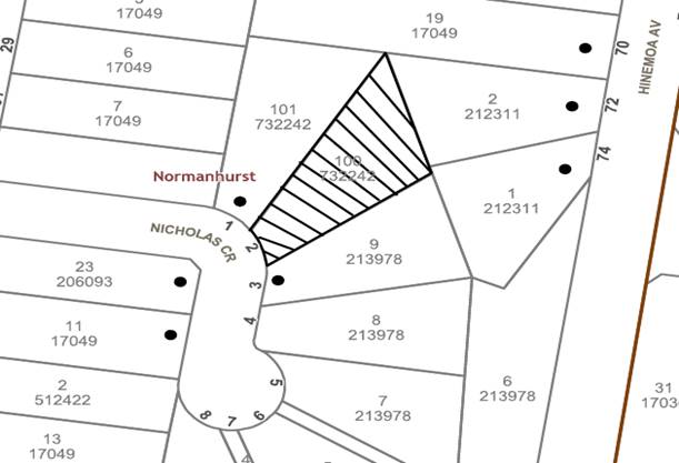
|
NOTIFICATION PLAN |
|||
|
• PROPERTIES NOTIFIED |
X SUBMISSIONS RECEIVED |
|
|
5.2 Public Agencies
The development application was not referred to any Public Agencies for comment.
6. THE PUBLIC INTEREST
Section 4.15(1)(e) of the Act requires Council to consider “the public interest”.
The public interest is an overarching requirement, which includes the consideration of the matters discussed in this report. Implicit to the public interest is the achievement of future built outcomes adequately responding to and respecting the future desired outcomes expressed in environmental planning instruments and development control plans.
The application is considered to have satisfactorily addressed Council’s and relevant agencies’ criteria and would provide a development outcome that, on balance, would result in a positive impact for the community. Accordingly, it is considered that the approval of the proposed development would be in the public interest.
CONCLUSION
The application proposes alterations and additions to a dwelling house.
The development generally meets the desired outcomes of Council’s planning controls and is satisfactory having regard to the matters for consideration under Section 4.15 of the Environmental Planning and Assessment Act 1979.
Having regard to the circumstances of the case, approval of the application is recommended.
The reasons for this decision are:
· The proposed development generally complies with the requirements of the relevant environmental planning instruments and the Hornsby Development Control Plan 2013.
· The request under Clause 4.6 of Hornsby Local Environmental Plan 2013 to vary the ‘Height of Buildings’ Development Standard is well founded. Strict compliance with the development standard is unreasonable and unnecessary in the circumstances of the case and there are sufficient environmental planning grounds to justify the variation to the development standards.
· The proposed development does not create unreasonable environmental impacts to adjoining development with regard to visual bulk, overshadowing, solar access, amenity or privacy.
Note: At the time of the completion of this planning report, no persons have made a Political Donations Disclosure Statement pursuant to Section 10.4 of the Environmental Planning and Assessment Act 1979 in respect of the subject planning application.
RESPONSIBLE OFFICER
The officer responsible for the preparation of this report is Tom Mojsiejuk.
|
Cassandra Williams Major Development Manager - Development Assessments Planning and Compliance Division |
Rod Pickles Manager - Development Assessments Planning and Compliance Division |
|
Locality Map |
|
|
|
|
Clause 4.6 Variation |
|
|
|
|
Architectural Plans and Tree Protection Plan |
|
|
|
|
Bushfire Report |
|
|
|
|
Arboricultural Impact Assessment Report |
|
|
File Reference: DA/579/2020
Document Number: D08010063
SCHEDULE 1
GENERAL CONDITIONS
The conditions of consent within this notice of determination have been applied to ensure that the use of the land and/or building is carried out in such a manner that is consistent with the aims and objectives of the relevant legislation, planning instruments and council policies affecting the land and does not disrupt the amenity of the neighbourhood or impact upon the environment.
Note: For the purpose of this consent, the term ‘applicant’ means any person who has the authority to act on or the benefit of the development consent.
Note: For the purpose of this consent, any reference to an Act, Regulation, Australian Standard or publication by a public authority shall be taken to mean the gazetted Act or Regulation or adopted Australian Standard or publication as in force on the date that the application for a construction certificate is made.
1. Approved Plans and Supporting Documentation
The development must be carried out in accordance with the plans and documentation listed below and endorsed with Council’s stamp, except where amended by Council and/or other conditions of this consent:
Approved Plans
|
Plan No. |
Plan Title |
Drawn by |
Dated |
Council Reference |
|
1 |
Site Plan/Site Analysis |
Smith and Sons |
19 May 2020 |
|
|
3 |
Proposed Floor Plans |
Smith and Sons |
19 May 2020 |
|
|
4 |
SW and NE Elevations |
Smith and Sons |
19 May 2020 |
|
|
5 |
NW and SE Elevations |
Smith and Sons |
19 May 2020 |
|
|
6 |
Section A-A |
Smith and Sons |
19 May 2020 |
|
|
N/A |
Tree Protection Plan |
Hornsby Shire Council |
14 August 2020 |
|
Supporting Documentation
|
Document Title |
Prepared by |
Dated |
Council Reference |
|
Bushfire Assessment Report |
Blackash Bushfire Consulting |
11 March 2020 |
D07959829 |
|
Arboricultural Impact Assessment |
Australis Tree Management |
30 April 2020 |
D07959828 |
|
RFS concurrence letter Ref: DAA20200728002727-Original-1 |
NSW Rural Fire Service |
24 August 2020 |
D07983867 |
2. Construction Certificate
a) A Construction Certificate is required to be approved by Council or a Private Certifying Authority prior to the commencement of any construction works under this consent.
b) The Construction Certificate plans must include all requirements imposed by the NSW Rural Fire.
c) The Construction Certificate plans must be consistent with the Development Consent plans.
3. Removal of Trees
a) This development consent permits the removal of 1 tree numbered T5 as identified in the Arboricultural Impact Assessment prepared by Australis Tree Management dated 30 April 2020.
b) No consent is granted for the removal of trees numbered T1, T2, T3, T4 and T6 as these trees contribute to the established landscape amenity of the area.
Note: The removal of any other trees from the site requires separate approval by Council in accordance with Part 1B.6 Tree and Vegetation Preservation of the Hornsby Development Control Plan, 2013 (HDCP).
4. Tree Pruning
This development consent does not permit the pruning of any trees on the site.
Note: The pruning of any other trees from the site requires separate approval by Council in accordance with Part 1B.6 Tree and Vegetation Preservation of the Hornsby Development Control Plan 2013 (HDCP).
REQUIREMENTS PRIOR TO THE ISSUE OF A CONSTRUCTION CERTIFICATE
5. Building Code of Australia
All approved building work must be carried out in accordance with the relevant requirements of the Building Code of Australia.
6. Contract of Insurance (Residential Building Work)
Where residential building work for which the Home Building Act 1989 requires there to be a contract of insurance in force in accordance with Part 6 of that Act, this contract of insurance must be in force before any building work authorised to be carried out by the consent commences.
7. Notification of Home Building Act 1989 Requirements
Residential building work within the meaning of the Home Building Act 1989 must not be carried out unless the principal certifying authority for the development to which the work relates (not being Council) has given Council written notice of the following information:
a) In the case of work for which a principal contractor is required to be appointed:
i) The name and licence number of the principal contractor; and
ii) The name of the insurer by which the work is insured under Part 6 of that Act.
b) In the case of work to be done by an owner-builder:
i) The name of the owner-builder; and
ii) If the owner-builder is required to hold an owner-builder’s permit under that Act, the number of the owner-builder’s permit.
Note: If arrangements for doing the residential building work are changed while the work is in progress so that the information notified becomes out of date, further work must not be carried out unless the principal certifying authority for the development to which the work relates (not being Council) has given Council written notification of the updated information.
8. Sydney Water – Approval
This application must be submitted to Sydney Water for approval to determine whether the development would affect any Sydney Water infrastructure, and whether further requirements are to be met.
Note: Building plan approvals can be obtained online via Sydney Water Tap inTM through www.sydneywater.com.au under the Building and Development tab.
9. Stormwater Drainage
The stormwater drainage system for the development must be designed for an average recurrence interval (ARI) of 20 years and be gravity drained and connected to the existing internal drainage system.
10. Internal Driveway/Vehicular Areas
The parking areas on site must be designed and constructed and a construction certificate issued in accordance with Australian Standards AS2890.1 and AS3727.
11. Appointment of a Project Arborist
a) To ensure the trees that must be retained are protected, a project arborist with AQF Level 5 qualifications must be appointed to assist in ensuring compliance with the conditions of consent and provide monitoring reports as specified by the conditions of consent.
b) Details of the appointed project arborist must be submitted to Council and the PCA with the application for the construction certificate/subdivision works certificate.
REQUIREMENTS PRIOR TO THE COMMENCEMENT OF ANY WORKS
12. Erection of Construction Sign
a) A sign must be erected in a prominent position on any site on which any approved work is being carried out:
i) Showing the name, address and telephone number of the principal certifying authority for the work;
ii) Showing the name of the principal contractor (if any) for any demolition or building work and a telephone number on which that person may be contacted outside working hours; and
iii) Stating that unauthorised entry to the work site is prohibited.
b) The sign is to be maintained while the approved work is being carried out and must be removed when the work has been completed.
13. Protection of Adjoining Areas
A temporary hoarding, fence or awning must be erected between the work site and adjoining lands before the works begin and must be kept in place until after the completion of the works if the works:
a) Could cause a danger, obstruction or inconvenience to pedestrian or vehicular traffic;
b) Could cause damage to adjoining lands by falling objects; and/or
c) Involve the enclosure of a public place or part of a public place; and/or
d) Have been identified as requiring a temporary hoarding, fence or awning within the Council approved Construction Management Plan (CMP).
Note: Notwithstanding the above, Council’s separate written approval is required prior to the erection of any structure or other obstruction on public land.
a) To provide a safe and hygienic workplace, toilet facilities must be available or be installed at the works site before works begin and must be maintained until the works are completed at a ratio of one toilet for every 20 persons employed at the site.
b) Each toilet must:
i) be a standard flushing toilet connected to a public sewer; or
ii) be a temporary chemical closet approved under the Local Government Act 1993; or
iii) have an on-site effluent disposal system approved under the Local Government Act 1993.
15. Erosion and Sediment Control
To protect the water quality of the downstream environment, erosion and sediment control measures must be provided and maintained throughout the construction period in accordance with the manual ‘Soils and Construction 2004 (Bluebook)’, the approved plans, Council specifications and to the satisfaction of the principal certifying authority. The erosion and sediment control devices must remain in place until the site has been stabilised and revegetated.
Note: On the spot penalties may be issued for any non-compliance with this requirement without any further notification or warning.
To ensure the protection of local fauna, prior to the removal of trees:
a) An arborist, ecologist or wildlife carer is to inspect the trees for active habitat use including nests, hollows and decorticating bark.
b) If any habitat is being actively used for nesting the tree removal must be deferred until after birds have fledged.
c) A wildlife carer must be on site to capture any observed wildlife from the trees and relocate into adjacent bushland.
d) Trees are to be removed in sections by a qualified tree surgeon in the presence of a ‘Wildlife Carers’ organisation to assist in the event of fauna presence or injury.
Note: ‘WIRES’ (Wildlife Rescue) volunteers can be contacted on 1300 094 737. ‘Wildlife Services Sydney Metropolitan’ volunteers can be contacted on 9413 4300.
17. Installation of Tree Protection Measures
a) The 5 trees to be retained numbered T1, T2, T3, T4 and T6 as identified on the approved Tree Protection Plan must have tree protection measures for the ground, trunk and canopy installed by the project arborist as follows:
i) For the duration of demolition works, in accordance with the approved Tree Protection Plan and the Arboricultural Impact Assessment prepared by Australis Tree Management dated 30 April 2020 (D07959829).
ii) For the duration of construction works, in accordance the approved Tree Protection Plan and the Arboricultural Impact Assessment prepared by Australis Tree Management dated 30 April 2020 (D07959829).
b) Tree protection fencing for the trees to be retained must be installed by the engaged AQF 5 project arborist and consist of 1.8m high temporary fencing panels installed in accordance with Australian Standard AS4687-2007 Temporary fencing and hoardings.
c) The installation of all required tree protection fencing must include shade cloth attached to the fencing to reduce transport of dust, particulates and liquids from entering the tree protection zone.
d) Tree crown protection measures are required and must be installed by the AQF 5 project arborist.
e) The circumference of the trunk(s) must be wrapped in hessian material to provide cushioning for the installation of timber planks.
f) Timber planks (50 x100mm) must be spaced at 100mm intervals and must be attached using adjustable ratchet straps.
g) All tree protection zones must have a layer of wood-chip mulch at a depth of between 150mm and 300mm.
h) Where wood-chip mulch is permitted by Council instead of tree protection fencing within the tree protection zones, the wood-chip must be covered with a layer of geotextile fabric and rumble boards.
REQUIREMENTS DURING DEMOLITION AND CONSTRUCTION
All works on site, including demolition and earth works, must only occur between 7am and 5pm Monday to Saturday.
No work is to be undertaken on Sundays or public holidays.
19. Demolition
To protect the surrounding environment, all demolition work must be carried out in accordance with Australian Standard AS2601-2001 Demolition of structures and the following requirements:
a) Demolition material must be disposed of to an authorised recycling and/or waste disposal site and/or in accordance with an approved waste management plan; and
b) Demolition works, where asbestos material is being removed, must be undertaken by a contractor that holds an appropriate licence issued by SafeWork NSW in accordance with the Work Health and Safety Regulation 2017 and be appropriately transported and disposed of in accordance with the Protection of the Environment Operations (Waste) Regulation 2014; and
c) On construction sites where any building contain asbestos material, a standard commercially manufactured sign containing the words ‘DANGER ASBESTOS REMOVAL IN PROGRESS’ and measuring not less than 400mm x 300mm must be displayed in a prominent position visible from the street.
20. Environmental Management
To prevent sediment run-off, excessive dust, noise or odour emanating from the site during the construction, the site must be managed in accordance with the publication ‘Managing Urban Stormwater – Landcom (March 2004) and the Protection of the Environment Operations Act 1997.
To ensure that the public reserve is kept in a clean, tidy and safe condition during construction works, no building materials, waste, machinery or related matter is to be stored on the road or footpath.
22. Waste Management
All work must be carried out in accordance with the approved waste management plan.
23. Prohibited actions within the fenced tree protection zone
The following activities are prohibited within the approved fenced tree protection zones unless otherwise approved by Council:
a) Soil cutting or filling, including excavation and trenching
b) Soil cultivation, disturbance or compaction
c) Stockpiling storage or mixing of materials
d) The parking, storing, washing and repairing of tools, equipment and machinery
e) The disposal of liquids and refuelling
f) The disposal of building materials
g) The siting of offices or sheds
h) Any action leading to the impact on tree health or structure
24. Maintaining the health of trees approved for retention
The appointed project arborist must monitor and record any and all necessary actions required to maintain tree health and condition for retained trees on the approved plans.
25. Maintaining Tree Protection Measures
Tree Protection Measures must be maintained by the project arborist in accordance with Condition No. 17 of this consent for the duration of works.
26. Approved Works within Tree Protection Zone incursions
a) Where tree root pruning is required for the installation of piers, driveway or underground services, the pruning must be overseen by the AQF 5 project arborist and must be undertaken as follows:
i) Using sharp secateurs, pruners, handsaws or chainsaws with the final cut being clean.
ii) The maximum diameter of roots permitted to be cut is 30mm
b) Where the building footprint enters or transects the Tree Protection Zones of trees to be retained, sensitive construction techniques in the form of screw pilings or piers, cantilevered or suspended slab design must be employed to create a 100mm clearance above existing soil grade.
c) Approved excavations within the Tree Protection Zone of trees to be retained not associated with installation of services must be undertaken as follows:
i) Excavations for the construction and/or installation of the piers in the Tree Protection Zone of the five trees to be retained numbered T1, T2, T3, T4 and T6 on the approved plans must be supervised by the project arborist for the first 1 metre and be undertaken manually to locate roots and allow for pruning in accordance with condition 26 (a).
d) To minimise impacts within the Tree Protection Zone (TPZ) of retained trees on the approved plans, the installation of services must be undertaken as follows:
i) The AQF 5 project arborist must be present to oversee the installation of any underground services which enter or transect the tree protection.
ii) The installation of any underground services which either enter or transect the designated TPZ must be undertaken manually.
iii) For manually excavated trenches the AQF 5 project arborist must designate roots to be retained. Manual excavation may include the use of pneumatic and hydraulic tools.
e) Where scaffolding is required, ground protection must be installed beneath the scaffolding in the following order:
i) Installation of a 100mm deep layer of woodchip and;
ii) Installation of geotextile fabric ground covering and;
iii) Installation of scaffold boarding above the woodchip and geotextile fabric.
27. Building materials and Site Waste
The stockpiling of building materials, the parking of vehicles or plant, the disposal of cement slurry, waste water or other contaminants must be located outside the tree protection zones as prescribed in the conditions of this consent of any tree to be retained.
REQUIREMENTS PRIOR TO THE ISSUE OF AN OCCUPATION CERTIFICATE
28. Damage to Council Assets
To protect public property and infrastructure, any damage caused to Council’s assets as a result of the construction or demolition of the development must be rectified by the applicant in accordance with AUS-SPEC Specifications (www.hornsby.nsw.gov.au/property/build/aus-spec-terms-and-conditions. Rectification works must be undertaken prior to the issue of an Occupation Certificate, or sooner, as directed by Council.
29. Replacement Tree Requirements
a) The tree approved for removal under this consent, being tree numbered T5 must be offset through replacement planting of a minimum of one tree.
b) All replacement plantings must be species selected from the ‘Trees Indigenous to Hornsby Shire (as of 1 September 2011)’ document available for viewing on the Hornsby Council’s website http://www.hornsby.nsw.gov.au/environment/flora-and-fauna/tree-management/indigenous-trees
c) The location and size of tree replacement planting must comply with the following:
i) All replacement trees must be located in either front or rear setbacks and planted 4 metres or greater from the foundation walls of the approved development.
ii) The pot size of the replacement trees must be a minimum 45 litres.
iii) All replacement trees must be a minimum of 3 metres in height.
iv) All replacement trees must have the potential to reach a mature height greater than 10 metres.
30. Final Certification
The AQF 5 Project arborist must submit to the Principal Certifying Authority a certificate that includes the following:
a) All tree protection requirements complied with the as approved tree protection plan for the duration of demolition and/or construction works.
b) All completed works relating to tree protection and maintenance have been carried out in compliance with the conditions of consent and approved plans.
c) Dates, times and reasons for all site attendance.
d) All works undertaken to maintain the health of retained trees.
e) Details of tree protection zone maintenance for the duration of works.
f) A statement to confirm that tree replacement planting meets NATSPEC guidelines and the approved landscape plan.
Note: Copies of monitoring documentation may be requested throughout DA process.
31. Bushfire Certification
Certification of compliance with all of the NSW Rural Fire Service requirements from a suitably qualified Bushfire Consultant must be submitted to the Principal Certifying Authority prior to issue of the Occupation Corticate.
CONDITIONS OF CONCURRENCE - NSW RURAL FIRE SERVICE
The following conditions of consent are from the nominated State Agency pursuant to Section 4.13 of the Environmental Planning and Assessment Act 1979 and must be complied with to the satisfaction of that Agency.
32. Asset Protection Zones
The intent of measures is to minimise the risk of bush fire attack and provide protection for emergency services personnel, residents and others assisting firefighting activities. To achieve this, the following conditions shall apply:
a) From the start of building works, and in perpetuity to ensure ongoing protection from the impact of bush fires, the property around the building must be maintained as an inner protection area (IPA), in accordance with the requirements of Appendix 4 of Planning for Bush Fire Protection 2019, as follows:
i) North IPA to property boundary.
ii) East IPA to a distance of 10 metres.
iii) South IPA to property boundary.
iv) West for a distance of 10 metres.
b) When establishing and maintaining an IPA the following requirements apply:
i) Tree canopy cover should be less than 15% at maturity.
ii) Tees at maturity should not touch or overhang the building.
iii) Lower limbs should be removed up to a height of 2m above the ground.
iv) Tree canopies should be separated by 2 to 5m.
v) Preference should be given to smooth barked and evergreen trees.
vi) Large discontinuities or gaps in vegetation should be provided to slow down or break the progress of fire towards buildings.
vii) Shrubs should not be located under trees.
viii) Shrubs should not form more than 10% ground cover.
ix) Clumps of shrubs should be separated from exposed windows and doors by a distance of at least twice the.
x) Height of the vegetation.
xi) Grass should be kept mown (as a guide grass should be kept to no more than 100mm in height).
xii) Leaves and vegetation debris should be removed.
33. Construction Standards
The intent of measures is that buildings are designed and constructed to withstand the potential impacts of bush fire attack. To achieve this, the following conditions shall apply:
a) New construction must comply with Sections 3 and 9 (BAL FZ) of Australian Standard AS3959-2018 Construction of buildings in bush fire-prone areas or NASH Standard (1.7.14 updated) National Standard Steel Framed Construction in Bushfire Areas – 2014 as appropriate and Section 7.5 of Planning for Bush Fire Protection 2019.
34. Water and Utility Services
The intent of measures is to minimise the risk of bush fire attack and provide protection for emergency services personnel, residents and others assisting firefighting activities. To achieve this, the following conditions shall apply:
a) The provision of water, electricity and gas must comply the following in accordance with Table 7.4a of Planning for Bush Fire Protection 2019:
i) Reticulated water is to be provided to the development where available.
ii) All above-ground water service pipes external to the building are metal, including and up to any taps.
iii) Where practicable, electrical transmission lines are underground.
iv) Where overhead, electrical transmission lines are proposed as follows:
a. Lines are installed with short pole spacing (30m), unless crossing gullies, gorges or riparian areas.
b. No part of a tree is closer to a power line than the distance set out in accordance with the specifications in ISSC3 Guideline for Managing Vegetation Near Power Lines.
i) Reticulated or bottled gas is installed and maintained in accordance with AS/NZS 1596:2014 and the requirements of relevant authorities, and metal piping is used.
ii) All fixed gas cylinders are kept clear of all flammable materials to a distance of 10m and shielded on the hazard side.
iii) Connections to and from gas cylinders are metal.
iv) Polymer sheathed flexible gas supply ‐ lines are not used.
v) above-ground gas service pipes are metal, including and up to any outlets.
General Advice: The NSW RFS recognises that the site is constrained and that the proposed development falls within the Flame Zone. Flame Zone development is high risk development; consequently, in situations such as this, the NSW RFS seeks to improve the overall fire safety of the existing development. This requires greater emphasis on construction standards, landscaping, siting, and vegetation management practices to ensure improved levels of protection are afforded to the development, its occupants and fire fighters. The Service has undertaken a merit-based assessment of the proposal and provides the above advice in accordance with Planning for Bush Fire Protection 2019.
OPERATIONAL CONDITIONS
35. Bushfire Protection Zones
The required bushfire protection zones around the buildings, as required by Condition No. 31 must be maintained in perpetuity.
- END OF CONDITIONS -
ADVISORY NOTES
The following information is provided for your assistance to ensure compliance with the Environmental Planning and Assessment Act, 1979, Environmental Planning and Assessment Regulation 2000, other relevant legislation and Council’s policies and specifications. This information does not form part of the conditions of development consent pursuant to Section 4.17 of the Act.
Environmental Planning and Assessment Act 1979 Requirements
The Environmental Planning and Assessment Act 1979 requires:
· The issue of a construction certificate prior to the commencement of any works. Enquiries can be made to Council’s Customer Services Branch on 9847 6760.
· A principal certifying authority to be nominated and Council notified of that appointment prior to the commencement of any works.
· Council to be given at least two days written notice prior to the commencement of any works.
· Mandatory inspections of nominated stages of the construction inspected.
· An occupation certificate to be issued before occupying any building or commencing the use of the land.
Long Service Levy
In accordance with Section 34 of the Building and Construction Industry Long Service Payments Act 1986, a ‘Long Service Levy’ must be paid to the Long Service Payments Corporation or Hornsby Council.
Note: The rate of the Long Service Levy is 0.35% of the total cost of the work.
Note: Hornsby Council requires the payment of the Long Service Levy prior to the issue of a construction certificate.
Tree and Vegetation Preservation
Hornsby Development Control Plan 2013 Tree and Vegetation Preservation provisions have been developed under Council’s authorities contained in State Environmental Planning Policy (Vegetation in Non-Rural Areas) 2017 and the Environmental Planning and Assessment Act 1979.
In accordance with these provisions a person must not cut down, fell, uproot, kill, poison, ringbark, burn or otherwise destroy the vegetation, lop or otherwise remove a substantial part of the trees or vegetation to which any such development control plan applies without the authority conferred by a development consent or a permit granted by Council.
Fines may be imposed for non-compliance with the Hornsby Development Control Plan 2013.
Note: A tree is defined as a long lived, woody perennial plant with one or relatively few main stems with the potential to grow to a height greater than three metres (3m). (HDCP 1B.6.1.c).
Covenants
The land upon which the subject building is to be constructed may be affected by restrictive covenants. Council issues this approval without enquiry as to whether any restrictive covenant affecting the land would be breached by the construction of the building, the subject of this consent. Applicants must rely on their own enquiries as to whether or not the building breaches any such covenant.
Dial Before You Dig
Prior to commencing any works, the applicant is encouraged to contact Dial Before You Dig on 1100 or www.dialbeforeyoudig.com.au for free information on potential underground pipes and cables within the vicinity of the development site.
Telecommunications Act 1997 (Commonwealth)
If you are aware of any works or proposed works which may affect or impact on Telstra’s assets in any way, you are required to contact: Telstra’s Network Integrity Team on Phone Number 1800810443.
Asbestos Warning
Should asbestos or asbestos products be encountered during demolition or construction works, you are advised to seek advice and information prior to disturbing this material. It is recommended that a contractor holding an asbestos-handling permit (issued by SafeWork NSW) be engaged to manage the proper handling of this material. Further information regarding the safe handling and removal of asbestos can be found at:
Alternatively, telephone the SafeWork NSW on 13 10 50.
The NSW RFS recognises that the site is constrained and that the proposed development falls within the Flame Zone. Flame Zone development is high risk development; consequently, in situations such as this, the NSW RFS seeks to improve the overall fire safety of the existing development. This requires greater emphasis on construction standards, landscaping, siting, and vegetation management practices to ensure improved levels of protection are afforded to the development, its occupants and fire fighters. The Service has undertaken a merit-based assessment of the proposal and provides the above advice in accordance with Planning for Bush Fire Protection 2019.
LPP Report No. LPP27/20
Local Planning Panel
Date of Meeting: 30/09/2020
5 REPORTING DEVELOPMENT APPLICATIONS FOR DETERMINATION BY THE HORNSBY LOCAL PLANNING PANEL OVER 180 DAYS
EXECUTIVE SUMMARY
· In accordance with the Local Planning Panels Directions - Operational Procedures, Council is required to monitor development applications to be determined by the Panel that may be experiencing unreasonable delays of over 180 days from lodgement.
· A list of out outstanding development applications in excess of 180 calendar days from lodgement is attached for the Hornsby Local Planning Panel’s advice.
|
THAT the contents of LPP Report No. LPP27/20 be received and noted. |
PURPOSE
The purpose of this report is to advise the Hornsby Local Planning Panel of development applications required to be determined by the Panel that are over 180 calendar days from lodgement.
DISCUSSION
In 2019 the NSW Productivity Commission conducted a review of the Independent Planning Commission (IPC). The review recommended several actions to streamline processes to optimise efficiency, output and performance.
The planning panel changes were implemented on 1 August 2020 to incorporate a number of the NSW Productivity Commission ‘s recommendations to the way Local Planning Panels work to make them more efficient and to improve the assessment and determination times of development applications and maintain panel oversight of sensitive and contentious applications.
These changes were made as part of the Planning Acceleration Program to support the State’s immediate and long-term economic recovery from the COVID-19 crisis.
The changes will speed up panel determinations by:
1. Reducing the need to conduct public panel meetings for non-contentious matters by applying a ‘10-or-more’ objection trigger for public meetings.
2. Reducing the amount of modifications going to panels.
3. Obliging panel chairs to more actively manage development applications (DAs) coming to the panels to reduce panel deferrals and assessment timeframes.
4. Allowing chairs to bring forward determination on DAs that are experiencing unreasonable delays of over 180 days from lodgement.
5. Introducing panel performance measures.
The Local Planning Panels Directions - Operational Procedures has been amended to:
· Require panels to make determinations within two weeks of being provided an assessment report.
· Require panels to hold a public meeting only where the Development Application has attracted 10 or more unique submissions by way of objection.
· Allow, at the Chair’s discretion, applicants to attend a briefing, along with council staff, to explain complex matters or present confidential or commercially sensitive material.
· Oblige panel chairs to work with council to ensure key issues are addressed during assessment in order to minimise deferrals by the panels at determination stage.
· Require the panels to provide reasons for deferring a decision and set timeframes in which any additional information must be provided in order to finalise the determination.
· Give panel chairs the ability to require council to report a DA to the panel within four weeks for determination if the application has experienced unreasonable delays in excess of 180 calendar days from lodgement.
In accordance with Point 6 of the Local Planning Panels Directions - Operational Procedures, attached is a list of development applications required to be determined by the Panel that are over 180 calendar days from lodgement.
CONCLUSION
Council is required to monitor development applications to be determined by the Panel that are over 180 calendar days from lodgement. This report provides advice to the Local Planning Panel on DAs that are experiencing unreasonable delays of over 180 days from lodgement.
RESPONSIBLE OFFICER
The officer responsible for the preparation of this report is the Major Development Manager, Cassandra Williams.
|
Rod Pickles Manager - Development Assessments Planning and Compliance Division |
James Farrington Director - Planning and Compliance Planning and Compliance Division |
|
DAs over 180 days - September meeting |
|
|
File Reference: F2013/00295-002


