
BUSINESS PAPER
Local Planning Panel meeting
Wednesday 25 August 2021
at 6:30pm
BUSINESS PAPER
Local Planning Panel meeting
Wednesday 25 August 2021
at 6:30pm
Hornsby Shire Council Table of Contents
Page 1
GENERAL BUSINESS
Local Planning Panel
Item 1 LPP14/21 DA/149/2021 - Torrens Title Subdivision of One Lot into Two - No. 34 Day Road, Cheltenham................................................................................................................ 1
Item 2 LPP21/21 DA/275/2021 - Demolition of Structures and Construction of a Single Storey 35 Place Childcare Centre with Basement Carpark - 1 Cameron Avenue, West Pennant Hills...... 33
Item 3 LPP20/21 DA/947/2020 - Demolition of Existing Structures and Construction of 5 Storey Boarding House with Basement Park - 2A Park Avenue, Waitara................................. 84
LPP Report No. LPP14/21
Local Planning Panel
Date of Meeting: 25/08/2021
1 DA/149/2021 - TORRENS TITLE SUBDIVISION OF ONE LOT INTO TWO - NO. 34 DAY ROAD, CHELTENHAM
EXECUTIVE SUMMARY
|
DA No: |
DA/149/2021 (Lodged on 15 February 2021) |
|
Description: |
Torrens Title subdivision of one lot into two lots |
|
Property: |
Lot 1 DP 1256358, No. 34 Day Road Cheltenham |
|
Applicant: |
Mr. Peter Stewart Graham |
|
Owner: |
Mrs. Janet Ashlyn Loibner |
|
Estimated Value: |
$12,000 |
|
Ward: |
C |
· The application involves the Torrens Title subdivision of one allotment into two lots.
· The proposal generally complies with the Hornsby Local Environmental Plan 2013 and the Hornsby Development Control Plan 2013.
· A total of 18 submissions have been received in respect of the application.
· The application is required to be determined by the Hornsby Council Local Planning Panel as 10 or more unique submissions were received by way of objection.
· It is recommended that the application be approved.
|
THAT Development Application No. DA/149/2021 for Torrens Title subdivision of one allotment into two lots at Lot 1 DP 1256358, No. 34 Day Road Cheltenham be approved subject to the conditions of consent detailed in Schedule 1 of LPP Report No. LPP14/21. |
BACKGROUND
Site History
On 7 January 1960, Council approved the Torrens Title subdivision of the parcel of land formally known as DP 31594 into 6 allotments (Nos. 30, 32, 32A, 34, 34A and 36 Day Road), creating the subject site. It is noted that No. 32 Day Road has since been subdivided into two lots (No. 32 and 32B Day Road).
On 25 May 2020, Council approved Subdivision Certificate SC/32/2019 for a boundary adjustment between No. 34 and 34A Day Road resulting in an increase in the size of No. 34 Day Road from 2,004m2 to 2,170m2.
Application History
On 16 February 2021, Council requested the submission of written owners consent from the adjacent landowners at No. 34A Day Road consenting to the proposed works on their land. Subsequently, Council received the requested owner’s consent.
On 20 April 2021, Council requested the submission of an amended Plan of Proposed Subdivision to indicate the provision of a common turning area over proposed Lot 11. It is noted that the requested changes would not result in additional works within the carriageway owned by the adjacent landowners at No. 34A Day Road.
On 4 May 2021, Council received the requested amended Plan of Proposed Subdivision.
On 23 July 2021, Council received GTAs from the NSW RFS. The GTAs agree to the deletion of the 4m wide accessway requirement and acknowledges that the provision of a water hydrant along the carriageway for firefighting purposes would be permitted in place of fire truck access into the site.
SITE
The site is legally described as Lot 1 DP 1256358 (No. 34 Day Road, Cheltenham). The battle-axe allotment has an area of 2,170m2, is vacant of any improvements and contains dense vegetation including large canopy trees.
The site experiences a fall of 16m to the front boundary, representing an average gradient of 14.8%.
Vehicular access to the site is provided by an s-shaped driveway located within a right of carriageway (ROC) burdening the adjacent properties at Nos. 32, 32A and 34A Day Road. Six properties benefit from the ROC (Nos. 30, 32, 32A, 32B, 34 and 34A Day Road).
Day Road is a low-density residential area comprising a mixture of single and two storey residential buildings. Numerous battle-axe allotments are located along Day Road in the vicinity of the site.
The site is bushfire prone with ‘Category 1’ vegetation located approximately 165m east of the site.
The site is burdened by an unformed right of carriageway which covers 965m2 to the front of the site.
The site does not contain a heritage listed item, however the site is located within the C2 Beecroft-Cheltenham Heritage Conservation Area under Schedule 5 of the HLEP.
PROPOSAL
The application proposes the Torrens Title subdivision of one allotment into two lots.
Proposed Lot 11 would be a vacant allotment and have an area of 600m2 (excluding access).
Proposed Lot 12 would be a vacant allotment and have an area of 605m2.
The application proposes the construction of the following physical works:
· A combined passing bay and common vehicle turning area on proposed Lot 11.
· The construction of three narrow strips of driveway within the Right of Carriageway owned by the adjacent property at No. 34A Day Road, between the existing carriageway and the southern boundary of proposed Lots 11 and 12.
· An inter-allotment stormwater drainage easement to the southern side of the site to service both proposed lots.
The application seeks to retain the existing s-shaped carriageway to provide vehicular access to the proposed allotments.
The application proposes the removal of 21 trees to facilitate the proposed development and future dwelling houses on the allotments.
ASSESSMENT
The development application has been assessed having regard to the Greater Sydney Region Plan – A Metropolis of Three Cities, the North District Plan and the matters for consideration prescribed under Section 4.15 of the Environmental Planning and Assessment Act 1979 (the Act). The following issues have been identified for further consideration.
1. STRATEGIC CONTEXT
1.1 Greater Sydney Region Plan - A Metropolis of Three Cities and North District Plan
The Greater Sydney Region Plan - A Metropolis of Three Cities has been prepared by the NSW State Government to guide land use planning decisions for the next 40 years (to 2056). The Plan sets a strategy and actions for accommodating Sydney’s future population growth and identifies dwelling targets to ensure supply meets demand. The Plan also identifies that the most suitable areas for new housing are in locations close to jobs, public transport, community facilities and services.
The NSW Government will use the subregional planning process to define objectives and set goals for job creation, housing supply and choice in each subregion. Hornsby Shire has been grouped with Hunters Hill, Ku-ring-gai, Lane Cove, Mosman, North Sydney, Ryde, Northern Beaches and Willoughby to form the North District. The Greater Sydney Commission has released the North District Plan which includes priorities and actions for Northern District for the next 20 years. The identified challenge for Hornsby Shire will be to provide an additional 4,350 dwellings by 2021 with further strategic supply targets to be identified to deliver 97,000 additional dwellings in the North District by 2036.
The proposed development would be consistent with the Greater Sydney Region Plan - A Metropolis of Three Cities and the North District Plan by providing an additional allotment capable of accommodating future dwelling houses and contributing to achieving the dwelling targets for the region.
2. STATUTORY CONTROLS
Section 4.15(1)(a) requires Council to consider “any relevant environmental planning instruments, draft environmental planning instruments, development control plans, planning agreements and regulations”.
2.1 Environmental Planning and Assessment Act 1979 - Section 4.46
The proposed subdivision is ‘integrated development’ subject to approval of the NSW Rural Fire Service for the issue of a Bushfire Safety Authority under the Rural Fires Act 1997.
The approval of the NSW Rural Fire Service has been obtained for the issue of a Bushfire Safety Authority subject to General Terms of Approval (GTAs). Section 3.1.1.2 of this report discusses the RFS GTAs and the implications regarding tree preservation.
2.2 Hornsby Local Environmental Plan 2013
The proposed development has been assessed having regard to the provisions of the Hornsby Local Environmental Plan 2013 (HLEP).
2.2.1 Zoning of Land and Permissibility
The site is zoned R2 Low density residential pursuant to the Land Use Table of the HLEP. The objectives of the R2 zone are:
· To provide for the housing needs of the community within a low-density residential environment.
· To enable other land uses that provide facilities or services to meet the day to day needs of residents.
The proposed development is defined as ‘subdivision’ and is permissible in the R2 zone with Council’s consent. It is considered that the proposed development would provide for the growing housing needs of the community and meets the objectives of the R2 Low density residential zone.
2.2.2 Minimum Subdivision Lot Size
Clause 4.1 of the HLEP prescribes that the minimum subdivision lot size is not to be less than shown for the land on the Minimum Lot Size Map, which is 600m2.
The proposed subdivision would result in proposed Lot 11 having an area of 600m2 (ex. ROC) and Lot 12 having an area of 605m2. The proposal complies with the minimum subdivision lot size development standard pursuant to Clause 4.1 of the HLEP.
2.2.3 Height of Buildings
Clause 4.3 of the HLEP provides that the height of a building on any land should not exceed the maximum height shown for the land on the Height of Buildings Map. The maximum permissible height for the subject site is 8.5m.
There are no buildings proposed as part of this application.
2.2.4 Heritage Conservation
Submissions have been received from the community raising heritage concerns, summarised as follows:
· The nearby heritage listed property ‘Ahimsa’ has not been properly considered.
· The loss of vegetation would pose a detrimental impact to the HCA.
· The subdivision is inappropriate for the HCA.
Clause 5.10 of the HLEP sets out heritage conservation provisions for Hornsby Shire. The site does not contain a heritage listed item, however the site is located within the Gullies Precinct of the Beecroft-Cheltenham Heritage Conservation Area (HCA) under Schedule 5 of the HLEP.
The site is not in the immediate vicinity of any heritage items in Schedule 5 of the HLEP. In addressing the submission, the heritage listed item (‘Ahimsa’) is located approximately 250m north of the site at No. 67 Cobran Road Cheltenham and would not be visible from the subject site.
The Gullies Precinct is defined by its sloping topography with exposed buffs, rock outcrops and remnant forest communities. Its urban form is characterised by an irregular subdivision pattern and a mix of single and two storey dwellings from the post war and modern periods. Landscaping and mature trees are prominent in the streetscape and front gardens are often open without fences, or with low fences constructed in stone or freestone.
Context
Day Road is intersected by Sutherland Road at its south and follows a ridgeline that ends at the bushland at Byles Creek Gully to the north. It was sparsely developed until after World War 2 and typical of the HCA Precinct, its urban form is characterised by both street-facing and battle-axe lots and a stylistically eclectic mid to late 20th Century built form. The streetscape value is defined by tall native and exotic trees.
With regard to visibility of the site from Day Road, the indicative building envelopes are not visible with only a portion the dwelling house on the adjacent battle-axe allotment visible from the street.
Subdivision
Part 9.3.5 of the HDCP provides prescriptive requirements for land subdivision in Heritage Conservation Areas, summarised as follows:
· Subdivisions should retain characteristic subdivision patterns.
· New lots should be capable of development that is compatible with the established character of the heritage conservation area, especially in terms of the orientation of buildings and setbacks.
· Subdivisions should not result in new dwellings being constructed in the front setback area of existing characteristic buildings.
· Potential impacts from associated development such as driveways and hard stand areas on the streetscape and heritage significance of the heritage conservation area should be minimised.
· Changes affecting significant gardens should be avoided.
Council’s heritage assessment concluded that the proposed subdivision satisfies the requirements of Part 9.3.5 the HDCP. Battle-axe subdivision is common along Day Road and the new dwellings would be substantially setback from the street, screened by trees and unlikely to be seen from the public domain. The common single driveway would remain, and no heritage significant gardens would be affected.
There is no heritage objection to the proposed subdivision as it is consistent with the existing subdivision pattern of the street and would provide for appropriate setbacks and screening from the street. The subdivision would not result in a development form that would detract from the values of the HCA or adversely impact streetscape character.
Tree Removal
Part 9.3.3 of the HDCP provides requirements for gardens, fences and gates within the HCA. Of relevance to the proposal, the HDCP stipulates that:
· Development should not impact upon or remove trees that contribute to the significance of the Heritage Conservation Area.
· Mature trees that are removed should be replaced with trees in a similar or more appropriate location that will mature to similar size and canopy.
· Proposed works should comply with AS 4970 Protection of Trees on Development Sites.
It is considered that the proposal is consistent with the requirements of Part 9.3.3 of the HDCP with regard to tree removal in HCAs as the proposal would not adversely impact streetscape or landscape heritage values given the depth of the site and the dense canopy being retained at the street frontage. There are no trees within the subject site or adjacent sites that have been identified in the Arborist Report or HDCP as having cultural heritage significance. With respect to replacement planting and tree protection measures, Sections 3.1.1.1 and 3.1.1.4 of this report addresses these considerations.
Council’s heritage assessment raises no objection to the proposed tree removal at the site, subject to the imposition of a recommended condition under Schedule 1 requiring replacement planting.
2.2.5 Earthworks
A submission has been received that the site is steep, and the proposal does not comply with the earthwork requirements of the HLEP.
Clause 6.2 of the HLEP states that consent is required for proposed earthworks on site. Before granting consent for earthworks, Council is required to assess the impacts of the works on adjoining properties, drainage patterns and soil stability of the locality.
The proposed physical works consists of the construction of an above grade passing bay/vehicle turning area, driveway strips and an inter-allotment stormwater drainage system. The application has demonstrated that future dwelling houses could be sited on the level portions of the proposed lots to minimise earthworks.
Subject to compliance with the recommended conditions, the proposal is considered acceptable in this regard.
2.2.6 Flood Planning
The site is not identified as a flood planning area on the ‘Flood Planning Map’ and further assessment under Clause 6.3 of the HLEP is not required.
2.3 State Environmental Planning Policy No. 55 Remediation of Land
The application has been assessed against the requirements of State Environmental Planning Policy No. 55 Remediation of Land (SEPP 55) under which consent must not be granted to the carrying out of any development on land unless the consent authority has considered whether the land is contaminated or requires remediation for the proposed use.
Should the land be contaminated, Council must be satisfied that the land is suitable in a contaminated state for the proposed use. If the land requires remediation to be undertaken to make the land suitable for the proposed use, Council must be satisfied that the land will be remediated before the land is used for that purpose.
An examination of Council’s records and aerial photography has determined that the site has been historically vacant of any improvements. It is not likely that the site has experienced any significant contamination, and further assessment under SEPP 55 is not required.
2.4 State Environmental Planning Policy (Vegetation in Non-Rural Areas) 2017
State Environmental Planning Policy (Vegetation in Non-Rural Areas) 2017 (Vegetation SEPP) aims to protect the biodiversity and amenity values of trees within non-rural areas of the state.
Part 3, Clause 9(2) of the Vegetation SEPP states that a Development Control Plan may make a declaration in any manner relating to species, size, location and presence of vegetation. Accordingly, Part 1B.6.1 of the Hornsby Development Control Plan 2013 (HDCP) prescribes works that can be undertaken with or without consent to trees and objectives for tree preservation.
The application has been assessed against the requirements of the Vegetation SEPP and it has been determined that the proposal would meet the objectives of the Vegetation SEPP. This matter is addressed further in Section 3.1.1 of this report.
2.5 Sydney Regional Environmental Plan (Sydney Harbour Catchment) 2005
The application has been assessed against the requirements of Sydney Regional Environmental Plan (Sydney Harbour Catchment) 2005. This Policy provides general planning considerations and strategies to ensure that the catchment, foreshores, waterways and islands of Sydney Harbour are recognised, protected, enhanced and maintained.
Subject to the implementation of installation of sediment and erosion control measures and stormwater management to protect water quality, the proposal would have minimal potential to impact on the Sydney Harbour Catchment.
2.6 Section 3.42 Environmental Planning and Assessment Act 1979 - Purpose and Status of Development Control Plans
Section 3.42 of the Environmental Planning and Assessment Act 1979 states that a DCP provision will have no effect if it prevents or unreasonably restricts development that is otherwise permitted and complies with the development standards in relevant Local Environmental Plans and State Environmental Planning Policies.
The principal purpose of a development control plan is to provide guidance on the aims of any environmental planning instrument that applies to the development; facilitate development that is permissible under any such instrument; and achieve the objectives of land zones. The provisions contained in a DCP are not statutory requirements and are for guidance purposes only. Consent authorities have flexibility to consider innovative solutions when assessing development proposals, to assist achieve good planning outcomes.
2.7 Hornsby Development Control Plan 2013
The proposed development has been assessed having regard to the relevant desired outcomes and prescriptive requirements within the Hornsby Development Control Plan 2013 (HDCP). The following table sets out the proposal’s compliance with the prescriptive requirements of the Plan:
Subdivision of one lot into two
|
HDCP – Part 6 Subdivision |
|||
|
Control |
Proposal |
Requirement |
Complies |
|
Site Area |
2,170m2 |
N/A |
N/A |
|
Lot Area |
|
|
|
|
- Lot 11 |
1565m2 / 600m2 (ex. ROW) |
600m2 |
Yes |
|
- Lot 12 |
605m2 |
600m2 |
Yes |
|
Minimum Lot Width |
|
|
|
|
- Lot 11 |
25.7m |
15m |
Yes |
|
- Lot 12 |
25.7m |
15m |
Yes |
|
Accessway Width |
|
|
|
|
- Carriageway Width |
3m – 6m |
5.65m |
No |
|
- Landscaping Width |
>1m |
1m |
Yes |
|
Indicative Building Envelope |
|
|
|
|
- Lot 11 |
200m2 |
200m2 |
Yes |
|
- Lot 12 |
200m2 |
200m2 |
Yes |
|
Setbacks Lot 11 |
|
|
|
|
- Street (west) |
62m |
900mm |
Yes |
|
- Front (south) |
5.5m |
900mm |
Yes |
|
- Side (east) |
1m – 2.5m |
900mm |
Yes |
|
- Rear (north) |
5m |
5m |
Yes |
|
Setbacks Lot 12 |
|
|
|
|
- Front (south) |
7.5m |
900mm |
Yes |
|
- Side (east) |
5m |
900mm |
Yes |
|
- Side (west) |
2.1m |
900mm |
Yes |
|
- Rear (north) |
5m |
5m |
Yes |
|
Landscaping |
|
|
|
|
- Lot 11 |
85% |
45% |
Yes |
|
- Lot 12 |
67% |
30% |
Yes |
|
Open Space |
|
|
|
|
- Lot 11 |
>24m2 |
min. 24m2 |
Yes |
|
- Lot 12 |
>24m2 |
min. 24m2 |
Yes |
|
Car Parking |
|
|
|
|
- Lot 11 |
2 spaces |
2 spaces |
Yes |
|
- Lot 12 |
2 spaces |
2 spaces |
Yes |
As detailed in the above table, the proposed development generally complies with the prescriptive requirements within the HDCP, with the exception of the carriageway width. The matters of non-compliance are detailed below, as well as a brief discussion on compliance with relevant desired outcomes.
2.7.1 Allotment Size and Shape
Submissions have been received raising concerns that the proposed lots are small and irregular in shape compared to surrounding properties.
The proposed subdivision would result in the proposed lots having a minimum lot size of 600m2 and a minimum lot width of 15m, which complies with the minimum subdivision lot size and width requirements of the HDCP. The subdivision pattern within Day Road is comprised of regular shaped, battle-axe and irregular shaped lots. The proposed subdivision design provides for battle-axe lots consistent with adjoining allotments and those in the vicinity. Furthermore, the application has demonstrated that the proposed allotments are capable of supporting future dwelling houses on the level portions of the proposed lots whilst avoiding dense vegetation to the front of the site.
The proposal is deemed acceptable with regard to the Lot Size and Shape requirements of the HDCP.
2.7.2 Privacy and Amenity
A submission has been received raising concerns that large scale future dwelling houses on the proposed allotments would give rise to negative privacy and amenity impacts to adjacent properties.
The proposal has demonstrated compliance with the setback, lot shape and lot size considerations of the HDCP and it is considered that the allotments would be capable of accommodating future dwelling houses that provide appropriate privacy and amenity to adjacent properties. Development Applications for future dwelling houses on these allotments would be required to be submitted to Council for assessment with regard to the privacy, amenity and scale provisions of Part 3.1 of the HDCP.
2.7.3 Bushfire
A submission has been received raising concerns that the proposal does not comply with Planning for Bushfire Protection 2019 including that the accessway and turning area is not of adequate width to facilitate access by RFS fire trucks.
The site is mapped as bushfire prone with ‘Category 1’ vegetation located approximately 165m east of the site.
The application has been accompanied by a Bushfire Assessment Report and an addendum letter prepared by Australian Bushfire Protection Planners Pty Ltd dated 15 December 2020 and 27 January 2021, respectively. The report indicates that an existing water supply main with hydrants is located within the verge along Day Road at spacing/locations which meet the performance requirements of Australian Standard AS 2419.1-2005. Further, the report states that the eastern extent of the indicative building envelope on proposed Lot 12 is located more than 80m from the street boundary and recommends that a reticulated water supply be extended from the street mains with a hydrant located adjacent to the proposed passing bay.
The application was referred to the NSW Rural Fire Service (RFS) pursuant to Section 4.46 of the Environmental Planning and Assessment Act 1979.
The approval of the NSW Rural Fire Service (RFS) has been obtained for the issue of a Bushfire Safety Authority. The NSW RFS raise no concerns with the proposed development, subject to General Terms of Approval (GTAs) requiring the establishment of an Inner Protection Area (IPA) on proposed Lots 11 and 12 and the provision of water, electricity and gas in accordance with Table 5.3c of Planning for Bush Fire Protection 2019. It is noted that the GTAs do not necessitate upgrade works to the existing accessway and does not require on-site vehicular access by fire trucks. In its place, the RFS seeks to rely upon a proposed water hydrant along the carriageway for firefighting purposes.
Section 3.1.1.1 of this report discusses the RFS GTAs and its implications with regard to tree preservation.
2.7.4 Accessway Design
Submissions have been received raising concerns that:
· The proposal would not comply with the driveway width, turning head, passing bay, waste collection, gradient and lighting requirements of the HDCP.
· The proposed use of the existing accessway is unsafe for vehicles and pedestrians.
· The width of the accessway does not permit 2 vehicles using the accessway at any one time.
· There is not enough space along the street frontage to accommodate the additional bins.
Carriageway Width
The application seeks to retain the existing s-shaped carriageway to provide vehicular access to the proposed allotments. The existing Right of Carriageway provides vehicular access to 6 allotments within the existing subdivision (Nos. 30, 32, 32A, 32B, 34 and 34A Day Road). The proposed subdivision would result in seven allotments having benefit of the accessway.
The HDCP stipulates that a carriageway serving between 7-24 allotments should have a minimum width of 5.65m. The existing carriageway has a width of between 3m-6m and does not comply with the HDCP in this regard.
The proposed development would result in one additional lot accessing the carriageway. Council’s engineering assessment has determined that the existing accessway is of adequate width to facilitate safe vehicular movement and is capable of accommodating the proposed subdivision. Strict compliance with the HDCP carriageway width prescriptive measure is considered unnecessary in this instance, given that the proposal has included improvements to the existing carriageway through the provision of an additional passing bay and turning area. Widened the carriageway to 5.65m for its full length would require removal of additional trees that contribute to the heritage streetscape and provide vegetation screening to the proposed allotments.
It is noted the NSW RFS GTAs do not require fire trucks to have vehicular access within the site and seeks to rely upon a proposed water hydrant along the carriageway for firefighting purposes.
Common Turning Area
The HDCP requires the provision of a common vehicle turning area for subdivisions with an accessway serving 2 or more lots where the site has a slope greater than 15% and where vehicles would otherwise have to reverse more than 50m. Given that the existing accessway has a gradient greater than 15% and exhibits a length greater than 50m, the provision of a common turning area is necessitated in this instance.
The application proposes the construction of a common turning area to the northern side of the accessway within proposed Lot 11. Council’s engineering assessment has determined that the common turning area would facilitate egress from the site in a forward direction in accordance with Australian Standard AS2890.1 and AS2890.2.
The proposal complies with the prescriptive requirement of Part 6.4.1(g) of the HDCP and is considered acceptable.
Passing Bays
The HDCP stipulates that a passing bay should be provided adjacent to the street boundary and every 40m where the accessway serves seven or more lots. Accordingly, 2 passing bays are required to service the proposed subdivision.
The application proposes the construction of a single passing bay approximately 40m from the Day Road boundary within proposed Lot 11. Although the proposed passing bay would not be located at the street frontage, it is considered that the passing bay would be more appropriately sited at its proposed location to avoid impact to vegetation and the addition of handstand areas within the heritage streetscape. Whilst the application proposes the construction of a single passing bay, the submitted Plan of Proposed Subdivision has adequately demonstrated that the carriageway accommodates adequate width to facilitate the passing of vehicles at three separate locations and is deemed acceptable in this regard.
Waste Collection Vehicles
The HDCP provides that waste collection vehicles should be accommodated on-site if the accessway serves seven or more lots. The application seeks to retain the existing on-street Council waste collection arrangement that benefits the existing allotments.
It is noted that this HDCP requirement is intended to be applied to new subdivisions resulting in seven or more additional allotments, rather than for applications that propose the addition of a single allotment to an existing subdivision arrangement. Given that the proposal results in the addition of a single allotment to the existing arrangement, the widening of the accessway to provide for on-site waste vehicle access is deemed particularly onerous in this instance. Council’s waste management assessment raises no concerns to the collection of bins from the street frontage.
Street Lighting
The HDCP states that an accessway serving seven or more lots should provide street lighting pursuant to Australian Standards AS1158.3 and AS4282. The application seeks to retain the existing accessway, which does not incorporate street lighting.
It is noted that this control is intended to be applied to new subdivisions resulting in 7 or more additional allotments and street lighting would not be appropriate along the existing right-of-carriageway.
2.8 Section 7.11 Contributions Plans
Hornsby Shire Council Section 7.11 Contributions Plan 2020-2030 applies to the development as it would result in an additional allotment. Accordingly, the requirement for a monetary Section 7.11 contribution is recommended as a condition of consent.
3. ENVIRONMENTAL IMPACTS
Section 4.15(1)(b) of the Act requires Council to consider “the likely impacts of that development, including environmental impacts on both the natural and built environments, and social and economic impacts in the locality”.
3.1 Natural Environment
3.1.1 Tree and Vegetation Preservation
Submissions have been received from the community raising tree and vegetation concerns, summarised as follows:
· The proposed tree canopy loss is understated and unacceptable and provides habitat for wildlife.
· Endangered Species (Syzygium paniculatum) are growing on the subject site.
· The large number of trees proposed to be removed is unacceptable.
· The ability to provide offset planting is limited due to the NSW Rural Fire Service APZ requirements.
· Trees proposed to be removed within the indicative building envelopes should not be removed and are to be considered upon future applications for dwelling houses on the allotments.
· There is a conflict between the positioning of the private open space and offset planting area.
The application has been supported by an Arboricultural Impact Assessment prepared by Australis Tree Management dated 22 January 2021.
The site contains 2 trees listed as vulnerable under the Commonwealth Environment Protection and Biodiversity Conservation Act 1995, identified as tree Nos. 25 and 35 (Magenta Lilly Pilly).
Council’s tree assessment has been undertaken with consideration of the submitted Arboricultural Impact Assessment. The Report has determined that 44 trees on the subject site are ‘moderate’ to ‘high’ value trees worthy of retention, identified as tree Nos. 5, 6, 7, 9, 12, 13, 22, 23, 24, 25, 26, 27, 28, 31, 33, 35, 36, 38, 39, 40, 41, 42, 50, 53, 54, 60, 64, 67, 70, 71, 73, 77, 78, 79, 80, 81, 82, 87, 89, 91, 94, 97, 99 and 103.
3.1.1.1 Tree Removal and Replacement Planting
The application proposes the removal of 21 trees on the subject site to facilitate the proposed works and to accommodate future dwelling houses on the proposed allotments.
The trees proposed to be removed have been identified on the Tree Protection Plan as tree Nos. 1 (Sweet Pittosporum), 47 (Smooth-barked Apple), 58 (Gum Tree), 62 (Smooth-barked Apple), 63 (River Oak), 64 (Smooth-barked Apple), 65 (Bangalay), 66 (Bhutan Cypress), 67 (Lemon-scented Gum), 69 (Willow Bottlebrush), 70 (Tallowwood), 71 (Gum Tree), 74 (Smooth-barked Apple), 77 (Queensland Brush Box), 78 (Queensland Brush Box), 79 (Broad-leaved Paperbark), 80 (Broad-leaved Paperbark), 81 (Broad-leaved Paperbark), 82 (Willow Bottlebrush), 93 (Smooth-barked Apple) and 103 (Pistachio).
Of the 21 trees proposed to be removed, the submitted Arboricultural Impact Assessment has assessed 9 trees as achieving a ‘low’ significance rating (tree Nos. 1, 47, 58, 62, 63, 65, 66, 69 and 74) with the remaining 12 trees achieving a ‘moderate/high’ significance rating (tree Nos. 64, 67, 70, 71, 77, 78, 79, 80, 81, 82, 93 and 103).
Council’s tree assessment recommends that consideration be given to the retention of 15 additional trees identified as Nos. 47, 58, 63, 64, 65, 66, 67, 70, 71, 77, 79, 80, 81, 82 and 93 as the proposed stormwater works and passing bay / common vehicle turning area would not impact these trees, or the trees are located towards the perimeter of the indicative building envelopes. Accordingly, a condition has been recommended under Schedule 1 limiting tree removal to a total of 6 trees, identified as tree Nos. 1, 62, 69, 74, 78 and 103.
Of the 6 trees recommended by Council for removal, 2 trees achieve a ‘moderate/high’ significance rating (tree Nos. 78 and 103) with the remaining trees achieving a ‘low’ rating.
Council’s tree assessment raises no concerns to the removal of these 6 trees, subject to the replacement planting of 6 trees. With regard to replacement planting, Council’s tree assessment is satisfied that adequate space exists on the site to accommodate 6 replacement trees whilst achieving the RFS IPA requirements. In addressing the submission, it is noted that the offset planting locations shown on the Plan of Proposed Subdivision are indicative only. A condition has been recommended under Schedule 1 that permits replacement planting outside of these identified areas.
The Bushfire Report indicates that there is no requirement for the removal of additional trees to satisfy the Asset Protection Zone requirements of Planning for Bushfire Protection 2019.
3.1.1.2 Tree Retention
With regard to the impact of the development on trees to be retained on-site and adjacent sites, Council’s tree assessment concurs with the conclusions of the submitted Arboricultural Impact Assessment that the trees proposed to be retained can be successfully retained through the utilisation of sensitive methods of construction as prescribed in Australian Standard AS4970-2009. Accordingly, conditions have been recommended under Schedule 1 requiring the appointment of a Project Arborist to oversee the installation of tree protection fencing and the use of sensitive construction techniques for all works within the TPZ of retained trees.
3.1.2 Stormwater Management
Submissions have been received raising concerns that the proposal would increase stormwater runoff into adjacent waterways.
Stormwater from each allotment is to be drained via a proposed inter-allotment stormwater drainage easement that would traverse the southern side of the site to Council’s drainage system along Day Road. Future dwellings would also require the provision of onsite detention systems.
Council’s engineering assessment is satisfied that the proposal would not result in adverse stormwater runoff and raises no concerns to the proposed method of stormwater disposal. Accordingly, a condition has been recommended under Schedule 1 requiring the creation of an inter-allotment drainage easement over the site pursuant to Section 88B of the Conveyancing Act 1919.
3.2 Social Impacts
The development would improve housing choice in the locality by providing additional Torrens Title allotments capable of accommodating future dwelling houses. This is consistent with Council’s Housing Strategy which identifies the need to provide a mix of housing options to meet future demographic needs in Hornsby Shire.
3.3 Economic Impacts
The proposal would have a minor positive impact on the local economy in conjunction with other new low-density residential development in the locality by generating an increase in demand for local services.
4. SITE SUITABILITY
Section 4.15(1)(c) of the Act requires Council to consider “the suitability of the site for the development”.
The proposal has demonstrated the ability to retain the majority of trees on the site and provides a subdivision design that is appropriate for the locality and heritage conservation area. The indicative building envelopes are located on the flattest portions of the site and provide ample amenity to adjacent properties. The site is mapped as bushfire prone, however the removal of vegetation to accommodate an Asset Protection Zone is not required.
The site is considered to be capable of accommodating the proposed development. The scale of the proposed development is consistent with the capability of the site and is considered acceptable.
5. PUBLIC PARTICIPATION
Section 4.15(1)(d) of the Act requires Council to consider “any submissions made in accordance with this Act”.
5.1 Community Consultation
The proposed development was placed on public exhibition and was notified to adjoining and nearby landowners between 16 February 2021 and 9 March 2021 in accordance with the Hornsby Community Participation Plan. During this period, Council received 18 submissions. The map below illustrates the location of those nearby landowners who made a submission that are in close proximity to the development site.
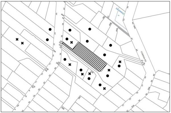
|
NOTIFICATION PLAN |
|||
|
• PROPERTIES NOTIFIED |
X SUBMISSIONS RECEIVED |
|
|
|
9 SUBMISSIONS RECEIVED OUT OF MAP RANGE |
|||
18 submissions objected to the development, generally on the grounds that:
· Future dwelling houses on the allotments could be large scale and affect the amenity of the area.
· The application has been insufficiently supported with regard to documentation, plans and detail.
· The site provides poor vehicular access for firefighters and emergency services.
· The impact to on-street parking is substantial.
· Additional trees can be removed on the site pursuant to the RFS 10/50 code.
· The proposal would result in a reduction in on-street parking.
· The submitted Arborist Report includes numerous errors and inconsistencies, including numerous trees that have not been plotted on the Survey Plan.
· An Ecological Assessment is required to be submitted.
· The nearby heritage listed property ‘Ahimsa’ has not been properly considered.
· The loss of vegetation would pose a detrimental impact to the HCA.
· The subdivision is inappropriate for the HCA.
· The site is steep, and the proposal does not comply with the earthwork requirements of the HLEP.
· The proposed lots are small and irregular in shape compared to surrounding properties.
· The indicative location of future dwelling houses on the proposed allotments would give rise to negative privacy and amenity impacts to these properties.
· The proposal does not comply with Planning for Bushfire Protection 2019 including that the accessway and turning areas is not of adequate width to facilitate access by RFS fire trucks.
· The driveway width, turning head, passing bay, waste collection, gradient and lighting requirements of the HDCP.
· The proposed use of the existing accessway is unsafe for vehicles and pedestrians.
· The width of the accessway does not permit 2 vehicles using the accessway at any one time.
· There is not enough space along the street frontage to accommodate the additional bins.
· The proposed tree canopy loss is understated and unacceptable and provides habitat for wildlife.
· Endangered Species (Syzygium paniculatum) are growing on the subject site.
· The large number of trees proposed to be removed is unacceptable.
· The ability to provide offset planting is limited due to the NSW Rural Fire Service APZ requirements.
· Trees proposed to be removed within the indicative building envelopes should not be removed and are to be considered upon future applications for dwelling houses on the allotments.
· There is a conflict between the positioning of the private open space, offset planting area and tree removal.
· The proposal would increase stormwater runoff into adjacent waterways.
The merits of the matters raised in community submissions have been addressed in the body of the report with the exception of the following:
5.1.1 Insufficient Information
Submissions have been received raising concerns that the application has been insufficiently supported with regard to documentation, plans and detail, including that numerous trees that have not been plotted on the Survey Plan.
In addressing these submissions, it is acknowledged that Council’s assessment has taken into consideration the quality of the submitted plans and documentation and has deemed the submitted information to be adequate for the purposes of development assessment and for the determination of the application. It is noted that the submitted Plan of Proposed Subdivision has mistakenly not plotted numerous trees on the subject site. The submitted Tree Protection Plan prepared by Australis Tree Management dated 22 January 2021 has rectified this issue which is also accurately reflected in the Arboricultural Impact Assessment.
5.1.2 Street Parking
Submissions have been received raising concerns that the proposal would result in a reduction in on-street parking.
In addressing these submissions, the proposal accommodates capacity for on-site parking of 2 vehicles per allotment and complies with the HDCP in this regard. In addition, the application does not propose the construction of an additional vehicular crossing at Day Road and would not reduce street parking in this respect. There is no requirement under the HDCP for the provision of onsite visitor car parking for low density residential development.
5.1.3 Ecological Assessment
A submission has been received raising concerns that an Ecological Assessment is required to be submitted given the site contains 2 Magenta Lilly Pilly trees, listed as vulnerable under the Commonwealth Environment Protection and Biodiversity Conservation Act 1995.
The site is not mapped as containing ‘Terrestrial Biodiversity’ and is not subject to the ‘Terrestrial Biodiversity’ considerations of the HLEP.
The 2 Magenta Lilly Pilly trees (tree Nos. 25 and 35) located to the front of site are proposed to be retained. Council’s tree assessment concurs with the submitted Arboricultural Impact Assessment that the proposed works, including the proposed stormwater line, would not encroach into the TPZ of these 2 trees. The trees are located approximately 35m from the indicative building envelope on Lot 11 and the construction of dwelling houses on the proposed lots would not impact upon these trees. Council’s biodiversity assessment is satisfied that the proposal would not impact threatened species habitat, populations or ecological communities pursuant to section 5A of the Environmental Planning and Assessment Act and an Ecological Assessment is not required in this instance.
5.2 Public Agencies
The development application was referred to the following Agency for comment:
5.2.1 Rural Fire Service
The application is integrated development in accordance with Section 4.46 of the Environmental Planning and Assessment Act 1979 as the site is subject to bushfire risk. The proposal was referred to the NSW Rural Fire Service (RFS). The RFS provided a Bushfire Safety Authority as required under Section 100b of the Rural Fires Act 1997 and the General Terms of Approval have been included in Schedule 1 of the report.
6. THE PUBLIC INTEREST
Section 4.15(1)(e) of the Act requires Council to consider “the public interest”.
The public interest is an overarching requirement, which includes the consideration of the matters discussed in this report. Implicit to the public interest is the achievement of future built outcomes adequately responding to and respecting the future desired outcomes expressed in environmental planning instruments and development control plans.
The application is considered to have satisfactorily addressed Council’s and relevant agencies’ criteria and would provide a development outcome that, on balance, would result in a positive impact for the community. Accordingly, it is considered that the approval of the proposed development would be in the public interest.
CONCLUSION
The application proposes the Torrens Title subdivision of one allotment into two lots.
The development meets the desired outcomes of Council’s planning controls and is satisfactory having regard to the matters for consideration under Section 4.15 of the Environmental Planning and Assessment Act 1979.
Council received 18 submissions during the public notification period. The matters raised have been addressed in the body of the report.
Having regard to the circumstances of the case, approval of the application is recommended.
The reasons for this decision are:
· The proposed development complies with the requirements of the relevant environmental planning instruments and the Hornsby Development Control Plan 2013.
· The proposed development does not create unreasonable environmental impacts to adjoining development with regard to amenity, privacy, heritage conservation, tree preservation, bushfire management, vehicle access and stormwater management.
Note: At the time of the completion of this planning report, no persons have made a Political Donations Disclosure Statement pursuant to Section 10.4 of the Environmental Planning and Assessment Act 1979 in respect of the subject planning application.
RESPONSIBLE OFFICER
The officer responsible for the preparation of this report is Thomas Dales
|
Cassandra Williams Major Development Manager - Development Assessments Planning and Compliance Division |
Rod Pickles Manager - Development Assessments Planning and Compliance Division |
|
Locality Map |
|
|
|
|
Subdivision Plan |
|
|
|
|
Survey Plan |
|
|
|
|
Drainage Plan |
|
|
|
|
Tree Protection Plan |
|
|
File Reference: DA/149/2021
Document Number: D08153472
SCHEDULE 1
The conditions of consent within this notice of determination have been applied to ensure that the use of the land and/or building is carried out in such a manner that is consistent with the aims and objectives of the relevant legislation, planning instruments and Council policies affecting the land and does not disrupt the amenity of the neighbourhood or impact upon the environment.
Note: For the purpose of this consent, the term ‘applicant’ means any person who has the authority to act on or the benefit of the development consent.
Note: For the purpose of this consent, any reference to an Act, Regulation, Australian Standard or publication by a public authority shall be taken to mean the gazetted Act or Regulation or adopted Australian Standard or publication as in force on the date that the application for a construction certificate is made.
1. Approved Plans and Supporting Documentation
The development must be carried out in accordance with the plans and documentation listed below and endorsed with Council’s stamp, except where amended by Council and/or other conditions of this consent:
Approved Plans
|
Plan No. |
Plan Title |
Drawn by |
Dated |
Council Reference |
|
S.15630A2, Rev B |
Plan of Proposed Subdivision |
P.S. Graham & Associates |
27.4.21 |
|
|
S.15630A2, Rev A2 |
Concept Drainage Plan |
P.S. Graham & Associates |
29.1.21 |
|
|
20211720.5, Page 3/4 |
Tree Protection Plan |
Australis Tree Management |
22.1.21 |
|
Supporting Documents
|
Document Title |
Prepared by |
Dated |
Council Reference |
|
Bushfire Protection Assessment Report |
ABPP |
15.12.20 |
D08106037 |
|
Arboricultural Impact Assessment |
Australis Tree Management |
22.1.21 |
D08106036 |
|
Addendum to Bushfire Protection Assessment Report |
ABPP |
27.1.21 |
D08106035 |
|
Waste Management Plan |
P.S. Graham & Associates |
23.12.20 |
D08106032 |
|
General Terms of Approval (GTA) (Ref: A20210510001876-CL55-1) |
NSW Rural Fire Service |
23.7.21 |
D08213550 |
2. Removal of Existing Trees
This development consent permits the removal of 6 trees numbered 1, 62, 69, 74, 78 and 103 as identified on the Tree Protection Plan prepared by Australis Tree Management dated 22 January 2021. All other trees must be retained.
3. Construction Certificate
a) A Construction Certificate is required to be approved by Council or a Private Certifying Authority prior to the commencement of any construction works under this consent.
b) A Subdivision Works Certificate is required to be approved by Council or a Private Certifying Authority with relevant accreditation in B and C Category, prior to the commencement of any subdivision works under this consent.
c) A separate Subdivision Works Certificate must be obtained from Council for all works within the public road reserve under S138 of the Roads Act 1993.
d) The Construction Certificate / Subdivision Works Certificate plans must be consistent with the Development Consent plans.
4. Section 7.11 Development Contributions
a) In accordance with Section 4.17(1) of the Environmental Planning and Assessment Act 1979 and the Hornsby Shire Council Section 7.11 Development Contributions Plan 2020-2030, the following monetary contributions must be paid to Council to cater for the increased demand for community infrastructure resulting from the development:
|
Description |
Contribution (4) |
|
Roads |
$1,456.60 |
|
Open Space and Recreation |
$11,413.95 |
|
Community Facilities |
$7,029.95 |
|
Plan Preparation and Administration |
$99.50 |
|
TOTAL |
$20,000 |
being for an additional allotment.
b) The value of this contribution is current as at 29 July 2021. If the contribution is not paid within the financial quarter that this condition was generated, the contribution payable will be adjusted in accordance with the provisions of the Hornsby Shire Council Section 7.11 Development Contributions Plan and the amount payable will be calculated at the time of payment in the following manner:
$CPY = $CDC x CPIPY
CPIDC
Where:
$CPY is the amount of the contribution at the date of Payment.
$CDC is the amount of the contribution as set out in this Development Consent.
CPIPY is the latest release of the Consumer Price Index (Sydney – All Groups) at the date of Payment as published by the ABS.
CPIDC is the Consumer Price Index (Sydney – All Groups) for the financial quarter at the date applicable in this Development Consent Condition.
c) The monetary contribution must be paid to Council:
i) prior to the issue of the Subdivision Certificate where the development is for subdivision.
ii) prior to the issue of the first Construction Certificate where the development is for building work.
iii) prior to issue of the Subdivision Certificate or first Construction Certificate, whichever occurs first, where the development involves both subdivision and building work.
iv) prior to the works commencing where the development does not require a Construction Certificate or Subdivision Certificate.
Note: It is the professional responsibility of the Principal Certifying Authority to ensure that the monetary contributions have been paid to Council in accordance with the above timeframes.
Council’s Development Contributions Plan may be viewed at www.hornsby.nsw.gov.au or a copy may be inspected at Council’s Administration Centre during normal business hours.
REQUIREMENTS PRIOR TO THE ISSUE OF A CONSTRUCTION CERTIFICATE
5. Appointment of a Project Arborist
a) A project arborist with AQF Level 5 qualifications must be appointed.
b) Details of the appointed project arborist must be submitted to Council and the PCA for registration with the application for the construction certificate.
6. Stormwater Drainage
The stormwater drainage system for the development must be designed in accordance with AUS-SPEC Specifications (www.hornsby.nsw.gov.au/property/build/aus-spec-terms-and-conditions) and the following requirements:
a) Connected directly to Council’s street drainage system in Day Road with a galvanised box section with a 100mm maximum depth.
b) An inter-allotment stormwater drainage system to service the proposed subdivision with pits being cast in situ or pre-cast concrete pits being used.
7. Service Conduits
a) Conduit for utility services including electricity, water, gas and telephone is to be provided. All existing overhead assets within the subject site including electricity and telecommunications cabling shall be relocated underground at no cost to Council. A certificate from an appropriately licensed contractor shall be submitted to the principal certifying authority certifying that the service conduits have been installed in accordance with the relevant utility provider and Australian Standards.
b) The relocated services are to be located within the proposed Easement for Services as depicted on the approved Plan of Proposed Subdivision.
8. Internal Driveway/Vehicular Areas
The proposed passing bay/turning head and the three narrow strips of driveway within the Right of Carriageway owned by the adjacent property at No. 34A Day Road must be designed, constructed and a Construction Certificate issued in accordance with Australian Standards AS2890.1, AS2890.2, AS3727 and the following requirements:
a) The driveway be a rigid pavement.
b) A passing bay a minimum 5.5 metres wide and 6 metres long with 4-metre-long transition splays shall be provided along the existing access driveway to enable vehicles to pass each other.
c) A common turning area to service the proposed subdivision in accordance with Australian Standards AS 2890.1 to ensure vehicles can enter and leave the site in a forward direction. A right of access shall be created over the turning area to ensure access is maintained at all times.
d) Longitudinal sections along both sides of the access driveway shall be submitted to the principal certifying authority in accordance with the relevant sections of AS 2890.1. The maximum grade shall not exceed 1 in 4 (25%) with the maximum changes of grade of 1 in 8 (12.5%) for summit grades and 1 in 6.7 (15%) for sag grades. Any transition grades shall have a minimum length of 2 metres. The longitudinal sections shall incorporate the design levels obtained by Council.
Note: A construction certificate shall be obtained prior to the commencement of these works and are to be completed prior to the issue of an occupation certificate.
9. Building Code of Australia
All approved building work must be carried out in accordance with the relevant requirements of the Building Code of Australia.
The applicant must submit written evidence of the following service provider requirements: -
a) Ausgrid - a letter of consent demonstrating that satisfactory arrangements have been made to service the proposed development.
b) Telstra or NBN Co. - a letter of consent demonstrating that satisfactory arrangements have been made to service the proposed development.
11. Sydney Water – Approval
This application must be submitted to Sydney Water for approval to determine whether the development would affect any Sydney Water infrastructure, and whether further requirements are to be met.
Note: Building plan approvals can be obtained online via Sydney Water Tap inTM through www.sydneywater.com.au under the Building and Development tab.
REQUIREMENTS PRIOR TO THE COMMENCEMENT OF ANY WORKS
12. Installation of Tree Protection Measures
All trees to be retained must have tree protection measures for the ground, trunk and canopy installed by the project arborist as follows:
a) For the duration of construction works, in accordance with Tree Protection Plan prepared by Australis Tree Management dated 22/1/2021.
b) Tree protection fencing for the trees to be retained must be installed by the engaged AQF 5 project arborist and consist of 1.8m high temporary fencing panels installed in accordance with Australian Standard AS4687-2007 Temporary fencing and hoardings.
c) The installation of all required tree protection fencing must include shade cloth attached to the fencing to reduce transport of dust, particulates and liquids from entering the tree protection zone.
d) Tree crown protection measures are required and must be installed by the AQF 5 project arborist.
e) The circumference of the trunk(s) must be wrapped in hessian material to provide cushioning for the installation of timber planks.
f) Timber planks (50 x100mm) must be spaced at 100mm intervals and must be attached using adjustable ratchet straps.
g) All tree protection zones must have a layer of wood-chip mulch at a depth of between 150mm and 300mm.
h) Where wood-chip mulch is permitted by Council instead of tree protection fencing within the tree protection zones, the wood-chip must be covered with a layer of geotextile fabric and rumble boards.
13. Erection of Construction Sign
a) A sign must be erected in a prominent position on any site on which any approved work is being carried out:
i) Showing the name, address and telephone number of the principal certifying authority for the work.
ii) Showing the name of the principal contractor (if any) for any demolition or building work and a telephone number on which that person may be contacted outside working hours.
iii) Stating that unauthorised entry to the work site is prohibited.
b) The sign is to be maintained while the approved work is being carried out and must be removed when the work has been completed.
14. Protection of Adjoining Areas
A temporary hoarding, fence or awning must be erected between the work site and adjoining lands before the works begin and must be kept in place until after the completion of the works if the works:
a) Could cause a danger, obstruction or inconvenience to pedestrian or vehicular traffic.
b) Could cause damage to adjoining lands by falling objects; and/or
c) Involve the enclosure of a public place or part of a public place; and/or
d) Have been identified as requiring a temporary hoarding, fence or awning within the Council approved Construction Management Plan (CMP).
Note: Notwithstanding the above, Council’s separate written approval is required prior to the erection of any structure or other obstruction on public land.
15. Toilet Facilities
a) To provide a safe and hygienic workplace, toilet facilities must be available or be installed at the works site before works begin and must be maintained until the works are completed at a ratio of one toilet for every 20 persons employed at the site.
b) Each toilet must:
i) Be a standard flushing toilet connected to a public sewer.
ii) Be a temporary chemical closet approved under the Local Government Act 1993.
iii) Have an on-site effluent disposal system approved under the Local Government Act 1993.
16. Erosion and Sediment Control
To protect the water quality of the downstream environment, erosion and sediment control measures must be provided and maintained throughout the construction period in accordance with the manual ‘Soils and Construction 2004 (Bluebook)’, the approved plans, Council specifications and to the satisfaction of the principal certifying authority. The erosion and sediment control devices must remain in place until the site has been stabilised and revegetated.
Note: On the spot penalties may be issued for any non-compliance with this requirement without any further notification or warning.
REQUIREMENTS DURING CONSTRUCTION
17. Prohibited Actions Within the Fenced Tree Protection Zone
The following activities are prohibited within the approved fenced tree protection zones unless otherwise approved by Council:
a) Soil cutting or filling, including excavation and trenching.
b) Soil cultivation, disturbance or compaction.
c) Stockpiling storage or mixing of materials.
d) The parking, storing, washing and repairing of tools, equipment and machinery.
e) The disposal of liquids and refuelling.
f) The disposal of building materials.
g) The siting of offices or sheds.
h) Any action leading to the impact on tree health or structure.
18. Maintaining the Health of Trees Approved for Retention
The appointed project arborist must monitor and record any and all necessary actions required to maintain tree health and condition for retained trees on the approved plans.
19. Maintaining Tree Protection Measures
The Tree Protection Measures must be maintained by the project arborist for the duration of works.
20. Approved Works Within Tree Protection Zone Incursions
a) Where tree root pruning is required for the installation of piers, driveway or underground services, the pruning must be overseen by the AQF 5 project arborist and must be undertaken as follows:
i) Using sharp secateurs, pruners, handsaws or chainsaws with the final cut being clean.
ii) The maximum diameter of roots permitted to be cut is 50mm.
b) The new driveway components and passing bay/turning head must be constructed using the following process:
i) To minimise soil compaction the proposed driveway must be built above grade using sensitive construction techniques in the form of piers or screw pilings.
ii) To minimise soil compaction all imported material in the vicinity of the replacement driveway must be distributed by hand.
c) Where the construction of the structures enters or transects the Tree Protection Zones of trees to be retained sensitive construction techniques in the form of screw pilings or piers, cantilevered or suspended slab design must be employed to create a 100mm clearance above existing soil grade.
d) Approved excavations within the Tree Protection Zone of trees to be retained not associated with installation of services must be undertaken as follows:
i) Excavations for the construction and/or installation of the driveway components and turning area in the Tree Protection Zone of trees to be retained on the approved plans must be supervised by the project arborist for the first 1.000 meter undertaken manually to locate roots and allow for pruning.
e) No changes of grade within the Tree Protection Zone of trees to be retained on the approved plans are permitted.
f) To minimise impacts within the Tree Protection Zone (TPZ) of trees to be retained on the approved plans, the installation of services must be undertaken as follows:
i) The AQF 5 project arborist must be present to oversee the installation of any underground services which enter or transect the tree protection.
ii) The installation of any underground services which either enter or transect the designated TPZ must be undertaken manually.
iii) For manually excavated trenches the AQF 5 project arborist must designate roots to be retained. Manual excavation may include the use of pneumatic and hydraulic tools.
g) Where scaffolding is required, ground protection must be installed beneath the scaffolding in the following order:
i) Installation of a 100mm deep layer of woodchip.
ii) Installation of geotextile fabric ground covering.
iii) Installation of scaffold boarding above the woodchip and geotextile fabric.
21. Building Materials and Site Waste
The stockpiling of building materials, the parking of vehicles or plant, the disposal of cement slurry, waste water or other contaminants must be located outside the tree protection zones as prescribed in the conditions of this consent of any tree to be retained.
22. Construction Work Hours
All works on site, including demolition and earth works, must only occur between 7am and 5pm Monday to Saturday.
No work is to be undertaken on Sundays or public holidays.
23. Environmental Management
To prevent sediment run-off, excessive dust, noise or odour emanating from the site during the construction, the site must be managed in accordance with the publication ‘Managing Urban Stormwater – Landcom (March 2004) and the Protection of the Environment Operations Act 1997.
24. Council Property
To ensure that the public reserve is kept in a clean, tidy and safe condition during construction works, no building materials, waste, machinery or related matter is to be stored on the road or footpath.
Note: This consent does not give right of access to the site via Council’s park or reserve. Should such access be required, separate written approval is to be obtained from Council.
25. Disturbance of Existing Site
During construction works, the existing ground levels of open space areas and natural landscape features, including natural rock-outcrops, vegetation, soil and watercourses must not be altered unless otherwise nominated on the approved plans.
26. Waste Management
All work must be carried out in accordance with the approved waste management plan.
27. RFS Requirements / Reticulated Water Supply
a) In accordance with the recommendations of the submitted Bushfire Protection Assessment prepared by ABPP dated 15 December 2020 and consistent with the NSW Rural Fire Service’s General Terms of Approval (GTA), the reticulated water supply is to be extended from the street mains to the proposed hydrant located adjacent to the proposed passing bay; and
b) A Certificate prepared by a BPAD accredited Bushfire Consultant is to be provided to the Principal Certifying Authority (PCA) certifying the completion of any works required by the NSW RFS General Terms of Approval (GTAs) prior to the issue of the Subdivision Certificate.
Note: Figure 1 on Page 6 of the submitted Bushfire Protection Assessment prepared by ABPP dated 15 December 2020 indicates the proposed location of the hydrant.
28. Replacement Tree Requirements
a) The 6 trees approved for removal under this consent must be offset through replacement planting of a minimum of 6 trees within Lot 11.
b) All replacement plantings must be species selected from the ‘Trees Indigenous to Hornsby Shire (as of 1 September 2011)’ document available for viewing on the Hornsby Council’s website http://www.hornsby.nsw.gov.au/environment/flora-and-fauna/tree-management/indigenous-trees
c) The location and size of tree replacement planting must comply with the following:
i) All replacement trees must be located in either front or rear setbacks and planted 4 metres or greater from the indicative building envelopes.
ii) The pot size of the replacement trees must be a minimum 45 litres.
iii) All replacement trees must be a minimum of 3 metres in height at the time of planting.
iv) All replacement trees must have the potential to reach a mature height greater than 10 metres.
29. Final Tree Certification
a) The AQF 5 Project arborist must submit to the Principal Certifying Authority a certificate that includes the following:
b) All tree protection requirements complied with the as approved tree protection plan for the duration of demolition and/or construction works and.
c) All completed works relating to tree protection and maintenance have been carried out in compliance with the conditions of consent and approved plans and;
d) Dates, times and reasons for all site attendance and;
e) All works undertaken to maintain the health of retained trees and;
f) Details of tree protection zone maintenance for the duration of works and;
Note: Copies of monitoring documentation may be requested throughout DA process.
30. Sydney Water – s73 Certificate
A s73 Certificate must be obtained from Sydney Water and submitted to the PCA.
Note: Sydney Water requires that s73 applications are to be made through an authorised Sydney Water Servicing Coordinator. Refer to www.sydneywater.com.au or telephone 13 20 92 for assistance.
The following matter(s) must be nominated on the plan of subdivision under s88B of the Conveyancing Act 1919:
a) A right of access over the access corridor and the proposed passing bay and turning head;
b) An easement for services at the location shown on the approved Plan of Proposed Subdivision;
c) The creation of a “Positive Covenant” over the proposed Lot 11 and 12 requiring that any future development is to provide an on-site detention system. The on-site detention system is to have a storage capacity of 5 cubic metres and a maximum discharge of 8 litres per second into Council’s drainage system in accordance with Council’s prescribed wording;
d) The creation of a “Positive Covenant” over the entire site requiring that the site be managed as an inner protection area (IPA) in accordance with the requirements of Planning for Bush Fire Protection 2019;
e) An easement for letterboxes shall be created over Lot 11 benefiting Lot 12. The 88b instrument shall be worded to reflect the obligations and responsibilities of the benefiting and burdening parties.
Note: Council must be nominated as the authority to release, vary or modify any easement, restriction or covenant.
32. Construction of Engineering Works
All engineering works identified in this consent are to be completed and a Compliance Certificate issued prior to the release of the Subdivision Certificate.
33. Preservation of Survey Marks
A certificate by a Registered Surveyor must be submitted to the Principal Certifying Authority, certifying that there has been no removal, damage, destruction, displacement or defacing of the existing survey marks in the vicinity of the proposed development or otherwise the re-establishment of damaged, removed or displaced survey marks has been undertaken in accordance with the Surveyor General’s Direction No.11 - Preservation of Survey Infrastructure.
34. Works as Executed Plan
A works-as-executed plan(s) must be prepared by a registered surveyor and submitted to Council for completed on-site detention, council drainage, road pavement and kerb & gutter. The plan(s) must be accompanied by a certificate from a registered surveyor certifying that all pipelines and associated structures lie wholly within any relevant easements.
35. Damage to Council Assets
To protect public property and infrastructure, any damage caused to Council’s assets as a result of the construction or demolition of the development must be rectified by the applicant in accordance with AUS-SPEC Specifications (www.hornsby.nsw.gov.au/property/build/aus-spec-terms-and-conditions. Rectification works must be undertaken prior to the issue of an Occupation Certificate, or sooner, as directed by Council.
GENERAL TERMS OF APPROVAL – NSW RURAL FIRE SERVICE
The following conditions of consent are General Terms of Approval from the nominated State Agency pursuant to Section 4.47 of the Environmental Planning and Assessment Act 1979 and must be complied with to the satisfaction of that Agency.
36. Asset Protection Zones
At the issue of a subdivision certificate, and in perpetuity to ensure ongoing protection from the impact of bush fires, the entire site must be managed as an inner protection area (IPA) in accordance with the requirements of Appendix 4 of Planning for Bush Fire Protection 2019. When establishing and maintaining an IPA the following requirements apply:
a) Tree canopy cover should be less than 15% at maturity.
b) Trees at maturity should not touch or overhang the building.
c) Lower limbs should be removed up to a height of 2m above the ground.
d) Tree canopies should be separated by 2 to 5m.
e) Preference should be given to smooth barked and evergreen trees.
f) Large discontinuities or gaps in vegetation should be provided to slow down or break the progress of fire towards buildings.
g) Shrubs should not be located under trees.
h) Shrubs should not form more than 10% ground cover.
i) Clumps of shrubs should be separated from exposed windows and doors by a distance of at least twice the height of the vegetation.
j) Grass should be kept mown (as a guide grass should be kept to no more than 100mm in height).
k) Leaves and vegetation debris should be removed.
37. Water and Utility Services
The provision of water, electricity and gas must comply with Table 5.3c of Planning for Bush Fire Protection 2019.
- END OF CONDITIONS
ADVISORY NOTES
The following information is provided for your assistance to ensure compliance with the Environmental Planning and Assessment Act 1979, Environmental Planning and Assessment Regulation 2000, other relevant legislation and Council’s policies and specifications. This information does not form part of the conditions of development consent pursuant to Section 4.17 of the Act.
Environmental Planning and Assessment Act 1979 Requirements
The Environmental Planning and Assessment Act 1979 requires:
· The issue of a construction certificate prior to the commencement of any works. Enquiries can be made to Council’s Customer Services Branch on 9847 6760.
· A principal certifying authority to be nominated and Council notified of that appointment prior to the commencement of any works.
· Council to be given at least two days written notice prior to the commencement of any works.
· Mandatory inspections of nominated stages of the construction inspected.
· An occupation certificate to be issued before occupying any building or commencing the use of the land.
Tree and Vegetation Preservation
Hornsby Development Control Plan 2013 Tree and Vegetation Preservation provisions have been developed under Council’s authorities contained in State Environmental Planning Policy (Vegetation in Non-Rural Areas) 2017 and the Environmental Planning and Assessment Act 1979.
In accordance with these provisions a person must not cut down, fell, uproot, kill, poison, ringbark, burn or otherwise destroy the vegetation, lop or otherwise remove a substantial part of the trees or vegetation to which any such development control plan applies without the authority conferred by a development consent or a permit granted by Council.
Fines may be imposed for non-compliance with the Hornsby Development Control Plan 2013.
Note: A tree is defined as a long lived, woody perennial plant with one or relatively few main stems with the potential to grow to a height greater than three metres (3m). (HDCP 1B.6.1.c).
Prior to commencing any works, the applicant is encouraged to contact Dial Before You Dig on 1100 or www.dialbeforeyoudig.com.au for free information on potential underground pipes and cables within the vicinity of the development site.
Should asbestos or asbestos products be encountered during demolition or construction works, you are advised to seek advice and information prior to disturbing this material. It is recommended that a contractor holding an asbestos-handling permit (issued by SafeWork NSW) be engaged to manage the proper handling of this material. Further information regarding the safe handling and removal of asbestos can be found at:
Alternatively, telephone SafeWork NSW on 13 10 50.
Subdivision Certificate Requirements
A subdivision certificate application is required to be lodged with Council containing the following information:
· A surveyor’s certificate certifying that all structures within the subject land comply with the development consent in regard to the setbacks from the new boundaries.
· A surveyor’s certificate certifying that all services, drainage lines or access are located wholly within the property boundaries. Where services encroach over the new boundaries, easements are to be created.
· Certification that the requirements of relevant utility authorities have been met.
· A surveyor’s certificate certifying finished ground levels are in accordance with the approved plans.
Note: Council will not issue a subdivision certificate until all conditions of the development consent have been completed.
Fees and Charges – Subdivision
All fees payable to Council as part of any construction, compliance or subdivision certificate or inspection associated with the development (including the registration of privately issued certificates) are required to be paid in full prior to the issue of the subdivision certificate. Any additional Council inspections beyond the scope of any compliance certificate required to verify compliance with the terms of this consent will be charged at the individual inspection rate nominated in Council's Fees and Charges Schedule.
The house numbering for this subdivision shall be:
|
Lot |
Street Number |
Street Name |
Street Type |
Locality |
|
Lot 11 |
34 |
Day |
Road |
Cheltenham |
|
Lot 12 |
34B |
Day |
Road |
Cheltenham |
LPP Report No. LPP21/21
Local Planning Panel
Date of Meeting: 25/08/2021
2 DA/275/2021 - DEMOLITION OF STRUCTURES AND CONSTRUCTION OF A SINGLE STOREY 35 PLACE CHILDCARE CENTRE WITH BASEMENT CARPARK - 1 CAMERON AVENUE, WEST PENNANT HILLS
EXECUTIVE SUMMARY
|
DA No: |
DA/275/2021 (Lodged on 23 March 2021) |
|
Description: |
Demolition of existing structures and construction of a single storey 35 place child care centre with a basement carpark |
|
Property: |
Lot 18 DP 203971, No. 1 Cameron Avenue West Pennant Hills |
|
Applicant: |
Childcare Development Group |
|
Owner: |
Mr Gerard John Duane and Mrs Nora Teresa Duane |
|
Estimated Value: |
$1,101,829 |
|
Ward: |
C |
· The application involves the demolition of existing structures and construction of a single storey 35 place child care centre with a basement carpark and business identification signage.
· The proposal complies with the Hornsby Local Environmental Plan 2013, the Hornsby Development Control Plan 2013, State Environmental Planning Policy (Educational Establishments and Childcare Facilities) 2017 and the Child Care Planning Guideline with respect to landscaping, privacy, noise, traffic and safety, scale, site suitability, contamination, setbacks, tree preservation and sunlight access.
· A total of 31 submissions have been received in respect of the application.
· The application is required to be determined by the Hornsby Council Local Planning Panel as 10 or more unique submissions were received by way of objection.
· It is recommended that the application be approved.
|
THAT Development Application No. DA/275/2021 for demolition of existing structures and construction of a single storey 35 place child care centre with a basement carpark and business sign at Lot 18 DP 203971, No. 1 Cameron Avenue West Pennant Hills be approved subject to the conditions of consent detailed in Schedule 1 of LPP Report No. LPP21/21. |
BACKGROUND
Site History
On 5 November 2020, Council held a pre-lodgement meeting (PL/72/2020) with the applicant to discuss the merits of a 35-place single storey child care centre with basement carpark.
Application History
On 26 April 2021, Council requested additional information/ amended plans to enable Council to undertake a comprehensive assessment regarding landscaping, acoustics, site contamination, pedestrian/ vehicle safety and construction traffic management. Between the dates of 20 May 2021 and 22 June 2021, Council received the requested plans and documentation.
On 22 June 2021, Council requested further revisions to the submitted Construction Traffic Management Plan (CTMP). Council received the revised CTMP on 5 July 2021.
On 2 August 2021, Council sought clarification from the applicant’s acoustic consultant regarding whether the proposed 1.8m high boundary fences along the side boundaries could be tapered to 1.2m within the front setback for vehicle visibility and to improve streetscape presence, whilst maintaining acoustic requirements. On 3 August 2021, Council received a letter from the acoustic consultant along with revised Architectural Plans (Rev C).
SITE
The 752.5m2 site legally described as Lot 18 DP 203971 is located on the western side of Cameron Avenue West Pennant Hills and contains a split-level dwelling house and a shed outbuilding to the rear.
The site experiences an average fall of 9% (3.5m) to the front, south-eastern corner.
Cameron Avenue is a low-density residential street with a streetscape comprising a mixture of single and two storey dwelling houses.
The two adjoining properties to the south at Nos. 178 and 180 Victoria Road comprise a single storey dwelling house with garage and shed outbuildings and a split-level dwelling house, respectively. The adjoining property to the north at No. 3 Cameron Avenue contains a newly constructed single storey dwelling house. The adjacent property to the rear at No. 14 Wesson Road contains a single storey dwelling house.
The site is not bushfire or flood prone and is not burdened by any easements or restrictions.
The site is sparsely vegetated and contains a variety of small to large scale shrubs and trees along its perimeter.
Cherrybrook Metro Station is located approximately 1.3km walking distance from the site. A bus stop servicing the Transport for NSW ‘632’, ‘633’ and ‘642X’ bus routes is located 210m walking distance from the site at Castle Hill Road, connecting the site to locations including Rouse Hill, Castle Hill and the Sydney CBD.
PROPOSAL
The application seeks demolition of existing structures and construction of a purpose-built single storey child care centre with basement carpark.
The centre would cater for a maximum of 35 children within the following age groups:
· 2-3 years 15 Children
· 3-5 years 20 Children
The ground floor would contain a lift, kitchen, laundry, entry, office/reception, disabled toilet, staff room, store room, nappy change/kids’ toilets, two playrooms and outdoor store room. The basement comprises 10 car parking spaces (including 1 disabled space), a lift and a bin storage room.
An outdoor play area would be provided to the rear and sides of the site and would comprise a combination of soft fall synthetic and natural grass.
A pedestrian access ramp is proposed to the northern side of the frontage which would provide direct access to the front entry of the centre.
Ten trees are proposed to be removed to facilitate the proposed development. Landscaping is proposed within the front, side and rear setbacks, including the planting of 2 ‘native frangipani’ trees within the frontage, along with 3 trees (Maple, Bottlebrush and Flowering Pear) within the side and rear boundaries. Additionally, 108 shrubs (with mature heights between 1.5m to 3m) and groundcovers would be planted around the perimeter of the site.
A 1.8m high solid boundary fence would be installed along the side and rear boundaries of the site for privacy and acoustic attenuation purposes. In addition, a 10m2 (5m x 2m) cantilevered roof is to be provided at the north-western corner of the site to provide a partially covered outdoor play area and additional acoustic attenuation.
The proposed operating hours of the child care centre would be 7:00am to 7:00pm, Monday to Friday.
The centre would be staffed by a maximum of 5 educators. Child care staff will commence work on a staggered basis between 7.00am and 9.30am.
A business identification sign comprising a single non-illuminated flush wall sign measuring 1500mm(W) x 1000mm(H) is to be located on the front façade. The top of the sign has a maximum height above ground level of 2700mm.
ASSESSMENT
The development application has been assessed having regard to the Greater Sydney Region Plan – A Metropolis of Three Cities, the North District Plan and the matters for consideration prescribed under Section 4.15 of the Environmental Planning and Assessment Act 1979 (the Act). The following issues have been identified for further consideration.
1. STRATEGIC CONTEXT
1.1 Greater Sydney Region Plan - A Metropolis of Three Cities and North District Plan
The Greater Sydney Region Plan - A Metropolis of Three Cities has been prepared by the NSW State Government to guide land use planning decisions for the next 40 years (to 2056). The Plan sets a strategy and actions for accommodating Sydney’s future population growth and identifies dwelling targets to ensure supply meets demand. The Plan also identifies that the most suitable areas for new housing are in locations close to jobs, public transport, community facilities and services.
Part 3 of the strategy relates to “Infrastructure and Collaboration” and a key objective is to provide services and infrastructure to meet communities’ changing needs. Further, the strategy cites changing demographics will affect the types and distribution of services required in neighbourhoods.
Over the 20 years to 2036, projections show an expected increase of 6,150 children aged four years and under. The identified challenge for Hornsby Shire would be to provide additional infrastructure for students and young people. The proposed child care centre would be consistent with the objectives of the strategy by providing 35 additional child care places to support a growing population.
2. STATUTORY CONTROLS
Section 4.15(1)(a) requires Council to consider “any relevant environmental planning instruments, draft environmental planning instruments, development control plans, planning agreements and regulations”.
2.1 Hornsby Local Environmental Plan 2013
The proposed development has been assessed having regard to the provisions of the Hornsby Local Environmental Plan 2013 (HLEP).
2.1.1 Zoning of Land and Permissibility
The subject land is zoned R2 Low Density Residential under the HLEP. The objectives of the R2 zone are:
· To provide for the housing needs of the community within a low-density residential environment.
· To enable other land uses that provide facilities or services to meet the day to day needs of residents.
Submissions have been received raising concerns that the proposed child care centre is an inappropriate form of development in the R2 Low Density residential zone.
The proposed development is defined as a ‘centre-based child care facility’ and is permissible in the R2 zone with Council’s consent. The proposed development would provide facilities and services to meet the day to day needs of residents and would contribute in meeting the increasing demand for child care in the Hornsby Shire.
2.1.2 Height of Buildings
Clause 4.3 of the HLEP provides that the height of a building on any land should not exceed the maximum height show for the land on the Height of Buildings Map. The maximum permissible height for the subject site is 8.5m. The proposed building would have a maximum height of 5.6m and complies with this provision.
2.1.3 Heritage Conservation
Clause 5.10 of the HLEP sets out heritage conservation provisions for Hornsby Shire. The site does not include a heritage item, is not located in a heritage conservation area and is not within the immediate vicinity of any heritage items. Accordingly, no further assessment regarding heritage is necessary.
2.1.4 Earthworks
A submission has been received raising concerns that Sydney Water infrastructure and decommissioned septic tanks are potentially present under the site and that the proposed basement may impact upon these.
Clause 6.2 of the HLEP states that consent is required for proposed earthworks on site. Before granting consent for earthworks, Council is required to assess the impacts of the works on adjoining properties, drainage patterns and soil stability of the locality.
The application has been supported by a Preliminary Geotechnical Assessment prepared by Martens Consulting Engineers.
It is anticipated that the proposed development would require excavation works for the building footings, basement carpark and general levelling of the site. Council’s assessment has determined that the proposed development would require the removal of 1,245m3 of excavated material and the utilisation of minimal fill. The submitted Geotechnical Report raises no concerns with the proposed development with regard to earthworks and ground conditions, subject to the implementation of the geotechnical recommendations under Section 4 of the report and the provision of a dilapidation report detailing the structural condition of the adjoining properties before the commencement of works. Council concurs with the recommendations of the Geotechnical Assessment.
In addressing the submission, Council’s mapping system provides an indication that Sydney Water sewer infrastructure may be located within the adjacent sites at Nos. 178 and 180 Victoria Road. Notwithstanding, a standard condition has been recommended under Schedule 1 requiring that an application be submitted to Sydney Water for approval to determine whether the development would affect any Sydney Water infrastructure, prior to the issue of a Construction Certificate. In addition, a condition has been recommended that all demolition work be carried out in accordance with Australian Standard AS2601-2001 Demolition of structures to ensure that the decommissioned septic tanks are removed safely (if it is determined during excavations that they are indeed present under the site).
The proposed earthworks would not detrimentally impact the surrounding natural and built environment with regard to drainage patterns and soil stability of the locality.
The proposal complies with Clause 6.2 of the HLEP and is considered acceptable in this regard.
2.2 State Environmental Planning Policy (Educational Establishments and Childcare Facilities) 2017
State Environmental Planning Policy (Educational Establishments and Childcare Facilities) 2017 (Childcare SEPP) commenced on 1 September 2017.
Clause 23 of the Childcare SEPP requires Council to consider the relevant provisions of the Child Care Planning Guideline 2017 (CCPG). The CCPG will generally take precedence over the HDCP with the exception of building height, side and rear setbacks and car parking rates.
An assessment of the application against Part 1.3 Planning objectives, Part 2 Design quality principles, Part 3 Matters for consideration and Part 4 Applying the National Regulations to development proposals is provided below:
2.2.1 Part 1.3 - What Are the Planning Objectives?
The planning objectives contained within Part 1.3 of the CCPG include requirements that child care facilities are compatible with the existing streetscape, context and neighbouring land uses and that they seek to minimise adverse impacts of development on adjoining properties and the neighbourhood.
As per the discussion provided in response to Part 3 of the CCPG, the proposal is considered consistent with these objectives.
2.2.2 Part 2 - Design Quality Principles
As per the discussion provided in response to Part 3 of the CCPG, the proposal is considered consistent with the design quality principles of Part 2 in relation to built form, landscaping, safety and amenity, privacy, solar access and noise.
2.2.3 Part 3.1 - Site Selection and Location
Submissions have been received that the existing road infrastructure is inadequate to accommodate the child care centre and additional traffic.
The objectives of Part 3.1 of the CCPG include that the siting of child care centres should be clear of potential environmental contaminants and incompatible social activities or uses and should not be located on flood or bushfire prone sites. In addition, Part 3.1 encourages that the land characteristics and slope be suitable for the scale of the development and that the type of adjoining road is appropriate for the proposed use.
Centre-based child care facilities are a permissible land use within the R2 low density residential zone. The site is located approximately 210m walking distance from a bus stop along Castle Hill Road and Cherrybrook Metro Station is located approximately 1.3km walking distance from the site. The site is not mapped as flood or bushfire prone and is an appropriate site in this regard.
The site experiences an average slope of 9% to the rear boundary and is considered to be a reasonably level site as is encouraged by the CCPG for child care centre developments. The site is located approximately 465m from a 7-Eleven service station along the western side of Pennant Hills Road and is not within proximity to any land uses that generate potential environmental contaminants.
Further discussion regarding site contamination and the appropriateness of the width of the street and traffic conditions is provided under Sections 2.3 and 2.8.2 of this report, respectively.
The proposal meets the objectives of Part 3.1 of the CCPG and the proposal is supported in this regard.
2.2.4 Part 3.2 - Local Character, Streetscape and the Public Domain Interface
Submissions have been received raising concerns that the existing and future desired character of the area would be detrimentally impacted by the proposal.
The objectives of Part 3.2 of the CCPG include that child care centre developments should contribute to and recognise existing streetscape qualities including form and scale and integrate car parking into the building design. In addition, child care centre developments should ensure that front fences respond to and complement the character of the area and do not dominate the public domain. Further, the proposal should not impact upon local heritage and the windows of the development should include street facing windows to provide passive surveillance to the street as a safety measure.
Cameron Avenue is a low-density residential street with a streetscape predominantly comprising single storey dwelling houses. The child care centre would present to the streetscape as a single storey structure and complements the setbacks and scale of built form along Cameron Avenue. The proposal includes basement carparking and is consistent with the CCPG requirement to integrate carparking into the building design. Although a 1.2m high masonry / timber front boundary fence has been proposed as indicated in the submitted Statement of Environmental Effects, the submitted plans do not provide any detail in this regard and accordingly approval of this fence cannot be considered under this application. Notwithstanding, 1.2m high front boundary fences are permitted to be constructed without consent under the exempt development provisions of the State Environmental Planning Policy (Exempt and Complying Development Codes) 2008.
The proposal would not be located within close proximity to a heritage item or heritage conservation area and would not pose a detrimental heritage impact consistent with the requirements of the CCPG. Further, the proposal includes street facing windows and provides opportunity for passive surveillance as a safety measure.
The proposal as amended includes provision for 1.8m high acoustic fencing around the sides and rear of the site, which tapers to 1.2m within the front setback to improve vehicle sight lines, streetscape character and landscape prominence.
The proposal meets the objectives of Part 3.2 of the CCPG and is supported in this regard.
2.2.5 Part 3.3 - Building Orientation, Envelope and Design
The objectives of Part 3.3 of the CCPG stipulate that child care centres should be orientated to minimise visual privacy and minimise noise impacts to adjacent properties. In addition, the objectives encourage built form, setbacks and scale of development that relates to its context and allows for accessibility and sunlight access.
Building Orientation and Design
Submissions have been received raising concerns that the proposal would be of a poor design given its residential context.
As previously discussed, Cameron Avenue is a low-density residential street with a streetscape predominantly comprising single storey dwelling houses, with numerous exhibiting face-brick, Colourbond and cladding materials and finishes. The child care centre would present to the streetscape as a single storey building and complements the setbacks and predominantly single storey scale of built form along Cameron Avenue. It is considered that the proposed use of a combination of face-brick, Colourbond, glass and cladding finishes positively contribute to the visual interest of the building and compliments the character of the local area. In addition, it is considered that the proposed boundary setbacks and building orientation would be in keeping with the expectation for development within a low-density residential context, with outdoor play areas provided to the rear of the site and access to the building provided from the front elevation.
Sunlight Access
The proposed single storey building would be setback between 2m-4.2m from the side boundaries and achieves a moderate scale consistent with the expectation for built form in the R2 Low density residential zone. Although the application has not been supported by Sunlight Access Diagrams, the Hornsby Development Application Submission Guideline only requires the submission of shadow diagrams for buildings greater than 1 storey in height. Given the modest scale of the structure, it is considered that all adjacent properties would receive a minimum of 3 hours of unobstructed solar access between 9am and 3pm in June. The proposal is acceptable with regard to sunlight access impacts to adjacent properties.
As addressed under Section 2.2.10 of this report, solar access for outdoor play meets the requirements of Part 4 of the CCPG.
Accessibility
The application has been accompanied by an Access Report prepared by Building Innovations Australia.
The CCPG indicates that Child care facilities need to allow equitable access by all members of the community, including those with disabilities. The submitted architectural plans indicate the provision of a disabled car parking space with access to a lift, an access ramp to the front of the building, a disabled toilet and accessible internal and external areas.
Council’s accessibility assessment concurs with the conclusions of the Access Report, subject to the imposition of a condition under Schedule 1 requiring that the building meets the requirements of the Disability (Access to Premises Buildings) Standards 2010.
2.2.6 Part 3.4 - Landscaping
The objectives of Part 3.4 of the CCPG include providing landscape design that contributes to the streetscape and amenity and along the boundary integrated with fencing. In addition, Part 3.4 encourages the use of existing landscaped areas where feasible.
Landscaping is proposed within the front, side and rear setbacks, including the planting of 2 ‘native frangipani’ trees within the frontage, along with 3 trees (Maple, Bottlebrush and Flowering Pear) within the side and rear boundaries. The trees have an expected mature height of 5m-10m and can be considered medium/ large canopy trees. Additionally, 108 shrubs (with heights between 1.5m-3m) and groundcovers would be planted around the perimeter of the site and would provide vegetation screening to the adjacent properties to the north (No. 3 Wesson Road), south (No. 178 Victoria Road) and rear (No. 14 Wesson Road).
Notwithstanding, the submitted Landscape Plan indicates that the south-western corner of the site would not be subject to the provision of landscaping. To provide vegetation screening to the adjacent property to the south at No. 180 Victoria Road, a condition has been recommended under Schedule 1 requiring that the Landscape Plan be amended to include the planting of shrubs/ trees with a mature height of 3m at the south-western corner. Council’s assessment has determined that the additional landscaping would have an approximate area of 16m2 and would reduce the unencumbered outdoor space from 7.6m2 to 7.1m2 per child, which complies with Part 4 of the CCPG.
The proposal meets the objectives of Part 3.4 of the CCPG and the proposal is supported in this regard.
2.2.7 Part 3.5 - Visual and Acoustic Privacy
The objectives of Part 3.5 of the CCPG encourage the protection of the privacy and security of children attending the facility and to minimise impacts on privacy of adjoining properties. In addition, Part 3.5 seeks to minimise the impact of child care facilities on the acoustic amenity of neighbouring residential developments.
Privacy
Submissions have been received raising concerns that the proposal would result in privacy impacts and overlooking into adjacent properties.
The site experiences an average fall of 9% (3.5m) to the front, south-eastern corner. As evidenced on the submitted Survey Plan, the existing site achieves a ground level of between RL 168.75 AHD and RL 170.03 AHD within the rear yard. As a means of achieving a level building floorplate and outdoor play areas, excavation of between 900mm-1.9m has been proposed to the rear and sides of the site, with the outdoor play areas achieving a ground level of RL 168.00 AHD and the north-western corner provided at existing grade (RL 169.00 AHD). Given that the proposed outdoor play areas would be recessed into the site, substantial privacy is afforded to adjacent properties in this regard.
Similarly, excavation with a depth between 100mm-1.4m is proposed to facilitate the siting of the proposed child care centre building when viewed from the side elevations. It is anticipated that the proposed boundary fences in conjunction with the proposed landscaping would provide considerable privacy to the adjoining property to the north and south.
Despite extensive excavation being proposed to the rear of the site, the proposed boundary fencing to the rear of the site would be provided at existing ground level and would add privacy to adjacent properties at Nos. 3 Cameron Avenue and 14 Wesson Road.
The proposal meets the objectives of Part 3.5 of the CCPG with respect to privacy and the proposal is supported in this regard.
Acoustic Amenity
Submissions have been received with regard to acoustic amenity, summarised as follows:
· The proposed child care centre would generate an unacceptable level of operational noise to adjacent residential properties and would result in a loss of amenity.
· The submitted Acoustic Report is inaccurate, includes inconsistencies and is general in nature.
· The proposed western boundary fence is large and intrusive.
The application has been supported by an Acoustic Report prepared by Renzo Tonin & Associates dated 10 March 2021.
The proposed physical acoustic attenuation measures comprise the construction of a 1.8m high solid boundary fence along the side and rear boundaries and a 10m2 (5m x 2m) cantilevered awning at the north-western corner of the site to provide a partially covered outdoor play area and additional acoustic attenuation.
For child care centre developments, Council strictly requires that background levels (L90) are not exceeded by 5dB(A) when measured at all sensitive residential receiver locations. Council’s assessment of the Acoustic Report identified that insufficient detail had been provided within the report and raised the following concerns:
· The predicted noise levels from outdoor play areas with the proposed acoustic mitigation measures will not achieve acoustic compliance at receiver R4 (No. 14 Wesson Road).
· An assessment of the noise impacts associated with mechanical plant has not been included in the Acoustic Report.
· The assessment of noise impacts associated with the indoor play areas assumes that windows and doors are closed.
· An assessment of the amenity criteria has not been provided.
· The proposed 1.8m high side boundary fence should be tapered to 1.2m within the front setback to improve vehicle sightlines and streetscape character.
· The Plan of Management refers to ‘special events’. The noise impacts associated with special events have not been assessed in the Acoustic Report.
· Whilst the proposed hours of operation are from 7:00am, it is anticipated staff will arrive prior to 7:00am. An assessment of the noise impacts of staff arriving prior to 7:00am is required.
· The Acoustic Report does not include an assessment of noise impacts associated with delivery and service vehicles.
In addressing these concerns, the applicant submitted an Addendum to the Acoustic Report dated 24 May 2021. Upon review of the Addendum, Council is satisfied that sufficient detail has now been provided to undertake a comprehensive acoustic assessment of the proposal. To ensure that background levels (L90) are not exceeded by 5dB(A) when measured at all adjacent properties (including No. 14 Wesson Road), the Addendum recommends that the number of children in the outdoor play area at any one time be limited to the following:
· 20 x 3-5 years old children in the outdoor play areas
OR
· 15 x 2-3 years old children in the outdoor play areas
Council raises no acoustic concerns to the proposal as amended. In accordance with the acoustic recommendations, Council has recommended the imposition of an operational condition under Schedule 1 requiring that the 2-3 and 3-5-year age groups not be together within the outdoor play area at any one time.
It is noted that the Addendum has undertaken the acoustic assessment for indoor play noise on the basis that the windows in Playroom 1 and Playroom 2 are fixed with natural ventilation solely provided through the sliding doors. Council understands that whilst the ground floor level windows would be fixed, automatically controlled highlight awning windows have also been proposed along the northern elevation. A condition has been recommended under Schedule 1 that the highlight windows be fixed to ensure compliance with the acoustic limits.
Further, a condition has been recommended under Schedule 1 to ensure the tapering of the 1.8m high side boundary fences to 1.2m within the frontage.
The proposal meets the objectives of Parts 3.5 of the CCPG and is considered acceptable.
2.2.8 Part 3.6 - Noise and Air Pollution
The objectives of Part 3.6 of the CCPG include ensuring that outside noise levels of the facility are minimised to acceptable levels and to ensure air quality is acceptable where child care facilities are proposed. The CCPG stipulates that the location of child care facilities should be selected to avoid or minimise external sources of significant noise on the facility.
The site is located on a low-density residential street and is sited approximately 120m from a major road in the form of Castle Hill Road to the south-west. In addition, the site is not located in the vicinity of industrial land uses. The site would not be subjected to external sources of significant noise and air pollution and is considered acceptable with regard to the requirements of Part 3.6 of the CCPG. Section 2.2.7 of this report addresses the findings of the submitted Acoustic Report.
The proposal meets the objectives of Parts 3.6 of the CCPG and is considered acceptable.
2.2.9 Part 3.7 - Hours of Operation
A submission has been received raising concerns that parents may remain on the premises after closing hours.
Part 3.7 of the CCPG indicates that the hours of operation within areas where the predominant land use is residential are to be confined to the core hours of 7.00am to 7.00pm weekdays. The proposed operating hours of the child care centre would be 7:00am to 7:00pm, Monday to Friday.
In addressing the submission, page No. 7 the submitted Plan of Management indicates that the majority of children will have been collected between the hours of 3:00pm to 5:00pm. Council concurs with this statement and it is anticipated that only on rare occasions will parents collect their children at closing time.
The proposed hours of use of the child care facility complies with this requirement.
2.2.10 Part 3.8 - Traffic, Parking and Pedestrian Circulation
Part 3.8 of the CCPG indicates that a Traffic and Parking Study should be prepared to support the proposal to quantify potential impacts on the surrounding land uses and demonstrate how impacts on amenity will be minimised. In addition, the CCPG indicates that child care facilities proposed within narrow roads should ensure that safe access can be provided to and from the site and that vehicles can enter and leave the site in a forward direction.
Given that the CCPG delegates car parking rates and traffic to the requirements of the HDCP, Section 2.8.2 of this report addresses parking, traffic and safety.
The following table sets out the proposal’s compliance with the measures of Part 4 of the CCPG:
|
Child Care Planning Guideline 2017 - Part 4 |
|||
|
Control |
Proposal |
Requirement |
Compliance |
|
Unencumbered indoor space |
3.4m2 |
3.25m2 per child |
Yes |
|
Unencumbered outdoor space |
7.6m2 |
7m2 per child |
Yes |
|
Storage |
|
|
|
|
- External |
0.485m3 |
0.3m3 per child |
Yes |
|
- Internal |
0.65m3 |
0.2m3 per child |
Yes |
|
On site laundry |
Provided on site |
Provided on site |
Yes |
|
Child toilet facilities |
Provided on site |
Provided on site |
Yes |
|
Administration space |
Provided on site |
Provided on site |
Yes |
|
Nappy change facilities |
Provided on site |
Provided on site |
Yes |
|
Solar Access for outdoor play |
34% |
30-60% solar access |
Yes |
As detailed in the above table, the proposed development complies with Part 4 of the CCPG.
Clause 25 of the Childcare SEPP contains non-discretionary development standards. This prevents the consent authority from imposing more onerous standards or refusing an application on the basis that they have not been complied with. An assessment of the application against Clause 25 of the Childcare SEPP has been carried out below:
Centre-based child care - non-discretionary development standards
(a) Location - the development may be located at any distance from an existing or proposed early childhood education and care facility.
Submissions have been received raising concerns that the proposed development would be located within close proximity to other child care centres in the locality and that there is an undesirable saturation in the area.
Whilst there are other child care centres located at a distance of 450m or greater from the site, the child care centre can be located at any distance from an existing or proposed childhood education and care facility in accordance with Clause 25(a) of the Childcare SEPP.
(b) Indoor or outdoor space
(i) For development to which clause 107 (indoor unencumbered space requirements) or 108 (outdoor unencumbered space requirements) of the Education and Care Services National Regulations applies - the unencumbered area of indoor space and the unencumbered area of outdoor space for the development complies with the requirements of those clauses, or
(ii) For development to which clause 28 (unencumbered indoor space and useable outdoor play space) of the Children (Education and Care Services) Supplementary Provisions Regulation 2012 applies - the development complies with the indoor space requirements or the useable outdoor play space requirements in that clause;
Comment: The regulations require a minimum of 3.25m2 of unencumbered indoor play area and a minimum of 7m2 of unencumbered outdoor play area per child. The proposal complies with this requirement.
(c) Site area, site coverage and site dimensions—the development may be located on a site of any size, cover any part of the site and have any length of street frontage or any allotment depth.
Submissions have been received raising concerns that the site is not of adequate size to accommodate a child care centre.
Comment: The site has an area of 752.5m2 and a frontage width of 22.86m and complies with Clause 25(c) of the Childcare SEPP.
(d) Colour of building materials or shade structures—the development may be of any colour or colour scheme unless it is a heritage item or in a heritage conservation area,
Comment: The centre would not be located within a heritage conservation area and the site is not a heritage listed item.
In summary, the proposed centre-based child care centre would comply with the Childcare SEPP provisions and is assessed as satisfactory in this regard.
2.3 State Environmental Planning Policy No. 55 Remediation of Land
Submissions have been received raising concerns that effluent is leaking onto the site from disused septic tanks located within upstream properties.
The application has been assessed against the requirements of State Environmental Planning Policy No. 55 Remediation of Land (SEPP 55) under which consent must not be granted to the carrying out of any development on land unless the consent authority has considered whether the land is contaminated or requires remediation for the proposed use.
Should the land be contaminated Council must be satisfied that the land is suitable in a contaminated state for the proposed use. If the land requires remediation to be undertaken to make the land suitable for the proposed use, Council must be satisfied that the land will be remediated before the land is used for that purpose.
The application has been supported by a Preliminary Site Investigation (PSI) prepared by Martens Consulting Engineers to identify whether the potential for contaminants are present on the site. The PSI identified the potential for contamination in all areas of concern. The conclusion of the PSI is provided below:
· The dwelling construction and maintenance have the potential to have introduced contaminants in the form of asbestos (fibrous cement sheets as a construction material), pesticides (pest control) and heavy metals (paints, pest control, use of galvanised materials).
· Past shed construction, storage and maintenance could have introduced asbestos (possible construction material), pesticides (pest control) and heavy metals (paints, galvanised metals, pest control).
· Potential onsite filling includes the entire western portion of site (retaining wall area and previous swimming pool footprint). Fill imported on site have unknown origins and may have introduced asbestos (possible construction material), pesticides (pest control) and heavy metals (paints, galvanised metals, pest control).
Given the PSI identified the potential for contaminants, the applicant provided a Detailed Site Investigation (DSI) prepared by Martens Consulting Engineers dated 12 March 2021 to further investigate the areas of concern and provide potential remediation actions if necessary. The DSI was conducted with on-site borehole contamination sampling. Council’s assessment of the DSI raised concerns that insufficient detail was provided within the report to undertake a comprehensive assessment of whether the site is suitable for a child care centre. Principally, Council raised concerns that that not all samples were examined for all analytes and no sample results for sample SS08, BH 203 or BH 206 have been included in the Detailed Site Investigation.
Accordingly, Council requested that the DSI be amended to address these issues. The amended DSI (dated 19 May 2021) showed that all samples undertaken were below the National Environment Protection (Assessment of Site Contamination) Measure Health Investigation Levels for child care centre land uses.
Council’s environmental protection assessment raises no concerns to the proposal as amended, subject to conditions recommended under Schedule 1 requiring that the removal of asbestos material to be undertaken by a contractor that holds an appropriate licence issued by SafeWork NSW. In addition, a condition has been recommended requiring that a licenced asbestos assessor provide a Clearance Certificate certifying that the site is suitable for its proposed use after the asbestos has been disposed.
2.4 State Environmental Planning Policy No. 64 Advertising and Signage
The aims of the Policy are to ensure that advertising and signage is compatible with the desired amenity and visual character of an area, to provide effective communication in suitable locations and to ensure signage is of high-quality design and finish.
SEPP 64 defines a ‘business identification sign’ as a sign that identifies or names a building or the nature of the business. The proposed signage complies with the definition of business identification signs under the SEPP.
Division 1 Clause 9 of SEPP 64 indicates that the Policy does not apply to ‘business identification signs’. However, the Policy requires that the consent authority must consider the assessment criteria within Schedule 1 of SEPP 64 when assessing any sign. An assessment of the application with regard to SEPP 64 is provided below:
|
State Environmental Planning Policy No. 64 |
|||
|
Control |
Requirement |
Assessment |
|
|
Division 1, 2 and 3 development controls |
|||
|
Objectives |
Does the proposal satisfy the objectives in Clause 3 of the SEPP? |
Yes |
|
|
Schedule 1 – Assessment Criteria (to be considered for all advertising structures including “business identification signs”) |
|||
|
Character of the area |
Is the proposal compatible with the existing or desired future character of the area or locality in which it is proposed to be located? |
The sign to be affixed to the front of the building would have dimensions of 1m(h) x 1.5m(w) and is considered to be of a small scale. The signage would be consistent with the existing and future character of the area. |
|
|
Is the proposal consistent with a particular theme for outdoor advertising in the area or locality? |
There is no particular theme regarding outdoor advertising within the locality. |
||
|
Special areas |
Does the proposal detract from the amenity or visual quality of any environmentally sensitive areas, heritage areas, natural or other conservation areas, open space areas, waterways, rural landscapes or residential areas |
The proposal would not detract from the visual quality of the residential area |
|
|
Views and vistas |
Does the proposal obscure or compromise important views? |
The proposed signage will not obscure or compromise any important views |
|
|
Does the proposal dominate the skyline and reduce the quality of vistas? |
No |
||
|
Does the proposal respect the viewing rights of other advertisers? |
The signage would not obstruct any views to other advertisements in the area. |
||
|
Streetscape, setting or landscape |
Is the scale, proportion and form of the proposal appropriate for the streetscape, setting or landscape? |
The scale and proportion of the proposed signage is suitable for the site and locality |
|
|
Does the proposal contribute to the visual interest of the streetscape, setting or landscape? |
The proposed sign would have a neutral contribution to the visual interest of the streetscape and setting |
||
|
Does the proposal reduce clutter by rationalising and simplifying existing advertising? |
The proposed signage would provide for a neat, uncluttered finish. |
||
|
Does the proposal screen unsightliness? |
The proposed signage will not screen unsightliness. |
||
|
|
Does the proposal protrude above buildings, structures or tree canopies in the area or locality? |
The sign would not protrude vertically above structures or the building |
|
|
Does the proposal require ongoing vegetation management? |
The signage does not require ongoing vegetation management |
||
|
Site and building |
Is the proposal compatible with the scale, proportion and other characteristics of the site or building, or both, on which the proposed signage is to be located? |
The proposal would be compatible with the scale and proportion of the existing building on the site. |
|
|
Does the proposal respect important features of the site or building, or both |
The proposed sign respects the architectural features of the building and site and would complement its features |
||
|
Does the proposal show innovation and imagination in its relationship to the site or building, or both? |
The sign is of a simple design, is placed in a visible location and would not be unsightly in the residential context |
||
|
Associated devices and logos |
Have any safety devices, platforms, lighting devices or logos been designed as an integral part of the signage or structure on which it is to be displayed? |
The signage does not have any lights or safety devices |
|
|
Illumination |
Would illumination result in unacceptable glare? |
The signage is not illuminated |
|
|
Would illumination affect safety for pedestrians, vehicles or aircraft? |
N/A |
||
|
Would illumination detract from the amenity of any residence or other form of accommodation? |
N/A |
||
|
Can the intensity of the illumination be adjusted, if necessary? |
N/A |
||
|
Is the illumination subject to a curfew? |
N/A |
||
|
Safety |
Would the proposal reduce the safety for any public road? |
The proposed signage will not reduce the safety of any public road. |
|
|
Would the proposal reduce the safety for pedestrians or bicyclists? |
The proposed signage will not reduce the safety for pedestrians or cyclists. |
||
|
Would the proposal reduce the safety for pedestrians, particularly children, by obscuring sightlines from public areas? |
The proposed signage will not reduce pedestrian safety or impact sightlines from public areas. |
||
The proposed signage is assessed as acceptable pursuant to the provisions of Schedule 1 of SEPP64.
2.5 State Environmental Planning Policy (Vegetation in Non-Rural Areas) 2017
State Environmental Planning Policy (Vegetation in Non-Rural Areas) 2017 (Vegetation SEPP) commenced 25 August 2017 and aims to protect the biodiversity and amenity values of trees within non-rural areas of the state.
Part 3 of the Vegetation SEPP states that a development control plan may make a declaration in any manner relating to species, size, location and presence of vegetation. Accordingly, Part 1B.6.1 of the Hornsby Development Control Plan 2013 (HDCP) prescribes works that can be undertaken with or without consent to trees.
Section 3.1.1 of this report addresses proposed tree removal.
2.6 Sydney Regional Environmental Plan No. 20 Hawkesbury-Nepean River
The site is located within the catchment of the Hawkesbury Nepean River. Part 2 of this Plan contains general planning considerations and strategies requiring Council to consider the impacts of development on water quality, aquaculture, recreation and tourism.
Subject to the implementation of sediment and erosion control measures and stormwater management to protect water quality, the proposal would comply with the requirements of the Policy.
2.7 Section 3.42 Environmental Planning and Assessment Act 1979 - Purpose and Status of Development Control Plans
Section 3.42 of the Environmental Planning and Assessment Act 1979 states that a DCP provision will have no effect if it prevents or unreasonably restricts development that is otherwise permitted and complies with the development standards in relevant Local Environmental Plans and State Environmental Planning Policies.
The principal purpose of a development control plan is to provide guidance on the aims of any environmental planning instrument that applies to the development; facilitate development that is permissible under any such instrument; and achieve the objectives of land zones. The provisions contained in a DCP are not statutory requirements and are for guidance purposes only. Consent authorities have flexibility to consider innovative solutions when assessing development proposals, to assist achieve good planning outcomes.
2.8 Hornsby Development Control Plan 2013
The proposed development has been assessed having regard to the relevant desired outcomes and prescriptive requirements within the Hornsby Development Control Plan 2013 (HDCP). The following table sets out the proposal’s compliance with the prescriptive requirements of the Plan:
|
Hornsby Development Control Plan 2013 - Part 7 Community Uses |
|||
|
Control |
Proposal |
Requirement |
Compliance |
|
Site Area |
752.5m2 |
N/A |
N/A |
|
Floor Area |
265m2 |
380m2 |
Yes |
|
Site Coverage |
36% |
50% |
Yes |
|
Height |
5.6m - 1 storey |
8.5m - 2 storey |
Yes |
|
Number of Children |
35 children |
max. 40 Children |
Yes |
|
Recreation Space |
|
|
|
|
- Indoor |
3.4m2 |
3.25m2 per child |
Yes |
|
- Outdoor |
7.6m2 |
7m2 per child |
Yes |
|
Landscaping |
45% |
min. 30% |
Yes |
|
Car Parking (@ 1/ 4 children) |
10 spaces |
9 spaces |
Yes |
|
Setbacks (To Buildings) |
|
|
|
|
- Front |
6.1m |
6m |
Yes |
|
- Side (north) |
2m |
2m |
Yes |
|
- Side (south) |
2m |
2m |
Yes |
|
- Rear |
8.67m |
8m |
Yes |
As detailed in the above table, the proposed development complies with the prescriptive measures within the HDCP. A brief discussion on compliance with relevant performance requirements and Part 1C General Controls is provided below. It is noted that the CCPG would take precedence over the HDCP with the exception of building height, side and rear setbacks and car parking rates.
2.8.1 Site Requirements
The HDCP provides selection criteria that aim to encourage the location of community land uses to minimise potential land use conflicts. The HDCP recommends that community uses should be separated from intensive, offensive or hazardous land uses. It also suggests that the preferred location would be corner sites, sites with a frontage to a park and within 400m walking distance to public transport. As the provisions of the CCPG take precedence over the HDCP with regard to site selection and land use conflicts, Section 2.2.3 of this report addresses the relevant CCPG site requirements.
Notwithstanding, the site is separated from intensive, offensive or hazardous land uses and is within 400m walking distance to public transport. It is considered that the site is suitable for the proposed use and complies with Part 7.1.1 Site Requirements of the HDCP.
2.8.2 Parking, Traffic and Safety
Submissions have been received from the community raising concerns in relation to traffic, parking and safety, summarised as follows:
· The width of the street is inadequate for two-way traffic when vehicles are parking on either side.
· The street is short and has poor visibility.
· The submitted Traffic Report underestimates traffic generation and includes numerous errors.
· Vehicle manoeuvrability in the proposed basement carpark would be restricted.
· The proposal would result in a significant increase in traffic in the low-density residential area.
· Public transport would be rarely used by parents and staff resulting in the reduction in on-street parking.
· The proposal would generate vehicle / pedestrian safety impacts along the street and there are poor sight lines when existing the centre.
· There would be a lack of parking within the basement and parents would instead utilise on-street parking.
· Waste vehicles would restrict two-way traffic along Cameron Avenue whilst collecting waste from the facility.
· There would be a general reduction in on-street parking as a result of the proposal.
· The proximity of the proposed driveway to adjacent driveways would present a safety issue to vehicles and pedestrians.
· Stacked parking (staff stacked with parents) within the proposed basement will be impractical.
· The proposal does not include the provision of bicycle or motorbike parking on-site.
· The submitted Construction Traffic Management Plan (CTMP) is erroneous and is general in nature.
· Pedestrians currently walk on the road as there is no footpath provision along Cameron Avenue and adjacent streets, presenting a safety issue.
The application has been supported by a Traffic and Parking Impact Assessment prepared by Hemanote Consultants dated 10 March 2021.
Existing Traffic
Cameron Avenue is a two-way undivided local road with a speed limit of 50km/h. Cameron Avenue runs in a north to south direction, between Wesson Road (local road) to the north and Victoria Road (local road) to the south. As identified Traffic and Parking Impact Assessment, a traffic volume count was undertaken at the intersection of Cameron Avenue / Victoria Road near the subject site on Wednesday 17 February 2021, during morning period (7.00am to 10.00am) and afternoon period (3.00pm to 6.00pm), considering the child care centre proposed hours of operation and traffic peak periods. The findings of the existing traffic flows in the morning and afternoon peak hours have been provided below:
|
Traffic movement |
Morning Peak Hour 7.45am-8.45am (Vehicles Per Hour) |
Evening Peak Hour 2.45pm - 3.45pm (Vehicles Per Hour) |
|
Cameron Avenue |
|
|
|
- Northbound |
18 |
48 |
|
- Southbound |
58 |
32 |
|
Victoria Road (East of Cameron Avenue) |
|
|
|
- Eastbound |
48 |
83 |
|
- Westbound |
90 |
40 |
|
Victoria Road (West of Cameron Avenue) |
|
|
|
- Eastbound |
40 |
107 |
|
- Westbound |
122 |
48 |
The results of the traffic volume counts undertaken determined that the traffic morning peak period was between 7.45am to 8.45am and the afternoon peak period was between 2.45pm to 3.45pm on a typical weekday. The traffic flows on Cameron Avenue and Victoria Road are appropriate for local roads in a mainly residential area, where traffic is free flowing without major queuing or delays near the subject site in peak hours, with spare capacity.
Traffic Generation
It is acknowledged that there is significant concern from the community that the proposed 35 place child care centre would result in a significant increase in vehicular traffic along Cameron Avenue and adjoining streets. An indication of the potential traffic generation of the proposed development is provided by the RMS Guide to Traffic Generating Development - 2002. The Guide specifies the following traffic generation rates for long-day care centres:
· 0.8 peak period vehicle trips per child between 7:00am and 9:00am.
· 0.7 peak period vehicle trips per child between 4:00pm and 6:00pm.
Therefore, the proposed development with a total of 35 children places has a total estimated traffic generation as follows:
· 28 morning peak period vehicle trips (14 In and 14 Out trips).
· 25 afternoon peak period vehicle trips (12.5 In and 12.5 Out trips).
It should be noted that the rate used by the RMS Guide is based on surveys of child care centres, where it was determined that the mean proportion of children transported to the centre by car was 93% for long-day care centres. The estimated peak period traffic generation is of low impact on existing flows on Cameron Avenue and the surrounding road network and can be readily accommodated without adverse impacts.
Street Parking
To determine the availability of kerbside parking along Cameron Avenue, Council has reviewed historical aerial photography provided by Nearmap comprising 46 separate photographs captured between 2010 and 2021. During this period, it is calculated than an average of two vehicles were parked along either side of Cameron Avenue at the time of capture. It is considered that there is sufficient provision for kerbside parking along Cameron Avenue to accommodate any potential overflow from the proposed child care centre. Notwithstanding, the proposal has demonstrated compliance with the on-site parking rates of the HDCP and it is anticipated that any overflow would be infrequent.
Road Width, Sight Distances and Safety
Cameron Avenue is a two-way undivided carriageway with a width between kerbs of approximately 7m and includes unrestricted kerbside parking on both sides. It is understood that a typical large Australian car is 1.9m wide plus mirrors. In this knowledge, Cameron Avenue provides one travel lane per direction, assuming that only one of the two sides of the road are occupied by a parked vehicle. As previously discussed, kerbside parking along Cameron Avenue is currently continually available throughout all portions of the day and kerbside parking directly adjacent to the site may be used infrequently for pickup / drop-off periods on occasions that the basement carpark is at capacity. On the rare occasion that vehicles are parked along both sides of the street, a single shared travel lane will be available to vehicles travelling in both directions. Council’s traffic assessment raises no concerns to the width of the street for the purposes of a child care centre on traffic and safety grounds.
With regard to egress from the basement ramp, the basement carpark includes a vehicle turning area and facilitates vehicle egress from the site in a forward direction. In addition, an unobstructed sightline triangle (2.5m x 2m) between the driver’s eye view and pedestrians has been provided on the egress side of the driveway pursuant to Figure 3.3 of Australian Standard AS2890.1:2004.
A separate pedestrian access gate is also provided at the front of the site, to separate pedestrians and vehicles and improve safety within the site. Within the basement, wall mounted convex mirrors and pedestrian pathways would be provided as an added safety measure.
On-Site Parking
The HDCP requires on-site car parking for child care centres to be provided at a minimum rate of 1 car space per 4 children. The proposed 35 place child care centre generates a demand for a minimum of 9 on-site parking spaces. The basement provides 10 car parking spaces (including 1 disabled space) and complies with the HDCP requirement.
The HDCP stipulates that 1 motorbike space should be provided for every 50 on-site car parking spaces. Although bike parking is not provided within the site, the proposal complies with this requirement.
Swept Path Diagrams have been provided within the submitted Traffic and Parking Impact Assessment demonstrating that all vehicle manoeuvring within the site has been designed utilising B99 and B85 design vehicle turning paths from Australian Standard AS2890.1:2004.
Construction Traffic Management
A Construction Traffic Management Plan (CTMP) has supported the application prepared by The Traffic Planner dated 3 June 2021. Council requested revisions to the CTMP to rectify numerous errors and inconsistencies including (but not limited to) works hours, the identification of LGA, vehicle access and egress. Council’s review of the revised CTMP dated 5 July 2021 has determined the amendments to be satisfactory for the purposes of development assessment and provides Council with a level of certainty that the amenity of nearby residential properties will be maintained during demolition and construction works. A condition has been recommended under Schedule 1 requiring that the CTMP be enforced for the duration of works unless otherwise approved by Council.
2.8.3 Scale
Submissions have been received raising concerns that the proposed centre would have an excessively large scale.
The HDCP provides that the floor area of a child care centre should be 380m2, and the maximum number of children should be 40 children.
The single storey child care centre achieves a maximum floor area of 265m2, has maximum capacity for 35 children and would have a height of 5.6m. The proposal complies with the scale requirements of the HDCP in this regard. Notwithstanding, the provisions of the CCPG take precedence over the HDCP with respect to scale and built form (except building height). Sections 2.2.4 and 2.2.5 of this report address the built form and design requirements of the CCPG.
The proposal complies with Part 7.1.2 Scale of the HDCP and is considered acceptable in this regard.
2.8.4 Waste Management
Waste generation rates for child care centres are 20L/child/week for garbage and 10L/child/week for recycling. Accordingly, the centre would generate a demand for 3 x 240L garbage bins and 2 x 240L recycling bins weekly. The proposed number of bins (3 x 240L garbage bins weekly and 3 x 240L recycling bins weekly) is acceptable.
A bin storage room has been proposed within the basement and provides sufficient space for bin storage and for access and manoeuvrability. Given the 1:4 gradient of the driveway is unsuitably steep to utilise for the bin carting route, the bins will be required to be carted by staff from the storage room to the lift, followed by the access ramp to the nature strip prior to collection by a private waste contractor.
It is noted that 240L bins have dimensions of 600mm(w) and 740mm(d) and would be able to enter the lift.
The proposal complies with the waste management requirements of Part 1C.2.3 of the HDCP and is considered acceptable in this regard.
2.8.5 Setbacks
The provisions of the CCPG take precedence over the HDCP with respect to front boundary setbacks, however the HDCP side and rear boundary controls override the CCPG in this regard.
The proposed building would be setback between 2m-4.2m from the side boundaries and 8.67m to the rear boundary and complies with the HDCP in this regard. The centre would exhibit a moderate scale consistent with the built form characteristics along Cameron Avenue and provides ample separation from the adjacent residential land uses. In conjunction with the HDCP compliant side and rear boundary setbacks, excavation of between 100mm-1.9m has been proposed to the rear half of the site. It is anticipated that the proposed excavation would reduce the perception of bulk and scale of the single storey building to the adjoining properties.
Section 2.2.5 of this report addresses the front boundary setback requirements of the CCPG.
The proposal complies with the side and rear boundary setback requirements of the HDCP and is considered acceptable in this regard.
2.8.6 Building Code of Australia
The submitted Architectural Plans (Drawing No. A1.03, Issue B) indicates the construction of a retaining wall to achieve level outdoor play areas to the rear of the site. The retaining wall would achieve a height of 1m, with a bottom of wall height of RL 168.00 AHD and a top of wall height of RL 169.00 AHD. The plans do not provide any indication that a safety barrier or balustrade would be provided as a child safety measure to the top of the retaining wall. Accordingly, a condition has been recommended under Schedule 1 requiring that a balustrade/ barrier be provided to the top of the retaining wall pursuant to the requirements of the National Construction Code - Building Code of Australia.
2.9 Section 7.12 Contributions Plans
Hornsby Shire Council Section 7.12 Contributions Plan 2019-2029 applies to the development as the estimated costs of works is greater than $100,000. Should the application be approved, an appropriate condition of consent is recommended requiring the payment of a contribution in accordance with the Plan.
3. ENVIRONMENTAL IMPACTS
Section 4.15(1)(b) of the Act requires Council to consider “the likely impacts of that development, including environmental impacts on both the natural and built environments, and social and economic impacts in the locality”.
3.1 Natural Environment
3.1.1 Tree and Vegetation Preservation
Submissions have been received with regard to tree and vegetation preservation, summarised as follows:
· The removal of vegetation from the site is unacceptable and would result in impacts to fauna.
· Tree No. 1 would be impacted by the proposed development and should be removed to prevent damage to property and for child safety reasons.
The application has been supported by an Arboricultural Impact Assessment prepared by Monaco Designs. Council’s tree assessment has been undertaken with consideration of the submitted Arboricultural Impact Assessment.
Tree Removal
The application proposes the removal of 10 trees on the subject site to facilitate the proposed works and to provide a child-safe outdoor play area. The trees proposed to be removed have been identified on the Landscape Plan as Tree Nos. 1 (Lagerstroemia indica), 2 (Picea abies), 3 (Unidentified), 4 (Camellia species), 5 (Acer palmatum), 6 (Cordyline australis), 7 (Palm species), 8 (Erythrina species), 9 (Callistemon ’cv’) and 10 (Syagrus romanzoffianum).
Of the 10 trees proposed to be removed, the submitted Arboricultural Impact Assessment has assessed 6 trees as achieving a ‘low’ retention value (tree Nos. 4, 6, 7, 8, 9 and 10) with the remaining 4 trees achieving a ‘moderate’ retention value (tree Nos. 1, 2, 3 and 5). Council’s tree assessment concurs with the retention values of the submitted Arborist Report and deems that the trees do not particularly contribute to the amenity of the area and are not worthy of retention in this instance. The proposed landscaping scheme presents an opportunity to improve the amenity of the area and provide child-safe play areas. Council’s tree assessment raises no concerns to the removal of the specified trees, subject to replacement planting in accordance with the recommendations under Section 2.2.6 of Council’s report.
In addressing the submission, it is noted that the Arboricultural Impact Assessment designates a ‘very high’ retention value for trees considered to have potential to harbour habitat for endangered or threatened fauna. The trees proposed to be removed do not achieve a ‘very high’ retention value and consequently the potential for impact to fauna habitat is considered minor.
Tree Retention
No trees are proposed to be retained on the subject site. Trees Nos. 11 (Quercus robur) and 12 (Corymbia maculate) are located within adjacent properties to the rear of the subject site and have been assessed in Arboricultural Impact Assessment as achieving a ‘very high’ retention value.
Council’s tree assessment has determined that the proposed development would generate an encroachment into the TPZ of tree Nos. 11 and 12 of 11% (including 3% soft landscaping) and 5%, respectively. These two trees are considered resilient species in relation to impacts resulting from development and there are numerous examples where these trees have been successfully retained where minor incursions have occurred, and appropriate tree protection measures and management has been applied in accordance with the Australian Standard AS4970-2009 Protection of trees on development sites. It is considered that these trees would be unaffected by the proposed works and no concerns are raised in this regard. Accordingly, conditions have been recommended under Schedule 1 requiring the appointment of a Project Arborist to oversee the installation of tree protection fencing and the use of sensitive construction techniques for all works within the TPZ of retained trees.
3.1.2 Stormwater Management
A submission has been received raising concerns that there are existing stormwater drainage issues present on the property.
The application proposes to drain the stormwater captured by the proposed development to Council’s drainage system along Cameron Avenue via a proposed On-Site Detention System. Council’s engineering assessment raises no concerns to the proposed method of stormwater disposal, subject to the imposition of conditions as recommended under Schedule 1.
In addressing the submission, Council does not have any record of flooding at the subject site. Any existing overland flows would be collected and piped to Council’s stormwater system.
3.2 Social Impacts
The proposed child care centre would make a positive social contribution to the local community by providing services for the needs of local residents. This is consistent with the State Government’s ‘A Metropolis of Three Cities’ which identifies the need to provide an additional 85,000 child care places by 2036.
3.3 Economic Impacts
The proposal would have a minor positive impact on the local economy by generating an increase in employment opportunities.
4. SITE SUITABILITY
Section 4.15(1)(c) of the Act requires Council to consider “the suitability of the site for the development”.
The subject site has not been identified as bushfire prone or flood prone land and generally complies with the site selection considerations of the CCPG and HDCP for child care centre developments. The site is considered to be capable of accommodating the proposed development and would not detrimentally impact surrounding road infrastructure. The scale of the 35-place child care centre is consistent with the capability of the site and is considered acceptable.
5. PUBLIC PARTICIPATION
Section 4.15(1)(d) of the Act requires Council to consider “any submissions made in accordance with this Act”.
5.1 Community Consultation
The proposed development was placed on public exhibition and was notified to adjoining and nearby landowners between 24 March 2021 and 15 April 2021 in accordance with the Hornsby Community Participation Plan. The amended application was re-notified to the public between 22 June 2021 and 13 July 2021. During these periods, Council received 31 submissions. The map below illustrates the location of those nearby landowners who made a submission that are in close proximity to the development site.
|
NOTIFICATION PLAN |
|||
|
• PROPERTIES NOTIFIED |
X SUBMISSIONS RECEIVED |
|
|
|
5 SUBMISSIONS RECEIVED OUT OF MAP RANGE INCLUDING A SUBMISSION FROM THE TENANT OF THE SUBJECT SITE |
|||
31 submissions objected to the development, generally on the following grounds:
· The proposed child care centre is an inappropriate form of development in the R2 Low Density Residential zone.
· Sydney Water infrastructure and unused septic tanks are potentially present under the site and that the proposed basement may impact upon these.
· The existing road infrastructure is inadequate to accommodate the child care centre and additional traffic.
· The existing and future desired character of the area would be detrimentally impacted by the proposal.
· The proposal would result in privacy impacts and overlooking into adjacent properties.
· The proposed child care centre would generate an unacceptable level of operational noise to adjacent residential properties and would result in a loss of amenity.
· The submitted Acoustic Report is inaccurate, includes inconsistencies and is general in nature.
· The proposed western boundary fence is large and intrusive.
· Parents may remain on the premises after closing hours resulting in noise impacts.
· The proposed development would be located within close proximity to other child care centres in the locality and that there is an undesirable saturation in the area.
· The site is not of adequate size to accommodate a child care centre.
· The width of the street is inadequate for two-way traffic when vehicles are parking on either side.
· The street is short and has poor visibility.
· The submitted Traffic Report underestimates traffic generation and includes numerous errors.
· Vehicle manoeuvrability in the proposed basement carpark would be restricted.
· The proposal would result in a significant increase in traffic in the low-density residential area.
· Public transport would be rarely used by parents and staff resulting in the reduction in on-street parking.
· The proposal would generate vehicle / pedestrian safety impacts along the street and there are poor sight lines when existing the centre.
· There would be a lack of parking within the basement and parents would instead utilise on-street parking.
· Waste vehicles would restrict two-way traffic along Cameron Avenue whilst collecting waste from the facility.
· There would be a general reduction in on-street parking as a result of the proposal.
· The proximity of the proposed driveway to adjacent driveways would present a safety issue to vehicles and pedestrians.
· Stacked parking (staff stacked with parents) within the proposed basement will be impracticable.
· The proposal does not include the provision of bicycle or motorbike parking on-site.
· The submitted Construction Traffic Management Plan (CTMP) is erroneous and is general in nature.
· Pedestrians currently walk on the road as there is no footpath provision along Cameron Avenue and adjacent streets, presenting a safety issue.
· The proposed centre would be of an excessively large scale.
· The removal of vegetation from the site is unacceptable and would result in impacts to fauna.
· Tree No. 1 would be impacted by the proposed development and should be removed to prevent damage to property and for child safety reasons.
· There are existing stormwater drainage issues present on the property.
· Effluent is leaking onto the site from disused septic tanks located within upstream properties.
The merits of the matters raised in community submissions have been addressed in the body of the report with the exception of the following:
5.1.1 Footpath
A submission has been received raising concerns that the proposed footpath along the nature strip is unusual given that adjacent sites do not have this provision and would not provide a continuous path of travel.
The submitted Civil Works Layout Plan prepared by Ace Civil Stormwater Services indicates that a 68m long footpath is proposed along the verge from the northern side of the site frontage extending to the intersection of Cameron Avenue with Victoria Road. The proposed footpath would provide a continuous path of travel to the footpath network along Victoria Road with access to public transport and is considered a worthwhile component of the application with regard to disabled access.
A condition has been recommended under Schedule 1 requiring that the proposed footpath be constructed prior to the issue of an Occupation Certificate.
5.1.2 Erroneous Documentation and Insufficient Information
Submissions have been received raising concerns that the submitted supporting documentation is erroneous and inconsistent and the application is supported by an overall lack of information.
Council’s assessment has taken into consideration the quality of the submitted plans and documentation and has deemed the submitted information to be adequate for the purposes of development assessment and for the determination of the application in accordance with Section 4.15 of the Environmental Planning and Assessment Act 1979.
5.1.3 Notification of Application
A submission has been received raising concerns that the DA notification letter was not received in the mail.
The application was directly notified via post to adjoining and nearby landowners on two separate occasions (original proposal and most recent amended plans) in accordance with the Hornsby Community Participation Plan.
5.1.4 Demolition and Construction Noise
A submission has been received raising concerns that the demolition and construction works would result in noise and amenity impacts to adjacent properties.
To ensure noise generation during works is kept within acceptable limits, a standard condition has been recommended under Schedule 1 requiring that the site be managed in accordance with the publication ‘Managing Urban Stormwater – Landcom (March 2004) and the Protection of the Environment Operations Act 1997.
5.1.5 Staff Ratios
A submission has been received raising concerns that the child care centre would be understaffed and would be contrary to the staff / child ratio requirements.
In addressing this submission, the Education and Care Services National Regulations provides that the 2-3 year age group is to be staffed at a ratio of 1:5 and the 3-5 year age group is to be staffed at a ratio of 1:10. Consequently, the 35 place centre generates a demand for a minimum of 5 educators on-site at any one time.
The application proposes to employ 5 educators and complies with the Education and Care Services National Regulations.
5.1.6 Emergency Evacuation
A submission has been received raising concerns that emergency evacuation would be difficult along Cameron Avenue given its narrow width and length.
The submitted Emergency Evacuation Plan has adequately demonstrated the emergency escape routes within the site to a meet point within Council’s verge. Cameron Avenue is of adequate width to accommodate service vehicles and no concerns are raised in this regard.
5.2 Public Agencies
The development application was not referred to any Public Agencies for comment.
6. THE PUBLIC INTEREST
Section 4.15(1)(e) of the Act requires Council to consider “the public interest”.
The public interest is an overarching requirement, which includes the consideration of the matters discussed in this report. Implicit to the public interest is the achievement of future built outcomes adequately responding to and respecting the future desired outcomes expressed in environmental planning instruments and development control plans.
The application is considered to have satisfactorily addressed Council’s and relevant agencies’ criteria and would provide a development outcome that, on balance, would result in a positive impact for the community. Accordingly, it is considered that the approval of the proposed development would be in the public interest.
CONCLUSION
The application proposes the demolition of existing structures and construction of a single storey 35 place child care centre with a basement carpark.
The development generally meets the desired outcomes of Council’s planning controls and is satisfactory having regard to the matters for consideration under Section 4.15 of the Environmental Planning and Assessment Act 1979.
Council received 31 submissions during the public notification period. The matters raised have been addressed in the body of the report.
Having regard to the circumstances of the case, approval of the application is recommended.
The reasons for this decision are:
· The proposed development complies with the requirements of the relevant environmental planning instruments, the Child Care Planning Guideline and the Hornsby Development Control Plan 2013.
· The proposed development does not create unreasonable environmental impacts to adjoining development with regard to visual bulk, overshadowing, solar access, amenity, privacy, noise, vegetation preservation, parking and traffic.
Note: At the time of the completion of this planning report, no persons have made a Political Donations Disclosure Statement pursuant to Section 10.4 of the Environmental Planning and Assessment Act 1979 in respect of the subject planning application.
RESPONSIBLE OFFICER
The officer responsible for the preparation of this report is Thomas Dales.
|
Cassandra Williams Major Development Manager - Development Assessments Planning and Compliance Division |
Rod Pickles Manager - Development Assessments Planning and Compliance Division |
|
Locality Map |
|
|
|
|
Architectural Plans |
|
|
|
|
Landscape Plan |
|
|
|
|
Traffic Report |
|
|
|
|
Plan of Management |
|
|
File Reference: DA/275/2021
Document Number: D08214066
SCHEDULE 1
GENERAL CONDITIONS
The conditions of consent within this notice of determination have been applied to ensure that the use of the land and/or building is carried out in such a manner that is consistent with the aims and objectives of the relevant legislation, planning instruments and council policies affecting the land and does not disrupt the amenity of the neighbourhood or impact upon the environment.
Note: For the purpose of this consent, the term ‘applicant’ means any person who has the authority to act on or the benefit of the development consent.
Note: For the purpose of this consent, any reference to an Act, Regulation, Australian Standard or publication by a public authority shall be taken to mean the gazetted Act or Regulation, or adopted Australian Standard or publication as in force on the date that the application for a construction certificate is made.
1. Approved Plans and Supporting Documentation
The development must be carried out in accordance with the plans and documentation listed below and endorsed with Council’s stamp, except where amended by Council and/or other conditions of this consent:
Approved Plans
|
Plan No. |
Plan Title |
Drawn by |
Dated |
Council Reference |
|
A1.00, Issue C |
Site Plan |
Creative Drafting Services |
18.6.21 |
|
|
A1.01, Issue C |
Basement Carpark Layout |
Creative Drafting Services |
18.6.21 |
|
|
A1.02, Issue C |
Ground Floor & Roof Layout |
Creative Drafting Services |
18.6.21 |
|
|
A1.03, Issue C |
Playground Set-Outs |
Creative Drafting Services |
18.6.21 |
|
|
A1.04, Issue C |
Elevations 1-4 and Section 5 |
Creative Drafting Services |
18.6.21 |
|
|
A1.05, Issue C |
Coloured Scheme Elevations |
Creative Drafting Services |
18.6.21 |
|
|
C101, Issue A |
Civil Works Layout Plan |
Ace Civil Stormwater Services |
21.5.21 |
|
|
Sheet 1 of 2 |
DA Landscape Concept |
Monaco Designs |
11.3.21 |
|
Supporting Documents
|
Document Title |
Prepared by |
Dated |
Council Reference |
|
DA Noise Assessment - Ref: TL779-01F02 (rev. 2) |
Renzo Tonin & Assoc. |
10.3.21 |
D08131239 |
|
Response to Council’s Comments - Ref TL779-02F01 (rev 2) |
Renzo Tonin & Assoc. |
24.5.21 |
D08175321) |
|
Addendum DA Noise Assessment |
Renzo Tonin & Assoc. |
24.5.21 |
D08175321 |
|
Letter - DA Noise Assessment |
Renzo Tonin & Assoc. |
3.8.21 |
D08219978 |
|
Tree Location Plan |
Council’s Tree Management Team |
11.3.21 |
D08131271 |
|
Plan of Management Ref: R2.0 |
Compass Planning |
June 2021 |
D08188128 |
|
Construction Traffic Management Plan |
The Traffic Planner |
5.7.21 |
D08200989 |
|
Traffic & Parking Statement
|
Hemanote Consultants |
10.3.21 |
D08131258 |
|
Preliminary Geotechnical Assessment |
Martens Consulting Engineers |
22.2.21 |
D08131246 |
a) To comply with Councils requirement in terms of landscaping, the approved DA Landscape Concept Plan, prepared by Monaco Design dated 11.3.21 is to be amended as follows:
i) To provide vegetation screening to the adjacent property to the south at No. 180 Victoria Road, the Landscape Plan is to be amended to include the planting of shrubs / trees with a mature height of 3m at the south-western corner of the site.
Note: The additional landscaping is to follow a similar design and width to the approved landscaping along the rear boundary.
b) These amended plans must be submitted with the application for the Construction Certificate.
3. Construction Certificate
a) A Construction Certificate is required to be approved by Council or a Private Certifying Authority prior to the commencement of any construction works under this consent.
b) A separate application must be obtained from Council for all works within the public road reserve under S138 of the Roads Act 1993.
c) A separate application must be obtained from Council for all works within drainage easements vested in Council.
d) The Construction Certificate plans must be consistent with the Development Consent plans.
4. Section 7.12 Development Contributions
a) In accordance with Section 4.17(1) of the Environmental Planning and Assessment Act 1979 and the Hornsby Shire Council Section 7.12 Development Contributions Plan 2019 - 2029, $11,018.30 must be paid towards the provision, extension or augmentation of public amenities or public services, based on development costs of $1,101,829.
b) The value of this contribution is current as of 3 August 2021. If the contributions are not paid within the financial quarter that this consent is granted, the contributions payable will be adjusted in accordance with the provisions of the Hornsby Shire Council Section 7.12 Development Contributions Plan and the amount payable will be calculated at the time of payment in the following manner:
|
$CPY |
= |
|
|
$CDC x CPIPY |
|
|
|
|
|
CPIDC |
Where:
$CPY is the amount of the contribution at the date of Payment
$CDC is the amount of the contribution as set out in this Development Consent
CPIPY is the latest release of the Consumer Price Index (Sydney – All Groups) at the date of Payment as published by the ABS.
CPIDC is the Consumer Price Index (Sydney – All Groups) for the financial quarter at the date of this Development Consent.
c) The monetary contributions shall be paid to Council:
(i) prior to the issue of the Subdivision Certificate where the development is for subdivision; or
(ii) prior to the issue of the first Construction Certificate where the development is for building work; or
(iii) prior to issue of the Subdivision Certificate or first Construction Certificate, whichever occurs first, where the development involves both subdivision and building work; or
(iv) prior to the works commencing where the development does not require a Construction Certificate or Subdivision Certificate.
Note: It is the professional responsibility of the Principal Certifying Authority to ensure that the monetary contributions have been paid to Council in accordance with the above timeframes.
Note: In accordance with Ministerial Directions, the payment of contribution fees for development with a cost of works of over $10 million can be deferred to prior to Occupation Certificate.
Note: The Hornsby Shire Council Section 7.12 Development Contributions Plan may be viewed at www.hornsby.nsw.gov.au or a copy may be inspected at Council’s Administration Centre during normal business hours.
5. Removal and/ or Pruning of Trees
a) This development consent permits the removal of the ten trees numbered 1 to 10 inclusive as identified in the DA Landscape Plan prepared by Monaco Designs dated 11 March 2021.
b) This development consent does not permit the pruning of any trees.
6. Geotechnical Requirements
a) The Construction Certificate plans must be designed in accordance with the Geotechnical Recommendations under Section 4 of the Preliminary Geotechnical Assessment prepared by Martens Consulting Engineers dated 22 February 2021; and
b) Site preparation, demolition works and construction works must be implemented in accordance with the Geotechnical Recommendations under Section 4 of the Preliminary Geotechnical Assessment.
REQUIREMENTS PRIOR TO THE ISSUE OF A CONSTRUCTION CERTIFICATE
This application must be submitted to Sydney Water for approval to determine whether the development would affect any Sydney Water infrastructure, and whether further requirements are to be met.
Note: Building plan approvals can be obtained online via Sydney Water Tap inTM through www.sydneywater.com.au under the Building and Development tab.
8. Dilapidation Report
A ‘Dilapidation Report’ is to be prepared by a ‘chartered structural engineer’ detailing the structural condition of the adjoining properties at Nos. 178 and 180 Victoria Road (Lot 4 DP 380383; Lot B DP 403296), No. 3 Cameron Avenue (Lot 17 DP 203971) and No. 14 Wesson Road (Lot 16 DP 203971) before the commencement of works.
9. Building Code of Australia
a) Detailed plans, specifications and supporting information is required to be submitted to the certifying authority detailing how the proposed building work achieves compliance with the National Construction Code - Building Code of Australia. All building work must be carried out in accordance with the requirements of the National Construction Code - Building Code of Australia.
b) A child-safe balustrade / barrier must be provided to the top of the approved retaining wall as shown of the approved Architectural Plans (Drawing No. A1.03, Issue B) pursuant to the requirements of the National Construction Code - Building Code of Australia.
10. Fire Safety Schedule
A schedule of all proposed essential fire safety measures to be installed in the building (e.g. hydrants, hose reels, emergency warning systems etc.) shall be submitted with the construction certificate application.
11. Disabled Access
The building is required to meet the requirements of the Disability (Access to Premises Buildings) Standards 2010.
12. Construction Management Plan (CMP)
To assist in the protection of the public, the environment and Council’s assets, a separate Construction Management Plan (CMP) must be prepared by a suitably qualified environmental consultant in consultation with a qualified traffic engineer and AQF Level 5 arborist and submitted to Council’s Compliance Team at: https://www.hornsby.nsw.gov.au/property/build/applicationforms for review and approval. The CMP must include the following details:
a) A Construction Traffic Management Plan (CTMP) prepared by a qualified traffic engineer in compliance with the requirements of the Roads and Maritime Services Traffic control at work sites Manual 2018 that is consistent with all other required CMP plans and includes the following:
i) The order of construction works and arrangement of all construction machines and vehicles on site during all stages.
ii) Traffic controls including those used during non-working hours.
iii) Pedestrian and cyclist access and safety demonstrating that two-way traffic in the public road will be facilitated at all times.
iv) Details of parking arrangements for all employees and contractors, including layover areas for large trucks during all stages of works. The parking or stopping of truck and dog vehicles associated with the development will not be permitted other than on the site and the plan must demonstrate this will be achieved.
v) Proposed truck routes to and from the site including details of the frequency of truck movements for all stages of the development.
vi) Swept path analysis for ingress and egress of the site for all stages of works.
vii) A schedule of maximum truck movements on any given day and during peak commuter periods for all stages of works as follows:
|
Stage |
Max. # trucks/ day |
Vehicle type/s i.e., SRV, MRV, HRV |
Largest vehicle type and length in metres |
Time-frame |
|
Demolition |
|
|
|
|
|
Excavation |
|
|
|
|
|
Construction |
|
|
|
|
|
Fit-out |
|
|
|
|
|
Period |
No. trucks/period |
Vehicle type/s during period |
Largest vehicle type and length in metres |
|
Morning peak commuter period |
|
|
|
|
Afternoon/evening peak commuter period |
|
|
|
viii) The Plan must include statements confirming the following:
a. Building materials, work sheds, vehicles, machines and the like will not be allowed to remain in the road reserve area without the written consent of Hornsby Shire Council.
b. An application to Hornsby Shire Council will be made to obtain any required: Out of Hours, partial Road Closure, Work Zone (if permitted) and Crane Permits, the Plan must detail these requirements.
c. All vehicles will enter and leave the site in a forward direction and that all demolition and construction vehicles will be contained wholly within the site;
d. A street ‘scrub and dry’ ‘street-sweeping’ service will be in operation during all stages of works.
e. The applicant and all employees of contractors on the site will obey any direction or notice from the Prescribed Certifying Authority or Hornsby Shire Council in order to ensure compliance with the approved CTMP.
b) Separate Construction Site Management plans for each stage of works (demolition, excavation and construction) showing the following:
i) Site sheds, concrete pump and crane locations, unloading and loading areas, waste and storage areas, ablutions facilities, existing survey marks, vehicle entry and turning areas, surrounding pedestrian footpaths and proposed hoarding (fencing) locations.
ii) Tree protection zones (TPZ) and structural root zones (SRZ) of trees required to be retained and specific details of required tree protection measures inclusive of distances (in metres) measured from tree trunks.
iii) Sediment and erosion control measures.
c) A Construction Waste Management Plan detailing the following:
i) Details of the excavation of soil, disposal methods and authorised disposal depots that will be used for the excavated material.
ii) Asbestos management procedures.
iii) General construction waste details including construction waste skip bin locations and litter management for workers.
d) A Construction Noise and Vibration Management Plan (CNMP) which includes and assessment of existing ambient noise and vibration levels within the vicinity of the site and including:
i) Details of the extent of rock breaking or rock sawing works forming part of the proposed development works.
ii) The maximum level of noise and vibration predicted to be emitted during each stage of works.
iii) Details of the site specific noise mitigation measures, inclusive of respite periods, that will meet acoustic standards and guidelines at each stage of works.
iv) Details of a complaints handling process for the surrounding neighbourhood for each stage of works.
e) The CMP must detail the contact information for developers, builder, private certifier and any emergency details during and outside work hours.
13. Pedestrian Access Management Plan
A Pedestrian Access Management Plan (PAMP) detailing how pedestrian movements will be changed and managed during various stages of development, particularly during any partial or total closure of footpaths. Council will review the PAMP, agree any modifications with the proponent and enforce the PAMP during construction.
14. Stormwater Drainage
The stormwater drainage system for the development must be designed in accordance with AUS-SPEC Specifications (www.hornsby.nsw.gov.au/property/build/aus-spec-terms-and-conditions) and the following requirements:
a) Connected directly to Council’s street drainage system.
15. On Site Stormwater Detention
An on-site stormwater detention system must be designed by a chartered civil engineer and constructed in accordance with the following requirements:
a) Have a capacity of not less than 10.0 cubic metres, and a maximum discharge (when full) of 17.0 litres per second;
b) Have a surcharge/inspection grate located directly above the outlet;
c) Discharge from the detention system must be controlled via 1 metre length of pipe, not less than 50 millimetres diameter or via a stainless plate with sharply drilled orifice bolted over the face of the outlet discharging into a larger diameter pipe capable of carrying the design flow to an approved Council system;
d) Where above ground and the average depth is greater than 0.3 metres, a ‘pool type’ safety fence and warning signs must be installed; and
e) Not be constructed in a location that would impact upon the visual or recreational amenity of residents.
16. Vehicular Crossing (Boundary Levels)
A separate application under the Local Government Act, 1993 and the Roads Act 1993 being an ‘Application for Boundary Levels’ must be submitted to Council to obtain design levels at the front boundary for the design of the internal driveway, prior to the issue of a Construction Certificate.
Note: A separate application to construct the vehicular crossing being an ‘Application to Construct Vehicular Crossing from Roadway to Property’ is required to be submitted to Council for approval.
Note: An application for a vehicular crossing can only be made to one of Council’s Authorised Vehicular Crossing Contractors. You are advised to contact Council on 02 9847 6940 to obtain a list of contractors.
17. Road Works
All road works approved under this consent must be designed in accordance with AUS-SPEC Specifications (www.hornsby.nsw.gov.au/property/build/aus-spec-terms-and-conditions) and the following requirements:
a) The existing kerb and gutter along the full frontage of the proposed development shall be reconstructed, together with footpath formation, necessary drainage and sealing of road pavement between the existing pavement and lip of the gutter.
b) The existing road pavement to be saw cut a minimum of 600mm from the existing edge of the bitumen and reconstructed.
18. Internal Driveway/Vehicular Areas
The driveway and parking areas on site must be designed and a Construction Certificate issued in accordance with Australian Standards AS2890.1, AS2890.2, AS3727 and the following requirements:
a) Design levels at the front boundary be obtained from Council.
b) The driveway be a rigid pavement.
c) Prior to the issue of a construction certificate, a certificate from a qualified engineer shall be submitted to the principal certifying authority certifying that the access driveway, parking and services areas have been designed in accordance with Australian Standards AS 2890.1 and AS 2890.2.
Note: A construction certificate shall be obtained prior to the commencement of these works and are to be completed prior to the issue of an occupation certificate
19. Identification of Survey Marks
A registered surveyor must identify all survey marks in the vicinity of the proposed development. Any survey marks required to be removed or displaced as a result of the proposed development shall be undertaken by a registered surveyor in accordance with Section 24 (1) of the Surveying and Spatial Information Act 2002 and following the Surveyor General’s Directions No.11 Preservation of Survey Infrastructure.
20. Appointment of a Project Arborist
a) To ensure the trees that must be retained are protected, a project arborist with AQF Level 5 qualifications must be appointed to assist in ensuring compliance with the conditions of consent and provide monitoring reports as specified by the conditions of consent.
b) Details of the appointed project arborist must be submitted to Council and the PCA with the application for the construction certificate.
REQUIREMENTS PRIOR TO THE COMMENCEMENT OF ANY WORKS
21. Erection of Construction Sign
a) A sign must be erected in a prominent position on any site on which any approved work is being carried out:
i) Showing the name, address and telephone number of the principal certifying authority for the work;
ii) Showing the name of the principal contractor (if any) for any demolition or building work and a telephone number on which that person may be contacted outside working hours; and
iii) Stating that unauthorised entry to the work site is prohibited.
b) The sign is to be maintained while the approved work is being carried out and must be removed when the work has been completed.
22. Protection of Adjoining Areas
A temporary hoarding, fence or awning must be erected between the work site and adjoining lands before the works begin and must be kept in place until after the completion of the works if the works:
a) Could cause a danger, obstruction or inconvenience to pedestrian or vehicular traffic;
b) Could cause damage to adjoining lands by falling objects; and/or
c) Involve the enclosure of a public place or part of a public place; and/or
d) Have been identified as requiring a temporary hoarding, fence or awning within the Council approved Construction Management Plan (CMP).
Note: Notwithstanding the above, Council’s separate written approval is required prior to the erection of any structure or other obstruction on public land.
a) To provide a safe and hygienic workplace, toilet facilities must be available or be installed at the works site before works begin and must be maintained until the works are completed at a ratio of one toilet for every 20 persons employed at the site.
b) Each toilet must:
i) be a standard flushing toilet connected to a public sewer; or
ii) be a temporary chemical closet approved under the Local Government Act 1993; or
iii) have an on-site effluent disposal system approved under the Local Government Act 1993.
24. Erosion and Sediment Control
To protect the water quality of the downstream environment, erosion and sediment control measures must be provided and maintained throughout the construction period in accordance with the manual ‘Soils and Construction 2004 (Bluebook)’, the approved plans, Council specifications and to the satisfaction of the principal certifying authority. The erosion and sediment control devices must remain in place until the site has been stabilised and revegetated.
Note: On the spot penalties may be issued for any non-compliance with this requirement without any further notification or warning.
25. Installation of Tree Protection Measures
a) Trees to be retained and numbered 11 and 12 as identified on the Landscape Plan prepared by Monaco Designs P/L, dated 11 March 2021 must have tree protection measures for the ground, installed by the project arborist as follows:
i) For the duration of demolition works, in accordance with the Landscape Plan prepared by Monaco Designs P/L, dated 11 March 2021
ii) For the duration of construction works, in accordance with the Landscape Plan prepared by Monaco Designs P/L, dated 11 March 2021.
b) Tree protection fencing for the trees to be retained numbered 11 and 12 must be installed by the engaged AQF 5 project arborist and consist of 1.8m high temporary fencing panels installed in accordance with Australian Standard AS4687-2007 Temporary fencing and hoardings.
c) The installation of all required tree protection fencing must include shade cloth attached to the fencing to reduce transport of dust, particulates and liquids from entering the tree protection zone.
d) Where wood-chip mulch is permitted by Council instead of tree protection fencing within the tree protection zones, the wood-chip must be covered with a layer of geotextile fabric and rumble boards.
26. Existing Waste Collection Service
Prior to the commencement of any works, the on-going waste collection service must be cancelled and the bins retrieved by the waste collection service provider.
Note: For residential properties, Council is the waste collection service provider.
27. Garbage Receptacle
a) A garbage receptacle must be provided at the work site before works begin and must be maintained until all works are completed.
a) The garbage receptacle must have a tight fitting lid and be suitable for the reception of food scraps and papers.
b) The receptacle lid must be kept closed at all times, other than when garbage is being deposited.
c) Food scraps must be placed in the garbage receptacle and not in demolition and construction waste bins.
REQUIREMENTS DURING DEMOLITION AND CONSTRUCTION
All works on site, including demolition and earth works, must only occur between 7am and 5pm Monday to Saturday.
No work is to be undertaken on Sundays or public holidays.
29. Demolition
To protect the surrounding environment, all demolition work must be carried out in accordance with Australian Standard AS2601-2001 Demolition of Structures and the following requirements:
a) Demolition material must be disposed of to an authorised recycling and/or waste disposal site and/or in accordance with an approved waste management plan; and
b) Demolition works, where asbestos material is being removed, must be undertaken by a contractor that holds an appropriate licence issued by SafeWork NSW in accordance with the Work Health and Safety Regulation 2017 and be appropriately transported and disposed of in accordance with the Protection of the Environment Operations (Waste) Regulation 2014; and
c) On construction sites where any building contain asbestos material, a standard commercially manufactured sign containing the words ‘DANGER ASBESTOS REMOVAL IN PROGRESS’ and measuring not less than 400mm x 300mm must be displayed in a prominent position visible from the street.
30. Unexpected Finds
Should the presence of asbestos or soil contamination, not recognised during the application process be identified during any stage of works, the applicant must immediately notify the PCA and Council.
31. Environmental Management
To prevent sediment run-off, excessive dust, noise or odour emanating from the site during the construction, the site must be managed in accordance with the publication ‘Managing Urban Stormwater – Landcom (March 2004) and the Protection of the Environment Operations Act 1997.
a) During works and until exposed ground surfaces across the site have been stabilised, street sweeping must be undertaken following sediment tracking from the site.
b) The street cleaning service must utilise a ‘scrub and dry’ method and be undertaken for the full extent of any sediment tracking.
To ensure that the public reserve is kept in a clean, tidy and safe condition during construction works, no building materials, waste, machinery or related matter is to be stored on the road or footpath.
34. Disturbance of Existing Site
During construction works, the existing ground levels of open space areas and natural landscape features, including natural rock-outcrops, vegetation, soil and watercourses must not be altered unless otherwise nominated on the approved plans.
35. Landfill Not Permitted
The importation of fill material associated with earthworks, or structural or engineering works, is not permitted as part of this consent.
36. Excavated Material
All excavated material removed from the site must be classified by a suitably qualified environmental consultant in accordance with the NSW Environment Protection Authority’s Waste Classification Guidelines and Protection of the Environment Operations (Waste) Regulation 2014 prior to disposal to a licensed waste management facility. Tipping dockets for the total volume of excavated material that are received from the licensed waste management facility must be provided to the principal certifying authority prior to the issue of an Occupation Certificate.
37. Survey Report
A report(s) must be prepared by a registered surveyor and submitted to the principal certifying authority:
a) Prior to the pouring of concrete at each level of the building certifying that:
i) The building, retaining walls and the like have been correctly positioned on the site; and
ii) The finished floor level(s) are in accordance with the approved plans.
38. Compliance with Construction Management Plan
The Council approved Construction Management Plan must be complied with for the duration of works, unless otherwise approved by Council.
39. Maintenance of Public Footpaths
Public footpaths in front of the site must be maintained for the duration of works to ensure they are free of trip hazards, displacements, breaks or debris to enable pedestrians to travel along the footpath safely.
40. Work Zone
All construction vehicles associated with the proposed development are to be contained on site or in a Local Traffic Committee (LTC) approved “Works Zone”.
a) The site supervisor to be advised that the Works Zone will be deemed to be in effect, and fees will apply, between the dates nominated by the supervisor, or when parking spaces are managed for the sole use of construction vehicles associated with the site.
b) The Works Zone signs shall be in effect only for the times approved by Council, and the time is to be noted on the sign. E.g., ‘Works Zone Mon – Sat 7am – 5pm’.
c) The applicant is required to supply a sign posting installation plan for referral to the Local Traffic Committee, noting on it the duration of the Works Zone.
d) The Works Zone is only to be used for the loading and unloading of vehicles. Parking of workers’ vehicles, or storage of materials, is not permitted.
41. Prohibited Actions Within the Fenced Tree Protection Zone
The following activities are prohibited within the approved fenced tree protection zones unless otherwise approved by Council:
a) Soil cutting or filling, including excavation and trenching
b) Soil cultivation, disturbance or compaction
c) Stockpiling storage or mixing of materials
d) The parking, storing, washing and repairing of tools, equipment and machinery
e) The disposal of liquids and refuelling
f) The disposal of building materials
g) The siting of offices or sheds
h) Any action leading to the impact on tree health or structure
42. Maintaining the Health of Trees Approved for Retention
The appointed project arborist must monitor and record any and all necessary actions required to maintain tree health and condition for trees numbered 11 and 12 on the approved plans.
43. Maintaining Tree Protection Measures
Tree Protection Measures must be maintained by the project arborist in accordance with the conditions of this consent for the duration of works.
44. Approved Works within Tree Protection Zone Incursions
a) Where tree root pruning is required for the installation of piers, driveway or underground services, the pruning must be overseen by the AQF 5 project arborist and must be undertaken as follows:
i) Using sharp secateurs, pruners, handsaws or chainsaws with the final cut being clean.
ii) The maximum diameter of roots permitted to be cut is 40mm.
b) Where the building footprint enters or transects the Tree Protection Zones of trees to be retained numbered 11 and 12, sensitive construction techniques in the form of screw pilings or piers, cantilevered or suspended slab design must be employed to create a 100mm clearance above existing soil grade.
c) Approved excavations within the Tree Protection Zone of trees to be retained numbered 11 and 12 not associated with installation of services must be undertaken as follows:
i) Excavations associated with the basement and building footprint and within the Tree Protection Zone of tree numbered 11 and 12 must be overseen by the AQF 5 project arborist for the first 1m undertaken manually to a depth of 600mm to locate roots and allow for pruning.
d) Grade changes in the form of filling, are permissible outside the Structural Root Zone in conjunction with piers.
e) To minimise impacts within the Tree Protection Zone (TPZ) of trees numbered 11 and 12 on the approved plans, the installation of services must be undertaken as follows:
i) The AQF 5 project arborist must be present to oversee the installation of any underground services which enter or transect the tree protection.
ii) The installation of any underground services which either enter or transect the designated TPZ must be undertaken manually.
iii) For manually excavated trenches the AQF 5 project arborist must designate roots to be retained. Manual excavation may include the use of pneumatic and hydraulic tools.
45. Building Materials and Site Waste
The stockpiling of building materials, the parking of vehicles or plant, the disposal of cement slurry, waste water or other contaminants must be located outside the tree protection zones as prescribed in the conditions of this consent of any tree to be retained.
REQUIREMENTS PRIOR TO THE ISSUE OF AN OCCUPATION CERTIFICATE
a) The trees approved for removal under this consent must be offset through replacement planting of a minimum of 5 trees as identified on the approved DA Landscape Plan prepared by Monaco Designs dated 11 March 2021; and the following requirements:
i) The pot size of the replacement trees must be a minimum 45 litres.
ii) All replacement trees must be a minimum of 3 metres in height at the time of planting.
b) The site is to be landscaped as shown on the approved DA Landscape Plan prepared by Monaco Designs dated 11 March 2021 prior to the issue of the Occupation Certificate.
47. Final Tree Certification
The AQF 5 Project arborist must submit to the Principal Certifying Authority a certificate that includes the following:
a) All tree protection requirements complied with the as approved tree protection plan for the duration of demolition and/or construction works and;
b) All completed works relating to tree protection and maintenance have been carried out in compliance with the conditions of consent and approved plans and;
c) Dates, times and reasons for all site attendance and;
d) All works undertaken to maintain the health of retained trees and;
e) Details of tree protection zone maintenance for the duration of works.
Note: Copies of monitoring documentation may be requested throughout the development works.
48. Child-Safe Balustrade
A child-safe balustrade / barrier must be provided to the top of the approved retaining wall as shown of the approved Architectural Plans (Drawing No. A1.03, Issue B) pursuant to the requirements of the National Construction Code - Building Code of Australia prior to the issue of the Occupation Certificate.
49. Damage to Council Assets
To protect public property and infrastructure, any damage caused to Council’s assets including the removal, damage, destruction, displacement or defacing of the existing survey marks, as a result of the construction or demolition of the development must be rectified by the applicant in accordance with AUS-SPEC Specifications (www.hornsby.nsw.gov.au/property/build/aus-spec-terms-and-conditions. Rectification works must be undertaken prior to the issue of an Occupation Certificate, or sooner, as directed by Council.
a) To protect the amenity of adjacent premises, all external lighting must be designed and installed in accordance with Australian Standard AS 4282 – Control of the Obtrusive Effects of Outdoor Lighting.
b) Certification of compliance with this Standard must be obtained from a suitably qualified person and submitted to the PCA with the application for the Occupation Certificate.
51. Asbestos Clearance Certificate
Should any asbestos be encountered during demolition or construction works, a licenced asbestos assessor is required to provide a Clearance Certificate to the Certifier prior to the issue of an Occupation Certificate, certifying that the asbestos has been removed and appropriately disposed of, and the site is now suitable for its approved use.
52. Excavated Material Tipping Dockets
Tipping dockets for the total volume of excavated material that are received from the licensed waste facility must be provided to the Principal Certifying Authority prior to the issue of an Occupation Certificate.
53. Acoustic Certification
Prior to the issue of an Occupation Certificate, an Acoustic Compliance Certificate is to be prepared by a suitably qualified Acoustic Consultant and submitted to the Principal Certifying Authority and Council. The Acoustic Compliance Certificate is to certify the following:
a) The development has been constructed in accordance with the Physical Mitigation Measures detailed in section 4.4.1 of the DA Noise Assessment - Ref: TL779-01F02, (rev 2), prepared by Renzo Tonin & Assoc. dated 10/03/2021, including:
i) 1.8 metre high solid fences have been installed along the northern, western and southern boundaries, when measured from the existing ground level;
a. The 1.8m high side boundary fences are to be tapered to a height of 1.2m within the front setback forward of the front building line.
ii) A 2m wide cantilevered top section on top of the 1.8m high boundary fence has been installed along the 5m portion of the western boundary;
iii) All penetrations through the fence, including any joints and any gaps, have been sealed and are air tight;
iv) All gaps between the horizontal section and vertical section of the cantilevered fence have been sealed and are air tight;
v) All gaps between the fence and the ground have been filled.
b) Fixed, non-opening windows have been installed in Playroom 1 and Playroom 2 (including the highlight windows) in accordance with section 3.4.1 of the Response to Council’s Comments - Ref TL779-02F01 (rev 2), prepared by Renzo Tonin & Assoc. dated 24/05/2021.
c) Noise emissions from mechanical plant do not exceed LAeq 15 minute 46dB(A).
d) Signage has been erected advising of the following:
i) Staff and parents must converse at a very low volume;
ii) Parents must not call out to their children when dropping off or collecting their children;
iii) Gates must not be slammed.
e) Should the Acoustic Compliance Certificate identify any non-compliance issues, the Certificate is to provide suitable recommendations for mitigation of those issues.
54. Fire Safety Statement – Final
In accordance with the Environmental Planning and Assessment Regulation 2000, upon completion of the building, the owner must provide Council with a certificate in relation to each fire safety measure implemented in the building.
55. Food Premises Compliance
a) The fit out and operation of that part of the building to be used for the manufacture, preparation or storage of food for sale, must be in accordance with Australian Standard AS4674-2004 Design and fit out of food premises, the Food Act 2003, and the Food Regulation 2015 and the Food Standards Code developed by Food Standards Australia New Zealand. Food Standards 3.2.2 and 3.2.3 are mandatory for all food businesses.
Note: Walls are to be of solid construction.
b) Prior to the commencement of the business, the operator is required to contact Council’s Public Health Team to arrange for a Health Officer to carry out an inspection of the premises to ensure compliance with the Australian Standard AS4674-2004 Design and fit out of food premises, the Food Act 2003, Food Regulation 2015 and the Australia New Zealand Food Standards Codes.
c) A letter of compliance provided by Hornsby Shire Council’s Health Officer must be submitted to the Principal Certifier prior to an occupation certificate being issued.
Note: Council’s Public Health Team can be contacted on 02 9847 6014.
56. Grease Trap & Dry Basket Arrestor Installation
An application must be submitted to Sydney Water for the installation of a grease trap and dry basket arrestor (floor and sink) in accordance with the ‘Guidelines for the On-Site Pre-Treatment of Trade Wastewater Discharges – Sydney Water (May 2004)’.
57. Kitchen Exhaust Installation
A kitchen exhaust system must be designed and installed to effectively prevent air pollution in accordance with the Protection of the Environment Operations Act 1997.
58. Creation of Easements
The following matter(s) must be nominated on the plan of subdivision under s88B of the Conveyancing Act 1919:
a) The creation of an appropriate "Positive Covenant" and "Restriction as to User" over the constructed on-site detention/retention systems and outlet works, within the lots in favour of Council in accordance with Council’s prescribed wording. The position of the on-site detention system is to be clearly indicated on the title.
b) To register the OSD easement, the restriction on the use of land “works-as-executed” details of the on-site-detention system must be submitted verifying that the required storage and discharge rates have been constructed in accordance with the design requirements. The details must show the invert levels of the onsite system together with pipe sizes and grades. Any variations to the approved plans must be shown in red on the “works-as-executed” plan and supported by calculations.
Note: Council must be nominated as the authority to release, vary or modify any easement, restriction or covenant.
59. Construction of Engineering Works
All engineering works identified in this consent are to be completed and a Compliance Certificate issued prior to the release of the Occupation Certificate.
60. Geotechnical Certification
A certificate from a chartered geotechnical engineer must be submitted to the principal certifying authority (PCA) certifying that the development has been constructed in accordance with the Geotechnical Recommendations under Section 4 of the Preliminary Geotechnical Assessment prepared by Martens Consulting Engineers dated 22 February 2021.
61. Preservation of Survey Marks
Prior to the issue of an Occupation Certificate, a certificate by a Registered Surveyor must be submitted to the Principal Certifying Authority, certifying that there has been no removal, damage, destruction, displacement or defacing of the existing survey marks in the vicinity of the proposed development or otherwise the re-establishment of damaged, removed or displaced survey marks has been undertaken in accordance with the Surveyor General’s Direction No.11 Preservation of Survey Infrastructure.
62. Footpath
In accordance with the approved Civil Works Layout Plan prepared by Ace Civil Stormwater Services dated 21 May 2021, a pedestrian footpath 1.2m wide must be constructed along the frontage of the site including the suitable extension / connection to the existing footpath network in Victoria Road before the issuing of an Occupation Certificate.
OPERATIONAL CONDITIONS
63. Use of Premises
a) The development approved under this consent shall be used for ‘centre-based child care facility’ and not for any other purpose without Council’s separate written consent.
b) The child care centre shall accommodate a maximum of 35 children.
a) The hours of operation of the premise are restricted to those times listed below:
Monday to Friday 7 am to 7 pm
Saturday, Sunday & Public Holidays No work
b) Staff must not arrive prior to 6 am.
c) All deliveries and service vehicles, including waste collection, must be carried out within the approved hours of operation.
d) Cleaning and maintenance activities outside of the approved hours of operation must be restricted to Saturdays between 8 am and 12 pm.
The advertising signage approved under this consent must not be illuminated, flash, move or display electronic images.
66. Noise Management – General
a) In accordance with the assumptions of the DA Noise Assessment, prepared by Renzo Tonin & Associates, dated 10/3/21, reference TL779-01F02 (Revision 2) (TRIM: D08131239), the maximum number of children within indoor play areas of the Child Care Centre premises at any given time are as follows:
i) Playroom 1 maximum of 15 children aged 2-3 years; and
ii) Play room 2 maximum of 20 children aged 3-5 years
b) In accordance with Section 3.3 of the Response to Council’s Comments Ref: TL779-02F01 (r2), prepared by Renzo Tonin & Assoc. dated 24/05/2021, the maximum number of children within outdoor play areas of the Child Care Centre premises at any given time must be in accordance with the following:
i) Children aged 2-3 years: Maximum of 15 children, or
ii) Children aged 3-5 years: Maximum of 20 children.
c) The operation of the Child Care Centre must be carried out in accordance with the approved Plan of Management Ref: R2.0, prepared by Compass Planning, dated June 2021.
d) All noise generated by the Child care Centre, when assessed as a Leq, 15 minutes at any affected point on or within any residential premises must not exceed 46dB(A). Where such noise being emitted possess tonal, beating or similar characteristics a correction factor of 5dB(A) shall be added to the measured level in accordance with the EPA’s Noise Policy for Industry.
e) Music must not be played in any outdoor areas at any time.
f) No after-hours special events are to be held at the premises at any time.
67. Maintenance of Acoustic Fencing
All Acoustic barriers, including boundary fencing, must be maintained for the duration of the development. Responsibility for the maintenance of all acoustic barriers, including boundary fences, is the sole responsibility of the owner of the development, and shall continue into perpetuity should the premises be sold in the future, unless otherwise approved by Council.
68. Fire Safety Statement - Annual
On at least one occasion in every 12-month period following the date of the first ‘Fire Safety Certificate’ issued for the property, the owner must provide Council with an annual ‘Fire Safety Certificate’ certifying each essential service installed in the building.
69. Car Parking and Deliveries
All car parking must be operated in accordance with Australian Standard AS2890.1-2004 Off Street Car Parking and Australian Standard AS2890.2-2002 Off Street Commercial and the following requirement:
a) All parking areas and driveways must be sealed to an all-weather standard, line marked and signposted;
b) Car parking, loading and manoeuvring areas must be used solely for nominated purposes;
c) Vehicles awaiting loading, unloading or servicing must be parked on site and not on adjacent or nearby public roads; and
d) All vehicular entry on to the site and egress from the site must be made in a forward direction.
70. Sight Lines
Any proposed landscaping and/or fencing must not restrict sight distance to pedestrians and cyclists travelling along the footpath.
- END OF CONDITIONS -
ADVISORY NOTES
The following information is provided for your assistance to ensure compliance with the Environmental Planning and Assessment Act, 1979, Environmental Planning and Assessment Regulation 2000, other relevant legislation and Council’s policies and specifications. This information does not form part of the conditions of development consent pursuant to Section 4.17 of the Act.
Environmental Planning and Assessment Act 1979 Requirements
The Environmental Planning and Assessment Act 1979 requires:
· The issue of a construction certificate prior to the commencement of any works. Enquiries can be made to Council’s Customer Services Branch on 9847 6760.
· A principal certifying authority to be nominated and Council notified of that appointment prior to the commencement of any works.
· Council to be given at least two days written notice prior to the commencement of any works.
· Mandatory inspections of nominated stages of the construction inspected.
· An occupation certificate to be issued before occupying any building or commencing the use of the land.
Long Service Levy
In accordance with Section 34 of the Building and Construction Industry Long Service Payments Act 1986, a ‘Long Service Levy’ must be paid to the Long Service Payments Corporation or Hornsby Council.
Note: The rate of the Long Service Levy is 0.35% of the total cost of the work.
Note: Hornsby Council requires the payment of the Long Service Levy prior to the issue of a construction certificate.
Tree and Vegetation Preservation
Hornsby Development Control Plan 2013 Tree and Vegetation Preservation provisions have been developed under Council’s authorities contained in State Environmental Planning Policy (Vegetation in Non-Rural Areas) 2017 and the Environmental Planning and Assessment Act 1979.
In accordance with these provisions a person must not cut down, fell, uproot, kill, poison, ringbark, burn or otherwise destroy the vegetation, lop or otherwise remove a substantial part of the trees or vegetation to which any such development control plan applies without the authority conferred by a development consent or a permit granted by Council.
Fines may be imposed for non-compliance with the Hornsby Development Control Plan 2013.
Note: A tree is defined as a long lived, woody perennial plant with one or relatively few main stems with the potential to grow to a height greater than three metres (3m). (HDCP 1B.6.1.c).
The applicant’s attention is drawn to the existence of the Disability Discrimination Act 1992. A construction certificate is required to be obtained for the proposed building/s, which will provide consideration under the Building Code of Australia, however, the development may not comply with the requirements of the Disability Discrimination Act 1992. This is the sole responsibility of the applicant.
The land upon which the subject building is to be constructed may be affected by restrictive covenants. Council issues this approval without enquiry as to whether any restrictive covenant affecting the land would be breached by the construction of the building, the subject of this consent. Applicants must rely on their own enquiries as to whether or not the building breaches any such covenant.
Dial Before You Dig
Prior to commencing any works, the applicant is encouraged to contact Dial Before You Dig on 1100 or www.dialbeforeyoudig.com.au for free information on potential underground pipes and cables within the vicinity of the development site.
Telecommunications Act 1997 (Commonwealth)
If you are aware of any works or proposed works which may affect or impact on Telstra’s assets in any way, you are required to contact: Telstra’s Network Integrity Team on Phone Number 1800810443.
Asbestos Warning
Should asbestos or asbestos products be encountered during demolition or construction works, you are advised to seek advice and information prior to disturbing this material. It is recommended that a contractor holding an asbestos-handling permit (issued by SafeWork NSW) be engaged to manage the proper handling of this material. Further information regarding the safe handling and removal of asbestos can be found at:
Alternatively, telephone the SafeWork NSW on 13 10 50.
LPP Report No. LPP20/21
Local Planning Panel
Date of Meeting: 25/08/2021
3 DA/947/2020 - DEMOLITION OF EXISTING STRUCTURES AND CONSTRUCTION OF 5 STOREY BOARDING HOUSE WITH BASEMENT PARK - 2A PARK AVENUE, WAITARA
EXECUTIVE SUMMARY
|
DA No: |
DA/947/2020 (Lodged on 4 November 2020) |
|
Description: |
Demolition of existing structures and construction of 5 storey boarding house with basement parking |
|
Property: |
Lot 50 DP 1000022, No. 2A Park Avenue, Waitara |
|
Applicant: |
Urban Link Pty Ltd |
|
Owner: |
Denham Place 017 Pty Ltd |
|
Estimated Value: |
$3,455,596 |
|
Ward: |
B |
· The application involves the demolition of existing structures and the construction of a 5-storey boarding house with basement parking.
· The proposed development is considered to satisfactorily address Council’s planning controls and the relevant environmental planning instruments and proposes a development that addresses the constraints of the site, surrounding development and the character of the locality.
· A total of 59 submissions have been received in respect of the application.
· The application is required to be determined by the Hornsby Council Local Planning Panel as 10 or more unique submissions were received by way of objection.
· It is recommended that the application be approved.
|
THAT Development Application No. DA/947/2020 for demolition of existing structures and construction of 5 storey boarding house with basement parking at Lot 50 DP 1000022, No. 2A Park Avenue, Waitara be approved subject to the conditions of consent detailed in Schedule 1 of LPP Report No. LPP20/21. |
BACKGROUND
On 16 August 2019 Council provided pre-lodgement advice (PL/43/2019) for the construction of a 5-storey boarding house comprising 24 boarding rooms, a manager’s residence and basement carparking on the subject site. The proposed development included basement access from the adjoining site No. 4-6A Park Avenue which relied upon an existing right of carriageway. In providing pre-lodgement advice for the development, Council referred the development application to its Design Excellence Panel for design review.
Council’s advice identified that the proposed development must be designed with regard to the constrained nature of the site, and that the compatibility of the development with the character of the local area would be a crucial consideration. The Design Excellence Panel provided design considerations for the built form, landscaping, site planning, local context and communal and private open space areas on site.
Subsequent to the provision of pre-lodgement advice for PL/43/2019, the applicant submitted DA/947/2020 (which is the subject of this report) on 4 November 2020.
On 8 December 2020 Council referred the application to the Design Excellence Panel for review. The panel provided the following summary of the proposed development:
This application has been previously submitted for Panel review and the recommendations made have been incorporated into this resubmission. The Panel acknowledges the clear and concise presentation by the proponent’s consultant planner as this assisted the review process for this application.
A five-storey development generally requires a 30m site width and this site has a width of 16.95m, which would normally result in a series of unsatisfactory non-compliances. This proposal however has the benefit of utilizing the neighbouring development basement car park for access to its own basement parking. This avoids the further complications of locating a compliant driveway on a site that is almost half the width required. Given the reliance on a shared driveway “right of way” the proponent should provide information as to how security concerns can be addressed given the ARH SEPP framework for this.
The viability of this proposal is based on whether it can demonstrate compatibility with the existing and future character of the area as per Clause 30A of the Affordable Rental Housing SEPP. A review of the submitted SEE clearly outlines the site context and the justification for alignment with the Local Character Test. The proponent’s presentation further outlined context and the scheme’s compatibility with height, bulk and scale of current and future developments in this location.
The Panel agrees with this conclusion on review of the documentation.
The panel provided a number of recommended design changes to increase internal amenity and improve architectural treatment.
Council provided the Design Excellence Panel meeting minutes to the applicant and requested that the applicant address the design points raised in the minutes by way of amended plans or by way of written justification as to why the proposed change would not be incorporated. On 15 February 2021 the applicant prepared amended plans in accordance with the meeting minutes as well as the provision of a covering letter detailing the changes.
Further information was requested from the applicant on 26 March 2021 in relation to a number of matters, generally relating to the organisation of required building elements on the site. Further information regarding how the proposed development would control and monitor access from the basement of the building to the adjoining residential development (and vice versa) was also requested.
In response to this further request, the applicant supplied amended plans relocating building services on site (such as on-site stormwater detention, fire hydrants etc.) and supplied plans indicating the provision of security gates to separately access both basements.
A final request for additional information was sent to the applicant on 9 July 2021 requesting further detail on acoustic design and construction requirements. The applicant provided information to satisfy this request on the 26 August 2021.
SITE
The site comprises a single 601m2 allotment on the eastern side of Park Avenue Waitara. The site currently contains a detached dwelling house.
The site is generally level and devoid of vegetation, with the exception of a single paperbark tree in the front setback.
The site is not bushfire prone or flood prone.
The site is benefitted by a right of carriageway of variable width and an easement for construction access over a portion of the adjoining property known as No. 4-6A Park Avenue (SP 94295) These rights relate to the portion of No. 4-6A Park Avenue currently occupied by the basement access ramp.
The site does not contain a heritage listed item, is not located in the vicinity of a heritage listed item and is not located in a heritage conservation area.
Adjoining the site to the north and east is a 5-storey residential flat building development. To the south of the site comprises a number of low-density residential allotments. To the west of the site, on the opposite side of Park Avenue are 3 storey residential flat buildings with a Seven Day Adventist Church Centre on the corner of Park Avenue and Alexandria Parade.
Vegetation consistent with the Sydney Turpentine Ironbark Forrest vegetation community is located to the east of the subject site on adjoining allotments.
More broadly, the site is located within the Balmoral Street, Waitara Precinct, as described within the Hornsby Development Control Plan 2013.
PROPOSAL
The proposed development involves the demolition of a dwelling house and the construction of a five-storey boarding house comprising of 24 boarding rooms, a manager’s residence and basement parking.
The basement level of the proposed boarding house would be accessed via the utilisation of an existing right of carriageway burdening the adjoining allotment No. 4-6A Park Avenue. The basement would remove an existing basement wall to facilitate access. The basement level would comprise of 13 car spaces, 10 of which would be provided in a stacker arrangement. The basement level would also provide for 5 motorcycle spaces.
The ground level of the boarding house would comprise three double boarding rooms, a manager’s room and communal space. Externally, west facing rooms would be provided with courtyards, a communal open space area would be provided on the northern side of the building, a bin room would be constructed in the southern building setback and the northern frontage would comprise of mass planted garden beds with ground covers, shrubbery and feature trees.
Levels 1, 2 and 3 of the boarding house would all have identical layouts comprising 6 double rooms accessed via central lift / stair building core.
Level 5 of the boarding house would comprise two double rooms.
In total, the boarding house would have sufficient space for 47 lodgers.
No trees would be removed by the proposal.
ASSESSMENT
The development application has been assessed having regard to the Greater Sydney Region Plan – A Metropolis of Three Cities, the North District Plan and the matters for consideration prescribed under Section 4.15 of the Environmental Planning and Assessment Act 1979 (the Act). The following issues have been identified for further consideration.
1. STRATEGIC CONTEXT
1.1 Greater Sydney Region Plan - A Metropolis of Three Cities and North District Plan
The Greater Sydney Region Plan - A Metropolis of Three Cities has been prepared by the NSW State Government to guide land use planning decisions for the next 40 years (to 2056). The Plan sets a strategy and actions for accommodating Sydney’s future population growth and identifies dwelling targets to ensure supply meets demand. The Plan also identifies that the most suitable areas for new housing are in locations close to jobs, public transport, community facilities and services.
The NSW Government will use the subregional planning process to define objectives and set goals for job creation, housing supply and choice in each subregion. Hornsby Shire has been grouped with Hunters Hill, Ku-ring-gai, Lane Cove, Mosman, North Sydney, Ryde, Northern Beaches and Willoughby to form the North District. The Greater Sydney Commission has released the North District Plan which includes priorities and actions for Northern District for the next 20 years. The identified challenge for Hornsby Shire will be to provide an additional 4,350 dwellings by 2021 with further strategic supply targets to be identified to deliver 97,000 additional dwellings in the North District by 2036.
The proposed development would be consistent with the Greater Sydney Region Plan - A Metropolis of Three Cities and North District Plan, by providing a variety of housing types and affordable rental housing within the area.
2. STATUTORY CONTROLS
Section 4.15(1)(a) requires Council to consider “any relevant environmental planning instruments, draft environmental planning instruments, development control plans, planning agreements and regulations”.
2.1 Hornsby Local Environmental Plan 2013
The proposed development has been assessed having regard to the provisions of the Hornsby Local Environmental Plan 2013 (HLEP).
2.1.1 Zoning of Land and Permissibility
The subject land is zoned R4 High Density Residential under the HLEP. The objectives of the R4 zone are:
· To provide for the housing needs of the community within a high-density residential environment.
· To provide a variety of housing types within a high-density residential environment.
· To enable other land uses that provide facilities or services to meet the day to day needs of residents.
The proposed development is defined as ‘boarding house’ and is permissible in the R4 zone with Council’s consent. The development would be consistent with the objectives of the zone by providing a variety of housing types within a high-density residential environment
2.1.2 Height of Buildings
Clause 4.3 of the HLEP provides that the height of a building on any land should not exceed the maximum height show for the land on the Height of Buildings Map. The maximum permissible height for the subject site is 16.5m. The proposal has a maximum building height of 16.739m which does not comply with this provision.
On 4 December 2020 the height of buildings map was amended by Hornsby Local Environmental Plan 2013 Amendment Number 11. Prior to the introduction of Amendment No. 11, the height of building standard for the subject site was 17.5 metres. Amendment No. 11 introduced a savings provision at Clause 1.8A of the HLEP which states:
If a development application has been made before the commencement of Hornsby Local Environmental Plan 2013 (Amendment No 11) in relation to land to which that Plan applies, and the application has not been finally determined before that commencement, the application must be determined as if that Plan had not commenced.
The subject development application was submitted to Council on 4 November 2020. As per the provisions of the amended Clause 1.8A of the HLEP, Amendment No. 11 is not applicable to the development and a height of buildings development standard of 17.5 metres applies to this development application. The proposed development complies with this provision.
2.1.3 Heritage Conservation
Clause 5.10 of the HLEP sets out heritage conservation provisions for the Hornsby Shire. The site does not include a heritage item and is not located in the vicinity of a heritage item or a heritage conservation area. Accordingly, no further assessment regarding heritage is necessary.
2.1.4 Earthworks
The objective of Clause 6.2 Earthworks of the HLEP is to ensure that earthworks for which development consent is required would not have a detrimental impact on environmental functions and processes, neighbouring uses, cultural or heritage items or features of the surrounding land.
The proposed boarding house would involve the excavation of approximately 2000m3 of soil for the construction of the basement area, an assessment of the requirements listed under Clause 6.2(3) of the HLEP is required to be undertaken before development consent is granted. An assessment of these requirements is provided in the table below:
|
Matter for Consideration |
Comment |
|
(a)The likely disruption of, or any detrimental effect on, drainage patterns and soil stability in the locality of the development |
The proposed excavation would be unlikely to affect any drainage patterns or soil stability in the locality. The excavation is not identified to impact on any drainage infrastructure or the water table. |
|
(b)The effect of the development on the likely future use or redevelopment of the land |
The proposed excavation would be unlikely to sterilise the site from any future redevelopment. Future development would likely take the form of high-density development which would utilise a basement excavation. |
|
(c)The quality of the fill or the soil to be excavated, or both |
Fill importation is not identified to be required in large quantities beyond landscaping/ topsoiling works. Conditions of development consent are recommended in Schedule 1 for the classification of excavated material prior to disposal off site. |
|
(d)The effect of the development on the existing and likely amenity of adjoining properties |
Amenity impacts arising from the proposed excavation would be limited to construction. Conditions of development consent are recommended in Schedule 1 of this report to limit the impacts of the development on adjoining properties during the construction period. |
|
(e)The source of any fill material and the destination of any excavated material |
As outlined above fill is not identified to be required in any significant quantity on site. |
|
(f)The likelihood of disturbing relics |
Council has no records indicating that relics are likely to be encountered on the subject site. |
|
(g)The proximity to, and potential for adverse impacts on, any waterway, drinking water catchment or environmentally sensitive area |
No waterways, environmentally sensitive areas or drinking water catchments are located in the vicinity of the development. |
|
(h)Any appropriate measures proposed to avoid, minimise or mitigate the impacts of the development |
Appropriate conditions of development consent have been recommended in Schedule 1 of this report to assist in avoiding, minimising and mitigating the impacts of the proposed excavation. |
2.2 Design Excellence
The objective of Clause 6.8 of the HLEP is to ‘deliver the highest standard of architectural and urban design’.
At the time of lodgement, Clause 6.8 was not applicable to the proposed boarding house as the height of the building was less than the 29.6m threshold. Since the application was lodged. Hornsby Local Environmental Plan 2013 Amendment Number 11 was adopted which amended the scope of Clause 6.8 to include multi dwelling development and residential flat buildings, regardless of height.
Amendment No. 11 introduced a savings provision at Clause 1.8A of the HLEP which states that if a development application has been made before the commencement of Hornsby Local Environmental Plan 2013 (Amendment No 11) in relation to land to which that Plan applies, and the application has not been finally determined before that commencement, the application must be determined as if that Plan had not commenced.
Amendment No. 11 was published on 4 December 2020. The subject development application was submitted to Council on 4 November 2020 and as per the provisions of the amended Clause 1.8A of the HLEP, Amendment No. 11 is not applicable to the development and Clause 6.8 of the HLEP does not apply.
Despite the above, Council referred the application to its Design Excellence Panel for guidance in relation to Clause 30A of State Environmental Planning Policy (Affordable Rental Housing) 2009. A discussion of the comments provided by the Panel is included in the body of this report.
2.3 State Environmental Planning Policy No. 55 Contaminated Land
The policy provides guidelines for the remediation of contaminated land for the purpose of reducing the risk of harm to human health or any other aspect of the environment. Clause 7 requires Council to consider whether land is contaminated prior to granting consent to the carrying out of any development on that land.
Should the land be contaminated Council must be satisfied that the land is suitable in a contaminated state for the proposed use. If the land requires remediation to be undertaken to make the land suitable for the proposed use, Council must be satisfied that the land will be remediated before the land is used for that purpose.
The site has been historically used for residential purposes. A review of Council’s records did not find any evidence that the site has experienced any significant contamination, and further assessment under SEPP 55 is not required.
2.4 State Environmental Planning Policy (Affordable Rental Housing) 2009
Division 3 of Part 2 of State Environmental Planning Policy (Affordable Rental Housing) 2009 (SEPP ARH) permits development for the purposes of “boarding houses” on land in the R4 High density residential zone. Clause Nos. 29-30A provide the development standards for the assessment of a boarding house.
Accordingly, the application has been assessed against the requirements of the SEPP ARH. The Policy includes development standards and applies assessment criteria for boarding house development.
The following table sets out the proposal’s compliance with the prescriptive standards of the Policy:
|
SEPP - Affordable Rental Housing Clause 29: Standards that cannot be used to refuse consent |
|||
|
Control |
Proposal |
Requirement |
Compliance |
|
Site Area |
601m2 |
N/A |
N/A |
|
Floor Space Ratio A consent authority must not refuse consent to development to which this Division applies on the grounds of density or scale if the density and scale of the buildings when expressed as a floor space ratio are not more than: · The existing maximum floor space ratio for any form of residential accommodation permitted on the land. |
N/A |
HLEP does not incorporate any floor space ratio development standard for the R4 High Density Residential zone |
N/A |
|
Building Height |
16.739m |
17.5m |
Yes |
|
Landscape Area
|
40% of the site is landscaped with 110m2 of landscaping deep soil area provided within the front setback of the site. |
Landscape treatment of the front setback area is compatible with the streetscape |
Yes |
|
Private Open Space for Lodgers |
27m2 with minimum dimension of 1.9m |
>20m2 with a minimum dimension of 3m |
No |
|
Car Parking |
13 spaces (including 2 disabled and 1 managers space) |
13 spaces (@ 0.5 spaces per room + 1 managers space) |
Yes |
|
Min. size of boarding room |
14m2 16m2 |
12m2 for single lodges 16m2 for doubles |
Yes |
|
Max. size of boarding room |
21m2 |
25m2 |
Yes |
|
Private kitchen and bathroom facilities |
All rooms contain private kitchens and bathroom facilities |
A boarding house may have private kitchen or bathroom facilities in each boarding room but is not required to have those facilities in any boarding room |
Yes |
|
SEPP - Affordable Rental Housing Clause 30: Standards for boarding houses |
|||
|
Control |
Proposal |
Requirement |
Compliance |
|
Communal Living area |
A communal living room is proposed on the ground floor level of the building |
At least 1 communal living area if a boarding house has more than 5 boarding rooms |
Yes |
|
Number of Adult Lodgers Per Room |
2 lodgers per room with the exception of Unit G04 which would have 1 |
Max. 2 lodgers per room |
Yes |
|
Bathroom and Kitchen Facilities |
Each room is self-contained with a kitchen and bathroom |
Adequate bathroom and kitchen facilities will be available within the boarding house for the use of each lodger |
Yes |
|
Boarding House Manager |
There would be a maximum of 47 lodgers. A manager is required, and a room has been provided. |
Boarding house manager for 20 or more lodgers |
Yes |
|
Bicycle and Motorcycle Parking |
Adequate parking space is provided for 5 bicycles and 5 motorcycles |
1 bicycle space and 1 space for motorcycle, for every 5 boarding rooms |
Yes |
As detailed in the above table, the proposed boarding house complies with the relevant prescriptive standards within the Policy. Below is a brief discussion concerning the proposal and the mandatory and prescriptive provisions of SEPP ARH.
2.4.1 Density
SEPP ARH stipulates that the floor space ratio of any development for a boarding house should not exceed the maximum permissible floor space ratio for any form of residential accommodation in the zone.
The HLEP does not incorporate any floor space ratio development standard for the R4 High Density Residential zone. Floor Space is instead controlled by the site constraints and the requirements of the HDCP in relation to setbacks, building height, landscape requirements and other miscellaneous scale controls.
A discussion regarding the proposal’s compliance with the HDCP controls in provided in Section 2.4 and 2.9 of this report.
As discussed in Section 2.4, the proposed development is considered to have a density that is suitable for the subject site, with respect to its isolated nature and the land use proposed.
2.4.2 Landscape Area
SEPP ARH prescribes that a consent authority may not refuse a development if the landscape treatment of the front setback is compatible with the streetscape. As indicated on the Landscape Plans, the proposed front setback incorporates dense landscaping with modest scale fencing elements to delineate from the public realm.
In assessing the compatibility of the proposed landscaping treatment, it is noted that the streetscape of Park Avenue consists of high-density development with vegetated front setbacks. Vegetation on the western side of Park Avenue is much more prevalent, with numerous large feature trees and planted garden beds. On the eastern side of Park Avenue vegetation is generally less established however the general theme of vegetated setbacks remains. Large feature trees are present and retained on both side of Park Avenue. Differences in streetscape presentation can be attributed to the relative ages of the buildings present, with buildings on the eastern side generally being more recently constructed with less established landscaped areas.
With reference to the proposed landscape design for No. 2A Park Avenue, the following points are noted;
· No. 2A Park Avenue is located on the eastern side of Park Avenue and as such landscaping treatments on this side of the street can be characterised as vegetated front setbacks with some feature trees and planted garden beds with a boundary delineating front fence.
· The landscaping treatment for No. 2A Park Avenue comprises of mass planted garden beds with feature trees and mid-storey hedge treatments. A fence is proposed to be erected in the front boundary.
· The proposed landscaping retains the mature paperbark tree in the front of the site which is the only existing feature tree on the subject site.
· The building has been located to minimise impacts on significant trees on adjoining properties, which assists in maintaining streetscape character.
For the above listed reasons, it is considered that the proposed landscaping treatment is consistent with the streetscape character of Park Avenue. A condition of development consent is recommended in Schedule 1 that all landscaping be established and certified prior to the issue of an Occupation Certificate for the development.
2.4.3 Solar Access
SEPP ARH provides the minimum solar access requirement as one communal living room to receive a minimum of 3 hours of direct sunlight between 9am and 3pm in mid-winter.
A ground floor communal open space is provided that has a northern aspect. Supplied solar diagrams indicate that this room would receive one-hour direct sunlight access within the prescribed hours from approximately 2pm-3pm during mid-winter. Sunlight access is primarily limited due to the existing residential flat building located on No. 4-6A Park Avenue. It would not be possible to create an internal open space area with compliant sunlight access due to the constrained nature of the site. No objections are raised in this regard as the communal open space area is located on the northern building elevation, would receive some sunlight access, and would likely receive additional sunlight hours outside of the 9am-3pm timeframe.
2.4.4 Private Open Space
Clause 29(2)(d)(i) of SEPP ARH prescribes that a consent authority may not refuse a development if one area of private open space is provided of at least 20m2 with a minimum dimension of 3m for the use of the lodgers. As indicated on the submitted Landscape Plan, the proposal includes a 27m2 private open space area to the rear of the site with a minimum dimension of 1.9m.
The proposed outdoor open spaced would have a minimum dimension of less than the 3m minimum. Despite this numerical non-compliance, no objections are raised to the minimum width for the following reasons;
· The non-compliant section of the communal open space directly adjoins the internal communal area on the ground floor of the development. The internal communal area is shown with a French door that permits the internal and external areas to be joined together to create a large communal space.
· The private open space contains a section that is at least 3m in width adjacent to the bicycle storage area.
· The external private open space is in excess of the minimum required 20m2 area.
· Most units are provided with a small balcony, external courtyard or Juliet balcony which would permit residents to be outdoors. These private open space areas would reduce reliance on the communal open space area.
2.4.5 Parking
Clause 29(2)(e) (iia) of SEPP ARH states that in the case where a boarding house development is not carried out by or on behalf of a social housing provider, at least 0.5 parking spaces are to be provided for each boarding room. Given the proposed development comprises a total of 25 rooms; the proposal requires the provision of 13 car parking spaces.
The proposal meets the parking requirements of SEPP Affordable Housing as 13 car parking spaces are provided.
2.4.6 Accommodation Size
The proposal includes 24 rooms with a bathroom and kitchen facilities. Each boarding room includes space for a wardrobe and desk providing storage facilities for the residents. The accommodation size complies with the objectives of SEPP ARH.
2.4.7 Character of Local Area
Clause 30A of SEPP ARH states that:
“A consent authority must not consent to development to which this Division applies unless it has taken into consideration whether the design of the development is compatible with the character of the local area.”
SEPP ARH does not provide guidance on defining the character of an area and as such a merit assessment is provided.
The planning principle in Project Venture Developments v Pittwater Council [2005] NSWLEC 191 provides guidance in assessing the ‘compatibility’ of a development. Specifically, the planning principle states the following;
“For a new development to be visually compatible with its context, it should contain, or at least respond to, the essential elements that make up the character of the surrounding urban environment. In some areas, planning instruments or urban design studies have already described the urban character. In others (the majority of cases), the character needs to be defined as part of a proposal's assessment. The most important contributor to urban character is the relationship of built form to surrounding space, a relationship that is created by building height, setbacks and landscaping.”
In completing a merit assessment against Clause 30A, Council referred the application to its Design Excellence Panel for review, compared the development to relevant controls for residential flat development and referred to the relevant controls contained within the Hornsby Development Control Plan 2013 for high density development. Discussion regarding these assessments is provided in Section 2.4.7.1 below.
2.4.7.1 Design Excellence Review
Council referred the application to the Design Excellence Panel for review on 8 December 2020. Council briefed the panel and requested advice from the panel as per the following:
Clauses 25 to 30A of State Environmental Planning Policy (Affordable Rental Housing) 2009 apply to the proposed development. In particular Clause 30A of the SEPP requires the design of the development to be compatible with the character of the area… The desired future character of the area is of a high density five storey building design, consistent with the spatial and built form controls contained within both the ADG and Part 3.4 of the Hornsby Development Control Plan 2013.
It is considered that Clause 30A of the Affordable Rental Housing SEPP will be a key point of consideration in determining the application as the development will need to demonstrate compatibility with the existing character of the area, despite being located on an allotment that is undersized, and the subsequent non-compliances that arise due to the site width.
The panel provided detailed design advice with respect to the proposed development. Notably the panel provided the following assessment of the proposal:
The viability of this proposal is based on whether it can demonstrate compatibility with the existing and future character of the area as per Clause 30A of the Affordable Rental Housing SEPP. A review of the submitted SEE clearly outlines the site context and the justification for alignment with the Local Character Test. The proponent’s presentation further outlined context and the scheme’s compatibility with height, bulk and scale of current and future developments in this location.
The Panel agrees with this conclusion on review of the documentation.
The side setbacks are non-compliant given the narrowness of the site however the Panel believes this is acceptable in this context. The apartment building to the north generally has bedrooms along this boundary and given the scale, use and layout of the proposal most amenities issues can be minimized. Previous panel recommendations to assist with this included pop out windows that face the street along each side of the proposal. The current proposal is for no windows along both side elevations and this is not supported. The Panel suggests high level strip windows to each unit to ensure adequate access to light and air for cross ventilation along both north and southern elevations.
The reduced rear setback caused some amenity concern to the previous Panel relative the proposed rear balconies and privacy screening. The proponent has elected to delete these east facing balconies in this resubmission.
The current built form is generally considered satisfactory, the architectural expression aligns with the apartment building to the north and bulk and scale are compatible. The western elevation will require the addition of external west sun control devices to be integrated into the façade design. External retractable privacy screening should also be considered for Unit G01 given the proximity to the street.
A projecting entry canopy should also be considered to further articulate the building form and emphasise the entry and provide weather protection.
The top level of the building requires further resolution as it currently has a “box” like appearance and is not adequately integrated with the building form and the roof top elements. Whilst it is acknowledged that this element is recessed it will still be visible from middle distance so further design work is required. This could be by way of an extended roof form to provide cover to the open space surrounding the upper level units.
The northern and south elevations require reconsideration, as currently there are no window openings proposed. The Panel recommends that high level opening strip windows, frosted for privacy if required, be included to improve amenity and to provide further articulation.
As noted in the extract above, the panel was generally supportive of the proposed development, however numerous design changes were proposed to integrate the building into its context and provide for higher levels of residential amenity. The applicant was provided with a copy of the Panel’s assessment and on 15 February 2021 amended plans were received which incorporated all of the Panels design suggestions.
2.4.7.2 Apartment Design Guide
Council received a detailed community submission by way of objection that the proposed development does not comply with State Environmental Planning Policy No. 65 Design Quality of Residential Flat Development (SEPP 65) and the Apartment Design Guide, NSW Department of Planning and Environment 2015 (ADG).
SEPP 65 applies to residential flat buildings that are three or more storeys and have four or more dwellings and to mixed use development with a residential accommodation component and shop top housing. It does not apply to boarding houses or serviced apartments.
The subject site however, is located in a R4 High Density Residential precinct comprising residential flat building development and the built form takes on a design similar to a residential flat building. SEPP 65 provides detailed planning controls that are directly applicable to how the precinct has developed and hence can be used as a guide when assessing the character of the boarding house to its high-density residential environment.
The following table sets out the proposal’s compliance with the Apartment Design Guide, where relevant.
|
Apartment Design Guide |
|||
|
Control |
Proposal |
Requirement |
Compliance |
|
Deep Soil Zone (3E) |
38% |
7% of site area |
Yes |
|
Building Separation (3F-1) |
Compliant setback distance provided to northern boundary (minimum 7m separation for floors GF-4, top level 13m setback) Rear boundary >10m to all windows to the rear. |
6m Between habitable windows and balconies for floors 1-4, 9m for floors 5 and 6. 3m between Non-habitable rooms for floors 1-4, 4.5m for floors 5 and 6 |
Yes |
|
Solar Access (Living rooms & private open space areas) (4A-1) |
84% |
2 hours for 70% of units
|
Yes |
|
Minimum Balcony Size (4E-1)
|
2m2 -5m2 |
Studio Apartment - 4m2 1-bedroom 8m² 2m depth 2-bedroom 10m² 2m depth 3-bedroom 12m² 2m depth |
No |
|
Maximum Number of Units on a Single Level (4F-1) |
6 |
8 units off a circulation core |
Yes |
As detailed in the above table an assessment of the proposed development against the applicable controls relating to built form, generally identifies that the building is compliant, with the exception of balcony size requirements.
With respect to the minimum balcony sizes, the development proposes balconies on the Park Avenue elevation to provide building articulation. Balcony size ranges from 2m2-5m2. Although this does not comply with ADG requirements, it is considered that the proposed balconies are suitable in scale with respect to the design of the building and would assist in harmonising the building with the character of Park Avenue. No balconies are provided for rear facing lodgings with small Juliet style openings provided. No objections are raised to the rear elevation treatment as it would not be visible from the public realm.
The proposed development complies with deep soil landscaping requirements, providing an amount of landscaping area well in excess of the 7% requirement, and also achieves building separation compliance, despite numerical non-compliances with HDCP controls (discussed in Section 2.9 of this report).
2.4.7.3 Hornsby Development Control Plan 2013
Part 3.4 of the HDCP provides planning controls for ‘erecting, and undertaking alterations and additions to, residential flat buildings in the R4 High Density Residential Zone’. As the proposed boarding house is not a residential flat building, an assessment against in the controls contained within Part 3.4 is provided as a comparative guide to assist in identifying the suitability of the development with respect to the character of the surrounding built environment. The following table sets out the proposal’s compliance with the relevant prescriptive requirements of Part 3.4 of the Plan
|
Hornsby Development Control Plan 2013 |
|||
|
Control |
Proposal |
Requirement |
Compliance |
|
Site Width |
16.95m |
30m |
No |
|
Height |
16.74m |
5 storeys 17.5m |
Yes |
|
Maximum Floorplate Dimension |
22m 10m |
35m 35m |
Yes Yes |
|
Building Indentation |
Indentations provided on northern and southern elevations of 0.8 x 2.3m. |
4m x 4m |
No |
|
Setbacks |
|
|
|
|
- Front Setback |
7m |
10m 8m< 1/3 building length |
No |
|
- Side Setback (Northern) |
3m |
6m 4.5m < 1/3 building length 6m (balconies) |
No
|
|
- Side Setback (Southern) |
3m |
6m 4.5m < 1/3 building length 6m (balconies) |
No
|
|
- Rear Setback |
6m building, basement at 3m |
10m 8m < 1/3 building length 7m (balconies) |
No
|
|
- Top Storey Setback from Ground Floor |
3m |
3m |
Yes |
|
- Basement Ramp Setback |
N/A |
2m |
Yes |
|
Deep Soil Landscaped Areas |
|
|
|
|
- Front |
7m |
8m |
No |
|
- Sides |
3m |
4m |
No |
|
- Rear |
6m |
7m |
No |
As detailed in the above table, the proposed development does not comply with site width requirements, setbacks and deep soil landscaping requirements. The matters of non-compliance are detailed below, as well as a brief discussion on compliance with relevant desired outcomes.
2.4.7.4 Site Requirements
As outlined in the table above, No. 2A Park Avenue has a site width of 16.95m. The proposed development does not comply with the minimum 30 metre lot width requirements for a residential flat building as prescribed in Part 3.4.3 Site Requirements of the HDCP however, it is noted that SEPP ARH does not specify minimum site requirements for boarding houses.
Opportunities for No. 2A Park Avenue to amalgamate and develop with adjoining sites are limited to No. 2 Park Avenue to the south as all other elevations are built out with recently completed high density residential development.
Amalgamation of Sites
The SEE provides a detailed explanation of the reasoning as to why the site is being developed in isolation, which includes documentary evidence supplied annexed to the SEE. The SEE summarises that attempts were made to purchase the adjoining site (No. 2 Park Avenue) and describes the process as follows:
The applicants approached the owner of 2 Park Avenue with a purchase offer in writing dated 9 March 2020 (Appendix C). The amount offered ($1,775,000) was based on the valuation carried out by valuers Knight Frank, dated 21 October 2019 (Appendix D). The Knight Frank report valued 2 Park Avenue “as is” at $1,540,000, excluding GST. The purchase offer amount was 15% (actually 15.2%) above the Knight Frank valuation.
The purchase offer was not responded to by the owner of 2 Park Avenue. The applicants had been verbally advised by the owner of 2 Park Ave, in a telephone conversation prior to the written purchase offer being made, that it is the intention of the owner of 2 Park Avenue to develop his landholding as it currently exists, in association with other properties south of No. 2, also owned by him.
It should also be noted that the rejected purchase offer to the owner of 2 Park Avenue did not elicit a reciprocal response purchase offer for 2A Park Avenue.
The actions of the applicant in regard to the purchase offer for 2 Park Avenue accord with the Land and Environment’s planning principle for redevelopment where isolation of a site is a consideration due to the redevelopment of an adjacent site or sites. The Court’s site isolation planning principle is set out in the 2004 case of Karavellas v Sutherland Shire Council (reference NSWLEC 251 at 17-19).
A review of the documents provided at Annexure C and D identifies that prior to lodgement, an offer to purchase No. 2 Park Avenue was made by the applicant as detailed within the SEE. The applicant supplied the tracking information from Star Track which identifies that a letter was sent from Infocus Legal to No. 2 Park Avenue and that the letter was successfully delivered to the letterbox of No. 2 Park Avenue on 10 March 2020.
Despite the above evidence, during the notification period, Council received a submission objecting to the development which included the following passage:
(The author of this submission) and (the owner of 2 Park Avenue) dispute a key assertion made in the Statement of Environmental Effects included in the application that an offer to purchase his family’s adjoining property, 2A Park Avenue Waitara, was made and not responded to. No genuine negotiation was made by the applicant.
Following the receipt of the above-mentioned submission, Council held a further meeting with the adjoining land owners and Mr Peter Fryar of Key Urban Planning to discuss the contents of the submission and No. 2 Park Avenue. During this meeting it was discussed that No. 2 Park Avenue was part of a number of adjoining sites to the south of No. 2A Park Avenue, that intended to develop in the future. Specifically, No. 2 Park Avenue, was identified as being part of a potential development site which included Nos. 57, 59 and 61 Alexandria Parade. These allotments were described as being within the holdings of a single family, and that were purchased with the intention of later developing for residential flat buildings.
Upon receipt of the above-mentioned submission and follow up meeting with the adjoining land owner Council was in possession of conflicting evidence with respect to the possibility of amalgamating sites. Council sent a letter to the owner of No. 2 Park Avenue dated 26 March 2021 which requested clarification on the future intention of the owner of No. 2 Park Avenue.
Council’s request for clarification sought information as follows;
Council is seeking your written confirmation that you intend to develop your site, 2 Park Avenue (Lot A DP325603) in conjunction with the adjoining allotments to the south, being 57-61 Alexandria Parade (Lot C DP 325603, Lot B1 and B2 DP104389) and that you would not consider the sale of your site to the owner of the adjoining 2A Park Avenue.
Could you please, by way of return letter, confirm that the above statement is your intended course of action. If the above is not a true reflection of the circumstances surrounding the future sale or development of your site, would you please, by way of return letter, outline your position on this matter.
On 26 April 2021, Council received a response from Mr Peter Fryar of Key Urban Planning which stated the following
Our client understands that the redevelopment of No. 2 Park Avenue in isolation would be problematic and result in a development that would not comply with the desired outcomes sought by council under the adopted planning controls for the locality. Our client advises that a decision to develop No 2 Park Avenue with the adjoining allotments to the south, being 57-61 Alexandria Parade has not been made or agreed upon.
Mr Fryar then proceeded to detail objections to the development on character grounds and site requirements. The response from Mr Fryar did not provide any detail on whether a consideration to sell No. 2 Park Avenue to the owner of No. 2A Park Avenue would be made and no detail was provided for any future redevelopment plans at No. 2 Park Avenue.
Noting that the response was silent on the two key questions posed by Council, a follow up phone conversation was held with Mr Fryar on 26 April 2021.
Two key questions were asked by Council as follows:
· During previous discussions with Mr Fryar and an objector, No. 2 Park Avenue was identified as being part of an amalgamated development site with Nos. 57-61 Alexandria Parade. Mr Fryar was asked why the submitted letter identified that this no longer was the case and he detailed that there was a “breakdown in the relationship” between the owner of No. 2 Park Avenue and the owners of Nos. 57-61 Alexandria Parade.
· The second question put to Mr Fryar was whether the letter forwarded to Council dated 26 April 2021 represented the complete thoughts of the owner of No. 2 Park Avenue. This question was posed as it was noted that the return reply did not directly address the question of whether the owner of No. 2 Park Avenue would consider selling their property to No. 2A Park Avenue. Mr Fryar informed Council that the letter represented the position of the owner of No. 2 Park Avenue regarding the matter.
In summary of the process undertaken to ascertain whether amalgamation is possible the following points are noted:
· On 10 March 2020 the applicant sent a tracked letter that was successfully delivered to No. 2 Park Avenue requesting to purchase the site based upon a figure derived from the commissioning of an independent valuation of the property. No response was received to this correspondence.
· On 26 March 2021, Council sent a letter that was delivered to the letterbox of No. 2 Park Avenue by Council staff requesting that the owner of the allotment outline whether they would consider selling their property to the adjoining allotment. A response was received from Mr Peter Fryar (representative of the owner) however this response did not directly answer the question.
· On 26 April Council phoned Mr Peter Fryar seeking further clarification on whether the owner was willing to sell and Mr Fryar informed Council that the letter represented the position the owner of No. 2 Park Avenue regarding the matter, which as noted above, did not address the question.
In light of the above attempts to facilitate amalgamation of lots, an assessment of the proposal against the relevant requirements of the HDCP is provided below.
Planning Assessment - Section 1C2.12 - Avoiding Isolated Sites
Section 1C2.12 - Avoiding Isolated Sites of the HDCP adopts the planning principles established by the Land and Environment Court in the decision Karavellas v Sutherland Shire Council (Case No. 11658 of 2004) for the assessment of developments that would result in site isolation. It also provides a definition of site isolation, which is provided as follows:
An isolated site means a site whose size and location could potentially significantly limit development as a result of not being included in an adjoining development proposal. Sites may not be defined as isolated if they have the future potential to amalgamate with an alternate adjoining property.
In reviewing the development against the relevant LEC judgements and the requirements of Section 1C2.12 - Avoiding Isolated Sites of the HDCP, it is evident that these planning requirements deal with the isolation of sites adjoining a development site, not development sites that are being developed in isolation which is the case for this development.
With respect to the above, and the established fact that the site is being developed as a single allotment that is considered to be isolated, the planning principles in the NSW Land and Environment Court decision of CSA Architects v Randwick City Council [2004] NSWLEC 179 are relevant and applicable in the circumstances. In the CSA Architects case, the Court considered a development application for a residential flat building in which the major issue was the narrowness of the site and the consequent inability of the Applicant to comply with the DCP Guidelines for setbacks from side boundaries.
The following planning principle for “development on small or narrow sites” was set out in the CSA Architects case:
“Planning principle: development on small or narrow sites
Where the council has a policy for small or narrow sites, the Court should, where reasonable, apply that policy. (This is a valid principle for all matters before the Court.) In the absence of a council policy, the assessment of a proposal on a site that is below the preferred area or width should be considered both as a development on its own site as well as in the context of possible developments on neighbouring sites. The following questions should be asked:
· Would approval of the application result in the isolation of neighbouring sites?
· Would it render the reasonable development of neighbouring sites difficult?
· Can orderly, economic and appropriate development of the subject site as well as neighbouring sites be achieved?
The main criterion for assessing the proposal on its own site is whether it meets other planning controls, e.g.,
· Does the proposal meet density, setback and landscaping controls? The most critical control for small and narrow sites is that for setbacks.
· Is its impact on adjoining properties and the streetscape worse because the development is on a small or narrow site?
Where an application meets other planning controls and the area and width of the site does not exacerbate its impacts, the failure of the site to meet the preferred area or width would usually not be a reason for refusal.”
Council’s policy for small and narrow sites is articulated in Part 3.4.3 of the HDCP, which prescribes a minimum site width of 30m. No further policy is provided, as Part 3.4.3 of the HDCP does not encourage development on sites less than 30m width for residential flat buildings. Consequently, the provisions of the above planning principle are relevant considerations for this development. An assessment of the proposal against the above criteria is provided in the table below:
|
Planning principle: development on small or narrow sites |
|
|
Would approval of the application result in the isolation of neighbouring sites |
No, the only adjoining unamalgamated allotment is No. 2 Park Avenue. No. 2 Park Avenue would be able to amalgamate with Nos. 57-61 Alexandria Parade to create a development site of compliant dimensions. |
|
Would it render the reasonable development of neighbouring sites difficult? |
No. The proposed development would be located at a non-compliant side setback distance, but this is not considered to constrain No. 2 Park Avenue. As evidenced from the existing development to the north of No. 2A Park Avenue (Nos. 4-6A Park Ave), compliant ADG separation distances can be achieved despite the numerical noncompliance proposed. Additionally, it is noted that all south facing windows of the proposed boarding house would be highlight windows to increase privacy and no balconies face the side boundary. Council further notes that a number of Turpentine trees are located on the northern side boundary of No. 2 Park Avenue. These trees would likely require greater setback distances to the boundary for any future residential flat building which would further separate buildings between the two sites. |
|
Can orderly, economic and appropriate development of the subject site as well as neighbouring sites be achieved |
Yes. As discussed in the body of this report it is considered that orderly and appropriate development of the subject site can be undertaken. As discussed above, neighbouring allotments would likewise be able to develop in an orderly manner. |
|
Does the proposal meet density, setback and landscaping controls? The most critical control for small and narrow sites is that for setbacks |
No. The building does not meet side setback requirements of the HDCP but does meet building separation controls for the ADG. This matter is discussed in the body of this report and is considered to be acceptable. |
|
Is its impact on adjoining properties and the streetscape worse because the development is on a small or narrow site? |
No. The proposed development is considered to have acceptable streetscape presence and acceptable impact to adjoining properties. |
As detailed in the table above and within this planning report, the development of No. 2A Park Avenue as a standalone allotment is considered to achieve an appropriate urban form in an orderly use of the site.
Consequently, it is considered that the proposed development complies with the minimum lot width requirements as prescribed in Part 3.4.3 Site Requirements of the HDCP and is considered acceptable.
2.4.7.5 Setbacks
The desired outcome of Part 3.4.5 Setbacks of the HDCP is for “Well articulated building forms that are set back to incorporate landscaping, open space and separation between buildings, Developments which have coordinated basement and services located to minimise loss of landscaped open space and reduction of deep soil zones” and “Setbacks that preserve and protect existing trees around the perimeter of sites and provide effective deep soil areas that are able to create a garden setting, including substantial tree canopy to all sides of the building.”
The proposed boarding house does not comply with prescriptive measures for setback from property boundary. In assessing this non-compliance, it is noted that the setback controls for 5-storey RFB development assume a minimum site width of 30m. The HDCP does not envision small site development and no separate controls are provided.
Due to the establishment that the site is being developed in isolation due to the fact that there are no alternative properties for amalgamation, a strict and unyielding application of the setback controls would likely result in a large and thin, poorly proportioned built form, out of character with the surrounding residential environment. Setback controls in the Hornsby HDCP are however an important consideration as they are one of the main methods for controlling built form on site, due to the fact the HLEP does not adopt an FSR control.
Consequently, a merit-based assessment is required against the desired outcomes of Part 3.4.5. The following points are noted:
· The proposed setback distances are sufficient to meet the requirements of building separation under the ADG.
· The building setbacks permit the introduction of 7.2m of deep soil landscaping at the front of the site, permitting the establishment of a landscape front setback. 3m of deep soil is provided for the rear and southern side elevations.
· The basement of the proposed building is setback at a 0m side setback from the northern boundary. This setback is required as access to the basement is provided via the adjoining basement of No. 4-6A Park Avenue. The 0m northern side setback also provides adequate separation from existing mature trees located on the adjoining No. 2 Park Avenue allowing their retention.
· Side elevations have been provided with high set windows to establish a reasonable level of privacy between buildings.
· The front setback is similar to that of adjoining residential flat buildings to the north.
· The rear setback of the building incorporates boundary screen planting and feature trees within the deep soil areas to screen the building and provide greater privacy for lower levels.
· The building facades contain articulation to add visual interest. The size of these articulated portions is less than the HDCP requirements, however the scale of these features is appropriate for the comparatively small size of the building. Council’s Design Excellence Panel did not object to the building articulation.
· Variation to the setback controls in the HDCP do not result in an overdevelopment of the site. It is considered that the bulk of the building is appropriately balanced by deep soil zones and landscaping and the proposed built form is acceptable with reference to the constraints of the site and surrounding development.
· As outlined in Section 2.4 of this report, the proposed building setbacks do not impact on the ability of any adjoining site to further develop.
For the reasons outlined above, Council raises no objections to the proposed building setbacks and the development is considered to meet the desired outcomes of Part 3.4.5 Setbacks of the HDCP.
2.4.7.6 Landscaping
The desired outcome of Part 3.4.7 Landscaping of the HDCP is for Landscaping that integrates the built form with the locality and enhances the tree canopy; Development that retains existing landscape features such as trees, flora and fauna habitats and urban streams and Development that incorporates green roofs and walls to improve air quality, amenity, ambient air temperature, building insulation, bird habitat and aesthetic quality of the urban environment.
The proposed development does not meet the deep soil area requirements prescribed by Part 3.4.7 of the HDCP. In support of this numerical variation the following points are noted:
· The development site is isolated, with a width of approximately half of the minimum desired site width. Despite this fact, the deep soil landscaped areas are not similarly halved. No deep soil is provided to the northern side due the basement position. However, it is noted that the basement positioning is a result of access via the adjoining basement and requirement to provide setbacks to trees on 2 Park Avenue.
· The proposed landscaping includes feature trees to enhance local tree canopy, whilst retaining the tree located in the front setback of the site and trees located on adjoining properties.
· No green roof or wall is provided however, this feature is not present within this high-density precinct.
· The entire front setback of the building enjoys a landscaping treatment, due to the shared basement arrangement.
· Location of building services such as bin rooms and hydrant points have been selected to minimise impacts on landscaping.
In consideration of the above points, it is considered that the proposed development is consistent with the desired outcomes of Part 3.4.7 Landscaping of the HDCP and is considered acceptable. A condition of development consent is recommended in Schedule 1 of this report for the installation of openable gates to allow for maintenance access to the rear private open space areas to permit the building manager to access these areas for gardening purposes without having to enter the internal living areas of ground floor apartments.
2.4.7.7 Summary - Character Compatibility, Clause 30A
As outlined above, it is considered that the proposed development is compatible with the character of the area as the proposed boarding house adequately responds to the relevant planning controls and local context of Park Avenue. Complete compliance with the relevant controls would not yield a development that would be compatible with the character of the area, as the site is isolated and under the site width requirement for residential flat building development. It is considered that the proposed development suitably responds to the constraints of the site and presents a built form that, on balance, is consistent with the character of the locality.
2.5 State Environmental Planning Policy (Building Sustainability Index: BASIX) 2004
The application has been assessed against the requirements of State Environmental Planning Policy (Building Sustainability Index: BASIX) 2004. The proposal includes a BASIX Certificate for the proposed boarding house and is considered to be satisfactory.
2.6 State Environmental Planning Policy (Vegetation in Non-Rural Areas) 2017
State Environmental Planning Policy (Vegetation in Non-Rural Areas) 2017 (Vegetation SEPP) commenced 25 August 2017 and aims to protect the biodiversity and amenity values of trees within non-rural areas of the state.
Part 3 of the Vegetation SEPP states that a development control plan may make a declaration in any manner relating to species, size, location and presence of vegetation. Accordingly, Part 1B.6.1 of the Hornsby Development Control Plan 2013 (HDCP) prescribes works that can be undertaken with or without consent to trees.
Section 3.1.1 of this report provides an assessment in accordance with Part 1B.6.1 of the HDCP.
2.7 Sydney Regional Environmental Policy No. 20 Hawkesbury-Nepean River
The site is located with the catchment of the Hawkesbury Nepean River. Part 2 of this Plan contains general planning considerations and strategies requiring Council to consider the impacts of development on water quality, aquaculture, recreation and tourism.
Subject to the implementation of sediment and erosion control measures and stormwater management to protect water quality, the proposal would comply with the requirement of the Policy.
2.8 Section 3.42 Environmental Planning and Assessment Act 1979 - Purpose and Status of Development Control Plans
Section 3.42 of the Environmental Planning and Assessment Act 1979 states that a DCP provision will have no effect if it prevents or unreasonably restricts development that is otherwise permitted and complies with the development standards in relevant Local Environmental Plans and State Environmental Planning Policies.
The principal purpose of a development control plan is to provide guidance on the aims of any environmental planning instrument that applies to the development; facilitate development that is permissible under any such instrument; and achieve the objectives of land zones. The provisions contained in a DCP are not statutory requirements and are for guidance purposes only. Consent authorities have flexibility to consider innovative solutions when assessing development proposals, to assist achieve good planning outcomes.
2.9 Hornsby Development Control Plan 2013
The proposed development has been assessed having regard to the relevant desired outcomes within Part 3.4 and prescriptive requirements contained within Part 1 and 7 of the Hornsby Development Control Plan 2013 (HDCP) as outlined below.
2.9.1 Privacy and Security
The desired outcome of Part 3.4.9 Privacy and Security is for Development designed to provide reasonable privacy to proposed and adjacent residential properties and high levels of security. An assessment of the proposed development against the requirements of Part 3.4.9 is provided below.
Privacy
Part 3.4.9 of the HDCP prescribes that living rooms should be orientated towards front and rear boundaries and ground floor units should be screened from the street and communal areas. The proposed development orientates all units towards the front and rear of the site, with separation and screening provided between ground level units and communal/ public spaces. Additionally, it is noted that all side facing windows are provided with a 1.8 metre sill height to minimise direct view lines between elevated Units to the north and existing development to the south. To the rear of the site, units are provided with moveable privacy screens and ground floor units are provided with courtyards with fencing and landscaping to promote privacy. It is considered that the proposed development adequately establishes a reasonable level of privacy between the subject site and adjoining development.
Security – Internal
Security internal to the site is considered to be adequate and generally in accordance with the requirements of the HDCP, with clear pedestrian entrances, delineation from the public realm and opportunities for overlooking of communal spaces. It is also noted that an on-site manager is required to be present on site to manage day to day aspects of the building.
Security – Basement Level
Access to the basement level of the boarding house is proposed via the use of a right of carriageway over the adjoining No. 4-6A Park Avenue. The development site benefits from a right of carriageway and easement for construction access over the driveway and internal basement area of No. 4-6A. This easement generally extends from Park Avenue to behind the existing security gate, terminating 30m from Park Avenue and 10m east of the No. 4-6A Park Avenue security gate.
Council exhibited the development and received numerous objections to the development on security and access grounds. Concerns from adjoining neighbours in No. 4-6A were that the single security gate was insufficient and did not prevent persons from entering the basement from No. 2A Park Avenue. Council concurred that the applicant has not provided sufficient detail on how the proposed development demonstrated a high level of security between basement areas and requested further detail with respect to security measures proposed between basement areas. In response to these concerns, the applicant amended the plans to remove the single security gate and provide individual security gates to both basements. This change would permit controlled access to be restored to both basements, with only residents of each building being able to access the individual basement areas.
Council considers that the proposed basement solution would restore a high level of security between basements, and that it is a superior option to a single security gate. Conditions of development consent are recommended in Schedule 1 of this report that all security gates and any relocation of services be undertaken at cost to the applicant and that the installation of the additional security gates is provided prior to any other construction works occurring on site.
2.9.2 Vehicular Access and Parking
The desired outcome of Part 3.4.13 Vehicular Access and Parking is for Development that provides sufficient and convenient parking for residents and visitors with vehicular access that is simple, safe and direct.
The proposed basement parking would be accessed via a right of carriageway located on the adjoining site known as No. 4-6A Park Avenue, SP 94295. Vehicular access would utilise the existing street cross over and ramp and then at a point 23m from the front boundary of the site, an existing basement wall would be removed to create a 7.5m wide access point to the proposed basement area. As mentioned above, gate controls would be installed to control access between basement areas.
Internally, the proposed basement would have space for the parking of 13 vehicles and 5 motorcycles, which is compliant with SEPP ARH requirements. Of the vehicular parking spaces, 2 would be disabled spaces and 10 spaces would be provided as a car stacker, with basement recesses provided for the storage of vehicles.
The applicant provided a Traffic Management Report, prepared by Loka Consulting Engineers, dated 7 April 2020 which demonstrated that all vehicles could enter and exit the site in a forward direction and sufficient space is available within the basement for vehicle manoeuvring into car spaces.
Council’s traffic assessment reviewed the basement and vehicular access design and raised no objection subject to the imposition of conditions of development consent recommended in Schedule 1 of this report.
2.9.3 Waste Management
Part 1C.2.3 Waste Management prescribes that Waste storage and collection facilities that are designed to encourage recycling, located and designed to be compatible with the streetscape, accessible, clean and safe for users and collectors.
The proposed boarding house contains a ground level waste storage room, bulky waste storage area and waste collection areas on each floor of the building. The on-site manager would be responsible for decanting internal waste storage areas to the external bin room. With respect to the proposed waste management design, Council notes that the site is constrained, and that insufficient space is available for traditional waste collection options, such a basement bin storage and temporary bin holding areas in the front setback of the site.
Council bin collection contractors would therefore have to enter the site to collect bins from the bin holding area. No objections are raised to the proposed ongoing waste management subject to conditions recommended in Schedule 1 of this report
2.9.4 Noise and Vibration
The development proposes a ground floor level communal area comprising of an internal communal room and an outdoor open space area adjacent to the northern boundary of the site. The development is supported by an Acoustic Report, prepared by Acoustic Works, dated 23/7/21. The acoustic report recommended a number of measures be implemented to control noise emission from the subject site.
Council assessment raises no objections to the development subject to the imposition of conditions recommended in Schedule 1 of this report that set limits on the maximum number of persons in the private open space areas and requires certification of the proposed acoustic treatments prior to occupation.
2.9.5 Boarding Houses - HDCP Controls
Part 7.2.2 of the HDCP contains planning controls relating to boarding houses. These controls state that development for Boarding Houses should comply with the planning controls detailed in State Environmental Planning Policy (Affordable Rental Housing) 2009 (as amended). An assessment against SEPP ARH is provided in the body of this report.
2.10 Section 7.12 Contributions Plans
Hornsby Shire Council Section 7.12 Contributions Plan 2019-2029 applies to the development as the estimated costs of works is greater than $100,000. Should the application be approved, an appropriate condition of consent is recommended requiring the payment of a contribution in accordance with the Plan.
3. ENVIRONMENTAL IMPACTS
Section 4.15(1)(b) of the Act requires Council to consider “the likely impacts of that development, including environmental impacts on both the natural and built environments, and social and economic impacts in the locality”.
3.1 Natural Environment
3.1.1 Tree and Vegetation Preservation
The proposed development does not seek to remove any trees to facilitate the development. A number of trees would be located in the vicinity of the development, including a single trees in the front setback of the site, a street tree and a number of significant trees on the adjoining property, No. 2 Park Avenue.
The application is supported by an Arboricultural Impact Assessment Report (AIA), prepared by New Leaf Arboriculture, dated 14 February 2020. The AIA outlines that the proposed development can be undertaken in a manner that protects the health and longevity of trees and provides tree protection requirements during construction.
Council’s Arboricultural assessment raises no objections, subject to the imposition of tree protection measures during construction and oversight by a project arborist.
3.1.2 Stormwater Management
Stormwater would be collected on site via on site detention, with disposal to Council’s street drainage system in Park Avenue.
Council’s engineering assessment raises no objection to the proposed method of stormwater disposal, subject to the imposition of conditions of development consent.
3.2 Built Environment
3.2.1 Built Form
As discussed within the body of this report, the built form of the proposed boarding house is considered to be acceptable with respect to the constrained nature of the site. Detailed discussion of the built form is contained within the preceding sections of this report.
3.2.2 Traffic
A traffic and parking assessment has been submitted with the proposal which estimates that the proposed development would generate a maximum of 12 additional vehicle movements per hour from the development. Council’s traffic assessment did not identify that the additional vehicular movements would impact the level of service of Park Avenue or any local intersection in the vicinity of the development.
3.3 Social Impacts
The boarding house development would improve housing choice in the locality by providing a range of dwelling types and increasing the stock of affordable housing in the community. This is consistent with Council’s Housing Strategy which identifies the need to provide a mix of housing options to meet future demographic needs in Hornsby Shire.
The location of the development is in close proximity to Waitara Railway station providing access to employment, health services and shopping which is considered ideal for this type of development.
3.4 Economic Impacts
The proposal would have a minor positive impact on the local economy in conjunction with other new residential development in the locality by generating an increase in demand for local services.
4. SITE SUITABILITY
Section 4.15(1)(c) of the Act requires Council to consider “the suitability of the site for the development”.
The subject site has not been identified as bushfire prone or flood prone land. The site is considered to be capable of accommodating the proposed development as detailed in the body of this report. The scale of the proposed development is consistent with the capability of the site and is considered acceptable.
5. PUBLIC PARTICIPATION
Section 4.15(1)(d) of the Act requires Council to consider “any submissions made in accordance with this Act”.
5.1 Community Consultation
The proposed development was placed on public exhibition and was notified to adjoining and nearby landowners between 5 November 2020 and 1 December 2020 in accordance with the Hornsby Community Participation Plan. During this period, Council received representations from the community that mailed notification letters were delayed in reaching certain residents. As a result of community feedback, a further 1 week was provided for submissions until 8 December 2020.
A further notification period from 29 March 2021 to 23 April 2021 was provided in response to the receipt of amended plans.
The map below illustrates the location of those nearby landowners who made a submission that are in close proximity to the development site.
|
NOTIFICATION PLAN |
|||
|
• PROPERTIES NOTIFIED |
X SUBMISSIONS RECEIVED |
|
|
|
FOUR SUBMISSIONS RECEIVED OUT OF MAP RANGE |
|||
59 unique submissions objected to the development, generally on the grounds that the development would result in:
· Development out of character for the area.
· Noise from the outdoor area.
· Anti-Social Behaviour.
· Poor Location Choice - Demographic issues.
· Precedent to build more boarding houses.
· Concern that easement was provided to service adjoining allotment and that No. 4-6A Park Avenue would have to bear costs.
· Structural concerns regarding works. Removal of wall and capability for ramp to handle additional traffic.
· Basement security concerns.
· Fire safety concerns between basements.
· Stormwater in basement of adjoining property generated by No. 2A Park Avenue.
· Utilities for No. 4-6A Park Avenue may be impacted.
· Sharing of common property (ramp access).
· Tree removal.
· Traffic management in existing basement during construction.
· Construction Impacts (dust, vibration etc).
· Privacy concerns.
· Sunlight access (to No. 4-6A Park Avenue).
· Property devaluation.
· Traffic impacts on Park Avenue.
· Notification issues
· Site too small for development / site isolation.
· Setbacks.
· Deep soil zones inadequate.
· Building separation.
· Limited POS for residents of boarding house.
· Inadequate parking.
· Potential for vehicle collision on access ramp.
The merits of the matters raised in community submissions have been addressed in the body of the report with the exception of the following:
5.1.1 Fire Safety Between Basements
Submissions raised concerns regarding fire safety and separation between basements. Council’s building surveyor assessed the plans and recommended the imposition of conditions of development consent requiring a fire safety schedule of all fire safety measures, a fire safety statement and annual reporting requirements.
Further a condition of development consent requiring all works to be undertaken in accordance with the Building Code of Australia has been recommended in Schedule 1 of this report. Matters pertaining to fire safety devices would accompany a construction certificate application.
5.1.2 Security - Noise, Anti-Social Behaviour
Submissions raised concerns regarding security issues, including access between basements and noise/ anti-social behaviour from the use of the communal spaces.
The proposed development is not considered to be of a form that would encourage anti-social behaviour as discussed in the body of this report. Noise issues can be controlled via the recommended conditions of development consent.
Council further notes that the boarding house contains a manager to oversee the development. The submitted Plan of Management document outlines the responsibility of the manager to perform a number of safety and security management functions including providing CCTV of communal spaces, monitoring and mediation of unacceptable behaviours, disputes, providing controlled access to the buildings and maintaining a complaints register.
In addition to concerns raised above, it is noted that a large number of submissions raised concerns with regard to basement security. The majority of these submissions were received prior to the applicant amending the security gates at the basement entrance.
5.1.3 Poor Location Choice – Demographic Issues
Submissions raised concerns regarding the location of the boarding house being a poor choice due to the demographics of the area.
In terms of demographic issues, Council notes that this matter is not a matter for consideration under Section 4.15 of the Environmental Planning and Assessment Act 1979. Further SEPP ARH does not contain any planning requirement for boarding houses to be located in a certain location and the character test under Clause 30A of SEPP ARH is not considered to extend to a study of local demographics.
Council considers the location of the boarding house to be well placed, with walkable access to public transport and shopping centres in the locality.
5.1.4 Precedence to Build Additional Boarding Houses
Submissions raised concerns that the approval of the boarding house would set a precedence for additional boarding houses in the area.
In response to this concern, it is noted that the planning assessment undertaken in the body of this report details the development of an isolated allotment within a high-density residential zone. The similar development of allotments in the vicinity would likely not be supported as opportunities to amalgamate would be available to adjoining allotments. The planning concessions provided to this development are unique to the subject development site and are not considered to be readily applicable to any other development site in the locality.
5.1.5 Unfair that Easement was Provided to 2A Park Avenue - Cost Sharing
Submissions raised concerns regarding the fact that many owners within No. 4-6A Park Avenue were unaware that the right of carriageway and easement for construction access was on the title and were concerned that that the easement was being utilised as part of the proposed development. Submissions also contested that it would be unfair for No. 4-6A Park Avenue to have to bear costs associated with the development.
In response to these concerns, Council notes that the right of carriageway and easement for construction access was registered on title for SP 94295 at the time of plan registration, being 20 November 2016. The proposed development is consistent with the terms of this easement.
In terms of costs, a condition of development consent is recommended in Schedule 1 of this report that the cost of all works is to be borne by the developer.
5.1.6 Structural Concerns Regarding Development
Submissions raised concerns regarding the structural safety of the vehicle access ramp and structural concerns regarding the removal of a basement wall to facilitate the development. These concerns are discussed below:
Vehicle Access Ramp.
Concerns were raised regarding the vehicle access ramp and the ability of the structure to cope with additional traffic.
In response to these concerns it is noted that the vehicle access ramp would have to deal with a maximum of 12 additional vehicle movements per hour, as described within the supplied Traffic Management Report. Vehicle types would be limited to small rigid vehicles capable of entering the basement which is the same as the existing situation. The access ramp is not considered to be at risk of failure due to any additional vehicle loading.
Basement Wall Removal
Concerns were raised that the removal of the basement wall would lead to structural instability.
The proposed basement wall removal would comprise the removal of a “Dincell” wall. A Dincell wall being a polymer wall filled with concrete.
The applicant provided a structural certificate to support the application, prepared by Toni Narche of Structural Link Pty Ltd, dated 21 October 2020. The structural certificate outlined the following;
We, Structural Link Engineers, hereby certify that we have checked the New Proposed architectural plans for the 2A park avenue-Waitara and we confirm that the existing Dincel wall (as per the attached plan can be demolished with no adverse structural Impact on the existing Building (4-6A park avenue-Waitara).
Please refer below to the Method statement of Demolition of the Existing Shoring wall once construction will start.
1 Excavate the area behind the existing Dincel Wall Prior to wall demolition.
2 Saw cut the existing Dincel wall from the underside of the existing 350mm slab above.
3 The existing piles and the capping beam to remain on either side of the new driveway.
4 Construction of retaining wall on either side of the new driveway.
5 Key joint shall be provided between the existing slab on ground (neighbouring property) and the new proposed one on the subject site.
Council notes the certification provided by the applicant and recommends that conditions of development consent be applied in Schedule 1 for the design and oversight of all engineering works relating to the removal of the wall to be completed by a suitably qualified structural engineer with certification provided to the principle certifying authority.
In addition to the condition described above, Council recommends that a condition of development consent be applied for the completion of a condition report prior to works commencing on site, with any damage occurring during development to be rectified by the applicant prior to the release of an occupation certificate.
5.1.7 Stormwater impacting Basement of No. 4-6A Park Avenue
A submission raised concerns that the proposed basement would permit stormwater to impact and overflow into the basement of No. 4-6A Park Avenue.
In response to this submission it is noted that the concept stormwater plans indicate that stormwater will be collected in the proposed basement, with discharge to the street drainage system via a pump well. Additionally, a grated drain would be located at the edge of the proposed basement to catch any stormwater that would otherwise flow into No. 4-6A Park Avenue.
5.1.8 Impacts to utilities - 4-6A Park Avenue
Submissions raised concerns that the proposed development would impact on building utilities of No. 4-6A Park Avenue.
A condition of development consent is recommended in Schedule 1 of this report for all required utility replacement, removal or relocation to be at the cost of the applicant.
5.1.9 Sharing of Access Ramp
Conditions raised concerns regarding vehicle safety on the access ramp. In particular concerns were raised that the addition of basement area would create an intersection, and that vehicle swept paths would cross to the northern side of the driveway.
Council’s engineering assessment raises no concern in regard to the proposed basement layout and arrangement subject to the construction of all areas to the applicable Australian Standards. It is further noted that the basement access ramp is not divided into discrete lanes and that vehicles would be manoeuvring at a slow pace due to the fact that all vehicles would have to deaccelerate and stop to wait for the basement security gate to open.
Submissions also raised concerns regarding the cost sharing exercise of maintenance of the ramp. Council notes that the 88B instrument for SP 94295 outlines costs responsibilities for the use of the right of carriageway and the easement for construction access. No changes are proposed to these cost sharing arrangements.
Submissions further raised concerns regarding traffic management during construction works within the basement. A condition of development consent is recommended in Schedule 1 of this report that adequate notice be provided prior to construction works commencing and all traffic management responsibilities be borne by the applicant during works.
5.1.10 Construction Management
Submissions raised concerns regarding construction impacts including dust and noise generation.
Noise and dust generated by construction activities have been considered and appropriate conditions of development consent are recommended in Schedule 1 of this report for the control of pollutants during construction. Further a condition is recommended limiting hours of construction between 7am and 5pm Monday and Saturday with no work permitted on Sundays or public holidays. Additionally, a condition is recommended that the site be managed in accordance with the publication ‘Managing Urban Stormwater’ Landcom (March 2004) and the Protection of the Environment Operations Act 1997 in order to limit dust and sediment runoff.
5.1.11 Sunlight Access - No. 4-6A Park Avenue
Submissions raised concerns regarding the proposed building blocking sunlight access to No. 4-6A Park Avenue.
In response to this concern it is noted that the proposed boarding house is located to the south of No. 4-6A Park Avenue and as a consequence, would not cast shadow on No. 4-6A Park Avenue between 9am and 3pm.
5.1.12 Property Devaluation
Submissions raised concerns regarding property devaluation of adjoining properties in the locality.
The devaluation of property is not a matter for consideration under Section 4.15 of the Environmental Planning and Assessment Act 1979.
5.1.13 Traffic Impacts to Park Avenue
Submissions raised concerns regarding the proposed development adding additional traffic to Park Avenue.
In response to these concerns it is noted that the supplied Traffic Management Report details a maximum of 12 additional vehicle movements per hour from the development. Council’s traffic assessment did not identify that the additional vehicular movements would impact the level of service of Park Avenue or any local intersection in the vicinity of the development.
5.1.14 Notification Issues
Submissions raised concerns regarding notification of the development. In response to these concerns a further 1-week extension was provided for submissions received during the initial notification period. Council also notes that in the case of strata developments, the Hornsby Community Participation Plan requires Council to write to the strata body corporate only. It is the responsibility of body corporate to disseminate letters to individual strata unit owners.
5.2 Public Agencies
The development application was not referred to any Public Agencies for comment.
6. THE PUBLIC INTEREST
Section 4.15(1)(e) of the Act requires Council to consider “the public interest”.
The public interest is an overarching requirement, which includes the consideration of the matters discussed in this report. Implicit to the public interest is the achievement of future built outcomes adequately responding to and respecting the future desired outcomes expressed in environmental planning instruments and development control plans.
The application is considered to have satisfactorily addressed Council’s and relevant agencies’ criteria and would provide a development outcome that, on balance, would result in a positive impact for the community. Accordingly, it is considered that the approval of the proposed development would be in the public interest.
CONCLUSION
The application proposes the demolition of existing structures and construction of 5 storey boarding house with basement parking.
The development generally meets the desired outcomes of Council’s planning controls and is satisfactory having regard to the matters for consideration under Section 4.15 of the Environmental Planning and Assessment Act 1979.
Council received 59 submissions during the public notification period. The matters raised have been addressed in the body of the report.
Having regard to the circumstances of the case, approval/refusal of the application is recommended.
The reasons for this decision are:
· The proposed development generally complies with the requirements of the relevant environmental planning instruments and the Hornsby Development Control Plan 2013.
· The proposed development does not create unreasonable environmental impacts to adjoining development with regard to visual bulk, overshadowing, solar access, amenity or privacy.
Note: At the time of the completion of this planning report, no persons have made a Political Donations Disclosure Statement pursuant to Section 10.4 of the Environmental Planning and Assessment Act 1979 in respect of the subject planning application.
RESPONSIBLE OFFICER
The officer responsible for the preparation of this report is Ben Jones.
|
Cassandra Williams Major Development Manager - Development Assessments Planning and Compliance Division |
Rod Pickles Manager - Development Assessments Planning and Compliance Division |
|
Locality Map |
|
|
|
|
Consolidated Plan Set for Approval |
|
|
|
|
Amended Plan of Management |
|
|
File Reference: DA/947/2020
Document Number: D08202482
SCHEDULE 1
GENERAL CONDITIONS
The conditions of consent within this notice of determination have been applied to ensure that the use of the land and/or building is carried out in such a manner that is consistent with the aims and objectives of the relevant legislation, planning instruments and Council policies affecting the land and does not disrupt the amenity of the neighbourhood or impact upon the environment.
Note: For the purpose of this consent, the term ‘applicant’ means any person who has the authority to act on or the benefit of the development consent.
Note: For the purpose of this consent, any reference to an Act, Regulation, Australian Standard or publication by a public authority shall be taken to mean the gazetted Act or Regulation or adopted Australian Standard or publication as in force on the date that the application for a construction certificate is made.
1. Approved Plans and Supporting Documentation
The development must be carried out in accordance with the plans and documentation listed below and endorsed with Council’s stamp, except where amended by Council and/or other conditions of this consent:
Approved Plans
|
Plan No. |
Plan Title |
Drawn by |
Dated |
Council Reference |
|
DA2001 Rev E |
Basement 01 |
Urban Link |
23/07/2021 |
|
|
DA2002 Rev E |
Ground Floor Plan |
Urban Link |
23/07/2021 |
|
|
DA2003 Rev E |
Level 01 |
Urban Link |
23/07/2021 |
|
|
DA2004 Rev E |
Level 02 |
Urban Link |
23/07/2021 |
|
|
DA2005 Rev E |
Level 03 |
Urban Link |
23/07/2021 |
|
|
DA2006 Rev E |
Level 04 |
Urban Link |
23/07/2021 |
|
|
DA2007 Rev E |
Roof Plan |
Urban Link |
23/07/2021 |
|
|
DA3001 Rev E |
Elevations |
Urban Link |
23/07/2021 |
|
|
DA4001 Rev E |
Sections |
Urban Link |
23/07/2021 |
|
|
LS01 Issue F |
Existing Tree |
Melissa Wilson Landscape Architects |
21/07/21 |
|
|
LS02 Issue F |
Site Plan |
Melissa Wilson Landscape Architects |
21/07/21 |
|
|
LS03 Issue F |
Planting Plan: Front Garden |
Melissa Wilson Landscape Architects |
21/07/21 |
|
|
LS04 Issue F |
Planting Plan: Rear Garden |
Melissa Wilson Landscape Architects |
21/07/21 |
|
|
D01 Rev B |
Basement Stormwater Drainage Plan |
Loka Consulting Engineers |
12/04/2021 |
|
|
D02 Rev A |
Basement Stormwater Drainage Details |
Loka Consulting Engineers |
16/10/2019 |
|
|
D03 Rev C |
Ground Floor / Site Stormwater Drainage Plan |
Loka Consulting Engineers |
12/04/2021 |
|
|
D04 Rev B |
Site Stormwater Drainage Details |
Loka Consulting Engineers |
09/04/2021 |
|
|
D05 Rev B |
Erosion Sediment Control Plan and Details |
Loka Consulting Engineers |
06/04/2021 |
|
|
DA6301 Rev B |
Finishes Schedule |
Urban Link |
27/10/2020 |
|
Supporting Documentation
|
Document Title |
Prepared by |
Dated |
Council Reference |
|
Waste Management Plan |
Loka Consulting Engineers |
14/07/2021 |
|
|
Plan of Management - Boarding House |
- |
Undated |
D08214025 |
|
Acoustic Report Revision R01F |
Acoustic Works |
23/07/2021 |
D08214009 |
|
Traffic Management Report |
Loka Consulting Engineers |
07/04/2020 |
|
|
Structural Certificate No. Y20-S050-SS |
Structural Link Pty Ltd |
21/10/2020 |
|
|
BASIX Certificate No. 1045017M_02 |
Loka Consulting Engineers |
14 September 2020 |
|
|
Accessibility Report 19-054 Issue C |
Access Link Consulting |
07.04.2019 |
|
|
Arboricultural Impact Assessment |
New Leaf Arboriculture |
14/02/2020 |
|
2. Amendment of Plans
a) The approved plans are to be amended as follows:
i) Plan of Management – Boarding House, prepared by unknown author and undated (TRIM: D08214025) must be amended as follows:
a. Section 2(a) must be updated to specify the total maximum number of boarders is 47.
b. Section 2(d) shall be updated to include the following after item vii. Bed:
c. Mattress and pillows.
d. Blanket.
e. Curtains, blinds or similar devices to screen boarding room windows (excluding bathroom windows).
f. and the word ‘linen’ shall be removed from the Note.
g. Section 3(c) must be include a sentence specifying that the temporary manager will reside in the premises should the Manager be absent from the boarding house.
h. Section 3(g) must be amended to specify the following:
i. 3(g)vii. Bed, mattress, pillow/s and blanket.
j. and the Note must be amended to remove the word ‘linen’.
k. Section 3.1(e) must be amended to include blankets and the note must be amended to remove reference to ‘linen’.
l. Section 3(i) i. must be amended to specify that the boarding house manager’s contact details will also be listed on signage erected at the main front entry to the building.
m. Section 4 - the House Rules must be updated to include a rule specifying that the Indoor Communal Room must not be used by more than 25 people at any given time within the permitted hours of use.
n. Section 4 - the House Rules must be updated to include a rule specifying that the Outdoor Common rea must not be used by more than 25 people at any given time during the permitted hours of use.
b) The approved landscape plan is to be updated to indicate the provision of maintenance access through the internal fencing between units G03, G04 and G05 to permit for maintenance personal to service garden areas without traversing through internal areas of the units.
c) These amended plans must be submitted with the application for the Construction Certificate.
3. Removal of Trees
No consent is granted for the removal of tree(s) numbered 1, 2, 3, 4, 6, 7, 8 and 9 as identified within the Arboricultural Impact Assessment prepared by New Leaf Arboriculture, dated 14 February 2020 as these trees contribute to the established landscape amenity of the area/streetscape.
Note: The removal of any other trees from the site requires separate approval by Council in accordance with Part 1B.6 Tree and Vegetation Preservation of the Hornsby Development Control Plan, 2013 (HDCP).
4. Tree Pruning
a) This development consent only permits the pruning of trees numbered 6 and 7 as identified within the Arboricultural Impact Assessment prepared by New Leaf Arboriculture, dated 14 February 2020.
b) Works can be undertaken in the form of canopy modification as follows:
|
Tree number |
Work prescribed |
|
6 |
Maximum 30% canopy reduction |
|
7 |
Maximum 10 % canopy reduction |
c) All pruning work must be undertaken by an arborist with minimum AQF3 qualifications.
Note: The pruning of any other trees from the site requires separate approval by Council in accordance with Part 1B.6 Tree and Vegetation Preservation of the Hornsby Development Control Plan 2013 (HDCP).
5. Section 7.12 Development Contributions
a) In accordance with Section 4.17(1) of the Environmental Planning and Assessment Act 1979 and the Hornsby Shire Council Section 7.12 Development Contributions Plan 2019-2029, $34,555.95 must be paid towards the provision, extension or augmentation of public amenities or public services, based on development costs of $3,455,596.
b) The value of this contribution is current as of 30 July 2021 If the contributions are not paid within the financial quarter that this consent is granted, the contributions payable will be adjusted in accordance with the provisions of the Hornsby Shire Council Section 7.12 Development Contributions Plan and the amount payable will be calculated at the time of payment in the following manner:
|
$CPY |
= |
|
|
$CDC x CPIPY |
|
|
|
|
|
CPIDC |
Where:
$CPY is the amount of the contribution at the date of Payment
$CDC is the amount of the contribution as set out in this Development Consent
CPIPY is the latest release of the Consumer Price Index (Sydney – All Groups) at the date of Payment as published by the ABS.
CPIDC is the Consumer Price Index (Sydney – All Groups) for the financial quarter at the date of this Development Consent.
c) The monetary contributions shall be paid to Council:
(i) prior to the issue of the Subdivision Certificate where the development is for subdivision; or
(ii) prior to the issue of the first Construction Certificate where the development is for building work; or
(iii) prior to issue of the Subdivision Certificate or first Construction Certificate, whichever occurs first, where the development involves both subdivision and building work; or
(iv) prior to the works commencing where the development does not require a Construction Certificate or Subdivision Certificate.
Note: It is the professional responsibility of the Principal Certifying Authority to ensure that the monetary contributions have been paid to Council in accordance with the above timeframes.
Note: In accordance with Ministerial Directions, the payment of contribution fees for development with a cost of works of over $10 million can be deferred to prior to Occupation Certificate.
Note: The Hornsby Shire Council Section 7.12 Development Contributions Plan may be viewed at www.hornsby.nsw.gov.au or a copy may be inspected at Council’s Administration Centre during normal business hours.
6. Construction Certificate
a) A Construction Certificate is required to be approved by Council or a Private Certifying Authority prior to the commencement of any construction works under this consent.
b) A Subdivision Works Certificate is required to be approved by Council or a Private Certifying Authority prior to the commencement of any subdivision works under this consent.
c) A separate Construction Certificate must be obtained from Council for all works within the public road reserve under S138 of the Roads Act 1993.
d) A road opening permit must be obtained from Council for any works within Council road reserve.
e) The Construction Certificate plans must be consistent with the Development Consent plans.
REQUIREMENTS PRIOR TO THE ISSUE OF A CONSTRUCTION CERTIFICATE
7. Building Code of Australia
Detailed plans, specifications and supporting information is required to be submitted to the certifying authority detailing how the proposed building work achieves compliance with the National Construction Code - Building Code of Australia. All building work must be carried out in accordance with the requirements of the National Construction Code - Building Code of Australia.
8. Utility Services
The applicant must submit written evidence of the following service provider requirements:
a) Ausgrid (formerly Energy Australia) – a letter of consent demonstrating that satisfactory arrangements have been made to service the proposed development.
b) Telstra - a letter of consent demonstrating that satisfactory arrangements have been made to service the proposed development.
9. Fire Booster Assemblies
Fire booster assemblies must be located in an unobtrusive location. Where installed and visible from the street, the utilities shall be softened by a built screen, landscaping or a recessive coloured cabinet so as not to impact on the visual appearance of the streetscape.
10. Sydney Water - Approval
This application must be submitted to Sydney Water for approval to determine whether the development would affect any Sydney Water infrastructure, and whether further requirements are to be met.
Note: Building plan approvals can be obtained online via Sydney Water Tap inTM through www.sydneywater.com.au under the Building and Development tab.
11. Fire Safety Schedule
A schedule of all proposed essential fire safety measures to be installed in the building (e.g. hydrants, hose reels, emergency warning systems etc.) shall be submitted with the construction certificate application. The schedule shall distinguish between existing and proposed fire safety measures.
12. Noise – Rail Corridor
The development must be carried out in accordance with the recommendations contained within the Acoustic Report, prepared by Acoustic Works, dated 23/7/21, reference 1019074 R01F and the requirements of the Department of Planning’s Development Near Rail Corridors and Busy Roads – Interim Guideline and RailCorp’s Interim Guidelines for Applicants.
Note: The Department of Planning’s document is available at www.planning.nsw.gov.au (development assessments). The RailCorp document is available at www.railcorp.nsw.gov.au/publications.
The following waste management requirements must be complied with:
a) Should there be any conflict or confusion between approved plans and/or consent conditions related to the waste management system, then written clarification must be obtained from Council.
b) The approved on-going waste management system must not be amended without the written consent of Council.
c) There must be no steps along any bin carting route. Ramps and service lifts are acceptable.
d) For all bin carting routes, the path must be smooth hard surface. (Concrete pavement for example is acceptable, but pebbles, stepping stones, grass etc is not acceptable).
e) A design certificate and detailed plans are to accompany any Construction Certificate application, which demonstrate that the bin carting route from the ground level bin storage room to the parked waste collection vehicle has been designed to be constructed in accordance with the Waste Minimisation and Management Guidelines and including the following requirements:
i) Must be smooth hard surface.
ii) Must be straight and no less than 1.0m wide (including through any gates or doors).
iii) Must be devoid of steps.
iv) Must have a gradient no steeper than 1:14 for 240L bins.
v) Must be no greater than 9m walking distance from the bin storage room to the property boundary.
vi) The bin carting path from the bin storage room must extend from the property front boundary to the road kerb and finish with a pram ramp.
f) A dedicated bulky waste storage area of at least 8 square metres must be provided. The bulky waste storage area can be grassed.
g) A design certificate and detailed plans are to accompany any Construction Certificate application, which demonstrate that the bin storage room at the ground level has been designed to be constructed in accordance with the Waste Minimisation and Management Guidelines and including the following requirements:
i) The floor is to be constructed of concrete at least 75mm thick and adequately graded to drain to a Sydney Water approved drainage fitting.
ii) The floor must be finished so that it is non-slip, sealed and impervious, and has a smooth and even surface coved at all intersections.
iii) The ceilings and walls must be finished with smooth faced non-absorbent material capable of being cleaned.
iv) The room is to be provided with artificial light controllable within the room and adequate ventilation.
v) The room is to be provided with an adequate supply of hot and cold water mixed through a centralised mixing valve with hose cock.
vi) The doors are to be robust and lockable, with a door opening of no less than 2m. The doors must be able to be opened from inside the room without a key.
vii) The room is to be roofed.
h) The bin storage room at the ground level must:
i) Comfortably house the required number of bins (7x 240L garbage bins and 7x 240L recycling bins and 2x 240L green waste bins) with every bin being accessible (no stacking of bins 2 or more deep); and
ii) Have doors wide enough and positioned so that the largest bin (240L) can fit through.
Note: 240L bins are 600mm wide by 750mm deep; to allow for ease around the bin – 75 mm is recommended. The door must be wide enough and positioned such that all the bins can fit through. Every bin must be able to be accessed (no stacking of bins two or more deep).
i) There must be a waste facility (a garbage bin and a recycling bin) on each residential level of each lift core of each building. Each waste facility must:
i) Be accessible by persons with a disability after the garbage bin and recycling bin are installed.
ii) Comfortably house the required garbage bin and recycling bin.
iii) Include sealed and impervious surfaces, adequate lighting and ventilation.
i) An estimate of the types and volumes of waste and recyclables to be generated.
ii) A site plan showing sorting and storage areas for demolition and construction waste and the vehicle access to these areas.
iii) How excavation, demolition and construction waste materials will be reused or recycled and where residual wastes will be disposed.
iv) The total percentage (by weight) of demolition and construction waste that will be reused or recycled.
Note: the site(s) to which the waste materials are taken must be legally able to accept those wastes.
14. Dilapidation Report
A ‘Dilapidation Report’ is to be prepared by a chartered structural engineer detailing the structural condition of SP 94295, No. 4-6A Park Avenue before the commencement of works. The report must include as a minimum:
a) All portions of the vehicle access ramp, cross over, retaining walls and fencing in the vicinity of the access ramp, all utilities in the basement in the vicinity of the works.
b) Structural condition of all supporting beams, slabs and structural elements within the vicinity of the proposed works.
c) Condition of all other built elements in proximity of the shared southern side boundary of 4-6A Park Avenue that in the opinion of the chartered structural engineer could be impacted by construction works.
15. Car Parking and Deliveries
All car parking must be designed in accordance with Australian Standard AS2890.1-2004 Off Street Car Parking and Australian Standard AS2890.2-2002 Off Street Commercial and the following requirement:
a) All parking areas and driveways must be sealed to an all-weather standard, line marked and signposted.
b) Car parking, loading and manoeuvring areas must be used solely for nominated purposes.
c) Vehicles awaiting loading, unloading or servicing must be parked on site and not on adjacent or nearby public roads.
d) All vehicular entry on to the site and egress from the site must be made in a forward direction.
16. Identification of Survey Marks
A registered surveyor must identify all survey marks in the vicinity of the proposed development. Any survey marks required to be removed or displaced as a result of the proposed development shall be undertaken by a registered surveyor in accordance with Section 24 (1) of the Surveying and Spatial Information Act 2002 and following the Surveyor General’s Directions No.11 Preservation of Survey Infrastructure.
17. Appointment of a Project Arborist
a) To ensure the trees that must be retained are protected, a project arborist with AQF Level 5 qualifications must be appointed to assist in ensuring compliance with the conditions of consent and provide monitoring reports as specified by the conditions of consent.
b) Details of the appointed project arborist must be submitted to Council and the PCA with the application for the construction certificate/subdivision works certificate.
18. Basement Modifications 4-6a Park Avenue
To ensure the stability of the basement of SP 94295, No. 4-6A Park Avenue, all modifications to the basement of this property, including any required wall removal, shoring, excavation, structural changes and retaining devices must be designed and certified by a suitably qualified chartered structural engineer. Design certification must be provided to the Principle Certifying Authority prior to the issue of a construction certificate.
To ensure the stability of the site, structural details of all required retaining walls must be submitted with the application of the Construction Certificate.
20. Construction Management Plan (CMP)
To assist in the protection of the public, the environment and Council’s assets, a separate Construction Management Plan must be prepared by a suitably qualified environmental consultant in consultation with a qualified traffic engineer and AQF 5 arborist, and submitted to Council’s Compliance Team at:
https://www.hornsby.nsw.gov.au/property/build/applicationforms for review and approval.
The CMP must include the following details:
a) A Construction Traffic Management Plan (CTMP) including the following:
i) The order of construction works and arrangement of all construction machines and vehicles being used during all stages.
ii) The CTMP plans shall be in accordance with all other plans submitted to Council as part of this development proposal.
iii) A statement confirming that no building materials, work sheds, vehicles, machines or the like shall be allowed to remain in the road reserve area without the written consent of Hornsby Shire Council.
iv) The Plan shall be in compliance with the requirements of the Roads and Maritime Services Traffic control at work sites Manual 2018 and detail:
a. Public notification of proposed works.
b. Long term signage requirements.
c. Short term (during actual works) signage.
d. Vehicle Movement Plans, where applicable.
e. Traffic Management Plans.
f. Pedestrian and Cyclist access and safety.
v) Traffic controls including those used during non-working hours. Pedestrian access and two-way traffic in the public road must be able to be facilitated at all times.
vi) Details of parking arrangements for all employees and contractors, including layover areas for large trucks during all stages of works. The parking or stopping of truck and dog vehicles associated with the development will not be permitted other than on the site and the plan must demonstrate this will be achieved.
vii) Confirmation that a street ‘scrub and dry’ service will be in operation during all stages of works.
viii) Proposed truck routes to and from the site including details of the frequency of truck movements for all stages of the development.
ix) Swept path analysis for ingress and egress of the site for all stages of works.
x) Site plans for all stages of works including the location of site sheds, concrete pump and crane locations, unloading and loading areas, waste and storage areas, existing survey marks, vehicle entry, surrounding pedestrian footpaths and hoarding (fencing) locations.
xi) The total quantity and size of trucks for all importation and exportation of fill on site throughout all stages of works, and a breakdown of total quantities of trucks for each stage of works.
xii) The number of weeks trucks will be accessing and leaving the site with excavated or imported fill material.
xiii) The maximum number of trucks travelling to and from the site on any given day for each stage of works.
xiv) The maximum number of truck movements on any given day during peak commuting periods for all stages of works.
xv) The source site location of any proposed fill to be imported to the site, for all stages of works.
xvi) The Plan must state that the applicant and all employees of contractors on the site must obey any direction or notice from the Prescribed Certifying Authority or Hornsby Shire Council in order to ensure the above.
xvii) If there is a requirement to obtain a Work Zone, Out of Hours permit, partial Road Closure or Crane Permit, the Plan must detail these requirements and include a statement that an application to Hornsby Shire Council will be made to obtain such a permit.
xviii) A Pedestrian Access Management Plan (PAMP) detailing how pedestrian movements will be changed and managed during various stages of development, particularly during any partial or total closure of footpaths. Council will review the PAMP, agree any modifications with the proponent and enforce the PAMP during construction.
b) A Construction Waste Management Plan detailing the following:
i) Details of the importation or excavation of soil and fill, the classification of the fill, disposal methods and authorised disposal depots that will be used for the fill.
ii) Asbestos management requirement and procedures for removal and disposal from the site in accordance with AS 2601–2001 – ‘The Demolition of Structures’, and the Protection of the Environment Operations (Waste) Regulation 2005.
iii) General construction waste details including construction waste skip bin locations and litter management for workers.
c) A Tree Protection Plan (TPP) prepared by an AQF 5 Arborist in accordance with any approved Arboricultural Impact Assessment and tree location plans, detailing the following:
i) A site plan showing tree protection zones (TPZ) and structural root zones (SRZ) of trees to be retained and specific details of tree protection measures inclusive of distances (in metres) measured from tree trunks.
ii) Construction methodology to avoid damage to trees proposed to be retained during construction works.
iii) iii) Specifications on tree protection materials used and methods within the TPZ or SRZ.
i) Location of dedicated material storage space on site outside of TPZ’s and SRZ’s for retained trees.
d) A Construction Noise and Vibration Management Plan (CNMP) which includes:
i) Existing noise and vibration levels within the proximity of the proposed development site.
ii) Details of the extent of rock breaking or rock sawing works forming part of the proposed development works.
iii) The maximum level of noise and vibration predicted to be emitted during each stage of construction.
iv) The duration of each stage of works where the maximum level of noise and vibration are predicted to be emitted for.
v) Details of mitigation measures, inclusive of respite periods, that will meet acoustic standards and guidelines at each stage of works.
vi) Details of a complaints handling process for the surrounding neighbourhood for each stage of works.
e) Identification of approved sediment and erosion control measures.
f) The CMP must detail the contact information for developers, builder, private certifier and any emergency details during and outside work hours.
g) Separate Construction Site Management plans for each stage of works (demolition, excavation and construction) showing the following:
i) Site sheds, concrete pump and crane locations, unloading and loading areas, waste and storage areas, ablutions facilities, existing survey marks, vehicle entry and turning areas, surrounding pedestrian footpaths and proposed hoarding (fencing) locations.
ii) Tree protection zones (TPZ) and structural root zones (SRZ) of trees required to be retained and specific details of required tree protection measures inclusive of distances (in metres) measured from tree trunks.
iii) Sediment and erosion control measures.
h) A Construction Waste Management Plan detailing the following:
i) Details of the excavation of soil, the classification of the fill, disposal methods and authorised disposal depots that will be used for the fill.
ii) Asbestos management procedures.
iii) General construction waste details including construction waste skip bin locations and litter management for workers.
i) A Construction Noise and Vibration Management Plan (CNMP) which includes and assessment of existing ambient noise and vibration levels within the vicinity of the site and including:
vii) Details of the extent of rock breaking or rock sawing works forming part of the proposed development works.
viii) The maximum level of noise and vibration predicted to be emitted during each stage of works.
ix) Details of the site-specific noise mitigation measures, inclusive of respite periods, that will meet acoustic standards and guidelines at each stage of works.
x) Details of a complaints handling process for the surrounding neighbourhood for each stage of works.
j) The CMP must detail the contact information for developers, builder, private certifier and any emergency details during and outside work hours.
21. Stormwater Drainage
The stormwater drainage system for the development must be designed in accordance with AUS-SPEC Specifications (www.hornsby.nsw.gov.au/property/build/aus-spec-terms-and-conditions) and the following requirements:
a) Connected directly to Council’s street drainage system.
b) Connected to an existing Council piped drainage system within Park Avenue with the following requirements:
i) A separate Application must be made to Council for ‘Approval to Connect Stormwater Drainage Outlet to Council’s System’ with all fees paid, prior to connecting to Council’s drainage system;
ii) The connection to Council’s drainage pit.;
Note: An inspection booking can be made by calling Council on 9847 6760 quoting the Application reference number commencing SD
iii) Prior to the issue of an Occupation Certificate a Compliance Certificate must be obtained from Council for the connection to Council’s drainage system.
22. On Site Stormwater Detention
An on-site stormwater detention system must be designed by a chartered civil engineer and constructed in accordance with the following requirements:
a) Storage capacity to accommodate volume from up to 50 years ARI (average recurrence interval) storms and a maximum discharge (when full) limited to 5 years pre-development rate.
b) Have a surcharge/inspection grate located directly above the outlet. Discharge from the detention system to be controlled via 1 metre length of pipe, not less than 50 millimetres diameter or via a stainless plate with sharply drilled orifice bolted over the face of the outlet discharging into a larger diameter pipe capable of carrying the design flow to an approved Council system.
c) Where above ground system is proposed, and the average depth is greater than 0.3 metres, a ‘pool type’ safety fence and warning signs to be installed
d) Not be constructed in a location that would impact upon the visual or recreational amenity of residents.
e) Detail calculations are to be shown in construction certificate plan.
f) An overflow/escape path shall be incorporated in the design.
23. Internal Driveway/Vehicular Areas
The driveway and parking areas on site must be designed, constructed and a Construction Certificate issued in accordance with latest Australian Standards AS2890.1, AS2890.2, AS2890.6 and AS5124.
24. Footpath and Kerb and Gutter
All works approved under this consent must be designed in accordance with AUS-SPEC Specifications (www.hornsby.nsw.gov.au/property/build/aus-spec-terms-and-conditions) and the following requirements:
a) The existing old and damaged footpath fronting the development site to be reconstructed within the road verge with the remaining area turfed.
b) The existing old and damaged kerb and gutter and pavement in line with the adjoining footpath, together with footpath formation, necessary drainage and sealing of road pavement between the existing pavement and lip of the gutter.
c) The existing road pavement to be saw cut a minimum of 600 mm from the existing edge of the bitumen and reconstructed.
d) The submission of a compaction certificate from a geotechnical engineer for any fill within road reserves, and all road sub-grade and road pavement materials
e) A construction certificate application is to be submitted to Council.
REQUIREMENTS PRIOR TO THE COMMENCEMENT OF ANY WORKS
25. Installation of Security Gates at No. 4-6A Park Avenue
To ensure that the basement level of SP 94295, No. 4-6A Park Avenue remains secure at all times, prior to any other works occurring the 2 security gates located SP 94295, No. 4-6A Park Avenue must be installed in accordance with the following:
a) Any required services relocation, replacement or removal is to be done at no cost to the owners of SP 94295, No. 4-6A Park Avenue.
b) All building work must be carried out in accordance with the requirements of the National Construction Code - Building Code of Australia.
c) Doors are to be automatic in operation and key fobs provided to all unit owners at no additional cost.
d) Replacement security doors are to offer an equivalent level of security as the existing security door.
e) At least 7 days’ notice is to be provided to the owner’s corporation - SP 94295 prior to works being undertaken on site.
26. Erection of Construction Sign
a) A sign must be erected in a prominent position on any site on which any approved work is being carried out:
i) Showing the name, address and telephone number of the principal certifying authority for the work;
ii) Showing the name of the principal contractor (if any) for any demolition or building work and a telephone number on which that person may be contacted outside working hours; and
iii) Stating that unauthorised entry to the work site is prohibited.
b) The sign is to be maintained while the approved work is being carried out and must be removed when the work has been completed.
27. Protection of Adjoining Areas
A temporary hoarding, fence or awning must be erected between the work site and adjoining lands before the works begin and must be kept in place until after the completion of the works if the works:
a) Could cause a danger, obstruction or inconvenience to pedestrian or vehicular traffic.
b) Could cause damage to adjoining lands by falling objects.
c) Involve the enclosure of a public place or part of a public place.
d) Have been identified as requiring a temporary hoarding, fence or awning within the Council approved Construction Management Plan (CMP).
Note: Notwithstanding the above, Council’s separate written approval is required prior to the erection of any structure or other obstruction on public land.
28. Toilet Facilities
a) To provide a safe and hygienic workplace, toilet facilities must be available or be installed at the works site before works begin and must be maintained until the works are completed at a ratio of one toilet for every 20 persons employed at the site.
b) Each toilet must:
i) Be a standard flushing toilet connected to a public sewer; or
ii) Be a temporary chemical closet approved under the Local Government Act 1993; or
iii) Have an on-site effluent disposal system approved under the Local Government Act 1993.
29. Erosion and Sediment Control
To protect the water quality of the downstream environment, erosion and sediment control measures must be provided and maintained throughout the construction period in accordance with the manual ‘Soils and Construction 2004 (Bluebook)’, the approved plans, Council specifications and to the satisfaction of the principal certifying authority. The erosion and sediment control devices must remain in place until the site has been stabilised and revegetated.
Note: On the spot penalties may be issued for any non-compliance with this requirement without any further notification or warning.
30. Installation of Tree Protection Measures
a) Trees to be retained and numbered 1, 2, 3, 4, 6, 7, 8 and 9 as identified in the Arboricultural Impact Assessment prepared by New Leaf Arboriculture, dated 14 February 2020 must have tree protection measures for the ground, trunk and canopy installed by the project arborist as follows:
i) For the duration of demolition works, in accordance with the Arboricultural Impact Assessment prepared by New Leaf Arboriculture, dated 14 February 2020.
Note: Existing structure to be used as a guide on the southern boundary, then fencing to be moved close to new building boundary.
ii) For the duration of construction works.
b) Tree protection fencing for the trees to be retained numbered 1, 2, 3, 4, 6, 7, 8 and 9 must be installed by the engaged AQF 5 project arborist and consist of 1.8m high temporary fencing panels installed in accordance with Australian Standard AS4687-2007 Temporary fencing and hoardings.
c) The installation of all required tree protection fencing must include shade cloth attached to the fencing to reduce transport of dust, particulates and liquids from entering the tree protection zone.
d) The installation of all required tree protection fencing must have distances as indicated in the Arboricultural Impact Assessment prepared by New Leaf Arboriculture, dated 14 February 2020.
e) All tree protection zones must have a layer of wood-chip mulch at a depth of between 150mm and 300mm.
f) Where wood-chip mulch is permitted by Council instead of tree protection fencing within the tree protection zones, the wood-chip must be covered with a layer of geotextile fabric and rumble boards.
31. Waste Management Details
Prior to the commencement of any works, the on-going waste collection service must be cancelled, and the bins retrieved by the waste collection service provider.
Note: For residential properties, Council is the waste collection service provider.
32. Garbage Receptacle
a) A garbage receptacle must be provided at the work site before works begin and must be maintained until all works are completed.
b) The garbage receptacle must have a tight-fitting lid and be suitable for the reception of food scraps and papers.
c) The receptacle lid must be kept closed at all times, other than when garbage is being deposited.
d) Food scraps must be placed in the garbage receptacle and not in demolition and construction waste bins.
REQUIREMENTS DURING CONSTRUCTION AND DEMOLITION
33. Construction Work Hours
All works on site, including demolition and earth works, must only occur between 7am and 5pm Monday to Saturday.
No work is to be undertaken on Sundays or public holidays.
34. Use of Easement for Construction Access at No. 4-6A Park Avenue
At least 7 days’ notice is to be provided to the owner’s corporation of SP 94295, No. 4-6A Park Avenue prior to works being undertaken that utilise the easement for construction access. Any works that utilise the easement must not block access to the basement of SP 94295, No. 4-6A Park Avenue unless previous written agreement has been provided from the owners corporation - SP 94295.
35. Local Traffic Committee – Works Zone
All construction vehicles associated with the proposed development are to be contained on site or in a Local Traffic Committee (LTC) approved “Works Zone”, and the following requirements:
a) The site supervisor to be advised that the Works Zone will be deemed to be in effect, and fees will apply, between the dates nominated by the supervisor, or when parking spaces are managed for the sole use of construction vehicles associated with the site.
b) The Works Zone signs shall be in effect only apply for the times approved by Council, and the time is to be noted on the sign. E.g., ‘Works Zone Mon-Sat 7am-5pm’.
c) The applicant is required to supply a sign posting installation plan for referral to the Local Traffic Committee, noting on it the duration of the Works Zone.
d) The Works Zone is only to be used for the loading and unloading of vehicles. Parking of workers’ vehicles, or storage of materials, is not permitted.
36. Demolition
To protect the surrounding environment, all demolition work must be carried out in accordance with Australian Standard AS2601-2001 Demolition of structures and the following requirements;
a) Demolition material must be disposed of to an authorised recycling and/or waste disposal site and/or in accordance with an approved waste management plan; and
b) Demolition works, where asbestos material is being removed, must be undertaken by a contractor that holds an appropriate licence issued by SafeWork NSW in accordance with the Work Health and Safety Regulation 2017 and be appropriately transported and disposed of in accordance with the Protection of the Environment Operations (Waste) Regulation 2014; and
c) On construction sites where any building contains asbestos material, a standard commercially manufactured sign containing the words ‘DANGER ASBESTOS REMOVAL IN PROGRESS’ and measuring not less than 400mm x 300mm must be displayed in a prominent position visible from the street.
37. Environmental Management
To prevent sediment run-off, excessive dust, noise or odour emanating from the site during the construction, the site must be managed in accordance with the publication ‘Managing Urban Stormwater - Landcom (March 2004) and the Protection of the Environment Operations Act 1997.
38. Street Sweeping
During works and until exposed ground surfaces across the site have been stabilised, street sweeping must be undertaken following sediment tracking from the site.
The street cleaning service must utilise a ‘scrub and dry’ method and be undertaken for the full extent of any sediment tracking.
39. Council Property
To ensure that the public reserve is kept in a clean, tidy and safe condition during construction works, no building materials, waste, machinery or related matter is to be stored on the road or footpath.
40. Disturbance of Existing Site
During construction works, the existing ground levels of open space areas and natural landscape features, including natural rock-outcrops, vegetation, soil and watercourses must not be altered unless otherwise nominated on the approved plans.
41. Landfill not Permitted
The importation of fill material associated with earthworks, or structural or engineering works, is not permitted as part of this consent.
42. Excavated Material
All excavated material removed from the site must be classified by a suitably qualified environmental consultant in accordance with the NSW Environment Protection Authority’s Waste Classification Guidelines and Protection of the Environment Operations (Waste) Regulation 2014 prior to disposal to a licensed waste management facility. Tipping dockets for the total volume of excavated material that are received from the licensed waste management facility must be provided to the principal certifying authority prior to the issue of an Occupation Certificate.
43. Survey Report
A report(s) must be prepared by a registered surveyor and submitted to the principal certifying authority:
a) Prior to the pouring of concrete at each level of the building certifying that:
i) The building, retaining walls and the like have been correctly positioned on the site; and
ii) The finished floor level(s) are in accordance with the approved plans.
b) Confirming that the waste collection vehicle turning area complies with Australian Standard AS2890.1 – 2004 and AS20890.2 – 2002 for small rigid vehicles (SRV).
Requirements of the approved Waste Management Plan shall be complied with during all site preparation works, demolition and throughout all construction works. When implementing the Waste Management Plan, the developer is to ensure:
a) The disposal of any demolition and construction waste must be undertaken in accordance with the requirements of the Protection of Environment Operations Act 1997
b) All waste on site is to be stored, handled and disposed of in such a manner as to not create air pollution, offensive noise or pollution of land and water as defined by the Protection of Environment Operations Act 1997
c) Generation, storage, treatment and disposal of hazardous waste is conducted in accordance with the relevant waste legislation administered by the EPA and relevant Occupational Health and Safety legislation administered by WorkCover NSW
d) All waste generated (including excavated materials) which cannot be reused or recycled must be transported to a facility which can lawfully accept it
e) All materials and resources that are to be stored on site during construction works are contained on the site. The provisions of the Protection of Environment Operations Act 1997 must be complied with when placing/stock piling loose material, disposal of concrete waste or activities which have potential to pollute drains and water courses
f) The storage of waste and recycling containers must be within the boundaries of the development site at all times. Public footways and roads must not be used for the storage of any waste and must be kept clear of obstructions during all construction works
g) Additionally, written records of the following items must be maintained during the removal of any waste from the site and such information submitted to the Principal Certifying Authority within fourteen days of the date of completion of the works:
i) The identity of the person removing the waste.
ii) The waste carrier vehicle registration.
iii) Date and time of waste collection.
iv) A description of the waste (type of waste and estimated quantity).
v) Details of the site to which the waste is to be taken.
vi) The corresponding weighbridge tip docket/receipt from the site to which the waste is transferred (noting date and time of delivery, description (type and quantity) of waste).
vii) Whether the waste is expected to be reused, recycled or go to landfill.
Note: In accordance with the Protection of the Environment Operations Act 1997, the definition of waste includes any unwanted substance, regardless of whether it is reused, recycled or disposed to landfill.
45. Maintenance of Public Footpaths
Public footpaths must be maintained for the duration of works to ensure they are free of trip hazards, displacements, breaks or debris to enable pedestrians to travel along the footpath safely.
46. Compliance with Construction Management Plan
The Council approved Construction Management Plan must be complied with for the duration of works, unless otherwise approved by Council.
47. Unexpected Finds
Should the presence of asbestos or soil contamination, not recognised during the application process be identified during any stage of works, the applicant must immediately notify the PCA and Council.
48. Prohibited Actions within the Fenced Tree Protection Zone
The following activities are prohibited within the approved fenced tree protection zones unless otherwise approved by Council:
a) Soil cutting or filling, including excavation and trenching
b) Soil cultivation, disturbance or compaction
c) Stockpiling storage or mixing of materials
d) The parking, storing, washing and repairing of tools, equipment and machinery
e) The disposal of liquids and refuelling
f) The disposal of building materials
g) The siting of offices or sheds
h) Any action leading to the impact on tree health or structure
49. Maintaining the Health of Trees Approved for Retention
The appointed project arborist must monitor and record any and all necessary actions required to maintain tree health and condition for trees numbered 1, 2, 3, 4, 6, 7, 8 and 9 on the approved plans.
50. Maintaining Tree Protection Measures
Tree Protection Measures must be maintained by the project arborist in accordance with the conditions of this development consent for the duration of works.
51. Approved Works within Tree Protection Zone Incursions
a) Where tree root pruning is required for the installation of piers, driveway or underground services, the pruning must be overseen by the AQF 5 project arborist and must be undertaken as follows:
i) Using sharp secateurs, pruners, handsaws or chainsaws with the final cut being clean.
ii) The maximum diameter of roots permitted to be cut is 30mm.
b) Ground protection in the form of rumble boards or similar must be used in the area designated storage/waste area. The existing driveway may be retained as ground protection otherwise rumble boards or similar protection is required.
c) Where the fencing footprint transects the Tree Protection Zones of trees to be retained numbered 2, 3 and 4, sensitive construction techniques in the form of piers and lightweight panels or piers and suspended footings to create clearance above existing soil grade.
d) No changes of grade within the Tree Protection Zone of trees to be retained numbered 1, 2, 3, 4, 6, 7, 8 and 9 on the approved plans are permitted excepting the building footprint excavation. Minor fill is permitted to allow for the installation of landscape elements such as paving and turf and must not exceed 50mm.
e) Where pathways transect tree protection zones of trees numbered 3, 4 and 6 the paver slabs must be at or above grade.
f) To minimise impacts within the Tree Protection Zone (TPZ) of trees numbered 1, 2, 3, 4, 6, 7, 8 and 9 on the approved plans, the installation of services must be undertaken as follows:
i) The AQF 5 project arborist must be present to oversee the installation of any underground services which enter or transect the tree protection.
ii) The installation of any underground services which either enter or transect the designated TPZ must be undertaken manually.
iii) For manually excavated trenches the AQF 5 project arborist must designate roots to be retained. Manual excavation may include the use of pneumatic and hydraulic tools.
g) Where scaffolding is required, ground protection must be installed beneath the scaffolding in the following order:
i) Installation of a 100mm deep layer of woodchip and;
ii) Installation of geotextile fabric ground covering and;
iii) Installation of scaffold boarding above the woodchip and geotextile fabric.
REQUIREMENTS PRIOR TO THE ISSUE OF AN OCCUPATION CERTIFICATE
52. Fulfilment of BASIX Commitments
The applicant must demonstrate the fulfilment of BASIX commitments pertaining to the development.
53. Condition Report
A condition report is to be prepared by a ‘chartered structural engineer’ detailing the structural condition of SP 94295, No. 4-6A Park Avenue. Any damage identified to be caused by construction works must be rectified by the applicant prior to the issue of an occupation certificate.
54. Damage to Council Assets
To protect public property and infrastructure, any damage caused to Council’s assets as a result of the construction or demolition of the development must be rectified by the applicant in accordance with AUS-SPEC Specifications (www.hornsby.nsw.gov.au/property/build/aus-spec-terms-and-conditions. Rectification works must be undertaken prior to the issue of an Occupation Certificate, or sooner, as directed by Council.
A certificate must be submitted to the PCA by a practicing landscape architect, horticulturalist or person with similar qualifications and experience certifying that all required landscaping works have been satisfactorily completed in accordance with the approved landscape plans and the conditions of consent.
Note: Advice on suitable species for landscaping can be obtained from Council’s planting guide ‘Indigenous Plants for the Bushland Shire’, available at www.hornsby.nsw.gov.au.
The following waste management requirements must be complied with:
a) Prior to an Occupation Certificate being issued or the use commencing, whichever is earlier, the Principal Certifying Authority must obtain Council’s approval of the waste and recycling management facilities provided in the development and ensure arrangements are in place for domestic waste collection by Council.
Note: Waste and recycling management facilities includes everything required for on-going waste management on the site. For example, the bin storage areas, bulky waste storage area, bin collection area, waste collection vehicle access, doors wide enough to fit the bin through, accessibility, bin carting routes etc.
b) A report must be prepared by an appropriately qualified person, certifying the following:
i) A comparison of the estimated quantities of each demolition and construction waste type against the actual quantities of each waste type.
Note: Explanations of any deviations to the approved Waste Management Plan is required to be included in this report
ii) That at least 60% of the waste generated during the demolition and construction phase of the development was reused or recycled.
Note: If the 60% diversion from landfill cannot be achieved in the Construction Stage, the Report is to include the reasons why this occurred and certify that appropriate work practices were employed to implement the approved Waste Management Plan. The Report must be based on documentary evidence such as tipping dockets/receipts from recycling depots, transfer stations and landfills, audits of procedures etc. which are to be attached to the report.
i) All demolition and construction waste were taken to site(s) that were lawfully permitted to accept that waste.
c) The bin carting routes must be devoid of any steps and must be wholly within the site.
Note: Ramps between different levels are acceptable. The use of the public footpath is not acceptable.
d) Each boarding room and Manager’s room must be provided with two separate 10-20 litre containers (one each for general waste and recyclable materials) installed in a cupboard in the kitchen.
e) There must be a dedicated communal bulky waste storage area of at least 8 square metres.
f) Space must be provided for either individual compost containers for each unit or a communal compost container;
Note: The location of the compost containers should have regard for potential amenity impacts.
g) All lockable doors and gates, both pedestrian and vehicular, that are required to be opened by Council’s waste collection contractor in the provision of waste collection services, must be able to be opened using a pin code. That is, locks requiring keys, remote controls, key fobs etc are not acceptable.
i) There must be a waste facility (consisting of a garbage bin and recycling bin) on each residential level. Each waste facility must:
i) be accessible by persons with a disability after the garbage bin and recycling bin are installed; and
ii) comfortably house the required garbage bin and recycling bin, which must be installed; and
iii) include sealed and impervious surfaces, adequate lighting and ventilation.
57. Preservation of Survey Marks
A certificate by a Registered Surveyor must be submitted to the Principal Certifying Authority, certifying that there has been no removal, damage, destruction, displacement or defacing of the existing survey marks in the vicinity of the proposed development or otherwise the re-establishment of damaged, removed or displaced survey marks has been undertaken in accordance with the Surveyor General’s Direction No.11 Preservation of Survey Infrastructure.
58. Construction of Engineering Works.
All engineering works identified in this consent are to be completed and a Compliance Certificate issued prior to the release of the Occupation Certificate or Subdivision Certificate
59. Certification of Engineering Works – Basement Penetration No. 4-6A Park Avenue
Certification is to be provided to the Principle Certifying Authority from a chartered structural engineer stating that the basement penetration works have been undertaken in accordance with the specifications provided at construction certificate stage and all works required to ensure the structural adequacy of the basement have been satisfactorily completed.
60. Fire Safety Statement – Final
In accordance with the Environmental Planning & Assessment Regulation 2000, upon completion of the building, the owner must provide Council with a certificate in relation to each fire safety measure implemented in the building.
61. Works as Executed Plan
A works-as-executed plan(s) must be prepared by a registered surveyor and submitted to on-site detention design system, footpath and kerb and gutter. The plan(s) must be accompanied by a certificate from a registered surveyor certifying that all pipelines and associated structures lie wholly within any relevant easements.
62. Creation of Easements
The following matter(s) must be nominated on the plan of subdivision under s88B of the Conveyancing Act, 1919:
a) The creation of an appropriate "Positive Covenant" and "Restriction as to User" over the constructed on-site detention in favour of Council in accordance with Council’s prescribed wording. The positions of the on-site detention system are to be clearly indicated on the title.
b) To register the positive covenant and the restriction on the use of land, “works-as-executed” details of the on-site-detention system must be submitted verifying that the required storage and discharge pipes of the on- site detention system has been constructed in accordance with the design requirements. The details must show the invert levels of pipes, pipe sizes and grates. Any variations to the approved plans must be shown in red on the “works-as-executed” plan and supported by calculations
63. Completion of Works and Compliance Certificate
All engineering works identified in this consent are to be completed and a Compliance Certificate issued prior to the release of occupation certificate.
64. Submission of Excavated Material Tipping Dockets to Principal Certifying Authority
Tipping dockets for the total volume of excavated material that are received from the licensed waste facility must be provided to the Principal Certifying Authority prior to the issue of an Occupation Certificate.
65. External Lighting
a) To protect the amenity of adjacent premises, all external lighting must be designed and installed in accordance with Australian Standard AS 4282:2019 Control of the obtrusive effects of outdoor lighting.
b) Prior to the issue of the Occupation Certificate, the Principal Certifier shall be satisfied that all outdoor lighting complies with AS/NZS 4282:2019 Control of the obtrusive effects of outdoor lighting and is mounted, screened and directed in a way that does not create a nuisance or light spill on to buildings on surrounding residences or public places.
66. Communal Indoor and Outdoor Area Signage
Prior to the issue of the Occupation Certificate, the Principal Certifier shall be satisfied that appropriate signage has been erected as follows:
a) Within the Common Outdoor Area clearly stating the following:
i) A maximum of 25 people are permitted to use Common Outdoor Area at any one time and use of the area is prohibited between the following time periods:
Monday to Saturday 6pm to 7am.
Sundays 6pm to 8am.
ii) The playing of amplified music is prohibited at all times within the Common Outdoor Area.
b) Within the Indoor Communal Room clearly stating:
i) A maximum of 25 people are permitted within the Indoor Communal Room at any one time and that access doors must remain closed when not in use for entry and exit.
67. Self-closing Doors
Prior to the issue of the Occupation Certificate, the Principal Certifier shall be satisfied that soft-closure, self-closing doors have been installed on all entries and exits to the Indoor Communal Room to minimise noise breakout from the ground floor Indoor Communal Room.
68. Complaints Signage
Prior to the issue of the Occupation Certificate, the Principal Certifier shall be satisfied that a sign has been erected at the main ground floor entry along the western elevation which is conspicuously displayed to public view outside the premises, presenting contact details of the on-site boarding house manager, including 24 hr telephone contact number for the registering of any complaints regarding noise or resident conduct.
69. Noise-limit Controlled Audio System
To protect acoustic amenity, a television or dedicated sound system must be provided within the Internal Communal Room which incorporates an auxiliary input that permits any stereo, CD player, tape recorder, phones (or similar) to utilise the television/sound system as the only production source within that room and that is appropriately limited to have a Maximum Sound Pressure Level of 70dB(A)Leq at 1 metre from the speaker/s.
70. Acoustic Compliance Certificate
Prior to the issue of an Occupation Certificate, an Acoustic Compliance Certificate must be prepared by a suitably qualified Acoustic Consultant and be submitted to the Principal Certifying Authority and the Council. The Acoustic Compliance Certificate must certify the following:
a) The development has been constructed in accordance with, and complies with the acoustic criteria detailed in the Acoustic Report, prepared by Acoustic Works, dated 23/7/21, reference 1019074 R01F;
b) The level of total continuous noise emanating from the operation of all mechanical plant, including air conditioning units associated with the development, does not exceed (LA10) (measured for at least 15 minutes), the following noise levels:
i) 45 dB(A) – Between 7am and 6pm Monday to Saturday and between 8am and 6pm on Sundays and Public Holidays.
ii) 43dB(A) – Between 6pm and 10pm Monday to Sunday.
iii) 37dB(A) – Between 10pm and 7am Monday to Saturday and between 10pm and 8am on Sundays and Public Holidays.
c) A noise limited television/sound system has been installed to the development and acoustic validation testing carried out to the Internal Communal Room has verified that the system has a Maximum Sound Pressure Level of 70dB(A)Leq at 1 metre from the speaker/s.
d) Internal noise levels within the development comply with the following LAeq levels:
iv) 35dB(A) in any bedroom between 10pm and 7am.
v) 40dB(A) in any other room.
e) Should the Acoustic Compliance Certificate identify any non-compliance issues, the Certificate must provide suitable recommendations for mitigation of those issues which shall be implemented upon written approval of the Council.
71. Final Certification
a) The AQF 5 Project arborist must submit to the Principal Certifying Authority a certificate that includes the following:
b) All tree protection requirements complied with the as approved tree protection plan for the duration of demolition and/or construction works and;
c) All completed works relating to tree protection and maintenance have been carried out in compliance with the conditions of consent and approved plans and;
d) Dates, times and reasons for all site attendance and;
e) All works undertaken to maintain the health of retained trees and;
f) Details of tree protection zone maintenance for the duration of works and;
Note: Copies of monitoring documentation may be requested throughout DA process.
OPERATIONAL CONDITIONS
72. Use of Premises
The development approved under this consent shall be used for the purpose of a ‘Boarding House’ as defined by Standard Instrument—Principal Local Environmental Plan 2006 and not for any other purpose without Council’s separate written consent. The use of the premises must comply with the following requirements:
a) Is wholly or partly let in lodgings.
b) Provides lodgers with a principal place of residence for 3 months or more.
c) Includes 24 boarding rooms with kitchen and bathroom facilitates in each boarding room.
d) Accommodates a maximum of 47 lodgers at any one time, with a maximum of two persons leasing any lodging with the exception of the following;
i) Unit G04 is to have no more than 1-person lodging.
ii) Unit G05 is only to be used as a manager’s residence.
Note: The premises must not be used as backpackers’ accommodation, a group home, hotel or motel accommodation, seniors housing or a serviced apartment as defined by Hornsby Local Environmental Plan 2013.
73. Operational Noise Levels
The LAeq Noise levels from the operation of the development must not exceed the following criteria as detailed in the Acoustic Report, prepared by Acoustic Works, dated 23/7/21, reference 1019074 R01F:
a) 45dB(A) - Between 7am and 6pm Monday to Saturday and between 8am and 6pm on Sundays and Public Holidays.
b) 43dB(A) - Between 6pm and 10pm Monday to Sunday.
c) 37dB(A) - Between 10pm and 7am Monday to Saturday and between 10pm and 8am on Sundays and Public Holidays.
74. Noise Management – Ongoing
a) The Outdoor Common Area must not be used between the following hours:
i. Monday to Saturday 6pm to 7am.
ii. Sundays and Public Holidays 6pm to 8am.
b) A maximum of 25 people are permitted to use the Internal Communal Room at any one time within the permitted hours.
c) A maximum of 25 people are permitted to use the Outdoor Common Area at any one time within the permitted hours.
d) Amplified music/sound system must not be played at any time in the Outdoor Common Area and any other outdoor areas associated with the premises. Speakers located within the building must not be placed so to direct the playing of music/amplified noise towards the outdoor areas associated with the premises.
e) The noise-limited television/sound system installed within the Internal Communal Room must be maintained to at all times and have a Maximum Sound Pressure Level of 70dB(A)Leq at 1 metre from the speaker/s.
f) The access door from the Indoor Communal Room, to the Outdoor Common Area must be kept closed at all times when not in use for entry or exit.
75. Compliance with the Boarding House Plan of Management
a) The Council approved Plan of Management must be complied with at all times, unless otherwise approved by Council. Changes to the approved Plan of Management must not be made without the written consent of Council.
b) The name and contact number of the Boarding House Manager must be displayed on a sign provided both within the communal area and adjacent to the front boundary of the site and viewable from Harold Avenue in accordance with the following:
i) The sign is to be no larger than A4 size.
ii) The assigned manager must be contactable between the hours of 8am to 10pm, seven days a week.
76. Maintenance of Acoustic Fencing
All Acoustic barriers, including boundary fencing, must be maintained for the duration of the development. Responsibility for the maintenance of all acoustic barriers, including boundary fences, is the sole responsibility of the owner of the development, and shall continue into perpetuity should the premises be sold in the future, unless otherwise approved by Council.
77. Car Parking
All car parking must be constructed and operated in accordance with Australian Standard AS/NZS 2890.1:2004 Off-street car parking and Australian Standard AS2890.2:2002 Off-street commercial vehicle facilities and the following requirements:
a) All parking areas and driveways are to be sealed to an all-weather standard, line marked and signposted.
b) Car parking, loading and manoeuvring areas to be used solely for nominated purposes.
c) Vehicles awaiting loading, unloading or servicing shall be parked on site and not on adjacent or nearby public roads.
d) All vehicular entry on to the site and egress from the site shall be made in a forward direction.
e) Landscaping must be maintained so as to not restrict sight distance to pedestrians and cyclists travelling along the footpath.
78. Fire Safety Statement - Annual
On at least one occasion in every 12-month period following the date of the first ‘Fire Safety Certificate’ issued for the property, the owner must provide Council with an annual ‘Fire Safety Certificate’ certifying each essential service installed in the building.
The waste management on site must be in accordance with the following requirements:
b) The development must operate in full compliance with Council’s waste management collection requirements.
c) There must be a sufficient number of bins on site to contain the volume of waste and recycling expected to be generated between collection services.
d) A site caretaker must be employed and be responsible for moving bins where and when necessary, washing bins and maintaining waste storage areas and signage, decanting the bins on each residential level into service bins, managing the communal composting area and worm farm, managing the bulky item storage area, managing any clothing/donation bins, arranging collections where the service is not provided by Council (e.g. clothing bins, e-waste), arranging the prompt removal of dumped rubbish, arranging for shopping trolleys to be promptly returned to the local shopping centre, ensuring the recycling bins are free of contamination (which includes but is not limited to garbage, plastic bags, clothing, etc.), addressing overflowing bins and pest infestations, liaising with Council on waste matters, and ensuring all residents are informed and kept up to date on the use of the waste management system. The site caretaker must be employed for a sufficient number of hours each week to allow all waste management responsibilities to be carried out to a satisfactory standard.
e) Adequate signage is to be provided and maintained on how to use the waste management system and what materials are acceptable for recycling within all waste storage areas of the development. Signage is also to be provided and maintained which clearly identifies which bins (and containers) are to be used for general waste and recycling and what materials can be placed in each bin. Signage is also to be provided in locally appropriate culturally and linguistically diverse (CALD) community languages.
Note: Council may be able to assist with signage.
f) The Boarding House Plan of Management is to clearly set out the management responsibilities for the development’s waste management system.
- END OF CONDITIONS -
ADVISORY NOTES
The following information is provided for your assistance to ensure compliance with the Environmental Planning and Assessment Act, 1979, Environmental Planning and Assessment Regulation 2000, other relevant legislation and Council’s policies and specifications. This information does not form part of the conditions of development consent pursuant to Section 4.17 of the Act.
Environmental Planning and Assessment Act 1979 Requirements
The Environmental Planning and Assessment Act 1979 requires:
· The issue of a construction certificate prior to the commencement of any works. Enquiries can be made to Council’s Customer Services Branch on 9847 6760.
· A principal certifying authority to be nominated and Council notified of that appointment prior to the commencement of any works.
· Council to be given at least two days written notice prior to the commencement of any works.
· Mandatory inspections of nominated stages of the construction inspected.
· An occupation certificate to be issued before occupying any building or commencing the use of the land.
Long Service Levy
In accordance with Section 34 of the Building and Construction Industry Long Service Payments Act 1986, a ‘Long Service Levy’ must be paid to the Long Service Payments Corporation or Hornsby Council.
Note: The rate of the Long Service Levy is 0.35% of the total cost of the work.
Note: Hornsby Council requires the payment of the Long Service Levy prior to the issue of a construction certificate.
Tree and Vegetation Preservation
Hornsby Development Control Plan 2013 Tree and Vegetation Preservation provisions have been developed under Council’s authorities contained in State Environmental Planning Policy (Vegetation in Non-Rural Areas) 2017 and the Environmental Planning and Assessment Act 1979.
In accordance with these provisions a person must not cut down, fell, uproot, kill, poison, ringbark, burn or otherwise destroy the vegetation, lop or otherwise remove a substantial part of the trees or vegetation to which any such development control plan applies without the authority conferred by a development consent or a permit granted by Council.
Fines may be imposed for non-compliance with the Hornsby Development Control Plan 2013.
Note: A tree is defined as a long lived, woody perennial plant with one or relatively few main stems with the potential to grow to a height greater than three metres (3m). (HDCP 1B.6.1.c).
Disability Discrimination Act
The applicant’s attention is drawn to the existence of the Disability Discrimination Act 1992. A construction certificate is required to be obtained for the proposed building/s, which will provide consideration under the Building Code of Australia, however, the development may not comply with the requirements of the Disability Discrimination Act 1992. This is the sole responsibility of the applicant.
Covenants
The land upon which the subject building is to be constructed may be affected by restrictive covenants. Council issues this approval without enquiry as to whether any restrictive covenant affecting the land would be breached by the construction of the building, the subject of this consent. Applicants must rely on their own enquiries as to whether or not the building breaches any such covenant.
Advertising Signage – Separate DA Required
This consent does not permit the erection or display of any advertising signs. Most advertising signs or structures require development consent. Applicants should make separate enquiries with Council prior to erecting or displaying any advertising signage.
Dial Before You Dig
Prior to commencing any works, the applicant is encouraged to contact Dial Before You Dig on 1100 or www.dialbeforeyoudig.com.au for free information on potential underground pipes and cables within the vicinity of the development site.
Telecommunications Act 1997 (Commonwealth)
If you are aware of any works or proposed works which may affect or impact on Telstra’s assets in any way, you are required to contact: Telstra’s Network Integrity Team on Phone Number 1800810443.
Asbestos Warning
Should asbestos or asbestos products be encountered during demolition or construction works, you are advised to seek advice and information prior to disturbing this material. It is recommended that a contractor holding an asbestos-handling permit (issued by SafeWork NSW) be engaged to manage the proper handling of this material. Further information regarding the safe handling and removal of asbestos can be found at:


