
BUSINESS PAPER
Local Planning Panel meeting
Wednesday 29 September 2021
at 6:30pm
BUSINESS PAPER
Local Planning Panel meeting
Wednesday 29 September 2021
at 6:30pm
Hornsby Shire Council Table of Contents
Page 1
GENERAL BUSINESS
Local Planning Panel
Item 1 LPP24/21 DA/137/2021 - Construction of a Dwelling House - 38A Malton Road, Beecroft 1
Item 2 LPP25/21 DA/161/2021 - Construction of a Dwelling House - 38B Malton Road, Beecroft 32
Item 3 LPP28/21 DA/691/2021 - Change of Use of a Dwelling House to a Permanent Group Home - 9 Tanbark Place, Dural................................................................................................. 65
LPP Report No. LPP24/21
Local Planning Panel
Date of Meeting: 29/09/2021
1 DA/137/2021 - CONSTRUCTION OF A DWELLING HOUSE - 38A MALTON ROAD, BEECROFT
EXECUTIVE SUMMARY
|
DA No: |
DA/137/2021 (Lodged on 11 February 2021) |
|
Description: |
Construction of a dwelling house |
|
Property: |
Lot 3 DP 1226564, No. 38A Malton Road, Beecroft |
|
Applicant: |
Peter Henderson |
|
Owner: |
Mrs Janet Gwendoline Henderson |
|
Estimated Value: |
$1,000,000 |
|
Ward: |
C |
· The application involves the construction of a dwelling house.
· The proposal complies with the requirements of the Hornsby Local Environmental Plan 2013 and the Hornsby Development Control Plan 2013.
· A total of 21 submissions have been received in respect of the application.
· The application is required to be determined by the Hornsby Council Local Planning Panel as 10 or more unique submissions were received by way of objection.
· It is recommended that the application be approved.
|
THAT Development Application No. DA/137/2021 for the construction of a dwelling house at Lot 3 DP 1226564, No. 38A Malton Road, Beecroft be approved subject to the conditions of consent detailed in Schedule 1 of LPP Report No. LPP24/21. |
BACKGROUND
DA/390/2016 was approved for on 6 October 2016 for the demolition of structures and Torrens Title subdivision of two lots into three. DA/137/2021 seeks approval to construct a dwelling house on Lot 3.
On 22 March 2021, Council requested amended plans to address the turning circles provided, an amended landscape plan and an Integrated Bushfire and Vegetation Management Plan (IBVMP).
On 6 May 2021, Council received the amended plans and IBVMP.
On 26 July 2021, Council requested a survey for the threatened Powerful Owl (Ninox strenua) and an impact assessment of significance (‘five part test’) in accordance with Section 7.3 of the NSW Biodiversity Conservation Act 2016 prepared by fauna ecologist with survey experience and assessment specifically for this species.
On 11 August 2021, Council received the Threatened Powerful Owl survey and an amended IBVMP.
On 25 August 2021, Council requested amended plans to reduce the amount of fill proposed within the rear yard and increase the setbacks of the proposed retaining walls.
On 2 September 2021, Council received the amended landscape plans which are subject to this assessment.
SITE
The 2,412m2 vacant battle-axe property is located on the southern side of Malton Road Beecroft and experiences a fall of 30m to the rear southern boundary.
The site is burdened and benefitted by a right of access and easement for services of variable width and easement to drain water of variable width. The southern, rear portion of the site contains dense bushland identified as Blackbutt Gully Forest vegetation community.
The site is located within the Beecroft/Cheltenham Heritage Conservation Area listed under Schedule 5 of the Hornsby Local Environmental Plan, 2013.
The property is also located within close proximity to the following heritage listed items:
· No. 37 Malton Road, Beecroft.
· No.177E Copeland Road, Beecroft.
· Street trees growing along the road reserve of Malton Road.
The site is bushfire prone land.
PROPOSAL
The application proposes the construction of a two-storey dwelling house.
Retaining walls are proposed to the rear of the dwelling house to create a tiered landscaped area.
Seven trees would be removed by the proposed development.
ASSESSMENT
The development application has been assessed having regard to the Greater Sydney Region Plan - A Metropolis of Three Cities, the North District Plan and the matters for consideration prescribed under Section 4.15 of the Environmental Planning and Assessment Act 1979 (the Act). The following issues have been identified for further consideration.
1. STRATEGIC CONTEXT
1.1 Greater Sydney Region Plan - A Metropolis of Three Cities and North District Plan
The Greater Sydney Region Plan - A Metropolis of Three Cities has been prepared by the NSW State Government to guide land use planning decisions for the next 40 years (to 2056). The Plan sets a strategy and actions for accommodating Sydney’s future population growth and identifies dwelling targets to ensure supply meets demand. The Plan also identifies that the most suitable areas for new housing are in locations close to jobs, public transport, community facilities and services.
The NSW Government will use the subregional planning process to define objectives and set goals for job creation, housing supply and choice in each subregion. Hornsby Shire has been grouped with Hunters Hill, Ku-ring-gai, Lane Cove, Mosman, North Sydney, Ryde, Northern Beaches and Willoughby to form the North District. The Greater Sydney Commission has released the North District Plan which includes priorities and actions for Northern District for the next 20 years. The identified challenge for Hornsby Shire will be to provide an additional 4,350 dwellings by 2021 with further strategic supply targets to be identified to deliver 97,000 additional dwellings in the North District by 2036.
The proposed development would be consistent with the Greater Sydney Region Plan - A Metropolis of Three Cities and the North District Plan, by contributing to achieving the dwelling targets for the region.
2. STATUTORY CONTROLS
Section 4.15(1)(a) requires Council to consider “any relevant environmental planning instruments, draft environmental planning instruments, development control plans, planning agreements and regulations”.
2.1 Hornsby Local Environmental Plan 2013
The proposed development has been assessed having regard to the provisions of the Hornsby Local Environmental Plan 2013 (HLEP).
2.1.1 Zoning of Land and Permissibility
The subject land is zoned R2 Low density residential under the HLEP. The objectives of the R2 zone are:
· To provide for the housing needs of the community within a low-density residential environment; and
· To enable other land uses that provide facilities or services to meet the day to day needs of residents.
The proposed development is defined as a ‘dwelling house’ and is permissible with Council’s consent. The proposed development meets the objectives of the R2 zone.
2.1.2 Height of Buildings
Clause 4.3 of the HLEP provides that the height of a building on any land should not exceed the maximum height shown for the land on the Height of Buildings Map. The maximum permissible height for the subject site is 8.5m. The proposal has a height of 8.5m and complies with this provision.
2.1.3 Heritage Conservation
Clause 5.10 of the HLEP sets out heritage conservation provisions for Hornsby Shire. The site does not include a heritage item; however, the site is located within the Beecroft/Cheltenham Heritage Conservation Area listed under Schedule 5 of the HLEP. The property is also located within close proximity to the following heritage listed items:
· No.37 Malton Road, Beecroft (No. 124).
· No.177E Copeland Road, Beecroft; (No. 94).
· Street trees growing along Malton Road (No. 114).
In assessing the heritage impacts of the proposed development, it is noted that the proposed dwelling house would not be visible from Malton Road as it is located behind the two-storey dwelling house located at No. 38 Malton Road. Therefore, it is generally considered that the proposal would have negligible heritage impacts to the Beecroft/Cheltenham HCA or the nearby heritage listed item along Malton Road.
In assessing the heritage impacts to the rear adjoining heritage listed item at No. 177E Copeland Road, it is noted that the rear of the site contains existing vegetation that would screen the proposed dwelling house from the adjacent heritage listed item and would have a rear boundary setback of greater than 70m.
It is generally considered that the proposed dwelling house would be of similar design and scale to adjacent properties within the HCA.
Therefore, the proposed development meets the objectives of Clause 5.10 of the HLEP and is considered acceptable.
2.1.4 Earthworks
The application proposes a maximum cut of 0.8m and a maximum fill of 0.8m for the proposed dwelling house and tiered landscaping. This 0.8m of cut and fill complies with the maximum 1m prescriptive measure of the HDCP.
In support of the proposed fill within the rear yard, it is noted that the application proposes retaining walls to retain the fill which would be setback 3.5m from the western side boundary setback to mitigate any amenity or environmental impacts to the adjoining property No. 36A Malton Road.
In assessing the impacts to the eastern side boundary, it is noted that the earthworks and retaining walls have been designed to have the same levels as proposed within No. 38B Malton Road under DA/161/2021.
A condition is recommended in Schedule 1 of this report ensuring that any fill material being brought onto the site be classified as Virgin Excavated Natural Material (VENM). A similar condition is recommended for any excavated material that may be removed from the site.
Council’s assessment of the proposed works and excavation concludes that the proposed earthworks would have minimal and acceptable environmental and amenity impacts to adjoining properties.
2.2 State Environmental Planning Policy (Exempt and Complying Development Codes) 2008
The application has been considered against the requirements of State Environmental Planning Policy (Exempt and Complying Development Codes) 2008 (NSW Housing Code). The Policy provides exempt and complying development codes that have State-wide application. The Policy also identifies types of development that are of minimal environmental impact that may be carried out without the need for development consent and types of Complying Development (including dwelling houses) that may be carried out in accordance with a Complying Development Certificate.
The development requires the removal of trees which precludes the development from being approved as Complying Development. The proposed dwelling house additions would otherwise comply with the numerical standards for complying development contained within the NSW Housing Code.
2.3 State Environmental Planning Policy No. 55 Remediation of Land
The policy provides guidelines for the remediation of contaminated land for the purpose of reducing the risk of harm to human health or any other aspect of the environment. Clause 7 requires Council to consider whether land is contaminated prior to granting consent to the carrying out of any development on that land.
Should the land be contaminated, Council must be satisfied that the land is suitable in a contaminated state for the proposed use. If the land requires remediation to be undertaken to make the land suitable for the proposed use, Council must be satisfied that the land will be remediated before the land is used for that purpose.
A review of Council’s records and aerial photographs indicate that the site has been historically used for residential purposes. It is not likely that the site has experienced any significant contamination, and further assessment under SEPP 55 is not required.
2.4 SEPP (Building Sustainability Index: BASIX) 2004
2.5 State Environmental Planning Policy (Vegetation in non-rural areas) 2017
The application has been assessed against the requirements of State Environmental Planning Policy (Vegetation in Non-Rural Areas) 2017 (Vegetation SEPP). This Policy seeks to protect the biodiversity values of trees and other vegetation in non-rural areas of the State, and to preserve the amenity of non-rural areas of the State through the preservation of trees and other vegetation.
Part 3 of the Vegetation SEPP states that a development control plan may make a declaration in any manner relating to species, size, location and presence of vegetation. Accordingly, Part 1B.6.1 of the Hornsby Development Control Plan 2013 (HDCP) prescribes works that can be undertaken with or without consent to trees.
2.6 Sydney Regional Environmental Plan (Sydney Harbour Catchment) 2005
The application has been assessed against the requirements of Sydney Regional Environmental Plan (Sydney Harbour Catchment) 2005. This Policy provides general planning considerations and strategies to ensure that the catchment, foreshores, waterways and islands of Sydney Harbour are recognised, protected, enhanced and maintained.
Subject to the implementation of installation of sediment and erosion control measures and stormwater management to protect water quality, the proposal would have minimal potential to impact on the Sydney Harbour Catchment.
2.7 Section 3.42 Environmental Planning and Assessment Act 1979 - Purpose and Status of Development Control Plans
Section 3.42 of the Environmental Planning and Assessment Act 1979 states that a DCP provision will have no effect if it prevents or unreasonably restricts development that is otherwise permitted and complies with the development standards in relevant Local Environmental Plans and State Environmental Planning Policies.
The principal purpose of a development control plan is to provide guidance on the aims of any environmental planning instrument that applies to the development; facilitate development that is permissible under any such instrument; and achieve the objectives of land zones. The provisions contained in a DCP are not statutory requirements and are for guidance purposes only. Consent authorities have flexibility to consider innovative solutions when assessing development proposals, to assist achieve good planning outcomes.
2.8 Hornsby Development Control Plan 2013
The proposed development has been assessed having regard to the relevant desired outcomes and prescriptive requirements within the Hornsby Development Control Plan 2013 (HDCP). The following table sets out the proposal’s compliance with the prescriptive requirements of the Plan:
|
HDCP – Part 3.1 Dwelling Houses |
|||
|
Control |
Proposal |
Requirement |
Complies |
|
Site Area |
2,412m2 |
N/A |
N/A |
|
Building Height |
8.5m |
8.5m |
Yes |
|
No. storeys |
2 + attic |
max. 2 + attic |
Yes |
|
Site Coverage |
9.1% |
30% |
Yes |
|
Floor Area |
393.5m2 |
430m2 |
Yes |
|
Setbacks |
|
|
|
|
- Side (north) |
9.3m |
0.9m |
Yes |
|
- Side (west) |
|
|
|
|
Ground floor |
1.5m |
0.9m |
Yes |
|
Retaining walls |
3.49m |
0.9m |
Yes |
|
First floor |
1.5m |
1.5m |
Yes |
|
- Side (east) |
|
|
|
|
Ground floor |
2.1m |
0.9m |
Yes |
|
Retaining walls |
0m |
0.9m |
No |
|
First floor |
3.3m |
1.5m |
Yes |
|
- Rear (south) |
|
|
|
|
Ground floor |
>70m |
3m |
Yes |
|
First floor |
>70m |
8m |
Yes |
|
Landscaped Area (% of lot size) |
64% |
45% |
Yes |
|
Private Open Space |
|
|
|
|
- minimum area |
32m2 |
24m2 |
Yes |
|
- minimum dimension |
4m |
3m |
Yes |
|
Car Parking |
2 spaces |
2 spaces |
Yes |
As detailed in the above table, the proposed development does not comply with the prescriptive measures for setbacks within the HDCP. The matters of this non-compliance is detailed below, as well as a discussion on compliance with relevant desired outcomes.
2.8.1 Setbacks
The desired outcome of Part 3.1.2 Setbacks of the HDCP are to encourage “setbacks that are compatible with adjacent development and complement the streetscape” and “setbacks that allow for canopy trees to be retained and planted along the front and rear property boundaries.”
This is supported by the prescriptive measure set out in Table 3.1.2(a): Minimum Boundary Setbacks which prescribes a minimum side boundary setback of 0.9m for single storey elements and structures.
The application proposes a side boundary setback of 0m for the retaining walls within the rear yard which does not comply with the 0.9m prescriptive measure.
In support of the 0.9m encroachment, it is noted that the level of the proposed retaining walls would be the same as the neighbouring property No. 38B Malton Road as shown in the proposed plans for DA/161/2021. As the application proposes the same levels as the adjoining property, no objections are raised to the proposed eastern side setback encroachment.
Conditions are recommended in Schedule 1 of this report requiring the structural details of these retaining walls to be submitted with the application for the construction certificate and that the approved retaining walls be constructed prior to the issue of an occupation certificate.
Due to the proximity of the proposed retaining wall to the boundary of adjoining property No. 38B Malton Road Beecroft, a condition is recommended in Schedule 1 of this report, requiring the retaining wall to be built entirely within the subject property.
The proposal meets the desired outcomes of Part 3.1.2 Setbacks of the HDCP and is considered acceptable, subject to conditions.
2.8.2 Sunlight Access
This is supported by the prescriptive measure 3.1.5(a) requiring “50 per cent of the principal private open space of the subject site to receive at least 3 hours of unobstructed sunlight access between 9am and 3pm” during the day of the winter solstice and prescriptive measure 3.1.5(b) requiring “50 per cent of the principal private open space on any adjoining property to receive at least 3 hours of unobstructed sunlight access between 9am and 3pm.”
An assessment of the shadow diagrams provided by the applicant illustrate that the subject site and the adjoining properties No. 36A and 38B Malton Road, would still receive at least 3 hours of unobstructed sunlight access to 50 per cent of their private open space between 9am and 3pm on the day of the winter solstice.
The proposal meets the desired outcomes of Part 3.1.5 Sunlight Access of the HDCP and is considered acceptable.
2.8.3 Privacy
The desired outcome of Part 3.1.6 Privacy of the HDCP is to encourage “development that is designed to provide reasonable privacy to adjacent properties.”
This is supported by the prescriptive measure that state “living and entertaining areas of dwelling houses should be located on the ground floor and oriented towards the private open space of the dwelling house and not side boundaries.”
The application proposes a first floor level retreat and sitting room which do not comply with the above-mentioned prescriptive measures.
In support of this non-compliance, it is noted that the first-floor level sitting room and retreat would contain one window each within the northern elevation. These windows would allow overlooking onto the garage roof of adjoining property No. 38 Malton and to a lesser extent the driveway of adjoining property No. 36A Malton Road.
As garages and driveways are not considered the private open space of a property, no objections are raised on privacy grounds.
A submission was received raising concerns to the privacy impacts of No. 40A Malton Road Beecroft, noting that this site is not directly adjoining the subject site and 20 metres away from the subject site, it is generally considered that the proposed development would have negligible amenity impacts on that property.
The proposal meets the desired outcome of Part 3.1.6 Privacy of the HDCP and is considered acceptable.
2.8.4 Vehicular Access and Parking
The application proposes a double-spaced garage within the ground floor of the dwelling house and an internal driveway which would align with the existing turning area provided through the application for subdivision DA/390/2016. Submissions were received which raised concerns to the insufficient turning area of the proposed development.
Council’s development engineer has raised no concerns to the proposed development subject to appropriate conditions relating to the turning area and internal driveway.
2.9 Section 7.12 Contributions Plans
Hornsby Shire Council Section 7.12 Contributions Plan 2019-2029 applies to the development as the estimated costs of work is greater than $100,000. It is noted that the requirement for a contribution does not apply to this development as it is a newly subdivided lot and a contribution has been levied against DA/390/2016 under Section 7.11 of the Act previously.
3. ENVIRONMENTAL IMPACTS
Section 4.15(1)(b) of the Act requires Council to consider “the likely impacts of that development, including environmental impacts on both the natural and built environments, and social and economic impacts in the locality”.
3.1 Natural Environment
3.1.1 Tree and Vegetation Preservation
The application proposes the removal of 7 trees numbered T8, T9, T10, T20, T22, T25 and T26.
Submissions were received which raised concerns to the removal of trees, incorrect labelling of trees being exempt and impact on neighbouring trees.
It is noted that the AIA report prepared by McArdle Arboricultural Consultancy dated 2 December 2020, identified some trees to be removed as ‘exempt’ species. Council’s assessment has determined that this is incorrect as any tree in a heritage conservation area cannot be considered ‘exempt’. Council has assessed the application and findings within the AIA report accordingly.
Trees numbered T8 (Pittosporum undulatum - Sweet Pittosporum), T9 (Acer negundo - Box Elder) and T10 (stag - dead tree) have been assessed as having a low to very low retention value and are located within the north western corner of the site. No objections are raised on environmental grounds to the removal of these trees.
Tree T20 (Syncarpia glomulifera - Turpentine) has been assessed as having a moderate to high retention value and would be located to the rear of the dwelling house within the required APZ area.
Trees T22 (Stag x 2 - dead tree) and T25 (Stag - dead tree) has a very low retention value. It is noted that no hollows are present within these dead trees and no objections are raised on environmental grounds to the removal of these trees.
Tree T26 (Eriobotrya japonica - Loquat) has been assessed as having a very low retention value and located within the rear of the site. No objections are raised to the removal of this tree.
Overall, Council’s Arboricultural assessment generally concurs with these findings of the AIA. Council raises no objections to the removal of 7 trees numbered T8, T9, T10, T20, T22, T25 and T26. Council also considers that the proposed works would result in minimal impacts to 23 remaining trees numbered T1, T2, T3, T4, T5, T6, T7, T11, T12, T13, T14, T15, T16, T17, T18, T19, T21, T23, T24, T27, T28, T29 and T30 and appropriate conditions are recommended for the protection and retention of these trees.
To offset the removal of the 7 trees, a condition is recommended in Schedule 1 of this report requiring the replacement planting of five trees with the potential to reach a mature height of greater than 10m and 5 mid-storey trees with the potential to reach a mature height of greater than 5m.
Submissions were received with concerns to the lack of space on the site for replacement planting.
Due to the size of the 2,412m2 lot, it is generally considered that these trees can be planted in an appropriate location whilst satisfying the requirements for an APZ as discussed in Section 4.2 Bushfire of this report.
Subject to conditions, the proposed development meets the desired outcomes of Part 1B6.1 Tree Preservation of the HDCP and the proposed development would result in acceptable environmental impacts.
3.1.2 Biodiversity
The proposal is located amongst vegetation characteristic of the Blackbutt Gully Forest vegetation community. A submission also identified that a powerful owl was recently sighted on the subject site and multiple submissions were received which raised concerns to the impact of the Powerful Owl species. The powerful owl is listed as vulnerable under the Biodiversity Conservation Act 2016.
Council’s ecologists have assessed the Integrated Bushfire and Vegetation Management Plan prepared by Hunter Ecology, dated 10 August and the Powerful Owl (Ninox strenua) surveys and assessment prepared by Hunter Ecology, dated 10 August and determined the following:
· Powerful Owl were recorded roosting in the locality.
· No breeding habitat is present on site.
· A medium sized hollow was identified within No. 38A, approximately 25m from the southern boundary. Although the hollow is too small to be suitable for a powerful owl, it could potentially be made suitable for the Gang-gang Cockatoo (Callocephalon fimbriatum) as the site falls within the recognised extent of the local endangered population area. Suitability of the hollow would be dependent on the internal chamber characteristics and would require cleaning out using a chainsaw to allow entry.
· Some practical measures can be implemented in site to enhance habitat for this species (hollow improvement and nest box installation).
· The proposed development is unlikely to have a significant impact upon the local population of this species.
Therefore, it is generally considered that the proposed development would have minimal impacts on the Powerful Owl species. Notwithstanding, conditions are recommended in Schedule 1 of this report to minimise any disturbance to the species, including the appointment of a project ecologist, a Project Bush Regenerator and Ecologist that will be involved with the implementation and monitoring of environmental protection measures during the construction of the approved development. A condition is also recommended requiring 4 nest boxes be installed by an experienced fauna ecologist.
Subject to conditions, the proposed development meets the desired outcomes of Part 1C.1.1 Biodiversity of the HDCP and the proposed development would result in acceptable environmental impacts.
3.1.3 Stormwater Management
Appropriate conditions are also recommended to ensure appropriate sediment and erosion control measures are in place during construction to protection the bushland to the rear of the site.
3.2 Built Environment
3.2.1 Built Form
The proposal would generally be consistent with the built form of the surrounding low-density residential area which consists of dwelling houses ranging from single storey, split level, two storey and three storeys with excavated garages.
3.3 Social Impacts
The residential development would improve housing choice in the locality by providing a range of house hold types. This is consistent with Council’s Housing Strategy which identifies the need to provide a mix of housing options to meet future demographic needs in Hornsby Shire.
3.4 Economic Impacts
The proposal would have a minor positive impact on the local economy in conjunction with other new low-density residential development in the locality by generating an increase in demand for local services.
4. SITE SUITABILITY
Section 4.15(1)(c) of the Act requires Council to consider “the suitability of the site for the development”.
4.1 Flooding
The site is not identified as flood prone.
4.2 Bushfire Risk
The site is bushfire prone and the application was accompanied by a Bushfire Assessment Report, Ref: 20.10.316, prepared by Bushfire Planning & Design dated 15 October 2020, which assigned the site a Bushfire Attack Level (BAL) of 29. Consequently, the application was not required to be referred to the NSW Rural Fire Service (RFS) in accordance with Section 4.14 of the Environmental Planning and Assessment Act 1979.
Submissions were received raising concerns to the inadequacy of the bushfire requirements.
Council’s assessment of the bushfire report required the establishment of an Asset Protection Zone (APZ) of 37m from the rear of the dwelling house towards the southern boundary which is consistent with the requirements of the subdivision approved under DA/390/2016.
The proposal meets the desired outcomes of Part 1C.3.1 Bushfire of the HDCP and is considered acceptable, subject to conditions that require the construction of the dwelling to comply with Australian Standards AS3959-2009 Construction in bushfire prone areas. Conditions are also recommended requiring the development to comply with the Integrated Bushfire and Vegetation Management Plan (IBVMP) prepared by Hunter Ecology dated 27th April 2021.
Council has raised no objections to the development, subject to the conditions listed in Schedule 1 of this report.
5. PUBLIC PARTICIPATION
Section 4.15(1)(d) of the Act requires Council to consider “any submissions made in accordance with this Act”.
5.1 Community Consultation
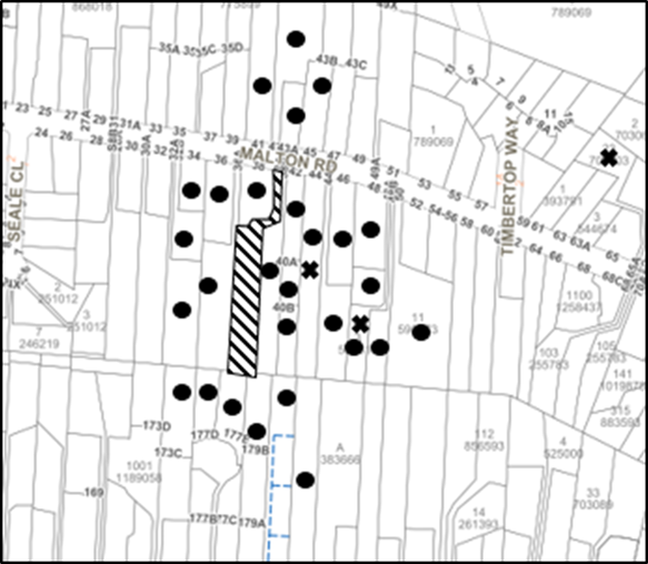
The proposed development was placed on public exhibition and was notified to adjoining and nearby landowners between 16 February 2021 and 9 March 2021 and 2 June 2021 and 21 June 2021 in accordance with the Hornsby Community Participation Plan. During this period, Council received 21 submissions. The map below illustrates the location of those nearby landowners who made a submission that are in close proximity to the development site.
|
NOTIFICATION PLAN |
|||
|
• PROPERTIES NOTIFIED |
X SUBMISSIONS RECEIVED |
|
|
|
18 SUBMISSIONS RECEIVED OUT OF MAP RANGE |
|||
Twenty-one submissions objected to the development, generally on the grounds that the development would result in:
· Impact to trees on neighbouring properties.
· Lack of space on site for replacement planting.
· Bushfire impacts not sufficiently addressed.
· Privacy concerns.
· Watercourse at the rear of the site.
· Earthworks.
· Unacceptable scale of development.
· Unacceptable environmental impacts through tree loss.
· Unacceptable impacts to powerful owl habitat.
· Unacceptable overshadowing of adjoining properties.
· Unacceptable privacy impacts.
· The removal of a significant trees.
· Development that is excessive in bulk and scale.
The merits of the matters raised in community submissions have been addressed in the body of the report with the exception of the following addressed below:
5.1.1 Development that is excessive in bulk and scale
Submissions were received raising concern to the excessive bulk and scale of the proposed development. In response to these submissions, it is noted that as outlined in the compliance table in Section 2.8 of this report, the application complies with height, floor area and site coverage requirements of the Hornsby DCP.
5.1.2 Watercourse at the rear of the site
Submissions were received raising concerns to the watercourse at the rear of the site known as Byles Creek and the impact the proposed development would have on this watercourse.
The subject site slopes to the upper extension of Lane Cove River located at the rear of the site and not directly to Byles Creek which is located in a different catchment area approximately 250 metres to the north of this site.
Notwithstanding to address issues of water quality to the Sydney Harbour Catchment, conditions are recommended in Schedule 1 of this report requiring appropriate sediment and erosion control measures to protect the downstream creek.
5.2 Public Agencies
The development application was not referred to any Public Agencies for comment.
6. THE PUBLIC INTEREST
Section 4.15(1)(e) of the Act requires Council to consider “the public interest”.
The public interest is an overarching requirement, which includes the consideration of the matters discussed in this report. Implicit to the public interest is the achievement of future built outcomes adequately responding to and respecting the future desired outcomes expressed in environmental planning instruments and development control plans.
The application is considered to have satisfactorily addressed Council’s and relevant agencies’ criteria and would provide a development outcome that, on balance, would result in a positive impact for the community. Accordingly, it is considered that the approval of the proposed development would be in the public interest.
CONCLUSION
The application proposes the construction of a dwelling house.
The development generally meets the desired outcomes of Council’s planning controls and is satisfactory having regard to the matters for consideration under Section 4.15 of the Environmental Planning and Assessment Act 1979.
Council received twenty-one submissions during the public notification period. The matters raised have been addressed in the body of the report.
Having regard to the circumstances of the case, approval of the application is recommended.
The reasons for this decision are:
· The proposed development generally complies with the requirements of the relevant environmental planning instruments and the Hornsby Development Control Plan 2013.
· The proposed development does not create unreasonable environmental impacts to adjoining development with regard to visual bulk, overshadowing, solar access, amenity or privacy.
Note: At the time of the completion of this planning report, no persons have made a Political Donations Disclosure Statement pursuant to Section 10.4 of the Environmental Planning and Assessment Act 1979 in respect of the subject planning application.
RESPONSIBLE OFFICER
The officer responsible for the preparation of this report is Tim Buwalda.
|
Cassandra Williams Major Development Manager - Development Assessments Planning and Compliance Division |
Rod Pickles Manager - Development Assessments Planning and Compliance Division |
|
Locality Map |
|
|
|
|
Architectural Plans |
|
|
|
|
Landscape Plan |
|
|
File Reference: DA/137/2021
Document Number: D08224476
SCHEDULE 1
GENERAL CONDITIONS
The conditions of consent within this notice of determination have been applied to ensure that the use of the land and/or building is carried out in such a manner that is consistent with the aims and objectives of the relevant legislation, planning instruments and council policies affecting the land and does not disrupt the amenity of the neighbourhood or impact upon the environment.
Note: For the purpose of this consent, the term ‘applicant’ means any person who has the authority to act on or the benefit of the development consent.
Note: For the purpose of this consent, any reference to an Act, Regulation, Australian Standard or publication by a public authority shall be taken to mean the gazetted Act or Regulation, or adopted Australian Standard or publication as in force on the date that the application for a construction certificate is made.
1. Approved Plans and Supporting Documentation
The development must be carried out in accordance with the plans and documentation listed below and endorsed with Council’s stamp, except where amended by Council and/or other conditions of this consent:
Approved Plans
|
Plan No. |
Plan Title |
Drawn by |
Dated |
Council Reference |
|
1725 1 of 2 |
Site Plan |
Distinct Innovations |
December 2020 |
|
|
1725 2 of 2 |
Elevations, Floor Plans and Sections |
Distinct Innovations |
December 2020 |
|
|
DA-01 rev. D |
Landscape Plan |
Grindstone Landscapes |
14 August 2021 |
|
|
DA-02 rev. D |
Driveway |
Grindstone Landscapes |
14 August 2021 |
|
|
DA-05 rev. D |
38A Landscape Plan |
Grindstone Landscapes |
14 August 2021 |
|
|
DA-06 rev. D |
38A Elevation |
Grindstone Landscapes |
14 August 2021 |
|
Supporting Documentation
|
Document Title |
Drawn by |
Dated |
Council Reference |
|
BASIX Certificate No. 1132384S |
Frys Energywise |
10 December 2021 |
D08106298 |
|
Integrated Bushfire and Vegetation Management Plan |
Hunter Ecology |
27 April 2021 |
D08225545 |
|
Arboricultural Impact Assessment Ref: 20036A |
McArdle Arboricultural Consultancy |
2 December 2021 |
D08106293 |
|
Waste Management Plan |
Peter Henderson |
27 December 2020 |
D08106281 |
|
Powerful Owl Assessment Ref. Beecroft 01 |
Hunter Ecology |
10 August 2021 |
D08225546 |
|
Nathers Certificate |
Frys Energywise |
10 December 2020 |
D08106311 |
|
Bushfire Planning & Design |
15 October 2020 |
D08106304 |
|
|
Schedule of Finishes |
Distinct Innovation Pty Ltd |
24 December 2020 |
D08106270 |
2. Construction Certificate
a) A Construction Certificate is required to be approved by Council or a Private Certifying Authority prior to the commencement of any construction works under this consent.
b) The Construction Certificate plans must include all requirements imposed by condition No. 10 of this consent.
c) The Construction Certificate plans must be consistent with the Development Consent plans.
3. Removal of Trees
a) This development consent permits the removal of 7 trees numbered T8, T9, T10, T20, T22, T25 and T26 as identified in the Arboricultural Impact Assessment prepared by McArdle Arboricultural Consultancy dated 2 December 2020, Ref:20036A.
b) No consent is granted for the removal of 23 trees numbered T1, T2, T3, T4, T5, T6, T7, T11, T12, T13, T14, T15, T16, T17, T18, T19, T21, T23, T24, T27, T28, T29 and T30 as these trees contribute to the established landscape amenity of the area/streetscape.
Note: The removal of any other trees from the site requires separate approval by Council in accordance with Part 1B.6 Tree and Vegetation Preservation of the Hornsby Development Control Plan, 2013 (HDCP).
4. Tree Pruning
This development consent does not permit the pruning of any tree.
Note: The pruning of any other trees from the site requires separate approval by Council in accordance with Part 1B.6 Tree and Vegetation Preservation of the Hornsby Development Control Plan 2013 (HDCP).
5. Retaining Walls
To ensure the stability of the site, structural details of all required retaining walls must be submitted with the application of the Construction Certificate.
REQUIREMENTS PRIOR TO THE ISSUE OF A CONSTRUCTION CERTIFICATE
Detailed plans, specifications and supporting information is required to be submitted to the certifying authority detailing how the proposed building work achieves compliance with the National Construction Code - Building Code of Australia. All building work must be carried out in accordance with the requirements of the National Construction Code - Building Code of Australia.
7. Contract of Insurance (Residential Building Work)
Where residential building work for which the Home Building Act 1989 requires there to be a contract of insurance in force in accordance with Part 6 of that Act, this contract of insurance must be in force before any building work authorised to be carried out by the consent commences.
8. Notification of Home Building Act 1989 Requirements
Residential building work within the meaning of the Home Building Act 1989 must not be carried out unless the principal certifying authority for the development to which the work relates (not being Council) has given Council written notice of the following information:
a) In the case of work for which a principal contractor is required to be appointed:
i) The name and licence number of the principal contractor; and
ii) The name of the insurer by which the work is insured under Part 6 of that Act.
b) In the case of work to be done by an owner-builder:
i) The name of the owner-builder; and
ii) If the owner-builder is required to hold an owner-builder’s permit under that Act, the number of the owner-builder’s permit.
Note: If arrangements for doing the residential building work are changed while the work is in progress so that the information notified becomes out of date, further work must not be carried out unless the principal certifying authority for the development to which the work relates (not being Council) has given Council written notification of the updated information.
9. Sydney Water – Approval
This application must be submitted to Sydney Water for approval to determine whether the development would affect any Sydney Water infrastructure, and whether further requirements are to be met.
Note: Building plan approvals can be obtained online via Sydney Water Tap inTM through www.sydneywater.com.au under the Building and Development tab.
10. Design and Construction - Bushfire Attack Category
a) That the proposed dwellings roof and eaves section, and the western, southern and eastern elevations shall be constructed to section 3 Construction General and section 7 BAL 29 of Australian Standard AS3959-2018 Construction of buildings in bushfire prone areas with the exception that the construction requirements shall be varied to comply with section 7.5.2 Additional Construction Requirements of Planning for Bush Fire Protection 2019.
b) That the proposed dwellings northern elevation shall be constructed to section 3 Construction General and section 6 BAL 19 of Australian Standard AS3959-2018 Construction of buildings in bushfire prone areas with the exception that the construction requirements shall be varied to comply with section 7.5.2 Additional Construction Requirements of Planning for Bush Fire Protection 2019.
c) That the dwelling shall maintain a reserve Static Water Supply (SWS) for use during a bushfire event of not less than 10,000 litres stored in a non-combustible tank within the area of recommended asset protection zone.
d) The reserve Static Water Supply shall be permanently plumbed to a petrol or diesel firefighting water pump with a minimum of 5hp. The pump shall be regularly maintained as per the manufacturer specifications. The pump must be located in such a position to be shielded from the direct mechanisms of bushfire attack.
e) That a water delivery line of not less than 50mm diameter be plumbed from the firefighting water pump plumbed to the reserve Static Water Supply tank, to an outlet point located directly adjacent to the driveway as indicated within figure 7 of the Bushfire Assessment Report (Ref: 20.10.316) prepared by Bushfire Planning & Assessment dated 15 October 2020 on the subject allotment to enable firefighting tankers to refill. The outlet of this line shall be fitted with a ball or gate valve and a 65 to 38mm reducer Storz fitting.
f) That the development must provide and have readily available kink resistant hose or hoses with a diameter of not less than 19mm and a fire fighting nozzle, capable of reaching all elevations of the dwelling, and fittings suitable for connection to the firefighting water pump.
g) Fire hose reels are constructed in accordance with Australian Standard AS/NZS 1221:1997 Fire hose reels and installed in accordance with the relevant clauses of Australian Standard AS2441:2005 Installation of fire hose reels.
h) That all plumbing associated with the reserve water supply above the ground or for a depth of not less than 300mm below the ground shall be metal.
i) That approved NSW Rural Fire Service; Static Water Supply signage is installed at approved locations for the proposed development.
j) That if the supply of gas to the subject dwelling is undertaken it shall be installed and maintained in accordance with Australian Standard AS1596-2002 The storage and handling of LP Gas and requirements of relevant authorities.
Note: Further information concerning planning for bush fire protection can be found at: www.rfs.nsw.gov.au.
11. Stormwater Drainage
The stormwater drainage system for the development must be designed for an average recurrence interval (ARI) of 20 years and be gravity drained in accordance with the following requirements:
a) Roof water must be connected to a rainwater tank having a minimum capacity in accordance with the BASIX requirements; and
b) The overflow from the rainwater tank and collected surface water must be connected to an existing inter-allotment drainage system.
12. Internal Driveway/Vehicular Areas
The driveway and parking areas on site must be designed, constructed and a Construction Certificate issued in accordance with Australian Standards AS2890.1, AS3727 and the following requirements:
a) The driveway be a rigid pavement;
b) The driveway grade must not exceed 25 percent and changes in grade must not exceed 8 percent per plan metre;
c) A turning area within the subject site to service the proposed dwelling must be designed and constructed in accordance with Australian Standards AS2890.1 to ensure vehicles can enter and leave the site in a forward direction; and
d) Reconstruction of the existing concrete driveway within the existing right of access is necessary if the driveway is damaged during the construction of the new dwelling.
13. Appointment of a Project Bush Regenerator and Ecologist
a) The applicant shall notify Council of the details of the engaged Project Bush Regenerator and Ecologist that will be involved with the implementation and monitoring of environmental protection measures during the construction of the approved development. These environmental experts will assist in ensuring compliance with the conditions of consent and provide monitoring reports to Council at various stages of the Project as identified in the approved Integrated Bushfire and Vegetation Management Plan prepared by Hunter Ecology dated 27 April 2021.The ecologist will also be responsible for implementing the tree hollow improvement works as recommended in the Powerful Owl (Ninox strenua) surveys and assessment prepared by Hunter Ecology dated 10 August 2021.
b) An inspection schedule to assess vegetation health and provide certification for the various stages of development such as site establishment (includes demolition and installation of tree protection measures), weed removal, construction work, hard and soft landscaping practical completion and occupancy certification is to be included with the application for the construction certificate.
14. Appointment of a Project Arborist
a) To ensure the trees that must be retained are protected, a project arborist with AQF Level 5 qualifications must be appointed to assist in ensuring compliance with the conditions of consent and provide monitoring reports as specified by the conditions of consent.
b) Details of the appointed project arborist must be submitted to Council and the PCA with the application for the construction certificate.
REQUIREMENTS PRIOR TO THE COMMENCEMENT OF ANY WORKS
15. Erection of Construction Sign
a) A sign must be erected in a prominent position on any site on which any approved work is being carried out:
i) Showing the name, address and telephone number of the principal certifying authority for the work;
ii) Showing the name of the principal contractor (if any) for any demolition or building work and a telephone number on which that person may be contacted outside working hours; and
iii) Stating that unauthorised entry to the work site is prohibited.
b) The sign is to be maintained while the approved work is being carried out and must be removed when the work has been completed.
16. Installation of Tree Protection Measures
a) Trees to be retained and numbered T1, T2, T3, T4, T5, T6, T7, T11, T12, T13, T14, T15, T16, T17, T18, T19, T21, T23, T24, T27, T28, T29 and T30 as identified on the Tree management Plan on page 15 of the Arboricultural Impact Assessment report prepared by McArdle Arboricultural Consultancy dated 2 December 2020 (D08106393) must have tree protection measures for the ground, trunk and canopy installed by the project arborist as follows:
i) For the duration of construction works, in accordance with on page 15 of the Arboricultural Impact Assessment report prepared by McArdle Arboricultural Consultancy dated 2 December 2020 (D08106393).
b) Tree protection fencing for the trees to be retained must be installed by the engaged AQF 5 project arborist and consist of 1.8m high temporary fencing panels installed in accordance with Australian Standard AS4687-2007 Temporary fencing and hoardings.
i) The exception being those protected by the existing boundary fencing
c) The installation of all required tree protection fencing must include shade cloth attached to the fencing to reduce transport of dust, particulates and liquids from entering the tree protection zone.
d) Tree crown protection measures are required and must be installed by the AQF 5 project arborist.
e) The circumference of the trunk(s) must be wrapped in hessian material to provide cushioning for the installation of timber planks.
f) Timber planks (50 x100mm) must be spaced at 100mm intervals and must be attached using adjustable ratchet straps.
g) All tree protection zones must have a layer of wood-chip mulch at a depth of between 150mm and 300mm.
h) Where wood-chip mulch is permitted by Council instead of tree protection fencing within the tree protection zones, the wood-chip must be covered with a layer of geotextile fabric and rumble boards.
17. Protection of vegetation, habitat and environmental features during construction
To ensure the protection of vegetation, habitat and environmental features during construction, the applicant must:
a) install 1.2m high chain wire fencing (or similar) along the southern boundary of the site as shown in the approved plans; and
b) clean machinery of soil and debris before entering the site to prevent the spread of weeds and fungal pathogens.
Note: The site contains potential habitat for threatened species listed under the NSW Biodiversity Conservation Act 2016. The Act prohibits the disturbance to threatened species, endangered populations and threatened ecological communities, or their habitat, without appropriate consent or licence.
18. Integrated Bushfire and Vegetation Management Plan (IBVMP)
a) All on-ground works shall comply with the approved Integrated Bushfire and Vegetation Management Plan (IBVMP) prepared by Hunter Ecology dated 27 April 2021 and Powerful Owl (Ninox strenua) surveys and assessment prepared by Hunter Ecology dated 10 August 2021. This includes compliance with development milestones listed in the Schedule of Works within Section 3, 6 & 7 of the approved IBVMP.
b) The IBVMP shall be implemented from the date of issue of the Notice of Determination
c) Monitoring should occur every 3 months for the first year of this IBVMP, then biannually until the expiration of this IVBMP to ensure that weed control is well managed and plantings have established and nestboxes have been installed. At the end of the 3-year IBVMP period a final monitoring report shall be provided to Council (naturalresourcesplanning@hornsby.nsw.gov.au). If the performance criteria have not been met the life to the IBVMP will be extended accordingly at the discretion of Council’s Natural Resources Unit.
d) Monitoring of the site after the initial 3/5 years should occur annually. Reporting on the implementation of the IBVMP should occur annually with the annual reports provided to Council (naturalresourcesplanning@hornsby.nsw.gov.au).
Reason: The development of a consolidated IBVMP will provide the developer and current and future landowners with a single document describing the required vegetation management actions across the site.
19. APZ – marking of boundary
The boundary of the asset protection zone must be permanently marked before the works begin and must be kept in place in perpetuity as follows:
a) Sufficient markers (a minimum of 2) must be placed along the boundary of the APZ to clearly delineate the extent of the asset protection zone;
b) The markers must be a tubular metal post (or the like) standing a minimum of 400mm above ground; and
c) The markers must include a notation stating: End of Asset Protection Zone. The notation may be in the form of an attached sign or sticker with lettering of a contrasting colour to the post colour.
a) Photographic evidence must be submitted to the Principal Certifying Authority confirming compliance with this condition.
Reason: To provide certainty for the developer, current and future landowners, Council and contractors, during and after construction, as to the boundaries of the asset protection zone and those areas associated with different management requirements.
20. Protection of Adjoining Areas
A temporary hoarding, fence or awning must be erected between the work site and adjoining lands before the works begin and must be kept in place until after the completion of the works if the works:
a) Could cause a danger, obstruction or inconvenience to pedestrian or vehicular traffic;
b) Could cause damage to adjoining lands by falling objects; and/or
c) Involve the enclosure of a public place or part of a public place; and/or
d) Have been identified as requiring a temporary hoarding, fence or awning within the Council approved Construction Management Plan (CMP).
Note: Notwithstanding the above, Council’s separate written approval is required prior to the erection of any structure or other obstruction on public land.
a) To provide a safe and hygienic workplace, toilet facilities must be available or be installed at the works site before works begin and must be maintained until the works are completed at a ratio of one toilet for every 20 persons employed at the site.
b) Each toilet must:
i) be a standard flushing toilet connected to a public sewer; or
ii) be a temporary chemical closet approved under the Local Government Act 1993.
22. Erosion and Sediment Control
To protect the water quality of the downstream environment, erosion and sediment control measures must be provided and maintained throughout the construction period in accordance with the manual ‘Soils and Construction 2004 (Bluebook)’, the approved plans, Council specifications and to the satisfaction of the principal certifying authority. The erosion and sediment control devices must remain in place until the site has been stabilised and revegetated.
Note: On the spot penalties may be issued for any non-compliance with this requirement without any further notification or warning.
23. Bushfire Management – Protection Zones
At the commencement of building works the Assets Protection Zone as outlined within Appendix 4 of Planning for Bush Fire Protection 2019 and the NSW Rural Fire Service’s document Standards for asset protection zones must be in accordance with the following:
a) From the southern elevation of the dwelling house to the south for 37m; and
b) From the western, eastern and northern elevations of the dwelling house to the lot boundaries.
Note: Further information concerning planning for bush fire protection can be found at: www.rfs.nsw.gov.au.
REQUIREMENTS DURING CONSTRUCTION
All works on site, including demolition and earth works, must only occur between 7am and 5pm Monday to Saturday.
No work is to be undertaken on Sundays or public holidays.
25. Prohibited Actions within the fenced tree protection zone
The following activities are prohibited within the approved fenced tree protection zones unless otherwise approved by Council:
a) Soil cutting or filling, including excavation and trenching;
b) Soil cultivation, disturbance or compaction;
c) Stockpiling storage or mixing of materials;
d) The parking, storing, washing and repairing of tools, equipment and machinery;
e) The disposal of liquids and refuelling;
f) The disposal of building materials;
g) The siting of offices or sheds; and
h) Any action leading to the impact on tree health or structure.
26. Maintaining the health of trees approved for retention
The appointed project arborist must monitor and record any and all necessary actions required to maintain tree health and condition for trees numbered T1, T2, T3, T4, T5, T6, T7, T11, T12, T13, T14, T15, T16, T17, T18, T19, T21, T23, T24, T27, T28, T29 and T30 on the approved plans.
27. Maintaining Tree Protection Measures
Tree Protection Measures must be maintained by the project arborist in accordance with Condition No. 16 of this consent for the duration of works.
28. Approved Works within Tree Protection Zone incursions
a) Where tree root pruning is required for the installation of piers, driveway or underground services, the pruning must be overseen by the AQF 5 project arborist and must be undertaken as follows:
i) Using sharp secateurs, pruners, handsaws or chainsaws with the final cut being clean; and
ii) The maximum diameter of roots permitted to be cut is 40mm
b) Approved excavations within the Tree Protection Zone of trees to be retained not associated with installation of services must be undertaken as follows:
i) Excavations for the construction and/or installation of the house/deck/driveway/piers in the Tree Protection Zone of trees to be retained numbered on the approved plans must be supervised by the project arborist for the first 1.000 meter undertaken manually to locate roots and allow for pruning in accordance with condition No. 28a).
c) To minimise impacts within the Tree Protection Zone (TPZ) of trees to be retained on the approved plans, the installation of services must be undertaken as follows:
i) The AQF 5 project arborist must be present to oversee the installation of any underground services which enter or transect the tree protection;
ii) The installation of any underground services which either enter or transect the designated TPZ must be undertaken manually; and
iii) For manually excavated trenches the AQF 5 project arborist must designate roots to be retained. Manual excavation may include the use of pneumatic and hydraulic tools.
d) Where scaffolding is required, ground protection must be installed beneath the scaffolding in the following order:
i) Installation of a 100mm deep layer of woodchip;
ii) Installation of geotextile fabric ground covering; and
iii) Installation of scaffold boarding above the woodchip and geotextile fabric.
29. Works near trees
a) To maintain tree health and condition for trees to be retained on the approved plans, the appointed project arborist must monitor and record all necessary remedial actions required.
b) The maintenance and monitoring of all tree protection techniques must be recorded by the appointed project arborist during the period of construction for submission with the application for the occupation certificate.
30. Building Materials and Site Waste
The stockpiling of building materials, the parking of vehicles or plant, the disposal of cement slurry, waste water or other contaminants must be located outside the tree protection zones as prescribed in the conditions of this consent of any tree to be retained.
31. Environmental Management
To prevent sediment run-off, excessive dust, noise or odour emanating from the site during the construction, the site must be managed in accordance with the publication ‘Managing Urban Stormwater - Landcom (March 2004) and the Protection of the Environment Operations Act 1997.
To ensure that the public reserve is kept in a clean, tidy and safe condition during construction works, no building materials, waste, machinery or related matter is to be stored on the road or footpath.
33. Disturbance of Existing Site
During construction works, the existing ground levels of open space areas and natural landscape features, including natural rock-outcrops, vegetation, soil and watercourses must not be altered unless otherwise nominated on the approved plans.
34. Landfill
a) Prior to fill material being imported to the site, a Waste Classification Certificate shall be obtained from a suitably qualified environmental consultant confirming the fill wholly consists of Virgin Excavated Natural Material (VENM) as defined in Schedule 1 of the Protection of the Environment Operations Act 1997 or a material approved under the NSW Environment Protection Authority’s Resource Recovery Orders and Exemptions.
b) The required Waste Classification Certificate must be obtained by the Principal Contractor prior to fill being imported to the site and made available to Council at its request.
35. Excavated Material
All excavated material removed from the site must be classified by a suitably qualified environmental consultant in accordance with the NSW Environment Protection Authority’s Waste Classification Guidelines and Protection of the Environment Operations (Waste) Regulation 2014 prior to disposal to a licensed waste management facility. Tipping dockets for the total volume of excavated material that are received from the licensed waste management facility must be provided to the principal certifying authority prior to the issue of an Occupation Certificate.
36. Survey Report
A report(s) must be prepared by a registered surveyor and submitted to the principal certifying authority:
a) Prior to the pouring of concrete at each level of the building certifying that:
i) The building, retaining walls and the like have been correctly positioned on the site; and
ii) The finished floor level(s) are in accordance with the approved plans.
REQUIREMENTS PRIOR TO THE ISSUE OF AN OCCUPATION CERTIFICATE
37. Fulfilment of BASIX Commitments
The applicant must demonstrate the fulfilment of BASIX commitments pertaining to the development.
38. Damage to Council Assets
To protect public property and infrastructure, any damage caused to Council’s assets as a result of the construction or demolition of the development must be rectified by the applicant in accordance with AUS-SPEC Specifications (www.hornsby.nsw.gov.au/property/build/aus-spec-terms-and-conditions. Rectification works must be undertaken prior to the issue of an Occupation Certificate, or sooner, as directed by Council.
39. Replacement Tree Requirements
a) The trees approved for removal under this consent, being 7 trees numbered T8, T9, T10, T20, T22, T25 and T26 must be offset through replacement planting of a minimum of 10 trees in accordance with the following:
i) 5 trees must have the potential to reach a mature height of greater than 10m;
ii) 5 mid-story trees with the potential to reach a mature height of greater than 5m; and
iii) This planting should be consistent with the approved Integrated Bushfire and Vegetation Management Plan.
b) All replacement plantings must be species selected from the ‘Trees Indigenous to Hornsby Shire (as of 1 September 2011)’ document available for viewing on the Hornsby Council’s website http://www.hornsby.nsw.gov.au/environment/flora-and-fauna/tree-management/indigenous-trees
c) The location and size of tree replacement planting must comply with the following:
i) All replacement trees must be located in either front or rear setbacks and planted 4m or greater from the foundation walls of the approved development;
ii) The pot size of the replacement trees must be a minimum 45 litres; and
iii) All replacement trees must be a minimum of 3m in height when planting.
40. Final Certification
The AQF 5 Project arborist must submit to the Principal Certifying Authority a certificate that includes the following:
a) All tree protection requirements complied with the as approved tree protection plan for the duration of demolition and/or construction works;
b) All completed works relating to tree protection and maintenance have been carried out in compliance with the conditions of consent and approved plans;
c) Dates, times and reasons for all site attendance;
d) All works undertaken to maintain the health of retained trees;
e) Details of tree protection zone maintenance for the duration of works; and
f) A statement to confirm that tree replacement planting meets NATSPEC guidelines and the approved landscape plan.
Note: Copies of monitoring documentation may be requested throughout DA process.
41. Damage to Council Assets
To protect public property and infrastructure, any damage caused to Council’s assets as a result of the construction or demolition of the development must be rectified by the applicant in accordance with AUS-SPEC Specifications (www.hornsby.nsw.gov.au/property/build/aus-spec-terms-and-conditions. Rectification works must be undertaken prior to the issue of an Occupation Certificate, or sooner, as directed by Council.
42. Supplementary planting, weeding and nest box installation
Any supplementary planting, weeding and nest box installation outside the immediate landscaping area depicted in the approved Landscape Plan No. DA.05 rev. D, prepared by Grindstone Landscapes dated 14 August 2021 shall be in accordance with Section 4.3 of the approved Integrated Bushfire and Vegetation Management Plan (IBVMP) prepared by Hunter Ecology dated 27 April 2021 and stock used for planting shall be sourced from a native nursery utilising Sydney basin stock. The hollow improvement works and 4 nest boxes shall only be installed and certified by an experienced fauna ecologist (Section 3.8 of the IBVMP and the Powerful Owl (Ninox strenua) surveys and assessment prepared by Hunter Ecology dated 10th August).
43. Certificate of Bushfire Requirements
a) A Certificate prepared by a BPAD accredited Bushfire Consultant is to be provided to the Principal Certifying Authority (PCA) certifying the completion of all works required by the Bushfire Assessment Report Ref: 20.10.316 prepared by Bushfire Planning & Design dated 15 October 2020, and condition Nos. 10 and 23 of this consent prior to the issue of the Occupation Certificate.
b) A suitably qualified and experienced bush fire consultant must provide to the PCA and Council certification of the implementation of the of the approved asset protection zone.
44. Final Certification – Ecology/Bush regeneration
The project ecologist/bush regenerator must provide to the PCA and/or Council certification of the implementation of the of the approved Integrated Bushfire and Vegetation Management Plan (IBVMP) prepared by Hunter Ecology dated 10 August 2021.
45. Retaining Walls
All retaining walls must be constructed as part of the development and prior to the issue of an Occupation Certificate.
OPERATIONAL CONDITIONS
46. Ongoing Protection of Remnant Trees
All trees on site not approved for removal under this consent are required to be retained for conservation purposes. These trees have a legal obligation for their preservation and are excluded from the clearing provisions of the 10/50 Vegetation Clearing Code of Practice for New South Wales in accordance with Clause 7.8 of the Code.
47. Ongoing Bushfire Management
Any requirements relating to bushfire protection must be maintained in perpetuity and landscaping works must be consistent with the Asset Protection Zone requirements as described in Planning for Bush Fire Protection 2019.
- END OF CONDITIONS -
ADVISORY NOTES
The following information is provided for your assistance to ensure compliance with the Environmental Planning and Assessment Act, 1979, Environmental Planning and Assessment Regulation 2000, other relevant legislation and Council’s policies and specifications. This information does not form part of the conditions of development consent pursuant to Section 4.17 of the Act.
Environmental Planning and Assessment Act 1979 Requirements
The Environmental Planning and Assessment Act 1979 requires:
· The issue of a construction certificate prior to the commencement of any works. Enquiries can be made to Council’s Customer Services Branch on 9847 6760.
· A principal certifying authority to be nominated and Council notified of that appointment prior to the commencement of any works.
· Council to be given at least two days written notice prior to the commencement of any works.
· Mandatory inspections of nominated stages of the construction inspected.
· An occupation certificate to be issued before occupying any building or commencing the use of the land.
Long Service Levy
In accordance with Section 34 of the Building and Construction Industry Long Service Payments Act 1986, a ‘Long Service Levy’ must be paid to the Long Service Payments Corporation or Hornsby Council.
Note: The rate of the Long Service Levy is 0.35% of the total cost of the work.
Note: Hornsby Council requires the payment of the Long Service Levy prior to the issue of a construction certificate.
Tree and Vegetation Preservation
Hornsby Development Control Plan 2013 Tree and Vegetation Preservation provisions have been developed under Council’s authorities contained in State Environmental Planning Policy (Vegetation in Non-Rural Areas) 2017 and the Environmental Planning and Assessment Act 1979.
In accordance with these provisions a person must not cut down, fell, uproot, kill, poison, ringbark, burn or otherwise destroy the vegetation, lop or otherwise remove a substantial part of the trees or vegetation to which any such development control plan applies without the authority conferred by a development consent or a permit granted by Council.
Fines may be imposed for non-compliance with the Hornsby Development Control Plan 2013.
Note: A tree is defined as a long lived, woody perennial plant with one or relatively few main stems with the potential to grow to a height greater than 3m. (HDCP 1B.6.1.c).
The land upon which the subject building is to be constructed may be affected by restrictive covenants. Council issues this approval without enquiry as to whether any restrictive covenant affecting the land would be breached by the construction of the building, the subject of this consent. Applicants must rely on their own enquiries as to whether or not the building breaches any such covenant.
Prior to commencing any works, the applicant is encouraged to contact Dial Before You Dig on 1100 or www.dialbeforeyoudig.com.au for free information on potential underground pipes and cables within the vicinity of the development site.
Telecommunications Act 1997 (Commonwealth)
If you are aware of any works or proposed works which may affect or impact on Telstra’s assets in any way, you are required to contact: Telstra’s Network Integrity Team on Phone Number 1800810443.
Should asbestos or asbestos products be encountered during demolition or construction works, you are advised to seek advice and information prior to disturbing this material. It is recommended that a contractor holding an asbestos-handling permit (issued by SafeWork NSW) be engaged to manage the proper handling of this material. Further information regarding the safe handling and removal of asbestos can be found at:
Alternatively, telephone the SafeWork NSW on 13 10 50.
It is recommended that water collected within any rainwater tank as part of the development be limited to non-potable uses. NSW Health recommends that the use of rainwater tanks for drinking purposes not occur where a reticulated potable water supply is available.
LPP Report No. LPP25/21
Local Planning Panel
Date of Meeting: 29/09/2021
2 DA/161/2021 - CONSTRUCTION OF A DWELLING HOUSE - 38B MALTON ROAD, BEECROFT
EXECUTIVE SUMMARY
|
DA No: |
DA/161/2021 (Lodged on 18 February 2021) |
|
Description: |
Construction of a dwelling house |
|
Property: |
Lot 2 DP 1226564, No. 38B Malton Road, Beecroft |
|
Applicant: |
Peter Henderson |
|
Owner: |
Mrs Janet Gwendoline Henderson |
|
Estimated Value: |
$1,000,000. |
|
Ward: |
C |
· The application involves the construction of a dwelling house.
· A total of 16 submissions have been received in respect of the application.
· The application is required to be determined by the Hornsby Council Local Planning Panel as 10 or more unique submissions were received by way of objection.
· It is recommended that the application be approved.
|
THAT Development Application No. DA/161/2021 for construction of a dwelling house at Lot 2 DP 1226564, No. 38B Malton Road, Beecroft be approved, subject to the conditions of consent detailed in Schedule 1 of LPP Report No. LPP25/21. |
BACKGROUND
DA/390/2016 was approved for on 6 October 2016 for the demolition of structures and Torrens Title subdivision of two lots into three. DA/161/2021 seeks approval to construct a dwelling house on Lot 2.
On 22 March 2021, Council requested amended plans to address the turning circles provided, an amended landscape plan, an Integrated Bushfire and Vegetation Management Plan (IBVMP) and an Arboricultural impact assessment report.
On 6 May 2021, Council received the amended plans and IBVMP.
On 28 May 2021, Council received the request Arboricultural Impact Assessment Report.
On 26 July 2021, Council requested a survey for threatened Powerful Owl (Ninox strenua) and an impact assessment of significance (‘five-part test’) in accordance with Section 7.3 of the NSW Biodiversity Conservation Act 2016 prepared by fauna ecologist with survey experience and assessment specifically for this species.
On 11 August 2021, Council received the Threatened Powerful Owl survey and an amended IBVMP.
On 25 August 2021, Council requested amended plans to reduce the amount of fill proposed within the rear yard and increase the setbacks of the proposed retaining walls.
On 2 September 2021, Council received the amended landscape plans which are subject to this assessment.
SITE
The 2,386m2 vacant battle-axe property is located on the southern side of Malton Road Beecroft and experiences a fall of 30m to the rear southern boundary. The site is burdened and benefitted by a right of access and easement for services of variable width and easement to drain water of variable width.
The southern, rear portion of the site contains dense bushland identified as Blackbutt Gully Forest vegetation community.
The site is located within the Beecroft/Cheltenham Heritage Conservation Area listed under Schedule 5 of the Hornsby Local Environmental Plan 2013.
The property is also located within close proximity to the following heritage listed items:
· No.37 Malton Road, Beecroft.
· No.177E Copeland Road, Beecroft.
· Street trees growing along the road reserve of Malton Road.
The site is bushfire prone land.
PROPOSAL
The application proposes the construction of a one and two storey dwelling house.
The ground floor would include a family/dining room, a double-spaced garage, lounge room, bathroom, walk in wardrobe, en-suite, kitchen with attached pantry and an outdoor alfresco area.
On the lower ground floor, the dwelling would include a bedroom, rumpus room, en-suite, walk in wardrobe and study.
Retaining walls are proposed to the rear of the dwelling house to create a tiered landscaped area.
Seven trees would be removed by the proposed development.
ASSESSMENT
The development application has been assessed having regard to the Greater Sydney Region Plan - A Metropolis of Three Cities, the North District Plan and the matters for consideration prescribed under Section 4.15 of the Environmental Planning and Assessment Act 1979 (the Act). The following issues have been identified for further consideration.
1. STRATEGIC CONTEXT
1.1 Greater Sydney Region Plan - A Metropolis of Three Cities and North District Plan
The Greater Sydney Region Plan - A Metropolis of Three Cities has been prepared by the NSW State Government to guide land use planning decisions for the next 40 years (to 2056). The Plan sets a strategy and actions for accommodating Sydney’s future population growth and identifies dwelling targets to ensure supply meets demand. The Plan also identifies that the most suitable areas for new housing are in locations close to jobs, public transport, community facilities and services.
The NSW Government will use the subregional planning process to define objectives and set goals for job creation, housing supply and choice in each subregion. Hornsby Shire has been grouped with Hunters Hill, Ku-ring-gai, Lane Cove, Mosman, North Sydney, Ryde, Northern Beaches and Willoughby to form the North District. The Greater Sydney Commission has released the North District Plan which includes priorities and actions for Northern District for the next 20 years. The identified challenge for Hornsby Shire will be to provide an additional 4,350 dwellings by 2021 with further strategic supply targets to be identified to deliver 97,000 additional dwellings in the North District by 2036.
The proposed development would be consistent with the Greater Sydney Region Plan - A Metropolis of Three Cities and the North District Plan, by contributing to achieving the dwelling targets for the region.
2. STATUTORY CONTROLS
Section 4.15(1)(a) requires Council to consider “any relevant environmental planning instruments, draft environmental planning instruments, development control plans, planning agreements and regulations”.
2.1 Hornsby Local Environmental Plan 2013
The proposed development has been assessed having regard to the provisions of the Hornsby Local Environmental Plan 2013 (HLEP).
2.1.1 Zoning of Land and Permissibility
The subject land is zoned R2 Low density residential under the HLEP. The objectives of the R2 zone are:
· To provide for the housing needs of the community within a low-density residential environment; and
· To enable other land uses that provide facilities or services to meet the day to day needs of residents.
The proposed development is defined as a ‘dwelling house’ and is permissible with Council’s consent. The proposed development meets the objectives of the R2 zone.
2.1.2 Height of Buildings
Clause 4.3 of the HLEP provides that the height of a building on any land should not exceed the maximum height show for the land on the Height of Buildings Map. The maximum permissible height for the subject site is 8.5m. The proposal has a height of 8.5m and complies with this provision.
2.1.3 Heritage Conservation
Clause 5.10 of the HLEP sets out heritage conservation provisions for Hornsby Shire. The site does not include a heritage item; however, the site is located within the Beecroft/Cheltenham Heritage Conservation Area listed under Schedule 5 of the HLEP. The property is also located within close proximity to the following heritage listed items:
· No. 37 Malton Road, Beecroft (No. 124).
· No.177E Copeland Road, Beecroft; (No. 94).
· Street trees growing along Malton Road (No. 114).
In assessing the heritage impacts of the proposed development, it is noted that the proposed dwelling house would be one storey when viewed from the front elevation and there would be minimal visual impacts to the streetscape of Malton Road due to the dwelling house being setback approximately 50m from the streetscape. The proposal would have negligible heritage impacts to the Beecroft/Cheltenham HCA or the nearby heritage listed items along Malton Road.
In assessing the heritage impacts to the heritage listed item at No. 177E Copeland Road to the rear of the site, it is noted that the rear of the site contains existing vegetation that would screen the proposed dwelling house from the adjacent heritage listed item and would have a rear boundary setback of greater than 70m.
It is generally considered that the proposed dwelling house would be of similar design and scale to adjacent properties within the HCA.
Therefore, the proposed development meets the objectives of Clause 5.10 of the HLEP and is considered acceptable.
2.1.4 Earthworks
Clause 6.2 of the HLEP states that consent is required for proposed earthworks on site. Before granting consent for earthworks, Council is required to assess the impacts of the works on adjoining properties, drainage patterns and soil stability of the locality.
The application proposes a maximum cut of 2m and a maximum fill of 0.9m for the proposed dwelling house and tiered landscaping. This 0.9m of fill complies with the maximum 1m prescriptive measure of the HDCP, however the proposed 2m cut does not comply.
Submissions were received raising concern with the proposed earthworks within the rear yard to create the tiered landscaping. It is noted that Council requested amended plans to address these concerns and the applicant has provided amended landscape plans which lower the proposed fill from 1.7m to a maximum 0.8m and increased the setback from the western side boundary to 3.49m to reduce amenity impacts to adjoining properties.
In support of the proposed landform modification within the rear yard, it is noted that the application proposes retaining walls to retain the fill which would be setback 1.495m from the western side boundary setback to mitigate any amenity or environmental impacts to the adjoining property No. 40A Malton Road.
In assessing the proposed 2m cut for the proposed basement level of the dwelling house, it is noted that the application is supported by a Geotechnical Report prepared by Ideal Geotech dated September 2020. This report supports the application subject to recommendations relating to the provision of a dilapidation report, requirements for excavation, footing and retaining walls. Council’s assessment of the application notes that the excavation of the basement level would reduce the bulk and scale of the proposed development when viewed from adjacent properties and the application responds appropriately to the topography of the land. No objections are raised on planning grounds to the proposed excavation as it is generally considered that the application would have minimal environmental and amenity impacts.
In assessing the impacts to the eastern side boundary, it is noted that the earthworks and retaining walls have been designed to have the same levels as proposed within No. 38B Malton Road under DA/137/2021.
A condition is recommended in Schedule 1 of this report ensuring that any fill material being brought onto the site be classified as Virgin Excavated Natural Material (VENM). A similar condition is recommended for any excavated material that may be removed from the site.
Council’s assessment of the proposed works and excavation concludes that the proposed earthworks would have minimal and acceptable environmental and amenity impacts to adjoining properties.
2.2 State Environmental Planning Policy (Exempt and Complying Development Codes) 2008
The application has been considered against the requirements of State Environmental Planning Policy (Exempt and Complying Development Codes) 2008 (NSW Housing Code). The Policy provides exempt and complying development codes that have State-wide application. The Policy also identifies types of development that are of minimal environmental impact that may be carried out without the need for development consent and types of Complying Development (including dwelling houses) that may be carried out in accordance with a Complying Development Certificate.
The development requires the removal of trees which precludes the development from being approved as Complying Development. The proposed dwelling house additions would otherwise comply with the numerical standards for Complying Development contained within the NSW Housing Code.
2.3 State Environmental Planning Policy No. 55 Remediation of Land
The policy provides guidelines for the remediation of contaminated land for the purpose of reducing the risk of harm to human health or any other aspect of the environment. Clause 7 requires Council to consider whether land is contaminated prior to granting consent to the carrying out of any development on that land.
Should the land be contaminated, Council must be satisfied that the land is suitable in a contaminated state for the proposed use. If the land requires remediation to be undertaken to make the land suitable for the proposed use, Council must be satisfied that the land will be remediated before the land is used for that purpose.
A review of Council’s records and aerial photographs indicate that the site has been historically used for residential purposes. It is not likely that the site has experienced any significant contamination, and further assessment under SEPP 55 is not required.
2.4 SEPP (Building Sustainability Index: BASIX) 2004
The application has been assessed against the requirements of State Environmental Planning Policy (Building Sustainability Index: BASIX) 2004. The proposal includes a BASIX Certificate for the proposed dwelling house, which is considered to be satisfactory. A condition is recommended in Schedule 1 of this report requiring the recommendations of the BASIX certificate be complied with.
2.5 State Environmental Planning Policy (Vegetation in Non-Rural Areas) 2017
The application has been assessed against the requirements of State Environmental Planning Policy (Vegetation in Non-Rural Areas) 2017 (Vegetation SEPP). This Policy seeks to protect the biodiversity values of trees and other vegetation in non-rural areas of the State, and to preserve the amenity of non-rural areas of the State through the preservation of trees and other vegetation.
Part 3 of the Vegetation SEPP states that a development control plan may make a declaration in any manner relating to species, size, location and presence of vegetation. Accordingly, Part 1B.6.1 of the Hornsby Development Control Plan 2013 (HDCP) prescribes works that can be undertaken with or without consent to trees.
The application has been assessed against the requirements of the Vegetation SEPP and it has been determined that the proposal would meet the objectives of the Vegetation SEPP. This matter is addressed in Section 3.1.1 of this report.
2.6 Sydney Regional Environmental Plan (Sydney Harbour Catchment) 2005
The application has been assessed against the requirements of Sydney Regional Environmental Plan (Sydney Harbour Catchment) 2005. This Policy provides general planning considerations and strategies to ensure that the catchment, foreshores, waterways and islands of Sydney Harbour are recognised, protected, enhanced and maintained.
Subject to the implementation of installation of sediment and erosion control measures and stormwater management to protect water quality, the proposal would have minimal potential to impact on the Sydney Harbour Catchment.
2.7 Section 3.42 Environmental Planning and Assessment Act 1979 - Purpose and Status of Development Control Plans
Section 3.42 of the Environmental Planning and Assessment Act 1979 states that a DCP provision will have no effect if it prevents or unreasonably restricts development that is otherwise permitted and complies with the development standards in relevant Local Environmental Plans and State Environmental Planning Policies.
The principal purpose of a development control plan is to provide guidance on the aims of any environmental planning instrument that applies to the development; facilitate development that is permissible under any such instrument; and achieve the objectives of land zones. The provisions contained in a DCP are not statutory requirements and are for guidance purposes only. Consent authorities have flexibility to consider innovative solutions when assessing development proposals, to assist achieve good planning outcomes.
2.8 Hornsby Development Control Plan 2013
The proposed development has been assessed having regard to the relevant desired outcomes and prescriptive requirements within the Hornsby Development Control Plan 2013 (HDCP). The following table sets out the proposal’s compliance with the prescriptive requirements of the Plan:
|
Control |
Proposal |
Requirement |
Complies |
|
Site Area |
2,386m2 |
N/A |
N/A |
|
Building Height |
8.5m |
8.5m |
Yes |
|
No. storeys |
2 + attic |
max. 2 + attic |
Yes |
|
Site Coverage |
11% |
30% |
Yes |
|
Floor Area |
342m2 |
430m2 |
Yes |
|
Setbacks |
|
|
|
|
- Side (north) |
8.8m |
0.9m |
Yes |
|
- Side (west) |
|
|
|
|
Ground floor |
1.05m |
0.9m |
Yes |
|
Retaining walls |
0m |
0.9m |
No |
|
First floor |
2.3m |
1.5m |
Yes |
|
- Side (east) |
|
|
|
|
Ground floor |
3.6m |
0.9m |
Yes |
|
Retaining walls |
1.495m |
0.9m |
Yes |
|
First floor |
2.3m |
1.5m |
Yes |
|
- Rear (south) |
|
|
|
|
Ground floor |
>70m |
3m |
Yes |
|
First floor |
>70m |
8m |
Yes |
|
Landscaped Area (% of lot size) |
67% |
45% |
Yes |
|
Private Open Space |
|
|
|
|
- minimum area |
32m2 |
24m2 |
Yes |
|
- minimum dimension |
4m |
3m |
Yes |
|
Car Parking |
2 spaces |
2 spaces |
Yes |
As detailed in the above table, the proposed development does not comply with the prescriptive measures for setbacks within the HDCP. This matter of non-compliance is detailed below, as well as a discussion on compliance with relevant desired outcomes.
2.8.1 Setbacks
The desired outcome of Part 3.1.2 Setbacks of the HDCP are to encourage “setbacks that are compatible with adjacent development and complement the streetscape” and “setbacks that allow for canopy trees to be retained and planted along the front and rear property boundaries.”
This is supported by the prescriptive measure set out in Table 3.1.2(a): Minimum Boundary Setbacks which prescribes a minimum side boundary setback of 0.9m for single storey elements and structures.
The application proposes a nil setback to the western side boundary for the retaining walls within the rear yard which does not comply with the 0.9m prescriptive measure.
In support of the 0.9m encroachment, it is noted that the levels of the proposed retaining walls would be the same as the neighbouring property No. 38A Malton Road as shown in the proposed plans for DA/137/2021. As the application proposes the same levels as the adjoining property, no objections are raised to the proposed western side boundary encroachment.
Conditions are recommended in Schedule 1 of this report requiring the structural details of these retaining walls be submitted with the application for the construction certificate and these retaining walls be constructed prior to the issue of an occupation certificate.
Due to the proximity of the proposed retaining wall to the boundary of the adjoining property at No. 38A Malton Road Beecroft, a condition is recommended in Schedule 1 of this report, requiring the retaining wall to be built entirely within the subject property.
The proposal meets the desired outcomes of Part 3.1.2 Setbacks of the HDCP and is considered acceptable, subject to conditions.
2.8.2 Sunlight Access
The desired outcomes of Part 3.1.5 Sunlight Access of the HDCP is to encourage “dwelling houses designed to provide solar access to open space areas” and “development designed to provide reasonable sunlight to adjacent properties”.
This is supported by the prescriptive measure 3.1.5(a) requiring “50 per cent of the principal private open space of the subject site to receive at least 3 hours of unobstructed sunlight access between 9am and 3pm” during the day of the winter solstice and prescriptive measure 3.1.5(b) requiring “50 per cent of the principal private open space on any adjoining property to receive at least 3 hours of unobstructed sunlight access between 9am and 3pm.”
Submissions were received raising concern to the overshadowing of adjacent properties form the proposed development.
An assessment of the shadow diagrams provided by the applicant illustrate that the subject site and the adjoining properties No. 38A and 40A Malton Road, would still receive at least 3 hours of unobstructed sunlight access to 50 per cent of their private open space between 9am and 3pm on the day of the winter solstice.
The proposal meets the desired outcomes of Part 3.1.5 Sunlight Access of the HDCP and is considered acceptable.
2.8.3 Privacy
The desired outcome of Part 3.1.6 Privacy of the HDCP is to encourage “development that is designed to provide reasonable privacy to adjacent properties.”
This is supported by the prescriptive measures that state that:
a) “Living and entertaining areas of dwelling houses should be located on the ground floor and oriented towards the private open space of the dwelling house and not side boundaries.
b) A proposed window in a dwelling house should have a privacy screen if:
· It is a window to a habitable room, other than a bedroom, that has a floor level of more than 1 metre above existing ground level.
· The window is setback less than 3 metres from a side or rear boundary.
· The window has a sill height of less than 1.5 metres.
c) A deck, balcony, terrace or the like should be located within 600mm of existing ground level where possible to minimise potential visual and acoustic privacy conflicts.
d) Decks and the like that need to be located more than 600mm above existing ground should not face a window of another habitable room, balcony or private open space of another dwelling located within 9 metres of the proposed deck unless appropriately screened.”
The application proposes a raised ground level outdoor alfresco area which would be elevated 3.2m above the existing ground level.
In assessing the amenity impacts of the proposed raised alfresco area, it is noted that the alfresco area would be within 9m of the private open space (POS) of adjoining property No. 40A Malton Road separated by a right of carriageway. Submission were also received which raised this concern.
To reduce the opportunity to overlook into the POS of adjoining property No. 40A Malton Road, a condition is recommended in Schedule 1 of this report requiring a 1.7m high privacy screen be erected along the eastern side of the proposed alfresco area to comply with Council’s prescriptive measures.
All other first floor level windows would provide natural light and ventilation to ‘non-habitable’ use rooms (bathroom and bedrooms) in compliance with Council’s planning guidelines.
The proposal meets the desired outcome of Part 3.1.6 Privacy of the HDCP and is considered acceptable.
2.8.4 Vehicle Access and Parking
The application proposes a double-spaced garage within the ground floor of the dwelling house and an internal driveway which would align with the existing turning area provided through the approved subdivision creating the lot (DA/390/2016). Submission were received which raised concerns to the insufficient turning area of the proposed development.
Council’s development engineer has raised no concerns to the proposed development subject to appropriate conditions relating to the turning area and internal driveway.
2.9 Section 7.12 Contributions Plans
Hornsby Shire Council Section 7.12 Contributions Plan 2019-2029 applies to the development as the estimated costs of work is greater than $100,000. It is noted that the requirement for a contribution does not apply to this development as it is a newly subdivided lot and a contribution has been levied against DA/390/2016 under Section 7.11 of the Act previously.
3. ENVIRONMENTAL IMPACTS
Section 4.15(1)(b) of the Act requires Council to consider “the likely impacts of that development, including environmental impacts on both the natural and built environments, and social and economic impacts in the locality”.
3.1 Natural Environment
3.1.1 Tree and Vegetation Preservation
The proposed development would be within the vicinity of 30 trees numbered T1 to T37 inclusive as identified within Arboricultural Impact Assessment (AIA) report prepared by McArdle Arboricultural Consultancy dated 28 May 2021.
It is noted that the AIA report prepared by McArdle Arboricultural Consultancy dated 2 December 2020, identified some trees to be removed as ‘exempt’ species. Council’s assessment has determined that this is incorrect as any tree in a heritage conservation area cannot be considered ‘exempt’. Council has assessed the application and findings within the AIA report accordingly.
It is noted that trees numbered T1 to T7 are located adjacent to the existing driveway, trees T27 to T30 inclusive are located on the adjacent property No. 38 Malton Road and trees numbered T31 to T37 inclusive are located within the subject site.
The remaining trees are the west of the subject site on or adjacent to No. 38A Malton Road and would not be impacted by the proposed development.
The application proposes the removal of 7 trees numbered T31, T32, T33, T34, T35, T36 and T37.
Trees numbered 31, 32 and 37 are identified as Acer negundo (box elder), Eriobotrya japonica (loquat) and a deciduous species and have a very low to low retention value.
Trees numbered T33 to T36 inclusive are identified as Syncarpia glomulifera (Turpentine) and Pittosporum undulatum (Sweet Pittosporum) trees are have a moderate to high retention value.
These trees would be located within the building footprint of the proposed development and within the required APZ area. While tree loss is not ideal, it is noted that there is sufficient space elsewhere on the site for appropriate replacement planting.
To offset the removal of the 7 trees, a condition is recommended in Schedule 1 of this report requiring the replacement planting of 5 trees with the potential to reach a mature height of greater than 10m and 5 mid-storey trees with the potential to reach a mature height of greater than 5m.
Submissions were received with concerns to the lack of space on the site for replacement planting.
Due to the size of the 2,386m2 lot, it is generally considered that these trees can be planted in an appropriate location whilst satisfying the requirements for an APZ as discussed in Section 4.2 Bushfire of this report.
Subject to conditions, the proposed development meets the desired outcomes of Part 1B6.1 Tree Preservation of the HDCP and the proposed development would result in acceptable environmental impacts.
3.1.2 Biodiversity
The proposal is located amongst vegetation characteristic of the Blackbutt Gully Forest vegetation community. A submission also identified that a powerful owl was recently sighted on the subject site and multiple submissions were received which raised concerns to the impact of the Powerful Owl species. The powerful owl is listed as vulnerable under the Biodiversity Conservation Act 2016.
Council’s ecologists have assessed the Integrated Bushfire and Vegetation Management Plan prepared by Hunter Ecology dated 10 August and the Powerful Owl (Ninox strenua) surveys and assessment prepared by Hunter Ecology dated 10th August and determined the following:
· Powerful Owl were recorded roosting in the locality.
· No breeding habitat is present on site.
· Some practical measures can be implemented in site to enhance habitat for this species (hollow improvement and nest box installation).
· The proposed development is unlikely to have a significant impact upon the local population of this species.
Therefore, it is generally considered that the proposed development would have minimal impacts on the Powerful Owl species. Conditions are recommended in Schedule 1 of this report to minimise any disturbance to the species, a project ecologist must be appointment a Project Bush Regenerator and Ecologist that will be involved with the implementation and monitoring of environmental protection measures during the construction of the proposed development. A condition is also recommended requiring 4 nest boxes be installed by an experienced fauna ecologist prior to works commencing on the site.
Subject to conditions, the proposed development meets the desired outcomes of Part 1C.1.1 Biodiversity of the HDCP and the proposed development would result in acceptable environmental impacts.
3.1.3 Stormwater Management
The residential development would have a minor impact on the natural environment with the stormwater system conditioned to be directed from the above ground rainwater tank and the overflow from the rainwater tank connected to the existing inter-allotment drainage system.
Appropriate conditions are also recommended to ensure appropriate sediment and erosion control measures are in place during construction to protection the bushland to the rear of the site.
3.2 Built Environment
3.2.1 Built Form
The residential development would improve housing choice in the locality by providing a range of house hold types. This is consistent with Council’s Housing Strategy which identifies the need to provide a mix of housing options to meet future demographic needs in Hornsby Shire.
3.3 Social Impacts
The proposal would have a minor positive impact on the local economy in conjunction with other new low-density residential development in the locality by generating an increase in demand for local services.
3.4 Economic Impacts
The proposal would have a minor positive impact on the local economy in conjunction with other new low-density residential development in the locality by generating an increase in demand for local services.
4. SITE SUITABILITY
Section 4.15(1)(c) of the Act requires Council to consider “the suitability of the site for the development”.
4.1 Flooding
The site is not identified as flood prone.
4.2 Bushfire Risk
The desired outcomes of Part 1C.3.1 Bushfire of the HDCP are to encourage “development that is located and designed to minimise the risk to life and property from bushfires”.
The site is bushfire prone and the application was accompanied by a Bushfire Assessment Report prepared by Bushfire Planning & Design dated 15 October 2020, which assigned the site a Bushfire Attack Level (BAL) of 29. Consequently, the application was not required to be referred to the NSW Rural Fire Service (RFS) for comment in accordance with Section 4.14 of the Environmental Planning and Assessment Act 1979.
Submissions were received raising concerns to the inadequacy of the bushfire requirements.
Council’s assessment of the bushfire report requires the establishment of an Asset Protection Zone (APZ) of 36m from the rear of the dwelling house towards the southern boundary which is consistent with the requirements of the subdivision approved under DA/390/2016.
The proposal meets the desired outcomes of Part 1C.3.1 Bushfire of the HDCP and is considered acceptable, subject to conditions that require the construction of the dwelling to comply with Australian Standard AS3959-2009 Construction in bushfire prone areas. Conditions are also recommended requiring the development to comply with the Integrated Bushfire and Vegetation Management Plan (IBVMP) prepared by Hunter Ecology dated 10 August 2021.
Council has raised no objections to the development, subject to the conditions listed in Schedule 1 of this report.
5. PUBLIC PARTICIPATION
Section 4.15(1)(d) of the Act requires Council to consider “any submissions made in accordance with this Act”.
5.1 Community Consultation
The proposed development was placed on public exhibition and was notified to adjoining and nearby landowners between 19 February 2021 and 16 March 2021; and 2 June 2021 and 21 June 2021 in accordance with the Hornsby Community Participation Plan. During this period, Council received a combined total of 16 submissions. The map below illustrates the location of those nearby landowners who made a submission that are in close proximity to the development site.
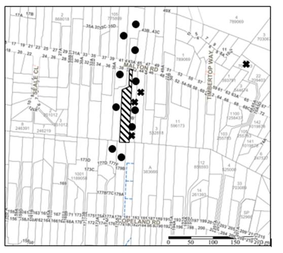
|
NOTIFICATION PLAN |
|||
|
• PROPERTIES NOTIFIED |
X SUBMISSIONS RECEIVED |
|
|
|
10 SUBMISSIONS RECEIVED OUT OF MAP RANGE |
|||
Sixteen submissions objected to the development, generally on the grounds that the development would result in:
· Impact to trees on neighbouring properties.
· Lack of space on site for replacement planting.
· Bushfire impacts not sufficiently addressed.
· Privacy concerns.
· Watercourse at the rear of the site.
· Earthworks.
· Unacceptable environmental impacts through tree loss.
· Unacceptable impacts to powerful owl habitat.
· Unacceptable overshadowing of adjoining properties.
· Unacceptable privacy impacts.
· The removal of a significant trees.
· Development that is excessive in bulk and scale.
The merits of the matters raised in community submissions have been addressed in the body of the report with the exception of the following addressed below:
5.1.1 Development that is excessive in bulk and scale
Submissions were received raising concern to the excessive bulk and scale of the proposed development.
In response to these submissions, it is noted that as outlined in the compliance table in Section 2.8 of this report, the application complies with height, floor area, site coverage and landscaping requirements.
Therefore, no objections are raised on planning grounds to the proposed bulk and scale of the development.
5.1.2 Watercourse at the rear of the site
Submissions were received raising concerns to the watercourse at the rear of the site known as Byles Creek and the impact the proposed development would have on this watercourse.
Notwithstanding to address issues of water quality to the Sydney Harbour Catchment, conditions are recommended in Schedule 1 of this report requiring appropriate sediment and erosion control measures to protect the downstream creek.
5.2 Public Agencies
The development application was not referred to any Public Agencies for comment.
6. THE PUBLIC INTEREST
Section 4.15(1)(e) of the Act requires Council to consider “the public interest”.
The public interest is an overarching requirement, which includes the consideration of the matters discussed in this report. Implicit to the public interest is the achievement of future built outcomes adequately responding to and respecting the future desired outcomes expressed in environmental planning instruments and development control plans.
The application is considered to have satisfactorily addressed Council’s and relevant agencies’ criteria and would provide a development outcome that, on balance, would result in a positive impact for the community. Accordingly, it is considered that the approval of the proposed development would be in the public interest.
CONCLUSION
The application proposes the construction of a dwelling house.
The development generally meets the desired outcomes of Council’s planning controls and is satisfactory having regard to the matters for consideration under Section 4.15 of the Environmental Planning and Assessment Act 1979.
Council received sixteen submissions during the public notification period. The matters raised have been addressed in the body of the report.
Having regard to the circumstances of the case, approval of the application is recommended.
The reasons for this decision are:
· The proposed development generally complies with the requirements of the relevant environmental planning instruments and the Hornsby Development Control Plan 2013; and
· The proposed development does not create unreasonable environmental impacts to adjoining development with regard to visual bulk, overshadowing, solar access, amenity or privacy.
Note: At the time of the completion of this planning report, no persons have made a Political Donations Disclosure Statement pursuant to Section 10.4 of the Environmental Planning and Assessment Act 1979 in respect of the subject planning application.
RESPONSIBLE OFFICER
The officer responsible for the preparation of this report is Tim Buwalda.
|
Cassandra Williams Major Development Manager - Development Assessments Planning and Compliance Division |
Rod Pickles Manager - Development Assessments Planning and Compliance Division |
|
Locality Map |
|
|
|
|
Architectural Plans |
|
|
|
|
Landscape Plan |
|
|
File Reference: DA/161/2021
Document Number: D08224479
SCHEDULE 1
GENERAL CONDITIONS
The conditions of consent within this notice of determination have been applied to ensure that the use of the land and/or building is carried out in such a manner that is consistent with the aims and objectives of the relevant legislation, planning instruments and council policies affecting the land and does not disrupt the amenity of the neighbourhood or impact upon the environment.
Note: For the purpose of this consent, the term ‘applicant’ means any person who has the authority to act on or the benefit of the development consent.
Note: For the purpose of this consent, any reference to an Act, Regulation, Australian Standard or publication by a public authority shall be taken to mean the gazetted Act or Regulation or adopted Australian Standard or publication as in force on the date that the application for a construction certificate is made.
1. Approved Plans and Supporting Documentation
The development must be carried out in accordance with the plans and documentation listed below and endorsed with Council’s stamp, except where amended by Council and/or other conditions of this consent:
|
Plan No. |
Plan Title |
Drawn by |
Dated |
Council Reference |
|
1724 1 of 2 |
Site Plan |
Distinct Innovations |
December 2020 |
|
|
1724 2 of 2 |
Elevations, Floor Plans and Sections |
Distinct Innovations |
December 2020 |
|
|
DA-01 rev. D |
Landscape Plan |
Grindstone Landscapes |
14 August 2021 |
|
|
DA-02 rev. D |
Driveway |
Grindstone Landscapes |
14 August 2021 |
|
|
DA-03 rev. D |
38B Landscape Plan |
Grindstone Landscapes |
15 September 2020 |
|
|
DA-04 rev. D |
38B Elevation |
Grindstone Landscapes |
14 August 2021 |
|
Supporting Documentation
|
Document Title |
Drawn by |
Dated |
Council Reference |
|
BASIX Certificate No. 1132496S |
Frys Energywise |
14 December 2021 |
D08108875 |
|
Integrated Bushfire and Vegetation Management Plan |
Hunter Ecology |
10 August 2021 |
D08225542 |
|
Arboricultural Impact Assessment Ref: 20036A V6JM |
McArdle Arboricultural Consultancy |
28 May 2021 |
D08177121 |
|
Geotechnical Assessment ref. 46785-IDF |
Idea Geotech |
September 2020 |
D08108864 |
|
Waste Management Plan |
Peter Henderson |
27 December 2020 |
D08242464 |
|
Powerful Owl Assessment Beecroft 01 |
Hunter Ecology |
10 August 2021 |
D08225544 |
|
Nathers Certificate |
Frys Energywise |
1 September 2020 |
D08108839 |
|
Bushfire Assessment Report Ref: 20.10.316 |
Bushfire Planning & Design |
15 October 2020 |
D08108876 |
|
Schedule of Finishes |
Distinct Innovation Pty Ltd |
24 December 2020 |
D08108842 |
2. Amendment of Plans
a) To comply with Councils requirement in terms of privacy, the approved plans are to be amended as follows:
i) A 1.7m high privacy screen must be erected along the eastern elevation of the raised ground floor level alfresco area to minimise the opportunity to overlook into the private open space of adjoining property No. 40A Malton Road (Lot 321 DP 861797).
ii) The screen must have no individual openings more than 30mm wide and have a total of all openings less than 30% of the surface area of the screen.
b) These amended plans must be submitted with the application for the Construction Certificate.
3. Construction Certificate
a) A Construction Certificate is required to be approved by Council or a Private Certifying Authority prior to the commencement of any construction works under this consent.
b) The Construction Certificate plans must include all requirements imposed by condition No. 12 of this consent.
c) The Construction Certificate plans must be consistent with the Development Consent plans.
4. Removal of Trees
a) This development consent permits the removal of seven numbered T31, T32, T33, T34, T35, T36 and T37 as identified in the Arboricultural Impact Assessment prepared by McArdle Arboricultural Consultancy dated 28 May 2021, Ref: 20036A V6JM (D08177121).
b) No consent is granted for the removal if any other trees on property 38B or 38A as these trees contribute to the established landscape amenity of the area/streetscape.
Note: The removal of any other trees from the site requires separate approval by Council in accordance with Part 1B.6 Tree and Vegetation Preservation of the Hornsby Development Control Plan, 2013 (HDCP).
a) This development consent only permits the pruning of tree(s) numbered T30 as identified in the Arboricultural Impact Assessment prepared by McArdle Arboricultural Consultancy dated 28/5/2021 TRIM D08177121.
i) This can only be permitted with Tree owners written consent.
b) Works can be undertaken in the form of canopy modification as follows:
|
Tree number |
Work prescribed |
|
T30 |
Prune for vehicle access |
i) All specified pruning works must be less than 10 percent.
ii) All pruning work must be undertaken by an arborist with minimum AQF3 qualifications.
Note: The pruning of any other trees from the site requires separate approval by Council in accordance with Part 1B.6 Tree and Vegetation Preservation of the Hornsby Development Control Plan 2013 (HDCP).
6. Retaining Walls
To ensure the stability of the site, structural details of all required retaining walls must be submitted with the application of the Construction Certificate.
REQUIREMENTS PRIOR TO THE ISSUE OF A CONSTRUCTION CERTIFICATE
7. Building Code of Australia
Detailed plans, specifications and supporting information is required to be submitted to the certifying authority detailing how the proposed building work achieves compliance with the National Construction Code - Building Code of Australia. All building work must be carried out in accordance with the requirements of the National Construction Code - Building Code of Australia.
8. Contract of Insurance (Residential Building Work)
Where residential building work for which the Home Building Act 1989 requires there to be a contract of insurance in force in accordance with Part 6 of that Act, this contract of insurance must be in force before any building work authorised to be carried out by the consent commences.
9. Notification of Home Building Act 1989 Requirements
Residential building work within the meaning of the Home Building Act 1989 must not be carried out unless the principal certifying authority for the development to which the work relates (not being Council) has given Council written notice of the following information:
a) In the case of work for which a principal contractor is required to be appointed:
i) The name and licence number of the principal contractor; and
ii) The name of the insurer by which the work is insured under Part 6 of that Act.
b) In the case of work to be done by an owner-builder:
i) The name of the owner-builder; and
ii) If the owner-builder is required to hold an owner-builder’s permit under that Act, the number of the owner-builder’s permit.
Note: If arrangements for doing the residential building work are changed while the work is in progress so that the information notified becomes out of date, further work must not be carried out unless the principal certifying authority for the development to which the work relates (not being Council) has given Council written notification of the updated information.
10. Sydney Water – Approval
This application must be submitted to Sydney Water for approval to determine whether the development would affect any Sydney Water infrastructure, and whether further requirements are to be met.
Note: Building plan approvals can be obtained online via Sydney Water Tap inTM through www.sydneywater.com.au under the Building and Development tab.
A ‘Dilapidation Report’ is to be prepared by a ‘chartered structural engineer’ detailing the structural condition of the adjoining properties Nos. 40A (Lot 321 DP 861797) and 42 (Lot 31 DP 834203) Malton Road before the commencement of works and a copy submitted to Council and the PCA with the Construction Certificate.
12. Design and Construction - Bushfire Attack Category
a) That the proposed dwellings roof and eaves section, and the western, southern and eastern elevations shall be constructed to section 3 Construction General and section 7 BAL 29 of AS3959-2018 Construction of buildings in bushfire prone areas with the exception that the construction requirements shall be varied to comply with section 7.5.2 Additional Construction Requirements of Planning for Bush Fire Protection 2019.
b) That the proposed dwellings northern elevation shall be constructed to section 3 Construction General and section 6 BAL 19 of AS3959-2018 Construction of buildings in bushfire prone areas with the exception that the construction requirements shall be varied to comply with section 7.5.2 Additional Construction Requirements of Planning for Bush Fire Protection 2019.
c) That the dwelling shall maintain a reserve Static Water Supply (SWS) for use during a bushfire event of not less than 10,000 litres stored in a non-combustible tank within the area of recommended asset protection zone.
d) The reserve Static Water Supply shall be permanently plumbed to a petrol or diesel firefighting water pump with a minimum of 5hp. The pump shall be regularly maintained as per the manufacturer specifications. The pump must be located in such a position to be shielded from the direct mechanisms of bushfire attack.
e) That a water delivery line of not less than 50mm diameter be plumbed from the firefighting water pump plumbed to the reserve Static Water Supply tank, to an outlet point located directly adjacent to the driveway as indicated within figure 7 of the Bushfire Assessment Report prepared by Bushfire Planning & Assessment dated 15 October 2020 on the subject allotment to enable firefighting tankers to refill. The outlet of this line shall be fitted with a ball or gate valve and a 65 to 38mm reducer Storz fitting.
f) That the development must provide and have readily available kink resistant hose or hoses with a diameter of not less than 19mm and a firefighting nozzle, capable of reaching all elevations of the dwelling, and fittings suitable for connection to the firefighting water pump.
g) Fire hose reels are constructed in accordance with AS/NZS 1221:1997 and installed in accordance with the relevant clauses of AS 2441:2005.
h) That all plumbing associated with the reserve water supply above the ground or for a depth of not less than 300mm below the ground shall be metal.
i) That approved NSW Rural Fire Service; Static Water Supply signage is installed at approved locations for the proposed development.
j) That if the supply of gas to the subject dwelling is undertaken it shall be installed and maintained in accordance with AS1596-2002 and requirements of relevant authorities.
Note: Further information concerning planning for bush fire protection can be found at: www.rfs.nsw.gov.au.
13. Stormwater Drainage
The stormwater drainage system for the development must be designed for an average recurrence interval (ARI) of 20 years and be gravity drained in accordance with the following requirements:
a) Roof water must be connected to a rainwater tank having a minimum capacity of 3,500 litres (in addition to any BASIX requirements).
b) The overflow from the rainwater tank must be connected to an existing internal drainage system.
14. Internal Driveway/Vehicular Areas
The driveway and parking areas on site must be designed, constructed and a Construction Certificate issued in accordance with Australian Standards AS2890.1, AS3727 and the following requirements:
a) The driveway be a rigid pavement.
b) The driveway grade must not exceed 25 percent and changes in grade must not exceed 8 percent.
c) A turning area to service the proposed dwelling must be designed and constructed in accordance with Australian Standards AS2890.1 to ensure all vehicles can enter and leave the site in a forward direction.
d) Reconstruction of the existing concrete driveway is necessary if the driveway is damaged during the construction of the new dwelling.
15. Appointment of Project Bush Regenerator and Ecologist
a) The applicant shall notify Council of the details of the engaged Project Bush Regenerator and Ecologist that will be involved with the implementation and monitoring of environmental protection measures during the construction of the approved development. These environmental experts will assist in ensuring compliance with the conditions of consent and provide monitoring reports to Council at various stages of the Project as identified in the approved Integrated Bushfire and Vegetation Management Plan prepared by Hunter Ecology dated 10 August 2021 .The ecologist will also be responsible for implementing the tree hollow improvement works as recommended in the Powerful Owl (Ninox strenua) surveys and assessment prepared by Hunter Ecology dated 10 August 2021.
b) An inspection schedule to assess vegetation health and provide certification for the various stages of development such as site establishment (includes demolition and installation of tree protection measures), weed removal, construction work, hard and soft landscaping practical completion and occupancy certification is to be included with the application for the construction certificate.
16. Appointment of a Project Arborist
a) To ensure the trees that must be retained are protected, a project arborist with AQF Level 5 qualifications must be appointed to assist in ensuring compliance with the conditions of consent and provide monitoring reports as specified by the conditions of consent.
b) Details of the appointed project arborist must be submitted to Council and the PCA with the application for the construction certificate/subdivision works certificate.
REQUIREMENTS PRIOR TO THE COMMENCEMENT OF ANY WORKS
17. Erection of Construction Sign
a) A sign must be erected in a prominent position on any site on which any approved work is being carried out:
i) Showing the name, address and telephone number of the principal certifying authority for the work.
ii) Showing the name of the principal contractor (if any) for any demolition or building work and a telephone number on which that person may be contacted outside working hours.
iii) Stating that unauthorised entry to the work site is prohibited.
b) The sign is to be maintained while the approved work is being carried out and must be removed when the work has been completed.
18. Installation of Tree Protection measures
a) Trees to be retained as identified on the Retention Value Map with TPZ and Tree Management Plan prepared McArdle Arboricultural Consultancy dated 28 May 2021 must have tree protection measures for the ground, trunk and canopy installed by the project arborist as follows:
i) For the duration of construction works, in accordance with Tree Protection Plan prepared by McArdle Arboricultural Consultancy dated 28 May 2021.
b) Tree protection fencing for the trees to be retained must be installed by the engaged AQF 5 project arborist and consist of 1.8m high temporary fencing panels installed in accordance with Australian Standard AS4687-2007 Temporary fencing and hoardings.
c) The installation of all required tree protection fencing must include shade cloth attached to the fencing to reduce transport of dust, particulates and liquids from entering the tree protection zone.
d) Tree crown protection measures are required and must be installed by the AQF 5 project arborist.
e) The circumference of the trunk(s) must be wrapped in hessian material to provide cushioning for the installation of timber planks.
f) Timber planks (50 x100mm) must be spaced at 100mm intervals and must be attached using adjustable ratchet straps.
g) All tree protection zones must have a layer of wood-chip mulch at a depth of between 150mm and 300mm.
h) Where wood-chip mulch is permitted by Council instead of tree protection fencing within the tree protection zones, the wood-chip must be covered with a layer of geotextile fabric and rumble boards.
19. Protection of vegetation, habitat and environmental features during construction
To ensure the protection of vegetation, habitat and environmental features during construction, the applicant must:
a) Install 1.2-m-high chain wire fencing (or similar) along the southern boundary of the site as shown in the approved plans.
b) Clean machinery of soil and debris before entering the site to prevent the spread of weeds and fungal pathogens.
Note: The site contains potential habitat for threatened species listed under the NSW Biodiversity Conservation Act 2016. The Act prohibits the disturbance to threatened species, endangered populations and threatened ecological communities, or their habitat, without appropriate consent or licence.
20. Integrated Bushfire and Vegetation Management Plan (IBVMP)
a) All on-ground works shall comply with the approved Integrated Bushfire and Vegetation Management Plan (IBVMP) prepared by Hunter Ecology dated 27 April 2021 and Powerful Owl (Ninox strenua) surveys and assessment prepared by Hunter Ecology dated 10th August 2021. This includes compliance with development milestones listed in the Schedule of Works within Section 3, 6 & 7 of the approved IBVMP.
b) The IBVMP shall be implemented from the date of issue of the Notice of Determination
c) Monitoring should occur every 3 months for the first year of this IBVMP, then biannually until the expiration of this IVBMP to ensure that weed control is well managed and plantings have established and nestboxes have been installed. At the end of the 3-year IBVMP period a final monitoring report shall be provided to Council (naturalresourcesplanning@hornsby.nsw.gov.au). If the performance criteria have not been met the life to the IBVMP will be extended accordingly at the discretion of Council’s Natural Resources Unit.
d) Monitoring of the site after the initial 3/5 years should occur annually. Reporting on the implementation of the IBVMP should occur annually with the annual reports provided to Council (naturalresourcesplanning@hornsby.nsw.gov.au).
Reason: The development of a consolidated IBVMP will provide the developer and current and future landowners with a single document describing the required vegetation management actions across the site.
21. APZ – marking of boundary
The boundary of the asset protection zone must be permanently marked before the works begin and must be kept in place in perpetuity as follows:
a) Sufficient markers (a minimum of two) must be placed along the boundary of the APZ to clearly delineate the extent of the asset protection zone.
b) The markers must be a tubular metal post (or the like) standing a minimum of 400mm above ground.
c) The markers must include a notation stating: End of Asset Protection Zone. The notation may be in the form of an attached sign or sticker with lettering of a contrasting colour to the post colour.
d) Photographic evidence must be submitted to the Principal Certifying Authority confirming compliance with this condition.
Reason: To provide certainty for the developer, current and future landowners, Council and contractors, during and after construction, as to the boundaries of the asset protection zone and those areas associated with different management requirements.
22. Protection of Adjoining Areas
A temporary hoarding, fence or awning must be erected between the work site and adjoining lands before the works begin and must be kept in place until after the completion of the works if the works:
a) Could cause a danger, obstruction or inconvenience to pedestrian or vehicular traffic.
b) Could cause damage to adjoining lands by falling objects; and/or.
c) Involve the enclosure of a public place or part of a public place; and/or.
d) Have been identified as requiring a temporary hoarding, fence or awning within the Council approved Construction Management Plan (CMP).
Note: Notwithstanding the above, Council’s separate written approval is required prior to the erection of any structure or other obstruction on public land.
23. Toilet Facilities
a) To provide a safe and hygienic workplace, toilet facilities must be available or be installed at the works site before works begin and must be maintained until the works are completed at a ratio of one toilet for every 20 persons employed at the site.
b) Each toilet must:
i) Be a standard flushing toilet connected to a public sewer; or
ii) Be a temporary chemical closet approved under the Local Government Act 1993.
24. Erosion and Sediment Control
To protect the water quality of the downstream environment, erosion and sediment control measures must be provided and maintained throughout the construction period in accordance with the manual ‘Soils and Construction 2004 (Bluebook)’, the approved plans, Council specifications and to the satisfaction of the principal certifying authority. The erosion and sediment control devices must remain in place until the site has been stabilised and revegetated.
Note: On the spot penalties may be issued for any non-compliance with this requirement without any further notification or warning.
25. Bushfire Management – Protection Zones
At the commencement of building works the Assets Protection Zone as outlined within Appendix 4 of Planning for Bush Fire Protection 2019 and the NSW Rural Fire Service’s document Standards for asset protection zones must be in accordance with the following:
a) From the southern elevation of the dwelling house to the south for 36m.
b) From the western, eastern and northern elevations of the dwelling house to the lot boundaries.
Note: Further information concerning planning for bush fire protection can be found at: www.rfs.nsw.gov.au.
REQUIREMENTS DURING CONSTRUCTION
26. Construction Work Hours
All works on site, including demolition and earth works, must only occur between 7am and 5pm Monday to Saturday.
No work is to be undertaken on Sundays or public holidays.
27. Prohibited actions within the fenced tree protection zone
The following activities are prohibited within the approved fenced tree protection zones unless otherwise approved by Council:
a) Soil cutting or filling, including excavation and trenching.
b) Soil cultivation, disturbance or compaction.
c) Stockpiling storage or mixing of materials.
d) The parking, storing, washing and repairing of tools, equipment and machinery.
e) The disposal of liquids and refuelling.
f) The disposal of building materials.
g) The siting of offices or sheds.
h) Any action leading to the impact on tree health or structure.
28. Works near trees
a) To maintain tree health and condition for trees to be retained on the approved plans, the appointed project arborist must monitor and record all necessary remedial actions required.
b) The maintenance and monitoring of all tree protection techniques must be recorded by the appointed project arborist during the period of construction for submission with the application for the occupation certificate.
29. Maintaining Tree Protection Measures
Tree Protection Measures must be maintained by the project arborist in accordance with Condition No. 18 of this consent for the duration of works.
30. Maintaining Tree Protection Zones
The Tree Protection Zone must be maintained by the project arborist in accordance with section 4.6 requirements of Australian Standard AS 4970-2009 - “Protection of Trees on Development Sites”.
31. Approved Works within Tree Protection Zone incursions
a) Where tree root pruning is required for the installation of piers, driveway or underground services, the pruning must be overseen by the AQF 5 project arborist and must be undertaken as follows:
i) Using sharp secateurs, pruners, handsaws or chainsaws with the final cut being clean.
ii) The maximum diameter of roots permitted to be cut is 40mm.
b) The new driveway must be constructed using the following process:
i) To minimise soil compaction the proposed driveway must be built above grade using sensitive construction techniques in the form of piers or screw pilings.
ii) To minimise soil compaction all imported material in the vicinity of the replacement driveway must be distributed by hand.
c) Where the building footprint enters or transects the Tree Protection Zones of trees to be retained sensitive construction techniques in the form of screw pilings or piers, cantilevered or suspended slab design must be employed to create a 100mm clearance above existing soil grade.
d) Approved excavations within the Tree Protection Zone of trees to be retained not associated with installation of services must be undertaken as follows:
i) Excavations for the construction and/or installation of the house/deck/driveway/piers in the Tree Protection Zone of trees to be retained on the approved plans must be supervised by the project arborist for the first 1.000 meter undertaken manually to locate roots and allow for pruning in accordance with condition 30a.
e) To minimise impacts within the Tree Protection Zone (TPZ) of trees to be retained on the approved plans, the installation of services must be undertaken as follows:
i) The AQF 5 project arborist must be present to oversee the installation of any underground services which enter or transect the tree protection.
ii) The installation of any underground services which either enter or transect the designated TPZ must be undertaken manually.
iii) For manually excavated trenches the AQF 5 project arborist must designate roots to be retained. Manual excavation may include the use of pneumatic and hydraulic tools.
f) Where scaffolding is required, ground protection must be installed beneath the scaffolding in the following order:
i) Installation of a 100mm deep layer of woodchip.
ii) Installation of geotextile fabric ground covering.
iii) Installation of scaffold boarding above the woodchip and geotextile fabric.
32. Works near Trees Certification
a) The project arborist must submit to the principal certifying authority a certificate that all works have been carried out in compliance with the approved plans and conditions or specifications for tree protection.
b) Certification should include a statement of site attendance, the condition of retained trees, details of any deviations from the approved tree protection measures and their impacts on trees.
Note: Copies of monitoring documentation may be required by the PCA and/or Council.
33. Building materials and Site Waste
The stockpiling of building materials, the parking of vehicles or plant, the disposal of cement slurry, waste water or other contaminants must be located outside the tree protection zones as prescribed in the conditions of this consent of any tree to be retained.
34. Environmental Management
To prevent sediment run-off, excessive dust, noise or odour emanating from the site during the construction, the site must be managed in accordance with the publication ‘Managing Urban Stormwater – Landcom (March 2004) and the Protection of the Environment Operations Act 1997.
35. Council Property
To ensure that the public reserve is kept in a clean, tidy and safe condition during construction works, no building materials, waste, machinery or related matter is to be stored on the road or footpath.
36. Disturbance of Existing Site
During construction works, the existing ground levels of open space areas and natural landscape features, including natural rock-outcrops, vegetation, soil and watercourses must not be altered unless otherwise nominated on the approved plans.
37. Landfill
a) Prior to fill material being imported to the site, a Waste Classification Certificate shall be obtained from a suitably qualified environmental consultant confirming the fill wholly consists of Virgin Excavated Natural Material (VENM) as defined in Schedule 1 of the Protection of the Environment Operations Act 1997 or a material approved under the NSW Environment Protection Authority’s Resource Recovery Orders and Exemptions.
b) The required Waste Classification Certificate must be obtained by the Principal Contractor prior to fill being imported to the site and made available to Council at its request.
38. Excavated Material
All excavated material removed from the site must be classified by a suitably qualified environmental consultant in accordance with the NSW Environment Protection Authority’s Waste Classification Guidelines and Protection of the Environment Operations (Waste) Regulation 2014 prior to disposal to a licensed waste management facility. Tipping dockets for the total volume of excavated material that are received from the licensed waste management facility must be provided to the principal certifying authority prior to the issue of an Occupation Certificate.
39. Survey Report
A report(s) must be prepared by a registered surveyor and submitted to the principal certifying authority:
a) Prior to the pouring of concrete at each level of the building certifying that:
i) The building, retaining walls and the like have been correctly positioned on the site.
ii) The finished floor level(s) are in accordance with the approved plans.
REQUIREMENTS PRIOR TO THE ISSUE OF AN OCCUPATION CERTIFICATE
40. Fulfilment of BASIX Commitments
The applicant must demonstrate the fulfilment of BASIX commitments pertaining to the development.
41. Replacement Tree Requirements
a) The trees approved for removal under this consent, being 7 trees numbered T26, T31, T32, T33, T34, T35, T36 and T37 must be offset through replacement planting of a minimum of 10 trees.
i) 5 trees must have the potential to reach a mature height of greater than 10m.
ii) 5 mid-story trees with the potential to reach a mature height of greater than 5m.
iii) This planting should be consistent with a Vegetation management plan.
b) All replacement plantings must be species selected from the ‘Trees Indigenous to Hornsby Shire (as of 1 September 2011)’ document available for viewing on the Hornsby Council’s website http://www.hornsby.nsw.gov.au/environment/flora-and-fauna/tree-management/indigenous-trees
c) The location and size of tree replacement planting must comply with the following:
i) All replacement trees must be located in either front or rear setbacks and planted 4m or greater from the foundation walls of the approved development.
ii) The pot size of the replacement trees must be a minimum 45 litres.
iii) All replacement trees must be a minimum of 3m in height.
iv) All replacement trees must have the potential to reach a mature height greater than 10m.
42. Final Certification
The AQF 5 Project arborist must submit to the Principal Certifying Authority a certificate that includes the following:
a) All tree protection requirements complied with the as approved tree protection plan for the duration of demolition and/or construction works.
b) All completed works relating to tree protection and maintenance have been carried out in compliance with the conditions of consent and approved plans.
c) Dates, times and reasons for all site attendance.
d) All works undertaken to maintain the health of retained trees.
e) Details of tree protection zone maintenance for the duration of works.
f) A statement to confirm that tree replacement planting meets NATSPEC guidelines and the approved landscape plan.
Note: Copies of monitoring documentation may be requested throughout DA process.
To protect public property and infrastructure, any damage caused to Council’s assets as a result of the construction or demolition of the development must be rectified by the applicant in accordance with AUS-SPEC Specifications (www.hornsby.nsw.gov.au/property/build/aus-spec-terms-and-conditions. Rectification works must be undertaken prior to the issue of an Occupation Certificate, or sooner, as directed by Council.
44. Supplementary planting, weeding and nestbox installation
Any supplementary planting, weeding and nest box installation outside the immediate landscaping area depicted in the approved landscape Plan prepared by Grindstone Landscapes dated 14 August 2021 shall be in accordance with Section 4.3 of the approved Integrated Bushfire and Vegetation Management Plan (IBVMP) prepared by Hunter Ecology dated 27th April 2021 and stock used for planting shall be sourced from a native nursery utilising Sydney basin stock. The hollow improvement works and four (4) nestboxes shall only be installed and certified by an experienced fauna ecologist (Section 3.8 of the IBVMP and the Powerful Owl (Ninox strenua) surveys and assessment prepared by Hunter Ecology dated 10th August).
45. Certification of Bushfire Requirements
a) A Certificate prepared by a BPAD accredited Bushfire Consultant is to be provided to the Principal Certifying Authority (PCA) certifying the completion of all works required by the Bushfire Assessment Report Ref: 20.10.316, prepared by Bushfire Planning and Design dated 15 October 2020 and condition Nos. 12 and 25 of this consent prior to the issue of the Occupation Certificate.
b) A suitably qualified and experienced bush fire consultant must provide to the PCA and/or Council certification of the implementation of the of the approved asset protection zone.
46. Final Certification – Ecology/Bush regeneration
The project ecologist/bush regenerator must provide to the PCA and/or Council certification of the implementation of the of the approved Integrated Bushfire and Vegetation Management Plan (IBVMP) prepared by Hunter Ecology dated 10 August 2021 (D08225542).
47. Retaining Walls
All retaining walls must be constructed as part of the development and prior to the issue of an Occupation Certificate.
OPERATIONAL CONDITIONS
48. Ongoing Protection of remnant trees
All trees on site not approved for removal under this consent are required to be retained for conservation purposes. These trees have a legal obligation for their preservation and are excluded from the clearing provisions of the 10/50 Vegetation Clearing Code of Practice for New South Wales in accordance with Clause 7.8 of the Code.
49. Ongoing Bushfire Management
Any requirements relating to bushfire protection must be maintained in perpetuity and landscaping works must be consistent with the Asset Protection Zone requirements as described in Planning for Bush Fire Protection.
- END OF CONDITIONS -
ADVISORY NOTES
The following information is provided for your assistance to ensure compliance with the Environmental Planning and Assessment Act, 1979, Environmental Planning and Assessment Regulation 2000, other relevant legislation and Council’s policies and specifications. This information does not form part of the conditions of development consent pursuant to Section 4.17 of the Act.
Environmental Planning and Assessment Act 1979 Requirements
The Environmental Planning and Assessment Act 1979 requires:
· The issue of a construction certificate prior to the commencement of any works. Enquiries can be made to Council’s Customer Services Branch on 9847 6760.
· A principal certifying authority to be nominated and Council notified of that appointment prior to the commencement of any works.
· Council to be given at least two days written notice prior to the commencement of any works.
· Mandatory inspections of nominated stages of the construction inspected.
· An occupation certificate to be issued before occupying any building or commencing the use of the land.
Long Service Levy
In accordance with Section 34 of the Building and Construction Industry Long Service Payments Act 1986, a ‘Long Service Levy’ must be paid to the Long Service Payments Corporation or Hornsby Council.
Note: The rate of the Long Service Levy is 0.35% of the total cost of the work.
Note: Hornsby Council requires the payment of the Long Service Levy prior to the issue of a construction certificate.
Tree and Vegetation Preservation
Hornsby Development Control Plan 2013 Tree and Vegetation Preservation provisions have been developed under Council’s authorities contained in State Environmental Planning Policy (Vegetation in Non-Rural Areas) 2017 and the Environmental Planning and Assessment Act 1979.
In accordance with these provisions a person must not cut down, fell, uproot, kill, poison, ringbark, burn or otherwise destroy the vegetation, lop or otherwise remove a substantial part of the trees or vegetation to which any such development control plan applies without the authority conferred by a development consent or a permit granted by Council.
Fines may be imposed for non-compliance with the Hornsby Development Control Plan 2013.
Note: A tree is defined as a long lived, woody perennial plant with one or relatively few main stems with the potential to grow to a height greater than three ms (3m). (HDCP 1B.6.1.c).
Covenants
The land upon which the subject building is to be constructed may be affected by restrictive covenants. Council issues this approval without enquiry as to whether any restrictive covenant affecting the land would be breached by the construction of the building, the subject of this consent. Applicants must rely on their own enquiries as to whether or not the building breaches any such covenant.
Dial Before You Dig
Prior to commencing any works, the applicant is encouraged to contact Dial Before You Dig on 1100 or www.dialbeforeyoudig.com.au for free information on potential underground pipes and cables within the vicinity of the development site.
Telecommunications Act 1997 (Commonwealth)
If you are aware of any works or proposed works which may affect or impact on Telstra’s assets in any way, you are required to contact: Telstra’s Network Integrity Team on Phone Number 1800810443.
Asbestos Warning
Should asbestos or asbestos products be encountered during demolition or construction works, you are advised to seek advice and information prior to disturbing this material. It is recommended that a contractor holding an asbestos-handling permit (issued by SafeWork NSW) be engaged to manage the proper handling of this material. Further information regarding the safe handling and removal of asbestos can be found at:
Alternatively, telephone the SafeWork NSW on 13 10 50.
Rain Water Tank
It is recommended that water collected within any rainwater tank as part of the development be limited to non-potable uses. NSW Health recommends that the use of rainwater tanks for drinking purposes not occur where a reticulated potable water supply is available.
LPP Report No. LPP28/21
Local Planning Panel
Date of Meeting: 29/09/2021
3 DA/691/2021 - CHANGE OF USE OF A DWELLING HOUSE TO A PERMANENT GROUP HOME - 9 TANBARK PLACE, DURAL
EXECUTIVE SUMMARY
|
DA No: |
DA/691/2021 (Lodged 12 July 2021) |
|
Description: |
Change of use of a dwelling house to a permanent group home |
|
Property: |
Lot 496 DP 775959, No. 9 Tanbark Place Dural |
|
Applicant: |
Sunnyfield |
|
Owner: |
Mrs Homataj Vafa Mr Navid Vafa |
|
Estimated Value: |
Nil |
|
Ward: |
C |
· The application seeks to regularise the use of an existing dwelling house as a permanent group home to accommodate people with intellectual disabilities.
· The proposal complies with the requirements of the Hornsby Local Environmental Plan 2013 and the Hornsby Development Control Plan 2013.
· A total of 26 submissions have been received in respect of the application.
· The application is required to be determined by the Hornsby Council Local Planning Panel as 10 or more unique submissions were received by way of objection.
· It is recommended that the application be approved.
|
THAT Development Application No. DA/691/2021 for the use of a dwelling house as a permanent group home at Lot 496 DP 775959, No. 9 Tanbark Place Dural be approved subject to the conditions of consent detailed in Schedule 1 of LPP Report No. LPP28/21. |
BACKGROUND
On 6 April 1987, Council approved BA/723/89 for the construction of a dwelling house.
On 19 July 2002, Council approved DA/1176/2002 for the construction of a carport.
On 12 July 2021, the subject application was lodged.
On 17 July 2021, the application was publicly notified until 3 August 2021.
On 30 July 2021, the public notification period was extended for another 7 days till 10 August 2021 due to a failure to produce evidence of an erected notification sign.
On 25 August 2021, Council requested an amended Statement of Environmental Effects, an amended Plan of Management and an amended Site Plan to establish consistency within the supporting documentation and to enable a full and proper assessment to be made.
On 7 September 2021, all requested information was submitted.
SITE
The 869.3m2 battle-axe site is located on the south-western side of Tanbark Place, Dural and contains a two-storey dwelling house and a detached carport. The site falls 50m from the west (rear) to the east (front). The site is not bushfire or flood prone.
Whilst the rear boundary of the site abuts New Line Road, vehicular access is achieved via Tanbark Place as it benefits from a Right of Carriageway which burdens adjoining properties Nos. 7 and 11 Tanbark Place.
The site is not a heritage item but is located adjacent to local heritage item no. 343 - Street trees and bushland, located along the road reserve of the New Line Road frontage, between Pyes Creek and New Line Road.
The locality is characterised by one and two storey brick dwelling houses in a landscaped setting reflective of a low-density residential area.
PROPOSAL
The application seeks to regularise the use of an existing dwelling house as a permanent group home to accommodate people with intellectual disabilities.
The Statement of Environmental Effects states:
“the site has been operating as a group home for an extended period of time; the subject application is being lodged as it was recently identified by the site operator (Sunnyfield Disability Services) that consent had not been obtained for this use”.
The application does not propose any construction works to the existing dwelling house. However, fire upgrade and acoustic works may be required subject to council’s conditions.
5 bedrooms would form part of the group home with a maximum of 4 occupants residing at any one time, one to a bedroom. The fifth bedroom would be used as a staff room.
There are 7 regular staff members and 1 manager providing care for the participants on a 24 hour/7-day basis with 2-3 staff per day shift and 1 staff per overnight shift.
Transport for the participants is by passenger vehicle driven by staff. This vehicle would be parked on site when not in use. Parking for staff and visitor vehicles would be provided on site.
No trees would be removed or impacted by the development.
ASSESSMENT
The development application has been assessed having regard to the Greater Sydney Region Plan – A Metropolis of Three Cities, the North District Plan and the matters for consideration prescribed under Section 4.15 of the Environmental Planning and Assessment Act 1979 (the Act). The following issues have been identified for further consideration.
1. STRATEGIC CONTEXT
1.1 Greater Sydney Region Plan - A Metropolis of Three Cities and North District Plan
The Greater Sydney Region Plan - A Metropolis of Three Cities has been prepared by the NSW State Government to guide land use planning decisions for the next 40 years (to 2056). The Plan sets a strategy and actions for accommodating Sydney’s future population growth and identifies dwelling targets to ensure supply meets demand. The Plan also identifies that the most suitable areas for new housing are in locations close to jobs, public transport, community facilities and services.
The NSW Government will use the subregional planning process to define objectives and set goals for job creation, housing supply and choice in each subregion. Hornsby Shire has been grouped with Hunters Hill, Ku-ring-gai, Lane Cove, Mosman, North Sydney, Ryde, Northern Beaches and Willoughby to form the North District. The Greater Sydney Commission has released the North District Plan which includes priorities and actions for Northern District for the next 20 years. The identified challenge for Hornsby Shire will be to provide an additional 4,350 dwellings by 2021 with further strategic supply targets to be identified to deliver 97,000 additional dwellings in the North District by 2036.
The proposed development would be consistent with the Greater Sydney Region Plan - A Metropolis of Three Cities and North District Plan, by providing housing, additional services and social infrastructure to support a growing population.
2. STATUTORY CONTROLS
Section 4.15(1)(a) requires Council to consider “any relevant environmental planning instruments, draft environmental planning instruments, development control plans, planning agreements and regulations”.
2.1 Hornsby Local Environmental Plan 2013
The proposed development has been assessed having regard to the provisions of the Hornsby Local Environmental Plan 2013 (HLEP).
2.1.1 Zoning of Land and Permissibility
The subject land is zoned R2 Low Density Residential under the HLEP.
The proposed development is defined as ‘group home’ and is permissible in the R2 zone with Council’s consent.
The Statement of Environmental Effects states that consent for the group home is being sought under the HLEP because “the proposal is incapable of being undertaken as complying development, as the complying development provisions contained with Schedule 2 of the SEPP ARH are for new group homes (or alterations and additions to existing group homes), and do not relate to the change of use of an existing structure where building works are not proposed or required to facilitate that use”.
the HLEP dictionary, has the following definition for a ‘group home’:
group home means a permanent group home or a transitional group home.
group home (permanent) or permanent group home means a dwelling:
(a) That is occupied by persons as a single household with or without paid supervision or care and whether or not those persons are related or payment for board and lodging is required, and
(b) That is used to provide permanent household accommodation for people with a disability or people who are socially disadvantaged,
group home (transitional) or transitional group home means a dwelling:
(a) That is occupied by persons as a single household with or without paid supervision or care and whether or not those persons are related or payment for board and lodging is required, and
(b) That is used to provide temporary accommodation for the relief or rehabilitation of people with a disability or for drug or alcohol rehabilitation purposes, or that is used to provide half-way accommodation for persons formerly living in institutions or temporary accommodation comprising refuges for men, women or young people,
The proposed use is consistent with the definition of a ‘permanent group home’ as it is a place which provides permanent accommodation for people with an intellectual disability.
The objectives of the R2 zone are:
· To provide for the housing needs of the community within a low-density residential environment.
· To enable other land uses that provide facilities or services to meet the day to day needs of residents.
The proposed permanent group home would be consistent with the zone objectives as the development is permissible in the zone and would provide permanent accommodation and independence for intellectually disabled people within a low-density residential locality.
2.1.2 Height of Buildings
Clause 4.3 of the HLEP provides that the height of a building on any land should not exceed the maximum height shown for the land on the Height of Buildings Map. The maximum permissible height for the subject site is 8.5m. The proposal complies with this provision as it does not seek to modify the existing building height of 6.6m.
2.1.3 Heritage Conservation
Clause 5.10 of the HLEP sets out heritage conservation provisions for Hornsby Shire. The site does not include a heritage item but is located adjacent to local heritage item No. 343 - Street trees and bushland, located along the road reserve of New Line Road between Pyes Creek and New Line Road.
Given that the proposal does not involve the removal of any trees within the New Line Road frontage, further assessment regarding heritage is not required.
2.2 State Environmental Planning Policy No. 55 Contaminated Land
The policy provides guidelines for the remediation of contaminated land for the purpose of reducing the risk of harm to human health or any other aspect of the environment. Clause 7 requires Council to consider whether land is contaminated prior to granting consent to the carrying out of any development on that land.
Should the land be contaminated Council must be satisfied that the land is suitable in a contaminated state for the proposed use. If the land requires remediation to be undertaken to make the land suitable for the proposed use, Council must be satisfied that the land will be remediated before the land is used for that purpose.
The site has been historically used for residential purposes. A review of Council’s records did not find any evidence that the site has experienced any significant contamination, and further assessment under SEPP 55 is not required.
2.3 State Environmental Planning Policy (Infrastructure) 2007
State Environmental Planning Policy (Infrastructure) 2007 (ISEPP) applies to the proposed development as the site has a frontage to a classified road. The application has been assessed against the following relevant clauses of the ISEPP.
2.3.1 Clause 101 Development with frontage to classified road
The objectives of Clause 101 of the ISEPP are:
a) To ensure that new development does not compromise the effective and ongoing operation and function of classified roads, and
b) To prevent or reduce the potential impact of traffic noise and vehicle emission on development adjacent to classified roads.
The consent authority cannot grant consent that has frontage to a classified road unless it is satisfied that:
c) Where practicable and safe, vehicular access to the land is provided by a road other than a classified road, and
d) The safety, efficiency and ongoing operation of the classified road will not be adversely by the development as a result of:
(i) The design of the vehicular access to the land, or
(ii) The emission of smoke or dust from the development, or
(iii) The nature, volume or frequency of vehicles using the classified road to gain access to the land, and
b) The development is of a type that is not sensitive to traffic noise or vehicle emissions, or is appropriately located and design, or includes measures, to ameliorate potential traffic noise or vehicle emissions within the site of the development arising from the adjacent classified road.
The rear boundary of the subject site has frontage to New Line Road which is identified as a classified road by Transport for NSW (TfNSW).
Vehicle access to the site is achieved from Tanbark Place to the north-east via a right of carriageway over adjoining properties Nos. 7 and 11 Tanbark Place. No direct vehicle access from New Line Road exists or is proposed as part of this development.
The Statement of Environment Effects establishes that “the number of residents is consistent with that of a typical dwelling within the area (i.e. it is a low-intensity residential use), and the proposal does not seek to provide any additional parking spaces. The proposal will subsequently have no impact on the safety, efficiency and ongoing operation of New Line Road”.
2.3.2 Clause 102 Impact of road noise or vibration on non-road development
Where development is located in or adjacent to a road corridor for the purpose of residential accommodation and would likely be affected by road noise or vibration, Clause 102 of the ISEPP states that the consent authority must not grant consent unless it is satisfied that appropriate measures are taken to ensure that the following LAeq levels are not exceeded:
a) In any bedroom in the residential accommodation – 35 dB(A) at any time between 10pm and 7am,
b) Anywhere else in the residential accommodation (other than a garage, kitchen, bathroom or hallway) – 40 dB(A) at any time.
To address these requirements, noting that the rear boundary of the property adjoins New Line Road, a condition is recommended in Schedule 1 of this report to ensure that the proposal would comply with the requirements of the ISEPP.
2.4 State Environmental Planning Policy (Affordable Rental Housing) 2009
Part 2 Division 7 of the State Environmental Planning Policy (Affordable Rental Housing) 2009 (SEPP ARH) permits development for the purposes of ‘group homes’ in R2 Low Density Residential zones.
The aims of this Policy include facilitating the development of housing for the homeless and other disadvantaged people who may require support services, including group homes and supportive accommodation.
A detailed assessment of the proposal’s compliance with the ARH SEPP is provided in Section 2.8.2 of this report.
2.5 State Environmental Planning Policy (Vegetation in Non-Rural Areas) 2017
State Environmental Planning Policy (Vegetation in Non-Rural Areas) 2017 (Vegetation SEPP) commenced 25 August 2017 and aims to protect the biodiversity and amenity values of trees within non-rural areas of the state.
Part 3 of the Vegetation SEPP states that a development control plan may make a declaration in any manner relating to species, size, location and presence of vegetation. Accordingly, Part 1B.6.1 of the Hornsby Development Control Plan 2013 (HDCP) prescribes works that can be undertaken with or without consent to trees.
Section 3.1.1 of this report provides an assessment in accordance with Part 1B.6.1 of the HDCP.
2.6 Sydney Regional Environmental Plan No. 20 Hawkesbury-Nepean River
The site is located within the catchment of the Hawkesbury Nepean River. Part 2 of this Plan contains general planning considerations and strategies requiring Council to consider the impacts of development on water quality, aquaculture, recreation and tourism.
As the proposal does not involve external works to the existing building and is already served by a stormwater system which does not require modification, the proposal would comply with the requirements of the Policy.
2.7 Section 3.42 Environmental Planning and Assessment Act 1979 - Purpose and Status of Development Control Plans
Section 3.42 of the Environmental Planning and Assessment Act 1979 states that a DCP provision will have no effect if it prevents or unreasonably restricts development that is otherwise permitted and complies with the development standards in relevant Local Environmental Plans and State Environmental Planning Policies.
The principal purpose of a development control plan is to provide guidance on the aims of any environmental planning instrument that applies to the development; facilitate development that is permissible under any such instrument; and achieve the objectives of land zones. The provisions contained in a DCP are not statutory requirements and are for guidance purposes only. Consent authorities have flexibility to consider innovative solutions when assessing development proposals, to assist achieve good planning outcomes.
2.8 Hornsby Development Control Plan 2013
The proposed development has been assessed having regard to the relevant desired outcomes and prescriptive requirements within the Hornsby Development Control Plan 2013 (HDCP). Part 7.2.3 of the HDCP prescribes that development for group homes should comply with the planning controls detailed in the SEPP ARH. Consequently, an assessment of the proposal against Division 7 of the SEPP ARH is provided below.
2.8.1 Division 7 of SEPP ARH
Clause 42 Definitions
The proposed use complies with the definition of “permanent group home” as the use would provide permanent household accommodation for people with intellectual disabilities.
Clause 43 Development in prescribed zones
Clause 43 states that:
(1) Development for the purpose of a permanent group home or a transitional group home on land in a prescribed zone may be carried out:
(a) Without consent if the development does not result in more than 10 bedrooms being within one or more group homes on a site and the development is carried out by or on behalf of a public authority, or
(b) With consent in any other case.
Comment: The proposal would be carried out by a National Disability Insurance Scheme (NDIS) registered provider and would utilise 4 bedrooms within the existing dwelling. The development complies with SEPP ARH in this regard.
Clause 45 Complying Development - Group Homes
Clause 45 states that:
(1) Development for the purposes of a group home is complying development if—
(a) The development does not result in more than 10 bedrooms being within one or more group homes on a site, and
(b) The development satisfies the requirements for complying development specified in clauses 1.18 and 1.19 of State Environmental Planning Policy (Exempt and Complying Development Codes) 2008 (other than clauses 1.18 (1) (h) and 1.19 (1) (b) and the requirement that the development not be in a draft heritage conservation area).
Comment: The proposal has been lodged with Council as a development application seeking development consent. Consequently, Council’s assessment of the proposal has been undertaken in accordance with the relevant complying development provisions of the SEPP ARH and the HDCP.
2.8.2 SEPP ARH Schedule 2 Complying development - group homes
In accordance with the requirements of the HDCP, as assessment of the proposal against Schedule 2 of the SEPP ARH is provided below:
|
Control |
Existing |
Requirement |
Compliance |
|
Site Area |
869.3m2 |
450m2 (min) |
Yes |
|
Access Laneway Width |
Min. 4 metres |
3m |
Yes |
|
Comprises a 12m x 12m area |
12m x 12m |
12m x 12m |
Yes |
|
Site Coverage |
18.6% |
70% |
Yes |
|
Building Height |
6.6m |
8.5m |
Yes |
|
Setbacks (Group home) |
|
|
|
|
- Side (north-east) |
|||
|
Ground floor |
8.6m |
0.9m |
Yes |
|
First floor |
10.6 |
1.6m |
Yes |
|
- Side (north-west) |
|
|
|
|
Ground floor |
2.5m |
0.9m |
Yes |
|
First floor |
2.5m |
1.6m |
Yes |
|
- Side (south-east) |
|
|
|
|
Ground floor |
1.2m |
0.9m |
Yes |
|
First floor |
1.2m |
1.6m |
No |
|
- Rear (south-west) |
|
|
|
|
Ground floor |
21.4m |
0.9m |
Yes |
|
First floor |
21.4m |
8m |
Yes |
|
Setbacks (Carport) |
|
|
|
|
- Side (north-east) |
0.6m |
0.9m |
No |
|
- Side (north-west) |
1.8m |
0.9m |
Yes |
|
- Side (south-east) |
9.6m |
0.9m |
Yes |
|
- Rear (south-west) |
N/A |
0.9m |
N/A |
|
Landscaped Area (% of lot size) |
56% total landscaping of which >50% is at the rear |
20% total landscaping with 50% at the rear |
Yes |
|
Principal Private Open Space |
>24m2 |
24m2 |
Yes |
|
Car Parking |
4 spaces |
2 spaces |
Yes |
|
Car Parking Location
|
Carport is 1.5m forward of the front building line. |
No more than 1m forward of the front building setback |
No |
As stated in the above table, the development does not comply with Schedule 2 of the SEPP ARH in relation to setbacks and the location of on-site carparking These non-compliances are addressed below, in addition to a discussion on compliance with relevant performance requirements of the HDCP.
2.8.3 Setbacks
The application does not propose any physical works to the building to facilitate its use as a permanent group home. All setback non-compliances are existing and not anticipated to adversely affect the amenity of adjoining properties.
2.8.4 Car parking
The location of the carport forward of the front building line is existing and the application will not alter its location or dimensions. The current location of the carport and its continued use is not anticipated to adversely affect the amenity of adjoining properties.
2.8.5 National Construction Code – Building Code of Australia (BCA)
The application includes a BCA Classification Report prepared by Design Confidence dated 20 May 2021.
The existing dwelling house is classified as a Class 1a building in accordance with the Building Code of Australia (BCA). The proposed change of use of the dwelling house to a permanent group home would result in a modification of its BCA classification to a Class 3 building.
Council’s building certification assessment raises no objections to the proposal, subject to conditions requiring the application demonstrate compliance with the BCA and fire safety upgrades prior to the issue of a Construction Certificate and the implementation of fire safety measures prior to the issue of an Occupation Certificate.
2.8.6 Accessible Design
The desired outcomes of Part 1C.2.2 Accessible Design of the HDCP is to encourage “publicly accessible buildings that provide a safe and continuous path of travel for people with impaired mobility” and “residential development that includes adaptable units and accessible residential accommodation to address potential demand”.
Whilst the HLEP defines a ‘permanent group home’ as a dwelling “that is used to provide permanent household accommodation for people with a disability or people who are socially disadvantaged”, the proposed permanent group home would provide accommodation for people with intellectual disabilities only.
Given that the proposed use and the subject Plan of Management would only accommodate intellectually disabled occupants within a private dwelling, the provision of disabled access is not required in accordance with Disability (Access to Premises - Buildings) Standards 2010.
2.8.7 Plan of Management
A revised Plan of Management was submitted to Council on 7 September 2021 prepared by the NDIS registered provider ‘Sunnyfield Disability Services’. An assessment against the Land and Environment Court’s Planning Principles for plans of management is provided below:
· Do the requirements in the Management Plan relate to the proposed use and complement any conditions of approval?
Comment: Yes, the Plan of Management relates to a group home and appropriate conditions are recommended restricting the number of bedrooms, hours of operation, noise minimisation, waste disposal, signage, emergency evacuation procedures and management of complaints. An operational condition is recommended that the Plan of Management must be adhered to.
· Do the requirements in the Management Plan require people to act in a manner that would be unlikely or unreasonable in the circumstances of the case?
Comment: No, the Plan of Management is considered simple and easy to understand and would not place any unreasonable requirements on the manager of the group home.
· Can the source of any breaches of the Management Plan be readily identified to allow for any enforcement action?
Comment: Yes, an operational condition is recommended in Schedule 1 requiring any complaints regarding the operation of the group home to be directed to the manager of the business and a log book of the date and time of the complaint, contact details of the person making the complaint and the nature of the complaint to be documented. This logbook must be readily available to Council and contact details must be provided on a website of relevant contact details of the manager.
· Do the requirements in the Management Plan require absolute compliance to achieve an acceptable outcome?
Comment: No. The Plan of Management’s proposed procedures and operational limitations would ensure that the standard of the operation would achieve an acceptable environmental outcome.
· Can the people the subject of the Management Plan be reasonably expected to know of its requirements?
Comment: Yes, an operational condition is recommended in Schedule 1 requiring the submitted Plan of Management to be adhered to.
· Is the Management Plan to be enforced as a condition of consent?
Comment: Yes, an operational condition is recommended in Schedule 1 requiring the submitted Plan of Management to be adhered to.
· Does the Management Plan contain complaint management procedures?
Comment: Yes, Section 12 of the submitted Plan of Management contains a compliant management plan. Complaints would be directed to the manager who will investigate any complaints and keep a log book of the date and time of the complaint, contact details of the person making the complaint and any action taken. A condition has been recommended in Schedule 1 accordingly.
· Is there a procedure for updating?
Comment: Yes, Section 23 of the plan allows for a review of the plan after 12 months. Should complaints occur, the plan can be updated.
2.9 Development Contributions
The Hornsby Shire Council Section 7.12 Development Contributions Plan 2019-2029 does not apply to the development as the proposal is for the use of an existing dwelling house as a group home and the estimated costs of works is less than $100,000.
3. ENVIRONMENTAL IMPACTS
Section 4.15(1)(b) of the Act requires Council to consider “the likely impacts of that development, including environmental impacts on both the natural and built environments, and social and economic impacts in the locality”.
3.1 Natural Environment
3.1.1 Tree and Vegetation Preservation
The proposal does not necessitate the removal of any trees from the site. Furthermore, whilst no building works are proposed as part of the development, any upgrading works to the dwelling as required by the recommended conditions in Schedule 1 will not impact on any existing trees on the site.
3.1.2 Stormwater Management
The dwelling house is served by an existing stormwater management system. This system would not require modification as no increase in roof or impervious surface area is proposed.
3.2 Built Environment
3.2.1 Built Form
The existing dwelling house is compatible with the locality as it is of a form that is characteristic of a low-density residential zone, this being a two storey brick building with a tiled roof. The change of use of the dwelling house to a group home would not alter the built form.
3.2.2 Traffic
The Statement of Environmental Effects (SEE) provides the following assessment on the traffic and parking impacts of the proposed group home:
“At present, two formalised off-street car parking spaces are provided within the carport within the northern part of the site. Further off-street parking is also available within a large paves area within the front setback of the subject site, that is adjacent to the section of the site that acts as a driveway connecting the site entrance point to the carport.
It should also be noted that the residents of this Sunnyfield group home do not drive, the only traffic generation associated with this site therefore consists of Sunnyfield carers/employees and a van/people mover is otherwise used by Sunnyfield staff to transport residents to/from the site.
The small number of staff at the site arrive via a number of transport options; bus stops approximately 190 metres walking distance from the site are serviced both ways…by the 622 bus route, which connects the site with numerous urban centres and associated transport nodes between Dural and Milsons Point.
Visitors to the site are to arrange visits in advance to ensure that the number of persons (including visitors) on the site are limited and that off-street car parking is provided at all times.
Given the small number of residents accommodated at this site (and the small number of staff required to care for them), the two car parking spaces are therefore capable of meeting the parking demand generated by this proposed use”.
Section 22 of the Plan of Management outlines the staff roster as below:
· 1 staff member from 7:30am to 3pm.
· 1 staff member from 3pm to 11am (sleepover).
· 2 staff members from 11am to 7:30pm.
With this roster, no more than 3 staff will be present within the group home at any one time with possible vehicle movements on the driveway at 7:30am, 11am, 3pm and 7:30pm.
It is considered that the two car parking spaces within the carport and further parking on the paving forward of the building would support the parking needs of employees and any visitors.
The anticipated vehicle movements arising from staff shift changes is not dissimilar to that which could be expected of a low-density residential dwelling.
3.3 Social Impacts
The SEE provides the following assessment on the social impacts of the proposed group home:
“The proposal provides specialised and suitable housing for members of the community who have a disability. The location of the group home within the locality enables increased community participation and provides both tailored and supportive accommodation with higher levels of privacy, flexibility and amenity. The more supportive housing model considers that people with a disability have a right to live in a community, and to participate fully in that community. Group homes provide people with the support they need to increase their independence, achieve personal goals and to live both full and productive lives.
No adverse social impacts are anticipated as a result of the proposed development. The development provides and contributes to diversity in housing choice”.
No objections are raised to the SEE assessment of social impacts arising from the proposed group home.
3.4 Economic Impacts
It is not considered that any adverse economic impacts would arise as a result of the proposed group home.
The proposal would have a minor positive impact on the local economy in conjunction with other new low-density residential development in the locality by contributing employment opportunities for suitably qualified staff to support group home residents and by maintaining the ongoing demand for local goods and services.
4. SITE SUITABILITY
Section 4.15(1)(c) of the Act requires Council to consider “the suitability of the site for the development”.
The subject site is not bushfire prone or flood prone land. The site is considered to be capable of accommodating the proposed development. The scale of the proposed development is consistent with the capability of the site and is considered acceptable.
5. PUBLIC PARTICIPATION
Section 4.15(1)(d) of the Act requires Council to consider “any submissions made in accordance with this Act”.
5.1 Community Consultation
The proposed development was placed on public exhibition and was notified to adjoining and nearby landowners between 17 July 2021 and 10 August 2021 in accordance with the Hornsby Community Participation Plan. During this period, Council received 26 submissions. The map below illustrates the location of those nearby landowners who made a submission that are in close proximity to the development site.
|
NOTIFICATION PLAN |
|||
|
• PROPERTIES NOTIFIED |
X SUBMISSIONS RECEIVED |
|
|
|
20 SUBMISSIONS RECEIVED OUT OF MAP RANGE |
|||
26 submissions objected to the development, generally on the grounds that the development:
· Would result in a reduction in the quality of life and value of the community.
· Does not match the community, with Tanbark Place and surrounding streets being of a low-density residential character with large populations of families with young children.
· Would result in the safety and security of the community being compromised as occupants of the group home would be transients, without ties to the community. The group home occupants and their visitors may be unreformed with greater likelihood of undesirable activity occurring.
· Would result in disruptions and intrusive noise. There have been past incidences of group home occupants causing disruptions.
· Would not be adequately served by public transportation.
· The Royal Commission on Violence, Abuse, Neglect and Exploitation of People with Disability was announced in April 2019 which has raised concerns about the placement of group homes in suburban areas. Due to the COVID pandemic, the commission has been extended to 29 September 2023. It would be prudent to await the commission’s findings before making a determination.
The merits of the matters raised in community submissions are addressed as follows:
5.1.1 Unsuitable Development and Undesirable Occupants and Visitors
Submissions were received raising concerns that the proposed group home would not be appropriate as the core demographic in the locality are families with children. The safety of children and the elderly would be impacted, and the development would destroy the harmonious atmosphere of the community.
Further concerns were raised that the future occupants of the group home and their visitors would be transients, without ties to the community and may be unreformed with a greater likelihood of undesirable activity occurring.
In addressing this concern, it must be noted that the application proposes the use of a dwelling house as a permanent group home to accommodate people with intellectual disabilities with care from support staff.
As outlined in the revised Plan of Management, the group home will be operated on a 24 hours per day/7 days per week basis by a manager and staff whose duties will include overseeing all concerns related to residents of the premises.
An operational condition has been recommended requiring the use of the premises as a ‘permanent group home’ in accordance with the revised Plan of Management, which indicates that the premises would be occupied by residents with an intellectual disability only, excluding staff.
5.1.2 Past Incidents with Occupants
Submissions were received indicating that there have been past incidents of existing occupants of the dwelling house yelling, screaming, shouting and disrupting traffic.
As stated in the revised Plan of Management, all concerns related to the residents of the group home will be overseen by the on-site manager and staff. The duties of the on-site manager include appropriately briefing residents before they move in and maintaining an incident register.
Section 12 of the Plan of Management outlines the purpose of the incident register and provides a protocol to be followed for any issues and complaints. The incident register will be made available to police or Council on request where investigation is necessary.
An operational condition has been recommended requiring the enforcement of the Plan of Management for the lifetime of the development.
5.1.3 Public Transport
A submission was received raising concern that the proposed group home would not be conveniently served by public transportation.
In addressing this concern, the SEPP ARH does not include provisions requiring a group home to have access to public transport. Nevertheless, the Statement of Environmental Effects has identified that the subject site is located 190m away from a bus stop along Jenner Road which is serviced by the 622 bus route.
5.1.4 Royal Commission
Submissions have been received indicating that a ‘Royal Commission into Violence, Abuse, Neglect and Exploitation of People with Disability’ is ongoing and it would be prudent for Council to await the Royal Commissions findings prior to determining the subject application.
In addressing this concern, the proposed development is a permitted use within the R2 Low Density Residential zone of the HLEP. Council cannot speculate on the outcome of an ongoing Royal Commission in its assessment of a development application as it is not a matter for consideration under the Environmental Planning and Assessment Act 1979.
5.2 Public Agencies
The development application was not required to be referred to any Public Agencies for comment.
6. THE PUBLIC INTEREST
Section 4.15(1)(e) of the Act requires Council to consider “the public interest”.
The public interest is an overarching requirement, which includes the consideration of the matters discussed in this report. Implicit to the public interest is the achievement of future built outcomes adequately responding to and respecting the future desired outcomes expressed in environmental planning instruments and development control plans.
The application is considered to have satisfactorily addressed Council’s criteria and would provide a development outcome that, on balance, would result in a positive impact for the community. Accordingly, it is considered that the approval of the proposed development would be in the public interest.
CONCLUSION
The application seeks to regularise the use of an existing dwelling house as a permanent group home to accommodate people with intellectual disabilities.
The development generally meets the desired outcomes of Council’s planning controls and is satisfactory having regard to the matters for consideration under Section 4.15 of the Environmental Planning and Assessment Act 1979.
Council received 26 submissions during the public notification period. The matters raised have been addressed in the body of the report.
Having regard to the circumstances of the case, approval of the application is recommended.
The reasons for this decision are:
· The proposed development complies with the requirements of the Hornsby Local Environmental Plan 2013 and the Hornsby Development Control Plan 2013.
· The proposed development does not create unreasonable environmental impacts to adjoining development with regard to visual bulk, solar access, privacy or amenity.
Note: At the time of the completion of this planning report, no persons have made a Political Donations Disclosure Statement pursuant to Section 10.4 of the Environmental Planning and Assessment Act 1979 in respect of the subject planning application.
RESPONSIBLE OFFICER
The officer responsible for the preparation of this report is Lawrence Huang.
|
Cassandra Williams Major Development Manager - Development Assessments Planning and Compliance Division |
Rod Pickles Manager - Development Assessments Planning and Compliance Division |
|
Locality Map |
|
|
|
|
Plans Architectural |
|
|
|
|
Plan of Management |
|
|
File Reference: DA/691/2021
Document Number: D08239771
SCHEDULE 1
GENERAL CONDITIONS
The conditions of consent within this notice of determination have been applied to ensure that the use of the land and/or building is carried out in such a manner that is consistent with the aims and objectives of the relevant legislation, planning instruments and council policies affecting the land and does not disrupt the amenity of the neighbourhood or impact upon the environment.
Note: For the purpose of this consent, the term ‘applicant’ means any person who has the authority to act on or the benefit of the development consent.
Note: For the purpose of this consent, any reference to an Act, Regulation, Australian Standard or publication by a public authority shall be taken to mean the gazetted Act or Regulation, or adopted Australian Standard or publication as in force on the date that the application for a construction certificate is made.
1. Approved Plans and Supporting Documentation
The development must be carried out in accordance with the plans and documentation listed below and endorsed with Council’s stamp, except where amended by Council and/or other conditions of this consent:
Approved Plans
|
Plan No. |
Plan Title |
Drawn by |
Dated |
Council Reference |
|
AP01 Issue B |
Site Plan |
Sunnyfield Disability Services |
30.08.2021 |
|
|
AP02 Issue B |
Floor Plans |
Sunnyfield Disability Services |
08.07.2021 |
|
|
AP03 Issue A |
Front Elevation |
Sunnyfield Disability Services |
08.07.2021 |
|
|
F000 Rev. C |
Fire Safety Upgrade Title Page, Legend, General Notes |
Mobius Fire Safety Pty Ltd |
18.02.2021 |
|
|
F004 Rev. B |
9 Tanbark Place Dural |
Mobius Fire Safety Pty Ltd |
18.02.2021 |
|
Supporting Documentation
|
Document Title |
Prepared by |
Dated |
Council Reference |
|
Plan of Management |
Sunnyfield Disability Services |
Sept 2021 |
D08241648 |
2. Construction Certificate
a) A Construction Certificate is required to be approved by Council or a Private Certifying Authority prior to the commencement of any construction works under this consent.
b) The Construction Certificate plans must be consistent with the Development Consent plans.
REQUIREMENTS PRIOR TO THE ISSUE OF A CONSTRUCTION CERTIFICATE
3. Building Code of Australia
Detailed plans, specifications and supporting information is required to be submitted to the certifying authority detailing how the proposed building work achieves compliance with the National Construction Code - Building Code of Australia. All building work must be carried out in accordance with the requirements of the National Construction Code - Building Code of Australia.
To ensure the protection of persons using the building and to facilitate egress from the building in the event of a fire, the application for a construction certificate must demonstrate compliance with Section E of the National Construction Code - Building Code of Australia.
5. Fire Safety Schedule
A schedule of all proposed essential fire safety measures to be installed in the building (e.g. hydrants, hose reels, emergency warning systems etc.) shall be submitted with the construction certificate application. The schedule shall distinguish between existing and proposed fire safety measures.
6. Impact of Road Noise or Vibration on Non-Road Development
a) An acoustic assessment must be undertaken within 90 days of the date of this consent demonstrating how the development will ensure that the following LAeq levels are not exceeded:
i) In any bedroom in the residential accommodation – 35 dB(A) at any time between 10pm and 7am; and
ii) Anywhere else in the residential accommodation (other than a garage, kitchen, bathroom or hallway) – 40 dB(A) at any time.
b) The acoustic assessment must also demonstrate compliance with the Department of Planning’s document titled ‘Development Near Rail Corridors and Busy Roads – Interim Guidelines’.
c) The applicant must incorporate in the development all measures recommended in the report.
d) A copy of the report must be provided to the Principal Certifying Authority and Council prior to the issuing of a Construction Certificate.
e) The Principal Certifying Authority must ensure that the recommendations of the acoustic assessment are incorporated in the construction drawings and documentation prior to the issuing of the relevant Construction Certificate.
Note: The Department of Planning’s document is available at www.planning.nsw.gov.au (development assessments).
REQUIREMENTS PRIOR TO THE COMMENCEMENT OF ANY WORKS
7. Erection of Construction Sign
a) A sign must be erected in a prominent position on any site on which any approved work is being carried out:
i) Showing the name, address and telephone number of the principal certifying authority for the work.
ii) Showing the name of the principal contractor (if any) for any demolition or building work and a telephone number on which that person may be contacted outside working hours.
iii) Stating that unauthorised entry to the work site is prohibited.
b) The sign is to be maintained while the approved work is being carried out and must be removed when the work has been completed.
8. Protection of Adjoining Areas
A temporary hoarding, fence or awning must be erected between the work site and adjoining lands before the works begin and must be kept in place until after the completion of the works if the works:
a) Could cause a danger, obstruction or inconvenience to pedestrian or vehicular traffic.
b) Could cause damage to adjoining lands by falling objects; and/or.
c) Involve the enclosure of a public place or part of a public place.
Note: Notwithstanding the above, Council’s separate written approval is required prior to the erection of any structure or other obstruction on public land.
9. Toilet Facilities
a) To provide a safe and hygienic workplace, toilet facilities must be available or be installed at the works site before works begin and must be maintained until the works are completed at a ratio of one toilet for every 20 persons employed at the site.
b) Each toilet must:
i) Be a standard flushing toilet connected to a public sewer.
ii) Be a temporary chemical closet approved under the Local Government Act 1993.
REQUIREMENTS DURING CONSTRUCTION
10. Construction Work Hours
a) All works on site must only occur between 7am and 5pm Monday to Saturday.
b) No work is to be undertaken on Sundays or public holidays.
11. Waste Management
All waste material must be disposed on to an authorised recycling and/or waste disposal site.
REQUIREMENTS PRIOR TO THE ISSUE OF AN OCCUPATION CERTIFICATE
12. Damage to Council Assets
To protect public property and infrastructure, any damage caused to Council’s assets as a result of the construction or demolition of the development must be rectified by the applicant in accordance with AUS-SPEC Specifications (www.hornsby.nsw.gov.au/property/build/aus-spec-terms-and-conditions. Rectification works must be undertaken prior to the issue of an Occupation Certificate, or sooner, as directed by Council.
13. Fire Safety Statement – Final
In accordance with the Environmental Planning & Assessment Regulation 2000, upon completion of the building, the owner must provide Council with a certificate in relation to each fire safety measure implemented in the building.
14. Acoustic Compliance Certificate
Prior to the issue of an Occupation Certificate, an Acoustic Compliance Certificate must be prepared by a suitably qualified Acoustic Consultant and be submitted to the Principal Certifying Authority and the Council. The Acoustic Compliance Certificate must certify the following:
a) The requirements of condition No. 6 have been satisfied.
OPERATIONAL CONDITIONS
15. Use of Premises
The development approved under this consent must be used for a group home (permanent) and not for any other purpose without Council’s separate written consent, and the following:
a) The group home must be solely accommodate persons with an intellectual disability, carers or temporary visitors unless otherwise consented to by Council.
16. Plan of Management
The operation of the group home must be undertaken in accordance with the approved Plan of Management prepared by Sunnyfield Disability Services dated September 2021 and the following:
a) Any complaints regarding the operation of the group home must be directed to the manager and a log book of the date and time of the complaint, contact details of the person making the complaint and the nature of the complaint must be documented. This logbook must be readily available to Council; and
b) Contact details including a 24 hour telephone number must be provided on a website of the manager of the group home.
- END OF CONDITIONS -
ADVISORY NOTES
The following information is provided for your assistance to ensure compliance with the Environmental Planning and Assessment Act 1979, Environmental Planning and Assessment Regulation 2000, other relevant legislation and Council’s policies and specifications. This information does not form part of the conditions of development consent pursuant to Section 4.17 of the Act.
Environmental Planning and Assessment Act 1979 Requirements
The Environmental Planning and Assessment Act 1979 requires:
· The issue of a construction certificate prior to the commencement of any works. Enquiries can be made to Council’s Customer Services Branch on 9847 6760.
· A principal certifying authority to be nominated and Council notified of that appointment prior to the commencement of any works.
· Council to be given at least two days written notice prior to the commencement of any works.
· Mandatory inspections of nominated stages of the construction inspected.
· An occupation certificate to be issued before occupying any building or commencing the use of the land.
Tree and Vegetation Preservation
Hornsby Development Control Plan 2013 Tree and Vegetation Preservation provisions have been developed under Council’s authorities contained in State Environmental Planning Policy (Vegetation in Non-Rural Areas) 2017 and the Environmental Planning and Assessment Act 1979.
In accordance with these provisions a person must not cut down, fell, uproot, kill, poison, ringbark, burn or otherwise destroy the vegetation, lop or otherwise remove a substantial part of the trees or vegetation to which any such development control plan applies without the authority conferred by a development consent or a permit granted by Council.
Fines may be imposed for non-compliance with the Hornsby Development Control Plan 2013.
Note: A tree is defined as a long lived, woody perennial plant with one or relatively few main stems with the potential to grow to a height greater than three metres (3m). (HDCP 1B.6.1.c).
The applicant’s attention is drawn to the existence of the Disability Discrimination Act 1992. A construction certificate is required to be obtained for the proposed building/s, which will provide consideration under the Building Code of Australia, however, the development may not comply with the requirements of the Disability Discrimination Act 1992. This is the sole responsibility of the applicant.
Asbestos Warning
Should asbestos or asbestos products be encountered during demolition or construction works, you are advised to seek advice and information prior to disturbing this material. It is recommended that a contractor holding an asbestos-handling permit (issued by SafeWork NSW) be engaged to manage the proper handling of this material. Further information regarding the safe handling and removal of asbestos can be found at:


