
BUSINESS PAPER
Local Planning Panel meeting
Wednesday 27 October 2021
at 6:30pm
BUSINESS PAPER
Local Planning Panel meeting
Wednesday 27 October 2021
at 6:30pm
Hornsby Shire Council Table of Contents
Page 1
GENERAL BUSINESS
Local Planning Panel
Item 1 LPP22/21 DA/346/2021 - Torrens Title Subdivision of Two Lots into Four - 39-41 Beecroft Road, Beecroft..................................................................................................................... 1
Item 2 LPP30/21 DA/739/2021 - Change of Use to a Chemist Warehouse and Consolidation of Three Commercial Premises into One - 3 Hillcrest Road, Pennant Hills.................................. 42
LPP Report No. LPP22/21
Local Planning Panel
Date of Meeting: 27/10/2021
1 DA/346/2021 - TORRENS TITLE SUBDIVISION OF TWO LOTS INTO FOUR - 39-41 BEECROFT ROAD, BEECROFT
EXECUTIVE SUMMARY
|
DA No: |
DA/346/2021 (Lodged on 9 April 2021) |
|
Description: |
Torrens title subdivision of two lots into four lots |
|
Property: |
Lot 12 and 13 DP 20759, Nos. 39 and 41 Beecroft Road, Beecroft |
|
Applicant: |
PS Graham and Associates |
|
Owner: |
Mr Maltman and Mr and Mrs Odhavji |
|
Estimated Value: |
$258,000 |
|
Ward: |
C |
· The application involves Torrens title subdivision of two lots into four lots.
· The proposal generally complies with the Hornsby Local Environmental Plan 2013 and the Hornsby Development Control Plan 2013.
· A total of 14 submissions have been received in respect of the application.
· The application is required to be determined by the Hornsby Council Local Planning Panel as 10 or more unique submissions were received by way of objection.
· It is recommended that the application be approved as a deferred commencement subject to registration of an inter-allotment drainage easement.
|
THAT Development Application No. DA/346/2021 for Torrens title subdivision of two lots into four lots at Lot 12 and 13 DP 20759, Nos. 39 and 41 Beecroft Road, Beecroft be approved as a deferred commencement pursuant to Section 4.16(3) of the Environmental Planning and Assessment Act 1979 subject to the conditions of consent detailed in Schedule 1 of LPP Report No. LPP22/21. |
BACKGROUND
On 28 February 2008, Development Application No. DA/234/2008 for subdivision of two lots into four lots was withdrawn.
On 6 April 2011, Development Application No. DA/1298/2010 for subdivision of two lots into four lots was refused at Council’s General Meeting for the following reasons:
1. The proposal is unsatisfactory in respect to Section 79C(1)(a)(iii) of the Environmental Planning and Assessment Act 1979, as the proposal does not comply with the Residential Subdivision, Dwelling and Byles Creek Development Control Plans as follows:
1.1 The proposal does not comply with the allotment density prescriptive measure for a larger lot size on steeply sloping sites.
1.2 The proposal does not comply with the private open space performance criteria.
1.3 The proposal does not meet the drainage control element objective.
1.4 The proposal does not meet the accessway design element objective.
2. The proposal is unsatisfactory in respect to Section 79(1)(e) of the Environmental Planning and Assessment Act, 1979, as the proposal is not in the public interest.
3. The necessary written consent of downstream property owners, for granting of access to an existing stormwater drainage easement, has not been obtained.
On 11 December 2019, Development Application No. DA/129/2019 for subdivision of two lots into four lots was refused under delegation for the following reasons:
1. In accordance with Section 4.15(1)(a)(i) of the Environmental Planning and Assessment Act 1979 the proposal does not meet the objectives of the State Environmental Planning Policy (Vegetation in Non-Rural Areas) 2017 in that:
a) The proposed development would result in detrimental impact on significant trees and vegetation on the subject site and neighbouring property.
b) Owners consent has not been obtained for the removal and impact on trees and vegetation located on the downstream, neighbouring property.
2. In accordance with Section 4.15(1)(a)(i) of the Environmental Planning and Assessment Act 1979 the proposal does not meet the objectives of Clause 6.2 Earthworks of the Hornsby Local Environmental Plan 2013 in that:
a) The proposed development would disrupt and have detrimental impact on soil stability and amenity of adjoining properties and existing structures.
b) The proposed development would have adverse impact on the environmentally sensitive area being the significant trees which form part of the Blue Gum High Forest (BGHF) community on the subject site.
3. In accordance with Section 4.15(1)(a)(i) of the Environmental Planning and Assessment Act 1979 the proposal does not meet the objectives of Clause 4.1 Minimum Subdivision Lot Size of the Hornsby Local Environmental Plan 2013 in that:
a) The proposed development is not appropriate for the environmental site constraints.
4. In accordance with Section 4.15(1)(a)(iii) of the Environmental Planning and Assessment Act 1979, the proposal does not comply with the desired outcome of Part 1C.1.1 Biodiversity of the Hornsby Development Control Plan 2013 (HDCP) in that:
a) The proposed development would have detrimental impacts on the Blue Gum High Forest (BGHF) community which is listed as a Critically Endangered Ecological Community.
5. In accordance with Section 4.15(1)(a)(iii) of the Environmental Planning and Assessment Act 1979, the proposal does not comply with the desired outcome of Part 1B.6 Trees and Vegetation Preservation of the Hornsby Development Control Plan 2013 (HDCP) in that:
a) The proposed development would have detrimental impact on significant, locally indigenous trees on the site and adjoining property.
b) The proposed development requires removal of a number of trees and there would be no area left for adequate compensatory planting.
c) The cumulative impacts of future development on the site would result in adverse and detrimental impact on significant trees on the subject site and adjoining site.
6. In accordance with Section 4.15(1)(a)(iii) of the Environmental Planning and Assessment Act 1979, the proposal does not comply with the desired outcome of Part 1C.1.2 Stormwater Management of the Hornsby Development Control Plan 2013 (HDCP) in that:
a) Owners consent has not been obtained for the inter-allotment drainage line from the affected downstream property owners.
b) The proposed inter-allotment drainage line would not be gravity drained to Councils street drainage system in Wongala Crescent, Beecroft.
c) The proposed development has not demonstrated the proposed construction method of tunnel boring is feasible given the topography of the site and existing surrounding structures.
7. In accordance with Section 4.15(1)(a)(iii) of the Environmental Planning and Assessment Act 1979, the proposal does not comply with the desired outcomes of Part 6.4 Accessway Design of the Hornsby Development Control Plan 2013 (HDCP) in that:
a) The proposed development would not comply with the with common turning area requirement in Australian Standard 2890.1 – Off Street Car parking in that the grades exceed the maximum 5 percent requirement.
b) There is insufficient information to determine the swept path of vehicles in and out of the site in accordance with AS 2890.1 Off Street Car Parking.
c) The proposed accessway and turning areas are not simple, safe and direct.
8. In accordance with Section 4.15(1)(c) of the Environmental Planning and Assessment Act 1979, it is considered that the site is not suitable for the proposed development and would result in unacceptable environmental and amenity impacts.
9. Pursuant to the provisions of Section 4.15(1)(d)(e) of the Environmental Planning and Assessment Act 1979, it is considered that the proposed development would not be in the public interest.
On 9 April 2021, the subject Development Application was lodged with Council. The current development application addresses the previous grounds of refusal by revising the proposed method of stormwater drainage to enable the development to be gravity drained to Council’s street drainage system in Wongala Crescent; undertaking a biodiversity assessment to address the environmental impacts of the proposed development and including further information to address the vehicular swept path requirement of AS2890.
On 16 June 2021, the Applicant submitted additional architectural plans indicating private open space areas of existing dwellings, engineering plans, section plans, a revised letter from Alan Pike regarding directional drilling for the subject site, a revised landscape plan indicating planting of 5x Sydney Blue Gum trees and 10x mid storey trees and submission of a 4.5m wide ‘Restricted Development Area’ at the rear of Lots 2 and 3 to protect the trees growing at the very rear of the site from future development.
On 3 August 2021, the Applicant submitted swept turning paths for vehicles entering and leaving Beecroft Road from the access-handle.
On 7 September 2021, the Applicant submitted a Biodiversity assessment report.
On 17 September 2021, Transport for NSW issued its concurrence to the application.
SITE
The 3,064m2 rectangular site is located on the north-eastern side of Beecroft Road, and contains two dwelling houses, one on each lot. The site is comprised of two allotments which are legally described as Lot 12 DP 20759 and Lot 13 DP 20759, respectively. The site is densely vegetated with both native and exotic trees.
The site has a fall from Beecroft Road of 9.1% to the rear of the dwellings and then 20% to the rear boundary.
The site is not identified as bushfire prone land and is not flood prone and is not burdened or benefitted by any easements or restrictions.
The property is located within the Beecroft North Precinct of the Beecroft/Cheltenham Heritage Conservation Area identified in Schedule 5 (Environmental Heritage) of the Hornsby Local Environmental Plan 2013 (HELP).
The property is in the vicinity of Wongala Crescent Bushland - (Landscape Item No. 688), a remnant section of indigenous Bushland located within the roadside of Wongala Crescent, and Property No. 8 Beecroft Road - Blackwood House - Garden (Built Item No. 37) which are included as heritage items of local significance listed under Schedule 5 (Environmental Heritage) of the HLEP.
PROPOSAL
The application proposes the Torrens title subdivision of two allotments into four. The subdivision would comprise the following:
· Proposed Lot 1 would have an area of 840m2 (excluding the access handle). The lot would have a 20.83m street frontage to Beecroft Road and vehicular access would be provided to the rear of the dwelling via the shared access driveway. The existing dwelling would be retained and the existing driveway to Beecroft Road would be removed.
· Proposed Lot 2 would have an area of 600m2 (excluding the access handle). The battle-axe lot would have a lot width of 18.475m and vehicular access would be provided to the via the shared access driveway.
· Proposed Lot 3 would have an area of 799m2 (excluding access handle). The battle-axe lot would have a lot width of 21.755m and vehicular access would be provided to the via the shared access driveway.
· Proposed Lot 4 would have an area of 600m2 (excluding access handle). The lot would have a 20.83m street frontage to Beecroft Road and vehicular access would be provided to the rear of the dwelling via the shared access driveway. The existing dwelling would be retained and the existing driveway to Beecroft Road would be removed.
The application would involve the construction of a new shared driveway for all lots and an inter-allotment drainage line over the downstream, neighbouring property.
The rear of Lots 3 and 4 would include a 4.5m wide ‘Restricted Development Area’.
A total of 43 trees would be removed as a result of the development and 15 replacement trees are proposed to be planted including 5 Blue Gum trees and 10 mid-storey trees belonging to Blue Gum Shale Forest. An additional 56 Lilly Pilly and ground covers are proposed on the landscape plan.
ASSESSMENT
The development application has been assessed having regard to the Greater Sydney Region Plan – A Metropolis of Three Cities, the North District Plan and the matters for consideration prescribed under Section 4.15 of the Environmental Planning and Assessment Act 1979 (the Act). The following issues have been identified for further consideration.
1. STRATEGIC CONTEXT
1.1 Greater Sydney Region Plan - A Metropolis of Three Cities and North District Plan
The Greater Sydney Region Plan - A Metropolis of Three Cities has been prepared by the NSW State Government to guide land use planning decisions for the next 40 years (to 2056). The Plan sets a strategy and actions for accommodating Sydney’s future population growth and identifies dwelling targets to ensure supply meets demand. The Plan also identifies that the most suitable areas for new housing are in locations close to jobs, public transport, community facilities and services.
The NSW Government will use the subregional planning process to define objectives and set goals for job creation, housing supply and choice in each subregion. Hornsby Shire has been grouped with Hunters Hill, Ku-ring-gai, Lane Cove, Mosman, North Sydney, Ryde, Northern Beaches and Willoughby to form the North District. The Greater Sydney Commission has released the North District Plan which includes priorities and actions for Northern District for the next 20 years. The identified challenge for Hornsby Shire will be to provide an additional 4,350 dwellings by 2021 with further strategic supply targets to be identified to deliver 97,000 additional dwellings in the North District by 2036.
The proposed development would be consistent with the Greater Sydney Region Plan - A Metropolis of Three Cities and the North District Plan by providing additional Torrens title allotments capable of accommodating future dwelling houses and contributing to achieving the dwelling targets for the region.
2. STATUTORY CONTROLS
Section 4.15(1)(a) requires Council to consider “any relevant environmental planning instruments, draft environmental planning instruments, development control plans, planning agreements and regulations”.
2.1 Hornsby Local Environmental Plan 2013
The proposed development has been assessed having regard to the provisions of the Hornsby Local Environmental Plan 2013 (HLEP).
2.1.1 Zoning of Land and Permissibility
The site is zoned R2 Low density residential pursuant to the Land Use Table of the HLEP. The objectives of the R2 zone are:
· To provide for the housing needs of the community within a low-density residential environment.
· To enable other land uses that provide facilities or services to meet the day to day needs of residents.
The proposed development is defined as ‘subdivision’ and ‘dwelling house’ and is permissible in the zone with Council’s consent. It is considered that the proposed development would provide for the growing housing needs of the community and meets the objectives of the R2 Low density residential zone.
2.1.2 Heritage Conservation
Clause 5.10 of the HLEP sets out heritage conservation provisions for Hornsby Shire. The site does not contain a heritage listed item, however the site is located within the Beecroft North Precinct of the Beecroft-Cheltenham Heritage Conservation Area (HCA) under Schedule 5 of the HLEP and is located in the vicinity of Wongala Crescent Bushland (Landscape Item No. 688) and Property No. 8 Beecroft Road, which are heritage items of local significance listed under Schedule 5 of the HLEP.
The application has been supported by a Heritage Impact Statement (HIS) prepared by Edwards Heritage consultants.
Council’s heritage assessment raises no objection to the proposed subdivision as battle-axe subdivisions are common in the area and the topography as well as the retention of current dwellings, indicates that it is unlikely that new buildings would be seen from the public domain. In addition, no heritage objection is raised to the proposed tree removal or landscape plan as sufficient trees would be retained to provide the canopy cover characteristic of the HCA and supplementary plantings would offset canopy loss in streetscape and heritage terms.
The proposed subdivision and subsequent construction works would not impact the identified heritage significance of Wongala Crescent Bushland (Landscape Item No. 68) or Property No. 8 Beecroft Road - Blackwood House - Garden (Built Item No. 37), as both are at a considerable distance from the subject site.
Council’s heritage assessment of the proposal does not raise objection to the proposal, subject to conditions requiring replacement planting in accordance with the submitted landscape plan.
2.1.3 Earthworks
Clause 6.2 of the HLEP states that consent is required for proposed earthworks on site. Before granting consent for earthworks, the consent authority is required to assess the impacts of the works on adjoining properties, drainage patterns and soil stability of the locality.
The proposed construction of the access handle and common turning area would result in excavation into the site ranging from 300mm to 1m and fill of 400mm high at the rear of the site to cater for the proposed driveway turning areas for future Lots 2 and 3.
Council raises no objections to the proposed earthworks as they are unlikely to cause impact to adjoining property or existing drainage patterns within the locality.
2.1.4 Terrestrial Biodiversity
Clause 6.4 of the HLEP applies to land identified as ‘Biodiversity’ on the Terrestrial Biodiversity Map. The site is not mapped as ‘Biodiversity’ and therefore Clause 6.4 of the HLEP does not apply.
The site however is mapped on the Biodiversity Values Map and a test of significance under the Biodiversity Conservation Act 2016 is provided in Section 2.5 of this report.
2.2 State Environmental Planning Policy No. 55 Remediation of Land
The application has been assessed against the requirements of State Environmental Planning Policy No. 55 Remediation of Land (SEPP 55) under which consent must not be granted to the carrying out of any development on land unless the consent authority has considered whether the land is contaminated or requires remediation for the proposed use.
Should the land be contaminated, Council must be satisfied that the land is suitable in a contaminated state for the proposed use. If the land requires remediation to be undertaken to make the land suitable for the proposed use, Council must be satisfied that the land will be remediated before the land is used for that purpose.
An examination of Council’s records and aerial photography has determined that the site has been historically used for residential purposes. It is not likely that the site has experienced any significant contamination, and further assessment under SEPP 55 is not required.
2.3 State Environmental Planning Policy (Infrastructure) 2007
The application has been assessed against the requirements of State Environmental Planning Policy (Infrastructure) 2007 (ISEPP). This Policy contains State-wide planning controls for developments adjoining busy roads. The development is located immediately adjoining a classified road corridor (Beecroft Road). The following matters are required to be considered pursuant to the ISEPP.
2.3.1 Development with Frontage to a Classified Road
The proposal has been assessed against the requirements of Clause 101 of ISEPP as it proposes new vehicular access from Beecroft Road.
The proposed development was referred to the Transport for NSW (TfNSW) for concurrence under Section 138 of the Roads Act 1993. No objections were raised from the TfNSW regarding the driveway location, width and swept path vehicle turning areas to Beecroft Road subject to conditions of concurrence.
In addition, Council’s engineering assessment concludes that the width of the access driveway is satisfactory to enable vehicles to pass and enter and leave the site in a forward direction.
2.4 State Environmental Planning Policy (Vegetation in Non-Rural Areas) 2017
State Environmental Planning Policy (Vegetation in Non-Rural Areas) 2017 (Vegetation SEPP) aims to protect the biodiversity and amenity values of trees within non-rural areas of the state.
Part 3, Clause 9(2) of the Vegetation SEPP states that a Development Control Plan may make a declaration in any manner relating to species, size, location and presence of vegetation. Accordingly, Part 1B.6.1 of the Hornsby Development Control Plan 2013 (HDCP) prescribes works that can be undertaken with or without consent to trees and objectives for tree preservation.
Section 3.1.1 of this report provides an assessment in accordance with Part 1B.6.1 of the HDCP.
2.5 Biodiversity Conservation Act 2016
The NSW Biodiversity Conservation Act 2016 (BC Act) commenced on the 25th August 2017 and includes the Biodiversity Offset Scheme (BOS), which provides for biodiversity assessment and biodiversity offsetting of a range of developments in NSW according to a new method, known as the Biodiversity Assessment Method or ‘BAM’.
BOS applies to local development assessed under Part 4 of the Environmental Planning and Assessment Act 1979 that is likely to significantly affect ecological communities or threatened species listed under Schedules 1 and 2 of the BC Act as determined by application of a five-part-test of significance.
The application includes a biodiversity report prepared by Narla Environmental as the site is mapped on the Biodiversity Values Map and contains vegetation characteristic of Blue Gum High Forest which is listed as a Critically Endangered Ecological Community under the NSW Biodiversity Conservation Act 2016.
The report states that the proposal would have a minimal direct impact to the existing Blue Gum High Forest Community as the vegetation proposed for removal is deemed low quality and although remnant species remain, large portions are overrun with common garden species and high threat exotics. In addition, the report states that while changes to vegetation condition may have a localised impact to threatened species, threatened ecological communities and their habitats, this is not expected to impact on their bioregional persistence and implementation of the Landscape Plan would ensure the revegetation of native species within the subject property, further alleviating potential impacts.
The report assumes the presence of the threatened plant species Hibbertia spanantha on the site by applying a precautionary approach when considering the sites characteristics and habitat. Council’s assessment of the submitted Biodiversity report confirms that the Biodiversity Assessment Methodology (BAM) has been correctly applied by assuming the presence of Hibbertia spanantha on the site in the absence of surveys and on 13 October 2021, Council’s Natural Resources staff inspected the site during the optimal detection period and confirmed no evidence that this species was growing at the site.
Given the applicant’s ecologist considers the site to contain suitable habitat for Hibbertia spanantha, a credit for this species is required to be retired prior to the commencement of works and as a precautionary measure. No additional targeted surveys are required once the credit has been retired via the NSW Biodiversity Conservation Trust fund.
Council’s Natural Resources assessment concludes that the application has demonstrated that it has attempted to avoid, minimise and mitigate impacts to the Blue Gum High Forest Critically Endangered Ecological Community listed under the Biodiversity Conservation Act 2016. Subject to the recommended conditions in Schedule 1 to protect trees; the requirement for replacement planting of 5x Blue Gum trees and 10x mid-storey trees belonging to Blue Gum Shale Forest; and payment of credits the proposed development is considered to acceptable.
2.6 Sydney Environmental Plan (Sydney Harbour Catchment) 2005
The application has been assessed against the requirements of Sydney Regional Environmental Plan (Sydney Harbour Catchment) 2005. This Policy provides general planning considerations and strategies to ensure that the catchment, foreshores, waterways and islands of Sydney Harbour are recognised, protected, enhanced and maintained.
Subject to the implementation of installation of sediment and erosion control measures and stormwater management to protect water quality, the proposal would have minimal potential to impact on the Sydney Harbour Catchment.
2.7 Section 3.42 Environmental Planning and Assessment Act 1979 - Purpose and Status of Development Control Plans
Section 3.42 of the Environmental Planning and Assessment Act 1979 states that a DCP provision will have no effect if it prevents or unreasonably restricts development that is otherwise permitted and complies with the development standards in relevant Local Environmental Plans and State Environmental Planning Policies.
The principal purpose of a development control plan is to provide guidance on the aims of any environmental planning instrument that applies to the development; facilitate development that is permissible under any such instrument; and achieve the objectives of land zones. The provisions contained in a DCP are not statutory requirements and are for guidance purposes only. Consent authorities have flexibility to consider innovative solutions when assessing development proposals, to assist achieve good planning outcomes.
2.8 Hornsby Development Control Plan 2013
The proposed development has been assessed having regard to the relevant desired outcomes and prescriptive requirements within the Hornsby Development Control Plan 2013 (HDCP). The following table sets out the proposal’s compliance with the prescriptive requirements of the Plan:
|
Hornsby Development Control Plan 2013 - Part 6 Subdivision |
|||
|
Control |
Proposal |
Requirement |
Compliance |
|
Site Area |
3,064m2 |
N/A |
N/A |
|
Lot Area (excluding access) |
|
|
|
|
- Lot 1 |
840m2 |
600m2 |
Yes |
|
- Lot 2 |
600m2 |
600m2 |
Yes |
|
- Lot 3 |
600m2 |
600m2 |
Yes |
|
- Lot 4 |
779m2 |
600m2 |
Yes |
|
Lot Width |
|
|
|
|
- Lot 1 |
20.83m |
15m |
Yes |
|
- Lot 2 |
20.83m |
15m |
Yes |
|
- Lot 3 |
21.75m |
15m |
Yes |
|
- Lot 4 |
18.4m |
15m |
Yes |
|
Accessway Width |
|
|
|
|
- Carriageway Width |
3.5m to 5.5m |
3m |
Yes |
|
- Landscape verge |
0.5m on each side |
1m |
Yes |
|
Floor area of existing dwellings |
|
|
|
|
- Lot 1 |
214m2 |
380m2 |
Yes |
|
- Lot 4 |
360m2 |
380m2 |
Yes |
|
Setbacks existing dwelling Lot 1 |
|
|
|
|
- Front |
22m - 23.7m |
7.6m |
Yes |
|
- Side (north) |
Existing no change |
1.5m |
Yes |
|
- Side |
3m |
1.5m |
Yes |
|
- Rear |
7.7m |
8m |
No |
|
Setbacks existing dwelling Lot 4 |
|
|
|
|
- Front |
16m to 20m |
7.6m |
Yes |
|
- Side |
4m |
900mm |
Yes |
|
- Side (south) |
Existing. No change |
1.5m |
Yes |
|
- Rear |
5m |
8m |
No |
|
Landscaping existing dwellings |
|
|
|
|
- Lot 1 |
56% |
30% |
Yes |
|
- Lot 4 |
51% |
30% |
Yes |
|
Private open space existing dwellings |
|
|
|
|
- Lot 1 |
44m2 |
24m2 |
Yes |
|
- Lot 4 |
34m2 |
24m2 |
Yes |
|
Car parking existing dwellings |
|
|
|
|
- Lot 1 |
2 car spaces |
2 car spaces |
Yes |
|
- Lot 4 |
2 car spaces |
2 car spaces |
Yes |
|
Indicative Building Envelope area |
|
|
|
|
- Lot 2 |
200m2 |
200m2 |
Yes |
|
- Lot 3 |
200m2 |
200m2 |
Yes |
|
Indicative Building Envelope setbacks |
|
|
|
|
· Setbacks Lot 2 (Envelope) |
|
|
|
|
- Front |
8.5m |
6m |
Yes |
|
- Side (north) |
1.5m |
900mm |
Yes |
|
- Side (south) |
1m |
900mm |
Yes |
|
- Rear |
12m |
5m |
Yes |
|
· Setbacks Lot 3 (Envelope) |
|
|
|
|
- Front |
8.5m |
6m |
Yes |
|
- Side (north) |
1.5m |
900mm |
Yes |
|
- Side (south) |
1.5m |
900mm |
Yes |
|
- Rear |
9.16m |
5m |
Yes |
|
Landscaping Building envelopes |
|
|
|
|
- Lot 2 |
>30% |
30% |
Yes |
|
- Lot 3 |
>30% |
30% |
Yes |
|
Private open space Building envelopes |
24m2 |
24m2 |
Yes |
|
Car parking Building envelopes |
2 car spaces |
2 car spaces |
Yes |
As detailed in the above table, the proposed development generally complies with the prescriptive requirements within the HDCP other than the rear boundary setbacks of both existing dwellings. The matters of non-compliance are detailed below, as well as a brief discussion on compliance with relevant desired outcomes.
2.8.1 Lot Shape and design
The proposed subdivision would result in the proposed lots having a minimum lot size of 600m2 and a minimum lot width of 15m, which complies with the minimum subdivision lot size and width requirements of the HDCP.
The proposed subdivision design provides for regular shaped and battle-axe lots, and demonstrates compliance with relevant HDCP controls including, site coverage, landscaping, open space, heritage and car parking. The proposal is consistent with allotment configurations for nearby properties 33, 33A, 35, 37 & 37A Beecroft Road.
It is acknowledged that the 600m2 rear lots result in minimal area left for compensatory replanting at rear of these lots, however, given the proposal would retain both existing dwellings which are setback a considerable distance from Beecroft Road, it is impractical to increase the lot sizes without requiring demolition of both existing dwellings.
In addition, the proposal would result in one consolidated access driveway serving all 4 lots with parking to be provided at the rear for both front lots and removal of 2 existing driveways, 2 existing vehicle crossings and 2 existing car parking areas currently serving the existing dwellings which would create additional landscape area for compensatory replacement trees to be provided within the frontage of Lots 1 and 4 which is demonstrated on the submitted landscape plan.
Subject to conditions requiring compliance with the landscape plan which proposes to remove the existing driveways and car parking from the front allotment and proposes replanting of 5 Blue Gum trees and 10 mid-storey replacement trees, the proposal is deemed acceptable with regard to the urban subdivision requirements of the HDCP.
2.8.2 Setbacks and Privacy impacts
The first-floor rear setback of both existing dwellings on Lots 1 and 4 do not meet the minimum 8m rear setback HDCP provision for first floor rear setbacks and include first floor private open space areas.
In assessing this non-compliance, it is noted that the non-compliant setback of both existing dwellings to the newly created rear lots at the rear are a consequence of the significant front setback of the existing dwellings to Beecroft Road.
The non-compliant setback and first floor private open space areas would not cause detrimental privacy or amenity impacts to Lots 3 and 4 at the rear given the steep topography of these rear lots likely resulting in a future tiered design and addition of a 1.8m boundary fence between the two properties.
2.8.3 Landscaping
As noted in the HDCP table above, the proposed allotments would provide for at least 30% of the site area to be landscaped, however the front 2 lots (Lots 1 and 4) would not comply with Part 3.1.3(c) of the HDCP which requires at least 50% of the minimum landscaped area should be located behind the front building line.
The non-compliance is largely attributed to the large setback for the existing dwellings from Beecroft Road which restricts the rear developable portion of the site. Given the total landscape area far exceeds the minimum 30% of site area to be landscaped, the non-compliance is supported.
To ensure the frontage of Lots 1 and 4 would be fully landscaped, a condition is recommended requiring existing impervious areas of the site identified on the approved landscape plan to be appropriately landscaped with suitable indigenous trees and shrubs to complement the development and prevent erosion of soil; and existing driveways and car parking areas must be removed.
2.8.4 Accessway Design and Parking
The proposal involves removal of two existing driveways and vehicle crossings to Beecroft Road and creation of a shared access handle which would serve each of the 4 allotments. The proposal would also include a common turning bay to service each lot and allow vehicles to enter and leave the site in a forward direction. A 200m2 building envelope has been shown on the proposed rear lots, including provision for two parking spaces and a car turning bay on each new lot.
The current development proposal addresses Council’s previous reasons for refusal within DA/129/2019 by providing cross sections along the common driveway and turning bay, heights of retaining walls, compliant gradients and swept vehicle diagrams to car parking spaces for each lot and to Beecroft Road.
Council’s engineering assessment did not raise concerns to the positioning and gradient of the access handle, common turning area and vehicle manoeuvrability of car parking spaces as the proposal is considered to comply with Australian Standard AS2890.1 Off street car parking and provides a design that is ‘simple, safe and has direct vehicular access’ in accordance with the HDCP and Australian Standard AS2890.1 Off street car parking.
2.8.5 Biodiversity
The desired outcome of Part 1C.1.1 Biodiversity of the HDCP is for:
“Development that provides for the conservation of biodiversity including threatened species and populations, endangered ecological communities, remnant indigenous trees, regionally and locally significant terrestrial vegetation and aquatic vegetation, and
Development that maintains habitat for native wildlife and wildlife corridors to provide for the movement of fauna species.”
As discussed in Section 2.5 of the report above, the site contains vegetation characteristic of Blue Gum High Forest (BGHF) which is listed as a Critically Endangered Ecological Community under the NSW Biodiversity Conservation Act 2016. The two existing properties have also been landscaped over time with numerous exotic plant species located throughout the central part of the properties with remnant BGHF trees along the front and rear of the site.
The application is supported by a Biodiversity Development Assessment Report prepared by Narla Environmental dated September 2021.
Council’s biodiversity assessment is satisfied that the proposal would not impact threatened species habitat, populations or ecological communities pursuant to section 5A of the Environmental Planning and Assessment Act and the application has demonstrated that it has genuinely attempted to avoid, minimise and mitigate impacts to Blue Gum High Forest Critically Endangered Ecological Community listed under the Biodiversity Conservation Act 2016.
It is considered that the current proposal addresses the previous reasons for refusal within DA/129/2019 as the application is now supported by a Biodiversity report that confirms the proposal would have an acceptable biodiversity impact.
2.9 Section 7.11 Contributions Plans
Hornsby Shire Council Section 7.11 Contributions Plan 2020-2030 applies to the development as it would result in two additional allotments. Accordingly, the requirement for a monetary Section 7.11 contribution is recommended as a condition of consent.
3. ENVIRONMENTAL IMPACTS
Section 4.15(1)(b) of the Act requires Council to consider “the likely impacts of that development, including environmental impacts on both the natural and built environments, and social and economic impacts in the locality”.
3.1 Natural Environment
3.1.1 Tree and Vegetation Preservation
The 2 existing properties contain a mix of exotic species throughout the central portion of the site, with remnant Blue Gum High Forest (BGHF) trees along the front and rear of the site. The property is located in the Beecroft Cheltenham Conservation Area and all tree species are protected.
The application was supported by an arborist report prepared by Australis Tree management, Landscape Plan prepared by Conczept Landscape Architects, a ‘restricted development area’ at the rear prepared by PS Graham and Associates and a letter from a construction company experienced in directional drilling prepared by Alannette Pty Ltd.
The site contains 113 trees in total and proposes the removal of 43 trees. The trees to be removed are categorised as follows in the arborist report:
· Of the 43 trees to be removed, 20 trees are included in table 1B.6(a) of the HDCP (exempt tree species) and Section 1B.6.1(d) of the HDCP (exempt tree work) and are considered exempt tree species with no retention value as they are either a weed species (Privet), a citrus or fruit tree, undersize or a dead species with no hollowing bearing capabilities. These trees are identified as tree Nos. 3, 24, 30, 51, 52, 59, 60, 61, 62, 63, 70, 73, 74, 75, 76, 78, 79, 81, 82 and 105.
· The remaining 23 trees to be removed that are not exempt for removal comprise 5 Indigenous tree species to Hornsby Shire being tree No. 22 (5m Angophora costata), tree No. 48 (Weeping Bottlebrush), tree No. 45 (NSW Christmas bush) and tree No. 80 (Lily Pilly) and 18 ornamental exotic species.
Council’s tree assessment raised no objections to the removal of the 43 trees, as they comprise a majority of tree species either not native to the Hornsby area, within the access driveway or building envelope or assessed as being of low retention value and would not warrant refusal of this application alone. To compensate for the loss of these trees, Council’s tree assessment recommends the replacement planting of 5x Sydney Blue Gums and 10x mid-storey trees belonging to the Sydney Blue Gum Forest community, all of which are identified on the proposed landscape plan.
In addressing potential impacts to trees as a result of the driveway works and stormwater infrastructure, conditions are recommended that the installation of tree protection devices, use of sensitive construction techniques including underground boring for installation of stormwater and appointment of a project arborist would be required to ensure monitoring during construction. Appropriate conditions of consent to this effect are recommended in Schedule 1 of this report.
In addition, it is considered that the amended stormwater infrastructure and supporting documentation addresses previous reasons for refusal which included a lack of information as the stormwater would be drained via No. 77 Wongala Crescent instead of No. 75 Wongala Crescent avoiding removal of significant trees, a tunnel boring machine would allow for installation of stormwater infrastructure to avoid tree roots and stormwater pits would be constructed by hand and an updated arborist report that identifies all trees on the subject site and downstream property affected by the stormwater infrastructure.
Furthermore, to inform current and future owners that the rear area of proposed Lots 2 and 3 are to be protected from future development of any kind to protect species identified as Blue Gum High Forest, a condition has been recommended under Schedule 1 requiring the imposition of a Restriction as to User pursuant to Section 88B of the Conveyancing Act 1919.
Subject to these conditions, the proposed development is considered to be acceptable.
3.1.2 Stormwater Management
Stormwater from each allotment is proposed to be drained via an inter-allotment stormwater drainage system to Council’s drainage system in Wongala Crescent via creation of a 1m wide inter-allotment drainage easement over the downstream property at No. 77 Wongala Crescent. The proposal would include construction of an on-site detention tank underneath the driveway to reduce peak stormwater flow. It is noted that the owner of No. 77 Wongala Crescent has provided owners’ consent for the creation of the downstream stormwater easement.
To minimise impacts to trees along the downstream property, directional drilling is proposed as a method of constructing the stormwater infrastructure. A letter was provided dated 7 June 2021 from a construction company experienced in directional drilling which reviewed the submitted stormwater documentation and indicated that a boring machine could successfully construct the drainage infrastructure approximately 800mm to 1m underground to avoid tree roots and has undertaken similar works in the locality.
In addition, it is considered that the proposed stormwater method addresses previous reasons for refusal in that the stormwater drainage would be directed to Council’s street drainage system via No. 77 Wongala Crescent instead of No. 75 Wongala Crescent allowing for protection of significant trees and vegetation, owners’ consent has been obtained from the downstream property and evidence was provided demonstrating that the proposed construction method of tunnel boring is feasible given the topography of the site and existing surrounding structures.
Council’s stormwater engineering assessment raises no objections to the proposed stormwater disposal system, subject to conditions during construction requiring the utilisation of tree sensitive techniques for the installation of stormwater piping that intersects the Tree Protection Zones of trees to be retained at the rear of the site, requirements for directional drilling along the downstream property and construction requirements for installation of a on-site detention tank underneath the access driveway.
3.2 Built Environment
3.2.1 Built Form
The topography as well as the retention of current dwellings would allow for new buildings to be constructed on the rear lots that would be unlikely to be seen from the public domain and the indicative building envelopes demonstrate that future dwellings could comply with the relevant HDCP controls for built form.
3.2.2 Traffic
As established in Table 2.6 of this report, the proposal complies with the HDCP requirement for the minimum provision of two car parking spaces behind the building line.
A longitudinal section of the proposed accessway has been submitted indicating that the access handle and common turning area would comply with the HDCP requirement for a maximum gradient of 20% for subdivisions producing 4 or more lots.
Vehicles egressing the lower ground floor garage of the existing dwelling house would be able to utilise the proposed accessway to manoeuvre and egress from the site in a forward direction. It is considered that the subdivision design and the regular lot shapes would ensure that vehicular egress from future dwelling houses within the rear 2 lots is capable of being achieved in a forward direction in accordance with Australian Standard AS2890.
The proposal meets the provisions of the HDCP with respect to Transport and Parking.
3.3 Social Impacts
The residential development would improve housing choice in the locality by providing additional Torrens title allotments capable of accommodating future dwelling houses. This is consistent with Council’s Housing Strategy which identifies the need to provide a mix of housing options to meet future demographic needs in Hornsby Shire.
3.4 Economic Impacts
The proposal would have a minor positive impact on the local economy in conjunction with other new low-density residential development in the locality by generating an increase in demand for local services.
4. SITE SUITABILITY
Section 4.15(1)(c) of the Act requires Council to consider “the suitability of the site for the development”.
The subject site has not been identified as bushfire prone or flood prone land and is not burdened by any easements or restrictions. The proposal has demonstrated the ability to retain significant, healthy vegetation at the front and rear of the site and provide 15 high value tree species belonging to the Sydney Blue Gum High Forest. A restricted development area has also been proposed to protect trees at the rear from future development. Accordingly, it is considered that the subdivision is appropriate for the locality and heritage conservation area and is suitable for residential development.
The site is considered to be capable of accommodating the proposed development. The scale of the proposed development is consistent with the capability of the site and is considered acceptable.
5. PUBLIC PARTICIPATION
Section 4.15(1)(d) of the Act requires Council to consider “any submissions made in accordance with this Act”.
5.1 Community Consultation
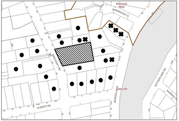
The proposed development was placed on public exhibition and was notified to adjoining and nearby landowners between 19 April 2021 and 6 May 2021 in accordance with the Hornsby Community Engagement Plan. During this period, Council received 14 unique submissions. The map below illustrates the location of those nearby landowners who made a submission that are in close proximity to the development site.
|
NOTIFICATION PLAN |
|||
|
• PROPERTIES NOTIFIED |
X SUBMISSIONS RECEIVED |
|
|
|
9 SUBMISSIONS RECEIVED OUT OF MAP RANGE |
|||
14 submissions objected to the development, generally on the grounds that the development would result in:
· Insufficient private open space.
· Amenity, separation and privacy of future lots.
· Insufficient size of lots.
· Removal of trees.
· Incorrect facts contained within the arborist report.
· Lack of landscaped area for rear lots.
· Flora and fauna impacts.
· Insufficient replacement trees.
· Stormwater and flooding concerns.
· Stormwater runoff concerns to Byles Creek.
· Vehicle access and parking concerns.
· Earthworks concerns.
· Approval from RMS.
· Heritage impacts.
The merits of the matters raised in community submissions have been addressed in the body of the report with the exception of the following:
5.1.1 Private Open Space
A submission raised concerns that the existing dwellings would not meet the private open space requirements.
The HDCP requires dwelling houses to have access to at least 24m2 of private open space that:
· Has a minimum dimension of 3m.
· Is located behind the front building line.
· Is directly accessible from living areas within the dwelling.
The submitted plans provided by the applicant demonstrate that both dwellings would have at least 24m2 of private open space located behind the front building line that is directly accessible from internal living areas. The application is compliant in this regard.
5.1.2 Privacy, earthworks, landscaping and amenity concerns of future dwellings
Submissions raised concerns regarding future privacy, landscaping, amenity and earthwork impacts arising from the construction of future dwellings and ancillary structures on the rear lots.
With respect to these concerns, it is noted that the current application seeks to subdivide the site with no dwelling construction proposed. Amenity, earthworks and landscaping impacts arising from the construction of dwellings on the subdivided allotments would be a matter for consideration in the assessment of development applications for the construction of future dwelling houses on the allotments.
5.1.3 Flood prone and stormwater runoff
Submissions raised concerns over potential flooding and stormwater impacts over downstream properties and the wider Byles Creek catchment as a result of the development.
The site itself is not identified as being flood prone or having a stormwater overland flow path. Impervious areas including the access handle, parking areas and downpipes of existing dwellings would be connected into a proposed on-site detention tank underneath the proposed access driveway that would reduce peak stormwater flows and drained into the inter allotment drainage line. Lots 2-3 at the rear would connect all impervious areas into the future inter-allotment drainage line which would reduce stormwater runoff to adjoining properties.
Subject to the implementation of sediment and erosion control measures and stormwater management to protect water quality, the proposal would have minimal potential to impact on the Byles Creek catchment.
5.1.4 Allotment Size
Submissions raised concerns that the proposed rear allotments would have sufficient area to cater for future development of the site and replacement landscaping.
This is discussed in the report in greater detail above under Section 2.7.1 Lot Shape and Design and it is considered that the subdivision concept plan shows that there is sufficient space on the subject site to cater for 2 vehicle parking spaces, a residential dwelling and protection of Blue Gum High Forest species at the rear of the site.
5.1.5 Arborist report concerns
Submissions raised concerns regarding the information contained within the Arborist report and that not all trees were plotted within 10m of all proposed works.
As discussed in the report in greater detail under Section 3.1.1 Tree and Vegetation Preservation, Council notes, that whilst the submitted arborist report identifies a number of trees as exempt tree species, the site is located within a heritage conservation area and therefore all trees on land within a heritage conservation area are protected under the HDCP.
Council’s arboricultural assessment was satisfied that all trees within proximity of the proposed works were identified in the report and supporting documentation and concluded that the proposal is acceptable subject to conditions requiring the appointment of an arborist, installation of tree protection measures, utilisation of tree sensitive construction techniques and provision of a restriction as to user to protect significant trees at the rear.
6. THE PUBLIC INTEREST
Section 4.15(1)(e) of the Act requires Council to consider “the public interest”.
The public interest is an overarching requirement, which includes the consideration of the matters discussed in this report. Implicit to the public interest is the achievement of future built outcomes adequately responding to and respecting the future desired outcomes expressed in environmental planning instruments and development control plans.
The application is considered to have satisfactorily addressed Council’s and relevant agencies’ criteria and would provide a development outcome that, on balance, would result in a positive impact for the community. Accordingly, it is considered that the approval of the proposed development would be in the public interest.
CONCLUSION
The application proposes Torrens title subdivision of two lots into four lots.
The development generally meets the desired outcomes of Council’s planning controls and is satisfactory having regard to the matters for consideration under Section 4.15 of the Environmental Planning and Assessment Act 1979.
Council received 14 submissions during the public notification period. The matters raised have been addressed in the body of the report.
Having regard to the circumstances of the case, approval of the application is recommended.
The reasons for this decision are:
· The proposed development generally complies with the requirements of the relevant environmental planning instruments and the Hornsby Development Control Plan 2013.
· The proposed development does not create unreasonable environmental impacts to adjoining development with regard to visual bulk, heritage conservation, tree preservation, earthworks, landscaping, traffic, vehicle access, overshadowing, solar access, amenity or privacy.
Note: At the time of the completion of this planning report, no persons have made a Political Donations Disclosure Statement pursuant to Section 10.4 of the Environmental Planning and Assessment Act 1979 in respect of the subject planning application.
RESPONSIBLE OFFICER
The officer responsible for the preparation of this report is Matthew Miles.
|
Cassandra Williams Major Development Manager - Development Assessments Planning and Compliance Division |
Rod Pickles Manager - Development Assessments Planning and Compliance Division |
|
Locality Map |
|
|
|
|
Subdivision Plan |
|
|
|
|
Landscape Plan |
|
|
File Reference: DA/346/2021
Document Number: D08220938
SCHEDULE 1
1. Deferred Commencement
Pursuant to Section 4.16(3) of the Environmental Planning and Assessment Act 1979, this consent does not operate until the following information is submitted to Council:
a) The registration and creation of an easement to drain water from the site over downstream property at Lot 11 DP 25897, No. 77 Wongala Crescent, Beecroft.
Such information must be submitted within 48 months of the date of this notice.
Upon Council’s written satisfaction of the above information, the following conditions of development consent apply:
GENERAL CONDITIONS
The conditions of consent within this notice of determination have been applied to ensure that the use of the land and/or building is carried out in such a manner that is consistent with the aims and objectives of the relevant legislation, planning instruments and council policies affecting the land and does not disrupt the amenity of the neighbourhood or impact upon the environment.
Note: For the purpose of this consent, the term ‘applicant’ means any person who has the authority to act on or the benefit of the development consent.
Note: For the purpose of this consent, any reference to an Act, Regulation, Australian Standard or publication by a public authority shall be taken to mean the gazetted Act or Regulation, or adopted Australian Standard or publication as in force on the date that the application for a construction certificate is made.
2. Approved Plans and Supporting Documentation
The development must be carried out in accordance with the plans and documentation listed below and endorsed with Council’s stamp, except where amended by Council and/or other conditions of this consent:
Approved Plans
|
Plan No. |
Plan Title |
Drawn by |
Dated |
Council Reference |
|
S.15612, Rev C |
Plan of proposed driveway |
P.S. Graham and Associates |
10-06-2021 |
|
|
Plan of proposed subdivision |
P.S. Graham and Associates |
10-06-2021 |
|
|
|
Tree survey plan |
Conzept landscape architects |
11-06-2021 |
|
|
|
LPDA 20-77, sheet 2, rev C |
Landscape plan |
Conzept landscape architects |
11-06-2021 |
|
Supporting Documentation
|
Prepared by |
Dated |
Council Reference |
|
|
Arboricultural impact Assessment ref: 20211742.2 |
Australis tree management |
29-03-2021 |
D08189136 |
|
Directional drilling advice |
Alannette Pty Ltd |
7-06-2021 |
D08189130 |
|
Floor plans of existing dwellings |
P.S. Graham and Associates |
28-05-2021 |
D08189132 |
|
Driveway long section, S.15612, Rev B |
P.S. Graham and Associates |
10-06-2021 |
D08189132 |
|
Long section of retaining wall, S.15612 |
P.S. Graham and Associates |
10-06-2021 |
D08189132 |
|
Plan of subdivision with turning paths, S.15612, Rev A |
P.S. Graham and Associates |
10-06-2021 |
D08189132 |
|
Transport for NSW Concurrence Letter, SYD21/00654/02 |
Transport for NSW |
17/09/2021 |
D08248744 |
|
Streamlined Biodiversity Development Assessment Report (Project No. Bmvol1) |
Narla Environmental |
September 2021 |
D08242528 |
3. Removal of Trees
b) No consent is granted for the removal of trees numbered 1, 2, 4, 5, 6, 7, 8, 9, 10, 11, 12, 13, 14, 15, 16, 17, 18, 19, 20, 23, 24, 25, 26, 27, 28, 29, 31, 32, 35, 36, 37, 38, 39, 40, 41, 46, 48, 47, 50, 53, 54, 77, 83, 84, 85, 86, 87, 88, 89, 90, 91, 92, 93, 94, 95, 96, 96, 98, 99, 100, 101, 102, 104, 106, 107, 108, 109, 110, 111, 113, 114, 115, 116, 117, 118, 119, 120, 121, 122, 123, 124, 125, 126, 127 as these trees contribute to the established landscape amenity of the area and streetscape.
Note: The removal of any other trees from the site requires separate approval by Council in accordance with Part 1B.6 Tree and Vegetation Preservation of the Hornsby Development Control Plan, 2013 (HDCP).
4. Tree Pruning
This development consent only permits the pruning of trees numbered 107 and 108 as identified in Arboricultural Impact Assessment ref: 20211742.2 prepared by Australis Tree management dated 29 March 2021.
a) All specified pruning works must be less than 10 percent of the overall tree canopy and not alter the height or spread of the trees.
b) All pruning work must be undertaken by an arborist with minimum AQF3 qualifications.
Note: The pruning of any other trees from the site requires separate approval by Council in accordance with Part 1B.6 Tree and Vegetation Preservation of the Hornsby Development Control Plan 2013 (HDCP).
5. Construction Certificate
a) A Subdivision Works Certificate is required to be approved by Council or a Private Certifying Authority prior to the commencement of any subdivision works under this consent.
b) A separate Subdivision Works Certificate must be obtained from Council for all works within the public road reserve under S138 of the Roads Act 1993.
c) The Subdivision Works Certificate plans must be consistent with the Development Consent plans.
6. Section 7.11 Development Contributions
a) In accordance with Section 4.17(1) of the Environmental Planning and Assessment Act 1979 and the Hornsby Shire Council Section 7.11 Development Contributions Plan 2020-2030, the following monetary contributions must be paid to Council to cater for the increased demand for community infrastructure resulting from the development:
|
Description |
Contribution (4) |
|
Roads |
$2,913.20 |
|
Open Space and Recreation |
$22,827.90 |
|
Community Facilities |
$14,059.90 |
|
Plan Preparation and Administration |
$199.00 |
|
TOTAL |
$40,000 |
Being for two additional allotments.
b) The value of this contribution is current as at 3 August 2021. If the contribution is not paid within the financial quarter that this condition was generated, the contribution payable will be adjusted in accordance with the provisions of the Hornsby Shire Council Section 7.11 Development Contributions Plan and the amount payable will be calculated at the time of payment in the following manner:
$CPY = $CDC x CPIPY
CPIDC
Where:
$CPY is the amount of the contribution at the date of Payment.
$CDC is the amount of the contribution as set out in this Development Consent.
CPIPY is the latest release of the Consumer Price Index (Sydney – All Groups) at the date of Payment as published by the ABS.
CPIDC is the Consumer Price Index (Sydney – All Groups) for the financial quarter at the date applicable in this Development Consent Condition.
c) The monetary contribution must be paid to Council:
i) Prior to the issue of the Subdivision Certificate where the development is for subdivision.
ii) Prior to the issue of the first Construction Certificate where the development is for building work.
iii) Prior to issue of the Subdivision Certificate or first Construction Certificate, whichever occurs first, where the development involves both subdivision and building work.
iv) Prior to the works commencing where the development does not require a Construction Certificate or Subdivision Certificate.
Note: It is the professional responsibility of the Principal Certifying Authority to ensure that the monetary contributions have been paid to Council in accordance with the above timeframes.
Note: In accordance with Ministerial Directions, the payment of contribution fees for development with a cost of works of over $10 million can be deferred to prior to Occupation Certificate.
Note: Council’s Development Contributions Plan may be viewed at www.hornsby.nsw.gov.au or a copy may be inspected at Council’s Administration Centre during normal business hours.
REQUIREMENTS PRIOR TO THE ISSUE OF A CONSTRUCTION CERTIFICATE
7. Appointment of a Project Arborist
a) To ensure the trees that must be retained are protected, a project arborist with AQF Level 5 qualifications must be appointed to assist in ensuring compliance with the conditions of consent and provide monitoring reports as specified by the conditions of consent.
b) Details of the appointed project arborist must be submitted to Council and the PCA with the application for the construction certificate.
8. Appointment of Project Ecologist
a) The applicant must notify Council of the details of the engaged Project Ecologist that will be involved with the implementation and monitoring of environmental protection measures during the construction of the approved development. This environmental expert will assist in ensuring compliance with the conditions of consent and provide compliance reports to Council at various stages of the Project as identified in approved Plan No. LPDA 20-77, sheets 1 & 2, rev C Tree Survey Plan and Landscape Plan, prepared by Conzept landscape architects , dated 11 June 2021.
b) The experienced Ecologist Consultant (minimum 3 years’ experience) shall possess a minimum tertiary degree in Science, Conservation, Biology, Ecology, Natural Resource Management, Environmental Science or Environmental Management.
c) The Ecologist must be licensed with a current Department of Primary Industries Animal Research Authority permit and New South Wales Scientific License issued under the Biodiversity Conservation Act 2016.
d) The Ecologist must be commissioned to:
i) Undertake an extensive pre-clearing survey, delineating habitat-bearing trees and shrubs to be retained/removed.
ii) Supervise the clearance of trees and shrubs (native and exotic) in order to capture, treat and/or relocate any displaced fauna.
9. Construction Environmental Management Plan
a) The applicant is to prepare a Construction Environment Management Plan (CEMP) which must be submitted to Council for approval prior to the issue of a Construction Certificate. The CEMP must include, as a minimum:
i) Industry standard measures for the management of soil, surface water, tree protection, weeds and pollutants, as well as site-specific measures, including all procedures recommended within Section 6 of the approved Biodiversity Assessment Report (BDAR) prepared by Narla Environmental dated September 2021.
ii) The proposed mitigation measures shall include environmental safeguards for protection of neighbouring properties and nearby waterways in accordance with relevant policy documentation and Government guidelines.
b) The CEMP must be submitted to Council’s Natural Resources Unit for written approval prior to issue of the Construction Certificate.
10. Utility Services
The applicant must submit written evidence of the following service provider requirements:
a) Ausgrid (formerly Energy Australia) – a letter of consent demonstrating that satisfactory arrangements have been made to service the proposed development.
b) Telstra - a letter of consent demonstrating that satisfactory arrangements have been made to service the proposed development.
11. Identification of Survey Marks
A registered surveyor must identify all survey marks in the vicinity of the proposed development. Any survey marks required to be removed or displaced as a result of the proposed development shall be undertaken by a registered surveyor in accordance with Section 24 (1) of the Surveying and Spatial Information Act 2002 and following the Surveyor General’s Directions No.11 Preservation of Survey Infrastructure.
12. Stormwater Drainage
The stormwater drainage system for the development must be designed in accordance with AUS-SPEC Specifications (www.hornsby.nsw.gov.au/property/build/aus-spec-terms-and-conditions) and the following requirements:
a) Discharged to an existing Council drainage outlet on Wongala Crescent with the following requirements:
i) A separate Application must be made to Council for ‘Approval to Connect Stormwater Drainage Outlet to Council’s System’ with all fees paid, prior to connecting to Council’s drainage system.
ii) The connection to Council’s drainage outlet in accordance with Councils Design Standard Drawing No. 6 must be inspected by a Council Engineer from Council’s Planning Division.
iii) The stormwater plans must include details of directional drilling.
Note: An inspection booking can be made by calling Council on 9847 6760 quoting the Application reference number commencing SD
13. On Site Stormwater Detention
An on-site stormwater detention system must be designed by a chartered civil engineer and constructed in accordance with the following requirements:
a) Have a capacity of not less than 10 cubic metres, and a maximum discharge (when full) of 16 litres per second.
b) Have a surcharge/inspection grate located directly above the outlet.
c) Discharge from the detention system must be controlled via 1 metre length of pipe, not less than 50 millimetres diameter or via a stainless plate with sharply drilled orifice bolted over the face of the outlet discharging into a larger diameter pipe capable of carrying the design flow to an approved Council system.
d) Where above ground and the average depth is greater than 0.3 metres, a ‘pool type’ safety fence and warning signs must be installed.
e) Not be constructed in a location that would impact upon the visual or recreational amenity of residents.
14. Internal Driveway/Vehicular Areas
The driveway on site must be designed and a Construction Certificate issued in accordance with Australian Standards AS2890.1, AS3727 and the following requirements:
a) A Boundary Levels application must be obtained from Council for the design on the internal driveway.
b) The driveway be a rigid pavement.
c) The driveway grade must not exceed 25 percent and changes in grade must not exceed 8 percent.
d) The driveway pavement be a minimum 3 metres wide, 0.15 metres thick reinforced concrete with F72 steel reinforcing fabric and a 0.15 metre sub-base.
e) The pavement have a kerb to one side and a one-way cross fall with a minimum gradient of 2 percent and a lintel and pit provided at the low point.
f) Planting of landscaping strips 0.5 metres wide along both sides of the length of the driveway.
g) Conduit for utility services including electricity, water, gas and telephone be provided. All existing overhead assets including electricity and telecommunications cabling shall be relocated underground at no cost to Council. A certificate from an appropriately licensed contractor shall be submitted to the principal certifying authority certifying that the service conduits have been installed in accordance with the relevant utility provider and Australian Standards.
h) A common turning area to service the proposed subdivision in accordance with Australian Standards AS2890.1 to ensure vehicles can enter and leave the site in a forward direction. A right of access shall be created over the turning area to ensure access is maintained at all times.
i) Longitudinal sections along both sides of the access driveway shall be submitted to the principal certifying authority in accordance with the relevant sections of AS 2890.1. The maximum grade shall not exceed 1 in 4 (25%) with the maximum changes of grade of 1 in 8 (12.5%) for summit grades and 1 in 6.7 (15%) for sag grades. Any transition grades shall have a minimum length of 2 metres. The longitudinal sections shall incorporate the design levels obtained by Council.
j) The passing bay at the front boundary of Beecroft Road shall have minimum width of 5.5m, depth of 6m and transition of 4m.
Note: A construction certificate shall be obtained prior to the commencement of these works and all works are to be completed prior to the issue of the subdivision certificate.
REQUIREMENTS PRIOR TO THE COMMENCEMENT OF ANY WORKS
15. Erection of Construction Sign
a) A sign must be erected in a prominent position on any site on which any approved work is being carried out:
i) Showing the name, address and telephone number of the principal certifying authority for the work.
ii) Showing the name of the principal contractor (if any) for any demolition or building work and a telephone number on which that person may be contacted outside working hours.
iii) Stating that unauthorised entry to the work site is prohibited.
b) The sign is to be maintained while the approved work is being carried out and must be removed when the work has been completed.
16. Protection of Adjoining Areas
A temporary hoarding, fence or awning must be erected between the work site and adjoining lands before the works begin and must be kept in place until after the completion of the works if the works:
a) Could cause a danger, obstruction or inconvenience to pedestrian or vehicular traffic.
b) Could cause damage to adjoining lands by falling objects.
c) Involve the enclosure of a public place or part of a public place.
d) Have been identified as requiring a temporary hoarding, fence or awning within the Council approved Construction Management Plan (CMP).
Note: Notwithstanding the above, Council’s separate written approval is required prior to the erection of any structure or other obstruction on public land.
a) To provide a safe and hygienic workplace, toilet facilities must be available or be installed at the works site before works begin and must be maintained until the works are completed at a ratio of one toilet for every 20 persons employed at the site.
b) Each toilet must:
i) Be a standard flushing toilet connected to a public sewer.
ii) Be a temporary chemical closet approved under the Local Government Act 1993.
iii) Have an on-site effluent disposal system approved under the Local Government Act 1993.
18. Erosion and Sediment Control
To protect the water quality of the downstream environment, erosion and sediment control measures must be provided and maintained throughout the construction period in accordance with the manual ‘Soils and Construction 2004 (Bluebook)’, the approved plans, Council specifications and to the satisfaction of the principal certifying authority. The erosion and sediment control devices must remain in place until the site has been stabilised and revegetated.
Note: On the spot penalties may be issued for any non-compliance with this requirement without any further notification or warning.
19. Installation of Tree Protection Measures
a) Trees to be retained on the subject site and adjoining sites numbered 1, 2, 4, 5, 6, 7, 8, 9, 10, 11, 12, 13, 14, 15, 16, 17, 18, 19, 20, 23, 24, 25, 26, 27, 28, 29, 31, 32, 35, 36, 37, 38, 39, 40, 41, 46, 48, 47, 50, 53, 54, 77, 83, 84, 85, 86, 87, 88, 89, 90, 91, 92, 93, 94, 95, 96, 96, 98, 99, 100, 101, 102, 104, 106, 107, 108, 109, 110, 111, 113, 114, 115, 116, 117, 118, 119, 120, 121, 122, 123, 124, 125, 126, 127a s identified on the Tree Location Plan prepared by must have tree protection measures for the ground, trunk and canopy installed by the project arborist as follows:
i) For the duration of demolition works, in accordance with the Tree Protection Plan for prepared by Australis Tree management dated 29 March 2021.
ii) For the duration of construction works, in accordance with Tree Protection Plan prepared by Australis Tree management dated 29 March 2021.
b) Tree protection fencing for the trees to be retained must be installed by the engaged AQF 5 project arborist and consist of 1.8m high temporary fencing panels installed in accordance with Australian Standard AS4687-2007 Temporary fencing and hoardings.
c) The installation of all required tree protection fencing must include shade cloth attached to the fencing to reduce transport of dust, particulates and liquids from entering the tree protection zone.
d) The circumference of the trunk(s) must be wrapped in hessian material to provide cushioning for the installation of timber planks.
e) Timber planks (50 x100mm) must be spaced at 100mm intervals and must be attached using adjustable ratchet straps.
f) All tree protection zones must have a layer of wood-chip mulch at a depth of between 150mm and 300mm.
g) Where wood-chip mulch is permitted by Council instead of tree protection fencing within the tree protection zones, the wood-chip must be covered with a layer of geotextile fabric and rumble boards.
20. Ecosystem credit retirement conditions
a) Prior to the commencement of any vegetation clearing or construction works on the site the class and number of ecosystem credits in Table 1 must be retired to offset the residual biodiversity impacts of the development.
b) The requirement to retire credits in condition 20(a) may be satisfied by payment to the Biodiversity Conservation Fund of an amount equivalent to the class and number of ecosystem credits, as calculated by the BAM Credit Calculator (BAM-C).
c) Evidence of the retirement of credits or payment to the Biodiversity Conservation Fund in satisfaction of condition 20(a) must be provided to the consent authority prior to the commencement of any vegetation clearing or construction works on the site.
Table 1: Ecosystem credits required to be retired – like for like
|
Impacted Plant Community Type |
Number of ecosystem credits |
IBRA subregion |
Plant community type(s) that can be used to offset the impacts from development |
|
1237 – Blue Gum High Forest in the Sydney Basin Bioregion |
1 |
Cumberland, Burragorang, Pittwater, Sydney Cataract, Wollemi and Yengo. Or Any IBRA subregion that is within 100 kilometres of the outer edge of the impacted site. |
1237 |
Table 2:Species credits required to be retired – like for like
|
Impacted Species |
Number of species credits |
IBRA subregion |
|
Hibbertia spanantha Julian’s Hibbertia |
1 |
Anywhere in NSW |
21. Protection of vegetation, habitat and environmental features during construction
To ensure the protection of vegetation, habitat and environmental features during construction, the applicant must:
a) Install bushland protection fencing along the management zones identified in the approved Construction Environment Management Plan to retain all native trees to be retained.
b) Clean machinery of soil and debris before entering the site to prevent the spread of weeds and fungal pathogens.
Note: The site contains Blue Gum High Forest which is listed under the NSW Biodiversity Conservation Act 2016. The Act prohibits the disturbance to threatened species, endangered populations and threatened ecological communities, or their habitat, without appropriate consent or licence.
REQUIREMENTS DURING DEMOLITION AND CONSTRUCTION
All works on site, including demolition and earth works, must only occur between 7am and 5pm Monday to Saturday.
No work is to be undertaken on Sundays or public holidays.
23. Vehicular Crossing
A separate application under the Local Government Act 1993 and the Roads Act 1993 must be submitted to Council for the installation of a new vehicular crossing and the removal of two redundant vehicular crossings. The vehicular crossing must be constructed in accordance with AUS-SPEC Specifications (www.hornsby.nsw.gov.au/property/build/aus-spec-terms-and-conditions) and the following requirements:
a) The two redundant vehicular crossings must be replaced with turf and kerb & gutter.
b) Pavement specification to match with internal driveway.
c) Approval must be obtained from all relevant utility providers that all necessary conduits be provided and protected under the crossing.
Note: An application for a vehicular crossing can only be made to one of Council’s Authorised Vehicular Crossing Contractors. You are advised to contact Council on 02 9847 6940 to obtain a list of contractors.
24. Demolition
To protect the surrounding environment, all demolition work must be carried out in accordance with Australian Standard AS2601-2001 Demolition of structures and the following requirements:
a) Demolition material must be disposed of to an authorised recycling and/or waste disposal site and/or in accordance with an approved waste management plan.
b) Demolition works, where asbestos material is being removed, must be undertaken by a contractor that holds an appropriate licence issued by SafeWork NSW in accordance with the Work Health and Safety Regulation 2017 and be appropriately transported and disposed of in accordance with the Protection of the Environment Operations (Waste) Regulation 2014.
c) On construction sites where any building contain asbestos material, a standard commercially manufactured sign containing the words ‘DANGER ASBESTOS REMOVAL IN PROGRESS’ and measuring not less than 400mm x 300mm must be displayed in a prominent position visible from the street.
25. Environmental Management
To prevent sediment run-off, excessive dust, noise or odour emanating from the site during the construction, the site must be managed in accordance with the publication ‘Managing Urban Stormwater – Landcom (March 2004) and the Protection of the Environment Operations Act 1997.
To ensure that the public reserve is kept in a clean, tidy and safe condition during construction works, no building materials, waste, machinery or related matter is to be stored on the road or footpath.
Note: This consent does not give right of access to the site via Council’s park or reserve. Should such access be required, separate written approval is to be obtained from Council.
27. Landfill
a) Prior to fill material being imported to the site, a Waste Classification Certificate shall be obtained from a suitably qualified environmental consultant confirming the fill wholly consists of Virgin Excavated Natural Material (VENM) as defined in Schedule 1 of the Protection of the Environment Operations Act 1997 or a material approved under the NSW Environment Protection Authority’s Resource Recovery Orders and Exemptions.
b) The required Waste Classification Certificate must be obtained by the Principal Contractor prior to fill being imported to the site, and made available to Council as its request.
28. Excavated Material
All excavated material removed from the site must be classified by a suitably qualified environmental consultant in accordance with the NSW Environment Protection Authority’s Waste Classification Guidelines and Protection of the Environment Operations (Waste) Regulation 2014 prior to disposal to a licensed waste management facility. Tipping dockets for the total volume of excavated material that are received from the licensed waste management facility must be provided to the principal certifying authority prior to the issue of an Occupation Certificate.
29. Prohibited actions within the fenced tree protection zone
The following activities are prohibited within the approved fenced tree protection zones unless otherwise approved by Council:
a) Soil cutting or filling, including excavation and trenching.
b) Soil cultivation, disturbance or compaction.
c) Stockpiling storage or mixing of materials.
d) The parking, storing, washing and repairing of tools, equipment and machinery.
e) The disposal of liquids and refuelling.
f) The disposal of building materials.
g) The siting of offices or sheds.
h) Any action leading to the impact on tree health or structure.
30. Maintaining the health of trees approved for retention
The appointed project arborist must monitor and record any and all necessary actions required to maintain tree health and condition for trees numbered 1, 2, 4, 5, 6, 7, 8, 9, 10, 11, 12, 13, 14, 15, 16, 17, 18, 19, 20, 23, 24, 25, 26, 27, 28, 29, 31, 32, 35, 36, 37, 38, 39, 40, 41, 46, 48, 47, 50, 53, 54, 77, 83, 84, 85, 86, 87, 88, 89, 90, 91, 92, 93, 94, 95, 96, 96, 98, 99, 100, 101, 102, 104, 106, 107, 108, 109, 110, 111, 113, 114, 115, 116, 117, 118, 119, 120, 121, 122, 123, 124, 125, 126, 127 on the approved plans.
31. Maintaining Tree Protection Measures
Tree Protection Measures must be maintained by the project arborist in accordance with Condition No. 4 of this consent for the duration of works.
32. Approved Works within Tree Protection Zone incursions
a) Where tree root pruning is required for the installation of piers, driveway or underground services, the pruning must be overseen by the AQF 5 project arborist and must be undertaken as follows:
i) Using sharp secateurs, pruners, handsaws or chainsaws with the final cut being clean.
ii) The maximum diameter of roots permitted to be cut is 40mm.
b) Where the driveway enters or transects the Tree Protection Zones of trees to be retained, sensitive construction techniques in the form of screw pilings or piers, cantilevered or suspended slab design must be employed to create a 100mm clearance above existing soil grade.
c) Approved excavations within the Tree Protection Zone of trees to be retained not associated with installation of services must be undertaken as follows:
i) Excavations for the construction and installation of the driveway and stormwater infrastructure in the Tree Protection Zone of trees to be retained 1, 2, 4, 5, 6, 7, 8, 9, 10, 11, 12, 13, 14, 15, 16, 17, 18, 19, 20, 23, 24, 25, 26, 27, 28, 29, 31, 32, 35, 36, 37, 38, 39, 40, 41, 46, 48, 47, 50, 53, 54, 77, 83, 84, 85, 86, 87, 88, 89, 90, 91, 92, 93, 94, 95, 96, 96, 98, 99, 100, 101, 102, 104, 106, 107, 108, 109, 110, 111, 113, 114, 115, 116, 117, 118, 119, 120, 121, 122, 123, 124, 125, 126, 127 on the approved plans must be supervised by the project arborist for the first 1m undertaken manually to locate roots and allow for pruning.
d) Grade changes in the form of filling, are permissible outside the Structural Root Zone in conjunction with piers.
e) To minimise impacts within the Tree Protection Zone (TPZ) of trees 1, 2, 4, 5, 6, 7, 8, 9, 10, 11, 12, 13, 14, 15, 16, 17, 18, 19, 20, 23, 24, 25, 26, 27, 28, 29, 31, 32, 35, 36, 37, 38, 39, 40, 41, 46, 48, 47, 50, 53, 54, 77, 83, 84, 85, 86, 87, 88, 89, 90, 91, 92, 93, 94, 95, 96, 96, 98, 99, 100, 101, 102, 104, 106, 107, 108, 109, 110, 111, 113, 114, 115, 116, 117, 118, 119, 120, 121, 122, 123, 124, 125, 126, 127 identified on the approved plans, the installation of services must be undertaken as follows:
i) The AQF 5 project arborist must be present to oversee the installation of any underground services which enter or transect the tree protection.
ii) The installation of any underground services which either enter or transect the designated TPZ must utilise directional drilling only.
iii) All associated excavations within the TPZ of retained trees must be undertaken manually.
iv) For manually excavated trenches the AQF 5 project arborist must designate roots to be retained. Manual excavation may include the use of pneumatic and hydraulic tools.
33. Building materials and Site Waste
The stockpiling of building materials, the parking of vehicles or plant, the disposal of cement slurry, waste water or other contaminants must be located outside the tree protection zones as prescribed in the conditions of this consent of any tree to be retained.
REQUIREMENTS PRIOR TO THE ISSUE OF AN OCCUPATION OR SUBDIVISION CERTIFICATE
34. Sydney Water – s73 Certificate
A s73 Certificate must be obtained from Sydney Water and submitted to the PCA.
Note: Sydney Water requires that s73 applications are to be made through an authorised Sydney Water Servicing Coordinator. Refer to www.sydneywater.com.au or telephone 13 20 92 for assistance.
35. Damage to Council Assets
To protect public property and infrastructure, any damage caused to Council’s assets as a result of the construction or demolition of the development must be rectified by the applicant in accordance with AUS-SPEC Specifications (www.hornsby.nsw.gov.au/property/build/aus-spec-terms-and-conditions. Rectification works must be undertaken prior to the issue of an Occupation Certificate, or sooner, as directed by Council.
b) A certificate must be provided by a practicing landscape architect, horticulturalist or person with similar qualifications and experience certifying that all required landscaping works and replacement trees have been satisfactorily completed in accordance with the approved landscape plans prepared by Conzept Landscapes dated 11 June 2021.
Note: Advice on suitable species for landscaping can be obtained from Council’s planting guide ‘Indigenous Plants for the Bushland Shire’, available at www.hornsby.nsw.gov.au.
37. Creation of Easements
The following matter(s) must be nominated on the plan of subdivision under s88B of the Conveyancing Act 1919:
a) A right of access and easement for services over the access corridor.
b) An inter-allotment drainage easement(s) over each of the burdened lots.
c) The creation of an appropriate "Positive Covenant" and "Restriction as to User" over the constructed on-site detention/retention systems and outlet works, within the lots in favour of Council in accordance with Council’s prescribed wording. The position of the on-site detention system is to be clearly indicated on the title.
d) To register the OSD easement, the restriction on the use of land “works-as-executed” details of the on-site-detention system must be submitted verifying that the required storage and discharge rates have been constructed in accordance with the design requirements. The details must show the invert levels of the on-site system together with pipe sizes and grades. Any variations to the approved plans must be shown in red on the “works-as-executed” plan and supported by calculations.
Note: Council must be nominated as the authority to release, vary or modify any easement, restriction or covenant.
38. Preservation of Survey Marks
A certificate by a Registered Surveyor must be submitted to the Principal Certifying Authority, certifying that there has been no removal, damage, destruction, displacement or defacing of the existing survey marks in the vicinity of the proposed development or otherwise the re-establishment of damaged, removed or displaced survey marks has been undertaken in accordance with the Surveyor General’s Direction No.11 Preservation of Survey Infrastructure.
39. Construction of engineering works.
All engineering works identified in this consent are to be completed and a Compliance Certificate issued prior to the release of the Subdivision Certificate.
40. Restriction as to User – Protection of Land from Future Development
To inform current and future owners that the areas of native vegetation and habitat on the site are to be protected from future development at the rear of the site, the following restrictions on title must be registered:
a) A Restriction as to User must be created under Section 88B of the Conveyancing Act 1919 identifying the area of the site shown marked ‘proposed restricted development area’ on approved Plan No. S.15612, Rev C Plan of proposed subdivision prepared by P.S. Graham and Associates, dated 10 June 2021 is restricted from future development or disturbance of any kind.
b) The creation of a “Positive Covenant” over all lots to be managed in accordance with approved Plan No. LPDA 20-77, sheet 2, rev C Landscape Plan, prepared by Conzept Landscapes, dated 11 June 2021.
Note: The wording of the Restriction as to User must be to Council’s satisfaction and Council must be nominated as the authority to release, vary or modify the Restriction.
All retaining walls must be constructed as part of the development and prior to the issue of an Occupation Certificate.
42. Replacement Tree Requirements
a) The trees approved for removal under this consent, must be offset through replacement planting of a minimum of 15 trees that are identified on the approved landscape plan prepared by Conzept Landscapes.
b) All replacement plantings must be species occurring in Blue Gum Shale Forest.
i) A minimum of 10 mid-storey trees must be planted.
ii) A minimum of 5 Eucalyptus saligna must be planted.
c) The location and size of tree replacement planting must comply with the following:
i) All replacement trees must be located in accordance with the approved landscape plan and must planted 4 metres or greater from the foundation walls of the approved development.
ii) The pot size of the replacement trees must be a minimum 45 litres.
iii) All replacement trees must be a minimum of 3 metres in height.
iv) Plant stock used for offset planting shall be sourced from a native nursery utilising Sydney basin stock.
43. Final Certification (Arborist)
a) The AQF 5 Project arborist must submit to the Principal Certifying Authority a certificate that includes the following:
b) All tree protection requirements complied with the as approved tree protection plan for the duration of demolition and/or construction works.
c) All completed works relating to tree protection and maintenance have been carried out in compliance with the conditions of consent and approved plans.
d) Dates, times and reasons for all site attendance.
e) All works undertaken to maintain the health of retained trees.
f) Details of tree protection zone maintenance for the duration of works.
g) A statement to confirm that tree replacement planting meets NATSPEC guidelines and the approved landscape plan.
Note: Copies of monitoring documentation may be requested throughout DA process.
44. Final Certification – Ecology
Certification by the project ecologist, bush regeneration consultant must be submitted to Council and to the Principal Certifying Authority confirming that works have been completed on site in accordance with the approved Construction Environmental Management Plan and Landscape plan prior to the issue of a Subdivision Certificate.
CONDITIONS OF CONCURRENCE – NSW RMS
The following conditions of consent are from the nominated State Agency pursuant to Section 4.13 of the Environmental Planning and Assessment Act 1979 and must be complied with to the satisfaction of that Agency
45. Transport for NSW Condition 1
All buildings and structures, together with any improvements integral to the future use of the site are wholly within the freehold property (unlimited in height or depth), along the Beecroft Road boundary.
46. Transport for NSW Condition 2
The redundant driveway on the Beecroft Road boundary shall be removed and replaced with kerb and gutter to match existing. The design and construction of the new vehicle crossing, and kerb and gutter shall be in accordance with TfNSW requirements. Details of these requirements should be obtained by email to developerworks.sydney@transport.nsw.gov.au.
A plan checking fee and lodgement of a performance bond is required from the applicant prior to the release of the approved road design plans by TfNSW.
TfNSW fees for administration, plan checking, civil works inspections and project management shall be paid by the developer prior to the commencement of works.
47. Transport for NSW Condition 3
Detailed design plans and hydraulic calculations of any changes to the stormwater drainage system are to be submitted to TfNSW for approval, prior to the commencement of any works. Please send all documentation to development.sydney@transport.nsw.gov.au.
A plan checking fee will be payable, and a performance bond may be required before TfNSW approval is issued.
48. Transport for NSW Condition 4
The developer shall be responsible for all public utility adjustment/relocation works, etc. necessitated by the above/approved work and as required by the various public utility authorities and/or their agents.
49. Transport for NSW Condition 5
In accordance with AS 2890.1- 2004 (Parking Facilities, Part 1: Off-street car parking), the driveway shall be a minimum of 5.5 metres in width for a minimum distance of 6 metres from the property boundary.
50. Transport for NSW Condition 6
The existing clearway / “No Stopping” restrictions along the Beecroft Road frontage of the property to remain unchanged.
51. Transport for NSW Condition 7
All vehicles should enter and exit the property in a forward direction.
52. Transport for NSW Condition 8
All demolition and construction vehicles are to be contained wholly within the site and vehicles must enter the site before stopping. A construction zone will not be permitted on Beecroft Road.
53. Transport for NSW Condition 9
A Road Occupancy Licence (ROL) should be obtained from Transport Management Centre for any works that may impact on traffic flows on Beecroft Road during demolition and construction activities.
A ROL can be obtained through https://myrta.com/oplinc2/pages/security/oplincLogin.jsf
- END OF CONDITIONS -
ADVISORY NOTES
The following information is provided for your assistance to ensure compliance with the Environmental Planning and Assessment Act 1979, Environmental Planning and Assessment Regulation 2000, other relevant legislation and Council’s policies and specifications. This information does not form part of the conditions of development consent pursuant to Section 4.17 of the Act.
Environmental Planning and Assessment Act 1979 Requirements
The Environmental Planning and Assessment Act 1979 requires:
· The issue of a construction certificate prior to the commencement of any works. Enquiries can be made to Council’s Customer Services Branch on 9847 6760.
· A principal certifying authority to be nominated and Council notified of that appointment prior to the commencement of any works.
· Council to be given at least two days written notice prior to the commencement of any works.
· Mandatory inspections of nominated stages of the construction inspected.
· An occupation certificate to be issued before occupying any building or commencing the use of the land.
Long Service Levy
In accordance with Section 34 of the Building and Construction Industry Long Service Payments Act 1986, a ‘Long Service Levy’ must be paid to the Long Service Payments Corporation or Hornsby Council.
Note: The rate of the Long Service Levy is 0.35% of the total cost of the work.
Note: Hornsby Council requires the payment of the Long Service Levy prior to the issue of a construction certificate.
Tree and Vegetation Preservation
Hornsby Development Control Plan 2013 Tree and Vegetation Preservation provisions have been developed under Council’s authorities contained in State Environmental Planning Policy (Vegetation in Non-Rural Areas) 2017 and the Environmental Planning and Assessment Act 1979.
In accordance with these provisions a person must not cut down, fell, uproot, kill, poison, ringbark, burn or otherwise destroy the vegetation, lop or otherwise remove a substantial part of the trees or vegetation to which any such development control plan applies without the authority conferred by a development consent or a permit granted by Council.
Fines may be imposed for non-compliance with the Hornsby Development Control Plan 2013.
Note: A tree is defined as a long lived, woody perennial plant with one or relatively few main stems with the potential to grow to a height greater than three metres (3m). (HDCP 1B.6.1.c).
The land upon which the subject building is to be constructed may be affected by restrictive covenants. Council issues this approval without enquiry as to whether any restrictive covenant affecting the land would be breached by the construction of the building, the subject of this consent. Applicants must rely on their own enquiries as to whether or not the building breaches any such covenant.
Prior to commencing any works, the applicant is encouraged to contact Dial Before You Dig on 1100 or www.dialbeforeyoudig.com.au for free information on potential underground pipes and cables within the vicinity of the development site.
Telecommunications Act 1997 (Commonwealth)
If you are aware of any works or proposed works which may affect or impact on Telstra’s assets in any way, you are required to contact: Telstra’s Network Integrity Team on Phone Number 1800810443.
Should asbestos or asbestos products be encountered during demolition or construction works, you are advised to seek advice and information prior to disturbing this material. It is recommended that a contractor holding an asbestos-handling permit (issued by SafeWork NSW) be engaged to manage the proper handling of this material. Further information regarding the safe handling and removal of asbestos can be found at:
Alternatively, telephone the SafeWork NSW on 13 10 50.
Subdivision Certificate Requirements
A subdivision certificate application is required to be lodged with Council containing the following information:
· A surveyor’s certificate certifying that all structures within the subject land comply with the development consent in regard to the setbacks from the new boundaries.
· A surveyor’s certificate certifying that all services, drainage lines or access are located wholly within the property boundaries. Where services encroach over the new boundaries, easements are to be created.
· Certification that the requirements of relevant utility authorities have been met.
· A surveyor’s certificate certifying finished ground levels are in accordance with the approved plans.
Note: Council will not issue a subdivision certificate until all conditions of the development consent have been completed.
Note: At the present time Hornsby Shire Council is the only authority that can be appointed as a PCA for subdivision works within the Shire.
Fees and Charges – Subdivision
All fees payable to Council as part of any construction, compliance or subdivision certificate or inspection associated with the development (including the registration of privately issued certificates) are required to be paid in full prior to the issue of the subdivision certificate. Any additional Council inspections beyond the scope of any compliance certificate required to verify compliance with the terms of this consent will be charged at the individual inspection rate nominated in Council's Fees and Charges Schedule.
The house numbering for this subdivision shall be:
|
Lot |
Street Number |
Street Name |
Street Type |
Locality |
|
Lot 1 |
39 |
Beecroft |
Road |
Beecroft |
|
Lot 2 |
39a |
Beecroft |
Road |
Beecroft |
|
Lot 3 |
41a |
Beecroft |
Road |
Beecroft |
|
Lot 4 |
41 |
Beecroft |
Road |
Beecroft |
LPP Report No. LPP30/21
Local Planning Panel
Date of Meeting: 27/10/2021
2 DA/739/2021 - CHANGE OF USE TO A CHEMIST WAREHOUSE AND CONSOLIDATION OF THREE COMMERCIAL PREMISES INTO ONE - 3 HILLCREST ROAD, PENNANT HILLS
EXECUTIVE SUMMARY
|
DA No: |
DA/739/2021 (Lodged on 23 July 2021) |
|
Description: |
Change of use of premises to a Chemist Warehouse and consolidation of three commercial premises into one |
|
Property: |
Lot 2 DP558805, No. 3 Hillcrest Road, Pennant Hills |
|
Applicant: |
AMS Constructions |
|
Owner: |
3 Hillcrest Road Pennant Hills Pty Ltd |
|
Estimated Value: |
$119,250 |
|
Ward: |
B |
· The application involves the change of use of premises to a Chemist Warehouse and consolidation of three commercial premises into one.
· A total of 21 submissions have been received in respect of the application.
· The application is required to be determined by the Hornsby Council Local Planning Panel as 10 or more unique submissions were received by way of objection.
· It is recommended that the application be approved.
|
THAT Development Application No. DA/739/2021 for the change of use of premises to a Chemist Warehouse and consolidation of three commercial premises into one at Lot 2 DP 558805, No. 3 Hillcrest Road, Pennant Hills be approved, subject to the conditions of consent detailed in Schedule 1 of LPP Report No. LPP30/21 |
BACKGROUND
The site was previously occupied by three separate commercial premises being a Lifeline shop, bakery and the ANZ Bank.
Historically, the site has been occupied by a number of retail and business premises.
On 23 July 2021, the subject development application was lodged.
On 9 August 2021, Council requested additional information with regards to the external colour scheme and signage for the proposed new premises due to a number of concerns raised by the community in this regard. Council also requested confirmation as to whether the existing Chemist Warehouse business on the corner of Hillcrest Road and Yarrara Road would remain in operation should the proposal be approved.
On 13 August 2021, a response from the Applicant was submitted identifying that the requested information outlined above should not be a matter for consideration under the evaluation criteria set out under Section 4.15 of the Environmental Planning and Assessment Act 1979. Notwithstanding, the Applicant advised that the existing Chemist Warehouse on the corner of Yarrara Road and Hillcrest Road, Pennant Hills would likely cease operation upon commencement of trade at the proposed premises and that external finishes and signage of the proposed premises would fall under the provisions of State Environmental Planning Policy (Exempt and Complying Development Codes) 2008 (this was also noted within the SEE).
On 16 August 2021, Council requested further information with regards to waste management on the site.
On 17 August 2021, Council sought clarification regarding works associated with the first-floor level of the proposed premises. A plan was submitted by the Applicant detailing that the first floor would remain ‘as is’ with the exception of one of the two staircases (which connected to the ground level) being removed.
On 24 August 2021, additional waste management details were submitted for Council’s consideration.
On 25 August 2021, Council requested additional parking analysis to accompany the proposed development.
On 3 September, after ongoing discussions with Council and the Applicant regarding the community concerns relating to the external finishes associated with the proposed development, the Applicant agreed to confirm in writing that “there is no intent to paint the building first floor level façade, facing Hillcrest Road”.
On 6 September 2021, the Applicant submitted a further car parking history/ analysis for Council to consider.
On 13 September 2021, Council requested additional information with respect to waste management, particularly with regards to the function of the loading/ store room and garbage storage area at the rear of the premises.
On 29 September 2021, amended plans were submitted addressing Council’s additional information request with regards to waste management.
SITE
The 499.5m² site is located on the south-western side of Hillcrest Road, Pennant Hills and consists of three commercial premises within the ground and first floor level.
The site is located within the Pennant Hills Village surrounded by a number of commercial premises such as grocery stores, restaurants, cafes, beauty salons and medical facilities to service the local community and business centre.
The site is located approximately 100 metres from Pennant Hill Train Station, in close proximity to two large Council public car parks to the north and south of the site and is within walking distance from low, medium and high-density residential areas.
PROPOSAL
The application proposes the consolidation of three commercial premises into one and the change of use of the premises to Chemist Warehouse. The proposal would involve:
· Internal demolition works to consolidate the three commercial premises into one.
· Internal construction works to the ground floor to accommodate the Chemist Warehouse layout/services incorporating an aisle configuration with checkout areas, dispensary, consulting rooms, waiting areas, script counter, loading/store room and entry and exit doors.
· The removal of a staircase to the first floor. The first floor would remain as it with the additional of a door to connect the first-floor spaces. The first floor would incorporate storage areas, staff rooms and bathrooms for staff.
· The proposal would not generate any additional floor space.
The proposed Chemist Warehouse would operate 8am to 9pm, 7 days a week.
There is no on-site car parking provided.
No signage is proposed under this application.
ASSESSMENT
The development application has been assessed having regard to the Greater Sydney Region Plan – A Metropolis of Three Cities, the North District Plan and the matters for consideration prescribed under Section 4.15 of the Environmental Planning and Assessment Act 1979 (the Act). The following issues have been identified for further consideration.
1. STRATEGIC CONTEXT
1.1 Greater Sydney Region Plan - A Metropolis of Three Cities and North District Plan
The Greater Sydney Region Plan - A Metropolis of Three Cities has been prepared by the NSW State Government to guide land use planning decisions for the next 40 years (to 2056). The Plan sets a strategy and actions for accommodating Sydney’s future population growth and identifies dwelling targets to ensure supply meets demand. The Plan also identifies that the most suitable areas for new housing are in locations close to jobs, public transport, community facilities and services.
The NSW Government will use the subregional planning process to define objectives and set goals for job creation, housing supply and choice in each subregion. Hornsby Shire has been grouped with Hunters Hill, Ku-ring-gai, Lane Cove, Mosman, North Sydney, Ryde, Northern Beaches and Willoughby to form the North District. The Greater Sydney Commission has released the North District Plan which includes priorities and actions for Northern District for the next 20 years. The identified challenge for Hornsby Shire will be to provide an additional 4,350 dwellings by 2021 with further strategic supply targets to be identified to deliver 97,000 additional dwellings in the North District by 2036.
The proposed development would be consistent with the Greater Sydney Region Plan - A Metropolis of Three Cities and North District Plan, by providing additional services to support a growing population.
2. STATUTORY CONTROLS
Section 4.15(1)(a) requires Council to consider “any relevant environmental planning instruments, draft environmental planning instruments, development control plans, planning agreements and regulations”.
2.1 Hornsby Local Environmental Plan 2013
The proposed development has been assessed having regard to the provisions of the Hornsby Local Environmental Plan 2013 (HLEP).
2.1.1 Zoning of Land and Permissibility
The subject land is zoned B2 Local Centre under the HLEP. The objectives of the B2 zone are:
· To provide a range of retail, business, entertainment and community uses that serve the needs of people who live in, work in and visit the local area.
· To encourage employment opportunities in accessible locations.
· To maximise public transport patronage and encourage walking and cycling.
The proposed development is defined as a ‘retail premises’ and is permissible in the zone with Council’s consent.
2.1.2 Height of Buildings
Clause 4.3 of the HLEP details that the height of a building should not exceed the maximum height identified for the land on the Height of Buildings Map. The maximum permissible height for the subject site is 12 metres. The proposal would not alter the existing external building structure so no further assessment under this clause is required.
2.1.3 Floor Space Ratio
Clause 4.4 of the HLEP details that the floor space ratio should not exceed the maximum floor space ratio detailed for the land on the Floor Space Ratio Map. The maximum permissible floor space ratio for the subject site is 1:1. The proposal would not alter the existing external building structure so no further assessment under this clause is required.
2.1.4 Heritage Conservation
Clause 5.10 of the HLEP sets out heritage conservation provisions for Hornsby Shire. The site does not include a heritage item and is not located in a heritage conservation area. Accordingly, no further assessment regarding heritage is required.
2.2 Section 3.42 Environmental Planning and Assessment Act 1979 - Purpose and Status of Development Control Plans
Section 3.42 of the Environmental Planning and Assessment Act 1979 states that a DCP provision will have no effect if it prevents or unreasonably restricts development that is otherwise permitted and complies with the development standards in relevant Local Environmental Plans and State Environmental Planning Policies.
The principal purpose of a development control plan is to provide guidance on the aims of any environmental planning instrument that applies to the development; facilitate development that is permissible under any such instrument; and achieve the objectives of land zones. The provisions contained in a DCP are not statutory requirements and are for guidance purposes only. Consent authorities have flexibility to consider innovative solutions when assessing development proposals, to assist achieve good planning outcomes.
2.3 Hornsby Development Control Plan 2013
The proposed development has been assessed having regard to the relevant desired outcomes and prescriptive requirements within the Hornsby Development Control Plan 2013 (HDCP). The following table sets out the proposal’s compliance with the prescriptive requirements of the Plan:
|
Hornsby Development Control Plan 2013 – Part 4 Business |
|||
|
Control |
Proposal |
Requirement |
Compliance |
|
Site Area |
499.5m2 |
N/A |
N/A |
|
FSR |
Unchanged |
1:1 |
Yes |
|
Height |
Unchanged |
12m |
Yes |
|
Setbacks |
Unchanged |
0m to all boundaries |
Yes |
|
Car Parking |
No specified car parking spaces (discussed below) |
17 spaces (1 space/29m² GLFA) |
No |
As detailed in the above table, with the exception of car parking, the proposal would generally comply with the prescriptive requirements within the HDCP. The matters of non-compliance are detailed below, as well as a brief discussion on compliance with relevant desired outcomes.
2.3.1 Transport and Parking
The desired outcomes of Part 1C.2.1 Transport and Parking of the HDCP are for “development that manages transport demand around transit nodes to encourage public transport use”, “car parking and bicycle facilities that meet the requirements of future occupants and their visitors” and for “development with simple, safe and direct vehicular access”.
Under Part 1C.2.1 Transport and Parking of the HDCP, ‘shop’ has a car parking requirement of 1 space/ 29m² Gross Leased Floor Area (GLFA). Given the chemist would have a GLFA of 477m², 17 car parking spaces would be required.
The application proposes that customers and staff would park in the two large Council car parks located in close proximity to the site, similar to other shops and businesses in Hilcrest Road.
In addition, it is noted that the site is also easily accessible and in walking distance to many surrounding residential areas and within 100 metres walking distance from Pennant Hills Train Station. It would be anticipated that customers and staff would also use these methods of transport for work and visiting the chemist to purchase goods.
Given that two of the most recent occupants of the proposed consolidated premise were shops, the car parking requirements for approximately half of the premise would remain unchanged. The ANZ bank previously occupied the other half of the proposed premise which required a car parking rate of 1 space/ 48m² GLFA. As a result, the change in use from a business premise to a shop would require the addition of 4 car parking spaces.
In assessing this variation, Council requested further car parking analysis from the applicant.
A summary of the applicant’s response detailed that in reviewing the history of the site, it was identified that all three premises have been used as retail premises in the past and therefore the car parking demand would substantially remain unchanged. In addition, it was also emphasised that in most cases, the average shopper does not attend a business centre solely to attend a chemist. Visiting a chemist to purchase goods is normally a secondary journey in visiting other essential shops.
In summary, the proposal meets the desired outcomes of Part 1C.2.1 Transport and Parking of the HDCP and is considered acceptable.
2.3.2 Waste Management
The desired outcomes of Part 1C.2.3 Waste Management of the HDCP are for “development that maximises re-use and recycling of building materials” and “waste storage and collection facilities that are designed to encourage recycling, located and designed to be compatible with the streetscape, accessible, clean and safe for users and collectors”.
The proposed waste management plan/ details do not cover the internal demolition and construction works; however, as conditioned in Schedule 1 of this report, this information can be provided at construction certificate stage.
Amended waste generation rates were requested/ submitted from the “Better Practice Guidelines for Management and Recycling in Commercial and Industrial Facilities” (2012) for chemists of 185L/ 100m² floor area/ day for garbage and 60L/ 100m2 floor area/ day for recycling rather than the waste generation rates of other existing Chemist Warehouse stores. It is proposed to have 2x1100L garbage bins and 1x1100L recycling bin, serviced 2 or 3 times per week which is considered acceptable.
Further, amended plans were submitted addressing Council’s concern with the loading/ storeroom at the rear of the premises resulting in a larger loading/ storeroom with a steel roller door to ensure the garbage/ recycling bins could be stored within this space.
In addition, it is noted that waste collection would occur at the rear of the premises via Geeves Lane and the Council owned car park, as per current practice, which is considered acceptable for the site.
Conditions have been recommended in Schedule 1 of this report with regards to waste management during demolition and construction works and ongoing waste management procedures that must remain in place once the business is in operation.
Subject to conditions, the proposal meets the desired outcomes of Part 1C.2.3 Waste Management of the HDCP and is considered acceptable.
2.4 Section 7.12 Contributions Plans
Hornsby Shire Council Section 7.12 Contributions Plan 2019-2029 applies to the development as the estimated costs of works is greater than $100,000. As the proposed cost of works is $119,250, an appropriate condition of consent is recommended requiring the payment of a contribution in accordance with the Plan.
3. ENVIRONMENTAL IMPACTS
Section 4.15(1)(b) of the Act requires Council to consider “the likely impacts of that development, including environmental impacts on both the natural and built environments, and social and economic impacts in the locality”.
3.1 Natural Environment
3.1.1 Tree and Vegetation Preservation
No trees or vegetation would be impacted by the development
3.1.2 Stormwater Management
The existing stormwater management system would remain in place, given the existing external building structure would not be altered.
3.2 Built Environment
3.2.1 Built Form
The existing external building structure would not be altered; however, a number of submissions were received raising concerns with the anticipated external finishes and signage that would be associated with the proposed Chemist Warehouse and its visual impact. Further background relating to this matter has been discussed under the ‘Background’ heading of this report.
In response to these concerns it is noted as follows:
· The DA does not seek consent to paint the building or erect any signage and does not require consent from Council in this regard as the site does not contain a heritage item and is not located within a heritage conservation area and therefore the exempt development provisions within SEPP (Exempt and Complying Development Codes) 2008 can apply.
· After ongoing discussions between Council and the Applicant regarding this matter, given the public comment surrounding this case and the Applicants desire to continue to engage and serve the best interests of the local community, the applicant confirmed in writing that it is “their intent not to paint the buildings first floor level façade facing Hillcrest Road”.
· Notwithstanding, no conditions have been applied to the consent in this regard due to the prevailing exempt development provisions within SEPP (Exempt and Complying Development Codes) 2008 which would make any condition of the consent unenforceable.
3.2.2 Traffic
A parking analysis was submitted as part of the development application and is discussed further in Section 2.3.1 of this report.
3.3 Social Impacts
The social impacts of the development on the local and broader community have been considered with specific reference to the potential employment generation within the complex. It is estimated that the proposed chemist warehouse would require three full time pharmacists, a dispensing technician and 8-10 full/ part time staff depending on the day and time of the week. This is consistent with the State Government’s Greater Sydney Region Plan - A Metropolis of Three Cities’ which identifies the need to provide an additional 689,000 new jobs by 2031.
There would be a number of multiplier effects that the development would provide throughout the local and regional economies. These multiplier effects would result from the sourcing of goods and services from suppliers to the business as well as the increased consumption generated by the increase of employment in the area. The complex is likely to provide employment opportunities to younger age groups, which typically have higher unemployment rates within the region.
3.4 Economic Impacts
The proposal would have a positive impact on the local economy in conjunction with surrounding low/medium and high-density residential areas and commercial/business services in the locality which would generate an increase in demand for local services such as chemists.
4. SITE SUITABILITY
Section 4.15(1)(c) of the Act requires Council to consider “the suitability of the site for the development”.
The subject site has not been identified as bushfire prone or flood prone land. The site is considered to be capable of accommodating the proposed development. The scale of the proposed development is consistent with the capability of the site and is considered acceptable.
5. PUBLIC PARTICIPATION
Section 4.15(1)(d) of the Act requires Council to consider “any submissions made in accordance with this Act”.
5.1 Community Consultation
The proposed development was placed on public exhibition and was notified to adjoining and nearby landowners between 27 July 2021 and 17 August 2021 in accordance with the Hornsby Community Engagement Plan. During this period, Council received 21 submissions, 2 in support of the proposal and 19 objecting to the proposal. The map below illustrates the location of those nearby landowners who made a submission that are in close proximity to the development site.
|
NOTIFICATION PLAN |
|||
|
• PROPERTIES NOTIFIED |
X SUBMISSIONS RECEIVED |
|
|
|
19 SUBMISSIONS RECEIVED OUT OF MAP RANGE |
|||
Nineteen submissions objected to the development, generally with regards to:
· An unacceptable visual impact to the locality - due to anticipated external finishes and signage for the proposed Chemist Warehouse premises - usually consisting of bright yellow and blue branding.
· Concerns regarding what would happen to the existing Chemist Warehouse on the corner of Hillcrest Road and Yarrara Road.
· Concerns regarding car parking availability - many noting that there are inadequate levels of carparking in the area, particularly for staff to park.
· Questions with regards to the use of the first-floor level.
· Concerns that there are too many chemists in the Pennant Hills Village area.
Two submissions supported the development and made the following observations:
· The new location of Chemist Warehouse will be safer and have easier access to parking.
· The Chemist Warehouse branding would be far less offensive in the new location.
· Support relating to the number of pharmacies in the locality.
· No concern with the colours or branding associated with Chemist Warehouse.
The merits of the matters raised in community submissions have been addressed in the body of the report with the exception of the following:
· The number of chemists within the locality is not a matter for consideration under Section 4.15 of the Environmental Planning and Assessment Act 1979.
· A first-floor plan was submitted detail that the first-floor level would remain as is with the exception of one of the two staircases (which connected to the ground level) being removed.
· Whilst the applicant noted that the existing Chemist Warehouse on the corner of Yarrara Road and Hillcrest Road, Pennant Hills would likely cease operation upon commencement of trade at the proposed premises, this is not a matter for consideration under Section 4.15 of the Environmental Planning and Assessment Act 1979.
5.1.1 External Finishes and Signage
A number of submissions were received raising concerns with the anticipated external finishes and signage that would be associated with the proposed Chemist Warehouse and its visual impact. Further background relating to this matter has been discussed under the ‘Background’ heading of this report.
In response to these concerns it is noted as follows:
· The DA does not seek consent to paint the building or erect any signage and does not require consent from Council in this regard as the site does not contain a heritage item and is not located within a heritage conservation area and therefore the exempt development provisions within SEPP (Exempt and Complying Development Codes) 2008 can apply.
· After ongoing discussions between Council and the Applicant regarding this matter, given the public comment surrounding this case and the Applicants desire to continue to engage and serve the best interests of the local community, the applicant confirmed in writing that it is “their intent not to paint the buildings first floor level façade facing Hillcrest Road”.
· Notwithstanding, no conditions have been applied to the consent in this regard due to the prevailing exempt development provisions within SEPP (Exempt and Complying Development Codes) 2008 which would make any condition of the consent unenforceable.
In summary, the proposal is considered acceptable and no further concerns are raised in this regard.
6. THE PUBLIC INTEREST
Section 4.15(1)(e) of the Act requires Council to consider “the public interest”.
The public interest is an overarching requirement, which includes the consideration of the matters discussed in this report. Implicit to the public interest is the achievement of future built outcomes adequately responding to and respecting the future desired outcomes expressed in environmental planning instruments and development control plans.
The application is considered to have satisfactorily addressed Council’s and relevant agencies’ criteria and would provide a development outcome that, on balance, would result in a positive impact for the community. Accordingly, it is considered that the approval of the proposed development would be in the public interest.
CONCLUSION
The application proposes the change of use of premises to a Chemist Warehouse and consolidation of three commercial premises into one.
The development generally meets the desired outcomes of Council’s planning controls and is satisfactory having regard to the matters for consideration under Section 4.15 of the Environmental Planning and Assessment Act 1979.
Conditions are recommended to minimise disruption to the locality.
Having regard to the circumstances of the case, approval of the application is recommended.
The reasons for this decision are:
· The proposed development generally complies with the requirements of the relevant environmental planning instruments and the Hornsby Development Control Plan 2013.
· The proposed development does not create unreasonable environmental impacts to adjoining development with regard to visual bulk, overshadowing, solar access, amenity or privacy.
Note: At the time of the completion of this planning report, no persons have made a Political Donations Disclosure Statement pursuant to Section 10.4 of the Environmental Planning and Assessment Act 1979 in respect of the subject planning application.
RESPONSIBLE OFFICER
The officer responsible for the preparation of this report is Madeleine Brown, Senior Town Planner.
|
Rod Pickles Manager - Development Assessments Planning and Compliance Division |
Cassandra Williams Major Development Manager - Development Assessments Planning and Compliance Division |
|
Locality Map |
|
|
|
|
Architectural Plans |
|
|
File Reference: DA/739/2021
Document Number: D08258968
SCHEDULE 1
GENERAL CONDITIONS
The conditions of consent within this notice of determination have been applied to ensure that the use of the land and/or building is carried out in such a manner that is consistent with the aims and objectives of the relevant legislation, planning instruments and council policies affecting the land and does not disrupt the amenity of the neighbourhood or impact upon the environment.
Note: For the purpose of this consent, the term ‘applicant’ means any person who has the authority to act on or the benefit of the development consent.
Note: For the purpose of this consent, any reference to an Act, Regulation, Australian Standard or publication by a public authority shall be taken to mean the gazetted Act or Regulation or adopted Australian Standard or publication as in force on the date that the application for a construction certificate is made.
1. Approved Plans and Supporting Documentation
The development must be carried out in accordance with the plans and documentation listed below and endorsed with Council’s stamp, except where amended by Council and/or other conditions of this consent:
Approved Plans
|
Plan No. |
Plan Title |
Drawn by |
Dated |
Council Reference |
|
Dwg No. A02, Rev. G |
Existing/Demolition Ground Flood Plan |
AMS Constructions |
22/07/21 |
|
|
Dwg No. A03, Rev. H |
Proposed Ground Floor Plan |
AMS Constructions |
29/09/21 |
|
|
Dwg No. A04, Rev. G |
Existing/Demolition First Floor Plan |
AMS Constructions |
22/07/21 |
|
|
Dwg No. A05, Rev. G |
Proposed First Floor Plan |
AMS Constructions |
22/07/21 |
|
Supporting Documentation
|
Document Title |
Prepared by |
Dated |
Council Reference |
|
Waste Management Plan and Additional Details |
AUSWIDE Consulting |
July 2021 |
D08214773 |
2. Approved Development
This development consent does not permit any external alterations to the building or the existing façade of the premises unless otherwise specified by the conditions and/ or approved plans of this development consent.
3. Construction Certificate
a) A Construction Certificate is required to be approved by Council or a Private Certifying Authority prior to the commencement of any works under this consent.
b) The Construction Certificate plans must be consistent with the Development Consent plans.
4. Section 7.12 Development Contributions
a) In accordance with Section 4.17(1) of the Environmental Planning and Assessment Act 1979 and the Hornsby Shire Council Section 7.12 Development Contributions Plan 2019-2029, $596.25 must be paid towards the provision, extension or augmentation of public amenities or public services, based on development costs of $119,250.
b) The value of this contribution is current as of 30 September 2021. If the contributions are not paid within the financial quarter that this consent is granted, the contributions payable will be adjusted in accordance with the provisions of the Hornsby Shire Council Section 7.12 Development Contributions Plan and the amount payable will be calculated at the time of payment in the following manner:
$CPY = $CDC x CPIPY
CPIDC
Where:
$CPY is the amount of the contribution at the date of Payment.
$CDC is the amount of the contribution as set out in this Development Consent.
CPIPY is the latest release of the Consumer Price Index (Sydney – All Groups) at the date of Payment as published by the ABS.
CPIDC is the Consumer Price Index (Sydney – All Groups) for the financial quarter at the date applicable in this Development Consent Condition.
c) The monetary contributions shall be paid to Council:
(i) Prior to the issue of the Subdivision Certificate where the development is for subdivision.
(ii) Prior to the issue of the first Construction Certificate where the development is for building work.
(iii) Prior to issue of the Subdivision Certificate or first Construction Certificate, whichever occurs first, where the development involves both subdivision and building work.
(iv) Prior to the works commencing where the development does not require a Construction Certificate or Subdivision Certificate.
Note: It is the professional responsibility of the Principal Certifying Authority to ensure that the monetary contributions have been paid to Council in accordance with the above timeframes.
Note: In accordance with Ministerial Directions, the payment of contribution fees for development with a cost of works of over $10 million can be deferred to prior to Occupation Certificate.
Note: The Hornsby Shire Council Section 7.12 Development Contributions Plan may be viewed at www.hornsby.nsw.gov.au or a copy may be inspected at Council’s Administration Centre during normal business hours.
REQUIREMENTS PRIOR TO THE ISSUE OF A CONSTRUCTION CERTIFICATE
5. Building Code of Australia
Detailed plans, specifications and supporting information is required to be submitted to the certifying authority detailing how the proposed building work achieves compliance with the National Construction Code - Building Code of Australia. All building work must be carried out in accordance with the requirements of the National Construction Code - Building Code of Australia.
6. Fire Safety Upgrade
To ensure the protection of persons using the building and to facilitate egress from the building in the event of a fire, the application for a construction certificate must demonstrate the following building upgrades:
a) Existing retained stairs of the development shall be upgraded so that they have handrails in accordance with NCC - BCA section D2.17 and colour contrasting, non-slip stair tread nosing’s installed in accordance with NCC - BCA Section D2.13 and section 11.1 of AS 1428.1.
b) Existing doors in exit pathways shall be upgraded so that latches comply with NCC - BCA section D2.21 where applicable.
c) Emergency lighting and exit signage shall be provided to existing building parts complying with AS2293.1.
d) Lighting to existing parts of the building shall comply with AS1680.0.
7. Fire Safety Schedule
A schedule of all proposed essential fire safety measures to be installed in the building (e.g. hydrants, hose reels, emergency warning systems etc.) shall be submitted with the construction certificate application. The schedule shall distinguish between existing and proposed fire safety measures.
8. Waste Management Plan
A Waste Management Plan must be submitted with the application for the Construction Certificate to ensure that all demolition and construction waste is disposed of in accordance with Council’s Waste Minimisation and Waste Management Guideline and the requirements under Condition No’s. 13 and 15 of this consent.
REQUIREMENTS PRIOR TO THE COMMENCEMENT OF ANY WORKS
9. Erection of Construction Sign
a) A sign must be erected in a prominent position on any site on which any approved work is being carried out:
i) Showing the name, address and telephone number of the principal certifying authority for the work.
ii) Showing the name of the principal contractor (if any) for any demolition or building work and a telephone number on which that person may be contacted outside working hours.
iii) Stating that unauthorised entry to the work site is prohibited.
b) The sign is to be maintained while the approved work is being carried out and must be removed when the work has been completed.
10. Toilet Facilities
a) To provide a safe and hygienic workplace, toilet facilities must be available or be installed at the works site before works begin and must be maintained until the works are completed at a ratio of one toilet for every 20 persons employed at the site.
b) Each toilet must:
i) Be a standard flushing toilet connected to a public sewer.
ii) Be a temporary chemical closet approved under the Local Government Act 1993.
iii) Have an on-site effluent disposal system approved under the Local Government Act 1993.
11. Garbage receptacle
a) A garbage receptacle must be provided at the work site before works begin and must be maintained until all works are completed.
a) The garbage receptacle must have a tight-fitting lid and be suitable for the reception of food scraps and papers.
b) The receptacle lid must be kept closed at all times, other than when garbage is being deposited.
c) Food scraps must be placed in the garbage receptacle and not in demolition and construction waste bins.
REQUIREMENTS DURING DEMOLITION AND CONSTRUCTION
12. Construction Work Hours
All works on site, including demolition and earth works, must only occur between 7am and 5pm Monday to Saturday.
No work is to be undertaken on Sundays or public holidays.
13. Demolition
To protect the surrounding environment, all demolition work must be carried out in accordance with Australian Standard AS2601-2001 and the following requirements:
a) Demolition material must be disposed of to an authorised recycling and/or waste disposal site and/or in accordance with an approved waste management plan.
b) Demolition works, where asbestos material is being removed, must be undertaken by a contractor that holds an appropriate licence issued by SafeWork NSW in accordance with the Work Health and Safety Regulation 2017 and be appropriately transported and disposed of in accordance with the Protection of the Environment Operations (Waste) Regulation 2014.
c) On construction sites where any building contains asbestos material, a standard commercially manufactured sign containing the words ‘DANGER ASBESTOS REMOVAL IN PROGRESS’ and measuring not less than 400mm x 300mm must be displayed in a prominent position visible from the street.
14. Council Property
To ensure that the public reserve is kept in a clean, tidy and safe condition during construction works, no building materials, waste, machinery or related matter is to be stored on the road or footpath.
15. Waste Management Details
Requirements of the Waste Management Plan must be complied with during demolition and throughout all construction works. When implementing the Waste Management Plan, the developer is to ensure:
a) The disposal of any demolition and construction waste must be undertaken in accordance with the requirements of the Protection of Environment Operations Act 1997.
b) All waste on site is to be stored, handled and disposed of in such a manner as to not create air pollution, offensive noise or pollution of land and water as defined by the Protection of Environment Operations Act 1997.
c) Generation, storage, treatment and disposal of hazardous waste is conducted in accordance with the relevant waste legislation administered by the EPA and relevant Occupational Health and Safety legislation administered by WorkCover NSW.
d) All waste generated (including excavated materials) which cannot be reused or recycled must be transported to a facility which can lawfully accept it.
e) All materials and resources that are to be stored on site during construction works are contained on the site. The provisions of the Protection of Environment Operations Act 1997 must be complied with when placing/stock piling loose material, disposal of concrete waste or activities which have potential to pollute drains and water courses.
f) The storage of waste and recycling containers must be within the boundaries of the development site at all times. Public footways and roads must not be used for the storage of any waste and must be kept clear of obstructions during all demolition and construction works.
g) Additionally, written records of the following items must be maintained during the removal of any waste from the site and such information submitted to the Principal Certifying Authority within fourteen days of the date of completion of the works:
i) The identity of the person removing the waste.
ii) The waste carrier vehicle registration.
iii) Date and time of waste collection.
iv) A description of the waste (type of waste and estimated quantity).
v) Details of the site to which the waste is to be taken.
vi) The corresponding weighbridge tip docket/receipt from the site to which the waste is transferred (noting date and time of delivery, description (type and quantity) of waste).
vii) Whether the waste is expected to be reused, recycled or go to landfill.
Note: In accordance with the Protection of the Environment Operations Act 1997, the definition of waste includes any unwanted substance, regardless of whether it is reused, recycled or disposed to landfill.
REQUIREMENTS PRIOR TO THE ISSUE OF AN OCCUPATION CERTIFICATE
16. Damage to Council Assets
To protect public property and infrastructure, any damage caused to Council’s assets as a result of the construction or demolition of the development must be rectified by the applicant in accordance with AUS-SPEC Specifications (www.hornsby.nsw.gov.au/property/build/aus-spec-terms-and-conditions. Rectification works must be undertaken prior to the issue of an Occupation Certificate, or sooner, as directed by Council.
17. Fire Safety Statement – Final
In accordance with the Environmental Planning and Assessment Regulation 2000, upon completion of the building, the owner must provide Council with a certificate in relation to each fire safety measure implemented in the building.
18. Waste Management Details
The following waste management requirements must be complied with:
a) Prior to an Occupation Certificate being issued, the Principal Certifying Authority must ensure arrangements are in place for regular commercial waste collections to commence.
b) A report must be prepared by an appropriately qualified person, certifying the following:
i) A comparison of the estimated quantities of each waste type against the actual quantities of each waste type.
Note: Explanations of any deviations to the approved Waste Management Plan is required to be included in this report
ii) That at least 60% of the waste generated during the demolition and construction phase of the development was reused or recycled.
Note: If the 60% diversion from landfill cannot be achieved in the Construction Stage, the Report is to include the reasons why this occurred and certify that appropriate work practices were employed to implement the approved Waste Management Plan. The Report must be based on documentary evidence such as tipping dockets/receipts from recycling depots, transfer stations and landfills, audits of procedures etc. which are to be attached to the report.
iii) All waste was taken to site(s) that were lawfully permitted to accept that waste.
d) There must be no steps along any bin carting route. The path must be smooth hard surface.
OPERATIONAL CONDITIONS
19. Use of Premises
a) The development approved under this consent must be used for ‘commercial premises’ and not for any other purpose without Council’s separate written consent.
b) The rear entry to the premises must not be used by customers. All customer access must be via the Hillcrest Road frontage.
20. Hours of Operation
The hours of operation of the premises are restricted to the times listed below:
Monday to Sunday (7 days a week) 8am to 9pm
21. Waste Management – Ongoing
The waste management on site must be in accordance with the following requirements:
a) The waste management plan/details are to be implemented throughout the ongoing use of the development.
b) 2 x 1100L garbage bins and 1 x 1100L recycling bins must service the chemist and be stored within the approved loading/storeroom at the rear of the premises.
c) All commercial tenant(s) must keep written evidence on site of a valid and current contract with a licensed waste contractor(s) for the regular collection and disposal of the waste and recyclables that are generated on site.
d) All commercial tenant(s) must have a sufficient number of bins to contain the volume of waste and recycling expected to be generated between collection services.
e) Waste collection services must not take place between 8PM and 6AM weekdays or 8PM and 8AM on weekends and public holidays.
Note: Time-of-day service restrictions apply to commercial developments located near residential areas.
f) The management plan for the commercial premises must specifically include the management of waste generated on site, litter and dumped rubbish. The site manager/owner must be responsible for the prompt removal of litter and dumped rubbish.
Note: In accordance with the Protection of the Environment Operations Act 1997, the definition of waste includes any unwanted substance, regardless of whether it is reused, recycled or disposed to landfill.
g) Adequate signage is to be provided and maintained on how to use the waste management system and what materials are acceptable for recycling within all waste storage areas of the development. Signage is also to be provided and maintained which clearly identifies which bins (and containers) are to be used for general waste and recycling and what materials can be placed in each bin.
22. Fire Safety Statement - Annual
On at least one occasion in every 12-month period following the date of the first ‘Fire Safety Certificate’ issued for the property, the owner must provide Council with an annual ‘Fire Safety Certificate’ certifying each essential service installed in the building.
- END OF CONDITIONS -
ADVISORY NOTES
The following information is provided for your assistance to ensure compliance with the Environmental Planning and Assessment Act, 1979, Environmental Planning and Assessment Regulation 2000, other relevant legislation and Council’s policies and specifications. This information does not form part of the conditions of development consent pursuant to Section 4.17 of the Act.
Environmental Planning and Assessment Act 1979 Requirements
The Environmental Planning and Assessment Act 1979 requires:
· The issue of a construction certificate prior to the commencement of any works. Enquiries can be made to Council’s Customer Services Branch on 9847 6760.
· A principal certifying authority to be nominated and Council notified of that appointment prior to the commencement of any works.
· Council to be given at least two days written notice prior to the commencement of any works.
· Mandatory inspections of nominated stages of the construction inspected.
· An occupation certificate to be issued before occupying any building or commencing the use of the land.
Disability Discrimination Act
The applicant’s attention is drawn to the existence of the Disability Discrimination Act 1992. A construction certificate is required to be obtained for the proposed building/s, which will provide consideration under the Building Code of Australia, however, the development may not comply with the requirements of the Disability Discrimination Act 1992. This is the sole responsibility of the applicant.
Covenants
The land upon which the subject building is to be constructed may be affected by restrictive covenants. Council issues this approval without enquiry as to whether any restrictive covenant affecting the land would be breached by the construction of the building, the subject of this consent. Applicants must rely on their own enquiries as to whether or not the building breaches any such covenant.
Advertising Signage – Separate DA Required
This consent does not permit the erection or display of any advertising signs. Most advertising signs or structures require development consent. Applicants should make separate enquiries with Council prior to erecting or displaying any advertising signage.
Asbestos Warning
Should asbestos or asbestos products be encountered during demolition or construction works, you are advised to seek advice and information prior to disturbing this material. It is recommended that a contractor holding an asbestos-handling permit (issued by SafeWork NSW) be engaged to manage the proper handling of this material. Further information regarding the safe handling and removal of asbestos can be found at:

