
BUSINESS PAPER
Local Planning Panel meeting
Wednesday 15 December 2021
at 6:30pm
BUSINESS PAPER
Local Planning Panel meeting
Wednesday 15 December 2021
at 6:30pm
Hornsby Shire Council Table of Contents
Page 0
GENERAL BUSINESS
Local Planning Panel
Item 1 LPP27/21 DA/20/2021 - Shop Top Housing Development Comprising 2 Retail Units and 34 Residential Units - 5 Wongala Crescent Beecroft.......................................................... 1
Item 2 LPP32/21 DA/357/2021 - Temporary Use of Site as a Function Centre - 4 Henstock Road Arcadia..................................................................................................................... 90
LPP Report No. LPP27/21
Local Planning Panel
Date of Meeting: 15/12/2021
1 DA/20/2021 - SHOP TOP HOUSING DEVELOPMENT COMPRISING 2 RETAIL UNITS AND 34 RESIDENTIAL UNITS - 5 WONGALA CRESCENT BEECROFT
EXECUTIVE SUMMARY
|
DA No: |
DA/20/2021 (Lodged on 11 January 2021) |
|
Description: |
|
|
Property: |
Lot C DP 300075, Lot 2 DP 309575, Lot 2 DP 980180, No. 5 Wongala Crescent, Beecroft (Beecroft Shopping Village) |
|
Applicant: |
5 Wongala Cres Beecroft Pty Ltd |
|
Owner: |
5 Wongala Cres Beecroft Pty Ltd |
|
Estimated Value: |
$13,634,000 |
|
Ward: |
C |
· The proposal does not comply with the height of building development standard under the Hornsby Local Environmental Plan 2013 (HLEP). The applicant has made a submission in accordance with Clause 4.6 ‘Exceptions to development standards’ of the HLEP to contravene the height of building development standard.
· A total of 62 submissions have been received in respect of the application.
· The application is required to be determined by the Hornsby Council Local Planning Panel as 10 or more unique submissions were received by way of objection and the development is classified as a sensitive development.
· It is recommended that the application be approved as deferred commencement.
RECOMMENDATION
THAT Hornsby Shire Local Planning Panel assume the concurrence of the Secretary of the Department of Planning and Environment pursuant to Clause 4.6 of the Hornsby Local Environmental Plan 2013 and approve Development Application No. DA/20/2021 for demolition of existing structures and construction of 5 storey shop top housing development comprising 2 x retail/commercial units, 34 residential units and basement carparking at Lot C DP 300075, Lot 2 DP 309575, Lot 2 DP 980180, No. 5 Wongala Crescent, Beecroft as a deferred commencement pursuant to Section 4.16(3) of the Environmental Planning and Assessment Act 1979 subject to the conditions of consent detailed in Schedule 1 of LPP Report No. LPP27/21.
BACKGROUND
The subject land was rezoned from Residential A (Low Density) to R4 (High Density Residential) on 2 September 2011 as part of Council’s Housing Strategy.
On 8 November 2017, Council resolved to undertake a Design Excellence Review of planning controls with the aim of improving the built form outcomes of residential flat buildings and townhouses development in Hornsby Shire. The background for the recently gazetted height reduction for the site to 16.5m is included below:
· At its meeting on 10 October 2018, Council resolved to implement the recommendations of an independent design review into its controls for residential flat buildings.
· In January 2019, Council made the recommended amendments to the HDCP 2013 involving changes to landscaping requirements, deep soil planting, setbacks, materials and finishes and screening of services as recommended by the Review.
· In November 2019, the recommendations relating to the HLEP 2013 controls for height and design excellence were incorporated in the Housekeeping Amendment Planning Proposal. This involved a reduction in the permitted building height for 5 storey residential flat buildings from 17.5m to 16.5m and the expansion of provisions in Clause 6.8 Design Excellence to apply to all residential unit developments regardless of height.
· The planning proposal encourages the incorporation of design excellence considerations (outlined in Clause 6.8 of the HLEP) into the design of multi-unit housing and removes the unintended inclusion of mezzanine levels for 5-storey residential flat buildings which will significantly improve the building scale and streetscape outcomes for this development type.
· On 4 December 2020, the Hornsby Local Environmental Plan 2013 was amended pursuant to Hornsby Local Environmental Plan 2013 (Amendment No 11) which resulted in a reduction of the permissible height of building standard from 17.5m to 16.5m.
APPLICATION HISTORY
On 17 July 2020, Council provided pre-lodgement advice to the applicant.
On 11 January 2021, the subject application was lodged. The original application included 34 units, 2 retail tenancies and basement car parking.
The application has undergone numerous amendments following Design Excellence Advice, Waste advice, input from various internal Council teams and submissions received following notification of the application on three separate occasions.
On 29 October 2021, Council received final amended architectural plans and supporting documentation as follows:
· Deletion of a residential unit adjoining the neighbouring car park at 3 Hannah Street and replacement with a retail unit and retail plaza in front of the tenancy for outdoor dining as well as a pedestrian link to Wongala Crescent.
· Reintroduction of the splay architectural treatment for retail unit 2 to allow for greater area for alfresco dining.
· Provision of a lift along the outdoor dining area to enable access to the first-floor retail tenancy.
· Modification of the basement car park relocating accessibility car parking spaces to the lift cores.
· A land title investigation report submitted by a registered surveyor to confirm that no right of way exists over the subject property for car park access for Nos. 3 and 5 Hannah Street.
· Amended concept architectural plans for the adjoining sites at Nos. 7-11 Wongala Crescent and Nos. 3-5 Hannah Street indicating a potential development scenario and provision of vehicle access and a bin storage area through the basement of the subject site.
On 8 November 2021, an amended traffic report was submitted which included vehicle turning paths to accommodate Council’s waste truck and a cover letter detailing the recent amendments and supporting documentation.
On 1 December 2021, amended plans were submitted to address traffic safety concerns, the plans incorporate a splay to Wongala Crescent to increase sightlines and reduce pedestrian conflict and the plans now incorporate a minimum 6.5m wide driveway access.
SITE
The subject site has a frontage of 55.71m to Wongala Crescent and a site area of 2045.4m2. The site is legally defined as Lot 2 DP 3095575, Lot 2 DP 980180, and Lot C DP 30075. The site currently contains a two-storey building containing shops at the ground floor level and hardstand parking forward of the buildings. The site is adjacent to the Northern Rail Line and within walking distance to Beecroft Village Shopping Centre and 150m south of Beecroft Railway Station.
The site experiences a 6.8m fall towards the front boundary. The site is not bushfire or flood prone and is not burdened by any easements, right of way/access or restrictions.
The subject property is located in the Beecroft/Cheltenham (Beecroft Village Precinct) Heritage Conservation Area (HCA) and in the vicinity of 3 heritage items known as No.1-3 Wongala Crescent, Beecroft, No.5B Hannah Street, Beecroft and No.2-4 Wongala Crescent, Beecroft which are listed under Schedule 5 of the Hornsby Local Environmental Plan 2013.
No trees are proposed to be removed.
PROPOSAL
The proposal involves the demolition of existing structures within the site and construction of a five storey shop top housing development comprising two retail/ commercial units, 34 residential units, two levels of basement carparking, rooftop communal open space and associated landscaping.
The residential unit mix would comprise 8x 1-bedroom units, 17x 2-bedroom units, 7x 3-bedroom units and 2x 4-bedroom units. The units would be accessed via a lift located off a residential lobby to Wongala Crescent.
The development would be accessed from Wongala Crescent via a driveway located along the southern boundary of the site. The driveway entrance has been designed to accommodate Council’s 11m Heavy Rigid Waste truck with provision of a 4.2m height clearance and vehicle turntable.
A separate residential lobby, centrally located at the front of the property, would provide access to all levels. A total of 67 car parking spaces would be provided over two basement levels which includes 27 residential spaces, 5 residential visitor spaces, 35 retail spaces, 14 bicycle spaces and 2 motorbike parking spaces.
The site includes a future pedestrian link with lift access to the Hannah Street Plaza which is identified in the Key Development Principles Diagram for the Beecroft Heritage Precinct in the Hornsby Development Control Plan 2013.
The application proposes an easement for vehicle access through basement Level 1 for the adjoining site at Nos.7-11 Wongala Crescent and Nos. 3-5 Hannah Street and a waste storage area at the ground level should the adjoining site be developed for a mixed-use complex in the future.
ASSESSMENT
The development application has been assessed having regard to the Greater Sydney Region Plan – A Metropolis of Three Cities, the North District Plan and the matters for consideration prescribed under Section 4.15 of the Environmental Planning and Assessment Act 1979 (the Act). The following issues have been identified for further consideration.
1. STRATEGIC CONTEXT
1.1 Greater Sydney Region Plan - A Metropolis of Three Cities and North District Plan
The Greater Sydney Region Plan - A Metropolis of Three Cities has been prepared by the NSW State Government to guide land use planning decisions for the next 40 years (to 2056). The Plan sets a strategy and actions for accommodating Sydney’s future population growth and identifies dwelling targets to ensure supply meets demand. The Plan also identifies that the most suitable areas for new housing are in locations close to jobs, public transport, community facilities and services.
The NSW Government will use the subregional planning process to define objectives and set goals for job creation, housing supply and choice in each subregion. Hornsby Shire has been grouped with Hunters Hill, Ku-ring-gai, Lane Cove, Mosman, North Sydney, Ryde, Northern Beaches and Willoughby to form the North District. The Greater Sydney Commission has released the North District Plan which includes priorities and actions for Northern District for the next 20 years. The identified challenge for Hornsby Shire will be to provide an additional 4,350 dwellings by 2021 with further strategic supply targets to be identified to deliver 97,000 additional dwellings in the North District by 2036.
The proposed development would be consistent with the Greater Sydney Region Plan - A Metropolis of Three Cities and the North District Plan, by contributing to achieving the dwelling targets for the region.
2. STATUTORY CONTROLS
Section 4.15(1)(a) requires Council to consider “any relevant environmental planning instruments, draft environmental planning instruments, development control plans, planning agreements and regulations”.
2.1 Hornsby Local Environmental Plan 2013
The proposed development has been assessed having regard to the provisions of the Hornsby Local Environmental Plan 2013 (HLEP).
2.1.1 Zoning of Land and Permissibility
The subject land is zoned B2 Local Centre under the HLEP. The objectives of the B2 zone are:
· To provide a range of retail, business, entertainment and community uses that serve the needs of people who live in, work in and visit the local area.
· To encourage employment opportunities in accessible locations.
· To maximise public transport patronage and encourage walking and cycling.
The proposed development is defined as ‘shop top housing’ and is permissible in the zone with Council’s consent.
2.1.2 Height of Buildings
Clause 4.3 of the HLEP provides that the height of a building on any land should not exceed the maximum height show for the land on the Height of Buildings Map. The maximum permissible height for the subject site is 16.5m. The application seeks to vary Clause 4.3 of the HLEP as the acoustic screen on the roof parapet and top of the lift overrun would be 18.7m and the top of the roof form serving level 5 would be 17.76m.
The application includes a written request under Clause 4.6 to contravene the development standard, prepared by Chapman Planning. A discussion regarding Clause 4.6 is provided in Section 2.1.4 below.
2.1.3 Floor Space Ratio
Clause 4.4(2) of the HLEP provides that the floor space ratio (FSR) on any land is not to exceed the maximum shown for the land on the Floor Space Ratio Map. The maximum permissible FSR for the precinct in accordance with the map is 1:1.
Clause 4.4(2C) states the following:
Despite subclause (2), the floor space ratio for development on land identified as “Area 5” on the Floor Space Ratio Map may exceed the floor space ratio shown for the land on the Floor Space Ratio Map if the development is for the purposes of:
(a) Shop top housing.
(b) Any other land use permitted in the zone, other than residential accommodation, that comprises a floor space ratio of at least 0.5:1.
The subject site is located within “Area 5” on the Floor Space Ratio Map. The proposal constitutes shop top housing. The proposed commercial component has a floor space ratio of 0:53:1 and the residential component has a floor space ratio of 1.7:1.
The proposed development is in accordance with the floor space ratio requirement and meets the objective of Clause 4.4, i.e.:
To permit development of a bulk and scale that is appropriate for the site constraints, development potential and infrastructure capacity of the locality.
2.1.4 Exceptions to Development Standards
The application has been assessed against the requirements of Clause 4.6 of the HLEP. This clause provides flexibility in the application of the development standards in circumstances where strict compliance with those standards would, in any particular case, be unreasonable or unnecessary, and it can be demonstrated that sufficient environmental planning grounds are present to justify contravening a development standard.
The application seeks to contravene Clause 4.3 of the HLEP as the maximum height of the lift overrun would be 18.7m which exceeds the development standard by 2.2m or 13% and does not comply with the 16.5m height of building development standard.
The objectives of Clause 4.3 Height of Building are as follows—
(a) To permit a height of buildings that is appropriate for the site constraints, development potential and infrastructure capacity of the locality.
(b) The height of a building on any land is not to exceed the maximum height shown for the land on the Height of Buildings Map.
The applicant has made a submission in support of the contravention to the development standard in accordance with Clause 4.6 of the HLEP. Clause 4.6 provides that development consent must not be granted for development that contravenes a development standard unless the consent authority has considered a written request from the applicant that seeks to justify the contravention of the development standard by demonstrating:
(a) That compliance with the development standard is unreasonable or unnecessary in the circumstances of the case.
(b) That there are sufficient environmental planning grounds to justify contravening the development standard.
Council must be satisfied that the written request provided by the applicant under Clause 4.6 addresses both the unreasonable and unnecessary test and demonstrates sufficient environmental planning grounds to justify contravening the development standard. These matters are discussed below.
2.1.4.1 Unreasonable or Unnecessary
There are five common methods by which an applicant can demonstrate that compliance with a development standard is unreasonable or unnecessary in the circumstances of the development. Initially proposed for objections under clause 6 of SEPP 1 in the decision of Wehbe v Pittwater Council [2007] NSWLEC 827 Pearson C summarised and applied these methods to written requests made under Clause 4.6 in Four2Five Pty Ltd v Ashfield Council [2015] NSWLEC 1009 [61-62]. These five methods are generally as follows:
· The objectives of the development standard are achieved notwithstanding non-compliance with the standard.
· The underlying objective or purpose is not relevant to the development.
· That the objective would be defeated or thwarted if compliance was required.
· That the development standard has been virtually abandoned or destroyed by the Council’s own actions in departing from the standard.
· The zoning of the land is unreasonable or inappropriate.
It is not required to demonstrate that a development meets multiple methods as listed above, and the satisfaction of one can be adequate to demonstrate that the development standard is unreasonable or unnecessary.
The written request prepared by Chapman Planning provides justification for the exceedance in height by attempting to demonstrate that the objectives of the development standard, and the objectives of the zone are achieved notwithstanding non-compliance with the development standard.
The written request provides justification as follows:
“The development proposal is consistent with the objective of clause 4.3 of the LEP based on the following: -
· Objective (a): The proposal has been designed within a built form that is consistent with the intent of the 16.5m height limit, noting the proposal presents a 5-storey form to the public domain with a recessed upper level as envisioned for the site pursuant to the Beecroft Heritage Precinct (Commercial Area) Key Development Principles diagram. The proposal technically results in a 6-storey form noting the ground floor sits partially above existing ground level, but does not result in a building height that is antipathetic to the built form controls.
· It is unreasonable to require compliance with the development standard noting the non-compliance is a maximum of 1m measured to the central portion of the roof form and 2.2m measured to the (northern and southern) lift overruns. The proposed variation will not be visually discernible when viewed from the public domain noting the building presents a 5-storey form within the 16.5m height standard to Wongala Crescent and the portion of the building exceeding the 16.5m height is setback and largely central to the upper-level roof form of the development.
· The variation to the upper-level roof form is negligible, with the majority of the upper-level presenting to the public domain being within the 16.5m height control. Permitting the contravention of the height of buildings development standard will facilitate a 5-storey shop top housing development that is consistent with the envisioned scale of development for the subject site.
· Further, compliance with the development standard is unnecessary noting the proposed variation will not result in any amenity impacts upon adjoining properties with respect to overshadowing, views or outlook. The portions of the upper level exceeding the height control will not be visually perceptible from adjoining properties, with the majority of the building complying with the 16.5m height control that applies to the site.”
Council considers that the applicant’s written request sufficiently identifies that the objectives of the development standard are achieved notwithstanding non-compliance with the standard.
With respect to the objective of Clause 4.3(a) the height of building is dictated by the following constraints:
· Sloping topography.
· The ground floor and portion of the podium level accommodates a retail level which results in an additional floor to ceiling height which is not anticipated by the HDCP and LEP controls to promote future flexibility of uses.
· The site is located within a business precinct which results in communal open space to be placed on the rooftop instead of the ground level.
· Requirements to site bulk of building centrally assists in achieving better planning streetscape presentation in the heritage precinct.
Council considers that the applicant’s written request sufficiently identifies that the objectives of the development standard are achieved notwithstanding the non-compliance with the standard. The request makes a sufficient argument that the proposed built form and height is appropriate for the site constraints and is consistent with the intent of the 16.5m height limit and HDCP controls which encourages 5 storey mixed use development for the site with a retail/commercial level at ground level.
The variation will not be visually discernible when viewed from the public domain given the exceedance in height is located centrally within the site setback 12m to 21m from Wongala Crescent, the height exceedance does not occur for the entire roof form of the upper level and will not result in amenity impacts to adjoining properties in terms of overshadowing, views or outlook. In addition, the height exceedance allows for provision of communal open space on the roof top level with accessible lift access and for screening of condenser units on the rooftop to conceal these structures from the heritage precinct.
It is also noted that the Height of Building does not generate additional infrastructure demand and does not amount to an overdevelopment of the site or an additional storey for apartments. The non-compliance could be avoided by strictly complying with the front and rear setbacks for Levels 1 to 4, however this would not result in an articulated building that responds to the heritage precinct and would not result in a good planning outcome.
Accordingly, it is considered that the proposal is consistent with the objectives of the B2 Zone as the development provides for shop top housing that maximises the development potential for the site and the objective of the height of buildings development standard as the site constraints, development potential and infrastructure capacity of the locality are capable of accommodating a development of the kind proposed.
The request adequately demonstrates that compliance with the height of buildings development standard is unreasonable and unnecessary in this instance.
2.1.4.2 Environmental Planning Grounds
In addition to demonstrating that compliance is unreasonable or unnecessary, Clause 4.6(3)(b) of the HLEP requires that there are sufficient environmental planning grounds to justify contravening the development standard. In demonstrating that sufficient environmental planning grounds exist, it must be demonstrated that the planning grounds are particular to the circumstances of the development on the subject site (summarised from Four2Five Pty Ltd v Ashfield Council [2015] NSWLEC 1009 [60].
In demonstrating the environmental planning grounds the written request states:
· “The variation to the height of buildings standard measured to the roof form of the upper level and lift overruns is the result of the topography of the site that has a moderate cross-fall from the south-western corner to the north-eastern corner of the site of 4.5m. The variation measured to the upper-level roof form and proposed lift overruns are located central to the roof form and would not be highly visible from the public domain. Further, the elements of the building exceeding the 16.5m height standard will not result in any environmental amenity impacts upon adjoining properties or the broader locality.
· The development proposal has been designed to conform to the topography of the site that has a diagonal cross-fall from the south-western corner to the north-eastern corner of the site of 4.5m. The recessed upper level of the development has been designed to conform to the slope of the site and reduce building bulk at the lower portions of the site.
· The portion of the building exceeding the 16.5m height standard is central to the proposed built form and at the south-east corner of the upper level, and the portions exceeding the height will not result in unreasonable amenity impacts.
· The 3.8m floor to floor height for the ground floor commercial space and the topography results in the proposed upper-level projecting above the 16.5m height standard. The proposed development is consistent with the 5-storey height control planned for the locality.
· The Council report on the housekeeping amendment to the LEP reducing the height to 16.5m states: “The objective of the amendment is to remove the ability for mezzanine levels which produce a ‘top heavy’ appearance disproportionate with the overall scale of 5-storey development.”
· The development proposal has not been designed with mezzanine levels and the portion of the building exceeding the 16.5m height control is a result of the ground floor levels required for shop top housing development and the cross-fall (topography) of the subject site.
· Despite the non-compliance with the height of buildings standard, the proposal is consistent with the following aims of the Hornsby LEP 2013 found at clause 1.2(2):
o 1.2(2)(a) - The proposed shop top housing development provides for the needs of the community by providing additional housing including affordable units within the Beecroft Heritage Precinct within close proximity to public transport - Beecroft Railway Station.
o 1.2(2)(c) - The proposal provides a mixture of housing types including 1, 2- and 3-bedroom units, as well as adaptable and liveable units to meet the housing needs of the community within the B2 Local Centre zone and within close proximity to Beecroft Railway Station.
o 1.2(2)(d) - The proposal will provide large retail tenancy space to meet the needs of the community within close proximity to housing and transport and is a suitable form of development with respect to the Beecroft Heritage Precinct (Commercial Area).
o 1.2(2)(i) - The proposal has been designed to respond to and reflect the heritage significance of the adjoining heritage item at 1-3 Wongala Crescent, Beecroft and the broader Beecroft Cheltenham Heritage Conservation Area.
· Despite the non-compliance with the height of buildings standard, the proposal is consistent with the following objects of the Environmental Planning and Assessment Act 1979 as follows:
o 1.3(c) - The proposal is an orderly and economic use of the site, and the development is consistent with the objectives of the height of buildings standard with a built form that is compatible with the desired future character of the locality, on an allotment that is capable of accommodating a shop top housing development,
o 1.3(f) - The proposal has been designed to respond to and reflect the heritage significance of the adjoining heritage item at 1-3 Wongala Crescent, Beecroft and the broader Beecroft Cheltenham Heritage Conservation Area.
o 1.3(g) - The design of the proposal is a good design outcome for the site and will provide a high level of residential amenity for the future residents of the development, whilst preserving the amenity of the broader locality.”
Council considers that the environmental planning grounds stated within the written request are sufficient with respect to Clause 4.6(3)(b) and that the stated grounds are specific to the proposed development and the circumstances of the development site. It is therefore considered that the written request adequately demonstrates compliance with the clause and is acceptable in this regard.
Council further notes that in demonstrating the unreasonable and unnecessary test, the applicant further established environmental planning grounds with respect to the site and the surrounding constraints.
2.1.4.3 Public Interest and Clause 4.6(4)
Clause 4.6(4) states that development consent must not be granted for development that contravenes a development standard unless:
(a) The consent authority is satisfied that -
(i) The applicant’s written request has adequately addressed the matters required to be demonstrated by subclause (3).
(ii) The proposed development will be in the public interest because it is consistent with the objectives of the particular standard and the objectives for development within the zone in which the development is proposed to be carried out.
(b) The concurrence of the Planning Secretary has been obtained.
With regard to part (i), the written request is considered to adequately address the matter required to be demonstrated as outlined above.
With regard to part (ii), the proposed development is considered to be in the public interest because it is consistent with the objectives of the particular standard and the objectives for development within the zone in which the development is proposed to be carried out.
With regard to (b) the concurrence of the Planning Secretary has been obtained.
Accordingly, it is considered that the Request satisfactorily responds to the relevant matters required to be addressed under Clause 4.6 and that the Panel, as consent authority, may rely upon the Request and grant development consent to the DA. Should the Panel resolve to approve the DA, it should also provide a statement in the reasons for approval that it has satisfied itself of the matters in Clause 4.6(4).
2.1.5 Heritage Conservation
Clause 5.10 of the HLEP provides for the conservation of heritage items, heritage conservation areas, archaeological sites and Aboriginal heritage.
The site is located in the Beecroft Cheltenham Heritage Conservation Area (HCA), listed under Schedule 5 of HLEP.
Council’s Heritage assessment of the proposal to date is provided below:
|
Construction of basement/driveway impacts on adjacent heritage item |
|
|
Previous Heritage Request |
“Update the Construction Management Plan, Version 5.1 prepared by Vantager dated March 2021, to incorporate the recommendations and methodologies outlined in the Structural Report prepared by SYJ Consulting Engineers dated 31 March 2021, specifically with regards to construction methods to prevent adverse impacts potentially arising on the adjoining heritage item during construction.” |
|
Additional Information |
The applicant has provided an amended ‘Construction Management Plan, Version 5.2 prepared by Vantager Construction, dated July 2021. |
|
Heritage Comment |
The amended Construction Management Plan, on page 16, (Section 11 Structural Strategies), references the Structural Report prepared by SYJ Consulting Engineers dated 31 March 2021, which is attached to the CMP as Appendix E. The CMP also includes requirements for a dilapidation survey of adjoining properties on page 7 and includes a copy of the ‘Construction Noise and Vibration Management Plan’ prepared by PWNA, attached as Appendix D. The amended Construction Management Plan addresses the previous request. |
|
Vibration Impacts on adjacent heritage item |
|
|
Previous Heritage Request |
“The Construction Noise and Vibration Management Plan prepared by PWNA, dated 1 March 2021 is to be updated to address the specific impacts from the CFA Piling as detailed in the Structural Engineers Report prepared by SYJ Consulting Engineers, dated 31 March 2021.” |
|
Additional Information |
The applicant has provided a ‘Construction Noise and Vibration Management Plan’ prepared by PWNA, dated 6 July 2021, which is attached to the amended ‘Construction Management Plan, Version 5.2 prepared by Vantager Construction, dated July 2021 as Appendix D. |
|
Heritage Comment |
The Construction Noise and Vibration Management Plan’ prepared by PWNA, dated 6 July 2021, includes (on page 17) under “Project Vibration Criteria’: “Based on the details included in the sections above, the project specific vibration criteria to protect the surrounding residential receivers for structural or architectural damage includes the following: ‘1. Project construction at all surrounding building structures – 7mm/s.” The amended Construction Noise and Vibration Management Plan addresses the previous request. |
|
Impacts on heritage item (No.1-3 Wongala Crescent, Beecroft) |
|
|
Previous Heritage Request |
“Details are to be provided on how the proposed external wall adjacent to the heritage item at No. 1-3 Wongala Crescent will be constructed to ensure there will be no impacts to the fabric and structural integrity of the northern wall of No. 1-3 Wongala Crescent (e.g. drainage, ventilation, weather proofing etc.). The proposed construction method(s) are to be confirmed as appropriate by a suitably qualified heritage consultant. If it cannot be demonstrated that the heritage building can be protected, consideration could be given to amending the proposal so that the southern walls (includes the southern courtyard wall and southern unit wall) are setback off the wall of the heritage item at No.1-3 Wongala Crescent, Beecroft to ensure that there are no impacts. The setback should be sufficient to allow for maintenance of the heritage item and avoid moisture penetration issues and the like.” |
|
Additional Information/Amended plans |
The applicant’s cover letter (D08230254) from Chapman Planning Pty dated 18 August 2021 states: “the architectural plans have been amended with the basement 1 and 2 plan setback 1m from the southern boundary (1-3 Wongala Crescent) and the driveway - ground floor plan setback 0.4m from the building – heritage at 1-3 Wongala Crescent.” The amended plans reflect that the southern walls of the development have been setback off the wall of the heritage item at No.1-3 Wongala Crescent. |
|
Heritage Comment |
No heritage objections are raised to the increased southern boundary setbacks, including the amended above ground southern wall setback to 0.4metre. The increased setback is considered to address the previous request. |
|
HCA/Streetscape: Main Residential entry brick walls - articulation and screen planting |
|
|
Previous Heritage Request |
“The plans be amended to include the provision of screen planting and articulation along the main residential brick entry walls/opening on Wongala Crescent. This amendment is required to reduce the bulk and scale impacts of the revised two storey brick walls on the HCA streetscape.” |
|
Additional Information/Amended plans |
The applicant’s cover letter dated 18 August 2021 states that “the amended plans include a green wall to the residential entry”. The amended plans include the provision of screen planting on the southern wall of the main entry. This detail is shown on elevations and the ground floor plan (DA102, Issue D, date 10 August 2021 prepared by PBD Architects). |
|
Heritage Comment |
The planting within the main residential entry would provide sufficient softening of the two-storey brick entry on the streetscape. No further concerns are raised. |
|
Utilities |
|
|
Previous Heritage Request |
‘The provision of details on the plans on the location of all utilities including but not limited to any required electricity substation, telecommunication equipment, air-conditioning units and the like. These should be located and designed so that the visual impact of utilities does not detract from the character of the HCA or the setting of the heritage items in the vicinity.’ ‘The substation must be designed in accordance with the specific requirements of the L3 electrical consultants letter dated 8 September 2021’ |
|
Additional Information/Amended plans |
Details of the location of the electricity sub-station have been provided on amended plans submitted on the 8 November 2021 and a letter provided by a L3 electrical consultant confirming the requirement for a substation within the development. The electricity chamber has been located in an enclosed chamber adjoining the access driveway and Retail 1 with no street frontage required and has been designed in accordance with the requirements of the L3 electrical consultant. With regard to the location of services the amended plans nominate the location of air conditioning units on the roof of the development and the ground floor, basement levels 1and 2 include area for the provision of building services. The air conditioning units and services will not be within the visual catchment of the heritage item (1-3 Wongala Street). |
|
Heritage Comment |
Heritage preference is that utilities/services are sympathetically located so as not to impact on the setting of heritage items in the vicinity and the streetscape. The current amended plans show the location of the electricity sub-station setback from the street with no street frontage and located in an enclosed chamber. Council’s heritage assessment raised no concerns with the location of air-conditioning units as they are screened from the visual catchment of the heritage items in the vicinity or the location/design of the required electricity substation as it is not visible from or within the visual catchment of the heritage items in the vicinity. |
|
Current Amended Plans |
|
|
Heritage Comment |
The streetscape elevations appear to be substantially the same as previously proposed, except for the amended garage entry to accommodate Council garbage trucks (now approximately in line with the verandah lintel of the adjoining heritage item). The street elevation brick parapet is now approximately in line with the verandah lintel of the adjoining heritage item. As the proposed street elevation brick piers and fenestration remains well below the parapet of the item, no heritage objections are raised. The increased southern boundary setback of the units above the commercial/retail spaces, is supported. There are no additional heritage concerns raised to the amended plans. |
In summary, the proposed five storey development is permitted in the zone and meets the desired character provisions of the HDCP for five storey commercial buildings within the HCA. Generally, the proposal would have minimal impact on heritage items in the vicinity and conditions are recommended that requires compliance with the associated Construction Management Plans to protect the adjoining heritage item and conditions to protect the heritage values of the HCA.
The proposal is therefore acceptable in respect to the heritage conservation provisions of HLEP.
2.1.6 Earthworks
Clause 6.2 of the HLEP states that consent is required for proposed earthworks on site. Before granting consent for earthworks, Council is required to assess the impacts of the works on adjoining properties, drainage patterns and soil stability of the locality.
Council’s assessment concludes that the proposal would be satisfactory in regard to earthworks subject to appropriate conditions regarding the preparation of dilapidation reports assessing impacts of excavation on adjoining properties and earthwork management measures.
2.1.7 Design Excellence
Clause 6.8 Design Excellence of the HLEP sets out matters for consideration to determine whether a proposed development exhibits a high standard of design. The Clause applies to shop top housing which includes this site. The Clause states that development consent must not be granted to development to which this Clause applies unless, in the opinion of the consent authority, the proposed development exhibits design excellence. To assist the implementation of ‘Clause 6.8 Design Excellence’ in the HLEP, Council has established a panel of suitably qualified architecture and urban design professionals to undertake a review of the design quality of relevant developments.
In accordance with the above provisions, the proposal was sent to Council’s Design Excellence Panel to undertake an independent urban design review.
The proposal has been amended responding to the points raised for further consideration by the design panel following the initial assessment. In summary, the panel provided qualified support to awarding Design Excellence for the proposal for its consideration of:
· Contextual streetscape design including detailing and finishes.
· Articulation and response to the setting of the proposal within the Beecroft village precinct.
A more detailed discussion regarding design excellence is provided under the 9 Design Quality Principles of State Environmental Planning Policy No. 65 Design Quality of Residential Flat Development (SEPP 65) in Section 2.3 below.
2.2 State Environmental Planning Policy No. 55 Remediation of Land
State Environmental Planning Policy No. 55 (SEPP 55) requires that Council must not consent to the carrying out of any development on land unless it has considered whether the land is contaminated or requires remediation for the proposed use.
A review of Council’s records indicates that the adjacent lot located at 97-99 Beecroft Road which has now been redeveloped into a mixed-use development was previously used as a service station which is identified as a potentially contaminating activity in the SEPP 55 Planning Guidelines.
The application is supported by a Detailed Site Contamination Investigation, Dewatering Management plan and a Remediation Action Plan prepared by Foundation Earth Sciences.
The Detailed Site Investigation revealed that TRH F2 concentrations exceeds the ecological screening levels in borehole 7 and requires remediation.
It is considered that the site can be made suitable for the proposed use, subject to the implementation of the Remediation Action Plan and Waste Classification of soils prior to off-site disposal and adherence of Water NSW requirements which recommended a dewatering management plan and water license to manage potential contaminated water in excavations (discussion provided in 2.6 below).
Based on the above comments and subject to implementation with the Remediation Action Plan and post remediation validation works, the site is considered suitable for the proposed use.
Conditions of consent, listed in Schedule 1 of this report, have been staged accordingly.
2.3 State Environmental Planning Policy No. 65 Design Quality of Residential Flat Development
State Environmental Planning Policy No. 65 Design Quality of Residential Flat Development (SEPP 65) provides for design principles to improve the design quality of residential flat development and for consistency in planning controls across the State.
SEPP 65 adopts the Apartment Design Guide which prevails in the event of any inconsistency with a Development Control Plan. SEPP 65 includes objectives to meet housing and population targets, affordable housing and to facilitate timely and efficient assessment of development application. SEPP 65 makes further provision for design review panels; include additional provisions for the determination of development application and for standards for car parking, visual privacy, solar and daylight access, common circulation and spaces, apartment size and layout, ceiling heights, private open space and balconies, natural ventilation and storage, which cannot be used as grounds for refusal of development consent.
2.3.1 Design Quality Principles
The applicant has submitted a “Design Verification Statement” prepared by a qualified Architect stating how the proposed development achieves the design principles of SEPP 65. The nine design principles of SEPP 65 and the submitted design verification statement are addressed in the following table.
|
Principle |
Compliance |
|
Yes |
|
|
Principle: Good design responds and contributes to its context. Context is the key natural and built features of an area, their relationship and the character they create when combined. It also includes social, economic, health and environmental conditions. Responding to context involves identifying the desirable elements of an area’s existing or future character. Well-designed buildings respond to and enhance the qualities and identity of the area including the adjacent sites, streetscape and neighbourhood. Consideration of local context is important for all sites, including sites in established areas, those undergoing change or identified for change. Design Excellence Comments: The objective is to maintain a scalar relationship with the established ‘arts and crafts’ character of the adjacent heritage item at 1 to 3 Wongala Crescent and the ‘village’ character that has evolved from its ‘arts and crafts’ origin of the early 20th century that is perceived of the Beecroft shopping and commercial precinct and characteristic of the nearby residential streets. The panel is supportive of the proposed 2-storey face-brick façade at the street frontage and the articulation generally, as being respectful of the ‘arts and crafts’ tradition that is the perceived character of Beecroft. However, the panel was concerned with the relationship of the Ground Floor commercial premises to the gradient of the footpath in being able to interact with the public domain in an accessible and permeable manner. Consideration could be given to developing a transitional interface to avoid stepping between tenancies or requiring the construction of steps to enter them. As noted by the Architect, it is desirable that the floor level be maintained at a single level, if possible, to enable the adaptability of the floorspace for variable commercial uses. As a general design consideration, it was felt that the location of a Garbage Chute adjacent to the entry door to the north eastern units is not desirable and its location should be reconsidered. Applicant Response: The amended architectural plans prepared by PBD Architects show reconfigured ground floor retail spaces and an enlarged pedestrian plaza area adjoining 7-11 Wongala Crescent, Beecroft. The enlarged width of the pedestrian plaza and the central residential lobby provide a buffer between tenancies, reducing the dominance of the step between the tenancies. Each tenancy has been designed at a single level at grade and cut into the slope, ensuring equitable access. The garbage chute and waste areas within the basement have been reconfigured to accommodate the chute central to the residential lobby areas, away from the entry doorways to individual units. Council Comment: The proposed mix-use development demonstrates design excellence and blends with the surrounding heritage neighbourhood character cohesively whilst responding to the future character anticipated by the planning controls which comprises five storey mixed use development of the site and surrounding land. The design provides an active frontage to both Wongala Crescent and Hannah Street and includes a lower-level retail premise to serve the growing population in this part of the town centre. |
|
|
2. Built form and Scale |
Yes |
|
Principle: Good design achieves a scale, bulk and height appropriate to the existing or desired future character of the street and surrounding buildings. Good design also achieves an appropriate built form for a site and the building’s purpose in terms of building alignments, proportions, building type, articulation and the manipulation of building elements. Appropriate built form defines the public domain, contributes to the character of streetscapes and parks, including their views and vistas, and provides internal amenity and outlook Design Excellence Comment: The Height of the building exceeds the prescribed height of 16.5m. It was noted, by the Panel, that the prescribed height was amended in December 2020, when it was reduced to 17.5m. Nevertheless, at 18.6m, the maximum height exceeds that limit. However, the Panel felt that the proposed height exceedance, due to its location, limited visual and amenity impact, was not a substantive issue and that a reduction would not make a substantial improvement to the building through its reduction. The building form, choice of finishes and articulation disguise the, otherwise, scale and bulk of the building by layering the residential over the commercial podium. The impact of the setback at Level 1 would improve the relationship between the street and the residential units. Applicant Response: The amended architectural plans prepared by PBD Architects include modifications to the ground floor layout providing larger entries to the residential lobby and pedestrian through link, which provide larger vertical breaks across the development. The vertical breaks contribute to the proposed articulation of the upper levels, breaking down the visual bulk of the proposal into two forms. Furthermore, the amended plans include additional landscaping and a pergola element at the first-floor level in accordance with Panel feedback It is noted that the panel included both a recommendation for the removal of the internal void and the combining of the 2 communal open space areas. the removal of the internal void prevents the communal open space areas being combined noting the design consequences at the upper level. According the communal open space has been increased at level 5, however remains two separated spaces in order to retain the void providing additional light and ventilation to the adjoining units. Council Comment: The amended built form appropriately responds to the HDCP controls for a five storey mixed use development that includes a 2 storey podium with a tower element that is well articulated to reduce the overall visual bulk of the development. The additional height of the development does not add to the visual bulk of the development due to the setbacks at the top level. The development achieves a scale consistent with the desired outcome for the precinct. |
|
|
3. Density |
Yes |
|
Principle: Good design achieves a high level of amenity for residents and each apartment, resulting in a density appropriate to the site and its context. Appropriate densities are consistent with the area’s existing or projected population. Appropriate densities can be sustained by existing or proposed infrastructure, public transport, access to jobs, community facilities and the environment. Council Comment: The proposal complies with the FSR requirements of the site pursuant to the HLEP. The proposed density is considered to be sustainable as it responds to the regional context, availability of infrastructure, public transport, community facilities and environmental quality and is acceptable in terms of density. |
|
|
4. Sustainability |
Yes |
|
Principle: Good design combines positive environmental, social and economic outcomes. Good sustainable design includes use of natural cross ventilation and sunlight for the amenity and liveability of residents and passive thermal design for ventilation, heating and cooling reducing reliance on technology and operation costs. Other elements include recycling and reuse of materials and waste, use of sustainable materials, and deep soil zones for groundwater recharge and vegetation. Council Comment: The applicant has submitted a BASIX Certificate for the proposed development. In achieving the required BASIX targets for sustainable water use, thermal comfort and energy efficiency, the proposed development would achieve efficient use of natural resources, energy and water throughout its full life cycle, including demolition and construction. |
|
|
5. Landscape |
Yes |
|
Principle: Good design recognises that together landscape and buildings operate as an integrated and sustainable system, resulting in attractive developments with good amenity. A positive image and contextual fit of well-designed developments is achieved by contributing to the landscape character of the streetscape and neighbourhood. Good landscape design enhances the development’s environmental performance by retaining positive natural features which contribute to the local context, co-ordinating water and soil management, solar access, micro-climate, tree canopy, habitat values, and preserving green networks. Good landscape design optimises usability, privacy and opportunities for social interaction, equitable access, respect for neighbours’ amenity, provides for practical establishment and long-term management. Design Excellence Comment: The panel are supportive of the retention of trees at the rear of the property and consider this to be a positive outcome. Landscaping of the Podium Terrace would benefit from being more visible to the street through the opening in the parapet above the retail/commercial street front. Elements that require consideration, though, include: a. Common open spaces should be combined and increased in area to allow for creation of spaces that would enable greater usability and activity (BBQ, cover etc) by multiple users simultaneously. b. Elevating landscape and planting behind the Podium wall to a level above the opening to the street and the inclusion of a pergola or similar structure would increase the apparent depth of the structure and aid comprehension of the 2-storey element as being sympathetic to the heritage listed shops at 1-3 and important to still provide a landscape presence to the streetscape. Applicant Response: The amended plans prepared by PBD architects include an increase in size of the communal areas at level 5. Furthermore, these spaces have been detailed with additional communal facilities. The proposed landscaped works at level 1 within the street setback have been increased in accordance with panel comments, improving the presentation of the building to the public domain. The landscape works include a pergola structure over the level 1 landscaped works. Council Comment: The application includes a landscape concept plan which provides substantial landscaping along first floor podium level as well as the communal open terrace, a pergola structure over the level 1 landscaped works, retention of street trees and planting of street trees which is considered acceptable and suitable for the commercial nature of the site. |
|
|
6. Amenity |
Yes |
|
Principle: Good design positively influences internal and external amenity for residents and neighbours. Achieving good amenity contributes to positive living environments and resident wellbeing. Good amenity combines appropriate room dimensions and shapes, access to sunlight, natural ventilation, outlook, visual and acoustic privacy, storage, indoor and outdoor space, efficient layouts and service areas, and ease of access for all age groups and degrees of mobility. Design Excellence Comment: Generally, solar access and cross ventilation appear to be satisfactory with the exception of Bedrooms opening into the ‘Void’ area. The panel is not convinced that a ‘light shaft’ enclosed on 4 sides is a desirable outcome for solar access and cross ventilation. Especially when the shaft is, also, sealed at its base. The panel advises that a potential resolution may include opening the void at one end to prevent a 4-sided enclosure and extending the void to open to the front of the building. Applicant Response: The amended plans prepared by PBD Architects include the removal of the internal void central to the residential units. This void has been amended to form part of the central break in the design, connected to the residential lobby area. Council Comment: The proposed units are designed with appropriate room dimensions and layout to maximise amenity for future residents. The proposal incorporates good design in terms of achieving natural ventilation, solar access and acoustic privacy considering the site constraints. All units incorporate balconies accessible from living areas and privacy has been achieved through appropriate design and orientation of balconies and living areas. Storage areas have been provided within each unit and in the basement levels. The proposal would provide convenient and safe access via a central lift connecting the basement and all other levels. |
|
|
7. Safety |
Yes |
|
Principle: Good design optimises safety and security, within the development and the public domain. It provides for quality public and private spaces that are clearly defined and fit for the intended purpose. Opportunities to maximise passive surveillance of public and communal areas promote safety. A positive relationship between public and private spaces is achieved through clearly defined secure access points and well-lit and visible areas that are easily maintained and appropriate to the location and purpose. Council Comment: The design orientates the balconies and windows of individual apartments towards the street, rear and side boundaries, providing passive surveillance of the public domain and communal open space areas. Both the pedestrian and vehicular entry points are secured and visibly prominent from Wongala Crescent. The proposal includes an assessment of the development against crime prevention controls in the Statement of Environmental Effects (SEE). The SEE has regard to Crime Prevention Through Environmental Design Principles (CPTED) and includes details of surveillance, access control, territorial reinforcement and space management such as artificial lighting in public places; attractive landscaping whilst maintaining clear sight lines; security coded door lock or swipe card entry; physical or symbolic barriers to attract, channel or restrict the movement of people; security controlled access to basement car park; intercom access for pedestrians; and security cameras located at the entrance of the building. Conditions of consent are recommended to require compliance with the above matters. |
|
|
8. Housing Diversity and Social Interaction |
Yes |
|
Principle: Good design achieves a mix of apartment sizes, providing housing choice for different demographics, living needs and household budgets. Well-designed apartment developments respond to social context by providing housing and facilities to suit the existing and future social mix. Good design involves practical and flexible features, including different types of communal spaces for a broad range of people, providing opportunities for social interaction amongst residents. Council Comment: The proposal incorporates a range of unit sizes to cater for different budgets and housing needs. The development complies with the housing choice requirements of the Hornsby DCP by providing a component of adaptable housing and a mix of 1, 2 and 3 bedroom dwellings. The proposal responds to the social context in terms of providing a range of dwelling sizes with good access to social facilities and services as the site is located in close proximity to Beecroft Railway Station and Beecroft shops. |
|
|
9. Aesthetics |
Yes |
|
Principle: Good design achieves a built form that has good proportions and a balanced composition of elements, reflecting the internal layout and structure. Good design uses a variety of materials, colours and textures. The visual appearance of well-designed apartment development responds to the existing or future local context, particularly desirable elements and repetitions of the streetscape. Council Comment: The architectural treatment of the building incorporates indentations and projections in the exterior walls with balcony projections to articulate the facades. The roof is flat to minimise building height and incorporates eaves which would cast shadows across the top storey wall. The articulation of the building, composition of building elements, textures, materials and colours would achieve a built form generally consistent with the design principles contained within the Apartment Design Guideline and the HDCP. In addition, the building form, choice of finishes and articulation are considered to meet the desired outcome for five storey mixed use developments within the Beecroft Heritage precinct and the choice of face-brick as the dominant finish at podium and street level provides a quality presentation to the character of the area. |
|
2.4 Apartment Design Guide
Amendment No. 3 of SEPP 65 also requires consideration of the Apartment Design Guide, NSW Department of Planning and Environment 2015. The Guide includes development controls and best practice benchmarks for achieving the design principles of SEPP 65. The following table sets out the proposal’s compliance with the Guide:
|
Apartment Design Guide |
|||
|
Control |
Proposal |
Requirement |
Compliance |
|
Deep Soil Zone |
50m2 |
7% of site area |
No |
|
Communal Open Space |
8% (177m2) |
25% of site area |
No |
|
Building Separation |
|
|
|
|
Up to 12m (4 storeys) |
Both Sides: 1.5 - 8m Rear: 5.8m to 20m
|
6m between habitable rooms/balconies 3m between non-habitable rooms
|
Technically no due to podium setback, discussed further below |
|
Up to 25m (5-8 storeys)
|
Side: South 8m, Side: North 7m-12m Rear: 5.8m-10.25m |
9m between habitable rooms/balconies 4.5m between non-habitable rooms |
No due to irregular lot shape, discussed below |
|
Ground Level Private Open Space |
N/A |
N/A |
N/A |
|
Solar Access (Living rooms and private open space areas) |
70% |
2 hours for 70% of units |
Yes |
|
No Solar Access allowable for units |
11.7% |
15% of units (max) |
Yes |
|
Natural Cross Ventilation |
76% |
60% |
Yes |
|
Minimum Dwelling Size |
|
|
|
|
1 bedroom |
52m2 - 75m2 |
50m2 |
Yes |
|
2 bedrooms |
76m2 - 99m2 |
70m2 |
Yes |
|
3 bedrooms |
104m2 - 143m2 |
90m2 + 5m2 for additional bathrooms |
Yes |
|
Habitable room depth from a window for open plan layout |
Less than 8m |
8m from a window (max) |
Yes |
|
Minimum Ceiling Height |
|
|
|
|
Residential - habitable rooms |
2.4m (min) |
2.7m |
Yes |
|
Residential - Non-habitable rooms |
2.4m (min) |
2.4m |
Yes |
|
Commercial/retail |
3.7m |
3.3m |
Yes |
|
Minimum Balcony Size (minimum depth 2m-2.4m) |
|
|
|
|
1 bedroom |
>8m² |
8m² |
Yes |
|
2 bedrooms |
>10m² |
10m² |
Yes |
|
3 bedrooms |
>12m² |
12m² |
Yes |
|
Maximum Number of Units on a Single Level |
3 - 5 units |
8 units off a circulation core |
Yes |
|
Minimum Dwelling Size |
|
|
|
|
1 bedroom |
52m2 - 75m2 |
50m2 |
Yes |
|
2 bedrooms |
76m2 - 99m2 |
70m2 |
Yes |
|
3 bedrooms |
104m2 - 143m2 |
90m2 + 5m2 for additional bathrooms |
Yes |
|
Total Storage Area |
|
|
|
|
1 bedroom |
6m3 (min.) |
50m2 |
Yes |
|
2 bedrooms |
8m3 (min.) |
70m2 |
Yes |
|
3 bedrooms |
10m3 (min.) |
90m2 + 5m2 for additional bathrooms |
Yes |
|
% Accessible from the apartment |
50% |
50% |
Yes |
|
Parking |
|
|
|
|
resident spaces |
26 spaces |
0.4 per Studio/1 bed 0.7 per 2 beds 1.2 per 3+ bed |
Yes - complies with applicable RMS rates |
|
visitor spaces |
5 spaces |
1 per 7 units for visitor |
|
As detailed in the above table, the proposed development generally complies with the prescriptive measures within the Apartment Design Guide (ADG) other than deep soil zone requirements and communal open space requirements. Below is a brief discussion regarding the relevant development controls and best practice guidelines.
2.4.1 Deep Soil
As the proposal is in a dense urban area and comprises significant non-residential podium uses, no ground level deep soil planting is proposed. Notwithstanding, substantial opportunities exist for larger shrubs and small trees to be planted in raised planting beds at the podium and communal open space levels. This is considered with part 3E of the ADG which states:
Achieving the design criteria may not be possible on some sites including where:
· There is 100% site coverage or non-residential uses at the ground floor level.
2.4.2 Communal Open Space
The proposed communal open space at Level 5 - roof level does not meet the minimum 25% of the site as contained within Design Criteria 1 of Objective 3D-1 of the ADG. The intent of this design criteria is relevant to communal open space provided at ground level in residential flat buildings in suburban precincts. In mixed use developments, where communal open space cannot be provided at ground level, it can be provided on a podium or roof.
It is noted that the ADG does not specify a minimum size standard applicable to roof-top open space areas provided in business zones and encourages instead larger balconies/private open space and provision of good proximity to public open space and facilities.
The Applicant’s Town Planner provides the following justification for the proposed rooftop communal open space as follows:
· The subject site is located in a higher density location, being within a business zone in the Beecroft Heritage Precinct – B2 Local Centre zone, with an R4 High Density Residential zone located north of the precinct adjacent to the Beecroft Railway Line.
· The proposal provides communal open space on a landscaped rooftop terrace which provides a good level of amenity for the future residents of the development including seating.
· The proposal presents generous apartment areas beyond the minimum requirements of the ADG, with balconies/private open space areas including terrace courtyards up to 227m2 providing for a high level of internal amenity for residents.
· The subject site is within close proximity to public open space and facilities including Beecroft Village Green and Tennis Courts (190m south-east of the site) and Chilworth Reserve (750m south-west of the site).
Council’s Design Excellence Panel noted that the combined area of the communal open space is less than that required by the DCP and ADG and suggested improvements such as provision of amenities including a pergola/shade structure, screen planting, accessible ablutions and BBQ facilities and recommended a connected area rather than two separate areas.
In response to the Design Excellence Panels suggestions, the applicant provided amended plans that increased the size of the communal open space with additional facilities including a BBQ, Pergola and seating facilities. The applicant advised that providing a connected area would not allow for a vertical break within the building (which was also suggested by the Panel) and that this alternative outcome would allow for better design by providing additional light and ventilation into all residential units.
Council accepts the Applicants justification and acknowledges the provision of larger balconies and larger apartments and notes the sites’ unique location in the Beecroft Town Centre which allows for increased amenity with shops, parks and cultural facilities located within close walking distance.
2.4.3 Building Separation and Privacy Impacts
The ADG includes the following setback requirements for windows and balconies from the side and rear boundaries to maintain “Visual Privacy” between adjoining residential flat buildings:
· Up to 12m (4 storeys): 6m for habitable rooms and balconies and 3m for non-habitable rooms
· Up to 25m (5-8 storeys): 9m for habitable rooms and balconies and 4.5m for non-habitable rooms
The proposed setbacks are discussed below in the light of the above requirements and context.
2.4.3.1 Rear Boundary
The podium level includes large terrace areas to capitalise on the partial ground level and marketability of ground level units in a commercial precinct which has resulted in these terraces located 3m to 5.5m from the boundary. It is considered that negligible privacy impacts would be encountered due to the design of the adjoining complex at 97-99 Beecroft Road including a blank wall along its western elevation, existing dense trees growing between the properties and significant landscaping proposed adjoining the terrace areas in 3m to 5.5m wide planter areas.
Levels 2 - 4 meet the required 6m distance with the exception of a minor 2m2 portion of the balcony adjoining units B201-B401 due to the irregular boundary. The non-compliance would not lead to any additional privacy impacts as the balcony would be separated by more than 13m from the adjoining residential complex at No. 97-99 Beecroft Road.
Level 5 would have a varied setback of 5.8m to 10.25m which does not meet the ADG stipulated 9m requirement. This non-compliance arises as a result of the irregular shaped boundary. No objections are raised to this setback as the adjoining site at No.97-99 Beecroft Road does not include a 4th or 5th storey and a blank wall is provided along its western elevation.
2.4.3.2 Side Boundary
The podium level includes large terrace areas which results in balconies along the southern side being setback 2.2m to the boundary and 1.7m along the northern boundary which does not meet the 6m required separation distance to the boundary. In support of this non-compliance for the southern side setback, it is acknowledged that the southern boundary adjoins a heritage item that incorporates a blank wall and car park and accordingly no privacy concerns are raised. In regard to the northern side setback, the terrace area adjoining unit B102 includes dense landscaping and would incorporate a 1.8m high dividing fence which accordingly would prevent privacy impacts to units within 5B Hannah Street.
With regard to side setbacks for residential levels 2-4, the units located on the southern and northern elevation are setback 4.5m to 8m and where non-compliance is not achieved with the 6m separation distance, splayed windows and sliding privacy screens are proposed which is considered acceptable. Frosted glazing is recommended for the bedroom and study window adjoining the side boundary of units B202 and B302.
Th 5th floor southern elevation is setback by 8.5m which marginally does not meet the 9m separation distance, however the minor non-compliance is considered acceptable given this setback adjoins a commercial heritage building which is not anticipated for residential development. With regard to the northern side setback, unit 501 includes two windows along the northern elevation which would be setback 7.5m. Conditions are recommended that frosted glazing be installed to mitigate privacy impacts to any future redeveloped site.
2.4.4 Ceiling Height
The application is supported by a detailed section which demonstrates compliance with the minimum floor to floor ceiling heights for both commercial and residential in accordance with Objective 4C-1 of the ADG with service bulkheads to be wholly contained within non-habitable rooms which do not intrude into habitable spaces.
The retail level provides a floor to ceiling height of 3.65m for retail 1 and 3.77m height for retail 2 which is above the minimum 3.3m required which allows for additional clearance for services to be contained within the ceiling and allows for flexibility of future uses.
2.4.5 Sunlight access and ventilation
The proposal complies with the ADG requirements for sunlight access and ventilation to the proposed apartments and to the communal open spaces. In addition, the proposal does not result in unreasonable overshadowing of any public open space or residential development.
2.5 State Environmental Planning Policy (Building Sustainability Index: BASIX) 2004
The application has been assessed against the requirements of State Environmental Planning Policy (Building Sustainability Index: BASIX) 2004. The proposal includes a BASIX Certificate for the proposed units and is considered to be satisfactory.
2.6 State Environmental Planning Policy (Infrastructure) 2007
The application has been assessed against the requirements of State Environmental Planning Policy Infrastructure 2007 (ISEPP). This Policy contains State-wide planning controls for developments adjoining main roads. The development is located adjacent to the northern railway corridor and was referred to Sydney Trains for concurrence. The following matters are required to be considered pursuant to the ISEPP:
2.6.1 Excavation in, above, below or adjacent to rail corridors
The proposal has been assessed against the requirements of Clause 86 of ISEPP as the site is within 25m of a railway line.
The application was referred to Sydney Trains for concurrence in accordance with the requirements of Clause 86. Concurrence has been granted by the Public Authority subject to deferred commencement conditions.
2.6.2 Impact of Road and Rail Noise
Assessment of the impact of rail noise on a residential use is required pursuant to Clause 87 of ISEPP where a development is located adjacent to a railway corridor.
The applicant submitted a detailed Acoustic Assessment report. The report provides details of construction techniques and measures to attenuate rail noise and vibration. The report concludes that the development would not exceed the specified noise criteria and Laeq levels within Clause 87 of the SEPP (Infrastructure) subject to adherence to the recommendation for upgrading of window glazing. Council’s assessment in this regard concludes that the proposed noise mitigation measures are satisfactory.
2.7 State Environmental Planning Policy (Vegetation in Non-Rural Areas) 2017
State Environmental Planning Policy (Vegetation in Non-Rural Areas) 2017 (Vegetation SEPP) commenced 25 August 2017 and aims to protect the biodiversity and amenity values of trees within non-rural areas of the state.
Part 3 of the Vegetation SEPP states that a development control plan may make a declaration in any manner relating to species, size, location and presence of vegetation. Accordingly, Part 1B.6.1 of the Hornsby Development Control Plan 2013 (HDCP) prescribes works that can be undertaken with or without consent to trees.
Part 3.1.1 of this report provides an assessment in accordance with Part 1B.6.1 of the HDCP.
2.8 Sydney Regional Environmental Plan (Sydney Harbour Catchment) 2005
The application has been assessed against the requirements of Sydney Regional Environmental Plan (Sydney Harbour Catchment) 2005. This Policy provides general planning considerations and strategies to ensure that the catchment, foreshores, waterways and islands of Sydney Harbour are recognised, protected, enhanced and maintained.
Subject to the implementation of installation of sediment and erosion control measures and stormwater management to protect water quality, the proposal would have minimal potential to impact on the Sydney Harbour Catchment.
2.9 Water Management Act 2000
The application was referred to Water NSW to provide General Terms of Approval as the site requires a dewatering license/water supply work approval in accordance with Section 90(2) of the Water Management Act 2000.
The Application is supported by a Groundwater Management Plan and Geotechnical Investigation Report prepared Foundation Earth Services.
The Groundwater Management Plan includes recommendations detailing how contaminated groundwater will be managed throughout the development, including treatment and disposal methodology.
On 16 July 2021, Water NSW provided its General Terms of Approval and recommended conditions which are included in Schedule 1.
2.10 Section 3.42 Environmental Planning and Assessment Act 1979 - Purpose and Status of Development Control Plans
Section 3.42 of the Environmental Planning and Assessment Act 1979 states that a DCP provision will have no effect if it prevents or unreasonably restricts development that is otherwise permitted and complies with the development standards in relevant Local Environmental Plans and State Environmental Planning Policies.
The principal purpose of a development control plan is to provide guidance on the aims of any environmental planning instrument that applies to the development; facilitate development that is permissible under any such instrument; and achieve the objectives of land zones. The provisions contained in a DCP are not statutory requirements and are for guidance purposes only. Consent authorities have flexibility to consider innovative solutions when assessing development proposals, to assist achieve good planning outcomes.
2.11 Hornsby Development Control Plan 2013
The proposed development has been assessed having regard to the relevant desired outcomes and prescriptive requirements within the Hornsby Development Control Plan 2013 (HDCP). The following table sets out the proposal’s compliance with the prescriptive requirements of the Plan:
|
Hornsby Development Control Plan 2013 |
|||
|
Control |
Proposal |
Requirement |
Compliance |
|
Site Width |
55.7m |
30m |
Yes |
|
Height |
17.7m roof and 18.7m lift overrun |
16.5m |
No |
|
No. of storeys |
5-6 storeys |
5 storeys |
Yes - presents as 5 storeys |
|
Max. Floorplate Dimension |
|
|
|
|
parallel to retail frontage |
29m-35m |
35m |
Yes |
|
perpendicular to retail frontage |
13-32m |
25m |
No |
|
2 storey podium setbacks Ground floor |
Front – 0m Side (north) – 0m-8m Side (south) – 0m Rear – 0m |
0m for each boundary |
Yes |
|
2 storey podium setbacks First floor |
Front – 3m-9.4m Side (north) – 5.3m Side (south) – 1m-4.4m Rear – 6.4m-19m |
0m for each boundary |
Yes |
|
Setbacks above 2 storey podium level 2 to 4
|
Front - 3m-7.4m Side (north) – 5.25m Side (South) – 4.5m-5.8m Rear – 5.3m-19m |
Front - 3m Side – 6m Side - 6m Rear – 6m |
Yes No No No |
|
Top Storey Setback from First floor podium to exterior walls of fifth storey |
Front – 12m-21m Side (north) – 7m-9.3m Side (South) – 8.2m Rear – 8.8m to 26m |
3m from lowest storey above podium |
Yes Yes Yes Yes |
|
Private Open Space |
1 bdr >8m2 2 bdr >10m2 3 bdr >12m2 |
1 bdr 8m2 2 bdr 10m2 3 bdr 12m2 |
Yes Yes Yes |
|
Parking |
|
|
|
|
Resident Spaces |
26 spaces |
26 spaces |
Yes, proposal complies with DCP requirements for car parking |
|
Visitor Spaces |
5 spaces |
5 spaces |
|
|
Bicycle Racks |
14 spaces |
7 spaces |
|
|
Visitor Bicycle Racks |
4 spaces |
4 spaces |
|
|
Motorbike Spaces |
1 space |
1 space |
|
|
Retail Spaces |
35 spaces |
1 space |
|
|
Solar Access |
70% |
70% |
Yes |
|
Housing Choice |
10% of each type |
min. 10% of each type |
Yes |
|
Adaptable units |
10% (4 units) |
10% Adaptable |
Yes |
As detailed in the above table, the proposed development does not comply with a number of prescriptive requirements within the HDCP. The matters of non-compliance are detailed below, as well as a brief discussion on compliance with relevant desired outcomes.
2.11.1 Desired Future Character (Commercial Area)
The proposed mixed-use development is generally in accordance with the HDCP requirements for:
· Shops to be visible and accessed directly from the street frontage to retain the historic relationship of the shopping centre with the railway station.
· Business uses to be located on the lower two floors providing a broad podium with residential floors setback above.
· Pedestrian friendly scale with shop fronts activating the street.
· Flat roofs with wide eaves around top storeys.
· Awnings over footpaths.
· Five storey appearance.
The proposal is acceptable in meeting the desired future character of the Beecroft Heritage Precinct commercial area.
2.11.2 Site Requirements and Site Isolation
Part 1C.2.12 of the DCP requires the consolidation of sites in a manner that avoids adjoining sites becoming isolated so that they cannot be developed, and Part 9.6.4 requires the minimum site width to be 30m.
The subject site has a minimum site width of 55m measured from the primary frontage and the adjoining undeveloped sites to the north at Nos. 7-11 Wongala Crescent and 3-5 Hannah Street, combined would have a 59m street frontage if developed with each other which meets this requirement. Sites to the south have adequate street frontage to be develop in the future.
Despite meeting the site requirements of the DCP and not technically resulting in isolation of any adjoining sites, Nos. 3-5 Hannah Street, Beecroft are identified for amalgamation with the subject site as part of the Beecroft Heritage Precinct key development principles diagram. Accordingly, negotiations were undertaken with the adjoining property owners at Nos.3-5 Hannah Street as well as properties at 7-11 Wongala Crescent with formal offers to purchase those sites provided, supported by property valuations.
Council engaged an independent valuation expert to review the submitted property valuations for the adjoining sites. Council’s independent valuation expert concluded that the valuations offered as an amalgamated site as required by the DCP were considered fair market value. It was acknowledged that the adjoining sites sold individually and not part of an amalgamated site for development would fetch a higher market value.
Accordingly, copies of negotiation and email correspondence demonstrate that the owners of the adjoining sites do not wish to sell at the market value offered for an amalgamated site.
In recognition that the adjoining sites would have limited vehicle access opportunity due to the steep gradient of Hannah Street and narrow 20m depth, the applicant provided concept plans that indicated that both Nos.3-5 Hannah Street and Nos. 7-11 Wongala Crescent could amalgamate together and accommodate a 5 storey shop top housing development. The concept plans were supported by basement designs with future vehicle access and waste storage to be provided through the subject site via an easement for right of access and easement for waste collection. The concept plans demonstrate compliance with ADG separation requirements and include a plaza area as envisaged by the Key development diagram for Beecroft Town Centre, contained in the Hornsby DCP.
In addition, Council met with key stakeholders of the adjoining properties who came to a joint agreement of the subject proposal and access arrangements. Amended plans were also lodged in response to this meeting that deleted a residential unit facing the ‘future plaza’ with a retail unit in its place, setback 3m from the boundary to allow for and encourage outdoor dining.
The proposed development is considered to provide an orderly and economic development of the land and does not isolate adjoining sites or compromise the amenity of future occupants.
2.11.3 Building Form
The HDCP recommends a maximum 25m floorplate dimension perpendicular to retail frontage of 25m.
Whilst the majority of the building complies with this requirement, a small section of the building would have a 32m long floor plate.
Council’s Design Excellence Panel did not raise concerns with regard to the articulation of the building and no objections are raised in this respect.
2.11.4 Height
The proposed development exceeds the HDCP requirement for a maximum of 5 storeys and height limit of 16.5m and a portion of the basement is located 1m above the ground level and therefore the proposal is technically considered 6 storeys in this location.
With regard to the minor portion of the basement located 1m above ground level, which is depicted on drawing DA202, elevation 03, the proposal maintains a 5-storey appearance to the public domain with the upper level recessed from Wongala Crescent to ensure the resultant form and scale is consistent with the envisioned form of the HDCP.
As discussed in Section 2.1.4, The applicant’s justification for the contravention of the 17.5m height control is considered acceptable and the proposal maintains the desired five storey appearance with 2 storey podium and tower above with retail on the ground level as envisaged by the HDCP and does not incorporate a mezzanine level.
2.11.5 Solar Access
The development proposal will cast a shadow upon the southern adjoining properties from 9am-12pm in midwinter, with shadow cast from 1pm falling upon Wongala Crescent. It is noted that the southern adjoining properties are commercial buildings and do not contain residential dwellings. Further, the built form of the proposal is consistent with the desired future character of the locality and will allow for acceptable levels of solar access to any future high-density developments to the south of the site.
The proposal provides an acceptable overshadowing impact given the location within the commercial town centre and building envelopment envisaged by the HDCP controls.
2.11.6 Setbacks
The HDCP requires a 6m setback for side and rear setbacks in commercial areas of the Heritage Conservation area for levels 2-4 above the podium.
The proposal provides the following setbacks to boundaries for levels 2-4:
· Side Northern Elevation - 5.25m.
· Side Southern Elevation - 4.5m to 6m.
· Rear Elevation 5.3m to 19m.
Council’s Design Excellence Panel did not raise any concerns in relation to the setback encroachments and it was considered that the tower element is setback from the podium alignment in accordance with the HDCP design guidance for the Beecroft commercial mixed-use precinct. It is noted that the setback non-compliances do not affect the future development potential of adjoining sites with compliance with the ADG able to be met.
Privacy impacts are discussed in Section 2.4.3 of the report above.
2.11.7 Housing Choice
The proposed development complies with HDCP housing choice requirement for a mix of one, two and three bedroom dwellings and for the provision of adaptable housing.
2.11.8 Heritage Conservation
The proposed built form and architectural treatment responds to the traditional shopfront character of Beecroft Village, to the context of the site within the wider conservation area, and to the adjoining heritage item at No. 3 Wongala Crescent.
The proposed development meets the HDCP desired outcome for:
New development which retains the historic relationship of the railway and shopping centre within the Beecroft/Cheltenham Heritage Conservation Area.
Refer to discussion in Section 2.1.4.
2.11.9 Landscaping
The development proposes landscaping at the podium level and at the roof top level adjoining the communal open space. Council’s assessment of the landscape plans is satisfactory subject to conditions of consent regarding certification of the approved landscape plan and irrigation.
2.11.10 Accessible Design
The application is supported by a Access Report prepared by Lindsay Perry Access. The proposal includes 4 units that are designed as adaptable units and a total of 7 units designed as silver ‘liveable’ units. The proposal also incorporates two separate accessible toilets on the ground level of both retail premises.
The access report confirms that the proposal demonstrates that the fundamental aims of accessibility legislation are achievable within the Proposed Mixed-Use Development.
Conditions of consent are recommended requiring the Construction Certificate plans to detail the following:
· 4 x Residential Accessible car spaces.
· 4 x Adaptable units.
· 7 x Silver level liveable housing units.
· 1 x Commercial Accessible car space.
· 1 x Unisex Accessible toilet provide within each retail tenancy.
2.11.11 Vehicular Access and Parking
The proposed vehicle access is located at the southern frontage of the building with vehicular access off Wongala Crescent.
The vehicle access at ground level has been designed to accommodate Council’s 11m long Heavy Rigid Waste Vehicle (being the largest vehicle permitted to enter the basement) with a 11.5m turntable and 4.2m high vertical clearance as well 6.5m wide combined ingress/ egress driveway enabling two-way vehicle access and a splay at the entrance to reduce pedestrian conflict.
The proposed lower 2 basement levels would accommodate separate commercial and residential levels with accessible car spaces adjoining the lift cores. The number of car spaces for residential, commercial including visitor spaces and bicycle spaces complies with the minimum requirements of both the Apartment Design Guideline and the HDCP.
In addition, the proposed plans and supporting documentation include draft terms of an easement, that would allow for vehicle access through Basement Level 1 to the adjoining site at Nos. 7-11 Wongala Crescent and Nos. 3-5 Hannah Street in the event the adjoining sites are redeveloped.
Council’s assessment of the vehicular access, sight lines, driveway gradients, vehicle and pedestrian safety, and turning area templates confirms that the proposal complies with the relevant Australian Standards and is satisfactory subject to conditions of consent requiring a ‘Give Way To Pedestrians’ sign at the exit, a speed hump on the exit driveway and a restriction on the vehicles permitted to enter the site to a maximum 11m long.
2.11.12 Waste Management
The proposal includes a waste management plan with details of waste management during the demolition phase and the construction phase of building works. The proposal also includes an indicative waste collection area for the adjoining site at Nos. 7-11 Wongala Crescent and No. 3-5 Hannah Street in the event that these sites are redeveloped.
The site would be serviced by Council’s Heavy Rigid Waste Vehicle, and accordingly, the basement at the ground level has been designed to accommodate this truck, being the largest vehicle permitted to enter the basement, with a 11.5m diameter vehicle turntable, 4.2m vertical clearance and swept vehicle paths to Wongala Crescent for the Council waste truck which would be the largest truck to enter and leave the site. The Applicant has confirmed that the retail waste collection would be serviced by a private contractor.
Council’s waste assessment raised no objections to the proposal, subject to conditions.
2.11.13 Public Plaza
The Key Development Principles Diagram indicates a future public plaza over the adjoining properties at Nos. 7-11 Wongala Crescent with a pedestrian link through the subject site.
To facilitate the construction of the plaza in the future, and in consultation with the Design Excellence Panel and adjoining stakeholders, the proposed development includes a 2.5m wide pedestrian link to the future plaza with a lift facilitating disabled access. The retail section incorporates a 5.5m wide to 11m wide open plaza adjoining the walkway at ground level to provide alfresco dining and Level 1 provides a retail level above the pedestrian stairs which is setback 3m from the boundary which allows retail presentation to the street in lieu of a residential unit facing an existing car park.
Council’s landscape assessment of the proposal concludes that the amended plans have provided improved pedestrian connection from Wongala Crescent retail to the existing carpark in Hannah Street (proposed future plaza) and that the amendments also provide an improved interface to the Level 1 retail from the Hannah Street carpark and a disability compliant egress between these 2 spaces using a publicly available lift.
The increased width in the outdoor space provides increased opportunity for external gathering and active public domain.
The works are supported subject to conditions.
2.11.14 Acoustic Privacy
The subject DA was accompanied by an acoustic impact assessment and supplementary acoustic reports prepared by White Noise Acoustics which assessed the following:
· Noise and vibration impact from surrounding noise sources including the railway line to the east of the site.
· Predicted noise levels and proposed hours of the communal areas.
· Basement noise associated with carparking and the loading dock.
· Additional Traffic Noise.
· Waste Collection noise.
· Retail/Commercial tenancy noise.
Council’s Environmental Compliance assessment of the potential noise impacts and proposed mitigation methods, raised no objections to the proposal subject to conditions requiring operating hours for the communal open area from 7am to 10pm Monday to Saturday and 8am to 10pm on Sundays including restrictions on gatherings and music/ speakers, hours of operation for the retail tenancies from 7am to 7pm Monday to Saturday and 9am to 6pm on Sundays, conditions to reduce noise from plant and machinery, acoustic verification of the proposal and conditions that the design be carried out in accordance with the recommendations within the acoustic report and the requirements of the Department of Planning’s Development Near Rail Corridors and Busy Roads - Interim Guideline and RailCorp’s Interim Guidelines for Applicants.
2.12 Section 7.11 Contributions Plans
Hornsby Shire Council Section 7.11 Contributions Plan 2020-2030 applies to the development as it would result in an additional 34 residential dwellings. Accordingly, the requirement for a monetary Section 7.11 contribution is recommended as a condition of consent. It is noted that the proposal would not generate additional retail floor area, accordingly no development contribution has been levied for this aspect.
3. ENVIRONMENTAL IMPACTS
Section 4.15(1)(b) of the Act requires Council to consider “the likely impacts of that development, including environmental impacts on both the natural and built environments, and social and economic impacts in the locality”.
3.1 Natural Environment
3.1.1 Tree and Vegetation Preservation
The proposed development would necessitate the removal of three low retention value trees identified as T1 (Japanese maple), T3 (Brush Box) and T9 (Wild Tobacco Tree) from the site.
The application was supported by an arborist report provided by Horticultural Resources Consulting Group.
Council’s tree assessment of the proposal raised no objections to the removal of the trees as they are not considered worthy of protection, subject to conditions regarding installation of tree protection fencing, utilisation of tree sensitive construction techniques, compliance with the landscape plan and appointment of an arborist to oversee the construction and demolition stages.
3.2 Built Environment
3.2.1 Built Form
The development achieves a scale consistent with the desired outcome for well-articulated buildings that are set back to incorporate landscaping, open space and separation between buildings. The proposal incorporates a high-quality facade with a balanced composition of varied building elements including, a mix of 30% dark bricks on each facade and a mix of materials and colours to break up the development and reduce the overall bulk. The design of the proposal achieves an appropriate built form for the site and its purpose, in terms of building alignments, proportions, and the manipulation of building elements. An increased top storey setback on the external facades has been incorporated to minimise bulk and height of the building as required by the HDCP.
Council’s Design Excellence Panel have undertaken a comprehensive design review and are generally supportive of the proposed development. Accordingly, the built form of the proposal would be consistent with the desired future character of the precinct.
3.2.2 Traffic Generation
A traffic and parking assessment has been submitted by Transport and Traffic and Planning Associates in support of the proposal.
The Traffic report has included an assessment of estimated traffic generation of the proposed residential and retail component of the development using RMS traffic generation rates which is the appropriate method of traffic calculation.
The nett traffic generation is estimated to be 140 additional vehicle trips during a Thursday PM peak and 30 vehicles during AM Peak hour and 51 vehicles during PM peak hour.
Council’s traffic assessment of the proposal concludes that the traffic generated by the proposed development would have an acceptable traffic implication in terms of the capacity of the State and local road network.
The cumulative impact of the traffic generation has been considered in the strategic transport model for the housing strategy and the required traffic management improvements have been included in the Section 7.11 contributions plan (Facility reference: RD-019 Beecroft Town Centre traffic improvements including future signalisation of Wongala Cr/ Hannah St). The subject proposal includes a requirement to pay Section 7.11 fees which would go towards future traffic improvements in the local catchment.
3.3 Social Impacts
The residential development would improve housing choice in the locality by providing a range of household types. This is consistent with Council’s Housing Strategy which identifies the need to provide a mix of housing options to meet future demographic needs in Hornsby Shire.
3.4 Economic Impacts
The proposal would have a minor positive impact on the local economy in conjunction with other residential development in the locality by generating an increase in demand for local services.
4. SITE SUITABILITY
Section 4.15(1)(c) of the Act requires Council to consider “the suitability of the site for the development”.
The subject site has not been identified as bushfire prone or flood prone land. The site is considered to be capable of accommodating the proposed development. The scale of the proposed development is consistent with the capability of the site and is considered acceptable.
5. PUBLIC PARTICIPATION
Section 4.15(1)(d) of the Act requires Council to consider “any submissions made in accordance with this Act”.
5.1 Community Consultation
The proposed development was placed on public exhibition and was notified to adjoining and nearby landowners on three separate occasions in accordance with the Hornsby Community Engagement Plan between 13 January 2021 to 7 February 2021, 14 March 2021 to 4 June 2021 and 23 August 2021 and 14 September 2021. During this time, 62 submissions were received.
The map below illustrates the location of those nearby landowners who made a submission that are in close proximity to the development site.
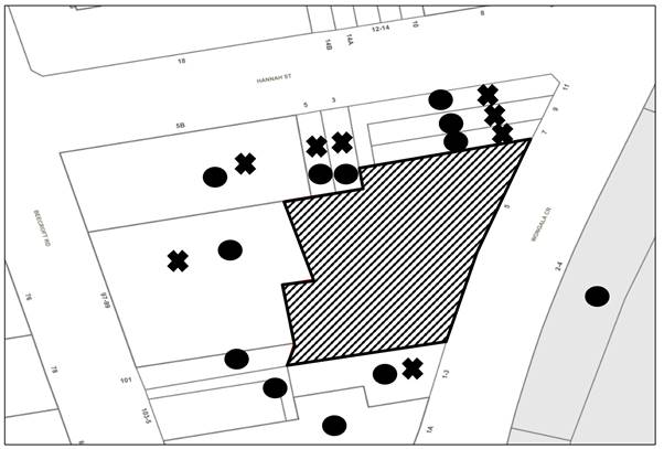
|
NOTIFICATION PLAN |
|||
|
• PROPERTIES NOTIFIED |
X SUBMISSIONS RECEIVED |
|
|
|
62 Unique submissions objected to the development, of these submissions, 50 were out of map range |
|||
62 submissions objected to the development, generally on the grounds that the development would result in:
· Loss of retail.
· Devaluation.
· Amalgamation of adjoining sites.
· Height and built form concerns.
· Heritage concerns.
· Existing right of way.
· Excavation concerns.
· Redevelopment concerns.
· General design concerns.
· Electricity substation.
· Ground water contamination impacts.
· Impacts on local creeks and stormwater impacts.
· Impacts on native bird life.
· Privacy concerns.
· Unacceptable traffic on local streets.
· Unacceptable parking impacts.
· Pedestrian safety.
· Accessibility concerns.
· Communal open space concerns.
· Acoustic requirements.
· Overshadowing and cross ventilation concerns.
· Tree protection.
· Insufficient landscaping.
· Construction impacts.
· Inability of Schools to cope with extra demand in the area.
· Affordable housing.
The submissions are addressed in the body of the report with the exception of the following:
5.1.1 Existing right of way
Concerns were raised that the subject proposal could block the existing right of way to the rear of Nos. 3-5 Hannah Street.
The rear of the subject site currently includes a car parking area for the subject site, and it also appears Nos. 3-5 Hannah Street traverse over the subject site to access the rear of their property.
To confirm whether or not No.3-5 Hannah Street has legal rights to pass over the subject property, the applicant provided a title investigation report prepared by Surveyplus that confirmed that Nos. 3-5 Hannah Street does not have any car parking entitlements or current legal access over the subject site at No. 5 Wongala Crescent, Beecroft.
It is also noted that No. 3 Hannah Street has extended the rear of the property behind the existing right of way which has made the right of way obsolete.
5.1.2 Electricity substation
Concerns were raised regarding the potential impact of an electricity substation.
In response to this concern, supporting documentation was provided by a Level 3 Accredited Service Provider (Power control Engineer) who provided calculations for the maximum demand and noted that the existing substation is unable to support the loads required by the development. Accordingly, a new substation is proposed adjoining the basement entrance ramp and Retail 1. The substation has been designed in accordance with the letter provided by the consultant to avoid modifications to the façade and is located in an enclosed area.
5.1.3 Impact on bird life
Concerns were raised that the proposal may impact local bird life.
Council does not have a planning policy relating to materials or finishes to avoid injuries to native birds potentially flying into buildings.
5.1.4 Loss of retail
Concerns were raised that the proposal would result in a net loss of retail/ commercial floor area for the site and broader Beecroft Precinct.
To encourage revisitation of the mixed-use precinct and shopping centre area with shop top housing, the HLEP incorporates a minimum floor space area requirement for retail of 0:5:1. The proposal meets this requirement.
5.1.5 Scale
Concerns were raised regarding the development being five to six storeys as being inconsistent with the Development Control Plan. The proposal is consistent with the provisions of HDCP which encourages mixed use development to be five storeys.
5.1.6 Schools
The development capacity is consistent with the contemplated yield from when the rezoning of the land originally occurred, which would have included consultation with the NSW Department of Education
5.1.7 Traffic Impact
The proposed traffic generation is within the satisfactory level of service for the operation of the Hannah Street and Beecroft Road intersection and the Hannah Street intersection with Wongala Crescent. A condition is recommended to restrict the size of trucks into the basement.
The proposed vehicle access on Hannah Street is of acceptable design for pedestrian and vehicle safety subject to recommended conditions.
5.1.8 Redevelopment Potential of adjoining sites
The proposal includes indicative plans for development of the isolated site which demonstrate built form which would integrate with the proposed development, generally in compliance with the HDCP requirements other than for car parking and setbacks for the upper levels.
5.1.9 Stormwater runoff
Submissions raised concerns over stormwater impacts to the wider Byles Creek catchment as a result of the development.
Subject to the implementation of sediment and erosion control measures and stormwater management to protect water quality, the proposal would have minimal potential to impact on the Byles Creek catchment.
5.1.10 Beecroft Village Heritage Character
The proposed built form is generally in compliance with HDCP requirements for the Beecroft Heritage Precinct. The non-compliance with the maximum height requirements is acceptable with regard to the building separation and stepping of the development reducing bulk and scale.
The architectural treatment has regard to the context of the site with the surrounding heritage conservation area and heritage items in the vicinity of the site.
5.1.11 Safety and Security
Appropriate conditions are recommended for public access control, surveillance and management of the public domain.
5.1.12 Traffic-Pedestrian Conflict
The proposed vehicle access on Wongala Crescent is designed for pedestrian safety with regard to sightlines, pedestrian refuge and vehicle movement and is acceptable subject to recommended conditions.
5.1.13 Design Concerns
Numerous submissions included design suggestions for the site.
Whilst some design suggestions have been considered, amended plans have been submitted reflecting some of the suggestions. In addition, Council’s Design Excellence Panel undertook a comprehensive review of the design and support the proposed design of the development. The proposal generally complies with the Hornsby DCP, Hornsby LEP and Apartment Design Guideline.
5.1.14 Pedestrian Safety concerns
The proposal includes footpath improvements along the site frontages and the HDCP and S7.11 Plan envisage public domain improvements to improve pedestrian connectivity and safety. A condition of consent is also recommended requiring monetary development contributions toward improvements in the wider town centre.
5.1.15 Energy Efficiency concerns
The proposal complies with the requirements of BASIX, the ADG and the HDCP in regard to energy efficiency impacts.
5.1.16 Fire safety concerns
A preliminary fire safety assessment has been submitted which demonstrates that the proposal is capable of complying with the prevailing fire safety standards and it is a requirement of the EP&A Regulation that a condition be imposed requiring the development to be constructed in accordance with the BCA which includes fire safety requirements.
5.1.17 Apartment Sizes too small
The proposed apartments all comply with and in many cases significantly exceed the minimum requirements of the ADG and provide for a broader array of unit sizes than is typical in a development of this nature.
5.1.18 Overdevelopment for area
The proposal substantially complies with the prevailing statutory and non-statutory planning provisions which apply to the land with the main exception being in regard to building height which is discussed in greater detail above. It is considered that a height compliant development would likely contain the same quantum of floor space, noting that the proposal complies with the FSR development standard under the HLEP. Furthermore, with regard to external environmental impacts, the proposal has been assessed as acceptable. Accordingly, the proposed development is not considered to be overdevelopment and meets the zone objectives.
5.1.19 Greater setbacks for landscaping
There is no requirement in the HDCP for additional setbacks to accommodate deep soil landscaping for the subject site, the proposal provides a significant amount of landscaping on the podium level and communal open space and was accepted by Council’s Design Excellence Panel and Council’s landscape architect.
5.1.20 Construction Impacts
As with other major developments being undertaken in the Hornsby LGA, there will be negative short-term disruptions due to demolition, excavation and construction works. In this regard, a preliminary Construction Management Plan and a preliminary Construction Traffic Management Plan have been submitted which describe various measures that can be undertaken to minimise the potential impacts of demolition and construction works including:
· Environmental management measures (e.g., dust, soil and sedimentation control, truck wash facilities and tree protection).
· Designation of works zones, materials handling areas and waste storage and removal.
· Pedestrian management.
· Traffic management - including local traffic control measures, construction vehicles routes, parking, etc.
· Hours of work and access.
A Condition of development consent is recommended requiring the development to be undertaken in accordance with these preliminary plans and that a detailed plan be prepared prior to works commencing on-site. In addition, a dilapidation report is recommended prior to any excavation for all adjoining properties.
Affordable Housing
There is no requirement to provide affordable housing for under the HLEP or SEPP 65.
5.1.21 Property values
Impact on property values is not a matter that requires consideration under Section 4.15 of the Environmental Planning and Assessment Act 1979.
5.1.22 Safety and Security
Appropriate conditions are recommended for public access control, surveillance and management of the public domain.
5.2 Public Agencies
The development application was referred to the following Agencies for comment:
5.2.1 Water NSW
The application was referred to Water NSW for General Terms of Approval in accordance Section 90(2) of the Water Management Act 2000.
On 16 July 2021, Water NSW provided its General Terms of Approval and recommended conditions which are included in Schedule 1.
5.2.2 Sydney Trains
The application was referred to Sydney Trains for concurrence in accordance with Clause 86 of the ISEPP.
On 4 February 2021, Sydney Trains granted concurrence to the proposed development subject to deferred commencement and construction conditions.
6. THE PUBLIC INTEREST
Section 4.15(1)(e) of the Act requires Council to consider “the public interest”.
The public interest is an overarching requirement, which includes the consideration of the matters discussed in this report. Implicit to the public interest is the achievement of future built outcomes adequately responding to and respecting the future desired outcomes expressed in environmental planning instruments and development control plans.
The application is considered to have satisfactorily addressed Council’s and relevant agencies’ criteria and would provide a development outcome that, on balance, would result in a positive impact for the community. Accordingly, it is considered that the approval of the proposed development would be in the public interest.
CONCLUSION
The application proposes demolition of existing structures and construction of 5 storey shop top housing development comprising 2 x retail/commercial units, 34 residential units, 2 levels basement carparking, rooftop communal open space and associated landscaping.
The application includes a Clause 4.6 variation request to vary the maximum height of buildings development standard. The request is considered well founded.
The development generally meets the desired outcomes of Council’s planning controls and is satisfactory having regard to the matters for consideration under Section 4.15 of the Environmental Planning and Assessment Act 1979.
Council received 62 submissions during the public notification period. The matters raised have been addressed in the body of the report.
Having regard to the circumstances of the case, approval of the application is recommended.
The reasons for this decision are:
· The proposed development generally complies with the requirements of the relevant environmental planning instruments, Apartment Design Guide and the Hornsby Development Control Plan 2013.
· The proposal is permissible with development consent in the B2 Local Centre Zone under the Hornsby Local Environmental Plan 2013 and is consistent with the objectives of that zone. The proposal complies with the FSR development standard under the Hornsby Local Environmental Plan 2013 and is consistent with the other relevant provisions of the Hornsby Local Environmental Plan 2013 with the exception of the Height of Buildings development standard.
· The Applicant has prepared a written request pursuant to Clause 4.6 of the Hornsby Local Environmental Plan 2013 to vary the Height of Buildings development standard. It is considered that the Clause 4.6 written request has adequately demonstrated that:
o The height of buildings control is a development standard and is not excluded from the operation of Clause 4.6.
o Compliance with the development standard is unreasonable and unnecessary in this instance.
o There are sufficient environmental planning grounds to justify contravening the development standard.
o The proposal is in the public interest because it is consistent with the objective of the height of building development standard and the objectives of the B2 Local Centre Zone
· The proposed development does not create unreasonable environmental impacts to adjoining development with regard to visual bulk, overshadowing, solar access, amenity or privacy.
Accordingly, the Panel may assume the concurrence of the Secretary of the Department of Planning, Industry and Environment and grant consent to the development application.
Note: At the time of the completion of this planning report, no persons have made a Political Donations Disclosure Statement pursuant to Section 10.4 of the Environmental Planning and Assessment Act 1979 in respect of the subject planning application.
RESPONSIBLE OFFICER
The officer responsible for the preparation of this report is Matthew Miles.
|
Cassandra Williams Major Development Manager - Development Assessments Planning and Compliance Division |
Rod Pickles Manager - Development Assessments Planning and Compliance Division |
|
Locality Map |
|
|
|
|
Clause 4.6 |
|
|
|
|
Landscape Plans |
|
|
|
|
Architectural Plans |
|
|
File Reference: DA/20/2021
Document Number: D08239163
SCHEDULE 1
1. Deferred Commencement
a) Pursuant to Section 4.16(3) of the Environmental Planning and Assessment Act 1979, this consent does not operate until the Applicant satisfies Council, within 48 months of the date of this consent, that it has obtained approval/certification from Sydney Trains as to the following matters and the approval/certification has been forwarded to the Council:
i) The Applicant shall prepare and provide to Sydney Trains for review, comment and written endorsement the following final version items in compliance with relevant ASA Standards
(https://www.transport.nsw.gov.au/industry/asset-standards-authority):
a. Geotechnical and Structural report/drawings that meet Sydney Trains requirements. The Geotechnical Report must be based on actual borehole testing conducted on the site closest to the rail corridor.
b. Construction methodology with construction details pertaining to structural support during excavation. The Applicant is to be aware that Sydney Trains will not permit any rock anchors/bolts (whether temporary or permanent) within its land or easements.
c. Cross sectional drawings showing the rail corridor, sub soil profile, proposed basement excavation and structural design of sub ground support adjacent to the rail corridor. All measurements are to be verified by a Registered Surveyor.
d. Detailed Survey Plan showing the relationship of the proposed development with respect to Sydney Trains easement and rail corridor land.
e. If required by Sydney Trains, an FE analysis which assesses the different stages of loading-unloading of the site and its effect on the rock mass surrounding the rail corridor.
f. If required by Sydney Trains, a Monitoring Plan.
g. Any conditions issued as part of Sydney Trains endorsement of the above documents will also form part of the consent conditions that the Applicant is required to comply with.
b) Such information must be submitted within 4 years of the date of this notice.
Upon Council’s written satisfaction of the above information, the following conditions of development consent apply:
GENERAL CONDITIONS
The conditions of consent within this notice of determination have been applied to ensure that the use of the land and/or building is carried out in such a manner that is consistent with the aims and objectives of the relevant legislation, planning instruments and council policies affecting the land and does not disrupt the amenity of the neighbourhood or impact upon the environment.
Note: For the purpose of this consent, the term ‘applicant’ means any person who has the authority to act on or the benefit of the development consent.
Note: For the purpose of this consent, any reference to an Act, Regulation, Australian Standard or publication by a public authority shall be taken to mean the gazetted Act or Regulation, or adopted Australian Standard or publication as in force on the date that the application for a construction certificate is made.
2. Approved Plans and Supporting Documentation
The development must be carried out in accordance with the plans and documentation listed below and endorsed with Council’s stamp, except where amended by Council and/or other conditions of this consent:
Approved Plans
|
Plan No. |
Plan Title |
Drawn by |
Dated |
Council Reference |
|
DA003, Issue A |
Demolition plan |
PBD Architects |
09.10.2020 |
|
|
DA100, Issue D |
Basement 2 plan |
PBD Architects |
21.10.2021 |
|
|
DA101, Issue D |
Basement 1 plan |
PBD Architects |
21.10.2021 |
|
|
DA102, Issue H |
Ground floor plan |
PBD Architects |
1.12.2021 |
|
|
DA103, Issue G |
Level 1 plan |
PBD Architects |
1.12.2021 |
|
|
DA104, Rev D |
Level 2 plan |
PBD Architects |
10.08.2021 |
|
|
DA105, Rev D |
Level 3 plan |
PBD Architects |
10.08.2021 |
|
|
DA106, Rev D |
Level 4 plan |
PBD Architects |
10.08.2021 |
|
|
DA107, Rev D |
Level 5 plan |
PBD Architects |
10.08.2021 |
|
|
DA108, Rev C |
Roof plan |
PBD Architects |
24.03.2021 |
|
|
DA 200, Issue E |
Elevations 01 |
PBD Architects |
1.12.2021 |
|
|
DA 201, Issue E |
Elevations 02 |
PBD Architects |
21.10.2021 |
|
|
DA 203, Rev D |
Elevations 03 |
PBD Architects |
10.08.2021 |
|
|
DA 300, Issue E |
Section 01 |
PBD Architects |
21.10.2021 |
|
|
DA 301, Rev D |
Section 02 |
PBD Architects |
10.08.2021 |
|
|
DA 302, Rev B |
Detail Sections |
PBD Architects |
10.08.2021 |
|
|
21/2188 Issue D 1 of 3 |
Landscape plans |
Paul Scrivener landscape |
31.03.21 |
|
|
21/2188 Issue D 2 of 3 |
Landscape plans |
Paul Scrivener landscape |
31.03.21 |
|
|
21/2188 Issue D 3 of 3 |
Landscape plans |
Paul Scrivener landscape |
31.03.21 |
|
Supporting Documentation
|
Document Title |
Prepared by |
Dated |
Council Reference |
|
Stormwater Plans D02-D08, Rev B |
SYJ Consulting |
7/04/2021 |
D08140928 |
|
Construction Management Plan |
Vantager |
No date |
D08230246 |
|
BASIX Certificate No.1148273M |
Building Sustainability Assessments |
3/11/2020 |
D08084993 |
|
Access report, LP_20122 |
Lindsay Perry Access |
12/10/2020 |
D08084970 |
|
BCA Report |
BVA Logic |
16/10/2020 |
D08084996 |
|
Traffic report, issue C |
Transport and Traffic Planning Associates |
July 2021 |
D08230240 |
|
Construction Noise and Vibration Management Plan |
Pulse White Noise Acoustics |
6/07/2021 |
D08230241 |
|
Water NSW General Terms of Approval, reference IDAS1137960 |
Water NSW |
08/07/2021 |
D08204469 |
|
De-watering Management Plan, reference E2359-4 |
Foundation Earth Sciences |
14/7/21 |
D08230250 |
|
Acoustic Response |
White Noise Acoustics |
7/5/21 |
D08230245 |
|
Noise Impact Assessment, Rev 3 |
White Noise Acoustics |
1/3/2021 |
D08140926 |
|
Unexpected Finds Protocol Letter Report |
Foundation Earth Sciences |
14/7/21 |
D08230251 |
|
Remediation Action Plan |
Foundation Earth Sciences |
1/9/21 |
D08238674 |
|
Detailed Site Investigation |
Foundation Earth Sciences |
14/7/21 |
D08230247 |
|
Arborist report |
Horticultural Resources Consulting Group |
20/10/2020 |
D08084999 |
|
Sydney Trains concurrence letter |
Sydney Trains |
4/02/2021 |
D08099399 |
|
Structural report |
SYJ Consulting Engineers |
31/03/2021 |
D08140929 |
|
Waste management plan |
Auswide |
March 2021 |
D08139028 |
|
Signage Strategy |
PBD Architects |
March 2021 |
D08139033 |
|
Elevations 01/Materials and finishes |
PBD Architects |
30.11.2021 |
D08305778 |
a) To comply with Council’s requirement in terms of privacy, the approved plans are to be amended as follows:
i) Elevations 02, DA 201, Issue E dated 21.10.2021 must be amended by incorporating frosted glazing or a privacy screen in the northern elevation window for bedroom ‘2’ and study window of Units B202 and B302 in the northern elevation; and
ii) Elevations 02, DA 201, Issue E dated 21.10.2021 must be amended by incorporating frosted glazing or a privacy screen for the northern elevation window in bedroom ‘4’ and living/dining room window in the northern elevation for unit B501 on the upper level.
b) These amended plans must be submitted with the application for the Construction Certificate.
4. Removal of Trees
a) This development consent permits the removal of trees numbered T1, T3 and T9 as identified in the Arboricultural Impact Assessment prepared by Horticultural Resources Consulting Group, Issue C dated 20 October 2020.
b) No consent is granted for the removal of trees numbered T2, T4, T5, T6, T7, T8, T10, T11, T12, T13, T14 and T15 as these trees contribute to the established landscape amenity of the area/streetscape.
Note: The removal of any other trees from the site requires separate approval by Council in accordance with Part 1B.6 Tree and Vegetation Preservation of the Hornsby Development Control Plan, 2013 (HDCP).
5. Tree Pruning
a) This development consent only permits the pruning of tree numbered T15 as identified in the Arboricultural Impact Report prepared by Horticultural Resources Consulting Group, Issue C dated 20 October 2020.
i) All specified pruning works must be less than 10 percent.
ii) All pruning work must be undertaken by an arborist with minimum AQF3 qualifications.
Note: The pruning of any other trees from the site requires separate approval by Council in accordance with Part 1B.6 Tree and Vegetation Preservation of the Hornsby Development Control Plan 2013 (HDCP).
6. Section 7.11 Development Contributions
a) In accordance with Section 4.17(1) of the Environmental Planning and Assessment Act 1979 and the Hornsby Shire Council Section 7.11 Development Contributions Plan 2020-2030, the following monetary contributions must be paid to Council to cater for the increased demand for community infrastructure resulting from the development:
|
Description |
Contribution (4) |
|
Roads |
$14,983.25 |
|
Open Space and Recreation |
$377,273.6 |
|
Community Facilities |
$232,366.25 |
|
Plan Preparation and Administration |
$3,123.10 |
|
TOTAL |
$627,746.20 |
being for 8 x 1 bedroom units, 17 x 2 bedrooms units, 9 x 3+ bedroom units and a credit has been given for the existing retail.
b) The value of this contribution is current as at 15 November 2021. If the contribution is not paid within the financial quarter that this condition was generated, the contribution payable will be adjusted in accordance with the provisions of the Hornsby Shire Council Section 7.11 Development Contributions Plan and the amount payable will be calculated at the time of payment in the following manner:
$CPY = $CDC x CPIPY
CPIDC
Where:
$CPY is the amount of the contribution at the date of Payment
$CDC is the amount of the contribution as set out in this Development Consent
CPIPY is the latest release of the Consumer Price Index (Sydney – All Groups) at the date of Payment as published by the ABS.
CPIDC is the Consumer Price Index (Sydney – All Groups) for the financial quarter at the date applicable in this Development Consent Condition.
c) The monetary contribution must be paid to Council:
i) Prior to the issue of the Subdivision Certificate where the development is for subdivision.
ii) Prior to the issue of the first Construction Certificate where the development is for building work.
iii) Prior to issue of the Subdivision Certificate or first Construction Certificate, whichever occurs first, where the development involves both subdivision and building work.
iv) Prior to the works commencing where the development does not require a Construction Certificate or Subdivision Certificate.
Note: It is the professional responsibility of the Principal Certifying Authority to ensure that the monetary contributions have been paid to Council in accordance with the above timeframes.
Note: In accordance with Ministerial Directions, the payment of contribution fees for development with a cost of works of over $10 million can be deferred to prior to Occupation Certificate.
Note: Council’s Development Contributions Plan may be viewed at www.hornsby.nsw.gov.au or a copy may be inspected at Council’s Administration Centre during normal business hours.
7. Construction Certificate
a) A Construction Certificate is required to be approved by Council or a Private Certifying Authority prior to the commencement of any construction works under this consent.
b) A separate Subdivision Works Certificate (Civil Works) must be obtained from Council for all works within the public road reserve under S138 of the Roads Act 1993.
c) A Work Zone permit must be obtained for interference of any pedestrian movements or parking facilities on the street.
d) The Construction Certificate / Subdivision Works Certificate plans must be consistent with the Development Consent plans.
REQUIREMENTS PRIOR TO THE ISSUE OF A CONSTRUCTION CERTIFICATE
8. Access Report
In accordance with the accessibility report, the following details must be detailed on the approved Construction Certificate plans:
a) 4 x Residential Accessible car spaces.
b) 4 x Adaptable units.
c) 7 x Silver level liveable housing units.
d) 1 x Commercial Accessible car space.
e) 1 x Unisex Accessible toilet provided within each retail tenancy.
9. Building Code of Australia
Detailed plans, specifications and supporting information is required to be submitted to the certifying authority detailing how the proposed building work achieves compliance with the National Construction Code - Building Code of Australia. All building work must be carried out in accordance with the requirements of the National Construction Code - Building Code of Australia.
10. Fire Safety Schedule
A schedule of all proposed essential fire safety measures to be installed in the building (e.g., hydrants, hose reels, emergency warning systems etc.) shall be submitted with the construction certificate application.
11. Utilities
The provision of all utilities including but not limited to, telecommunication equipment, air-conditioning units and the like located on the roof are to be located and screened in accordance with the approved plans so that the visual impact of utilities do not detract from the character of the HCA or the setting of the heritage items in the vicinity.
The screening enclosure must be indicated on the approved Construction Certificate.
The development must be carried out in accordance with the recommendations contained within the acoustic report submitted with the development application, titled Noise & Vibration Impact Assessment, prepared by White Noise Acoustics and dated 1/3/20, (reference 20091_200514_Noise Impact Assessment_BW_R3.docx) and the requirements of the Department of Planning’s Development Near Rail Corridors and Busy Roads – Interim Guideline and RailCorp’s Interim Guidelines for Applicants.
Note: The Department of Planning’s document is available at www.planning.nsw.gov.au (development assessments). The RailCorp document is available at www.railcorp.nsw.gov.au/publications.
13. Acoustic Design Report
a) An acoustic design report shall be prepared by an appropriately qualified acoustic consultant and be submitted to the Principal Certifying authority prior to the issue of a construction certificate. The acoustic design report shall identify all noise generating plant and equipment proposed as part of the approved development.
b) The acoustic design report shall confirm the acoustic design for the project and identify the required noise control measures and/or specifications to ensure that the combined operation of all plant and equipment will not exceed the relevant criteria detailed in the Noise and Vibration Impact Assessment, prepared by White Noise Acoustics, dated 1/3/21, reference 20091_200514_Noise Impact Assessment_BW_R3.docx.
c) All required acoustic treatments must be shown on the Architectural Plans accompanying the Construction Certificate application.
14. Pre-commencement Dilapidation Report
A ‘Dilapidation Report’ is to be prepared by an engineer registered by the Australian Institute of Engineers detailing the structural condition of the following properties that directly adjoin the site:
a) Lot 1 DP 1134589 No.1-3 Wongala Crescent, Beecroft.
b) Lot B DP 300075, No.7 Wongala Crescent, Beecroft.
c) Lot B1, DP 333429, No.9 Wongala Crescent, Beecroft.
d) Lot A1, DP 333429, No.11 Wongala Crescent, Beecroft.
e) Strata Plan SP 82129, No.97-99 Beecroft Road, Beecroft.
f) Strata Plan SP 72498, No.5B Hannah Street, Beecroft.
g) Lot 1 DP 611932, No.5 Hannah Street, Beecroft.
h) Lot 2 DP 611932, No.3 Hannah Street, Beecroft.
A Portable Document Format (.pdf) copy of the Dilapidation Report shall be submitted to the Principal Certifying Authority and Hornsby Council (devmail@hornsby.nsw.gov.au reference DA/20/2021) before approval of any Construction Certificate.
15. Appointment of a Project Arborist
a) A project arborist with AQF Level 5 qualifications must be appointed.
b) Details of the appointed project arborist must be submitted to Council and the PCA for registration with the application for the construction certificate.
16. Identification of Survey Marks
A registered surveyor must identify all survey marks in the vicinity of the proposed development. Any survey marks required to be removed or displaced as a result of the proposed development shall be undertaken by a registered surveyor in accordance with Section 24 (1) of the Surveying and Spatial Information Act 2002 and following the Surveyor General’s Directions No.11 "Preservation of Survey Infrastructure".
17. Stormwater Drainage
The stormwater drainage system for the development must be designed in accordance with AUS-SPEC Specifications (www.hornsby.nsw.gov.au/property/build/aus-spec-terms-and-conditions) and the following requirements:
a) Connected to an existing Council piped drainage system with the following requirements:
i) Extend Council network in Wongala Crescent from the development site to the nearest Council pit.
ii) A separate Construction Certificate Application (SWC) must be made to Council for the stormwater drainage works within Wongala Crescent.
iii) Connection to Council’s drainage system shall include design and construction of Council’s standard kerb inlet / raised / flush / grated / concrete filled pit top in accordance with AUS-SPEC Specifications.
The Applicant’s Engineer must prepare the design of system including location of proposed work in the plan. 3 copies of the plan shall be submitted with lodgement and payment of the Application.
iv) A Traffic Control Plan (TCP) must be prepared by a qualified traffic controller in accordance with the Roads & Traffic Authority’s Traffic Control at Worksites Manual 1998 and Australian Standard AS1742.3 for all work on a public road. 3 copies of the Traffic Management Plan shall be submitted with lodgement of the Application prior to Council’s approval. The TCP must detail the following:
a. Arrangements for public notification of the works.
b. Temporary construction signage.
c. Vehicle movement plans.
d. Traffic management plans.
e. Pedestrian and cyclist access/safety.
v) Where public assets and utilities are impacted by proposed works, the Applicant shall relocate or reconstruct the asset or utility in accordance with the relevant standard at the Applicant’s cost.
vi) Prior to the issue of an Occupation Certificate a Compliance Certificate must be obtained from Council for the connection to Council’s drainage system.
18. On Site Stormwater Detention
An on-site stormwater detention system must be designed by a chartered civil engineer and constructed in accordance with the following requirements:
a) Storage capacity to accommodate volume from up to 50 years ARI (average recurrence interval) storms and a maximum discharge (when full) limited to 5 years pre- development rate.
b) Have a surcharge/inspection grate located directly above the outlet. Discharge from the detention system to be controlled via 1 metre length of pipe, not less than 50 millimetres diameter or via a stainless plate with sharply drilled orifice bolted over the face of the outlet discharging into a larger diameter pipe capable of carrying the design flow to an approved Council system.
c) Where above ground system is proposed and the average depth is greater than 0.3 metres, a ‘pool type’ safety fence and warning signs to be installed.
d) Not be constructed in a location that would impact upon the visual or recreational amenity of residents.
e) Detail calculations are to be shown in construction certificate plan.
f) An overflow/escape path shall be incorporated in the design.
19. Water Sensitive Urban Design System
a) Stormwater discharging from the development site is to be treated to achieve the quality specified in Council’s Development Control Plan 2012 (table 1C.1.2(b) Urban Stormwater Quality Targets).
b) MUSIC modelling and Hornsby Shire Council Music- link report must be submitted to the PCA prior to issue of a construction certificate. Council’s parameters are to be used in the model.
c) Prior to occupation of the premises, a Chartered Civil/Hydraulic Engineer of the Institution of Engineers, Australia is to certify that works have been completed in accordance with the approved construction plan and the measures will achieve the targets specified in the condition.
20. Vehicular Crossing
A separate application under the Local Government Act 1993 and the Roads Act 1993 must be submitted to Council for the installation of a new vehicular crossing and the removal of the redundant crossing. The vehicular crossing must be constructed in accordance with AUS-SPEC Specifications (www.hornsby.nsw.gov.au/property/build/aus-spec-terms-and-conditions) and the following requirements:
a) Design levels at the front boundary must be obtained from Council for the design on the internal driveway.
b) Any redundant crossings must be replaced with integral kerb and gutter.
c) Approval must be obtained from all relevant utility providers that all necessary conduits be provided and protected under the crossing.
Note: An application for a vehicular crossing can only be made to one of Council’s Authorised Vehicular Crossing Contractors. You are advised to contact Council on 02 9847 6940 to obtain a list of contractors.
21. Internal Driveway/Vehicular Areas
The driveway and parking areas on site must be designed, constructed and a Construction Certificate issued in accordance with Australian Standards 2890.1, AS2890.2, AS2890.6 and the following requirements:
a) Design levels at the front boundary shall be obtained from Council if a private accredited certifier is engaged to obtain a construction certificate for these works.
b) The driveway be a rigid pavement.
c) Conduit for utility services including electricity, water, gas and telephone be provided. All existing overhead assets including electricity and telecommunications cabling shall be relocated underground at no cost to Council. A certificate from an appropriately licensed contractor shall be submitted to the principal certifying authority certifying that the service conduits have been installed in accordance with the relevant utility provider and Australian Standards.
d) Longitudinal sections along both sides of the access driveway shall be submitted to the principal certifying authority in accordance with the relevant sections of AS 2890.1. The maximum grade shall not exceed 1 in 4 (25%) with the maximum changes of grade of 1 in 8 (12.5%) for summit grades and 1 in 6.7 (15%) for sag grades. Any transition grades shall have a minimum length of 2 metres. The longitudinal sections shall incorporate the design levels obtained by Council.
22. Road Works
All road works approved under this consent must be designed in accordance with AUS-SPEC Specifications (www.hornsby.nsw.gov.au/property/build/aus-spec-terms-and-conditions) and the following requirements:
a) Footpath and Kerb and gutter along frontage of the property must be replaced.
b) The existing road pavement next to the kerb and gutter is to be saw cut a minimum of 600 mm from the existing edge of the bitumen and reconstructed.
c) The submission of a compaction certificate from a geotechnical engineer for any fill within road reserves, and all road sub-grade and road pavement materials
d) A construction certificate application is to be submitted to Council for approval and compliance certificate.
Note: Council is the only authority to issue construction and compliance certificate for footpath and kerb and gutter.
23. Construction Management Plan (CMP)
To assist in the protection of the public, the environment and Council’s assets, a separate Construction Management Plan must be prepared by a suitably qualified environmental consultant in consultation with a qualified traffic engineer and AQF 5 arborist, and submitted for review and written approval to Council’s Compliance Team at: https://www.hornsby.nsw.gov.au/property/build/applicationforms.
The CMP must include the following details:
a) A Construction Traffic Management Plan (CTMP) including the following:
i) The order of construction works and arrangement of all construction machines and vehicles being used during all stages.
ii) The CTMP plans shall be in accordance with all other plans submitted to Council as part of this development proposal.
iii) A statement confirming that no building materials, work sheds, vehicles, machines or the like shall be allowed to remain in the road reserve area without the written consent of Hornsby Shire Council.
iv) The Plan shall be in compliance with the requirements of the Roads and Maritime Services Traffic control at work sites Manual 2018 and detail:
a. Public notification of proposed works.
b. Long term signage requirements.
c. Short term (during actual works) signage.
d. Vehicle Movement Plans, where applicable.
e. Traffic Management Plans.
f. Pedestrian and Cyclist access and safety.
v) Traffic controls including those used during non-working hours. Pedestrian access and two-way traffic in the public road must be able to be facilitated at all times.
vi) Details of parking arrangements for all employees and contractors, including layover areas for large trucks during all stages of works. The parking or stopping of truck and dog vehicles associated with the development will not be permitted other than on the site and the plan must demonstrate this will be achieved.
vii) Confirmation that a street ‘scrub and dry’ service will be in operation during all stages of works.
viii) Proposed truck routes to and from the site including details of the frequency of truck movements for all stages of the development.
ix) Swept path analysis for ingress and egress of the site for all stages of works.
x) Site plans for all stages of works including the location of site sheds, concrete pump and crane locations, unloading and loading areas, waste and storage areas, existing survey marks, vehicle entry, surrounding pedestrian footpaths and hoarding (fencing) locations.
xi) The total quantity and size of trucks for all importation and exportation of fill on site throughout all stages of works, and a breakdown of total quantities of trucks for each stage of works.
xii) The number of weeks trucks will be accessing and leaving the site with excavated or imported fill material.
xiii) The maximum number of trucks travelling to and from the site on any given day for each stage of works.
xiv) The maximum number of truck movements on any given day during peak commuting periods for all stages of works.
xv) The source site location of any proposed fill to be imported to the site, for all stages of works.
xvi) The Plan must state that the applicant and all employees of contractors on the site must obey any direction or notice from the Prescribed Certifying Authority or Hornsby Shire Council in order to ensure the above.
xvii) If there is a requirement to obtain a Work Zone, Out of Hours permit, partial Road Closure or Crane Permit, the Plan must detail these requirements and include a statement that an application to Hornsby Shire Council will be made to obtain such a permit.
b) A Construction Waste Management Plan detailing the following:
i) Details of the importation or excavation of soil and fill, the classification of the fill, disposal methods and authorised disposal depots that will be used for the fill.
ii) Asbestos management requirement and procedures for removal and disposal from the site in accordance with AS 2601–2001 – ‘The Demolition of Structures’, and the Protection of the Environment Operations (Waste) Regulation 2005.
iii) General construction waste details including construction waste skip bin locations and litter management for workers.
d) A Tree Protection Plan (TPP) prepared by an AQF 5 Arborist in accordance with any approved Arboricultural Impact Assessment and tree location plans, detailing the following:
i) A site plan showing tree protection zones (TPZ) and structural root zones (SRZ) of trees to be retained and specific details of tree protection measures inclusive of distances (in metres) measured from tree trunks.
ii) Construction methodology to avoid damage to trees proposed to be retained during construction works.
iii) Specifications on tree protection materials used and methods within the TPZ or SRZ.
iv) Location of dedicated material storage space on site outside of TPZ’s and SRZ’s for retained trees.
e) A Construction Noise and Vibration Management Plan (CNMP) which includes:
i) Existing noise and vibration levels within the proximity of the proposed development site.
ii) Details of the extent of rock breaking or rock sawing works forming part of the proposed development works.
iii) The maximum level of noise and vibration predicted to be emitted during each stage of construction.
iv) The duration of each stage of works where the maximum level of noise and vibration are predicted to be emitted for.
v) Details of mitigation measures, inclusive of respite periods, that will meet acoustic standards and guidelines at each stage of works.
vi) Details of a complaints handling process for the surrounding neighbourhood for each stage of works.
f) Identification of approved sediment and erosion control measures.
g) The CMP must detail the contact information for developers, builder, private certifier and any emergency details during and outside work hours.
24. Validation Report
a) A Validation Report must be prepared by a certified consultant as recognised under the Certified Environmental Practitioners Scheme - Site Contamination (CEnvP (SC)) and the Certified Professional Soil Scientist Contaminated Site Assessment and Management (CPSS CSAM) certification, verifying that the site has been remediated in accordance with the NSW Environment Protection Authority’s Contaminated Sites Guidelines, the National Environment Protection (Assessment of Site Contamination) Measure 2013 (NEPM) and the recommendations of the Remediation Action Plan, prepared by Foundation Earth Sciences, dated 1/9/21, reference E2359-6, (TRIM: D08238674). The Validation Report must state that the site has been remediated and is suitable for its approved use.
b) The Validation Report must be submitted to the Principal Certifying Authority and a copy provided to Council prior to the issue of a Construction Certificate.
The following waste management requirements must be complied with:
a) Should there be any conflict or confusion between approved plans and/or consent conditions related to the waste management system or the waste collection vehicle travel path on site, then written clarification must be obtained from Council.
b) The approved on-going waste management system must not be amended without the written consent of Council.
c) There must be no steps along any bin carting route. Ramps and service lifts are acceptable.
Note: bin carting routes include, but are not limited to, from the bin storage rooms to the loading bay, from each commercial unit to the commercial bin storage room to the loading bay.
d) A design certificate and detailed plans are to accompany any Construction Certificate application, which demonstrate that the waste carting route from each commercial unit to their commercial bin storage room has been designed to be constructed in accordance with the Waste Minimisation and Management Guidelines and including the following requirements:
i) The route is direct, does not cross into a private lot, and is wholly within property boundaries (does not include the public footpath or road).
ii) The route is as short as possible.
iii) The route is an accessible path of travel for persons with a disability in accordance with AS1428 Design and Access for Mobility.
iv) Does not include any steps.
v) The route is no less than 1.5m wide, including doorways.
e) The residential component and non-residential component of the development must have separate and self-contained waste management systems, including separate bin storage rooms. Commercial tenants must not have access to the residential waste/recycling bins and vice versa.
f) A dedicated bulky waste storage area of at least 8 square metres internal area must be provided adjacent to the loading bay.
h) A design certificate and detailed plans are to accompany any Construction Certificate application, which demonstrate that all waste storage room(s) have been designed to be constructed in accordance with the Waste Minimisation and Management Guidelines and including the following requirements:
i) The floor is to be constructed of concrete at least 75mm thick and adequately graded to drain to a Sydney Water approved drainage fitting.
ii) The floor must be finished so that it is non-slip, sealed and impervious, and has a smooth and even surface coved at all intersections.
iii) The ceilings and walls must be finished with smooth faced non-absorbent material capable of being cleaned.
iv) The room is to be provided with artificial light controllable within the room and adequate ventilation.
v) The room is to be provided with an adequate supply of hot and cold water mixed through a centralised mixing valve with hose cock.
vi) The doors are to be robust and lockable, with a door opening of no less than 1.5m. The doors must be able to be opened from inside the room without a key.
i) There must be a waste facility (a garbage chute and a 240 L recycling bin in a cupboard or small room) on each residential level of each lift core of each building. Each waste facility must:
i) Be accessible by persons with a disability after the garbage chute and recycling bin are installed.
ii) Comfortably house the required garbage chute and 240 L recycling bin.
iii) Have door(s) wide enough and positioned so that the 240 L recycling bin can fit through with ease.
iv) There must be no access to the residential garbage chute on the commercial and retail levels.
v) The recycling bin cupboard on each residential level must have internal dimensions of no less than 750mm wide by 900mm deep, and a door of width no less than 800mm and a door opening of no less than 750mm. The door must be positioned so that a 240L bin can fit through (that is, the centre of the door aligned with the centre of the bin cupboard).
Note: a 240 L recycling bin is 600 mm wide by 750 mm deep; allow for ease around the bin – 75 mm is recommended. These dimensions do not include wall thickness, door thickness, ventilation ducting etc, which must be added. The chute system supplier must be consulted for chute space requirements. AS 1428.1 requires at least 800 mm clear doorway opening for wheelchair access.
j) A design certificate and detailed plans are to accompany any Construction Certificate application, which confirms that the waste chute system for each building can be constructed to satisfy the Manufacturer’s standard installation guidelines, the Waste Minimisation and Management Guidelines and specifically the following requirements:
i) Chutes, service openings and charging devices are constructed of metal or a smooth faced surface which is fire resistant and of impervious material.
ii) Chute is cylindrical in section, vertical and without bends as it passes through the floors.
iii) Chutes must terminate in the waste storage room and discharge into a waste bin.
iv) The chute system must comply with the manufacturers technical specifications and operational limitations.
v) The gradient of each chute must be no less than the minimum gradient recommended by the chute manufacturer.
vi) Each chute system must include volume handling equipment to automatically change the bin under the chute when it becomes full and thereby provide a minimum 3 days bin capacity under the chute.
vii) The required volume handling equipment for each chute system must not include compaction.
viii) The chute service rooms (Residential Waste Rooms A and B) must have sufficient space to comfortably house the required volume handling equipment and to load/unload bins from this equipment, and sufficient space to store the spare garbage and recycling bins for that building and to access and manoeuvre the bins.
Note: The required volume handling equipment is: Residential Waste Rooms A and B each requires at least a 2 x 660L bin linear or carousel under the garbage chute.
Note that 660L bins are 1370mm wide, 850mm deep, 1470mm high; allow 75 mm between bins for ease of manoeuvring and to avoid damage to walls and doors from bins scraping against them.
k) A design certificate from a qualified traffic engineer and detailed plans are to accompany the Construction Certificate application that confirms that the waste can be directly collected from the loading bay as detailed in the Waste Management Plan and the Traffic Report. The design certificate is to specifically confirm that the:
i) Waste collection vehicle is able to enter the site in a forward direction, adequately manoeuvre into position near the bins, load bins and exit the site in a forward direction.
ii) Vertical clearance of no less than 4.2m is provided along the entire route of travel of the waste collection vehicle on site and loading bay.
iii) The installation of ceiling mounted cable trays, pipes, ducting, lights, signs etc will not reduce the vertical clearance of the waste collection vehicle travel path on site to less than 4.2m.
iv) The waste collection vehicle must be able to manoeuvre on site with limited need for reversing.
v) The grades along the entire travel path of the waste collection vehicle on site must not exceed the maximum grades of AS2890.2 for a heavy rigid vehicle.
vi) The vehicle ground clearance is sufficient to prevent scraping.
vii) All pavement has been designed to carry the load of the heavy rigid vehicle.
i) An estimate of the types and volumes of waste and recyclables to be generated.
ii) A site plan showing sorting and storage areas for demolition and construction waste and the vehicle access to these areas.
iii) How excavation, demolition and construction waste materials will be reused or recycled and where residual wastes will be disposed.
iv) The total percentage (by weight) of demolition and construction waste that will be reused or recycled.
Note: the site(s) to which the waste materials are taken must be legally able to accept those wastes.
a) A design certificate and detailed plans are to accompany any Construction Certificate application, which confirms that the vehicular turntable can be constructed to satisfy the manufacturers standard installation guidelines and specifically the following requirements:
i) Hydraulic override system or equivalent that permits the turn table to be manually turned in the event of a power failure or malfunction.
ii) Access to operate the turntable is restricted to authorised users.
iii) The operation system requires the driver to exit the vehicle.
iv) The diameter of the turntable is such that there is no vehicle overhang for an 11m long heavy rigid vehicle.
v) There is 1m clear of obstructions around the 11m diameter turntable, or 0.5m clear of obstructions around the 11.5m diameter turntable.
vi) There is 2m clear of obstructions behind the truck for loading operations.
vii) The turntable has been designed to carry the maximum legal load of a heavy rigid vehicle.
27. Certification of Traffic Engineer
Prior to the issue of a Construction Certificate, a Certificate from an appropriately qualified Traffic Engineer is to be submitted to the Principal Certifying Authority (PCA) certifying that the parking modules, loading areas and garbage collection areas comply with Australian Standards AS2890.1, AS2890.2 and the approved Development Consent plans and conditions.
REQUIREMENTS PRIOR TO THE COMMENCEMENT OF ANY WORKS
28. Erection of Construction Sign
a) A sign must be erected in a prominent position on any site on which any approved work is being carried out:
i) Showing the name, address and telephone number of the principal certifying authority for the work.
ii) Showing the name of the principal contractor (if any) for any demolition or building work and a telephone number on which that person may be contacted outside working hours.
iii) Stating that unauthorised entry to the work site is prohibited.
b) The sign is to be maintained while the approved work is being carried out and must be removed when the work has been completed.
29. Protection of Adjoining Areas
A temporary hoarding, fence or awning must be erected between the work site and adjoining lands before the works begin and must be kept in place until after the completion of the works if the works:
a) Could cause a danger, obstruction or inconvenience to pedestrian or vehicular traffic.
b) Could cause damage to adjoining lands by falling objects.
c) Involve the enclosure of a public place or part of a public place.
d) Have been identified as requiring a temporary hoarding, fence or awning within the Council approved Construction Management Plan (CMP).
Note: Notwithstanding the above, Council’s separate written approval is required prior to the erection of any structure or other obstruction on public land.
a) To provide a safe and hygienic workplace, toilet facilities must be available or be installed at the works site before works begin and must be maintained until the works are completed at a ratio of one toilet for every 20 persons employed at the site.
b) Each toilet must:
i) Be a standard flushing toilet connected to a public sewer.
ii) Be a temporary chemical closet approved under the Local Government Act 1993.r
iii) Have an on-site effluent disposal system approved under the Local Government Act 1993.
31. Erosion and Sediment Control
To protect the water quality of the downstream environment, erosion and sediment control measures must be provided and maintained throughout the construction period in accordance with the manual ‘Soils and Construction 2004 (Bluebook)’, the approved plans, Council specifications and to the satisfaction of the principal certifying authority. The erosion and sediment control devices must remain in place until the site has been stabilised and revegetated.
Note: On the spot penalties may be issued for any non-compliance with this requirement without any further notification or warning.
Prior to the commencement of any works, the on-going waste collection service must be cancelled and the bins retrieved by the waste collection service provider.
Note: For residential properties, Council is the waste collection service provider.
a) A garbage receptacle must be provided at the work site before works begin and must be maintained until all works are completed.
b) The garbage receptacle must have a tightfitting lid and be suitable for the reception of food scraps and papers.
c) The receptacle lid must be kept closed at all times, other than when garbage is being deposited.
d) Food scraps must be placed in a garbage receptacle and not in demolition and construction waste bins.
34. Installation of Tree Protection Measures
a) Trees to be retained and numbered T2, T4, T5, T6, T7, T8, T10, T11, T12, T13, T14 and T15 as identified on the Tree Location Plan prepared by Horticultural Resources Consulting Group, Issue C dated 20 October 2020 must have tree protection measures for the ground, trunk and canopy installed by the project arborist as follows:
i) For the duration of demolition works, in accordance with the Tree Protection Plan for prepared by Horticultural Resources Consulting Group, Issue C dated 20 October 2020 TRIM D08084999
ii) For the duration of construction works, in accordance with Tree Protection Plan prepared by Horticultural Resources Consulting Group, Issue C dated 20 October 2020 TRIM D08084999
b) The circumference of the trunk(s) must be wrapped in hessian material to provide cushioning for the installation of timber planks.
c) Timber planks (50 x100mm) must be spaced at 100mm intervals and must be attached using adjustable ratchet straps.
d) All tree protection zones must have a layer of wood-chip mulch at a depth of between 150mm and 300mm.
e) Where wood-chip mulch is permitted by Council instead of tree protection fencing within the tree protection zones, the wood-chip must be covered with a layer of geotextile fabric and rumble boards.
REQUIREMENTS DURING DEMOLITION AND CONSTRUCTION
35. Construction Work Hours (5 -25 storeys RFBs and mixed use only)
All work on site (including demolition and earth works) must only occur between 7am and 5pm Monday to Saturday (unless otherwise approved in writing by Council due to extenuating circumstances). No work is to be undertaken on Sundays or public holidays.
36. Archaeological Relics
a) An archaeological findings induction to be carried out by a qualified archaeologist for all employees prior to the commencement of any excavation, demolition or construction work on the site. The induction is to educate the workers to be aware of the potential archaeological items contained within the project site and what measures should be taken should they be discovered.
b) In the event that any archaeological findings are discovered during ground works, clearing of the site, or excavation all work in the area must cease immediately and a suitably qualified heritage and archaeologist professional must be contacted and further investigation and recording of the site carried out if required prior to commencement of works. Archaeological ‘relics’ are a type of environmental heritage which is protected under the NSW Heritage Act.
c) To ensure compliance with the reporting and protection of relics under the NSW Heritage Act 1977, if any historical relics are uncovered during the course of the work, all work must stop immediately, and the NSW Heritage Division be contacted to advise on the appropriate measures to safeguard any relics.
37. Demolition
To protect the surrounding environment, all demolition work must be carried out in accordance with Australian Standard AS2601-2001 – The Demolition of Structures and the following requirements:
a) Demolition material must be disposed of to an authorised recycling and/or waste disposal site and/or in accordance with an approved waste management plan; and
b) Demolition works, where asbestos material is being removed, must be undertaken by a contractor that holds an appropriate licence issued by SafeWork NSW in accordance with the Work Health and Safety Regulation 2017 and be appropriately transported and disposed of in accordance with the Protection of the Environment Operations (Waste) Regulation 2014; and
c) On construction sites where any building contains asbestos material, a standard commercially manufactured sign containing the words ‘DANGER ASBESTOS REMOVAL IN PROGRESS’ and measuring not less than 400mm x 300mm must be displayed in a prominent position visible from the street.
38. Environmental Management
To prevent sediment run-off, excessive dust, noise or odour emanating from the site during the construction, the site must be managed in accordance with the publication ‘Managing Urban Stormwater – Landcom (March 2004) and the Protection of the Environment Operations Act 1997.
During works and until exposed ground surfaces across the site have been stabilised, street sweeping must be undertaken following sediment tracking from the site.
The street cleaning service must utilise a ‘scrub and dry’ method and be undertaken for the full extent of any sediment tracking.
40. Compliance with Environmental Management Plan (EMP)
The Council approved Environmental Management Plan must be complied with for the duration of works, unless otherwise approved by Council.
To ensure that the public reserve is kept in a clean, tidy and safe condition during construction works, no building materials, waste, machinery or related matter is to be stored on the road or footpath.
42. Disturbance of Existing Site
During construction works, the existing ground levels of open space areas and natural landscape features, including natural rock-outcrops, vegetation, soil and watercourses must not be altered unless otherwise nominated on the approved plans.
43. Landfill
a) Prior to fill material being imported to the site, a Waste Classification Certificate shall be obtained from a suitably qualified environmental consultant confirming the fill wholly consists of Virgin Excavated Natural Material (VENM) as defined in Schedule 1 of the Protection of the Environment Operations Act 1997 or a material approved under the NSW Environment Protection Authority’s Resource Recovery Orders and Exemptions.
b) The required Waste Classification Certificate must be obtained by the Principal Contractor prior to fill being imported to the site and made available to Council at its request.
44. Excavated Material
All excavated material removed from the site must be classified by a suitably qualified environmental consultant in accordance with the NSW Environment Protection Authority’s Waste Classification Guidelines and Protection of the Environment Operations (Waste) Regulation 2014 prior to disposal to a licensed waste management facility. Tipping dockets for the total volume of excavated material that are received from the licensed waste management facility must be provided to the principal certifying authority prior to the issue of an Occupation Certificate.
45. Maintenance of Public Footpaths
Public footpaths must be maintained for the duration of works to ensure they are free of trip hazards, displacements, breaks or debris to enable pedestrians to travel along the footpath safely.
46. Compliance with Construction Management Plan
The Council approved Construction Management Plan must be complied with for the duration of works, unless otherwise approved by Council.
47. Unexpected Finds
Should the presence of asbestos or soil contamination, not recognised during the application process be identified during any stage of works, the applicant must immediately notify the PCA and Council.
48. Council Property
To ensure that the public reserve is kept in a clean, tidy and safe condition during construction works, no building materials, waste, machinery or related matter is to be stored on the road or footpath.
Note: This consent does not give right of access to the site via Council’s park or reserve. Should such access be required, separate written approval is to be obtained from Council.
49. Disturbance of Existing Site
During construction works, the existing ground levels of open space areas and natural landscape features, including natural rock-outcrops, vegetation, soil and watercourses must not be altered unless otherwise nominated on the approved plans.
50. Traffic Control Plan Compliance
The development must be carried out in accordance with the submitted Traffic Control Plan (TCP).
51. Prohibited actions within the fenced tree protection zone
The following activities are prohibited within the approved fenced tree protection zones unless otherwise approved by Council:
a) Soil cutting or filling, including excavation and trenching.
b) Soil cultivation, disturbance or compaction.
c) Stockpiling storage or mixing of materials.
d) The parking, storing, washing and repairing of tools, equipment and machinery.
e) The disposal of liquids and refuelling.
f) The disposal of building materials.
g) The siting of offices or sheds.
h) Any action leading to the impact on tree health or structure.
52. Maintaining the health of trees approved for retention
The appointed project arborist must monitor and record any and all necessary actions required to maintain tree health and condition for trees numbered T2, T4, T5, T6, T7, T8, T10, T11, T12, T13, T14 and T15 on the approved plans.
53. Maintaining Tree Protection Measures
Tree protection measures must be maintained by the project arborist in accordance with Condition No. 4 of this consent for the duration of works.
54. Approved Works within Tree Protection Zone incursions
a) Where tree root pruning is required for the installation of piers, driveway or underground services, the pruning must be overseen by the AQF 5 project arborist and must be undertaken as follows:
i) Using sharp secateurs, pruners, handsaws or chainsaws with the final cut being clean.
ii) The maximum diameter of roots permitted to be cut is 40mm.
b) Approved excavations within the Tree Protection Zone of trees to be retained numbered T2, T4, T5, T6, T7, T8, T10, T11, T12, T13, T14 and T15 not associated with installation of services must be undertaken as follows:
i) Excavations for the construction and/or installation of the basement and building footprint in the Tree Protection Zone of trees to be retained numbered T2, T4, T5, T6, T7, T8, T10, T11, T12, T13, T14 and T15 on the approved plans must be supervised by the project arborist for the first 1.000 meter undertaken manually to locate roots and allow for pruning in accordance with condition 5a.
c) To minimise impacts within the Tree Protection Zone (TPZ) of trees numbered T2, T4, T5, T6, T7, T8, T10, T11, T12, T13, T14 and T15 on the approved plans, the installation of services must be undertaken as follows:
i) The AQF 5 project arborist must be present to oversee the installation of any underground services which enter or transect the tree protection.
ii) The installation of any underground services which either enter or transect the designated TPZ must be undertaken manually.
iii) For manually excavated trenches the AQF 5 project arborist must designate roots to be retained. Manual excavation may include the use of pneumatic and hydraulic tools.
d) Where scaffolding is required, ground protection must be installed beneath the scaffolding in the following order:
i) Installation of a 100mm deep layer of woodchip.
ii) Installation of geotextile fabric ground covering.
iii) Installation of scaffold boarding above the woodchip and geotextile fabric.
55. Supervision of works adjoining heritage item (Vibration)
a) The project engineer is to ensure that the structural works next to the heritage item at No.1-3 Wongala Crescent do not adversely impact the structural or fabric integrity of the adjoining heritage item.
b) The development is to comply with the construction and vibration requirements of the relevant reports, including the ‘Construction Management Plan, Version 5.2 prepared by Vantager Construction, dated July 2021; the Construction Noise and Vibration Management Plan’ prepared by PWNA, dated 6 July 2021 and ‘Structural Report’ prepared by SYJ Consulting Engineers dated 31 March 2021, to avoid any damage to the heritage items in the vicinity.
Requirements of the approved Waste Management Plan shall be complied with during all site preparation works, demolition and throughout all construction works. When implementing the Waste Management Plan, the developer is to ensure:
a) The disposal of any demolition and construction waste must be undertaken in accordance with the requirements of the Protection of Environment Operations Act 1997.
b) All waste on site is to be stored, handled and disposed of in such a manner as to not create air pollution, offensive noise or pollution of land and water as defined by the Protection of Environment Operations Act 1997.
c) Generation, storage, treatment and disposal of hazardous waste is conducted in accordance with the relevant waste legislation administered by the EPA and relevant Occupational Health and Safety legislation administered by WorkCover NSW.
d) All waste generated (including excavated materials) which cannot be reused or recycled must be transported to a facility which can lawfully accept it.
e) All materials and resources that are to be stored on site during construction works are contained on the site. The provisions of the Protection of Environment Operations Act 1997 must be complied with when placing/stock piling loose material, disposal of concrete waste or activities which have potential to pollute drains and water courses.
f) The storage of waste and recycling containers must be within the boundaries of the development site at all times. Public footways and roads must not be used for the storage of any waste and must be kept clear of obstructions during all construction works.
g) Additionally, written records of the following items must be maintained during the removal of any waste from the site and such information submitted to the Principal Certifying Authority within fourteen days of the date of completion of the works:
i) The identity of the person removing the waste.
ii) The waste carrier vehicle registration.
iii) Date and time of waste collection.
iv) A description of the waste (type of waste and estimated quantity).
v) Details of the site to which the waste is to be taken.
vi) The corresponding weighbridge tip docket/receipt from the site to which the waste is transferred (noting date and time of delivery, description (type and quantity) of waste).
vii) Whether the waste is expected to be reused, recycled or go to landfill.
Note: In accordance with the Protection of the Environment Operations Act 1997, the definition of waste includes any unwanted substance, regardless of whether it is reused, recycled or disposed to landfill.
a) A report(s) must be prepared by a registered surveyor and submitted to the principal certifying authority:
i) Prior to the pouring of the concrete driveway and ramp to the loading bay that is to be used by the heavy rigid waste collection vehicle, certifying that: the gradient of the finished pavement will be no greater than 15.4% (1:6.5).
ii) Prior to the pouring of any concrete support columns on the ground level, certifying that: no support columns are positioned within the approved travel path of the waste collection vehicle; and
iii) Prior to the pouring of any concrete on the level above the waste collection vehicle travel path, certifying that: the vertical clearance over the waste collection vehicle travel path will be no less than 4.2 metres.
iv) Prior to the pouring of concrete at each level of the building certifying that:
a. The building, retaining walls and the like have been correctly positioned on the site; and
b. The finished floor level(s) are in accordance with the approved plans.
b) In addition, the installation of ceiling mounted cable trays, pipes, ducting, lights, signs etc must not reduce the vertical clearance of the waste collection vehicle travel path on site to less than 4.2m.
REQUIREMENTS PRIOR TO THE ISSUE OF AN OCCUPATION CERTIFICATE
58. Fire Safety Statement – Final
In accordance with the Environmental Planning and Assessment Regulation 2000, upon completion of the building, the owner must provide Council with a certificate in relation to each fire safety measure implemented in the building.
59. Fulfilment of BASIX Commitments
The applicant must demonstrate the fulfilment of BASIX commitments pertaining to the development.
60. Sydney Water – s73 Certificate
A s73 Certificate must be obtained from Sydney Water and submitted to the PCA.
Note: Sydney Water requires that s73 applications are to be made through an authorised Sydney Water Servicing Coordinator. Refer to www.sydneywater.com.au or telephone 13 20 92 for assistance.
All units are to be numbered consecutively commencing at No.1. The strata plan lot number is to coincide with the unit number, e.g Unit 1 = Lot 1. The allocated unit numbering must be authorised by Council’s Planning Division by contacting devmail@hornsby.nsw.gov.au prior to the numbering of each unit in the development.
All car parking must be constructed and operated in accordance with Australian Standard AS 2890.1-2004 Off street car parking and Australian Standard AS2890.2-2002 Off street commercial and the following requirement
a) All parking areas and driveways are to be sealed to an all-weather standard, line marked and signposted;
b) Car parking, loading and manoeuvring areas to be used solely for nominated purposes.
c) Vehicles awaiting loading, unloading or servicing shall be parked on site and not on adjacent or nearby public roads; and
d) All vehicular entry on to the site and egress from the site shall be made in a forward direction.
3. Works as Executed Plan
Works-as-executed plan(s) must be prepared by a registered surveyor and submitted to Council for completed kerb & gutter, footpath, driveway, on-site detention and water sensitive urban design system. The plan(s) must be accompanied by a certificate from a registered surveyor certifying that all pipelines and associated structures lie wholly within any relevant easements.
The following matter(s) must be nominated on the plan of subdivision under s88B of the Conveyancing Act, 1919:
a) The creation of an appropriate "Positive Covenant" and "Restriction as to User" over the constructed on-site detention/retention and water sensitive urban design system and outlet works, within the lots in favour of Council in accordance with Council’s prescribed wording. The position of the systems are to be clearly indicated on the title;
b) To register the positive covenant and the restriction on the use of land, “works-as-executed” details of the on-site-detention and water sensitive urban design systems must be submitted verifying that the required storage area and discharge structure and water sensitive design system have been constructed in accordance with the design requirements. The details must show the invert levels of the on- site system together with pipe sizes and grades and details of water sensitive urban design system. Any variations to the approved plans must be shown in red on the “works-as-executed” plan and supported by calculations.
c) To facilitate future development over the adjoining site at 3-5 Hannah Street and 7-11 Wongala Crescent, Beecroft, a easement must be created which enables future vehicle access to an adjoining basement as well as waste collection storage.
5. Preservation of Survey Infrastructure
A certificate by a Registered Surveyor must be submitted to the Principal Certifying Authority, certifying that there has been no removal, damage, destruction, displacement or defacing of the existing survey marks in the vicinity of the proposed development or otherwise the re-establishment of damaged, removed or displaced survey marks has been undertaken in accordance with the Surveyor General’s Direction No.11 “Preservation of Survey Infrastructure”.
6. Completion of Works and Compliance Certificate
All engineering works identified in this consent are to be completed and a Compliance Certificate issued prior to the release of occupation permit.
7. Asbestos Clearance Certificate
Should any asbestos be encountered during demolition or construction works, a licenced asbestos assessor is required to provide a Clearance Certificate to the Certifier prior to the issue of an Occupation Certificate, certifying that the asbestos has been removed and appropriately disposed of, and the site is now suitable for its approved use.
8. Damage to Council Assets
To protect public property and infrastructure, any damage caused to Council’s assets as a result of the construction or demolition of the development must be rectified by the applicant in accordance with AUS-SPEC Specifications (www.hornsby.nsw.gov.au/property/build/aus-spec-terms-and-conditions. Rectification works must be undertaken prior to the issue of an Occupation Certificate, or sooner, as directed by Council.
9. Submission of Excavated Material Tipping Dockets to Principal Certifying Authority
Tipping dockets for the total volume of excavated material that are received from the licensed waste facility must be provided to the Principal Certifying Authority prior to the issue of an Occupation Certificate.
10. Acoustic Verification
a) Prior to the issue of an Occupation Certificate, an appropriately qualified acoustic consult must verify that the development has been constructed in accordance with the recommendations and meets the relevant criteria detailed in the Noise and Vibration Impact Assessment, prepared by White Noise Acoustics, dated 1/3/21, reference 20091_200514_Noise Impact Assessment_BW_R3.docx and the Acoustic Design Report approved by the Principal Certifying Authority (as required to be submitted with the Construction Certificate Application for approval by the Principal Certifying Authority) must be submitted to the Principal Certifying Authority and Council. The Acoustic Verification must verify that signage has been installed in all Communal Open Space areas stating:
Use of the communal open spaces is restricted to the following hours:
· Monday to Saturday 7 am to 10pm
· Sunday and Public Holidays 8 am to 10 pm
b) Music or speakers must not be played/used any time in the Communal Open Space areas and any other outdoor area associated with the premises. Speakers located within the building must not be placed so to direct the playing of music/amplified noise towards the Communal Open Space areas; and
c) The Communal Open Space areas must not be used for large gatherings and parties.
11. Final Certification
a) The AQF 5 Project arborist must submit to the Principal Certifying Authority a certificate that includes the following:
b) All tree protection requirements complied with the as approved tree protection plan for the duration of demolition and/or construction works.
c) All completed works relating to tree protection and maintenance have been carried out in compliance with the conditions of consent and approved plans.
d) Dates, times and reasons for all site attendance.
e) All works undertaken to maintain the health of retained trees.
f) Details of tree protection zone maintenance for the duration of works.
Note: Copies of monitoring documentation may be requested throughout DA process.
12. Planter Boxes / On slab planting
On slab planter boxes must include waterproofing, subsoil drainage (proprietary drainage cell, 50mm sand and filter fabric) automatic irrigation, minimum 500mm planting soil for shrubs and minimum 1000mm planting soil for trees and palms and 75mm mulch.
13. Streetscape paving
Streetscape pavement works are to be provided within the Wongala Crescent Road verge. Paving works are to include a fully paved verge using Claypave ‘Monarch Tan’ 230 x 110 x 60mm unit paving laid in a 45◦ herringbone pattern with header course. Pavers are to be laid on bedding sand over a 100mm thick concrete base slab.
14. Street Tree Plantings
Street Tree planting to the Wongala Creacent verge is to be located in tree planter pits 2m x 4m x 0.5m deep per tree creating a minimum volume of structural soils of 4m3 per tree. Imported tree pit soil is to be a structural soil created using 40mm aggregate free draining granular material to create an adequate lateral growing volume below the pavement. Tree pits are to have a surface area opening of 2m x 1m created within the concrete slab. Tree pits are top have a finished surface matching the surrounding paver level of compacted decomposed granite. Trees are to be installed at minimum 100 litre pot size.
15. Completion of landscaping
A certificate must be provided by a practicing landscape architect, horticulturalist or person with similar qualifications and experience certifying that all required landscaping works have been satisfactorily completed in accordance with the approved landscape plans.
Note: Applicants are advised to pre-order plant material required in pot sizes 45 litre or larger to ensure nurseries have stock available at the time of install.
16. Automated watering system
An automated watering system must be installed within the subject site to provide irrigation to all landscaping required to be planted under this consent.
17. Shopping Trolley Management
a) In order to prevent trolleys being taken and moved off-site, prior to issue of the Occupation Certificate a trolley wheel locking system must be installed to prevent trolleys being taken or removed externally from the building.
b) A certificate must be submitted to the PCA and to Council stating that that trolley wheel locking management measures have been carried out and installed.
18. Garbage Collection Easement
For the purpose of waste collection, an easement entitling Council, its servants and agents and persons authorised by it to enter upon the subject land and to operate thereon, vehicles and other equipment for the purposes of waste collection must be granted to Council by the owner of the land. The waste collection easement must be registered with the NSW Land Registry Services prior to issue of the occupation certificate.
Note: The easement must be in a form prescribed by Council and must include covenants to the effect that parties will not be liable for any damage caused to the subject land or any part thereof or to any property located therein or thereon by reason of the operation thereon of any vehicle or other equipment used in connection with the collection of garbage and to the effect that the owner for the time being of the subject land shall indemnify the Council, its servants, agents and persons authorised by it to collect garbage against liability in respect of any such claims made by any person whomsoever.
19. Vehicular Turntable
Prior to an Occupation Certificate being issued or the use commencing, whichever is earlier, A Plan of Management for the turntable system demonstrating that the turntable system is designed for maximum reliability and availability, must be submitted to Council (devmail@hornsby.nsw.gov.au) and the Private Certifier. The Plan of Management is to include, but is not limited to:
a) The Functional Specifications.
b) Safety hazards operational analysis (HAZOP).
c) A Safety and Operational Risk Management Plan.
d) Safe Work Method Statements
The following waste management requirements must be complied with:
a) Prior to an Occupation Certificate being issued or the use commencing, whichever is earlier, the Principal Certifying Authority must obtain Council’s approval of the waste and recycling management facilities provided in the development and ensure arrangements are in place for domestic waste collection by Council.
Note: Waste and recycling management facilities includes everything required for on-going waste management on the site. For example, the bin storage areas, bulky waste storage area, bin collection area, waste collection vehicle access, doors wide enough to fit the bin through, accessibility, bin carting routes etc.
b) Prior to an Occupation Certificate being issued or the use commencing, whichever is earlier, all external works including but not limited to the vehicular crossover and footpath, must be completed.
c) A report must be prepared by an appropriately qualified person, certifying the following:
i) A comparison of the estimated quantities of each demolition and construction waste type against the actual quantities of each waste type.
Note: Explanations of any deviations to the approved Waste Management Plan is required to be included in this report
ii) That at least 60% of the waste generated during the demolition and construction phase of the development was reused or recycled.
Note: If the 60% diversion from landfill cannot be achieved in the Construction Stage, the Report is to include the reasons why this occurred and certify that appropriate work practices were employed to implement the approved Waste Management Plan. The Report must be based on documentary evidence such as tipping dockets/receipts from recycling depots, transfer stations and landfills, audits of procedures etc. which are to be attached to the report.
iii) All demolition and construction waste was taken to site(s) that were lawfully permitted to accept that waste.
d) The bin carting routes must be devoid of any steps and must be wholly within the site.
Note: Ramps between different levels are acceptable. The use of the public footpath is not acceptable.
e) Each unit must be provided with two separate 15-20 litre containers (one each for general waste and recyclable materials) installed in a cupboard in the kitchen.
f) There must be a dedicated communal bulky waste storage area of at least 8 square metres.
g) Space must be provided for either individual compost containers for each unit or a communal compost container.
Note: The location of the compost containers should have regard for potential amenity impacts.
h) All lockable doors and gates, both pedestrian and vehicular, that are required to be opened by Council’s waste collection contractor in the provision of domestic waste collection services, must be able to be opened using a pin code. That is, locks requiring keys, remote controls, key fobs etc are not acceptable.
j) There must be a waste facility (a garbage chute and a 240 L recycling bin in a cupboard or small room) on each residential level of each lift core of each building. Each waste facility must:
i) Be accessible by persons with a disability after the garbage chute and recycling bin are installed.
ii) Comfortably house the required garbage chute and 240 L recycling bin.
iii) Have door(s) wide enough and positioned so that the 240 L recycling bin can fit through with ease.
iv) Include sealed and impervious surface, adequate lighting and ventilation.
v) There must be no access to the residential garbage chute on the commercial and retail levels.
k) The residential component and non-residential component of the development must have separate and self-contained waste management systems, including separate bin storage rooms. Commercial tenants must not have access to the residential chute system or residential bins. Residential tenants must not have access to the commercial bins.
l) A survey of the finished access way (including ramp, waste collection vehicle turning area, loading bay and site entry/exit) to be used by HRV waste collection vehicle, must be carried out by a registered surveyor and submitted to the principal certifying authority and to Council. The survey is to include dimensions, gradients and vertical clearance. Written confirmation must be submitted to Council and to the Principal certifying authority from a qualified Traffic Engineer, that this survey confirms the finished access way within the waste collection vehicle turning path was designed and constructed in compliance with Australian Standard AS2890.2-2002 Parking Facilities Part 2: Off-street Commercial Vehicle Facilities for Heavy rigid vehicles (for layout, dimensions, manoeuvring clearances, gradients, rates of change of grade, vertical clearance, vehicle ground clearance).
m) The 4.2 metre clearance height within the waste collection vehicle travel path must not be reduced by cable trays, ducting, lights, pipes, signs or anything else.
n) “No parking” signs must be erected to prohibit parking in the waste collection loading bay and turning area.
o) Site security measures implemented on the property, including electronic gates, must not prevent access to the collection point by waste removal services.
r) There must be sufficient vertical clearance to operate the bin lifter in the bin room at the basement level.
s) Lockable storage space must be provided for all equipment required for the operation of the waste management system, including a bin lifter, motorised bin carting equipment.
t) Each garbage chute must be fitted with automatic waste volume handling equipment that automatically changes the bin under the chute when it becomes full, thereby providing no less than 3 days bin capacity under the chute. Access to the automatic waste volume handling equipment by unauthorised persons (including residents and waste collectors) must be prevented. The automatic waste volume handling equipment on the chute system must not include compaction.
Note: For 3 days bin capacity, Waste Room A and Waste Room B each require a 2 x 660L bin linear or carousel under garbage chute.
21. External Lighting
a) To protect the amenity of adjacent premises, all external lighting must be designed and installed in accordance with Australian Standard AS 4282 Control of the Obtrusive Effects of Outdoor Lighting.
b) Certification of compliance with this Standard must be obtained from a suitably qualified person and submitted to the PCA with the application for the Occupation Certificate.
22. Consolidation of Allotments
All allotments the subject of this consent must be consolidated into one allotment.
23. Provision for National Broadband Network (NBN)
Provision must be made for fibre ready passive infrastructure (pits and pipes) generally in accordance with NBN Co's pit and pipe installation guidelines to service the proposed development. A certificate from NBN Co or Telstra must be submitted to the PCA that the fibre optic cabling provided for the development complies with MDU Building Design Guides for Development.
24. Clothes Drying Facilities
To minimise any adverse impact on the public domain, Clothes drying facilities are to be provided within each unit (not on any balcony space) in accordance with the Building Code of Australia and shall not be visible from the public domain. Clothes drying facilities shall be installed and approved by the Principal Certifying Authority, prior to any occupation of the premises.
25. Safety and Security
This site must include the following elements:
a) A clear demarcation of the residential lobby must be provided via lockable doors etc.
b) An intercom system must be installed at gate locations to ensure screening of persons entering the units.
c) Any entry door to the pedestrian foyer is to be constructed of safety rated glass to enable residents a clear line of site before entering or exiting the residential apartments.
d) Lighting is to be provided to pathways, building foyer entries, driveways and common external spaces.
e) Security gate access is to be provided to the car parking areas allowing residents-only access to private car spaces.
f) Retail customers must have access to the Basement level 1 carpark at all times.
g) CCTV cameras must be installed at the entry and exit point and the around the mailbox.
h) The communal open space at the roof top within the site, must be illuminated with high luminance by motion sensor lighting.
i) The driveway and basement car parking must be illuminated with low luminance at all times.
j) Security deadlocks are to be provided to each apartment door.
k) Peep holes are to be provided to individual apartment doors to promote resident safety.
OPERATIONAL CONDITIONS
The hours of operation of the commercial/retail tenancies are restricted to those times listed below:
Monday to Saturday 7 am to 7 pm
Sunday and public holidays 9am to 6 pm
27. Noise – Plant and Machinery
a) The level of total continuous noise emanating from operation of mechanical plant, (LAeq 15min) in or on the above premises, must not exceed the following criteria when measured at all property boundaries:
i) 50dB(A) - between 7am and 6pm Monday to Saturday, and between 8am and 6pm Sundays and Public Holidays.
ii) 43dB(A) - between 6pm and 10pm Monday to Sunday.
iii) 38dB(A) - between 10pm and 7am Monday to Saturday, and between 10pm and 8am on Sundays and public holidays.
c) An acoustic assessment is to be undertaken by a suitably qualified environmental consultant within 60 days of occupying the site in accordance with the Environment Protection Authority’s Noise Policy for Industry (2017), Council’s Policy and Guidelines for Noise and Vibration Generating Development (Acoustic Guidelines V.5, 2000) and the DECC’s Noise Guide for Local Government (2004). The assessment must be held on site for review by Council if necessary. Should the assessment find that noise from the premises exceeds 5dB(A) above background noise levels, appropriate measures must be employed to rectify excessive noise.
d) The noise shall be assessed at the boundary of the development site and on the balcony of any residential apartment within the development site and shall be adjusted in accordance with NSW EPA’s guidelines for tonality, frequency weighting, impulsive characteristics, fluctuations and temporal content where necessary.
28. Noise - Communal Open Spaces
To ensure a reasonable level of acoustic amenity is provided to nearby residences, the following restrictions apply to the Communal Open Space areas within the development:
a) Use of the communal open spaces shall be restricted to the following hours:
i) Monday to Saturday 7 am to 10pm
ii) Sunday and Public Holidays 8 am to 10 pm
b) Music or speakers must not be played/used any time in the Communal Open Space areas and any other outdoor area associated with the premises. Speakers located within the building must not be placed so to direct the playing of music/amplified noise towards the Communal Open Space areas.;
c) The communal open spaces must not be used for large gatherings and parties.
d) Signage must be erected in a prominent position within each communal open space advising residents of the above listed time restrictions and permitted hours of use. Signage must be maintained at all times and be replaced if required.
29. Signage
All future signage on the site must be consistent with the approved signage strategy prepared by prepared by PBD Architects dated March 2021. Signage indicated in the signage strategy is not approved under this consent and is subject to a separate application/ approval.
30. Landscape establishment
The landscape works must be maintained into the future to ensure the establishment and successful growth of plant material to meet the intent of the landscape design. This must include but not be limited to watering, weeding, replacement of failed plant material and promoting the growth of plants through standard industry practices
31. Public access to lift
Public access to the retail lift is always to be provided and maintained to ensure that a DDA compliant egress is provided from Wongala Crescent retail to the Hannah Street carpark.
32. Shopping Trolley Management
Centre Management must ensure that the approved Shopping Trolley Management Plan is effectively implemented. Sufficient resources must be provided for the management of shopping trolleys both on and off site, to be carried out to a satisfactory standard.
33. Waste Management
The waste management on site must be in accordance with the following requirements:
b) All commercial tenant(s) must keep written evidence on site of a valid and current contract with a licensed waste contractor(s) for the regular collection and disposal of the waste and recyclables that are generated on site.
c) Waste collection services must not take place between 8PM and 6AM weekdays or 8PM and 8AM on weekends and public holidays.
Note: Time-of-day service restrictions apply to commercial developments located near residential areas.
d) The residential component and non-residential component of the development must have separate and self-contained waste management systems, including separate bin storage rooms. Commercial tenants must be prevented (via signage, locked doors and other means) from using the residential waste/recycling bins and vice versa.
f) All commercial tenant(s) must have a sufficient number of bins to contain the volume of waste and recycling expected to be generated between collection services.
g) If the sum of meat, seafood and poultry waste generated per day is at least 50 litres, then waste collections must take place daily.
h) The residential development must operate in full compliance with Council’s waste management collection requirements.
i) There must be a sufficient number of domestic bins on site to contain the volume of domestic waste and recycling expected to be generated between collection services. There must be a sufficient number of rotational bins on site for there to be a garbage bin under each chute and a recycling bin in each bin cupboard on each residential level on collection days.
j) A site caretaker must be employed and be responsible for moving bins where and when necessary, washing bins and maintaining waste storage areas and signage, ensuring the chute systems and related devices are regularly checked and maintained in effective and efficient working order, maintaining and checking all waste management equipment (e.g. bin cart, bin lifter), decanting rotational bins into service bins, managing the loading dock to ensure that it is sufficiently available for all necessary waste collection services to take place, ensuring the turntable system and related devices are maintained in effective and efficient working order, providing training to waste collection personnel in the use of the turntable when requested, managing the communal composting area and worm farm, managing the bulky item storage area, managing the clothing/donation bins, arranging collections where the service is not provided by Council (e.g. clothing bins, e-waste), arranging the prompt removal of dumped rubbish, arranging for shopping trolleys to be promptly returned to the local shopping centre(s), ensuring the recycling bins are free of contamination (which includes but is not limited to garbage, plastic bags, clothing, etc.), ensuring the commercial waste and recycling is kept separate from the residential waste and recycling (and vice versa), addressing overflowing bins and pest infestations, liaising with Council on waste matters, and ensuring all residents and commercial tenants are informed and kept up to date on the use of the waste management system. The site caretaker must be employed for a sufficient number of hours each week to allow all waste management responsibilities to be carried out to a satisfactory standard.
k) The nominated on-site collection point is to be utilised to facilitate the collection of waste and recycling bins for the development. The on-site collection point is to be kept clear of obstructions at all times so not to restrict the collection of waste and recycling bins.
l) Adequate signage is to be provided and maintained on how to use the waste management system and what materials are acceptable for recycling within all waste storage areas of the development. Signage is also to be provided and maintained which clearly identifies which bins (and containers) are to be used for general waste and recycling and what materials can be placed in each bin. Signage is also to be provided in locally appropriate culturally and linguistically diverse (CALD) community languages.
Note: Council may be able to assist with signage.
m) Where the development incorporates strata title subdivision, the by-laws are to clearly set out the management responsibilities for the developments waste management system.
n) Where the waste management system includes a chute system, there needs to be a contingency plan to allow for the continual disposal and collection of waste if the chute cannot be operated.
o) All equipment required in the operation of the approved waste management system (including but not limited to, the turntable, the volume handling equipment and bin lifter) must be regularly checked and maintained in effective and efficient working order in accordance with the manufacturer’s instructions by trained service technicians.
q) All surfaces trafficable by the waste collection vehicle must be kept in good and substantial repair.
34. Restriction on Service Vehicle Size and car park signage
a) At no time shall the site be serviced by vehicles exceeding 11m in length.
b) The following must be installed at the exit to the basement carpark at the Wongala Crescent exit: ‘Give Way To Pedestrians’ signage and a speed hump on the exit driveway.
35. Fire Safety Statement - Annual
On at least one occasion in every 12-month period following the date of the first ‘Fire Safety Certificate’ issued for the property, the owner must provide Council with an annual ‘Fire Safety Certificate’ to each essential service installed in the building.
GENERAL TERMS OF APPROVAL - WATER NSW
The following conditions of consent are General Terms of Approval from the nominated State Agency pursuant to Section 4.47 of the Environmental Planning and Assessment Act 1979 and must be complied with to the satisfaction of that Agency.
Note: The below WaterNSW conditions do not constitute an approval under the Water Management Act 2000. The development consent holder must apply to WaterNSW for a Water Supply Work approval after consent has been issued by Council and before the commencement of any work or activity.
36. GT0115-00001
Groundwater must only be pumped or extracted for the purpose of temporary construction dewatering at the site identified in the development application. For clarity, the purpose for which this approval is granted is only for dewatering that is required for the construction phase of the development and not for any dewatering that is required once construction is completed.
37. GT0116-00001
Before any construction certificate is issued for any excavation under the development consent, the applicant must:
a) Apply to WaterNSW for, and obtain, an approval under the Water Management Act 2000 or Water Act 1912, for any water supply works required by the development; and
b) Notify WaterNSW of the programme for the dewatering activity to include the commencement and proposed completion date of the dewatering activity Advisory Note:
c) An approval under the Water Management Act 2000 is required to construct and/or install the water supply works. For the avoidance of doubt, these General Terms of Approval do not represent any authorisation for the take of groundwater, nor do they constitute the grant or the indication of an intention to grant, any required Water Access Licence (WAL). A WAL is required to lawfully take more than 3ML of water per water year as part of the dewatering activity.
d) A water use approval may also be required, unless the use of the water is for a purpose for which a development consent is in force.
38. GT0117-00001
A water access licence, for the relevant water source, must be obtained prior to extracting more than 3ML per water year of water as part of the construction dewatering activity.
Advisory Notes:
1. This approval is not a water access licence.
2. A water year commences on 1 July each year.
3. This approval may contain an extraction limit which may also restrict the ability to take more than 3ML per water year without further information being provided to WaterNSW.
4. Note that certain water sources may be exempted from this requirement - see paragraph17A, Schedule 4 of the Water Management (General) Regulation 2018.
39. GT0118-00001
If no water access licence is obtained for the first 3ML / year (or less) of water extracted, then, in accordance with clause 21(6), Water Management (General) Regulation 2018, the applicant must:
a) Record water taken for which the exemption is claimed.
b) Record the take of water not later than 24 hours after water is taken.
c) Make the record on WAL exemption form located on WaterNSW website "Record of groundwater take under exemption".
d) Keep the record for a period of 5 years.
e) Give the record to WaterNSW via email to Customer. Helpdesk@waternsw.com.au or post completed forms to - PO Box 398 Parramatta NSW 2124
f) Not later than 28 days after the end of the water year (being 30 June) in which the water was taken, or (ii) if WaterNSW directs the person in writing to give the record to WaterNSW on an earlier date, by that date.
40. GT0119-00001
All extracted groundwater must be discharged from the site in accordance with Council requirements for stormwater drainage or in accordance with any applicable trade waste agreement.
41. GT0120-00001
The design and construction of the building must prevent:
a) Any take of groundwater, following the grant of an occupation certificate (and completion of construction of development), by making any below-ground levels that may be impacted by any water table fully watertight for the anticipated life of the building. Waterproofing of below-ground levels must be sufficiently extensive to incorporate adequate provision for unforeseen high water table elevations to prevent potential future inundation.
b) Obstruction to groundwater flow, by using sufficient permanent drainage beneath and around the outside of the watertight structure to ensure that any groundwater mounding shall not be greater than 10 % above the pre-development level; and
c) Any elevated water table from rising to within 1.0 m below the natural ground surface.
42. GT0121-00001
Construction phase monitoring bore requirements GTA:
a) A minimum of three monitoring bore locations are required at or around the subject property, unless otherwise agreed by WaterNSW.
b) The location and number of proposed monitoring bores must be submitted for approval, to WaterNSW with the water supply work application.
c) The monitoring bores must be installed and maintained as required by the water supply work approval.
d) The monitoring bores must be protected from construction damage.
43. GT0122-00001
Construction Phase Monitoring programme and content:
a) A monitoring programme must be submitted, for approval, to WaterNSW with the water supply work application. The monitoring programme must, unless agreed otherwise in writing by WaterNSW, include matters set out in any Guide published by the NSW Department of Planning Industry and Environment in relation to groundwater investigations and monitoring. Where no Guide is current or published, the monitoring programme must include the following (unless otherwise agreed in writing by WaterNSW):
i) Pre-application measurement requirements: The results of groundwater measurements on or around the site, with a minimum of 3 bore locations, over a minimum period of 3 months in the six months prior to the submission of the approval to WaterNSW.
ii) Field measurements: Include provision for testing electrical conductivity; temperature; pH; redox potential and standing water level of the groundwater.
iii) Water quality: Include a programme for water quality testing which includes testing for those analytes as required by WaterNSW.
iv) QA: Include details of quality assurance and control.
v) Lab assurance: Include a requirement for the testing by National Association of Testing Authorities accredited laboratories.
b) The applicant must comply with the monitoring programme as approved by WaterNSW for the duration of the water supply work approval (Approved Monitoring Programme).
44. GT0123-00001
Prior to the issuing of the Occupation Certificate, and following the completion of the dewatering of the dewatering activity, and any monitoring required under the Approved Monitoring Programme, the applicant must submit a completion report to WaterNSW.
The completion report must, unless agreed otherwise in writing by WaterNSW, include matters set out in any guideline published by the NSW Department of Planning Industry and Environment in relation to groundwater investigations and monitoring. Where no guideline is current or published, the completion report must include the following (unless otherwise agreed in writing by WaterNSW):
i) All results from the Approved Monitoring Programme.
ii) Any other information required on the WaterNSW completion report form as updated from time to time on the WaterNSW website.
The completion report must be submitted using "Completion Report for Dewatering work form" located on WaterNSW website www.waternsw.com.au/customer-service/water-licensing/dewatering
45. GT0150-00001
The extraction limit shall be set at a total of 3ML per water year (being from 1 July to 30 June). The applicant may apply to WaterNSW to increase the extraction limit under this condition. Any application to increase the extraction limit must be in writing and provide all information required for a hydrogeological assessment. Advisory note: Any application to increase the extraction limit should include the following:
o Groundwater investigation report describing the groundwater conditions beneath and around the site and subsurface conceptualisation.
o Survey plan showing ground surface elevation across the site - Architectural drawings showing basement dimensions.
o Environmental site assessment report for any sites containing contaminated soil or groundwater (apart from acid sulphate soils (ASS)).
o Laboratory test results for soil sampling testing for ASS.
o If ASS, details of proposed management and treatment of soil and groundwater. Testing and management should align with the NSW Acid Sulphate Soil Manual.
46. GT0151-00001
Any dewatering activity approved under this approval shall cease after a period of two (2) years from the date of this approval, unless otherwise agreed in writing by WaterNSW (Term of the dewatering approval). Advisory note: an extension of this approval may be applied for within 6 months of the expiry of Term.
47. GT0152-00001
This approval must be surrendered after compliance with all conditions of this approval, and prior to the expiry of the Term of the dewatering approval, in condition GT0151-00001.
Advisory note: an extension of this approval may be applied for within 6 months of the expiry of Term.
CONDITIONS OF CONCURRENCE - SYDNEY TRAINS
The following conditions of consent are from the nominated State Agency pursuant to Section 4.13 of the Environmental Planning and Assessment Act 1979 and must be complied with to the satisfaction of that Agency.
48. Sydney Trains 1
Prior to the issue of a Construction Certificate the Applicant is to engage an Electrolysis Expert to prepare a report on the Electrolysis Risk to the development from stray currents. The Applicant must incorporate in the development all the measures recommended in the report to control that risk. A copy of the report is to be provided to the Principal Certifying Authority with the application for a Construction Certificate. The Principal Certifying Authority must ensure that the recommendations of the electrolysis report are incorporated in the construction drawings and documentation prior to the issuing of the relevant Construction Certificate.
49. Sydney Trains 2
If required by Sydney Trains, prior to the issue of a Construction Certificate a Risk Assessment/Management Plan and detailed Safe Work Method Statements (SWMS) for the proposed works are to be submitted to Sydney Trains for review and comment on the impacts on rail corridor. The Principal Certifying Authority is not to issue the Construction Certificate until written confirmation has been received from Sydney Trains confirming that this condition has been satisfied.
50. Sydney Trains 3
No metal ladders, tapes, and plant, machinery, or conductive material are to be used within 6 horizontal metres of any live electrical equipment. This applies to the train pantographs and catenary, contact and pull-off wires of the adjacent tracks, and to any aerial power supplies within or adjacent to the rail corridor.
51. Sydney Trains 4
Prior to the issuing of a Construction Certificate the Applicant must submit to Sydney Trains a plan showing all craneage and other aerial operations for the development and must comply with all Sydney Trains requirements. If required by Sydney Trains, the Applicant must amend the plan showing all craneage and other aerial operations to comply with all Sydney Trains requirements. The Principal Certifying Authority is not to issue the Construction Certificate until written confirmation has been received from the Sydney Trains confirming that this condition has been satisfied.
52. Sydney Trains 5
The Applicant must ensure that all drainage from the development is adequately disposed of and managed and not allowed to be discharged into the railway corridor unless prior written approval has been obtained from Sydney Trains.
53. Sydney Trains 6
Rainwater from the roof must not be projected and/or falling into the rail corridor and must be piped down the face of the building which faces the rail corridor.
54. Sydney Trains 7
The Applicant/Developer shall not at any stage block the corridor access gate/s and should make provision for easy and ongoing 24/7 access by rail vehicles, plant and equipment to support maintenance and emergency activities.
55. Sydney Trains 8
Prior to the issuing of a Construction Certificate, the following rail specific items are to be submitted to Sydney Trains for review and endorsement:
a) Machinery to be used during excavation/construction.
The Principal Certifying Authority is not to issue the Construction Certificate until it has received written confirmation from Sydney Trains that this condition has been complied with.
56. Sydney Trains 9
Sydney Trains or Transport for NSW (TfNSW), and persons authorised by those entities for the purpose of this condition, must be permitted to inspect the site of the development and all structures to enable it to consider whether those structures have been or are being constructed and maintained in accordance with the approved plans and the requirements of this consent, on giving reasonable notice to the principal contractor for the development or the owner or occupier of the part of the site to which access is sought.
57. Sydney Trains 10
If required, prior to the issue of a Construction Certificate the Applicant is to contact Sydney Trains External Interface Management team to determine the need for public liability insurance cover. If insurance cover is deemed necessary this insurance be for sum as determined by Sydney Trains and shall not contain any exclusion in relation to works on or near the rail corridor, rail infrastructure and must be maintained for the duration specified by Sydney Trains. The Applicant is to contact Sydney Trains External Interface Management team to obtain the level of insurance required for this particular proposal. Prior to issuing the Construction Certificate the Principal Certifying Authority must witness written proof of this insurance in conjunction with Sydney Trains written advice to the Applicant on the level of insurance required.
58. Sydney Trains 11
If required, prior to the issue of a Construction Certificate the Applicant is to contact Sydney Trains External Interface Management team to determine the need for the lodgement of a Bond or Bank Guarantee for the duration of the works. The Bond/Bank Guarantee shall be for the sum determined by Sydney Trains. Prior to issuing the Construction Certificate the Principal Certifying Authority must witness written advice from Sydney Trains confirming the lodgement of this Bond/Bank Guarantee.
59. Sydney Trains 12
Copies of any certificates, drawings, approvals/certification or documents endorsed by, given to or issued by Sydney Trains or TAHE (Transport Asset Holding Entity) must be submitted to Council for its records prior to the issuing of the applicable Construction Certificate or Occupation Certificate.
60. Sydney Trains 13
Any conditions issued as part of Sydney Trains approval/certification of any documentation for compliance with the Sydney Trains conditions of consent, those approval/certification conditions will also form part of the consent conditions that the Applicant is required to comply with.
61. Sydney Trains 14
The Applicant must ensure that at all times they have a representative (which has been notified to Sydney Trains in writing), who:
a) Oversees the carrying out of the Applicant’s obligations under the conditions of this consent and in accordance with correspondence issued by Sydney Trains.
b) Acts as the authorised representative of the Applicant.
c) Is available (or has a delegate notified in writing to Sydney Trains that is available) on a 7 day a week basis to liaise with the representative of Sydney Trains, as notified to the Applicant.
62. Sydney Trains 15
Without in any way limiting the operation of any other condition of this consent, the Applicant must, during demolition, excavation and construction works, consult in good faith with Sydney Trains in relation to the carrying out of the development works and must respond or provide documentation as soon as practicable to any queries raised by Sydney Trains in relation to the works.
63. Sydney Trains 16
Where a condition of consent requires consultation with Sydney Trains, the Applicant shall forward all requests and/or documentation to the relevant Sydney Trains external party interface team. In this instance the relevant interface team is North Interface and they can be contacted via email on North_Interface@transport.nsw.gov.au.
- END OF CONDITIONS -
ADVISORY NOTES
The following information is provided for your assistance to ensure compliance with the Environmental Planning and Assessment Act, 1979, Environmental Planning and Assessment Regulation 2000, other relevant legislation and Council’s policies and specifications. This information does not form part of the conditions of development consent pursuant to Section 4.17 of the Act.
Environmental Planning and Assessment Act 1979 Requirements
The Environmental Planning and Assessment Act 1979 requires:
· The issue of a construction certificate prior to the commencement of any works. Enquiries can be made to Council’s Customer Services Branch on 9847 6760.
· A principal certifying authority to be nominated and Council notified of that appointment prior to the commencement of any works.
· Council to be given at least two days written notice prior to the commencement of any works.
· Mandatory inspections of nominated stages of the construction inspected.
· An occupation certificate to be issued before occupying any building or commencing the use of the land.
Long Service Levy
In accordance with Section 34 of the Building and Construction Industry Long Service Payments Act 1986, a ‘Long Service Levy’ must be paid to the Long Service Payments Corporation or Hornsby Council.
Note: The rate of the Long Service Levy is 0.35% of the total cost of the work.
Note: Hornsby Council requires the payment of the Long Service Levy prior to the issue of a construction certificate.
Tree and Vegetation Preservation
Hornsby Development Control Plan 2013 Tree and Vegetation Preservation provisions have been developed under Council’s authorities contained in State Environmental Planning Policy (Vegetation in Non-Rural Areas) 2017 and the Environmental Planning and Assessment Act 1979.
In accordance with these provisions a person must not cut down, fell, uproot, kill, poison, ringbark, burn or otherwise destroy the vegetation, lop or otherwise remove a substantial part of the trees or vegetation to which any such development control plan applies without the authority conferred by a development consent or a permit granted by Council.
Fines may be imposed for non-compliance with the Hornsby Development Control Plan 2013.
Note: A tree is defined as a long lived, woody perennial plant with one or relatively few main stems with the potential to grow to a height greater than three metres (3m). (HDCP 1B.6.1.c).
The applicant’s attention is drawn to the existence of the Disability Discrimination Act 1992. A construction certificate is required to be obtained for the proposed building/s, which will provide consideration under the Building Code of Australia, however, the development may not comply with the requirements of the Disability Discrimination Act 1992. This is the sole responsibility of the applicant.
The land upon which the subject building is to be constructed may be affected by restrictive covenants. Council issues this approval without enquiry as to whether any restrictive covenant affecting the land would be breached by the construction of the building, the subject of this consent. Applicants must rely on their own enquiries as to whether or not the building breaches any such covenant.
Tenancy Fit-Out – Separate DA Required
This consent does not permit the fit-out of individual tenancies. A separate development application is required for the fit-out of individual tenancies prior to the occupation of the building.
Use of Building – Separate DA Required
This consent does not permit the use of the premises for any purpose. Separate development consent is required for the use of the premises prior to the occupation of the building.
Advertising Signage – Separate DA Required
This consent does not permit the erection or display of any advertising signs. Most advertising signs or structures require development consent. Applicants should make separate enquiries with Council prior to erecting or displaying any advertising signage.
Prior to commencing any works, the applicant is encouraged to contact Dial Before You Dig on 1100 or www.dialbeforeyoudig.com.au for free information on potential underground pipes and cables within the vicinity of the development site.
Telecommunications Act 1997 (Commonwealth)
If you are aware of any works or proposed works which may affect or impact on Telstra’s assets in any way, you are required to contact Telstra’s Network Integrity Team on Phone Number 1800810443.
Should asbestos or asbestos products be encountered during demolition or construction works, you are advised to seek advice and information prior to disturbing this material. It is recommended that a contractor holding an asbestos-handling permit (issued by SafeWork NSW) be engaged to manage the proper handling of this material. Further information regarding the safe handling and removal of asbestos can be found at:
Alternatively, telephone the SafeWork NSW on 13 10 50.
LPP Report No. LPP32/21
Local Planning Panel
Date of Meeting: 15/12/2021
2 DA/357/2021 - TEMPORARY USE OF SITE AS A FUNCTION CENTRE - 4 HENSTOCK ROAD ARCADIA
EXECUTIVE SUMMARY
|
DA No: |
DA/357/2021 (Lodged on 13 April 2021) |
|
Description: |
Temporary use of site as a function centre |
|
Property: |
Lot 3 DP 832940 - No. 4 Henstock Road, Arcadia |
|
Applicant: |
Chanticleer Gardens – c/ Barker Ryan Stewart |
|
Owner: |
Mr P. Shipway and Mrs G. E. Shipway |
|
Estimated Value: |
$14,500 |
|
Ward: |
A |
·
The application proposes the temporary use of the site as a
function centre in accordance with the provisions of Clause 2.8 of Hornsby
Local Environmental Plan 2013.
· The proposal does not comply with the requirements of Hornsby Local Environmental Plan 2013 and Hornsby Development Control Plan 2013.
· A total of 60 submission were received with regards to the application. 25 submissions were received objecting to the original development. When the application was amended and re-notified, an additional 35 submissions were received objecting to the development.
· The application is required to be determined by the Hornsby Council Local Planning Panel as 10 or more unique submissions were received by way of objection.
· It is recommended that the application be refused.
|
THAT Development Application No. DA/357/2021 for the temporary use of site as a function centre at Lot 3 DP 832940, No. 4 Henstock Road, Arcadia be refused for the reasons detailed in Schedule 1 of LPP Report No. LPP32/21. |
BACKGROUND
On 26 September 2018, Council approved alterations and additions to an existing studio and the use of the additions as a secondary dwelling. The proposed temporary functions would incorporate the use of the existing secondary dwelling structure on the site.
On 13 April 2021, the subject development application was lodged for the establishment of outdoor recreation facility for open garden events, the use of the existing secondary dwelling for tourist and visitor accommodation and the temporary use of the site as a function centre in accordance with Clause 2.8 of the Hornsby Local Environmental Plan 2013. The temporary functions would incorporate the use of the secondary dwelling and central and northern functions areas within the gardens.
On 4 May 2021, Council requested additional information/ amendments as follows:
· Site Compatibility and System Design Report to address insufficiencies with regards to effluent disposal for the proposed development.
· Existing effluent disposal details for the site.
· Proposed effluent disposal system details for the site.
· An amended Acoustic Report to address inconsistences in supporting documents, additional noise criteria and acoustic fencing details.
· Amended site plan including existing and proposed irrigation areas and to ensure there is no conflict between the car parking facilities, waste storage and port-a-loo areas, and the effluent disposal areas.
· Amended Plan of Management to provide additional details and clarify/ amend inconsistences between supporting documentation.
· Additional information regarding portable toilet facility operations.
On 13 August 2021, amended plans and additional documentation were submitted to Council for consideration. These amendments involved deleting the proposed outdoor recreation facility and tourist and visitor accommodation components of the development.
On 30 August 2021, the amended proposal comprising the temporary use of the site as a function centre was re-notified.
SITE
The 2.011-hectare site is located on the northern side of Henstock Road, Arcadia and contains a dwelling house, swimming pool, cabana, shed and a secondary dwelling.
The site experiences a gradual fall of 10 metres to the south-western, front boundary.
The site is not mapped as bushfire or flood prone.
The site is surrounded by rural and agricultural land uses.
The site is located adjacent to a heritage listed house (Item No. 10) of local significance at No. 3 Cobah Road listed within Schedule 5 of the Hornsby Local Environmental Plan 2013.
PROPOSAL
The application proposes the temporary use of the site for a function centre in accordance with the provisions of Clause 2.8 Hornsby Local Environmental Plan 2013 (HLEP). Functions would be limited to a maximum period of 28 days (whether or not consecutive days) in any period of 12 months, excluding time required for set up and pack down.
The proposed operation parameters would be as follows:
· Max. 110 guests on the site for any function held.
· Hours of Operation: Monday to Sunday - 9am to 8pm.
· Max. 110 people in the central garden areas with 2 speakers as per the plans submitted. No alcohol or meals are to be served in this location.
· Max. 110 people in the enclosed ‘function/ event area’. This would include the option to allow for the temporary installation of a marquees as shown on the plans submitted. Allowing for a maximum of 30 of the 110 people to disperse into the granite and garden areas during an event/ function.
· Max. 80 people in the enclosed function/ event area when the marquee is not in place.
The various functions held would incorporate the use of the existing secondary dwelling on the site.
The temporary use would require the installation of acoustic measures. These measures would not preclude the operation of the existing secondary dwelling when the temporary use ceases to be used on site.
All food service associated with the temporary functions/ events would be undertaken from temporary food trucks.
All other structures associated with the temporary use would be either existing or temporary structures erected or brought onto the site for the various functions held.
The application proposes two car parking areas comprising 42 car spaces. The two parking areas would be located in front of the existing dwelling house and in the north-eastern, rear corner of the site.
No trees would be removed by the proposed development.
ASSESSMENT
The development application has been assessed having regard to the Greater Sydney Region Plan - A Metropolis of Three Cities, the North District Plan and the matters for consideration prescribed under Section 4.15 of the Environmental Planning and Assessment Act 1979 (the Act). The following issues have been identified for further consideration.
1. STRATEGIC CONTEXT
1.1 Greater Sydney Region Plan - A Metropolis of Three Cities and North District Plan
The Greater Sydney Region Plan - A Metropolis of Three Cities has been prepared by the NSW State Government to guide land use planning decisions for the next 40 years (to 2056). The Plan sets a strategy and actions for accommodating Sydney’s future population growth and identifies dwelling targets to ensure supply meets demand. The Plan also identifies that the most suitable areas for new housing are in locations close to jobs, public transport, community facilities and services.
The NSW Government will use the subregional planning process to define objectives and set goals for job creation, housing supply and choice in each subregion. Hornsby Shire has been grouped with Hunters Hill, Ku-ring-gai, Lane Cove, Mosman, North Sydney, Ryde, Northern Beaches and Willoughby to form the North District. The Greater Sydney Commission has released the North District Plan which includes priorities and actions for Northern District for the next 20 years. The identified challenge for Hornsby Shire will be to provide an additional 4,350 dwellings by 2021 with further strategic supply targets to be identified to deliver 97,000 additional dwellings in the North District by 2036.
Planning Priority N18 - Better managing rural areas
In giving effect to A Metropolis of Three Cities, this Planning Priority delivers on the following objective and the corresponding strategies:
· Objective 29 - Environmental, social, and economic values in rural areas are protected and enhanced.
The proposed temporary use of the site as a function centre would not be inconsistent with this objective.
2. STATUTORY CONTROLS
Section 4.15(1)(a) requires Council to consider “any relevant environmental planning instruments, draft environmental planning instruments, development control plans, planning agreements and regulations”.
2.1 Hornsby Local Environmental Plan 2013
The proposed development has been assessed having regard to the provisions of the Hornsby Local Environmental Plan 2013 (HLEP).
2.1.1 Zoning of Land, Permissibility and Clause 2.8 Temporary Use of Land
The subject land is zoned RU4 Primary Production Small Lots under the HLEP. The objectives of the RU4 zone are:
· To enable sustainable primary industry and other compatible land uses.
· To encourage and promote diversity and employment opportunities in relation to primary industry enterprises, particularly those that require smaller lots or that are more intensive in nature.
· To minimise conflict between land uses within this zone and land uses within adjoining zones.
· To encourage land uses that support primary production, including low-scale and low-intensity tourist and visitor accommodation and the provision of farm produce direct to the public.
· To ensure that development does not unreasonably increase the demand for public infrastructure, services or facilities.
The proposed development is defined as a ‘function centre’ which is a prohibited land use within the zone. In addition, the proposal is inconsistent with the objectives of the zone as it fails to demonstrate minimising conflicts between surrounding land uses and would unreasonably increase the demand for public infrastructure, services or facilities.
Notwithstanding the above, Clause 2.8 of the HLEP permits a function centre as a temporary use on land if it can be demonstrated that “the use does not compromise future development of the land, or have detrimental economic, social, amenity or environmental effects on the land” and the following:
“(2) Despite any other provision of this Plan, development consent may be granted for development on land in any zone for a temporary use for a maximum period of 28 days (whether or not consecutive days) in any period of 12 months.
(3) Development consent must not be granted unless the consent authority is satisfied that—
(a) The temporary use will not prejudice the subsequent carrying out of development on the land in accordance with this Plan and any other applicable environmental planning instrument, and
(b) The temporary use will not adversely impact on any adjoining land or the amenity of the neighbourhood, and
(c) The temporary use and location of any structures related to the use will not adversely impact on environmental attributes or features of the land, or increase the risk of natural hazards that may affect the land, and
(d) At the end of the temporary use period the land will, as far as is practicable, be restored to the condition in which it was before the commencement of the use.”
Whilst a), c) and d) can be adequately addressed, it is considered the proposal has not sufficiently demonstrated that the temporary use would not adversely impact on any adjoining land or the amenity of the neighbourhood.
As established by Marshall Rural Pty Limited v Hawkesbury City Council ([2015] NSWLEC 197) case law, the test posed for consideration of the elements of cl. 2.8 differs from that which would conventionally apply to development applications for uses which, according to the Land Use Table, are not prohibited development. Therefore, in the case of the current application, the requirements of cl. 2.8(3)(b) establish a much higher test standard than would typically be imposed on an application for a ‘function centre’ on land where the relevant zoning permits this use.
On this basis, development consent must not be granted unless Council is satisfied that the application would satisfy the ‘no adverse impact’ test under cl. 2.8(3)(b).
Council considers that the proposal fails to demonstrate that the proposed development satisfies the ‘no adverse impact’ test for the following reasons:
· The applicant submitted an Amended Acoustic Report prepared by RWDI Group and the Acoustic Directions Peer Review prepared by Acoustic Directions in support of the application; however, neither of these reports concludes that the proposed temporary use as a function centre would not have adverse impacts on the acoustic amenity of the neighbourhood.
· The Amended Acoustic Report summarises that, ‘no determination has been definitively identified regarding noise emissions,’ and, although ‘predicted results have been assessed against the project specific “zero impact” target and applicable guidelines and regulatory requirements’, Section 8 of the Amended Acoustic Report does not conclude that the development proposal would achieve the ‘“zero impact” target’, only that ‘operational noise will achieve the HLEP requirement relating to temporary use of land’, which is earlier acknowledged in the report as not having any clear guiding criteria.
Note: In legal proceedings involving similar “temporary use” applications before the NSW Land & Environment Court, the meaning of “not adversely impact” has not been clearly defined in relation to noise emissions [Section 4.2, p.7].
· Further, the Amended Acoustic Report and Acoustic Directions Peer Review do not consider all relevant noise contribution sources associated with the proposed use, including noise emissions associated with staff/workers (sub-contractors) both during function events and ancillary preparatory (set-up) and postliminary (pack-up) works for separate function events. In this regard, the amended Statement of Environmental Effects contends that:
“Staff are not considered to warrant any assessment as it is typically only assessed as guests that contribute to assessable noise”.
However, as indicated above, the relevant case law establishes that the test for consideration of a temporary use proposed under cl. 2.8 is not the same as would typically apply to a function centre in circumstances where the use wasn’t otherwise prohibited development. Accordingly, it is considered that all noise sources have the potential to ‘adversely impact on any adjoining land or the amenity of the neighbourhood’ and should warrant consideration under the subject application.
· Additionally, whilst Council acknowledge the findings in EMRR Pty Ltd v Murray Shire Council [2016] NSWLEC 144, that additional days for preparatory (set-up) and postliminary (pack-up) works associated with each separate function event are excluded from calculations of the total number of days on which the temporary use is carried out, in evaluating whether the current development proposal satisfies the ‘no adverse impact’ test posed by cl. 2.8(3)(b), consideration must be given to the additional noise impacts associated with ancillary set-up and pack-down activities for function events, including, but not necessarily limited to, noise from: staff/ sub-contractors; the assembly/ dismantling of temporary structures (marquee, ablutions facilities), and equipment set/ pack up.
· With the exception of vehicle noise associated with 2 delivery vehicles, the collective acoustic documents submitted by the applicant do not consider noise emissions associated with staff/ workers (sub-contractors) during either function events or ancillary preparatory and postliminary works.
This is of concern considering that Section 2.2.1 of the Updated Plan of Management (“the PoM”) identifies that portable toilets would be utilised for all functions and, ‘will be temporarily placed on site for the duration of [sic] the function and collected within a 24 hour period by the contractor’ and, similarly, Section 4.10 of the PoM states, ‘all temporary structures and portable buildings will be removed within 24 hours of the wedding, except where weather or unforeseen circumstances prevent this.’
Notwithstanding the PoM being unclear about when in relation to each function event that this 24-hour period would commence, the specified time period is considered inappropriate as it would allow for a range of potentially noisy activities to be undertaken during the late evening period and throughout the night, which would be reasonably expected to cause adverse acoustic impacts on nearby residences.
· It should also be noted that the collective acoustic documents submitted with the application in support of the proposal recommend the implementation of numerous noise mitigation and management measures, which the PoM attempts to incorporate the recommendations of both the Amended Acoustic Report and Acoustic Group Peer Review into the operational management of the proposed temporary function centre.
However, the use of non-committal terminology (i.e., ‘should’), surrounding these measures, does not provide the necessary level of certainty that the recommended noise controls would be appropriately incorporated into the development.
· Further, several of the noise control measures which are recommended in the Acoustic Directions Peer Review and (non-committedly) incorporated into the PoM are impractical to implement in the context of the PoM’s operational management structure, which places excessive responsibility on the function-holder and sub-contractors to implement and enforce (discussed further below), without appropriate mechanisms for this.
For example, the recommendation in the Acoustic Directions Peer Review that, ‘for noise emissions to comply with the criterion at all times, speeches should be made when the conversational levels in the Events Area are relatively low. Announcements should not be made in way to reach guests in the Granite area’.
This recommendation would be impractical to implement without there being dedicated noise management staff employed by the proponent on-site at all times during functions, who have been provided an appropriate level of acoustic training to be enable them to recognise ‘relatively low’ noise levels and instruct the function holder or event coordinator on the appropriate timing to conduct speeches.
Another example is the recommendation of the Acoustic Directions Peer Review that within the Outdoor Granite Area located to the north of the existing secondary dwelling, ‘seating for a maximum of thirty people should be arranged so that no more than four guests can a [sic.] produce a conversation group’. This recommendation is included in Section 4.2 of the PoM.
· There are discrepancies between the PoM and the architectural plans, in that for the location labelled, ‘GRANITE OUTDOOR AREA AND DISPERSED WITHIN THE GARDENS’, the architectural plans nominate there to be ‘NO SIT-DOWN AREAS, PEOPLE ARE TO BE DISCOURAGED FROM CONGREGATING’, the application and specifically the PoM fails to demonstrate how this would practically be implemented and monitored throughout the use. Also, whilst unclear in the PoM, it appears responsibility for this lies with the function-holder. In the case of wedding functions, the function-holder is very likely to be a bride and/or groom for whom noise control management is likely to be of little priority during their function event, this is not considered to be an appropriate management measure to minimise noise emissions.
· The proposed development’s reliance on such a stringent noise management control measure which prevent guests from congregating to produce a ‘conversation group’ of more than 4 people, is not impractical to implement, however, is evidence the proposed temporary function centre is not an appropriate use of the subject land.
· The PoM does not adequately address question 3 of the Land and Environment Court of NSW ‘Plan of Management’ planning principal, which requires consideration of ‘whether the source of any breaches of the Management Plan can be readily identified to allow for any enforcement action?’
According to the PoM, no staff would be involved in operation of the proposed use as ‘all functions would utilise sub-contractors for catering, food/ drink service, waste management, and setting up for a function including temporary furnishings, marquee and the like.’
Conversely, Section 4.1 of the PoM identifies that staff would incorporate ‘two (2) proponents’ who ‘will be onsite during operation’ and throughout the PoM, ‘the proponents’ are identified as being responsible for numerous operational management aspects of the proposed temporary use. However, the PoM does not establish who the ‘proponent’ is in this context which would render it difficult to identify an appropriate person/entity against which to take enforcement action in the case of any breaches (of the PoM).
Further, although the PoM nominates the ‘proponent’ as having responsibility for numerous aspects of the operational management of the temporary use, many areas of operational management which Council considers as crucial to achieving the objectives of cl.2.8(3)(b), are identified in the PoM as the responsibility of the ‘function holder’.
This is considered inappropriate for the proposed development as, should any breaches of the PoM occur, the issuance of a penalty notice (‘fine’) to the ‘function holder’ would not provide sufficient disincentive against future non-compliances with the PoM as it would typically in the case of a traditional function centre development (where the operator is responsible for overseeing all aspects of operational management), noting that the ‘function holder’ would differ between separate function events.
· It is acknowledged that the PoM does incorporate a financial disincentive measure for non-compliance by the function-holder, which is stipulated in Section 4.7 as follows:
As part of the function holder agreement to be signed stating “The bond will be forfeited if any justified complaint is received by the police, local council or the NSW Office of Liquor, Gaming and Racing.
However, the ambiguous use of the wording ‘justified complaint’ does not provide any certainty surrounding the circumstances where bond forfeiture would apply and offers little confidence that this would be a successful deterrent to non-compliance by a function-holder.
· Overall, it is considered that the PoM is deficient in information and lacks the certainty required of such a document in the case of (an otherwise prohibited) development in close proximity to multiple sensitive rural-residential receivers. Other deficiencies identified within the PoM include:
o Aims of PoM
Section 3.1 identifies the aim of the PoM, which seeks, ‘to minimise the impacts on the surrounding properties and broader locality’.
By seeking to minimise the impacts on surrounding properties and the broader locality, the PoM indirectly acknowledges that the development proposal would have impacts on the surrounding properties and broader locality, demonstrating that the application does not satisfy the ‘no adverse impact’ test under cl. 2.8 (3)(b).
Similarly, Section 4 of the PoM outlines potential issues and the measures to be adopted by the ‘proponents’ to, among other things, ‘mitigate adverse impacts on neighbours and the surrounding locality’, however, whilst the management measures detailed in Section 4 may contribute to mitigating adverse impacts, they are not considered sufficiently to satisfy the required ‘no impact’ objective.
o Hours of Operation
Whilst Section 4.1 identifies that ‘All sub-contractors and external service providers are to be scheduled for operation on site by the proponents.’, and Section 4.3, which addresses the Hours of Operation, lists the proposed operating hours of Monday - Sunday: 9am - 8pm and places responsibility on the ‘Proponents’ to make the ‘Function holder’ ‘familiar with the restriction to number of guests and operating hours as per Table 2’, the PoM does not clearly identify who is responsible for any operations extending outside of operating hours and therefore allow for appropriate enforcement action in the case of any such breach. Further, the PoM does not adequately address how this aspect of the development would be managed to ensure that all functions operate within the operating hours.
o Responsible Service of Alcohol
Section 4.4 of the PoM addresses the Responsible Service of Alcohol and provides 2 primary management measures for this, including the requirement for a RSA competency card ‘to be sited [sic] as part of the booking terms of the proponent in association with any functions that include the supply of alcohol on site’ and that all caterers must comply with, ‘among any other relevant controls’ the Responsible Service of Alcohol Guidelines NSW Liquor & Gaming.
It is considered that the behaviour of intoxicated function-goers contributes one of the potential sources of adverse impacts on neighbourhood acoustic amenity associated with the proposed development. However, aside from the ‘Proponent’ sighting an RSA competency card which, although not explicitly stated in the PoM, is presumed to mean the function holder’s RSA competency card, all accountability for the Responsible Service of Alcohol, according to the PoM, lies with the function holder and the plan does not detail how the ‘Proponent’ would ensure that the function holder upholds their obligations relating to this.
o Transport and Parking
Section 4.5 of the PoM addresses minimising impacts associated with transport and parking and, whilst the PoM identifies the ‘Proponents’ as being responsible for ensuring measures identified in the Traffic Management Plan (Appendix D) are employed for temporary functions, the Proponent’s only other responsibilities in this area are to advise function holders ‘of the parking areas to be used for Guests and sub-contractors in advance of the event’ and also of ‘the contact details for the local alternative transport (bus, Uber etc).’
It is therefore unclear who is responsible for ensuring that sub-contractors and function-goers utilise only the designated parking areas and what processes would be implemented in the case of any non-conformances.
Section 4.5 of the PoM also fails to address how noise impacts associated with function-goers loitering in the carparking area prior to/ following any event would be eliminated. Given there is potential for significant noise impacts to the surrounding neighbourhood associated with intoxicated function-goers congregating in the car park and/ or in the road reserve in vicinity of the subject site, this is considered a major deficiency of the PoM.
o Complaint handling
According to the complaint handling and management procedures outlined in Section 4.5 of the PoM, ‘Neighbours will be advised of the afterhours contact phone numbers for the proponent for complaints’, however no detail is provided on how/ when this notification would occur and who/ which neighbours would be notified. Further the information provided in Section 4.5 suggests the proponents contact number would be provided for ‘after hours’ complaints only and it is not clear who would be the contact for registering a complaint during operating hours.
o Control of Music and Loud Speakers
In Section 5.2 of the Wilkinson Murray report, the noise control measures nominated in relation to the provision of music identifies that no amplified entertainment is permissible and house background music would be within the internal Function Centre only.
Notwithstanding, with the identification of external speakers in the garden ceremony area, there does not appear to be any restrictions in terms of the direction of the speakers. This is contrary to the requirement in Section 4 of the Acoustic Directions report that amplification in the Events Centre and in the Garden Ceremony area should be “tightly controlled with the loudspeakers located in defined positions and the maximum operation levels”.
It is considered that both acoustic reports fail to demonstrate how the loudspeakers and any music would be effectively controlled in terms of positioning and amplification on the site.
In summary, as demonstrated above, it is considered impractical to enforce noise management restrictions such as the number of persons conversing in a group and the over reliance upon function-holders to implement noise management measures. A condition of consent requiring compliance with the applicant’s Plan of Management is not considered to be a viable solution to control noise generated from the proposed use.
It should also be noted that a number of submissions were received raising concerns with regards to the inconsistences and inadequacies with the supporting documents to address Clause 2.8(3)(b) of the HLEP.
As outlined above, Council assessment of the proposal concludes that in the absence of sufficient information to adequately demonstrate that the proposed ‘temporary use will not adversely impact on any adjoining land or the amenity of the neighbourhood’ as required by Clause 2.8 (3)(b) of the HLEP, the application cannot be supported.
Additionally, the proposal would not meet the objectives of the zone as it fails to demonstrate minimising conflicts between surrounding land uses and would unreasonably increase the demand for public infrastructure, services or facilities.
2.1.2 Height of Buildings
Clause 4.3 of the HLEP provides that the height of a building on any land should not exceed the maximum height show for the land on the Height of Buildings Map. The maximum permissible height for the subject site is 10.5 metres. With the exception of acoustic fencing ranging from 1.8-2.4 metres in height, no other building works are proposed under this development. Therefore, the proposal complies with this provision.
2.1.3 Heritage Conservation
Clause 5.10 of the HLEP sets out heritage conservation provisions for Hornsby Shire. The site does not contain a heritage listed item and is not located within a heritage conservation area; however, the site is located adjacent to a heritage listed house (Item No. 10) of local significance at No. 3 Cobah Road listed within Schedule 5 of the HLEP.
A Heritage Impact Statement was not submitted with the development application. Notwithstanding, within the supporting Statement of Environmental Effects, consideration was made with regards to the impacts the proposal would have on the adjoining heritage item as follows:
· The heritage item is located some 177m from the property boundary with the subject site.
· The curtilage of the property has been modified since the original subdivision of the land, and the erection of dwellings and ancillary structures on the property and 2 Henstock Road.
· The heritage item is well screened from the street (refer to Photograph 14 - 16 above) and surrounding properties and has been the subject of improvement works likely to include replacement roof materials and the external façade has been improved.
· The integrity of the heritage item is described as being ‘Altered/extended sympathetically’ on the heritage inventory.
· The proposed use and acoustic screening will not impact on the heritage value of this site for the following reasons:
o The proposal is for the use in association with the existing residential property at the subject site and therefore will not alter the character of this location as rural residential landholdings.
o With the exception of the proposed acoustic screens and glazing, the proposal does not include any physical works to the site.
o The curtilage for this heritage item has been compromised in previous application and supports other single dwellings and detached ancillary structures between the subject property and the item.
o The generous separation and vegetation screening provided to the subject site is not compromised by the erection of the proposed acoustic screens / fencing.
o The impact of the heritage item was considered in the assessment of the DA/733/2018 for the construction of the secondary dwelling and was not considered by Council at that time to have an impact on the heritage value of the existing dwelling on No. 15 Cobah Road.
In summary, the proposed development would not have a significant negative impact on the adjoining heritage items value and would meet the objectives of Clause 5.10 of the HLEP.
2.2 State Environmental Planning Policy No. 55 Remediation of Land
State Environmental Planning Policy No. 55 Remediation of Land (SEPP 55) requires that consent must not be granted to the carrying out of any development on land unless Council has considered whether the land is contaminated or requires remediation for the proposed use.
A search of Council’s records and aerial photos indicates the site has a history of rural residential use. Accordingly, it is not likely that the site has experienced any significant contamination and further assessment under SEPP 55 is not required.
2.3 State Environmental Planning Policy (Infrastructure) 2007
State Environmental Planning Policy (Infrastructure) 2007 (ISEPP) does not apply to the development as it is not considered a traffic generating development under the relevant size and capacity requirements of the type of development under Schedule 3 of the ISEPP and is not located on a classified road.
2.4 Sydney Regional Environmental Policy No. 20 Hawkesbury-Nepean River
The site is located within the catchment of the Hawkesbury Nepean River. Part 2 of this Plan contains general planning considerations and strategies requiring Council to consider the impacts of development on water quality, aquaculture, recreation and tourism.
If the proposal were approved, subject to the implementation of temporary sediment and erosion control measures and stormwater management to protect water quality, the proposal would comply with the requirement of the Policy.
2.5 Section 3.42 Environmental Planning and Assessment Act 1979 - Purpose and Status of Development Control Plans
Section 3.42 of the Environmental Planning and Assessment Act 1979 states that a DCP provision will have no effect if it prevents or unreasonably restricts development that is otherwise permitted and complies with the development standards in relevant Local Environmental Plans and State Environmental Planning Policies.
The principal purpose of a development control plan is to provide guidance on the aims of any environmental planning instrument that applies to the development; facilitate development that is permissible under any such instrument; and achieve the objectives of land zones. The provisions contained in a DCP are not statutory requirements and are for guidance purposes only. Consent authorities have flexibility to consider innovative solutions when assessing development proposals, to assist in achieving good planning outcomes.
2.6 Hornsby Development Control Plan 2013
The proposed development has been assessed having regard to the relevant desired outcomes and prescriptive requirements within the Hornsby Development Control Plan 2013 (HDCP). The following table sets out the proposal’s compliance with the prescriptive requirements of the Plan:
|
HDCP - Part 2 Rural |
|||
|
Control |
Proposal |
Requirement |
Complies |
|
Site Area |
2.011ha |
N/A |
N/A |
|
Site Coverage |
All permanent structures are existing. Only temporary structures to be erected under this application. |
On Merit |
Yes |
|
Setbacks |
All temporary structures would comply with these setback requirements. |
10 metre - side 15 metre - rear |
Yes |
|
Landscaping/Fencing |
1.8m - 2.4m |
1.8m |
No |
|
Private Open Space |
>24m² |
24m² |
Yes |
|
Car Parking |
42 spaces |
Parking Study identified minimum of 32 spaces for max. 110 guest |
Yes |
As detailed in the above table, with the exception of acoustic fencing height, the proposal would generally comply with the relevant numerical measures of the HDCP. The matters of non-compliance are detailed below, as well as a detailed discussion on compliance with any relevant desired outcomes and/or prescriptive measures of the HDCP.
2.6.1 Noise and Vibration
The desired outcomes of Part 1C.2.5 Noise and Vibration of the HDCP are to encourage “development designed and managed to minimise noise and vibration impacts on the occupants of residential dwellings and other noise sensitive land uses”.
As outlined in Section 2.1.1 of this report, the applicant submitted an Amended Acoustic Report prepared by RWDI Group and the Acoustic Directions Peer Review prepared by Acoustic Directions in support of the application; however, neither of these reports concluded that the proposed temporary use as a function centre would not have adverse impacts on the acoustic amenity of the neighbourhood.
In addition, it is considered that the proposed Plan of Management is insufficient in information and lacks the certainty required of such a document in the case of (an otherwise prohibited) development in close proximity to multiple sensitive rural-residential noise receivers.
The impracticalities of imposing enforceable noise management restrictions such as the number of persons conversing in a group and the over reliance upon function-holders to implement noise management measures, it is considered that a condition of consent requiring compliance with applicant’s Plan of Management would not be considered a viable solution to control noise generated from the proposed use.
In the absence of sufficient information to adequately demonstrate that the proposed ‘temporary use will not adversely impact on any adjoining land or the amenity of the neighbourhood’ as required by Clause 2.8(3)(b) of the HLEP, the application cannot be supported.
The proposal fails to meet the desired outcome of Part 1C.2.5 Noise and Vibration of the HDCP and is considered unacceptable.
2.6.2 Effluent Disposal
The desired outcome of Part 1C.2.4 Effluent Disposal under the HDCP encourages that “sewage is disposed of in a manner that minimise impacts on the natural and built environmental and public health”
The supporting Wastewater Report states that effluent from the primary dwelling is currently secondary treated and irrigated to the south of the aerated wastewater treatment system; and that the existing irrigation area servicing the primary dwelling is 155m². The approved land application area is 300m2, with a duplicate 300m2 reserve area as detailed under the 2018 secondary dwelling consent.
The Wastewater Report states ‘‘generated wastewater from the main dwelling will continue to be treated to a secondary standard within the existing AWTS and treated effluent will be reused on-site via the existing spray irrigation area’ and ‘no changes to the OSSM are necessary”, however, the existing approved spray irrigation area is located where the car park is proposed to be located.
The Wastewater Report identified an available effluent management area to the north of the primary dwelling. The approved effluent management area is to the southwest of the existing dwelling. It is unclear why the location of the effluent management area has changed when no changes to the approved area is proposed. Further, Figure 1 included in the Wastewater Report shows an effluent management area which appears to correspond with the location of Outdoor Function Area, Outdoor Function Area 2, and the existing trench.
The Wastewater Report states that wastewater from the secondary dwelling currently undergoes primary treatment with disposal via a 12m2 (20m x 0.6m) absorption trench with reserve area. This is consistent with Council approvals.
The Wastewater Report demonstrates that the existing septic tank servicing the secondary dwelling has a capacity to accommodate the wastewater from up to 30 staff, when the secondary dwelling is not in use for accommodation. It is unclear why staff have been included in the Wastewater Report given the Amended Plan of Management states “there are no staff involved in the operation of the site….”.
The Amended Statement of Environmental Effects states, “the toilets within the secondary dwelling will not be available for guest use” and the Amended Plan of Management states “private amenities are provided within the dwelling house for the proponents use only”. It is unclear how access to the toilet facilities within the secondary dwelling would be restricted from guest use.
In addition, The Amended Statement of Environmental Effects and Amended Acoustic Report proposes guest numbers of up to 110 people. The Amended Plan of Management states that “private amenities are provided within the dwelling house for the proponents use only”. It is unclear how access to the internal toilets within the secondary dwelling would be prevented.
Further, portable toilets are proposed at a rate of 1 double unit (containing 2 cubicles) per 100 guests, and a maximum of 2 cubicles are proposed to be provided. The proposed number of portable toilets (100) does not appear to be sufficient for the proposed maximum number of guests (110). Table 4.1 of the Amended Plan of Management indicates that portable toilets would also be provided for sub-contractors and external service providers. Section 4.9 of the Amended Plan of Management refers to ‘security’.
In summary, as outlined above there are a number of inconsistencies between the Wastewater Report and PoM which raise concerns on whether the existing and proposed effluent disposal systems would be sufficient for the proposed development in conjunction with the existing effluent disposal management areas of the site.
As such, the proposal fails to meet the desired outcome of Part 1C.2.4 Effluent Disposal of the HDCP and is considered unacceptable.
2.6.3 Transport and Parking
The desired outcomes of Part 1C.2.1 Transport and Parking of the HDCP are for “development that manages transport demand around transit nodes to encourage public transport use”, “car parking and bicycle facilities that meet the requirements of future occupants and their visitors” and for “development with simple, safe and direct vehicular access”.
The supporting amended Traffic and Event Management Plan identified that 42 car parking spaces are allocated for use and that any event limited to 110 guests would result in a minimum of 32 cars arriving on the site. As such, the parking provision available is considered to be well in excess of the parking demand and would be considered acceptable.
In addition, accessible parking could be provided on site (as required) and the proposed use was not identified as a Traffic Generating Development pursuant to ISEPP.
In should also be noted that these additional traffic movements in the area for an event would not be considered excessive in terms of traffic generation and would not be considered an issue for the proposed development. If the application were to be supported, the following would apply:
· The supported PoM must be implemented during the operation of the site.
· The maximum number of people permitted to be on site at any one time would be 110.
· All vehicles for attending and preparing events in the site would be required to be fully accommodated within the boundary of the site.
· The operational time for any event on the site would be restricted to 9am to 8pm.
· A separate Road Closure Permit would be required prior to any event if the site is to conduct any traffic control on public roads.
If the application were to be supported, the proposal would meet the desired outcomes of Part 1C.2.1 Transport and Parking of the HDCP.
2.6.4 Waste Management
The desired outcomes of Part 1C.2.3 Waste Management of the HDCP are for “development that maximises re-use and recycling of building materials” and “waste storage and collection facilities that are designed to encourage recycling, located and designed to be compatible with the streetscape, accessible, clean and safe for users and collectors”.
As outlined in the supporting Waste Management Plan, all waste generated throughout a function event would be required to be disposed of by the function holder and taken off the site at the conclusion of the event by subcontractors.
In additional, it should also be noted that appropriate and acceptable measures would be put in place to re-use, recycle and dispose of the minimal amount of waste material during construction works associated with the acoustic fencing.
If the application were to be supported, the proposal would meet the desired outcomes of Part 1C.2.3 Waste Management of the HDCP and would be considered acceptable.
2.6.5 Landscaping
The desired outcome of Part 2.1.3 Landscaping of the HDCP encourages “landscaping that integrates the built form with the locality and enhances the tree canopy” and “landscaping that is consistent with the visual landscape in the rural area”.
This is supported by the prescriptive measures which state that “fences should be open style and constructed of materials such as timber or post and wire, with a maximum height of 1.8 metres” and “high, solid fences constructed as sound barriers should be avoided”.
The application proposes a 1.8-2.4-metre-high acoustic screen to internal areas of the site and adjacent to common boundaries. The screens are proposed in combination with extensive screen planting that is existing on the site so would have negligible impact on the landscape character of the site and surrounding rural locality. The external and internal view lines to the screens and fencing would be set within the context of the site that is considered a highly landscaped setting, so as to preserve the rural character on and off site.
If the application were to be supported, the proposal would meet the desired outcomes of Part 2.1.3 Landscaping of the HDCP and would be considered acceptable.
2.6.6 Heritage
The site does not contain a heritage listed item and is not located within a heritage conservation area; however, the site is located adjacent to a heritage listed house (Item No. 10) of local significance at No. 3 Cobah Road listed within Schedule 5 of the Hornsby Local Environmental Plan 2013.
No Heritage Impact Statement was submitted with the development application. Notwithstanding, within the supporting Statement of Environmental Effects, consideration was made with regards to the impacts the proposal would have on the adjoining heritage item as follows:
· The heritage item is located some 177m from the property boundary with the subject site.
· The curtilage of the property has been modified since the original subdivision of the land, and the erection of dwellings and ancillary structures on the property and 2 Henstock Road.
· The heritage item is well screened from the street (refer to Photograph 14 - 16 above) and surrounding properties and has been the subject of improvement works likely to include replacement roof materials and the external façade has been improved.
· The integrity of the heritage item is described as being ‘Altered/extended sympathetically’ on the heritage inventory.
· The proposed use and acoustic screening will not impact on the heritage value of this site for the following reasons:
o The proposal is for the use in association with the existing residential property at the subject site and therefore will not alter the character of this location as rural residential landholdings.
o With the exception of the proposed acoustic screens and glazing, the proposal does not include any physical works to the site.
o The curtilage for this heritage item has been compromised in previous application and supports other single dwellings and detached ancillary structures between the subject property and the item.
o The generous separation and vegetation screening provided to the subject site is not compromised by the erection of the proposed acoustic screens / fencing.
o The impact of the heritage item was considered in the assessment of the DA/733/2018 for the construction of the secondary dwelling and was not considered by Council at that time to have an impact on the heritage value of the existing dwelling on No. 15 Cobah Road.
In summary, the proposed development would not have a significant negative impact on the adjoining heritage items value and would meet the desired outcomes of Part 9.4 Development in the Vicinity of Heritage under HDCP.
3. ENVIRONMENTAL IMPACTS
Section 4.15(1)(b) of the Act requires Council to consider “the likely impacts of that development, including environmental impacts on both the natural and built environments, and social and economic impacts in the locality”.
3.1 Natural Environment
3.1.1 Tree and Vegetation Preservation
No trees would be removed by the proposed development. If the application were to be supported, the proposal would be acceptable in terms of its anticipated impact on trees to be retained, subject to the implementation of sensitive tree protection measures and ongoing management.
3.1.2 Stormwater Management
Given the only building works proposed on the site would be acoustic screens, the proposal would not generate any additional overland flow or demand for on-site retention and the existing stormwater management controls would be retained on the site.
3.2 Built Environment
3.2.1 Built Form
The only building works proposed on the site would be acoustic screens ranging from 1.8-2.4 metres high which would have negligible visual impact on the rural locality due to effective tree and vegetation screening on the site.
3.2.2 Traffic Impacts
If the application were to be supported, vehicle access would be retained via Henstock Road and the proposed parking demand associated with the use would be well within the service level of the road as identified in the supporting Traffic Management Plan prepared by Barker Ryan Stewart. Parking on site (42 vehicles, as marked) would be in excess of the demand required for the proposed use. Accessible parking could be provided on site as required and the proposed use was not identified as a Traffic Generating Development pursuant to ISEPP.
3.3 Social and Economic Impacts
The proposal could have a minor positive impact on the local economy in conjunction with other rural development in the locality, with the potential to generate an increase in demand for local services.
Notwithstanding, given the proposal would require the use of external suppliers (i.e., food trucks) where suppliers could be hired from all over the Greater Sydney and there would be no assurance that the immediate local economy would be benefited by this development.
In addition, it should also be noted that the proposal may result in an adverse social and economic impact on the surrounding area, directly impacting farming activities including farmers patterns, damage to crops/trees due to trespassing, impact on local equine activities associated with the rehabilitation and equine therapy of horses.
4. SITE SUITABILITY
Section 4.15(1)(c) of the Act requires Council to consider “the suitability of the site for the development”.
The subject site has not been identified as bushfire or flood prone.
Notwithstanding, given that it could not be demonstrated that the temporary use would not adversely impact on any adjoining land or the amenity of the neighbourhood, the proposed development is not considered suitable for the site.
5. PUBLIC PARTICIPATION
Section 4.15(1)(d) of the Act requires Council to consider “any submissions made in accordance with this Act”.
5.1 Community Consultation
The proposed development was placed on public exhibition and was notified to adjoining and nearby landowners between 19 April 2021 and 6 May 2021; and subsequently between 4 September 2021 and 21 September 2021 in accordance with the Hornsby Community Engagement Plan. During these two periods, Council received a combined total of 60 submissions. The map below illustrates the location of those nearby landowners who made a submission that are in close proximity to the development site.
|
NOTIFICATION PLAN |
|||
|
• PROPERTIES NOTIFIED |
X SUBMISSIONS RECEIVED |
|
|
|
An additional 20 submissions were received either out of map range or from an unknown address. On behalf of two objectors, a peer reviewed Acoustic Report was prepared by Rodney Stevens Acoustics and a Town Planners submission was prepared by Natalie Richter Planning. Many objectors wrote a new submission for each of the two notification periods. |
|||
All submissions objected to the development, as follows:
· Overall concerns relating to amenity impacts to the rural area as a result of the proposed functions, mainly associated with noise and traffic. Many noting that they have previously experienced the level of noise and poor management associated with various functions that have been held on the subject site.
· Overall concerns regarding the impact on the quality of life for those surrounding this development.
· Concerns that this type of development does not meet the RU4 zone objectives and ‘functions centres’ are prohibited in this zone under the HLEP.
· Many questioning the temporary use, concerned it would be used more regularly, for larger scale functions as a ‘commercial enterprise’.
· Many were not confident in the proposed acoustic barriers and mitigation measures, concerned that sounds travel far in the semi-rural area and that the mitigation measures would not be adequate.
· Concerns regarding anti-social behaviour associated with alcohol consumption.
· Many residents noting that if this development is approved, it would more than likely create disharmony and social unrest within the local community, resulting in many complaints to Council and the police.
· Additional concerns relating to ongoing traffic issues on Cobah Road and the cumulative traffic flow impacts associated with these types of developments in the area – many noting that that TMP does not address traffic to the streets surrounding, particularly during peak periods such as school pick up/drop off.
· Residents on Marrakesh Place rely on Henstock Road to access their sites – concerns regarding traffic and safety implications relating to emergency vehicle access and residents being able to vacate their sites in the event of an emergency such as bushfires.
· Concerns that the reports note the provision of on-street parking, and that Henstock Road is too narrow for this, and the nature strip is not appropriate for off street parking due to drainage issues.
· Some concerns about how waste would be disposed from the site and the amenity impacts associated with this.
· Concerns relating to sub-contractors holding licences for the premises and that there should be an on-premises liquor licence.
· Many concerns that the hours of operation could result in more than one function being held on any individual day.
· Concerns regarding set up, next day cleaning, deliveries etc. associated with the various functions held and that this would result in the temporary use extending beyond the 28 day/year restriction.
· The visual impact of port-a-loo’s to surrounding neighbours.
· The lack of information provided regarding proposed food trucks and pop-up cafes.
· Many noting that the DA should be refused by Council like many applications have been for function centres within the Berrilee and Arcadia area.
· The proposal would set an undesirable precedent for the area for this type of development.
· The proposal does not demonstrate that it would “not adversely impact” upon adjoining land and the neighbourhood as outlined under the temporary use clause of the HLEP.
· Some noted that the owner of this property previously objected alongside the local community to an early childhood centre at 1A Henstock Road for traffic and noise related issues, agreeing that it was an overdevelopment of the area, and this proposal contradicts their previous views/objections.
· Many concerned about the proposed plan of management and how this would be managed appropriately during an event.
· Many noting that proposal would create an adverse economic impact on the area, directly impacting farming activities including farmers patterns, damage to crops/trees due to trespassing, impact on local equine activities associated with the rehabilitation and equine therapy of horses.
· It was also noted that there would be no local employment opportunities due to food trucks likely coming from other Greater Sydney areas.
· Many noting that there are already enough function centres within the locality.
· Ongoing traffic safety issues - An example was provided from an objector of a recent car fire that occurred on Henstock Road resulting in the road being blocked and traffic congestion up to Cobah Road – emphasising the traffic and road congestion issues and narrowness of street.
The merits of the matters raised in community submissions have been addressed in the body of the report.
In response to a number of the submissions, it should be noted that the inadequacies and inconsistencies in the supporting documentation including the PoM and Acoustic Reports, the amenity and visual impacts to adjoining neighbours and the application failing to meet the requirements of Clause 2.8(3)(b) and zone objectives of HLEP have been thoroughly addressed in Section 2.1.1 and 2.6.1 of this report, essentially concurring with the issues raised by the objectors in this regard, hence the reasons for refusal.
Additionally, as outlined under Section 3 of this report, the proposal would have significant environmental impacts on the natural, built, social and economic environment of the rural locality.
Notwithstanding, the following additional matters are noted with regards to the community submissions and concerns raised above.
5.1.1 Traffic
In response to the concerns relating to traffic generation of the proposed development and as outlined under Section 2.6.3 and Section 3.2.2 of this report; if the application were to be supported, vehicle access would be retained via Henstock Road and the proposed parking demand associated with the use would be well within the service level of the road as identified in the supporting Traffic Management Plan prepared by Barker Ryan Stewart. Parking on site (42 vehicles, as marked) would be in excess of the demand required for the proposed use. Accessible parking could be provided on site as required and the proposed use was not identified as a Traffic Generating Development pursuant to ISEPP.
In addition, Council’s Traffic and Safety assessment of the proposal raised no objection to the application being approved on traffic and safety grounds, subject to the implementation of the plan of management, the maximum number of staff and visitors on site being 110 people, all vehicles attending and preparing events on the site be accommodated within the boundaries of the site, the operational time for any event be 9am to 8pm and a separate road closure permit be required prior to any event if the site is to conduct any traffic control on public road.
5.1.2 Bushfires/ Emergencies
Given the site is not considered bushfire prone and the proposal is not considered a traffic generating development, no concern would be raised with regards to traffic and safety implications relating to emergency vehicle access and residents being able to vacate their sites in the event of an emergency such as bushfires.
Based off the supporting Traffic Management Plan and Council’s assessment of the proposal, the roads surrounding the development should not be significantly impacted in the event of an emergency as a result of a temporary function being held on the subject site.
5.2 Public Agencies
The development application was not referred to any Public Agencies for comment.
6. THE PUBLIC INTEREST
Section 4.15(1)(e) of the Act requires Council to consider “the public interest”.
The public interest is an overarching requirement, which includes the consideration of the matters discussed in this report. Implicit to the public interest is the achievement of future built outcomes adequately responding to and respecting the future desired outcomes expressed in environmental planning instruments and development control plans.
The application is not considered to have satisfactorily addressed Council’s criteria and would provide a development outcome that, on balance, would result in a negative impact for the community. Accordingly, it is considered that the approval of the proposed development would not be in the public interest, and refusal would be in the public interest.
CONCLUSION
The application proposes the temporary use of the site as a function centre.
The development does not meet the desired outcomes of Council’s planning controls and is unsatisfactory having regard to the matters for consideration under Section 4.15 of the Environmental Planning and Assessment Act 1979.
Council received 60 submissions during the two public notification periods. The matters raised have been addressed in the body of the report.
Having regard to the circumstances of the case, refusal of the application is recommended.
The reasons for this decision are:
· The proposed development does not comply with the relevant requirements of the Hornsby Local Environmental Plan 2013 and Hornsby Development Control Plan 2013.
· The proposed development is not suitable for the subject site, creates unreasonable amenity impacts to surrounding neighbours and does not adequately address acoustic, plan of management and effluent disposal requirements.
· The proposed development does not adequately demonstrate that the temporary use of the land would not adversely impact on any adjoining land or the amenity of the neighbourhood.
Note: At the time of the completion of this planning report, no persons have made a Political Donations Disclosure Statement pursuant to Section 10.4 of the Environmental Planning and Assessment Act 1979 in respect of the subject planning application.
RESPONSIBLE OFFICER
The officer responsible for the preparation of this report is Madeleine Brown.
|
Cassandra Williams Major Development Manager - Development Assessments Planning and Compliance Division |
Rod Pickles Manager - Development Assessments Planning and Compliance Division |
|
Locality Plan |
|
|
|
|
Architectural Plans |
|
|
File Reference: DA/357/2021
Document Number: D08259011
Schedule 1
1. The proposal is unsatisfactory with respect to Section 4.15(1)(a)(i) of the Environmental Planning and Assessment Act 1979 as the development does not satisfy the provisions of Clause 2.8 Temporary use of land of the Hornsby Local Environmental Plan 2013. The proposal does not adequately demonstrate that the proposed ‘temporary use will not adversely impact on any adjoining land or the amenity of the neighbourhood’ as required by Clause 2.8 (3)(b).
2. The proposal is unsatisfactory with respect to Section 4.15(1)(a)(i) of the Environmental Planning and Assessment Act 1979 as the development is not consistent with the development objectives and provisions of the RU4 zone under the Hornsby Local Environmental Plan 2013. The proposal would not meet the objectives of the zone as it fails to demonstrate minimising conflicts between surrounding land uses and would unreasonably increase the demand for public infrastructure, services or facilities with the rural area.
3. Pursuant to Section 4.15(1)(a)(iii) of the Environmental Planning and Assessment Act 1979, the proposal does not comply with the desired outcome and the prescriptive measures of Hornsby Development Control Plan 2013 (HDCP) as follows:
a) The proposal does not comply with 1C.2.5 Noise and Vibration of the HDCP as the development is not designed and managed to minimise noise and vibration impacts on the occupants of surrounding rural/residential dwellings and other noise sensitive land uses, due to a number of inconsistencies and uncertainties in the acoustic measures and plan of management proposed for the temporary function events.
b) The proposal does not comply with 1C.2.4 Effluent Disposal of the HDCP as there are a number of inconsistencies with regards to the existing and proposed effluent disposal systems and whether they would be sufficient for the proposed development in conjunction with the existing effluent disposal management areas of the site.
4. Pursuant to Section 4.15(1)(b) of the Environmental Planning and Assessment Act 1979, it is considered that the proposal would have significant environmental impacts on the natural, built, social and economic environment of the locality.
5. Pursuant to Section 4.15(1)(c) of the Environmental Planning and Assessment Act 1979, it is considered that the site is not suitable for the proposed development.
6. Pursuant to the provisions of Section 4.15(1)(a)(d) and (e) of the Environmental Planning and Assessment Act 1979, it is considered that the proposed development would not be in the public interest.
7. The application fails to include sufficient information that adequately addresses the proposed temporary use would not adversely impact on any adjoining land or the amenity of the neighbourhood.

