
BUSINESS PAPER
Local Planning Panel meeting
Wednesday 27 July 2022
at 4:00pm
BUSINESS PAPER
Local Planning Panel meeting
Wednesday 27 July 2022
at 4:00pm
Hornsby Shire Council Agenda and Summary of Recommendations
Page 0
GENERAL BUSINESS
Local Planning Panel
Item 1 LPP41/22 DA/147/2022 - Construction of a Dwelling House, Swimming Pool, Shed and Associated Landscaping - 16 Karalee Road, Galston.................................................... 1
LPP Report No. LPP41/22
Local Planning Panel
Date of Meeting: 27/07/2022
1 DA/147/2022 - CONSTRUCTION OF A DWELLING HOUSE, SWIMMING POOL, SHED AND ASSOCIATED LANDSCAPING - 16 KARALEE ROAD, GALSTON
EXECUTIVE SUMMARY
|
DA No: |
DA/147/2022 (Lodged 16/02/22) |
|
Description: |
Construction of a dwelling house, swimming pool, shed, driveway and associated landscaping |
|
Property: |
Lot 5 DP 243183, No. 16 Karalee Road, Galston |
|
Applicant: |
Peter Morson - Morson Group |
|
Owner: |
Ms Kirsty Marie Zeaiter |
|
Estimated Value: |
$1,171,500 |
|
Ward: |
A |
· The application involves construction of a dwelling house, swimming pool, shed, driveway and associated landscaping.
· The proposal does not comply with the biodiversity and tree preservation avoid, minimise and mitigate principles as required by the Hornsby Development Control Plan 2013 and Biodiversity Conservation Act 2016.
· A total of 48 submissions were received in respect of the application throughout two notification periods, 25 in favour and 23 against the development.
· The application is required to be determined by the Hornsby Council Local Planning Panel as 10 or more unique submissions were received by way of objection.
· It is recommended that the application be refused.
|
THAT Development Application No. DA/147/2022 for the construction of a dwelling house, swimming pool, shed, driveway and associated landscaping at Lot 5 DP 243183, No. 16 Karalee Road, Galston be refused for the reasons detailed in Schedule 1 of LPP Report No. LPP41/22. |
BACKGROUND
In 2019 and 2020, a number of service requests and complaints were made to Council regarding unauthorised removal of trees and earthworks occurring on the site.
On 16 September 2020, Council issued pre-lodgement advice (PL/37/2020) for the construction of a dwelling house, secondary dwelling, shed and associated landscaping on the subject site.
In February 2021, after ongoing investigation, Penalty Infringement Notices were issued to the previous owner of property regarding illegal clearing, with fines issued and paid, resulting in the matter being closed. Council did not have adequate evidence to pursue the matter further. With the exception of considering suitable locations for development on the site, this is not a matter for consideration under this application and cannot be included in the overall vegetation clearing calculations.
On 16 February 2022, the subject application was lodged.
On 29 March 2022, Council requested amended plans and documentation to address a number of concerns with regards to biodiversity and tree impacts, waste classification, cut/fill requirements, site contamination, construction management and wastewater.
On 12 April 2022, Council held a meeting with the applicant and their ecologist to the discuss the concerns raised in the additional information request.
At this meeting, Council advised the applicant that the proposal should be re-designed and relocated upslope to minimise impacts to trees and vegetation within the property and provide a buffer to the C3 zone, as there is sufficient space within the RU4 zone to facilitate the development and a 20 metre APZ buffer. Furthermore, the development has not adequately demonstrated the ‘avoid, minimise and mitigate principles’ as required by the Hornsby Development Control Plan 2013 and the Biodiversity Conservation Act 2016.
On 24 May 2022, amended plans and documentation were submitted to Council for consideration, essentially shifting the same design slightly upslope to reduce any environmental impacts within the C3 environmental zone of the site.
SITE
The 25,198.4m² site is located on the north-eastern side of Karalee Road, Galston within a cul-de-sac and is currently vacant.
The site experiences a fall of 64 metres to the northern rear corner of the site.
The site contains a 1.829 metre wide easement to drain water along north-western, side boundary directed stormwater from Karalee Road to a waterway within the Berowra Valley National Park to the north.
The site is bushfire prone.
The property contains vegetation mapped as Bloodwood Scribbly Gum Woodland, with a pocket of Peppermint Angophora Forest to the north-east. Threatened species including the Red Crowned Toadlet and the Giant Burrowing Frog are listed as vulnerable under the NSW Biodiversity Conservation Act 2016 and have been recorded as occurring in surrounding bushland. The Giant Burrowing Frog is also protected under the Commonwealth Environmental Protection and Biodiversity Conservation Act 1999.
The site is not serviced by the sewers of Sydney Water and would require the installation of an on-site sewage management system.
PROPOSAL
The application proposes the construction of a dwelling house, swimming pool, shed, driveway and associated landscaping.
The ground floor would comprise five bedrooms, two bathrooms, an ensuite, a walk-in-robe, a linen/mud room, two WCs, an entry, a living room, a dining room, a kitchen with butler’s pantry and a rear terraced/alfresco area.
The basement/lower ground floor would comprise a guest room with ensuite, a study, a five car garage with storage area, a living room, a wine cellar, a cinema, a gym, a beauty room, a cool room, two powder room, and a terraced area connecting to the infinity swimming pool.
A 137.75m² shed is also proposed at basement level, accessed via a driveway that would run down the eastern side of the site. Three visitors parking spaces with associated driveway are also proposed above the shed and incorporated into the landscape design. A set of stairs provides access to the rooftop level.
Associated landscaping works and fencing including a 1.8 metre high Colorbond fence along the eastern side boundary and 1.8 metre high masonry fence with cars and pedestrian gates are also proposed along the front boundary.
Thirty-seven trees would be removed by the development.
ASSESSMENT
The development application has been assessed having regard to the Greater Sydney Region Plan - A Metropolis of Three Cities, the North District Plan and the matters for consideration prescribed under Section 4.15 of the Environmental Planning and Assessment Act 1979 (the Act). The following issues have been identified for further consideration.
1. STRATEGIC CONTEXT
1.1 Greater Sydney Region Plan - A Metropolis of Three Cities and North District Plan
The Greater Sydney Region Plan - A Metropolis of Three Cities has been prepared by the NSW State Government to guide land use planning decisions for the next 40 years (to 2056). The Plan sets a strategy and actions for accommodating Sydney’s future population growth and identifies dwelling targets to ensure supply meets demand. The Plan also identifies that the most suitable areas for new housing are in locations close to jobs, public transport, community facilities and services.
The NSW Government will use the subregional planning process to define objectives and set goals for job creation, housing supply and choice in each subregion. Hornsby Shire has been grouped with Hunters Hill, Ku-ring-gai, Lane Cove, Mosman, North Sydney, Ryde, Northern Beaches and Willoughby to form the North District. The Greater Sydney Commission has released the North District Plan which includes priorities and actions for Northern District for the next 20 years. The identified challenge for Hornsby Shire will be to provide an additional 4,350 dwellings by 2021 with further strategic supply targets to be identified to deliver 97,000 additional dwellings in the North District by 2036.
In giving effect to the Greater Sydney Region Plan - A Metropolis of Three Cities, the North District Plan includes Planning Priorities to deliver on the following objectives and the corresponding strategies.
1.1.1 Planning Priority N16 - Better Protecting and enhancing bushland and biodiversity
· Objective 27: Biodiversity is protected, urban bushland and remnant vegetation is enhanced
The proposed development is inconsistent with this objective as it fails to protect and enhance biodiversity by managing urban bushland and remnant vegetation as green infrastructure and managing urban development and urban bushland to reduce edge-effect impacts.
1.1.2 Planning Priority N18 - Better managing rural areas
· Objective 29: Environmental, social, and economic values in rural areas are protected and enhanced.
The proposed dwelling house, swimming pool, shed, driveway and associated landscaping would be inconsistent with this objective as it does not adequately demonstrate protection of the environmental values of the rural area.
2. STATUTORY CONTROLS
Section 4.15(1)(a) requires Council to consider “any relevant environmental planning instruments, draft environmental planning instruments, development control plans, planning agreements and regulations”.
2.1 Hornsby Local Environmental Plan 2013
The proposed development has been assessed having regard to the provisions of the Hornsby Local Environmental Plan 2013 (HLEP).
2.1.1 Zoning of Land and Permissibility
The subject land is zoned RU4 Primary production and C3 Environmental management under the HLEP. All works have been amended to be located within the RU4 zoned component of the site. The objectives of the RU4 zone are:
· To enable sustainable primary industry and other compatible land uses.
· To encourage and promote diversity and employment opportunities in relation to primary industry enterprises, particularly those that require smaller lots or that are more intensive in nature.
· To minimise conflict between land uses within this zone and land uses within adjoining zones.
· To encourage land uses that support primary production, including low-scale and low-intensity tourist and visitor accommodation and the provision of farm produce direct to the public.
· To ensure that development does not unreasonably increase the demand for public infrastructure, services or facilities.
The proposed development is defined as a ‘dwelling house’ and is permissible in the zone with Council’s consent and meets the objectives of the zone however would result in excessive tree loss and biodiversity impacts.
2.1.2 Height of Buildings
Clause 4.3 of the HLEP provides that the height of a building on any land should not exceed the maximum height show for the land on the Height of Buildings Map. The maximum permissible height for the subject site is 10.5 metres. The proposed development has a height of 7.5 metres and complies with this provision.
2.1.3 Earthworks
Clause 6.2 of the HLEP states that consent is required for proposed earthworks on site. Before granting consent for earthworks, Council is required to assess the impacts of the works on adjoining properties, drainage patterns and soil stability of the locality.
Submissions received raised concerns with regards to excessive excavation for the proposed development.
Council’s assessment of the proposed excavation for the garage and shed component of the development notes that it would result in excessive excavation and non-compliant front setback requirements. A consequence of the basement garage excavation would be the loss vegetation along the western side of the allotment which could be avoided with a re-design of the dwelling house.
2.2 Consolidated State Environmental Planning Policies
On 1 March 2022, the following State Environmental Planning Policies (SEPPS) were gazetted.
· State Environmental Planning Policy (Primary Production) 2021
· State Environmental Planning Policy (Resources and Energy) 2021
· State Environmental Planning Policy (Resilience and Hazards) 2021
· State Environmental Planning Policy (Industry and Employment) 2021
· State Environmental Planning Policy (Transport and Infrastructure) 2021
· State Environmental Planning Policy (Biodiversity and Conservation) 2021
· State Environmental Planning Policy (Planning Systems) 2021
· State Environmental Planning Policy (Precincts - Eastern Harbour City) 2021
These SEPPS now form matters for consideration under Section 4.15 of the Environmental Planning and Assessment Act 1979. However, general savings provisions apply to development applications that have been made but not yet determined, on or before the commencement date.
As this development application was lodged on 16 February 2021, this development application is considered to have been made prior to the commencement date of the SEPPs. SEPP (Resilience and Hazards) and SEPP (Biodiversity and Conservation) have been considered as matters for consideration under S4.15 of the Act. However, the existing legislation in force at time of lodgement of the development application prevails to be extent of any inconsistency.
The relevant EPI’s are discussed below.
2.3 State Environmental Planning Policy No. 55 Remediation of Land
The application has been assessed against the requirements of State Environmental Planning Policy No. 55 Remediation of Land (SEPP 55) under which consent must not be granted to the carrying out of any development on land unless the consent authority has considered whether the land is contaminated or requires remediation for the proposed use.
Should the land be contaminated, Council must be satisfied that the land is suitable in a contaminated state for the proposed use. If the land requires remediation to be undertaken to make the land suitable for the proposed use, Council must be satisfied that the land will be remediated before the land is used for that purpose.
A Preliminary and Detailed Site Investigation (PSI/DSI) was submitted with the application and the following information is provided in relation to these investigations:
· The PSI/DSI identified uncontrolled filling/demolition across the site footprint which has the potential to have resulted in land contamination.
· Testing of 18 sampling locations did not reveal any exceedances of the adopted site criteria. No asbestos was identified in any samples.
· The PSI/DSI concludes that the site is suitable for the proposed rural residential development and recommends waste classification of any soils proposed for off-site disposal. This aspect would be addressed through conditions.
Based on the above comments, no objections are raised to the development on the basis of land contamination and Council’s obligations under SEPP 55 are considered satisfied.
2.4 State Environmental Planning Policy (Building Sustainability Index: BASIX) 2004
The application has been assessed against the requirements of State Environmental Planning Policy (Building Sustainability Index: BASIX) 2004. The proposal includes a BASIX Certificate for the proposed dwelling house.
If approval were granted to the development, a condition would be recommended requiring the recommendations of the BASIX certificate be complied with.
2.5 Sydney Regional Environmental Plan No. 20 Hawkesbury-Nepean River
The site is located within the catchment of the Hawkesbury Nepean River. Part 2 of this Plan contains general planning considerations and strategies requiring Council to consider the impacts of development on water quality, aquaculture, recreation and tourism.
If approval were granted to the development, subject to the implementation of sediment and erosion control measures and stormwater management to protect water quality, the proposal would comply with the requirements of the Policy.
2.6 Section 3.42 Environmental Planning and Assessment Act 1979 - Purpose and Status of Development Control Plans
Section 3.42 of the Environmental Planning and Assessment Act 1979 states that a DCP provision will have no effect if it prevents or unreasonably restricts development that is otherwise permitted and complies with the development standards in relevant Local Environmental Plans and State Environmental Planning Policies.
The principal purpose of a development control plan is to provide guidance on the aims of any environmental planning instrument that applies to the development; facilitate development that is permissible under any such instrument; and achieve the objectives of land zones. The provisions contained in a DCP are not statutory requirements and are for guidance purposes only. Consent authorities have flexibility to consider innovative solutions when assessing development proposals, to assist achieve good planning outcomes.
2.7 Hornsby Development Control Plan 2013
The proposed development has been assessed having regard to the relevant desired outcomes and prescriptive requirements within the Hornsby Development Control Plan 2013 (HDCP). The following table sets out the proposal’s compliance with the prescriptive requirements of the Plan:
|
HDCP - Part 2 Rural |
|||
|
Control |
Proposal |
Requirement |
Complies |
|
Site Area |
25,198.4m2 |
N/A |
N/A |
|
Building Height |
7.5m |
10.5m |
Yes |
|
No. storeys |
2 |
max. 2 + attic |
Yes |
|
Site Coverage |
3% |
On merit |
Yes |
|
Floor Area – Outbuilding |
138m2 |
250m2 |
Yes |
|
Setbacks |
|
|
|
|
- Front |
11m |
15m |
No |
|
- Side (north-west) |
10m |
10m |
Yes |
|
- Side (south-east) |
10m |
10m |
Yes |
|
- Rear |
>15m |
15m |
Yes |
|
Private Open Space |
|
|
|
|
- minimum area |
>24m2 |
24m2 |
Yes |
|
- minimum dimension |
>3m |
3m |
Yes |
|
Car Parking |
8 spaces |
2 spaces |
Yes |
As detailed in the above table, with the exception of a front setback non-compliance, the proposal generally complies with the prescriptive requirements of the HDCP. The matters of non-compliance are detailed below, as well as a detailed discussion on compliance with relevant desired outcomes.
Notwithstanding the above, the application is recommended for refusal on environmental grounds with regards to tree removal and biodiversity impacts and the lack of consideration of the tree and biodiversity ‘avoid, minimise and mitigate’ principles of the HDCP. This matter is discussed in further detail under Section 3 of the report.
2.7.1 Setbacks
Submissions raised concerns with regards to the location of the proposed driveway and resultant privacy and amenity impacts.
The application proposes a front setback of 11 metres which does not comply with the 15 metre front setback requirement under Part 2.1.2 Setbacks of the HDCP.
To comply with this requirement, the deletion of the visitor’s car parking spaces and deletion and/or reduction in size of the shed would be required. This would also allow for the proposed driveway to be relocated further away from the western side boundary which would provide an improved amenity to the adjoining neighbour, improve the landscaping on the site and potentially reduce the number of trees that would require removal along the western side of the site.
Due to significance of the changes required to the dwelling design and the significant tree and biodiversity impacts associated with the proposal, Council has not requested further amendments to the dwelling design and the proposal as submitted fails to comply with Part 2.1.2 Setbacks of the HDCP and is considered unacceptable.
2.7.2 Landscaping
The application proposes excessive hardstand areas including visitors car parking within the front setback and solid front and side fencing that would not meet the fencing requirements of the HDCP outlined as follows:
· Frontages/ streetscapes should not contain excessively urban features such as formal gates and high fences.
· Fences should be open style and constructed of materials such as timber or post and wire, with a maximum height of 1.8 metres.
· Any masonry gate entry feature should not extend more than 3 metres either side of the driveway entrance.
· High, solid fences constructed as sound barriers should be avoided. On main roads alternative measures of reducing traffic noise should be explored, such as double glazing, internal layout, earth mounds and vegetation, rather than high solid fences.
Whilst these aspects of the development could be amended, due to significant tree and biodiversity impacts associated with the proposal, Council did not request these amendments and therefore the proposal fails to comply with Part 2.1.3 Landscaping of the HDCP and is considered unacceptable.
2.7.3 Privacy
Whilst a number of submissions raised concerns with regards to amenity impacts to neighbouring properties, it should be noted that proposed dwelling was designed and orientated to overlook the Berowra Valley National Park and bushland to the north of the site. The dwelling was designed with bedrooms/bathrooms and unhabitable spaces on the western side of the site and living and entertaining spaces to the eastern side, further away from nearby dwellings.
It is considered that the privacy and amenity of neighbours has been adequately considered in the design and orientation of the proposed dwelling, is consistent with privacy requirements of the HDCP and has been sited sympathetically within the rural landscape. No amenity concerns to adjoining neighbours are raised in this regard.
2.8 Section 7.12 Contributions Plans
Hornsby Shire Council Section 7.12 Contributions Plan 2019-2029 applies to the development as the estimated costs of works is greater than $100,000. Should the application be approved, an appropriate condition of consent would be recommended requiring the payment of a contribution in accordance with the Plan.
3. ENVIRONMENTAL IMPACTS
Section 4.15(1)(b) of the Act requires Council to consider “the likely impacts of that development, including environmental impacts on both the natural and built environments, and social and economic impacts in the locality”.
3.1 Natural Environment
3.1.1 Biodiversity
The property contains vegetation mapped as Bloodwood Scribbly Gum Woodland, with a pocket of Peppermint Angophora Forest to the north-east. Threatened species including the Red Crowned Toadlet and the Giant Burrowing Frog are listed as vulnerable under the NSW Biodiversity Conservation Act 2016 and have been recorded as occurring in surrounding bushland. The Giant Burrowing Frog is also protected under the Commonwealth Environmental Protection and Biodiversity Conservation Act 1999.
Council’s initial biodiversity assessment of the proposal determined that:
· The development would not demonstrate the avoid, minimise and mitigate principle as required by the Hornsby Development Control Plan 2013 and the Biodiversity Conservation Act 2016.
· The development would result in a net loss of biodiversity for the site through the loss of vegetation and habitat features.
It was also identified that the development should be redesigned, and the dwelling footprint should be relocated upslope to minimise impacts to trees and vegetation within the property. An Integrated Bushfire Vegetation Management Plan (IBVMP) must be provided to restore areas of the site impacted by historic clearing and future APZ requirements. The development must provide a buffer to the C3 zone as there is sufficient space within the RU4 zone to facilitate the development and a 20 metre APZ buffer. The C3 zone should be rehabilitated under an IBVMP.
Amended plans and documentation were submitted aiming to address the above matters. Council’s biodiversity assessment of the amended design is outlined as follows:
· Section 1.5 of the Amended Flora and Fauna Report identifies that 37 trees would be removed within the development footprint and would be replaced with 148 locally indigenous trees. An area of 0.85ha is also proposed to be managed under a 5 year long Integrated Bushfire and Vegetation Management Plan (IBVMP).
· While the IBVMP and the replacement of 148 locally indigenous trees is a positive outcome for the restoration of degraded bushland, loss of hollow bearing trees on a site adjoining bushland is problematic for habitat availability.
· The Tree Management Plan in the Amended Arboricultural Impact Assessment (page 30) identifies the proximity of the development to trees to be retained and removed. A fundamental issue with the design of the proposal is that the cleared land to the south has not been utilised to reduce impacts to the trees on site. The area which has been under-utilised is shaded green in Figure X below.
· Table 7 of the Flora and Fauna Report specifies that 5 of 10 hollow bearing trees will be removed. The Arborist Report only identifies tree 33 as containing hollows. While the IBVMP identifies the replacement of hollows with nest boxes at a ratio of 2:1, retention of natural habitat is always preferable.
· While the proposal has been relocated so that the APZ is outside of the C3 zone, the development footprint still has not utilised areas of the site which contain less trees. The Tree Management Plan shows the significant encroachments which will occur for the proposed dwelling, impacting the longevity of these trees. In addition, the 10/50 clearing entitlement will likely result in future removal due to overhang.

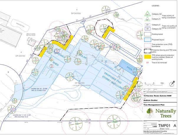
Figure 1: Area shaded green for potential location of new works
In summary, the proposal cannot be supported for the following reasons:
· Cleared areas of the site have not been utilised to avoid native vegetation and hollow bearing trees. The southern cleared area could support development to avoid pressures on pockets of vegetation to the western and eastern sides of the proposal.
3.1.2 Tree and Vegetation Preservation
The proposed development would necessitate the removal of 37 trees which includes the trees that require removal for the asset protection zone requirements to be met. The application has been supported by an Arborist report that provided a tree schedule identifying health and value of trees on the site, 24 of which require removal that are considered of medium to high significance and important for retention on the site.
Similarly to the biodiversity assessment outlined above, Council Tree Management Team objected to the original design, requesting amendments to the design and location of the dwelling be made.
Council’s tree assessment of the amended design is outlined as follows:
· The site was previously extensively cleared and whilst the regulatory element of the clearing matter has been addressed by Council and does not form part of this assessment process, it is important to note that the area of already cleared vegetation should be considered for the proposed development.
· The proposal indicates the placement of ancillary structures and building footprint would straddle part of the cleared area and a number of the remaining/retained trees within the RU4 portion of the block. Taking into consideration this type of configuration; 15 trees are within the footprint, and a further 22 trees would require removal for the APZ requirements.
· The clearing that was previously undertaken resulted in the creation of a cleared envelope of approximately 1246m². The proposed overall building footprint (excluding driveway) is approximately 979m², which could fit within the already cleared area of the site.
· There is a large, cleared envelope which the building footprint could be re-orientated within and would result in a reduced size and scale of the driveway element and a reduced number of trees required to be removed for the driveway and the overall defendable space.
In summary, the proposal cannot be supported for the following reasons:
· The property has alternative locations which can be utilised as a building footprint and would result in a reduced number of trees required to be removed and would reduce the adverse effect of the remnant vegetation community within the subject property and or adjoining property.
· In accordance with Section 4.15(1)(a)(iii) of the Environmental Planning and Assessment Act 1979, the proposal does not comply with the desired outcome and the prescriptive measures of the HDCP as follows:
o The proposal does not comply with the desired outcome of Part 1C.1.1 Biodiversity of the Hornsby Development Control Plan which states:
Development should seek to:
i) Avoid potential adverse impact on biodiversity.
ii) If that impact cannot be avoided, minimise that impact.
iii) If the impact cannot be minimised, to mitigate the impact.
Development should seek to retain unique environmental features of the site including:
iv) Rock outcrops.
v) Groups of significant trees and vegetation.
vi) Mature hollow trees and other fauna habitat features on the site.
o The development is inconsistent with Part 1B.6.1 and 6.2 Tree and Vegetation Preservation requirements of the HDCP and does not adequately demonstrate the preservation of significant trees and vegetation on the site.
3.1.3 Stormwater Management
Submissions received raised concerns with respect to potential stormwater runoff and existing stormwater issues within the site and its surrounds.
The proposed development would connect to the existing drainage easement that runs down the north-western side of the site as detailed in the supporting stormwater management plans prepared by CAM Consulting.
Council’s engineering assessment considered that the design would be acceptable for the site and no further concerns are raised in this regard.
3.2 Built Environment
Being less than the 10.5 metre maximum height for the site, the building would sit sympathetically within the rural landscape, minimising the visual impact of the development from within the streetscape and adjoining properties.
3.3 Social Impacts
The rural residential development would be consistent with Council’s Housing Strategy which identifies the need to provide a mix of housing options to meet future demographic needs in Hornsby Shire. Notwithstanding, concerns are raised regarding the vegetation and biodiversity impacts of the development.
3.4 Economic Impacts
The proposal would have a minor positive impact on the local economy in conjunction with other new low density residential development in the locality by generating an increase in demand for local services.
4. SITE SUITABILITY
Section 4.15(1)(c) of the Act requires Council to consider “the suitability of the site for the development”.
The subject site has been identified as bushfire prone land. The site is considered to be capable of accommodating the proposed development, however the siting of the dwelling house would result in vegetation and biodiversity impacts.
4.1 Bushfire Risk
Submissions received raised concerns with regards to the potential bushfire risk of the proposed development, including water supply and construction requirements.
As identified within the Bushfire Assessment Report prepared by Building Code and Bushfire Hazard Solutions, the property is located in an area with a bushfire rating of BAL Flame Zone and was referred to the NSW RFS for concurrence in accordance with Section 4.14 of the Environmental Planning and Assessment Act 1979.
The NSW RFS considered the development and supporting Bushfire Assessment Report and provided a number of conditions to be applied to the consent. If Council were to grant approval to the development, these conditions would be applied and are considered consistent with the relevant asset protection zone, construction standards, water and utility service and landscaping requirements of Planning for Bushfire Protection 2019. Tree removal for the required Asset Protection Zone has been incorporated in the overall number of trees to be removed, as discussed within Sections 3.1.1 and 3.1.2 of this report.
5. PUBLIC PARTICIPATION
Section 4.15(1)(d) of the Act requires Council to consider “any submissions made in accordance with this Act”.
5.1 Community Consultation
The proposed development was placed on public exhibition and was notified to adjoining and nearby landowners between 18 February 2022 and 10 March 2022 and re-notified between 1 June 2022 and 23 June 2022 in accordance with the Hornsby Community Engagement Plan. During the two notification periods, Council received 48 submissions. The map below illustrates the location of those nearby landowners who made a submission that are in close proximity to the development site.
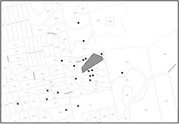
|
NOTIFICATION PLAN |
|||
|
• PROPERTIES NOTIFIED |
X SUBMISSIONS RECEIVED |
|
|
|
36 SUBMISSIONS RECEIVED OUT OF MAP RANGE |
|||
48 submissions were received during the two notification periods, 25 in favour and 23 against the development. Issues raised include:
· Impacts on trees and biodiversity
· Level of excavation required
· Stormwater runoff and existing stormwater issues within site and its surrounds
· Amenity impacts to the adjoining properties - concerns around impacts to private open spaces, overlooking of windows, proposed driveway within 10 metres of adjoining boundary
· Lack of consideration to rural setting
· Previously illegally cleared site
· Concerns regarding construction works and construction vehicle requirements
· Concerns regarding use of dwelling for business purposes
· Bushfire risk of proposed development – water supply and construction requirements
The merits of the matters raised in community submissions have been addressed in the body of the report with the exception of the following:
5.1.1 Impacts on trees and biodiversity
A number of submissions raised concerns with regards to tree and biodiversity impacts of the proposed development. Sections 3.1.1 and 3.1.2 of the report provided a detailed response to these concerns.
5.1.2 Amenity impacts to the adjoining properties - concerns around impacts to private open spaces, overlooking of windows, proposed driveway within 10 metres of adjoining boundary
A number of submissions raised concerns with regards to amenity impacts of the proposed development. Sections 2.7.1 and 2.7.3 of the report provided a detailed response to these concerns.
5.1.3 Lack of consideration to rural setting
The environmental impacts associated within the proposal have not adequately considered the rural setting and its surrounds.
5.1.4 Previously illegally cleared site
A number of submissions raised concerns with regards to the previous clearing of the site. As stated in the Background section of the report, in February 2021, after ongoing investigation, Penalty Infringement Notices were issued to the previous owner of property regarding illegal clearing, with fines issued and paid, resulting in the matter being closed. Council did not have adequate evidence to pursue the matter further. As such this is not a matter for consideration under Section 4.15 of the Act and any previous clearing works cannot be included in the overall vegetation clearing calculations.
5.1.5 Concerns regarding construction works and construction vehicle requirements
If Council were to grant approval to the development, a number of conditions to protect amenity of neighbours within the area would be applied to ensure controlled and managed levels of construction works would occur on the site and within the restricted construction hours of 7am to 5pm Monday to Saturday. It is inevitable that construction works would have some level of impact to adjoining neighbour; however, controlling and appropriately managing these works would aim to minimise construction impacts to the locality.
5.1.6 Concerns regarding use of dwelling for business purposes
Whilst the application proposes a dwelling house which is a permitted use within the zone, if Council were to grant approval to the development, a ‘use of premises’ condition would be applied to ensure the site is used for domestic purposes only.
5.1.7 Submissions in Favour
Whilst it is recognised that a number of submissions were received in support of the proposal, the environmental implications of the development were considered too great, and the overall proposal could not be supported on biodiversity and tree preservation grounds.
5.2 Public Agencies
The development application was referred to the following Agencies for comment:
5.2.1 Rural Fire Service
Given the site has a bushfire attack level rating of BAL Flame Zone, the application was referred to the NSW RFS for advice.
As per the discussion under Section 4.1 of this report, the NSW RFS considered the development and supporting Bushfire Assessment Report prepared by Building Code & Bushfire Hazard Solutions and provided a number of conditions to be applied if consent is granted. If Council were to grant approval to the development, these conditions would be applied to the consent and are considered consistent with the relevant requirements of Planning for Bushfire Protection 2019.
6. THE PUBLIC INTEREST
Section 4.15(1)(e) of the Act requires Council to consider “the public interest”.
The public interest is an overarching requirement, which includes the consideration of the matters discussed in this report. Implicit to the public interest is the achievement of future built outcomes adequately responding to and respecting the future desired outcomes expressed in environmental planning instruments and development control plans.
The application is considered to have satisfactorily addressed Council’s and relevant agencies’ criteria and would provide a development outcome that, on balance, would result in a positive impact for the community. Accordingly, it is considered that the approval of the proposed development would be in the public interest.
CONCLUSION
The application proposes the construction of a dwelling house, swimming pool, shed, driveway and associated landscaping.
The development fails to meet the desired outcomes of Council’s planning controls and is satisfactory having regard to the matters for consideration under Section 4.15 of the Environmental Planning and Assessment Act 1979.
Council received 48 submissions during the public notification periods. The matters raised have been addressed in the body of the report.
Having regard to the circumstances of the case, refusal of the application is recommended.
The reasons for this decision are:
· The proposed development location and design is not suitable for the site and does not comply with the Tree Preservation or Biodiversity requirements of the Hornsby Development Control Plan 2013.
· The proposed development does not meet the earthworks, landscaping or setback requirements of the Hornsby Local Environmental Plan 2013 and Hornsby Development Control Plan 2013.
Note: At the time of the completion of this planning report, no persons have made a Political Donations Disclosure Statement pursuant to Section 10.4 of the Environmental Planning and Assessment Act 1979 in respect of the subject planning application.
RESPONSIBLE OFFICER
The officer responsible for the preparation of this report is Madeleine Brown.
|
Cassandra Williams Major Development Manager - Development Assessments Planning and Compliance Division |
Rod Pickles Manager - Development Assessments Planning and Compliance Division |
|
Locality Plan |
|
|
|
|
Architectural Plans |
|
|
|
|
Landscape Plans |
|
|
File Reference: DA/147/2022
Document Number: D08440301
SCHEDULE 1
2. The proposed development is unsatisfactory in respect to the provisions of Section 4.15(1)(a)(iii) of the Environmental Planning and Assessment Act 1979, the proposal does not comply with the desired outcomes and the prescriptive measures of Hornsby Development Control Plan 2013 as follows:
2.1 The proposed development does not comply with the desired outcome of Part 1C.1.1 Biodiversity as the application has not demonstrated that the development has been designed with regard to the ‘avoid, minimise and mitigate’ principles of the Hornsby Development Control Plan 2013 and the Biodiversity Conservation Act 2016.
a) The proposed development has not adequately demonstrated retention of unique environmental features of the site including rock outcrops, group of significant trees and vegetation and mature hollow trees and other fauna habitat features on the site.
2.2 The proposed development does not comply with the requirements of Part 1B.6 Tree and Vegetation Preservation of the HDCP as the development does not adequately demonstrate the preservation of significant trees and vegetation on the site.
2.3 The proposal does not comply with the desired outcome or prescriptive measures within Part 1C.1.4 Earthworks and Slope of the Hornsby Development Control Plan 2013 as it proposes an unacceptable level of excavation that is not considered to respect the landform characteristic of the land or maintain amenity of adjoining properties.
2.4 The proposal does not comply with the desired outcome or prescriptive measures within Part 2.1.2 Setbacks of the HDCP as it does not adequately retain natural landscape features and does not comply with the 15 metre front setback requirement.
2.5 The proposal does not comply with the desired outcome or prescriptive measures within Part 2.1.3 Landscaping of the HDCP as is does not comply with the fencing or gate requirements and proposes extensive hardstand spaces within the front setback which does not adequately demonstrate integrating landscape with the built form.
3. Pursuant to Section 4.15(1)(b) of the Environmental Planning and Assessment Act 1979, it is considered that the proposal would have detrimental environmental impacts on both the natural and built environment in the locality.
4. Pursuant to Section 4.15(1)(c) of the Environmental Planning and Assessment Act 1979, it is considered that the site is not suitable for the proposed development in its current form.
5. Pursuant to the provisions of Section 4.15(1)(a)(d) and (e) of the Environmental Planning and Assessment Act 1979, it is considered that the proposed development would not be in the public interest.
