
DETERMINATION
BUSINESS PAPER
Local Planning Panel meeting
Wednesday 31 August 2022
at 2:30pm
DETERMINATION
BUSINESS PAPER
Local Planning Panel meeting
Wednesday 31 August 2022
at 2:30pm
Hornsby Shire Council Table of Contents
Page 1
ITEMS
Item 1 LPP42/22 DA/568/2022 - Torrens Title Subdivision of an Existing Strata Title Dual Occupancy into Two Lots - 15 Carlisle Crescent, Beecroft............................................................... 1
Item 2 LPP43/22 DA/604/2022 - Refurbishment of an Existing Seniors Housing Development - Hopetoun Village - 146-200 David Road, Castle Hill.................................................... 25
Item 3 LPP48/22 DA/1308/2021 - Alterations and Additions to an Existing Industrial Building - 29 Leighton Place, Hornsby............................................................................................ 50
Item 4 LPP49/22 DA/181/2022 - Demolition of Existing Structures and Construction of a 5 Storey Residential Flat Building Comprising 21 units - 10 and 12 Bellevue Street, Thornleigh... 78
LPP Report No. LPP42/22
Local Planning Panel
Date of Meeting: 31/08/2022
1 DA/568/2022 - TORRENS TITLE SUBDIVISION OF AN EXISTING STRATA TITLE DUAL OCCUPANCY INTO TWO LOTS - 15 CARLISLE CRESCENT, BEECROFT
EXECUTIVE SUMMARY
|
DA No: |
DA/568/2022 (Lodged on 2 June 2022) |
|
Description: |
Torrens Title subdivision of an existing strata title dual occupancy development into two lots. |
|
Property: |
CP SP 41548, No. 15 Carlisle Crescent, Beecroft |
|
Applicant: |
Ms Anne Elizabeth Walker |
|
Owner: |
Owners Corporation - SP 41548 |
|
Estimated Value: |
$0 |
|
Ward: |
C Ward |
· The application involves Torrens Title subdivision of an existing strata title dual occupancy development into two lots.
· The proposal does not comply with Clause 4.1 ‘Minimum subdivision lot size’ of the Hornsby Local Environmental Plan 2013 (HLEP). The applicant has made a submission in accordance with Clause 4.6 ‘Exceptions to development standards’ of the HLEP to contravene the 600m2 minimum lot size development standard. The submission is considered well founded and is supported.
· The application is required to be determined by the Hornsby Local Planning Panel as the proposal would contravene the HLEP development standard for minimum subdivision lot size by more than 10 percent (15.55% contravention).
· No submissions have been received in respect of the application.
· It is recommended that the application be approved.
|
THAT the Hornsby Shire Local Planning Panel assume the concurrence of the Secretary of the Department of Planning and Environment pursuant to Clause 4.6 of the Hornsby Local Environmental Plan 2013 and approve Development Application No. DA/568/2022 for Torrens title subdivision of an existing strata title dual occupancy development into two lots at Lots 1 and 2, SP 41548, No. 15 Carlisle Crescent, Beecroft subject to the conditions of consent detailed in Schedule 1 of LPP Report No. LPP42/22. |
BACKGROUND
On 24 August 1989, Council approved DA/345/2989 for the erection of a detached dual occupancy, subject to conditions.
On 22 March 2019, Council approved DA/1159/2018 for alterations and additions to a dwelling house within a detached dual occupancy strata allotment, subject to conditions.
On 10 December 2019, Council approved DA/1159/2018/A to modify the location and size of windows along the southern and northern elevations, subject to conditions.
On 21 July 2022, Council requested an amended subdivision plan that proposed a reciprocal right of access over a portion of the driveway of adjoining property No. 17 Carlisle Crescent. Council also requested owners’ consent from No. 17 Carlisle Crescent consenting to the reciprocal right of access.
On 5 August 2022, Council received correspondence from No. 17 Carlisle Crescent stating that they would not consent to the reciprocal right of access.
As a consequence, on 8 August 2022, Council requested an amended subdivision plan that provided a legal point of access to the subject site without relying on the adjacent driveway.
On 11 August 2022, Council received the amended subdivision plan which is the subject of this assessment.
SITE
The 1,137.4m2 site is located on the western side of Carlisle Crescent and contains a dual occupancy (detached) development.
The site experiences a fall of 10 metres to Carlisle Crescent.
The site is not burdened or benefitted by any easements or restrictions. The site layout requires the occupants to utilise a portion of the adjoining properties driveway to access the subject site, however no right of access benefits the subject site.
The site is not bushfire prone but is flood prone.
The site does not contain a heritage listed item, is not within the vicinity of a heritage listed item and is not within a heritage conservation area.
PROPOSAL
The application proposes Torrens Title subdivision of an existing strata title dual occupancy development into two lots.
· Proposed Lot 1 would have an area of 584.8m2 (452.6m2 excluding the access handle) and would contain the existing dwelling to the north of the site. Vehicular access to this lot will be via the existing access handle from Carlisle Crescent.
· Proposed Lot 2 would have an area of 552.6m2 (420m2 excluding the access handle) and would contain the existing dwelling to the east of the site. Vehicular access to Lot 2 would be via the existing access handle from Carlisle Crescent.
No amendments to the existing stormwater management system are proposed.
The application also proposes widening the existing driveway and vehicle crossing to provide a legal point of access to the subject site.
No trees would be removed or impacted by the development.
ASSESSMENT
The development application has been assessed having regard to the Greater Sydney Region Plan - A Metropolis of Three Cities, the North District Plan and the matters for consideration prescribed under Section 4.15 of the Environmental Planning and Assessment Act 1979 (the Act). The following issues have been identified for further consideration.
1. STRATEGIC CONTEXT
1.1 Greater Sydney Region Plan - A Metropolis of Three Cities and North District Plan
The Greater Sydney Region Plan - A Metropolis of Three Cities has been prepared by the NSW State Government to guide land use planning decisions for the next 40 years (to 2056). The Plan sets a strategy and actions for accommodating Sydney’s future population growth and identifies dwelling targets to ensure supply meets demand. The Plan also identifies that the most suitable areas for new housing are in locations close to jobs, public transport, community facilities and services.
The NSW Government will use the subregional planning process to define objectives and set goals for job creation, housing supply and choice in each subregion. Hornsby Shire has been grouped with Hunters Hill, Ku-ring-gai, Lane Cove, Mosman, North Sydney, Ryde, Northern Beaches and Willoughby to form the North District. The Greater Sydney Commission has released the North District Plan which includes priorities and actions for Northern District for the next 20 years. The identified challenge for Hornsby Shire will be to provide an additional 4,350 dwellings by 2021 with further strategic supply targets to be identified to deliver 97,000 additional dwellings in the North District by 2036.
The proposed development would not be inconsistent with the Greater Sydney Region Plan - A Metropolis of Three Cities and the North District Plan.
2. STATUTORY CONTROLS
Section 4.15(1)(a) requires Council to consider “any relevant environmental planning instruments, draft environmental planning instruments, development control plans, planning agreements and regulations”.
2.1 Hornsby Local Environmental Plan 2013
The proposed development has been assessed having regard to the provisions of the Hornsby Local Environmental Plan 2013 (HLEP).
2.1.1 Zoning of Land and Permissibility
The subject land is zoned R2 Low density residential under the HLEP. The objectives of the R2 zone are:
· To provide for the housing needs of the community within a low-density residential environment.
· To enable other land uses that provide facilities or services to meet the day to day needs of residents.
The proposed development is defined as ‘subdivision’ and is permissible in the zone with Council’s consent.
2.1.2 Permissibility
The approved development is defined as ‘dual occupancy (detached)’ under the HLEP and is prohibited in the R2 zone.
Notwithstanding, the site is deemed to enjoy existing use rights pursuant to Clause 4.65(a)(i) of the Act as “the use of (the) building, work or land……for which development consent was granted before the commencement of a provision of an environmental planning instrument having the effect of prohibiting the use”. The ‘dual occupancy’ use compromising a single dwelling-house on each strata lot was approved prior to the gazettal of the HLEP on 11 October 2013.
The proposed Torrens title subdivision would not alter the intensity or scale of the existing development on the site and would convert a prohibited ‘dual occupancy’ development to a permissible use within the R2 Low density residential zone under the HLEP. Once the Torrens title subdivision is registered, the dual occupancy would be treated as two separate dwelling houses, and therefore the HLEP and HDCP controls pertaining to dwelling houses would apply. The proposed Torrens title subdivision is permitted under the Environmental Planning and Assessment Regulation 2021 with development consent.
2.1.3 Minimum Lot Size
Clause 4.1 of the HLEP prescribes that the minimum subdivision lot size is not to be less than shown for the land on the minimum Lot Size Map, which is 600m2.
The proposed subdivision would result in proposed Lot 1 having an area of 584.8m2 (452.6m2 excluding the access handle) which would result in a 25% contravention to the minimum lot size development standard. Proposed Lot 2 would have an area of 552.6m2 (420m2 excluding the access handle) which would result in a 30% contravention to the minimum lot size development standard.
The application is supported by a submission pursuant to Clause 4.6 of the HLEP to contravene the minimum 600m2 minimum lot size development standard, which is discussed below in Section 2.1.4 of this report.
2.1.4 Exceptions to Development Standards
The application has been assessed against the requirements of Clause 4.6 of the HLEP. This clause provides flexibility in the application of the development standards in circumstances where strict compliance with those standards would, in any particular case, be unreasonable or unnecessary or tender to hinder the attainment of the objectives of the zone.
The proposal exceeds the minimum lot size requirements specified in the HLEP Clause 4.1 ‘Minimum subdivision lot size’ which requires a minimum lot size, as per the ‘Lot Size Map’ of 600m2.
The Objectives of Clause 4.1 of HLEP are as follows:
(1) The objectives of this clause are as follows—
a) To provide for the subdivision of land at a density that is appropriate for the site constraints, development potential and infrastructure capacity of the land,
b) To ensure that lots are of a sufficient size to accommodate development.
The applicant has made a submission in support of the contravention to the development standard in accordance with Clause 4.6 of the HLEP. Clause 4.6 provides that development consent must not be granted for development that contravenes a development standard unless the consent authority has considered a written request from the applicant that seeks to justify the contravention of the development standard by demonstrating:
(a) That compliance with the development standard is unreasonable or unnecessary in the circumstances of the case, and
(b) That there are sufficient environmental planning grounds to justify contravening the development standard.
Council must be satisfied that the written request provided by the applicant under Clause 4.6 addresses both the unreasonable and unnecessary test and demonstrates sufficient environmental planning grounds to justify contravening the development standard. These matters are discussed below.
2.1.4.1 Unreasonable or Unnecessary Clause 4.6(3)(a)
There are five common methods by which an applicant can demonstrate that compliance with a development standard is unreasonable or unnecessary in the circumstances of the development. Initially proposed for objections under clause 6 of SEPP 1 in the decision of Wehbe v Pittwater Council [2007] NSWLEC 827 Pearson C summarised and applied these methods to written requests made under Clause 4.6 in Four2Five Pty Ltd v Ashfield Council [2015] NSWLEC 1009 [61-62]. These five methods are generally as follows:
· The objectives of the development standard are achieved notwithstanding non-compliance with the standard.
· The underlying objective or purpose is not relevant to the development.
· That the objective would be defeated or thwarted if compliance was required.
· That the development standard has been virtually abandoned or destroyed by the Council’s own actions in departing from the standard.
· The zoning of the land is unreasonable or inappropriate.
It is not required to demonstrate that a development meets multiple methods as listed above, and the satisfaction of one can be adequate to demonstrate that the development standard is unreasonable or unnecessary.
The written request prepared by Barry Hunt Associates, dated 29 June 2022 provides a detailed assessment of the proposal with respect to the development standard sought to be contravened. The request argues that:
· The dwellings located on the site are existing and are to be retained as part of this application.
· No physical works are proposed on the site other than replacement of a water isolation valve with a water metre to effect the change in title tenure and therefore no environmental impact will occur.
· The proposed dividing boundary between the 2 properties replicates the existing 1992 strata dividing boundary.
· The proposed subdivision is required to rectify an outdated Strata Plan which no longer reflects approved buildings on the site.
· The approved detached dual occupancy buildings have provided separately titled dwellings for over 30 years. The proposal continues to reflect the existing site conditions, generating no adverse impacts on adjoining properties.
· The proposed development will not alter the residential capacity of the site.
· The proposed conventional land Torrens Title Subdivision removes the management burden of a strata scheme, that serves no benefit for 2 freestanding detached dwellings.
· Following subdivision, the 2 lots can be can function separately and be managed independently without the need for an Owners Corporation, removing the burden of a strata scheme that provides no positive effects on the property owners.
· Conversion from strata title to conventional land Torrens Title Subdivision will allow existing and future owners freedom of choice on lots and dwellings with proven suitability for residential purposes.
· The proposed subdivision pattern matches the existing strata boundaries and is consistent with the adjoining subdivision pattern in the area. The proposed subdivision pattern will not adversely impact other landowners in the area.
· The change in area from the 600m² development standard does not undermine the underlying objectives of the R2 Low Density Residential zone to provide for the housing needs of the community within a low density residential environment.
· No physical change is proposed as a result of this application to vary the subdivision tenure from strata to conventional land Torrens Title Subdivision. Conversion of the existing strata subdivision to a conventional land Torrens Title Subdivision maintains the as-built status quo.
· Subdivision replicates what is already in in existence on the ground and simply changes the titling system utilised to define ownership on paper. The shape and size of lots correspond with existing lot layout. Lots are limited by existing dwellings, driveways and services. All site constraints have been considered in defining the proposed boundary locations
· No additional dwelling entitlements are created by the boundary adjustment. The opportunity to create a conventional land Torrens Title subdivision, reflecting the current built form, with independent ownership of each lot is considered a desirable outcome.
· The variation to the minimum lot size standard is considered inconsequential relative to the benefit of correcting a superseded Strata Plan and providing a legal and viable subdivision alternative with independent housing choice.
· The underlying objectives or purpose of the standard to provide land at a density that is appropriate for site constraints has been demonstrated by the existence of established long-standing dwellings on each of the lots which are of sufficient size to accommodate development.
· The underlying objectives or purpose would be defeated or thwarted if compliance was required, as strict compliance with the development standard would result in a missed opportunity to create independent living with each registered proprietor responsible for decisions pertaining to their own property. Therefore, compliance is unreasonable.
· There is no public benefit in maintaining the 600m² minimum lot size development standard as both lots already have an existing approved dwelling and no additional dwelling entitlements will arise from the termination of the existing strata and conversion to conventional land Subdivision. Varying the development standard will not compromise the development form envisaged by the planning controls adopted by Council.
· The development standard has effectively been annulled by Council as prior approvals have granted consent for construction of buildings and the subdivision thereof, creating lots less than 600m².
Council notes that the objectives of Clause 4.1 of the HLEP are as follows:
(b) To ensure that lots are of a sufficient size to accommodate development.
With reference to the reasoning provided by the applicant above, Council does not object to the conclusion that the proposed subdivision meets the objectives of Clause 4.1. In reaching this conclusion the following points are noted:
· The proposal seeks approval for the Torrens title subdivision of an existing dual occupancy (detached).
· There would be no change to the existing density of development on the site and the existing infrastructure supports the capacity of the land.
· The proposal does not seek approval for any physical works with the subdivision limited to a change in the title of the property and minor works to the existing driveway and vehicle crossing.
· The granting of consent does not create a precedent on the basis that the construction of a new dual occupancy is prohibited within the R2 zone.
· The existing dual occupancy (attached) is provided with separate services and is ideally suited to the subdivision as proposed. The strata subdivision currently has no common property (excluding the existing access handle).
· The proposed subdivision will not result in any detrimental impacts.
For the reasons outlined above, it is considered that the written request to contravene the height of building standard adequately demonstrates that the objectives of the minimum lot size development standard contained within Clause 4.1 of the HLEP are achieved, notwithstanding non-compliance with the standard.
2.1.4.2 Environmental Planning Grounds - Clause 4.6(3)(b)
In addition to demonstrating that compliance is unreasonable or unnecessary, Clause 4.6(3)(b) requires that there are sufficient environmental planning grounds to justify contravening the development standard. In demonstrating that sufficient environmental planning grounds exist it must be demonstrated that the planning grounds are particular to the circumstances of the development on the subject site (summarised from Four2Five Pty Ltd v Ashfield Council [2015] NSWLEC 1009 [60].
The applicant provided the following planning grounds for the contravention of the development standard:
· Approval of existing dwellings on each of the lots demonstrates compliance with environmental planning controls such as access for light and air, open space areas, carparking, traffic movement enabling vehicle ingress and egress and a forward direction, provision for landscaping, private and public amenity, streetscape, building form, height and setbacks.
· Each of these residential design guidelines have been considered by Council and approved with prior development consents. The conversion of subdivision tenure proposed by this application will not result in any physical construction works or corresponding environmental impact.
· Subdivision density is not changing. It is only the title tenure system that requires amendment because the existing Strata Plan no longer reflects buildings approved and constructed on the site. No amendment to Development potential, site constraints and infrastructure capacity are required.
· Long-standing, existing functioning dwellings are evidence that lots are of sufficient size to accommodate development. Adequate site area, solar access, open space, parking, vehicular access and site amenity exist on the site and were addressed with prior approvals for construction of dwellings on the site. No changes are sought as a consequence of this application.
· Areas of each of the proposed lots correspond to the existing approved lots (see table in attached statement of environmental effects).
· Contravention of the development standard does not raise any matter of significance for State or regional environmental planning. The existing and proposed development form part of infill development in an established residential precinct, with no potential for impact outside the immediate vicinity of the site. Thus, no matters of significance for State or regional environmental planning exist.
· Both existing lots are already smaller than the minimum lot size requirements under the R2- low density residential zoning. The dual occupancy use, comprising freestanding single dwellings on each lot and the subsequent strata subdivision was approved prior to the gazettal of the Hornsby Local Environmental Plan (LEP) on 11/10/2013. Under clause 4.65 (b) of The Environmental Planning and Assessment Act 1979 “the use of the building, work or land… for which development consent was granted before the commencement of a provision of an environmental planning instrument having the effect of prohibiting the use”, affords existing use rights. Thus, converting the existing strata subdivision to a conventional land Torrens Title Subdivision maintains the status quo and utilises existing use rights.
Council considers that the environmental planning grounds stated within the written request are sufficient with respect to Clause 4.6(3)(b) and that the stated grounds are specific to the proposed development and the circumstances of the development site. It is therefore considered that the written request adequately demonstrates compliance with the clause and is acceptable in this regard.
In demonstrating the unreasonable and unnecessary test, the applicant further established satisfactory environmental planning grounds with respect to the site and the surrounding constraints.
Council is therefore satisfied that Clause 4.6(3)(b) of the HLEP is adequately addressed.
2.1.4.3 Public Interest and Clause 4.6(4)
Clause 4.6(4) states that development consent must not be granted for development that contravenes a development standard unless:
(a) The consent authority is satisfied that:
(i) The applicant’s written request has adequately addressed the matters required to be demonstrated by subclause (3), and
(ii) The proposed development will be in the public interest because it is consistent with the objectives of the particular standard and the objectives for development within the zone in which the development is proposed to be carried out, and
(b) The concurrence of the Planning Secretary has been obtained.
With regard to part (a)(i), the written request is considered to adequately address the matters required to be demonstrated as outlined above.
With regard to part (a)(ii), the proposed development is considered to be in the public interest because it is consistent with the objectives of the particular standard and the objectives for development within the zone in which the development is proposed to be carried out.
· The development contravenes a numerical standard by greater than 10%.
· The variation is to a non-numerical standard.
Local Planning Panels constituted under the Environmental Planning and Assessment Act 1979 exercise consent authority functions on behalf of a Council and are not delegates of Council. Therefore, Local Planning Panels may determine a development application notwithstanding, a numerical non-compliance in excess of 10%.
Therefore, the exceedance of the minimum lot size development standard is supported in this instance.
2.1.5 Heritage Conservation
Clause 5.10 of the HLEP sets out heritage conservation provisions for Hornsby Shire. The site does not include a heritage item and is not located in a heritage conservation area. Accordingly, no further assessment regarding heritage is necessary.
2.1.6 Earthworks
Clause 6.2 of the HLEP states that consent is required for proposed earthworks on site. Before granting consent for earthworks, Council is required to assess the impacts of the works on adjoining properties, drainage patterns and soil stability of the locality.
Council’s assessment of the proposed works and excavation concludes that the proposed widening of the driveway and vehicle crossing would create minimum if any earthworks and it is generally considered that the widening of the driveway and vehicle crossing would have negligible environment or amenity impacts to adjoining properties.
2.2 State Environmental Planning Policy (Biodiversity and Conservation) 2021
2.2.1 Chapter 10 Sydney Harbour Catchment
The plan addresses matters related to biodiversity, ecology and environment protection; public access to, and use of, foreshores and waterways; maintenance of a working harbour; interrelationship of waterway and foreshore uses; foreshore and waterways scenic quality; maintenance, protection and enhancement of views and boat storage facilities.
Subject to the implementation of sediment and erosion control measures and stormwater management to protect water quality, the proposal would have minimal potential to impact on the Sydney Harbour Catchment and would comply with the requirements of chapter 10 of the Biodiversity and Conservation SEPP.
2.3 State Environmental Planning Policy (Resilience and Hazards) 2021
2.3.1 Chapter 4 Remediation of Land
Should the land be contaminated, Council must be satisfied that the land is suitable in a contaminated state for the proposed use. If the land requires remediation to be undertaken to make the land suitable for the proposed use, Council must be satisfied that the land will be remediated before the land is used for that purpose.
An examination of Council’s records and aerial photography has determined that the site has been historically used for residential purposes. It is not likely that the site has experienced any significant contamination, and further assessment under chapter 4 of the Resilience and Hazards SEPP is not required.
2.4 Section 3.42 Environmental Planning and Assessment Act 1979 - Purpose and Status of Development Control Plans
Section 3.42 of the Environmental Planning and Assessment Act 1979 states that a DCP provision will have no effect if it prevents or unreasonably restricts development that is otherwise permitted and complies with the development standards in relevant Local Environmental Plans and State Environmental Planning Policies.
The principal purpose of a development control plan is to provide guidance on the aims of any environmental planning instrument that applies to the development; facilitate development that is permissible under any such instrument; and achieve the objectives of land zones. The provisions contained in a DCP are not statutory requirements and are for guidance purposes only. Consent authorities have flexibility to consider innovative solutions when assessing development proposals, to assist achieve good planning outcomes.
2.5 Hornsby Development Control Plan 2013
The proposed development has been assessed having regard to the relevant desired outcomes and prescriptive requirements within the Hornsby Development Control Plan 2013 (HDCP). The following table sets out the proposal’s compliance with the prescriptive requirements of the Plan:
|
HDCP - Part 6 Subdivision |
|||
|
Control |
Proposal |
Requirement |
Complies |
|
Site Area |
1,137.4m2 |
N/A |
N/A |
|
Lot Area |
|
|
|
|
- Lot 1 |
584.8m2 (452.6m2 exc. access handle) |
600m2 |
No |
|
- Lot 2 |
552.6m2 (420m2 exc. access handle) |
600m2 |
No |
|
Minimum Lot Width at Frontage |
|
|
|
|
- Lot 1 |
16m |
15m |
Yes |
|
- Lot 2 |
20m |
15m |
Yes |
Existing dwelling house on proposed (Lot 1):
|
HDCP - Part 3.1 Dwelling Houses |
|||
|
Control |
Proposal |
Requirement |
Complies |
|
Site Area |
420m2 |
600m2 |
No |
|
Building Height |
7.7m |
8.5m |
Yes |
|
No. storeys |
2 |
max. 2 + attic |
Yes |
|
Site Coverage |
44% |
max. 55% |
Yes |
|
Floor Area |
277m2 |
270m2 |
No |
|
Setbacks |
|
|
|
|
- Side (northern) |
|
|
|
|
Ground floor |
4.33m |
900mm |
Yes |
|
First floor |
3.52m |
1.5m |
Yes |
|
- Side (eastern) |
|
|
|
|
Ground floor |
3.5m |
900mm |
Yes |
|
First floor |
1.81m |
1.5m |
Yes |
|
- Side (southern) |
|
|
|
|
Ground floor |
1.84m |
900mm |
Yes |
|
First floor |
1.74m |
1.5m |
Yes |
|
- Rear (western) |
|
|
|
|
Ground floor |
970mm |
3m |
No |
|
Landscaped Area (% of lot size) |
17% |
min. 15% |
Yes |
|
Private Open Space |
|
|
|
|
- minimum area |
>24m2 |
24m2 |
Yes |
|
- minimum dimension |
>3m |
3m |
Yes |
|
Car Parking |
2 spaces |
2 spaces |
Yes |
Existing dwelling house on proposed (Lot 2):
|
HDCP - Part 3.1 Dwelling Houses |
|||
|
Control |
Proposal |
Requirement |
Complies |
|
Site area |
420m2 |
600m2 |
No |
|
No. storeys |
1 storey |
max. 2 + attic |
Yes |
|
Site Coverage |
42% |
55% |
Yes |
|
Floor Area |
180m2 |
270m2 |
Yes |
|
Setbacks |
|
|
|
|
- Front (west) |
14.5m |
0.9m |
Yes |
|
- Side (north) |
0m |
0.9m |
No |
|
- Side (south) |
1.9m |
0.9m |
Yes |
|
- Rear (east)
|
15.2m |
3m |
No |
|
Landscaped Area (% of lot size) |
48% |
15% |
Yes |
|
Private Open Space |
|
|
|
|
- minimum area |
>24m2 |
24m2 |
Yes |
|
- minimum dimension |
>3m |
3m |
Yes |
|
Car Parking |
2 spaces |
2 spaces |
Yes |
As detailed in the above table, the proposed development does not comply with a number of prescriptive requirements within the HDCP. The matters of non-compliance are detailed below, as well as a brief discussion on compliance with relevant desired outcomes.
2.5.1 Scale (Floor Area)
The desired outcome of Part 3.1.1 Scale of the HDCP encourages “development with a height, bulk and scale that is compatible with a low density residential environment”.
This is supported by the prescriptive measure which states that sites with an area if 300m² to 499m² should comply with the maximum floor area in Table 3.1.1(c): being 270m².
The total floor area of the existing dwelling house within proposed lot 2 is 277m², which does not comply with the prescriptive measures.
It is noted that this non-compliance was approved by Council under DA/1159/2018 and the following justification was provided for this non-compliance:
This 7m² non-compliance is considered acceptable, as all other aspects of the proposal, apart from a minor rear setback non-compliance, comply with the prescriptive measures and the variation would not contribute to the height and visual bulk of the dwelling house. Further, no outbuildings exist on the site and the area allowance for an outbuilding is 45m², which in this instance has been considered in the variation of floor area.
The proposal meets the desired outcomes of Part 3.1.1 Scale of the HDCP and is considered acceptable.
2.5.2 Setbacks
The desired outcomes of Part 3.1.2 Setbacks of the HDCP are to encourage “setbacks that are compatible with adjacent development and complement the streetscape”.
The prescriptive measures set out in Table 3.1.2(a) require a rear boundary setback of 3 metres for one storey elements.
The dwelling house on proposed Lot 2 has a rear setback of 970mm which does not comply with the prescriptive measure.
In support of this non-compliance, it is noted that this was approved under DA/1159/2018 which provided the following justification:
In support of this non-compliance, the application proposes alterations and additions to an existing dwelling house that is already set back 931mm from the rear boundary. The rear alterations are minor in scale, but would slightly increase the rear setback to 970mm. As such, the proposal would have negligible additional amenity impacts to the adjoining neighbour at the rear and no objection is raised to this encroachment on planning grounds.
The proposal meets the desired outcomes of Part 3.1.2 Setbacks of the HDCP and is considered acceptable.
2.5.3 Landscaping
The desired outcome of Part 3.1.3 of HDCP are to encourage “landscaping that integrates the built form with soft canopy and retains and enhances the tree canopy” and “development that retains the existing landscape features”. These desired outcomes are supported by prescriptive controls requiring that each lot have a minimum of 15% of the site area being landscaped.
Notwithstanding the departure to minimum lot size development standard under HLEP, both proposed lots comply with their respective minimum landscaping requirements for dwelling houses under Part 3.1.3 of HDCP.
The proposal complies with Part 3.1.3 of HDCP and is considered acceptable
2.5.4 Open Space
The desired outcome of Part 3.1.4 Open Space is “private open space that functions as an extension to the dwelling house”. This desired outcome is supported by the prescriptive control that each lot have a minimum of 24m2 of private open space, with a minimum width of 3m. Both lots have greater than the required minimum private open space area.
The proposal complies with Part 3.1.4 Open Space and is considered acceptable.
2.5.5 Vehicular Access and Parking
The site is accessed by an existing battle-axe driveway. It is noted that to access the subject site the occupants are required to drive over a portion of driveway that is owned by the adjacent property No. 17 Carlisle Crescent. It is further noted that the owner of No. 17 Carlisle Crescent uses a portion of driveway owned by the subject site to access their property.
To address the legal point of access to the subject site, Council requested an amended subdivision plan proposing a reciprocal right of access over the affected section of the driveways to allow both lots to have legal points of entry to their properties. Council also requested owners’ consent from No. 17 Carlisle Crescent consenting to the reciprocal right of access burdening and benefitting their lot.
The owner of No. 17 Carlisle Crescent advised Council that they would not be providing their consent.
Therefore, the applicant was required to amend the proposed subdivision plan to widen the existing driveway to allow a minimum width of 3 metres at the front of the subject site to meet Council’s requirements for internal driveway access. This also requires the applicant to widen the existing vehicular crossing to accommodate the proposed driveway extension.
The proposed amended driveway access is considered acceptable, and conditions are recommended in Schedule 1 of this report for the driveway construction and vehicle crossing.
2.6 Section 7.11 Contributions Plans
A Section 7.11 Contribution is not applicable as the development would not increase demand for services and no additional dwellings are proposed as the existing dual occupancies are to be retained as approved under DA/345/2989.
3. ENVIRONMENTAL IMPACTS
Section 4.15(1)(b) of the Act requires Council to consider “the likely impacts of that development, including environmental impacts on both the natural and built environments, and social and economic impacts in the locality”.
3.1 Natural Environment
3.1.1 Tree and Vegetation Preservation
The proposed development does not require the removal of any trees.
3.1.2 Stormwater Management
The existing dwellings and hard paved areas drain towards Carlisle Crescent adjacent to the existing driveway.
The application does not propose to alter the existing stormwater drainage system for both Lot 1 and Lot 2 and no building works are proposed that would increase the stormwater runoff.
A condition is recommended in Schedule 1 of this report requiring the creation of a drainage easement over the existing drainage infrastructure servicing the subject site.
3.2 Built Environment
3.2.1 Built Form
The application does not propose any physical works excluding a minor extension to the existing driveway. The existing structures on the subject site would remain unchanged and therefore there is no change to the existing built form.
3.3 Social Impacts
The conversion from strata to Torrens title subdivision would improve housing choice in the locality by providing a range of household types. This is consistent with Council’s Housing Strategy which identifies the need to provide a mix of housing options to meet future demographic needs in Hornsby Shire.
3.4 Economic Impacts
The proposal would remove the burden of maintaining the cost of a strata scheme and improve the economic value of the property.
4. SITE SUITABILITY
Section 4.15(1)(c) of the Act requires Council to consider “the suitability of the site for the development”.
The subject site has not been identified as bushfire prone but is flood prone. The flooding impact is discussed below:
4.1 Flooding
Part of the land the subject of the development is identified as being impacted by an overland flow path.
As the application does not propose additional building works that would impact the overland flow path, no objections are raised by Council’s engineer to the proposed development in regard to flooding.
5. PUBLIC PARTICIPATION
Section 4.15(1)(d) of the Act requires Council to consider “any submissions made in accordance with this Act”.
5.1 Community Consultation
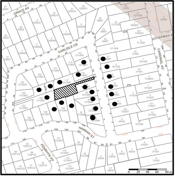
The proposed development was placed on public exhibition and was notified to adjoining and nearby landowners between 7 June 2022 and 30 June 2022 in accordance with the Hornsby Community Engagement Plan. During this period, did not receive any submissions. The map below illustrates the location of those nearby landowners who made a submission that are in close proximity to the development site.
|
NOTIFICATION PLAN |
|||
|
• PROPERTIES NOTIFIED |
X SUBMISSIONS RECEIVED |
|
|
5.2 Public Agencies
The development application was not referred to any Public Agencies for comment.
6. THE PUBLIC INTEREST
Section 4.15(1)(e) of the Act requires Council to consider “the public interest”.
The public interest is an overarching requirement, which includes the consideration of the matters discussed in this report. Implicit to the public interest is the achievement of future built outcomes adequately responding to and respecting the future desired outcomes expressed in environmental planning instruments and development control plans.
The application is considered to have satisfactorily addressed Council’s and relevant agencies’ criteria and would provide a development outcome that, on balance, would result in a positive impact for the community. Accordingly, it is considered that the approval of the proposed development would be in the public interest.
CONCLUSION
The application proposes the Torrens title subdivision of an existing strata title dual occupancy development into two lots.
The development generally meets the desired outcomes of Council’s planning controls and is satisfactory having regard to the matters for consideration under Section 4.15 of the Environmental Planning and Assessment Act 1979.
The application does not comply with the HLEP in respect to the minimum 600m2 lot size. The applicant submitted a written request in response to Clause 4.6 Exceptions to development standard to contravene Clause 4.1 Minimum subdivision lot size development standard. The objection is considered well founded with regard to the approved development on the site and the principles established by the Land and Environment Court.
Having regard to the circumstances of the case, approval of the application is recommended.
The reasons for this decision are:
· The request under Clause 4.6 of Hornsby Local Environmental Plan 2013 to contravene the ‘minimum lot size’ development standard is well founded. Strict compliance with the development standard is considered unreasonable and unnecessary in the circumstances of the case and sufficient environmental planning grounds have been submitted to justify the contravention to the development standard; and
· The proposed development generally complies with the requirements of the relevant environmental planning instruments and the Hornsby Development Control Plan 2013.
· The proposed development does not create unreasonable environmental impacts to adjoining development.
Note: At the time of the completion of this planning report, no persons have made a Political Donations Disclosure Statement pursuant to Section 10.4 of the Environmental Planning and Assessment Act 1979 in respect of the subject planning application.
RESPONSIBLE OFFICER
The officer responsible for the preparation of this report is Tim Buwalda.
|
Cassandra Williams Major Development Manager - Development Assessments Planning and Compliance Division |
Rod Pickles Manager - Development Assessments Planning and Compliance Division |
|
Locality Plan |
|
|
|
|
Clause 4.6 |
|
|
|
|
Subdivision Plan |
|
|
File Reference: DA/568/2022
Document Number: D08443300
SCHEDULE 1
GENERAL CONDITIONS
The conditions of consent within this notice of determination have been applied to ensure that the use of the land and/or building is carried out in such a manner that is consistent with the aims and objectives of the relevant legislation, planning instruments and council policies affecting the land and does not disrupt the amenity of the neighbourhood or impact upon the environment.
Note: For the purpose of this consent, the term ‘applicant’ means any person who has the authority to act on or the benefit of the development consent.
Note: For the purpose of this consent, any reference to an Act, Regulation, Australian Standard or publication by a public authority shall be taken to mean the gazetted Act or Regulation, or adopted Australian Standard or publication as in force on the date that the application for a construction certificate is made.
1. Approved Plans and Supporting Documentation
The development must be carried out in accordance with the plans and documentation listed below and endorsed with Council’s stamp, except where amended by Council and/or other conditions of this consent:
Approved Plans
|
Plan No. |
Plan Title |
Drawn by |
Dated |
Council Reference |
|
1 of 1 rev. E |
Proposed Strata Termination and Boundary Adjustment |
Barry Hunt Associates |
11 August 2022 |
|
2. Construction Certificate
a) A Subdivision Works Certificate is required to be approved by Council or a Private Certifying Authority prior to the commencement of any subdivision works under this consent.
b) A separate Subdivision Works Certificate must be obtained from Council for all works within the public road reserve under S138 of the Roads Act.
c) The Subdivision Works Certificate plans must be consistent with the Development Consent plans.
REQUIREMENTS PRIOR TO THE ISSUE OF A SUBDIVISION WORKS CERTIFICATE
Detailed plans, specifications and supporting information is required to be submitted to the certifying authority detailing how the proposed building work achieves compliance with the National Construction Code - Building Code of Australia. All building work must be carried out in accordance with the requirements of the National Construction Code - Building Code of Australia.
4. Vehicle Crossing
A separate application under the Local Government Act 1993 and the Roads Act 1993 must be submitted to Council for the installation of a new vehicular crossing and the removal of the redundant crossing. The vehicular crossing must be constructed in accordance with AUS-SPEC Specifications (www.hornsby.nsw.gov.au/property/build/aus-spec-terms-and-conditions) and the following requirements:
a) Design levels at the front boundary must be obtained from Council for the design on the internal driveway;
b) The existing driveway crossings must be removed and reconstruct;
c) The footway area must be restored by turfing;
d) Approval must be obtained from all relevant utility providers that all necessary conduits be provided and protected under the crossing.
e) The new crossing must be located minimum of 1m from the existing power pole.
Note: An application for a vehicular crossing can only be made to one of Council’s Authorised Vehicular Crossing Contractors. You are advised to contact Council on 02 9847 6940 to obtain a list of contractors.
5. Internal Driveway/Vehicular Areas
The driveway and parking areas on site must be designed, constructed and a Construction Certificate issued in accordance with Australian Standards AS2890.1, AS3727 and the following requirements:
a) The first 10 metres of the existing driveway from the front boundary must be removed and reconstructed;
b) The new driveway be a rigid pavement.
c) The driveway pavement be a minimum 3 metres wide, 0.125 metres thick reinforced concrete with SL72 steel reinforcing fabric and a 0.15 metre sub-base.
d) All existing utility services including electricity, water, gas and telephone that encroach into the new section of the driveway must be relocated and reinstalled. A certificate from an appropriately licensed contractor shall be submitted to the principal certifying authority certifying that the services have been reinstalled in accordance with the relevant utility provider and Australian Standards.
6. New Driveway within the Easement for Support
The new driveway within the existing Easement for Support is to be designed by a chartered structural engineer, to ensure the new driveway slab does not cause damage to the existing Easement for Support, and both the driveway and Easement for Support will function in a safe and efficient manner.
REQUIREMENTS PRIOR TO THE COMMENCEMENT OF ANY WORKS
7. Erection of Construction Sign
a) A sign must be erected in a prominent position on any site on which any approved work is being carried out:
i) Showing the name, address and telephone number of the principal certifying authority for the work;
ii) Showing the name of the principal contractor (if any) for any demolition or building work and a telephone number on which that person may be contacted outside working hours; and
iii) Stating that unauthorised entry to the work site is prohibited.
b) The sign is to be maintained while the approved work is being carried out and must be removed when the work has been completed.
8. Protection of Adjoining Areas
A temporary hoarding, fence or awning must be erected between the work site and adjoining lands before the works begin and must be kept in place until after the completion of the works if the works:
a) Could cause a danger, obstruction or inconvenience to pedestrian or vehicular traffic;
b) Could cause damage to adjoining lands by falling objects; and/or
c) Involve the enclosure of a public place or part of a public place; and/or
d) Have been identified as requiring a temporary hoarding, fence or awning within the Council approved Construction Management Plan (CMP).
Note: Notwithstanding the above, Council’s separate written approval is required prior to the erection of any structure or other obstruction on public land.
a) To provide a safe and hygienic workplace, toilet facilities must be available or be installed at the works site before works begin and must be maintained until the works are completed at a ratio of one toilet for every 20 persons employed at the site.
b) Each toilet must:
i) be a standard flushing toilet connected to a public sewer; or
ii) be a temporary chemical closet approved under the Local Government Act 1993.
10. Erosion and Sediment Control
To protect the water quality of the downstream environment, erosion and sediment control measures must be provided and maintained throughout the construction period in accordance with the manual ‘Soils and Construction 2004 (Bluebook)’, the approved plans, Council specifications and to the satisfaction of the principal certifying authority. The erosion and sediment control devices must remain in place until the site has been stabilised and revegetated.
Note: On the spot penalties may be issued for any non-compliance with this requirement without any further notification or warning.
REQUIREMENTS DURING CONSTRUCTION
All works on site, including demolition and earth works, must only occur between 7am and 5pm Monday to Saturday.
No work is to be undertaken on Sundays or public holidays.
12. Demolition
To protect the surrounding environment, all demolition work must be carried out in accordance with Australian Standard AS2601-2001 Demolition of structures and the following requirements:
a) Demolition material must be disposed of to an authorised recycling and/or waste disposal site and/or in accordance with an approved waste management plan; and
b) Demolition works, where asbestos material is being removed, must be undertaken by a contractor that holds an appropriate licence issued by SafeWork NSW in accordance with the Work Health and Safety Regulation 2017 and be appropriately transported and disposed of in accordance with the Protection of the Environment Operations (Waste) Regulation 2014; and
c) On construction sites where any building contains asbestos material, a standard commercially manufactured sign containing the words ‘DANGER ASBESTOS REMOVAL IN PROGRESS’ and measuring not less than 400mm x 300mm must be displayed in a prominent position visible from the street.
13. Environmental Management
To prevent sediment run-off, excessive dust, noise or odour emanating from the site during the construction, the site must be managed in accordance with the publication ‘Managing Urban Stormwater – Landcom (March 2004) and the Protection of the Environment Operations Act 1997.
To ensure that the public reserve is kept in a clean, tidy and safe condition during construction works, no building materials, waste, machinery or related matter is to be stored on the road or footpath.
REQUIREMENTS PRIOR TO THE ISSUE OF AN SUBDIVISION CERTIFICATE
15. Sydney Water – s73 Certificate
A s73 Certificate must be obtained from Sydney Water and submitted to the PCA..
Note: Sydney Water requires that s73 applications are to be made through an authorised Sydney Water Servicing Coordinator. Refer to www.sydneywater.com.au or telephone 13 20 92 for assistance.
16. Damage to Council Assets
To protect public property and infrastructure, any damage caused to Council’s assets as a result of the construction or demolition of the development must be rectified by the applicant in accordance with AUS-SPEC Specifications (www.hornsby.nsw.gov.au/property/build/aus-spec-terms-and-conditions. Rectification works must be undertaken prior to the issue of an Occupation Certificate, or sooner, as directed by Council.
17. Structural Engineer’s Certificate
A certificate from a chartered structural engineer certifying that the new driveway slab has been constructed in accordance with the requirements of the structural engineer, and it does not cause damage to the existing Easement for Support, and both the driveway and Easement for Support will function in a safe and efficient manner.
18. Creation of Easements
The following matter(s) must be nominated on the plan of subdivision under s88B of the Conveyancing Act 1919:
a) A right of access and easement for services over the access corridor;
b) An inter-allotment drainage easement(s) over each of the burdened lots;
Note: Council must be nominated as the authority to release, vary or modify any easement, restriction or covenant.
- END OF CONDITIONS -
ADVISORY NOTES
The following information is provided for your assistance to ensure compliance with the Environmental Planning and Assessment Act, 1979, Environmental Planning and Assessment Regulation 2021, other relevant legislation and Council’s policies and specifications. This information does not form part of the conditions of development consent pursuant to Section 4.17 of the Act.
Tree and Vegetation Preservation
Hornsby Development Control Plan 2013 Tree and Vegetation Preservation provisions have been developed under Council’s authorities contained in State Environmental Planning Policy (Vegetation in Non-Rural Areas) 2017 and the Environmental Planning and Assessment Act 1979.
In accordance with these provisions a person must not cut down, fell, uproot, kill, poison, ringbark, burn or otherwise destroy the vegetation, lop or otherwise remove a substantial part of the trees or vegetation to which any such development control plan applies without the authority conferred by a development consent or a permit granted by Council.
Fines may be imposed for non-compliance with the Hornsby Development Control Plan 2013.
Note: A tree is defined as a long lived, woody perennial plant with one or relatively few main stems with the potential to grow to a height greater than three metres (3m). (HDCP 1B.6.1.c).
The land upon which the subject building is to be constructed may be affected by restrictive covenants. Council issues this approval without enquiry as to whether any restrictive covenant affecting the land would be breached by the construction of the building, the subject of this consent. Applicants must rely on their own enquiries as to whether or not the building breaches any such covenant.
Should asbestos or asbestos products be encountered during installation of smoke alarms, you are advised to seek advice and information prior to disturbing this material. It is recommended that a contractor holding an asbestos-handling permit (issued by SafeWork NSW) be engaged to manage the proper handling of this material. Further information regarding the safe handling and removal of asbestos can be found at:
Alternatively, telephone the SafeWork NSW on 13 10 50.
Subdivision Certificate Requirements
A subdivision certificate application is required to be lodged with Council containing the following information:
· A surveyor’s certificate certifying that all structures within the subject land comply with the development consent in regard to the setbacks from the new boundaries.
· A surveyor’s certificate certifying that all services, drainage lines or access are located wholly within the property boundaries. Where services encroach over the new boundaries, easements are to be created.
· Certification that the requirements of relevant utility authorities have been met.
· A surveyor’s certificate certifying finished ground levels are in accordance with the approved plans.
Note: Council will not issue a subdivision certificate until all conditions of the development consent have been completed.
Note: At the present time Hornsby Shire Council is the only authority that can be appointed as a PCA for subdivision works within the Shire.
Fees and Charges – Subdivision
All fees payable to Council as part of any construction, compliance or subdivision certificate or inspection associated with the development (including the registration of privately issued certificates) are required to be paid in full prior to the issue of the subdivision certificate. Any additional Council inspections beyond the scope of any compliance certificate required to verify compliance with the terms of this consent will be charged at the individual inspection rate nominated in Council's Fees and Charges Schedule.
The house numbering for this subdivision shall be:
|
Lot |
Street Number |
Street Name |
Street Type |
Locality |
|
1 |
13 |
Carlisle |
Crescent |
Beecroft |
|
2 |
15 |
Carlisle |
Crescent |
Beecroft |
LPP Report No. LPP43/22
Local Planning Panel
Date of Meeting: 31/08/2022
2 DA/604/2022 - REFURBISHMENT OF AN EXISTING SENIORS HOUSING DEVELOPMENT - HOPETOUN VILLAGE - 146-200 DAVID ROAD, CASTLE HILL
EXECUTIVE SUMMARY
|
DA No: |
DA/604/2022 (Lodged on 16 June 2022) |
|
Description: |
Refurbishment of an existing seniors housing development within Hopetoun Village |
|
Property: |
Lot 74 DP 1067989, Nos. 146-200 David Road, Castle Hill |
|
Applicant: |
DFP Planning Pty Ltd |
|
Owner: |
Anglican Community Services |
|
Estimated Value: |
$6,891,000 |
|
Ward: |
C Ward |
· The application involves the refurbishment of an existing seniors housing development.
· The application is required to be determined by the Local Planning Panel as it involves Development to which State Environmental Planning Policy No 65 Design Quality of Residential Apartment Development applies.
· No submissions have been received in respect of the application.
· It is recommended that the application be approved.
|
THAT Development Application No. DA/604/2022 for refurbishment of an existing seniors housing development at Lot 74 DP 1067989, No. 146-200 David Road, Castle Hill be approved, subject to the conditions of consent detailed in Schedule 1 of LPP Report No. 43/22. |
BACKGROUND
The site has been used as a retirement village since 1959. The Anglican Retirement Village at Castle Hill supports a range of independent living units plus a range of residential aged care facilities for residents needing low and high care services.
The residents in the independent living units at Anglican Retirement Village (ARV) at Castle Hill are supported by a 24-hour medical clinic, therapy centre, chapel, library, hairdressers, bowling green, kiosks, community halls, hydrotherapy pool, café, restaurant, leisure centres, gymnasium, workshops, better balance centre and village bus.
The site has been subject to multiple development applications in the past to modify, refurbish and amalgamate dwellings to suit the changing needs of the community.
SITE
The site is known as ‘The Castle Hill Anglican Retirement Village’ and has an area of approximately 43.672 ha. It comprises 13 separate land titles including property Nos. 146-150 David Road (Lot 74 DP 1067989), No. 284 Castle Hill Road (Lot 1 DP 177433, Lot 2005 DP 1088072, Lot B DP 410898, Lot 1 DP 654242, Lot 2 DP 309991, Lot D DP 369584, Lot 72 DP 1067989 and Lot 73 DP 1067989), No. 284A Castle Hill Road (Lot 10 DP 135926), No. 296 Castle Hill Road (Lot E DP 369584), No. 300-302 Castle Hill Road (Lot C DP 369584), and No. 304 Castle Hill Road (Lot A DP 410898).
Of the above allotments, only two allotments, Lot 74 DP 1067989 and Lot 73 DP 1067989, are the subject of this application. The Hopetoun Village Community Centre site is part of Mowll Village and comprises an area of approximately 2861m2. The eastern boundary of the site is located adjacent to David Road and has frontage to Thea Dare, Gough, Gowrie and Charlton Drives. The main vehicle access point to the community centre is via Thea Dare Drive.
Hopetoun Village comprises six, 2-3 storey residential flat buildings named Azalea Court, Begonia Court, Rose Court, Camelia Court, Ferntree Court and Waratah Court. All residential buildings are ‘U shaped’ and are located north of Gowrie Drive.
PROPOSAL
The application proposes the refurbishment of an existing seniors housing development known as ‘The Castle Hill Anglican Retirement Village’ as follows:
· Amalgamation and internal and external refurbishment of 32 x 1 bedroom or studio dwellings into 16 x 2 bedroom dwellings:
o The entry doors from the external walkways/ gallery access will also be amended or removed as necessary to remove the duplicate doorways.
o The amalgamated dwellings will involve revised internal layouts and will be refurbished including kitchen, bathrooms, laundry etc.
o The balustrade to the balconies will be replaced with glazed balustrading.
o Awnings will be fitted to the balconies to replace the existing canvas awnings that are currently manually operated.
· Internal and external refurbishment of 55 dwellings (not all works would occur in every dwelling);
o Refurbishment of bathrooms including improved accessibility.
o Refurbishment of kitchens some dwellings with altered layouts to improve internal circulation areas and functionality.
o Some dwellings have internal wall alterations to improve circulation areas and functionality.
o Replacement glazing and front door. The front door will be re-hinged to the opposite side.
o Replacement of the hinged door to the balcony with a sliding door.
o Replacement of balustrading with glazed balustrading.
o Awnings to balconies.
· Minor upgrading of two pedestrian pathways/ramps. These ramps provide access to the ground level of Azalea Court and Begonia Court and would be modified to a 1:14 gradient to comply with the relevant Australian Standards.
No trees would be removed or impacted by the proposed works.
ASSESSMENT
The development application has been assessed having regard to the Greater Sydney Region Plan - A Metropolis of Three Cities, the North District Plan and the matters for consideration prescribed under Section 4.15 of the Environmental Planning and Assessment Act 1979 (the Act). The following issues have been identified for further consideration.
1. STRATEGIC CONTEXT
1.1 Greater Sydney Region Plan - A Metropolis of Three Cities and North District Plan
The Greater Sydney Region Plan - A Metropolis of Three Cities has been prepared by the NSW State Government to guide land use planning decisions for the next 40 years (to 2056). The Plan sets a strategy and actions for accommodating Sydney’s future population growth and identifies dwelling targets to ensure supply meets demand. The Plan also identifies that the most suitable areas for new housing are in locations close to jobs, public transport, community facilities and services.
The NSW Government will use the subregional planning process to define objectives and set goals for job creation, housing supply and choice in each subregion. Hornsby Shire has been grouped with Hunters Hill, Ku-ring-gai, Lane Cove, Mosman, North Sydney, Ryde, Northern Beaches and Willoughby to form the North District. The Greater Sydney Commission has released the North District Plan which includes priorities and actions for Northern District for the next 20 years. The identified challenge for Hornsby Shire will be to provide an additional 4,350 dwellings by 2021 with further strategic supply targets to be identified to deliver 97,000 additional dwellings in the North District by 2036.
The proposed development would be consistent with the Greater Sydney Region Plan - A Metropolis of Three Cities and North District Plan, by providing improved housing suitable for an aging population.
2. STATUTORY CONTROLS
Section 4.15(1)(a) requires Council to consider “any relevant environmental planning instruments, draft environmental planning instruments, development control plans, planning agreements and regulations”.
2.1 Hornsby Local Environmental Plan 2013
The proposed development has been assessed having regard to the provisions of the Hornsby Local Environmental Plan 2013 (HLEP).
2.1.1 Zoning of Land and Permissibility
The subject land is zoned R2 Low density residential under the HLEP. The objectives of the R2 zone are:
· To provide for the housing needs of the community within a low density residential environment.
· To enable other land uses that provide facilities or services to meet the day to day needs of residents.
The proposed development is defined as ‘seniors housing’ and is prohibited in the R2 Low Density Residential zone under HLEP.
The proposed development is subject to the provisions of State Environmental Planning Policy (Housing) 2021 (Housing SEPP) which prevails to the extent of any inconsistency with HLEP. The proposal is permitted in accordance with Part 5 Housing for seniors and people with a disability of the Housing SEPP where R2 Low density residential is permitted.
It is noted that Clause 80 of the Housing SEPP specifies that the Housing SEPP does not apply to environmentally sensitive land, which includes ‘critical habitat’ as described in Schedule 3. While the subject site itself does contain land that is identified as Biodiversity Value (BV), the proposed development would not be located in the vicinity of the area mapped as critical habitat.
Therefore, the proposed development is permissible under the Housing SEPP which prevails over the HLEP.
2.1.2 Height of Buildings
Clause 4.3 of the HLEP provides that the height of a building on any land should not exceed the maximum height show for the land on the Height of Buildings Map. The maximum permissible height for the subject site is 8.5 metres. The proposal has a maximum height of 8 metres for the proposed pergolas over existing balconies and complies with this provision.
2.1.3 Heritage Conservation
Clause 5.10 of the HLEP sets out heritage conservation provisions for Hornsby Shire.
The subject property is listed as local Heritage Item No.255 (Built and Landscape), in Schedule 5 - Environmental Heritage of the HLEP. It is significant for its 1920s Arts and Craft buildings and landscape that includes formal entry gates and plantings from the 1890s.
The Heritage Conservation Management Plan for the site prepared by Paul Davies in 2019 identifies that ‘Hopetoun Village’ at the north-eastern corner of the site was built in the 1960s and 70s, is of low-moderate heritage significance for its continued retirement village use only and that there is no need to retain the Hopetoun village buildings, providing replacement buildings continue the retirement village use of the place.
The works include the amalgamation and refurbishment of 32 dwellings, internal and external refurbishment of 55 dwellings and minor pathway/ramp upgrades. The works would not impact any element of high heritage significance at the site as they are located elsewhere on the site and the works would retain the retirement village use of Hopetoun Village. Due to the location of the works and their minor nature it is considered that they would have no adverse heritage impact and no heritage concerns are raised.
2.1.4 Earthworks
Clause 6.2 of the HLEP states that consent is required for proposed earthworks on site. Before granting consent for earthworks, Council is required to assess the impacts of the works on adjoining properties, drainage patterns and soil stability of the locality.
The application involves minor earthworks to create the required gradients for the upgrading of two pedestrian pathways/ramps to comply with the relevant Australian Standards.
A condition is recommended in Schedule 1 of this report ensuring that any fill material being brought onto the site be classified as Virgin Excavated Natural Material (VENM). A similar condition is recommended for any excavated material that may be removed from the site.
Council’s assessment of the proposed works and excavation concludes that the proposed earthworks would have negligible environmental or amenity impacts and is considered acceptable.
2.2 State Environmental Planning Policy (Housing) 2021
The application has been assessed against the requirements of Chapter 3, Part 5 of State Environmental Planning Policy (Housing) 2021.
2.2.1 Part 5 Housing for seniors and people with a disability
Chapter 3 provides State-wide planning controls for the provision of diverse housing types. Part 5 of the Housing SEPP is the prevailing planning instrument for the development of housing for aged and disabled persons in NSW and provides for hostels, residential care facilities, self-contained dwellings and multi-storey dwellings, on land zoned for urban purposes. The Housing SEPP includes land use planning provisions, design principles, development standards and criteria specific to meet the housing needs of seniors and people with a disability.
The application proposes refurbishment of an existing seniors housing development. An assessment against the relevant requirements of the Housing SEPP is provided below:
2.2.1.1 Clause 85: Development Standards for hostels and Independent Living Units
Clause 85 of the Housing SEPP states that “development consent must not be granted for development for the purposes of a hostel or an independent living unit unless the hostel or independent living unit complies with the relevant standards specified in Schedule 4.”
The application include a Statement of Compliance Access for People with a Disability prepared by Accessible Building Solutions dated 1 June 2022 which includes an assessment of Schedule 4 of the Housing SEPP which is further discussed in the table below:
|
Standard |
Assessment |
Compliance |
|
2. Sitting Standards, wheelchair access |
The application proposes the upgrading of two exterior pathways to ensure accessibility is provided to the ground floor units. |
Yes |
|
3. Security |
The application does not propose to alter existing pathway lighting. |
N/A |
|
4. Letterboxes |
The application does not propose to amend the existing letterbox location. |
N/A |
|
5. Private Car Accommodation |
The application does not propose to alter the existing car parking within the subject site. |
N/A |
|
6. Accessible entry |
Capable of complying during the CC stage. |
Yes |
|
7. Interior general |
Applies to ground floor units only and complies as per Plan No. DA920. |
Yes |
|
8. Bedroom |
Applies to ground floor units only and complies as per Plan No. DA920. |
Yes |
|
9. Bathroom |
As shown on plan No. DA920, the ground floor units provide the necessary. |
Yes |
|
10. Toilet |
Applies to ground floor units only and complies as per Plan No. DA920. |
Yes |
|
11. Surface finishes |
Complies as per the architectural plans. |
Yes |
|
12. Door hardware |
Capable of complying during the CC stage. |
Yes |
|
13. Ancillary items |
Capable of complying during the CC stage. |
Yes |
|
15. Living room and dining room |
Capable of complying during the CC stage. |
Yes |
|
16. Kitchen |
Applies to ground floor units only and complies as per Plan No. DA920. |
Yes |
|
17. Access to Kitchen, main bedroom, bathroom and toilet |
Applies to ground floor units only and complies as per Plan No. DA920. |
Yes |
|
18. Lifts in multi-storey buildings |
The existing buildings do not contain lifts and a lift is not proposed as part of this application. |
N/A |
|
19. Laundry |
Applies to ground floor units only and complies as per Plan No. DA920. |
Yes |
|
20. Storage for linen |
Applies to ground floor units only and complies as per Plan No. DA920. |
Yes |
|
21. Garbage |
The application does not propose to amend the existing waste collection. |
N/A |
As shown in the above table, the application complies with the development standards of Schedule 4 of the Housing SEPP and is considered acceptable.
2.2.2 Clause 95 Water and Sewer
Clause 95 of the Housing SEPP states the following:
(1) A consent authority must not consent to development under this Part unless the consent authority is satisfied the seniors housing will—
(a) be connected to a reticulated water system, and
(b) have adequate facilities for the removal or disposal of sewage.
The site is serviced by reticulated water and Sydney Water sewage system.
2.2.3 Division 6 Design Principles
Clause 98 Design of Seniors Housing of the Housing SEPP states that “a consent authority must not consent to development for the purposes of seniors housing unless the consent authority is satisfied that the design of the seniors housing demonstrates adequate consideration has been given to the principles set out in Division 6.”
Division 6 of the Housing SEPP provides design principles in which seniors housing should comply with. The below table provides an assessment of the proposed development against these principles.
|
Principle |
Assessment |
Compliance |
|
Section 99 - Neighbourhood Amenity and Streetscape |
The proposed development involves internal alterations which would not impact the neighbourhood amenity. The only external amendments relate to the existing balconies and construction of some awnings which would have negligible impact to the streetscape. |
Yes |
|
Section 100 - Visual and Acoustic Privacy |
The proposed development would not alter the existing visual and acoustic privacy impacts as it does not propose additional windows or openings. |
Yes |
|
Section 101 - Solar Access and Design for Climate |
This clause is not relevant as it refers to the construction of a new development not alterations and additions to an existing. |
N/A |
|
Section 102 - Stormwater |
The proposed development does not increase or modify the existing stormwater infrastructure. |
Yes |
|
Section 103 - Crime Prevention |
The proposed development does not affect crime prevention considerations and the works primarily relate to internal refurbishment or balcony treatment. |
N/A |
|
Section 104 - Accessibility |
Accessibility is discussed in Section 2.8.1 of this report and is considered acceptable. . |
Yes |
|
Section 105- Waste Management |
The operational waste management facilities for the buildings will continue and is not proposed to be amended. |
Yes |
The proposed development complies with the design principles set out in Division 6 of the Housing SEPP and is considered acceptable.
2.2.4 Division 7: Non-discretionary development standards
Clause 108 provides non-discretionary development standards for independent living units; the table below sets out the applications compliance with these standards:
|
Development Standard |
Assessment |
Compliance |
|
a) Building Height: 9.5m excluding servicing equipment on the roof |
The proposed works do not increase the height of the existing building. The proposed awnings would have a maximum height of 8 metres above existing ground level. |
Yes |
|
b) Servicing equipment |
Servicing equipment on the roof is not proposed. |
N/A |
|
c) Density and Scale: FSR 0.5:1 or less |
All proposed works occur within the external walls of the existing building do not alter the gross floor area of the buildings. |
No change |
|
d) Landscaped Area: 35m2 per dwelling for applications made by a social housing provider |
No change is proposed to the existing landscaped area. |
Yes |
|
e) Landscape Area (non-social housing provider) |
Not applicable |
N/A |
|
f) Deep Soil Planting: 15% of the site area |
No change is proposed to the existing landscaped area. |
Yes |
|
g) Solar access: 70% of dwellings to receive a minimum of 2 hours direct sunlight between 9am and 3pm in mid-winter to living rooms and private open spaces. |
The orientation of the dwellings and their private open space remains unchanged. |
N/A |
|
h) Private open space for a dwelling in single storey dwelling or a dwelling that is located, wholly or in part, on the ground floor of a multi-storey building, (i) at least 15m2 of private open space per dwelling, and (ii) at least 1 private open space with minimum dimension of 3m accessible from a living area located on the ground floor i) Private Open space for a dwelling in a multi-storey building not located on the ground floor – a balcony accessible from a living area within minimum dimensions of 2m and (i) an area of at least 10m2 or (ii) for each dwelling containing 1 bedroom, an area of at least 6m |
The existing balconies do not meet the minimum areas or dimensions; however, the application does not propose to alter the existing balconies. The accessibility to the balconies is being improved by replacing swing/hinged doors with sliding doors which will enable the occupant to open up the living room to the balcony space improving their accessibility and amenity to the living room or bedroom. The amalgamated dwellings would also have the benefit of two balconies. The balcony locations are stacked in each vertical section of the buildings. This design element produces a consistent architectural feature to the buildings. The enlargement of balconies in random locations will remove the consistent design and is therefore not considered desirable in terms of building aesthetics. Given that the balconies are existing, and the amenity of the dwellings is significantly improved, the variation to the private open space is considered acceptable. |
No, however the application does not propose to alter the existing private open space. |
|
j) Parking: 1 car space for each 5 dwellings where the DA is made by a social housing provider |
The proposed development results in a reduction of 16 dwellings. The car parking provision for Hopetoun Court is unchanged and therefore compliance with the standard is unaffected. |
No change |
The proposed development complies with the non-discretionary development standards of the Housing SEPP and is considered acceptable.
2.3 State Environmental Planning Policy (Biodiversity and Conservation) 2021
The application has been assessed against the requirements of chapters 2, 4 and 9 of State Environmental Planning Policy (Biodiversity and Conservation) 2021.
2.3.1 Chapter 2 Vegetation in non-rural areas
Chapter 2 of this policy aims to protect the biodiversity and amenity values of trees within non-rural areas of the state.
Part 2.3 of the policy states that a development control plan may make a declaration in any manner relating to species, size, location and presence of vegetation. Accordingly, Part 1B.6.1 of the HDCP prescribes works that can be undertaken with or without consent to trees and objectives for tree preservation.
No trees are proposed to be removed as discussed in Section 3.1.1 of this report.
2.3.2 Chapter 4 Koala habitat protection 2021
Chapter 4 of the policy aims to encourage the conservation and management of areas of natural vegetation that provide habitat for koalas to support a permanent free-living population over their present range and reverse the current trend of koala population decline. Chapter 4 applies to all non-rural zoned land within the Hornsby Local Government Area.
Section 4.9 of the SEPP requires Council to assess whether the development is likely to have any impact on koalas or koala habitat as the property is not subject to a Koala Plan of Management and has a lot size greater than 1 hectare.
The proposal does not involve the removal of any trees. The site, however, does not represent a core koala habitat and consequently, no further consideration of the Chapter 4 is required.
2.3.3 Chapter 9 Hawkesbury-Nepean River
The site is located within the catchment of the Hawkesbury-Nepean River. The aim of this chapter is to protect the environment of the Hawkesbury-Nepean River system by ensuring that the impacts of development are considered in the regional context. Part 9.2 of this Plan contains general planning considerations and strategies requiring Council to consider the impacts of development on water quality, aquaculture, significant vegetation habitats, extraction, environmental heritage and scenic quality, recreation and tourism, and agriculture.
Subject to the implementation of sediment and erosion control measures and stormwater management to protect water quality, the proposal would not impact on the water quality of the catchment and would comply with the requirements of chapter 9 of the Biodiversity and Conservation SEPP.
2.4 State Environmental Planning Policy (Building Sustainability Index: BASIX) 2004
The application has been assessed against the requirements of State Environmental Planning Policy (BASIX) 2004 which seeks to encourage sustainable residential development.
The proposal includes BASIX certificates for the amalgamations of 32 single dwellings into 16 two-bedroom dwellings and the refurbishment of 55 dwellings, in accordance with the requirements of the SEPP including the list of commitments to be complied with at the construction stage and during the use of the premises. The BASIX certificate achieves the minimum scores for thermal comfort, water and energy.
The proposal is acceptable in this regard.
2.5 State Environmental Planning Policy No. 65 Design Quality of Residential Flat Development
State Environmental Planning Policy No. 65 Design Quality of Residential Flat Development (SEPP 65) provides for design principles to improve the design quality of residential flat development and for consistency in planning controls across the State.
SEPP 65 adopts the Apartment Design Guide which prevails in the event of any inconsistency with a Development Control Plan. The Policy includes objectives to meet housing and population targets, affordable housing and to facilitate timely and efficient assessment of development applications. SEPP 65 makes further provision for design review panels; includes additional provisions for the determination of development application and for standards for car parking, visual privacy, solar and daylight access, common circulation and spaces, apartment size and layout, ceiling heights, private open space and balconies, natural ventilation and storage, which cannot be used as grounds for refusal of development consent.
The applicant has submitted a “Design Verification Statement” prepared by a qualified Architect stating how the proposed development achieves the design principles of SEPP 65. An assessment of the proposal against the design quality principles contained within Schedule 1 of SEPP 65 and the submitted design verification statement are addressed in the following table:
|
Principle |
Compliance |
|
1. CONTEXT AND NEIGHBOURHOOD CHARACTER |
Yes |
|
Comment: Hopetoun North Village is one of five villages within the Anglicare Castle Hill Villages estate. Hopetoun North comprises 6 individual building of 2-3 storeys height, set in a community environment with supporting community halls, cafes, and required support. The village was constructed in the early 1970’s. The village has had several minor alterations and additions over time to improve the amenity of the development. The proposal would integrate with the surrounding sites and would be in keeping with the future urban form. The proposed building would contribute to the identity and future character of the precinct. |
|
|
2. BUILT FORM AND SCALE |
Yes |
|
Comment: The application does not propose to increase the bulk or scale of the existing development, but rather re-configure and refurbish the existing development to suit the needs of Anglicare Castle Hill Village. The built form would not be substantially altered. The amalgamation of apartments comprises mainly internal works and the only external works are the replacement of balustrading and installation of some fixed pergolas to replace extendable canvas pergolas which are considered to be minor exterior works. The overall built form would remain unchanged. |
|
|
3. DENSITY |
Yes |
|
Comment: The density of the development would remain as existing, with 32 single dwellings being amalgamated into 16 two-bedroom dwellings which does not change the overall density of the Anglicare Castle Hill Villages estate. The application does not propose to increase or alter the existing floor area or floor space ratio. |
|
|
4. SUSTAINABILITY |
Yes |
|
Comment: The applicant has submitted a BASIX Certificates for the proposed amalgamation of 32 single dwellings into 16 two-bedroom dwellings. In achieving the required BASIX targets for sustainable water use, thermal comfort and energy efficiency, the proposed development would achieve efficient use of natural resources, energy and water throughout its full life cycle, including demolition and construction. |
|
|
5. LANDSCAPE |
Yes |
|
Comment: The application does not propose to alter the existing landscape of the Anglicare Castle Hill Villages estate and is considered acceptable. |
|
|
6. AMENITY |
Yes |
|
Comment: The proposed amalgamation of 32 single dwellings into 16 two-bedroom dwellings would increase the internal space of some of the dwellings which would increase the amenities of these dwellings. The refurbishment of another 55 dwelling would also increase the amenity of these dwellings. |
|
|
7. SAFETY AND SECURITY |
Yes |
|
Comment: The application proposes the replacement of some balustrading to existing balconies and provision of compliant ramps which would increase the safety of these areas. As the application does not propose to alter other external elements of the Anglicare Castle Hill Villages estate, the existing safety and security measures are considered acceptable. |
|
|
8. SOCIAL DIMENSIONS AND HOUSING AFFORDABILITY |
Yes |
|
Comment: Hopetoun village comprises predominately one-bedroom apartments. The proposed development which creates two-bedroom apartments would increase the housing diversity available in the Village. |
|
|
9. AESTHETICS |
Yes |
|
Comment: The proposal would create minor visual improvements to the existing balconies, by replacing the existing balustrading on balconies with glass balustrading and constructing awnings to replace canvas awnings. The proposed amendments to the exterior of the buildings are generally considered to improve the aesthetics of the development. |
|
2.6 Apartment Design Guide
Amendment No. 3 of SEPP 65 also requires consideration of the Apartment Design Guide (ADG), NSW Department of Planning and Environment 2015. The ADG includes development controls and best practice benchmarks for achieving the design principles of SEPP 65.
Clause 6A of SEPP 65 sets out that the Apartment Design Guide (ADG) objectives, design criteria and design guidance set out in Parts 3 and 4 of the ADG prevail over any DCP that contains provisions in relation to the matters such as visual privacy, solar access, common circulation, apartment size and layout, ceiling height, private open space and balconies and natural ventilation.
Parts 3 and 4 of the ADG provides objectives, design criteria and design guidance for the siting, design and amenity of residential apartment development. The design criteria provide measurable requirements for how objectives can be achieved and the design guidance provides advice on how the objectives and design criteria can be achieved through appropriate design responses, or in cases where design criteria cannot be met. Hopetoun Village is a group of existing buildings and therefore strict compliance with the provisions of the ADG is not possible. However, the primary objective of the proposed refurbishment is to upgrade the building to modern requirements and improve internal spaces and private open spaces.
It is noted that objective 4A-1 requires ‘living rooms and private open spaces of at least 70% of apartments in a building receive a minimum of 2 hours direct sunlight between 9 am and 3 pm at mid-winter.’
In assessing the proposed development, it is noted that the refurbished apartments would not alter or modify the private open space or living room areas of the apartments and therefore the sunlight access would remain as existing which is considered acceptable.
In assessing the amalgamated apartments, it is noted that the private open space and living room spaces would be increased through the joining of two single dwellings into two-bedroom dwellings which would ultimately improve the amenity of the amalgamated dwellings.
The proposed works would improve the residential amenity of the dwellings and not alter the overall solar performance of the building.
Private open space areas are required to be provided under the ADG at a rate of 15m² for a ground level unit, 10m² for a two (2) or more bedroom upper level unit and 8m² for a 1 bedroom upper level unit.
The proposed refurbishment of the units and amalgamated units do not comply with the above requirements. The non-compliance is acceptable in this instance as the building envelope has not been altered and the existing private open space to these units is maintained. Furthermore, the proposed refurbishment improves the usability of units and amenity of future residents.
2.7 Section 3.42 Environmental Planning and Assessment Act 1979 - Purpose and Status of Development Control Plans
Section 3.42 of the Environmental Planning and Assessment Act 1979 states that a DCP provision will have no effect if it prevents or unreasonably restricts development that is otherwise permitted and complies with the development standards in relevant Local Environmental Plans and State Environmental Planning Policies.
The principle purpose of a development control plan is to provide guidance on the aims of any environmental planning instrument that applies to the development; facilitate development that is permissible under any such instrument; and achieve the objectives of land zones. The provisions contained in a DCP are not statutory requirements and are for guidance purposes only. Consent authorities have flexibility to consider innovative solutions when assessing development proposals, to assist achieve good planning outcomes.
2.8 Hornsby Development Control Plan 2013
The proposed development has been assessed having regard to the relevant desired outcomes and prescriptive requirements within the Hornsby Development Control Plan 2013 (HDCP). The following assessment against the relevant requirements Part 1 General Provisions of the HDCP is provided below:
2.8.1 Accessible Design
The application includes a Design Verification Statement prepared by McNally Architects dated 1 June 2022 and a Statement of Compliance Access for People with a Disability prepared by Accessible Building Solutions dated 1 June 2022 which outline the proposed developments compliance with the Building Code of Australia and Disability (Access to Premises - Buildings) Standards 2010. The statement also includes an assessment of Schedule 4 of the Housing SEPP as discussed in Section 2.2.1 of this report.
Council’s assessment of the application has determined that the proposed development would comply with the BCA and accessibility standards and is considered acceptable.
2.8.2 Vehicular Access and Parking
The application does not propose to alter or amend the existing vehicular access or parking within the subject site.
2.8.3 Waste Management
The application does not propose to amend or alter the waste management and waste collection of the subject site.
2.9 Section 7.11 Contributions Plans
Hornsby Shire Council Section 7.12 Contributions Plan 2019-2029 does not apply to this development as a ‘social housing provider’ for the purposes of ‘seniors housing’ is exempt from the contributions plan.
3. ENVIRONMENTAL IMPACTS
Section 4.15(1)(b) of the Act requires Council to consider “the likely impacts of that development, including environmental impacts on both the natural and built environments, and social and economic impacts in the locality”.
3.1 Natural Environment
3.1.1 Tree and Vegetation Preservation
The application does not propose to remove or impact any trees or vegetation.
3.1.2 Stormwater Management
The application does not propose to alter the existing stormwater system.
3.2 Built Environment
3.2.1 Built Form
The application does not propose to alter the building height, scale, floor area or site coverage and therefore the built form of the existing development would remain as existing.
3.3 Social Impacts
The residential development would improve housing choice in the locality by providing a range of dwelling types within the Village for an ageing population.
3.4 Economic Impacts
The proposal would have an economic impact on the local economy.
4. SITE SUITABILITY
Section 4.15(1)(c) of the Act requires Council to consider “the suitability of the site for the development”.
The subject site is not identified as bushfire prone or flood prone land. The scale of the proposed development is consistent with the capability of the site and is considered acceptable.
5. PUBLIC PARTICIPATION
Section 4.15(1)(d) of the Act requires Council to consider “any submissions made in accordance with this Act”.
5.1 Community Consultation
The proposed development was placed on public exhibition and was notified to adjoining and nearby landowners between 21 June 2022 and 14 July 2022 in accordance with the Hornsby Community Engagement Plan. During this period, Council did not receive any submissions. The map below illustrates the location of those nearby landowners who were notified of the proposed development.
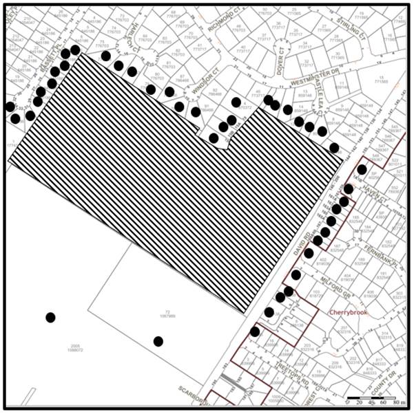
|
NOTIFICATION PLAN |
|||
|
• PROPERTIES NOTIFIED |
X SUBMISSIONS RECEIVED |
|
|
5.2 Public Agencies
The development application was not referred to any Public Agencies for comment.
6. THE PUBLIC INTEREST
Section 4.15(1)(e) of the Act requires Council to consider “the public interest”.
The public interest is an overarching requirement, which includes the consideration of the matters discussed in this report. Implicit to the public interest is the achievement of future built outcomes adequately responding to and respecting the future desired outcomes expressed in environmental planning instruments and development control plans.
The application is considered to have satisfactorily addressed Council’s and relevant agencies’ criteria and would provide a development outcome that, on balance, would result in a positive impact for the community. Accordingly, it is considered that the approval of the proposed development would be in the public interest.
CONCLUSION
The application proposes the refurbishment of an existing seniors housing development.
The development generally meets the desired outcomes of both State and Council’s planning controls and is satisfactory having regard to the matters for consideration under Section 4.15 of the Environmental Planning and Assessment Act 1979.
Having regard to the circumstances of the case, approval/refusal of the application is recommended.
The reasons for this decision are:
· The proposed development generally complies with the requirements of the relevant environmental planning instruments and the Hornsby Development Control Plan 2013.
· The proposed development does not create unreasonable environmental impacts to adjoining development with regard to visual bulk, solar access, amenity or privacy.
Note: At the time of the completion of this planning report, no persons have made a Political Donations Disclosure Statement pursuant to Section 10.4 of the Environmental Planning and Assessment Act 1979 in respect of the subject planning application.
RESPONSIBLE OFFICER
The officer responsible for the preparation of this report is Tim Buwalda.
|
Cassandra Williams Major Development Manager - Development Assessments Planning and Compliance Division |
Rod Pickles Manager - Development Assessments Planning and Compliance Division |
|
Locality Plan |
|
|
|
|
Architectural Plans |
|
|
File Reference: DA/604/2022
Document Number: D08443330
SCHEDULE 1
GENERAL CONDITIONS
The conditions of consent within this notice of determination have been applied to ensure that the use of the land and/or building is carried out in such a manner that is consistent with the aims and objectives of the relevant legislation, planning instruments and council policies affecting the land and does not disrupt the amenity of the neighbourhood or impact upon the environment.
Note: For the purpose of this consent, the term ‘applicant’ means any person who has the authority to act on or the benefit of the development consent.
Note: For the purpose of this consent, any reference to an Act, Regulation, Australian Standard or publication by a public authority shall be taken to mean the gazetted Act or Regulation, or adopted Australian Standard or publication as in force on the date that the application for a construction certificate is made.
1. Approved Plans and Supporting Documentation
The development must be carried out in accordance with the plans and documentation listed below and endorsed with Council’s stamp, except where amended by Council and/or other conditions of this consent:
Approved Plans
|
Plan No. |
Plan Title |
Drawn by |
Dated |
Council Reference |
|
DA000 rev. 03 |
Site Plan |
McNally Architects |
1/06/2022 |
|
|
DA001 rev. 05 |
Unit Works – schedule of DA works |
McNally Architects |
1/06/2022 |
|
|
DA002 rev. 03 |
Site – Slope Analysis |
McNally Architects |
1/06/2022 |
|
|
DA003 rev. 03 |
Site – Accessible paths to accessible units |
McNally Architects |
1/06/2022 |
|
|
DA004 rev. 03 |
Site – Level 1 Floor Plan |
McNally Architects |
1/06/2022 |
|
|
DA005 rev. 03 |
Site Level 2 Floor Plan |
McNally Architects |
1/06/2022 |
|
|
DA006 rev. 03 |
Site – Level 3 Floor Plan |
McNally Architects |
1/06/2022 |
|
|
DA100 rev. 03 |
AZALEA Court – Floor Plans |
McNally Architects |
1/06/2022 |
|
|
DA101 rev. 03 |
AZALEA Court – Elevations |
McNally Architects |
1/06/2022 |
|
|
DA200 rev. 03 |
BERGONIA Court – Floor Plans |
McNally Architects |
1/06/2022 |
|
|
DA201 rev. 03 |
BERGONIA Court – Elevations |
McNally Architects |
1/06/2022 |
|
|
DA300 rev. 03 |
CAMELLIA Court – Floor Plans |
McNally Architects |
1/06/2022 |
|
|
DA301 rev. 03 |
CAMELLIA Court – Elevations |
McNally Architects |
1/06/2022 |
|
|
DA401 rev. 03 |
FERNTREE Court – Floor Plans |
McNally Architects |
1/06/2022 |
|
|
DA400 rev. 03 |
FERNTREE Court – Elevations |
McNally Architects |
1/06/2022 |
|
|
DA500 rev. 03 |
ROSE Court – Floor Plans |
McNally Architects |
1/06/2022 |
|
|
DA501 rev. 03 |
ROSE Court – Elevations |
McNally Architects |
1/06/2022 |
|
|
DA600 rev. 03 |
WARATAH Court – Floor Plans |
McNally Architects |
1/06/2022 |
|
|
DA601 rev. 03 |
WARATAH Court – Elevations |
McNally Architects |
1/06/2022 |
|
|
DA700 rev. 03 |
North and South Elevations |
McNally Architects |
1/06/2022 |
|
|
DA701 rev. 03 |
East and West Elevations |
McNally Architects |
1/06/2022 |
|
|
DA920 rev. 03 |
Level 1 (Ground Floor) Accessible Units – Floor Plans |
McNally Architects |
1/06/2022 |
|
Supporting Documentation
|
Document Title |
Prepared by |
Dated |
Council Reference |
|
BASIX Certificates |
Efficient Living |
20/05/2022 |
D08433926 |
|
BCA Compliance Statement |
Blackett Maguire Goldsmith |
02/06/2022 |
D08433924 |
|
Design Verification Statement |
McNally Architects |
01/06/2022 |
D08433919 |
|
Heritage Impact Statement |
DFP Planning |
02/06/2022 |
D08433916 |
|
Heritage Conservation management Plan |
Paul Davies Pty Ltd |
February 2019 |
D08433917 |
|
Seniors Housing Guidelines |
McNally Architects |
unknown |
D08433911 |
|
SEPP 65 Assessment |
McNally Architects |
unknown |
D08433910 |
|
Statement of Compliance Access for People with a Disability |
Accessible Building Solutions |
01/06/2022 |
D08433909 |
|
Waste Management Plan |
Anglicare |
30/05/2022 |
D08433904 |
2. Construction Certificate
a) A Construction Certificate is required to be approved by Council or a Private Certifying Authority prior to the commencement of any construction works under this consent.
b) The Construction Certificate plans must be consistent with the Development Consent plans.
REQUIREMENTS PRIOR TO THE ISSUE OF A CONSTRUCTION CERTIFICATE
3. Building Code of Australia
a) Detailed plans, specifications and supporting information is required to be submitted to the certifying authority detailing how the proposed building work achieves compliance with the National Construction Code - Building Code of Australia. All building work must be carried out in accordance with the requirements of the National Construction Code - Building Code of Australia.
b) The balustrading and handrails are required to be upgraded to comply with the National Construction Code - Building Code of Australia.
4. Contract of Insurance (Residential Building Work)
Where residential building work for which the Home Building Act 1989 requires there to be a contract of insurance in force in accordance with Part 6 of that Act, this contract of insurance must be in force before any building work authorised to be carried out by the consent commences.
5. Notification of Home Building Act 1989 Requirements
Residential building work within the meaning of the Home Building Act 1989 must not be carried out unless the principle certifying authority for the development to which the work relates (not being Council) has given Council written notice of the following information:
a) In the case of work for which a principle contractor is required to be appointed:
i) The name and licence number of the principle contractor.
ii) The name of the insurer by which the work is insured under Part 6 of that Act.
b) In the case of work to be done by an owner-builder:
i) The name of the owner-builder.
ii) If the owner-builder is required to hold an owner-builder’s permit under that Act, the number of the owner-builder’s permit.
Note: If arrangements for doing the residential building work are changed while the work is in progress so that the information notified becomes out of date, further work must not be carried out unless the principle certifying authority for the development to which the work relates (not being Council) has given Council written notification of the updated information.
6. Stormwater Drainage
The stormwater drainage system for the development must be designed for an average recurrence interval (ARI) of 20 years and be gravity and connected to the existing internal drainage system.
REQUIREMENTS PRIOR TO THE COMMENCEMENT OF ANY WORKS
7. Erection of Construction Sign
a) A sign must be erected in a prominent position on any site on which any approved work is being carried out:
i) Showing the name, address and telephone number of the principle certifying authority for the work.
ii) Showing the name of the principle contractor (if any) for any demolition or building work and a telephone number on which that person may be contacted outside working hours; and
iii) Stating that unauthorised entry to the work site is prohibited.
b) The sign is to be maintained while the approved work is being carried out and must be removed when the work has been completed.
8. Protection of Adjoining Areas
A temporary hoarding, fence or awning must be erected between the work site and adjoining lands before the works begin and must be kept in place until after the completion of the works if the works:
a) Could cause a danger, obstruction or inconvenience to pedestrian or vehicular traffic.
b) Could cause damage to adjoining lands by falling objects; and/or
c) Involve the enclosure of a public place or part of a public place; and/or
d) Have been identified as requiring a temporary hoarding, fence or awning within the Council approved Construction Management Plan (CMP).
Note: Notwithstanding the above, Council’s separate written approval is required prior to the erection of any structure or other obstruction on public land.
9. Toilet Facilities
a) To provide a safe and hygienic workplace, toilet facilities must be available or be installed at the works site before works begin and must be maintained until the works are completed at a ratio of one toilet for every 20 persons employed at the site.
b) Each toilet must:
i) Be a standard flushing toilet connected to a public sewer.
ii) Be a temporary chemical closet approved under the Local Government Act 1993.
10. Erosion and Sediment Control
To protect the water quality of the downstream environment, erosion and sediment control measures must be provided and maintained throughout the construction period in accordance with the manual ‘Soils and Construction 2004 (Bluebook)’, the approved plans, Council specifications and to the satisfaction of the principle certifying authority. The erosion and sediment control devices must remain in place until the site has been stabilised and revegetated.
Note: On the spot penalties may be issued for any non-compliance with this requirement without any further notification or warning.
REQUIREMENTS DURING CONSTRUCTION
11. Construction Work Hours
All works on site, including demolition and earth works, must only occur between 7am and 5pm Monday to Saturday.
No work is to be undertaken on Sundays or public holidays.
12. Demolition
To protect the surrounding environment, all demolition work must be carried out in accordance with Australian Standard AS2601-2001 Demolition of structures and the following requirements:
a) Demolition material must be disposed of to an authorised recycling and/or waste disposal site and/or in accordance with an approved waste management plan; and
b) Demolition works, where asbestos material is being removed, must be undertaken by a contractor that holds an appropriate licence issued by SafeWork NSW in accordance with the Work Health and Safety Regulation 2017 and be appropriately transported and disposed of in accordance with the Protection of the Environment Operations (Waste) Regulation 2014; and
c) On construction sites where any building contains asbestos material, a standard commercially manufactured sign containing the words ‘DANGER ASBESTOS REMOVAL IN PROGRESS’ and measuring not less than 400mm x 300mm must be displayed in a prominent position visible from the street.
13. Environmental Management
To prevent sediment run-off, excessive dust, noise or odour emanating from the site during the construction, the site must be managed in accordance with the publication ‘Managing Urban Stormwater’, Landcom (March 2004) and the Protection of the Environment Operations Act 1997.
To ensure that the public reserve is kept in a clean, tidy and safe condition during construction works, no building materials, waste, machinery or related matter is to be stored on the road or footpath.
15. Disturbance of Existing Site
During construction works, the existing ground levels of open space areas and natural landscape features, including natural rock-outcrops, vegetation, soil and watercourses must not be altered unless otherwise nominated on the approved plans.
16. Landfill
a) Prior to fill material being imported to the site, a Waste Classification Certificate shall be obtained from a suitably qualified environmental consultant confirming the fill wholly consists of Virgin Excavated Natural Material (VENM) as defined in Schedule 1 of the Protection of the Environment Operations Act 1997 or a material approved under the NSW Environment Protection Authority’s Resource Recovery Orders and Exemptions.
b) The required Waste Classification Certificate must be obtained by the Principle Contractor prior to fill being imported to the site and made available to Council at its request.
REQUIREMENTS PRIOR TO THE ISSUE OF AN OCCUPATION CERTIFICATE
17. Fulfilment of BASIX Commitments
The applicant must demonstrate the fulfilment of BASIX commitments pertaining to the development.
18. Asbestos Clearance Certificate
Should any asbestos be encountered during demolition or construction works, a licenced asbestos assessor is required to provide a Clearance Certificate to the Certifier prior to the issue of an Occupation Certificate, certifying that the asbestos has been removed and appropriately disposed of, and the site is now suitable for its approved use.
19. Damage to Council Assets
To protect public property and infrastructure, any damage caused to Council’s assets as a result of the construction or demolition of the development must be rectified by the applicant in accordance with AUS-SPEC Specifications (www.hornsby.nsw.gov.au/property/build/aus-spec-terms-and-conditions. Rectification works must be undertaken prior to the issue of an Occupation Certificate, or sooner, as directed by Council.
20. Fire Safety Statement – Final
In accordance with the Environmental Planning and Assessment (Development Certification and Fire Safety) Regulation 2021, upon completion of the building, the owner must provide Council with a certificate in relation to each fire safety measure implemented in the building.
OPERATIONAL CONDITIONS
21. Fire Safety Statement - Annual
On at least one occasion in every 12 month period following the date of the first ‘Fire Safety Certificate’ issued for the property, the owner must provide Council with an annual ‘Fire Safety Certificate’ to each essential service installed in the building.
- END OF CONDITIONS -
ADVISORY NOTES
The following information is provided for your assistance to ensure compliance with the Environmental Planning and Assessment Act, 1979, Environmental Planning and Assessment Regulation 2021, other relevant legislation and Council’s policies and specifications. This information does not form part of the conditions of development consent pursuant to Section 4.17 of the Act.
Environmental Planning and Assessment Act 1979 Requirements
The Environmental Planning and Assessment Act 1979 requires:
· The issue of a construction certificate prior to the commencement of any works. Enquiries can be made to Council’s Customer Services Branch on 9847 6760.
· A principle certifying authority to be nominated and Council notified of that appointment prior to the commencement of any works.
· Council to be given at least two days written notice prior to the commencement of any works.
· Mandatory inspections of nominated stages of the construction inspected.
· An occupation certificate to be issued before occupying any building or commencing the use of the land.
Long Service Levy
In accordance with Section 34 of the Building and Construction Industry Long Service Payments Act 1986, a ‘Long Service Levy’ must be paid to the Long Service Payments Corporation or Hornsby Council.
Note: The rate of the Long Service Levy is 0.35% of the total cost of the work.
Note: Hornsby Council requires the payment of the Long Service Levy prior to the issue of a construction certificate.
Tree and Vegetation Preservation
Hornsby Development Control Plan 2013 Tree and Vegetation Preservation provisions have been developed under Council’s authorities contained in State Environmental Planning Policy (Vegetation in Non-Rural Areas) 2017 and the Environmental Planning and Assessment Act 1979.
In accordance with these provisions a person must not cut down, fell, uproot, kill, poison, ringbark, burn or otherwise destroy the vegetation, lop or otherwise remove a substantial part of the trees or vegetation to which any such development control plan applies without the authority conferred by a development consent or a permit granted by Council.
Fines may be imposed for non-compliance with the Hornsby Development Control Plan 2013.
Note: A tree is defined as a long lived, woody perennial plant with one or relatively few main stems with the potential to grow to a height greater than three metres (3m). (HDCP 1B.6.1.c).
Covenants
The land upon which the subject building is to be constructed may be affected by restrictive covenants. Council issues this approval without enquiry as to whether any restrictive covenant affecting the land would be breached by the construction of the building, the subject of this consent. Applicants must rely on their own enquiries as to whether or not the building breaches any such covenant.
Prior to commencing any works, the applicant is encouraged to contact Dial Before You Dig on 1100 or www.dialbeforeyoudig.com.au for free information on potential underground pipes and cables within the vicinity of the development site.
Telecommunications Act 1997 (Commonwealth)
If you are aware of any works or proposed works which may affect or impact on Telstra’s assets in any way, you are required to contact: Telstra’s Network Integrity Team on Phone Number 1800810443.
Asbestos Warning
Should asbestos or asbestos products be encountered during demolition or construction works, you are advised to seek advice and information prior to disturbing this material. It is recommended that a contractor holding an asbestos-handling permit (issued by SafeWork NSW) be engaged to manage the proper handling of this material. Further information regarding the safe handling and removal of asbestos can be found at:
Alternatively, telephone the SafeWork NSW on 13 10 50.
LPP Report No. LPP48/22
Local Planning Panel
Date of Meeting: 31/08/2022
3 DA/1308/2021 - ALTERATIONS AND ADDITIONS TO AN EXISTING INDUSTRIAL BUILDING - 29 LEIGHTON PLACE, HORNSBY
EXECUTIVE SUMMARY
|
DA No: |
DA/1308/2021 (Lodged on 8 December 2021) |
|
Description: |
Alterations and additions to an existing industrial building |
|
Property: |
Lot 11 DP 748030, No. 29 Leighton Place, Hornsby |
|
Applicant: |
Mr Joseph Hajje |
|
Owner: |
JNH Group Pty Ltd |
|
Estimated Value: |
$538,467 |
|
Ward: |
B Ward |
· The application involves alterations and additions to an existing industrial building at 29 Leighton Place, Hornsby.
· The proposal does not comply with the Hornsby Local Environmental Plan 2013 with regard to Clause 4.3 ‘Height of buildings’. The applicant has made a submission in accordance with Clause 4.6 ‘Exceptions to development standards’ of the Hornsby Local Environmental Plan 2013 to contravene the height of buildings development standard. The submission is considered well founded and is supported.
· The application is required to be determined by the Hornsby Local Planning Panel as the proposal would contravene the Hornsby Local Environmental Plan 2013 development standard for maximum height of buildings by more than 10 percent.
· No submissions have been received.
· It is recommended that the application be approved.
|
THAT the Hornsby Local Planning Panel assume the concurrence of the Secretary of the Department of Planning and Environment pursuant to Clause 4.6 of the Hornsby Local Environmental Plan 2013 and approve Development Application No. DA/1308/2021 for alterations and additions to an existing industrial building at Lot 11 DP 748030, No. 29 Leighton Place, Hornsby subject to the conditions of consent detailed in Schedule 1 of LPP Report No. LPP 48/22. |
BACKGROUND
The existing industrial building on site was approved on the site in 1997, under consent number DA/68/1997. Numerous subsequent approvals have been granted for the site, which have steadily increased the gross floor area, overall building height and number of units on site. Key applications of note include:
· DA/68/1997 - Erection of an industrial building comprising 23 units over four levels (the original consent). The building had an overall height of 22.3m and an FSR of 0.68:1. (Note: At the time of consent, no height development standard applied to industrial lands, other than number of storeys in accordance with the Industrial Lands DCP).
· DA/174/1998 - Addition of two units to bring the total units to 25.
· DA/985/1998 - Alterations and additions to the industrial building including construction of an additional 3 units to bring the total to 28 units with an FSR of 0.76:1. This application introduced a fifth building level increasing overall building height to 24.9m.
· DA/2465/2000 - Construction of an additional unit on Level 5 and partitioning of existing Unit 28 to provide four separate occupancies. This bought the total number of units to 32 and increased FSR to 0.79:1. At the time of this consent, the Hornsby Shire Industrial Lands DCP applied to the site which limited the height of industrial area to 2 storeys. However, 3 storeys could be considered in the Asquith Industrial area where the development is in context with the topography. The 5 storey non-compliance was justified based on existing non-compliance and the approval of the fifth floor under DA/985/1998.
· DA/1164/2001 - Addition of mezzanines to Units 28-32 on floor number 5 increasing FSR to 0.82:1 No increase in building height.
· DA/984/2002 - Occupation of Unit 26 for a commercial kitchen and erection of a mezzanine.
· DA/829/2018 - Strata subdivision of the site into 41 strata allotments. This application included allotments for which no physical buildings exist, including Lot 34, 35, 36, 37, 38, 39 and 40.
SITE
The development site comprises a single 5041m2 allotment on the northern side of Leighton Place, Hornsby. The site currently contains a five-storey industrial building comprising 32 industrial units. A variety of uses are undertaken on site, including warehousing, storage, a commercial kitchen and a number of uses / businesses of a light industrial nature.
The western portion of the site contains remnant bushland consistent with the Peppermint Angophora Woodland vegetation community. An ephemeral waterway is located within the bushland area which is also burdened by sewerage and gas service easements.
The site experiences a fall of approximately 26 metres towards the front boundary with Leighton Place and has a number of exposed cliffs and rock areas.
The surrounding locality is dominated by industrial buildings. Due to the topography of the locality, a number of industrial sites are located on excavated and benched areas or are raised on piles significantly above the existing ground level.
The site does not contain a heritage listed item, is not located in the vicinity of a heritage listed item and is not located within a heritage conservation area.
PROPOSAL
The proposal seeks consent for an additional 7 industrial units, being located within the newly formed strata lots approved under DA/829/2018 - Lot 34, 35, 36, 37, 38 , 39 and 40. It is noted that the SEE outlines consent is sought for 8 units but this appears to be an error as only 7 units are shown on the proposed plans.
The supplied SEE describes the development as follows;
The development proposal involves the following:
· Level Ground & 1 will be accessed via a concrete ramp extending from the existing accessway from Leighton Place. The proposed unit 34 will have a GFA of 49.23m2.
· Level 2 will include the construction of an additional unit 35 with a GFA of 93.42m2.
· Level 3 & 4 will comprise a new unit no. 36 adjacent to the access ramp. Proposed unit 36 will comprise 3 x levels. Level 3 will have a GFA of 56.97m2 and level 4 with a GFA of 60.44m2 and Level 5 having a GFA of 60.44m2.
· Level 5 will involve the construction of 4 x additional units.
o Unit 37 - 75.15m2.
o Unit 38 - 58.18m2.
o Unit 39 - 61.27m2.
o Unit 40 - 88.60m2.
All additional units would be located within the existing footprint of the building and consequently, no tree removal, bulk excavation or filling is required as existing slabs will be utilised. Minor vegetation removal would be required to facilitate the construction of Unit 36.
ASSESSMENT
The development application has been assessed having regard to the Greater Sydney Region Plan - A Metropolis of Three Cities, the North District Plan and the matters for consideration prescribed under Section 4.15 of the Environmental Planning and Assessment Act 1979 (the Act). The following issues have been identified for further consideration.
1. STRATEGIC CONTEXT
1.1 Greater Sydney Region Plan - A Metropolis of Three Cities and North District Plan
The Greater Sydney Region Plan - A Metropolis of Three Cities has been prepared by the NSW State Government to guide land use planning decisions for the next 40 years (to 2056). The Plan sets a strategy and actions for accommodating Sydney’s future population growth and identifies dwelling targets to ensure supply meets demand. The Plan also identifies that the most suitable areas for new housing are in locations close to jobs, public transport, community facilities and services.
The NSW Government will use the subregional planning process to define objectives and set goals for job creation, housing supply and choice in each subregion. Hornsby Shire has been grouped with Hunters Hill, Ku-ring-gai, Lane Cove, Mosman, North Sydney, Ryde, Northern Beaches and Willoughby to form the North District. The Greater Sydney Commission has released the North District Plan which includes priorities and actions for Northern District for the next 20 years. Planning Priority N11 is to retain and manage industrial and urban services land.
The proposed development would be consistent with the Greater Sydney Region Plan - A Metropolis of Three Cities and North District Plan, by providing additional industrial units to support a growing population to meet economic and employment purposes of the district.
2. STATUTORY CONTROLS
Section 4.15(1)(a) requires Council to consider “any relevant environmental planning instruments, draft environmental planning instruments, development control plans, planning agreements and regulations”.
2.1 Hornsby Local Environmental Plan 2013
The proposed development has been assessed having regard to the provisions of the Hornsby Local Environmental Plan 2013 (HLEP).
2.1.1 Zoning of Land and Permissibility
The subject land is zoned IN1 General Industrial under the HLEP. The objectives of the IN1 zone are:
· To provide a wide range of industrial and warehouse land uses.
· To encourage employment opportunities.
· To minimise any adverse effect of industry on other land uses.
· To support and protect industrial land for industrial uses.
· To permit other land uses that provide facilities or services to meet the day-to-day needs of workers in the area.
The proposed development is defined as ‘light industry’ and is permissible in the IN1 zone with Council’s consent.
2.1.2 Height of Buildings
Clause 4.3 of the HLEP provides that the height of a building on any land should not exceed the maximum height shown for the land on the Height of Buildings Map. The maximum permissible height for the subject site is 14.5 metres. The proposal fails to comply with this provision with a maximum building height 24.25m, a 9.75m or 67% contravention of the development standard. The applicant has submitted a written request to contravene the development standard under Clause 4.6 of the HLEP which is discussed in Section 2.1.3 below.
2.1.3 Exceptions to Development Standards
The applicant submitted a written request to contravene the height of building development standard contained within Clause 4.3 of the HLEP.
The written request prepared by Peter Fryar of Key Urban Planning, describes the extent of the contravention as follows:
The purpose of this request is to seek a variation to Clause 4.3 (Height of buildings) of the Hornsby Local Environmental Plan 2013. It is proposed that elements of the upper level of the additional units will exceed the maximum height control predominantly at the southern elevation of the existing building.
The extent of the non-compliance with the maximum height standard being a maximum height at the southern elevation of 24.25 metres. Most of the building will remain unaltered. The breach of the maximum height control is along elements of the southern elevation of the existing building and in the context of the site and the existing development is negligible in the impacts.
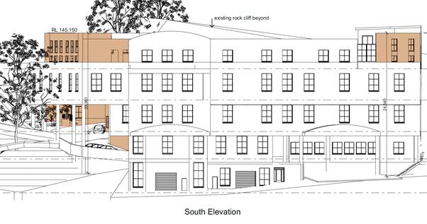
Figure 1: Southern elevation showing new building sections in orange.
The application has been assessed against the requirements of Clause 4.6 of the HLEP. This clause provides flexibility in the application of the development standards in circumstances where strict compliance with those standards would, in any particular case, be unreasonable or unnecessary or tender to hinder the attainment of the objectives of the zone. In particular, Clause 4.6 provides criteria that must be satisfied prior to a consent authority granting consent to development that contravenes a development standard. These criteria demonstrated under Clause 4.6(3) are as follows:
(a) That compliance with the development standard is unreasonable or unnecessary in the circumstances of the case, and;
(b) That there are sufficient environmental planning grounds to justify contravening the development standard.
A discussion regarding the criteria provided at Clause 4.6(3), with respect to the development application is provided below.
2.1.3.1 Unreasonable or Unnecessary Clause 4.6(3)(a)
There are five common methods by which an applicant can demonstrate that compliance with a development standards is unreasonable or unnecessary in the circumstances of the development. Initially proposed for objections under clause 6 of SEPP 1 in the decision of Wehbe v Pittwater Council [2007] NSWLEC 827 Pearson C summarised and applied these methods to written requests made under Clause 4.6 in Four2Five Pty Ltd v Ashfield Council [2015] NSWLEC 1009 [61-62]. These five methods are generally as follows:
· The objectives of the development standard are achieved notwithstanding non-compliance with the standard.
· The underlying objective or purpose is not relevant to the development.
· That the objective would be defeated or thwarted if compliance was required.
· That the development standard has been virtually abandoned or destroyed by the Council’s own actions in departing from the standard.
· The zoning of the land is unreasonable or inappropriate.
It is not required to demonstrate that a development meets multiple methods as listed above, and the satisfaction of one can be adequate to demonstrate that the development standard is unreasonable or unnecessary.
The written request prepared by Key Urban Planning, dated 5 November 2021 provides a detailed assessment of the proposal with respect to the development standard sought to be contravened. The written request provides reasoning on all five of the Wehbe tests, however, Council is of the opinion that the justification provided for the first test, being “The objectives of the development standard are achieved notwithstanding non-compliance with the standard” is the most appropriate reasoning provided. Justification provided under the remaining four Wehbe tests are noted, however they are considered to be supporting arguments, that do not meet the required level of justification to support contravention of the ‘height of buildings’ development standard.
The reasoning provided within the written request to demonstrate that the objectives of the development standard are achieved notwithstanding non-compliance with the standard are as follows:
The relevant objective underpinning the building height development standard is:
“(a) to permit a height of buildings that is appropriate for the site constraints, development potential and infrastructure capacity of the locality.”
The relatively modest additional height proposed (above the existing building) contributes to the delivery of a high-quality development on this site. The zoning of the site and surrounding industrial lands includes land of relatively steep topography that may be considered in some respects unsuitable for industrial development. Consequently, a number of industrial complexes in the locality have been approved by Council in contravention of the current LEP height standard. The proposed building works are consistent with the height and scale of the building constructed immediately adjoining the site to the west.
The existing building has been constructed more than 25 metres in height. The minor additional breach in height at small elements of the building is considered acceptable in the circumstances and in the context of the surrounding development.
The lateral expansion of the building to achieve the councils floor space expectations for industrial development of the site will impact adversely on the endangered ecological community situated upon the site and the additional height responds to the ecological constraints on the site. The natural topography of the site will result in unreasonable impacts by way of excavation should the additional floor space be provided outside the existing building envelope.
The council in the granting of development consent for the creation of the strata lots upon which the additional industrial units are proposed has envisaged additional ‘height’ occurring as part of the development subject of this DA.
The objectives of the standard can be achieved, notwithstanding the additional height, and that a superior development outcome would result.
With reference to the reasoning provided by the applicant above, Council does not object to the conclusion that the proposed additions meet the objectives of Clause 4.3. In reaching this conclusion the following points are noted:
· The additional industrial units are provided within the existing building envelope and would be below or equal to the previously approved building height which is 24.9m at the southern façade of Units 28 and 29.
· The additional floor space assists in achieving the envisioned development potential for the site and brings the development closer to the maximum permissible 1:1 FSR. Placing this additional floor space within the building envelope would assist in protecting the remnant vegetation on site.
· The proposed development would have negligible impact on the infrastructure capacity of the locality.
· The development as proposed represents a consistent local based approach to dealing with site constraints. Numerous examples of buildings over 14.5 metres are present in the locality, as the steep topography and remnant natural vegetation forces buildings to condense the footprint and expand vertically. Whilst it is noted that most of the buildings proposed were approved prior to the implementation of the 14.5 metre height control, the building located immediately east of the subject site was approved in 2020 with a height contravention of Clause 4.3.
For the reasons outlined above, it is considered that the written request to contravene the height of buildings development standard adequately demonstrates that the objectives of the development standard contained within Clause 4.3 of the HLEP are achieved, notwithstanding contravention of the development standard.
2.1.3.2 Environmental Planning Grounds - Clause 4.6(3)(b)
In addition to demonstrating that compliance is unreasonable or unnecessary, Clause 4.6(3)(b) requires that there are sufficient environmental planning grounds to justify contravening the development standard. In demonstrating that sufficient environmental planning grounds exist it must be demonstrated that the planning grounds are particular to the circumstances of the development on the subject site (summarised from Four2Five Pty Ltd v Ashfield Council [2015] NSWLEC 1009 [60].
The applicant provided the following planning grounds for the contravention of the development standard:
· The potential for negative town planning and urban outcomes that may arise from strict compliance with the requirement are negligible when considering the context of the site with surrounding development;
· The unique qualities of the site and the proposed alterations and additions will maintain and enhance these and the character of the locality;
· The shape and locality of the site and the opportunities and constraints that arise for its development as a result - specifically the opportunity to provide substantial public benefits in the form of a public street frontage with no discernible impacts arising from the additional height proposed on the locality.
· The extent of the non-compliance is minor in the context of the existing built form.
· There is limited opportunity to ‘step’ the design and the additional height is within an envelope already approved for development under the approved strata plan.
· In order to achieve the development potential of the site envisaged by controls such as FSR, the site constraints created when the original subdivision occurred have caused strict compliance with the height standard adopted under the current LEP unfeasible.
· The historic height provisions that were envisaged at the time the subdivision creating the site occurred would allow building height greater than proposed. This is evident in the heights of older industrial developments in the locality.
· Scale of the building as viewed from the adjoining roadway is negligible due to existing site topography. The proposed building in the context of the backdrop of existing buildings constructed to the rear of the site is considered reasonable.
· The additional height is a negligible issue within the context of the greater planning benefit, including opportunities for the protection and enhancement of local values and provision of high-quality industrial development that would result from the minor variation to the height standard.
In this regard, there are sufficient environmental planning grounds specific to this site to justify the proposed departure from the development standard.
The underlying objective of the height standard is to minimise potential adverse environmental impacts of development of the site on the surrounding area. It is noted that the height standard was applied to the site at a time historically when the subdivision of the locality had occurred that created industrial allotments on extremely steep topography. It could be argued that the current height standard is inappropriate when accounting for changes to height controls that have occurred in recent years on surrounding lands.
Although the proposal breaches the height of buildings control, the development achieves appropriate building envelopes and separation to the adjacent industrial land. It is also worth noting that the development does comply with solar access, site coverage and other similar requirements adopted by Council.
Council’s review of the environmental planning grounds presented by the applicant raises no points of contention, and it is considered that the consolidation of the building footprint to be a reasonable built environment outcome, both within the subject site, and to the adjoining industrial development.
Council is therefore satisfied that Clause 4.6(3) of the HLEP is adequately addressed.
2.1.3.3 Public Interest and Clause 4.6(4)
Clause 4.6(4) states that development consent must not be granted for development that contravenes a development standard unless:
(a) The consent authority is satisfied that:
(i) The applicant’s written request has adequately addressed the matters required to be demonstrated by subclause (3), and
(ii) The proposed development will be in the public interest because it is consistent with the objectives of the particular standard and the objectives for development within the zone in which the development is proposed to be carried out, and
(b) The concurrence of the Planning Secretary has been obtained.
With regard to part (a)(i), the written request is considered to adequately address the matters required to be demonstrated as outlined above.
With regard to part (a)(ii), the proposed development is considered to be in the public interest because it is consistent with the objectives of the particular standard and the objectives for development within the zone in which the development is proposed to be carried out.
With regard to (b), on 21 February 2018, the Secretary of the Department of Planning and Environment issued a Notice under cl. 64 of the Environmental Planning and Assessment Regulation 2000. The Secretary’s concurrence may not be assumed by a delegate of council if:
· The development contravenes a numerical standard by greater than 10%.
· The variation is to a non-numerical standard.
Local Planning Panels constituted under the Environmental Planning and Assessment Act 1979 exercise consent authority functions on behalf of a Council and are not delegates of Council. Therefore, Local Planning Panels may determine a development application notwithstanding, a numerical non-compliance in excess of 10%.
Therefore, the exceedance of the height of buildings development standard is supported in this instance.
2.1.4 Floor Space Ratio
Clause 4.4 of the HLEP states that the maximum floor space ratio for a building on any land is not to exceed the floor space ratio shown for the land on the Floor Space Ratio Map. The applicable floor space ratio for the subject site is 1:1. The proposed development would have a Floor Space Ratio of 0.94:1 which is compliant with Clause 4.4 of the HLEP.
2.1.5 Earthworks
Clause 6.2 of the HLEP states that consent is required for proposed earthworks on site. Before granting consent for earthworks, Council is required to assess the impacts of the works on adjoining properties, drainage patterns and soil stability of the locality.
Council’s assessment of the proposed works and excavation concludes that no excavation would be required into existing ground for any footings or building foundations. Minor excavation works would be required to create a staircase into Unit 36, however these minor works would involve minimal disturbance. Consequently, it is considered that the proposed development would have negligible impacts on adjoining properties, drainage patterns and soil stability of the locality.
2.2 Adopted State Environmental Planning Policies
On 1 March 2022, the following State Environmental Planning Policies (SEPPS) were gazetted.
· State Environmental Planning Policy (Primary Production) 2021
· State Environmental Planning Policy (Resources and Energy) 2021
· State Environmental Planning Policy (Resilience and Hazards) 2021
· State Environmental Planning Policy (Industry and Employment) 2021
· State Environmental Planning Policy (Transport and Infrastructure) 2021
· State Environmental Planning Policy (Biodiversity and Conservation) 2021
· State Environmental Planning Policy (Planning Systems) 2021
· State Environmental Planning Policy (Precincts - Eastern Harbour City) 2021
These SEPPs now form matters for consideration under Section 4.15 of the Environmental Planning and Assessment Act 1979. However general savings provisions apply to development applications that have been made but not yet determined, on or before the commencement date.
As this development application was lodged on 18 February 2022, this development application is considered to have been made prior to the commencement date of the SEPPs. The existing legislation in force at time of lodgement of the development application, prevails to be extent of any inconsistency.
Notwithstanding, the approval of the development application would not adversely affect the objectives of the newly adopted SEPPs and is considered to be consistent with this policy.
2.3 State Environmental Planning Policy No. 55 Remediation of Land
The policy provides guidelines for the remediation of contaminated land for the purpose of reducing the risk of harm to human health or any other aspect of the environment. Clause 7 requires Council to consider whether land is contaminated prior to granting consent to the carrying out of any development on that land.
Should the land be contaminated Council must be satisfied that the land is suitable in a contaminated state for the proposed use. If the land requires remediation to be undertaken to make the land suitable for the proposed use, Council must be satisfied that the land will be remediated before the land is used for that purpose.
The site has historically been used for industrial purposes. However, all works are proposed with the existing footprint and within hardstand areas, no excavations of in situ soils would be required, and no potential contaminates are stored in any area proposed for development. Consequently, the proposed development would be unlikely to encounter any contamination that may be present on the site, and further assessment under SEPP 55 is unnecessary.
2.4 State Environmental Planning Policy (Vegetation in Non-Rural Areas) 2017
State Environmental Planning Policy (Vegetation in Non-Rural Areas) 2017 (Vegetation SEPP) commenced 25 August 2017 and aims to protect the biodiversity and amenity values of trees within non-rural areas of the state.
Part 3 of the Vegetation SEPP states that a development control plan may make a declaration in any manner relating to species, size, location and presence of vegetation. Accordingly, Part 1B.6.1 of the Hornsby Development Control Plan 2013 (HDCP) prescribes works that can be undertaken with or without consent to trees.
Part 3.1 of this report provides an assessment in accordance with Part 1B.6.1 of the HDCP.
2.5 Sydney Regional Environmental Policy No. 20 Hawkesbury-Nepean River
The site is located with the catchment of the Hawkesbury Nepean River. Part 2 of this Plan contains general planning considerations and strategies requiring Council to consider the impacts of development on water quality, aquaculture, recreation and tourism.
Subject to the implementation of sediment and erosion control measures and stormwater management to protect water quality, the proposal would comply with the requirement of the Policy.
2.6 Section 3.42 Environmental Planning and Assessment Act 1979 - Purpose and Status of Development Control Plans
Section 3.42 of the Environmental Planning and Assessment Act 1979 states that a DCP provision will have no effect if it prevents or unreasonably restricts development that is otherwise permitted and complies with the development standards in relevant Local Environmental Plans and State Environmental Planning Policies.
The principal purpose of a development control plan is to provide guidance on the aims of any environmental planning instrument that applies to the development; facilitate development that is permissible under any such instrument; and achieve the objectives of land zones. The provisions contained in a DCP are not statutory requirements and are for guidance purposes only. Consent authorities have flexibility to consider innovative solutions when assessing development proposals, to assist achieve good planning outcomes.
2.7 Hornsby Development Control Plan 2013
The proposed development has been assessed having regard to the relevant desired outcomes and prescriptive requirements within the Hornsby Development Control Plan 2013 (HDCP). The following table sets out the proposal’s compliance with the prescriptive requirements of the Plan:
|
HDCP - Part 5.1 Industrial Land |
|||
|
Control |
Proposal |
Minimum Requirement |
Complies |
|
Site Area |
5041m2 |
N/A |
N/A |
|
Building Height |
24.9m |
14.5m |
No |
|
No. storeys |
5 |
max. 3 |
No |
|
Floor space ratio |
0.94:1 |
1:1 |
Yes |
|
Setbacks |
|
|
|
|
- Front |
2.8m (unchanged) |
5m |
No |
|
- Eastern Side |
1.4m |
0m |
Yes |
|
- Western Side |
22m |
0m |
Yes |
|
- Rear |
2.5m (unchanged) |
5m |
No |
|
Car Parking |
59 spaces |
47 spaces |
Yes |
As detailed in the above table, the proposed development generally complies with the prescriptive measures within the HDCP with the exception of building heights and front and rear setbacks. A brief discussion on compliance with relevant performance requirements and Part 1C General Controls is provided below.
2.7.1 Setbacks
The proposed development does not comply with the prescriptive requirements for front and rear setbacks.
As outlined in the table above, the front and rear setback distances are existing. As the proposed additional industrial units are located within the confined of the existing building footprint, there is no additional encroachment into setback areas.
Unit 40 would be located at the 3.1 metre front setback, which is non-compliant, however, no objection is raised to this continued non-compliance, as unit 40 would be located on the fifth floor of the development and would appear as a continuation of the façade of the four floors below. None of the existing units on floor five are setback from the front façade, so the continuation of the non-compliance for Unit 40 is considered acceptable and in accordance with the existing building design.
The proposed setbacks are therefore considered acceptable with respect to the desired outcomes of Part 5.2.1 Setbacks of the HDCP.
2.7.2 Open Space
Part 5.1.4 Open Space of the HDCP prescribes a rate of 1m2 per 1 employee for industrial developments. For developments where no employees are identified, such as this application, a rate of 1 employee per 50m2 GFA is to be adopted. For this development a communal open space area of 50m2 is required.
No communal open space is provided for the site currently, with no additional open space proposed under this application.
No objections are raised to this non-compliance as due to site constraints and the existing building design, the provision of a communal open space area would not be plausible for the subject site, without vegetation removal and / or landform modification. Additionally, due to the five storey built form and underlying topography on the site, provision of an area of open space would likely be poorly patronised by owners / employees on different building levels who would have to traverse multiple floors to access any provided space.
The additional units would not be located over any existing open space area, and due to the small-scale separate tenancies proposed, it is not envisioned that the tenancies would support large worker populations on the site. The supplied statement of environmental effects describes that the proposed industrial units would likely suit a boutique clientele, being small scale business, hobbyists and residential / domestic garage and warehouse spaces.
2.7.3 Vehicle Access and Parking
Vehicle access to the site would be facilitated via the existing crossover and asphalt roadway located in the southern portion of the site.
Council’s engineering review of the proposed vehicle parking and manoeuvring areas raises no objections to the proposed amendments, and it noted that the proposed development provides in excess of the minimum parking requirements. Additionally, additional traffic generation caused by the further intensification of the site can be accommodated by the local road network.
The proposed development is required to provide 4 bicycle parking spaces as well as 2 motorcycle parking spaces on site. Whilst these spaces are not shown on the supplied plans, sufficient spaces are available on site for the parking of bicycles and motorcycles, should these transport methods be used.
2.7.4 Sunlight Access
The desired outcome of Part 5.1.5 Sunlight of the HDCP is development designed to provide reasonable sunlight to sensitive areas. The subject site does not adjoin any residential lands, community uses, education, public open space or recreation areas. Consequently, the proposal would not unreasonable shadow any adjoining sensitive areas.
2.7.5 Height of Buildings
The development does not comply with the 14.5m height of buildings prescriptive measure. This aspect of the development is discussed in detail in Part 2.1.2 of this report.
2.7.6 Acoustic Amenity
The development does not propose hours of operation for the additional industrial units. This approach is consistent with the existing situation for units on site, with no previous development approvals restricting hours of operation.
The subject site is centrally located within the wider Hornsby Industrial area and is not located in close proximity to any sensitive receivers, with the closest residential allotment being located approximately 300 metres south of the site, on Cecil Avenue. Additionally, the small scale nature of the industrial units would be unlikely to house any significant industrial enterprise or workforce, which is consistent with the proposed “light industry” use. Consequently, no objections are raised to the proposed unrestricted business hours.
An operational condition of development consent is recommended in Schedule 1 of this to prevent levels of noise being emitted to adjacent premises which possess tonal, beating and similar characteristics or which exceeds background noise levels by more than 5dB(A).
2.8 Section 7.12 Contributions Plan
Hornsby Shire Council Section 7.12 Contributions Plan 2019 - 2029 applies to the development as the estimated costs of work is greater than $100,000. Should the application be approved, an appropriate condition of consent is recommended requiring the payment of a contribution in accordance with the Plan.
3. ENVIRONMENTAL IMPACTS
Section 4.15(1)(b) of the Act requires Council to consider “the likely impacts of that development, including environmental impacts on both the natural and built environments, and social and economic impacts in the locality”.
3.1 Natural Environment
3.1.1 Tree and Vegetation Preservation
As the development is located within the previously disturbed area, vegetation removal is limited to that which is required for the construction of the fire stair adjacent to Unit 36. In addition, there may be some required branch removal from an existing tree canopy which would be located in close proximity to Units 38 and 39.
With respect to the “tree removal” identified on Architectural Plan DA003 by AB3D, the “tree” identified for removal in this location comprises a heavily pruned shrub of less than 3m in height. No objections are raised to the removal of this vegetation.
In regards to potential branch removal for Units 38 and 39, any required removal would largely be dead branches on the underside of the canopy. Less than 10% of the tree canopy would be removed by any required pruning, as the vast majority of the tree canopy is located to the west of the proposed unit location. To ensure tree health and longevity, a condition of development consent is recommended in Schedule 1 of this report for any tree pruning to be completed by a minimum AQF 3 level arborist.
3.1.2 Stormwater Management
The proposal would seek to dispose of stormwater generated on the subject site to the Leighton Place street drainage system via the existing stormwater drainage system on site. As all works are located on existing hardstand areas, no objections are raised to this approach, as no additional stormwater would be generated by the proposed works.
3.2 Built Environment
3.2.1 Built Form
As discussed in Part 2.1.3 of this report, the proposed built form on the subject site is appropriate with regard to the existing industrial building, and the large scale industrial development in the surrounding locality. No objections are raised to the built form of the proposed alterations and additions.
3.3 Social and Economic Impacts
The proposed development would offer additional industrial floor area and employment opportunities within the Shire, both during construction and ongoing operation. The development would assist in achieving expected floor space yield for the industrial allotments, in a manner that adequately responds to the significant constraints of the development site. Overall, the proposed development would have a positive social and economic impact.
4. SITE SUITABILITY
Section 4.15(1)(c) of the Act requires Council to consider “the suitability of the site for the development”.
The site is considered to be capable of accommodating the proposed development as discussed in the body of this assessment report. The scale of the proposed development is consistent with the capability of the site, the surrounding industrial development and on balance, is considered acceptable. A discussion on the site’s bushfire risk as it applies to the development site is provided below.
4.1 Bushfire Risk
The development site is bushfire prone, with a maximum BAL Level of BAL 29 applicable to the subject site.
The National Construction Code does not provide for any bush fire specific performance requirements for Class 5 to 8 structures and as such Australian Standard 3959 ‘Construction of buildings in bushfire-prone areas’ does not apply a set of ‘deemed to satisfy’ provisions for these classification of buildings. Planning for Bushfire Protection 2019 states:
Whilst bush fire is not captured in the NCC for Class 5-8 buildings, the following objectives will be applied in relation to access, water supply and services, and emergency and evacuation planning:
· to provide safe access to/from the public road system for firefighters providing property protection during a bush fire and for occupant egress for evacuation;
· to provide suitable emergency and evacuation (and relocation) arrangements for occupants of the development;
· to provide adequate services of water for the protection of buildings during and after the passage of bush fire, and to locate gas and electricity so as not to contribute to the risk of fire to a building; and
· provide for the storage of hazardous materials away from the hazard wherever possible
The development site is serviced by direct street access to Leighton Place. In the event of a bushfire, vehicles and occupants would be able to egress the site via the existing vehicle access points. Additionally, fire safety devices are provided on site, including emergency exit points, hydrants at street level and fire hose reels. The existing and proposed building design does not permit the storage of any hazardous materials on the southern or eastern building façade.
Additional conditions of development consent relating to fire safety have been recommended in Schedule 1 of this report. These conditions relate to upgrading, and augmentation of the existing fire safety systems, as well as annual reporting requirements and signage requirements.
5. PUBLIC PARTICIPATION
Section 4.15(1)(d) of the Act requires Council to consider “any submissions made in accordance with this Act”.
5.1 Community Consultation
The proposed development was placed on public exhibition and was notified to adjoining and nearby landowners between 8 December 2021 and 24 January 2022 in accordance with the Hornsby Community Engagement Plan. During this period, Council did not receive any submissions. The map below illustrates the location of those nearby landowners who were notified of the development.
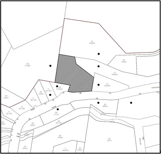
|
NOTIFICATION PLAN |
|||
|
• PROPERTIES NOTIFIED |
X SUBMISSIONS RECEIVED |
|
|
5.2 Public Agencies
The development application was not referred to any Public Agencies for comment.
6. THE PUBLIC INTEREST
Section 4.15(1)(e) of the Act requires Council to consider “the public interest”.
The public interest is an overarching requirement, which includes the consideration of the matters discussed in this report. Implicit to the public interest is the achievement of future built outcomes adequately responding to and respecting the future desired outcomes expressed in environmental planning instruments and development control plans.
The application is considered to have satisfactorily addressed Council’s criteria and would provide a development outcome that, on balance, would result in a positive impact for the community. Accordingly, it is considered that the approval of the proposed development would be in the public interest.
CONCLUSION
The application proposes alterations and additions to an existing industrial building.
The development generally meets the desired outcomes of Council’s planning controls and is satisfactory having regard to the matters for consideration under Section 4.15 of the Environmental Planning and Assessment Act 1979.
Having regard to the circumstances of the case, approval of the application is recommended.
The reasons for this decision are:
· The request under Clause 4.6 of Hornsby Local Environmental Plan 2013 to contravene the Clause 4.3 Height of Buildings development standard is well founded. Strict compliance with the development standard is considered unreasonable and unnecessary in the circumstances of the case and sufficient environmental planning grounds have been submitted to justify the contravention to the development standard.
· The proposed development complies with the requirements of the relevant environmental planning instruments and the Hornsby Development Control Plan 2013.
· The proposed development does not create unreasonable environmental impacts to adjoining development with regard to visual bulk, solar access, amenity or privacy.
Note: At the time of the completion of this planning report, no persons have made a Political Donations Disclosure Statement pursuant to Section 10.4 of the Environmental Planning and Assessment Act 1979 in respect of the subject planning application.
RESPONSIBLE OFFICER
The officer responsible for the preparation of this report is Ben Jones.
|
Cassandra Williams Major Development Manager - Development Assessments Planning and Compliance Division |
Rod Pickles Manager - Development Assessments Planning and Compliance Division |
|
Locality Plan |
|
|
|
|
Clause 4.6 |
|
|
|
|
Architectural Plans |
|
|
|
|
Request for Additional Information |
|
|
File Reference: DA/1308/2021
Document Number: D08458141
Schedule 1
1. GENERAL CONDITIONS
The conditions of consent within this notice of determination have been applied to ensure that the use of the land and/or building is carried out in such a manner that is consistent with the aims and objectives of the relevant legislation, planning instruments and Council policies affecting the land and does not disrupt the amenity of the neighbourhood or impact upon the environment.
Note: For the purpose of this consent, the term ‘applicant’ means any person who has the authority to act on or the benefit of the development consent.
Note: For the purpose of this consent, any reference to an Act, Regulation, Australian Standard or publication by a public authority shall be taken to mean the gazetted Act or Regulation, or adopted Australian Standard or publication as in force on the date that the application for a construction certificate is made.
1. Approved Plans and Supporting Documentation
The development must be carried out in accordance with the plans and documentation listed below and endorsed with Council’s stamp, except where amended by Council and/or other conditions of this consent:
Approved Plans
|
2. Plan No. |
3. Plan Title |
4. Drawn by |
5. Dated |
6. Council Reference |
|
7. DA01 |
8. Site Plan |
9. AB3D |
10. 3/11/2021 |
11. |
|
12. DA02 |
13. Sections & Elevations |
14. AB3D |
15. 3/11/2021 |
16. |
|
17. DA03 |
18. Building Plans Levels 1,2 |
19. AB3D |
20. 3/11/2021 |
21. |
|
22. DA04 |
23. Proposed Unit 34 Level 2 |
24. AB3D |
25. 3/11/2021 |
26. |
|
27. DA05 |
28. Building Plan Level 3 |
29. AB3D |
30. 3/11/2021 |
31. |
|
32. DA06 |
33. Proposed Unit 35 Level 3 |
34. AB3D |
35. 3/11/2021 |
36. |
|
37. DA07 |
38. Building Plan Level 4 |
39. AB3D |
40. 3/11/2021 |
41. |
|
42. DA08 |
43. Proposed Unit 36 Levels 3,4,5 |
44. AB3D |
45. 3/11/2021 |
46. |
|
47. DA09 |
48. Building Plan Level 5 |
49. AB3D |
50. 3/11/2021 |
51. |
|
52. DA10 |
53. Proposed Unit 37 Level 5 |
54. AB3D |
55. 3/11/2021 |
56. |
|
57. DA11 |
58. Proposed Units 38 & 39 Level 5 |
59. AB3D |
60. 3/11/2021 |
61. |
|
62. DA12 |
63. Proposed Unit 40 Level 5 |
64. AB3D |
65. 3/11/2021 |
66. |
|
67. DA13 |
68. Building Plan Level 6 |
69. AB3D |
70. 3/11/2021 |
71. |
|
72. DA002 |
73. Schedule of External Finishes |
74. AB3D |
75. 25/11/2021 |
76. |
|
77. DA003 |
78. ESD |
79. AB3D |
80. 25/11/2021 |
81. |
Supporting Documentation
|
82. Document Title |
83. Prepared by |
84. Dated |
85. Council Reference |
|
86. Waste Management Plan |
87. Key Urban Planning |
88. Undated |
89. D08310895 |
2. Section 7.12 Development Contributions
(a) In accordance with Section 4.17(1) of the Environmental Planning and Assessment Act 1979 and the Hornsby Shire Council Section 7.12 Development Contributions Plan 2019 - 2029, $5,384.55 must be paid towards the provision, extension or augmentation of public amenities or public services, based on development costs of $538,467.
(b) The value of this contribution is current as of 2 August 2022. If the contributions are not paid within the financial quarter that this consent is granted, the contributions payable will be adjusted in accordance with the provisions of the Hornsby Shire Council Section 7.12 Development Contributions Plan and the amount payable will be calculated at the time of payment in the following manner:
|
$CPY |
= |
|
|
$CDC x CPIPY |
|
|
|
|
|
CPIDC |
Where:
$CPY is the amount of the contribution at the date of Payment.
$CDC is the amount of the contribution as set out in this Development Consent.
CPIPY is the latest release of the Consumer Price Index (Sydney - All Groups) at the date of Payment as published by the ABS.
CPIDC is the Consumer Price Index (Sydney - All Groups) for the financial quarter at the date of this Development Consent.
(c) The monetary contributions shall be paid to Council:
(i) Prior to the issue of the Subdivision Certificate where the development is for subdivision.
(ii) Prior to the issue of the first Construction Certificate where the development is for building work.
(iii) Prior to issue of the Subdivision Certificate or first Construction Certificate, whichever occurs first, where the development involves both subdivision and building work.
(iv) Prior to the works commencing where the development does not require a Construction Certificate or Subdivision Certificate.
Note: It is the professional responsibility of the Principal Certifying Authority to ensure that the monetary contributions have been paid to Council in accordance with the above timeframes.
Note: The Hornsby Shire Council Section 7.12 Development Contributions Plan may be viewed at www.hornsby.nsw.gov.au or a copy may be inspected at Council’s Administration Centre during normal business hours.
3. Construction Certificate
a) A Construction Certificate is required to be approved by Council or a Private Certifying Authority prior to the commencement of any construction works under this consent.
b) The Construction Certificate plans must be consistent with the Development Consent plans.
90. REQUIREMENTS PRIOR TO THE ISSUE OF A CONSTRUCTION CERTIFICATE
4. Building Code of Australia
Detailed plans, specifications and supporting information is required to be submitted to the certifying authority detailing how the proposed building work achieves compliance with the National Construction Code - Building Code of Australia. All building work must be carried out in accordance with the requirements of the National Construction Code - Building Code of Australia.
5. Fire Safety Upgrade
To ensure the protection of persons using the building and to facilitate egress from the building in the event of a fire, the application for a construction certificate must demonstrate the following building upgrades:
a) Doors in the path of travel throughout the existing building shall have latches that comply with Section D2.21 of the National Construction Code - Building Code of Australia.
b) The existing fire hydrant system shall provide sufficient coverage to the proposed units. Notices for test and working pressures and block plans shall be displayed at the booster location in accordance with AS 2419.1.
c) Balustrading to the fifth-floor carpark shall comply with Section D2.16 of the National Construction Code - Building Code of Australia.
6. Fire Safety Schedule
A schedule of all proposed essential fire safety measures to be installed in the building (e.g. hydrants, hose reels, emergency warning systems etc.) shall be submitted with the construction certificate application.
7. Stormwater Drainage
The stormwater drainage system for the development must be designed in accordance with AUS-SPEC Specifications (www.hornsby.nsw.gov.au/property/build/aus-spec-terms-and-conditions) and the following requirements:
a) Connected directly to an existing internal drainage system which is connected to Council’s street drainage system.
b) The stormwater drainage system must be designed by a suitably qualified civil / hydraulic engineer.
8. Structural Adequacy
A Structural Adequacy Report prepared by an appropriately qualified and practicing structural engineer (CPEng or equivalent) for the existing building is required. The report must certify the structural adequacy of the existing building and its ability to withstand the proposed additional, or altered structural loads. The report shall be submitted to the Certifying Authority prior to issue of the Construction Certificate. Any recommendations of the consulting engineer must be incorporated into the construction certificate plans.
9. Internal Driveway/Vehicular Areas
The driveway and parking areas on site must be designed, constructed and a Construction Certificate issued in accordance with Australian Standards AS2890.1, and AS2890.2 where access is required to service a Medium Rigid Vehicle (MRV) and the following requirements:
a) To ensure flow of traffic servicing the development, swept out manoeuvres for design vehicles shall be shown on construction plans. That is, opposing B99 and B85 manoeuvres and the design MRV opposing B99 vehicles on bends and ramps.
b) All car parking spaces are to be lined marked.
c) The development must provide for a minimum of four bicycle parking spaces and two motorcycle parking spaces.
10. Design and Construction - Bushfire Attack Category
To ensure that the buildings are appropriately designed with respect to the bushfire attack level of the site:
a) All gaps >3mm or more on approved units be either screened within aluminium, steel or bronze metal mesh having an aperture size of ≤2mm or be sealed / closed.
b) External side-hung doors on approved units must be tight fitting and fitted with a draft excluder. This may require draft excluders on the stiles, head, sill or threshold and rebated or planted jambs & centre stiles.
c) The external roller doors on approved units have tight fitting guide tracks / seals (not providing a gap >3mm).
d) Any mechanical ducted ventilation provides screens over air intake vents and ensuring that exhaust vents are either screened or fitted with dampers that close when positive outward air pressure is lost to ensure the maintain ember protection to the inside of the building.
e) The sizing, pressure and spacing of the hydrant system be installed in accordance with AS2419.1-2005.
91. REQUIREMENTS PRIOR TO THE COMMENCEMENT OF ANY WORKS
11. Erection of Construction Sign
a) A sign must be erected in a prominent position on any site on which any approved work is being carried out:
i) Showing the name, address and telephone number of the principal certifying authority for the work.
ii) Showing the name of the principal contractor (if any) for any demolition or building work and a telephone number on which that person may be contacted outside working hours.
iii) Stating that unauthorised entry to the work site is prohibited.
b) The sign is to be maintained while the approved work is being carried out and must be removed when the work has been completed.
12. Protection of Adjoining Areas
A temporary hoarding, fence or awning must be erected between the work site and adjoining lands before the works begin and must be kept in place until after the completion of the works if the works:
a) Could cause a danger, obstruction or inconvenience to pedestrian or vehicular traffic.
b) Could cause damage to adjoining lands by falling objects; and/or.
c) Involve the enclosure of a public place or part of a public place; and/or.
d) Have been identified as requiring a temporary hoarding, fence or awning within the Council approved Construction Management Plan (CMP).
Note: Notwithstanding the above, Council’s separate written approval is required prior to the erection of any structure or other obstruction on public land.
13. Toilet Facilities
a) To provide a safe and hygienic workplace, toilet facilities must be available or be installed at the works site before works begin and must be maintained until the works are completed at a ratio of one toilet for every 20 persons employed at the site.
b) Each toilet must:
i) Be a standard flushing toilet connected to a public sewer.
ii) Be a temporary chemical closet approved under the Local Government Act 1993.
iii) Have an on-site effluent disposal system approved under the Local Government Act 1993.
14. Erosion and Sediment Control
To protect the water quality of the downstream environment, erosion and sediment control measures must be provided and maintained throughout the construction period in accordance with the manual ‘Soils and Construction 2004 (Bluebook)’, the approved plans, Council specifications and to the satisfaction of the principal certifying authority. The erosion and sediment control devices must remain in place until the site has been stabilised and revegetated.
Note: On the spot penalties may be issued for any non-compliance with this requirement without any further notification or warning.
15. Garbage Receptacle
a) A garbage receptacle must be provided at the work site before works begin and must be maintained until all works are completed.
a) The garbage receptacle must have a tight fitting lid and be suitable for the reception of food scraps and papers.
b) The receptacle lid must be kept closed at all times, other than when garbage is being deposited.
c) Food scraps must be placed in the garbage receptacle and not in demolition and construction waste bins.
92. REQUIREMENTS DURING DEMOLITION AND CONSTRUCTION
16. Construction Work Hours
All works on site, including demolition and earth works, must only occur between 7am and 5pm Monday to Saturday.
No work is to be undertaken on Sundays or public holidays.
17. Environmental Management
To prevent sediment run-off, excessive dust, noise or odour emanating from the site during the construction, the site must be managed in accordance with the publication ‘Managing Urban Stormwater - Landcom (March 2004) and the Protection of the Environment Operations Act 1997.
18. Pruning of Trees
This development consent permits the pruning of no more than 10% of the canopy of the tree numbered T1, as identified on the approved site plan DA01 prepared by AB3D in accordance with the following requirements:
a) Pruning must be undertaken by an arborist with a minimum AQF 3 qualification.
b) Pruning must only be undertaken if branches of tree T1 conflict with the approved location of Units 38 or 39.
c) Certification that any required pruning has been undertaken in accordance with this condition must be prepared by the engaged AQF 3 arborist and submitted to the PCA prior to the issue of any occupation certificate.
Note: The pruning or removal of any other trees from the site requires separate approval by Council in accordance with Part 1B.6 Tree and Vegetation Preservation of the Hornsby Development Control Plan, 2013.
19. Street Sweeping
To protect the surrounding environment, Street sweeping must be undertaken following sediment tracking from the site along Leighton Place during works and until the site is established.
The street cleaning services must undertake a street ‘scrub and dry’ method of service and not a dry sweeping service that may cause sediment tracking to spread or cause a dust nuisance.
20. Council Property
To ensure that the public reserve is kept in a clean, tidy and safe condition during construction works, no building materials, waste, machinery or related matter is to be stored on the road or footpath.
21. Disturbance of Existing Site
During construction works, the existing ground levels of open space areas and natural landscape features, including natural rock-outcrops, vegetation, soil and watercourses must not be altered unless otherwise nominated on the approved plans.
22. Landfill not Permitted
The importation of soil or other fill material associated with earthworks, or structural or engineering works, is not permitted as part of this consent.
23. Excavated Material
Any excavated material removed from the site must be classified by a suitably qualified environmental consultant in accordance with the NSW Environment Protection Authority’s Waste Classification Guidelines and Protection of the Environment Operations (Waste) Regulation 2014 prior to disposal to a licensed waste management facility. Tipping dockets for the total volume of excavated material that are received from the licensed waste management facility must be provided to the principal certifying authority prior to the issue of an Occupation Certificate.
24. Waste Management
All work must be carried out in accordance with the approved waste management plan.
93. REQUIREMENTS PRIOR TO THE ISSUE OF AN OCCUPATION CERTIFICATE
25. Emergency Management
An Emergency Evacuation Plan must be prepared by a suitably qualified person consistent with the NSW Rural Fire Service document ‘Guidelines for the Preparation of Emergency/Evacuation Plan’ and be submitted to the principle certifying authority with the application for an Occupation Certificate.
26. External Lighting
a) To protect the amenity of adjacent premises, all external lighting must be designed and installed in accordance with Australian Standard AS4282 Control of the obtrusive effects of outdoor lighting.
b) Certification of compliance with this Standard must be obtained from a suitably qualified person and submitted to the PCA with the application for the Occupation Certificate.
27. Unit Numbering
All units are to be numbered consecutively commencing at No.1. The strata plan lot number is to coincide with the unit number, e.g Unit 1 = Lot 1. The allocated of unit numbering must be authorised by Council prior to the numbering of each units in the development.
28. Damage to Council Assets
To protect public property and infrastructure, any damage caused to Council’s assets as a result of the construction or demolition of the development must be rectified by the applicant in accordance with AUS-SPEC Specifications (www.hornsby.nsw.gov.au/property/build/aus-spec-terms-and-conditions. Rectification works must be undertaken prior to the issue of an Occupation Certificate, or sooner, as directed by Council.
29. Fire Safety Statement - Final
In accordance with the Environmental Planning and Assessment (Development Certification and Fire Safety) Regulation 2021, upon completion of the building, the owner must provide Council with a certificate in relation to each fire safety measure implemented in the building.
94. OPERATIONAL CONDITIONS
30. Use of Premises
The industrial units approved under this consent shall be used for a ‘light industry’ purpose, as per the definition of this term in the Hornsby Local Environmental Plan 2013, and not for any other purpose without Council’s separate written consent.
31. Fire Safety Statement - Annual
On at least one occasion in every 12 month period following the date of the first ‘Fire Safety Certificate’ issued for the property, the owner must provide Council with an annual ‘Fire Safety Certificate’ to each essential service installed in the building.
32. Noise
All noise generated by the proposed development must be attenuated to prevent levels of noise being emitted to adjacent premises which possess tonal, beating and similar characteristics or which exceeds background noise levels by more than 5dB(A).
- END OF CONDITIONS -
ADVISORY NOTES
The following information is provided for your assistance to ensure compliance with the Environmental Planning and Assessment Act 1979, Environmental Planning and Assessment Regulation 2000, other relevant legislation and Council’s policies and specifications. This information does not form part of the conditions of development consent pursuant to Section 4.17 of the Act.
Environmental Planning and Assessment Act 1979 Requirements
The Environmental Planning and Assessment Act 1979 requires:
· The issue of a construction certificate prior to the commencement of any works. Enquiries can be made to Council’s Customer Services Branch on 9847 6760.
· A principal certifying authority to be nominated and Council notified of that appointment prior to the commencement of any works.
· Council to be given at least two days written notice prior to the commencement of any works.
· Mandatory inspections of nominated stages of the construction inspected.
· An occupation certificate to be issued before occupying any building or commencing the use of the land.
Long Service Levy
In accordance with Section 34 of the Building and Construction Industry Long Service Payments Act 1986, a ‘Long Service Levy’ must be paid to the Long Service Payments Corporation or Hornsby Council.
Note: The rate of the Long Service Levy is 0.35% of the total cost of the work.
Note: Hornsby Council requires the payment of the Long Service Levy prior to the issue of a construction certificate.
Tree and Vegetation Preservation
Hornsby Development Control Plan 2013 Tree and Vegetation Preservation provisions have been developed under Council’s authorities contained in State Environmental Planning Policy (Vegetation in Non-Rural Areas) 2017 and the Environmental Planning and Assessment Act 1979.
In accordance with these provisions a person must not cut down, fell, uproot, kill, poison, ringbark, burn or otherwise destroy the vegetation, lop or otherwise remove a substantial part of the trees or vegetation to which any such development control plan applies without the authority conferred by a development consent or a permit granted by Council.
Fines may be imposed for non-compliance with the Hornsby Development Control Plan 2013.
Note: A tree is defined as a long lived, woody perennial plant with one or relatively few main stems with the potential to grow to a height greater than three metres (3m). (HDCP 1B.6.1.c).
Disability Discrimination Act
The applicant’s attention is drawn to the existence of the Disability Discrimination Act 1992. A construction certificate is required to be obtained for the proposed building/s, which will provide consideration under the Building Code of Australia, however, the development may not comply with the requirements of the Disability Discrimination Act 1992. This is the sole responsibility of the applicant.
Covenants
The land upon which the subject building is to be constructed may be affected by restrictive covenants. Council issues this approval without enquiry as to whether any restrictive covenant affecting the land would be breached by the construction of the building, the subject of this consent. Applicants must rely on their own enquiries as to whether or not the building breaches any such covenant.
Tenancy Fit-Out - Separate DA Required
This consent does not permit the fit-out of individual tenancies. A separate development application is required for the fit-out of individual tenancies prior to the occupation of the building.
Use of Existing Building - Separate DA Required
This consent does not change the use, or permit any previously unapproved use, of any unit within the existing premises.
Advertising Signage - Separate DA Required
This consent does not permit the erection or display of any advertising signs. Most advertising signs or structures require development consent. Applicants should make separate enquiries with Council prior to erecting or displaying any advertising signage.
LPP Report No. LPP49/22
Local Planning Panel
Date of Meeting: 31/08/2022
4 DA/181/2022 - DEMOLITION OF EXISTING STRUCTURES AND CONSTRUCTION OF A 5 STOREY RESIDENTIAL FLAT BUILDING COMPRISING 21 UNITS - 10 AND 12 BELLEVUE STREET, THORNLEIGH
|
DA No: |
DA/181/2022 (Lodged on 23 February 2022) |
|
Description: |
Demolition of existing structures, construction of a 5 storey residential flat building containing 21 residential units over basement parking, associated landscape/civil works and consolidation of allotments |
|
Property: |
Lot A and B DP 360224, Nos. 10 and 12 Bellevue Street, Thornleigh |
|
Applicant: |
Zhinar Architects |
|
Owner: |
Vue leigh Pty Ltd |
|
Estimated Value: |
$5,994,930 |
|
Ward: |
B Ward |
· The proposal does not comply with the ‘Height of buildings’ development standard contained within Clause 4.3 of the Hornsby Local Environmental Plan 2013. The applicant has made a submission in accordance with Clause 4.6 ‘Exceptions to development standards’ of the Hornsby Local Environmental Plan 2013 to contravene the ‘Height of buildings’ development standard. The submission is considered well founded and is supported.
· A total of 5 submissions have been received in respect of the application.
· The application is required to be determined by the Hornsby Council Local Planning Panel as State Environmental Planning Policy No. 65 Design Quality of Residential Development applies.
· It is recommended that the application be approved.
The subject land was rezoned from Residential A (Low Density) to R4 (High Density Residential) on 2 September 2011 as part of Council’s Housing Strategy.
On 8 November 2017, Council resolved to undertake a Design Excellence Review of planning controls with the aim of improving the built form outcomes of residential flat buildings and townhouses development in Hornsby Shire.
On 4 December 2020, the Hornsby Local Environmental Plan 2013 was amended pursuant to Hornsby Local Environmental Plan 2013 (Amendment No. 11) which resulted in a reduction of the permissible height of building standard from 17.5m to 16.5m.
On 21 September 2021, Council’s Design Excellence Panel (DEP) meeting was held for a pre-lodgement proposal of a 5-storey residential flat building comprising 21 units and basement car parking within the subject site.
On 7 October 2021, Council issued pre-lodgement advice including DEP advice for a 5 storey residential flat building comprising 21 units and basement car parking at the subject site.
On 23 February 2022 the subject application was lodged with Council.
On 13 April 2022, the subject development application was reviewed by Council’s DEP. The panel were generally comfortable with the built form and internal layouts of the apartments. It was however recommended that the following key comments be further investigated and addressed:
· Review of basement with relaxed deep soil zone widths.
· Provision of ADG minimum communal open space of 25%.
· Compliant co-location of communal open space with deep soil.
On 5 May 2022, Council requested additional information relating to waste management, acoustics, construction management, cut/fill, geotechnical and the DEP matters raised. It was also recommended that the OSD be relocated due to a conflict with deep soil planting and the location of the above ground basin.
On 8 August 2022, after ongoing correspondence with the Applicant regarding the requested additional information, the required documentation was submitted for Council’s consideration with some minor amendments to location of the OSD, height (reduced) and landscape treatments. Given the minor nature of the amendments, the application was not required to be publicly re-notified.
The 1327.8m2 relatively flat site comprises two allotments, Nos. 10 and 12 Bellevue Street, Thornleigh. The site is located on the southern side of Bellevue Street. Overhead power lines exist along the Bellevue Street frontage and a footpath exists along the street frontage.
The site contains two dwelling houses with associated outbuildings and landscaping and a number of exotic, native and locally indigenous trees.
Whilst the site does not include a heritage item and is not located within a heritage conservation area, it is located within the vicinity of a heritage item at No. 9 Station Street, Thornleigh (Item No. 718) listed under Schedule 5 in the Hornsby Local Environmental Plan 2013.
Approximately 70 metres to the west of the site is the intersection of Pennant Hills Road. The site is in close proximity to an ALDI supermarket complex, across the road from the Thornleigh Marketplace that accommodates Woolworths and specialty shops and to the south are single storey dwellings zoned for 5 storey residential flat buildings. The site is also within walking distance of Thornleigh Railway Station, which is approximately 200 metres to the west, on the opposite side of Pennant Hills Road.
Bus stops with regular services to Hornsby, Castle Hill and Parramatta are located along Pennant Hills Road in close proximity to the site.
The surrounding area includes single dwellings houses and is undergoing transition to high density housing development. The site adjoins a recently completed residential flat building development to the east (DA/1337/2015 and DA/1337/2015/A) and an approved residential flat building development to the west that has not been commenced (DA/901/2018).
Both these developments were approved under the previous HLEP and HDCP controls.
The application proposes construction of a 5-storey residential flat building containing 21 units and comprising the following works:
· Demolition of existing structures and removal of trees.
· Construction of 2 basement car parking levels containing 28 car spaces (3 disabled), including 24 resident spaces and 4 visitors spaces. 1 motorcycle space and 4 bicycle racks are also proposed.
· Provision of 3x 1-bedroom units, 14x 2-bedroom units and 4x 3-bedroom units.
· Associated landscaping, incorporating replacement trees, deep soil planting, shrubs, screening plants, ground covers and planting boxes on Level 4.
· Consolidation of two lots into one.
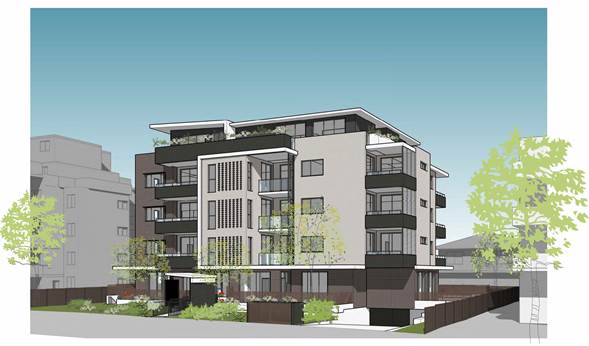
Figure 1: Photomontage of proposed residential flat building.
The ground floor of the development would comprise vegetated front setback, private courtyard areas for ground level units and a rear private open space area comprising garden areas, lawn, BBQ and seating facilities.
The development would drain stormwater to the Bellevue Street drainage system via an on-site detention.
Seven trees would be removed by the proposed development.
The development application has been assessed having regard to the Greater Sydney Region Plan - A Metropolis of Three Cities, the North District Plan and the matters for consideration prescribed under Section 4.15 of the Environmental Planning and Assessment Act 1979 (the Act). The following issues have been identified for further consideration.
1. STRATEGIC CONTEXT
1.1 Greater Sydney Region Plan - A Metropolis of Three Cities and North District Plan
The Greater Sydney Region Plan - A Metropolis of Three Cities has been prepared by the NSW State Government to guide land use planning decisions for the next 40 years (to 2056). The Plan sets a strategy and actions for accommodating Sydney’s future population growth and identifies dwelling targets to ensure supply meets demand. The Plan also identifies that the most suitable areas for new housing are in locations close to jobs, public transport, community facilities and services.
The NSW Government will use the subregional planning process to define objectives and set goals for job creation, housing supply and choice in each subregion. Hornsby Shire has been grouped with Hunters Hill, Ku-ring-gai, Lane Cove, Mosman, North Sydney, Ryde, Northern Beaches and Willoughby to form the North District. The Greater Sydney Commission has released the North District Plan which includes priorities and actions for Northern District for the next 20 years. The identified challenge for Hornsby Shire will be to provide an additional 4,350 dwellings by 2021 with further strategic supply targets to be identified to deliver 97,000 additional dwellings in the North District by 2036.
The proposed development would be consistent with the Greater Sydney Region Plan - A Metropolis of Three Cities and the North District Plan, by contributing to achieving the dwelling targets for the region.
2. STATUTORY CONTROLS
Section 4.15(1)(a) requires Council to consider “any relevant environmental planning instruments, draft environmental planning instruments, development control plans, planning agreements and regulations”.
2.1 Hornsby Local Environmental Plan 2013
The proposed development has been assessed having regard to the provisions of the Hornsby Local Environmental Plan 2013 (HLEP).
2.1.1 Zoning of Land and Permissibility
The subject land is zoned R4 (High Density Residential) under the HLEP. The objectives of the R4 zone are:
· To provide for the housing needs of the community within a high density residential environment.
· To promote a variety of housing types within a high density residential environment.
· To enable other land uses that provide facilities or services to meet the day to day needs of residents.
The proposed development is a high density residential development and complies with the zone objectives by providing a variety of housing types and new housing stock. The proposed development is defined as a ‘residential flat building’ under the HLEP and is permissible in the zone with the consent of Council.
2.1.2 Height of Buildings
Clause 4.3 of the HLEP provides that the height of a building on any land should not exceed the maximum height shown for the land on the Height of Buildings Map. The maximum permissible height for the subject site is 16.5m.
The building proposes a maximum height of 17.47m, a contravention of 5.9% which does not comply with the height of building development standard. The applicant has submitted a written request to contravene the Height of Buildings development standard pursuant to Clause 4.6 of the HLEP. The written request is discussed in detail below.
2.1.3 Exceptions to Development Standards
The application has been assessed against the requirements of Clause 4.6 of the HLEP. This clause provides flexibility in the application of the development standards in circumstances where strict compliance with those standards would, in any particular case, be unreasonable or unnecessary or tender to hinder the attainment of the objectives of the zone.
The application seeks to contravene Clause 4.3 of the HLEP as the maximum height of building would be 17.47m which exceeds the development standard by 970mm or 5.9% and does not comply with the 16.5m height of building development standard.
The following diagrams demonstrate the extent of the non-compliant building portions, as demonstrated by the blue dashed line at 16.5 metres above existing ground level:
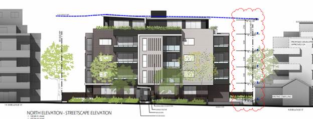
Figure 2: Elevation plan demonstrating over height portion of building.
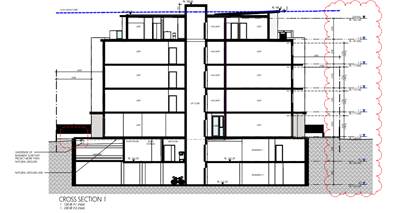
Figure 3: Section plan demonstrating over height portion of building.
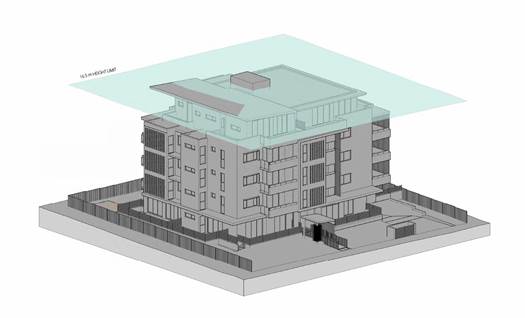
Figure 4: Isometric Blanket Diagram.
As demonstrated in the figures above, the lift overrun, and a small portion of the eastern section of the Level 4 roof exceed the 16.5 metre height development standard.
The objectives of Clause 4.3 Height of buildings are as follows:
a) To permit a height of buildings that is appropriate for the site constraints, development potential and infrastructure capacity of the locality.
b) The height of a building on any land is not to exceed the maximum height shown for the land on the Height of Buildings Map.
The applicant has made a submission in support of the contravention to the development standard in accordance with Clause 4.6 of the HLEP. Clause 4.6 provides that development consent must not be granted for development that contravenes a development standard unless the consent authority has considered a written request from the applicant that seeks to justify the contravention of the development standard by demonstrating:
(a) That compliance with the development standard is unreasonable or unnecessary in the circumstances of the case, and
(b) That there are sufficient environmental planning grounds to justify contravening the development standard.
Council must be satisfied that the written request provided by the applicant under Clause 4.6 addresses both the unreasonable and unnecessary test and demonstrates sufficient environmental planning grounds to justify contravening the development standard. These matters are discussed below.
2.1.3.1 Unreasonable or Unnecessary Clause 4.6(3)(a)
There are five common methods by which an applicant can demonstrate that compliance with a development standard is unreasonable or unnecessary in the circumstances of the development. Initially proposed for objections under clause 6 of SEPP 1 in the decision of Wehbe v Pittwater Council [2007] NSWLEC 827 Pearson C summarised and applied these methods to written requests made under Clause 4.6 in Four2Five Pty Ltd v Ashfield Council [2015] NSWLEC 1009 [61-62]. These five methods are generally as follows:
· The objectives of the development standard are achieved notwithstanding non-compliance with the standard.
· The underlying objective or purpose is not relevant to the development.
· That the objective would be defeated or thwarted if compliance was required.
· That the development standard has been virtually abandoned or destroyed by the Council’s own actions in departing from the standard.
· The zoning of the land is unreasonable or inappropriate.
It is not required to demonstrate that a development meets multiple methods as listed above, and the satisfaction of one can be adequate to demonstrate that the development standard is unreasonable or unnecessary.
The written request prepared by Caladines Town Planning Pty Ltd, dated 1 August 2022 provides a detailed assessment of the proposal with respect to the development standard sought to be contravened. The request argues that the objectives of the development standard are achieved notwithstanding non-compliance with the standard, providing relevant reasoning as follows:
· Council’s height controls surrounding the site promote buildings of similar scale to that proposed. The average person walking past the site or from a distance would not realize there is a departure from the height control of between 160mm or 0.99% (small portion of roof-eastern side) and lift overrun by 970mm or 5.9%.
· Because of the orientation of the site, the proposed development does not cast any additional shadow onto the public domain compared to a fully compliant 16.5m high design scheme.
· The objectives of the height standard are still achieved in that it provides a transition in built form and will not unreasonably impact upon the amenity of adjoining neighbours or block or interrupt any known view corridors or vistas.
· The sites R4 High Density Residential zone objectives are met because the proposal increases the population of this neighbourhood.
· The variation is consistent with all relevant environmental planning instruments to increase densities around public transport corridors and employment zones, such as buses along Pennant Hills Rd, Thornleigh Railway Station and the Thornleigh Town Centre.
· The orderly and economic use of the land achieves a planning outcome that does not impact upon neighbours or future residents within the proposed RFB.
· It satisfies the intent of Council’s strategic planning vision for new high rise development in this precinct.
· Privacy impacts have been mitigated to that of a fully compliant design scheme.
With reference to the reasoning provided by the applicant above, Council does not object to the conclusion that the proposed development meets the objectives of Clause 4.3. In reaching this conclusion the following points are noted:
· The development would maintain a 5 storey height consistent with the objectives of the R4 residential zone.
· The height departure would not result in any significant amenity impact to surrounding neighbours in terms of overshadowing and privacy and the proposed over height building portions do not create unacceptable overshadowing to any adjoining residential development.
· The overall appearance of the building, when viewed from the street front, would be consistent with surrounding developments.
· The proposed development would not overly dominate surrounding built element or be obvious in its non-compliance.
· The proposed height variation is appropriate considering the constraints of the site in terms of land slope.
· The application provides for the orderly and economic development of land, sufficient consideration of the surrounding residential area and associated amenity impacts and demonstrates adequate consideration and protection of the environmental and public interest.
· The proposed height non-compliance does not diminish the development potential of the site, or any surrounding development;
· The development would not overburden the infrastructure capacity of the locality and does not permit additional floor area or units on the subject site. The building would maintain a five storey design and would have a yield consistent with the strategic intent for the site; and
· The proposed development generally meets the objectives of Clause 4.3 Height of Buildings of the HLEP by way of being appropriate with respect to the constraints of the site and in regard to the development potential of the site.
For the reasons outlined above, it is considered that the written request to contravene the height of building standard adequately demonstrates that the objectives of the height of building development standard contained within Clause 4.3 of the HLEP are achieved, notwithstanding non-compliance with the standard.
2.1.3.2 Environmental Planning Grounds - Clause 4.6(3)(b)
In addition to demonstrating that compliance is unreasonable or unnecessary, Clause 4.6(3)(b) requires that there are sufficient environmental planning grounds to justify contravening the development standard. In demonstrating that sufficient environmental planning grounds exist it must be demonstrated that the planning grounds are particular to the circumstances of the development on the subject site (summarised from Four2Five Pty Ltd v Ashfield Council [2015] NSWLEC 1009 [60].
The applicant provided the following planning grounds for the contravention of the development standard:
· The proposed RFB is permissible in the R4 High Density Residential zone and is consistent with the zones objectives.
· The proposed RFB does not significantly increase overshadowing to that of a fully compliant 16.5m building height scheme.
· The lift overrun, which encroaches above the height control by 970mm does not cast any shadow outside of the roof and that part of the roof that extends 160mm above the standard generates a very small increase in shadow to that generated by a compliant design scheme.
· No views will be lost to that of a fully compliant scheme.
· The design responds to its eclectic context in that the proposed design is responsive to its urban infill location and will not impact upon the amenity of existing or future residents in this precinct, in terms of overlooking and overshadowing of private and communal open space areas.
· The proposed development is located on a site that is large in size and falls towards the rear. The additional height comfortably fits within its transitional neighbourhood context and ideally suits the sites location.
· Compliance with the development standard is deemed to be unreasonable or unnecessary in the circumstances of this case because the departure sought does not create any additional amenity impacts upon the built and natural environments to that of a fully compliant design scheme.
· The proposed RFB demonstrates that although the roof marginally exceeds the height control in two (2) small areas, the proposed RFB can readily fit within this transitional neighbourhood context.
· The proposed built form responds to Council’s LEP controls in that provision is made for a high density RFB that is complimentary to the height control objectives to control future development on this property and other residential development within the visual catchment of the site.
· The proposed design is in the public interest as it promotes a quality built form in that the development will engage in responding to a need for greater economic and social benefits to this neighbourhood.
Council considers that the environmental planning grounds stated within the written request are sufficient with respect to Clause 4.6(3)(b) and that the stated grounds are specific to the proposed development and the circumstances of the development site. It is therefore considered that the written request adequately demonstrates compliance with the clause and is acceptable in this regard.
As it is considered that the written request demonstrates sufficient environmental planning grounds specific to the development site, no further justification is considered necessary as sound environmental planning grounds for the non-compliance have been established.
Council is therefore satisfied that Clause 4.6(3)(b) of the HLEP is adequately addressed.
2.1.3.3 Public Interest and Clause 4.6(4)
Clause 4.6(4) states that development consent must not be granted for development that contravenes a development standard unless:
(a) The consent authority is satisfied that:
(i) The applicant’s written request has adequately addressed the matters required to be demonstrated by subclause (3), and
(ii) The proposed development will be in the public interest because it is consistent with the objectives of the particular standard and the objectives for development within the zone in which the development is proposed to be carried out, and
(b) The concurrence of the Planning Secretary has been obtained.
With regard to part (a)(i), the written request is considered to adequately address the matter required to be demonstrated as outlined above.
With regard to part (a)(ii), the proposed development is considered to be in the public interest because it is consistent with the objectives of the particular standard and the objectives for development within the zone in which the development is proposed to be carried out.
With regard to (b), on 21 February 2018, the Secretary of the Department of Planning and Environment issued a Notice under cl. 64 of the Environmental Planning and Assessment Regulation 2000. The Secretary’s concurrence may not be assumed by a delegate of council if:
· The development contravenes a numerical standard by greater than 10%.
· The variation is to a non-numerical standard.
Local Planning Panels constituted under the Environmental Planning and Assessment Act 1979 exercise consent authority functions on behalf of a Council and are not delegates of Council. Therefore, Local Planning Panels may determine a development application notwithstanding, a numerical non-compliance in excess of 10%.
Therefore, the exceedance of the height of buildings development standard is supported in this instance.
2.1.4 Heritage Conservation
Clause 5.10 of the HLEP sets out heritage conservation provisions for Hornsby Shire. Whilst the site does not include a heritage item and is not located within a heritage conservation area, it is located within the vicinity of a heritage item at No. 9 Station Street which was approved for demolition on 1 November 2016 under DA/835/2016.
Accordingly, no further assessment in this regard is necessary.
2.1.5 Earthworks
Clause 6.2 of the HLEP states that consent is required for proposed earthworks on site. Before granting consent for earthworks, Council is required to assess the impacts of the works on adjoining properties, drainage patterns and soil stability of the locality.
The site is relatively level. The proposal includes excavation works for a basement car park. The geology of the site is identified as bedrock comprising shale and laminate, overlying deeper sandstone. A condition is recommended that the recommendations of the Geotechnical Assessment prepared by Green Geotechnics be applied including but not limited to the completion of dilapidation surveys/reports for adjoining buildings and structures prior to the commencement of works and inspections and monitoring of earthworks and footing excavations by Green Geotechnics.
In addition, all excavated material removed from the site must be classified by a suitably qualified environmental consultant in accordance with the NSW Environment Protection Authority’s Waste Classification Guidelines and Protection of the Environment Operations (Waste) Regulation 2014 prior to disposal to a licensed waste management facility. Tipping dockets for the total volume of excavated material that are received from the licensed waste management facility must be provided to the principal certifying authority prior to the issue of an Occupation Certificate. A Council approved Construction Management Plan must also be complied with for the duration of works.
Subject to recommended conditions, the proposal is considered satisfactory in respect to Clause 6.2 of the HLEP.
2.1.6 Design Excellence
Clause 6.8 of the HLEP provides considerations for the delivery of the highest standard of architectural and urban design. The development application was referred to Council’s Design Excellence Panel (DEP) on 13 April 2022 for review.
The DEP previously reviewed the proposal at pre-lodgement stage on 21 September 2021 where a number of matters raised by the Panel were adopted as part of the subject development application including the re-configuration of units within the RFB to improve layout, solar access and ventilation. The Panel were satisfied that a number of these changes had substantially improved the overall design of the development.
The Panel further reviewed the proposed development under this application and concluded the following:
The panel is generally comfortable with the built form and internal layouts of the apartments. It is however recommended that the proposal be presented again once the following key comments have been investigated and addressed:
· Review of basement with relaxed deep soil zone widths.
· Provision of ADG minimum communal open space of 25%.
· Compliant co-location of communal open space with deep soil.
Additional matters raised by the Panel for consideration by the Applicant included location of ancillary elements cluttering the front setback such as fire hydrant, bin holding bay etc, landscape treatment on Level 4 of the building (should include planter boxes), layout of communal open space at rear and how the external rear hard stand spaces connect with the rear building entry, basement carpark and access to the front of the site.
Council provided the detailed DEP assessment of the proposal to the applicant for consideration and the applicant supplied amended plan and further detail regarding the key considerations outlined above. The following amendments were made:
· Landscaping on Level 4 replaced with planter boxes.
· Re-configuration of front setback elements to reduce cluttering.
· Re-designed communal open space and hardstand spaces, providing more opportunity for deep soil planting and improving connectivity with the basement carpark, rear building entry and access to the front of the site.
· Building height lowered by 200mm.
· Rainwater harvesting provided to the development to irrigate the common landscaped areas including planter boxes on fifth floor (11,000 Litres).
· Photovoltaic system (solar panels) provided for common area electricity usage (lighting & power).
· Energy and water efficient appliances & fixtures/fittings; minimum 4 star provided to all apartments.
· Indoor environmental quality optimised through efficient and passive architectural design.
· Units are afforded cross and through ventilation and excellent access to natural light. Limited reliance on mechanical/artificial means (lighting and heating/cooling).
· Reduction in conflicting deep soil planting elements including the communal open space hard stand areas and the OSD. These have been relocated and consolidated into more suitable areas where deep soil planting isn’t considered as high a priority.
The following provides a more detailed discussion on some of the key comments raised by the DEP:
Deep Soil Planting
Whilst the level of deep soil planting was not increased, the conflicting aspects within the identified deep soil planting areas were addressed and improved to ensure larger trees could be planted in areas of higher importance, including within the front and rear setbacks. The OSD was relocated to the eastern side boundary and communal open space hard stand areas consolidated to the south-eastern rear corner of the site where a group of larger trees are to be retained, providing necessary softening and screening to the development.
Communal Open Space (COS)
The Applicant contends that they comply with the required 25% COS requirement for the site. An area within the eastern side setback was included in the Applicants calculation. This area did not meet the dimension requirements for COS within the ADG.
Council’s assessment of the COS identified that there was only 22.5% COS proposed for the site. Whilst Council recognises there is a shortfall in COS, this shortfall has been considered acceptable due to larger private open spaces being provided throughout the site (including ground level courtyards) which is considered beneficial for a residential flat building of this nature.
It should also be noted that the re-design of the COS was considered an overall improvement due to greater provision of deep soil planting throughout the site.
As detailed above, the application has undergone a detailed design review with the objective of ensuring an adequate level of design excellence. Council considers that the considerations provided by the DEP have been adequately addressed and the development as proposed is consistent with the requirements of Clause 6.8 of the HLEP.
2.2 Consolidated State Environmental Planning Policies
On 1 March 2022, the following State Environmental Planning Policies (SEPPS) were gazetted.
· State Environmental Planning Policy (Primary Production) 2021
· State Environmental Planning Policy (Resources and Energy) 2021
· State Environmental Planning Policy (Resilience and Hazards) 2021
· State Environmental Planning Policy (Industry and Employment) 2021
· State Environmental Planning Policy (Transport and Infrastructure) 2021
· State Environmental Planning Policy (Biodiversity and Conservation) 2021
· State Environmental Planning Policy (Planning Systems) 2021
· State Environmental Planning Policy (Precincts - Eastern Harbour City) 2021
These SEPPS now form matters for consideration under Section 4.15 of the Environmental Planning and Assessment Act 1979. However, general savings provisions apply to development applications that have been made but not yet determined, on or before the commencement date.
As this development application was lodged on 23 February 2022, this development application is considered to have been made prior to the commencement date of the SEPPs. SEPP (Resilience and Hazards), SEPP (Biodiversity and Conservation), SEPP (Transport and Infrastructure) have been considered as matters for consideration under S4.15 of the EP&A Act 1979. However, the existing legislation in force at time of lodgement of the development application, prevails to be extent of any inconsistency.
2.3 State Environmental Planning Policy No. 55 Remediation of Land
The application has been assessed against the requirements of State Environmental Planning Policy No. 55 Remediation of Land (SEPP 55) under which consent must not be granted to the carrying out of any development on land unless the consent authority has considered whether the land is contaminated or requires remediation for the proposed use.
Should the land be contaminated, Council must be satisfied that the land is suitable in a contaminated state for the proposed use. If the land requires remediation to be undertaken to make the land suitable for the proposed use, Council must be satisfied that the land will be remediated before the land is used for that purpose.
An examination of Council’s records and aerial photography has determined that the site has been historically used for commercial and residential purposes. Appropriate conditions of development consent have been recommended in Schedule 1 of this report, including the implementation of an unexpected finds protocol, to ensure that if unexpected contamination is detected on site, appropriate mitigation measures are undertaken.
2.4 State Environmental Planning Policy No. 65 Design Quality of Residential Flat Development
State Environmental Planning Policy No. 65 Design Quality of Residential Flat Development (SEPP 65) provides for design principles to improve the design quality of residential flat development and for consistency in planning controls across the State.
SEPP 65 adopts the Apartment Design Guide which prevails in the event of any inconsistency with a Development Control Plan. The Policy includes objectives to meet housing and population targets, affordable housing and to facilitate timely and efficient assessment of development applications. SEPP 65 makes further provision for design review panels; includes additional provisions for the determination of development application and for standards for car parking, visual privacy, solar and daylight access, common circulation and spaces, apartment size and layout, ceiling heights, private open space and balconies, natural ventilation and storage, which cannot be used as grounds for refusal of development consent.
The applicant has submitted a “Design Verification Statement” prepared by a qualified Architect stating how the proposed development achieves the design principles of SEPP 65. An assessment of the proposal against the design quality principles contained within Schedule 1 of SEPP 65 and the submitted design verification statement are addressed in the following table:
|
SEPP 65 - Schedule 1 Assessment |
|
|
Principle |
Compliance |
|
1. CONTEXT AND NEIGHBOURHOOD CHARACTER |
Yes |
|
Comment: The site is located within a precinct planned for five storey residential flat buildings in close proximity to Thornleigh Railway Station and Thornleigh commercial centre. The desired future character of the area, as outlined in the Hornsby Development Control Plan 2013, is that of a locality characterised by residential flat buildings of 5-storeys in height in landscape settings with underground car parking. Development should seek to complement and enhance the adjacent public domain environment and building footprints by maintaining landscape corridors around and through development sites. The proposed development appropriately responds to the context of the site by proposing a residential flat building development adjacent to the existing Thornleigh Commercial Centre. The ground level would appropriately integrate with the existing public domain and sufficient landscaping is provided adjacent to side boundaries to ensure green links through the site. |
|
|
2. BUILT FORM AND SCALE |
Yes |
|
Comment: Despite the minor height non-compliance, it is considered that the proposed development achieves a scale, bulk and height appropriate to the existing or desired future character of the street and surrounding buildings. The building presents as highly articulated and of appropriate proportions and materiality. The concept would contribute to the character of the streetscape and offer residents a high level of amenity. |
|
|
3. DENSITY |
Yes |
|
Comment: The HLEP does not incorporate floor space ratio requirements for the site. The density of the development is governed by the height of the building and the required setbacks. The proposed density is considered to be sustainable as it responds to the regional context, availability of infrastructure, public transport, community facilities and environmental quality and is acceptable in terms of density. |
|
|
4. SUSTAINABILITY |
Yes |
|
Comment: The applicant has submitted a BASIX Certificate for the proposed development. In achieving the required BASIX targets for sustainable water use, thermal comfort and energy efficiency, the proposed development would achieve efficient use of natural resources, energy and water throughout its full life cycle, including demolition and construction. |
|
|
5. LANDSCAPE |
Yes |
|
Comment: The application includes a landscape concept plan which provides landscaping along the street frontages, side and rear boundaries and sufficient deep soil planting. The proposal has been designed to facilitate the retention of a group of 16 trees in the south-eastern, rear corner of the site. Large trees are proposed along the street frontages intercepted by shrubs and hedges which would soften the appearance of the development when viewed from the streets. Deep soil areas that incorporate canopy trees are provided around the building envelope which would enhance the development’s natural environmental performance and provide an appropriate landscaped setting. |
|
|
6. AMENITY |
Yes |
|
Comment: The proposed units are designed with appropriate room dimensions and layout to maximise amenity for future residents. The proposal incorporates good design in terms of achieving natural ventilation, solar access and acoustic privacy. All units incorporate balconies accessible from living areas and privacy has been achieved through appropriate design and orientation of balconies and living areas. Storage areas have been provided within each unit and in the basement levels. The proposal would provide convenient and safe access via a central lift connecting the basement and all other levels. |
|
|
7. SAFETY AND SECURITY |
Yes |
|
Comment: The design orientates the balconies and windows of individual apartments towards the street, rear and side boundaries, providing passive surveillance of the public domain and communal open space areas. Both the pedestrian and vehicular entry points are secured and visibly prominent from Bellevue Street. The proposal includes an assessment of the development against crime prevention controls in the Statement of Environmental Effects (SEE). The SEE has regard to Crime Prevention Through Environmental Design Principles (CPTED) and includes details of surveillance, access control, territorial reinforcement and space management such as artificial lighting in public places; attractive landscaping whilst maintaining clear sight lines; security coded door lock or swipe card entry; physical or symbolic barriers to attract, channel or restrict the movement of people; security controlled access to basement car park; intercom access for pedestrians; and security cameras located at the entrance of the building. Appropriate conditions of consent are recommended to require compliance with the above matters. |
|
|
8. SOCIAL DIMENSIONS AND HOUSING AFFORDABILITY |
Yes |
|
Comment: The proposal incorporates a range of unit sizes to cater for different budgets and housing needs. The development complies with the housing choice requirements of the HDCP by providing a component of adaptable housing and a mix of 1, 2 and 3 bedroom dwellings. The proposal responds to the social context in terms of providing a range of dwelling sizes with good access to social facilities and services as the site is located in close proximity to Thornleigh Railway Station and shops. |
|
|
9. AESTHETICS |
Yes |
|
Comment: The architectural treatment of the building incorporates indentations and projections in the exterior walls with balcony projections to articulate the facades. The roof is flat (or low pitched) to minimise building height and incorporates eaves which would cast shadows across the top storey wall. The articulation of the building, composition of building elements, textures, materials and colours would achieve a built form generally consistent with the design principles contained within the Apartment Design Guide and the Hornsby DCP. |
|
Clause 30(2) of SEPP 65 provides that development consent must not be granted if, in the opinion of the consent authority, the development or modification does not demonstrate that adequate regard has been given to the design quality principles. As outlined in the table above, it is considered that that proposed development demonstrates adequate regard to the design quality principles.
2.5 Apartment Design Guide
Amendment No. 3 of SEPP 65 also requires consideration of the Apartment Design Guide (ADG), NSW Department of Planning and Environment 2015. The ADG includes development controls and best practice benchmarks for achieving the design principles of SEPP 65. The following table sets out the proposal’s compliance with the ADG:
|
Apartment Design Guide |
|||
|
Control |
Proposal |
Requirement |
Compliance |
|
Communal Open Space (3D-1) |
22.5% |
25% of site area |
No |
|
Solar Access (Communal open space areas) (3D-1) |
>50% |
50% direct sunlight access for 2 hours |
Yes |
|
Deep Soil Zone (3E-1) |
24% |
7% of site area |
Yes |
|
Building Separation (3F-1) |
|
|
|
|
- side boundaries |
|
|
|
|
- Ground - Level 3 |
4.5 - 6m |
6m between habitable windows and balconies. 3m to non-habitable |
No |
|
- Level 4 |
8 - 9m |
9m between habitable windows and balconies. 4.5m to non-habitable |
No |
|
- rear boundary |
|
|
|
|
- Ground - Level 3 |
7m |
6m between habitable windows and balconies. 3m to non-habitable |
Yes |
|
- Level 4 |
9m |
9m between habitable windows and balconies. 4.5m to non-habitable |
Yes |
|
Car Parking (3J-1) |
28 spaces |
26 spaces |
Yes |
|
Solar Access (4A-1) |
|
|
|
|
- Living rooms |
85% - 18/21 |
2 hours for 70% |
Yes |
|
- Private open space |
85% - 18/21 |
2 hours for 70% |
Yes |
|
No Solar Access allowable for units (4A-1) |
<15% of units |
15% of units (max) |
Yes |
|
Natural Cross Ventilation (4B-3) |
85% |
60% |
Yes |
|
Ceiling Height (4C-1) |
2.7m 3m |
2.7m for habitable rooms 2.4 for non-habitable rooms |
Yes |
|
Minimum Dwelling Size (4D-1) |
|
|
|
|
- 1 Bed units |
52.73m2 |
50m2 |
Yes |
|
- 2 bed units |
75.39m2 |
70m2 |
Yes |
|
- 3 bed units |
97.53m2 |
90m2 |
Yes |
|
- 3 bed +5m2 for additional bathrooms |
N/A |
95+m2 |
N/A |
|
Minimum Window Size (4D-1) |
>10% |
10% of floor area of room |
Yes |
|
Habitable Room Depth (4D-2) |
8.5m |
8m from a window (max for open plan) or 2.5x ceiling height |
No |
|
Apartment Layouts – Minimum Bedroom Size (4D-3) |
|
|
|
|
- Master bedroom |
>10m2 |
min 10m2 |
Yes |
|
- Other bedrooms |
>9m2 |
min 9m2 |
Yes |
|
Apartment Layouts – Combined Living / Dining Rooms Minimum Width (4D-3) |
|
|
|
|
- Studio/ 1 bed units |
3.6m |
3.6m |
Yes |
|
- 2/3 bed units |
4m |
4m |
Yes |
|
Apartment Layouts - Cross Through Apartments (4D-3) |
>4m |
min 4m width |
Yes |
|
Minimum Balcony Size (4E-1) |
|||
|
- 1 Bed units |
9m2 |
8m2 / 2m depth |
Yes |
|
- 2 bed units |
10m2 |
10m2 / 2m depth |
Yes |
|
- 3+ bed units |
39m2 |
12m2 / 2m depth |
Yes |
|
Maximum Number of Units on a Single Level (4F-1) |
5 |
8 units off a circulation core |
Yes |
|
Storage (4G-1) |
|
|
|
|
- 1 Bed units |
>6m3 |
6m3 |
Yes |
|
- 2 bed units |
>8m3 |
8m3 |
Yes |
|
- 3+ bed units |
>10m3 |
10m3 |
Yes |
|
- % located within unit |
50% |
50% |
Yes |
As detailed in the above table, with the exception of communal open space, building separation and habitable room depth, the proposed development generally complies with the numerical measures within the Apartment Design Code (ADG). Below is a brief discussion regarding the relevant development controls and best practice guidelines.
2.5.1 Communal Open Space
Objective 3D-1 of the ADG is for “An adequate area of communal open space is provided to enhance residential amenity and to provide opportunities for landscaping”. The design criteria for objective 3D-1 is that “Communal open space has a minimum area equal to 25% of the site and Developments achieve a minimum of 50% direct sunlight to the principal usable part of the communal open space for a minimum of 2 hours between 9 am and 3 pm on 21 June (mid-winter)”.
The proposed development provides a communal open space (COS) area at the rear of the development site which has an area equal to 22.5% which does not comply with the 25% site area prescription.
In support of this non-compliance the following points are noted:
· The communal open space provided on site offers an acceptable level of amenity, with facilities for BBQs, gatherings, seated areas and grassed recreation space.
· Ground floor units all benefit from private open space areas, which would reduce the reliance on the communal open space.
· All units have more than the required private open space provided under the ADG guidelines which is considered desirable for a residential flat building.
· The site is adjacent to a shopping centre with cafes with gathering opportunities. There are also a number of parks and open recreational areas within walking distance to the site including Thornleigh Oval and Lane Cove National Park walking tracks.
· Further COS could be provided on site; however this would be located in side setback areas or on the rooftop of the building. Neither of these options are preferred as locating COS in the side setback areas would create likely unused linear spaces with privacy impacts to ground floor units. It would also reduce landscaping opportunities in setback areas. Providing further COS at the rooftop would cause the building to further breach the height limit, which is considered unnecessary in this instance.
Despite the numerical non-compliance, it is considered that the provided open space at the rear of the site would be of a suitable design to service future residents, with a variety of recreation options. Existing park infrastructure and local shops in the locality would be able to service any numerical shortfall in COS.
2.5.2 Building Separation
Objective 3F-1 of the ADG requires any side building setback up to 4 storeys to be a distance of 6m to habitable windows and balconies or 3m to non-habitable windows and balconies; and any side building setback over 4 storeys to be a distance with 9 metres to habitable windows and balconies or 4.5 metres to non-habitable windows and balconies.
The application proposes 4.5m - 6 metre side setbacks to habitable rooms and windows of the ground to third floor levels; and 7m - 9 metre side setbacks to habitable rooms and windows of the fourth level which do not comply with these requirements.
In support of these variations, it is noted as follows:
· All building separation non-compliances exist from balconies or bedroom windows (which under the ADG are considered habitable rooms/windows).
· Effort has been made to ensure living and entertaining spaces do not encroach within these building separation variations and where this was unavoidable, privacy screens have been proposed to minimise amenity impacts to adjoining neighbours.
· The building separation variations exist for only small portions of the building to provide visual interest to the building design, ensuring the building provides appropriate indentation and achieve the ‘wedding cake appearance’ that is desirable for RFB’s.
Overall, it is considered that the building separation variations would result in minimal amenity impacts to adjoining neighbours and achieve an acceptable building design and separation within the context of the site and the adjoining RFB’s and no further objections are raised in this regard.
2.5.3 Apartment Layout
Objective 4D-2 of the ADG provides that in open plan layouts, habitable room depth is to be no more than 8m from a window. The proposed RFB contains a number of units which have habitable room depths of up to 8.5m from a window.
In support of this non-compliance, it is noted that in all instances of this non-compliance, the variation occurs in open plan living areas that open onto a residential balcony. The open plan living areas are therefore serviced by large, floor to ceiling windows with large openable portions. Sufficient light and ventilation would be available for these rooms to allow for an adequate level of environmental performance.
For the reasons outlined above, no objections are raised in regard to the proposed room depths.
2.6 State Environmental Planning Policy (Building Sustainability Index: BASIX) 2004
The application has been assessed against the requirements of State Environmental Planning Policy (BASIX) 2004 which seeks to encourage sustainable residential development.
The proposal includes a BASIX certificate in accordance with the requirements of the SEPP including the list of commitments to be complied with at the construction stage and during the use of the premises. The BASIX certificate achieves the minimum scores for thermal comfort, water and energy.
The proposal is acceptable in this regard.
2.7 State Environmental Planning Policy Vegetation in Non-Rural Areas
State Environmental Planning Policy (Vegetation in Non-Rural Areas) 2017 (Vegetation SEPP) aims to protect the biodiversity and amenity values of trees within non-rural areas of the state.
Part 3 of the Vegetation SEPP states that a development control plan may make a declaration in any manner relating to species, size, location and presence of vegetation. Accordingly, Part 1B.6.1 of the Hornsby Development Control Plan 2013 (HDCP) prescribes works that can be undertaken with or without consent to trees. The application proposes the removal of 7 trees from the site. All trees proposed to be removed from the site are identified as having a low to medium retention value.
Section 3.1.1 of this report provides an assessment in accordance with Part 1B.6.1 of the HDCP.
2.8 State Environmental Planning Policy (Infrastructure) 2007
The application has been assessed against the requirements of Subdivision 2 of State Environmental Planning Policy (Infrastructure) 2007 (ISEPP).
Clause 46(2) of the Policy states:
(2) Before determining a development application (or an application for modification of a consent) for development to which this section applies, the consent authority must—
(a) give written notice to the electricity supply authority for the area in which the development is to be carried out, inviting comments about potential safety risks, and
(b) take into consideration any response to the notice that is received within 21 days after the notice is given.
Written notice was given to Ausgrid in accordance with Clause 45(2) and no concerns were raised subject to the Overhead Powerlines and Underground Cables safety requirements/advisory notes being followed.
The applicant also submitted correspondence from Ausgrid that the ‘Installation of a kiosk type substation’ would be required for the development and this matter is indicated on the supplied architectural and landscape plans.
2.9 Sydney Regional Environmental Plan (Sydney Harbour Catchment) 2005
The site is located within the catchment of Sydney Harbour. The aim of this policy is to ensure that the catchment, foreshores, waterways and islands of Sydney Harbour are recognised, protected, enhanced and maintained. This chapter provides general planning considerations and strategies to ensure that the catchment, foreshores, waterways and islands of Sydney Harbour are recognised, protected, enhanced and maintained.
The plan addresses matters related to biodiversity, ecology and environment protection; public access to, and use of, foreshores and waterways; maintenance of a working harbour; interrelationship of waterway and foreshore uses; foreshore and waterways scenic quality; maintenance, protection and enhancement of views and boat storage facilities.
Subject to the implementation of sediment and erosion control measures and stormwater management to protect water quality, the proposal would have minimal potential to impact on the Sydney Harbour Catchment and would comply with the requirements of SREP Sydney Harbour Catchment.
2.10 Section 3.42 Environmental Planning and Assessment Act 1979 - Purpose and Status of Development Control Plans
Section 3.42 of the Environmental Planning and Assessment Act 1979 states that a DCP provision will have no effect if it prevents or unreasonably restricts development that is otherwise permitted and complies with the development standards in relevant Local Environmental Plans and State Environmental Planning Policies.
The principal purpose of a development control plan is to provide guidance on the aims of any environmental planning instrument that applies to the development; facilitate development that is permissible under any such instrument; and achieve the objectives of land zones. The provisions contained in a DCP are not statutory requirements and are for guidance purposes only. Consent authorities have flexibility to consider innovative solutions when assessing development proposals, to assist achieve good planning outcomes.
2.11 Hornsby Development Control Plan 2013
The proposed development has been assessed having regard to the relevant desired outcomes and prescriptive requirements within the Hornsby Development Control Plan 2013 (HDCP). The following table sets out the proposal’s compliance with the prescriptive requirements of the Plan:
|
Control |
Proposal |
Requirement |
Compliance |
|
Site Width |
36.575m |
30m |
Yes |
|
17.47m (incl. lift overrun) |
16.5m |
No |
|
|
No. of storeys |
5 storeys |
5 storeys |
Yes |
|
Lowest Residential Floor Above Natural Ground Level |
0.7m |
1.5m (max) |
Yes |
|
Maximum Floorplate Dimension |
21m (N/S) 27m (E/W) |
35m 35m |
Yes Yes |
|
Building Indentation |
No building indentation |
4m x 4m |
No |
|
Setbacks |
|
|
|
|
- Front |
8-10m 8m <1/3 building length |
10m 8m < 1/3 building length |
Yes
|
|
- Side (East) |
4.5m - 6m Yes, but considered habitable room |
6m 4.5m < 1/3 building length |
No
|
|
- Side (West) |
4.5m - 6m Yes, but considered habitable room |
6m 4.5m < 1/3 building length |
No
|
|
- Rear |
7-8m No 8m (balconies) |
10m 8m < 1/3 building length 7m (balconies) |
No No Yes |
|
- Top Storey Setback from Ground Floor |
1-2m |
3m |
No |
|
Basement Ramp Setback (landscaping) |
2m - landscaping provided |
2m |
Yes |
|
Deep Soil Landscaped Areas |
|
|
|
|
- Front |
7-8m |
8m |
No |
|
- Side (east) |
4m |
4m |
No |
|
- Side (west) |
2m |
4m |
No |
|
- Rear |
7m rear |
7m rear |
Yes |
|
Communal Open Space with minimum dimensions 4m |
>50m2 22.5% |
50m2 (min) 25% |
Yes No |
|
Solar Access |
>70% |
70% |
Yes |
|
Housing Choice |
10% of each type |
10% of each type (min) |
Yes |
|
Adaptable Units |
10% (3x 1br units) |
10% |
Yes |
2.11.1 Desired Future Character
The site is included in the Station Street, Thornleigh precinct which was rezoned from Residential A (Low Density) to R4 (High Density Residential) as part of Council’s Housing Strategy.
The application was reviewed by Council’s Design Excellence Panel with the design advice subsequently referred to the applicant and it was requested that the matters raised be addressed as well as additional Council concerns. The applicant subsequently provided amended plans and a cover letter detailing how the amended plans achieve design excellence.
As discussed in further detail in Section 2.1.6 of this report, it is considered that the proposed development would meet the desired outcome for the housing precinct for well-articulated five storey residential flat buildings in garden settings with basement car parking. The building is generally well articulated and is appropriately setback to provide appropriate landscaping and streetscape presentation.
2.11.2 Site Requirements
The HDCP requires sites to have a minimum frontage of 30m. The subject site has a frontage of 36.575m to Bellevue Street and complies with this requirement. The proposal would not result in isolation of any property as the two adjoining sites to the east and west have five storey residential flat buildings either constructed or approved.
In this regard, the proposal would not result in an isolated site or compromised site requirements as detailed within the HDCP.
2.11.3 Scale
The proposed five storey building has a maximum height of 17.46m which includes the lift overrun and does not comply with the 16.5m height control as discussed in the body of this report under Sections 2.1.2 and 2.1.3.
As detailed in this report, the proposed building height is considered to be acceptable with respect to the constraints of the site, the development potential, infrastructure capacity and surrounding development.
2.11.4 Setbacks
As noted in the table above, sections of the building do not comply with a number of setback requirements under the HDCP.
Western and Eastern Side Setbacks
The HDCP requires a minimum building side setback of 6m, which can be reduced to 4.5m for a maximum of 1/3 of the building width for non-habitable rooms.
Less than 1/3 of the building width along the western and eastern elevations from ground level to level 3 project to 4.5m from the side boundary which is consistent with the allowance for 1/3 of the building to project to 4.5m. The portions of building that encroach to 4.5m are either balconies or bedrooms which are considered habitable spaces. Notwithstanding, the Level 1-3 balconies and bedrooms have been designed so that no windows face the side boundaries, and any balcony would have a privacy screen installed to minimise amenity impacts to adjoining neighbours. The ground level encroachments would be adequately screened by vegetation and boundary fencing.
The variation is not perceptible from the streetscape or surrounding properties and would not cause any significant privacy impacts to adjoining properties. The setback non-compliance would be suspended over the basement and would not result in any loss of deep soil landscaping to the side boundary.
Top Storey Setback
The majority of the building incorporates a 3m building setback for the top storey element. However, minor portions of the front top storey setback would be setback 1-2m due to ground level indentations and projections to achieve articulation that do not strictly comply with the numerical requirements of the HDCP.
The non-compliance would not be visually perceptible from the street as the top level is setback 10m from the front boundary and the overall building would still achieve the ‘wedding cake appearance’. It is considered that the overall intent of the top storey setbacks provision is achieved given that the proposal includes a well-articulated built form.
Rear Setback
The application proposes a 7-8m rear setback. Whilst this does not comply with the 10m rear setback requirements of the HDCP, this rear setback does comply with the building separation requirements of the ADG.
In support of this variation, it is noted that this non-compliance would not be visually perceptible from the street, is consistent with the adjoining developments and there would be significant deep soil planting and landscaping to provide necessary screening and softening to adjoining properties. There are also an existing group of 16 trees which would be retained along a portion of the rear boundary which would assist in softening the built form from neighbouring developments.
Overall, the proposed setback variations do not generate any privacy impacts or sunlight access loss as a result of the minor numerical non-compliances and are considered acceptable.
2.11.5 Built Form and Separation
Part 3.4.6 of the HDCP prescribes those buildings with a depth of greater than 25m should incorporate a distinct indentation of 4m x 4m in building facades to create the impression of two distinct building pavilions.
The proposed RFB has a building width of 27m (east to west) and does not provide the required 4m x 4m articulation. Despite the numerical non-compliance, it was considered by Council and the DEP that the RFB provides a building form, detail and articulation to fit within the existing precinct and adjoining RFB’s. The requirement for a compliant indentation was not raised by the DEP, as sufficient articulation was provided in the design to break up building form and mass.
2.11.6 Privacy and Security
The proposed development is appropriately designed for privacy with all units having an orientation to the street or the rear boundary. Habitable rooms and balconies have been strategically located to provide adequate building separation to adjoining residential flat buildings on the eastern, western and southern boundaries. Appropriate privacy mitigation measures have been implemented on the eastern and western elevations where the building separation is less than the minimum 6 metres as required by the ADG.
The proposed development would provide for casual surveillance of the public domain. Appropriate conditions are recommended for security access and crime prevention.
Subject to conditions, the proposal complies with the requirements of the HDCP.
2.11.7 Open Space
As discussed in the body of this report, the proposed development does not meet the minimum 25% site area COS requirements. The HDCP mirrors the ADG in terms of required site area. This aspect is discussed in Section 2.5.1 of this report.
2.11.8 Landscaping
The HDCP prescribes deep soil landscape area within all boundary setbacks, to allow for the growth of canopy trees in the front and rear of the site, as well as feature trees in side setbacks. Landscaping should integrate the built form with the existing vegetated locality and be 8m wide in front setbacks, 4m wide in side setbacks and 7m wide in the rear.
The proposed development provides 7m deep landscaped area in the site frontage, 2-4m of landscaping in the northern and southern side setbacks and 7m at the rear of the site.
With reference to the proposed landscaping in the front setback, the landscaping is provided as deep soil zones, with a terraced design and feature canopy trees to integrate the development into the streetscape. The applicant has provided space for bin storage, letterboxes, hydrants and an electrical substation which are considered essential for the site.
Council requested the applicant re-locate the OSD to an alternate location on the site of lessor importance in terms of deep soil planting which improves the overall front setback landscaping requirements.
With refence to the side setbacks, the applicant has provided for amenity trees, and deep soil zones, with garden beds and permeable/planting paving areas. The landscaped side areas achieve the intent of the HDCP despite minor numerical non-compliances which are primarily the result of the need to provide ground level useable POS for ground level units.
No objections are raised to the proposed landscaping design.
2.11.9 Sunlight and Ventilation
The prescriptive measure of the HDCP requires at least 70% of the dwellings to receive 2 or more hours of sunlight to living room windows and private open space between 9am and 3pm on 22 June.
Living room and private open space areas would receive a minimum of 85% of two hours of direct sunlight between 9am and 3pm in mid-winter and 85% of the units are naturally cross ventilated which complies with the HDCP and ADG requirements.
2.11.10 Housing Choice
As stated in the above table, the proposed development includes a mix of one, two and three bedroom units including adaptable units complying with the prescriptive measures of the HDCP.
2.11.11 Vehicular Access and Parking
The proposed basement car park is over two levels and is accessed via a 6.1m wide driveway from Bellevue Street.
Parking provision within the basement levels is in accordance with the minimum number of car spaces prescribed by the HDCP. The basement level includes storage areas for residents, bicycle/motor cycle parking areas, visitors and resident parking spaces and accessible car spaces.
Subject to recommended conditions, the proposal is considered satisfactory in respect to the HDCP requirements for vehicle access and parking.
2.11.12 Waste Management
The proposal includes a waste management plan with details of waste management during the demolition phase and the construction phase of building works. The site would require 4 x 660 litre general garbage bins serviced twice weekly, 10 x 240 litre recycling bins serviced weekly, 1 x 660 litre paper and cardboard bin serviced weekly and 5 x 240 litre FOGO bins serviced weekly with sufficient space provided for additional bin capacity in the garbage room. The waste room also includes sufficient area to accommodate a bulky goods area and a bin carousel or linear track system.
A garbage chute and recycling/FOGO bin area has been provided on each residential level and is designed to be accessible by persons with a disability. The garbage chute terminates in the basement garbage room. Each bin would be required to be placed on the ‘temporary bin holding area’ adjoining the driveway ramp for collection by a waste collection vehicle.
Subject to conditions, the proposed development is assessed as satisfactory with regard to on-going waste management operations on site and service vehicle access.
2.11.13 Noise and Vibration
Part 1C.2.5 of the HDCP applies to the development and aims to attenuate noise as best as possible on the occupants of residential dwellings and other noise sensitive land uses.
The site is located within close vicinity of multiple noise generating sources including traffic noise from Pennant Hills Road and Bellevue Street, a loading bay to the west for the Aldi supermarket, a commercial building and Thornleigh Shopping Centre to the north with adjacent loading bay.
To minimise amenity impacts to future residences within the subject development site, an acoustic report was submitted by Acoustic Logic. The report recommends acoustic mitigation measures to comply with the acoustic aims of the relevant environmental planning instruments, policies and standards.
In order to characterise the existing acoustical environment of the area, unattended noise monitoring was conducted between Tuesday 26 October and Tuesday 2 November 2021 during the daytime, evening and night-time which revealed that existing airborne noise levels exceeded the minimum background levels as outlined in the ISEPP for bedrooms 35dB(A) and for living rooms 40dB(A).
To reduce noise intrusion into the units from Pennant Hills Road and the adjoining loading dock, the acoustic report recommends a number of acoustic measures that must be complied with to minimise noise disturbance during various times of day.
The above recommendations are deemed to be more than sufficient in providing amenity to the future residences from loading bay deliveries, staff carpark movements as well as road noise.
Subject to conditions, the proposal is considered satisfactory in regard to the objectives of Part 1C.2.5 of the HDCP.
2.11.14 Air Quality
Part 1C.2.6 of the HDCP applies to the development and aims to minimise air quality impacts on the occupants of residential dwellings.
Whilst the proposed site does not directly adjoin Pennant Hills Road and does not require an assessment against the I SEPP, given the proposal is located within 100m of a busy road, the provisions of Clause 101 of ISEPP has been taken into consideration for air quality assessment purposes and an air quality report was submitted by RWDI Pty Ltd.
Screening modelling using the RMS Tool for Roadside Air Quality, identified that worst-case road emissions at 30m from the kerb would be below the relevant criteria for all road traffic emissions and would be acceptable from an air quality perspective.
The current improvements on the site include dwelling houses that would currently be impacted upon by vehicle emissions and airborne dust particles due to the current traffic flow. The rezoning of the land to R4 High Density Residential pursuant to Council’s Housing Strategy has been the subject of consultation with the RMS and endorsed by the Department of Planning and Environment, who have not raised concern with regard to air quality in this area.
The proposed development includes setbacks, landscaping, deep soil zones generally in accordance with the requirements of the HDCP which would ameliorate the impacts of noise and emissions. The proposed development would result in the net increase of 3-4 vehicles during peak hours and therefore, the additional impact due to vehicle emissions would be negligible.
The design of the development responds to the site context, being in the vicinity of a busy road and is designed in accordance with the recommendations with the document “Development Near Rail Corridors and Busy Roads – Interim Guidelines 2008”. This includes setbacks, landscaping and deep soil zones that would ameliorate the impacts of noise and emission related impacts.
The application is assessed as satisfactory in this regard.
2.12 Section 7.11 Contributions Plans
Hornsby Shire Council Section 7.11 Contributions Plan 2020-2030 applies to the development as it would result in an additional 19 residential dwellings in lieu of the 2 existing residences. Accordingly, the requirement for a monetary Section 7.11 contribution is recommended as a condition of consent.
3. ENVIRONMENTAL IMPACTS
Section 4.15(1)(b) of the Act requires Council to consider “the likely impacts of that development, including environmental impacts on both the natural and built environments, and social and economic impacts in the locality”.
3.1 Natural Environment
3.1.1 Tree and Vegetation Preservation
The proposed development would necessitate the removal of 7 trees from the site. All trees proposed to be removed from the site are identified as having a low to medium retention value, as described within the supplied Arboricultural Impact Assessment Report, prepared by Redgum Horticultural to support the application.
A group of 16 trees within the south-eastern, rear corner of the site have been proposed for retention. The proposed works would be capable of retaining these trees, subject to conditions proposed in Schedule 1 of this report requiring the installation of tree protection fencing and monitoring by an arborist throughout construction.
To offset tree loss on the subject site, the applicant proposes the planting of 25 trees of various sizes as depicted on the supplied landscape plans. Trees to be replanted include trees on the subject site as well as trees within the road reserve. A number of screening plants, shrubs, ornamental, groundcover and grasses are also proposed within the site.
No objection is raised to the proposed tree removal, as trees to be removed are not identified as being worthy of retention and appropriate re-planting will occur on site to maintain local canopy cover.
3.1.2 Stormwater Management
The proposed stormwater drainage system includes an on-site stormwater detention system which would then be directed to the Bellevue Street drainage system.
Council’s engineering review raises no objection to the proposed stormwater disposal method, subject to appropriate conditions recommended in Schedule 1 of this report.
3.2 Built Environment
3.2.1 Built Form
The development achieves a scale consistent with the desired outcome for well-articulated buildings that are set back to incorporate landscaping, open space and separation between buildings. The proposal incorporates a high quality facade with a balanced composition of varied building elements including a mix of materials and colours to break up the development and reduce the overall bulk. The design of the proposal achieves an appropriate built form for the site and its purpose, in terms of building alignments, proportions, and the manipulation of building elements. An increased top storey setback on the external facades has been incorporated to minimise bulk and height of the building as required by the HDCP.
Accordingly, the built form of the proposal would be consistent with the desired future character of the precinct.
3.2.2 Traffic
A traffic and parking assessment has been submitted with the proposal, prepared by Varga Traffic Planning.
The report outlined a net traffic generation of an additional 4 vehicle movements per hour during peak hour. Although peak hour traffic generation may appear to be negligible when compared with the traffic volumes on the surrounding road network for this development alone, the cumulative traffic impacts of all sites earmarked for redevelopment in the precinct will be significant. The cumulative impact has been considered in the strategic transport model for the housing strategy and appropriate conditions have been recommended in Schedule 1 of the payment of contributions to upgrade the local road network.
The above mentioned contributions would ensure long term stability of the road network. The proposal in of itself would not cause any unacceptable impact from the additional vehicle movement increase to the site.
3.3 Social Impacts
The residential development would improve housing choice in the locality by providing a range of house hold types. This is consistent with Council’s Housing Strategy which identifies the need to provide a mix of housing options to meet future demographic needs in Hornsby Shire.
The location of the development is in close proximity to Thornleigh Railway Station and Thornleigh Marketplace, ALDI supermarket complex, recreational, health and education facilities for future residents.
3.4 Economic Impacts
The proposed development would have a positive economic impact by creating housing within a predefined high-density precinct. This will have flow on effects including demand for goods and services in the local area, in a locality that is highly serviced and well located within existing public transport networks.
4. SITE SUITABILITY
Section 4.15(1)(c) of the Act requires Council to consider “the suitability of the site for the development”.
The subject site has not been identified as bushfire prone or flood prone land. The site is considered to be capable of accommodating the proposed development. The scale of the proposed development is consistent with the capability of the site and is considered acceptable.
5. PUBLIC PARTICIPATION
Section 4.15(1)(d) of the Act requires Council to consider “any submissions made in accordance with this Act”.
5.1 Community Consultation
The proposed development was placed on public exhibition and was notified to adjoining and nearby landowners between 8 March 2022 and 22 March 2022 in accordance with the Hornsby Community Engagement Plan. During this period, Council received five submissions. The map below illustrates the location of those nearby landowners who made a submission that are in close proximity to the development site.
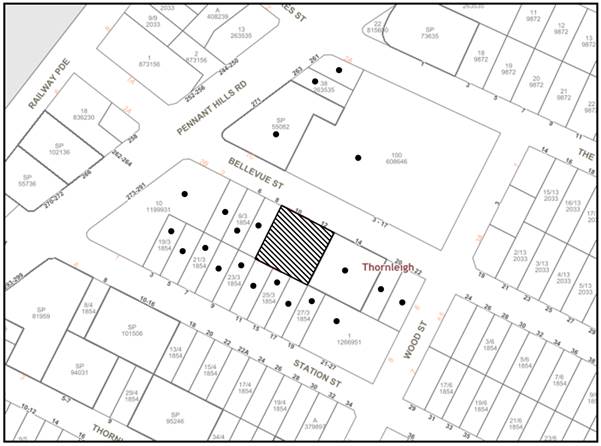
|
NOTIFICATION PLAN |
|||
|
• PROPERTIES NOTIFIED |
X SUBMISSIONS RECEIVED |
|
|
|
The 5 submissions received were either out of map range or did not disclose their address |
|||
Five submissions objected to the development, generally on the grounds that the development would result in:
· Heavy traffic along Bellevue Street due to adjacent shopping centre and Aldi retailer, local bus route, delivery truck location and additional construction traffic associated with this development.
o Council should consider putting traffic control restrictions on this heavy pedestrian zone such as speed humps and lower speed limits.
· Ongoing sewerage and stormwater drainage blockages within the area, that this development will only further impact.
· Noise associated with construction sites around Bellevue Street, for last 2 years construction noise has not stopped. Can Council consider liveability for current residents?
· In view of two big food retailer, Woolworth and Aldi, Bellevue Street is busy with shoppers, subsequently abandoned shopping trolleys and rubbish always found on the street. If DA/181/2022 is approved, it will bring even more people to this small precinct. Have Council had any plan on solving the current environmental issues before the condition worsens?
· Additional multi-storey buildings in Bellevue Street, together with Station Street and Thornleigh Street will over-populate the area.
· Concerns that residents have no say anymore on planning matters.
· Concerns that local residents will end up with overcrowded and characterless neighbourhoods, and with the loss of the valuable trees to facilitate these developments.
The merits of the matters raised in community submissions have been addressed in the body of the report with the exception of the following:
5.1.1 Traffic impacts
The proposal in of itself would not cause any unacceptable traffic generation impact from the additional vehicle movement increase to the site. Refer to Section 3.2.2 of this report for a detailed discussion.
5.1.2 Sewerage and stormwater
In terms of sewer, a condition is recommended in Schedule 1 requiring this application to be submitted to Sydney Water for approval to determine whether the development would affect any Sydney Water infrastructure, and whether further requirements are to be met. In addition, a Section 73 certificate must be issued by Sydney Water to ensure there are adequate wastewater and water supply services for the development.
The proposed stormwater drainage system includes an on-site stormwater detention system which would then be directed to Bellevue Street drainage system. Council’s engineering review raises no objection to the proposed stormwater disposal method.
5.1.3 Noise associated with construction sites and ongoing environmental issues in the area
It is inevitable that with development comes some disruption and amenity impact to the neighbouring community.
Notwithstanding, there a number of conditions applied to the consent, including the implementation of a construction management plan approved by Council to manage and reduce any potential amenity impacts associated with demolition and construction works on the site.
Matters relating to environmental impacts within the area as a result of developments of this type (such as rubbish being left everywhere) should be reported to Council for investigation. The cumulative impact of this development has been considered in the strategic modelling for the housing strategy and appropriate conditions have been recommended in Schedule 1 for the payment of contributions to upgrade the local services.
5.1.4 Overpopulating area, loss of character and trees
The proposed development would be consistent with the Greater Sydney Region Plan - A Metropolis of Three Cities and the North District Plan, by contributing to achieving the dwelling targets for the region.
The surrounding area has been re-zoned for higher density development and is in the process of transition which is consistent with Council’s Housing Strategy and the requirement for more dwellings in close proximity to established local centre, services and public transport. The character of the development is consistent with the zone objectives and surrounding developments.
Suitable tree replacement and landscaping would offset any tree removal. It is anticipated with land zoned RU4 that some trees may be removed as a result of higher density development over the transition period. The development retains trees where possible and proposes ample replacement trees with an improved significance and retention value to the area, in an attempt to maintain local amenity.
5.2 Public Agencies
The development application was referred to Ausgrid for comment. As noted under Section 2.8 of this report, written notice was given to Ausgrid in accordance with Section 2.48(2) of the SEPP and no concerns were raised subject to Overhead Powerlines and Underground Cables safety requirements/advisory notes being followed.
The applicant also submitted correspondence from Ausgrid that the ‘installation of a kiosk type substation’ would be required for the development.
6. THE PUBLIC INTEREST
Section 4.15(1)(e) of the Act requires Council to consider “the public interest”.
The public interest is an overarching requirement, which includes the consideration of the matters discussed in this report. Implicit to the public interest is the achievement of future built outcomes adequately responding to and respecting the future desired outcomes expressed in environmental planning instruments and development control plans.
The application is considered to have satisfactorily addressed Council’s and relevant agencies’ criteria and would provide a development outcome that, on balance, would result in a positive impact for the community. Accordingly, it is considered that the approval of the proposed development would be in the public interest.
The application proposes the demolition of existing structures, construction of a 5 storey residential flat building containing 21 residential units over basement parking, associated landscape/civil works and the consolidation of two lots into one.
The development generally meets the desired outcomes of Council’s planning controls and is satisfactory having regard to the matters for consideration under Section 4.15 of the Environmental Planning and Assessment Act 1979.
Council received 5 submissions during the public notification period. The matters raised have been addressed in the body of the report.
Having regard to the circumstances of the case, approval of the application is recommended.
The reasons for this decision are:
· The request under Clause 4.6 of Hornsby Local Environmental Plan 2013 to contravene the ‘height of building’ development standard is well founded. Strict compliance with the development standard is considered unreasonable and unnecessary in the circumstances of the case and sufficient environmental planning grounds have been submitted to justify the contravention to the development standard.
· The proposed development complies with the requirements of the relevant environmental planning instruments and the Hornsby Development Control Plan 2013.
· The proposed development does not create unreasonable environmental impacts to adjoining development with regard to visual bulk, solar access, amenity or privacy.
Note: At the time of the completion of this planning report, no persons have made a Political Donations Disclosure Statement pursuant to Section 10.4 of the Environmental Planning and Assessment Act 1979 in respect of the subject planning application.
The officer responsible for the preparation of this report is Madeleine Bayman.
|
Cassandra Williams Major Development Manager - Development Assessments Planning and Compliance Division |
Rod Pickles Manager - Development Assessments Planning and Compliance Division |
|
Locality Plan |
|
|
|
|
SEE and Clause 4.6 |
|
|
|
|
Site Plan |
|
|
|
|
Floor Plans |
|
|
|
|
Elevations and Sections |
|
|
|
|
Landscape Plan |
|
|
File Reference: DA/181/2022
Document Number: D08458145
SCHEDULE 1
GENERAL CONDITIONS
The conditions of consent within this notice of determination have been applied to ensure that the use of the land and/or building is carried out in such a manner that is consistent with the aims and objectives of the relevant legislation, planning instruments and council policies affecting the land and does not disrupt the amenity of the neighbourhood or impact upon the environment.
Note: For the purpose of this consent, the term ‘applicant’ means any person who has the authority to act on or the benefit of the development consent.
Note: For the purpose of this consent, any reference to an Act, Regulation, Australian Standard or publication by a public authority shall be taken to mean the gazetted Act or Regulation, or adopted Australian Standard or publication as in force on the date that the application for a construction certificate is made.
1. Approved Plans and Supporting Documentation
The development must be carried out in accordance with the plans and documentation listed below and endorsed with Council’s stamp, except where amended by Council and/or other conditions of this consent:
Approved Plans
|
Plan No. |
Plan Title |
Drawn by |
Dated |
Council Reference |
|
Job No. 8736, Dwg No. 100, Issue C |
Site Plan |
Zhinar Architects |
28/07/22 |
|
|
Job No. 8736, Dwg No. 101, Issue B |
Basement 2 |
Zhinar Architects |
08/06/22 |
|
|
Job No. 8736, Dwg No. 102, Issue B |
Basement 1 |
Zhinar Architects |
08/06/22 |
|
|
Job No. 8736, Dwg No. 103, Issue D |
Ground Floor |
Zhinar Architects |
11/08/22 |
|
|
Job No. 8736, Dwg No. 104, Issue C |
Typical L1-L3 |
Zhinar Architects |
11/08/22 |
|
|
Job No. 8736, Dwg No. 105, Issue C |
Level 4 |
Zhinar Architects |
11/08/22 |
|
|
Job No. 8736, Dwg No. 200, Issue B |
East and North Elevation |
Zhinar Architects |
08/06/22 |
|
|
Job No. 8736, Dwg No. 201, Issue B |
West and South Elevation |
Zhinar Architects |
08/06/22 |
|
|
Job No. 8736, Dwg No. 202, Issue B |
Sections |
Zhinar Architects |
08/06/22 |
|
|
Job No. 8736, Dwg No. 203, Issue A |
Material Schedule |
Zhinar Architects |
17/12/21 |
|
|
Job Ref. 20/2353, Dwg No. 1, Issue E |
Landscape Site Plan |
Paul Scrivener Landscape |
29/07/22 |
|
|
Job Ref. 20/2353, Dwg No. 2, Issue E |
Planting Plan |
Paul Scrivener Landscape |
29/07/22 |
|
|
Job Ref. 20/2353, Dwg No. 3, Issue E |
Level 4 Plan |
Paul Scrivener Landscape |
29/07/22 |
|
|
Job Ref. 20/2353, Dwg No. 4, Issue E |
Elevations North and West |
Paul Scrivener Landscape |
29/07/22 |
|
|
Job Ref. 20/2353, Dwg No. 5, Issue E |
Elevations South and East |
Paul Scrivener Landscape |
29/07/22 |
|
|
Job Ref. 20/2353, Dwg No. 6, Issue E |
Section AA |
Paul Scrivener Landscape |
29/07/22 |
|
|
Dwg No. D1, Issue D |
Details, Notes & Legend |
Quantum Engineers |
02/08/22 |
|
|
Dwg No. D2, Issue D |
Basement Level 2 Plan |
Quantum Engineers |
02/08/22 |
|
|
Dwg No. D3, Issue D |
Basement Level 1 Plan |
Quantum Engineers |
02/08/22 |
|
|
Dwg No. D4, Issue D |
Site/ Ground Floor Plan |
Quantum Engineers |
02/08/22 |
|
|
Dwg No. D5, Issue D |
Roof Plan |
Quantum Engineers |
02/08/22 |
|
|
Dwg No. D6, Issue D |
Combines Below Ground OSD/RWT Details and Calculations |
Quantum Engineers |
02/08/22 |
|
|
Dwg No. D7, Issue D |
Sediment Control Plan |
Quantum Engineers |
02/08/22 |
|
|
Dwg No. D8, Issue D |
Stormwater & Sediment Control Details |
Quantum Engineers |
02/08/22 |
|
Supporting Documentation
|
Document Title |
Prepared by |
Dated |
Council Reference |
|
Arboricultural Impact Assessment and Tree Management Plan |
Redgum Horticultural |
10/12/21 |
D08355943
|
|
Acoustic Report Rev. 1 |
Acoustic Logic |
27/05/22 |
D08431691 |
|
BASIX Certificate No. 1268982M |
Gradwell Consulting |
10/02/22 |
D08355940 |
|
Waste Management Plan |
Dicken Solutions |
06/22 |
D08431692 |
|
Geotechnical Report |
Green Geotechnics |
07/04/22 |
D08431688 |
|
Traffic and Parking Assessment Report |
Varga Traffic Planning |
14/06/22 |
D08431694 |
|
Construction and Traffic Management Plan Rev. 1 |
SBMG Planning |
13/06/22 |
D08431693 |
|
Access Report; and Access Support Statement |
Vista Access Architects |
17/12/21 02/08/22 |
D08355948 D08465084 |
2. Amendment of Plans
The approved plans are to be amended as follows:
a) Bin storage room on Basement Level 1 is to be amended to show the following:
i) Bin carousel or linear track system capable of circulating 3x 660L waste plus room for 1x additional 660L spare waste bin.
ii) 1x 660L paper and cardboard bin.
iii) 5x 240L FOGO bins.
iv) 10x 240L recycle bins.
b) The temporary bin holding area at ground level is to be amended to show the following bins can be accommodated:
i) 15x 240L bins.
ii) 3x 660L bins.
c) The storage area for the mobile bin towing device must be sufficiently dimensioned to accommodate the required equipment.
Note that this device may require upgrading from the unit referenced in the original waste management plan for use with 240L bins to a unit suitable for use with 660L bins.
d) Further details are to be provided regarding the waste management of the development. These details are to form an addendum to WMP and must be submitted for written approval by Councils’ Waste Management Team (devmail@hornsby.nsw.gov.au) in accordance with the provisions of the Hornsby Development Control Plan 2013 and prior to the issue of the Construction Certificate. These details are to include:
i) Provide updated details consistent with council advice regarding:
a. Bin allocations.
b. On site management of waste and bins.
c. Bin towing device - must be suitable for use with 660L bins.
e) These amended plans must be submitted with the application for the Construction Certificate.
3. Appointment of a Project Arborist
a) To ensure the trees that must be retained are protected, a project arborist with AQF Level 5 qualifications must be appointed to assist in ensuring compliance with the conditions of consent and provide monitoring reports as specified by the conditions of consent.
b) Details of the appointed project arborist must be submitted to Council and the PCA with the application for the construction certificate/subdivision works certificate.
4. Removal of Trees
a) This development consent permits the removal of trees numbered 1, 2, 3, 5, 6, 7 and 8 as identified on page 15, Appendix C (Site Plan A - Survey of Subject Trees) of the Arboricultural Impact Assessment prepared by Redgum Horticultural, dated 10 December 2021.
b) No consent is granted for the removal of tree number 4 (group of 16 trees) as these trees contribute to the established landscape amenity of the area/streetscape.
Note: The removal or pruning of any other trees from the site requires separate approval by Council in accordance with Part 1B.6 Tree and Vegetation Preservation of the Hornsby Development Control Plan 2013.
5. Construction Certificate
a) A Construction Certificate is required to be approved by Council or a Private Certifying Authority prior to the commencement of any construction works under this consent.
b) A separate Roads Act Approval must be obtained from Council for all works within the public road reserve under S138 of the Roads Act 1993.
c) The Construction Certificate plans must be consistent with the Development Consent plans.
6. Section 7.11 Development Contributions
a) In accordance with Section 4.17(1) of the Environmental Planning and Assessment Act 1979 and the Hornsby Shire Council Section 7.11 Development Contributions Plan 2020-2030, the following monetary contributions must be paid to Council to cater for the increased demand for community infrastructure resulting from the development:
|
Description |
Contribution (4) |
|
Roads |
$6,190.10 |
|
Open Space and Recreation |
$219,164.25 |
|
Community Facilities |
$134,985.35 |
|
Plan Preparation and Administration |
$1,801.65 |
|
TOTAL |
$362,141.35 |
being for 3 x 1 bedroom units, 14 x 2 bedroom units, 4 x 3 bedroom units and 2 lot/dwelling credits.
b) The value of this contribution is current as of 5 August 2022. If the contribution is not paid within the financial quarter that this condition was generated, the contribution payable will be adjusted in accordance with the provisions of the Hornsby Shire Council Section 7.11 Development Contributions Plan and the amount payable will be calculated at the time of payment in the following manner:
$CPY = $CDC x CPIPY
CPIDC
Where:
$CPY is the amount of the contribution at the date of Payment.
$CDC is the amount of the contribution as set out in this Development Consent.
CPIPY is the latest release of the Consumer Price Index (Sydney – All Groups) at the date of Payment as published by the ABS.
CPIDC is the Consumer Price Index (Sydney – All Groups) for the financial quarter at the date applicable in this Development Consent Condition.
c) The monetary contribution must be paid to Council:
i) Prior to the issue of the Subdivision Certificate where the development is for subdivision.
ii) Prior to the issue of the first Construction Certificate where the development is for building work.
iii) Prior to issue of the Subdivision Certificate or first Construction Certificate, whichever occurs first, where the development involves both subdivision and building work.
iv) Prior to the works commencing where the development does not require a Construction Certificate or Subdivision Certificate.
Note: It is the professional responsibility of the Principal Certifying Authority to ensure that the monetary contributions have been paid to Council in accordance with the above timeframes.
Note: In accordance with Ministerial Directions, the payment of contribution fees for development with a cost of works of over $10 million can be deferred to prior to Occupation Certificate.
Note: Council’s Development Contributions Plan may be viewed at www.hornsby.nsw.gov.au or a copy may be inspected at Council’s Administration Centre during normal business hours.
REQUIREMENTS PRIOR TO THE ISSUE OF A CONSTRUCTION CERTIFICATE
7. Building Code of Australia
Detailed plans, specifications and supporting information is required to be submitted to the certifying authority detailing how the proposed building work achieves compliance with the National Construction Code - Building Code of Australia. All building work must be carried out in accordance with the requirements of the National Construction Code - Building Code of Australia.
8. Fire Safety Schedule
A schedule of all proposed essential fire safety measures to be installed in the building (e.g. hydrants, hose reels, emergency warning systems etc.) shall be submitted with the construction certificate application.
9. Contract of Insurance (Residential Building Work)
Where residential building work for which the Home Building Act 1989 requires there to be a contract of insurance in force in accordance with Part 6 of that Act, this contract of insurance must be in force before any building work authorised to be carried out by the consent commences.
10. Notification of Home Building Act 1989 Requirements
Residential building work within the meaning of the Home Building Act 1989 must not be carried out unless the principal certifying authority for the development to which the work relates (not being Council) has given Council written notice of the following information:
a) In the case of work for which a principal contractor is required to be appointed:
i) The name and licence number of the principal contractor.
ii) The name of the insurer by which the work is insured under Part 6 of that Act.
b) In the case of work to be done by an owner-builder:
i) The name of the owner-builder.
ii) If the owner-builder is required to hold an owner-builder’s permit under that Act, the number of the owner-builder’s permit.
Note: If arrangements for doing the residential building work are changed while the work is in progress so that the information notified becomes out of date, further work must not be carried out unless the principal certifying authority for the development to which the work relates (not being Council) has given Council written notification of the updated information.
11. Utility Services
The applicant must submit written evidence of the following service provider requirements:
a) Ausgrid (formerly Energy Australia) - a letter of consent demonstrating that satisfactory arrangements have been made to service the proposed development.
b) Telstra - a letter of consent demonstrating that satisfactory arrangements have been made to service the proposed development.
12. Sydney Water - Approval
This application must be submitted to Sydney Water for approval to determine whether the development would affect any Sydney Water infrastructure, and whether further requirements are to be met.
Note: Building plan approvals can be obtained online via Sydney Water Tap inTM through www.sydneywater.com.au under the Building and Development tab.
a) Prior to the commencement of any works on site, the applicant must submit for approval by the Principal Certifying Authority (with a copy forwarded to Council) a ‘Dilapidation Report’ detailing the structural condition of the adjoining properties:
i) SP 93482, No. 14 Bellevue Street, Thornleigh.
ii) Lots 8-10 Sec 3 DP 1854, No. 4-8 Bellevue Street, Thornleigh (if construction works associated with DA/901/2018 have commenced).
iii) Lots 10 Sec 3 DP 1854, No. 8 Bellevue Street, Thornleigh (if construction works associated with DA/901/2018 have not commenced).
iv) Lot 24 Sec 3 DP 1854, No. 11 Station Street, Thornleigh.
v) Lot 25 Sec 3 DP 1854, No. 15 Station Street, Thornleigh.
vi) Lot 26 Sec 3 DP 1854, No. 17 Station Street, Thornleigh.
b) The report must include a photographic survey of the adjoining properties detailing their physical condition, both internally and externally, including such items as walls, ceilings, roof, structural members and other similar items. The report must be completed by a chartered structural/geotechnical engineer. A copy of the dilapidation report must be submitted to Council.
c) In the event access to adjoining allotments for the completion of a dilapidation survey is denied, the applicant must demonstrate in writing that all reasonable steps have been taken to advise the adjoining allotment owners of the benefit of this survey and details of failure to gain consent for access to the satisfaction of the Principle Certifying Authority.
Note: This documentation is for record keeping purposes only and can be made available to an applicant or affected property owner should it be requested to resolve any dispute over damage to adjoining properties arising from works. It is in the applicant’s and adjoining owner’s interest for it to be as detailed as possible.
14. Identification of Survey Marks
A registered surveyor must identify all survey marks in the vicinity of the proposed development. Any survey marks required to be removed or displaced as a result of the proposed development shall be undertaken by a registered surveyor in accordance with Section 24 (1) of the Surveying and Spatial Information Act 2002 and following the Surveyor General’s Directions No.11 Preservation of Survey Infrastructure.
15. Stormwater Drainage
The stormwater drainage system for the development must be designed in accordance with AUS-SPEC Specifications (www.hornsby.nsw.gov.au/property/build/aus-spec-terms-and-conditions) and the following requirements:
a) Connected directly to Council’s street drainage system and discharged via an on-site detention system.
b) Pump out storage to be designed in accordance with Australian Standard AS3500.3.
16. On Site Stormwater Detention
An on-site stormwater detention system must be designed by a chartered civil engineer and constructed in accordance with the following requirements:
a) Storage capacity to accommodate volume from up to 20 years ARI and a maximum discharge when full limited to 5 years pre development rate.
b) Have a surcharge/inspection grate located directly above the outlet.
c) Discharge from the detention system must be controlled via 1 metre length of pipe, not less than 50 millimetres diameter or via a stainless plate with sharply drilled orifice bolted over the face of the outlet discharging into a larger diameter pipe capable of carrying the design flow to an approved Council system.
d) Where above ground and the average depth is greater than 0.3 metres, a ‘pool type’ safety fence and warning signs must be installed.
e) Not be constructed in a location that would impact upon the visual or recreational amenity of residents.
17. Noise Requirements
The development must be carried out in accordance with Section 6 of the recommendations contained within the Acoustic Report Rev 1, submitted by Acoustic Logic, dated 27/05/22 (pages 15-17).
The following waste management requirements must be complied with:
a) Should there be any conflict or confusion between approved plans and/or consent conditions related to the waste management system or the waste collection vehicle travel path on site, then written clarification must be obtained from Council.
b) The approved on-going waste management system must not be amended without the written consent of Council.
c) Details of all changes to the waste management plans (including but not limited to, the chute system, bin storage/ chute service rooms, bin carting paths, bulky waste storage) must be submitted to Council’s Waste Team (devmail@hornsby.nsw.gov.au) for written approval prior to the issue of a Construction Certificate.
d) There must be no steps along any bin carting route. Ramps and service lifts are acceptable.
Note: bin carting routes include, but are not limited to, from the bin storage rooms to the ground level temporary bin holding bay, from the ground level bin storage/holding bay to the kerbside.
e) For all bin carting routes, the path must be smooth hard surface. (Concrete pavement for example is acceptable, but pebbles, stepping stones, grass etc is not acceptable).
f) A design certificate and detailed plans are to accompany any Construction Certificate application, which demonstrate that the bin carting route from the ground level bin temporary bin holding bay to the parked waste collection vehicle has been designed to be constructed in accordance with the Waste Minimisation and Management Guidelines and including the following requirements:
i) Must be smooth hard surface.
ii) Must be sufficiently wide to hold all serviceable bins and provide aisle space for manoeuvring bins out and in (including through any gates or doors).
iii) Must be devoid of steps.
iv) The first 6m of the driveway must have a gradient no steeper than 1:20 and must be designed to carry the load of a heavy rigid waste collection vehicle.
g) A design certificate and detailed plans are to accompany any Construction Certificate application, which demonstrate that the waste carting route from each dwelling to the bulky waste storage area has been designed to be constructed in accordance with the Waste Minimisation and Management Guidelines and including the following requirements:
i) The route is direct, does not cross into a private lot, and is wholly within property boundaries (does not include the public footpath or road).
ii) The route is as short as possible and does not exceed 30m walking distance.
iii) The route is an accessible path of travel for persons with a disability in accordance with AS1428 Design and Access for Mobility.
i) The floor is to be constructed of concrete at least 75mm thick and adequately graded to drain to a Sydney Water approved drainage fitting.
ii) The floor must be finished so that it is non-slip, sealed and impervious, and has a smooth and even surface coved at all intersections.
iii) The ceilings and walls must be finished with smooth faced non-absorbent material capable of being cleaned.
iv) The room is to be provided with artificial light controllable within the room and adequate forced ventilation.
v) The room is to be provided with an adequate supply of hot and cold water mixed through a centralised mixing valve with hose cock.
vi) The doors are to be robust and lockable, with a door opening of no less than 2m. The doors must be able to be opened from inside the room without a key.
vii) The chute service room must have sufficient space to comfortably house the required volume handling equipment and to load/unload bins from this equipment, and sufficient space to store the spare garbage bins for that building and to access and manoeuvre the bins. The doors to the chute service rooms must be wide enough and positioned to fit the 660L bins through.
k) The temporary bin holding area must be at the same level as the truck loading bay (that is, not a raised loading dock). The gradient of the temporary bin holding area must not exceed 1:30.
Note: Bins cannot be serviced from a raised loading dock.
l) A design certificate and detailed plans are to accompany any Construction Certificate application, which demonstrate that the bin holding bay at ground level has been designed to be constructed in accordance with the Waste Minimisation and Management Guidelines and specifically the following requirements:
i) The doorway must face the driveway and be no less than 2.0m wide and be no further than 5 metres walking distance from the front boundary.
ii) There must be no step(s) between the bin bay and the driveway.
iii) The bin bay must be at the same level as the driveway.
iv) The bin carting route from the bin holding bay to the street must not exceed a gradient of 1:14 and must be no less than 2.0m wide and must not include any steps.
v) The bin holding bays must be integrated into the overall design of the development and landscaping to minimise impact on the streetscape and include screening to a height of no less than 1.5m.
vi) The internal dimensions of the ground level bin holding bay must be sufficient to house the required bin (refer to general conditions). Internal dimensions do not include wall thickness, support columns, ventilation shafts etc for which additional space must be allowed with consideration of the bin layout.
Note: a 240 L recycling bin is 600 mm wide by 750 mm deep; 660L bins are 1370mm wide, 850mm deep, 1250mm high; allow for 75 mm ease around the bin to avoid damage to walls etc from scraping.
i) Be accessible by persons with a disability after the garbage chute and recycling bin are installed.
ii) Comfortably house the required garbage chute and 240 L recycling bin and 240L FOGO bin.
iii) Have door(s) wide enough and positioned so that the 240 L recycling bin and 240L FOGO bin can fit through with ease.
Note: a 240 L recycling bin is 600 mm wide by 750 mm deep; allow for ease around the bin – 75 mm is recommended. These dimensions do not include wall thickness, door thickness, ventilation ducting etc, which must be added. The chute system supplier must be consulted for chute space requirements. AS 1428.1 requires at least 800 mm clear doorway opening for wheelchair access.
Note: Internal dimensions do not include wall thickness, door thickness, ventilation ducting etc, which must be added. AS 1428.1 requires at least 800 mm clear doorway opening for wheelchair access.
i) Chutes, service openings and charging devices are constructed of metal or a smooth faced surface which is fire resistant and of impervious material.
ii) Chute is cylindrical in section, vertical and without bends as it passes through the floors.
iii) Chutes must terminate in the waste storage room and discharge into a waste bin.
iv) The chute system must comply with the manufacturers technical specifications and operational limitations.
v) The gradient of each chute must be no less than the minimum gradient recommended by the chute manufacturer.
vi) Each chute system must include volume handling equipment to automatically change the bin under the chute when it becomes full and thereby provide a minimum 3 days bin capacity under the chute.
vii) The required volume handling equipment for each chute system must not include compaction.
viii) The chute service rooms must have sufficient space to comfortably house the required volume handling equipment and to load/unload bins from this equipment, and sufficient space to store the spare garbage and recycling bins for that building and to access and manoeuvre the bins.
Note: The linear track system or carousel volume handling equipment should be designed to accommodate 3 x 660L general waste bins.
Note: 1x additional 660L bin will be provided for use under the chute on bin service days.
Note: 660L bins are 1370mm wide, 850mm deep, 1250mm high; allow 75mm between bins for ease of manoeuvring and to avoid damage to walls and doors from bins scraping against them.
19. Certification of Traffic Engineer
Prior to the issue of a Construction Certificate, a Certificate from an appropriate qualified Traffic Engineer is to be submitted to the Principal Certifying Authority (PCA) certifying that the parking modules, loading areas and garbage collection areas comply with AS 2890.1, AS 2890.2 and the approved plans and conditions.
20. Internal Driveway/Vehicular Areas
The driveway and parking areas on site must be designed and a Construction Certificate issued in accordance with Australian Standards AS2890.1, AS2890.2, AS3727 and the following requirements:
a) A Boundary Levels application must be obtained from Council for the design on the internal driveway The driveway be a rigid pavement.
b) The driveway grade must not exceed 25 percent and changes in grade must not exceed 8 percent.
c) Longitudinal sections along both sides of the access driveway shall be submitted to the principal certifying authority in accordance with the relevant sections of AS 2890.1. The maximum grade shall not exceed 1 in 4 (25%) with the maximum changes of grade of 1 in 8 (12.5%) for summit grades and 1 in 6.7 (15%) for sag grades. Any transition grades shall have a minimum length of 2 metres. The longitudinal sections shall incorporate the design levels obtained by Council.
21. Accessible Units
a) A minimum of 10% of all units must be designed to be adaptable units.
b) A minimum of 20% of all units must be Universal Design housing in accordance with the Liveable Housing Guidelines (2012) silver level design features.
c) The details of all accessible units and details of adaptable units must be provided with the Construction Certificate Plans.
22. Services
To provide a development that enhances the visual quality of the public domain, the following must be indicated on the Construction Certificate drawings:
a) Heating, Ventilation and Air Conditioning (HVAC) must be grouped within designated areas in the basement and roof. No air conditioning units are permitted on private balconies.
b) Wall-mounted equipment and associated pipework must be concealed into wall cabinets and duct.
c) Letter boxes must be located perpendicular to the road.
d) Powerlines must be undergrounded on the road reserve at the front of the site. The above details must be detailed and provided with the Construction Certificate Plans.
23. Fencing Details
The following fencing details must be provided on the construction certificate drawings:
a) Within street setbacks, front fences are not permitted unless shown on the approved landscape plans. Planting at grade, or low walls screened by planting and/ or planter boxes are permitted at the interface between the private and public domain land.
b) Enclosure of private courtyards within the front setbacks must achieve at least 50 percent transparency and be a maximum height of 1.5m above the adjacent communal space.
c) Side and rear boundary fences should be a maximum of 1.8 metres high, sited behind the front building line. The above details must be detailed and provided with the Construction Certificate Plans.
24. Identification of Survey Marks
A registered surveyor must identify all survey marks in the vicinity of the proposed development. Any survey marks required to be removed or displaced as a result of the proposed development shall be undertaken by a registered surveyor in accordance with Section 24 (1) of the Surveying and Spatial Information Act 2002 and following the Surveyor General’s Directions No.11 "Preservation of Survey Infrastructure".
25. Footpath
A concrete footpath must be designed across the full frontage of the subject site in accordance with AUS-SPEC Specifications (www.hornsby.nsw.gov.au/property/build/aus-spec-terms-and-conditions) and the following requirements:
a) The existing footpath being removed.
b) Pouring of the concrete footpath to the full frontage of the subject site.
c) The land adjoining the footpath to be fully turfed.
d) Any public utility adjustments to be carried out at the cost of the applicant and to the requirements of the relevant public authority.
e) Detailed engineering plans are to be submitted to Council for approval.
26. Road Works
All road works approved under this consent must be designed in accordance with AUS-SPEC Specifications (www.hornsby.nsw.gov.au/property/build/aus-spec-terms-and-conditions) and the following requirements:
a) The existing kerb and gutter is to be removed and reconstructed. All redundant access crossings are to be removed and the area made good.
b) The existing road pavement to be saw cut a minimum of 300 mm from the existing edge of the bitumen and reconstructed.
c) The submission of a compaction certificate from a geotechnical engineer for any fill within road reserves, and all road sub-grade and road pavement materials.
d) Detailed engineering plans are to be submitted to Council for approval.
27. Structural Design
All structural details must be designed by a Chartered Structural Engineer of the Institution of Engineers Australia with structural details to be submitted with the application of the Construction Certificate.
28. Construction Management Plan (CMP)
To assist in the protection of the public, the environment and Council’s assets, a separate Construction Management Plan must be prepared by a suitably qualified environmental consultant in consultation with a qualified traffic engineer and AQF 5 arborist and submitted to Council’s Compliance Team via Council’s Online Services Portal for review and written approval.
The CMP must include the following details:
a) A Construction Traffic Management Plan (CTMP) including the following:
i) The order of construction works and arrangement of all construction machines and vehicles being used during all stages.
ii) The CTMP plans shall be in accordance with all other plans submitted to Council as part of this development proposal.
iii) A statement confirming that no building materials, work sheds, vehicles, machines or the like shall be allowed to remain in the road reserve area without the written consent of Hornsby Shire Council.
iv) The Plan shall be in compliance with the requirements of the Roads and Maritime Services Traffic control at work sites Manual 2018 and detail:
a. Public notification of proposed works.
b. Long term signage requirements.
c. Short term (during actual works) signage.
d. Vehicle Movement Plans, where applicable.
e. Traffic Management Plans.
f. Pedestrian and Cyclist access and safety.
v) Traffic controls including those used during non-working hours. Pedestrian access and two-way traffic in the public road must be able to be facilitated at all times.
vi) Details of parking arrangements for all employees and contractors, including layover areas for large trucks during all stages of works. The parking or stopping of truck and dog vehicles associated with the development will not be permitted other than on the site and the plan must demonstrate this will be achieved.
vii) Confirmation that a street ‘scrub and dry’ service will be in operation during all stages of works.
viii) Proposed truck routes to and from the site including details of the frequency of truck movements for all stages of the development.
ix) Swept path analysis for ingress and egress of the site for all stages of works.
x) Site plans for all stages of works including the location of site sheds, concrete pump and crane locations, unloading and loading areas, waste and storage areas, existing survey marks, vehicle entry, surrounding pedestrian footpaths and hoarding (fencing) locations.
xi) The total quantity and size of trucks for all importation and exportation of fill on site throughout all stages of works, and a breakdown of total quantities of trucks for each stage of works.
xii) The number of weeks trucks will be accessing and leaving the site with excavated or imported fill material.
xiii) The maximum number of trucks travelling to and from the site on any given day for each stage of works.
xiv) The maximum number of truck movements on any given day during peak commuting periods for all stages of works.
xv) The source site location of any proposed fill to be imported to the site, for all stages of works.
xvi) The Plan must state that the applicant and all employees of contractors on the site must obey any direction or notice from the Prescribed Certifying Authority or Hornsby Shire Council in order to ensure the above.
xvii) If there is a requirement to obtain a Work Zone, Out of Hours permit, partial Road Closure or Crane Permit, the Plan must detail these requirements and include a statement that an application to Hornsby Shire Council will be made to obtain such a permit.
b) A Construction Waste Management Plan detailing the following:
i) Details of the importation or excavation of soil and fill, the classification of the fill, disposal methods and authorised disposal depots that will be used for the fill.
ii) Asbestos management requirement and procedures for removal and disposal from the site in accordance with Australian Standard AS260-2001 Demolition of structures, and the Protection of the Environment Operations (Waste) Regulation 2005.
iii) General construction waste details including construction waste skip bin locations and litter management for workers.
c) A Tree Protection Plan (TPP) prepared by an AQF 5 Arborist in accordance with any approved Arboricultural Impact Assessment and tree location plans, detailing the following:
i) A site plan showing tree protection zones (TPZ) and structural root zones (SRZ) of trees to be retained and specific details of tree protection measures inclusive of distances (in metres) measured from tree trunks.
ii) Construction methodology to avoid damage to trees proposed to be retained during construction works.
iii) Specifications on tree protection materials used and methods within the TPZ or SRZ.
iii) Location of dedicated material storage space on site outside of TPZ’s and SRZ’s for retained trees.
d) A Construction Noise and Vibration Management Plan (CNMP) which includes:
i) Existing noise and vibration levels within the proximity of the proposed development site.
ii) Details of the extent of rock breaking or rock sawing works forming part of the proposed development works.
iii) The maximum level of noise and vibration predicted to be emitted during each stage of construction.
iv) The duration of each stage of works where the maximum level of noise and vibration are predicted to be emitted for.
v) Details of mitigation measures, inclusive of respite periods, that will meet acoustic standards and guidelines at each stage of works.
vi) Details of a complaints handling process for the surrounding neighbourhood for each stage of works.
e) Identification of approved sediment and erosion control measures.
f) The CMP must detail the contact information for developers, builder, private certifier and any emergency details during and outside work hours.
Note: The CMP must be lodged via Council’s Online Services Portal at: https://hornsbyprd-pwy-epw.cloud.infor.com/ePathway/Production/Web/Default.aspx and by selecting the following menu options: Applications > New Applications > Under ‘Application Types’: Management Plans.
REQUIREMENTS PRIOR TO THE COMMENCEMENT OF ANY WORKS
29. Erection of Construction Sign
a) A sign must be erected in a prominent position on any site on which any approved work is being carried out:
i) Showing the name, address and telephone number of the principal certifying authority for the work.
ii) Showing the name of the principal contractor (if any) for any demolition or building work and a telephone number on which that person may be contacted outside working hours.
iii) Stating that unauthorised entry to the work site is prohibited.
b) The sign is to be maintained while the approved work is being carried out and must be removed when the work has been completed.
30. Protection of Adjoining Areas
A temporary hoarding, fence or awning must be erected between the work site and adjoining lands before the works begin and must be kept in place until after the completion of the works if the works:
a) Could cause a danger, obstruction or inconvenience to pedestrian or vehicular traffic.
b) Could cause damage to adjoining lands by falling objects; and/or
c) Involve the enclosure of a public place or part of a public place; and/or
d) Have been identified as requiring a temporary hoarding, fence or awning within the Council approved Construction Management Plan (CMP).
Note: Notwithstanding the above, Council’s separate written approval is required prior to the erection of any structure or other obstruction on public land.
31. Toilet Facilities
a) To provide a safe and hygienic workplace, toilet facilities must be available or be installed at the works site before works begin and must be maintained until the works are completed at a ratio of one toilet for every 20 persons employed at the site.
b) Each toilet must:
i) Be a standard flushing toilet connected to a public sewer.
ii) Be a temporary chemical closet approved under the Local Government Act 1993.
iii) Have an on-site effluent disposal system approved under the Local Government Act 1993.
32. Erosion and Sediment Control
To protect the water quality of the downstream environment, erosion and sediment control measures must be provided and maintained throughout the construction period in accordance with the manual ‘Soils and Construction 2004 (Bluebook)’, the approved plans, Council specifications and to the satisfaction of the principal certifying authority. The erosion and sediment control devices must remain in place until the site has been stabilised and revegetated.
Note: On the spot penalties may be issued for any non-compliance with this requirement without any further notification or warning.
33. Installation of Tree Protection Measures
a) Trees to be retained and numbered 4 (group of 16) as identified on page 15, Appendix C (Site Plan A - Survey of Subject Trees) of the Arboricultural Impact Assessment prepared by Redgum Horticultural, dated 10 December 2021 must have tree protection measures for the ground, trunk and canopy installed by the project arborist as follows:
i) For the duration of demolition works, in accordance with the Tree Protection Plan, Appendix F (page 31) of the Arboricultural Impact Assessment prepared by Redgum Horticultural, dated 10 December 2021.
ii) For the duration of construction works, in accordance with Tree Protection Plan, Appendix F (page 31) of the Arboricultural Impact Assessment prepared by Redgum Horticultural, dated 10 December 2021.
b) Tree protection fencing for the trees to be retained numbered 4 (group of 16) must be installed by the engaged AQF 5 project arborist and consist of 1.8m high temporary fencing panels installed in accordance with Australian Standard AS4687-2007 Temporary fencing and hoardings.
c) The installation of all required tree protection fencing must include shade cloth attached to the fencing to reduce transport of dust, particulates and liquids from entering the tree protection zone.
d) The installation of all required tree protection fencing must have a TPZ radius as listed in the Table below:
|
Tree number |
TPZ radius from centre of tree |
|
4 (group of 16) |
2.5 metres from the fence line |
e) Tree crown protection measures are required and must be installed by the AQF 5 project arborist.
f) The circumference of the trunk(s) must be wrapped in hessian material to provide cushioning for the installation of timber planks.
g) Timber planks (50 x100mm) must be spaced at 100mm intervals and must be attached using adjustable ratchet straps.
34. Waste Management Details
Prior to the commencement of any works, the on-going waste collection service must be cancelled and the bins retrieved by the waste collection service provider.
Note: For residential properties, Council is the waste collection service provider.
35. Garbage receptacle
a) A garbage receptacle must be provided at the work site before works begin and must be maintained until all works are completed.
a) The garbage receptacle must have a tight fitting lid and be suitable for the reception of food scraps and papers.
b) The receptacle lid must be kept closed at all times, other than when garbage is being deposited.
c) Food scraps must be placed in the garbage receptacle and not in demolition and construction waste bins.
36. Littering and Illegal Dumping
A Litter and Illegal Dumping Management Plan covering the entire development period must be submitted to the principal certifying authority and Council prior to the commencement of any works on site. Implementation of the Litter and Illegal Dumping Management Plan is the responsibility of the developer and must include mitigation measures including but not limited to litter picking patrols and removal of illegally dumped material across both the subject site and adjacent land.
REQDUIREMENTS DURING DEMOLITION AND CONSTRUCTION
37. Construction Work Hours
All work on site (including demolition and earth works) must only occur between 7am and 5pm Monday to Saturday.
No work is to be undertaken on Sundays or public holidays.
38. Demolition
To protect the surrounding environment, all demolition work must be carried out in accordance with Australian Standard AS2601-2001 Demolition of structures and the following requirements:
a) Demolition material must be disposed of to an authorised recycling and/or waste disposal site and/or in accordance with an approved waste management plan.
b) Demolition works, where asbestos material is being removed, must be undertaken by a contractor that holds an appropriate licence issued by SafeWork NSW in accordance with the Work Health and Safety Regulation 2017 and be appropriately transported and disposed of in accordance with the Protection of the Environment Operations (Waste) Regulation 2014.
c) On construction sites where any building contain asbestos material, a standard commercially manufactured sign containing the words ‘DANGER ASBESTOS REMOVAL IN PROGRESS’ and measuring not less than 400mm x 300mm must be displayed in a prominent position visible from the street.
39. Environmental Management
To prevent sediment run-off, excessive dust, noise or odour emanating from the site during the construction, the site must be managed in accordance with the publication ‘Managing Urban Stormwater – Landcom (March 2004) and the Protection of the Environment Operations Act 1997.
All construction vehicles associated with the proposed development are to be contained on site or in a Local Traffic Committee (LTC) approved “Works Zone” as follows:
a) The site supervisor to be advised that the Works Zone will be deemed to be in effect, and fees will apply, between the dates nominated by the supervisor, or when parking spaces are managed for the sole use of construction vehicles associated with the site.
b) The Works Zone signs shall be in effect only for the times approved by Council, and the time is to be noted on the sign. Eg, ‘Works Zone Mon – Sat 7am – 5pm’.
c) The applicant is required to supply a sign posting installation plan for referral to the Local Traffic Committee, noting on it the duration of the Works Zone.
d) The Works Zone is only to be used for the loading and unloading of vehicles. Parking of workers’ vehicles, or storage of materials, is not permitted.
Note: A Works Zone Permit can be obtained via Council’s Online Services Portal at: Work Zone Permit | Hornsby Shire Council (nsw.gov.au).
41. Street Sweeping
During works and until exposed ground surfaces across the site have been stabilised, street sweeping must be undertaken following sediment tracking from the site.
The street cleaning service must utilise a ‘scrub and dry’ method and be undertaken for the full extent of any sediment tracking.
42. Council Property
To ensure that the public reserve is kept in a clean, tidy and safe condition during construction works, no building materials, waste, machinery or related matter is to be stored on the road or footpath.
43. Disturbance of Existing Site
During construction works, the existing ground levels of open space areas and natural landscape features, including natural rock-outcrops, vegetation, soil and watercourses must not be altered unless otherwise nominated on the approved plans.
44. Landfill not Permitted
The importation of fill material associated with earthworks, or structural or engineering works, is not permitted as part of this consent.
45. Excavated Material
All excavated material removed from the site must be classified by a suitably qualified environmental consultant in accordance with the NSW Environment Protection Authority’s Waste Classification Guidelines and Protection of the Environment Operations (Waste) Regulation 2014 prior to disposal to a licensed waste management facility. Tipping dockets for the total volume of excavated material that are received from the licensed waste management facility must be provided to the principal certifying authority prior to the issue of an Occupation Certificate.
Requirements of the approved Waste Management Plan shall be complied with during all site preparation works, demolition and throughout all construction works. When implementing the Waste Management Plan, the developer is to ensure:
a) The disposal of any demolition and construction waste must be undertaken in accordance with the requirements of the Protection of Environment Operations Act 1997.
b) All waste on site is to be stored, handled and disposed of in such a manner as to not create air pollution, offensive noise or pollution of land and water as defined by the Protection of Environment Operations Act 1997.
c) Generation, storage, treatment and disposal of hazardous waste is conducted in accordance with the relevant waste legislation administered by the EPA and relevant Occupational Health and Safety legislation administered by WorkCover NSW.
d) All waste generated (including excavated materials) which cannot be reused or recycled must be transported to a facility which can lawfully accept it.
e) All materials and resources that are to be stored on site during construction works are contained on the site. The provisions of the Protection of Environment Operations Act 1997 must be complied with when placing/stock piling loose material, disposal of concrete waste or activities which have potential to pollute drains and water courses.
f) The storage of waste and recycling containers must be within the boundaries of the development site at all times. Public footways and roads must not be used for the storage of any waste and must be kept clear of obstructions during all construction works.
g) Additionally, written records of the following items must be maintained during the removal of any waste from the site and such information submitted to the Principal Certifying Authority within fourteen days of the date of completion of the works:
i) The identity of the person removing the waste.
ii) The waste carrier vehicle registration.
iii) Date and time of waste collection.
iv) A description of the waste (type of waste and estimated quantity).
v) Details of the site to which the waste is to be taken.
vi) The corresponding weighbridge tip docket/receipt from the site to which the waste is transferred (noting date and time of delivery, description (type and quantity) of waste).
vii) Whether the waste is expected to be reused, recycled or go to landfill.
Note: In accordance with the Protection of the Environment Operations Act 1997, the definition of waste includes any unwanted substance, regardless of whether it is reused, recycled or disposed to landfill.
h) A report must be prepared by a registered surveyor and submitted to the principal certifying authority:
i) Prior to the pouring of the concrete on the ground level, certifying that: the ground level bin storage/holding bay is at the same level as the driveway (no steps).
47. Survey Report
A report must be prepared by a registered surveyor and submitted to the principal certifying authority:
a) Prior to the pouring of concrete at each level of the building certifying that:
i) The building, retaining walls and the like have been correctly positioned on the site; and
ii) The finished floor level(s) are in accordance with the approved plans.
48. Maintenance of Public Footpaths
Public footpaths must be maintained for the duration of works to ensure they are free of trip hazards, displacements, breaks or debris to enable pedestrians to travel along the footpath safely.
49. Compliance with Construction Management Plan
The Council approved Construction Management Plan must be complied with for the duration of works, unless otherwise approved by Council.
50. Prohibited Actions within the Fenced Tree Protection Zone
The following activities are prohibited within the approved fenced tree protection zones unless otherwise approved by Council:
a) Soil cutting or filling, including excavation and trenching.
b) Soil cultivation, disturbance or compaction.
c) Stockpiling storage or mixing of materials.
d) The parking, storing, washing and repairing of tools, equipment and machinery.
e) The disposal of liquids and refuelling.
f) The disposal of building materials.
g) The siting of offices or sheds.
h) Any action leading to the impact on tree health or structure.
51. Maintaining the Health of Trees Approved for Retention
The appointed project arborist must monitor and record any and all necessary actions required to maintain tree health and condition for trees numbered 4 (group of 16) on the approved plans.
52. Maintaining Tree Protection Measures
Tree Protection Measures must be maintained by the project arborist in accordance with Condition No. 31 of this consent for the duration of works.
53. Unexpected Finds
Should the presence of asbestos or soil contamination, not recognised during the application process be identified during any stage of works, the applicant must immediately notify the PCA and Council.
REQUIREMENTS PRIOR TO THE ISSUE OF AN OCCUPATION CERTIFATE
54. Fulfilment of BASIX Commitments
The applicant must demonstrate the fulfilment of BASIX commitments pertaining to the development.
55. Sydney Water – s73 Certificate
A s73 Certificate must be obtained from Sydney Water and submitted to the PCA.
Note: Sydney Water requires that s73 applications are to be made through an authorised Sydney Water Servicing Coordinator. Refer to www.sydneywater.com.au or telephone 13 20 92 for assistance.
56. Water Saving Urban Design
80% of the roof area of the development is to drain to a tank(s) that has a capacity of 3,000 litres per 100m2 of roof area of the development. The tank(s) is to be connected to the communal water system, and to all dwellings for toilet flushing and laundry.
57. Certification of WSUD Facilities
Prior to the issue of an Occupation Certificate a certificate from a Civil Engineer is to be obtained stating that the WSUD facilities have been constructed and comply with the requirements under Hornsby Development Control Plan 2013.
58. Replacement Tree Requirements
a) The trees approved for removal under this consent, being trees numbered 1, 2, 3, 5, 6, 7 and 8 must be offset through replacement planting of a minimum of 5 trees.
b) All replacement plantings must be species selected from the ‘Trees Indigenous to Hornsby Shire (as of 1 September 2011)’ document available for viewing on the Hornsby Council’s website http://www.hornsby.nsw.gov.au/environment/flora-and-fauna/tree-management/indigenous-trees.
c) The location and size of tree replacement planting must comply with the following:
i) All replacement trees must be located in either the front or rear setbacks and planted 4 metres or greater from the foundation walls of the approved development.
ii) The pot size of the replacement trees must be a minimum 45 litres.
iii) All replacement trees must be a minimum of 3 metres in height when planted.
iv) All replacement trees must have the potential to reach a mature height greater than 10 metres.
59. Final Certification
The AQF 5 Project arborist must submit to the Principal Certifying Authority a certificate that includes the following:
a) All tree protection requirements complied with the as approved tree protection plan for the duration of demolition and/or construction works.
b) All completed works relating to tree protection and maintenance have been carried out in compliance with the conditions of consent and approved plans.
c) Dates, times and reasons for all site attendance.
d) All works undertaken to maintain the health of retained trees.
e) Details of tree protection zone maintenance for the duration of works.
f) A statement to confirm that tree replacement planting meets NATSPEC guidelines and the approved landscape plan.
Note: Copies of monitoring documentation may be requested throughout the development works.
60. Asbestos Clearance Certificate
Should any asbestos be encountered during demolition or construction works, a licenced asbestos assessor is required to provide a Clearance Certificate to the Certifier prior to the issue of an Occupation Certificate, certifying that the asbestos has been removed and appropriately disposed of, and the site is now suitable for its approved use.
61. Unit Numbering
All units are to be numbered consecutively commencing at No.1. The strata plan lot number is to coincide with the unit number, e.g Unit 1 = Lot 1. The allocated of unit numbering must be authorised by Council prior to the numbering of each units in the development.
62. Damage to Council Assets
To protect public property and infrastructure, any damage caused to Council’s assets as a result of the construction or demolition of the development must be rectified by the applicant in accordance with AUS-SPEC Specifications (www.hornsby.nsw.gov.au/property/build/aus-spec-terms-and-conditions. Rectification works must be undertaken prior to the issue of an Occupation Certificate, or sooner, as directed by Council.
63. Creation of Easements
The following matter(s) must be nominated on the plan of subdivision under s88B of the Conveyancing Act 1919:
a) The creation of an appropriate "Positive Covenant" and "Restriction as to User" over the constructed on-site detention/retention systems, WSUD system and outlet works, within the development in favour of Council in accordance with Council’s prescribed wording. The position of the on-site detention system is to be clearly indicated on the title;
b) To register the OSD easement, the restriction on the use of land “works-as-executed” details of the on-site-detention system must be submitted verifying that the required storage and discharge rates have been constructed in accordance with the design requirements. The details must show the invert levels of the on site system together with pipe sizes and grades. Any variations to the approved plans must be shown in red on the “works-as-executed” plan and supported by calculations;
Note: Council must be nominated as the authority to release, vary or modify any easement, restriction or covenant.
A certificate must be submitted to the PCA by a practicing landscape architect, horticulturalist or person with similar qualifications and experience certifying that all required landscaping works have been satisfactorily completed in accordance with the approved landscape plans.
Note: Advice on suitable species for landscaping can be obtained from Council’s planting guide ‘Indigenous Plants for the Bushland Shire’, available at www.hornsby.nsw.gov.au.
65. Planter Boxes / On slab Planting
On slab planter boxes must include waterproofing, subsoil drainage (proprietary drainage cell, 50mm sand and filter fabric) automatic irrigation, minimum 500mm planting soil for shrubs and minimum 1000mm planting soil for trees and palms and 75mm mulch.
All retaining walls must be constructed as part of the development and prior to the issue of an Occupation Certificate.
67. Submission of Excavated Material Tipping Dockets to Principal Certifying Authority
Tipping dockets for the total volume of excavated material that are received from the licensed waste facility must be provided to the Principal Certifying Authority prior to the issue of an Occupation Certificate.
The following waste management requirements must be complied with:
a) Prior to an Occupation Certificate being issued or the use commencing, whichever is earlier, the Principal Certifying Authority must obtain Council’s approval of the waste and recycling management facilities provided in the development and ensure arrangements are in place for domestic waste collection by Council.
Note: Waste and recycling management facilities includes everything required for on-going waste management on the site. For example the bin storage areas, bulky waste storage area, bin collection area, waste collection vehicle access, doors wide enough to fit the bin through, accessibility, bin carting routes etc.
i) Prior to the issue of the occupation certificate or the use commencing, whichever is earlier, for each stage of the development the waste management system (including but not limited to the bin storage room, bin holding bay, the road/accessway and vehicular crossover, loading bay and truck turning area) for that stage, must be completed.
ii) Once a stage has been occupied or the use has commenced, whichever is earlier, the road, vehicular crossover, accessway, loading bay and turning areas used by the waste collection vehicle to service that stage, must be maintained in a condition acceptable to Council during all subsequent construction stages.
c) A report must be prepared by an appropriately qualified person, certifying the following:
i) A comparison of the estimated quantities of each demolition and construction waste type against the actual quantities of each waste type.
Note: Explanations of any deviations to the approved Waste Management Plan is required to be included in this report
ii) That at least 60% of the waste generated during the demolition and construction phase of the development was reused or recycled.
Note: If the 60% diversion from landfill cannot be achieved in the Construction Stage, the Report is to include the reasons why this occurred and certify that appropriate work practices were employed to implement the approved Waste Management Plan. The Report must be based on documentary evidence such as tipping dockets/receipts from recycling depots, transfer stations and landfills, audits of procedures etc. which are to be attached to the report.
iii) All demolition and construction waste was taken to site(s) that were lawfully permitted to accept that waste.
d) The bin carting routes must be devoid of any steps and must be wholly within the site.
Note: Ramps between different levels are acceptable. The use of the public footpath is not acceptable.
e) Each residential unit must be provided with two separate 15-20L containers/bins for the interim storage of waste to landfill and recyclables. The containers/bins are to be accommodated within a cupboard in the kitchen.
f) Space must be provided for either individual compost containers for each unit or a communal compost container.
Note: The location of the compost containers should have regard for potential amenity impacts.
g) There must be a dedicated communal bulky waste storage area of at least 8 square metres.
h) All lockable doors and gates, both pedestrian and vehicular, that are required to be opened by Council’s waste collection contractor in the provision of waste collection services, must be able to be opened using a pin code. That is, locks requiring keys, remote controls, key fobs etc are not acceptable.
i) The bin storage / chute service room at basement level B1 must include water or a hose for cleaning, graded floors with drainage to sewer, sealed and impervious surfaces, robust door(s), adequate lighting and ventilation, and must be lockable.
k) The waste facility rooms/cupboards (housing the garbage chute and individual recycle and FOGO bins) on each residential level must include sealed and impervious surfaces, adequate lighting and forced ventilation.
l) There must be a waste facility (a garbage chute and a 240L recycling bin and a 240L FOGO bin in a cupboard or small room) on each residential level of each lift core of each building. Each waste facility must:
i) Be accessible by persons with a disability after the garbage chute and recycling bin are installed.
ii) Comfortably house the required garbage chute and 240L recycling bin and 240L FOGO bin.
iii) Have door(s) wide enough and positioned so that the 240L recycling bin and the 240L FOGO bin can fit through with ease.
iv) Include sealed and impervious surface, adequate lighting and ventilation.
m) A motorised bin cart, trolley or similar equipment must be provided to enable the site caretaker to safely cart the bins around the site. This equipment must be suitable for the ramp grades along the bin carting route and the approved bin sizes.
n) Lockable storage space must be provided for all equipment required for the operation of the waste management system, including a bin lifter, motorised bin carting equipment.
o) Each garbage chute must be fitted with automatic waste volume handling equipment that automatically changes the bin under the chute when it becomes full, thereby providing no less than 3 days bin capacity under the chute. Access to the automatic waste volume handling equipment by unauthorised persons (including residents and waste collectors) must be prevented. The automatic waste volume handling equipment on the chute system must not include compaction.
69. Garbage Collection Easement
For the purpose of waste collection, an easement entitling Council, its servants and agents and persons authorised by it to enter upon the subject land and to operate thereon, vehicles and other equipment for the purposes of waste collection must be granted to Council by the owner of the land. The waste collection easement must be registered with the NSW Land Registry Services prior to issue of the occupation certificate.
Note The easement must be in a form prescribed by Council and must include covenants to the effect that parties will not be liable for any damage caused to the subject land or any part thereof or to any property located therein or thereon by reason of the operation thereon of any vehicle or other equipment used in connection with the collection of garbage and to the effect that the owner for the time being of the subject land shall indemnify the Council, its servants, agents and persons authorised by it to collect garbage against liability in respect of any such claims made by any person whomsoever.
a) To protect the amenity of adjacent premises, all external lighting must be designed and installed in accordance with Australian Standard AS4282 Control of the obtrusive effects of outdoor lighting.
b) Certification of compliance with this Standard must be obtained from a suitably qualified person and submitted to the PCA with the application for the Occupation Certificate.
A works-as-executed plan(s) must be prepared by a registered surveyor and submitted to Council for completed road pavement, kerb & gutter, public drainage systems, driveways and on-site detention system. The plan(s) must be accompanied by a certificate from a registered surveyor certifying that all pipelines and associated structures lie wholly within any relevant easements.
72. Vehicular Crossing
A separate application under the Local Government Act 1993 and the Roads Act 1993 must be submitted to Council for the installation of a new vehicular crossing and the removal of the redundant crossing. The vehicular crossing must be constructed in accordance with AUS-SPEC Specifications (www.hornsby.nsw.gov.au/property/build/aus-spec-terms-and-conditions) and the following requirements:
a) Design levels at the front boundary must be obtained from Council for the design on the internal driveway.
b) Any redundant crossings must be replaced with integral kerb and gutter.
c) The footway area must be restored by turfing.
d) Approval must be obtained from all relevant utility providers that all necessary conduits be provided and protected under the crossing.
Note: An application for a vehicular crossing can only be made to one of Council’s Authorised Vehicular Crossing Contractors. You are advised to contact Council on 02 9847 6940 to obtain a list of contractors.
73. Consolidation of Allotments
All allotments the subject of this consent must be consolidated into one allotment.
Note: The applicant is recommended to submit the plan of subdivision to consolidate allotments to the NSW Department of Lands at least 4-6 weeks prior to seeking an occupation certificate.
74. Preservation of Survey Marks
A certificate by a Registered Surveyor must be submitted to the Principal Certifying Authority, certifying that there has been no removal, damage, destruction, displacement or defacing of the existing survey marks in the vicinity of the proposed development or otherwise the re-establishment of damaged, removed or displaced survey marks has been undertaken in accordance with the Surveyor General’s Direction No.11 Preservation of Survey Infrastructure.
75. Construction of Engineering Works
All engineering works identified in this consent are to be completed and a Compliance Certificate issued prior to the release of the Occupation Certificate.
76. Provision for National Broadband Network (NBN)
Provision must be made for fibre ready passive infrastructure (pits and pipes) generally in accordance with NBN Co's pit and pipe installation guidelines to service the proposed development. A certificate from NBN Co or Telstra must be submitted to the PCA that the fibre optic cabling provided for the development complies with MDU Building Design Guides for Development.
77. Safety and Security
This site must include the following elements:
a) An intercom system must be installed at gate locations to ensure screening of persons entering the units.
b) The entry doors to the pedestrian foyer is to be constructed of safety rated glass to enable residents a clear line of site before entering or exiting the residential apartments.
c) Lighting is to be provided to pathways, building foyer entries, driveways and common external spaces.
d) Security gate access is to be provided to the car parking areas allowing residents-only access to private car spaces.
e) CCTV cameras must be installed at the entry and exit point and the around the mailbox.
f) The communal open spaces within the site must be illuminated with high luminance by motion sensor lighting.
g) The driveway and basement car parking must be illuminated with low luminance at all times.
h) Security deadlocks are to be provided to each apartment door.
i) Peep holes are to be provided to individual apartment doors to promote resident safety.
78. Fire Safety Statement – Final
In accordance with the Environmental Planning and Assessment (Development Certification and Fire Safety) Regulation 2021, upon completion of the building, the owner must provide Council with a certificate in relation to each fire safety measure implemented in the building.
OPERATIONAL CONDITIONS
79. Fire Safety Statement - Annual
On at least one occasion in every 12 month period following the date of the first ‘Fire Safety Certificate’ issued for the property, the owner must provide Council with an annual ‘Fire Safety Certificate’ certifying each essential service installed in the building.
a) The level of total continuous noise emanating from operation of all the plant, including air conditioning units and processes in all buildings (LA10) (measured for at least 15 minutes) in or on the above premises, must not exceed the background level by more than 5dB(A) when measured at all property boundaries.
b) An acoustic assessment is to be undertaken by a suitably qualified environmental consultant within 60 days of occupying the site in accordance with the Environment Protection Authority’s Noise Policy for Industry (2017), Council’s Policy and Guidelines for Noise and Vibration Generating Development (Acoustic Guidelines V.5, 2000) and the DECC’s Noise Guide for Local Government (2004). The assessment must be held on site for review by Council if necessary. Should the assessment find that noise from the premise exceeds 5dB(A) above background noise levels, appropriate measures must be employed to rectify excessive noise.
81. Landscape Establishment
a) The landscape works including landscaping within private courtyards along the boundary areas must be maintained into the future to ensure the establishment and successful growth of plant material to meet the intent of the landscape design. This must include but not be limited to watering, weeding, replacement of failed plant material and promoting the growth of plants through standard industry practices.
b) Those areas of private open space that are located on the ground floor are to be managed by the owner’s corporation, and provide for the exclusive use to all units within the building.
c) The landscaping of the vehicle access must not restrict sight distance to pedestrians and cyclists travelling along the Bellevue Street footpath.
82. Car Parking and Deliveries
All car parking must be constructed and operated in accordance with Australian Standard AS 2890.1-2004 Off street car parking and Australian Standard AS2890.2-2002 Off street commercial and the following requirements:
a) The tandem parking spaces (two spaces in line) are to be allocated to a single unit.
b) A minimum of six bicycle parking spaces must be provided.
c) All parking areas and driveways must be sealed to an all-weather standard, line marked and signposted.
d) Car parking, loading and manoeuvring areas must be used solely for nominated purposes.
e) Vehicles awaiting loading, unloading or servicing must be parked on site and not on adjacent or nearby public roads.
f) All vehicular entry on to the site and egress from the site must be made in a forward direction.
g) Any proposed landscaping and/or fencing must not restrict sight distance to pedestrians and cyclists travelling along the footpath.
h) Visitors must be able to access the visitor parking spaces at all times. These spaces are not to be used by residents as storage or parking spaces.
i) Motorcycle parking spaces are to be designed in accordance with AS/NZS2890.1:2004 Figure 2.7.
j) Bicycle parking spaces are to be designed in accordance with AS2890.3-1993 Bicycle parking facilities.
The waste management on site must be in accordance with the following requirements:
b) The development must operate in full compliance with Council’s waste management collection requirements.
c) There must be a sufficient number of bins on site to contain the volume of waste and recycling expected to be generated between collection services. There must be a sufficient number of rotational bins on site for there to be a garbage bin under each chute and a recycling bin in each bin cupboard on each residential level on collection days.
d) A site caretaker must be employed and be responsible for:
i) Moving bins where and when necessary, washing bins and maintaining waste storage areas and signage, ensuring the chute systems and related devices are regularly checked and maintained in effective and efficient working order. Maintaining and checking all waste management equipment (e.g. bin cart/tug), managing the bulky item storage area, arranging the prompt removal of dumped rubbish, arranging for shopping trolleys to be promptly returned to the local shopping centre(s), ensuring recycling bins are free of contamination (which includes but is not limited to garbage, plastic bags, clothing, etc.), addressing overflowing bins and pest infestations, liaising with Council on waste matters and ensuring all residents are informed and kept up to date on the use of the waste management system. The site caretaker must be employed for a sufficient number of hours each week to allow all waste management responsibilities to be carried out to a satisfactory standard.
b) Bins must not be permanently stored in the ground level temporary bin holding area. All mobile garbage bins that are placed in the ground level temporary bin holding area for collection must be taken back to their bin storage room on the same day of service.
Note: bins are to be placed in the holding area the day before the collection day, then returned to the basement bin storage rooms promptly after servicing.
e) No waste storage containers are to be located or placed outside of the approved waste storage area at any time except for collection purposes.
Note: Council may be able to assist with signage.
g) Where the development incorporates strata title subdivision, the by-laws are to clearly set out the management responsibilities for the developments waste management system.
h) Where the waste management system includes a chute system, there needs to be a contingency plan to allow for the continual disposal and collection of waste if the chute cannot be operated.
i) All equipment required in the operation of the approved waste management system must be regularly checked and maintained in effective and efficient working order in accordance with the manufacturer’s instructions by trained service technicians.
- END OF CONDITIONS -
ADVISORY NOTES
The following information is provided for your assistance to ensure compliance with the Environmental Planning and Assessment Act, 1979, Environmental Planning and Assessment Regulation 2021, other relevant legislation and Council’s policies and specifications. This information does not form part of the conditions of development consent pursuant to Section 4.17 of the Act.
Ausgrid Notes
Overhead Powerlines
Safe work NSW Document – Work Near Overhead Powerlines: Code of Practice, outlines the minimum safety separation requirements between these mains/poles to structures within the development throughout the construction process. It is a statutory requirement that these distances be maintained throughout construction. Special consideration should be given to the positioning and operating of cranes and the location of any scaffolding.
The “as constructed” minimum clearances to the mains should also be considered. These distances are outlined in the Ausgrid Network Standard, NS220 Overhead Design Manual. This document can be sourced from Ausgrid’s website, www.ausgrid.com.au.
It remains the responsibility of the developer and relevant contractors to verify and maintain these clearances onsite.
“Should the existing overhead mains require relocating due to the minimum safety clearances being compromised in either of the above scenarios, this relocation work is generally at the developers cost.
It is also the responsibility of the developer to ensure that the existing overhead mains have sufficient clearance from all types of vehicles that are expected be entering and leaving the site."
Underground Cables
Special care should also be taken to ensure that driveways and any other construction activities within the footpath area do not interfere with the existing cables in the footpath. Ausgrid cannot guarantee the depth of cables due to possible changes in ground levels from previous activities after the cables were installed. Hence it is recommended that the developer locate and record the depth of all known underground services prior to any excavation in the area.
Safework Australia – Excavation Code of Practice, and Ausgrid’s Network Standard NS156 outlines the minimum requirements for working around Ausgrid’s underground cables. Should ground anchors be required in the vicinity of the underground cables, the anchors must not be installed within 300mm of any cable, and the anchors must not pass over the top of any cable.
Environmental Planning and Assessment Act 1979 Requirements
The Environmental Planning and Assessment Act 1979 requires:
· The issue of a construction certificate prior to the commencement of any works. Enquiries can be made to Council’s Customer Services Branch on 9847 6760.
· A principal certifying authority to be nominated and Council notified of that appointment prior to the commencement of any works.
· Council to be given at least two days written notice prior to the commencement of any works.
· Mandatory inspections of nominated stages of the construction inspected.
· An occupation certificate to be issued before occupying any building or commencing the use of the land.
Long Service Levy
In accordance with Section 34 of the Building and Construction Industry Long Service Payments Act 1986, a ‘Long Service Levy’ must be paid to the Long Service Payments Corporation or Hornsby Council.
Note: The rate of the Long Service Levy is 0.35% of the total cost of the work.
Note: Hornsby Council requires the payment of the Long Service Levy prior to the issue of a construction certificate.
Tree and Vegetation Preservation
Hornsby Development Control Plan 2013 Tree and Vegetation Preservation provisions have been developed under Council’s authorities contained in State Environmental Planning Policy (Vegetation in Non-Rural Areas) 2017 and the Environmental Planning and Assessment Act 1979.
In accordance with these provisions a person must not cut down, fell, uproot, kill, poison, ringbark, burn or otherwise destroy the vegetation, lop or otherwise remove a substantial part of the trees or vegetation to which any such development control plan applies without the authority conferred by a development consent or a permit granted by Council.
Fines may be imposed for non-compliance with the Hornsby Development Control Plan 2013.
Note: A tree is defined as a long lived, woody perennial plant with one or relatively few main stems with the potential to grow to a height greater than three metres (3m). (HDCP 1B.6.1.c).
The applicant’s attention is drawn to the existence of the Disability Discrimination Act 1992. A construction certificate is required to be obtained for the proposed building/s, which will provide consideration under the Building Code of Australia, however, the development may not comply with the requirements of the Disability Discrimination Act 1992. This is the sole responsibility of the applicant.
Covenants
The land upon which the subject building is to be constructed may be affected by restrictive covenants. Council issues this approval without enquiry as to whether any restrictive covenant affecting the land would be breached by the construction of the building, the subject of this consent. Applicants must rely on their own enquiries as to whether or not the building breaches any such covenant.
Dial Before You Dig
Prior to commencing any works, the applicant is encouraged to contact Dial Before You Dig on 1100 or www.dialbeforeyoudig.com.au for free information on potential underground pipes and cables within the vicinity of the development site.
Telecommunications Act 1997 (Commonwealth)
If you are aware of any works or proposed works which may affect or impact on Telstra’s assets in any way, you are required to contact: Telstra’s Network Integrity Team on Phone Number 1800810443.
Asbestos Warning
Should asbestos or asbestos products be encountered during demolition or construction works, you are advised to seek advice and information prior to disturbing this material. It is recommended that a contractor holding an asbestos-handling permit (issued by SafeWork NSW) be engaged to manage the proper handling of this material. Further information regarding the safe handling and removal of asbestos can be found at:
Alternatively, telephone the SafeWork NSW on 13 10 50.
Unit Numbering (Strata)
All units are to be numbered consecutively commencing at No1. The strata plan lot number is to coincide with the unit number. E.g. Unit 1 = Lot 1.


