
BUSINESS PAPER
Local Planning Panel meeting
Wednesday 30 November 2022
at 4:00pm
BUSINESS PAPER
Local Planning Panel meeting
Wednesday 30 November 2022
at 4:00pm
Hornsby Shire Council Table of Contents
Page 0
GENERAL BUSINESS
Local Planning Panel
Item 1 LPP62/22 DA/431/2022 - Demolition of Structures and Torrens Title Subdivision of 2 Lots into 6 - 127 & 127A Boundary Road, North Epping.............................................................. 1
Item 2 LPP63/22 DA/514/2022 - Torrens Title Subdivision of 1 Lot into 4 and Road Widening - 263 Malton Road, North Epping........................................................................................ 22
Item 3 LPP61/22 DA/1244/2021 - Seniors Living Development Comprising 30 Self-Contained Dwellings - 15B, 17, 19, 19A & 21 Penrhyn Avenue, Beecroft and 579 Pennant Hills Road, West Pennant Hills............................................................................................................ 44
Item 4 LPP56/22 DA/1368/2021 - Construction of a 91 Place Child Care Centre with Basement Carparking - 59 Edwards Road, Wahroonga............................................................. 110
LPP Report No. LPP62/22
Local Planning Panel
Date of Meeting: 30/11/2022
1 DA/431/2022 - DEMOLITION OF STRUCTURES AND TORRENS TITLE SUBDIVISION OF 2 LOTS INTO 6 - 127 & 127A BOUNDARY ROAD, NORTH EPPING
EXECUTIVE SUMMARY
|
DA No: |
DA/431/2022 (Lodged on 2 May 2022) |
|
Description: |
Demolition of structures, Torrens title subdivision of 2 lots into 6 lots and road widening as a staged development |
|
Property: |
Lots O & N DP 28986, No. 127 & 127A Boundary Road, North Epping |
|
Applicant: |
Group Development Services Pty Ltd |
|
Owner: |
Mrs Katrina Louise Collins |
|
Estimated Value: |
$240,000 |
|
Ward: |
C Ward |
· The proposal does not comply with the Hornsby Local Environmental Plan 2013 with regard to Clause 4.1 ‘Minimum lot size for subdivision’. The applicant has made a submission in accordance with Clause 4.6 ‘Exceptions to development standards’ of the Hornsby Local Environmental Plan 2013 to contravene the minimum lot size development standard. The submission is considered well founded and is supported.
· A total of 12 submissions, including a letter signed by 9 parties, have been received in respect of the original application. The re-notification of the amended application received a total of 3 submissions, plus a petition signed by landowners of 9 properties in Walker Place and Boundary Road.
· As the proposal involves the dedication of land for road widening in Walker Place, an independent assessment of the application has been undertaken by Landmark Planning Pty Ltd In accordance with Council’s adopted Policy ‘Proposed Council Developments’.
· The application is required to be determined by the Hornsby Council Local Planning Panel as the proposal involves dedication of land to Council and 10 or more unique submissions were received by way of objection.
|
THAT Hornsby Shire Local Planning Panel assume the concurrence of the Secretary of the Department of Planning and Environment pursuant to Clause 4.6 of the Hornsby Local Environmental Plan 2013 and approve Development Application No. DA/431/2022 for the demolition of structures, Torrens title subdivision of 2 lots into 6 lots and road widening as a staged development at Lots O & N DP 28986, Nos. 127 & 127A Boundary Road, North Epping, subject to the conditions of consent detailed in Schedule 1 of LPP Report No. LPP62/22. |
ASSESSMENT
In accordance with the referral criteria and procedural requirements for Local Planning Panels, the assessment of the development application has been referred to an independent town planning consultant as Hornsby Shire Council has a financial interest in the proposed development. The report by Landmark Planning Pty Ltd is held at Attachment 1 of this report.
CONCLUSION
The application proposes the demolition of structures, Torrens title subdivision of 2 lots into 6 lots and the dedication of land to Council.
The development generally meets the desired outcomes of Council’s planning controls and is satisfactory having regard to the matters for consideration under Section 4.15 of the Environmental Planning and Assessment Act 1979.
Council received a total of 15 submissions, plus a petition, during the two public notification period. The matters raised have been addressed in the body of the report and the issues do not warrant amendments to the proposal.
Having regard to the circumstances of the case, approval of the application is recommended.
The reasons for this decision are:
· The proposed development generally complies with the requirements of the relevant environmental planning instruments and the Hornsby Development Control Plan 2013.
· The proposed development does not create unreasonable environmental impacts to adjoining development with regard to visual bulk, overshadowing, solar access, amenity or privacy.
Note: At the time of the completion of this planning report, no persons have made a Political Donations Disclosure Statement pursuant to Section 10.4 of the Environmental Planning and Assessment Act 1979 in respect of the subject planning application.
RESPONSIBLE OFFICER
The officer responsible for the preparation of this report is Donna Clarke, an independent consultant from Landmark Planning Pty Ltd.
|
Cassandra Williams Major Development Manager - Development Assessments Planning and Compliance Division |
Rod Pickles Manager - Development Assessments Planning and Compliance Division |
|
Independent Consultant Report |
|
|
|
|
Locality Plan |
|
|
|
|
Clause 4.6 |
|
|
|
|
Plan of Subdivision |
|
|
|
|
Engineering Plans |
|
|
|
|
Plan of Constraints |
|
|
File Reference: DA/431/2022
Document Number: D08505161
SCHEDULE 1
CONDITIONS APPLICABLE TO BOTH STAGES
GENERAL CONDITIONS
The conditions of consent within this notice of determination have been applied to ensure that the use of the land and/or building is carried out in such a manner that is consistent with the aims and objectives of the relevant legislation, planning instruments and Council policies affecting the land and does not disrupt the amenity of the neighbourhood or impact upon the environment.
Note: For the purpose of this consent, any reference to an Act, Regulation, Australian Standard or publication by a public authority shall be taken to mean the gazetted Act or Regulation or adopted Australian Standard or publication as in force on the date that the application for a construction certificate is made.
1. Approved Plans and Supporting Documentation
The development must be carried out in accordance with the plans and documentation listed below and endorsed with Council’s stamp, except where amended by Council and/or other conditions of this consent:
Approved Plans
|
Plan No. |
Plan Title |
Drawn by |
Dated |
Council Reference |
|
P00430-SK001 Rev D |
Lot Layout |
Group Development Services Pty Ltd |
28/9/22 |
|
|
P00430-SK002 Rev A |
Lot Layout |
Group Development Services Pty Ltd |
28/9/22 |
|
|
P00430-SK003 Rev A |
Lot Layout |
Group Development Services Pty Ltd |
28/9/22 |
|
|
P00430-SK004 Rev D |
Lot Layout - Constraints |
Group Development Services Pty Ltd |
28/9/22 |
|
|
001 Rev C |
Cover Sheet |
Group Development Services Pty Ltd |
12/10/22 |
|
|
002 Rev C |
Site Locality Plan |
Group Development Services Pty Ltd |
12/10/22 |
|
|
100 Rev C |
Plan of Subdivision |
Group Development Services Pty Ltd |
12/10/22 |
|
|
200 Rev C |
Road Layout Plan |
Group Development Services Pty Ltd |
12/10/22 |
|
|
210 Rev C |
Road Details |
Group Development Services Pty Ltd |
12/10/22 |
|
|
300 Rev C |
Stormwater Drainage Plan |
Group Development Services Pty Ltd |
12/10/22 |
|
|
301 Rev C |
Stormwater Catchment Plan |
Group Development Services Pty Ltd |
12/10/22 |
|
|
302 Rev C |
Stormwater Longitudinal Sections |
Group Development Services Pty Ltd |
12/10/22 |
|
|
500 Rev C |
Vehicle Turning Movements |
Group Development Services Pty Ltd |
12/10/22 |
|
|
600 Rev C |
Tree Removal Plan |
Group Development Services Pty Ltd |
12/10/22 |
|
|
601 Rev C |
Tree Protection Details |
Group Development Services Pty Ltd |
12/10/22 |
|
|
602 Rev C |
Demolition Plan |
Group Development Services Pty Ltd |
12/10/22 |
|
|
700 Rev C |
Soil and Water Management Plan |
Group Development Services Pty Ltd |
12/10/22 |
|
|
701 Rev C |
Soil and Water Management Details |
Group Development Services Pty Ltd |
12/10/22 |
|
|
Section 7.5, Page 24, Map B of the AIA |
Tree Management Plan |
McArdle Arboricultural Consultancy |
17/10/22 |
|
Supporting Documentation
|
Document Title |
Prepared by |
Dated |
Council Reference |
|
Waste Management Plan |
Unknown |
Undated |
D08401631 |
|
Arboricultural Impact Assessment |
McArdle Arboricultural Consultancy |
17/10/22 |
D08514503 |
2. Construction Certificate
a) A Subdivision Works Certificate is required to be approved by Council or a Private Certifying Authority prior to the commencement of any subdivision works under this consent.
b) A separate Section 138 Roads Act Approval must be obtained from Council for all works within the public road reserve.
c) The Subdivision Works Certificate plans must be consistent with the Development Consent plans.
3. Section 7.11 Development Contributions
a) In accordance with Section 4.17(1) of the Environmental Planning and Assessment Act 1979 and the Hornsby Shire Council Section 7.11 Development Contributions Plan 2020-2030, the following monetary contributions must be paid to Council to cater for the increased demand for community infrastructure resulting from the development:
|
Description |
Contribution (4) |
|
Roads |
$5,826.35 |
|
Open Space and Recreation |
$45,655.80 |
|
Community Facilities |
$28,119.80 |
|
Plan Preparation and Administration |
$398.00 |
|
TOTAL |
$79,999.95 |
being for an additional 4 lots.
b) The value of this contribution is current as of 7 November 2022. If the contribution is not paid within the financial quarter that this condition was generated, the contribution payable will be adjusted in accordance with the provisions of the Hornsby Shire Council Section 7.11 Development Contributions Plan and the amount payable will be calculated at the time of payment in the following manner:
$CPY = $CDC x CPIPY
CPIDC
Where:
$CPY is the amount of the contribution at the date of Payment.
$CDC is the amount of the contribution as set out in this Development Consent.
CPIPY is the latest release of the Consumer Price Index (Sydney – All Groups) at the date of Payment as published by the ABS.
CPIDC is the Consumer Price Index (Sydney – All Groups) for the financial quarter at the date applicable in this Development Consent Condition.
c) The monetary contribution must be paid to Council:
i) Prior to the issue of the Subdivision Certificate where the development is for subdivision.
ii) Prior to the issue of the first Construction Certificate where the development is for building work.
iii) Prior to issue of the Subdivision Certificate or first Construction Certificate, whichever occurs first, where the development involves both subdivision and building work.
iv) Prior to the works commencing where the development does not require a Construction Certificate or Subdivision Certificate.
Note: It is the professional responsibility of the Principal Certifying Authority to ensure that the monetary contributions have been paid to Council in accordance with the above timeframes.
Note: In accordance with Ministerial Directions, the payment of contribution fees for development with a cost of works of over $10 million can be deferred to prior to Occupation Certificate.
Note: Council’s Development Contributions Plan may be viewed at www.hornsby.nsw.gov.au or a copy may be inspected at Council’s Administration Centre during normal business hours.
4. Appointment of a Project Arborist
a) To ensure the trees that must be retained are protected, a project arborist with AQF Level 5 qualifications must be appointed to assist in ensuring compliance with the conditions of consent and provide monitoring reports as specified by the conditions of consent.
b) Details of the appointed project arborist must be submitted to the PCA with the application for the construction certificate.
5. Removal of Trees
a) This development consent permits the removal of trees numbered 1, 2, 3, 4, 5, 6, 8, 9, 10, 11a, 11b, 11c, 12, 13, 14, 15, 28, 31 and 32 as identified in the approved Tree Management Plan within the Arborist Impact Assessment (AIA) prepared by McArdle Arboricultural Consultancy, dated 17 October 2022.
b) No consent is granted for the removal of trees numbered 16, 17, 19, 20, 21, 22, 23, 24a, 24b, 25, 26, 27, 29, and 30 as these trees contribute to the established landscape amenity of the area/streetscape.
Note: The removal of any other trees from the site requires separate approval by Council in accordance with Part 1B.6 Tree and Vegetation Preservation of the Hornsby Development Control Plan, 2013 (HDCP).
6. Tree Pruning
This development consent does not permit the pruning of any trees.
Note: The pruning of any other trees from the site requires separate approval by Council in accordance with Part 1B.6 Tree and Vegetation Preservation of the Hornsby Development Control Plan 2013 (HDCP).
REQUIREMENTS PRIOR TO THE ISSUE OF A SUBDIVISION WORKS CERTIFICATE
7. Utility Services
The applicant must submit written evidence of the following service provider requirements:
a) Ausgrid (formerly Energy Australia) – a letter of consent demonstrating that satisfactory arrangements have been made to service the proposed development.
b) Telstra - a letter of consent demonstrating that satisfactory arrangements have been made to service the proposed development.
8. Construction Management Plan (CMP)
To assist in the protection of the public, the environment and Council’s assets, a separate Construction Management Plan must be prepared by a suitably qualified environmental consultant in consultation with a qualified traffic engineer and AQF 5 arborist, and submitted to Council’s Compliance Team at
https://www.hornsby.nsw.gov.au/property/build/applicationforms for review and approval according to the following requirements:
a) The CMP must detail the contact information for developers, builder, private certifier and any emergency details during and outside work hours.
b) A Construction Traffic Management Plan (CTMP) including the following:
i) The order of construction works and arrangement of all construction machines and vehicles being used during all stages.
ii) The CTMP plans shall be in accordance with all other plans submitted to Council as part of this development proposal.
iii) A statement confirming that no building materials, work sheds, vehicles, machines or the like shall be allowed to remain in the road reserve area without the written consent of Hornsby Shire Council.
iv) The Plan shall be in compliance with the requirements of the Roads and Maritime Services Traffic control at work sites Manual 2018 and detail:
a. Public notification of proposed works.
b. Long term signage requirements.
c. Short term (during actual works) signage.
d. Vehicle Movement Plans, where applicable.
e. Traffic Management Plans.
f. Pedestrian and Cyclist access and safety.
v) Traffic controls including those used during non-working hours. Pedestrian access and two-way traffic in the public road must be able to be facilitated at all times.
vi) Details of parking arrangements for all employees and contractors, including layover areas for large trucks during all stages of works. The parking or stopping of truck and dog vehicles associated with the development will not be permitted other than on the site and the plan must demonstrate this will be achieved.
vii) Confirmation that a street ‘scrub and dry’ service will be in operation during all stages of works.
viii) Proposed truck routes to and from the site including details of the frequency of truck movements for all stages of the development.
ix) Swept path analysis for ingress and egress of the site for all stages of works.
x) Site plans for all stages of works including the location of site sheds, concrete pump and crane locations, unloading and loading areas, waste and storage areas, existing survey marks, vehicle entry, surrounding pedestrian footpaths and hoarding (fencing) locations.
xi) The total quantity and size of trucks for all importation and exportation of fill on site throughout all stages of works, and a breakdown of total quantities of trucks for each stage of works.
xii) The number of weeks trucks will be accessing and leaving the site with excavated or imported fill material.
xiii) The maximum number of trucks travelling to and from the site on any given day for each stage of works.
xiv) The maximum number of truck movements on any given day during peak commuting periods for all stages of works.
xv) The source site location of any proposed fill to be imported to the site, for all stages of works.
xvi) The Plan must state that the applicant and all employees of contractors on the site must obey any direction or notice from the Prescribed Certifying Authority or Hornsby Shire Council in order to ensure the above.
xvii) If there is a requirement to obtain a Work Zone, Out of Hours permit, partial Road Closure or Crane Permit, the Plan must detail these requirements and include a statement that an application to Hornsby Shire Council will be made to obtain such a permit.
c) A Construction Waste Management Plan detailing the following:
i) Details of the importation or excavation of soil and fill, the classification of the fill, disposal methods and authorised disposal depots that will be used for the fill.
ii) Asbestos management requirement and procedures for removal and disposal from the site in accordance with AS 2601–2001 – ‘The Demolition of Structures’, and the Protection of the Environment Operations (Waste) Regulation 2005.
iii) General construction waste details including construction waste skip bin locations and litter management for workers.
d) A Tree Protection Plan (TPP) prepared by an AQF 5 Arborist in accordance with any approved Arboricultural Impact Assessment and tree location plans, detailing the following:
i) A site plan showing tree protection zones (TPZ) and structural root zones (SRZ) of trees to be retained and specific details of tree protection measures inclusive of distances (in metres) measured from tree trunks.
ii) Construction methodology to avoid damage to trees proposed to be retained during construction works.
iii) Specifications on tree protection materials used and methods within the TPZ or SRZ.
iv) Location of dedicated material storage space on site outside of TPZ’s and SRZ’s for retained trees.
e) A Construction Noise and Vibration Management Plan (CNMP) which includes:
i) Existing noise and vibration levels within the proximity of the proposed development site.
ii) Details of the extent of rock breaking or rock sawing works forming part of the proposed development works.
iii) The maximum level of noise and vibration predicted to be emitted during each stage of construction.
iv) The duration of each stage of works where the maximum level of noise and vibration are predicted to be emitted for.
v) Details of mitigation measures, inclusive of respite periods, that will meet acoustic standards and guidelines at each stage of works.
vi) Details of a complaints handling process for the surrounding neighbourhood for each stage of works.
f) Identification of approved sediment and erosion control measures.
REQUIREMENTS PRIOR TO THE COMMENCEMENT OF ANY WORKS
9. Erection of Construction Sign
a) A sign must be erected in a prominent position on any site on which any approved work is being carried out:
i) Showing the name, address and telephone number of the principal certifying authority for the work.
ii) Showing the name of the principal contractor (if any) for any demolition or building work and a telephone number on which that person may be contacted outside working hours.
iii) Stating that unauthorised entry to the work site is prohibited.
b) The sign is to be maintained while the approved work is being carried out and must be removed when the work has been completed.
10. Protection of Adjoining Areas
A temporary hoarding, fence or awning must be erected between the work site and adjoining lands before the works begin and must be kept in place until after the completion of the works if the works:
a) Could cause a danger, obstruction or inconvenience to pedestrian or vehicular traffic.
b) Could cause damage to adjoining lands by falling objects.
c) Involve the enclosure of a public place or part of a public place.
d) Have been identified as requiring a temporary hoarding, fence or awning within the Council approved Construction Management Plan (CMP).
Note: Notwithstanding the above, Council’s separate written approval is required prior to the erection of any structure or other obstruction on public land.
11. Toilet Facilities
a) To provide a safe and hygienic workplace, toilet facilities must be available or be installed at the works site before works begin and must be maintained until the works are completed at a ratio of one toilet for every 20 persons employed at the site.
b) Each toilet must:
i) Be a standard flushing toilet connected to a public sewer.
ii) Be a temporary chemical closet approved under the Local Government Act 1993.
iii) Have an on-site effluent disposal system approved under the Local Government Act 1993.
12. Erosion and Sediment Control
To protect the water quality of the downstream environment, erosion and sediment control measures must be provided and maintained throughout the construction period in accordance with the manual ‘Soils and Construction 2004 (Bluebook)’, the approved plans, Council specifications and to the satisfaction of the principal certifying authority. The erosion and sediment control devices must remain in place until the site has been stabilised and revegetated.
Note: On the spot penalties may be issued for any non-compliance with this requirement without any further notification or warning.
13. Installation of Tree Protection Measures
a) Trees to be retained and numbered 16, 17, 19, 20, 21, 22, 23, 24a, 24b, 25, 26, 27, 29, and 30 as identified on the approved Tree Management Plan of the Arboricultural Impact Assessment (AIA) provided by McArdle Arboricultural Consultancy dated 17 October 2022 must have tree protection measures for the ground, trunk and canopy installed by the project arborist as follows:
i) For the duration of demolition works, in accordance with the Tree Management Plans prepared by the McArdle Arboricultural Consultancy.
ii) For the duration of construction works, in accordance with the Tree Management Plans prepared by the McArdle Arboricultural Consultancy.
b) Tree protection fencing for the trees to be retained numbered 16, 17, 19, 20, 21, 22, 23, 24a, 24b, 25, 26, 27, 29, and 30 must be installed by the engaged AQF 5 project arborist and consist of 1.8m high temporary fencing panels installed in accordance with Australian Standard AS4687-2007 Temporary fencing and hoardings.
c) The installation of all required tree protection fencing must include shade cloth attached to the fencing to reduce transport of dust, particulates and liquids from entering the tree protection zone.
d) Tree crown protection measures are required and must be installed by the AQF 5 project arborist.
e) The circumference of the trunk(s) must be wrapped in hessian material to provide cushioning for the installation of timber planks.
f) Timber planks (50 x100mm) must be spaced at 100mm intervals and must be attached using adjustable ratchet straps.
g) All tree protection zones must have a layer of wood-chip mulch at a depth of between 150mm and 300mm.
h) Where wood-chip mulch is permitted by Council instead of tree protection fencing within the tree protection zones, the wood-chip must be covered with a layer of geotextile fabric and rumble boards.
REQUIREMENTS DURING DEMOLITION AND CONSTRUCTION
A road opening permit shall be obtained from the Council to permit a person to dig into Council assets, such as roads, footpaths and nature strips. The applicable fees for the restoration of any public asset by Council shall be at the applicant’s full expense.
15. Construction Work Hours
All works on site, including earth works, must only occur between 7am and 5pm Monday to Saturday.
No work is to be undertaken on Sundays or public holidays.
16. Demolition
To protect the surrounding environment, all demolition work must be carried out in accordance with Australian Standard AS2601-2001 Demolition of structures and the following requirements:
a) Demolition material must be disposed of to an authorised recycling and/or waste disposal site and/or in accordance with an approved waste management plan.
b) Demolition works, where asbestos material is being removed, must be undertaken by a contractor that holds an appropriate licence issued by SafeWork NSW in accordance with the Work Health and Safety Regulation 2017 and be appropriately transported and disposed of in accordance with the Protection of the Environment Operations (Waste) Regulation 2014.
c) On construction sites where any building contains asbestos material, a standard commercially manufactured sign containing the words ‘DANGER ASBESTOS REMOVAL IN PROGRESS’ and measuring not less than 400mm x 300mm must be displayed in a prominent position visible from the street.
17. Environmental Management
To prevent sediment run-off, excessive dust, noise or odour emanating from the site during the construction, the site must be managed in accordance with the publication ‘Managing Urban Stormwater – Landcom (March 2004) and the Protection of the Environment Operations Act 1997.
18. Council Property
To ensure that the public reserve is kept in a clean, tidy and safe condition during construction works, no building materials, waste, machinery or related matter is to be stored on the road or footpath.
Note: This consent does not give right of access to the site via Council’s park or reserve. Should such access be required, separate written approval is to be obtained from Council.
19. Disturbance of Existing Site
During construction works, the existing ground levels of open space areas and natural landscape features, including natural rock-outcrops, vegetation, soil and watercourses must not be altered unless otherwise nominated on the approved plans.
The importation of fill material associated with earthworks, or structural or engineering works, is not permitted as part of this consent.
21. Waste Management
All work must be carried out in accordance with the approved waste management plan.
22. Compliance with Construction Management Plan
The Council approved Construction Management Plan must be complied with for the duration of works, unless otherwise approved by Council.
23. Prohibited Actions Within the Fenced Tree Protection Zone
The following activities are prohibited within the approved fenced tree protection zones unless otherwise approved by Council:
a) Soil cutting or filling, including excavation and trenching.
b) Soil cultivation, disturbance or compaction.
c) Stockpiling storage or mixing of materials.
d) The parking, storing, washing and repairing of tools, equipment and machinery.
e) The disposal of liquids and refuelling.
f) The disposal of building materials.
g) The siting of offices or sheds.
h) Any action leading to the impact on tree health or structure.
24. Maintaining the Health of Trees Approved for Retention
The appointed project arborist must monitor and record any and all necessary actions required to maintain tree health and condition for trees numbered 16, 17, 19, 20, 21, 22, 23, 24a, 24b, 25, 26, 27, 29, and 30 on the approved plans.
25. Maintaining Tree Protection Measures
Tree Protection Measures must be maintained by the project arborist in accordance with Condition No. 13 of this consent for the duration of works.
26. Approved Works within Tree Protection Zone Incursions
a) Where tree root pruning is required for the installation of piers, driveway or underground services, the pruning must be overseen by the AQF 5 project arborist and must be undertaken as follows:
i) Using sharp secateurs, pruners, handsaws or chainsaws with the final cut being clean.
ii) The maximum diameter of roots permitted to be cut is 40 mm.
b) The new driveway must be constructed using the following process:
i) To minimise soil compaction the proposed driveway must be built above grade using sensitive construction techniques in the form of piers or screw pilings.
ii) To minimise soil compaction all imported material in the vicinity of the replacement driveway must be distributed by hand.
c) Approved excavations within the Tree Protection Zone of trees to be retained not associated with installation of services must be undertaken as follows:
i) Excavations for the construction and/or installation of the driveway in the Tree Protection Zone of trees to be retained on the approved plans must be supervised by the project arborist for the first 1 metre undertaken manually to locate roots and allow for pruning in accordance with Condition No. 26 a).
d) Grade changes in the form of filling, are permissible outside the Structural Root Zone in conjunction with piers.
e) Where scaffolding is required, ground protection must be installed beneath the scaffolding in the following order:
i) Installation of a 100mm deep layer of woodchip.
ii) Installation of geotextile fabric ground covering.
iii) Installation of scaffold boarding above the woodchip and geotextile fabric.
REQUIREMENTS PRIOR TO THE ISSUE OF A SUBDIVISION CERTIFICATE
27. Sydney Water – s73 Certificate
A s73 Certificate must be obtained from Sydney Water and submitted to the PCA.
Note: Sydney Water requires that s73 applications are to be made through an authorised Sydney Water Servicing Coordinator. Refer to www.sydneywater.com.au or telephone 13 20 92 for assistance.
28. Damage to Council Assets
To protect public property and infrastructure, any damage caused to Council’s assets as a result of the construction or demolition of the development must be rectified by the applicant in accordance with AUS-SPEC Specifications (www.hornsby.nsw.gov.au/property/build/aus-spec-terms-and-conditions. Rectification works must be undertaken prior to the issue of an Occupation Certificate, or sooner, as directed by Council.
29. Preservation of Survey Marks
A certificate by a Registered Surveyor must be submitted to the Principal Certifying Authority, certifying that there has been no removal, damage, destruction, displacement or defacing of the existing survey marks in the vicinity of the proposed development or otherwise the re-establishment of damaged, removed or displaced survey marks has been undertaken in accordance with the Surveyor General’s Direction No.11 Preservation of Survey Infrastructure.
a) The exact location, design and costing for the erection of boundary fencing are to be the subject of negotiation and agreement in accordance with the relevant requirements of the Dividing Fences Act 1991.
b) Fencing must be erected along all property boundaries behind the front building alignment to a height of 1.8 metres.
Note: Alternative fencing may be erected subject to the written consent of the adjoining property owner(s).
31. Replacement Tree Requirements
a) The trees approved for removal under this consent, being trees numbered 1, 2, 3, 4, 5, 6, 8, 9, 10, 11a, 11b, 11c, 12, 13, 14, 15, 28, 31 and 32 must be offset through replacement planting of a minimum of 19 trees. The replacement trees are to be wholly contained within the proposed lots and located:
i) With a minimum of two (2) per lot within the front setback of each proposed lot in the final subdivision.
ii) In the rear of the lots along the eastern boundary.
iii) With a minimum of five (5) replacement trees within the handle of residue Lot 1 and Lot 204.
b) All replacement plantings must be species selected from the ‘Trees Indigenous to Hornsby Shire (as of 1 September 2011)’ document available for viewing on the Hornsby Council’s website http://www.hornsby.nsw.gov.au/environment/flora-and-fauna/tree-management/indigenous-trees
c) The location and size of tree replacement planting must comply with the following:
i) All replacement trees must be located in either front or rear setbacks and planted 4 metres or greater from the foundation walls of the approved indicative building envelopes.
ii) The pot size of the replacement trees must be a minimum 45 litres.
iii) All replacement trees must be a minimum of 3 metres in height when planted.
iv) All replacement trees must have the potential to reach a mature height greater than 10 metres.
32. Final Certification
The AQF 5 Project arborist must submit to the Principal Certifying Authority a certificate that includes the following:
a) All tree protection requirements complied with the as approved tree protection plan for the duration of demolition and/or construction works.
b) All completed works relating to tree protection and maintenance have been carried out in compliance with the conditions of consent and approved plans.
c) Dates, times and reasons for all site attendance.
d) All works undertaken to maintain the health of retained trees.
e) Details of tree protection zone maintenance for the duration of works.
f) A statement to confirm that tree replacement planting meets NATSPEC guidelines and the approved landscape plan.
Note: Copies of monitoring documentation may be requested throughout DA process.
ADDITIONAL CONDITIONS APPLICABLE TO STAGE 1 – TORRENS TITLE SUBDIVISION OF TWO LOT INTO THREE LOTS
REQUIREMENTS PRIOR TO THE ISSUE OF A SUBDIVISION WORKS CERTIFICATE
33. Stormwater Drainage
The stormwater drainage system for the development must be designed in accordance with Project No. P00430 Drawing No. 300, 301 & 302 Revision C dated 12.10.2022 by Group Development Services Pty Ltd, AUS-SPEC Specifications
(www.hornsby.nsw.gov.au/property/build/aus-spec-terms-and-conditions) and the following requirements:
a) Connected to an existing Council piped drainage system with the following requirements:
b) Council’s drainage system be piped to contain the 20 year Average Recurrence Interval storm event with an overland flow provided above it.
c) An inter-allotment stormwater drainage system to service the proposed subdivision with pits being cast in situ or pre cast concrete pits being used.
34. Public Road and Drainage Works
A separate Section 138 Roads Act Approval must be obtained from Council for all works within the public road reserve. All road works approved under this consent must be designed in accordance with AUS-SPEC Specifications
(www.hornsby.nsw.gov.au/property/build/aus-spec-terms-and-conditions) and the following requirements:
a) A Deign Certifications Report Checklist in Annexure A and the civil design drawings shall be prepared in accordance with Annexure B – Minimum Drafting Guidelines in the Hornsby Council AUS SPEC Specifications.
b) The extension of the existing public drainage system from the intersection with Boundary Road to the property frontage of proposed Lot 101 in Walker Place with a minimum 375 diameter RCP.
c) Kerb and gutter across the frontage of development site in Walker Place with a minimum half road pavement construction together with drainage and turfed nature strip and kerb ramp.
d) The road pavement shall be designed with a width measured from the existing kerb alignment shall be a minimum 7.5m.
e) The existing road pavement to be saw cut a minimum of 500 mm from the existing edge of the bitumen and reconstructed.
f) The submission of a compaction certificate from a geotechnical engineer for any fill within road reserves, and all road sub-grade and road pavement materials.
35. Footpath
A concrete footpath must be designed along the western side of Walker Place in accordance with AUS-SPEC Specifications (www.hornsby.nsw.gov.au/property/build/aus-spec-terms-and-conditions) and the following requirements:
a) Pouring of the concrete footpath on the western side of Walker Place for the full length of the frontage of the subject site up to Boundary Road.
b) The land adjoining the footpath to be fully turfed.
c) Any public utility adjustments to be carried out at the cost of the applicant and to the requirements of the relevant public authority.
Note: The plans of the footpath must be submitted and approved by Council’s Manager Traffic and Road Safety prior to the issue of a Construction Certificate. Please submit this information to TrafficEngineering&RoadSafety@hornsby.nsw.gov.au for approval.
36. Parking Restrictions
Subject to consideration and approval by the Hornsby Local Traffic Committee, “No Parking” restrictions be posted along the eastern side of the widened road (development side). Written evidence is to be provided to Council of the decision of the Hornsby Local Traffic Committee prior to the issue of a Construction Certificate.
REQUIREMENTS PRIOR TO THE ISSUE OF A SUBDIVISION CERTIFICATE
All proposed public roads, as detailed on the approved plans Plan No. P00430-SK002 Revision A dated 28-09-2022 by Group Development Services Pty Ltd must be dedicated to Council as a ‘public road’ at no cost.
38. Creation of Easements
The following matter(s) must be nominated on the plan of subdivision under s88B of the Conveyancing Act 1919:
a) The creation of a “Positive Covenant” over the proposed Lot 101 & 102 requiring that any future development is to provide a minimum 5,000 litre rainwater tank to be connected to all toilets, laundry use and irrigation purposes or provide a raingarden with a minimum filter area of 6m2 to meet the water quality targets outlined in the Hornsby DCP 2013.
b) The creation of a “Positive Covenant” over the proposed Lot 101 & 102 requiring that any future development is to provide an on-site detention system. The on-site detention system is to have a storage capacity of 5 cubic metres and a maximum discharge of 8 litres per second into Council’s drainage system in accordance with Council’s prescribed wording.
c) "Restriction on the Use of Land" over residue Lot 1 to prohibit vehicular access from Boundary Road, with all vehicular access required via Walker Place.
Note: Council must be nominated as the authority to release, vary or modify any easement, restriction or covenant.
A works-as-executed plan(s) must be prepared by a registered surveyor and submitted to Council for completed road pavement, kerb & gutter, public drainage systems, driveways and inter-allotment drainage system. The plan(s) must be accompanied by a certificate from a registered surveyor certifying that all pipelines and associated structures lie wholly within any relevant easements. The location of all necessary service conduits provided to facilitate the proposed subdivision shall be clearly indicated on the works as executed plan.
ADDITIONAL CONDITIONS APPLICABLE TO STAGE 2 – DEMOLITION OF THE EXISTING DWELLING AND TORRENS TITLE SUBDIVISION OF PROPOSED RESIDUE LOT 1 INTO FOUR LOTS
REQUIREMENTS PRIOR TO THE ISSUE OF A SUBDIVISION WORKS CERTIFICATE
40. Subdivision – Lodgement of Plan
Evidence that a plan of subdivision creating the proposed lots in Stage 1 has been registered with the NSW Department of Lands must be submitted to Council or the Principal Certifying Authority.
41. Stormwater Drainage
The stormwater drainage system for the development must be designed in accordance with Project No. P00430 Drawing No. 300, 301 & 302 Revision C dated 12.10.2022 by Group Development Services Pty Ltd, AUS-SPEC Specifications
(www.hornsby.nsw.gov.au/property/build/aus-spec-terms-and-conditions) and the following requirements:
a) Connected to an existing Council piped drainage system with the following requirements:
b) Council’s drainage system be piped to contain the 20 year Average Recurrence Interval storm event with an overland flow provided above it.
c) An inter-allotment stormwater drainage system to service the proposed subdivision with pits being cast in situ or pre cast concrete pits being used.
REQUIREMENTS PRIOR TO THE ISSUE OF A SUBDIVISION CERTIFICATE
42. Creation of Easements
The following matter(s) must be nominated on the plan of subdivision under s88B of the Conveyancing Act 1919:
a) The creation of a “Positive Covenant” over the proposed Lot 201, 202, 203 & 204 requiring that any future development is to provide a minimum 5,000 litre rainwater tank to be connected to all toilets, laundry use and irrigation purposes or provide a raingarden with a minimum filter area of 6m2 to meet the water quality targets outlined in the Hornsby DCP 2013.
b) The creation of a “Positive Covenant” over the proposed Lot 201, 202, 203 & 204 requiring that any future development is to provide an on-site detention system. The on-site detention system is to have a storage capacity of 5 cubic metres and a maximum discharge of 8 litres per second into Council’s drainage system in accordance with Council’s prescribed wording.
c) "Restriction on the Use of Land" over Lot 204 to prohibit vehicular access from Boundary Road, with all vehicular access required via Walker Place.
Note: Council must be nominated as the authority to release, vary or modify any easement, restriction or covenant.
43. Works as Executed Plan
A works-as-executed plan(s) must be prepared by a registered surveyor and submitted to Council for completed road pavement, kerb & gutter, public drainage systems, driveways and inter-allotment drainage system. The plan(s) must be accompanied by a certificate from a registered surveyor certifying that all pipelines and associated structures lie wholly within any relevant easements. The location of all necessary service conduits provided to facilitate the proposed subdivision shall be clearly indicated on the works as executed plan.
- END OF CONDITIONS -
ADVISORY NOTES
The following information is provided for your assistance to ensure compliance with the Environmental Planning and Assessment Act 1979, Environmental Planning and Assessment Regulation 2000, other relevant legislation and Council’s policies and specifications. This information does not form part of the conditions of development consent pursuant to Section 4.17 of the Act.
Environmental Planning and Assessment Act 1979 Requirements
The Environmental Planning and Assessment Act 1979 requires:
· The issue of a construction certificate prior to the commencement of any works. Enquiries can be made to Council’s Customer Services Branch on 9847 6760.
· A principal certifying authority to be nominated and Council notified of that appointment prior to the commencement of any works.
· Council to be given at least two days written notice prior to the commencement of any works.
· Mandatory inspections of nominated stages of the construction inspected.
· An occupation certificate to be issued before occupying any building or commencing the use of the land.
Subdivision Certificate Requirements
A subdivision certificate application is required to be lodged with Council containing the following information:
· A surveyor’s certificate certifying that all structures within the subject land comply with the development consent in regard to the setbacks from the new boundaries.
· A surveyor’s certificate certifying that all services, drainage lines or access are located wholly within the property boundaries. Where services encroach over the new boundaries, easements are to be created.
· Certification that the requirements of relevant utility authorities have been met.
· A surveyor’s certificate certifying finished ground levels are in accordance with the approved plans.
Note: Council will not issue a subdivision certificate until all conditions of the development consent have been completed.
Fees and Charges – Subdivision
All fees payable to Council as part of any construction, compliance or subdivision certificate or inspection associated with the development (including the registration of privately issued certificates) are required to be paid in full prior to the issue of the subdivision certificate. Any additional Council inspections beyond the scope of any compliance certificate required to verify compliance with the terms of this consent will be charged at the individual inspection rate nominated in Council's Fees and Charges Schedule.
Tree and Vegetation Preservation
Hornsby Development Control Plan 2013 Tree and Vegetation Preservation provisions have been developed under Council’s authorities contained in State Environmental Planning Policy (Vegetation in Non-Rural Areas) 2017 and the Environmental Planning and Assessment Act 1979.
In accordance with these provisions a person must not cut down, fell, uproot, kill, poison, ringbark, burn or otherwise destroy the vegetation, lop or otherwise remove a substantial part of the trees or vegetation to which any such development control plan applies without the authority conferred by a development consent, or a permit granted by Council.
Fines may be imposed for non-compliance with the Hornsby Development Control Plan 2013.
Note: A tree is defined as a long lived, woody perennial plant with one or relatively few main stems with the potential to grow to a height greater than three metres (3m). (HDCP 1B.6.1.c).
Prior to commencing any works, the applicant is encouraged to contact Dial Before You Dig on 1100 or www.dialbeforeyoudig.com.au for free information on potential underground pipes and cables within the vicinity of the development site.
Telecommunications Act 1997 (Commonwealth)
If you are aware of any works or proposed works which may affect or impact on Telstra’s assets in any way, you are required to contact Telstra’s Network Integrity Team on Phone Number 1800810443.
Should asbestos or asbestos products be encountered during demolition or construction works, you are advised to seek advice and information prior to disturbing this material. It is recommended that a contractor holding an asbestos-handling permit (issued by SafeWork NSW) be engaged to manage the proper handling of this material. Further information regarding the safe handling and removal of asbestos can be found at:
Alternatively, telephone the SafeWork NSW on 13 10 50.
The house numbering for this subdivision shall be:
|
Lot |
Street Number |
Street Name |
Street Type |
Locality |
|
Lot 101 |
13 |
Walker |
Place |
North Epping |
|
Lot 102 |
11 |
Walker |
Place |
North Epping |
|
Lot 1 |
127 |
Boundary |
Road |
North Epping |
|
Lot 201 |
9 |
Walker |
Place |
North Epping |
|
Lot 202 |
7 |
Malton |
Road |
North Epping |
|
Lot 203 |
5 |
Walker |
Place |
North Epping |
|
Lot 204 |
3 |
Walker |
Place |
North Epping |
LPP Report No. LPP63/22
Local Planning Panel
Date of Meeting: 30/11/2022
2 DA/514/2022 - TORRENS TITLE SUBDIVISION OF 1 LOT INTO 4 AND ROAD WIDENING - 263 MALTON ROAD, NORTH EPPING
EXECUTIVE SUMMARY
|
DA No: |
DA/514/2022 (Lodged on 19 May 2022) |
|
Description: |
Demolition of existing dwelling house and carport, Torrens title subdivision of one lot into four, construction of a driveway, drainage works and road widening as a staged development |
|
Property: |
Lot M DP 28986, No.263 Malton Road, North Epping |
|
Applicant: |
Mr Warren Alan Eldridge |
|
Owner: |
Suzanne Christine Neil |
|
Estimated Value: |
$45,000 |
|
Ward: |
C Ward |
· The proposal complies with the requirements of the relevant environmental planning instruments and the Hornsby Development Control Plan 2013.
· A total of 10 submissions, including a letter signed by four parties, has been received in respect of the original application. The re-notification of the amended application received a total of 4 submissions, plus a petition signed by landowners of 9 properties in Walker Place and Boundary Road.
· As the proposal involves the dedication of land for road widening in Walker Place, an independent assessment of the application has been undertaken by Landmark Planning Pty Ltd In accordance with Council’s adopted Policy ‘Proposed Council Developments.’
· The application is required to be determined by the Hornsby Council Local Planning Panel as the proposal involves dedication of land to Council and 10 or more unique submissions were received by way of objection.
· It is recommended that the application be approved.
|
THAT Development Application No. DA/514/2022 for demolition of existing dwelling house and carport, Torrens title subdivision of 1 lot into 4, construction of a driveway, drainage works and road widening as a staged development at Lot M DP 28986, No.263 Malton Road, North Epping be approved subject to the conditions of consent detailed in Schedule 1 of LPP Report No. LPP63/22. |
ASSESSMENT
In accordance with the referral criteria and procedural requirements for Local Planning Panels, the assessment of the development application has been referred to an independent town planning consultant as Hornsby Shire Council has a financial interest in the proposed development. The report by Landmark Planning Pty Ltd is held at Attachment 1 of this report.
CONCLUSION
The application proposes demolition of existing dwelling house and carport, Torrens title subdivision of one lot into four, construction of a driveway, drainage works and road widening as a staged development
The development generally meets the desired outcomes of Council’s planning controls and is satisfactory having regard to the matters for consideration under Section 4.15 of the Environmental Planning and Assessment Act 1979.
Council received a total of 14 submissions and 1 petition during the two public notification periods. The matters raised have been addressed in the body of the report.
Having regard to the circumstances of the case, approval of the application is recommended.
The reasons for this decision are:
· The proposed development generally complies with the requirements of the relevant environmental planning instruments and the Hornsby Development Control Plan 2013.
· The proposed development does not create unreasonable environmental impacts to adjoining development with regard to visual bulk, solar access, amenity or privacy.
Note: At the time of the completion of this planning report, no persons have made a Political Donations Disclosure Statement pursuant to Section 10.4 of the Environmental Planning and Assessment Act 1979 in respect of the subject planning application.
RESPONSIBLE OFFICER
The officer responsible for the preparation of this report is Donna Clarke, an independent consultant from Landmark Planning Pty Ltd.
|
Cassandra Williams Major Development Manager - Development Assessments Planning and Compliance Division |
Rod Pickles Manager - Development Assessments Planning and Compliance Division |
|
Independent Consultant Report |
|
|
|
|
Locality Plan |
|
|
|
|
Subdivision Plan |
|
|
File Reference: DA/514/2022
Document Number: D08505170
SCHEDULE 1
CONDITIONS APPLICABLE TO BOTH STAGES
GENERAL CONDITIONS
The conditions of consent within this notice of determination have been applied to ensure that the use of the land and/or building is carried out in such a manner that is consistent with the aims and objectives of the relevant legislation, planning instruments and Council policies affecting the land and does not disrupt the amenity of the neighbourhood or impact upon the environment.
Note: For the purpose of this consent, the term ‘applicant’ means any person who has the authority to act on or the benefit of the development consent.
Note: For the purpose of this consent, any reference to an Act, Regulation, Australian Standard or publication by a public authority shall be taken to mean the gazetted Act or Regulation or adopted Australian Standard or publication as in force on the date that the application for a construction certificate is made.
1. Approved Plans and Supporting Documentation
The development must be carried out in accordance with the plans and documentation listed below and endorsed with Council’s stamp, except where amended by Council and/or other conditions of this consent:
Approved Plans
|
Plan No. |
Plan Title |
Drawn by |
Dated |
Council Reference |
|
2753-3 |
Plan showing Proposed Subdivision of Lot M in DP 28986, Plan of Survey, Concept Drainage & Road Design, and Sediment & Control Plan |
Warren Eldridge |
9/9/22 |
|
|
- |
Tree Protection Map |
Hornsby Council |
Undated |
|
Supporting Documentation
|
Document Title |
Prepared by |
Dated |
Council Reference |
|
Waste Management Plan |
Warren Eldridge & Associates |
10/3/22 |
D08412020 |
|
Arboricultural Impact Assessment |
Redgum Horticultural |
4/2/22 |
D08412033 |
2. Construction Certificate
a) A Subdivision Works Certificate is required to be approved by Council or a Private Certifying Authority prior to the commencement of any subdivision works under this consent.
b) A separate Section 138 Roads Act 1993 Approval must be obtained from Council for all works within the public road reserve.
c) The Subdivision Works Certificate plans must be consistent with the Development Consent plans.
3. Section 7.11 Development Contributions
a) In accordance with Section 4.17(1) of the Environmental Planning and Assessment Act 1979 and the Hornsby Shire Council Section 7.11 Development Contributions Plan 2020-2030, the following monetary contributions must be paid to Council to cater for the increased demand for community infrastructure resulting from the development:
|
Description |
Contribution (4) |
|
Roads |
$4,369.75 |
|
Open Space and Recreation |
$34,241.85 |
|
Community Facilities |
$21,089.85 |
|
Plan Preparation and Administration |
$298.50 |
|
TOTAL |
$59,999.95 |
being for the addition of three(3) lots.
b) The value of this contribution is current as of 7 November 2022. If the contribution is not paid within the financial quarter that this condition was generated, the contribution payable will be adjusted in accordance with the provisions of the Hornsby Shire Council Section 7.11 Development Contributions Plan and the amount payable will be calculated at the time of payment in the following manner:
$CPY = $CDC x CPIPY
CPIDC
Where:
$CPY is the amount of the contribution at the date of Payment
$CDC is the amount of the contribution as set out in this Development Consent
CPIPY is the latest release of the Consumer Price Index (Sydney – All Groups) at the date of Payment as published by the ABS.
CPIDC is the Consumer Price Index (Sydney – All Groups) for the financial quarter at the date applicable in this Development Consent Condition.
c) The monetary contribution must be paid to Council:
i) Prior to the issue of the Subdivision Certificate where the development is for subdivision.
ii) Prior to the issue of the first Construction Certificate where the development is for building work.
iii) Prior to issue of the Subdivision Certificate or first Construction Certificate, whichever occurs first, where the development involves both subdivision and building work.
iv) Prior to the works commencing where the development does not require a Construction Certificate or Subdivision Certificate.
Note: It is the professional responsibility of the Principal Certifying Authority to ensure that the monetary contributions have been paid to Council in accordance with the above timeframes.
Note: In accordance with Ministerial Directions, the payment of contribution fees for development with a cost of works of over $10 million can be deferred to prior to Occupation Certificate.
Note: Council’s Development Contributions Plan may be viewed at www.hornsby.nsw.gov.au or a copy may be inspected at Council’s Administration Centre during normal business hours.
4. Appointment of a Project Arborist
a) To ensure the trees that must be retained are protected, a project arborist with AQF Level 5 qualifications must be appointed to assist in ensuring compliance with the conditions of consent and provide monitoring reports as specified by the conditions of consent.
b) Details of the appointed project arborist must be submitted to the PCA with the application for the construction certificate.
5. Removal of Trees
a) This development consent permits the removal of trees numbered 5-9 (inclusive) and 21 as identified in the Survey of Subject Trees, Appendix C, page 18 of the Arboricultural Impact Assessment (AIA) provided by Redgum Horticultural, dated 04 February 2022.
b) No consent is granted for the removal of tree(s) numbered 1-4 (inclusive) and 10-20 (inclusive) as these trees contribute to the established landscape amenity of the area/streetscape.
Note: The removal of any other trees from the site requires separate approval by Council in accordance with Part 1B.6 Tree and Vegetation Preservation of the Hornsby Development Control Plan, 2013 (HDCP).
6. Tree Pruning
This development consent does not permit the pruning of any trees.
Note: The pruning of any other trees from the site requires separate approval by Council in accordance with Part 1B.6 Tree and Vegetation Preservation of the Hornsby Development Control Plan 2013 (HDCP).
REQUIREMENTS PRIOR TO THE ISSUE OF A SUBDIVISION WORKS CERTIFICATE
7. Utility Services
The applicant must submit written evidence of the following service provider requirements:
a) Ausgrid (formerly Energy Australia) – a letter of consent demonstrating that satisfactory arrangements have been made to service the proposed development.
b) Telstra - a letter of consent demonstrating that satisfactory arrangements have been made to service the proposed development.
8. Construction Management Plan (CMP)
To assist in the protection of the public, the environment and Council’s assets, a separate Construction Management Plan must be prepared by a suitably qualified environmental consultant in consultation with a qualified traffic engineer and AQF 5 arborist, and submitted to Council’s Compliance Team at
https://www.hornsby.nsw.gov.au/property/build/applicationforms for review and approval according to the following requirements:
a) The CMP must detail the contact information for developers, builder, private certifier and any emergency details during and outside work hours.
b) A Construction Traffic Management Plan (CTMP) including the following:
i) The order of construction works and arrangement of all construction machines and vehicles being used during all stages.
ii) The CTMP plans shall be in accordance with all other plans submitted to Council as part of this development proposal.
iii) A statement confirming that no building materials, work sheds, vehicles, machines or the like shall be allowed to remain in the road reserve area without the written consent of Hornsby Shire Council.
iv) The Plan shall be in compliance with the requirements of the Roads and Maritime Services Traffic control at work sites Manual 2018 and detail:
a. Public notification of proposed works.
b. Long term signage requirements.
c. Short term (during actual works) signage.
d. Vehicle Movement Plans, where applicable.
e. Traffic Management Plans.
f. Pedestrian and Cyclist access and safety.
v) Traffic controls including those used during non-working hours. Pedestrian access and two-way traffic in the public road must be able to be facilitated at all times.
vi) Details of parking arrangements for all employees and contractors, including layover areas for large trucks during all stages of works. The parking or stopping of truck and dog vehicles associated with the development will not be permitted other than on the site and the plan must demonstrate this will be achieved.
vii) Confirmation that a street ‘scrub and dry’ service will be in operation during all stages of works.
viii) Proposed truck routes to and from the site including details of the frequency of truck movements for all stages of the development.
ix) Swept path analysis for ingress and egress of the site for all stages of works.
x) Site plans for all stages of works including the location of site sheds, concrete pump and crane locations, unloading and loading areas, waste and storage areas, existing survey marks, vehicle entry, surrounding pedestrian footpaths and hoarding (fencing) locations.
xi) The total quantity and size of trucks for all importation and exportation of fill on site throughout all stages of works, and a breakdown of total quantities of trucks for each stage of works.
xii) The number of weeks trucks will be accessing and leaving the site with excavated or imported fill material.
xiii) The maximum number of trucks travelling to and from the site on any given day for each stage of works.
xiv) The maximum number of truck movements on any given day during peak commuting periods for all stages of works.
xv) The source site location of any proposed fill to be imported to the site, for all stages of works.
xvi) The Plan must state that the applicant and all employees of contractors on the site must obey any direction or notice from the Prescribed Certifying Authority or Hornsby Shire Council in order to ensure the above.
xvii) If there is a requirement to obtain a Work Zone, Out of Hours permit, partial Road Closure or Crane Permit, the Plan must detail these requirements and include a statement that an application to Hornsby Shire Council will be made to obtain such a permit.
c) A Construction Waste Management Plan detailing the following:
i) Details of the importation or excavation of soil and fill, the classification of the fill, disposal methods and authorised disposal depots that will be used for the fill.
ii) Asbestos management requirement and procedures for removal and disposal from the site in accordance with Australian Standard AS2601-2001 Demolition of structures, and the Protection of the Environment Operations (Waste) Regulation 2005.
iii) General construction waste details including construction waste skip bin locations and litter management for workers.
d) A Tree Protection Plan (TPP) prepared by an AQF 5 Arborist in accordance with any approved Arboricultural Impact Assessment and tree location plans, detailing the following:
iv) A site plan showing tree protection zones (TPZ) and structural root zones (SRZ) of trees to be retained and specific details of tree protection measures inclusive of distances (in metres) measured from tree trunks.
v) Construction methodology to avoid damage to trees proposed to be retained during construction works.
vi) Specifications on tree protection materials used and methods within the TPZ or SRZ.
vii) Location of dedicated material storage space on site outside of TPZ’s and SRZ’s for retained trees.
e) A Construction Noise and Vibration Management Plan (CNMP) which includes:
i) Existing noise and vibration levels within the proximity of the proposed development site.
ii) Details of the extent of rock breaking or rock sawing works forming part of the proposed development works.
iii) The maximum level of noise and vibration predicted to be emitted during each stage of construction.
iv) The duration of each stage of works where the maximum level of noise and vibration are predicted to be emitted for.
v) Details of mitigation measures, inclusive of respite periods, which will meet acoustic standards and guidelines at each stage of works.
vi) Details of a complaints handling process for the surrounding neighbourhood for each stage of works.
f) Identification of approved sediment and erosion control measures.
REQUIREMENTS PRIOR TO THE COMMENCEMENT OF ANY WORKS
9. Erection of Construction Sign
a) A sign must be erected in a prominent position on any site on which any approved work is being carried out:
i) Showing the name, address and telephone number of the principal certifying authority for the work.
ii) Showing the name of the principal contractor (if any) for any demolition or building work and a telephone number on which that person may be contacted outside working hours.
iii) Stating that unauthorised entry to the work site is prohibited.
b) The sign is to be maintained while the approved work is being carried out and must be removed when the work has been completed.
10. Protection of Adjoining Areas
A temporary hoarding, fence or awning must be erected between the work site and adjoining lands before the works begin and must be kept in place until after the completion of the works if the works:
a) Could cause a danger, obstruction or inconvenience to pedestrian or vehicular traffic.
b) Could cause damage to adjoining lands by falling objects.
c) Involve the enclosure of a public place or part of a public place.
d) Have been identified as requiring a temporary hoarding, fence or awning within the Council approved Construction Management Plan (CMP).
Note: Notwithstanding the above, Council’s separate written approval is required prior to the erection of any structure or other obstruction on public land.
11. Toilet Facilities
a) To provide a safe and hygienic workplace, toilet facilities must be available or be installed at the works site before works begin and must be maintained until the works are completed at a ratio of one toilet for every 20 persons employed at the site.
b) Each toilet must:
i) Be a standard flushing toilet connected to a public sewer.
ii) Be a temporary chemical closet approved under the Local Government Act 1993.
iii) Have an on-site effluent disposal system approved under the Local Government Act 1993.
12. Erosion and Sediment Control
To protect the water quality of the downstream environment, erosion and sediment control measures must be provided and maintained throughout the construction period in accordance with the manual ‘Soils and Construction 2004 (Bluebook)’, the approved plans, Council specifications and to the satisfaction of the principal certifying authority. The erosion and sediment control devices must remain in place until the site has been stabilised and revegetated.
Note: On the spot penalties may be issued for any non-compliance with this requirement without any further notification or warning.
13. Installation of Tree Protection Measures
a) Trees to be retained and numbered 1-4 (inclusive) and 10-20 (inclusive) as identified on the Survey of Subject Trees, Appendix C, page 18 of the Arboricultural Impact Assessment (AIA) provided by Redgum Horticultural dated 04 February 2022 must have tree protection measures for the ground, trunk and canopy installed by the project arborist as follows:
i) For the duration of demolition works, in accordance with the Tree Protection Map prepared by the Tree Management Team dated 10 June 2022.
ii) For the duration of construction works, in accordance Tree Protection Map prepared by the Tree Management Team dated 10 June 2022.
b) Tree protection fencing for the trees to be retained numbered 1, 4 and 10-20 inclusive must be installed by the engaged AQF 5 project arborist and consist of 1.8m high temporary fencing panels installed in accordance with Australian Standard AS4687-2007 Temporary fencing and hoardings.
c) The installation of all required tree protection fencing must include shade cloth attached to the fencing to reduce transport of dust, particulates and liquids from entering the tree protection zone.
d) Tree crown protection measures are required and must be installed by the AQF 5 project arborist.
e) The circumference of the trunk(s) must be wrapped in hessian material to provide cushioning for the installation of timber planks.
f) Timber planks (50 x100mm) must be spaced at 100mm intervals and must be attached using adjustable ratchet straps.
g) All tree protection zones must have a layer of wood-chip mulch at a depth of between 150mm and 300mm.
h) Where wood-chip mulch is permitted by Council instead of tree protection fencing within the tree protection zones, the wood-chip must be covered with a layer of geotextile fabric and rumble boards.
REQUIREMENTS DURING CONSTRUCTION
14. Road Opening Permit
A road opening permit shall be obtained from the Council to permit a person to dig into Council assets, such as roads, footpaths and nature strips. The applicable fees for the restoration of any public asset by Council shall be at the applicant’s full expense.
15. Construction Work Hours
All works on site, including earth works, must only occur between 7am and 5pm Monday to Saturday.
No work is to be undertaken on Sundays or public holidays.
16. Demolition
To protect the surrounding environment, all demolition work must be carried out in accordance with Australian Standard AS2601-2001 Demolition of structures and the following requirements:
a) Demolition material must be disposed of to an authorised recycling and/or waste disposal site and/or in accordance with an approved waste management plan.
b) Demolition works, where asbestos material is being removed, must be undertaken by a contractor that holds an appropriate licence issued by SafeWork NSW in accordance with the Work Health and Safety Regulation 2017 and be appropriately transported and disposed of in accordance with the Protection of the Environment Operations (Waste) Regulation 2014.
c) On construction sites where any building contain asbestos material, a standard commercially manufactured sign containing the words ‘DANGER ASBESTOS REMOVAL IN PROGRESS’ and measuring not less than 400mm x 300mm must be displayed in a prominent position visible from the street.
17. Environmental Management
To prevent sediment run-off, excessive dust, noise or odour emanating from the site during the construction, the site must be managed in accordance with the publication ‘Managing Urban Stormwater – Landcom (March 2004) and the Protection of the Environment Operations Act 1997.
18. Council Property
To ensure that the public reserve is kept in a clean, tidy and safe condition during construction works, no building materials, waste, machinery or related matter is to be stored on the road or footpath.
Note: This consent does not give right of access to the site via Council’s park or reserve. Should such access be required, separate written approval is to be obtained from Council.
19. Disturbance of Existing Site
During construction works, the existing ground levels of open space areas and natural landscape features, including natural rock-outcrops, vegetation, soil and watercourses must not be altered unless otherwise nominated on the approved plans.
20. Landfill not Permitted
The importation of fill material associated with earthworks, or structural or engineering works, is not permitted as part of this consent.
21. Waste Management
All work must be carried out in accordance with the approved waste management plan.
22. Compliance with Construction Management Plan
The Council approved Construction Management Plan must be complied with for the duration of works, unless otherwise approved by Council.
23. Prohibited Actions Within the Fenced Tree Protection Zone
The following activities are prohibited within the approved fenced tree protection zones unless otherwise approved by Council:
a) Soil cutting or filling, including excavation and trenching.
b) Soil cultivation, disturbance or compaction.
c) Stockpiling storage or mixing of materials.
d) The parking, storing, washing and repairing of tools, equipment and machinery.
e) The disposal of liquids and refuelling.
f) The disposal of building materials.
g) The siting of offices or sheds.
h) Any action leading to the impact on tree health or structure.
24. Maintaining the Health of Trees Approved for Retention
The appointed project arborist must monitor and record any and all necessary actions required to maintain tree health and condition for trees numbered 1, 4 and 10-20 on the approved plans.
25. Maintaining Tree Protection Measures
Tree Protection Measures must be maintained by the project arborist in accordance with Condition No. 13 of this consent for the duration of works.
26. Approved Works within Tree Protection Zone Incursions
a) Where tree root pruning is required for the installation of piers, driveway or underground services, the pruning must be overseen by the AQF 5 project arborist and must be undertaken as follows:
i) Using sharp secateurs, pruners, handsaws or chainsaws with the final cut being clean.
ii) The maximum diameter of roots permitted to be cut is 40 mm.
b) The new driveway must be constructed using the following process:
i) To minimise soil compaction the proposed driveway must be built above grade using sensitive construction techniques in the form of piers or screw pilings.
ii) To minimise soil compaction all imported material in the vicinity of the replacement driveway must be distributed by hand.
c) Approved excavations within the Tree Protection Zone of trees to be retained numbered 4 not associated with installation of services must be undertaken as follows:
i) Excavations for the construction and/or installation of the driveway in the Tree Protection Zone of trees to be retained numbered 4 on the approved plans must be supervised by the project arborist for the first 1 metre undertaken manually to locate roots and allow for pruning in accordance with Condition No. 26 a).
d) Grade changes in the form of filling, are permissible outside the Structural Root Zone in conjunction with piers.
e) Where scaffolding is required, ground protection must be installed beneath the scaffolding in the following order:
i) Installation of a 100mm deep layer of woodchip.
ii) Installation of geotextile fabric ground covering.
iii) Installation of scaffold boarding above the woodchip and geotextile fabric.
REQUIREMENTS PRIOR TO THE ISSUE OF A SUBDIVISION CERTIFICATE
27. Sydney Water – s73 Certificate
A s73 Certificate must be obtained from Sydney Water and submitted to the PCA.
Note: Sydney Water requires that s73 applications are to be made through an authorised Sydney Water Servicing Coordinator. Refer to www.sydneywater.com.au or telephone 13 20 92 for assistance.
28. Damage to Council Assets
To protect public property and infrastructure, any damage caused to Council’s assets as a result of the construction or demolition of the development must be rectified by the applicant in accordance with AUS-SPEC Specifications (www.hornsby.nsw.gov.au/property/build/aus-spec-terms-and-conditions. Rectification works must be undertaken prior to the issue of an Occupation Certificate, or sooner, as directed by Council.
29. Preservation of Survey Marks
A certificate by a Registered Surveyor must be submitted to the Principal Certifying Authority, certifying that there has been no removal, damage, destruction, displacement or defacing of the existing survey marks in the vicinity of the proposed development or otherwise the re-establishment of damaged, removed or displaced survey marks has been undertaken in accordance with the Surveyor General’s Direction No.11 Preservation of Survey Infrastructure.
30. Boundary Fencing
a) The exact location, design and costing for the erection of boundary fencing are to be the subject of negotiation and agreement in accordance with the relevant requirements of the Dividing Fences Act 1991.
b) Fencing must be erected along all property boundaries behind the front building alignment to a height of 1.8 metres.
Note: Alternative fencing may be erected subject to the written consent of the adjoining property owner(s).
31. Replacement Tree Requirements
a) The trees approved for removal under this consent, being trees numbered 5-9 (inclusive) and 21 must be offset through replacement planting of a minimum of 4 trees.
b) All replacement plantings must be species selected from the ‘Trees Indigenous to Hornsby Shire (as of 1 September 2011)’ document available for viewing on the Hornsby Council’s website http://www.hornsby.nsw.gov.au/environment/flora-and-fauna/tree-management/indigenous-trees
c) The location and size of tree replacement planting must comply with the following:
i) All replacement trees must be located in either front or rear setbacks and planted 4 metres or greater from the foundation walls of the approved indicative building envelopes.
ii) The pot size of the replacement trees must be a minimum 45 litres.
iii) All replacement trees must be a minimum of 3 metres in height when planted.
iv) All replacement trees must have the potential to reach a mature height greater than 10 metres.
The AQF 5 Project arborist must submit to the Principal Certifying Authority a certificate that includes the following:
a) All tree protection requirements complied with the as approved tree protection plan for the duration of demolition and/or construction works.
b) All completed works relating to tree protection and maintenance have been carried out in compliance with the conditions of consent and approved plans.
c) Dates, times and reasons for all site attendance.
d) All works undertaken to maintain the health of retained trees.
e) Details of tree protection zone maintenance for the duration of works.
f) A statement to confirm that tree replacement planting meets NATSPEC guidelines and the approved landscape plan.
Note: Copies of monitoring documentation may be requested throughout DA process.
ADDITIONAL CONDITIONS APPLICABLE TO STAGE 1 – TORRENS TITLE SUBDIVISION OF ONE LOT INTO TWO LOTS
REQUIREMENTS PRIOR TO THE ISSUE OF A SUBDIVISION WORKS CERTIFICATE
33. Road Works
A separate Section 138 Roads Act Approval must be obtained from Council for all works within the public road reserve. All road works approved under this consent must be designed in accordance with AUS-SPEC Specifications
(www.hornsby.nsw.gov.au/property/build/aus-spec-terms-and-conditions) and the following requirements:
a) Kerb and gutter across the frontage of development site in Walker Place with a minimum half road pavement construction together with drainage and turfed nature stip.
b) The cul-de-sac in Walker Place shall be designed with a minimum 8.5m radius to provide sufficient turning area for a Councill garbage truck.
c) A Deign Certifications Report Checklist in Annexure A and the civil design drawings shall be prepared in accordance with Annexure B - Minimum Drafting Guidelines in the Hornsby Council AUS SPEC Specifications.
d) The existing road pavement to be saw cut a minimum of 500 mm from the existing edge of the bitumen and reconstructed.
e) The submission of a compaction certificate from a geotechnical engineer for any fill within road reserves, and all road sub-grade and road pavement materials.
34. Footpath
A concrete footpath must be designed along the western side of Walker Place in accordance with AUS-SPEC Specifications (www.hornsby.nsw.gov.au/property/build/aus-spec-terms-and-conditions) and the following requirements:
a) Pouring of the concrete footpath on the western side of Walker Place.
b) The land adjoining the footpath to be fully turfed.
c) Any public utility adjustments to be carried out at the cost of the applicant and to the requirements of the relevant public authority.
Note: The plans of the footpath must be submitted and approved by Council’s Manager Traffic and Road Safety prior to the issue of a Construction Certificate. Please submit this information to TrafficEngineering&RoadSafety@hornsby.nsw.gov.au for approval.
35. Parking Restrictions
Subject to consideration and approval by the Hornsby Local Traffic Committee, “No Parking” restrictions be posted along the eastern side of the widened road and cul-de-sac (development side). Written evidence is to be provided to Council of the decision of the Hornsby Local Traffic Committee prior to the issue of a Construction Certificate.
REQUIREMENTS PRIOR TO THE ISSUE OF A SUBDIVISION CERTIFICATE
36. Dedication of Public Road
All proposed public roads, as detailed on the approved plans Plan No. 2753-3 dated 09-09-2022 by Warren Eldridge Surveyors must be dedicated to Council as a ‘public road’ at no cost.
37. Creation of Easements
The following matter(s) must be nominated on the plan of subdivision under s88B of the Conveyancing Act 1919:
a) The creation of a “Positive Covenant” over the proposed Lot 20 requiring that any future development is to provide a minimum 5,000 litre rainwater tank to be connected to all toilets, laundry use and irrigation purposes or provide a raingarden with a minimum filter area of 6m2 to meet the water quality targets outlined in the Hornsby DCP 2013.
b) The creation of a “Positive Covenant” over the proposed Lot 20 requiring that any future development is to provide an on-site detention system. The on-site detention system is to have a storage capacity of 5 cubic metres and a maximum discharge of 8 litres per second into Council’s drainage system in accordance with Council’s prescribed wording.
c) “Restriction on the Use of Land" over Proposed Lots 19 (residue) and 20 that restricts use of the land or built form development on the land until such time the widening and dedication of Walker Place has occurred under the adjoining DA/431/2022.
Note: Council must be nominated as the authority to release, vary or modify any easement, restriction or covenant.
38. Works as Executed Plan
A works-as-executed plan(s) must be prepared by a registered surveyor and submitted to Council for completed road pavement, kerb & gutter, public drainage systems, driveways and inter-allotment drainage system. The plan(s) must be accompanied by a certificate from a registered surveyor certifying that all pipelines and associated structures lie wholly within any relevant easements. The location of all necessary service conduits provided to facilitate the proposed subdivision shall be clearly indicated on the works as executed plan.
ADDITIONAL CONDITIONS APPLICABLE TO STAGE 2 – DEMOLITION OF THE EXISTING DWELLING AND TORRENS TITLE SUBDIVISION OF PROPOSED LOT 19 INTO THREE LOTS
REQUIREMENTS PRIOR TO THE ISSUE OF A SUBDIVISION WORKS CERTIFICATE
39. Subdivision - Lodgement of Plan
Evidence that a plan of subdivision creating the proposed lots in Stage 1 has been registered with the NSW Department of Lands must be submitted to Council or the Principal Certifying Authority.
40. Stormwater Drainage
The stormwater drainage system for the development must be designed in accordance with AUS-SPEC Specifications (www.hornsby.nsw.gov.au/property/build/aus-spec-terms-and-conditions) and Plan No. 2753-3 dated 10.03.2022 by Warren Eldridge Surveyors and the following requirements:
a) Connected directly to Council’s kerb and gutter in Malton Road via a 200 x 100 Galvanised Steel RHS.
b) An inter-allotment stormwater drainage system to service the proposed subdivision with pits being cast in situ or pre cast concrete pits being used.
41. On Site Stormwater Detention
An on-site stormwater detention system must be designed by a chartered civil engineer and constructed in accordance with the following requirements:
a) Have a capacity of not less than 15 cubic metres, and a maximum discharge (when full) of 24 litres per second.
b) Have a surcharge/inspection grate located directly above the outlet.
c) Discharge from the detention system must be controlled via 1 metre length of pipe, not less than 50 millimetres diameter or via a stainless plate with sharply drilled orifice bolted over the face of the outlet discharging into a larger diameter pipe capable of carrying the design flow to an approved Council system.
d) Where above ground and the average depth is greater than 0.3 metres, a ‘pool type’ safety fence and warning signs must be installed.
e) Not be constructed in a location that would impact upon the visual or recreational amenity of residents.
REQUIREMENTS PRIOR TO THE ISSUE OF A SUBDIVISION CERTIFICATE
42. Creation of Easements
The following matter(s) must be nominated on the plan of subdivision under s88B of the Conveyancing Act 1919:
a) An inter-allotment drainage easement(s) over each of the burdened lots.
b) The creation of an appropriate "Positive Covenant" and "Restriction as to User" over the constructed on-site detention/retention systems and outlet works, within the lots in favour of Council in accordance with Council’s prescribed wording. The position of the on-site detention system is to be clearly indicated on the title.
c) To register the OSD easement, the restriction on the use of land “works-as-executed” details of the on-site-detention system must be submitted verifying that the required storage and discharge rates have been constructed in accordance with the design requirements. The details must show the invert levels of the on-site system together with pipe sizes and grades. Any variations to the approved plans must be shown in red on the “works-as-executed” plan and supported by calculations.
d) The creation of a “Positive Covenant” over the proposed Lot 21, 22 and 23 requiring that any future development is to provide a minimum 5,000 litre rainwater tank to be connected to all toilets, laundry use and irrigation purposes or provide a raingarden with a minimum filter area of 6m2 to meet the water quality targets outlined in the Hornsby DCP 2013.
e) “Restriction on the Use of Land" over Proposed Lots 21 and 23 that restricts use of the land or built form development on the land until such time the widening and dedication of Walker Place has occurred under the adjoining DA/431/2022.
Note: Council must be nominated as the authority to release, vary or modify any easement, restriction or covenant.
43. Works as Executed Plan
A works-as-executed plan(s) must be prepared by a registered surveyor and submitted to Council for completed road pavement, kerb & gutter, public drainage systems, driveways and inter-allotment drainage system. The plan(s) must be accompanied by a certificate from a registered surveyor certifying that all pipelines and associated structures lie wholly within any relevant easements. The location of all necessary service conduits provided to facilitate the proposed subdivision shall be clearly indicated on the works as executed plan.
- END OF CONDITIONS -
ADVISORY NOTES
The following information is provided for your assistance to ensure compliance with the Environmental Planning and Assessment Act 1979, Environmental Planning and Assessment Regulation 2000, other relevant legislation and Council’s policies and specifications. This information does not form part of the conditions of development consent pursuant to Section 4.17 of the Act.
Environmental Planning and Assessment Act 1979 Requirements
The Environmental Planning and Assessment Act 1979 requires:
· The issue of a construction certificate prior to the commencement of any works. Enquiries can be made to Council’s Customer Services Branch on 9847 6760.
· A principal certifying authority to be nominated and Council notified of that appointment prior to the commencement of any works.
· Council to be given at least two days written notice prior to the commencement of any works.
· Mandatory inspections of nominated stages of the construction inspected.
· An occupation certificate to be issued before occupying any building or commencing the use of the land.
Subdivision Certificate Requirements
A subdivision certificate application is required to be lodged with Council containing the following information:
· A surveyor’s certificate certifying that all structures within the subject land comply with the development consent in regard to the setbacks from the new boundaries.
· A surveyor’s certificate certifying that all services, drainage lines or access are located wholly within the property boundaries. Where services encroach over the new boundaries, easements are to be created.
· Certification that the requirements of relevant utility authorities have been met.
· A surveyor’s certificate certifying finished ground levels are in accordance with the approved plans.
Note: Council will not issue a subdivision certificate until all conditions of the development consent have been completed.
Note: At the present time Hornsby Shire Council is the only authority that can be appointed as a PCA for subdivision works within the Shire.
Fees and Charges – Subdivision
All fees payable to Council as part of any construction, compliance or subdivision certificate or inspection associated with the development (including the registration of privately issued certificates) are required to be paid in full prior to the issue of the subdivision certificate. Any additional Council inspections beyond the scope of any compliance certificate required to verify compliance with the terms of this consent will be charged at the individual inspection rate nominated in Council's Fees and Charges Schedule.
Tree and Vegetation Preservation
Hornsby Development Control Plan 2013 Tree and Vegetation Preservation provisions have been developed under Council’s authorities contained in State Environmental Planning Policy (Vegetation in Non-Rural Areas) 2017 and the Environmental Planning and Assessment Act 1979.
In accordance with these provisions a person must not cut down, fell, uproot, kill, poison, ringbark, burn or otherwise destroy the vegetation, lop or otherwise remove a substantial part of the trees or vegetation to which any such development control plan applies without the authority conferred by a development consent or a permit granted by Council.
Fines may be imposed for non-compliance with the Hornsby Development Control Plan 2013.
Note: A tree is defined as a long lived, woody perennial plant with one or relatively few main stems with the potential to grow to a height greater than three metres (3m). (HDCP 1B.6.1.c).
Dial Before You Dig
Prior to commencing any works, the applicant is encouraged to contact Dial Before You Dig on 1100 or www.dialbeforeyoudig.com.au for free information on potential underground pipes and cables within the vicinity of the development site.
Telecommunications Act 1997 (Commonwealth)
If you are aware of any works or proposed works which may affect or impact on Telstra’s assets in any way, you are required to contact: Telstra’s Network Integrity Team on Phone Number 1800810443.
Asbestos Warning
Should asbestos or asbestos products be encountered during demolition or construction works, you are advised to seek advice and information prior to disturbing this material. It is recommended that a contractor holding an asbestos-handling permit (issued by SafeWork NSW) be engaged to manage the proper handling of this material. Further information regarding the safe handling and removal of asbestos can be found at:
Alternatively, telephone the SafeWork NSW on 13 10 50.
House Numbering
The house numbering for this subdivision shall be:
|
Lot |
Street Number |
Street Name |
Street Type |
Locality |
|
Lot 19 |
263 |
Malton |
Road |
North Epping |
|
Lot 20 |
15 |
Walker |
Place |
North Epping |
|
Lot 21 |
17 |
Walker |
Place |
North Epping |
|
Lot 22 |
263 |
Malton |
Road |
North Epping |
|
Lot 23 |
19 |
Walker |
Place |
North Epping |
LPP Report No. LPP61/22
Local Planning Panel
Date of Meeting: 30/11/2022
3 DA/1244/2021 - SENIORS LIVING DEVELOPMENT COMPRISING 30 SELF-CONTAINED DWELLINGS - 15B, 17, 19, 19A & 21 PENRHYN AVENUE, BEECROFT AND 579 PENNANT HILLS ROAD, WEST PENNANT HILLS
EXECUTIVE SUMMARY
|
DA No: |
DA/1244/2021 (Lodged on 18 November 2021) |
|
Description: |
Demolition of existing structures, construction of a Seniors living development comprising 30 self-contained dwellings, associated civil/site works, landscape works and lot consolidation |
|
Property: |
Lots 146, 148, 149, DP 1212765, Lot 1, 2, DP 1261337 & Lot 51, DP 1212724 - Nos. 15B, 17, 19, 19A & 21 Penrhyn Avenue, Beecroft and No. 579 Pennant Hills Road, West Pennant Hills |
|
Applicant: |
Mr Peter William Brooks |
|
Owner: |
Mr Kenneth Bruce McLennan, Mrs Janet Madge McLennan, Mr Maheswaran Viswanathan, P Sandhu Pty Ltd, Mr Rajan Nagendra Boora, Miss Nirmala Fernandes & Mr Seung Taeg Baeg |
|
Estimated Value: |
$14,695,651 |
|
Ward: |
C Ward |
· The proposal generally complies with the Hornsby Local Environmental Plan 2013, the Hornsby Development Control Plan 2013 and State Environmental Planning Policy (Housing for Seniors or People with a Disability) 2004 with respect to landscaping, privacy, noise, traffic and safety, scale, site suitability, contamination, setbacks, tree preservation, sunlight access, stormwater and waste management.
· A total of 80 submissions over two notification periods have been received in respect of the application.
· The application is required to be determined by the Hornsby Council Local Planning Panel as 10 or more unique submissions were received by way of objection.
|
THAT Development Application No. DA/1244/2021 for demolition of existing structures, construction of a Seniors living development comprising 30 self-contained dwellings, associated civil/site works, landscape works and lot consolidation at Nos. 15B, 17, 19, 19A & 21 Penrhyn Avenue, Beecroft and 579 Pennant Hills Road, West Pennant Hills be approved, subject to the conditions of consent detailed in Schedule 1 of LPP Report No. LPP61/22. |
BACKGROUND
On 16 December 2021, the proposal was reviewed by Council’s Design Excellence Panel (DEP).
On 15 February 2022, Council requested additional information to address the DEP advice and matters relating to stormwater, driveway and carparking design, traffic, noise and waste management.
On 9 May 2022, a full set of amended plans were submitted to Council for consideration.
On 1 June 2022, a second DEP meeting was undertaken to discuss the additional information and amended plans submitted, a number of the initial concerns raised by DEP still remained outstanding at this time.
Council provided the Applicant with a second opportunity to amend the plans, specifically noting that consideration should be given to reducing the number of dwellings to reduce the scale of the development and address a number of the DEP concerns.
On 9 July 2022, amended plans reducing the number of dwellings from 33 to 31 were submitted.
On 6 September 2022, Council undertook a meeting with the Applicant to discuss outstanding concerns in relation to the development. A follow up letter was sent on 7 September 2022 requesting amendments with respect to design details, a conflict with landscaping and the overland flow path on the site, building details to meet BCA requirements and some additional waste management matters that were required to be addressed.
On 27 October 2022, upon further review, Council requested additional information relating to outstanding concerns associated with the front setback to the cul-de-sac, streetscape impact of the development and amenity impacts associated with Unit 4. In addition, further matters with regard to waste management were also required to be addressed.
On 7 November 2022, amended plans deleting Unit 4, addressing the above concerns were submitted for consideration. As a result, the overall number of dwellings was reduced from 31 to 30 and additional landscaping is proposed within the front setback of the site.
SITE
The 7,907.6m² site comprises 6 allotments and is located on the southern side of Penrhyn Ave, Beecroft within a cul-de-sac and on the eastern side of Pennant Hills Road via a battle-axe lot.
Five of the existing lots contain dwelling houses.
The site experiences a 17m fall to the south-eastern, rear corner of the site.
The site is flood prone and contains a 2.44m wide easement to drain water/ restriction on the use of land which dissects diagonally through the north-eastern corner of the site, specifically within No. 17 Penrhyn Ave. No. 19A Penrhyn Ave also contains a 1.5m wide drainage easement along the eastern side boundary.
The site is not bushfire prone.
The property is located in close proximity to Blue Gum High Forest vegetation which is listed as critically endangered under the Commonwealth Environmental Protection and Biodiversity Conservation Act 1999 and the NSW Biodiversity Conservation Act 2016.
PROPOSAL
The proposed development comprises the demolition of 5 existing dwellings and the construction of 30 self-contained Seniors living dwellings. The application also proposes the consolidation of the 6 lots, associated civil/ site works and landscape works.
The complex would consist of a wide range of housing styles, including:
· 11x 1 and 2-storey detached and attached dwellings.
· 9x 2-storey townhouse-style dwellings.
· 10x apartments.
All dwellings would be 3 bedrooms.
The reduction in apartment numbers aims to create a larger village green space in the centre of the site, increase the separation distances between the proposed dwellings and reduce the bulk and scale of the development.
The existing overland flow path on the site has been utilised for the provision of communal open space and to provide a buffer between residential developments to the east of the site. Additional communal open space is proposed within the centre of the site to improve overall amenity and provide suitable landscaping.
Sixty-two off-street car parking spaces are proposed, including 7 visitors spaces, all with vehicular access via Penrhyn Ave.
The accessway to Pennant Hills Road is to be used to provide convenient and safe pedestrian access to the complex only and provides access to bus stops for services which link Pennant Hills to Parramatta and intervening centres, with easy access to local services and amenities.
A total of 146 trees would be impacted by the development, 100 of which would be removed.
ASSESSMENT
The development application has been assessed having regard to the Greater Sydney Region Plan - A Metropolis of Three Cities, the North District Plan and the matters for consideration prescribed under Section 4.15 of the Environmental Planning and Assessment Act 1979 (the Act). The following issues have been identified for further consideration.
1. STRATEGIC CONTEXT
1.1 Greater Sydney Region Plan - A Metropolis of Three Cities and North District Plan
The Greater Sydney Region Plan - A Metropolis of Three Cities has been prepared by the NSW State Government to guide land use planning decisions for the next 40 years (to 2056). The Plan sets a strategy and actions for accommodating Sydney’s future population growth and identifies dwelling targets to ensure supply meets demand. The Plan also identifies that the most suitable areas for new housing are in locations close to jobs, public transport, community facilities and services.
The NSW Government will use the subregional planning process to define objectives and set goals for job creation, housing supply and choice in each subregion. Hornsby Shire has been grouped with Hunters Hill, Ku-ring-gai, Lane Cove, Mosman, North Sydney, Ryde, Northern Beaches and Willoughby to form the North District. The Greater Sydney Commission has released the North District Plan which includes priorities and actions for Northern District for the next 20 years. The identified challenge for Hornsby Shire will be to provide an additional 4,350 dwellings by 2021 with further strategic supply targets to be identified to deliver 97,000 additional dwellings in the North District by 2036.
The proposed development would be consistent with the Greater Sydney Region Plan - A Metropolis of Three Cities and the North District Plan, by providing improved housing options suitable for an aging population.
2. STATUTORY CONTROLS
Section 4.15(1)(a) requires Council to consider “any relevant environmental planning instruments, draft environmental planning instruments, development control plans, planning agreements and regulations”.
2.1 Hornsby Local Environmental Plan 2013
The proposed development has been assessed having regard to the provisions of the Hornsby Local Environmental Plan 2013 (HLEP).
2.1.1 Zoning of Land and Permissibility
The subject land is zoned R2 Low density residential under the HLEP. The objectives of the R2 zone are:
· To provide for the housing needs of the community within a low-density residential environment.
· To enable other land uses that provide facilities or services to meet the day to day needs of residents.
The proposed development is defined as a ‘seniors housing’ and is prohibited within the R2 zone under the HLEP. Notwithstanding, State Environmental Planning Policy (Housing for Seniors or People with a Disability) 2004 (SEPP HSPD) is the overriding planning instrument that applies to the proposed development for housing of aged and disabled people in NSW and provides for hostels, residential care facilities (nursing homes) self-contained dwellings and multi-storey buildings.
The application proposes 30 self-contained seniors living developments and would provide for the housing needs of the community within a low-density residential environmental, enabling land uses that provide facilities or services to meet the day to day needs of residents.
2.1.2 Height of Buildings
Clause 4.3 of the HLEP provides that the height of a building on any land should not exceed the maximum height shown for the land on the Height of Buildings Map. The maximum permissible height for the subject site is 8.5m. The proposal has a maximum height of 9.5m and does not comply with this provision.
Notwithstanding, the proposal complies with the overriding height requirements of SEPP HSPD, whereby, the non-discretional height standard of 8m to the ceiling with which the proposal complies, prevails over any inconsistency with the 8.5m height standard contained in HLEP. This was confirmed in judgements in the Court of Appeal in Hastings Point Progress Association Inc v Tweed Shire Council and the Land and Environment Court of NSW in Eastern Suburbs Leagues Club Ltd v Waverley Council. This is further reinforced by:
· Section 3.28(1)(a) of the Act which identified that in the event of an inconsistency between environmental planning instruments and unless otherwise provided, there is a general presumption that a SEPP prevails over a local environmental plan made before or after the policy; and
· Clause 5(3) of SEPP HSPD which details the following:
(3) If this Policy is inconsistent with any other environmental planning instrument, made before or after this Policy, this Policy prevails to the extent of the inconsistency.
2.1.3 Heritage Conservation
Clause 5.10 of the HLEP sets out heritage conservation provisions for Hornsby Shire. The site does not include a heritage item and is not located in a heritage conservation area. Accordingly, no further assessment regarding heritage is necessary.
2.1.4 Earthworks
Clause 6.2 of the HLEP states that consent is required for earthworks. Before granting consent for earthworks, Council is required to assess the impacts of the works on adjoining properties, drainage patterns and soil stability of the locality. The depth of the cut and fill varies significantly throughout the site with a maximum excavation depth of 5m to establish basement carparking to the townhouse and apartment dwellings.
It should also be noted that concern was raised by residents regarding the level of cut required in some areas of the site.
In the context of the site, Council’s assessment of the proposed earthworks including fill and excavation concludes that the proposal is satisfactory, given:
· The overall development responds effectively to the topography of the site, minimising the level of earthworks required.
· The development is unlikely to adversely disrupt drainage patterns or soil stability.
· The excavation is to be undertaken on sites with a long history of residential use and present a low risk to potential contamination.
· The excavation is unlikely to result in adverse amenity impacts on adjoining properties, and conditions of consent would be imposed relating to hours of work and management of soil and sedimentation impacts.
· Excavated material would be required to be disposed of at appropriately licensed waste disposal sites.
· No fill is permitted to be brought onto the site.
· Dilapidation reports are to be prepared for all buildings within adjoining properties that may be impacted for the proposed cut.
· There is a low likelihood of disturbing relics.
· The site is not in proximity to any waterway, drinking water catchment or environmentally sensitive area and is therefore, unlikely to have adverse impacts with appropriate site management conditions being imposed.
· Standard conditions of consent would be imposed relating to site management requirements to mitigate against potential adverse impacts.
2.1.5 Flooding
The land is identified as a ‘Flood Planning Area’ under the HLEP flood planning maps. Flood affected land requires consent from Council to ensure Council is satisfied with the development outcome. The objectives of Clause 6.3 are as follows:
· “To minimise the flood risk to life and property associated with the use of land,
· To allow development on land that is compatible with the land’s flood hazard, taking into account projected changes as a result of climate change,
· To avoid significant adverse impacts on floor behaviour and the environment”.
The site is flood prone and contains a 2.44m wide easement to drain water and restriction on the use of land which dissects diagonally through the north-eastern corner of the site, specifically within the No. 17 Penrhyn Ave property.
The application is supported by an overland flow assessment, prepared by C & M Consulting Engineers detailing Hydraulic Analysis and modelling to determine the Flood Planning Levels and construction requirements. A number of conditions are recommended in Schedule 1 to reflect the recommendations contained within the report to ensure the objectives of Clause 6.3 are adequately met.
As such, the proposal is considered acceptable and supported under Clause 6.3 of the HLEP, subject to conditions.
2.1.6 Design Excellence
Clause 6.8 of the HLEP provides considerations for the delivery of the highest standard of architectural and urban design. The development application was referred to Council’s Design Excellence Panel (DEP) on 16 December 2021 and amended plans further reviewed by the Panel on 1 June 2022.
The initial review of the development by the DEP raised a number of concerns and did not support the proposal in its current form. The DEP advised that there were a number of significant issues with the proposal that would need to be addressed, before considering the proposed development for design excellence. A summary of the DEP initial concerns is outlined below:
· In response to the local character the applicant is advised to consider:
o A planned layout with well-defined precincts with, preferably, centralised and accessible common open spaces within a ‘green’ grid.
o Connections between spaces that are clearly identifiable, passively secure and safe, universally accessible generally, and with a high level of amenity.
o Roads and paths in-keeping with the typical infrastructure, and to avoid driveways and roads passing through or under buildings.
o Parking under buildings in basements or undercroft areas should be specific to the dwellings above and not part of any drive-through.
o Trees should be retained where possible and new ones introduced to retain the leafy tree canopy character of the neighbourhood.
o Building footprints should be sized to reflect typical dwelling footprints of the locality. Where larger footprints are required, step the buildings in response to the topography of the site to minimise excavation and to avoid clashes of bulk and scale.
o Flat roofs are uncharacteristic to the neighbourhood and should be avoided, generally.
· Significant overshadowing of the common open space provided within the development as a result of siting, building heights and conflicting layout issues.
· Insufficient space for screen planting particularly to the west of the townhouse building.
· A more sympathetic and contemporary design approach to the style and form of the buildings needs to be adopted.
· Lack of building separation between some of the dwellings throughout the site.
· Limited deep soil opportunities throughout the site.
· Lack of central common open space.
· Lack of amenity to private open spaces throughout development.
· Concern regarding the proposed road network and that it should be more open and legible to occupants and visitors.
· Public domain and pedestrian entrance understated.
· Environmentally sustainable development throughout proposal should be further considered.
On 1 June 2022, the DEP further reviewed the proposed development subject to amended plans and additional documentation and concluded the following:
· Concerns remained that the proposed scale and built form is too big for the site relative to the surrounding context.
· The Panel remained unsatisfied with the communal open space suggesting providing a village green like space in the centre of the site.
· Additional areas noted as communal open space are predominantly overshadowed, immediately adjacent to POS or habitable rooms, or leftover spaces that are uninviting and unlikely to be used for recreation due to their location or proximity to residents.
· Remained concerned that the internal road, the road/driveway under the building and pedestrian pathways are uninviting, lacking vegetation and shading via trees.
· Panel’s view is that the buildings in the centre of the site should be deleted and replaced with landscaped common open space that is more accessible to all the occupants of the development and that creates a more village like atmosphere.
· Concerns regarding narrow setbacks on the western side of the development with little room for landscaping.
· Concerns regarding balconies in close proximity to windows of adjacent dwellings and a lack of privacy between common open spaces and private living areas.
· The proposed rooftop common open space does not replace the need for a centrally located, easily accessible, ground level, and deep soil, landscaped green open space. Should the rooftop open space be retained it should include accessible toilet facilities, BBQ and shade structure/s.
· The amended plans do not adequately address the issues previously raised by the Panel, including, the number of multi-level dwellings with stairs, external ramps etc. The Panel again questioned the suitability of the site for a seniors’ living development.
In response to the DEP advice, Council advised the Applicant that in order to address a number of the matters raised, consideration should be given to reducing the number of dwellings proposed to reduce the scale of the development.
On 9 July 2022, the applicant submitted revised architectural plans with the following changes and comments regarding DEP advice:
· Two apartments have been deleted from the residential flat building to create a central village green space in the centre of the site, increase the separation distances between dwelling within the site and to substantially reduce the bulk and scale of the central building in the development. Note that all dwellings from 16 upwards have been renumbered.
· The proposed FSR of the development has been reduced to 0.45:1.
· A Central Village Green area has been created with a direct link to the roof top communal area.
· The Apartment building portion of the proposed development is still in the centre of the site surrounded by single level and partial two level dwellings separating this portion of the development from surrounding dwellings. These proposed changes substantially reduce the footprint and building envelope of the apartment building.
· Separation of dwellings within the site has been increased
· The revised scheme proposes over 30% of the site area in deep soil planting with an additional 3% of landscaped area on podiums (note that this excludes the additional area provided by the roof top terrace).
· We disagree with the panels view that the portion of the site along the eastern boundary that is deep soil communal open space will not be used. This area is accessible to all dwellings and also in the context of the SEPP which by definition considers a bus stop within 400m on the site as accessible.
· We also disagree with the Panels contention that the topography of the site makes the site unsuitable for Seniors Living. Again the SEPP specifically identifies controls for sites with a cross fall greater than 10%.
· We also disagree with the Panels contention that the driveway access within the site is inappropriate. Way finding is a simple decision to proceed straight ahead or turn right at the front of the site which will be clearly sign posted. The fact that one of the driveways goes under one of the buildings in no way makes this driveway less usable or safe. It also provides that a substantially majority of vehicle movements are isolated from the dwellings increasing residential amenity.
· We also disagree with the Panels contention that seniors living units should not have more than one level and not have internal stairs. This is clearly evidenced by several precedents for seniors living developments both within the Hornsby LGA and generally. Beyond providing an accessible bedroom, living/dining/kitchen area, bathroom and POS as has been done in all the dwelling proposed by this application, there is no requirement in the SEPP requiring individual dwellings having additional bedrooms, bathrooms and living areas at a second level.
Following further discussion with the Applicant, amended plans were submitted deleting Unit 4 at the front of the site to improve the public interface/entrance, increase the front setback to conform with adjacent development and provide more landscaping within the front setback to complement the streetscape of Penrhyn Ave.
The following provides a more detailed discussion on some of the key comments raised by the DEP:
2.1.6.1 Scale/Site Context
The reduction in dwelling numbers from 33 to 30 and reconfiguration of the dwellings has reduced the overall bulk and scale of the development and improved the overall amenity of the complex. An increased front setback within the cul-de-sac provides more consistency from within the streetscape.
2.1.6.2 Deep Soil Planting
The revised scheme proposes over 30% of the site area as deep soil planting providing necessary softening and screening to the development. This revised level of planting is considered acceptable and complies with the requirements of SEPP HSPD.
2.1.6.3 Communal Open Space (COS)
The Applicant deleted two units from the central apartment building to create an additional 350m² COS in the centre of the site. This additional COS reduced the bulk and scale of the development whilst improving the overall amenity and design of the Senior Living complex.
2.1.6.4 Internal Road Network
Whilst the DEP raised concern regarding the internal road networks, particularly with regards to the underground throughway beneath the townhouses, Council’s Traffic and Safety Branch raised no concern with this layout furthermore, whilst the DEP consider this design unconventional, there is no substantiated reasoning as why this design would impact residential amenity.
2.1.6.5 Western Side Setback
The western side setback generally complies with the 3 metre side setback requirement for the site and provides screen landscaping where possible. Essential services for accessibility and waste have been placed adjacent to the site at No. 573 Pennant Hills. Due to the topography of the land in relation to the adjoining site and existing screen planting, these services would have minimal amenity impacts to neighbouring properties and are considered acceptable in this regard.
2.1.6.6 Accessibility
SEPP HSPD requires developments to comply with development standards contained within Schedule 3 of the SEPP to ensure an adequate level of access for people with disabilities. The application includes an Access Report that addresses these controls and demonstrates that adequate accessibility would be provided throughout the proposed complex.
As detailed above, the application has undergone a detailed design review with the objective of ensuring an adequate level of design excellence. Council considers that the considerations provided by the DEP have been adequately addressed and the development as proposed is consistent with the requirements of Clause 6.8 of the HLEP.
2.2 State Environmental Planning Policy (Housing for Seniors or People with a Disability) 2004
Despite the recent commencement of State Environmental Planning Policy (Housing) 2021 on 26 November 2021 (which repeals State Environmental Planning Policy (Housing for Seniors or People with a Disability) 2004 (SEPP HSPD), SEPP HSPD will apply to this application as it was lodged prior to the commencement of the new SEPP.
SEPP HSPD is the overriding planning instrument for the development of housing for aged and disabled people in NSW and provides for hostels, residential care facilities (nursing homes) self-contained dwellings and multi-storey buildings. SEPP HSPD is comprehensive in scope including land use planning provisions, design principles, development standards and standards specifically to meet the housing needs of aged and disabled people. SEPP HSPD also includes design guidelines for infill development. Assessment of the proposal in accordance with the relevant requirements of SEPP HSPD is provided as follows:
2.2.1 Clause 13 - Self Contained Dwellings
For the purposes of assessment against SEPP HSPD, the proposed development is defined as ‘in-fill self-care housing’ comprising 30 ‘self-contained dwellings’.
2.2.2 Clause 26 - Location and Access to Facilities
SEPP HSPD includes mandatory standards for accessibility and useability of self-contained dwellings to ensure wheelchair accessibility throughout the development and to a public road. Mandatory standards also apply for access to public transport, medical services and shops. The applicant submitted an Access Report which includes a detailed assessment of the subject site and the proposed development, concerning compliance with the mandatory standards. Some minor amendments will be required to comply with AS1428.1, AS4299 and SEPP HSPD. All of these requirements are achievable and recommended conditions in Schedule 1 to ensure compliance.
The site is immediately surrounded by low density residential development generally comprising 1-2 storey dwelling houses. A contemporary 2-storey seniors housing complex known as Copeland Gardens at Nos. 585-587 Pennant Hills Road and Nos. 3-5 Copeland Road containing 19 dwellings consisting of detached dwelling houses, town houses and an apartment building is located in close proximity to the site.
Pennant Hills Golf Course is located within 100m of the site, to the south.
There is an existing concrete public pathway connecting the western end of Penrhyn Avenue to Pennant Hills Road which provides access to bus stops for services which link to Parramatta and intervening centres, with easy access to local services and amenities. An additional pedestrian footpath is also proposed along the access handle of No. 579 Pennant Hills Road which provides improved accessibility to the bus stops for residents of the complex.
NorthConnex, a twin tunnel linking the M1 Pacific Motorway at Wahroonga to the Hills M2 Motorway at West Pennant Hills, is located at a stratum level below the site. These major roads are all within 600m of the subject site for convenient access.
Given the above, the proposal complies with the provisions of Clause 26.
2.2.3 Clause 30 - Site Analysis
The application includes a site analysis in accordance with the requirements of the SEPP HSPD. The proposal is assessed as satisfactory in this regard.
2.2.4 Clause 31 - Design of In-Fill Self-Care Housing
In determining a development application seeking approval for in-fill self-care housing, a consent authority must take into consideration (in addition to any other matters that are required to be, or may be, taken into consideration) the provisions of the Seniors Living Policy: Urban Design Guideline for Infill Development published by the then Department of Infrastructure, Planning and Natural Resources in March 2004.
The merits of the proposal in meeting the SEPP HSPD design principles and the Seniors Living Policy Urban Design Guidelines for Infill Development are discussed in the following sections of this report.
2.2.5 Clause 33 - Neighbourhood Amenity and Streetscape
The irregular subdivision pattern in this area, which involves multiple hatchet-shaped allotments, has resulted in a building pattern and spacing that lacks the consistency of most low density residential precincts. Despite this, the proposal will be compatible and consistent with the height, bulk, scale and setback of surrounding residential area.
The complex will provide an attractive streetscape element in Penrhyn Avenue in terms of its articulated built form and its landscaped street setback and will be compatible with the streetscape characteristics of residential buildings at the western end of the street’s cul-de-sac.
Dwellings 1, 2, 3 and 4 were re-designed to ensure the front setback of the development conforms to adjoining building setbacks.
The proposal is considered consistent with the R2 zone objectives of the HLEP and will:
· Take advantage of the site’s attributes in terms of its outlook and aspect.
· Increase the variety of housing types available to satisfy the housing needs of the local community.
· Embrace the principles of ecologically sustainable development.
In summary, it is considered that the development provides for appropriate spatial separation to neighbouring dwellings in terms of access to light, sunlight and visual privacy with respect to both existing development and the desired future character of the area. The landscape treatment to the curtilage areas of the building as proposed will reinforce the landscape setting of the locality. As such, the proposal has addressed the neighbourhood amenity and streetscape so as to be compatible with the existing and future natural and built environment and would comply with the provisions of Clause 33.
2.2.6 Clause 34 - Visual and Acoustic Privacy
The proposed dwellings are designed with regard to visual privacy to avoid overlooking neighbouring residencies. This coupled with the proposed landscaping and setbacks results in adequate space for effective landscape settings along the boundaries of the development and separation between neighbouring buildings.
To maintain the privacy of a number of residences within the complex and neighbouring properties, it is recommended that any balcony servicing a dwelling greater than 600mm above natural ground level include translucent glazed balustrades to maintain visual amenity. A condition is recommended in Schedule 1 accordingly.
The proposed private open space areas are integrated with the living areas of the dwellings and have regard to acoustic privacy. The development is to be used as seniors living and therefore, would be a low noise generating development. The proposal would not have any unreasonable acoustic impact on the surroundings and would comply with the provisions of Clause 34.
2.2.7 Clause 35 - Solar Access and Design for Climate
The living areas of the proposed dwellings are orientated towards the north-west for appropriate solar access. The submitted solar analysis diagrams demonstrate that 25 of the dwellings receive a minimum 3 hours of sunlight to living rooms and private open spaces between 9am and 3pm the Winter Solstice.
In addition, supporting shadow diagrams demonstrate that adjoining properties would receive negligible additional shadowing impacts as a result of the proposed development and would be compliant with Part 3.1.5 Sunlight Access requirements of the HDCP.
As such, the proposal complies with the provisions of Clause 35.
2.2.8 Clause 36 - Stormwater
The proposed stormwater drainage system is designed to minimise impacts on downstream waterways and would be connected to the Council controlled drainage system directed to an inter-allotment drainage easement to Copeland Road via an on-site detention system and a Water Quality Control system.
As such, the proposal complies with the provisions of Clause 36.
2.2.9 Clause 37 - Crime Prevention
The accessway design, pedestrian linkages and orientation of dwellings ensures casual surveillance of the development and separation of public and private areas. As such, the proposal is satisfactory in respect to crime prevention and the provisions of Clause 37.
Concerns were raised by objectors with regards to crime prevention; however, it is considered that the above requirements and associated conditions of consent would adequately address these concerns.
2.2.10 Clause 38 - Accessibility
The development remains fully accessible with the internal and outdoor layouts satisfying the applicable standards of the Building Code of Australia and the Disability Discrimination Act 1992 as demonstrated in the supporting Access Report.
Concerns were raised by objectors with regards to accessibility; however, it is considered that the above requirements and associated conditions of consent would adequately these concerns.
2.2.11 Clause 39 - Waste Management
The 30 self-contained dwellings would require the following waste management:
Bin Room |
Dwellings utilising |
No Bins Required |
|
Near dwelling 24 |
4 dwellings 23, 24, 25, 26 |
Waste: 1 x 240 (serviced twice weekly) Recycle: 2 x 240 (serviced weekly) FOGO/GO: 1 x 240 |
|
Near dwelling 13 |
8 dwellings 7, 8, 9, 10, 11, 12, 13, 14 |
Waste: 2 x 240 (serviced twice weekly) Recycle: 4 x 240 (serviced weekly) FOGO/GO: 2 x 240 |
|
Next to dwelling 6 garage |
3 dwellings* 1, 2, 3 *This is also the main holding room |
Waste: 1 x 240 (serviced twice weekly) Recycle: 2 x 240 (serviced weekly) FOGO/GO: 1 x 240 |
|
Behind dwelling 7 garage |
3 dwellings 4, 5, 6 |
Waste: 1 x 240 (serviced twice weekly) Recycle: 2 x 240 (serviced weekly) FOGO/GO: 1 x 240 |
|
Next to dwelling 15 garage |
12 dwellings 15, 16, 17, 18, 19, 20, 21, 22, 27, 28, 29, 30 |
Waste: 3 x 240 (serviced twice weekly) Recycle: 6 x 240 (serviced weekly) FOGO/GO: 3 x 240 |
|
Total General Waste: 8 Total Recycle: 16 Total FOGO/GO: 8 |
Total serviceable bins: 32 |
|
|
Spare Bins: 5 |
1 x 240L general waste bin per bin room for use by residents while serviceable bins are awaiting collection |
|
It should be noted that concerns were raised by objectors regarding waste management on the site; however, it is considered that the above detail and conditional requirements would adequately address these concerns.
Subject to some minor conditional amendments, it is considered that these bin areas would have sufficient space to house the bins. These bin storage areas would be accessible for persons with a disability. It is proposed that a site caretaker would cart the bins from the bin area to the bin collection point for servicing.
The waste truck will reverse onto the site and exit in a forward direction when collection is required. The 6 metre wide driveway will allow for vehicles to pass the truck if required.
Standard ongoing waste management requirements are required to be complied with in perpetuity as conditioned in Schedule 1 of this report.
Given the above, the application is assessed as satisfactory with regard to Clause 39.
2.2.12 Clause 40 - Development Standards
The proposal complies with the standards in respect to the site area being greater than 1,000m2 and site frontage of greater than 20m at the building line, as the site has an area of 7,907.6m² and a site frontage of approximately 40m to Penrhyn Avenue.
Clause 40(4) specifies height requirements in zones where residential flat buildings are not permitted. A residential flat building is defined as a building containing two or more self-contained dwellings. Residential flat buildings are prohibited in the R2 Low density residential zone; however, the proposal complies in terms of the requirements of SEPP HSPD with the maximum height to the ceiling of the topmost floor of the buildings being no more than 8 metres.
2.2.13 Clause 41 - Standards Regarding Accessibility and Useability
This clause requires developments to comply with development standards contained within Schedule 3 of SEPP HSPD to ensure an adequate level of access for people with disabilities. The application includes an Access Report that addresses the controls. Compliance with the controls is discussed below and reinforced by conditions of consent.
|
Clause |
Control |
Compliance |
Comments |
|
2 |
Wheelchair access 100% of the units must have wheelchair access by a continuous path of travel to an adjoining public road and to common areas.
Site gradient should be less than 1:10
Common areas |
Yes
Yes
Yes |
Levels are designed to provide a continuous accessible path from the units to the internal driveway and public road. The access report certifies that all gradients are suitable for wheelchair access.
Modified site gradient would be less than 1:10.
Wheelchair accessibility provided to all common areas |
|
3 |
Security Pathway lighting |
Yes
|
Low Level lighting adjacent to all pathways, courtyards and dwelling entrances. |
|
4 |
Letterboxes |
Yes |
To be provided at the entry point |
|
5 |
Private car accommodation If car parking (not being car parking for employees) is provided: Car spaces must comply with AS2890, and 5% of total number must be designed to enable width to be increased to 3.8 metres. Any garage with power operated doors |
Yes
Yes |
Parking spaces comply with AS2890.6
Garages would have power operated doors. |
|
6 |
Accessible entry Every entry must comply with AS4299. |
Yes
|
The access report advises that the units comply. Compliance can be ensured via condition of consent. |
|
7 |
Interior: general Widths of internal corridors and circulation at internal doorways must comply with AS1428.1. |
Yes
|
The access report advises that the units comply with AS1428.1. Compliance is ensured via condition of consent. |
|
8 |
Bedroom One bedroom to accommodate a wardrobe and queen-size bed and a clear area of at least 1200mm at the foot of the bed and 1000mm wide beside the bed and the wall. |
Yes
|
The access report advises that the units comply with AS1428.1. Compliance is ensured via condition of consent. |
|
9 |
Bathroom At least 1 bathroom to comply with AS1428.1 |
Yes
|
The access report advises that the units comply with AS1428.1. Compliance is ensured via condition of consent. |
|
10 |
Toilet Provide a visitable toilet per AS4299. |
Yes
|
The access report advises that the units comply with this provision. Compliance is ensured via condition of consent. |
|
11/ 12/ 13 |
Surface finishes/ Door hardware/ Ancillary items . |
Yes
|
Compliance via condition of consent recommended and as per access report advice. |
|
15 |
Living room and dining room Circulation space per AS4299. |
Yes
|
The access report advises that the units comply with this provision. Compliance is ensured via condition of consent. |
|
16/ 17 |
Kitchen/ Access Circulation space per Cl.4.5.2 of AS4299. Width of door approaches of 1200mm. |
Yes
|
The access report advises that the units comply with this provision. Compliance is ensured via condition of consent. |
|
18 |
Lifts Lifts in multi-storey buildings |
Yes |
Complies |
|
19 |
Laundry Width of door approach to be 1200mm Clear space in front of appliances of 1300mm. |
Yes |
The access report advises that the units comply with this provision. Compliance is ensured via condition of consent. |
|
20 |
Storage for Linen |
Yes |
Linen cupboards provided. |
|
21 |
Garbage A garbage storage area must be provided in an accessible location. |
Yes |
An accessible path of travel is provided to the garbage storage rooms. |
As indicated in the above table, the proposal complies with the development standards contained within Schedule 3 of SEPP HSPD.
2.2.14 Clause 50 - Standards that Cannot be Used to Refuse Development Consent for Self-Contained Dwellings
SEPP HSPD includes non-discretionary development standards whereby compliance cannot be used to refuse development consent. The following table sets out the proposal’s compliance with these standards.
|
Clause |
Control |
Proposal |
Requirement |
Compliance |
|
50(a) |
Building Height |
max. 8m ceiling height 1-2 storeys + basement carparking |
8m
2 storeys |
Yes
Yes |
|
50(b) |
Density and Scale |
0.45:1 |
0.5:1 |
Yes |
|
50(c) |
Landscaped Area |
40% |
30% |
Yes |
|
50(d) |
Deep Soil - Percentage - Deep soil at the rear - Minimum dimension |
26% Internal allotment 3m |
15% 2/3 of site area 3m |
Yes N/A Yes |
|
50(e) |
Solar Access |
75.7% |
70% |
Yes |
|
50(f) |
Private open Space - Ground level units - Minimum dimension - Upper level units - Minimum dimension upper level |
>15m2 3m >10m² 2m |
15m2 (min) 3m 10m2 (min) 2m |
Yes Yes Yes Yes |
|
50(h) |
No. of car spaces (min. 0.5 car space per bedroom) |
60 spaces + 7 visitors spaces |
45 spaces (90 bedrooms) |
Yes |
As detailed above, the proposal complies with SEPP HSPD.
2.3 State Environmental Planning Policy (Biodiversity and Conservation) 2021
The application has been assessed against the requirements of Chapters 2 and 10 of State Environmental Planning Policy (Biodiversity and Conservation) 2021.
2.3.1 Chapter 2 Vegetation in Non-Rural Areas
Chapter 2 of this policy aims to protect the biodiversity and amenity values of trees within non-rural areas of the state.
Part 2.3 of the policy states that a development control plan may make a declaration in any manner relating to species, size, location and presence of vegetation. Accordingly, Part 1B.6.1 of the HDCP prescribes works that can be undertaken with or without consent to trees and objectives for tree preservation.
Section 2.7.1 and 3.1.1 of this report provides an assessment in accordance with Part 1B.6.1 of the HDCP.
2.3.2 Chapter 10 Sydney Harbour Catchment
The plan addresses matters related to biodiversity, ecology and environment protection; public access to, and use of, foreshores and waterways; maintenance of a working harbour; interrelationship of waterway and foreshore uses; foreshore and waterways scenic quality; maintenance, protection and enhancement of views and boat storage facilities.
Subject to the implementation of sediment and erosion control measures and stormwater management to protect water quality, the proposal would have minimal potential to impact on the Sydney Harbour Catchment and would comply with the requirements of Chapter 10 of the Biodiversity and Conservation SEPP.
2.4 State Environmental Planning Policy (Building Sustainability Index: BASIX) 2004
The application has been assessed against the requirements of State Environmental Planning Policy (BASIX) 2004 which seeks to encourage sustainable residential development.
The proposal includes a BASIX certificate in accordance with the requirements of the SEPP including the list of commitments to be complied with at the construction stage and during the use of the premises. The BASIX certificate achieves the minimum scores for thermal comfort, water and energy.
The proposal is acceptable in this regard.
2.5 State Environmental Planning Policy (Resilience and Hazards) 2021
The application has been assessed against the requirements of Chapter 4 of State Environmental Planning Policy (Resilience and Hazards) 2021.
2.5.1 Chapter 4 Remediation of Land
Should the land be contaminated, Council must be satisfied that the land is suitable in a contaminated state for the proposed use. If the land requires remediation to be undertaken to make the land suitable for the proposed use, Council must be satisfied that the land will be remediated before the land is used for that purpose.
The applicant submitted a Detailed Site Investigation Report (DSI) prepared by Neo Consulting for the proposed development which considers that the potential for widespread contamination of the site is low and that the site is suitable for the proposed residential land use. Council’s environmental review of the submitted information raised no objection to the proposed development.
Nevertheless, a number of precautionary conditions relating to hazardous materials, asbestos, demolition, waste classification and unexpected finds protocol are recommended in Schedule 1, in line with the recommendations of the DSI.
2.6 Section 3.42 Environmental Planning and Assessment Act 1979 - Purpose and Status of Development Control Plans
Section 3.42 of the Environmental Planning and Assessment Act 1979 states that a DCP provision will have no effect if it prevents or unreasonably restricts development that is otherwise permitted and complies with the development standards in relevant Local Environmental Plans and State Environmental Planning Policies.
The principal purpose of a development control plan is to provide guidance on the aims of any environmental planning instrument that applies to the development; facilitate development that is permissible under any such instrument; and achieve the objectives of land zones. The provisions contained in a DCP are not statutory requirements and are for guidance purposes only. Consent authorities have flexibility to consider innovative solutions when assessing development proposals, to assist achieve good planning outcomes.
2.7 Hornsby Development Control Plan 2013
The Hornsby Development Control Plan 2013 (HDCP) applies to all land within Hornsby Shire. Parts 1 and 7.2 apply to the proposed development. Below is a discussion on the relevant parts of the HDCP that apply to the proposed development.
2.7.1 Tree Preservation and Biodiversity
The proposed development would require the removal of 100 trees from the site. 81 of the trees proposed to be removed from the site are identified as exempt or low retention value. The remaining 19 trees to be removed are either unsuitable for retention or of poor health.
The property is located in close proximity to Blue Gum High Forest vegetation which is listed as critically endangered under the Commonwealth Environmental Protection and Biodiversity Conservation Act 1999 and the NSW Biodiversity Conservation Act 2016.
The site is mapped on the Terrestrial Biodiversity or Environmentally Sensitive Lands Map; however, no locally native trees are proposed to be removed.
The proposal does not require the removal or modification of a significant area of vegetation or habitat, is generally consistent with the biodiversity element of HDCP and would not have a significant impact on matters listed under the NSW Biodiversity Conservation Act 2016. Appropriate conditions are recommended in Schedule 1 of this report for tree protection and replacement planting.
As such, the proposal meets the requirements of Part 1B.6 Tree and Vegetation Preservation and the desired outcomes and prescriptive measures of Part 1C.1.1 Biodiversity under the HDCP and is considered acceptable.
2.7.2 Earthworks and Slope
Part 1C.1.4 Earthworks and Slope under the HDCP has been addressed in Section 2.1.4 of this report and is considered acceptable.
2.7.3 Transport and Parking
1C.2.1 Transport and Parking of the HDCP provides controls for the management of transport demand around transit nodes, provision of parking to meet the requirement of future occupants and their visitors and provide development with simple, safe and direct vehicular access. The HDCP requires Seniors Housing developments to satisfy the parking requirements of SEPP HSPD.
A number of concerns were also raised by objectors regarding traffic generation and safety.
A Traffic and Parking Impact Assessment was submitted with the application. The report estimates traffic generation of the existing site and the proposed development using TfNSW traffic generation rates. The traffic generation of the development is estimated to be a net increase of 8 vehicles per hour. The calculated traffic generation is a minor increase in comparison to the existing traffic volumes on the local road networks and is considered acceptable.
In addition to the above, the following requirements have been conditioned in Schedule 1 of this report to maintain traffic and road safety:
· ‘No Parking’ signs are to be installed in the Cul-de-sac subject to the approval of the Hornsby Local Traffic Committee.
· The intersection of Penrhyn Avenue with Hannah Street is to be formalised as a stop-controlled intersection with 20 metres no stopping and stop-line markings at the Penrhyn Avenue approach subject to the approval of Hornsby Local Traffic Committee.
· A pedestrian footpath along the full length of north-western side of Penrhyn Avenue is to be constructed and approved by Council.
· All car parking must be constructed and operated in accordance with Australian Standard AS/NZS 2890.1:2004 Off-street car parking and Australian Standard AS2890.2:2002 Off-street commercial vehicle facilities.
· Any proposed landscaping and/or fencing must not restrict sight distance to pedestrians and cyclists travelling along the footpaths.
· Residential parking spaces are to be secure spaces with access controlled by card or numeric pad. Visitors must be able to access the visitor parking spaces in the basement car park at all times.
The development proposes 67 car parking spaces (60 residential, 7 visitor) on the site which complies with the SEPP HSPD.
It should also be noted that truck manoeuvring diagrams were submitted to Council demonstrating adequate detail for trucks to operate and turn into the cul-de-sac including future waste vehicles that would be required to reverse onto the site for garbage collection and exit in a forward direction.
Council’s traffic assessment concludes that subject to the recommended conditions, the proposal would have minimal impacts to the existing local road network and is considered to be acceptable under Part 1C.2.1 Transport and Parking of the HDCP.
2.7.4 Accessible Design
The HDCP states that access for Seniors Housing is to be provided in accordance with the requirements of SEPP HSPD. The applicant has submitted an Access Report in accordance with the requirements SEPP HSPD which has been discussed further within Section 2.2.10 of this report. The proposal meets the desired outcomes and prescriptive measures of Part 1C.2.2 Accessible Design under the HDCP and is considered acceptable.
2.7.5 Waste Management
The application includes a waste management plan in accordance with the requirements of the HDCP. A detailed discussion on the design of the waste facilities for on-going waste management has been discussed in Section 2.2.11 of this report.
2.7.6 Crime Prevention
The proposal incorporates crime prevention through the implementation of environmental design principles throughout the development. The accessway design, pedestrian linkages and orientation of dwellings ensures casual surveillance of the development and separation of public and private areas. The proposal is considered satisfactory with respect to Part 1C.2.7 Crime Prevention under the HDCP.
2.7.7 Building Sustainability
The development includes a BASIX Certificate demonstrating that the building complies with SEPP BASIX and therefore meets the requirements of Part 1C.2.8 Building Sustainability under the HDCP.
2.7.8 Landscaping
The proposed development incorporates landscaping that integrates the built form with the locality and reinforces the desire future character of the low density residential area.
Various amendments made throughout the assessment process, including the reduction of 3 units have allowed for additional landscaping throughout the site, in particular within the front setback of the Penrhyn Ave cul-de-sac.
The landscaping softens the visual impact of the buildings and improves the aesthetic quality of the development, meeting the desired outcomes and prescriptive measures of Part 1C.2.9 Landscaping under the HDCP.
2.7.9 Part 7.2 Community Housing
Part 7.2 of the HDCP provides guidelines for the development of land for seniors housing, boarding houses, group homes and hostels throughout the Hornsby Shire. Part 7.2.1 provides the following desired outcomes and prescriptive measures for Seniors Housing:
Desired Outcomes
a. Development with a bulk, scale and intensity that is compatible with the character of the area.
Prescriptive Measures
a. Development for Seniors Housing Should comply with the planning controls in State Environmental Planning policy (Housing for Seniors or People with a Disability) 2004 (as amended).
Part 3.1.1 of the HDCP identifies that the desired outcome for development within low density to be of a height, bulk and scale that is compatible with a low density residential environment. The R2 low density residential environment is to be characterised by:
· Low density housing comprising a mixture of one and two storey dwellings in a landscaped setting.
· Buildings are to have low pitched roofs with wide eaves. Additional floor space is provided within an attic, where the floor area is contained wholly within the roof space.
· Development footprints are limited in scale and located to achieve setbacks to boundaries incorporating soft landscaping and buildings separated by garden areas.
· Contemporary buildings utilise façade modulation and incorporate shade elements, such as pergolas, verandah and the like.
· The larger scale dwellings on the site have been centralised, with the detached/attached dwellings around the perimeter of the site to reduce visual and amenity impacts to adjoining neighbours.
The proposal generally conforms with the desired outcomes resulting in building envelopes that are consistent with the desired future character for low density development in the locality. The proposal has been sympathetically designed within the locality and would be of an acceptable bulk and scale in the context of the area. The buildings would be softened by a suitable surrounding landscape setting.
The development would deliver a wide choice of private and communal open space.
The proposal satisfies the desired future character requirements, the planning controls in SEPP HSPD as addressed in Section 2.2 of the report and would meet the desired outcomes and prescriptive measures of Part 7.2 Community Housing under the HDCP.
2.8 Section 7.11 Contributions Plans
Hornsby Shire Council Section 7.11 Contributions Plan 2020-2030 applies to the development as it would result in an additional 24 residential dwellings/lots in lieu of the 6 existing residences/lots. Accordingly, the requirement for a monetary Section 7.11 contribution is recommended as a condition of consent.
3. ENVIRONMENTAL IMPACTS
Section 4.15(1)(b) of the Act requires Council to consider “the likely impacts of that development, including environmental impacts on both the natural and built environments, and social and economic impacts in the locality”.
3.1 Natural Environment
3.1.1 Tree and Vegetation Preservation
The proposed development would require the removal of 100 trees from the site. 81 of the trees proposed to be removed from the site are identified as exempt or low retention value. The remaining 19 trees to be removed are either unsuitable of retention or poor health.
The trees to be retained on and adjoining the site require the installation of tree protection fencing and the implementation of tree protection measures throughout demolition and construction, monitored by the project arborist. Conditions are recommended in Schedule 1 of this report to address these requirements.
To offset tree loss on the subject site, a minimum of 15 trees (min. 3 metres in height) are required to be planted on site to offset the loss of trees. In addition, an extensive plant schedule including a number of screening plants, shrubs, ornamental, groundcover and grasses are also proposed within the site, more specifically outlined below:
· Mature height greater than 10m: 2x Jacaranda, 8x Ornamental Pear and 1x Japanese Zelkova.
· Mature height between 3m-10m: 5x Coral Barked Maple, 13x Blueberry Ash, 8x Crepe Myrtle, 10x Dwarf Magnolia, 16x Ornamental Pear and 9x Chinese Tallow.
· Mature height of 3m: 56x Lilli Pilli, 80x Sasanqua Camellia, 23x Purple Hop Bush and 67x Photinia.
· And more than 2000 species under 3m in height used for screening plants, shrubs, ornamental, groundcover and grasses including species such as Dwarf Lilli Pill’s, Guinea Flower, Star Jasmine, Paroo Lily etc.
No objection is raised to the proposed tree removal, as trees to be removed are generally not identified as being worthy of retention and appropriate replacement planting will occur on site to maintain local canopy cover.
3.1.2 Stormwater Management
The proposed stormwater drainage system is designed to minimise impacts on downstream waterways and would be connected to the Council controlled drainage system directed to an inter-allotment drainage easement to Copeland Road via an on-site detention system and a Water Quality Control system. Conditions are recommended for the system to be designed and constructed in accordance with Council’s AUS-SPEC Specifications. Accordingly, the proposed development satisfies the desired outcomes and prescriptive measures of Part 1C.1.2 Stormwater Management under the HDCP.
3.2 Built Environment
3.2.1 Traffic
Refer to discussion under section 2.7.3 of this report.
3.3 Social Impacts
The residential development would improve housing choice in the locality by providing a range of household types. This is consistent with Council’s Housing Strategy which identifies the need to provide a mix of housing options to meet future demographic needs in Hornsby Shire.
The location of the development provides easy access to local services and amenities. There is an existing concrete public pathway connecting the western end of Penrhyn Avenue to Pennant Hills Road which provides access to bus stops for services which link Pennant Hills to Parramatta and intervening centres. An additional pedestrian footpath is also proposed along the access handle for No. 579 Pennant Hills Road, which provides improved accessibility to the bus stops for residents of the development.
3.4 Economic Impacts
The proposal would have a positive impact on the local economy in conjunction with other new low density residential development in the locality by generating an increase in demand for local services.
4. SITE SUITABILITY
Section 4.15(1)(c) of the Act requires Council to consider “the suitability of the site for the development”.
4.1 Flooding
The site is flood prone and contains a 2.44m wide easement to drain water/ restriction on the use of land which dissects diagonally through the north-eastern corner of the site, specifically within No. 17 Penrhyn Ave.
The application is supported by Overland Flow Assessment, prepared by C & M Consulting Engineers detailing Hydraulic Analysis and modelling to determine the Flood Planning Levels and construction requirements.
Refer to section 2.1.5 for further discussion in this regard.
5. PUBLIC PARTICIPATION
Section 4.15(1)(d) of the Act requires Council to consider “any submissions made in accordance with this Act”.
5.1 Community Consultation
The proposed development was placed on public exhibition and was notified to adjoining and nearby landowners from 24 November 2021 to 16 December 2021 and from 2 August 2022 to 25 August 2022 in accordance with the Hornsby Community Engagement Plan. During these notification periods, Council received a total of 80 submissions. The map below illustrates the location of those nearby landowners who made a submission that are in close proximity to the development site.
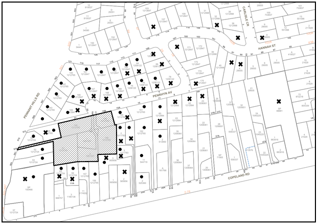
|
NOTIFICATION PLAN |
|||
|
• PROPERTIES NOTIFIED |
X SUBMISSIONS RECEIVED |
|
|
|
11 SUBMISSIONS RECEIVED OUT OF MAP RANGE OR UNKNOWN |
|||
44 submissions were received during the first notification period. An additional 36 submissions were received during the second notification period. Issues raised include:
· Overall concerns regarding the number of units in complex and that the amended reduction in 2 units was not enough for the site.
· Significant traffic increase to Penrhyn Ave, impacting existing residents with what is currently a quiet residential street.
o Penrhyn Ave not wide enough to allow for 2 way traffic and parking on both sides of road.
o Street not wide enough to allow for large trucks to operate and turn around in cul-de-sac.
o Requests for a wider footpath in street, if development goes ahead.
· Significant traffic implications to Hannah Street, which already serves as a short cut to Pennant Hills Road for traffic which should otherwise be using Copeland Road – concerns regarding safety of children and community within the area as a result.
o Many noted that the Hannah Street intersection is already dangerous, and this will only add to the associated safety issues.
· Impacts associated with construction works on the site including noise associated.
· Concerns regarding no shops within walking distance.
· Concerns regarding location of notification sign during notification period.
· Concerns that the proposal does not achieve design excellence.
· Concerns regarding privacy implications to neighbouring properties at No. 11A Copeland Road, Beecroft.
· The proposal would significantly impact the streetscape character of Penrhyn Ave.
· Loss of trees and vegetation.
· Requests for additional visitors parking.
· Solar panels on rooftops should be considered.
· Unclear quantities and details of cut and fill - concerns regarding level of excavation required in some areas of site.
· Concerns regarding the waste management and garage disposal and collection of bins requirements.
· That the applicant is seeking maximum yield at the expense of better design, amenity and privacy and a higher standard of housing should be required.
· Lack of open space.
· Lack of consideration for green energy.
· Concerns regarding accessibility throughout the site for seniors given the topography of land and number of storeys.
· Increase security risk to housing within street due to increased population.
· The proposal is not in keeping with the area.
· 3 seniors living development within close proximity of the site - considered an overdevelopment of the area.
· Lack of public transport in the area.
· Concerns regarding the height of the development.
· Request that setback of development to No. 573 Pennant Hills Road be increased to protect trees and swimming pool structure.
· Bus commuters park on Penrhyn Ave causing an overflow of parking within the street.
· Asbestos concerns relating to house to be demolished on the sites.
· Concerns regarding emergency access vehicles being blocked as a result of construction works and additional cars in street.
· Concerns regarding HDCP setback non-compliances, specifically in relation to Units 1 and 2.
· Concerns regarding fencing within front setback of Units 1 and 2 to achieve private open space.
· Concerns regarding stormwater/overland flow and additional flood risk to area.
The merits of the matters raised in community submissions have been addressed in the body of the report with the exception of the following:
5.1.1 Number of Units/ Standard of Housing
The overall number of Units was reduced from 33 to 30 which was considered appropriate for the site and is compliant with the prescriptive requirements of SEPP HSPD as discussed in the body of this report.
5.1.2 Hannah Street/ Penrhyn Ave Intersection
As indicated in Section 2.7.3 of this report, the following would be required to address the concerns regarding the Hannah Street/ Penrhyn Ave intersection:
· The intersection of Penrhyn Avenue with Hannah Street is to be formalised as a stop-controlled intersection with 20 metres no stopping and stop-line markings at the Penrhyn Avenue approach subject to the approval of Hornsby Local Traffic Committee.
· A pedestrian footpath along the full length of north-western side of Penrhyn Avenue is to be constructed and approved by Council.
· Streetlighting in Penrhyn Avenue is to be assessed by the proponent, to ensure it meets the relevant requirements for the increased pedestrian activity in Penrhyn Avenue.
5.1.3 Amenity Impacts Associated with Construction
It is inevitable that with development comes some disruption and amenity impact to the neighbouring community.
Notwithstanding, there a number of conditions applied to the consent, including the restriction of construction hours and the implementation of a construction management plan approved by Council to manage and reduce any potential amenity impacts associated with demolition and construction works on the site.
5.1.4 No Shops/ Limited Public Transport Within Walking Distance
Where a senior living development is not located within walking distance to shops and services, accessibility can be achieved by being within walking distance to public transport.
Bus stops are located on Pennant Hills Road that provide for travel to and from the site to shops and services. The bus stops are located within 400m of the site which meets the accessibility requirements under SEPP HSPD.
5.1.5 Notification Sign
The issue relating to the inadequate location of the notification sign on the site was rectified during the assessment process. Whilst there were no issues with this location, Council contacted the applicant who agreed to relocate the sign to satisfy nearby residents.
5.1.6 Privacy Impacts to No. 11A Copeland Road, Beecroft
Council in its assessment of the application considered the privacy impacts associated to the adjacent dwelling at No. 11A Copeland Road and requested that the applicant address this concern. The applicant agreed to delete the proposed balcony on the southern elevation of this dwelling.
5.1.7 Solar Panels and Green Energy
Council cannot enforce the requirement for solar panels and green energy initiative; however, the development includes a BASIX Certificate demonstrating that the building complies with SEPP BASIX and therefore meets building sustainability requirements in this regard.
5.1.8 Lack of Communal Open Space (COS)
Amended plans were submitted providing additional COS within the central component of the site to address both community and design concerns. It is considered that the additional COS significantly improves the amenity of the development.
5.1.9 Senior Living Developments within Close Proximity
There is no limitation on the number of Seniors Living developments within a certain area and no further concerns are raised in this regard.
5.1.10 Front Setback Requirements
The front setback of the development from Penrhyn Avenue has been increased to conform to the streetscape and provide additional landscaping.
5.1.11 Height of Development
Refer to sections 2.1.2 and 2.2.12 for further discussions with regards to heights and compliance with SEPP HSPD.
5.1.12 Increase Setback to No. 573 Pennant Hills Road
The western side setback generally complies with the 3m side setback requirement for the site and provides screen landscaping where possible. Essential services for accessibility and waste have been placed adjacent to the site at No. 573 Pennant Hills. Due to the topography of the land in relation to the adjoining site and existing screen planting, these services would have minimal amenity to neighbouring properties and are considered acceptable in this regard.
To further protect the property at No. 573 Pennant Hills Road, a condition is recommended in Schedule 1 of this report that a dilapidation report detailing the structural condition of the adjoining property must be prepared prior to the commencement of works.
5.1.13 Emergency access vehicles being blocked as a result of construction works and additional cars in street
The implementation of a Council approved Construction Management Plan and adequate parking on site would prevent emergency access vehicles being blocked within the street.
5.1.14 Fencing for Units 1 and 2 Private Open Space (POS)
It is considered that adequate landscaping would provide appropriate screening of the POS of Units 1 and 2.
5.1.15 Stormwater and Flooding
Refer to sections 2.1.5 and 3.1.2 of this report for further discussion with regards to stormwater and flooding. It is considered that appropriate measures have been taken to protect the overland flow path on the site and adequately drain stormwater.
5.2 Public Agencies
The development application was not referred to any Public Agencies for comment.
6. THE PUBLIC INTEREST
Section 4.15(1)(e) of the Act requires Council to consider “the public interest”.
The public interest is an overarching requirement, which includes the consideration of the matters discussed in this report. Implicit to the public interest is the achievement of future built outcomes adequately responding to and respecting the future desired outcomes expressed in environmental planning instruments and development control plans.
The application is considered to have satisfactorily addressed Council’s and relevant agencies’ criteria and would provide a development outcome that, on balance, would result in a positive impact for the community. Accordingly, it is considered that the approval of the proposed development would be in the public interest.
CONCLUSION
The application proposes the demolition of 5 existing dwellings and the construction of 30 self-contained Seniors living dwellings. The application also proposes the consolidation of the 6 lots into 1, associated civil/site works and landscape works.
The development generally meets the desired outcomes of Council’s planning controls and is satisfactory having regard to the matters for consideration under Section 4.15 of the Environmental Planning and Assessment Act 1979.
Council received a total of 80 submissions during the public notification periods. The matters raised have been addressed in the body of the report.
Having regard to the circumstances of the case, approval of the application is recommended.
The reasons for this decision are:
· The proposed development complies with the requirements of State Environmental Planning Policy (Housing for Seniors or People with a Disability) 2004, relevant environmental planning instruments and the Hornsby Development Control Plan 2013.
· The proposed development does not create unreasonable environmental impacts to adjoining development with regard to visual bulk, solar access, amenity or privacy.
Note: At the time of the completion of this planning report, no persons have made a Political Donations Disclosure Statement pursuant to Section 10.4 of the Environmental Planning and Assessment Act 1979 in respect of the subject planning application.
RESPONSIBLE OFFICER
The officer responsible for the preparation of this report is Madeleine Bayman.
|
Cassandra Williams Major Development Manager - Development Assessments Planning and Compliance Division |
Rod Pickles Manager - Development Assessments Planning and Compliance Division |
|
Locality Plan |
|
|
|
|
Context Plan |
|
|
|
|
Architectural Plans |
|
|
|
|
Landscape Plans |
|
|
File Reference: DA/1244/2021
Document Number: D08505147
SCHEDULE 1
GENERAL CONDITIONS
The conditions of consent within this notice of determination have been applied to ensure that the use of the land and/or building is carried out in such a manner that is consistent with the aims and objectives of the relevant legislation, planning instruments and council policies affecting the land and does not disrupt the amenity of the neighbourhood or impact upon the environment.
Note: For the purpose of this consent, the term ‘applicant’ means any person who has the authority to act on or the benefit of the development consent.
Note: For the purpose of this consent, any reference to an Act, Regulation, Australian Standard or publication by a public authority shall be taken to mean the gazetted Act or Regulation, or adopted Australian Standard or publication as in force on the date that the application for a construction certificate is made.
1. Approved Plans and Supporting Documentation
The development must be carried out in accordance with the plans and documentation listed below and endorsed with Council’s stamp, except where amended by Council and/or other conditions of this consent:
Approved Plans
|
Plan No. |
Plan Title |
Drawn by |
Dated |
Council Reference |
|
Ref. BPA2202, Sk1k, Issue K |
Site and Roof Plan |
Brooks Projects Architects |
03/11/22 |
|
|
Ref. BPA2202, Sk2p, Issue P |
Floor Plan - RL 132.00 |
Brooks Projects Architects |
29/09/22 |
|
|
Ref. BPA2202, Sk3o, Issue O |
Floor Plan – RL 135.00 |
Brooks Projects Architects |
08/10/22 |
|
|
Ref. BPA2202, Sk4n, Issue N |
Floor Plan – RL 138.00 |
Brooks Projects Architects |
03/11/22 |
|
|
Ref. BPA2202, Sk5j, Issue K |
Floor Plan – RL 141.00 |
Brooks Projects Architects |
03/11/22 |
|
|
Ref. BPA2202, Sk7e, Issue E |
Elevations |
Brooks Projects Architects |
03/11/22 |
|
|
Ref. BPA2202, Sk8d, Issue D |
Elevations |
Brooks Projects Architects |
04/11/22 |
|
|
Ref. BPA2202, Sk9ed, Issue D |
Elevations |
Brooks Projects Architects |
04/11/22 |
|
|
Ref. BPA2202, Sk10d, Issue D |
Sections |
Brooks Projects Architects |
04/11/22 |
|
|
Ref. BPA2202, Sk13b, Issue B |
Demolition Plan |
Brooks Projects Architects |
26/04/22 |
|
|
Ref. BPA2202, Sk11d, Issue C |
Bus Stop Access Plan |
Brooks Projects Architects |
01/11/21 |
|
|
Job No. 187.22(21)/ 407’D’, 1/6 |
Landscape Plan |
iScape Landscape Architecture |
04/11/22 |
|
|
Job No. 187.22(21)/ 408’D’, 2/6 |
Detailed Landscape Plan 1 |
iScape Landscape Architecture |
04/11/22 |
|
|
Job No. 187.22(21)/ 409’D’, 3/6 |
Detailed Landscape Plan 3 |
iScape Landscape Architecture |
04/11/22 |
|
|
Job No. 187.22(21)/ 410’D’, 4/6 |
Detailed Landscape Plan 3 |
iScape Landscape Architecture |
04/11/22 |
|
|
Job No. 187.22(21)/ 411’D’, 5/6 |
Detailed Landscape Plan 4 |
iScape Landscape Architecture |
04/11/22 |
|
|
Job No. 187.22(21)/ 412’D’, 6/6 |
Materials Palette |
iScape Landscape Architecture |
04/11/22 |
|
|
Dwg No. 02542_100 |
Cover Sheet, Drawing Index, General Note |
C & M Consulting Engineers |
28/04/22 |
|
|
Dwg No. 02542_201 |
Stormwater Drainage Plan – Ground Floor |
C & M Consulting Engineers |
28/04/22 |
|
|
Dwg No. 02542_202 |
Stormwater Drainage Plan – First Floor |
C & M Consulting Engineers |
28/04/22 |
|
|
Dwg No. 02542_203 |
Stormwater Drainage Plan – Second Floor |
C & M Consulting Engineers |
28/04/22 |
|
|
Dwg No. 02542_401 |
Driveway Plan |
C & M Consulting Engineers |
28/04/22 |
|
|
Dwg No. 02542_402 |
Longitudinal Sections Driveway 1 |
C & M Consulting Engineers |
28/04/22 |
|
|
Dwg No. 02542_403 |
Longitudinal Sections Driveway 2 |
C & M Consulting Engineers |
28/04/22 |
|
|
Dwg No. 02542_404 |
Longitudinal Sections Driveway 3 |
C & M Consulting Engineers |
28/04/22 |
|
|
Dwg No. 02542_621 |
On-Site Detention Tank – Plan & Details |
C & M Consulting Engineers |
28/04/22 |
|
|
Dwg No. 02542_631 |
Stormwater Longitudinal Section |
C & M Consulting Engineers |
28/04/22 |
|
|
Dwg No. 02542_701 |
Sediment & Erosion Control Plan & Details |
C & M Consulting Engineers |
28/04/22 |
|
Supporting Documentation
|
Document Title |
Prepared by |
Dated |
Council Reference |
|
BASIX Certificate No. 1250894M_03 |
Sustainability-Z Pty Ltd |
17/11/22 |
D08536961 |
|
Arboricultural Impact Assessment |
Urban Arbor |
12/10/21 |
D08299495 |
|
Access Review – Final v5 |
Morris Goding Access Consulting |
31/07/22 |
D08507903 |
|
Environmental Noise Assessment – Rev. B |
Day Design |
29/04/22 |
D08401377 |
|
Overland Flow Assessment, Rev B |
C & M Consulting Engineers |
02/05/22 |
D08401374 |
|
Stormwater Management Plan, Rev B |
C & M Consulting Engineers |
28/04/22 |
D08401376 |
|
Detailed Site Investigation |
Neo Consulting |
28/09/21 |
D08299444 |
|
Waste Management Plan |
Brooks Projects Architects |
27/10/21 |
D08299485 |
2. Amendment of Plans
To comply with Councils requirement in terms of waste management and privacy, the approved plans are to be amended as follows:
a) To maintain the privacy of a number of residences within the complex and neighbouring properties, any balcony servicing a dwelling/unit within the complex greater than 600mm above natural ground level must include translucent glazed balustrades to maintain visual amenity.
c) The bin storage room next to Dwelling 13 must be extended from 3.8m x 2.3m to 5.2m x 2.3m. The rear door (opening to the private open space of Dwelling 13) must be deleted.
d) A dedicated lockable storage space must be provided for the motorised bin carting equipment (bin trolley).
e) Further details are to be provided regarding the waste management of the development. These details are to form an addendum to WMP and must be submitted in accordance with the provisions of Council’s Development Control Plan and prior to the issue of the Construction Certificate. These details are to include:
i) Plans clearly showing the walking path and walking distance from each dwelling to their allocated bin storage room.
ii) A list of the bin storage rooms, and the dwellings allocated to use them.
3. Removal of Trees
a) This development consent permits the removal of trees numbered 1, 2, 3, 4, 5, 6, 7, 8, 9, 10, 11, 12, 13, 14, 15, 16, 17, 18, 19, 20, 21, 22, 23, 24, 25, 26, 27, 28, 29, 30, 31, 32, 33, 34, 44, 45, 50, 51, 52, 53, 54, 55, 56, 57, 58, 59, 60, 61, 62, 63, 64, 65, 66, 67, 68, 69, 70, 71, 72, 73, 74, 75, 76, 77, 80, 81, 94, 95, 96, 97, 98, 99, 100, 120, 121, 122, 123, 124, 125, 126, 127, 128, 129, 130, 131, 132, 133, 134, 135, 136, 137, 138, 139, 140, 141, 142, 143, 144, 145 and 146 as identified in the Arboricultural Impact Assessment prepared by Urban Arbor, dated 12 October 2021.
b) No consent is granted for the removal of trees numbered 35, 36, 37, 38, 39, 40, 41, 42, 43, 46, 47, 48, 49, 78, 79, 82, 83, 84, 85, 86, 87, 88, 89, 90, 91, 92, 93, 101, 102, 103, 104, 105, 106, 107, 108, 109, 110, 111, 112, 113, 114, 115, 116, 117, 118 and 119 as these trees contribute to the established landscape amenity of the area/streetscape.
Note: The removal or pruning of any other trees from the site requires separate approval by Council in accordance with Part 1B.6 Tree and Vegetation Preservation of the Hornsby Development Control Plan 2013 (HDCP).
4. Appointment of a Project Arborist
a) To ensure the trees that must be retained are protected, a project arborist with AQF Level 5 qualifications must be appointed to assist in ensuring compliance with the conditions of consent and provide monitoring reports as specified by the conditions of consent.
b) Details of the appointed project arborist must be submitted to Council and the PCA with the application for the construction certificate/subdivision works certificate.
5. Construction Certificate
a) A Construction Certificate is required to be approved by Council or a Private Certifying Authority prior to the commencement of any construction works under this consent.
b) A Subdivision Works Certificate is required to be approved by Council or a Private Certifying Authority prior to the commencement of any subdivision works under this consent.
c) A separate Subdivision Works Certificate must be obtained from Council for all works within the public road reserve under S138 of the Roads Act.
d) A separate Subdivision Works Certificate must be obtained from Council for all works within drainage easements vested in Council.
e) The Construction Certificate / Subdivision Works Certificate plans must be consistent with the Development Consent plans.
6. Section 7.11 Development Contributions
a) In accordance with Section 4.17(1) of the Environmental Planning and Assessment Act 1979 and the Hornsby Shire Council Section 7.11 Development Contributions Plan 2020-2030, the following monetary contributions must be paid to Council to cater for the increased demand for community infrastructure resulting from the development:
|
Description |
Contribution (4) |
|
Roads |
$22,099.25 |
|
Open Space and Recreation |
$251,383.80 |
|
Community Facilities |
$154,829.70 |
|
Plan Preparation and Administration |
$2,141.70 |
|
TOTAL |
$430,454.45 |
being for 30 seniors living dwellings and 6 dwelling house/lot credits.
b) The value of this contribution is current as of 7 November 2022. If the contribution is not paid within the financial quarter that this condition was generated, the contribution payable will be adjusted in accordance with the provisions of the Hornsby Shire Council Section 7.11 Development Contributions Plan and the amount payable will be calculated at the time of payment in the following manner:
$CPY = $CDC x CPIPY
CPIDC
Where:
$CPY is the amount of the contribution at the date of Payment
$CDC is the amount of the contribution as set out in this Development Consent
CPIPY is the latest release of the Consumer Price Index (Sydney – All Groups) at the date of Payment as published by the ABS.
CPIDC is the Consumer Price Index (Sydney – All Groups) for the financial quarter at the date applicable in this Development Consent Condition.
c) The monetary contribution must be paid to Council:
i) Prior to the issue of the Subdivision Certificate where the development is for subdivision.
ii) Prior to the issue of the first Construction Certificate where the development is for building work.
iii) Prior to issue of the Subdivision Certificate or first Construction Certificate, whichever occurs first, where the development involves both subdivision and building work.
iv) Prior to the works commencing where the development does not require a Construction Certificate or Subdivision Certificate.
Note: It is the professional responsibility of the Principal Certifying Authority to ensure that the monetary contributions have been paid to Council in accordance with the above timeframes.
Note: In accordance with Ministerial Directions, the payment of contribution fees for development with a cost of works of over $10 million can be deferred to prior to Occupation Certificate.
Note: Council’s Development Contributions Plan may be viewed at www.hornsby.nsw.gov.au or a copy may be inspected at Council’s Administration Centre during normal business hours.
REQUIREMENTS PRIOR TO THE ISSUE OF A CONSTRUCTION CERTIFICATE
7. Building Code of Australia
Detailed plans, specifications and supporting information is required to be submitted to the certifying authority detailing how the proposed building work achieves compliance with the National Construction Code - Building Code of Australia. All building work must be carried out in accordance with the requirements of the National Construction Code - Building Code of Australia.
8. Fire Safety Schedule
A schedule of all proposed essential fire safety measures to be installed in the building (e.g. hydrants, hose reels, emergency warning systems etc.) shall be submitted with the construction certificate application.
9. Contract of Insurance (Residential Building Work)
Where residential building work for which the Home Building Act 1989 requires there to be a contract of insurance in force in accordance with Part 6 of that Act, this contract of insurance must be in force before any building work authorised to be carried out by the consent commences.
10. Notification of Home Building Act 1989 Requirements
Residential building work within the meaning of the Home Building Act 1989 must not be carried out unless the principal certifying authority for the development to which the work relates (not being Council) has given Council written notice of the following information:
a) In the case of work for which a principal contractor is required to be appointed:
i) The name and licence number of the principal contractor.
ii) The name of the insurer by which the work is insured under Part 6 of that Act.
b) In the case of work to be done by an owner-builder:
i) The name of the owner-builder.
ii) If the owner-builder is required to hold an owner-builder’s permit under that Act, the number of the owner-builder’s permit.
Note: If arrangements for doing the residential building work are changed while the work is in progress so that the information notified becomes out of date, further work must not be carried out unless the principal certifying authority for the development to which the work relates (not being Council) has given Council written notification of the updated information.
11. Identification of Survey Marks
A registered surveyor must identify all survey marks in the vicinity of the proposed development. Any survey marks required to be removed or displaced as a result of the proposed development shall be undertaken by a registered surveyor in accordance with Section 24 (1) of the Surveying and Spatial Information Act 2002 and following the Surveyor General’s Directions No.11 - "Preservation of Survey Infrastructure".
The applicant must submit written evidence of the following service provider requirements:
a) Ausgrid (formerly Energy Australia) – a letter of consent demonstrating that satisfactory arrangements have been made to service the proposed development.
b) Telstra - a letter of consent demonstrating that satisfactory arrangements have been made to service the proposed development.
13. Sydney Water – Approval
This application must be submitted to Sydney Water for approval to determine whether the development would affect any Sydney Water infrastructure, and whether further requirements are to be met.
Note: Building plan approvals can be obtained online via Sydney Water Tap inTM through www.sydneywater.com.au under the Building and Development tab.
a) Prior to the commencement of any works on site, the applicant must submit for approval by the Principal Certifying Authority (with a copy forwarded to Council) a ‘Dilapidation Report’ detailing the structural condition of the adjoining properties:
i) Lot 105, DP 1212765, No. 573 Pennant Hills Road, West Pennant Hills.
ii) Lot 165 DP 1212847, No. 20 Penrhyn Avenue, Beecroft.
b) The report must include a photographic survey of the adjoining properties detailing their physical condition, both internally and externally, including such items as walls, ceilings, roof, structural members and other similar items. The report must be completed by a chartered structural/geotechnical engineer. A copy of the dilapidation report must be submitted to Council.
c) In the event access to adjoining allotments for the completion of a dilapidation survey is denied, the applicant must demonstrate in writing that all reasonable steps have been taken to advise the adjoining allotment owners of the benefit of this survey and details of failure to gain consent for access to the satisfaction of the Principal Certifying Authority.
Note: This documentation is for record keeping purposes only and can be made available to an applicant or affected property owner should it be requested to resolve any dispute over damage to adjoining properties arising from works. It is in the applicant’s and adjoining owner’s interest for it to be as detailed as possible.
15. Stormwater Drainage
The stormwater drainage system for the development must be designed in accordance with AUS-SPEC Specifications (www.hornsby.nsw.gov.au/property/build/aus-spec-terms-and-conditions) and the following requirements:
a) Connected to an existing Council piped drainage system with the following requirements:
i) A separate Application must be made to Council for ‘Approval to Connect Stormwater Drainage Outlet to Council’s System’ with all fees paid, prior to connecting to Council’s drainage system;
ii) The connection to Council’s drainage pit or pipeline in accordance with Councils Design Standard Drawing No. 6 must be inspected by a Council Engineer from Council’s Planning Division;
Note: An inspection booking can be made by calling Council on 9847 6760 quoting the Application reference number commencing SD
iii) Where public assets and utilities are impacted by proposed works, the Applicant shall relocate or reconstruct the asset or utility in accordance with the relevant standard at the Applicant’s cost;
iv) Prior to the issue of an Occupation Certificate a Compliance Certificate must be obtained from Council for the connection to Council’s drainage system.
16. On Site Stormwater Detention
An on-site stormwater detention system must be designed by a chartered civil engineer and constructed in accordance with the following requirements:
a) Have a capacity of not less than 124.7 cubic metres, and a maximum discharge (when full) of 183 litres per second.
b) Have a surcharge/inspection grate located directly above the outlet.
c) Discharge from the detention system must be controlled via 1 metre length of pipe, not less than 50 millimetres diameter or via a stainless plate with sharply drilled orifice bolted over the face of the outlet discharging into a larger diameter pipe capable of carrying the design flow to an approved Council system.
d) Where above ground and the average depth is greater than 0.3 metres, a ‘pool type’ safety fence and warning signs must be installed.
e) Not be constructed in a location that would impact upon the visual or recreational amenity of residents.
17. WSUD Facilities
The proposed WSUD facilities includes Ocean Guards (2 x 200um), and Storm Filter Cartridges (12 x 690mm) are to be constructed and meet the water quality targets as specified in the Hornsby Development Control Plan 2013.
18. The Habitable Floor Levels
a) The finished floor level of any habitable room to be not less than 500mm and the garage 300mm above the 100 year average recurrence interval storm level. The levels must be related to Australian Height Datum (AHD):
i) Dwelling 1 - 134.50m.
ii) Dwelling 2 - RL 134.18m.
iii) Dwelling 3 - RL 133.25m.
b) The minimum finished floor level for the area designated to waste material is RL134.00.
19. Building Materials and Construction Methods for Dwellings 1, 2 and 3
a) Building materials below the minimum finished floor level shall be built from flood compatible materials and designed to withstand impact from debris carried in flood waters.
b) Pier and beam method construction adjacent to easements to the depth of the invert of proposed and existing pipes.
20. Overland Flow Path Construction
a) The existing depression/watercourse be constructed to contain the 1 in 100 year Average Recurrence Interval storm event across the subject site; generally in accordance with the Flood Modelling Pre-Development Flood Extents, prepared by C & M Consulting Engineers, dated 02/05/22.
b) Council’s piped drainage system to contain the 20 year Average Recurrence Interval (ARI) storm event with an overland flow of 100 years ARI provided above it.
c) All fences crossing the overland flow path extents shall have a minimum 500mm of pool fencing at the base of the fence to allow overland flow to pass through the area unimpeded;
Note: A certificate from a chartered civil engineer together with a works as executed design plan must be submitted to the principal certifying authority to demonstrate the satisfaction of this condition.
d) A separate Subdivision Works Certificate must be obtained from Council for all works within drainage easements vested in Council, prior to the commencement of physical works.
21. Internal Driveway/Vehicular Areas
The driveway and parking areas on site must be designed, and a Construction Certificate issued in accordance with Australian Standards AS2890.1, AS2890.2, AS3727 and the following requirements:
a) Design levels at the front boundary be obtained from Council.
b) The driveway be a rigid pavement.
c) The driveway pavement be a minimum 3 metres wide, 0.15 metres thick reinforced concrete with SL72 steel reinforcing fabric and a 0.15 metre sub-base.
d) Retaining walls required to support the carriageway and the compaction of all fill batters to be in accordance with the requirements of a chartered structural engineer.
e) The provision of safety rails where there is a level difference more than 0.3 metres and a 1:4 batter cannot be achieved.
f) A common turning area to service the proposed development in accordance with Australian Standards AS 2890.1 to ensure vehicles can enter and leave the site in a forward direction. A right of access shall be created over the turning area to ensure access is maintained at all times.
g) Construction of pedestrian access designed to help prevent slip and fall shall be designed and constructed with the future access driveway. Pedestrian grades steeper than 12.5% shall be provided with surface texturing, brushing or cleats to satisfy Class V: R11 ramps in accordance with Australian Standards AS 4586-2004 Clause 5.2.
h) Longitudinal sections along both sides of the access driveway shall be submitted to the principal certifying authority in accordance with the relevant sections of AS 2890.1. The maximum grade shall not exceed 1 in 4 (25%) with the maximum changes of grade of 1 in 8 (12.5%) for summit grades and 1 in 6.7 (15%) for sag grades. Any transition grades shall have a minimum length of 2 metres. The longitudinal sections shall incorporate the design levels obtained by Council.
i) A sag in the driveway is to be implemented within chainage 70.00 and chainage 65.00 in order to redirect overland flow back to the existing easement and overland flow path.
22. Redundant Driveway Crossing at 579 Pennant Hills Road
a) Any redundant crossings must be replaced with integral kerb and gutter at 579 Pennant Hills Road to the satisfactory of Transport for NSW.
b) A separate Subdivision Works Certificate or Subdivision Roads Application must be obtained from Council and Transport for NSW for all works within the public road reserve under S138 of the Roads Act 1993, prior to commencement of works.
23. Footpath Link from Penrhyn Avenue to Hannah Street
To provide a footpath link to Hannah Street, a concrete footpath must be designed along the full length of the north-western side of Penrhyn Avenue in accordance with AUS-SPEC Specifications (www.hornsby.nsw.gov.au/property/build/aus-spec-terms-and-conditions) and the following requirements:
a) Pouring of the 1.2m wide concrete footpath to the whole length of Penrhyn Street.
b) The land adjoining the footpath to be fully turfed.
c) Any public utility adjustments to be carried out at the cost of the applicant and to the requirements of the relevant public authority.
Note: A separate Subdivision Works Certificate or Subdivision Roads Application must be obtained from Council for all works within the public road reserve under S138 of the Roads Act, prior to commencement of works.
a) ‘No Parking’ signs are to be installed in the Cul-de-sac subject to the approval of Hornsby Local Traffic Committee before the issuing of a Construction Certificate; and
b) The intersection of Penrhyn Avenue with Hannah Street is to be formalised as a stop controlled intersection within 20 metres no stopping and stop-line markings at the Penrhyn Avenue approach subject to the approval of Hornsby Local Traffic Committee before the issuing of a Construction Certificate.
Note: Approval of Hornsby’s Local Traffic Committee should be sought by emailing TrafficEngineering&RoadSafety@hornsby.nsw.gov.au
25. Waste Management Details
The following waste management requirements must be complied with:
a) Should there be any conflict or confusion between approved plans and/or consent conditions related to the waste management system or the waste collection vehicle travel path on site, then written clarification must be obtained from Council.
b) The approved on-going waste management system must not be amended without the written consent of Council.
c) There must be no steps along any bin carting route. Ramps and service lifts are acceptable.
Note: bin carting routes include, but are not limited to, from the bin storage rooms to the main bin storage/holding room.
d) For all bin carting routes, the path must be smooth hard surface. (Concrete pavement for example is acceptable, but pebbles, stepping stones, grass etc is not acceptable).
e) A design certificate and detailed plans are to accompany any Construction Certificate application, which demonstrate that the bin carting route from the main bin storage room / temporary bin holding room to the waste collection vehicle parked on the driveway has been designed to be constructed in accordance with the Waste Minimisation and Management Guidelines and including the following requirements:
i) Must be smooth hard surface.
ii) Must be no less than 2m wide (including through any gates or doors).
iii) Must be devoid of steps.
iv) Must have a gradient no steeper than 1:14 for 240L bins and 1:30 for 660L or 1100L bins.
v) The first 6m of the driveway must have a gradient no steeper than 1:20 and must be designed to carry the load of a heavy rigid waste collection vehicle.
f) A design certificate and detailed plans are to accompany any Construction Certificate application, which demonstrate that for every dwelling, the walking path residents take from their dwelling to their assigned bin storage room has been designed to be constructed in accordance with the Waste Minimisation and Management Guidelines and including the following requirements:
i) The route is direct, does not cross into a private lot, and is wholly within property boundaries (does not include the public footpath or road).
ii) The route is as short as possible and does not exceed 30m walking distance.
iii) The route is an accessible path of travel for persons with a disability in accordance with AS1428 Design and Access for Mobility.
i) The floor is to be constructed of concrete at least 75mm thick and adequately graded to drain to a Sydney Water approved drainage fitting.
ii) The floor must be finished so that it is non-slip, sealed and impervious, and has a smooth and even surface coved at all intersections.
iii) The ceilings and walls must be finished with smooth faced non-absorbent material capable of being cleaned.
iv) The room is to be provided with artificial light controllable within the room and adequate forced ventilation.
v) The room is to be provided with an adequate supply of hot and cold water mixed through a centralised mixing valve with hose cock.
vi) The doors are to be robust and lockable, with a door width of no less than 920mm. The doors must be able to be opened from inside the room without a key. The door swing must not block access to bins.
j) Every bin storage room must:
ii) Comfortably house the required number of bins for the dwellings allocated to use the bin room with every bin being accessible (no stacking of bins 2 or more deep).
iii) Have door(s) wide enough and positioned so that the largest bin (240L) can fit through.
iv) Be located no more than 30m walking distance from each dwelling allocated to use it. The walking path from each dwelling to the bin storage room must not include the public footpath, that must be wholly within the site. The walking path from each accessible/adaptable dwelling to the bin storage room must be an accessible path of travel.
Note: 240L bins are 600mm wide by 750mm deep; allow for ease around the bin - 75mm is recommended. Minimum aisle width for accessibility is 1.55m.
k) The access way (including ramp, vehicle turning area, loading dock/service bay and site entry/exit) to be used by waste collection vehicles, must be designed in compliance with Australian Standard AS2890.2-2002 Parking Facilities Part 2: Off-street commercial vehicle facilities for heavy rigid vehicles.
Note: AS2890.2-2002 includes a maximum gradient of 1:6.5 for forward travel and 1:8 for reverse travel, a minimum vertical clearance of 4.5 m.
i) Waste collection vehicle is able to enter the site in a reverse direction, adequately manoeuvre into position near the bins, load bins and exit the site in a forward direction.
ii) Vertical clearance of 4.5m is provided along the entire route of travel of the waste collection vehicle on site.
iii) The installation of overhead lights, signs etc will not reduce the vertical clearance of the waste collection vehicle travel path on site to less than 4.5m.
iv) The grades along the entire travel path of the waste collection vehicle on site must not exceed the maximum grades of AS2890.2 for a heavy rigid vehicle.
v) The vehicle ground clearance is sufficient to prevent scraping.
vi) The pavement width is no less than 6.0m wide and is designed to allow cars to pass the parked HRV waste collection vehicle.
vii) All pavement has been designed to carry the load of the heavy rigid vehicle.
i) An estimate of the types and volumes of waste and recyclables to be generated.
ii) A site plan showing sorting and storage areas for demolition and construction waste and the vehicle access to these areas.
iii) How excavation, demolition and construction waste materials will be reused or recycled and where residual wastes will be disposed.
iv) The total percentage (by weight) of demolition and construction waste that will be reused or recycled.
Note: the site(s) to which the waste materials are taken must be legally able to accept those wastes.
26. Certification of Traffic Engineer
Prior to the issue of a Construction Certificate, a Certificate from an appropriate qualified Traffic Engineer is to be submitted to the Principal Certifying Authority (PCA) certifying that the parking modules, loading areas and garbage collection areas comply with Australian Standards AS2890.1, AS2890.2 and the approved Development Consent plans and conditions.
27. Accessibility
Prior to the issue of a Construction Certificate, a Certificate from an appropriate qualified Access consultant is to be submitted to the Principal Certifying Authority (PCA) certifying that the Construction Certificate plans demonstrate compliance with the specifications within the Access Review Report - Final v5 prepared by Morris Goding Access Consulting, dated 31 July 2022.
28. Construction Management Plan (CMP)
To assist in the protection of the public, the environment and Council’s assets, a separate Construction Management Plan must be prepared by a suitably qualified environmental consultant in consultation with a qualified traffic engineer and AQF 5 arborist and submitted to Council’s Compliance Team via Council’s Online Services Portal for review and written approval.
The CMP must include the following details:
a) The CMP must detail the contact information for developers, builder, private certifier and any emergency details during and outside work hours.
b) A Construction Traffic Management Plan (CTMP) including the following:
i) The order of construction works and arrangement of all construction machines and vehicles being used during all stages.
ii) The CTMP plans shall be in accordance with all other plans submitted to Council as part of this development proposal.
iii) A statement confirming that no building materials, work sheds, vehicles, machines or the like shall be allowed to remain in the road reserve area without the written consent of Hornsby Shire Council.
iv) The Plan shall be in compliance with the requirements of the Roads and Maritime Services Traffic control at work sites Manual 2018 and detail:
a. Public notification of proposed works.
b. Long term signage requirements.
c. Short term (during actual works) signage.
d. Vehicle Movement Plans, where applicable.
e. Traffic Management Plans.
f. Pedestrian and Cyclist access and safety.
v) Traffic controls including those used during non-working hours. Pedestrian access and two-way traffic in the public road must be able to be facilitated at all times.
vi) Details of parking arrangements for all employees and contractors, including layover areas for large trucks during all stages of works. The parking or stopping of truck and dog vehicles associated with the development will not be permitted other than on the site and the plan must demonstrate this will be achieved.
vii) Confirmation that a street ‘scrub and dry’ service will be in operation during all stages of works.
viii) Proposed truck routes to and from the site including details of the frequency of truck movements for all stages of the development.
ix) Swept path analysis for ingress and egress of the site for all stages of works.
x) Site plans for all stages of works including the location of site sheds, concrete pump and crane locations, unloading and loading areas, waste and storage areas, existing survey marks, vehicle entry, surrounding pedestrian footpaths and hoarding (fencing) locations.
xi) The total quantity and size of trucks for all importation and exportation of fill on site throughout all stages of works, and a breakdown of total quantities of trucks for each stage of works.
xii) The number of weeks trucks will be accessing and leaving the site with excavated or imported fill material.
xiii) The maximum number of trucks travelling to and from the site on any given day for each stage of works.
xiv) The maximum number of truck movements on any given day during peak commuting periods for all stages of works.
xv) The Plan must state that the applicant and all employees of contractors on the site must obey any direction or notice from the Prescribed Certifying Authority or Hornsby Shire Council in order to ensure the above.
xvi) If there is a requirement to obtain a Work Zone, Out of Hours permit, partial Road Closure or Crane Permit, the Plan must detail these requirements and include a statement that an application to Hornsby Shire Council will be made to obtain such a permit.
c) A Construction Waste Management Plan detailing the following:
i) Details of the importation or excavation of soil and fill, the classification of the fill, disposal methods and authorised disposal depots that will be used for the fill.
ii) Asbestos management requirement and procedures for removal and disposal from the site in accordance with AS 2601–2001 – ‘The Demolition of Structures’, and the Protection of the Environment Operations (Waste) Regulation 2005.
iii) General construction waste details including construction waste skip bin locations and litter management for workers.
d) A Tree Protection Plan (TPP) prepared by an AQF 5 Arborist in accordance with any approved Arboricultural Impact Assessment and tree location plans, detailing the following:
iv) A site plan showing tree protection zones (TPZ) and structural root zones (SRZ) of trees to be retained and specific details of tree protection measures inclusive of distances (in metres) measured from tree trunks.
v) Construction methodology to avoid damage to trees proposed to be retained during construction works.
vi) Specifications on tree protection materials used and methods within the TPZ or SRZ.
vii) Location of dedicated material storage space on site outside of TPZ’s and SRZ’s for retained trees.
e) A Construction Noise and Vibration Management Plan (CNMP) which includes:
i) Existing noise and vibration levels within the proximity of the proposed development site.
ii) Details of the extent of rock breaking or rock sawing works forming part of the proposed development works.
iii) The maximum level of noise and vibration predicted to be emitted during each stage of construction.
iv) The duration of each stage of works where the maximum level of noise and vibration are predicted to be emitted for.
v) Details of mitigation measures, inclusive of respite periods, that will meet acoustic standards and guidelines at each stage of works.
vi) Details of a complaints handling process for the surrounding neighbourhood for each stage of works.
f) Identification of approved sediment and erosion control measures.
Note: The CMP must be lodged via Council’s Online Services Portal at: https://hornsbyprd-pwy-epw.cloud.infor.com/ePathway/Production/Web/Default.aspx and by selecting the following menu options: Applications > New Applications > Under ‘Application Types’: Management Plans.
29. Mechanical Equipment
A detailed mechanical plant noise assessment for all proposed mechanical equipment and site specific equipment must be undertaken by a suitably qualified Acoustic Consultant and a report certifying that the operation of all proposed equipment will not exceed 38dB(A) at any boundary upon installation must be submitted to the PCA prior to the issue of the Construction Certificate.
REQUIREMENTS PRIOR TO THE COMMENCEMENT OF ANY WORKS
30. Erection of Construction Sign
a) A sign must be erected in a prominent position on any site on which any approved work is being carried out:
i) Showing the name, address and telephone number of the principal certifying authority for the work.
ii) Showing the name of the principal contractor (if any) for any demolition or building work and a telephone number on which that person may be contacted outside working hours.
iii) Stating that unauthorised entry to the work site is prohibited.
b) The sign is to be maintained while the approved work is being carried out and must be removed when the work has been completed.
31. Protection of Adjoining Areas
A temporary hoarding, fence or awning must be erected between the work site and adjoining lands before the works begin and must be kept in place until after the completion of the works if the works:
a) Could cause a danger, obstruction or inconvenience to pedestrian or vehicular traffic.
b) Could cause damage to adjoining lands by falling objects.
c) Involve the enclosure of a public place or part of a public place.
d) Have been identified as requiring a temporary hoarding, fence or awning within the Council approved Construction Management Plan (CMP).
Note: Notwithstanding the above, Council’s separate written approval is required prior to the erection of any structure or other obstruction on public land.
a) To provide a safe and hygienic workplace, toilet facilities must be available or be installed at the works site before works begin and must be maintained until the works are completed at a ratio of one toilet for every 20 persons employed at the site.
b) Each toilet must:
i) Be a standard flushing toilet connected to a public sewer.
ii) Be a temporary chemical closet approved under the Local Government Act 1993.
iii) Have an on-site effluent disposal system approved under the Local Government Act 1993.
33. Erosion and Sediment Control
To protect the water quality of the downstream environment, erosion and sediment control measures must be provided and maintained throughout the construction period in accordance with the manual ‘Soils and Construction 2004 (Bluebook)’, the approved plans, Council specifications and to the satisfaction of the principal certifying authority. The erosion and sediment control devices must remain in place until the site has been stabilised and revegetated.
Note: On the spot penalties may be issued for any non-compliance with this requirement without any further notification or warning.
Prior to the commencement of any works, the on-going waste collection service must be cancelled and the bins retrieved by the waste collection service provider.
Note: For residential properties, Council is the waste collection service provider.
35. Garbage receptacle
a) A garbage receptacle must be provided at the work site before works begin and must be maintained until all works are completed.
a) The garbage receptacle must have a tight fitting lid and be suitable for the reception of food scraps and papers.
b) The receptacle lid must be kept closed at all times, other than when garbage is being deposited.
c) Food scraps must be placed in the garbage receptacle and not in demolition and construction waste bins.
36. Installation of Tree Protection Measures
a) Trees to be retained and numbered 35, 36, 37, 38, 39, 40, 41, 42, 43, 46, 47, 48, 49, 78, 79, 82, 83, 84, 85, 86, 87, 88, 89, 90, 91, 92, 93, 101, 102, 103, 104, 105, 106, 107, 108, 109, 110, 111, 112, 113, 114, 115, 116, 117, 118 and 119 as identified on the Tree Location Plan with the Arboricultural Impact Assessment prepared by Urban Arbor, dated 12 October 2021 must have tree protection measures for the ground, trunk and canopy installed by the project arborist as follows:
i) For the duration of demolition works, in accordance with the Tree Protection Plan with the Arboricultural Impact Assessment prepared by Urban Arbor, dated 12 October 2021.
ii) For the duration of construction works, in accordance with Tree Protection Plan within the Arboricultural Impact Assessment prepared by Urban Arbor, dated 12 October 2021.
b) Tree protection fencing for the trees to be retained must be installed by the engaged AQF 5 project arborist and consist of 1.8m high temporary fencing panels installed in accordance with Australian Standard AS4687-2007 Temporary fencing and hoardings.
c) Where wood-chip mulch is permitted by Council instead of tree protection fencing within the tree protection zones, the wood-chip must be covered with a layer of geotextile fabric and rumble boards.
REQUIREMENTS DURING DEMOLITION AND CONSTRUCTION
37. Construction Work Hours
All work on site (including demolition and earth works) must only occur between 7am and 5pm Monday to Saturday (unless otherwise approved in writing by Council due to extenuating circumstances).
No work is to be undertaken on Sundays or public holidays.
38. Demolition
To protect the surrounding environment, all demolition work must be carried out in accordance with Australian Standard AS2601-2001 Demolition of structures and the following requirements:
a) A Hazardous Materials Survey must be conducted by a qualified occupational hygienist and/or environmental consultant prior to the commencement of demolition works in accordance with the recommendations of the Detailed Site Investigation, prepared by NEO Consulting, dated 30/9/21, reference N517.
b) Demolition material must be disposed of to an authorised recycling and/or waste disposal site and/or in accordance with an approved waste management plan.
c) Demolition works, where asbestos material is being removed, must be undertaken by a contractor that holds an appropriate licence issued by SafeWork NSW in accordance with the Work Health and Safety Regulation 2017 and be appropriately transported and disposed of in accordance with the Protection of the Environment Operations (Waste) Regulation 2014.
d) On construction sites where any building contain asbestos material, a standard commercially manufactured sign containing the words ‘DANGER ASBESTOS REMOVAL IN PROGRESS’ and measuring not less than 400mm x 300mm must be displayed in a prominent position visible from the street.
39. Environmental Management
The site must be managed in accordance with the publication ‘Managing Urban Stormwater – Landcom (March 2004) and the Protection of the Environment Operations Act 1997 by way of implementing appropriate measures to prevent sediment run-off, excessive dust, noise or odour emanating from the site during the construction of the development.
a) To protect the surrounding environment, Street sweeping must be undertaken following sediment tracking from the site along Penrhyn Avenue and surrounding roads during works and until the site is established.
b) The street cleaning service must utilise a ‘scrub and dry’ method and be undertaken for the full extent of any sediment tracking.
41. Disturbance of Existing Site
During construction works, the existing ground levels of open space areas and natural landscape features, (including natural rock-outcrops, vegetation, soil and watercourses) must not be altered unless otherwise nominated on the approved plans.
To ensure that the public reserve is kept in a clean, tidy and safe condition during construction works, no building materials, waste, machinery or related matter is to be stored on the road or footpath.
43. Works Zone
All construction vehicles associated with the proposed development are to be contained on site or in a Local Traffic Committee (LTC) approved “Works Zone” as follows:
a) The site supervisor to be advised that the Works Zone will be deemed to be in effect, and fees will apply, between the dates nominated by the supervisor, or when parking spaces are managed for the sole use of construction vehicles associated with the site.
b) The Works Zone signs shall be in effect only for the times approved by Council, and the time is to be noted on the sign. Eg, ‘Works Zone Mon – Sat 7am – 5pm’.
c) The applicant is required to supply a sign posting installation plan for referral to the Local Traffic Committee, noting on it the duration of the Works Zone.
d) The Works Zone is only to be used for the loading and unloading of vehicles. Parking of workers’ vehicles, or storage of materials, is not permitted.
Note: A Works Zone Permit can be obtained via Council’s Online Services Portal at: Work Zone Permit | Hornsby Shire Council (nsw.gov.au).
44. Prohibited Actions Within the Tree Protection Zone
In accordance with the Australian Standards AS4970-2009, the following be prohibited within the fenced area of TPZ:
a) Soil cut or fill including excavation and trenching.
b) Soil cultivation, disturbance or compaction.
c) Stockpiling storage or mixing of materials.
d) The parking, storing, washing and repairing of tools, equipment and machinery.
e) The disposal of liquids and refuelling.
f) The disposal of building materials.
g) The siting of offices or sheds.
h) Any action leading to the impact on tree health or structure.
45. Maintaining the health of trees approved for retention
The appointed project arborist must monitor and record any and all necessary actions required to maintain tree health and condition for trees retained on the approved plans.
46. Maintaining Tree Protection Measures
Tree protection measures must be maintained by the project arborist in accordance with Condition No. 36 and 43 of this consent for the duration of works.
47. Approved Works within Tree Protection Zone incursions
a) Where tree root pruning is required for the installation of piers, driveway or underground services, the pruning must be overseen by the AQF 5 project arborist and must be undertaken as follows:
i) Using sharp secateurs, pruners, handsaws or chainsaws with the final cut being clean.
ii) The maximum diameter of roots permitted to be cut is 40mm.
b) Approved excavations within the Tree Protection Zone of trees to be retained not associated with installation of services must be undertaken as follows:
i) Excavations for the construction and/or installation of the house/deck/driveway/piers in the Tree Protection Zone of trees to be retained on the approved plans must be supervised by the project arborist for the first 1 metre undertaken manually to locate roots and allow for pruning in accordance with condition 46a.
c) Construction Design/Specification Requirements for Trees 49 and 111:
i) The proposed construction will encroach into the TPZ and SRZ of trees 49 and 111. To ensure the trees are not adversely impacted by the construction, it must be demonstrated the following design and construction specifications can be implemented within the TPZ of the trees. If the construction cannot be completed in accordance with these specifications, the trees may not be viable for retention:
a) To retain the trees in a viable condition, the hard surfacing must be constructed in a tree sensitive method. The hard surfacing should be constructed above existing grades in the TPZ of the trees. Compaction of lowest sub base materials must be minimised, as this can cause soil compaction and impact the health of trees.
b) If excavations are essential, they must not exceed 100mm below the existing grades. The excavations should be supervised by a project Arborist with a minimum AQF level 5 qualification. All excavations for the hard surfacing should be carried out manually to avoid impacting retained tree roots. All tree roots greater than 40mm in diameter should be retained, unless the project arborist has assessed and advised that the pruning/severing of the root will not impact the condition or stability of the tree. Manual excavation may include the use of pneumatic and hydraulic tools, high-pressure air or a combination of high-pressure water and a vacuum device.
c) Where tree roots greater than 40mm are encountered that must be retained, the hard surfacing should be elevated over the individual tree root to allow for its retention.
e) To minimise impacts within the Tree Protection Zone (TPZ) of trees retained on the approved plans, the installation of services must be undertaken as follows:
i) The AQF 5 project arborist must be present to oversee the installation of any underground services which enter or transect the tree protection.
ii) The installation of any underground services which either enter or transect the designated TPZ must utilise directional drilling only.
f) Where scaffolding is required, ground protection must be installed beneath the scaffolding in the following order:
i) Installation of a 100mm deep layer of woodchip.
ii) Installation of geotextile fabric ground covering.
iii) Installation of scaffold boarding above the woodchip and geotextile fabric.
48. Landfill not Permitted
The importation of fill material associated with earthworks, or structural or engineering works, is not permitted as part of this consent.
49. Excavated Material
All excavated material removed from the site must be classified by a suitably qualified environmental consultant in accordance with the NSW Environment Protection Authority’s Waste Classification Guidelines and Protection of the Environment Operations (Waste) Regulation 2014 prior to disposal to a licensed waste management facility. Tipping dockets for the total volume of excavated material that are received from the licensed waste management facility must be provided to the principal certifying authority prior to the issue of an Occupation Certificate.
50. Maintenance of Public Footpaths
Public footpaths must be maintained for the duration of works to ensure they are free of trip hazards, displacements, breaks or debris to enable pedestrians to travel along the footpath safely.
51. Compliance with Construction Management Plan
The Council approved Construction Management Plan must be complied with for the duration of works, unless otherwise approved by Council.
52. Unexpected Finds
Should the presence of asbestos or soil contamination, not recognised during the application process be identified during any stage of works, the applicant must immediately notify the PCA and Council.
53. Survey Report
A report(s) must be prepared by a registered surveyor and submitted to the principal certifying authority:
a) Prior to the pouring of concrete at each level of the building certifying that:
i) The building, retaining walls and the like have been correctly positioned on the site.
ii) The finished floor level(s) are in accordance with the approved plans.
54. Waste Management Details
Requirements of the approved Waste Management Plan shall be complied with during all site preparation works, demolition and throughout all construction works. When implementing the Waste Management Plan, the developer is to ensure:
a) The disposal of any demolition and construction waste must be undertaken in accordance with the requirements of the Protection of Environment Operations Act 1997.
b) All waste on site is to be stored, handled and disposed of in such a manner as to not create air pollution, offensive noise or pollution of land and water as defined by the Protection of Environment Operations Act 1997.
c) Generation, storage, treatment and disposal of hazardous waste is conducted in accordance with the relevant waste legislation administered by the EPA and relevant Occupational Health and Safety legislation administered by WorkCover NSW.
d) All waste generated (including excavated materials) which cannot be reused or recycled must be transported to a facility which can lawfully accept it.
e) All materials and resources that are to be stored on site during construction works are contained on the site. The provisions of the Protection of Environment Operations Act 1997 must be complied with when placing/stock piling loose material, disposal of concrete waste or activities which have potential to pollute drains and water courses.
f) The storage of waste and recycling containers must be within the boundaries of the development site at all times. Public footways and roads must not be used for the storage of any waste and must be kept clear of obstructions during all construction works.
g) Additionally, written records of the following items must be maintained during the removal of any waste from the site and such information submitted to the Principal Certifying Authority within fourteen days of the date of completion of the works:
i) The identity of the person removing the waste.
ii) The waste carrier vehicle registration.
iii) Date and time of waste collection.
iv) A description of the waste (type of waste and estimated quantity).
v) Details of the site to which the waste is to be taken.
vi) The corresponding weighbridge tip docket/receipt from the site to which the waste is transferred (noting date and time of delivery, description (type and quantity) of waste).
vii) Whether the waste is expected to be reused, recycled or go to landfill.
Note: In accordance with the Protection of the Environment Operations Act 1997, the definition of waste includes any unwanted substance, regardless of whether it is reused, recycled or disposed to landfill.
h) From the commencement of works on site, until such time as the final occupation certificate is issued, the applicant is required to monitor the construction area and the immediate vicinity regularly for litter and illegal dumping. The applicant is to arrange removal of said material where required to avoid contamination of waterways and bushland as well as mitigating any further instances or compounding of illegal dumping.
REQUIREMENTS PRIOR TO THE ISSUE OF AN OCCUPATION CERTIFICATE
55. Fulfilment of BASIX Commitments
The applicant must demonstrate the fulfilment of BASIX commitments pertaining to the development.
56. Sydney Water – s73 Certificate
A s73 Certificate must be obtained from Sydney Water and submitted to the PCA.
Note: Sydney Water requires that s73 applications are to be made through an authorised Sydney Water Servicing Coordinator. Refer to www.sydneywater.com.au or telephone 13 20 92 for assistance.
57. Certification of WSUD Facilities
Prior to the issue of an Occupation Certificate a certificate from a Civil Engineer is to be obtained stating that the WSUD facilities have been constructed and will meet the water quality targets as specified in the Hornsby Development Control Plan 2013.
58. Asbestos Clearance Certificate
Should any asbestos be encountered during demolition or construction works, a licenced asbestos assessor is required to provide a Clearance Certificate to the Certifier prior to the issue of an Occupation Certificate, certifying that the asbestos has been removed and appropriately disposed of, and the site is now suitable for its approved use.
59. Submission of Excavated Material Tipping Dockets to Principal Certifying Authority
Tipping dockets for the total volume of excavated material that are received from the licensed waste facility must be provided to the Principal Certifying Authority prior to the issue of an Occupation Certificate.
60. Damage to Council Assets
To protect public property and infrastructure, any damage caused to Council’s assets as a result of the construction or demolition of the development must be rectified by the applicant in accordance with AUS-SPEC Specifications (www.hornsby.nsw.gov.au/property/build/aus-spec-terms-and-conditions. Rectification works must be undertaken prior to the issue of an Occupation Certificate, or sooner, as directed by Council.
The following matter(s) must be nominated on the plan of subdivision under s88B of the Conveyancing Act 1919:
a) A drainage easement 3 metres wide over the existing drainage pipeline over the burdened lots in favour of Council and in accordance with the terms set out in Memorandum B5341305V filed with the NSW Department of Lands;
b) A restriction over the pipeline and the flow path for a 100 year average recurrence interval storm. The "Restriction on the Use of Land" over the affected lots is to prohibit the alteration of the final floodway shape and the erection of any structures, including fencing, in the floodway without the written permission of Council. The terms of this restriction must be obtained from Council;
c) A "Restriction on the Use of Land" for any lot adjacent to the floodway, requiring the finished floor level of any habitable room to be not less than 500mm and the garage 300mm above the 100 year average recurrence interval storm level. The levels must be related to Australian Height Datum;
d) The creation of an appropriate "Positive Covenant" and "Restriction as to User" over the constructed on-site detention/WSUD systems and outlet works, within the lots in favour of Council in accordance with Council’s prescribed wording. The position of the on-site detention/wsud system is to be clearly indicated on the title;
e) To register the OSD easement, the restriction on the use of land “works-as-executed” details of the on-site-detention system must be submitted verifying that the required storage and discharge rates have been constructed in accordance with the design requirements. The details must show the invert levels of the on-site system together with pipe sizes and grades. Any variations to the approved plans must be shown in red on the “works-as-executed” plan and supported by calculations;
Note: Council must be nominated as the authority to release, vary or modify any easement, restriction or covenant.
62. Works as Executed Plan
A works-as-executed plan(s) must be prepared by a registered surveyor and submitted to Council for completed public drainage systems, driveways and footpath. The plan(s) must be accompanied by a certificate from a registered surveyor certifying that all pipelines and associated structures lie wholly within any relevant easements.
A separate application under the Local Government Act 1993 and the Roads Act 1993 must be submitted to Council for the installation of a new vehicular crossing and the removal of the redundant crossing. The vehicular crossing must be constructed in accordance with AUS-SPEC Specifications (www.hornsby.nsw.gov.au/property/build/aus-spec-terms-and-conditions) and the following requirements:
a) Design levels at the front boundary must be obtained from Council for the design on the internal driveway.
b) Any redundant crossings must be replaced with integral kerb and gutter.
c) The footway area must be restored by turfing.
d) Approval must be obtained from all relevant utility providers that all necessary conduits be provided and protected under the crossing.
Note: An application for a vehicular crossing can only be made to one of Council’s Authorised Vehicular Crossing Contractors. You are advised to contact Council on 02 9847 6940 to obtain a list of contractors.
64. Consolidation of Allotments
All allotments that are the subject of this consent must be consolidated into one allotment.
Note: The applicant is recommended to submit the plan of subdivision to consolidate allotments to the NSW Department of Lands at least 4-6 weeks prior to seeking an occupation certificate.
65. Preservation of Survey Marks
A certificate by a Registered Surveyor must be submitted to the Principal Certifying Authority, certifying that there has been no removal, damage, destruction, displacement or defacing of the existing survey marks in the vicinity of the proposed development or otherwise the re-establishment of damaged, removed or displaced survey marks has been undertaken in accordance with the Surveyor General’s Direction No.11 “Preservation of Survey Infrastructure”.
66. Construction of Engineering Works
All engineering works identified in this consent are to be completed and a Compliance Certificate issued prior to the release of the Occupation Certificate.
67. Compliance with Accessibility Requirements
A Compliance Certificate must be prepared by a suitable qualified Access Consultant confirming that the constructed development complies with the accessibility requirements of SEPP Seniors Living Policy, AS1428 series, Building Code of Australia (BCA), and DDA Access to Premises Standards (including DDA Access Code) including the pedestrian footpath to the bus stops in Pennant Hills Road.
68. Garbage Collection Easement
For the purpose of waste collection, an easement entitling Council, its servants and agents and persons authorised by it to enter upon the subject land and to operate thereon, vehicles and other equipment for the purposes of waste collection must be granted to Council by the owner of the land. The waste collection easement must be registered with the NSW Land Registry Services prior to issue of the occupation certificate.
Note: The easement must be in a form prescribed by Council and must include covenants to the effect that parties will not be liable for any damage caused to the subject land or any part thereof or to any property located therein or thereon by reason of the operation thereon of any vehicle or other equipment used in connection with the collection of garbage and to the effect that the owner for the time being of the subject land shall indemnify the Council, its servants, agents and persons authorised by it to collect garbage against liability in respect of any such claims made by any person whomsoever.
69. Waste Management Details
The following waste management requirements must be complied with:
a) Prior to an Occupation Certificate being issued or the use commencing, whichever is earlier, the Principal Certifying Authority must obtain Council’s approval of the waste and recycling management facilities provided in the development and ensure arrangements are in place for waste collections to commence.
Note: Waste and recycling management facilities includes everything required for on-going waste management on the site. For example bin storage areas, bin collection area, waste collection vehicle access, motorised bin trolley or similar, doors wide enough to fit the bin through, etc.
b) A report must be prepared by an appropriately qualified person, certifying the following:
i) A comparison of the estimated quantities of each waste type against the actual quantities of each waste type.
Note: Explanations of any deviations to the approved Waste Management Plan is required to be included in this report
ii) That at least 60% of the waste generated during the demolition and construction phase of the development was reused or recycled.
Note: If the 60% diversion from landfill cannot be achieved in the Construction Stage, the Report is to include the reasons why this occurred and certify that appropriate work practices were employed to implement the approved Waste Management Plan. The Report must be based on documentary evidence such as tipping dockets/receipts from recycling depots, transfer stations and landfills, audits of procedures etc. which are to be attached to the report.
iii) All demolition and construction waste were taken to site(s) that were lawfully permitted to accept that waste.
c) The bin carting routes must be devoid of any steps and must be wholly within the site.
Note: Ramps between different levels are acceptable. The use of the public footpath is not acceptable.
d) Each dwelling/unit must be provided with two separate 15-20 litre containers (one each for general waste and recyclable materials) installed in a cupboard in the kitchen.
e) Space must be provided for either individual compost containers for each unit or a communal compost container.
Note: The location of the compost containers should have regard for potential amenity impacts.
h) The bin storage rooms must be accessible by persons with a disability while comfortably housing all of the bins required to be stored there.
i) The accessway/driveway to be used by waste collection vehicles, must be designed and constructed in compliance with Australian Standard AS2890.2-2002 Parking Facilities Part 2: Off-street Commercial Vehicle Facilities for heavy rigid vehicles.
Note: AS2890.2-2002 includes a maximum gradient 1:8 for reverse travel and a minimum vertical clearance of 4.5 m.
j) The 4.5 metre clearance height within the waste collection vehicle travel path must not be reduced by overhead lights, signs, tree branches or anything else.
l) Lockable storage space must be provided for all equipment required for the operation of the waste management system, including but not limited to the motorised bin carting equipment.
70. Replacement Tree Requirements
a) The trees approved for removal under this consent, being trees numbered 1, 2, 3, 4, 5, 6, 7, 8, 9, 10, 11, 12, 13, 14, 15, 16, 17, 18, 19, 20, 21, 22, 23, 24, 25, 26, 27, 28, 29, 30, 31, 32, 33, 34, 44, 45, 50, 51, 52, 53, 54, 55, 56, 57, 58, 59, 60, 61, 62, 63, 64, 65, 66, 67, 68, 69, 70, 71, 72, 73, 74, 75, 76, 77, 80, 81, 94, 95, 96, 97, 98, 99, 100, 120, 121, 122, 123, 124, 125, 126, 127, 128, 129, 130, 131, 132, 133, 134, 135, 136, 137, 138, 139, 140, 141, 142, 143, 144, 145 and 146 must be offset through replacement planting of a minimum of 15 trees.
b) All replacement plantings must be species selected from the ‘Trees Indigenous to Hornsby Shire (as of 1 September 2011)’ document available for viewing on the Hornsby Council’s website http://www.hornsby.nsw.gov.au/environment/flora-and-fauna/tree-management/indigenous-trees
c) The location and size of tree replacement planting must comply with the following:
i) All replacement trees must be located in either front or rear setbacks and planted 4 metres or greater from the foundation walls of the approved development.
ii) The pot size of the replacement trees must be a minimum 45 litres.
iii) All replacement trees must be a minimum of 3 metres in height when planted.
iv) All replacement trees must have the potential to reach a mature height greater than 10 metres.
71. Final Certification
The AQF 5 Project arborist must submit to the Principal Certifying Authority a certificate that includes the following:
a) All tree protection requirements complied with the as approved tree protection plan for the duration of demolition and/or construction works.
b) All completed works relating to tree protection and maintenance have been carried out in compliance with the conditions of consent and approved plans.
c) Dates, times and reasons for all site attendance.
d) All works undertaken to maintain the health of retained trees.
e) Details of tree protection zone maintenance for the duration of works.
f) A statement to confirm that tree replacement planting meets NATSPEC guidelines and the approved landscape plan.
Note: Copies of monitoring documentation may be requested throughout DA process.
72. Completion of Landscaping
A certificate must be provided by a practicing landscape architect, horticulturalist or person with similar qualifications and experience certifying that all required landscaping works have been satisfactorily completed in accordance with the approved landscape plans.
Note: Advice on suitable species for landscaping can be obtained from Council’s planting guide ‘Indigenous Plants for the Bushland Shire’, available at www.hornsby.nsw.gov.au.
73. Restriction on Occupation - Housing for Seniors or People with a Disability
A restriction as to user must be created under s88E of the Conveyancing Act 1919 and registered, requiring the dwellings approved under this consent to be solely used for the accommodation of:
a) Seniors (55+ age) or people with a disability.
b) People who live within the same household as seniors or people with a disability.
c) Staff employed to assist the administration and provision of services to housing provided under SEPP (Housing for Seniors or People with a Disability) 2004.
Note: The restriction must nominate Council as the authority to release, vary or modify the restriction.
74. Retaining Walls
All required retaining walls must be constructed as part of the development.
a) To protect the amenity of adjacent premises, all external lighting must be designed and installed in accordance with Australian Standard AS4282 Control of the obtrusive effects of outdoor lighting.
b) Certification of compliance with this Standard must be obtained from a suitably qualified person and submitted to the PCA with the application for the Certificate.
76. Safety and Security
a) Ground floor windows must be fitted with window locks that can be locked with a key.
b) Security deadlocks are to be provided to each unit door.
c) Lighting is to be provided to pathways, building foyer entries, driveways and common external spaces.
d) Sign posting and way finding to be colour coded with the respective unit blocks in clear legible signage so that emergency services are able to clearly identify location of a on the site.
77. Parking/Road/Footpath Upgrades
All street parking, road, streetlight and footpath upgrades must be completed prior to the issue of an Occupation Certificate.
78. Fire Safety Statement – Final
In accordance with the Environmental Planning & Assessment (Development Certification and Fire Safety) Regulation 2021, upon completion of the building, the owner must provide Council with a certificate in relation to each fire safety measure implemented in the building.
OPERATIONAL CONDITIONS
79. Noise
All noise generated by the development, inclusive of mechanical plant and the use of the carpark, must be attenuated to prevent levels of noise being emitted to adjacent premises which possess tonal, beating and similar characteristics or which exceeds background noise levels by more than 5dB(A).
Note: The provisions of the Protection of the Environment Operations (Noise Control) Regulation 2017 apply to this development.
80. Car Parking
All car parking must be operated in accordance with Australian Standard AS/NZS2890.1:2004 Off-street car parking and Australian Standard AS2890.2:2002 Off-street commercial vehicle facilities and the following requirements:
a) All parking areas and driveways are to be sealed to an all weather standard, line marked and signposted.
b) Car parking, loading and manoeuvring areas to be used solely for nominated purposes.
c) Vehicles awaiting loading, unloading or servicing shall be parked on site and not on adjacent or nearby public roads.
d) All vehicular entry on to the site and egress from the site shall be made in a forward direction.
81. Parking and Driveway Requirements
a) All signage related to the driveways and parking on site must be implemented and maintained in perpetuity.
b) Residential parking spaces are to be secure spaces with access controlled by card or numeric pad. Visitors must be able to access the visitor parking spaces in the basement car park at all times.
c) All parking spaces for people with disabilities must be constructed and operated in accordance with Australian Standard AS/NZS2890.6:2009 Off-street parking for people with disabilities.
82. Sight Lines
Any proposed landscaping and/or fencing must not restrict sight distance to pedestrians and cyclists travelling along the footpath.
83. Landscape Establishment
The landscape works must be maintained into the future to ensure the establishment and successful growth of plant material to meet the intent of the landscape design. This must include but not be limited to watering, weeding, replacement of failed plant material and promoting the growth of plants through standard industry practices.
84. Ongoing Waste Management
The waste management on site must be in accordance with the following requirements:
b) The development must operate in full compliance with Council’s waste management collection requirements.
c) There must be a sufficient number of bins on site to contain the volume of waste and recycling expected to be generated between collection services. There must be a sufficient number of rotational bins on site for there to be a garbage bin and a recycling bin in each bin storage room on collection days.
d) A site caretaker must be employed and be responsible for moving bins where and when necessary, washing bins and maintaining waste storage areas and signage, maintaining and checking all waste management equipment (e.g. bin cart), managing the communal composting area and worm farm, managing the bulky item storage area, managing any clothing/donation bins, arranging collections where the service is not provided by Council (e.g. clothing bins, e-waste), arranging the prompt removal of dumped rubbish, arranging for shopping trolleys to be promptly returned to the local shopping centre(s), ensuring the recycling bins are free of contamination (which includes but is not limited to garbage, plastic bags, clothing, etc.), addressing overflowing bins and pest infestations, liaising with Council on waste matters, and ensuring all residents are informed and kept up to date on the use of the waste management system. The site caretaker must be employed for a sufficient number of hours each week to allow all waste management responsibilities to be carried out to a satisfactory standard.
e) No waste storage bins are to be located or placed outside of the approved waste storage rooms at any time except for collection purposes.
Note: Bins are to be placed in the main bin storage room/collection point the day before the collection day, then returned to each bin storage room promptly after servicing.
f) The nominated on-site collection point is to be utilised to facilitate the collection of waste and recycling bins for the development. The on-site collection point is to be kept clear of obstructions at all times so not to restrict the collection of waste and recycling bins.
g) Adequate signage is to be provided and maintained on how to use the waste management system and what materials are acceptable for recycling within all waste storage areas of the development. Signage is also to be provided and maintained which clearly identifies which bins (and containers) are to be used for general waste and recycling and what materials can be placed in each bin. Signage is also to be provided in locally appropriate culturally and linguistically diverse (CALD) community languages.
Note: Council may be able to assist with signage.
h) Where the development incorporates strata title subdivision, the by-laws are to clearly set out the management responsibilities for the developments waste management system.
i) All equipment required in the operation of the approved waste management system must be regularly checked and maintained in effective and efficient working order in accordance with the manufacturer’s instructions by trained service technicians.
k) Vegetation adjacent to the driveway/accessway/roadway must be regularly pruned to maintain a 4.5m vertical clearance over the driveway/accessway/roadway and to ensure the vegetation does not encroach on the vehicular travel path.
85. Fire Safety Statement - Annual
On at least one occasion in every 12 month period following the date of the first ‘Fire Safety Certificate’ issued for the property, the owner must provide Council with an annual ‘Fire Safety Certificate’ certifying each essential service installed in the building.
- END OF CONDITIONS -
ADVISORY NOTES
The following information is provided for your assistance to ensure compliance with the Environmental Planning and Assessment Act, 1979, Environmental Planning and Assessment Regulation 2021, other relevant legislation and Council’s policies and specifications. This information does not form part of the conditions of development consent pursuant to Section 4.17 of the Act.
Environmental Planning and Assessment Act 1979 Requirements
The Environmental Planning and Assessment Act 1979 requires:
· The issue of a construction certificate prior to the commencement of any works. Enquiries can be made to Council’s Customer Services Branch on 9847 6760.
· A principal certifying authority to be nominated and Council notified of that appointment prior to the commencement of any works.
· Council to be given at least two days written notice prior to the commencement of any works.
· Mandatory inspections of nominated stages of the construction inspected.
· An occupation certificate to be issued before occupying any building or commencing the use of the land.
Long Service Levy
In accordance with Section 34 of the Building and Construction Industry Long Service Payments Act 1986, a ‘Long Service Levy’ must be paid to the Long Service Payments Corporation or Hornsby Council.
Note: The rate of the Long Service Levy is 0.35% of the total cost of the work.
Note: Hornsby Council requires the payment of the Long Service Levy prior to the issue of a construction certificate.
Tree and Vegetation Preservation
Hornsby Development Control Plan 2013 Tree and Vegetation Preservation provisions have been developed under Council’s authorities contained in State Environmental Planning Policy (Biodiversity and Conservation) 2021 and the Environmental Planning and Assessment Act 1979.
In accordance with these provisions a person must not cut down, fell, uproot, kill, poison, ringbark, burn or otherwise destroy the vegetation, lop or otherwise remove a substantial part of the trees or vegetation to which any such development control plan applies without the authority conferred by a development consent or a permit granted by Council.
Fines may be imposed for non-compliance with the Hornsby Development Control Plan 2013.
Note: A tree is defined as a long lived, woody perennial plant with one or relatively few main stems with the potential to grow to a height greater than three metres (3m). (HDCP 1B.6.1.c).
The applicant’s attention is drawn to the existence of the Disability Discrimination Act 1992. A construction certificate is required to be obtained for the proposed building/s, which will provide consideration under the Building Code of Australia, however, the development may not comply with the requirements of the Disability Discrimination Act 1992. This is the sole responsibility of the applicant.
The land upon which the subject building is to be constructed may be affected by restrictive covenants. Council issues this approval without enquiry as to whether any restrictive covenant affecting the land would be breached by the construction of the building, the subject of this consent. Applicants must rely on their own enquiries as to whether or not the building breaches any such covenant.
Dial Before You Dig
Prior to commencing any works, the applicant is encouraged to contact Dial Before You Dig on 1100 or www.dialbeforeyoudig.com.au for free information on potential underground pipes and cables within the vicinity of the development site.
Telecommunications Act 1997 (Commonwealth)
If you are aware of any works or proposed works which may affect or impact on Telstra’s assets in any way, you are required to contact: Telstra’s Network Integrity Team on Phone Number 1800810443.
Asbestos Warning
Should asbestos or asbestos products be encountered during demolition or construction works, you are advised to seek advice and information prior to disturbing this material. It is recommended that a contractor holding an asbestos-handling permit (issued by SafeWork NSW) be engaged to manage the proper handling of this material. Further information regarding the safe handling and removal of asbestos can be found at:
Alternatively, telephone the SafeWork NSW on 13 10 50.
It is recommended that water collected within any rainwater tank as part of the development be limited to non-potable uses. NSW Health recommends that the use of rainwater tanks for drinking purposes not occur where a reticulated potable water supply is available.
Unit Numbering (Strata Units)
All units are to be numbered consecutively commencing at No. 1. The strata plan lot number is to coincide with the unit number. E.g. Unit 1 = Lot 1.
LPP Report No. LPP56/22
Local Planning Panel
Date of Meeting: 30/11/2022
4 DA/1368/2021 - CONSTRUCTION OF A 91 PLACE CHILD CARE CENTRE WITH BASEMENT CARPARKING - 59 EDWARDS ROAD, WAHROONGA
EXECUTIVE SUMMARY
|
DA No: |
DA/1368/2021 (Lodged on 20 December 2021) |
|
Description: |
Construction of a 91 place childcare centre with basement carparking for 23 vehicles, an outdoor play area and associated landscaping works |
|
Property: |
Lot X DP 413605, No. 59 Edwards Road, Wahroonga |
|
Applicant: |
The Planning Hub |
|
Owner: |
Kings Properties Pty Ltd |
|
Estimated Value: |
$2,951,300 |
|
Ward: |
B Ward |
· The proposal does not adequately assess in situ soils for ground contaminates of potential concern and does not sufficiently demonstrate that the site can be remediated to be made suitable for use as a childcare centre as per the requirements of Section 7 of State Environmental Planning Policy No. 55 Remediation of Land.
· Inadequate detail has been provided for the consent authority to undertake the consideration of the impacts of rail noise on non-rail development as required by Section 87(2) of State Environment Planning Policy (Infrastructure) 2007.
· The proposal fails to demonstrate adequate compliance with the requirements of Section 3 of the Child Care Planning Guideline, with respect to site selection, acoustic privacy and noise pollution.
· A total of 70 submissions have been received raising concerns with the application.
· The application is required to be determined by the Hornsby Council Local Planning Panel as 10 or more unique submissions were received by way of objection.
· It is recommended that the application be refused.
|
THAT Development Application No. DA/1368/2021 for construction of a 91-place child care centre with basement carparking for 23 cars and an outdoor play area and associated landscaping works at Lot X DP 413605, No. 59 Edwards Road, Wahroonga be refused for the reasons detailed in Schedule 1 of LPP Report No. LPP56/22. |
BACKGROUND
On 20 November 2012, DA/833/2012 was approved for the Torrens tile subdivision of one lot into two and the demolition of a dwelling-house and swimming pool on site. Council’s records indicate work commenced under DA/833/2012 during May 2019, following the issue of Subdivision Construction Certificate No. SCC/16/2016 during May 2016. Work was limited to tree removal and demolition works.
On 18 February 2021, a development application was received for the construction of a 104 place child care centre, basement car parking and associated works at the subject site (DA/204/2021). On 15 April 2021, Council wrote to the applicant advising of several issues in relation to the proposal, with particular focus on the built form, and the character of the surrounding area. In response to Council’s concerns, the applicant withdrew the development application on 23 June 2022.
SITE
The site comprises a single 1611m2 allotment located on the southern side of Edwards Road Wahroonga.
The site is currently vacant.
The site is bordered on the northern and eastern sides by low density residential development, comprising dwelling houses on subdivided allotments. To the south of the site is a medium density townhouse development, with the Main Northern Rail Line adjoining the western site boundary.
The site is located on Edwards Road which comprises a no through road which terminates at the train line directly to the west of the subject site. No cul-de-sac or turning area is provided at the end of Edwards Road, with the road simply terminating at a gate that provides intermittent access to the Main Northern Rail Line. A pedestrian footpath connecting Edwards Road to Normanhurst Railway Station is located adjacent to the western boundary and along the frontage of the site.
The site is not bushfire or flood prone.
The site is not burdened or benefitted by any easements or restrictions.
The site does not contain a heritage listed item and is not located in a heritage conservation area. Heritage Listed item No. 743, Edwards Road Street Trees, is located adjacent to the front boundary of the site.
PROPOSAL
The development application proposes the construction of a 91 place childcare centre comprising:
· Basement parking to accommodate 23 car parking spaces.
· A 1 and 2 storey childcare centre comprising 295m2 of indoor play space split over two building pavilions, with 637m2 of outdoor play space located adjacent to the western side boundary and within the rear setback.
· Staff rooms, changing facilities, a laundry and storage spaces would be provided within the building envelope.
· Two trees would be removed from the site.
ASSESSMENT
The development application has been assessed having regard to the Greater Sydney Region Plan - A Metropolis of Three Cities, the North District Plan and the matters for consideration prescribed under Section 4.15 of the Environmental Planning and Assessment Act 1979 (the Act). The following issues have been identified for further consideration.
1. STRATEGIC CONTEXT
1.1 Greater Sydney Region Plan - A Metropolis of Three Cities and North District Plan
The Greater Sydney Region Plan - A Metropolis of Three Cities has been prepared by the NSW State Government to guide land use planning decisions over the next 40 years to 2056. The Plan sets a strategy and actions for accommodating Sydney’s future population growth and identifies dwelling targets to ensure supply meets demand. The Plan also identifies that the most suitable areas for new housing are in locations close to jobs, public transport, community facilities and services.
The NSW Government will use the subregional planning process to define objectives and set goals for job creation, housing supply and choice in each subregion. Hornsby Shire has been grouped with Hunters Hill, Ku-ring-gai, Lane Cove, Mosman, North Sydney, Ryde, Northern Beaches and Willoughby to form the North District. The Greater Sydney Commission has released the North District Plan which includes priorities and actions for Northern District over the next 20 years.
Part 3 of the strategy relates to ‘Infrastructure and Collaboration’ and a key objective is to provide services and infrastructure to meet communities’ changing needs. Further, the strategy cites changing demographics will affect the types and distribution of services required in neighbourhoods.
Between 2016-2036, the number of infants aged 0-4 years is projected to increase by 85,000 and there are projected to be 333,000 more children and young people aged 5-19 years. The identified challenge for Hornsby Shire would be to provide additional infrastructure for students and young people.
The proposed child care centre would be consistent with the objectives of the strategy by providing 91 additional child care places to support a growing population.
2. STATUTORY CONTROLS
Section 4.15(1)(a) requires Council to consider “any relevant environmental planning instruments, draft environmental planning instruments, development control plans, planning agreements and regulations”.
2.1 Hornsby Local Environmental Plan 2013
The proposed development has been assessed having regard to the provisions of the Hornsby Local Environmental Plan 2013 (HLEP).
2.1.1 Zoning of Land and Permissibility
The subject land is zoned R2 Low density residential under the HLEP. The objectives of the R2 zone are:
· To provide for the housing needs of the community within a low-density residential environment.
· To enable other land uses that provide facilities or services to meet the day to day needs of residents.
The proposed development is defined as a ‘centre-based child care facility’ and is permissible in the R2 zone with Council’s consent. The proposed development would provide facilities and services to meet the day to day needs of residents and would contribute to meeting demand for childcare the Hornsby Shire.
2.1.2 Height of Buildings
Clause 4.3 of the HLEP provides that the height of a building on any land should not exceed the maximum height shown for the land on the Height of Buildings Map. The maximum permissible height for the subject site is 8.5m. The proposal has a maximum height of 8 metres in compliance with Clause 4.3.
2.1.3 Heritage Conservation
Clause 5.10 of the HLEP sets out heritage conservation provisions for Hornsby Shire. The site does not include a heritage item and is not located in a heritage conservation area. The site is located in close proximity to Environmental Heritage Item No. 743, Edwards Road Street Trees.
In assessing the heritage impacts of the proposal, it is noted that the proposal seeks to alter the built form within the subject site only. The adjoining environmental heritage items preserve the scenic and remnant environmental landscape elements of the Wahroonga area. The proposal would have negligible impact on these items and would not adversely impact the continued heritage value of the Edwards Road. Accordingly, no further assessment regarding heritage is necessary.
2.1.4 Earthworks
Clause 6.2 of the HLEP states that consent is required for proposed earthworks on site. Before granting consent for earthworks, Council is required to assess the impacts of the works on adjoining properties, drainage patterns and soil stability of the locality.
The proposed development would require earthworks of up to 2m in depth to facilitate the construction of the basement car parking area. Excavation would be largely limited to the building footprint and would not be expected to impact on any adjoining properties, existing drainage patterns or soil stability in the locality. In the event that approval is granted for the development, the impacts of excavation could be adequately mitigated by the imposition of conditions of development consent.
2.2 Consolidated State Environmental Planning Policies
On 1 March 2022, the following State Environmental Planning Policies (SEPPS) were gazetted.
· State Environmental Planning Policy (Primary Production) 2021
· State Environmental Planning Policy (Resources and Energy) 2021
· State Environmental Planning Policy (Resilience and Hazards) 2021
· State Environmental Planning Policy (Industry and Employment) 2021
· State Environmental Planning Policy (Transport and Infrastructure) 2021
· State Environmental Planning Policy (Biodiversity and Conservation) 2021
· State Environmental Planning Policy (Planning Systems) 2021
· State Environmental Planning Policy (Precincts - Eastern Harbour City) 2021
These SEPPS now form matters for consideration under Section 4.15 of the Environmental Planning and Assessment Act 1979 (the Act). However, general savings provisions apply to development applications that have been made but not yet determined, on or before the commencement date.
As this development application was lodged on 20 December 2021, this development application is considered to have been made prior to the commencement date of the above listed SEPPs. SEPP (Resilience and Hazards), SEPP (Biodiversity and Conservation), SEPP (Transport and Infrastructure) have been considered as matters for consideration under S4.15 of the Act. However, the existing legislation in force at time of lodgement of the development application, prevails to be extent of any inconsistency.
The relevant EPI’s, Childcare Planning Guideline and Development Control Plan are discussed below.
2.3 State Environmental Planning Policy No. 55 Remediation of Land
State Environmental Planning Policy No. 55 Remediation of Land provides guidelines for the remediation of contaminated land for the purpose of reducing the risk of harm to human health or any other aspect of the environment. Clause 7 requires Council to consider whether land is contaminated prior to granting consent to the carrying out of any development on that land.
Should the land be contaminated Council must be satisfied that the land is suitable in a contaminated state for the proposed use. If the land requires remediation to be undertaken to make the land suitable for the proposed use, Council must be satisfied that the land will be remediated before the land is used for that purpose.
The applicant submitted the following documents for assessment with the development application:
· Detailed Site Investigation, reference 9460-ER-1-1, prepared by Alliance Geotechnical, dated 16/9/19.
· Remedial Action Plan, reference 9460-ER-1-2, prepared by Alliance Geotechnical & Environmental Solutions, dated 31/5/21.
· Soil Classification Report, reference 7606-ER-2-1, prepared by Alliance Geotechnical, dated 21/1/19.
· Asbestos Clearance Certificate, reference 9460-ER-2-1, prepared by Alliance Geotechnical, dated 6/12/19.
Council’s initial assessment of the supplied documentation identified a number of deficiencies with the supplied data including:
· The Soil Classification Report was for a site on Kissing Point Road, Turramurra and predated the Detailed Site Investigation which identified contamination on the subject site. As a result the Soil Classification Report was not considered to be a document that could be relied upon.
· The Detailed Site Investigation incorrectly identified the proposed land use as a “residential subdivision” rather than a childcare centre.
· The Detailed Site Investigation identified uncontrolled filling and demolition as potentially contaminating activities and undertook 7 soil samples. The whole site was identified as an area of concern and not all samples were tested for all contaminates of potential concern.
· The Remedial Action Plan states that ‘Alliance recommended a supplementary contamination assessment (data gap) to delineate asbestos impacted soils on site’. The Supplementary Contamination Assessment has not been provided. The RAP states “the remediation method/strategy will be finalised once the full extent of potential contamination and intended construction works onsite has been quantified and assessed. This will be based on the additional assessments to be conducted prior to or during the construction phase of the development”. The objective of the Remedial Action Plan therefore appears to be related to data gap closure assessment rather than making the site suitable for the proposed childcare land use as recommended by the Detailed Site Investigation. The objective of the Remedial Action Plan should be to make the site suitable for the proposed childcare land use.
· The Asbestos Clearance Report which “revealed no evidence of asbestos” is inconsistent with the Remedial Action Plan which recommends further investigation and remediation of asbestos contamination.
Due to the issues outlined above, Council requested the provision of amended detail to demonstrate that the site can be made suitable for the use as a childcare centre. The applicant supplied an amended Remedial Action Plan (RAP), prepared by Alliance Geotechnical & Environmental Solutions, dated 18/05/2022.
Council also requested the completion of an updated Detailed Site Investigation report; however this was not provided by the applicant.
Council’s assessment of the amended RAP identified that Section 7 of the Amended RAP states that “The locations of intrusive soil sampling points reported in Alliance (2019) provide general coverage of soils across the site. However, the locations do not necessarily target likely sources of contamination at the site (e.g., the footprints of former dwelling and shed, the footprint of the driveway, and a stockpile). Further to this, the asbestos that has been historically identified on the site, was found at locations that do not fall within the footprints of those likely sources (suggesting potential for spreading of materials during uncontrolled demolition, or the presence of uncontrolled filling on the site). Provision for addressing this data gap is presented in Section 9 of this RAP”.
Based on the data gap analysis contained within the RAP, it is understood that the extent of contamination has not yet been completely ascertained through the contaminated land investigations completed. Further all Contaminants of Potential Concern (COPCs) have not been tested for all sample locations. As per NSW EPA Sampling Design Part 1 – Application Contaminated Land Guidelines (August 2022), for a site with an area of 1600 m2 a minimum of 8 samples must be collected and analysed for the COPCs. Sampling conducted as part of the DSI did not sample all Contaminates of Potential Concern for a minimum of 8 samples across the site footprint and is short of the 14 additional sample points recommended to be investigated across the site in the RAP.
Section 7(1) of SEPP 55 states that “A consent authority must not consent to the carrying out of any development on land unless:
a) It has considered whether the land is contaminated, and
b) If the land is contaminated, it is satisfied that the land is suitable in its contaminated state (or will be suitable, after remediation) for the purpose for which the development is proposed to be carried out, and
c) If the land requires remediation to be made suitable for the purpose for which the development is proposed to be carried out, it is satisfied that the land will be remediated before the land is used for that purpose.”
With regard to Section 7(1)(a), the land is known to have been contaminated with asbestos in in-situ soils. It is unknown as to whether the land has been contaminated by other Contaminates of Potential Concern as adequate testing was not undertaken in all sampling locations and an inadequate number of samples have been taken across the site.
With regard to Section 7(1)(b), Council is not satisfied that the site can be made suitable for use as a childcare centre, as the amended RAP recommends further site investigation be undertaken on site to identify the extent of contamination. It is considered that the extent of contamination of asbestos and other Contaminates of Potential Concern must be identified prior to assessing whether the site can be made suitable for the proposed use. Council is not satisfied that the land will be remediated to be made suitable for the use of a childcare centre as per the requirements of Section 7(1)(c) and therefore it is considered that the consent authority cannot consent to the development.
Consequently, the development application is recommended for refusal.
2.4 State Environmental Planning Policy (Educational Establishments and Childcare Facilities) 2017
State Environmental Planning Policy (Educational Establishments and Childcare Facilities) 2017 (Childcare SEPP) commenced on 1 September 2017.
The SEPP was recently amended on 17 December 2021 and includes a reference to the Child Care Planning Guideline published in the Gazette on 1 October 2021. Schedule 5 of the amended SEPP includes a Savings Provision for development applications lodged prior to this amendment. The Savings Provision states that the amendments to the SEPP do not apply to development applications made but not finally determined before the publishing of the amendments on 17 December 2021.
Accordingly, as the development application was lodged after the commencement of the amendment to the SEPP and Child Care Guideline, Child Care Planning Guideline 2021 is in force at the time of lodgement and applies to this proposal.
2.4.1 Clause 23 - Centre-based child care facility—matters for consideration by consent authorities
Clause 23 of the Childcare SEPP requires Council to consider the relevant provisions of the Child Care Planning Guideline 2021 (CCPG). The CCPG will generally take precedence over the HDCP with the exception of building height, side and rear setbacks and car parking rates.
An assessment of the application against Part 1.3 Planning objectives, Part 2 Design quality principles, Part 3 Matters for consideration and Part 4 Applying the National Regulations to development proposals is provided below.
2.4.1.1 Part 1.3 - What Are the Planning Objectives?
The planning objectives contained within Part 1.3 of the CCPG include requirements that child care facilities are compatible with the existing streetscape, context and neighbouring land uses and that they seek to minimise adverse impacts of development on adjoining properties and the neighbourhood.
As per the discussion provided in response to Part 3 of the CCPG, the proposal is considered inconsistent with these objectives.
2.4.2 Part 2 - Design Quality Principles
As per the discussion provided in response to Part 3 of the CCPG, the proposal is considered inconsistent with the design quality principles of Part 2 in relation to safety, amenity, and noise.
2.4.3 Part 3 - Matters for Consideration
3.1 Site selection and location
Child care centres are a permissible land use within the subject R2 residential zone. The site is located in proximity to existing educational establishments including Barker College, St Leos Catholic College, Normanhurst Boys High School and Loreto Normanhurst. The site is also located within walking distance of the Normanhurst Railway Station and is connected directly to the station via a pedestrian access along the rail line. The surrounding low density residential environment is generally compatible with the development site as a childcare centre with the exception of the following:
· As outlined in Part 2.3 of this report, the development application fails to demonstrate that the site is suitable for use as a childcare centre, with regards to the potential contamination of in situ soils.
· The supplied acoustic report fails to adequately demonstrate that the acoustic impact of the rail line on the childcare centre has been adequately mitigated, as discussed below.
· The supplied acoustic detail fails to adequately demonstrate that the acoustic impact of the childcare centre on surrounding residential amenity would be acceptable as detailed in this report below.
In summary, for the reasons outlined above, Council does not consider that the development application adequately demonstrates that the site is suitable for the proposed use with respect to the matters for consideration outlined in Part 3.1 of the CCPG.
3.2 Local, character, streetscape and the public domain interface
The site is within an established residential area. The prevailing character is for dwelling houses of one and two storeys with vegetated front gardens.
The proposed childcare centre is considered to be generally consistent with the surrounding built form for the following reasons:
· The childcare centre is designed as a two storey building with a pitched roof and front vegetated setback with landscaping.
· The bulk and scale proposed are separated into two distinct building pavilions to break up the apparent mass and scale.
· The setbacks of the development from site boundaries are compliant with the requirements of the CCPG and HDCP.
· The proposed childcare centre does not unacceptably overshadow any adjoining residential land
· Landscaping elements such as fencing do not dominate the public domain whilst providing a clear delineation between the childcare centre and the public realm
3.3 Building orientation, envelope and design
The proposed development orientates its windows primarily to the street, rear boundary and railway line. Views to neighbouring private open space, living rooms and windows have been largely restricted by orienting the development inwards and to the western boundary.
Solar access is available to internal play areas, in balance with ensuring cross-ventilation and shading for warmer days.
Excavation works are required to construct the basement carpark; however, as discussed in this report, the excavation is limited to the building footprint.
Appropriate setbacks have been adopted per the CCPG and HDCP to integrate the form within the streetscape. The height of the development is also compatible with the area. The front façade suitably defines and addresses the street.
A single secure entry is proposed for pedestrians off the street and is directly visible with a straight pathway. Casual surveillance to this pathway is possible from the reception area/director’s office and is easily monitored. Access is not required through an outdoor play area or via the driveway entrance.
The centre would provide all the required services detailed in Part 4 of the CCPG. Accordingly, no objections are raised in regard to building design.
3.4 Landscaping
The objectives of Part 3.4 CCPG include providing landscaping that contributes to the streetscape and neighbourhood amenity.
The proposed landscaping would include a range of plantings across the site with larger trees intermixed with a number of shrubs and ground covers.
Landscaping would be provided along the boundaries of outdoor play areas to screen and soften the visual impacts to adjoining neighbours. Council considers the proposed landscaping suitable.
3.5 Visual and Acoustic Privacy and 3.6 Noise and Air pollution
Regarding visual privacy, a 7m front setback, substantial landscaping and fencing integrate to mask the outdoor play area. The use of a 2.1m high steel fence along the western side boundary would be accompanied by screen plantings along the boundaries.
In regard to acoustic impacts, the childcare centre has the potential to generate unacceptable acoustic impacts on adjoining residential development, as well as receive unacceptable acoustic noise pollution from the railway line immediately adjoining the western boundary of the site.
The applicant supplied a DA Acoustic Report - Childcare Centre report by PKA Acoustic Consulting dated 6 May 2021 in support of the application. Council’s review of the supplied acoustic report identified a number of shortcomings, including:
· The nearby sensitive residential receivers were not clearly identified.
· The details on the use of the outdoor play area were inconsistent and unclear.
· The assumptions undertaken in the preparation of the report, such as whether windows are opened or closed, or number of children assessed are not clearly stated.
· A complete assessment of all mechanical plant proposed was not provided.
· The report did not discuss internal noise level impacts for noise emanating from the railway line.
· The mitigation measures proposed and shown on the plans were inconsistent and an operational plan of management was not provided.
Council requested amended acoustic detail to satisfy the above shortcomings. In response the applicant supplied an amended acoustic report dated 23 May 2022 accompanied by a cover letter response from PKA Acoustic Consulting. An operational plan of management was also provided.
Council commissioned an independent acoustic review of the amended acoustic report by The Acoustic Group. The independent review identified a number of outstanding issues in relation to the amended acoustic detail and concluded that:
The acoustic assessment submitted for the proposed child care centre at 59 Edwards Road, Wahroonga is considered inadequate for the purpose of evaluating potential noise impacts on nearby residents. On the basis of the inadequate acoustic report it is recommended that the application be refused and that one of the grounds of refusal be due to the inadequate acoustic report.
Specific concerns raised by the acoustic review include:
· Impacts from the railway line on outdoor play spaces and indoor spaces including play and sleeping areas, especially where these areas have openable windows and doors.
· The report does not identify the cumulative impacts of noise from indoor play areas, mechanical plant, vehicles on site on neighbouring residential development.
· The report does not adequately address noise emission from play rooms and how this may be impacted by openable doors and windows.
· The report does not consider any vehicle movements that may occur prior to 7am associated with the arrival of staff.
· Noise logging information is presented in a non-standardised manner and as a result there is an expectation that the outdoor play spaces may experience excessive noise from rail activities.
· The noise assessment appears to fail to evaluate noise from the childcare centre on critical receiver locations as the report fails to assess the impact of noise on two storey dwellings.
For the reasons outlined above, it is considered that the proposed childcare centre does not comply with the requirements of Part 3.5 and 3.6 of the CCPG.
3.7 Hours of operation
No objections are raised to the proposed hours of operation as outlined in the Operational Plan of Management, as they are consistent with Objective C29 of the CCPG which limits hours of operation between 7am to 7pm on weekdays.
3.8 Traffic, parking and pedestrian circulation
The application proposes 23 car parking spaces comprising 11 staff spaces, and 12 visitor spaces (including 1 disabled space).
A Traffic and Parking Statement (TPIA) prepared by Traffic Solutions was submitted with the application. The assessment concludes that the proposed parking arrangement is in accordance with Australian Standard AS2890.1 and would allow for vehicles to enter and exit in a forward direction.
The RMS Guide to Traffic Generating Developments has rates of 0.8 vehicle trips/ child during the 7-9am peak period and 0.7 vehicle trips/ child during the 4-6pm peak period for long-day care. The TPIA estimates that during the 7am-9am period the traffic generated by the site would be equal to 73 vehicles trips, with 64 trips during the 5pm to 6pm peak.
The number of trips generated by the proposed development is not expected to change the Level of Service of nearby intersections, however the development would represent a large peak hour increase for Edwards Road, which currently only services 8 vehicles in the AM peak and 10 in the PM peak. Post development peak traffic flows would therefore be a total of 81 in the AM peak and 83 in the PM peak, which is below the RMS suggested environmental capacity of 200 vehicles per peak.
Whilst it is noted that Edwards Road would be performing below capacity with the addition of the childcare centre, the end of Edwards Road terminates at the railway line, without an appropriate turning area for vehicles. Whilst the B85 design vehicle would be able to perform a three point turn at the end of Edwards Road a larger Council waste collection vehicle, or HRV would be unable to perform such a turn. A larger vehicle may attempt to complete a three point turn via the utilisation of the large proposed childcare centre driveway, which introduces unacceptable pedestrian conflict.
With an expected increase in demand for on street parking associated with the childcare centre it would be necessary to introduce a timed no-stopping area at the end of Edwards Road, as well as construction of kerb and guttering along the site frontage to ensure that larger MRV and HRV vehicles would be able to turn at the end of the street without leaving the road surface or utilising a driveway which would introduce pedestrian conflict. In the event that the application is recommended for approval, appropriate conditions could be applied for the installation of no stopping signs and reconstruction of the kerb front along the site.
2.4.4 Part 4 - Applying the National Regulations to Development Proposals
The following table sets out the proposal’s compliance with the measures of Part 4 of the CCPG 2021:
|
Child Care Planning Guideline 2017 - Part 4 |
|||
|
Control |
Proposal |
Requirement |
Compliance |
|
Unencumbered indoor space |
3.25m2 per child |
3.25m2 per child |
Yes |
|
Unencumbered outdoor space |
7m2 per child |
7m2 per child |
Yes |
|
Storage |
|
|
|
|
- External |
0.4m3 per child |
0.3m3 per child |
Yes |
|
- Internal |
0.27m3 per child |
0.2m3 per child |
Yes |
|
On site laundry |
Provided on site |
Provided on site |
Yes |
|
Child toilet facilities |
Provided on site |
Provided on site |
Yes |
|
Administration space |
Provided on site |
Provided on site |
Yes |
|
Nappy change facilities |
Provided on site |
Provided on site |
Yes |
|
Solar Access for outdoor play |
>30-60% solar access |
30-60% solar access |
Yes |
As detailed in the above table, the proposed development complies with Part 4 of the CCPG.
2.4.5 Section 24A Centre-based child care facility—floor space ratio
Section 24A of the Childcare SEPP provides that:
(1) Development consent must not be granted for the purposes of a centre-based child care facility in Zone R2 Low Density Residential if the floor space ratio for the building on the site of the facility exceeds 0.5:1.
(2) This clause does not apply if another environmental planning instrument or a development control plan sets a maximum floor space ratio for the centre-based child care facility.
With regards to 24A(1), the proposed childcare centre would have a FSR equal to 0.36:1. With regard to Section 24A(2), the HLEP and HDCP do not set maximum floor space ratios for the site. It is noted that the HDCP provides a maximum floor area control, however the method for defining floor area in the HDCP is not equivalent to the method for determining gross floor area as defined in the HELP and therefore, the HDCP control does not apply in this instance.
2.4.6 Centre-based child care—non-discretionary development standards
Clause 25 of the Childcare SEPP contains non-discretionary development standards. This prevents the consent authority from imposing more onerous standards or refusing an application on the basis that they have not been complied with. An assessment of the application against Clause 25 of the SEPP has been carried out below:
(a) Location - the development may be located at any distance from an existing or proposed early childhood education and care facility.
Comment: It is noted that submissions raised concerns about the number of childcare centres and educational establishments in the vicinity of the site, however as per the non-discretionary standards, the existence of other early learning and education establishments cannot preclude the use of the development site as a childcare centre.
(b) Indoor or outdoor space
(i) For development to which clause 107 (indoor unencumbered space requirements) or 108 (outdoor unencumbered space requirements) of the Education and Care Services National Regulations applies—the unencumbered area of indoor space and the unencumbered area of outdoor space for the development complies with the requirements of those clauses, or
(ii) For development to which clause 28 (unencumbered indoor space and useable outdoor play space) of the Children (Education and Care Services) Supplementary Provisions Regulation 2012 applies—the development complies with the indoor space requirements or the useable outdoor play space requirements in that clause;
Comment: The regulations require a minimum of 3.25m2 of unencumbered indoor play area and a minimum of 7m2 of unencumbered outdoor play area per child. The submitted plans indicate compliance with these requirements.
(c) Site area, site coverage and site dimensions—the development may be located on a site of any size, cover any part of the site and have any length of street frontage or any allotment depth.
Comment: The site has an area of 1611m2 and is considered acceptable.
(d) Colour of building materials or shade structures—the development may be of any colour or colour scheme unless it is a heritage item or in a heritage conservation area.
Comment: The site does not contain a heritage listed item and is not located in a heritage conservation area. No objections are raised in this regard.
In summary, the proposed centre-based child care centre would comply with key Childcare SEPP provisions outlined in Clause 25.
2.5 State Environmental Planning Policy (Vegetation in Non-Rural Areas) 2017
State Environmental Planning Policy (Vegetation in Non-Rural Areas) 2017 (Vegetation SEPP) aims to protect the biodiversity and amenity values of trees within non-rural areas of the state.
Part 3 of the Vegetation SEPP states that a development control plan may make a declaration in any manner relating to species, size, location and presence of vegetation. Accordingly, Part 1B.6.1 of the Hornsby Development Control Plan 2013 (HDCP) prescribes works that can be undertaken with or without consent to trees. The application proposes the removal of two trees from the site.
Section 3.1.1 of this report addresses proposed tree removal and replacement planting across the site.
2.6 State Environmental Planning Policy (Infrastructure) 2007
The application is subject to assessment under Section 85, 86 and 87 of the State Environmental Planning Policy (Infrastructure) 2007 (ISEPP) as the site is located adjacent to the Main Northern Rail Line.
Council sent a copy of the application for Sydney Trains for assessment as per the requirements of Section 85 and 86 of the ISEPP. Sydney Trains responded with concurrence to the development and conditions of development consent in the event the application is recommended for approval.
With regard to Section 87, Council’s independent acoustic review of the supplied Acoustic Report undertaken by The Acoustic Group identified that the supplied acoustic documentation failed to address the requirements of the ISEPP in regard to noise and vibration.
It is noted that in regard to vibration, the applicant supplied a separate Ground Vibration Report, by Pollution Control Consultancy and Design which identified that vibration levels were below EPA limits.
However, no acoustic detail was provided to enable an assessment of the application against the requirements of the Rail Infrastructure Noise Guideline. As a consequence, inadequate detail has been provided for the consent authority to undertake the consideration required by Section 87(2) of the ISEPP and the development application cannot be recommended for approval.
2.7 Sydney Regional Environmental Plan No. 20 Hawkesbury-Nepean River
The site is located within the catchment of the Hawkesbury Nepean River. Part 2 of this Plan contains general planning considerations and strategies requiring Council to consider the impacts of development on water quality, aquaculture, recreation and tourism.
Subject to the implementation of sediment and erosion control measures and stormwater management to protect water quality, the proposal would comply with the requirements of the Policy.
2.8 Section 3.42 Environmental Planning and Assessment Act 1979 - Purpose and Status of Development Control Plans
Section 3.42 of the Environmental Planning and Assessment Act 1979 states that a DCP provision will have no effect if it prevents or unreasonably restricts development that is otherwise permitted and complies with the development standards in relevant Local Environmental Plans and State Environmental Planning Policies.
The principal purpose of a development control plan is to provide guidance on the aims of any environmental planning instrument that applies to the development; facilitate development that is permissible under any such instrument; and achieve the objectives of land zones. The provisions contained in a DCP are not statutory requirements and are for guidance purposes only. Consent authorities have flexibility to consider innovative solutions when assessing development proposals, to assist achieve good planning outcomes.
2.9 Hornsby Development Control Plan 2013
The proposed development has been assessed having regard to the relevant desired outcomes and prescriptive requirements within the Hornsby Development Control Plan 2013 (HDCP). The following table sets out the proposal’s compliance with the prescriptive requirements of the Plan:
|
Hornsby Development Control Plan 2013 - Part 7 Community Uses |
|||
|
Control |
Proposal |
Requirement |
Compliance |
|
Site Area |
1611m2 |
N/A |
N/A |
|
Floor Area |
587m2 |
430m2 |
No |
|
Site Coverage |
30% |
max. 40% |
Yes |
|
Height |
8m |
8.5m |
Yes |
|
Number of Children |
91 proposed |
Max. 40 |
No |
|
Recreation Space |
|
|
|
|
- Indoor |
3.25m2 per child |
3.25m2 per child |
Yes |
|
- Outdoor |
7m2 per child |
7m2 per child |
Yes |
|
Landscaping |
50% |
Min. 40% |
Yes |
|
Car Parking (@ 1/ 4 children) |
23 spaces |
23 spaces |
Yes |
|
Setbacks |
|
|
|
|
- Front |
7.6m |
6m |
Yes |
|
- Eastern Side |
2m |
2m |
Yes |
|
- Western Side |
2m |
2m |
Yes |
|
- Rear (ground floor) |
6m |
3m |
Yes |
|
- Rear (first floor) |
>20m |
8m |
Yes |
As detailed in the above table, the proposed development generally complies with the prescriptive measures within the HDCP with the exception of number of children and floor area. A brief discussion on compliance with relevant performance requirements and Part 1C General Controls is provided below.
2.9.1 Number of Children and Floor Area
The proposed childcare centre does not comply with the number of children or floor area requirements of the HDCP, which was a matter raised in numerous submissions against the development. However, Section 26 of State Environmental Planning Policy (Educational Establishments and Child Care Facilities) 2017 states that a provision of a development control plan that specifies a requirement, standard or control in relation to any matter discussed in Part 2 or 3 of the CCPG does not apply. Consequently, the number of children and floor area requirements of the HDCP do not apply to the development.
2.9.2 Landscaping
The proposed landscaping treatment for the development comprises of ground covers, mid-storey and feature trees. The proposed landscaping treatment would adequately integrate the development into the streetscape of Edwards Road and provide visual separation for adjoining residential properties.
2.9.3 Sunlight Access
The proposed development would primarily overshadow the subject site during the morning and mid-day periods. Shadowing would impact the adjoining eastern residential allotment No. 57 Edwards Road by 3pm, however no adjoining residential property would be reduced to less than 3 hours of continuous solar access per day in accordance with the HDCP solar access requirements.
2.9.4 Privacy
The proposed development orients the building towards the western boundary with the main Northern Railway Line, which minimises privacy impacts to adjoining development. Windows facing side and rear boundaries are minimised or at a single storey with the exception of three elevated windows on the south east elevation.
These windows would primarily look out over the front setback of the adjoining residential property No. 57 Edwards Road. The windows service an internal laundry and two bathrooms. In the event that approval of the application was recommended, these windows could be conditioned to be translucent glazing to reduce potential privacy impacts.
2.9.5 Setbacks
The front setback of the development is set at 7.6 metres which complies with the 6m front setback requirements of the HDCP.
Submissions have been received contesting that the front setback requirement for the site should be greater as dwellings located on the southern side of Edwards Road are setback at greater than 7.6m.
Part 3.1.2 Setbacks of the HDCP prescribes that on local roads, where an existing setback of 7.6m or greater exists, it may be necessary to conform to this setback to maintain the streetscape character.
The dwelling immediately adjoining the eastern side of the site is setback at 28m from Edwards Road, however it is not considered that a greater setback should be required at No. 59 Edwards Road as the allotment is located at the end of the street and therefore a 7.6m setback would not impact on streetscape character.
2.9.6 Vehicular Access and Parking
As discussed in this report, the proposed childcare centre contains 23 car parking spaces, which complies with the requirements of the HDCP.
Submissions raised concerns regarding the location of the childcare centre on the ‘dead end’ section of Edwards Road which is contrary to Part 7.1.1 Site Requirements of the HDCP which states that community uses should not be situated on a street ending in a cul-de-sac. As outlined in Part 2.4.3 of this report, the childcare centre would not impact on the level of service of Edwards Road or any nearby intersection and sufficient parking and manoeuvring space would be located on site to allow vehicles to enter, park and leave the site in a forward direction. It is noted that some additional vehicles may opt to park on Edwards Road to drop off or pick up children attending the childcare centre. Edwards Road contains street parking on both sides of the street. In the event that the application is recommended for approval, introduction of parking restrictions and rebuilding of the kerb and roadway at the end of Edwards Road immediately in front of the site would be required to ensure that MRV and HRV could turn at the end of the street. Council’s traffic and road safety review does not identify that the use of No. 59 Edwards Road as a childcare centre would be unacceptable with specific reference to its location on a street ending in a (unformed) cul-de-sac.
2.9.7 Waste Management
Council’s Waste Management Team assessed the proposed application and did not object to the proposed development subject to a number of conditions relating to waste management on site, and the installation of traffic management measures described in Part 2.9.6 of this report.
2.10 Section 7.12 Contributions Plans
Hornsby Shire Council Section 7.12 Contributions Plan 2019-2029 applies to the development as the estimated costs of works is greater than $100,000. Should the application be approved, an appropriate condition of consent is recommended requiring the payment of a contribution in accordance with the Plan. However, as the application is recommended for refusal, no such condition is recommended.
3. ENVIRONMENTAL IMPACTS
Section 4.15(1)(b) of the Act requires Council to consider “the likely impacts of that development, including environmental impacts on both the natural and built environments, and social and economic impacts in the locality”.
3.1 Natural Environment
3.1.1 Tree and Vegetation Preservation
The proposed development would require the removal of two trees. No objections are raised to the removal of these trees as suitable replanting to offset tree loss is shown on the submitted landscape plans.
3.1.2 Stormwater Management
The proposed development would discharge stormwater to the street drainage system in Edwards Road. Submissions have raised concerns regarding this proposed stormwater disposal method.
Council’s engineering review of the proposed stormwater drainage method raises no concern to the proposed use of Edwards Road to dispose of stormwater generated on site and subject to the imposition of conditions that require on site detention to restrict flow rates during a storm event it is considered that the Edwards Road street drainage system would have capacity to cater for the development.
3.2 Built Environment
As discussed in the body of this report, the built form of the development is generally considered to be acceptable.
3.3 Social Impacts
The development application fails to adequately demonstrate that the site is suitable for use as a childcare centre, with respect to the potential contamination of in situ soils and acoustic impacts both to and from the childcare centre.
Therefore the use of the site as a childcare centre has the potential to locate children in proximity to contaminated lands and within play and indoor areas that are subject to excessive noise. This is considered to be a negative social impact on users of the site, as well as the surrounding residential environment.
3.4 Economic Impacts
The proposal has the potential to have a minor positive impact on the local economy in by providing additional childcare places and generating local employment.
4. SITE SUITABILITY
Section 4.15(1)(c) of the Act requires Council to consider “the suitability of the site for the development”.
As outlined in the body of this report, the development application fails to demonstrate that the site is suitable for use as a childcare centre. Council is not satisfied that the land will be remediated to be made suitable for the use of childcare centre as per the requirements of Section 7(1)(c) of State Environmental Planning Policy No. 55 Remediation of Land. Further, the supplied acoustic information fails to demonstrate that the childcare centre would not be subjected to unacceptable noise levels from the adjoining Main Northern Rail Line and that adjoining sensitive residential receivers would not be subjected to unacceptable noise levels from the use of the site as a childcare centre.
As a consequence of the inability of the development application to demonstrate that the site is suitable for the proposed development, refusal of the application is recommended.
5. PUBLIC PARTICIPATION
Section 4.15(1)(d) of the Act requires Council to consider “any submissions made in accordance with this Act”.
5.1 Community Consultation
The proposed development was placed on public exhibition and was notified to adjoining and nearby landowners between 23 December 2021 and 7 February 2022 in accordance with the Hornsby Community Engagement Plan. During this period, Council received 70 submissions. The map below illustrates the location of those nearby landowners who made a submission that are in close proximity to the development site.
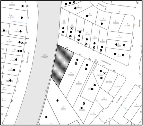
|
NOTIFICATION PLAN |
|||
|
• PROPERTIES NOTIFIED |
X SUBMISSIONS RECEIVED |
|
|
|
50 submissions received out of map range or insufficient detail provided to identify an address |
|||
Seventy submissions were received against the development, all being by way of objection. Issues raised include:
· Traffic, parking and road safety
· Size of childcare centre inappropriate for area (number of children)
· Bulk and Scale
· Acoustic Impact
· Location of childcare centre at the end of a dead-end street
· Amenity Impacts on residential area
· Notification / time of year notification
· Streetscape Impact
· Safety Impacts of locating childcare centre adjacent to train line (including fire safety and acoustics)
· Bin collection location inappropriate
· Bulk and scale of acoustic fencing
· On street drainage
· Tree preservation
· Saturation of area with childcare centres.
· Devaluation of property
· Non-compliance with HDCP requirements
The merits of the matters raised in community submissions have been addressed in the body of the report with the exception of the following:
5.1.1 Notification
Submissions raised concerns that the application was submitted during the Christmas period of 2021. The Hornsby Community Engagement Plan provides for extended notification periods over the Christmas period, and the application was notified for an extended period in accordance with the plan, which included 23 December 2021 until 7 February 2022.
5.1.2 Safety Impacts for Children
Submissions raised concerns the location of a childcare centre in close proximity to a rail line would subject children to acoustic impacts and may result in fires in the rail line impacting the centre.
In regard to acoustics, this concern is addressed in the body of this report. With respect to fire safety, these matters would be addressed at construction certificate stage should the application be recommended for approval.
5.1.3 Bin Enclosure Location
Submissions raised concerns regarding the placement of the bin enclosure in the frontage of the site. Council’s waste team reviewed the location of the bin enclosure and raised no objection to the structure. The bin enclosure needs to be located at the front of the site to allow for servicing when bins are full.
5.1.4 Acoustic Fencing Bulk and Scale
Submissions raised concerns regarding acoustic fencing bulk and scale. In response to these concerns it is noted that the supplied acoustic detail does not adequately demonstrate that the amenity of adjoining sensitive receivers would be effectively maintained by the proposed development. Therefore it is unknown as to whether the acoustic fencing as proposed would be adequate. In assessing the existing bulk and scale of proposed acoustic fencing it is noted that the fencing comprises 1.8m lapped and capped fencing on side and rear boundaries, which is consistent with the bulk and scale of most residential fencing.
5.1.5 Property Devaluation
Submissions raised concerns that the proposed development would devalue property in the vicinity. The devaluation of property is not a matter for consideration under Section 4.15 of the Environmental Planning and Assessment Act 1979.
5.2 Public Agencies
The development application was referred to Sydney Trains for comment, as detailed in this report. Sydney Trains raised no objection to the proposed development and provided conditions of concurrence should the proposal be recommended for approval.
6. THE PUBLIC INTEREST
Section 4.15(1)(e) of the Act requires Council to consider “the public interest”.
The public interest is an overarching requirement, which includes the consideration of the matters discussed in this report. Implicit to the public interest is the achievement of future built outcomes adequately responding to and respecting the future desired outcomes expressed in environmental planning instruments and development control plans.
The application is considered to have unsatisfactorily addressed Council’s and relevant agencies’ criteria and would provide a development outcome that, on balance, would result in a negative impact for the community. Accordingly, it is considered that the refusal of the proposed development would be in the public interest.
7. CONCLUSION
The application proposes the construction of a 91-place childcare centre with basement carparking for 23 vehicles, an outdoor play area and associated landscaping works.
The development fails to meet the desired outcomes of Council’s planning controls and is unsatisfactory having regard to the matters for consideration under Section 4.15 of the Environmental Planning and Assessment Act 1979.
Council received 70 submissions during the public notification period. The matters raised have been addressed in the body of the report.
Having regard to the circumstances of the case, refusal of the application is recommended for the reasons outlined in Schedule 1 of this report.
Note: At the time of the completion of this planning report, no persons have made a Political Donations Disclosure Statement pursuant to Section 10.4 of the Environmental Planning and Assessment Act 1979 in respect of the subject planning application.
RESPONSIBLE OFFICER
The officer responsible for the preparation of this report is Ben Jones.
|
Cassandra Williams Major Development Manager - Development Assessments Planning and Compliance Division |
Rod Pickles Manager - Development Assessments Planning and Compliance Division |
|
Locality Plan |
|
|
|
|
Architectural Plans |
|
|
|
|
Landscape Plans |
|
|
File Reference: DA/1368/2021
Document Number: D08482498
1. The proposed development is unsatisfactory in respect to Section 4.15(1)(a)(i) of the Environmental Planning and Assessment Act 1979 as the development application does not adequately assess the site for ground contaminates of potential concern and does not sufficiently demonstrate that the site can be remediated to be made suitable for use as a child care centre as per the requirements of Section 7 of State Environmental Planning Policy No. 55 Remediation of Land.
2. The proposed development is unsatisfactory in respect to Section 4.15(1)(a)(i) of the Environmental Planning and Assessment Act 1979 as the assessment of the matters for consideration required by Section 23 of State Environmental Planning Policy (Educational Establishments and Child Care Facilities) 2017 identifies inadequate consideration of the applicable provisions of Part 3 of the Childcare Planning Guideline 2021 as follows:
a) The proposal does not comply with Part 3.1 Site Selection and Location of the Childcare Planning Guideline 2021 as the application fails to demonstrate that the site is suitable for use as a childcare centre, with respect to the potential contamination present on site, the acoustic impact of the railway line on the childcare centre and the acoustic impact of the childcare centre on nearby sensitive residential receivers
b) The proposal does not comply with Part 3.5 Visual and Acoustic Privacy of the Childcare Planning Guideline 2021 as the application fails to demonstrate that the proposed childcare centre would not have a detrimental impact on the acoustic privacy of adjoining residential receivers.
c) The proposal does not comply with Part 3.6 Noise and Air Pollution of the Childcare Planning Guideline 2021 as the application fails to demonstrate that the adjoining railway line would not result in excessive noise in outdoor play spaces, indoor play spaces or sleeping areas of the proposed childcare centre.
3. The proposed development is unsatisfactory in respect to Section 4.15(1)(a)(i) of the Environmental Planning and Assessment Act 1979 as the development application contains inadequate information to enable the consideration of the impact of rail noise on non-rail development as per the requirements of Section 87 of State Environmental Planning Policy (Infrastructure) 2007.
4. The proposed development is unsatisfactory in respect to Section 4.15(1)(c) of the Environmental Planning and Assessment Act 1979 as the site is not suitable for the development proposed.
5. The proposed development is unsatisfactory in respect to Section 4.15(1)(e) of the Environmental Planning and Assessment Act 1979 as the development is not considered to be in the public interest.

