
DETERMINATION
BUSINESS PAPER
Local Planning Panel meeting
Wednesday 29 March 2023
at 2:30pm
DETERMINATION
BUSINESS PAPER
Local Planning Panel meeting
Wednesday 29 March 2023
at 2:30pm
Hornsby Shire Council Agenda and Summary of Recommendations
Page 0
ITEMS
Item 1 LPP7/23 ELECTRONIC -DA/53/2023 - Construction of a Pergola over an Existing Deck - 120A Quarter Sessions Road, Westleigh............................................................................... 1
Item 2 LPP8/23 ELECTRONIC - DA/887/2022 - Alterations and Additions to the Existing Church - St Johns Anglican Church, 9 Chapman Avenue, Beecroft................................................ 27
Item 3 LPP9/23 Reporting Development Applications for Determination by the Hornsby Local Planning Panel over 180 Days................................................................................................. 72
LPP Report No. LPP7/23
Local Planning Panel
Date of Meeting: 29/03/2023
1 ELECTRONIC -DA/53/2023 - CONSTRUCTION OF A PERGOLA OVER AN EXISTING DECK - 120A QUARTER SESSIONS ROAD, WESTLEIGH
|
DA No: |
DA/53/2023 (Lodged on 18 January 2023) |
|
Description: |
Construction of a pergola over an existing first floor deck |
|
Property: |
Lot 5 DP 825768, No. 120A Quarter Sessions Road, Westleigh |
|
Applicant: |
Patioland Pty Ltd |
|
Owner: |
Mr Warren Gareth Williams & Ms Halima Heywood |
|
Estimated Value: |
$190,953.00 |
|
Ward: |
B Ward |
|
Zoning |
R2 Low density residential |
|
Clause 4.6 Request: |
Clause 4.3 Height of Buildings |
|
Submissions: |
Nil |
|
LPP Criteria: |
Proposal contravenes a development standard by more than 10% |
|
Author: |
Katrina Maxwell, Senior Town Planner |
|
COI Declaration: |
No Council staff involved in the assessment of this application have declared a Conflict of Interest. |
|
THAT the Hornsby Local Planning Panel assume the concurrence of the Secretary of the Department of Planning and Environment pursuant to Clause 4.6 of the Hornsby Local Environmental Plan 2013 and approve Development Application No. DA/53/2022 for construction of a pergola over an existing first floor deck at Lot 5 DP 825768, No. 120A Quarter Sessions Road, Westleigh subject to the conditions of consent detailed in Schedule 1 of LPP Report No. LPP7/23. |
EXECUTIVE SUMMARY
· The application involves construction of patio cover over an existing deck.
· The proposal does not comply with Clause 4.3 of the Hornsby Local Environmental Plan 2013 with regard to ‘Height of Buildings’. The applicant has made a written submission in accordance with Clause 4.6 ‘Exceptions to development standards’ of the Hornsby Local Environmental Plan 2013 to contravene the Height of Buildings development standard. The submission is considered well founded and is supported.
· No submissions have been received in respect of the application.
· The application is required to be determined by the Hornsby Local Planning Panel as the proposal would contravene the Hornsby Shire Local Environmental Plan 2013 development standard for maximum height of buildings by more than 10 percent (17%).
· It is recommended that the application be approved.
BACKGROUND
On 29 May 1989, Council approved DA/19/1989 for the construction of a cluster housing development comprising 20 dwellings.
On 30 September 1992, the site was Torrens title subdivided.
On 23 December 1992, BA/2445/1992 was approved for a dwelling.
On, 12 April 1995, the Building Application (BA/2445/1992/A) was modified to amend the deck of the approved dwelling.
SITE
The 950m2 irregular shaped site is located on the eastern side of Quarter Sessions Road and contains a two-storey pole home style dwelling house. The site is accessed by a Right of Carriageway 30 metres to the east of Quarter Sessions Road.
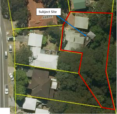
Figure 1: Aerial Image of Site (Source: Intramaps)
The site contains Peppermint-Angophora Forest vegetation and is bushfire prone land.
The subject land is affected by a drainage easement 1 metre wide, an easement for service variable width, an easement for services 5 wide and variable width, a right of carriageway variable width and variable width created by the registration of Deposited Plan 825768 and an easement for fire protection created by the registration of Deposited Plan 803400.
The site is not a heritage item, is not adjacent to a heritage item and is not within a heritage conservation area.
The site adjoins Dog Pound Creek bushland to the east.
The site is located within a cluster housing development comprising 20 one and two storey dwelling houses accessed by a Right of Carriageway.
PROPOSAL
The application proposes the construction of a pergola and balustrade over the existing first floor deck. A new outdoor kitchen would also be installed on the existing deck.
No trees would be removed or impacted by the development.
ASSESSMENT
The development application has been assessed having regard to the Greater Sydney Region Plan - A Metropolis of Three Cities, the North District Plan and the matters for consideration prescribed under Section 4.15 of the Environmental Planning and Assessment Act 1979 (the Act). The following issues have been identified for further consideration.
1. STRATEGIC CONTEXT
1.1 Greater Sydney Region Plan - A Metropolis of Three Cities and North District Plan
The Greater Sydney Region Plan - A Metropolis of Three Cities has been prepared by the NSW State Government to guide land use planning decisions over the next 40 years (to 2056). The Plan sets a strategy and actions for accommodating Sydney’s future population growth and identifies dwelling targets to ensure supply meets demand. The Plan also identifies that the most suitable areas for new housing are in locations close to jobs, public transport, community facilities and services.
The NSW Government will use the subregional planning process to define objectives and set goals for job creation, housing supply and choice in each subregion. Hornsby Shire has been grouped with Hunters Hill, Ku-ring-gai, Lane Cove, Mosman, North Sydney, Ryde, Northern Beaches and Willoughby to form the North District. The Greater Sydney Commission has released the North District Plan which includes priorities and actions for Northern District over the next 20 years.
The identified challenge for Hornsby Shire will be to provide an additional 4,350 dwellings by 2021 with further strategic supply targets to be identified to deliver 97,000 additional dwellings in the North District by 2036.
The proposed development would not be inconsistent with the Greater Sydney Region Plan - A Metropolis of Three Cities and the North District Plan.
2. STATUTORY CONTROLS
Section 4.15(1)(a) requires Council to consider “any relevant environmental planning instruments, draft environmental planning instruments, development control plans, planning agreements and regulations”.
2.1 Hornsby Local Environmental Plan 2013
The proposed development has been assessed having regard to the provisions of the Hornsby Local Environmental Plan 2013 (HLEP).
2.1.1 Zoning of Land and Permissibility
The subject land is zoned R2 Low density residential under the HLEP. The objectives of the R2 zone are:
· To provide for the housing needs of the community within a low-density residential environment.
· To enable other land uses that provide facilities or services to meet the day to day needs of residents.
The proposed development is defined as alterations and addition to a ‘dwelling house’ and is permissible in the zone with Council’s consent. The proposal would meet the objectives of the zone by providing for the housing needs of the community within a low-density residential environment.
2.1.2 Height of Buildings
Clause 4.3 of the HLEP provides that the height of a building on any land should not exceed the maximum height shown for the land on the Height of Buildings Map. The maximum permissible height for the subject site is 8.5 metres. The proposal has a maximum height of 9.96 metres and does not comply with this provision.
The application is supported by a written submission pursuant to Clause 4.6 of the HLEP to contravene the maximum height of buildings development standard, which is discussed below in Section 2.1.3 of this report.
2.1.3 Exceptions to Development Standards
The application has been assessed against the requirements of Clause 4.6 of the HLEP. This clause provides flexibility in the application of the development standards in circumstances where strict compliance with those standards would, in any particular case, be unreasonable or unnecessary or tender to hinder the attainment of the objectives of the zone.
The proposal exceeds the height of buildings development standard.
The applicant has made a submission in support of the contravention to the development standard in accordance with Clause 4.6 of the HLEP. Clause 4.6 provides that development consent must not be granted for development that contravenes a development standard unless the consent authority has considered a written request from the applicant that seeks to justify the contravention of the development standard by demonstrating:
(a) That compliance with the development standard is unreasonable or unnecessary in the circumstances of the case, and
(b) That there are sufficient environmental planning grounds to justify contravening the development standard.
Council must be satisfied that the written request provided by the applicant under Clause 4.6 addresses both the unreasonable and unnecessary test and demonstrates sufficient environmental planning grounds to justify contravening the development standard. These matters are discussed below.
2.1.3.1 Unreasonable or Unnecessary Clause 4.6(3)(a)
There are five common methods by which an applicant can demonstrate that compliance with a development standard is unreasonable or unnecessary in the circumstances of the development. Initially proposed for objections under clause 6 of SEPP 1 in the decision of Wehbe v Pittwater Council [2007] NSWLEC 827 Pearson C summarised and applied these methods to written requests made under Clause 4.6 in Four2Five Pty Ltd v Ashfield Council [2015] NSWLEC 1009 [61-62]. These five methods are generally as follows:
· The objectives of the development standard are achieved notwithstanding non-compliance with the standard.
· The underlying objective or purpose is not relevant to the development.
· That the objective would be defeated or thwarted if compliance was required.
· That the development standard has been virtually abandoned or destroyed by the Council’s own actions in departing from the standard.
· The zoning of the land is unreasonable or inappropriate.
It is not required to demonstrate that a development meets multiple methods as listed above, and the satisfaction of one can be adequate to demonstrate that the development standard is unreasonable or unnecessary.
The written request prepared by Watermark Planning provides a detailed assessment of the proposal with respect to the development standard sought to be contravened.
“The requested variation is as follows: Permissible maximum building height:
Proposed variation (maximum): 9.96m (17%).
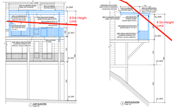
Figure 2: Extract of Elevation showing 8.5m height limit in red
Figure 2 depicts the extent of the non-compliance with the maximum height standard, being a height of approximately 9.96 metres or 17% contravention (max).
The request argues that:
The variation is a direct result of the steep falling nature of the land underneath the existing dwelling and it is worth acknowledging that the ridge height of the existing dwelling house roof is 172.05m AHD which 2.07m above the height of the gutters of the proposed pergola.
The proposed development will present with a patio cover and pergola of compatible scale to both the existing and neighbouring developments. It is an aesthetically pleasing addition to the existing elevated deck and will remain masked from public view, therefore having nil impact upon the public domain and streetscape. The height non-compliance results only where the site falls away rapidly towards the rear of the site overlooking the heavily vegetated bushland. This section of the building is centrally located on the site, therefore being well distanced from adjoining lot boundaries, and minimising any potential impacts on adjoining land or the streetscape.
Council notes that the objectives of Clause 4.3 Height of buildings of the HLEP are:
(a) to permit a height of buildings that is appropriate for the site constraints, development potential and infrastructure capacity of the locality.
With reference to the reasoning provided by the applicant above, Council does not object to the conclusion that the proposed additions meet the objectives of Clause 4.3. In reaching this conclusion the following points are noted:
· The site is highly constrained by easements, natural features and constraints such as bushfire. It is not feasible for the footprint of the building to be increased, and therefore the only way to improve the development potential of the site, and the liveability of the dwelling is to develop the dwelling house vertically.
· The structure would not be feasible if strict compliance with Section 4.3 were to be enforced, due to steep slope of the site and the height of the existing deck.
· The height of the development is considered appropriate and would not be visible from the streetscape and would not result in amenity impacts to adjoining properties. There is no ability to re-design the pergola so that it complies with the 8.5 metre maximum height requirement.
· The structure is not habitable and would not impact the development potential and infrastructure capacity of the locality.
· The proposed pergola roof will assist in the maintenance of the deck by preventing decay from the weather. The pergola roof would also enable appropriate stormwater drainage from the structure.
The lack of environmental impacts arising from the non-compliance with the development standard, and the largely compliant nature of the development when assessed against the relevant legislative and HDCP requirements identifies that the site is suitable for this development.
The proposed development would have negligible impact on the infrastructure capacity of the locality.
For the reasons outlined above, it is considered that the written request to contravene the height of building standard adequately demonstrates that the objectives of Clause 4.3 of the HLEP are achieved, notwithstanding non-compliance with the development standard.
2.1.3.2 Environmental Planning Grounds - Clause 4.6(3)(b)
In addition to demonstrating that compliance is unreasonable or unnecessary, Clause 4.6(3)(b) requires that there are sufficient environmental planning grounds to justify contravening the development standard. In demonstrating that sufficient environmental planning grounds exist it must be demonstrated that the planning grounds are particular to the circumstances of the development on the subject site (summarised from Four2Five Pty Ltd v Ashfield Council [2015] NSWLEC 1009 [60].
The applicant provided the following planning grounds for the contravention of the development standard:
· The inclusion of the height variation has no impact on the natural environment. The variation sits at the rear of the existing dwelling and will not result in any impact to the existing natural components of the site or neighbourhood. No landscape area is lost or impacted through the height variation satisfying Cl1.3(b). The natural environment is unaffected by the small departure to the development standard, and it would be unreasonable for the development to be refused on this basis.
· The proposal represents an environmentally sustainable design, making an appropriate enhancement to the liveability of the existing dwelling satisfying Cl1.3(f). Compliance with the development standard based on this would be unreasonable.
· The small variation to the height as detailed above will have no social impacts for the site or local area satisfying Cl1.3(b)and accordingly refusal of the development based on this reason would be unreasonable.
· The small variation to the height control as detailed above will have no economic impacts for the site or the local area satisfying Cl1.3(b) and accordingly refusal of the development based on this reason would be unreasonable.
· The development proposed is not an overdevelopment of the site and satisfies the objectives of the zone and the development standard as is detailed earlier in the report.
· The variation does not result in a roof form or height beyond that which is found in the general locality. The maximum height of the varied portion of the roof form is located at the rear of the site, well distanced from neighbours as detailed in the Architectural Plan Elevations. The small variation will be compatible within the context in which it sits and is reasonable in the circumstances of the case satisfying Cl1.3(c). Compliance with the development standard based on this would be unreasonable.
· Removal of the non-compliance would not result in any meaningful reduction in the perceived bulk and scale of the proposal due to its minor nature, siting and topography.
Council considers that the environmental planning grounds stated within the written request are sufficient with respect to Clause 4.6(3)(b) and that the stated grounds are specific to the proposed development and the circumstances of the development site. It is therefore considered that the written request adequately demonstrates compliance with the clause and is acceptable in this regard.
Council further notes that the technical non-compliance is a result of the existing configuration of the dwelling house, being a pole home construction. Notwithstanding the non-compliance with numerical standards, the proposal does not give rise to any adverse amenity impacts to any adjoining property. The dwelling house continues to respond to the slope of the site, by stepping the design of the dwelling house down the slope.
Council is therefore satisfied that Clause 4.6(3)(b) of the HLEP is adequately addressed.
2.1.3.3 Public Interest and Clause 4.6(4)
Clause 4.6(4) states that development consent must not be granted for development that contravenes a development standard unless:
(a) The consent authority is satisfied that:
(i) The applicant’s written request has adequately addressed the matters required to be demonstrated by subclause (3), and
(ii) The proposed development will be in the public interest because it is consistent with the objectives of the particular standard and the objectives for development within the zone in which the development is proposed to be carried out, and
(b) The concurrence of the Planning Secretary has been obtained.
The Applicant provided the following response regarding public interest:
“Despite the proposal seeking an exception to the building height clause, the bulk and scale of the building will have minimal effect as the variation is set well back from all boundaries, centrally located on the site and due to site topography.
The proposal will not result in any discernible impacts, being complementary to the existing dwelling and masked from view of any public vantage point.
The proposed development is not contrary to the public interest, because it is consistent with the objectives of the standard (see Cl 4.6(3)(A)) and objectives for development within the zone.”
With regard to (a)(i), the written requests are considered to adequately address the matters required to be demonstrated as outlined above.
With regard to (a)(ii), the proposed development is considered to be in the public interest because it is consistent with the objectives of the particular standard and the objectives for height of building contained within the HLEP.
With regard to (b), on 21 February 2018, the Secretary of the Department of Planning and Environment issued a Notice (‘the Notice’) under cl. 64 of the Environmental Planning and Assessment Regulation 2000 (the EP&A Regulation) The Secretary’s concurrence may not be assumed by a delegate of council if:
· The development contravenes a numerical standard by greater than 10%.
· The variation is to a non-numerical standard.
Local Planning Panels constituted under the Environmental Planning and Assessment Act 1979 exercise consent authority functions on behalf of a Council and are not delegates of Council. Therefore, Local Planning Panels may determine a development application notwithstanding, a numerical non-compliance in excess of 10%.
Therefore, the contravention of the height of buildings development standard is supported in this instance.
2.1.4 Heritage Conservation
Clause 5.10 of the HLEP sets out heritage conservation provisions for Hornsby Shire. The site does not include a heritage item and is not located in a heritage conservation area. Accordingly, no further assessment regarding heritage is necessary.
2.1.5 Earthworks
Clause 6.2 of the HLEP states that consent is required for proposed earthworks on site. Before granting consent for earthworks, Council is required to assess the impacts of the works on adjoining properties, drainage patterns and soil stability of the locality.
Council’s assessment of the proposed works and excavation concludes that the impacts would be minimal. The existing bearers and joists of the dwelling house will be utilised as footings for the proposed patio cover and balustrade. No cut or fill is required to construct the development. The proposal is assessed as satisfactory with regards to Clause 6.2 of the HLEP.
2.1 State Environmental Planning Policy (Biodiversity and Conservation) 2021
The application has been assessed against the requirements of Chapter 2 and 6 of State Environmental Planning Policy (Biodiversity and Conservation) 2021.
2.1.1 Chapter 2 Vegetation in Non-Rural Areas
Chapter 2 of this policy aims to protect the biodiversity and amenity values of trees within non-rural areas of the state.
Part 2.3 of the policy states that a development control plan may make a declaration in any manner relating to species, size, location and presence of vegetation. Accordingly, Part 1B.6.1 of the HDCP prescribes works that can be undertaken with or without consent to trees and objectives for tree preservation.
Section 3.1.1 of this report provides an assessment in accordance with Part 1B.6.1 of the HDCP.
2.1.2 Chapter 6 Water Catchments
The site is located within the catchment of the Hawkesbury-Nepean River. The aim of this chapter is to protect the environment of the Hawkesbury-Nepean River system by ensuring that the impacts of development are considered in the regional context. Part 6.2 of this Plan contains general planning considerations and strategies requiring Council to consider the impacts of development on water quality, aquaculture, significant vegetation habitats, extraction, environmental heritage and scenic quality, recreation and tourism, and agriculture. Part 6.13 Hawkesbury-Nepean conservation area sub-catchments contains matters to be considered when granting consent for development in the Hawkesbury-Nepean conservation area sub-catchment.
Subject to the implementation of sediment and erosion control measures and stormwater management to protect water quality, the proposal would not impact on the water quality of the catchment and would comply with the requirements of chapter 9 of the Biodiversity and Conservation SEPP.
2.2 State Environmental Planning Policy (Resilience and Hazards) 2021
The application has been assessed against the requirements of Chapter 4 - Remediation of Land of State Environmental Planning Policy (Resilience and Hazards) 2021.
2.2.1 Chapter 4 Remediation of Land
Should the land be contaminated, Council must be satisfied that the land is suitable in a contaminated state for the proposed use. If the land requires remediation to be undertaken to make the land suitable for the proposed use, Council must be satisfied that the land will be remediated before the land is used for that purpose.
An examination of Council’s records and aerial photography has determined that the site has been historically used for residential purposes. It is not likely that the site has experienced any significant contamination, and further assessment under chapter 4 of the Resilience and Hazards SEPP is not required.
2.3 Section 3.42 Environmental Planning and Assessment Act 1979 - Purpose and Status of Development Control Plans
Section 3.42 of the Environmental Planning and Assessment Act 1979 states that a DCP provision will have no effect if it prevents or unreasonably restricts development that is otherwise permitted and complies with the development standards in relevant Local Environmental Plans and State Environmental Planning Policies.
The principal purpose of a development control plan is to provide guidance on the aims of any environmental planning instrument that applies to the development; facilitate development that is permissible under any such instrument; and achieve the objectives of land zones. The provisions contained in a DCP are not statutory requirements and are for guidance purposes only. Consent authorities have flexibility to consider innovative solutions when assessing development proposals, to assist achieve good planning outcomes.
2.4 Hornsby Development Control Plan 2013
The proposed development has been assessed having regard to the relevant desired outcomes and prescriptive requirements within the Hornsby Development Control Plan 2013 (HDCP). The following table sets out the proposal’s compliance with the prescriptive requirements of the Plan:
|
HDCP - Part 3.1 Dwelling Houses |
|||
|
Control |
Proposal |
Requirement |
Complies |
|
Site Area |
950m2 |
N/A |
N/A |
|
Building Height |
9.96m |
8.5m |
No |
|
No. storeys |
2 |
max. 2 + attic |
Yes |
|
Site Coverage |
15% |
Max 40% |
Yes |
|
Setbacks |
|
|
|
|
- Northern Side |
10.3m |
1.5m |
Yes |
|
- Western Side |
9.0m |
1.5m |
Yes |
|
- Eastern Side |
19.3m |
1.5m |
Yes |
|
- Rear |
10.6m |
8m |
Yes |
|
Landscaped Area (% of lot size) |
698m2 (73%) |
380m2 (40%) |
Yes |
|
Private Open Space |
|
|
|
|
- minimum area |
>24m2 |
24m2 |
Yes |
|
- minimum dimension |
>3m |
3m |
Yes |
As detailed in the above table, there is a non-compliance with the HDCP controls which is discussed below including a brief discussion on compliance with relevant performance requirements.
2.4.1 Scale
The desired outcome of Part 3.1.1 of the HDCP is for ‘development with a height, bulk and scale that is compatible with a low-density residential environment’.
This is supported by the prescriptive measures which state that require a maximum of two storeys and an attic.
In addition, it is stated that ‘buildings should respond to the topography of the site by:
· Minimising earthworks (cut and fill).
· Siting the floor level of the lowest residential storey a maximum of 1.5 above natural ground level’.
The proposed pergola roof is situated 9.96 metres above natural ground which does not comply with Part 3.1.1 Scale of the HDCP and Clause 4.3 of HLEP. In support of this non-compliance, it is noted that the slope of that site is a significant constraint for any development on the site.
The open style deck and pergola are not capable of being enclosed, and therefore are not considered to constitute a storey. No additional cut or fill is required to facilitate the construction of the pergola. A simple low profile roof design minimises the overall height of the structure. If compliance with the 8.5 metre height requirement was insisted, the structure would not be viable. The pergola structure would enhance the usability of the existing deck and protect the deck from weathering.
The Applicant submitted a written request pursuant to Clause 4.6 of the HLEP which has adequately addressed this non-compliance as discussed in under Section 2.1.3 of the report.
The proposal meets the desired outcomes of Part 3.1.1 Scale of the HDCP and is considered acceptable.
2.4.2 Privacy
The desired outcome of Part 3.1.6 Privacy of the HDCP is for development ‘that is designed to provide reasonable privacy to adjacent properties.’ This is supported by prescriptive measure (c) and (d) where:
‘c) a deck, balcony, terrace or the like should be located within 600mm of existing ground level where possible to minimise potential visual and acoustic privacy conflicts’; and
d) ‘decks and the like that need to be located more than 600mm above existing ground level should not face a window of another habitable room. Balcony or private open space of another dwelling located within 9 metres of the proposed deck unless appropriately screened.’
The application proposes the construction of a pergola roof over an existing deck. The pergola will be orientated to the rear of the property towards Dog Pound Creek Reserve. The pergola is obscured from view from the north by the existing carport, and from the southwest by the existing dwelling house on the subject site. The development would not cause any privacy loss to adjoining properties to the north and south-west.
In summary, whilst the proposed pergola would be more than 600mm above existing ground level, as the deck is existing, it would not result in any adverse privacy loss impacts and privacy screening is not considered to be warranted.
The proposal meets the desired outcome of Part 3.1.6 Privacy of the HDCP and is considered acceptable.
2.4.3 View Impact
The desired outcome of Part 3.1.8 Design Details of HDCP 2013 is to encourage “development compatible with a low-density residential environment that complements the zone objectives”. This desired outcome is supported by the prescriptive control that “development should allow for the reasonable sharing of significant views by appropriately siting the building appropriately designing the bulk of the building and using open materials for balustrades on balconies and decks.”
The planning principle of view sharing is provided in Tenacity Consulting v Warringah Consulting and includes a four step assessment: for assessing view loss impact.
· Step One - Assessment of the views to be affected. “Water views are valued more highly than land views. Iconic views (e.g., of the Opera House, the Harbour Bridge or North Head) are valued more highly than views without icons. Whole views are valued more highly than partial views, e.g., a water view in which the interface between land and water is visible is more valuable than one in which it is obscured.”
· Step Two - Consideration from what part of the property the views are obtained. “For example, the protection of views across side boundaries is more difficult than the protection of views from front and rear boundaries. In addition, whether the view is enjoyed from a standing or sitting position may also be relevant. Sitting views are more difficult to protect than standing views. The expectation to retain side views and sitting views is often unrealistic.”
· Step Three - Assessment of the extent of the impact. “This should be done for the whole of the property, not just for the view that is affected. The impact on views from living areas is more significant than from bedrooms or service areas (though views from kitchens are highly valued because people spend so much time in them). The impact may be assessed quantitatively, but in many cases this can be meaningless. For example, it is unhelpful to say that the view loss is 20% if it includes one of the sails of the Opera House. It is usually more useful to assess the view loss qualitatively as negligible, minor, moderate, severe or devastating.”
· Step Four - Assessment of the reasonableness of the proposal that is causing the impact. “A development that complies with all planning controls would be considered more reasonable than one that breaches them. Where an impact on views arises as a result of non-compliance with one or more planning controls, even a moderate impact may be considered unreasonable. With a complying proposal, the question should be asked whether a more skilful design could provide the applicant with the same development potential and amenity and reduce the impact on the views of neighbours. If the answer to that question is no, then the view impact of a complying development would probably be considered acceptable and the view sharing reasonable”
A view assessment was undertaken as part of the assessment of this development application. The site enjoys bushland views to Dog Pound Creek Reserve. Whilst a pleasant outlook, the reserve is not considered to be an iconic view. The existing dwelling house sits out further towards the valley than the adjoining dwelling houses. Whilst the structure is non-compliant with the Height of Buildings development standard, it is a lightweight structure which would not obstruct views from any adjoining dwelling house. Side views from the dwelling to the southwest are currently obstructed by the existing dwelling house on the subject site. The views of the dwelling to the north of the site are currently obstructed by the existing carport on the subject site. The view from dwelling to the south (No. 116 Quarter Sessions Road) is currently partially obscured by vegetation.
2.4.4 Bushfire
The desired outcomes of Part 1C.3.1 Bushfire of the HDCP are to encourage ‘development that is located and designed to minimise the risk to life and property from bushfire’ and to encourage ‘development that balances the conservation of native vegetation and bushfire protection’.
A Bushfire Threat Assessment was prepared by Building Code & Bushfire Hazard Solutions (dated 25 November 2022) in support of the development application. The bushfire threat assessment identified the required construction level is Bushfire Attack Level - Flame Zone (BAL FZ).
In accordance with Council’s assessment protocol for development in BAL Flame Zone, the application was referred to the NSW Rural Fire Service (NSW RFS) for review. The NSW RFS raised no objections to the proposal subject to conditions.
Conditions reflecting the NSW RFS requirements have been recommended in Schedule 1 of this report in regard to construction and asset protection zone requirements.
The proposal meets the desired outcomes of Part 1C.3.1 Bushfire of the HDCP and is considered acceptable, subject to conditions.
2.4.5 Earthworks and Slope
The desired outcomes of Part 1C.1.4 Earthworks and Slope are to encourage ‘development that is designed to respect the natural landform characteristics and protects the stability of land’ and ‘development that limits landform modification to maintain the amenity of adjoining properties and streetscape character’.
These desired outcomes are supported by the prescriptive control that “Sloping sites with a gradient in excess of 20% require certification from a geotechnical engineer as to the stability of the slope in regard to the proposed design.”
In this instance, no footings or foundations are proposed. The proposed pergola roof is a lightweight structure. As such, it is unlikely that the pergola would greatly increase the structural load of the building. Therefore, no geotechnical assessment has been requested.
Subject to conditions, the proposal meets the desired outcomes of Part 1C.1.4 Earthworks and Slope and is considered acceptable.
2.5 Contributions Plans
Hornsby Shire Council Section 7.12 Contributions Plan 2019-2029 applies to the development as the estimated costs of works is greater than $100,000, being $190,953.00. Should the application be approved, an appropriate condition of consent is recommended requiring the payment of a contribution in accordance with the Plan.
3. ENVIRONMENTAL IMPACTS
Section 4.15(1)(b) of the Act requires Council to consider “the likely impacts of that development, including environmental impacts on both the natural and built environments, and social and economic impacts in the locality”.
3.1 Natural Environment
3.1.1 Tree and Vegetation Preservation
No trees or vegetation is proposed to be removed. The bushfire report submitted with the development application states the that the site is managed land and that no vegetation is required to be removed to create and maintain an Asset Protection Zone (APZ) on the site.
3.1.2 Stormwater Management
The residential development would have a minor positive impact on the natural environment with all stormwaters being directed to the existing internal drainage system which will then be conveyed to the drainage easement at the rear of the site.
3.2 Built Environment
3.2.1 Built Form
The proposal would generally be consistent with the built form of the surrounding low-density residential area which consists of dwelling houses ranging from single storey, split level and two storeys.
3.2.2 Social Impacts
The proposed development would not have any social impacts to the locality.
3.2.3 Economic Impacts
The proposal would have a minor positive impact on the local economy in conjunction with other new low density residential development in the locality by generating an increase in demand for local services.
4. SITE SUITABILITY
Section 4.15(1)(c) of the Act requires Council to consider “the suitability of the site for the development”.
The site is considered to be capable of accommodating the proposed development. The scale of the proposed development is consistent with the capability of the site and is considered acceptable.
4.1 Bushfire Risk
As noted in Section 2.9.3 of this report, the subject site is identified as being bushfire prone, the application was referred to the NSW Rural Fire Service for comment.
Conditions provided by NSW RFS have been recommended in Schedule 1 of this report with regard to the utilisation of BAL-FZ construction methods and asset protection zone requirements.
5. PUBLIC PARTICIPATION
Section 4.15(1)(d) of the Act requires Council to consider “any submissions made in accordance with this Act”.
5.1 Community Consultation
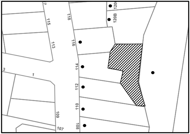
The proposed development was placed on public exhibition and was notified to adjoining and nearby landowners between 19 January 2023 and 9 February 2023 in accordance with the Hornsby Community Engagement Plan. During this period, Council received nil submissions. The map below illustrates the location of those nearby landowners who were notified.
|
NOTIFICATION PLAN |
|||
|
• PROPERTIES NOTIFIED |
X SUBMISSIONS RECEIVED |
|
|
No submissions were received objecting to the development.
6. Public Agencies
The development application was referred to the following Agencies for comment:
6.1.1 Rural Fire Service
The development application was referred to the NSW Rural Service for comment and no objections were raised to the proposed development subject to the conditions recommended in Schedule 1.
7. THE PUBLIC INTEREST
Section 4.15(1)(e) of the Act requires Council to consider “the public interest”.
The public interest is an overarching requirement, which includes the consideration of the matters discussed in this report. Implicit to the public interest is the achievement of future built outcomes adequately responding to and respecting the future desired outcomes expressed in environmental planning instruments and development control plans.
The application is considered to have satisfactorily addressed Council’s and relevant agencies’ criteria and would provide a development outcome that, on balance, would result in a positive impact for the community. Accordingly, it is considered that the approval of the proposed development would be in the public interest.
CONCLUSION
The application proposes a first floor pergola over an existing deck.
The development generally meets the desired outcomes of Council’s planning controls and is satisfactory having regard to the matters for consideration under Section 4.15 of the Environmental Planning and Assessment Act 1979.
Having regard to the circumstances of the case, approval of the application is recommended.
The reasons for this decision are:
· The request under Clause 4.6 of Hornsby Local Environmental Plan 2013 to contravene the ‘Height of Buildings’ development standard is well founded. Strict compliance with the development standard is considered unreasonable and unnecessary in the circumstances of the case and sufficient environmental planning grounds have been submitted to justify the contravention to the development standard.
· The proposed development complies with the requirements of the relevant environmental planning instruments and the Hornsby Development Control Plan 2013.
· The proposed development does not create unreasonable environmental impacts to adjoining development with regard to visual bulk, solar access, amenity or privacy.
Note: At the time of the completion of this planning report, no persons have made a Political Donations Disclosure Statement pursuant to Section 10.4 of the Environmental Planning and Assessment Act 1979 in respect of the subject planning application.
|
Cassandra Williams Major Development Manager - Development Assessments Planning and Compliance Division |
Rod Pickles Manager - Development Assessments Planning and Compliance Division |
|
Locality Plan |
|
|
|
|
Clause 4.6 |
|
|
|
|
Architectural Plans |
|
|
|
|
Photomontage |
|
|
|
|
Schedule of Finishes |
|
|
File Reference: DA/53/2023
Document Number: D08592224
SCHEDULE 1
GENERAL CONDITIONS
The conditions of consent within this notice of determination have been applied to ensure that the use of the land and/or building is carried out in such a manner that is consistent with the aims and objectives of the relevant legislation, planning instruments and council policies affecting the land and does not disrupt the amenity of the neighbourhood or impact upon the environment.
Note: For the purpose of this consent, the term ‘applicant’ means any person who has the authority to act on or the benefit of the development consent.
Note: For the purpose of this consent, any reference to an Act, Regulation, Australian Standard or publication by a public authority shall be taken to mean the gazetted Act or Regulation, or adopted Australian Standard or publication as in force on the date that the application for a construction certificate is made.
1. Approved Plans and Supporting Documentation
The development must be carried out in accordance with the plans and documentation listed below and endorsed with Council’s stamp, except where amended by Council and/or other conditions of this consent:
Approved Plans
|
Plan No. |
Plan Title |
Drawn by |
Dated |
Council Reference |
|
1 of 7 |
Site Plan/Site Analysis Plan |
Emanate & Co |
10/02/2023 |
|
|
2 of 7 |
Sediment & Erosion Control Plan |
Emanate & Co |
10/02/2023 |
|
|
3 of 7 |
Existing Deck Plan |
Emanate & Co |
10/02/2023 |
|
|
4 of 7 |
Roof Plan |
Emanate & Co |
10/02/2023 |
|
|
5 of 7 |
East & South Elevation |
Emanate & Co |
10/02/2023 |
|
|
6 of 7 |
North Elevation |
Emanate & Co |
10/02/2023 |
|
|
7 of 7 |
BASIX Information |
Emanate & Co |
10/02/2023 |
|
Supporting Documentation
|
Document Title |
Prepared by |
Dated |
Council Reference |
|
Bushfire Threat Assessment (Ref: 230533) |
Building Code & Bushfire Hazard Solutions |
25/11/2023 |
D08570655 |
|
Schedule of Colours/Materials |
Emanate & Co |
Dec 2022 |
D08570645 |
|
Waste Management Plan |
Emanate & Co |
Nov2022 |
D08570640 |
Reason: To ensure all parties are aware of the approved plans and supporting documentation that apply to the development.
2. Construction Certificate
a) A Construction Certificate is required to be approved by Council or a Private Certifying Authority prior to the commencement of any construction works under this consent.
b) The Construction Certificate plans must be consistent with the Development Consent plans.
Reason: To ensure that detailed construction certificate plans are consistent with the approved plans and supporting documentation.
3. Section 7.12 Development Contributions
a) In accordance with Section 4.17(1) of the Environmental Planning and Assessment Act 1979 and the Hornsby Shire Council Section 7.12 Development Contributions Plan 2019-2029, $954.75 must be paid towards the provision, extension or augmentation of public amenities or public services, based on development costs of $190,953.00.
b) The value of this contribution is current as of 21 February 2023. If the contributions are not paid within the financial quarter that this consent is granted, the contributions payable will be adjusted in accordance with the provisions of the Hornsby Shire Council Section 7.12 Development Contributions Plan and the amount payable will be calculated at the time of payment in the following manner:
|
$CPY |
= |
|
|
$CDC x CPIPY |
|
|
|
|
|
CPIDC |
Where:
$CPY is the amount of the contribution at the date of Payment.
$CDC is the amount of the contribution as set out in this Development Consent.
CPIPY is the latest release of the Consumer Price Index (Sydney - All Groups) at the date of Payment as published by the ABS.
CPIDC is the Consumer Price Index (Sydney - All Groups) for the financial quarter at the date of this Development Consent.
c) The monetary contributions shall be paid to Council:
(i) Prior to the issue of the Subdivision Certificate where the development is for subdivision.
(ii) Prior to the issue of the first Construction Certificate where the development is for building work.
(iii) Prior to issue of the Subdivision Certificate or first Construction Certificate, whichever occurs first, where the development involves both subdivision and building work.
(iv) Prior to the works commencing where the development does not require a Construction Certificate or Subdivision Certificate.
Note: It is the professional responsibility of the Principal Certifying Authority to ensure that the monetary contributions have been paid to Council in accordance with the above timeframes.
Note: In accordance with Ministerial Directions, the payment of contribution fees for development with a cost of works of over $10 million can be deferred to prior to Occupation Certificate.
Note: The Hornsby Shire Council Section 7.12 Development Contributions Plan may be viewed at www.hornsby.nsw.gov.au or a copy may be inspected at Council’s Administration Centre during normal business hours.
Reason: To address the increased demand for community infrastructure resulting from the approved development.
REQUIREMENTS PRIOR TO THE ISSUE OF A CONSTRUCTION CERTIFICATE
4. Building Code of Australia
Detailed plans, specifications and supporting information is required to be submitted to the certifying authority detailing how the proposed building work achieves compliance with the National Construction Code - Building Code of Australia. All building work must be carried out in accordance with the requirements of the National Construction Code - Building Code of Australia.
Reason: Prescribed condition - EP&A Regulation section 69(1)
5. Contract of Insurance (Residential Building Work)
Where residential building work for which the Home Building Act 1989 requires there to be a contract of insurance in force in accordance with Part 6 of that Act, this contract of insurance must be in force before any building work authorised to be carried out by the consent commences.
Reason: Prescribed condition EP&A Regulation section 69(2)
6. Notification of Home Building Act 1989 Requirements
Residential building work within the meaning of the Home Building Act 1989 must not be carried out unless the principal certifying authority for the development to which the work relates (not being Council) has given Council written notice of the following information:
a) In the case of work for which a principal contractor is required to be appointed:
i) The name and licence number of the principal contractor; and
ii) The name of the insurer by which the work is insured under Part 6 of that Act.
b) In the case of work to be done by an owner-builder:
i) The name of the owner-builder; and
ii) If the owner-builder is required to hold an owner-builder’s permit under that Act, the number of the owner-builder’s permit.
Note: If arrangements for doing the residential building work are changed while the work is in progress so that the information notified becomes out of date, further work must not be carried out unless the principal certifying authority for the development to which the work relates (not being Council) has given Council written notification of the updated information.
Reason: Prescribed condition EP&A Regulation section 71(2) and (3)
7. Stormwater Drainage - Dwelling
The stormwater drainage system for the development must be designed for an average recurrence interval (ARI) of 20 years and be gravity drained in accordance with the following requirements:
a) Connected to the existing internal drainage system.
Reason: To ensure appropriate provision for management and disposal of stormwater.
8. Structural Engineering Certification
A chartered professional structural engineer’s “Certificate of Adequacy” certifying the ability of the footings to take the proposed addition is to be submitted to Principal Certifier prior to the issue of the Construction Certificate.
Reason: To ensure the structural adequacy of the existing footings to take the additional load.
REQUIREMENTS PRIOR TO THE COMMENCEMENT OF ANY WORKS
9. Erection of Construction Sign
a) A sign must be erected in a prominent position on any site on which any approved work is being carried out:
i) Showing the name, address and telephone number of the principal certifying authority for the work.
ii) Showing the name of the principal contractor (if any) for any demolition or building work and a telephone number on which that person may be contacted outside working hours.
iii) Stating that unauthorised entry to the work site is prohibited.
b) The sign is to be maintained while the approved work is being carried out and must be removed when the work has been completed.
Reason: Prescribed condition EP&A Regulation, section 70(2) and (3).
10. Protection of Adjoining Areas
A temporary hoarding, fence or awning must be erected between the work site and adjoining lands before the works begin and must be kept in place until after the completion of the works if the works:
a) Could cause a danger, obstruction or inconvenience to pedestrian or vehicular traffic.
b) Could cause damage to adjoining lands by falling objects.
c) Involve the enclosure of a public place or part of a public place.
d) Have been identified as requiring a temporary hoarding, fence or awning within the Council approved Construction Management Plan (CMP).
Note: Notwithstanding the above, Council’s separate written approval is required prior to the erection of any structure or other obstruction on public land.
Reason: To ensure public safety and protection of adjoining land.
a) To provide a safe and hygienic workplace, toilet facilities must be available or be installed at the works site before works begin and must be maintained until the works are completed at a ratio of one toilet for every 20 persons employed at the site.
b) Each toilet must:
i) Be a standard flushing toilet connected to a public sewer.
ii) Be a temporary chemical closet approved under the Local Government Act 1993.
Reason: To ensure adequate toilet facilities are provided.
REQUIREMENTS DURING CONSTRUCTION
All works on site, including demolition and earth works, must only occur between 7am and 5pm Monday to Saturday.
No work is to be undertaken on Sundays or public holidays.
Reason: To protect the amenity of neighbouring properties.
13. Council Property
To ensure that the public reserve is kept in a clean, tidy and safe condition during construction works, no building materials, waste, machinery or related matter is to be stored on the road or footpath.
Reason: To protect public land.
14. Waste Management
All work must be carried out in accordance with the approved waste management plan.
Reason: To ensure the management of waste to protect the environment and local amenity during construction.
15. Disturbance of Existing Site
During construction works, the existing ground levels of open space areas and natural landscape features, including natural rock-outcrops, vegetation, soil and watercourses must not be altered unless otherwise nominated on the approved plans.
Reason: To protect the natural features of the site.
REQUIREMENTS PRIOR TO THE ISSUE OF AN OCCUPATION CERTIFICATE
16. Certification of RFS Requirements
A Certificate prepared by a BPAD accredited Bushfire Consultant is to be provided to the Principal Certifying Authority (PCA) certifying the completion of all works required by the NSW RFS General Terms of Approval (GTAs)/ conditions of concurrence [delete whichever not required] prior to the issue of the Occupation/ Subdivision [delete which not relevant] Certificate.
Reason: To ensure all bushfire protection measures are implemented to protect life and property.
17. Damage to Council Assets
To protect public property and infrastructure, any damage caused to Council’s assets as a result of the construction or demolition of the development must be rectified by the applicant in accordance with AUS-SPEC Specifications (www.hornsby.nsw.gov.au/property/build/aus-spec-terms-and-conditions. Rectification works must be undertaken prior to the issue of an Occupation Certificate, or sooner, as directed by Council.
Reason: To ensure public infrastructure and property is maintained.
CONDITIONS OF CONCURRENCE - NSW RURAL FIRE SERVICE
The following conditions of consent are from the nominated State Agency pursuant to Section 4.13 of the Environmental Planning and Assessment Act 1979 and must be complied with to the satisfaction of that Agency.
18. Asset Protection Zones
The intent of measures: to minimise the risk of bush fire attack and provide protection for emergency services personnel, residents and others assisting firefighting activities.
From the commencement of building works and in perpetuity, all existing maintained grounds within the subject property are to continue to be maintained as an Inner Protection Area in accordance with the following requirements of Appendix 4 of Planning for Bush Fire Protection 2019:
a) Tree canopy cover should be less than 15% at maturity.
b) Trees at maturity should not touch or overhang the building.
c) Lower limbs should be removed up to a height of 2m above the ground.
d) Tree canopies should be separated by 2 to 5m.
e) Preference should be given to smooth-barked and evergreen trees.
f) Create large discontinuities or gaps in the vegetation to slow down or break the progress of fire towards buildings should be provided.
g) Shrubs should not be located under trees.
h) Shrubs should not form more than 10% ground cover.
i) Clumps of shrubs should be separated from exposed windows and doors by a distance of at least twice the height of the vegetation.
j) Grass should be kept mown (as a guide, grass should be kept to no more than 100mm in height); and leaves and vegetation debris should be removed.
19. Construction Standards
The intent of measures: to minimise the risk of bush fire attack and provide protection for emergency services personnel, residents and others assisting firefighting activities.
The proposed patio cover and louvred pergola must be constructed utilising non-combustible materials only.
- END OF CONDITIONS -
ADVISORY NOTES
The following information is provided for your assistance to ensure compliance with the Environmental Planning and Assessment Act 1979, Environmental Planning and Assessment Regulation 2021, other relevant legislation and Council’s policies and specifications. This information does not form part of the conditions of development consent pursuant to Section 4.17 of the Act.
Environmental Planning and Assessment Act 1979 Requirements
The Environmental Planning and Assessment Act 1979 requires:
· The issue of a construction certificate prior to the commencement of any works. Enquiries can be made to Council’s Customer Services Branch on 9847 6760.
· A principal certifying authority to be nominated and Council notified of that appointment prior to the commencement of any works.
· Council to be given at least two days written notice prior to the commencement of any works.
· Mandatory inspections of nominated stages of the construction inspected.
· An occupation certificate to be issued before occupying any building or commencing the use of the land.
Tree and Vegetation Preservation
Hornsby Development Control Plan 2013 Tree and Vegetation Preservation provisions have been developed under Council’s authorities contained in State Environmental Planning Policy (Biodiversity and Conservation) 2021 and the Environmental Planning and Assessment Act 1979.
In accordance with these provisions a person must not cut down, fell, uproot, kill, poison, ringbark, burn or otherwise destroy the vegetation, lop or otherwise remove a substantial part of the trees or vegetation to which any such development control plan applies without the authority conferred by a development consent or a permit granted by Council.
Fines may be imposed for non-compliance with the Hornsby Development Control Plan 2013.
Note: A tree is defined as a long lived, woody perennial plant with one or relatively few main stems with the potential to grow to a height greater than three metres (3m). (HDCP 1B.6.1.c).
The land upon which the subject building is to be constructed may be affected by restrictive covenants. Council issues this approval without enquiry as to whether any restrictive covenant affecting the land would be breached by the construction of the building, the subject of this consent. Applicants must rely on their own enquiries as to whether or not the building breaches any such covenant.
Prior to commencing any works, the applicant is encouraged to contact Before You Dig Australia (BYDA) at www.byda.com.au for free information on potential underground pipes and cables within the vicinity of the development site.
Telecommunications Act 1997 (Commonwealth)
If you are aware of any works or proposed works which may affect or impact on Telstra’s assets in any way, you are required to contact: Telstra’s Network Integrity Team on Phone Number 1800810443.
Should asbestos or asbestos products be encountered during demolition or construction works, you are advised to seek advice and information prior to disturbing this material. It is recommended that a contractor holding an asbestos-handling permit (issued by SafeWork NSW) be engaged to manage the proper handling of this material. Further information regarding the safe handling and removal of asbestos can be found at:
Alternatively, telephone the SafeWork NSW on 13 10 50.
LPP Report No. LPP8/23
Local Planning Panel
Date of Meeting: 29/03/2023
2 ELECTRONIC - DA/887/2022 - ALTERATIONS AND ADDITIONS TO THE EXISTING CHURCH - ST JOHNS ANGLICAN CHURCH, 9 CHAPMAN AVENUE, BEECROFT
|
DA No: |
DA/887/2022 (Lodged on 24 August 2022) |
|
Description: |
Alterations and additions to the existing church and associated buildings |
|
Property: |
Lot 1 DP 1052911, No. 9 Chapman Avenue, Beecroft (St Johns Anglican Church) |
|
Applicant: |
Ms Genevieve Slattery |
|
Owner: |
Anglican Church Prop Trust |
|
Estimated Value: |
$1,707,152 |
|
Ward: |
C Ward |
|
Zoning: |
R2 Low density residential |
|
Clause 4.6 Request: |
Clause 4.3 ‘Height of buildings’ |
|
Submissions: |
Nil |
|
LPP Criteria: |
Proposal contravenes a development standard by more than 10% |
|
Author: |
Madeleine Bayman, Senior Town Planner |
|
COI Declaration: |
No Council staff involved in the assessment of this application have declared a Conflict of Interest. |
|
THAT the Hornsby Local Planning Panel assume the concurrence of the Secretary of the Department of Planning and Environment pursuant to Clause 4.6 of the Hornsby Local Environmental Plan 2013 and approve Development Application No. DA/887/2022 for alterations and additions to the existing church and associated buildings at Lot 1 DP 1052911 - St Johns Anglican Church, No. 9 Chapman Avenue, Beecroft subject to the conditions of consent detailed in Schedule 1 of LPP Report No. LPP8/23. |
EXECUTIVE SUMMARY
· The application proposes alterations and additions to the existing church and associated buildings and increase capacity of church from 200 seats to 284 seats.
· The proposal does not comply with the Hornsby Local Environmental Plan 2013 with regard to Clause 4.3 ‘Height of buildings’. The applicant has made a submission in accordance with Clause 4.6 ‘Exceptions to development standards’ of the Hornsby Local Environmental Plan 2013 to contravene the height of buildings development standard. The submission is considered well founded and is supported.
· No submissions were received in respect of the application.
· The application is required to be determined by the Hornsby Local Planning Panel as the proposal would contravene the Hornsby Local Environmental Plan 2013 development standard for maximum height of buildings by more than 10 percent.
· It is recommended that the application be approved.
BACKGROUND
On 8 May 2013, Council approved DA/238/2013 for alterations and additions to the subject site including the addition of a male toilet, the conversion of a male toilet to a disabled access toilet, the erection of an awning over the toilets, the installation of new doors and windows with frosted elements, and the addition of a concrete pathway with balustrade to provide access to the toilets.
On 3 March 2014, a Construction Certificate (CC/123/2014) was issued by a private certifier in accordance with the approved plans.
On 19 November 2015, Council approved DA/1296/2015 for the erection of a double-sided business identification sign on the subject site.
On 16 May 2016, a Construction Certificate (CC/40/2016) was issued by Council in accordance with the approved plans.
On 16 September 2016, an occupation certificate was issued by Council for completion of works in accordance with the approved plans.
On 9 February 2016, pre-lodgement meeting advice (PL/145/2015) was provided by Council for further alterations and additions to the subject site including the relocation of a weatherboard former church building.
On 20 July 2016, Council approved DA/575/2016 for the erection of a storage shed attached to the southern elevation of the church hall building on the subject site.
On 28 November 2016, a Construction Certificate (CC/695/2016) was issued by a private certifier in accordance with the approved plans.
On 19 February 2018, Council approved DA/668/2017 for alterations and additions to a Church that included the following:
· Relocation of the existing weatherboard former church building to the northern boundary, with minor internal alterations and demolition of the pre-1943 crèche addition to the southern side of this building.
· Alterations and additions to the rear of the of the existing masonry church building including demolition of entry porch at the rear and construction of a rear wing connecting to the relocated weatherboard former church building. The rear wing would comprise a foyer, meeting room, two offices, a kitchenette, a bathroom, a store room, a lift and a deck.
· Additional pathways and paved areas connecting the buildings and providing access from the street.
· A fenced play area adjacent to the eastern side of the relocated weatherboard church.
APPLICATION HISTORY
On 7 October 2022, Council sent a request for additional information requiring a new on-street parking survey for weekends, up to 400 metres from the proposed site, excluding parking spaces on Beecroft Road due to concerns with the original survey undertaken during the lock-down period, new parking restrictions on Beecroft Road and a lack of explanation of the Church’s weekday events and activities. In addition, Council requested further heritage information including a Heritage Impact Assessment of trees proposed for removal and a detailed structural integrity report for the proposed relocation of the 1890s church building.
On 16 February 2023, Council received the additional information.
SITE
The 4376m² site is located on the southern side of Chapman Avenue, Beecroft. The site is irregular in shape, with frontages of 71.63m to Chapman Avenue and 61.335m to Beecroft Road.
The site is adjoined to the east by Beecroft Road which is a classified road. On the opposite side of Beecroft Road to the east are 2x five storey residential flat buildings, immediately to the south exists a two storey multi-dwelling housing complex and to the west contains a detached weatherboard dwelling.
The site is well-located in relation to public transport, with bus services operating from bus stops located on Beecroft Road, approximately 50m south of the site and the Beecroft Railway Station which is located approximately 350m south-east of the site.
Existing improvements on the site include a brick church hall building on the southern side of the site, a two storey brick residence with detached garage, accessed off Chapman Avenue, a brick church building, a weatherboard former church building and off street car parking for 14 vehicles.
The site experiences a 4m fall to the north-western, corner of the site.
The site contains a 4m wide and variable length right of carriageway, easement to drain water and easement for services along the western boundary and an on-site detention system, restriction on the use of the land.
The site is not bushfire or flood prone.
The property is listed as a heritage item No.72 (St Johns Anglican Church) of local significance under Schedule 5 (Environmental Heritage) of the Hornsby Local Environmental Plan 2013. The heritage listing identifies the item as a significant brick Federation Gothic style church on a prominent corner site with good quality detailing, including windows, slate roof and sandstone base.
The property is also within the Beecroft Cheltenham Heritage Conservation Area (HCA) and is adjacent to street trees in Chapman Avenue (Item No.71 - Street Trees).
PROPOSAL
The proposal seeks consent for alterations and additions to an existing Church and an increase in the seating capacity from 200 seats to 284 seats as follows:
· Demolition of entry porch to the rear (west) of the 1967 extension to the 1908 church building and the enlarging of the opening in the 1967 rear wall of the church.
· The relocation of the 1891-1894 weatherboard former School-church building to a location closer to Chapman Avenue and demolition of the pre-1943 creche addition to the southern side of this building.
· Construction a new western extension to the existing 1967 extension of the 1908 church building, designed as a modern, part glazed, part brick and part metal clad building, including the following elements:
o 2 x offices
o 1 meeting room
o Kitchenette
o Foyer area
o Accessible WC
o Storage area
o Stairs and platform lift
o A centralised space linking the church to the new areas at the rear which can accommodate up to 84 additional seats for occasions where the existing 200 seat capacity is exceeded (e.g., Funerals, weddings, Christmas etc)
· Removal of three trees
· Various new external paving
· A fenced play area adjacent to the timber church meeting room
With the exception of the alterations to the church building, a number of elements of the proposal are similar to that approved under DA/668/2017.
ASSESSMENT
The development application has been assessed having regard to the Greater Sydney Region Plan - A Metropolis of Three Cities, the North District Plan and the matters for consideration prescribed under Section 4.15 of the Environmental Planning and Assessment Act 1979 (the Act). The following issues have been identified for further consideration.
1. STRATEGIC CONTEXT
1.1 Greater Sydney Region Plan - A Metropolis of Three Cities and North District Plan
The Greater Sydney Region Plan - A Metropolis of Three Cities has been prepared by the NSW State Government to guide land use planning decisions over the next 40 years (to 2056). The Plan sets a strategy and actions for accommodating Sydney’s future population growth and identifies dwelling targets to ensure supply meets demand. The Plan also identifies that the most suitable areas for new housing are in locations close to jobs, public transport, community facilities and services.
The NSW Government will use the subregional planning process to define objectives and set goals for job creation, housing supply and choice in each subregion. Hornsby Shire has been grouped with Hunters Hill, Ku-ring-gai, Lane Cove, Mosman, North Sydney, Ryde, Northern Beaches and Willoughby to form the North District. The Greater Sydney Commission has released the North District Plan which includes priorities and actions for Northern District over the next 20 years.
Part 3 of the strategy relates to ‘Infrastructure and Collaboration’ and a key objective is to provide services and infrastructure to meet communities’ changing needs. Further, the strategy cites changing demographics will affect the types and distribution of services required in neighbourhoods.
The proposed alterations and additions to the existing Church would be consistent with the objectives of the strategy by providing additional services and infrastructure to support a growing population.
2. STATUTORY CONTROLS
Section 4.15(1)(a) requires Council to consider “any relevant environmental planning instruments, draft environmental planning instruments, development control plans, planning agreements and regulations”.
2.1 Hornsby Local Environmental Plan 2013
The proposed development has been assessed having regard to the provisions of the Hornsby Local Environmental Plan 2013 (HLEP).
2.1.1 Zoning of Land and Permissibility
The subject land is zoned R2 Low density residential under the HLEP. The objectives of the R2 zone are:
· To provide for the housing needs of the community within a low-density residential environment.
· To enable other land uses that provide facilities or services to meet the day to day needs of residents.
The proposed development is defined as ‘Place of public worship’ and is permissible in the R2 zone with Council’s consent.
2.1.2 Height of Buildings
Clause 4.3 of the HLEP provides that the height of a building on any land should not exceed the maximum height shown for the land on the Height of Buildings Map. The maximum permissible height for the subject site is 8.5m. The proposal has a maximum height of 10.178m and does not comply with this provision.
The application is supported by a written request pursuant to Clause 4.6 of the HLEP to contravene the maximum height of building development standard, which is discussed in Section 2.1.3 of this report.
2.1.3 Exceptions to Development Standards
The application has been assessed against the requirements of Clause 4.6 of the HLEP. This clause provides flexibility in the application of the development standards in circumstances where strict compliance with those standards would, in any particular case, be unreasonable or unnecessary or tender to hinder the attainment of the objectives of the zone.
The proposal exceeds the height of building development standard in Clause 4.3 of the HLEP.
The applicant has made a submission in support of the contravention to the development standard in accordance with Clause 4.6 of the HLEP. Clause 4.6 provides that development consent must not be granted for development that contravenes a development standard unless the consent authority has considered a written request from the applicant that seeks to justify the contravention of the development standard by demonstrating:
(a) That compliance with the development standard is unreasonable or unnecessary in the circumstances of the case.
(b) That there are sufficient environmental planning grounds to justify contravening the development standard.
Council must be satisfied that the written request provided by the applicant under Clause 4.6 addresses both the unreasonable and unnecessary test and demonstrates sufficient environmental planning grounds to justify contravening the development standard. These matters are discussed below.
2.1.3.1 Unreasonable or Unnecessary Clause 4.6(3)(a)
There are five common methods by which an applicant can demonstrate that compliance with a development standard is unreasonable or unnecessary in the circumstances of the development. Initially proposed for objections under clause 6 of SEPP 1 in the decision of Wehbe v Pittwater Council [2007] NSWLEC 827 Pearson C summarised and applied these methods to written requests made under Clause 4.6 in Four2Five Pty Ltd v Ashfield Council [2015] NSWLEC 1009 [61-62]. These five methods are generally as follows:
· The objectives of the development standard are achieved notwithstanding non-compliance with the standard.
· The underlying objective or purpose is not relevant to the development.
· That the objective would be defeated or thwarted if compliance was required.
· That the development standard has been virtually abandoned or destroyed by the Council’s own actions in departing from the standard.
· The zoning of the land is unreasonable or inappropriate.
It is not required to demonstrate that a development meets multiple methods as listed above, and the satisfaction of one can be adequate to demonstrate that the development standard is unreasonable or unnecessary.
The written request prepared by Slattery Planning, dated 18 August 2022 provides a detailed assessment of the proposal with respect to the development standard sought to be contravened. The request argues that:
“The existing masonry church has a maximum height of 11.744m to crucifix above the main parapet and 10.7m to the main ridge. The existing building therefore exceeds the maximum 8.5m height of building development standard by 3.244m or 38.2%.
The proposed addition to the rear of the masonry building has a maximum height of 10.178m which, while being lower than the existing building, exceeds the maximum 8.5m permitted under Clause 4.3 of HLEP 2013 by 1.678m or 19.7%.”
Council notes that the objectives of Clause 4.3 of the HLEP are as follows:
(a) to permit a height of buildings that is appropriate for the site constraints, development potential and infrastructure capacity of the locality.
With reference to the reasoning provided by the applicant above, Council does not object to the conclusion that the proposed additions meet the objectives of Clause 4.3. In reaching this conclusion the following points are noted:
· That the proposal has been designed to ensure the works are sympathetic to the heritage significance of the site, involving the construction of a sympathetic modern rear addition to the 1908 church extended at the rear in 1967 to upgrade the amenity of the site and its compliance with BCA and disabled access requirements.
· The proposed works would be largely obscured from view from the surrounding streets (refer to perspectives outlined below) and would have positive streetscape and heritage impacts as outlined under Section 2.1.4 of this report, the submitted Heritage Impact Statement and supporting letters prepared by Paul Davies.:
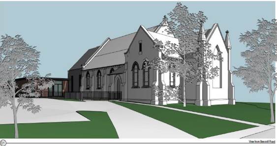
Figure 1: Perspective of proposed development from Beecroft Road (Source: Paul Davies Pty Ltd)
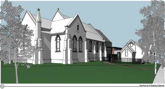
Figure 2: Perspective of proposed development from intersection of Beecroft Road and Chapman Ave
(Source: Paul Davies Pty Ltd)
· The proposed non-compliant height elements are lower than the main roof with minimal visibility from the public domain.
· The proposed development would not overly dominate the natural environment or surrounding built elements.
· The proposed height variation is appropriate considering the constraints of the site and would not create any significant overshadowing impacts to adjoining properties.
· The application provides for the orderly and economic development of land, addresses compliance issues with the existing building to ensure its ongoing functionality to the benefit of parishioners and the local communities and demonstrates adequate consideration and protection of the environmental and public interest.
· The proposed development generally meets the objectives of Clause 4.3 Height of Buildings of the HLEP by way of being appropriate with respect to the constraints of the site and in regard to the development potential of the site.
For the reasons outlined above, it is considered that the written request to contravene the height of building development standard adequately demonstrates that the objectives of the development standard contained within Clause 4.3 of the HLEP are achieved, notwithstanding non-compliance with the standard.
2.1.3.2 Environmental Planning Grounds - Clause 4.6(3)(b)
In addition to demonstrating that compliance is unreasonable or unnecessary, Clause 4.6(3)(b) requires that there are sufficient environmental planning grounds to justify contravening the development standard. In demonstrating that sufficient environmental planning grounds exist it must be demonstrated that the planning grounds are particular to the circumstances of the development on the subject site (summarised from Four2Five Pty Ltd v Ashfield Council [2015] NSWLEC 1009 [60].
The applicant provided the following planning grounds for the contravention of the development standard:
· The proposed height non-compliance is associated with the roof extension to the rear of the masonry church building.
· The addition to the rear of the church has been designed as a modern, part glazed, part brick and part metal clad building. The section linking into the rear (west) of the main church building (i.e., the element with the non-compliant building height) is setback in width and height, to create a respectful link into the main church building.
· The works will be partly obscured from view from Chapman Avenue due to the relocated former School-church building and it will have limited visibility from Beecroft Road.
· The proposed contravention is considered acceptable given the sensitive design of the proposed works, heritage gains achieved by the proposal and the significant benefits to the functionality of the existing church which will occur as a result of the proposal. The works will enable the ongoing use of the church in a manner which complies with relevant accessibility standards, to the benefit of all people.
Council considers that the environmental planning grounds stated within the written request are sufficient with respect to Clause 4.6(3)(b) and that the stated grounds are specific to the proposed development and the circumstances of the development site. It is therefore considered that the written request adequately demonstrates compliance with the clause and is acceptable in this regard.
In demonstrating the unreasonable and unnecessary test, the applicant further established satisfactory environmental planning grounds with respect to the site and the surrounding constraints.
Council is therefore satisfied that Clause 4.6(3)(b) of the HLEP is adequately addressed.
2.1.3.3 Public Interest and Clause 4.6(4)
Clause 4.6(4) states that development consent must not be granted for development that contravenes a development standard unless:
(a) The consent authority is satisfied that:
(i) The applicant’s written request has adequately addressed the matters required to be demonstrated by subclause (3), and
(ii) The proposed development will be in the public interest because it is consistent with the objectives of the particular standard and the objectives for development within the zone in which the development is proposed to be carried out, and
(b) The concurrence of the Planning Secretary has been obtained.
With regard to part (a)(i), the written request is considered to adequately address the matter required to be demonstrated as outlined above.
With regard to part (a)(ii), the proposed development is considered to be in the public interest because it is consistent with the objectives of the particular standard and the objectives for development within the zone in which the development is proposed to be carried out.
With regard to (b), on 21 February 2018, the Secretary of the Department of Planning and Environment issued a Notice under cl. 64 of the Environmental Planning and Assessment Regulation 2000. The Secretary’s concurrence may not be assumed by a delegate of council if:
· The development contravenes a numerical standard by greater than 10%.
· The variation is to a non-numerical standard.
Local Planning Panels constituted under the Environmental Planning and Assessment Act 1979 exercise consent authority functions on behalf of a Council and are not delegates of Council. Therefore, Local Planning Panels may determine a development application notwithstanding, a numerical non-compliance in excess of 10%.
Therefore, the exceedance of the height of buildings development standard is supported in this instance.
The applicant submitted a written request to contravene the height of building development standard contained within Clause 4.3 of the HLEP.
2.1.4 Heritage Conservation
Clause 5.10 of the HLEP sets out heritage conservation provisions for Hornsby Shire.
The site is listed as a heritage item No.72 (St Johns Anglican Church) of local significance under Schedule 5 (Environmental Heritage) of the HLEP. The heritage listing identifies it as a significant brick Federation Gothic style church on a prominent corner site with good quality detailing, including windows, slate roof and sandstone base. The site contains four buildings, of which two are affected by the proposal:
· The 1908 brick church with its western (rear) 1967 brick extension. The proposed changes to the church building are limited to the wall and porch of the 1967 extension. No work is proposed to the 1908 section of the church.
· 1891-1894 timber church/school building which was relocated from an earlier church site in 1905 and has had several changes and alterations both during and since its use as a church.
The property is also within the Beecroft Cheltenham Heritage Conservation Area (HCA) and is adjacent to street trees in Chapman Avenue (Item No.71 - Street Trees).
Council’s initial heritage assessment of the proposal is outlined as follows:
Background
On 20 February 2018, Council approved DA/668/2017 for proposed works at the site with many elements the same as those included in DA/887/2022. The approval included the relocation of the weatherboard c.1891 church within the site and a new rear extension to the 1967 church extension.
Assessment
The application has been assessed with regards to the information submitted with the proposal and the relevant provisions of the Hornsby Development Control Plan 2013 (HDCP). The information includes a Heritage Impact Statement (HIS) by Paul Davies Pty Ltd, which identifies that the proposal involves:
· The demolition of the entry porch at the rear (western) wall of the 1967 extension to the 1908 church building and enlarging the opening in the extension’s rear (western) wall.
· The relocation of the 1891-1894 weatherboard former School/church building to a location closer to the Chapman Avenue boundary. The relocation will involve demolition of the pre-1943 crèche addition to the southern side of the building; and
· Construction of a new modern, part glazed, part brick and part metal clad extension to west of the existing 1967 extension.
Entry porch demolition and expanded western entry
The western church entry and porch were built in 1967 when the church was extended (see Figure 13 of the HIS on page 13). The removal of the western porch and enlarging the western entry would have some impact on the current fabric of the church, however, the significance of the site is primarily in its main function, use and social significance and in the form, location and fabric of the 1908 elements of the church. The removal of some church elements constructed in 1967 would have negligible impact on that significance.
Consequently, there are no heritage objections to the demolition of the western entry porch and expanded western entry.
Relocation of the 1890s timber school-church building
There are no heritage concerns in principle with the proposal to retain, relocate and adaptively reuse the 1890s timber previous school-church building. It was relocated in the past to the current site, and its proposed new location closer to the Chapman Street boundary, is not an area important for views to and from the church, or an area important for landscape heritage reasons. The relocation would not impact the heritage listed street trees in Chapman Avenue (Item No.71 - Street Trees) or impact the character of the Beecroft/Cheltenham HCA as the relocated building is already part of the character of the HCA.
The application did not include a detailed structural survey report about the school/church building, firm details about the proposed relocation method or an indication of heritage impacts potentially associated with its removal and relocation process. The brief report from Partridge Engineering indicates that they consider the building in reasonable condition, and the report provides some removal method options, however, additional relocation method detail is required to fully assess impacts. A review of the structural drawings submitted with the application also indicate that new steel floor bearers and the removal or some piers and footings is intended as part of the relocation.
A detailed structural integrity report, further information about the method of disassembly, relocation and reassembly and an assessment of associated heritage impacts is required to fully identify the heritage implications of the proposed relocation of the 1890s school/church. A recommendation requires the supplementary information to be submitted Council.
New western extensions
The proposed new western extension to the existing 1967 extension to the church building, would be a modern, glazed, brick and metal clad structure of varying height and two distinct forms. The area closest to the western wall of the church would be clad over to reflect the form and steep pitch of the church roof while further to the rear, it would appear as a simple flat roofed more utilitarian brick structure.
The extension would be clearly distinguishable from the existing church and consistent with the desired outcomes of Clause 9.2.1 Heritage Items of the HDCP, it would not dominate it in terms of bulk, scale, form, setbacks or materials, mostly due its rear location, articulated and varied roof height and form, and the mix of newly introduced and traditional materials. The prescriptive measures of Clause 9.2.1 General Design Requirements - Materials, colours and finishes of the HDCP, allows contemporary materials, colours and finishes compatible with a heritage item.
The proposed additions would have minimal visibility from surrounding streets - from Beecroft Road due to the setback behind the 1908 church, and from Chapman Avenue due to location of the to be relocated 1891-94 weatherboard former School-church building.
No heritage concerns are raised with regards the proposed new additions.
Landscape, Fencing and Trees
A lawn play area to the east of the relocated church/school building and north of the existing 1908 church is proposed. It would be enclosed internally and along the Chapman Avenue boundary by a 1.2m high fence with shrub planting/hedges. Other proposed landscaping includes new paving to existing paths and paved outdoor links between existing and proposed structures.
The Arborist’s report identifies that the proposal would require the removal of six trees numbered trees 1, 2, 3, 4, 11 and 12. Tree 11 (a self -seeded wattle) and tree 4 (an iron bark eucalyptus) are in the road reserve of Chapman Avenue and as such, are part of the heritage listed street trees in Chapman Avenue (Item No.71 - Street Trees).
There are no heritage concerns about the proposed landscaping as the site is not significant for landscape reasons and the works are contained within the site and are relatively minor. Similarly, there are no concerns about the removal of trees 1, 2, 3 and 12 as they have no identified cultural heritage value, and their removal would not adversely impact the heritage value of the site or the HCA. The heritage impact of the removal of Trees 4 and 11, however, is not assessed or justified in the material submitted with the application and is not supported at this time as their contribution to Heritage Item No.71 - Street Trees Chapman Avenue, is not known nor the impact of their removal identified.
A recommendation requires a supplementary heritage impact assessment of the removal of trees 4 and 11 on Heritage Item No.71 - Street Trees Chapman Avenue to be submitted Council.
Summary
No heritage concerns are raised in principle to the relocation of the weatherboard church/school building, the new western extensions or landscaping within the site. Preparing a photographic record of the site prior to works commencing is recommended should the application be approved.
Heritage concerns are raised with regards to the method of disassembly, relocation and reassembly of the weatherboard church building and to the impact of the removal of trees 4 and 11 in the road reserve of Chapman Avenue, on Heritage Item No.71 - Chapman Avenue Street Trees. Supplementary information to address these outstanding matters is required to fully assess the heritage implications of the proposal. Further information was requested in this regard.
The concerns raised in Council’s original heritage assessment were addressed by way of additional information and heritage comment to these concerns are outlined as follows:
1. A detailed structural integrity report of the 1890s school/church building, specifications for its disassembly, relocation and reassembly and a supplementary heritage impact assessment of the proposed relocation process and method.
Comment: The level of detailed technical information sought has not been provided, however, the Additional Heritage Letter by Paul Davies sufficiently addresses previous concerns about piers and relocation methods. No further heritage concerns are raised.
2. A heritage impact assessment of the removal of Trees 11 and 4 on Heritage Item No.71 - Street Trees Chapman Avenue.
Comment: The Additional Arborists Letter confirms that Trees 3, 4 and 11 will now not be removed and that the project drawings would be updated for that purpose. Subject to the agreement of Trees Management to the tree retention and management proposed, there are no heritage concerns.
3. Should the application be approved, a photographic archival record of the property and all its buildings and elements of significance be undertaken by a suitably qualified heritage professional prior to any demolition works. The photographic record should be generally undertaken in accordance with NSW Heritage guidelines for recording local heritage items and one an electronic copy submitted to Hornsby Council and prior to issue of any Construction Certificate.
Comment: A condition to this effect is recommended in Schedule 1 of this report accordingly.
In summary, no heritage concerns are raised in principle to the relocation of the weatherboard church/school building, the new western extensions or landscaping within the site.
The proposal would meet the objectives of Clause 5.10 of the HLEP and is considered acceptable.
2.1.5 Earthworks
Clause 6.2 of the HLEP states that consent is required for proposed earthworks on site. Before granting consent for earthworks, Council is required to assess the impacts of the works on adjoining properties, drainage patterns and soil stability of the locality.
The proposed development would require negligible earthworks as the extension of the Church would be located on piers. Excavation would be largely limited to the building footprint and would not be expected to impact on any adjoining properties, existing drainage patterns or soil stability in the locality. As such, the proposal is considered to meet the objective of this Clause.
2.2 State Environmental Planning Policy (Resilience and Hazards) 2021
The application has been assessed against the requirements of chapter 4 of State Environmental Planning Policy (Resilience and Hazard) 2021.
2.2.1 Chapter 4 Remediation of Land
Section 4.6 of the Resilience and Hazard SEPP states that consent must not be granted to the carrying out of any development on land unless the consent authority has considered whether the land is contaminated or requires remediation for the proposed use.
Should the land be contaminated, Council must be satisfied that the land is suitable in a contaminated state for the proposed use. If the land requires remediation to be undertaken to make the land suitable for the proposed use, Council must be satisfied that the land will be remediated before the land is used for that purpose.
An examination of Council’s records and aerial photography has determined that the site has been historically used as a church within a residential area. It is not likely that the site has experienced any significant contamination, and further assessment under chapter 4 of the Resilience and Hazards SEPP is not required.
2.3 State Environmental Planning Policy (Biodiversity and Conservation) 2021
2.3.1 Chapter 2 Vegetation in Non-Rural Areas
Chapter 2 of this policy aims to protect the biodiversity and amenity values of trees within non-rural areas of the state.
Part 2.3 of the policy states that a development control plan may make a declaration in any manner relating to species, size, location and presence of vegetation. Accordingly, Part 1B.6.1 of the HDCP prescribes works that can be undertaken with or without consent to trees and objectives for tree preservation.
Section 3.1.1 of this report provides an assessment in accordance with Part 1B.6.1 of the HDCP.
2.3.2 Chapter 10 Sydney Harbour Catchment
The plan addresses matters related to biodiversity, ecology and environment protection; public access to, and use of, foreshores and waterways; maintenance of a working harbour; interrelationship of waterway and foreshore uses; foreshore and waterways scenic quality; maintenance, protection and enhancement of views and boat storage facilities.
Subject to the implementation of sediment and erosion control measures and stormwater management to protect water quality, the proposal would have minimal potential to impact on the Sydney Harbour Catchment and would comply with the requirements of Chapter 10 of the Biodiversity and Conservation SEPP.
2.4 Section 3.42 Environmental Planning and Assessment Act 1979 - Purpose and Status of Development Control Plans
Section 3.42 of the Environmental Planning and Assessment Act 1979 states that a DCP provision will have no effect if it prevents or unreasonably restricts development that is otherwise permitted and complies with the development standards in relevant Local Environmental Plans and State Environmental Planning Policies.
The principal purpose of a development control plan is to provide guidance on the aims of any environmental planning instrument that applies to the development; facilitate development that is permissible under any such instrument; and achieve the objectives of land zones. The provisions contained in a DCP are not statutory requirements and are for guidance purposes only. Consent authorities have flexibility to consider innovative solutions when assessing development proposals, to assist achieve good planning outcomes.
2.5 Hornsby Development Control Plan 2013
The proposed development has been assessed having regard to the relevant desired outcomes and prescriptive requirements within the Hornsby Development Control Plan 2013 (HDCP). The following table sets out the proposal’s compliance with the prescriptive requirements of the Plan:
|
HDCP - Part 7.1 Community Uses |
|||
|
Control |
Proposal |
Requirement |
Complies |
|
Site Area |
4376m² |
N/A |
N/A |
|
Building Height |
10.178m |
8.5m |
No |
|
No. storeys |
1 |
max. 2 + attic |
Yes |
|
Site Coverage |
28% |
30% |
Yes |
|
Setbacks |
|
|
|
|
- Front (Beecroft Road) |
Unchanged |
6m |
Yes |
|
- Secondary (Chapman Avenue) |
2.5m to 3m |
3m |
No |
|
- Side (southern) |
Unchanged |
900mm |
Yes |
|
- Rear |
Unchanged |
3m |
Yes |
|
Landscaped Area (% of lot size) |
46% |
45% |
Yes |
|
Car Parking (1 space per 5 seats) |
14 spaces (existing) |
57 spaces |
No |
As detailed in the above table, there are a number of non-compliances with the HDCP controls which are discussed below including a brief discussion on compliance with relevant performance requirements.
2.5.1 Transport and Parking
Under the Table 1C.2.1(d) of the HDCP, a place of worship requires 1 space per 5 seats (subject to a parking study).
The existing development provides 14 car parking spaces. On street parking is used during peak periods. It is proposed to increase the number of seats in the Church from 200 to 284 as a result of the additions.
The application was accompanied by Traffic and Parking Report prepared by McLaren Traffic Engineering.
Council’s traffic assessment reviewed the original report and requested additional information requiring a new on-street parking survey for weekends, up to 400m from the proposed site which exclude parking spaces on Beecroft Road due to concerns with the original survey undertaken during the lock-down period and new parking restrictions on Beecroft Road. Further, Council requested detailed explanation of the Church’s events and activities on weekdays.
In response to Council’s concerns, the applicant provided a new traffic parking survey, additional details regarding the Church’s events and activities on weekdays and a revised car parking plan which indicate the provision of two disabled car spaces.
Councils traffic assessment of the revised information is provided below:
Proponent response: The surveys were conducted on Sunday 14 November 2021 between the hours of 7:30am-12:30pm and 6:00pm-9:00pm. The undertaken surveys were completed over a month after the date of ‘Freedom Day’ and the church operator had advised that the existing Church on the subject site was operating in a generally typical manner. TfNSW were contacted through phone discussions, but the persons reached were unable to find information regarding potential Clearways on Beecroft Road.
Section response: Traffic Section accept the statement from Response Letter. No new surveys are required.
The additional information included a breakdown of Church activities which indicated that Sunday is the busiest day when mass occurs twice with the rest of the week not requiring a large demand for the use of the Church and Saturdays experiencing the occasional wedding. Accordingly, given the nature of the proposed use and that Council has not received complaints regarding off-street car parking from the Church use, the proposed increased capacity is considered acceptable in this instance.
The proposal meets the desired outcomes of Part 1C.2.1 Transport and Parking and is considered acceptable, subject to conditions.
2.5.2 Setbacks
The relocation of the timber church would result in a 2.5m to 3m setback to Chapman Avenue which does not comply with the HDCP setback provisions which stipulate a 3m setback.
In response to this non-compliance, the relocation would have a similar setback to the existing timber church, albeit at a different orientation and no heritage concerns are raised to the revised setback as it would enhance the ability for the public to appreciate the heritage significance of the 1891-1894 weatherboard former School-church building through both its conservation and its relocation on the site to a location closer to Chapman Street resulting in a sympathetic addition that blends into the surrounding environment.
Accordingly, no objections are raised to the minor non-compliance.
2.6 Contributions Plans
Hornsby Shire Council Section 7.12 Contributions Plan 2019-2029 does not apply to the development as the owner of the subject site is a charity (church) and is exempt for payment under the Plan under Section 2.8(3).
3. ENVIRONMENTAL IMPACTS
Section 4.15(1)(b) of the Act requires Council to consider “the likely impacts of that development, including environmental impacts on both the natural and built environments, and social and economic impacts in the locality”.
3.1 Natural Environment
3.1.1 Tree and Vegetation Preservation
The proposed development would necessitate the removal of three trees from the site. The application was supported by an Arborist Report prepared by Moore Trees dated March 2017. Councils assessment of the proposal noted the following:
· The proposal indicates trees numbered 1, 2 and 12 are located within the building envelope and would require removal. Trees numbered 3, 4 and 5 are also impacted by the building envelope; however, subject to the use of sensitive excavation for stormwater installation, the trees could be retained.
· One tree to be removed is identified as a ‘significant tree’ in accordance with the Tree and Vegetation provisions of the HDCP. In addition, the roadside is classified as a heritage item for the purposes of conserving mature indigenous trees giving local Australian landscape identity to the area and streetscape.
· Trees numbered 3 to 11 (inclusive) are resilient species in relation to impacts resulting from development and there are numerous examples where these trees have been successfully retained where minor incursion have occurred, and appropriate tree protection measures and management has been applied in accordance with the Australian Standard AS4970-2009 Protection of trees on development sites.
It is considered that the removal of the trees is acceptable in the circumstances of the case and conditions requiring replacement tree planting, as well as conditions for protection of trees during construction is recommended.
3.1.2 Stormwater Management
The proposed stormwater drainage system is designed to minimise impacts on downstream waterways and would be connected to the Council controlled drainage system in Chapman Avenue via an on-site detention system with a capacity of 8.4 cubic metres and a maximum discharge when full of 25 litres per second.
Conditions are recommended for the system to be designed and constructed in accordance with Council’s AUS-SPEC Specifications. Accordingly, the proposed development satisfies the desired outcomes and prescriptive measures of Part 1C.1.2 Stormwater Management under the HDCP.
3.2 Built Environment
3.2.1 Built Form
The proposed built form is consistent with the existing Church building on site in terms of height design and materials and is compatible with adjoining dwellings and uses.
3.2.2 Traffic
Refer to discussion under section 2.5.1 of this report.
3.3 Social Impacts
The development would make a positive social contribution to the local community by facilitating an upgrade of an existing social community service which would benefit future residents and the community.
3.4 Economic Impacts
The proposal would have a minor positive impact on the local economy in conjunction with other new low density residential development in the locality by generating an increase in demand for local community services.
4. SITE SUITABILITY
Section 4.15(1)(c) of the Act requires Council to consider “the suitability of the site for the development”.
The subject site is not identified as bushfire prone or flood prone land and is considered to be capable of accommodating the proposed development. The scale of the proposed development is consistent with the capability of the site and is considered acceptable.
5. PUBLIC PARTICIPATION
Section 4.15(1)(d) of the Act requires Council to consider “any submissions made in accordance with this Act”.
5.1 Community Consultation
The proposed development was placed on public exhibition and was notified to adjoining and nearby landowners between 1 September 2022 and 22 September 2022 in accordance with the Hornsby Community Engagement Plan. During this period, Council did not receive any submissions. The map below illustrates the location of those nearby landowners that were notified of the development.

|
NOTIFICATION PLAN |
|||
|
• PROPERTIES NOTIFIED |
X SUBMISSIONS RECEIVED |
|
|
5.2 Public Agencies
The development application was not referred to any Public Agencies for comment.
6. THE PUBLIC INTEREST
Section 4.15(1)(e) of the Act requires Council to consider “the public interest”.
The public interest is an overarching requirement, which includes the consideration of the matters discussed in this report. Implicit to the public interest is the achievement of future built outcomes adequately responding to and respecting the future desired outcomes expressed in environmental planning instruments and development control plans.
The application is considered to have satisfactorily addressed Council’s and relevant agencies’ criteria and would provide a development outcome that, on balance, would result in a positive impact for the community. Accordingly, it is considered that the approval of the proposed development would be in the public interest.
CONCLUSION
The application proposes alterations and additions to the existing church and associated buildings and increase capacity of church from 200 seats to 284 seats.
The development generally meets the desired outcomes of Council’s planning controls and is satisfactory having regard to the matters for consideration under Section 4.15 of the Environmental Planning and Assessment Act 1979.
No submissions were received during the public notification period.
Having regard to the circumstances of the case, approval of the application is recommended.
The reasons for this decision are:
· The request under Clause 4.6 of Hornsby Local Environmental Plan 2013 to contravene the Clause 4.3 Height of Buildings development standard is well founded. Strict compliance with the development standard is considered unreasonable and unnecessary in the circumstances of the case and sufficient environmental planning grounds have been submitted to justify the contravention to the development standard.
· The proposed development generally complies with the requirements of the relevant environmental planning instruments and the Hornsby Development Control Plan 2013.
· The proposed development does not create unreasonable environmental impacts to adjoining development with regard to visual bulk, solar access, amenity or privacy.
Note: At the time of the completion of this planning report, no persons have made a Political Donations Disclosure Statement pursuant to Section 10.4 of the Environmental Planning and Assessment Act 1979 in respect of the subject planning application.
|
Cassandra Williams Major Development Manager - Development Assessments Planning and Compliance Division |
Rod Pickles Manager - Development Assessments Planning and Compliance Division |
|
Locality Plan |
|
|
|
|
Clause 4.6 |
|
|
|
|
Architectural Plans |
|
|
|
|
Landscape Plans |
|
|
File Reference: DA/887/2022
Document Number: D08598786
SCHEDULE 1
GENERAL CONDITIONS
The conditions of consent within this notice of determination have been applied to ensure that the use of the land and/or building is carried out in such a manner that is consistent with the aims and objectives of the relevant legislation, planning instruments and council policies affecting the land and does not disrupt the amenity of the neighbourhood or impact upon the environment.
Note: For the purpose of this consent, the term ‘applicant’ means any person who has the authority to act on or the benefit of the development consent.
Note: For the purpose of this consent, any reference to an Act, Regulation, Australian Standard or publication by a public authority shall be taken to mean the gazetted Act or Regulation, or adopted Australian Standard or publication as in force on the date that the application for a construction certificate is made.
1. Approved Plans and Supporting Documentation
The development must be carried out in accordance with the plans and documentation listed below and endorsed with Council’s stamp, except where amended by Council and/or other conditions of this consent:
Approved Plans
|
Plan No. |
Plan Title |
Drawn by |
Dated |
Council Reference |
|
DA00, Issue B |
Site and Roof Plan |
Paul Davies Architects |
10/11/22 |
|
|
DA01, Issue B |
Proposed Ground Floor Plan |
Paul Davies Architects |
10/11/22 |
|
|
DA02, Issue A |
Proposed Elevations |
Paul Davies Architects |
12/08/22 |
|
|
DA03, Issue A |
Proposed Elevations |
Paul Davies Architects |
12/08/22 |
|
|
DA04, Issue A |
Proposed Sections |
Paul Davies Architects |
12/08/22 |
|
|
DA11, Issue A |
Ground Floor Parking Layout |
Paul Davies Architects |
12/01/23 |
|
|
17-3374 L01, Rev. B |
Landscape Plan |
Zenith Landscape Design |
14/06/22 |
|
|
17-3374 L02, Rev. B |
Landscape Plan |
Zenith Landscape Design |
14/06/22 |
|
|
17-3374 L03, Rev. B |
Landscape Plan - Plant Schedule and Details |
Zenith Landscape Design |
14/06/22 |
|
Supporting Documentation
|
Document Title |
Prepared by |
Dated |
Council Reference |
|
Arboricultural Development Assessment Report (verified 13/07/22) |
Moore Trees |
Mar 2017 |
D08484463 |
|
Arboricultural Root Mapping Assessment Report (verified 13/07/22) |
Moore Trees |
Dec 2017 |
D08484464 |
|
Further Review of Trees 3, 4 and 11 |
Moore Trees |
03/11/22 |
D08533357 |
|
Waste Management Plan |
The Wardens, St Johns Anglican Church |
Undated |
D08484491 |
|
Proposed Drainage, Sediment and Erosion Control Plans - Job No. 2016H0213, Dwg No. SEDA2 1.1 to 1.6 (inclusive) |
Partridge Hydraulic Services |
28/06/22 |
D08484480 |
|
Geotechnical Investigation Report |
Geo-environmental Engineering |
11/05/22 |
D08484470 |
Reason: To ensure all parties are aware of the approved plans and supporting documentation that apply to the development.
2. Appointment of a Project Heritage Consultant
a) A suitably qualified heritage consultant must be appointed to provide monitoring and certification throughout the construction period.
b) Details of the appointed heritage consultant must be submitted to the PCA with the application for the construction certificate.
Reason: To ensure appropriate monitoring of heritage items to be retained.
3. Heritage Requirements
The following heritage requirements are to be submitted and written approval provided by Council prior to demolition works or the issue of a Construction Certificate (whichever occurs first):
a) A photographic archival record of the property at Lot 1 DP 1052911, No. 9 Chapman Avenue, Beecroft (St Johns Anglican Church) is to be undertaken by a suitably qualified heritage professional prior to any demolition works of the heritage listed church buildings (internally and externally) and setting. The photographic record should:
i) Be generally undertaken in accordance with the Office of Environment and Heritage, Heritage Branch Guidelines and 1 complete paper copy, plus an electronic copy to be submitted to Hornsby Council.
ii) The photographic and measured drawing record shall include (but not be limited to) an accurate record of the exterior and interior of the building and its setting.
b) Satisfaction of this condition shall be confirmed by written advice by Council’s Strategic Planning Branch prior to issue of any Construction Certificate.
Note: Please contact Council’s heritage officer for enquiries regarding heritage requirements on 9847 6726.
Reason: To protect the heritage significance of site.
4. Appointment of a Project Arborist
b) Details of the appointed project arborist must be submitted to Council and the PCA with the application for the construction certificate/subdivision works certificate.
Reason: To ensure appropriate monitoring of tree(s) to be retained.
5. Removal of Trees
a) This development consent permits the removal of trees numbered 1, 2 and 12 as identified on the Tree Protection Plan on page 20 of Appendix 1 in the Arboricultural Development Assessment Report prepared by Moore Trees, dated March 2017.
b) No consent is granted for the removal of trees numbered 3-11 (inclusive) as these trees contribute to the established landscape amenity of the area/streetscape.
Note: The removal of any other trees from the site requires separate approval by Council in accordance with Part 1B.6 Tree and Vegetation Preservation of the Hornsby Development Control Plan, 2013.
Reason: To identify only those trees permitted to be removed.
6. Tree Pruning
This development consent does not permit the pruning of any trees.
Note: The pruning of any trees from the site requires separate approval by Council in accordance with Part 1B.6 Tree and Vegetation Preservation of the Hornsby Development Control Plan 2013.
Reason: To minimise the impact on trees to be retained.
7. Construction Certificate
a) A Construction Certificate is required to be approved by Council or a Private Certifying Authority prior to the commencement of any construction works under this consent.
b) The Construction Certificate plans must be consistent with the Development Consent plans.
Reason: To ensure that detailed construction certificate plans are consistent with the approved plans and supporting documentation.
REQUIREMENTS PRIOR TO THE ISSUE OF A CONSTRUCTION CERTIFICATE
Detailed plans, specifications and supporting information is required to be submitted to the certifying authority detailing how the proposed building work achieves compliance with the National Construction Code - Building Code of Australia. All building work must be carried out in accordance with the requirements of the National Construction Code - Building Code of Australia.
Reason: Prescribed condition - EP&A Regulation section 69(1)
To ensure the protection of persons using the building and to facilitate egress from the building in the event of a fire, the application for a construction certificate must demonstrate that it would comply with the following Sections C, D and E of the Building Code of Australia.
Reason: To ensure adequate provision is made for fire safety to protect future occupants.
10. Fire Safety Schedule
A schedule of all proposed essential fire safety measures to be installed in the building (e.g. hydrants, hose reels, emergency warning systems etc.) shall be submitted with the construction certificate application.
Reason: To ensure adequate provision is made for fire safety to protect future occupants.
11. Building Accessibility
a) The new building, new part of the building or affected part of the building is required to meet the requirements of the Disability (Access to Premises Buildings) Standards 2010.
b) The new building, new part of the building is required to be upgraded in accordance with the requirements of AS1428.1-2009 Design for access and mobility.
c) Details of the building accessibility must be submitted with the application for the Construction Certificate.
Reason: To ensure adequate provision is made for disabled access.
12. Geotechnical Requirements
a) The development must be designed and carried out in accordance with the recommendations outlined in the submitted Geotechnical Investigation Report prepared by Geo-environmental Engineering, dated 11 May 2022.
b) Details are to be provided to the Principal Certifying Authority with the application for a Construction Certificate.
Reason: To ensure adequate structural design and construction of the development.
13. Sydney Water - Approval
This application must be submitted to Sydney Water for approval to determine whether the development would affect any Sydney Water infrastructure, and whether further requirements are to be met.
Note: Building plan approvals can be obtained online via Sydney Water Tap inTM through www.sydneywater.com.au under the Building and Development tab.
Reason: To ensure the development is provided with the relevant utility services.
14. Stormwater Drainage
The stormwater drainage system for the development must be designed for an average recurrence interval (ARI) of 20 years and be gravity drained in accordance with the following requirements:
a) Connected directly to the kerb line in Chapman Avenue via the on-site detention system.
Reason: To ensure appropriate provision for management and disposal of stormwater.
15. On Site Stormwater Detention
The stormwater drainage system for the development must be designed in accordance with AUS-SPEC Specifications (www.hornsby.nsw.gov.au/property/build/aus-spec-terms-and-conditions) by a chartered civil engineer and constructed in accordance with the following requirements:
a) Have a capacity of not less than 8.4 cubic metres, and a maximum discharge (when full) of 25 litres per second.
b) Have a surcharge/inspection grate located directly above the outlet; and
c) Discharge from the detention system must be controlled via 1 metre length of pipe, not less than 50 millimetres diameter or via a stainless plate with sharply drilled orifice bolted over the face of the outlet discharging into a larger diameter pipe capable of carrying the design flow to an approved Council system.
Reason: To ensure appropriate provision for management and disposal of stormwater.
16. Work Zone Permit
a) All construction vehicles associated with the proposed development are to be contained on site or in a Local Traffic Committee (LTC) approved “Works Zone”.
b) A work zone permit must be obtained by the LTC prior to the issue of the Construction Certificate – Apply for a Permit | Hornsby Shire Council (nsw.gov.au).
c) The site supervisor to be advised that the Works Zone will be deemed to be in effect, and fees will apply, between the dates nominated by the supervisor, or when parking spaces are managed for the sole use of construction vehicles associated with the site.
d) The Works Zone signs shall be in effect only apply for the times approved by Council, and the time is to be noted on the sign. E.g., ‘Works Zone Mon - Sat 7am - 5pm’.
e) The applicant is required to supply a sign posting installation plan for referral to the Local Traffic Committee, noting on it the duration of the Works Zone.
f) The Works Zone is only to be used for the loading and unloading of vehicles. Parking of workers’ vehicles, or storage of materials, is not permitted.
Reason: To ensure the management of construction traffic to maintain road and pedestrian safety.
17. Construction Management Plan (CMP)
To assist in the protection of the public, the environment and Council’s assets, a separate Construction Management Plan must be prepared by a suitably qualified environmental consultant in consultation with a qualified traffic engineer and AQF 5 arborist, and submitted to Council’s Compliance Team at:
https://www.hornsby.nsw.gov.au/property/build/applicationforms for review and approval according to the following requirements:
a) The CMP must detail the contact information for developers, builder, private certifier and any emergency details during and outside work hours.
b) A Construction Traffic Management Plan (CTMP) including the following:
i) The order of construction works and arrangement of all construction machines and vehicles being used during all stages.
ii) The CTMP plans shall be in accordance with all other plans submitted to Council as part of this development proposal.
iii) A statement confirming that no building materials, work sheds, vehicles, machines or the like shall be allowed to remain in the road reserve area without the written consent of Hornsby Shire Council.
iv) The Plan shall be in compliance with the requirements of the Roads and Maritime Services Traffic control at work sites Manual 2018 and detail:
a. Public notification of proposed works.
b. Long term signage requirements.
c. Short term (during actual works) signage.
d. Vehicle Movement Plans, where applicable.
e. Traffic Management Plans.
f. Pedestrian and Cyclist access and safety.
v) Traffic controls including those used during non-working hours. Pedestrian access and two-way traffic in the public road must be able to be facilitated at all times.
vi) Details on how pedestrian movements will be changed and managed during various stages of development, particularly during any partial or total closures of footpaths.
vii) Details of parking arrangements for all employees and contractors, including layover areas for large trucks during all stages of works. The parking or stopping of truck and dog vehicles associated with the development will not be permitted other than on the site and the plan must demonstrate this will be achieved.
viii) Confirmation that a street ‘scrub and dry’ service will be in operation during all stages of works.
ix) Proposed truck routes to and from the site including details of the frequency of truck movements for all stages of the development.
x) Swept path analysis for ingress and egress of the site for all stages of works.
xi) Site plans for all stages of works including the location of site sheds, concrete pump and crane locations, unloading and loading areas, waste and storage areas, existing survey marks, vehicle entry, surrounding pedestrian footpaths and hoarding (fencing) locations.
xii) The total quantity and size of trucks for all importation and exportation of fill on site throughout all stages of works, and a breakdown of total quantities of trucks for each stage of works.
xiii) The number of weeks trucks will be accessing and leaving the site with excavated or imported fill material.
xiv) The maximum number of trucks travelling to and from the site on any given day for each stage of works.
xv) The maximum number of truck movements on any given day during peak commuting periods for all stages of works.
xvi) The source site location of any proposed fill to be imported to the site, for all stages of works.
xvii) The Plan must state that the applicant and all employees of contractors on the site must obey any direction or notice from the Prescribed Certifying Authority or Hornsby Shire Council in order to ensure the above.
xviii) If there is a requirement to obtain a Work Zone, Out of Hours permit, partial Road Closure or Crane Permit, the Plan must detail these requirements and include a statement that an application to Hornsby Shire Council will be made to obtain such a permit.
c) A Construction Waste Management Plan detailing the following:
i) Details of the importation or excavation of soil and fill, the classification of the fill, disposal methods and authorised disposal depots that will be used for the fill.
ii) Asbestos management requirement and procedures for removal and disposal from the site in accordance with AS 2601-2001 - ‘The Demolition of Structures’, and the Protection of the Environment Operations (Waste) Regulation 2005.
iii) General construction waste details including construction waste skip bin locations and litter management for workers.
d) A Tree Protection Plan (TPP) prepared by an AQF 5 Arborist in accordance with any approved Arboricultural Impact Assessment and tree location plans, detailing the following:
iv) A site plan showing tree protection zones (TPZ) and structural root zones (SRZ) of trees to be retained and specific details of tree protection measures inclusive of distances (in metres) measured from tree trunks.
v) Construction methodology to avoid damage to trees proposed to be retained during construction works.
vi) Specifications on tree protection materials used and methods within the TPZ or SRZ.
vii) Location of dedicated material storage space on site outside of TPZ’s and SRZ’s for retained trees.
e) A Construction Noise and Vibration Management Plan (CNMP) which includes:
i) Existing noise and vibration levels within the proximity of the proposed development site.
ii) Details of the extent of rock breaking or rock sawing works forming part of the proposed development works.
iii) The maximum level of noise and vibration predicted to be emitted during each stage of construction.
iv) The duration of each stage of works where the maximum level of noise and vibration are predicted to be emitted for.
v) Details of mitigation measures, inclusive of respite periods, that will meet acoustic standards and guidelines at each stage of works.
vi) Details of a complaints handling process for the surrounding neighbourhood for each stage of works.
f) Identification of approved sediment and erosion control measures.
Note: The CMP must be lodged via Council’s Online Services Portal at: https://hornsbyprd-pwy-epw.cloud.infor.com/ePathway/Production/Web/Default.aspx and by selecting the following menu options: Applications > New Applications > Under ‘Application Types’: Management Plans.
Reason: To document measures to protect the public and the surrounding environment.
18. Hazardous Material Survey
A Hazardous Materials Survey of the site is to be submitted to Council for review. The Survey must be prepared by a suitably qualified environmental consultant in accordance with the Work Health and Safety Act 2011 and associated Regulations, including laboratory analysis for asbestos and lead on the site and within the soil.
Reason: To document measures to protect the public and the surrounding environment.
REQUIREMENTS PRIOR TO THE COMMENCEMENT OF ANY WORKS
19. Erection of Construction Sign
a) A sign must be erected in a prominent position on any site on which any approved work is being carried out:
i) Showing the name, address and telephone number of the principal certifying authority for the work.
ii) Showing the name of the principal contractor (if any) for any demolition or building work and a telephone number on which that person may be contacted outside working hours.
iii) Stating that unauthorised entry to the work site is prohibited.
b) The sign is to be maintained while the approved work is being carried out and must be removed when the work has been completed.
Reason: Prescribed condition EP&A Regulation, section 70(2) and (3).
20. Protection of Adjoining Areas
A temporary hoarding, fence or awning must be erected between the work site and adjoining lands before the works begin and must be kept in place until after the completion of the works if the works:
a) Could cause a danger, obstruction or inconvenience to pedestrian or vehicular traffic.
b) Could cause damage to adjoining lands by falling objects.
c) Involve the enclosure of a public place or part of a public place.
d) Have been identified as requiring a temporary hoarding, fence or awning within the Council approved Construction Management Plan (CMP).
Note: Notwithstanding the above, Council’s separate written approval is required prior to the erection of any structure or other obstruction on public land.
Reason: To ensure public safety and protection of adjoining land.
21. Toilet Facilities
a) To provide a safe and hygienic workplace, toilet facilities must be available or be installed at the works site before works begin and must be maintained until the works are completed at a ratio of one toilet for every 20 persons employed at the site.
b) Each toilet must:
i) Be a standard flushing toilet connected to a public sewer.
ii) Be a temporary chemical closet approved under the Local Government Act 1993.
iii) Have an on-site effluent disposal system approved under the Local Government Act 1993.
Reason: To ensure adequate toilet facilities are provided.
22. Erosion and Sediment Control
To protect the water quality of the downstream environment, erosion and sediment control measures must be provided and maintained throughout the construction period in accordance with the manual ‘Urban Stormwater: Soils and Construction “The Blue Book” 2005 (4th edition)’, the approved plans, Council specifications and to the satisfaction of the principal certifying authority. The erosion and sediment control devices must remain in place until the site has been stabilised and revegetated.
Note: On the spot penalties may be issued for any non-compliance with this requirement without any further notification or warning.
Reason: To minimise impacts on the water quality of the downstream environment.
23. Installation of Tree Protection Measures
a) Trees to be retained and numbered 3-11 (inclusive), as identified on the Tree Protection Plan on page 20 of Appendix 1 in the Arboricultural Development Assessment Report prepared by Moore Trees, dated March 2017 must have tree protection measures for the ground, trunk and canopy installed by the project arborist as follows:
i) For the duration of demolition works, in accordance with the Tree Protection Plan in the Arboricultural Development Assessment Report prepared by Moore Trees dated March 2017, with additional trunk protection measures for trees numbered 3 and 4.
ii) For the duration of construction works, in accordance with Tree Protection Plan in the Arboricultural Development Assessment Report prepared by Moore Trees dated March 2017, with additional trunk protection measures for tree numbered 3 and 4.
b) Tree protection fencing for the trees to be retained numbered 3-11 (inclusive) must be installed by the engaged AQF 5 project arborist and consist of 1.8m high temporary fencing panels installed in accordance with Australian Standard AS4687-2007 Temporary fencing and hoardings.
c) The installation of all required tree protection fencing must include shade cloth attached to the fencing to reduce transport of dust, particulates and liquids from entering the tree protection zone.
d) Tree crown protection measures are required and must be installed by the AQF 5 project arborist.
e) The circumference of the trunk(s) must be wrapped in hessian material to provide cushioning for the installation of timber planks.
f) Timber planks (50 x100mm) must be spaced at 100mm intervals and must be attached using adjustable ratchet straps.
g) Where wood-chip mulch is permitted by Council instead of tree protection fencing within the tree protection zones, the woodchip must be covered with a layer of geotextile fabric and rumble boards.
24. Garbage receptacle
A garbage receptacle must be provided at the work site before works begin and must be maintained until all works are completed.
a) The garbage receptacle must have a tight fitting lid and be suitable for the reception of food scraps and papers.
b) The receptacle lid must be kept closed at all times, other than when garbage is being deposited.
c) Food scraps must be placed in the garbage receptacle and not in demolition and construction waste bins.
Reason: To maintain the site in a clean condition and protect local amenity.
1. REQUIREMENTS DURING DEMOLITION AND CONSTRUCTION
25. Construction Work Hours
a) All works on site, including demolition and earth works, must only occur between 7am and 5pm Monday to Saturday.
b) No work is to be undertaken on Sundays or public holidays.
Reason: To protect the amenity of neighbouring properties.
26. Work Zone Requirements
a) All construction vehicles associated with the proposed development are to be contained on site or in a Local Traffic Committee (LTC) approved “Works Zone”.
b) The site supervisor to be advised that the Works Zone will be deemed to be in effect, and fees will apply, between the dates nominated by the supervisor, or when parking spaces are managed for the sole use of construction vehicles associated with the site.
c) The Works Zone signs shall be in effect only for the times approved by Council, and the time is to be noted on the sign. E.g. ‘Works Zone Mon-Sat, 7am-5pm’.
d) The applicant is required to supply a sign posting installation plan for referral to the Local Traffic Committee, noting on it the duration of the Works Zone.
e) The Works Zone is only to be used for the loading and unloading of vehicles. Parking of workers’ vehicles, or storage of materials, is not permitted.
Reason: To ensure the management of construction traffic to maintain road and pedestrian safety.
27. Demolition
To protect the surrounding environment, all demolition work must be carried out in accordance with Australian Standard AS2601-2001 Demolition of structures and the following requirements:
a) Demolition material must be disposed of to an authorised recycling and/or waste disposal site and/or in accordance with an approved waste management plan; and
b) Demolition works, where asbestos material is being removed, must be undertaken by a contractor that holds an appropriate licence issued by SafeWork NSW in accordance with the Work Health and Safety Regulation 2017 and be appropriately transported and disposed of in accordance with the Protection of the Environment Operations (Waste) Regulation 2014; and
c) On construction sites where any building contain asbestos material, a standard commercially manufactured sign containing the words ‘DANGER ASBESTOS REMOVAL IN PROGRESS’ and measuring not less than 400mm x 300mm must be displayed in a prominent position visible from the street.
Reason: To ensure the appropriate removal and disposal of demolition materials.
28. Relocation of the 1890’s Timber School/Church Building
a) The relocation of the 1890’s Timber School/Church building must be overseen by a suitability qualified structural/civil engineer and heritage consultant.
b) Upon completion to the school/church building relocation, a structural engineering certificate must be submitted to the PCA and Council.
Reason: To ensure the structural integrity of the heritage listed building is maintained.
29. Environmental Management
To prevent sediment run-off, excessive dust, noise or odour emanating from the site during the construction, the site must be managed in accordance with the publication ‘Managing Urban Stormwater - Landcom (March 2004) and the Protection of the Environment Operations Act 1997.
Reason: To minimise impacts to the natural environment and public health.
During works and until exposed ground surfaces across the site have been stabilised, street sweeping must be undertaken following sediment tracking from the site.
The street cleaning service must utilise a ‘scrub and dry’ method and be undertaken for the full extent of any sediment tracking.
Reason: To minimise impacts to the natural environment and public health.
31. Compliance with Construction Management Plan
The Council approved Construction Management Plan must be complied with for the duration of works, unless otherwise approved by Council.
Reason: To ensure implementation of construction measures to protect the public and the surrounding environment.
32. Council Property
To ensure that the public reserve is kept in a clean, tidy and safe condition during construction works, no building materials, waste, machinery or related matter is to be stored on the road or footpath.
Reason: To protect public land.
33. Disturbance of Existing Site
During construction works, the existing ground levels of open space areas and natural landscape features, including natural rock-outcrops, vegetation, soil and watercourses must not be altered unless otherwise nominated on the approved plans.
Reason: To protect the natural features of the site.
34. Landfill not Permitted
The importation of fill material associated with earthworks, or structural or engineering works, is not permitted as part of this consent.
Reason: To ensure no landfill is imported to the site.
35. Excavated Material
All excavated material removed from the site must be classified by a suitably qualified environmental consultant in accordance with the NSW Environment Protection Authority’s Waste Classification Guidelines and Protection of the Environment Operations (Waste) Regulation 2014 prior to disposal to a licensed waste management facility. Tipping dockets for the total volume of excavated material that are received from the licensed waste management facility must be provided to the principal certifying authority prior to the issue of an Occupation Certificate.
Reason: To ensure the appropriate removal and disposal of excavated material.
36. Unexpected Finds
Should the presence of asbestos or soil contamination, not recognised during the application process be identified during any stage of works, the applicant must immediately notify the PCA and Council.
Reason: To ensure the appropriate removal and disposal of contaminated material.
37. Survey Report
A report(s) must be prepared by a registered surveyor and submitted to the principal certifying authority:
a) Prior to the pouring of concrete at each level of the building certifying that:
i) The building, retaining walls and the like have been correctly positioned on the site; and
ii) The finished floor level(s) are in accordance with the approved plans.
Reason: To ensure buildings are positioned in the approved location and at the correct height.
38. Waste Management
All work must be carried out in accordance with the approved waste management plan.
Reason: To ensure the management of waste to protect the environment and local amenity during construction.
39. Maintenance of Public Footpaths
Public footpaths must be maintained for the duration of works to ensure they are free of trip hazards, displacements, breaks or debris to enable pedestrians to travel along the footpath safely.
Reason: To maintain safe pedestrian movement.
40. Prohibited Actions within the Fenced Tree Protection Zone
The following activities are prohibited within the approved fenced tree protection zones unless otherwise approved by Council:
a) Soil cutting or filling, including excavation and trenching
b) Soil cultivation, disturbance or compaction
c) Stockpiling storage or mixing of materials
d) The parking, storing, washing and repairing of tools, equipment and machinery
e) The disposal of liquids and refuelling
f) The disposal of building materials
g) The siting of offices or sheds
h) Any action leading to the impact on tree health or structure
Reason: To protect trees during construction.
41. Maintaining the Health of Trees Approved for Retention
The appointed project arborist must monitor and record any and all necessary actions required to maintain tree health and condition for trees numbered 3-11 (inclusive) on the approved plans.
Reason: To protect trees during construction.
42. Maintaining Tree Protection Measures
Tree Protection Measures must be maintained by the project arborist in accordance with Condition Nos. 23 and 40 of this consent for the duration of works.
Reason: To protect trees during construction.
43. Approved Works within Tree Protection Zone Incursions
a) Where tree root pruning is required for the installation of piers, driveway or underground services, the pruning must be overseen by the AQF 5 project arborist and must be undertaken as follows:
i) Using sharp secateurs, pruners, handsaws or chainsaws with the final cut being clean.
ii) The maximum diameter of roots permitted to be cut is 50mm.
b) Where the building footprint enters or transects the Tree Protection Zones of trees to be retained numbered 3, 4 and 5, sensitive construction techniques in the form of screw pilings or piers, cantilevered or suspended slab design must be employed to create a 100mm clearance above existing soil grade.
c) Approved excavations within the Tree Protection Zone of trees to be retained numbered 3, 4 and 5 not associated with installation of services must be undertaken as follows:
i) Excavations associated with the basement and building footprint and within the Tree Protection Zone of trees numbered 3, 4 and 5 must be overseen by the AQF 5 project arborist for the first 1m undertaken manually to a depth of 1 metre to locate roots and allow for pruning in accordance with condition No. 43a).
d) No changes of grade within the Tree Protection Zone of trees to be retained numbered 3-11 (inclusive) on the approved plans, are permitted.
e) To minimise impacts within the Tree Protection Zone (TPZ) of trees numbered 3, 4 and 5 on the approved plans, the installation of services must be undertaken as follows:
i) The AQF 5 project arborist must be present to oversee the installation of any underground services which enter or transect the tree protection.
ii) The installation of any underground services which either enter or transect the designated TPZ must be undertaken manually.
iii) For manually excavated trenches the AQF 5 project arborist must designate roots to be retained. Manual excavation may include the use of pneumatic and hydraulic tools.
f) Where scaffolding is required, ground protection must be installed beneath the scaffolding in the following order:
i) Installation of a 100mm deep layer of woodchip.
ii) Installation of geotextile fabric ground covering.
iii) Installation of scaffold boarding above the woodchip and geotextile fabric.
Reason: To protect trees during construction.
2. REQUIREMENTS PRIOR TO THE ISSUE OF AN OCCUPATION CERTIFICATE
44. Replacement Tree Requirements
a) The trees approved for removal under this consent, being trees numbered 1, 2 and 12 must be offset through replacement planting of a minimum of 3 trees.
b) All replacement plantings must be species selected from the ‘Trees Indigenous to Hornsby Shire (as of 1 September 2011)’ document available for viewing on the Hornsby Council’s website: http://www.hornsby.nsw.gov.au/environment/flora-and-fauna/tree-management/indigenous-trees.
c) The location and size of tree replacement planting must comply with the following:
i) All replacement trees must be located in either the front or rear setbacks and planted 4 metres or greater from the foundation walls of the approved development.
ii) The pot size of the replacement trees must be a minimum 45 litres.
iii) All replacement trees must be a minimum of 3 metres in height when planted.
iv) All replacement trees must have the potential to reach a mature height greater than 10 metres.
Reason: To ensure replacement planting to maintain tree canopy.
45. Final Certification
The AQF 5 Project arborist must submit to the Principal Certifying Authority a certificate that includes the following:
a) All tree protection requirements complied with the as approved tree protection plan for the duration of demolition and/or construction works.
b) All completed works relating to tree protection and maintenance have been carried out in compliance with the conditions of consent and approved plans.
c) Dates, times and reasons for all site attendance.
d) All works undertaken to maintain the health of retained trees.
e) Details of tree protection zone maintenance for the duration of works.
Note: Copies of monitoring documentation may be requested throughout the development works.
Reason: To ensure compliance with tree protection commitments.
46. Asbestos Clearance Certificate
Should any asbestos be encountered during demolition or construction works, a licenced asbestos assessor is required to provide a Clearance Certificate to the Certifier prior to the issue of an Occupation Certificate, certifying that the asbestos has been removed and appropriately disposed of, and the site is now suitable for its approved use.
Reason: To ensure the appropriate removal and disposal of contaminated material if encountered during demolition of construction works. .
47. Damage to Council Assets
To protect public property and infrastructure, any damage caused to Council’s assets as a result of the construction or demolition of the development must be rectified by the applicant in accordance with AUS-SPEC Specifications :www.hornsby.nsw.gov.au/property/build/aus-spec-terms-and-conditions Rectification works must be undertaken prior to the issue of an Occupation Certificate, or sooner, as directed by Council.
Reason: To ensure public infrastructure and property is maintained.
The following matter(s) must be nominated on the plan of subdivision under s88B of the Conveyancing Act 1919:
a) The creation of an appropriate "Positive Covenant" and "Restriction as to User" over the constructed on-site detention/retention systems and outlet works, within the lots in favour of Council in accordance with Council’s prescribed wording. The position of the on-site detention system is to be clearly indicated on the title; and
b) To register the OSD easement, the restriction on the use of land “works-as-executed” details of the on-site-detention system must be submitted verifying that the required storage and discharge rates have been constructed in accordance with the design requirements. The details must show the invert levels of the on-site system together with pipe sizes and grades. Any variations to the approved plans must be shown in red on the “works-as-executed” plan and supported by calculations.
Note: Council must be nominated as the authority to release, vary or modify any easement, restriction or covenant.
Reason: To create legal entitlements to facilitate the proper use and management of land.
A works-as-executed plan(s) must be prepared by a registered surveyor and submitted to Council for completed road pavement, kerb & gutter, public drainage systems, driveways and on-site detention system.
Reason: To ensure infrastructure is constructed and positioned in the approved location.
a) To protect the amenity of adjacent premises, all external lighting must be designed and installed in accordance with Australian Standard AS4282 Control of the obtrusive effects of outdoor lighting.
b) Certification of compliance with this Standard must be obtained from a suitably qualified person and submitted to the PCA with the application for the Certificate.
Reason: To ensure external lighting does not interfere with the amenity of adjoining development.
51. Fire Safety Statement - Final
In accordance with the Environmental Planning and Assessment (Development Certification and Fire Safety) Regulation 2021, upon completion of the building, the owner must provide Council with a certificate in relation to each fire safety measure implemented in the building.
Reason: To ensure all fire safety measures are implemented to protect life and property.
52. Final Certification Heritage
The appointed heritage consultant must submit to the principal certifying authority a statement that all the completed works have been carried out in compliance with the approved plans and specifications for heritage.
Reason: To ensure compliance with heritage item protection commitments.
OPERATIONAL CONDITIONS
53. Use of Premises
The development approved under this consent shall be used for a place of public worship and not for any other purpose without Council’s separate written consent.
Reason: To ensure the use is undertaken with the terms of this consent.
54. Noise
All noise generated by the proposed development must be attenuated to prevent levels of noise being emitted to adjacent premises which possess tonal, beating and similar characteristics or which exceeds background noise levels by more than 5dB(A).
Reason: To protect the acoustic amenity of the local area.
55. Car Parking and Deliveries
All car parking must be constructed and operated in accordance with Australian Standard AS 2890.1-2004Off street car parking and Australian Standard AS2890.2-2002 Off street commercial and the following requirements:
a) All parking for people with disabilities is to comply with AS/NZS 2890.6:2009 Off-street parking for people with disabilities.
b) All parking areas and driveways must be sealed to an all-weather standard, line marked and signposted.
c) Car parking, loading and manoeuvring areas must be used solely for nominated purposes.
d) Vehicles awaiting loading, unloading or servicing must be parked on site and not on adjacent or nearby public roads; and
e) All vehicular entry on to the site and egress from the site must be made in a forward direction.
56. Sight lines
Any proposed landscaping and/or fencing must not restrict sight distance to pedestrians and cyclists travelling along the footpath.
Reason: To ensure the safety of pedestrians and cyclists.
57. Fire Safety Statement - Annual
On at least one occasion in every 12 month period following the date of the first ‘Fire Safety Certificate’ issued for the property, the owner must provide Council with an annual ‘Fire Safety Certificate’ to each essential service installed in the building.
Reason: To ensure fire safety measures are maintained to protect life and property.
- END OF CONDITIONS -
ADVISORY NOTES
The following information is provided for your assistance to ensure compliance with the Environmental Planning and Assessment Act 1979, Environmental Planning and Assessment Regulation 2000, other relevant legislation and Council’s policies and specifications. This information does not form part of the conditions of development consent pursuant to Section 4.17 of the Act.
Environmental Planning and Assessment Act 1979 Requirements
The Environmental Planning and Assessment Act 1979 requires:
· The issue of a construction certificate prior to the commencement of any works. Enquiries can be made to Council’s Customer Services Branch on 9847 6760.
· A principal certifying authority to be nominated and Council notified of that appointment prior to the commencement of any works.
· Council to be given at least two days written notice prior to the commencement of any works.
· Mandatory inspections of nominated stages of the construction inspected.
· An occupation certificate to be issued before occupying any building or commencing the use of the land.
Long Service Levy
In accordance with Section 34 of the Building and Construction Industry Long Service Payments Act 1986, a ‘Long Service Levy’ must be paid to the Long Service Payments Corporation (LSC) at
Note: The rate of the Long Service Levy is 0.25% of the total cost of the work (including GST).
Note: Hornsby Council requires the payment of the Long Service Levy prior to the issue of a construction certificate.
Tree and Vegetation Preservation
Hornsby Development Control Plan 2013 Tree and Vegetation Preservation provisions have been developed under Council’s authorities contained in State Environmental Planning Policy (Biodiversity and Conservation) 2021 and the Environmental Planning and Assessment Act 1979.
In accordance with these provisions a person must not cut down, fell, uproot, kill, poison, ringbark, burn or otherwise destroy the vegetation, lop or otherwise remove a substantial part of the trees or vegetation to which any such development control plan applies without the authority conferred by a development consent or a permit granted by Council.
Fines may be imposed for non-compliance with the Hornsby Development Control Plan 2013.
Note: A tree is defined as a long lived, woody perennial plant with one or relatively few main stems with the potential to grow to a height greater than three metres (3m). (HDCP 1B.6.1.c).
The applicant’s attention is drawn to the existence of the Disability Discrimination Act 1992. A construction certificate is required to be obtained for the proposed building/s, which will provide consideration under the Building Code of Australia, however, the development may not comply with the requirements of the Disability Discrimination Act 1992. This is the sole responsibility of the applicant.
Covenants
The land upon which the subject building is to be constructed may be affected by restrictive covenants. Council issues this approval without enquiry as to whether any restrictive covenant affecting the land would be breached by the construction of the building, the subject of this consent. Applicants must rely on their own enquiries as to whether or not the building breaches any such covenant.
Before You Dig
Prior to commencing any works, the applicant is encouraged to contact Before You Dig Australia (BYDA) at www.byda.com.au for free information on potential underground pipes and cables within the vicinity of the development site.
Telecommunications Act 1997 (Commonwealth)
If you are aware of any works or proposed works which may affect or impact on Telstra’s assets in any way, you are required to contact: Telstra’s Network Integrity Team on Phone Number 1800810443.
Asbestos Warning
Should asbestos or asbestos products be encountered during demolition or construction works, you are advised to seek advice and information prior to disturbing this material. It is recommended that a contractor holding an asbestos-handling permit (issued by SafeWork NSW) be engaged to manage the proper handling of this material. Further information regarding the safe handling and removal of asbestos can be found at:
Alternatively, telephone the SafeWork NSW on 13 10 50.
LPP Report No. LPP9/23
Local Planning Panel
Date of Meeting: 29/03/2023
3 REPORTING DEVELOPMENT APPLICATIONS FOR DETERMINATION BY THE HORNSBY LOCAL PLANNING PANEL OVER 180 DAYS
EXECUTIVE SUMMARY
· In accordance with the Local Planning Panels Directions - Operational Procedures, Council is required to monitor development applications to be determined by the Panel that may be experiencing unreasonable delays of over 180 days from lodgement.
· A list of out outstanding development applications in excess of 180 calendar days from lodgement is attached for the Hornsby Local Planning Panel’s advice.
|
THAT the contents of LPP Report No. LPP9/23 be received and noted. |
PURPOSE
The purpose of this report is to advise the Hornsby Local Planning Panel of development applications required to be determined by the Panel that are over 180 calendar days from lodgement.
DISCUSSION
In 2019 the NSW Productivity Commission conducted a review of the Independent Planning Commission (IPC). The review recommended several actions to streamline processes to optimise efficiency, output and performance.
The planning panel changes were implemented on 1 August 2020 to incorporate a number of the NSW Productivity Commission ‘s recommendations to the way Local Planning Panels work to make them more efficient and to improve the assessment and determination times of development applications and maintain panel oversight of sensitive and contentious applications.
These changes were made as part of the Planning Acceleration Program to support the State’s immediate and long-term economic recovery from the COVID-19 crisis.
The changes will speed up panel determinations by:
1. Reducing the need to conduct public panel meetings for non-contentious matters by applying a ‘10-or-more’ objection trigger for public meetings.
2. Reducing the amount of modifications going to panels.
3. Obliging panel chairs to more actively manage development applications (DAs) coming to the panels to reduce panel deferrals and assessment timeframes.
4. Allowing chairs to bring forward determination on DAs that are experiencing unreasonable delays of over 180 days from lodgement.
5. Introducing panel performance measures.
The Local Planning Panels Directions - Operational Procedures has been amended to:
· Require panels to make determinations within two weeks of being provided an assessment report.
· Require panels to hold a public meeting only where the Development Application has attracted 10 or more unique submissions by way of objection.
· Allow, at the Chair’s discretion, applicants to attend a briefing, along with council staff, to explain complex matters or present confidential or commercially sensitive material.
· Oblige panel chairs to work with council to ensure key issues are addressed during assessment in order to minimise deferrals by the panels at determination stage.
· Require the panels to provide reasons for deferring a decision and set timeframes in which any additional information must be provided in order to finalise the determination.
· Give panel chairs the ability to require council to report a DA to the panel within four weeks for determination if the application has experienced unreasonable delays in excess of 180 calendar days from lodgement.
In accordance with Point 6 of the Local Planning Panels Directions - Operational Procedures, attached is a list of development applications required to be determined by the Panel that are over 180 calendar days from lodgement.
CONCLUSION
Council is required to monitor development applications to be determined by the Panel that are over 180 calendar days from lodgement. This report provides advice to the Local Planning Panel on DAs that are experiencing unreasonable delays of over 180 days from lodgement.
RESPONSIBLE OFFICER
The officer responsible for the preparation of this report is the Major Development Manager, Cassandra Williams.
|
James Farrington Director - Planning and Compliance Planning and Compliance Division |
|
|
There are no attachments for this report. |
|
|
|
File Reference: F2013/00295-004

