DETERMINATION
BUSINESS PAPER
Local Planning Panel meeting
Wednesday 27 September 2023
at 4:00pm
DETERMINATION
BUSINESS PAPER
Local Planning Panel meeting
Wednesday 27 September 2023
at 4:00pm
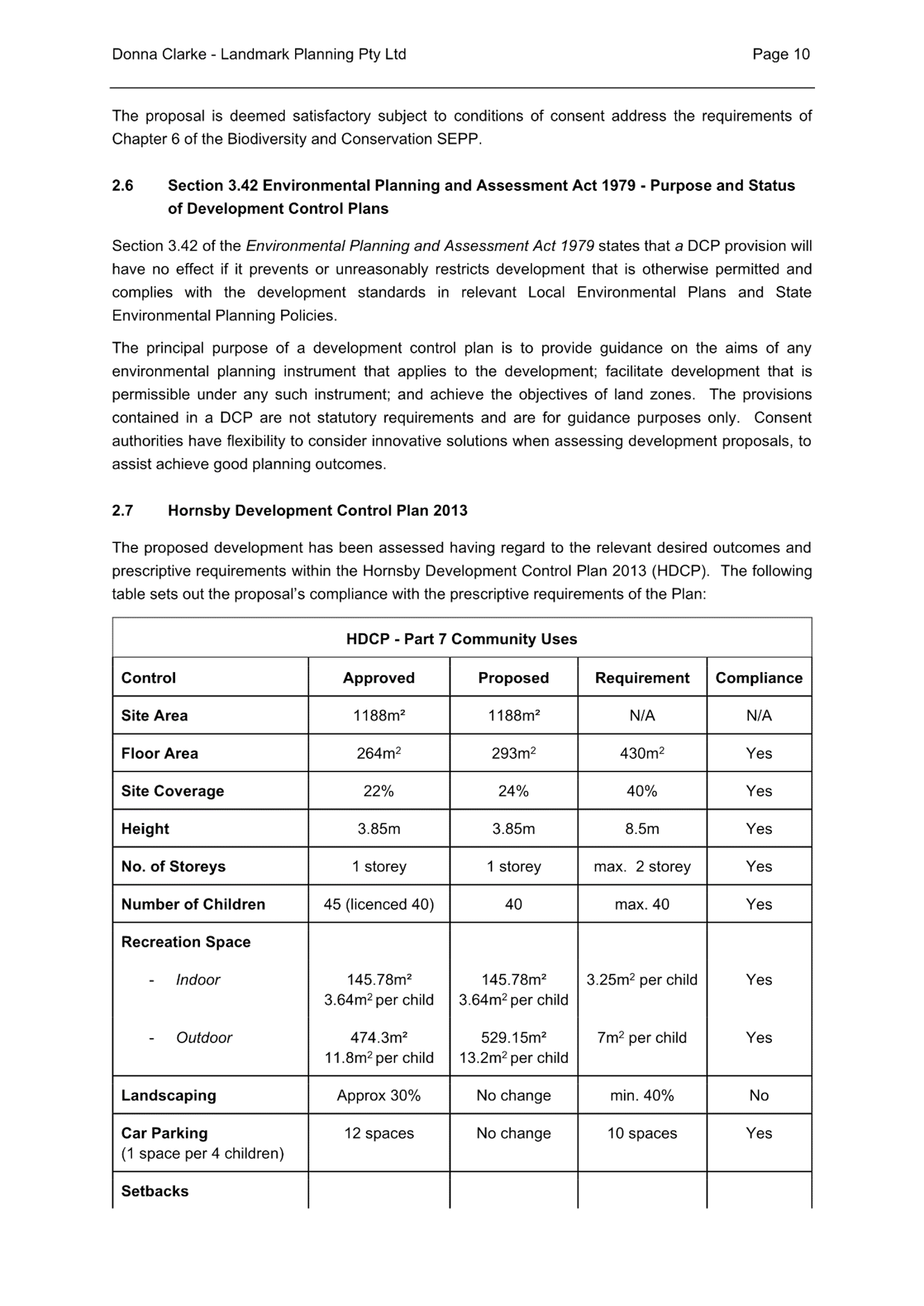
Hornsby Shire Council Table of Contents
Page 1
ITEMS
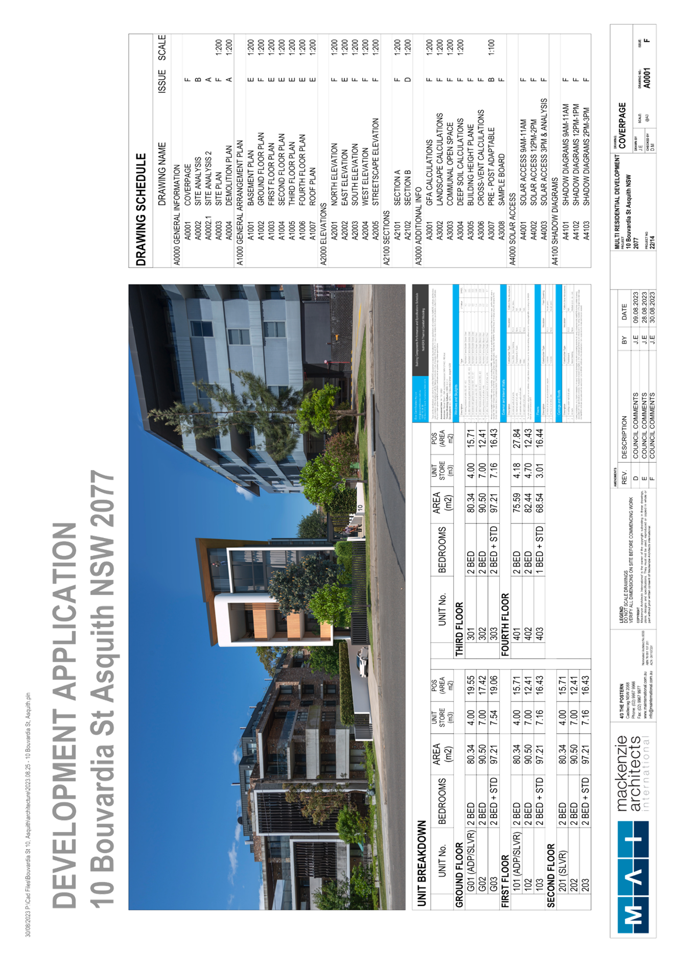
Item 2 LPP29/23 DA/389/2023 - Alterations and Additions to Existing Childcare Centre - Jack and Jill Kindergarten, 1 Hall Road, Hornsby............ 1
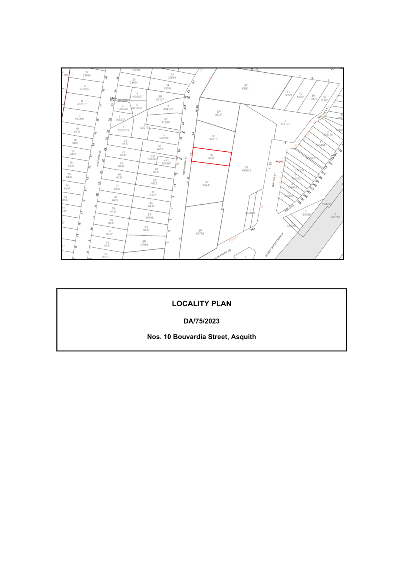
Item 3 LPP33/23 DA/75/2023 - Demolition of Existing Structures and Construction of a 5 Storey Residential Flat Building Comprising 15 units - 10 Bouvardia Street, Asquith........................... 58
Item 4 LPP36/23 Reporting Development Applications for Determination by the Hornsby Local Planning Panel over 180 Days...... 180
LPP Report No. LPP29/23
Local Planning Panel
Date of Meeting: 27/09/2023
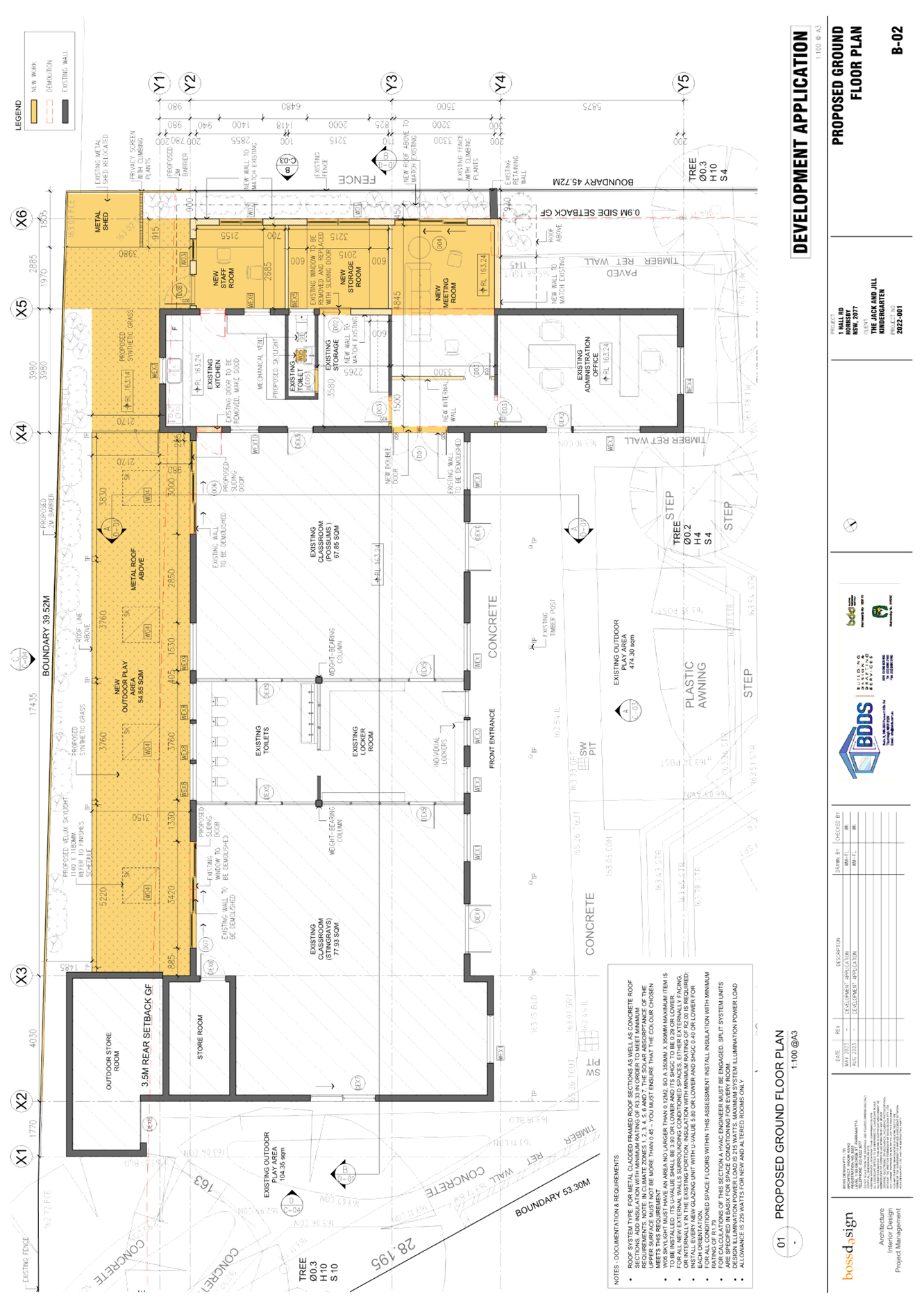
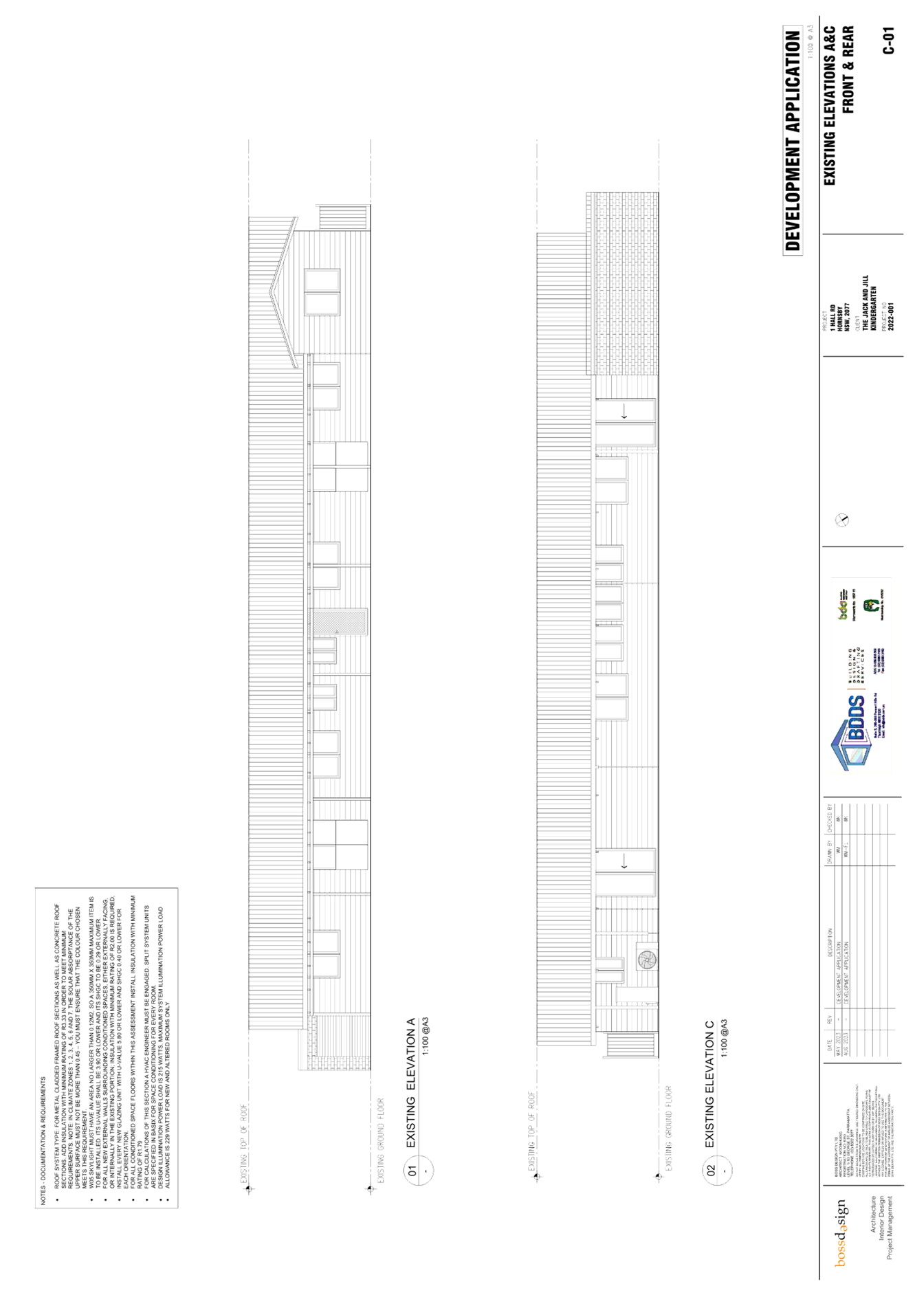
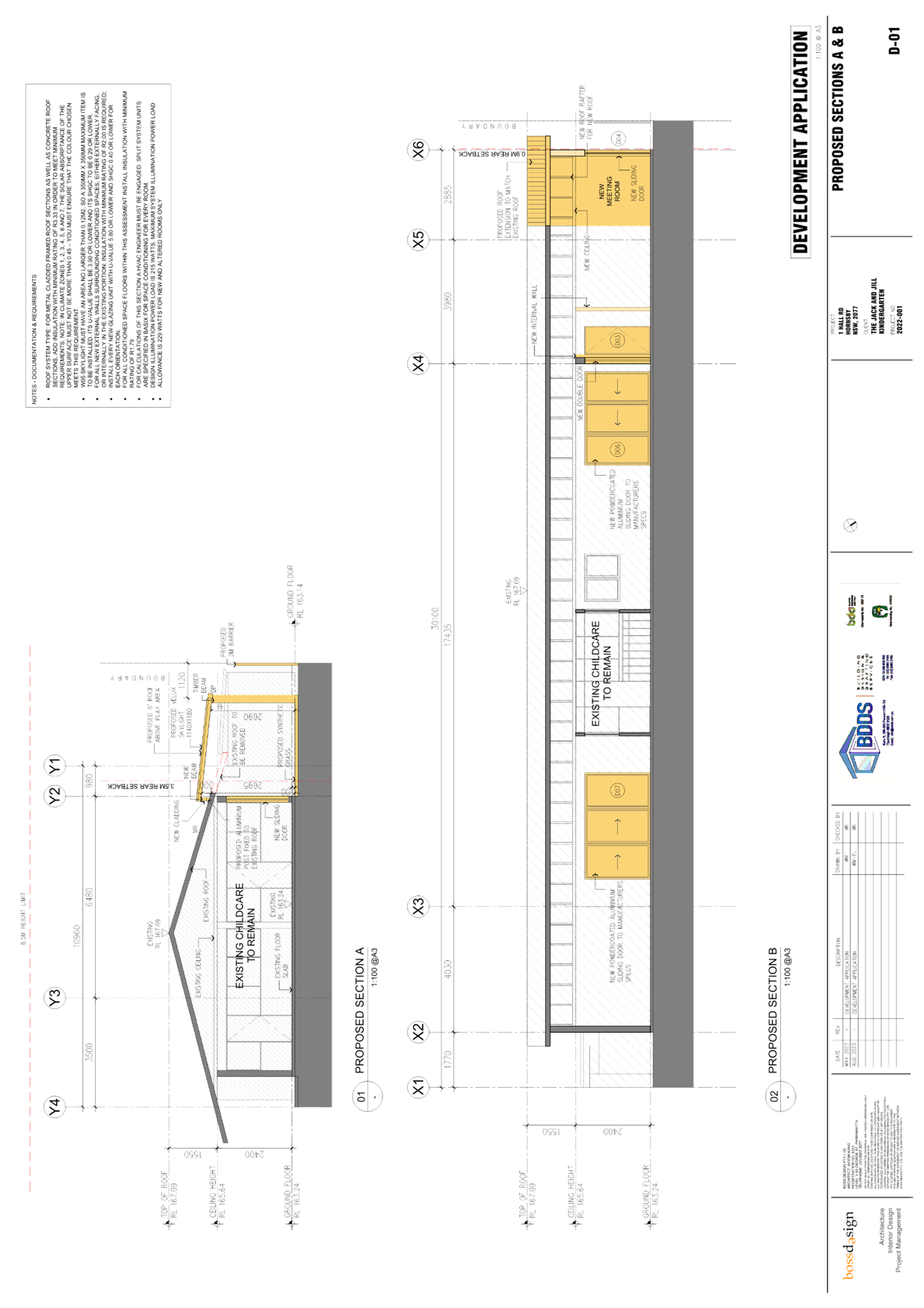
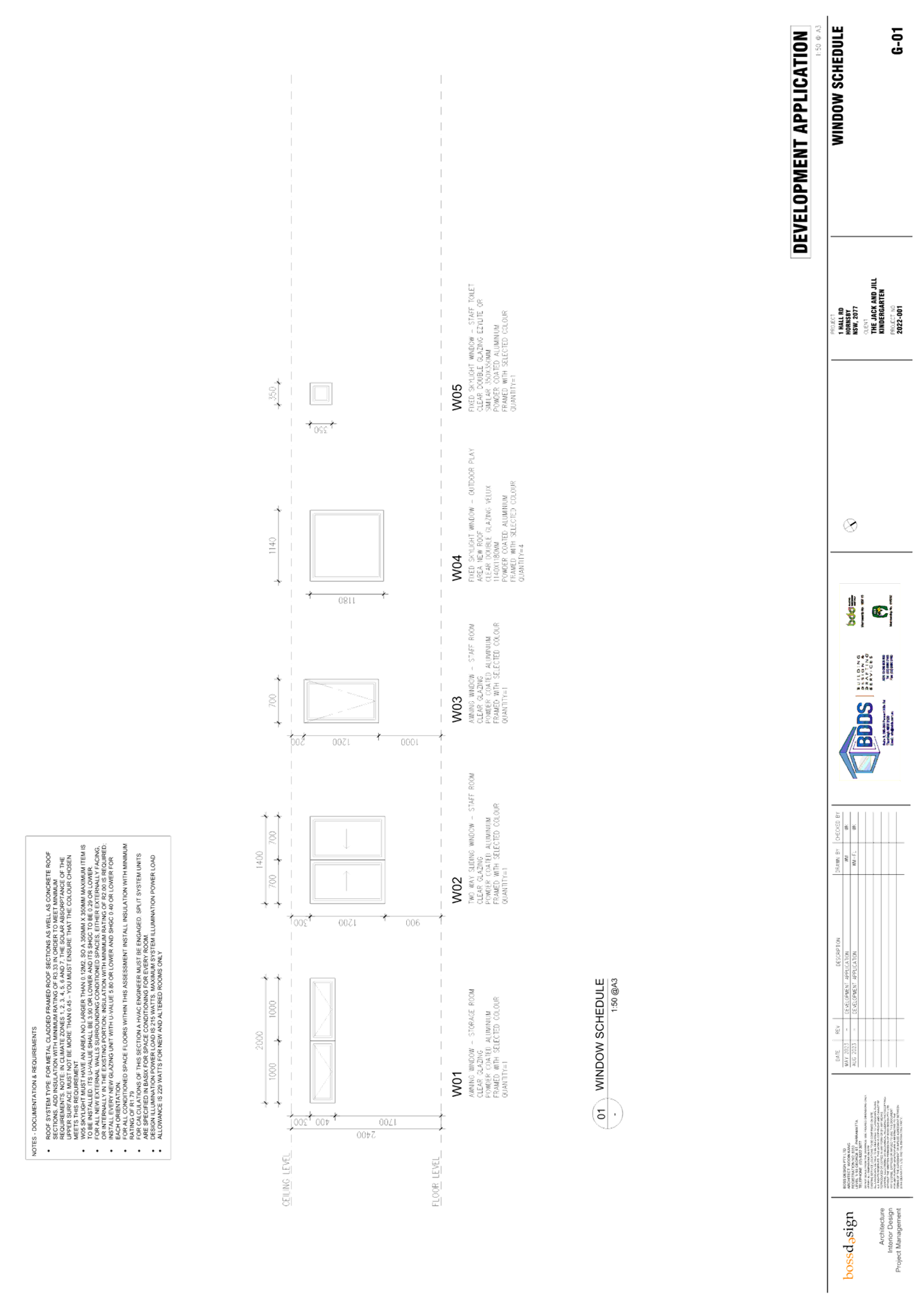
DA/389/2023 - ALTERATIONS AND ADDITIONS TO EXISTING CHILDCARE CENTRE - JACK AND JILL KINDERGARTEN, 1 HALL ROAD, HORNSBY
|
DA No: |
DA/389/2023 (Lodged on 10 May 2023) |
|
Description: |
Alterations and additions to existing childcare centre |
|
Property: |
Lot 2 DP 565080, No.1 Hall Road, Hornsby - Jack and Jill Kindergarten |
|
Applicant: |
Boss Design Pty Ltd |
|
Owner: |
Hornsby Shire Council |
|
Estimated Value: |
$231,600 |
|
Ward: |
B Ward |
|
Clause 4.6 Request: |
N/A |
|
Submissions: |
One |
|
LPP Criteria: |
Council owned land |
|
Author: |
Independent report prepared by Landmark Planning |
|
COI Declaration: |
No Council staff involved in the assessment of this application have declared a Conflict of Interest. |
|
THAT Development Application No. DA/389/2023 for alterations & additions to an existing child care centre at Lot 2 DP 565080, No. 1 Hall Road, Hornsby be approved subject to the conditions of consent detailed in Schedule 1 of the Independent Assessment Report. |
EXECUTIVE SUMMARY
· The application involves alterations & additions to an existing child care centre known as Jack & Jill Kindergarten.
· The application involves land owned by Hornsby Shire Council and is required to be determined by the Hornsby Local Planning Panel. An independent assessment of the development application has been undertaken by Landmark Planning.
· A total of one submission has been received in respect of the application.
· The assessment report by Landmark Planning is attached to this report for the Hornsby Planning Panel’s consideration. The independent consultant’s report recommends that the application be approved.
ASSESSMENT
CONCLUSION
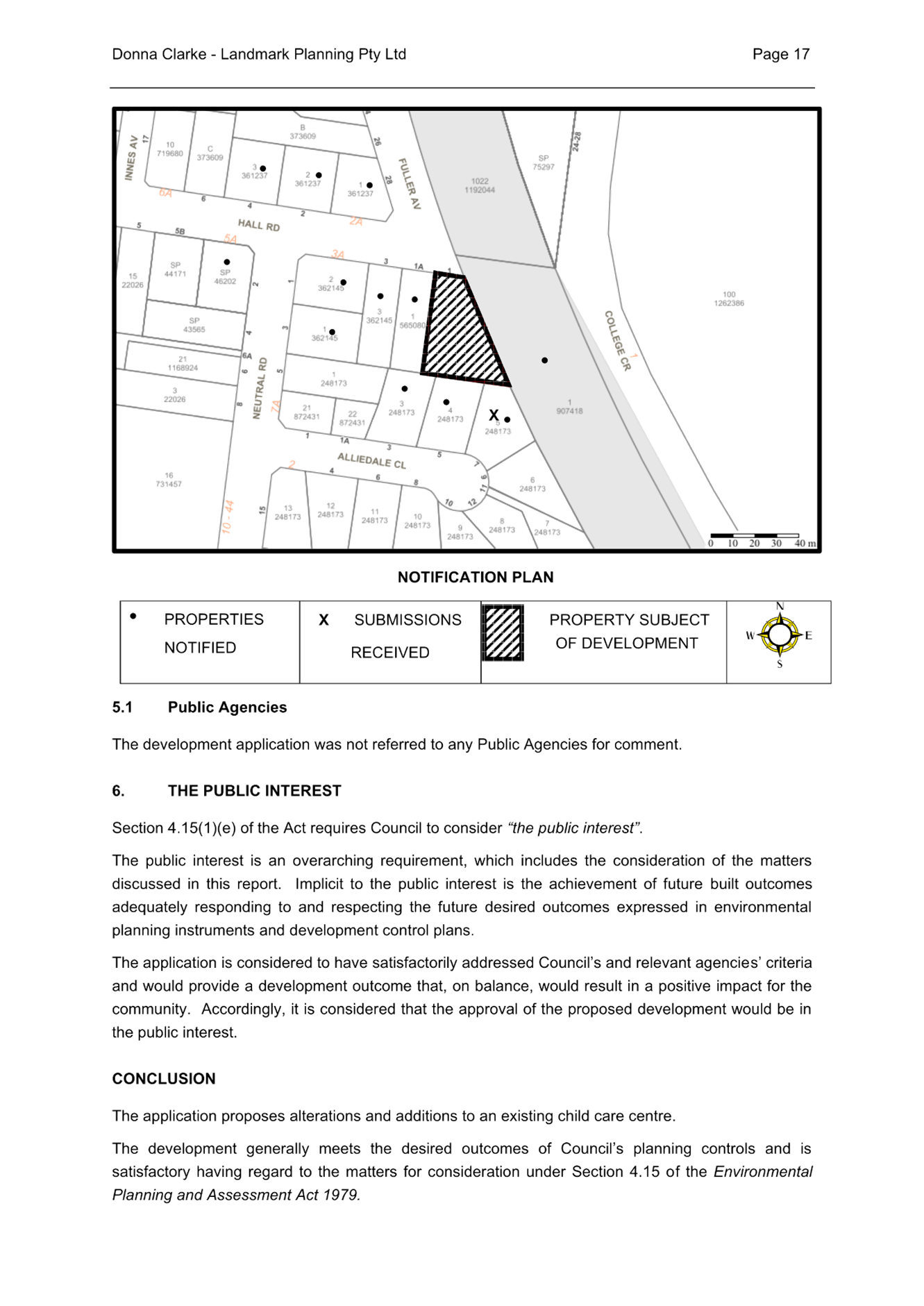
The application proposes alterations and additions to existing childcare centre.
The development generally meets the desired outcomes of Council’s planning controls and is satisfactory having regard to the matters for consideration under Section 4.15 of the Environmental Planning and Assessment Act 1979.
Council received one submission during the public notification period. The matters raised have been addressed in the independent assessment report.
It is recommended that the Hornsby Local Planning Panel approve the application in accordance with the recommendations in the report prepared by Landmark Planning and the conditions of consent in Attachment 2 of this report.
Note: At the time of the completion of this planning report, no persons have made a Political Donations Disclosure Statement pursuant to Section 10.4 of the Environmental Planning and Assessment Act 1979 in respect of the submitted project planning application.
|
Cassandra Williams Major Development Manager - Development Assessments Planning and Compliance Division |
Rod Pickles Manager - Development Assessments Planning and Compliance Division |
|
1.⇩ |
Independent Assessment Report |
|
|
|
2.⇩ |
Locality Plan |
|
|
|
3.⇩ |
Architectural Plans |
|
|
|
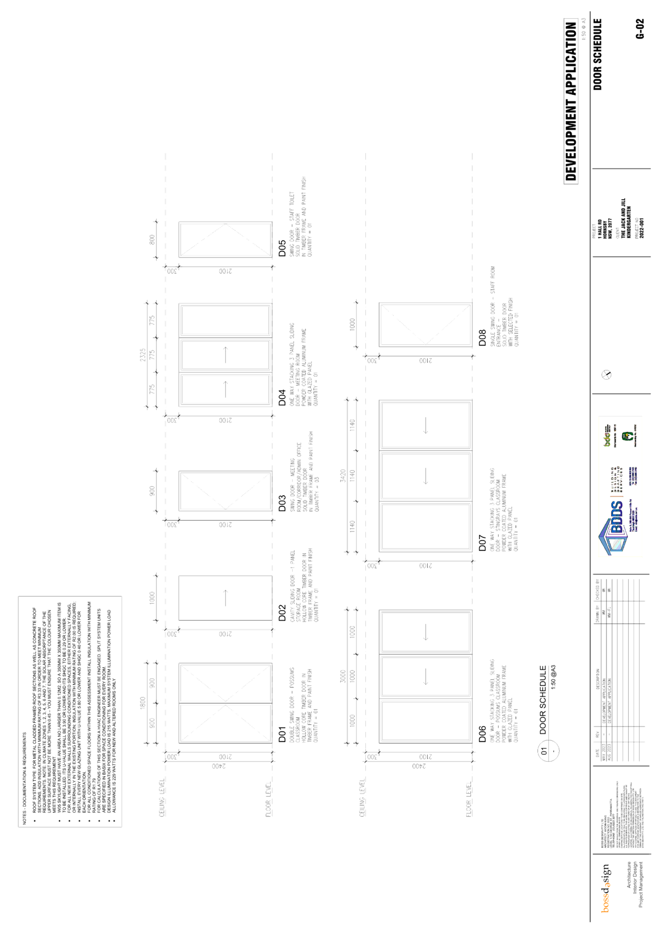
4.⇩ |
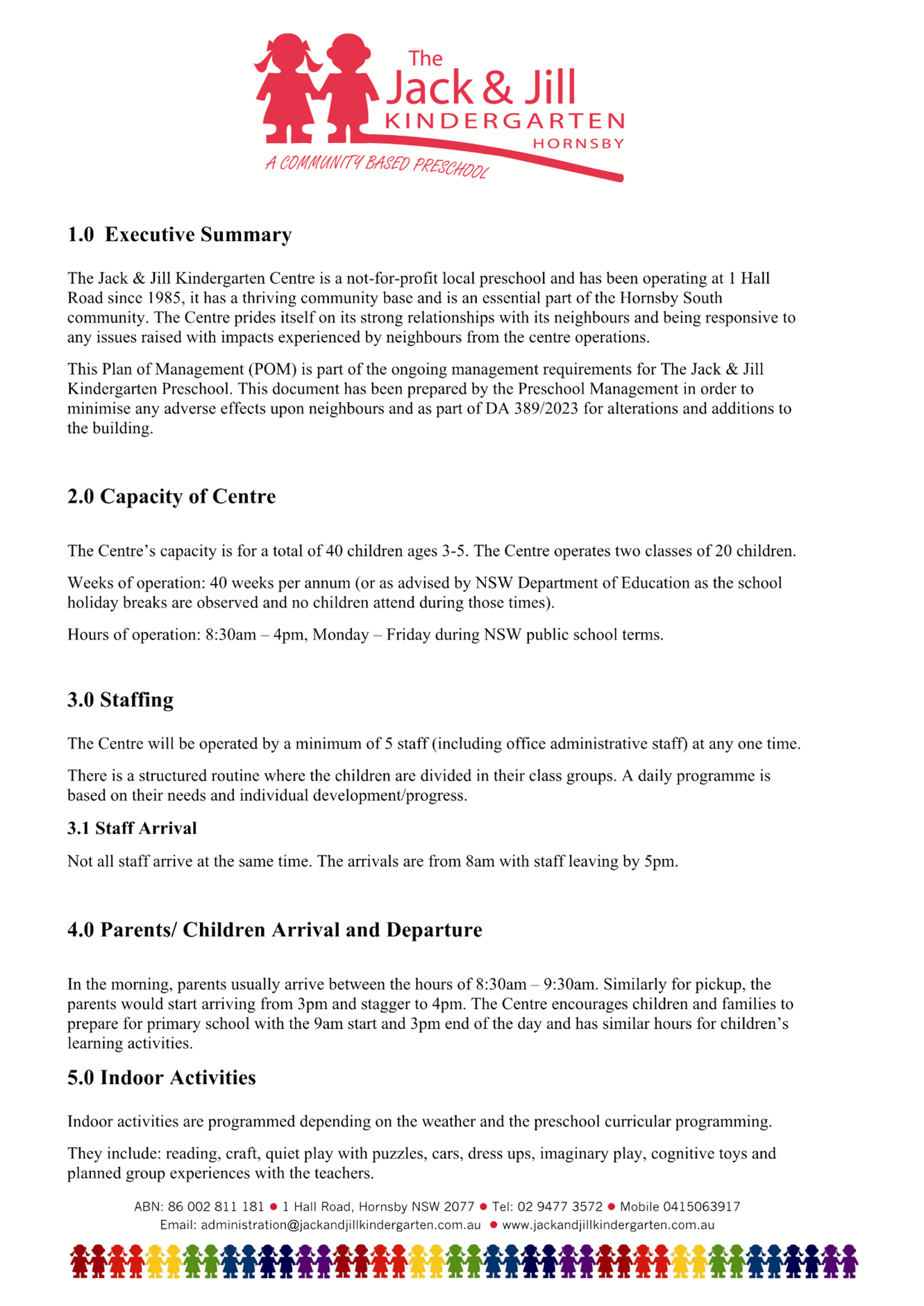
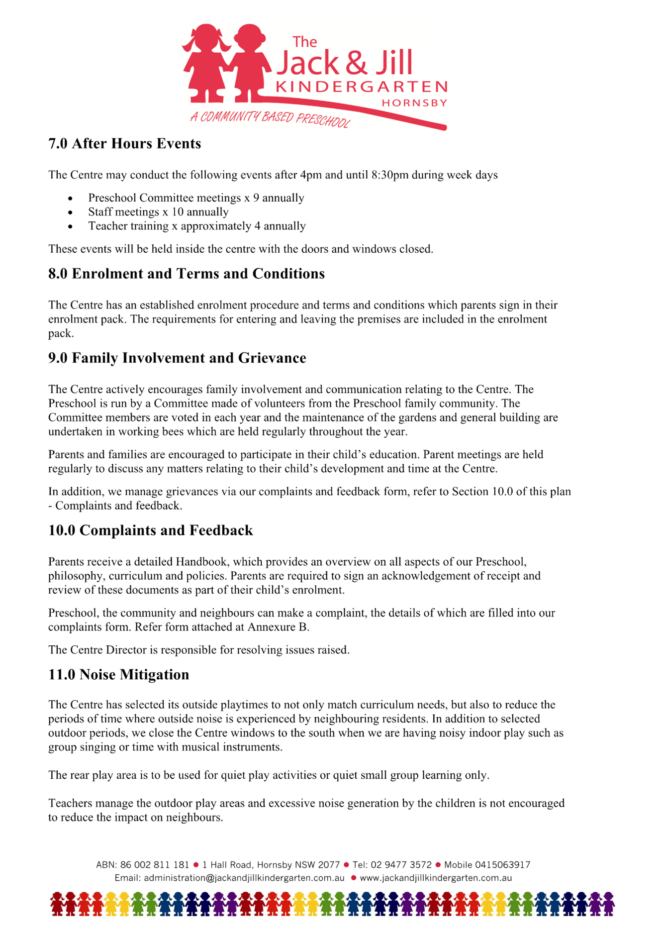
Plan of Management |
|
|
File Reference: DA/389/2023
Document Number: D08702294
LPP Report No. LPP33/23
Local Planning Panel
Date of Meeting: 27/09/2023
3DA/75/2023 - DEMOLITION OF EXISTING STRUCTURES AND CONSTRUCTION OF A 5 STOREY RESIDENTIAL FLAT BUILDING COMPRISING 15 UNITS - 10 BOUVARDIA STREET, ASQUITH
|
DA No: |
DA/75/2023 (Lodged on 24 January 2023) |
|
Description: |
Demolition of existing structures and the construction of a 5 storey residential flat building comprising 15 units, basement car parking and associated landscaping/civil works |
|
Property: |
Lot 56 DP 8437, No. 10 Bouvardia Street, Asquith |
|
Applicant: |
Mackenzie Architects International Pty Ltd |
|
Owner: |
Jaami Holdings Pty Ltd, Fmh Nominees Pty Ltd & Fmh Custodian Pty Ltd |
|
Estimated Value: |
$4,525,000 |
|
Ward: |
A |
|
Clause 4.6 Request: |
Clause 4.3 Height of buildings in the HLEP R4 High density residential zone |
|
Submissions: |
Two |
|
LPP Criteria: |
SEPP 65 development |
|
Author: |
Madeleine Bayman, Senior Town Planner |
|
COI Declaration: |
No Council staff involved in the assessment of this application have declared a Conflict of Interest. |
|
THAT Council assume the concurrence of the Secretary of the Department of Planning and Environment pursuant to Clause 4.6 of the Hornsby Local Environmental Plan 2013 and approve Development Application No. DA/75/2023 for the demolition of existing structures and construction of a 5 storey residential flat building comprising 15 units, basement car parking and associated landscaping/civil works at Lot 56 DP 8437, No. 10 Bouvardia Street, Asquith, subject to the conditions of consent detailed in Schedule 1 of LPP Report No. LPP33/23. |
executive summary
· The application involves the demolition of existing structures and the construction of a 5 storey residential flat building comprising 15 units, basement car parking and associated landscaping/civil works.
· The proposal does not comply with the ‘Height of buildings’ development standard contained within Clause 4.3 of the Hornsby Local Environmental Plan 2013. The applicant has made a submission in accordance with Clause 4.6 ‘Exceptions to development standards’ of the Hornsby Local Environmental Plan 2013 to contravene the Clause 4.3 ‘Height of buildings’ development standard. The submission is considered well founded and is supported.
· A total of 2 submissions have been received in respect of the application.
· The application is required to be determined by the Hornsby Council Local Planning Panel as State Environmental Planning Policy No. 65 Design Quality of Residential Development applies.
· It is recommended that the application be approved.
On 11 November 2015, Council granted consent to DA/742/2015 for demolition of existing structures and construction of a five storey residential flat building comprising 34 units at Nos. 12 & 14 Bouvardia Street Asquith, which resulted in the isolation of No. 10 Bouvardia Street, Asquith (the subject site).
The report for DA/745/2015 (No. 12-14 Bouvardia Street) provided the following commentary regarding isolation of the subject site:
“The HDCP requires sites to have a minimum frontage of 30 metres to Bouvardia Street. The subject site complies with this requirement. The HDCP also requires the following:
Where a development proposal results in an adjoining site within the precinct with no street frontage or a primary street frontage of less than 30m, proponents should demonstrate that orderly and economic development of the site can be achieved under this DCP.
Where a property is likely to be isolated by a proposed development and it cannot be demonstrated that orderly and economic development (isolated) site can be achieved, applicants should provide documentary evidence that genuine and reasonable attempt has been made to purchase an isolated site based on a fair market value.
Approval has been granted for a five storey residential flat development at Nos. 4-8 Bouvardia Street under DA/270/2015. Approval of the proposed development would result in the isolation of No. 10 Bouvardia Street for future five storey development as the primary street frontage is 18 metres which is less than the required 30 metre minimum frontage requirement under the HDCP.
In accordance with the provisions of the HDCP, the Applicant sought to resolve the isolation of No. 10 by making genuine and reasonable attempts to acquire the site at a fair market value. Offers between $1.4 million to $1.85 million were made to the adjoining owner. Details of the attempts made to acquire No. 10 were submitted with the Application and include a statutory declaration outlining the offers made by the landowner to purchase No. 10 and a letter of offer sent by the landowner’s property agent. These attempts to acquire No. 10 were unsuccessful.
Further to the above, the landowners at Nos. 4-8 Bouvardia Street provided evidence under DA/270/2015 indicating offers made to the adjoining landowner and provided an independent valuation of the property at No. 10 Bouvardia Street. The independent valuation concluded that the property value for No. 10 Bouvardia Street was between $845, 000 to $1.1 million. These attempts to acquire No. 10 were also unsuccessful.
No submissions were received from the owner of No. 10 Bouvardia Street opposing the subject development.
The adjoining site at No. 10 Bouvardia Street has a frontage of 18 metres and a depth of 50 metres which results in an area of 900m². Whilst the subject application did not include the submission of indicative building envelopes for the adjoining isolated site, residential flat development has been approved on similar sized sites within the Hornsby Shire. For example, a five storey residential flat building comprising 15 units and a single level of basement car parking was approved at No. 229 Carlingford Road under DA/644/2013. The site at No. 229 Carlingford Road has a frontage of 17.1 metres, depth of 53.5 metres and an area of 915m². The approved development comprised a two way aisle (5.8 metre wide), perpendicular parking (5.4 metres) for 12 vehicles and parallel parking (2.4 metres) for an additional 6 vehicles (total width 13.6 metres) and turning area. The remaining 3.5 metre site width was proportioned along the side boundaries for landscaping. As the site at No. 10 Bouvardia Street is of a similar size, the subject site would be capable of accommodating a residential flat development.
Based on the above, the Applicant has made reasonable attempts to acquire the adjoining site in accordance with the Land and Environment Court principles and the adjoining site is assessed as being capable of being developed. The proposal is considered to be acceptable in respect to the HDCP prescriptive measures for site requirements.”
On 24 January 2023, the subject development application was lodged.
On 3 April 2023, the application was reviewed by Council’s Design Excellence Panel (DEP). The Panel did not support the proposal in its current form and suggested a number of matters be addressed in this regard. A summary of how these matters have been addressed is discussed below.
On 27 April 2023, Council sent a RFI to address the matters raised by DEP and insufficiencies with regards to waste management, BCA requirements, traffic and safety and stormwater management.
On 15 June 2023, the application was reviewed by Council’s Development Advisory Panel (DAP) who raised concerns with the front and rear setbacks, landscaping within the front setback, floor to ceiling heights, location of bin storage area at ground level and the location of fire stairs.
On 15 June 2023, a meeting was undertaken with the Applicant to discuss outstanding concerns with the proposal.
On 3 July 2023, amended plans were submitted to address Council concerns.
On 5 July 2023, Council requested further information and supporting documentation to reflect the amended plans submitted. After ongoing back and forth, the Applicant submitted a set of amended plans to address Council’s concerns.
During this time, a draft set of plans were submitted for Council to review prior to formal lodgement.
On 24 July 2023, the application was reviewed at a Pre-Local Planning Panel (LPP) meeting in anticipation for the application to be determined at the August LPP meeting. A number of previous concerns were still outstanding.
On 15 August 2023, after ongoing discussions, amended plans were submitted.
Upon review of the amended plans, Council advised there were still a number of outstanding concerns that had not been adequately addressed. Subsequently, a further meeting was held on 24 August 2023.
Based on Council’s advice, on the 30 August 2023, a final set of plans and documentation were submitted to Council for consideration. These plans (Rev. F) are the basis of this determination.
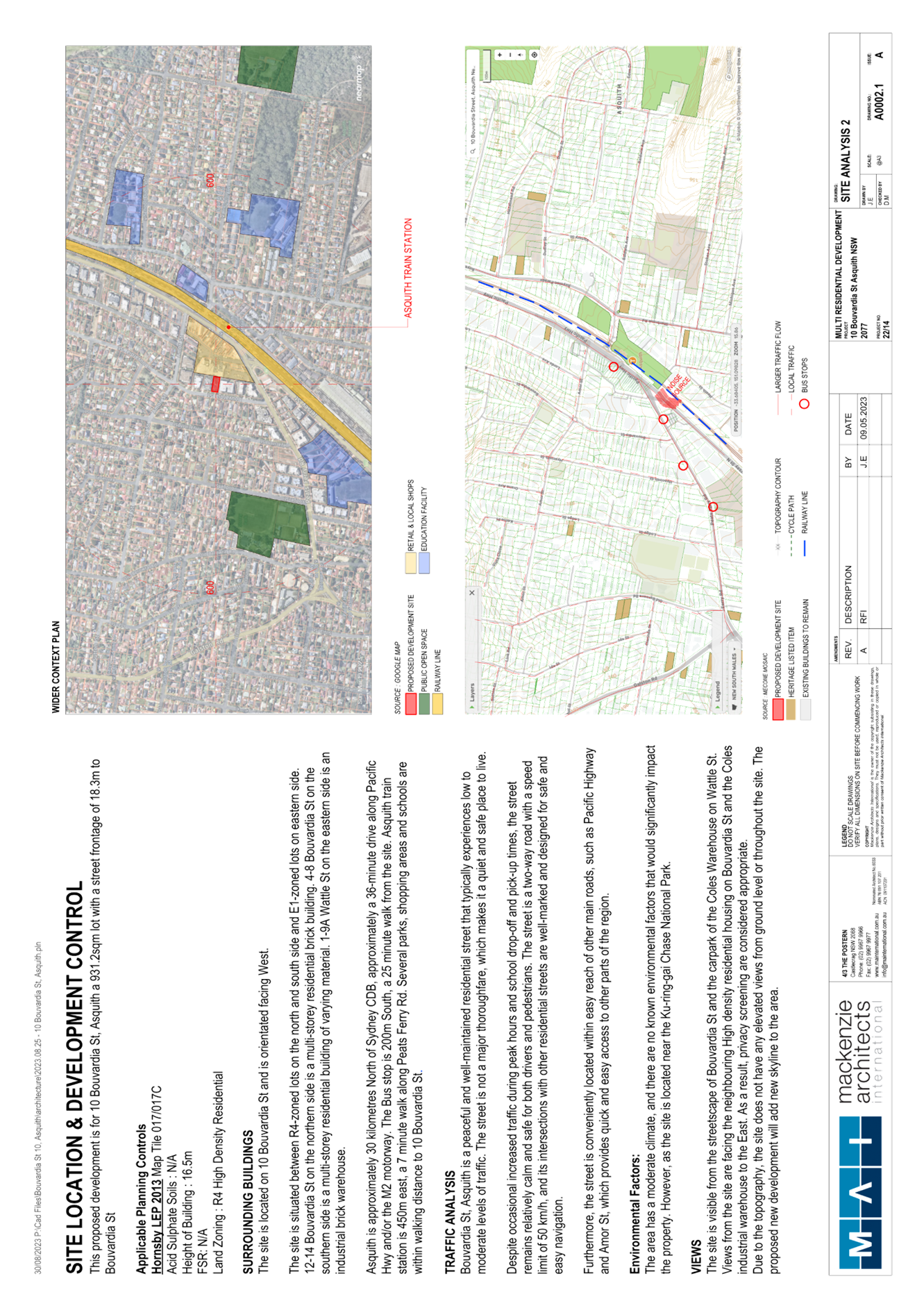
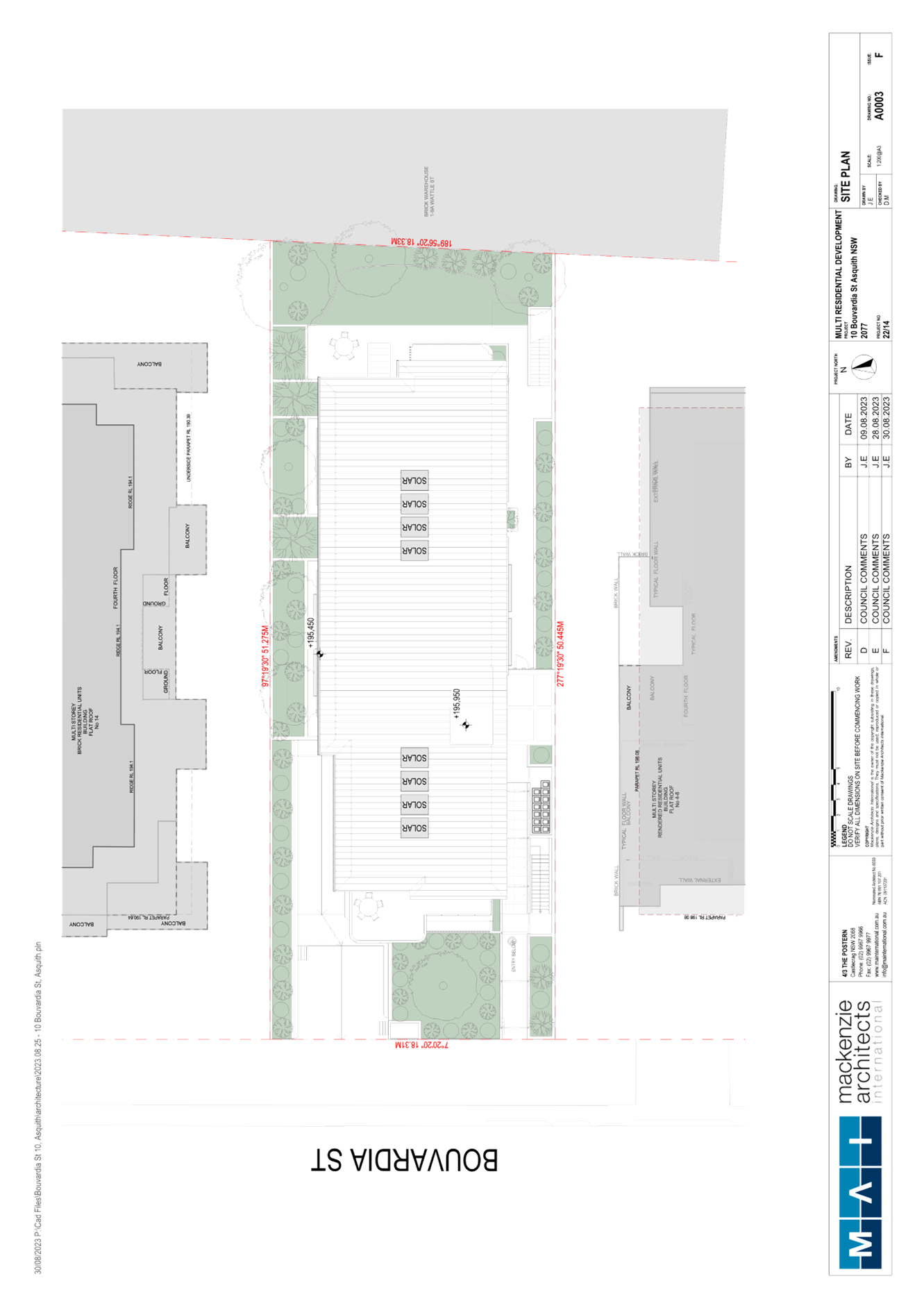
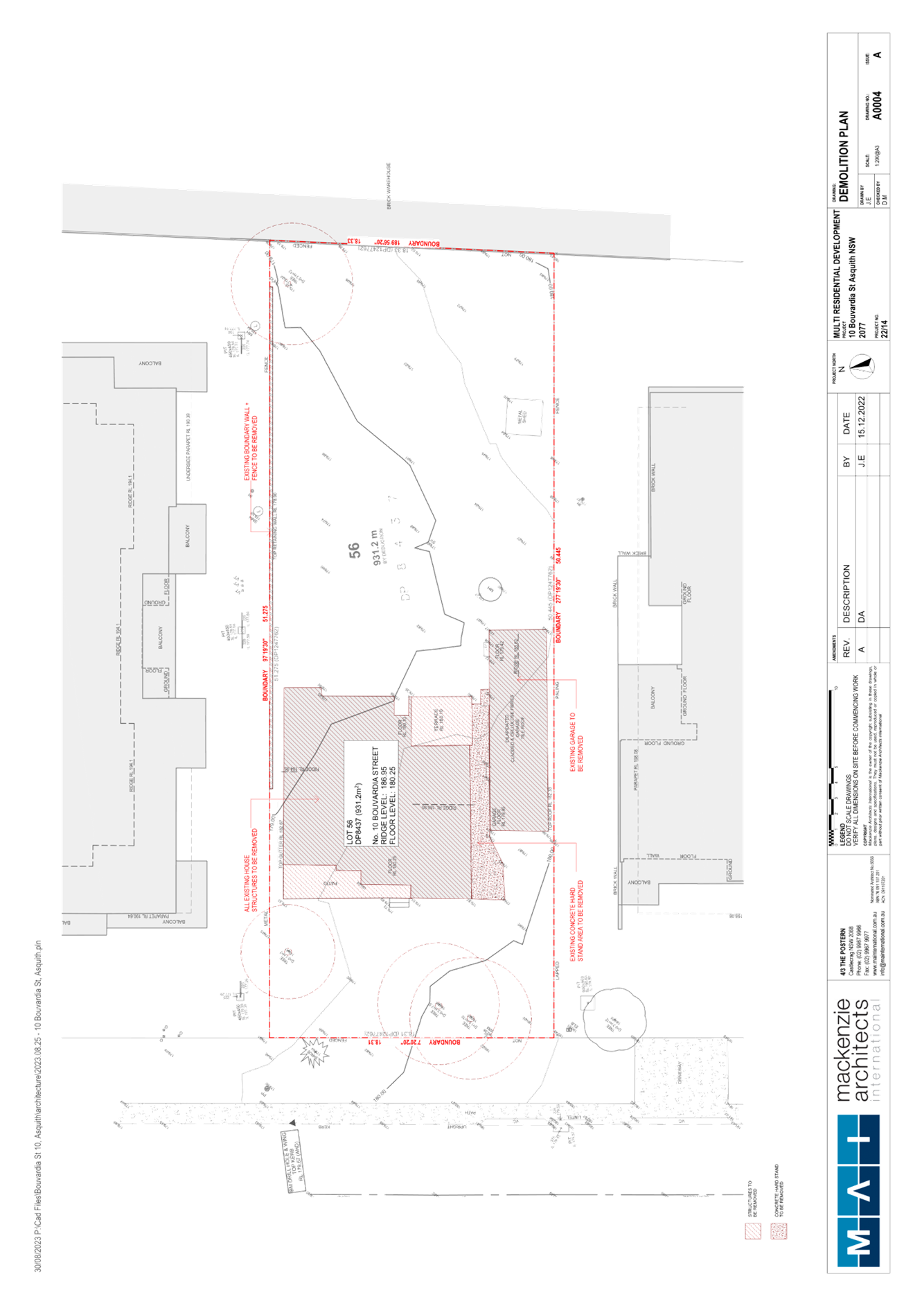
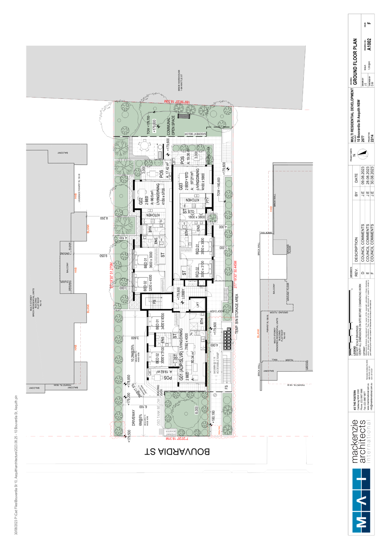
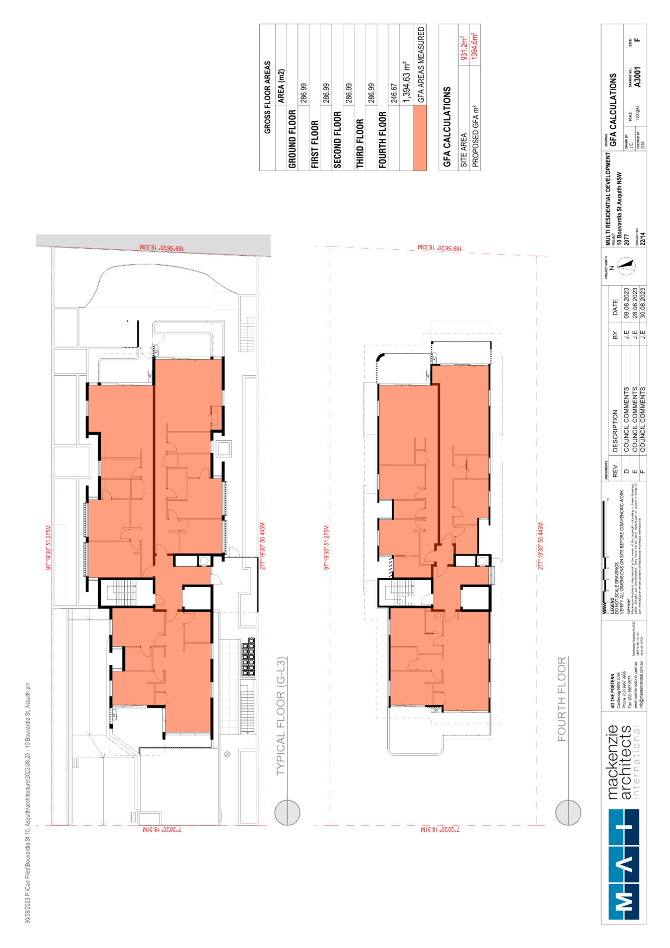
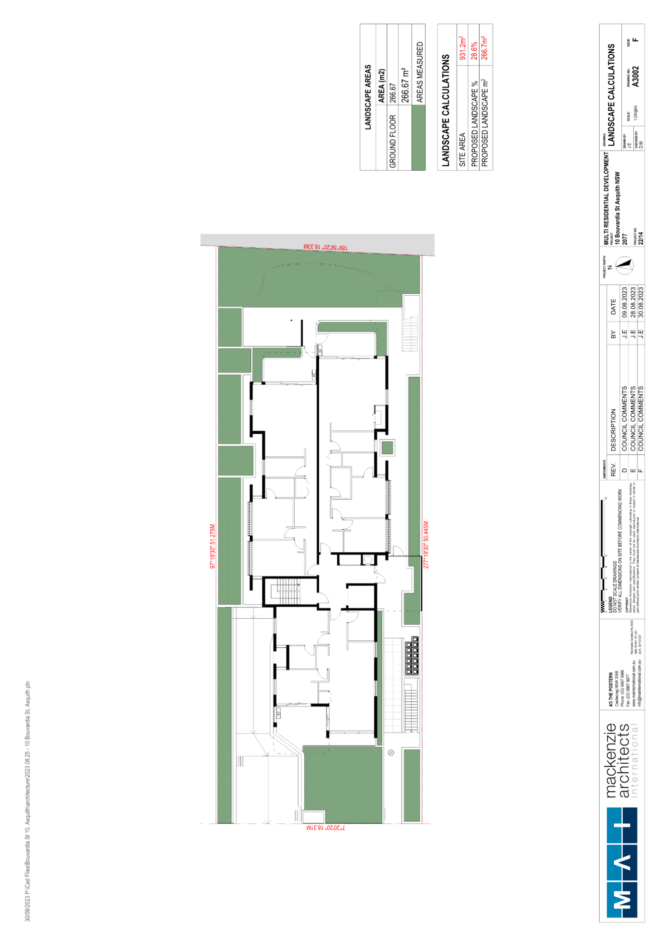
SITE
The 931.2m² is located eastern side of Bouvardia Street, Asquith and contains a dwelling house, detached garage and a metal shed.
The site is relatively flat with a slight cross fall of approximately 1m towards the north side boundary.
The site is not flood or bushfire prone and does not contain any easement or restrictions.
The site is not heritage listed, is not in the vicinity of any heritage listed items and is not located within a heritage conservation area.
The site is surrounded by 5 storey residential flat buildings to the north and south and adjoins Asquith Commercial Centre to the east. The western side of Bouvardia Street contains low density residential dwellings, with the land zoned R2.
The site is located approximately 450m from Asquith Railway Station, with two bus stops located from 110m to 170m from the site with services to Hornsby, Berowra, Mount Colah and Asquith.
The site is situated within a large street block that is bound by Bouvardia Street to the west, Amor Street to the north, and Peats Ferry Road to the south.
PROPOSAL
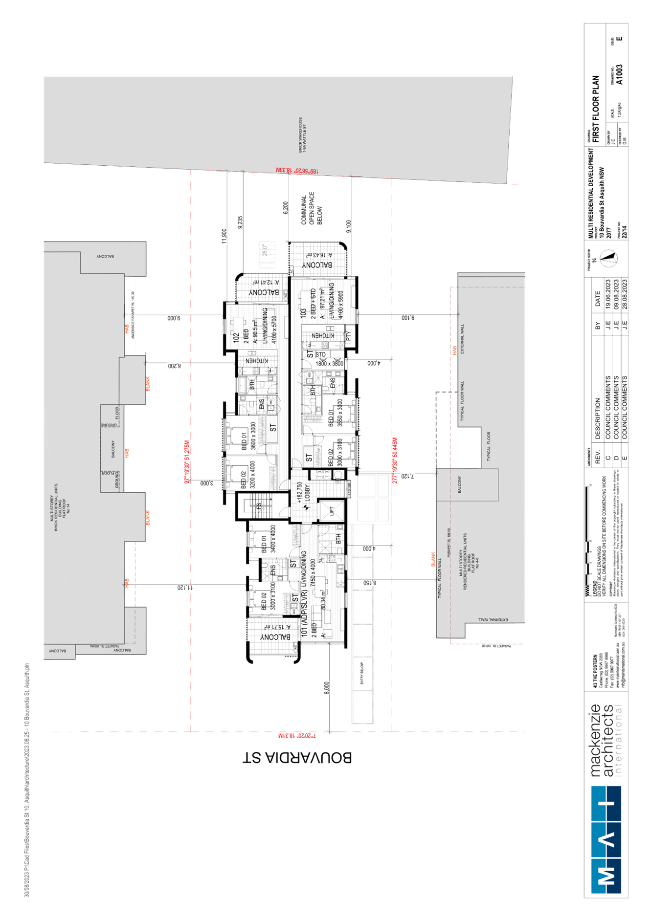
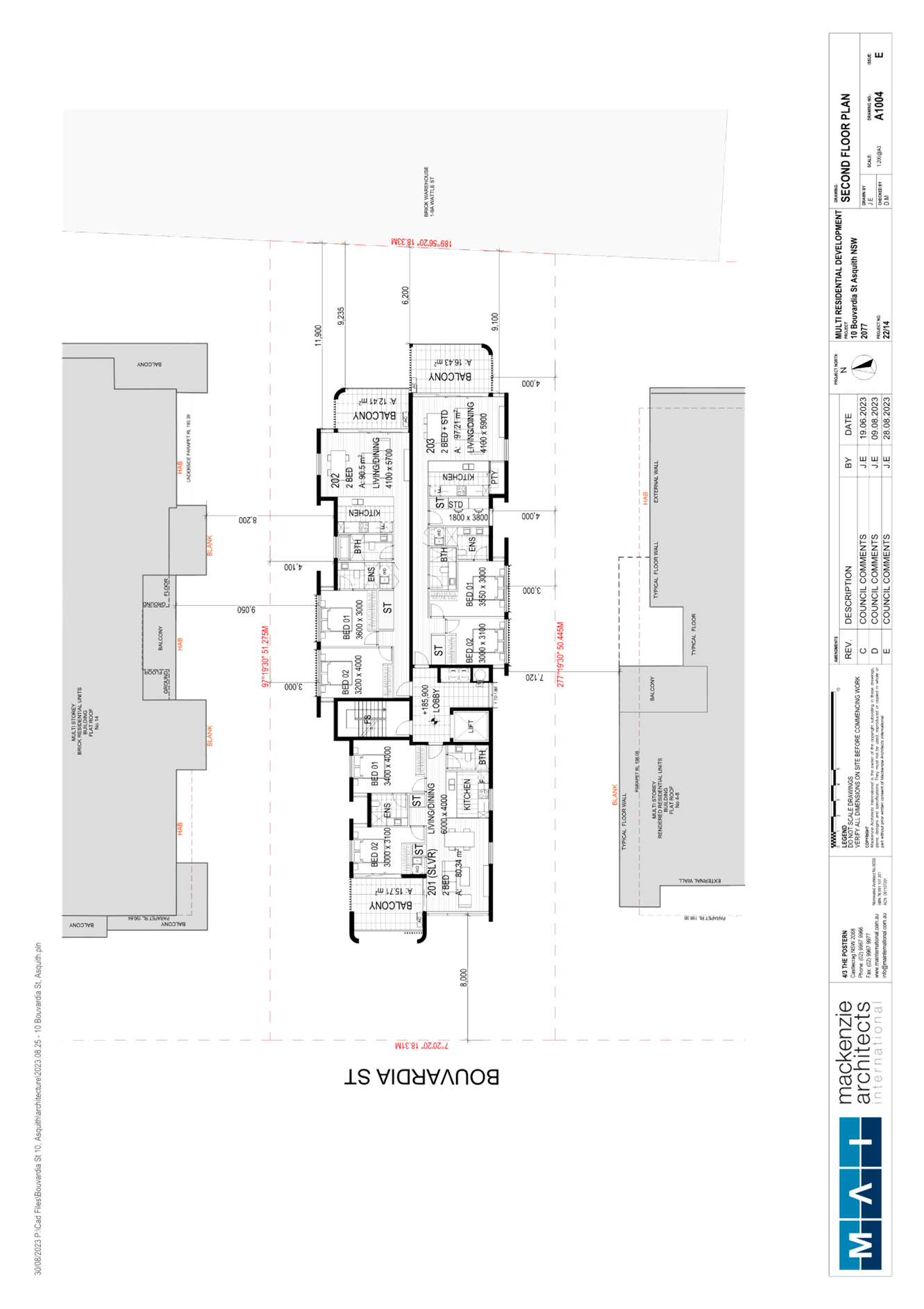
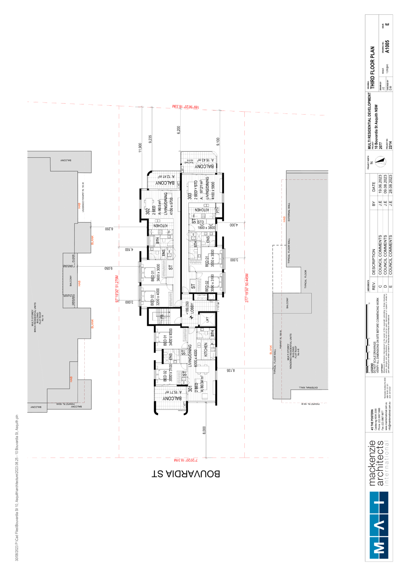
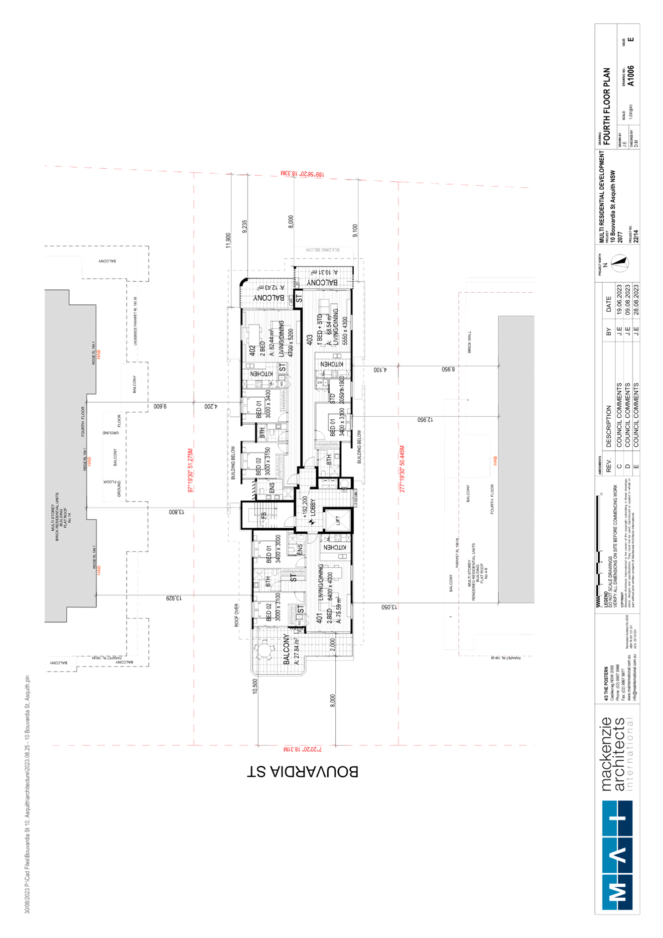
The application proposes construction of a 5 storey residential flat building containing 15 units and basement car parking and the following:
· Demolition of existing dwelling and removal of two trees.
· Construction of a basement car park level containing 18 car spaces, including 15 resident spaces, 3 visitors spaces and a bicycle rack for 5 bikes.
· Provision of 1x 1 bedroom + study unit, 4x 2 bedroom + study units and 10x 2 bedroom units.
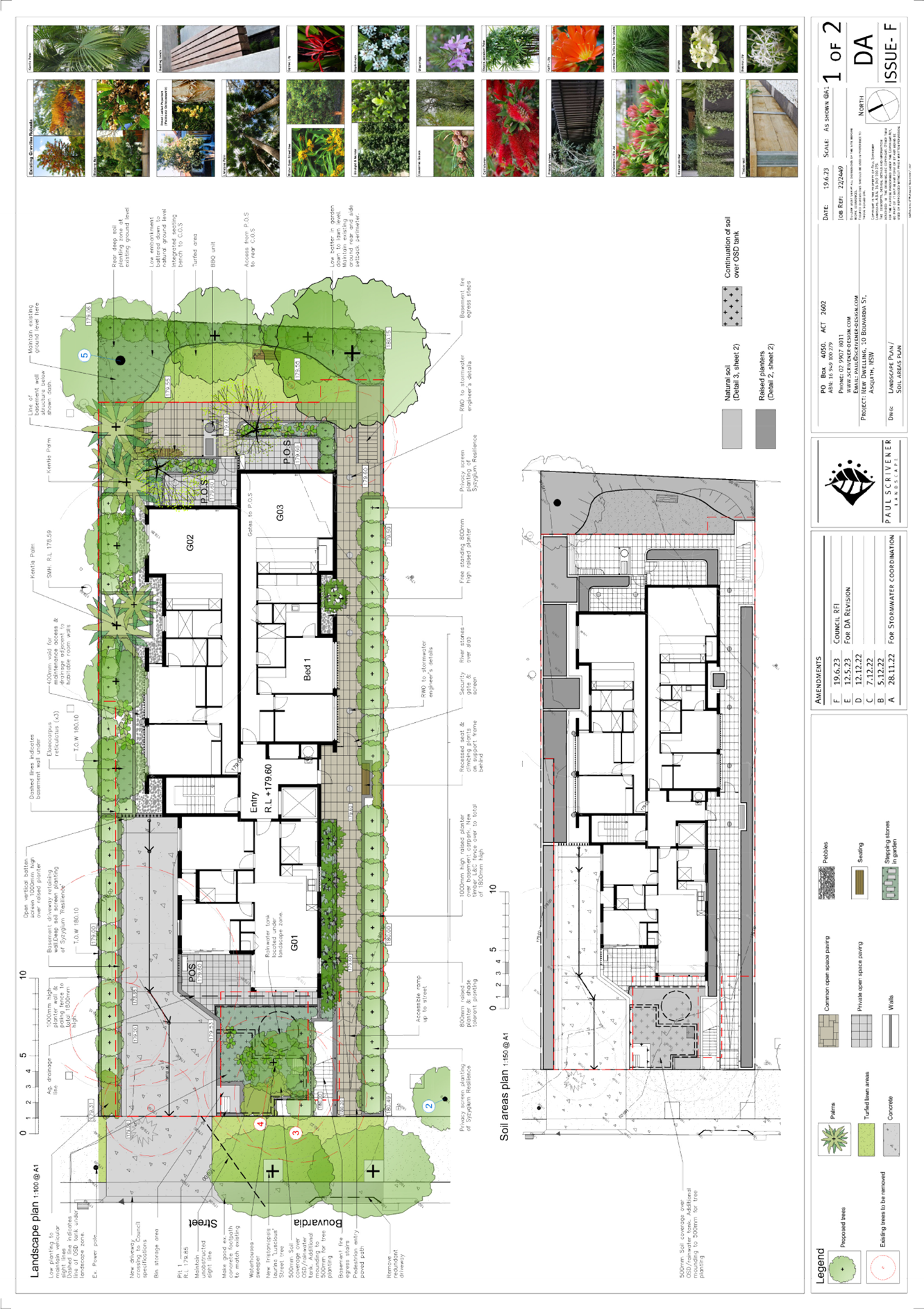
· Associated landscaping, incorporating replacement trees, deep soil planting, shrubs, screening plants and ground covers at ground level.
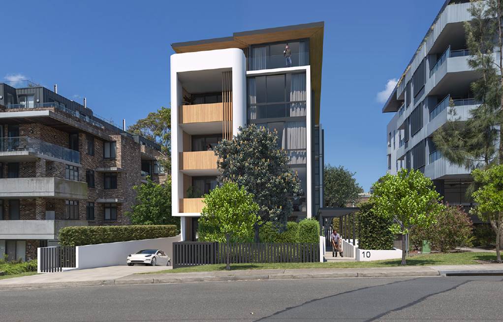
Figure 1: Photomontage of proposed residential flat building - Prepared by Mackenzie Architects International
ASSESSMENT
The development application has been assessed having regard to the Greater Sydney Region Plan - A Metropolis of Three Cities, the North District Plan and the matters for consideration prescribed under Section 4.15 of the Environmental Planning and Assessment Act 1979 (the Act). The following issues have been identified for further consideration.
1. STRATEGIC CONTEXT
1.1 Greater Sydney Region Plan - A Metropolis of Three Cities and North District Plan
The Greater Sydney Region Plan - A Metropolis of Three Cities has been prepared by the NSW State Government to guide land use planning decisions over the next 40 years (to 2056). The Plan sets a strategy and actions for accommodating Sydney’s future population growth and identifies dwelling targets to ensure supply meets demand. The Plan also identifies that the most suitable areas for new housing are in locations close to jobs, public transport, community facilities and services.
The NSW Government will use the subregional planning process to define objectives and set goals for job creation, housing supply and choice in each subregion. Hornsby Shire has been grouped with Hunters Hill, Ku-ring-gai, Lane Cove, Mosman, North Sydney, Ryde, Northern Beaches and Willoughby to form the North District. The Greater Sydney Commission has released the North District Plan which includes priorities and actions for Northern District over the next 20 years.
The identified challenge for Hornsby Shire was to provide an additional 4,350 dwellings by 2021 with further strategic supply targets to be identified to deliver 97,000 additional dwellings in the North District by 2036.
The proposed development would be consistent with the Greater Sydney Region Plan - A Metropolis of Three Cities and the North District Plan, by contributing to achieving the dwelling targets for the region.
2. STATUTORY CONTROLS
Section 4.15(1)(a) requires Council to consider “any relevant environmental planning instruments, draft environmental planning instruments, development control plans, planning agreements and regulations”.
2.1 Hornsby Local Environmental Plan 2013
The proposed development has been assessed having regard to the provisions of the Hornsby Local Environmental Plan 2013 (HLEP).
2.1.1 Zoning of Land and Permissibility
The subject land is zoned R4 (High Density Residential) under the HLEP. The objectives of the R4 zone are:
· To provide for the housing needs of the community within a high density residential environment.
· To promote a variety of housing types within a high density residential environment.
· To enable other land uses that provide facilities or services to meet the day to day needs of residents.
The proposed development is a high density residential development and complies with the zone objectives by providing a variety of housing types and new housing stock. The proposed development is defined as a ‘residential flat building’ under the HLEP and is permissible in the zone with the consent of Council.
2.1.2 Height of Buildings
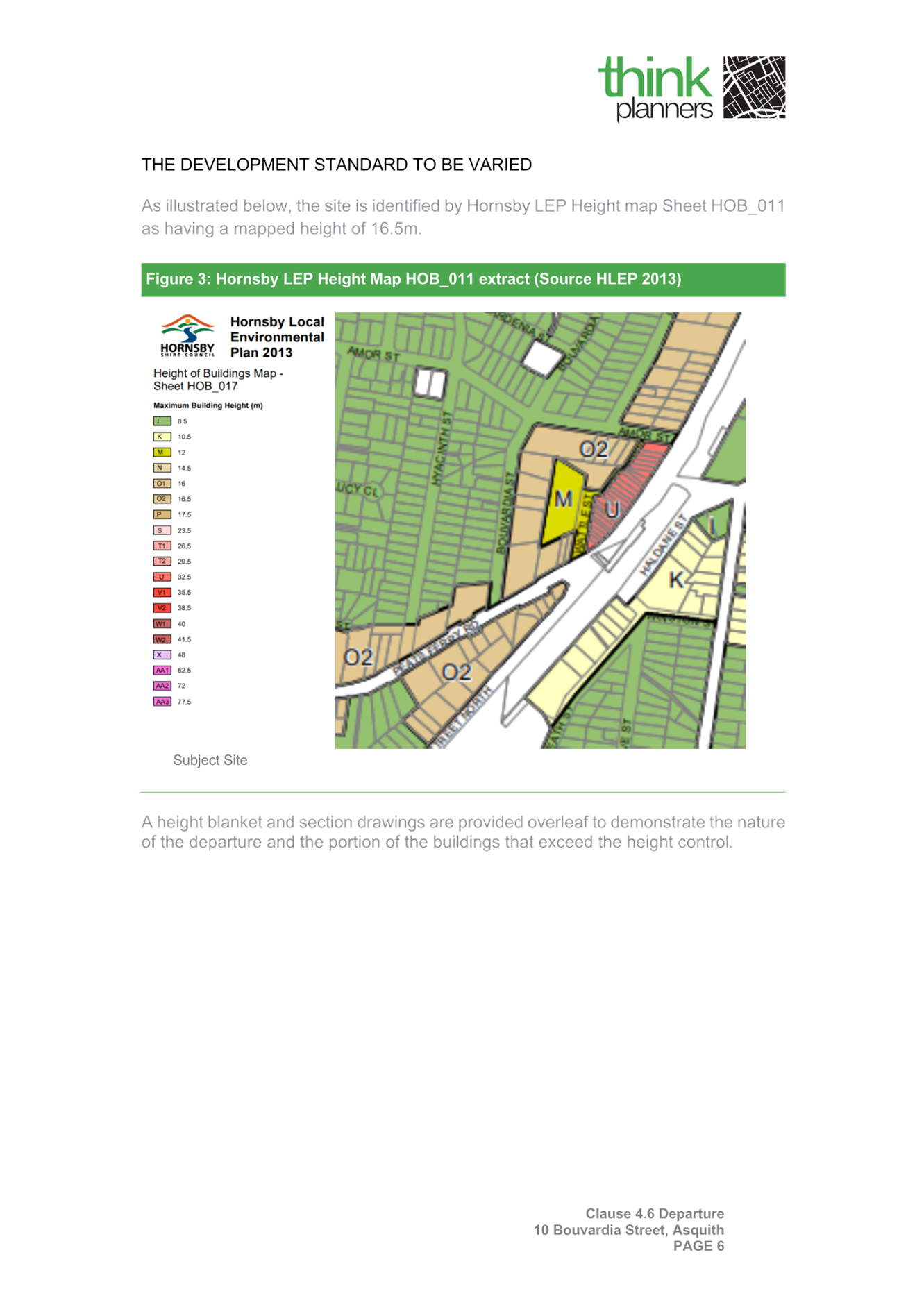
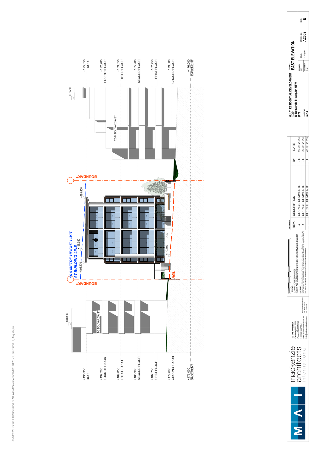
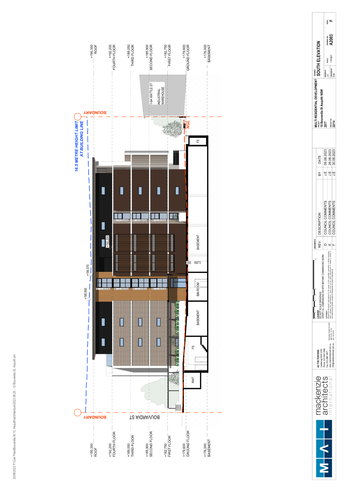
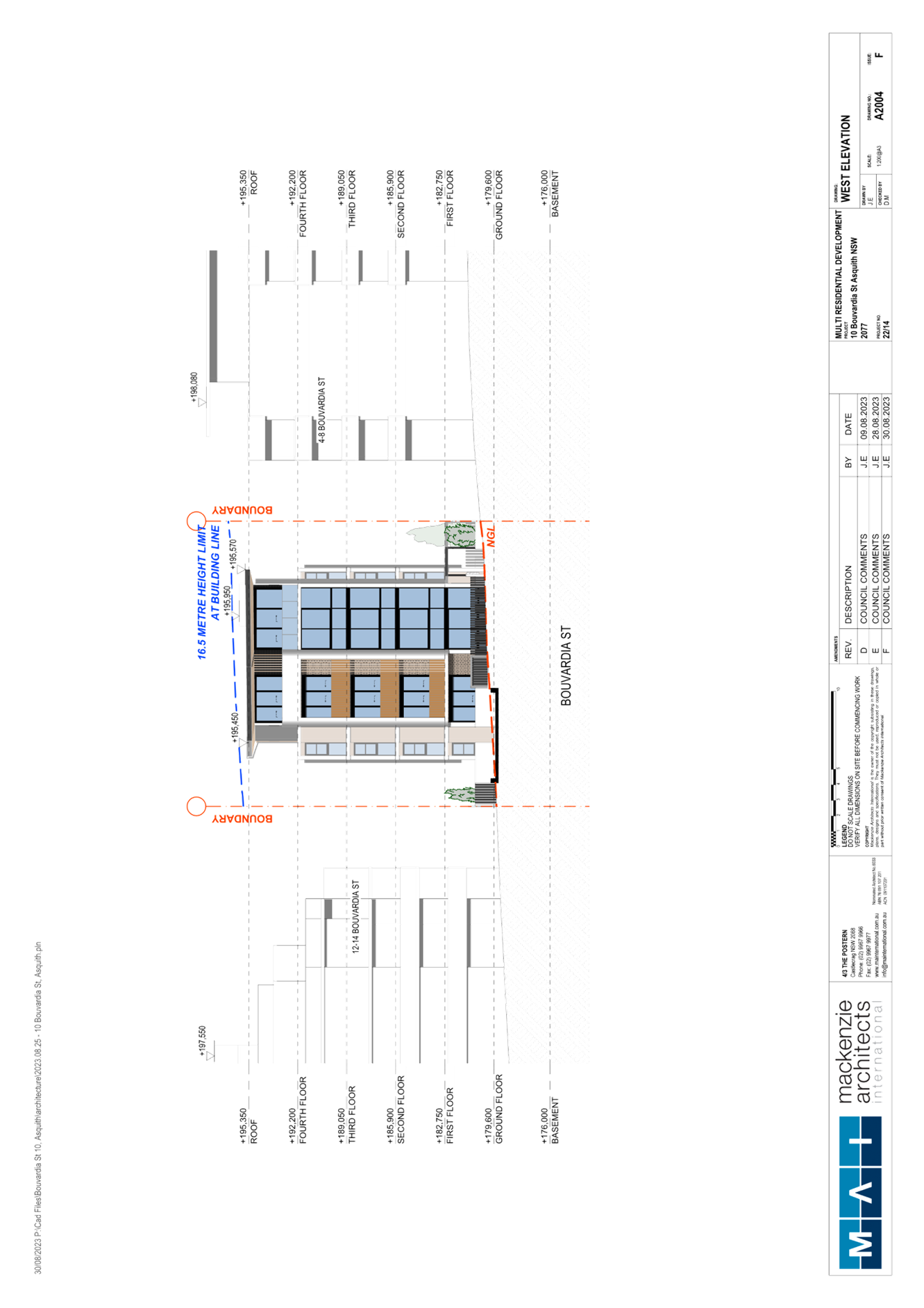
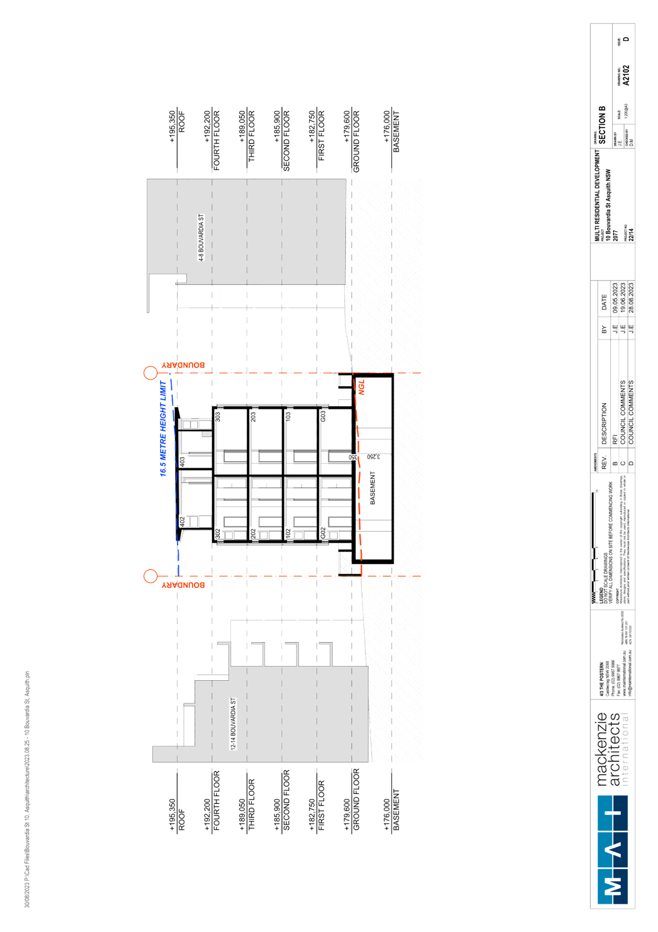
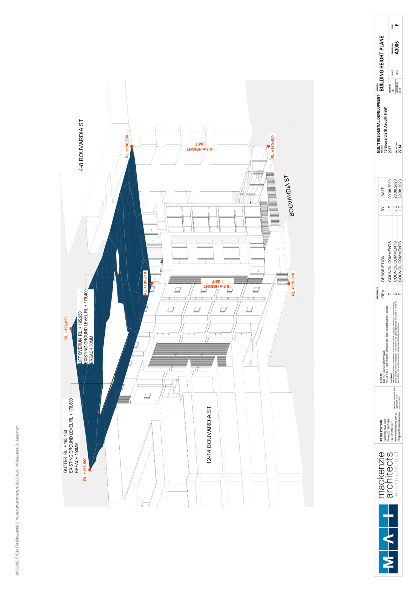
Clause 4.3 of the HLEP provides that the height of a building on any land should not exceed the maximum height shown for the land on the Height of Buildings Map. The maximum permissible height for the subject site is 16.5m.
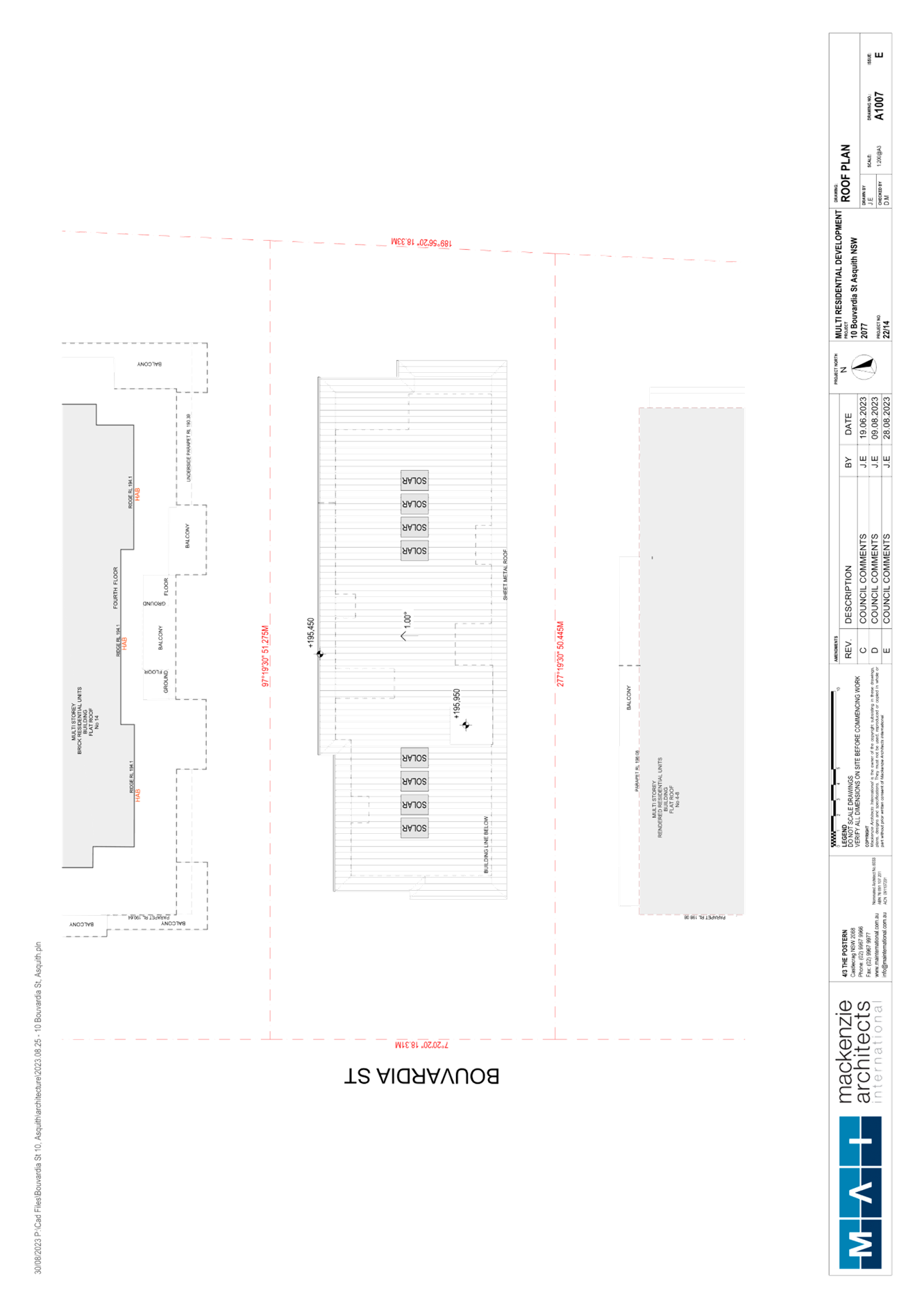
The building proposes a maximum height of 16.65m, a contravention of 0.9% which does not comply with the height of building development standard. The applicant has submitted a written request to contravene the Height of Buildings development standard pursuant to Clause 4.6 of the HLEP. The written request is discussed in detail below.
2.1.3 Exceptions to Development Standards
The application has been assessed against the requirements of Clause 4.6 of the HLEP. This clause provides flexibility in the application of the development standards in circumstances where strict compliance with those standards would, in any particular case, be unreasonable or unnecessary or tender to hinder the attainment of the objectives of the zone.
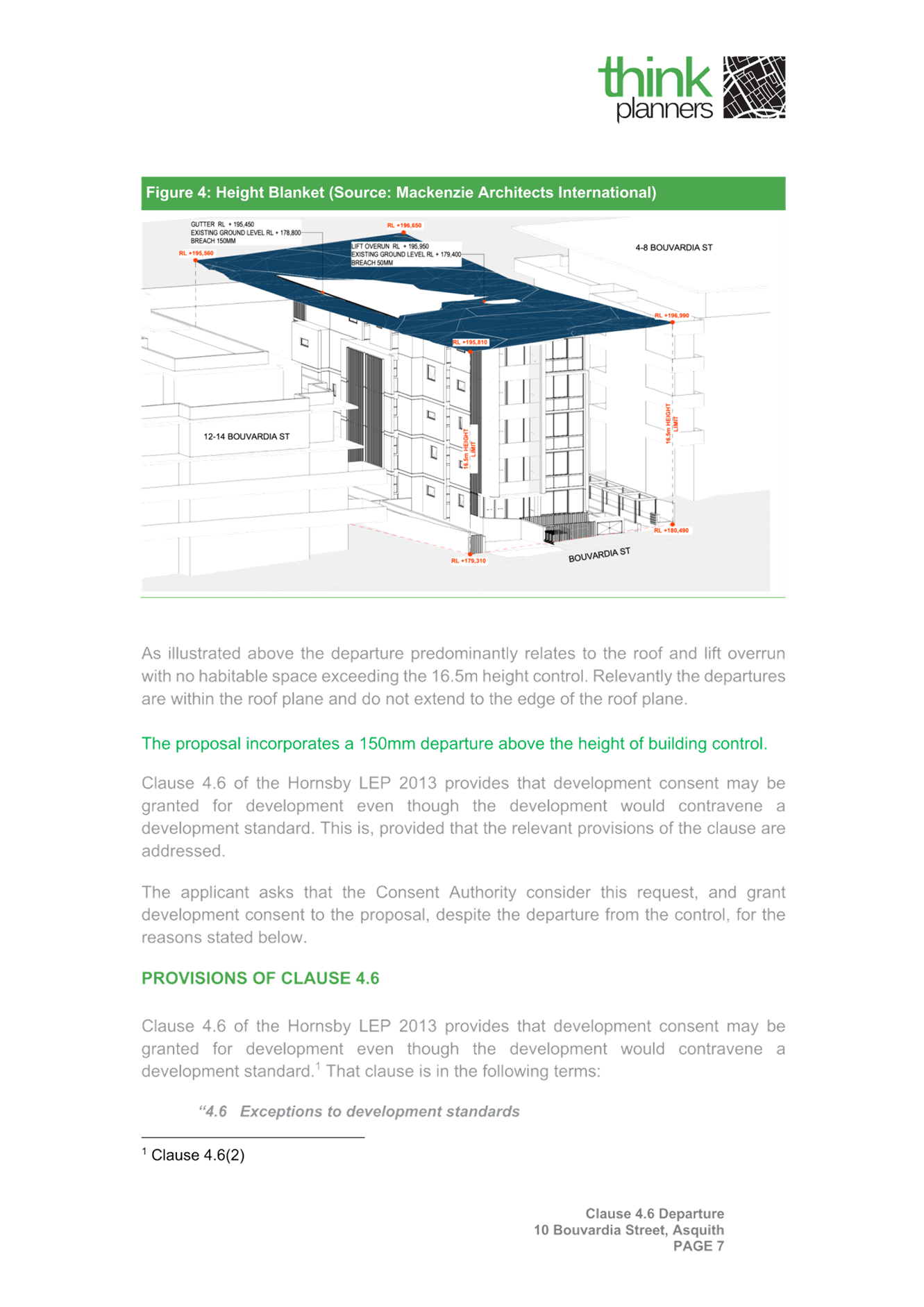
The application seeks to contravene Clause 4.3 of the HLEP as the maximum height of building would be 16.65m which exceeds the development standard by 150mm or 0.9%.
The following diagram demonstrates the extent of the breach of the building height:

Figure 2: Isometric Blanket Diagram prepared by Mackenzie Architects International
As demonstrated in Figure 1 above, the lift overrun, and a small portion of the northern section of the Level 4 roof exceed the 16.5m height of buildings development standard.
The objectives of Clause 4.3 Height of buildings are as follows:
a) To permit a height of buildings that is appropriate for the site constraints, development potential and infrastructure capacity of the locality.
b) The height of a building on any land is not to exceed the maximum height shown for the land on the Height of Buildings Map.
The applicant has made a submission in support of the contravention to the development standard in accordance with Clause 4.6 of the HLEP. Clause 4.6 provides that development consent must not be granted for development that contravenes a development standard unless the consent authority has considered a written request from the applicant that seeks to justify the contravention of the development standard by demonstrating:
(a) That compliance with the development standard is unreasonable or unnecessary in the circumstances of the case, and
(b) That there are sufficient environmental planning grounds to justify contravening the development standard.
In Initial Action Pty Ltd v Woollahra Municipal Council [2008] NSW LEC 118, Preston CJ clarified the correct approach to dealing with a written request under Clause 4.6 to justify the contravention of a development standard.
In relation to determining the matter under Clause 4.6(3)(a), the consent authority must be satisfied that the applicant’s written request adequately addresses the matter as opposed to the determining authority making its own judgement regarding whether compliance is unreasonable or unnecessary. Additionally, the clause does not require that a non-compliant development should have a neutral or beneficial effect relative to a compliant development.
In relation to determining the matter under Clause 4.6(3)(b), the environmental planning grounds clause, non-compliant development is not required to result in a ‘better environmental planning outcome for the site’ relative to a compliant development. Instead, the requirement is only that there are sufficient environmental planning grounds to justify the development standard contravention.
Council must be satisfied that the written request provided by the applicant under Clause 4.6 addresses both the unreasonable and unnecessary test and demonstrates sufficient environmental planning grounds to justify contravening the development standard. These matters are discussed below.
2.1.3.1 Unreasonable or Unnecessary Clause 4.6(3)(a)
There are five common methods by which an applicant can demonstrate that compliance with a development standard is unreasonable or unnecessary in the circumstances of the development. Initially proposed for objections under clause 6 of SEPP 1 in the decision of Wehbe v Pittwater Council [2007] NSWLEC 827 Pearson C summarised and applied these methods to written requests made under Clause 4.6 in Four2Five Pty Ltd v Ashfield Council [2015] NSWLEC 1009 [61-62]. These five methods are generally as follows:
1. The objectives of the standard are achieved notwithstanding noncompliance with the standard.
2. The underlying objective or purpose of the standard is not relevant to the development and therefore compliance is unnecessary.
3. The underlying object of purpose would be defeated or thwarted if compliance was required and therefore compliance is unreasonable.
4. The development standard has been virtually abandoned or destroyed by the council’s own actions in granting consents departing from the standard and hence compliance with the standard is unnecessary and unreasonable.
5. The compliance with development standard is unreasonable or inappropriate due to existing use of land and current environmental character of the particular parcel of land. That is, the particular parcel of land should not have been included in the zone.
It is not required to demonstrate that a development meets multiple methods as listed above, and the satisfaction of one can be adequate to demonstrate that the development standard is unreasonable or unnecessary.
The written request prepared by Think Planners provides a detailed assessment of the proposal with respect to the development standard sought to be contravened. The request argues that the objectives of the development standard are achieved notwithstanding non-compliance with the standard, providing relevant reasoning as follows:
· The development proposal is consistent with the intent of the maximum height control and will provide an attractive 5 storey building that addresses the site’s frontage to Bouvardia Street.
· The non-compliance is minor in nature with the majority of the building being compliant with the building height control and only a small portion of the building encroaches upon the prescribed height control and as such its impact to the streetscape is negligible as it will be visually unnoticeable when viewed from the street level, noting that the 5th floor is recessed.
· The proposed height is consistent with that of the constructed 5 storey residential flat buildings constructed on the eastern side of Bouvardia Street many of which were approved when the precinct benefited from a 17.5m height control and accordingly benefited from approvals for buildings greater than 16.5m in height. Given that this is an isolated parcel, the development will have a height that is consistent and compatible with adjoining apartment buildings.
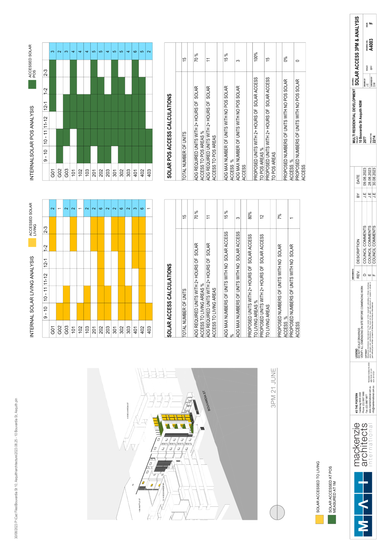
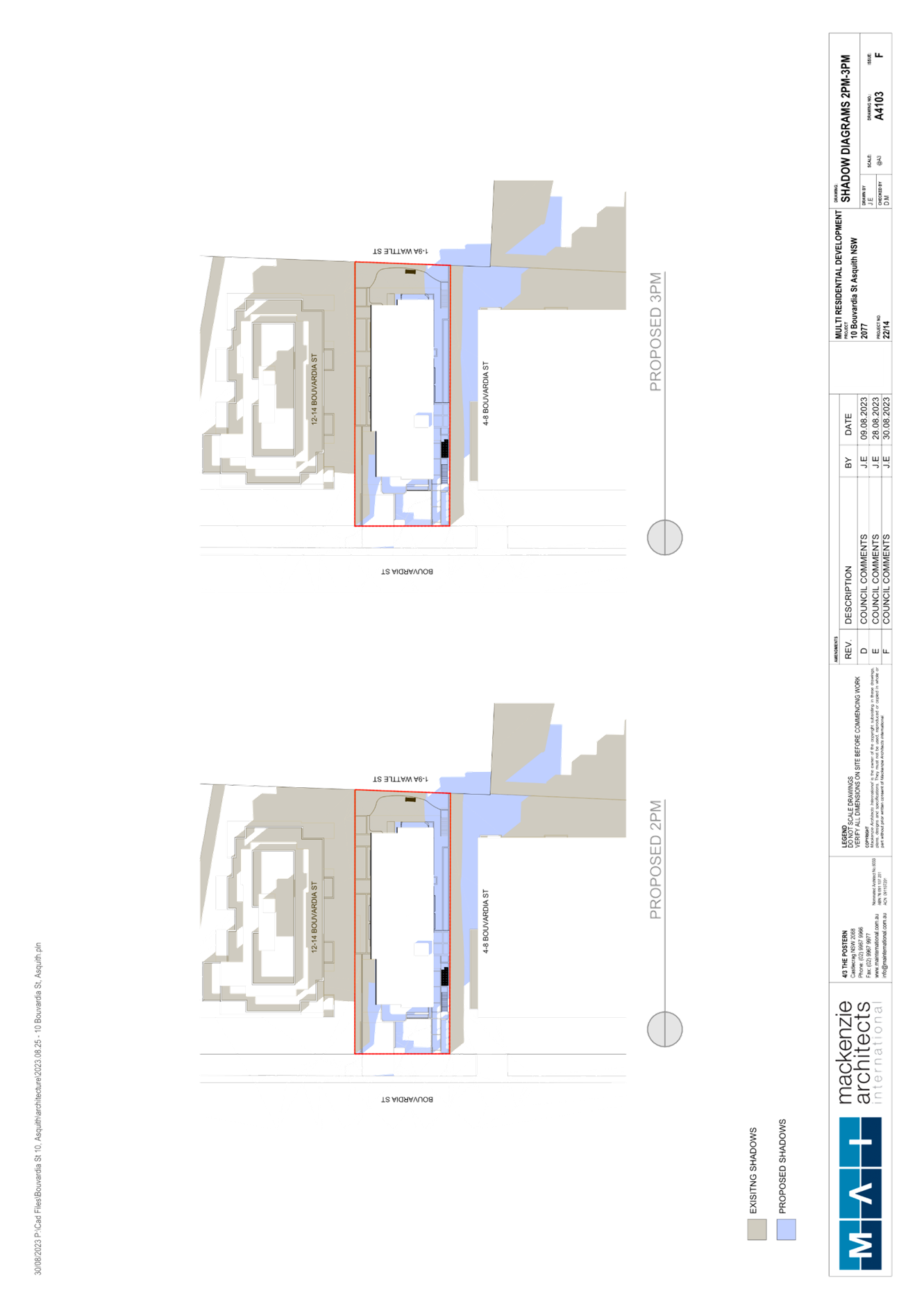
· The departure will not unreasonably impact on the solar access of adjoining properties or the public areas in the vicinity of the site particularly noting that the southern portion of the building complies with the height control.
· Due to the minor nature of the variation, it will not have any adverse amenity impacts. In this regard it is noted:
o The variation will have no adverse impact on the physical bulk, height or scale of the development, noting the small scale nature and location of the point encroachment.
o The variation will not lead to a significant reduction in solar penetration on site or to adjoining properties nor will it lead to any unacceptable sunlight loss or overshadowing.
o The proposed variation will not lead to view loss or interrupt views to and from the site; and
o The proposed variation will not lead to a reduction in privacy afforded to existing residents or future residents of the proposal.
· The proposal has been designed to ensure that privacy impacts are mitigated and that the proposal will not obstruct existing view corridors.
· The proposal is not located within a low-density area and the proposal represents an appropriate built form on the site.
· The proposed variation is minor in nature with the majority of the buildings being compliant with the building height control and the variation is also due to the extensive undulation of the site. The extent of non-compliance will also not be a visually prominent element in the streetscape.
· The overall height of the development presents as a compatible form of development to the anticipated high density residential development that exist in the locality. The portions of the building that exceeds the height control is recessed behind the main building alignment to downplay visual dominance as viewed from the public domain and adjoining residential properties.
· The proposal provides an appropriate building form that is consistent with the desired future character of the locality and is reflective of the objectives for the zone and locality generally- noting the uneven topography is the key driver of the height variation rather than a desired to achieve greater yield on the site.
· The additional height does not generate any additional amenity impacts given the location of the breeches and the surrounding site context.
· The proposal has been designed to ensure that privacy impacts are mitigated against and that the proposal will not obstruct existing view corridors.
· Given the sites orientation, and the minor height departure the additional height will not have any additional adverse overshadowing impacts on nearby developments that incorporate residential components.
· The development proposal is consistent with the intent of the maximum height control and has a bulk and scale that is not discernible from a development that complies with the control.
· The proposal has been designed to ensure that privacy impacts are mitigated that the proposal will not obstruct existing view corridors with appropriate setbacks provided to promote view sharing opportunities.
· The non-compliance to the height control has no unacceptable impact on the setting of any items of environmental heritage or view corridors.
· The proposal will sit comfortably in the streetscape relative to the desired future character of the locality; and
· The development will not exceed the infrastructure capability of the locality.
With reference to the reasoning provided by the applicant above, Council does not object to the conclusion that the proposed development meets the objectives of Clause 4.3. In reaching this conclusion the following points are noted:
· The development would maintain a 5 storey height consistent with the objectives of the R4 residential zone.
· The height departure would not result in any significant amenity impact to surrounding neighbours in terms of overshadowing and privacy and the proposed over height building portions do not create unacceptable overshadowing to any adjoining residential development.
· The overall appearance of the building, when viewed from the street front, would be consistent with surrounding developments.
· The proposed development would not overly dominate surrounding built elements or be obvious in its non-compliance.
· The application provides for the orderly and economic development of land, sufficient consideration of the surrounding residential area and associated amenity impacts and demonstrates adequate consideration and protection of the environmental and public interest.
· The proposed height non-compliance does not diminish the development potential of the site, or any surrounding development.
· The development would not overburden the infrastructure capacity of the locality and does not permit additional floor area or units on the subject site. The building would maintain a five storey design and would have a yield consistent with the strategic intent for the site; and
· The proposed development generally meets the objectives of Clause 4.3 Height of Buildings of the HLEP by way of being appropriate with respect to the constraints of the site and in regard to the development potential of the site.
For the reasons outlined above, it is considered that the written request to contravene the height of building standard adequately demonstrates that the objectives of the height of building development standard contained within Clause 4.3 of the HLEP are achieved, notwithstanding non-compliance with the standard.
2.1.3.2 Environmental Planning Grounds - Clause 4.6(3)(b)
In addition to demonstrating that compliance is unreasonable or unnecessary, Clause 4.6(3)(b) requires that there are sufficient environmental planning grounds to justify contravening the development standard. In demonstrating that sufficient environmental planning grounds exist it must be demonstrated that the planning grounds are particular to the circumstances of the development on the subject site (summarised from Four2Five Pty Ltd v Ashfield Council [2015] NSWLEC 1009 [60].
The applicant provided the following planning grounds for the contravention of the development standard:
· The additional height supports the provision of a residential flat building on an isolated height that will have a similar or lesser massing than adjoining properties.
· The proposal ensures that the high density nature of the zone is achieved and the development is consistent with the existing character of the locality.
· The character of the locality is undergoing transition to larger and more contemporary built forms that are all permitted in the R4 zone and the bulk and scale of the residential flat development is comparable to that of surrounding Mixed Use Developments in the Asquith Precinct.
· The form and presentation of the development maintains an appropriate visual relationship to adjoining properties and does not present a bulk and scale from the street or adjoining properties that is detrimental to the existing and desired future character of the area.
· The building is compatible with the desired future character of the area in terms of the building presentation to the street, the materials, and the relationship to surrounding properties; and
· The proposal will provide for a number of distinct public benefits:
o Delivery of additional housing within close proximity to the Asquith Town Centre.
o Creation of jobs during the construction stage.
o Amenity impacts to adjoining properties are mitigated and the distribution of floor space across the site will not be discernibly different to a built form that is compliant with the height control; and
o The scale and intensity of the development is consistent with other approved and constructed residential flat buildings in the immediate precinct, which demonstrates an appropriate development outcome.
Council considers that the environmental planning grounds stated within the written request are sufficient with respect to Clause 4.6(3)(b) and that the stated grounds are specific to the proposed development and the circumstances of the development site. It is therefore considered that the written request adequately demonstrates compliance with the clause and is acceptable in this regard.
As it is considered that the written request demonstrates sufficient environmental planning grounds specific to the development site, no further justification is considered necessary as sound environmental planning grounds for the non-compliance have been established.
Council is therefore satisfied that Clause 4.6(3)(b) of the HLEP is adequately addressed.
2.1.3.3 Public Interest and Clause 4.6(4)
Clause 4.6(4) states that development consent must not be granted for development that contravenes a development standard unless:
(a) The consent authority is satisfied that:
(i) The applicant’s written request has adequately addressed the matters required to be demonstrated by subclause (3), and
(ii) The proposed development will be in the public interest because it is consistent with the objectives of the particular standard and the objectives for development within the zone in which the development is proposed to be carried out, and
(b) The concurrence of the Planning Secretary has been obtained.
With regard to part (a)(i), the written request is considered to adequately address the matter required to be demonstrated as outlined above.
With regard to part (a)(ii), the proposed development is considered to be in the public interest because it is consistent with the objectives of the particular standard and the objectives for development within the zone in which the development is proposed to be carried out.
With regard to (b), on 21 February 2018, the Secretary of the Department of Planning and Environment issued a Notice under cl. 64 of the Environmental Planning and Assessment Regulation 2000. The Secretary’s concurrence may not be assumed by a delegate of council if:
· The development contravenes a numerical standard by greater than 10%.
· The variation is to a non-numerical standard.
Accordingly, it is considered that the written request satisfactorily responds to the relevant matters required to be addressed under Clause 4.6 and that the Panel, as consent authority, may rely upon the written request and grant development consent to the development application. Should the Panel resolve to approve the application, it should also provide a statement in the reasons for approval that it has satisfied itself of the matters in Clause 4.6(4).
2.1.4 Heritage Conservation
Clause 5.10 of the HLEP sets out heritage conservation provisions for Hornsby Shire. The site does not include a heritage item and is not located in a heritage conservation area. Accordingly, no further assessment regarding heritage is necessary.
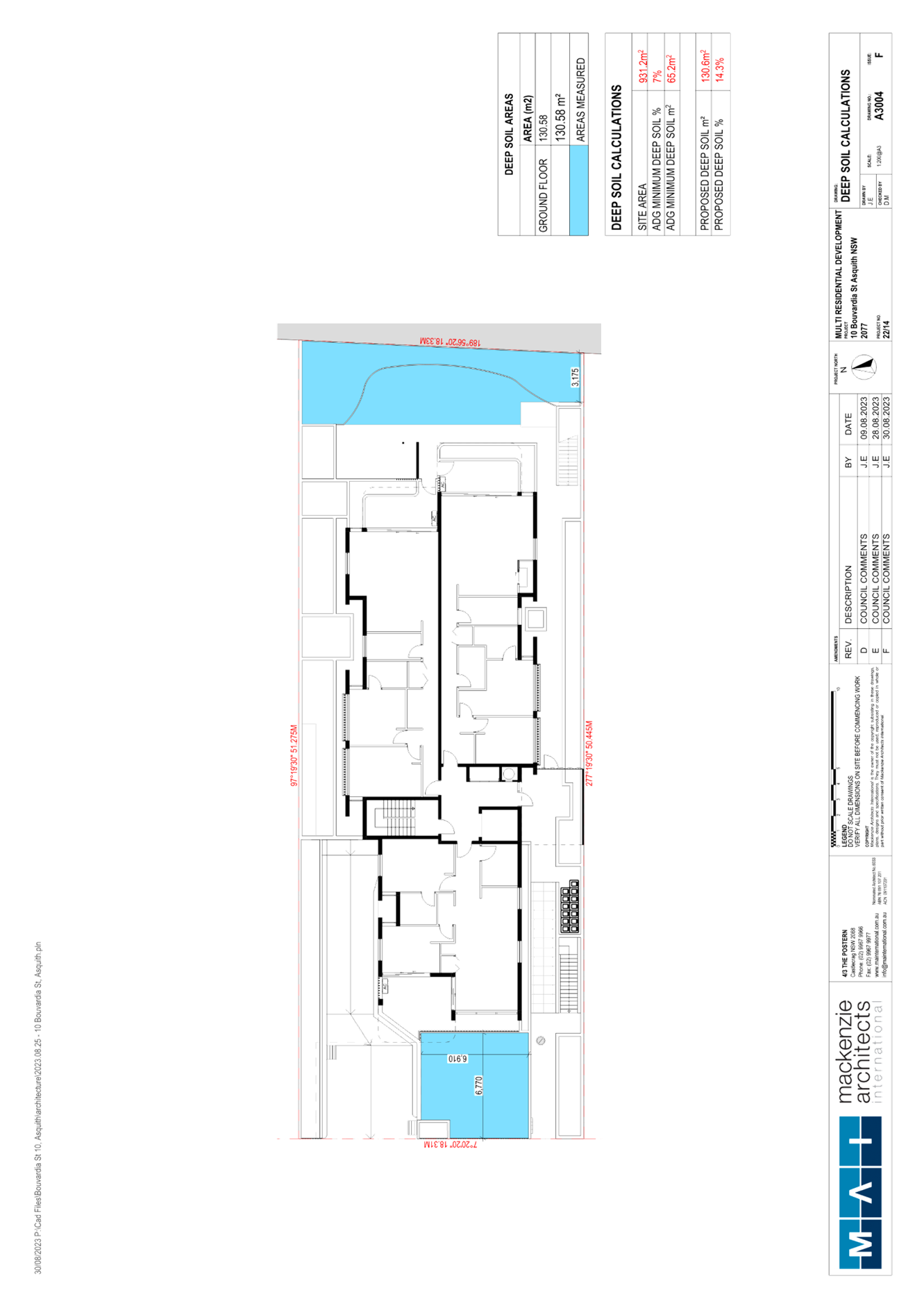
2.1.5 Earthworks
Clause 6.2 of the HLEP states that consent is required for proposed earthworks on site. Before granting consent for earthworks, Council is required to assess the impacts of the works on adjoining properties, drainage patterns and soil stability of the locality.
The site is relatively level. The proposal includes excavation works for a basement car park. The geology of the site is identified as bedrock comprising shale, overlying deeper sandstone. A condition is recommended that the recommendations of the Geotechnical Assessment prepared by Morrow Geotechnics be applied including but not limited to the completion of dilapidation surveys/reports for adjoining buildings and structures prior to the commencement of works and inspections and monitoring of earthworks by Morrow Geotechnics.
In addition, all excavated material removed from the site must be classified by a suitably qualified environmental consultant in accordance with the NSW Environment Protection Authority’s Waste Classification Guidelines and Protection of the Environment Operations (Waste) Regulation 2014 prior to disposal to a licensed waste management facility. Tipping dockets for the total volume of excavated material that are received from the licensed waste management facility must be provided to the Principal Certifier prior to the issue of an Occupation Certificate and Prior to fill material being imported to the site, a Waste Classification Certificate shall be obtained from a suitably qualified environmental consultant. Further A Council approved Construction Management Plan must also be complied with for the duration of works.
Subject to recommended conditions, the proposal is considered satisfactory in respect to Clause 6.2 of the HLEP.
2.1.6 Design Excellence
Clause 6.8 of the HLEP provides considerations for the delivery of the highest standard of architectural and urban design. The development application was reviewed by Council’s Design Excellence Panel (DEP) on 3 April 2023.
The Panel did not support the original proposal. Council provided the detailed DEP assessment of the proposal to the applicant for consideration and after ongoing back and forth, the applicant supplied amended plans and further detail to address the key considerations. The initial Panel concerns and how the Applicant has addressed these changes are discussed below.
· The Panel are mindful of the design excellence provisions of the HLEP. For a development to achieve design excellence it must be able to demonstrate that it exceeds basic compliance. This refers to both the HLEP, HDCP and ADG.
Comment: It is considered that the amended proposal achieves an appropriate outcome for the site in terms of design and meeting the relevant HLEP, HDCP and ADG requirements, as discussed in the body of this report.
· The Panel requested a reduced footprint to increase compliance with ADG controls.
Comment: The applicant contends that they demonstrate basic compliance, and the variations are acceptable due to the constraints of the narrow, isolated site. Council considers the variations acceptable in this regard.
· The Panel requested consideration be given to reducing floor to floor heights to reduce overall building height.
Comment: The overall height was reduced from 17m to 16.65m.
· The Panel requested that the privacy and amenity considerations of non-compliant side setbacks be re-considered, and appropriate solutions found to ameliorate any resulting negative impacts.
Comment: Indentations provided to side elevations to allow for additional windows to face front and rear boundaries - windows that face side boundaries are highlight windows with minimum 1.5m sill heights.
· The Panel was not convinced that the resulting building form and separation (which are largely due to proposed narrow side setbacks and large overhanging roof) will satisfy the Design Excellence provisions of the HLEP.
Comment: Roof overhang has been reduced to provide a more appropriate built form. Additional front and rear indentation to the top floor also improved this element of the proposal.
Despite building separation and side setback variations, the applicant contends that this is acceptable due to careful site planning and design of the development and that it is considered that an appropriate level of privacy has been provided to adjoining apartments.
Council considers the amended design provides appropriate building form and separation within the constraints of the site in this regard.
· The Panel were concerned with lack of and compromised Communal Open Space (COS), Open Space (OS) and Deep Soil Planting (DSP).
Comment: The rear communal area was reconfigured to create a more useable area and the provision of a more sustainable landscape and deep soil zones. Included in this is the relocation of the fire stair and seating for improved access.
The development was also amended to create oversized terraces and balcony’s for each unit.
In addition, the OSD, rainwater tanks and fire stairs have been relocated within the front setback to achieve more DSP and suitable landscaping within the front of the site.
· The Panel raised concerns regarding privacy impacts between the common open space on the ground floor and adjacent units.
Comment: The layout of rear ground level COS and POS was amended to provide landscaped buffers between these areas.
· The Panel noted that solar access to the north facing apartments is impacted by site width and setback issues already discussed. Proposed highlight windows facing the north and south side boundaries are not considered desirable however may be used as a secondary light source in habitable rooms where there are also windows facing east and/or west.
Comment: The applicant adequately demonstrated compliance with sunlight access requirements.
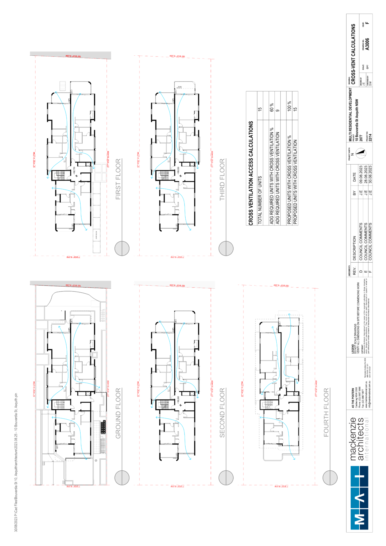
Additional E/W windows have been added to bedrooms with side facing highlight windows for additional light source. All unit demonstrate compliance with the cross ventilation requirements of the ADG.
· Panel recommended exploring a greater housing mix.
Comment: The applicant contended that 1 Bedroom or studio units are commercially unviable and as such have not been included. The proposal was amended to provide 1x 1 bedroom + study unit, 4x 2 bedroom + study units and 10x 2 bedroom units. Council considers the proposed housing mix acceptable in this regard.
· Panel requested the applicant provide a landscape strip on the northern side of the vehicle ramp and consider smaller apartments to reduce parking numbers and to reduce the size of the basement footprint to address lack of deep soil.
Comment: Additional deep soil planting has been provided within the front setback; however, the car parking/unit numbers remain substantially the same. A 1m landscape strip on the northern side of the driveway has also been provided. The proposal is considered acceptable in this regard.
· Panel noted that street trees should be provided.
Comment: The application includes the provision of 2x water gums, 5-7m high street trees.
· The Panel requested that Environmentally Sustainable Development be further considered through the provision of EV car charging, solar, WSUD etc.
Comment: Several ESD elements have been included including the provision for EV car charging. BASIX targets have also been achieved.
The DEP noted that they were mindful of the constraints of the site and that variations to the relevant controls would be sought. They noted that the proposal should demonstrate that the design exceeds basic compliance with the relevant controls, and it is considered that adequate amendments have been made to improve compliance and meet the relevant desired outcomes and objectives of the HLEP, HDCP and ADG in this regard.
As detailed above, the application has undergone a detailed design review with the objective of ensuring an adequate level of design excellence. Council considers that the considerations provided by the DEP have been adequately addressed and the development as proposed is consistent with the requirements of Clause 6.8 of the HLEP.
2.2 State Environmental Planning Policy (Biodiversity and Conservation) 2021
The application has been assessed against the requirements of chapters 2 and 6 of State Environmental Planning Policy (Biodiversity and Conservation) 2021.
2.2.1 Chapter 2 Vegetation in Non-Rural Areas
Chapter 2 of this policy aims to protect the biodiversity and amenity values of trees within non-rural areas of the state.
Part 2.3 of the policy states that a development control plan may make a declaration in any manner relating to species, size, location and presence of vegetation. Accordingly, Part 1B.6.1 of the HDCP prescribes works that can be undertaken with or without consent to trees and objectives for tree preservation.
Section 3.1.1 of this report provides an assessment in accordance with Part 1B.6.1 of the HDCP.
2.2.2 Chapter 6 Waterways
The site is located within the catchment of the Hawkesbury-Nepean River. The aim of this chapter is to protect the environment of the Hawkesbury-Nepean River system by ensuring that the impacts of development are considered in the regional context. This chapter contains general planning considerations and strategies requiring Council to consider the impacts of development on water quality, aquaculture, significant vegetation habitats, extraction, environmental heritage and scenic quality, recreation and tourism, and agriculture.
The plan addresses matters related to biodiversity, ecology and environment protection; public access to, and use of, foreshores and waterways; interrelationship of waterway and foreshore uses; foreshore and waterways scenic quality; maintenance, protection and enhancement of views and boat storage facilities.
Subject to the implementation of sediment and erosion control measures and stormwater management to protect water quality, the proposal would not impact on the water quality of the catchment and would comply with the requirements of chapter 6 of the Biodiversity and Conservation SEPP.
2.3 State Environmental Planning Policy (Building Sustainability Index: BASIX) 2004
The application has been assessed against the requirements of State Environmental Planning Policy (BASIX) 2004 which seeks to encourage sustainable residential development.
The proposal includes a BASIX certificate in accordance with the requirements of the BASIX SEPP including the list of commitments to be complied with at the construction stage and during the use of the premises. The BASIX certificate achieves the minimum scores for thermal comfort, water and energy.
The proposal is acceptable in this regard.
2.4 State Environmental Planning Policy (Resilience and Hazards) 2021
2.4.1 Chapter 4 Remediation of Land
Should the land be contaminated, Council must be satisfied that the land is suitable in a contaminated state for the proposed use. If the land requires remediation to be undertaken to make the land suitable for the proposed use, Council must be satisfied that the land will be remediated before the land is used for that purpose.
An examination of Council’s records and aerial photography has determined that the site has been historically used for residential purposes. It is not likely that the site has experienced any significant contamination, and further assessment under chapter 4 of the Resilience and Hazards SEPP is not required. Conditions are recommended in Schedule 1 to manage any potential unexpected finds during work if required.
2.5 State Environmental Planning Policy (Transport and Infrastructure) 2021
The application has been assessed against the requirements of chapter 2 of State Environmental Planning Policy (Transport and Infrastructure) 2021.
2.5.1 Ausgrid
Written notice to Ausgrid was not required in accordance with chapter 2, division 5 of the Transport and Infrastructure SEPP.
Notwithstanding, the applicant submitted correspondence from Ausgrid that the ‘Installation of a kiosk type substation’ would not be required for the development. The proposed development would connect into existing electricity infrastructure within the street.
In addition, a condition is recommended in Schedule 1 that the applicant must submit written evidence prior to the issue of a construction certificate that a letter of consent has been obtained from Ausgrid demonstrating that satisfactory arrangements have been made to service and construct the proposed development.
The proposed development is considered acceptable in this regard.
2.6 State Environmental Planning Policy No. 65 Design Quality of Residential Flat Development
State Environmental Planning Policy No. 65 Design Quality of Residential Flat Development (SEPP 65) provides for design principles to improve the design quality of residential flat development and for consistency in planning controls across the State.
SEPP 65 adopts the Apartment Design Guide which prevails in the event of any inconsistency with a Development Control Plan. The Policy includes objectives to meet housing and population targets, affordable housing and to facilitate timely and efficient assessment of development applications. SEPP 65 makes further provision for design review panels; includes additional provisions for the determination of development application and for standards for car parking, visual privacy, solar and daylight access, common circulation and spaces, apartment size and layout, ceiling heights, private open space and balconies, natural ventilation and storage, which cannot be used as grounds for refusal of development consent.
The applicant has submitted a “Design Verification Statement” prepared by a qualified Architect stating how the proposed development achieves the design principles of SEPP 65. An assessment of the proposal against the design quality principles contained within Schedule 1 of SEPP 65 and the submitted design verification statement are addressed in the following table:
|
SEPP 65 - Schedule 1 Assessment |
|
|
Principle |
Compliance |
|
1. CONTEXT AND NEIGHBOURHOOD CHARACTER |
Yes |
|
Comment: The site is located within a precinct planned for five storey residential flat buildings in close proximity to Asquith Railway Station and the Asquith commercial centre. The desired future character of the area, as outlined in the Hornsby Development Control Plan 2013, is that of a locality characterised by residential flat buildings of 5-storeys in height in landscape settings with underground car parking. Development should seek to complement and enhance the adjacent public domain environment and building footprints by maintaining landscape corridors around and through development sites. The proposed development appropriately responds to the context of the site by proposing a residential flat building development adjacent to the existing Asquith commercial core. The ground level would appropriately integrate with the existing public domain and sufficient landscaping is provided adjacent to side boundaries to ensure green links through the site. The façade has been designed to respond to the adjacent urban forms and streetscape. |
|
|
2. BUILT FORM AND SCALE |
Yes |
|
Comment: Despite the minor height non-compliance, it is considered that the proposed development achieves a scale, bulk and height appropriate to the existing or desired future character of the street and surrounding buildings. The building presents as highly articulated and of appropriate proportions and materiality. The concept would contribute to the character of the streetscape and offer residents a high level of amenity. |
|
|
3. DENSITY |
Yes |
|
Comment: The HLEP does not incorporate floor space ratio requirements for the site. The density of the development is governed by the height of the building and the required setbacks. The proposed density is sustainable as it responds to the regional context, availability of infrastructure, public transport, community facilities and environmental quality and is acceptable in terms of density. |
|
|
4. SUSTAINABILITY |
Yes |
|
Comment: The applicant has submitted a BASIX Certificate for the proposed development. In achieving the required BASIX targets for sustainable water use, thermal comfort and energy efficiency, the proposed development would achieve efficient use of natural resources, energy and water throughout its full life cycle, including demolition and construction. Provisions have also been made to provide electric vehicle ready connections within the basement. |
|
|
5. LANDSCAPE |
Yes |
|
Comment: The application includes a landscape concept plan which provides landscaping along the street frontages, side and rear boundaries and sufficient deep soil planting within the front and rear setbacks. Large trees are proposed along the street frontages intercepted by shrubs and hedges which would soften the appearance of the development when viewed from the street. Deep soil areas that incorporate canopy trees are provided around the building envelope which would enhance the development’s natural environmental performance and provide an appropriate landscaped setting. |
|
|
6. AMENITY |
Yes |
|
Comment: The proposed units are designed with appropriate room dimensions and layout to maximise amenity for future residents. The proposal incorporates good design in terms of achieving natural ventilation, solar access and acoustic privacy. All units incorporate balconies accessible from living areas and privacy has been achieved through appropriate design and orientation of balconies and living areas. Storage areas have been provided within each unit and in the basement levels. The proposal would provide convenient and safe access via a central lift connecting the basement and all other levels. |
|
|
7. SAFETY AND SECURITY |
Yes |
|
Comment: The design orientates the balconies and windows of individual apartments towards the street, rear and side boundaries, providing passive surveillance of the public domain and communal open space areas. Both the pedestrian and vehicular entry points are secured and visibly prominent from Bouvardia Street. The SEE has regard to Crime Prevention Through Environmental Design Principles (CPTED) and includes details of surveillance, access control, territorial reinforcement and space management such as artificial lighting in public places; attractive landscaping whilst maintaining clear sight lines; security coded door lock or swipe card entry; physical or symbolic barriers to attract, channel or restrict the movement of people; security controlled access to basement car park; intercom access for pedestrians; and security cameras located at the entrance of the building. Appropriate conditions of consent are recommended to require compliance with the above matters. |
|
|
8. SOCIAL DIMENSIONS AND HOUSING AFFORDABILITY |
Yes |
|
Comment: The proposal incorporates a range of unit sizes to cater for different budgets and housing needs. The development complies with the housing choice requirements of the Hornsby DCP by providing a component of adaptable and liveable housing and an appropriate mix of 1 and 2 bedroom dwellings (plus some studies) within the context of the isolated site and the market demand. The proposal responds to the social context in terms of providing a range of dwelling sizes with good access to social facilities and services as the site is located in close proximity to Asquith railway station and shops. |
|
|
9. AESTHETICS |
Yes |
|
Comment: The architectural treatment of the building incorporates indentations and projections in the exterior walls with balcony projections to articulate the facades. The roof is flat to minimise building height and incorporates eaves which would cast shadows across the top storey wall. The articulation of the building, composition of building elements, textures, materials and colours would achieve a built form generally consistent with the design principles contained within the Residential Flat Design Code and the Hornsby DCP. |
|
Clause 30(2) of SEPP 65 provides that development consent must not be granted if, in the opinion of the consent authority, the development or modification does not demonstrate that adequate regard has been given to the design quality principles. As outlined in the table above, it is considered that that proposed development demonstrates adequate regard to the design quality principles.
2.7 Apartment Design Guide
Amendment No. 3 of SEPP 65 also requires consideration of the Apartment Design Guide (ADG), NSW Department of Planning and Environment 2015. The ADG includes development controls and best practice benchmarks for achieving the design principles of SEPP 65. The following table sets out the proposal’s compliance with the ADG:
|
Apartment Design Guide |
|||
|
Control |
Proposal |
Requirement |
Compliance |
|
Communal Open Space (3D-1) |
15% |
25% of site area |
No |
|
Solar Access (Communal open space areas) (3D-1) |
>50% |
50% direct sunlight access for 2 hours |
Yes |
|
Deep Soil Zone (3E-1) |
14.3% |
7% of site area |
Yes |
|
Building Separation (3F-1) |
|
|
|
|
- side boundaries |
3m-4.1m
4.1m-5m |
6m between habitable windows and balconies. 3m to non-habitable (G-Level 3.) 9m between habitable windows and balconies. 4.5m to non-habitable (Level 4) |
No
No
|
|
- rear boundary |
6.2m-9.1m
8m-9.2m |
6m between habitable windows and balconies. 3m to non-habitable (G-Level 3.) 9m between habitable windows and balconies. 4.5m to non-habitable (Level 4) |
Yes
No |
|
Car Parking (3J-1) |
18 |
17 |
Yes |
|
Solar Access (4A-1) |
|
|
|
|
- Living rooms |
73% - 11/15 |
2 hours for 70% |
Yes |
|
- Private open space |
100% - 15/15 |
2 hours for 70% |
Yes |
|
No Solar Access allowable for units (4A-1) |
0% |
15% of units (max) |
Yes |
|
Natural Cross Ventilation (4B-3) |
100% (15/15) |
60% |
Yes |
|
Ceiling Height (4C-1) |
2.8m >2.4m |
2.7m for habitable rooms 2.4m for non-habitable |
Yes Yes |
|
Minimum Dwelling Size (4D-1) |
|
|
|
|
- 1 Bed units |
min. 71.29m2 |
50m2 |
Yes |
|
- 2 bed units |
min. 80.34m2 |
70m2 |
Yes |
|
Minimum Window Size (4D-1) |
>10% of floor area of room |
10% of the floor area of the room |
Yes |
|
Habitable Room Depth (4D-2) |
>8m room depth or >2.5m ceiling height |
8m from a window (max for open plan) OR 2.5x ceiling height |
Yes |
|
Apartment Layouts - Minimum Bedroom Size (4D-3) |
>10m2 >9m2 |
10m2 min master bed size 9m2 bedroom size |
Yes Yes |
|
Apartment Layouts - Combined Living / Dining Rooms Minimum Width (4D-3) |
>3.6m >4m |
3.6m - Studio and 1 bed 4m - 2 and 3 bed |
Yes Yes |
|
Apartment Layouts - Cross Through Apartments (4D-3) |
>4m |
Min 4m width |
Yes |
|
Minimum Balcony Size (4E-1) |
1 br - >8m2 2 br - >10m2 |
1-bedroom 8m2 2m depth 2-bedroom 10m² 2m depth |
Yes Yes |
|
Maximum Number of Units on a Single Level (4F-1) |
max. 3 |
max. 8 units off a circulation core |
Yes |
|
Storage (4G-1) |
>6m3 >8m3 >50% |
6m3 - 1 bedroom 8m3 - 2 bedrooms 50% located within apartments |
Yes Yes Yes |
As detailed in the above table, with the exception of community open space and building separation the proposed development complies with the prescriptive measures within the ADG. Below is a brief discussion regarding the varied ADG development controls and best practice guidelines.
2.7.1 Communal Open Space
Objective 3D-1 of the ADG is for “An adequate area of communal open space is provided to enhance residential amenity and to provide opportunities for landscaping”. The design criteria for objective 3D-1 states: “Communal open space has a minimum area equal to 25% of the site and Developments achieve a minimum of 50% direct sunlight to the principal usable part of the communal open space for a minimum of 2 hours between 9am and 3pm on 21 June (mid-winter)”.
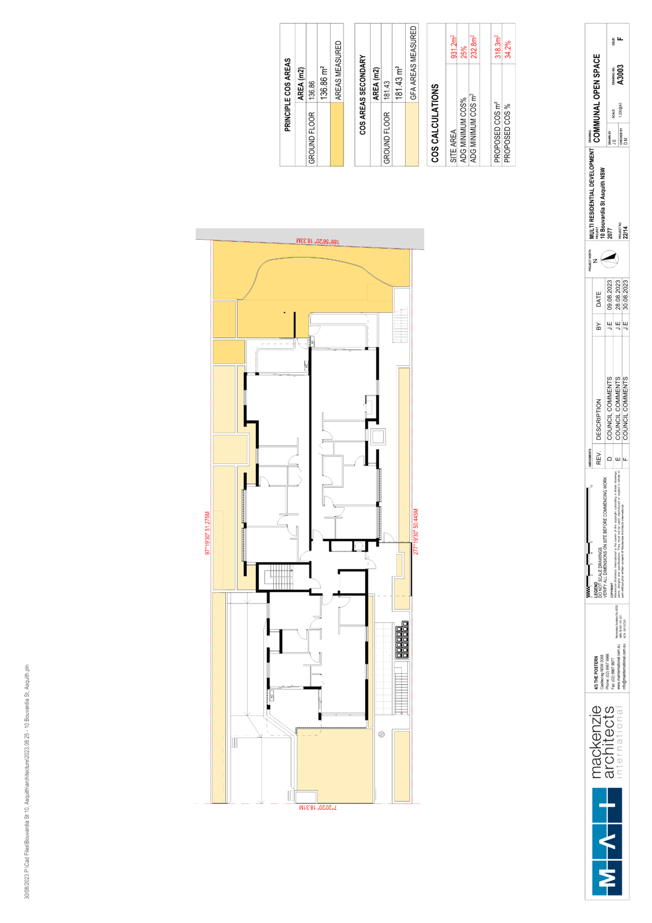
The proposed development provides a communal open space (COS) area at the rear of the development site which has an area equal to 15% which does not comply with the 25% site area requirement.
In support of this non-compliance the following points are noted:
· The communal open space provided on site offers an acceptable level of amenity, with facilities for BBQs, gatherings, seated areas and grassed recreation space.
· All units benefit from larger than required private open space areas/balconies under the ADG, which would reduce the reliance on the communal open space and is considered desirable for a residential flat building.
· The site is adjacent to a shopping centre with cafes with gathering opportunities. There are also a number of parks and open recreational areas within walking distance to the site including Storey Park.
· Further COS could be provided on site; however, this would be located in side setback areas or on the rooftop of the building. Neither of these options are preferred as locating COS in the side setback areas would create likely unused linear spaces with privacy impacts to ground floor units. It would also reduce landscaping opportunities in setback areas. Providing further COS at the rooftop would cause the building to further breach the height limit, which is considered unnecessary in this instance.
Given the constraints of the site in terms of isolation and site width, the COS is considered adequate and meets the overriding objective for COS under the ADG.
2.7.2 Building Separation
Objective 3F-1 of the ADG requires any side building setback up to 4 storeys to be a distance of 6m to habitable windows and balconies or 3m to non-habitable rooms; and any side building setback over 4 storeys to be a distance of 9m to habitable windows and balconies or 4.5m to non-habitable rooms. Further, this section of the ADG requires a rear boundary setback over 4 storeys of 9m between habitable windows and balconies or 4.5m to non-habitable rooms.
The application proposes 3m-4.1m setbacks to habitable rooms and windows of the ground to third floor levels; 4.1m-5m side setbacks to habitable rooms and windows of the fourth level; and 8m-9.2m rear setbacks to habitable rooms and balconies on the fourth level which do not comply with these requirements.
In support of these non-compliances, the following is noted:
· The site is significantly constrained due to being an isolated lot, with an 18.3m site width.
· All windows facing side boundaries would be highlighted windows. Indentations to bedrooms on side elevations have been included to provide front and rear facing windows to improve amenity of units whilst maintain privacy of neighbouring properties.
· Effort has been made to ensure living and entertaining spaces are oriented towards front and rear boundaries and where this was unavoidable, privacy screens have been proposed to minimise amenity impacts to adjoining properties.
· The building separation variations provide visual interest to the building design, ensuring the building provides appropriate indentation and consideration of amenity of adjoining properties.
· The rear setback/building separation requirements have been mostly achieved with the exception of a minor variation to the 1 bedroom + study balcony within unit No. 403 on the fourth floor. The rear setback of this unit was increased to provide additional building separation.
· There would be negligible amenity impacts to the adjoining property at the rear as this site is a Coles shopping complex and the proposal would overlook the roof of this complex only. Nevertheless, the future redevelopment of the Coles shopping centre at the rear has been considered and amendments were made to the plans to increase the building separation and future proof the development should the Coles site be redeveloped.
Overall, it is considered that the building separation non-compliances would result in minimal amenity impacts to adjoining neighbours and achieve an acceptable building design and separation within the context of the site and the adjoining RFB’s and no further objections are raised in this regard.
2.8 Section 3.42 Environmental Planning and Assessment Act 1979 - Purpose and Status of Development Control Plans
Section 3.42 of the Environmental Planning and Assessment Act 1979 states that a DCP provision will have no effect if it prevents or unreasonably restricts development that is otherwise permitted and complies with the development standards in relevant Local Environmental Plans and State Environmental Planning Policies.
The principal purpose of a development control plan is to provide guidance on the aims of any environmental planning instrument that applies to the development; facilitate development that is permissible under any such instrument; and achieve the objectives of land zones. The provisions contained in a DCP are not statutory requirements and are for guidance purposes only. Consent authorities have flexibility to consider innovative solutions when assessing development proposals, to assist achieve good planning outcomes.
2.9 Hornsby Development Control Plan 2013
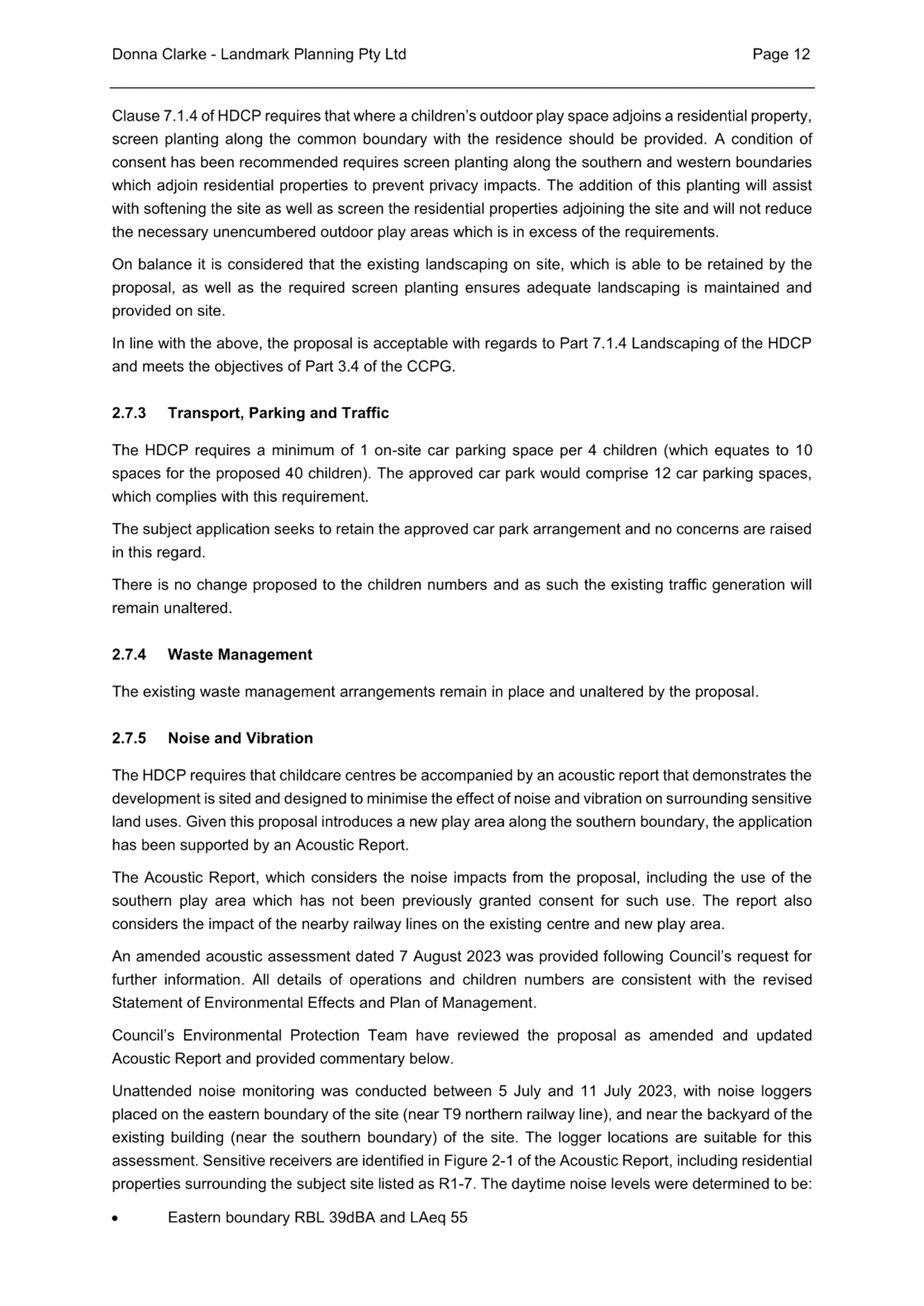
The proposed development has been assessed having regard to the relevant desired outcomes and prescriptive requirements within the Hornsby Development Control Plan 2013 (HDCP). The following table sets out the proposal’s compliance with the prescriptive requirements of the Plan:
|
Hornsby Development Control Plan 2013 |
|||
|
Control |
Proposal |
Requirement |
Compliance |
|
Site Width |
18.3m |
30m |
No |
|
Height |
5 storeys 16.65m (inc. lift overrun) |
5 storeys 16.5m |
Yes No |
|
Lowest Residential Floor Above Natural Ground Level |
0.8m |
1.5m (max) |
Yes |
|
Maximum Floorplate Dimension |
12.5m (N/S) 33m (E/W) |
35m 35m |
Yes Yes |
|
Building Indentation |
<4m x 4m |
4m x 4m |
No |
|
Front Setback |
8m 8m <1/3 building length |
10m 8m <1/3 building length |
No No |
|
Side Setback (north) |
3-4.1m No |
6m 4.5m <1/3 building length |
No No |
|
Side Setback (south) |
3-4m No |
6m 4.5m <1/3 building length |
No No |
|
Rear Setback |
6.2-9.1m No 6.2m (balconies) |
10m 8m <1/3 building length 7m (balconies) |
No No No |
|
Top Storey Setback from Ground Floor |
<3m |
3m |
No |
|
Basement Ramp Setback (landscaping) |
1m |
2m |
No |
|
Deep Soil Landscaped Areas |
6.8m front Nil 3.2m - 5m rear |
8m front 4m sides 7m rear |
No No No |
|
Communal Open Space with Minimum Dimensions 4m |
>50m2 (min) 15% |
50m2 (min) 25% |
Yes No |
|
Solar Access |
>70% |
70% |
Yes |
|
Housing Choice |
<10% of 1- and 3-bedroom dwellings |
10% of each type (min) |
No |
|
Adaptable Units |
13% (2x 2br units) |
10% |
Yes |
|
Private Open Space |
|
|
|
|
- 1 Bed Unit |
>8m2 & >2m depth |
Min 8m2 & 2m width |
Yes |
|
- 2 Bed Unit |
>10m2 & >2m depth |
Min 10m2 & 2m width |
Yes |
|
Cross Ventilation |
100% |
Min 60% of units |
Yes |
|
Car Parking |
|
|
|
|
- Total |
18 spaces |
17 spaces |
Yes |
|
- Motorcycle Parking |
0 spaces |
1 space |
No |
|
- Bicycle Parking |
5 spaces |
5 spaces |
Yes |
|
- Accessible Spaces |
3 spaces |
2 spaces |
Yes |
As detailed in the above table, the proposed development does not comply with a number of prescriptive requirements within the HDCP. The matters of non-compliance are detailed below, as well as a brief discussion on compliance with the relevant performance requirements and Part 1C General Controls.
2.9.1 Desired Future Character
The site is included in the Bouvardia Street precinct which was rezoned from Residential A (Low Density) to R4 (High Density Residential) as part of Council’s Housing Strategy.
The application was reviewed by Council’s Design Excellence Panel with the design advice subsequently referred to the applicant and it was requested that the matters raised be addressed as well as additional Council concerns. The applicant subsequently provided amended plans and a cover letter detailing how the amended plans achieve design excellence.
The Design Excellence Panel noted that they were mindful of the constraints of the site and that variations to the relevant controls would be sought. They noted that the proposal should demonstrate that the design exceeds basic compliance with the relevant controls, and it is considered that adequate amendments have been made to improve compliance and meet the relevant desired outcomes and objectives of the HLEP, HDCP and ADG in this regard.
As discussed in detail in Section 2.1.6 of this report, it is considered that the proposed development would meet the desired outcome for the housing precinct for well-articulated five storey residential flat buildings in garden settings with basement car parking. The building is generally well articulated and is appropriately setback to provide sufficient landscaping and streetscape presentation.
2.9.2 Site Requirements
The HDCP requires sites to have a minimum frontage of 30m. The subject site has a frontage of 18.3m to Bouvardia Street which does not comply with this requirement.
In support of this non-compliance, it is noted that the proposal is located within a previously isolated site with the adjoining sites consisting of occupied five storey residential flat buildings.
The proposal has been appropriately designed with regard to the site constraints and is considered acceptable within high density residential zoned site.
2.9.3 Scale
The proposed five storey building has a maximum height of 16.65m which includes the lift overrun and does not comply with the 16.5m height control.
As detailed in Sections 2.1.2 and 2.1.3 this report, the proposed building height is considered to be acceptable with respect to the constraints of the site, the development potential, infrastructure capacity and surrounding development.
2.9.4 Setbacks
As noted in the table above, sections of the building do not comply with a number of setback requirements under the HDCP.
2.9.4.1 Front Setback
The HDCP requires a 10m front setback, which can be reduced to 8m for a maximum of 1/3 of the building width.
The application proposes an 8m front setback within a significantly constrained and isolated site.
The proposal has been sympathetically designed within the context of the site and its surrounds and is consistent within the front setback of the neighbouring developments. Appropriate landscaping within the front setback would visually soften the development within the streetscape and the proposal is considered acceptable in this regard.
2.9.4.2 Northern and Southern Side Setbacks
The HDCP requires a minimum building side setback of 6m, which can be reduced to 4.5m for a maximum of 1/3 of the building width for non-habitable rooms. The proposal does not comply with either of these requirements.
In support of these variations, it is noted as follows:
· The site is significantly constrained due to being an isolated lot, with an 18.3m site width. A fully compliant RFB development on this site would result in an essentially undevelopable site and would not be commercially viable.
· All windows facing side boundaries would be highlighted windows. Indentations to bedrooms on side elevations have been included to provide front and rear facing windows to improve amenity of units whilst maintain the privacy of neighbouring properties.
· Effort has been made to ensure living and entertaining spaces are oriented towards front and rear boundaries and where this was unavoidable, privacy screens have been proposed to minimise amenity impacts to adjoining properties.
· The building separation variations provide visual interest to the building design, ensuring the building provides appropriate indentation and consideration of amenity of adjoining properties.
· The setback non-compliance would be suspended over the basement and would not result in any loss of deep soil landscaping to the side boundary.
2.9.4.3 Top Storey Setback
The proposal does not comply with the 3m additional setback requirement to the top floor. The proposal was amended to include 1m-2m indentations within the front and rear setbacks.
This is considered acceptable due to the constraints of the site and that the overall intent of the top storey setback provisions is achieved, given that the proposal includes a well-articulated built form.
2.9.4.4 Rear Setback
The application proposes a minimum 8m rear setback. Whilst this does not comply with the 10m rear setback requirements of the HDCP, the ground to third level does comply with the rear building separation requirements of the ADG and the fourth floor rear balcony non-compliance addresses the prescriptive measure 3.4.5(d) of the HDCP which identified that “balconies are able to encroach to within 7 metres of the rear boundaries provided there is no impact on the achievement of daylight access, visual privacy, and acoustic privacy and growth of mature canopy trees”.
In support of this non-compliance, it is noted that balcony encroachment would not be visually perceptible from the street, is consistent with the adjoining developments and there would be adequate deep soil planting and landscaping to provide necessary screening and softening to adjoining properties.
Overall, the proposed setback non-compliance do not generate any privacy impacts or sunlight access loss as a result of the numerical non-compliances and are considered acceptable.
2.9.5 Built Form and Separation
Part 3.4.6 of the HDCP prescribes those buildings with a depth of greater than 25m should incorporate a distinct indentation of 4m x 4m in building facades to create the impression of two distinct building pavilions.
The proposed RFB has a building depth of 33m (east to west) and a building width of 13m (north to south) and does not provide the required 4m x 4m articulation. Despite the numerical non-compliance, it was considered that the RFB provides a building form, detail and articulation to fit within the existing precinct and adjoining RFB’s. It is considered that sufficient articulation has been provided in the design to break up building form and mass.
2.9.6 Privacy and Security
The proposed development is appropriately designed for privacy with all units having an orientation to the front or the rear boundary. Habitable rooms and balconies have been strategically located to provide adequate building separation to adjoining residential flat buildings on the northern and southern side boundaries and increased rear setbacks were required to future proof any development to the adjoining Coles supermarket. Appropriate privacy mitigation measures have been implemented on the northern and southern elevations where the building separation is less than the minimum 6m as required by the ADG.
The proposed development would provide for casual surveillance of the public domain. Appropriate conditions are recommended for security access and crime prevention. Subject to conditions, the proposal complies with these requirements of the HDCP.
2.9.7 Open Space
The HDCP mirrors the ADG in terms of required site area for open space. As discussed in Section 2.7.1 of this report, whilst the proposed development does not meet the minimum 25% site area COS requirements, given the constraints of the site in terms of isolation and site width, the COS is considered adequate and meets the overriding objective for COS under the HDCP and ADG.
2.9.8 Landscaping
The HDCP prescribes deep soil landscape area within all boundary setbacks, to allow for the growth of canopy trees in the front and rear of the site, as well as feature trees within side setbacks. Landscaping should integrate the built form with the existing vegetated locality and be 8m wide in front setbacks, 4m wide to side setbacks and 7m wide in the rear.
The proposed development provides a deep soil planting (DSP) area 6.8m deep within the frontage and 3.2m-5m deep at the rear of the site. No DSP is proposed with the side setbacks.
With reference to the proposed landscaping in the front setback, the landscaping is provided as deep soil zones, with a terraced design and feature canopy trees to integrate the development into the streetscape. The applicant has provided space for bin storage, letterboxes, and fire hydrant which are considered essential for the site.
Council requested the applicant re-locate the OSD, rainwater tanks, fire stairs and ground level temporary bin storage to an alternate location on the site of lessor importance in terms of DSP which significantly improves the overall front setback landscaping requirements.
With refence to the side setbacks, the applicant has provided for suitable landscape amenity within garden beds and permeable/planting paving areas given the constraints of the site and the lack of DSP is considered acceptable in this instance. In addition, the proposal was amended to include a 1m landscape strip along the northern side of the driveway within the front setback.
In summary, it is considered that the side landscaped areas achieve the intent of the HDCP despite the numerical non-compliances which is primarily the result of the narrowness of the site. No objections are raised to the proposed landscaping design.
2.9.9 Sunlight and Ventilation
The prescriptive measure of the HDCP requires at least 70% of the dwellings to receive 2 or more hours of sunlight to living room windows and private open space between 9am and 3pm on 22 June.
Living room and private open space areas would receive a minimum of 85% of two hours of direct sunlight between 9am and 3pm in mid-winter and 85% of the units are naturally cross ventilated which complies with the HDCP and ADG requirements.
2.9.10 Housing Choice
The proposal was amended to provide 1x 1 bedroom + study unit, 4x 2 bedroom + study units and 10x 2 bedroom units.
The proposed development includes a mix of one and two units (some with studies) including the required adaptable and liveable units and the proposed housing mix is considered acceptable in this regard.
2.9.11 Vehicular Access and Parking
The proposed basement car park is accessed via a 6.1m wide driveway from Bouvardia Street.
Parking provision within the basement level is in accordance with the minimum number of car spaces prescribed by the HDCP. The basement level includes storage areas for residents, bicycle parking areas, visitors and resident parking spaces and accessible car spaces. A condition is recommended that a motorcycle parking space must be included in the basement. Adequate space is provided within the basement to meet this requirement.
Subject to recommended conditions, the proposal is considered satisfactory in respect to the HDCP requirements for vehicle access and parking.
2.9.12 Waste Management
The proposal includes a waste management plan with details of waste management during the demolition phase and the construction phase of building works. The site would require 5x 240L general garbage bins serviced twice weekly, 8x 240L recycling bins serviced weekly and 5x 240L FOGO bins serviced weekly with sufficient space provided for additional bin capacity in the garbage room. The waste room also includes sufficient area to accommodate a bulky goods area and a bin carousel or linear track system.
A garbage chute and recycling/FOGO bin area has been provided on each residential level and is designed to be accessible by persons with a disability. The garbage chute terminates in the basement garbage room. Each bin would be required to be placed on the ‘temporary bin holding area’ located along the southern side boundary prior to collection. A site caretaker would be responsible for the movement of bins throughout the complex for the required services.
Subject to conditions, the proposed development is assessed as satisfactory with regard to demolition and construction waste requirements, and on-going waste management operations of the site.
2.9.13 Noise and Vibration
Part 1C.2.5 of the HDCP applies to the development and aims to attenuate noise as best as possible on the occupants of residential dwellings and other noise sensitive land uses.
The acoustic report prepared by Acoustic Logic assesses the internal noise impacts on the proposed development from traffic noise intrusion and noise emissions from mechanical plant.
In order to characterise the existing acoustical environment of the area, unattenuated noise monitoring was conducted between Friday 18 November 2022 and Tuesday 29 November 2022 during the daytime, evening and night-time which revealed that existing airborne noise levels exceeded the minimum background levels for bedrooms of 35dB(A) and for living rooms of 40dB(A).
The assessment has been performed in accordance with the relevant acoustic noise criteria/ standards and identifies that internal noise levels will primarily be a contribution of noise transfer through windows, doors and ceilings. The report includes recommendations for the use of materials to ensure compliance with the adopted project noise objectives to attenuate road traffic noise. Furthermore, a detailed acoustic review at CC stage is recommended to determine acoustic treatments to control noise emissions from mechanical plant, which has not been selected at this stage.
Subject to conditions, the proposal is considered satisfactory in regard to the objectives of Part 1C.2.5 of the HDCP.
2.10 Section 7.11 Contributions Plans
Hornsby Shire Council Section 7.11 Contributions Plan 2020-2030 applies to the development as it would result in an additional 14 residential units in lieu of the 1 existing dwelling. Accordingly, the requirement for a monetary Section 7.11 contribution is recommended as a condition of consent.
3. ENVIRONMENTAL IMPACTS
Section 4.15(1)(b) of the Act requires Council to consider “the likely impacts of that development, including environmental impacts on both the natural and built environments, and social and economic impacts in the locality”.
3.1 Natural Environment
3.1.1 Tree and Vegetation Preservation
The proposed development would necessitate the removal of two trees from the site. All trees proposed to be removed from the site are identified as having a medium retention value, however unsuitable for retention on the site, as described within the supplied Arboricultural Impact Assessment Report prepared by Horticultural Resources Consulting Group to support the application.
Two trees have been proposed to be retained and protected. The proposed works would be capable of retaining these trees, subject to conditions proposed in Schedule 1 of this report requiring the installation of tree protection fencing and monitoring by an arborist throughout construction.
To offset tree loss on the subject site, the applicant proposes the planting of 11 trees of various sizes as depicted on the supplied landscape plans. Trees to be replanted include trees on the subject site as well as trees within the road reserve. A number of screening plants, shrubs, ornamental, groundcover and grasses are also proposed within the site.
No objection is raised to the proposed tree removal, as trees to be removed are not identified as being worthy of retention and appropriate re-planting will occur on site to maintain local canopy cover.
3.1.2 Stormwater Management
The proposed stormwater drainage system includes an on-site stormwater detention system which would then be directed to the Bouvardia Street drainage system.
Council’s engineering review raises no objection to the proposed stormwater disposal method, subject to appropriate conditions recommended in Schedule 1 of this report.
3.2 Built Environment
3.2.1 Built Form
The development achieves a scale consistent with the desired outcome for well-articulated buildings that are set back to incorporate landscaping, open space and separation between buildings. The proposal incorporates a high quality facade with a balanced composition of varied building elements including a mix of materials and colours to break up the development and reduce the overall bulk. The design of the proposal achieves an appropriate built form for the site and its purpose, in terms of building alignments, proportions, and the manipulation of building elements. Indentation to the front and rear of the top floor has been incorporated to minimise bulk and height of the building as required by the HDCP.
Accordingly, the built form of the proposal would be consistent with the desired future character of the precinct.
3.2.2 Traffic
A Traffic and Parking Assessment was submitted with the proposal, prepared by Terraffic Pty Ltd.
The report outlined a net traffic generation of an additional 5 vehicle movements during the morning and evening peak periods. Although peak hour traffic generation may appear to be negligible when compared with the traffic volumes on the surrounding road network for this development alone, the cumulative traffic impacts of all sites earmarked for redevelopment in the precinct will be significant. The cumulative impact has been considered in the strategic transport model for the housing strategy and appropriate conditions have been recommended in Schedule 1 of the payment of contributions to upgrade the local road network.
The above-mentioned contributions would ensure long term stability of the road network. The proposal in of itself would not cause any unacceptable impact from the additional vehicle movement increase to the site.
3.3 Social Impacts
The residential development would improve housing choice in the locality by providing a range of house hold types. This is consistent with Council’s Housing Strategy which identifies the need to provide a mix of housing options to meet future demographic needs in Hornsby Shire.
The location of the development is in close proximity to the Asquith commercial precinct including Coles Supermarket, Asquith Railway Station and a number of recreational, health and education facilities for future residents.
The development delivers 14 additional dwellings in an area close to public transport, recreation and shops and contributes to the goals of the National Housing Accord 2022 by improving housing supply which would have a positive social impact.
3.4 Economic Impacts
The proposed development would have a positive economic impact by creating housing within a predefined high density precinct. This will have flow on effects including demand for goods and services in the local area, in a locality that is highly serviced and well located within existing public transport networks.
4. SITE SUITABILITY
Section 4.15(1)(c) of the Act requires Council to consider “the suitability of the site for the development”.
The subject site has not been identified as bushfire prone or flood prone land. The site is considered to be capable of accommodating the proposed development. The scale of the proposed development is consistent with the capability of the site and is considered acceptable.
5. PUBLIC PARTICIPATION
Section 4.15(1)(d) of the Act requires Council to consider “any submissions made in accordance with this Act”.
5.1 Community Consultation
The proposed development was placed on public exhibition and was notified to adjoining and nearby landowners between 31 January 2023 and 17 February 2023 in accordance with the Hornsby Community Engagement Plan. During this period, Council received two submissions. The map below illustrates the location of those nearby landowners who made a submission that are in close proximity to the development site.
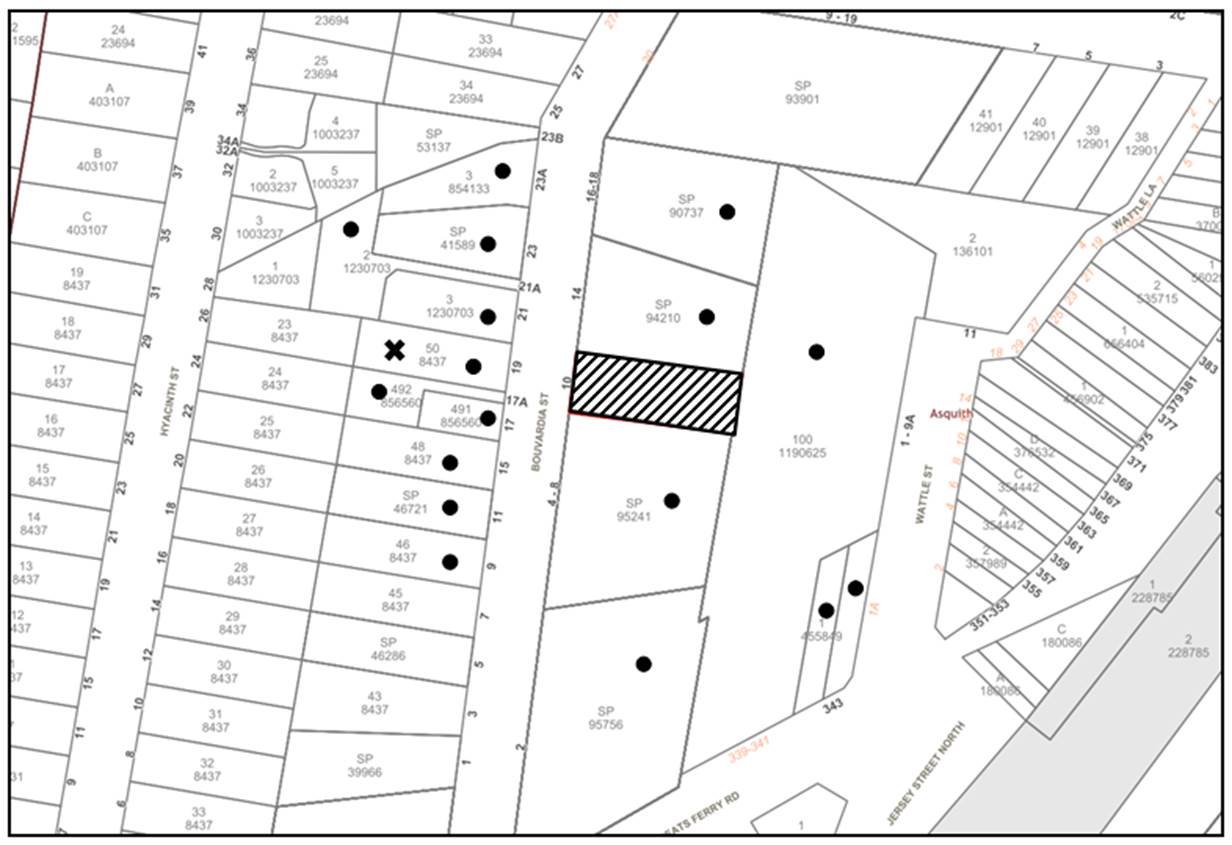
|
NOTIFICATION PLAN |
|||
|
• PROPERTIES NOTIFIED |
X SUBMISSIONS RECEIVED |
|
|
|
1 SUBMISSIONS RECEIVED OUT OF MAP RANGE |
|||
Two submissions objected to the development, generally on the grounds that the development would result in:
· Additional Traffic Congestion and Parking
o During construction with tradies and construction vehicles.
o Lack of on street parking as a result of overflow from neighbouring developments - this will only worsen.
o Further safety implications.
The merits of the matters raised in community submissions have been addressed in the body of the report with the exception of the following:
5.1.1 Traffic impacts
The proposal in of itself would not cause any unacceptable traffic generation impact from the additional vehicle movement increase to the site. Refer to Section 3.2.2 of this report for a detailed discussion.
5.1.2 Amenity impacts during construction
It is inevitable that with development comes some disruption and amenity impact to the neighbouring community.
Notwithstanding, there a number of conditions applied to the consent, including the implementation of a construction management plan approved by Council to manage and reduce any potential amenity impacts associated with demolition and construction works on the site.
5.1.3 Overpopulating area and lack of street parking
The proposed development would be consistent with the Greater Sydney Region Plan - A Metropolis of Three Cities and the North District Plan, by contributing to achieving the dwelling targets for the region.
The surrounding area has been re-zoned for higher density development and is in the process of transition which is consistent with Council’s Housing Strategy and the requirement for more dwellings in close proximity to established local centre, services and public transport. The character of the development is consistent with the zone objectives and surrounding developments, and it is considered that the site provides adequate parking. Lack of street parking is not a matter for consideration under this application.
The cumulative impact of this development has been considered in the strategic modelling for the housing strategy and appropriate conditions have been recommended in Schedule 1 for the payment of contributions to upgrade the local services.
5.2 Public Agencies
The development application was not referred to any Public Agencies for comment.
6. THE PUBLIC INTEREST
Section 4.15(1)(e) of the Act requires Council to consider “the public interest”.
The public interest is an overarching requirement, which includes the consideration of the matters discussed in this report. Implicit to the public interest is the achievement of future built outcomes adequately responding to and respecting the future desired outcomes expressed in environmental planning instruments and development control plans.
The application is considered to have satisfactorily addressed Council’s and relevant agencies’ criteria and would provide a development outcome that, on balance, would result in a positive impact for the community. Accordingly, it is considered that the approval of the proposed development would be in the public interest.
CONCLUSION
The application proposes demolition of existing structures and the construction of a 5 storey residential flat building comprising 15 units, basement car parking and associated landscaping/civil works
The development generally meets the desired outcomes of Council’s planning controls and is satisfactory having regard to the matters for consideration under Section 4.15 of the Environmental Planning and Assessment Act 1979.
Council received two submissions during the public notification period. The matters raised have been addressed in the body of the report.
Having regard to the circumstances of the case, approval of the application is recommended.
The reasons for this decision are:
· The request under Clause 4.6 of Hornsby Local Environmental Plan 2013 to contravene the ‘height of building’ development standard is well founded. Strict compliance with the development standard is considered unreasonable and unnecessary in the circumstances of the case and sufficient environmental planning grounds have been submitted to justify the contravention to the development standard.
· The development delivers 14 additional dwellings in an area close to public transport, recreation and shops and contributes to the goals of the National Housing Accord by improving housing supply.
· The proposed development complies with the requirements of State Environmental Planning Policy No. 65 Design Quality of Residential Flat Development.
· The proposed development does not create unreasonable environmental impacts to adjoining development with regard to visual bulk, solar access, amenity or privacy.
Note: At the time of the completion of this planning report, no persons have made a Political Donations Disclosure Statement pursuant to Section 10.4 of the Environmental Planning and Assessment Act 1979 in respect of the subject planning application.
|
Cassandra Williams Major Development Manager - Development Assessments Planning and Compliance Division |
Rod Pickles Manager - Development Assessments Planning and Compliance Division |
|
1.⇩ |
Locality Plan |
|
|
|
2.⇩ |
Clause 4.6 Variation |
|
|
|
3.⇩ |
Architectural Plans |
|
|
|
4.⇩ |
Landscape Plan |
|
|
File Reference: DA/75/2023
Document Number: D08716437
SCHEDULE 1
GENERAL CONDITIONS
1. Approved Plans and Supporting Documentation
The development must be carried out in accordance with the plans and documentation listed below and endorsed with Council’s stamp, except where amended by Council and/or other conditions of this consent:
Approved Plans
|
Plan No. |
Plan Title |
Drawn by |
Dated |
Council Reference |
|
A0001, Rev. F |
Cover Page |
Mackenzie Architects International |
30/08/23 |
|
|
A0003, Rev. F |
Site Plan |
Mackenzie Architects International |
30/08/23 |
|
|
A0004, Rev. A |
Demolition Plan |
Mackenzie Architects International |
15/12/22 |
|
|
Basement Plan |
Mackenzie Architects International |
30/08/23 |
|
|
|
A1002, Rev. F |
Ground Floor Plan |
Mackenzie Architects International |
30/08/23 |
|
|
A1003, Rev. E |
First Floor Plan |
Mackenzie Architects International |
28/08/23 |
|
|
A1004, Rev. E |
Second Floor Plan |
Mackenzie Architects International |
28/08/23 |
|
|
A1005, Rev. E |
Third Floor Plan |
Mackenzie Architects International |
28/08/23 |
|
|
A1006, Rev. E |
Fourth Floor Plan |
Mackenzie Architects International |
28/08/23 |
|
|
A1007, Rev. E |
Roof Plan |
Mackenzie Architects International |
28/08/23 |
|
|
A2001, Rev. F |
North Elevation |
Mackenzie Architects International |
28/08/23 |
|
|
A2002, Rev. E |
East Elevation |
Mackenzie Architects International |
28/08/23 |
|
|
A2003, Rev. F |
South Elevation |
Mackenzie Architects International |
30/08/23 |
|
|
A2004, Rev. F |
West Elevation |
Mackenzie Architects International |
30/08/23 |
|
|
A2101, Rev. F |
Section A |
Mackenzie Architects International |
30/08/23 |
|
|
A2102, Rev. D |
Section B |
Mackenzie Architects International |
28/08/23 |
|
|
A3007, Rev. B |
Pre-Post Adaptable |
Mackenzie Architects International |
09/05/23 |
|
|
A3008, Rev. F |
Sample Board |
Mackenzie Architects International |
30/08/23 |
|
|
22/2449, Sheet 1 of 2, Issue. F |
Landscape Plan/ Soil Areas Plan |
Paul Scrivener Landscape |
19/06/23 |
|
|
22/2449, Sheet 2 of 2, Issue. F |
Planting Plan, Notes and Schedule |
Paul Scrivener Landscape |
19/06/23 |
|
Supporting Documentation
|
Document Title |
Prepared by |
Dated |
Council Reference |
|
Arboricultural Implication Assessment and Tree Protection Specifications Issue A |
Horticultural Resources Consulting Group |
08/12/22 |
D08578260 |
|
BCA Report No. 2906 Rev B |
J2 BCA Consulting |
12/05/23 |
D08683451 |
|
Concept Stormwater Management Layout Plan, Job number SW22360, Issue E |
AWL Design - Civil Engineering Consultants |
02/08/23 |
D08709793 |
|
Public Drainage System Hydraulic Analysis, Job No. SW19276, Issue D |
AWL Design - Civil Engineering Consultants |
12/05/23 |
D08683452 |
|
Waste Management Plan Job No. 22NL185-WMP3 |
Loka Consulting Engineers |
08/05/23 |
D08683453 |
|
Survey Ref: 42038/D2-MGA |
Chadwick Cheng Consulting Surveyors |
21/09/22 |
D08578268 |
|
Traffic Report Ref: 22081 |
Terraffic Pty Ltd |
12/12/22 |
D08578266 |
|
Access Report |
Obvius Access |
13/12/22 |
D08578264 |
|
Acoustic Report Ref: 20221390.1/ 1312A/R0/ANP |
Acoustic Logic |
13/12/22 |
D08578262 |
|
BASIX Certificate No. 1362352M |
Eco Certificates |
15/12/22 |
D08578251 |
|
Geotechnical Report Ref: P2743_01 |
Morrow Geotechnics |
10/11/22 |
D08578235 |
Reason: To ensure all parties are aware of the approved plans and supporting documentation that apply to the development.
1. To comply with Council’s requirement in terms of traffic and parking, the approved plan No. A1001 Basement Plan Rev E prepared by Mackenzie Architects International, dated 30/08/23 is to be amended as follows:
a. One motorcycle parking space must be provided within the basement.
2. To ensure the landscape plans reflect the approved architectural plans, the approved landscape plans Job Ref: 22/2449 Sheet 1 (Landscape Plan/ Soil Areas Plan) and Sheet 2 (Planting Plan, Notes and Schedule) prepared by Paul Scrivener Landscape, dated 19/06/23 must be amended to reflect the relocation of bin area, fire stairs, OSD, rainwater tank and fire hydrant in accordance with the plan No. A1002 Ground Floor Plan Rev F prepared by Mackenzie Architects International, dated 30/08/23.
Note: There must be no reduction in number of plantings, as identified on the approved landscape plans.
3. These amended plans must be submitted with the application for the Construction Certificate.
Reason: To require minor amendments to the approved plans and supporting documentation following assessment of the development.
3. Removal of Trees
1. This development consent permits the removal of trees numbered T3 and T4 as identified in the Arboricultural Impact Assessment prepared by Horticultural Resources Consulting Group, dated 8 December 2022.
2. No consent is granted for the removal of trees numbered T1, T2 and T5 as these trees contribute to the established landscape amenity of the area/streetscape.
Note: The removal of any other trees from the site requires separate approval by Council in accordance with Part 1B.6 Tree and Vegetation Preservation of the Hornsby Development Control Plan, 2013.
Reason: To identify only those trees permitted to be removed.
4. Construction Certificate
1. A Construction Certificate is required to be approved by Council or a Private Certifying Authority prior to the commencement of any construction works under this consent.
2. A separate Roads Act Approval must be obtained from Council for all works within the public road reserve under S138 of the Roads Act 1993.
3. The Construction Certificate / Subdivision Works Certificate plans must be consistent with the Development Consent plans.
Reason: To ensure that detailed construction certificate plans are consistent with the approved plans and supporting documentation.
5. Section 7.11 Development Contributions
1. In accordance with Section 4.17(1) of the Environmental Planning and Assessment Act 1979 and the Hornsby Shire Council Section 7.11 Development Contributions Plan 2020-2030, the following monetary contributions must be paid to Council to cater for the increased demand for community infrastructure resulting from the development:
|
Description |
Contribution (4) |
|
Roads |
$12,866.35 |
|
Open Space and Recreation |
$161,837.40 |
|
Community Facilities |
$99,677.25 |
|
Plan Preparation and Administration |
$1,371.90 |
|
TOTAL |
$275,752.90 |
being for 1 x 1 bedroom unit, 14 x 2 bedroom units and a credit of 1 x dwelling.
2. The value of this contribution is current as of 24 August 2023. If the contribution is not paid within the financial quarter that this condition was generated, the contribution payable will be adjusted in accordance with the provisions of the Hornsby Shire Council Section 7.11 Development Contributions Plan and the amount payable will be calculated at the time of payment in the following manner:
$CPY = $CDC x CPIPY
CPIDC
Where:
$CPY is the amount of the contribution at the date of Payment.
$CDC is the amount of the contribution as set out in this Development Consent.
CPIPY is the latest release of the Consumer Price Index (Sydney - All Groups) at the date of Payment as published by the ABS.
CPIDC is the Consumer Price Index (Sydney - All Groups) for the financial quarter at the date applicable in this Development Consent Condition.
3. The monetary contribution must be paid to Council:
a. Prior to the issue of the Subdivision Certificate where the development is for subdivision; or
b. Prior to the issue of the first Construction Certificate where the development is for building work; or
c. Prior to issue of the Subdivision Certificate or first Construction Certificate, whichever occurs first, where the development involves both subdivision and building work; or
d. Prior to the works commencing where the development does not require a Construction Certificate or Subdivision Certificate.
Note: It is the professional responsibility of the Principal Certifier to ensure that the monetary contributions have been paid to Council in accordance with the above timeframes.
Note: In accordance with Ministerial Directions, the payment of contribution fees for development with a cost of works of over $10 million can be deferred to prior to Occupation Certificate.
Note: Council’s Development Contributions Plan may be viewed at www.hornsby.nsw.gov.au or a copy may be inspected at Council’s Administration Centre during normal business hours.
Reason: To ensure development contributions are paid to address the increased demand for community infrastructure resulting from the approved development.
BEFORE ISSUE OF A CONSTRUCTION CERTIFICATE
Detailed plans, specifications and supporting information is required to be submitted to the certifying authority detailing how the proposed building work achieves compliance with the National Construction Code - Building Code of Australia. All building work must be carried out in accordance with the requirements of the National Construction Code - Building Code of Australia.
Reason: Prescribed condition - EP&A Regulation section 69(1).
7. Fire System Hydrants, Boosters and Pumps
The required fire hydrants, sprinkler boosters or pumps must be installed in accordance with the recommendations contained in the BCA Report No. 2906 Rev B, prepared by J2 BCA Consulting, dated 12/05/23. Details demonstrating compliance are to be provided with the application for the construction certificate.
Reason: To ensure adequate protection is provided to NSW Fire & Rescue and to minimise the visual impact on the streetscape.
8. Fire Safety Schedule
A schedule of all proposed essential fire safety measures to be installed in the building (e.g., hydrants, hose reels, emergency warning systems etc.) shall be submitted with the construction certificate application. The schedule shall distinguish between existing and proposed fire safety measures.
Reason: To ensure all fire safety measures are identified to protect life and property.
9. Contract of Insurance (Residential Building Work)
Where residential building work for which the Home Building Act 1989 requires there to be a contract of insurance in force in accordance with Part 6 of that Act, this contract of insurance must be in force before any building work authorised to be carried out by the consent commences.
Reason: Prescribed condition EP&A Regulation section 69(2).
The applicant must submit written evidence of the following service provider requirements:
1. Ausgrid (formerly Energy Australia) - a letter of consent demonstrating that satisfactory arrangements have been made to service the proposed development.
2. Telstra - a letter of consent demonstrating that satisfactory arrangements have been made to service the proposed development.
Reason: To ensure the development is provided with the relevant utility services.
11. Sydney Water - Approval
This application must be submitted to Sydney Water for approval to determine whether the development would affect any Sydney Water infrastructure, and whether further requirements are to be met.
Note: Building plan approvals can be obtained online via Sydney Water Tap InTM through www.sydneywater.com.au under the Building and Development tab.
Reason: To ensure the development is provided with the relevant utility services.
1. Prior to the commencement of any works on site, the applicant must submit for approval by the Principal Certifier (with a copy forwarded to Council) a ‘Dilapidation Report’ detailing the structural condition of the adjoining properties:
a. SP 94210 at 14 Bouvardia Street, Asquith.
b. SP 95241 at 4-8 Bouvardia Street, Asquith.
c. Lot 100 DP 1190625 at 1-9A Wattle Street, Asquith.
2. The report must include a photographic survey of the adjoining properties detailing their physical condition, both internally and externally, including such items as walls, ceilings, roof, structural members, and other similar items. The report must be completed by a chartered structural/geotechnical engineer. A copy of the dilapidation report must be submitted to Council.
3. In the event access to adjoining allotments for the completion of a dilapidation survey is denied, the applicant must demonstrate in writing that all reasonable steps have been taken to advise the adjoining allotment owners of the benefit of this survey and details of failure to gain consent for access to the satisfaction of the Principle Certifying Authority.
Note: This documentation is for record keeping purposes only and can be made available to an applicant or affected property owner should it be requested to resolve any dispute over damage to adjoining properties arising from works. It is in the applicant’s and adjoining owner’s interest for it to be as detailed as possible.
Reason: To record the condition of adjoining properties and public land to resolve any dispute over damage from works.
13. Identification of Survey Marks
A registered surveyor must identify all survey marks in the vicinity of the proposed development. Any survey marks required to be removed or displaced as a result of the proposed development shall be undertaken by a registered surveyor in accordance with Section 24 (1) of the Surveying and Spatial Information Act 2002 and following the Surveyor General’s Directions No.11 Preservation of Survey Infrastructure.
Reason: To identify and protect the State’s survey infrastructure.
14. Stormwater Drainage
The stormwater drainage system for the development must be designed for an average recurrence interval (ARI) of 20 years and be gravity drained in accordance with the following requirements:
1. Connected directly to Council’s street drainage system and discharged via an on-site detention system.
2. Stormwater design to be generally in accordance with Concept Stormwater Management Layout Plan Job number SW22360 (02/08/23) issue E & Public Drainage System Hydraulic Analysis Job number SW19276 (12/05/23) issue D, both prepared by ALW Design.
3. Pump out storage to be designed in accordance with Australian Standard AS 3500.3.
Reason: To ensure appropriate provision for management and disposal of stormwater.
15. On-Site Stormwater Detention
An on-site stormwater detention system must be designed by a chartered civil engineer and constructed in accordance with the following requirements:
1. Have a capacity of not less than 13.6 cubic metres, and a maximum discharge (when full) of 13 litres per second.
2. Have a surcharge/inspection grate located directly above the outlet.
3. Discharge from the detention system must be controlled via 1 metre length of pipe, not less than 50 millimetres diameter or via a stainless plate with sharply drilled orifice bolted over the face of the outlet discharging into a larger diameter pipe capable of carrying the design flow to an approved Council system.
4. Where above ground and the average depth is greater than 0.3 metres, a ‘pool type’ safety fence and warning signs must be installed; and
5. Not be constructed in a location that would impact upon the visual or recreational amenity of residents.
Reason: To manage stormwater flows to minimise potential flooding.
16. Water Saving Urban Design
80% of the roof area of the development is to drain to a tank that has a capacity of 3,000 litres per 100m² of roof area of the development. The tank is to be connected to the communal water system, and to all dwellings for toilet flushing and laundry.
Reason: To manage the quantity and quality of stormwater to better protect the local environment and waterways.
17. Internal Driveway/Vehicular Areas
The driveway and parking areas on site must be designed, constructed and a Construction Certificate issued in accordance with Australian Standards AS2890.1, AS2890.2, AS3727 and the following requirements:
1. A Boundary Levels application must be obtained from Council for the design on the internal driveway The driveway be a rigid pavement.
2. The driveway grade must not exceed 25 percent and changes in grade must not exceed 12 percent.
3. Longitudinal sections along both the access driveway shall be submitted to the Principal Certifier in accordance with the relevant sections of AS 2890.1. The maximum grade shall not exceed 1 in 4 (25%) with the maximum changes of grade of 1 in 8 (12.5%) for summit grades and 1 in 6.7 (15%) for sag grades. Any transition grades shall have a minimum length of 2 metres. The longitudinal sections shall incorporate the design levels obtained by Council.
Reason: To provide safe vehicle and pedestrian access.
18. Footpath
A concrete footpath must be designed across the full frontage of the subject site in accordance with AUS-SPEC Specifications (www.hornsby.nsw.gov.au/property/build/aus-spec-terms-and-conditions) and the following requirements:
1. The existing footpath being removed.
2. Pouring of the concrete footpath to the full frontage of the subject site.
3. The land adjoining the footpath to be fully turfed.
4. Any public utility adjustments to be carried out at the cost of the applicant and to the requirements of the relevant public authority.
5. Detailed engineering plans are to be submitted to Council for approval.
Reason: To provide safe pedestrian movement.
19. Road Works
Prior to the issue of a Construction Certificate, a separate approval under Section 138 of the Roads Act 1993 must be obtained from Council by lodging an application via the NSW e-planning portal for works within the public road reserve. All road works approved under this consent must be designed in accordance with AUS-SPEC Specifications (www.hornsby.nsw.gov.au/property/build/aus-spec-terms-and-conditions) and the following requirements:
1. The existing kerb and gutter is to be removed and reconstructed. All redundant access crossings are to be removed and the area made good.
2. The existing road pavement to be saw cut a minimum of 300 mm from the existing edge of the bitumen and reconstructed.
3. The submission of a compaction certificate from a geotechnical engineer for any fill within road reserves, and all road sub-grade and road pavement materials.
4. Detailed engineering plans are to be submitted to Council for approval.
Reason: To ensure infrastructure works are designed and constructed to appropriate standards and requirements of the Roads Act 1993.
20. Structural Design
All structural details must be designed by a Chartered Structural Engineer of the Institution of Engineers Australia with structural details to be submitted with the application of the Construction Certificate.
Reason: To ensure compliance with structural detail requirements.
21. Mechanical Equipment
A detailed mechanical plant noise assessment for all proposed mechanical equipment must be undertaken by a suitably qualified Acoustic Consultant and a report certifying that the operation of all proposed equipment will not exceed the noise criteria adopted in the approved acoustic report must be submitted to the Principal Certifier prior to the issue of the Construction Certificate.
Reason: To protect the acoustic amenity of the local area.
The following details must be provided with the Construction Certificate plans:
1. The development is required to provide the following adaptable/Liveable housing:
a. A minimum of 10% of all units must be designed to be adaptable units.
b. A minimum of 20% of all units must be Universal Design housing in accordance with the Liveable Housing Guidelines (2012) silver level design features.
2. Each dwelling within the development must have a minimum area for storage (not including kitchen and bedroom cupboards) of 6m3 for one bedroom units, 8m3 for two bedroom units and 10m3 for three bedroom units, where 50% is required to be located within the apartment and accessible from either the hall or living area.
Reason: To ensure the development meets accessibility requirements.
23. Services
To provide a development that enhances the visual quality of the public domain, the following must be indicated on the Construction Certificate drawings:
1. Heating, Ventilation and Air Conditioning (HVAC) must be grouped within designated areas in the basement and roof. No air conditioning units are permitted on private balconies.
2. Wall-mounted equipment and associated pipework must be concealed into wall cabinets and duct.
3. Letter boxes must be located perpendicular to the road.
4. Powerlines must be underground on the road reserve at the front of the site. The above details must be detailed and provided with the Construction Certificate Plans.
Reason: To ensure the development maintains the visual quality of the public domain.
24. Fencing Details
The following fencing details must be provided on the construction certificate drawings:
1. Within street setbacks, front fences are not permitted unless shown on the approved landscape plans. Any front fencing must be a maximum height of 1.2 metres.
2. Planting at grade, or low walls screened by planting and/ or planter boxes are permitted at the interface between the private and public domain land.
3. Enclosure of private courtyards within the front setbacks must achieve at least 50 percent transparency and be a maximum height of 1.5m above the adjacent communal space.
4. Side and rear boundary fences should be a maximum of 1.8 metres high, sited behind the front building line. The above details must be detailed and provided with the Construction Certificate Plans.
Reason: To ensure the proposal meets landscape requirements and maintains the visual quality of the public domain.
The following waste management requirements must be complied with:
1. Should there be any conflict or confusion between approved plans and/or consent conditions related to the waste management system or the waste collection vehicle travel path on site, then written clarification must be obtained from Council.
2. The approved on-going waste management system must not be amended without the written consent of Council.
3. Details of all changes to the waste management plans (including but not limited to, the chute system, bin storage/ chute service rooms, bin carting paths, bulky waste storage) must be submitted to Council’s Waste Team (devmail@hornsby.nsw.gov.au) for written approval prior to the issue of a Construction Certificate.
4. There must be no steps along any bin carting route. Ramps and service lifts are acceptable.
Note: bin carting routes include, but are not limited to, from the bin storage rooms to the ground level temporary bin holding bay, from the ground level bin storage/holding bay to the kerbside.
5. For all bin carting routes, the path must be smooth hard surface. (Concrete pavement for example is acceptable, but pebbles, stepping stones, grass etc is not acceptable).
6. A design certificate and detailed plans are to accompany any Construction Certificate application, which demonstrate that the bin carting route from the ground level bin temporary bin holding bay to the street in accordance with the Waste Minimisation and Management Guidelines and including the following requirements:
a. Must be smooth hard surface.
b. Must be sufficiently wide to hold all serviceable bins and provide aisle space for manoeuvring bins out and in (including through any gates or doors).
c. Must be devoid of steps.
7. A design certificate and detailed plans are to accompany any Construction Certificate application, which demonstrate that the waste carting route from each dwelling to the bulky waste storage area has been designed to be constructed in accordance with the Waste Minimisation and Management Guidelines and including the following requirements:
a. The route is direct, does not cross into a private lot, and is wholly within property boundaries (does not include the public footpath or road).
b. The route is as short as possible and does not exceed 30m walking distance.
c. The route is an accessible path of travel for persons with a disability in accordance with AS1428 Design and Access for Mobility.
a. The floor is to be constructed of concrete at least 75mm thick and adequately graded to drain to a Sydney Water approved drainage fitting.
b. The floor must be finished so that it is non-slip, sealed and impervious, and has a smooth and even surface coved at all intersections.
c. The ceilings and walls must be finished with smooth faced non-absorbent material capable of being cleaned.
d. The room is to be provided with artificial light controllable within the room and adequate forced ventilation.
e. The room is to be provided with an adequate supply of hot and cold water mixed through a centralised mixing valve with hose cock.
f. The doors are to be robust and lockable, with a door opening of no less than 2m. The doors must be able to be opened from inside the room without a key.
g. The chute service room must have sufficient space to comfortably house the required volume handling equipment and to load/unload bins from this equipment, and sufficient space to store the spare garbage bins for that building and to access and manoeuvre the bins. The doors to the chute service rooms must be wide enough and positioned to fit the 240L bins through.
11. A design certificate and detailed plans are to accompany any Construction Certificate application, which demonstrate that the bin holding bay at ground level has been designed to be constructed in accordance with the Waste Minimisation and Management Guidelines and specifically the following requirements:
a. There must be no step(s) between the bin bay and the street.
b. The bin carting route from the bin holding bay to the street must not exceed a gradient of 1:14.
c. The bin holding bays must be integrated into the overall design of the development and landscaping to minimise impact on the streetscape and include screening to a height of no less than 1.5m.
d. The internal dimensions of the ground level bin holding bay must be sufficient to house the required bin (refer to general conditions). Internal dimensions do not include wall thickness, support columns, ventilation shafts etc for which additional space must be allowed with consideration of the bin layout.
Note: a 240L recycling bin is 600 mm wide by 750 mm deep.
a. Be accessible by persons with a disability after the garbage chute and recycling bin are installed.
b. Comfortably house the required garbage chute and 240 L recycling bin and 240L FOGO bin.
c. Have door(s) wide enough and positioned so that the 240 L recycling bin and 240L FOGO bin can fit through with ease.
Note: a 240 L recycling bin is 600 mm wide by 750 mm deep; allow for ease around the bin - 75 mm is recommended. These dimensions do not include wall thickness, door thickness, ventilation ducting etc, which must be added. The chute system supplier must be consulted for chute space requirements. AS 1428.1 requires at least 800 mm clear doorway opening for wheelchair access.
Note: Internal dimensions do not include wall thickness, door thickness, ventilation ducting etc, which must be added. AS 1428.1 requires at least 800 mm clear doorway opening for wheelchair access.
a. Chutes, service openings and charging devices are constructed of metal or a smooth faced surface which is fire resistant and of impervious material.
b. Chute is cylindrical in section, vertical and without bends as it passes through the floors.
c. Chutes must terminate in the waste storage room and discharge into a waste bin.
d. The chute system must comply with the manufacturers technical specifications and operational limitations.
e. The gradient of each chute must be no less than the minimum gradient recommended by the chute manufacturer.
f. Each chute system must include volume handling equipment to automatically change the bin under the chute when it becomes full and thereby provide a minimum 3 day bin capacity under the chute.
g. The required volume handling equipment for each chute system must not include compaction.
h. The chute service rooms must have sufficient space to comfortably house the required volume handling equipment and to load/unload bins from this equipment, and sufficient space to store the spare garbage and recycling bins for that building and to access and manoeuvre the bins.
Note: The linear track system or carousel volume handling equipment should be designed to accommodate 4 X 240L general waste bins.
Note: 1 x additional 240L bin will be provided for use under the chute on bin service days.
Reason: To ensure appropriate waste management for the development.
26. Appointment of a Project Arborist
2. Details of the appointed project arborist must be submitted to Council and the PCA with the application for the construction certificate/subdivision works certificate.
Reason: To ensure appropriate monitoring of tree(s) to be retained.
27. Construction Management Plan (CMP)
A Construction Management Plan (CMP) must be prepared by a suitably qualified consultant in consultation with a qualified traffic engineer and submitted to Council for review.
The CMP assists with the protection of the public, the environment, and Council’s assets during all stages of construction works and must include the following:
1. Description of the works
a. A general description of the scope of works.
b. Details of the extent of earthworks including quantities of excavated and imported material to be transported to and from the site.
c. Details of any staging of works.
2. Construction traffic and management
a. The anticipated number and frequency of truck movements per day over the duration of the project (i.e., throughout demolition, earthworks, and construction phases) for fill importation and exportation. The number of trucks should correlate to the volume of fill material to be imported to/exported from the site.
b. The vehicle traffic routes to and from the site, including any queuing locations. The vehicle routes should be identified on a plan attached to the PCMP.
c. Size and types of construction vehicles to be used for importation and exportation of fill throughout the stages of works.
d. Access and egress into the site, including any limitation on access for certain types of vehicles (determined via swept path analysis) due to site constraints.
e. Any required road closures/openings, work zones, crane permits, road occupancy licences and traffic control.
f. Management measures to be implemented to minimise disruption to, and maintain the safety, of all road users.
3. Pedestrian management
a. Potential impacts on pedestrian movements. This includes consideration of locations or times where footpaths are heavily trafficked (e.g., school arrival and departure; commuter peaks).
b. Management measures to be implemented to minimise disruptions to pedestrians and maintain safety.
4. Car parking
a. Impacts on on-street parking (e.g., use of work zones, construction access implications).
b. Details of construction worker parking. Where limited car parking is available on site or nearby, details of alternative transport arrangements must be provided.
5. Tree management and protection
a. Trees to be removed and retained on site consistent with other lodged Plans, including tree protection measures.
6. Stormwater Management
a. Details of stormwater management and disposal during excavation and construction, consistent with other lodged Plans.
b. Identification of existing watercourses.
c. Sediment and erosion control measures.
7. Noise and Vibration
a. Expected sources of noise and vibration during demolition, earthworks, and construction at sensitive receiver locations.
b. Duration of works that are expected to emit higher than average levels of noise and vibration (e.g., rock breaking and rock sawing).
c. Details of mitigation measures to minimise noise and vibration impacts
8. Waste Management
a. Detail the reuse, recycling and disposal methods for all demolition and construction waste on site.
9. Site plan
a. A site plan which identifies the following information at each stage of the development:
i. Existing and proposed buildings
ii. Site boundaries
iii. Extent of proposed earthworks (i.e., excavation and fill importation locations, and cut and fill locations)
iv. Existing trees and vegetation to be removed and retained and tree protection measures (consistent with TPP if required to be submitted as part of the Development Application)
v. Vehicle access and egress
vi. On-site vehicle parking areas
vii. Proposed hard-stand areas for loading and unloading materials, including the location of cranes and concrete pumps
viii. Location of material storage on-site, stockpiles, site sheds, hoardings, waste storage
ix. Location of sediment control measures (consistent with Erosion and Sediment Control plans submitted as part of the Development Application)
x. Potential Work Zone locations
10. The CMP must detail all responsible parties ensuring compliance with the document and include the contact information for developers, builder, principal certifier, and any emergency details during and outside work hours.
Note: The CMP must be lodged via Council’s Online Services Portal at: https://hornsbyprd-pwy-epw.cloud.infor.com/ePathway/Production/Web/Default.aspx and by selecting the following menu options: Applications > New Applications > Under ‘Application Types’: Management Plans.
Reason: To document construction measures to protect the public and the surrounding environment.
28. Electric Vehicle (EV) Ready Connections
Prior to the issue of the relevant Construction Certificate, the following must be demonstrated to the satisfaction of the Principal Certifier:
1. The car park must provide Electric Vehicle (EV) Ready Connections (minimum ’Level 2’ electric vehicle circuitry) to at least 25% of allocated on-site parking spaces; and
2. The carpark must provide EV Distribution Board(s) of sufficient size to allow connection of all EV Ready Connections
Note: EV Ready Connection is the provision of a dedicated spare 32A circuit provided in an EV Distribution Board to enable easy future installation of cabling from an EV charger to the EV Distribution Board and a circuit breaker to feed the circuit.
Note: EV Distribution Board is a distribution board dedicated to EV charging that is capable of supplying not less than 50% of EV connections at full power at any one time during off-peak periods and includes an EV Load Management System.
The EV Distribution Board should provide adequate space for the future installation (post construction) of compact meters in or adjacent to the distribution board, to enable individual EV usage to be measured.
Reason: To encourage and support the use of electric vehicles.
29. Retaining Walls
To ensure the stability of the site, structural details of all required retaining walls must be submitted with the application for the Construction Certificate.
Reason: To ensure the stability of the site and adjoining properties.
BEFORE WORK COMMENCES
30. Notice of Commencement for Demolition
At least one week before demolition work commences, written notice must be provided to council and the occupiers of neighbouring premises of the work commencing. The notice must include:
1. Name
2 Address
3 Contact telephone number
4 Licence type and license number of any demolition waste removal contractor and, if applicable, asbestos removal contractor
5 The contact telephone number of council and
6 The contact telephone number of SafeWork NSW (4921 2900)
Note: The written notice to Council can be sent to devmail@hornsby.nsw.gov.au.
Reason: To advise neighbours about the commencement of demolition work and provide contact details for enquiries.
31. Hazardous Material Survey Before Demolition
Before demolition work commences, a hazardous materials survey of the site must be prepared by a suitably qualified person and a report of the survey results must be provided to council at least one week before demolition commences.
Hazardous materials include, but are not limited to, asbestos materials, synthetic mineral fibre, roof dust, PCB materials and lead based paint.
The report must include at least the following information:
1. The location of all hazardous material throughout the site
2. A description of the hazardous material
3. The form in which the hazardous material is found, e.g., AC sheeting, transformers, contaminated soil, roof dust
4. An estimation of the quantity of each hazardous material by volume, number, surface area or weight
5. A brief description of the method for removal, handling, on-site storage, and transportation of the hazardous materials
6. Identification of the disposal sites to which the hazardous materials will be taken
Note: The Hazardous Material Survey must be lodged via Council’s Online Services Portal at: https://hornsbyprd-pwy-epw.cloud.infor.com/ePathway/Production/Web/Default.aspx and by selecting the following menu options: Applications > New Applications > Under ‘Application Types’: Management Plans.
Reason: To require a plan for safely managing hazardous materials.
32. Erection of Construction Sign
1. A sign must be erected in a prominent position on any site on which any approved work is being carried out:
a. Showing the name, address, and telephone number of the Principal Certifier for the work.
b. Showing the name of the principal contractor (if any) for any demolition or building work and a telephone number on which that person may be contacted outside working hours; and
c. Stating that unauthorised entry to the work site is prohibited.
2. The sign is to be maintained while the approved work is being carried out and must be removed when the work has been completed.
Reason: Prescribed condition EP&A Regulation, section 70(2) and (3).
33. Protection of Adjoining Areas
A temporary hoarding, fence or awning must be erected between the work site and adjoining lands before the works begin and must be kept in place until after the completion of the works if the works:
1. Could cause a danger, obstruction, or inconvenience to pedestrian or vehicular traffic.
2. Could cause damage to adjoining lands by falling objects; and/or
3. Involve the enclosure of a public place or part of a public place; and/or
4. Have been identified as requiring a temporary hoarding, fence, or awning within the Council approved Construction Management Plan (CMP).
Note: Notwithstanding the above, Council’s separate written approval is required prior to the erection of any structure or other obstruction on public land.
Reason: To ensure public safety and protection of adjoining land.
34. Toilet Facilities
1. To provide a safe and hygienic workplace, toilet facilities must be available or be installed at the works site before works begin and must be maintained until the works are completed at a ratio of one toilet for every 20 persons employed at the site.
2. Each toilet must:
a. Be a standard flushing toilet connected to a public sewer; or
b. Be a temporary chemical closet approved under the Local Government Act 1993; or
c. Have an on-site effluent disposal system approved under the Local Government Act 1993.
Reason: To ensure adequate toilet facilities are provided.
35. Cancellation of Waste Collection Service
Prior to the commencement of any works, the on-going waste collection service must be cancelled, and the bins retrieved by the waste collection service provider.
Note: For residential properties, Council is the waste collection service provider.
Reason: To ensure domestic waste bins are not used for demolition and construction waste.
36. Garbage Receptacle
A garbage receptacle must be provided at the work site before works begin and must be maintained until all works are completed.
1. The garbage receptacle must have a tight fitting lid and be suitable for the reception of food scraps and papers.
2. The receptacle lid must be kept closed at all times, other than when garbage is being deposited.
3. Food scraps must be placed in the garbage receptacle and not in demolition and construction waste bins.
Reason: To maintain the site in a clean condition and protect local amenity.
37. Erosion and Sediment Control
To protect the water quality of the downstream environment, erosion and sediment control measures must be provided and maintained throughout the construction period in accordance with the manual ‘Urban Stormwater: Soils and Construction “The Blue Book” 2004 (4th edition), the approved plans, Council specifications and to the satisfaction of the principal certifying authority. The erosion and sediment control devices must remain in place until the site has been stabilised and revegetated.
Note: On the spot penalties may be issued for any non-compliance with this requirement without any further notification or warning.
Reason: To minimise impacts on the water quality of the downstream environment.
38. Installation of Tree Protection Measures
1. Trees to be retained and numbered T1 and T5 as identified on the Tree Location Plan prepared by Horticultural Resources Consulting Group, dated 8 December 2022 must have tree protection measures for the ground, trunk and canopy installed by the project arborist as follows:
a. For the duration of demolition works, in accordance with the Tree Management Plan (Appendix A) prepared by Horticultural Resources Consulting Group, dated 8 December 2022.
b. For the duration of construction works, in accordance with Tree Management Plan (Appendix A) prepared by Horticultural Resources Consulting Group, dated 8 December 2022.
2. Tree protection fencing for the trees to be retained numbered T1 and T5 must be installed by the engaged AQF 5 project arborist and consist of 1.8m high temporary fencing panels installed in accordance with Australian Standard AS4687-2007 Temporary fencing and hoardings.
3. The installation of all required tree protection fencing must include shade cloth attached to the fencing to reduce transport of dust, particulates and liquids from entering the tree protection zone.
Reason: To protect trees during construction.
DURING DEMOLITION AND BUILDING WORKS
39. Demolition and Construction Work Hours
1. All works on site, including demolition and earth works, must only occur between 7am and 5pm Monday to Saturday (unless otherwise approved in writing by Council due to extenuating circumstances).
2. No work is to be undertaken on Sundays or public holidays.
Reason: To protect the amenity of neighbouring properties.
40. Demolition
To protect the surrounding environment, all demolition work must be carried out in accordance with Australian Standard AS2601-2001 Demolition of structures and the following requirements:
1. Demolition material must be disposed of to an authorised recycling and/or waste disposal site and/or in accordance with an approved waste management plan; and
2. Demolition works, where asbestos material is being removed, must be undertaken by a contractor that holds an appropriate licence issued by SafeWork NSW in accordance with the Work Health and Safety Regulation 2017 and be appropriately transported and disposed of in accordance with the Protection of the Environment Operations (Waste) Regulation 2014; and
3. On construction sites where any building contains asbestos material, a standard commercially manufactured sign containing the words ‘DANGER ASBESTOS REMOVAL IN PROGRESS’ and measuring not less than 400mm x 300mm must be displayed in a prominent position visible from the street.
Reason: To ensure the appropriate removal and disposal of demolition materials.
41. Handling of Asbestos During Demolition
While demolition work is being carried out, any work involving the removal of asbestos must comply with the following requirements:
1. Only an asbestos removal contractor who holds the required class of Asbestos Licence issued by SafeWork NSW must carry out the removal, handling, and disposal of any asbestos material.
2. Asbestos waste in any form must be disposed of at a waste facility licensed by the NSW Environment Protection Authority to accept asbestos waste; and
3. Any asbestos waste load over 100kg (including asbestos contaminated soil) or 10m² or more of asbestos sheeting must be registered with the EPA on-line reporting tool Waste Locate.
Reason: To ensure that the removal of asbestos is undertaken safely and professionally.
42. Environmental Management (Air Pollution)
The Applicant must take all reasonable steps to minimise dust generated during all works authorised by this consent. During construction, the Applicant must ensure that:
1. Exposed surfaces and stockpiles are suppressed by regular watering.
2. All trucks entering or leaving the site with loads have their loads covered.
3. Trucks associated with the development do not track dirt onto the public road network.
4. Public roads used by these trucks are kept clean; and
5. Land stabilisation works are carried out progressively on site to minimise exposed surfaces.
Reason: To minimise impacts to the natural environment and public health.
During works and until exposed ground surfaces across the site have been stabilised, street sweeping must be undertaken following sediment tracking from the site.
The street cleaning service must utilise a ‘scrub and dry’ method and be undertaken for the full extent of any sediment tracking.
Reason: To minimise impacts to the natural environment.
44. Works Zone
All construction vehicles associated with the proposed development are to be contained on site or in a Local Traffic Committee (LTC) approved “Works Zone” as follows:
1. The site supervisor to be advised that the Works Zone will be deemed to be in effect, and fees will apply, between the dates nominated by the supervisor, or when parking spaces are managed for the sole use of construction vehicles associated with the site.
2. The Works Zone signs shall be in effect only for the times approved by Council, and the time is to be noted on the sign. E.g., ‘Works Zone Mon - Sat 7am - 5pm’.
3. The applicant is required to supply a sign posting installation plan for referral to the Local Traffic Committee, noting on it the duration of the Works Zone.
4. The Works Zone is only to be used for the loading and unloading of vehicles. Parking of workers’ vehicles, or storage of materials, is not permitted.
Note: A Works Zone Permit can be obtained via Council’s Online Services Portal at: Work Zone Permit | Hornsby Shire Council (nsw.gov.au).
Reason: To protect the amenity of neighbouring properties.
45. Council Property
To ensure that the public reserve is kept in a clean, tidy, and safe condition during construction works, no building materials, waste, machinery, or related matter is to be stored on the road or footpath.
Reason: To protect public land.
46. Disturbance of Existing Site
During construction works, the existing ground levels of open space areas and natural landscape features, including natural rock-outcrops, vegetation, soil, and watercourses must not be altered unless otherwise nominated on the approved plans.
Reason: To protect the natural features of the site.
47. Soil Management (Excavation and Fill)
While site work is being carried out, the Principal Certifier or Council (where a principal certifier is not required) must be satisfied all soil removed from or imported to the site is managed in accordance with the following requirements:
1. All excavated material removed from the site must be classified in accordance with the EPA’s Waste Classification Guidelines before it is disposed of at an approved waste management facility and the classification, and the volume of material removed must be reported to the Principal Certifier or Council (where a principal certifier is not required).
2. Tipping dockets for the total volume of excavated material that are received from the licensed waste management facility must be provided to the Principal Certifier prior to the issue of an Occupation Certificate.
3. Prior to fill material being imported to the site, a Waste Classification Certificate shall be obtained from a suitably qualified environmental consultant confirming all fill material imported to the site must be:
a. Virgin Excavated Natural Material as defined in Schedule 1 of the Protection of the Environment Operations Act 1997, or
b. A material identified as being subject to a resource recovery exemption by the NSW EPA, or
c. A combination of Virgin Excavated Natural Material as defined in Schedule 1 of the Protection of the Environment Operations Act 1997 and a material identified as being subject to a resource recovery exemption by the NSW EPA.
4. The required Waste Classification Certificate must be provided to the Principal Contractor prior to fill being imported to the site and made available to Council at its request.
Reason: To ensure soil removed from the site is appropriately disposed of and soil imported to the site is not contaminated and is safe for future occupants.
48. Survey Report
A report(s) must be prepared by a registered surveyor and submitted to the principal certifying authority:
1. Prior to the pouring of concrete at each level of the building certifying that:
a. The building, retaining walls and the like have been correctly positioned on the site; and
b. The finished floor level(s) are in accordance with the approved plans.
2. Confirming that the waste collection vehicle turning area complies with Australian Standard AS2890.1 - 2004 and AS20890.2 - 2002 for small rigid vehicles (SRV).
Reason: To ensure buildings are positioned in the approved location and at the correct height.
Requirements of the approved Waste Management Plan shall be complied with during all site preparation works, demolition and throughout all construction works. When implementing the Waste Management Plan, the developer is to ensure:
1. The disposal of any demolition and construction waste must be undertaken in accordance with the requirements of the Protection of Environment Operations Act 1997.
2. All waste on site is to be stored, handled and disposed of in such a manner as to not create air pollution, offensive noise or pollution of land and water as defined by the Protection of Environment Operations Act 1997.
3. Generation, storage, treatment and disposal of hazardous waste is conducted in accordance with the relevant waste legislation administered by the EPA and relevant Occupational Health and Safety legislation administered by WorkCover NSW.
4. All waste generated (including excavated materials) which cannot be reused or recycled must be transported to a facility which can lawfully accept it.
5. All materials and resources that are to be stored on site during construction works are contained on the site. The provisions of the Protection of Environment Operations Act 1997 must be complied with when placing/stock piling loose material, disposal of concrete waste or activities which have potential to pollute drains and water courses.
6. The storage of waste and recycling containers must be within the boundaries of the development site at all times. Public footways and roads must not be used for the storage of any waste and must be kept clear of obstructions during all construction works.
7. Additionally, written records of the following items must be maintained during the removal of any waste from the site and such information submitted to the Principal Certifier within fourteen days of the date of completion of the works:
a. The identity of the person removing the waste.
b. The waste carrier vehicle registration.
c. Date and time of waste collection.
d. A description of the waste (type of waste and estimated quantity).
e. Details of the site to which the waste is to be taken.
f. The corresponding weighbridge tip docket/receipt from the site to which the waste is transferred (noting date and time of delivery, description (type and quantity) of waste).
g. Whether the waste is expected to be reused, recycled or go to landfill.
Note: In accordance with the Protection of the Environment Operations Act 1997, the definition of waste includes any unwanted substance, regardless of whether it is reused, recycled or disposed to landfill.
8. A report must be prepared by a registered surveyor and submitted to the principal certifying authority:
a. Prior to the pouring of the concrete on the ground level, certifying that: the ground level bin storage/holding bay is at the same level as the driveway (no steps).
Reason: To ensure the management of waste to protect the environment and local amenity during construction.
50. Compliance with Acoustic Report
All control measures nominated in the Acoustic Report Ref: 20221390.1/1312A/R0/ANP, prepared by Acoustic Logic, dated 13/12/2022 must be implemented.
Reason: To ensure implementation of acoustic measures to protect the public and the surrounding environment.
51. Compliance with Construction Management Plan
The Council approved Construction Management Plan must be complied with for the duration of works, unless otherwise approved by Council.
Reason: To ensure implementation of construction measures to protect the public and the surrounding environment.
52. Prohibited Actions within the Fenced Tree Protection Zone
The following activities are prohibited within the approved fenced tree protection zones unless otherwise approved by Council:
1. Soil cutting or filling, including excavation and trenching
2. Soil cultivation, disturbance, or compaction
3. Stockpiling storage or mixing of materials
4. The parking, storing, washing, and repairing of tools, equipment, and machinery
5. The disposal of liquids and refuelling
6. The disposal of building materials
7. The siting of offices or sheds
8. Any action leading to the impact on tree health or structure
Reason: To protect trees during construction.
53. Maintaining the Health of Trees Approved for Retention
The appointed project arborist must monitor and record any and all necessary actions required to maintain tree health and condition for trees numbered T1 and T5 on the approved plans.
Reason: To ensure appropriate monitoring of tree(s) to be retained.
54. Maintaining Tree Protection Measures
Tree Protection Measures must be maintained by the project arborist for the duration of works.
Reason: To protect trees during construction.
55. Approved Works within Tree Protection Zone Incursions
1. Where tree root pruning is required for the installation of piers, driveway or underground services, the pruning must be overseen by the AQF 5 project arborist and must be undertaken as follows:
a. Using sharp secateurs, pruners, handsaws, or chainsaws with the final cut being clean.
b. The maximum diameter of roots permitted to be cut is 40mm.
2. Approved excavations within the Tree Protection Zone of trees to be retained not associated with installation of services must be undertaken as follows:
a. Excavations for the construction and/or installation of the house/deck/driveway/piers in the Tree Protection Zone of trees to be retained on the approved plans must be supervised by the project arborist for the first 1 metre undertaken manually to locate roots and allow for pruning in accordance with condition 57(1).
3. To minimise impacts within the Tree Protection Zone (TPZ) of trees to be retained on the approved plans, the installation of services must be undertaken as follows:
a. The AQF 5 project arborist must be present to oversee the installation of any underground services which enter or transect the tree protection.
b. The installation of any underground services which either enter or transect the designated TPZ must be undertaken manually.
c. For manually excavated trenches the AQF 5 project arborist must designate roots to be retained. Manual excavation may include the use of pneumatic and hydraulic tools.
4. Where scaffolding is required, ground protection must be installed beneath the scaffolding in the following order:
a. Installation of a 100mm deep layer of woodchip and.
b. Installation of geotextile fabric ground covering and.
c. Installation of scaffold boarding above the woodchip and geotextile fabric.
Reason: To protect trees during construction.
56. Unexpected Finds
Should the presence of asbestos or soil contamination, not recognised during the application process be identified during any stage of works, the applicant must immediately notify the Principal Certifier and Council.
Reason: To ensure the appropriate removal and disposal of contaminated materials.
57. De-watering of Excavated Sites
Water that accumulates within an excavation must be removed and disposed of in a manner that does not result in the pollution of waters, nuisance to neighbouring properties, or damage to neighbouring land and/or property.
Reason: To document the safe removal of water during work to protect the public and the surrounding environment.
BEFORE ISSUE OF AN OCCUPATION CERTIFICATE
58. Fulfilment of BASIX Commitments
The applicant must demonstrate the fulfilment of BASIX commitments pertaining to the development.
Reason: Prescribed condition under section 75. EP&A Regulation.
59. Sydney Water - s73 Certificate
A s73 Certificate must be obtained from Sydney Water and submitted to the PCA.
Note: Sydney Water requires that s73 applications are to be made through an authorised Sydney Water Servicing Coordinator. Refer to www.sydneywater.com.au or telephone 13 20 92 for assistance.
Reason: To ensure compliance with the requirements of Sydney Water.
60. Certification of WSUD Facilities
Prior to the issue of an Occupation Certificate a certificate from a Civil Engineer is to be obtained stating that the Water Saving Urban Design facilities have been constructed and will meet the water quality targets as specified in the Hornsby Development Control Plan 2013.
Reason: To ensure compliance with WSUD commitments.
61. Replacement Tree Requirements
1. The trees approved for removal under this consent, being trees numbered T3 and T4 must be offset through replacement planting of a minimum of 2 trees.
2. These 2 replacement plantings must be species selected from the ‘Trees Indigenous to Hornsby Shire (as of 1 September 2011)’ document available for viewing on the Hornsby Council’s website http://www.hornsby.nsw.gov.au/environment/flora-and-fauna/tree-management/indigenous-trees
3. The location and size of tree replacement plantings must comply with the following:
a. All replacement trees must be located in either the front or rear setbacks and planted 4 metres or greater from the foundation walls of the approved development.
b. The pot size of the replacement trees must be a minimum 45 litres.
c. All replacement trees must be a minimum of 3 metres in height.
d. All replacement trees must have the potential to reach a mature height greater than 10 metres.
Reason: To ensure replacement planting to maintain tree canopy.
62. Final Certification
The AQF 5 Project arborist must submit to the Principal Certifier a certificate that includes the following:
1. All tree protection requirements complied with the as approved tree protection plan for the duration of demolition and/or construction works and.
2. All completed works relating to tree protection and maintenance have been carried out in compliance with the conditions of consent and approved plans and.
3. Dates, times, and reasons for all site attendance and.
4. All works undertaken to maintain the health of retained trees and.
5. Details of tree protection zone maintenance for the duration of works.
Note: Copies of monitoring documentation may be requested throughout the development works.
Reason: To ensure compliance with tree protection commitments.
63. Asbestos Clearance Certificate
Should any asbestos be encountered during demolition or construction works, a licenced asbestos assessor is required to provide a Clearance Certificate to the Certifier prior to the issue of an Occupation Certificate, certifying that the asbestos has been removed and appropriately disposed of, and the site is now suitable for its approved use.
Reason: To ensure the appropriate removal and disposal of contaminated materials and the site is suitable for its approved use.
64. Unit Numbering
All units are to be numbered consecutively commencing at No.1. The strata plan lot number is to coincide with the unit number, e.g Unit 1 = Lot 1. The allocated of unit numbering must be authorised by Council prior to the numbering of each units in the development.
Reason: To maintain property numbering in accordance with Australian Standards.
65. Damage to Council Assets
To protect public property and infrastructure, any damage caused to Council’s assets as a result of the construction or demolition of the development must be rectified by the applicant in accordance with AUS-SPEC Specifications (www.hornsby.nsw.gov.au/property/build/aus-spec-terms-and-conditions. Rectification works must be undertaken prior to the issue of an Occupation Certificate, or sooner, as directed by Council.
Reason: To ensure public infrastructure and property is maintained.
The following matter(s) must be nominated on the title of the property under the Conveyancing Act 1919:
1. The creation of an appropriate "Positive Covenant" and "Restriction as to User" over the constructed on-site detention/retention systems, WSUD system and outlet works, within the development in favour of Council in accordance with Council’s prescribed wording. The position of the on-site detention system is to be clearly indicated on the title.
2. To register the OSD easement, the restriction on the use of land “works-as-executed” details of the on-site-detention system must be submitted verifying that the required storage and discharge rates have been constructed in accordance with the design requirements. The details must show the invert levels of the on-site system together with pipe sizes and grades. Any variations to the approved plans must be shown in red on the “works-as-executed” plan and supported by calculations.
Note: Council must be nominated as the authority to release, vary or modify any easement, restriction, or covenant.
Reason: To create legal entitlements to facilitate the proper use and management of land.
67. Works as Executed Plan
A works-as-executed plan(s) must be prepared by a registered surveyor and submitted to Council for completed road pavement, kerb & gutter, public drainage systems, driveways, and on-site detention system. The plan(s) must be accompanied by a certificate from a registered surveyor certifying that all pipelines and associated structures lie wholly within any relevant easements.
Reason: To ensure infrastructure is constructed and positioned in the approved location.
68. Preservation of Survey Marks
A certificate by a Registered Surveyor must be submitted to the Principal Certifying Authority, certifying that there has been no removal, damage, destruction, displacement or defacing of the existing survey marks in the vicinity of the proposed development or otherwise the re-establishment of damaged, removed, or displaced survey marks has been undertaken in accordance with the Surveyor General’s Direction No.11 - “Preservation of Survey Infrastructure”.
Reason: To protect the State’s survey infrastructure.
A certificate must be submitted to the PCA by a practicing landscape architect, horticulturalist or person with similar qualifications and experience certifying that all required landscaping works have been satisfactorily completed in accordance with the approved landscape plans.
Note: Advice on suitable species for landscaping can be obtained from Council’s planting guide ‘Indigenous Plants for the Bushland Shire’, available at www.hornsby.nsw.gov.au.
Reason: To ensure compliance with landscaping commitments.
All retaining walls must be constructed as part of the development and prior to the issue of an Occupation Certificate.
Reason: To ensure the stability of the site and adjoining land.
71. Submission of Excavated Material Tipping Dockets to Principal Certifying Authority
Tipping dockets for the total volume of excavated material that are received from the licensed waste facility must be provided to the Principal Certifier prior to the issue of an Occupation Certificate.
Reason: To confirm appropriate disposal of excavated material.
72. Garbage Collection Easement
For the purpose of waste collection, an easement entitling Council, its servants and agents and persons authorised by it to enter upon the subject land and to operate thereon, vehicles and other equipment for the purposes of waste collection must be granted to Council by the owner of the land. The waste collection easement must be registered with the NSW Land Registry Services prior to issue of the occupation certificate.
Note: The easement must be in a form prescribed by Council and must include covenants to the effect that parties will not be liable for any damage caused to the subject land or any part thereof or to any property located therein or thereon by reason of the operation thereon of any vehicle or other equipment used in connection with the collection of garbage and to the effect that the owner for the time being of the subject land shall indemnify the Council, its servants, agents and persons authorised by it to collect garbage against liability in respect of any such claims made by any person whomsoever. Standard terms for easements etc can be found on Council’s website.
Reason: To create legal entitlements to facilitate waste management.
The following waste management requirements must be complied with:
1. Prior to an Occupation Certificate being issued or the use commencing, whichever is earlier, the Principal Certifier must obtain Council’s approval of the waste and recycling management facilities provided in the development and ensure arrangements are in place for domestic waste collection by Council.
Note: Waste and recycling management facilities includes everything required for on-going waste management on the site. For example, the bin storage areas, bulky waste storage area, bin collection area, waste collection vehicle access, doors wide enough to fit the bin through, accessibility, bin carting routes etc.
3. A report must be prepared by an appropriately qualified person, certifying the following:
a. A comparison of the estimated quantities of each demolition and construction waste type against the actual quantities of each waste type.
Note: Explanations of any deviations to the approved Waste Management Plan is required to be included in this report
b. That at least 60% of the waste generated during the demolition and construction phase of the development was reused or recycled.
Note: If the 60% diversion from landfill cannot be achieved in the Construction Stage, the Report is to include the reasons why this occurred and certify that appropriate work practices were employed to implement the approved Waste Management Plan. The Report must be based on documentary evidence such as tipping dockets/receipts from recycling depots, transfer stations and landfills, audits of procedures etc. which are to be attached to the report.
c. All demolition and construction waste were taken to site(s) that were lawfully permitted to accept that waste.
4. The bin carting routes must be devoid of any steps and must be wholly within the site.
Note: Ramps between different levels are acceptable. The use of the public footpath is not acceptable.
5. Each residential unit must be provided with two separate 15-20L containers/bins for the interim storage of waste to landfill and recyclables. The containers/bins are to be accommodated within a cupboard in the kitchen.
6. Space must be provided for either individual compost containers for each unit or a communal compost container.
Note: The location of the compost containers should have regard for potential amenity impacts.
7. There must be a dedicated communal bulky waste storage area of at least 8 square metres.
8. All lockable doors and gates, both pedestrian and vehicular, that are required to be opened by Council’s waste collection contractor in the provision of waste collection services, must be able to be opened using a pin code. That is, locks requiring keys, remote controls, key fobs etc are not acceptable.
9. The bin storage / chute service room at basement level B1 must include water or a hose for cleaning, graded floors with drainage to sewer, sealed and impervious surfaces, robust door(s), adequate lighting and ventilation, and must be lockable.
11. The waste facility rooms/cupboards (housing the garbage chute and individual recycle and FOGO bins) on each residential level must include sealed and impervious surfaces, adequate lighting and forced ventilation.
12. There must be a waste facility (a garbage chute and a 240L recycling bin and a 240L FOGO bin in a cupboard or small room) on each residential level of each lift core of each building. Each waste facility must:
a. Be accessible by persons with a disability after the garbage chute and recycling bin are installed.
b. Comfortably house the required garbage chute and 240L recycling bin and 240L FOGO bin.
c. Have door(s) wide enough and positioned so that the 240L recycling bin and the 240L FOGO bin can fit through with ease.
d. Include sealed and impervious surface, adequate lighting and ventilation.
13. A motorised bin cart, trolley or similar equipment must be provided to enable the site caretaker to safely cart the bins around the site. This equipment must be suitable for the ramp grades along the bin carting route and the approved bin sizes.
14. Lockable storage space must be provided for all equipment required for the operation of the waste management system, including a bin lifter, motorised bin carting equipment.
15. Each garbage chute must be fitted with automatic waste volume handling equipment that automatically changes the bin under the chute when it becomes full, thereby providing no less than 3 days bin capacity under the chute. Access to the automatic waste volume handling equipment by unauthorised persons (including residents and waste collectors) must be prevented. The automatic waste volume handling equipment on the chute system must not include compaction.
Reason: To ensure the management of waste to protect the environment and local amenity.
74. Vehicular Crossing
A separate application under the Local Government Act 1993 and the Roads Act 1993 must be submitted to Council for the installation of a new vehicular crossing and the removal of the redundant crossing. The vehicular crossing must be constructed in accordance with AUS-SPEC Specifications (www.hornsby.nsw.gov.au/property/build/aus-spec-terms-and-conditions) and the following requirements:
1. Design levels at the front boundary must be obtained from Council for the design on the internal driveway.
2. Any redundant crossings must be replaced with integral kerb and gutter.
3. The footway area must be restored by turfing; and
4. Approval must be obtained from all relevant utility providers that all necessary conduits be provided and protected under the crossing.
Note: An application for a vehicular crossing can only be made to one of Council’s Authorised Vehicular Crossing Contractors. You are advised to contact Council on 02 9847 6940 to obtain a list of contractors.
Reason: To provide safe vehicle and pedestrian access.
75. Construction of Engineering Works
All engineering works identified in this consent are to be completed and a Compliance Certificate issued prior to the release of the Occupation Certificate or Subdivision Certificate.
Reason: To ensure engineering works are completed.
76. Provision for National Broadband Network (NBN)
Provision must be made for fibre ready passive infrastructure (pits and pipes) generally in accordance with NBN Co's pit and pipe installation guidelines to service the proposed development. A certificate from NBN Co or Telstra must be submitted to the PCA that the fibre optic cabling provided for the development complies with MDU Building Design Guides for Development.
Reason: To ensure the development is provided with telecommunications infrastructure.
1. To protect the amenity of adjacent premises, all external lighting must be designed and installed in accordance with Australian Standard AS4282 Control of the obtrusive effects of outdoor lighting.
2. Certification of compliance with this Standard must be obtained from a suitably qualified person and submitted to the PCA with the application for the Occupation Certificate.
Reason: To protect the amenity of the surrounding environment and neighbouring properties.
78. Safety and Security
This site must include the following elements:
1. An intercom system must be installed at gate locations to ensure screening of persons entering the units.
2. The entry doors to the pedestrian foyer is to be constructed of safety rated glass to enable residents a clear line of site before entering or exiting the residential apartments.
3. Lighting is to be provided to pathways, building foyer entries, driveways and common external spaces.
4. Security gate access is to be provided to the car parking areas allowing residents-only access to private car spaces.
5. CCTV cameras must be installed at the entry and exit point and the around the mailbox.
6. The communal open spaces within the site must be illuminated with high luminance by motion sensor lighting.
7. The driveway and basement car parking must be illuminated with low luminance at all times.
8. Security deadlocks are to be provided to each apartment door; and
9. Peep holes are to be provided to individual apartment doors to promote resident safety.
Reason: To ensure safety measures are implemented for crime prevention.
79. Fire Safety Statement - Final
In accordance with the Environmental Planning and Assessment (Development Certification and Fire Safety) Regulation 2021, upon completion of the building, the owner must provide Council with a certificate in relation to each fire safety measure implemented in the building.
Reason: To ensure all fire safety measures are implemented to protect life and property.
ONGOING USE
80. Noise and Vibration
1. The emission of noise that exceeds the background noise level by more than 5dBA when measured at, or computed for, the most affected point, on or within the boundary of the most affected receiver. Modifying factor corrections must be applied for tonal, impulsive, low frequency or intermittent noise in accordance with the Noise Policy for Industry 2017.
2. An internal noise level in any adjoining occupancy that exceeds the recommended design sound levels specified in Australian/New Zealand Standard AS/NZS 2107:2000 Acoustics - Recommended design sound levels and reverberation times for building interiors.
Reason: To protect the acoustic amenity of the local area.
81. Fire Safety Statement - Annual
On at least one occasion in every 12 month period following the date of the first ‘Fire Safety Certificate’ issued for the property, the owner must provide Council with an annual ‘Fire Safety Certificate’ to each essential service installed in the building.
Reason: To ensure fire safety measures are maintained to protect life and property.
82. Landscape Establishment
1. The landscape works including landscaping within private courtyards must be maintained into the future to ensure the establishment and successful growth of plant material to meet the intent of the landscape design. This must include but not be limited to watering, weeding, replacement of failed plant material and promoting the growth of plants through standard industry practices.
2. The areas of communal open space that are located on the ground floor are to be managed by the owner’s corporation and provide for the exclusive use to all units within the building.
3. The landscaping of the vehicle access must not restrict sight distance to pedestrians and cyclists travelling along the Bouvardia Street footpath.
Reason: To ensure landscaping within the site is adequately maintained in perpetuity.
83. Car Parking and Deliveries
All car parking must be constructed and operated in accordance with Australian Standard AS 2890.1-2004 Off street car parking and Australian Standard AS2890.2-2002 Off street commercial and the following requirements:
1. All parking areas and driveways must be sealed to an all-weather standard, line marked and signposted.
2. Car parking, loading and manoeuvring areas must be used solely for nominated purposes.
3. Vehicles awaiting loading, unloading or servicing must be parked on site and not on adjacent or nearby public roads.
4. All vehicular entry on to the site and egress from the site must be made in a forward direction.
5. Any proposed landscaping and/or fencing must not restrict sight distance to pedestrians and cyclists travelling along the footpath.
6. Visitors must be able to access the visitor parking spaces at all times. These spaces are not to be used by residents as storage or parking spaces.
7. Motorcycle parking spaces are to be designed in accordance with AS/NZS2890.1:2004 Figure 2.7.
8. Bicycle parking spaces are to be designed in accordance with AS2890.3-1993 Bicycle parking facilities.
Reason: To ensure car parking and vehicular movements on the site meet the relevant Australian Standard requirements.
The waste management on site must be in accordance with the following requirements:
2. The development must operate in full compliance with Council’s waste management collection requirements.
3. Bin storage room at basement level must include the following:
a. Bin carousel or linear track system capable of circulating 4 x 240L waste bins, and include 1 x 240L spare waste bin.
b. 8 x 240L recycling bins; and
c. 5 x 240L FOGO bins.
4. The temporary bin holding area at ground level must accommodate the following:
a. 5 x 240L waste bins; and
b. 8 x 240L recycling bins.
5. There must be a sufficient number of bins on site to contain the volume of waste and recycling expected to be generated between collection services. There must be a sufficient number of rotational bins on site for there to be a garbage bin under each chute and a recycling bin in each bin cupboard on each residential level on collection days.
6. A site caretaker must be employed and be responsible for:
a. Moving bins where and when necessary, washing bins and maintaining waste storage areas and signage, ensuring the chute systems and related devices are regularly checked and maintained in effective and efficient working order. Maintaining and checking all waste management equipment (e.g. bin cart/tug), managing the bulky item storage area, arranging the prompt removal of dumped rubbish, arranging for shopping trolleys to be promptly returned to the local shopping centre(s), ensuring recycling bins are free of contamination (which includes but is not limited to garbage, plastic bags, clothing, etc.), addressing overflowing bins and pest infestations, liaising with Council on waste matters and ensuring all residents are informed and kept up to date on the use of the waste management system. The site caretaker must be employed for a sufficient number of hours each week to allow all waste management responsibilities to be carried out to a satisfactory standard.
7. Bins must not be permanently stored in the ground level temporary bin holding area. All mobile garbage bins that are placed in the ground level temporary bin holding area for collection must be taken back to their bin storage room on the same day of service.
Note: Bins are to be placed in the holding area the day before the collection day, then returned to the basement bin storage rooms promptly after servicing.
8. No waste storage containers are to be located or placed outside of the approved waste storage area at any time except for collection purposes.
Note: Council may be able to assist with signage.
10. Where the development incorporates strata title subdivision, the by-laws are to clearly set out the management responsibilities for the developments waste management system.
11. Where the waste management system includes a chute system, there needs to be a contingency plan to allow for the continual disposal and collection of waste if the chute cannot be operated.
12. All equipment required in the operation of the approved waste management system must be regularly checked and maintained in effective and efficient working order in accordance with the manufacturer’s instructions by trained service technicians.
Reason: To ensure waste management is implemented throughout the ongoing use of the development.
- END OF CONDITIONS -
ADVISORY NOTES
The following information is provided for your assistance to ensure compliance with the Environmental Planning and Assessment Act, 1979, Environmental Planning and Assessment Regulation 2021, other relevant legislation and Council’s policies and specifications. This information does not form part of the conditions of development consent pursuant to Section 4.17 of the Act.
Environmental Planning and Assessment Act 1979 Requirements
The Environmental Planning and Assessment Act 1979 requires:
· The issue of a construction certificate prior to the commencement of any works. Enquiries can be made to Council’s Customer Services Branch on 9847 6760.
· A Principal Certifier to be nominated and Council notified of that appointment prior to the commencement of any works.
· Council to be given at least two days written notice prior to the commencement of any works.
· Mandatory inspections of nominated stages of the construction inspected.
· An occupation certificate to be issued before occupying any building or commencing the use of the land.
Long Service Levy
In accordance with Section 34 of the Building and Construction Industry Long Service Payments Act 1986, a ‘Long Service Levy’ must be paid to the Long Service Payments Corporation (LSC) at www.longservice.nsw.gov.au.
Note: The rate of the Long Service Levy is 0.25% of the total cost of the work (including GST).
Note: Hornsby Council requires the payment of the Long Service Levy prior to the issue of a construction certificate.
Tree and Vegetation Preservation
Hornsby Development Control Plan 2013 Tree and Vegetation Preservation provisions have been developed under Council’s authorities contained in State Environmental Planning Policy (Biodiversity and Conservation) 2021 and the Environmental Planning and Assessment Act 1979.
In accordance with these provisions a person must not cut down, fell, uproot, kill, poison, ringbark, burn, or otherwise destroy the vegetation, lop, or otherwise remove a substantial part of the trees or vegetation to which any such development control plan applies without the authority conferred by a development consent, or a permit granted by Council.
Fines may be imposed for non-compliance with the Hornsby Development Control Plan 2013.
Note: A tree is defined as a long lived, woody perennial plant with one or relatively few main stems with the potential to grow to a height greater than three metres (3m). (HDCP 1B.6.1.c).
The applicant’s attention is drawn to the existence of the Disability Discrimination Act 1992. A construction certificate is required to be obtained for the proposed building/s, which will provide consideration under the Building Code of Australia, however, the development may not comply with the requirements of the Disability Discrimination Act 1992. This is the sole responsibility of the applicant.
Covenants
The land upon which the subject building is to be constructed may be affected by restrictive covenants. Council issues this approval without enquiry as to whether any restrictive covenant affecting the land would be breached by the construction of the building, the subject of this consent. Applicants must rely on their own enquiries as to whether or not the building breaches any such covenant.
Prior to commencing any works, the applicant is encouraged to contact Before You Dig Australia (BYDA) at www.byda.com.au for free information on potential underground pipes and cables within the vicinity of the development site.
Telecommunications Act 1997 (Commonwealth)
If you are aware of any works or proposed works which may affect or impact on Telstra’s assets in any way, you are required to contact Telstra’s Network Integrity Team on Phone Number 1800810443.
Should asbestos or asbestos products be encountered during demolition or construction works, you are advised to seek advice and information prior to disturbing this material. It is recommended that a contractor holding an asbestos-handling permit (issued by SafeWork NSW) be engaged to manage the proper handling of this material. Further information regarding the safe handling and removal of asbestos can be found at:
Alternatively, telephone the SafeWork NSW on 13 10 50.
Unit Numbering (Strata Units)
All units are to be numbered consecutively commencing at No1. The strata plan lot No is to coincide with the unit number. E.g., Unit 1 = Lot 1.
It is recommended that water collected within any rainwater tank as part of the development be limited to non-potable uses. NSW Health recommends that the use of rainwater tanks for drinking purposes not occur where a reticulated potable water supply is available.
LPP Report No. LPP36/23
Local Planning Panel
Date of Meeting: 27/09/2023
4 REPORTING DEVELOPMENT APPLICATIONS FOR DETERMINATION BY THE HORNSBY LOCAL PLANNING PANEL OVER 180 DAYS
EXECUTIVE SUMMARY
· In accordance with the Local Planning Panels Directions - Operational Procedures, Council is required to monitor development applications to be determined by the Panel that may be experiencing unreasonable delays of over 180 days from lodgement.
· A list of out outstanding development applications in excess of 180 calendar days from lodgement is attached for the Hornsby Local Planning Panel’s advice.
|
THAT the contents of LPP Report No. LPP36/23 be received and noted. |
PURPOSE
The purpose of this report is to advise the Hornsby Local Planning Panel of development applications required to be determined by the Panel that are over 180 calendar days from lodgement.
DISCUSSION
In 2019 the NSW Productivity Commission conducted a review of the Independent Planning Commission (IPC). The review recommended several actions to streamline processes to optimise efficiency, output and performance.
The planning panel changes were implemented on 1 August 2020 to incorporate a number of the NSW Productivity Commission ‘s recommendations to the way Local Planning Panels work to make them more efficient and to improve the assessment and determination times of development applications and maintain panel oversight of sensitive and contentious applications.
These changes were made as part of the Planning Acceleration Program to support the State’s immediate and long-term economic recovery from the COVID-19 crisis.
The changes will speed up panel determinations by:
1. Reducing the need to conduct public panel meetings for non-contentious matters by applying a ‘10-or-more’ objection trigger for public meetings.
2. Reducing the amount of modifications going to panels.
3. Obliging panel chairs to more actively manage development applications (DAs) coming to the panels to reduce panel deferrals and assessment timeframes.
4. Allowing chairs to bring forward determination on DAs that are experiencing unreasonable delays of over 180 days from lodgement.
5. Introducing panel performance measures.
The Local Planning Panels Directions - Operational Procedures has been amended to:
· Require panels to make determinations within two weeks of being provided an assessment report.
· Require panels to hold a public meeting only where the Development Application has attracted 10 or more unique submissions by way of objection.
· Allow, at the Chair’s discretion, applicants to attend a briefing, along with council staff, to explain complex matters or present confidential or commercially sensitive material.
· Oblige panel chairs to work with council to ensure key issues are addressed during assessment in order to minimise deferrals by the panels at determination stage.
· Require the panels to provide reasons for deferring a decision and set timeframes in which any additional information must be provided in order to finalise the determination.
· Give panel chairs the ability to require council to report a DA to the panel within four weeks for determination if the application has experienced unreasonable delays in excess of 180 calendar days from lodgement.
In accordance with Point 6 of the Local Planning Panels Directions - Operational Procedures, attached is a list of development applications required to be determined by the Panel that are over 180 calendar days from lodgement.
CONCLUSION
Council is required to monitor development applications to be determined by the Panel that are over 180 calendar days from lodgement. This report provides advice to the Local Planning Panel on DAs that are experiencing unreasonable delays of over 180 days from lodgement.
RESPONSIBLE OFFICER
The officer responsible for the preparation of this report is the Major Development Manager, Cassandra Williams.
|
James Farrington Director - Planning and Compliance Planning and Compliance Division |
|
|
|
|
|
File Reference: F2013/00295-004
Document Number: D08727917