BUSINESS PAPER
Planning Meeting
Wednesday, 15 October, 2008
at 6:30 pm
|
Hornsby
Shire Council
|
Table of Contents
|
|
Page
1
|
|
|
|
|
TABLE OF CONTENTS
AGENDA AND SUMMARY OF RECOMMENDATIONS
Mayoral Minutes
Notices of Motion
Rescission Motions
Item 1 RM7/08 Rescission Motion - Mr Steven De Pasquale
- Lot 8 DP 16525 (No. 56) Murray Farm Road, Beecroft - Deletion of Condition
No. 16 Requiring Kerb & Gutter Construction
MATTERS OF URGENCY
ITEMS PASSED BY
EXCEPTION / CALL FOR SPEAKERS ON AGENDA ITEMS
DEVELOPMENT
APPLICATIONS
GENERAL BUSINESS
A Ward Deferred
A Ward
Item 2 PLN203/08 Development Application - Two Lot
Residential Subdivision
59A Telopea Street,
Mount Colah
Item 3 PLN204/08 Development Application - Aged or
Differently Abled Persons Housing
2A Manor Road,
Hornsby
Item 4 PLN205/08 Development Application - Section 96(2) - To replace self care units
with hostel units
301 - 305 Galston Road,
Galson
Item 5 PLN208/08 Development Application for Mobile Phone
Tower and Equipment Shelter
Galston Road, Hornsby
Heights
B Ward Deferred
B Ward
Item 6 PLN196/08 Development Application -
Alterations to building and subdivision into 25 units
293 -299 Pennant Hills Road Thornleigh
C Ward Deferred
C Ward
Item 7 PLN202/08 Development Application -
Demolition of existing dwelling and erection of a child care centre
96 Ray Road,
Epping
General Business
Item 8 PLN198/08 Keep Australia Beautiful (NSW) 2008
Sustainable Cities Award - Heritage Management by a Metropolitan Council
Item 9 PLN199/08 Ku-ring-gai and Hornsby
Subregional Employment Study
SUPPLEMENTARY AGENDA
Question of Which Notice Has Been Given
QUESTIONS WITHOUT
NOTICE
|
Hornsby Shire Council
|
Agenda and Summary of
Recommendations
|
|
Page
1
|
|
|
|
|
AGENDA
AND SUMMARY OF RECOMMENDATIONS
PRESENT
NATIONAL ANTHEM
OPENING PRAYER/S
Acknowledgement of RELIGIOUS DIVERSITY
Statement by the Chairperson
“We
Recognise our
Shire's rich cultural and religious diversity and we acknowledge and pay
respect to the beliefs of all members of our community, regardless of creed or
faith."
ABORIGINAL RECOGNITION
Statement by the
Chairperson:
"We recognise the
traditional inhabitants of the land we are meeting on tonight, the Darug and
Guringai Aboriginal people, and respect is paid to their elders and their
heritage."
AUDIO RECORDING OF COUNCIL MEETING
Statement by the Chairperson:
"I advise all present that tonight's meeting
is being audio recorded for the purpose of assisting in the accuracy of the
Minutes. The recordings may be accessed
by members of the public once the Minutes have been finalised and speakers are
requested to ensure their comments are relevant to the issue at hand and
refrain from making personal comments or criticisms."
APOLOGIES
declarations of interest
Clause 52 of Council’s Code of Meeting Practice (Section 451 of the
Local Government Act, 1993) requires that a councillor or a member of Council
committee who has a pecuniary interest in a matter which is before the Council
or committee and who is present at a meeting of the Council or committee at which
the matter is being considered must disclose the nature of the interest to the
meeting as soon as practicable. The
disclosure is also to be submitted in writing (on the form titled “Declaration
of Interest”).
The
Councillor or member of a Council committee must not be present at, or in sight
of, the meeting of the Council or committee:
(a) at any time during which the matter is being considered or
discussed by the Council or committee.
(b) at any
time during which the Council or committee
is voting on any question in relation to the matter.
Clause
51A of Council’s Code of Meeting Practice provides that a Councillor, Council
officer, or a member of a Council committee who has a conflict of interest or
non pecuniary interest in any matter with which the Council is concerned and
who is present at a meeting of the Council or committee at which the matter is
being considered must disclose the nature of
the interest to the meeting as soon as practicable. The disclosure is also to be submitted in
writing (on the form titled “Declaration of Interest”).
The Councillor or member of a
Council committee who has a conflict of interest may still participate in the
discussion and vote on the matter. In
this regard particular note should be taken of Section 6.12 of Council’s Code
of Conduct.
confirmation of minutes
THAT the Minutes of
the Planning Meeting held on 3 September, 2008 be confirmed, a copy having been
distributed to all Councillors.
petitions
Mayoral Minutes
Notices of Motion
Rescission Motions
Page Number
Item 1 RM7/08 Rescission Motion - Mr Steven De Pasquale -
Lot 8 DP 16525 (No. 56) Murray
Farm Road, Beecroft - Deletion of Condition No. 16
Requiring Kerb & Gutter Construction
COUNCILLOR
Browne TO MOVE
THAT the resolution adopted at
the Planning Meeting held on 20 August, 2008 in respect of Item 7, Mr Steven De Pasquale – Lot 8 DP 16525 (No. 56) Murray Farm Road,
Beecroft – Deletion of Condition No. 16 Requiring Kerb & Gutter
Construction namely:-
"THAT the Section 96 Application for deletion of Condition No. 16
requiring kerb and gutter construction be approved."
be, and
is hereby rescinded.
NOTE: THE
ABOVE RESCISSION MOTION IS SUPPORTED BY
COUNCILLORS EVANS AND HORNE
NOTE: In the event of the proposed
Rescission Motion being adopted, the following motion is proposed.
"THAT pursuant to Section 96 of the Environmental Planning and Assessment
Act, 1979, Development Consent No. 1941/2007 for subdivision of one allotment
into two, be modified as follows:
1. Deletion of condition No. 59 and
replacement with new conditions as follows:-
59A. To ensure any work undertaken will not
adversely affect the longevity of the Jacaranda street trees at the Saracen
Road frontage, a qualified and experienced Arborist shall be engaged to direct
all works within four metres (4m) of the trunk of any tree to be retained.
59B. Tree roots between 10mm and 40mm diameter,
revealed during excavation, must be cut cleanly by a sharp hand saw. If tree
roots greater than 40mm diameter are revealed during excavation, alternative
construction techniques, such as pier and beam, are to be employed so as to
limit the damage to the trees roots.
59C. A reassessment of the trees, by an
independent Arborist, is to occur five (5) months from the completion of the
kerb and gutter works. Any tree found to have deteriorated to the condition
where it is required to be removed is to be replaced, with a Jacaranda
mimosifolia (Jacaranda) to be planted in the same location. Remaining stump grindings
from the previous tree removal are to be removed and a suitable (safe) growing
medium for the replacement tree emplaced. The pot size is to be a minimum 25
litres and the tree must be maintained and protected until it reaches a height
of 3 metres.”
MAYORAL MINUTES
NOTICES OF MOTION
MATTERS
OF URGENCY
ITEMS
PASSED BY EXCEPTION / CALL FOR SPEAKERS ON AGENDA ITEMS
Note:
Persons
wishing to address Council on matters which are on the Agenda are permitted to
speak, prior to the item being discussed, and their names will be recorded in
the Minutes in respect of that particular item.
DEVELOPMENT
APPLICATIONS
GENERAL BUSINESS
·
Items for
which there is a Public Forum Speaker
·
Public
Forum for non agenda items
·
Balance
of General Business items
A
Ward Deferred
A
Ward
Page Number
Item 2 PLN203/08 Development Application - Two Lot Residential
Subdivision
59A Telopea Street,
Mount Colah
THAT Council adheres to its
decision to refuse Development Application No. 1946/2007 for the Torrens title subdivision of one allotment into two
allotments, for the reasons detailed in Schedule 1.
Page Number
Item 3 PLN204/08 Development Application - Aged or Differently
Abled Persons Housing
2A Manor Road,
Hornsby
THAT development
application DA/928/2007 at Lot 12 DP 1079875 (No. 2A) Manor Road,
Hornsby be approved subject to the conditions of consent held at Schedule 1.
Page Number
Item 4 PLN205/08 Development Application - Section 96(2) - To replace self care units
with hostel units
301 - 305 Galston Road, Galson
THAT Development Application No.
276/1983/N at Lot 1 and Lot 2 DP 713848, (Nos. 301 - 305) Galston Road, Galston
be approved subject to conditions of consent detailed in Schedule 1 of this
report.
Page Number
Item 5 PLN208/08 Development Application
for Mobile
Phone Tower
and Equipment Shelter
Galston Road, Hornsby Heights
THAT Council approves DA/1931/2007 for the “Installation
of a mobile phone tower and associated equipment shelter” at Rofe Park, 100X Galston Road, Hornsby Heights in accordance with the
recommended conditions of consent prepared by Natasha Mavlian Planning Consultant held at Attachment 2 of this
report.
B
Ward Deferred
B
Ward
Page Number
Item 6 PLN196/08 Development Application - Alterations to
building and subdivision into 25 units
293 -299 Pennant Hills Road Thornleigh
THAT Development
Application No. 930/2008 at Lot 27, DP 263535,
Lot 1 DP 1122268 Nos. 293-299 Pennant Hills Road Thornleigh be approved subject
to conditions of consent detailed in Schedule 1.
C
Ward Deferred
C
Ward
Page Number
Item 7 PLN202/08 Development Application - Demolition of
existing dwelling and erection of a child care centre
96 Ray Road, Epping
THAT Development Application No. 582/2008 at Lot 3 DP 8346
(No. 96) Ray Road Epping be approved subject to conditions of consent detailed
in Schedule 1 of this report.
General Business
Page Number
Item 8 PLN198/08 Keep Australia Beautiful (NSW) 2008
Sustainable Cities Award - Heritage Management by a Metropolitan Council
THAT the contents of Executive
Manager’s Report No.PLN198/08 be received and noted.
Page Number
Item 9 PLN199/08 Ku-ring-gai and Hornsby Subregional Employment
Study
THAT:
1. Council
progress exhibition of the Ku-ring-gai and Hornsby Subregional Employment Study
including the addendum attached to Executive Manager’s Report PLN130/08.
2. The
Study be exhibited for a minimum period of two months in accordance with the
consultation strategy identified in Executive Manager’s Report No. PLN130/08.
3. A
briefing for Councillors be conducted during the exhibition period.
4. At
the conclusion of the exhibition period, the Ku-ring-gai and Hornsby
Subregional Employment Study Working Party review submissions and prepare a
report to Council on the exhibition of the Study.
SUPPLEMENTARY
AGENDA
CONFIDENTIAL
ITEMS
QUESTIONS
OF WHICH NOTICE HAS BEEN GIVE
Question of Which Notice Has Been Given N
QUESTIONS
WITHOUT NOTICE
Rescission Motion No. RM7/08
Date of Meeting: 15/10/2008
1 RESCISSION MOTION - MR STEVEN DE PASQUALE - LOT 8 DP 16525 (NO. 56) MURRAY FARM ROAD,
BEECROFT - DELETION OF CONDITION NO. 16 REQUIRING KERB & GUTTER
CONSTRUCTION
|
COUNCILLOR Browne TO MOVE
THAT the resolution adopted at
the Planning Meeting held on 20 August, 2008 in respect of Item 7, Mr Steven De Pasquale – Lot 8 DP 16525 (No. 56)
Murray Farm Road, Beecroft – Deletion of Condition No. 16 Requiring Kerb
& Gutter Construction namely:-
"THAT the Section 96 Application for deletion of Condition No. 16
requiring kerb and gutter construction be approved."
be,
and is hereby rescinded.
NOTE: THE
ABOVE RESCISSION MOTION IS SUPPORTED BY
COUNCILLORS EVANS AND HORNE
NOTE: In the event of the proposed
Rescission Motion being adopted, the following motion is proposed.
"THAT pursuant to Section 96 of the Environmental Planning and
Assessment Act, 1979, Development Consent No. 1941/2007 for subdivision of
one allotment into two, be modified as follows:
1. Deletion of condition No. 59 and
replacement with new conditions as follows:-
59A. To ensure any work undertaken will not
adversely affect the longevity of the Jacaranda street trees at the Saracen
Road frontage, a qualified and experienced Arborist shall be engaged to
direct all works within four metres (4m) of the trunk of any tree to be
retained.
59B. Tree roots between 10mm and 40mm
diameter, revealed during excavation, must be cut cleanly by a sharp hand
saw. If tree roots greater than 40mm diameter are revealed during excavation,
alternative construction techniques, such as pier and beam, are to be
employed so as to limit the damage to the trees roots.
59C. A reassessment of the trees, by an
independent Arborist, is to occur five (5) months from the completion of the
kerb and gutter works. Any tree found to have deteriorated to the condition
where it is required to be removed is to be replaced, with a Jacaranda
mimosifolia (Jacaranda) to be planted in the same location. Remaining stump
grindings from the previous tree removal are to be removed and a suitable
(safe) growing medium for the replacement tree emplaced. The pot size is to
be a minimum 25 litres and the tree must be maintained and protected until it
reaches a height of 3 metres.”
|
File Reference: DA/1941/2007/A
Document Number: D01000530
Planning Report No. PLN203/08
Date of Meeting: 15/10/2008
2 DEVELOPMENT APPLICATION - TWO LOT RESIDENTIAL SUBDIVISION
59A TELOPEA STREET,
MOUNT COLAH
|
Development
Application No:
|
DA No. 1946/2007 – Section 82A Review
|
|
Description
of Proposal:
|
Torrens
title subdivision of one allotment, comprising an existing multi-unit housing
development, into two allotments.
|
|
Property
Description:
|
Lot 661 DP 1041285 (No. 59A) Telopea Street, Mount Colah
|
|
Applicant:
|
Barrie Green & Associates and Mrs Mildred
Joan Rego
|
|
Owner:
|
Mr Clifford Rego and Mrs Mildred J
Rego
|
|
Statutory
Provisions:
|
Hornsby LEP 1994 (Residential
A-Low Density)
SEPP 1 – Development Standards
|
|
Estimated
Value:
|
No construction costs
|
|
Ward:
|
A
|
RECOMMENDATION
That Council adheres to its
decision to refuse Development Application No. 1946/2007 for the Torrens title subdivision of one allotment into two
allotments, for the reasons detailed in Schedule 1.
EXECUTIVE SUMMARY
· On 21 May 2008 Council refused DA/1946/2007
for the Torrens title subdivision of one
allotment, comprising an existing multi-unit housing development, into two
allotments.
· Pursuant to Section 82A of the
Environmental Planning and Assessment Act, 1979 (the Act), a request has been
made of the Council to review its determination.
· The proposal does not comply with Hornsby
Shire Local Environmental Plan 1994 (HSLEP) and Council’s Residential
Subdivision Development Control Plan (RSDCP). The application is supported by
an objection under State Environmental Planning Policy No. 1 – Development
Standards (SEPP 1)
· No submissions have been received in respect
of the application.
· It is recommended that the application be refused.
HISTORY OF THE
APPLICATION
At its Planning Committee Meeting
on 21 May 2008, Council resolved to refuse the application for the following
reasons:
1. Pursuant to
the provisions of Section 79C(1)(a)(i) and (c) of the Environmental Planning
and Assessment Act, 1979 and Hornsby Shire Local Environmental Plan 1994, the
proposal does not comply with the objectives (a) and (b) of the Residential A
(Low Density) zone.
2. Pursuant to
Section 79C(1)(a)(i) of the Environmental Planning and Assessment Act, 1979,
the proposed development does not comply with Clause 14 ‘Density’ and Clause 15
‘Floor Space Ratio’ within the Hornsby Shire Local Environmental Plan, 1994.
3. The proposal
does not comply with the element Density of the Residential Subdivision
Development Control.
4. The proposal
does not demonstrate that sufficient landscaped area can be provided for Lot 611 to satisfy the provisions of the Residential
Subdivision Development Control Plan.
5. The
subdivision plan does not provide adequate details regarding access to the
private open space area for proposed lot 612.
6. The proposal
would set an undesirable precedent.
This report details the assessment of an application for
Council to review its determination pursuant to s.82A of the Act.
HISTORY OF THE SITE
On 1 August
2001, at its Planning Committee meeting, Council resolved to approve a
development application for the erection of a multi unit housing development
comprising two attached dwellings (DA/710/2001).
THE SITE
The site is an approximately
rectangular shaped allotment with an area of 796.8 sqm located on the
north-western side of Telopea
Street. The site comprises three levels divided by
a number of rock ledges and experiences an average fall of 22% towards the
street.
The site accommodates a two-storey multi unit housing development comprising
two attached dwellings each with frontage to Telopea Street. The floor area of Unit A
is 142.1 sqm and Unit B is 181.2 sqm. The units include single garages in front
of the building alignment with car spaces on each side of the garages. Both
units are constructed on split levels to follow the contours of the land
incorporating the primary living areas located on the lower level and bedrooms
on the upper level. The private open space areas are located within the rear
setback and comprise pergolas with tiled areas adjoining the grassed areas in
two levels separated by retaining walls. The grassed area at the rear is
accessed via a set of stairs from Unit B. There are no significant trees on
site.
Currently, a
fence is located alongside the outdoor tiled area of Unit A which separates the
rear courtyard grassed area of the site from Unit A. Consequently, Unit A does
not have direct access to the majority of the private open space area. This is
inconsistent with the development consent for the multi-unit housing
development.
The Main Northern railway runs
parallel to the site’s western boundary with the rail set back approximately
20m from the rear fence of the property. The locality is generally
characterised by low-density residential developments. A multi-unit housing
development comprising fourteen dwelling houses is located to the north-east
and extends to Myall Road.
Mount Colah Public School
is located approximately 300m to the south-west.
THE PROPOSAL
The
development application, as originally submitted to Council, involved the Torrens title subdivision of one allotment into two
allotments, with an existing dwelling to be located on each allotment. The
allotments would have reciprocal rights of way over a small triangular portion
of the driveway for manoeuvring of vehicles to and from the site.
· Site area for lot 611:
433.6 sqm
· Site
area for lot 612: 363.2 sqm
· FSR
of existing dwelling on lot 611:
0.42:1
· FSR
of existing dwelling on lot 612:
0.39:1
Proposed
lot 611 would comprise the northern portion of the site with frontage to Telopea Street. An
attached two storey dwelling would be located entirely within proposed Lot 611. Vehicular and pedestrian access to the proposed
lot would remain as existing.
Proposed lot 612 would comprise the southern
portion of the site with frontage to Telopea
Street. An attached two storey dwelling would be
located entirely within the proposed allotment. Vehicular and pedestrian access
to the property would remain as existing.
The applicant has submitted additional
information in support of the Section 82A application to address Council’s
previous reasons for refusal. In summary, the applicant submits that:
· This subdivision would create two
contemporary and affordable accommodations in the eastern side of Mount Colah
that comply with Council’s regulations. The proposal would attract younger
population to the area.
· Since the buildings exist, the proposal would
not impact on the landscape or streetscape in any form and would have no
adverse environmental impacts.
· The subdivision does not have any objections
from the neighbours.
· The subdivision, if approved, would HSLEP the
owners of the property monetarily.
· The issues regarding loss of access to the
rear grassed can be resolved by demolishing the fence at the rear.
· The subdivision would not set an undesirable
precedent, as there are several existing dwellings of less than 500 sqm in East
Mount Colah.
ASSESSMENT
The development application has
been assessed having regard to the ‘2005
City of Cities Metropolitan Strategy’,
the ‘North Subregion (Draft) Subregional
Strategy’ and the matters for consideration prescribed under Section 79C of
the Environmental Planning and Assessment
Act 1979 (the Act). Subsequently,
the following issues have been identified for further consideration.
1. STRATEGIC CONTEXT
1.1 Metropolitan Strategy – (Draft) North Subregional
Strategy
The Metropolitan Strategy is a
broad framework to secure Sydney’s
place in the global economy by promoting and managing growth. It outlines a vision for Sydney to 2031; the challenges faced, and the
directions to follow to address these challenges and achieve the vision. The draft North Subregional Strategy acts as
a framework for Council in the preparation of a new Principal LEP by 2011.
The draft Subregional Strategy
sets the following targets for the Hornsby LGA by 2031:
· Employment capacity to increase by
9,000 jobs; and
· Housing stock to increase by 11,000
dwellings.
The proposal would have no impact
on the Draft Strategy targets as it does not result in the net increase of the
housing stock in the Hornsby LGA. However, the proposal would result in the
loss of housing choice and affordable housing within the Shire (as discussed in
detail in the body of this report) and is therefore inconsistent with the Draft
Strategy.
2. STATUTORY CONTROLS
Section 79C(1)(a) requires
Council to consider any relevant environmental planning instruments, draft
environmental planning instruments, development control plans, planning
agreements and other prescribed matters.
2.1 Hornsby Shire Local Environmental Plan
1994
The subject land is zoned Residential A (Low Density) under HSLEP. The
objectives of the zone are:
(a) to provide for the housing needs of the population of the
Hornsby area.
(b) to promote a variety of housing types and other land uses
compatible with a low density residential environment.
(c) to provide for development that is within the environmental
capacity of a low density residential environment.
The use is defined as
‘subdivision’ and is permissible within the zone pursuant to Clause 7 of the HSLEP.
Clause 14 of HSLEP prescribes
that the minimum size of allotments within the zone is 500 sqm. The applicant seeks to create
two undersized allotments and consequently the proposal does not comply with
the development standard contained within Clause 14.
Given that the application does not comply with
HSLEP and the RSDCP (discussed below) with respect to the minimum allotment
size, it is considered that the proposal does not provide a development that is
both compatible with the low density residential environment or contributes
towards a variety of housing needs compatible with a low density residential
environment. In this regard the proposal does not satisfy the zone objectives
and consequently, the objectives of the development standard. To address this
matter, the applicant has submitted a SEPP 1 objection to the development
standard under HSLEP.
Clause 15 of HSLEP prescribes
that the maximum floor space ratio (FSR) of development within the zone is 0.4:1.
The proposed FSR for dwellings on the allotments are as follows:
· Dwelling on Lot
611 0.42:1
· Dwelling on Lot
612 0.39:1.
As indicated
above, the dwelling on proposed Lot 611 would
not comply with the development standard under Clause 15. The application is
supported by an objection pursuant to SEPP 1, to support the proposed
variation.
2.2 State Environmental Planning Policy No. 1 – Development Standards
The
application has been assessed against the requirements of SEPP 1. This
policy provides flexibility in the application of development standards in
circumstances where strict compliance with those standards would, in any
particular case, be unreasonable or unnecessary or tend to hinder the
attainment of the objectives of the Act.
The Land and Environment Court has expressed the view that
there are five different ways in which an objection may be well founded and
that approval of the objection may be consistent with the aims of the policy:
1. the
objectives of the standard are achieved notwithstanding non-compliance with the
standard;
2. the
underlying objective or purpose of the standard is not relevant to the
development and therefore compliance is unnecessary;
3. the
underlying object of purpose would be defeated or thwarted if compliance was
required and therefore compliance is unreasonable;
4. the
development standard has been virtually abandoned or destroyed by the Council's
own actions in granting consents departing from the standard and hence
compliance with the standard is unnecessary and unreasonable;
5. the zoning
of the particular land is unreasonable or inappropriate so that a development
standard appropriate for that zoning is also unreasonable and unnecessary as it
applies to the land and compliance with the standard would be unreasonable or
unnecessary. That is, the particular
parcel of land should not have been included in the particular zone.
It is
considered that the first four of the above points are relevant matters to
consider in respect of this application.
The
applicant has submitted an objection pursuant to SEPP 1 in support of the
proposal. The applicant’s submission has been summarised (in italics) below:
· The
multi-unit housing development was approved prior to the existence of Clause
14(3) and 14(4)within HSLEP in relation to multi-unit housing being permissible
at a density of 1 dwelling per 350 sqm and subdivision of such a development
being only permissible if it complies with minimum allotment size of 500 sqm.
Therefore these clauses are not applicable to the current application.
· The
development standards have been virtually abandoned or destroyed by Council’s
own actions in granting development consents departing from the standards and
hence compliance with the standard is unnecessary and unreasonable.
The
applicant’s submission is not correct as the existing multi-unit housing
development referred to by the applicant was approved under the current
planning instrument, which permitted the erection of multi-unit housing
development at a maximum density of 1 dwelling per 350 sqm of land, however,
precluded subdivision to avoid the creation of undersized allotments. Therefore
the development standards have not been abandoned by Council’s own actions. The
previous proposal was approved as it complies with the development standards
within Clause 14(3), 14(4) of HSLEP and the elements of the RSDCP.
· It
has been demonstrated by the approval and construction of the existing
multi-unit housing that the subject site is capable of supporting two dwellings
and will not impact on the amenity of the adjoining properties or the character
of the area.
· The
proposal is consistent with the aims of SEPP No. 1 in that the existing
development which comprises two attached dwellings was approved by Council and
that the proposal does not require modification to the built form and therefore
does not impact on the density, bulk and scale of the locality.
· The
proposed subdivision is considered to be compatible with the existing
surrounding subdivision pattern, particularly the allotments on the northwest
side of Telopea Street.
· The
compliance with the development standards would prevent the creation of
separate titles and therefore the individual sale of the two dwellings. This
would limit the orderly and economic use of the land.
· Therefore
the objectives of the applicable development standards are achieved
notwithstanding the proposed non-compliances.
It is acknowledged that the proposed
subdivision would not have any impact on the natural or the built environment
as it has been demonstrated that the site is capable of supporting two
dwellings with associated facilities.
However, the intent of Clause 14(3) of HSLEP
is to preclude subdivision of undersized allotments, and therefore,
facilitating a variety of housing types within the Shire that contributes
towards the provision of affordable
housing, affordable rental accommodation
and accommodation for young families in accordance with objective (a) and (b)
of the Residential A zone. Clause 14(4) precludes the subdivision of such
undersized allotments as it would contradict the intent of Clause 14(3) and its
compliance with the zone objectives by creating more costly conventional Torrens titled allotments.
Consequently,
the proposal seeks approval for subdivision of an allotment which under Clause
14(2) of HSLEP does not comply with both the intent and the objective of Clause
14(3) or 14(4), pursuant to which, the application for the multi-unit housing
development was originally approved. It is considered that the current
subdivision proposal may result in a negative social impact by reducing housing
choice in the Shire and would set an undesirable precedent for the area.
Council’s
records indicate that Council has not approved any applications on Telopea Street,
under the current planning instruments. Therefore, approval of this application
would establish a precedent and may erode the intent of the development
standard.
2.3 Residential Subdivision Development
Control Plan
The proposed development has been
assessed having regard to the relevant performance and prescriptive design
standards within Council’s RSDCP. The following table sets out the proposal’s
compliance with the prescriptive standards of the Plan:
|
Residential Subdivision Development
Control Plan
|
|
Control
|
Proposal
|
Requirement
|
Compliance
|
|
Density
Lot 611
Lot 612
|
433.6m2
363.2m2
|
500 m2
500 m2
|
No
No
|
|
Car parking
Lot 611
Lot 612
|
2 spaces
2 spaces
|
2 spaces
2 spaces
|
Yes
Yes
|
|
Private Open Space
Lot 611
Lot 612
|
120m2
110m2
|
120 m2
100 m2
|
Yes
Yes
|
|
Landscaping
Lot 611
Lot 612
|
34%
49%
|
45%
45%
|
No
Yes
|
|
Site cover
Lot 611
Lot 612
|
45%
34%
|
40%
40%
|
No
Yes
|
|
Setbacks
Lot 612
Front (Telopea Street)
North-eastern side
South-west side No Yes
Rear
|
No change
No change
No change
Nil to wall
|
1m
|
No
|
As detailed in the above table,
the proposed development does not comply with a number of prescriptive
standards within Council’s Housing RSDCP.
The matters of non-compliance are detailed below, as well as a brief
discussion on compliance with relevant performance standards.
2.3.1 Setbacks
As the
dwellings currently exist on the site, there would be no change to the existing
boundary setbacks. The proposed boundary that divides Lot 611 from Lot 612, separates the properties through an existing
common wall, resulting in a nil setback in this section of the site. The
remainder of the boundary is setback a minimum of one metre from the existing
building structures.
2.3.2 Site Cover
The proposed
subdivision seeks to provide separate land titles for each dwelling. The bulk,
scale and density of the existing development would not be altered by the
proposal. However, the creation of the undersized allotments would result in
non-compliance with the site coverage for proposed lot 611 and is considered
inappropriate.
2.3.3 Landscaping
The Residential
Subdivision DCP requires that 45% of the site be landscaped. Proposed lot 611
does not comply with the prescriptive measure within the DCP due to the
creation of the undersized allotment and is considered unacceptable in this
regard.
2.3.4 Private Open Space
The proposed
allotments include sufficient private open space areas to the rear of the site
for each dwelling. The private open space areas for both the dwelling houses
include outdoor tiled areas with pergolas and adjoining grassed areas which are
located in two different levels in accordance with the topography of the site.
The grassed area adjoining the rear fence is accessed via a set of stairs from
proposed allotment 611.
However, the
dwelling house on proposed lot 612 does not have direct access to the grassed
area due to the location of 1.6 m high retaining wall and a fence separating
the paved area from the grassed area. In the event that the application was
approved, an appropriate condition of consent should require the removal of
that fence.
2.3.5 Car Parking
The proposal
would have no impact on transport, traffic, access and parking within the site.
Each dwelling comprises two car spaces and is acceptable. The proposed
allotments would have reciprocal rights of way over a portion of the common
driveway providing access to the properties.
3. ENVIRONMENTAL IMPACTS
Section 79C(1)(b) of the Act
requires Council to consider “the likely impacts
of that development, including environmental impacts on both the natural and
built environments, and social and economic impacts in the locality”.
3.1 Social Impacts
The proposal would result in the
creation of two undersized allotments and restrict the opportunities of
affordable housing, low rental accommodation and accommodation for young
families and is inconsistent with the objectives of the zone. Therefore the
proposal would not have a positive social impact on the locality.
3.2 Economic Impacts
The
two contemporary accommodations currently exist and provide affordable housing
opportunities. However, approval of the application for Torrens
title subdivision of the allotment would increase the land values and reduce
the opportunity for a variety of housing types and affordable housing in the
neighbourhood.
Therefore
the application fails to demonstrate that the proposal would result in a
positive economic benefit to the community by creating a variety of housing
types in a low density environment.
4.
SITE SUITABILITY
Section 79C(1)(c) of the Act requires Council to consider “the suitability of the site for the
development”.
The site is not suitable for the
subdivision as it would result in the creation of undersized allotments.
5. PUBLIC PARTICIPATION
Section 79C(1)(d) of the Act requires Council to consider “any submissions made in accordance with
this Act”.
The proposed development was
placed on public exhibition and was notified to adjoining and nearby landowners
between 7 August 2008 and 26 August 2008 in accordance with Council’s
Notification and Exhibition Development Control Plan. During this period, Council did not receive
any submissions.
6. THE PUBLIC INTEREST
Section 79C(1)(e) of the Act requires Council to consider “the public interest”.
The public interest is an
overarching requirement, which includes the consideration of the matters
discussed in this report. Implicit to the public interest is the achievement of
future built outcomes adequately responding to and respecting the future
desired outcomes expressed in environmental planning instruments and
development control plans.
The application does not
satisfactorily meet Council’s development standards and therefore would not
provide a development outcome that, on balance, would result in a positive
impact for the community. Accordingly,
it is considered that the approval of the proposed would not be in the public interest.
7. CONCLUSION
The application proposes the
subdivision of one allotment into two allotments on which is constructed a
multi-unit housing development.
The proposal does not comply with
the development standards under Clause 14 (Density) and Clause 15 (FSR) of the
HSLEP. The applicant has submitted an objection under the provisions of SEPP 1
to vary the density and FSR requirements. It is considered that the SEPP 1
submission does not demonstrate that the approval of the development is
warranted in the circumstances of the case. In addition, the proposal also does
not comply with the prescriptive measures with regard to ‘site coverage’ and
‘landscaping’ of the RSDCP.
The Section 82A application for DA/1946/2007 fails
to justify the non-compliance of the proposal with the relevant provisions
within Clause 14 ‘Density’ and Clause 15 ‘Floor Space Ratio’of the HSLEP. The
submitted additional information does not demonstrate that the proposal would
result in a positive social or economic impact or would not set an undesirable
precedent for the area.
Having regard to the assessment of
the proposed development, it is recommended that Council adhere to its original
decision and refuse the application.
|
SCHEDULE 1
1. Pursuant
to the provisions of Section 79C(1)(a)(i) and (c) of the Environmental
Planning and Assessment Act, 1979 and Hornsby Shire Local Environmental Plan
1994, the proposal does not comply with the objectives (a) and (b) of the
Residential A (Low Density) zone insofar as promoting a variety of housing
types compatible with a low density residential environment.
2. Pursuant to Section
79C(1)(a)(i) of the Environmental Planning and Assessment Act, 1979, the
proposed development does not comply with Clause 14 ‘Density’ and Clause 15
‘Floor Space Ratio’ within the Hornsby Shire Local Environmental Plan, 1994.
3. Pursuant to Section
79C(1)(a)(i) of the Environmental Planning and Assessment Act, 1979, the
proposal does not comply with the element “Density” of the Residential
Subdivision Development Control.
4. Pursuant
to Section 79C(1)(a)(i) of the Environmental Planning and Assessment Act,
1979, it is considered that the development would reduce housing
affordability for low cost rental accommodation in the locality and would
therefore have a negative social impact.
5. Pursuant to Section
79C(1)(a)(i) of the Environmental Planning and Assessment Act, 1979, the proposal does not demonstrate that sufficient
landscaped area can be provided for Lot 611 to satisfy the provisions of the
Residential Subdivision Development Control Plan.
6. Pursuant
to Section 79C(1)(a)(i) of the Environmental Planning and Assessment Act,
1979, the subdivision plan does not provide adequate details regarding
access to the private open space area for proposed lot 612.
7. Pursuant to Section 79C(1)(a)(i) of the Environmental Planning and
Assessment Act, 1979, the proposal would set an undesirable precedent
for similar inappropriate development and is therefore not in the public
interest.
|
|
Rod Pickles
Manager -
Assessment Team 2
Planning Division
|
Scott Phillips
Executive Manager
Planning Division
|
Attachments:
|
1.View
|
locality
Plan
|
|
|
|
2.View
|
Subdivision
Plan
|
|
|
|
3.View
|
Site
Plan
|
|
|
File Reference: DA/1946/2007
Document Number: D01011039
Planning Report No. PLN204/08
Date of Meeting: 15/10/2008
3 DEVELOPMENT APPLICATION - AGED OR DIFFERENTLY ABLED PERSONS HOUSING
2A MANOR ROAD,
HORNSBY
|
Development
Application No:
|
DA/928/2007
|
|
Description
of Proposal:
|
Construction of an aged or
differently abled persons housing development comprising 91 units with
basement car parking and alterations and additions to Mount Wilga House
(heritage item) for use as ancillary communal facilities
|
|
Property
Description:
|
Lot 12 DP 1079875 Manor Road,
Hornsby
|
|
Applicant:
|
Austcorp Project No 1 Pty Ltd
|
|
Owner:
|
Austcorp Project No 1 Pty Ltd
|
|
Statutory Provisions:
|
Hornsby Shire LEP 1994 (Special Uses A (Community
Purposes))
SEPP (Housing for Seniors or People with a Disability)
2004
SEPP 65 Design Quality of Residential Flat Development
|
|
Estimated
Value:
|
$38,126,617
|
|
Ward:
|
A
|
RECOMMENDATION
THAT development
application DA/928/2007 at Lot 12 DP 1079875 (No. 2A) Manor Road,
Hornsby be approved subject to the conditions of consent held at Schedule 1.
EXECUTIVE SUMMARY
1. The application
proposes the staged construction of housing
for aged or differently abled persons comprising five buildings ranging in
height from 2 to 4 storeys incorporating 91 self care units and alterations and
additions to Mt Wilga House and its use as an ancillary communal facility.
2. The property was
previously approved for 79 self care aged housing units in five buildings
ranging in height from 2 to 5 storeys, under SEPP No. 5 pursuant to
DA/2355/1999. The approved development
has physically commenced.
3. The proposal complies
with the provisions of the Hornsby Shire Local Environmental Plan that permits ‘housing for aged or differently abled
persons’ on the property. The
proposal also generally complies with SEPP (Housing for Seniors or People with
a Disability) 2004 and SEPP 65 Design Quality of Residential Flat Development.
4. It is recommended that
the application be approved.
HISTORY OF THE SITE
The site was used as a residential property between
1907-1952, as a Commonwealth Government rehabilitation hospital between
1952-1987, a private rehabilitation hospital between 1987-1990 and as a Buddist Temple and administration centre between
1990-1999.
On 24 February
2000, Council approved Development Application No. 2355/1999 for a “Five stage development comprising housing
for older people or people with a disability (retirement village consisting of
81 residential units), parking for 127 vehicles, an associated recreation
facility, refurbishment and ancillary use of the existing Mt Wilga Heritage
building, and the demolition of other existing buildings”. Thereafter in 2003, the application was
amended to delete two approved units.
In 2004
demolition work was undertaken on the property pursuant to DA No.
2355/1999. A letter from Council’s
Executive Manager Planning Division to Austcorp dated 2 July 2004 confirmed in
relation to DA No. 2355/1999 that “in
view of the demolition works completed on the site it is considered the
development consent has been physically commenced.”
On 11 July
2007 the current development application No. 928/2007 was submitted to the
Council. On 12 November 2007 the
application was amended. The amendments
included reduction of the building bulk on Buildings A, C and E adjacent to Manor Road and the
erection of an additional storey on Building D adjacent to Mt Wilga Private Hospital. This resulted in an overall increase in the
total number of units from 88 to 91.
THE SITE
Description
The 2.31
hectare site at 2A Manor Road Hornsby is an irregular shaped property, bounded
by Manor Road
and Rosamond Street
to the south and east, and by Mt Wilga private hospital to the north. The property is located approximately 1.6 km
to the north-west of the Hornsby Town Centre and train station, within a
predominantly low density residential area.
The site has a frontage of 420
metres to Manor Road
and Rosamond Street,
a variable common northern boundary of 285 metres with Mt Wilga Private Hospital
and an 85 metre western boundary with a private residential access
road/driveway. Primary access to the
site is via a driveway from Rosamond
Street, adjacent to Mt Wilga Hospital. There are currently two other vehicular entry
points from Manor Road
in the south of the site.
The property
is sited on the apex of a long ridge with views to the surrounding area. Mt Wilga House is located near the centre of
the site in an elevated position. From
this central position, the site’s topography falls down towards the eastern,
southern and western property boundaries with an average gradient of 12% to
18%.
The property contains Mt Wilga
House which is a heritage item of regional significance. This building comprises a two storey masonry
and tile building with a hipped and pitched roof and a ground floor
balcony. In September 1987 a Permanent
Conservation Order under the Heritage Act was established in respect of the
property. The heritage listing
identifies a curtilage around Mt Wilga House of approximately 1.2 hectares,
which is located over the eastern half of the site.
Part of the adjacent Mt Wilga
Hospital buildings encroach over the common northern boundary. The encroachments include a disused waiting
room, a covered pedestrian walkway and eaves/awnings to a rehabilitation
building.
The grounds
around Mt Wilga House are landscaped with grassed lawns, interspersed with
mature trees and lower vegetation. A
significant stand of trees is located on the southern side of the site
adjoining Manor Road. The property’s landscaped grounds also
include a disused tennis court in the south-eastern corner.
The area to be developed drains
to the south towards Manor Road. From Manor Road stormwater drains to the south
via an existing drainage easement between Nos. 25 and 27 Manor Road or alternatively via an
easement between Nos. 37 and 39
Manor Road. The site is burdened by a number of
drainage easements that benefit Mt
Wilga Private Hospital. These drainage easements also discharge to
the south over Manor Road. These drainage easements are no longer in
use. In this regard DA No.1225/2003 for
the expansion of Mt Wilga Hospital included an on-site detention system that
discharges stormwater to the north.
Approximately 30% of the site is
identified as bushfire prone in the south of the site.
Mt Wilga Private Hospital
to the north comprises a series of one and two storey masonry buildings. The
site’s western boundary adjoins a 6 to 9 metre wide residential
driveway/s. To the west of the driveway
is four detached 1 to 2 storey residential dwellings. The site is surrounded by
a low-density residential neighbourhood.
The area contains detached residential dwellings generally ranging in
height from one to two storeys.
THE PROPOSAL
The proposal
seeks consent for the staged construction of housing
for aged or differently abled persons comprising five residential flat
buildings ranging in height from 2 to 4 storeys including 3 x 1 bedroom units, 76 x 2 bedroom units and 12 x 3
bedroom units (total of 91 units). In
addition, alterations and additions are proposed to Mr Wilga House and
use of the heritage item for communal facilities ancillary to the aged housing
development. A total of 184 parking
spaces are provided and accessed via the site’s primary driveway from Rosamond Street and
a secondary driveway from Manor
Road.
The Development Components are summarised in the following:
|
Development Component
|
Description
|
|
Basement
|
182 car parking spaces comprising:
* 71
double residential spaces,
* 20
single residential spaces,
* 19
visitor/ staff spaces, and
* 1
caretaker’s space.
1 community
bus bay,
1 double car
wash bay, and
garbage
storage rooms.
|
|
Building A
- storeys
- ceiling height
- unit mix
- floor area
|
- 3 storeys
- 6 to 10.6 metres
- 14 x 2-bed units, 2 x 3-bed units (Total 16 units)
- 1945sqm
|
|
Building B
- storeys
- ceiling height
- unit mix
- floor area
|
- 3 storeys
- 9 metres
- 12 x 2-bed units, 2 x 3-bed units. (Total 14 units)
- 1709sqm
|
|
Building C
- storeys
- ceiling height
- unit mix
- floor area
|
- 3 storeys
- 7.3 to 10 metres
-14 x 2-bed units, 2 x 3-bed units. (Total 16 units)
- 1911sqm
|
|
Building D
- storeys
- ceiling height
- unit mix
- floor area
|
- 4 storeys
- 11.9 metres
-20 x 2-bed units, 2 x 3-bed units. (Total 22 units)
- 2602sqm
|
|
Building E
- storeys
- ceiling height
- unit mix
- floor area
|
- 2 to 4 storeys
- 4.2 to 11.5 metres
- 3 x 1-bed units, 16 x
2-bed units, 4 x 3-bed units. (Total 23
units)
- 2899sqm
|
|
Mt Wilga House
|
multi-purpose recreation facility for the residents,
meeting rooms,
Doctors rooms,
a one bedroom caretakers residence and
2 car parking spaces (at grade).
|
|
Total gross floor area
|
11659sqm
|
|
Site Coverage
|
24%
|
|
Total Communal landscaping
|
68%
|
|
Deep Soil Zone
|
58%
|
|
Private Open Space per unit
|
12
to 62sqm (average 25sqm)
|
The
development is proposed to be constructed in five stages as follows:
Stage A:
· Alterations and additions to Mt Wilga House;
· Upgrade vehicular and pedestrian links from Rosamond Street to
Mt Wilga House;
· Construct Building A and associated basement parking (7 double
and 9 single spaces);
· Two temporary visitor parking spaces are on
land to be developed as stage C;
· Vehicular access to the Building A basement
via the secondary access to Manor
Road;
· Waste collection is to occur from the new
waste collection area near Mt Wilga House.
The caretaker is to transfer bins from the basement waste rooms. Waste vehicles are to collect from the
internal round-a-bout;
· Stage
A stormwater management is to include the permanent downstream system through
Stage B and E onto and down Manor
Road.
Stormwater is to drain in a westerly direction along Manor Road, and
thereafter flow to the existing drainage channel easement between Nos. 37 and
39 Manor Road; and
· Bulk earthworks for Stages A to E.
Stage B:
· Construct Building B, the basement ramp and
part of the basement parking (17 double and 1 single residential spaces, 12
visitor spaces, 1 caretakers space); and
· Landscaping of the rear yard (west) of Mt
Wilga House including the loop path.
Stage C:
· Construct Building C;
· Expansion of the basement, incorporating an
internal driveway linking the Rosamond
Street and Manor Road driveways; and
· Additional basement parking (21 double and 3
single residential spaces, 7 staff/visitor spaces and 1 vehicle car wash-bay).
Stage D:
· Construct Building D; and
· Additional basement parking (14 double and 2
single residential spaces).
Stage E:
· Construct Building E; and
· Completion of the basement parking (15 double
and 1 single residential spaces).
A comparison of the approved and proposed development is
summarised in the table below:
|
Development
Component
|
Approved (DA/2355/99/A)
|
Proposed
(DA/928/07)
|
Net Change
|
|
Total Units
|
79
|
91
(+ 1 caretaker unit)
|
+ 12units
|
|
Aged Housing
Unit Mix
|
13 * 2 bed
66 * 3 bed
|
3 * 1 bed
76 * 2 bed
12 * 3 bed
|
+ 3 * 1 bed
+ 63 * 2 bed
- 54 * 3 bed
|
|
Total Bedrooms
(including studies)
|
224
|
191
|
15% reduction
|
|
On-site parking
|
115 residential
23 visitor/staff
138 total
|
162 residential
22 visitor/staff
184 total
|
33% increase
|
|
FSR
|
0.52:1
|
0.504:1
|
Similar
|
|
Site Coverage
|
24%
|
24%
|
Similar
|
ASSESSMENT
The development application has been assessed having regard
to the ‘2005 City of Cities Metropolitan Strategy’, the ‘North Subregion (Draft) Subregional
Strategy’ and the matters for consideration prescribed under Section 79C of
the Environmental Planning and Assessment
Act 1979 (the Act). Subsequently,
the following issues have been identified for further consideration.
1. STRATEGIC CONTEXT
1.1 Metropolitan Strategy – (Draft) North
Subregional Strategy
The Metropolitan Strategy is a broad framework to secure Sydney’s place in the
global economy by promoting and managing growth. It outlines a vision for Sydney to 2031; the challenges faced, and the
directions to follow to address these challenges and achieve the vision. The draft North Subregional Strategy acts as
a framework for Council in the preparation of a new Principal LEP by 2011.
The draft Subregional Strategy sets the following targets
for the Hornsby LGA by 2031:
· Employment capacity to increase
by 9,000 jobs; and
· Housing stock to increase by
11,000 dwellings.
The proposed development would be consistent with the draft
Strategy by providing an additional 91 aged care dwellings and would improve
housing choice in the locality.
2. STATUTORY CONTROLS
Section 79C(1)(a) requires Council to consider any relevant
environmental planning instruments, draft environmental planning instruments,
development control plans, planning agreements and other prescribed matters.
2.1 Hornsby Local Environmental Plan 1994
The subject land is zoned Special Uses A (Community
Purposes) Zone under Hornsby Local Environmental Plan 1994 (HSLEP). The objectives of the Special Uses zone are:
(a) to provide for the cultural needs of the community,
(b) to identify land for the provision of
community services and facilities,
(c) to ensure that community
uses are compatible with the amenity of the area in which they are located.
The proposed development is not inconsistent
with the zone objectives.
The proposed development is defined as ‘housing for aged or differently abled persons’ under HSLEP and is
permissible in the zone with Council’s consent.
There is no floor space ratio (FSR) development standard in Clause 15 for the
Special Uses A zone.
Clause 18 of HSLEP sets out
heritage conservation provisions within the Hornsby area. The property at 2A Manor Road is
identified on Schedule D of the LEP as a heritage item of regional
significance. Pursuant to Clause 18(6)
the Council must not determine a development application until it has
considered a conservation plan for the item.
A conservation plan was prepared by Godden Mackay Logan dated June
2006. The development application was
referred to the NSW Heritage Council and Council’s Heritage Committee that
raised no objection to the proposal.
2.2 State Environmental Planning Policy (Housing for
Seniors or People with a Disability) 2004
The application was lodged with
the Council on 11 July 2007 and seeks consent for the use of the premises for “multi-unit access for life residential
dwelling complex for independent aged persons of all mobility levels.” At the time the application was lodged, the
provisions of SEPP (Seniors Living) 2004 did not apply to the site as Clause 4
of the Policy did not apply to properties identified as bushfire prone land or
properties listed on the State Heritage register. Rather, Council was able to consider the
application under the provisions of the Hornsby Shire LEP 1994 that permits ‘housing
for aged or differently abled persons’ with consent in the Special Uses A
zone.
Amendment No. 2
to SEPP (Seniors Living) commenced on 14 October 2007. At that time the SEPP was modified and
renamed SEPP (Housing for
Seniors or People with a Disability) 2004.
The modified SEPP now applies to land identified as bushfire prone and
listed on the State Heritage register.
However, the savings provisions in Clause 53 of the SEPP (Housing for
Seniors) are not applicable to the application as this only relates to a development
application made pursuant to chapter 3.
The applicant submitted modified plans in November
2007 and clarified that the application was not being lodged pursuant to SEPP
(Housing for Seniors) 2004.
The SEPP (Housing for Seniors or People with a Disability)
2004 only applies to a development application made pursuant to the policy
itself. This is reflected in chapter 3
of the Policy where most of the clauses contained within that chapter are
worded as follows:
“A consent authority must not consent to a development application made
pursuant to this chapter…”
The application is required to be assessed having
regard to the relevant provisions contained with Hornsby Shire LEP 1994
relating to development for ‘housing for
aged or differently abled persons’ within the meaning of the definition in
HSLEP. The Housing for Seniors SEPP is a
relevant consideration as part of the assessment and must be taken into
consideration pursuant to section 79C of The Act. However, as the development application is
not being made pursuant to the SEPP, any non compliances with the standards
contained in the Policy do not give rise to the need for the lodgement of a
SEPP 1 objection. The SEPP is a matter
for consideration and some weight needs to be given to the Seniors Policy in
the determination of the application.
The
assessment of the proposal in accordance with the relevant requirements of SEPP
(Housing for Seniors), is commented on as follows:
· Clause 26 Location
and access to facilities
The
Policy requires a public transport service to be available within 400 metres of
the site, with suitable gradients along the access route.
Shorelink Bus Service ‘Route 595’ (Mills Avenue and Pacific Highway to Hornsby Station)
services the area. The closest bus stop
is located on the south side of Carrington
Road near the Rosamond Street intersection, 200 metres
from the site’s main entrance driveway.
The bus stop on the northern side of Carrington Road is 250 metres from the
site. This pedestrian route is a
relatively flat footpath 1.2 metres wide along most of the route along Rosamond Street. The gradient of the footpath to the bus stop
along Carrington Road
is 6%, which is accessible. Appropriate
conditions are proposed to require upgrading works to the footpath where necessary.
The
application also proposes to provide a dedicated ‘shuttle bus’ for the use of
residents in addition to the existing public bus service. The shuttle bus would be used for trips for
residents between the site and local services (i.e. shops and medical
facilities) and for special day trip outings.
Appropriate conditions are proposed to ensure compliance with this
proposal.
The
access arrangements for the development are appropriate.
· Clause 27 Bush
fire prone land
The
development is on bushfire prone land.
The SEPP requires the development to comply with the document ‘Planning for Bushfire Protection’. The application was referred to the RFS as Integrated Development under the Rural Fires
Act. The RFS
has considered the proposal and does not object to the application and has
provided a ‘consolidated bush fire safety authority’ as required under section
100B of the Rural Fires Act 1997. The
fire safety authority applies to the entire property.
· Clause 28 Water
and sewer
The
property is serviced by reticulated water and sewerage.
· Clause 29 Consider
site compatibility criteria for applications to which clause 24 does not apply
The
proposed use of the site for housing for aged or differently abled persons,
that is permissible pursuant to the HSLEP.
The proposed use of the land is permissible with consent, is compatible
with the natural environment, and the services and infrastructure are able to
meet the demands arising from the development with appropriate consent
conditions. The impact of the building
bulk, scale, built form and character on the locality is assessed in this
report.
· Clause 30 Site
Analysis
The
application plans, Statement of Environmental Effects and accompanying
documents provide details on the existing site and locality.
· Clause 31 Design
of in-fill self-care housing
The
Policy requires Council to take into consideration the provisions of the ‘Seniors Living Policy: Urban Design
Guideline for Infill Development’ when considering applications lodged
pursuant to the SEPP. The design
principles in this guideline are considered in the assessment of the
application.
· Clause 33
Neighbourhood amenity and streetscape
The
proposed development contributes to the quality and identity of the area and
has been designed to harmonise with the heritage significance of the site. The development maintains satisfactory
neighbourhood amenity by:
* providing building setbacks to reduce bulk and
overshadowing;
* using building form and siting that relates to the site’s
land form;
* stepping the building height along the Manor Road frontage to be compatible with
the scale of adjacent developments;
* considering the impact of building walls on neighbours by
providing appropriate setbacks;
* establishing a suitable front setback that provides a
landscape setting for the development; and
* retention of significant trees where reasonable.
· Clause 34 Visual
and acoustic privacy
The
separation of the buildings from neighbouring residential properties complies
with the Residential Flat Design Code (SEPP 65), as detailed in this report.
· Clause 35 Solar
access and design for climate
The
siting and orientation of the proposed units generally complies with the the
Residential Flat Design Code as discussed under the heading of SEPP 65 in this
report. Furthermore, a BASIX certificate
has been submitted with the application to ensure the design minimises energy
use.
· Clause 36
Stormwater
Adequate
on-site stormwater detention is proposed.
· Clause 37 Crime
Prevention
The
applicant submitted a report addressing the principles set out in CPTED (Crime
Prevention Through Environmental Design).
The development would achieve passive and active surveillance, access
control, territorial reinforcement, and space management.
· Clause 38
Accessibility
The
proposed development has obvious and safe pedestrian links from the site to
public transport services. Adequate
access and parking is provided for residents and visitors.
· Clause 39 Waste
Management
Adequate
waste storage and collection facilities are available.
· Clause 40
Development Standards
The
site area of 23,130sqm exceeds the minimum area of 1,000sqm under the Policy.
The
property has a frontage of approximately 420 metres to the street, in excess of
the minimum 20 metres under the Policy.
The
Policy prescribes maximum height controls of 8 metres and 2 storeys for
developments in residential zones where residential flat buildings are not
permitted. This clause does not apply as
the site is zoned Special Uses A, not residential. Furthermore, the clause does not apply as a
residential flat building is not prohibited on this site given that multi-unit
housing and strata subdivision are permissible land uses with consent.
· Clause 41
Standards for hostels and self contained dwellings
This
clause provides development standards to ensure an adequate level of access for
people with disabilities. The application
includes a Disability Access Assessment report by Access Associates Sydney that
addresses the controls in SEPP (Seniors Living).
|
Clause
|
Provision
|
Compliance
|
|
2(1)&(3)
|
Wheelchair
access:
100%
of the units must have wheelchair access by a continuous path of travel to an
adjoining public road and to common areas
|
Yes
The
levels are designed to provide a continuous accessible path from the units to
Mt Wilga House.
From
Mt Wilga house a 1.5m wide pathway is provided to Rosamond Street with a gradient of
around 5%.
|
|
2(3)
|
Security:
Pathway
lighting
|
Yes
Condition
of consent.
|
|
2(4)
|
Letterboxes:
Pathway
lighting
|
Yes
Condition
of consent.
|
|
2(5)
|
Private
car accommodation
If
car parking (not being car parking for employees) is provided:
(a) car
paces must comply with AS2890, and
(b) 5%
of total number must be designed to enable width to be increased to 3.8
metres,
|
Yes
AS2890.1-1993
requires spaces 3.2m (wide) by 5.4m (long). Each of the units is provided
with one resident space that complies
with these dimensions. This does not
include the additional visitor/staff spaces.
78%
of the spaces are designed to enable the width to be increased to 3.8metres+
|
|
2(6)
|
Accessible
entry
Every
entry must comply with AS4299.
|
Yes
The
Access report advises that the majority of units comply.
Compliance
is achievable via a condition of consent.
|
|
2(7)
|
Interior:
general
Widths
of internal corridors and circulation at internal doorways must comply with
AS1428.1.
|
Yes
The
Access report advises that the units appear to comply with AS1428.1.
Compliance
via condition of consent.
|
|
2(8)
|
Bedroom
One
bedroom to accommodate a wardrobe and queen-size bed and a clear area of at
least 1200mm at the foot of the bed and 1000mm wide beside the bed and the
wall.
|
No
This
requires a clear space of 3530mm (w) by 3230mm (l) excluding the
wardrobe. The dimensions provided on
the plan indicate that some of the main bedrooms are under sized - for
example some units are 3100 by 3200mm.
Compliance is achievable via condition of consent, that may require
some minor internal modifications.
|
|
2(9)
|
Bathroom
At least 1 bathroom to comply with AS1428.1
|
Yes
The
Access report advises that the units can comply with AS1428.1. Compliance via
condition of consent.
|
|
2(10)
|
Toilet
Provide a visitable toilet per AS4299.
|
Yes
The
Access report advises that the units can comply with this provision.
Compliance via condition of consent.
|
|
2(11)
|
Surface
finishes
Slip resistance surfaces.
|
Yes
Compliance
via condition of consent
|
|
2(12)
|
Door
hardware
|
Compliance
via condition of consent.
|
|
2(13)
|
Ancillary
items
|
Compliance
via condition of consent.
|
|
2(15)
|
Living
room and dining room
Circulation space per AS4299
|
Yes
The
DA plans are annotated to show a circulation space with a 2250mm diameter.
Compliance via condition of consent
|
|
2(16)
|
Kitchen
Circulation space per Cl.4.5.2 of AS4299
Width of door approaches of 1200mm
|
Yes
Access
report advises that a clear space between benches of 1450mm is
acceptable. Compliance via condition
of consent.
|
|
2(17)
|
Access
to kitchen, main bedroom, bathroom and toilet
|
N/A
Only
applies to multi-storey self contained dwellings.
|
|
2(18)
|
Lifts
in multistorey buildings
|
Yes
Lift
access provided. Condition of consent
to require compliance with clause E3.6 of the BCA
|
|
2(19)
|
Laundry
Width of door approach to be 1200mm
Clear space in front of applicances of 1300mm
|
Yes
Access
report advises that all units have provision for a washing machine and dryer
with a clearance of 1300mm.
|
|
2(20)
|
Storage
for Linen
Linen cupboard per AS4299
|
Yes
Linen
cupboards provided. Condition of
consent to require compliance.
|
|
2(21)
|
Garbage
A garbage storage area must be provided in an
accessible location
|
Yes
An
accessible path of travel is provided to the garbage storage rooms in the
basement. Caretaker to transfer bins
to the collection area.
|
· Part 7 - Development standards that can not be used as
grounds to refuse consent
This part of the Policy provides
controls that can not be used as grounds to refuse consent. However, pursuant to clause 47, this part
does not apply to development applications relating to land to which a listing
under the Heritage Act 1977 applies.
2.3 State Environmental Planning Policy No. 65: Design
Quality of Residential Flat Development
State Environmental Planning
Policy No. 65 (SEPP65) establishes design criteria for the assessment of
residential flat developments and for residential components of mixed
developments. The primary aim of SEPP 65 is to “improve the design quality
of residential flat development in New
South Wales”. Part 2 of SEPP 65 requires that consideration
be given to 10 principles. The following section of the report includes an
assessment of the proposed development against these principles.
Principle 1: Context.
The
site contains the State heritage listed Mt Wilga House and grounds and is bounded
by Mt Wilga Private Hospital to the north, Manor Road to the south, Rosamond
Street to the east and low density residential properties to the west.
The
Hospital precinct to the north comprises a mixture of 1 to 2 storey buildings
with large building footprints characteristic of ‘institutional’
structures. The subject property
comprises Mt Wilga House that is predominantly a 1 to 2 storey building. The surrounding residential area comprises
detached dwelling houses of 1 to 2 storeys.
Therefore the current character of the locality comprises buildings of
varying bulk positioned in a landscaped setting, with a maximum building height
of up to 2 storeys.
The
proposed development comprises five residential flat buildings within a
landscaped setting, with a building height ranging from 2 to 4 storeys and a
predominant height of 3 storeys. The
siting of the proposed buildings respond to the site constraints, provide for
the retention of Mt Wilga House and its curtilage and establishes a landscaped
setting around the development. A
concern raised as part of the community consultation process is that the
building height would be inconsistent with the existing character of the
locality. The bulk and height of the
development is discussed further under ‘Scale’ below.
Principle 2:
Scale.
The
appropriateness of a development’s height and bulk is most usefully assessed
against planning controls related to these attributes, such as maximum height,
floor space ratio, site coverage and setbacks, as established by the planning
principles established by the Land & Environment Court.
There
is an absence of planning controls related to bulk and height for development
of housing for aged or differently abled
persons within the Special Uses A zone.
The planning controls indicate that the intent is to maintain the
existing character of the area. However,
in this assessment it is also relevant to take into account the form of the
(then) SEPP 5 scheme for the site for which development consent already exists
(DA/2355/99).
· Height
The
surrounding residential area has a predominant building height of up to 2
storeys. The approved development has
building heights ranging from 2 to 5 storeys whereas the current proposal has
building heights ranging from 2 to 4 storeys, with a predominant height of 3
storeys. Planning principles indicate
that buildings do not have to be the same height to be compatible with the locality. Where there are significant differences in
height, it is easier to achieve compatibility when the change is gradual rather
than abrupt. To address this planning
principle, the plans were modified to step back the 3rd floor of the
buildings adjacent to Manor Road
and minimise the extent of basement projecting above ground. In addition, the building height along the
western interface with the adjacent Residential A zone steps back at the upper
levels to provide for a transition in the building height.
Floor Space Ratio
The
proposed FSR of 0.504:1 is
consistent with the approved development (DA/2355/99) that had an FSR of 0.52:1.
It is not appropriate to delete the heritage curtilage area from the FSR calculation as suggested within a resident
submission as the land forms part of the DA site and furthermore the
redevelopment provides for the long term use and conservation of the heritage
property. The difference between the
existing and proposed schemes is that the bulk has been resited, improving
views to and open space around the heritage item. The Council’s Heritage Committee has advised
that “the proposal presents better
to the heritage item than the approved proposal”.
Site Coverage
There
is no site coverage control guideline in SEPP (Housing for Seniors). A site coverage of 24% is achieved which is
consistent with the existing development consent (DA/2355/99). The extent of total communal landscaping of
68% exceeds the minimum development standard of 30% in SEPP (Housing for
Seniors). Similarly a deep soil zone of
58% is achieved which exceeds the minimum of 15% prescribed in SEPP (Housing
for Seniors). In summary, this scheme
has significantly minimised site coverage, resulting in additional building
height, in order to establish a generous landscape setting for the proposal and
Mt Wilga House.
Setbacks
Front setbacks and the way they are treated
are an important element of urban character.
Buildings A, C and E adjacent to Manor Road have a variable setback
ranging from 5 to 15 metres, with an average setback of 9 metres. This facilitates the stepping of the building
bulk and provides for the retention of the majority of established trees along
the Manor Road
streetscape. The planning controls for
the adjacent Residential A zone establishes a minimum front building setback of
7.6 metres (for 2 storey buildings).
Furthermore the existing approved development on the site had a
predominant 6 metre setback to Manor
Road.
Therefore the building setbacks proposed are not inconsistent with the
desired future character of the area.
Setbacks from side
boundaries determine the rhythm of building and void. The siting of buildings A, C and E adjacent
to Manor Road
comply with the building separation controls in the Residential Flat Design
Code (RFDC). Furthermore the siting of
the proposed buildings provides for greater separation between the proposed buildings,
and between the proposed buildings and Mt Wilga House, as compared to the
existing consent (DA/2355/99) enhancing the open setting of the house. For example, the proposed siting incorporates
a break between Buildings A and C that allows for the preservation of a view of
high historic significance to Mt Wilga House, that was previously removed with
the approved SEPP 5 development.
The
development is setback 5.5 to 7 metres from the western property boundary with
the adjacent Residential A (Low Density) properties. The top floor (level 3) is set back 12 metres
from the side boundary. The proposed
setback provides for the retention of landscaping along the boundary, is consistent
with that achieved with the existing consent, and achieves building separation
in accordance with the RFDC.
In
summary, the above analysis of the height, floor space, site coverage and
building setbacks of the development indicates that the scale of the proposed
development provides a considered response to the scale of the existing and
approved developments in the locality.
Principle 3:
Built Form.
The proposal is an appropriate
built form in that it provides a considered response
to the scale of the existing and approved developments in the locality; the
built form is articulated to minimise incongruous visual impacts on the
streetscape; and the development responds to the heritage objectives for the
site. (See further discussion under ‘Scale’ above.)
The materials
of the proposed apartment buildings are compatible with the locality and
include a mix of materials including rendered brickwork on the lower two levels
and recessed weatherboard cladding on the upper floor to visually reduce the
bulk of the building. The roof pitch and
charcoal coloured tiles are compatible with the streetscape. The balconies have rendered up-stands. Aluminium louvered sliding screens are
provided to some of the balconies, notably those facing west in Building E. A natural earth colour scheme is proposed to
the elevations including beige, browns and greys. This colour scheme is generally consistent
with the area.
The built form provides for good
internal amenity and outlook as the units are consistent with the provisions of
the RFDC. The development provides for
an extensive landscape setting, well in excess of the minimum standards
indicated in Part 7 of SEPP (Housing for Seniors).
Principle 4:
Density.
There is no maximum FSR for the site prescribed in the HSLEP. The proposed FSR
of 0.504:1 does not exceed the FSR
of 0.52:1 approved with the previous application DA/2355/99. Furthermore the FSR
is similar to the
densities anticipated for aged housing developments pursuant to the development
standards in SEPP (Housing for Seniors).
(Also see
previous discussion under ‘Scale’ above.)
Principle 5:
Resource, energy and water efficiency.
The design of the development is
consistent with the provisions of the RFDC that provides guidelines for passive
energy efficient design. In addition a
BASIX certificate has been submitted which demonstrates
that the development would achieve the objectives of water conservation and
energy efficiency. A waste management
plan has been submitted for the construction phase.
Principle 6:
Landscape.
The development application
provides an adequate landscaped area in accordance with the RFDC and the
standards in SEPP (Housing for Seniors), resulting in a compatible landscape
setting for the building.
Principle 7: Amenity.
The
development achieves an acceptable level of amenity for the existing and future
residents of the locality as the scheme generally complies with the design
practice rules of thumb in the RFDC as summarised below:-
|
Issue
|
Rule of Thumb
|
Compliance
|
|
Building Depth
|
Developments
that propose wider than 18m must demonstrate how satisfactory day lighting
and natural ventilation is achieved.
|
No
Building
depths of 25m proposed, therefore the applicant has provided a solar access
analysis. ( See discussion below under Solar Access.)
|
|
Building Separation
|
Within
a development and between adjoining sites, min building separation of:
· 12m
between habitable rooms/ balconies
· 9m between habitable rooms and non-habitable rooms
· 6m between non-habitable rooms
|
Yes
Compliance
with the intent of the controls achieved.
(See
discussion below under ‘Privacy.)
|
|
Communal Open Space and
Deep Soil Zones
|
Min 25-30% of the site
area to be communal open space.
Min
25% of the open space area to be a deep soil zone.
|
Yes
68%
of the site is common open space, with 85% of that area being a deep soil
zone (no basement underneath).
The siting of deep soil zones
provides for tree and shrub planting along the property’s boundaries to
create a suitable setting for the development.
|
|
Daylight Access
|
3 hrs of direct sunlight
in mid winter to 70% of units living rooms and balconies.
|
No
Living
rooms – 54% (3hrs)
Balconies
– 69% (3hrs)
(See
discussion below under Solar Access.)
|
|
Single Aspect Units
|
Max
20% units single aspect.
Limit
single aspect units with a southerly (SW to SE) aspect to a maximum of 10% of
the total units.
|
No
Total
24% single aspect units. 11% single
aspect units with a southerly aspect.
(See
discussion below under Solar Access.)
|
|
Cross-ventilated units:
|
60%
units (min)
|
Yes
78%
dual aspect units provide for cross ventilation.
|
|
Back of kitchen to window
|
8m
(max)
|
No
Extent
of variation limited. Majority of
apartments comply.
|
|
Balcony depth
|
2m
(min)
|
Yes
All
units have a useable balcony area with a minimum dimension of 2m.
|
|
Ceiling height
|
2.7m
(min)
|
Yes
Complies.
|
|
Unit storage
|
8m3/
unit (2 bed units)
10m3/
unit (3 bed units)
|
Yes
Majority
of units comply. Address via condition
of consent.
|
As detailed in the above table,
the proposed development does not comply with a number of the prescriptive
standards within the RFDC. The matters
of non-compliance are detailed below, as well as a brief discussion on
compliance with relevant performance standards.
(a) Solar Access
The RFDC and
SEPP (Housing for Seniors) 2004 prescribe that developments should aim for 3
hours of direct sunlight in mid winter to living
rooms and private open space areas for 70% of units. This control is reinforced in the
prescriptive control for building depths.
The development
does not comply with the above, and provides the following:
Living rooms –
54% of units (3hrs), 72% of units (2 hrs)
Balconies –
69% of units (3hrs), 85% of units (2 hrs)
The RFDC prescribes that a
reduction to 2 hours of direct sunlight to units is acceptable in higher
density areas. While the property is not
sited within a high density area, relaxation of the sunlight access controls to
the units is supported as it minimises the length of the building footprints
which has a positive outcome for the setting of the heritage item. The buildings are designed to ensure that
cross ventilation is achieved. Furthermore,
the design of the proposal is more energy efficient than the existing consent,
and is therefore consistent with the objectives of ESD. Accordingly, it is
considered that a departure from the development standard is appropriate in the
circumstances of the case.
(b) Overshadowing
The siting of the
buildings does not result in excessive overshadowing of neighbouring
residential buildings or private open space areas. As a guide, the Council’s Low-Density
Multi-Unit Housing Development Control Plan requires dwellings to be designed
to allow at least 4 hours of sunshine to the private open space required and 3
hours to north facing windows of adjacent dwellings in mid winter between 9am
and 3pm. The shadow diagrams submitted
with the application demonstrate compliance with the above guideline. Furthermore as the shadow diagrams relate to
the original (bulkier) buildings, the extent of overshadowing that would occur
would be even less than described below:
Residential Properties to the West – In
mid-winter the buildings would overshadow a small portion of the side boundary
at 9am, with no overshadowing occurring by 10am. This complies with the above guideline.
Residential Properties
to the South – In mid-winter the buildings would overshadow the front yard
and façade of buildings to the south of Manor Road at 9am, with overshadowing
reducing significantly by 10am to a small portion of the front garden
area. There is also limited
overshadowing in the afternoon on the front garden at 3pm.
This indicates that there would be no overshadowing between 10.30am and 2.30pm in midwinter. This complies with the above controls.
(c) Privacy
The ‘Privacy’ element in the Council’s
Residential DCPs prescribes that where windows or balconies of dwellings are
within 12m of windows or balconies of other dwellings, some form of screening
should be provided to ensure visual privacy.
The RFDC (SEPP 65) also prescribes a similar 12 metre separation between
habitable rooms and residential balconies to provide visual and acoustic
privacy for existing and new residents.
The separation between buildings
on site generally complies with the building separation provisions above. Some minor non compliances occur
between some of the ground floor terrace areas, which is addressed by 1500mm
high fences around the courtyards, as indicated on the landscape plans.
The siting and
design of the buildings complies with the above privacy controls as discussed
in the following:
Building B to Hospital –
balconies are located within 5 metres of the hospital buildings to the
north. The adjacent hospital building is
a covered outdoor lunch area that has a privacy screen erected along the
southern elevation. No privacy impacts.
Building D to Hospital –
balconies are located 10 metres from the ward bedroom windows. Fencing and landscaping is proposed along the
boundary. Furthermore a site inspection
found that these ward bedrooms have tinted glass so that privacy conflicts are
limited.
Building E to Hospital – complies
with building separation standards. The
ward bedroom windows are setback 15 metres from the unit balconies.
Building E to No. 6, 8 &10 Manor Rd – the terraces and balconies
are located more than 12 metres from these properties. Privacy along this boundary is enhanced with
the retention of existing substantial trees.
Principle 8:
Safety and security.
The
applicant submitted a crime risk assessment report with the application, as
recommended by the RFDC for developments with more than 20 dwellings. The design of the development considers
safety by enabling casual surveillance, reinforcing territory, controlling
access and managing space.
Principle 9: Social dimensions.
The
development provides for a mix of units including 4 × 1 bed, 76 × 2 bed,
and 12 × 3 bed units, including the 1-bed caretakers unit.
The RFDC recommends the following
minimum apartment sizes can contribute to housing affordability (2 bed units of
70sqm, and 3 bed units of 95sqm). In
comparison the majority of the units are well above the minimum areas
prescribed above. The larger units have
partly resulted from the need to provide adequate circulation for disabled
access to satisfy the intent of the development to provide for aged or
differently abled persons.
The Council has not adopted any
unit mix controls for housing for aged persons.
Principle 10:
Aesthetics.
In accordance with the Court’s
planning principles on aesthetics, the weight
given by the Court to expert opinion on architectural style, form or character
should be tested against two main criteria, ie: whether the opinion is mandated
by a design code, such as the Residential Flat Design Code or the Burra
Charter, or alternatively reflects the subjective preferences of a local
community expressed in a local policy, such as a development control plan,
and/or whether the opinion is a widely
accepted professional view, or at least a view held by a sizable group of
professionals, rather than one individual opinion.
The proposal is generally
consistent with the design principles in the RFDC. There are no prescriptive DCP controls that
prescribe the aesthetics desired for aged housing on the site. The buildings have a clear base, middle and
top and materials that are appropriate for the setting. Both the NSW Heritage Office and Council’s
Heritage Committee support the development.
2.4 State Environmental Planning Policy No. 11: Traffic
Generating Development
The application was not required
to be referred to the Roads and Traffic Authority pursuant to Clause 7 of SEPP
No. 11 as the property is more than 500 metres from Galston Road and accommodates less than
200 vehicles. Notwithstanding this, the
application was referred to the RTA for comment as discussed later in this
report.
The provisions of SEPP
(Infrastructure) 2007 (which repeals SEPP
No.11) does not apply pursuant to the Savings provisions in Clause 11 as
this development application was lodged prior to the commencement of SEPP
(Infrastructure) 2007 in January 2008.
2.5 State Environmental Planning Policy No. 32: Urban Consolidation (Redevelopment of
Urban Land)
This SEPP requires the Council
to implement the aims and objectives of this Policy to the fullest extent
practicable when considering development applications relating to urban
land. The objectives include to
implement a policy of urban consolidation to promote the social and economic
welfare of the State. There are no
prescriptive controls within this policy.
2.6 State Environmental Planning
Policy No. 44: Koala Habitat Protection
This policy aims to encourage the proper
conservation and management of areas of native vegetation that provide habitat
for koalas. Council’s mapping indicates
that the site may be potential koala habitat.
The environmental assessment of the application demonstrates that the
development would have no impact regarding koala habitat.
2.7 State Environmental Planning
Policy No. 55: Remediation of Land
SEPP 55 requires that Council must not consent to
the carrying out of any development on land unless it has considered whether
the land is contaminated or requires remediation for the proposed use. The applicant has submitted a Contamination
Assessment report. The report concluded
that the site is suitable for residential development.
2.8 Sydney Regional Environmental
Plan 20: Hawkesbury
Nepean River
The site is located within the catchment of
the Hawkesbury – Nepean Rivers. As such,
the land is subject to the SREP No. 20.
Part 2 of this Plan contains general planning consideration and
strategies requiring Council to consider the impacts of this proposal on water
quality, scenic quality, aquaculture, recreation and tourism. The aim of the Plan is to protect the
environment of the Hawkesbury – Nepean Rivers system including its water quality.
The proposed development would have minimal potential to impact on the water
quality of the catchment, with the implementation of management measures for
the construction and operational phases of the development. Appropriate conditions are recommended with
respect to installation of sediment and erosion control measures prior to and
during construction.
2.9 Heritage Development Control Plan
The primary purpose of the DCP is to manage
heritage in Hornsby Shire and to provide guidance and outline specific controls
for development relating to heritage items.
This application proposes alterations and
additions to Mt Wilga House and its use as a communal facility to support the
aged housing development. The
application was accompanied by a Conservation Management Plan and Heritage
Impact Statement by Godden Mackay Logan heritage consultants. The application has been considered by the
NSW Heritage Council and the Council’s Heritage Committee and no objections
have been raised to the development on heritage grounds.
2.10 Car Parking Development
Control Plan
The primary purpose of this DCP is to provide
car parking controls for development.
The proposal complies with the prescriptive parking rates for housing
for aged or differently abled persons.
The DCP requires a total of 91 spaces designed for people with
disabilities. In comparison the
application provides a total of 94 spaces designed for people with
disabilities, plus an additional 19 visitor/staff spaces in compliance with
conventional minimum dimensions.
2.11 Access
and Mobility Development Control Plan
The primary
purpose of this DCP is to assist proponents and Council in ensuring the
requirements for equitable access are satisfied when building work is
proposed. The development is designed to
provide suitable access for people with disabilities. (See previous discussion under SEPP (Housing
for Aged or Differently Abled Persons).)
2.12 Waste
Minimisation and Management Development Control Plan
A
waste management plan has been provided and is to be implemented in accordance
with recommended conditions consistent with this DCP.
2.13 Sustainable Water Development Control Plan
The DCP aims to achieve the
implementation of sustainable water practices into the management of
development in the Hornsby Shire. (See
discussion under SREP No. 20 above.)
3. ENVIRONMENTAL IMPACTS
Section 79C(1)(b) of the Act requires Council to consider “the likely impacts of that development,
including environmental impacts on both the natural and built environments, and
social and economic impacts in the locality”.
3.1 Natural Environment
· Threatened Species
The south-western corner of the
site has been mapped by Hornsby Shire Council as containing Sydney Turpentine Ironbark Forest
(STIF), an Endangered Ecological Community as listed under the Threatened
Species Conservation Act 1995. The
applicant has submitted a Vegetation Management Plan to address the retention
and maintenance of this remnant population.
The ecological assessment undertaken by Council has found that the
proposal is unlikely to have a significant impact on threatened species,
populations, communities and their habitat as listed under the Threatened
Species Conservation Act 1995, subject to the implementation of appropriate
measures.
· Tree
Preservation
There are approximately 40 trees
on this site near the proposed works comprising of a variety of species
including native Angophora, Eucalyptus,
Lophostemon and introduced species such as Cinnamomum. 26 trees are
identified as significant.
There are 23 trees located
between the new aged housing buildings and Manor Road. These trees are predominantly Lophostemon
confertus (brush box) ranging in height from 8 to 20 metres, 13 of
which are significant. The application
proposes the removal of 8 trees, 1 of which is significant and in good
condition. In addition, 2 significant
brush box trees that are proposed to be retained may be impacted by the works
as they are located less than 4 metres from the proposed buildings. The other trees proposed to be removed are in
poor condition.
There are 10 trees located
between proposed Building E and the western (side) boundary. These are brush box trees ranging in height
from 14 to 18 metres, 8 of which are significant. The application proposes the removal of 2
trees, 1 of which is significant. In
addition, 3 significant brush box trees that are proposed to be retained may be
impacted by the works as they are located less than 4 metres from the proposed
buildings.
In summary, the application proposes
the removal of 2 significant trees that are in good condition (Trees No.6, 16)
and potentially may impact on 5 significant trees that are proposed to be
retained (Tree No. 3,7,8,11,17).
Council’s tree assessment concludes that the development would be
satisfactory subject to the imposition of appropriate consent conditions that
includes replacement planting. The potential impact of the development on trees proposed
to remain is addressed by consent conditions that may require excavation for
the basement to be undertaken by piering the foundations rather than earth
battering. With the imposition of the
recommended conditions, a suitable landscape screen and setting to the new
buildings along Manor Road
and the western boundary would be achieved.
The landscape plan also indicates
the removal of a number of other trees through the site, that were not
addressed by the applicant’s arborist report.
The removal of these trees is not essential to facilitate the current
application and the recommended conditions of consent do not support their
removal. A subsequent application to
remove these trees would be necessary to be lodged with appropriate supporting
documentation for Council’s separate consideration.
3.2 Built Environment
An assessment of the setting,
siting and design of the building has been previously undertaken in Section 2.0
of this report ‘Statutory Controls’.
Other built environment matters not previously addressed in detail are
discussed below.
· Heritage
Council’s Heritage Committee
raised no objection to the development and provided the following comments in
August 2007:
“The proposal is for alterations and
additions to the heritage listed house, demolition of minor structures on the
site and construction of a multi-unit housing development comprising 88 units.
The property is listed as a heritage item (“Mount Wilga”
and grounds) of regional significance under the provisions of Schedule D
(Heritage Items) of the HSLEP 1994. The property is also located in the
vicinity of property No. 45 Rosamond Street (house) and No. 5 Manor Road,
Hornsby (suspension bridge) which are listed as heritage items of local
significance under the provisions of Schedule D (Heritage Items).
At its meeting on 6 August 2007, the Heritage Advisory
Committee compared the approved redevelopment plans to the current Development
Application for the Mount
Wilga site. The Committee
commented that the proposal provides improved view corridors to the heritage
house from Manor Road
and a more open setting for the heritage house in view of the layout of
buildings and the central axis through the site. The Committee noted that the
facilitation of multiple vehicle entrances directs vehicles away from the
heritage item. Also, that the design of the proposed addition to the rear of Mount Wilga
House is improved by its alignment to the existing house. The Committee
generally agreed that the proposal presents better to the heritage item than
the approved proposal. Accordingly, the Committee resolved that no objection be
raised to the proposal on heritage grounds.”
The amended
application plans received in November 2007 were referred to the Council’s
Heritage Committee. The Committee raised no objection to the amended design and
provided the following additional comments:
At its meeting on 4 February 2008, the Heritage Advisory
Committee discussed the proposed amendments and commented that the proposed
setting back of upper floor units would improve the presentation of the
development to Manor Road. It was further noted that the amendments do
not alter the siting of proposed multi-storey buildings or the extensions to Mount Wilga
House. As such, the Committee reiterated
its earlier comments that the proposal provides improved view corridors to the
heritage house from Manor Road and a more open setting for the heritage house
in view of the layout of buildings and the central axis through the site (as
compared to the earlier approved plans).
Also, the design of the proposed addition to the rear of Mount Wilga
House is improved by its alignment to the existing house, as opposed to the
approved plans. Accordingly, the Committee resolved that no objection be raised
to the proposal on heritage grounds.”
· Views
The
Conservation Management Plan (CMP) prepared for the site, and approved by the
Heritage Council, identifies a number of significant views from the public
domain towards Mt Wilga House. All the
significant views are over the permanent conservation order land (in the east
of the property) are retained as part of this application. The one significant view from the public
domain to Mt Wilga in the west of the site is over the existing service
driveway. The siting of the proposed
buildings allows for the vista over the existing service driveway between
proposed buildings A and C, to be retained.
In comparison, the existing approved consent for the property included
buildings that extended along the frontage of Manor Road (outside the permanent conservation
area boundary), eliminating the view along the service driveway.
One community submission objected to tree
planting along the Rosamond Street
frontage as it would block vistas to Mt Wilga House. The proposal would not block all views from
the public domain to the property.
Rather the landscape plan includes tree planting at 12 to 15 metre
centres in the vicinity of Rosamond
Street and the establishment of a low 1.2 metre
tall hedge along the boundary.
· Traffic
The proposed development would
generate 182 additional vehicular movements per day with peak movements of 18
vehicles per hour (based on the RTA’s Guide to Traffic Generating Development).
While the site
is currently vacant, the last lawful use was as a Buddist Temple
and Administration Centre. The traffic
report prepared in 1993 for the Buddist
Temple (DA No.689/93)
identified that the peak traffic generation of the site was in the order of 30
vehicles on a Sunday and 18 vehicles on a week night. There are no intersection works required as a
consent condition for the existing aged housing approval DA No.2355/1999.
The RTA’s
recommendation for the current application is to close right turn movements
from Carrington Road
into Galston Road. This intersection is located 500 metres to
the north-east of the property. The RTA
argued that this was necessary because of the deficient sight distance and the
declined gap selection ability of elderly drivers and the increase in traffic.
A recommended condition of consent has been included that requires the
applicant to undertake the necessary intersection works.
The applicant’s traffic report of
23 January 2008
advises that “if Council proceeds with
banning right turn movements at Carrington
Road to address an existing safety concern then
upgrading works will be required at the Galston Road/ Clarinda Street intersection.” The traffic modelling of the road network shows that as a
result of the proposed development and the need to limit traffic movements at
Carrington Road to left in and left out movements, the level of service at the
intersection with Galston Road / Clarinda Street would degrade from existing
level of service D to level of service F.
This is considered to be unsatisfactory and would result in excessive
queuing for residents if another control mode is not implemented at this
intersection.
Having regard to the necessary intersection works at Carrington
and Galston Roads as a result of the development, it may be necessary for
Council’s Traffic & Road Safety Branch to liaise with the RTA regarding the
possible upgrade of Clarinda
Street and Galston Road to a signalised
intersection.
· Parking
The parking
rates in SEPP (Housing for Seniors) require a minimum of 0.5 car spaces for each
bedroom. These controls prescribe a total minimum amount of parking for the
development and does not differentiate between resident, visitor and staff spaces. The development provides 191 bedrooms which
requires 96 parking spaces in accordance with the SEPP. The proposal provides 94 spaces (designed for
disabilities) plus an additional 19 visitor/ staff spaces with conventional
minimum dimensions, equating to a total provision of 113 spaces.
Council’s Car Parking DCP
prescribes the following parking rates for housing for aged or differently
abled persons:
Dwellings < 55sqm = 0.5 spaces
Dwellings 55 to 85sqm = 0.85 spaces
Dwellings > 85sqm = 1 space
The above rates
require 91 parking spaces to be provided for the 91 aged units, plus one space
for the caretakers unit. The proposed
development exceeds this minimum requirement.
Therefore the number of parking spaces provided complies with the Council’s
DCP controls. Furthermore the majority
of these parking spaces (some 71 spaces) are designed to be 5.4 metres wide so
that the residents also have the option to use the single disabled parking
space as a ‘double’ space if appropriate.
There is no rate
prescribed for visitor or employee parking within the car parking DCP. If a visitor rate of 1 space per 5 dwellings
for multi-unit housing was applied, an additional 18 visitor spaces would be
necessary. The proposed development can
provide 21 visitor/staff spaces (19 spaces in the basement and 2 spaces at
grade). To address concerns within a
community submission that visitor parking would be monopolised by staff in the
Mt Wilga communal facility, consent conditions limit staff numbers to address
potential external impacts. Furthermore
consent conditions limit the activity within the communal facility to uses
ancillary to the aged housing development only.
In
summary, the development exceeds the minimum carparking required on the site in
accordance with the Council’s Car Parking DCP and SEPP (Housing for
Seniors). Therefore it is considered
that there are no grounds for refusal on the basis of inadequate on-site
parking.
· Impact
on Existing Easements
The
proposed driveway works near the northern boundary are located within a
right-of-way and easement for services benefiting the adjacent Mt Wilga
Hospital. The driveway requires the
removal of an existing east-west pedestrian link to the rear of the
Hospital. The Council raised concerns
regarding the impact on the Hospital’s access and egress in the event of
emergencies as a result of removing this walkway. In response, the applicant proposes to
replace the existing pedestrian walkway, with a new structure/ramp located
immediately adjacent to the rehabilitation building. A letter was provided from Mt Wilga Hospital
raising no concerns with the proposed solution.
Pursuant to Clause 13 of HSLEP for the purposes of enabling development
to be carried out in accordance with that Plan, any covenant that would
otherwise restrict the development does not apply. The variation to the existing covenants is
addressed by recommended consent conditions.
· Acoustic
Impact
Whilst it is recognised that there would be some
increase in noise associated with an increase in development on site, it is
considered that the noise increase would not be significant as to warrant a
refusal of the application in itself.
Any unreasonable or excessive noise is governed by the Protection of the Environment Operations Act
1997. Appropriate conditions are
recommended, including a limit on the activities within the communal facility
to minimise disturbance to the neighbourhood.
3.3 Social Impacts
The proposal would provide additional housing stock
for seniors, in an area with an aging population and a need for such
housing. This housing facilitates local
residents’ aging in place and continuing their social ties with the community.
3.4 Economic Impacts
The economic impact of the proposed development on
the locality is considered minimal and the provision of accommodation for older
people would have a positive effect on the local economy.
4. SITE
SUITABILITY
Section 79C(1)(c) of the Act requires Council to consider “the suitability of the site for the
development”.
4.1 Bushfire Risk
Approximately
a third of the site is identified as bushfire prone in the south of the
site. The main driveway into the
property from Rosamond Street
is outside the area identified as bushfire prone on Council’s maps.
The application was referred to the Rural
Fire Service (RFS) as Integrated
Development requiring a bushfire safety authority pursuant to the Rural Fires
Act 1997. A number of resident
submissions received were concerned about the impact of the development on
bushfire safety in the locality. A copy
of the submissions received were sent to the RFS
on 21 August 2007 and on 25 February 2008.
The final submission from the RFS raises no objection to the application.
A
number of residents were concerned that a bushfire evacuation plan should be
developed for the area and were concerned that the aged housing development
would create a traffic bottle-neck during emergencies. The Hornsby Ku-ring-gai Local Disaster Plan (DISPLAN), prepared by The
Hornsby Ku-ring-gai Local Emergency Management Committee, currently details the
arrangements for the prevention of, preparation for, response to and initial
recovery from emergencies within the local government areas of Hornsby and
Ku-ring-gai. The consent
conditions recommended by the RFS also requires a site specific bushfire
evacuation plan to be prepared for the property.
5. PUBLIC
PARTICIPATION
Section 79C(1)(d) of the Act requires Council to consider “any submissions made in accordance with
this Act”.
5.1 Community Consultation
The
proposed development was placed on public exhibition and was notified to
adjoining and nearby landowners between 26 July 2007 to 16 August 2007. A supplementary notification was undertaken
from 27 August 2007
to 6 October 2007. During this period, Council received 63
submissions. In addition one petition
with 163 signatures was received.
Amended plans were received in November and
placed on public exhibition until 15 February 2008. During this period Council received an
additional 42 submissions. This includes
a submission from the ‘Mt Wilga
Neighbourhood Group’. In
addition an additional petition with 177
signatures was received.
The map below illustrates the location of those nearby
landowners who made a submission that are in close proximity to the development
site.
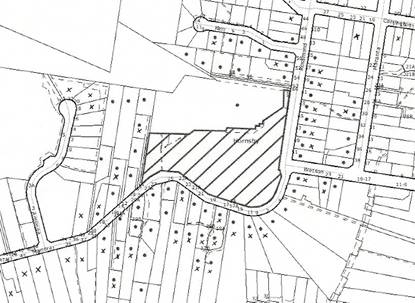
|
SUBMISSIONS
PLAN
|
|
|
• PROPERTIES
NOTIFIED
|
X SUBMISSION RECEIVED
|

PROPERTY SUBJECT OF DEVELOPMENT
|

|
|
37 SUBMISSIONS RECEIVED OUT OF MAP RANGE
|
|
|
|
|
The submissions objected to the development, generally on
the following grounds that the development would result in:
· Development
that is excessive in building bulk, height and site coverage;
· Excessive
residential density;
· Overflow
parking to the surrounding roads;
· Unacceptable
traffic on local streets;
· Traffic
hazards as the surrounding local streets do not provide for 2 way flow given
existing overflow parking from Mt Wilga Hospital;
· An
increase in traffic accidents, particularly at the Carrington Road/ Galston Road intersection and the Roper Lane link to Bridge Road;
· A
traffic bottleneck during a bushfire from evacuating elderly residents;
· An
inadequate landscape setting due to inadequate open space and setbacks;
· The
removal of local vistas and views across the property;
· The
application failing to provide a site compatibility certificate from the
Department of Planning;
· Overlooking
residential properties to the west;
· Overshadowing
on Manor Road
and over properties to the south and west;
· Unacceptable
noise from the additional units, traffic and use of the communal/ recreational
facility;
· Unacceptable
stormwater drainage impacts;
· A
scheme that does not adequately provide for aged persons and/or development not
being occupied by aged persons;
· An
inadequately serviced development with poor sewerage, water etc;
· Removal
of the potential for public access to the house and grounds;
· An
increase in crime from construction activity and additional residents;
· Pollution
from traffic fumes and garbage odours;
· Noise,
dust and traffic impacts during an extended construction phase;
· Structural
damage to neighbouring properties;
· A
precedent for other high-density high rise in Manor Road;
· A
decrease in local property values;
The merits of the matters raised
in community submissions have been addressed in the body of the report with the
exception of the following:
5.1.1 Existing Parking conflicts
Many submissions raised concerns
that Mt Wilga Hospital is not complying with its development consent, resulting
in an existing overflow parking problem.
Mt Wilga Hospital is not the subject of the current development
application and concerns raised are separately being investigated by Council.
5.1.2 Site Compatibility Certificate
Some submissions
have argued that the applicant requires a site compatibility certificate from
the Department of Planning pursuant to Clause 24 of SEPP (Housing for
Seniors). This clause does not apply because a hospital is a permissible landuse
within the Special Uses A zone.
Furthermore, this clause only applies to development applications made
pursuant to this Chapter. As detailed in
the report, the application is not lodged pursuant to SEPP (Housing for
Seniors) 2004. Rather the proposed use
is permissible with consent pursuant to the provisions of the HSLEP.
5.1.3 Drainage
Council’s engineering assessment
of the stormwater impacts of the development concludes that the proposal would
comply with Council’s requirements in relation to onsite detention and
stormwater management. Appropriate
consent conditions are recommended. This
includes conditions to upgrade the existing drainage system in Manor Road and
associated drainage easements.
5.1.4 Occupation of the Units
The
assessment and consent conditions would ensure that the units are suitably
designed for the elderly or people with disabilities. Some submissions are concerned that the
proposed units would be occupied by residents other than those that are aged or
disabled. Appropriate conditions are
proposed, including a restriction as to user in accordance with section 88E of
the Conveyancing Act 1919, to ensure that only seniors and people with a
disability are residents.
5.1.5 Inadequate Local Utility Services
Local utilities services such as
sewerage, water and electricity are available to the site.
5.1.6 Public Access to the Property
Some submissions argue that Council should
purchase this site and that the proposal should provide for public access to
the house and grounds. The property was
sold by the Commonwealth Government 20 years ago. The property is not zoned for public open
space. This is not a valid planning
reason to refuse the current development application.
5.1.7 Garbage Odours
The waste from the development is to be stored
in the basement. The temporary
collection area is located 100 metres from the closest neighbouring residential
property.
5.1.8 Construction Impacts
Conditions of consent are recommended to
address the impacts of the development during the construction phase.
5.1.9 Structural damage to neighbouring properties
Consent
conditions are recommended including a requirement for a dilapidation report to
be prepared by a chartered professional structural engineer at the applicant’s
expense, detailing the structural condition of adjoining properties, including
Council’s property, and their ability to withstand the proposed excavation.
5.1.10 Precedent
All development applications are
required to be assessed on their individual merits, taking into account the
applicable planning controls. This
property is unique in that it is zoned Special Uses A, unlike much of the
surrounding area that is zoned Residential A.
The surrounding Residential A area is subject to different planning
controls. In this respect, approval of the development would not create a
precedent in the locality.
5.1.11 Property Values
Concerns were raised that the
development would adversely effect the property values of the dwellings in the
locality. This is not a relevant matter
for consideration under Section 79C of the Act.
5.2 Public Agencies
The development application is Integrated Development under
the Act. Accordingly, the application
was referred to the following Agencies for comment:
5.2.1 Roads and Traffic Authority
The
application does not require referral to the Roads and Traffic Authority (RTA)
pursuant to SEPP No.11 – Traffic Generating Development nor does it require
referral pursuant to the provisions of SEPP (Infrastructure) 2007. However, the application was referred to the
RTA for its advice given potential traffic impacts.
The RTA raised no objection to the
application and provided recommendations including that the Galston Road/ Carrington Road intersection be converted
into one-way in, or left in/ left out.
This is necessary because of deficient sight distances and an increasing
accident history that would further increase with increased volumes of
traffic. The RTA advised that these
roadworks were necessary due to the declined gap selection ability of elderly
drivers and the increase in traffic.
In response to the above recommendation,
Council enquired with the RTA whether it would agree to the implementation of a
round-a-bout at the intersection of Galston
Road/ Clarinda
Street. The
RTA advised that it does
not support the construction of a roundabout at the intersection of Galston Road and Clarinda Street as
roundabouts are unsuitable at intersections with highly unbalanced traffic
flows, such as the subject intersection.
If any works are to occur at this intersection the RTA would prefer
traffic signals to be installed as they provide a better level of service and
with spare capacity. The RTA did not
recommend the installation of any works at the Galston/ Clarinda intersection
as part of this consent. As the subject development would not have any
significant impact upon that intersection, it is not considered appropriate
that the cost of these works be burdened upon the applicant.
The RTA’s
recommendations are addressed in the consent conditions at Schedule 1.
5.2.2 Rural Fire Service
The application was referred to the Rural Fire Service (RFS) as Integrated Development requiring a bushfire
safety authority pursuant to the Rural
Fires Act 1997. A number of
submissions received were concerned about the impact of the development on
bushfire safety in the locality. A copy
of the submissions received were forwarded to the RFS.
Initially, concerns were raised
by the RFS regarding the proximity of Building A to the bushfire hazard. The applicant submitted additional
information for consideration, including radiant heat modelling. The final response from the RFS has raised no
objection to the application. The
consent conditions recommended by the RFS are included in Schedule 1.
5.2.3 NSW Heritage Council
An application was submitted under Section 60
of the Heritage Act 1977 to the NSW
Heritage Council for multi-unit housing on the site in July 2006. The NSW Heritage Council approved the
application pursuant to Section 63 of the Heritage Act on 2 March 2007. A development application was subsequently
submitted to Council in July 2007, incorporating plans for aged housing similar
to the plans approved by the Heritage Council in March 2007. This is the subject of the current report.
Council referred the current development application to the Heritage
Council as Integrated Development under the Heritage Act 1977. A number of resident submissions
received were concerned about the impact of the development on the heritage
significance of the property. A copy of
the submissions received were sent to the Heritage Office on 21 August 2007 and
25 February 2008. The Heritage Office
has advised Council that the Heritage Council has raised no objection to the
development application.
The Heritage Council’s response dated 29 August 2007 advised the
following:
“The
Heritage Council received a set of preliminary documents for S60 Application No
.2006/S60/114 on 27 July 2006. The
Heritage Council determined that the scheme could be supported if the façade of
the new buildings was redesigned to fit more easily with the Mt Wilga
house. This scheme was revised into the
form described by the following documents which is very similar to the revised
documents referred to the Heritage Council by Hornsby Shire Council…
Hornsby
Shire Council referred un updated but very similar scheme to the Heritage
Council for comment on 20 July 2007, received on 24 July 2007.
The Heritage Council advices that the roof pitch in the drawings sent by
Hornsby Shire Council is in accordance with Heritage Council conditions. The schemes are not significantly different
from a heritage point of view in other respects, and the Heritage Council has
no objection to the scheme described in the following drawings as sent by
Council…”
Amended plans were submitted to Council in
November 2007 and referred to the Heritage Office for comment. Further minor amendments to the plans were
sent in February 2008 and May 2008. This
involved shifting some building bulk away from Manor Road and providing details on works
required to the property’s Rosamond
Street driveway.
The Heritage Council raised no objections to these further
amendments.
The Heritage Council’s
General Terms of Approval (GTAs) are addressed in the recommended consent
conditions at Schedule 1.
6. THE
PUBLIC INTEREST
Section 79C(1)(e) of the Act
requires Council to consider “the public
interest”.
The public interest is an
overarching requirement, which includes the consideration of the matters
discussed in this report. Implicit to
the public interest is the achievement of future built outcomes adequately
responding to and respecting the future desired outcomes expressed in
environmental planning instruments and development control plans.
The application is considered to
have satisfactorily addressed Council’s and relevant agencies’ criteria and
would provide a development outcome that, on balance, would result in a
positive impact for the community.
Accordingly, it is considered that the approval of the proposed housing
for aged or differently abled persons would be in the public interest.
7. CONCLUSION
The application proposes erection of a development
for Aged or Differently Abled Persons.
This application has been assessed having regard to
the Heads of Consideration under Section 79C(1) of the Act, Hornsby Local
Environmental Plan and the provisions of the relevant State Environmental
Planning Policies. Council does not have a specific Development Control Plan
for the proposed use as “housing for aged or differently abled persons” or for
the subject zone or area, however, the proposal complies with the general
controls in SEPP (Housing for Seniors) and the SEPP 65 Residential Flat Design
Code.
The design provides for variable building setbacks
to the side and rear property boundaries and the proposal is considered to
provide a reasonable outcome for the subject site and surrounding land uses
through consideration of height, design and landscaping provided.
Approval of
the application is recommended.
SCHEDULE 1
PART 1 –
DEFERRED COMMENCEMENT
THE CONSENT SHALL NOT BECOME EFFECTIVE OR OPERATIVE UNTIL
THE FOLLOWING INFORMATION IS SUBMITTED TO THE SATISFACTION OF THE COUNCIL. ALL DEFERRED COMMENCEMENT CONDITIONS ARE TO
BE COMPLIED WITH WITHIN 1 YEAR FROM THE DATE OF THIS CONSENT.
A. The
Right of Way and Easement for Services, burdening the subject property and
benefitting the adjoining property to the north shall be either extinguished or
modified in such a manner that its modified form will enable the development to
proceed without contravening the terms of the Right of Way or the Easement for
Services. The right of way is to ensure
unencumbered access along the approved pedestrian link to the south of the
Hospital’s rehabilitation building for all emergency services at all times and
for the egress of the occupants of the rehabilitation building in a fire
or emergency situation.
B. The
Restriction as to User, burdening the subject property and benefitting the
adjoining property to the north shall be either extinguished or modified in
such a manner that its modified form will enable the development to proceed
without contravening the terms of the Restriction as to User.
C. The
easements for drainage, burdening the subject property and benefitting the
adjoining property to the north shall be either extinguished or modified in
such a manner that its modified form will enable the development to proceed
without contravening the terms of the Restriction as to User.
All Section 88B restrictions and covenants created as part
of this consent are to contain a provision that they cannot be extinguished or
altered except with the consent of Hornsby Shire Council.
PART 2
UPON SATISFACTION OF THE DEFERRED
COMMENCEMENT CONDITIONS IN PART 1, THIS CONSENT SHALL OPERATE IN ACCORDANCE
WITH THE FOLLOWING CONDITIONS
General Conditions Applying to All Stages
Approved Plans and Supporting
Documentation
1. The development must be carried out in
accordance with the following plans as amended in red and documentation listed
below and endorsed with Council’s stamp, except where amended by other
conditions of this consent:
Architectural Plans – Aged Housing Apartments
|
Plan
No.
|
Rev
|
Drawn
by
|
Dated
|
|
Site Analysis Plan
05009/DA001
|
C
|
Giles Tribe
Architects
|
19-03-07
|
|
Site Plan 05009/DA002
|
G
|
Giles Tribe
Architects
|
11-04-08
|
|
Basement Plan
05009/DA100
|
J
|
Giles Tribe
Architects
|
05-04-08
|
|
Level One/ Site Plan
05009/DA101
|
J
|
Giles Tribe
Architects
|
18-01-08
|
|
Level Two Floor Plan
05009/DA102
|
G
|
Giles Tribe
Architects
|
18-01-08
|
|
Level Three Floor
Plan 05009/DA103
|
G
|
Giles Tribe
Architects
|
18-01-08
|
|
Roof Floor Plan
05009/DA104
|
G
|
Giles Tribe
Architects
|
18-01-08
|
|
Site Sections-1
05009/DA400
|
F
|
Giles Tribe
Architects
|
09-11-07
|
|
Site Sections-2
05009/DA401
|
F
|
Giles Tribe
Architects
|
09-11-07
|
|
Site Sections/ Elevations
05009/DA402
|
G
|
Giles Tribe
Architects
|
18-01-08
|
|
Elevations 05009/
DA403
|
B
|
Giles Tribe
Architects
|
24-01-08
|
|
Walkway for Hospital
Access SK100
|
C
|
Giles Tribe
Architects
|
July 2008
|
|
Section – Walkway
SK101
|
A
|
Giles Tribe
Architects
|
July 2008
|
Architectural Plans – Mount Wilga House
|
Plan
No.
|
Rev
|
Drawn
by
|
Dated
|
|
2050602/00 Drawing
Index and North Elevation
|
A
|
Robertson &
Hindmarsh
|
15.12.05
|
|
2050602/01 Ground
Floor Plan
|
E
|
Robertson &
Hindmarsh
|
Undated
(received 11.07.07)
|
|
2050602/02 Basement
Plan
|
A
|
Robertson &
Hindmarsh
|
Undated
(received 11.07.07)
|
|
2050602/03 Roof Plan
|
A
|
Robertson &
Hindmarsh
|
Undated
(received 11.07.07)
|
|
2050602/04 Elevation
|
F
|
Robertson &
Hindmarsh
|
Undated
(received 11.07.07)
|
|
2050602/05 Elevation
|
F
|
Robertson &
Hindmarsh
|
Undated
(received 11.07.07)
|
Civil Plans
|
Plan
No.
|
Rev
|
Drawn
by
|
Dated
|
|
Stormwater Layout
Catchment Plan C0101
|
08
|
Meinhardt
|
11.01.08
|
|
Stormwater Layout
Basement Level C0102
|
08
|
Meinhardt
|
11.01.08
|
|
Stormwater Layout
Level 1 C0103
|
08
|
Meinhardt
|
11.01.08
|
|
Stormwater Layout Manor Road Works C0104
|
08
|
Meinhardt
|
11.01.08
|
|
Stormwater Layout 39
Manor Road C0105
|
08
|
Meinhardt
|
11.01.08
|
|
Soil and Water
Management Stage 1 C0201
|
08
|
Meinhardt
|
11.01.08
|
|
Soil and Water
Management Stage 2 C0202
|
08
|
Meinhardt
|
11.01.08
|
|
Soil and Water
Management Stage 3 C0203
|
08
|
Meinhardt
|
11.01.08
|
|
Soil and Water
Management Stage 4 C0204
|
08
|
Meinhardt
|
11.01.08
|
|
Stormwater Detention
Details C0301
|
08
|
Meinhardt
|
11.01.08
|
Landscape Plans
|
Plan
No.
|
Rev
|
Drawn
by
|
Dated
|
|
Landscape Plan LA01
|
E
|
Taylor Brammer
|
18.01.08
|
|
Landscape Plan LA02
|
D
|
Taylor Brammer
|
18.01.08
|
|
Landscape Plan LA03
|
D
|
Taylor Brammer
|
18.01.08
|
|
Landscape Sections
LA04
|
B
|
Taylor Brammer
|
18.01.08
|
|
Landscape Details
LA05
|
A
|
Taylor Brammer
|
18.01.08
|
|
Document
No.
|
Prepared
by
|
Dated
|
|
Statement of
Environmental Effects
|
Deborah Sutherland
Planning
|
April 2007
|
|
Supplementary
Statement of Environmental Effects
|
Deborah Sutherland
Planning
|
November 2007
|
|
Shadow Diagrams
DA800 9am June 21
DA801 10am June 21
DA802 Noon June 21
DA803 3pm June 21
|
Giles Tribe
Architects
|
|
|
Solar Access Diagrams
Basement
05009/DA804 A
Level 1
05009/DA805 A
Level 2
05009/DA806 A
Level 3
05009/DA807 A
Level 4
05009/DA808 A
|
Giles Tribe
Architects
|
11.01.08
|
|
Photomontages
3D View – 1
05009/DA-V01
3D View – 2
05009/DA-V02
|
Giles Tribe
Architects
|
04-02-08
|
|
Basix Certificate
172211M
|
Unknown
|
29-01-08
|
|
Vegetation Management
Plan
|
Cumberland Ecology
|
January 2008
|
|
Bush Fire Safety
Compliance Report
|
Roger Fenwick
|
July 2007
|
|
Schedule of Materials
and Finishes
Plan: 05009/DAF01B
|
Giles Tribe
Architects
|
19-03-07
|
|
Stage 2 Environmental
Site Assessment
|
Consulting Earth
Scientists
|
5 December 2005
|
|
Disability Access
Assessment Report
|
Access Associates
|
February 2007
|
|
Landscape Sections
(D00898825)
|
Taylor Brammer
|
22 April 2008
|
Plans on Site
2. A copy of all approved
plans, specification and documents (including the construction certificate if
required for the work incorporating certification of conditions of approval)
shall be kept on site at all times so as to be readily available for perusal by
any officer of Council or the Principal Certifying Authority.
Use of the Premises
3. The
approved development must be occupied or used solely for the approved use.
No separate occupation or use of any part of the approved development
shall take place without prior development consent, (other than for exempt or
complying development).
4. All
activities within the communal facility (Mt Wilga House) are to be ancillary
and subsumed by the aged housing development.
Any Doctors rooms and the like are to provide services only to those
residents living on the property.
5. The use of
the communal facility (Mt Wilga House) is to be restricted to those times
listed below:
Monday to Sundays 8.00am 10.00pm
This does not include caretaker activities.
6. The
communal facility (Mt Wilga House) is to accommodate a maximum of five staff
on-site at any one time.
Use of Materials
7. The
finished surface materials, including colours and texture of any building
and/or hard paved areas, shall blend with the surrounding environment and shall
be non-glare.
8. The aluminium louvered
sliding screens illustrated on the building elevations are to be designed and
installed so that at least half (50%) of the elevation width remains opened at
any one time, at each of the balconies.
For example, this may require the 4 panelled sliding screen to be
reduced to 2 panels wide on Building E (west).
Access & Mobility
9. The development is to be designed and constructed to comply
with the standards concerning accessibility and useability for self contained
dwellings in Schedule 3 of State
Environmental Planning Policy (Housing for Seniors or People with a Disability) 2004. This may require minor internal modifications
to the plans only. A suitably qualified
access consultant is to certify compliance with this condition prior to the
issuance of a construction certificate.
10. Footpaths
from the site to bus stops in the vicinity of the site, shall be constructed on
Rosamond Street and Carrington Road in accordance with AS1428 and Austroads, to
ensure a continuous path of travel to bus services in accordance with the
requirements of State Environmental
Planning Policy (Housing for Seniors or People with a Disability) 2004.
11. The owner of the premises shall provide a
dedicated Village Bus Service for the use of the residents of the
development. The bus is to be
capable of carrying at least 10 passengers and shall operate at least 2 round
trips daily from the site to a local centre that provides residents with access
to the following:
(i) shops, bank service providers and other
retail and commercial services;
(ii) community services and recreation
facilities;
(iii) the practice of a general medical
practitioner
12. A restriction as to user is to be created
under Section 88B of the Conveyancing
Act 1919 that limits the occupants of the residential units to ‘housing for aged or differently abled
persons’, as defined in the following:
housing for aged or differently abled
persons means residential accommodation which may
take any building form and may be or include a hostel and which is, or is
intended to be used as, housing for the permanent accommodation of:
(a) persons over 55 years of
age, or
(b) persons of any age who,
as a result of having a mental, physical or sensory impairment, either
permanently or for an extended period, have substantially limited opportunities
to enjoy a full and active life.
The above restriction does not apply
to the caretakers’ unit.
Support for
Neighbouring Properties
13. A Dilapidation Report is to be prepared by a chartered
professional structural engineer at the applicant’s expense, detailing the
structural condition of adjoining properties, including Council’s property, and
their ability to withstand the proposed excavation. This report must include
any measures required to be incorporated to ensure that no damage will occur
during the course of works. The report shall be submitted to the principal
certifying authority prior to any
excavation works taking place. Such
works shall take place in accordance with the recommendations of the report.
14. If
an excavation extends below the level of the base of the footings of a building
on an adjoining allotment of land, the person causing the excavation to be made
must:
i) preserve
and protect the building from damage;
ii) if
necessary, underpin and support the building in an approved manner; and
iii) at
least 7 days before excavating, give notice of intention to do so to the
adjoining owner and furnish particulars to the owner of the proposed work.
Fencing
15. The
northern property boundary adjoining Mt Wilga Hospital shall be enclosed with a
1.5m fences/screens/walls to protect the privacy of future occupants as well as
adjoining owners. The fence/screen/wall
is to be erected prior to the occupation of the dwellings. The finished surface materials, including
colours and texture, shall blend with the surrounding environment and shall be
non-glare.
16. The
new sandstone entry gates indicated on landscape plan LA03D is not approved as
no elevation details were submitted with the application for assessment
purposes. Any such works is to be the
subject of a separate application to the Council.
Noise and Dust Control during Construction Phase
17. A Noise and Dust Management Plan
(NDMP) must be submitted to Council prior to the issuance of a construction
certificate to address noise and dust emission during the construction
phase. The NDMP must be prepared by a
suitably qualified environmental consultant.
The NDMP should address, but not be limited to, the following:
(a) Establishment
of maximum prescriptive noise emission and dust emission targets for the
construction phase. These targets are to
comply with the Protection of the Environment Operations Act and the NSW
Environment Protection Authority’s Environmental Noise Control Manual -
guidelines for construction sites,
(b) Recommend
management measures to be implemented to achieve the targets established in (a)
above,
(c) Recommend
monitoring equipment to be installed to measure noise and dust emissions,
(d) Propose
a regular monitoring and review programme by a suitably qualified environmental
consultant to ensure the construction complies with noise emission and dust
emission targets,
(e) Procedures
to record and address any complaints regarding noise and dust;
(f) Propose
a reporting system to certify the ongoing compliance of the development with
this condition.
Time to Complete Development
18. The
works set forth in the plans and specifications and approved under this
consent, once commenced, shall be completed within 5 years from the date of
commencement.
Building Code of Australia
19. All building work must
be carried out in accordance with the requirements of the Building Code of Australia.
Should there be any alternative solutions
listed as Category 2 Fire Safety Provisions and outlined in the Environmental
Planning and Assessment Regulation 2000, a fire engineering report should be
forwarded to the Brigades for comment under Clause 144 of the Environmental
Planning and Assessment Regulation 2000.
Hours of Construction
20. In order to maintain
the amenity of adjoining properties, site works shall be restricted to between
7.00 am and 6.00 pm, Monday to Friday and 8.00 am to 1.00 pm Saturday. No work shall be undertaken on Sundays or public
holidays. Plant, goods or materials
shall not be delivered to the site outside the approved hours of site works
unless otherwise approved by Council.
Long Service Levy
21. Under Section 34 of the
Building and Construction Industry Long Service Payments Act 1986 any work
costing $25,000 or more is subject to a Long Service Levy. The levy rate is 0.35% of the total cost of
the work and shall be paid to either the Long Service Payments Corporation or
Hornsby Shire Council. Under section
109F (1) of the Environmental Planning & Assessment Act, 1979 this payment
must be made prior to a construction certificate being issued.
Fire Safety Schedule
22. In accordance with clause 168 of the
Environmental Planning and Assessment Regulation 2000 fire safety measures
shall be implemented in the building. A
schedule of all proposed and existing Essential Fire Safety Measures to be
installed in the building (eg: hydrants, hose reels, exit signs, smoke control
systems) shall be submitted with the Construction Certificate application and
distinguish between the existing and proposed fire safety measures. Should the Construction Certificate involve
the use of an alternate solution, the application must also be accompanied by
details of the performance requirements that the alternate solution is intended
to meet and the assessment methods use to establish compliance with those
performance requirements.
Fire Safety Certificate –
Final
23. In accordance with Part 9, Division 4 of
the Environmental Planning & Assessment Regulation, 2000, the owner of the
building must, on completion of the building, provide Council with a
certificate in relation to each essential fire safety or other safety measure
implemented in the building.
Fire Safety Statement - Annual
24. In accordance with Part
9, Division 5 of the Environmental Planning & Assessment Regulation, 2000,
at least once in each period of 12 months after the date of the first fire
safety certificate, the owner shall provide Council with a further certificate
in relation to each essential service installed in the building.
Survey Reports
25. To ensure that the
building and any associated structures are correctly positioned on the site, a
report prepared by a registered surveyor is to be submitted to the principal
certifying authority at each level of construction of the building (prior to
the pouring of concrete) indicating that the finished floor level is in
accordance with the approved plans.
Fire Egress
26. A construction
management plan is to be submitted with the Construction certificate
application demonstrating that unimpeded egress can be provided from the
southern fire exit of the adjoining rehabilitation building in a fire or
emergency situation to an open space within the rehabilitation building
allotment during construction. Any
temporary measures are to remain in place until the permanent egress walkway is
constructed.
Construction
Certificate – Subdivision/Engineering Works
27. A construction certificate must be
obtained from either Council or an Accredited Certifier. Engineering design
plans and specifications are to be prepared by a chartered professional
engineer for any proposed works. The
plans and specifications are to be in accordance with development consent
conditions, appropriate Australian standards, and applicable Council standards,
in particular “Hornsby Shire Council Civil Works - Design and Construction
Specification”. The information that is required to be submitted with a
construction certificate is as follows:
(a) copies
of compliance certificates relied upon
(b) Four
(4) copies of the detailed engineering plans in accordance Hornsby Shire
Council's Civil Works - Design Specification 1999. The detailed plans may
include but are not limited to the earthworks, roadworks, road pavements, road
furnishings, stormwater drainage, landscaping and erosion control works.
(c) Hornsby Shire Council’s approval is
required for any works within the road reserve of Manor Rd or Rosamond Rd prior to the issuing of a
construction certificate for these works.
(d) Hornsby Shire Council’s approval is
required for any works within Council controlled drainage easements prior to
the issuing of a construction certificate for these works
Construction Management Plans
28. In order to enable
unencumbered movement of traffic in the public road during construction works,
a Construction Management Plan, including a Traffic Management Plan and scaled
construction plan prepared by a suitably Chartered and Qualified Chartered
Engineer and Qualified Worksite Traffic Controller shall be prepared and
submitted with the Construction Certificate. The Construction Management Plans
shall identify all works for each stage and how to effectively manage the
construction traffic for that stage. The plans shall address the following
requirements:-
(a) A copy of the plans
shall be submitted for consideration and written approval by Hornsby Shire Council’s Manager, Subdivisions
prior to the release of the Construction Certificate.
(b) The plans shall detail
the order of construction works and arrangement of all construction machines
and vehicles being used at the same time during all stages.
(c) In order to prevent
injury, accident and loss of property, no building materials, work sheds,
vehicles, machines or the like shall be allowed to remain in the road reserve
area without written consent of Hornsby
Shire Council.
(d) The Plan shall be
generally in compliance with the requirements of the Road and Traffic
Authority’s “Traffic Control at Worksites Manual 1998” and detailing:-
(i) Public notification of
proposed works;
(ii) Long term signage
requirements;
(iii) Short term (during
actual works) signage;
(iv) Vehicle Movement Plans,
where applicable;
(v) Traffic Management
Plans;
(vi) Pedestrian and Cyclist
access and safety;
(e) The plans shall indicate
traffic controls including those used during non-working hours and shall
provide pedestrian access and two-way traffic in the public road to be
facilitated at all times.
(f) The Applicant and all
employees of contractors on the site must obey any direction or notice from the
Prescribed Certifying Authority or Hornsby
Shire Council in order to ensure the above.
29. Any damage caused to Council's assets in
the vicinity of the subject site as a result of construction works associated
with the approved development is to be repaired by the applicant/developer
prior to the issue of the Occupation Certificate.
30. All
service vehicles including garbage trucks, removalist trucks, emergency
vehicles and the like are only permitted to use the Rosamond Rd access. The Manor
Rd access is to be signposted to prohibit trucks
entering or exiting this driveway.
Works As
Executed
31. A
works-as-executed plan prepared by a chartered professional engineer or a
registered surveyor must be lodged with Hornsby Shire Council when the
engineering works are complete for each of the different stages, prior to the
release of the Occupation Certificate.
Traffic and
Access
32. The existing median island in Galston Road, in the vicinity of Carrington Street,
is to be extended to effectively convert the Galston Road/ Carrington Street intersection to left
in/ left out. This shall be designed to
meet RTA’s requirements, and endorsed by a suitably qualified and chartered
Engineer (i.e. who is registered with the Institute
of Engineers, Australia). The design requirements shall be in
accordance with the RTA’s Road Design Guide and other Australian Codes of
Practice. The certified copies of the
civil design plans shall be submitted to the RTA for consideration and approval
prior to the release of construction certificate by Council and commencement of
road works.
33. All deliveries shall be made within the site, under no
circumstances delivery vehicles to be loaded or unloaded upon the public road.
34. All off street carparking including the provision of
aisle, ramps and access driveways shall comply with Australian Standard AS
2890.1 - 1993 Off Street Car Parking and AS 2890.2 - 2002 Off Street Commercial
facilities.
Boundary Planting
Hedge
35. Planting along the boundary of the Mt
Wilga Heritage Estate (Rosamond
Avenue) shall be Photinia glabra ‘Rubens’ planted at 1 metre centres in mulched
planter beds. Shrubs to be installed at minimum pot size of 5 litres.
Screen Planting (Manor Road Building)
36. To ensure
adequate screen planting is provided to the carpark area adjacent to building
along the Manor Road
boundary, additional planting shall be provided.
Screen
planting to the on-grade landscape setback zone adjacent to Building C must
include Twenty (20) additional Syzigium
‘Royal Flame’ planted at 2 metre centres in mulched planter beds. Shrubs to be installed at minimum pot size of
5 litres.
Boundary Planting (Northern Boundary)
37. To ensure
adequate tree planting in scale with the proposed building is provided additional
planting shall be provided.
Boundary tree planting to
the on-grade landscape zone must include Five (5) additional Lophostemon confertus (brushbox)
capable of reaching a mature height of 10 metres planted in locations adjacent
to building B in mulched planter beds. Trees to be installed at minimum pot
size of 25 litres.
Existing Retaining wall to south
western Boundary
38. The existing retaining wall in the south
west corner of the site shall be retained and protected during construction.
Screen planting shall be placed along boundary in front of the wall.
Planter Boxes / On Slab Planting
39. To
ensure a sustainable landscape is achieved to on slab planter box areas, they
shall include automatic irrigation, subsoil drainage (proprietary drainage
cell, 50mm sand and filter fabric), and waterproofing. Soil depths additional
to the requirement of subsoil drainage shall be a minimum of 1000mm with a soil
volume of 35 cubic metres for trees and a minimum of 500mm for shrubs.
Landscape Works To All Areas – Plant
sizes and densities
40. Excepting
the above specific requirements, all landscape works shall also meet the
minimum construction standards identified in the Hornsby Shire Council
Landscape Code for Development Applications including the construction of
mulched planter beds, planting of trees in pot sizes as specified on approved
plans, shrubs in minimum 5 litre pot sizes and groundcovers in minimum 150mm
pot sizes in the densities identified in the submitted planting specification.
Tree Fencing
41. Prior
to work commencing, tree protection fencing must be erected around the trees to
be retained along the western and southern boundaries at a 3m setback. The tree fencing
must be constructed of 1.8 metre cyclone chainmesh fence’. The tree protection
fencing must be maintained in good working order until the completion of all
building or development works. A statement of compliance from a qualified tree
surgeon or environmental consultant shall be submitted to Council prior to the
issue of the Construction Certificate.
Excavation
42. To prevent damage to
tree roots, parking (vehicles or plant) or placement of building materials
(including disposal of cement slurry and waste water) within 3m of all trees to be retained onsite, is
strictly forbidden. No tree roots located within the specified tree setback
shall be severed or injured in the process of any site works during the
construction or landscaping phases of the approved project.
Note: In order to achieve this condition, this may
require excavation for basement purposes to be undertaken by piering the
foundations (rather than earth battering).
43. Excavation
for the installation of any underground service within the specified tree
setbacks of all trees on the western and southern boundaries has been approved
by Council’s Parks and Landscape Team and shall be carried out by using the
thrust boring method only. [ Tunnel boring shall be carried out at least 1
metre beneath natural ground surface and at a setback radius of 3 metres to
minimise damage to tree root systems.]
The severance of tree roots greater than 50mm in diameter is not
permitted. If roots of such diameter are
revealed by hand excavation, the applicant must provide Council’s Parks and
Landscape team an assessment by a qualified arborist that outlines the likely
impact of severing the roots or an alternative location for the service
trenching.]
44. Any
works undertaken within the specified tree setbacks must be overseen by a
qualified and experienced arborist.
Tree
Preservation Order
45. A
Tree Preservation Order exists within the Hornsby Shire whereby the cutting
down, topping, lopping or wilful destruction of any tree exceeding 3.0 metres
in height (except where exempt as defined under Council’s Tree Preservation
Order ) or substantially altering the soil level around the trunk or within 3
metres of the trunk, without prior written consent is prohibited. Release of
the Construction Certificate gives automatic approval to the removal of those
trees located on the subject property within 3 metres of the foundation
footprint of an approved residential, commercial or community building, garage,
inground swimming pool or within the alignment of approved vehicular access or
parking area. Other trees shall not be
removed or damaged without approval being granted under Council’s Tree
Preservation Order. Penalties apply for
non-compliance.
Maintain Canopy Cover
46. This
application approves the removal of the following trees Nos.2, 6, 13, 13a, 14,
15, 16, 21, 23, and 39 only. To maintain
local tree canopy cover, the trees that are approved to be removed along the
western and southern boundaries are to be replaced with a Lophostemon confertus (Brush Box).
In addition any other tree that later dies or is damaged during or after
the development, is to be replaced with a Lophostemon
confertus (Brush Box). The planting
location shall be in the immediate location of where the tree is removed, but
not within 3 metres of the foundation walls of a dwelling or inground
pool. The pot size is to be a minimum
100 litres and the trees must be maintained and protected until they reach the
height of 5 metres.
Note:
The above condition does not exempt the property from the provisions of
Council’s Tree Preservation Order. The
purpose of the above is to ensure that if any trees decline in the future, they
are suitably replaced to maintain the approved landscape setting for the
development.
BUSHLAND AND
BIODIVERSITY MANAGEMENT TEAM
47. The
Landscape Plan prepared by Taylor Brammer,
Drawing No. LA01 Revision E, shall be amended and submitted for approval to the
Bushland and Biodiversity Team prior to the issuance of a construction
certificate. The Landscape Plan shall be
amended to remove the gravel maintenance path passing through the Sydney Turpentine
Ironbark Forest
community to be revegetated under the guidance of the Vegetation Management
Plan prepared by Cumberland Ecology,
January 2008.
48. The
maintenance, revegetation and future management of the Sydney Turpentine
Ironbark Forest (STIF), an Endangered Ecological Community as listed under the Threatened Species Conservation Act 1995,
shall be undertaken in accordance with the Vegetation Management Plan for 2a Manor Road,
Hornsby, prepared by Cumberland Ecology
dated January 2008.
49. All
erosion and sediment controls (i.e. geotextile sediment fence and straw bales)
shall be in place prior to commencement of works so as to protect the adjacent
bushland and native fauna habitat. Fencing should comply with the EPA
publication ‘Managing Urban Stormwater:
Soils & Construction’. Techniques used for erosion and sediment
control on building sites are to be adequately maintained at all times and must
be installed in accordance with Council guidelines. All techniques shall remain
in proper operation until all development activities have been completed and
the site fully stabilised. This condition must be complied with during
demolition and building work.
50. To protect the bushland
and retained trees from potential damage on the development site the
applicant is to ensure that a temporary fence shall be erected, prior to
commencement of works at 2a Manor Road, Hornsby, to protect the Sydney
Turpentine Ironbark Forest (STIF), an Endangered Ecological Community as listed
under the Threatened Species Conservation
Act 1995, from casual or inadvertent access. The fence shall be constructed from either
wire mesh or orange barrier mesh and remain in place until the completion of
site works.
WASTE MANAGEMENT
51. The
waste and recycling collection point at the roundabout, the waste vehicle
standing area and all other modifications to the roundabout must be completed
prior to issue of the Occupation Certificate for Stage One.
52. Bin
storage areas in the basements must be designed and constructed in accordance
with Council’s Waste Minimisation and
Management Development Control Plan.
53. The
caretaker is to transfer waste bins from the storage areas in the basement to
the waste collection area adjacent to the round-a-bout. The transfer of bins is to occur within the
site. At all stages of the development,
a suitable path of travel is to be provided, which does not include steps. Ramp(s) or roll curb must be used between the
different levels between the driveway/truck standing area, the bin collection point
and each bin room.
Note: The Stage A plans indicate that the route
between the Building A basement and waste collection area incorporates
steps. For this stage a suitable
temporary link is to be provided on-site outside of the permanent conservation
area to facilitate the transfer of waste bins.
54. To confirm compliance with approved Waste
Management Plans, prior to issue of the occupation certificate, submit to
Council a Report of actual destinations and quantities of waste generated by
the works carried out under this development consent. This Report is to be
based on Documentary evidence (ie. tipping dockets/receipts from
transfer stations and landfills) and be in the format
of the Waste Management Plan Section One – Demolition Stage and/or Section
Three – Construction Stage. If less than 60% waste was reused or
recycled, then this Report must include the reasons why the 60% target was not
achieved.
55. Waste from commercial activities on site
(including but not limited to medical services) must not be placed in the
residential bins and must be disposed of separately to the domestic/residential
waste.
56. An easement
entitling the Council, its servants and agents and persons authorised by it
to enter upon the property and to operate
equipment for the purpose of waste and recycling collection services. This easement must be granted in favour of
Council prior to the occupation of the development.
Note: An 88(b) instrument is an acceptable form of
easement subject to the area effected by the easement not requiring renewal
upon sale or transfer at any time.
ENVIRONMENTAL PROTECTION
57. Prior
to the release of the Construction Certificate a connection must be made to
Sydney Water’s sewerage system for all wastewater from the development.
58. The installation of
rainwater tanks and associated plumbing must be in accordance with Sydney
Water’s Guidelines for Rainwater Tanks on
Residential Properties: Plumbing Requirements, dated April 2003.
59. Any imported soils to the subject site
must be Virgin Excavated Natural Material (VENM) as defined in Schedule 1 of
the Protection of the Environment
Operations Act 1997.
60. All
excavated material removed from the site must be classified in accordance with
NSW EPA (1999) Environmental Guidelines: Assessment, Classification and
Management of Liquid and Non-Liquid Wastes prior to disposal. All excavated material must be disposed of to
an approved waste management facility.
61. Council
and the PCA must be notified immediately should the presence of asbestos or
soil contamination, not recognised during the original assessment process be
identified during demolition or construction works.
62. Prior
to the issue of an occupation certificate, all mechanical plant equipment must
have noise specifications, proposed locations and orientations reviewed prior
to installation on the site to ensure that they will not singularly or in total
emit noise levels which possess tonal, beating and similar characteristics or
which exceeds background noise levels by more than 5dB(A). Should the
calculated noise emissions from the mechanical plant equipment be in excess of
the set limits, appropriate acoustic treatment must be implemented by a
suitably qualified consultant.
63. The sediment basin/s
shall be provided and designed to contain 25mm runoff from the 75th percentile,
5-day rainfall event or a 5 year ARI
time of concentration storm event, with a volume capacity of water that will
enter in 6 minutes, one hour storm event with an additional 20% capacity
provided for storage of sediment. The overflow from the sediment basin/s shall
be directed into the onsite detention tank. The outlet discharge shall be a
slow control discharge (i.e.
riser or a sheet flow spillway) designed to discharge at peak flow of a 20 year
frequency storm. Trash collection screening filters should be installed at the
inlet of the basin.
64. Waters captured in the
sediment basin shall be flocculated to ensure that discharges contain no more
than 50 millilitres of suspended solids, turbidity is no more than 30 ntu’s and
the pH is between 6.5 – 7.5 before being discharged. Gypsum (calcium sulfate)
shall be used as the flocculant agent and applied within 48 hours following
rainfall events. The flocculant shall be evenly distributed over the surface
area of the sediment retention basin. Settled sediment shall be pumped out and
disposed of to an approved waste management facility. Approval must be sought from Council prior to
discharge into Council’s stormwater system.
65. All headwall outlets
shall incorporate flow velocity reduction controls (i.e. bedded boulders and
small stones) to minimise erosive and scouring impacts to the watercourse.
Accordingly, energy dissipator controls shall be landscaped to accommodate
outlet sheet flow (forced jump). No engineering works are permitted within the
bed of the watercourse.
66. Dust control measures
must be utilised to ensure airborne dust particulates are abated and airborne
movement of sediment blown from exposed disturbed areas is contained within the
site.
67. Geofabric sediment
fencing is to be installed 10 metres downslope running parallel to the proposed
works. The sediment fencing shall be secured by post at 2 metre intervals with
the geotextile fabric embedded at 200 mm in soil. Two metre returns shall be included
at both ends of the sediment fencing.
68. The sediment basin/s
primary outlet/s riser shall be designed to discharge at peak flow of a minimum
of a 20 year frequency storm. Trash collection devices and a geotextile filter
shall also be incorporated.
RURAL FIRE SERVICE
Asset
Protection Zone
69. At the commencement of building works and
in perpetuity the entire property shall be managed as an ‘Inner Protection Area’ as outlined within Planning for Bush Fire Protection 2006 and the Services document ‘Standards for asset protection zones.’
Water
and Utilities
70. Water, electricity and gas are to comply
with section 4.1.3 of Planning for Bush Fire Protection 2006.
Access
71. Public
Road
Access shall comply with section 4.1.3 (1) of Planning for Bush Fire Protection
2006.
Note: The Rural Fire Service clarified that this
condition relates to the internal
provisions of the future development only and in no way relates to the public
roads within the surrounding neighbourhood.
Evacuation
and Emergency Management
72. Arrangements for emergency and evacuation
are to comply with section 4.2.7 of Planning for Bush Fire Protection
2006.
Design
and Construction
73. New construction shall comply with
Australian Standard AS3959-1999 ‘Construction of buildings in bush-fire prone
areas’ Level 1.
74. Roofing shall be gutterless or have
leafless guttering and valleys to prevent the building up of flammable
material. Any materials used shall have
a Flammability Index of greater than 5.
Landscaping
75. Landscaping to the site is to comply with
principles of Appendix 5 of Planning for Bush Fire Protection 2006. In this regard the following landscaping
principles are to be incorporated into the development:
(a) Suitable impervious areas being provided
immediately surrounding the building such as courtyards, paths and driveways;
(b) Grassed areas/ mowed lawns/ or ground
cover plantings being provided in close proximity to the building;
(c) Restrict planting in the immediate
vicinity of the building which may over time and if not properly maintained
come into contact with the building;
NSW HERITAGE COUNCIL
76. The garbage area must not be paved with
in situ concrete. Precast concrete
pavers may be used.
Note: this condition relates to the waste collection
area adjacent to the round-a-bout, not to the basement storage areas.
77. An interpretation plan for the site,
proportional to the site’s significance, is to be prepared and submitted to
the Director of the Heritage Branch to be approved prior to the application for
the construction certificate. The interpretation plan shall
include relevant historical themes and propose appropriate media and signage,
its design and its location on the site.
The Plan shall include the management of any possible future acquisition
of moveable heritage items and relics with a provenance traceable to this
site. The interpretation plan shall be
developed in consultation with, and to the approval of, the nominated heritage
architect and archaeologist;
78. The Strata Management Statements (or any
buildings management documents) for the site are to include By-law(s) or other
measures to ensure that ownership of the Mt Wilga’s significant fabric
and interpretation signage is by the site’s body corporate, and that significant
fabric is protected and conserved in accordance with the Conservation
Management Plan, and adequate funds are provided in any building maintenance
fund for this work. This information is
to be is to be submitted to the Director of the Heritage Branch to be approved
prior to the application for an occupancy certificate;
79. A
heritage architect is to be nominated for the project. An archaeologist is also to be nominated for
the project The name and experience of
these heritage consultants shall be submitted to the Heritage Branch for
approval prior to the application for the construction certificate;
80. The
heritage consultants (as appropriate) shall advise on detail design resolution
of new elements fixed to Mt Wilga house, inspect the demolition work to ensure
no loss of significant fabric and elements, review the reuse of salvageable
material, construction of new elements, and impact of services (to minimise
impacts on significant fabric, openings and views) and conformity to the
conditions of approval;
81. A
report by the consultant shall be submitted to the Director of the Heritage
Branch for approval within 1 month of the completion of the works, which
describes the work, any impacts/damage and remedial works carried out;
82. The
building contract selected for the project shall ensure that the nominated
heritage architect has a contractual role as administrator of the contract for
works to Mt Wilga House and gardens, with the ability to issue instructions to
the contractor;
83. The
scope of archaeological work on the site beyond the State Heritage Register
boundary should be further discussed with the Heritage Council or its
delegate. An application under either
S140 or S139(4) shall be submitted and approved by the Heritage Council before
the site works may commence. An
archaeological Research Design may be required, depending upon the conclusion
of these discussions.
84. The monitoring
archaeologist shall make periodic inspections as required of the ground
disturbance associated with the proposed building and landscaping works in this
application affecting parts of the site identified as being of High
archaeological potential in the March 2006 Mt Wilga and Grounds Conservation
Management Plan.
85. The
Applicant must ensure that should any Aboriginal objects be uncovered,
excavation or disturbance of the area is to stop immediately and the Department
of Environment and Conservation is to be informed in accordance with section 91
of the National Parks and Wildlife Act,
1974.
86. The
Applicant must ensure that any excavation which reveals Aboriginal objects is
referred to Department of Environment and Climate Change.
87. Prior
to the commencement of the proposed works, all contractors and relevant
personnel involved are to be made aware of the existence of historical
archaeological remains at the site by way of an induction process undertaken by
the nominated archaeologist. The
induction shall also make the personnel aware of the possibility that more as
yet unidentified archaeological remains may still exist and of the requirements
of the NSW Heritage Act, 1977 in
relation to archaeological relics in the event that they are uncovered.
89. Suitable
clauses, prepared in consultation with the nominated heritage consultants, are
to be included in all contractor and subcontractor contracts to ensure that
on-site personnel are aware of their statutory obligations in relation to the
relics provisions of the NSW Heritage
Act, 1977 and the National Parks and
Wildlife Act, 1974 concerning Aboriginal archaeology in the event that any
material is disturbed or exposed during site works;
90. If
any unidentified historical archaeological remains or deposits are exposed
during the works other than remains of mid twentieth-century (or later)
buildings, excavation is to cease immediately in the affected areas and the
nominated archaeologist is to be notified to undertake an evaluation of the
potential extent and significance of such relics. The Heritage Branch is to be notified in
accordance with Section 146 of the Heritage
Act. Additional assessment and
approval may be required prior to works continuing in the affected area(s)
based on the nature of the discovery.
91. In
the event of archaeological relics being exposed on the site, the relics should
be appropriately documented according to the procedures outlined in the
investigation strategy accompanying the application for any excavation permit
or exception.
92. An
archival record of the elements of the house and garden to be opened up or
otherwise affected by these works, in accordance with Heritage Branch
guidelines for items of State significance, is to be submitted to the Executive
Director of the Heritage Branch for approval within 3 months of the completion
of the works. One copy of the archival
record shall be deposited with each of the Heritage Branch and Hornsby Shire
Council’s local studies collection.
93. Significant
building elements, features, fixtures, fittings and fragile materials shall be
adequately protected from potential damage during the works. Protection systems must ensure historic
fabric is not damaged or removed;
94. The
installation of new services to Mt Wilga house shall be carried out in such a
manner as to minimise damage to, or removal of historic fabric, and shall not
obscure historic features. Any
penetrations through heritage fabric for pipes and ducts should be
prevented. New services should avoid
significant spaces, views and fabric;
95. A
section 65A application (enclosed) under the NSW Heritage Act, 1977 must be forwarded to the Heritage Council
and be approved before these works may commence. One set of A3 size drawings must also be
included.
Rosamond Street Driveway
96. To retain the
significant setting and formal landscape qualities of the driveway and grounds
to Mt Wilga, a retaining wall is to be constructed between the Rosamond Street
entry to the property to the entry to the roundabout within the site. The retaining wall is to be constructed of
sandstone to match the existing character and materials of “Mt Wilga”. Construction details are to be submitted to
and approved by Hornsby Council prior to the issuance of a Construction
Certificate.
97. The driveway surface is
to be relaid in an appropriate material in the form of either black bitumen or
AC.
Note: this
condition relates to the Rosamond
Street driveway.
Condition No. 101 requires the driveway surface to be Asphaltic
concrete (AC).
DEVELOPER CONTRIBUTIONS
98. The payment of a
contribution towards the cost of transport and traffic management, open space
and recreation facilities, library and community facilities, bushland
regeneration, stormwater drainage, civic improvements and section 94 plan
administration in accordance with sections 94, 94A and 94C of the Environmental
Planning and Assessment Act, 1979 and the Hornsby Shire Council’s Development
Contributions Plan 2007-2011. The
contributions for the five (5) construction stages of the development shall be
as follows:
Stage A: 17
dwellings @ $9,191.95 – Total $ 156,263.15;
Stage B: 14
dwellings @ $9,191.95 – Total $ 128,687.30;
Stage C: 16
dwellings @ $9,191.95 – Total $ 147,071.20;
Stage D: 22
dwellings @ $9,191.95 – Total $ 202,222.90;
Stage E: 23
dwellings @ $9,191.95 – Total $ 211,414.85;
The contribution is
to be paid by the end of the financial quarter in which the development
application was determined and prior to the issuing of a construction
certificate for each respective Stage, whichever occurs first. The contribution will be adjusted in
accordance with the underlying consumer price index for the subsequent
financial quarters.
Note 1: It
is recommended that you contact Council on 9847 6030 to ascertain the indexed
value of contributions prior to payment.
Note 2: Council’s Contribution Plan can be viewed at www.hornsby.nsw.gov.au/Building & Development, or a copy may be inspected during business
hours at the first floor of Hornsby Shire Council’s Administration Building
located at No. 296 Pacific
Highway, Hornsby.
Additional Conditions Applying to
Stage A
Access
Way/Driveway
99. A separate application under the Local Government Act 1993 and Roads
Act 1993 must be submitted to Council for approval for:-
(a) The
installation of a vehicular footway crossing servicing the development, and the
removal of any redundant crossings.
This application can only
be submitted by one of Council’s Authorised Vehicular Crossing
Contractors. You are advised to contact
Council’s Works Division on (02) 9847 6940 to obtain a list of Council’s
Authorised Vehicular Crossing contractors.
(b) The
undertaking of work within a public road (this includes laneways, public
pathways, footways).
100. The concrete vehicular crossing within Rosamond St shall
be a minimum of 200mm in depth reinforced with 2 layers of F72 steel
reinforcing fabric.
The vehicular crossing in Rosamond St shall
have a minimum width of 9m at the property boundary alignment in accordance
with AS 2890.2. The maximum grade across the footpath area and the first 6m
from the property boundary are to have a maximum grade of 1 in 20. The existing
footpath in Rosamond St
is to be removed and reconstructed so as to achieve a maximum grade across the
footpath of 4%.
101. Construction
of the proposed access driveway from Rosamond St in accordance with the
following requirements:-
(a) Construction of an
Asphaltic concrete (AC) sealed driveway from the property boundary to the entry
of the underground carpark. The AC seal shall also be extended through the roundabout
in front of the Mt Wilga house. The pavement shall be designed and constructed
in accordance with Council’s Civil Works Specification.
(b) The pavement width
shall be a minimum width of 6.5 metres in accordance with AS 2890.2 to allow
vehicles, including service vehicles, to pass.
(c) The pavement shall
have a kerb to one side and a one-way crossfall with a minimum gradient of 2%.
(d) Construction of
retaining walls, as required to support the carriageway and the compaction of
all filled batters to the requirements of a practising geotechnical engineer.
(e) The provision of a
safety rail at appropriate locations along the carriageway where there is a
level difference between the driveway and the adjoining ground level of more
than 300 mm or a 1:4 batter cannot be achieved.
102. The vehicular crossing within Manor Rd shall be
designed and constructed in accordance with Council’s Civil Works - Design and
Construction Specification 1999 and AS 2890.1.
103. The concrete vehicular crossing within Manor Rd shall be a
minimum of 150mm in depth reinforced with F72 steel reinforcing fabric.
104. The vehicular crossing shall have a minimum
width of 5.5m at the property boundary alignment.
105. Construction
of the access driveway in Manor Rd
in accordance with the following requirements:-
(a) Construction of 150mm
thick reinforced concrete pavement with 150/100 mm sub base.
(b) The pavement width
shall be a minimum width of 5.5 metres.
(c) The pavement shall
have a kerb to one side and a one-way crossfall with a minimum gradient of 2%.
106. Any redundant gutter and/or footway
crossing must be replaced with integral kerb and gutter. The footway area must be restored by
turfing. Works are to be completed prior
to occupancy or the issue of a subdivision certificate, whichever occurs first.
Access to Public
Transport - Footpath improvements for disabled access
107. A 1.2m wide footpath and pram ramp/s are to
be constructed to provide a continuous accessible path from the site to the bus
stop at the corner of Carrington
Street and Rosamond Street. This will require but is not limited to new
footpath works adjacent to No.50
Rosamond Street and No.35 Rosamond Street, and the extension
of the footpath to the kerb at Carrington
Street.
Detailed plans of the upgrading work are to be provided to Hornsby Shire
Council prior to the issuance of a construction certificate. This is to include certification from an
access consultant that the overall average gradients comply with Clause 26(3)
of SEPP (Housing for Seniors or People with a Disability) 2004. These works are to be designed and
constructed in accordance with Hornsby Shire Council’s Civil Works
Specification. An occupation certificate
is not to be issued until these works are completed.
Drainage
108. Stormwater drainage from
the site shall be designed and constructed to satisfactorily drain rainfall
intensities for an average recurrence interval of 20 years. The design shall:-
(a) Be in accordance with Hornsby Shire
Council Civil Works – Design Specification 1999 and generally in accordance
with plans prepared by the Meinhardt Group Job No 9367 revision 08. The
designing engineer is to complete and submit to Hornsby Shire Council the
Design Certification Report as required in the Hornsby Shire Council Civil
Works – Design Specification 1999
(b) Provide for drainage discharge to the
existing drainage system in Manor
Rd.
(c) Ensure that the development, either
during construction or upon completion, does not impede or divert natural
surface water runoff so as to cause a nuisance to adjoining properties.
(d) Ensure that the stormwater drainage
pipes are located under the existing kerb and gutter in accordance with
standard practise.
(e) Provide for a minimum pipe size of
375mm. The bedding material for the bed, haunch, overlay and side zones shall
be 20mm aggregate and covered with geotextile fabric.
(f) The existing kerb and gutter above the
proposed pipeline within Manor Rd is to be removed and reconstructed in
accordance with the Hornsby Shire Council’s Civil works Specification and all
areas, including private properties are to be restored to as near as
practicable to the pre construction condition following completion of the
works.
(g) All works within the open channel
section of the Drainage Easement are to be constructed in accordance with
Hornsby Shire Council’s Sustainable Water DCP.
(h) Adequate notice of the intention to
commence works is to be given to all affected residents. Details of this notice
are to be given to Hornsby Shire Council.
(i) All stormwater drainage works within
the public road reserve and private properties other than the subject property
are to be inspected by Hornsby Shire Council at the “Hold Points” as detailed
in the Hornsby Shire council’s Civil Works Specification.
(j) A Traffic Control Plan is to be
prepared and submitted with the engineering plans addressing traffic control
within Manor Rd.
(k) It should be noted that no works are to
commence within the road reserve of Manor
Rd or the Council’s drainage without the written
approval of Hornsby Shire Council.
109. The drainage system is to be constructed
with an on-site-detention system, having a capacity of not less than 250m3
and a maximum discharge, when full, of 520 l/s.
The system shall be designed by a chartered professional civil engineer
to the following requirements:
* A surcharge/inspection grate is to be
located directly above the outlet.
* Stormwater discharge from the
detention system is to be controlled via a one metre length of pipe not less
than 50mm diameter discharging into a larger diameter pipe capable of carrying
the design flow to Council's gutter/stormwater pit.
* Where the on-site detention system is
proposed under the vehicular driveway, the engineer is to certify that the
detention tank is structurally capable of withstanding the maximum anticipated
traffic loads.
* An overland flowpath is to be provided to allow undetained
flows to flow directly to Manor
Rd.
* A minimum height of 2.0m is to be provided above the
inspection grates to allow access into the detention tank for maintenance and
inspection purposes.
110. A compliance certificate
is to be submitted to Council which includes work-as-executed details of the
on-site-detention system prepared by a chartered professional engineer/registered
surveyor verifying that the required storage and discharge volumes have been
constructed in accordance with the design requirements. The details are to show
the invert levels of the on system as well as the pipe sizes and grades. Any variations to approved plans must be
shown in red and supported by calculations.
Additional Conditions Applying to
Stage E
Roadworks
111. The
existing kerb, gutter and footpath across the frontage of the site in Manor Rd and Rosamond Rd are to
be removed and reconstructed. The footpath is to be lowered so that a uniform
grade of 4% from the top of kerb to the boundary is achieved. The existing road
pavement is to be saw cut a minimum of 300mm from the existing edge of bitumen
and reconstructed. The work is to be completed prior to the issue of the
Occupation Certificate for Stage E.
112. A
concrete median island is to be designed and constructed in Galston Road at the intersection with
Carrington St to prohibit right turn movements into and out of Carrington
St. The design of the median island is
to be carried out in accordance with the RTA’s Road design Guide and is to be
approved by the RTA prior to the issue of an approval by Hornsby Shire Council
under section 138 of the Roads Act and prior to the issue of a Construction
Certificate for this work. The work is to be completed prior to the issue of
the Occupation Certificate for Stage E.
Footpaths
113. A 1.2m
wide concrete footpath shall be designed and constructed across the frontage of
the site in manor Rd and Rosamond St in accordance with Hornsby Shire Council
Civil Works Design and Construction Specification 1999. The work is to be
completed prior to the issue of the Occupation Certificate for Stage E.
ADVICES
(i). There
is no new fencing proposed or approved along Manor Road or the western property
boundary. Any such works is to be the
subject of a separate application to the Council.
Note: Fencing
is not exempt development pursuant to Council’s Exempt and Complying
Development DCP as the property is a heritage item pursuant to Schedule D of
the Hornsby Shire LEP 1994.
|
Rod Pickles
Manager -
Assessment Team 2
Planning Division
|
Scott Phillips
Executive Manager
Planning Division
|
Attachments:
|
1.View
|
Locality
Plan
|
|
|
|
2.View
|
Site
Plan
|
|
|
|
3.View
|
Landscape
Plans
|
|
|
|
4.View
|
Floor
Plans
|
|
|
|
5.View
|
Shadow
Diagrams
|
|
|
|
6.
|
Mt
Wilga House Plans
|
|
|
File Reference: DA/928/2007
Document Number: D01011053
Planning Report No. PLN205/08
Date of Meeting: 15/10/2008
4 DEVELOPMENT APPLICATION -
SECTION 96(2) - TO REPLACE SELF CARE UNITS WITH HOSTEL UNITS
301 - 305 GALSTON ROAD, GALSON
|
Development
Application No:
|
DA/276/1983/N
|
|
Description
of Proposal:
|
Section 96(2)
modification application to approved Wing 3 of Stage 2 works within the Rowland Retirement Village
by replacing the self contained units with hostel units and nursing home facilities
including minor external modifications
|
|
Property
Description:
|
Lot 1 and Lot 2 DP 713848, 301 - 305 Galston Road, Galston
|
|
Applicant:
|
Humel Architects Pty Ltd
|
|
Owner:
|
RSL Veterans
Retirement Villages (NSW
State Branch)
|
|
Statutory
Provisions:
|
Hornsby Shire
LEP 1994 Rural BA (Small Holdings – Agricultural Landscapes) and Part Rural
BR (Small Holdings – Rural Landscapes)
|
|
Estimated
Value:
|
$ 7,853,121
|
|
Ward:
|
A
|
RECOMMENDATION
THAT Development Application No.
276/1983/N at Lot 1 and Lot 2 DP 713848, (Nos. 301 - 305) Galston Road, Galston
be approved subject to conditions of consent detailed in Schedule 1 of this
report.
EXECUTIVE SUMMARY
1. The application seeks to
modify approved Wing 3 within the Rowland
Retirement Village
including replacement of the self care units to hostel units.
2. The proposal complies with the provisions Hornsby Shire
Local Environmental Plan 1994 (HSLEP ) and the Rural Lands Development Control
Plan (RLDCP).
3. Two submissions have been
received in respect of the application.
4. It is recommended that the
application be approved.
HISTORY OF THE SITE
·
On 15
December 1983, Council approved DA 276/83 for a retirement village comprising
200 self contained units, 60 hostel serviced units and 30-40 bed nursing home
principally on Lot 1 DP 713848. The
works were proposed in the following stages:
· Stage 1:
Consisting of up to 30 units and 35 hostel units.
· Stage 2: Consisting of the remainder of the
self care units and the community centre.
· Stage 3:
Development of a further sub-stage subject to redesign.
·
Between
1984 and 1998, Amendments A – M to DA/276/1983 were approved by Council. The
amendments related to minor alterations to the retirement village and did not
propose any modifications to Wing 3.
·
On 3
July 2002, Council resolved to approve DA/2607/2001 for the addition of 25
single storeys attached and detached dwellings for aged and differently abled
persons as a part of Stage 3 works.
THE SITE
·
The site
consists of Lots 1 & 2 in DP 713848, has an area of 22.49 hectares and is
located on the southern side of Galston
Road.
·
Lot 1 has
an area of 7.7 hectares. It experiences an average grade of 1 in 10 to the
centre of the site from the western half and is relatively level in the eastern
half. The lot is occupied by “Rowland Village”, an aged and differently abled
housing facility, which includes self-contained, serviced/hostel and nursing
home accommodation as well as administration, support and recreational
facilities.
·
The
current improvements on lot 1 involve the following:
· 135 attached and detached self-care dwellings
with 192 bedrooms, constructed as a part of Stage 1 and Stage 3 of the
development.
· 38 units with associated car parking
including garages, dining rooms, kitchen and lounge area, constructed in wings
1 and 2 of the Rowland Court
as a part of Stage 1 works.
· The community centre.
·
The site
includes several sheds for storage purposes and an existing on-site sewage
management system.
·
A vacant
area currently exists to the south of Wing 2 and would be the location for the
future approved building envelope of Wing 3 (subject of the proposed
modifications). The current approved building comprises 28 small self contained
one bedroom units on Level 1 and 2 and 29 hostel rooms on Level 3.
Lot
2 within the site comprises native bushland, a wastewater disposal system and a
golf course.
·
The edge
of the proposed development area contains remnant Sydney Turpentine Ironbark
Forest (STIF), an Endangered Ecological Community listed under the Threatened Species Conservation Act 1995. A major portion of the understorey has been
modified through mowing. The approved building envelope for proposed Wing 3 is
located in close proximity to a ‘classified’
creek.
The development area is located
within the site and is not directly visible from the adjoining properties. The
adjoining property at 311-313
Galston Road contains a significant remnant of
Blue Gum High Forest, a Critically Endangered Ecological Community listed under
the Threatened Species Conservation Act
1995. This remnant vegetation is
located to the west of the proposed development area.
The site is located in a rural
zone and is surrounded by agricultural land, plant nurseries, low density
residential developments and the Berowra
Valley Regional
Park to the south.
THE PROPOSAL
·
The
proposal seeks approval to modify the approved arrangements of self-care units
and hostel rooms within Wing 3. The total number of hostel units in the village
would increase from 60 to 66 as a result of the proposed modifications to Wing
3.
·
The
applicant indicates that under the current circumstances, it is inappropriate
to construct a mix of self-care and hostel units within one building. Therefore
the development is proposed to be modified to include only hostel units within
Wing 3. The proposed hostel units would be larger than the approved hostel
units (26.4 sqm) and include all the supporting services resulting in better
amenity provisions.
·
The total population of the retirement village
would not change as a result of the proposed modifications. No change is proposed
to the approved floor space or the building footprint. There would be an
addition of 6 hostel units and the reduction of 28 self care units and 6
nursing home beds as a result of the proposal.
·
The
following table sets out details of the proposed modifications:
|
Level 1
|
· Increase the
number of car spaces within the external car parking area from 12 to 14
· Additional and
independent vehicular access to the building from the main internal access to
the village
· Deletion of 13
one-bedroom self contained aged persons units
· Provision of 20
hostel units each containing a bed sitting room, ensuite and balcony
· Shared dining
room, balcony and lounge room
· Entry foyer, reception, manager’s office, nurse’s station,
storerooms and amenities
|
|
Level 2
|
· Deletion of 15 one
bedroom self contained aged persons’ units
· Provision of 24
hostel units each containing a bed sitting room, en-suite and a balcony
· Shared dining room
and two shared lounge rooms with adjoining balconies
· Staff room,
nurse’s station, storerooms and amenities
· Proposed hallway
connection to existing Wing 2 building would be deleted.
· The access to Wing
2 is proposed via the shared lounge/dining area
|
|
Level 3
|
· Deletion of the
laundry and reduction in the number of hostel units from 29 to 22
· Shared dining room
and two shared lounge rooms with adjoining balconies
· Nurse’s station,
storerooms and amenities
· Proposed hallway
connection to existing Wing 2 to be deleted and new access proposed via the
shared lounge/dining area.
|
|
Outdoor areas
|
· An amended landscape plan in accordance
with the conditions of the original development consent in compliance with
the bushfire requirements.
|
|
External modifications
|
· The proposed external modifications are
primarily cosmetic and reflect the internal alterations.
|
ASSESSMENT
The development application has
been assessed having regard to the ‘2005
City of Cities Metropolitan Strategy’,
the ‘North Subregion (Draft) Subregional
Strategy’ and the matters for consideration prescribed under Section 79C of
the Environmental Planning and Assessment
Act 1979 (the Act). Subsequently,
the following issues have been identified for further consideration.
1. STRATEGIC CONTEXT
1.1 Metropolitan Strategy – (Draft) North Subregional
Strategy
The Metropolitan Strategy is a
broad framework to secure Sydney’s
place in the global economy by promoting and managing growth. It outlines a vision for Sydney to 2031; the challenges faced, and the
directions to follow to address these challenges and achieve the vision. The draft North Subregional Strategy acts as
a framework for Council in the preparation of a new Principal LEP by 2011.
The draft Subregional Strategy
sets the following targets for the Hornsby LGA by 2031:
· Employment capacity to increase by
9,000 jobs; and
· Housing stock to increase by 11,000
dwellings.
The proposed development would be consistent with the draft
Strategy insofar as improving housing choice for the seniors and differently
abled persons.
2. STATUTORY CONTROLS
Section 79C(1)(a) requires
Council to consider any relevant environmental planning instruments, draft
environmental planning instruments, development control plans, planning
agreements and other prescribed matters.
2.1 Environmental Planning and Assessment
Act, 1979
In considering the application, Council must be satisfied that the
development to which the consent as modified relates is substantially the same
development as originally approved.
The proposal seeks approval to alter the mix of units and replace the
self-care units within Wing 3 with hostel units to suit the current needs of
the retirement village. The external modifications reflect the internal changes
and the associated facilities are required to cater to the hostel units, not previously
incorporated in the development. In that respect, it is considered that the
proposal as amended is substantially the same as the development originally
approved.
2.2 Hornsby Local Environmental Plan 1994
The site is zoned part Rural BA (Small
Holdings – Agricultural Landscapes) and part Rural BR (Small Holdings – Rural
Landscapes). The proposed development is located on that portion of the site
which is zoned Rural BA (Small Holdings – Agricultural Landscapes).
The objectives of the zone are:-
(a) To
restrain population growth, maintain rural character of the area and ensure
that existing or potentially productive agricultural land is preserved.
(b) to
promote agricultural use of the land and provide of a range of compatible land
uses which maintain the agricultural and rural environment of the area.
(c) to
ensure development is carried out in a manner that improves the environmental
qualities, and is within the servicing capacity, of the area.
·
The use is defined under the LEP as ‘Housing for Aged or Differently Abled
Persons’ and is prohibited in the Rural BA zone. However, the use is
permissible pursuant to Clause 106 of the Act given that the site benefits from
existing use rights.
·
The development was originally approved in
accordance with State Environmental
Planning Policy No. 5 – Housing for Aged or Disabled Persons. At that time, SEPP 5 made permissible the
subject development.
·
The modification would involve the replacement of 28
self-care units by hostel units. Consequently, the proposed modification does
not substantially modify the population or character of the Rowland Village
and is within the environmental capacity of the site.
·
The site
has not been put to an agricultural land use for a significant period as Rowland Village has developed as the dominant
land use. Since existing agricultural potential is negligible, the current
modifications will not have any adverse impact.
2.3 State Environmental Planning Policy (Housing for the Seniors and People with Disability) 2004 (SEPP)
The application has been assessed
having regard to the requirements of State Environmental Planning Policy
(Housing for the Seniors and People with Disability) 2004. Pursuant to Clause 4 of the SEPP, the site
does not adjoin land zoned primarily for urban purposes. Therefore, the SEPP does not have direct application to
the development.
Notwithstanding the above, the development has been assessed against
the SEPP to determine whether it meets ‘best practice’ standards for this type
of development.
|
State Environmental Planning Policy
(Housing for Seniors and People with Disability) 2004
|
|
Control
|
Proposal
|
Requirement
|
Compliance
|
|
Floor Area
|
unchanged
|
N/A
|
N/A
|
|
Height
|
unchanged
|
N/A
|
N/A
|
|
Car parking
|
14 spaces
|
18 spaces
|
No
|
|
Site cover
|
unchanged
|
N/A
|
N/A
|
|
Landscaping
|
>1650 m2
|
25 m2/hostel bed
|
Yes
|
As detailed in the above table,
the proposed development does not comply with the prescribed number of car
space requirements for this type of development. The matters of non-compliance are detailed
below, as well as a brief discussion on compliance with relevant performance
standards.
2.3.1 Car Parking
Under the SEPP, the proposed
modifications would require 18 car spaces. The proposal includes 14 spaces. The
application has been supported by a Traffic Impact Study. An assessment of the
parking provisions for the proposal concludes that there is sufficient space
within the site to readily accommodate the shortfall in parking spaces having
regard to the size of the lot and the number of car parking spaces across the
whole site.
2.3.2 Accessibility
and useability for hostels and self-contained dwellings
The application includes a ‘Statement for Disability
Access Provisions’ addressing relevant matters within the SEPP. A condition has
been recommended to ensure compliance with these provisions.
2.4 State
Environmental Planning Policy No. 44 - Koala Habitat Protection
·
The
provisions of SEPP 44 apply to the development as the site is greater than one
hectare in size. The proposed modifications are within the approved building
footprint and would not result in the removal of trees which represent a
potential or core koala habitat. Accordingly, no further consideration of this
Policy is required.
2.5 Sydney Regional Environmental Plans
No. 20 - Hawkesbury-Nepean
River
·
Council is required to
consider the impact of all proposals located within the Hawkesbury-Nepean River
Catchments having regard to water quality, urban and rural residential
development, scenic quality, environmental heritage and recreation and
tourism.
·
The proposal is
contained within the approved building footprint. An assessment of the proposal
with regard to water quality and water quantity has been undertaken and
considered satisfactory. The impact of the proposed modifications on the
riparian zone of the classified creek is discussed in a later section of this
report.
2.6 Rural
Lands Development Control Plan
Council’s Rural Lands Development
Control Plan does not include any prescriptive measures relevant to the use of
the site for Seniors Living. The Rural Lands DCP requires a minimum 15 metres
setback of all structures from property boundaries. The modifications would be
contained within the approved building envelope and comply with the setback
requirements of the Rural Lands DCP.
2.7 Sustainable
Waters Development Control Plan
·
The
Sustainable Waters Development Control Plan applies to the proposed
development. The relevant issues have been addressed under the requirements of SREP
20.
3. ENVIRONMENTAL IMPACTS
Section 79C(1)(b) of the Act
requires Council to consider “the likely
impacts of that development, including environmental impacts on both the
natural and built environments, and social and economic impacts in the locality”.
3.1 Natural Environment
·
The
proposed modifications are contained within the approved building footprint and
do not require further removal of trees or other vegetation. Due to an already
approved building envelope containing the current development, it is likely
that most of the remnant vegetation within the building footprint would be
removed or adversely affected by the proposal.
3.1.1 Asset Protection Zones
The submitted landscape plan
indicates that the bushland to the south and south-east of the development
area, on the opposite side of the internal road would be part of the Asset
Protection Zone for the proposed development due to Planning for Bushfire Protection 2006 requirements. This bushland is an intact remnant of Sydney Turpentine
Ironbark Forest,
which has been mapped by Council and extends along the watercourse and within
other areas of the retirement village. The proposed Inner Protection Area for
the Asset Protection Zones as recommended by the NSW Rural Fire Service would
impact on 10m of the bushland edge and road batter. The core area of the Sydney Turpentine
Ironbark Forest
remnant would be minimally impacted on by bushfire protection measures and
would be managed in accordance with an approved Integrated Vegetation Management Plan.
3.1.2 Ecological Impacts
The proposed modifications and
the Asset Protection Zone would not have a significant impact on the Sydney Turpentine
Ironbark Forest
listed under the Threatened Species
Conservation Act 1995, subject to conditions requiring the preparation of
an Integrated Vegetation Management Plan.
The proposed modifications would
not change the nature or functioning of the approved on-site waste water
irrigation system. The development would
not increase the impact on the nearby remnant Sydney Turpentine
Ironbark Forest
at the rear of the retirement village.
3.2 Built Environment
The proposed modifications are
internal and suit the current requirements of the retirement village. The
corresponding external modifications reflect the internal alterations and
enhance the appearance of the building by providing a contemporary elevation.
The proposal does not involve
alterations to the bulk and scale or height of the approved building and would
not have any adverse impact on the built environment of the retirement village.
3.3 Social Impacts
The provision of the hostel units
would cater to the current social needs of the retirement village by providing
opportunities for housing choices as the existing wings currently accommodate
self-care dwellings. This is consistent with the North Subregion (Draft)
Subregional Strategy.
4 SITE SUITABILITY
Section 79C(1)(c) of the Act requires Council to consider “the suitability of the site for the
development”.
The proposed modification relate to an existing retirement
village. Therefore the site is suitable for the proposed modifications.
5. PUBLIC PARTICIPATION
Section 79C(1)(d) of the Act requires Council to consider “any submissions made in accordance with
this Act”.
5.1 Community Consultation
The proposed development was
placed on public exhibition and was notified in the newspaper between 15
January 2008 and 29 January 2008 in accordance with Council’s Notification and
Exhibition Development Control Plan.
Council received two submissions in response to the notification. One submission did not provide address
details. Consequently, it is not known
whether that person owns or resides on land in close proximity to the subject
site. The other submission was received
by a person who does own or reside on property within the locality.
Both submissions objected to the
development, generally on the following grounds:
· The development application is not a Section
96 modification as the development is not substantially the same as originally
approved in 1983.
· The current application does not clearly
identify the existing and proposed capacity of the village and therefore does
not specify whether the proposal will result in an increase in the total
population.
· The Planning Report for DA/2607/2001
(addition of 25 single storeys attached and detached dwellings for aged and
differently abled persons) described that the development was in three stages.
The current application indicates that there are two stages to the development.
The statements are contradictory.
·
The
current application indicates that there are three stages of the development
and the current modifications relate to Stage 2 of the building works.
· No DA notification sign has been erected in
front of the site
·
The
element “Section 96(2) Applications” within Council’s Notification and
Exhibition Development Control Plan does not require the erection of signs in
front of sites. The development complies with this requirement.
· The residents of Rowland Village
have not been notified by Council.
·
Council
has received owner’s consent from the Rowland Retirement
Village.
· Whether it is possible to amend a development
consent issued 25 years ago, via a section 96 modification application
·
The Act
does not limit the time in which the lodgement of an application under Section
96 is permissible.
· It is unclear whether an on site waste
management system was installed for DA/2607/2001.
· It was also noted in the report
that 3.5 ha of irrigation area will be required and no land will be available
for any further disposal system installation. Whether the above indicate that the sewage disposal
works required in relation to the construction of the villas in 2003/2004 was
never installed.
· An audit should be carried out
regarding the existing system and the proposed population as a result of the
modifications to assess the impact on the effluent disposal system
The above objections are not
relevant to the current application and relate to development consent
DA/2607/2001.
The application includes a
detailed report on the existing on-site sewage management system and proposed
upgrade. A scaled plan indicating that 2.6 hectares of irrigation area can be
provided on site taking into account a minimum buffer distance of 5 metres from
all bushland has been previously submitted and considered by Council.
An assessment of the on-site
sewage management report considering the proposed modification and the existing
population of the site have been conducted and the proposed up-grade works are
considered satisfactory.
5.2 Public Agencies
The application was referred to the following Agencies for
comment:
5.2.1 Rural Fire Service
·
The
original proposal was approved prior to the existence of the Rural Fires Act 1997 and therefore the
provisions of Section 100B of the Act did not apply.
·
However,
the current modification application has been referred to Rural Fire Service (RFS) for comment. A bushfire safety authority
was issued under the Rural Fires Act 1997 and the Planning for Bushfire Protection 2006 subject to conditions
regarding Asset Protection Zones taking into consideration the need to protect
the STIF.
·
Although the original proposal was not an Integrated Development under the Rural Fires Act 1997, the current
Section 96(2) modification proposes changes to the nature of use of the site.
It is assessed that the modification would result in a better outcome for Wing
3 and the overall development in relation to future bushfire safety and environment
protection. Therefore the RFS conditions are considered relevant to the Section
96 application and are recommended, should the application be approved.
5.2.2 Department of Water and Energy
·
The
proposed building works of are located within 40 m of a classified creek. The
Department of Water and Energy has advised that the application does not result
in a modified building footprint. Therefore further assessment of the proposal
is not required under the Water
Management Act 2000.
6. THE PUBLIC INTEREST
Section 79C(1)(e) of the Act requires Council to consider “the public interest”.
The public interest is an
overarching requirement, which includes the consideration of the matters
discussed in this report. Implicit to
the public interest is the achievement of future built outcomes adequately
responding to and respecting the future desired outcomes expressed in
environmental planning instruments and development control plans.
The proposed modifications are
considered to have satisfactorily addressed Council’s and relevant agencies’
criteria and would provide a development outcome that, on balance, would result
in a positive impact for the community.
Accordingly, it is considered that the approval of the proposed development would be in the public interest.
7. CONCLUSION
The proposed modification to DA/276/1983 is substantially
the same as the originally approved development. The proposal would not result
in an overall increase of the density or population of the retirement village.
The proposed modifications are restricted within the building footprint and
would not result in a negative impact on the natural or built environment. The
application is assessed as satisfactory against the provisions of Section 79C
of the Act, SREP 20, HSLEP and the Rural Lands DCP.
Two submissions were received by Council as a result of
the exhibition process. Community
submissions have been addressed in the report and issues of concern can be
overcome through relevant conditions.
Accordingly, it is recommended that Council approves the
development subject to the conditions held at Schedule 1 of this report.
SCHEDULE 1
Amendment to the
description of the proposal:
·
“A Retirement complex consisting up to 200
self contained aged persons units, 66
hostel type service units and 30 – 34
bed nursing home”
Addition of the following conditions:
Approved Plans and Supporting Documentation
(applicable to all stages)
11. The development must be carried out in
accordance with the following plans and documentation listed below and endorsed
with Council’s stamp, except where amended by other conditions of this consent:
|
Plan No.
|
Drawn by
|
Dated
|
|
General Notes and site plan Dwg No. 100 Rev A
|
Humel Architects Pty Ltd
|
December 2007
|
|
Survey Plan
|
Barry Hunt Associates
|
15/05/2007
|
|
Soil Erosion and Sediment Control Details Dwg No.
101 Rev A
|
Humel Architects Pty Ltd
|
December 2007
|
|
Site floor Plan Dwg No. 103 Rev A
|
Humel Architects Pty Ltd
|
December 2007
|
|
Site floor Plan Dwg No. 104 Rev A
|
Humel Architects Pty Ltd
|
December 2007
|
|
Site floor Plan Dwg No. 105 Rev A
|
Humel Architects Pty Ltd
|
December 2007
|
|
Site floor Plan Dwg No. 106 Rev A
|
Humel Architects Pty Ltd
|
December 2007
|
|
Foundation Level
Plan Dwg No. 108 Rev A
|
Humel Architects Pty Ltd
|
December 2007
|
|
Level 1 floor Plan
PlanDwg No. 109 Rev A
|
Humel Architects Pty Ltd
|
December 2007
|
|
Level 2 floor Plan PlanDwg No. 110 Rev A
|
Humel Architects Pty Ltd
|
December 2007
|
|
Level 3 floor Plan PlanDwg No. 111 Rev A
|
Humel Architects Pty Ltd
|
December 2007
|
|
Roof Plan
Plan Dwg No. 112 Rev A
|
Humel Architects Pty Ltd
|
December 2007
|
|
Elevations North and South and section AA Dwg No 113
Rev A
|
Humel Architects Pty Ltd
|
December 2007
|
|
Elevations East and West and section B-B Dwg No. 114
Rev-A
|
Humel Architects Pty Ltd
|
December 2007
|
|
Typical hostel room details Dwg. No 118 Rev-A
|
Humel Architects Pty Ltd
|
December 2007
|
|
Stormwater Drainage Plans 207079-H01
|
Niven Donnelly and Partners Pty Ltd
|
7/02/2007
|
|
Stormwater Drainage Plans 207079-H02
|
Niven Donnelly and Partners Pty Ltd
|
7/02/2007
|
|
Landscape Plan 537.01 rev C
|
Tramonte Jensen
|
6/08/2008
|
|
Landscape Plan 537.02
|
Tramonte Jensen
|
4/12/2007
|
|
Landscape Plan 537.03
|
Tramonte Jensen
|
4/12/2007
|
|
Schedule of Finishes
|
Humel Architects Pty Ltd
|
18/09/2007
|
|
Statement of Disability Access Provisions
|
Disability Access Consultants Pty Ltd
|
10/12/2007
|
Building Code of Australia
12. All building work must
be carried out in accordance with the requirements of the Building Code of Australia.
13. Should there be any
alternative solutions listed as Category 2 Fire Safety Provisions and outlined
in the Environmental Planning and Assessment Regulation 2000, a fire
engineering report should be forwarded to the Brigades for comment under Clause
144 of the Environmental Planning and Assessment Regulation 2000.
14. The modified
development approved under DA/276/1983/N shall result in the total number of
units on site being in accordance with the following:
· The total number of self-care units
within the site will not exceed 200
· The total number of hostels units
within the site will not exceed 66
· The total number of nursing home beds
provided on site will not exceed 34
15. The modified
development approved under DA/276/1983/M shall to comply with the Statement of
Disability Provisions prepared by Disability Access Consultants Pty Limited
dated 10 December 2007. The details and recommendations contained within the
report must be incorporated into the amended construction certificate plans.
16. An Integrated Vegetation
Management Plan that incorporates the requirements of both bushfire protection
and the conservation of the endangered Sydney Turpentine
Ironbark Forest
is to be jointly prepared by a qualified bushfire management expert and a
qualified ecological/bush regeneration expert to the satisfaction of Council
and the Rural Fire Service. The plan
shall be submitted to both Council and the Rural Fire Service for approval
prior to the accredited certifier issuing a construction certificate. The integrated plan shall include the
following.
a) Outline management strategies to maintain the
Inner Protection Area extending 10 metres into the Sydney Turpentine
Ironbark Forest
from the road. No clearing or
disturbance is to occur within 5 metres of the watercourse, except for weed
removal. Significant indigenous trees
should be retained;
b) Outline management strategies to maintain the
Outer Protection Area in a way that does not degrade the conservation value of
the Sydney Turpentine Ironbark
Forest remnant. The following management strategies are to be
included:
(i) Undertake hazard reduction burns in
accordance with the ecological fire regime for Sydney Turpentine
Ironbark Forest;
(ii) Target removal of weeds and exotic
vegetation and dense stands of Pittosporum (Pittosporum
undulatum). Native vegetation should
be retained; and
(iii) Hand
removal of accumulated ground fuels.
c) Provide strategies for the on-going
management of the Sydney
Turpentine Ironbark
Forest including weed
removal using qualified and experienced bush regenerator.
d) Provide suitable conservation and protection
measures to ensure the long-term conservation of the Sydney Turpentine
Ironbark Forest
and native flora and fauna habitat.
e) Provide suitable plan showing the Inner and
Outer Protection Areas and the existing and approved buildings.
17. To protect the adjoining
Sydney Turpentine Ironbark Forest remnants including the stand of trees east of
the building area and the bushland along the watercourse on the opposite side
of the road from potential damage during construction works the applicant is to ensure that a temporary
protective 1.5 to 1.8 metre high fence shall be erected along the boundary of
the development site, prior to commencement of works to protect the Sydney
Turpentine Ironbark Forest remnant.
18. To protect the bushland
and retained trees from the effects of building materials, sedimentation and
erosion from development sites the applicant will ensure that no filling
of soil and no stockpiling of building materials is to occur within 4 metres of
the adjacent
bushland or retained trees for the duration of the on-site works.
19. No
machines or heavy vehicle is permitted within the retained stand of Sydney Turpentine
Ironbark Forest
trees on the eastern side of the approved development footprint.
20. To
ensure that the Asset Protection Zone requiring treatment is clearly defined as
an area separate to retained native vegetation, the boundary of the Asset
Protection Zone for bushfire protection shall be marked with permanent fire
resistant stakes to prevent the on-going fuel reduction activities from
encroaching into the core area of the Sydney Turpentine Ironbark Forest remnant
and the riparian zone along the watercourse.
21. To
ensure that invasive plants and noxious weeds are effectively controlled from
spreading into the adjoining Sydney Turpentine Ironbark Forest remnant all environmental and noxious weeds including
are to be removed and suppressed using an appropriate bush regeneration
methods. Weeds within the approved Asset
Protection Zones shall be controlled in accordance with the approved Integrated
Vegetation Management Plan.
22. Landscaping is to be
primarily composed of locally occurring native species, as listed in the
Hornsby Council planting guide, Indigenous Plants for the Bushland Shire, available at Council or on Council’s web
site: www.hornsby.nsw.gov.au. Landscape plants must be non-invasive and not
have the potential to spread into the surrounding bushland.
23. To compensate for the
removal of Sydney
Turpentine Ironbark
Forest trees as a result
of the development the applicant shall ensure that seed is collected from all
indigenous trees within the approved building footprint prior to their
removal. This shall be undertaken by a
qualified arborist or native seed collecting company engaged by the
Applicant. The seed shall be donated to
the Hornsby Shire Community Nursery located at Pennant Hills, via Council’s
Bushland and Biodiversity Management Team, for propagation and future
replanting within the Roland
Retirement Village
and in the local area. Documentation
demonstrating this commitment shall be submitted to Council’s Bushland and
Biodiversity Management Team for approval prior to the issue of the amended
Construction Certificate.
24. A minimum five (5) metre
setback must be provided from all wastewater irrigation disposal areas to
bushland.
25. All wastewater generated by the proposed development must be
treated and disposed of in accordance with the site capability and system
design report prepared by Cardno, Version 2, Lisle Butler dated 15 June 2008
and amended plans for Proposed Irrigation Fields prepared by Cardno dated 8
August 2008.
26. The applicant shall protect
overland flow paths, drains, adjoining land and downstream water quality from
sedimentation. Accordingly, sediment and erosion control measures must be
implemented prior to excavation, and maintained during construction.
27. The following sediment
control measures are required to be provided in conjunction with the Site Plan
and Soil Erosion and Sediment Control Details prepared by Humel Architects Pty
Ltd dated December 2007:
All runoff and erosion controls are to be
installed before any works are carried out at the site.
a) All
contaminated surface waters and debris from the site must be screened,
collected and pollutants captured within the site.
b) Stormwater
kerb inlets and drains receiving stormwater must be protected at all times
during work on site.
c) Movement
of water must be controlled by diverting upslope clean surface runoff (via
diversion drains and sediment fencing) around the disturbed areas.
d) Contamination
of surface waters on downslope lands must be mitigated by installing sediment
control fences downslope of the disturbed areas to capture sediment and debris
escaping from the site.
e) Geofabric
sediment fencing must be installed parallel to the proposed works or along the
natural contours of the site.
f) Sediment
fencing must be secured by post (where metal star pickets are used, plastic
safety caps shall be used) at two-metre
intervals with the geotextile fabric embedded at 200 mm in soil. One metre
returns must be installed at twenty-metre intervals along the sediment fencing.
g) Topsoil
stockpiling stripped from the construction site must be diverted away from
drainage lines and stormwater inlets, be suitably covered by impervious
membrane material and screened by sediment fencing.
h) Driveway
access paths must be stabilised with needle-punched geotextile covered by a
minimum 150mm thick layer of coarse gravel, aggregate, or recycled crushed
concrete.
i) Kerb
inlet sediment traps are to be installed downslope of the site to facilitate
the capture of sediment.
j) Street sweeping must be undertaken as required along Galston Road during
and after excavation and construction until the site is fully established.
k) Turfed
nature strip areas adjacent to the kerb of the lots under construction shall
remain undisturbed during the construction phase.
l) Erosion
and sediment control measures must be maintained in good working order, and be
repaired or replaced throughout the course of works on site.
m) Sediment
and erosion controls must be inspected weekly or after each storm event for
litter, sediment, and organic waste accumulation. All sediment/debris shall be
removed within two (2) working days or when reached 40% capacity.
n) Disturbed
areas must be rehabilitated and landscaped with preferably indigenous plant
species or other suitable approved stabilising processes within fifteen days of
the completion of works.
28. All landscape works shall also meet the
minimum construction standards identified in the Hornsby Shire Council
Landscape Code for Development Applications including the construction of
mulched planter beds, planting of trees in minimum 25 litre pot sizes, shrubs
in minimum 5 litre pot sizes and groundcovers in minimum 150mm pot sizes in the
densities identified in the submitted planting specification.
Construction Certificate – Engineering Works
29. An
amended construction certificate must be obtained from either Council or an
Accredited Certifier. Engineering design plans and specifications are to be
prepared by a chartered professional engineer for any proposed works. The plans and specifications are to be in
accordance with development consent conditions, appropriate Australian
standards, and applicable Council standards, in particular “Hornsby Shire
Council Civil Works - Design and Construction Specification” Information
required to be submitted with a construction certificate is as follows:
a) copies of compliance certificates
relied upon
b) Four (4) copies of the detailed
engineering plans in accordance Hornsby Shire Council's Civil Works - Design
Specification 1999. The detailed plans may include but are not limited to the
earthworks, roadworks, road pavements, road furnishings, stormwater drainage,
landscaping and erosion control works.
c) Hornsby Shire Council’s approval for
the existing roadworks and public drainage is required prior to the issuing of
a construction certificate for these works.
Engineering Works
30. All engineering works required by this must be designed and
undertaken in accordance with the relevant aspects of the following documents, except
as otherwise authorised by this consent. A Construction Certificate is to be
obtained prior to commencement of works.
a) Australian
Rainfall and Run-Off 1987
b) Hornsby
Shire Council's Design and Construction Specifications 1999
31. A tree retention plan is to be included with any construction
certificate application indicating:
a) trees to be retained
b) all areas left
undisturbed that are to be cordoned off from construction works.
Inspections - Engineering
32. All
engineering work required by the consent must be inspected at the “hold points”
as nominated in the Hornsby Shire Council Civil Works Construction
Specifications 1999. Certificates shall be issued prior to occupancy confirming
that the works comply with development consent, construction certificate and
Hornsby Shire Council Civil Works - Design and Construction Specification.
Drainage
33. The drainage system to control all collected roof and surface
stormwater shall be designed to satisfactorily drain rainfall intensities for
an average recurrence interval of 20 years. The design shall:
a) be in
accordance with Hornsby Shire Council - Design Specification and Australian /
New Zealand Standard 3500.3
b) all
stormwater shall be discharged to the natural watercourse at the north eastern
corner of the development in a manner that will not cause soil erosion (energy
to be dissipated).
34. Proposed parking
facilities shall be provided in accordance with the Australian Standard
AS2890.1.
Sediment & Erosion Control
35. Temporary sedimentation
and erosion controls are to be constructed prior to commencement of any work to
eliminate the discharge of sediment from the site. The controls are to be designed and installed
in accordance with the requirements of Landcom’s “Managing Urban Stormwater:
Soils and Construction”, Volume 1, 4th Edition, March 2004, (the
Blue Book), and Hornsby Shire Council’s “Sustainable Water Best Practices”
manual and shall:-
· be effectively maintained at all
times during the course of works and shall not be removed until the site has
been stabilised or landscaped to the Principal Certifying Authority’s
satisfaction.
· include adequate measures to remove
clay from vehicles leaving the site so as to maintain public roads in a clean
condition.
· ensure that no spoil or fill
encroaches upon adjacent bushland for the duration of the works.
· ensure disturbed areas are
rehabilitated with indigenous plant species, landscaped and treated by approved
methods of erosion mitigation such as, mulching, and revegetation with native
grasses or other suitable stabilising processes within fifteen days of the
completion of works.
Hours of Demolition Works
36. All demolition work is
to be carried out in accordance with the applicable provisions of Australian
Standard 2601-2001 ‘The Demolition of Structures’.
37. In order to maintain the
amenity of adjoining properties, demolition works shall be restricted to
between 7.00 am and 6.00 pm. No
demolition works are to be undertaken on Saturdays, Sundays or Public
Holidays. Plant, goods or materials
shall not be delivered to the site outside the approved hours of site works
unless written Council gives consent.
Demolition
38. All demolition work is
to be carried out in accordance with the applicable provisions of Australian
Standard 2601-2001 ‘The Demolition of Structures’.
Dust Control
39. Measures to prevent the
emission of dust or other impurities into the surrounding environment are to be
implemented during demolition works.
Signs for Construction Sites
40. On-site signage is
required to clearly identify the PCA and the principal contractor (the
coordinator of the building work) pursuant to the Environmental Planning and Assessment Amendment (Quality of
Construction) Act 2003, s157(1)(c1), Cl 98A, 136C & 227A.
Hours of Construction
41. In order to maintain the
amenity of adjoining properties, site works shall be restricted to between 7.00
am and 6.00 pm, Monday to Friday and 8.00 am to 1.00 pm Saturday. No work shall be undertaken on Sundays or
public holidays. Plant, goods or
materials shall not be delivered to the site outside the approved hours of site
works unless otherwise approved by Council.
Fire Safety Certificate –
Final
42. In accordance with Part
9, Division 4 of the Environmental Planning & Assessment Regulation, 2000,
the owner of the building must, on completion of the building, provide Council
with a certificate in relation to each essential fire safety or other safety
measure implemented in the building.
Fire Safety Statement - Annual
43. In accordance with Part
9, Division 5 of the Environmental Planning & Assessment Regulation, 2000,
at least once in each period of 12 months after the date of the first fire
safety certificate, the owner shall provide Council with a further certificate
in relation to each essential service installed in the building.
Occupation
44. The approved development
must not be occupied or the use must not commence until an occupation certificate
has been issued in accordance with Sections 109C and 109H of the Environmental
Planning & Assessment Act, 1979.
Asset Protection Zone
45. At the
commencement of building works the following asset protection zones shall be
provided and maintained as outlined in the Landscape Plan – bushfire protection
prepared by Tramonte Jensen numbered 537.01 and dated 05.08.2008
a) The inner protection area
shall be 20 metres wide, restricted to within 10 metres of the road and taper
to within 5 metres of the creek in the southwest and the community hall in the
north
b) The outer protection area
shall extend from the inner protection area, southwest for a distance of 45
metres, to the 5 metre buffer along the creek. From there it shall taper to
within 20 metres of the road in line with the office car park to the north.
Design and Construction
46. New construction shall
comply with Australian Standard AS3959-1999 'Construction
of buildings in bush fire-prone areas' Level 1.
|
Scott Phillips
Executive Manager
Planning Division
|
Rod Pickles
Manager -
Assessment Team 2
Planning Division
|
Attachments:
|
1.View
|
Locality
Plan
|
|
|
|
2.View
|
Survey
Plan
|
|
|
|
3.View
|
Floor
Plans
|
|
|
|
4.View
|
Landscape
Plans
|
|
|
|
5.View
|
Elevation
Plans
|
|
|
|
6.View
|
Perspective
Plan
|
|
|
|
7.View
|
Original
Approved Plans
|
|
|
File Reference: DA/276/1983/N
Document Number: D01011097
Planning Report No. PLN208/08
Date of Meeting: 15/10/2008
5 DEVELOPMENT APPLICATION
FOR MOBILE
PHONE TOWER
AND EQUIPMENT SHELTER
GALSTON ROAD, HORNSBY HEIGHTS
|
Development
Application No:
|
DA/1931/2007
|
|
Description
of Proposal:
|
Proposed installation of a mobile
phone tower and equipment shelter
|
|
Property
Description:
|
Rofe Park, Lot 405-420, Lot 664, Lot 384, Lot 882 DP
752053, Lot 7063 DP 93660, Lot 23 DP 40000, Lot 7013 and 7014, DP 752048
(No. 100X) Galston Road, Hornsby Heights
|
|
Applicant:
|
Telstra
|
|
Owner:
|
Department of Lands
|
|
Statutory
Provisions:
|
Hornsby
Shire Local Environmental Plan 1994
Open Space A
(Public Recreation – Local
Open Space B (Public Recreation-District)
State Environmental Planning Policy No 19 –
Bushland in Urban areas
State Environmental Planning Policy No 44 –
Koala Habitat
Sydney Regional Environmental Plan No. 20
(SREP 20) – Hawkesbury – Nepean
River
Telecommunications Act 1997
Telecommunications Code of
Practice 1997
The Australian Communications Industry Forum Industry Code
|
|
Estimated
Value:
|
$250,000
|
|
Ward:
|
A
|
RECOMMENDATION
THAT
Council approves DA/1931/2007 for the “Installation of a mobile phone
tower and associated equipment shelter” at Rofe Park, 100X Galston Road,
Hornsby Heights in accordance with the
recommended conditions of consent prepared by Natasha Mavlian Planning Consultant held at Attachment 2 of this
report.
EXECUTIVE SUMMARY
1. The application proposes the installation
of a mobile phone tower and associated equipment shelter in Rofe Park, Galston Road, Hornsby Heights
2. Council considered the proposed development
at its Planning Meeting on 20 August 2008 and resolved to defer the application
pending the receipt of further information.
3. Council has been served with a Class 1
appeal to the Land and Environment
Court due to Council’s deemed refusal of the
application.
4. Council has received advice from its
solicitor detailing Council’s prospects in the Class 1 appeal to the Court
(held at Attachment 3).
5. It is recommended that Council approve the
application in accordance with Executive Manager’s Report No. PLN175/08 held at
Attachment 1 to this report.
HISTORY OF THE
APPLICATION
On 5 March 2008 Council’s Planning Committee first
considered the subject application and resolved:
“THAT Development Application No. 1931/2007
for the installation of a mobile phone tower and associated equipment shelter
be deferred.
· to allow the Applicant to
provide a RADHAZ Report plus modelling presenting the radiation patterns with
power density measurements from the modelling.
· Telstra organise advertised
meetings for concerned residents to provide them with more information on this
matter.”
In response to the resolution,
additional information was submitted and community consultation undertaken by
the applicant and Council.
On 2 July 2008 Council’s Planning Committee again considered
the subject application and resolved:
“THAT:
A. Development Application No. 1931/2007
for the installation of a mobile phone tower and associated equipment shelter
be deferred for the applicant to:
1. Consult
with the community and the Council to consider a new site away from residential
area providing minimal visual, social and economic impacts with emphasis on
avoiding likely health impacts.
2. Provide
a detailed specification of the equipment to be installed and the
infrastructure required to enable council to assess the impact on the selected
site and surrounding area.
3. Provide
a detailed Radiation Hazard Report which consists of the combined result of the
theoretical and ambient radiation levels. The report must provide the expected
output power levels in Watts and dBm at worst
case maximum power scenario.
B. Possible reduced access by emergency
services air craft be considered in any future recommendations to Council.”
On 20 August 2008 Council’s
Planning Committee considered the additional information with regard to the
subject application and resolved:
“THAT Council:
1. Defer consideration of Report No.
PLN175/08 to seek advice from the NSW Cancer Council, Pilots Association,
Leichardt Municipal Council and the appropriate emergency services.
2. Forward those communications to
Council's legal representative seeking legal advice concerning Council's
prospects in the event that the applicant lodges a Class 1 appeal in the Land
and Environment Court.”
In accordance with Council’s resolution,
letters were forwarded to the Cancer Council NSW and the Australian and International Pilots Association (AIPA) on 26 August
2008.
In addition, information has been obtained from
the Leichardt Municipal Council
regarding the outcome of a Land and Environment
Court case concerning a mobile phone tower within
that local government area. The
details of the court case are briefly discussed below.
On 14 September 2007, Commissioner J Murrell
handed down a judgment to the appeal by Telstra
Corporation Ltd against the refusal of a development application for a
proposed mobile network base station, by Leichardt
Municipal Council. The works included the installation of a 24.85 m high
nautical flagpole with 3 sectors of Telstra antennas housed internally within
the flagpole, provision of a new flag, construction of a masonry wall and a new
equipment shed.
The Assessment and the Findings by the Court
included the following:
“On the basis of the site inspection and the evidence of the experts I
have concluded that the proposed telecommunications facility should not be
approved. In the context of the immediate visual catchment and area it will be
a most prominent, dominant and overwhelming element and out of character.”
A copy of the full judgement is held at Attachment 4.
On 29 August Council was served with a Class 1 Appeal in the Land and Environment Court
against Council’s deemed refusal of the application.
On 15 September 2008, Council received a response from the AIPA. The Association advises:
“On the 26
August you wrote to the Australian & International Pilots Association in
respect to a planned development at Rofe
Park, Hornsby Heights.
AIPA forwarded the letter to the AFAP (Australian Federation of Air Pilots) due
to our membership coverage of helicopter pilots.
My reading
of the plans is that: -
· The overall height increase of an
obstruction is 3.3 m (approx 10 feet); and
· The new tower will be relatively close to
the position of the current pole, that is,
it
will only be approx 5 or 6m further south.
I have been
in touch with our helicopter pilot members with CHC Helicopters (Australia) in Sydney, who operate in the area. It is our
opinion, based on the above assumptions, that from a flight safety aspect there
would be little difference to the obstructions, and safer helicopter operations
could continue.”
A copy of the AIPA letter is held at Attachment 5.
On 29 September 2008, Council received advice from Council’s solicitor
concerning Council’s prospects in respect of the forthcoming Class 1 appeal to
the Land & Environment Court. The legal advice is held at Attachment 3 to
this report.
At the date of the preparation of this report, Council has yet to
receive a reply from the Cancer Council regarding this matter.
CONCLUSION
The proposal seeks approval for the installation of a mobile phone
tower and associated equipment shelter at Rofe
Park, Hornsby Heights.
Council has received 1021 objections in response to the notification of
the proposal including petitions and proforma-letters.
Council has referred the application to an independent planning
consultancy to carry out an assessment of the application and to consider
public submissions. The assessment concludes that the application is worthy of
Council’s development consent subject to relevant conditions.
Council has considered the proposed development on three previous
occasions at its Planning Meetings and has most recently resolved to defer the
application pending the receipt of further information.
Council has
been served with a Class 1 appeal to the Land and Environment Court against Council’s
deemed refusal of the application. Council’s solicitor has provided advice
regarding Council’s prospects in any forthcoming Class 1 appeal to the Court.
It is recommended that Council approve the
application in accordance with the recommended conditions of consent prepared by Natasha
Mavlian Planning Consultant and held at Attachment 1 of this report.
|
Rod Pickles
Manager -
Assessment Team 2
Planning Division
|
Scott Phillips
Executive Manager
Planning Division
|
Attachments:
|
1.View
|
Executive
Manager's Report No. PLN175/08 and Minutes
|
|
|
|
2.View
|
Natasha
Mavlian Consultant's Report - Including recommended conditions of consent
|
|
|
|
3.View
|
Confidential
Legal Advice
|
|
|
|
4.View
|
Land
& Environment Court
- Telstra v Leichhardt Municipal Council [2007] NSW LEC 571
|
|
|
|
5.
|
Correspondence
from Australian & International Pilots Association
|
|
|
File Reference: DA/1931/2007
Document Number: D01012997
Planning Report No. PLN196/08
Date of Meeting: 15/10/2008
6 DEVELOPMENT APPLICATION - ALTERATIONS TO BUILDING AND SUBDIVISION INTO
25 UNITS
293 -299 PENNANT HILLS ROAD THORNLEIGH
Development
Application No:
DA/930/2008
Description of Alterations
to existing building to create separate tenancies & strata Proposal: subdivision
into 25 units.
Property Lot
27 DP 263535, Lot 1 DP 1122268 (Nos. 293-299) Pennant Hills Road Description: Thornleigh
Applicant: Meriton
Apartments Pty Ltd
Owner: Domain
Apartments Pty Ltd
Statutory Hornsby
Local Environmental Plan 2004 Business A (General) zone
Provisions:
Estimated $953,055
Value:
Ward: B
RECOMMENDATION
THAT Development
Application No. 930/2008 at Lot 27, DP 263535,
Lot 1 DP 1122268 Nos. 293-299 Pennant Hills Road Thornleigh be approved subject
to conditions of consent detailed in Schedule 1.
EXECUTIVE SUMMARY
1. The application
proposes alterations to two existing buildings to create separate tenancies and
the strata subdivision of three existing buildings into 25 units.
3. The proposal complies
with the provisions of the Hornsby Shire Local Environmental Plan 2004 (HSLEP)
and the Business Lands Development Control Plan (BLDCP).
4. No written submissions
have been received in respect of the application.
5. It is recommended that
the application be approved subject to appropriate conditions
HISTORY OF THE SITE
293 Pennant Hills Road
On 7 February
1972, Approval was granted to erect the current building subject to conditions,
including a condition that the applicant transfer to the Council a 40 ft by 75
ft area of land in the southern portion of the site, in the approximate
location that the loading dock and accessway at 295-299 Pennant Hills Road is
today. This dedication was for use as a Council owned, ten space, public carpark
and was in lieu of the sixteen spaces required to fulfil the provisions of the
(then) Car Parking Code. This carpark was removed by the construction approved
by Development Consent No. 2187/2002 with the condition that ten public spaces
be dedicated in the proposed underground carpark.
Between 1972
and 2008, Council’s records indicate that the premises have since been used for
multiple commercial and retail purposes including restaurants, a butchers shop,
an amusement arcade and a hardware store.
295-299
Pennant Hills Road
On 24 March 2000, The property was sold by Council to Domain Apartments
Pty Ltd.
On 4 June
2005, The Land and Environment
Court approved DA/2187/2002 for the demolition of
the existing structures on the site and erection of an “Officeworks” outlet,
commercial offices and basement car parking. The approved office premises are
the subject of this DA.
THE SITE
The site has
an area of 2090.7m2, is located on the eastern side of Pennant Hills Road
and experiences an average grade of 8% to the west of the site.
The site is
bordered by Pennant Hills Road
to the west, Thornleigh Street
to the south, Station Street
to the north and residential houses to the east. The site has a main frontage
to Pennant Hills Road
of approximately 40m with vehicular access and underground parking available
from an entrance on the Thornleigh
Street frontage.
Three,
two-storey buildings currently exist on the consolidated site. Of the buildings
relevant to this proposal, the largest premise, fronting Pennant Hills Road, and the smallest
premise, fronting Thornleigh
Street, were constructed under the consent issued
through Development Consent No. 2187/2002. The other premises, fronting Station Street,
were constructed in the early 1970s and has been fully refurbished to match the
new building.
The refurbished
building (henceforth known as ‘Building 1’) is currently divided into eight
tenancies with four on the ground floor and four on the first floor. The larger
of the new buildings (henceforth known as ‘Building 2’) is currently divided
into five tenancies with two at ground floor and three on the first floor. The
smallest building (henceforth known as ‘Building 3’) consists of one office
space on both the ground and first floors.
THE PROPOSAL
The proposal involves the strata title
subdivision of the existing office buildings into twenty-five units as well as
associated internal alterations. The alterations and strata subdivision would
involve:
|
Building 1
|
Ground Floor
|
· Strata
subdivision of the existing building into four separate tenancies
|
|
|
First Floor
|
· Strata
subdivision of the existing building into four separate tenancies
|
|
Building 2
|
Ground Floor
|
· Strata
subdivision of the two existing units into three retail spaces with frontages
to Pennant Hills Road
and four office spaces on the eastern side of the buildings
· Associated
construction of non-structural internal walls to divide the new tenancies and
other minor internal works and external windows for tenancies.
|
|
|
First Floor
|
· The segregation and strata
subdivision of the existing open floor area into nine separate tenancies.
· Associated
construction of non-structural internal walls in order to divide the new
tenancies.
|
|
Building 3
|
Ground Floor
|
· Strata
subdivision of the existing floor into one separate tenancy.
|
|
|
First Floor
|
· Strata
subdivision of the existing floor into one separate tenancy.
|
ASSESSMENT
The development application has
been assessed having regard to the ‘2005
City of Cities Metropolitan Strategy’,
the ‘North Subregion (Draft) Subregional
Strategy’ and the matters for consideration prescribed under Section 79C of
the Environmental Planning and Assessment
Act 1979 (the Act). Subsequently,
the following issues have been identified for further consideration.
1.
STRATEGIC CONTEXT
1.1 Metropolitan Strategy – (Draft) North
Subregional Strategy
The Metropolitan Strategy is a
broad framework to secure Sydney’s
place in the global economy by promoting and managing growth. It outlines a vision for Sydney to 2031; the challenges faced, and the
directions to follow to address these challenges and achieve the vision. The draft North Subregional Strategy acts as
a framework for Council in the preparation of a new Principal LEP by 2011.
The draft Subregional Strategy sets the following targets
for the Hornsby LGA by 2031:
· Employment capacity to increase by
9,000 jobs; and
· Housing stock to increase by
11,000 dwellings.
The proposed development would be
consistent with the draft Strategy in so far as providing additional jobs in
the locality.
2. STATUTORY CONTROLS
Section 79C(1)(a) requires
Council to consider any relevant environmental planning instruments, draft
environmental planning instruments, development control plans, planning
agreements and other prescribed matters.
2.1 Hornsby Local Environmental Plan 1994
The subject land is zoned
Business A (General) under Hornsby Local Environmental Plan 1994 (HSLEP). The objectives of the Business A (General)
zone are:
(a) To
encourage economic growth and employment opportunities.
(b) To
accommodate the retail, commercial and social needs of the community.
(c) To
encourage development that improves the health, vitality, cultural environment
and social environment within the area.
The proposed development is
defined as subdivision under HSLEP and is permissible in the zone with
Council’s consent.
2.2 Car Parking Development Control Plan
Under Council’s Car Parking Development Control Plan, (CPDCP), retail
premises require the provision of one car parking space per 20m2 of
gross leasable floor area (GLFA). Office premises require one space per 40m2
of GLFA.
In total, the application proposes the creation of twenty-five separate
office and retail spaces within the three buildings. All the spaces within the
buildings would be strata subdivided. The development would consist of seven
retail and eighteen office premises.
The proposal for Building 1 involves the subdivision of the existing
space at 293 Pennant Hills Road
into four retail spaces on the ground floor and four office spaces on the first
floor. This building was constructed in the early 1970s and at the time that
the site was owned by Council, had ten car parking spaces allocated to it on
the adjoining site, when that site was owned by Council. Following the
construction of Building 2, over the original Council carpark, the parking
arrangements for the site have been restricted to on-street parking in Station Street.
At the time that Council sold the adjoining
property containing the ten car parking spaces, off-site car parking for 293 Pennant Hills Road
ceased to exist. However, as part of the development consent for the
“Officeworks” development in 2002, the developer agreed to a condition of
consent which had the effect of providing ten ‘public’ car parking spaces that
the tenants of 293 Pennant Hills
Road could utilise. Given that the adjoining site
has now been amalgamated with 293
Pennant Hills Road as part of this application,
the matter of the ten car parking spaces has also been amalgamated into a
single development.
Taking into account the retail and office gross leasable floor area
(GLFA) of Buildings 2 and 3, as well as the required ten public spaces, the
subdivision requires eighty-five spaces. Ninety-nine spaces are provided under
the proposed strata plan leaving fourteen spaces surplus for use as visitor
parking. As such, the parking provisions are sufficient to accommodate the
anticipated demand of the subdivision and the proposal satisfies the objectives
and measures of the CPDCP.
To ensure that sufficient visitor car
parking is provided, it is recommended that the strata plans be modified to
designate fourteen spaces as ‘visitor parking’. It is recommended that the
eight spaces to the immediate left of the entrance, as well as the six spaces
located across the driveway from the public parking be designated as such.
These spaces are the closest to the entrance and therefore the most practical
to use as temporary parking.
2.3 Access and Mobility Development Control Plan
Under Council’s Access and Mobility Development Control Plan (AMDCP)
retail/commercial premises are required to provide between 1 and 2% of the
total car parking allocation as specifically reserved for persons with a
disability. The proposal would supply two disabled spaces out of a total of 99.
Additionally, the building would be refurbished under the proposal creating
disabled toilets and access ramps for access to all tenancies. Accordingly, the
proposal satisfies the objectives and measures of the AMDCP.
3. ENVIRONMENTAL IMPACTS
Section 79C(1)(b) of the Act requires Council to consider “the likely impacts of that development,
including environmental impacts on both the natural and built environments, and
social and economic impacts in the locality”.
3.1 Built Environment
The proposal
consists of the internal alteration of the two larger buildings on the site and
the subdivision of the space within all three units into twenty-five office and
retail spaces. The external appearance would not be altered other than
additional opening for additional light to individual tenancies. The proposal
would not have any negative impacts in regards to design.
The application
proposes the installation of four new windows along the first storey of the
eastern elevation of Building 2. Another window is proposed on the second
storey of the eastern elevation. These windows would measure 1.5m in height by
3m in length. The access ramp for the loading bay, approximately 5m in length,
separates the proposed windows from the adjacent residential property known as 5 Thornleigh Street,
which is located approximately 3m below the level of the ramp. As a result
these windows have the potential to overlook on the private open space of the
adjoining property at 5 Thornleigh
Street. The two southern-most windows, closest to
the loading bay, have the potential to overlook, as would the window on the
second storey. These three windows would represent a reduction in the amenity
of the resident/s of 5 Thornleigh
Street unless appropriately treated.
Consequently,
should the application be approved a condition is recommended requiring the
installation of visual screens on the subject windows. These screens would be
similar to the ones installed on Building 3 to prevent overlooking.
The existing
access routes and entrances to the buildings would be retained and additional
entrances installed for the new retail premises fronting Pennant Hills Road. The proposal raises
no impacts in regards to access from the street.
The vehicular
access to the site would remain unchanged. The entrance to the underground
carpark is located on the Thornleigh
Street frontage to the east of Building 3. Access
to Building 3 is via stairs to the south of the carparking area. Access from
the carpark to Building 2 is via stairs or a lift to the main entry fronting Pennant Hills Road.
Access to Building 1 is via stairs in the northern section of the carpark.
These stairs are contained within Building 2 as the carparking area does not
extend to Building 1. These stairs exit in the north eastern corner of Building
2, requiring visitors to Building 1 to walk along the delivery driveway to Station Street.
This access route raises safety concerns due to the lack of any form of
physical separation between the pedestrian and heavy vehicle access routes.
Accordingly, should the application be approved, a condition is recommended
requiring the construction of a physical barrier between the two access routes.
Currently the
accessway to the loading dock is being used for temporary car parking by people
using the area. As the accessway is only 5m wide, this practice has the
potential to disrupt access to the loading dock for any trucks delivering goods
to the premises. Consequently, should the application be approved, it is recommended that a condition be
imposed on the site requiring the erection of ‘No Parking’ signs and bollards
in order prevent the loading dock space from being used for parking.
The
proposal requires minimal construction, with most to be taken place indoors.
However the neighbouring properties at 8 Station Street and 5 Thornleigh Street are located close to
the eastern side of the site, where some works are taking place. Should
the application be approved a condition is recommended requiring all
construction works to be undertaken within normal working hours in order to
protect the amenity of neighbouring residential properties.
3.2 Economic Impacts
The economic value of the
development on the local and broader community has been considered with
specific reference to the potential employment generation within the complex.
This is consistent with the North Subregion (Draft) Subregional Strategy that
provides a target of 9,000 jobs within the Hornsby LGA by 2031.
Should
approval be granted, a Section 94 contribution would be required for the
additional allotments in accordance with Council’s Section 94 Contribution Plan
to provide for community facilities, open space, civic improvements, waste
management and bushfire services.
4. SITE SUITABILITY
Section 79C(1)(c) of the Act
requires Council to consider “the
suitability of the site for the development”.
The proposal is
consistent with the business zoning of the site and fits into the locality. As
such, it is considered that the site attributes are conducive to development of
this nature.
5. PUBLIC PARTICIPATION
Section 79C(1)(d) of the Act
requires Council to consider “any
submissions made in accordance with this Act”.
5.1 Community Consultation
The proposed development was
placed on public exhibition and was notified to adjoining and nearby landowners
between date and date in accordance with Council’s Notification and Exhibition
Development Control Plan. During this
period, Council did not receive any written submissions.
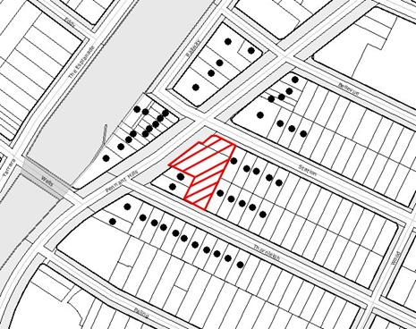
NOTIFICATION PLAN
|
· PROPERTIES NOTIFIED
|
PROPERTY SUBJECT OF DEVELOPMENT
|
|
6. THE PUBLIC INTEREST
Section 79C(1)(e) of the Act
requires Council to consider “the public
interest”.
The public interest is an
overarching requirement, which includes the consideration of the matters
discussed in this report. Implicit to
the public interest is the achievement of future built outcomes adequately
responding to and respecting the future desired outcomes expressed in
environmental planning instruments and development control plans.
The application is considered to
have satisfactorily addressed Council’s criteria and would provide a
development outcome that, on balance, would result in a positive impact for the
community. Accordingly, it is considered
that the approval of the proposed subdivision would be in the public interest.
7. CONCLUSION
Consent is sought to construct alterations to
the existing building to create separate tenancies and to strata subdivide the
buildings into 25 units. The proposal
complies with the respective provisions of the HSLEP and relevant DCPs. The
proposal would not result in negative social, economic or environmental
impacts. .
The application was publicly exhibited in
accordance with Council’s Notification Policy and during that time, did not
receive any submissions.
It is recommended that the application be
approved subject to the conditions held at Schedule 1 of this report.
|
SCHEDULE 1
Approved Plans and Supporting Documentation
1. The
development must be carried out in accordance with the following plans and
documentation listed below and endorsed with Council’s stamp, except where
amended by other conditions of this consent:
|
Plan No.
|
Drawn by
|
Dated
|
|
A-201-GR Ground Floor
Plan
|
Meriton
|
10/7/2008
|
|
A-201-L01 Level 01 Floor
Plan
|
Meriton
|
10/7/2008
|
|
A-201-ELEV Elevations
|
Meriton
|
10/7/2008
|
|
Strata Plan Form 2 - Car
Parking Level 1(as amended)
|
Wayne Allen Diver Tuck
|
8/7/2008
|
|
Strata Plan Form 2 – Car
Parking Level 2
|
Wayne Allen Diver Tuck
|
8/7/2008
|
|
Strata Plan Form 2 –
Ground Level
|
Wayne Allen Diver Tuck
|
8/7/2008
|
|
Strata Plan Form 2 –
Level 1
|
Wayne Allen Diver Tuck
|
8/7/2008
|
|
Document No.
|
Prepared by
|
Dated
|
|
Statement of
Environmental Effects
|
Meriton
|
July 2008
|
2. A Positive Covenant,
under Section 88B of the Conveyancing Act 1919, is created, for the provision
of and on going maintenance of ten (10) public parking spaces within common
property, as indicated on the revised strata plans, for use by the public
anytime between the hours of 7:00am to 7:00pm Monday to Friday everyday,
except public holidays. All other car
parking spaces are to be allocated to individual units, at a ratio
commensurate to the size of individual units.
3. The pedestrian
access from the basement car park to the premises at No. 293 Pennant Hills Road is to be
clearly marked as such and physically separated from the adjacent accessway
to the loading dock by the construction of a railing or similar between the
two access routes prior to release of the Subdivision Certificate.
4. The
loading dock and access from Station
Street is to be solely used for truck and van
access and shall only operate during the approved hours of operation of the
units. At all other times, the loading
dock shall be locked by a gate at the entrance to the site from Station Street
which prevents vehicular access onto that part of the site. The gate shall be installed to Council’s
satisfaction prior to the issue of a subdivision certificate.
5. The loading dock and
access from Station Street
are to be sign posted ‘No Parking’ zones. The signage is to be erected prior
to issue of a subdivision certificate.
6. In order to maintain amenity to
adjoining residences, the hours of use of each of the strata units shall be
restricted to those times listed below:
Monday - Wednesday 7.00am to 7.00pm
Thursday – Friday 7.00am to 9.00pm
Saturday 8.30am to
6.00pm
Sunday 10.00am to 5.00pm
7. In order to maintain
privacy to adjoining dwellings, the windows proposed on the eastern elevation
of the building are to be fitted with screens to prevent overlooking, prior
to release of the subdivision certificate.
8. The existing fence separating the
loading dock from the residential premises at No. 5 Thornleigh Street is to be fitted
with solid panels in order to prevent overlooking into the adjacent
residential private open space from vehicles utilising the loading dock.
Building Code of Australia
9. All
building work must be carried out in accordance with the requirements of the Building Code of Australia.
Should there be any alternative solutions listed as Category 2
Fire Safety Provisions and outlined in the Environmental Planning and
Assessment Regulation 2000, a fire engineering report should be forwarded to
the Brigades for comment under Clause 144 of the Environmental Planning and
Assessment Regulation 2000.
Council Property
10. The
land and adjoining areas are to be kept in a clean and tidy condition at all
times. Litter and rubbish shall be
placed in containers and removed from the site. A waste storage container is to be provided
at the commencement of the building work.
11. The
cost of repairing any damage caused to Council's assets as a result of
construction works associated with the approved development is to be met in
full by the applicant/developer prior to the issue of a subdivision
certificate.
Signs for
Construction Sites
12. On-site
signage is required to clearly identify the PCA and the principal contractor
(the coordinator of the building work) pursuant to the Environmental Planning and Assessment Amendment (Quality of
Construction) Act 2003, s157(1)(c1), Cl 98A, 136C & 227A.
Hours of Construction
13. In
order to maintain the amenity of adjoining properties, site works shall be
restricted to between 7.00 am and 6.00 pm, Monday to Friday and 8.00 am to
1.00 pm Saturday. No work shall be
undertaken on Sundays or public holidays.
Plant, goods or materials shall not be delivered to the site outside
the approved hours of site works unless otherwise approved by Council.
Protection of Public Places
14. If
the construction works causes pedestrian or vehicular traffic in a public
place to be obstructed or rendered inconvenient, a fence must be erected
between the building premises and the public place. The fence must be at least 1.8m high of
chainwire and galvanised pipe construction.
Welded wire reinforcing fabric is not to be used.
If
the construction works will cause pedestrian or vehicular traffic in a public
place to be obstructed or rendered inconvenient or unsafe, or the works
involve the enclosure of a public place, a hoarding must be erected between
the building premises and the public place.
The erection of any hoarding and temporary awnings requires separate
approval under the Local Government Act, 1993.
15. The
work site is to be kept lit between sunset and sunrise if it is likely to be
a source of danger to persons using a public place or upon instruction by
Council to enhance the safety and security of the area in which the work is
located.
Fire Safety Certificate –
Final
16. In
accordance with Part 9, Division 4 of the Environmental Planning &
Assessment Regulation, 2000, the owner of the building must, on completion of
the building, provide Council with a certificate in relation to each
essential fire safety or other safety measure implemented in the building.
Fire Safety Statement -
Annual
17. In
accordance with Part 9, Division 5 of the Environmental Planning &
Assessment Regulation, 2000, at least once in each period of 12 months after
the date of the first fire safety certificate, the owner shall provide
Council with a further certificate in relation to each essential service
installed in the building.
|
|
Rod Pickles
Manager -
Assessment Team 2
Planning Division
|
Scott Phillips
Executive Manager
Planning Division
|
Attachments:
|
1.View
|
Locality
Plan
|
|
|
|
2.View
|
Proposed
Strata Plans
|
|
|
|
3.View
|
First
Floor Basement Carpark - Amended Car Parking Provisions
|
|
|
File Reference: DA/930/2008
Document Number: D01005394
Planning Report No. PLN202/08
Date of Meeting: 15/10/2008
7 DEVELOPMENT APPLICATION - DEMOLITION OF EXISTING DWELLING AND ERECTION
OF A CHILD CARE CENTRE
96 RAY ROAD, EPPING
|
Development
Application No:
|
DA/582/2008
|
|
Description
of Proposal:
|
Demolition of existing dwelling and erection of a
child care centre for 48 children.
|
|
Property
Description:
|
Lot 3 DP 8346 (No.
96) Ray Road
Epping
|
|
Applicant:
|
Mr Andre Elahyek
|
|
Owner:
|
Mr E Isaac
|
|
Statutory
Provisions:
|
Residential A (Low Density) Zone
|
|
Estimated
Value:
|
$680,000
|
|
Ward:
|
C
|
RECOMMENDATION
THAT Development Application No. 582/2008 at Lot 3 DP 8346
(No. 96) Ray Road Epping be approved subject to conditions of consent detailed
in Schedule 1 of this report.
EXECUTIVE SUMMARY
1. The application proposes
the demolition of an existing dwelling and the erection of a child care centre
for 48 children.
2. The application is
subject to an appeal in the Land and Environment
Court against Council’s deemed refusal of the
application (Proceedings No. 10744 of 2008).
3. The proposal complies
with the provisions of the Hornsby Shire Local Environmental Plan and the
Community Uses DCP other than departures to the prescriptive measures for
landscaping and site selection, which are considered acceptable.
4. Thirty eight submissions
have been received in respect of the application. Three submissions have been
received in response to amended plans.
5. It is recommended that
the application be approved.
HISTORY OF THE SITE
The site is the subject of
Development Application No. 192/2008 approved on 20 June 2008, for demolition
of the existing carport and subdivision of one allotment into two. Under that consent, it was envisaged that a
new dwelling would be constructed on the rear portion of the site (subject to
separate consent).
THE SITE
The site comprises an existing
single storey brick dwelling house with tiled roof on a large residential lot
having an area of 1,421sqm with dimension 18.3 metres wide x 70.1 metres
depth. The site has frontage to the
northern side of Ray Road.
The site has a gradual slope with
an average fall of 10% to the rear boundary.
An existing dwelling house with attached carport is sited on the
land. The site is clear of natural
vegetation and includes a number of non-indigenous trees and shrubs.
The adjoining residential lots
are of similar size with detached single storey dwellings. The locality is characterised by low density
residential development comprising detached dwellings of single and two storey
construction.
ASSESSMENT
The development application has
been assessed having regard to the ‘2005
City of Cities Metropolitan Strategy’,
the ‘North Subregion (Draft) Subregional
Strategy’ and the matters for consideration prescribed under Section 79C of
the Environmental Planning and Assessment
Act 1979 (the Act). Subsequently,
the following issues have been identified for further consideration.
1. STRATEGIC CONTEXT
1.1 Metropolitan Strategy – (Draft) North
Subregional Strategy
The Metropolitan Strategy is a
broad framework to secure Sydney’s
place in the global economy by promoting and managing growth. It outlines a vision for Sydney to 2031; the challenges faced, and the
directions to follow to address these challenges and achieve the vision. The draft North Subregional Strategy acts as
a framework for Council in the preparation of a new Principal LEP by 2011.
The draft Subregional Strategy
sets the following targets for the Hornsby LGA by 2031:
· Employment capacity to increase by
9,000 jobs; and
· Housing stock to increase by 11,000
dwellings.
The proposed development would be
consistent with the draft Strategy in so far as providing an additional seven
jobs in the locality.
2. STATUTORY CONTROLS
Section 79C(1)(a) requires
Council to consider any relevant environmental planning instruments, draft
environmental planning instruments, development control plans, planning
agreements and other prescribed matters.
2.1 Hornsby Local Environmental Plan 1994
The subject land is zoned
Residential A (Low Density) under Hornsby Local Environmental Plan 1994
(HLEP). The objectives of the zone are:
(a) to provide for the housing needs of the
population of the Hornsby area.
(b) to promote a variety of housing types and
other land uses compatible with a low density residential environment.
(c) to provide for development that is within the
environmental capacity of a low density residential environment.
The proposed development is
defined as ‘demolition’ and ‘child care centre’
under HLEP and is permissible in
the zone with Council’s consent.
Clause 15 of HLEP prescribes that
the maximum floor space ratio (FSR) of development within the zone is 0.4:1. The proposed building would
have an FSR of 0.275:1, which satisfies the development standard.
2.2 Children’s Services Regulation 2004
Compliance with the Regulation is
required for the licensing of child care centres by the NSW Department of
Community Services.
The proposed development has been
designed for the proposed number of child care centre places in accordance with
the space requirements of the Regulation for the provision of indoor and
outdoor play areas, cot room and staff room. The proposed number of seven staff
meets the requirement of the Regulation for the ratio of staff to children
according to age group, ie:
|
15 places 0 –
2 years
|
Staff ratio 1
per 5 children
|
= 3
|
|
16 places 2 –
3 years
|
Staff ratio 1
per 8 children
|
= 2
|
|
17 places 3 –
6 years
|
Staff ratio 1
per 10 children
|
= 2
|
|
48 places TOTAL
|
7
|
The prescribed indoor &
outdoor play area requirements under Clause 30 of the Regulation are reiterated
under Council’s Community Uses Development Control Plan (DCP).
2.3 Community Uses Development Control Plan
The proposed development has been
assessed having regard to the relevant performance and prescriptive design
standards within Council’s Community Uses DCP.
The proposal complies with the DCP requirements in respect to density,
setbacks, parking & access, design, recreation space, acoustics, land
sensitivity, solar access and crime prevention. The following table sets out
the proposal’s compliance with the prescriptive standards of the Plan:
|
Community Uses Development Control Plan
|
|
Control
|
Proposal
|
Requirement
|
Compliance
|
|
Density
|
48 places
|
50 places
|
Yes
|
|
Height
|
2 storey
|
2 storey
|
Yes
|
|
Car parking
|
12 Spaces
|
12 Spaces
|
Yes
|
|
Indoor play area
|
161.5m2
|
156m2
|
Yes
|
|
Outdoor play area
|
431.8m2
|
336m2
|
Yes
|
|
Site cover
|
32%
|
40%
|
Yes
|
|
Landscaping
|
41%
|
45%
|
No
|
|
Staff
|
7
|
7
|
Yes
|
As detailed in the above table,
the proposed development does not comply with the landscaping prescriptive
standard. Further, the proposal does not meet a number of the DCP’s site
selection criteria. The matters of non-compliance are discussed below.
2.3.1 Landscaping
The proposed landscaping involves
41% of the site and does not comply with the prescriptive measure of 45%. The
departure to the development standard is considered acceptable having regard to
the submitted landscape plan, which includes appropriate landscaped areas to
soften the extent of paved surface area at the frontage of the building and to
complement the development in the streetscape.
It is noted that the development exceeds Council’s minimum development
standards in a number of areas, (i.e. floor space ratio, site coverage and
outdoor play area) and, on balance, the development outcome would be
reasonable.
In departure of the development
standard is addressed by recommended conditions of consent to minimise the
visual impact of the paved carparking area in the streetscape. Subject to
recommended conditions, it is considered the proposal meets the DCP landscaping
element objective.
2.3.2 Site Selection Criteria
The Community Uses DCP includes
the following site selection criteria as being appropriate locations for child
care centres:
· sites with less exposure to neighbouring dwellings and
noise sensitive areas (i.e. corner sites, sites adjacent to non-residential
uses).
· sites where drop-off and pick-up turning areas can be
provided.
· sites with safe vehicular access (i.e. not on a main
road).
· sites which form part of an established place of worship
or community facility.
· sites with close proximity to parkland.
· sites within walking distance (i.e. 700m) to a railway
station and employment centre.
· sites close to populations with a large proportion in the
0-4 age group.
· large sites with potential for extensive play areas.
The subject
site comprises a large narrow lot which adjoins three dwelling house lots. The
site fronts Ray Road
which is identified as a collector road in Council’s road hierarchy. The site
is not within walking distance of Epping railway station & town centre nor
is it in close proximity to parkland. The site does not form part of a church
or community facility.
The proposed
site does not meet a number of the DCP’s site selection criteria for child care
centres. However, the proposed centre is conveniently located for parents on
route to Epping AM and returning PM and includes entry & exit driveways.
Conditions for traffic calming and parking management are recommended to ensure
that the proposal would be satisfactory in respect to traffic and road safety
(refer to Section 3.4.9 of this report).
The
development’s departure from site selection criteria standards under the DCP
needs to be offset against the recognised need for child car centre places in
Epping particularly for the 0-2 year age group.
The proposed centre has social and economic merit in meeting the
increasing demand for child care in the locality (refer to Section 3.1 of this
report).
In view of the
proposed centre’s convenience for parents, demand for childcare centres in the
locality and compliance with amenity criteria, non-compliance with site
selection criteria in itself should not be fatal to the application.
2.4 Waste Minimisation & Management DCP
The application includes a Waste
Management Plan for the demolition of the existing dwelling, in compliance with
the DCP requirements. A condition to ensure the implementation of best practice
waste management during construction of the development, is recommended.
3. ENVIRONMENTAL IMPACTS
Section 79C(1)(b) of the Act
requires Council to consider “the likely
impacts of that development, including environmental impacts on both the
natural and built environments, and social and economic impacts in the
locality”.
3.1 Social Impact on the Locality
The
proposal would have a positive social impact in meeting demand for the child
care places at Epping and generally in enabling the return of parents/carers to
the workforce. This is evident by the shortage of child care centre places
across Hornsby LGA with a waiting list of 300 children for the 208 places
within Council’s own centres for the 0-2 year age group. At Council’s
Somerville Park Centre at Epping there is a waiting list of 90 children for the
0-2 year age group.
At
Epping the existing child care centres primarily are older style pre-school
centres catering for 3 – 5 year olds and there is a shortage of long day care
centre places.
The
proposal would contribute to the number of child care centre places within the
Epping area. Also, the proposed centre is of design to provide opportunity for
the provision of ancillary child care services, eg. early childhood
professional and health services and support programs for children with
additional needs.
The
need for improved child care services and quality of child care is recognised
in the Federal Government’s recent budget initiatives, which includes
establishing 260 additional Early Learning and Care Centres across Australia.
3.2 Economic Impact on the Locality
The
proposal increases employment opportunities in child care and would contribute
to the local economy.
The
proposed centre provides opportunity for parents/carers to return to the
workforce, increasing household income and benefiting the local economy.
3.3 Natural Environment
The proposed development would
necessitate the removal of two of the ten trees from the site. The trees to be removed are not identified as
‘significant trees’. An appropriate condition to protect the trees to be
retained, including Tree No. 3 on the adjoining land is recommended.
3.4 Built Environment
The impact of the proposed
development on the built environment is examined below.
3.4.1
Building Alignment
The proposed
23.4m front building setback is inconsistent with the predominant building
alignment in the street of 6m – 10m. The proposed front setback however
provides for the car parking area, which is in accordance with the setbacks
performance criteria of the Community Uses DCP, ie: “ for setbacks to allow for off street car parking”.
The proposed
development is on the lower side of the street and would not significantly
detract from streetscape. The proposed front setback is therefore considered
acceptable.
3.4.2
Bulk & Scale
In scale and
appearance the proposed child care centre is considered generally consistent
with recently constructed low density residential development in the locality.
The proposed car park results in a greater building setback in the streetscape
and the proposed building is at a lower level to the street. The applicant has
submitted a streetscape elevation plan which illustrates that the first floor
of the proposed development appears as a single storey structure in the
streetscape, consistent with adjoining dwelling houses.
The proposed
landscaping is considered satisfactory in softening the extent of the paved
front setback area in the streetscape and in complementing the proposed
building, subject to adherence to recommended conditions.
The proposed
building is sited predominantly to the rear of the site and adjacent to the
back yards of adjoining detached dwellings. The proposed building would form a
dominant element to the rear of adjoining properties, which is considered
acceptable with regard to the proposed materials, finishes, solar access and
design for privacy.
It should be
noted the site has approval for subdivision of the land (DA/192/2008) with an
indicative building envelope and battleaxe lot approved for rear of the
site. A future dwelling house on the
rear of the site is a likely eventuality should the proposal not proceed. In that regard, the future built form of the
site has been determined regardless of the outcome of this application. The proposed development is in keeping with
Council’s requirement for single storey development on a battleaxe lot as the
rear (majority) of the building would be a single storey element.
The proposed
building is two storey at the front elevation and single storey to the rear.
The proposed building would appear predominantly single storey in relation to
the yards of adjoining residential property and in relation to the streetscape.
The proposal is considered satisfactory in terms of low density residential
design.
The proposal
involves cut and fill and construction of a 2m high retaining wall between the
car park and the building. Approximately 70% of the site’s landform is modified
for the proposed development. The cut & fill enables slab on ground
construction and car park crossfall design criteria to be met. Whilst the DCP seeks to minimise earthworks
and land disturbance, the DCP also seeks to provide car parking at the front of
buildings to promote off-street carparking.
In this regard, it is considered that the design represents a reasonable
response to the DCP.
The proposed
child care centre complies with Clause 30 of the Children’s Services Regulation
2004, in respect to spatial and functional requirements. The proposed outdoor play area exceeds the regulatory
area requirement and meets the Community Uses DCP site selection requirement
for extensive play areas. The proposed first floor, as amended, includes
sufficient suitable area for activities and services ancillary to the operation
of the child care centre.
3.4.3
Crime Prevention
The
proposed development has been designed to minimise crime in accordance with
CPTED principles by way of clear sightlines, windows that overlook the car
parking area and pedestrian access and clearly defined building entry and
access.
The
proposal complies with the Community Uses DCP crime prevention element
objective.
3.4.4
Privacy
The
proposed development is of design to minimise impacts on privacy of properties
adjoining the western and eastern boundaries by way of no opening windows of
the building being provided on side elevations.
The
building is elevated to the rear boundary and the rear porch would have an
outlook to the rear adjoining property.
However, the proposed building is setback 21.4m from the rear boundary
and therefore, the development would not result in any direct privacy
impacts. The submitted landscaping plan
includes screening along the rear northern boundary which is considered
adequate to address privacy for the adjoining property.
The application
includes construction of lapped & capped timber fencing to finished ground
levels to address visual and acoustic privacy for adjoining properties.
3.4.5
Noise Impacts
The
proposed hours of the centre are weekdays from 7 am to 6 pm. The primary sources of noise from the centre
would be vehicle movements at the beginning and end of the day and outdoor
children’s activities periodically throughout the day.
The
applicant has submitted an acoustic report prepared by RSA Acoustics Pty Ltd
which includes recommendations to minimise noise impacts on adjoining
residential property, resulting from the proposed development.
The
applicant proposes to construct a combination of masonry fencing in the front
car park area and timber fencing in the rear play area to mitigate against
noise impacts on neighbouring properties.
However, it is also considered necessary that operational procedures are
implemented that manage the outdoor play area.
These procedures should incorporate restrictions on the use of amplified
music, sirens, whistles or any other device that mechanically increases noise
levels in the rear yard. In addition,
the centre should be managed in such a manner so as to minimise the number of
children in the outdoor play area at any one time. In that regard, no more than 20 children
should be outside at any one time. A
further requirement that the centre provides adjoining and nearby neighbours
details of the name of the duty manager and contact number of the centre in the
event that neighbouring residents have particular concerns with the daily
operation of the centre is recommended.
A condition
is included for the implementation of the report recommendations which includes
masonry/lapped and capped timber fencing along the side and rear boundaries and
operational procedures for outdoor play.
3.4.6
Solar Access
The application
includes shadow diagrams which demonstrate compliance with Council’s
requirements for developments maintaining a minimum of 4 hours of sunshine to
the open space areas of adjoining residential properties, in accordance with
the Community Uses DCP solar access requirement.
3.4.7
Access For People With A Disability
The
application includes an access report prepared by Morris-Goding Accessibility
Consulting that made recommendations for the proposal, in compliance with Australian Standard 1428, the Building Code
of Australia,
the Disability Discrimination Act and
Council’s Access & Mobility DCP.
In this
respect, it is necessary that the internal stairs of the centre be of the
required width to accommodate a wheelchair stair lift. A condition is recommended for implementation
of the access report recommendations.
3.4.8
Visual Impact
The
proposal retains the majority of existing trees on the site and would not detract
from the existing visual quality of the site.
The proposed landscaping plan includes appropriate planting to
complement the development in the streetscape and minimise the visual impact of
paved area for the car park at the frontage. The proposed materials and
finishes blend the development with the surrounding environment and is
considered acceptable.
3.4.9 Transport, Traffic, Access and Parking
The site has
frontage to Ray Road
which is a collector road in Council’s road hierarchy. The road carries high
traffic volumes in the AM and PM peaks. The applicant submitted a Traffic
Impact Study for the proposed development together with additional information
as requested by Council. Council’s
traffic and road safety assessment concludes that the development would be
acceptable subject to a number of on-site management and on-street traffic
calming measures.
The proposal
includes 12 car parking spaces in compliance with Council’s Community Uses DCP.
The proposed parking layout for two stacked car parking spaces for staff is
satisfactory for child care centre use.
Subject to recommended conditions the proposal complies with the parking
and access element objective of the Community Uses DCP.
The proposal
would not have any impact on the safety or functioning of the bus stop and post
box located 100m east of the site on Ray
Road.
3.4.10 Soils and Waterways
The applicant
submitted a Soil & Water Management Plan and a geotechnical report, in
compliance with the Community Uses land sensitivity element objective. A condition is recommended for the Soil &
Water Management Plan to be implemented in accordance with Council’s best
practice guidelines.
The site is in
the vicinity of a former watercourse now piped as part of Council’s stormwater
drainage system. The proposed car park and building involve extensive paved
surface areas, increasing stormwater runoff from the site. A condition is recommended to provide
adequate stormwater detention to minimise downstream impacts from stormwater
runoff.
3.4.11
Waste Minimisation & Management
The applicant
submitted a Waste Management Plan for the demolition of the existing dwelling
in accordance with the requirements of the Waste Minimisation and Management
DCP.
The waste
generated by the operation of the proposed development would be collected by
commercial waste contractor at the street frontage.
A condition is
recommended for compliance with project management best practice during
construction in accordance with the Waste Minimisation and Management Guide.
3.4.12
Energy Efficiency
The proposed
building would achieve energy efficiency through masonry construction (thermal
mass) and the building envelope which includes shading at the northern
elevation.
A condition is
recommended to ensure that the development is constructed in a manner that
incorporates energy efficient hot water heating.
3.4.13 Technological Hazards
In accordance
with Council’s requirements, the applicant submitted a preliminary
contamination assessment prepared by GeoEnviro Consultancy. That report determined:
Within the context of the scope of work
carried out, the results of the contamination assessment indicate that the
likelihood of gross ground chemical contamination on the site is generally
considered low.
A condition is
recommended to require validation that the site is suitable for the child care
centre use, in accordance with the NSW
Environment Protection Authority guidelines.
Appropriate
conditions are recommended for the safe identification and removal of asbestos
from the site during the demolition phase of the development.
4. SITE SUITABILITY
Section 79C(1)(c) of the Act
requires Council to consider “the
suitability of the site for the development”.
The site has a gradual slope and
is currently the site of a dwelling house. The site is suitable for the
proposed development subject to the implementation of erosion and sediment
control measures during construction to protect downstream water quality.
The proposal is similar in bulk,
scale and form to recent residential development occurring in the locality.
5. PUBLIC PARTICIPATION
Section 79C(1)(d) of the Act
requires Council to consider “any
submissions made in accordance with this Act”.
5.1 Community Consultation
The proposed development was
placed on public exhibition and was notified to adjoining and nearby landowners
between 21 May 2008 and 11 June 2008 in
accordance with Council’s Notification and Exhibition Development Control Plan. During this period, Council received 41 submissions and a petition with 197
signatories. There were 3 submissions in support of the proposal and 38 submissions objecting to the
proposal.
The application was further
notified following receipt of amended plans and 3 submissions were received
from previous respondents reiterating concerns.
The map below illustrates the
location of those nearby landowners who made a submission that are in close
proximity to the development site.
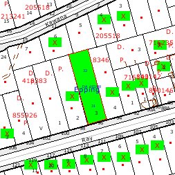
|
NOTIFICATION
PLAN
|
|
|
• PROPERTIES
NOTIFIED
|
X SUBMISSIONS RECEIVED
|
PROPERTY
SUBJECT
OF DEVELOPMENT
|

|
|
25 SUBMISSIONS
RECEIVED OUT OF MAP RANGE
|
|
|
|
|
Thirty eight submissions objected to the development,
generally on the following grounds that the development would result in:
· Loss of trees;
· Unacceptable traffic, parking &
road safety impacts;
· Unacceptable impact on residential
character;
· Non-compliance with site selection
criteria;
· Stormwater drainage nuisance.
Three submissions were neutral to the development and made
the following observations:
· Leaflets being distributed reflected
NIMBY attitude of objectors.
The merits of the matters raised in community submissions
have been addressed in the body of the report.
5.2 Public Agencies
There were no submissions received from public authorities.
6. THE PUBLIC INTEREST
Section 79C(1)(e) of the Act
requires Council to consider “the public
interest”.
The public interest is an
overarching requirement, which includes the consideration of the matters
discussed in this report. Implicit to the
public interest is the achievement of future built outcomes adequately
responding to and respecting the future desired outcomes expressed in
environmental planning instruments and development control plans.
The application is considered to
have satisfactorily addressed Council’s criteria and would provide a
development outcome that, on balance, would result in a positive social impact
for the community. The departure from
site selection criteria in Council’s DCP in itself should not be fatal to the
application given that the application demonstrates that it could proceed in a
sustainable manner and fulfil a community need.
Accordingly, it is considered that the approval of the proposed would be in the public interest.
7. CONCLUSION
The proposed child care centre is consistent in scale with low
density residential development in the locality and complies with the Community
Uses DCP in respect to the majority of the DCP criteria.
The development application was the subject of considerable
response to the initial notification of the proposal. The subsequent amended
plans involved minor changes to the proposal to address landscaping, disabled
access and functional use of the first floor. There was limited response to the
notification of the amended plans.
The development application is the subject of an appeal in the
Land and Environment Court
against Council’s deemed refusal of the application.
The concerns raised in the submissions to the application are
principally in respect of traffic and road safety matters. The concerns have
been considered in the assessment of the application and are addressed by
recommended conditions for traffic calming and parking management.
On balance, and having regard to the community benefit of the
proposal, it is considered that the development is worthy of Council’s
consent. Accordingly, recommended
conditions of consent are held at Schedule 1 to this report.
SCHEDULE 1
Approved Plans and Supporting Documentation
1. The development must be carried out in
accordance with the following plans and documentation listed below and endorsed
with Council’s stamp, except where amended by other conditions of this consent:
|
Plan
No.
|
Drawn
by
|
Dated
|
|
2/6 Site Plan / Ground Floor Plan
|
SB Design
|
11-08-2008
|
|
3/6 First Floor Plan / Roof Plan
|
SB design
|
11-08-2008
|
|
4/6 Elevations & Sections
|
SB Design
|
11-08-2008
|
|
5/6 Elevations & Sections
|
SB Design
|
11-08-2008
|
|
Landscape Plan
|
RFA Landscape Architects
|
19-08-2008
|
Note: This development consent
does not provide for any signage. A separate
development application shall be submitted for the child care centre.
2. The child care centre
shall have a maximum of 48 places in the following groups.
· 0 – 2 years: 15 places
· 2 – 3 years: 16 places
· 3 – 6 years: 17 places
3. The
hours of operation of the centre are restricted to weekdays between 7.00am and
6.00pm .
4. The materials
and colours to be used in the construction shall be in accordance with the
samples submitted to Council (Reference No. D00911778).
5. The driveways and car
parking area shall be in coloured concrete or similar treatment to minimise
visual impact and to complement the landscaping of the development.
6. The proposed bin
storage at the frontage shall be deleted and replaced with landscaping
generally in accordance with the landscape plan for the area at the frontage.
A suitable bin
storage area shall be provided adjacent to car parking space No. 10 and the
pedestrian pathway.
7. The
development shall operate in accordance with all recommendations in the
acoustic report prepared by RSA Acoustics
dated April 2008 accompanying the application which requires specialised
acoustic treatment of the building and/or the way in which the use is to
operate and the following:
i) The
acoustic fencing on the eastern side of the car park shall be of masonry
construction, 1.8 metres high and not
forward of the building alignment on the adjoining property, as illustrated on
the approved plans;
ii) A
maximum of 20 children shall occupy the outdoor play area at any one time;
iii) No
amplified music, sirens, whistles or other mechanical device that mechanically
increases noise levels shall be used in the outdoor play area;
iv) Details
of the name and contact number of the on-site manager shall be provided to
adjoining and nearby neighbours to contact the centre in the event that
excessive noise is being generated by the centre;
v) A 1.8
metre high lapped and capped timber fence shall be constructed along the side
and rear property boundaries of the property at the sole cost of the applicant;
vi) All
noise generated by the proposed development is to be attenuated to prevent
levels of noise being emitted to adjacent premises which possess tonal, beating
and similar characteristics or which exceeds background noise levels by more
than 5dB(A).
8. The hot water system
for the development shall have an energy efficiency rating of not less than 3.5
stars.
9. Documentary
evidence (ie. tipping dockets/receipts from transfer stations and landfills)
shall be submitted to Council or the principal certifier to confirm compliance
with the Waste Management Plan lodged with the development application.
10. To
minimise waste, appropriate project management techniques shall be employed in
accordance with Section C1.01 of the Hornsby Shire Council Waste Minimisation
and Management Guide.
Building Code of Australia
11. All building work must
be carried out in accordance with the requirements of the Building Code of Australia.
12. The land and adjoining
areas are to be kept in a clean and tidy condition at all times. Litter and rubbish shall be placed in
containers and removed from the site. A
waste storage container is to be provided at the commencement of the building
work.
13. The cost of repairing
any damage caused to Council's assets as a result of construction works
associated with the approved development is to be met in full by the
applicant/developer prior to the issue of a subdivision certificate.
Sediment & Erosion Control
14. Temporary sedimentation
and erosion controls are to be constructed prior to commencement of any work to
eliminate the discharge of sediment from the site. The controls are to be designed and installed
in accordance with the requirements of Landcom’s “Managing Urban Stormwater:
Soils and Construction”, Volume 1, 4th Edition, March 2004, (the
Blue Book), and Hornsby Shire Council’s “Sustainable Water Best Practices”
manual and shall:-
i) be effectively maintained at
all times during the course of works and shall not be removed until the site
has been stabilised or landscaped to the Principal Certifying Authority’s
satisfaction.
ii) include adequate measures
to remove clay from vehicles leaving the site so as to maintain public roads in
a clean condition.
iii) ensure disturbed areas
are rehabilitated with indigenous plant species, landscaped and treated by
approved methods of erosion mitigation such as, mulching, and revegetation with
native grasses or other suitable stabilising processes within fifteen days of
the completion of works.
Hours of Demolition Works
15. In order to maintain the
amenity of adjoining properties, demolition works shall be restricted to
between 7.00 am and 6.00 pm. No
demolition works are to be undertaken on Saturdays, Sundays or Public
Holidays. Plant, goods or materials
shall not be delivered to the site outside the approved hours of site works
unless written Council gives consent.
Demolition
16. All demolition work is
to be carried out in accordance with the applicable provisions of Australian
Standard 2601-2001 ‘The Demolition of Structures’.
A sign must be
erected in a prominent position on the premises, on which the demolition of a
building is being carried out, stating that unauthorised entry to the premises
is prohibited and showing the name of the builder or other person in control of
the premises and a telephone number at which the builder or other person may be
contacted during and outside work hours. The sign is to be removed when the demolition
of the building has been completed.
Note:
Applicants are reminded that WorkCover NSW requires all plant and equipment
used in demolition work must comply with the relevant Australian Standards and
manufacturer specifications.
Asbestos Removal
17. The following conditions
shall be complied with regarding asbestos:
i) Prior to commencement of
any work involving the demolition, alteration or addition to any building on
the development site, a survey is to be conducted by a competent person to
ascertain whether any asbestos materials exist thereon. Asbestos material means any material that
contains asbestos.
ii) Where asbestos material
is found to exist on the development site and that asbestos material is to be
removed or disturbed as a result of any proposed demolition, alteration or
addition, then all work involving removal and disposal of asbestos material
must be undertaken by persons who hold the appropriate licence issued by
WorkCover NSW under Chapter 10 of the Occupational Health and Safety Regulation
2001.
iii) The collection, storage,
transportation or disposal of any type of asbestos waste is to comply with the
requirements of clause 29 of the Protection of the Environment Operations
(Waste) Regulation 1996.
iv) Upon completion of
disposal operations, the applicant must lodge with the principal certifying
authority, within seven (7) days, all receipts (or certified photocopies)
issued by the receiving landfill site as evidence of proper disposal.
Note: The person responsible for disposing of the
asbestos material shall consult with the Environment Protection Authority to
determine the location of an approved landfill site to receive asbestos
material.
v) On construction sites
where buildings contain asbestos material, a standard commercially manufactured
sign containing the words ‘DANGER ASBESTOS REMOVAL IN PROGRESS’ measuring not
less than 400mm x 300mm is to be erected on the site in a prominent position
visible from the street. The sign is to
be erected prior to any work commencing and is to remain in place until such
time as all asbestos material has been removed from the site to an approved
waste facility. This condition is
imposed for the purpose of worker and public safety and to ensure compliance
with Clause 259(2)(c) of the Occupational Health and Safety Regulation 2001.
Signs for Construction Sites
18. On-site signage is
required to clearly identify the PCA and the principal contractor (the
coordinator of the building work) pursuant to the Environmental Planning and Assessment Amendment (Quality of
Construction) Act 2003, s157(1)(c1), Cl 98A, 136C & 227A.
Dust Control
19. Measures to prevent the
emission of dust or other impurities into the surrounding environment are to be
implemented during demolition works.
Hours of Construction
20. In order to maintain the
amenity of adjoining properties, site works shall be restricted to between 7.00
am and 6.00 pm, Monday to Friday and 8.00 am to 1.00 pm Saturday. No work shall be undertaken on Sundays or public
holidays. Plant, goods or materials
shall not be delivered to the site outside the approved hours of site works
unless otherwise approved by Council.
Excavation & Backfilling
21. Retaining walls or other
approved methods necessary to prevent the movement of excavated or filled
ground, are to be constructed together with associated stormwater drainage
measures prior to occupation of the development or before where site conditions
require.
If an
excavation extends below the level of the base of the footings of a building on
an adjoining allotment of land, the person causing the excavation to be made
must:
i) preserve and protect the building from
damage;
ii) if necessary, underpin and support the
building in an approved manner; and
iii) at least 7 days before excavating, give
notice of intention to do so to the adjoining owner and furnish particulars to
the owner of the proposed work.
Protection of Public Places
22. If the erection or
demolition of a building causes pedestrian or vehicular traffic in a public
place to be obstructed or rendered inconvenient, a fence must be erected
between the building premises and the public place. The fence must be at least 1.8m high of
chainwire and galvanised pipe construction.
Welded wire reinforcing fabric is not to be used.
Fire Safety Certificate – Final
23. In accordance with Part
9, Division 4 of the Environmental Planning & Assessment Regulation, 2000,
the owner of the building must, on completion of the building, provide Council
with a certificate in relation to each essential fire safety or other safety
measure implemented in the building.
Fire Safety Statement - Annual
24. In accordance with Part
9, Division 5 of the Environmental Planning & Assessment Regulation, 2000,
at least once in each period of 12 months after the date of the first fire
safety certificate, the owner shall provide Council with a further certificate
in relation to each essential service installed in the building.
Survey Reports
25. To ensure that the
building and any associated structures are correctly positioned on the site, a
report prepared by a registered surveyor is to be submitted to the principal
certifying authority at each level of construction of the building (prior to
the pouring of concrete) indicating that the finished floor level is in
accordance with the approved plans.
Sydney Water
26. The approved plans must
be submitted to a Sydney Water Quick Check agent or Customer Centre to
determine whether the development will affect Sydney Water’s sewer and water
mains, stormwater drains and/or easements, and if further requirements need to
be met. The approved plans will be
appropriately stamped. For Quick Check
agent details please refer to “Your Business” section of Sydney Water’s web site
at www.sydneywater.com.au then see Building & Renovating under the heading Building
& Renovating, or telephone 13 20 92.
Long Service Levy
27. Under Section 34 of the
Building and Construction Industry Long Service Payments Act 1986 any work
costing $25,000 or more is subject to a Long Service Levy. The levy rate is 0.35% of the total cost of
the work and shall be paid to either the Long Service Payments Corporation or
Hornsby Shire Council. Under section
109F (1) of the Environmental Planning & Assessment Act, 1979 this payment
must be made prior to a construction certificate being issued.
Construction
Certificate – Engineering Works
28. A construction certificate must be obtained from either
Council or an Accredited Certifier. Engineering design plans and specifications
are to be prepared by a chartered professional engineer for any proposed
works. The plans and specifications are
to be in accordance with development consent conditions, appropriate Australian
standards, and applicable Council standards, in particular “Hornsby Shire Council
Civil Works - Design and Construction Specification”. Information required to
be submitted with a construction certificate is as follows:
a) copies of compliance certificates relied upon
b) Four (4) copies of the detailed engineering plans in accordance
Hornsby Shire Council's Civil Works - Design Specification 1999. The detailed
plans may include but are not limited to the earthworks, roadworks, road
pavements, road furnishings, stormwater drainage, landscaping and erosion
control works.
c) Hornsby Shire Council’s approval for roadworks and public
drainage is required prior to the issuing of a construction certificate for
these works.
29. All
engineering works required by this consent must be designed and undertaken in
accordance with the relevant aspects of the following documents, except as
otherwise authorised by this consent. A Construction Certificate is to be
obtained prior to commencement of works.
a) Australian Rainfall and Run-Off 1987
b) Hornsby Shire Council's Design and Construction Specifications
1999
Inspections - Engineering
30. All engineering work required by the consent must be inspected
at the “hold points” as nominated in the Hornsby Shire Council Civil Works
Construction Specifications 1999. Certificates shall be issued prior to
occupancy confirming that the works comply with development consent,
construction certificate and Hornsby Shire Council Civil Works - Design and
Construction Specification.
Road
Works (Driveway/ Access)
31. A separate application under the Local Government Act 1993 and Roads
Act 1993 shall be submitted to Council for approval for the following:
a) the installation of an
additional vehicular footway crossing servicing the development from Ray Road.
b) the levels
provided by Council are to be used to design the internal driveway.
c) further, evidence of Council's levels being incorporated into
the longitudinal section is to be submitted with a construction certificate application.
Note: This application can only be submitted by one
of Council’s Authorised Vehicular Crossing Contractors. You are advised to
contact Council’s Works Division on (02) 9847 6940 to obtain a list of
Council’s Authorised Vehicular Crossing contractors.
32. The vehicular footway crossing, driveway
and the parking areas are to be designed and constructed in accordance with
Hornsby Shire Council Civil Works Specifications, Australian Standards 2890.1
and 3727 and comply with the following requirements:
a) A
longitudinal section through the centreline of the driveway from the road to
the proposed car parking areas showing proposed driveway grades and allowing or
suitable transition at changes of grades, is to be submitted for consideration
with a construction certificate application.
b) The
maximum grade is to be 25% with maximum transition for changes of grade to be
8% per plan meter.
33. The
ingress and egress crossings shall be suitably signposted prior to occupation.
Drainage
– On Site Detention
34. The
drainage system to control all collected roof and surface stormwater shall be
designed with an on-site-detention system. The system shall be designed by a Chartered Professional Civil/Hydraulic
Engineer of the Institution of Engineers, Australia to the following
requirements:
a) A below
ground system the storage/ ponding capacity of not less than 17.90 m3 and maximum permissible discharge, when
full, 22.80 litres per second.
b) The discharge from an on-site-detention shall
be connected to the inter‑allotment easement to drain water that is to be
created prior to issue of a construction certificate.
35. Stormwater drainage from the site shall be
designed (pipes and gutters) to satisfactorily
drain rainfall intensities for an average recurrence interval of 20 years. The design shall:
a) be in
accordance with Hornsby Shire Council - Design Specification
b) be in accordance
with Australian/New Zealand Standard 3500.3.
c) ensure that the development, either during
construction or upon completion, does not impede or divert natural surface
water runoff so as to cause a nuisance to adjoining properties.
d) A surcharge/inspection
grate is to be located directly above the outlet.
e)
Stormwater discharge from the detention system is to be controlled via a
one metre length of pipe not less than 50mm diameter discharging into a larger
diameter pipe capable of carrying the design flow to Council's
gutter/stormwater pit.
Certificate
and Restriction as to user and Positive Covenant for OSD system
36. A certificate from a Chartered
Professional Engineers of the Institution of Engineers, Australia (also known
as Engineers, Australia), confirming that the on-site detention system has been
constructed according to construction certificate plans and will function
hydraulically in accordance with the approved design plan shall be submitted to
Council (via PCA if private).
The
certificate (OSD) is to include work-as-executed details of the
on-site-detention system prepared by a Chartered Professional
Engineer/Registered Surveyor and verify that the storage has been constructed
in accordance with the design requirements. The details are to show the invert
levels of the OSD system as well as the pipe sizes and grades. Any variations
must be shown in red and supported by calculations.
37. An
appropriate 88B restriction as to user and a positive covenant are to be
created on the title of the land describing the on-site detention system
clearly and responsibilities for maintenance and that they are not to be varied
without the consent of the Council. Evidence of creation shall be submitted
prior to occupation of the premises.
Interallotment Easement to Drain Water
38. Construction
of an interallotment stormwater drainage system to service the lot through the
downstream property (lot 5, DP 205518). The OSD system is to be connected to
the interallotment drainage pipe.
39. The
interallotment easement to drain water (through lot 5, DP 205518) shall be
created prior to issue of a construction certificate and evidence provided to
the nominated Principal Certifying Authority.
Tree Protection
40. To
protect trees, the removal of trees numbered 2, 3, 6 and 10 marked on the plan
or excavation or filling of soil or the placing of building materials or
associated works (ie water, sewer, telephone, drainage) within the three metre
setback is not permitted without written approval from Council.
41. To
avoid mechanical injury or damage, tree number 10 is to have the trunk
protected by 2m lengths of 75mm x 25mm hardwood timbers spaced at 80mm secured
with galvanised wire (not fixed or nailed to the tree in any way). Trunk
protection is to be installed prior to the issue of a construction certificate
and maintained in good condition for the duration of the construction period.
Affixing signage to trees located on site or located on the nature strip is
strictly forbidden.
42. To
prevent damage to tree roots, excavation (for services and other works), change
of soil level (cut or fill), parking (vehicles or plant), or placement of
building materials (including disposal of cement slurry and waste water) within the specified
tree protection setbacks, and within three metres of all other trees to be
retained onsite, is strictly forbidden. No tree roots located within the
specified tree setbacks shall be severed or injured in the process of any site
works during the construction or landscaping phases of the approved project. The applicant shall ensure that all
underground services (i.e. water, drainage, gas, and sewer) shall not be laid
within 3m of any tree located on the property protected under Council’s Tree
Preservation Order.
43. Works
within the specified tree setbacks of trees 2, 3, 7, 8, 9 and 10 has been
approved by Council’s Parks and Landscape Team and shall be carried out in such
a manner that is non-injurious to any roots revealed. Tree roots between 10mm
and 50mm diameter, revealed during excavation, shall be cut cleanly by a sharp
hand saw. The severance of tree roots greater than 50mm in diameter is not
permitted. If roots of such diameter are
revealed by hand excavation, the applicant must provide Council’s Parks and
Landscape Team an assessment by a qualified arborist that outlines the likely
impact of severing the roots or an alternative to the proposed works.
44. Prior to the issue of
an occupation certificate validation sampling must be carried out in the
building areas after removal/demolition of the structures to ensure
contamination does not exist in these areas in accordance with the
recommendations made by GeoEnviro Consultancy Pty Ltd in their Preliminary
Contamination and Geotechnical Report dated 3 July 2008. All sampling must be undertaken in accordance
with the NSW Environment Protection Authority’s Contaminated Sites –
Guidelines for Consultants Reporting on Contaminated Sites and Contaminated
Sites – Sampling Design Guidelines
45. Prior
to the issue of an occupation certificate, all mechanical plant equipment must
have noise specifications, proposed locations and orientations reviewed prior
to installation on the site to ensure that they will not singularly or in total
emit noise levels which possess tonal, beating and similar characteristics or
which exceeds background noise levels by more than 5dB(A). Should the
calculated noise emissions from the mechanical plant equipment be in excess of
the set limits, appropriate acoustic treatment must be implemented by a suitably
qualified consultant.
46. The
operator of the centre shall ensure that all parents enrolling in the child
care centre be required to use the on-site parking facilities for drop off and
pick up
47. A
traffic calming device is to be designed and constructed at the sole cost of
the applicant for that section of Ray
Road between Midson Road and Kent Street in accordance with Council’s
written requirements prior to the issue of an occupation certificate.
48. In accordance with the approved plans and Australian
Standard AS 2890.1:2004 Off-street car parking and AS 2890.2 - 2002 Off-street
commercial vehicle facilities, a minimum of 12 marked and numbered car spaces shall be provided on
site.
49. The development shall
comply with the recommendations of the Access Review prepared by Morris-Goding Accessibility Consulting
dated 18 July 2008. Certification of compliance by the access consultant is to
be obtained prior to the issue of a Construction Certificate.
|
Rod Pickles
Manager -
Assessment Team 2
Planning Division
|
Scott Phillips
Executive Manager
Planning Division
|
Attachments:
|
1.View
|
Locality
Plan
|
|
|
|
2.View
|
Site
Plan
|
|
|
|
3.View
|
Floor
Plans & Elevations
|
|
|
|
4.View
|
Landscape
Plan
|
|
|
|
5.View
|
Shadow
Diagram
|
|
|
|
6.View
|
Stormwater
Drainage Plan
|
|
|
|
7.View
|
Traffic
Calming Plan
|
|
|
File Reference: DA/582/2008
Document Number: D01011026
Standard Report No. PLN198/08
Planning Division
Date of Meeting: 15/10/2008
8 KEEP AUSTRALIA
BEAUTIFUL (NSW) 2008 SUSTAINABLE CITIES AWARD - HERITAGE MANAGEMENT BY A
METROPOLITAN COUNCIL
EXECUTIVE SUMMARY
Council has been awarded the Keep
Australia Beautiful (NSW) 2008 Sustainable Cities Award for Heritage Management
by a Metropolitan Council. The Award publicly
recognises Council’s leadership in heritage practice amongst local governments.
In receiving the Award, Council is recognised for its work in, and promotion
of, heritage conservation, the support it provides to residents through a range
of conservation initiatives, information, advice and financial assistance.
PURPOSE/OBJECTIVE
The
purpose of this report is to advise Council that it has been awarded the Keep
Australia Beautiful (NSW) 2008 Sustainable Cities Award for Heritage Management
by a Metropolitan Council.
BACKGROUND
Keep
Australia Beautiful’s Sustainable Cities Programme is a leading community and
environmental award programme for metropolitan communities in NSW. Local councils and other community groups are
invited to participate in the programme.
The
aim of the Sustainable Cities Programme is to provide recognition and
acknowledgement of outstanding environmental initiatives implemented by local
government authorities, businesses, schools and community groups. Sustainable
Cities raises public awareness of a range of environmental issues. The projects/programmes carried out not only
improve the environment, but also improve the standard of living and quality of
life for urban communities.
The
Sustainable Cities Awards, formerly known as the Metro Pride Awards, include
the Heritage Management by a Metropolitan Council Award. The Award is partnered
by the NSW Heritage Council and the Department of Planning. The Award is specifically aimed at local
government due to its responsibility for heritage management in NSW.
In
May 2008, Council made a submission (copy attached) for an award under the
Heritage Management by a Metropolitan Council category. The submission outlined
the management controls that Council has put in place, including provisions
within the Hornsby Shire Local Environmental Plan (HSLEP) 1994, the
implementation of the Heritage Development Control Plan, an established
Heritage Advisory Committee and a full-time Heritage Officer, financial
incentives to owners of heritage items and several other initiatives. Hornsby Shire Council has been awarded first
place in the category.
DISCUSSION
The
Heritage Management by a Metropolitan Council Award has been established to
acknowledge that heritage items, be they buildings or sites or moveable items,
should be there for future generations to enjoy within a harmonious
environment. Heritage includes conservation areas and main street precincts,
individual buildings, industrial heritage sites, historic gardens and parks,
archaeological sites, cemeteries, moveable items and Aboriginal heritage
sites. The Award is presented in
recognition of projects or programmes that aim to educate, promote, better
manage and physically conserve heritage items.
The Award is not designed for one-off projects with priority given to
councils which have best practice management in place.
In
receiving the 2008 Heritage Management by a Metropolitan Council Award, Council
is congratulated for its work in, and promotion of, heritage conservation, the
support it provides to residents through a range of conservation initiatives,
information, advice and financial assistance.
It is acknowledged that a range of heritage items have been recognised
by Council, including some Council owned properties, natural areas of heritage
significance, industrial sites and conservation areas. Council previously won
the Award in 2005.
The
Award was received by former Councillor Mark Lyons as Chair of the Heritage
Advisory Committee and Council’s Heritage Planner on behalf of Council at the
Keep Australia Beautiful 2008 Sustainable Cities Awards dinner held at the AJC
Convention Centre, Randwick
on Thursday, 14 August 2008.
The
Heritage Management by a Metropolitan Council Award recognises Council for
being a leader in implementing heritage initiatives and best practice
management in NSW. The Award honours
Council at a State level, for its work in protecting and promoting the rich
history and culture of the Shire. By publicly acknowledging Council’s
leadership in heritage practice amongst local governments, the Award will
assist in raising the profile of Council’s heritage practices to residents of
the Shire and beyond.
BUDGET
There
are no financial implications.
POLICY
There
are no policy implications.
CONSULTATION
No
consultation was required in the preparation of this report.
TRIPLE BOTTOM LINE SUMMARY
Triple
Bottom Line is a framework for improving Council decisions by ensuring
accountability and transparency on social, environmental and economic
factors. It does this by reporting upon
Council’s strategic themes.
As
this report only provides Council with information and does not propose any
actions which require a sustainability assessment, no Triple Bottom Line
considerations apply.
CONCLUSION
Council
has been awarded the Keep Australia Beautiful (NSW) 2008 Sustainable Cities
Award for Heritage Management by a Metropolitan Council. Council previously won
the Award in 2005. By publicly acknowledging Council’s leadership in heritage
practice amongst local governments, the Award will assist in raising the
profile of Council’s heritage practices to residents of the Shire and beyond.
RECOMMENDATION
|
THAT the
contents of Executive Manager’s Report No.PLN198/08 be received and noted.
|
|
James Farrington
Manager - Town
Planning Services
Planning Division
|
Scott Phillips
Executive Manager
Planning Division
|
Attachments:
|
1.View
|
Council
Submission
|
|
|
|
2.View
|
Keep
Australia
Beautiful (NSW) Sustainable Cities Award
|
|
|
File Reference: F2004/07641
Document Number: D01006797
Standard Report No. PLN199/08
Planning Division
Date of Meeting: 15/10/2008
9 KU-RING-GAI AND HORNSBY SUBREGIONAL EMPLOYMENT STUDY
EXECUTIVE SUMMARY
The
Ku-ring-gai and Hornsby Subregional Employment Study includes key observations
and recommendations concerning employment lands within the North Subregion and
provides strategic direction for the future role and function of employment
lands. The Study has been funded jointly by Hornsby and Ku-ring-gai Councils
and the Department of Planning (DOP).
Hornsby
and Ku-ring-gai Councils have endorsed the Study for exhibition. However, on 17
July 2008, the DOP advised that it was concerned that the Study recommendations
for Dural Service Centre may be contrary to State planning policy and therefore
did not support exhibition of the Study.
On 9
September 2008, a deputation of Councillors and staff from Hornsby Council met
with the DOP representatives with a view to progressing the exhibition of the
Study and commencing discussions on appropriate land use options for the Dural
Service Centre. As a result of
discussions, the DOP has agreed to progression of the exhibition of the Study
subject to inclusion of an addendum outlining the role of the Study and
commenting on the zoning for the Dural Service Centre without reference to
specific zones under the State Government’s Standard Instrument.
It is recommended that Council endorse the
progression of the exhibition of the Ku-ring-gai and Hornsby Subregional
Employment Study jointly with Ku-ring-gai Council, including the addendum
endorsed by the DOP.
PURPOSE/OBJECTIVE
The purpose of this report is to
advise Council of the outcome of discussions with the Department of Planning
concerning progression of the Ku-ring-gai and Hornsby Subregional Employment
Study to public exhibition.
BACKGROUND
At
its meeting on 18 June 2008, Council considered Executive Manager’s Report No.
PLN 130/08 (copy attached) presenting the findings of the Ku-ring-gai and
Hornsby Subregional Employment Study and seeking endorsement of the Study for
public exhibition. Council resolved to endorse the Study for public exhibition
subject to an addendum that the zoning of the Dural Service Centre include
consideration of applying a B2 (Local Centre) and/or B5 (Business Development)
zone in addition to the IN2 (Light Industrial) zone.
On 24
June 2008, the DOP was formally notified of Council’s resolution. In response, the Department advised that it
was concerned that the Study includes recommendations for Dural Service Centre
that may be contrary to State planning policy.
The Department advised that it did not support exhibition of the Study
in its current form and requested that reference to the B2 (Local Centre) zone be deleted from the
recommendations for the Dural Service Centre.
The Department suggested that the B1 (Neighbourhood Centre) zone would
be more appropriate.
On 6
August 2008, Council considered Executive Manager’s Report No. PLN171/08
advising of the response from the Department. Council resolved that:
1. Council endorse a
deputation to meet with the Department of Planning, comprising the Mayor,
General Manager, Chairman of the Dural Service Centre Review Working Party, the
Councillor representative from the Subregional Employment Study Working Party
and relevant Council officers, with a view to progressing the exhibition of the
Subregional Employment Study and commencing discussions with the Department on
appropriate land use options for the Dural Service Centre.
2. The outcome of discussions
with the Department of Planning be reported to Council.
3. Should the Department of
Planning provide its support for the exhibition of the Study, that Council
endorse the Ku-ring-gai and Hornsby Subregional Employment Study for public
exhibition, jointly with Ku-ring-gai Council without reference to an addendum
for Dural Service Centre.
In
accordance with Council’s resolution, a meeting between representatives of
Council and the DOP was held on 9 September 2008. (Then) Councillors McIntosh and Evans, the
General Manager, Executive Manager Planning Division, Manager Town Planning
Services and Senior Strategic Planner represented Council at the meeting. The Regional Director and two officers from
the Sydney West Regional Team represented the DOP at the meeting.
DISCUSSION
This report outlines the outcome
of discussions with the DOP concerning progression of the Ku-ring-gai and
Hornsby Subregional Employment Study to public exhibition.
Ku-ring-gai and Hornsby Subregional Employment Study
The
main aim of the Subregional Employment Study is to ensure local employment
lands strategies facilitate opportunities for the provision of an additional
13,500 jobs within the Subregion by the year 2031 as required by the
Metropolitan Strategy. The objective of
the Study is to develop a strategy for zoning, land uses and controls for
employment lands that is consistent with the hierarchy of commercial centres
under the Metropolitan Strategy and the State Government’s Standard Instrument.
The
Study has been undertaken by SGS Economics and Planning and has been overseen
by a working party comprised of Council officers and Councillors from
Ku-ring-gai and Hornsby Councils and representatives from the DOP.
The
Study includes key observations and recommendations in respect of each of the
employment zones within the Subregion.
The Study confirms the hierarchy of centres in respect of the
Metropolitan Strategy and the draft North Subregional Strategy, and provides
strategic direction for the future role and function of employment lands,
including the application of zones from the State Government’s Standard
Instrument. The key issues and
recommendations are as follows:
a) Reinforce the role of the Hornsby Town Centre as the major town
centre in the Subregion by preserving a commercial core and identifying
adjacent business development areas to facilitate future growth in the Centre.
b) Strengthen the role of Epping as a Town Centre by
increasing higher order office and retail activities.
c) Strengthen the local service role of Villages, Small
Villages
and Neighbourhood Centres through a reduction in higher order retail and
employment uses.
d) Protect existing strategic industrial centres and promote the
centres as a competitive place for industrial activity.
Meeting with
Representatives from the Department of Planning
In accordance with Council’s
resolution, a deputation
of Councillors and Council staff met with representatives from the DOP on
9 September 2008, to
discuss concerns raised by the Department concerning the recommended business
zoning to be applied to part of the Dural Service Centre.
At
the meeting, Council officers outlined that the Study recognises that the Dural
Service Centre has a mixed industrial and local service profile. There is no zone under the Standard
Instrument that, either through its objectives or compulsory permissible land
uses, reflects the current range of land uses permissible under the current
Business E (Service Centre) zoning. The
recommended zoning strategy under the Study is to apply the IN2 zone. However,
to introduce some additional variety of local service uses, the Study
recommends that part of the Centre could be zoned B2. Department representatives reaffirmed their
support for the application of the IN2 zone, which is considered appropriate
given the role and function of the Centre.
However, Department representatives noted that the main concerns with
the Study relate to the recommended application of any business zoning to the
Centre.
It
was noted that timber and building supplies and landscape and garden supplies would both
be permitted activities within the IN2 zone and would likely accommodate a
number of the existing activities currently occurring within the Centre as bulky goods retailing under the current
Hornsby LEP. In discussion it was
suggested that Council could either support the Study recommendation to
prohibit Bulky Goods Retailing within
the IN2 zone or justify an alternative position supporting Bulky Goods Retailing in the Centre. However, it was not that Council should
review existing bulky goods retailing establishments within the centre in
relation to definitions under the Standard Instrument during the exhibition
period.
Council
representatives confirmed that some Dural Service Centre Working Party members
were also seeking support for the inclusion of vehicle sales and hire premises within the Centre. Department representatives advised that
Council would need to undertake additional work to support the permissibility
of this activity and that the Department would provide evaluation criteria
should Council wish to investigate introducing vehicle sales as a permissible
use.
Department
representatives noted that in commenting on the preparation of the Study, the
Department has only indicated its support for a small restricted area within
the Centre that may allow for a wider range of retail and commercial land uses
to service the needs of the immediate local area. It was commented that the draft North and
North West Subregional Strategies identify Round Corner as the nearest Village
Centre to the Dural Service Centre.
Although a small Neighbourhood Centre may be appropriate within the
Dural Service Centre, Department representatives raised concern that the
application of the B2 zone would allow the development of businesses and
services of a similar nature to that currently provided at Round Corner.
Department
representatives stated that, under the Standard Instrument, it is intended that
the B2 zone be applied to local centres on major public transport routes. It was suggested that the finding of the
Study that the Centre could accommodate a range of small scale services and
facilities to serve the needs of people who live and work in the immediate
locality, is more closely align with a B1 zoning and not the recommended B2
zone.
Department
representatives acknowledged that the recommendations contained in the Study
are of a preliminary nature and will require refinement in the preparation of
Council’s Principal LEP. However,
concern was raised that by exhibiting recommended zonings for centres, there is
a perception that the recommendations may be seen as being endorsed as a final
position of the Department. Department
representatives advised that care was needed to ensure that in placing the
Study on exhibition, the community does not view the recommendations as being
endorsed by the Department, in particular the application of the B2 zone to the
Dural Service Centre.
After
discussion, it was agreed that the exhibition of the Study should be progressed
subject to an addendum being exhibited with the Study. The addendum should
acknowledge that the zone and land use recommendations contained within the
Study do not represent a definitive list of uses and land zones and are
intended as a guide only to assist the Councils in the progression of their
Principal LEPs. It was also agreed that
the identified role for the Dural Service Centre is as a light industrial area
with a limited area identified for the application of a business zoning with
business activity limited to permitting wider retail and commercial uses to
service the needs of the immediate local area.
It
was noted that a report would be presented to Council seeking endorsement for
the progression of the exhibition of the Study with the inclusion of the
addendum. A copy of the notes of the
meeting is attached.
Subregional Employment
Study Addendum
In
accordance with the agreed actions from the meeting, an addendum has been
prepared (copy attached). The addendum
notes that the Study provides Strategic direction for the future role and
function of employment lands. It is
acknowledged that the Study includes recommendations to guide and inform
Council in the preparation of its Principal LEP. Specifically in relation to the Dural Service
Centre, the addendum states that the key finding of the Study is that generally
the Centre should be zoned industrial with a limited area identified for the
application of a business zoning for the purposes of servicing the Centre, not
the surrounding area. The addendum notes
that following the exhibition of the Study, Council will be appropriately
placed to continue discussions with the DOP concerning how the various business
zones under the Standard Instrument should be applied to the centres with the
Subregion.
The
addendum has been endorsed by the DOP, Ku-ring-gai Council and the Study
consultant for use as part of the exhibition material for the Study. It is appropriate that Council endorse the
addendum to enable progression of the exhibition of the Study.
CONSULTATION
In
finalising the addendum, consultation was undertaken with the Department of
Planning, Ku-ring-gai Council and the Subregional Employment Study Consultant,
SGS Economics and Planning.
Should
Council endorse the Study for exhibition, it is usual practice for Council to
exhibit major studies for a period of two months. The Employment Study Memorandum of
Understanding (MOU) requires that the draft Study be exhibited jointly by Hornsby
and Ku-ring-gai Councils and that a further report on submissions be considered
by the Councils. Exhibition is
anticipated to occur in November/December 2008.
At
the conclusion of the exhibition period, the Ku-ring-gai and Hornsby
Subregional Employment Study Working Party would review submissions and prepare
a report to Council. At that time,
Council would determine whether to endorse the recommendations of the Study to
be progressed as part of Council’s Principal LEP.
POLICY IMPLICATIONS
There
are no policy implications.
TRIPLE BOTTOM LINE SUMMARY
Triple Bottom Line is a framework
for improving Council decisions by ensuring accountability and transparency on
social, environmental and economic factors.
It does this by reporting upon Council’s strategic themes. As this report provides Council with
information and does not propose any actions which require a sustainability
assessment, no Triple Bottom Line considerations apply. Triple Bottom Line considerations relevant to
the Study were addressed in Executive Manager’s Report No.PLN130/08.
CONCLUSION
This
report recommends that Council progress exhibition of the Ku-ring-gai and
Hornsby Subregional Employment Study jointly with Ku-ring-gai Council,
including a reference to an addendum endorsed by the Department of Planning. The Study would be exhibited for a period of
two months with exhibition likely to occur in November/December 2008.
At
the conclusion of the exhibition period, the Ku-ring-gai and Hornsby
Subregional Employment Study Working Party would review submissions and prepare
a report to Council on the exhibition of the Study. At that time, Council would determine whether
to endorse the recommendations of the Study to be progressed as part of
Council’s Principal LEP.
RECOMMENDATION
|
THAT:
1. Council progress exhibition of the Ku-ring-gai and Hornsby
Subregional Employment Study including the addendum attached to Executive
Manager’s Report PLN130/08.
2. The Study be exhibited for a minimum period of two months in
accordance with the consultation strategy identified in Executive Manager’s
Report No. PLN130/08.
3. A briefing for Councillors be conducted during the exhibition
period.
4. At the conclusion of the exhibition period, the Ku-ring-gai
and Hornsby Subregional Employment Study Working Party review submissions and
prepare a report to Council on the exhibition of the Study.
|
|
James Farrington
Manager - Town
Planning Services
Planning Division
|
Scott Phillips
Executive Manager
Planning Division
|
Attachments:
|
1.View
|
Ku-ring-gai
and Hornsby Subregional Employment Study Addendum
|
|
|
|
2.View
|
Meeting
Notes - Department of Planning 9 September 2008
|
|
|
|
3.View
|
Executive
Managers Report PLN130/08, late memo and minutes
|
|
|
|
4.View
|
Executive
Managers Report PLN 171/08 and minutes
|
|
|
File Reference: F2007/00599-03
Document Number: D01006983