SUPPLEMENTARY
BUSINESS PAPER
Local Planning Panel meeting
Wednesday 19 December 2018
at 6:30pm

SUPPLEMENTARY
BUSINESS PAPER
Local Planning Panel meeting
Wednesday 19 December 2018
at 6:30pm
Hornsby Shire Council Table of Contents
Page 1
SUPPLEMENTARY ITEMS
Item 3 LPP40/18 Development Application - Subdivision of One Allotment Into Six as a Staged Development - 50A Duffy Avenue, Thornleigh.............................................................. 1
LPP Report No. LPP40/18
Local Planning Panel
Date of Meeting: 19/12/2018
3 DEVELOPMENT APPLICATION - SUBDIVISION OF ONE ALLOTMENT INTO SIX AS A STAGED DEVELOPMENT - 50A DUFFY AVENUE, THORNLEIGH
EXECUTIVE SUMMARY
|
DA No: |
DA/510/2018 (Lodged on 30 May 2018) |
|
Description: |
Torrens title subdivision of one lot into six as a staged development |
|
Property: |
Lot 2 DP 211095, No. 50A Duffy Avenue, Thornleigh |
|
Applicant: |
Trumen Norman Thornleigh Pty Ltd |
|
Owner: |
NCI Holdings Pty Ltd |
|
Estimated Value: |
$1,100,000 |
|
Ward: |
B |
· The application involves the Torrens title subdivision of one lot into six as a staged development.
· The application includes an offer for Council to enter into a Voluntary Planning Agreement in order to offset the loss of vegetation on site. The application is therefore required to be determined by the Hornsby Local Planning Panel.
· The proposal generally complies with the Hornsby Local Environmental Plan 2013.
· Hornsby Development Control Plan 2013 and the Hornby Council Green Offset Code.
· 4 submissions have been received in respect of the application.
· It is recommended that the application be approved.
|
THAT Development Application No. 510/2018 for the Torrens title subdivision of one lot into six as a staged development at Lot 1 DP 211095, Lot 2 DP 211095, No. 50A Duffy Avenue, Thornleigh be approved subject to the conditions of consent detailed in Schedule 1 of Report No. LPP40/18 |
BACKGROUND
The site has historically been used for farming and agricultural purposes. Council records indicate industrial development occurring on the site from 1959. The current use of the land is for the manufacture of metal packaging.
On 30 September 1976, Council at its meeting resolved to approve application No. 134/76 for an extension to the existing industrial premises for use as a can making factory and warehouse. The application included a 100 space car park within the front of the site fronting Sefton Road. Condition No. 5 of the consent required the submission of a landscaping plan for approval with any subsequent building application “showing landscaping and the provision of shade trees in the car parking area adjacent to Sefton Road”. A subsequent construction drawing for the development submitted with Building Application No. (2745/76) dated 27 July 1977 included three rows of canopy within the front of the site parallel to Sefton Road.
In February 2014, the applicant wrote to Council seeking support for the re-zoning of the site to medium density housing.
On 21 February 2014, Council wrote to the applicant and advised that it would not support in principle the re-zoning of the subject site for residential use.
On 15 March 2018, Council provided pre-lodgement advice PL/22/2018 for the Torrens title subdivision of one lot into six.
On 30 May 2018, the subject application was lodged.
On 2 July 2018, DA/619/2018 was lodged for the construction of industrial and self-storage units at the rear of the subject site. The application is currently under assessment.
On 10 July 2018, Complying Development Certificate No. CDP/663/2018 was issued for the partial demolition of an existing warehouse and administration building at the rear of the site.
APPLICATION HISTORY
On 10 July 2018, Council requested a bushfire report, a contamination report, a remedial action plan, a hazardous materials survey and a construction management plan. On 11 July 2018, a bushfire report was submitted. On 26 September 2018, the requested contamination report, remedial action plan and hazardous materials survey was submitted.
On 18 July 2018, Council requested earthwork volume calculations and a section plan. On 13 August 2018, the requested information was submitted.
On 2 August 2018, Council requested a traffic report, details regarding vehicle access and additional subdivision plans. On 13 August 2018, the requested information was submitted.
On 23 August 2018, the developer made an offer to Council to enter into a Voluntary Planning Agreement (VPA) with Council pursuant to Section 7.4 of the Environmental Planning and Assessment Act 1979. An amended landscape plan was also submitted.
On 31 October 2018, Council requested a revised remedial action plan and sediment and soil water management plan. On 13 November 2018, the requested information was submitted.
On 6 December 2018, Council requested a reduction in tree removal and clarification regarding the remedial action plan. On 7 December 2018, the applicant provided the requested information and advised that earthworks were no longer proposed as part of the application in order to retain additional trees. An additional 7 trees are proposed for retention in a 5m landscaped buffer adjoining the existing industrial building.
SITE
The 20,240m2 site is located on the southern side of Sefton Road Thornleigh and is irregular in shape, comprising two lots. The site has a 125.5m frontage to Sefton Road and is also known as 35 Sefton Road.
Current vehicle access to the site is from Sefton Road, however the site also benefits from part ownership of a private road known as Whitecroft Place which is accessed from Duffy Avenue.
The rear of the site comprises a warehouse and an administration building associated with the manufacture of metal packaging. The front of the site comprises car parking with rows of vegetation.
The site falls from the southern boundary towards Sefton Road at the front.
The north-western portion of the site is bushfire prone.
The sites are surrounded by a mixture of land uses with industrial to the east, medium density residential to the west and low density residential to the north and south.
PROPOSAL
The application proposes consent for staged subdivision, civil works and the removal of trees as detailed below.
Stage 1:
o Subdivision of one lot into five as follows.
o Lots 1-3 would occupy the north-eastern portion of the site with areas of 1,414m2. Each lot would have a 27.25m2 frontage to Sefton Road. The front of Lots 2-3 would include easements for stormwater and services.
o Lot 4 would occupy the north-western portion of the site with an area of 1,451m2. The site would have a 29.39m frontage to Sefton Road. The front of the site would include easements for stormwater and services. The western boundary of the site would include an easement for pedestrian egress.
o Lot 5 would occupy the northern portion of the site and have an area of 1.45ha excluding vehicle access. Vehicle access would be from the existing vehicle crossover on Sefton Road. The existing industrial building within the centre of the site would remain. The site would benefit and be burdened from various easements relating to stormwater, vehicle access, pedestrian access and services.
Stage 2:
Subdivision of one lot into two as detailed below. The subdivision would further divide proposed Lot 5 in Stage 1.
o Lot 6 would occupy the centre of the site and have an area of 6,672m2 excluding vehicle access. Vehicle access would be from the existing vehicle crossover on Sefton Road and the industrial building would remain. The site would benefit and be burdened from various easements relating to stormwater, vehicle access, pedestrian access and services.
o Lot 7 would occupy the northern portion of the site and have an area of 7,831m2 excluding vehicle access. Vehicle access would be from the existing vehicle crossover on Sefton Road. The site would benefit and be burdened from various easements relating to stormwater, vehicle access, pedestrian access and services.
o 45 trees would be removed, largely from within the existing open carpark fronting Sefton Road.
THE ASSESSMENT
The development application has been assessed having regard to Greater Sydney Region Plan – A Metropolis of Three Cities, the North District Plan and the matters for consideration prescribed under Section 4.15 of the Environmental Planning and Assessment Act 1979 (the Act). The following issues have been identified for further consideration.
1. STRATEGIC CONTEXT
1.1 Greater Sydney Region Plan - A Metropolis of Three Cities and North District Plan
A Metropolis of Three Cities – the Greater Sydney Region Plan has been prepared by the NSW State Government to guide land use planning decisions for the next 40 years (to 2056). The North District Plan is a guide for implementing A Metropolis of Three Cities - the Greater Sydney Region Plan at a District level and is a bridge between regional and local planning.
The plans set strategy and actions for accommodating Sydney’s future population growth and identifies key targets such as dwelling numbers, infrastructure planning, liability, sustainability and productivity. An important vision of the strategy involves managing and maintaining industrial land close to centres and transport in order to ensure critical services are available to support businesses and residents.
Part 5 of the Metropolis of Three Cities relates to “Productivity” and a key objective is to ensure industrial and urban services land is planned, retained and managed. It defines a light industry as a “wide range of business that service other business and populations. Include warehousing, freight and logistics, construction and building supplies, and domestic storage”. The strategy notes that light industry should be located on mixed lot sizes depending on the sizes and needs of the business as well as being located close to surrounding residential and commercial community they directly serve.
The development would allow for a range of lot sizes from 1,414m2 to 7,831m2 and would be located close to surrounding medium and low density residential as well as commercial and light industrial land uses.
The development is considered consistent with A Metropolis of Three Cities and the North District Plan, by retaining industrial land and enabling further development that would serve a wide range of uses to support a growing population.
2. STATUTORY CONTROLS
Section 4.15(1)(a) requires Council to consider “any relevant environmental planning instruments, draft environmental planning instruments, development control plans, planning agreements and regulations”.
2.1 Hornsby Local Environmental Plan 2013
The proposed development has been assessed having regard to the provisions of the Hornsby Local Environmental Plan 2013 (HLEP).
2.1.1 Zoning of Land and Permissibility
The subject land is zoned IN1 (General Industrial) under the HLEP. The objectives of the zone are:
· To provide a wide range of industrial and warehouse land uses.
· To encourage employment opportunities.
· To minimise any adverse effect of industry on other land uses.
· To support and protect industrial land for industrial uses.
· To permit other land uses that provide facilities or services to meet the day-to-day needs of workers in the area.
The proposed development is defined as “subdivision” and is permissible in the zone with Council’s consent. The development is considered consistent with the objectives of the zone as it would provide opportunity for additional industrial development and employment opportunities.
2.1.2 Height of Buildings
Clause 4.3 of the HLEP provides that the height of a building on any land should not exceed the maximum height shown for the land on the Height of Buildings Map. The maximum permissible height for the subject site is 10.5m. No buildings are proposed as part of this application and no further assessment is warranted.
2.1.3 Floor Space Ratio
In accordance with Clause 4.4 of the HLEP the site has a maximum floor space ratio (FSR) of 1:1. Whilst no new buildings are proposed as part of the application, proposed Lot 5 (Stage 1) and Lot 6 (Stage 2) would maintain the existing industrial warehouse with a gross floor area (GFA) of 3,670m2. Given Lot 6 (Stage 2) would have a site area of 6,672m2, it would have a maximum FSR of 0.55:1 and is considered acceptable.
Approval for the demolition of buildings and structures on proposed Lot 7 (Stage 2) was provided under CDP/663/2018, notwithstanding, if the buildings and structures were to remain, Lot 7 would have a FSR of 0.52:1.
2.1.4 Earthworks
The objective of Clause 6.2 Earthworks in the HLEP is “to ensure that earthworks for which development consent is required will not have a detrimental impact on environmental functions and processes, neighbouring uses, cultural or heritage items or features of the surrounding land”.
The application originally included a civil works diagram and proposed a total of 5,845m3 of cut and 97m3 of fill within the front of the site. Concerns were raised by Council that the earthworks would result in the loss of trees between proposed Lots 1-4 and 5. Accordingly, on 7 December 2018, the applicant withdrew the request to complete earthworks as part of this application.
As a consequence, no further assessment under Clause 6.2 of the HLEP is warranted.
2.2 State Environmental Planning Policy No. 55 – Remediation of Land
State Environmental Planning Policy No. 55 (SEPP 55) requires that consent must not be granted to the carrying out of any development on land unless Council has considered whether the land is contaminated or requires remediation for the proposed use.
The current use of the land is the manufacture of metal packaging. The application indicates that the site historically held a licence issued by the Environmental Protection Authority (EAPA) for the storage of hazardous waste which was surrendered in 2003. Notwithstanding, the site has not been notified to the EPA under section 60 of the Contaminated Land Management Act 1997 with regard to contamination.
The proposal includes a contamination report, detailed site investigation report, remedial action plan and a hazardous buildings material survey. A summary of each is provided below.
Hazardous Buildings Material Survey
The hazardous buildings material survey included in the application references the existing buildings and structures on proposed Lot 6 and 7 (Stage 2) due to be demolished.
The report identifies suspected hazardous materials throughout the structures as a result of visual identification and laboratory analysis including non-friable asbestos containing materials (ACM) and lead.
Notwithstanding, approval for the demolition works of these structures has already been provided under Complying Development Certificate No. CDP/663/2018 and therefore not a matter of consideration under this application.
Contamination Report and Detailed Site Investigation
The contamination report and detailed site investigation report, prepared by JBS&G Australia utilised a desktop study, bore-hole testing, groundwater monitoring and laboratory testing to form their study.
Minor contamination in the form of ACM was identified above adopted health screening levels (HSL) in one bore sample (S1) located within a garden bed on the northern embankment of the site. Trichloroethene (TCE) in soil vapour was also found on site above HSL in three locations close to an existing underground storage tank (UST) which has not been used for at least 10 years.
The reports concludes that the site will be required to be managed or remediated in order to make the site suitable for future commercial or industrial use and that a remedial action plan should be developed and implemented.
Remedial Action Plan (RAP)
A remedial action plan, prepared by JBS&G Australia was submitted to Council. The report identifies several remedial options consistent with EPA and National Environmental Protection Council (NEPC) framework including on-site treatment, off-site treatment, excavation and removal of impacted material or consolidation and isolation of soil and on-site management. Section 5 of the plan includes the preferred approach for remediation works including removal of the UST and remediation of the soil surrounding it, removal of ACM fragments and excavation and remediation of asbestos impacted soils where appropriate.
Discussion
Council generally concurs with the findings of the reports and agrees that the site is required to be remediated prior to future use given the contaminants found.
Notwithstanding, Council notes that RAP does not detail the exact amount of soil required to be excavated in order to remove the UST as the RAP argues that this will only be known at the time of the remediation works commencing. Accordingly, Council’s environmental protection assessment recommends that a NSW EPA accredited Site Auditor be engaged for the duration of remediation works to ensure certainty for the remediation works along with general conditions of consent relating to remediation works prior to subdivision works commencing.
2.3 State Environmental Planning Policy (Vegetation in Non-Rural Areas) 2017
State Environmental Planning Policy (Vegetation in Non-Rural Areas) 2017 (Vegetation SEPP) commenced 25 August 2017 and aims to protect the biodiversity and amenity values of trees within non-rural areas of the state.
Part 3, Clause 9(2) of the Vegetation SEPP states that a Development Control Plan may make a declaration in any manner relating to species, size, location and presence of vegetation. Accordingly, Part 1B.6.1 of the Hornsby Development Control Plan 2013 (HDCP) prescribes works that can be undertaken with or without consent to trees and objectives for tree preservation.
Part 3.1.1 of this report provides an assessment in accordance with Part 1B.6.1 of the HDCP
2.4 State Regional Environmental Policy No. 20 – Hawkesbury-Nepean River
The site is located within the catchment of the Hawkesbury Nepean River. Part 2 of this Plan contains general planning considerations and strategies requiring Council to consider the impacts of development on water quality, aquaculture, recreation and tourism.
Subject to the implementation of sediment and erosion control measures and stormwater management to protect water quality, the proposal would comply with the requirements of the Policy.
2.5 Biodiversity Conservation Act 2016
The NSW Biodiversity Conservation Act 2016 (BC Act) commenced on the 25th August 2017 and includes the Biodiversity Offset Scheme (BOS), which provides for biodiversity assessment and biodiversity offsetting of a range of developments in NSW according to a new method, known as the Biodiversity Assessment Method or ‘BAM’.
BOS applies to local development assessed under Part 4 of the Environmental Planning and Assessment Act 1979 that is likely to significantly affect ecological communities or threatened species listed under Schedules 1 and 2 of the BC Act as determined by application of a five-part-test of significance. The application includes a biodiversity report prepared by SLR. The report concludes that the proposed development is ‘not likely’ to ‘significantly affect’ threatened species or ecological communities, or their habitats, as listed under the BC Act and therefore the BOS is not triggered and further assessment is not required. A summary of the report and a discussion is provided below:
Site and existing trees
The report identifies that the majority of trees on site are located within the front carpark planted in three distinct linear rows parallel to Sefton Road. These trees appear to be 40-50 years old and were likely planted at the time of construction of the carpark and current buildings. These trees include Sydney Blue Gum (Eucalyptus saligna), Brush Box (Lophostemon confertus), Tallowwood E (microcorys), Wallangarra White Gum E. (Eucalyptus scoparia), Spotted Gum (Corymbia maculate), Lemon-scented Gum C. (Citriodora), Silky Oak (Grevillea robusta) and Forest Oak (Allocasuarina torulosa).
The report notes that no stands or patches of native vegetation were recorded on the site, or any habitats of relevance to threatened species. Further, the site was not mapped as containing any native vegetation categories by Council’s study conducted by Smith and Smith (2007).
Threatened Species
The report notes that no threatened plants were recorded on site and is unlikely to occur given its artificial nature however the Wallangarra White Gum (Eucalyptus scoparia), is listed as endangered under the BC Act. Notwithstanding, the two Eucalyptus scoparia trees form part of previous landscape planting only and therefore it is argued that they do not form conservation importance.
Threatened Ecological Communities
Due to the presence of Blue Gum Eucalyptus saligna, an analysis was undertaken to determine whether the trees form part of the Blue Gum High Forest (BGHF) community which is listed as a ‘Critically Endangered Ecological Community’ under BC Act and the Commonwealth Environment Protection and Biodiversity Conservation Act 1999 (EPBC Act). The report concludes that the trees do not form part of the BGHF community for the following reasons:
· The Blue Gum trees are not (evidently) regrowth from the soil seed bank and were evidently planted some time ago (given they are all of the same height and age class and as they occur within and surrounding the landscaped parts of an existing car park).
· The trees present on the site do not constitute a patch of naturally occurring or regenerating native vegetation – there is evidence that the soils of the site have been imported or at least reworked or buried as part of the construction of the car park; furthermore, there are no locally indigenous shrubs or groundcover species, or evidence of natural regeneration, that would indicate a native plant community.
· The vegetation recorded on site does not contain any of the characteristic plant species listed in the Final Determination for Blue Gum High Forest (NSW Scientific Committee 2011), with the exception of Blue Gum Eucalyptus saligna.
Discussion
Council’s environmental assessment concurs with the findings of the submitted biodiversity assessment. While species characteristic of the BGHF vegetation community are present on the site, they are not considered part of a regenerating naturally occurring stand of trees as they were planted for landscaping purposes as a condition of consent under development approval 134/76.
Council also acknowledges that there are no hollow-bearing trees that will be removed and hence no removal of nesting or roosting habitat for native arboreal fauna.
Accordingly, it is not considered likely that the development would significant affect any endangered species or communities and no further assessment is required under the BC Act.
2.6 Green Offsets Code
On 23 August 2018, the proponent made a draft offer to Council to enter into a Voluntary Planning Agreement (VPA) pursuant to Section 7.4 of the Environmental Planning and Assessment Act 1979 (the Act). The draft agreement proposes that the developer make a monetary contribution of $153,461 to offset the loss of 0.269ha of vegetation.
The offer was publically exhibited from 18 October 2018 to 15 November 2018. The VPA was assessed against the objectives of Council’s Green Offsets Code (the Code) concerns raised by the public. Accordingly, on 6 December 2018, Council requested the proposal to retain additional trees. Amended plans proposed an additional 7 trees for retention. An assessment against the Code is provided below.
The Code was implemented, and most recently updated in 2013. The Code aims to assist in providing an offset where there is no possibility of a development avoiding an impact on native vegetation. Using this code enables land owners to offset the loss by providing practical, managerial and financial offsets through a legally binding agreement.
The original VPA monetary value was calculated to offset the loss of 0.296ha (18 trees) of vegetation located within the front car park of the site. These trees are listed as Nos. 35, 36, 37, 45, 48, 53, 54, 58, 63, 66, 67, 68, 71, 72, 73, 79, 83 & 84 in the submitted Arboricultural Assessment Report and include Eucalyptus saligna (Sydney blue gum), Pittosporum undulatum (Sweet pittosporum), Eucalyptus microcorys (Tallowwood) and Eucalyptus sp.
The application argues that a multiplier of 2 should be provided in accordance with the Code for “Other Native Vegetation and Remnant Trees” for the reasons listed in Part 2.5 of this report. The application includes the following calculation:
Offsets required = Area to be cleared (in hectares) x offsets multiplier x 2 plus 10% management fee.
The offset calculation is therefore:
0.2960 x 2 x $235,660 + 10% = $139,510.00 + $13,951.00 = $153,461.
Total Development Contribution required = $153,461 to the Bushland Restoration Offset Program.
In assessing the appropriateness of the VPA, the following objectives of the Code are cited:
· Ensure that significant vegetation including trees in the shire are protected.
· Facilitate some development, which may have negative impacts.
· Ameliorate negative environmental impacts of development at a regional and local level.
· Provide for environmental enhancement and restoration.
In response to the abovementioned objectives, Council requested the applicant prove that the retention of the subject 18 trees is unreasonable in relation to the subject development and the existing site context. A summary of the applicant’s response is as follows:
· The submitted documentation provided in the application indicates that the trees proposed for removal were planted and do not form part of significant endangered communities. It is understood that the trees were planted to complement the current carpark and in a similar way, new planting can occur within the new development of the site.
· The removal of trees within the lower car park generally occupy the area designated for proposed building pads and car parking areas.
· The driveway access to Sefton Road requires widening to be compliant with Australian standards. Two Eucalyptus sp trees will required to be removed in order to widen the driveway.
· The existing landscape strip along the west side of the existing driveway will be retained.
· Opportunities exist for replacement planting within several areas upon the completion of civil works.
Council’s assessment of the proposal generally agrees with the abovementioned statement provided with the application, however concerns were raised that the number of trees being removed were substantial. On 7 December 2018, the applicant provided an amended tree removal plan retaining an additional 7 trees overall and an additional 2 trees proposed to be removed under the VPA. Accordingly, the final amount payable under the VPA will be modified as 2 trees would be retained.
The amended proposal is considered to meet objectives of the Code for the following reasons:
· The subject trees proposed for removal were planted for landscaping purposes as part of past industrial development and form rows within a carpark area.
· The site is zoned for industrial use and therefore requires 5m setbacks to street frontages and residential land and 0m setbacks to other industrial land. As a consequence, future industrial development of any kind would likely result in vegetation loss. Accordingly, the VPA would offset the loss of trees externally in a more suitable location.
· Any future industrial development of the site would likely require the widening of the driveway to comply with current Australian standards and would result in tree loss.
· Industrial sites within the surrounding precinct currently contain substantially smaller front setbacks and larger building footprints than what currently exists at the subject site.
· The existing landscaped area between proposed Lots 1-4 and 5 will retain 7 trees as well as 13 trees beside the existing driveway.
· The site is required to be remediated due to asbestos containing materials found in the garden beds location within the front setback.
· The development would still allow for replacement planting on-site after re-development in several areas including the front setback to Sefton Road, and the rear setback of Lot 7. Conditions are recommended in this regard.
· A positive covenant is recommended that all future landscaping of the site be in accordance with the concept landscape plan. (proposed Lot 7) indicates the planting of 30 indigenous trees (Angophra costa, Backhousia myrtifolia, Elaeocarpus reticulatus and Ecualypyis salinga) within the 5m southern setback and 138 shrubs within the western setback of the subject site.
2.7 Draft Green Offsets Code
On 12 September 2018, Council considered report No. EH16/18 for the implementation of a revised Green Offsets Code (the Draft) at its general meeting. Council resolved to defer the adoption of the Draft with the following motion:
2. The draft Green Offsets Code be referred to the Bushland Management Advisory Committee and also placed on public exhibition for a period of 28 days, with detailed information being provided to our community regarding this policy and its implications. The feedback received from the community is to be presented to Councillors at an informal workshop.
3. A further report be provided to Council in respect of the draft Green Offsets Code following the informal workshop.
The Draft seeks to improve environmental outcomes while also providing greater clarity on the process of implementing the code. Further, the draft response to recent changes in legislation and planning policies including the repeal of the Threatened Species Conservation Act 1995, the enactment of the Biodiversity Conservation Act 2016 and changes to the Environmental Planning and Assessment Act 1979.
Whilst the Draft has not been formally adopted by Council, a monetary analysis is provided below in comparison to the current Code.
Offset Require = the area proposed to be cleared (in m2), then multiply by the offsets multiplier, then multiply by the ‘vegetation area’ offsets cost.
The offset calculation is therefore:
0.2960ha x 2 x ($235,660.50) = $139,511
Management fee 10% = $13,951.1
Total VPA contribution = $153,462.12
It is noted that the monetary value payable under the Draft code would be substantially the same as the calculation under the current code.
2.8 Section 7.4 Environmental Planning and Assessment Act 1979
Council has a Policy on Planning Agreements which embodies the legislative criteria and sets the framework governing the use of Planning Agreements within Hornsby Shire. The Policy includes the following ‘acceptability test’ of a proper planning purpose to ensure that Planning Agreements;
· Are directed towards proper or legitimate planning purposes, ordinarily ascertainable from the statutory planning controls and other adopted planning policies applying to development.
Comment: The proposal complies with the Hornsby Shire Local Environmental Plan 2013 and is generally consistent with Part 6 – Subdivision of the Hornsby Development Control Plan 2013. The inclusion of a VPA to offset the loss of trees is consistent with Council’s Green Offsets Code in relation to meeting requirements for the development and Council’s Policy on Planning Agreements.
· Provide for public benefits that bear a relationship to development that are not wholly unrelated to the development.
Comment: Under Council’s Policy on Planning Agreements, bushland regeneration works are listed as an appropriate benefit for a planning agreement.
· Produce outcomes that meet the general values and expectations of the public and protect the overall public interest.
Comment: The draft agreement balances the opportunity for sustainable development against the environmental attributes of the locality.
· Provide for a reasonable means of achieving the relevant purposes and outcomes and securing the benefits.
Comment: The draft agreement provides a reasonable means of achieving and securing the benefits of bushland regeneration by provision of a monetary contribution to offset the loss of native vegetation under Council’s Green Offset Code.
· Protect the community against harm.
Comment: The draft agreement provides for interested persons to consider and comment on the merits of the proposal through a public exhibition process.
The VPA would offset the loss of trees from the site and facilitate bushland regeneration works offsite. Under Council’s Policy on Planning Agreements, bushland regeneration works are listed as an appropriate planning benefit for a planning agreement.
It is an appropriate environmental outcome for Council to enter into a VPA in this instance to balance the opportunity for sustainable development against the environmental attributes of the locality. The VPA is considered to satisfy the above acceptability test and is consistent with Council’s Policy on Planning Agreements.
Conditions are recommended requiring the applicant to enter into a VPA with Council to offset the loss of trees on the site.
In accordance with Section 7.5 of the Environmental Planning and Assessment Act 1979, the VPA was required to be publically notified and available for public inspection for a period of 28 days before being entered into. In this regard, the VPA was notified from 18 October 2018 to 15 November 2018 and 8 submissions were received which are addressed in Section 5.1.1 of this report.
2.9 Section 3.42 Environmental Planning and Assessment Act, 1979 - Purpose and Status of Development Control Plans
Section 3.42 of the Environmental Planning and Assessment Act 1979 states that a DCP provision will have no effect if it prevents or unreasonably restricts development that is otherwise permitted and complies with the development standards in relevant Local Environmental Plans and State Environmental Planning Policies.
The principal purpose of a development control plan is to provide guidance on the aims of any environmental planning instrument that applies to the development; facilitate development that is permissible under any such instrument; and achieve the objectives of land zones. The provisions contained in a DCP are not statutory requirements and are for guidance purposes only. Consent authorities have flexibility to consider innovative solutions when assessing development proposals, to assist achieve good planning outcomes.
2.10 Hornsby Development Control Plan 2013
The proposed development has been assessed having regard to the relevant desired outcomes and prescriptive requirements within the Hornsby Development Control Plan 2013 (HDCP). The following table sets out the proposal’s compliance with the prescriptive requirements of the Plan:
|
HDCP – Part 5.1 Industrial Land |
|||
|
Control |
Proposal |
Requirement |
Complies |
|
Site Area |
1,973m2 |
N/A |
N/A |
|
Lot Size |
|
|
|
|
- Lot 1 (Stage 1) |
1,414m2 |
N/A |
Yes |
|
- Lot 2 (Stage 1) |
1,414m2 |
N/A |
Yes |
|
- Lot 3 (Stage 1) |
1,414m2 |
N/A |
Yes |
|
- Lot 4 (Stage 1) |
1,451m2 |
N/A |
Yes |
|
- Lot 5 (Stage 1) |
1.45ha |
N/A |
Yes |
|
- Lot 6 (Stage 2) |
6,672m2 |
N/A |
Yes |
|
- Lot 7 (Stage 2) |
7,831m2 |
N/A |
Yes |
|
Floor Space Ratio |
|
|
|
|
- Lot 1 |
0:1 |
1:1 |
Yes |
|
- Lot 2 |
0:1 |
1:1 |
Yes |
|
- Lot 3 |
0:1 |
1:1 |
Yes |
|
- Lot 4 |
0:1 |
1:1 |
Yes |
|
- Lot 5 |
0.25:1 |
1:1 |
Yes |
|
- Lot 6 (Stage 2) |
0:55:1 |
1:1 |
Yes |
|
- Lot 7 (Stage 2) |
0:1 |
1:1 |
Yes |
|
Setbacks (Lot 6 Stage 2) |
|
|
|
|
- Side (East) |
8m |
5m |
Yes |
|
- Side (west) |
3m |
0m |
Yes |
|
- Side (north) |
2.5m |
0m |
Yes |
|
- Side (south) |
12m |
0m |
Yes |
|
Open Space (Lot 6 Stage 2) |
Not identified |
73.4m2 (1m2 per employee |
No |
|
Car Parking (Lot 6 Stage 2) |
37 Spaces |
37 Spaces |
Yes |
As detailed in the above table, the proposed development generally complies with the above prescriptive requirements within the HDCP with the exception of Open Space. The matters of non-compliance are detailed below, as well as a brief discussion on compliance with relevant desired outcomes.
2.10.1 Subdivision
The desired outcomes of Part 6.1.1 of the HDCP aims to encourage subdivision design that provides usable allotments that relate to site conditions, the retention of landscape features including significant trees, remnant bushland, steep topography, and bushfire hazard asset protection zones.
The application includes the following statement regarding the subdivision layout:
The proposed subdivision has been designed to facilitate future development for the purposes of industry/warehousing, which is consistent with the intended development of land within the Thornleigh industrial area. The proposal will promote the efficient and sustainable use of designated employment lands for future employment-generating development and therefore, through the creation of lots suitable for industry, the proposal will benefit the local and regional economies and populations.
Council considers that the proposal is generally in accordance with the aims of Part 6.1.1 of the HDCP for the following reasons:
· The subdivision would provide six allotments capable of varying future industrial development.
· The subdivision relates to the existing site conditions including driveway location, topography and existing buildings to be retained.
· Council considers the application has demonstrated that it would be unreasonable to restrict future development through the retention of all on site trees. The VPA would offset the loss of trees externally in a more suitable location.
2.10.2 Setbacks
The existing building on proposed Lot 6 (stage 2) would comply with the setback controls contained within Part 5.1.2 of the HDCP. It is also considered that the proposed lot shapes would allow for future development to comply with all Council setback controls.
Part 5.1.2(d) of the HDCP notes that driveways up to 8m wide with deep soil verges of at least 2m adjacent to the side boundary are able to encroach into to the 5m setback. It is noted that the existing driveway setback adjacent to the western boundary of the site is currently varies between 0 and 2m from the existing boundary. Accordingly, enforcing this control is considered unreasonable as it would require the completing demolition of all of the existing driveway, industrial building and a new vehicle crossing.
2.10.3 Noise and Vibration
Submissions have been received raising concerns that future development would create unacceptable noise to the residential land uses to the south and west.
In response to this concern, the application does not propose any land use for the proposed lots and therefore accurate noise testing cannot be undertaken. Notwithstanding, the development would create allotments that are capable of complying with Council’s development controls including setbacks.
Further, future development applications in proximity to residential development would require noise assessments and the submission of a site specific acoustic report.
2.10.4 Open Space
Part 5.1.4 of the HDCP encourages industrial land uses to provide outdoor eating and sitting areas. Whilst the application proposes subdivision only, the existing building on proposed Lot 6 (Stage 2) would have an open space requirement of 73.4m2. Whilst no open space has been identified on the site plan, sufficient space would exist for it to be provided with any future development application for its use.
2.11 Section 7.12 Contributions Plans
Hornsby Shire Council Section 94A Contributions Plan 2014 – 2024 applies to the development as the estimated costs of works is greater than $100,000. Should the application be approved, an appropriate condition of consent is recommended requiring the payment of a contribution in accordance with the Plan.
3. ENVIRONMENTAL IMPACTS
Section 4.15(1)(b) of the Act requires Council to consider “the likely impacts of that development, including environmental impacts on both the natural and built environments, and social and economic impacts in the locality”.
3.1 Natural Environment
3.1.1 Tree Preservation and Biodiversity
Part 1B.6.1 of the HDCP relates to tree preservation and prescribes the applicable approval process for tree work or removal. Part 1C.1.1 of the HDCP relates to biodiversity and aims to encourage development that provides for the conservation of threatened species and populations.
Objections have been received raising concerns with tree removal and the lack of replacement planting. In response to this concern, Council requested that the proposal be amended to retain additional trees. On 7 December a revised landscape plan was submitted retaining an additional 7 trees. Council also recommends that an additional tree (No. 81) be retained as it contributes to the landscape significance of the surrounding area. Council’s assessment is provided below in accordance with the amended application.
Existing Site
An arborist report, prepared by Jacksons Nature Works was submitted with the application. The report identifies the majority of the trees on site to be located within the front carpark adjacent to Sefton Road. The trees are listed to comprise a mix of locally indigenous and exotic species.
Tree Removal
The application proposes the removal of 45 trees on site as follows:
· 4 trees are that are listed as being exempt and do not require Council’s consent (Nos. 8, 38, 42 and 46).
· 16 significant trees within the front car park proposed to be removed under a VPA with a monetary value in accordance with Council’s Green Offsets Code (Nos. 35, 36, 37, 45, 48, 54, 58, 63, 67, 68, 71, 72, 73, 79, 83 and 84).
· 25 trees requiring Council’s consent located within the developable areas of Lots 1-4 and the driveway (Nos. 23, 24, 39, 40, 41, 43, 44, 47, 49, 50, 51, 55, 56, 57, 59, 60, 61, 62, 69, 74, 75, 76, 77, 82 and 85).
Tree Retention
The application requires the retention of the following trees on site:
· 17 trees that are located between the existing driveway from Sefton Road and the western residential developments (Nos. 15, 16, 17, 18, 19, 20, 21, 22, 25, 26, 27, 28, 29, 30, 31, 32 and 33).
· 8 trees located on Lots 1-4 and 5 (Nos. 52, 53, 64, 65, 66, 70, 80 and 81)
· 6 trees located at the rear of the site (Nos. 88, 92, 93, 94, 95 and 98). Note: these trees are proposed to be removed and replaced under DA/619/2018.
Discussion
The applicant has submitted the following statement regarding tree removal:
To compensate for the loss of vegetation on site we have prepared an updated Landscape Plan and will commit to replanting vegetation in accordance with that plan. Replacement species are selected from the Blue Gum High Forest vegetation community which will comprise high canopy trees such as Sydney Blue Gum, smaller trees, shrubs, ground covers and native grasses. The replacement planting is concentrated in the following 3 locations:
· A 5 metre setback from Sefton Road will be re-planted upon completion of civil works for Lots 1 - 4. This will contribute to the streetscape of Sefton Road.
· In the batter behind Lots 1 - 4 there is an area of 6 metres width where new planting will be provided at the completion of the civil works. This area will contribute to visual separation of the front and rear lots by greenery, to break up the scale of existing and future buildings of the development.
· The 5 metre strip along the southern boundary of proposed Lot 6 with the adjoining owners will be planted. This area will not be planted as part of the current subdivision works, to avoid the new planting from being damaged during site works, but the Applicant will commit to providing this planting as part of the Lot 6 redevelopment.
While the loss of 45 trees on the site is considered substantial, it has to be acknowledged that the subject trees were planted for shading as part of the historical development of the site. Further, it has been demonstrated through revised plans that additional trees can be retained.
Due to works associated with future industrial development, it is not considered practical to enforce replacing planting as part of the subdivision works. While planting could occur within a 5m front setback to Sefton Road, the location of future buildings and driveways are unknown and the landscaping could be impacted during future construction. The submitted concept landscape plan identifies locations and species for replacement planting predominantly from the Blue Gum High Forest community. Accordingly, it is recommended that a positive covenant be placed on each title pursuant Section 88E of the Conveyancing Act 1919 to provide for the future landscaping of the site in accordance with the locations and species specified in the Concept Landscape Plan.
Council’s tree assessment recommends the following conditions in order to protect retained trees:
· A project arborist be appointed to the project to provide monitoring, certification and guidance throughout all works in accordance with the Australian Standard AS 4970-2009 - Protection of Trees on Development Sites.
· Tree protection fencing, trunk protection and ground protection measures be implemented;
· Tree protection zones be maintained.
· Services which enter the TPZ of any trees be undertaken by tree sensitive construction techniques such as directional drilling or manual excavation.
In relation to Part 1C.1.1 Biodiversity of the HDCP, reasonable steps have been demonstrated that development on the site would result in unavoidable tree loss by the enlargement of the existing driveway and proposed building envelopes of Lots 1-4. Further, the proposal includes appropriate minimisation and mitigation strategies in the form of tree retention, replacement planting and offsite offsets.
In summary, subject to conditions, it is considered that the removal of the trees is acceptable in the circumstances of the case.
3.1.2 Landscaping
Part 5.1.3 of the HDCP relates to landscaping. A discussion is provided below in regard to the relevant prescriptive measures of Part 7.1.4 of the HDCP.
a. Landscaping should be included in building setback areas to complement the appearance of the building.
Comment: Although the development is for subdivision only, it is acknowledged that landscaping should be provided within the 5m setback to Sefton Road and the adjoining residential areas to the south and west. The submitted landscape plan demonstrates that landscaping within setbacks is possible in future applications. A positive covenant is recommended that all future landscaping of the site be in accordance with the concept landscape plan.
b. A minimum of 50% of the required setback area to all public roads should be landscaped area. This landscaping is to extend along the full length of each street frontage (other than a vehicle entry/exit driveway).
Comment: The submitted landscape plan demonstrates that at least 50% of the front setback area could be landscaped.
c. Setbacks from sensitive areas should be fully landscaped. Where landscaping is required for screening, landscaping should include species that will grow to the height of the building.
Comment: No buildings are proposed as part of this application. The existing building on proposed Lot 5 is currently screened by trees adjacent to the western boundary on the subject and adjoining site that would be retained.
In summary, the proposed subdivision would allow for current and future landscaping in accordance with the provisions of the HDCP.
3.1.3 Stormwater
Part 1C.1.2 of the HDCP encourages environmentally responsible development in respect to stormwater runoff and water quality.
The application proposes stormwater overflow from all allotments be drained via gravity to Sefton Road via a stormwater easement.
Council’s engineering assessment raises no objection to the proposal subject to conditions requiring, the registration and creation of easements as well as conditions requiring on-site detention systems and water quality treatment be provided with any future development to limit the flow of water.
The application is considered satisfactory in regard to 1C.1.2 of the HDCP.
3.2 Built Environment
3.2.1 Vehicle Access and Parking
Submissions have been received raising concerns with future truck movements on Sefton Road and increases in local traffic, specifically Sefton and Chilvers Road. A further submission raises concerns with trucks entering the site from Duffy Ave.
The application includes a traffic assessment report (TAR) prepared by Terraffic. Council’s vehicle access, parking and traffic assessment is as follows with respect to concerns raised in submissions:
Traffic Generation
The submitted TAR notes that existing traffic volumes on Sefton Road were found to be 148 vehicles per hour (vph) in the AM peak and 160 vph in the PM peak. These volumes included the existing traffic generated by the site which is operating at approximately 50% capacity. Taking the existing traffic generated by the site into account, the additional traffic generated from the site is predicted to be 48 vph in both the AM and PM peak hours. This gives a two way traffic flow of 196 vph and 208 vph in the AM and PM peak hours. The environmental capacity of a local street, as stated in the RMS Guide to Traffic Generating Developments, is 200 vph, with a maximum of 300 vph. Therefore, the projected traffic volume on Sefton Road is within the environment capacity and is considered acceptable.
Regarding the intersection Between Chilvers and Sefton Road, the TAR notes that the intersection is at the upper end of level of service (LOS) B during the existing PM peak and at the lower end of LOS C with projected traffic volumes in the PM peak. During the AM peak the intersection operates at the lower end of LOS C for existing and projected traffic volume. On this basis, the subdivision is not considered to have a substantial impact on traffic delay at the intersection.
Access
The application proposes an 8m wide combined entry/exit driveway off Sefton Road for Lots 1-4. Swept paths included indicate that a 12.5m long heavy ridged vehicle could access the site from Sefton Road.
The existing access driveway along the western site boundary will be retained to serve proposed Lots 5 and 6. While the existing driveway is approximately 6m wide and does not satisfy the width requirements specified by 2890.2, Parking facilities Off-street commercial vehicle facilities, the driveway crossing is proposed to be widened to 16.2m to facilitate articulated vehicle access to the site. Swept paths illustrate that a 19m articulated vehicle could enter and exit the site in a forward direction.
In regard to concerns raised with trucks entering the site via Sefton Road, the turning path analysis for the proposed entry/exit driveway from Sefton Road at the roundabout at Kooringal Avenue shows the left turn movement into the site can be achieved, although it does mount the mountable roundabout and splitter island. The exit right turn movement from the development is not shown, but would be achievable by mounting the mountable roundabout. Large vehicles entering and leaving the site currently traverse the roundabout at the entry from Sefton Road and its design as a mountable roundabout is specifically to cater for these vehicles.
The application notes that vehicle access for the future developments is to be limited to Sefton Road only. Conditions are recommended in this regard.
Parking
Based on a requirement of 1 parking space per 100m2 of gross floor area, the existing building on proposed Lot 5 (Stage 1) and Lot 6 (Stage 2) would require 37 car parking spaces. The submitted plans identify these car parking spaces with swept paths. Council’s traffic and parking assessment raises no objections to the proposal subject to their construction prior to the issue of an occupation certificate for Stage 2.
3.2.2 Waste
A waste management plan was provided in the application. The plan indicates that soil, green waste and road base would be required to be removed off site.
Due to the remediation required for the site a more comprehensive waste management details are recommended to be provided prior to the commencement of remediation works on site.
3.3 Social Impacts
The social impacts of the development on the local and broader community have been considered with specific reference to the potential employment generation within the site.
There would be a number of multiplier effects that the development would provide throughout the local and regional economies. These multiplier effects would result from the sourcing of goods and services from suppliers to businesses within the complex as well as the increased consumption generated by the increase of employment in the area.
4. SITE SUITABILITY
Section 4.15(1)(c) of the Act requires Council to consider “the suitability of the site for the development”.
4.1.1 Bushfire
The north-western corner of the site is mapped as being bushfire prone. The application does not constitute Integrated Development pursuant to Clause 4.46 of the Environmental Planning and Assessment Act 1979 given it does not involve the subdivision of land for residential or rural residential or special fire protection purposes.
Notwithstanding, the application was forwarded to the NSW Rural Fire Service for comment. The NSW RFS raised no objections to the proposal subject to conditions of concurrence requiring the development be carried out in accordance with the requirements of Planning for Bush Fire Protection 2006 relating to asset protection zones as well as water and utilities.
5. PUBLIC PARTICIPATION
Section 4.15(1)(d) of the Act requires Council to consider “any submissions made in accordance with this Act”.
5.1 Community Consultation
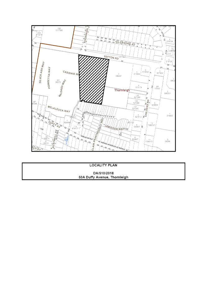
The proposed development was placed on public exhibition and was notified to adjoining and nearby landowners between 5 June 2018 and 18 June 2018 in accordance with the Notification and Exhibition requirements of the HDCP. The application was further notified to adjoining and nearby landowners between 14 August 2018 and 31 August 2018. During this period, Council received 4 submissions. The map below illustrates the location of those nearby landowners who made a submission that are in close proximity to the development site.

|
NOTIFICATION PLAN |
|
||
|
• PROPERTIES NOTIFIED
|
X SUBMISSIONS RECEIVED |
PROPERTY SUBJECT OF DEVELOPMENT |
|
4 submissions objected to the development, generally on the grounds that the development would result in:
· Unacceptable traffic and parking impact
Comment: A traffic and parking report submitted with the application projects an acceptable level of traffic increase resulting from the future development of the site. Parking on site is provided in accordance with Council’s controls.
· Unacceptable loss of trees
Comment: If approved, the development will require a monetary payment in the form of a Voluntary Planning Agreement to offset the loss of trees on site. Other trees removed from the development will be required to be replaced as per the submitted landscape plan as part of future development. On 7 December 2018, the applicant advised that additional trees would be retained on site between Lots 1-4 and 5.
· Unacceptable construction noise
Comment: The application does not propose the construction of buildings. Notwithstanding, all works on site, including demolition and earth works, would be limited to only occur between 7am and 5pm Monday to Saturday with no works on Sundays or public holidays.
· No notification received
Comment: Council notifies in accordance with Part 1B.5 of the Hornsby Development Control Plan 2013. For Strata lots, written notice is directed to the owners corporation and not individual lots. Notwithstanding, Council re-notified the application between 14 August 2018 and 31 August 2018 and sent letters to specific strata properties on Sefton Road, Wild Ash, Cassinia and Silver Ash Way.
The merits of the matters raised in community submissions have been further addressed in the body of the report.
5.1.1 Draft Voluntary Planning Agreement
In accordance with Section 7.5 of the Environmental Planning and Assessment Act 1979, the draft VPA was publically notified and available for public inspection for a period of 28 days. In this regard, the VPA was notified from 18 October 2018 to 15 November 2018 and 8 submissions by way of objections were received. A discussion in this regard is provided below:
· Unacceptable tree removal and offset planting on site
Comment: Council’s environmental assessment consider the proposal satisfactory in regard to tree removal with consideration to the submitted VPA.
The VPA does not propose replacement planting on site. A discussion on replacement planting is provided in Part 3.1.1 of this report.
· Incorrect offset multiplier in accordance with the Green Offsets Code
Comment: A draft offset dated 6 August 2018 was submitted to Council based on concerns Council had raised with tree loss. The proposed offset totalled $40,870 based on an offset multiplier of 6 with a discount of 90% (due to 4,865m2 of replacement planting onsite). Council did not support this offer as such replacement planting at the subdivision stage of an industrial development would likely be impacted or removed by future development and would not be considered a good long term environmental outcome.
On 23 August 2018, a formal VPA was offered to Council with an offset multiplier of 2 totalling $153,461. This figure did not include any discounts and proposed the total area of 2,960m2 to be offset offsite.
Vegetation on the site is also not mapped on Council’s Conservation Significance Assessment Map and as such consideration was given to the most likely conservation significance category associated with this vegetation in accordance with Council’s Green Offsets Code. The ‘Other native vegetation and remnant trees’ category was determined as the most appropriate category due to the vegetation not being mapped and not meeting criteria for other categories. The Draft VPA has utilised the appropriate offset ratio of 2:1 and vegetation clearing fee from Council’s 2018/19 Fees and Charges.
On 7 December amended plans were received reducing the number of trees to be removed. Accordingly, a revised VPA will be required to be re-notified in accordance with the Act and approved by Council.
· Unacceptable impact on local fauna
Comment: The site is not identified or mapped as being the habitat of any endangered fauna. Council’s Bushland assessment has raised no objections to the proposal due to the impact on local fauna.
· The VPA does not include an explanatory note
Comment: Clause 25E(1) of the Environmental Planning and Assessment Regulation 2000 (EPA Regulation) requires that an explanatory note must accompany a planning agreement
In response to this concern, the VPA has not been endorsed by Council. Conditions of consent recommend that a VPA be entered into prior to the issue of a Subdivision Certificate. Revisions to the draft VPA are required to be available for public notice and inspection for a period of 28 days in accordance with the Environmental Planning and Assessment Act 1979.
6. THE PUBLIC INTEREST
Section 4.15(1)(e) of the Act requires Council to consider “the public interest”.
The public interest is an overarching requirement, which includes the consideration of the matters discussed in this report. Implicit to the public interest is the achievement of future built outcomes adequately responding to and respecting the future desired outcomes expressed in environmental planning instruments and development control plans.
The application is considered to have satisfactorily addressed Council’s and relevant agencies’ criteria and would provide a development outcome that, on balance, would result in a positive impact for the community. Accordingly, it is considered that the approval of the proposed development would be in the public interest.
CONCLUSION AND STATEMENT OF REASONS
The application proposes consent for staged subdivision, civil works and the removal of trees. The application includes a voluntary planning agreement for the loss of trees.
A total of 4 submissions have been received objecting to the proposal generally on grounds of traffic, tree removal, construction noise and notification policy.
The proposal generally complies with the Hornsby Local Environmental Plan 2013, the Hornsby Development Control Plan 2013 and the Hornby Council Green Offset Code.
Accordingly, the proposed development is recommended for approval.
The reasons for this recommendation are:
· The proposed development generally complies with the requirements of the relevant environmental planning instruments and the Hornsby Development Control Plan 2013.
· The proposal is considered consistent with the aims of Council’s Green Offsets Code.
· The proposal would offset tree loss through a monetary contribution in order to provide offsite bushland planting or regeneration.
· Future development on site would be required to provide suitable vegetation in accordance with the submitted concept landscape plan.
· The development is considered consistent with the State Government’s “A Metropolis of Three Cities” and “North District Plan”, by retaining industrial land and enabling further development that would serve a wide range of uses to support a growing population.
Note: At the time of the completion of this planning report, no persons have made a Political Donations Disclosure Statement pursuant to Section 10.4 of the Environmental Planning and Assessment Act 1979 in respect of the subject planning application.
RESPONSIBLE OFFICER
The officer responsible for the preparation of this Report is the Stephen Dobbs.
|
Rod Pickles Manager - Development Assessment Planning Division |
Cassandra Williams Team Leader - Major Applications Planning Division |
|
1.⇩ |
Locality Plan |
|
|
|
2.⇩ |
Survey Plan |
|
|
|
3.⇩ |
Subdivision Plan |
|
|
|
4.⇩ |
Landscape Plan |
|
|
File Reference: DA/510/2018
Document Number: D07558820
SCHEDULE 1
CONDITIONS APPLICABLE TO STAGE 1 AND STAGE 2
CONDITIONS PRIOR TO THE APPOITMENT OF A PRINCIPAL CERTIFYING AUTHORITY
CONDITIONS PRIOR TO REMEDIATION
1. Interim Site Audit Statement
a) An Interim Site Audit Statement must be submitted to Council by a NSW Environment Protection Authority (EPA) accredited Site Auditor certifying that all contamination and associated reports relating to the remediation of the subject site are practical, and that the site will be suitable for its proposed use after being remediated in accordance with the requirements of the provided Remediation Action Plan (RAP).
b) Copies of all other reports and documentation that were reviewed by the Site Auditor and formed part of the Interim Site Audit Statement, must be submitted to Council.
2. Remedial Action Plan
The Remediation Action Plan (RAP) that formed part of the Interim Site Audit Statement must be submitted to Council, and must contain an associated Site Management Plan for remediation works, for Council’s review and approval.
Note: Documents should be emailed to Council at Compliance@hornsby.nsw.gov.au
3. Environmental Management Plan
An Environmental Management Plan (EMP) is to be prepared by a suitably qualified Environmental Consultant detailing the actions that will be taken to protect the environment for the duration of remediation works, and all responsible parties ensuring compliance with the document. The Plan is to be in accordance with the publication ‘Managing Urban Stormwater – Landcom (March 2004)’ and the Protection of the Environment Operations Act 1997 by way of implementing appropriate measures, and should include but not be limited to:
a) Water and soil management, including but not limited to sediment and erosion control measures;
b) Air quality;
c) Noise management, including excavation noise mitigation measures will be implemented;
d) Waste Management.
4. Construction Management Plan (CMP)
In order to enable unencumbered movement of traffic in the public road during remediation works, a Construction Management Plan, including a Construction Traffic Management Plan (CTMP) and scaled construction plans prepared by a suitably Chartered and Qualified Chartered Civil Engineer and Qualified Worksite Traffic Controller shall be prepared and submitted to Hornsby Shire Council for approval according to the following requirements:
a) A copy of plans shall be submitted to Council detailing the stages of remediation and arrangement of all construction machines and vehicles being used at the same time during all remediation stages.
b) The CMP plans shall be in accordance with the approved Development Application plans the Development Consent Conditions, and all associated contamination reports as certified in the Interim Site Audit Statement by the NSW EPA accredited Site Auditor, including but not limited to the Remediation Action Plan,.
i) The plans shall detail the order of construction works and arrangement of all construction machines and vehicles being used at the same time during all stages.
ii) The CTMP plans shall be in accordance with the approved Development Application plans and the Development Consent conditions.
iii) In order to prevent injury, accident and loss of property, no building materials, work sheds, vehicles, machines or the like shall be allowed to remain in the road reserve area without the written consent of Hornsby Shire Council.
iv) The Plan shall be in compliance with the requirements of the Road and Traffic Authority’s “Traffic Control at Worksites Manual 1998” and detailing:-
v) Public notification of proposed works;
vi) Long term signage requirements;
vii) Short term (during actual works) signage;
viii) Vehicle Movement Plans, where applicable;
ix) Traffic Management Plans;
x) Pedestrian and Cyclist access and safety.
xi) The plans shall indicate traffic controls including those used during non-working hours and shall provide pedestrian access and two-way traffic in the public road to be facilitated at all times.
xii) Survey plan showing site sheds, concrete pump location, crane location and existing survey marks; The plan shall include details of parking arrangements for all employees and contractors, including layover areas for large trucks during all stages of works. The parking or stopping of truck and dog vehicles associated with the development will not be permitted other than on the site and the plan must demonstrate this will be achieved.
xiii) The plan shall include the proposed truck routes to and from the site including details of the frequency of truck movements at the different stages of the development;
xiv) The plan shall include swept path analysis for ingress and egress of the site throughout all stages of works.
xv) The plan shall include site plans for all stages of works including the location of site sheds, unloading and loading areas, waste and storage areas being used.
xvi) The plan shall include the total volume of fill to be imported to the subject site throughout all stages to achieve approved levels.
xvii) The plan shall include the total volume of fill to be exported at the subject property throughout all stages.
xviii) The plan shall include the total quantity and size of trucks for all importation and exportation of fill on site throughout all stages of works, and a breakdown of total quantities of trucks for each stage of works.
xix) The plan shall include the number of total truck movements to and from the site for each stage of works.
xx) The plan shall include the number of weeks trucks will be accessing and leaving the site with excavated or imported fill material.
xxi) The plan shall include the maximum number of trucks travelling to and from the site on any given day for each stage of works.
xxii) The plan shall include the maximum number of truck movements on any given day during peak commuting periods for all stages of works.
xxiii) The plan must include but not be limited to the location details of the licensed waste facility where excavated material required for removal will be disposed to.
xxiv) The plan must include the location details of the source site of any proposed fill to be imported for all stages of works.
xxv) The Applicant and all employees of contractors on the site must obey any direction or notice from the Prescribed Certifying Authority or Hornsby Shire Council in order to ensure the above.
xxvi) Confirmation that a street ‘scrub and dry’ service will be in operation during remediation works;
xxvii) If there is a requirement to obtain a Work Zone, Out of Hours permit, partial Road Closure or Crane Permit, the Plan must detail these requirements and that an application to Hornsby Shire Council will be made.
CONDITIONS DURING REMEDIATION
5. Site Management Plan
The Council approved Site Management Plan must be complied with for the duration of remediation works, unless otherwise approved by Council.
CONDITIONS AFTER REMEDIATION
6. Site Audit Statement
A Site Audit Statement issued by a NSW EPA accredited Site Auditor, and an accompanying Site Audit Report documenting the information reviewed by the Auditor and providing the basis for the conclusions contained within the Site Audit Statement is required to be submitted to Council and the Principal Certifying Authority (PCA) following remediation of the site and prior to the commencement of any subdivision works. The Site Audit Statement must certify that the site is suitable for the proposed use.
GENERAL CONDITIONS
The conditions of consent within this notice of determination have been applied to ensure that the use of the land and/or building is carried out in such a manner that is consistent with the aims and objectives of the relevant legislation, planning instruments and council policies affecting the land and does not disrupt the amenity of the neighbourhood or impact upon the environment.
Note: For the purpose of this consent, the term ‘applicant’ means any person who has the authority to act on or the benefit of the development consent.
Note: For the purpose of this consent, any reference to an Act, Regulation, Australian Standard or publication by a public authority shall be taken to mean the gazetted Act or Regulation, or adopted Australian Standard or publication as in force on the date that the application for a construction certificate is made.
7. Section 7.12 Development Contributions
a) In accordance with Section 4.17(1) of the Environmental Planning and Assessment Act, 1979 and the Hornsby Shire Council Section 94A Development Contributions Plan 2014-2024, $11,000.00 must be paid to Council to cater for the increased demand for community infrastructure resulting from the development, based on development costs of $1,100,000.
b) The value of this contribution is current as at 26 November 2018. If this contribution is not paid within the financial quarter that this condition was generated, the contribution payable will be adjusted in accordance with the provisions of the Hornsby Shire Council Section 94 Development Contributions Plan and the amount payable will be calculated at the time of payment in the following manner:
$CPY = $CDC x CPIPY
CPIDC
Where:
$CPY is the amount of the contribution at the date of Payment
$CDC is the amount of the contribution as set out in this Development Consent
CPIPY is the latest release of the Consumer Price Index (Sydney – All Groups) at the date of Payment as published by the ABS.
CPIDC is the Consumer Price Index (Sydney – All Groups) for the financial quarter at the date applicable in this Development Consent Condition.
c) The monetary contributions must be paid to Council:
i) Prior to the issue of the Subdivision Certificate where the development is for subdivision.
ii) Prior to the issue of the first Construction Certificate where the development is for building work.
iii) Prior to issue of the Subdivision Certificate or first Construction Certificate, whichever occurs first, where the development involves both subdivision and building work.
iv) Prior to the works commencing where the development does not require a Construction Certificate or Subdivision Certificate.
Note: It is the professional responsibility of the Principal Certifying Authority to ensure that the monetary contributions have been paid to Council in accordance with the above timeframes.
Council’s S94A Development Contributions Plan may be viewed at www.hornsby.nsw.gov.au or a copy may be inspected at Council’s Administration Centre during normal business hours.
8. Appointment of a Project Arborist
a) A project arborist with AQF Level 5 qualifications must be appointed to provide monitoring and certification throughout the construction period of both stages.
b) Details of the appointed project arborist must be submitted to Council and the PCA for registration with the application for the construction certificate.
9. Removal of Trees
a) This development consent permits the removal of trees numbered 8, 23, 24, 35, 36, 37, 38, 39, 40, 41, 42, 43, 44, 45, 46, 47, 48, 49, 50, 51, 54, 55, 56, 57, 58, 59, 60, 61, 62, 63, 67, 68, 69, 71, 72, 73, 74, 75, 76, 77, 79, 82, 83, 84 and 85 as identified on page 7 contained in the Arboricultural Impact Assessment submitted by Jackson Nature Works dated 8/8/2018 TRIM: D07500882.
b) The barrels of trees numbered 47, 48, 49, 50, 51, 54, 55, 56, 57, 63, 65, 68, 72, 73, 74, 75, 83, 84 and 85, with a diameter at breast height of 400mm or greater, shall be cut into lengths of 4m and stored at Council’s Green Waste facility at Beaumont Road, Mount Ku-ring-gai. The barrels will be used within Council’s reserve system for habitat, edging and furniture.
c) No consent is given for the removal of trees numbered 15, 16, 17, 18, 19, 20, 21, 22, 25, 26, 27, 28, 29, 30, 31, 32, 33, 52, 53, 64, 65, 66, 70, 80 and 81.
Note: The removal of any other trees from the site requires separate approval by Council in accordance with Part 1B.6 Tree and Vegetation Preservation of the Hornsby Development Control Plan, 2013 (HDCP).
10. Placement of a Positive Covenant Requiring the Conservation of Native Vegetation
A positive covenant shall be created under Section 88E of The Conveyancing Act 1919 to provide for the future landscaping of the site, being proposed Lots 1-6, as described in Concept Landscape Plan (Site Design + Studios, L-01, 7/12/2018, D07512666). The covenant shall specify that:
a) The landscape plans for proposed lots 1-7 detail the number and size of plants to be used.
b) The planting must include a minimum of 30 canopy or mid-canopy species across the site.
c) The majority of species are to be characteristic of the Blue Gum High Forest vegetation community.
d) Plant stock for landscape plantings shall be sourced from a native nursery utilising Sydney basin stock
e) The landscaping woks shall be completed for each lot prior to the issue of an occupation certificate or that lot.
f) A landscape maintenance program is implemented for a minimum of 12 months from the date of landscape completion.
The draft covenant is to be provided to Council’s Natural Resources Branch for approval. The wording of the Positive Covenant must be to Council’s satisfaction and Council must be nominated as the authority to release, vary or modify the Restriction.
11. Vehicle Access
a) Vehicle and truck access relating to construction, demolition and remediation must be via Sefton Road only.
b) Truck movements relating to remediation works must be limited to no more than 10 trips per day.
12. Subdivision Construction Management Plan (SCMP)
To assist in the protection of the public, the environment and Council’s assets, a separate Subdivision Construction Management Plan (SCMP) must be prepared by a suitably qualified environmental consultant in consultation with a qualified traffic engineer, and submitted to Council’s Compliance Team for approval at compliance@hornsby.nsw.gov.au prior to the issue of a subdivision construction certificate and according to the following requirements:
a) The SCMP must detail the contact information for developers, builder, private certifier and any emergency details during and outside work hours.
b) The plan must include a Construction Traffic Management Plan (CTMP) including the following:-
i) The plans shall detail the order of construction works and arrangement of all construction machines and vehicles being used at the same time during all stages.
ii) The CTMP plans shall be in accordance with the approved Development Application plans and the Development Consent conditions.
iii) In order to prevent injury, accident and loss of property, no building materials, work sheds, vehicles, machines or the like shall be allowed to remain in the road reserve area without the written consent of Hornsby Shire Council.
iv) The Plan shall be in compliance with the requirements of the Road and Traffic Authority’s “Traffic Control at Worksites Manual 1998” and detailing:-
v) Public notification of proposed works;
vi) Long term signage requirements;
vii) Short term (during actual works) signage;
viii) Vehicle Movement Plans, where applicable;
ix) Traffic Management Plans;
x) Pedestrian and Cyclist access and safety.
xi) The plans shall indicate traffic controls including those used during non-working hours and shall provide pedestrian access and two-way traffic in the public road to be facilitated at all times.
xii) Survey plan showing site sheds, concrete pump location, crane location and existing survey marks; The plan shall include details of parking arrangements for all employees and contractors, including layover areas for large trucks during all stages of works. The parking or stopping of truck and dog vehicles associated with the development will not be permitted other than on the site and the plan must demonstrate this will be achieved.
xiii) Confirmation that a street ‘scrub and dry’ service will be in operation during subdivision works;
xiv) The plan shall include the proposed truck routes to and from the site including details of the frequency of truck movements at the different stages of the development;
xv) The plan shall include swept path analysis for ingress and egress of the site throughout all stages of works.
xvi) The plan shall include site plans for all stages of works including the location of site sheds, unloading and loading areas, waste and storage areas being used.
xvii) The plan shall include the total volume of fill to be imported to the subject site throughout all stages to achieve approved levels.
xviii) The plan shall include the total volume of fill to be exported at the subject property throughout all stages.
xix) The plan shall include the total quantity and size of trucks for all importation and exportation of fill on site throughout all stages of works, and a breakdown of total quantities of trucks for each stage of works.
xx) The plan shall include the number of total truck movements to and from the site for each stage of works.
xxi) The plan shall include the number of weeks trucks will be accessing and leaving the site with excavated or imported fill material.
xxii) The plan shall include the maximum number of trucks travelling to and from the site on any given day for each stage of works.
xxiii) The plan shall include the maximum number of truck movements on any given day during peak commuting periods for all stages of works.
xxiv) The plan must include but not be limited to the location details of the licensed waste facility where excavated material required for removal will be disposed to.
xxv) The plan must include the location details of the source site of any proposed fill to be imported for all stages of works.
xxvi) The Applicant and all employees of contractors on the site must obey any direction or notice from the Prescribed Certifying Authority or Hornsby Shire Council in order to ensure the above.
xxvii) If there is a requirement to obtain a Work Zone, Out of Hours permit, partial Road Closure or Crane Permit, the Plan must detail these requirements and that an application to Hornsby Shire Council will be made.
c) The plan must also include a Construction Waste Management Plan detailing the following:-
i) Details of the importation or excavation of soil and fill, the classification of the fill, disposal methods and authorised disposal depots that will be used for the fill;
ii) Asbestos management requirement and procedures for removal and disposal from the site in accordance with AS 2601–2001 – ‘The Demolition of Structures’, and the Protection of the Environment Operations (Waste) Regulation 2005;
iii) General construction waste details including construction waste skip bin locations and litter management for workers.
d) Management of stormwater disposal from the detention basin or basement throughout all development phases in accordance with the ANZECC Guidelines trigger values for the area.
e) Sediment and Erosion control including during rainfall events and site plans showing entry to or exits from the site, all in accordance with the ‘Soils and Construction 2004 (Bluebook)’.
f) Air quality management on site, including dust suppression measures during demolition and construction.
g) Details on the general operating procedures to manage environmental risk throughout all stages of works on the site;
h) To ensure Council assets are maintained throughout the development, a detailed survey plan showing existing survey marks, vehicle entry, footpath and hoarding (fencing) locations; and
i) Noise and vibration control information to address any noise nuisances such as rock sawing or breaking, the mitigation methods implemented and how complaints will be managed or prevented.
13. Subdivision Environmental Management Plan (SEMP)
A Subdivision Environmental Management Plan (SEMP) prepared by a suitably qualified environmental consultant must be submitted to Council for approval prior to the issue of a subdivision Construction Certificate. The plan is to be submitted to: compliance@hornsby.nsw.gov.au The SEMP must detail the actions that will be taken to protect the environment for the duration of all work and all responsible parties ensuring compliance with the document. The Plan should include but not be limited to:
a) Water and soil management, including but not limited to sediment and erosion control measures;
b) Air quality;
c) Noise management, including how rock sawing/rock breaking noise mitigation measures will be implemented;
d) Waste Management.
14. Construction Certificate
a) A Construction Certificate is required to be approved by Council or a Private Certifying Authority prior to the commencement of any works under this consent.
b) A separate Construction Certificate must be obtained from Council for all works within the public road reserve under S138 of the Roads Act.
c) A separate Construction Certificate must be obtained from Council for all works within drainage easements vested in Council.
d) The Construction Certificate plans must not be inconsistent with the Development Consent plans.
OPERATIONAL CONDITIONS
15. Vehicle Access
Vehicle access to the site is to be limited to Sefton Road only.
16. Compliance with requirements of Site Audit Statement
Any requirements as conditioned by the NSW EPA Site Audit Statement must be complied with.
CONDITIONS OF CONCURRENCE – NSW Rural Fire Service
17. Asset Protection Zone
At the issue of a subdivision certificate, and in perpetuity, the entire property shall be managed as an inner protection area (IPA) as outlined within section 4.1.3 and Appendix 5 of 'Planning for Bush Fire Protection 2006' and the NSW Rural Fire Service's document 'Standards for asset protection zones'.
18. Water and Utilities
Water, electricity and gas are to comply with the requirements of section 4.1.3 of 'Planning for Bush Fire Protection 2006'.
19. Access
The property access road shall comply with section 4.1.3 (2) of ‘Planning for Bush Fire Protection 2006’.
20. Design and Construction
Future construction on proposed Lots 3 and 4 shall comply with Sections 3 and 5 (BAL 12.5) Australian Standard AS3959-2009 'Construction of buildings in bush fire-prone areas' or NASH Standard (1.7.14 updated) ‘National Standard Steel Framed Construction in Bushfire Areas – 2014’ as appropriate and section A3.7 Addendum Appendix 3 of 'Planning for Bush Fire Protection 2006'.
CONDITIONS APPLICABLE TO STAGE 1 WORKS - SUBDIVISION OF ONE LOT INTO FIVE
21. Approved Plans and Supporting Documentation
The development must be carried out in accordance with the plans and documentation listed below and endorsed with Council’s stamp, except where amended by Council and/or other conditions of this consent:
|
Plan No. |
Plan Title |
Drawn by |
Dated |
|
78546-S1 |
Plan of Proposed Subdivision (Stage 1) |
Gregory Jon Frith |
13/08/2018 |
|
Document Title |
Prepared by |
Dated |
|
Detailed Site Investigation |
JBS&G Australia Pty Ltd |
24/08/2018 |
|
Concept Stormwater Management Plan (181029 DA4.01 Rev 2) |
Northrop |
10/08/2018 |
|
Tree Retention/Removal/and Concept Landscape Plan (L-01) |
SiteDesign+Studios |
7/12/2018 |
|
Traffic Assessment Report (18036) |
Terraffic Pty Ltd |
10/08/2018 |
|
Preliminary Biodiversity and Bush Fire Assessment (630.12507-L01-v2.0) |
SLR |
25/05/2018 |
|
NSW Rural Fire Service – Conditions of Concurrence (D18/6119 DA18062913736 LR) |
NSW Rural Fire Service |
25/07/2018 |
|
Civil Engineering Package (181029 Rev 4) |
Northrop |
07/12/2018 |
REQUIREMENTS PRIOR TO THE ISSUE OF A CONSTRUCTION CERTIFICATE
22. Voluntary Planning Agreement
Pursuant to section 7.4 of the Environmental Planning and Assessment Act 1979, the applicant must prepare and enter into a Voluntary Planning Agreement (VPA) with Hornsby Shire Council to offset the loss of other vegetation and remnant trees under Council’s Green Offset Code (2015). The terms of the VPA must include but not be limited to the following:
a) The Applicant must pay Council a monetary contribution towards the replacement of tree Nos. 35, 36, 37, 45, 48, 53, 54, 58, 63, 66, 67, 68, 71, 72, 73, 79, 83 & 84 lost from the site as result of the development in accordance with Council’s Green Offsets Code.
b) The Applicant agrees to pay all costs (including Council’s costs) associated with the preparation, public notification, legal costs and administration costs of the VPA.
23. Utility Services
The applicant must submit written evidence of the following service provider requirements:
a) Ausgrid (formerly Energy Australia) – a letter of consent demonstrating that satisfactory arrangements have been made to service the proposed development.
b) NBN/Telstra - a letter of consent demonstrating that satisfactory arrangements have been made to service the proposed development.
24. Identification of Survey Marks
A registered surveyor must identify all survey marks in the vicinity of the proposed development. Any survey marks required to be removed or displaced as a result of the proposed development shall be undertaken by a registered surveyor in accordance with Section 24 (1) of the Surveying and Spatial Information Act 2002 and following the Surveyor General’s Directions No.11 – "Preservation of Survey Infrastructure".
25. Stormwater Drainage
The stormwater drainage system for the development must be designed in accordance with Council’s Civil Works – Design and Construction Specification 2005 and the following requirements:
a) Connected to an existing Council piped drainage system with the following requirements:
i) A separate Application must be made to Council for ‘Approval To Connect Stormwater Drainage Outlet To Council’s System’ with all fees paid, prior to connecting to Council’s drainage system;
ii) The connection to Council’s drainage pit or pipeline in accordance with Councils Design Standard Drawing No. 6 must be inspected by a Council Engineer from Council’s Planning Division;
Note: An inspection booking can be made by calling Council on 9847 6760 quoting the Application reference number commencing SD
Note: A certificate from a chartered civil engineer together with a works as executed design plan must be submitted to the principal certifying authority to demonstrate the satisfaction of this condition.
b) An inter-allotment stormwater drainage system to service the proposed subdivision with pits being cast in situ or pre cast concrete pits being used.
c) The stormwater drainage system must be designed by a Chartered Professional Civil/Hydraulic Engineer of the Institution of Engineers, Australia.
26. Vehicular Crossing
A separate application under the Local Government Act 1993 and the Roads Act 1993 must be submitted to Council for the installation of a new vehicular crossing and the removal of the redundant crossing. The vehicular crossing must be constructed in accordance with Council’s Civil Works Design 2005, AS 2890.2 2004 and the following requirements
a) Design levels at the front boundary must be obtained from Council for the design on the internal driveway;
b) The width of vehicular crossing shall be 16.2m ( Refer to Traffic assessment Report , prepared by Terraffic Pty Ltd, dated 21st May 29018 )
c) Any redundant crossings must be replaced with integral kerb and gutter;
d) The footway area must be restored by turfing;
e) Approval must be obtained from all relevant utility providers that all necessary conduits be provided and protected under the crossing.
Note: An application for a vehicular crossing can only be made to one of Council’s Authorised Vehicular Crossing Contractors. You are advised to contact Council on 02 9847 6940 to obtain a list of contractors.
27. Internal Driveway/Vehicular Areas
The driveway and parking areas on site must be designed, constructed and a Construction Certificate issued in accordance with Australian Standards, S 2890.1, AS2890.2, and the following requirements:
a) Design levels at the front boundary be obtained from Council.
b) The driveway width and type shall be in accordance with the latest Australian Standard 2890.2.
c) Vehicles are to come out in a forward direction to street from the premises.
d) The pavement have a kerb to one side and a one-way cross fall with a minimum gradient of 2 percent and a lintel and pit provided at the low point.
e) Planting of landscaping strips 0.5 metres wide along one side of the length of the driveway.
f) Conduit for utility services including electricity, water, gas and telephone be provided. All existing overhead assets including electricity and telecommunications cabling shall be relocated underground at no cost to Council. A certificate from an appropriately licensed contractor shall be submitted to the principal certifying authority certifying that the service conduits have been installed in accordance with the relevant utility provider and Australian Standards.
g) Longitudinal sections along both sides of the access driveway shall be submitted to the principal certifying authority in accordance with the relevant sections of AS 2890.2
REQUIREMENTS PRIOR TO THE COMMENCEMENT OF ANY WORKS
28. Erosion and Sediment Control
To protect the water quality of the downstream environment, erosion and sediment control measures must be provided and maintained throughout the construction period in accordance with the manual ‘Soils and Construction 2004 (Bluebook)’, the approved plans, Council specifications and to the satisfaction of the principal certifying authority. The erosion and sediment control devices must remain in place until the site has been stabilised and revegetated.
Note: On the spot penalties may be issued for any non-compliance with this requirement without any further notification or warning.
29. Protection of Adjoining Areas
A temporary hoarding, fence or awning must be erected between the work site and adjoining lands before the works begin and must be kept in place until after the completion of the works if the works:
a) Could cause a danger, obstruction or inconvenience to pedestrian or vehicular traffic;
b) Could cause damage to adjoining lands by falling objects; and/or
c) Involve the enclosure of a public place or part of a public place.
Have been identified as requiring a temporary hoarding, fence or awning within the Council approved Construction Management Plan (CMP).
Note: Notwithstanding the above, Council’s separate written approval is required prior to the erection of any structure or other obstruction on public land.
a) To provide a safe and hygienic workplace, toilet facilities must be available or be installed at the works site before works begin and must be maintained until the works are completed at a ratio of one toilet for every 20 persons employed at the site.
b) Each toilet must:
i) be a standard flushing toilet connected to a public sewer; or
ii) be a temporary chemical closet approved under the Local Government Act 1993; or
iii) have an on-site effluent disposal system approved under the Local Government Act 1993.
31. Subdivision Environmental Management Plan
Any requirements prior to the commencement of works as detailed within the Council approved Subdivision Environmental Management Plan must be complied, unless otherwise approved by Council.
32. Subdivision Construction Management Plan
Any requirements prior to the commencement of works as detailed within the Council approved Subdivision Construction Management Plan (SCMP) and associated Construction Traffic Management Plan (CTMP) must be complied with, unless otherwise approved by Council.
33. Compliance with requirements of Site Audit Statement
Any requirements as conditioned by the NSW EPA Site Audit Statement must be complied with.
34. Installation of Tree Protection Fencing
a) All tree protection measures for the trees to be retained must have the protection measures for the ground, trunk and canopy installed in accordance with the relevant requirements of Australian Standard AS 4970-2009 - “Protection of Trees on Development Sites”.
b) All tree protection fencing for the trees to be retained must be erected around trees numbered 9, 10, 11, 12, 13, 14, 15, 16, 17, 18, 19, 20, 21, 25, 26, 27, 28, 29, 30, 31, 32, 52, 53, 64, 65, 66, 70, 80 and 81 as specified in the submitted Arboricultural Impact Assessment provided by Jacksons Nature Works, 28/5/2018, D07459212 except where in conflict with the extension of the existing driveway.
35. Tree Protection Zone - Ground Protection
a) All tree protection zones for the trees to be retained must have a layer of wood-chip mulch installed prior to works commencing.
b) The wood-chip mulch must be maintained throughout the period of construction at a depth of between 150mm and 300mm, using material that complies with the relevant requirements of Australian Standard AS 4454 – “Composts, Soil Conditioners and Mulches”.
36. Protection Certification
To ensure that all tree protection measures are correctly installed, a certificate from the appointed project arborist must be submitted to the Principal Certifying Authority confirming compliance with the tree protection requirements of this consent.
REQUIREMENTS DURING CONSTRUCTION
37. Construction Work Hours
All works on site, including demolition and earth works, must only occur between 7am and 5pm Monday to Saturday.
No work is to be undertaken on Sundays or public holidays.
38. Environmental Management
To prevent sediment run-off, excessive dust, noise or odour emanating from the site during the construction, the site must be managed in accordance with the publication ‘Managing Urban Stormwater – Landcom (March 2004) and the Protection of the Environment Operations Act 1997.
39. Subdivision Construction Management Plan Compliance
The Council approved Subdivision Construction Management Plan (SCMP) and associated Construction Traffic Management Plan (CTMP) per Condition No. 12 must be complied with for the duration of works, unless otherwise approved by Council.
40. Subdivision Compliance with Environmental Management Plan
The Council approved Subdivision Environmental Management Plan per Condition No. 13 must be complied with for the duration of works, unless otherwise approved by Council.
41. Compliance with requirements of Site Audit Statement
a) Any requirements as conditioned by the NSW EPA Site Audit Statement must be complied with.
b) Should the presence of asbestos or soil contamination, not recognised during the application process be identified, the applicant must immediately notify the principal certifying authority, Council and the NSW EPA accredited Site Auditor.
42. Council Property
To ensure that the public reserve is kept in a clean, tidy and safe condition during construction works, no building materials, waste, machinery or related matter is to be stored on the road or footpath.
Note: This consent does not give right of access to the site via Council’s park or reserve. Should such access be required, separate written approval is to be obtained from Council.
43. Disturbance of Existing Site
During construction works, the existing ground levels of open space areas and natural landscape features, including natural rock-outcrops, vegetation, soil and watercourses must not be altered unless otherwise nominated on the approved plans.
44. Landfill
Landfill must be constructed in accordance with Council’s ‘Construction Specification 2005’ and the following requirements:
a) Prior to fill material being imported to the site, a certificate shall be obtained from a suitably qualified environmental consultant confirming the fill wholly consists of Virgin Excavated Natural Material (VENM) as defined in Schedule 1 of the Protection of the Environment Operations Act 1997 or material approved under the Department of Environment and Climate Change’s general resource recovery exemption.
b) A compaction certificate is to be obtained from a suitably qualified geotechnical engineer verifying that the specified compaction requirements have been met.
c) These certificates must be included with the application for an occupation certificate.
45. Excavated Material
All excavated material removed from the site must be classified by a suitably qualified person in accordance with the Department of Environment, Climate Change and Water NSW Waste Classification Guidelines and Protection of the Environment Operations (Waste) Regulation 2014 prior to disposal to an approved waste management facility and be reported to the principal certifying authority prior to the issue of an Occupation Certificate.
46. Impacts on Trees
To ensure the protection of local fauna, prior to the removal of trees:
a) An arborist, ecologist or wildlife carer is to inspect the trees for active habitat use including nests, hollows and decorticating bark.
b) If any habitat is being actively used for nesting the tree removal must be deferred until after birds have fledged.
c) A wildlife carer must be on site to capture any observed wildlife from the trees and relocate into adjacent bushland.
d) Trees are to be removed in sections by a qualified tree surgeon in the presence of a ‘Wildlife Carers’ organisation to assist in the event of fauna presence or injury.
Note: ‘WIRES’ (Wildlife Rescue) volunteers can be contacted on 8977 3333. ‘Wildlife Services Sydney Metropolitan’ volunteers can be contacted on 13000 94737. Information on animal nesting boxes can be obtained from WIRES, Kalkari Information Centre in Ku-Ring-Gai Chase National Park or Birds Australia www.birdsaustralia.com.au.
47. Works Near Trees
a) No consent is granted for any works within the Structural Root Zone of and trees retained on site other than site remediation.
b) To maintain tree health and condition, the appointed project arborist must monitor and record any and all necessary remedial actions required for trees numbered 9, 10, 11, 12, 13, 14, 15, 16, 17, 18, 19, 20, 21, 25, 26, 27, 28, 29, 30, 31, 32, 52, 53, 64, 65, 66, 70, 80 and 81.
c) To minimise the environmental impacts of the development within the Tree Protection Zone (TPZ) of trees to be retained:
i) The installation of any underground services which either enter or transect the designated TPZ must utilise sensitive methods such as directional drilling or manual excavation.
ii) The installation of any underground services must be inspected by the project arborist to monitor the likely impacts of the development on retained trees.
iii) For manual excavation of trenches the project arborist must advise on roots to be retained and must monitor the works. Manual excavation may include the use of pneumatic and hydraulic tools. Refer Clause 4.5.3.
d) The maintenance and monitoring of all tree protection techniques must be recorded by the appointed project arborist during the period of construction for submission with the application for the occupation certificate.
48. Maintaining Tree protections zones
The Tree Protection Zone must be maintained in accordance with section 4.6 requirements of Australian Standard AS 4970-2009 - “Protection of Trees on Development Sites”
49. Building materials and Site Waste
The filling or stockpiling of building materials, the parking of vehicles or plant, the disposal of cement slurry, waste water or other contaminants must be located outside the tree protection zones as prescribed in the conditions of this consent or the prescriptive measures of Part 1B.6.1 Tree Preservation of the Hornsby Development Control Plan, 2013, of any tree to be retained.
50. Works near trees certification
a) The project arborist must submit to the principal certifying authority on a monthly a certificate that the works have been carried out in compliance with the approved plans and specifications for tree protection.
b) Certification should include a statement of site attendance, the condition of the retained trees, details of any deviations from the approved tree protection measures and their impacts on trees.
Note: Copies of monitoring documentation may be required by the PCA and/or Council.
REQUIREMENTS PRIOR TO THE ISSUE OF A SUBDIVISION CERTIFICATE
51. Sydney Water – s73 Certificate
A s73 Certificate must be obtained from Sydney Water and submitted to the PCA..
Note: Sydney Water requires that s73 applications are to be made through an authorised Sydney Water Servicing Coordinator. Refer to www.sydneywater.com.au or telephone 13 20 92 for assistance.
52. Damage to Council Assets
To protect public property and infrastructure, any damage caused to Council’s assets as a result of the construction or demolition of the development must be rectified by the applicant in accordance with Council’s Civil Works Specifications. Rectification works must be undertaken prior to the issue of an Occupation Certificate, or sooner, as directed by Council.
53. Compliance with requirements of Site Audit Statement
Any requirements as conditioned by the NSW EPA Site Audit Statement must be complied with.
54. Preservation of Survey Marks
A certificate by a Registered Surveyor must be submitted to the Principal Certifying Authority, certifying that there has been no removal, damage, destruction, displacement or defacing of the existing survey marks in the vicinity of the proposed development or otherwise the re-establishment of damaged, removed or displaced survey marks has been undertaken in accordance with the Surveyor General’s Direction No.11 – “Preservation of Survey Infrastructure”.
55. Creation of Easements
The following matter(s) must be nominated on the plan of subdivision under s88B of the Conveyancing Act 1919:
a) A right of access and easement for services over the access corridor.
b) The creation of a “Positive Covenant” over the proposed Lots, 1, 2 3, 4, and the remaining lot (5 and 6 in 2nd stage) requiring that any future development/redevelopment is to provide an on-site detention system that is to be designed to limit discharge to 5 year ARI pre development rate and storage volume provided for up to 50 years ARI storm events.
c) The creation of a “Positive Covenant” over the proposed Lots, 1, 2 3, 4 and the remaining lot (5 and 6 in 2 stage) requiring that stormwater discharging from the development site is to be treated to achieve the quality specified in Council’s Development Control Plan (table 1C.1.2(b), Urban Stormwater Quality Targets using Council’s parameters
d) Creation of a positive covenant on the title of lots 1 to 4 that driveway width for any future development shall be a minimum 12.5m.
Note: Council must be nominated as the authority to release, vary or modify any easement, restriction or covenant.
e) An easement for letter boxes.
56. Final Certification Arborist
a) The Project supervisor must submit to the principal certifying authority all relevant certificates with the application for the occupation certificate stating compliance with all the conditions of this consent.
b) The Project arborist must submit to the principal certifying authority a certificate that all the completed works have been carried out in compliance with the approved plans and specifications for tree protection.
c) Certification must include a statement of overall site attendance, the condition of the retained trees, details of any deviations from the approved tree protection measures and their impacts on trees.
Note: Copies of monitoring documentation may be required.
57. Numbering
The lot numbering for the development shall be:
|
Lot |
Street Number |
Street Name |
Street Type |
Locality |
|
Lot 1 |
35A |
Sefton |
Road |
Thornleigh |
|
Lot 2 |
35B |
Sefton |
Road |
Thornleigh |
|
Lot 3 |
35C |
Sefton |
Road |
Thornleigh |
|
Lot 4 |
35D |
Sefton |
Road |
Thornleigh |
|
Remaining Lot 5 |
35 |
Sefton |
Road |
Thornleigh |
CONDITIONS APPLICABLE TO STAGE 2 WORKS - SUBDIVISION OF ONE LOT INTO TWO AND TREE REMOVAL
58. Approved Plans and Supporting Documentation
The development must be carried out in accordance with the plans and documentation listed below and endorsed with Council’s stamp, except where amended by Council and/or other conditions of this consent:
|
Plan No. |
Plan Title |
Drawn by |
Dated |
|
78546-S2 |
Plan of Proposed Subdivision (Stage 2) |
Gregory Jon Frith |
13/08/2018 |
|
Document Title |
Prepared by |
Dated |
|
Detailed Site Investigation |
JBS&G Australia Pty Ltd |
24/08/2018 |
|
Concept Stormwater Management Plan (181029 DA4.01 Rev 2) |
Northrop |
10/08/2018 |
|
Tree Retention/Removal/and Concept Landscape Plan (L-01) |
SiteDesign+Studios |
7/12/2018 |
|
Traffic Assessment Report (18036) |
Terraffic Pty Ltd |
10/08/2018 |
|
Preliminary Biodiversity and Bush Fire Assessment (630.12507-L01-v2.0) |
SLR |
25/05/2018 |
|
Arboricultural Impact Assessment |
Jacksons Nature Works |
28/05/2018 |
|
NSW Rural Fire Service – Conditions of Concurrence (D18/6119 DA18062913736 LR) |
NSW Rural Fire Service |
25/07/2018 |
|
Arboricultural Impact Assessment |
Jacksons Nature Works |
28/05/2018 |
|
NSW Rural Fire Service – Conditions of Concurrence (D18/6119 DA18062913736 LR) |
NSW Rural Fire Service |
25/07/2018 |
REQUIREMENTS PRIOR TO THE ISSUE OF A CONSTRUCTION CERTIFICATE
59. Utility Services
The applicant must submit written evidence of the following service provider requirements:
a) Ausgrid (formerly Energy Australia) – a letter of consent demonstrating that satisfactory arrangements have been made to service the proposed development.
b) NBN/Telstra - a letter of consent demonstrating that satisfactory arrangements have been made to service the proposed development.
60. Identification of Survey Marks
A registered surveyor must identify all survey marks in the vicinity of the proposed development. Any survey marks required to be removed or displaced as a result of the proposed development shall be undertaken by a registered surveyor in accordance with Section 24 (1) of the Surveying and Spatial Information Act 2002 and following the Surveyor General’s Directions No.11 – "Preservation of Survey Infrastructure".
61. Stormwater Drainage
The stormwater drainage system for the development must be designed in accordance with Council’s Civil Works – Design and Construction Specification 2005 and the following requirements:
a) Connected to an existing Council piped drainage system with the following requirements:
i) A separate Application must be made to Council for ‘Approval To Connect Stormwater Drainage Outlet To Council’s System’ with all fees paid, prior to connecting to Council’s drainage system;
ii) The connection to Council’s drainage pit or pipeline in accordance with Councils Design Standard Drawing No. 6 must be inspected by a Council Engineer from Council’s Planning Division;
Note: An inspection booking can be made by calling Council on 9847 6760 quoting the Application reference number commencing SD
Note: A certificate from a chartered civil engineer together with a works as executed design plan must be submitted to the principal certifying authority to demonstrate the satisfaction of this condition.
b) An inter-allotment stormwater drainage system to service the proposed subdivision with pits being cast in situ or pre cast concrete pits being used.
c) The stormwater drainage system must be designed by a Chartered Professional Civil/Hydraulic Engineer of the Institution of Engineers, Australia.
Or, if Stage 1 has been completed
d) Connected to the existing inter-allotment drainage system.
i) An inter-allotment stormwater drainage system to service the proposed subdivision with pits being cast in situ or pre cast concrete pits being used.
ii) The stormwater drainage system must be designed by a Chartered Professional Civil/Hydraulic Engineer of the Institution of Engineers, Australia.
62. Internal Driveway/Vehicular Areas
The driveway and parking areas on site must be designed, constructed and a Construction Certificate issued in accordance with Australian Standards AS2890.2 and AS3727 and the following requirements:
a) The driveway be a rigid pavement.
b) The internal driveway shall be upgraded to concrete and the pavement have a kerb to one side and a one-way cross fall with a minimum gradient of 2 percent and a lintel and pit provided at the low point.
c) Conduit for utility services including electricity, water, gas and telephone be provided. A certificate from an appropriately licensed contractor shall be submitted to the principal certifying authority certifying that the service conduits have been installed in accordance with the relevant utility provider and Australian Standards 2890.2.
d) 37 Car parking spaces must be provided for the existing building on proposed Lot 6. They must be constructed prior to the issue of a subdivision certificate.
REQUIREMENTS PRIOR TO THE COMMENCEMENT OF ANY WORKS
63. Installation of Tree Protection Fencing
a) All tree protection measures for the trees to be retained must have the protection measures for the ground, trunk and canopy installed in accordance with the relevant requirements of Australian Standard AS 4970-2009 - “Protection of Trees on Development Sites”.
b) All tree protection fencing for the trees to be retained must be erected around trees numbered 9, 10, 11, 12, 13, 14, 15, 16, 17, 18, 19, 20, 21, 25, 26, 27, 28, 29, 30, 31 and 32 as specified in the submitted Arboricultural Impact Assessment provided by Jacksons Nature Works, 28/5/2018, D07459212 except where in conflict with the extension of the existing driveway.
64. Tree Protection Zone - Ground Protection
a) All tree protection zones for the trees to be retained must have a layer of wood-chip mulch installed prior to works commencing.
b) The wood-chip mulch must be maintained throughout the period of construction at a depth of between 150mm and 300mm, using material that complies with the relevant requirements of Australian Standard AS 4454 – “Composts, Soil Conditioners and Mulches”.
65. Protection Certification
To ensure that all tree protection measures are correctly installed, a certificate from the appointed project arborist must be submitted to the Principal Certifying Authority confirming compliance with the tree protection requirements of this consent.
66. Erosion and Sediment Control
To protect the water quality of the downstream environment, erosion and sediment control measures must be provided and maintained throughout the construction period in accordance with the manual ‘Soils and Construction 2004 (Bluebook)’, the approved plans, Council specifications and to the satisfaction of the principal certifying authority. The erosion and sediment control devices must remain in place until the site has been stabilised and revegetated.
Note: On the spot penalties may be issued for any non-compliance with this requirement without any further notification or warning.
67. Toilet Facilities
a) To provide a safe and hygienic workplace, toilet facilities must be available or be installed at the works site before works begin and must be maintained until the works are completed at a ratio of one toilet for every 20 persons employed at the site.
b) Each toilet must:
i) be a standard flushing toilet connected to a public sewer; or
ii) be a temporary chemical closet approved under the Local Government Act 1993; or
iii) have an on-site effluent disposal system approved under the Local Government Act 1993.
68. Subdivision Environmental Management Plan
Any requirements prior to the commencement of works as detailed within the Council approved Subdivision Environmental Management Plan must be complied, unless otherwise approved by Council.
69. Subdivision Construction Management Plan
Any requirements prior to the commencement of works as detailed within the Council approved Subdivision Construction Management Plan (SCMP) and associated Construction Traffic Management Plan (CTMP) must be complied with, unless otherwise approved by Council.
70. Compliance with requirements of Site Audit Statement
Any requirements as conditioned by the NSW EPA Site Audit Statement must be complied with.
71. Protection of Adjoining Areas
A temporary hoarding, fence or awning must be erected between the work site and adjoining lands before the works begin and must be kept in place until after the completion of the works if the works:
d) Could cause a danger, obstruction or inconvenience to pedestrian or vehicular traffic;
e) Could cause damage to adjoining lands by falling objects; and/or
f) Involve the enclosure of a public place or part of a public place.
Have been identified as requiring a temporary hoarding, fence or awning within the Council approved Construction Management Plan (CMP).
Note: Notwithstanding the above, Council’s separate written approval is required prior to the erection of any structure or other obstruction on public land.
REQUIREMENTS DURING CONSTRUCTION
All works on site, including demolition and earth works, must only occur between 7am and 5pm Monday to Saturday.
No work is to be undertaken on Sundays or public holidays.
73. Environmental Management
To prevent sediment run-off, excessive dust, noise or odour emanating from the site during the construction, the site must be managed in accordance with the publication ‘Managing Urban Stormwater – Landcom (March 2004) and the Protection of the Environment Operations Act 1997.
74. Subdivision Construction Management Plan Compliance
The Council approved Subdivision Construction Management Plan (SCMP) and associated Construction Traffic Management Plan (CTMP) per Condition No. 12 must be complied with for the duration of works, unless otherwise approved by Council.
75. Subdivision Compliance with Environmental Management Plan
The Council approved Subdivision Environmental Management Plan per Condition No. 13 must be complied with for the duration of works, unless otherwise approved by Council.
76. Compliance with requirements of Site Audit Statement
a) Any requirements as conditioned by the NSW EPA Site Audit Statement must be complied with.
b) Should the presence of asbestos or soil contamination, not recognised during the application process be identified, the applicant must immediately notify the principal certifying authority, Council and the NSW EPA accredited Site Auditor.
77. Council Property
To ensure that the public reserve is kept in a clean, tidy and safe condition during construction works, no building materials, waste, machinery or related matter is to be stored on the road or footpath.
Note: This consent does not give right of access to the site via Council’s park or reserve. Should such access be required, separate written approval is to be obtained from Council.
78. Disturbance of Existing Site
During construction works, the existing ground levels of open space areas and natural landscape features, including natural rock-outcrops, vegetation, soil and watercourses must not be altered unless otherwise nominated on the approved plans.
Any landfill must be constructed in accordance with Council’s ‘Construction Specification 2005’ and the following requirements:
a) Prior to fill material being imported to the site, a certificate shall be obtained from a suitably qualified environmental consultant confirming the fill wholly consists of Virgin Excavated Natural Material (VENM) as defined in Schedule 1 of the Protection of the Environment Operations Act 1997 or material approved under the Department of Environment and Climate Change’s general resource recovery exemption.
b) A compaction certificate is to be obtained from a suitably qualified geotechnical engineer verifying that the specified compaction requirements have been met.
c) These certificates must be included with the application for an occupation certificate.
80. Excavated Material
All excavated material removed from the site must be classified by a suitably qualified person in accordance with the Department of Environment, Climate Change and Water NSW Waste Classification Guidelines and Protection of the Environment Operations (Waste) Regulation 2014 prior to disposal to an approved waste management facility and be reported to the principal certifying authority prior to the issue of an Occupation Certificate.
81. Works Near Trees
a) No consent is granted for any works within the Structural Root Zone of and trees retained on site other than site remediation.
b) To maintain tree health and condition, the appointed project arborist must monitor and record any and all necessary remedial actions required for trees numbered 9, 10, 11, 12, 13, 14, 15, 16, 17, 18, 19, 20, 21, 25, 26, 27, 28, 29, 30, 31 and 32.
c) To minimise the environmental impacts of the development within the Tree Protection Zone (TPZ) of trees to be retained:
i) The installation of any underground services which either enter or transect the designated TPZ must utilise sensitive methods such as directional drilling or manual excavation.
ii) The installation of any underground services must be inspected by the project arborist to monitor the likely impacts of the development on retained trees.
iii) For manual excavation of trenches the project arborist must advise on roots to be retained and must monitor the works. Manual excavation may include the use of pneumatic and hydraulic tools. Refer Clause 4.5.3.
d) The maintenance and monitoring of all tree protection techniques must be recorded by the appointed project arborist during the period of construction for submission with the application for the occupation certificate.
82. Maintaining Tree protections zones
The Tree Protection Zone must be maintained in accordance with section 4.6 requirements of Australian Standard AS 4970-2009 - “Protection of Trees on Development Sites”
83. Building materials and Site Waste
The filling or stockpiling of building materials, the parking of vehicles or plant, the disposal of cement slurry, waste water or other contaminants must be located outside the tree protection zones as prescribed in the conditions of this consent or the prescriptive measures of Part 1B.6.1 Tree Preservation of the Hornsby Development Control Plan, 2013, of any tree to be retained.
84. Works near trees certification
a) The project arborist must submit to the principal certifying authority on a monthly a certificate that the works have been carried out in compliance with the approved plans and specifications for tree protection.
b) Certification should include a statement of site attendance, the condition of the retained trees, details of any deviations from the approved tree protection measures and their impacts on trees.
Note: Copies of monitoring documentation may be required by the PCA and/or Council.
REQUIREMENTS PRIOR TO THE ISSUE OF A SUBDIVISION CERTIFICATE
85. Damage to Council Assets
To protect public property and infrastructure, any damage caused to Council’s assets as a result of the construction or demolition of the development must be rectified by the applicant in accordance with Council’s Civil Works Specifications. Rectification works must be undertaken prior to the issue of an Occupation Certificate, or sooner, as directed by Council.
86. Compliance with requirements of Site Audit Statement
Any requirements as conditioned by the NSW EPA Site Audit Statement must be complied with.
87. Sydney Water – s73 Certificate
A s73 Certificate must be obtained from Sydney Water and submitted to the PCA..
Note: Sydney Water requires that s73 applications are to be made through an authorised Sydney Water Servicing Coordinator. Refer to www.sydneywater.com.au or telephone 13 20 92 for assistance.
88. Creation of Easements
The following matter(s) must be nominated on the plan of subdivision under s88B of the Conveyancing Act 1919:
a) A right of access and easement for services over the access corridor;
b) An inter-allotment drainage easement(s) over each of the burdened lots;
c) The creation of a “Positive Covenant” over the proposed Lots, 6 and 7 requiring that any future development/redevelopment is to provide an on-site detention system that is to be designed to limit discharge to 5 year ARI pre development rate and storage volume provided for up to 50 years ARI storm events.
d) The creation of a “Positive Covenant” over the proposed Lots, 6 and 7 requiring that stormwater discharging from the development site is to be treated to achieve the quality specified in Council’s Development Control Plan (table 1C.1.2(b), Urban Stormwater Quality Targets using Council’s parameters
Note: Council must be nominated as the authority to release, vary or modify any easement, restriction or covenant.
89. Final Certification Arborist
a) The Project supervisor must submit to the principal certifying authority all relevant certificates with the application for the occupation certificate stating compliance with all the conditions of this consent.
b) The Project arborist must submit to the principal certifying authority a certificate that all the completed works have been carried out in compliance with the approved plans and specifications for tree protection.
c) Certification must include a statement of overall site attendance, the condition of the retained trees, details of any deviations from the approved tree protection measures and their impacts on trees.
Note: Copies of monitoring documentation may be required.
90. Numbering
The lot numbering for the development shall be:
|
Lot |
Street Number |
Street Name |
Street Type |
Locality |
|
Lot 6 |
35 E |
Sefton |
Road |
Thornleigh |
|
Lot 7 |
35 |
Sefton |
Road |
Thornleigh |
- END OF CONDITIONS -
ADVISORY NOTES
The following information is provided for your assistance to ensure compliance with the Environmental Planning and Assessment Act, 1979, Environmental Planning and Assessment Regulation 2000, other relevant legislation and Council’s policies and specifications. This information does not form part of the conditions of development consent pursuant to Section 4.17 of the Act.
Subdivision Certificate Requirements
A subdivision certificate application is required to be lodged with Council containing the following information:
· A surveyor’s certificate certifying that all structures within the subject land comply with the development consent in regard to the setbacks from the new boundaries.
· A surveyor’s certificate certifying that all services, drainage lines or access are located wholly within the property boundaries. Where services encroach over the new boundaries, easements are to be created.
· Certification that the requirements of relevant utility authorities have been met.
· A surveyor’s certificate certifying finished ground levels are in accordance with the approved plans.
Note: Council will not issue a subdivision certificate until all conditions of the development consent have been completed.
In accordance with Section 34 of the Building and Construction Industry Long Service Payments Act 1986, a ‘Long Service Levy’ must be paid to the Long Service Payments Corporation or Hornsby Council.
Note: The rate of the Long Service Levy is 0.35% of the total cost of the work.
Note: Hornsby Council requires the payment of the Long Service Levy prior to the issue of a construction certificate.
Tree and Vegetation Preservation
A person must not ringbark, cut down, top, lop, remove, injure or wilfully destroy any tree or other vegetation protected under the Hornsby Development Control Plan 2013 without the authority conferred by a development consent or a permit granted by Council.
Notes: A tree is defined as a long lived, woody perennial plant with one or relatively few main stems with the potential to grow to a height greater than three metres (3M). (HDCP 1B.6.1.c).
Tree protection measures and distances are determined using the Australian Standard AS 4970:2009, “Protection of Trees on Development Sites”.
Fines may be imposed for non-compliance with the Hornsby Development Control Plan 2013.
Fees and Charges – Subdivision
All fees payable to Council as part of any construction, compliance or subdivision certificate or inspection associated with the development (including the registration of privately issued certificates) are required to be paid in full prior to the issue of the subdivision certificate. Any additional Council inspections beyond the scope of any compliance certificate required to verify compliance with the terms of this consent will be charged at the individual inspection rate nominated in Council's Fees and Charges Schedule.
Prior to commencing any works, the applicant is encouraged to contact Dial Before You Dig on 1100 or www.dialbeforeyoudig.com.au for free information on potential underground pipes and cables within the vicinity of the development site.
Telecommunications Act 1997 (Commonwealth)
If you are aware of any works or proposed works which may affect or impact on Telstra’s assets in any way, you are required to contact: Telstra’s Network Integrity Team on Phone Number 1800810443.
Use of Building – Separate DA Required
This consent does not permit the use of the premises for any purpose. Separate development consent is required for the use of the premises prior to the occupation of the existing building on proposed Lot 5(Stage 1), Lot 6 (Stage 2).
Should asbestos or asbestos products be encountered during demolition or construction works, you are advised to seek advice and information prior to disturbing this material. It is recommended that a contractor holding an asbestos-handling permit (issued by SafeWork NSW) be engaged to manage the proper handling of this material. Further information regarding the safe handling and removal of asbestos can be found at:
Alternatively, telephone the SafeWork NSW Asbestos and Demolition Team on 8260 5885.
Advertising Signage – Separate DA Required
This consent does not permit the erection or display of any advertising signs. Most advertising signs or structures require development consent. Applicants should make separate enquiries with Council prior to erecting or displaying any advertising signage.