SUPPLEMENTARY
BUSINESS PAPER
Local Planning Panel meeting
Wednesday 25 March 2020
at 6:30PM
SUPPLEMENTARY
BUSINESS PAPER
Local Planning Panel meeting
Wednesday 25 March 2020
at 6:30PM
Hornsby Shire Council Table of Contents
Page 1
SUPPLEMENTARY ITEMS
Item 4 LPP7/20 Development Application - Section 4.55 (2) - Alterations and Additions to a Dwelling House - No. 18 Welham Street, Beecroft...................................................................... 1
LPP Report No. LPP7/20
Local Planning Panel
Date of Meeting: 25/03/2020
4 DEVELOPMENT APPLICATION - SECTION 4.55 (2) - ALTERATIONS AND ADDITIONS TO A DWELLING HOUSE - NO. 18 WELHAM STREET, BEECROFT
EXECUTIVE SUMMARY
|
DA No: |
DA/624/2018/B (Lodged on 8 November 2019) |
|
Description: |
Section 4.55 (2) amendment to modify the approved development by altering the approved building footprint to reflect the actual location of the dwelling and correct errors in relation the site dimensions. |
|
Property: |
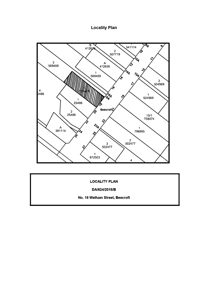
Lot 2 DP 569459, No. 18 Welham Street, Beecroft |
|
Applicant: |
Turrell Building Services Pty Ltd |
|
Owner: |
Mr Timothy Abrams Mrs Karin Nicolette Marie Abrams |
|
Estimated Value: |
$175,657.32 (no change) |
|
Ward: |
C |
· The modifications to the dwelling house generally comply with the Hornsby Local Environmental Plan 2013 and the Hornsby Development Control Plan 2013.
· A total of 13 submissions have been received in respect of the application.
· The application is required to be determined by the Hornsby Council Local Planning Panel as 10 or more unique submissions were received by way of objection.
· It is recommended that the application be approved.
|
THAT pursuant to Section 4.55(2) of the Environmental Planning and Assessment Act 1979, Development Application No. DA/624/2018/A for alterations and additions to a dwelling house at Lot 2 DP 569459, No. 18 Welham Street, Beecroft be modified as detailed in Schedule 1 of LPP Report No. LPP7/20. |
APPLICATION History
On 6 December 2018, Council approved DA/624/2018 for alterations and additions to a dwelling house, subject to conditions.
On 8 March 2019, Council approved a Section 4.55(1) application DA/624/2018/A to amend the condition in relation to the applicable fee for the Section 7.12 contributions, based upon a revised cost of works report.
On 8 November 2019, this Section 4.55(2) application DA/624/2018/B was lodged to correct errors identified during construction in relation to the location of the approved additions to the front of the site.
On 15 November 2019 Council issued a Stop Work Order pursuant to Item No. 2 of Part 1, Schedule 5 of the Environmental Planning and Assessment Act 1979 and instructed the owner to do as follows:
1. Cease carrying out works forward of the front building line of the existing dwelling that are in contravention of the approved plans of Development Consent No. DA/624/2018/A.
2. Undertake the following structural works to support the roof frame at the rear of the dwelling in order to make the structure safe. These works are limited to:
a) Installation of the structural steel portal frame to support the existing roof structure correctly.
b) Re-construction of the sub-floor framing and sheet flooring of the portal frame to tie the roof in; and
3. Cease all works on the site upon completion of the abovementioned works.
On 6 February 2020 Council’s officers met the owner and applicant and advised that the application as submitted with a 6.5 metre front setback could not be supported on heritage and planning grounds. Council advised the applicant that the development should be setback 10.3 metres from Welham Street and be sympathetic to the streetscape character along Welham Street in order for Council to support the application.
On 7 February 2020 Council requested additional information in the form of amended plans detailing a front setback of 10.3 metres to Welham Street.
On 24 February 2020 a further meeting was held by Council’s officers with the applicant and owner and an amended plan with a front setback of 7.5 metres was proposed. Council advised that this variation could not be supported on heritage grounds.
On 26 February 2020 an amended plan with a front setback of 8.8 metres was submitted to Council.
On 9 March 2020 a Heritage Impact Statement was submitted in support of the application. This statement forms part of this assessment.
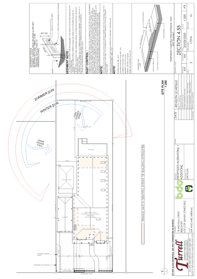
On 20 March 2020 amended plans providing a front fence and landscape plan where submitted to Council. These plans form part of this assessment.
SITE
The 884.8m2 site is located on the north-western side of Welham Street Beecroft and contains a partially demolished single storey dwelling house with a detached carport and a shed.
The site has a fall of two metres to the side western boundary.
The site is bushfire prone.
The site is not flood prone.
The site does not contain a heritage listed item.
The site is located in the vicinity of two heritage listed items within Schedule 5 of the Hornsby Local Environmental Plan 2013 (HLEP). These two items are as follows:
· Item No. 51 (‘Nakinda’) at No. 104 Beecroft Road, Beecroft of local heritage significance.
· Item No. 149 (‘Chilworth’) at No. 24 Welham Street, Beecroft of local heritage significance.
The site is located within the Beecroft/Cheltenham Heritage Conservation Area (HCA).
The site is not burdened by any easements or restrictions.
APPROVED DEVELOPMENT
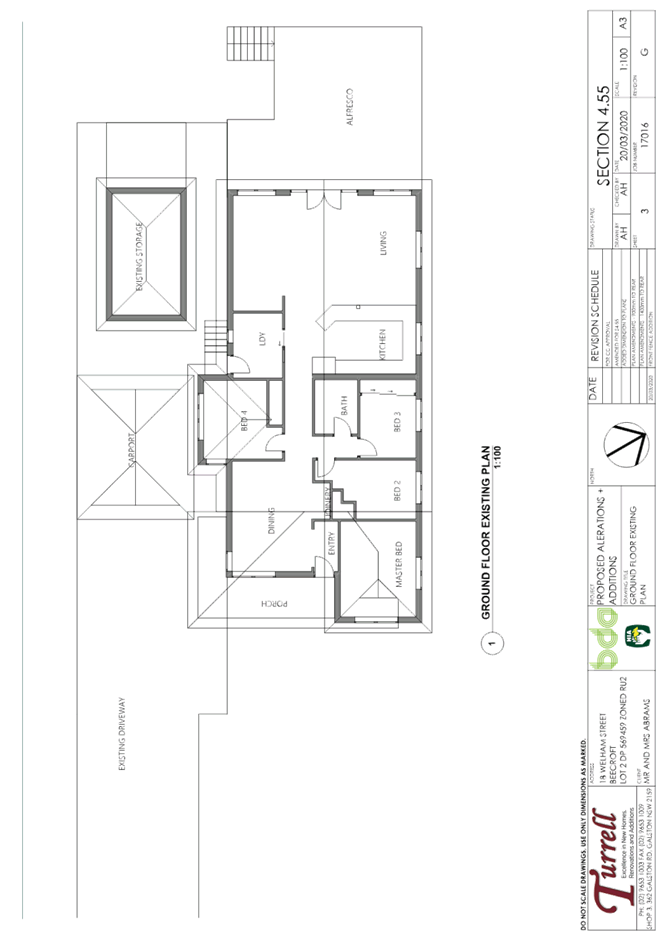
The approved development DA/624/2018/A comprises alterations and additions to a dwelling house as follows:
· The demolition of internal and external walls.
· The construction of a front extension, internal alterations and the construction of a new roof rear deck and chimney/flue.
· The construction of a detached carport.
· The extension of the existing storage room.
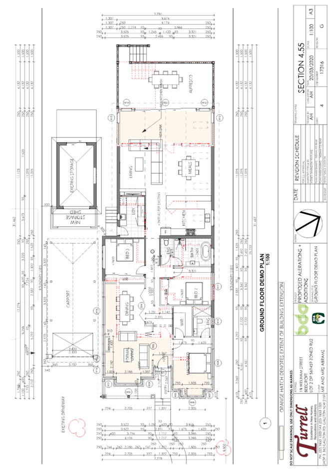
PROPOSED MODIFICATION
The application proposes a Section 4.55(2) modification of the approved development amend the approved building footprint to reflect the actual front, side and rear boundaries. The proposed amendments are as follows:
· The demolition of the front section.
· The construction of a new front addition and front fence.
· Alterations to the rear section.
· Internal amendments to the floor plan accounting for the changes to the front setback distance are also proposed to improve the functionality of the floor plan.
ASSESSMENT
1. STRATEGIC CONTEXT
1.1 Greater Sydney Region Plan - A Metropolis of Three Cities and North District Plan
The Greater Sydney Region Plan - A Metropolis of Three Cities has been prepared by the NSW State Government to guide land use planning decisions for the next 40 years (to 2056). The Plan sets a strategy and actions for accommodating Sydney’s future population growth and identifies dwelling targets to ensure supply meets demand. The Plan also identifies that the most suitable areas for new housing are in locations close to jobs, public transport, community facilities and services.
The NSW Government will use the subregional planning process to define objectives and set goals for job creation, housing supply and choice in each subregion. Hornsby Shire has been grouped with Hunters Hill, Ku-ring-gai, Lane Cove, Mosman, North Sydney, Ryde, Northern Beaches and Willoughby to form the North District. The Greater Sydney Commission has released the North District Plan which includes priorities and actions for Northern District for the next 20 years. The identified challenge for Hornsby Shire will be to provide an additional 4,350 dwellings by 2021 with further strategic supply targets to be identified to deliver 97,000 additional dwellings in the North District by 2036.
The proposed development would be consistent with the Greater Sydney Region Plan - A Metropolis of Three Cities and the North District Plan.
2. STATUTORY CONTROLS
Section 4.15(1)(a) requires Council to consider “any relevant environmental planning instruments, draft environmental planning instruments, development control plans, planning agreements and regulations”.
2.1 Environmental Planning and Assessment Act 1979 - Section 4.55(2)
The proposal constitutes an amendment under Section 4.55(2). Pursuant to Section 4.55(2) of the Environmental Planning and Assessment Act 1979, Council may consider an application to amend development consent provided that, inter alia:
“(a) It is satisfied that the development to which the consent as modified relates is substantially the same development as the development for which consent was originally granted and before that consent as originally granted was modified (if at all), and
(b) It has consulted with the relevant Minister, public authority or approval body (within the meaning of Division 4.8) in respect of a condition imposed as a requirement of a concurrence to the consent or in accordance with the general terms of an approval proposed to be granted by the approval body and that Minister, authority or body has not, within 21 days after being consulted, objected to the modification of that consent, and
(c) It has notified the application in accordance with:
(i) The regulations, if the regulations so require, or
(ii) A development control plan, if the consent authority is a council that has made a development control plan that requires the notification or advertising of applications for modification of a development consent, and
(d) It has considered any submissions made concerning the proposed modification within the period prescribed by the regulations or provided by the development control plan, as the case may be”.
Subsections (1) and (1A) do not apply to such a modification.
(3) In determining an application for modification of a consent under this section, the consent authority must take into consideration such of the matters referred to in section 4.15 (1) as are of relevance to the development the subject of the application. The consent authority must also take into consideration the reasons given by the consent authority for the grant of the consent that is sought to be modified.
(4) The modification of a development consent in accordance with this section is taken not to be the granting of development consent under this Part, but a reference in this or any other Act to a development consent includes a reference to a development consent as so modified.
(5) (Repealed)
With respect to (a), it is considered that the proposal as amended is substantially the same as the development originally approved.
Section 4.55(2)(b) is not applicable as the development is not an integrated development or a State significant development.
In accordance with Section 4.55(2)(c) and (d), the amended application was advertised, and 13 submissions were received.
In determining an application for modification of a consent under this section, the consent authority must take into consideration such of the matters referred to in section 4.15(1) as are of relevance to the development the subject of the application. The consent authority must also take into consideration the reasons given by the consent authority for the grant of the consent that is sought to be modified.
In accordance with Section 4.55(3) an assessment taking into consideration the relevant matters referred to in Section 4.15(1) of the Environmental Planning and Assessment Act 1979 is provided below.
2.2 Hornsby Local Environmental Plan 2013
The proposed development has been assessed having regard to the provisions of the Hornsby Local Environmental Plan 2013 (HLEP).
2.2.1 Zoning of Land and Permissibility
The subject land is zoned R2 – Low Density Residential under the HLEP. The objectives of the zone are:
· To provide for the housing needs of the community within a low-density residential environment
· To enable other land uses that provide facilities or services to meet the day to day needs of residents.
The proposed modification is defined as a dwelling house and is permissible in the zone with Council’s consent. The proposed development meets the objectives of the R2 zone.
2.2.2 Height of Buildings
Clause 4.3 of the HLEP provides that the height of a building on any land should not exceed the maximum height shown for the land on the Height of Buildings Map. The maximum permissible height for the subject site is 8.5m. No changes to the approved building height of 6.5 metres are proposed. The application proposes to retain the building height of 6.5 metres which complies with the maximum building height of 8.5 metres that applies to the area.
2.2.3 Heritage Conservation
Clause 5.10 Heritage Conservation of the Hornsby Local Environmental Plan 2013 (HLEP). states that any alteration to the exterior of a building including changes to its detail, fabric, finish or appearance requires consent from Council.
The site is located within the Beecroft/Cheltenham Heritage Conservation Area (H.C.A) Schedule 5 of the HLEP.
The site is also located in the vicinity of two heritage listed items within Schedule 5 of the HELP as follows:
· Item No. 51 (‘Nakinda’) at No. 104 Beecroft Road, Beecroft of local heritage significance.
· Item No. 149 (‘Chilworth’) at No. 24 Welham Street, Beecroft of local heritage significance.
Due to the nature of the proposed amendment, Council engaged a heritage consultant and a town planning consultant to conduct an independent heritage and planning assessment of the proposed amendment.
The findings of this assessment against the relevant Parts of the Part 9 Heritage of the Hornsby Development Control Plan 2013 (HDCP) has been provided below under Part 2.8.1 Heritage of this report.
2.2.4 Earthworks
Clause 6.2 of the HLEP states that consent is required for proposed earthworks on site. Before granting consent for earthworks, Council is required to assess the impacts of the works on adjoining properties, drainage patterns and soil stability of the locality.
Comment: No additional earthworks are proposed under this modification.
2.3 State Environmental Planning Policy (Building Sustainability Index – BASIX) 2004
The application has been assessed against the requirements of State Environmental Planning Policy (Building Sustainability Index: BASIX) 2004. The approved development included a BASIX Certificate (Cert. No. A311681) for the proposed development which meets the requirements of the SEPP.
Comment: No changes are proposed to the BASIX requirements. The approved development contains a BASIX Certificate which is considered to be satisfactory.
2.4 State Environmental Planning Policy No. 55 Remediation of Land
The policy provides guidelines for the remediation of contaminated land for the purpose of reducing the risk of harm to human health or any other aspect of the environment. Clause 7 requires Council to consider whether land is contaminated prior to granting consent to the carrying out of any development on that land.
Should the land be contaminated, Council must be satisfied that the land is suitable in a contaminated state for the proposed use. If the land requires remediation to be undertaken to make the land suitable for the proposed use, Council must be satisfied that the land will be remediated before the land is used for that purpose.
The site has been historically used for residential purposes. It is not likely that the site has experienced any significant contamination, and further assessment under SEPP 55 is not required.
2.5 State Environmental Planning Policy (Vegetation in non-rural areas) 2017
The application has been assessed against the requirements of State Environmental Planning Policy (Vegetation in Non-Rural Areas) 2017. This Policy seeks to protect the biodiversity values of trees and other vegetation in non-rural areas of the State, and to preserve the amenity of non-rural areas of the State through the preservation of trees and other vegetation.
Part 3 of the Vegetation SEPP states that a development control plan may make a declaration in any manner relating to species, size, location and presence of vegetation. Accordingly, Part 1B.6.1 of the Hornsby Development Control Plan 2013 (HDCP) prescribes works that can be undertaken with or without consent to trees.
Part 3.1.1 of this report provides an assessment of the proposed amendment in accordance with Part 1B.6.1 of the HDCP.
2.6 Sydney Regional Environmental Plan (Sydney Harbour Catchment) 2005
The approved development was assessed against the requirements of Sydney Regional Environmental Plan (Sydney Harbour Catchment) 2005. This Policy provides general planning considerations and strategies to ensure that the catchment, foreshores, waterways and islands of Sydney Harbour are recognised, protected, enhanced and maintained.
The proposed amendments do not alter the original assessment of the application and subject to the implementation of installation of sediment and erosion control measures and stormwater management to protect water quality, the proposal would have minimal potential to impact on the Sydney Harbour Catchment.
2.7 Section 3.42 Environmental Planning and Assessment Act, 1979 - Purpose and Status of Development Control Plans
Section 3.42 of the Environmental Planning and Assessment Act 1979 states that a DCP provision will have no effect if it prevents or unreasonably restricts development that is otherwise permitted and complies with the development standards in relevant Local Environmental Plans and State Environmental Planning Policies.
The principal purpose of a development control plan is to provide guidance on the aims of any environmental planning instrument that applies to the development; facilitate development that is permissible under any such instrument; and achieve the objectives of land zones. The provisions contained in a DCP are not statutory requirements and are for guidance purposes only. Consent authorities have flexibility to consider innovative solutions when assessing development proposals, to assist achieve good planning outcomes.
2.8 Hornsby Development Control Plan 2013
The proposed development has been assessed having regard to the relevant desired outcomes and prescriptive requirements within the Hornsby Development Control Plan 2013 (HDCP). The following table sets out the proposal’s compliance with the prescriptive requirements of the Plan:
|
HDCP – Part 3.1 Dwelling Houses |
||||
|
Control |
Approved |
Proposed |
Requirement |
Complies |
|
Site Area |
884.4m2 |
884.4m2 |
N/A |
N/A |
|
Building Height |
6.8m |
6.8m |
8.5m |
Yes |
|
No. storeys |
1 |
1 |
Max. 2 + attic |
Yes |
|
Site Coverage |
36.2% |
29.3% |
50% |
Yes |
|
Floor Area (Dwelling house) |
252.2m2 |
231.8m2 |
Max. 380m2 |
Yes |
|
Floor Area (Outbuildings) |
27.4m2 |
No change |
Max. 60m2 |
Yes |
|
Setbacks |
|
|
|
|
|
- Front |
10.3m |
8.8m |
To match the streetscape |
Yes |
|
- Side (north-east) |
1.5m |
1.5m |
0.9m |
Yes |
|
- Side (storage shed, south-west) |
0.9m |
0.9m |
0.9m |
Yes |
|
- Side (carport, south-west) |
0.4m |
0.75m |
0.9m |
No |
|
- Rear |
13.3m |
11.48m |
3m |
Yes |
|
Landscaped Area (% of lot size) |
36% |
46% |
30% min |
Yes |
|
Private Open Space |
|
|
|
|
|
- minimum area |
>24m2 |
>24m2 |
24m2 |
Yes |
|
- minimum dimension |
>3m |
>24m |
3m |
Yes |
|
Car Parking |
2 spaces |
2 spaces |
2 spaces |
Yes |
As detailed in the above table, there are minor non-compliances with the HDCP controls in relation to setbacks which are discussed below in addition to a discussion on compliance with relevant performance requirements.
2.8.1 Heritage
The site is located within the Beecroft/Cheltenham Heritage Conservation Area (HCA) Schedule 5 of the HLEP.
The site is also located in the vicinity of two heritage listed items within Schedule 5 of the HLEP as follows:
· Item No. 51 (‘Nakinda’) at No. 104 Beecroft Road, Beecroft of local heritage significance.
· Item No. 149 (‘Chilworth’) at No. 24 Welham Street, Beecroft of local heritage significance.
Due to the development having been constructed contrary to the approved plans, Council engaged John Oultram, Heritage and Design, to conduct an independent heritage assessment of the proposal based on the heritage provisions under Part 9 of the HDCP.
Council also engaged Mr Peter Fryar of Key Urban Planning to complete an independent planning assessment of the proposed amendment in terms of its heritage impact. Mr Fryar has made the following assessment:
Background
On 6 December 2018 approved DA/624/2018. The DA included the demolition of the front portion of the dwelling house and the construction of a new addition (single storey) to the front with a new carport to the side.
The rear portion of the house was substantially retained. The plans approved under the DA identified
(by dimension) a front setback of 10.324m/11.393m to the Welham Street property boundary. The plans were lacking in detail and failed to clearly identify the front boundary in relation to the building footprint and proposed extensions. During construction, it became apparent that the approved plans were at ‘error’ and as a consequence, the building construction was at a 6.5m (approx.) front setback.
The applicant submitted amended plans under the current section 4.55(2) application following a series of discussions and negotiations with Council. The amended plans (revision F) dated 2 March 2020 provides for a minimum front setback of 8.8m to a front bay window and front verandah. The front wall on the eastern corner of the building has a setback of 9.414m whilst the carport is setback 12.293m.
Whilst we do not condone the actions of the applicant to make a ‘misrepresentation’ of the front setback dimension shown on the approved plans, this independent assessment is undertaken considering the merits of the amended design when applying the adopted planning controls of Council.
Current Property
No. 18 Welham Street (now partially demolished) is what appears to have been a single storey, Inter War house set on a well landscaped site to the northwest side of the street.
The house was in rendered masonry with a hipped, terracotta tile roof with gablets to the front. The projecting hipped roof to the front flanked a wrap around, timber verandah. Internally the house had a convoluted plan and appears to have been heavily altered with much of the original fabric removed.
The house had a large, modern extension and garden at the rear and a large, well-planted garden to the front with a drive to the side that served a carport and garage.
Welham Street is characterised as a quiet, tree-lined street that slopes to the south and is lined largely with single storey houses from the Edwardian period onwards including some Inter War development, although there are also some modern, infill developments and battle-axe subdivisions.
The proposed amendment would undertake the following works:
· Demolition of the front section
· The construction of a new front addition
· Alterations to the rear section
· Replacement carport
The front addition is in face brick with a hipped and gabled roof in terracotta tiles. There is a projecting gabled bay to the front flanking, a verandah that is detailed in an Edwardian style with a skillion roof supported on timber posts on a swept and a brick balustrade. The ‘carport’ is to a similar detail and has a door to the front though it is open to the sides and rear.
We have been provided and reviewed the (Qualified) Heritage Assessments prepared by:
· Mr John Oultram, Heritage and Design dated 19 March 2020 (Council).
· Mr Graham Brooks, GBA dated 6 March 2020 (Applicant).
Mr Oultram is of the opinion that the alterations and additions ‘as built’ “would not have received development approval and, had the error in the setback been apparent, it is likely that a requirement for a greater setback closer to that of the adjoining properties would have been required.”
Whilst we cannot pre-empt whether Council may or may not have granted development consent for the ‘as built’ additions on a 6 metre (approx.) front setback to Welham Street, it is the opinion of the author that the reduced setback to Welham Street is unacceptable from a streetscape perspective and although the established setback of buildings along Welham Street is varied and in our opinion, not clearly defined, the reduced setback (6.0m) would adversely impact on the streetscape and adversely impact on the character of the built form in Welham Street. A reduction of the setback to the ‘as built’ 6 metres would, in our opinion, set an undesirable precedent.
Mr Brooks in his assessment does not provide an opinion on the acceptability of the ‘as built’ setback.
However, Mr Brooks assessment of the character and predominant setback of buildings in Welham Street differs from the opinions of Mr Oultram.
Mr Oultram considers that the “proposed setback does not conform” to the common setback pattern in Welham Street. Mr Oultram is of the opinion that there “is a reasonably consistent building line to the northwest side of the street for primary structures” however acknowledges that there are a number of encroachments into the ‘primary front set back’ that “would not be approved under the current controls”.
Mr Brooks in his assessment of the heritage impact of the plans forming part of the section 4.55(2) application states:
“The streetscape on the north western side of Welham Street is punctuated by battle-axe driveways that lead to more recently subdivided houses behind those that address the street. One such driveway separates Nos 18 and 20. In addition, the housing stock on this side of the street generally comprises either post WW2 era dwellings or extensively altered pre WW2 buildings. Many of the houses on the opposite side of the street [sic] also reflect extensive changes and additions to their early form and scale. There can be no doubt therefore that the Welham St streetscape, particularly at its south-western end, has evolved significantly and in many directions since the area was initially settled.”
We support the opinions of Mr Brooks above and consider that the ‘historic’ approvals for dwellings and ancillary structures in Welham Street has resulted in a varied building line. The revised building setback proposed under the s 4.55(2) plans is considered to be acceptable and not ‘inconsistent’ with the established varied setback along both sides of Welham Street.
In summary, our observations of varied setbacks along Welham Street are based upon the following:
· No. 16 – Carport to front boundary line.
· No. 22 – Garage to front boundary.
· No. 26 – Brush fence at 2 meters (approx.) on front boundary line with elevated rock retaining walls in road reserve.
· No. 10 – Alts & adds to dwelling (under construction) on 10 m front setback.
· Mixed uses including church and pre-school changing consistent residential character towards Beecroft Road.
· Predominance of front fences establishing main character along streetscape. Should be reinforced.
The relevant matters for consideration with respect to Part 9 Heritage of the HDCP in relation to the issue of ‘setback’ in consideration of the amended plans are discussed as follows:
Section 9.3.6 – Beecroft Cheltenham Heritage Conservation Area
The site is situated within the Beecroft/Cheltenham Heritage Conservation Area. The desired outcomes for the area are to ensure that development is both complementary and sympathetic to the existing character of the conservation area and the elements that are significant to that character.
The HDCP contains a number of prescriptive measures to ensure that the desired outcomes are achieved. The prescriptive measures contained within the DCP are as follows:
“Maintain and reinforce characteristic details Development should respect the significant characteristics of the Heritage Conservation Area, as detailed in the applicable Character Statement in this Part.
Significant changes to front elevations should be avoided where the existing building retains characteristic detailing.
Original decorative elements and detailing on buildings should be used where appropriate but should not be overdone as a means of fitting in”.
Comment:
Issues relating to streetscape have been discussed in detail above. The proposed changes to the appearance of the front elevation of the building will dramatically improve the appearance of the dwelling house creating a federation appearance in keeping with more traditional buildings in the locality. The design respects the significant characteristics of the Heritage Conservation Area.
“Form, massing, scale, setbacks – streetscape character
New work should be designed to complement the existing streetscape in terms of the following elements.
(refer to Character Statements for details):
Building elements - scale, height, bulk, massing, roof form, orientation, façade treatments, setbacks and spaces between buildings, verandah and window placement, balance of solid walls and openings, materials, colours and textures; and
Landscape elements – landscaping and gardens, height and design of fences, garages, driveways and existing street trees”.
Comment:
Issues relating to the consistency of the proposal with the character statement for the locality is discussed in detail below. It is considered that the building elements in the design are consistent with above prescriptive requirements.
“Additions should be located away from the street elevation and below the main ridge line.
New buildings, alterations and additions should be single storey within streetscapes that are
predominately single storey. New levels, or split-level additions, may be possible to the rear on sloping sites.
Ancillary structures e.g. swimming pools, tennis courts, sheds, should be located in rear yards.
New buildings should be located so that they are compatible with predominant front setbacks in the street, particularly the setbacks of immediately adjoining buildings.
Roof form and pitch should be compatible with characteristic roof forms of the conservation area. Traditionally rear extensions used skillion or simple pitched roof forms”.
Comment:
The streetscape is characterised by a mix of single storey and two storey construction. The proposed addition is in keeping with the built form in the immediate locality. The siting of the proposed dwelling is consistent with the predominant setback of dwellings in the street and complies with the prescriptive requirement under Council’s DCP.
“Contemporary design
Contemporary design should be sympathetic to the characteristic built form of the conservation area, particularly in terms of bulk, scale, height, form or materials.
Materials and finishes
Rendering or painting over original face brick should be avoided.
Materials used should complement the period and style of the building, and the conservation area.
Compatible, but not necessarily matching materials i.e. modern materials may be used where appropriate
(refer to Character Statements for details)”.
Comment:
The materials of construction and finishes are in keeping with the newer surrounding dwelling construction. The building has been suitably articulated particularly the front elevation to reduce the overall bulk and scale of the dwelling.
Section 9.3.6 – Beecroft Cheltenham Heritage Conservation Area.
The site is located within the Beecroft Cheltenham Heritage Conservation Area and more particularly the ‘Beecroft-Cheltenham Plateau Precinct’. The character statement for the precinct is as follows:
“The early development occurred near Beecroft Station from the late 1880s, comprising villas with modest and large domestic gardens that have become characteristic of the area’s streetscape. Development around Cheltenham Station commenced in the 1920s on later subdivisions.
Victorian villas are among the earliest remaining buildings in Beecroft and Cheltenham. The main building periods are Federation, Edwardian and Interwar, with infill development from later periods also present in most areas.
Buildings are predominantly single storey in scale and are well articulated in the manner characteristic of the period.
Stone foundations, face brick with rendered detailing of small areas and terracotta or slate tiled roofs are typical”.
As discussed previously, the surrounding locality has undergone a number of changes over recent years with the construction of new residential dwellings. The proposal is in keeping with surrounding development in the locality. We consider that the addition of a front fence (picket style) that is consistent with the predominant front fencing along Welham Street would be appropriate in the modified. Further, the fence should be bordered by hedging. We have expressed this opinion to Council and at the time of the preparation of this assessment have been advised that the plans have been amended accordingly.
Recommendation
That council approve the section 4.55(2) application to amend the design and front setback of the proposed dwelling alterations and additions approved under DA/624/2018/A.
Summary
On balance, Council based on the above recommendation is of the view that the proposed modification would generally be sympathetic to the streetscape of Welham Street. Whilst the bay window could be further set back or removed, it is considered that this element measuring 1.38m2 in size results in a positive impact to the front elevation. It is considered that the articulation would break up an otherwise plain façade. The applicant has submitted an amended plan detailing a front fence with brick piers and white “picket” style fencing which is considered sympathetic to the streetscape. The landscaping and planter boxes would further soften the impacts to the streetscape and no objections are raised to the proposed amendment.
The proposal meets the desired outcomes of Part 9 Heritage of the HDCP and is considered acceptable.
2.8.2 Setbacks
The desired outcomes of Part 3.1.2 Setbacks of the HDCP are to encourage “setbacks that are compatible with adjacent development and complements the streetscape” and setbacks “that allow for canopy trees to be retained and planted along the front and rear boundaries”.
This is supported by the prescriptive measures set out in Table 3.1.2(a) Minimum Boundary Setbacks in the HDCP which prescribes a 0.9 metre setback for development in relation to side boundaries for single storey development.
The carport would be set back 0.75 metres from the south-western side boundary which fails to comply with the abovementioned prescriptive measure.
In support of this 0.15 metre side setback encroachment, it is noted that the carport has been increased from the originally approved location that was 0.4 metres from this boundary and would be replacing an existing carport which was approved in the same configuration.
Accordingly, no objections are raised regarding the side setback non-compliance.
In regard to the proposed front setback, Council has undertaken a merit-based assessment in conjunction with the heritage assessment as discussed above in Part 2.8.1 Heritage. This assessment raised no objections to the proposed front setback on planning and heritage grounds.
The proposal meets the desired outcomes of Part 3.1.2 Setbacks of the HDCP and is considered acceptable.
2.8.3 Bushfire
The desired outcomes of Part 1C.3.1 Bushfire of the HDCP are to encourage “development that is located and designed to minimise the risk to life and property from bushfires”
The subject site is identified as being bushfire prone with a Bushfire Attack Level (BAL) of 12.5. The proposed amendment does not change the level of bushfire risk applicable to the land and the requirements in relation to the construction to the BAL 12.5 requirements still apply.
Accordingly, the development must comply with AS3959 ‘Construction of buildings in bushfire prone areas’ and Planning for Bushfire Protection 2019.
The proposal meets the desired outcomes of Part 1C.3.1 Bushfire of the HDCP and is considered acceptable, subject to conditions.
2.8.4 Sunlight Access
The application has been assessed against the relevant requirements of Part 3.1.5 Sunlight Access of the HDCP regarding the impacts to sunlight access for adjacent properties.
Noting that the proposed development is single storey in scale, it is considered that the amended proposal would not result in detrimental overshadowing impacts on the adjacent properties.
2.8.5 Privacy
The application has been assessed against the relevant requirements of Part 3.1.6 Privacy of the HDCP in relation to the impacts from the proposal amendment toward the privacy of adjoining properties.
Council’s assessment has determined that minimal privacy impacts would be experienced by adjacent properties due to the single storey nature of the development and noting that an existing 1.8-metre-high boundary fence along the northern, eastern and western boundary and existing shrubs along the northern boundary would effectively screen the proposed additions and alfresco. No objections are raised to the proposed amendment on privacy grounds.
2.9 Section 7.12 Contributions Plans
Hornsby Shire Council Section 7.12 Contributions Plan 2019–2029 applies to the development as the estimated costs of works is greater than $100,000. Existing conditions of consent include a requirement for the payment of a contribution in accordance with the Plan.
3. ENVIRONMENTAL IMPACTS
Section 4.15(1)(b) of the Act requires Council to consider “the likely impacts of that development, including environmental impacts on both the natural and built environments, and social and economic impacts in the locality”.
3.1 Natural Environment
3.1.1 Tree and Vegetation Preservation
The subject site contains no trees. However, eight shrubs are located adjacent to the side northern boundary along the adjacent driveway serving 16A Welham Street and two trees are located on the Council road reserve to the east of the site.
No concerns are raised regarding the impact of the development on these specimens as they are shrubs.
However, concerns were initially raised by Council regarding the street trees on the Council road reserve in particular one Turpentine Iron Bark tree which had the potential of being impacted during the course construction works.
As a consequence, Council requested an Arboricultural Impact Assessment (A.I.A) and tree protection plan to demonstrate that the proposed construction works would not significantly impact the trees on the Council road reserve.
An Arboricultural Impact Assessment prepared by Advanced Treescape Consulting was subsequently submitted with DA/624/2018 which determined that the majority of the front yard would be a Tree Protection Zone (TPZ) for tree T1, a critically endangered Turpentine Ironbark tree and tree T2 a Weeping Bottle Brush.
The A.I.A found that T1 was a tree of high landscape significance and that T1 would be subject to a minor TPZ encroachment of 1.36% by the proposed development and that tree T2 would not be subject to a TPZ encroachment. One tree T3 was classed as being dead and Council raised no objections to its removal.
Notwithstanding, noting that the front addition would be located closer to trees T1 and T2 that are proposed to be retained, an assessment of the amended plans that are subject to this assessment has been undertaken. Council’s environmental assessment has found that although the nature of the encroachment into the TPZ of tree T1 would increase to 20m2 or 4%, this is considered to be in the acceptable range and is classed as a minor encroachment under AS 4970 2009 ‘Protection of trees on Development Sites’.
Accordingly, the conditions imposed relating to tree protection are considered to be sufficient and no additional tree protection conditions are recommended in Schedule 1 of this report.
The proposal meets the desired outcomes of Part 1B6.1 Tree and Vegetation Preservation and is considered acceptable, subject to conditions.
3.1.2 Stormwater Management
The approved development is drained to the existing internal stormwater drainage system which connects to Welham Street. The proposed amendment would not alter the approved drainage plan for the development.
Council’s assessment against the relevant requirements of Part 1C.1.2 Stormwater Management raised no concerns with the proposed stormwater drainage plan, subject to the existing conditions of consent.
3.2 Built Environment
3.2.1 Built Form
The proposal would generally be consistent with the built form of the surrounding low-density residential area which consists of dwelling houses ranging from single storey, split level to two storeys.
3.3 Social Impacts
The residential development would improve housing choice in the locality by providing a range of house hold types. This is consistent with Council’s Housing Strategy which identifies the need to provide a mix of housing options to meet future demographic needs in Hornsby Shire.
3.4 Economic Impacts
The proposal would have a minor positive impact on the local economy in conjunction with other new low-density residential development in the locality by generating an increase in demand for local services.
4. SITE SUITABILITY
Section 4.15(1)(c) of the Act requires Council to consider “the suitability of the site for the development”.
4.1 Bushfire Risk
As noted in Part 2.8.3 Bushfire of this report, the subject site is identified as being bushfire prone with a Bushfire Attack Level (BAL) of 12.5. The proposed amendment does not change the level of bushfire risk applicable to the land and the requirements in relation to the construction to the BAL 12.5 requirements still apply.
5. PUBLIC PARTICIPATION
Section 4.15(1)(d) of the Act requires Council to consider “any submissions made in accordance with this Act”.
5.1 Community Consultation
The proposed development was placed on public exhibition and was notified to adjoining and nearby landowners between 13 November 2019 and 28 November 2019 in accordance with the Hornsby Community Participation Plan. During this period, Council received 13 submissions. The map below illustrates the location of those nearby landowners who made a submission that are in close proximity to the development site.
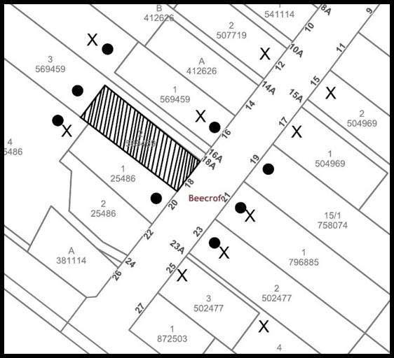
|
NOTIFICATION PLAN |
|||
|
• PROPERTIES NOTIFIED |
X SUBMISSIONS RECEIVED |
|
|
|
2 SUBMISSIONS RECEIVED OUT OF MAP RANGE |
|||
Thirteen submissions objected to the development, generally on the grounds that the development would result in:
· Unacceptable impacts to the character of the Welham Street streetscape and overall significance of the Beecroft/Cheltenham Heritage Conservation Area.
· The front setback was not at an appropriate distance.
· That there is a conflict of interest for Council and transparency is required for the assessment.
The merits of the matters raised in community submissions have been addressed in the body of the report with the exception of the following:
5.1.1 Heritage
Submissions have been received raising concerns with the proposed amendment and the unacceptable impacts form a reduced front setback to Welham Street and the Beecroft/Cheltenham Heritage Conservation Area.
In response to these concerns the matters relating to heritage have been addressed under Part 2.8.1 Heritage and 2.8.2 Setbacks of this report.
On balance, Council is of the view that the proposed modification would generally be sympathetic to the streetscape of Welham Street.
5.1.2 Setbacks
Submissions have been received raising concerns with the proposed amendment and the unacceptable impacts form a reduced front setback to Welham Street.
In response to these concerns the matters relating to heritage have been addressed under Part 2.8.1 Setbacks and 2.8.2 Setbacks of this report.
On balance, Council is of the view that the proposed modification would generally be sympathetic to the streetscape of Welham Street.
5.2 Conflict of Interest and requirement for transparency of assessment
A submission has been received raising concerns with the assessment process of the amendment and the conflict of interest, given that Council’s officers conducted the initial assessment of the proposal and that Council has been engaged as the Principal Certifying Authority for the works.
In response to this concern, Council has engaged an independent heritage consultant and consultant town planner to conduct the assessment of this application.
5.3 Public Agencies
The development application was not required to be referred to any Public Agencies for comment.
6. THE PUBLIC INTEREST
Section 4.15(1)(e) of the Act requires Council to consider “the public interest”.
The public interest is an overarching requirement, which includes the consideration of the matters discussed in this report. Implicit to the public interest is the achievement of future built outcomes adequately responding to and respecting the future desired outcomes expressed in environmental planning instruments and development control plans.
The application is considered to have satisfactorily addressed Council’s and relevant agencies’ criteria and would provide a development outcome that, on balance, would result in a positive impact for the community. Accordingly, it is considered that the approval of the proposed development would be in the public interest.
CONCLUSION
The section 4.55 (2) application proposes to modify the approved development by altering the approved building footprint to reflect the actual location of the dwelling and correct errors in relation the site dimensions.
The development generally meets the desired outcomes of Council’s planning controls and is satisfactory having regard to the matters for consideration under Section 4.15 of the Environmental Planning and Assessment Act 1979.
Council received 13 submissions during the public notification period. The matters raised have been addressed in the body of the report.
Having regard to the circumstances of the case, approval of the application is recommended.
The reasons for this decision are:
· The proposed development complies with the requirements of the relevant environmental planning instruments and the Hornsby Development Control Plan 2013.
· The proposed development does not create unreasonable environmental impacts to adjoining development with regard to heritage, visual bulk, overshadowing, solar access, amenity or privacy.
Note: At the time of the completion of this planning report, no persons have made a Political Donations Disclosure Statement pursuant to Section 10.4 of the Environmental Planning and Assessment Act 1979 in respect of the subject planning application.
RESPONSIBLE OFFICER
The officer responsible for the preparation of this report is Tom Mojsiejuk.
|
Rod Pickles Manager - Development Assessments Planning and Compliance Division |
James Farrington Director - Planning and Compliance Planning and Compliance Division |
|
1.⇩ |
Locality Map |
|
|
|
2.⇩ |
Architectural Plans |
|
|
|
3.⇩ |
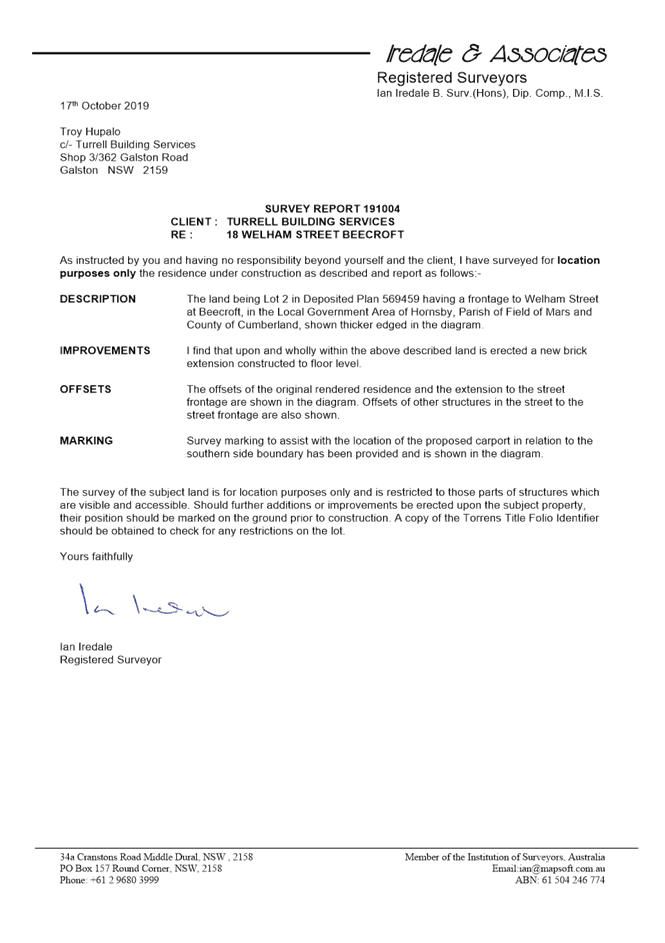
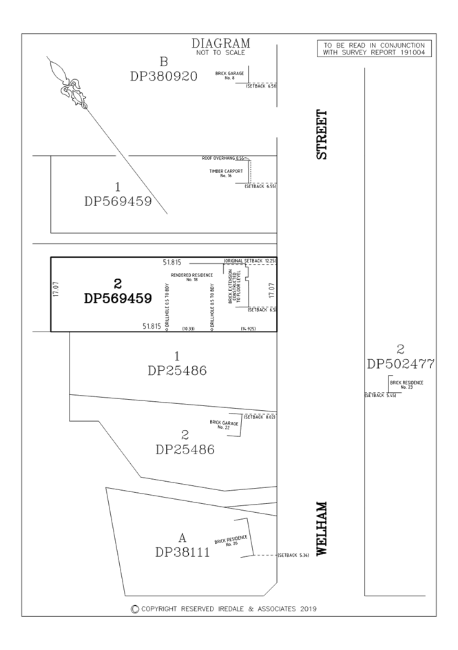
Survey Report |
|
|
File Reference: DA/624/2018/B
Document Number: D07880391
SCHEDULE 1
|
Date of 1st modification: |
5 March 2019 |
|
Details of 1st modification: |
Re-calculation of the applicable Section 7.12 fees for the approved development based upon the revised cost of work report. |
|
Conditions Added: |
Nil |
|
Conditions Deleted: |
Nil |
|
Conditions Modified: |
5 |
|
Date of this modification: |
25 March 2020 |
|
Details of this modification: |
· Modification to the building footprint based upon correct site dimensions.
· Addition of front fence and landscaping
|
|
Conditions Added: |
32A |
|
Conditions Deleted: |
Nil |
|
Conditions Modified: |
1, 13 |
GENERAL CONDITIONS
The conditions of consent within this notice of determination have been applied to ensure that the use of the land and/or building is carried out in such a manner that is consistent with the aims and objectives of the relevant legislation, planning instruments and Council policies affecting the land and does not disrupt the amenity of the neighbourhood or impact upon the environment.
Note: For the purpose of this consent, the term ‘applicant’ means any person who has the authority to act on or the benefit of the development consent.
Note: For the purpose of this consent, any reference to an Act, Regulation, Australian Standard or publication by a public authority shall be taken to mean the gazetted Act or Regulation or adopted Australian Standard or publication as in force on the date that the application for a construction certificate is made.
1. Approved Plans and Supporting Documentation
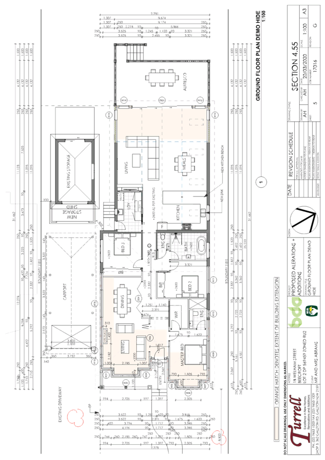
The development must be carried out in accordance with the plans and documentation listed below and endorsed with Council’s stamp, except where amended by Council and/or other conditions of this consent:
|
Plan No. |
Plan Title |
Drawn by |
Dated |
Council Reference |
|
DA-02 Rev G |
Site Plan |
Turrell |
20.3.2020 |
|
|
DA-04 Rev G |
Ground Floor/Demo Plan |
Turrell |
20.3.2020 |
|
|
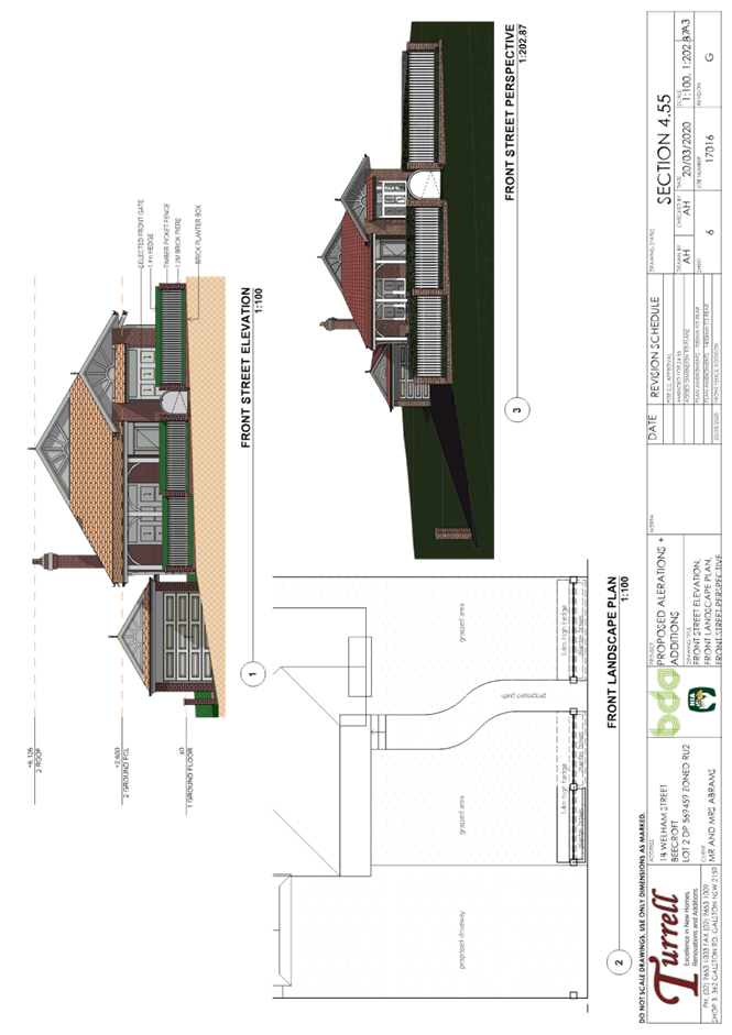
DA-06 Rev G |
Front Landscape Plan |
Turrell |
20.3.2020 |
|
|
DA-07 |
Elevations |
Turrell |
20.08.2018 |
D07575913 |
|
DA-08 |
Elevations |
Turrell |
20.08.2018 |
D07575913 |
|
DA-09 |
Section |
Turrell |
20.08.2018 |
D07575913 |
|
Document Title |
Prepared by |
Dated |
Council Reference |
|
Arboricultural Impact Assessment |
Advanced Treescape Consulting |
3 December 2018 |
D07574332 |
|
Stormwater Concept Plan |
Turrell |
20.08.2018 |
D07574355 |
|
BASIX Certificate No: A311681 |
Turrell Building |
26.3.2018 |
D07477402 |
|
Independent Heritage Review |
GBA Heritage |
6 March 2020 |
D07880652 |
2. Construction Certificate
a) A Construction Certificate is required to be approved by Council or a Private Certifying Authority prior to the commencement of any works under this consent.
b) The Construction Certificate plans must not be inconsistent with the Development Consent plans.
3. Appointment of a Project Arborist
a) A project arborist with AQF Level 5 qualifications must be appointed to provide monitoring and certification throughout the construction period.
b) Details of the appointed project arborist must be submitted to Council and the PCA for registration with the application for the construction certificate.
c) Proposed inspection schedule to assess tree health and provide certification for the various stages of development such as site establishment (includes demolition and installation of tree protection measures), construction work, hard and soft landscaping practical completion and occupancy certification.
4. Removal of Trees
a) This development consent permits the removal of tree numbered T3 as identified in the Arboricultural Impact Assessment prepared by Advanced Treescape Consulting dated 3 December 2018.
b) No consent is granted for the removal of any other trees.
Note: The removal of any other trees from the site requires separate approval by Council in accordance with Part 1B.6 Tree and Vegetation Preservation of the Hornsby Development Control Plan, 2013 (HDCP).
5. Section 7.12 Development Contributions
a) In accordance with Section 4.17(1) of the Environmental Planning and Assessment Act, 1979 and the Hornsby Shire Council Section 94A Development Contributions Plan 2014-2024, $878.30 must be paid to Council to cater for the increased demand for community infrastructure resulting from the development, based on development costs of $175,657.32.
b) The value of this contribution is current as at 5 March 2019. If this contribution is not paid within the financial quarter that this condition was generated, the contribution payable will be adjusted in accordance with the provisions of the Hornsby Shire Council Section 94 Development Contributions Plan and the amount payable will be calculated at the time of payment in the following manner:
$CPY = $CDC x CPIPY
CPIDC
Where:
$CPY is the amount of the contribution at the date of Payment
$CDC is the amount of the contribution as set out in this Development Consent
CPIPY is the latest release of the Consumer Price Index (Sydney – All Groups) at the date of Payment as published by the ABS.
CPIDC is the Consumer Price Index (Sydney – All Groups) for the financial quarter at the date applicable in this Development Consent Condition.
c) The monetary contributions must be paid to Council:
i) Prior to the issue of the Subdivision Certificate where the development is for subdivision.
ii) Prior to the issue of the first Construction Certificate where the development is for building work.
iii) Prior to issue of the Subdivision Certificate or first Construction Certificate, whichever occurs first, where the development involves both subdivision and building work.
iv) Prior to the works commencing where the development does not require a Construction Certificate or Subdivision Certificate.
Note: It is the professional responsibility of the Principal Certifying Authority to ensure that the monetary contributions have been paid to Council in accordance with the above timeframes.
Note: Council’s S94A Development Contributions Plan may be viewed at www.hornsby.nsw.gov.au or a copy may be inspected at Council’s Administration Centre during normal business hours.
6. Domestic Solid Fuel Burning Appliances
a) The fire place and chimney/flue must be installed in accordance with Part 3.7.3 of the Building Code of Australia.
b) The domestic solid-fuel heater must comply with the Protection of the Environment Operations (Clean Air) Regulation 2010 and Australian Standard AS 4013-1992 Domestic solid fuel burning appliances - Method for determination of flue gas emission.
REQUIREMENTS PRIOR TO THE ISSUE OF A CONSTRUCTION CERTIFICATE
7. Building Code of Australia
All approved building work must be carried out in accordance with the relevant requirements of the Building Code of Australia.
8. Contract of Insurance (Residential Building Work)
Where residential building work for which the Home Building Act 1989 requires there to be a contract of insurance in force in accordance with Part 6 of that Act, this contract of insurance must be in force before any building work authorised to be carried out by the consent commences.
9. Notification of Home Building Act 1989 Requirements
Residential building work within the meaning of the Home Building Act 1989 must not be carried out unless the principal certifying authority for the development to which the work relates (not being Council) has given Council written notice of the following information:
a) In the case of work for which a principal contractor is required to be appointed:
i) The name and licence number of the principal contractor.
ii) The name of the insurer by which the work is insured under Part 6 of that Act.
b) In the case of work to be done by an owner-builder:
i) The name of the owner-builder.
ii) If the owner-builder is required to hold an owner-builder’s permit under that Act, the number of the owner-builder’s permit.
Note: If arrangements for doing the residential building work are changed while the work is in progress so that the information notified becomes out of date, further work must not be carried out unless the principal certifying authority for the development to which the work relates (not being Council) has given Council written notification of the updated information.
10. Sydney Water – Approval
This application must be submitted to Sydney Water for approval to determine whether the development would affect any Sydney Water infrastructure, and whether further requirements are to be met.
Note: Building plan approvals can be obtained online via Sydney Water Tap inTM through www.sydneywater.com.au under the Building and Development tab.
11. Stormwater Drainage
The stormwater drainage system for the development must be designed for an average recurrence interval (ARI) of 20 years, be gravity drained, and be connected to the existing internal drainage system.
12. Internal Driveway/Vehicular Areas
The driveway and parking areas on site must be designed and constructed in accordance with Australian Standards 2890.1, 2890.2, 3727.
13. Design and Construction - Bushfire Attack Category
New construction must comply with the current Australian Standard AS3959 Construction of Buildings in Bush Fire-prone Areas Section 3 and 5 (BAL 12.5) and Planning for Bushfire Protection 2019.
Notes: Timbers treated with an applied intumescent paint are no longer recognised by the Rural Fire Service as a fire-retardant treated timber or a performance option to increase fire resistance.
REQUIREMENTS PRIOR TO THE COMMENCEMENT OF ANY WORKS
14. Erection of Construction Sign
a) A sign must be erected in a prominent position on any site on which any approved work is being carried out:
i) Showing the name, address and telephone number of the principal certifying authority for the work.
ii) Showing the name of the principal contractor (if any) for any demolition or building work and a telephone number on which that person may be contacted outside working hours.
iii) Stating that unauthorised entry to the work site is prohibited.
b) The sign is to be maintained while the approved work is being carried out and must be removed when the work has been completed.
15. Protection of Adjoining Areas
A temporary hoarding, fence or awning must be erected between the work site and adjoining lands before the works begin and must be kept in place until after the completion of the works if the works:
a) Could cause a danger, obstruction or inconvenience to pedestrian or vehicular traffic.
b) Could cause damage to adjoining lands by falling objects; and/or
c) Involve the enclosure of a public place or part of a public place.
Note: Notwithstanding the above, Council’s separate written approval is required prior to the erection of any structure or other obstruction on public land.
a) To provide a safe and hygienic workplace, toilet facilities must be available or be installed at the works site before works begin and must be maintained until the works are completed at a ratio of one toilet for every 20 persons employed at the site.
b) Each toilet must:
i) Be a standard flushing toilet connected to a public sewer.
ii) Be a temporary chemical closet approved under the Local Government Act 1993.
17. Erosion and Sediment Control
To protect the water quality of the downstream environment, erosion and sediment control measures must be provided and maintained throughout the construction period in accordance with the manual ‘Soils and Construction 2004 (Bluebook)’, the approved plans, Council specifications and to the satisfaction of the principal certifying authority. The erosion and sediment control devices must remain in place until the site has been stabilised and revegetated.
Note: On the spot penalties may be issued for any non-compliance with this requirement without any further notification or warning.
18. Installation of Tree Protection Fencing
a) Trees numbered T1 and T2 must have tree protection measures for the ground, trunk and canopy installed as detailed within the Arboricultural Impact Assessment prepared by Advanced Treescape Consulting dated 3 December 2018.
b) All tree protection measures for the ground, trunk and canopy installed by the project arborist must be set in accordance with Australian Standard AS 4970-2009 - “Protection of Trees on Development Sites”.
19. Tree Protection Zone - Ground Protection
a) All tree protection zones must have a layer of wood-chip mulch at a depth of between 150mm and 300mm that complies with the relevant requirements of Australian Standard AS 4454 – “Composts, Soil Conditioners and Mulches installed prior to works commencing.
b) Where fencing cannot be installed inside the TPZ the wood-chip must be covered with a layer of geotextile fabric and rumble boards to allow for small plant movement and/or placement of storage of material.
20. Protection Certification
To ensure that all tree protection measures are correctly installed, a certificate from the appointed project arborist must be submitted to the Principal Certifying Authority confirming compliance with the tree protection requirements of this consent.
REQUIREMENTS DURING DEMOLITION AND CONSTRUCTION
21. Construction Work Hours
All works on site, including demolition and earth works, must only occur between 7am and 5pm Monday to Saturday. No work is to be undertaken on Sundays or public holidays.
To protect the surrounding environment, all demolition work must be carried out in accordance with Australian Standard 2601-2001 – The Demolition of Structures and the following requirements
a) Demolition material must be disposed of to an authorised recycling and/or waste disposal site and/or in accordance with an approved waste management plan.
b) Demolition works, where asbestos material is being removed, must be undertaken by a contractor that holds an appropriate licence issued by WorkCover NSW in accordance with Chapter 10 of the Occupational Health and Safety Regulation 2001 and Clause 29 of the Protection of the Environment Operations (Waste) Regulation 2005.
c) On construction sites where any building contains asbestos material, a standard commercially manufactured sign containing the words ‘DANGER ASBESTOS REMOVAL IN PROGRESS’ and measuring not less than 400mm x 300mm must be displayed in a prominent position visible from the street.
To prevent sediment run-off, excessive dust, noise or odour emanating from the site during the construction, the site must be managed in accordance with the publication ‘Managing Urban Stormwater – Landcom (March 2004) and the Protection of the Environment Operations Act 1997.
24. Council Property
To ensure that the public reserve is kept in a clean, tidy and safe condition during construction works, no building materials, waste, machinery or related matter is to be stored on the road or footpath.
25. Disturbance of Existing Site
During construction works, the existing ground levels of open space areas and natural landscape features, (including natural rock-outcrops, vegetation, soil and watercourses) must not be altered unless otherwise nominated on the approved plans.
Any landfill must be imported in accordance with Council’s ‘Construction Specification 2005’ and the following requirements:
a) Prior to fill material being imported to the site, a certificate shall be obtained from a suitably qualified environmental consultant confirming the fill wholly consists of Virgin Excavated Natural Material (VENM) as defined in Schedule 1 of the Protection of the Environment Operations Act 1997 or material approved under the Department of Environment and Climate Change’s general resource recovery exemption.
b) A compaction certificate is to be obtained from a suitably qualified geotechnical engineer verifying that the specified compaction requirements have been met.
c) These certificates must be included with the application for an occupation certificate.
Any/all excavated material removed from the site must be classified by a suitably qualified person in accordance with the Department of Environment, Climate Change and Water NSW Waste Classification Guidelines prior to disposal to an approved waste management facility and be reported to the principal certifying authority prior to the issue of an Occupation Certificate.
28. Prohibited Actions Within the Tree Protection Zone
a) In accordance with the AS4970-2009, the following be prohibited within the fenced area of TPZ:
i) Soil cut or fill including excavation and trenching.
ii) Soil cultivation, disturbance or compaction.
iii) Stockpiling storage or mixing of materials.
iv) The parking, storing, washing and repairing of tools, equipment and machinery.
v) The disposal of liquids and refuelling.
vi) The disposal of building materials.
vii) The siting of offices or sheds.
viii) Any action leading to the impact on tree health or structure.
29. Works Near Trees
a) No consent is granted for any works within the Structural Root Zone of trees numbered T1 and T2.
b) To maintain tree health and condition for trees number T1 and T2 on the approved plans, the appointed project arborist must monitor and record any and all necessary remedial actions required.
c) The maintenance and monitoring of all tree protection techniques must be recorded by the appointed project arborist during the period of construction for submission with the application for the occupation certificate.
30. Maintaining Tree protections zones
The Tree Protection Zone must be maintained by the project arborist in accordance with Section 4.6 requirements of Australian Standard AS 4970-2009 - “Protection of Trees on Development Sites”
31. Building materials and Site Waste
The filling or stockpiling of building materials, the parking of vehicles or plant, the disposal of cement slurry, waste water or other contaminants must be located outside the tree protection zones as prescribed in the conditions of this consent or the prescriptive measures of Part 1B.6.1 Tree Preservation of the Hornsby Development Control Plan, 2013, of any tree to be retained.
32. Works near trees certification
a) The project arborist must submit to the principal certifying authority a certificate that all works have been carried out in compliance with the approved plans and conditions or specifications for tree protection.
b) Certification should include a statement of site attendance, the condition of retained trees, details of any deviations from the approved tree protection measures and their impacts on trees.
Note: Copies of monitoring documentation may be required by the PCA and/or Council.
32A. Survey Report
A report(s) must be prepared by a registered surveyor and submitted to the principal certifying authority:
a) Prior to the commencement of any further construction works of the building certifying that:
i) The building and the like have been correctly positioned on the site.
ii) The finished floor level(s) are in accordance with the approved plans.
REQUIREMENTS PRIOR TO THE ISSUE OF AN OCCUPATION CERTIFICATE
Note: For the purpose of this consent, a reference to ‘occupation certificate’ shall not be taken to mean an ‘interim occupation certificate’ unless otherwise stated:
33. Fulfilment of BASIX Commitments
The applicant must demonstrate the fulfilment of BASIX commitments pertaining to the development.
34. Domestic Solid Fuel Burning Appliance Installation
Certification must be submitted to Council on prior to issue of the Occupation Certificate stating that the installation was completed by an appropriately experienced and qualified person in accordance with the Building Code of Australia and Australian Standard AS 2918:2001 - Domestic Solid Fuel Burning Appliances – Installation.
35. Damage to Council Assets
To protect public property and infrastructure, any damage caused to Council’s assets as a result of the construction or demolition of the development must be rectified by the applicant in accordance with Council’s Civil Works Specifications. Rectification works must be undertaken prior to the issue of an Occupation Certificate, or sooner, as directed by Council.
36. Smoke Alarms – Dwelling Additions
To warn the occupants of the development in the event of a fire, smoke alarms must be installed in the existing building and the proposed additions in accordance with the requirements of the Building Code of Australia.
37. Final Certification
a) The AQF Level 5 Project arborist must submit to the principal certifying authority a certificate that states the following:
i) All the tree protection requirements comply with the tree protection plan.
ii) All completed works have been carried out in compliance with the conditions of consent and approved plans.
iii) Dates and times and reasons for site attendance.
iv) The post development condition of the health for the retained tree number 1.
v) Details necessary work to maintain tree health.
vi) Details of tree protection zone maintenance.
vii) Tree replacements meet NATSPEC guidelines and the approved landscape plan.
Note: Copies of monitoring documentation may be requested throughout DA process.
- END OF CONDITIONS -
ADVISORY NOTES
The following information is provided for your assistance to ensure compliance with the Environmental Planning and Assessment Act 1979, Environmental Planning and Assessment Regulation 2000, other relevant legislation and Council’s policies and specifications. This information does not form part of the conditions of development consent pursuant to Section 4.17 of the Act.
Environmental Planning and Assessment Act 1979 Requirements
The Environmental Planning and Assessment Act 1979 requires:
· The issue of a construction certificate prior to the commencement of any works. Enquiries can be made to Council’s Customer Services Branch on 9847 6760.
· A principal certifying authority to be nominated and Council notified of that appointment prior to the commencement of any works.
· Council to be given at least two days written notice prior to the commencement of any works.
· Mandatory inspections of nominated stages of the construction inspected.
· An occupation certificate to be issued before occupying any building or commencing the use of the land.
Long Service Levy
In accordance with Section 34 of the Building and Construction Industry Long Service Payments Act 1986, a ‘Long Service Levy’ must be paid to the Long Service Payments Corporation or Hornsby Council.
Note: The rate of the Long Service Levy is 0.35% of the total cost of the work.
Note: Hornsby Council requires the payment of the Long Service Levy prior to the issue of a construction certificate.
Tree Preservation in Hornsby Shire
Hornsby Development Control Plan Tree Preservation provisions have been developed under Council’s authorities contained in the State Environmental Planning Policy (Vegetation in Non-Rural Area’s) 2017 under the Environmental Planning and Assessment Act, 1979.
In accordance with these provisions a person must not cut down, fell, uproot, kill, poison, ringbark, burn or otherwise destroy the vegetation, lop or otherwise remove a substantial part of the trees or vegetation to which any such development control plan applies without the authority conferred by a development consent or a permit granted by Council.
Fines may be imposed for non-compliance with the HDCP.
Note: A tree is defined as a long lived, woody perennial plant with one or relatively few main stems with the potential to grow to a height greater than three metres (3m). (HDCP 1B.6.1.c).
Covenants
The land upon which the subject building is to be constructed may be affected by restrictive covenants. Council issues this approval without enquiry as to whether any restrictive covenant affecting the land would be breached by the construction of the building, the subject of this consent. Applicants must rely on their own enquiries as to whether or not the building breaches any such covenant.
Dial Before You Dig
Prior to commencing any works, the applicant is encouraged to contact Dial Before You Dig on 1100 or www.dialbeforeyoudig.com.au for free information on potential underground pipes and cables within the vicinity of the development site.
Should asbestos or asbestos products be encountered during demolition or construction works, you are advised to seek advice and information prior to disturbing this material. It is recommended that a contractor holding an asbestos-handling permit (issued by SafeWork NSW) be engaged to manage the proper handling of this material. Further information regarding the safe handling and removal of asbestos can be found at: