ELECTRONIC DETERMINATION
BUSINESS PAPER
Local Planning Panel meeting
Wednesday 15 December 2021
at 6:30pm
ELECTRONIC DETERMINATION
BUSINESS PAPER
Local Planning Panel meeting
Wednesday 15 December 2021
at 6:30pm
Hornsby Shire Council Table of Contents
Page 0
ITEMS
Item 3 LPP39/21 ELECTRONIC - DA/959/2021 - Alerations and Additions to a Dwelling House - 46 Marine Crescent, Hornsby Heights............................................................................... 1
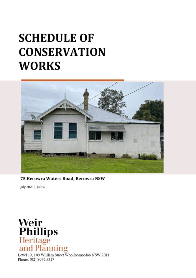
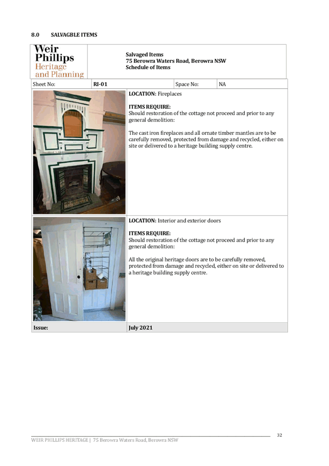
Item 4 LPP40/21 ELECTRONIC - DA/1074/2021 - Demolition of Heritage Listed Dwelling House - 75 Berowra Waters Road, Berowra................................................................................. 55
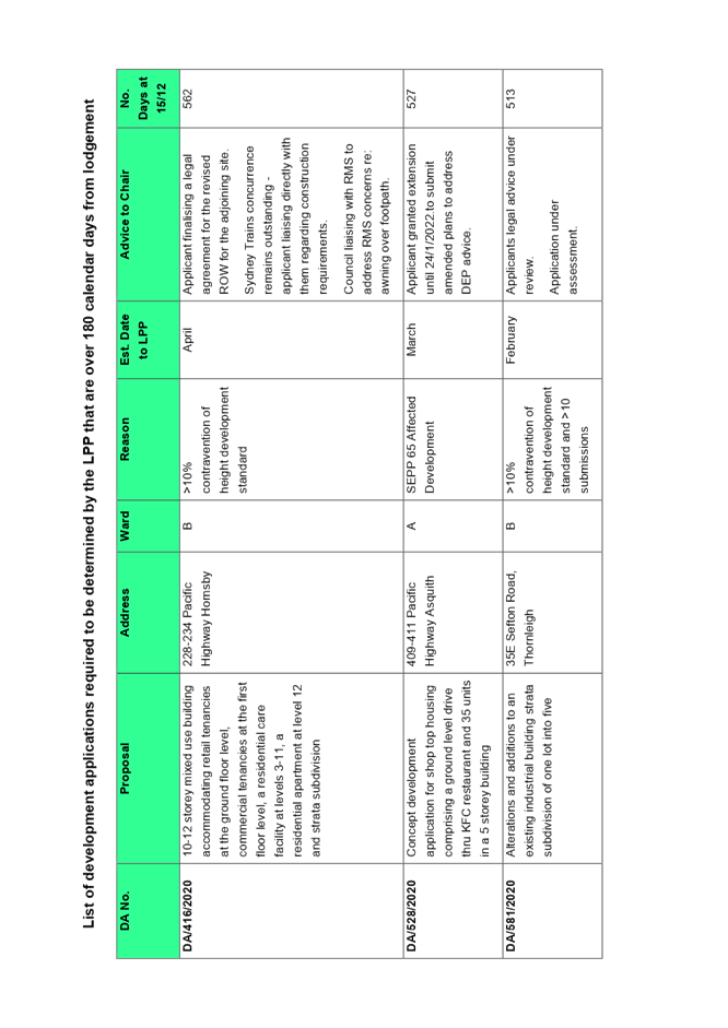
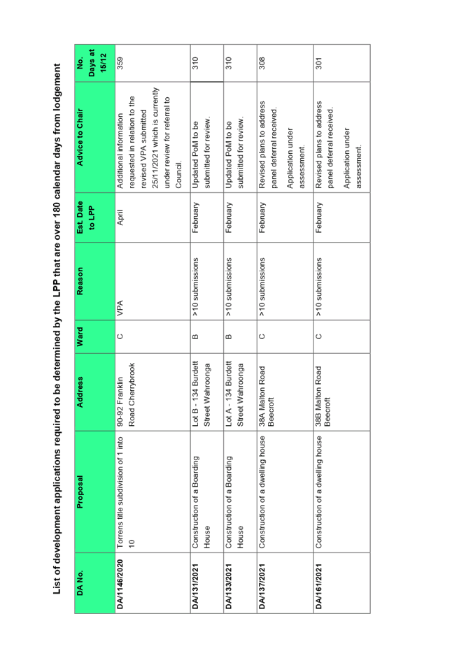
Item 5 LPP41/21 ELECTRONIC - Reporting Development Applications for Determination by the Hornsby Local Planning Panel over 180 Days........................................................... 163
LPP Report No. LPP39/21
Local Planning Panel
Date of Meeting: 15/12/2021
3 ELECTRONIC - DA/959/2021 - ALERATIONS AND ADDITIONS TO A DWELLING HOUSE - 46 MARINE CRESCENT, HORNSBY HEIGHTS
EXECUTIVE SUMMARY
|
DA No: |
DA/959/2021 (Lodged on 16 September 2021) |
|
Description: |
Alterations and additions to a Dwelling House |
|
Property: |
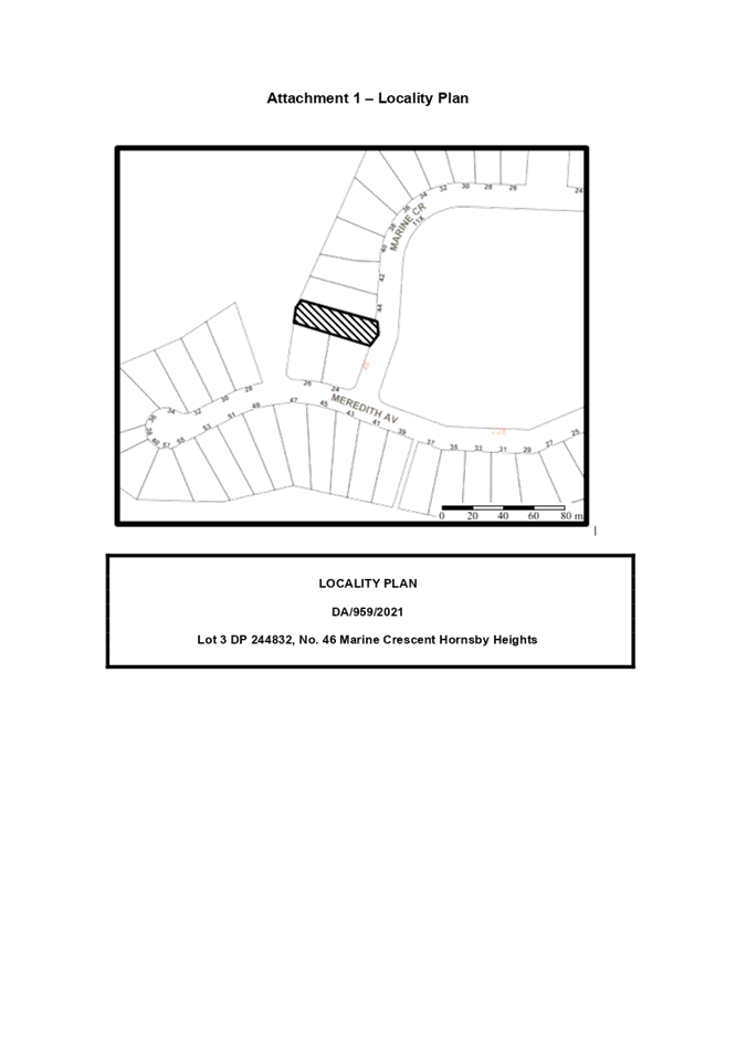
Lot 3 DP 244832, No. 46 Marine Crescent, Hornsby Heights |
|
Applicant: |
Mr Robert Vergara |
|
Owner: |
Mr Robert Vergara |
|
Estimated Value: |
$555,000 |
|
Ward: |
A Ward |
· The proposal does not comply with Clause 4.3 ‘Height of Buildings’ of the Hornsby Local Environmental Plan 2013. The applicant has made a submission in accordance with Clause 4.6 ‘Exceptions to development standards’ of the Hornsby Local Environmental Plan 2013 to contravene the building height standard. The submission is considered well founded and is supported.
· The application is required to be determined by the Hornsby Council Local Planning Panel as the proposed development would contravene the ‘Height of Buildings’ development standard by more than 10%.
· The proposal generally complies with the Hornsby Development Control Plan 2013 other than with regard to building height.
· No submissions have been received in respect of the application.
· It is recommended that the application be approved.
|
THAT the Hornsby Shire Local Planning Panel assume the concurrence of the Secretary of the Department of Planning and Environment pursuant to Clause 4.6 of the Hornsby Local Environmental Plan 2013 and approve Development Application No. DA/959/2021 for alterations and additions to a dwelling house at Lot 3 DP 244832, No. 46 Marine Crescent, Hornsby Heights, subject to the conditions of consent detailed in Schedule 1 of LPP Report No. LPP39/21. |
BACKGROUND
On 13 May 2009, Council approved DA/323/2009 for the construction of a rear first floor level and ground level covered decks, subject to conditions.
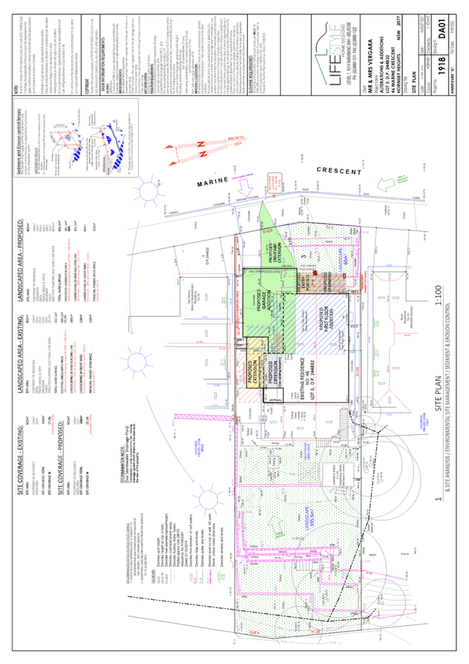
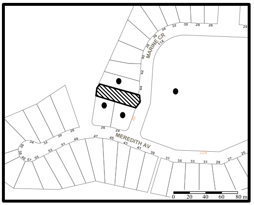
SITE
The 822m2 site is located on the western side of Marine Crescent, Hornsby Heights and contains a one and two-storey dwelling house. The site experiences a fall of 12 metres to the rear north western corner of the site.
The site is bushfire prone but not flood prone.
The site is not burdened or benefitted by any easements or restrictions.
The site does not contain a heritage listed item and is not within a heritage conservation area.
The site is adjacent to heritage listed item No. 560, namely “Hopeville Park” as listed in Schedule 5 Environmental Heritage of the Hornsby Local Environmental Plan 2013.
PROPOSAL
The application proposes alterations and additions to a dwelling house as follows:
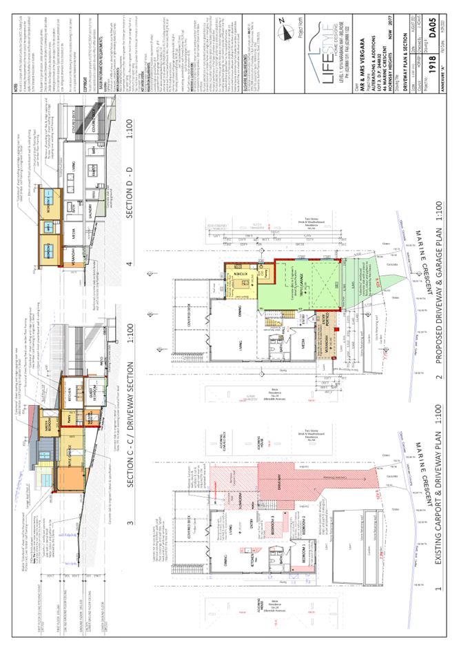
· The construction of a new driveway.
· Alterations to the lower ground floor level including extending the guest bedroom, construction of a laundry, hallway and internal stairwell.
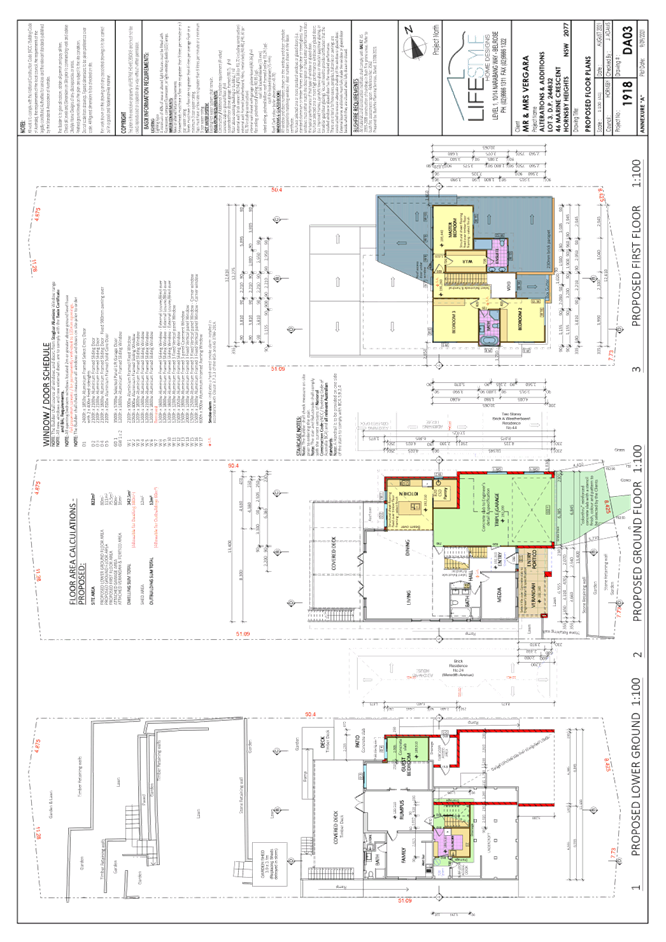
· Alterations to the ground floor level including a kitchen and pantry, a three-car garage and reconfiguring the floor plan for an open living and dining area.
· Construction of a first-floor addition.
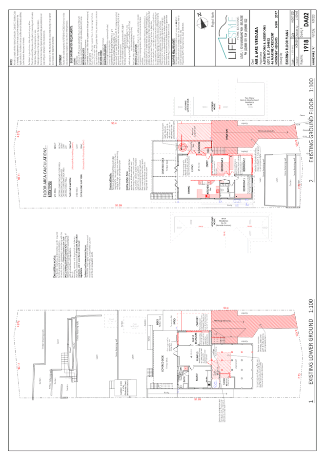
The lower ground floor would comprise of a laundry, family room, rumpus room, bathroom, guest bedroom and covered deck.
The ground floor would comprise of a three-car garage, an entryway, a media room, a bathroom, a living/dining room, a kitchen with attached pantry and a covered deck.
Three bedrooms, a bathroom, a walk-in wardrobe and an en-suite would be located on the first-floor level.
No trees would be removed or impacted by the development.
ASSESSMENT
The development application has been assessed having regard to the Greater Sydney Region Plan – A Metropolis of Three Cities, the North District Plan and the matters for consideration prescribed under Section 4.15 of the Environmental Planning and Assessment Act 1979 (the Act). The following issues have been identified for further consideration.
1. STRATEGIC CONTEXT
1.1 Greater Sydney Region Plan - A Metropolis of Three Cities and North District Plan
The Greater Sydney Region Plan - A Metropolis of Three Cities has been prepared by the NSW State Government to guide land use planning decisions for the next 40 years (to 2056). The Plan sets a strategy and actions for accommodating Sydney’s future population growth and identifies dwelling targets to ensure supply meets demand. The Plan also identifies that the most suitable areas for new housing are in locations close to jobs, public transport, community facilities and services.
The NSW Government will use the subregional planning process to define objectives and set goals for job creation, housing supply and choice in each subregion. Hornsby Shire has been grouped with Hunters Hill, Ku-ring-gai, Lane Cove, Mosman, North Sydney, Ryde, Northern Beaches and Willoughby to form the North District. The Greater Sydney Commission has released the North District Plan which includes priorities and actions for Northern District for the next 20 years. The identified challenge for Hornsby Shire will be to provide an additional 4,350 dwellings by 2021 with further strategic supply targets to be identified to deliver 97,000 additional dwellings in the North District by 2036.
The proposed development would be consistent with the Greater Sydney Region Plan - A Metropolis of Three Cities and the North District Plan, by contributing to achieving the dwelling targets for the region.
2. STATUTORY CONTROLS
Section 4.15(1)(a) requires Council to consider “any relevant environmental planning instruments, draft environmental planning instruments, development control plans, planning agreements and regulations”.
2.1 Hornsby Local Environmental Plan 2013
The proposed development has been assessed having regard to the provisions of the Hornsby Local Environmental Plan 2013 (HLEP).
2.1.1 Zoning of Land and Permissibility
The subject land is zoned R2 Low density residential under the HLEP. The objectives of the R2 zone are:
· To provide for the housing needs of the community within a low-density residential environment; and
· To enable other land uses that provide facilities or services to meet the day to day needs of residents.
The proposed development is defined as a ‘dwelling house’ and is permissible with Council’s consent. The proposed development meets the objectives of the R2 zone.
2.1.2 Height of Buildings
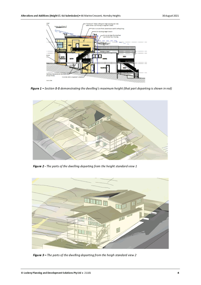
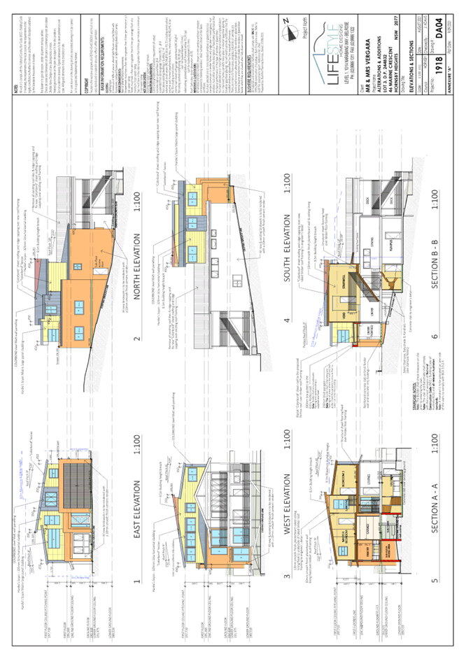
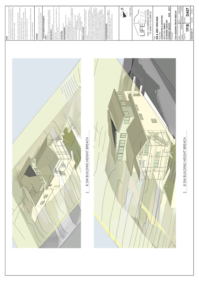
Clause 4.3 of the HLEP provides that the height of a building on any land should not exceed the maximum height show for the land on the Height of Buildings Map. The maximum permissible height for the subject site is 8.5 metres. The proposal has a maximum height of 9.831 metres and does not comply with the maximum height development standard.
The applicant has submitted justification for the non-compliance in accordance with Clause 4.6 of the HLEP as discussed in Section 2.1.3.
2.1.3 Exceptions to Development Standards
The application has been assessed against the requirements of Clause 4.6 of the HLEP. This clause provides flexibility in the application of the development standards in circumstances where strict compliance with those standards would, in any particular case, be unreasonable or unnecessary or tender to hinder the attainment of the objectives of the zone.
The proposal exceeds the Height of Buildings development standard for the R2 Low density residential zone which is 8.5 metres as prescribed under Clause 4.3 ‘Height of Buildings’ of the HLEP.
The objective of the Height of Buildings control is to permit building heights that are appropriate for the site constraints, development potential and infrastructure capacity of the locality.
The applicant has made a submission in support of a contravention to the development standard in accordance with Clause 4.6 of the HLEP. The development application seeks to contravene the development standard by 15.7% to 9.831 metres. The applicant states the proposed contravention is consistent with the objectives of the control and is justified as follows:
· Maintains a low-density single dwelling house land use on the site, consistent with the locality’s overarching land use character.
· Is located on a site of sufficient size to appropriately accommodate the proposal.
· Undertakes works which are not visually intrusive or bulky when viewed from the surrounding public domain.
· Provides a built form that is consistent with the locality’s prevailing character and will add architectural integrity to an otherwise non-descript residential locality.
· Has no identifiable impact on any ecological, scientific or aesthetic values, bushland, natural drainage patterns and generally maintains the site’s topographical characteristics.
· Proposes a high-quality design solution and predominantly unaltered landscape condition on a site that does not have any aesthetic, historical, built form or social significance.
· There are no unreasonable amenity impacts to neighbouring and nearby properties and the surrounding public domain.
· The scale of the proposal is characterised by the desired future character for the area. The height, bulk and scale of the built form does not influence or set a precedent for future buildings on neighbouring or nearby properties. Rather the altered dwelling sits comfortably in the site’s wider visual context as viewed from the surrounding public domain, given the scale and form of development (as anticipated by the planning controls) and as existing in the site’s vicinity.
· Compliance is maintained with the floor area, site coverage, setbacks, landscaped area and private open space complementary development guidelines. The dwelling sits within a park/ like setting and the overall built form is typically anticipated by the planning controls.
· The building volume has been designed to be articulated, visually interesting, and to facilitate a contextually appropriate massing. The elevations are articulated in response to the form and size of the dwelling. The proposed design is re-interpreting established roof shapes and slopes, whilst integrating contemporary materials and an architectural aesthetic.
State Government Guidelines on contravening development standards recommend considering the provisions of Clause 4.6 of the LEP and the ‘five-part test’ established by the Land and Environment Court as follows:
1. The objectives of the standard are achieved notwithstanding non-compliance with the standard.
2. The underlying objective or purpose of the standard is not relevant to the development and therefore compliance is unnecessary.
3. The underlying object of purpose would be defeated or thwarted if compliance was required and therefore compliance is unreasonable.
4. The development standard has been virtually abandoned or destroyed by the council’s own actions in granting consents departing from the standard and hence compliance with the standard is unnecessary and unreasonable.
5. The compliance with development standard is unreasonable or inappropriate due to existing use of land and current environmental character of the particular parcel of land. That is, the particular parcel of land should not have been included in the zone.
The applicant’s submission to contravene the 8.5 metre development standard is considered well founded for the following reasons:
· The proposal is consistent with the objectives of the height standard which are to manage form and scale and to protect amenity and area character.
· The site is significantly constrained by the existing finished floor levels of the existing dwelling house.
· The proposed addition would maintain a two-storey dwelling house appearance when viewed from Marine Crescent.
· The proposed addition would not create any adverse amenity impacts to adjoining properties in regard to sunlight access or privacy as discussed below in the body of this report.
· Strict numeric compliance would not materially change the development or improve the residential living amenity of the house.
· Strict numeric compliance would result in the detrimental changes and is not considered necessary as the proposal will not change the appearance or scale of the site within the local context and the dwelling is consistent with the relevant planning objectives.
· The application provides for the orderly and economic development of land, improvement of living conditions of the existing low-density residence and adequate protection of the environment and public interest.
· The proposed development generally meets the objectives of Clause 4.3 Height of Buildings of the HLEP by way of being appropriate with respect to the constraints of the site and in regard to the development potential of the site.
Based on this assessment, it is considered that compliance with the development standard would be unreasonable and unnecessary in the circumstances of the case. Accordingly, the Clause 4.6 submission is supported.
2.1.4 Heritage Conservation
Clause 5.10 of the HLEP sets out heritage conservation provisions for Hornsby Shire. The site does not include a heritage item and is not located in a heritage conservation area. The site is adjacent to heritage listed item No. 560, namely “Hopeville Park” as listed in Schedule 5 Environmental Heritage of the HLEP.
Noting that the proposed alterations and additions would appear as two storeys when viewed from Marine Crescent, it is generally considered that the proposed development would be consistent with existing development along Marine Crescent and would not detract from the heritage significance of the heritage listed item.
Accordingly, no objections are raised on heritage grounds to the proposed development.
2.1.5 Earthworks
Clause 6.2 of the HLEP states that consent is required for proposed earthworks on site. Before granting consent for earthworks, Council is required to assess the impacts of the works on adjoining properties, drainage patterns and soil stability of the locality.
Council’s assessment of the proposed works and excavation concludes that there will be minor excavation, approximately 4m3 to facilitate the proposed development including the minor excavation for the lower ground floor laundry and foundations.
Appropriate conditions are recommended in Schedule 1 of this report requiring any excavated materials to be removed from the site must be classified by a suitably qualified environmental consultant in accordance with the NSW Environment Protection Authority’s Waste Classification Guidelines and Protection of the Environment Operations (Waste) Regulation 2014 prior to disposal to a licensed waste management facility.
2.2 State Environmental Planning Policy (Exempt and Complying Development Codes) 2008 - NSW Housing Code
The application has been considered against the requirements of State Environmental Planning Policy (Exempt and Complying Development Codes) 2008 (NSW Housing Code). The Policy provides exempt and complying development codes that have State-wide application. The Policy also identifies types of development that are of minimal environmental impact that may be carried out without the need for development consent and types of Complying Development (including dwelling houses) that may be carried out in accordance with a Complying Development Certificate.
The site is subject to bushfire risk and is in exceedance of the maximum building height which precludes the development from being approved as Complying Development. The proposed dwelling house additions would otherwise comply with the numerical standards for Complying Development contained within the SEPP.
2.3 State Environmental Planning Policy No. 55 Remediation of Land
The policy provides guidelines for the remediation of contaminated land for the purpose of reducing the risk of harm to human health or any other aspect of the environment. Clause 7 requires Council to consider whether land is contaminated prior to granting consent to the carrying out of any development on that land.
Should the land be contaminated, Council must be satisfied that the land is suitable in a contaminated state for the proposed use. If the land requires remediation to be undertaken to make the land suitable for the proposed use, Council must be satisfied that the land will be remediated before the land is used for that purpose.
A review of Council’s records and aerial photographs indicate that the site has been historically used for residential purposes. It is not likely that the site has experienced any significant contamination, and further assessment under SEPP 55 is not required.
2.4 SEPP (Building Sustainability Index: BASIX) 2004
The application has been assessed against the requirements of State Environmental Planning Policy (Building Sustainability Index: BASIX) 2004. The proposal includes a BASIX Certificate for the proposed alterations and additions, which is considered to be satisfactory. A condition is recommended in Schedule 1 of this report requiring the recommendations of the BASIX certificate be complied with.
2.5 State Environmental Planning Policy (Vegetation in non-rural areas) 2017
The application has been assessed against the requirements of State Environmental Planning Policy (Vegetation in Non-Rural Areas) 2017 (Vegetation SEPP). This Policy seeks to protect the biodiversity values of trees and other vegetation in non-rural areas of the State, and to preserve the amenity of non-rural areas of the State through the preservation of trees and other vegetation.
Part 3 of the Vegetation SEPP states that a development control plan may make a declaration in any manner relating to species, size, location and presence of vegetation. Accordingly, Part 1B.6.1 of the Hornsby Development Control Plan 2013 (HDCP) prescribes works that can be undertaken with or without consent to trees.
It is noted that no trees are proposed to be removed as a part of this application. Accordingly, a further assessment against Part 1B.6.1 of the HDCP was not required.
2.6 Sydney Regional Environmental Plan No. 20 Hawkesbury-Nepean River
The site is located within the catchment of the Hawkesbury Nepean River. Part 2 of this Plan contains general planning considerations and strategies requiring Council to consider the impacts of development on water quality, aquaculture, recreation and tourism.
Subject to the implementation of sediment and erosion control measures and stormwater management to protect water quality, the proposal would comply with the requirements of the Policy.
2.7 Section 3.42 Environmental Planning and Assessment Act 1979 - Purpose and Status of Development Control Plans
Section 3.42 of the Environmental Planning and Assessment Act 1979 states that a DCP provision will have no effect if it prevents or unreasonably restricts development that is otherwise permitted and complies with the development standards in relevant Local Environmental Plans and State Environmental Planning Policies.
The principal purpose of a development control plan is to provide guidance on the aims of any environmental planning instrument that applies to the development; facilitate development that is permissible under any such instrument; and achieve the objectives of land zones. The provisions contained in a DCP are not statutory requirements and are for guidance purposes only. Consent authorities have flexibility to consider innovative solutions when assessing development proposals, to assist achieve good planning outcomes.
2.8 Hornsby Development Control Plan 2013
The proposed development has been assessed having regard to the relevant desired outcomes and prescriptive requirements within the Hornsby Development Control Plan 2013 (HDCP). The following table sets out the proposal’s compliance with the prescriptive requirements of the Plan:
|
HDCP - Part 3.1 Dwelling Houses |
|||
|
Control |
Proposal |
Requirement |
Complies |
|
Site Area |
822m2 |
N/A |
N/A |
|
Building Height |
9.831m |
8.5m |
No |
|
No. storeys |
3 |
max. 2 + attic |
No |
|
Site Coverage |
25% |
50% (max) |
Yes |
|
Floor Area |
338m2 |
380m2 |
Yes |
|
Setbacks |
|
|
|
|
- Front (Marine Crescent) |
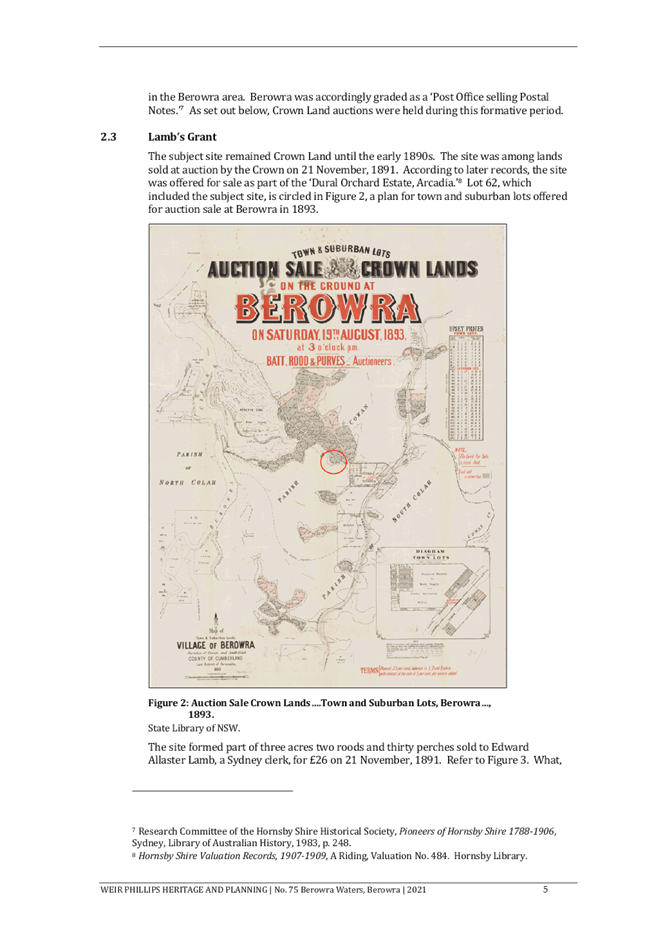
4.4m |
6m |
No |
|
- Side (north) |
|
|
|
|
Ground floor |
1.03m |
0.9m |
Yes |
|
First floor |
1.66m |
1.5m |
Yes |
|
- Side (south) |
|
|
|
|
Ground floor |
1.5m (existing) |
0.9m |
Yes |
|
First floor |
1.7m |
1.5m |
Yes |
|
- Rear (west) |
|
|
|
|
Ground floor |
24m (existing) |
3m |
Yes |
|
First floor |
35m |
8m |
Yes |
|
Landscaped Area (% of lot size) |
48% |
30% (min) |
Yes |
|
Private Open Space |
|
|
|
|
- minimum area |
47m2 |
24m2 |
Yes |
|
- minimum dimension |
4.6m2 |
3m |
Yes |
|
Car Parking |
3 spaces |
2 spaces |
Yes |
As detailed in the above table, the proposed development does not comply with a number of prescriptive requirements within the HDCP. The matters of non-compliance are detailed below, as well as a brief discussion on compliance with relevant desired outcomes.
2.8.1 Scale
The desired outcome of Part 3.1.1 Scale of the HDCP is for ‘development with a height, bulk and scale that is compatible with a low-density residential environment’.
This is supported by the prescriptive measures which state that ‘sites with the maximum building heights under Clause 4.3 of the HLEP should comply with the maximum number of storeys in Table 3.1.1(a).’
The proposed roof is situated 9.831 metres above natural ground level which does not comply with Part 3.1.1 Scale of the HDCP and Clause 4.3 of HLEP.
In support of this non-compliance, it is noted that the slope of the site is a significant constraint for any development on the site. It is also noted that the proposed addition has been designed to provide an internal lift for the occupants of the dwelling.
The applicant has made a submission pursuant to Clause 4.6 of the HLEP which has adequately addressed this non-compliance which is discussed in detail in Section 2.1.3 above.
The proposed development does not comply with Table 3.1.1(a) of the HDCP which prescribes a maximum two storeys for dwelling houses. The proposed development proposes a three storey dwelling house when viewed from the side elevations.
In support of the proposed development, it is noted that the proposal would be two storeys when viewed from Marine Crescent which is consistent with other residential developments within the locality.
It is noted that the development would only be viewed as three storeys when viewed from the side elevations and would predominately be a two storey development. It is noted that the proposal would be of a height, bulk and scale that is compatible within the low-density residential zone. The location of the proposed development would not visually detract from the Marine Crescent streetscape or create adverse environmental, or amenity impacts to adjoining properties. As a result, the proposal is generally consistent with the desired outcomes of Part 3.1.1 Scale and as discussed above in Section 2.1.3 with Clause 4.3 Height of Buildings of the HLEP. Accordingly, no objections are raised to the proposal on planning grounds.
The proposal meets the desired outcomes of Part 3.1.1 Scale of the HDCP and is considered acceptable.
2.8.2 Setbacks
This is supported by the prescriptive measure set out in Table 3.1.2(a): Minimum Boundary Setbacks which prescribes a minimum front boundary setback of 6 metres for single storey elements.
The application proposes a front boundary setback of 4.4 metres for the proposed garage which does not comply with the 6-metre prescriptive measure.
In support of the 1.6 metre encroachment, it is noted that DA/236/2018 granted consent for alterations and additions to a dwelling house including a garage forward of the building line to the neighbouring property No. 44 Marine Crescent with a front boundary setback of 4 metres. The application proposes a 4.4 to 5.7 metre front boundary setback which conforms to the existing streetscape. It is generally considered that the proposed development would have negligible impacts on the streetscape of Marine Crescent.
The proposal meets the desired outcomes of Part 3.1.2 Setbacks of the HDCP and is considered acceptable.
2.8.3 Sunlight Access
The desired outcomes of Part 3.1.5 Sunlight Access of the HDCP is to encourage “dwelling houses designed to provide solar access to open space areas” and “development designed to provide reasonable sunlight to adjacent properties”.
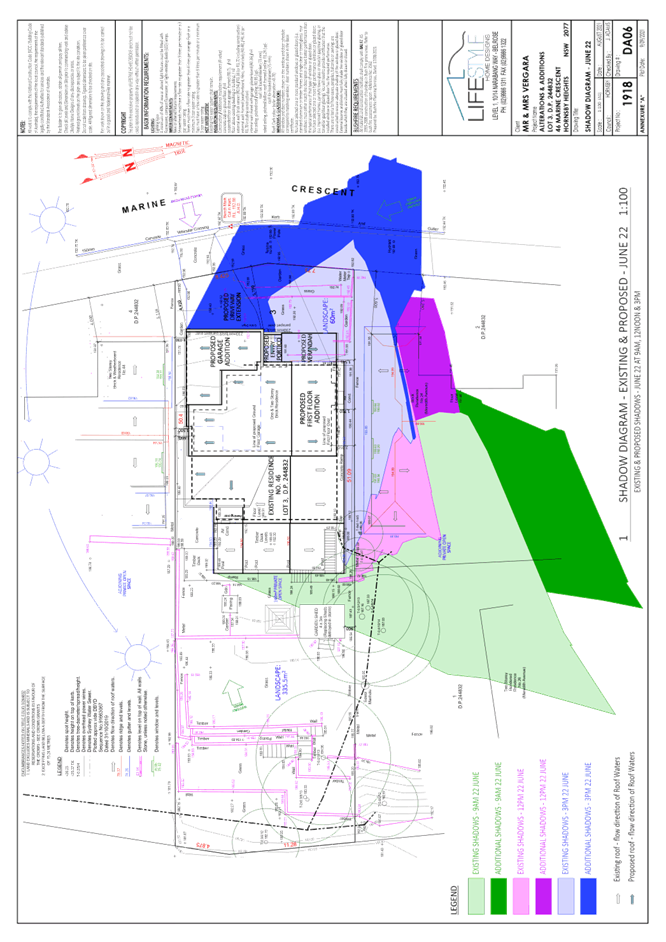
This is supported by the prescriptive measure 3.1.5(a) requiring “50 per cent of the principal private open space of the subject site to receive at least 3 hours of unobstructed sunlight access between 9am and 3pm” during the day of the winter solstice and prescriptive measure 3.1.5(b) requiring “50 per cent of the principal private open space on any adjoining property to receive at least 3 hours of unobstructed sunlight access between 9am and 3pm.”
An assessment of the shadow diagrams provided by the applicant illustrate that the subject site and the southern adjacent neighbours, No. 24 and 26 Meredith Avenue would still receive at least 3 hours of unobstructed sunlight access to 50 per cent of their private open space between 9am and 3pm on the day of the winter solstice.
The proposal meets the desired outcomes of Part 3.1.5 Sunlight Access of the HDCP and is considered acceptable.
2.8.4 Bushfire
The desired outcomes of Part 1C.3.1 Bushfire of the HDCP are to encourage ‘development that is located and designed to minimise the risk to life and property from bushfire’ and to encourage ‘development that balances the conservation of native vegetation and bushfire protection’.
The application has provided a Bushfire Assessment Report prepared by Bushfire Planning and Design dated 17 August 2021.
The Bushfire Hazard Assessment Report recommended that any development on the site be built to the requirements of AS3959-2018 Construction of buildings in bushfire-prone areas in accordance with the requirements for Bushfire Attack Level (BAL) FZ (Flame Zone) and the relevant sections of Planning for Bushfire Protection 2019.
In accordance with Council’s assessment protocol for development in BAL-FZ, the application was referred to the NSW Rural Fire Service (RFS) for review. The RFS raised no objections to the proposal subject to conditions.
Conditions reflecting the RFS requirements have been recommended in Schedule 1 of this report with regard to the utilisation of BAL-FZ fire retardant construction materials and the maintenance of the entire property as an Inner Protection Area (IPA) in perpetuity.
The proposal meets the desired outcomes of Part 1C.3.1 Bushfire of the HDCP and is considered acceptable, subject to conditions.
2.8.5 Privacy
The desired outcome of Part 3.1.6 Privacy of the HDCP is to encourage “development that is designed to provide reasonable privacy to adjacent properties.”
The application proposes alterations and additions to a dwelling house in the form of a first floor addition, garage, and ground floor extension.
It is noted that no entertainment rooms are proposed within the first floor addition, it is generally considered that the proposed first floor addition would create negligible amenity impacts to adjoining properties.
It is also noted that the proposed pantry would contain one window within the side, northern elevation, (W2) and two windows within the northern elevation of the garage (GW1 and GW2). Noting that these windows do not service entertainment rooms, no objections are raised to these windows on privacy grounds.
As the application does not include any windows that would overlook the private open space (POS) of adjoining properties, no objections are raised to the proposed development on planning grounds and is considered acceptable.
The proposal meets the desired outcome of Part 3.1.6 Privacy of the HDCP and is considered acceptable.
2.9 Section 7.12 Contributions Plans
Hornsby Shire Council Section 7.12 Contributions Plan 2019-2029 applies to the development as the estimated costs of works is greater than $100,000. Should the application be approved, an appropriate condition of consent is recommended requiring the payment of a contribution in accordance with the Plan.
3. ENVIRONMENTAL IMPACTS
Section 4.15(1)(b) of the Act requires Council to consider “the likely impacts of that development, including environmental impacts on both the natural and built environments, and social and economic impacts in the locality”.
3.1 Natural Environment
3.1.1 Tree and Vegetation Preservation
The proposed development does not require the removal of any trees and would not impact any trees.
3.1.2 Stormwater Management
The application proposes all stormwater would be directed to the rear of the site and disposed of into the National Park which abuts the rear of the site.
Council does not support the proposed stormwater management system as this will cause on-going erosion issues within the National Park and all stormwater should be disposed of within the subject site.
To address this, a condition is recommended in Schedule 1 of this report, requiring absorption trenches to be located within the subject site to reduce erosion and runoff into the National Park and adjoining properties.
3.2 Built Environment
3.2.1 Built Form
The proposal would generally be consistent with the built form of the surrounding low-density residential area which consists of dwelling houses ranging from single storey, split level, two storey and three storeys with excavated garages.
3.3 Social Impacts
The proposed development would have a positive social impact for the occupants of the dwelling by improving accessibility within the dwelling. This is consistent with Council’s Housing Strategy which identifies the need to provide a mix of housing options to meet future demographic needs in Hornsby Shire.
3.4 Economic Impacts
The proposal would have a minor positive impact on the local economy in conjunction with other new low-density residential development in the locality by generating an increase in demand for local services.
4. SITE SUITABILITY
Section 4.15(1)(c) of the Act requires Council to consider “the suitability of the site for the development”.
4.1 Bushfire Risk
As noted in Section 2.8.3 Bushfire of this report, the subject site is identified as bushfire prone and the application was referred to the NSW Rural Fire Service for comment.
Conditions of concurrence provided by the RFS have been recommended under Schedule 1 of this report with regard to the utilisation of BAL FZ fire retardant construction materials and the maintenance of the entire property as an Inner Protection Area (IPA) in perpetuity.
5. PUBLIC PARTICIPATION
Section 4.15(1)(d) of the Act requires Council to consider “any submissions made in accordance with this Act”.
5.1 Community Consultation
The proposed development was placed on public exhibition and was notified to adjoining and nearby landowners between 21 September 2021 and 12 October 2021 in accordance with the Hornsby Community Engagement Plan. During this period, Council did not receive any submissions. The map below illustrates the location of those properties who were notified during the notification period.
|
NOTIFICATION PLAN |
|||
|
• PROPERTIES NOTIFIED |
X SUBMISSIONS RECEIVED |
|
|
5.2 Public Agencies
As discussed in Section 4.1, the development application was referred to NSW Rural Fire Service for comment and no objections were raised to the proposed development subject to the conditions recommended in Schedule 1.
6. THE PUBLIC INTEREST
Section 4.15(1)(e) of the Act requires Council to consider “the public interest”.
The public interest is an overarching requirement, which includes the consideration of the matters discussed in this report. Implicit to the public interest is the achievement of future built outcomes adequately responding to and respecting the future desired outcomes expressed in environmental planning instruments and development control plans.
The application is considered to have satisfactorily addressed Council’s and relevant agencies’ criteria and would provide a development outcome that, on balance, would result in a positive impact for the community. Accordingly, it is considered that the approval of the proposed development would be in the public interest.
CONCLUSION
The application proposes alterations and additions to a dwelling house.
The development generally meets the desired outcomes of Council’s planning controls and is satisfactory having regard to the matters for consideration under Section 4.15 of the Environmental Planning and Assessment Act 1979.
Having regard to the circumstances of the case, approval of the application is recommended.
The reasons for this decision are:
· The proposed development generally complies with the requirements of the relevant environmental planning instruments and the Hornsby Development Control Plan 2013 other than height.
· The request under Clause 4.6 of Hornsby Local Environmental Plan 2013 to contravene the ‘Height of Buildings’ Development Standard is well founded. Strict compliance with the development standard is unreasonable and unnecessary in the circumstances of the case and there are sufficient environmental planning grounds to justify the contravention to the development standards.
· The proposed development does not create unreasonable environmental impacts to adjoining development with regard to visual bulk, overshadowing, solar access, amenity or privacy.
Note: At the time of the completion of this planning report, no persons have made a Political Donations Disclosure Statement pursuant to Section 10.4 of the Environmental Planning and Assessment Act 1979 in respect of the subject planning application.
RESPONSIBLE OFFICER
The officer responsible for the preparation of this report is Tim Buwalda.
|
Cassandra Williams Major Development Manager - Development Assessments Planning and Compliance Division |
Rod Pickles Manager - Development Assessments Planning and Compliance Division |
|
1.⇩ |
Locality Plan |
|
|
|
2.⇩ |
Clause 4.6 |
|
|
|
3.⇩ |
Architectural Plans |
|
|
File Reference: DA/959/2021
Document Number: D08296334
SCHEDULE 1
GENERAL CONDITIONS
The conditions of consent within this notice of determination have been applied to ensure that the use of the land and/or building is carried out in such a manner that is consistent with the aims and objectives of the relevant legislation, planning instruments and council policies affecting the land and does not disrupt the amenity of the neighbourhood or impact upon the environment.
Note: For the purpose of this consent, the term ‘applicant’ means any person who has the authority to act on or the benefit of the development consent.
Note: For the purpose of this consent, any reference to an Act, Regulation, Australian Standard or publication by a public authority shall be taken to mean the gazetted Act or Regulation, or adopted Australian Standard or publication as in force on the date that the application for a construction certificate is made.
1. Approved Plans and Supporting Documentation
The development must be carried out in accordance with the plans and documentation listed below and endorsed with Council’s stamp, except where amended by Council and/or other conditions of this consent:
Approved plans:
|
Plan No. |
Plan Title |
Drawn by |
Dated |
Council reference |
|
DA01 |
Site Plan |
Lifestyle Home Designs |
09/09/2021 |
|
|
DA02 |
Demolition Plans |
Lifestyle Home Designs |
09/09/2021 |
|
|
DA03 |
Proposed Floor Plans |
Lifestyle Home Designs |
09/09/2021 |
|
|
DA04 |
Elevations and Sections |
Lifestyle Home Designs |
09/09/2021 |
|
|
DA05 |
Driveway Plan and Section |
Lifestyle Home Designs |
09/09/2021 |
|
Supporting documents
|
Document Title |
Prepared by |
Dated |
Council reference |
|
Boundary Survey Plan Ref: 2627 DS Sheet 1 of 1 Issue A |
Richards & Loftus |
06/11/2019 |
D08249433 |
|
Bushfire Assessment Report Ref: 3562 |
Bushfire Planning and Design |
17/08/2021 |
D08249432 |
|
BASIX Certificate No. A427542 |
Lifestyle Home Designs |
09/09/2021 |
D08249434 |
|
Waste Management Plan |
Robert Vergara |
17/08/2021 |
D08249436 |
|
External Colours and Finishes |
Michele Galvin Interiors |
unknown |
D08249449 |
2. Construction Certificate
a) A Construction Certificate is required to be approved by Council or a Private Certifying Authority prior to the commencement of any construction works under this consent.
b) The Construction Certificate plans must include all requirements imposed by the NSW Rural Fire.
c) The Construction Certificate plans must be consistent with the Development Consent plans.
3. Section 7.12 Development Contributions
a) In accordance with Section 4.17(1) of the Environmental Planning and Assessment Act 1979 and the Hornsby Shire Council Section 7.12 Development Contributions Plan 2019 - 2029, $5,550 must be paid towards the provision, extension or augmentation of public amenities or public services, based on development costs of $555,000.
b) The value of this contribution is current as of 22 November 2021. If the contributions are not paid within the financial quarter that this consent is granted, the contributions payable will be adjusted in accordance with the provisions of the Hornsby Shire Council Section 7.12 Development Contributions Plan and the amount payable will be calculated at the time of payment in the following manner:
|
$CPY |
= |
|
|
$CDC x CPIPY |
|
|
|
|
|
CPIDC |
Where:
$CPY is the amount of the contribution at the date of Payment.
$CDC is the amount of the contribution as set out in this Development Consent.
CPIPY is the latest release of the Consumer Price Index (Sydney – All Groups) at the date of Payment as published by the ABS.
CPIDC is the Consumer Price Index (Sydney – All Groups) for the financial quarter at the date of this Development Consent.
c) The monetary contributions shall be paid to Council:
(i) Prior to the issue of the Subdivision Certificate where the development is for subdivision.
(ii) Prior to the issue of the first Construction Certificate where the development is for building work.
(iii) Prior to issue of the Subdivision Certificate or first Construction Certificate, whichever occurs first, where the development involves both subdivision and building work.
(iv) Prior to the works commencing where the development does not require a Construction Certificate or Subdivision Certificate.
Note: It is the professional responsibility of the Principal Certifying Authority to ensure that the monetary contributions have been paid to Council in accordance with the above timeframes.
Note: In accordance with Ministerial Directions, the payment of contribution fees for development with a cost of works of over $10 million can be deferred to prior to Occupation Certificate.
Note: The Hornsby Shire Council Section 7.12 Development Contributions Plan may be viewed at www.hornsby.nsw.gov.au or a copy may be inspected at Council’s Administration Centre during normal business hours.
REQUIREMENTS PRIOR TO THE ISSUE OF A CONSTRUCTION CERTIFICATE
Detailed plans, specifications and supporting information is required to be submitted to the certifying authority detailing how the proposed building work achieves compliance with the National Construction Code - Building Code of Australia. All building work must be carried out in accordance with the requirements of the National Construction Code - Building Code of Australia.
5. Contract of Insurance (Residential Building Work)
Where residential building work for which the Home Building Act 1989 requires there to be a contract of insurance in force in accordance with Part 6 of that Act, this contract of insurance must be in force before any building work authorised to be carried out by the consent commences.
6. Notification of Home Building Act 1989 Requirements
Residential building work within the meaning of the Home Building Act 1989 must not be carried out unless the principal certifying authority for the development to which the work relates (not being Council) has given Council written notice of the following information:
a) In the case of work for which a principal contractor is required to be appointed:
i) The name and licence number of the principal contractor.
ii) The name of the insurer by which the work is insured under Part 6 of that Act.
b) In the case of work to be done by an owner-builder:
i) The name of the owner-builder.
ii) If the owner-builder is required to hold an owner-builder’s permit under that Act, the number of the owner-builder’s permit.
Note: If arrangements for doing the residential building work are changed while the work is in progress so that the information notified becomes out of date, further work must not be carried out unless the principal certifying authority for the development to which the work relates (not being Council) has given Council written notification of the updated information.
7. Sydney Water – Approval
This application must be submitted to Sydney Water for approval to determine whether the development would affect any Sydney Water infrastructure, and whether further requirements are to be met.
Note: Building plan approvals can be obtained online via Sydney Water Tap inTM through www.sydneywater.com.au under the Building and Development tab.
8. Stormwater Drainage
The stormwater drainage system for the development must be designed for an average recurrence interval (ARI) of 20 years and be gravity drained in accordance with the following requirements:
a) Roof water must be connected to a rainwater tank having a minimum capacity of 5000 litres.
b) The overflow from the rainwater tank and collected surface water must be discharged through a level spreader of 5 metres wide with energy dissipators in front, so as not to discharge stormwater in a concentrated manner.
c) Level spreader must be located within the subject site, 5 metres away from the rear property boundary.
d) The stormwater drainage system must be designed by a qualified hydraulic engineer.
9. Vehicular Crossing
A separate application under the Local Government Act 1993 and the Roads Act 1993 must be submitted to Council for widening/installation of the existing/new vehicular crossing. The vehicular crossing must be constructed in accordance with AUS-SPEC Specifications (www.hornsby.nsw.gov.au/property/build/aus-spec-terms-and-conditions) and the following requirements:
a) The vehicular crossing is to be constructed to the design levels obtained from Council.
b) Any redundant crossings must be replaced with integral kerb and gutter.
c) The footway area must be restored by turfing.
d) Approval must be obtained from all relevant utility providers that all necessary conduits be provided and protected under the crossing.
Note: An application for a vehicular crossing can only be made to one of Council’s Authorised Vehicular Crossing Contractors. You are advised to contact Council on 02 9847 6940 to obtain a list of contractors.
10. Internal Driveway/Vehicular Areas
The driveway widening must be designed, constructed and a Construction Certificate issued in accordance with Australian Standards AS2890.1, AS2890.2, AS3727 and the following requirements:
a) A separate application under the Local Government Act, 1993 and the Roads Act 1993 being an “Application for Boundary Levels” must be submitted to Council to obtain design levels at the front boundary for the design of the internal driveway, prior to the issue of a construction certificate.
b) The driveway be a rigid pavement.
c) The driveway grade must not exceed 25 percent and changes in grade must not exceed 8 percent per metre.
d) Longitudinal sections of the driveway shall be submitted to the principal certifying authority in accordance with the relevant sections of AS2890.1.
REQUIREMENTS PRIOR TO THE COMMENCEMENT OF ANY WORKS
11. Erection of Construction Sign
a) A sign must be erected in a prominent position on any site on which any approved work is being carried out:
i) Showing the name, address and telephone number of the principal certifying authority for the work.
ii) Showing the name of the principal contractor (if any) for any demolition or building work and a telephone number on which that person may be contacted outside working hours.
iii) Stating that unauthorised entry to the work site is prohibited.
b) The sign is to be maintained while the approved work is being carried out and must be removed when the work has been completed.
12. Protection of Adjoining Areas
A temporary hoarding, fence or awning must be erected between the work site and adjoining lands before the works begin and must be kept in place until after the completion of the works if the works:
a) Could cause a danger, obstruction, or inconvenience to pedestrian or vehicular traffic.
b) Could cause damage to adjoining lands by falling objects; and/or.
c) Involve the enclosure of a public place or part of a public place; and/or.
d) Have been identified as requiring a temporary hoarding, fence or awning within the Council approved Construction Management Plan (CMP).
Note: Notwithstanding the above, Council’s separate written approval is required prior to the erection of any structure or other obstruction on public land.
a) To provide a safe and hygienic workplace, toilet facilities must be available or be installed at the works site before works begin and must be maintained until the works are completed at a ratio of one toilet for every 20 persons employed at the site.
b) Each toilet must:
i) Be a standard flushing toilet connected to a public sewer.
ii) Be a temporary chemical closet approved under the Local Government Act 1993.
14. Erosion and Sediment Control
To protect the water quality of the downstream environment, erosion and sediment control measures must be provided and maintained throughout the construction period in accordance with the manual ‘Soils and Construction 2004 (Bluebook)’, the approved plans, Council specifications and to the satisfaction of the principal certifying authority. The erosion and sediment control devices must remain in place until the site has been stabilised and revegetated.
Note: On the spot penalties may be issued for any non-compliance with this requirement without any further notification or warning.
REQUIREMENTS DURING CONSTRUCTION
All works on site, including demolition and earth works, must only occur between 7am and 5pm Monday to Saturday.
No work is to be undertaken on Sundays or public holidays.
16. Demolition
To protect the surrounding environment, all demolition work must be carried out in accordance with Australian Standard AS2601-2001 Demolition of structures and the following requirements:
a) Demolition material must be disposed of to an authorised recycling and/or waste disposal site and/or in accordance with an approved waste management plan.
b) Demolition works, where asbestos material is being removed, must be undertaken by a contractor that holds an appropriate licence issued by SafeWork NSW in accordance with the Work Health and Safety Regulation 2017 and be appropriately transported and disposed of in accordance with the Protection of the Environment Operations (Waste) Regulation 2014.
c) On construction sites where any building contains asbestos material, a standard commercially manufactured sign containing the words ‘DANGER ASBESTOS REMOVAL IN PROGRESS’ and measuring not less than 400mm x 300mm must be displayed in a prominent position visible from the street.
17. Environmental Management
To prevent sediment run-off, excessive dust, noise or odour emanating from the site during the construction, the site must be managed in accordance with the publication ‘Managing Urban Stormwater - Landcom (March 2004) and the Protection of the Environment Operations Act 1997.
To ensure that the public reserve is kept in a clean, tidy and safe condition during construction works, no building materials, waste, machinery or related matter is to be stored on the road or footpath.
19. Disturbance of Existing Site
During construction works, the existing ground levels of open space areas and natural landscape features, including natural rock-outcrops, vegetation, soil and watercourses must not be altered unless otherwise nominated on the approved plans.
20. Landfill not Permitted
The importation of fill material associated with earthworks, or structural or engineering works, is not permitted as part of this consent.
21. Excavated Material
All excavated material removed from the site must be classified by a suitably qualified environmental consultant in accordance with the NSW Environment Protection Authority’s Waste Classification Guidelines and Protection of the Environment Operations (Waste) Regulation 2014 prior to disposal to a licensed waste management facility. Tipping dockets for the total volume of excavated material that are received from the licensed waste management facility must be provided to the principal certifying authority prior to the issue of an Occupation Certificate.
22. Survey Report
A report(s) must be prepared by a registered surveyor and submitted to the principal certifying authority:
a) Prior to the pouring of concrete at each level of the building certifying that:
i) The building, retaining walls and the like have been correctly positioned on the site.
ii) The finished floor level(s) are in accordance with the approved plans.
REQUIREMENTS PRIOR TO THE ISSUE OF AN OCCUPATION CERTIFICATE
23. Fulfilment of BASIX Commitments
The applicant must demonstrate the fulfilment of BASIX commitments pertaining to the development.
24. Bushfire Certification
Certification of compliance with all NSW Rural Fire Service requirements from a suitably qualified Bushfire Consultant must be submitted to the Principal Certifying Authority prior to issue of the Occupation Corticate.
25. Damage to Council Assets
To protect public property and infrastructure, any damage caused to Council’s assets as a result of the construction or demolition of the development must be rectified by the applicant in accordance with AUS-SPEC Specifications:
www.hornsby.nsw.gov.au/property/build/aus-spec-terms-and-conditions.
Rectification works must be undertaken prior to the issue of an Occupation Certificate, or sooner, as directed by Council.
CONDITIONS FOR CONCURENCE - NSW RURAL FIRE SERVICE
The following conditions of consent are from the nominated State Agency pursuant to Section 4.13 of the Environmental Planning and Assessment Act 1979 and must be complied with to the satisfaction of that Agency.
26. Asset Protection Zones
The intent of measures is to minimise the risk of bush fire attack and provide protection for emergency services personnel, residents and others assisting firefighting activities. To achieve this, the following conditions shall apply:
a) From the start of building works, and in perpetuity to ensure ongoing protection from the impact of bush fires, the entire property must be managed as an inner protection area (IPA) in accordance with the requirements of Appendix 4 of Planning for Bush Fire Protection 2019. When establishing and maintaining an IPA the following requirements apply:
i) Tree canopy cover should be less than 15% at maturity.
ii) Tees at maturity should not touch or overhang the building.
iii) Lower limbs should be removed up to a height of 2m above the ground.
iv) Tree canopies should be separated by 2 to 5m.
v) Preference should be given to smooth barked and evergreen trees.
vi) Large discontinuities or gaps in vegetation should be provided to slow down or break the progress of fire towards buildings.
vii) Shrubs should not be located under trees.
viii) Shrubs should not form more than 10% ground cover.
ix) Clumps of shrubs should be separated from exposed windows and doors by a distance of at least twice the height of the vegetation.
x) Grass should be kept mown (as a guide grass should be kept to no more than 100mm in height).
xi) Leaves and vegetation debris should be removed.
27. Construction Standards
The intent of measures is that buildings are designed and constructed to withstand the potential impacts of bush fire attack. To achieve this, the following conditions shall apply:
a) New construction must comply with Sections 3 (excluding 3.5) and Section 9 (BAL FZ) Australian Standard AS3959-2018 Construction of buildings in bush fire-prone areas or the relevant BAL-FZ requirements of the NASH Standard -Steel Framed Construction in Bushfire Areas (incorporating amendment A -2015). New construction must also comply with the construction requirements in Section 7.5 of Planning for Bushfire Protection 2019.
b) The existing dwelling must be upgraded to improve ember protection by enclosing all openings (excluding roof tile spaces) or covering openings with a non-corrosive metal screen mesh with a maximum aperture of 2mm. Where applicable, this includes any sub-floor areas, openable windows, vents, weep holes and eaves. External doors are to be fitted with draft excluders.
28. Water and Utility Services
The intent of measures is to minimise the risk of bush fire attack and provide protection for emergency services personnel, residents and others assisting firefighting activities. To achieve this, the following conditions shall apply:
a) The provision of water, electricity and gas must comply the following in accordance with Table 7.4a of Planning for Bush Fire Protection 2019:
i) Reticulated water is to be provided to the development where available.
ii) All above-ground water service pipes external to the building are metal, including and up to any taps.
iii) Where practicable, electrical transmission lines are underground.
iv) Where overhead, electrical transmission lines are proposed as follows:
a) Lines are installed with short pole spacing (30m), unless crossing gullies, gorges or riparian areas.
b) No part of a tree is closer to a power line than the distance set out in accordance with the specifications in ISSC3 Guideline for Managing Vegetation Near Power Lines.
v) Reticulated or bottled gas is installed and maintained in accordance with AS/NZS 1596:2014 and the requirements of relevant authorities, and metal piping is used.
vi) All fixed gas cylinders are kept clear of all flammable materials to a distance of 10m and shielded on the hazard side.
vii) Connections to and from gas cylinders are metal.
viii) Polymer sheathed flexible gas supply ‐ lines are not used.
iv) Above-ground gas service pipes are metal, including and up to any outlets.
29. Landscaping
The intent of measures is for landscaping. To achieve this, the following conditions must apply:
a) Landscaping within the required asset protection zone must comply with Appendix 4 of Planning for Bush Fire Protection 2019. In this regard, the following principles are to be incorporated:
i) A minimum 1-metre-wide area, suitable for pedestrian traffic, must be provided around the immediate curtilage of the building.
ii) Planting is limited in the immediate vicinity of the building.
iii) Planting does not provide a continuous canopy to the building (i.e., trees or shrubs are isolated or located in small clusters).
iv) Landscape species are chosen to ensure tree canopy cover is less than 15% (IPA), and less than 30% (OPA) at maturity and trees do no touch or overhang buildings.
v) Avoid species with rough fibrous bark, or which retain/shed bark in long strips or retain dead material in their canopies.
vi) Use smooth bark species of trees species which generally do not carry a fire up the bark into the crown.
vii) Avoid planting of deciduous species that may increase fuel at surface/ ground level (i.e., leaf litter).
viii) Avoid climbing species to walls and pergolas.
ix) Locate combustible materials such as woodchips/mulch, flammable fuel stores away from the building.
x) Locate combustible structures such as garden sheds, pergolas and materials such as timber garden furniture away from the building.
xi) Low flammability vegetation species are used.
OPERATIONAL CONDITIONS
30. Bushfire Protection Zones
The required bushfire protection zones around the buildings, as required by Condition No. 26 must be maintained in perpetuity.
- END OF CONDITIONS -
ADVISORY NOTES
The following information is provided for your assistance to ensure compliance with the Environmental Planning and Assessment Act, 1979, Environmental Planning and Assessment Regulation 2000, other relevant legislation and Council’s policies and specifications. This information does not form part of the conditions of development consent pursuant to Section 4.17 of the Act.
Environmental Planning and Assessment Act 1979 Requirements
The Environmental Planning and Assessment Act 1979 requires:
· The issue of a construction certificate prior to the commencement of any works. Enquiries can be made to Council’s Customer Services Branch on 9847 6760.
· A principal certifying authority to be nominated and Council notified of that appointment prior to the commencement of any works.
· Council to be given at least two days written notice prior to the commencement of any works.
· Mandatory inspections of nominated stages of the construction inspected.
· An occupation certificate to be issued before occupying any building or commencing the use of the land.
Long Service Levy
In accordance with Section 34 of the Building and Construction Industry Long Service Payments Act 1986, a ‘Long Service Levy’ must be paid to the Long Service Payments Corporation or Hornsby Council.
Note: The rate of the Long Service Levy is 0.35% of the total cost of the work.
Note: Hornsby Council requires the payment of the Long Service Levy prior to the issue of a construction certificate.
Tree and Vegetation Preservation
Hornsby Development Control Plan 2013 Tree and Vegetation Preservation provisions have been developed under Council’s authorities contained in State Environmental Planning Policy (Vegetation in Non-Rural Areas) 2017 and the Environmental Planning and Assessment Act 1979.
In accordance with these provisions a person must not cut down, fell, uproot, kill, poison, ringbark, burn or otherwise destroy the vegetation, lop or otherwise remove a substantial part of the trees or vegetation to which any such development control plan applies without the authority conferred by a development consent or a permit granted by Council.
Fines may be imposed for non-compliance with the Hornsby Development Control Plan 2013.
Note: A tree is defined as a long lived, woody perennial plant with one or relatively few main stems with the potential to grow to a height greater than three metres (3m). (HDCP 1B.6.1.c).
The land upon which the subject building is to be constructed may be affected by restrictive covenants. Council issues this approval without enquiry as to whether any restrictive covenant affecting the land would be breached by the construction of the building, the subject of this consent. Applicants must rely on their own enquiries as to whether or not the building breaches any such covenant.
Prior to commencing any works, the applicant is encouraged to contact Dial Before You Dig on 1100 or www.dialbeforeyoudig.com.au for free information on potential underground pipes and cables within the vicinity of the development site.
Telecommunications Act 1997 (Commonwealth)
If you are aware of any works or proposed works which may affect or impact on Telstra’s assets in any way, you are required to contact: Telstra’s Network Integrity Team on Phone Number 1800810443.
Should asbestos or asbestos products be encountered during demolition or construction works, you are advised to seek advice and information prior to disturbing this material. It is recommended that a contractor holding an asbestos-handling permit (issued by SafeWork NSW) be engaged to manage the proper handling of this material. Further information regarding the safe handling and removal of asbestos can be found at:
Alternatively, telephone the SafeWork NSW on 13 10 50.
General Advice
The NSW RFS recognises that the site is constrained and that the proposed development falls within the Flame Zone. Flame Zone development is high risk development; consequently, in situations such as this, the NSW RFS seeks to improve the overall fire safety of the existing development. This requires greater emphasis on construction standards, landscaping, siting, and vegetation management practices to ensure improved levels of protection are afforded to the development, its occupants and fire fighters. The Service has undertaken a merit-based assessment of the proposal and provides the above advice in accordance with Planning for Bush Fire Protection 2019.
LPP Report No. LPP40/21
Local Planning Panel
Date of Meeting: 15/12/2021
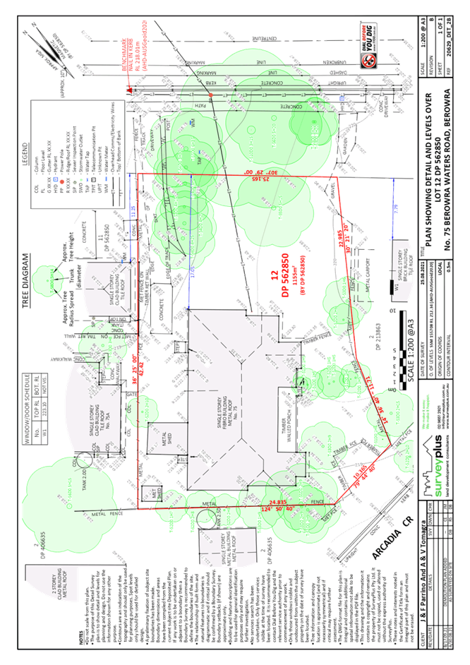
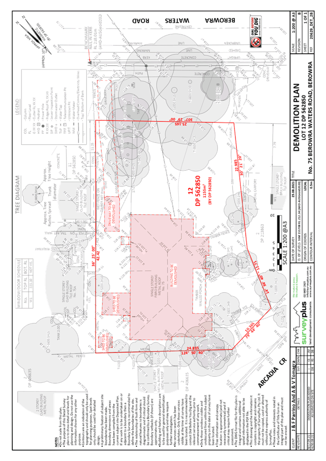
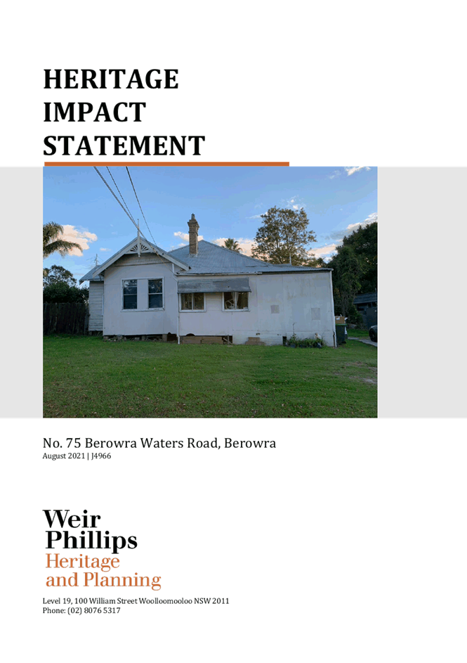
4 ELECTRONIC - DA/1074/2021 - DEMOLITION OF HERITAGE LISTED DWELLING HOUSE - 75 BEROWRA WATERS ROAD, BEROWRA
EXECUTIVE SUMMARY
|
DA No: |
DA/1074/2021 (Lodged on 13 October 2021) |
|
Description: |
Demolition of a heritage listed dwelling house |
|
Property: |
Lot 12 DP 562850, No. 75 Berowra Waters Road, Berowra |
|
Applicant: |
Minto Planning Services Pty Ltd |
|
Owner: |
Mr J Parrino and Miss V Tomagra |
|
Estimated Value: |
$25,000 |
|
Ward: |
A |
· The application involves demolition of the existing heritage listed dwelling, ancillary structures (two detached metal sheds) and concrete driveway hardstand area.
· The proposal complies with the requirements of Hornsby Local Environmental Plan 2013 and Hornsby Development Control Plan 2013.
· No submissions were received with respect to the application.
· The application is required to be determined by the Hornsby Council Local Planning Panel as demolition of a heritage item is sensitive development.
· It is recommended that the application be approved.
|
THAT Development Application No. DA/1074/2021 for demolition of a heritage listed dwelling and outbuildings at Lot 12 DP562850, No. 75 Berowra Waters Road, Berowra be approved subject to the conditions of consent detailed in Schedule 1 of LPP Report No. LPP40/21. |
BACKGROUND
In 2017, the owners of the property sought pre-lodgement advice regarding the demolition of the existing dwelling on the site and associated outbuildings (PL/40/2017). The pre-lodgement heritage advice was that:
Demolition of the existing dwelling would not be supported by Council given its age, rarity, landmark quality and heritage significance without adequate justification that it is not reasonable to alter, repair or extend the dwelling to meet contemporary amenity and living standards. Refer to Section 9.3.4 of the HDCP.
The matter did not progress any further at that time.
Council is currently undertaking a review of potential new heritage items and heritage items nominated for de-listing. The subject property has been nominated for de-listing by its owners based on its current physical condition and it is included in the Phase 1 study. To date, the consultants for the study have not forwarded to Council a final review of the heritage status of the dwelling.
SITE
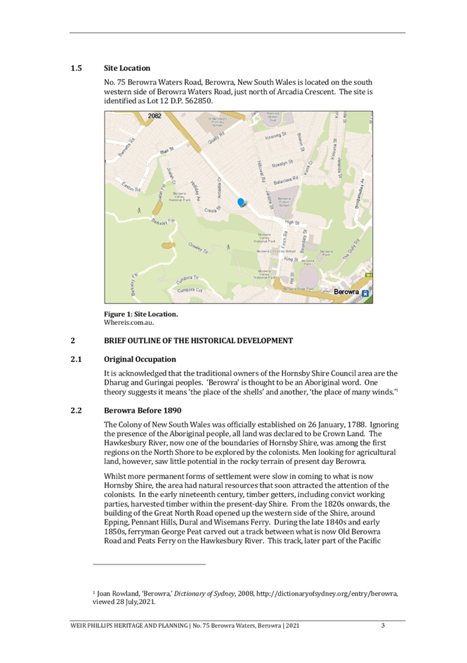
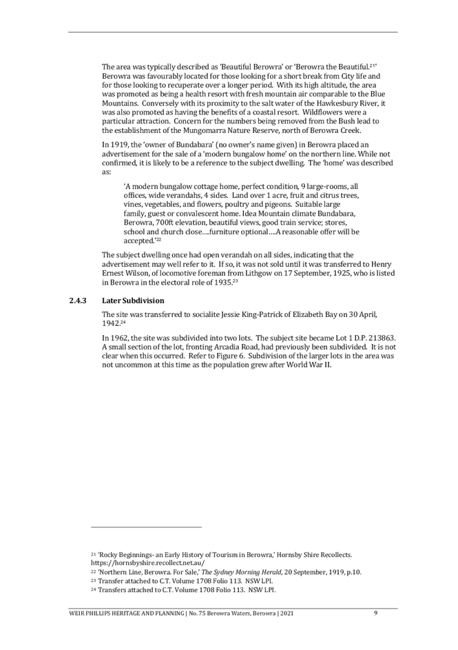
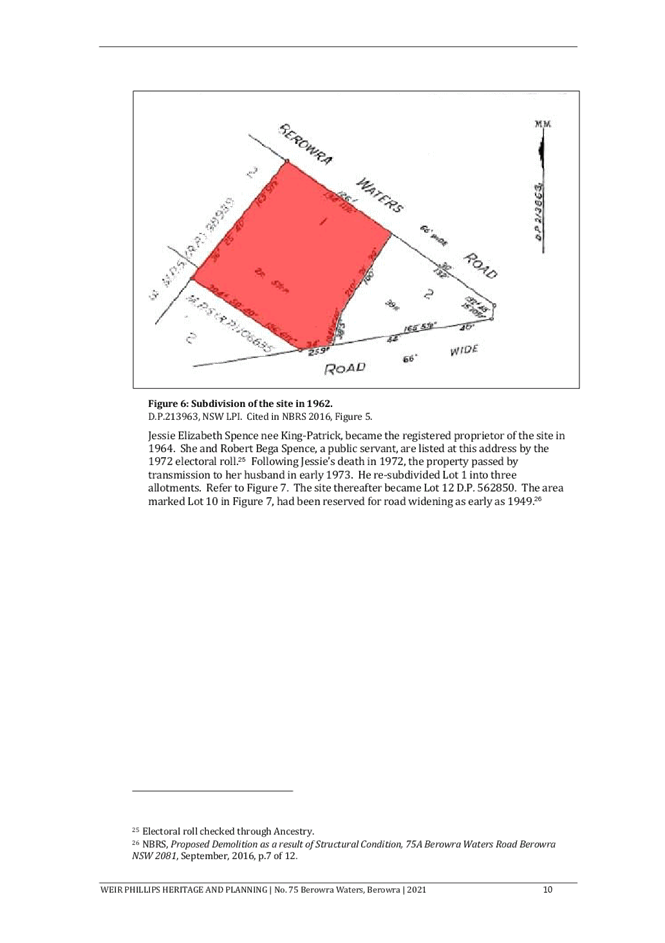
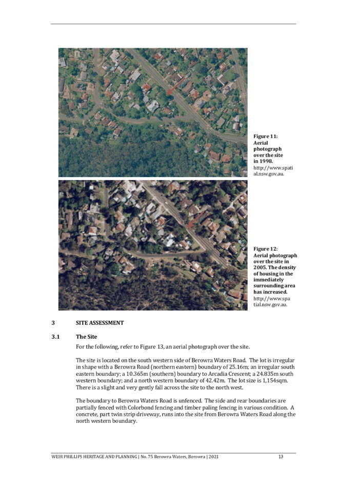
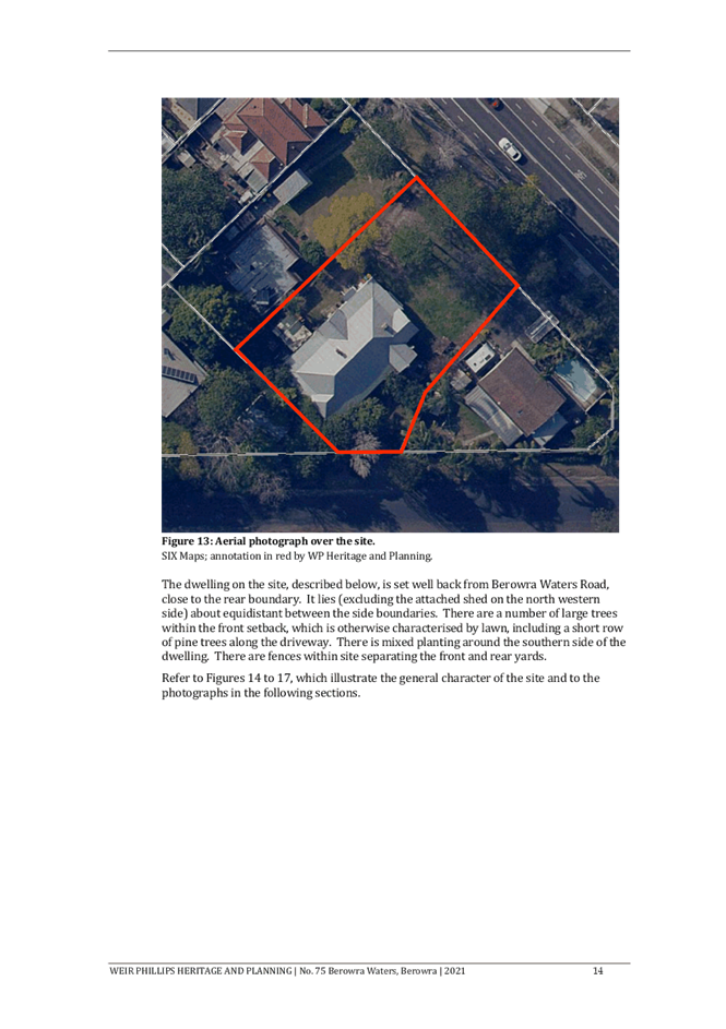
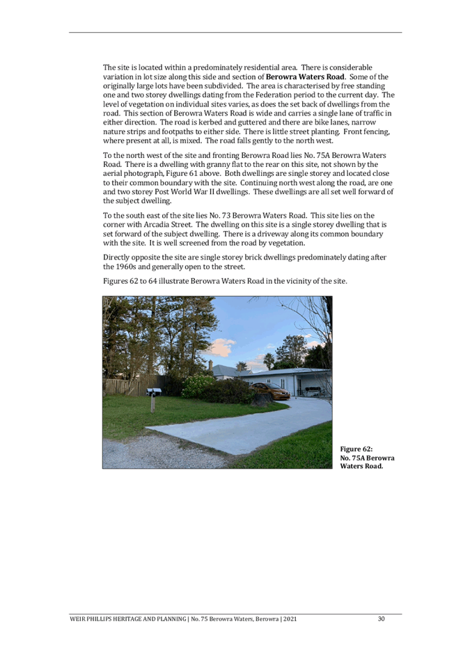
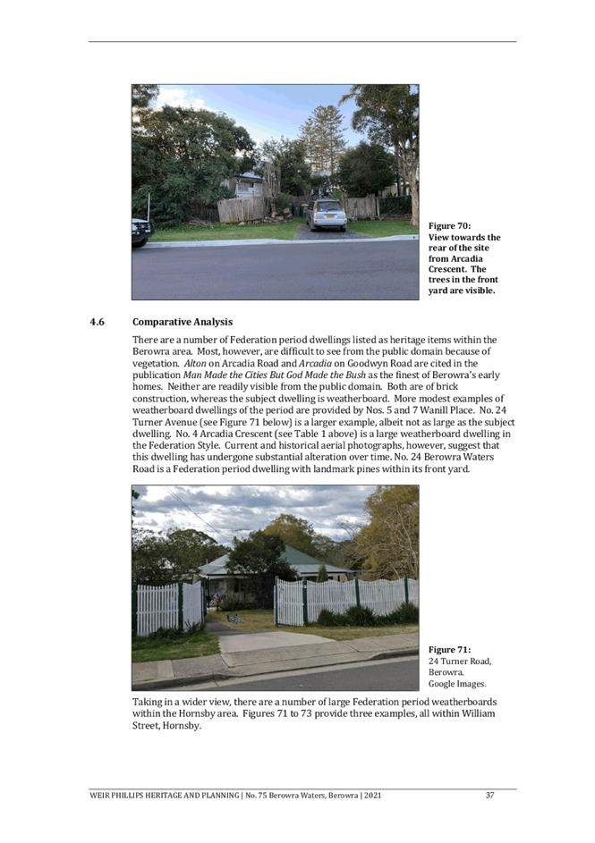
The 1,155m² site has a dual frontage, with access via Berowra Waters Road to the north-east and Arcadia Crescent to the south-west.
The site falls approximately 1.3 metres from the eastern boundary to the north-western corner and 1 metre from the eastern boundary to the south-western corner.
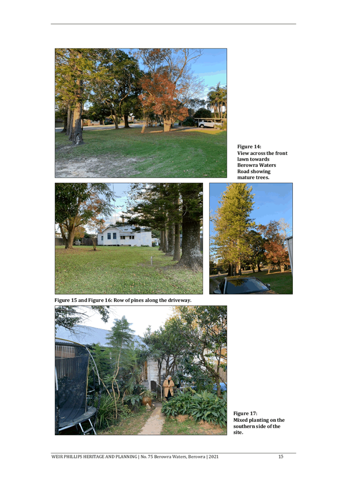
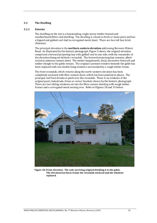
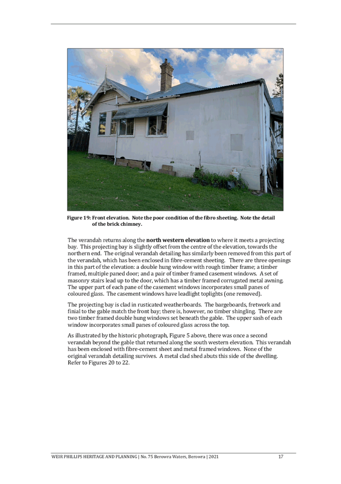
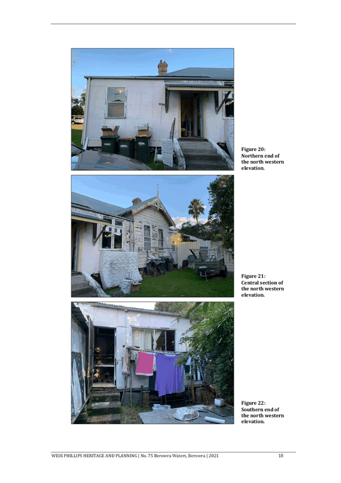
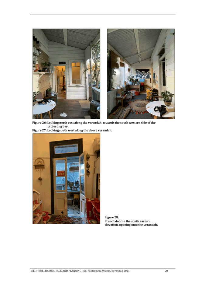
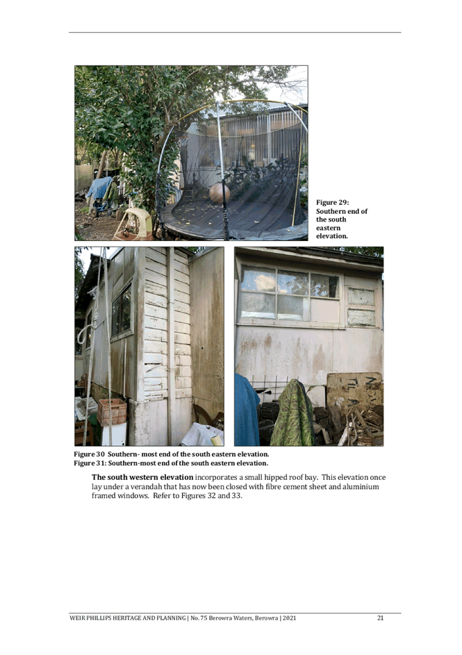
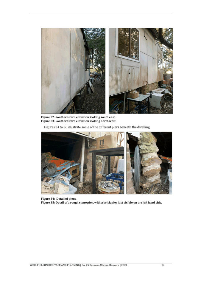
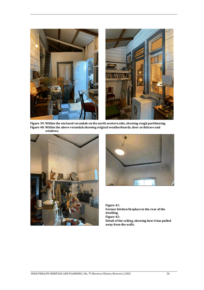
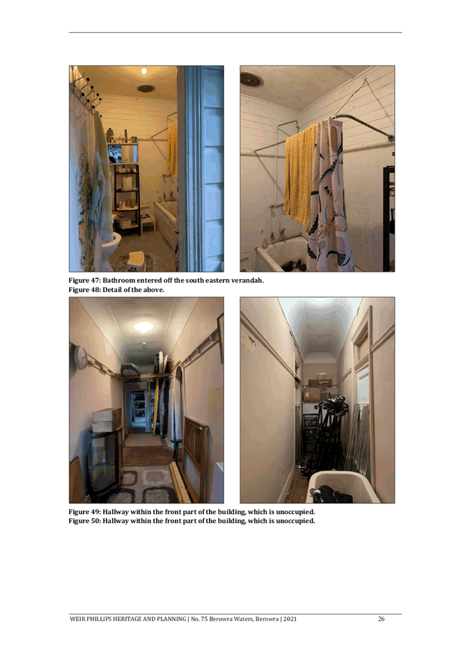
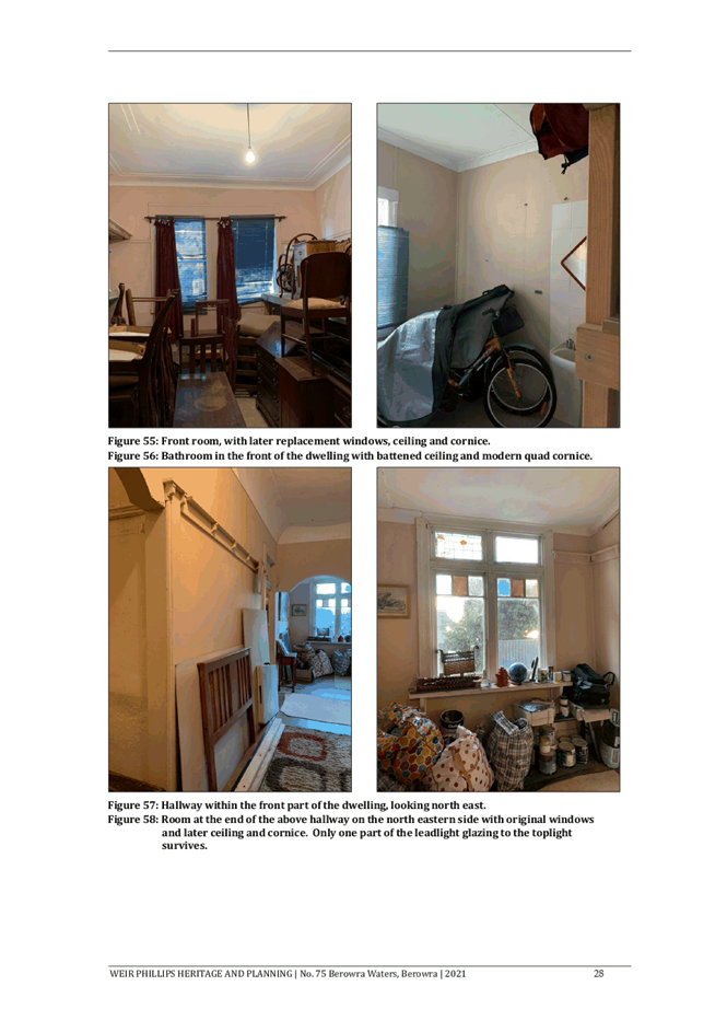
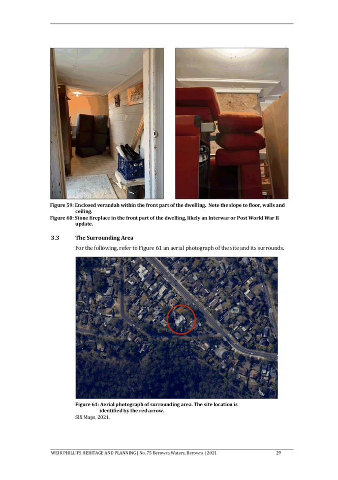
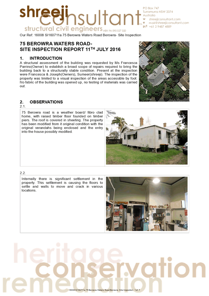
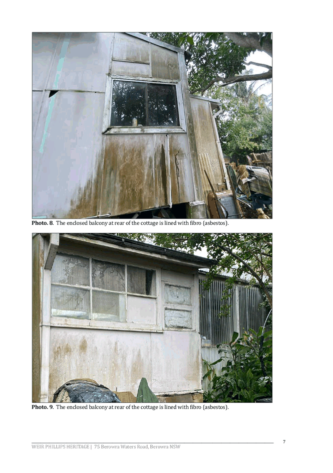
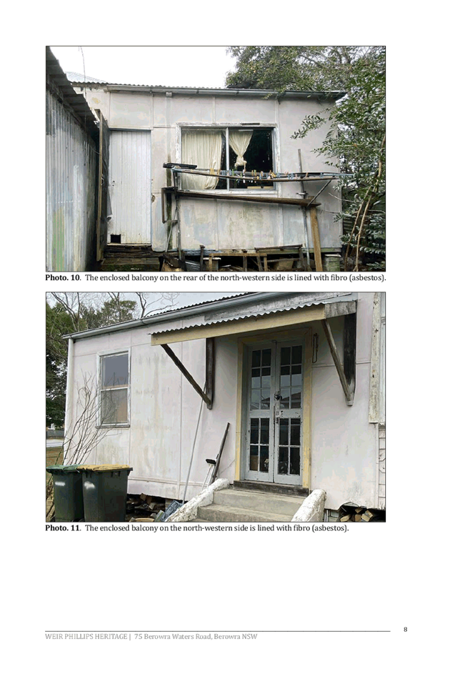
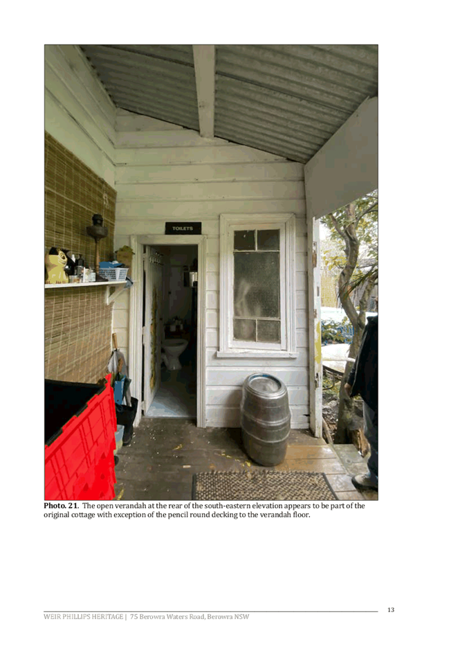
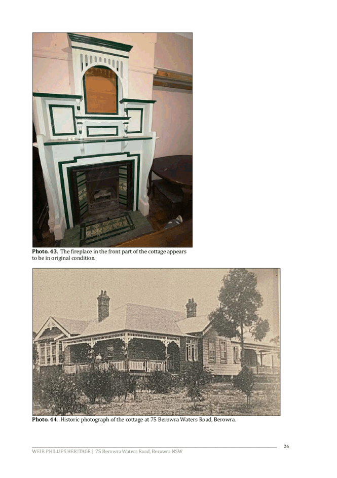
The site contains a single storey timber and fibro dwelling with metal roof. No floor plan is available for the dwelling; a 1919 real estate listing described it as a “A modern bungalow cottage home, perfect condition, 9 large-rooms, all offices, wide verandahs, 4 sides”. The verandahs to the north-east, north-west and south-west have all been enclosed with fibro sheeting, as has the projecting bay at the front of the dwelling. The dwelling is divided into two flats; only the rear flat is currently occupied, while the front flat is used for storage.
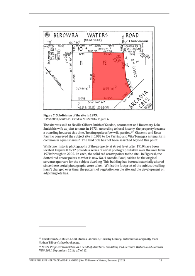
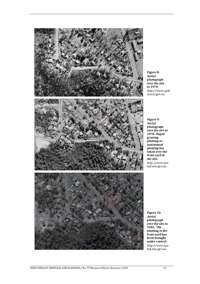
A gravel driveway runs along the north-western boundary and leads to a concrete hardstand parking space. Two metal sheds are located in the western corner of the site. There are a variety of mature trees in the front yard including a row of pines along the driveway.
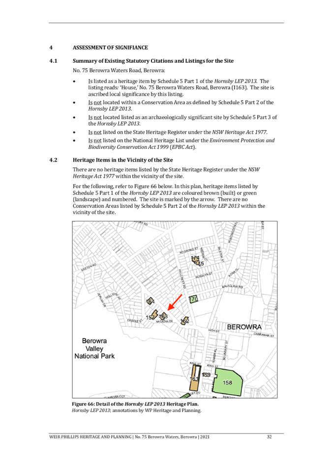
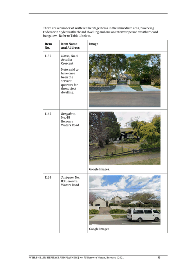
The dwelling is listed as heritage item number 163 under Schedule 5 of Hornsby Local Environmental Plan 2013. The site is not within a Heritage Conservation Area. The site is also located in the vicinity of 3 heritage items: No. 48 Berowra Waters Road (Item No. 162 - Bungalow), No. 85 Berowra Waters Road (Item No. 164 - House), and No. 4 Arcadia Road, Berowra (Item No. 157 - House).
The site is mapped as bushfire prone. The site is not identified as flood prone.
The site is not burdened by any easements or restrictions.
PROPOSAL
The application proposes demolition of the existing dwelling, ancillary structures (two detached metal sheds) and concrete driveway hardstand area.
No trees are proposed for removal.
ASSESSMENT
The development application has been assessed having regard to the Greater Sydney Region Plan – A Metropolis of Three Cities, the North District Plan and the matters for consideration prescribed under Section 4.15 of the Environmental Planning and Assessment Act 1979 (the Act). The following issues have been identified for further consideration.
1. STRATEGIC CONTEXT
1.1 Greater Sydney Region Plan - A Metropolis of Three Cities and North District Plan
The Greater Sydney Region Plan - A Metropolis of Three Cities has been prepared by the NSW State Government to guide land use planning decisions for the next 40 years (to 2056). The Plan sets a strategy and actions for accommodating Sydney’s future population growth and identifies dwelling targets to ensure supply meets demand. The Plan also identifies that the most suitable areas for new housing are in locations close to jobs, public transport, community facilities and services.
The NSW Government will use the subregional planning process to define objectives and set goals for job creation, housing supply and choice in each subregion. Hornsby Shire has been grouped with Hunters Hill, Ku-ring-gai, Lane Cove, Mosman, North Sydney, Ryde, Northern Beaches and Willoughby to form the North District. The Greater Sydney Commission has released the North District Plan which includes priorities and actions for Northern District for the next 20 years. The identified challenge for Hornsby Shire will be to provide an additional 4,350 dwellings by 2021 with further strategic supply targets to be identified to deliver 97,000 additional dwellings in the North District by 2036.
Planning Priority N6 – Creating and renewing great places and local centres, and respecting the Districts heritage
In giving effect to A Metropolis of Three Cities, this Planning Priority delivers on the following objective and the corresponding strategies:
· Objective 13 – Environmental heritage is identified, conserved and enhanced.
The proposed demolition of a heritage listed dwelling house has been thoroughly considered and identified within this report. Despite the objective identifying that heritage should be conserved and enhanced, based off the evidence and assessment detailed in Section 2.1.2 of this report, it is considered that demolition is the only remaining option for this heritage item and is acceptable under the circumstances.
2. STATUTORY CONTROLS
Section 4.15(1)(a) requires Council to consider “any relevant environmental planning instruments, draft environmental planning instruments, development control plans, planning agreements and regulations”.
2.1 Hornsby Local Environmental Plan 2013
The proposed development has been assessed having regard to the provisions of the Hornsby Local Environmental Plan 2013 (HLEP).
2.1.1 Zoning of Land and Permissibility
The subject land is zoned R2 Low Density Residential under the HLEP. The objectives of the R2 zone are:
· To provide for the housing needs of the community within a low-density residential environment.
· To enable other land uses that provide facilities or services to meet the day to day needs of residents.
The proposed development is defined as the demolition of a ‘dwelling house’ and is permissible in the zone with Council’s consent.
in accordance with Clause 2.7 of the HLEP, the application seeks the required development consent for demolition.
2.1.2 Heritage
The dwelling is listed as heritage item number 163 under Schedule 5 of the HLEP. The Statement of Significance in the heritage register reads:
Good example of a Federation weatherboard bungalow with complex roof and fine quality original detail. Integrity compromised by unsympathetic alterations.
The physical description in the heritage register reads:
Federation weatherboard house on large block. Complex iron roof on diagonal plan arrangement. Retains some fine timber work to gables and original windows.
There are no further details in the heritage register.
The site is also located in the vicinity of 3 heritage items: No. 48 Berowra Waters Road (No. 162 - Bungalow), No. 85 Berowra Waters Road (No. 164 - House), and No. 4 Arcadia Road, Berowra (No. 157 - House). It is noted that the subject site is not visible in conjunction with any of the closest heritage items to the site.
Under Clause 5.10(4) of the HLEP, the consent authority must consider the effect of the proposed development on the heritage significance of the item before granting consent.
The proposal was accompanied by a Statement of Heritage Impact (SHI) prepared by Weir Phillips Heritage and Planning. The SHI is supported by a Structural Report prepared by Shreeji Consultant Pty Ltd and a Schedule of Conservation Works prepared by Weir Phillips.
The SHI recounts the early colonial history of Berowra and notes that the trapezium-shaped block of land bound by Berowra Waters Road and Arcadia Crescent was first purchased in 1891 and was subdivided and transferred a number of times before a dwelling was constructed by Willoughby Devlin, a wool broker, between 1907 and 1909. The house was known as Bundabara. Evidence suggests that the dwelling was a guest house named Miparinka during the 1910s. A 1919 real estate listing described the dwelling as a “modern bungalow cottage home, perfect condition, 9 large-rooms, all offices, wide verandahs, 4 sides”.
In the mid-twentieth century the site was subdivided into 3 lots (creating what are now No. 73A Berowra Waters Road and No. 2 Arcadia Crescent) and in 1973 the remnant lot was split into 3, with a portion of the frontage used for road widening and the land to the north-west becoming what is now No. 75A Berowra Waters Road.
In the 1970s and 1980s the dwelling was used as a boarding house by then owners the Smiths. In 1988 the property was transferred by Giacomo and Rosa Parrino to Joe Parrino and Vita Tomagra as tenants in common with equal shares.
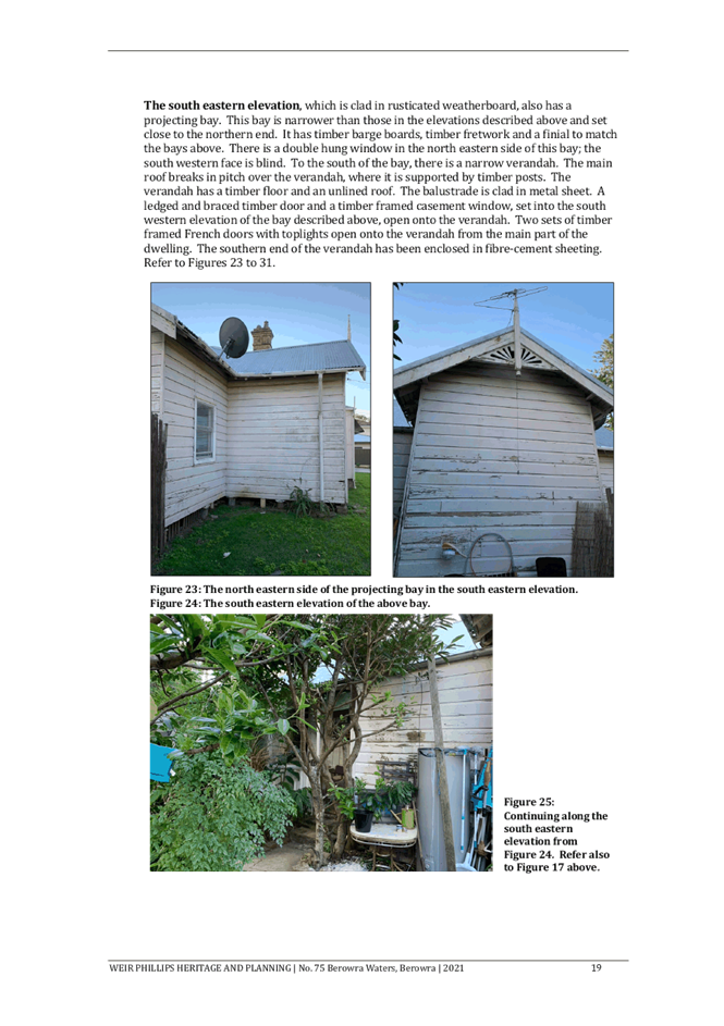
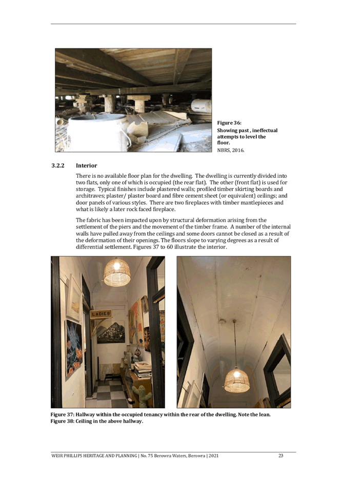
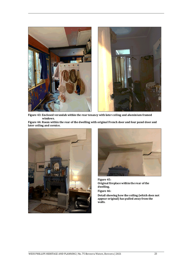
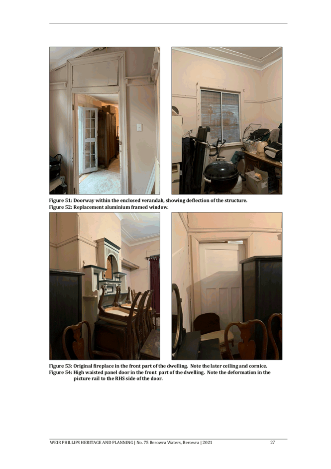
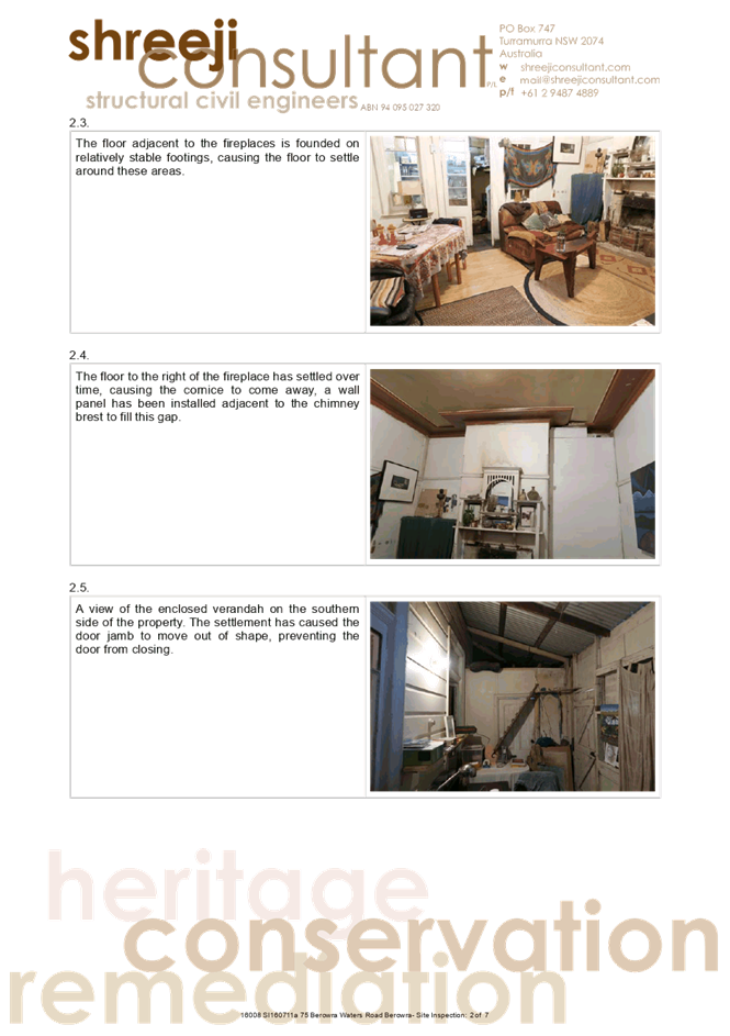
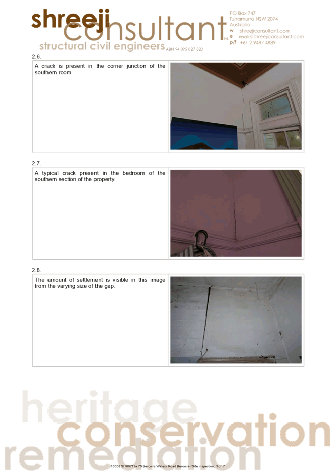
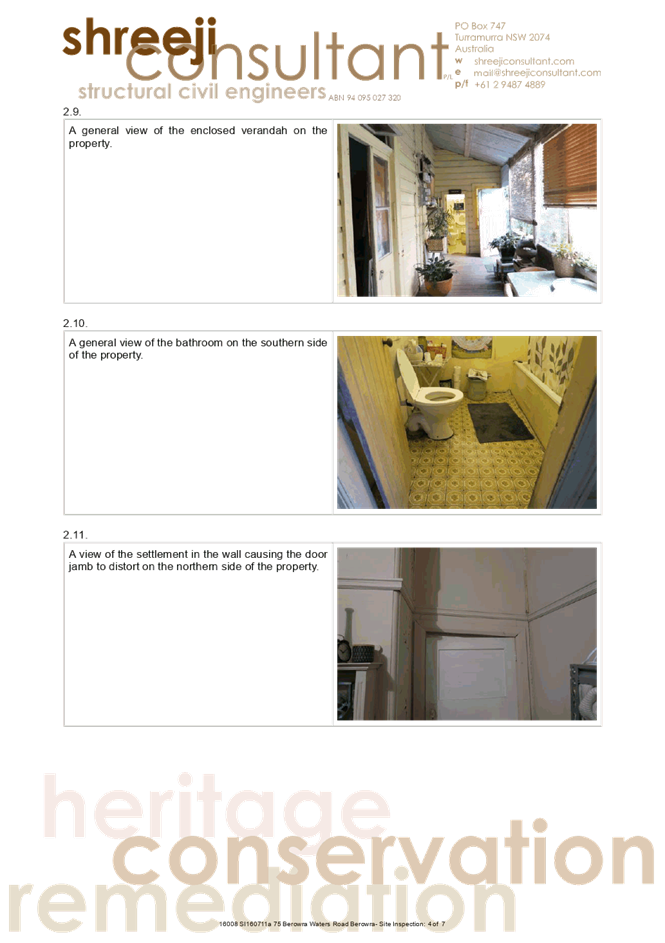
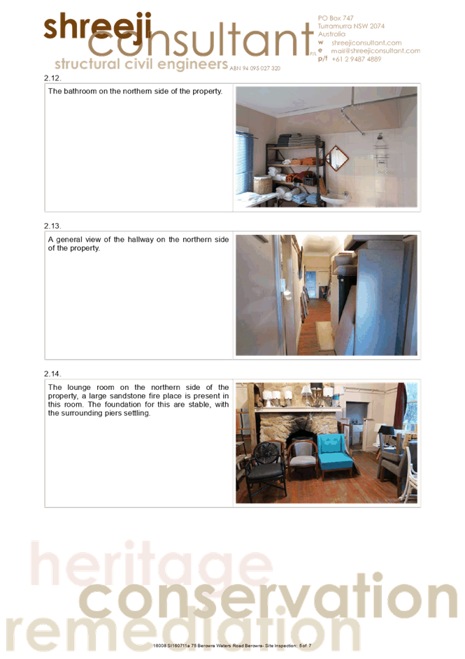
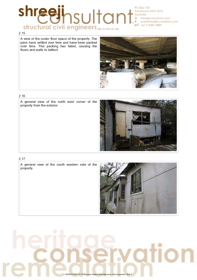
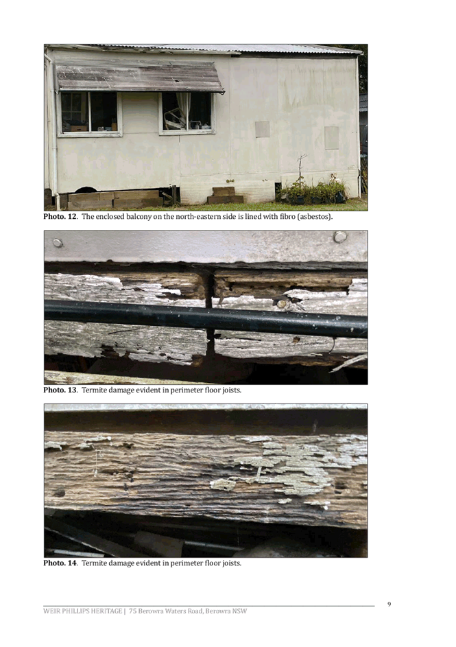
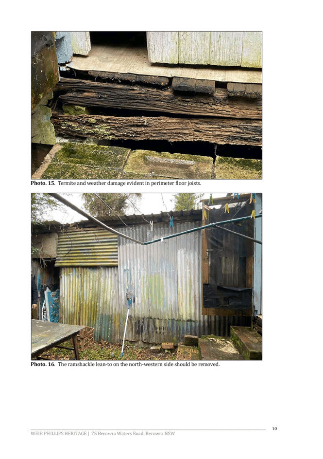
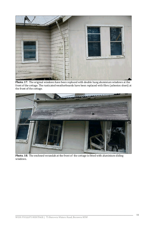
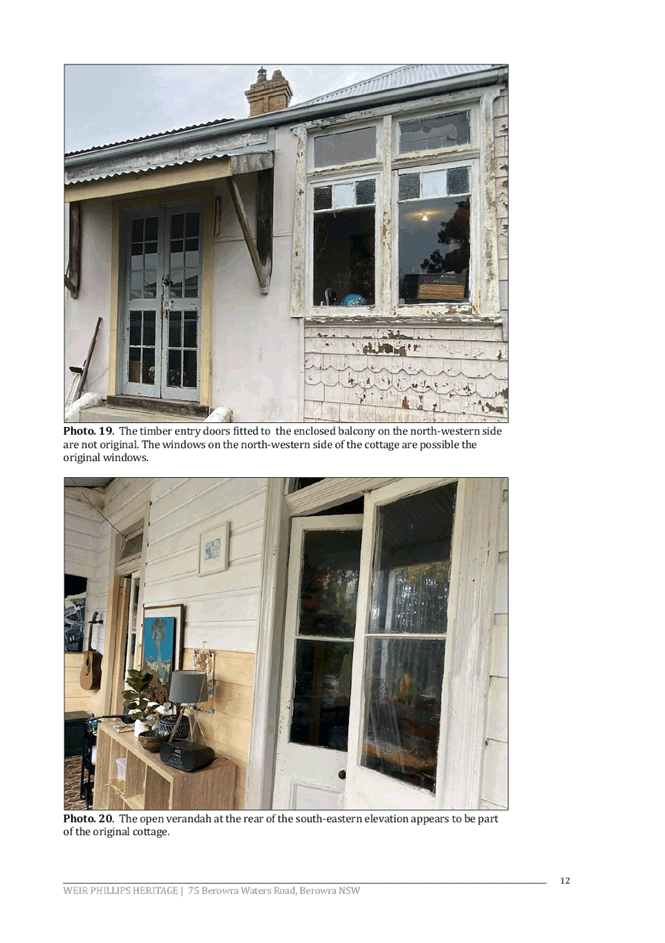
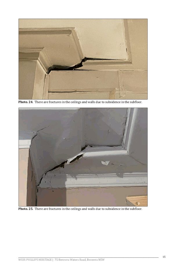
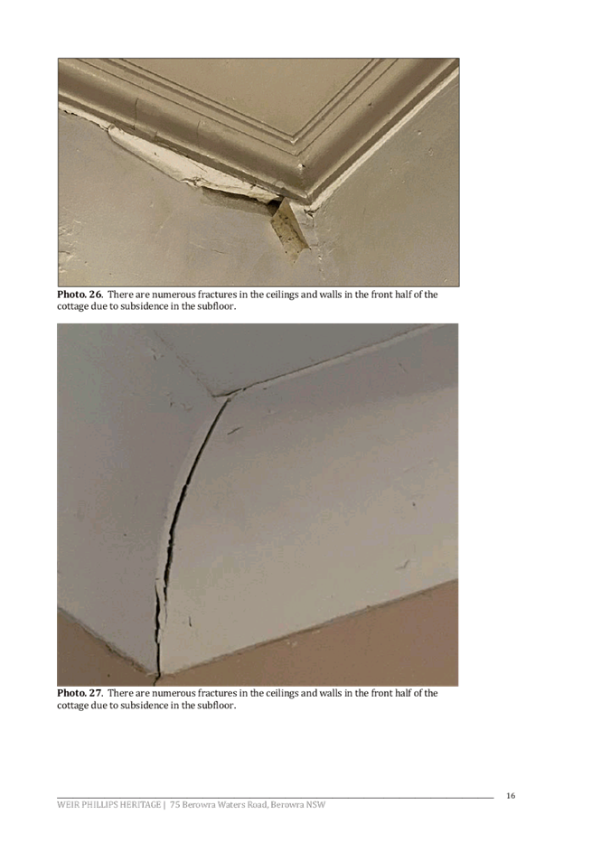
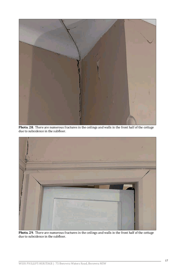
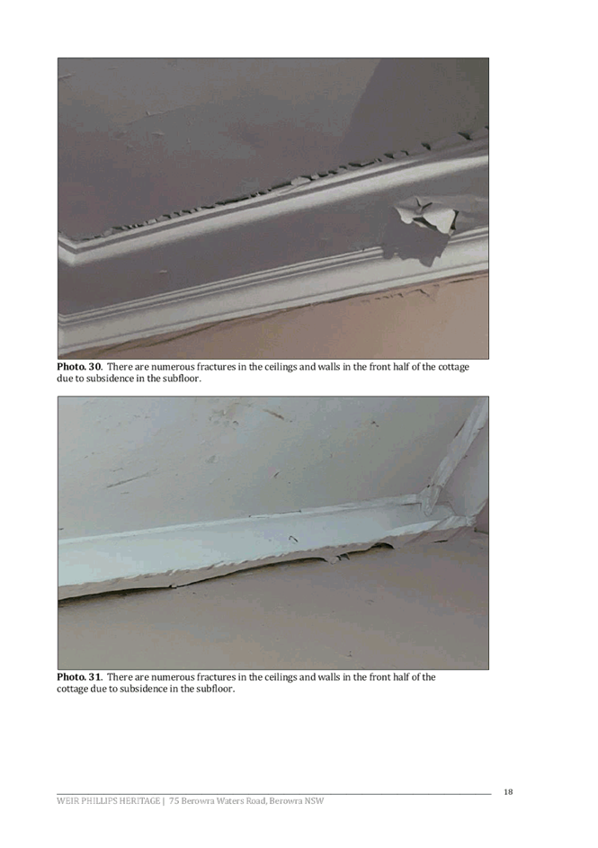
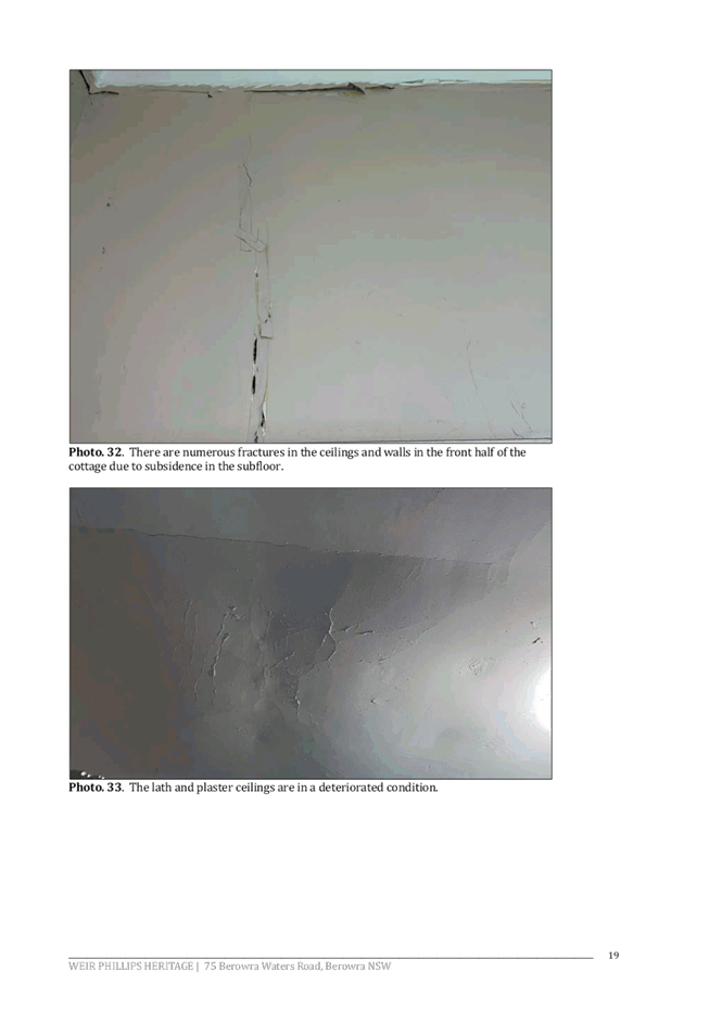
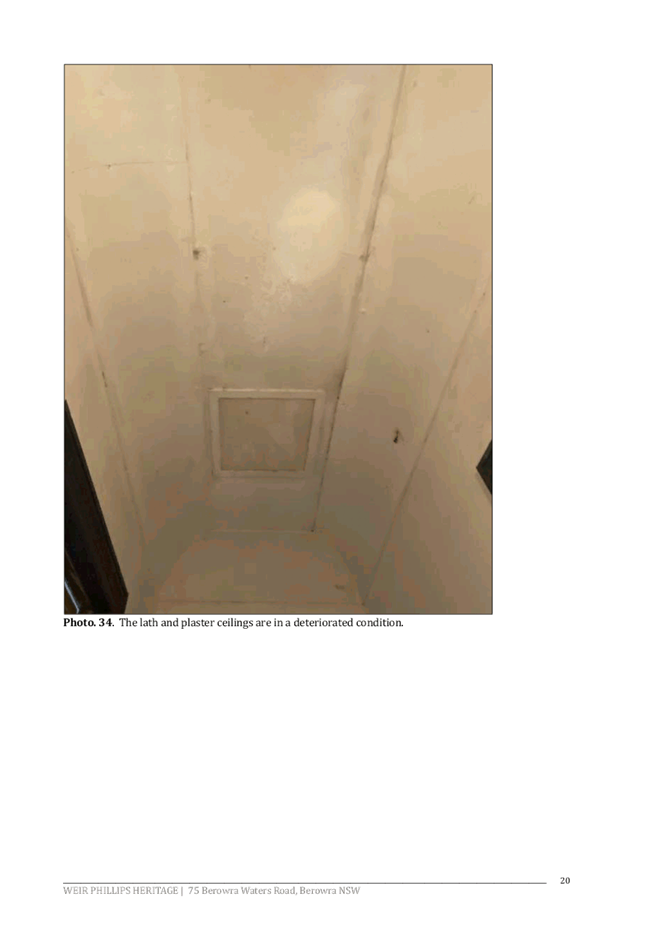
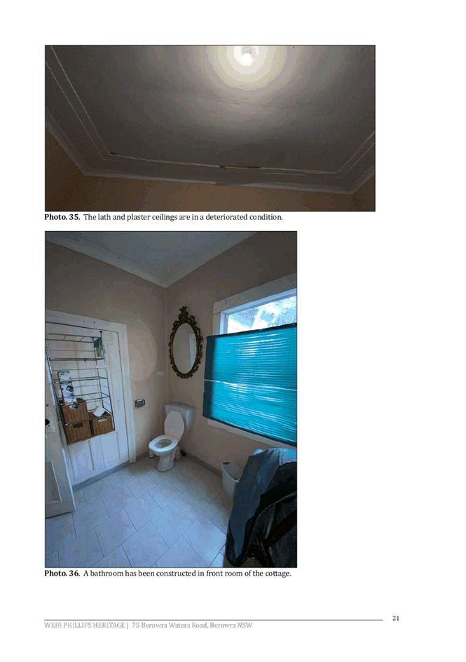
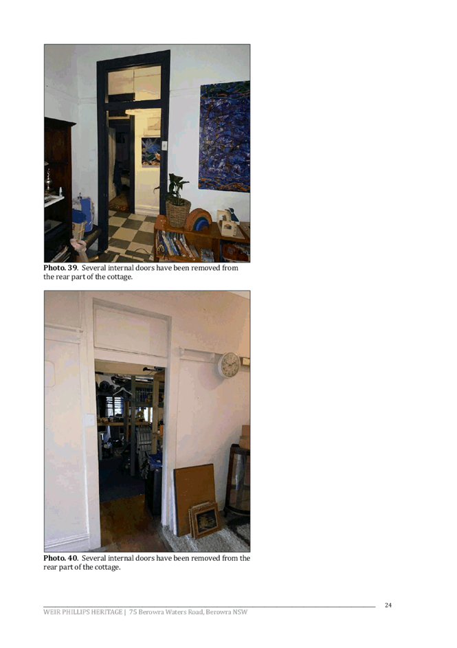
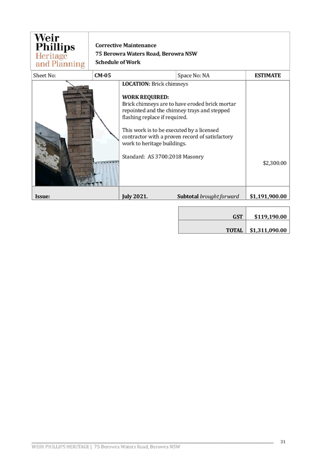
Photographs in the SHI demonstrate that the dwelling is structurally unsound, as the piers have settled, and the timber frame has moved. The images show sloping floors, doors that do not close due to deformed door frames, deformed picture rails, and places where the ceiling has come away from the walls. Photographs show unsuccessful efforts to level the floors with additional piers of varying materials under the house.
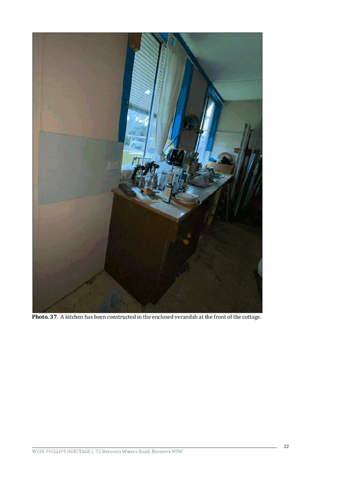
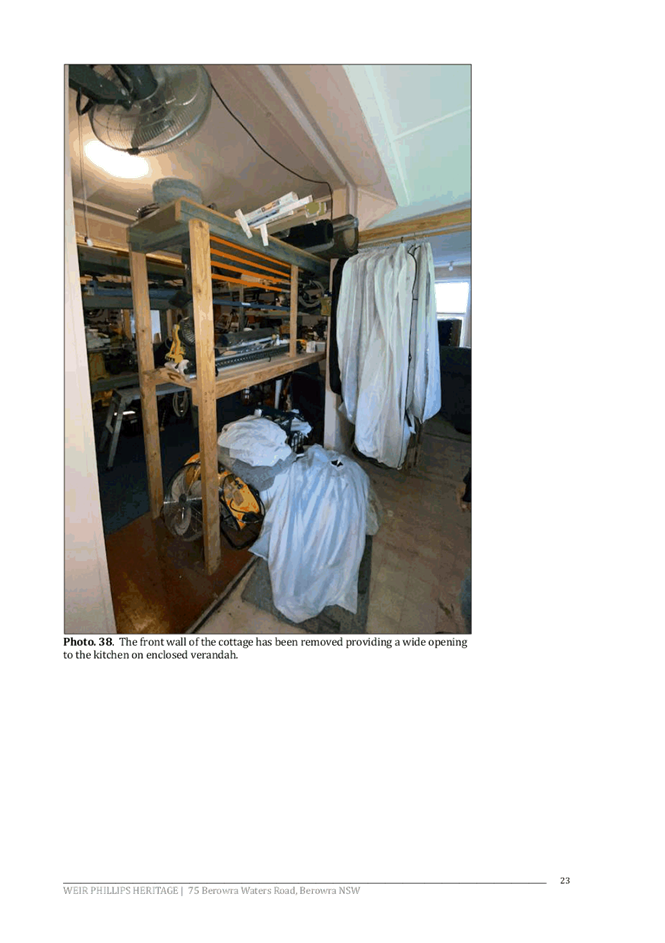
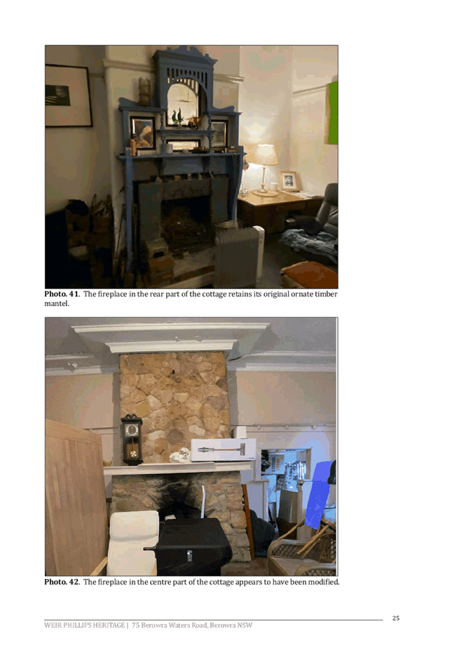
The dwelling has also suffered through various unsympathetic additions including, but not limited to, removal of the box window at the front of the dwelling, enclosure of verandahs with fibre cement sheeting (asbestos), rough partitioning of verandahs, removal of timber detailing to verandahs, removal of a large section of the front wall of the dwelling providing a wide opening to the enclosed verandah, removal of original window frames and panes including ornate lead lights, replacement of original ceilings, replacement of original external doors, and replacement of an original fireplace. The alterations and additions are described as described as “un-tradesman-like” in the Schedule of Conservation Works. The situation has been compounded by a general lack of maintenance. The Structural Report states that termite damage to the property is “likely”.
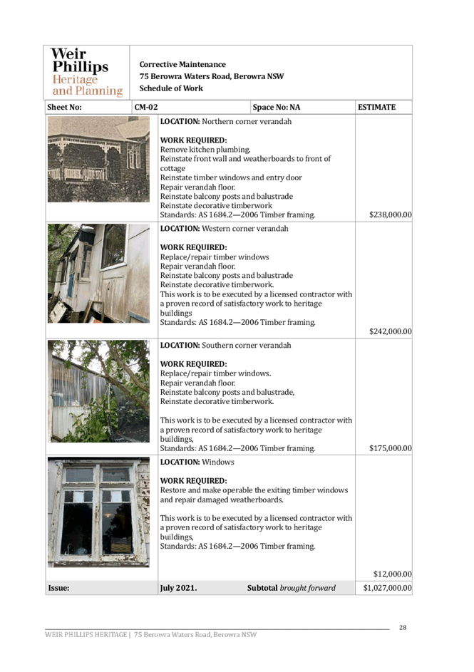
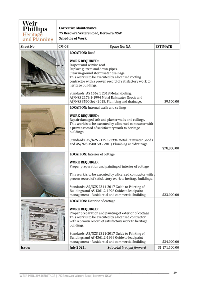
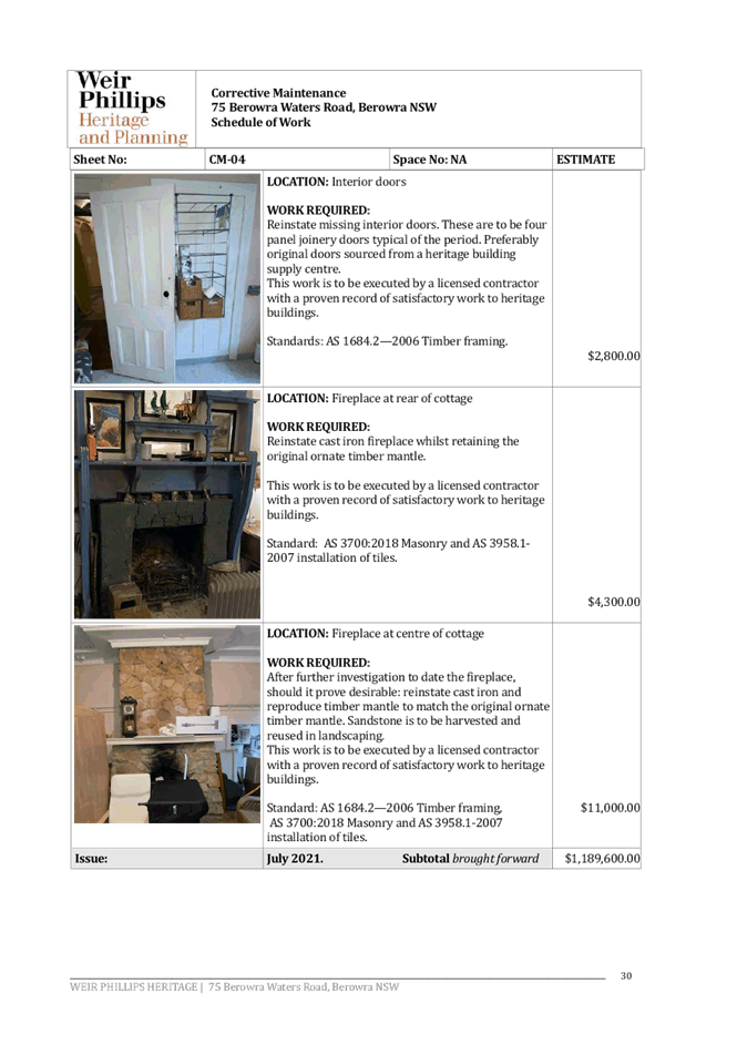
The preliminary costing to remediate the dwelling provided with the SHI was $1,311,090.
The SHI makes an assessment of the heritage significance of the property using the Heritage NSW criteria of cultural, associative, aesthetic, social and archaeological significance, rarity and representativeness, and provides the following updated Statement of Significance:
Erected c.1907, Bundabara, also known as Miparinka, at No. 75 Berowra Waters Road, Berowra, New South Wales has local significance as part of the early twentieth century development of Berowra and was most likely erected as a weekend retreat, making it part of the early twentieth century use of the area for recreational pursuits. One of the larger dwellings erected in the area at this time, its ability to demonstrate the Federation period and style has been diminished by later, unsympathetic alterations and additions, including the enclosure of its original verandahs and the subsequent loss of the timber detailing that was once one the primary architectural features of this dwelling; by the replacement of much of the weatherboard cladding; and by the removal of the box window beneath the front gable. The pines in the front yard continue to mark the location of the dwelling within the streetscape as a historic home.
The SHI concludes:
Following the advice of a structural engineer and a remedial builder, there are two options for this dwelling: substantial restoration work or demolition. The latter is recommended, hence this application, because of the prohibitive costs involved and because the extent of demolition and reconstruction that would be involved would result in an item where the fabric was of questionable integrity.
The proposal was referred to Council’s Heritage Planner for assessment, who detailed that the “level of remediation required to correct damage and deterioration… is so substantial that it would involve near complete demolition of original fabric [that] would so compromise the building’s heritage significance that it would be unlikely to meet any criteria for heritage listing”. The assessment concludes that:
While regrettable, the proposal to demolish the dwelling is accepted. Specialist reports have provided substantial justification that extensive demolition and re-build is required to meet structural and living standards, and that should that be pursued, it would result in a facsimile of the original dwelling which would, in turn, have little or no heritage value. There are no heritage objections to the proposed demolition of the metal outbuildings or concrete hard-stand area.
Archivally recording the site prior to demolition and lodging the record with Hornsby Shire Library local studies section is recommended to ensure the history and significance of the place is available as a record in the public domain. Salvaging building elements, a plaque outside the site and heritage de-listing are also recommended in the HIS, however, none are required in this instance due to potential asbestos contamination issues with salvage, and the placement of a plaque and heritage de-listing are outside the limits of an approval.
In summary, based off the evidence and assessment detailed above, it is considered that demolition is the only remaining option for this heritage item and is acceptable under the circumstances.
2.2 State Environmental Planning Policy No. 55 Remediation of Land
State Environmental Planning Policy No. 55 (SEPP 55) requires that consent must not be granted to the carrying out of any development on land unless Council has considered whether the land is contaminated or requires remediation for the proposed use.
A search of Council’s records and aerial photos indicates the site has a history of residential use. It is therefore unlikely that the land has experienced any significant contamination and further assessment under SEPP 55 is not necessary.
Notwithstanding the above, the supporting documentation submitted with the development application confirmed the presence of asbestos or asbestos containing materials within the existing dwelling.
Conditions have been recommended in Schedule 1 of this report with respect to waste management during demolition works; and appropriate methods and clearance certificate requirements with regards to asbestos to ensure it is disposed from the site safely.
2.3 State Regional Environmental Policy No. 20 Hawkesbury-Nepean River
The site is located with the catchment of the Hawkesbury Nepean River. Part 2 of this Plan contains general planning considerations and strategies requiring Council to consider the impacts of development on water quality, aquaculture, recreation and tourism.
Subject to the implementation of sediment and erosion control measures and stormwater management to protect water quality, the proposal would meet the aims of the Policy.
2.4 Section 3.42 Environmental Planning and Assessment Act 1979 - Purpose and Status of Development Control Plans
Section 3.42 of the Environmental Planning and Assessment Act 1979 states that a DCP provision will have no effect if it prevents or unreasonably restricts development that is otherwise permitted and complies with the development standards in relevant Local Environmental Plans and State Environmental Planning Policies.
The principal purpose of a development control plan is to provide guidance on the aims of any environmental planning instrument that applies to the development; facilitate development that is permissible under any such instrument; and achieve the objectives of land zones. The provisions contained in a DCP are not statutory requirements and are for guidance purposes only. Consent authorities have flexibility to consider innovative solutions when assessing development proposals, to assist achieve good planning outcomes.
2.5 Hornsby Development Control Plan 2013
The proposed development has been assessed having regard to the relevant desired outcomes and prescriptive requirements within the Hornsby Development Control Plan 2013 (HDCP).
2.5.1 Heritage
Part 9 of HDCP sets out development controls for heritage items and heritage conservation areas. Controls regarding demolition are contained only within the Heritage Conservation Areas (HCAs) section of HDCP, rather than the heritage items section. The dwelling is not located within a HCA and consequently there are no applicable controls for the proposed development within the HDCP.
Demolition of the heritage item has been discussed comprehensively in Section 2.1.2 of this report ad is considered acceptable under the circumstances.
2.5.2 Waste Management
Section 1C.2.3 of HDCP sets out desired outcomes and prescriptive measures for waste management.
A Waste Management Plan was submitted with the Development Application which satisfies the requirements of HDCP and is included as an approved supporting document in Schedule 1 of this report.
In addition, the supporting documentation submitted with the development application confirmed the presence of asbestos or asbestos containing materials within the existing dwelling.
Conditions have been recommended in Schedule 1 of this report with respect to waste management during demolition works, and appropriate methods and clearance certificate requirements with regards to asbestos.
Subject to conditions, the proposal meets the desired outcomes of Part 1C.2.3 Waste Management under the HDCP and is considered acceptable.
2.5.3 Bushfire
The desired outcomes of Part 1C.3.1 Bushfire of the HDCP are to encourage “development that is located and designed to minimise the risk to life and property from bushfires” and “development that balances the conservation of native vegetation and bushfire protection”.
The subject site is mapped as being bushfire prone.
The proposed development, being demolition of an existing dwelling house would not involve any building works and has no impacts on bushfire risk at this time.
The proposal meets the desired outcomes of Part 1C.3.1 Bushfires under the HDCP and is considered acceptable.
3. ENVIRONMENTAL IMPACTS
Section 4.15(1)(b) of the Act requires Council to consider “the likely impacts of that development, including environmental impacts on both the natural and built environments, and social and economic impacts in the locality”.
3.1 Natural Environment
3.1.1 Tree and Vegetation Preservation
The proposed development does not require the removal of any trees and would not impact any trees.
Notwithstanding, to ensure existing trees on the site are protected during demolition works, a condition is recommended in schedule 1 to ensure the stockpiling of building materials and site waste, the parking of vehicles or plant, the disposal of wastewater or other contaminants be located outside the tree protection zones as prescribed under Part 1B.6 Tree Preservation of the HDCP of any tree to be retained on and adjoining the site.
3.1.2 Stormwater Management
Given this proposal is for the demolition of a dwelling house only, no stormwater drainage details are proposed or required for assessment under this application.
3.2 Built Environment
3.2.1 Built Form
The existing dwelling house would be demolished, and the site would remain vacant until such time that the owner decides to re-develop.
3.3 Social Impacts
The demolition of a heritage item would have minimal social impacts to the locality.
3.4 Economic Impacts
The demolition of a heritage item would not have any economic impact to the locality.
4. SITE SUITABILITY
Section 4.15(1)(c) of the Act requires Council to consider “the suitability of the site for the development”.
The site is bushfire prone but given the proposal is for demolition of an existing dwelling house only, the application would not involve any building works and would have no impacts on bushfire risk at this time.
5. PUBLIC PARTICIPATION
Section 4.15(1)(d) of the Act requires Council to consider “any submissions made in accordance with this Act”.
5.1 Community Consultation
The proposed development was placed on public exhibition and was notified to adjoining and nearby landowners between 3 November to 25 November 2021 in accordance with the Hornsby Community Engagement Plan. During this period, Council did not receive any submissions. The map below illustrates the location of those nearby landowners who were notified of the development.
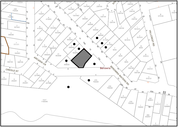
|
NOTIFICATION PLAN |
|||
|
• PROPERTIES NOTIFIED |
X SUBMISSIONS RECEIVED |
|
|
5.2 Public Agencies
The development application was not referred to any Public Agencies for comment.
6. THE PUBLIC INTEREST
Section 4.15(1)(e) of the Act requires Council to consider “the public interest”.
The public interest is an overarching requirement, which includes the consideration of the matters discussed in this report. Implicit to the public interest is the achievement of future built outcomes adequately responding to and respecting the future desired outcomes expressed in environmental planning instruments and development control plans.
The application is considered to have satisfactorily addressed Council’s and relevant agencies’ criteria and would provide a development outcome that, on balance, would result in a positive impact for the community. Accordingly, it is considered that the approval of the proposed development would be in the public interest.
CONCLUSION
The application proposes demolition of a heritage listed dwelling and outbuildings. The heritage significance of the dwelling has been substantially diminished by a range of unsympathetic alterations and additions plus a lack of general maintenance over several decades. Consequently, restoration of the dwelling to its original condition would essentially constitute a complete rebuild which would create a facsimile dwelling that would have little to no heritage value.
The development generally meets the desired outcomes of Council’s planning controls and is satisfactory having regard to the matters for consideration under Section 4.15 of the Environmental Planning and Assessment Act 1979.
Having regard to the circumstances of the case, approval of the application is recommended.
The reasons for this decision are:
· Demolition of the heritage item is justified given the current state of disrepair of the dwelling house and substantial restoration work would be cost prohibitive and reconstruction would compromise the heritage significance of the item.
Note: At the time of the completion of this planning report, no persons have made a Political Donations Disclosure Statement pursuant to Section 10.4 of the Environmental Planning and Assessment Act 1979 in respect of the subject planning application.
RESPONSIBLE OFFICER
The officer responsible for the preparation of this report is Madeleine Brown.
|
Cassandra Williams Major Development Manager - Development Assessments Planning and Compliance Division |
Rod Pickles Manager - Development Assessments Planning and Compliance Division |
|
1.⇩ |
Locality Plan |
|
|
|
2.⇩ |
Survey/Demolition Plan |
|
|
|
3.⇩ |
Heritage Impact Statement |
|
|
File Reference: DA/1074/2021
Document Number: D08301151
SCHEDULE 1
GENERAL CONDITIONS
The conditions of consent within this notice of determination have been applied to ensure that the use of the land and/or building is carried out in such a manner that is consistent with the aims and objectives of the relevant legislation, planning instruments and Council policies affecting the land and does not disrupt the amenity of the neighbourhood or impact upon the environment.
Note: For the purpose of this consent, any reference to an Act, Regulation, Australian Standard or publication by a public authority shall be taken to mean the gazetted Act or Regulation or adopted Australian Standard or publication as in force on the date that the application for a construction certificate is made.
1. Approved Plans and Supporting Documentation
The development must be carried out in accordance with the plans and documentation listed below and endorsed with Council’s stamp, except where amended by Council and/or other conditions of this consent:
Approved Plans
|
Plan No. |
Plan Title |
Drawn by |
Dated |
Council Reference |
|
1 of 1 |
Demolition Plan |
Survey Plus |
17/09/2021 |
|
Supporting Documentation
|
Document Title |
Prepared by |
Dated |
Council Reference |
|
Waste Management Plan |
Minto Planning Services |
24/09/2021 |
D08270353 |
2. Removal of Trees
No consent is granted for the removal of any tree on the subject site.
Note: The removal of any other trees from the site requires separate approval by Council in accordance with Part 1B.6 Tree and Vegetation Preservation of the Hornsby Development Control Plan, 2013.
3. Heritage Condition - Photographic Archive
a) A photographic archival record of the property including the existing dwelling, sheds, row of pine trees and other landscape elements is to be undertaken by a suitably qualified heritage professional prior to the demolition works commencing. The photographic record should be undertaken in accordance with the NSW Heritage Division, Premier and Cabinet Heritage Division Guidelines for photographic recording of heritage items and 1 complete ‘hard’ paper copy submitted to Hornsby Council, plus an electronic copy.
b) Satisfaction of this condition must be confirmed in writing by Council prior to the commencement of demolition works.
Note: Please submit the required information to Council at devmail@hornsby.nsw.gov.au noting the relevant DA number and marked to the attention of the Strategic Planning Team/ Heritage Planner.
REQUIREMENTS PRIOR TO THE COMMENCEMENT OF ANY WORKS
4. Erection of Demolition Sign
a) A sign must be erected in a prominent position on any site on which any approved work is being carried out:
i) Showing the name, address and telephone number of the principal certifying authority for the work.
ii) Showing the name of the principal contractor (if any) for any demolition or building work and a telephone number on which that person may be contacted outside working hours.
iii) Stating that unauthorised entry to the work site is prohibited.
b) The sign is to be maintained while the approved work is being carried out and must be removed when the work has been completed.
5. Protection of Adjoining Areas
A temporary hoarding, fence or awning must be erected between the work site and adjoining lands before the works begin and must be kept in place until after the completion of the works if the works:
a) Could cause a danger, obstruction or inconvenience to pedestrian or vehicular traffic.
b) Could cause damage to adjoining lands by falling objects; and/or.
c) Involve the enclosure of a public place or part of a public place; and/or.
d) Have been identified as requiring a temporary hoarding, fence or awning within the Council approved Construction Management Plan (CMP).
Note: Notwithstanding the above, Council’s separate written approval is required prior to the erection of any structure or other obstruction on public land.
6. Toilet Facilities
a) To provide a safe and hygienic workplace, toilet facilities must be available or be installed at the works site before works begin and must be maintained until the works are completed at a ratio of one toilet for every 20 persons employed at the site.
b) Each toilet must:
i) Be a standard flushing toilet connected to a public sewer.
ii) Be a temporary chemical closet approved under the Local Government Act 1993.
7. Erosion and Sediment Control
a) To protect the water quality of the downstream environment, erosion and sediment control measures must be provided and maintained throughout the construction period in accordance with the manual ‘Soils and Construction 2004 (Bluebook)’, the approved plans, Council specifications and to the satisfaction of the principal certifying authority.
b) The erosion and sediment control devices must remain in place until the site has been stabilised and revegetated.
Note: On the spot penalties may be issued for any non-compliance with this requirement without any further notification or warning.
REQUIREMENTS DURING DEMOLITION
8. Demolition Work Hours
a) All works on site, including earth works, must only occur between 7am and 5pm Monday to Saturday.
b) No work is to be undertaken on Sundays or public holidays.
9. Demolition
To protect the surrounding environment, all demolition work must be carried out in accordance with Australian Standard AS2601-2001 Demolition of structures and the following requirements:
a) Demolition material must be disposed of to an authorised recycling and/or waste disposal site and/or in accordance with an approved waste management plan.
b) Demolition works, where asbestos material is being removed, must be undertaken by a contractor that holds an appropriate licence issued by SafeWork NSW in accordance with the Work Health and Safety Regulation 2017 and be appropriately transported and disposed of in accordance with the Protection of the Environment Operations (Waste) Regulation 2014.
c) On construction sites where any building contains asbestos material, a standard commercially manufactured sign containing the words ‘DANGER ASBESTOS REMOVAL IN PROGRESS’ and measuring not less than 400mm x 300mm must be displayed in a prominent position visible from the street.
d) Waste disposal locations, contractors transporting material and quantity receipts of materials transported off-site and recycled or disposed of must be submitted to Council for our records.
Note: Please submit the required information to Council at devmail@hornsby.nsw.gov.au noting the relevant DA number.
10. Environmental Management
To prevent sediment run-off, excessive dust, noise or odour emanating from the site during the construction, the site must be managed in accordance with the publication ‘Managing Urban Stormwater – Landcom (March 2004) and the Protection of the Environment Operations Act 1997.
11. Building Materials and Site Waste
The stockpiling of building materials, the parking of vehicles or plant, the disposal of cement slurry, wastewater or other contaminants must be located outside the tree protection zones as prescribed under Part 1B.6 Tree Preservation of the HDCP of any tree to be retained on and adjoining the site.
12. Council Property
To ensure that the public reserve is kept in a clean, tidy and safe condition during construction works, no building materials, waste, machinery or related matter is to be stored on the road or footpath.
13. Damage to Council Assets
a) To protect public property and infrastructure, any damage caused to Council’s assets as a result of the construction or demolition of the development must be rectified by the applicant in accordance with AUS-SPEC Specifications (www.hornsby.nsw.gov.au/property/build/aus-spec-terms-and-conditions).
b) Rectification works must be undertaken as soon as practicable, as directed by Council.
- END OF CONDITIONS -
ADVISORY NOTES
The following information is provided for your assistance to ensure compliance with the Environmental Planning and Assessment Act 1979, Environmental Planning and Assessment Regulation 2000, other relevant legislation and Council’s policies and specifications. This information does not form part of the conditions of development consent pursuant to Section 4.17 of the Act.
Environmental Planning and Assessment Act 1979 Requirements
The Environmental Planning and Assessment Act 1979 requires:
· The issue of a construction certificate prior to the commencement of any works. Enquiries can be made to Council’s Customer Services Branch on 9847 6760.
· A principal certifying authority to be nominated and Council notified of that appointment prior to the commencement of any works.
· Council to be given at least two days written notice prior to the commencement of any works.
· Mandatory inspections of nominated stages of the construction inspected.
· An occupation certificate to be issued before occupying any building or commencing the use of the land.
Tree and Vegetation Preservation
Hornsby Development Control Plan 2013 Tree and Vegetation Preservation provisions have been developed under Council’s authorities contained in State Environmental Planning Policy (Vegetation in Non-Rural Areas) 2017 and the Environmental Planning and Assessment Act 1979.
In accordance with these provisions a person must not cut down, fell, uproot, kill, poison, ringbark, burn or otherwise destroy the vegetation, lop or otherwise remove a substantial part of the trees or vegetation to which any such development control plan applies without the authority conferred by a development consent or a permit granted by Council.
Fines may be imposed for non-compliance with the Hornsby Development Control Plan 2013.
Note: A tree is defined as a long lived, woody perennial plant with one or relatively few main stems with the potential to grow to a height greater than three metres (3m). (HDCP 1B.6.1.c).
Covenants
The land upon which the subject building is to be constructed may be affected by restrictive covenants. Council issues this approval without enquiry as to whether any restrictive covenant affecting the land would be breached by the construction of the building, the subject of this consent. Applicants must rely on their own enquiries as to whether or not the building breaches any such covenant.
Dial Before You Dig
Prior to commencing any works, the applicant is encouraged to contact Dial Before You Dig on 1100 or www.dialbeforeyoudig.com.au for free information on potential underground pipes and cables within the vicinity of the development site.
Telecommunications Act 1997 (Commonwealth)
If you are aware of any works or proposed works which may affect or impact on Telstra’s assets in any way, you are required to contact Telstra’s Network Integrity Team on Phone Number 1800810443.
Asbestos Warning
Should asbestos or asbestos products be encountered during demolition or construction works, you are advised to seek advice and information prior to disturbing this material. It is recommended that a contractor holding an asbestos-handling permit (issued by SafeWork NSW) be engaged to manage the proper handling of this material. Further information regarding the safe handling and removal of asbestos can be found at:
Alternatively, telephone the SafeWork NSW on 13 10 50.
LPP Report No. LPP41/21
Local Planning Panel
Date of Meeting: 15/12/2021
5 ELECTRONIC - REPORTING DEVELOPMENT APPLICATIONS FOR DETERMINATION BY THE HORNSBY LOCAL PLANNING PANEL OVER 180 DAYS
EXECUTIVE SUMMARY
· In accordance with the Local Planning Panels Directions - Operational Procedures, Council is required to monitor development applications to be determined by the Panel that may be experiencing unreasonable delays of over 180 days from lodgement.
· A list of out outstanding development applications in excess of 180 calendar days from lodgement is attached for the Hornsby Local Planning Panel’s advice.
|
THAT the contents of LPP Report No. LPP41/21 be received and noted. |
PURPOSE
The purpose of this report is to advise the Hornsby Local Planning Panel of development applications required to be determined by the Panel that are over 180 calendar days from lodgement.
DISCUSSION
In 2019 the NSW Productivity Commission conducted a review of the Independent Planning Commission (IPC). The review recommended several actions to streamline processes to optimise efficiency, output and performance.
The planning panel changes were implemented on 1 August 2020 to incorporate a number of the NSW Productivity Commission ‘s recommendations to the way Local Planning Panels work to make them more efficient and to improve the assessment and determination times of development applications and maintain panel oversight of sensitive and contentious applications.
These changes were made as part of the Planning Acceleration Program to support the State’s immediate and long-term economic recovery from the COVID-19 crisis.
The changes will speed up panel determinations by:
1. Reducing the need to conduct public panel meetings for non-contentious matters by applying a ‘10-or-more’ objection trigger for public meetings.
2. Reducing the amount of modifications going to panels.
3. Obliging panel chairs to more actively manage development applications (DAs) coming to the panels to reduce panel deferrals and assessment timeframes.
4. Allowing chairs to bring forward determination on DAs that are experiencing unreasonable delays of over 180 days from lodgement.
5. Introducing panel performance measures.
The Local Planning Panels Directions - Operational Procedures has been amended to:
· Require panels to make determinations within two weeks of being provided an assessment report.
· Require panels to hold a public meeting only where the Development Application has attracted 10 or more unique submissions by way of objection.
· Allow, at the Chair’s discretion, applicants to attend a briefing, along with council staff, to explain complex matters or present confidential or commercially sensitive material.
· Oblige panel chairs to work with council to ensure key issues are addressed during assessment in order to minimise deferrals by the panels at determination stage.
· Require the panels to provide reasons for deferring a decision and set timeframes in which any additional information must be provided in order to finalise the determination.
· Give panel chairs the ability to require council to report a DA to the panel within four weeks for determination if the application has experienced unreasonable delays in excess of 180 calendar days from lodgement.
In accordance with Point 6 of the Local Planning Panels Directions - Operational Procedures, attached is a list of development applications required to be determined by the Panel that are over 180 calendar days from lodgement.
CONCLUSION
Council is required to monitor development applications to be determined by the Panel that are over 180 calendar days from lodgement. This report provides advice to the Local Planning Panel on DAs that are experiencing unreasonable delays of over 180 days from lodgement.
RESPONSIBLE OFFICER
The officer responsible for the preparation of this report is the Major Development Manager, Cassandra Williams.
|
James Farrington Director - Planning and Compliance Planning and Compliance Division |
|
|
|
|
|
File Reference: F2013/00295-003
Document Number: D08302989