ELECTRONIC DETERMINATION
BUSINESS PAPER
Local Planning Panel meeting
Wednesday 23 February 2022
at 6:30pm
ELECTRONIC DETERMINATION
BUSINESS PAPER
Local Planning Panel meeting
Wednesday 23 February 2022
at 6:30pm
Hornsby Shire Council Table of Contents
Page 1
ITEMS
Item 7 LPP8/22 ELECTRONIC - DA/1188/2021 - Alterations and Additions to a Dwelling House - 14 Sutherland Road, Cheltenham..................................................................................... 1
Item 8 LPP9/22 ELECTRONIC - DA/1258/2021 - Strata Subdivision - One Lot into Three Lots - 33 Copeland Road, Beecroft......................................................................................... 101
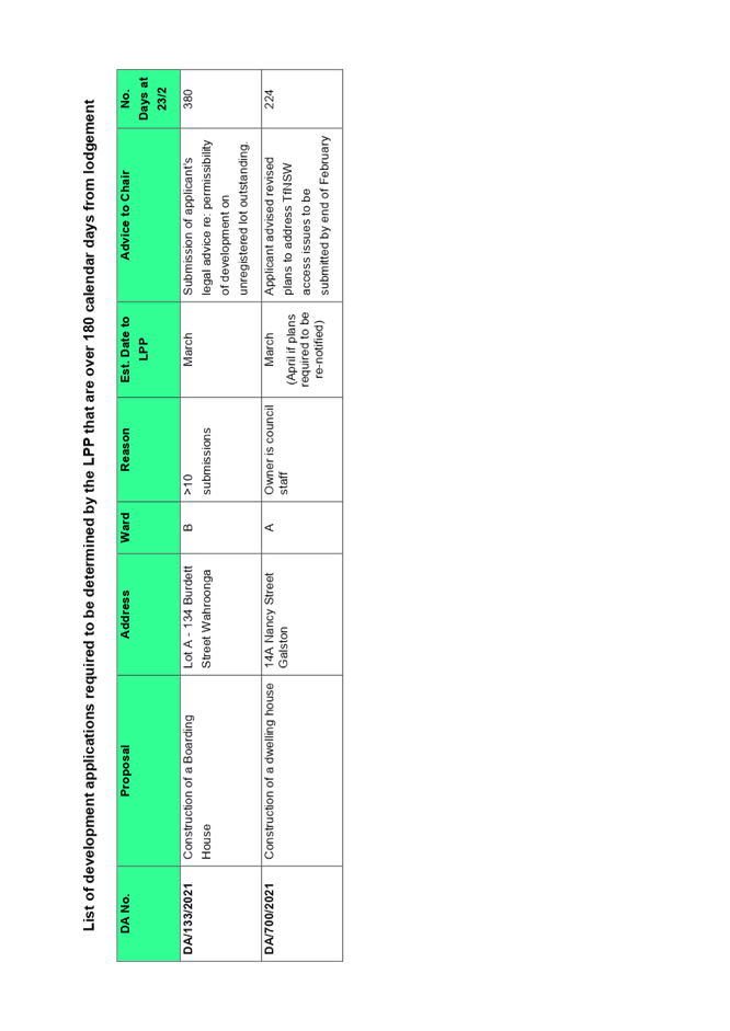
Item 9 LPP12/22 ELECTRONIC - Reporting Development Applications for Determination by the Hornsby Local Planning Panel over 180 Days........................................................... 139
LPP Report No. LPP8/22
Local Planning Panel
Date of Meeting: 23/02/2022
7 ELECTRONIC - DA/1188/2021 - ALTERATIONS AND ADDITIONS TO A DWELLING HOUSE - 14 SUTHERLAND ROAD, CHELTENHAM
EXECUTIVE SUMMARY
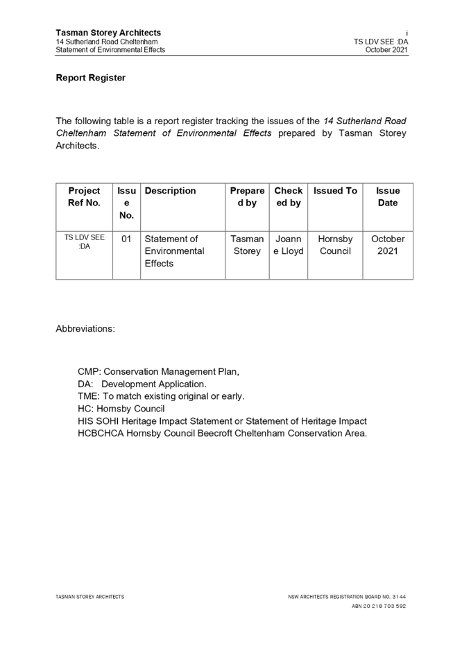
|
DA No: |
DA/1188/2021 (lodged 10 November 2021) |
|
Description: |
Alterations and additions to a dwelling house |
|
Property: |
Lot 5 DP 17378, No. 14 Sutherland Road, Cheltenham |
|
Applicant: |
Catherine Munayer Architecture |
|
Owner: |
Ms Lucinda Hope De Vries |
|
Estimated Value: |
$358,000 |
|
Ward: |
C |
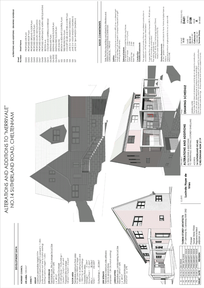
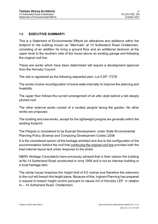
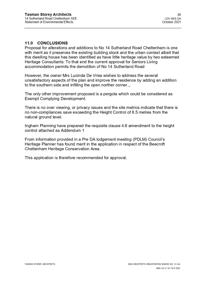
· The application proposes alterations and additions to a dwelling house known as “Merrivale”.
· The proposal does not comply with the Hornsby Shire Local Environmental Plan 2013 (HLEP) with regard to Clause 4.3 ‘Height of Buildings’. The applicant has made a submission in accordance with Clause 4.6 ‘Exceptions to development standards’ of the HLEP to contravene the maximum building height of 8.5m development standard. The submission is considered well founded and is supported.
· The application is required to be determined by the Hornsby Local Planning Panel as the proposal would contravene the HLEP development standard for maximum height of buildings by more than 10 percent.
· No submissions were received with respect to the application.
· It is recommended that the application be approved.
|
THAT the Hornsby Shire Council Local Planning Panel assume the concurrence of the Secretary of the Department of Planning and Environment pursuant to Clause 4.6 of the Hornsby Local Environmental Plan 2013 and approve Development Application No. DA/1188/2021 for alterations and additions to a dwelling house at Lot 5 DP 17378, No. 14 Sutherland Road, Cheltenham subject to the conditions of consent detailed in Schedule 1 of LPP Report No. LPP8/22. |
BACKGROUND
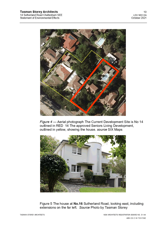
On 10 December 2019, DA/1115/2017 was approved by the Land and Environmental Court (LEC) for the demolition of existing structures, adaptive reuse of an existing dwelling, and construction of a senior’s living development at No’s. 14-18 Sutherland Road, Cheltenham subject to conditions.
The subject site comprises one of the lots which was part of the LEC consent for senior’s living..
On 14 October 2021, Council issued pre-lodgement advice (PL92/2021) for alterations and additions to a dwelling house within a heritage conservation area at No. 14 Sutherland Road, Cheltenham.
To date, the works associated with the DA/1115/2017 consent have not proceeded.
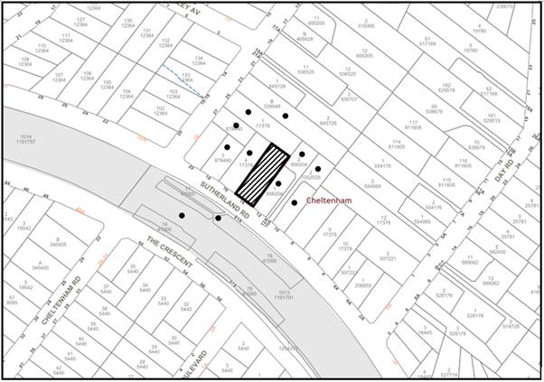
SITE
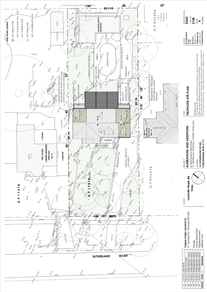
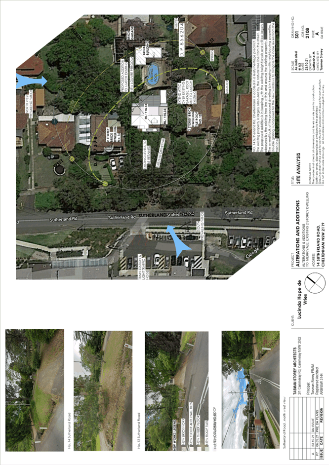
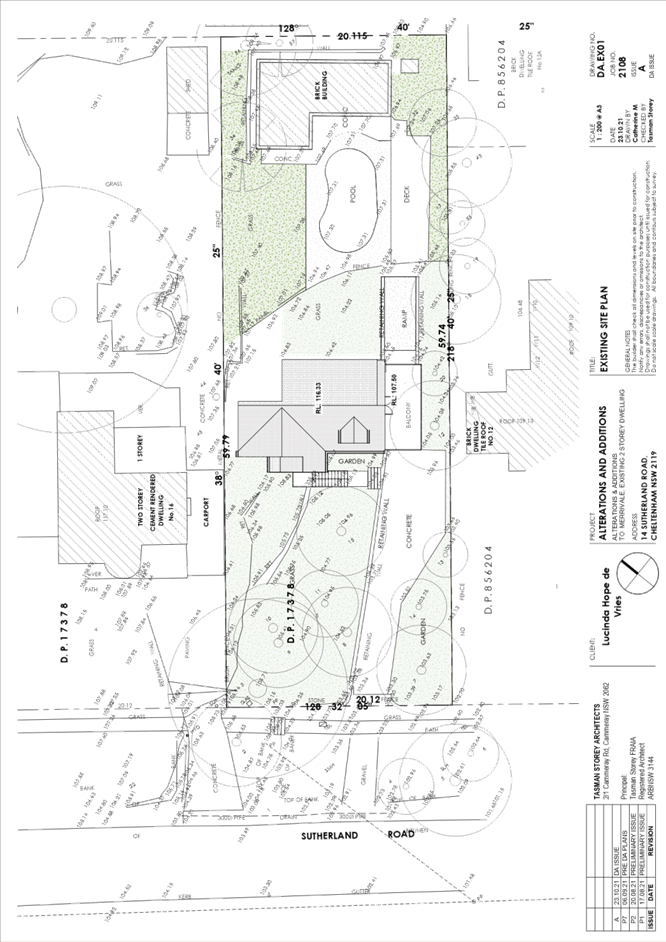
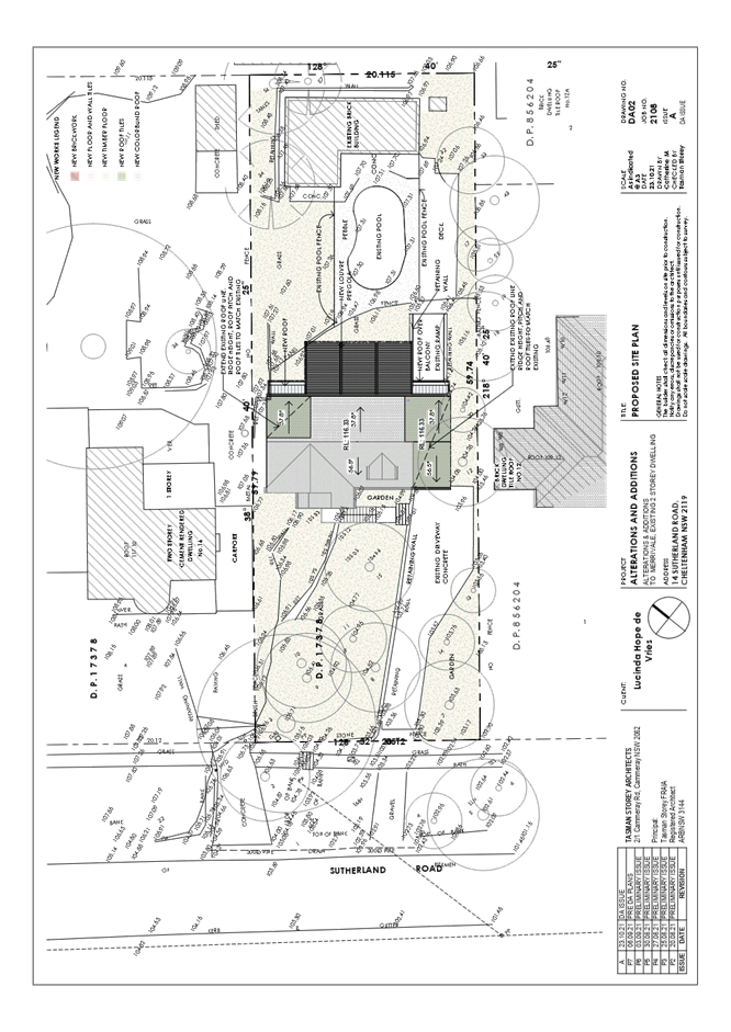
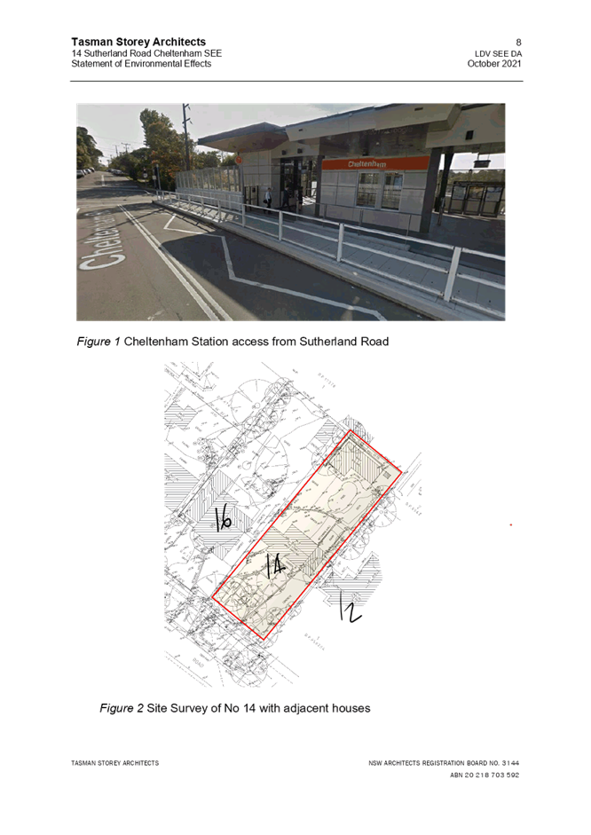
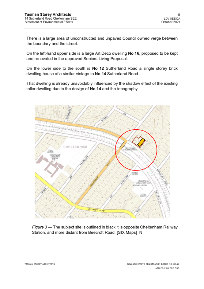
The 1202.5m² site is located on the north-eastern side of Sutherland Road, Cheltenham, adjacent to Cheltenham Train Station and contains a dwelling house, swimming pool and granny flat.
The site experiences a 6m cross fall to the southern, front corner of this site.
The site is not flood or bushfire prone and does not contain any easements or restrictions.
The site is located in the Beecroft/Cheltenham Precinct of the Beecroft-Cheltenham Heritage Conservation Area (HCA) identified in Schedule 5 (Environmental Heritage) of the Hornsby Local Environmental Plan 2013.
PROPOSAL
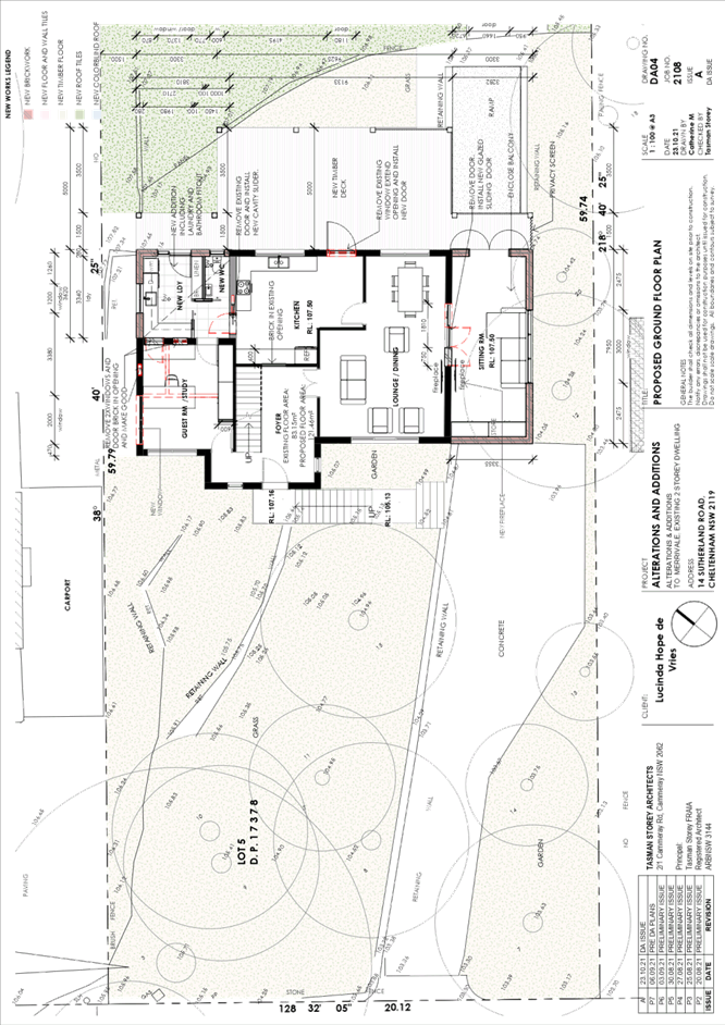
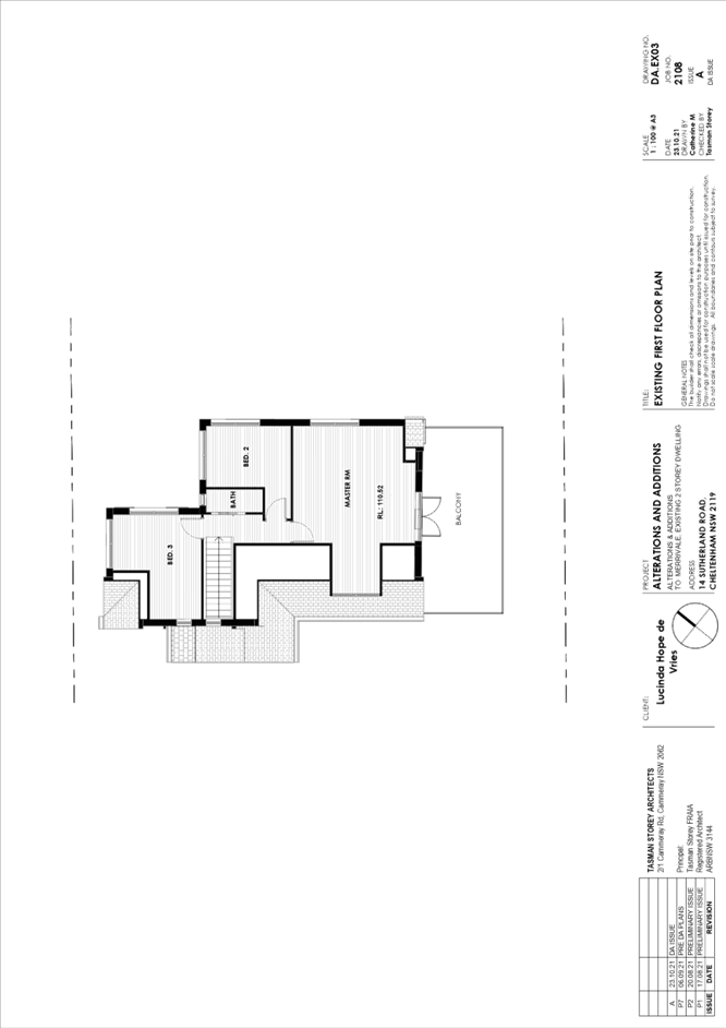
The application proposes alterations and additions to a dwelling house comprising the following:
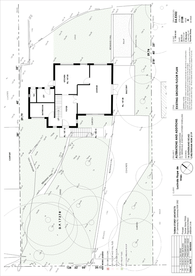
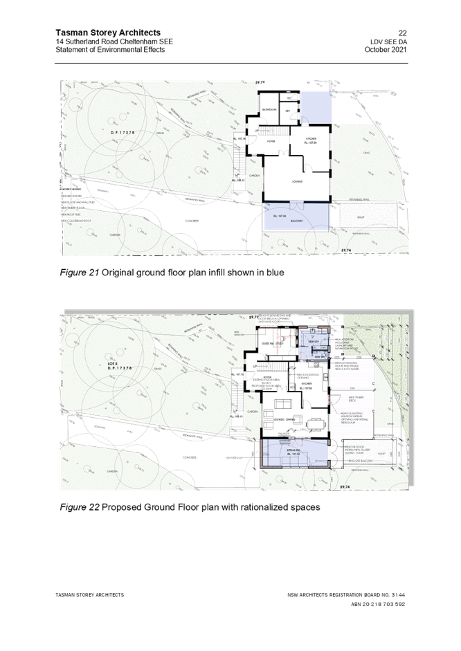
· Ground floor
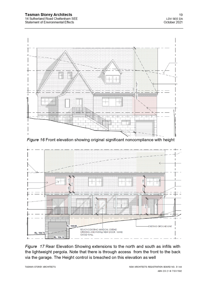
o The addition of a sitting room to the south-eastern elevation in replacement of an existing open balcony.
o The addition of a laundry and powder room to the northern, rear corner.
o A new timber deck and pergola at the rear.
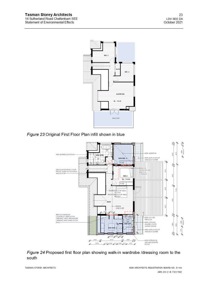
· First floor
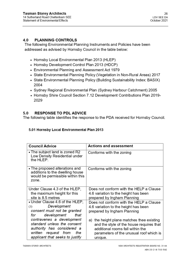
o The addition of a bedroom above the new laundry/powder room.
o The addition of a walk-in-robe and ensuite to the master bedroom above the new sitting room.
The application also includes minor internal layout changes and fixtures to both floors of the existing dwelling.
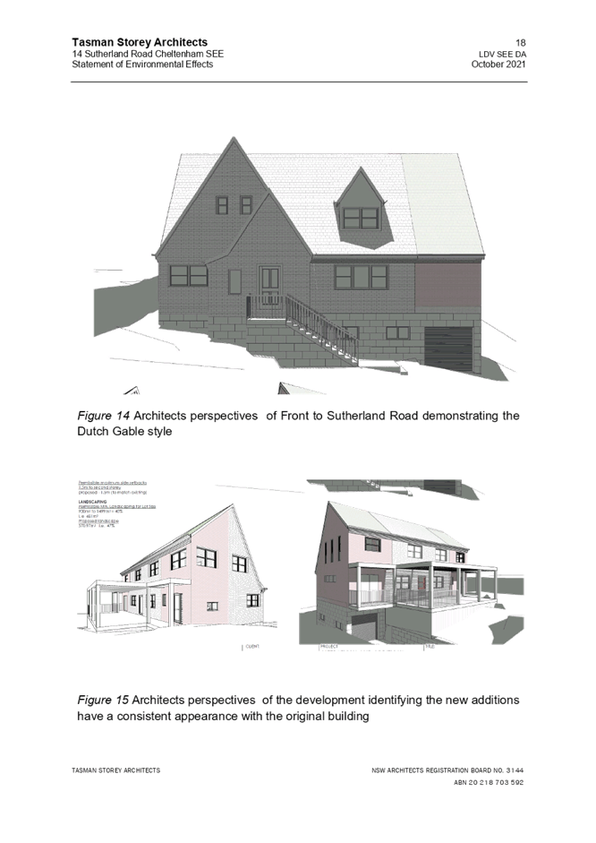
The proposed additions have been designed to continue the original roof line of the dwelling house, to improve the internal layout, whilst sympathetically retaining the visual impact of the dwelling house when viewed from the street.
No trees would be removed or impacted by the development
ASSESSMENT
The development application has been assessed having regard to the Greater Sydney Region Plan – A Metropolis of Three Cities, the North District Plan and the matters for consideration prescribed under Section 4.15 of the Environmental Planning and Assessment Act 1979 (the Act). The following issues have been identified for further consideration.
1. STRATEGIC CONTEXT
1.1 Greater Sydney Region Plan - A Metropolis of Three Cities and North District Plan
The Greater Sydney Region Plan - A Metropolis of Three Cities has been prepared by the NSW State Government to guide land use planning decisions for the next 40 years (to 2056). The Plan sets a strategy and actions for accommodating Sydney’s future population growth and identifies dwelling targets to ensure supply meets demand. The Plan also identifies that the most suitable areas for new housing are in locations close to jobs, public transport, community facilities and services.
The NSW Government will use the subregional planning process to define objectives and set goals for job creation, housing supply and choice in each subregion. Hornsby Shire has been grouped with Hunters Hill, Ku-ring-gai, Lane Cove, Mosman, North Sydney, Ryde, Northern Beaches and Willoughby to form the North District. The Greater Sydney Commission has released the North District Plan which includes priorities and actions for Northern District for the next 20 years. The identified challenge for Hornsby Shire will be to provide an additional 4,350 dwellings by 2021 with further strategic supply targets to be identified to deliver 97,000 additional dwellings in the North District by 2036.
· Planning Priority N5 - Providing housing supply, choice and affordability, with access to jobs, services and public transport.
· Planning Priority N6 - Creating and renewing great places and local centres, and respecting the Districts heritage.
In giving effect to A Metropolis of Three Cities, these Planning Priority deliver on the following objective and the corresponding strategies:
· Objective 11 - Housing is more diverse and affordable.
· Objective 13 - Environmental heritage is identified, conserved and enhanced.
The proposed alterations and addition to the dwelling house have been thoroughly considered and identified within this report. It is considered that the alterations to the dwelling house would provide a contemporary, more user-friendly family home, whilst sensitively retaining the interesting form of the dwelling house within a HCA.
The proposal would meet objectives of these planning priorities and would be considered acceptable in the context of the Greater Sydney Region Plan - A Metropolis of Three Cities and North District Plan.
2. STATUTORY CONTROLS
Section 4.15(1)(a) requires Council to consider “any relevant environmental planning instruments, draft environmental planning instruments, development control plans, planning agreements and regulations”.
2.1 Hornsby Local Environmental Plan 2013
The proposed development has been assessed having regard to the provisions of the Hornsby Local Environmental Plan 2013 (HLEP).
2.1.1 Zoning of Land and Permissibility
The subject land is zoned R2 Low Density Residential under the HLEP. The objectives of the R2 zone are:
· To provide for the housing needs of the community within a low-density residential environment.
· To enable other land uses that provide facilities or services to meet the day to day needs of residents.
The proposed development is defined as alterations and addition to a ‘dwelling house’, is permissible in the zone with Council’s consent and would meet the objectives of the zone by providing for the housing needs of the community within a low-density residential environment.
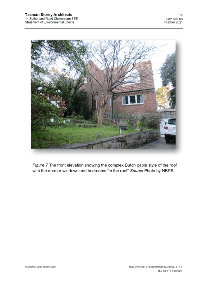
2.1.2 Height of Buildings
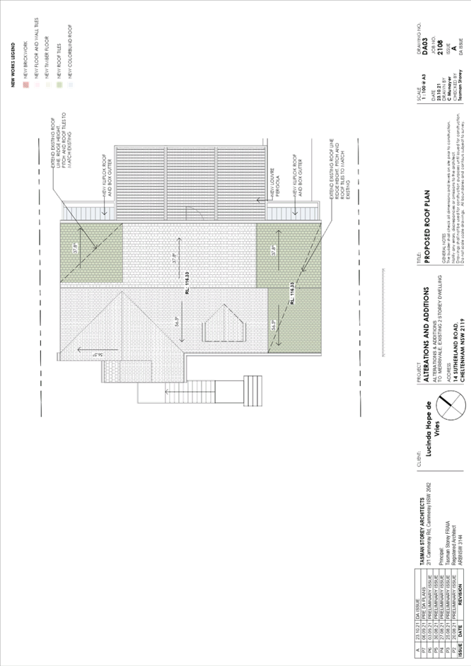
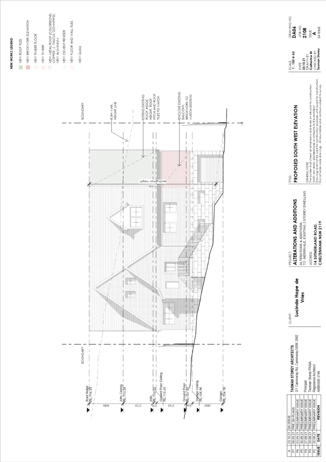
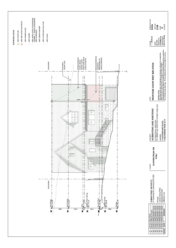
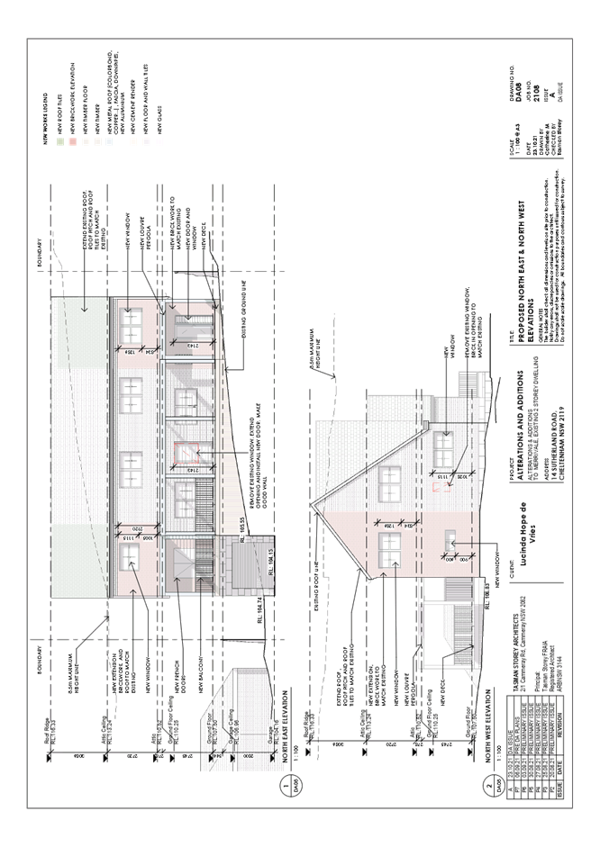
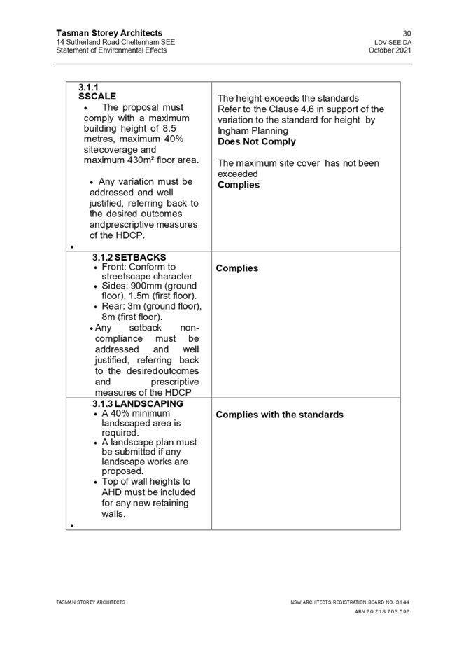
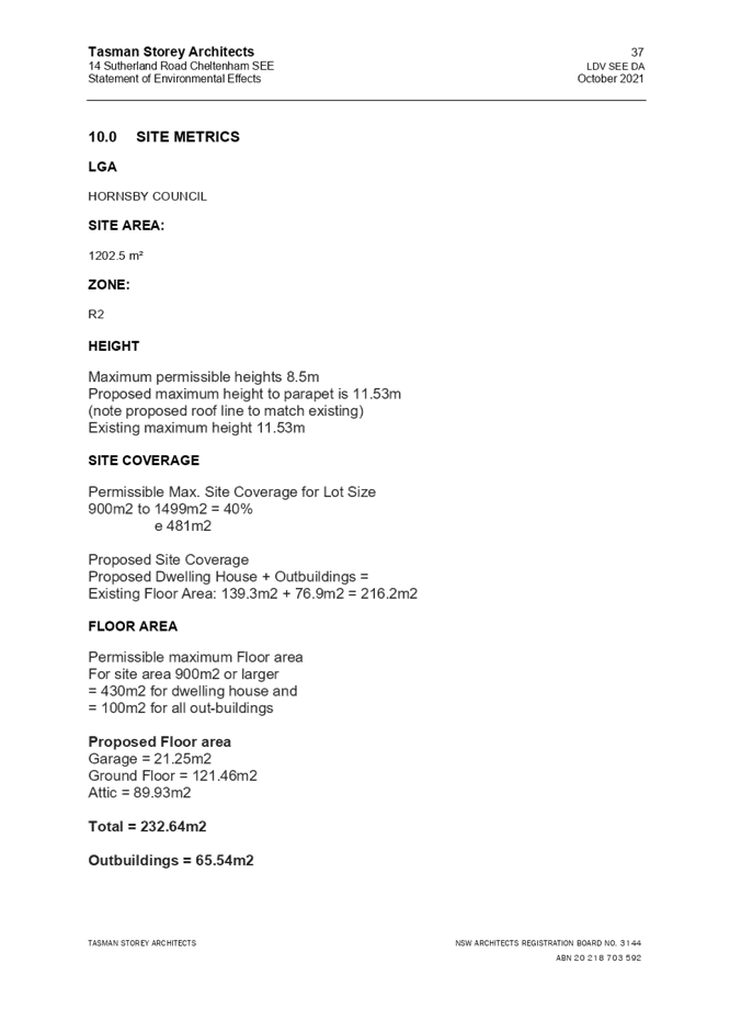
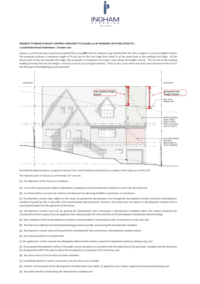
Clause 4.3 of the HLEP provides that the height of a building on any land should not exceed the maximum height shown for the land on the Height of Buildings Map. The maximum permissible height for the subject site is 8.5m. The proposed development would result in a maximum height of 11.86m and does not comply with this provision.
The application is supported by a submission pursuant to Clause 4.6 of HLEP to contravene the maximum height of buildings development standard, which is discussed below in Section 2.1.3 of this report.
2.1.3 Exceptions to Development Standards
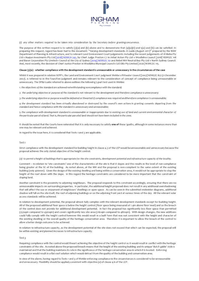
The application has been assessed against the requirements of Clause 4.6 of the HLEP. This clause provides flexibility in the application of the development standards in circumstances where strict compliance with those standards would, in any particular case, be unreasonable or unnecessary or tender to hinder the attainment of the objectives of the zone.
The proposal would exceed the 8.5m maximum building height development standard for a low-density residential zone with a proposed height of 11.86m.
The objective of Clause 4.3 Height of Buildings is “to permit a height of buildings that is appropriate for the site constrains, development potential and infrastructure capacity of the locality”.
The applicant has made a submission in support of the contravention to the development standard in accordance with Clause 4.6 of the HLEP. Clause 4.6 provides that development consent must not be granted for development that contravenes a development standard unless the consent authority has considered a written request from the applicant that seeks to justify the contravention of the development standard by demonstrating:
(a) That compliance with the development standard is unreasonable or unnecessary in the circumstances of the case, and
(b) That there are sufficient environmental planning grounds to justify contravening the development standard.
Council must be satisfied that the written request provided by the applicant under Clause 4.6 addresses both the unreasonable and unnecessary test and demonstrates sufficient environmental planning grounds to justify contravening the development standard. These matters are discussed below.
2.1.3.1 Unreasonable or Unnecessary
There are five common methods by which an applicant can demonstrate that compliance with a development standard is unreasonable or unnecessary in the circumstances of the development. Initially proposed for objections under clause 6 of SEPP 1 in the decision of Wehbe v Pittwater Council [2007] NSWLEC 827 Pearson C summarised and applied these methods to written requests made under Clause 4.6 in Four2Five Pty Ltd v Ashfield Council [2015] NSWLEC 1009 [61-62]. These five methods are generally as follows:
1. The objectives of the standard are achieved notwithstanding noncompliance with the standard.
2. The underlying objective or purpose of the standard is not relevant to the development and therefore compliance is unnecessary.
3. The underlying object of purpose would be defeated or thwarted if compliance was required and therefore compliance is unreasonable.
4. The development standard has been virtually abandoned or destroyed by the council’s own actions in granting consents departing from the standard and hence compliance with the standard is unnecessary and unreasonable.
5. The compliance with development standard is unreasonable or inappropriate due to existing use of land and current environmental character of the particular parcel of land. That is, the particular parcel of land should not have been included in the zone.
It is not required to demonstrate that a development meets multiple methods as listed above, and the satisfaction of one can be adequate to demonstrate that the development standard is unreasonable or unnecessary.
The applicant made a submission in support of a contravention to the development standard in accordance with Clause 4.6 of the HLEP. The development application seeks to contravene the development standard by 3.36m (39.5%). The applicant states the proposed contravention is considered to be consistent with the objectives of the control and is justified as follows:
· In relation to ‘site constraints’ one of the characteristics of the site is its slope and this results in the level of non-compliance being greater at the SE of the building. As noted above, at the NW end the proposal is non-compliant to the same extent of the existing building (only 400mm). Given the design of the existing dwelling and being within a conservation area, it would not be appropriate to step the height of the roof down with the slope. In this regard the heritage constraints are considered to be more important that the constraint of sloping land.
· Another constraint is the proximity to adjoining neighbours. The proposal responds to this constraint, accordingly, ensuring that there are no unreasonable impacts on surrounding properties. In particular, the additional height proposed does not result in any additional overshadowing that will affect the use or enjoyment of neighbours’ dwellings or open space. As can be seen in the submitted midwinter diagrams, additional shadow will fall on the site itself, the roof of adjoining buildings or on the adjoining front yard at various times of the day. All the relevant solar access standards will be achieved.
· In relation to development potential, the proposal almost fully complies with the relevant development standards except for building height. All of the proposed additional floor space is below the height control (floor space being measured at 1.4m above floor level) and so the breach of the control does not provide for additional development potential. In fact the proposal has significantly less floor space than permitted (232sqm compared to 430sqm) and covers significantly less site area (216sqm compared to 481sqm). With design changes, the new additions could fully comply with the height control however this would result in a built form that is not consistent with the height and character of the existing dwelling or the overall quality of the heritage conservation area. Therefore it is important to allow the breach of the control to allow a better design outcome to be achieved.
· In relation to infrastructure capacity, as the development potential of the site does not exceed that which can be expected, the proposal will be within existing and planned increases to infrastructure capacity.
· Requiring compliance with the control would thwart achieving the objective of the height control as it would result in conflict with the heritage constraints of the site. As noted above the proposed breach means that the height of the existing building and its unique ‘dutch gable’ style is maintained and that the building maintains its role in the significance of the heritage conservation area in which it is located. Enforcing compliance would result in a flat roof solution which would detract from the quality of the building and conservation area.
· As noted above, the proposal has been specifically designed to provide a superior planning outcome, consistent with the objective of Clause 4.6 to “achieve better outcomes for and from development by allowing flexibility in particular circumstances”. As detailed above strict compliance with the controls would result in a poorer level of integration with the existing dwelling, which already substantially breaches the height control. It would mean relying on a flat roof solution which would detract from the quality of the existing building and the significance of the heritage conservation area.
· As detailed above and in the submitted SEE, the proposal has very minimal impact on surrounding properties and the level of impact arising from the non-compliance is negligible. This is because the height breach is limited to the pitched roof and therefore it does not add significantly to the overall bulk and scale of the building. It is also setback from neighbours to reduce visual and overshadowing impacts. A compliant building would be lower but could be much larger than what is being proposed and be located closer to the site boundaries, creating greater impact.
· In view of the above it is considered that there are sufficient environmental planning grounds, specifically related to the subject site, that warrant contravention of the height standard.
Council considers the applicants request to contravene the height development standard is considered well founded for the following reasons:
· The height departure would not result in any significant amenity impact to surrounding neighbours and would not result in additional overshadowing of adjoining and nearby premises.
· The existing dwelling house already exceeds the maximum 8.5m height development control of the HLEP with an existing height of 11.53m.
· The proposed additions are designed to match the existing roof pitch, align with the existing ridge line of RL116.33 and sympathetically conform with the existing Dutch gable roofed dwelling house.
· There would be no change to the existing RL, just a 0.33m increase in overall height as a result of the sites crossfall/topography.
· The overall appearance of the building, when viewed from the street front, would be substantially unchanged and consistent with the heritage requirements of the HLEP.
· The proposal is considered a sensitive and modest modification that will retain the interesting form of the building and its unusual roof. It would have no discernible impact on the HCA, nearby heritage items or the streetscape.
· The proposed development would not overly dominate the natural environment or surrounding built elements.
· The proposed height variation is appropriate considering the constraints of the site in terms of land slope and protection of trees.
· The application provides for the orderly and economic development of land, improved residential amenity of the existing residence and demonstrates adequate consideration and protection of the environmental and public interest.
· The proposed development generally meets the objectives of Clause 4.3 Height of Buildings of the HLEP by way of being appropriate with respect to the constraints of the site and in regard to the development potential of the site.
Based on this assessment, it is considered that compliance with the development standard would be unreasonable and unnecessary in the circumstances of the case.
2.1.3.2 Environmental Planning Grounds
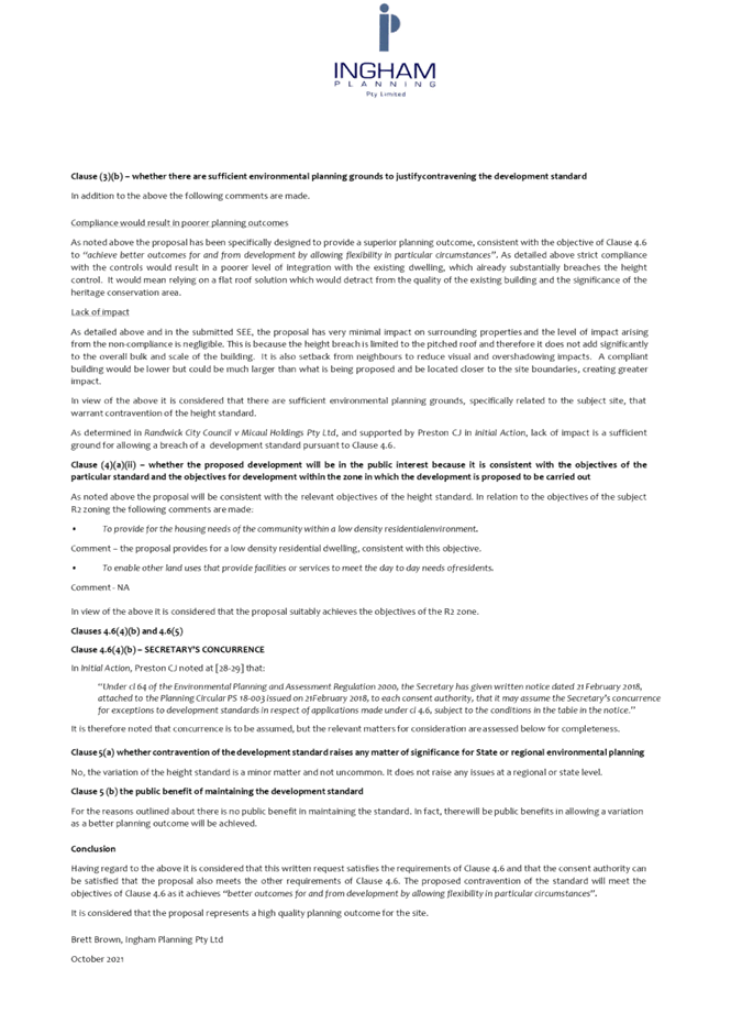
In addition to demonstrating that compliance is unreasonable or unnecessary, Clause 4.6(3)(b) of the HLEP requires that there are sufficient environmental planning grounds to justify contravening the development standard. In demonstrating that sufficient environmental planning grounds exist, it must be demonstrated that the planning grounds are particular to the circumstances of the development on the subject site (summarised from Four2Five Pty Ltd v Ashfield Council [2015] NSWLEC 1009 [60].
In demonstrating the environmental planning grounds the written request states:
Compliance would result in poorer planning outcomes
As noted above the proposal has been specifically designed to provide a superior planning outcome, consistent with the objective of Clause 4.6 to “achieve better outcomes for and from development by allowing flexibility in particular circumstances”. Strict compliance with the controls would result in a poorer level of integration with the existing dwelling, which already substantially breaches the height control. It would mean relying on a flat roof solution which would detract from the quality of the existing building and the significance of the heritage conservation area.
Lack of impact
As detailed above and in the submitted SEE, the proposal has very minimal impact on surrounding properties and the level of impact arising from the non-compliance is negligible. This is because the height breach is limited to the pitched roof and therefore it does not add significantly to the overall bulk and scale of the building. It is also setback from neighbours to reduce visual and overshadowing impacts. A compliant building would be lower but could be much larger than what is being proposed and be located closer to the site boundaries, creating greater impact.
In view of the above it is considered that there are sufficient environmental planning grounds, specifically related to the subject site, that warrant contravention of the height standard.
As determined in Randwick City Council v Micaul Holdings Pty Ltd, and supported by Preston CJ in Initial Action, lack of impact is a sufficient ground for allowing a breach of a development standard pursuant to Clause 4.6.
Council considers that the environmental planning grounds stated within the written request are sufficient with respect to Clause 4.6(3)(b) and that the stated grounds are specific to the proposed development and the circumstances of the development site. It is therefore considered that the written request adequately demonstrates compliance with the clause and is acceptable in this regard.
Council further notes that in demonstrating the unreasonable and unnecessary test, the applicant further established environmental planning grounds with respect to the site and the surrounding constraints.
2.1.3.3 Public Interest and Clause 4.6(4)
Clause 4.6(4) states that development consent must not be granted for development that contravenes a development standard unless:
(a) The consent authority is satisfied that -
(i) The applicant’s written request has adequately addressed the matters required to be demonstrated by subclause (3), and
(ii) The proposed development will be in the public interest because it is consistent with the objectives of the particular standard and the objectives for development within the zone in which the development is proposed to be carried out, and
(b) The concurrence of the Planning Secretary has been obtained.
With regard to part (i), the written request is considered to adequately address the matter required to be demonstrated as outlined above.
With regard to part (ii), the proposed development is considered to be in the public interest because it is consistent with the objectives of the particular standard and the objectives for development within the zone in which the development is proposed to be carried out.
With regard to (b) the concurrence of the Planning Secretary is assumed.
Accordingly, it is considered that the written request satisfactorily responds to the relevant matters required to be addressed under Clause 4.6 and that the Panel, as consent authority, may rely upon the written request and grant development consent to the development application. Should the Panel resolve to approve the application, it should also provide a statement in the reasons for approval that it has satisfied itself of the matters in Clause 4.6(4).
2.1.4 Heritage Conservation
Clause 5.10 of the HLEP sets out heritage conservation provisions for Hornsby Shire Council.
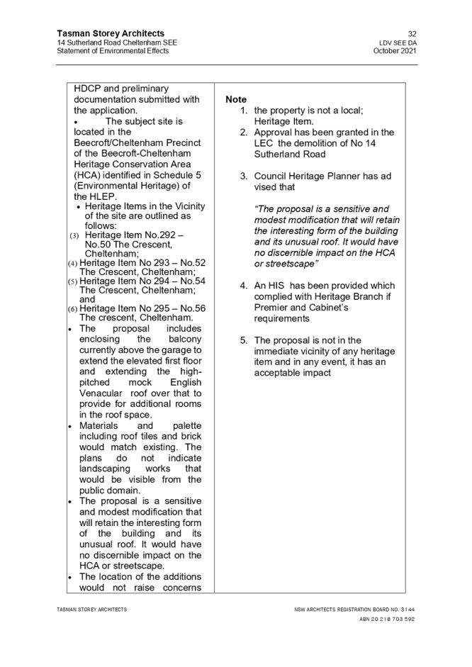
The site is located in the Beecroft/Cheltenham Precinct of the Beecroft-Cheltenham Heritage Conservation Area (HCA) identified in Schedule 5 (Environmental Heritage) of the HLEP.
Council’s heritage assessment of the proposal under the pre-lodgement application is outlined as follows:
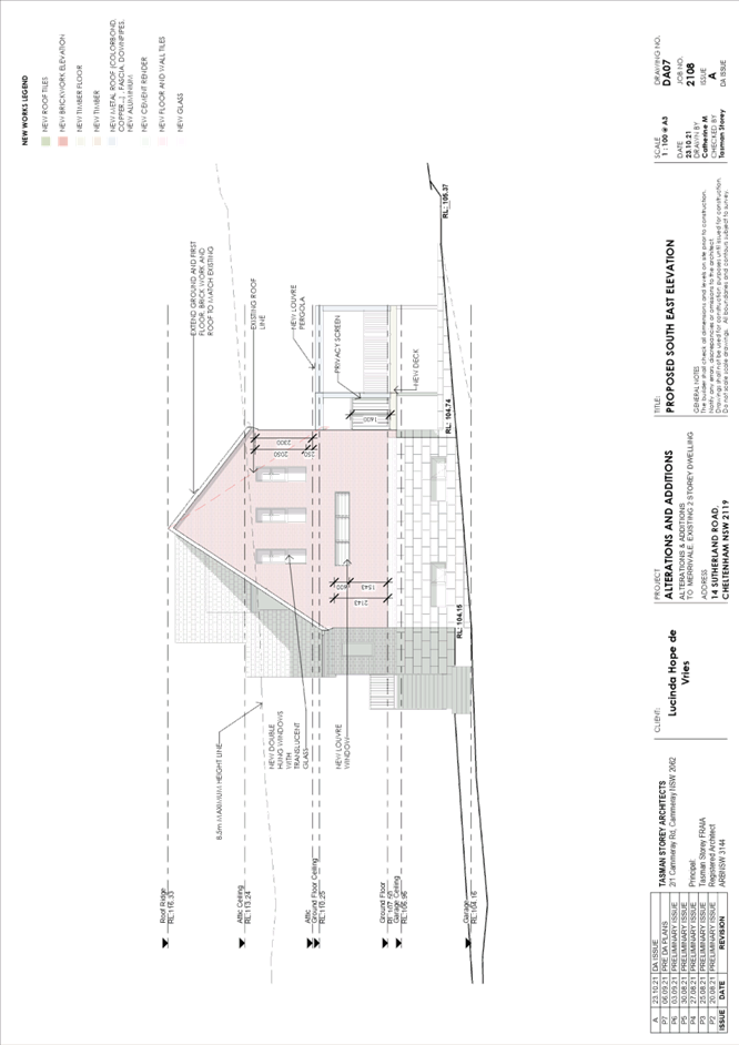
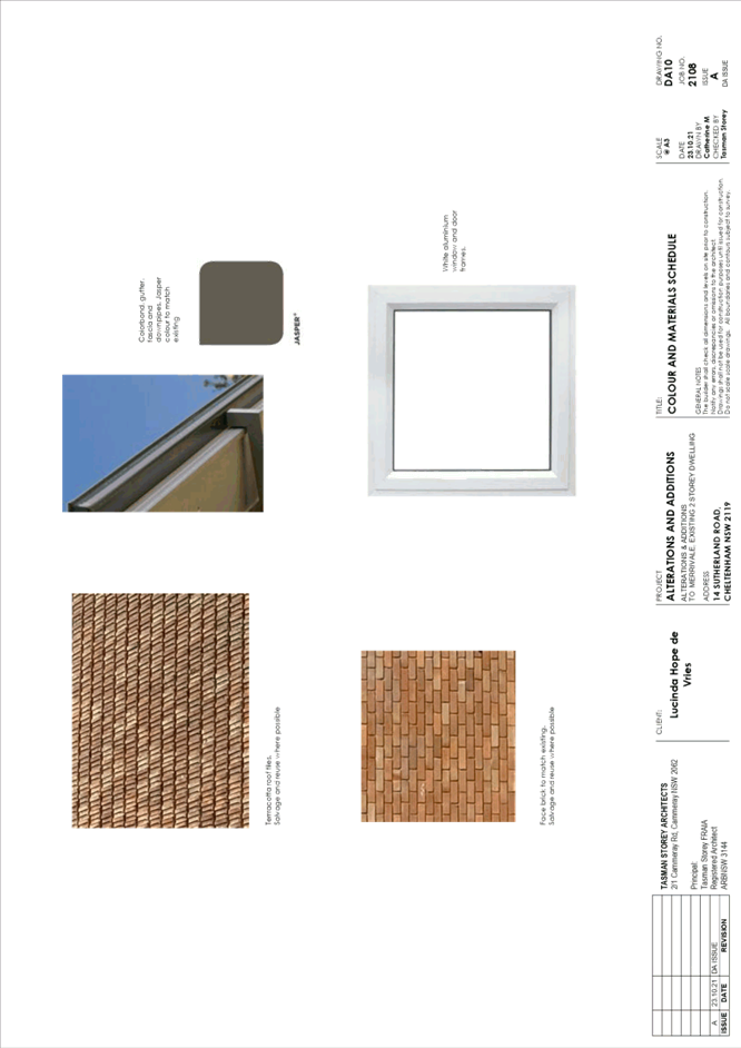
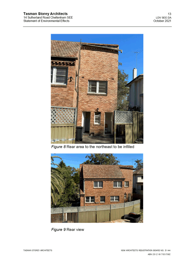
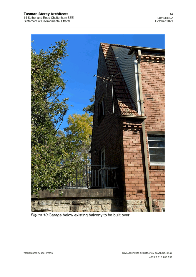
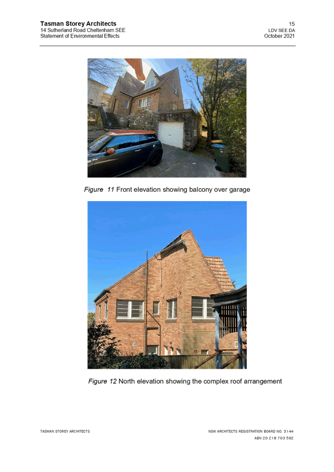
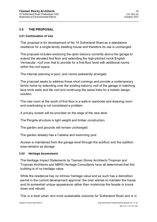
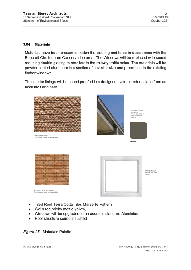
· The proposal includes enclosing the balcony currently above the garage to extend the elevated first floor and extending the high-pitched mock Dutch gabled roof over that to provide for additional rooms in the roof space.
· Materials and palette including roof tiles and brick would match existing. The plans do not indicate landscaping works that would be visible from the public domain.
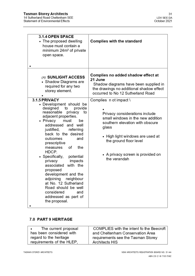
· The proposal is a sensitive and modest modification that will retain the interesting form of the building and its unusual roof. It would have no discernible impact on the HCA or streetscape.
· The location of the additions would not raise concerns regarding impacts on heritage items in the vicinity.
· In summary, as the proposal stands, there are no heritage concerns; however, in accordance with Clause 5.10(5) of the HLEP and Part 9.1.2 of the HDCP the following information is to be submitted with any future application for the proposal as identified below.
o Heritage Impact Statement (HIS). The HIS should include a brief history of the site and assessment of the impacts, including the heritage requirements of the HDCP.
o Detailed Schedule of Material and Finishes.
o Landscape Plan if landscape works are proposed.
Council’s heritage assessment for this application concluded that “the proposal has been considered with regards to the heritage requirements of the HLEP, the HDCP and the documentation submitted with the application. As the submitted plans are the same as those considered for PL/92/2021, there are no heritage concerns.”
In summary, the proposal would meet the objectives of Clause 5.10 of the HLEP and is considered acceptable.
2.1.5 Earthworks
Clause 6.2 of the HLEP states that consent is required for proposed earthworks on site.
(1) The objective of this clause is to ensure that earthworks for which development consent is required will not have a detrimental impact on environmental functions and processes, neighbouring uses, cultural or heritage items or features of the surrounding land.
The proposed additions including additional building footprint associated with the laundry and deck would result in minimal earthworks, with the exception of the requirements of foundations/footings. These works would have negligible impacts on adjoining properties, drainage patterns and/or soil stability of the locality. As such, the proposal is considered to meet the objective of this Clause.
2.2 State Environmental Planning Policy No. 55 Remediation of Land
The application has been assessed against the requirements of State Environmental Planning Policy No. 55 Remediation of Land (SEPP 55) under which consent must not be granted to the carrying out of any development on land unless the consent authority has considered whether the land is contaminated or requires remediation for the proposed use.
Should the land be contaminated, Council must be satisfied that the land is suitable in a contaminated state for the proposed use. If the land requires remediation to be undertaken to make the land suitable for the proposed use, Council must be satisfied that the land will be remediated before the land is used for that purpose.
An examination of Council’s records and aerial photography has determined that the site has been historically used for residential purposes. It is not likely that the site has experienced any significant contamination, and further assessment under SEPP 55 is not required.
2.3 State Environmental Planning Policy (Building Sustainability Index: BASIX) 2004
The application has been assessed against the requirements of State Environmental Planning Policy (Building Sustainability Index - BASIX) 2004. The proposal includes a BASIX Certificate for the proposed dwelling house.
A condition is recommended in Schedule 1 of this report requiring the recommendations of the BASIX certificate be complied with.
2.4 State Environmental Planning Policy (Vegetation in Non-Rural Areas) 2017
State Environmental Planning Policy (Vegetation in Non-Rural Areas) 2017 (Vegetation SEPP) aims to protect the biodiversity and amenity values of trees within non-rural areas of the state.
Part 3, Clause 9(2) of the Vegetation SEPP states that a Development Control Plan may make a declaration in any manner relating to species, size, location and presence of vegetation. Accordingly, Part 1B.6.1 of the Hornsby Development Control Plan 2013 (HDCP) prescribes works that can be undertaken with or without consent to trees and objectives for tree preservation.
The application has been assessed against the requirements of the Vegetation SEPP and it has been determined that the proposal would meet the objectives of the Vegetation SEPP. This matter is addressed in Section 3.1.1 of this report.
2.5 Sydney Regional Environmental Plan (Sydney Harbour Catchment) 2005
The application has been assessed against the requirements of Sydney Regional Environmental Plan (Sydney Harbour Catchment) 2005. This Policy provides general planning considerations and strategies to ensure that the catchment, foreshores, waterways and islands of Sydney Harbour are recognised, protected, enhanced and maintained.
Subject to the implementation of installation of sediment and erosion control measures and stormwater management to protect water quality, the proposal would have minimal potential to impact on the Sydney Harbour Catchment.
2.6 Section 3.42 Environmental Planning and Assessment Act 1979 - Purpose and Status of Development Control Plans
Section 3.42 of the Environmental Planning and Assessment Act 1979 states that a DCP provision will have no effect if it prevents or unreasonably restricts development that is otherwise permitted and complies with the development standards in relevant Local Environmental Plans and State Environmental Planning Policies.
The principal purpose of a development control plan is to provide guidance on the aims of any environmental planning instrument that applies to the development; facilitate development that is permissible under any such instrument; and achieve the objectives of land zones. The provisions contained in a DCP are not statutory requirements and are for guidance purposes only. Consent authorities have flexibility to consider innovative solutions when assessing development proposals, to assist achieve good planning outcomes.
2.7 Hornsby Development Control Plan 2013
The proposed development has been assessed having regard to the relevant desired outcomes and prescriptive requirements within the Hornsby Development Control Plan 2013 (HDCP). The following table sets out the proposal’s compliance with the prescriptive requirements of the Plan:
|
HDCP - Part 3.1 Dwelling Houses |
|||
|
Control |
Proposal |
Requirement |
Complies |
|
Site Area |
1202.5m2 |
N/A |
N/A |
|
Building Height |
11.86m |
8.5m |
No |
|
No. storeys |
3 |
max. 2 + attic |
No |
|
Site Coverage |
18% |
max. 40% |
Yes |
|
Floor Area (including granny flat) |
298m2 |
max. 430m² |
Yes |
|
Setbacks |
|
|
|
|
- Front |
Unchanged |
Conform to streetscape |
Yes |
|
- Side (south-east) |
|
|
|
|
Ground floor |
2.4m |
0.9m |
Yes |
|
First floor |
2.4m |
1.5m |
Yes |
|
- Side (north-west) |
|
|
|
|
Ground floor |
1.5m |
0.9m |
Yes |
|
First floor |
1.5m |
1.5m |
Yes |
|
- Rear |
|
|
|
|
Ground floor |
Unchanged |
3m |
Yes |
|
First floor |
Unchanged |
8m |
Yes |
|
Landscaped Area (% of lot size) |
47% |
min. 40% |
Yes |
|
Private Open Space |
|
|
|
|
- minimum area |
>24m2 |
24m2 |
Yes |
|
- minimum dimension |
>3m2 |
3m |
Yes |
|
Car Parking |
2 stacked spaces |
2 spaces |
Yes |
As detailed in the above table, with the exception of height and number of storeys, the proposed development generally complies with the numerical measures of the HDCP. The matters of non-compliance are detailed below, as well as a brief discussion on compliance with relevant desired outcomes.
2.7.1 Scale – Building Height
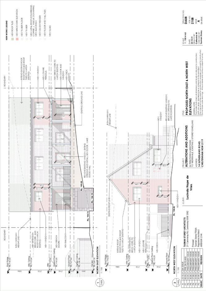
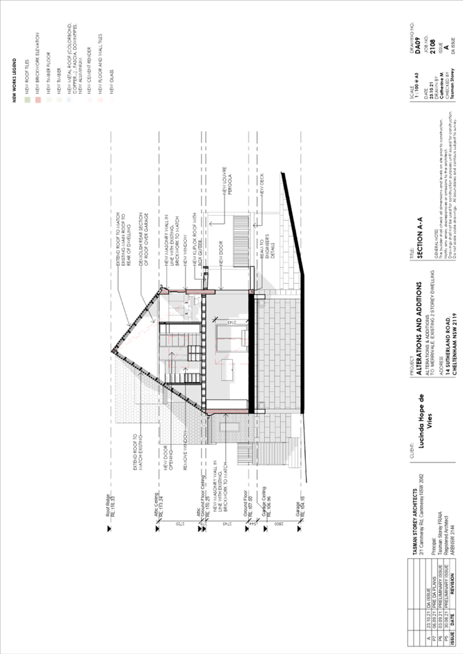
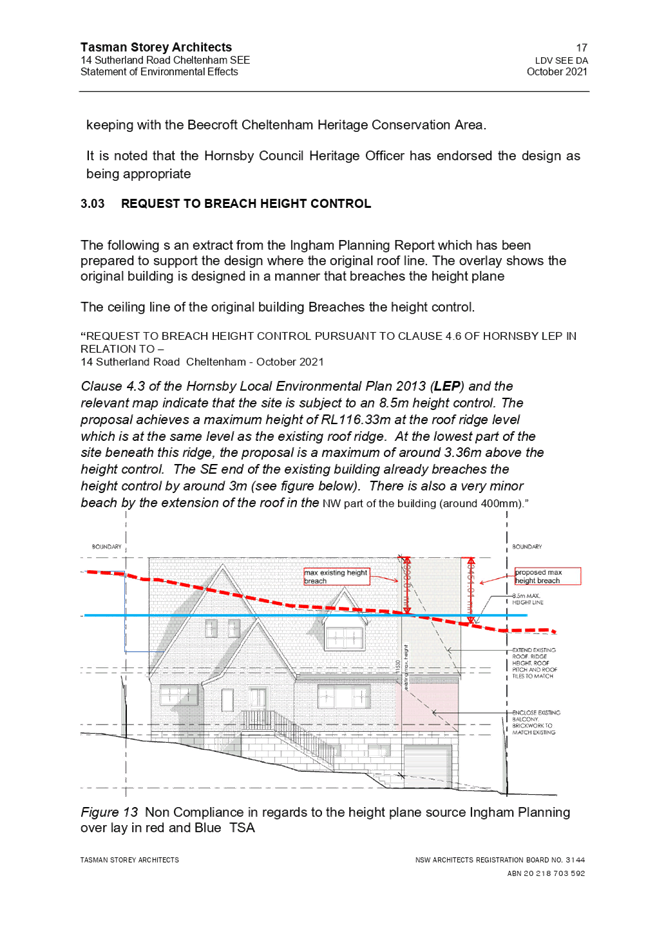
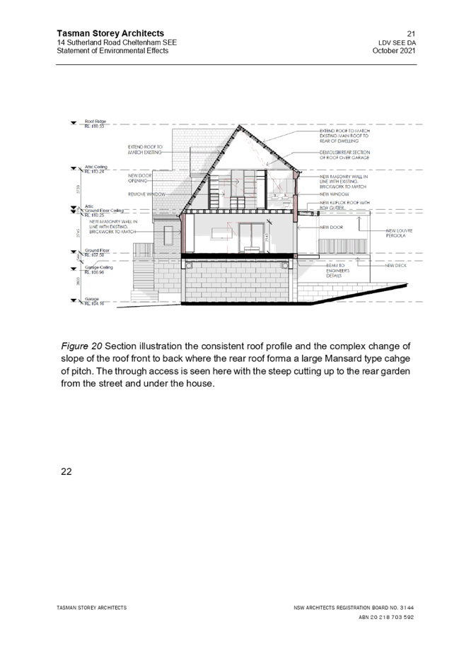
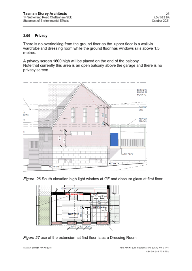
As discussed in Section 2.1.3 above, the building additions exceed the maximum building height by 3.36m and would appear as a 3-storey building along the south-eastern, side elevation.
The existing dwelling house already exceeds the maximum 8.5m height development control of the HLEP with an existing height of 11.53m.
The proposed additions are designed to match the existing roof pitch, align with the existing ridge line of RL116.33 and sympathetically conform with the existing Dutch gable roofed dwelling house.
There would be no change to the existing RL, just a 0.33m increase in overall height as a result of the sites crossfall/topography.
In support of this contravention, the height and number of storeys would not result in any significant overshadowing, loss of privacy, loss of views or loss of solar access. The proposal responds to the topographical constraints of the site, is sympathetic to the streetscape and HCA and is consistent with surrounding development.
The proposal meets the prescriptive measures of Part 3.1.1 Scale of the HDCP and is considered acceptable.
2.7.2 Privacy
The desired outcome of Part 3.1.6 Privacy under the HDCP is to encourage “development that is designed to provide reasonable privacy to adjacent properties”.
· It is a window to a habitable room, other than a bedroom, that has a floor level of more than 1 metre above existing ground level,
· The window is setback less than 3 metres from a side or rear boundary, and
· The window has a sill height of less than 1.5 metres”.
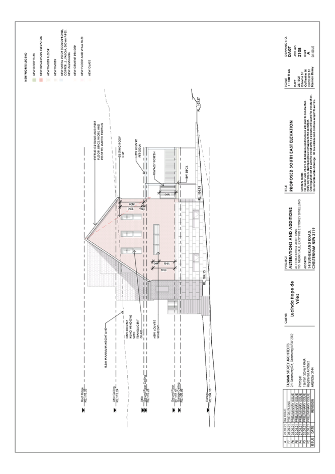
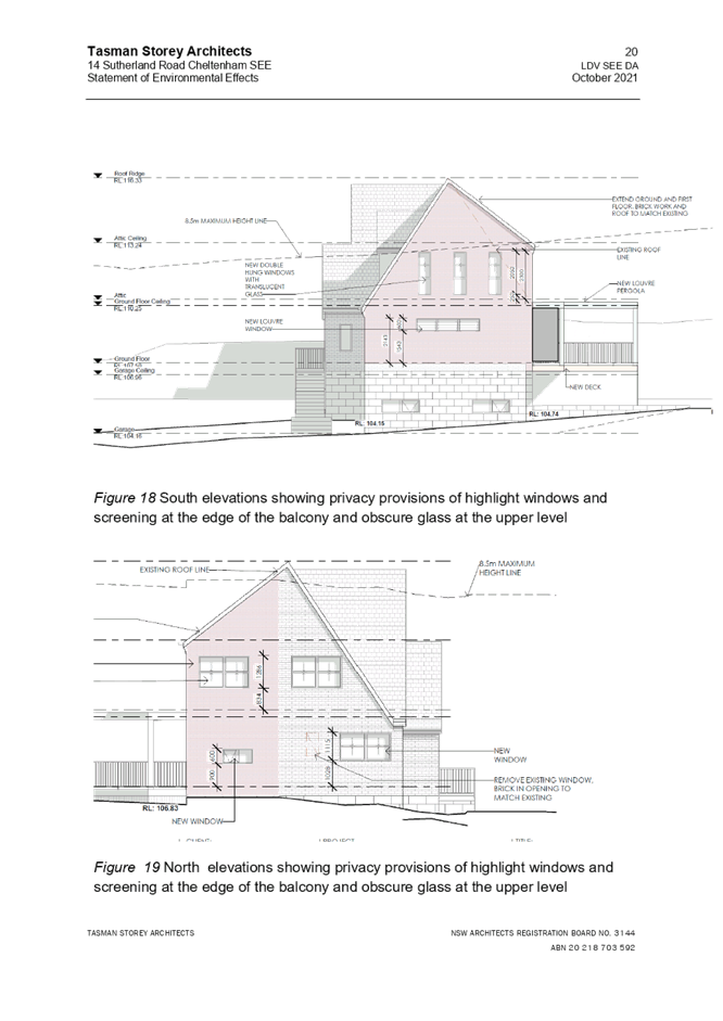
The application proposes a ground floor level balcony and sitting room more than 1m above existing ground level. Additionally, 3 windows are proposed along the south-eastern elevation of the first-floor level which would allow overlooking of the adjoining property at No. 12 Sutherland Road, Cheltenham.
In support of these variations, it is noted as follows:
· The window servicing the ground floor level sitting room would have a sill height of more than 1.5m above the finished floor level, resulting in minimal privacy impacts to neighbouring properties.
· A privacy screen and well-established trees and vegetations along the south-eastern boundary would provide effective screening and privacy to the adjoining neighbour at No. 12 Sutherland Road, having negligible amenity impacts.
· The 3 first floor level windows servicing the proposed walk-in-robe and ensuite which are not considered living or entertaining areas would include translucent glass reducing any potential amenity impacts to adjoining neighbours.
The proposal meets the desired outcomes for Part 3.1.6 Privacy under the HDCP and is considered acceptable.
2.7.3 Sunlight Access
The desired outcomes of Part 3.1.5 Sunlight Access of the HDCP is to encourage “dwelling houses designed to provide solar access to open space areas’ and “development designed to provide reasonable sunlight to adjacent properties.”
These outcomes are supported by prescriptive measures which require 50% of the required private open space areas (24m2) of any adjoining property to receive 3 hours of unobstructed sunlight access between 9am and 3pm on the winter solstice (21 June).
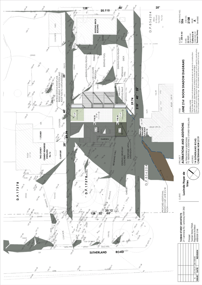
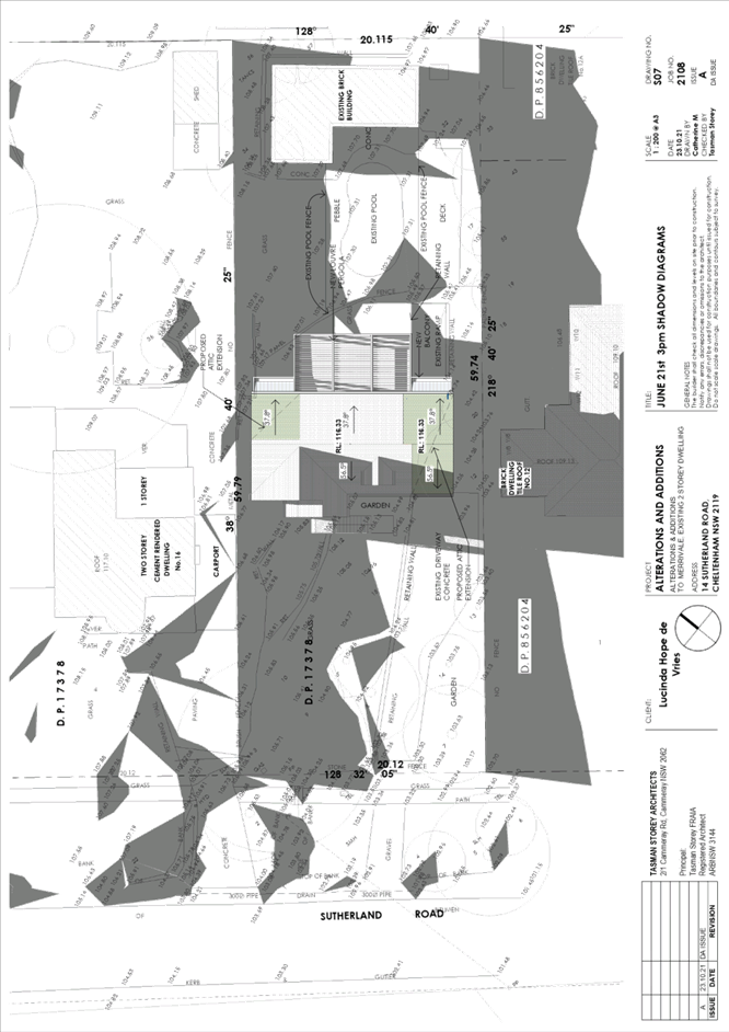
As demonstrated in the supporting shadow diagrams submitted with the development application, the proposed alterations and additions would result in minimal additional overshading to adjoining neighbours and remain compliant in terms of the relevant sunlight access prescriptive measures, resulting in negligible additional amenity impacts to adjoining neighbours.
The proposal meets the desired outcomes of Part 3.1.5 Sunlight Access of the HDCP and is considered acceptable.
2.7.4 Heritage
Part 9 of the HDCP sets out development controls for heritage items and heritage conservation areas.
The proposal has been discussed comprehensively in Section 2.1.4 of this report, would meet the desired outcomes of Part 9.3 Heritage Conservation Areas under the HDCP and is considered acceptable.
2.8 Section 7.12 Contributions Plans
Hornsby Shire Council Section 7.12 Contributions Plan 2019-2029 applies to the development as the estimated costs of works is greater than $100,000. An appropriate condition of consent is recommended requiring the payment of a contribution in accordance with the Plan.
3. ENVIRONMENTAL IMPACTS
Section 4.15(1)(b) of the Act requires Council to consider “the likely impacts of that development, including environmental impacts on both the natural and built environments, and social and economic impacts in the locality”.
3.1 Natural Environment
3.1.1 Tree and Vegetation Preservation
Section 1B.6 Tree and Vegetation Preservation of HDCP is made in accordance with State Environmental Planning Policy (Vegetation in Non-Rural Areas) 2017 (the Vegetation SEPP) and prescribes the trees and vegetation to which the Vegetation SEPP and/or Clause 5.10 of the HLEP applies and the applicable approval process.
The prescriptive measures of Part 1B.6.1 Tree Preservation of the HDCP state that:
a) “The prescribed trees that are protected by the Vegetation SEPP and/or Clause 5.10 of the HELP and this section of the DCP include:
· All trees except exempt tree species in Hornsby Shire as listed in Table 1B.6 (a) or subject to a Biodiversity Offset Scheme,
· All trees on land within a heritage conservation area described within the HLEP, and
· All trees on land comprising heritage items listed within the HLEP.
b) To damage or remove any tree protected under the HDCP is prohibited without the written consent of Council, except in accordance with the exemptions prescribed in this part (under the heading ‘Exempt Tree Work’).”
Council’s Tree Management Team reviewed the proposal and raised no objection to the proposal. There would be no trees removed or impacted as a result of the proposed development. Notwithstanding, to ensure trees within the site and road reserve are protected during construction, conditions are recommended in Schedule 1 of this report requiring tree protection fencing to be installed prior to the commencement of works, for the duration of works and in accordance with the approved Tree Location and Fencing Plan. A condition is also recommended in Schedule 1 of this report to relocate the sand, cement and soil stockpiles to a more suitable location, outside of the tree protection fencing locations.
The proposal meets the prescriptive measures of Part 1B.6.1 Tree Preservation of the HDCP and the Vegetation SEPP and is considered acceptable, subject to conditions.
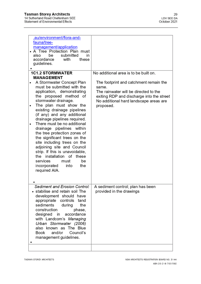
3.1.2 Stormwater Management
The proposal would connect to the existing system which is gravity drained and directed to the street.
The proposal meets the prescriptive measures of Part 1C.1.2 Stormwater Management under the HDCP and is considered acceptable.
3.2 Built Environment
3.2.1 Built Form
The built form would remain substantially the same when viewed from within the streetscape with only a slight extension to the south-eastern side of the dwelling house continuing the original roof line and form. The proposal would be consistent with residential development within the locality.
3.3 Social Impacts
The alterations and additions to a dwelling house would make a positive social contribution by providing for the housing needs of the community within a low-density residential environment.
3.4 Economic Impacts
The alterations and additions to a dwelling house would not have any detrimental economic impact upon the locality.
4. SITE SUITABILITY
Section 4.15(1)(c) of the Act requires Council to consider “the suitability of the site for the development”.
The subject site has not been identified as bushfire prone or flood prone land. The site is considered to be capable of accommodating the proposed development. The scale of the proposed development is consistent with the capability of the site and is considered acceptable.
5. PUBLIC PARTICIPATION
Section 4.15(1)(d) of the Act requires Council to consider “any submissions made in accordance with this Act”.
5.1 Community Consultation
The proposed development was placed on public exhibition and was notified to adjoining and nearby landowners between 12 November 2021 and 7 December 2021 in accordance with the Hornsby Community Engagement Plan. During this period, Council received no submissions. The map below illustrates the location of those nearby landowners who were notified.
|
NOTIFICATION PLAN |
|||
|
• PROPERTIES NOTIFIED |
X SUBMISSIONS RECEIVED |
|
|
5.2 Public Agencies
The development application was not referred to any Public Agencies for comment.
6. THE PUBLIC INTEREST
Section 4.15(1)(e) of the Act requires Council to consider “the public interest”.
The public interest is an overarching requirement, which includes the consideration of the matters discussed in this report. Implicit to the public interest is the achievement of future built outcomes adequately responding to and respecting the future desired outcomes expressed in environmental planning instruments and development control plans.
The application is considered to have satisfactorily addressed Council’s and relevant agencies’ criteria and would provide a development outcome that, on balance, would result in a positive impact for the community. Accordingly, it is considered that the approval of the proposed development would be in the public interest.
CONCLUSION
The application proposes ground and first floor alterations and additions to a dwelling house.
The development generally meets the desired outcomes of Council’s planning controls and is satisfactory having regard to the matters for consideration under Section 4.15 of the Environmental Planning and Assessment Act 1979.
Having regard to the circumstances of the case, approval of the application is recommended.
The reasons for this decision are:
· The request under Clause 4.6 of Hornsby Local Environmental Plan 2013 to contravene the ‘Height of buildings’ development standard is well founded. Strict compliance with the development standard is unreasonable and unnecessary in the circumstances of the case and there are sufficient environmental planning grounds to justify the contravention to the development standards.
· The proposed development generally complies with the requirements of the relevant environmental planning instruments and the Hornsby Development Control Plan 2013.
· The proposed development does not create unreasonable environmental impacts to adjoining development with regard to visual bulk, overshadowing, solar access, amenity or privacy.
Note: At the time of the completion of this planning report, no persons have made a Political Donations Disclosure Statement pursuant to Section 10.4 of the Environmental Planning and Assessment Act 1979 in respect of the subject planning application.
RESPONSIBLE OFFICER
The officer responsible for the preparation of this report is Madeleine Brown.
|
Cassandra Williams Major Development Manager - Development Assessments Planning and Compliance Division |
Rod Pickles Manager - Development Assessments Planning and Compliance Division |
|
1.⇩ |
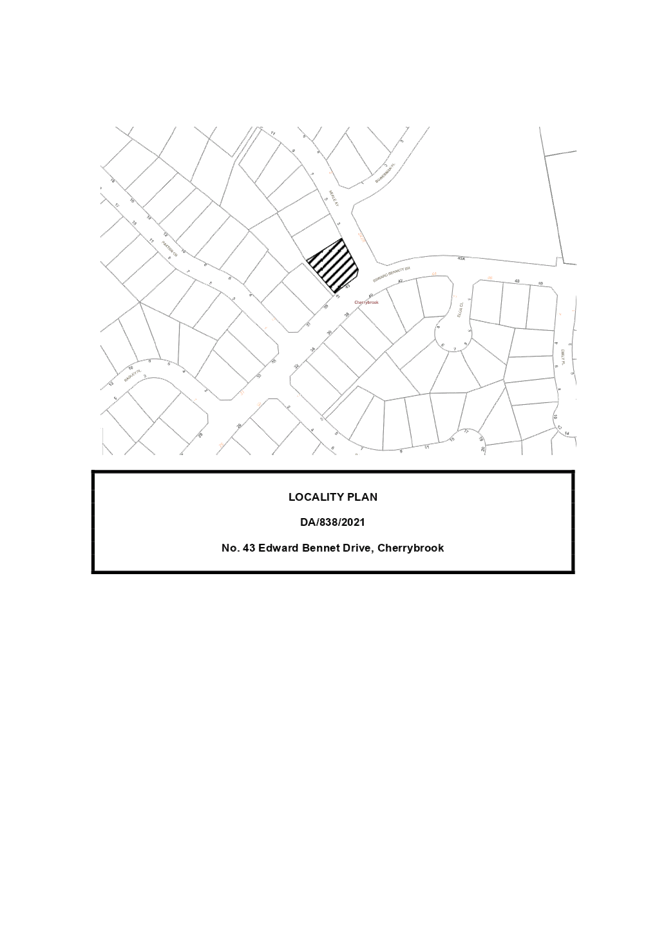
Locality Plan |
|
|
|
2.⇩ |
Architectural Plans |
|
|
|
3.⇩ |
Clause 4.6 |
|
|
|
4.⇩ |
Statement of Environmental Effects |
|
|
File Reference: DA/1188/2021
Document Number: D08329657
SCHEDULE 1
GENERAL CONDITIONS
The conditions of consent within this notice of determination have been applied to ensure that the use of the land and/or building is carried out in such a manner that is consistent with the aims and objectives of the relevant legislation, planning instruments and council policies affecting the land and does not disrupt the amenity of the neighbourhood or impact upon the environment.
Note: For the purpose of this consent, the term ‘applicant’ means any person who has the authority to act on or the benefit of the development consent.
Note: For the purpose of this consent, any reference to an Act, Regulation, Australian Standard or publication by a public authority shall be taken to mean the gazetted Act or Regulation, or adopted Australian Standard or publication as in force on the date that the application for a construction certificate is made.
1. Approved Plans and Supporting Documentation
The development must be carried out in accordance with the plans and documentation listed below and endorsed with Council’s stamp, except where amended by Council and/or other conditions of this consent:
Approved Plans
|
Plan No. |
Plan Title |
Drawn by |
Dated |
Council Reference |
|
Job No. 2108, Dwg. No. DA02, Issue A |
Proposed Site Plan |
Tasman Storey Architects |
23/10/21 |
|
|
Job No. 2108, Dwg. No. DA03, Issue A |
Proposed Roof Plan |
Tasman Storey Architects |
23/10/21 |
|
|
Job No. 2108, Dwg. No. DA04, Issue A |
Proposed Ground Floor Plan |
Tasman Storey Architects |
23/10/21 |
|
|
Job No. 2108, Dwg. No. DA05, Issue A |
Proposed First Floor Plan |
Tasman Storey Architects |
23/10/21 |
|
|
Job No. 2108, Dwg. No. DA06, Issue A |
Proposed South West Elevation |
Tasman Storey Architects |
23/10/21 |
|
|
Job No. 2108, Dwg. No. DA07, Issue A |
Proposed South East Elevation |
Tasman Storey Architects |
23/10/21 |
|
|
Job No. 2108, Dwg. No. DA08, Issue A |
Proposed North East and North West Elevation |
Tasman Storey Architects |
23/10/21 |
|
|
Job No. 2108, Dwg. No. DA09, Issue A |
Section A-A |
Tasman Storey Architects |
23/10/21 |
|
|
Job No. 2108, Dwg. No. DA10, Issue A |
Colour and Materials Schedule |
Tasman Storey Architects |
23/10/21 |
|
|
Job No. 2108, Dwg. No. S02, Issue A |
Erosion and Sediment Control Plan |
Tasman Storey Architects |
23/10/21 |
|
|
Job No. 2108, Dwg. No. S03, Issue A |
Tree Protection Plan |
Tasman Storey Architects |
23/10/21 |
|
|
Job No. 2108, Dwg. No. S04, Issue A |
Concept Stormwater Plan |
Tasman Storey Architects |
23/10/21 |
|
|
Not indicated |
Tree Location and Fencing Plan |
Hornsby Council’s Tree Management Group |
23/11/21 |
|
Supporting Documentation
|
Document Title |
Prepared by |
Dated |
Council Reference |
|
BASIX Certificate No. A437058 |
Catherine Munayer Architecture |
26/10/21 |
D08291273 |
|
Waste Management Plan |
Tasman Storey Architects |
10/21 |
D08291271 |
a) To comply with Council’s requirements in tree preservation, the approved Sediment and Erosion Control Plan is to be amended to relocate the sand, cement and top soil stock piles to the location marked in yellow on the approved Tree Location and Fencing Plan.
b) This amended plan must be submitted with the application for the Construction Certificate.
3. Construction Certificate
a) A Construction Certificate is required to be approved by Council or a Private Certifying Authority prior to the commencement of any construction works under this consent.
b) The Construction Certificate plans must be consistent with the Development Consent plans.
4. Appointment of a Project Arborist
a) To ensure the trees that must be retained are protected, a project arborist with AQF Level 5 qualifications must be appointed to assist in ensuring compliance with the conditions of consent and provide monitoring reports as specified by the conditions of consent.
b) Details of the appointed project arborist must be submitted to the PCA with the application for the construction certificate.
5. Removal of Trees
No consent is granted for the removal of any trees on the site as these trees contribute to the established landscape amenity of the area/streetscape.
Note: The pruning or removal of any other trees from the site requires separate approval by Council in accordance with Part 1B.6 Tree and Vegetation Preservation of the Hornsby Development Control Plan, 2013 (HDCP).
6. Tree Pruning
a) This development consent only permits the pruning of trees numbered 16 and 17 as identified in the Tree Location and Fencing Plan prepared by Hornsby Council’s Tree Management Group, dated 23/11/2021.
b) Works can be undertaken in the form of canopy modification as follows:
|
Tree number |
Work prescribed |
|
16 |
Prune to accommodate building and scaffolding |
|
17 |
Prune to accommodate building and scaffolding |
i) All pruning work must be undertaken by an arborist with minimum AQF3 qualifications.
Note: The pruning of any other trees from the site requires separate approval by Council in accordance with Part 1B.6 Tree and Vegetation Preservation of the Hornsby Development Control Plan 2013 (HDCP).
7. Section 7.12 Development Contributions
a) In accordance with Section 4.17(1) of the Environmental Planning and Assessment Act 1979 and the Hornsby Shire Council Section 7.12 Development Contributions Plan 2019-2029, $3,580 must be paid towards the provision, extension or augmentation of public amenities or public services, based on development costs of $358,000.
b) The value of this contribution is current as of 24 January 2022. If the contributions are not paid within the financial quarter that this consent is granted, the contributions payable will be adjusted in accordance with the provisions of the Hornsby Shire Council Section 7.12 Development Contributions Plan and the amount payable will be calculated at the time of payment in the following manner:
|
$CPY |
= |
|
|
$CDC x CPIPY |
|
|
|
|
|
CPIDC |
Where:
$CPY is the amount of the contribution at the date of Payment
$CDC is the amount of the contribution as set out in this Development Consent
CPIPY is the latest release of the Consumer Price Index (Sydney – All Groups) at the date of Payment as published by the ABS.
CPIDC is the Consumer Price Index (Sydney – All Groups) for the financial quarter at the date of this Development Consent.
c) The monetary contributions shall be paid to Council:
(i) Prior to the issue of the Subdivision Certificate where the development is for subdivision.
(ii) Prior to the issue of the first Construction Certificate where the development is for building work.
(iii) Prior to issue of the Subdivision Certificate or first Construction Certificate, whichever occurs first, where the development involves both subdivision and building work.
(iv) Prior to the works commencing where the development does not require a Construction Certificate or Subdivision Certificate.
Note: It is the professional responsibility of the Principal Certifying Authority to ensure that the monetary contributions have been paid to Council in accordance with the above timeframes.
Note: In accordance with Ministerial Directions, the payment of contribution fees for development with a cost of works of over $10 million can be deferred to prior to Occupation Certificate.
Note: The Hornsby Shire Council Section 7.12 Development Contributions Plan may be viewed at www.hornsby.nsw.gov.au or a copy may be inspected at Council’s Administration Centre during normal business hours.
REQUIREMENTS PRIOR TO THE ISSUE OF A CONSTRUCTION CERTIFICATE
a) Detailed plans, specifications and supporting information is required to be submitted to the certifying authority detailing how the proposed building work achieves compliance with the National Construction Code - Building Code of Australia.
b) All building work must be carried out in accordance with the requirements of the National Construction Code - Building Code of Australia.
9. Contract of Insurance (Residential Building Work)
Where residential building work for which the Home Building Act 1989 requires there to be a contract of insurance in force in accordance with Part 6 of that Act, this contract of insurance must be in force before any building work authorised to be carried out by the consent commences.
10. Notification of Home Building Act 1989 Requirements
Residential building work within the meaning of the Home Building Act 1989 must not be carried out unless the principal certifying authority for the development to which the work relates (not being Council) has given Council written notice of the following information:
a) In the case of work for which a principal contractor is required to be appointed:
i) The name and licence number of the principal contractor.
ii) The name of the insurer by which the work is insured under Part 6 of that Act.
b) In the case of work to be done by an owner-builder:
i) The name of the owner-builder.
ii) If the owner-builder is required to hold an owner-builder’s permit under that Act, the number of the owner-builder’s permit.
Note: If arrangements for doing the residential building work are changed while the work is in progress so that the information notified becomes out of date, further work must not be carried out unless the principal certifying authority for the development to which the work relates (not being Council) has given Council written notification of the updated information.
11. Sydney Water
This application must be submitted to Sydney Water for approval to determine whether the development would affect any Sydney Water infrastructure, and whether further requirements are to be met.
Note: Building plan approvals can be obtained online via Sydney Water Tap inTM through www.sydneywater.com.au under the Building and Development tab.
12. Stormwater Drainage
The stormwater drainage system for the development must be designed for an average recurrence interval (ARI) of 20 years and be gravity drained and connected to the existing drainage system, direct to the street in accordance with the approved Stormwater Concept Plan.
REQUIREMENTS PRIOR TO THE COMMENCEMENT OF ANY WORKS
13. Erection of Construction Sign
a) A sign must be erected in a prominent position on any site on which any approved work is being carried out:
i) Showing the name, address, and telephone number of the principal certifying authority for the work.
ii) Showing the name of the principal contractor (if any) for any demolition or building work and a telephone number on which that person may be contacted outside working hours; and
iii) Stating that unauthorised entry to the work site is prohibited.
b) The sign is to be maintained while the approved work is being carried out and must be removed when the work has been completed.
14. Protection of Adjoining Areas
A temporary hoarding, fence or awning must be erected between the work site and adjoining lands before the works begin and must be kept in place until after the completion of the works if the works:
a) Could cause a danger, obstruction or inconvenience to pedestrian or vehicular traffic.
b) Could cause damage to adjoining lands by falling objects.
c) Involve the enclosure of a public place or part of a public place.
d) Have been identified as requiring a temporary hoarding, fence or awning within the Council approved Construction Management Plan (CMP).
Note: Notwithstanding the above, Council’s separate written approval is required prior to the erection of any structure or other obstruction on public land.
a) To provide a safe and hygienic workplace, toilet facilities must be available or be installed at the works site before works begin and must be maintained until the works are completed at a ratio of one toilet for every 20 persons employed at the site.
b) Each toilet must:
i) Be a standard flushing toilet connected to a public sewer.
ii) Be a temporary chemical closet approved under the Local Government Act 1993.
16. Erosion and Sediment Control
a) To protect the water quality of the downstream environment, erosion and sediment control measures must be provided and maintained throughout the construction period in accordance with the manual ‘Soils and Construction 2004 (Bluebook)’, the approved plans, Council specifications and to the satisfaction of the principal certifying authority.
b) The erosion and sediment control devices must remain in place until the site has been stabilised and revegetated.
Note: On the spot penalties may be issued for any non-compliance with this requirement without any further notification or warning.
17. Installation of Tree Protection Measures
a) Trees to be retained and numbered 1, 2, 3, 7, 8, 9, 10, 11, 13, T14, 15, 16 and 17 must have tree protection measures for the ground, trunk and canopy installed by the project arborist for the duration of demolition and construction works, in accordance with the Tree Location and Fencing Plan prepared by Council’s Tree Management Group dated 23/11/2021.
b) Tree protection fencing for the trees to be retained numbered 1, 2, 3, 7, 8, 9, 10, 11, 13, T14, 15, 16 and 17 must be installed by the engaged AQF 5 project arborist and consist of 1.8m high temporary fencing panels installed in accordance with Australian Standard AS4687-2007 Temporary fencing and hoardings.
c) The installation of all required tree protection fencing must include shade cloth attached to the fencing to reduce transport of dust, particulates and liquids from entering the tree protection zone.
d) The circumference of the trunks of trees number 4, 5 and 6 must be wrapped in hessian material to provide cushioning for the installation of timber planks.
e) Timber planks (50 x100mm) must be spaced at 100mm intervals and must be attached using adjustable ratchet straps.
REQUIREMENTS DURING DEMOLITION AND CONSTRUCTION
a) All works on site, including demolition and earth works, must only occur between 7am and 5pm Monday to Saturday.
b) No work is to be undertaken on Sundays or public holidays.
19. Demolition
To protect the surrounding environment, all demolition work must be carried out in accordance with Australian Standard AS2601-2001 Demolition of structures and the following requirements:
a) Demolition material must be disposed of to an authorised recycling and/or waste disposal site and/or in accordance with an approved waste management plan.
b) Demolition works, where asbestos material is being removed, must be undertaken by a contractor that holds an appropriate licence issued by SafeWork NSW in accordance with the Work Health and Safety Regulation 2017 and be appropriately transported and disposed of in accordance with the Protection of the Environment Operations (Waste) Regulation 2014; and
c) On construction sites where any building contains asbestos material, a standard commercially manufactured sign containing the words ‘DANGER ASBESTOS REMOVAL IN PROGRESS’ and measuring not less than 400mm x 300mm must be displayed in a prominent position visible from the street.
20. Environmental Management
To prevent sediment run-off, excessive dust, noise or odour emanating from the site during the construction, the site must be managed in accordance with the publication ‘Managing Urban Stormwater – Landcom (March 2004) and the Protection of the Environment Operations Act 1997.
To ensure that the public reserve is kept in a clean, tidy and safe condition during construction works, no building materials, waste, machinery or related matter is to be stored on the road or footpath.
22. Disturbance of Existing Site
During construction works, the existing ground levels of open space areas and natural landscape features, including natural rock-outcrops, vegetation, soil and watercourses must not be altered unless otherwise nominated on the approved plans.
23. Prohibited Actions Within the Fenced Tree Protection Zone
The following activities are prohibited within the approved fenced tree protection zones unless otherwise approved by Council:
a) Soil cutting or filling, including excavation and trenching
b) Soil cultivation, disturbance or compaction
c) Stockpiling storage or mixing of materials
d) The parking, storing, washing and repairing of tools, equipment and machinery
e) The disposal of liquids and refuelling
f) The disposal of building materials
g) The siting of offices or sheds
h) Any action leading to the impact on tree health or structure
24. Maintaining Tree Protection Measures
Tree Protection Measures must be maintained by the project arborist in accordance with Condition No. 17 of this consent for the duration of works.
25. Approved Works within Tree Protection Zone Incursions
Where scaffolding is required within a Tree Protection Zone, ground protection must be installed beneath the scaffolding in the following order:
a) Installation of a 100mm deep layer of woodchip.
b) Installation of geotextile fabric ground covering.
c) Installation of scaffold boarding above the woodchip and geotextile fabric.
26. Building Materials and Site Waste
The stockpiling of building materials, the parking of vehicles or plant, the disposal of cement slurry, wastewater or other contaminants must be located outside the tree protection zones as prescribed in the conditions of this consent of any tree to be retained.
27. Waste Management
All work must be carried out in accordance with the approved waste management plan.
REQUIREMENTS PRIOR TO THE ISSUE OF AN OCCUPATION CERTIFICATE
28. Fulfilment of BASIX Commitments
The applicant must demonstrate the fulfilment of BASIX commitments pertaining to the development.
29. Construction of engineering works.
All engineering works identified in this consent are to be completed and a Compliance Certificate issued prior to the release of the Occupation Certificate.
30. Damage to Council Assets
a) To protect public property and infrastructure, any damage caused to Council’s assets as a result of the construction or demolition of the development must be rectified by the applicant in accordance with AUS-SPEC Specifications (www.hornsby.nsw.gov.au/property/build/aus-spec-terms-and-conditions).
b) Rectification works must be undertaken prior to the issue of an Occupation Certificate, or sooner, as directed by Council.
31. Final Certification
The AQF 5 Project arborist must submit to the Principal Certifying Authority a certificate that includes the following:
a) All tree protection requirements complied with the as approved tree protection plan for the duration of demolition and/or construction works.
b) All completed works relating to tree protection and maintenance have been carried out in compliance with the conditions of consent and approved plans.
c) Dates, times and reasons for all site attendance.
d) Details of tree protection zone maintenance for the duration of works.
Note: Copies of monitoring documentation may be requested throughout DA process.
- END OF CONDITIONS -
ADVISORY NOTES
The following information is provided for your assistance to ensure compliance with the Environmental Planning and Assessment Act 1979, Environmental Planning and Assessment Regulation 2000, other relevant legislation and Council’s policies and specifications. This information does not form part of the conditions of development consent pursuant to Section 4.17 of the Act.
Environmental Planning and Assessment Act 1979 Requirements
The Environmental Planning and Assessment Act 1979 requires:
· The issue of a construction certificate prior to the commencement of any works. Enquiries can be made to Council’s Customer Services Branch on 9847 6760.
· A principal certifying authority to be nominated and Council notified of that appointment prior to the commencement of any works.
· Council to be given at least two days written notice prior to the commencement of any works.
· Mandatory inspections of nominated stages of the construction inspected.
· An occupation certificate to be issued before occupying any building or commencing the use of the land.
Long Service Levy
In accordance with Section 34 of the Building and Construction Industry Long Service Payments Act 1986, a ‘Long Service Levy’ must be paid to the Long Service Payments Corporation or Hornsby Council.
Note: The rate of the Long Service Levy is 0.35% of the total cost of the work.
Note: Hornsby Council requires the payment of the Long Service Levy prior to the issue of a construction certificate.
Tree and Vegetation Preservation
Hornsby Development Control Plan 2013 Tree and Vegetation Preservation provisions have been developed under Council’s authorities contained in State Environmental Planning Policy (Vegetation in Non-Rural Areas) 2017 and the Environmental Planning and Assessment Act 1979.
In accordance with these provisions a person must not cut down, fell, uproot, kill, poison, ringbark, burn or otherwise destroy the vegetation, lop or otherwise remove a substantial part of the trees or vegetation to which any such development control plan applies without the authority conferred by a development consent or a permit granted by Council.
Fines may be imposed for non-compliance with the Hornsby Development Control Plan 2013.
Note: A tree is defined as a long lived, woody perennial plant with one or relatively few main stems with the potential to grow to a height greater than three metres (3m). (HDCP 1B.6.1.c).
The land upon which the subject building is to be constructed may be affected by restrictive covenants. Council issues this approval without enquiry as to whether any restrictive covenant affecting the land would be breached by the construction of the building, the subject of this consent. Applicants must rely on their own enquiries as to whether or not the building breaches any such covenant.
Prior to commencing any works, the applicant is encouraged to contact Dial Before You Dig on 1100 or www.dialbeforeyoudig.com.au for free information on potential underground pipes and cables within the vicinity of the development site.
Telecommunications Act 1997 (Commonwealth)
If you are aware of any works or proposed works which may affect or impact on Telstra’s assets in any way, you are required to contact Telstra’s Network Integrity Team on Phone Number 1800810443.
Should asbestos or asbestos products be encountered during demolition or construction works, you are advised to seek advice and information prior to disturbing this material. It is recommended that a contractor holding an asbestos-handling permit (issued by SafeWork NSW) be engaged to manage the proper handling of this material. Further information regarding the safe handling and removal of asbestos can be found at:
Alternatively, telephone the SafeWork NSW on 13 10 50
LPP Report No. LPP9/22
Local Planning Panel
Date of Meeting: 23/02/2022
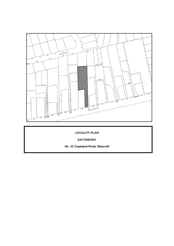
8 ELECTRONIC - DA/1258/2021 - STRATA SUBDIVISION - ONE LOT INTO THREE LOTS - 33 COPELAND ROAD, BEECROFT
EXECUTIVE SUMMARY
|
DA No: |
DA/1258/2021 (Lodged on 23 November 2021) |
|
Description: |
Subdivision of one Torrens title allotment into three strata title lots |
|
Property: |
Lot 34 DP 1208064, No. 33 Copeland Road, Beecroft |
|
Applicant: |
William Xie |
|
Owner: |
Mrs R Merhi |
|
Estimated Value: |
Nil |
|
Ward: |
C |
· The proposal does not comply with the Hornsby Local Environmental Plan 2013 (HLEP) with regard to Clause 4.1A ‘Minimum subdivision lot size for strata plan schemes in certain zones’. The applicant has made a submission in accordance with Clause 4.6 ‘Exceptions to development standards’ of the HLEP to vary the minimum 600m2 lot size development standard. The submission is considered well founded and is supported.
· The application is required to be determined by the Hornsby Local Planning Panel as the proposal would contravene the HLEP development standard for minimum subdivision lot size by more than 10 percent.
· No submissions have been received in respect of the application.
· It is recommended that the application be approved.
|
THAT the Hornsby Shire Council Local Planning Panel assume the concurrence of the Secretary of the Department of Planning and Environment pursuant to Clause 4.6 of the Hornsby Local Environmental Plan 2013 and approve Development Application No. DA/1258/2021 for the subdivision of one Torrens title allotment into three strata title lots at Lot 34 DP 1208064, No. 33 Copeland Road Beecroft subject to the conditions of consent detailed in Schedule 1 of LPP Report No. LPP9/22. |
BACKGROUND
Upon gazettal of the then Hornsby Shire Local Environmental Plan 1994 (HSLEP) in July 1994, Hornsby Shire was exempted from the provisions of the now repealed NSW State Government’s urban consolidation policies, namely Sydney Regional Environmental Plan No. 12 Dual Occupancy (SREP 12) and State Environmental Planning Policy No. 25 Residential Allotment Sizes (SEPP 25).
The exemption was granted as a result of the housing initiatives embodied within the HSLEP which presented an alternative solution to meet both local and State housing objectives. The HSLEP incorporated higher density residential zones around transport and employment nodes, such as the Hornsby Town Centre. The HSLEP also permitted multi-unit housing at a density of one dwelling per 350m2 of land area within the Residential A (Low Density) zone. In accordance with Clause 4(2) of the HSLEP, SREP 12 and SEPP 25 no longer applied to Hornsby Shire.
The then Minister for Urban Affairs and Planning subsequently repealed the right to separate titles on dual occupancy developments. However, despite the repeal of SREP 12 and SEPP 25, the subdivision of dual occupancy with reduced lot sizes was still possible under the HSLEP.
On 15 December 1995, to bring the now repealed HSLEP in accordance with State Government policies, HSLEP (Amendment No. 8) was gazetted to exclude the subdivision of multi-unit housing developments where proposed allotment sizes were less than the minimum allotment size under Clause 14 (Density).
In September 2013, the Hornsby Local Environmental Plan 2013 (HLEP) was gazetted which permitted a minimum allotment size of 600m2 (for the subject site) and prohibited ‘multi-unit housing’ and ‘dual occupancies’ within the R2 Low Density Residential zone.
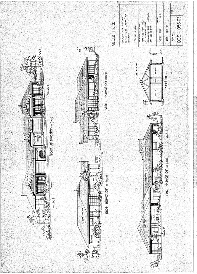
SITE HISTORY
On 17 May 1990, Council approved Development Application No. 78/90 for the demolition of the existing dwelling and the erection of one duplex building (Villas 1 and 2) and one detached dwelling (Villa 3). The development was approved under the provisions of the now repealed Hornsby Shire Council Cluster Housing Code.
SITE
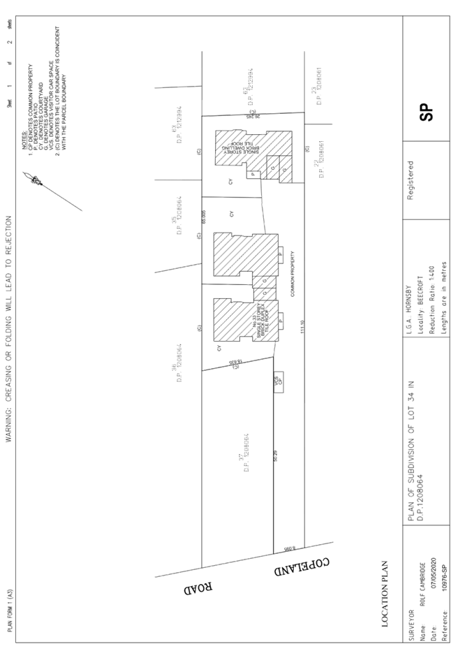
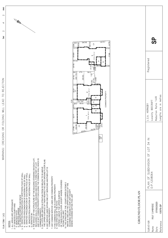
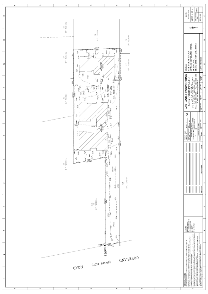
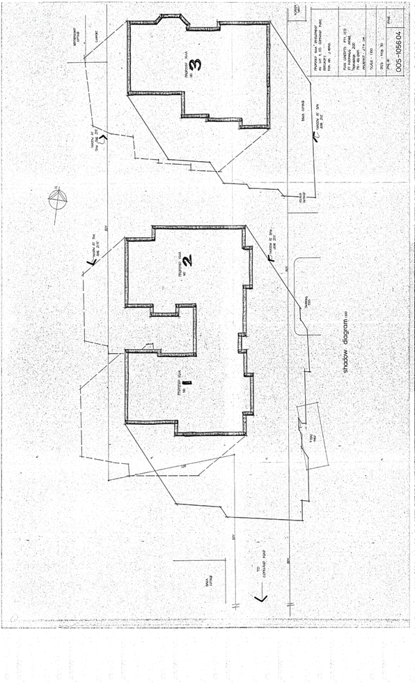
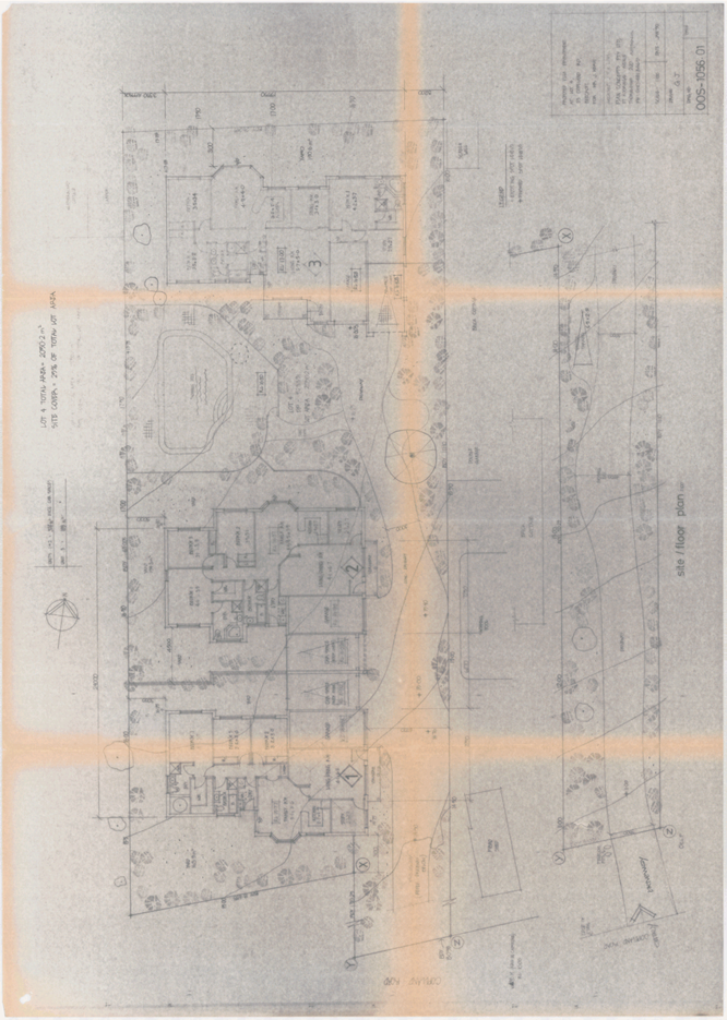
The 2,048.6m2 battle-axe site is located on the northern side of Copeland Road Beecroft and contains multi-dwelling housing in the form of a single storey duplex and a detached single storey dwelling house.
The site experiences a fall of 6.4m to the southern front boundary, representing an average gradient of 5.7%.
The site is not burdened by any easements or restrictions. The site is located above the NorthConnex corridor.
The site does not contain a heritage item and is not located within a heritage conservation area.
The site is adjacent to a heritage listed item (landscape) namely the ‘Grounds - Pennant Hills Golf Club’ listed in Schedule 5 of the HLEP. This heritage listed Golf Club contains Turpentine-Ironbark Forest and Blue Gum Shale Forest which is listed as Endangered Ecological Community under the Commonwealth Environment Protection and Biodiversity Conservation Act 1995 and a Critically Endangered Ecological Community under the NSW Biodiversity Conservation Act 2016.
The site is surrounded by low density residential land uses to the north, east and west comprising a mixture of single and two storey dwellings and several subdivided battle-axe allotments. Pennant Hills Golf Club adjoins the southern side of the subject site across Copeland Road.
PROPOSAL
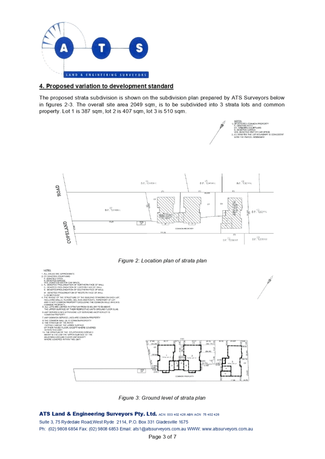
The application proposes the subdivision of one Torrens title allotment into three strata title lots.
Proposed Lot 1 would have an area of 387m2 and would retain the southernmost dwelling (existing Villa 1).
Proposed Lot 2 would have an area of 407m2 and would accommodate the rear dwelling of the dual occupancy building (existing Villa 2).
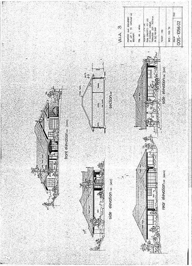
Proposed Lot 3 would have an area of 510m2 and would retain the detached single storey dwelling house to the rear of the site.
The application seeks to retain the existing driveway and visitor car parking space along the battle-axe handle to be re-allocated to common property.
The subdivision would be serviced by the existing on-site stormwater detention system which drains to Council’s drainage system along Copeland Road.
No physical works are proposed as part of this application.
The application would not necessitate the removal of any trees to facilitate the proposed subdivision.
ASSESSMENT
The development application has been assessed having regard to the Greater Sydney Region Plan – A Metropolis of Three Cities, the North District Plan and the matters for consideration prescribed under Section 4.15 of the Environmental Planning and Assessment Act 1979 (the Act). The following issues have been identified for further consideration.
1. STRATEGIC CONTEXT
1.1 Greater Sydney Region Plan - A Metropolis of Three Cities and North District Plan
The Greater Sydney Region Plan - A Metropolis of Three Cities has been prepared by the NSW State Government to guide land use planning decisions for the next 40 years (to 2056). The Plan sets a strategy and actions for accommodating Sydney’s future population growth and identifies dwelling targets to ensure supply meets demand. The Plan also identifies that the most suitable areas for new housing are in locations close to jobs, public transport, community facilities and services.
The NSW Government will use the subregional planning process to define objectives and set goals for job creation, housing supply and choice in each subregion. Hornsby Shire has been grouped with Hunters Hill, Ku-ring-gai, Lane Cove, Mosman, North Sydney, Ryde, Northern Beaches and Willoughby to form the North District. The Greater Sydney Commission has released the North District Plan which includes priorities and actions for Northern District for the next 20 years. The identified challenge for Hornsby Shire will be to provide an additional 4,350 dwellings by 2021 with further strategic supply targets to be identified to deliver 97,000 additional dwellings in the North District by 2036.
The proposed development would be consistent with the Greater Sydney Region Plan - A Metropolis of Three Cities and the North District Plan, by providing additional residential allotments capable of being sold separately which will enable potential home buyers the opportunity to purchase affordable housing on smaller allotments in the locality.
2. STATUTORY CONTROLS
Section 4.15(1)(a) requires Council to consider “any relevant environmental planning instruments, draft environmental planning instruments, development control plans, planning agreements and regulations”.
2.1 Hornsby Local Environmental Plan 2013
The proposed development has been assessed having regard to the provisions of the Hornsby Local Environmental Plan 2013 (HLEP).
2.1.1 Zoning of Land and Permissibility
The subject land is zoned R2 Low Density Residential under the HLEP. The objectives of the R2 zone are:
· To provide for the housing needs of the community within a low-density residential environment.
· To enable other land uses that provide facilities or services to meet the day to day needs of residents.
The proposed development is defined as ‘subdivision’ and is permissible with Council’s consent.
2.1.2 Minimum Subdivision Lot Size for Strata Plan Schemes in Certain Zones
Clause 4.1A of the HLEP prescribes that the minimum subdivision lot size for strata plan schemes is not to be less than shown for the land on the minimum lot size Map, which is 600m2.
The proposed Strata subdivision would result in Lot 1 having an area of 387m2 (35.5% variation), Lot 2 having an area of 407m2 (32.1% variation) and Lot 3 having an area of 510m2 (15% variation) and does not comply with the minimum lot size development standard.
The application is supported by a submission pursuant to Clause 4.6 of HLEP to contravene the minimum 600m2 allotment size development standard, which is discussed below in Section 2.1.4 of this report.
2.1.3 Height of Buildings
Clause 4.3 of the HLEP provides that the height of a building on any land should not exceed the maximum height show for the land on the Height of Buildings Map. The maximum permissible height for the subject site is 8.5m. The existing dwellings exhibit a maximum height of 6.2m above existing ground level.
Accordingly, the proposal complies with Clause 4.3 of the HLEP.
2.1.4 Exceptions to Development Standards
The application has been assessed against the requirements of Clause 4.6 of the HLEP. This clause provides flexibility in the application of the development standards in circumstances where strict compliance with those standards would, in any particular case, be unreasonable or unnecessary, and it can be demonstrated that sufficient environmental planning grounds are present to justify contravening a development standard.
The application seeks to contravene Clause 4.1A of the HLEP as the proposed strata subdivision would result in Lot 1 having an area of 387m2 (35.5% contravention), Lot 2 having an area of 407m2 (32.1% contravention) and Lot 3 having an area of 510m2 (15% contravention) and does not comply with the minimum lot size development standard.
The objective of Clause 4.1A Minimum subdivision lot size for strata plan schemes in certain zones is as follows—
(1) The objective of this clause is to ensure that land to which this clause applies is not fragmented by subdivisions that would create additional dwelling entitlements.
The applicant has made a submission in support of the contravention to the development standard in accordance with Clause 4.6 of the HLEP. Clause 4.6 provides that development consent must not be granted for development that contravenes a development standard unless the consent authority has considered a written request from the applicant that seeks to justify the contravention of the development standard by demonstrating:
(a) That compliance with the development standard is unreasonable or unnecessary in the circumstances of the case, and
(b) That there are sufficient environmental planning grounds to justify contravening the development standard.
Council must be satisfied that the written request provided by the applicant under Clause 4.6 addresses both the unreasonable and unnecessary test and demonstrates sufficient environmental planning grounds to justify contravening the development standard. These matters are discussed below.
2.1.4.1 Unreasonable or Unnecessary
There are five common methods by which an applicant can demonstrate that compliance with a development standard is unreasonable or unnecessary in the circumstances of the development. Initially proposed for objections under clause 6 of SEPP 1 in the decision of Wehbe v Pittwater Council [2007] NSWLEC 827 Pearson C summarised and applied these methods to written requests made under Clause 4.6 in Four2Five Pty Ltd v Ashfield Council [2015] NSWLEC 1009 [61-62]. These five methods are generally as follows:
· The objectives of the development standard are achieved notwithstanding non-compliance with the standard.
· The underlying objective or purpose is not relevant to the development.
· That the objective would be defeated or thwarted if compliance was required.
· That the development standard has been virtually abandoned or destroyed by the Council’s own actions in departing from the standard.
· The zoning of the land is unreasonable or inappropriate.
It is not required to demonstrate that a development meets multiple methods as listed above, and the satisfaction of one can be adequate to demonstrate that the development standard is unreasonable or unnecessary.
The written request prepared by ATS Land & Engineering Surveyors provides justification for the variation in lot size by seeking to demonstrate that the objectives of the development standard, and the objectives of the zone are achieved notwithstanding non-compliance with the development standard.
The written request provides justification as follows:
The proposal of strata subdivision is entirely reasonable as the development of the villas is inherently tied with strata subdivision in order for individual lots and common property to be created. Common property in this case is related directly to the access handle which is critical for all owners and visitors. Thus, the proposal satisfies the objective of the development standard, as it supports individual ownership of the lots and does not create additional dwelling entitlements, as the subdivision is based entirely existing dwellings (i.e. three residential villas being three lots and common property for access). By denying the proposed subdivision and enforcing compliance with the standard, it goes against the objective set out by the standard. It would leave the three individual dwellings as the existing lot which is unreasonable for a number of reasons. Most problematically, it would leave the owners of the three existing villas under one title which by itself is unnecessary. As such, the individual addressing of each villa is not officially registered, leaving further complications for the owners of each villa. A similar case to where a clause 4.6 variation had been granted by Hornsby Council was for DA/1100/2019 where the minimum lot size development standard was varied. A 32.42% variation in lot size was allowed in the proposed development, which was a Torrens title subdivision of one allotment (lot 3 in DP35906) into two lots. The justification for the variation from Hornsby Council was:
· The proposal would convert a prohibited ‘dual occupancy’ development to a permissible use (dwelling house) within the R2 Low Density Residential zone under the HLEP.
· Approval of the application for Torrens title subdivision would not alter the intensity or scale of the existing development on the site. The proposal would allow the existing dwellings to be on separate titles, thereby adding economic value and versatility to existing housing stock.
This current proposal is similar in extent in terms of the variation, and while it is a strata subdivision, the points of justification are fairly similar. As previously established, it would allow separate dwellings to be under separate titles, and therefore separate ownership, thereby supporting the objectives of the R2 zoning. The other points of justification are similarly shared and will be expanded upon in the following sections.
Council considers that the applicant’s written request sufficiently identifies that the objectives of the development standard are achieved notwithstanding non-compliance with the standard. With respect to the objective of Clause 4.1A(1) of the HLEP, Council is satisfied that the proposal is consistent with the objective as the proposed strata subdivision would not result in additional dwelling entitlements or land fragmentation on the site given that the existing Torrens title allotment is already lawfully improved by three dwellings resulting from the approval of a multi-unit housing development under Development Application No. 78/90.
In this regard, it is acknowledged that the site benefits from existing use rights established under Development Application No. 78/90 for multi-unit housing in the form of a duplex building and a detached dwelling house. Although the existing multi-unit housing development is not permissible under the in-force HLEP within the R2 Low density residential zone, the proposal presents an opportunity to convert a prohibited ‘multi-unit housing’ development to a permissible land use (dwelling house).
Council concurs with the applicant that approval of the application would not alter the intensity or scale of the existing development on the site and would allow the existing dwellings to be on separate titles and under separate ownership, thereby adding economic value and versatility to existing housing stock. It is considered that the three lots could be sold separately which would allow potential home buyers the opportunity to buy affordable property that has proven to be of a suitable size for residential purposes.
The proposal includes no changes to the approved built form, and therefore, the proposal would have a neutral impact on the existing streetscape or the amenity of adjoining properties. Approval of the application would not alter the intensity or scale of the existing development on the site.
The proposal would result in allotments consistent with the objectives of the development standard. This is evident as the existing multi-unit housing development on the site demonstrates that the proposed allotments are capable of accommodating dwellings with the necessary ancillary services including stormwater and sewer.
The written request adequately demonstrates that compliance with the minimum lot size development standard is unreasonable and unnecessary in this instance.
2.1.4.2 Environmental Planning Grounds
In addition to demonstrating that compliance is unreasonable or unnecessary, Clause 4.6(3)(b) of the HLEP requires that there are sufficient environmental planning grounds to justify contravening the development standard. In demonstrating that sufficient environmental planning grounds exist, it must be demonstrated that the planning grounds are particular to the circumstances of the development on the subject site (summarised from Four2Five Pty Ltd v Ashfield Council [2015] NSWLEC 1009 [60].
In demonstrating the environmental planning grounds the written request states:
The proposed variation is fairly notable when considered quantitatively, but is justified in the following points:
· The proposal of the construction of the villas was previously approved by Hornsby Council and subdivision of the land would inherently be associated with it.
· Separate titles, and separate ownership for each villa would be achieved, thereby making sales/purchases far easier, and like the previously mentioned case, it would provide similar benefits of adding economic value and versatility to housing stock. It helps to achieve objectives of the R2 zone by allowing separate ownership of each villa, thereby making it easier to satisfy the housing needs of the local community without creating additional dwelling entitlements.
· Having common property will allow for a common space for access that will be maintained by all owners through a strata scheme.
· Since the proposal is only a subdivision of existing villas, it will have no adverse impacts on adjoining properties. The existing villas already fit in with the character of the local area, being mostly low-density residential.
Council considers that the environmental planning grounds stated within the written request are sufficient with respect to Clause 4.6(3)(b) and that the stated grounds are specific to the proposed development and the circumstances of the development site. It is therefore considered that the written request adequately demonstrates compliance with the clause and is acceptable in this regard.
Council further notes that in demonstrating the unreasonable and unnecessary test, the applicant further established environmental planning grounds with respect to the site and the surrounding constraints.
2.1.4.3 Public Interest and Clause 4.6(4)
Clause 4.6(4) states that development consent must not be granted for development that contravenes a development standard unless:
(a) The consent authority is satisfied that -
(i) The applicant’s written request has adequately addressed the matters required to be demonstrated by subclause (3), and
(ii) The proposed development will be in the public interest because it is consistent with the objectives of the particular standard and the objectives for development within the zone in which the development is proposed to be carried out, and
(b) The concurrence of the Planning Secretary has been obtained.
With regard to part (i), the written request is considered to adequately address the matter required to be demonstrated as outlined above.
With regard to part (ii), the proposed development is considered to be in the public interest because it is consistent with the objectives of the particular standard and the objectives for development within the zone in which the development is proposed to be carried out.
With regard to (b) the concurrence of the Planning Secretary has been obtained.
Accordingly, it is considered that the written request satisfactorily responds to the relevant matters required to be addressed under Clause 4.6 and that the Panel, as consent authority, may rely upon the written request and grant development consent to the development application. Should the Panel resolve to approve the application, it should also provide a statement in the reasons for approval that it has satisfied itself of the matters in Clause 4.6(4).
2.1.5 Heritage Conservation
Clause 5.10 of the HLEP sets out heritage conservation provisions for Hornsby Shire.
The site does not include a heritage item and is not located in a heritage conservation area. Notwithstanding, the site is adjacent to a heritage listed item (landscape) namely the ‘Grounds - Pennant Hills Golf Club’ listed in Schedule 5 of the HLEP. The heritage listed Golf Club contains Turpentine-Ironbark Forest and Blue Gum Shale Forest which is listed as Endangered Ecological Community under the Commonwealth Environment Protection and Biodiversity Conservation Act 1995 and a Critically Endangered Ecological Community under the NSW Biodiversity Conservation Act 2016.
The application does not necessitate any physical works and the existing low density residential land use would be maintained as part of this proposal. It is considered that the proposal would not pose a detrimental impact to the heritage significance of the heritage item, including its setting and views to and from the item.
The proposal meets the objectives of Clause 5.10 of the HLEP and is deemed acceptable in this regard.
2.1.6 Earthworks
Clause 6.2 of the HLEP states that consent is required for proposed earthworks on site. Before granting consent for earthworks, Council is required to assess the impacts of the works on adjoining properties, drainage patterns and soil stability of the locality.
The application does not propose any physical works and is consistent with Clause 6.2 of the HLEP.
Subject to compliance with the recommended conditions, the proposal is considered acceptable in this regard.
2.1.7 Flood Planning
The site is not identified as a flood planning area on the Flood Planning Map and further assessment under Clause 5.21 of the HLEP is not required.
2.2 State Environmental Planning Policy No. 55 Remediation of Land
The application has been assessed against the requirements of State Environmental Planning Policy No. 55 Remediation of Land (SEPP 55) under which consent must not be granted to the carrying out of any development on land unless the consent authority has considered whether the land is contaminated or requires remediation for the proposed use.
Should the land be contaminated, Council must be satisfied that the land is suitable in a contaminated state for the proposed use. If the land requires remediation to be undertaken to make the land suitable for the proposed use, Council must be satisfied that the land will be remediated before the land is used for that purpose.
An examination of Council’s records and aerial photography has determined that the site has been historically used for residential purposes. It is not likely that the site has experienced any significant contamination, and further assessment under SEPP 55 is not required.
2.3 State Environmental Planning Policy (Infrastructure) 2007
The application has been assessed against the requirements of Clause 103 of State Environmental Planning Policy (Infrastructure) 2007 (Infrastructure SEPP) under which written notice of any application proposing ground penetration of 3m or greater within road corridors including the NorthConnex is to be provided to Transport for NSW (TfNSW).
Although the site is located above the NorthConnex corridor, the application does not propose excavation works and accordingly Clause 103 of the Infrastructure SEPP does not apply to the proposed development.
2.4 State Environmental Planning Policy (Vegetation in Non-Rural Areas) 2017
State Environmental Planning Policy (Vegetation in Non-Rural Areas) 2017 (Vegetation SEPP) aims to protect the biodiversity and amenity values of trees within non-rural areas of the state.
Part 3, Clause 9(2) of the Vegetation SEPP states that a Development Control Plan may make a declaration in any manner relating to species, size, location and presence of vegetation. Accordingly, Part 1B.6.1 of the Hornsby Development Control Plan 2013 (HDCP) prescribes works that can be undertaken with or without consent to trees and objectives for tree preservation.
The application has been assessed against the requirements of the Vegetation SEPP and it has been determined that the proposal would meet the objectives of the Vegetation SEPP. This matter is addressed in Section 3.1.1 of this report.
2.5 Sydney Regional Environmental Plan (Sydney Harbour Catchment) 2005
The application has been assessed against the requirements of Sydney Regional Environmental Plan (Sydney Harbour Catchment) 2005. This Policy provides general planning considerations and strategies to ensure that the catchment, foreshores, waterways and islands of Sydney Harbour are recognised, protected, enhanced and maintained.
The proposed development does not include earthworks and would not result in any additional impacts on the Sydney Harbour Catchment.
2.6 Section 3.42 Environmental Planning and Assessment Act 1979 - Purpose and Status of Development Control Plans
Section 3.42 of the Environmental Planning and Assessment Act 1979 states that a DCP provision will have no effect if it prevents or unreasonably restricts development that is otherwise permitted and complies with the development standards in relevant Local Environmental Plans and State Environmental Planning Policies.
The principal purpose of a development control plan is to provide guidance on the aims of any environmental planning instrument that applies to the development; facilitate development that is permissible under any such instrument; and achieve the objectives of land zones. The provisions contained in a DCP are not statutory requirements and are for guidance purposes only. Consent authorities have flexibility to consider innovative solutions when assessing development proposals, to assist achieve good planning outcomes.
2.7 Hornsby Development Control Plan 2013
The proposed development has been assessed having regard to the relevant desired outcomes and prescriptive requirements within the Hornsby Development Control Plan 2013 (HDCP). The following table sets out the proposal’s compliance with the prescriptive requirements of the Plan:
Strata Subdivision of one lot into three:
|
HDCP – Part 6 – Subdivision |
|||
|
Control |
Proposal |
Requirement |
Complies |
|
Site Area |
2,048.6m2 |
N/A |
N/A |
|
Lot Area |
|
|
|
|
- Lot 1 |
387m2 |
600m2 |
No |
|
- Lot 2 |
407m2 |
600m2 |
No |
|
- Lot 3 |
510m2 |
600m2 |
No |
|
Minimum Lot Width at Frontage |
|
|
|
|
- Lot 1 |
21m |
15m |
Yes |
|
- Lot 2 |
21m |
15m |
Yes |
|
- Lot 3 |
26m |
15m |
Yes |
|
Accessway Width
|
|
|
|
|
- Carriageway (existing) |
3.4m - 7.3m |
3m |
Yes |
|
- Landscape Verge Width |
0.5m - 3.7m |
0.5m |
Yes |
Existing dwelling on proposed (Lot 1):
|
HDCP – Part 3.1 Dwelling Houses |
|||
|
Control |
Proposal |
Requirement |
Complies |
|
Dwelling House height |
5.9m |
8.5m |
Yes |
|
No. storeys |
1 storey |
max. 2 + attic |
Yes |
|
Site Coverage |
41% |
55% |
Yes |
|
Floor Area |
160m2 |
270m2 |
Yes |
|
Setbacks |
|
|
|
|
- Front (east) |
5m |
900mm |
Yes |
|
- Side (south) |
4m |
900mm |
Yes |
|
- Side (north) |
3.7m |
900mm |
Yes |
|
- Rear (west)
|
3m |
3m |
Yes |
|
Landscaped Area (% of lot size) |
42% |
15% |
Yes |
|
Private Open Space |
|
|
|
|
- minimum area |
>24m2 |
24m2 |
Yes |
|
- minimum dimension |
>3m |
3m |
Yes |
|
Car Parking |
2 spaces |
2 spaces |
Yes |
Existing dwelling on proposed (Lot 2):
|
HDCP – Part 3.1 Dwelling Houses |
|||
|
Control |
Proposal |
Requirement |
Complies |
|
Dwelling House height |
5.7m |
8.5m |
Yes |
|
No. storeys |
1 storey |
max. 2 + attic |
Yes |
|
Site Coverage |
39% |
55% |
Yes |
|
Floor Area |
160m2 |
270m2 |
Yes |
|
Setbacks |
|
|
|
|
- Front (east) |
5m |
900mm |
Yes |
|
- Side (south) |
2m |
900mm |
Yes |
|
- Side (north) |
9m |
900mm |
Yes |
|
- Rear (west)
|
3m |
3m |
Yes |
|
Landscaped Area (% of lot size) |
52% |
15% |
Yes |
|
Private Open Space |
|
|
|
|
- minimum area |
>24m2 |
24m2 |
Yes |
|
- minimum dimension |
>3m |
3m |
Yes |
|
Car Parking |
2 spaces |
2 spaces |
Yes |
Existing dwelling house on proposed (Lot 3):
|
HDCP – Part 3.1 Dwelling Houses |
|||
|
Control |
Proposal |
Requirement |
Complies |
|
Dwelling House height |
6.2m |
8.5m |
Yes |
|
No. storeys |
1 storey |
max. 2 + attic |
Yes |
|
Site Coverage |
37% |
50% |
Yes |
|
Floor Area |
190m2 |
330m2 |
Yes |
|
Setbacks |
|
|
|
|
- Front (east) |
3.2m |
900mm |
Yes |
|
- Side (south) |
4.7m |
900mm |
Yes |
|
- Side (north) |
3.8m |
900mm |
Yes |
|
- Rear (west)
|
3.45m |
3m |
Yes |
|
Landscaped Area (% of lot size) |
55% |
20% |
Yes |
|
Private Open Space |
|
|
|
|
- minimum area |
>24m2 |
24m2 |
Yes |
|
- minimum dimension |
>3m |
3m |
Yes |
|
Car Parking |
2 spaces |
2 spaces |
Yes |
As detailed in the above tables, the proposed development complies with the prescriptive requirements within the HDCP, with the exception of lot size. The matters of non-compliance are detailed below, as well as a brief discussion on compliance with relevant desired outcomes.
2.7.1 Lot Size
As discussed under Section 2.1.4 of this report, the existing multi-dwelling housing development demonstrates that the site is of sufficient size and shape to accommodate three dwellings. The proposed strata title subdivision would not alter the intensity or scale of the existing development on the site and would convert a prohibited ‘multi-dwelling housing’ development to a permissible ‘dwelling house’ development within the R2 Low Density Residential zone under the HLEP.
The proposal would not have a detrimental impact on the existing streetscape or the amenity of adjoining properties and is considered acceptable in this regard.
2.7.2 Transport and Parking
The HDCP encourages the provision of two car parking spaces to be behind the building line of dwelling houses to maintain the streetscape. The existing dwellings contain two integrated car parking spaces and comply with the car parking provisions of the HDCP.
Surplus to the requirements of the HDCP, the existing on-grade visitor car parking space would be retained within the battle-axe handle.
Council’s engineering assessment raises no concerns to the structural integrity and utilisation of the existing crossing and driveway.
2.8 Section 7.11 Contributions Plans
The existing multi-dwelling housing development was approved prior to the gazettal of all previous Development Contribution Plans adopted by Council. A Section 7.11 Contribution is not applicable as the development would not increase demand for services and no additional dwellings are proposed.
3. ENVIRONMENTAL IMPACTS
Section 4.15(1)(b) of the Act requires Council to consider “the likely impacts of that development, including environmental impacts on both the natural and built environments, and social and economic impacts in the locality”.
3.1 Natural Environment
3.1.1 Tree and Vegetation Preservation
No physical works are proposed as part of this application. It is also noted that the conditions recommended under Schedule 1 would not necessitate any physical works to facilitate the proposed strata subdivision. Accordingly, the application would not require the removal of any trees or vegetation from the site.
3.1.2 Stormwater Management
The subdivision would be serviced by the existing on-site stormwater detention system which drains to Council’s drainage system along Copeland Road.
Council’s stormwater assessment has determined that the existing method of stormwater disposal would be suitable to service the proposed subdivision, subject to a recommended condition requiring the creation of an appropriate "Positive Covenant" and "Restriction as to User" over the existing on-site detention system.
The proposal meets the desired outcomes of Part 1C.1.2 Stormwater Management of the HDCP and is deemed acceptable in this regard.
3.2 Built Environment
3.2.1 Built Form
As previously discussed, physical works have not been proposed as part of this application. The built form on-site would remain unaltered and would maintain its existing presence and character within the streetscape and to adjoining properties.
3.2.2 Building Code of Australia (BCA)
The application has been accompanied by a BCA Assessment prepared by All State Building Surveying dated 30 June 2021. The purpose of the report is to identify BCA requirements relating to fire separation between the existing dwellings.
The submitted BCA Assessment concludes that the existing development satisfies the intent of the applicable Deemed to Satisfy and Performance Requirements of the BCA. Council’s building surveying assessment concurs with the conclusions of the BCA Assessment, subject to a recommended condition under Schedule 1 requiring that a certificate be provided from a licensed electrician certifying that the smoke alarms have been connected to the consumer mains power in accordance with Australian Standard AS 3786-2014 Smoke alarms and interconnected where there is more than one alarm in accordance with Part 3.7.2 of the Building Code of Australia.
3.2.3 Traffic
The proposed strata subdivision of the existing dwellings would not result in any change to traffic generation from the site.
3.3 Social Impacts
The strata subdivision would improve housing mix in the locality by enabling the existing dwellings to be either separately owner occupied or rented. This is consistent with Council’s Housing Strategy which identifies the need to provide a mix of housing options to meet future demographic needs in Hornsby Shire.
3.4 Economic Impacts
The proposal is both site specific and accords with the objectives of the zone as the proposal would allow the existing dwellings to be on separate strata titles, thereby adding economic value and versatility to existing housing stock.
Accordingly, the proposal would have a minor positive impact on the local economy in conjunction with other new low-density residential development in the locality.
4. SITE SUITABILITY
Section 4.15(1)(c) of the Act requires Council to consider “the suitability of the site for the development”.
The subject site is not subject to any constraints and is considered suitable for subdivision of an existing established multi-unit housing development.
5. PUBLIC PARTICIPATION
Section 4.15(1)(d) of the Act requires Council to consider “any submissions made in accordance with this Act”.
5.1 Community Consultation
The proposed development was placed on public exhibition and was notified to adjoining and nearby landowners between 25 November 2021 and 16 December 2021 in accordance with the Hornsby Community Engagement Plan. During this period, Council received no submissions. The map below illustrates the location of those nearby landowners who were notified of the subject application.
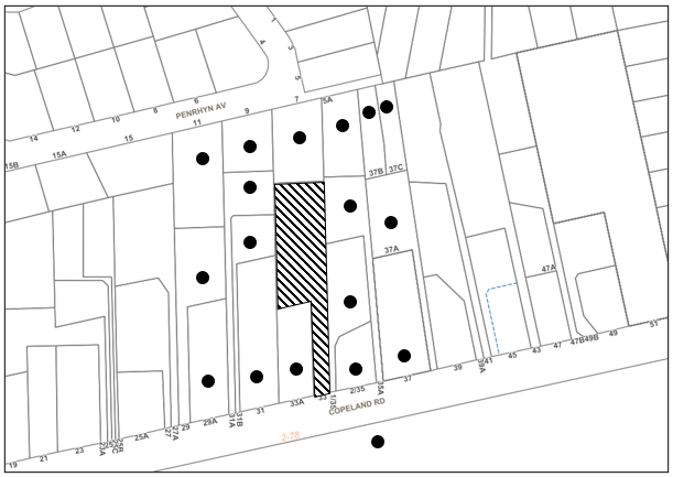
|
NOTIFICATION PLAN |
|||
|
• PROPERTIES NOTIFIED |
X SUBMISSIONS RECEIVED |
|
|
5.2 Public Agencies
The development application was not referred to any Public Agencies for comment.
6. THE PUBLIC INTEREST
Section 4.15(1)(e) of the Act requires Council to consider “the public interest”.
The public interest is an overarching requirement, which includes the consideration of the matters discussed in this report. Implicit to the public interest is the achievement of future built outcomes adequately responding to and respecting the future desired outcomes expressed in environmental planning instruments and development control plans.
The application is considered to have satisfactorily addressed Council’s and relevant agencies’ criteria and would provide a development outcome that, on balance, would result in a positive impact for the community. Accordingly, it is considered that the approval of the proposed development would be in the public interest.
CONCLUSION
The application proposes the subdivision of one Torrens title allotment into three strata title lots.
The development generally meets the desired outcomes of Council’s planning controls and is satisfactory having regard to the matters for consideration under Section 4.15 of the Environmental Planning and Assessment Act 1979.
The application does not comply with the HLEP in respect to the minimum 600m2 lot size. The applicant submitted a written request in response to Clause 4.6 Exceptions to Development Standard to contravene Clause 4.1A Minimum subdivision lot size for strata plan schemes in certain zones development standard. The objection is considered well founded with regard to the approved development on the site and the principles established by the Land and Environment Court.
Having regard to the circumstances of the case and consideration of the Clause 4.6 written request, approval of the application is recommended.
The reasons for this decision are:
· The request under Clause 4.6 of Hornsby Local Environmental Plan 2013 to contravene the ‘Minimum subdivision lot size for strata plan schemes in certain zones’ development standard is well founded. Strict compliance with the development standard is unreasonable and unnecessary in the circumstances of the case and there are sufficient environmental planning grounds to justify the contravention to the development standards.
· The proposed development generally complies with the requirements of the relevant environmental planning instruments and the Hornsby Development Control Plan 2013.
· There are no visual or physical impacts associated with the proposed subdivision as there will be no change to the built form as a result of this proposal.
· The proposed development does not create unreasonable environmental impacts to adjoining development with regard to tree and vegetation preservation, stormwater, vehicle access, earthworks, amenity or privacy.
Note: At the time of the completion of this planning report, no persons have made a Political Donations Disclosure Statement pursuant to Section 10.4 of the Environmental Planning and Assessment Act 1979 in respect of the subject planning application.
RESPONSIBLE OFFICER
The officer responsible for the preparation of this report is Thomas Dales.
|
Cassandra Williams Major Development Manager - Development Assessments Planning and Compliance Division |
Rod Pickles Manager - Development Assessments Planning and Compliance Division |
|
1.⇩ |
Locality Plan |
|
|
|
2.⇩ |
Strata Subdivision Plan |
|
|
|
3.⇩ |
Clause 4.6 |
|
|
|
4.⇩ |
Site Survey Plan |
|
|
|
5.⇩ |
Approved Plans for Multi-Unit Housing Development |
|
|
File Reference: DA/1258/2021
Document Number: D08330364
SCHEDULE 1
The conditions of consent within this notice of determination have been applied to ensure that the use of the land and/or building is carried out in such a manner that is consistent with the aims and objectives of the relevant legislation, planning instruments and Council policies affecting the land and does not disrupt the amenity of the neighbourhood or impact upon the environment.
Note: For the purpose of this consent, the term ‘applicant’ means any person who has the authority to act on or the benefit of the development consent.
Note: For the purpose of this consent, any reference to an Act, Regulation, Australian Standard or publication by a public authority shall be taken to mean the gazetted Act or Regulation, or adopted Australian Standard or publication as in force on the date that the application for a construction certificate is made.
1. Approved Plans and Supporting Documentation
The development must be carried out in accordance with the plans and documentation listed below and endorsed with Council’s stamp, except where amended by Council and/or other conditions of this consent:
Approved Plans
|
Plan No. |
Plan Title |
Drawn by |
Dated |
Council Reference |
|
10976-SP, Sheet 1 of 2 |
Plan of Subdivision (Location Plan) |
Rolf Cambridge |
7.5.20 |
|
|
10976-SP, Sheet 2 of 2 |
Plan of Subdivision (Ground Floor Plan) |
Rolf Cambridge |
7.5.20 |
|
Supporting Documents
|
Document Title |
Prepared by |
Dated |
Council Reference |
|
BCA Report |
All State Building Surveying |
30.6.21 |
D08300582 |
2. Smoke Alarm Certification
A certificate must be provided from a licensed electrician prior to the issue of a Subdivision Certificate certifying that the smoke alarms have been connected to the consumer mains power in accordance with Australian Standard AS 3786-2014 Smoke alarms and interconnected where there is more than one alarm in accordance with Part 3.7.2 of the Building Code of Australia.
3. Creation of Easements (Application for Execution of Legal Documents)
The following easement is to be created on the title of the property under the Conveyancing Act 1919:
a) The creation of an appropriate "Positive Covenant" and "Restriction as to User" over the constructed on-site detention/retention systems and outlet works, within the lots in favour of Council in accordance with Council’s prescribed wording. The position of the on-site detention system is to be clearly indicated on the title.
b) To register the OSD easement, the restriction on the use of land “works-as-executed” details of the on-site-detention system must be submitted verifying that the required storage and discharge rates have been constructed in accordance with the design requirements. The details must show the invert levels of the onsite system together with pipe sizes and grades. Any variations to the approved plans must be shown in red on the “works-as-executed” plan and supported by calculations.
Note: Council must be nominated as the authority to release, vary or modify any easement, restriction, or covenant.
- END OF CONDITIONS -
ADVISORY NOTES
The following information is provided for your assistance to ensure compliance with the Environmental Planning and Assessment Act 1979, Environmental Planning and Assessment Regulation 2000, other relevant legislation and Council’s policies and specifications. This information does not form part of the conditions of development consent pursuant to Section 4.17 of the Act.
Environmental Planning and Assessment Act 1979 Requirements
The Environmental Planning and Assessment Act 1979 requires:
· The issue of a construction certificate prior to the commencement of any works. Enquiries can be made to Council’s Customer Services Branch on 9847 6760.
· A principal certifying authority to be nominated and Council notified of that appointment prior to the commencement of any works.
· Council to be given at least two days written notice prior to the commencement of any works.
· Mandatory inspections of nominated stages of the construction inspected.
· An occupation certificate to be issued before occupying any building or commencing the use of the land.
Covenants
The land upon which the subject building is to be constructed may be affected by restrictive covenants. Council issues this approval without enquiry as to whether any restrictive covenant affecting the land would be breached by the construction of the building, the subject of this consent. Applicants must rely on their own enquiries as to whether or not the building breaches any such covenant.
Asbestos Warning
Should asbestos or asbestos products be encountered during installation of smoke alarms, you are advised to seek advice and information prior to disturbing this material. It is recommended that a contractor holding an asbestos-handling permit (issued by SafeWork NSW) be engaged to manage the proper handling of this material. Further information regarding the safe handling and removal of asbestos can be found at:
Alternatively, telephone the SafeWork NSW on 13 10 50.
Subdivision Certificate Requirements
A subdivision certificate application is required to be lodged with Council containing the following information:
· A surveyor’s certificate certifying that all structures within the subject land comply with the development consent in regard to the setbacks from the new boundaries.
· A surveyor’s certificate certifying that all services, drainage lines or access are located wholly within the property boundaries. Where services encroach over the new boundaries, easements are to be created.
· Certification that the requirements of relevant utility authorities have been met.
· A surveyor’s certificate certifying finished ground levels are in accordance with the approved plans.
Note: Council will not issue a subdivision certificate until all conditions of the development consent have been completed.
Note: At the present time Hornsby Shire Council is the only authority that can be appointed as a PCA for subdivision works within the Shire.
Fees and Charges – Subdivision
All fees payable to Council as part of any construction, compliance or subdivision certificate or inspection associated with the development (including the registration of privately issued certificates) are required to be paid in full prior to the issue of the subdivision certificate. Any additional Council inspections beyond the scope of any compliance certificate required to verify compliance with the terms of this consent will be charged at the individual inspection rate nominated in Council's Fees and Charges Schedule.
Unit Numbering (Strata Units)
All units are to be numbered consecutively commencing at No. 1. The strata plan lot number is to coincide with the unit number. E.g. Unit 1 = Lot 1.
LPP Report No. LPP12/22
Local Planning Panel
Date of Meeting: 23/02/2022
9 ELECTRONIC - REPORTING DEVELOPMENT APPLICATIONS FOR DETERMINATION BY THE HORNSBY LOCAL PLANNING PANEL OVER 180 DAYS
EXECUTIVE SUMMARY
· In accordance with the Local Planning Panels Directions - Operational Procedures, Council is required to monitor development applications to be determined by the Panel that may be experiencing unreasonable delays of over 180 days from lodgement.
· A list of out outstanding development applications in excess of 180 calendar days from lodgement is attached for the Hornsby Local Planning Panel’s advice.
|
THAT the contents of LPP Report No. LPP12/22 be received and noted. |
PURPOSE
The purpose of this report is to advise the Hornsby Local Planning Panel of development applications required to be determined by the Panel that are over 180 calendar days from lodgement.
DISCUSSION
In 2019 the NSW Productivity Commission conducted a review of the Independent Planning Commission (IPC). The review recommended several actions to streamline processes to optimise efficiency, output and performance.
The planning panel changes were implemented on 1 August 2020 to incorporate a number of the NSW Productivity Commission ‘s recommendations to the way Local Planning Panels work to make them more efficient and to improve the assessment and determination times of development applications and maintain panel oversight of sensitive and contentious applications.
These changes were made as part of the Planning Acceleration Program to support the State’s immediate and long-term economic recovery from the COVID-19 crisis.
The changes will speed up panel determinations by:
1. Reducing the need to conduct public panel meetings for non-contentious matters by applying a ‘10-or-more’ objection trigger for public meetings.
2. Reducing the amount of modifications going to panels.
3. Obliging panel chairs to more actively manage development applications (DAs) coming to the panels to reduce panel deferrals and assessment timeframes.
4. Allowing chairs to bring forward determination on DAs that are experiencing unreasonable delays of over 180 days from lodgement.
5. Introducing panel performance measures.
The Local Planning Panels Directions - Operational Procedures has been amended to:
· Require panels to make determinations within two weeks of being provided an assessment report.
· Require panels to hold a public meeting only where the Development Application has attracted 10 or more unique submissions by way of objection.
· Allow, at the Chair’s discretion, applicants to attend a briefing, along with council staff, to explain complex matters or present confidential or commercially sensitive material.
· Oblige panel chairs to work with council to ensure key issues are addressed during assessment in order to minimise deferrals by the panels at determination stage.
· Require the panels to provide reasons for deferring a decision and set timeframes in which any additional information must be provided in order to finalise the determination.
· Give panel chairs the ability to require council to report a DA to the panel within four weeks for determination if the application has experienced unreasonable delays in excess of 180 calendar days from lodgement.
In accordance with Point 6 of the Local Planning Panels Directions - Operational Procedures, attached is a list of development applications required to be determined by the Panel that are over 180 calendar days from lodgement.
CONCLUSION
Council is required to monitor development applications to be determined by the Panel that are over 180 calendar days from lodgement. This report provides advice to the Local Planning Panel on DAs that are experiencing unreasonable delays of over 180 days from lodgement.
RESPONSIBLE OFFICER
The officer responsible for the preparation of this report is the Major Development Manager, Cassandra Williams.
|
James Farrington Director - Planning and Compliance Planning and Compliance Division |
|
|
|
|
|
File Reference: F2013/00295-003
Document Number: D08338720