ELECTRONIC DETERMINATION BUSINESS PAPER
Local Planning Panel meeting
Wednesday 30 March 2022
at 4.00pm
ELECTRONIC DETERMINATION BUSINESS PAPER
Local Planning Panel meeting
Wednesday 30 March 2022
at 4.00pm
Hornsby Shire Council Table of Contents
Page 0
ITEMS
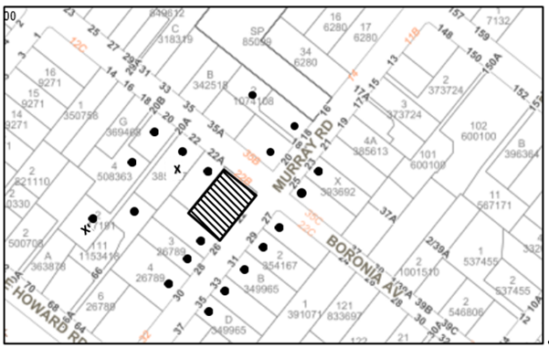
Item 3 LPP4/22 ELECTRONIC - DA/1302/2021 - Torrens Title Subdivision of an Existing Strata Titled Property - 22 Murray Road, Beecroft............................................................................ 1
Item 4 LPP17/22 ELECTRONIC - DA/61/2022 - Alterations and Additions to a Dwelling House - 21 Lowanna Place, Hornsby........................................................................................... 37
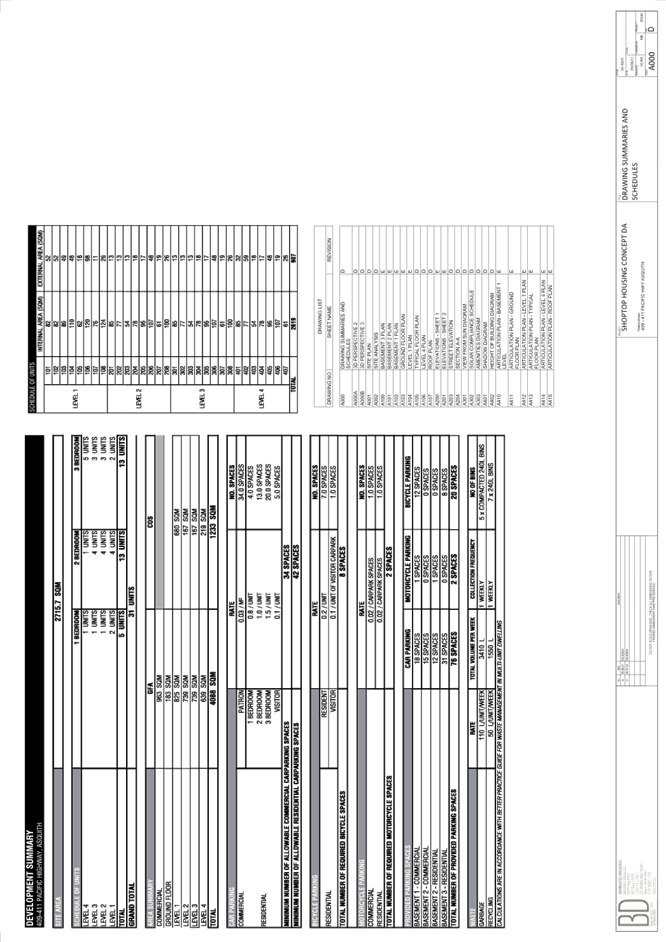
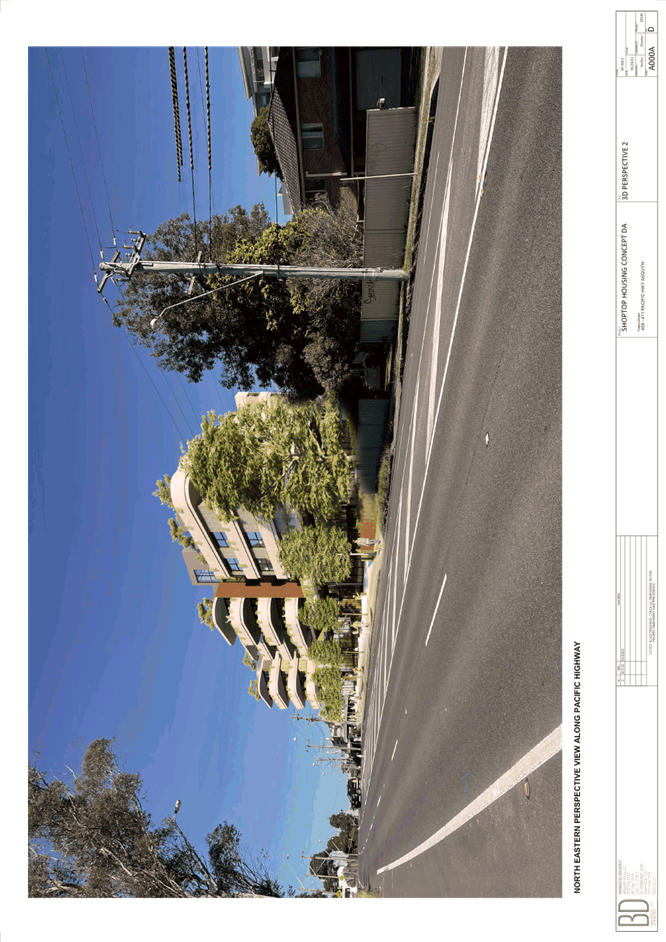
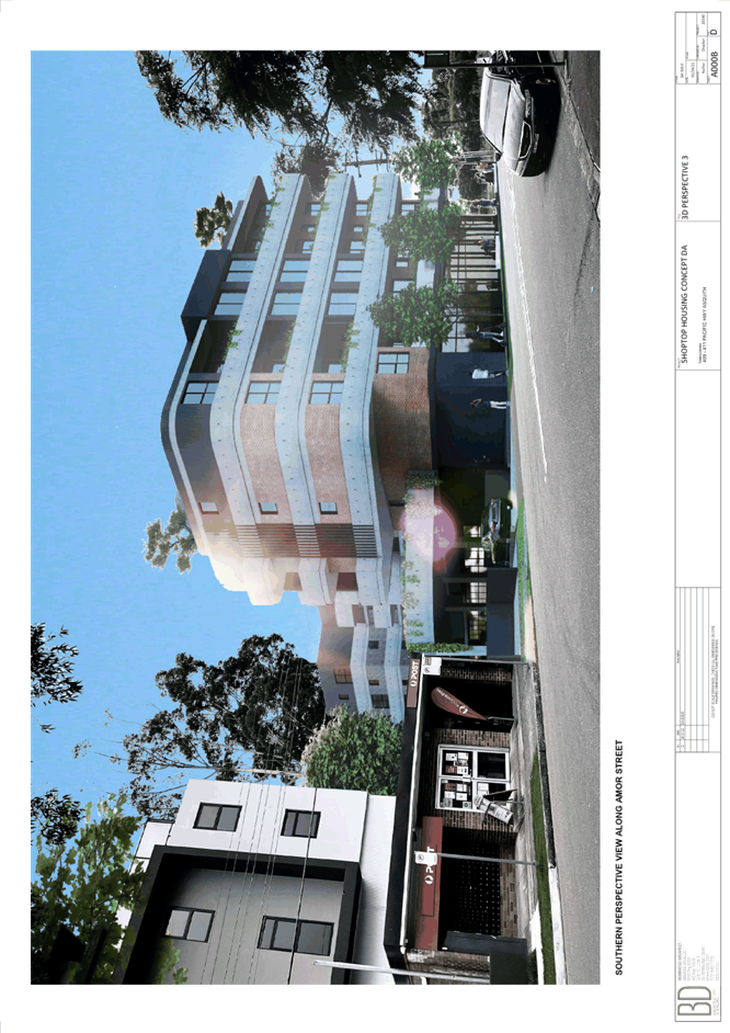
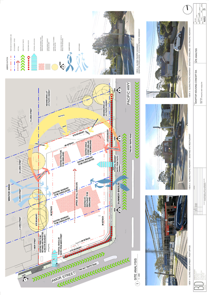
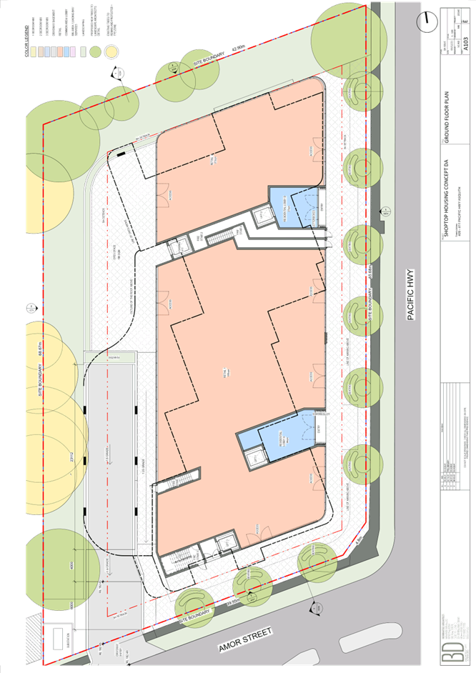
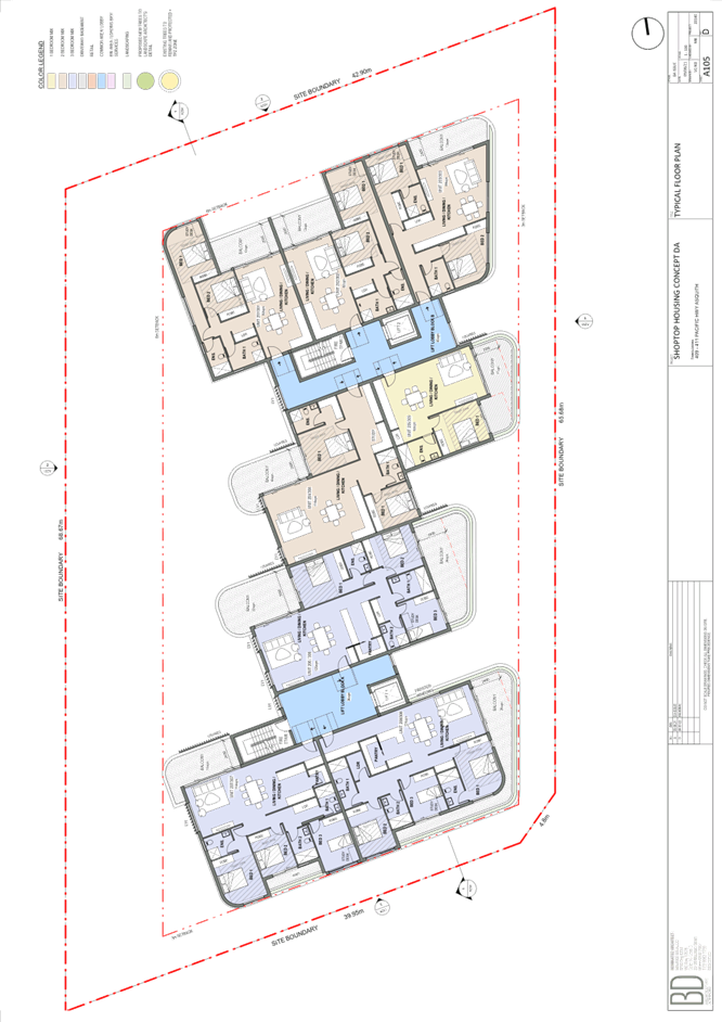
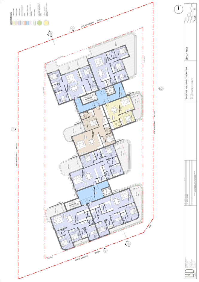
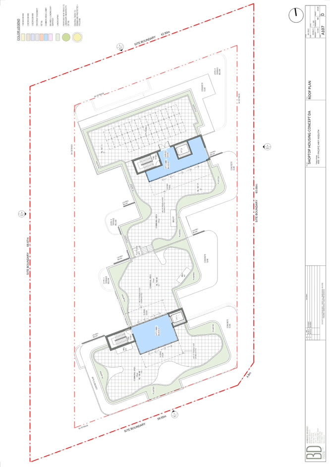
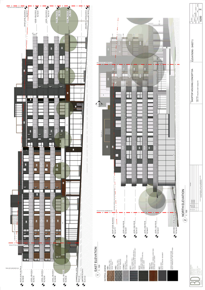
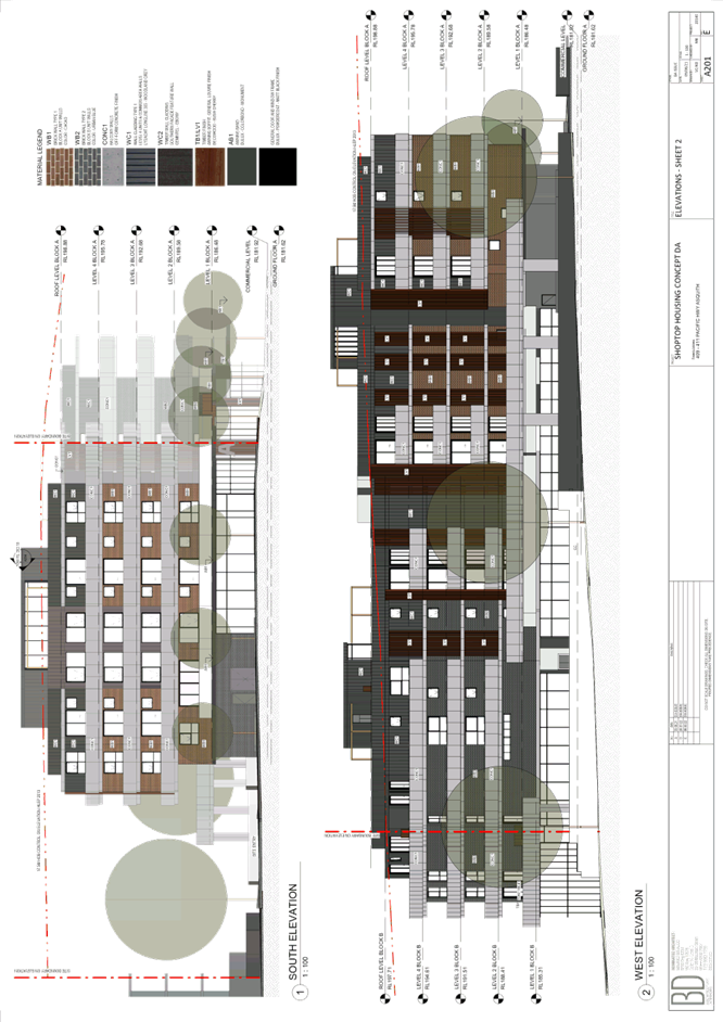
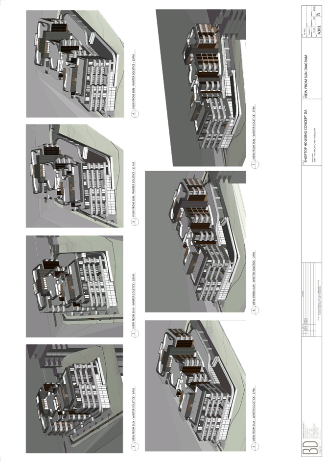
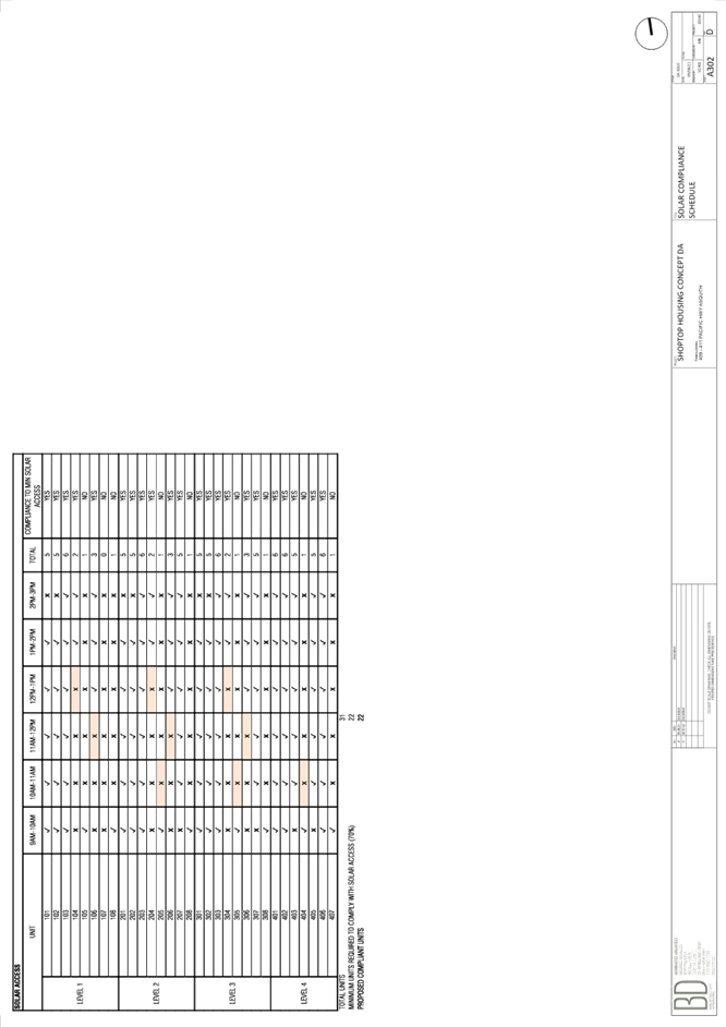
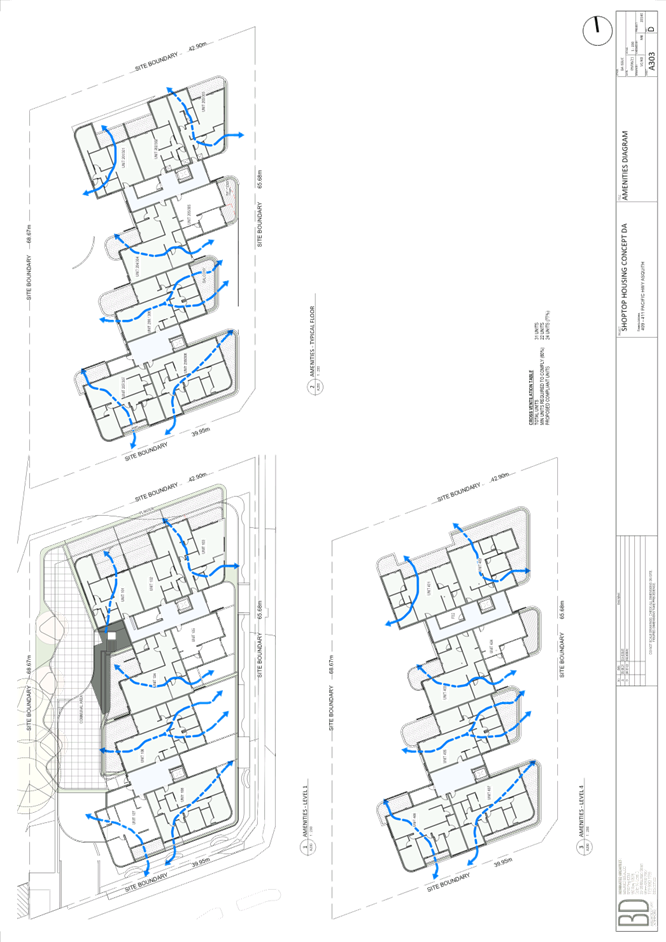
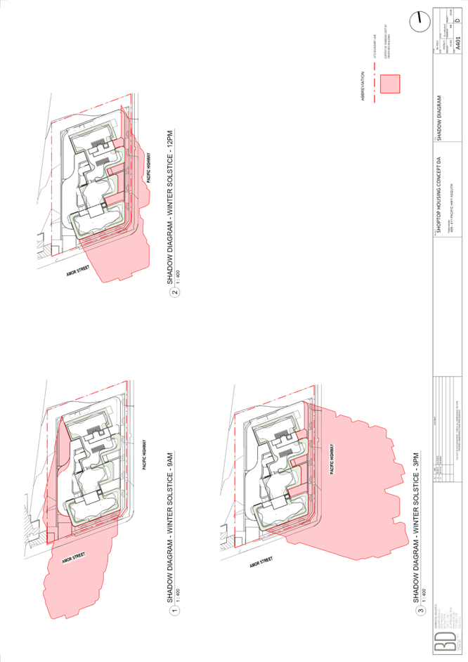
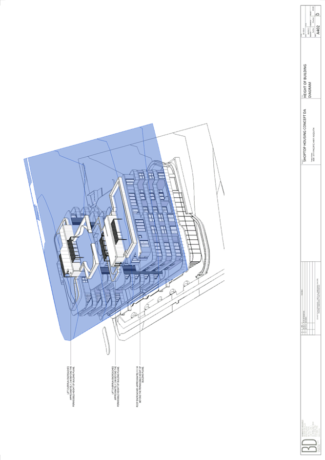
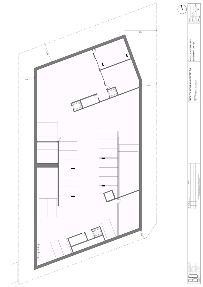
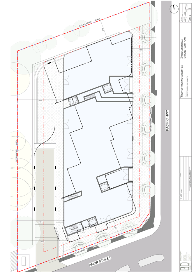
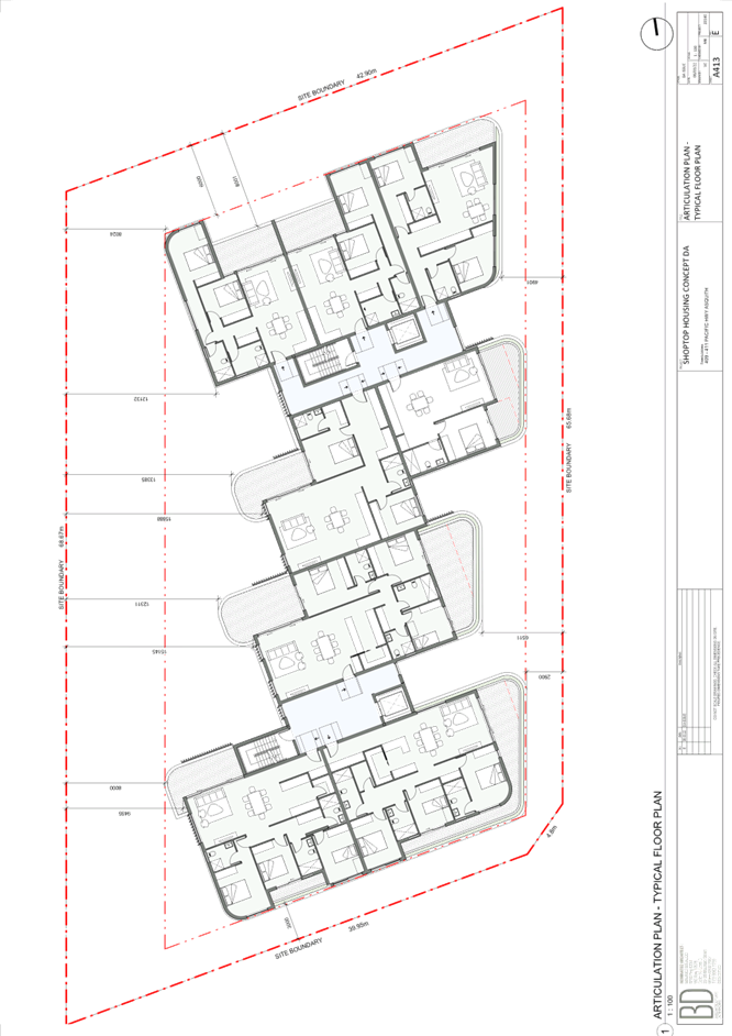
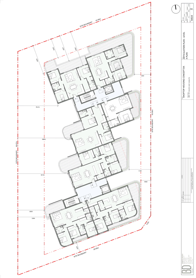
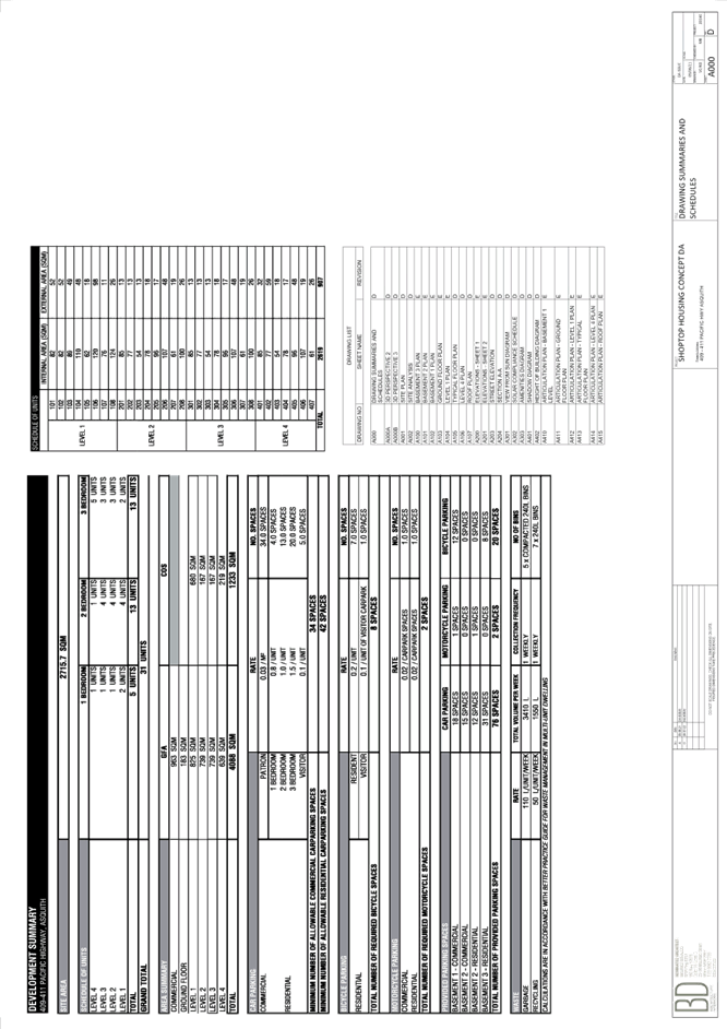
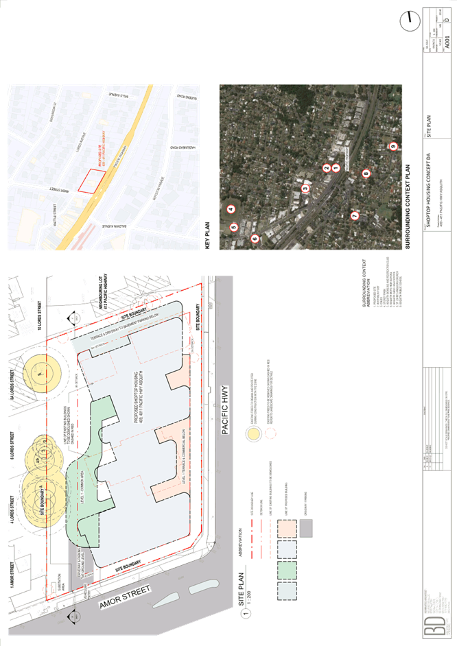
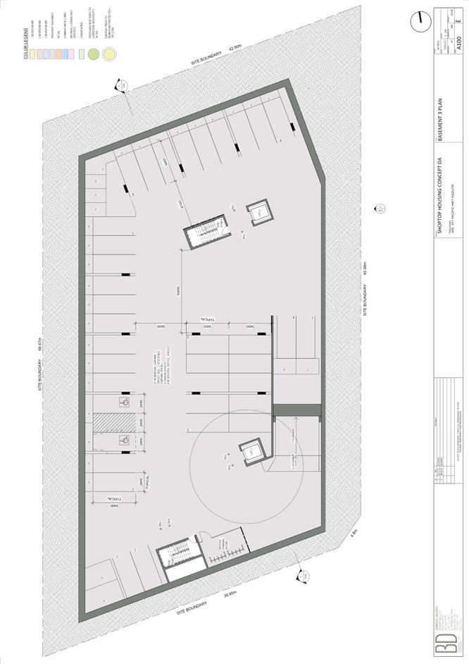
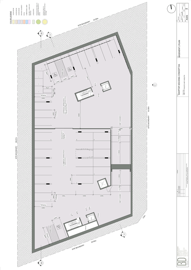
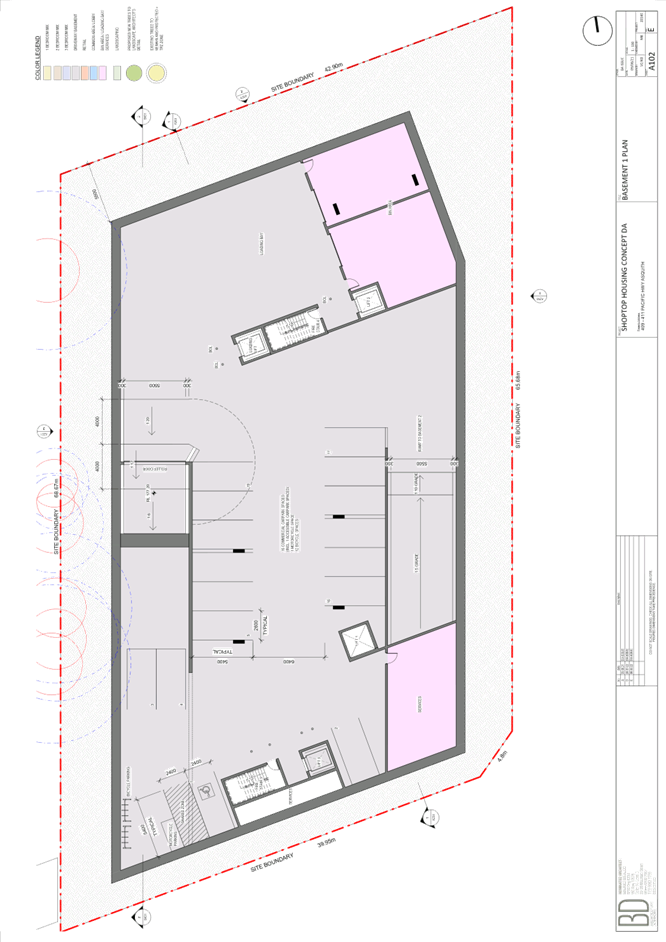
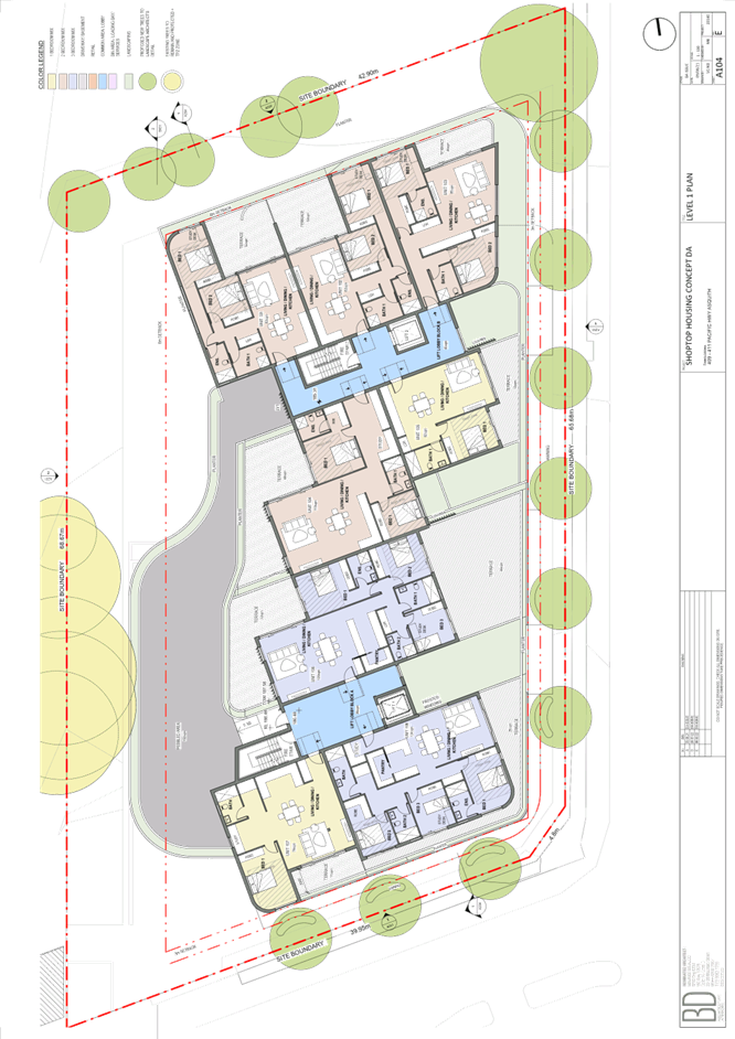
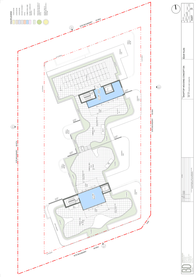
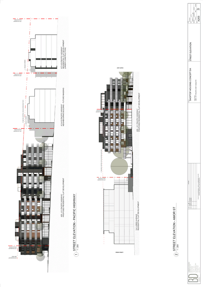
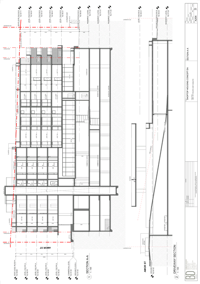
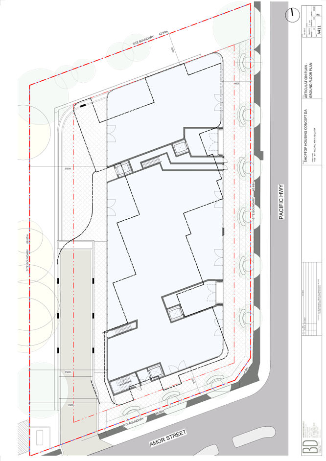
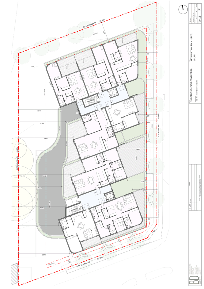
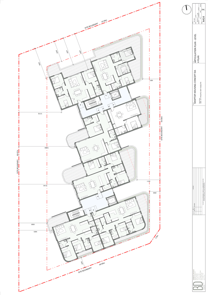
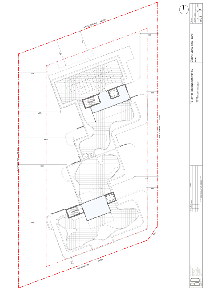
Item 5 LPP14/22 ELECTRONIC - DA/528/2020 - Concept Development Application for Shop Top Housing Development - 409-411 Pacific Highway, Asquith........................................... 96
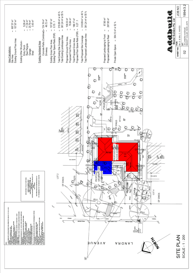
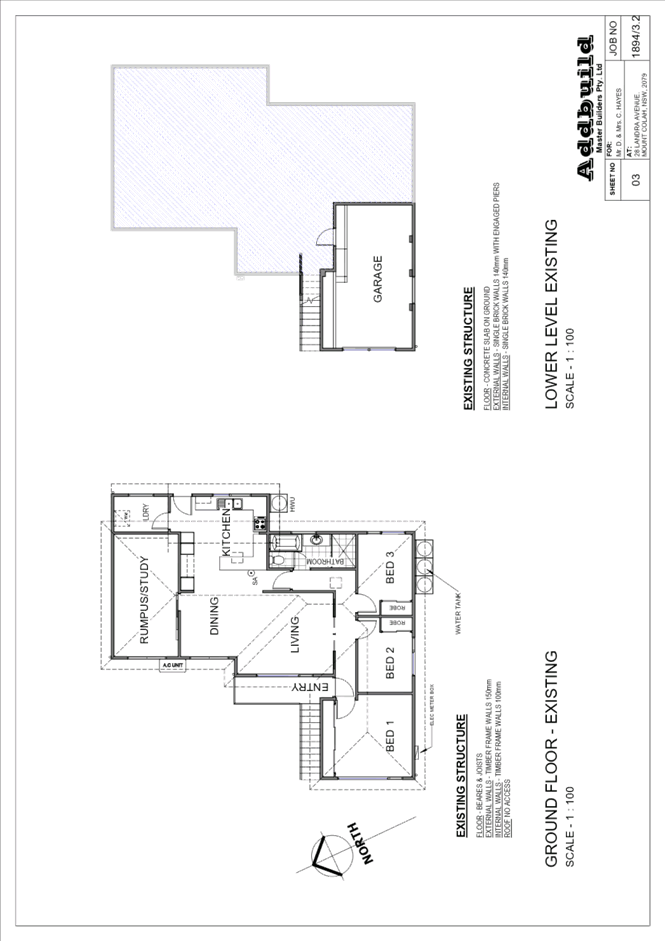
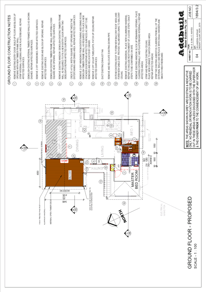
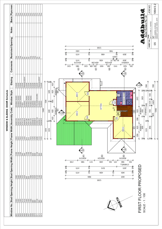
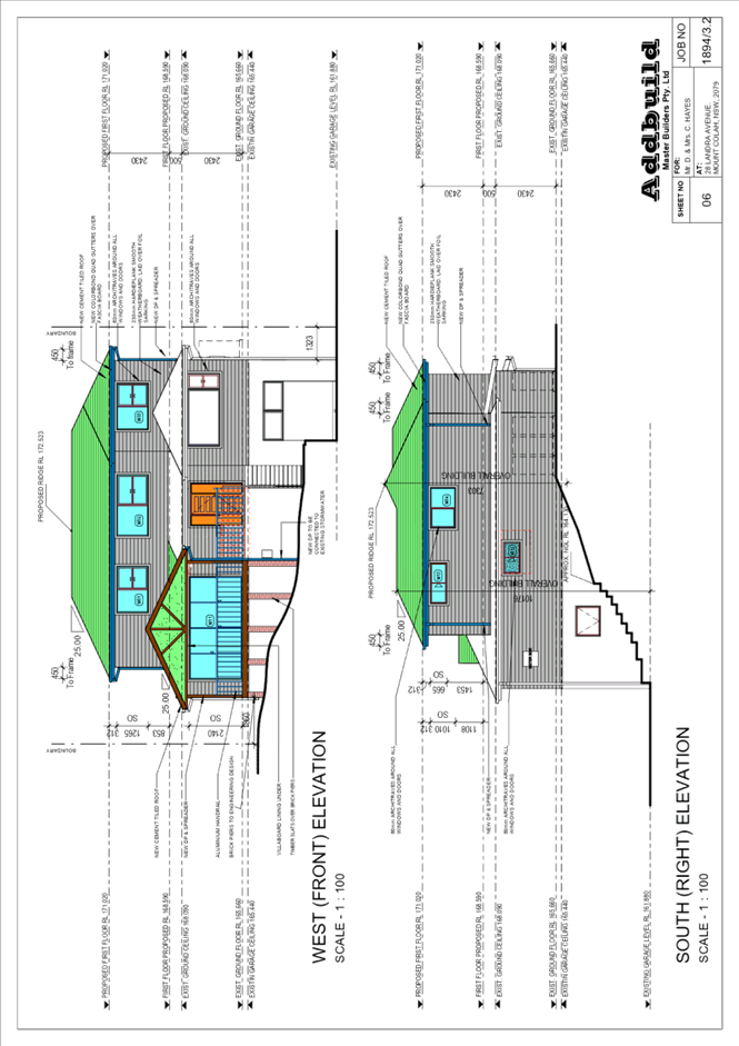
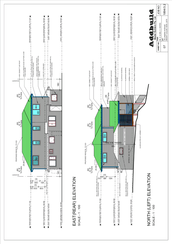
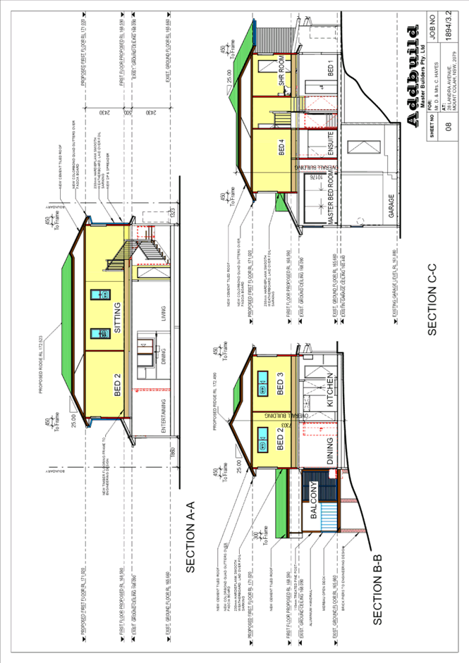
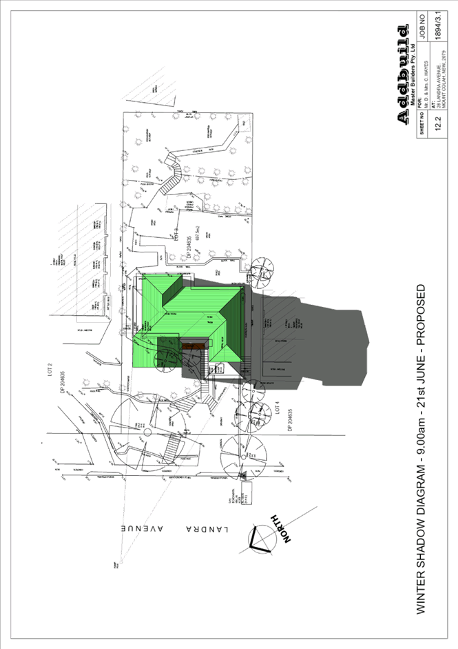
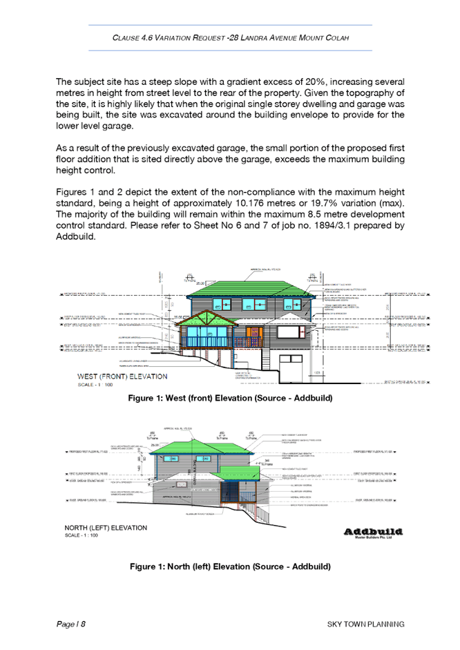
Item 6 LPP15/22 ELECTRONIC - DA/1353/2021 - Alterations and Additions to a Dwelling House - 28 Landra Avenue, Mount Colah................................................................................... 202
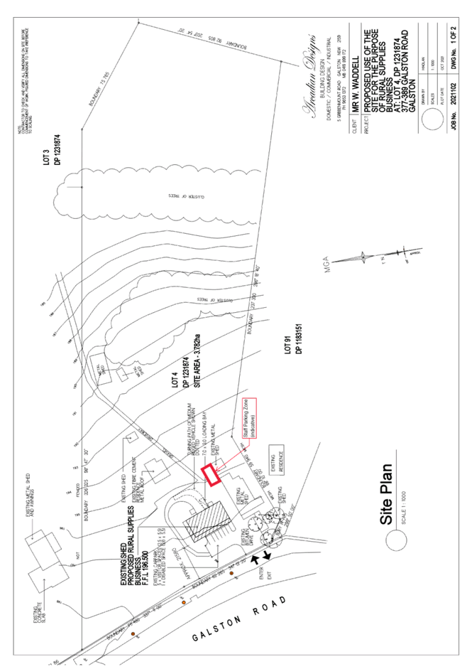
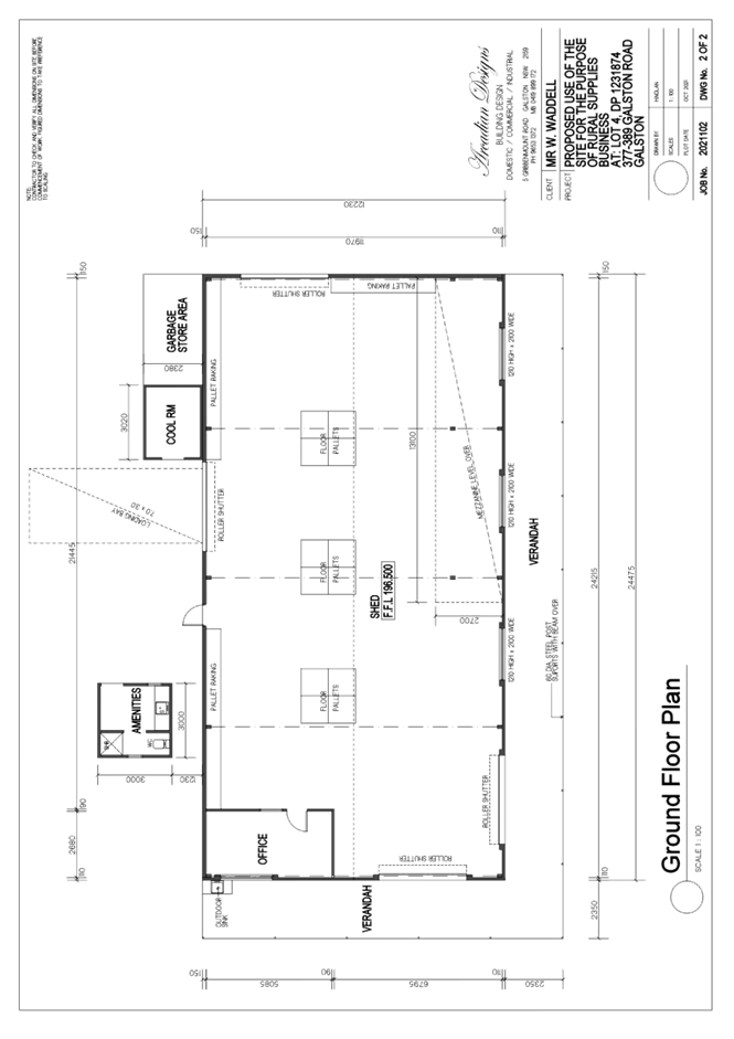
Item 7 LPP18/22 ELECTRONIC - DA/1374/2021 - Change of Use of a Shed for the Purposes of a Rural Supplies Business - 377-389 Galston Road, Galston........................................ 256
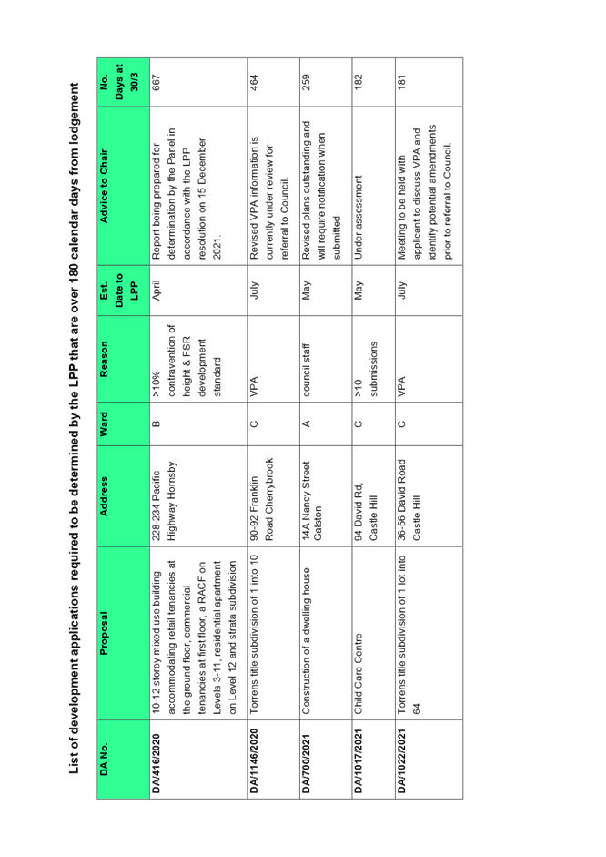
Item 8 LPP19/22 ELECTRONIC - Reporting Development Applications for Determination by the Hornsby Local Planning Panel over 180 Days........................................................... 284
LPP Report No. LPP4/22
Local Planning Panel
Date of Meeting: 30/03/2022
3 ELECTRONIC - DA/1302/2021 - TORRENS TITLE SUBDIVISION OF AN EXISTING STRATA TITLED PROPERTY - 22 MURRAY ROAD, BEECROFT
EXECUTIVE SUMMARY
|
DA No: |
DA/1302/2021 (Lodged on 3 December 2021) |
|
Description: |
Torrens title subdivision of an existing strata titled property comprising two detached dwellings |
|
Property: |
Lot 1 and 2 SP 34827, No. 22 Murray Road, Beecroft |
|
Applicant: |
Concise Planning Pty Ltd |
|
Owners: |
Mrs Alice Wei-Ling Farrell; Ms Linda Jayne Deegan; and Owners Corporation - SP 34827 |
|
Estimated Value: |
$5,000.00 |
|
Ward: |
C Ward |
· The proposal does not comply with Clause 4.1 ‘Minimum subdivision lot size’ of the Hornsby Local Environmental Plan 2013 (HLEP). The applicant has made a submission in accordance with Clause 4.6 ‘Exceptions to development standards’ of the HLEP to contravene the 600m2 minimum lot size development standard. The submission is considered well founded and is supported.
· The application is required to be determined by the Hornsby Local Planning Panel as the proposal would contravene the HLEP development standard for minimum subdivision lot size by more than 10 percent (15.55% variation).
· A total of 3 submissions have been received in respect of the application.
· It is recommended that the application be approved.
|
THAT Hornsby Shire Council Local Planning Panel assume the concurrence of the Secretary of the Department of Planning and Environment pursuant to Clause 4.6 of the Hornsby Local Environmental Plan 2013 and approve Development Application No. DA/1302/2021 for the conversion of a strata title subdivision to a Torrens title subdivision at Lot 1 and 2 SP 34827, No. 22 Murray Road, Beecroft subject to the conditions of consent detailed in Schedule 1 of LPP Report No. LPP4/22. |
BACKGROUND
Site History
On 16 January 1989, Council approved DA/547/1988 for a detached dual occupancy with construction of an additional dwelling house on the site, pursuant to Sydney Regional Environmental Plan No. 12 (SREP12).
On 4 October 1990, Council approved DA/272/1990 for the creation of 2 strata titled allotments, subject to conditions.
On 14 April 1997, Council approved BA/1495/1997 for the construction of a carport and driveway, subject to conditions.
On 10 October 2018, Council approved DA/436/2018 for the construction of a deck and an in-ground swimming pool (56,000L) at No.1/22 Murray Road, Beecroft. Nine trees and shrubs were permitted to be removed to accommodate the swimming pool, subject to conditions of consent.
On 14 August 2020 Council refused DA/349/2020 at No. 1/22 Murray Road for the construction of a first-floor addition to an existing dwelling (detached dual occupancy) and minor alterations to the ground floor. This development application was refused on heritage grounds.
Application History
On 3 December 2021, the subject application was lodged.
On 12 January 2022, Council requested an amended concept stormwater plan and a certificate from a suitably qualified civil engineer confirming that the onsite detention system is functioning in accordance with development consent and building application requirements.
On 28 January 2022, Council requested an update on the provision of the requested information.
On 17 February 2022, Council requested a further update on the provision of the requested information.
On 18 February 2022, the Applicant requested an extension until 28 February 2022 to provide the requested information.
On 4 March 2022, Council’s Assessment Officer advised the Applicant that if the requested information was not received by 11 March 2022, the application would be determined based on the information submitted as at that date.
On 11 March 2022, additional stormwater detail was provided to enable a proper assessment of the development application.
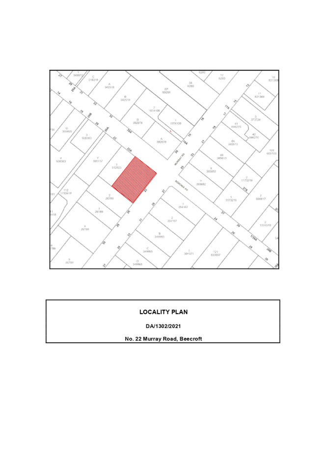
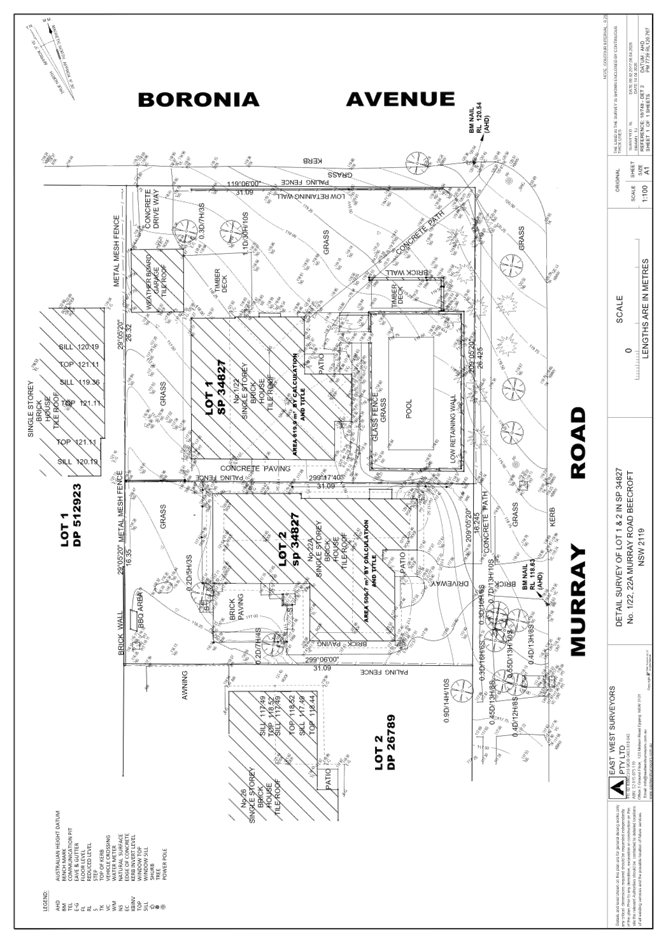
SITE
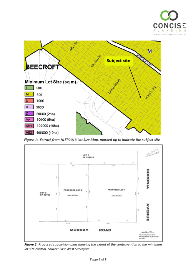
The 1326.6m2 site is on the corner of Murray Road and Boronia Avenue and contains a strata titled dual occupancy consisting of two detached dwellings as follows:
· Lot 1 - The 819.9m2 corner allotment known as Lot 1 SP 34827 is located on the southern corner of Boronia Avenue and Murray Road Beecroft and contains a dwelling house, swimming pool, a deck, and a carport.
· Lot 2 - The 506.7m2 site known as Lot 2 SP 34827 is on the north-western side of Boronia Avenue and contains a single storey dwelling house with an attached single garage.
There is no vehicular access crossing from Boronia Avenue, and vehicle access crossings for both lots are from Murray Road.
The site has a fall of 6 metres towards the rear, south-western corner.
The site is not bushfire prone or flood prone.
The site is benefitted by a drainage easement over No. 22A Boronia Avenue (Lot 1 DP 5129523).
The site is not heritage listed. The site is within the Beecroft-Cheltenham Heritage Conservation Area (HCA) and is in the vicinity to heritage items number 66 and 132 which are of local heritage significance and are listed within Schedule 5 of the Hornsby Local Environmental Plan 2013. Lot 1 of the subject site is of local cultural significance being the former home of Australian Author Miles Franklin.
Adjoining development is characterised by one and two storey dwelling houses.
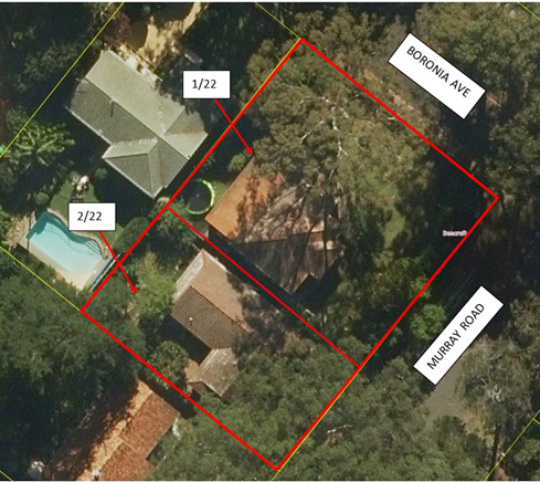
Figure 1: Aerial photo of the Site (Source: Intramaps)
PROPOSAL
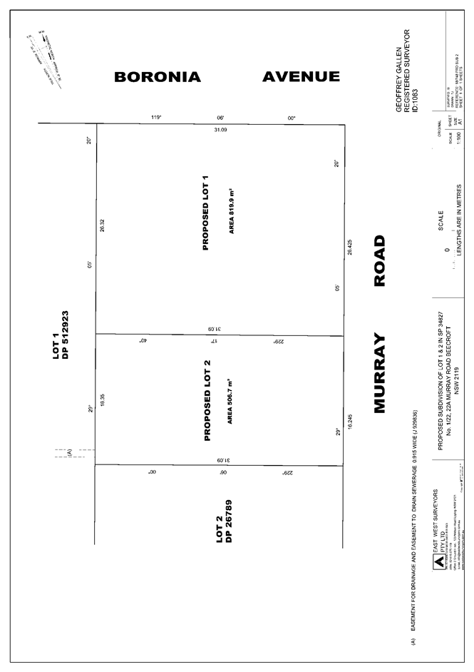
The application proposes Torrens title subdivision of an approved strata titled dual occupancy comprising 2 detached dwellings.
· Proposed Lot 1 would have an area of 819.9m2 and would contain the existing dwelling to the north of the site. Vehicular access to this lot will be via the existing driveway off Boronia Avenue.
· Proposed Lot 2 would have an area of 506.7m2 and would contain the existing dwelling to the south of the site. Vehicular access to Lot 2 would be via the existing driveway from Murray Road.
No physical works and no amendments to the existing stormwater management system are proposed.
No trees would be removed or impacted by the development.
ASSESSMENT
The development application has been assessed having regard to the Greater Sydney Region Plan – A Metropolis of Three Cities, the North District Plan and the matters for consideration prescribed under Section 4.15 of the Environmental Planning and Assessment Act 1979 (the Act). The following issues have been identified for further consideration.
1. STRATEGIC CONTEXT
1.1 Greater Sydney Region Plan - A Metropolis of Three Cities and North District Plan
The Greater Sydney Region Plan - A Metropolis of Three Cities has been prepared by the NSW State Government to guide land use planning decisions for the next 40 years (to 2056). The Plan sets a strategy and actions for accommodating Sydney’s future population growth and identifies dwelling targets to ensure supply meets demand. The Plan also identifies that the most suitable areas for new housing are in locations close to jobs, public transport, community facilities and services.
The NSW Government will use the subregional planning process to define objectives and set goals for job creation, housing supply and choice in each subregion. Hornsby Shire has been grouped with Hunters Hill, Ku-ring-gai, Lane Cove, Mosman, North Sydney, Ryde, Northern Beaches and Willoughby to form the North District. The Greater Sydney Commission has released the North District Plan which includes priorities and actions for Northern District for the next 20 years. The identified challenge for Hornsby Shire will be to provide an additional 4,350 dwellings by 2021 with further strategic supply targets to be identified to deliver 97,000 additional dwellings in the North District by 2036.
The proposed development would not be inconsistent with the Greater Sydney Region Plan - A Metropolis of Three Cities and the North District Plan.
2. STATUTORY CONTROLS
Section 4.15(1)(a) requires Council to consider “any relevant environmental planning instruments, draft environmental planning instruments, development control plans, planning agreements and regulations”.
2.1 Hornsby Local Environmental Plan 2013
The proposed development has been assessed having regard to the provisions of the Hornsby Local Environmental Plan 2013 (HLEP).
2.1.1 Zoning of Land and Permissibility
The subject land is zoned R2 Low density residential under the HLEP. The objectives of the R2 zone are:
· To provide for the housing needs of the community within a low-density residential environment.
· To enable other land uses that provide facilities or services to meet the day to day needs of residents.
The proposed development is defined as ‘subdivision’ and is permissible in the zone with Council’s consent.
2.1.2 Permissibility
The approved development is defined as ‘dual occupancy (detached)’ under the HLEP and is prohibited in the R2 zone.
Notwithstanding, the site is deemed to enjoy existing use rights pursuant to Clause 4.65(a)(i) of the Act as “the use of (the) building, work or land……for which development consent was granted before the commencement of a provision of an environmental planning instrument having the effect of prohibiting the use”. The ‘dual occupancy’ use compromising a single dwelling-house on each strata lot was approved prior to the gazettal of the HLEP on 11 October 2013.
The proposed Torrens title subdivision would not alter the intensity or scale of the existing development on the site and would convert a prohibited ‘dual occupancy’ development to a permissible use within the R2 Low density residential zone under the HLEP. Once the Torrens title subdivision is registered, the dual occupancy would\l be treated as two separate dwelling houses, and therefore the HLEP and HDCP controls pertaining to dwelling houses would apply. The proposed Torrens title subdivision is permitted under the Environmental Planning and Assessment Regulation 2000 with development consent.
2.1.3 Minimum Lot Size
Clause 4.1 of the HLEP prescribes that the minimum subdivision lot size is not to be less than shown for the land on the minimum Lot Size Map, which is 600m2.
The proposed subdivision would result in Lot 2 having an area of 506.7m2 which would result in a 15.55% variation to the minimum lot size development standard. Proposed Lot 1 would have an area of 819.9m2 which would comply with the minimum lot size development standard.
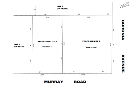
Figure 2: Proposed Plan of Subdivision
The application is supported by a submission pursuant to Clause 4.6 of the HLEP to contravene the minimum 600m2 allotment size development standard, which is discussed below in Section 2.1.4 of this report.
2.1.4 Exceptions to Development Standards
The application has been assessed against the requirements of Clause 4.6 of the HLEP. This clause provides flexibility in the application of the development standards in circumstances where strict compliance with those standards would, in any particular case, be unreasonable or unnecessary or tender to hinder the attainment of the objectives of the zone.
The proposal does not meet the minimum lot size requirements specified in HLEP Clause 4.1 ‘Minimum subdivision lot size’ which requires a minimum lot size, as per the ‘Lot Size Map’ of 600m2.
The Objectives of Clause 4.1 of HLEP are as follows:
(1) The objectives of this clause are as follows—
a) To provide for the subdivision of land at a density that is appropriate for the site constraints, development potential and infrastructure capacity of the land,
b) To ensure that lots are of a sufficient size to accommodate development.
The applicant has made a submission in support of the contravention of the development standard in accordance with Clause 4.6 of the HLEP. The development application seeks to contravene the development standard by 15.55% (93.3m2). The applicant states the proposed contravention is considered to be consistent with the objectives of the control and is justified as follows:
· The dwellings located on the site are existing and are proposed to be retained as part of this application. No physical works to the site is proposed.
· The proposed middle boundary between the two proposed dwelling houses will be retained to reflect the existing configuration of the dwellings. That building boundary was formed through the strata subdivision of the site in 1989.
· The current use of the site is a detached dual occupancy, which in accordance with the Hornsby Local Environmental Plan 2013 is a prohibited use within the R2 zone. This proposed one into two lots Torrens title subdivision will create two ‘dwelling houses’, which are a permissible use within the R2 – Low Density Residential zone. Therefore, the proposed development will remove a non-conforming use on the site and subsequently create a conforming use.
· The site as currently configured has been inclusive of a detached dual occupancy for a considerable amount of time. Furthermore, the proposal will continue to reflect the existing site conditions, generating no adverse impacts on adjoining properties.
· The proposed development will not impact on the residential capacity of the subject site.
· Following the subdivision of the site, the two lots can (if so desired) be sold separately which will allow potential home buyers the opportunity for buying land that has proven to be of a suitable size for residential purposes.
· The proposed Torrens title subdivision will remove the burden of a Strata scheme that serves no positive effects on the property owners of 1/22 and 22A Murray Road.
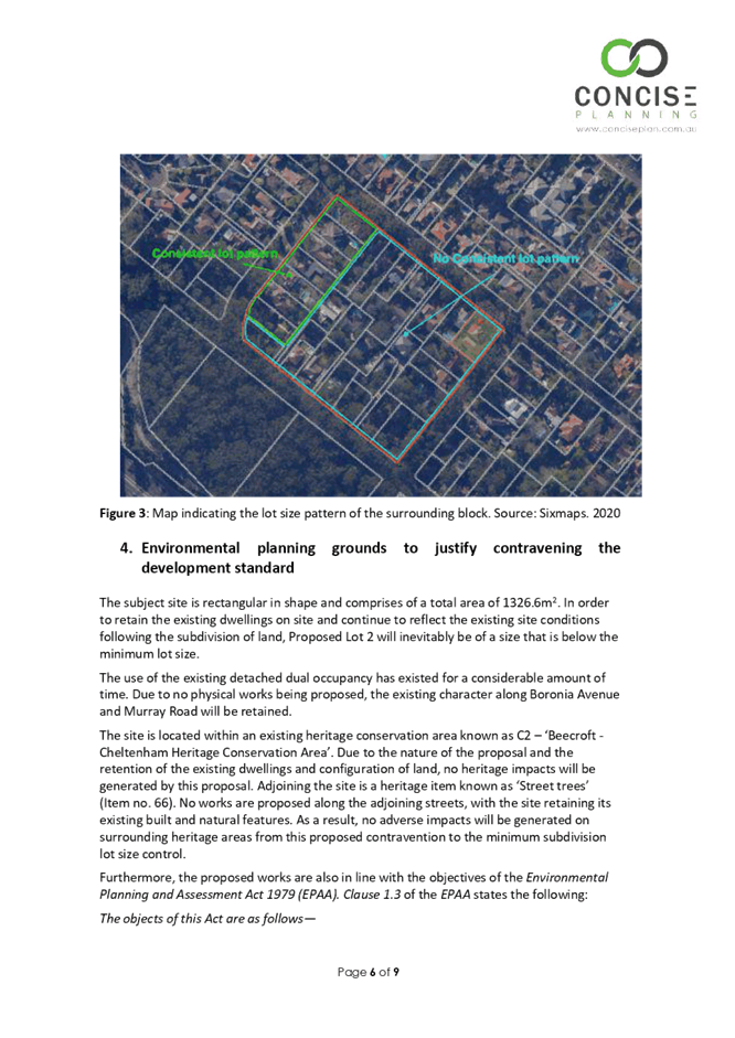
· There is no consistent subdivision pattern in the area. The site is located within a block that does not contain many rows of lots that are consistent with each other. The only section of the block that possesses a pattern in lot sizes is from 1 Oaklands Avenue to 15 Oaklands Avenue. These lots are not adjacent to the subject site and will not be adversely impacted by this proposed subdivision.
State Government Guidelines on contravening development standards recommend considering the provisions of Clause 4.6 of the LEP and the ‘five-part test’ established by the Land and Environment Court as follows:
1. The objectives of the standard are achieved notwithstanding noncompliance with the standard.
2. The underlying objective or purpose of the standard is not relevant to the development and therefore compliance is unnecessary.
3. The underlying object of purpose would be defeated or thwarted if compliance was required and therefore compliance is unreasonable.
4. The development standard has been virtually abandoned or destroyed by the council’s own actions in granting consents departing from the standard and hence compliance with the standard is unnecessary and unreasonable.
5. The compliance with development standard is unreasonable or inappropriate due to existing use of land and current environmental character of the particular parcel of land. That is, the particular parcel of land should not have been included in the zone.
The applicant’s submission to vary the minimum lot size development standard is considered well founded for the following reasons:
· The proposal seeks approval for the Torrens title subdivision of an existing dual occupancy (detached).
· The proposal does not seek approval for any physical works with the subdivision limited to a change in the title of the property.
· The granting of consent does not create a precedent on the basis that the construction of a new dual occupancy is prohibited within the R2 zone.
· The existing dual occupancy (attached) is provided with separate services and is ideally suited to the subdivision as proposed. The strata subdivision currently has no common property.
· The proposed subdivision will not result in any detrimental impacts.
In relation to the first objective, the proposed development will continue to meet the housing needs of the community within a low-density residential environment. The subdivision of land will be consistent with the existing density of the site, as no physical works are proposed.
In relation to the second objective, the proposed development will also enable the adjoining properties and other land uses in the area to continue to meet their daily needs. The functioning of the subject site will continue to be for residential purposes, with the existing dwellings also being retained. Therefore, the proposed subdivision of land will in no way affect neighbouring land.
In relation to the functions of the secretary, it is considered that the small scale of the proposal and nature of the contravention sought, are such that no State or Regional level of significance is involved. There is no particular concern arising in relation to the public benefit through the proposed contravention to the development standard, as in this instance there is no adverse impacts created.
The total area of the site is compliant. A minimum total lot size of 1200m2 is required. The total lot size of the subject site is 1326m2. However, the proposed subdivision will follow the existing strata lot arrangement, being Lot 1 - 819.9m2 and Lot 2 - 506.7m2. This subdivision layout allows Lot 1 to retain its larger size, as it is of local cultural significance as Miles Franklin’s former home. The larger lot size provides space for more landscaping to enhance the character of the home. Further, a larger corner allotment affords more streetscape amenity by allowing larger setbacks.
It would be unreasonable and unnecessary to require the boundary of the two allotments to be adjusted to meet the numerical standard pertaining to minimum lot size. Both lots are established residential properties with dwellings and established landscaping. The stormwater on both allotments functions appropriately. To amend the subdivision boundary would unreasonably disturb the established properties and would not result in a better planning outcome.
Based on this assessment, it is considered that compliance with the development standard would be unreasonable and unnecessary in the circumstances of the case. Accordingly, the Clause 4.6 submission is supported.
2.1.5 Heritage Conservation
Clause 5.10 of the HLEP sets out heritage conservation provisions for Hornsby Shire. The property is located within the Beecroft Cheltenham Plateau Precinct of the Beecroft Cheltenham Heritage Conservation Area (HCA), listed under Schedule 5 of the HLEP. Heritage conservation is discussed further in Section 2.7.6 of this report.
2.1.6 Earthworks
Clause 6.2 of the HLEP states that consent is required for proposed earthworks on site. Before granting consent for earthworks, Council is required to assess the impacts of the works on adjoining properties, drainage patterns and soil stability of the locality.
The application does not propose any physical works and is consistent with Clause 6.2 of the HLEP.
2.1.7 Flood Planning
The site is not identified as a flood planning area on the Flood Planning Map and further assessment under Clause 5.21 of the HLEP is not required.
2.2 Assessment of Existing Use Rights - Fodor Investments v Hornsby Shire Council [2005] NSWLEC 71
Due to the proposed use (dual occupancy) not being permissible in the zone, an assessment of the suitability of the development cannot be undertaken in accordance with the prescriptive requirements of the HLEP or most of the Hornsby Development Control Plan (HDCP) (some assessment against the HDCP is possible, this is provided in Part 6.5 of this report). Consequently, a merit assessment is required.
The principles to be considered when undertaking a merit assessment of a proposed redevelopment of a site with existing use rights were dealt with by Roseth SC in Fodor Investments v Hornsby Shire Council [2005] NSWLEC 71. Roseth SC found that four questions usually arise in the assessment of existing use rights developments. These four questions comprise the Planning Principle for assessing such developments. An assessment of this application against this planning principle is provided below.
|
Planning principles: Assessment of proposals on land with existing use rights |
|
|
Question |
Assessment |
|
How do the bulk and scale (as expressed by height, floor space ratio and setbacks) of the proposal relate to what is permissible on surrounding sites? |
There are no physical works proposed as part of this development application. The floor space and height of the building would not change. The side and rear setbacks comply with minimum setback requirements. Due to low density residential being the prevailing land use in the locality, the existing setbacks, height and floor space would be acceptable as they are generally consistent with the requirements outlined in Part 3 residential of the HDCP. It is therefore considered that the bulk and scale of the proposed development is consistent and acceptable with respect to the surrounding built environment. |
|
What is the relevance of the building in which the existing takes place? |
Upon approval of this development application The buildings in which the existing use takes place would be now be treated as a conforming land use being dwelling houses. |
|
What are the impacts on adjoining land? |
Impacts arising from the development are likely to be negligible, as there is no physical works proposed and no change to the existing stormwater system. There will be no additional development potential as a result of this development application. |
|
What is the internal amenity? |
There will be no impact to the internal site amenity of the site as a result of the development. |
2.3 Adopted State Environmental Planning Policies - Transitional and Savings Provisions
On 1 March 2022, the following State Environmental Planning Policies (SEPPS) were gazetted.
· State Environmental Planning Policy (Resilience and Hazards) 2021
· State Environmental Planning Policy (Biodiversity and Conservation) 2021
These SEPPS now form matters for consideration under Section 4.15 of the Environmental Planning and Assessment Act 1979. However general savings provisions apply to development applications that have been made but not yet determined, on or before the commencement date.
As this development application was lodged on 3 December 2021 this development application is considered to have been made prior to the commencement date of the SEPPs. The adopted policies have been considered as a matter for consideration under S4.15 of the Act. However, the existing legislation in force at time of lodgement of the development application, prevails to be extent of any inconsistency.
Notwithstanding, the approval of the development application would not adversely affect the objectives of the newly adopted State Environment Planning Policies and is considered to be consistent with this policy.
2.4 State Environmental Planning Policy No. 55 Remediation of Land
Should the land be contaminated, Council must be satisfied that the land is suitable in a contaminated state for the proposed use. If the land requires remediation to be undertaken to make the land suitable for the proposed use, Council must be satisfied that the land will be remediated before the land is used for that purpose.
An examination of Council’s records and aerial photography has determined that the site has been historically used for residential purposes. It is not likely that the site has experienced any significant contamination, and further assessment under SEPP 55 is not required.
2.5 State Environmental Planning Policy (Vegetation in Non-Rural Areas) 2017
Part 3, Clause 9(2) of the Vegetation SEPP states that a Development Control Plan may make a declaration in any manner relating to species, size, location and presence of vegetation. Accordingly, Part 1B.6.1 of the Hornsby Development Control Plan 2013 (HDCP) prescribes works that can be undertaken with or without consent to trees and objectives for tree preservation.
As no physical or engineering works are proposed, no trees or vegetation will be removed or impacted by this development.
The application has been assessed against the requirements of the Vegetation SEPP and it has been determined that the proposal would meet the objectives of the Vegetation SEPP. This matter is addressed further in Section 3.1.1 of this report.
2.6 Sydney Regional Environmental Plan (Sydney Harbour Catchment) 2005
Subject to the implementation of installation of sediment and erosion control measures and stormwater management to protect water quality, the proposal would have minimal potential to impact on the Sydney Harbour Catchment.
2.7 Section 3.42 Environmental Planning and Assessment Act 1979 - Purpose and Status of Development Control Plans
Section 3.42 of the Environmental Planning and Assessment Act 1979 states that a DCP provision will have no effect if it prevents or unreasonably restricts development that is otherwise permitted and complies with the development standards in relevant Local Environmental Plans and State Environmental Planning Policies.
The principal purpose of a development control plan is to provide guidance on the aims of any environmental planning instrument that applies to the development; facilitate development that is permissible under any such instrument; and achieve the objectives of land zones. The provisions contained in a DCP are not statutory requirements and are for guidance purposes only. Consent authorities have flexibility to consider innovative solutions when assessing development proposals, to assist achieve good planning outcomes.
2.8 Hornsby Development Control Plan 2013
The proposed development has been assessed having regard to the relevant desired outcomes and prescriptive requirements within the Hornsby Development Control Plan 2013 (HDCP). The following table sets out the proposal’s compliance with the prescriptive requirements of the Plan:
|
HDCP - Part 6 Subdivision & Part 3.1 Dwellings |
|||
|
Control |
Proposal |
Requirement |
Complies |
|
Site Area |
1326.6m2 |
1200m2 |
N/A |
|
Lot Size |
|
|
|
|
- Lot 1 |
819.9m2 |
600m2 |
Yes |
|
- Lot 2 |
600m2 |
No |
|
|
Minimum Lot Width |
|
|
|
|
- Lot 1 |
26.32m |
15m |
Yes |
|
- Lot 2 |
16.245m |
15m |
Yes |
|
|
|
|
|
|
- Lot 1 |
34% |
50% |
Yes |
|
- Lot 2 |
21% |
50% |
Yes |
|
Floor Area of Dwelling |
|
|
|
|
- Lot 1 |
155m2 |
380m2 |
Yes |
|
- Lot 2 |
174m2 |
330m2 |
Yes |
|
Setbacks Lot 1 |
|
|
|
|
- Front (Murray Rd) |
12.4m |
6m |
Existing |
|
- Secondary (garage) |
5.6m |
3m |
Existing |
|
- Side (south west) |
2m |
0.9m
|
Yes |
|
- Rear
|
5.9m |
3m |
Existing |
|
Setbacks Lot 2 |
|
|
|
|
- Front (Murray Rd) |
5-6.9m |
6m |
Existing |
|
- Side (north east) |
1.097m |
0.9m |
Yes |
|
- Side (south west) |
2.1m |
0.9m |
Existing |
|
- Rear (north west) |
7.9m |
3m |
Existing |
|
Landscape Area (% of lot size) |
|
|
|
|
- Lot 1 |
58% |
30% |
Yes |
|
- Lot 2 |
46% |
20% |
Yes |
|
Private Open Space - Lot 1 |
|||
|
- minimum area |
>24m2 |
24m2 |
Yes |
|
- minimum dimension |
>3m |
3m |
Yes |
|
Private Open Space - Lot 2 |
|||
|
- minimum area |
>24m2 |
24m2 |
Yes |
|
- minimum dimension |
>3m |
3m |
Yes |
|
Car Parking |
|||
|
- Lot 1 |
2 spaces |
2 spaces |
Yes |
|
- Lot 2 |
2 spaces |
2 spaces |
Yes |
As detailed in the above table, the proposed development complies with the prescriptive requirements within the HDCP, with the exception the minimum lot size control. The matters of non-compliance are detailed below, as well as a brief discussion on compliance with relevant desired outcomes.
2.8.1 Lot Size and Width
The desired outcomes of Part 6.2.1 Residential Subdivision of HDCP 2013 are to ensure “subdivision design should maintain appropriately shaped lots to accommodate a dwelling and associated development that is compatible with a low-density residential environment” and “subdivision design should provide setbacks to developable areas that will complement the streetscape, provide for landscaping, protect landscape features, and provide separation between existing and future dwellings.
As discussed under Sections 2.1.1 and 2.1.2 of this report, the existing dual occupancy development demonstrates that the site is of sufficient size and shape to accommodate two dwelling houses. The proposed Torrens title subdivision would not alter the intensity or scale of the existing development on the site and would convert a prohibited ‘dual occupancy’ development to a permissible use within the R2 Low density residential zone under the HLEP. Once the Torrens title subdivision is registered, the dual occupancy will be treated as two separate dwelling houses, and therefore the HLEP and HDCP controls pertaining to dwelling houses would apply.
Despite the departure to the minimum lot size control for Lot 2, the development complies with the prescriptive control for minimum lot width. The minimum lot width for a 600m2 lot in the R2 zone is 15m2. The width of proposed Lot 1 is 26.4m and the width of proposed Lot 2 is 16.2m.
The proposal would not have a detrimental impact on the existing streetscape or the amenity of adjoining properties and is considered acceptable in this regard.
The proposal complies with Part 6.2.1 Residential Subdivision of the HDCP 2013 and is considered acceptable.
2.8.2 Setbacks
The desired outcomes of Part 3.1.2 of HDCP are to encourage “setbacks that are compatible with adjacent development and complement the streetscape” and “setbacks that allow for canopy trees to be retained and planted along the front and rear property boundaries”.
Notwithstanding the departure to minimum lot size development standard under HLEP, the dwelling houses would comply with all relevant setback controls under Part 3.1.2 Setbacks of HDCP. Both existing properties complement the streetscape, and have sufficient landscaping along the front and rear boundaries.
The proposal complies with Part 3.1.2 Setbacks of the HDCP and is considered acceptable.
2.8.3 Landscaping
The desired outcome of Part 3.1.3 of HDCP are to encourage “landscaping that integrates the built form with soft canopy and retains and enhances the tree canopy” and “development that retains the existing landscape features”. These desired outcomes are supported by prescriptive controls requiring a minimum of 30% of the site area being landscaped on Lot 1, and a minimum of 20% of Lot 2 being landscaped.
Notwithstanding the departure to minimum lot size development standard under HLEP, both proposed lots comply with their respective minimum landscaping requirements for dwelling houses under Part 3.1.3 of HDCP.
The proposed lot configuration making Lot 1 the larger lot, allows for increased landscaping opportunities to frame and enhance the dwelling house on Lot 1 which is of local cultural significance.
The proposal complies with Part 3.1.3 of HDCP and is considered acceptable
2.8.4 Open Space
The desired outcome of Part 3.1.4 Open Space is “private open space that functions as an extension to the dwelling house”. This desired outcome is supported by the prescriptive control that each lot have a minimum of 24m2 of private open space, with a minimum width of 3m. Both lots have greater than the required minimum private open space area.
The proposal complies with Part 3.1.4 Open Space and is considered acceptable.
2.8.5 Vehicular Access and Parking
The desired outcome of Part 3.1.7 Vehicle Access and Parking is “development that provides sufficient and convenient parking for residents with vehicular access that is simple, safe and direct”. This desired outcome is supported by prescriptive controls requiring that the provision of “car parking for dwelling houses should be provided behind the front building line” and “a paved driveway should be provided between the required on-site car parking area and a public road”.
Both lots have two car parking spaces and both lots will continue by served by separate vehicle access crossings. Existing access to No. 1/22 Murray Road is via Boronia Avenue and access to No. 2/22 Murray Road is via Murray Road.
The proposal complies with Part 3.1.7 Vehicle Access and Parking and is considered acceptable.
2.8.6 Heritage
The property is located within the Beecroft Cheltenham Plateau Precinct of the Beecroft Cheltenham HCA, listed under Schedule 5 of the HLEP.
The property is located in the vicinity of heritage listed street trees on Boronia Avenue (Item No. 66).
In 1989 a strata subdivision was registered for the site (SP 34827). Two detached dwellings with separated private open space currently occupy the site. The original Inter-War painted brick dwelling constructed in c1940 is located on the corner lot (No. 1/22 Murray Road) and a c1990 single storey brick and tile dwelling is located on the adjacent lot (No. 2/22 Murray Road).
The two strata plan lots are physically divided by a 1.8m side boundary fence.
Council’s heritage assessment has been considered with regards to the submitted material and the relevant heritage provisions of the HDCP.
The proposed subdivision is reflective of the strata subdivision that was approved in 1989. It would have no material impact on the boundaries of the current lots, the existing dwellings, gardens or the characteristic values of the subdivision pattern existent in the surrounding HCA. The proposed Torrens title allotments would also be capable of future development compatible with the established character of the HCA.
Further, the proposal would have no adverse impact on the existing property’s contribution to the significant built character of the HCA.
Accordingly, no heritage concerns are raised with the proposal.
2.9 Section 7.11 Contributions Plans
A Section 7.11 Contribution is not applicable as the development would not increase demand for services and no additional dwellings are proposed as the existing dual occupancies are to be retained as approved under DA/547/1988 and DA/272/1990.
3. ENVIRONMENTAL IMPACTS
Section 4.15(1)(b) of the Act requires Council to consider “the likely impacts of that development, including environmental impacts on both the natural and built environments, and social and economic impacts in the locality”.
3.1 Natural Environment
3.1.1 Tree and Vegetation Preservation
No trees or vegetation would be removed or impacted by this development. As the site is a heritage conservation area, should trees be required to be removed in the future, approval of Council would be required.
3.1.2 Stormwater Management
On-site stormwater detention (OSD) was installed as part of the strata subdivision approved under DA/272/1990. As per site investigations AT&L acting as professional consulting engineers have provided confirmation that the OSD present on Lot 2 SP 34287 is still operating as per DA/547/1988.
3.2 Built Environment
3.2.1 Built Form
There will no change to the built form of the site as a result of this Torrens title subdivision.
3.2.2 Traffic
The proposal to convert the existing strata subdivision to Torrens title will not generate any additional traffic movements or car parking demand.
3.3 Social Impacts
The residential development would improve housing choice in the locality by providing a range of house hold types. This is consistent with Council’s Housing Strategy which identifies the need to provide a mix of housing options to meet future demographic needs in Hornsby Shire.
The location of the development is in close proximity to Beecroft and Cheltenham Railway Stations and the commercial centre of Beecroft which includes a supermarket, medical centre, Public School and childcare centre, as well as other recreational, health and education facilities for future residents. The site is also in close M2 Motorway which provides a further connection to employment and other services.
3.4 Economic Impacts
The proposal would remove the burden of maintaining the cost of a strata scheme and improve the economic value of the property.
The proposal would have a minor positive impact on the local economy in conjunction with other new low density residential development in the locality by generating an increase in demand for local services.
4. SITE SUITABILITY
Section 4.15(1)(c) of the Act requires Council to consider “the suitability of the site for the development”.
The subject site has not been identified as bushfire prone or flood prone land. The site is considered to be capable of accommodating the proposed development. The scale of the proposed development is consistent with the capability of the site and is considered acceptable.
5. PUBLIC PARTICIPATION
Section 4.15(1)(d) of the Act requires Council to consider “any submissions made in accordance with this Act”.
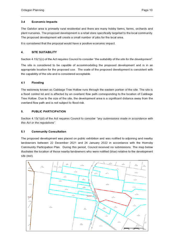
5.1 Community Consultation
The proposed development was placed on public exhibition and was notified to adjoining and nearby landowners between 7 December 2021 and 24 January 2022 in accordance with the Hornsby Community Engagement Plan. During this period, Council received 3 submissions. The map below illustrates the location of those nearby landowners who made a submission that are in close proximity to the development site.
|
NOTIFICATION PLAN |
|||
|
• PROPERTIES NOTIFIED |
X SUBMISSIONS RECEIVED |
|
|
|
1 SUBMISSION RECEIVED OUT OF MAP RANGE |
|||
Three submissions objected to the development, generally on the grounds that:
· The smaller parcel of land will have an unusually small size in comparison with the average land sizes on Murray Road and Boronia Avenue.
· The construction to open area ratio for the smaller piece of land will be too high in comparison.
· The construction of an additional dwelling will lead to loss of trees and green cover- the development will lead to construction, people and vehicular density as well as would negatively impact on the original house and street scape.
· It will lead to loss of visual beauty and the heritage laid back character of the location.
· The Community will need to have some control over the future town planning of our suburb and destroying the natural environment and tree scape in the name of progress is wrong.
· Creating a Torrens title will provide the owner(s) a greater opportunity to redevelop the undersized lot 2 and create a bigger development on this already small - enclosed plot of land with virtually no landscape and compromised privacy.
· The conversion to Torrens title will create greater community, environmental problems and a greater carbon 'footprint' than already exists.
· Creating a Torrens title will provide the owner, or owners, greater opportunity to redevelop on the undersized lot 2 and construct a new dwelling.
· While not an issue in some circumstances, in this case Council will be acknowledging the undersized lot is acceptable.
· Strata title does not prevent separate sale of the existing dwellings.
· The trust acknowledges the conversion to Torrens title will remove the non-conforming use of the two dwellings and therefore has a public benefit. But that alone appears to be the only public benefit. Therefore, there appears to be little public benefit in the conversion, but potential issues may arise in the future that would not be in the public interest.
The merits of the matters raised in community submissions have been addressed in the body of the report. The proposed subdivision would not result in any further development potential, or intensity of development on the respective lots. There are no physical works proposed, and no removal of trees or vegetation. Any works associated with the existing dwelling houses will be subject to separate development applications in the future and assessed on their individual merit. The objectors have not provided evidence to substantiate that the development is not in the public interest. “Carbon Footprint” is not a matter for consideration under Section 4.15 of the Environmental Planning and Assessment Act 1979.
5.2 Public Agencies
The development application was not referred to any Public Agencies for comment.
6. THE PUBLIC INTEREST
Section 4.15(1)(e) of the Act requires Council to consider “the public interest”.
The public interest is an overarching requirement, which includes the consideration of the matters discussed in this report. Implicit to the public interest is the achievement of future built outcomes adequately responding to and respecting the future desired outcomes expressed in environmental planning instruments and development control plans.
The application is considered to have satisfactorily addressed Council’s criteria and would provide a development outcome that, on balance, would result in a positive impact for the community. Accordingly, it is considered that the approval of the proposed development would be in the public interest.
CONCLUSION
The application proposes the Torrens title subdivision of an existing strata titled dual occupancy, comprising two detached dwellings at 22 Murray Road, Beecroft.
The development generally meets the desired outcomes of Council’s planning controls and is satisfactory having regard to the matters for consideration under Section 4.15 of the Environmental Planning and Assessment Act 1979.
The application does not comply with the HLEP in respect to the minimum 600m2 lot size. The applicant submitted a written request in response to Clause 4.6 Exceptions to Development Standard to contravene Clause 4.1 Minimum subdivision lot size development standard. The objection is considered well founded with regard to the approved development on the site and the principles established by the Land and Environment Court.
Council received 3 submissions during the public notification period. The matters raised have been addressed in the body of the report.
Having regard to the circumstances of the case, approval of the application is recommended.
The reasons for this decision are:
· The request under Clause 4.6 of Hornsby Local Environmental Plan 2013 to contravene the minimum allotment size development standard is well founded. Strict compliance with the development standard is considered unreasonable and unnecessary in the circumstances of the case and sufficient environmental planning grounds have been submitted to justify the contravention to the development standard.
· The proposed development generally complies with the requirements of the relevant environmental planning instruments and the Hornsby Development Control Plan 2013.
· The proposed development does not create unreasonable environmental impacts to adjoining properties.
Note: At the time of the completion of this planning report, no persons have made a Political Donations Disclosure Statement pursuant to Section 10.4 of the Environmental Planning and Assessment Act 1979 in respect of the subject planning application.
RESPONSIBLE OFFICER
The officer responsible for the preparation of this report is Katrina Maxwell.
|
Cassandra Williams Major Development Manager - Development Assessments Planning and Compliance Division |
Rod Pickles Manager - Development Assessments Planning and Compliance Division |
|
1.⇩ |
Locality Plan |
|
|
|
2.⇩ |
Subdivision PLan |
|
|
|
3.⇩ |
Clause 4.6 |
|
|
|
4.⇩ |
Existing Site Survey |
|
|
File Reference: DA/1302/2021
Document Number: D08318610
SCHEDULE 1
GENERAL CONDITIONS
The conditions of consent within this notice of determination have been applied to ensure that the use of the land and/or building is carried out in such a manner that is consistent with the aims and objectives of the relevant legislation, planning instruments and council policies affecting the land and does not disrupt the amenity of the neighbourhood or impact upon the environment.
Note: For the purpose of this consent, the term ‘applicant’ means any person who has the authority to act on or the benefit of the development consent.
Note: For the purpose of this consent, any reference to an Act, Regulation, Australian Standard or publication by a public authority shall be taken to mean the gazetted Act or Regulation, or adopted Australian Standard or publication as in force on the date that the application for a construction certificate is made.
1. Approved Plans and Supporting Documentation
The development must be carried out in accordance with the plans and documentation listed below and endorsed with Council’s stamp, except where amended by Council and/or other conditions of this consent:
Approved Plans
|
Plan No. |
Plan Title |
Drawn by |
Dated |
Council Reference |
|
18/748 Pro Sub 2 |
Proposed Subdivision |
East West Surveyors Pty Ltd |
undated |
|
Supporting Documentation
|
Document Title |
Prepared by |
Dated |
Council Reference |
|
Heritage Impact Statement |
Concise Planning |
10/09/21 |
D08309870 |
|
1931 – SKC001 - Stormwater Management Plans Iss P1 |
AT&L Civil Engineers and Project Managers |
11/03/2022 |
D08367531 |
REQUIREMENTS PRIOR TO THE ISSUE OF AN SUBDIVISION CERTIFICATE
2. Sydney Water – s73 Certificate
A s73 Certificate must be obtained from Sydney Water and submitted to the PCA.
Note: Sydney Water requires that s73 applications are to be made through an authorised Sydney Water Servicing Coordinator. Refer to www.sydneywater.com.au or telephone 13 20 92 for assistance.
3. Smoke Alarm Certification
A certificate must be provided from a licensed electrician prior to the issue of a Subdivision Certificate certifying that the smoke alarms for each dwelling have been connected to the consumer mains power in accordance with Australian Standard AS3786-2014 Smoke alarms and interconnected where there is more than one alarm in accordance with Part 3.7.2 of the Building Code of Australia
The following matter(s) must be nominated on the plan of subdivision under s88B of the Conveyancing Act 1919:
a) The creation of an appropriate "Positive Covenant" and "Restriction as to User" over the constructed on-site detention/retention systems and outlet works, within the lots in favour of Council in accordance with Council’s prescribed wording. The position of the on-site detention system is to be clearly indicated on the title;
Note: Council must be nominated as the authority to release, vary or modify any easement, restriction or covenant.
- END OF CONDITIONS -
ADVISORY NOTES
The following information is provided for your assistance to ensure compliance with the Environmental Planning and Assessment Act, 1979, Environmental Planning and Assessment Regulation 2000, other relevant legislation and Council’s policies and specifications. This information does not form part of the conditions of development consent pursuant to Section 4.17 of the Act.
Tree and Vegetation Preservation
Hornsby Development Control Plan 2013 Tree and Vegetation Preservation provisions have been developed under Council’s authorities contained in State Environmental Planning Policy (Vegetation in Non-Rural Areas) 2017 and the Environmental Planning and Assessment Act 1979.
In accordance with these provisions a person must not cut down, fell, uproot, kill, poison, ringbark, burn or otherwise destroy the vegetation, lop or otherwise remove a substantial part of the trees or vegetation to which any such development control plan applies without the authority conferred by a development consent or a permit granted by Council.
Fines may be imposed for non-compliance with the Hornsby Development Control Plan 2013.
Note: A tree is defined as a long lived, woody perennial plant with one or relatively few main stems with the potential to grow to a height greater than three metres (3m). (HDCP 1B.6.1.c).
The land upon which the subject building is to be constructed may be affected by restrictive covenants. Council issues this approval without enquiry as to whether any restrictive covenant affecting the land would be breached by the construction of the building, the subject of this consent. Applicants must rely on their own enquiries as to whether or not the building breaches any such covenant.
Should asbestos or asbestos products be encountered during installation of smoke alarms, you are advised to seek advice and information prior to disturbing this material. It is recommended that a contractor holding an asbestos-handling permit (issued by SafeWork NSW) be engaged to manage the proper handling of this material. Further information regarding the safe handling and removal of asbestos can be found at:
Alternatively, telephone the SafeWork NSW on 13 10 50.
Subdivision Certificate Requirements
A subdivision certificate application is required to be lodged with Council containing the following information:
· A surveyor’s certificate certifying that all structures within the subject land comply with the development consent in regard to the setbacks from the new boundaries.
· A surveyor’s certificate certifying that all services, drainage lines or access are located wholly within the property boundaries. Where services encroach over the new boundaries, easements are to be created.
· Certification that the requirements of relevant utility authorities have been met.
· A surveyor’s certificate certifying finished ground levels are in accordance with the approved plans.
Note: Council will not issue a subdivision certificate until all conditions of the development consent have been completed.
Note: At the present time Hornsby Shire Council is the only authority that can be appointed as a PCA for subdivision works within the Shire.
Fees and Charges – Subdivision
All fees payable to Council as part of any construction, compliance or subdivision certificate or inspection associated with the development (including the registration of privately issued certificates) are required to be paid in full prior to the issue of the subdivision certificate. Any additional Council inspections beyond the scope of any compliance certificate required to verify compliance with the terms of this consent will be charged at the individual inspection rate nominated in Council's Fees and Charges Schedule.
House Numbering
The house numbering for this subdivision shall be:
|
Lot |
Street Number |
Street Name |
Street Type |
Locality |
|
Lot 1 |
22 |
Murray |
Road |
Beecroft |
|
Lot 2 |
24 |
Murray |
Road |
Beecroft |
LPP Report No. LPP17/22
Local Planning Panel
Date of Meeting: 30/03/2022
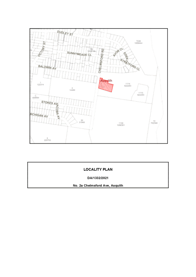
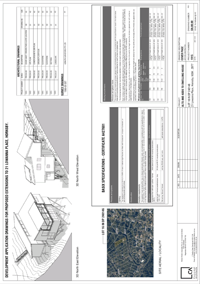
4 ELECTRONIC - DA/61/2022 - ALTERATIONS AND ADDITIONS TO A DWELLING HOUSE - 21 LOWANNA PLACE, HORNSBY
EXECUTIVE SUMMARY
|
DA No: |
DA/61/2022 (Lodged on 21 January 2022) |
|
Description: |
Alterations and additions to a dwelling house |
|
Property: |
Lot 16 DP 240146, No. 21 Lowanna Place, Hornsby |
|
Applicant: |
Concept Architects |
|
Owners: |
Mr Rory Stuart Tyler and Ms Sabrina Tyler |
|
Estimated Value: |
|
|
Ward: |
B Ward |
· The application proposes alterations and additions to a dwelling house.
· The proposal does not comply with the Hornsby Shire Local Environmental Plan 2013 with regard to Clause 4.3 ‘Height of Buildings’. The applicant has made a submission in accordance with Clause 4.6 ‘Exceptions to development standards’ of the Hornsby Shire Local Environmental Plan 2013 to contravene height of buildings development standard. The submission is considered well founded and is supported.
· No submissions have been received in respect of the application.
· The application is required to be determined by the Hornsby Local Planning Panel as the proposal would contravene the Hornsby Shire Local Environmental Plan 2013 development standard for maximum height of buildings by more than 10 percent (28.9%).
· It is recommended that the application be approved.
|
THAT Council assume the concurrence of the Secretary of the Department of Planning and Environment pursuant to Clause 4.6 of the Hornsby Local Environmental Plan 2013 and approve Development Application No. DA/61/2022 for alterations and additions to a dwelling house at Lot 16 DP 240146, No. 21 Lowanna Place, Hornsby subject to the conditions of consent detailed in Schedule 1 of LPP Report No. LPP17/22. |
BACKGROUND
On 6 June 2005, DA/548/2005 was approved for alterations and additions to a dwelling house.
On 18 May 2021, a Pre-Lodgement Meeting (PL/29/2021) was held to discuss a lower ground extension to the existing dwelling house.
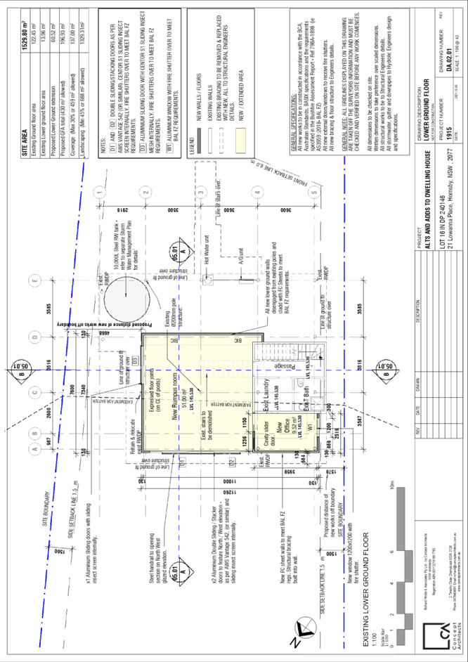
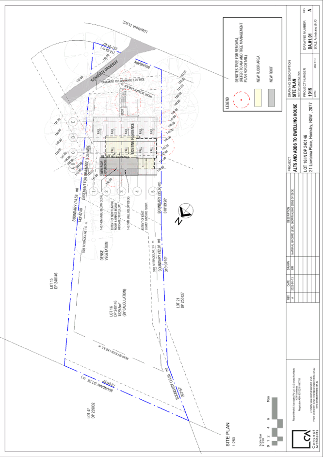
SITE
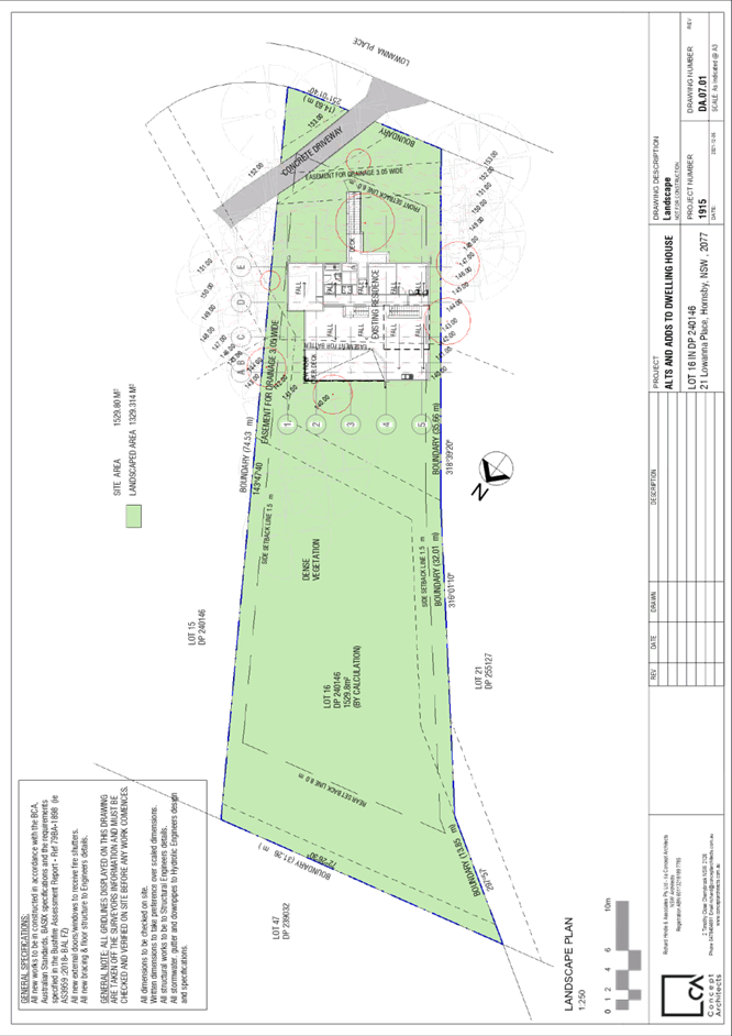
The 1529.9m2 site is located on northern side of Lowanna Place, Hornsby and contains a split-level pole home.
The site experiences a 48-metre fall to the northern, rear boundary. The site is mapped as being a sloping site with a gradient in excess of 20%
The site is bushfire prone being Bushfire Attack Level Flame Zone (BAL FZ).
The site is a flood control lot.
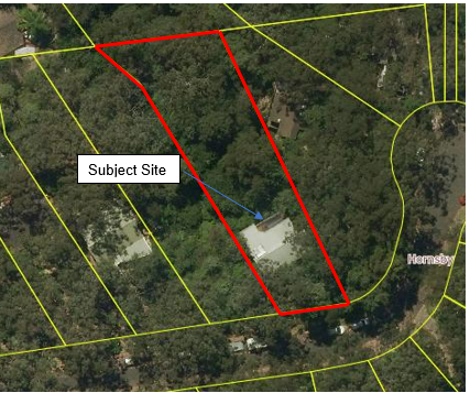
Figure 1: Aerial Photo of Subject Site
The site contains a ‘blue line’ water course which runs from the south-eastern, front corner to the north- western, rear corner of the site. The site drains in a northern direction to Waitara Creek.
The site is burdened by 3.05-metre-wide easements for drainage which run along the southern front boundary, eastern side boundary and dissect the site from east to west at the rear of the dwelling house.
An easement for batter with a variable width also runs underneath the house from east to west. A condition has been included in Schedule 1 requiring a ‘positive covenant’ is to ensure the owner is responsible for maintaining and looking after the easement for batter given the additional load the proposed works would have on it. The positive covenant will be added to the title to ensure any future occupant of the site is fully aware of the works that have been undertaken and their responsibilities in relation to the site if consent is granted.
The site and its surrounds contain native vegetation and species that belong to the Blackbutt Gully Forest community. The site is also adjoining land mapped on the DPIE Sensitive Biodiversity Values Map.
The site is not a heritage item, is not adjacent to a heritage item, and is not within a heritage conservation area.
PROPOSAL
The application proposes alterations and additions to the existing dwelling house as follows.
· A 59.9m2 addition to the lower ground floor consisting of a rumpus room and office.
· Demolition and Reconstruction of an existing ground floor deck.
· The ground floor deck will form part of the roof over the lower ground floor addition.
· New pergola roof over the re-constructed ground floor deck.
· No new footings or foundations are proposed.
Five trees would be removed, and 17 trees would be impacted by the proposal. The removal of trees is required to comply with bushfire asset protection zone (APZ) requirements.
ASSESSMENT
The development application has been assessed having regard to the Greater Sydney Region Plan – A Metropolis of Three Cities, the North District Plan and the matters for consideration prescribed under Section 4.15 of the Environmental Planning and Assessment Act 1979 (the Act). The following issues have been identified for further consideration.
1. STRATEGIC CONTEXT
1.1 Greater Sydney Region Plan - A Metropolis of Three Cities and North District Plan
The Greater Sydney Region Plan - A Metropolis of Three Cities has been prepared by the NSW State Government to guide land use planning decisions for the next 40 years (to 2056). The Plan sets a strategy and actions for accommodating Sydney’s future population growth and identifies dwelling targets to ensure supply meets demand. The Plan also identifies that the most suitable areas for new housing are in locations close to jobs, public transport, community facilities and services.
The NSW Government will use the subregional planning process to define objectives and set goals for job creation, housing supply and choice in each subregion. Hornsby Shire has been grouped with Hunters Hill, Ku-ring-gai, Lane Cove, Mosman, North Sydney, Ryde, Northern Beaches and Willoughby to form the North District. The Greater Sydney Commission has released the North District Plan which includes priorities and actions for Northern District for the next 20 years. The identified challenge for Hornsby Shire will be to provide an additional 4,350 dwellings by 2021 with further strategic supply targets to be identified to deliver 97,000 additional dwellings in the North District by 2036.
The proposed development would be consistent with the Greater Sydney Region Plan - A Metropolis of Three Cities and the North District Plan, by contributing to achieving the dwelling targets for the region.
2. STATUTORY CONTROLS
Section 4.15(1)(a) requires Council to consider “any relevant environmental planning instruments, draft environmental planning instruments, development control plans, planning agreements and regulations”.
2.1 Hornsby Local Environmental Plan 2013
The proposed development has been assessed having regard to the provisions of the Hornsby Local Environmental Plan 2013 (HLEP).
2.1.1 Zoning of Land and Permissibility
The subject land is zoned R2 Low Density Residential under the HLEP. The objectives of the R2 zone are:
· To provide for the housing needs of the community within a low-density residential environment.
· To enable other land uses that provide facilities or services to meet the day to day needs of residents.
The proposed development is defined as alterations and addition to a ‘dwelling house’, is permissible in the zone with Council’s consent and would meet the objectives of the zone by providing for the housing needs of the community within a low-density residential environment.
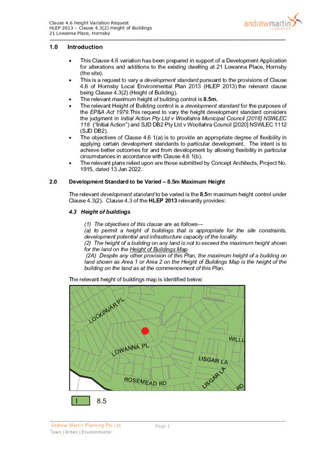
2.1.2 Height of Buildings
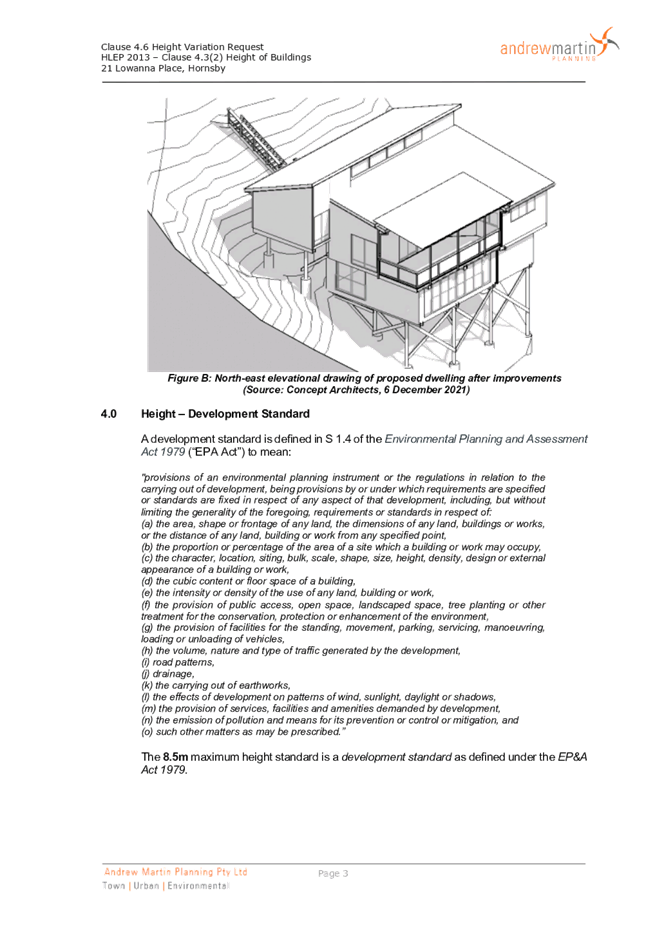
Clause 4.3 of the HLEP provides that the height of a building on any land should not exceed the maximum height shown for the land on the Height of Buildings Map. The maximum permissible height for the subject site is 8.5 metres. The proposed development would result in a maximum height of 11.04 metres and does not comply with this provision.
The application is supported by a submission pursuant to Clause 4.6 of HLEP to contravene the maximum height of buildings development standard, which is discussed below in Section 2.1.3 of this report.
2.1.3 Exceptions to Development Standards
The applicant submitted a written request to contravene the height of building development standard contained within Clause 4.3 of the HLEP.
The written request describes the extent of the non-compliance as follows:
The requested variation is as follows: Permissible maximum building height: 8.5m
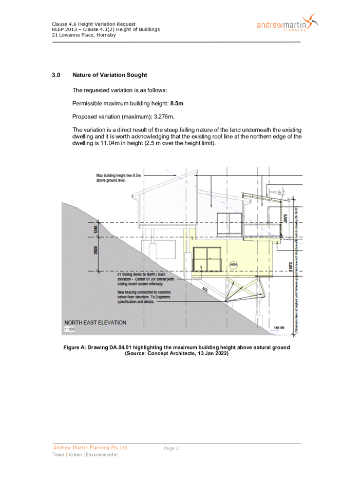
Proposed variation (maximum): 3.276m.
The variation is a direct result of the steep falling nature of the land underneath the existing dwelling and it is worth acknowledging that the existing roof line at the northern edge of the dwelling is 11.04m in height (2.5 m over the height limit).
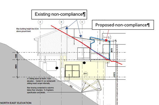
Figure 2: Extract of NE Elevation Plan showing overall building height.
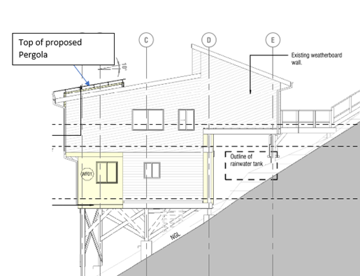
Figure 3: Extract of SW Elevation showing minor change to building height
Figures 2 and 3 depict the extent of the non-compliance with the maximum height standard, being a height of approximately 11.04 metres or 28.9% contravention (max). Further to the figures provided by the applicant above, Council notes that the North-Eastern Elevation Plan clearly details the overall height of the building.
The majority of the contravention of the 8.5 metre building height requirement is within the existing dwelling house (existing skillion roof pitch and walls). There is only a minor additional height contravention as a result of this proposal. The proposed contravention is due to the proposed pergola roof which is a light-weight structure with no enclosing walls.
The application has been assessed against the requirements of Clause 4.6 of the HLEP. This clause provides flexibility in the application of the development standards in circumstances where strict compliance with those standards would, in any particular case, be unreasonable or unnecessary or tender to hinder the attainment of the objectives of the zone. In particular, Clause 4.6 provides criteria that must be satisfied prior to a consent authority granting consent to development that contravenes a development standard. These criteria demonstrated under Clause 4.6(3) are as follows:
(a) That compliance with the development standard is unreasonable or unnecessary in the circumstances of the case, and;
(b) That there are sufficient environmental planning grounds to justify contravening the development standard.
A discussion regarding the criteria provided at Clause 4.6(3), with respect to the original and amended requests is provided below.
2.1.3.1 Unreasonable or Unnecessary Clause 4.6(3)(a)
There are five common methods by which an applicant can demonstrate that compliance with a development standard is unreasonable or unnecessary in the circumstances of the development. Initially proposed for objections under clause 6 of SEPP 1 in the decision of Wehbe v Pittwater Council [2007] NSWLEC 827 Pearson C summarised and applied these methods to written requests made under Clause 4.6 in Four2Five Pty Ltd v Ashfield Council [2015] NSWLEC 1009 [61-62]. These five methods are generally as follows:
· The objectives of the development standard are achieved notwithstanding non-compliance with the standard.
· The underlying objective or purpose is not relevant to the development.
· That the objective would be defeated or thwarted if compliance was required.
· That the development standard has been virtually abandoned or destroyed by the Council’s own actions in departing from the standard.
· The zoning of the land is unreasonable or inappropriate.
It is not required to demonstrate that a development meets multiple methods as listed above, and the satisfaction of one can be adequate to demonstrate that the development standard is unreasonable or unnecessary.
The written request prepared by Andrew Martin Planning, dated January 2022 provides a detailed assessment of the proposal with respect to the development standard sought to be varied. The request argues that The objectives of the development standard are achieved notwithstanding non-compliance with the standard in part 6 of the document, providing reasoning as follows:
Applicants justification
The land across the site falls steeply from the street frontage and underneath the existing dwelling platform before reaching a more gradual decline across the rear, vegetated parts
of the property. Underneath the existing dwelling the land falls by up to 7m from RL147 to
RL140.
The existing highest point of the dwelling above the natural ground level is observed at the rear, northern edge to the main roof line. The height measures 11.04m; a 2.54m breach
above the 8.5m LEP height standard. The proposal seeks to install a new light-weight roof over the external upper deck at the north-eastern corner of the house which will create a new high point and variation of 3.073m. The height sought is considered to be appropriate given that it is largely consistent with the established height of the dwelling and only occurs due to the falling nature of the land underneath. The variation only allows for a two-storey dwelling because the undercroft area is not enclosed and is not a storey as it has no floor. The two-storey form is compatible with the local area and the built form found on sloping sites.
The design of the alterations and additions will ensure that the dwelling maintains a consistent form and height to other neighbouring dwellings on sloping sites. The height breaches are also observed at the rear of the dwelling where there is no direct consequence or impact to the residential amenity of neighbouring properties. To this end, the proposal has had due regard to the site context and constraints. The use of the pillion type supports limits site excavation and manipulation associated with strip footing and slabs so there are environmental benefits associated with the elevated structure that minimises its footprint on the sloping site.
The alterations and additions proposed are relatively minor and will not drastically alter the existing layout, built form, bulk, scale or height of the dwelling. The proposal will not place any additional stress on existing infrastructure servicing the local area. There are no streetscape impacts associated with the height variation or overshadowing. Overall, the proposal as presented in the plans prepared by Concept Architects achieves the intent of this objective.
Council notes that the objectives of Clause 4.3 of the HLEP are as follows:
“to permit a height of buildings that is appropriate for the site constraints, development potential and infrastructure capacity of the locality.”
With reference to the reasoning provided by the applicant above, Council does not object to the conclusion that the proposed additions meet the objectives of Clause 4.3. In reaching this conclusion the following points are noted:
· The site is highly constrained by easements, nature features and constrains such as bushfire. It is not feasible for the footprint of the building to be increased, and therefore the only way to improve the development potential of the site, and the liveability of the dwelling house is to develop the dwelling house vertically.
· The proposed pergola roof will assist in the maintenance of the re-constructed deck by preventing decay from the weather. The pergola roof would also enable appropriate stormwater drainage from the structure.
· There is no ability to re-design the pergola so that it complies with the 8.5 metre maximum height requirement.
The lack of environmental impacts arising from the non-compliance with the development standard, and the largely compliant nature of the development when assessed against the relevant legislative and Hornsby Development Control Plan requirements (discussed in the body of this report) identifies that the site is suitable for this development.
The proposed development would have negligible impact on the infrastructure capacity of the locality.
For the reasons outlined above, it is considered that the written request to contravene the height of building standard adequately demonstrates that the objectives of the height of buildings development standard contained within Clause 4.3 of the HLEP are achieved, notwithstanding non-compliance with the standard.
2.1.3.2 Environmental Planning Grounds - Clause 4.6(3)(b)
In addition to demonstrating that compliance is unreasonable or unnecessary, Clause 4.6(3)(b) requires that there are sufficient environmental planning grounds to justify contravening the development standard. In demonstrating that sufficient environmental planning grounds exist it must be demonstrated that the planning grounds are particular to the circumstances of the development on the subject site (summarised from Four2Five Pty Ltd v Ashfield Council [2015] NSWLEC 1009 [60].
The applicant provided the following planning grounds for the contravention of the development standard;
· The existing roof line exceeds the maximum height standard to the rear of the dwelling platform by 2.54m. The existing breach is the direct result of the placement of a standard dwelling footprint over land which falls at a gradient of over 20% and upwards of 7m from the front to the rear of the dwelling platform. As a result, the house has been constructed on large timber and concrete columns.
· The footing design minimises site impacts but has the consequence of additional height.
· The installation of a new light-weight roof over the upper-level deck to the rear will see a modest increase in the overall height of the building. This is the direct result of the land fall underneath the north-eastern corner of the dwelling. The new roof over the deck will sit below the main dwelling roof line.
· The overall elevated built form is two storeys which is expected in a residential area and necessary to support a family especially with work from home area needed due to Covid 19.
· The proposed alterations and additions are minor in their overall scale and do not contribute to excessive additional bulk, scale or visual impacts to neighbouring properties. The additions sought are proposed underneath the ground floor to the rear and are contained wholly within the dwelling envelope above.
· The HOB exceedance does not unduly add to the overall bulk or scale of the development when viewed from the street or other neighbouring properties as the new roof line over the deck is situated at the rear of the dwelling and is well separated from the closest neighbour to the east (by over 10m).
· The introduction of the light-weight roof over the deck will have no direct consequence or adverse impact on the amenity of neighbouring properties with regard to view loss, privacy or overshadowing. Its location and light-weight design over an open deck ensures weather protection and avoidance of in-filling of the upper level which could result in additional bulk.
· The development is consistent with the form and height breaches observed on other neighbouring properties in the local area that are situated on raised columns above steeply sloping sites which back onto bushland. The height of the new upper-level deck roof is situated below the height of the main roofline over the first floor. It’s extent of height breach above the standard is directly related to the fall away of the natural ground level below.
· The development achieves and does not seek to exceed the scale and form anticipated for this site.
· The proposal reasonably preserves the residential amenity of the locality.
· The proposal has been assessed against the provisions of HLEP 2013 and HDCP 2013. It satisfies the objectives and provisions of both State and Local planning policies.
Council’s further review of the environmental planning grounds presented by the applicant raises no points of contention, and it is considered that the proposed pergola is reasonable built environment outcome, both within the subject site, and to the adjoining residential development.
Council further notes that the technical non-compliance is a result of the existing configuration of the dwelling house, being a pole home construction. Notwithstanding the non-compliance with numerical standards, the proposal does not give rise to any adverse amenity impacts to any adjoining property. The dwelling house continues to respond to the slope of the site, by stepping the design of the dwelling house down the slope.
Council is therefore satisfied that Clause 4.6(3)(b) of the HLEP is adequately addressed.
2.1.3.3 Public Interest and Clause 4.6(4)
Clause 4.6(4) states that development consent must not be granted for development that contravenes a development standard unless:
(a) The consent authority is satisfied that:
(i) The applicant’s written request has adequately addressed the matters required to be demonstrated by subclause (3), and
(ii) The proposed development will be in the public interest because it is consistent with the objectives of the particular standard and the objectives for development within the zone in which the development is proposed to be carried out, and
(b) The concurrence of the Planning Secretary has been obtained.
With regard to (a)(i), the written requests are considered to adequately address the matters required to be demonstrated as outlined above. With regard to (a)(ii), the proposed development is considered to be in the public interest because it is consistent with the objectives of the particular standard and the objectives for height of building contained within the HLEP.
With regard to (b), on 21 February 2018, the Secretary of the Department of Planning and Environment issued a Notice (‘the Notice’) under cl. 64 of the Environmental Planning and Assessment Regulation 2000 (the EP&A Regulation) The Secretary’s concurrence may not be assumed by a delegate of council if:
· The development contravenes a numerical standard by greater than 10%.
· The variation is to a non-numerical standard.
Local Planning Panels constituted under the Environmental Planning and Assessment Act 1979 exercise consent authority functions on behalf of a Council and are not delegates of Council. Therefore, Local Planning Panels may determine a development application notwithstanding, a numerical non-compliance in excess of 10%,
Therefore, the exceedance of the height of buildings development standard is supported in this instance.
2.1.4 Heritage Conservation
Clause 5.10 of the HLEP sets out heritage conservation provisions for Hornsby Shire. The site does not include a heritage item and is not located in a heritage conservation area. Accordingly, no further assessment regarding heritage is necessary.
2.1.5 Earthworks
Clause 6.2 of the HLEP states that consent is required for proposed earthworks on site. Before granting consent for earthworks, Council is required to assess the impacts of the works on adjoining properties, drainage patterns and soil stability of the locality.
Council’s assessment of the proposed works and excavation concludes that the impacts would be minimal. The existing bearers and joists of the dwelling house will be utilised as footings for the proposed extension and deck construction. No cut or fill is required to construct the development. The proposal is assessed as satisfactory with regards to Clause 6.2 of the HLEP.
2.1.6 Flood Planning
Clause 5.21 of the HLEP states development consent must not be granted to development on land the consent authority considers to be within the flood planning area unless the consent authority is satisfied the development is compatible with flood function and behaviour, will not adversely affect flooding on adjoining properties, will not constitute a risk to life or property and will not cause erosion or instability to watercourses.
The finished floor level (FFL) of the lower ground floor meets the minimum FFL (145.53m AHD) required under the Council’s Flood Risk Management Study and Plan (FRMSP) for the Shire, and the development is not considered to pose an unacceptable level of risk to property, life or the environment.
2.1.7 Suspension of covenants, agreements, and instruments
Clause 1.9A of the HELP states that for the purpose of enabling development on land in any zone to be carried out in accordance with this Plan or with a consent granted under the Act, any agreement, covenant or other similar instrument that restricts the carrying out of that development does not apply to the extent necessary to serve that purpose.
The 88B instrument contains restrictions regarding the external materials and finishes, size of dwelling houses, number of buildings on the site and fencing. However pursuant to Clause 1.9A Council is not obliged to consider these restrictions as part of this development application.
2.2 State Environmental Planning Policy (Exempt and Complying Development Codes) 2008
The application has been considered against the requirements of State Environmental Planning Policy (Exempt and Complying Development Codes) 2008. The Policy provides exempt and complying development codes that have State-wide application. The Policy also identifies types of development that are of minimal environmental impact that may be carried out without the need for development consent and types of Complying Development (including dwelling houses) that may be carried out in accordance with a Complying Development Certificate.
The site subject to bushfire risk (BAL Flame Zone) and is in exceedance of the maximum building height requirement of 8.5 metres. Therefore, the development is precluded from being approved as Complying Development. The proposed dwelling house additions would otherwise comply with the other numerical standards of Complying Development contained within the SEPP.
2.3 Adopted State Environmental Planning Policies (Savings and Transitional Provisions)
On 1 March 2022, the following State Environmental Planning Policies (SEPPS) were gazetted.
· State Environmental Planning Policy (Resilience and Hazards) 2021.
· State Environmental Planning Policy (Biodiversity and Conservation) 2021.
· State Environmental Planning Policy (Planning Systems) 2021.
· State Environmental Planning Policy (Precincts - Eastern Harbour City) 2021.
These SEPPS now form Matters for consideration under Section 4.15 of the Environmental Planning and Assessment Act 1979. However general savings provisions apply to development applications that have been made but not yet determined, on or before the commencement date.
As this development application was lodged on 21 January 2022, this development application is considered to have been made prior to the commencement date of the SEPPs. The aforementioned SEPPs have been considered as a matter for consideration under S4.15 of the Act. However, the existing legislation in force at time of lodgement of the development application, prevails to be extent of any inconsistency; these policies are listed below:
· State Environmental Planning Policy No. 55 Remediation of Land.
· State Environmental Planning Policy (Building Sustainability Index: BASIX) 2004.
· State Environmental Planning Policy (Vegetation in Non-Rural Areas) 2017.
· Sydney Regional Environmental Plan No. 20 Hawkesbury-Nepean River.
Notwithstanding, the approval of the development application would not adversely affect the objectives of the newly adopted State Environmental Planning Policies and is considered to be consistent with this policy.
2.4 State Environmental Planning Policy No. 55 Remediation of Land
The application has been assessed against the requirements of State Environmental Planning Policy No. 55 Remediation of Land (SEPP 55) under which consent must not be granted to the carrying out of any development on land unless the consent authority has considered whether the land is contaminated or requires remediation for the proposed use.
Should the land be contaminated, Council must be satisfied that the land is suitable in a contaminated state for the proposed use. If the land requires remediation to be undertaken to make the land suitable for the proposed use, Council must be satisfied that the land will be remediated before the land is used for that purpose.
An examination of Council’s records and aerial photography has determined that the site has been historically used for residential purposes. It is not likely that the site has experienced any significant contamination, and further assessment under SEPP 55 is not required.
2.5 State Environmental Planning Policy (Building Sustainability Index: BASIX) 2004
The application has been assessed against the requirements of State Environmental Planning Policy (Building Sustainability Index - BASIX) 2004. The proposal includes a BASIX Certificate (No. A427601) for the proposed alterations and additions to the dwelling House.
A condition is recommended in Schedule 1 of this report requiring the recommendations of the BASIX certificate be complied with.
2.6 State Environmental Planning Policy (Vegetation in Non-Rural Areas) 2017
Part 3, Clause 9(2) of the Vegetation SEPP states that a Development Control Plan may make a declaration in any manner relating to species, size, location and presence of vegetation. Accordingly, Part 1B.6.1 of the Hornsby Development Control Plan 2013 (HDCP) prescribes works that can be undertaken with or without consent to trees and objectives for tree preservation.
The application has been assessed against the requirements of the Vegetation SEPP and it has been determined that the proposal would meet the objectives of the Vegetation SEPP. This matter is addressed in Section 3.1.1 of this report.
2.7 Sydney Regional Environmental Plan No. 20 Hawkesbury-Nepean River
The site is located within the catchment of the Hawkesbury Nepean River. Part 2 of this Plan contains general planning considerations and strategies requiring Council to consider the impacts of development on water quality, aquaculture, recreation and tourism.
Subject to the implementation of sediment and erosion control measures and stormwater management to protect water quality, the proposal would comply with the requirements of the Policy.
2.8 Section 3.42 Environmental Planning and Assessment Act 1979 - Purpose and Status of Development Control Plans
Section 3.42 of the Environmental Planning and Assessment Act 1979 states that a DCP provision will have no effect if it prevents or unreasonably restricts development that is otherwise permitted and complies with the development standards in relevant Local Environmental Plans and State Environmental Planning Policies.
The principal purpose of a development control plan is to provide guidance on the aims of any environmental planning instrument that applies to the development; facilitate development that is permissible under any such instrument; and achieve the objectives of land zones. The provisions contained in a DCP are not statutory requirements and are for guidance purposes only. Consent authorities have flexibility to consider innovative solutions when assessing development proposals, to assist achieve good planning outcomes.
2.9 Hornsby Development Control Plan 2013
The proposed development has been assessed having regard to the relevant desired outcomes and prescriptive requirements within the Hornsby Development Control Plan 2013 (HDCP). The following table sets out the proposal’s compliance with the prescriptive requirements of the Plan:
|
HDCP - Part 3.1 Dwelling Houses |
|||
|
Control |
Proposal |
Requirement |
Complies |
|
Site Area |
1529.9m2 |
N/A |
N/A |
|
Building Height |
11.04m |
8.5m |
No |
|
No. storeys |
2 |
max. 2 + attic |
Yes |
|
Site Coverage |
10% |
max. 30% |
Yes |
|
Floor Area |
202.16m2 |
max. 430m² |
Yes |
|
Setbacks |
|
|
|
|
- Front |
9.5m |
Conform to streetscape |
Yes |
|
- Side (north-east) |
|
|
|
|
Ground floor |
4.6m |
0.9m |
Yes |
|
First floor |
1.6m |
1.5m |
Yes |
|
- Side (south-west) |
|
|
|
|
Ground floor |
1.5m |
0.9m |
Yes |
|
First floor |
Unchanged |
1.5m |
Yes |
|
- Rear |
|
|
|
|
Ground floor |
>3m |
3m |
Yes |
|
First floor |
>8m |
8m |
Yes |
|
Landscaped Area (% of lot size) |
85% |
min. 45% |
Yes |
|
Private Open Space |
|
|
|
|
- minimum area |
25.5m2 |
24m2 |
Yes |
|
- minimum dimension |
3.2m2 |
3m |
Yes |
|
Car Parking |
spaces |
2 spaces |
Yes |
As detailed in the above table, the proposed development does not comply with the prescriptive requirements of 3.1.1 Scale within the HDCP. The matters of non-compliance are detailed below, as well as a brief discussion on compliance with relevant desired outcomes.
2.9.1 Scale
The desired outcome of Part 3.1.1 of the HDCP is for ‘development with a height, bulk and scale that is compatible with a low-density residential environment’.
This is supported by the prescriptive measures which state that ‘sites with the maximum building heights under Clause 4.3 of the HLEP should comply with the maximum number of storeys in Table 3.1.1(a).’
In addition, it is stated that ‘buildings should respond to the topography of the site by:
· Minimising earthworks (cut and fill).
· Siting the floor level of the lowest residential storey a maximum of 1.5 above natural ground level’.
The proposed pergola roof is situated 11.04 metres above natural ground which does not comply with Part 3.1.1 Scale of the HDCP and Clause 4.3 of HLEP.
In support of this non-compliance, it is noted that the slope of that site is a significant constraint for any development on the site. It is also noted that the proposed addition has been designed to complement the natural slope of the land and avoid cut and fill on the site by utilising pier and beam construction.
The lowest residential storey is between 600mm and 4.8 metres above existing ground level. However, this is consistent on the existing dwelling house. Further, as the site is flood prone, minimum finished floor level (FFL) requirements apply. The proposal complies with FFL required under Council’s Flood Risk Management Study and Plan (FRMSP).
The Applicant has submitted a written request pursuant to Clause 4.6 of the HLEP which has adequately addressed this non-compliance which is discussed in detail above under Section 2.1.3.
The proposal meets the desired outcomes of Part 3.1.1 Scale of the HDCP and is considered acceptable.
2.9.2 Privacy
The desired outcome of Part 3.1.6 Privacy of the HDCP is for development ‘that is designed to provide reasonable privacy to adjacent properties.’ This is supported by prescriptive measure (c) and (d) where:
‘c) a deck, balcony, terrace or the like should be located within 600mm of existing ground level where possible to minimise potential visual and acoustic privacy conflicts’; and
d) ‘decks and the like that need to be located more than 600mm above existing ground level should not face a window of another habitable room. Balcony or private open space of another dwelling located within 9 metres of the proposed deck unless appropriately screened.’
The application proposes the re-construction/ refurbishment of an existing deck and the construction of a pergola roof over this deck. The deck will be orientated to the rear of the property. The south western side of the deck will be screened by the existing dwelling house. The deck will be setback 4 metres from the north-eastern boundary and would be approximately 18 metres from the nearest dwelling house to the northeast.
In summary, while the proposed re-constructed deck would be more than 600mm above existing ground level, the deck would not result in any adverse privacy loss impacts and privacy screening is not considered to be warranted.
The proposal meets the desired outcome of Part 3.1.6 Privacy of the HDCP and is considered acceptable.
2.9.3 Bushfire
The desired outcomes of Part 1C.3.1 Bushfire of the HDCP are to encourage ‘development that is located and designed to minimise the risk to life and property from bushfire’ and to encourage ‘development that balances the conservation of native vegetation and bushfire protection’.
The Application has provided a Bushfire Assessment Report prepared by Sydney Bushfire Consultants dated 7 December 2021.
The Bushfire Assessment Report recommended any development on the site be built to the requirements of AS3959-2018 Construction of bushfire-prone areas in accordance with the requirements for Bushfire Attack Level (BAL) Flame Zone and the relevant sections of Planning for Bushfire Protection 2019.
In accordance with Council’s assessment protocol for development in BAL Flame Zone, the application was referred to the NSW Rural Fire Service (NSW RFS) for review. The NSW RFS raised no objections to the proposal subject to conditions.
Conditions reflecting the NSW RFS requirements have been recommended under Schedule 1 of this report in regard to the utilisation of BAL FZ fire retardation construction materials and the maintenance of the property as an Inner Protection Area (IPA) in perpetuity.
The proposal meets the desired outcomes of Part 1C.3.1 Bushfire of the HDCP and is considered acceptable, subject to conditions.
2.9.4 Earthworks and Slope
The desired outcomes of Part 1C.1.4 Earthworks and Slope are to encourage ‘development that is designed to respect the natural landform characteristics and protects the stability of land’ and ‘development that limits landform modification to maintain the amenity of adjoining properties and streetscape character’.
These desired outcomes are supported by the prescriptive control that “Sloping sites with a gradient in excess of 20% require certification from a geotechnical engineer as to the stability of the slope in regard to the proposed design.”
The application has provided a “Geotechnical Investigation & Landslide Risk Assessment” prepared by Sydney Geotech Consultancy dated 25 August 2021.
Subject to conditions, the proposal meets the desired outcomes of Part 1C.1.4 Earthworks and Slope and is considered acceptable.
2.9.5 Flooding
The desired outcome of Part 1C.3.2 Flooding of the HDCP is to encourage “development that is located and designed to minimise the risk to life, property and the environment from flooding”.
The site is not identified as ‘flood planning area’ on the HLEP Flood Planning Map however is flood prone, with 1% AEP floodwaters impacting the site at elevations ranging from RL 153.5m AHD to RL 107 m AHD.
The proposal has been considered with regard to the Flood Impact Assessment Report prepared by Donovan Associates s dated 26 August 2021. Council’s development engineer raised no objections to the proposal, subject to the imposition of recommended conditions relating to minimum floor levels of 145.53m AHD. The finished floor level of proposed lower ground floor complies with requirement.
The proposal meets the desired outcomes of Part 1C.3.2 Flooding under the HDCP and is considered acceptable, subject to conditions.
2.10 Section 7.12 Contributions Plans
Hornsby Shire Council Section 7.12 Contributions Plan 2019-2029 applies to the development as the estimated costs of works is greater than $100,000. Should the application be approved, an appropriate condition of consent is recommended requiring the payment of a contribution in accordance with the Plan.
3. ENVIRONMENTAL IMPACTS
Section 4.15(1)(b) of the Act requires Council to consider “the likely impacts of that development, including environmental impacts on both the natural and built environments, and social and economic impacts in the locality”.
3.1 Natural Environment
3.1.1 Tree and Vegetation Preservation
The proposed development would necessitate the removal of 5 trees from the site, numbered T4, T12, T19, T21, and T23 and the pruning of T7, T15, T17, T20, andT22.
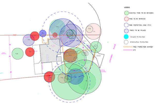
Figure 4 – Extract of Tree Management Plan Showing Trees to be Removed (in red)
The Development Application sought the removal of four trees on adjoining properties (T1, T1a, T10 and T10a). However, no nexus could be established between this development application and the removal of trees on adjoining properties. Two of these trees T10 and T10a are Camphor Laurel which are exempt from the requirement of approval to remove. The NSW Rural Fire Service advised that the Inner Protection Area (IPA) for bushfire protection only needs to extend to the property boundaries of the subject site. Therefore, a condition has been included in Schedule 1 this report stating that consent is not granted for the removal of trees on adjoining properties.
The application has been supported by an Arboricultural Impact Assessment (AIA) and Tree Management Plan prepared by Arbor Central Tree Care dated 13 September 2021. Most of these trees are weed species or of low retention value, such as camphor laurel and privet. However, some Turpentine and Silky Oak trees are also proposed to be removed.
Overall Council’s Arboricultural assessment generally concurs with the findings of the AIA. Council has no objection to the removal of 8 trees. Council also considers that the proposed works would result in minimal and acceptable tree impacts to trees T7, T15, T17, T20, T22. Whilst tree loss is not ideal, there is sufficient space on the site to provide compensatory plantings of locally occurring species to maintain the local amenity.
Conditions are recommended in Schedule 1 of this report requiring the appointment of a Project Arborist, the installation of tree protection measures, and the planting of 8 replacement trees.
Subject to conditions, the proposed development meets the desired outcomes of Part 1B6.1 Tree Preservation of the HDCP and the proposed development would result in acceptable environment impacts.
3.1.2 Biodiversity
The site is located amongst vegetation characteristic of Blackbutt Gully Forest Vegetation community. The proposed development will require the removal of Syncarpia glomulifera and Eucalyptus pilularus trees in addition to exotic species including environmental weeds.
Areas of remnant vegetation will be retained as a buffer between the development gully bushland downslope of the proposed development. The site is also adjoining land mapped on the DPIE Sensitive Biodiversity Values Map.
The site is mapped as bushfire prone land. The removal of trees is required to comply with bushfire APZ requirements.
A condition is recommended in Schedule 1 of this report requiring a Construction Environmental Management Plan (CEMP) to be submitted for the construction phase of the project.
Subject to conditions, the proposed development meets the desired outcomes of Part 1C.1.1 Biodiversity of the HDCP and the proposed development would result in acceptable environmental impacts.
3.1.3 Stormwater Management
The residential development would have a minor positive impact on the natural environment with all stormwater being directed to the existing internal drainage system which will then be conveyed to the stormwater easement on the site.
3.2 Built Environment
3.2.1 Built Form
The proposal would generally be consistent with the built form of the surrounding low-density residential area which consists of dwelling houses ranging from single storey, split level and two storeys.
3.3 Social Impacts
The residential development would improve housing choice in the locality by providing a range of house hold types. This is consistent with Council’s Housing Strategy which identifies the need to provide a mix of housing options to meet future demographic needs in Hornsby Shire.
The location of the development is in approximately 820 metres from the commercial area of Hornsby and approximately 1 kilometre from the Hornsby Railway Station ensuring pedestrian access to shops, services, medical centres, employment and public transport.
3.4 Economic Impacts
The proposal would have a minor positive impact on the local economy in conjunction with other new low density residential development in the locality by generating an increase in demand for local services.
4. SITE SUITABILITY
Section 4.15(1)(c) of the Act requires Council to consider “the suitability of the site for the development”.
4.1 Flooding
Part of the land the subject of the development is identified as being below the 1:100 year flood level. The finished floor level (FFL) of the lower ground floor meets the minimum FFL (145.53m AHD) required under the Council’s Flood Risk Management Study and Plan (FRMSP) for the Shire.
4.2 Bushfire Risk
As noted in Section 2.9.3 of this report, the subject site is identified as being bushfire prone, the application was referred to the NSW Rural Fire Service for comment.
Conditions provided by NSW RFS have been recommended under Schedule 1 of this report with regard to the utilisation of BAL Flame Zone fire retardant construction materials and the maintenance of the property as an Inner Protection Area (IPA) in perpetuity.
5. PUBLIC PARTICIPATION
Section 4.15(1)(d) of the Act requires Council to consider “any submissions made in accordance with this Act”.
5.1 Community Consultation
The proposed development was placed on public exhibition and was notified to adjoining and nearby landowners between 24 January 2022 and 15 February 2022 in accordance with the Hornsby Community Engagement Plan. During this period, Council received no submissions. The map below illustrates the location of those nearby landowners who made a submission that are in close proximity to the development site.
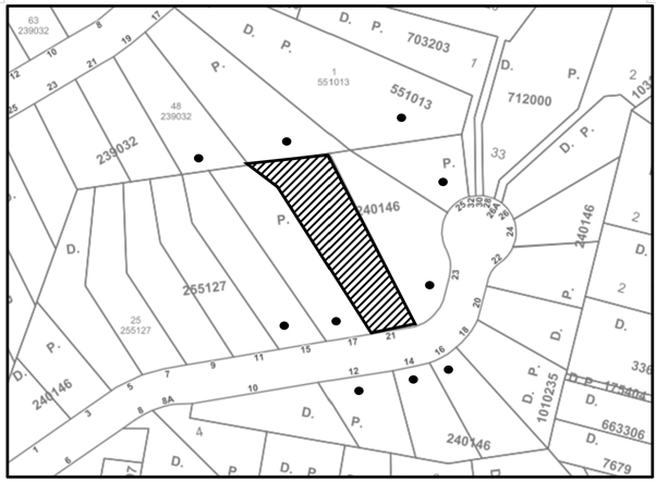
|
NOTIFICATION PLAN |
|||
|
• PROPERTIES NOTIFIED |
X SUBMISSIONS RECEIVED |
|
|
5.2 Public Agencies
The development application was referred to the following Agencies for comment:
5.2.1 Rural Fire Service
The development application was referred to the NSW Rural Service for comment and no objections were raised to the proposed development subject to the conditions recommended in Schedule 1.
6. THE PUBLIC INTEREST
Section 4.15(1)(e) of the Act requires Council to consider “the public interest”.
The public interest is an overarching requirement, which includes the consideration of the matters discussed in this report. Implicit to the public interest is the achievement of future built outcomes adequately responding to and respecting the future desired outcomes expressed in environmental planning instruments and development control plans.
The application is considered to have satisfactorily addressed Council’s and relevant agencies’ criteria and would provide a development outcome that, on balance, would result in a positive impact for the community. Accordingly, it is considered that the approval of the proposed development would be in the public interest.
CONCLUSION
The application proposes alterations and additions to a dwelling house.
The development generally meets the desired outcomes of Council’s planning controls and is satisfactory having regard to the matters for consideration under Section 4.15 of the Environmental Planning and Assessment Act 1979.
Council received no submissions during the public notification period. The matters raised have been addressed in the body of the report.
Having regard to the circumstances of the case, approval of the application is recommended.
The reasons for this decision are:
· The request under Clause 4.6 of Hornsby Local Environmental Plan 2013 to contravene the ‘Height of buildings’ development standard is well founded. Strict compliance with the development standard is considered unreasonable and unnecessary in the circumstances of the case and sufficient environmental planning grounds have been submitted to justify the contravention to the development standard.
· The proposed development generally complies with the requirements of the relevant environmental planning instruments and the Hornsby Development Control Plan 2013.
· The proposed development does not create unreasonable environmental impacts to adjoining development with regard to visual bulk, overshadowing, solar access, amenity or privacy.
Note: At the time of the completion of this planning report, no persons have made a Political Donations Disclosure Statement pursuant to Section 10.4 of the Environmental Planning and Assessment Act 1979 in respect of the subject planning application.
RESPONSIBLE OFFICER
The officer responsible for the preparation of this report is Katrina Maxwell.
|
Cassandra Williams Major Development Manager - Development Assessments Planning and Compliance Division |
Rod Pickles Manager - Development Assessments Planning and Compliance Division |
|
1.⇩ |
Locality Plan |
|
|
|
2.⇩ |
Architectural Plans |
|
|
|
3.⇩ |
Landscape Plan |
|
|
|
4.⇩ |
Clause 4.6 Variation |
|
|
File Reference: DA/61/2022
Document Number: D08358236
SCHEDULE 1
GENERAL CONDITIONS
The conditions of consent within this notice of determination have been applied to ensure that the use of the land and/or building is carried out in such a manner that is consistent with the aims and objectives of the relevant legislation, planning instruments and council policies affecting the land and does not disrupt the amenity of the neighbourhood or impact upon the environment.
Note: For the purpose of this consent, the term ‘applicant’ means any person who has the authority to act on or the benefit of the development consent.
Note: For the purpose of this consent, any reference to an Act, Regulation, Australian Standard or publication by a public authority shall be taken to mean the gazetted Act or Regulation, or adopted Australian Standard or publication as in force on the date that the application for a construction certificate is made.
1. Approved Plans and Supporting Documentation
The development must be carried out in accordance with the plans and documentation listed below and endorsed with Council’s stamp, except where amended by Council and/or other conditions of this consent:
Approved Plans
|
Plan No. |
Plan Title |
Drawn by |
Dated |
Council Reference |
|
1915 – Pre -DA.00 |
Cover Sheet, Perspectives & Site Location |
Concept Architects |
06/12/2021 |
|
|
1915-A.01.01 |
Site Plan |
Concept Architects |
13/01/2022 |
|
|
1915-DA.02 |
Lower Ground Floor Plan |
Concept Architects |
06/12/2021 |
|
|
1915-A.02.02 |
Ground Floor Plan |
Concept Architects |
06/12/2021 |
|
|
1915-DA.04 |
Elevations |
Concept Architects |
13/01/2022 |
|
|
1915-A.04.02 |
Elevations |
Concept Architects |
13/01/2022 |
|
|
1915-A.05.01 |
Sections |
Concept Architects |
13/01/2022 |
|
|
1915-A.07.01 |
Landscape |
Concept Architects |
06/12/2021 |
|
|
TMP_001 |
Tree Management Plan |
Concept Architects |
21/09/2021 |
|
Supporting Documentation
|
Document Title |
Prepared by |
Dated |
Council Reference |
|
BASIX Certificate No. A427601 |
Concept Architects |
05/11/2021 |
D08334324 |
|
Aboricultural Impact Assessment |
Arbor Centre Tree Care |
13/09/2021 |
D08334319 |
|
Waste Management Plan |
Concept Architects |
08/12/2021 |
D08334312 |
|
Geotechnical Investigation & Landslide Risk assessment (SGC20-121) |
Sydney Geotech Consultancy |
25/08/2021 |
D08334296 |
|
Bushfire Assessment Report (BF-79A-1898-2) |
Sydney Bushfire Consultants |
07/12/2021 |
D08334288 |
|
Flood Impact Assessment Report (Ref: E323535_Flood) |
Donovan Associates |
26/08/2021 |
D08334291 |
|
D1 - Stormwater Details, Notes & Legend (issue B) |
Donovan Associates |
01/12/2021 |
D08334309 |
|
D2 - Stormwater Management Plan (issue B) |
Donovan Associates |
01/12/2021 |
D08334309 |
|
D3 - Sediment Control Plan (issue B) |
Donovan Associates |
01/12/2021 |
D08334309 |
|
D4 – Sediment Control Details |
Donovan Associates |
01/12/2021 |
D08334309 |
|
RFS Concurrence Letter (CNR-34458) |
NSW Rural Fire Service |
04/02/2021 |
D08342570 |
2. Construction Certificate
a) A Construction Certificate is required to be approved by Council or a Private Certifying Authority prior to the commencement of any construction works under this consent.
b) The Construction Certificate plans must be consistent with the Development Consent plans.
3. Removal of Trees
a) This development consent permits the removal of trees numbered 4, 12, 19, 21, 23, 24 as identified on page 38 in the Arboricultural Impact Assessment prepared by Arbor Central dated 13/09/2021.
b) No consent is granted for the removal of trees numbered 2, 3, 5, 6, 7, 8, 9, 11, 13, 14, 15, 16, 17, 18, 20, 22 as these trees contribute to the established landscape amenity of the area/ streetscape.
c) No consent is granted to the removal of trees T1, T1a as these trees are on adjoining properties. Removal of these trees would require separate approval by Council.
Note: The removal of any other trees from the site requires separate approval by Council in accordance with Part 1B.6 Tree and Vegetation Preservation of the Hornsby Development Control Plan, 2013 (HDCP).
4. Tree Pruning
a) This development consent only permits the pruning of trees numbered 7,15,17,20,22 as identified in the Tree Location Plan Page 38 of the Arboricultural Impact Report prepared by Arbor Central dated 13/09/2021.
b) Works can be undertaken in the form of canopy modification as follows:
|
Tree number |
Work prescribed |
|
7,15,17,20,22 |
Crown Modification |
i) All specified pruning works must be less than 15 percent.
ii) All pruning work must be undertaken by an arborist with minimum AQF3 qualifications.
Note: The pruning of any other trees from the site requires separate approval by Council in accordance with Part 1B.6 Tree and Vegetation Preservation of the Hornsby Development Control Plan 2013 (HDCP).
5. Section 7.12 Development Contributions
a) In accordance with Section 4.17(1) of the Environmental Planning and Assessment Act 1979 and the Hornsby Shire Council Section 7.12 Development Contributions Plan 2019 - 2029, $3,443.00 must be paid towards the provision, extension or augmentation of public amenities or public services, based on development costs of $344,300.00.
b) The value of this contribution is current as of 3 March 2022. If the contributions are not paid within the financial quarter that this consent is granted, the contributions payable will be adjusted in accordance with the provisions of the Hornsby Shire Council Section 7.12 Development Contributions Plan and the amount payable will be calculated at the time of payment in the following manner:
|
c) $CPY |
d) = |
e) |
f) |
g) $CDC x CPIPY |
|
h) |
i) |
j) |
k) |
l) CPIDC |
Where:
$CPY is the amount of the contribution at the date of Payment
$CDC is the amount of the contribution as set out in this Development Consent
CPIPY is the latest release of the Consumer Price Index (Sydney – All Groups) at the date of Payment as published by the ABS.
CPIDC is the Consumer Price Index (Sydney – All Groups) for the financial quarter at the date of this Development Consent.
The monetary contributions shall be paid to Council:
(i) Prior to the issue of the Subdivision Certificate where the development is for subdivision.
(ii) Prior to the issue of the first Construction Certificate where the development is for building work.
(iii) Prior to issue of the Subdivision Certificate or first Construction Certificate, whichever occurs first, where the development involves both subdivision and building work.
(iv) Prior to the works commencing where the development does not require a Construction Certificate or Subdivision Certificate.
Note: It is the professional responsibility of the Principal Certifying Authority to ensure that the monetary contributions have been paid to Council in accordance with the above timeframes.
Note: In accordance with Ministerial Directions, the payment of contribution fees for development with a cost of works of over $10 million can be deferred to prior to Occupation Certificate.
Note: The Hornsby Shire Council Section 7.12 Development Contributions Plan may be viewed at www.hornsby.nsw.gov.au or a copy may be inspected at Council’s Administration Centre during normal business hours.
REQUIREMENTS PRIOR TO THE ISSUE OF A CONSTRUCTION CERTIFICATE
Detailed plans, specifications and supporting information is required to be submitted to the certifying authority detailing how the proposed building work achieves compliance with the National Construction Code - Building Code of Australia. All building work must be carried out in accordance with the requirements of the National Construction Code - Building Code of Australia.
7. Contract of Insurance (Residential Building Work)
Where residential building work for which the Home Building Act 1989 requires there to be a contract of insurance in force in accordance with Part 6 of that Act, this contract of insurance must be in force before any building work authorised to be carried out by the consent commences.
8. Notification of Home Building Act 1989 Requirements
Residential building work within the meaning of the Home Building Act 1989 must not be carried out unless the principal certifying authority for the development to which the work relates (not being Council) has given Council written notice of the following information:
a) In the case of work for which a principal contractor is required to be appointed:
i) The name and licence number of the principal contractor.
ii) The name of the insurer by which the work is insured under Part 6 of that Act.
b) In the case of work to be done by an owner-builder:
i) The name of the owner-builder.
ii) If the owner-builder is required to hold an owner-builder’s permit under that Act, the number of the owner-builder’s permit.
Note: If arrangements for doing the residential building work are changed while the work is in progress so that the information notified becomes out of date, further work must not be carried out unless the principal certifying authority for the development to which the work relates (not being Council) has given Council written notification of the updated information.
9. Sydney Water – Approval
This application must be submitted to Sydney Water for approval to determine whether the development would affect any Sydney Water infrastructure, and whether further requirements are to be met.
Note: Building plan approvals can be obtained online via Sydney Water Tap inTM through www.sydneywater.com.au under the Building and Development tab.
10. Stormwater Drainage – Dwelling
The stormwater drainage system for the development must be designed for an average recurrence interval (ARI) of 20 years and be gravity drained in accordance with the following requirements:
a) Connected to the existing internal drainage system.
11. Habitable Floor Level
The habitable floor level for the lower ground level must be at a minimum of 145.53m Australian Height Datum.
12. Structure within an Easement for Batter
a) Structures within an Easement for Batter are to be designed by a chartered structural engineer, to ensure structures do not cause damage to the existing Easement for Batter, and both the structures and Easement for Batter will function in a safe and efficient manner.
b) Construction for the proposed development is to be carried out in accordance with the requirements of the Geotechnical Investigation & Landslide Risk Assessment report, prepared by Sydney Geotech Consultancy, dated 25 August 2021.
13. Appointment of a Project Arborist
a) A project arborist with AQF Level 5 qualifications must be appointed.
b) Details of the appointed project arborist must be submitted to Council and the PCA for registration with the application for the construction certificate.
REQUIREMENTS PRIOR TO THE COMMENCEMENT OF ANY WORKS
14. Erection of Construction Sign
a) A sign must be erected in a prominent position on any site on which any approved work is being carried out:
i) Showing the name, address, and telephone number of the principal certifying authority for the work.
ii) Showing the name of the principal contractor (if any) for any demolition or building work and a telephone number on which that person may be contacted outside working hours.
iii) Stating that unauthorised entry to the work site is prohibited.
b) The sign is to be maintained while the approved work is being carried out and must be removed when the work has been completed.
15. Protection of Adjoining Areas
A temporary hoarding, fence or awning must be erected between the work site and adjoining lands before the works begin and must be kept in place until after the completion of the works if the works:
a) Could cause a danger, obstruction or inconvenience to pedestrian or vehicular traffic.
b) Could cause damage to adjoining lands by falling objects.
c) Involve the enclosure of a public place or part of a public place.
d) Have been identified as requiring a temporary hoarding, fence or awning within the Council approved Construction Management Plan (CMP).
Note: Notwithstanding the above, Council’s separate written approval is required prior to the erection of any structure or other obstruction on public land.
a) To provide a safe and hygienic workplace, toilet facilities must be available or be installed at the works site before works begin and must be maintained until the works are completed at a ratio of one toilet for every 20 persons employed at the site.
b) Each toilet must:
i) Be a standard flushing toilet connected to a public sewer.
ii) Be a temporary chemical closet approved under the Local Government Act 1993.
17. Erosion and Sediment Control
a) To protect the water quality of the downstream environment, erosion and sediment control measures must be provided and maintained throughout the construction period in accordance with the manual ‘Soils and Construction 2004 (Bluebook)’, the approved plans, Council specifications and to the satisfaction of the principal certifying authority.
b) The erosion and sediment control devices must remain in place until the site has been stabilised and revegetated.
Note: On the spot penalties may be issued for any non-compliance with this requirement without any further notification or warning.
18. Installation of Tree Protection Measures
a) Trees to be retained and numbered 2, 3, 5, 6, 7, 8, 9, 11, 13, 14, 15, 16, 17, 18, 20, 22 as identified on the Tree Location Plan prepared by Tree Central 24/1/2022 D08334319 must have tree protection measures for trunk installed by the project arborist as follows:
i) For the duration of construction works, in accordance with Tree Protection Plan prepared by Arbor Central dated 21/09/2021 TRIM: D08334319.
b) The circumference of the trunk must be wrapped in hessian material to provide cushioning for the installation of timber planks.
c) Timber planks (50 x100mm) must be spaced at 100mm intervals and must be attached using adjustable ratchet straps.
19. Protection of vegetation, habitat and environmental features during construction
To ensure the protection of vegetation, habitat and environmental features during construction, the applicant must:
a) Install bushland protection fencing along the management zones identified in the approved Construction Environment Management Plan to retain all native trees to be retained (as recommended by Council’s Tree Management Team).
b) Clean machinery of soil and debris before entering the site to prevent the spread of weeds and fungal pathogens.
REQUIREMENTS DURING CONSTRUCTION
a) All works on site, including any earthworks, must only occur between 7am and 5pm Monday to Saturday.
b) No work is to be undertaken on Sundays or public holidays.
21. Environmental Management
To prevent sediment run-off, excessive dust, noise or odour emanating from the site during the construction, the site must be managed in accordance with the publication ‘Managing Urban Stormwater - Landcom (March 2004) and the Protection of the Environment Operations Act 1997.
a) During works and until exposed ground surfaces across the site have been stabilised, street sweeping must be undertaken following sediment tracking from the site.
b) The street cleaning service must utilise a ‘scrub and dry’ method and be undertaken for the full extent of any sediment tracking.
23. Council Property
To ensure that the public reserve is kept in a clean, tidy and safe condition during construction works, no building materials, waste, machinery or related matter is to be stored on the road or footpath.
24. Disturbance of Existing Site
During construction works, the existing ground levels of open space areas and natural landscape features, including natural rock-outcrops, vegetation, soil and watercourses must not be altered unless otherwise nominated on the approved plans.
25. Prohibited actions within the fenced tree protection zone
The following activities are prohibited within the approved fenced tree protection zones unless otherwise approved by Council:
a) Soil cutting or filling, including excavation and trenching.
b) Soil cultivation, disturbance or compaction.
c) Stockpiling storage or mixing of materials.
d) The parking, storing, washing and repairing of tools, equipment and machinery.
e) The disposal of liquids and refuelling.
f) The disposal of building materials.
g) The siting of offices or sheds.
h) Any action leading to the impact on tree health or structure.
26. Maintaining the health of trees approved for retention
The appointed project arborist must monitor and record any and all necessary actions required to maintain tree health and condition for trees numbered 2, 3, 5, 6, 7, 8, 9, 11, 13, 14, 15, 16, 17, 18, 20, 22 on the approved plans.
27. Maintaining Tree Protection Measures
Tree Protection Measures must be maintained by the project arborist in accordance with Condition No. 14 and 19 of this consent for the duration of works.
28. Approved Works within Tree Protection Zone incursions
a) Where tree root pruning is required for the installation of piers, driveway or underground services, the pruning must be overseen by the AQF 5 project arborist and must be undertaken as follows:
i) Using sharp secateurs, pruners, handsaws or chainsaws with the final cut being clean.
ii) The maximum diameter of roots permitted to be cut is 40mm.
iii) The installation of any underground services which either enter or transect the designated TPZ must be undertaken manually.
iv) For manually excavated trenches the AQF 5 project arborist must designate roots to be retained. Manual excavation may include the use of pneumatic and hydraulic tools.
b) Where scaffolding is required, ground protection must be installed beneath the scaffolding in the following order:
i) Installation of a 100mm deep layer of woodchip.
29. Building materials and Site Waste
The stockpiling of building materials, the parking of vehicles or plant, the disposal of cement slurry, wastewater or other contaminants must be located outside the tree protection zones as prescribed in the conditions of this consent of any tree to be retained.
30. Geotechnical Report
The recommendations of the Geotechnical Report prepared by Sydney Geotech Consultancy, dated 25 August 2021 must be complied with for the duration of the construction works.
31. Waste Management
All work must be carried out in accordance with the approved waste management plan.
REQUIREMENTS PRIOR TO THE ISSUE OF AN OCCUPATION CERTIFICATE
32. Fulfilment of BASIX Commitments
The applicant must demonstrate the fulfilment of BASIX commitments pertaining to the development.
33. Completion of Works and Compliance Certificate
All engineering and geotechnical works identified under this consent are to be completed and a Compliance Certificate issued prior to the release of occupation certificate.
34. Damage to Council Assets
To protect public property and infrastructure, any damage caused to Council’s assets as a result of the construction or demolition of the development must be rectified by the applicant in accordance with AUS-SPEC Specifications
(www.hornsby.nsw.gov.au/property/build/aus-spec-terms-and-conditions) Rectification works must be undertaken prior to the issue of an Occupation Certificate, or sooner, as directed by Council.
35. Creation of Easements (Application for The Execution of Legal Documents)
The following easement is to be created on the title of the property under the Conveyancing Act 1919:
a) The creation of an appropriate “positive covenant” over the constructed structure within the Easement for Batter in favour of Council in accordance with Council’s prescribed wording. The position of the additional structure is to be clearly indicated on the title.
Note: Council must be nominated as the authority to release, vary or modify any easement, restriction or covenant.
36. Structural Engineer’s Certificate
A chartered structural engineer certificate that structures within an Easement for Batter have been constructed in accordance with the requirements of the structural engineer and they do not cause damage to the existing Easement for Batter, and both the structures and Easement for Batter are functioning in a safe and efficient manner.
37. Replacement Tree Requirements
a) The trees approved for removal under this consent, being trees numbered 1, 1a , 4, 10, 10a, 12, 19, 21, 23, 24 must be offset through replacement planting of a minimum of 8 trees.
b) All replacement plantings must be species selected from the ‘Trees Indigenous to Hornsby Shire (as of 1 September 2011)’ document available for viewing on the Hornsby Council’s website http://www.hornsby.nsw.gov.au/environment/flora-and-fauna/tree-management/indigenous-trees
c) The location and size of tree replacement planting must comply with the following:
i) All replacement trees must be located in either front or rear setbacks and planted 4 metres or greater from the foundation walls of the approved development.
ii) The pot size of the replacement trees must be a minimum 45 litres.
iii) All replacement trees must be a minimum of 3 metres in height.
iv) All replacement trees must have the potential to reach a mature height greater than 10 metres.
38. Final Certification
The AQF 5 Project arborist must submit to the Principal Certifying Authority a certificate that includes the following:
a) All tree protection requirements complied with the as approved tree protection plan for the duration of demolition and/or construction works.
b) All completed works relating to tree protection and maintenance have been carried out in compliance with the conditions of consent and approved plans.
c) Dates, times and reasons for all site attendance.
d) All works undertaken to maintain the health of retained trees.
e) Details of tree protection zone maintenance for the duration of works.
Note: Copies of monitoring documentation may be requested throughout DA process.
39. Certification of RFS Requirements
A Certificate prepared by a BPAD accredited Bushfire Consultant is to be provided to the Principal Certifying Authority (PCA) certifying the completion of all works required by the NSW RFS conditions of concurrence prior to the issue of the Occupation Certificate.
40. Ongoing Protection of Remnant Trees
All trees on site not approved for removal under this consent are required to be retained for conservation purposes. These trees have a legal obligation for their preservation and are excluded from the clearing provisions of the 10/50 Vegetation Clearing Code of Practice for New South Wales in accordance with Clause 7.8 of the Code.
CONDITIONS OF CONCURRENCE - NSW RURAL FIRE SERVICE
The following conditions of consent are from the nominated State Agency pursuant to Section 4.13 of the Environmental Planning and Assessment Act 1979 and must be complied with to the satisfaction of that Agency
41. Asset Protection Zones
From the start of building works, the property around the building must be managed as an inner protection area (IPA) for a distance of 10 metres, or to the property boundary (whichever comes first). in accordance with the requirements of Appendix 4 of Planning for Bush Fire Protection 2019. When establishing and maintaining an IPA the following requirements apply:
a) Tree canopy cover should be less than 15% at maturity.
b) Trees at maturity should not touch or overhang the building.
c) Lower limbs should be removed up to a height of 2 metres above the ground.
d) Tree canopies should be separated by 2 to 5 metres.
e) Preference should be given to smooth barked and evergreen trees.
f) Large discontinuities or gaps in vegetation should be provided to slow down or break the progress of fire towards buildings;
Shrubs should not be located under trees.
g) Shrubs should not form more than 10% ground cover.
h) Clumps of shrubs should be separated from exposed windows and doors by a distance of at least twice.
i) The height of the vegetation.
j) Grass should be kept mown (as a guide grass should be kept to no more than 100mm in height).
k) Leaves and vegetation debris should be removed.
42. Construction Standards
Construction Intent of measures: to minimise the risk of bush fire attack and provide protection for emergency services personnel, residents and others assisting firefighting activities.
New construction must comply with Section 3 (excluding section 3.5) and Section 9 (BAL FZ) of Australian Standard AS3959-2018 Construction of buildings in bushfire-prone areas or the relevant BAL-FZ requirements of the NASH Standard - Steel Framed Construction in Bushfire Areas (incorporating amendment A - 2015). New construction must also comply with the construction requirements in Section 7.5 of Planning for Bush Fire Protection 2019.
43. Water and Utility Services
Intent of measures: to minimise the risk of bush fire attack and provide protection for emergency services personnel, residents and others assisting firefighting activities.
The provision of water, electricity and gas must comply with the following in accordance with Table 7.4a of Planning for Bush Fire Protection 2019:
a) Reticulated water is to be provided to the development where available.
b) All above-ground water service pipes external to the building are metal, including and up to any taps.
c) Where practicable, electrical transmission lines are underground.
d) Where overhead, electrical transmission lines are proposed as follows:
e) Lines are installed with short pole spacing (30 metre), unless crossing gullies, gorges or riparian areas.
f) No part of a tree is closer to a power line than the distance set out in accordance with the specifications in ISSC3 Guideline for Managing Vegetation Near Power Lines.
g) Reticulated or bottled gas is installed and maintained in accordance with AS/NZS 1596:2014.
h) Requirements of relevant authorities, and metal piping is used.
i) All fixed gas cylinders are kept clear of all flammable materials to a distance of 10 metres and shielded on the hazard side.
j) Connections to and from gas cylinders are metal.
k) Polymer‐sheathed flexible gas supply lines are not used.
l) Above-ground gas service pipes are metal, including and up to any outlets.
44. Landscaping Assessment
The intent of measures for landscaping. To achieve this, the following conditions shall apply:
Landscaping within the required asset protection zone must comply with Appendix 4 of Planning for Bush Fire Protection 2019. In this regard, the following principles are to be incorporated:
a) A minimum 1 metres wide area, suitable for pedestrian traffic, must be provided around the immediate curtilage of the building.
b) Planting is limited in the immediate vicinity of the building.
c) Planting does not provide a continuous canopy to the building (i.e. trees or shrubs are isolated or located in small clusters).
d) Landscape species are chosen to ensure tree canopy cover is less than 15% (IPA), and less than 30% (OPA) at maturity and trees do no touch or overhang buildings.
e) Avoid species with rough fibrous bark, or which retain/shed bark in long strips or retain dead material in their canopies.
f) Use smooth bark species of trees species which generally do not carry a fire up the bark into the crown.
g) Avoid planting of deciduous species that may increase fuel at surface/ ground level (i.e. leaf litter).
h) Avoid climbing species to walls and pergolas.
i) Locate combustible materials such as woodchips/mulch, flammable fuel stores away from the building.
j) Locate combustible structures such as garden sheds, pergolas and materials such as timber garden.
k) Furniture away from the building.
l) Low flammability vegetation species are used.
- END OF CONDITIONS -
ADVISORY NOTES
The following information is provided for your assistance to ensure compliance with the Environmental Planning and Assessment Act, 1979, Environmental Planning and Assessment Regulation 2000, other relevant legislation and Council’s policies and specifications. This information does not form part of the conditions of development consent pursuant to Section 4.17 of the Act.
Environmental Planning and Assessment Act 1979 Requirements
The Environmental Planning and Assessment Act 1979 requires:
· The issue of a construction certificate prior to the commencement of any works. Enquiries can be made to Council’s Customer Services Branch on 9847 6760.
· A principal certifying authority to be nominated and Council notified of that appointment prior to the commencement of any works.
· Council to be given at least two days written notice prior to the commencement of any works.
· Mandatory inspections of nominated stages of the construction inspected.
· An occupation certificate to be issued before occupying any building or commencing the use of the land.
Long Service Levy
In accordance with Section 34 of the Building and Construction Industry Long Service Payments Act 1986, a ‘Long Service Levy’ must be paid to the Long Service Payments Corporation or Hornsby Council.
Note: The rate of the Long Service Levy is 0.35% of the total cost of the work.
Note: Hornsby Council requires the payment of the Long Service Levy prior to the issue of a construction certificate.
Tree and Vegetation Preservation
Hornsby Development Control Plan Tree Preservation provisions have been developed under Council’s authorities contained in State Environmental Planning Policy (Vegetation in Non-Rural Areas) 2017 under the Environmental Planning and Assessment Act 1979.
In accordance with these provisions a person must not cut down, fell, uproot, kill, poison, ringbark, burn or otherwise destroy the vegetation, lop or otherwise remove a substantial part of the trees or vegetation to which any such development control plan applies without the authority conferred by a development consent, or a permit granted by Council.
Fines may be imposed for non-compliance with the HDCP.
Note: A tree is defined as a long lived, woody perennial plant with one or relatively few main stems with the potential to grow to a height greater than three metres (3m). (HDCP 1B.6.1.c).
Covenants
The land upon which the subject building is to be constructed may be affected by restrictive covenants. Council issues this approval without enquiry as to whether any restrictive covenant affecting the land would be breached by the construction of the building, the subject of this consent. Applicants must rely on their own enquiries as to whether or not the building breaches any such covenant.
Dial Before You Dig
Prior to commencing any works, the applicant is encouraged to contact Dial Before You Dig on 1100 or www.dialbeforeyoudig.com.au for free information on potential underground pipes and cables within the vicinity of the development site.
Asbestos Warning
Should asbestos or asbestos products be encountered during demolition or construction works, you are advised to seek advice and information prior to disturbing this material. It is recommended that a contractor holding an asbestos-handling permit (issued by SafeWork NSW) be engaged to manage the proper handling of this material. Further information regarding the safe handling and removal of asbestos can be found at:
Alternatively, telephone the SafeWork NSW Asbestos and Demolition Team on 8260 5885.
Telecommunications Act 1997 (Commonwealth)
If you are aware of any works or proposed works which may affect or impact on Telstra’s assets in any way, you are required to contact: Telstra’s Network Integrity Team on Phone Number 1800810443.
LPP Report No. LPP14/22
Local Planning Panel
Date of Meeting: 30/03/2022
5 ELECTRONIC - DA/528/2020 - CONCEPT DEVELOPMENT APPLICATION FOR SHOP TOP HOUSING DEVELOPMENT - 409-411 PACIFIC HIGHWAY, ASQUITH
EXECUTIVE SUMMARY
|
DA No: |
DA/528/2020 (Lodged on 7 July 2020) |
|
Description: |
Concept Development Application for a shop top housing development comprising of ground floor retail and 31 units over four residential floors. |
|
Property: |
Lot 4 DP 650304, Lot 5 DP 650059, Lot 5 DP 136220, No. 409-411 Pacific Highway, Asquith |
|
Applicant: |
Beraldo Design & Soertsz Property Group Pty Ltd |
|
Owner: |
Soertsz Property Group Pty Ltd |
|
Estimated Value: |
$9,000,000 |
|
Ward: |
A Ward |
· The proposal does not comply with the height of buildings development standard contained within Clause 4.3 of the Hornsby Local Environmental Plan 2013. The applicant has made a submission in accordance with Clause 4.6 ‘Exceptions to development standards’ of the Hornsby Local Environmental Plan 2013. The submission is considered well founded and is supported.
· A total of 3 submissions have been received in respect of the application.
· The application is required to be determined by the Hornsby Council Local Planning Panel as State Environmental Planning Policy No. 65 Design Quality of Residential Flat Development applies and the proposal would contravene the Hornsby Local Environmental Plan 2013 development standard for maximum height of buildings by more than 10 percent (16.6%).
· It is recommended that the application be approved.
|
THAT Council assume the concurrence of the Secretary of the Department of Planning and Environment pursuant to Clause 4.6 of the Hornsby Local Environmental Plan 2013 and approve Development Application No. DA/528/2020 for a Concept Development Application for shop top housing development comprising ground floor retail and 31 units over four residential floors at Lot 4 DP 650304, Lot 5 DP 650059, Lot 5 DP 136220, No. 409-411 Pacific Highway, Asquith subject to the conditions of consent detailed in Schedule 1 of LPP Report No. LPP14/22. |
BACKGROUND
The concept development application was lodged on 7 July 2020 for a shop top housing development comprising a ground level restaurant and “drive-thru” with four levels of residential units above. A total of 35 units were proposed.
Council referred the concept development application to the Design Excellence Panel for consideration on 12 August 2020. The Panel supported the overall intention for the site as mixed use, given its corner location across from an existing commercial centre. Concerns were raised to the streetscape presentation of the ground floor, which largely isolated the ground level restaurant by wrapping drive thru lanes around the peripheries of the site. The ground level design was identified to have a detrimental impact on the public domain and significantly compromised any opportunity for street activation. With respect to the residential floors, concerns were raised with the apartment orientation and form and massing of the building.
Figure 1: Isometric view from corner of Pacific Highway and Amor Street showing ground level restaurant with drive-thru sunk below exiting ground level.
Council provided the Design Excellence Panel commentary to the applicant and requested that amended plans be supplied that responded to the concerns of the panel.
The applicant undertook further study into site layout and numerous alterative plans were investigated with respect to the ground level layout. It was identified that due to the technical requirements for the drive-thru, it would be difficult to accommodate a drive-thru lane on site in a manner that allowed for streetscape activation and did not cause internal traffic conflict.
Following detailed design review, on 25 January 2021 the applicant submitted amended plans to Council that removed the ground level drive-thru restaurant in preference to general “commercial area”. The amended plans provided 568m2 of ground level commercial, with rear parking adjacent to the side boundary. The form of the residential levels above changed substantially, with the floor plate of the residential component split into two distinct buildings sitting on the ground level podium.
Figure 2: Isometric view from corner of Pacific Highway and Amor Street showing ground floor commercial development and redesigned residential floors above.
Following the receipt of the amended plans and documentation, Council publicly renotified the development and sent the proposal to the Design Excellence Panel for further review. The design excellence panel raised a number of concerns with the revised design, including;
· The proposed dual residential towers on a concrete podium does not reflect the desired future character for the area.
· The proposed levels of the ground floor residential do not integrate well with the existing street levels.
· The central open space between the buildings was identified as having numerous deficiencies.
The panel identified that the removal of the drive-thru component was a positive step but considered that a full redesign of the proposal was required. The panel noted that “The site is in a prominent corner location at the northern end of a local shopping strip on Pacific Highway. A qualified urban designer should be engaged to provide urban design input with regard to the built form, public domain and the design of the ground level street interface.”
Following the advice from the Panel, Council further requested that the applicant supply amended plans to address the design commentary. Council also requested that the applicant engage the qualified services of an urban designer.
On 9 August 2021, the applicant submitted a redesigned proposal, which amounted to a complete building redesign. Residential units were reduced from 35 to 31 and the ground floor commercial area was redesigned to have improved integration with the streetscape.
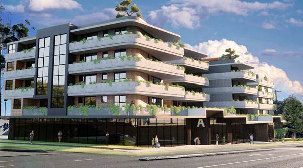
Figure 3: Isometric view from corner of Pacific Highway and Amor Street showing redesigned building form.
The updated building form is a single building with significant articulation for the residential storeys. Communal open space was relocated to the roof of the building and the bulk of the development was pushed forward to the Pacific Highway and Amor Street corner to allow for vegetated setbacks to adjoining residential development and to better integrate the building with the public domain at the front of the site.
The design was re-notified and was referred to the Design Excellence Panel for commentary. The panel noted that: “The inclusion of urban design input has resulted in positive changes for the development proposal that address many issues raised in the most recent submission seen by the Panel.”
The panel noted that the proposal had their “qualified support” subject to the resolution of a number of more minor items identified in their design review including better resolution of ground floor streetscape presentation and the inclusion of additional basement levels to remove ground level parking.
The applicant submitted amended plans to this effect on 27 January 2022. The primary change to these plans was the inclusion of two additional basement levels, and a more refined streetscape design which included street furniture and amenity trees.
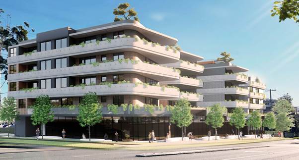
Figure 4: Refined proposal showing street furniture and trees.
On 3 March 2022, Council sent a final request for amended plans to the applicant, requesting the creation of a building form and massing plan and minor amendments to increase landscaped areas in side setbacks.
On 8 March 2022 the applicant provided massing plans and amendments in accordance with Council’s request.
SITE
The 2729m2 development site comprises four allotments on the corner of Pacific Highway and Amor Street Asquith. The three allotments comprising No. 409 Pacific Highway currently contain a KFC restaurant, with drive-thru facilities and a car park. No. 411 Pacific Highway currently contains a dwelling house and ancillary structures.
Immediately to the south of the site is the Asquith commercial precinct and Asquith Railway Station. To the north and west of the site is high density residential zoned lands. To the east of the site is the Pacific Highway and Main Northern Railway Line.
The site experiences a fall of approximately 5 metres towards the northern side boundary of No. 411 Pacific Highway. The site is not flood prone or bushfire prone and is not burdened or benefitted by any easements or restrictions.
The site does not contain a heritage listed item, is not in the vicinity of a heritage listed item and is not located with a heritage conservation area.
PROPOSAL
The application proposes a concept development application for shop top housing development comprising ground floor retail, 31 apartments over four residential levels above and roof top communal open space. A breakdown of the proposed development is as follows:
· Basement levels
Three basement levels are proposed, with the lower levels (Basement 2 and 3) being for the residential component of the development the development. The highest basement level (Basement 1) contains parking and services for the ground level commercial development. 59 residential parking spaces are provided, with 19 spaces allocated for commercial use.
· Ground Level Commercial
The ground floor of the development would comprise 2 retail premises with a floor area of 690m2 and 273m2 respectively.
· Levels 1-4 Residential
Levels 1-4 would comprise of 1, 2 and 3 bedroom units within an articulated and varied building form. The building is spilt into a northern and southern portion, with separate lobbies for each section providing access from basement areas and the street. All residential units are provided with a balcony and are capable of cross ventilation and sunlight access.
· Roof Level
The roof of the proposed development would comprise a communal open space area for use by the residential levels.
The communal open space area would have an area of approximately 512m2 and would include rooftop planting, BBQ facilities, lobby areas and provision for solar PV panels.
ASSESSMENT
The development application has been assessed having regard to the Greater Sydney Region Plan – A Metropolis of Three Cities, the North District Plan and the matters for consideration prescribed under Section 4.15 of the Environmental Planning and Assessment Act 1979 (the Act). The following issues have been identified for further consideration.
1. STRATEGIC CONTEXT
1.1 Greater Sydney Region Plan - A Metropolis of Three Cities and North District Plan
The Greater Sydney Region Plan - A Metropolis of Three Cities has been prepared by the NSW State Government to guide land use planning decisions for the next 40 years (to 2056). The Plan sets a strategy and actions for accommodating Sydney’s future population growth and identifies dwelling targets to ensure supply meets demand. The Plan also identifies that the most suitable areas for new housing are in locations close to jobs, public transport, community facilities and services.
The NSW Government will use the subregional planning process to define objectives and set goals for job creation, housing supply and choice in each subregion. Hornsby Shire has been grouped with Hunters Hill, Ku-ring-gai, Lane Cove, Mosman, North Sydney, Ryde, Northern Beaches and Willoughby to form the North District. The Greater Sydney Commission has released the North District Plan which includes priorities and actions for Northern District for the next 20 years. The identified challenge for Hornsby Shire will be to provide an additional 4,350 dwellings by 2021 with further strategic supply targets to be identified to deliver 97,000 additional dwellings in the North District by 2036.
The proposed development would be consistent with the Greater Sydney Region Plan - A Metropolis of Three Cities and the North District Plan, by contributing to achieving the dwelling targets for the region and by providing additional services to support a growing population.
2. STATUTORY CONTROLS
Section 4.15(1)(a) requires Council to consider “any relevant environmental planning instruments, draft environmental planning instruments, development control plans, planning agreements and regulations”.
2.1 Environmental Planning and Assessment Act 1979 (The Act)
Division 4.4 “Concept Development Applications” of the Environmental Planning and Assessment Act 1979 (the Act) applies to concept development applications and to consents granted on the determination of those applications. An assessment of the proposal with respect to the requirements of Division 4.4 is provided in the table below.
|
Division 4.4 Concept Development Applications |
|
|
4.22(1) For the purposes of this Act, a concept development application is a development application that sets out concept proposals for the development of a site, and for which detailed proposals for the site or for separate parts of the site are to be the subject of a subsequent development application or applications. |
The development application satisfies the criteria for a “concept development application” and the supplied statement of environmental effects details that the application is to be treated as a concept application. |
|
4.22(2) In the case of a staged development, the application may set out detailed proposals for the first stage of development. |
The application is not proposed to be staged development and the approval of this application would not authorise any works to be undertaken on site. |
|
4.22(3) A development application is not to be treated as a concept development application unless the applicant requests it to be treated as a concept development application. |
The applicant has requested that the application be treated as a concept development application |
|
4.22(4) If consent is granted on the determination of a concept development application, the consent does not authorise the carrying out of development on any part of the site concerned unless— |
The recommended conditions of consent are structured in a manner that makes it clear and obvious that the consent does not authorise the carrying out of development on site. |
|
(a) consent is subsequently granted to carry out development on that part of the site following a further development application in respect of that part of the site, or |
The subsequent grant of a further consent will be required prior to any works being undertaken on site. |
|
(b) the concept development application also provided the requisite details of the development on that part of the site and consent is granted for that first stage of development without the need for further consent. The terms of a consent granted on the determination of a concept development application are to reflect the operation of this subsection. |
The development application is not staged and it is not considered that the application has provided the requisite development detail to permit consent to any works on site. |
|
4.22(5) The consent authority, when considering under section 4.15 the likely impact of the development the subject of a concept development application, need only consider the likely impact of the concept proposals (and any first stage of development included in the application) and does not need to consider the likely impact of the carrying out of development that may be the subject of subsequent development applications. |
Assessment of the relevant considerations under Section 4.15 in accordance with this clause is contained within the body of this report. |
|
4.23 Concept development applications as alternative to DCP required by environmental planning instruments |
|
|
4.23(1) An environmental planning instrument cannot require the making of a concept development application before development is carried out. |
N/A - The HLEP does not require a concept approval for shop top housing. |
|
4.23(2) However, if an environmental planning instrument requires the preparation of a development control plan before any particular or kind of development is carried out on any land, that obligation may be satisfied by the making and approval of a concept development application in respect of that land. |
N/A - The HLEP does not require the preparation of a development control plan for this type of development. |
|
4.23(3) Any such concept development application is to contain the information required to be included in the development control plan by the environmental planning instrument or the regulations. |
N/A |
|
4.24 Status of concept development applications and consents |
|
|
4.24(1) The provisions of or made under this or any other Act relating to development applications and development consents apply, except as otherwise provided by or under this or any other Act, to a concept development application and a development consent granted on the determination of any such application. |
Noted |
|
4.24(2) While any consent granted on the determination of a concept development application for a site remains in force, the determination of any further development application in respect of the site cannot be inconsistent with the consent for the concept proposals for the development of the site. |
Noted and reinforced in the conditions of development consent recommended in Schedule 1 of this report. |
|
4.24(3) Subsection (2) does not prevent the modification in accordance with this Act of a consent granted on the determination of a concept development application. |
Noted. |
2.2 Hornsby Local Environmental Plan 2013
The proposed development has been assessed having regard to the provisions of the Hornsby Local Environmental Plan 2013 (HLEP).
2.2.1 Zoning of Land and Permissibility
The subject land is zoned R4 High density residential under the HLEP. The objectives of the R4 zone are:
· To provide for the housing needs of the community within a high-density residential environment.
· To provide a variety of housing types within a high-density residential environment.
· To enable other land uses that provide facilities or services to meet the day to day needs of residents.
The proposed development is defined as shop top housing and is permissible in the zone with Council’s consent.
2.2.2 Height of Buildings
Clause 4.3 of the HLEP provides that the height of a building on any land is not to exceed the maximum height shown for the land on the Height of Buildings Map. The maximum permissible height for the subject site is 17.5 metres.
It is noted that on 4 December 2020, Amendment No. 11 of the HLEP was finalised. One of the amendments to the HLEP was that the Height of Building Map was amended, and areas that previously permitted buildings of up to 17.5 metres in height were reduced to 16.5 metres. This amendment impacts on this development application as the Height of Building Map depicting the subject site was amended to permit a maximum building height of 16.5 metres from the previously permissible 17.5 metre building height.
Despite the above, Amendment No. 11 included a saving provision within Clause 1.8A of the HLEP which reads as follows:
If a development application has been made before the commencement of Hornsby Local Environmental Plan 2013 (Amendment No 11) in relation to land to which that Plan applies and the application has not been finally determined before that commencement, the application must be determined as if that Plan had not commenced.
As this development application was lodged prior to the finalisation of Amendment No. 11, as per the provisions of Clause 1.8A of the HLEP, the change in permissible building height does not apply to this application.
The building proposes a maximum height of 20.4 metres, a variation of 16.6% which does not comply with the height of building development standard. The applicant has submitted a written request to vary the development standard pursuant to Clause 4.6 of the HLEP. This written request is discussed in detail below.
2.2.3 Exceptions to Development Standards
The applicant submitted a written request to contravene the height of building development standard contained within Clause 4.3 of the HLEP.
The following diagrams demonstrate the extent of the non-compliant building portions, as demonstrated by the red dashed line at 17.5 metres above existing ground level (extract from SEE):
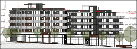 Figure 5:
East Elevation (facing Pacific Highway)
Figure 5:
East Elevation (facing Pacific Highway)

Figure 6: South Elevation (facing Amor Street)
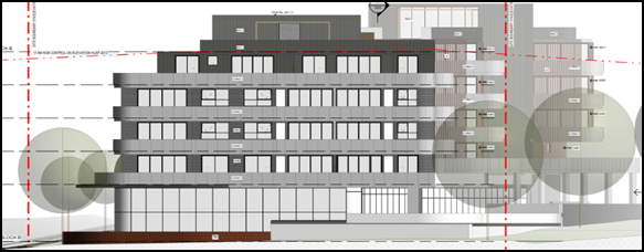
Figure 7: North Elevation
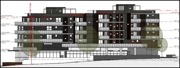
Figure 8: West Elevation
As demonstrated in the figures above, the roof top communal area lobbies, lift overruns, and shading/ PV panel structures breach the height limit, with minor parapet/ roof forms also exceeding the limit as the site falls to the north.
The application has been assessed against the requirements of Clause 4.6 of the HLEP. This clause provides flexibility in the application of the development standards in circumstances where strict compliance with those standards would, in any particular case, be unreasonable or unnecessary or tender to hinder the attainment of the objectives of the zone. In particular, Clause 4.6 provides criteria that must be satisfied prior to a consent authority granting consent to development that contravenes a development standard. These criteria demonstrated under Clause 4.6(3) are as follows:
(a) That compliance with the development standard is unreasonable or unnecessary in the circumstances of the case, and;
(b) That there are sufficient environmental planning grounds to justify contravening the development standard.
A discussion regarding the criteria provided at Clause 4.6(3), with respect to the development application is provided below.
2.2.3.1 Unreasonable or Unnecessary Clause 4.6(3)(a)
There are five common methods by which an applicant can demonstrate that compliance with a development standards is unreasonable or unnecessary in the circumstances of the development. Initially proposed for objections under clause 6 of SEPP 1 in the decision of Wehbe v Pittwater Council [2007] NSWLEC 827 Pearson C summarised and applied these methods to written requests made under Clause 4.6 in Four2Five Pty Ltd v Ashfield Council [2015] NSWLEC 1009 [61-62]. These five methods are generally as follows:
· The objectives of the development standard are achieved notwithstanding non-compliance with the standard.
· The underlying objective or purpose is not relevant to the development.
· That the objective would be defeated or thwarted if compliance was required.
· That the development standard has been virtually abandoned or destroyed by the Council’s own actions in departing from the standard.
· The zoning of the land is unreasonable or inappropriate.
It is not required to demonstrate that a development meets multiple methods as listed above, and the satisfaction of one can be adequate to demonstrate that the development standard is unreasonable or unnecessary.
The written request prepared by Andrew Martin Planning, dated January 2022, provides a detailed assessment of the proposal with respect to the development standard sought to be varied. The request argues that the objectives of the development standard are achieved notwithstanding non-compliance with the standard in Part 6 of the document, providing reasoning as follows:
The site slopes from south to north and from east to west. Therefore, the highest point of the building is the north-east corner - closest to the northern boundary and the Pacific Highway. The lift overrun with the maximum height variation is located towards the northern end of the building, central to the building footplate. The second lift overrun structure is located towards the southern end of the development, centrally located within the building envelope.
The CDA Concept Plans demonstrate that the site is capable and suitable for the proposed Shop Top Housing (STH) development. The planning provisions allow for the density of development proposed. The infrastructure in the area has the capacity to cater for the development as the site has been operating as a commercial premises for decades. The use of the site for high density residential accommodation is anticipated by the Council. The revised proposal is also now supported by a peer review urban design report prepared by Professor Webber. The review has regard to the plans and the surrounding site constraints and urban design outcomes. The peer review is supportive of the scheme notwithstanding the nominated height departure.
Overall, the CDA Concept for the STH development achieves the objective.
Council notes that the objectives of Clause 4.3 of the HLEP are as follows;
“to permit a height of buildings that is appropriate for the site constraints, development potential and infrastructure capacity of the locality.”
With reference to the reasoning provided by the applicant above, Council does not object to the conclusion that the proposed concept application meets the objectives of Clause 4.3. In reaching this conclusion the following points are noted;
· Strict compliance with the height of buildings development standard would likely result in poor level transitions at the ground level (such as those seen in the originally proposed development with a KFC drive-thru, see Figure 1) or result in the loss of a residential floor. The proposed building is highly articulated along the Pacific Highway frontage, which is identified as a desirable design feature. If a reduction in the number of floors was required to achieve compliance with Clause 4.3, the articulation of the building would likely be reduced so each residential floor could cater for further units, which would be undesirable from a design excellence view point.
· The site is strategically located next to both the Asquith commercial centre and Asquith train station. The adjoining Asquith commercial centre provides for mixed-use and commercial development to a height of 32.5 metres. The proposed building would provide an appropriate transition in height from the commercial centre to the high-density residential precinct.
· The height of the building is accentuated by the minimum floor to ceiling height requirements for the ground floor commercial uses, 5.31 metres compared to 3.1 metres for residential.
· The proposed building does respond to site constraints despite its non-compliance, and steps down to the north of the site to reduce the overall building height.
· The proposed development would have negligible impact on the infrastructure capacity of the locality and would assist in reinforcing the adjoining commercial precinct by providing a quality public realm at the ground level.
· The site is zoned for shop top housing which permits ground level retail. As a result of this land use, it can be difficult to provide the required services and access at the ground level for the commercial component whilst providing deep soil landscaping areas and communal open space for “shop top” residents. In the case of this development, commercial has been provided primarily underneath the residential floors above. When deep soil requirements of the HDCP are taken into account, there is insufficient space to provide the required residential communal open space at ground level. This has resulted in the communal open space being provided at the top of the building, which has contributed to the height non-compliance as lifts and lift lobbies are required to provide disabled access to the roof level of the building. Provision of the communal open space on top of the building is considered to be a superior outcome as it allows for the creation of a separated and private space for residents, that meets the minimum area requirements.
For the reasons outlined above, it is considered that the written request to contravene the height of building standard adequately demonstrates that the objectives of the height of buildings development standard contained within Clause 4.3 of the HLEP are achieved, notwithstanding non-compliance with the standard.
2.2.3.2 Environmental Planning Grounds - Clause 4.6(3)(b)
In addition to demonstrating that compliance is unreasonable or unnecessary, Clause 4.6(3)(b) requires that there are sufficient environmental planning grounds to justify contravening the development standard. In demonstrating that sufficient environmental planning grounds exist it must be demonstrated that the planning grounds are particular to the circumstances of the development on the subject site (summarised from Four2Five Pty Ltd v Ashfield Council [2015] NSWLEC 1009 [60].
The applicant provided the following planning grounds for the contravention of the development standard;
· The orientation of the site (north-south) means that travel path of the sun in winter provides ample sun penetration and solar access to the eastern, northern and western residential units – the additional HOB does not adversely impact on the attainment of minimum solar access requirements to the majority of the residential units.
· The proposed HOB variation is a function of the lift overruns needed to service the 5-storey building, otherwise the habitable floor levels of the building envelope are compliant with the height control.
· The lift shafts are both centrally located so that the additional height does not cast an additional shadow outside of the building footprint.
· The Statement of Environmental Effects addresses the transitional role of this site between the adjoining B2 Local Centre - which has a 32.5m HOB and the R4 High Density Residential zone with a HOB of 17.5m. The land use and built form, comprising a Shop Top Housing development, provides ground level commercial premises with high density residential accommodation above. The proposed development sits comfortably between the two height precincts.
· The HOB exceedance does not add to the overall bulk or scale of the development when viewed from the public domain or other nearby properties as it is only the lift shafts and rooftop terrace surrounds that are non-compliant.
· Only from distant viewpoints of the site will the lift overruns be visible. Around the perimeter of the site and along the footpath the lift overruns will be barely discernible and, if seen, are a recessive element.
· The development achieves and does not seek to exceed the scale and form anticipated for this site.
· The proposal reasonably preserves the residential amenity of the locality.
· The fine grain detail of the colours, materials and finishes are not finalised as part of the CDA. The lift overruns are to be integrated into the rooftop, in conjunction with the design of the common open space terrace which is to be edged with landscaping for privacy and amenity of residents.
· The lift shafts provide disable compliant access to the future communal spaces that could not otherwise be achieved without removal of a part level. Removal of a part level is not in the public interest and does not promote the orderly and economic use of the land.
· Suitable urban design outcome as reported in the peer review prepared by Professor Webber. Professor Webber concludes that the development will offer excellent amenity for residents and is of very good quality in relation to urban design issues.
· The proposal has been assessed against the provisions of HLEP 2013 and HDCP 2013. It satisfies the objectives and provisions of both State and Local planning policies.
Council’s further review of the environmental planning grounds presented by the applicant raises no points of contention, and it is considered that the written request provides sufficient environmental planning grounds and a reasonable built environment outcome, both within the subject site, and to the adjoining residential development.
As it is considered that the written request demonstrates sufficient environmental planning grounds specific to the development site, no further justification is considered necessary as sound environmental planning grounds for the non-compliance have been established.
Council is therefore satisfied that Clause 4.6(3) of the HLEP is adequately addressed.
2.2.3.3 Public Interest and Clause 4.6(4)
Clause 4.6(4) states that development consent must not be granted for development that contravenes a development standard unless:
(a) The consent authority is satisfied that:
(i) The applicant’s written request has adequately addressed the matters required to be demonstrated by subclause (3), and
(ii) The proposed development will be in the public interest because it is consistent with the objectives of the particular standard and the objectives for development within the zone in which the development is proposed to be carried out, and
(b) The concurrence of the Planning Secretary has been obtained
With regard to (a)(i), the written requests are considered to adequately address the matters required to be demonstrated as outlined above. With regard to (a)(ii), the proposed development is considered to be in the public interest because it is consistent with the objectives of the particular standard and the objectives for height of building contained within the HLEP. With regard to (b) the concurrence of the Planning Secretary has been obtained.
Therefore, the exceedance of the height of buildings development standard is supported in this instance.
2.2.4 Heritage Conservation
Clause 5.10 of the HLEP sets out heritage conservation provisions for Hornsby Shire. The site does not include a heritage item, is not located within the vicinity of a heritage listed item and is not located in a heritage conservation area. Accordingly, no further assessment regarding heritage is necessary.
2.2.5 Earthworks
Clause 6.2 of the HLEP states that consent is required for proposed earthworks on site. Before granting consent for earthworks, Council is required to assess the impacts of the works on adjoining properties, drainage patterns and soil stability of the locality.
Notwithstanding the fact that the approval of the application would not authorise the carrying out of any earthworks, Council’s assessment has not identified any reason as to why the three proposed basement levels could not be accommodated on the site in a manner that would be capable of satisfying the requirements of Clause 6.2 of the HLEP.
The proposed earth works are not considered to be of a form that would have a detrimental impact on environmental functions and processes, neighbouring uses, cultural or heritage items or features of the surrounding land and conditions of development consent have been recommended in Schedule 1 of this report for the provision of a geotechnical report with any future development application.
2.2.6 Design Excellence
Clause 6.8 of the HLEP provides considerations for the delivery of the highest standard of architectural and urban design. At the time of lodgement, Clause 6.8 of the HLEP did not apply to the application. Notwithstanding this fact, the application was assessed by Council’s Design Excellence Panel under State Environmental Planning Policy No. 65 Design Quality of Residential Apartment Development which is discussed in Part 2.2 of this report.
2.3 State Environmental Planning Policy No. 55 Remediation of Land
The application has been assessed against the requirements of State Environmental Planning Policy No. 55 Remediation of Land (SEPP 55) under which consent must not be granted to the carrying out of any development on land unless the consent authority has considered whether the land is contaminated or requires remediation for the proposed use.
Should the land be contaminated, Council must be satisfied that the land is suitable in a contaminated state for the proposed use. If the land requires remediation to be undertaken to make the land suitable for the proposed use, Council must be satisfied that the land will be remediated before the land is used for that purpose.
An examination of Council’s records and aerial photography has determined that the site has been historically used for commercial and residential purposes. A condition of development consent is recommended in Schedule 1 of this report for the provision of a contamination report with any future development application.
2.4 State Environmental Planning Policy (Infrastructure) 2007
The application is subject to assessment under Clause 101(2) of the State Environmental Planning Policy (Infrastructure) 2007 (ISEPP) given the proposal has a frontage to a classified road being Castle Hill Road.
Clause 101(2) of the ISEPP states:
(2) The consent authority must not grant consent to development on land that has a frontage to a classified road unless it is satisfied that:
(a) Where practicable, vehicular access to the land is provided by a road other than the classified road.
(b) The safety, efficiency and ongoing operation of the classified road will not be adversely affected by the development as a result of:
(i) The design of the vehicular access to the land.
(ii) The emission of smoke or dust from the development.
(iii) The nature, volume or frequency of vehicles using the classified road to gain access to the land.
(c) The development is of a type that is not sensitive to traffic noise or vehicle emissions, or is appropriately located and designed, or includes measures, to ameliorate potential traffic noise or vehicle emissions within the site of the development arising from the adjacent classified road.
In regard to Clause 101(2)a, vehicle access to the site is facilitated via a two-way entry to Amor Street, which satisfies this requirement.
In regard to Clause 101(2)b, Council’s Traffic and Road Safety Team assessed the proposed design and raised no objections to the proposed concept application subject to the provision of a traffic report to accompany any future development application and the conditions of development consent outlined in Schedule 1 of this report, including a restriction on right turn into the basement from Amor Street.
Subject to these conditions, Council is satisfied that the safety, efficiency and operation of the classified road would not be adversely impacted by the current proposal.
In regard to Clause 101(2)c, Council’s recommended conditions in Schedule 1 of this report includes a requirement for the commissioning of an acoustic report to accompany any future development application.
2.4.1.1 Development Adjacent to Rail Corridors
The development site is located adjacent to the Northern Rail Line, which is located to the east of the site, on the opposite side of the Pacific Highway.
The concept development application does not meet the requirements for concurrence under Clause 85 or 86 of SEPP as it does not involve excavation of any land referenced in Clause 86. With reference to Clause 87, Impact of Noise and Vibration on non-rail development, as mentioned above Schedule 1 of this report includes a requirement for the commissioning of an acoustic report to accompany any future development application.
2.5 State Environmental Planning Policy No. 65 Design Quality of Residential Apartment Development
The Policy provides for design principles to improve the design quality of residential apartment development and for consistency in planning controls across the State. The concept development application is of sufficient detail to enable a full or partial assessment to be carried out against many aspects of SEPP 65.
The application was supported by an Urban Design Review, prepared by Emeritus Professor G.P.Webber, of Planning Architecture and Urban Design supporting the proposal.
Additionally, the application was referred to Council’s Design Excellence Panel for design review as outlined in Part 1 of this report as per the requirements of Division 2 of the SEPP. The panel provided comprehensive design advice, and as at the final panel meeting, provided support to the proposed development.
Assessment of the proposal against the design quality principles contained within Schedule 1 of the SEPP is provided below:
|
SEPP 65 - Schedule 1 Assessment |
|
|
Principle |
Compliance |
|
1. CONTEXT AND NEIGHBOURHOOD CHARACTER |
Yes |
|
Comment: The site is located within a precinct planned for five storey residential flat buildings in close proximity to Asquith Railway Station. The desired future character of the area, as outlined in the Hornsby Development Control Plan 2013, is that of a locality characterised by residential flat buildings of 5-storeys in height in landscape settings with underground car parking. Development should seek to complement and enhance the adjacent public domain environment and building footprints by maintaining landscape corridors around and through development sites. The proposed shop top housing development appropriately responds to the context of the site by proposing a shop top housing development adjacent to the existing Asquith commercial core. The ground level would appropriately integrate with the existing public domain and sufficient landscaping is provided adjacent to side boundaries to ensure green links through the site. |
|
|
2. BUILT FORM AND SCALE |
Yes |
|
Comment: Despite the height noncompliance, it is considered that the proposed development achieves a scale, bulk and height appropriate to the existing or desired future character of the street and surrounding buildings. The building presents as highly articulated and of appropriate proportions and materiality. The concept would contribute to the character of the streetscape and offer residents a high level of amenity. |
|
|
3. DENSITY |
Yes |
|
Comment: The HLEP does not incorporate floor space ratio requirements for the site. The density of the development is governed by the height of the building and the required setbacks. The proposed density is considered to be sustainable as it responds to the regional context, availability of infrastructure, public transport, community facilities and environmental quality and is acceptable in terms of density despite non-compliant setback distances (discussed in further detail in the body of this report). |
|
|
4. SUSTAINABILITY |
Yes |
|
Comment: Whilst it is noted that the development is at a concept stage, provision has been made for PV panels on the roof top and further sustainable methods, including BASIX compliance would be possible on the subject site under a future development application. |
|
|
5. LANDSCAPE |
Yes |
|
Comment: Landscaping is provided within side setback areas, with provision for deep soil and planted garden beds. Additionally, landscaping elements including planter beds are provided on elevated levels and the roof top, to further provide greenery along facades. Where extensive landscaping is not possible along the Amor Street and Pacific Highway frontages, feature amenity trees with gardens beds are provided to break up these facades and integrate greenery. |
|
|
6. AMENITY |
Yes |
|
Comment: The proposed units are designed with appropriate room dimensions and layout to maximise amenity for future residents. The proposal incorporates good design in terms of achieving natural ventilation, solar access and acoustic privacy. All units incorporate balconies accessible from living areas and privacy has been achieved through appropriate design and orientation of balconies and living areas. It is expected that further resolution of internal amenity would be provided at a future development application stage. |
|
|
7. SAFETY |
Yes |
|
Comment: The design orientates the balconies and windows of individual apartments towards the street, rear and side boundaries, providing passive surveillance of the public domain and communal open space areas. Both the pedestrian and vehicular entry points are secured and visibly prominent from Amor Street and the Pacific Highway. A future development would be capable of compliance with Crime Prevention Through Environmental Design Principles (CPTED). |
|
|
8. SOCIAL DIMENSIONS AND HOUSING AFFORDABILITY |
Yes |
|
Comment: The proposal incorporates a range of unit sizes to cater for different budgets and housing needs. The development complies with the housing choice requirements of the Hornsby DCP by providing a component of adaptable housing and a mix of 1, 2 and 3 bedroom dwellings. The proposal responds to the social context in terms of providing a range of dwelling sizes with good access to social facilities and services as the site is located in close proximity to Asquith railway station and shops. |
|
|
10. AESTHETICS |
Yes |
|
Comment: The architectural treatment of the building incorporates indentations and projections in the exterior walls with balcony projections to articulate the facades. The roof is flat to minimise building height and incorporates landscaping and varied elements to break up the roof plane. The articulation of the building, composition of building elements, textures, materials and colours would achieve a built form generally consistent with the design principles contained within the Residential Flat Design Code and the Hornsby DCP. |
|
2.6 Apartment Design Guide
SEPP 65 also requires consideration of the Apartment Design Guide (ADG), NSW Department of Planning and Environment 2015. The ADG includes development controls and best practice benchmarks for achieving the design principles of SEPP 65. The following table sets out the proposal’s compliance with the ADG:
|
Apartment Design Guide |
|||
|
Control |
Proposal |
Requirement |
Compliance |
|
Deep Soil Zone (3E) |
20% |
7% of site area |
Yes |
|
Communal Open Space (3D) |
25% (rooftop) |
25% of site area |
Yes |
|
Building Separation (3F-1) |
Achieved to the west, achievable to the north due to 6m setback |
9m Between habitable windows and balconies 4.5m between Non-habitable rooms |
Yes |
|
Solar Access (Living rooms and private open space areas) (4A-1) |
70% >50% COS |
2 hours for 70% of units 2 hours for 50% of COS |
Yes |
|
No Solar Access allowable for units (4A-1) |
3% (1/31) |
15% of units (max) |
Yes |
|
Natural Cross Ventilation (4B) |
100% Depicted |
60% |
Yes |
|
Minimum Dwelling Size (4D-1) |
Compliant |
Studio – 35m2 1 br – 50m2 2 br – 70m2 3 br – 90m2 + 5m2 for additional bathrooms +12m2 for 4th and additional bedrooms |
Yes
|
|
Habitable room depth (4D-2) |
Complies |
2.5x Ceiling height 8m from a window (max)(open plan layouts) |
Yes |
|
Minimum Ceiling Height (4C-1) |
2.8m |
2.7m (habitable rooms) 2.4m (non-habitable rooms) |
Yes |
|
Minimum Balcony Size (4E-1)
|
Compliant |
Studio Apartment -4m2 1 bedroom 8m² 2m depth 2 bedroom 10m² 2m depth 3 bedroom 12m² 2m depth |
Yes |
|
Maximum Number of Units on a Single Level (4F-1) |
4 |
8 units off a circulation core |
Yes |
|
Car Parking (3J-1) |
84 Spaces |
76 – As per HDCP
|
Yes |
|
Total Storage Area (4G-1) |
TBC – DA Stage |
Studio 4m3 (Min) 1 bed - 6m3 (Min) 2 bed - 8m3 (Min) 3 bed - 10m3 (Min)
Minimum of 50% accessible from within apartments |
TBC |
As detailed in the above table, the proposed development demonstrates compliance with the prescriptive measures within the ADG is possible for a future development application. Below is a brief discussion regarding the relevant development controls and best practice guidelines.
2.6.1 Communal Open Space
Objective 3D-1 of the ADG is for “An adequate area of communal open space is provided to enhance residential amenity and to provide opportunities for landscaping”. The design criteria for objective 3D-1 is that Communal open space has a minimum area equal to 25% of the site and Developments achieve a minimum of 50% direct sunlight to the principal usable part of the communal open space for a minimum of 2 hours between 9 am and 3 pm on 21 June (mid-winter).
Further the ADG provides that “where communal open space cannot be provided at ground level, it should be provided on a podium or roof”.
The provision of the communal open space on the rooftop is considered to be a superior outcome to a ground level space, as it is considered that the rooftop allows for privacy, security and separation from the ground level commercial floor. Council’s design review panel noted that the rooftop level terraces were “generous” and provided for some facilities for the use of residents. Rooftop areas are fringed with garden beds which assists in providing visual separation and breakup of the roof plane. Detailed review and assessment of the communal open space would be possible at a future development application, as no objections are raised to the layout at this concept stage.
2.6.2 Solar Access
The proposal demonstrates that 70% of units would receive at least 2 hours of solar access during the Winter Solstice which complies with the minimum 70% requirement under the ADG. The ADG also requires that no more than 15% of apartments receive zero solar access. The proposal complies with this requirement as all units are depicted as receiving some solar access to internal areas during the winter solstice in the supplied solar view diagrams.
Private and communal open space areas are depicted to be compliant with the 50% solar access requirements of the ADG.
2.6.3 Building Separation
Objective 3F-1 of the ADG is for “Adequate building separation distances are shared equitably between neighbouring sites, to achieve reasonable levels of external and internal visual privacy”.
In the process of assessing the development application, the bulk of the building was moved towards the Amor Street and Pacific Highway corner as it was identified that this would provide for better streetscape presentation and greater side setback areas. As recommended by Council’s Design Excellence Panel on 12 August 2020;
As mentioned above, the restaurant component should move closer to the corner similar to the coffee shop opposite the site on the corner of Amor Street. The proposed shop should read as a continuation of the retail strip to the south of the property with appropriate setback and footpath awning wrapping around the corner.
The opportunity to shift the unit block closer to Pacific Highway and to Amor Street should be explored. This would reduce the size of the roof over the ground floor shop and increase the setback to the rear boundary thereby improving amenity for the residents in the adjacent properties to the west with regard to privacy and overshadowing.
In response to the design advice provided by the panel, the applicant provided amended plans that shifted the building bulk towards the corner of the site and away from adjoining high density residential zoned land.
This provided adequate building separation distances, and in the case of the western side boundary, separation that is generally above the ADG requirements. This would allow a future development application within the proposed footprint to comply with ADG requirements and achieve reasonable levels of external and internal visual privacy.
2.6.4 Minimum Balcony Size
Objective 4E-1 of the ADG is that “Apartments provide appropriately sized private open space and balconies to enhance residential amenity”. All proposed balconies would be equal to, or in excess of ADG requirements.
2.6.5 Car Parking
The proposed carparking basement contains 84 spaces, which exceeds the prescriptive requirements for carparking for high density dwellings, as detailed in Part 1C.2.1 Transport and Parking of the HDCP.
Sufficient parking is provided for both residential and commercial land uses over the three basement levels. The basements are of a sufficient design and size to incorporate the required services when these are identified in a future development application.
2.6.6 Facades
Objective 4M-1 of the ADG is for “Building facades provide visual interest along the street while respecting the character of the area”.
Council’s design excellence panel identified that “the overall built form configuration is well resolved to create a modelled frontage that is consistent with the anticipated future development along the highway…”. The Design Excellence Panel, concluded that “Overall, the applicant has responded positively to the DEP’s advice. The scheme has improved significantly compared to the earlier proposals and should be supported subject to addressing issues noted”.
Issues raised by the Panel are noted as minor building elements that can be incorporated at a future development application stage. The Design Excellence Panel commentary is proposed to be provided to the applicant as a supporting document for reference in preparing subsequent development applications, and is included as a document in Schedule 1 of this report.
2.6.7 Storage
The proposal does not show compliance with the storage requirements of Part 4G of the ADG. However it is considered that the size and layout of the basement and apartments are of a sufficient design to permit compliance with this requirement, which will be assessed at a later development application stage.
2.6.8 Deep Soil
The objective of Part 3E-1 of the ADG is for “Deep soil zones provide areas on the site that allow for and support healthy plant and tree growth. They improve residential amenity and promote management of water and air quality”.
The proposal provides 20% of site area for deep soil. These areas are provided adjacent to the northern and western side boundaries and permit the establishment of canopy trees and vegetated garden beds within setback areas. It is also noted that amenity trees are provided along the Pacific Highway and Amor Street frontages, which would be located within deep soil zones.
The proposal does demonstrates that a future development application would be capable of compliance with the deep soil requirements of the ADG.
2.7 Sydney Regional Environmental Plan No. 20 Hawkesbury-Nepean River
The site is located within the catchment of the Hawkesbury Nepean River. Part 2 of this Plan contains general planning considerations and strategies requiring Council to consider the impacts of development on water quality, aquaculture, recreation and tourism.
No concerns are raised in relation to the proposed concept development application. A future proposal would be capable of complying with the requirements of the Policy.
2.8 State Environmental Planning Policy (Vegetation in Non-Rural Areas) 2017
State Environmental Planning Policy (Vegetation in Non-Rural Areas) 2017 (Vegetation SEPP) commenced 25 August 2017 and aims to protect the biodiversity and amenity values of trees within non-rural areas of the state.
Part 3 of the Vegetation SEPP states that a development control plan may make a declaration in any manner relating to species, size, location and presence of vegetation. Accordingly, Part 1B.6.1 of the Hornsby Development Control Plan 2013 (HDCP) prescribes works that can be undertaken with or without consent to trees.
Part 3.1 of this report provides an assessment in accordance with Part 1B.6.1 of the HDCP.
2.9 State Environmental Planning Policy (Building Sustainability Index: BASIX) 2004
The application has been assessed against the requirements of State Environmental Planning Policy (Building Sustainability Index: BASIX) 2004. BASIX requirements would apply to a future development proposal and further assessment under this SEPP would be a matter for a future development application.
2.10 Adopted State Environmental Planning Policies
On 1 March 2022, the following State Environmental Planning Policies (SEPPS) were gazetted.
· State Environmental Planning Policy (Resilience and Hazards) 2021
· State Environmental Planning Policy (Biodiversity and Conservation) 2021
· State Environmental Planning Policy (Precincts - Eastern Harbour City) 2021
These SEPPS now form matters for consideration under Section 4.15 of the Environmental Planning and Assessment Act 1979. However general savings provisions apply to development applications that have been made but not yet determined, on or before the commencement date of the above SEPPs.
As this development application was lodged on 7 July 2020, this development application is considered to have been made prior to the commencement date of the SEPPs. The newly adopted SEPPs have been considered as a matter for consideration under S4.15 of the Act. However the existing legislation, in force at time of lodgement of the development application, prevails to be extent of any inconsistency.
2.11 Section 3.42 Environmental Planning and Assessment Act, 1979 - Purpose and Status of Development Control Plans
Section 3.42 of the Environmental Planning and Assessment Act 1979 states that a DCP provision will have no effect if it prevents or unreasonably restricts development that is otherwise permitted and complies with the development standards in relevant Local Environmental Plans and State Environmental Planning Policies.
The principal purpose of a development control plan is to provide guidance on the aims of any environmental planning instrument that applies to the development; facilitate development that is permissible under any such instrument; and achieve the objectives of land zones. The provisions contained in a DCP are not statutory requirements and are for guidance purposes only. Consent authorities have flexibility to consider innovative solutions when assessing development proposals, to assist achieve good planning outcomes.
2.12 Hornsby Development Control Plan 2013
The proposed development has been assessed having regard to the relevant desired outcomes and prescriptive requirements within the Hornsby Development Control Plan 2013 (HDCP). The following table sets out the proposal’s compliance with the prescriptive requirements of the Plan:
|
Hornsby Development Control Plan 2013 |
|||
|
Control |
Proposal |
Requirement |
Compliance |
|
Site Width |
139m |
30m |
Yes |
|
20.4m (including lift overrun) |
17.5m |
No |
|
|
No. of storeys |
5 storeys on podium |
5 storeys |
Yes |
|
Lowest Residential Floor Above Natural Ground Level |
2.4m |
1.5m (max) |
No - as shop top housing |
|
Maximum Floorplate Dimension |
55m (N/S) 26m ( E/W) |
35m 35m |
No Yes |
|
Building Indentation |
Complies |
4m x 4m |
Yes |
|
Front Setback |
Ground Floor Commercial 5.1 metre setback and Units above setback 3 metres from Pacific Highway and Amor Street |
10m 8m < 1/3 building length |
No |
|
Side Setback (northern) |
Ground Floor 6m with exception of awning structure setback at 3m. First floor setback at 6m with garden extending to 5.3m. All other floors 6m or greater setback. |
6m 4.5m < 1/3 building length |
No
|
|
Side Setback (Western) |
All floors setback 6m with exception of first floor which has protruding “pebbled area” setback at 5 metres |
6m 4.5m < 1/3 building length |
No
|
|
Top Storey Setback from Ground Floor |
Varied compliance from 0m to 2.4 metres |
3m |
No |
|
Basement Ramp Setback (landscaping) |
5m |
2m |
Yes |
|
Deep Soil Landscaped Areas |
0m front 1-6m variable Side |
8m front 4m sides |
No Partial |
|
Communal Open Space with Minimum Dimensions 4m |
>50m2 (min) 25% |
50m2 (min) 25% |
Yes Yes |
|
Parking |
|
|
|
|
- resident spaces |
>42 spaces |
41 spaces |
Yes |
|
- commercial spaces |
>34 spaces |
34 spaces |
Yes |
|
- bicycle racks |
16 bike racks |
6 bike racks |
Yes |
|
- motorbike space |
1 space |
1 space |
Yes |
|
Solar Access |
70% |
70% |
Yes |
|
Housing Choice |
10% of each type |
10% of each type (min) |
Yes |
|
Adaptable Units |
TBC (achievable) |
10% |
TBC |
2.12.1 Desired Future Character and Key Design Principles
The site is included in the Lords Avenue, Asquith precinct which is zoned R4 High Density Residential.
The HDCP states that a development should demonstrate compatibility with the “Desired Future Character Statement” which is outlined in Part 3.4.1 of the HDCP. Further detail regarding the future character is also contained within the Key Design Principles contained within Part 3.4.15 of the HDCP.
Generally, the applicable key design principles and desired future character for the Lords Avenue Precinct are as follows:
· Redevelopment should be predominantly five storey residential flat buildings in garden settings, with parking in basements.
· Building should be in landscaped settings with buildings providing broad setbacks to retain existing vegetation and to permit residential flat buildings to be surrounded and screened by canopy trees and shrubs to create landscaped corridors.
· Building facades should be well articulated, with setbacks that contain reasonable sunlight and privacy. Facades incorporate a range of materials and finishes including face brick, walls of windows, steel framed balconies with balustrades of steel or glass and operable louvres for privacy, shade and glare control.
· Balconies provide outdoor living areas which wrap around the corners of the buildings, providing usable open space as well as articulation in built form.
· Developments provide active living options including bicycle storage and parking and prioritized pedestrian entrances.
The proposed development is considered to comply with the desired future character and key design principles. Approval of the concept development application would permit the construction of a building that is consistent with the desired future character of the development site and the wider precinct.
2.12.2 Site Requirements
The desired outcome of Part 3.4.3 Site Requirements of the HDCP is for “Buildings located on consolidated development sites that provide soft landscaping surrounding the building and limit the number of driveway crossings.”
The proposed development site would be consistent with the desired outcome by consolidating four allotments, providing soft landscaping in side setback areas and providing one vehicular crossing to the site from Amor Street.
The proposal would also not isolate any adjoining development site or hinder the redevelopment of any other as yet undeveloped allotment within the surrounding high-density precinct.
2.12.3 Height
The proposed development does not comply with the height requirements within the HLEP as discussed in Section 2.1.2 of this report.
As detailed in the body of this report, the proposed building height is considered to be acceptable with respect to the constraints of the site, the development potential and surrounding development.
2.12.4 Setbacks
The desired outcomes of Part 3.4.5 Setbacks of the HDCP is for:
· Well-articulated building forms that are set back to incorporate landscaping, open space and separation between buildings.
· Developments which have coordinated basement and services located to minimise loss of landscaped open space and reduction of deep soil zones.
· Setbacks that preserve and protect existing trees around the perimeter of sites and provide effective deep soil areas that are able to create a garden setting, including substantial tree canopy to all sides of the building.
The proposed development does not comply with any of prescribed setback distances. A merit based assessment of each setback is provided below
2.12.4.1 Northern side setback
The proposed building envelope is setback 5.8 metres from the northern side boundary, which does not comply with the 6 metre setback requirement. The non-compliant section of the building is limited to a raised garden bed located on the first floor of the development. With the exception of this 200mm wide raised garden bed, the entirety of the building would be located at a compliant 6 metre side setback. No objections are raised to the non-compliant garden bed which would provide visual separation and building articulation for the northern façade without impacting on building separation, the ability for canopy trees to be provided within the setback area or the amenity of the adjoining residential development to the north.
2.12.4.2 Western side setback
The bulk of the proposed building would be located more than 12 metres from the western side boundary, and the entirety of the building, with the exception of a first-floor level raised planter would be located at a setback of 8 metres from the boundary.
The first floor level planter and driveway cover would be located at a setback of 5 metres for 40% of the first floor façade. No objections are raised to this structure as it would not permit the generation of privacy or amenity impacts to the adjoining high density development, and would not hinder the establishment of landscape setbacks.
2.12.4.3 Amor Street and Pacific Highway Frontages
Part 3.4.5 of the HDCP prescribes that for corner allotments, the front boundary setback requirement of 10 metres applies to all frontages. The proposed development envelope proposes a setback of 3 metres to the Amor Street frontage and the Pacific Highway. With respect to the non-compliant front setback distances the following points are noted:
· On the Pacific Highway frontage, the ground floor is setback at 3 metres, with floors 1-4 setback back between 3 - 13 metres.
· On the Amor Street frontage, all building levels are setback 3 metres.
· The site adjoins B2 Local Centre zoned lands to the south of the site. The B2 zoned lands comprise of the Asquith Local Centre, which is generally located on the western side of the Pacific Highway, opposite the Asquith Railway Station. Whilst these lands are not yet developed, the adjoining local centre has a maximum permissible height of 35.5m and a permissible setback distance of nil metres from the front boundaries (Part 4.4.5 of the HDCP). Therefore, the frontages proposed at 3 metres, whilst they would not comply with the requirements outlined in Part 3.4.5, they would be setback further than adjoining buildings in the business zone and would provide an appropriate transition between the two zones.
· The proposed shop top housing land use has a commercial ground floor level. Bringing this commercial level forward of the 10 metre setback requirement assists in activating the streetscape around the building, and assists in presenting the ground level commercial to the street. This also allows for the creation of appropriate public domain around the front of the site.
· Moving the bulk of the building towards the corner of Amor Street and Pacific Highway allows for greater setbacks to adjoining residential development, which assists in the creation of landscaped setback areas and green corridors.
· The building facades are well articulated, and the non-compliant setback distances are the result of a lengthy design process, with input from Council’s Design Excellence Panel and the applicant’s Urban Designer. The setbacks are not the result of an overdevelopment of the site.
· The basement levels have been placed under the building bulk and are not interfering with proposed deep soil landscape areas.
· The proposed setbacks still permit the inclusion of appropriate amenity tree coverage to improve the public domain around the frontage of the site and soften the appearance of the building.
For the reasons outlined above, the proposal is considered to be acceptable, with regard to the non-compliant front setbacks.
2.12.4.4 Top Floor Setback
Part 3.4.5 of the HDCP prescribes that the top residential floor should be setback an additional 6 metres from the floor beneath. The HDCP does not directly describe the desired outcome of this additional top floor setback, however the design outcome is that residential flat buildings would have a diminishing form as they achieve additional height. It is also noted that the ADG provides that “Generally one step in the built form as the height increases due to building separations is desirable.” With respect to the proposed non-compliance the following is noted:
· The Amor Street frontage does not propose to have any additional setback for the topmost residential floor, whilst the Pacific Highway frontage and the northern side boundary frontage both have and additional setback provided. As the site adjoining a commercial zoned land on the southern side of Amor Street and residential zoned land to the north, no objections are raised to the transition along the top floor of the building to a more compliant building design in the north of the site. With regard to the Amor Street frontage, it is considered that the non-compliance would have negligible streetscape impact.
· The highest residential floor is not the highest floor of the building as a rooftop communal open space is proposed. This communal open space is setback from the peripheries of Level 4 and contains garden beds and raised parapets. These features would assist in diminishing the rooftop of the building.
· The highly articulated building form along the Pacific Highway greatly breaks up the bulk of the building with balconies that protrude from under the roof line.
· The topmost residential floor is shown in a contrasting and recessive colour when compared to the residential floors below
For the reasons outlined above, no objections are raised to the proposed top residential floor setback.
2.12.5 Building Form and Separation
The desired outcomes of Part 3.4.6 Building Form and Separation is for:
· Buildings that are limited in width and depth, incorporating articulated facades and separated by garden areas.
· Quality architecture that evolves from the guidelines of the Apartment Design Guide.
Prescriptive measures are provided to support the desired outcomes. Including floorplate controls, building separation and articulation. These matters are discussed below:
2.12.5.1 Building Separation
In regard to building separation, Part 3.4.6 of the HDCP prescribes that building separation should comply with the requirements of the ADG, which as discussed in Section 2.3 of this report.
2.12.5.2 Floorplate
The proposed development does not comply with the maximum floor plate dimension in the north/ south building orientation. The HDCP prescribes a maximum floor plate dimension of 35m whilst the proposal has a 55m dimension.
In support of this variation it is noted that the proposed building form is greatly articulated which assists to break up the building mass and effectively hide the length of the building. The proposed building design is considered to have sufficient depth, articulation and vegetated garden areas to be of a quality architectural form. No objections are raised.
2.12.5.3 Articulation
Façade treatments and articulation are considered to be representative of quality design solutions for the following reasons:
· The proposed building envelope is greatly articulated, especially along the eastern and western frontages.
· The proposed building form is broken up landscaping on balconies and rooftop to soften building edges.
· Balconies on all elevations add visual interest and further work to articulate the facades.
· Supplied façade treatments and materials are consistent with the desired future character, including face brick and varied material use. Different building colourations also assist in articulating and breaking up the visual mass of the building.
For the reasons outlined in the sections above, it is considered that the building form and separation is supportable on site, and no objections are raised to the proposed massing.
2.12.6 Landscape
The landscaping provisions of the HDCP prescribe that 8 metre wide landscaped deep soil areas be provided at the front, 7 metre at the rear and a 4 metre wide landscaped area to be provided along the side boundaries.
With reference to the subject site the following points are noted:
· The Amor Street and Pacific Highway frontages do not comply with the 8 metre wide landscaped prescription. However, due to the proposed shop top housing land use, and the reduced setbacks along these frontages, no objections are raised to the non-compliance as providing an 8 metre landscape buffer would frustrate the goals of activating the streetscape and creating an acceptable public domain around the frontage of the site. The proposed design retains landscaping along these frontages, including canopy trees and garden beds, which is seen as an acceptable and desirable outcome.
· The setbacks of the site to the west and north are provided as deep soil landscape areas with minimum dimensions of greater than 4 metres. This allows for visual separation between buildings and the establishment of green linkages and canopies between buildings.
For the reasons outlined above, no objections are raised to the proposed landscaping on site.
2.12.7 Privacy
The proposed concept application is not considered to be of a form that would generate unacceptable privacy to future residents of the site or any residents in adjoining high density residential site.
2.12.8 Solar Access and Natural Ventilation
Part 3.4.11 Sunlight and Ventilation of the HDCP contains prescriptive measures consistent with the requirements of the ADG. As discussed in Section 2.4.2 of this report, the required sunlight access to units is achieved, with all units receiving some sunlight access at the winter solstice.
2.12.9 Housing Choice
Part 3.4.12 Housing Choice of the HDCP prescribes that a mix of 1, 2 and 3 bedroom units should be provided.
The proposal includes a mix of one, two and three bedrooms units, including possible adaptable units.
2.12.10 Vehicular Access and Parking
A Traffic and Parking Assessment Report (TPAR), prepared by Transport and Traffic Planning Associates was provided with the application.
The TPAR identified that additional traffic generation from the site would be minor and additional traffic movements would “not present any adverse conflict, capacity or safety implications, particularly given the regular gaps which are available in the traffic flows along this section of the highway”.
Further the TPAR considers that the proposed access from Amor Street would be consistent with the required Australian Standards and would be located in a position where good sight distances are available. Vehicle circulation was also identified to be acceptable at this concept stage.
Council’s Traffic and Road Safety team assessed the concept proposal and noted the following:
The TPAR states that the proposed development will generate around 26 vehicle trips at AM peak hours and 25 vehicle trips at PM peak hours, according to TfNSW GTGD.
While no traffic analysis has been undertaken for the adjacent intersection or the operation of the driveway, Council is aware that the site has the potential for queueing to occur in Amor Street westbound when cars attempt to turn right into the driveway. The queuing will likely impact on operation of Amor Street and possibly on the Pacific Highway.
To address this, it is recommended that the right turn from Amor Street into the driveway be prohibited by signage as well as driveway design. It is noted that Council will be constructing a roundabout at the intersection of Amor Street and Lords Avenue, also that Wattle Street will be realigned to form a 4 way intersection as part of the Public Domain Guidelines adopted for Asquith. The new roundabout will provide a suitable alternative for cars destined for the development from the Pacific Highway to turn around.
A condition of development consent reflecting the advice of the Traffic and Road Safety Team regarding turning to the site is outlined in Schedule 1 of this report. Subject to this condition, and further conditions regarding the submission of a TPAR with any future development application, no objections are raised to the development on traffic and parking grounds.
2.12.11 Open Space
Part 3.4.8 Open Spaces of the HDCP provides minimum open space requirements, generally in alignment with the requirements of the ADG. The proposed private open space areas comply with the prescriptive area requirements of the ADG as discussed in the body of this report.
2.12.12 Waste Management
The proposal includes preliminary plans in regards to waste collection which indicates that bin areas would be located in the first basement level.
Conditions of development consent have been recommended in Schedule 1 of this report for the provision of future waste management detail with a future development application, including provision of bin chutes, collection areas and access requirements.
2.13 Section 7.11 Contributions Plans
Hornsby Shire Council Section 94 Contributions Plan 2014-2024 does not apply to the concept development application as no dwellings are able to be constructed under this consent. The requirement for a monetary Section 7.11 contribution would be a matter for a future detailed development application.
3. ENVIRONMENTAL IMPACTS
Section 4.15(1)(b) of the Act requires Council to consider “the likely impacts of that development, including environmental impacts on both the natural and built environments, and social and economic impacts in the locality”.
3.1 Natural Environment
3.1.1 Tree and Vegetation Preservation
The proposed building footprint would require the removal of 8 trees as outlined in the Arboricultural Impact Assessment, prepared by Susan Stratton, dated 5 August 2021.
Of the trees that would be removed as part of a future development, 5 have very low or low retention values, with the remaining 3 trees having moderate retention values. Of the trees to be removed, only 2 are natives, with the remaining 6 trees being planted exotic species.
Sufficient space would be available on site with the proposed building envelope for the replanting of native tree species to offset the loss of trees. Consequently no objection is raised to the removal at this concept stage.
In addition to trees to be removed, a number of trees are located on the adjoining allotment No. 2C Amor Street which would have tree protection zones which extend into the site. To minimise impacts to these adjoining trees, throughout the assessment and redesign process, the applicant amended the basement levels and ground floor design to provide setbacks from these trees that would allow for their retention. The final proposed building form and massing is considered to be compatible with the retention of these adjoining trees.
A future development application would be required to complete an arboricultural impact assessment and conditions of consent to this effect are included in Schedule 1 of this report.
3.1.2 Stormwater Management
The proposed development slopes to the northern side boundary. Stormwater could be disposed of via the street drainage system and no easements are identified as being required. A condition of development consent requiring a future stormwater systems to be designed by a suitably qualified engineer is included in Schedule 1 of this report.
3.2 Built Environment
3.2.1 Built Form
As outlined in the body of this report, the proposed built form is considered to be acceptable.
3.3 Social Impacts
The residential development would improve housing choice in the locality by providing a range of house hold types as well as additional commercial space. This is consistent with Council’s Housing Strategy which identifies the need to provide a mix of housing options to meet future demographic needs in Hornsby Shire.
3.4 Economic Impacts
The proposed development would have a positive economic impact to the locality and shire by permitting the creation of additional commercial space for employment opportunities, and by also creating additional dwellings in the locality.
4. SITE SUITABILITY
Section 4.15(1)(c) of the Act requires Council to consider “the suitability of the site for the development”.
The subject site has not been identified as bushfire prone or flood prone land. The site is considered to be capable of accommodating the proposed development. The scale of the proposed development is consistent with the capability of the site, its unique location and the opportunities and constraints of the site.
5. PUBLIC PARTICIPATION
Section 4.15(1)(d) of the Act requires Council to consider “any submissions made in accordance with this Act”.
5.1 Community Consultation
Lodged on 13 July 2020, the application has been notified on 4 separate occasions, from 13 July 2020 to 6 August 2020, from 17 February 2021 to 11 March 2021, from 12 August 2021 to 2 September 2021 and from 28 January 2022 to 22 February 2022 in accordance with the Hornsby Community Engagement Plan.
The application has received 3 submissions in the notification periods, with 2 in the initial submission period and 1 in the following period. No submissions were received in the two most recent submission periods.
The map below illustrates the location of those nearby landowners who made a submission that are in close proximity to the development site.
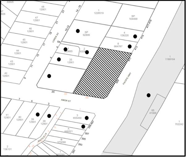
|
NOTIFICATION PLAN |
|||
|
• PROPERTIES NOTIFIED |
X SUBMISSIONS RECEIVED |
|
|
|
3 SUBMISSIONS RECEIVED OUT OF MAP RANGE |
|||
Three submissions objected to the development, generally on the grounds that the development would result in:
· A building of unacceptable height.
· Privacy impacts from the top floor communal open space.
· KFC “smells”.
· Potential for fires from shop top housing development.
· Non-compliant setback distances from the front boundary.
The merits of the matters raised in community submissions have been addressed in the body of the report with the exception of the following:
5.1.1 Privacy impacts from Rooftop Communal Open Space
A submission raised concerns regarding privacy impacts from the rooftop communal open space.
In addressing these concerns, it is noted that the rooftop communal open space is provided with a planter on all sides which would provide a standoff distance from the edge of the roof and the communal open space. This would effectively prevent views below the horizontal plane. Additionally, the site is located on the crest of a hill, with adjoining residential lands to the north and west sitting lower than the subject site. As a consequence of this topography, and the standoff distance from the roof edge provided by the planter, views from the rooftop communal open space would be over the roof of adjoining development only, and it would be improbable that any views into adjoining private open space or living areas would be possible.
5.1.2 KFC Odours
A submission raised concerns that a ground level KFC development would generate odours to the adjoining sites. The ground level KFC restaurant was removed from the proposed development after the first redesign of the concept development application and no such restaurant is proposed under the final plans submitted for consideration.
5.1.3 Fire Safety
A submission raised concerns regarding fire safety between the ground level commercial, and the residential floors above. In response to this concern it is noted that this matter would be addressed at a future development application and construction certificate stage.
5.1.4 Non-compliant Front Setbacks
A submission raised concerns regarding the front setbacks being inconsistent with residential flat buildings in the vicinity of the site.
As outlined in the body of this report, the proposed development occupies a unique site that is opposite the Asquith local centre and the development would provide an appropriate transition in scale and building setbacks between the two zones. Bringing the building closer to the corner of the site assists in activating the ground level retail, provides a high quality public domain and would reduce impacts to adjoining residential development. A 3 metre front setbacks would be inappropriate on the overwhelming majority of sites in the Asquith precinct, and it is only supported in this instance due to the unique nature of the site.
6. THE PUBLIC INTEREST
Section 4.15(1)(e) of the Act requires Council to consider “the public interest”.
The public interest is an overarching requirement, which includes the consideration of the matters discussed in this report. Implicit to the public interest is the achievement of future built outcomes adequately responding to and respecting the future desired outcomes expressed in environmental planning instruments and development control plans.
The application is considered to have satisfactorily addressed Council’s and relevant agencies’ criteria and would provide a development outcome that, on balance, would result in a positive impact for the community. Accordingly, it is considered that the approval of the proposed development would be in the public interest.
CONCLUSION
The application proposes a Concept Development Application for a shop top housing development comprising of ground floor retail and 31 units over four residential floors.
The development generally meets the desired outcomes of Council’s planning controls, other than height of building, and is satisfactory having regard to the matters for consideration under Section 4.15 of the Environmental Planning and Assessment Act 1979.
The variation to the height of building is supported based upon the requirements to provide roof top structures to provide disabled access to the communal open space, increased floor to ceiling heights for the ground floor commercial uses and the slope of the land. The development would provide an appropriate transition in building height between the Asquith commercial centre and high-density residential zone.
Council received 3 submissions during the public notification periods. The matters raised have been addressed in the body of the report.
Having regard to the circumstances of the case, approval of the application is recommended.
The reasons for this decision are:
· The request under Clause 4.6 of Hornsby Local Environmental Plan 2013 to contravene the ‘Height of buildings’ development standard is well founded. Strict compliance with the development standard is considered unreasonable and unnecessary in the circumstances of the case and sufficient environmental planning grounds have been submitted to justify the contravention to the development standard.
· The proposed development does not create unreasonable environmental impacts to adjoining development with regard to visual bulk, overshadowing, solar access, amenity or privacy.
· Detailed assessment of the impact of the development on the natural and built environment of the locality would be considered under a future development application for building works within the approved building envelope on the site.
Note: At the time of the completion of this planning report, no persons have made a Political Donations Disclosure Statement pursuant to Section 10.4 of the Environmental Planning and Assessment Act 1979 in respect of the subject planning application.
RESPONSIBLE OFFICER
The officer responsible for the preparation of this report is Ben Jones.
|
Cassandra Williams Major Development Manager - Development Assessments Planning and Compliance Division |
Rod Pickles Manager - Development Assessments Planning and Compliance Division |
|
1.⇩ |
Locality Plan |
|
|
|
2.⇩ |
Architectural Plan |
|
|
|
3.⇩ |
Approval Plan |
|
|
|
4.⇩ |
Design Excellence Commentary |
|
|
File Reference: DA/528/2020
Document Number: D08348346
SCHEDULE 1
GENERAL CONDITIONS
The conditions of consent within this notice of determination have been applied to ensure that the use of the land and/or building is carried out in such a manner that is consistent with the aims and objectives of the relevant legislation, planning instruments and council policies affecting the land and does not disrupt the amenity of the neighbourhood or impact upon the environment.
Note: For the purpose of this consent, the term ‘applicant’ means any person who has the authority to act on or the benefit of the development consent.
Note: For the purpose of this consent, any reference to an Act, Regulation, Australian Standard or publication by a public authority shall be taken to mean the gazetted Act or Regulation, or adopted Australian Standard or publication as in force on the date that the application for a construction certificate is made.
1. Approved Concept Plans
The development must be carried out in accordance with the concept plans listed below and endorsed with Council’s stamp, except where amended by Council and/or other conditions of this consent:
Concept Plans
|
1. Plan No. |
2. Rev |
3. Drawing Name |
4. Drawn by |
5. Dated |
6. Council Reference |
|
7. A000 |
8. D |
9. Drawing Summaries and Schedules |
10. BD Architecture interiors |
11. 24.01.22 |
12. |
|
13. A001 |
D |
14. Site Plan |
15. BD Architecture interiors |
16. 24.01.22 |
17. |
|
18. A100 |
E |
19. Basement 3 Plan |
20. BD Architecture interiors |
21. 8.03.22 |
22. |
|
23. A101 |
E |
24. Basement 2 Plan |
25. BD Architecture interiors |
26. 08.03.22 |
27. |
|
28. A102 |
E |
29. Basement 1 Plan |
30. BD Architecture interiors |
31. 08.03.22 |
32. |
|
33. A103 |
|
34. Ground Floor Plan |
35. BD Architecture interiors |
36. 08.03.22 |
37. |
|
38. A104 |
|
39. Level 1 Plan |
40. BD Architecture interiors |
41. 08.03.22 |
42. |
|
43. A105 |
D |
44. Typical Floor Plan |
45. BD Architecture interiors |
46. 24.01.22 |
47. |
|
48. A106 |
D |
49. Level 4 Plan |
50. BD Architecture interiors |
51. 24.01.22 |
52. |
|
53. A107 |
D |
54. Roof Plan |
55. BD Architecture interiors |
56. 24.01.22 |
57. |
|
58. A200 |
E |
59. Elevations Sheet 1 |
60. BD Architecture interiors |
61. 08.03.22 |
62. |
|
63. A201 |
E |
64. Elevations Sheet 2 |
65. BD Architecture interiors |
66. 08.03.22 |
67. |
|
68. A203 |
D |
69. Street Elevation |
70. BD Architecture interiors |
71. 24.01.22 |
72. |
|
73. A204 |
D |
74. Section A-A |
75. BD Architecture interiors |
76. 24.01.22 |
77. |
|
78. A410 |
E |
79. Articulation Plan – Basement Level 1 |
80. BD Architecture interiors |
81. 08.03.22 |
82. |
|
83. A411 |
E |
84. Articulation Plan – Ground Floor Plan |
85. BD Architecture interiors |
86. 08.03.22 |
87. |
|
88. A412 |
E |
89. Articulation Plan – Level 1 Plan |
90. BD Architecture interiors |
91. 08.03.22 |
92. |
|
93. A413 |
E |
94. Articulation Plan – Typical Floor Plan |
95. BD Architecture interiors |
96. 08.03.22 |
97. |
|
98. A414 |
E |
99. Articulation Plan – Level 4 Plan |
100. BD Architecture interiors |
101. 08.03.22 |
102. |
|
103. A415 |
E |
104. Articulation Plan – Roof Plan |
105. BD Architecture interiors |
106. 08.03.22 |
107. |
Supporting Documentation
|
Document Title |
Prepared by |
Dated |
Council Reference |
|
Design Excellence Panel Meeting Minutes |
Hornsby Shire Council Design Excellence Panel |
11.02.22 |
D08348747 |
2. Development Consent
a) This development consent does not permit any demolition or construction works on the site, or the removal of any trees. The approved development is concept only. Separate development applications are required to be submitted for any building/ drainage/ infrastructure/ tree removals works within the site.
b) The development approves a maximum of 31 residential units (dwellings) and 2 ground level commercial premises as defined within the Hornsby Local Environmental Plan 2013.
c) The vehicular access to the site is to be from Amor Street as indicated on the approved concept plans.
3. Building Envelope
The building envelope and floor plans for the future development application on the site must incorporate the setbacks and deep soil landscape areas approved in the Articulation Plans A410-A415 prepared by BD Architecture interiors dated 08/03/2022.
4. Compliance with Apartment Design Guidelines
Any future development application is to demonstrate compliance with the requirements of the NSW Department of Planning and Environment Apartment Design Guide.
5. Communal Open Space
Communal open space must have a minimum area equal to 25% of the site. A minimum of 50% direct sunlight is required to be provided to the principal usable part of the communal open space for a minimum of 2 hours between 9am and 3pm on 21 June (mid-winter). Details to be provided with the relevant development application for building work.
6. Internal Driveway/Vehicular Areas
a) The driveway and parking areas on site must be designed, in accordance with Australian Standards 2890.1, 2890.2, 3727 and the following requirements:
i) All car parking spaces within the basement level are to comply with AS2890.6.
ii) The number of car parking spaces to be provided must comply with the requirements of the Hornsby Development Control Plan 2013 for both the commercial and residential components.
iii) All service areas are to comply with AS2890.2.
iv) The site entry/exit, vehicular ramp, loading bays and truck turning areas to be used by waste collection vehicles must be designed for a heavy rigid vehicle in compliance with AS2890.2.
v) Note: AS2890.2-2002 includes a maximum gradient of 1:6.5 for forward travel and 1:8 for reverse travel, a minimum vertical clearance of 4.5 m, and minimum loading dock/service bay dimensions of 3.5 m x 12.5 m. A turn table to facilitate truck turning is acceptable.
vi) A physical barrier such as a gate, roller door or the like is to be provided to control entry into the basement levels, and to separately control entry into the residential component of the basement.
b) Details to be provided with the relevant development application.
7. Stormwater Drainage
a) The stormwater drainage system for the development must be designed in accordance with AUS-SPEC Specifications and be connected directly to Council’s street drainage system.
b) An on-site stormwater detention system must be designed by a Chartered Civil Engineer. Details to be provided with the relevant development application.
c) The proposed development must incorporate water sensitive urban design into the stormwater drainage design.
Note: The design of the stormwater management system must be supported with a MUSIC model.
d) Details to be provided with the relevant development application.
8. Geotechnical Report
A Geotechnical Investigation report is to be submitted to Council with the first development application.
9. Traffic Parking Impact Assessment Report
A Traffic Parking Impact Assessment Report is to be provided with any future development application. The report is to address the traffic and parking implications of the development and must include the following:
a) Architectural Plans demonstrating whether the vehicle access point has sufficient pedestrian sight distance.
Refer to Australian Standard AS2890.2-2018 Part 2 Off-Street Commercial vehicle facilities, figure 3.4.
b) The right turn from Amor Street into the driveway is to be prohibited by signage as well as driveway design. A plan showing the driveway design and signage is to be provided to Council for further review.
10. Contamination
A detailed investigation of the proposed development site must be prepared by a suitably qualified environmental consultant for any land contamination and submitted with the first development application. Such an investigation must be undertaken in accordance with NSW Environment Protection Authority’s ‘Contaminated Sites Guidelines for Consultants Reporting on Contaminated Sites’ and ‘Contaminated Sites Sampling Design Guidelines’.
Should you require further information regarding this request, please contact Hornsby Shire Council’s Compliance Team on 9847 6829.
11. Remedial Action Plan
A Remedial Action Plan (RAP) must be prepared by a suitably qualified environmental consultant and be submitted with the first development application should the preliminary/ detailed investigation reveal contamination exceeding criteria prescribed by the NSW Environment Protection Authority's’ Contaminated Sites Guidelines for the NSW Site Auditor Scheme’.
12. Acoustics
Prior to the issue of the relevant development application for building works, an acoustic report is to be prepared by a suitably qualified acoustic consultant in accordance with NSW EPA’s Noise Policy for Industry (2017), Hornsby Shire Council Policy and Guidelines for Noise and Vibration Generating Development (Acoustic Guidelines V.5, 2000), NSW Department of Planning’s Development Near Rail Corridors and Busy Roads - Interim Guideline, State Environmental Planning Policy (Transport and Infrastructure) 2021 and NSW EPA’s Noise Guide for Local Government (2013). The acoustic report must detail, at a minimum:
a) The predicted noise levels to be emitted from all noise associated with the construction and ongoing operation of the development at all sensitive receivers.
b) The predicted noise and vibration impacts associated with the adjacent classified road and rail corridor within all prescribed internal areas of the proposed development.
c) Any required noise attenuation measures which must be implemented to ensure acoustic compliance with the established noise criteria for the development and the internal noise levels detailed in Clauses 2.99(3) and 2.119(3) of State Environmental Planning Policy (Transport and Infrastructure) 2021.
13. Construction Management Plan (CMP)
A Preliminary Construction Management Plan must be prepared by a suitably qualified environmental consultant in consultation with a qualified traffic engineer and AQF 5 arborist and be submitted with the first development application.
The PCMP assists with the protection of the public, the environment and Council’s assets during all stages of construction works and must include the following:
a) Description of the works
i) A general description of the scope of works.
ii) Details of the extent of earthworks including quantities of excavated and imported material to be transported to and from the site.
iii) Details of any staging of works.
b) Construction traffic and management
i) The anticipated number and frequency of truck movements per day over the duration of the project (i.e. throughout demolition, earthworks and construction phases) for fill importation and exportation. The number of trucks should correlate to the volume of fill material to be imported to/exported from the site.
ii) The vehicle traffic routes to and from the site, including any queuing locations. The vehicle routes should be identified on a plan attached to the PCMP.
iii) Size and types of construction vehicles to be used for importation and exportation of fill throughout the stages of works.
iv) Access and egress into the site, including any limitation on access for certain types of vehicles (determined via swept path analysis) due to site constraints.
v) Any required road closures/openings, work zones, crane permits, road occupancy licences and traffic control.
vi) Management measures to be implemented to minimise disruption to, and maintain the safety, of all road users.
c) Pedestrian management
i) Potential impacts on pedestrian movements. This includes consideration of locations or times where footpaths are heavily trafficked (e.g. school arrival and departure; commuter peaks).
ii) Management measures to be implemented to minimise disruptions to pedestrians and maintain safety.
d) Car parking
i) Impacts on on-street parking (e.g. use of work zones, construction access implications).
ii) Details of construction worker parking. Where limited car parking is available on site or nearby, details of alternative transport arrangements must be provided.
e) Tree management and protection
i) Trees to be removed and retained on site consistent with other lodged Plans, including tree protection measures.
f) Stormwater Management
i) Details of stormwater management and disposal during excavation and construction, consistent with other lodged Plans.
ii) Identification of existing watercourses.
iii) Sediment and erosion control measures.
g) Noise and Vibration
i) Expected sources of noise and vibration during demolition, earthworks and construction at sensitive receiver locations.
ii) Duration of works that are expected to emit higher than average levels of noise and vibration (e.g. rock breaking and rock sawing).
iii) Details of mitigation measures to minimise noise and vibration impacts.
h) Waste Management
i) Detail the reuse, recycling and disposal methods for all demolition and construction waste on site.
i) Site plan
i) A site plan which identifies the following information at each stage of the development:
a. Existing and proposed buildings.
b. Site boundaries.
c. Extent of proposed earthworks (i.e. excavation and fill importation locations, and cut and fill locations).
d. Existing trees and vegetation to be removed and retained and tree protection measures (consistent with TPP if required to be submitted as part of the Development Application).
e. Vehicle access and egress.
f. On-site vehicle parking areas.
g. Proposed hard-stand areas for loading and unloading materials, including the location of cranes and concrete pumps.
h. Location of material storage on-site, stockpiles, site sheds, hoardings, waste storage.
i. Location of sediment control measures (consistent with Erosion and Sediment Control plans submitted as part of the Development Application).
j. Potential Work Zone locations.
14. Soil and Water Management Plan (SWMP)
a) A Soil and Water Management Plan (SWMP) is to be prepared by a suitably qualified consultant in accordance with the Managing Urban Stormwater - Soils & Construction, 2004 Manual, and be submitted with the first development application. The SWMP is to detail the sediment and erosion control measures to be implemented during the construction of the proposed development and is to include a plan to scale of 1:500 or larger and supporting information.
b) The following information must be included within the SWMP:
i) Site survey which identifies contours and approximate grades and the direction(s) of fall.
ii) Locality of site and allotment boundaries.
iii) Location of adjoining road(s) and all impervious surfaces.
iv) Location of site within catchment including an estimate of flows through the site.
v) Existing vegetation and site drainage.
vi) Nature and extent of clearing, excavation and filling.
vii) Diversion of run off around disturbed areas.
viii) Location and type of proposed erosion and sediment control measures.
ix) Location of site access and stabilisation of site access.
x) Location of material stockpiles.
xi) Location and engineering details with supporting design calculations for all necessary sediment retention basins.
xii) Location and concept plans of any proposed constructed wetlands, gross pollutant traps, trash racks or trash collection/separator units.
xiii) Proposed site rehabilitation and landscaping.
xiv) Detailed staging of construction works (breaking down of catchment disturbed).
xv) Maintenance program for erosion and sediment control measures.
c) All design criteria and calculations used to size sediment and erosion control measures should be shown, and construction standard drawings are to be provided on each type of sediment and erosion control measure proposed.
d) Where sediment retention basins are proposed, the following additional information is to be included in the SWMP:
i) Details of catchment area of basin.
ii) Design capacity dimensions of basin and overflow mechanism.
iii) Estimate of the average volumes of water to be disposed from the basin.
iv) Details of treatment methods to be employed to water prior to disposal from basin (flocculation).
v) Estimate of the water quality after treatment prior to disposal from basin (suspended solids).
vi) Method of disposal of water from basin.
vii) Location of discharge points and / or disposal areas of water from basin.
viii) Inspection and maintenance program for basin.
15. Waste Management
a) A future development application must provide Waste Management Plans for the Demolition Stage and for the Construction Stage, covering the scope of this project and including the following details:
i) An estimate of the types and volumes of waste and recyclables to be generated.
ii) A site plan showing sorting and storage areas for demolition and construction waste and the vehicle access to these areas.
iii) How excavation, demolition and construction waste materials will be reused or recycled and where residual wastes will be disposed.
iv) The total percentage (by weight) of demolition and construction waste that will be reused or recycled.
b) A future development application must provide separate Waste management plans for use and on-going management for the commercial/retail and residential components of the development, including the following details:
i) Estimate of expected waste and recycling generation for each waste stream.
ii) Bin size(s) and collection frequency for each waste stream.
iii) How bins are to be serviced (including where the waste collection vehicle is to park, vehicle turning paths for HRV, Traffic Report to include consideration of waste collection safety).
iv) Bin storage(s) including dimensions, how location and design has minimised impact on streetscape, amenity etc .
v) Waste carting routes (e.g. from commercial tenancy to commercial bin room) and bin carting routes (e.g. from each residential waste facility to the bin holding/collection room) including gradients and widths and distance.
vi) Details of all Waste facilities (including, but not limited to the garbage chute, 240L recycling bin and 240L FOGO bin in a small room or cupboard on each residential level of each lift core of each building, any litter bins in the commercial courtyard), including dimensions and accessibility for persons with a disability.
vii) Details of all equipment required for on-going waste management and where it will be stored. Examples of equipment include but are not limited to the chute system (and volume handling equipment to ensure there is 3 days bin capacity under the chute), motorised bin carting equipment, bin lifter, commercial cardboard compactor/bailer, Return and Earn machine, etc.
viii) Roles and responsibilities for on-going waste management.
c) The commercial/retail units and the residential units must have a separate self-contained waste management systems. The commercial/retail tenants must not have access to the residential waste management system and residents must not have access to the commercial/retail waste management system.
d) A dedicated bulky waste storage area of at least 8 square metres must be provided for every 50 dwellings or part thereof.
e) The waste facilities (a small room or cupboard housing the garbage chute, 240L recycling bin and 240L FOGO recycling bin) on each residential level must be accessible by persons with a disability while comfortably housing the garbage chute and 2x 240L bins.
f) The domestic waste collection facility at the basement level must accommodate the bins as per the following rates:
i) Bins for residential use are required at a rate of 140L/dwelling/week for garbage, 120L/dwelling/week for co-mingled recycling and 25L/dwelling/week for food organic garden organic (FOGO) recycling. In addition, allow for 2x 660L or 1x 1100L paper/cardboard bins.
ii) Garbage is collected two times per week and recycling is collected once per week.
iii) Garbage bins can be 660L or 1100L whereas recycling bins are 240L.
g) The commercial/ retail waste management system must be designed with waste collections no more frequent that twice per week for each waste stream.
h) The heavy rigid waste collection vehicle must be able to enter the site in a forward direction, adequately manoeuvre into position near the bins with no more than one reverse movement, load the bins and exit the site in a forward direction.
i) Details are to be provided with the relevant development application.
16. Arboricultural Assessment
A future development application must be accompanied by an Arboricultural Impact Assessment Report that assesses the impact of the development on tress to be retained and details all trees that are required to be removed to facilitate the future development. The Arboricultural Impact Assessment Report must:
a) Be completed by an Arborist with a minimum AQF5 level certification.
b) Assesses the impact of the development on all trees located on the subject site as well as all trees located on neighbouring allotments or within road reserves that are likely to be impacted by the development.
c) Assess the entire impact of the development on trees to be retained; including but not limited to:
i) The impacts of the proposed building envelope.
ii) The impacts of the installation of any proposed services and drainage infrastructure.
iii) The likely impacts of the erection of any required scaffolding and or erection of any cranes.
d) The Arboricultural Impact Assessment Report must be accompanied by, or contain within, a tree protection plan for all stages of the development, including site preparation, demolition and construction.
17. Landscape Plans
A future development application must be accompanied by detailed landscape plans and drawings that indicate the following:
a) Retention of the approved landscaped areas including retention of all approved deep soil zones.
b) Provision for canopy trees of no less than 10 metres mature height along the northern and western property boundaries.
c) Details for on slab planters are to be provided. There details need to include automatic drip irrigation, subsoil drainage (proprietary drainage cell, 50mm sand and filter fabric), and waterproofing. Soil depths additional to the requirement of subsoil drainage shall be a minimum of 500mm for shrubs.
d) Undergrounding of powerlines along the site frontages to avoid canopy and overhead powerline conflicts.
e) Native plants are to be used in preference.
f) All landscape plans are to be prepared by a suitably qualified Landscape Architect.
18. Urban Design Report
A future development application must be accompanied by an Urban Design Report, prepared by a suitably qualified architect that addresses (as a minimum):
a) The requirements of Clause 6.8 Design Excellence of the Hornsby Local Environmental Plan 2013.
b) Schedule 1 Design Quality Principles of State Environmental Planning Policy No 65 Design Quality of Residential Apartment Development.
c) The Hornsby Public Domain Guidelines to ensure that the future application is consistent with the public domain design for the Asquith Precinct.
19. Public Domain Guidelines
A future development application must be consistent with the Hornsby Public Domain Guideline and a future statement of environmental effects must state how the guidelines have been incorporated into the application. The following is required to be submitted with any future development application:
a) An Alignments Plan demonstrating levels, gradients and alignments of new and altered buildings and a Public Domain Plan to be prepared and submitted for approval, reflecting the public domain elements as outlined in the Public Domain Guidelines.
- END OF CONDITIONS -
ADVISORY NOTES
The following information is provided for your assistance to ensure compliance with the Environmental Planning and Assessment Act, 1979, Environmental Planning and Assessment Regulation 2000, other relevant legislation and Council’s policies and specifications. This information does not form part of the conditions of development consent pursuant to Section 80A of the Act.
Environmental Planning and Assessment Act 1979 Requirements
The Environmental Planning and Assessment Act 1979 require the lodgement and approval of a development application prior to any development on the site.
Tree and Vegetation Preservation
In accordance with Clause 5.9 of the Hornsby Local Environmental Plan 2013 a person must not ringbark, cut down, top, lop, remove, injure or wilfully destroy any tree or other vegetation protected under the Hornsby Development Control Plan 2013 without the authority conferred by a development consent or a permit granted by Council.
Notes: A tree is defined as a long lived, woody perennial plant with one or relatively few main stems with the potential to grow to a height greater than three metres (3M). (HDCP 1B.6.1.c).
Tree protection measures and distances are determined using the Australian Standard AS 4970:2009, “Protection of Trees on Development Sites”. Fines may be imposed for non-compliance with both the Hornsby Local Environmental Plan 2013 and the Hornsby Development Control Plan 2013.
The applicant’s attention is drawn to the existence of the Disability Discrimination Act 1992. A construction certificate is required to be obtained for the proposed building/s, which will provide consideration under the Building Code of Australia, however, the development may not comply with the requirements of the Disability Discrimination Act 1992. This is the sole responsibility of the applicant.
LPP Report No. LPP15/22
Local Planning Panel
Date of Meeting: 30/03/2022
6 ELECTRONIC - DA/1353/2021 - ALTERATIONS AND ADDITIONS TO A DWELLING HOUSE - 28 LANDRA AVENUE, MOUNT COLAH
|
DA No: |
DA/1353/2021 (Lodged on 17 December 2021) |
|
Description: |
Partial demolition and alterations and additions to a dwelling house comprising a first-floor addition and a ground floor balcony. |
|
Property: |
Lot 3 DP 204635, No. 28 Landra Avenue, Mount Colah |
|
Applicant: |
Addbuild Master Builders |
|
Owner: |
Mr Duncan Scott Hayes & Mrs Cecily Rita Hayes |
|
Estimated Value: |
$427,708.00 |
|
Ward: |
A Ward |
· The proposal does not comply with the maximum building height development standard prescribed under Clause 4.3 ‘Height of buildings’ of the Hornsby Local Environmental Plan 2013. The applicant has made a submission in accordance with Clause 4.6 ‘Exceptions to development standards’ of the Hornsby Local Environmental Plan 2013 to contravene the height of buildings development standard. The submission is considered well founded and is supported.
· 1 submission has been received in respect of the application.
· The application is required to be determined by the Hornsby Council Local Planning Panel as the proposal would contravene the Hornsby Local Environmental Plan 2013 development standard for maximum height of buildings by more than 10 percent (19.7%).
· It is recommended that the application be approved.
|
THAT Council assume the concurrence of the Secretary of the Department of Planning and Environment pursuant to Clause 4.6 of the Hornsby Local Environmental Plan 2013 and approve Development Application No. DA/1353/2021 for alterations and additions to a dwelling house at Lot 3 DP 204635, No. 28 Landra Avenue Mount Colah subject to the conditions of consent detailed in Schedule 1 of LPP Report No. LPP15/22. |
SITE
The site comprises a single 697.5m2 allotment on the eastern side of Landra Avenue, Mount Colah. Landra Avenue is typically characterised by one and two storey dwelling houses on landscaped allotments. Dwellings on the eastern and southern side of the street are typically set above street level, with dwellings on the northern and western side, set below street level. The area has remnant vegetation, exotic planted gardens and exposed sandstone rock shelves.
The subject site experiences a fall of 12 metres towards the front boundary of the site.
The site currently contains a part one and part two storey dwelling house, with a below ground garage and a single residential level.
The site is not bushfire prone and is not identified as flood prone.
The site is not burdened or benefitted by any easements or restrictions.
The site does not contain a heritage listed item, is not located in the vicinity of a heritage listed item and is not located in a heritage conservation area.
PROPOSAL
The application proposes alterations and additions to a dwelling house, described within the Statement of Environmental Effects as follows:
· Ground Floor - Internal renovations to Beds 1 and 2 to provide a new staircase to first floor proposed and addition of an ensuite to the Master Bedroom. It is also proposed to provide a covered balcony at the front of the existing dwelling.
· First Floor - Construction of 3 bedrooms, sitting room and bathroom.
· External - New cement roof tiles over the proposed ground floor and first floor additions. Painting and external finishes in keeping with existing residence and defined character of area. The extent of the proposed works is detailed on the plans prepared by Addbuild Master Builders.
No trees are proposed to be removed or altered to facilitate the development.
ASSESSMENT
The development application has been assessed having regard to the Greater Sydney Region Plan – A Metropolis of Three Cities, the North District Plan and the matters for consideration prescribed under Section 4.15 of the Environmental Planning and Assessment Act 1979 (the Act). The following issues have been identified for further consideration.
1. STRATEGIC CONTEXT
1.1 Greater Sydney Region Plan - A Metropolis of Three Cities and North District Plan
The Greater Sydney Region Plan - A Metropolis of Three Cities has been prepared by the NSW State Government to guide land use planning decisions for the next 40 years (to 2056). The Plan sets a strategy and actions for accommodating Sydney’s future population growth and identifies dwelling targets to ensure supply meets demand. The Plan also identifies that the most suitable areas for new housing are in locations close to jobs, public transport, community facilities and services.
The NSW Government will use the subregional planning process to define objectives and set goals for job creation, housing supply and choice in each subregion. Hornsby Shire has been grouped with Hunters Hill, Ku-ring-gai, Lane Cove, Mosman, North Sydney, Ryde, Northern Beaches and Willoughby to form the North District. The Greater Sydney Commission has released the North District Plan which includes priorities and actions for Northern District for the next 20 years. The identified challenge for Hornsby Shire will be to provide an additional 4,350 dwellings by 2021 with further strategic supply targets to be identified to deliver 97,000 additional dwellings in the North District by 2036.
The proposed development would be consistent with the Greater Sydney Region Plan - A Metropolis of Three Cities and the North District Plan, by contributing to achieving the dwelling targets for the region.
2. STATUTORY CONTROLS
Section 4.15(1)(a) requires Council to consider “any relevant environmental planning instruments, draft environmental planning instruments, development control plans, planning agreements and regulations”.
2.1 Hornsby Local Environmental Plan 2013
The proposed development has been assessed having regard to the provisions of the Hornsby Local Environmental Plan 2013 (HLEP).
2.1.1 Zoning of Land and Permissibility
The subject land is zoned R2 Low Density Residential under the HLEP. The objectives of the R2 zone are:
· To provide for the housing needs of the community within a low-density residential environment.
· To enable other land uses that provide facilities or services to meet the day to day needs of residents.
The proposed development is defined as a ‘dwelling house’ and is permissible in the zone with Council’s consent and would meet the objectives of the zone by providing for the housing needs of the community within a low-density residential environment.
2.1.2 Height of Buildings
Clause 4.3 of the HLEP provides that the height of a building on any land should not exceed the maximum height shown for the land on the Height of Buildings Map. The maximum permissible height for the subject site is 8.5 metres. The proposal fails to comply with this provision with a maximum building height 10.176 metres, a 19.7% contravention of the development standard. The applicant has submitted a written request to contravene the development standard under Clause 4.6 of the HLEP which is discussed in Section 2.1.3 below.
2.1.3 Exceptions to Development Standards
The applicant submitted a written request to contravene the height of building development standard contained within Clause 4.3 of the HLEP.
The written request describes the extent of the contravention as follows:
The proposed works involve the addition of a first floor over the existing ground level residence which also has a lower level one-car garage.
The subject site has a steep slope with a gradient excess of 20%, increasing several metres in height from street level to the rear of the property. Given the topography of the site, it is highly likely that when the original single storey dwelling and garage was being built, the site was excavated around the building envelope to provide for the lower-level garage.
As a result of the previously excavated garage, the small portion of the proposed first floor addition that is sited directly above the garage, exceeds the maximum building height control.
Figures 1 and 2 depict the extent of the non-compliance with the maximum height standard, being a height of approximately 10.176 metres or 19.7% variation (max). The majority of the building will remain within the maximum 8.5 metre development control standard. Please refer to Sheet No 6 and 7 of job no. 1894/3.1 prepared by Addbuild.
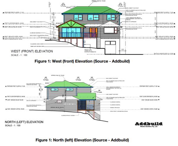
Figure 1: Extract from applicant’s Clause 4.6 written request.
Further to the figures provided by the applicant above, Council notes that the Section C-C Plan clearly details the overall height of the building;
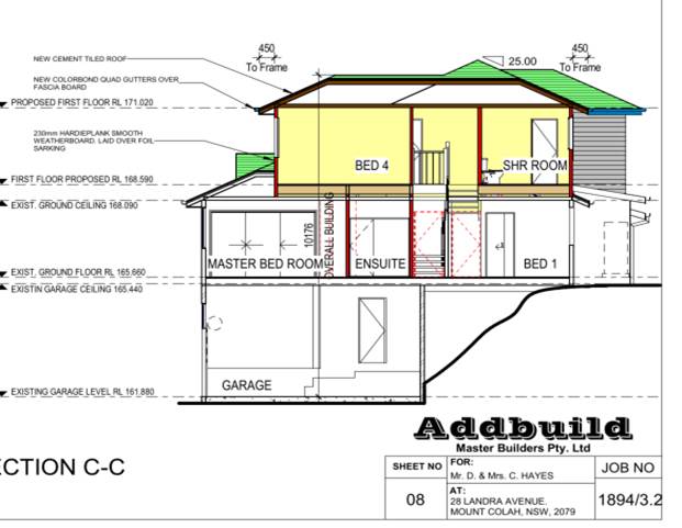
Figure 2: Section C-C showing overall building height.
The application has been assessed against the requirements of Clause 4.6 of the HLEP. This clause provides flexibility in the application of the development standards in circumstances where strict compliance with those standards would, in any particular case, be unreasonable or unnecessary or tender to hinder the attainment of the objectives of the zone. In particular, Clause 4.6 provides criteria that must be satisfied prior to a consent authority granting consent to development that contravenes a development standard. These criteria demonstrated under Clause 4.6(3) are as follows:
(a) That compliance with the development standard is unreasonable or unnecessary in the circumstances of the case, and;
(b) That there are sufficient environmental planning grounds to justify contravening the development standard.
A discussion regarding the criteria provided at Clause 4.6(3), with respect to the development application is provided below.
2.1.3.1 Unreasonable or Unnecessary Clause 4.6(3)(a)
There are five common methods by which an applicant can demonstrate that compliance with a development standards is unreasonable or unnecessary in the circumstances of the development. Initially proposed for objections under clause 6 of SEPP 1 in the decision of Wehbe v Pittwater Council [2007] NSWLEC 827 Pearson C summarised and applied these methods to written requests made under Clause 4.6 in Four2Five Pty Ltd v Ashfield Council [2015] NSWLEC 1009 [61-62]. These five methods are generally as follows:
· The objectives of the development standard are achieved notwithstanding non-compliance with the standard.
· The underlying objective or purpose is not relevant to the development.
· That the objective would be defeated or thwarted if compliance was required.
· That the development standard has been virtually abandoned or destroyed by the Council’s own actions in departing from the standard.
· The zoning of the land is unreasonable or inappropriate.
It is not required to demonstrate that a development meets multiple methods as listed above, and the satisfaction of one can be adequate to demonstrate that the development standard is unreasonable or unnecessary.
The written request prepared by Sky Town Planning, dated 14 December 2021 provides a detailed assessment of the proposal with respect to the development standard sought to be contravened. The request argues that the objectives of the development standard are achieved notwithstanding non-compliance with the standard in Part 6 of the document, providing reasoning as follows:
The proposed development seeks a minor variation to the height control for a portion of the addition as a result of the sites unique topography and existing garage.
The proposal has been designed to create a high-quality home that can comfortably accommodate a large family, and maximises the potential of the site while maintaining a residential scale that is appropriate for the low-density area. This is confirmed by the fact the proposal meets all other controls that limit bulk and scale including FSR, landscaped area and maximum site coverage, therefore demonstrating that this is a modest development.
Our opinion is that the relatively modest additional height proposed contributes to the delivery of a high quality and better functioning residence on the site. The proposed height variation realises the development potential of the site and provides a higher quality outcome than the alternative complying solution which would create an irregular development form as a result of having to mirror the unique angular topography in order to meet the height control.
It is clear that the objectives of the standard are able to be achieved, notwithstanding the additional height, and that a superior development outcome would result.
Council notes that the objectives of Clause 4.3 of the HLEP are as follows:
“to permit a height of buildings that is appropriate for the site constraints, development potential and infrastructure capacity of the locality.”
With reference to the reasoning provided by the applicant above, Council does not object to the conclusion that the proposed additions meet the objectives of Clause 4.3. In reaching this conclusion the following points are noted:
· The primary site constraint relating to the allotment is the significant fall from the rear of the site to the frontage with Landra Avenue. Placing further bulk within the existing building footprint is a logical response to this constraint and greatly reduces the environmental impacts of the proposed extension. The placement of further floor area within the building footprint reduces environmental impacts, reduces waste, reduces the requirement for extensive earthworks and protects slope stability with negligible additional impacts to adjoining properties.
· The lack of environmental impacts arising from the non-compliance with the development standard, and the largely compliant nature of the development when assessed against the relevant legislative and Hornsby Development Control Plan requirements (discussed in the body of this report) identifies that the site is suitable for this development.
· The proposed development would have negligible impact on the infrastructure capacity of the locality.
For the reasons outlined above, it is considered that the written request to contravene the height of building standard adequately demonstrates that the objectives of the height of buildings development standard contained within Clause 4.3 of the HLEP are achieved, notwithstanding non-compliance with the standard.
2.1.3.2 Environmental Planning Grounds - Clause 4.6(3)(b)
In addition to demonstrating that compliance is unreasonable or unnecessary, Clause 4.6(3)(b) requires that there are sufficient environmental planning grounds to justify contravening the development standard. In demonstrating that sufficient environmental planning grounds exist it must be demonstrated that the planning grounds are particular to the circumstances of the development on the subject site (summarised from Four2Five Pty Ltd v Ashfield Council [2015] NSWLEC 1009 [60].
The applicant provided the following planning grounds for the contravention of the development standard:
· The non-compliance arises solely as a result of the existing excavated garage and is only for the small portion of the first-floor addition that is site directly over the garage. The majority of the proposal complies with the height control.
· The proposed height variation provides a higher quality outcome than the alternative complying solution which would create an irregular development form as a result of having to mirror the unique angular topography.
· The request for the variation of 19.7% does not prevent compliance with all other LEP controls. All other controls that limit bulk and scale including FSR, landscaped area and maximum site coverage, therefore demonstrating that this is a modest development.
· The proposal is consistent with the objectives of the height standard, contained in Clause 4.3 of the LEP.
· The departure from the maximum height standard will not result in any significant adverse impact upon the amenity of the adjoining neighbours in terms of overshadowing, loss of privacy or views.
· The non-compliance is as a result of the sites unique topography and particular development history. No precedent will be set that would allow unjustified noncompliance with the standard in future applications.
· The proposed variation to the height standard does not conflict with any matters of State or regional environmental planning significance, nor does it conflict with any State Planning Policies or Ministerial directives. The significance of the non-compliance is acceptable in the context of the overall development of the broader Hornsby area.
· The public benefit would be best served by approval of the development application under consideration, given the absence of any demonstrable adverse impacts resulting from the proposal and that a higher quality outcome would be provided than the alternative complying solution.
Council’s further review of the environmental planning grounds presented by the applicant raises no points of contention, and it is considered that the consolidation of the building footprint to be a reasonable built environment outcome, both within the subject site, and to the adjoining residential development.
Council further notes that if the dwelling house were to be proposed as a single entity, with excavated garage and two floors above, the proposed residence would not contravene the height of buildings development standard. The technical non-compliance is a result of previous excavation and not the result of a building extending above natural ground level.
Council is therefore satisfied that Clause 4.6(3) of the HLEP is adequately addressed.
2.1.3.3 Public Interest and Clause 4.6(4)
Clause 4.6(4) states that development consent must not be granted for development that contravenes a development standard unless:
(a) The consent authority is satisfied that:
(i) The applicant’s written request has adequately addressed the matters required to be demonstrated by subclause (3).
(ii) The proposed development will be in the public interest because it is consistent with the objectives of the particular standard and the objectives for development within the zone in which the development is proposed to be carried out.
(b) The concurrence of the Planning Secretary has been obtained.
With regard to point (i), the written requests are considered to adequately address the matters required to be demonstrated as outlined above. With regard to point (ii), the proposed development is considered to be in the public interest because it is consistent with the objectives of the particular standard and the objectives for height of building contained within the HLEP. With regard to (b) the concurrence of the Planning Secretary has been obtained.
Therefore, the exceedance of the height of buildings development standard is supported in this instance.
2.1.4 Heritage Conservation
Clause 5.10 of the HLEP sets out heritage conservation provisions for Hornsby Shire. The site does not include a heritage item, is not located within the vicinity of a heritage listed item and is not located in a heritage conservation area. Accordingly, no further assessment regarding heritage is necessary.
2.1.5 Earthworks
Clause 6.2 of the HLEP states that consent is required for proposed earthworks on site. Before granting consent for earthworks, Council is required to assess the impacts of the works on adjoining properties, drainage patterns and soil stability of the locality.
Council’s assessment of the proposed works and excavation concludes that the proposed excavation works would be minor works undertaken for the purpose of the front facing balcony.
The proposed earth works are not considered to be of a form that would have a detrimental impact on environmental functions and processes, neighbouring uses, cultural or heritage items or features of the surrounding land.
2.2 State Environmental Planning Policy No. 55 Remediation of Land
The application has been assessed against the requirements of State Environmental Planning Policy No. 55 Remediation of Land (SEPP 55) under which consent must not be granted to the carrying out of any development on land unless the consent authority has considered whether the land is contaminated or requires remediation for the proposed use.
Should the land be contaminated, Council must be satisfied that the land is suitable in a contaminated state for the proposed use. If the land requires remediation to be undertaken to make the land suitable for the proposed use, Council must be satisfied that the land will be remediated before the land is used for that purpose.
An examination of Council’s records and aerial photography has determined that the site has been historically used for residential purposes. It is not likely that the site has experienced any significant contamination, and further assessment under SEPP 55 is not required.
2.3 State Environmental Planning Policy (Building Sustainability Index: BASIX) 2004
The application has been assessed against the requirements of State Environmental Planning Policy (Building Sustainability Index - BASIX) 2004. The proposal includes a BASIX Certificate for the proposed alterations and additions.
A condition is recommended in Schedule 1 of this report requiring the recommendations of the BASIX certificate be complied with.
2.4 State Environmental Planning Policy (Vegetation in non-rural areas) 2017
State Environmental Planning Policy (Vegetation in Non-Rural Areas) 2017 (Vegetation SEPP) aims to protect the biodiversity and amenity values of trees within non-rural areas of the state.
Part 3, Clause 9(2) of the Vegetation SEPP states that a Development Control Plan may make a declaration in any manner relating to species, size, location and presence of vegetation. Accordingly, Part 1B.6.1 of the Hornsby Development Control Plan 2013 (HDCP) prescribes works that can be undertaken with or without consent to trees and objectives for tree preservation.
The application has been assessed against the requirements of the Vegetation SEPP and it has been determined that the proposal would meet the objectives of the Vegetation SEPP. This matter is addressed in Section 3.1.1 of this report.
2.5 Sydney Regional Environmental Plan No. 20 Hawkesbury-Nepean River
The site is located within the catchment of the Hawkesbury Nepean River. Part 2 of this Plan contains general planning considerations and strategies requiring Council to consider the impacts of development on water quality, aquaculture, recreation and tourism.
Subject to the implementation of sediment and erosion control measures and stormwater management to protect water quality, the proposal would comply with the requirements of the Policy.
2.6 Adopted State Environmental Planning Policies
On 1 March 2022, the following State Environmental Planning Policies (SEPPS) applicable to the proposed development were gazetted:
· State Environmental Planning Policy (Biodiversity and Conservation) 2021
· State Environmental Planning Policy (Resilience and Hazards) 2021
These SEPPS now form matters for consideration under Section 4.15 of the Environmental Planning and Assessment Act 1979. However general savings provisions apply to development applications that have been made but not yet determined, on or before the commencement date of the above SEPPs.
As this development application was lodged on 17 December 2021, this development application is considered to have been made prior to the commencement date of the SEPPs. The newly adopted SEPPs have been considered as a matter for consideration under S4.15 of the Environmental Planning and Assessment Act 1979. However, the existing legislation, in force at time of lodgement of the development application, prevails to be extent of any inconsistency.
2.7 Section 3.42 Environmental Planning and Assessment Act 1979 - Purpose and Status of Development Control Plans
Section 3.42 of the Environmental Planning and Assessment Act 1979 states that a DCP provision will have no effect if it prevents or unreasonably restricts development that is otherwise permitted and complies with the development standards in relevant Local Environmental Plans and State Environmental Planning Policies.
The principal purpose of a development control plan is to provide guidance on the aims of any environmental planning instrument that applies to the development; facilitate development that is permissible under any such instrument; and achieve the objectives of land zones. The provisions contained in a DCP are not statutory requirements and are for guidance purposes only. Consent authorities have flexibility to consider innovative solutions when assessing development proposals, to assist achieve good planning outcomes.
2.8 Hornsby Development Control Plan 2013
The proposed development has been assessed having regard to the relevant desired outcomes and prescriptive requirements within the Hornsby Development Control Plan 2013 (HDCP). The following table sets out the proposal’s compliance with the prescriptive requirements of the Plan:
|
Hornsby Development Control Plan 2013 - Part 3.1 Dwelling Houses |
|||
|
Control |
Proposal |
Requirement |
Compliance |
|
Site Area |
697.5m2 |
N/A |
Yes |
|
Building Height |
10.17m |
8.5m |
No |
|
No. of storeys |
3 storeys |
2 storeys |
No |
|
Site Coverage |
16% |
50% |
Yes |
|
Floor Area |
219.5m2 |
380m2 |
Yes |
|
Setbacks |
|
|
|
|
- Front Setback (existing) |
7.6m |
7.6m |
Yes |
|
- Northern Side Setback |
|
|
|
|
- Ground Floor |
1.8m |
0.9m |
Yes |
|
- First Floor |
3m |
1.5m |
Yes |
|
- Southern Side Setback |
|
|
|
|
- Ground Floor |
0.9m |
0.9m |
Yes |
|
- First Floor |
1.3m |
1.5m |
No |
|
- Rear Setback |
|
|
|
|
- Ground Floor |
21m |
0.9m |
Yes |
|
- First Floor |
21m |
1.5m |
Yes |
|
Landscaped Areas (% of lot size) |
>50% |
30% |
Yes |
|
Private Open Space |
|
|
|
|
- Minimum area |
>24m |
24m |
Yes |
|
- Minimum dimension |
>3m |
3m |
Yes |
|
Car Parking |
2 spaces |
2 spaces |
Yes |
As detailed in the above table, the proposed development generally complies with a number of prescriptive requirements within the HDCP. The matters of non-compliance are detailed below, as well as a brief discussion on compliance with relevant desired outcomes.
2.8.1 Scale
The desired outcome of Part 3.1.1 Scale of the HDCP is for ‘Development with a height, bulk and scale that is compatible with a low-density residential environment’ with the prescriptive measure that dwellings houses are to have a maximum building height of 8.5 metres, with a maximum of 2 residential stories.
The proposed alterations and additions proposes a three-storey dwelling house with a maximum height of 10.17 metres.
As outlined in Part 2.1.3 of this report, the height of the proposal is considered to be compatible with the surrounding low-density environment and consistent with the objectives of Clause 4.3 of the HLEP.
With regard to the number of storeys, the proposed dwelling would be part 2 and part 3 storey in design. The 3-storey portion of the development comprises the first-floor addition that is located over the sub floor garage level. In support of this non-compliance the following is noted:
· The majority of the proposed development is of a compliant 2 storey design.
· The portion of the building that is 3 storeys is setback from the northern, front façade, which prevents a sheer façade design and softens the appearance of the 3-storey building portion.
· The non-compliance does not generate unacceptable streetscape impacts to the locality, and due to the topography of Landra Avenue and surrounding streets, there are numerous examples of buildings that appear elevated above the streetscape or of a 3-storey appearance.
· The 3-storey building portion does not generate unacceptable amenity impacts to adjoining residential development.
For the reasons listed above, it is considered that the development is of a height, bulk and scale that is compatible with the surrounding low density residential environment, and the proposal is consistent with the desired outcome of Part 3.1.1 Scale of the HDCP.
2.8.2 Setbacks
The desired outcomes of Part 3.1.2 Setbacks of the HDCP is for ‘Setbacks that are compatible with adjacent development and complement the streetscape’ and that ‘setbacks that allow for canopy trees to be retained and planted along front and rear property boundaries’ with the prescriptive measure that first floor building elements are to be setback 1.5 metres from side boundaries.
The proposed first floor addition would be setback 1.3 metres from the side boundary which does not comply with the prescriptive measure.
In support of this variation the following is noted;
· The 200mm variation would have negligible impact on the adjoining southern property in terms of overshadowing, privacy or amenity impacts that would arise as a result of the 200mm variation.
· The non-complaint first floor area is a result of the existing 1.3 metre building setback and the proposed first floor does not further encroach on the adjoining side setback.
· The non-compliant side setback would have negligible impact on the streetscape.
For the reasons outlined above, it is considered that the proposed southern side setback is compatible with adjacent development and would complement the streetscape. Consequently it is considered that the proposed development is consistent with the desired outcomes of Part 3.1.2 Setbacks of the HDCP and is acceptable.
2.8.3 Privacy
The desired outcome of Part 3.1.6 Privacy of the HDCP is for ‘Development that is designed to provide reasonable privacy to adjacent properties’ with the prescriptive measure that:
· Decks and the like that need to be located more than 600mm above existing ground should not face a window of another habitable room, balcony or private open space of another dwelling located within 9 metres of the proposed deck unless appropriately screened.
· Living and entertaining areas of dwelling houses should be located on the ground floor and oriented towards the private open space of the dwelling house and not side boundaries.
The proposed development includes a first floor sitting room which does not comply with the prescriptive measures of Part 3.1.6.
The first floor sitting room would be serviced by windows that face the front and rear boundary only and would not have any windows that would face the private open space or internal living area of any adjacent residential allotment. No objections are raised to the inclusion of this elevated living area.
With regard to the front facing ground floor balcony, it is noted that this structure would be elevated up to 2.2 metres above natural ground level. The north eastern facing side of the balcony would have views over the front setback of the adjoining property, No. 30 Landra Avenue. An aluminium privacy screen is proposed to be erected over approximately half of the north eastern balcony elevation. The portion of the balcony that would not have a privacy screen erected would have views over the front setback of No. 30 Landra Avenue only, which is not considered to generate an unacceptable privacy impact.
The proposed development is therefore considered to be consistent with the desired outcomes of Part 3.1.6 Privacy of the HDCP and is considered acceptable.
2.8.4 Sunlight and Ventilation
The desired outcomes of Part 3.1.5 Sunlight Access of the HDCP is that ‘Dwelling houses are designed to provide solar access to open space areas’ and that ‘Development is designed to provide reasonable sunlight to adjacent properties’ with the prescriptive measure that ‘On 22 June, 50 percent of the required principal private open space on any adjoining property should receive 3 hours of unobstructed sunlight access between 9am and 3pm.’
The proposed development includes shadow diagrams that indicate that overshadowing impacts would impact the adjoining south western property, No. 26 Landra Avenue. The bulk of the shadows generated by the development would be cast over the existing roof line of No. 26 Landra Avenue, with shadowing impacting the rear garden area of the adjoining allotment in the afternoon. The proposed development would not overshadow more than 50% of the required private open space, and more than 3 hours of unobstructed sunlight access would be enjoyed by the neighbouring property.
2.8.5 Vehicular Access and Parking
The HDCP prescribes that two parking spaces be made available on allotments with 3 or more bedrooms. The proposed development is compliant with this requirement, with one car space available in the exiting garage, and a further space available immediately in front of the garage.
2.9 Section 7.12 Contributions Plans
Hornsby Shire Council Section 7.12 Contributions Plan 2019-2029 applies to the development as the estimated costs of works is greater than $100,000. Should the application be approved, an appropriate condition of consent is recommended requiring the payment of a contribution in accordance with the Plan.
3. ENVIRONMENTAL IMPACTS
Section 4.15(1)(b) of the Act requires Council to consider “the likely impacts of that development, including environmental impacts on both the natural and built environments, and social and economic impacts in the locality”.
3.1 Natural Environment
3.1.1 Tree and Vegetation Preservation
The proposed development does not seek to remove any vegetation to facilitate the development. It is noted that two trees in the front of the site would be located in close proximity to the proposed works as depicted in yellow in Figure 3 below.

Firgure 3: Trees in the vicinty of the propsoed works (highlighted in yellow)
The larger tree located adjecnt to the front boundary is a large multi trunked native tree. The existing layout and topography of the front yard would adequatly separate this tree from the propsosed ground floor extension. The topography and an existing rock retaining wall would serve as an adequate barrier to this tree and consequently, no tree preservation measures are deemed necessary for this tree.
Subject to the imposition of conditions requiring that no materials be stored in the tree protection zone of trees on the subject site, no objections are raised to the propsoed development on tree preservation grounds.
3.1.2 Stormwater Management
The site slopes towards the front boundary with Landra Avenue. Stormwater can be disposed of to the street drainage system, via the existing stormwater system on site as minimal additional roof area is proposed. Appropriate conditions to this effect are recommended in Schedule 1 of this report.
3.2 Built Environment
3.2.1 Built Form
As discussed in the body of this report, the proposed development is considered to be of a built form that would be appropriate for the site, the streetscape and with minimal impacts to surrounding residential development.
3.2.2 Traffic
The proposed development would not increase traffic upon completion. Minor construction traffic would be required during the construction period. The existing form and layout of Landra Avenue would be able to cater for any required construction traffic.
3.3 Social Impacts
The development would have negligible social impact and would allow for the utilisation of an existing dwelling to meet the needs of the existing occupants.
3.4 Economic Impacts
The proposal would have a minor positive impact on the local economy in conjunction with other new low density residential development in the locality by generating an increase in demand for local services.
4. SITE SUITABILITY
Section 4.15(1)(c) of the Act requires Council to consider “the suitability of the site for the development”.
The subject site has not been identified as bushfire prone or flood prone land. The site is considered to be capable of accommodating the proposed development. The scale of the proposed development is consistent with the capability and constraints of the site and is considered acceptable.
5. PUBLIC PARTICIPATION
Section 4.15(1)(d) of the Act requires Council to consider “any submissions made in accordance with this Act”.
5.1 Community Consultation
The proposed development was placed on public exhibition and was notified to adjoining and nearby landowners between 24 December 2021 and 24 January 2022 in accordance with the Hornsby Community Engagement Plan. During this period, Council received 1 submission. The map below illustrates the location of those nearby landowners who made a submission that are in close proximity to the development site.
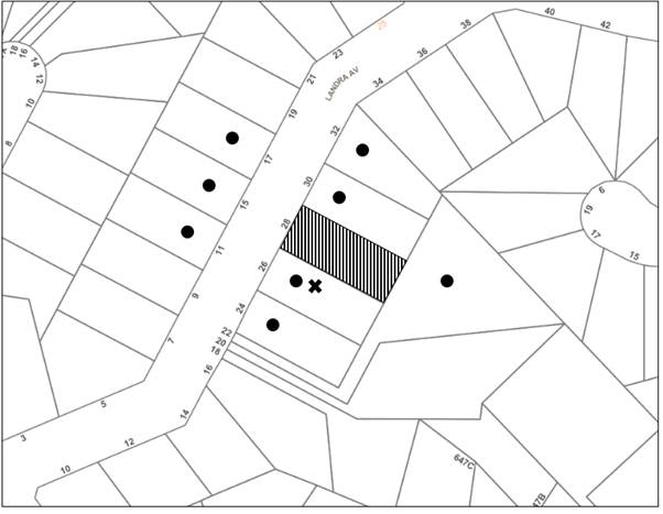
|
NOTIFICATION PLAN |
|||
|
• PROPERTIES NOTIFIED |
X SUBMISSIONS RECEIVED |
|
|
Council received 1 objection to the development, which raised concerns regarding shadowing of north-eastern facing windows of the adjoining property, No. 26 Landra Avenue.
Part 3.1.5 of the HDCP provides controls for sunlight access to principal private open space on adjoining property.
The supplied shadow plans show that shadows cast by the development would shade north-eastern facing windows of No. 26 Landra Avenue from 9am to 12pm, with shadows retreating sometime in the afternoon so that by 3pm, the windows are not shaded by the development. The Hornsby DCP does not include prescriptive controls for solar access to windows of adjoining properties and as such, no objections are raised to the shadowing impacts from the proposed development.
Overshadowing of open space areas is discussed in further detail in Section 2.7.4 of this report.
5.2 Public Agencies
The development application was not referred to any Public Agencies for comment.
6. THE PUBLIC INTEREST
Section 4.15(1)(e) of the Act requires Council to consider “the public interest”.
The public interest is an overarching requirement, which includes the consideration of the matters discussed in this report. Implicit to the public interest is the achievement of future built outcomes adequately responding to and respecting the future desired outcomes expressed in environmental planning instruments and development control plans.
The application is considered to have satisfactorily addressed Council’s and relevant agencies’ criteria and would provide a development outcome that, on balance, would result in a positive impact for the community. Accordingly, it is considered that approval of the proposed development would be in the public interest.
CONCLUSION
The application proposes the partial demolition and the construction of alterations and additions to a dwelling house.
The development generally meets the desired outcomes of Council’s planning controls and is satisfactory having regard to the matters for consideration under Section 4.15 of the Environmental Planning and Assessment Act 1979.
Council received one submission during the public notification period. The matters raised have been addressed in the body of the report.
Having regard to the circumstances of the case, approval of the application is recommended for approval.
The reasons for this decision are:
· The request under Clause 4.6 of Hornsby Local Environmental Plan 2013 to contravene the ‘Height of buildings’ development standard is well founded. Strict compliance with the development standard is considered unreasonable and unnecessary in the circumstances of the case and sufficient environmental planning grounds have been submitted to justify the contravention to the development standard.
· The proposed development generally complies with the requirements of the relevant environmental planning instruments and the Hornsby Development Control Plan 2013.
· The proposed development does not create unreasonable environmental impacts to adjoining development with regard to visual bulk, overshadowing, solar access, amenity or privacy.
Note: At the time of the completion of this planning report, no persons have made a Political Donations Disclosure Statement pursuant to Section 10.4 of the Environmental Planning and Assessment Act 1979 in respect of the subject planning application.
RESPONSIBLE OFFICER
The officer responsible for the preparation of this report is Ben Jones.
|
Cassandra Williams Major Development Manager - Development Assessments Planning and Compliance Division |
Rod Pickles Manager - Development Assessments Planning and Compliance Division |
|
1.⇩ |
Locality Plan |
|
|
|
2.⇩ |
Architectural Plans |
|
|
|
3.⇩ |
Shadow Plans |
|
|
|
4.⇩ |
Clause 4.6 |
|
|
File Reference: DA/1353/2021
Document Number: D08348352
GENERAL CONDITIONS
The conditions of consent within this notice of determination have been applied to ensure that the use of the land and/or building is carried out in such a manner that is consistent with the aims and objectives of the relevant legislation, planning instruments and council policies affecting the land and does not disrupt the amenity of the neighbourhood or impact upon the environment.
Note: For the purpose of this consent, the term ‘applicant’ means any person who has the authority to act on or the benefit of the development consent.
Note: For the purpose of this consent, any reference to an Act, Regulation, Australian Standard or publication by a public authority shall be taken to mean the gazetted Act or Regulation, or adopted Australian Standard or publication as in force on the date that the application for a construction certificate is made.
1. Approved Plans and Supporting Documentation
The development must be carried out in accordance with the plans and documentation listed below and endorsed with Council’s stamp, except where amended by Council and/or other conditions of this consent:
Approved Plans
|
Plan No. |
Plan Title |
Drawn by |
Dated |
Council Reference |
|
1894/3.2 Sheet 02 |
Site Plan |
Addbuild Master Builders |
07.12.21 |
|
|
1894/3.2 Sheet 04 |
Ground Floor – Proposed |
Addbuild Master Builders |
07.12.21 |
|
|
1894/3.2 Sheet 05 |
First Floor Proposed |
Addbuild Master Builders |
07.12.21 |
|
|
1894/3.2 Sheet 06 |
Elevations |
Addbuild Master Builders |
07.12.21 |
|
|
1894/3.2 Sheet 07 |
Elevations |
Addbuild Master Builders |
07.12.21 |
|
|
1894/3.2 Sheet 08 |
Sections |
Addbuild Master Builders |
07.12.21 |
|
Supporting Documentation
|
Document Title |
Prepared by |
Dated |
Council Reference |
|
Geotechnical Investigation Ref: 6675-G1 |
assetgeoenviro |
25/10/21 |
|
|
BASIX Certificate No. A424248 |
Addbuild Master Builder Pty Ltd |
28.10.21 |
D08318216 |
|
Waste Management Plan |
Addbuild |
27.10.21 |
D08318223 |
2. Construction Certificate
a) A Construction Certificate is required to be approved by Council or a Private Certifying Authority prior to the commencement of any construction works under this consent.
b) The Construction Certificate plans must be consistent with the Development Consent plans.
3. Section 7.12 Development Contributions
a) In accordance with Section 4.17(1) of the Environmental Planning and Assessment Act 1979 and the Hornsby Shire Council Section 7.12 Development Contributions Plan 2019 - 2029, $4,277.05 must be paid towards the provision, extension or augmentation of public amenities or public services, based on development costs of $427,708.00.
b) The value of this contribution is current as of 1 March 2022 If the contributions are not paid within the financial quarter that this consent is granted, the contributions payable will be adjusted in accordance with the provisions of the Hornsby Shire Council Section 7.12 Development Contributions Plan and the amount payable will be calculated at the time of payment in the following manner:
|
$CPY |
= |
|
|
$CDC x CPIPY |
|
|
|
|
|
CPIDC |
Where:
$CPY is the amount of the contribution at the date of Payment.
$CDC is the amount of the contribution as set out in this Development Consent.
CPIPY is the latest release of the Consumer Price Index (Sydney – All Groups) at the date of Payment as published by the ABS.
CPIDC is the Consumer Price Index (Sydney – All Groups) for the financial quarter at the date of this Development Consent.
c) The monetary contributions shall be paid to Council:
(i) Prior to the issue of the Subdivision Certificate where the development is for subdivision.
(ii) Prior to the issue of the first Construction Certificate where the development is for building work.
(iii) Prior to issue of the Subdivision Certificate or first Construction Certificate, whichever occurs first, where the development involves both subdivision and building work.
(iv) Prior to the works commencing where the development does not require a Construction Certificate or Subdivision Certificate.
Note: It is the professional responsibility of the Principal Certifying Authority to ensure that the monetary contributions have been paid to Council in accordance with the above timeframes.
Note: The Hornsby Shire Council Section 7.12 Development Contributions Plan may be viewed at www.hornsby.nsw.gov.au or a copy may be inspected at Council’s Administration Centre during normal business hours.
REQUIREMENTS PRIOR TO THE ISSUE OF A CONSTRUCTION CERTIFICATE
4. Building Code of Australia
Detailed plans, specifications and supporting information is required to be submitted to the certifying authority detailing how the proposed building work achieves compliance with the National Construction Code - Building Code of Australia. All building work must be carried out in accordance with the requirements of the National Construction Code - Building Code of Australia.
5. Contract of Insurance (Residential Building Work)
Where residential building work for which the Home Building Act 1989 requires there to be a contract of insurance in force in accordance with Part 6 of that Act, this contract of insurance must be in force before any building work authorised to be carried out by the consent commences.
6. Notification of Home Building Act 1989 Requirements
Residential building work within the meaning of the Home Building Act 1989 must not be carried out unless the principal certifying authority for the development to which the work relates (not being Council) has given Council written notice of the following information:
a) In the case of work for which a principal contractor is required to be appointed:
i) The name and licence number of the principal contractor.
ii) The name of the insurer by which the work is insured under Part 6 of that Act.
b) In the case of work to be done by an owner-builder:
i) The name of the owner-builder.
ii) If the owner-builder is required to hold an owner-builder’s permit under that Act, the number of the owner-builder’s permit.
Note: If arrangements for doing the residential building work are changed while the work is in progress so that the information notified becomes out of date, further work must not be carried out unless the principal certifying authority for the development to which the work relates (not being Council) has given Council written notification of the updated information.
7. Sydney Water – Approval
This application must be submitted to Sydney Water for approval to determine whether the development would affect any Sydney Water infrastructure, and whether further requirements are to be met.
Note: Building plan approvals can be obtained online via Sydney Water Tap inTM through www.sydneywater.com.au under the Building and Development tab.
8. Identification of Survey Marks
A registered surveyor must identify all survey marks in the vicinity of the proposed development. Any survey marks required to be removed or displaced as a result of the proposed development shall be undertaken by a registered surveyor in accordance with Section 24(1) of the Surveying and Spatial Information Act 2002 and following the Surveyor General’s Directions No.11 Preservation of Survey Infrastructure.
9. Stormwater Drainage – Dwellings
The stormwater drainage system for the development must be designed for an average recurrence interval (ARI) of 20 years and be gravity drained in accordance with the following requirements:
a) Connected directly to Council’s Street drainage system via the existing internal drainage system.
10. Geotechnical Design Requirements
a) The development shall be carried out in accordance with the requirements and recommendations of the preliminary Geotechnical Investigation Ref: 6675-G1 prepared by Asset Geotechnical Engineering Pty Ltd, dated 25 October 2021 and in accordance with further geotechnical assessment and advise to be provided during development and construction.
b) Structural design relating to the geotechnical aspects of the proposed development shall be checked and certified by a suitably qualified and experience Geotechnical Engineer as being in accordance with the geotechnical recommendations prior to issue of the Construction Certificate.
REQUIREMENTS PRIOR TO THE COMMENCEMENT OF ANY WORKS
11. Erection of Construction Sign
a) A sign must be erected in a prominent position on any site on which any approved work is being carried out:
i) Showing the name, address, and telephone number of the principal certifying authority for the work.
ii) Showing the name of the principal contractor (if any) for any demolition or building work and a telephone number on which that person may be contacted outside working hours.
iii) Stating that unauthorised entry to the work site is prohibited.
b) The sign is to be maintained while the approved work is being carried out and must be removed when the work has been completed.
12. Protection of Adjoining Areas
A temporary hoarding, fence or awning must be erected between the work site and adjoining lands before the works begin and must be kept in place until after the completion of the works if the works:
a) Could cause a danger, obstruction, or inconvenience to pedestrian or vehicular traffic.
b) Could cause damage to adjoining lands by falling objects.
c) Involve the enclosure of a public place or part of a public place.
d) Have been identified as requiring a temporary hoarding, fence, or awning within the Council approved Construction Management Plan (CMP).
Note: Notwithstanding the above, Council’s separate written approval is required prior to the erection of any structure or other obstruction on public land.
13. Toilet Facilities
a) To provide a safe and hygienic workplace, toilet facilities must be available or be installed at the works site before works begin and must be maintained until the works are completed at a ratio of one toilet for every 20 persons employed at the site.
b) Each toilet must:
i) Be a standard flushing toilet connected to a public sewer.
ii) Be a temporary chemical closet approved under the Local Government Act 1993.
iii) Have an on-site effluent disposal system approved under the Local Government Act 1993.
14. Erosion and Sediment Control
To protect the water quality of the downstream environment, erosion and sediment control measures must be provided and maintained throughout the construction period in accordance with the manual ‘Soils and Construction 2004 (Bluebook)’, the approved plans, Council specifications and to the satisfaction of the principal certifying authority. The erosion and sediment control devices must remain in place until the site has been stabilised and revegetated.
Note: On the spot penalties may be issued for any non-compliance with this requirement without any further notification or warning.
15. Garbage receptacle
a) A garbage receptacle must be provided at the work site before works begin and must be maintained until all works are completed.
b) The garbage receptacle must have a tight-fitting lid and be suitable for the reception of food scraps and papers.
c) The receptacle lid must be kept closed at all times, other than when garbage is being deposited.
d) Food scraps must be placed in the garbage receptacle and not in demolition and construction waste bins.
REQUIREMENTS DURING CONSTRUCTION
16. Construction Work Hours
All works on site, including demolition and earth works, must only occur between 7am and 5pm Monday to Saturday.
No work is to be undertaken on Sundays or public holidays.
17. Demolition
To protect the surrounding environment, all demolition work must be carried out in accordance with Australian Standard AS2601-2001 Demolition of structures and the following requirements:
a) Demolition material must be disposed of to an authorised recycling and/or waste disposal site and/or in accordance with an approved waste management plan.
b) Demolition works, where asbestos material is being removed, must be undertaken by a contractor that holds an appropriate licence issued by SafeWork NSW in accordance with the Work Health and Safety Regulation 2017 and be appropriately transported and disposed of in accordance with the Protection of the Environment Operations (Waste) Regulation 2014.
c) On construction sites where any building contain asbestos material, a standard commercially manufactured sign containing the words ‘DANGER ASBESTOS REMOVAL IN PROGRESS’ and measuring not less than 400mm x 300mm must be displayed in a prominent position visible from the street.
18. Environmental Management
To prevent sediment run-off, excessive dust, noise or odour emanating from the site during the construction, the site must be managed in accordance with the publication ‘Managing Urban Stormwater - Landcom (March 2004) and the Protection of the Environment Operations Act 1997.
19. Council Property
To ensure that the public reserve is kept in a clean, tidy and safe condition during construction works, no building materials, waste, machinery or related matter is to be stored on the road or footpath.
20. Disturbance of Existing Site
During construction works, the existing ground levels of open space areas and natural landscape features, including natural rock-outcrops, vegetation, soil and watercourses must not be altered unless otherwise nominated on the approved plans.
21. Landfill not Permitted
The importation of fill material associated with earthworks, or structural or engineering works, is not permitted as part of this consent.
22. Excavated Material
Any excavated material removed from the site must be classified by a suitably qualified environmental consultant in accordance with the NSW Environment Protection Authority’s Waste Classification Guidelines and Protection of the Environment Operations (Waste) Regulation 2014 prior to disposal to a licensed waste management facility. Tipping dockets for the total volume of excavated material that are received from the licensed waste management facility must be provided to the principal certifying authority prior to the issue of an Occupation Certificate.
23. Survey Report
A report(s) must be prepared by a registered surveyor and submitted to the principal certifying authority:
a) Prior to the pouring of concrete at each level of the building certifying that:
i) The building, retaining walls and the like have been correctly positioned on the site.
ii) The finished floor level(s) are in accordance with the approved plans.
24. Geotechnical Engineer Inspection
A suitably qualified and experience geotechnical engineer must carry out an inspection during construction at the following stages and provide certification to the principal certifying authority, to ensure that the requirements of the geotechnical report are followed:
a) Footing excavations shall be inspected prior to pouring concrete.
25. Waste Management
All work must be carried out in accordance with the approved waste management plan.
26. Maintenance of Public Footpaths
Public footpaths must be maintained for the duration of works to ensure they are free of trip hazards, displacements, breaks or debris to enable pedestrians to travel along the footpath safely.
27. Building Materials and Site Waste
The stockpiling of building materials, the parking of vehicles or plant, the disposal of cement slurry, waste water or other contaminants must be located outside the tree protection zones as prescribed in the conditions of this consent of any tree to be retained.
28. Ongoing management of the site/ structure
a) Surface and subsurface drains shall be maintained in good condition and shall be kept free of blockages and debris.
b) Inspection shall be carried out annually.
c) A record of inspections shall be kept on site.
REQUIREMENTS PRIOR TO THE ISSUE OF AN OCCUPATION CERTIFICATE
29. Fulfilment of BASIX Commitments
The applicant must demonstrate the fulfilment of BASIX commitments pertaining to the development.
30. Damage to Council Assets
To protect public property and infrastructure, any damage caused to Council’s assets as a result of the construction or demolition of the development must be rectified by the applicant in accordance with AUS-SPEC Specifications (www.hornsby.nsw.gov.au/property/build/aus-spec-terms-and-conditions). Rectification works must be undertaken prior to the issue of an Occupation Certificate, or sooner, as directed by Council.
- END OF CONDITIONS -
ADVISORY NOTES
The following information is provided for your assistance to ensure compliance with the Environmental Planning and Assessment Act, 1979, Environmental Planning and Assessment Regulation 2000, other relevant legislation and Council’s policies and specifications. This information does not form part of the conditions of development consent pursuant to Section 4.17 of the Act.
Environmental Planning and Assessment Act 1979 Requirements
The Environmental Planning and Assessment Act 1979 requires:
· The issue of a construction certificate prior to the commencement of any works. Enquiries can be made to Council’s Customer Services Branch on 9847 6760.
· A principal certifying authority to be nominated and Council notified of that appointment prior to the commencement of any works.
· Council to be given at least two days written notice prior to the commencement of any works.
· Mandatory inspections of nominated stages of the construction inspected.
· An occupation certificate to be issued before occupying any building or commencing the use of the land.
Long Service Levy
In accordance with Section 34 of the Building and Construction Industry Long Service Payments Act 1986, a ‘Long Service Levy’ must be paid to the Long Service Payments Corporation or Hornsby Council.
Note: The rate of the Long Service Levy is 0.35% of the total cost of the work.
Note: Hornsby Council requires the payment of the Long Service Levy prior to the issue of a construction certificate.
Tree and Vegetation Preservation
Hornsby Development Control Plan 2013 Tree and Vegetation Preservation provisions have been developed under Council’s authorities contained in State Environmental Planning Policy (Vegetation in Non-Rural Areas) 2017 and the Environmental Planning and Assessment Act 1979.
In accordance with these provisions a person must not cut down, fell, uproot, kill, poison, ringbark, burn or otherwise destroy the vegetation, lop or otherwise remove a substantial part of the trees or vegetation to which any such development control plan applies without the authority conferred by a development consent or a permit granted by Council.
Fines may be imposed for non-compliance with the Hornsby Development Control Plan 2013.
Note: A tree is defined as a long lived, woody perennial plant with one or relatively few main stems with the potential to grow to a height greater than three metres (3m). (HDCP 1B.6.1.c).
Prior to commencing any works, the applicant is encouraged to contact Dial Before You Dig on 1100 or www.dialbeforeyoudig.com.au for free information on potential underground pipes and cables within the vicinity of the development site.
Telecommunications Act 1997 (Commonwealth)
If you are aware of any works or proposed works which may affect or impact on Telstra’s assets in any way, you are required to contact:
Telstra’s Network Integrity Team on Phone Number 1800 810 443.
Asbestos Warning
Should asbestos or asbestos products be encountered during demolition or construction works, you are advised to seek advice and information prior to disturbing this material. It is recommended that a contractor holding an asbestos-handling permit (issued by SafeWork NSW) be engaged to manage the proper handling of this material. Further information regarding the safe handling and removal of asbestos can be found at:
LPP Report No. LPP18/22
Local Planning Panel
Date of Meeting: 30/03/2022
7 ELECTRONIC - DA/1374/2021 - CHANGE OF USE OF A SHED FOR THE PURPOSES OF A RURAL SUPPLIES BUSINESS - 377-389 GALSTON ROAD, GALSTON
EXECUTIVE SUMMARY
|
DA No: |
DA/1374/2021 (Lodged on 21 December 2021) |
|
Description: |
Change of use of a fruit packing shed to a rural supplies business |
|
Property: |
Lot 4 DP 1231874, No. 377-389 Galston Road, Galston |
|
Applicant: |
Mr Ryan Gill |
|
Owner: |
Mr John Bouchahine and Mrs Rozette Bouchahine |
|
Estimated Value: |
$20,000 |
|
Ward: |
A Ward |
· The application involves change of use from a fruit packing shed to a rural supplies business.
· The proposal complies with the relevant provisions of Hornsby Local Environmental Plan 2013 and Hornsby Development Control Plan 2013.
· No submissions have been received in respect of the application.
· The application is required to be determined by the Hornsby Council Local Planning Panel as the proposed rural supplies business is to be operated by a current Hornsby Shire Councillor. An independent assessment of the application has been conducted by Octagon Planning.
· It is recommended that the application be approved.
|
THAT Development Application No. DA/1374/2021 for the change of use of a fruit packing shed to a rural supplies business at Lot 4 DP 1231874, No. 377-389 Galston Road, Galston be approved subject to the conditions of consent detailed in Schedule 1 of LPP Report No. LPP18/22. |
ASSESSMENT
In accordance with the referral criteria and procedural requirements for Independent Hearing and Assessment Panels, the assessment of the development application has been referred to an independent town planning consultant as the proposed rural supplies business is to be operated by a current Hornsby Shire Councillor. The report by Octagon Planning is held at Attachment 1 of this report.
CONCLUSION
The application proposes the change of use of a fruit packing shed to a rural supplies business.
Council has referred the application to an independent planning consultancy to carry out an assessment of the application. The assessment concludes that the application should be approved.
It is recommended that the Hornsby Local Planning Panel approve the application in accordance with the recommendation in the report prepared by Octagon Planning and the conditions of consent held at Schedule 1 of this report.
The reasons for this decision are:
· The proposed development complies with the requirements of the relevant environmental planning instruments and the Hornsby Development Control Plan 2013.
· The proposed development is complementary to surrounding land uses and does not create unreasonable environmental impacts to adjoining development with regard to noise, traffic, parking.
Note: At the time of the completion of this planning report, no persons have made a Political Donations Disclosure Statement pursuant to Section 10.4 of the Environmental Planning and Assessment Act 1979 in respect of the subject planning application.
RESPONSIBLE OFFICER
The officer responsible for the preparation of this report is Nicola Neil from Octagon Planning.
|
Cassandra Williams Major Development Manager - Development Assessments Planning and Compliance Division |
Rod Pickles Manager - Development Assessments Planning and Compliance Division |
|
1.⇩ |
Locality Plan |
|
|
|
2.⇩ |
Consultant LPP Report |
|
|
|
3.⇩ |
Architectural Plans |
|
|
File Reference: DA/1374/2021
Document Number: D08358243
SCHEDULE 1
GENERAL CONDITIONS
The conditions of consent within this notice of determination have been applied to ensure that the use of the land and/or building is carried out in such a manner that is consistent with the aims and objectives of the relevant legislation, planning instruments and council policies affecting the land and does not disrupt the amenity of the neighbourhood or impact upon the environment.
Note: For the purpose of this consent, the term ‘applicant’ means any person who has the authority to act on or the benefit of the development consent.
Note: For the purpose of this consent, any reference to an Act, Regulation, Australian Standard or publication by a public authority shall be taken to mean the gazetted Act or Regulation, or adopted Australian Standard or publication as in force on the date that the application for a construction certificate is made.
1. Approved Plans and Supporting Documentation
The development must be carried out in accordance with the plans and documentation listed below and endorsed with Council’s stamp, except where amended by Council and/or other conditions of this consent:
|
Plan No. |
Plan Title |
Drawn by |
Dated |
Council Reference |
|
1 of 2 |
Site Plan |
Arcadian Designs |
October 2021 |
|
|
2 of 2 |
Ground Floor Plan |
Arcadian Designs |
October 2021 |
|
|
Document Title |
Prepared by |
Dated |
Council Reference |
|
Plumbing Inspection Letter |
Peter R Thomson Plumbing |
21.02.2022 |
D08358009 |
|
Wastewater System Diagram |
Arcadian Designs |
Undated |
D08354216 |
|
Waste Management Plan |
Balance Planning |
02.11.2021 |
D08320481 |
REQUIREMENTS PRIOR TO THE COMMENCEMENT OF ANY WORKS
2. Toilet Facilities
a) To provide a safe and hygienic workplace, toilet facilities must be available or be installed at the works site before works begin and must be maintained until the works are completed at a ratio of one toilet for every 20 persons employed at the site.
b) Each toilet must:
i) Be a temporary chemical closet approved under the Local Government Act 1993.
ii) Have an on-site effluent disposal system approved under the Local Government Act 1993.
3. Garbage receptacle
a) A garbage receptacle must be provided at the work site before works begin and must be maintained until all works are completed.
b) The garbage receptacle must have a tight-fitting lid and be suitable for the reception of food scraps and papers.
c) The receptacle lid must be kept closed at all times, other than when garbage is being deposited.
d) Food scraps must be placed in the garbage receptacle and not in demolition and construction waste bins.
REQUIREMENTS DURING FIT OUT WORKS
4. Internal Fit-out Construction Work Hours
a) All works on site involving the use of power tools must only occur between 7am and 5pm Monday to Saturday.
b) No work involving the use of power tools is to be undertaken on Sundays or public holidays.
5. Council Property
To ensure that the public reserve is kept in a clean, tidy and safe condition during construction works, no building materials, waste, machinery or related matter is to be stored on the road or footpath.
6. Disturbance of Existing Site
During construction works, the existing ground levels of open space areas and natural landscape features, including natural rock-outcrops, vegetation, soil and watercourses must not be altered unless otherwise nominated on the approved plans.
7. Maintenance of Public Footpaths
Public footpaths must be maintained for the duration of works to ensure they are free of trip hazards, displacements, breaks or debris to enable pedestrians to travel along the footpath safely.
8. Fire Safety Measures
To ensure the protection of persons using the building, upon completion of the fit out, fire extinguishers shall be installed complying with Australian Standard AS 2444 and E1.6 of the Building Code of Australia.
9. Fire Safety Statement – Final
Upon completion of the fit out, the owner must provide to Council with a certificate in relation to each fire safety measure implemented in the building.
OPERATIONAL CONDITIONS
10. Use of Premises
The development approved under this consent shall be used for a rural supplies business and not for any other purpose without Council’s separate written consent.
This consent does not permit the erection or display of any advertising signs.
12. Hours of Operation
a) The hours of operation of the premise are restricted to those times listed below:
Monday to Friday 7.30 am to 5.00 pm
Saturday, Sunday and Public Holidays 8.30 am to 1.00 pm
b) All deliveries must take place within the approved hours of operation.
13. Storage of Flammable and Combustible Goods
Flammable and combustible liquids must be stored in accordance with Australian Standard AS1940 Storage and handling of flammable and combustible liquids. A bund wall must be constructed around all work and liquid storage areas to prevent any spillage entering into the stormwater system. The bunded area must provide a volume equal to 110% of the largest container stored and graded to a blind sump so as to facilitate emptying and cleansing.
14. Noise – Plant and Machinery
a) The level of total continuous noise emanating from operation of all the plant, including air conditioning units and processes in all buildings (LA10) (measured for at least 15 minutes) in or on the above premises, must not exceed the background level by more than 5dB(A) when measured at all property boundaries.
b) An acoustic assessment is to be undertaken by a suitably qualified environmental consultant within 60 days of occupying the site in accordance with the Environment Protection Authority’s Noise Policy for Industry (2017), Council’s Policy and Guidelines for Noise and Vibration Generating Development (Acoustic Guidelines V.5, 2000) and the DECC’s Noise Guide for Local Government (2004). The assessment must be held on site for review by Council if necessary. Should the assessment find that noise from the premise exceeds 5dB(A) above background noise levels, appropriate measures must be employed to rectify excessive noise.
15. Fire Safety Statement – Annual
On at least one occasion in every 12 month period following the date of the first ‘Fire Safety Certificate’ issued for the property, the owner must provide Council with an annual ‘Fire Safety Certificate’ certifying each essential service installed in the building.
- END OF CONDITIONS -
ADVISORY NOTES
The following information is provided for your assistance to ensure compliance with the Environmental Planning and Assessment Act 1979, Environmental Planning and Assessment Regulation 2000, other relevant legislation and Council’s policies and specifications. This information does not form part of the conditions of development consent pursuant to Section 80A of the Act.
Environmental Planning and Assessment Act 1979 Requirements
The Environmental Planning and Assessment Act 1979 requires:
· The issue of a construction certificate prior to the commencement of any works. Enquiries can be made to Council’s Customer Services Branch on 9847 6760.
· A principal certifying authority to be nominated and Council notified of that appointment prior to the commencement of any works.
· Council to be given at least two days written notice prior to the commencement of any works.
· Mandatory inspections of nominated stages of the construction inspected.
· An occupation certificate to be issued before occupying any building or commencing the use of the land.
Long Service Levy
In accordance with Section 34 of the Building and Construction Industry Long Service Payments Act 1986, a ‘Long Service Levy’ must be paid to the Long Service Payments Corporation or Hornsby Council.
Note: The rate of the Long Service Levy is 0.35% of the total cost of the work.
Note: Hornsby Council requires the payment of the Long Service Levy prior to the issue of a construction certificate.
Tree and Vegetation Preservation
Hornsby Development Control Plan 2013 Tree and Vegetation Preservation provisions have been developed under Council’s authorities contained in State Environmental Planning Policy (Vegetation in Non-Rural Areas) 2017 and the Environmental Planning and Assessment Act 1979.
In accordance with these provisions a person must not cut down, fell, uproot, kill, poison, ringbark, burn or otherwise destroy the vegetation, lop or otherwise remove a substantial part of the trees or vegetation to which any such development control plan applies without the authority conferred by a development consent or a permit granted by Council.
Fines may be imposed for non-compliance with the Hornsby Development Control Plan 2013.
Note: A tree is defined as a long lived, woody perennial plant with one or relatively few main stems with the potential to grow to a height greater than three metres (3m). (HDCP 1B.6.1.c).
Disability Discrimination Act
The applicant’s attention is drawn to the existence of the Disability Discrimination Act 1992. A construction certificate is required to be obtained for the proposed building/s, which will provide consideration under the Building Code of Australia, however, the development may not comply with the requirements of the Disability Discrimination Act 1992. This is the sole responsibility of the applicant.
Covenants
The land upon which the subject building is to be constructed may be affected by restrictive covenants. Council issues this approval without enquiry as to whether any restrictive covenant affecting the land would be breached by the construction of the building, the subject of this consent. Applicants must rely on their own enquiries as to whether or not the building breaches any such covenant.
Advertising Signage – Separate DA Required
This consent does not permit the erection or display of any advertising signs. Most advertising signs or structures require development consent. Applicants should make separate enquiries with Council prior to erecting or displaying any advertising signage.
TfNSW Advisory Note
All buildings and structures together with any improvements integral to the future use of the site must be located wholly within the freehold property unlimited in height or depth along the Galston Road boundary.
LPP Report No. LPP19/22
Local Planning Panel
Date of Meeting: 30/03/2022
8 ELECTRONIC - REPORTING DEVELOPMENT APPLICATIONS FOR DETERMINATION BY THE HORNSBY LOCAL PLANNING PANEL OVER 180 DAYS
EXECUTIVE SUMMARY
· In accordance with the Local Planning Panels Directions - Operational Procedures, Council is required to monitor development applications to be determined by the Panel that may be experiencing unreasonable delays of over 180 days from lodgement.
· A list of out outstanding development applications in excess of 180 calendar days from lodgement is attached for the Hornsby Local Planning Panel’s advice.
|
THAT the contents of LPP Report No. LPP19/22 be received and noted. |
PURPOSE
The purpose of this report is to advise the Hornsby Local Planning Panel of development applications required to be determined by the Panel that are over 180 calendar days from lodgement.
DISCUSSION
In 2019 the NSW Productivity Commission conducted a review of the Independent Planning Commission (IPC). The review recommended several actions to streamline processes to optimise efficiency, output and performance.
The planning panel changes were implemented on 1 August 2020 to incorporate a number of the NSW Productivity Commission ‘s recommendations to the way Local Planning Panels work to make them more efficient and to improve the assessment and determination times of development applications and maintain panel oversight of sensitive and contentious applications.
These changes were made as part of the Planning Acceleration Program to support the State’s immediate and long-term economic recovery from the COVID-19 crisis.
The changes will speed up panel determinations by:
1. Reducing the need to conduct public panel meetings for non-contentious matters by applying a ‘10-or-more’ objection trigger for public meetings.
2. Reducing the amount of modifications going to panels.
3. Obliging panel chairs to more actively manage development applications (DAs) coming to the panels to reduce panel deferrals and assessment timeframes.
4. Allowing chairs to bring forward determination on DAs that are experiencing unreasonable delays of over 180 days from lodgement.
5. Introducing panel performance measures.
The Local Planning Panels Directions - Operational Procedures has been amended to:
· Require panels to make determinations within two weeks of being provided an assessment report.
· Require panels to hold a public meeting only where the Development Application has attracted 10 or more unique submissions by way of objection.
· Allow, at the Chair’s discretion, applicants to attend a briefing, along with council staff, to explain complex matters or present confidential or commercially sensitive material.
· Oblige panel chairs to work with council to ensure key issues are addressed during assessment in order to minimise deferrals by the panels at determination stage.
· Require the panels to provide reasons for deferring a decision and set timeframes in which any additional information must be provided in order to finalise the determination.
· Give panel chairs the ability to require council to report a DA to the panel within four weeks for determination if the application has experienced unreasonable delays in excess of 180 calendar days from lodgement.
In accordance with Point 6 of the Local Planning Panels Directions - Operational Procedures, attached is a list of development applications required to be determined by the Panel that are over 180 calendar days from lodgement.
CONCLUSION
Council is required to monitor development applications to be determined by the Panel that are over 180 calendar days from lodgement. This report provides advice to the Local Planning Panel on DAs that are experiencing unreasonable delays of over 180 days from lodgement.
RESPONSIBLE OFFICER
The officer responsible for the preparation of this report is the Major Development Manager, Cassandra Williams.
|
James Farrington Director - Planning and Compliance Planning and Compliance Division |
|
|
|
|
|
File Reference: F2013/00295-003
Document Number: D08363571