ELECTRONIC DETERMINATION BUSINESS PAPER
Local Planning Panel meeting
Wednesday 27 April 2022
at 4:00pm
ELECTRONIC DETERMINATION BUSINESS PAPER
Local Planning Panel meeting
Wednesday 27 April 2022
at 4:00pm
Hornsby Shire Council Table of Contents
Page 0
ITEMS
Item 2 LPP23/22 ELECTRONIC DA/1204/2021 - Alterations and Additions to a Heritage Listed Dwelling House and Landscaping Works - 29B Albert Road, Beecroft............................ 1
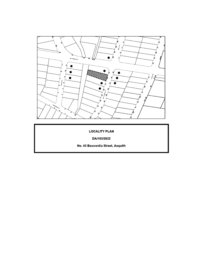
Item 3 LPP24/22 ELECTRONIC DA/103/2022 - Alterations and Additions to a Dwelling House - 43 Bouvardia Street, Asquith.......................................................................................... 42
Item 4 LPP27/22 ELECTRONIC - Reporting Development Applications for Determination by the Hornsby Local Planning Panel over 180 Days........................................................... 101
LPP Report No. LPP23/22
Local Planning Panel
Date of Meeting: 27/04/2022
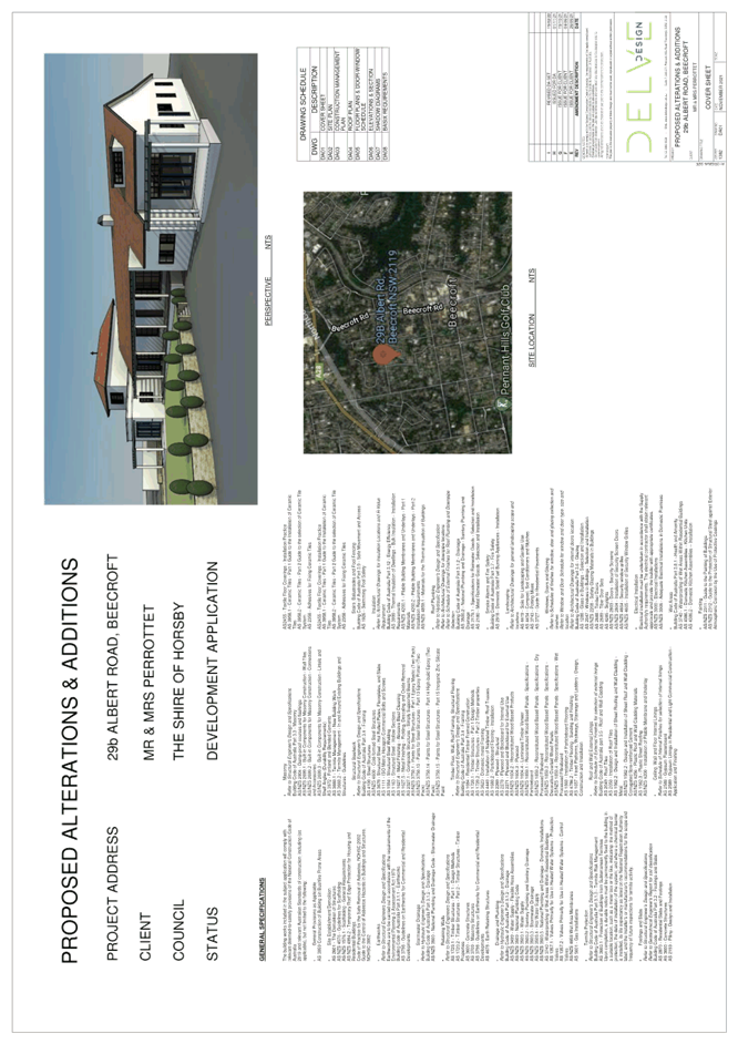
2 ELECTRONIC DA/1204/2021 - ALTERATIONS AND ADDITIONS TO A HERITAGE LISTED DWELLING HOUSE AND LANDSCAPING WORKS - 29B ALBERT ROAD, BEECROFT
EXECUTIVE SUMMARY
|
DA No: |
DA/1204/2021 (Lodged on 12 November 2021) |
|
Description: |
Alterations and additions to a heritage listed dwelling house and landscaping works |
|
Property: |
Lot 2 DP 1161695, No. 29B Albert Road, Beecroft |
|
Applicant: |
Delve Design |
|
Owner: |
Mrs Helen Siobhan Perrottet and Mr Dominic Francis Perrottet |
|
Estimated Value: |
$550,572 |
|
Ward: |
C Ward |
· The application involves alterations and additions to heritage listed dwelling house.
· The proposal complies with development standards of the Hornsby Local Environmental Plan 2013 and generally complies with the desired outcomes of the Hornsby Development Control Plan 2013.
· A total of two submissions have been received in respect of the application.
· The application is required to be determined by the Hornsby Council Local Planning Panel as the site is owned by a member of the Parliament of New South Wales.
· It is recommended that the application be approved.
|
THAT Development Application No. DA/1204/2021 for alterations and additions to a heritage listed dwelling house at Lot 2 DP 116169.5, No. 29B Albert Road, Beecroft be approved, subject to the conditions of consent detailed in Schedule 1 of LPP Report No. LPP23/2022. |
BACKGROUND
On 18 August 2021, Council provided pre-lodgement advice for alterations and additions to a heritage listed dwelling house.
On 23 December 2021, Council requested amended plans removing all structures within the easement for support that burdens the site, a cut and fill plan and an amended stormwater plan.
On 27 January 2022, Council received amended plans which did not address all the requirements of Council’s letter dated 23 December 2021.
On 9 February 202, Council requested amended plans to address Council’s letter dated 23 December 2021.
On 23 February 2022, Council received the amended plans.
On 29 March 2022, Council requested an amended stormwater plan relocating the proposed absorption trench outside the 1 in 100 year flood area that transects the north western portion of the site.
On 4 April 2022, Council received the amended stormwater plan.
On 24 April 2022, Council received an amended stormwater plan proposing the absorption trench with the raised landscaped area and a smaller absorption trench within the drainage easement/restriction on the use of land (overland flow path) which is subject to this assessment.
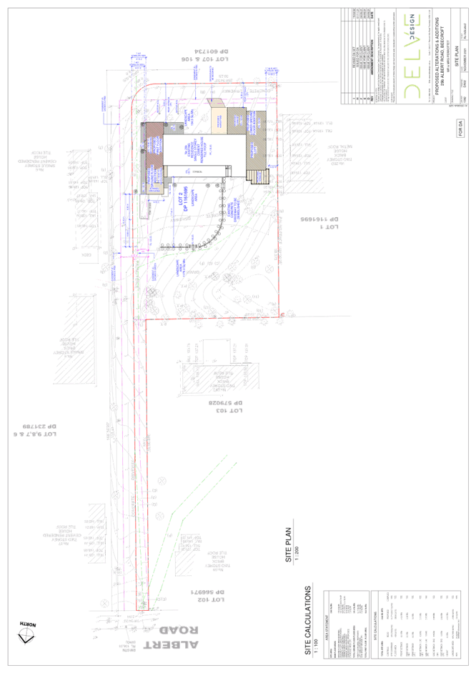
SITE
The 878.9m2 site is located on the southern side of Albert Road, Beecroft. The developable portion of the site experiences a fall of approximately 4 metres to the north western corner. The site is not bushfire prone.
The site is burdened by a right of carriageway, a drainage easement and a restriction on the use of the land. The site is mapped as containing an overland flow path within the north western corner of the site.
The subject site is listed as heritage listed item No. 35, namely House and Garden as listed under Schedule 5 of the Hornsby Local Environmental Plan 2013. The is also located within the within the Beecroft/Cheltenham (Beecroft North precinct) Heritage Conservation Area.
PROPOSAL
The application proposes alterations and additions to a heritage listed dwelling house as follows:
· Demolition of existing driveway within the front yard.
· Construction of a hardstand car parking space to the rear of the site.
· Construction of a double storey wing addition to the eastern side of the dwelling house comprising of an entry wall, guest bedroom, library and internal stairwell within the ground floor and a master bedroom and ensuite within the first floor.
· Construction of a single storey wing addition to the western side of the dwelling comprising of two bedrooms, a bathroom, a kitchen, living room, and garage. An unassigned room would also be located within the roof space of this proposed addition.
· Retaining walls and landscaping is proposed to the front yard of the property.
· Construction of retaining walls and a fence along the eastern side of the property.
· A cross would be located on the roof of the eastern wing addition.
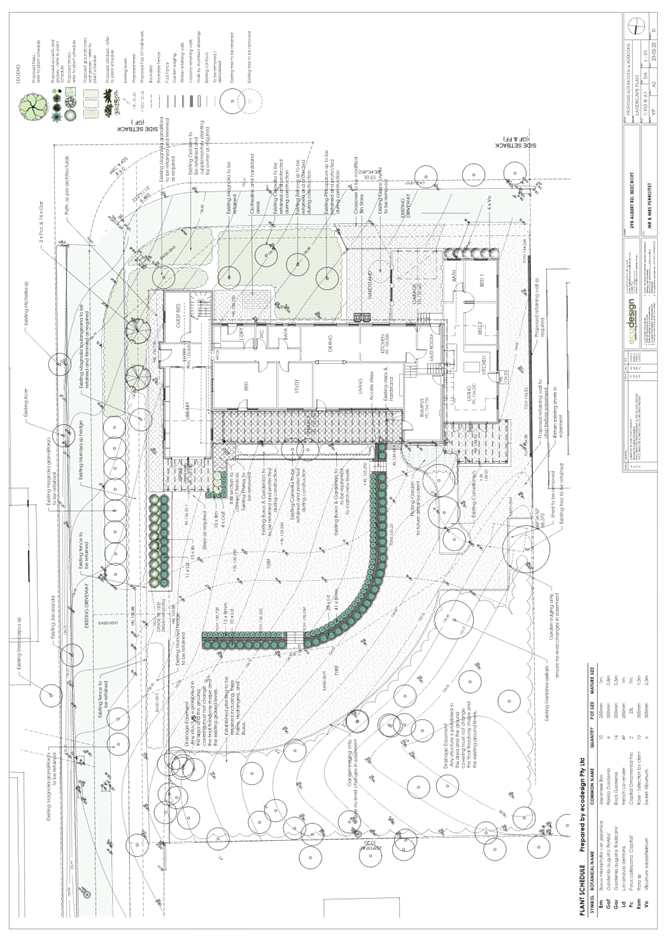
· Four trees would be removed as part of this development.
ASSESSMENT
The development application has been assessed having regard to the Greater Sydney Region Plan – A Metropolis of Three Cities, the North District Plan and the matters for consideration prescribed under Section 4.15 of the Environmental Planning and Assessment Act 1979 (the Act). The following issues have been identified for further consideration.
1. STRATEGIC CONTEXT
1.1 Greater Sydney Region Plan - A Metropolis of Three Cities and North District Plan
The Greater Sydney Region Plan - A Metropolis of Three Cities has been prepared by the NSW State Government to guide land use planning decisions for the next 40 years (to 2056). The Plan sets a strategy and actions for accommodating Sydney’s future population growth and identifies dwelling targets to ensure supply meets demand. The Plan also identifies that the most suitable areas for new housing are in locations close to jobs, public transport, community facilities and services.
The NSW Government will use the subregional planning process to define objectives and set goals for job creation, housing supply and choice in each subregion. Hornsby Shire has been grouped with Hunters Hill, Ku-ring-gai, Lane Cove, Mosman, North Sydney, Ryde, Northern Beaches and Willoughby to form the North District. The Greater Sydney Commission has released the North District Plan which includes priorities and actions for Northern District for the next 20 years. The identified challenge for Hornsby Shire will be to provide an additional 4,350 dwellings by 2021 with further strategic supply targets to be identified to deliver 97,000 additional dwellings in the North District by 2036.
The proposed development would be consistent with the Greater Sydney Region Plan - A Metropolis of Three Cities and the North District Plan.
2. STATUTORY CONTROLS
Section 4.15(1)(a) requires Council to consider “any relevant environmental planning instruments, draft environmental planning instruments, development control plans, planning agreements and regulations”.
2.1 Hornsby Local Environmental Plan 2013
The proposed development has been assessed having regard to the provisions of the Hornsby Local Environmental Plan 2013 (HLEP).
2.1.1 Zoning of Land and Permissibility
The subject land is zoned R2 Low density residential under the HLEP. The objectives of the R2 zone are:
· To provide for the housing needs of the community within a low-density residential environment.
· To enable other land uses that provide facilities or services to meet the day to day needs of residents.
The proposed development is defined as a dwelling house and is permissible in the zone with Council’s consent.
2.1.2 Height of Buildings
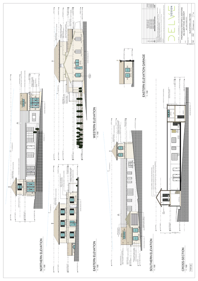
Clause 4.3 of the HLEP provides that the height of a building on any land should not exceed the maximum height show for the land on the Height of Buildings Map. The maximum permissible height for the subject site is 8.5 metres. The proposal complies with this provision. It is noted that the application proposes a cross above the eastern wing addition which complies with the 8.5 metre building height provision.
2.1.3 Heritage Conservation
Clause 5.10 of the HLEP sets out heritage conservation provisions for Hornsby Shire.
The subject property is listed as a heritage item and located within the Beecroft North Precinct of the Beecroft Cheltenham Heritage Conservation Area (HCA), listed under Schedule 5 of the HLEP. There are no other heritage items within the vicinity.
The house and garden are locally significant as an intact example of a modest Leslie Wilkinson architect designed residence (constructed in 1953) and garden designed by the original owner, Mrs Pym, with the assistance of the locally renowned Swane family of Swane's Nursery.
The application includes a Heritage Impact Statement (HIS) prepared by Coronal Projects, dated 1 August 2021. The proposed alterations and additions are considered acceptable as it is a high-quality design and has been proven within the supporting HIS to achieve the desired outcomes of the HDCP. It has been justified to sensitively respond, respect, and sympathise with the heritage significance and orientational constraints of the site. The application proposes a cross on the roof of the eastern wing addition. It is generally considered that this cross would not detract from the heritage significance of the heritage listed item.
Conditions are recommended in Schedule 1 of this report requiring the appointment of a nominated heritage consultant and that a photographic record of the heritage listed property be submitted prior to the issue of the Construction Certificate.
2.1.4 Earthworks
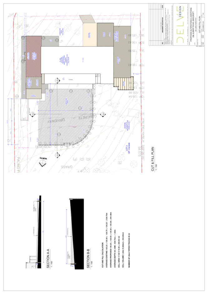
Clause 6.2 of the HLEP states that consent is required for proposed earthworks on site. Before granting consent for earthworks, Council is required to assess the impacts of the works on adjoining properties, drainage patterns and soil stability of the locality.
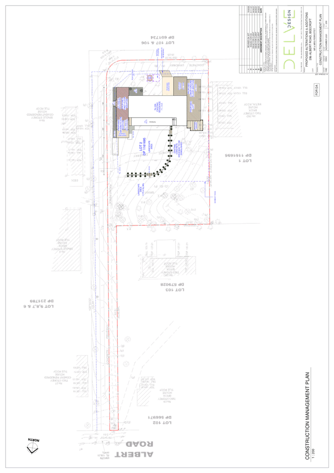
The application proposes the construction of retaining walls and fill to the front of the dwelling house ranging in height from 0.32 metres to 1 metre of fill. At Council’s request the applicant provided a cut and fill plan which estimated that a total of 443m3 which requires approximately 23x 20m3 tipper trucks to access the site to provide the required fill.
No objections are raised on environmental grounds to the proposed levelling of the site to the front of the dwelling house as this would provide a levelled private open space for the occupants of the dwelling house. it is also noted that the proposed retaining walls and fill would be entirely located outside the 1 in 100 year overland flow.
Conditions are recommended in Schedule 1 of this report requiring the fill be Virgin Excavated Natural Material (VENM), the retaining walls be constructed prior to the issue of an occupation certificate and a Construction and Traffic Management Plan (CTMP) be prepared by a suitably qualified environmental consultant in consultation with a qualified traffic engineer and AQF 5 arborist and submitted for council approval prior to issue of the construction certificate.
The CTMP is required due to the amount of fill proposed to be imported onto the site and the number of tipper trucks required to import the fill. Due to the number of trucks and the amount of fill to be imported to the site, a dilapidation report is required to be prepared by a chartered structural engineer detailing the structural condition of the driveway that services the subject site and adjoining properties.
Council’s assessment of the proposed works concludes that the proposed importation of fill is considered acceptable, subject to conditions.
2.2 State Environmental Planning Policy (Exempt and Complying Development Codes) 2008
The application has been considered against the requirements of State Environmental Planning Policy (Exempt and Complying Development Codes) 2008 (NSW Housing Code). The Policy provides exempt and complying development codes that have State-wide application. The Policy also identifies types of development that are of minimal environmental impact that may be carried out without the need for development consent and types of Complying Development (including dwelling houses) that may be carried out in accordance with a Complying Development Certificate.
The site is a heritage listed property which precludes the development from being approved as Complying Development. The proposed dwelling house additions would otherwise comply with the numerical standards for complying development contained within the NSW Housing Code.
2.3 State Environmental Planning Policy No. 55 Remediation of Land
The policy provides guidelines for the remediation of contaminated land for the purpose of reducing the risk of harm to human health or any other aspect of the environment. Clause 7 requires Council to consider whether land is contaminated prior to granting consent to the carrying out of any development on that land.
Should the land be contaminated, Council must be satisfied that the land is suitable in a contaminated state for the proposed use. If the land requires remediation to be undertaken to make the land suitable for the proposed use, Council must be satisfied that the land will be remediated before the land is used for that purpose.
A review of Council’s records and aerial photographs indicate that the site has been historically used for residential purposes. It is not likely that the site has experienced any significant contamination, and further assessment under SEPP 55 is not required.
2.4 State Environmental Planning Policy (Building Sustainability Index: BASIX) 2004
The application has been assessed against the requirements of State Environmental Planning Policy (Building Sustainability Index: BASIX) 2004. The proposal includes a BASIX Certificate for the proposed alterations and additions to a dwelling house, which is considered to be satisfactory. A condition is recommended in Schedule 1 of this report requiring the recommendations of the BASIX certificate be complied with.
2.5 State Environmental Planning Policy (Vegetation in non-rural areas) 2017
The application has been assessed against the requirements of State Environmental Planning Policy (Vegetation in Non-Rural Areas) 2017 (Vegetation SEPP). This Policy seeks to protect the biodiversity values of trees and other vegetation in non-rural areas of the State, and to preserve the amenity of non-rural areas of the State through the preservation of trees and other vegetation.
Part 3 of the Vegetation SEPP states that a development control plan may make a declaration in any manner relating to species, size, location and presence of vegetation. Accordingly, Part 1B.6.1 of the Hornsby Development Control Plan 2013 (HDCP) prescribes works that can be undertaken with or without consent to trees.
2.6 Sydney Regional Environmental Plan (Sydney Harbour Catchment) 2005
The application has been assessed against the requirements of Sydney Regional Environmental Plan (Sydney Harbour Catchment) 2005. This Policy provides general planning considerations and strategies to ensure that the catchment, foreshores, waterways and islands of Sydney Harbour are recognised, protected, enhanced and maintained.
Subject to the implementation of installation of sediment and erosion control measures and stormwater management to protect water quality, the proposal would have minimal potential to impact on the Sydney Harbour Catchment.
2.7 Section 3.42 Environmental Planning and Assessment Act 1979 - Purpose and Status of Development Control Plans
Section 3.42 of the Environmental Planning and Assessment Act 1979 states that a DCP provision will have no effect if it prevents or unreasonably restricts development that is otherwise permitted and complies with the development standards in relevant Local Environmental Plans and State Environmental Planning Policies.
The principal purpose of a development control plan is to provide guidance on the aims of any environmental planning instrument that applies to the development; facilitate development that is permissible under any such instrument; and achieve the objectives of land zones. The provisions contained in a DCP are not statutory requirements and are for guidance purposes only. Consent authorities have flexibility to consider innovative solutions when assessing development proposals, to assist achieve good planning outcomes.
2.8 Hornsby Development Control Plan 2013
The proposed development has been assessed having regard to the relevant desired outcomes and prescriptive requirements within the Hornsby Development Control Plan 2013 (HDCP). The following table sets out the proposal’s compliance with the prescriptive requirements of the Plan:
|
HDCP - Part 3.1 Dwelling Houses |
|||
|
Control |
Proposal |
Requirement |
Complies |
|
Site Area |
2,110m2 |
N/A |
N/A |
|
Building Height |
7.44m |
8.5m |
Yes |
|
No. Storeys |
2 |
max. 2 + attic |
Yes |
|
Site Coverage |
16% |
30% |
Yes |
|
Floor Area |
372m2 |
430m2 |
Yes |
|
Setbacks |
|
|
|
|
- Side (north) |
31m |
0.9m |
Yes |
|
- Side (east) |
|
|
|
|
Ground floor |
3.1m |
0.9m |
Yes |
|
First floor |
3.51m |
1.5m |
Yes |
|
- Side (west) |
|
|
|
|
Ground floor |
2.69m |
0.9m |
Yes |
|
First floor |
2.69m |
1.5m |
Yes |
|
- Rear (south) |
|
|
|
|
Ground floor |
6m |
3m |
Yes |
|
First floor |
9.66m |
8m |
Yes |
|
Landscaped Area (% of lot size) |
54% |
45% |
Yes |
|
Private Open Space |
|
|
|
|
- minimum area |
48m2 |
24m2 |
Yes |
|
- minimum dimension |
3m |
3m |
Yes |
|
Car Parking |
2 spaces |
2 spaces |
Yes |
2.8.1 Privacy
Under Section 3.1.6 of HDCP, living and entertaining areas should be located on the ground floor and oriented towards the private open space of the dwelling and not side boundaries. The proposal complies, with all living areas located on the ground floor.
It is noted that the application does not propose any windows that would allow overlooking into the private open space of adjoining properties, and it is generally considered that the proposed development would result in minimal privacy impacts to adjoining properties.
It is noted that a submission was received which raised concerns with regard to the proposed windows within the western elevation. In response to this submission, it is noted that these windows service the ground floor level and comply with Council’s requirements for privacy. Therefore no privacy mitigation measures are required for these windows.
The application complies with the desired outcomes of Part 3.1.6 Privacy of the HDCP and is considered acceptable.
2.8.2 Sunlight Access
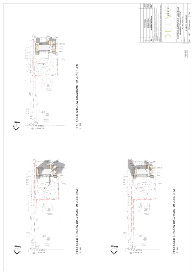
The desired outcomes of Part 3.1.5 Sunlight Access of the HDCP is to encourage “dwelling houses designed to provide solar access to open space areas” and “development designed to provide reasonable sunlight to adjacent properties”.
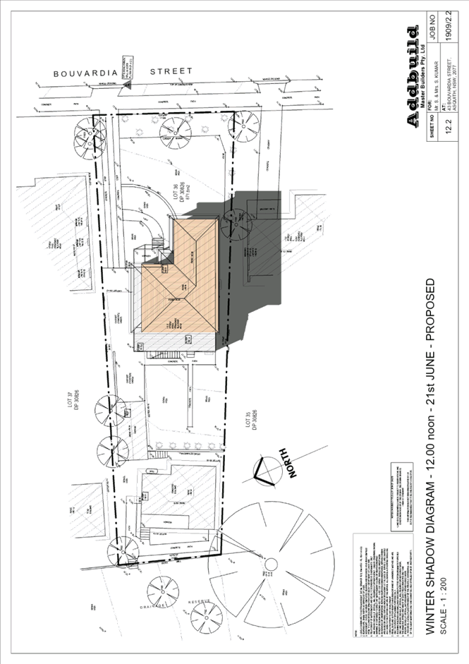
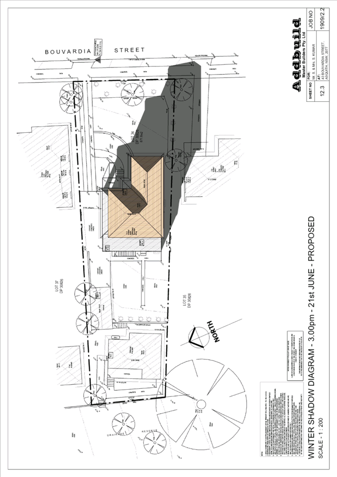
This is supported by the prescriptive measure 3.1.5(a) requiring “50 per cent of the principal private open space of the subject site to receive at least 3 hours of unobstructed sunlight access between 9am and 3pm” during the day of the winter solstice and prescriptive measure 3.1.5(b) requiring “50 per cent of the principal private open space on any adjoining property to receive at least 3 hours of unobstructed sunlight access between 9am and 3pm.”
An assessment of the shadow diagrams provided by the applicant illustrate that the subject site and the adjoining properties No. 29, 29A and 29D Albert Road, would receive at least 3 hours of unobstructed sunlight access to 50 per cent of their private open space between 9am and 3pm on the day of the winter solstice.
The proposal meets the desired outcomes of Part 3.1.5 Sunlight Access of the HDCP and is considered acceptable.
2.8.3 Vehicular Access and Parking
The application proposes the demolition of the existing driveway to the front of the existing dwelling house. The application proposes the construction of a single garage and hard stand car parking space to the rear of the dwelling house to provide the required 2 car parking spaces.
No objections are raised to the proposed car parking arrangement, subject to appropriate conditions regarding turning circles the hardstand car parking space.
2.9 Section 7.12 Contributions Plans
Hornsby Shire Council Section 7.12 Contributions Plan 2019-2029 applies to the development as the estimated costs of works is greater than $100,000. Should the application be approved, an appropriate condition of consent is recommended requiring the payment of a contribution in accordance with the Plan.
3. ENVIRONMENTAL IMPACTS
Section 4.15(1)(b) of the Act requires Council to consider “the likely impacts of that development, including environmental impacts on both the natural and built environments, and social and economic impacts in the locality”.
3.1 Natural Environment
3.1.1 Tree and Vegetation Preservation
The application has been supported by an Arborist report prepared by Arboreport, dated 7 October 2021 which identified 8 trees within the vicinity of the proposed development. These trees are numbered T1 to T8 inclusively.
The application proposes the removal of 4 trees numbered T1, T2, T3 and T6 as these trees would be located within close proximity to the proposed development. It is noted that these trees are all considered low significance value.
No objections are raised on environmental grounds to the removal of these trees, subject to a condition requiring the replacement planting of 5 trees within the northern portion of the site.
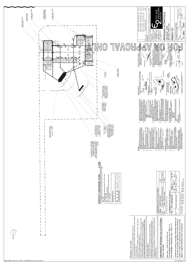
3.1.2 Stormwater Management
The application originally proposed all stormwater be directed to an absorption trench located within the overland flow path that burdens the property. Council requested an amended stormwater plan relocating the entire absorption trench outside the drainage easement/restriction as to the use of land (overland flow path). The applicant provided an amended stormwater plan proposing an absorption trench within the raised landscaped area and a smaller absorption trench within the restriction on the use of land (overland flow path) area.
As Council does not support the absorption trench within the drainage easement/restriction as to the use of land (overland flow path), a condition is recommended in Schedule 1 of this report requiring an amended stormwater plan relocating the absorption trench to be entirely within the raised landscaped area of the site.
Subject to this condition, no objections are raised on engineering grounds to the proposal.
3.2 Built Environment
3.2.1 Built Form
The proposal would generally be consistent with the built form of the surrounding low-density residential area which consists of dwelling houses ranging from single storey, split level, two storey and three storeys with excavated garages.
3.3 Social Impacts
The residential development would improve housing choice in the locality by providing a range of house hold types. This is consistent with Council’s Housing Strategy which identifies the need to provide a mix of housing options to meet future demographic needs in Hornsby Shire.
3.4 Economic Impacts
The proposal would have a minor positive impact on the local economy in conjunction with other new low-density residential development in the locality by generating an increase in demand for local services.
4. SITE SUITABILITY
Section 4.15(1)(c) of the Act requires Council to consider “the suitability of the site for the development”.
4.1 Flooding
The site is mapped as containing a drainage easement/restriction on the use of land (overland flow path) within the north-western corner of the site.
In assessing the proposed development, it is noted that the application does not propose any structures within the overland flow path. Furthermore, as discussed in Section 3.1.2 of this report, a condition is recommended in Schedule 1 of this report requiring the absorption trench be located entirely outside the drainage easement/restriction on the use of land (overland flow path). Subject to this condition, no objections are raised on engineering grounds to flooding.
5. PUBLIC PARTICIPATION
Section 4.15(1)(d) of the Act requires Council to consider “any submissions made in accordance with this Act”.
5.1 Community Consultation
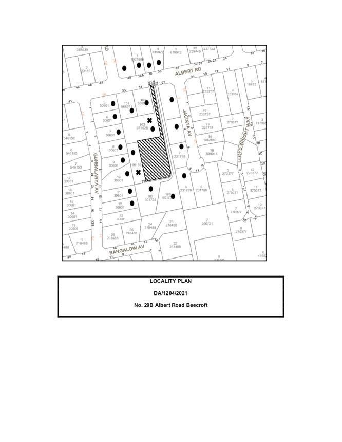
The proposed development was placed on public exhibition and was notified to adjoining and nearby landowners between 16 November 2021 and 9 December 2021 in accordance with the Hornsby Community Engagement Plan. During this period, 2 submissions were received. The map below illustrates the location of those nearby landowners who made a submission that are in close proximity to the development site.
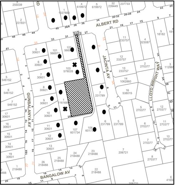
|
NOTIFICATION PLAN |
|||
|
• PROPERTIES NOTIFIED |
X SUBMISSIONS RECEIVED |
|
|
Two submissions objected to the development, generally on the grounds that the development would result in:
· Unacceptable overshadowing of adjoining properties.
· Unacceptable privacy impacts.
· Impeded access to adjoining properties.
· Damage to shared driveway.
· Damage to trees along shared driveway.
The merits of the matters raised in community submissions have been addressed in the body of the report with the exception of the following:
5.1.1 Impeded Access to adjoining properties
The submission raised concerns that adjoining properties would have their access impeded by the proposed development.
In response to this submission, it is noted that the proposed development is located entirely within the subject site and would not restrict any right of carriageway.
5.2 Public Agencies
The development application was not referred to any Public Agencies for comment.
6. THE PUBLIC INTEREST
Section 4.15(1)(e) of the Act requires Council to consider “the public interest”.
The public interest is an overarching requirement, which includes the consideration of the matters discussed in this report. Implicit to the public interest is the achievement of future built outcomes adequately responding to and respecting the future desired outcomes expressed in environmental planning instruments and development control plans.
The application is considered to have satisfactorily addressed Council’s and relevant agencies’ criteria and would provide a development outcome that, on balance, would result in a positive impact for the community. Accordingly, it is considered that the approval of the proposed development would be in the public interest.
CONCLUSION
The application proposes alterations and additions to a heritage listed dwelling.
The development generally meets the desired outcomes of Council’s planning controls and is satisfactory having regard to the matters for consideration under Section 4.15 of the Environmental Planning and Assessment Act 1979.
Council received 2 submissions during the public notification period. The matters raised have been addressed in the body of the report.
Having regard to the circumstances of the case, approval of the application is recommended.
The reasons for this decision are:
· The proposed development complies with the requirements of the relevant environmental planning instruments and the Hornsby Development Control Plan 2013.
· The proposed development does not create unreasonable environmental impacts to adjoining development with regard to visual bulk, overshadowing, solar access, amenity or privacy.
Note: At the time of the completion of this planning report, no persons have made a Political Donations Disclosure Statement pursuant to Section 10.4 of the Environmental Planning and Assessment Act 1979 in respect of the subject planning application.
RESPONSIBLE OFFICER
The officer responsible for the preparation of this report is Tim Buwalda
|
Cassandra Williams Major Development Manager - Development Assessments Planning and Compliance Division |
Rod Pickles Manager - Development Assessments Planning and Compliance Division |
|
|
|
|
File Reference: DA/1204/2021
Document Number: D08377226
SCHEDULE 1
GENERAL CONDITIONS
The conditions of consent within this notice of determination have been applied to ensure that the use of the land and/or building is carried out in such a manner that is consistent with the aims and objectives of the relevant legislation, planning instruments and council policies affecting the land and does not disrupt the amenity of the neighbourhood or impact upon the environment.
Note: For the purpose of this consent, the term ‘applicant’ means any person who has the authority to act on or the benefit of the development consent.
Note: For the purpose of this consent, any reference to an Act, Regulation, Australian Standard or publication by a public authority shall be taken to mean the gazetted Act or Regulation, or adopted Australian Standard or publication as in force on the date that the application for a construction certificate is made.
1. Approved Plans and Supporting Documentation
The development must be carried out in accordance with the plans and documentation listed below and endorsed with Council’s stamp, except where amended by Council and/or other conditions of this consent:
Approved Plans
|
Plan No. |
Plan Title |
Drawn by |
Dated |
Council reference |
|
DA02 rev. I |
Site Plan |
Delve Design |
15 February 2022 |
|
|
DA04 rev. I |
Roof Plan |
Delve Design |
15 February 2022 |
|
|
DA05 rev. I |
Floor Plans & Door Window Schedule |
Delve Design |
15 February 2022 |
|
|
DA06 rev. I |
Elevations & Section |
Delve Design |
15 February 2022 |
|
|
DA09 rev. 1 |
Cut and Fill Plan |
Delve Design |
3 March 2022 |
|
|
L-01 rev. D |
Landscape Plan |
Ecodesign |
23 February 2022 |
|
|
21.395, Sw1 rev. D |
Stormwater Plan |
E2 Civil and Structural Design |
13 April 2022 |
|
Supporting Documentation
|
Document Title |
Prepared by |
Dated |
Council reference |
|
Heritage Impact Statement |
Corona Projects |
1 August 2021 |
D08293954 |
|
Arboricultural Impact Assessment report |
Arboreport Vegetation Management Consultants |
7 October 2021 |
D08293941 |
|
BASIX Certificate: A438209 |
Delve Design |
1 November 2021 |
D08293944 |
|
Waste Management Plan |
Delve Design |
1 November 2021 |
D08293939 |
2. Removal of Trees
a) This development consent permits the removal of trees numbered T1, T2, T3 and T6 as identified in the Arboricultural Impact Assessment prepared by Arboreport Vegetation Management Consultants dated 7 October 2021.
b) No consent is granted for the removal of any other tree as these trees contribute to the established landscape amenity of the area/streetscape.
Note: The removal of any other trees from the site requires separate approval by Council in accordance with Part 1B.6 Tree and Vegetation Preservation of the Hornsby Development Control Plan, 2013 (HDCP).
a) To comply with Council’s requirement in terms of stormwater, the approved stormwater plans are to be amended as follows:
i) The absorption trenches must be located entirely within the raised landscape area and not within the drainage easement/restriction on the use of land (overland flow path).
b) These amended plans must be submitted with the application for the Construction Certificate.
4. Construction Certificate
a) A Construction Certificate is required to be approved by Council or a Private Certifying Authority prior to the commencement of any construction works under this consent.
b) The Construction Certificate plans must be consistent with the Development Consent plans.
5. Photographic Archival Record
a) A photographic record of the heritage listed property (house and garden) at No. 29B Albert Road, Beecroft must be undertaken prior to the commencement of works.
b) The photographic record should be undertaken in accordance with Heritage NSW guidelines and 1 complete ‘hard’ copy submitted to Hornsby Council, plus an electronic copy (devmail@hornsby.nsw.gov.au marked to the attention of the Strategic Land Use Planning Branch).
c) The photographic and measured drawing record shall include (but not limited to) an accurate record of the exterior and interior of the building and the main garden elements within its curtilage.
d) Satisfaction of this condition shall be confirmed by written advice by Council’s Strategic Land Use Planning Branch prior to the issue of the construction certificate.
6. Nominated Heritage Consultant
a) An architect/consultant suitably experienced in heritage conservation work shall be appointed prior to the commencement of works.
b) The appointed architect/consultant shall ensure that all work is carried out in accordance with the approved documentation and conditions of consent and that any effect on the heritage significance of the building and garden is minimised.
7. Section 7.12 Development Contributions
a) In accordance with Section 4.17(1) of the Environmental Planning and Assessment Act 1979 and the Hornsby Shire Council Section 7.12 Development Contributions Plan 2019-2029, $5,505.70 must be paid towards the provision, extension or augmentation of public amenities or public services, based on development costs of $550,572
b) The value of this contribution is current as of 4 April 2022. If the contributions are not paid within the financial quarter that this consent is granted, the contributions payable will be adjusted in accordance with the provisions of the Hornsby Shire Council Section 7.12 Development Contributions Plan and the amount payable will be calculated at the time of payment in the following manner:
|
$CPY |
= |
|
|
$CDC x CPIPY |
|
|
|
|
|
CPIDC |
Where:
$CPY is the amount of the contribution at the date of Payment.
$CDC is the amount of the contribution as set out in this Development Consent.
CPIPY is the latest release of the Consumer Price Index (Sydney – All Groups) at the date of Payment as published by the ABS.
CPIDC is the Consumer Price Index (Sydney – All Groups) for the financial quarter at the date of this Development Consent.
c) The monetary contributions shall be paid to Council:
(i) Prior to the issue of the Subdivision Certificate where the development is for subdivision.
(ii) Prior to the issue of the first Construction Certificate where the development is for building work.
(iii) Prior to issue of the Subdivision Certificate or first Construction Certificate, whichever occurs first, where the development involves both subdivision and building work.
(iv) Prior to the works commencing where the development does not require a Construction Certificate or Subdivision Certificate.
Note: It is the professional responsibility of the Principal Certifying Authority to ensure that the monetary contributions have been paid to Council in accordance with the above timeframes.
Note: In accordance with Ministerial Directions, the payment of contribution fees for development with a cost of works of over $10 million can be deferred to prior to Occupation Certificate.
Note: The Hornsby Shire Council Section 7.12 Development Contributions Plan may be viewed at www.hornsby.nsw.gov.au or a copy may be inspected at Council’s Administration Centre during normal business hours.
8. Retaining Walls
To ensure the stability of the site, structural details of all required retaining walls must be submitted with the application of the Construction Certificate.
REQUIREMENTS PRIOR TO THE ISSUE OF A CONSTRUCTION CERTIFICATE
Detailed plans, specifications and supporting information is required to be submitted to the certifying authority detailing how the proposed building work achieves compliance with the National Construction Code - Building Code of Australia. All building work must be carried out in accordance with the requirements of the National Construction Code - Building Code of Australia.
10. Contract of Insurance (Residential Building Work)
Where residential building work for which the Home Building Act 1989 requires there to be a contract of insurance in force in accordance with Part 6 of that Act, this contract of insurance must be in force before any building work authorised to be carried out by the consent commences.
11. Notification of Home Building Act 1989 Requirements
Residential building work within the meaning of the Home Building Act 1989 must not be carried out unless the principal certifying authority for the development to which the work relates (not being Council) has given Council written notice of the following information:
a) In the case of work for which a principal contractor is required to be appointed:
i) The name and licence number of the principal contractor.
ii) The name of the insurer by which the work is insured under Part 6 of that Act.
b) In the case of work to be done by an owner-builder:
i) The name of the owner-builder.
ii) If the owner-builder is required to hold an owner-builder’s permit under that Act, the number of the owner-builder’s permit.
Note: If arrangements for doing the residential building work are changed while the work is in progress so that the information notified becomes out of date, further work must not be carried out unless the principal certifying authority for the development to which the work relates (not being Council) has given Council written notification of the updated information.
12. Sydney Water – Approval
This application must be submitted to Sydney Water for approval to determine whether the development would affect any Sydney Water infrastructure, and whether further requirements are to be met.
Note: Building plan approvals can be obtained online via Sydney Water Tap inTM through www.sydneywater.com.au under the Building and Development tab.
A ‘Dilapidation Report’ is to be prepared by a ‘chartered structural engineer’ detailing the structural condition of the driveway that services the subject site and adjoining properties before the commencement of works.
14. Structures clear from Easement for Services and Right of Carriageway
All proposed structures must be located clear from the existing Easement for Services and the Right of Carriageway as stated in the property title.
15. Stormwater Drainage
The stormwater drainage system for the development must be designed for an average recurrence interval (ARI) of 20 years and be gravity drained in accordance with the approved stormwater plan prepared by E2 Civil and Structural Designs dated 4 April 2022 and the following requirements:
a) The overflow from the collected surface water must be disposed of in accordance with AUS-SPEC Specifications (www.hornsby.nsw.gov.au/property/build/aus-spec-terms-and-conditions) and the following requirements:
i) The trench must be located a minimum of 5 metres from any downstream properties and 1 metre from the side boundaries.
ii) The trench or trenches must be laid on contour.
iii) The trench must be a minimum of 0.6 metres wide, 0.6 metres deep and 1 metre long for every 25 square metres of impervious area.
iv) Overland flow from the trench must be spread evenly over the site so as not to discharge water in a concentrated manner onto adjoining land.
16. Internal Driveway/Vehicular Areas
The driveway and parking areas on site must be designed, constructed and a Construction Certificate issued in accordance with Australian Standards AS2890.1, AS3727 and the following requirements:
a) The driveway be a rigid pavement.
b) A turning area to service the proposed development in accordance with Australian Standards AS 2890.1 to ensure vehicles can enter and leave the site in a forward direction.
17. Construction Traffic management Plan
To assist in the protection of the public, the environment and Council’s assets, a separate Construction Management Plan must be prepared by a suitably qualified environmental consultant in consultation with a qualified traffic engineer and AQF 5 arborist, and submitted to Council’s Compliance Team at:
https://www.hornsby.nsw.gov.au/property/build/applicationforms
for review and approval according to the following requirements:
a) The CMP must detail the contact information for developers, builder, private certifier and any emergency details during and outside work hours.
b) A Construction Traffic Management Plan (CTMP) including the following:
i) The order of construction works and arrangement of all construction machines and vehicles being used during all stages.
ii) The CTMP plans shall be in accordance with the approved plans.
iii) A statement confirming that no building materials, work sheds, vehicles, machines or the like shall be allowed to remain in the road reserve area without the written consent of Hornsby Shire Council.
iv) The Plan shall be in compliance with the requirements of the Roads and Maritime Services Traffic control at work sites Manual 2018 and detail:
· Public notification of proposed works.
· Long term signage requirements.
· Short term (during actual works) signage.
· Vehicle Movement Plans, where applicable.
· Traffic Management Plans.
· Pedestrian and Cyclist access and safety.
v) Traffic controls including those used during non-working hours. Pedestrian access and two-way traffic in the public road must be able to be facilitated at all times.
vi) Details of parking arrangements for all employees and contractors, including layover areas for large trucks during all stages of works. The parking or stopping of truck and dog vehicles associated with the development will not be permitted other than on the site and the plan must demonstrate this will be achieved.
vii) Confirmation that a street ‘scrub and dry’ service will be in operation during all stages of works.
viii) Proposed truck routes to and from the site including details of the frequency of truck movements for all stages of the development.
ix) Swept path analysis for ingress and egress of the site for all stages of works.
x) Site plans for all stages of works including the location of site sheds, concrete pump and crane locations, unloading and loading areas, waste and storage areas, existing survey marks, vehicle entry, surrounding pedestrian footpaths and hoarding (fencing) locations.
xi) The total quantity and size of trucks for all importation and exportation of fill on site throughout all stages of works, and a breakdown of total quantities of trucks for each stage of works.
xii) The number of weeks trucks will be accessing and leaving the site with excavated or imported fill material.
xiii) The maximum number of trucks travelling to and from the site on any given day for each stage of works.
xiv) The maximum number of truck movements on any given day during peak commuting periods for all stages of works.
xv) The source site location of any proposed fill to be imported to the site, for all stages of works.
xvi) The Plan must state that the applicant and all employees of contractors on the site must obey any direction or notice from the Prescribed Certifying Authority or Hornsby Shire Council in order to ensure the above.
xvii) If there is a requirement to obtain a Work Zone, Out of Hours permit, partial Road Closure or Crane Permit, the Plan must detail these requirements and include a statement that an application to Hornsby Shire Council will be made to obtain such a permit.
c) A Construction Waste Management Plan detailing the following:
i) Details of the importation or excavation of soil and fill, the classification of the fill, disposal methods and authorised disposal depots that will be used for the fill.
ii) Asbestos management requirement and procedures for removal and disposal from the site in accordance with AS 2601–2001 – ‘The Demolition of Structures’, and the Protection of the Environment Operations (Waste) Regulation 2005.
iii) General construction waste details including construction waste skip bin locations and litter management for workers.
d) A Tree Protection Plan (TPP) prepared by an AQF 5 Arborist in accordance with any approved Arboricultural Impact Assessment and tree location plans, detailing the following:
i) A site plan showing tree protection zones (TPZ) and structural root zones (SRZ) of trees to be retained and specific details of tree protection measures inclusive of distances (in metres) measured from tree trunks.
ii) Construction methodology to avoid damage to trees proposed to be retained during construction works.
iii) Specifications on tree protection materials used and methods within the TPZ or SRZ.
iv) Location of dedicated material storage space on site outside of TPZ’s and SRZ’s for retained trees.
e) Identification of approved sediment and erosion control measures.
i) The CMP must detail the contact information for developers, builder, private certifier and any emergency details during and outside work hours.
18. Appointment of a Project Arborist
a) To ensure the trees that must be retained are protected, a project arborist with AQF Level 5 qualifications must be appointed to assist in ensuring compliance with the conditions of consent and provide monitoring reports as specified by the conditions of consent.
b) Details of the appointed project arborist must be submitted to Council and the PCA with the application for the construction certificate/subdivision works certificate.
REQUIREMENTS PRIOR TO THE COMMENCEMENT OF ANY WORKS
19. Erection of Construction Sign
a) A sign must be erected in a prominent position on any site on which any approved work is being carried out:
i) Showing the name, address and telephone number of the principal certifying authority for the work.
ii) Showing the name of the principal contractor (if any) for any demolition or building work and a telephone number on which that person may be contacted outside working hours.
iii) Stating that unauthorised entry to the work site is prohibited.
b) The sign is to be maintained while the approved work is being carried out and must be removed when the work has been completed.
20. Installation of Tree Protection Measures
a) Trees to be retained and numbered T4, T5, T7 and T8 as identified on the Tree Location Plan prepared by Arboreport Vegetation Management Consultants dated 7 October 2021 must have tree protection measures for the ground, trunk and canopy installed by the project arborist as follows:
i) For the duration of demolition and construction works, in accordance with the Tree Protection Plan for prepared by Arboreport Vegetation Management Consultants dated 7 October 2021.
b) Tree protection fencing for the trees to be retained numbered T4, T5, T7 and T8 must be installed by the engaged AQF 5 project arborist and consist of 1.8m high temporary fencing panels installed in accordance with Australian Standard AS4687-2007 Temporary fencing and hoardings.
c) The installation of all required tree protection fencing must include shade cloth attached to the fencing to reduce transport of dust, particulates and liquids from entering the tree protection zone.
d) Tree crown protection measures are required and must be installed by the AQF 5 project arborist.
e) The circumference of the trunk(s) must be wrapped in hessian material to provide cushioning for the installation of timber planks.
f) Timber planks (50 x100mm) must be spaced at 100mm intervals and must be attached using adjustable ratchet straps.
g) All tree protection zones must have a layer of wood-chip mulch at a depth of between 150mm and 300mm.
h) Where wood-chip mulch is permitted by Council instead of tree protection fencing within the tree protection zones, the wood-chip must be covered with a layer of geotextile fabric and rumble boards.
21. Protection of Adjoining Areas
A temporary hoarding, fence or awning must be erected between the work site and adjoining lands before the works begin and must be kept in place until after the completion of the works if the works:
a) Could cause a danger, obstruction or inconvenience to pedestrian or vehicular traffic.
b) Could cause damage to adjoining lands by falling objects.
c) Involve the enclosure of a public place or part of a public place.
d) Have been identified as requiring a temporary hoarding, fence or awning within the Council approved Construction Management Plan (CMP).
Note: Notwithstanding the above, Council’s separate written approval is required prior to the erection of any structure or other obstruction on public land.
a) To provide a safe and hygienic workplace, toilet facilities must be available or be installed at the works site before works begin and must be maintained until the works are completed at a ratio of one toilet for every 20 persons employed at the site.
b) Each toilet must:
i) Be a standard flushing toilet connected to a public sewer.
ii) Be a temporary chemical closet approved under the Local Government Act 1993.
23. Erosion and Sediment Control
To protect the water quality of the downstream environment, erosion and sediment control measures must be provided and maintained throughout the construction period in accordance with the manual ‘Soils and Construction 2004 (Bluebook)’, the approved plans, Council specifications and to the satisfaction of the principal certifying authority. The erosion and sediment control devices must remain in place until the site has been stabilised and revegetated.
Note: On the spot penalties may be issued for any non-compliance with this requirement without any further notification or warning.
REQUIREMENTS DURING CONSTRUCTION AND DEMOLITION
All works on site, including demolition and earth works, must only occur between 7am and 5pm Monday to Saturday.
No work is to be undertaken on Sundays or public holidays.
25. Prohibited actions within the fenced tree protection zone
The following activities are prohibited within the approved fenced tree protection zones unless otherwise approved by Council:
a) Soil cutting or filling, including excavation and trenching.
b) Soil cultivation, disturbance or compaction.
c) Stockpiling storage or mixing of materials.
d) The parking, storing, washing and repairing of tools, equipment and machinery.
e) The disposal of liquids and refuelling.
f) The disposal of building materials.
g) The siting of offices or sheds.
h) Any action leading to the impact on tree health or structure.
26. Maintaining the health of trees approved for retention
The appointed project arborist must monitor and record any and all necessary actions required to maintain tree health and condition for trees numbered T4, T5, T7 and T8 on the approved plans.
27. Maintaining Tree Protection Measures
Tree Protection Measures must be maintained by the project arborist in accordance with Condition No. 20 and 25 of this consent for the duration of works.
28. Approved Works within Tree Protection Zone incursions
a) Where tree root pruning is required for the installation of piers, driveway or underground services, the pruning must be overseen by the AQF 5 project arborist and must be undertaken as follows:
i) Using sharp secateurs, pruners, handsaws or chainsaws with the final cut being clean.
ii) The maximum diameter of roots permitted to be cut is 40mm.
b) Approved excavations within the Tree Protection Zone of trees to be retained numbered T4, T5, T7 and T8 not associated with installation of services must be undertaken as follows:
i) Excavations for the construction and/or installation of the house/deck/driveway/piers in the Tree Protection Zone of trees to be retained numbered T4, T5, T7 and T8 on the approved plans must be supervised by the project arborist for the first 1.000 meter undertaken manually to locate roots and allow for pruning in accordance with condition 28a.
c) To minimise impacts within the Tree Protection Zone (TPZ) of trees numbered T4, T5, T7 and T8 on the approved plans, the installation of services must be undertaken as follows:
i) The AQF 5 project arborist must be present to oversee the installation of any underground services which enter or transect the tree protection.
ii) The installation of any underground services which either enter or transect the designated TPZ must be undertaken manually.
iii) For manually excavated trenches the AQF 5 project arborist must designate roots to be retained. Manual excavation may include the use of pneumatic and hydraulic tools.
d) Where scaffolding is required, ground protection must be installed beneath the scaffolding in the following order:
i) Installation of a 100mm deep layer of woodchip.
ii) Installation of geotextile fabric ground covering.
iii) Installation of scaffold boarding above the woodchip and geotextile fabric.
29. Demolition
To protect the surrounding environment, all demolition work must be carried out in accordance with Australian Standard AS2601-2001 Demolition of structures and the following requirements:
a) Demolition material must be disposed of to an authorised recycling and/or waste disposal site and/or in accordance with an approved waste management plan.
b) Demolition works, where asbestos material is being removed, must be undertaken by a contractor that holds an appropriate licence issued by SafeWork NSW in accordance with the Work Health and Safety Regulation 2017 and be appropriately transported and disposed of in accordance with the Protection of the Environment Operations (Waste) Regulation 2014.
c) On construction sites where any building contains asbestos material, a standard commercially manufactured sign containing the words ‘DANGER ASBESTOS REMOVAL IN PROGRESS’ and measuring not less than 400mm x 300mm must be displayed in a prominent position visible from the street.
30. Environmental Management
To prevent sediment run-off, excessive dust, noise or odour emanating from the site during the construction, the site must be managed in accordance with the publication ‘Managing Urban Stormwater Landcom (March 2004) and the Protection of the Environment Operations Act 1997.
To ensure that the public reserve is kept in a clean, tidy and safe condition during construction works, no building materials, waste, machinery or related matter is to be stored on the road or footpath.
32. Disturbance of Existing Site
During construction works, the existing ground levels of open space areas and natural landscape features, including natural rock-outcrops, vegetation, soil and watercourses must not be altered unless otherwise nominated on the approved plans.
33. Landfill
a) Prior to fill material being imported to the site, a Waste Classification Certificate shall be obtained from a suitably qualified environmental consultant confirming the fill wholly consists of Virgin Excavated Natural Material (VENM) as defined in Schedule 1 of the Protection of the Environment Operations Act 1997 or a material approved under the NSW Environment Protection Authority’s Resource Recovery Orders and Exemptions.
b) The required Waste Classification Certificate must be obtained by the Principal Contractor prior to fill being imported to the site and made available to Council at its request.
34. Survey Report
A report(s) must be prepared by a registered surveyor and submitted to the principal certifying authority:
a) Prior to the pouring of concrete at each level of the building certifying that:
i) The building, retaining walls and the like have been correctly positioned on the site.
ii) The finished floor level(s) are in accordance with the approved plans.
REQUIREMENTS PRIOR TO THE ISSUE OF AN OCCUPATION CERTIFICATE
35. Fulfilment of BASIX Commitments
The applicant must demonstrate the fulfilment of BASIX commitments pertaining to the development.
36. Replacement Tree Requirements
a) The trees approved for removal under this consent, being four trees numbered T1, T2, T3 and T6 must be offset through replacement planting of a minimum of 5 trees within the drainage easement/restriction on the use of land (overland flow path) additional to those identified on the landscape plan.
b) All replacement plantings must be species selected from the ‘Trees Indigenous to Hornsby Shire (as of 1 September 2011)’ document available for viewing on the Hornsby Council’s website http://www.hornsby.nsw.gov.au/environment/flora-and-fauna/tree-management/indigenous-trees
c) The location and size of tree replacement planting must comply with the following:
i) The pot size of the replacement trees must be a minimum 45 litres.
ii) All replacement trees must be a minimum of 3 metres in height.
iii) All replacement trees must have the potential to reach a mature height greater than 10 metres.
37. Final Certification
The AQF 5 Project arborist must submit to the Principal Certifying Authority a certificate that includes the following:
a) All tree protection requirements complied with the as approved tree protection plan for the duration of demolition and/or construction works.
b) All completed works relating to tree protection and maintenance have been carried out in compliance with the conditions of consent and approved plans.
c) Dates, times and reasons for all site attendance.
d) All works undertaken to maintain the health of retained trees.
e) Details of tree protection zone maintenance for the duration of works.
Note: Copies of monitoring documentation may be requested throughout the development works.
38. Damage to Council Assets
To protect public property and infrastructure, any damage caused to Council’s assets as a result of the construction or demolition of the development must be rectified by the applicant in accordance with AUS-SPEC Specifications (www.hornsby.nsw.gov.au/property/build/aus-spec-terms-and-conditions. Rectification works must be undertaken prior to the issue of an Occupation Certificate, or sooner, as directed by Council.
All retaining walls must be constructed as part of the development and prior to the issue of an Occupation Certificate.
- END OF CONDITIONS -
ADVISORY NOTES
The following information is provided for your assistance to ensure compliance with the Environmental Planning and Assessment Act, 1979, Environmental Planning and Assessment Regulation 2000, other relevant legislation and Council’s policies and specifications. This information does not form part of the conditions of development consent pursuant to Section 4.17 of the Act.
Environmental Planning and Assessment Act 1979 Requirements
The Environmental Planning and Assessment Act 1979 requires:
· The issue of a construction certificate prior to the commencement of any works. Enquiries can be made to Council’s Customer Services Branch on 9847 6760.
· A principal certifying authority to be nominated and Council notified of that appointment prior to the commencement of any works.
· Council to be given at least two days written notice prior to the commencement of any works.
· Mandatory inspections of nominated stages of the construction inspected.
· An occupation certificate to be issued before occupying any building or commencing the use of the land.
Long Service Levy
In accordance with Section 34 of the Building and Construction Industry Long Service Payments Act 1986, a ‘Long Service Levy’ must be paid to the Long Service Payments Corporation or Hornsby Council.
Note: The rate of the Long Service Levy is 0.35% of the total cost of the work.
Note: Hornsby Council requires the payment of the Long Service Levy prior to the issue of a construction certificate.
Tree and Vegetation Preservation
Hornsby Development Control Plan 2013 Tree and Vegetation Preservation provisions have been developed under Council’s authorities contained in State Environmental Planning Policy (Vegetation in Non-Rural Areas) 2017 and the Environmental Planning and Assessment Act 1979.
In accordance with these provisions a person must not cut down, fell, uproot, kill, poison, ringbark, burn or otherwise destroy the vegetation, lop or otherwise remove a substantial part of the trees or vegetation to which any such development control plan applies without the authority conferred by a development consent or a permit granted by Council.
Fines may be imposed for non-compliance with the Hornsby Development Control Plan 2013.
Note: A tree is defined as a long lived, woody perennial plant with one or relatively few main stems with the potential to grow to a height greater than three metres (3m). (HDCP 1B.6.1.c).
The land upon which the subject building is to be constructed may be affected by restrictive covenants. Council issues this approval without enquiry as to whether any restrictive covenant affecting the land would be breached by the construction of the building, the subject of this consent. Applicants must rely on their own enquiries as to whether or not the building breaches any such covenant.
Prior to commencing any works, the applicant is encouraged to contact Dial Before You Dig on 1100 or www.dialbeforeyoudig.com.au for free information on potential underground pipes and cables within the vicinity of the development site.
Telecommunications Act 1997 (Commonwealth)
If you are aware of any works or proposed works which may affect or impact on Telstra’s assets in any way, you are required to contact: Telstra’s Network Integrity Team on Phone Number 1800810443.
Should asbestos or asbestos products be encountered during demolition or construction works, you are advised to seek advice and information prior to disturbing this material. It is recommended that a contractor holding an asbestos-handling permit (issued by SafeWork NSW) be engaged to manage the proper handling of this material. Further information regarding the safe handling and removal of asbestos can be found at:
Alternatively, telephone the SafeWork NSW on 13 10 50.
LPP Report No. LPP24/22
Local Planning Panel
Date of Meeting: 27/04/2022
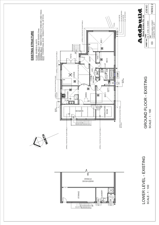
3 ELECTRONIC DA/103/2022 - ALTERATIONS AND ADDITIONS TO A DWELLING HOUSE - 43 BOUVARDIA STREET, ASQUITH
EXECUTIVE SUMMARY
|
DA No: |
DA/103/2022 (Lodged on 3 February 2022) |
|
Description: |
Alterations and additions to the principal dwelling house comprising ground floor alterations and a first-floor addition |
|
Property: |
Lot 36 DP 30826, No. 43 Bouvardia Street, Asquith |
|
Applicant: |
Addbuild Master Builders |
|
Owner: |
Mr S Kumar and Mrs S S Kumar |
|
Estimated Value: |
$275,945 |
|
Ward: |
A |
· The application proposes alterations and additions to the principal dwelling.
· The proposal does not comply with the Hornsby Local Environmental Plan 2013 with regard to Clause 4.3 Height of Buildings development standard. The applicant has made a submission in accordance with Clause 4.6 ‘Exceptions to development standards’ of the HLEP to contravene the height of buildings development standard. The submission is considered well founded and is supported.
· No submissions have been received in respect of the application.
· The application is required to be determined by the Hornsby Local Planning Panel as the proposal would contravene the HLEP development standard for building height by more than 10 percent.
· It is recommended that the application be approved.
|
THAT the Hornsby Local Planning Panel assume the concurrence of the Secretary of the Department of Planning and Environment pursuant to Clause 4.6 of the Hornsby Local Environmental Plan 2013 and approve Development Application No. DA/103/2022 for alterations and additions to the principal dwelling house at Lot 36 DP 30826, No. 43 Bouvardia Street, Asquith subject to the conditions of consent detailed in Schedule 1 of LPP Report No. LPP24/22. |
BACKGROUND
Site History
The existing dwelling house on the site was constructed in the 1960’s.
On 5 April 2016, Complying Development Certificate No. CDP/441/2016 was issued by a private certifier for the construction of a secondary dwelling to the rear of the site.
Application History
On 21 March 2022, Council requested the submission of an amended Clause 4.6 written request to address Council’s concerns that the written request had not sufficiently addressed the matters required under Clause 4.6(3) of the HLEP, namely:
· That compliance with the development standard is unreasonable or unnecessary in the circumstances of the case.
· That there are sufficient environmental planning grounds to justify contravening the development standard.
On 30 March 2022, Council received an amended Clause 4.6 written request prepared by Sky Town Planning dated 24 March 2022.
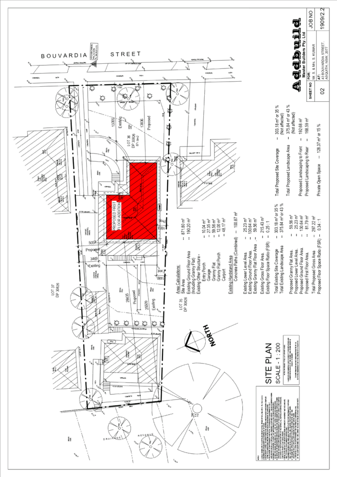
SITE
The 871.8m2 site is located on the western side of Bouvardia Street Asquith and contains a one and two storey dwelling house, a detached single car garage and double carport in a tandem arrangement to the northern side of the dwelling house and a secondary dwelling to the rear.
The site experiences a fall of 8 metres to the north-western rear corner, representing an average gradient of 14%.
The north-western corner of the site is mapped as bushfire prone land with ‘Category 1’ Vegetation located approximately 85 metres north-west of the subject site.
Council’s July 2021 Flood Study has identified that the westernmost (rear) 1m-2.5m of the site is flood prone comprising a 1% AEP overland flow path.
The site is not burdened by any easements or restrictions.
The site is vegetated by shrubs and trees to its perimeter and with lawn to the front and rear setbacks.
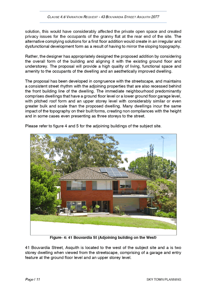
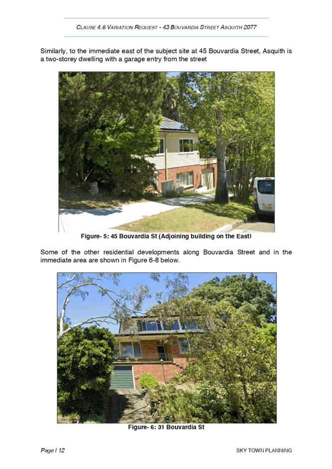
The rear of the site adjoins a narrow parcel of land owned by Hornsby Shire Council dedicated as a Drainage Reserve (zoned RE1 Public Recreation in the HLEP). The adjoining residential site to the north at No. 45 Bouvardia Street contains a one and two storey dwelling house (roof ridge RL 168.92) AHD), swimming pool and a secondary dwelling. The adjacent property to the south at No. 41 Bouvardia Street contains a two-storey dwelling house (roof ridge 171.31 AHD). Across Bouvardia Street is a mixture of single and two storey dwelling houses on elevated land sloping towards the street.
Asquith Railway Station is located approximately 600 metres south walking distance from the subject site.
PROPOSAL
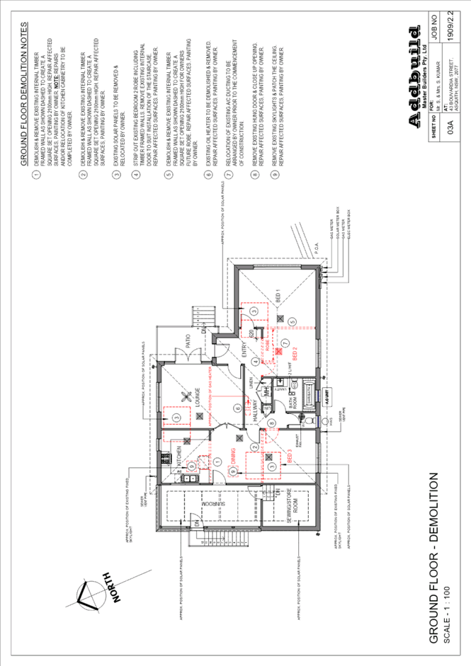
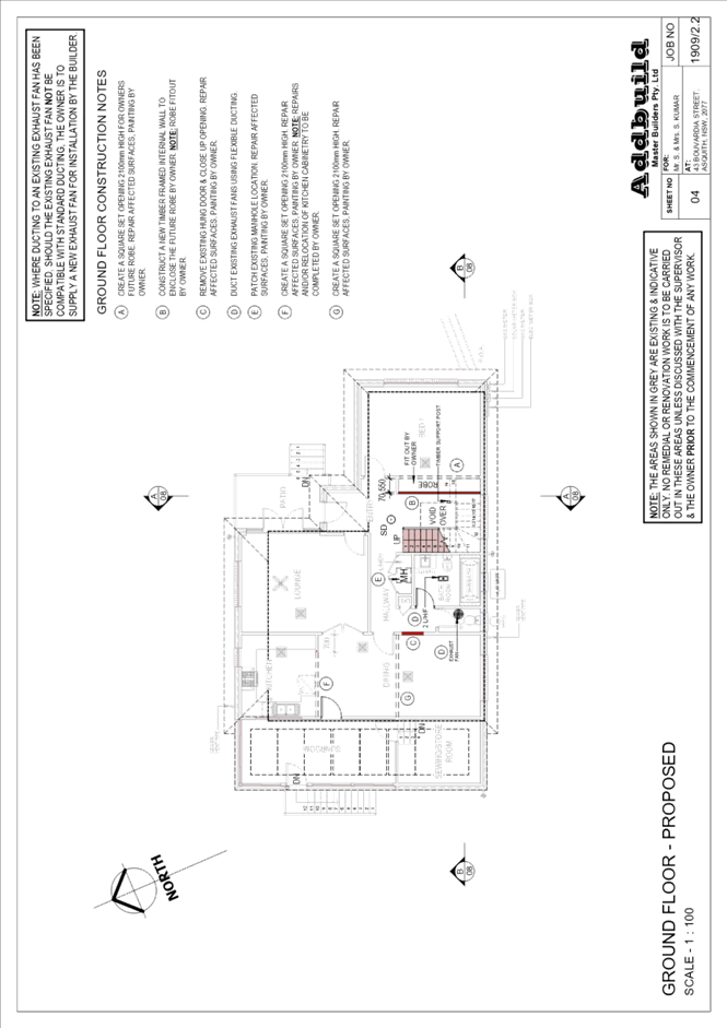
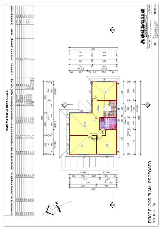
The application proposes alterations and additions to the principal dwelling house comprising ground floor alterations and a first-floor addition. The proposal can be summarised as follows:
· Ground Floor: internal alterations involving the demolition of Bedroom 2 to facilitate the construction of an internal staircase to the proposed first floor addition and the demolition of internal walls to enable an open plan dining area.
· First Floor: construction of the first-floor addition comprising the construction of 3 bedrooms, living room, sitting room and bathroom.
No trees are proposed to be removed to facilitate the proposed development.
ASSESSMENT
The development application has been assessed having regard to the Greater Sydney Region Plan – A Metropolis of Three Cities, the North District Plan and the matters for consideration prescribed under Section 4.15 of the Environmental Planning and Assessment Act 1979 (the Act). The following issues have been identified for further consideration.
1. STRATEGIC CONTEXT
1.1 Greater Sydney Region Plan - A Metropolis of Three Cities and North District Plan
The Greater Sydney Region Plan - A Metropolis of Three Cities has been prepared by the NSW State Government to guide land use planning decisions for the next 40 years (to 2056). The Plan sets a strategy and actions for accommodating Sydney’s future population growth and identifies dwelling targets to ensure supply meets demand. The Plan also identifies that the most suitable areas for new housing are in locations close to jobs, public transport, community facilities and services.
The NSW Government will use the subregional planning process to define objectives and set goals for job creation, housing supply and choice in each subregion. Hornsby Shire has been grouped with Hunters Hill, Ku-ring-gai, Lane Cove, Mosman, North Sydney, Ryde, Northern Beaches and Willoughby to form the North District. The Greater Sydney Commission has released the North District Plan which includes priorities and actions for Northern District for the next 20 years. The identified challenge for Hornsby Shire will be to provide an additional 4,350 dwellings by 2021 with further strategic supply targets to be identified to deliver 97,000 additional dwellings in the North District by 2036.
The proposed development would be consistent with the Greater Sydney Region Plan - A Metropolis of Three Cities and the North District Plan, by providing improved housing stock and contributing to additional housing density in the region.
2. STATUTORY CONTROLS
Section 4.15(1)(a) requires Council to consider “any relevant environmental planning instruments, draft environmental planning instruments, development control plans, planning agreements and regulations”.
2.1 Hornsby Local Environmental Plan 2013
The proposed development has been assessed having regard to the provisions of the Hornsby Local Environmental Plan 2013 (HLEP).
2.1.1 Zoning of Land and Permissibility
The subject land is zoned R2 Low Density Residential under the HLEP. The objectives of the R2 zone are:
· To provide for the housing needs of the community within a low-density residential environment.
· To enable other land uses that provide facilities or services to meet the day to day needs of residents.
The proposed development is defined as a ‘dwelling house’ and is permissible in the R2 zone with Council’s consent. The proposed development is consistent with the objectives of the zone.
2.1.2 Height of Buildings
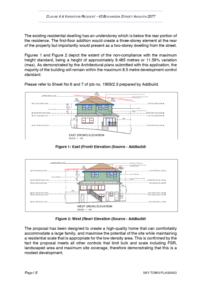
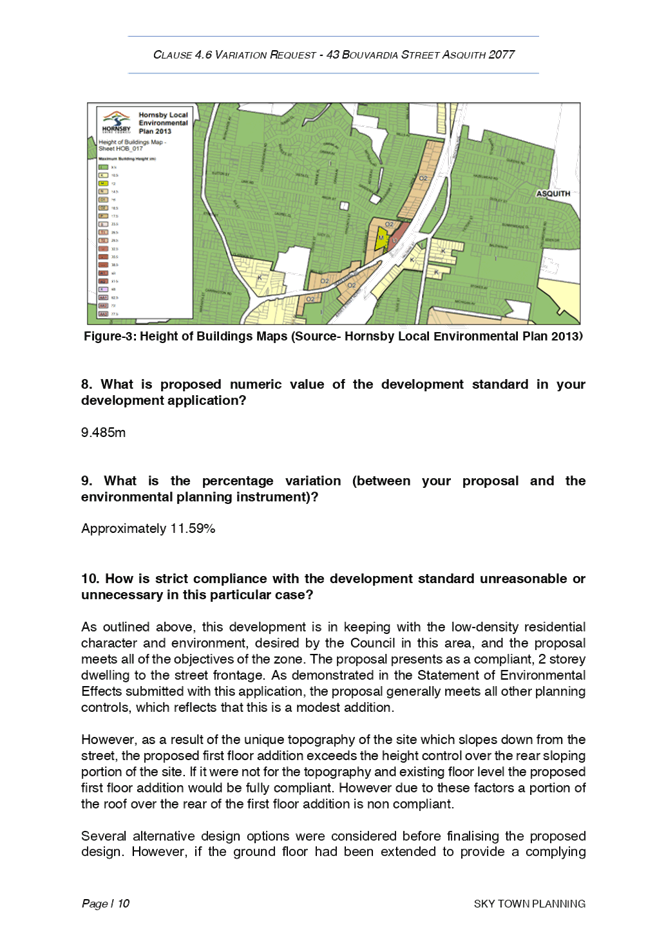
Clause 4.3 of the HLEP provides that the height of a building on any land should not exceed the maximum height show for the land on the Height of Buildings Map. The maximum permissible height for the subject site is 8.5m. The proposed development would have a maximum building height of 9.485m and does not comply with this provision.
Section 2.1.3 of this report addresses the proposed contravention of the Height of Buildings development standard.
2.1.3 Exceptions to Development Standards
The application has been assessed against the requirements of Clause 4.6 of the HLEP. This clause provides flexibility in the application of the development standards in circumstances where strict compliance with those standards would, in any particular case, be unreasonable or unnecessary, and it can be demonstrated that sufficient environmental planning grounds are present to justify contravening a development standard.
The application seeks to contravene Clause 4.3 of the HLEP as the proposed alterations and additions to the dwelling house would have a maximum height of 9.485m (11.59% contravention), which exceeds the 8.5 metre Height of Buildings development standard. Figure 1 and 2 demonstrate the extent of the non-compliant portion of the dwelling house, as demonstrated by the red dashed line at 8.5m above existing ground level.
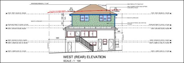
Figure 1: Rear Elevation
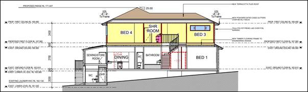
Figure 2: Section B-B
The objective of Clause 4.3 Height of Buildings of the HLEP is as follows:
To permit a height of buildings that is appropriate for the site constraints, development potential and infrastructure capacity of the locality.
The applicant has made a submission in support of the contravention to the development standard in accordance with Clause 4.6 of the HLEP. Clause 4.6 provides that development consent must not be granted for development that contravenes a development standard unless the consent authority has considered a written request from the applicant that seeks to justify the contravention of the development standard by demonstrating:
(a) That compliance with the development standard is unreasonable or unnecessary in the circumstances of the case, and
(b) That there are sufficient environmental planning grounds to justify contravening the development standard.
Council must be satisfied that the written request provided by the applicant under Clause 4.6 addresses both the unreasonable and unnecessary test and demonstrates sufficient environmental planning grounds to justify contravening the development standard. These matters are discussed below.
2.1.3.1 Unreasonable or Unnecessary
There are five common methods by which an applicant can demonstrate that compliance with a development standard is unreasonable or unnecessary in the circumstances of the development. Initially proposed for objections under clause 6 of SEPP 1 in the decision of Wehbe v Pittwater Council [2007] NSWLEC 827 Pearson C summarised and applied these methods to written requests made under Clause 4.6 in Four2Five Pty Ltd v Ashfield Council [2015] NSWLEC 1009 [61-62]. These five methods are generally as follows:
· The objectives of the development standard are achieved notwithstanding non-compliance with the standard.
· The underlying objective or purpose is not relevant to the development.
· That the objective would be defeated or thwarted if compliance was required.
· That the development standard has been virtually abandoned or destroyed by the Council’s own actions in departing from the standard.
· The zoning of the land is unreasonable or inappropriate.
It is not required to demonstrate that a development meets multiple methods as listed above, and the satisfaction of one can be adequate to demonstrate that the development standard is unreasonable or unnecessary.
The written request prepared by Sky Town Planning provides justification for the contravention of the building height development standard by seeking to demonstrate that compliance with the development standard is unreasonable or unnecessary in the circumstances of the development, summarised as follows:
· It is considered that the proposal meets the objectives of the Zone R2 Low Density Residential. This opinion is justified on the basis that the proposal will improve the living amenity for the residents and provide much needed space within the home thereby providing for their housing needs while maintaining the low-density residential character.
· It is clear that the objectives of the standard are able to be achieved, notwithstanding the additional height, and that a superior development outcome would result.
· The proposal is a more efficient and orderly development on the land that is of high quality architectural design that maximises the sites development potential along with providing improved housing stock for the community in the locality.
With respect to the objective of Clause 4.3 of the HLEP, Council is satisfied that the proposal is consistent with the objective as the proposed first floor addition would result in a moderately sized dwelling house (227.7m2) that is consistent with the prevailing built form along Bouvardia Street. In an attempt to avoid contravening the Height of Buildings development standard, consideration has been given by the applicant to an alternate design option involving a rear extension to the ground floor level. Noting the steep topography of the site, Council’s assessment concurs with the applicant’s submission that an alternate design involving an extension to the rear at the ground floor level is likely to be significantly elevated, approximately 2.7 metres above existing ground level. Any such alternate proposal would reduce the available landscaped and open space areas on the site and would culminate in a decrease in building separation, and consequently, the amenity and privacy received to the secondary dwelling on the subject site, along with the open space areas on the adjoining sites.
On balance, the first-floor addition is the most appropriate means of achieving additional residential density on the site given the site constraints, without compromising the amenity of adjoining residential land uses.
Council’s assessment has determined that the objectives of the development standard are achieved notwithstanding non-compliance with the standard. Accordingly, the written request adequately demonstrates that compliance with the Height of Buildings development standard is unreasonable and unnecessary in this instance.
2.1.3.2 Environmental Planning Grounds
In addition to demonstrating that compliance is unreasonable or unnecessary, Clause 4.6(3)(b) of the HLEP requires that there are sufficient environmental planning grounds to justify contravening the development standard. In demonstrating that sufficient environmental planning grounds exist, it must be demonstrated that the planning grounds are particular to the circumstances of the development on the subject site (summarised from Four2Five Pty Ltd v Ashfield Council [2015] NSWLEC 1009 [60].
In demonstrating the environmental planning grounds the written request states:
· The proposal will improve the living amenity for the residents and provide much needed space within the home thereby providing for their housing needs while maintaining the low-density residential character.
· The proposal meets all other controls that limit bulk and scale including landscaped area and maximum site coverage, therefore demonstrating that this is a modest development with bulk and scale that is within context of the R2 zoning.
· The topography of the site, which slopes to the rear, results in the first floor addition being non-compliant over the rear portion of the site only. The proposal complies with the height control at the front of the site, but becomes gradually non-compliant towards the rear as the site slopes down.
· The proposal has been designed to create a high-quality home that can comfortably accommodate a large family, and maximise the potential of the site while maintaining a residential scale that is appropriate for the low-density area. This is confirmed by the fact the proposal meets all other controls that limit bulk and scale including landscaped area and maximum site coverage, therefore demonstrating that this is a modest development.
· Importantly the height noncompliance is only over the rear portion of the, and would not be viewed from the public domain, thereby not impacting the streetscape. The proposal presents as a compliant, 2 storey dwelling to the street frontage.
· Our opinion is that the relatively modest additional height proposed contributes to the delivery of a high quality and better functioning residence on the site. The proposed height contravention realises the development potential of the site and provides a higher quality outcome than the alternative complying solution which would be a restricted and dysfunctional development form as a result of having to mirror the sloping topography in order to meet the height control.
· Asquith is an undulating area and subsequently the non-compliance arises as a result of the nature of the topography of the site. Several alternative design options were considered before finalising the proposed design. However, if the ground floor had been extended to provide a complying solution, this would have considerably affected the private open space and created privacy issues for the occupants of the granny flat at the rear end of the site.
· Given the nature of the proposal which is for additions and alterations, it will not generate any additional vehicular or pedestrian traffic around the site or in the street.
· The designer has appropriately designed the proposed addition by considering the overall form of the building and aligning it with the existing ground floor and understorey. The proposal will provide a high quality of living, functional space and amenity to the occupants of the dwelling and an aesthetically improved dwelling.
· The proposal has been developed in congruence with the streetscape, and maintains a consistent street rhythm with the adjoining properties that are also recessed behind the front building line of the dwelling. The immediate neighbourhood predominantly comprises dwellings that have a ground floor level or a lower ground floor garage level, with pitched roof form and an upper storey level with considerably similar or even greater bulk and scale than the proposed dwelling. Many dwellings incur the same impact of the topography on their built forms, creating non compliances with the height and in some cases even presenting as three storeys to the street.
· 41 Bouvardia Street, Asquith is located to the west of the subject site and a is two storey dwelling when viewed from the streetscape, comprising of a garage and entry feature at the ground floor level and an upper storey level. Similarly, to the immediate east of the subject site at 45 Bouvardia Street, Asquith is a two-storey dwelling with a garage entry from the street. These example of neighbouring residential dwellings indicate that the proposed development seamlessly integrates with the established residential characteristics of the neighbourhood dwellings in terms of architectural style and bulk and scale, and will not appear out of character when viewed from the street and public domain, despite the minor non-compliance to the building height.
· Analysis of the impact of the addition on neighbouring properties or on the streetscape reveals it will not create any adverse environmental or amenity related impacts, namely outlooks, privacy and solar access.
Council considers that the environmental planning grounds stated within the written request are sufficient with respect to Clause 4.6(3)(b) and that the stated grounds are specific to the proposed development and the circumstances of the development site. It is therefore considered that the written request adequately demonstrates compliance with the clause and is acceptable in this regard.
In demonstrating the unreasonable and unnecessary test, the applicant further established satisfactory environmental planning grounds with respect to the site and the surrounding constraints.
2.1.3.3 Public Interest and Clause 4.6(4)
Clause 4.6(4) states that development consent must not be granted for development that contravenes a development standard unless:
(a) The consent authority is satisfied that -
(i) The applicant’s written request has adequately addressed the matters required to be demonstrated by subclause (3), and
(ii) The proposed development will be in the public interest because it is consistent with the objectives of the particular standard and the objectives for development within the zone in which the development is proposed to be carried out, and
(b) The concurrence of the Planning Secretary has been obtained.
With regard to part (i), the written request is considered to adequately address the matter required to be demonstrated as outlined above.
With regard to part (ii), the proposed development is considered to be in the public interest because it is consistent with the objectives of the particular standard and the objectives for development within the zone in which the development is proposed to be carried out.
With regard to (b) the concurrence of the Planning Secretary has been obtained.
Accordingly, it is considered that the written request satisfactorily responds to the relevant matters required to be addressed under Clause 4.6 and that the Panel, as consent authority, may rely upon the written request and grant development consent to the development application. Should the Panel resolve to approve the application, it should also provide a statement in the reasons for approval that it has satisfied itself of the matters in Clause 4.6(4).
2.1.4 Heritage Conservation
Clause 5.10 of the HLEP sets out heritage conservation provisions for Hornsby Shire. The site does not include a heritage item, is not located in a heritage conservation area and is not within the immediate vicinity of any heritage items. Accordingly, no further assessment regarding heritage is necessary.
2.1.5 Flood Planning
Although Council’s July 2021 Flood Study has identified that the westernmost portion of site is flood prone comprising a 1% AEP overland flow path, the site is not identified as a flood planning area on the HLEP ‘Flood Planning Map’ and further assessment under Clause 5.21 of the HLEP is not required.
Section 2.8.2 of this report further discusses flooding.
2.1.6 Earthworks
Clause 6.2 of the HLEP states that consent is required for proposed earthworks on site. Before granting consent for earthworks, Council is required to assess the impacts of the works on adjoining properties, drainage patterns and soil stability of the locality.
The proposed development comprises internal works to the existing ground floor level of the dwelling house and the construction of a first-floor addition. The proposed development would be located entirely within the existing building footprint and earthworks are not necessitated to facilitate the proposed works. The proposal meets the objectives of Clause 6.2 Earthworks of the HLEP.
2.2 Adopted State Environmental Planning Policies
On 1 March 2022, the following State Environmental Planning Policies (SEPPS) were gazetted:
· State Environmental Planning Policy (Primary Production) 2021
· State Environmental Planning Policy (Resources and Energy) 2021
· State Environmental Planning Policy (Resilience and Hazards) 2021
· State Environmental Planning Policy (Industry and Employment) 2021
· State Environmental Planning Policy (Transport and Infrastructure) 2021
· State Environmental Planning Policy (Biodiversity and Conservation) 2021
· State Environmental Planning Policy (Planning Systems) 2021
· State Environmental Planning Policy (Precincts - Eastern Harbour City) 2021
These SEPPS now form Matters for consideration under Section 4.15 of the Environmental Planning and Assessment Act 1979. However general savings provisions apply to development applications that have been made but not yet determined, on or before the commencement date.
As this development application was lodged on 3 February 2022, this development application is considered to have been made prior to the commencement date of the SEPPs. The existing legislation in force at time of lodgement of the development application, prevails to be extent of any inconsistency.
Notwithstanding, the approval of the development application would not adversely affect the objectives of the newly adopted SEPPs and is considered to be consistent with this policy.
2.3 State Environmental Planning Policy No. 55 Remediation of Land
The application has been assessed against the requirements of State Environmental Planning Policy No. 55 Remediation of Land (SEPP 55) under which consent must not be granted to the carrying out of any development on land unless the consent authority has considered whether the land is contaminated or requires remediation for the proposed use.
Should the land be contaminated Council must be satisfied that the land is suitable in a contaminated state for the proposed use. If the land requires remediation to be undertaken to make the land suitable for the proposed use, Council must be satisfied that the land will be remediated before the land is used for that purpose.
An examination of Council’s records and aerial photography has determined that the site has been historically used for residential purposes. It is not likely that the site has experienced any significant contamination, and further assessment under SEPP 55 is not required.
2.4 State Environmental Planning Policy (Building Sustainability Index: BASIX) 2004
The application has been assessed against the requirements of State Environmental Planning Policy (Building Sustainability Index: BASIX) 2004. The proposal includes a BASIX Certificate for the proposed development which would satisfy the requirements of the SEPP.
2.5 State Environmental Planning Policy (Vegetation in Non-Rural Areas) 2017
State Environmental Planning Policy (Vegetation in Non-Rural Areas) 2017 (Vegetation SEPP) commenced 25 August 2017 and aims to protect the biodiversity and amenity values of trees within non-rural areas of the state.
Part 3 of the Vegetation SEPP states that a development control plan may make a declaration in any manner relating to species, size, location and presence of vegetation. Accordingly, Part 1B.6.1 of the Hornsby Development Control Plan 2013 (HDCP) prescribes works that can be undertaken with or without consent to trees.
Section 3.1.1 of this report further addresses impacts to vegetation.
2.6 Sydney Regional Environmental Plan No. 20 Hawkesbury-Nepean River
The site is located within the catchment of the Hawkesbury Nepean River. Part 2 of this Plan contains general planning considerations and strategies requiring Council to consider the impacts of development on water quality, aquaculture, recreation and tourism.
Subject to the implementation of sediment and erosion control measures and stormwater management to protect water quality, the proposal would comply with the requirements of the Policy.
2.7 Section 3.42 Environmental Planning and Assessment Act 1979 - Purpose and Status of Development Control Plans
Section 3.42 of the Environmental Planning and Assessment Act 1979 states that a DCP provision will have no effect if it prevents or unreasonably restricts development that is otherwise permitted and complies with the development standards in relevant Local Environmental Plans and State Environmental Planning Policies.
The principal purpose of a development control plan is to provide guidance on the aims of any environmental planning instrument that applies to the development; facilitate development that is permissible under any such instrument; and achieve the objectives of land zones. The provisions contained in a DCP are not statutory requirements and are for guidance purposes only. Consent authorities have flexibility to consider innovative solutions when assessing development proposals, to assist achieve good planning outcomes.
2.8 Hornsby Development Control Plan 2013
The proposed development has been assessed having regard to the relevant desired outcomes and prescriptive requirements within the Hornsby Development Control Plan 2013 (HDCP). The following table sets out the proposal’s compliance with the prescriptive requirements of the Plan:
|
HDCP – Part 3.1 Dwelling Houses |
|||
|
Control |
Proposal |
Requirement |
Complies |
|
Lot Size |
871.8m2 |
N/A |
N/A |
|
Dwelling House height |
9.485m |
8.5m |
No |
|
No. storeys |
2 storeys (at any 1 point) |
max. 2 + attic |
Yes |
|
Site Coverage |
26% |
50% |
Yes |
|
Floor Area |
227.7m2 |
380m2 |
Yes |
|
Setbacks (First floor addition) |
|
|
|
|
- Front |
13.8m |
6m |
Yes |
|
- Side (south) |
1.65m |
1.5m |
Yes |
|
- Side (north) |
5m |
1.5m |
Yes |
|
- Rear
|
28.4m |
8m |
Yes |
|
Landscaped Area (% of lot size) |
43% |
30% |
Yes |
|
Private Open Space |
|
|
|
|
- minimum area |
128m2 |
24m2 |
Yes |
|
- minimum dimension |
>3m |
3m |
Yes |
|
Car Parking |
3 spaces |
2 spaces |
Yes |
As detailed in the above table, the proposed development complies with the quantitative prescriptive measures within the HDCP, with the exception of building height. A discussion on compliance with relevant performance requirements and Part 1C General Controls is provided below.
2.8.1 Bushfire
The application has been supported by a Bushfire Assessment Report prepared by Bushfire Consulting Services dated 1 January 2022 (BPAD Level 2 Accredited Practitioner).
The north-western corner of the site is mapped as bushfire prone land with ‘Category 1’ Vegetation located approximately 85m north-west of the subject site. The proposed development would be located approximately 12m from the bushfire prone portion of the site.
The submitted Bushfire Assessment Report has assessed the bushfire threat to the proposed development to be BAL-LOW pursuant to Australian Standard 3959:2018 Construction of buildings in bushfire-prone areas and satisfies the objectives and performance requirements of Planning for Bush Fire Protection 2019. It is noted that Australian does not provide construction requirements for buildings assessed in bushfire prone areas as being BAL-LOW.
The proposal meets the desired outcomes and prescriptive measures of Part 1C.3.1 Bushfire of the HDCP.
2.8.2 Flooding
Council’s July 2021 Flood Study has identified that the westernmost (rear) 1m-2.5m of the site is flood prone comprising a 1% AEP overland flow path.
The proposed development involves internal works to the existing ground floor level of the dwelling house and the construction of a first-floor addition. Further, the proposed development would be located approximately 35 metres from the mapped overland flow path and would not pose any impact to the flood characteristics on the subject site or downstream properties.
2.8.3 Sunlight Access
The application has been supported by Sunlight Access Diagrams prepared by Addbuild.
It is noted that the first-floor addition would be located 1.65 metres to the southern side boundary and 5 metres northern side boundary which corresponds to the positioning of the existing dwelling house on the site.
The submitted Sunlight Access Diagrams demonstrate that the principal private open space of all adjoining properties would receive a minimum of 3 hours of unobstructed sunlight access between 9am and 3pm on 22 June and would comply with the prescriptive measures of Part 3.1.5b of the HDCP.
The proposal meets the desired outcomes of Part 3.1.5 Sunlight Access of the HDCP and is considered acceptable.
2.8.4 Privacy
Ground Floor Level
The application proposes internal alterations including demolition of internal walls at the ground floor level. Bedroom No. 3 is proposed to be converted and incorporated into an expanded open plan dining room. Council’s assessment notes that the existing full-sized window (900mm sill height) servicing the proposed dining room along the southern side elevation is proposed to be retained. The floor level of the proposed dining room is between 2.3m-2.44m above the existing ground level.
It is acknowledged that although the window is existing and has been approved for the purpose of servicing a bedroom, the proposed conversion of the bedroom to a dining room would increase the intensity of its use.
Figure 3: Dining room window facing open space at No. 41 Bouvardia Street
Figure 4: Dining room window facing open space at No. 41 Bouvardia Street
Photographs taken from within existing bedroom No. 3 towards the adjoining property indicate that the proposed dining room would have views obscured by vegetation and a shed to the rear deck of the adjoining property. The adjoining deck is located approximately 12.5 metres from the proposed dining room and includes a privacy screen to its northern elevation. It is considered that the 12.5 metre separation in conjunction with the privacy screen and the vegetation screening along the boundary would provide adequate privacy between these two properties and no privacy concerns are raised in this regard.
First Floor Level
The proposed first floor level bedrooms would be serviced by full sized windows with sill heights less than 1.5 metres above finished floor level. The HDCP states that windows servicing elevated bedrooms would not require the implementation of privacy measures / screens and accordingly no privacy concerns are raised to the proposed first floor bedrooms.
Notwithstanding, the north-facing window servicing the first-floor level living room (W04) would have a sill height of 900mm above finished floor level and would facilitate overlooking into the private open space and swimming pool area of the adjoining property at No. 45 Bouvardia Street. To ensure that privacy to the adjoining property is maintained, a condition has been recommended under Schedule 1 requiring the provision of amended plans prior to the issue of the Construction Certificate demonstrating an increase in the sill height of the first-floor level living room window at the northern elevation to be a minimum of 1.5 metres.
The proposal complies with the privacy requirements of the HDCP, subject to the imposition of the abovementioned conditions.
2.8.5 Vehicle Access and Parking
The application does not propose any changes to the existing car parking or vehicle access arrangement on the site.
The existing site benefits from a detached single car garage and double carport in a tandem arrangement to the northern side of the dwelling house. Vehicular access to the site is to be maintained via a driveway adjacent to the northern side boundary.
The proposal meets the HDCP requirement for a minimum of two car parking spaces to be provided behind the front building line of the dwelling house.
The proposal meets the desired outcomes of Part 3.1.7 Vehicle Access and Parking of the HDCP and is considered acceptable in this regard.
2.8.6 Bulk and Scale
The HDCP stipulates that residential development on the subject site is to achieve a maximum site coverage of 50% and a maximum floor area of 380m2 for dwelling houses. The proposed development would result in a site coverage of 26% and principal dwelling floor area of 227.7m2 and complies with the HDCP in this regard.
As discussed under Section 2.1.3 of this report, the proposed development would have a maximum height of 9.485m and it is considered that the written request to contravene the Height of Buildings development standard of the HLEP is satisfactorily and responds to the relevant matters required to be addressed under Clause 4.6.
The proposal meets the desired outcomes of Part 3.1.1 Scale of the HDCP and is considered acceptable.
2.9 Section 7.12 Contributions Plans
Hornsby Shire Council Section 7.12 Contributions Plan 2019-2029 applies to the development as the estimated costs of works is greater than $100,000. Should the application be approved, an appropriate condition of consent is recommended requiring the payment of a contribution in accordance with the Plan.
3. ENVIRONMENTAL IMPACTS
Section 4.15(1)(b) of the Act requires Council to consider “the likely impacts of that development, including environmental impacts on both the natural and built environments, and social and economic impacts in the locality”.
3.1 Natural Environment
3.1.1 Tree and Vegetation Preservation
The site is sparsely vegetated by shrubs and trees to its perimeter and with lawn to the front and rear setbacks. As the proposed development entirely comprises internal works to the existing ground floor level of the dwelling house and the construction of a first-floor addition, it is assessed that the proposal would not pose any impact to the root zones of vegetation on the subject site or adjoining sites. Further, the proposed first floor addition would not necessitate the pruning of any trees to facilitate its completion.
3.1.2 Stormwater Management
The application proposes to drain the stormwater captured by the proposed development to the existing stormwater system on-site. The existing on-site stormwater system connects via gravity to Council’s Drainage Reserve adjoining the rear of the site at No. 2X Gardenia Street (Lot 58 DP 30826).
It is acknowledged that the proposed development would not increase the extent of impervious surface on the site. The existing stormwater system has been assessed by Council to be suitable and would appropriately cater to the proposed development.
The proposal is deemed acceptable with regard to the stormwater management provisions of the HDCP.
3.2 Social Impacts
The residential development would improve housing choice in the locality by providing a range of household types. This is consistent with Council’s Housing Strategy which identifies the need to provide a mix of housing options to meet future demographic needs in Hornsby Shire.
3.3 Economic Impacts
The proposal would have a minor positive impact on the local economy in conjunction with other new low density residential development in the locality by generating an increase in demand for local services.
4. SITE SUITABILITY
Section 4.15(1)(c) of the Act requires Council to consider “the suitability of the site for the development”.
The site experiences an average gradient of 14% to the north-western rear corner. The north-western corner of the site is mapped as bushfire prone land and the westernmost portion of the site is mapped as flood prone. The site is not burdened by any easements or restrictions.
Despite the bushfire and flooding affectations of the site, the proposed development would be located in a manner that would not be impacted by these constraints. The site is considered to be capable of accommodating the proposed development. The scale of the proposed development is consistent with the capability of the site and is considered acceptable.
5. PUBLIC PARTICIPATION
Section 4.15(1)(d) of the Act requires Council to consider “any submissions made in accordance with this Act”.
5.1 Community Consultation
The proposed development was placed on public exhibition and was notified to adjoining and nearby landowners between 7 February 2022 and 1 March 2022 in accordance with the Hornsby Community Engagement Plan. During this period, Council received no submissions. The map below illustrates the location of those nearby landowners that are in close proximity to the development site.
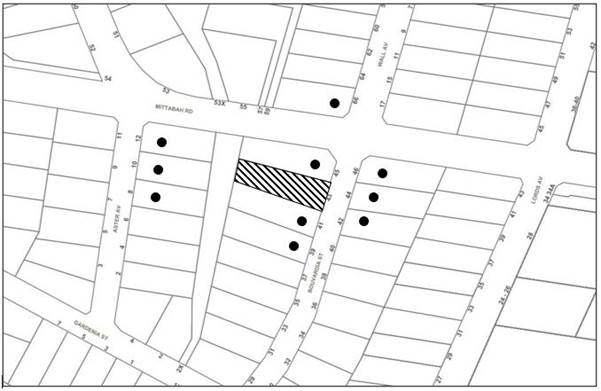
|
NOTIFICATION PLAN |
|||
|
• PROPERTIES NOTIFIED |
X SUBMISSIONS RECEIVED |
|
|
5.2 Public Agencies
The development application was not referred to any Public Agencies for comment.
6. THE PUBLIC INTEREST
Section 4.15(1)(e) of the Act requires Council to consider “the public interest”.
The public interest is an overarching requirement, which includes the consideration of the matters discussed in this report. Implicit to the public interest is the achievement of future built outcomes adequately responding to and respecting the future desired outcomes expressed in environmental planning instruments and development control plans.
The application is considered to have satisfactorily addressed Council’s criteria and would provide a development outcome that, on balance, would result in a positive impact for the community. Accordingly, it is considered that the approval of the proposed development would be in the public interest.
CONCLUSION
The application proposes alterations and additions to the principal dwelling house comprising ground floor alterations and a first-floor addition.
The development generally meets the desired outcomes of Council’s planning controls and is satisfactory having regard to the matters for consideration under Section 4.15 of the Environmental Planning and Assessment Act 1979.
Having regard to the circumstances of the case, approval of the application is recommended.
The reasons for this decision are:
· The request under Clause 4.6 of Hornsby Local Environmental Plan 2013 to contravene the ‘Height of buildings’ development standard is well founded. Strict compliance with the development standard is considered unreasonable and unnecessary in the circumstances of the case and sufficient environmental planning grounds have been submitted to justify the contravention to the development standard.
· The proposed development generally complies with the requirements of the relevant environmental planning instruments and the Hornsby Development Control Plan 2013.
· The proposed development does not create unreasonable environmental impacts to adjoining development with regard to visual bulk, overshadowing, solar access, amenity or privacy.
Note: At the time of the completion of this planning report, no persons have made a Political Donations Disclosure Statement pursuant to Section 10.4 of the Environmental Planning and Assessment Act 1979 in respect of the subject planning application.
RESPONSIBLE OFFICER
The officer responsible for the preparation of this report is Thomas Dales.
|
Cassandra Williams Major Development Manager - Development Assessments Planning and Compliance Division |
Rod Pickles Manager - Development Assessments Planning and Compliance Division |
Attachments:
|
1.⇩ |
Locality Plan |
|
|
|
2.⇩ |
Architectural Plans |
|
|
|
3.⇩ |
Shadow Diagrams |
|
|
|
4.⇩ |
Survey |
|
|
|
5.⇩ |
Clause 4.6 Submission |
|
|
File Reference: DA/103/2022
Document Number: D08378850
SCHEDULE 1
The conditions of consent within this notice of determination have been applied to ensure that the use of the land and/or building is carried out in such a manner that is consistent with the aims and objectives of the relevant legislation, planning instruments and Council policies affecting the land and does not disrupt the amenity of the neighbourhood or impact upon the environment.
Note: For the purpose of this consent, the term ‘applicant’ means any person who has the authority to act on or the benefit of the development consent.
Note: For the purpose of this consent, any reference to an Act, Regulation, Australian Standard or publication by a public authority shall be taken to mean the gazetted Act or Regulation, or adopted Australian Standard or publication as in force on the date that the application for a construction certificate is made.
1. Approved Plans and Supporting Documentation
The development must be carried out in accordance with the plans and documentation listed below and endorsed with Council’s stamp, except where amended by Council and/or other conditions of this consent:
Approved Plans
|
Plan No. |
Plan Title |
Drawn by |
Dated |
Council Reference |
|
02 |
Site Plan |
Addbuild |
28.01.22 |
|
|
03A |
Ground Floor Demolition |
Addbuild |
28.01.22 |
|
|
04 |
Ground Floor - Proposed |
Addbuild |
28.01.22 |
|
|
05 |
First Floor Plan – Proposed |
Addbuild |
28.01.22 |
|
|
06 |
East & South Elevations |
Addbuild |
28.01.22 |
|
|
07 |
West & North Elevations |
Addbuild |
28.01.22 |
|
|
08 |
Section A-A & Section B-B |
Addbuild |
28.01.22 |
|
Supporting Documents
|
Document Title |
Prepared by |
Dated |
Council Reference |
|
BASIX Certificate No. A447032 |
Addbuild Master Builder Pty Ltd |
28.01.22 |
D08343657 |
|
Waste Management Plan |
Addbuild Master Builder Pty Ltd |
27.01.22 |
D08343682 |
2. Amendment of Plans
a) To comply with Council’s requirement in terms of privacy, the approved plans are to be amended as follows:
i) The sill height of the first-floor level living room window at the northern elevation is to be increased to a minimum of 1.5m above the finished floor level.
b) These amended plans must be submitted with the application for the Construction Certificate.
3. Construction Certificate
a) A Construction Certificate is required to be approved by Council or a Private Certifying Authority prior to the commencement of any construction works under this consent.
b) The Construction Certificate plans must not be inconsistent with the Development Consent plans.
4. Section 7.12 Development Contributions
a) In accordance with Section 4.17(1) of the Environmental Planning and Assessment Act 1979 and the Hornsby Shire Council Section 7.12 Development Contributions Plan 2019-2029, $2,759.45 must be paid towards the provision, extension or augmentation of public amenities or public services, based on development costs of $275,945.
b) The value of this contribution is current as of 4 April 2022. If the contributions are not paid within the financial quarter that this consent is granted, the contributions payable will be adjusted in accordance with the provisions of the Hornsby Shire Council Section 7.12 Development Contributions Plan and the amount payable will be calculated at the time of payment in the following manner:
|
$CPY |
= |
|
|
$CDC x CPIPY |
|
|
|
|
|
CPIDC |
Where:
$CPY is the amount of the contribution at the date of Payment.
$CDC is the amount of the contribution as set out in this Development Consent.
CPIPY is the latest release of the Consumer Price Index (Sydney – All Groups) at the date of Payment as published by the ABS.
CPIDC is the Consumer Price Index (Sydney – All Groups) for the financial quarter at the date of this Development Consent.
c) The monetary contributions shall be paid to Council:
(i) Prior to the issue of the Subdivision Certificate where the development is for subdivision.
(ii) Prior to the issue of the first Construction Certificate where the development is for building work.
(iii) Prior to issue of the Subdivision Certificate or first Construction Certificate, whichever occurs first, where the development involves both subdivision and building work.
(iv) Prior to the works commencing where the development does not require a Construction Certificate or Subdivision Certificate.
Note: It is the professional responsibility of the Principal Certifying Authority to ensure that the monetary contributions have been paid to Council in accordance with the above timeframes.
Note: In accordance with Ministerial Directions, the payment of contribution fees for development with a cost of works of over $10 million can be deferred to prior to Occupation Certificate.
Note: The Hornsby Shire Council Section 7.12 Development Contributions Plan may be viewed at www.hornsby.nsw.gov.au or a copy may be inspected at Council’s Administration Centre during normal business hours.
REQUIREMENTS PRIOR TO THE ISSUE OF A CONSTRUCTION CERTIFICATE
5. Building Code of Australia
Detailed plans, specifications and supporting information is required to be submitted to the certifying authority detailing how the proposed building work achieves compliance with the National Construction Code - Building Code of Australia. All building work must be carried out in accordance with the requirements of the National Construction Code - Building Code of Australia.
6. Contract of Insurance (Residential Building Work)
Where residential building work for which the Home Building Act 1989 requires there to be a contract of insurance in force in accordance with Part 6 of that Act, this contract of insurance must be in force before any building work authorised to be carried out by the consent commences.
7. Notification of Home Building Act 1989 Requirements
Residential building work within the meaning of the Home Building Act 1989 must not be carried out unless the principal certifying authority for the development to which the work relates (not being Council) has given Council written notice of the following information:
a) In the case of work for which a principal contractor is required to be appointed:
i) The name and licence number of the principal contractor.
ii) The name of the insurer by which the work is insured under Part 6 of that Act.
b) In the case of work to be done by an owner-builder:
i) The name of the owner-builder.
ii) If the owner-builder is required to hold an owner-builder’s permit under that Act, the number of the owner-builder’s permit.
Note: If arrangements for doing the residential building work are changed while the work is in progress so that the information notified becomes out of date, further work must not be carried out unless the principal certifying authority for the development to which the work relates (not being Council) has given Council written notification of the updated information.
8. Stormwater Drainage
The stormwater drainage system for the development must be designed for an average recurrence interval (ARI) of 20 years and be gravity drained to the existing internal drainage system.
REQUIREMENTS PRIOR TO THE COMMENCEMENT OF ANY WORKS
9. Erection of Construction Sign
a) A sign must be erected in a prominent position on any site on which any approved work is being carried out:
i) Showing the name, address and telephone number of the principal certifying authority for the work.
ii) Showing the name of the principal contractor (if any) for any demolition or building work and a telephone number on which that person may be contacted outside working hours.
iii) Stating that unauthorised entry to the work site is prohibited.
b) The sign is to be maintained while the approved work is being carried out and must be removed when the work has been completed.
10. Protection of Adjoining Areas
A temporary hoarding, fence or awning must be erected between the work site and adjoining lands before the works begin and must be kept in place until after the completion of the works if the works:
a) Could cause a danger, obstruction or inconvenience to pedestrian or vehicular traffic.
b) Could cause damage to adjoining lands by falling objects.
c) Involve the enclosure of a public place or part of a public place.
d) Have been identified as requiring a temporary hoarding, fence or awning within the Council approved Construction Management Plan (CMP).
Note: Notwithstanding the above, Council’s separate written approval is required prior to the erection of any structure or other obstruction on public land.
11. Toilet Facilities
a) To provide a safe and hygienic workplace, toilet facilities must be available or be installed at the works site before works begin and must be maintained until the works are completed at a ratio of one toilet for every 20 persons employed at the site.
b) Each toilet must:
i) Be a standard flushing toilet connected to a public sewer.
ii) Be a temporary chemical closet approved under the Local Government Act 1993.
iii) Have an on-site effluent disposal system approved under the Local Government Act 1993.
12. Erosion and Sediment Control
To protect the water quality of the downstream environment, erosion and sediment control measures must be provided and maintained throughout the construction period in accordance with the manual ‘Soils and Construction 2004 (Bluebook)’, the approved plans, Council specifications and to the satisfaction of the principal certifying authority. The erosion and sediment control devices must remain in place until the site has been stabilised and revegetated.
Note: On the spot penalties may be issued for any non-compliance with this requirement without any further notification or warning.
REQUIREMENTS DURING DEMOLITION AND CONSTRUCTION
13. Construction Work Hours
All works on site, including demolition and earth works, must only occur between 7am and 5pm Monday to Saturday.
No work is to be undertaken on Sundays or public holidays.
14. Demolition
To protect the surrounding environment, all demolition work must be carried out in accordance with Australian Standard AS2601-2001 Demolition of structures and the following requirements:
a) Demolition material must be disposed of to an authorised recycling and/or waste disposal site and/or in accordance with an approved waste management plan.
b) Demolition works, where asbestos material is being removed, must be undertaken by a contractor that holds an appropriate licence issued by SafeWork NSW in accordance with the Work Health and Safety Regulation 2017 and be appropriately transported and disposed of in accordance with the Protection of the Environment Operations (Waste) Regulation 2014.
c) On construction sites where any building contain asbestos material, a standard commercially manufactured sign containing the words ‘DANGER ASBESTOS REMOVAL IN PROGRESS’ and measuring not less than 400mm x 300mm must be displayed in a prominent position visible from the street.
15. Environmental Management
To prevent sediment run-off, excessive dust, noise or odour emanating from the site during the construction, the site must be managed in accordance with the publication ‘Managing Urban Stormwater – Landcom (March 2004) and the Protection of the Environment Operations Act 1997.
16. Council Property
To ensure that the public reserve is kept in a clean, tidy and safe condition during construction works, no building materials, waste, machinery or related matter is to be stored on the road or footpath.
Note: This consent does not give right of access to the site via Council’s park or reserve. Should such access be required, separate written approval is to be obtained from Council.
17. Disturbance of Existing Site
During construction works, the existing ground levels of open space areas and natural landscape features, including natural rock-outcrops, vegetation, soil and watercourses must not be altered unless otherwise nominated on the approved plans.
18. Waste Management
All work must be carried out in accordance with the approved waste management plan.
19. Fulfilment of BASIX Commitments
The applicant must demonstrate the fulfilment of BASIX commitments pertaining to the development.
20. Damage to Council Assets
To protect public property and infrastructure, any damage caused to Council’s assets as a result of the construction or demolition of the development must be rectified by the applicant in accordance with AUS-SPEC Specifications (www.hornsby.nsw.gov.au/property/build/aus-spec-terms-and-conditions. Rectification works must be undertaken prior to the issue of an Occupation Certificate, or sooner, as directed by Council.
21. Smoke Alarms – Dwelling Additions
To warn the occupants of the development in the event of a fire, smoke alarms must be installed in the proposed additions in accordance with the requirements of the Building Code of Australia.
22. Installation of Privacy Devices
To establish and maintain a reasonable level of privacy for the adjoining premises No. 45 Bouvardia Street the sill height of the first-floor level living room window at the northern elevation is to be increased to a minimum of 1.5m above the finished floor level.
- END OF CONDITIONS -
ADVISORY NOTES
The following information is provided for your assistance to ensure compliance with the Environmental Planning and Assessment Act 1979, Environmental Planning and Assessment Regulation 2000, other relevant legislation and Council’s policies and specifications. This information does not form part of the conditions of development consent pursuant to Section 4.17 of the Act.
Environmental Planning and Assessment Act 1979 Requirements
The Environmental Planning and Assessment Act 1979 requires:
· The issue of a construction certificate prior to the commencement of any works. Enquiries can be made to Council’s Customer Services Branch on 9847 6760.
· A principal certifying authority to be nominated and Council notified of that appointment prior to the commencement of any works.
· Council to be given at least two days written notice prior to the commencement of any works.
· Mandatory inspections of nominated stages of the construction inspected.
· An occupation certificate to be issued before occupying any building or commencing the use of the land.
Long Service Levy
In accordance with Section 34 of the Building and Construction Industry Long Service Payments Act 1986, a ‘Long Service Levy’ must be paid to the Long Service Payments Corporation or Hornsby Council.
Note: The rate of the Long Service Levy is 0.35% of the total cost of the work.
Note: Hornsby Council requires the payment of the Long Service Levy prior to the issue of a construction certificate.
Tree and Vegetation Preservation
Hornsby Development Control Plan 2013 Tree and Vegetation Preservation provisions have been developed under Council’s authorities contained in State Environmental Planning Policy (Vegetation in Non-Rural Areas) 2017 and the Environmental Planning and Assessment Act 1979.
In accordance with these provisions a person must not cut down, fell, uproot, kill, poison, ringbark, burn or otherwise destroy the vegetation, lop or otherwise remove a substantial part of the trees or vegetation to which any such development control plan applies without the authority conferred by a development consent or a permit granted by Council.
Fines may be imposed for non-compliance with the Hornsby Development Control Plan 2013.
Note: A tree is defined as a long lived, woody perennial plant with one or relatively few main stems with the potential to grow to a height greater than three metres (3m). (HDCP 1B.6.1.c).
Dial Before You Dig
Prior to commencing any works, the applicant is encouraged to contact Dial Before You Dig on 1100 or www.dialbeforeyoudig.com.au for free information on potential underground pipes and cables within the vicinity of the development site.
Asbestos Warning
Should asbestos or asbestos products be encountered during demolition or construction works, you are advised to seek advice and information prior to disturbing this material. It is recommended that a contractor holding an asbestos-handling permit (issued by SafeWork NSW) be engaged to manage the proper handling of this material. Further information regarding the safe handling and removal of asbestos can be found at:
Alternatively, telephone SafeWork NSW on 13 10 50.
LPP Report No. LPP27/22
Local Planning Panel
Date of Meeting: 27/04/2022
4 ELECTRONIC - REPORTING DEVELOPMENT APPLICATIONS FOR DETERMINATION BY THE HORNSBY LOCAL PLANNING PANEL OVER 180 DAYS
EXECUTIVE SUMMARY
· In accordance with the Local Planning Panels Directions - Operational Procedures, Council is required to monitor development applications to be determined by the Panel that may be experiencing unreasonable delays of over 180 days from lodgement.
· A list of out outstanding development applications in excess of 180 calendar days from lodgement is attached for the Hornsby Local Planning Panel’s advice.
|
THAT the contents of LPP Report No. LPP27/22 be received and noted. |
\
PURPOSE
The purpose of this report is to advise the Hornsby Local Planning Panel of development applications required to be determined by the Panel that are over 180 calendar days from lodgement.
DISCUSSION
In 2019 the NSW Productivity Commission conducted a review of the Independent Planning Commission (IPC). The review recommended several actions to streamline processes to optimise efficiency, output and performance.
The planning panel changes were implemented on 1 August 2020 to incorporate a number of the NSW Productivity Commission ‘s recommendations to the way Local Planning Panels work to make them more efficient and to improve the assessment and determination times of development applications and maintain panel oversight of sensitive and contentious applications.
These changes were made as part of the Planning Acceleration Program to support the State’s immediate and long-term economic recovery from the COVID-19 crisis.
The changes will speed up panel determinations by:
1. Reducing the need to conduct public panel meetings for non-contentious matters by applying a ‘10-or-more’ objection trigger for public meetings.
2. Reducing the amount of modifications going to panels.
3. Obliging panel chairs to more actively manage development applications (DAs) coming to the panels to reduce panel deferrals and assessment timeframes.
4. Allowing chairs to bring forward determination on DAs that are experiencing unreasonable delays of over 180 days from lodgement.
5. Introducing panel performance measures.
The Local Planning Panels Directions - Operational Procedures has been amended to:
· Require panels to make determinations within two weeks of being provided an assessment report.
· Require panels to hold a public meeting only where the Development Application has attracted 10 or more unique submissions by way of objection.
· Allow, at the Chair’s discretion, applicants to attend a briefing, along with council staff, to explain complex matters or present confidential or commercially sensitive material.
· Oblige panel chairs to work with council to ensure key issues are addressed during assessment in order to minimise deferrals by the panels at determination stage.
· Require the panels to provide reasons for deferring a decision and set timeframes in which any additional information must be provided in order to finalise the determination.
· Give panel chairs the ability to require council to report a DA to the panel within four weeks for determination if the application has experienced unreasonable delays in excess of 180 calendar days from lodgement.
In accordance with Point 6 of the Local Planning Panels Directions - Operational Procedures, attached is a list of development applications required to be determined by the Panel that are over 180 calendar days from lodgement.
CONCLUSION
Council is required to monitor development applications to be determined by the Panel that are over 180 calendar days from lodgement. This report provides advice to the Local Planning Panel on DAs that are experiencing unreasonable delays of over 180 days from lodgement.
RESPONSIBLE OFFICER
The officer responsible for the preparation of this report is the Major Development Manager, Cassandra Williams.
|
James Farrington Director - Planning and Compliance Planning and Compliance Division |
|
|
|
|
|
File Reference: F2013/00295-003
Document Number: D08389265