DETERMINATION
BUSINESS PAPER
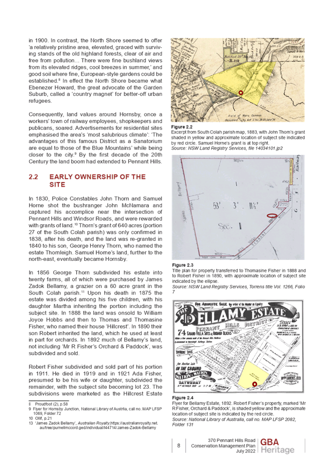
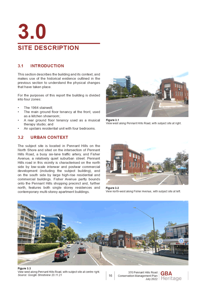
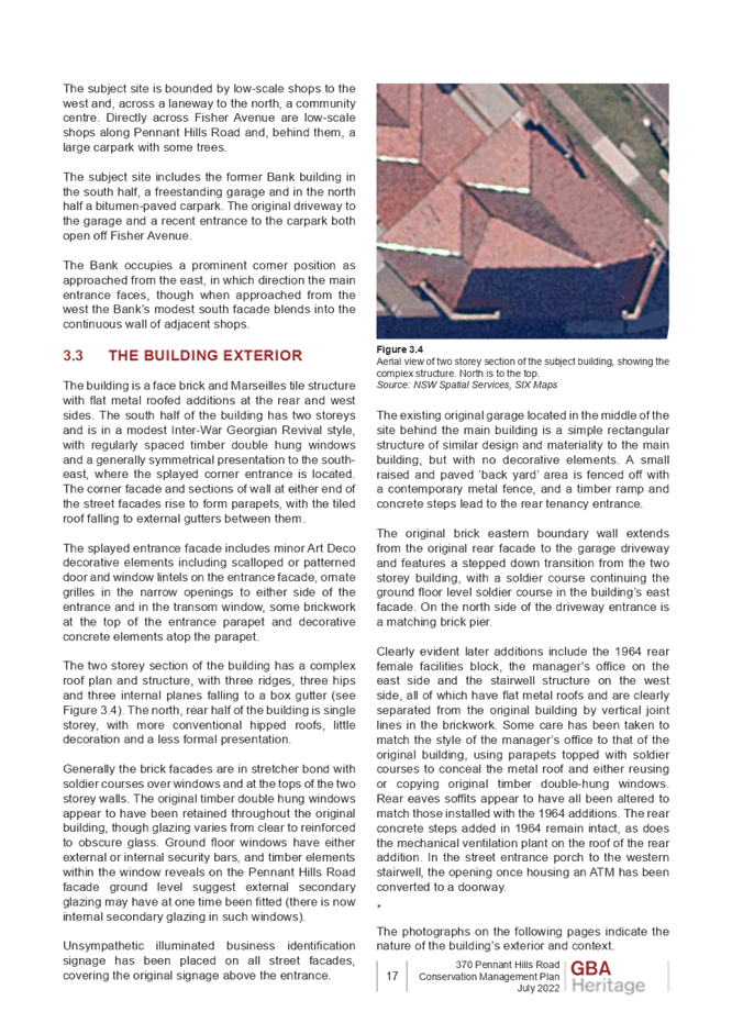
Local Planning Panel meeting
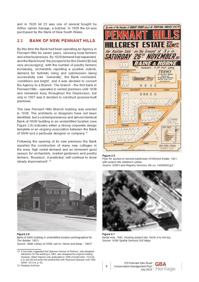
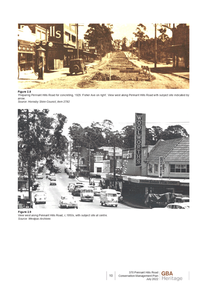
Wednesday 30 November 2022
at 4:00pm
DETERMINATION
BUSINESS PAPER
Local Planning Panel meeting
Wednesday 30 November 2022
at 4:00pm
Hornsby Shire Council Table of Contents
Page 1
ITEMS
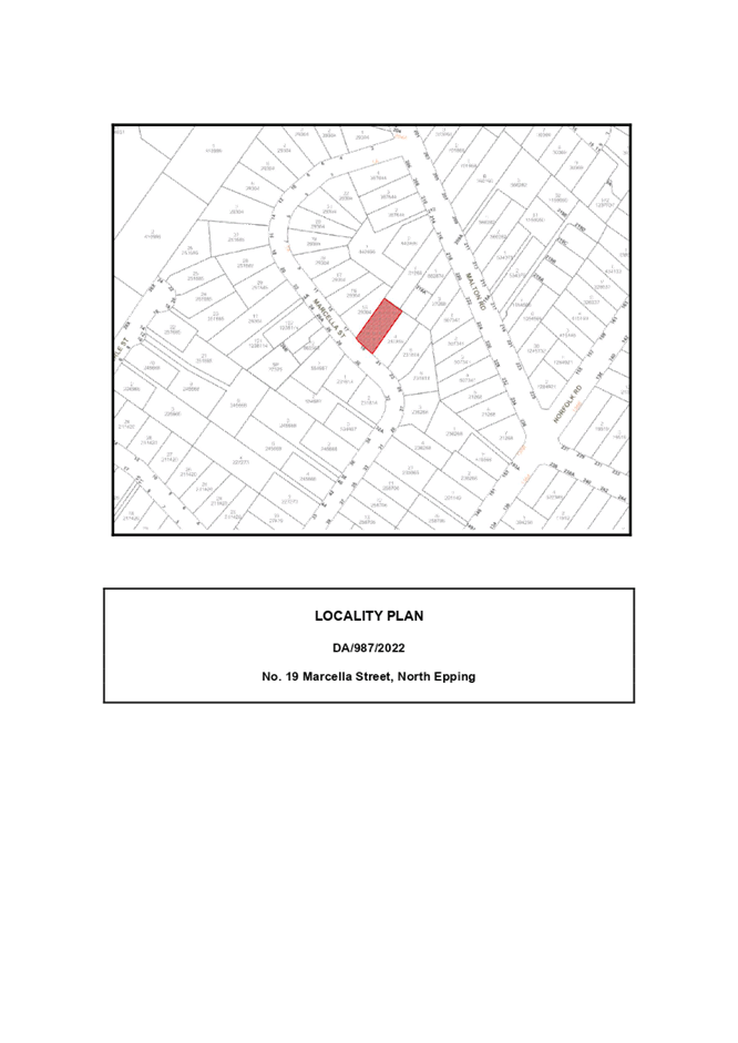
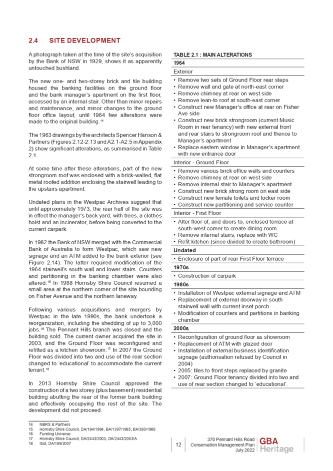
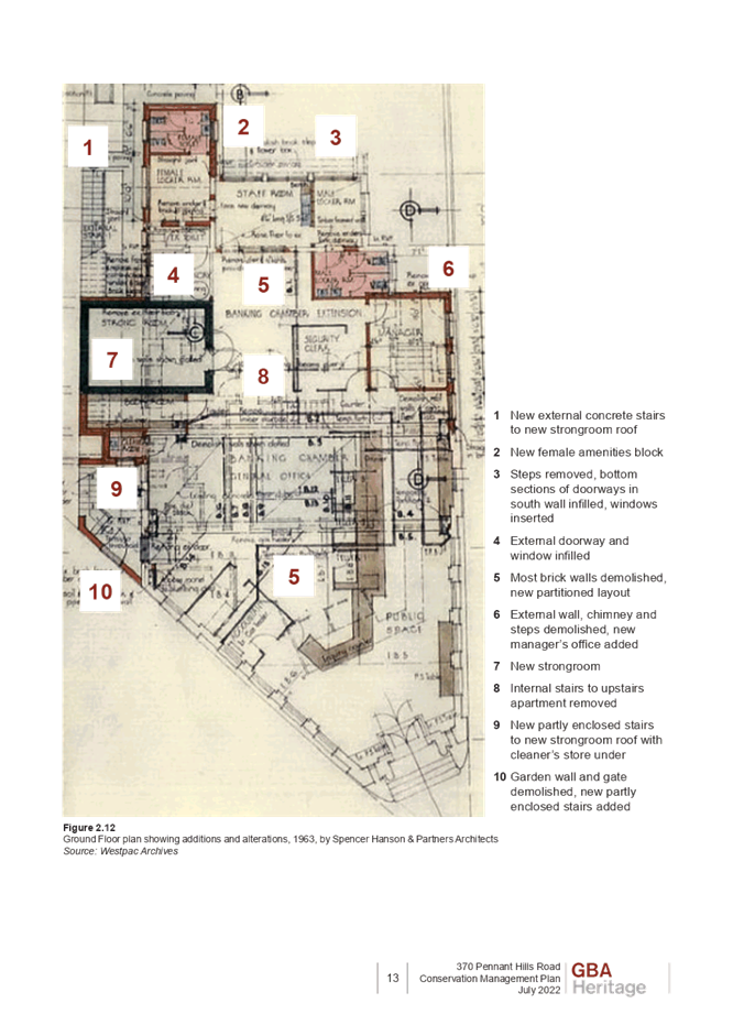
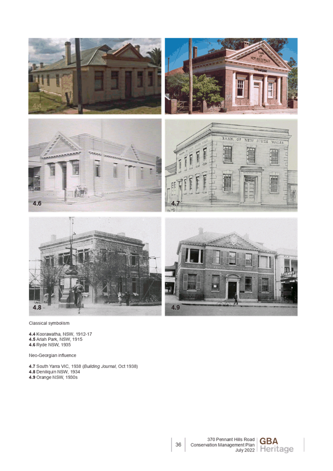
Item 5 LPP70/22 DA/987/2022 - Alterations and Additions to Existing Dwelling and New Swimming Pool - 19 Marcella Street, North Epping........................................................................ 1
Item 6 LPP68/22 DA/787/2022 - Alterations and Additions to Existing Dwelling and New Swimming Pool - 3 Butterfield Street, Thornleigh......................................................................... 49
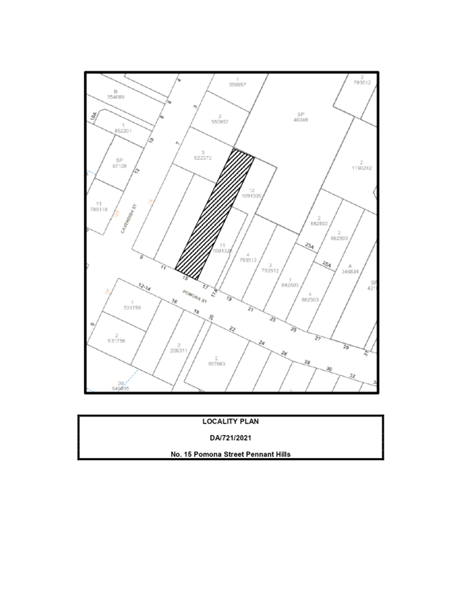
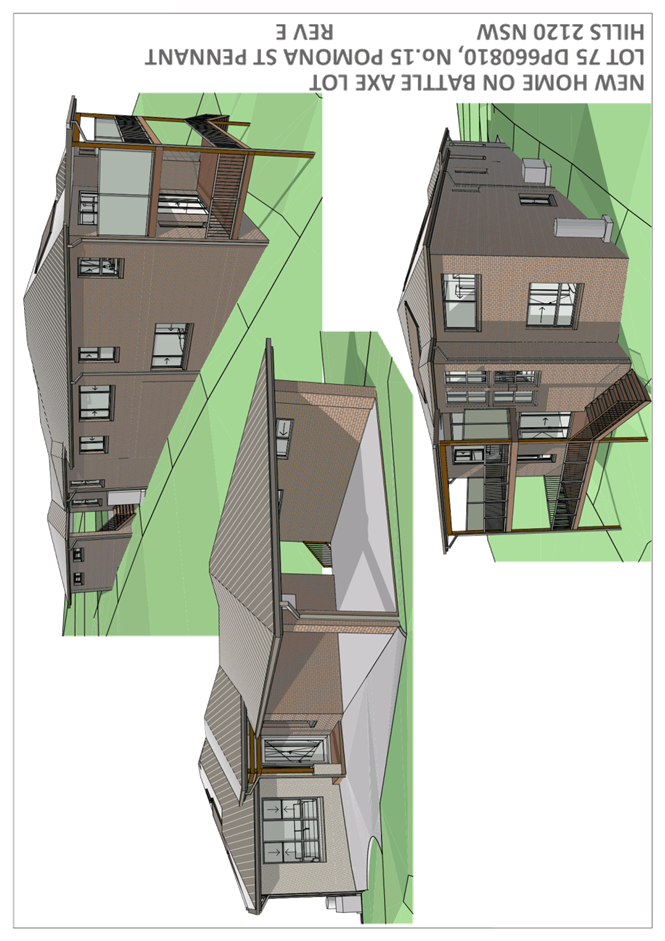
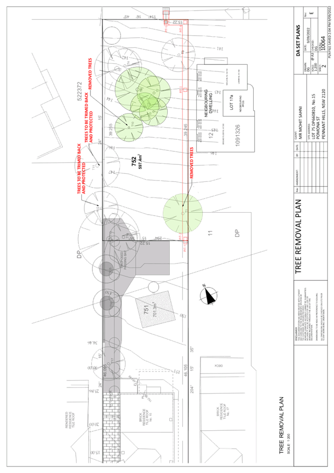
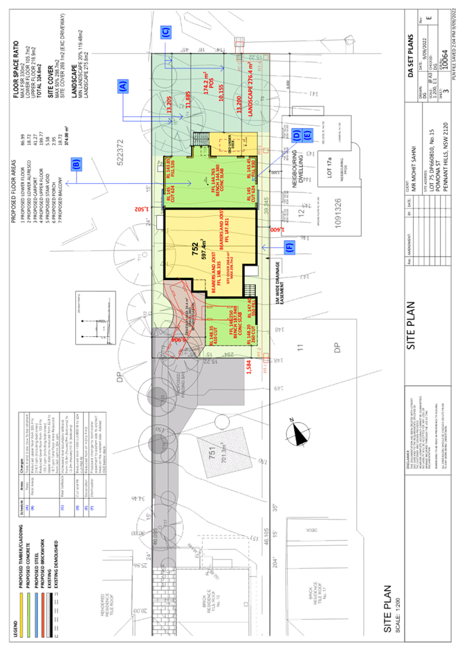
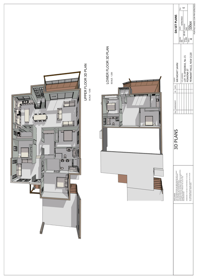
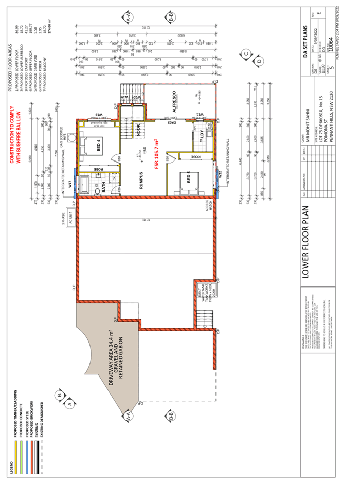
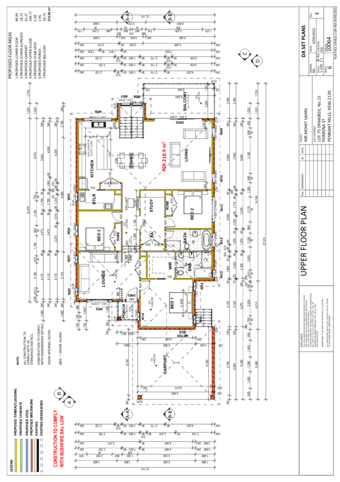
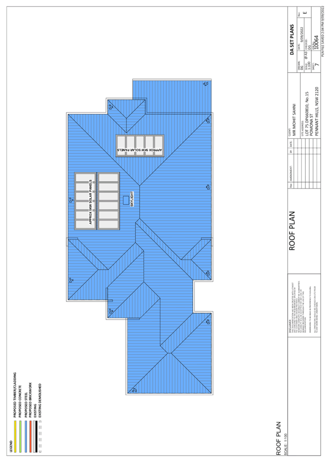
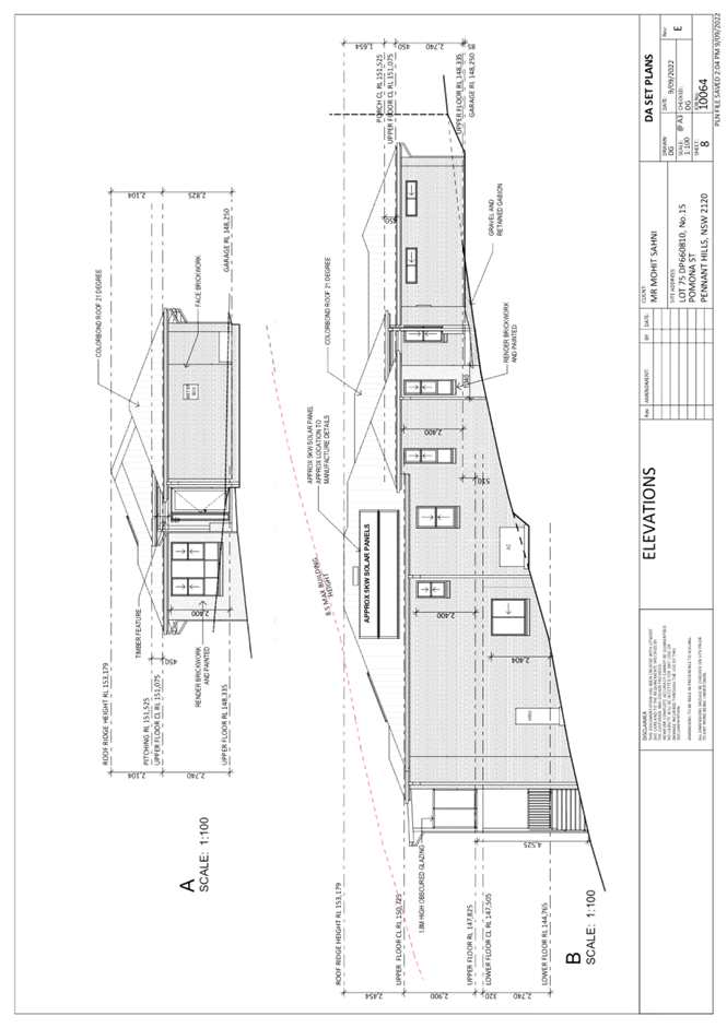
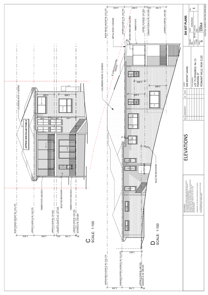
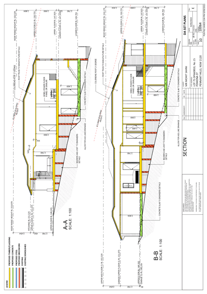
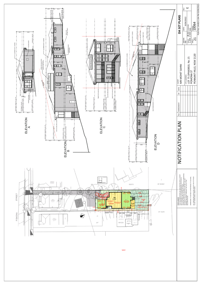
Item 7 LPP71/22 DA/742/2021 - Section 8.2 Application - Construction of a Dwelling House - 15 Pomona Street, Pennant Hills.................................................................................... 92
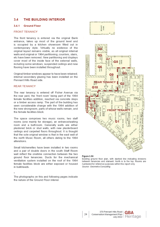
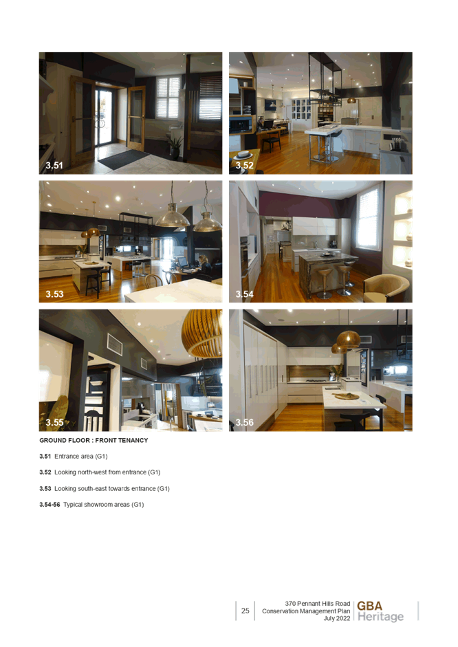
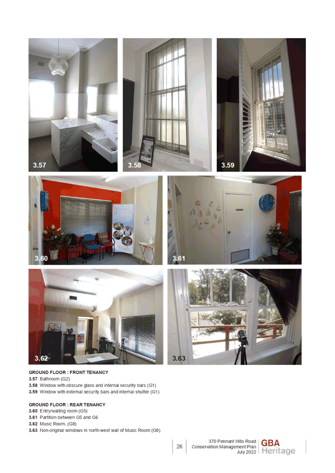
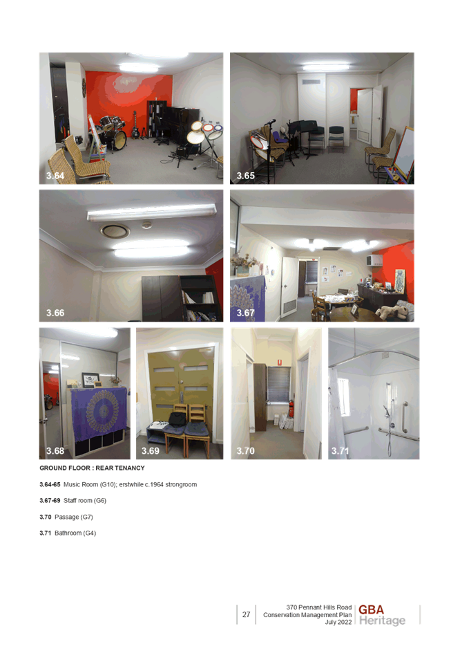
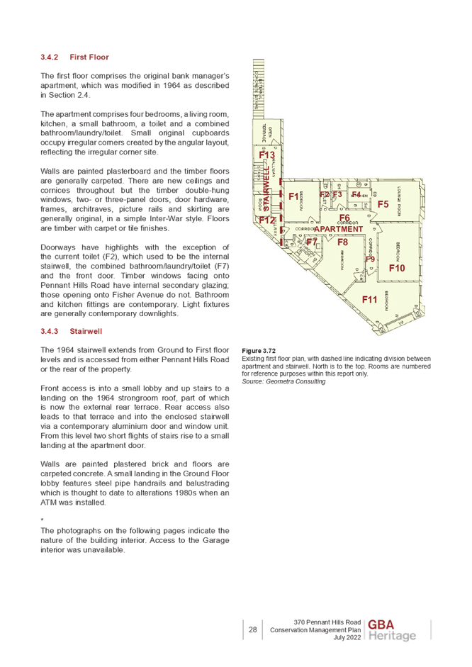
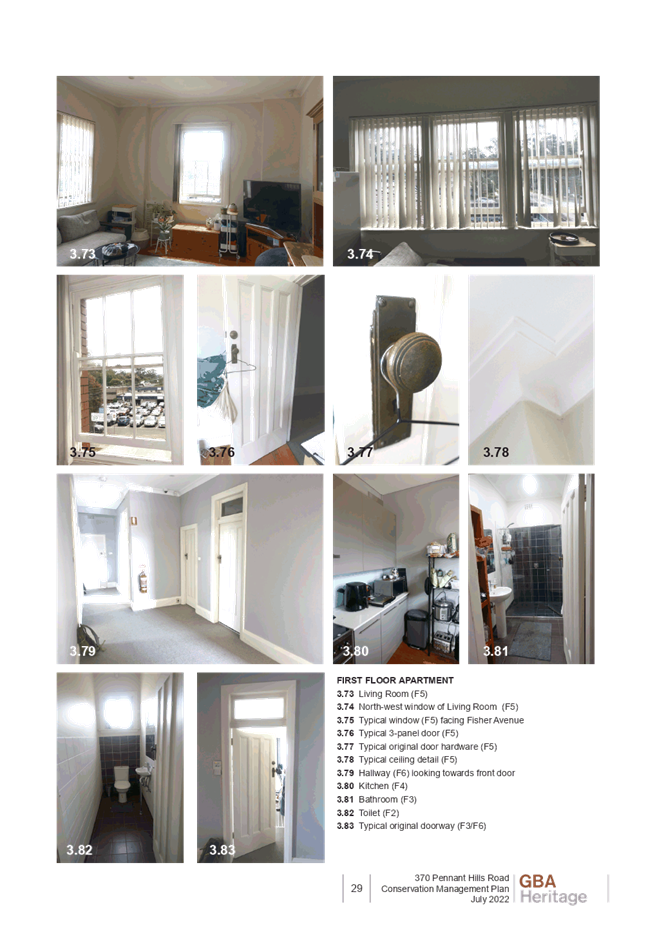
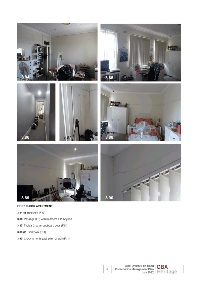
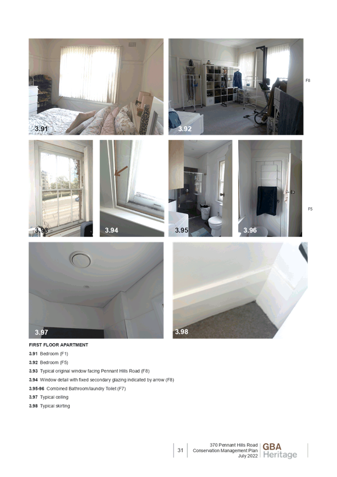
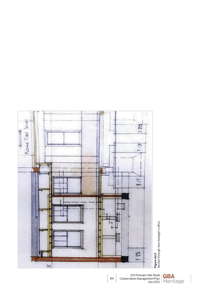
Item 8 LPP72/22 Report on Heritage Conservation Management Plan for DA/667/2022......... 134
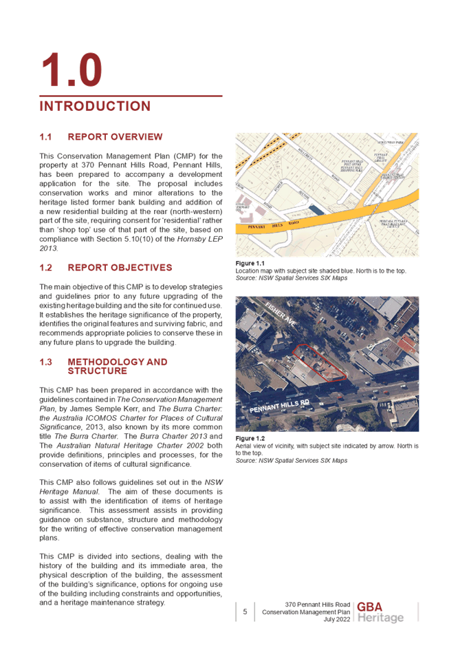
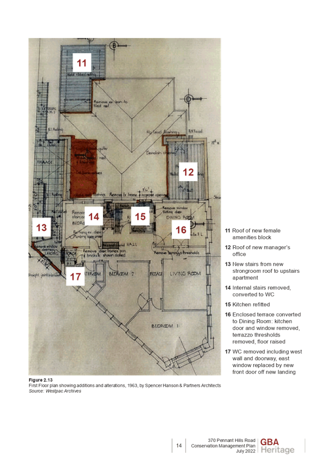
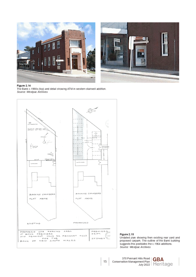
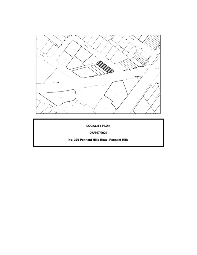
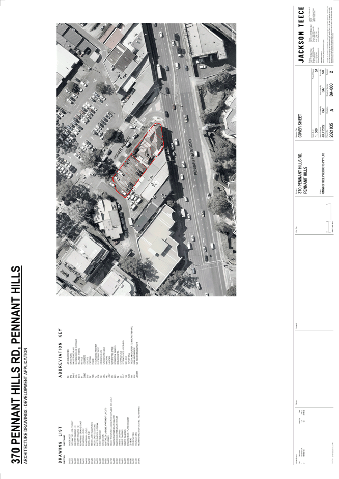
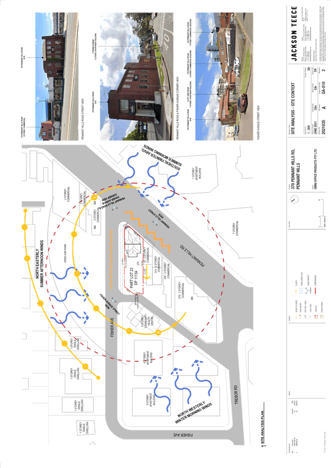
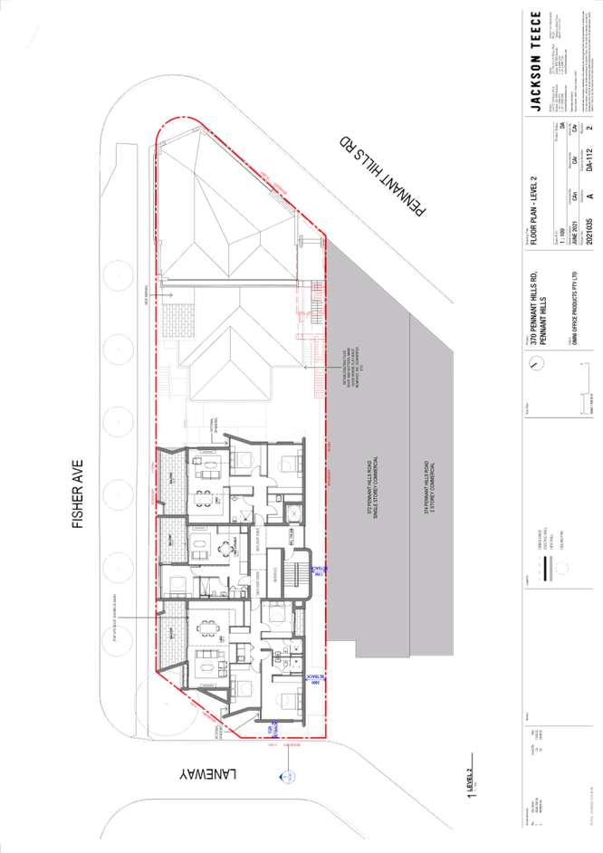
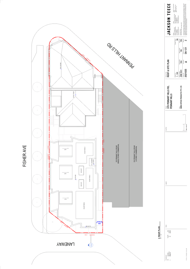
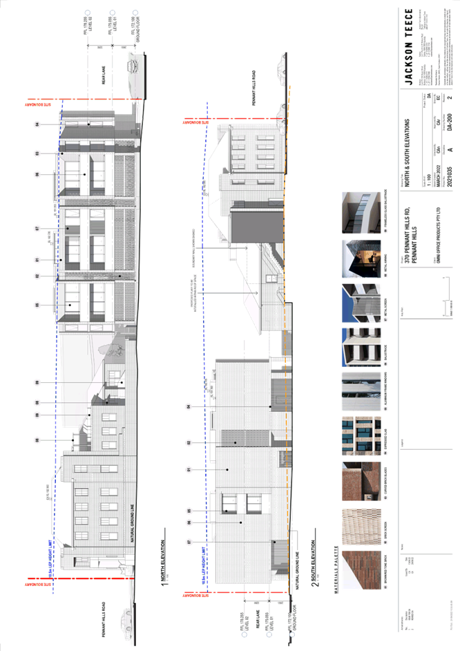
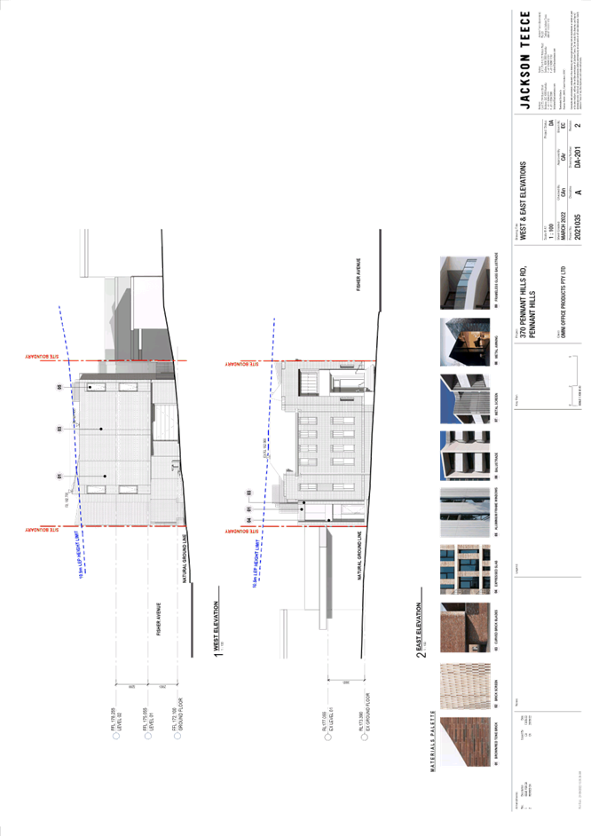
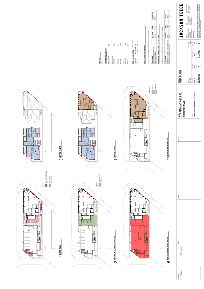
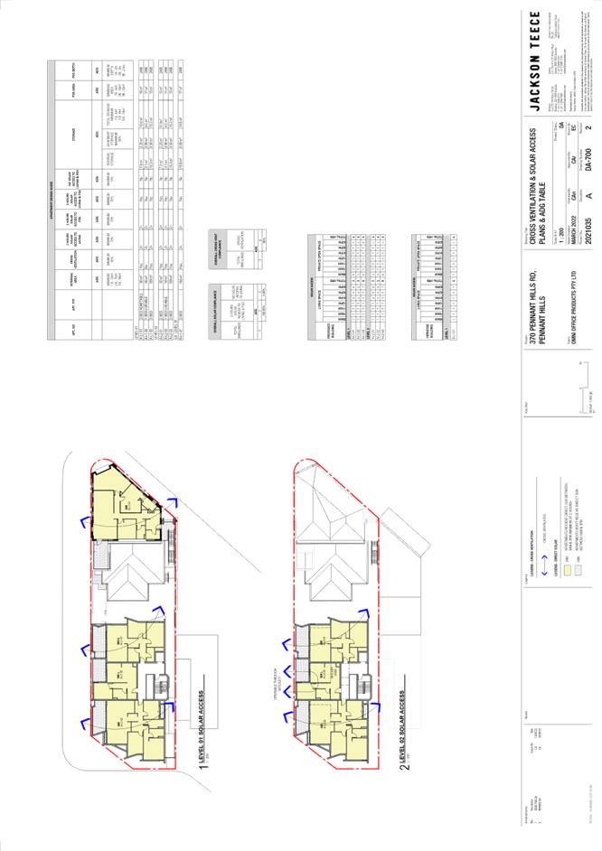
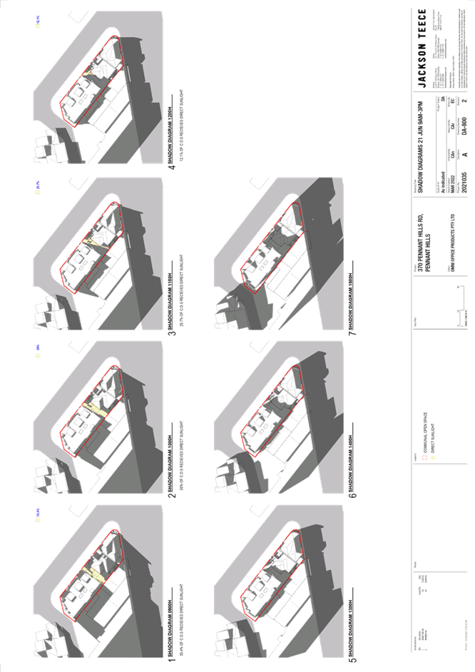
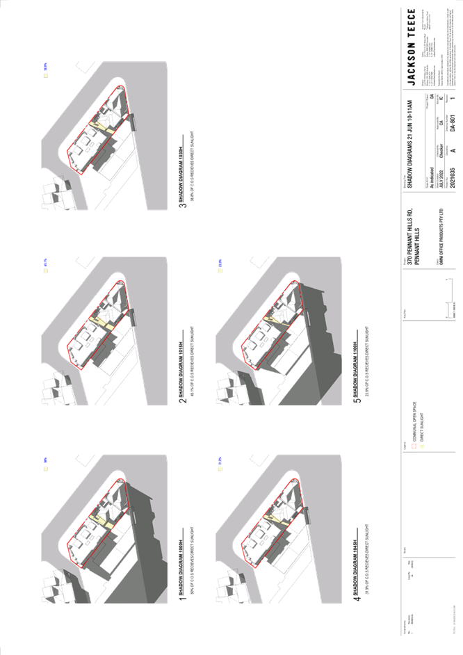
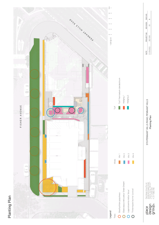
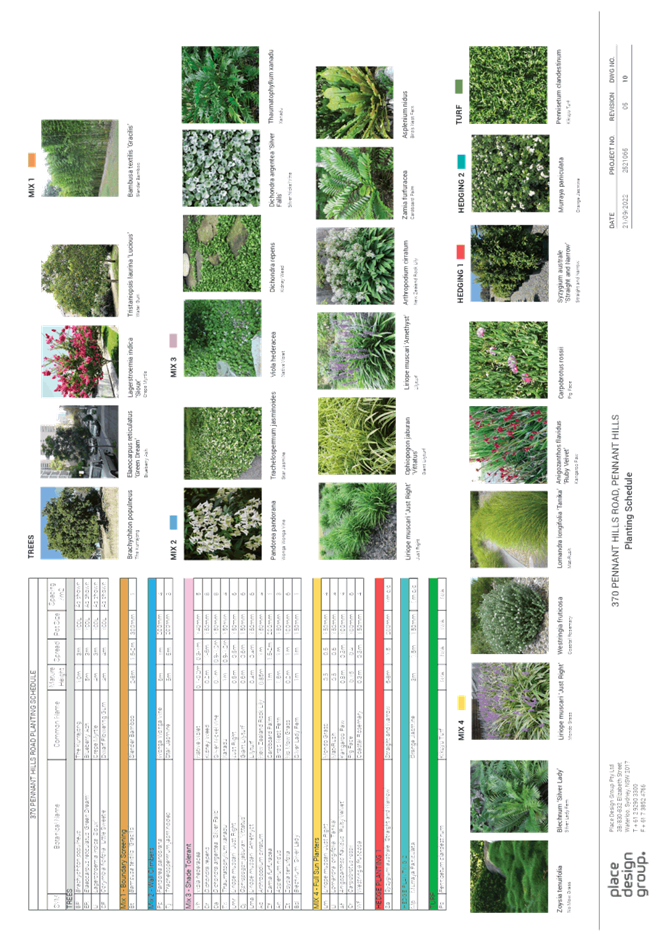
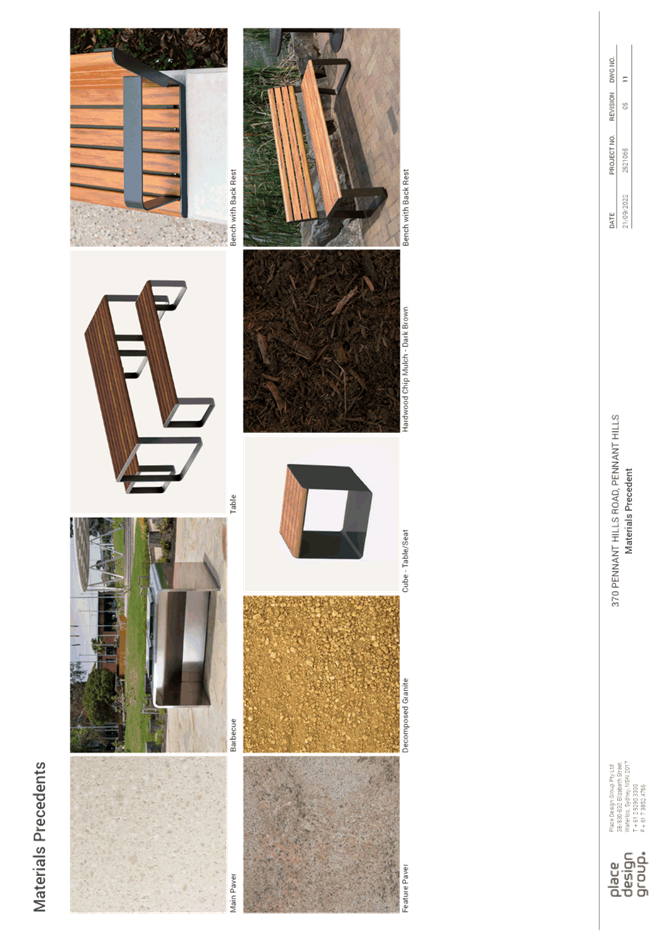
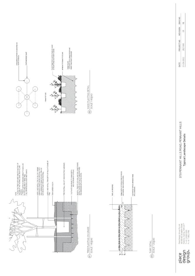
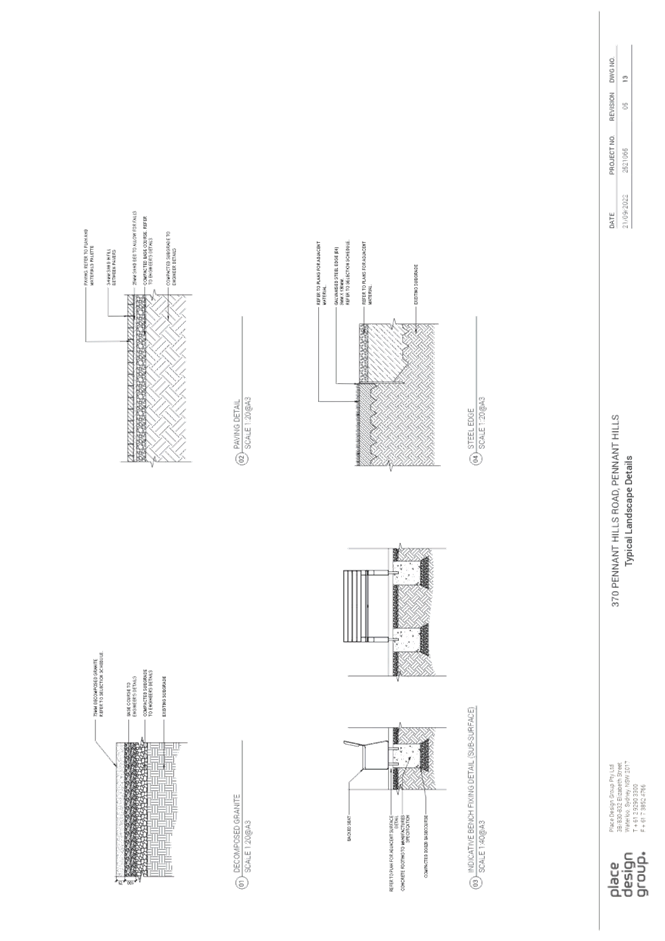
Item 9 LPP65/22 DA/667/2022 - Mixed Use Development Comprising Shop Top Housing and Residential Flat Building - 370 Pennant Hills Road, Pennant Hills............................... 207
LPP Report No. LPP70/22
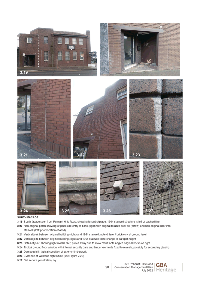
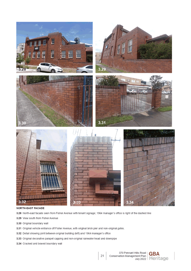
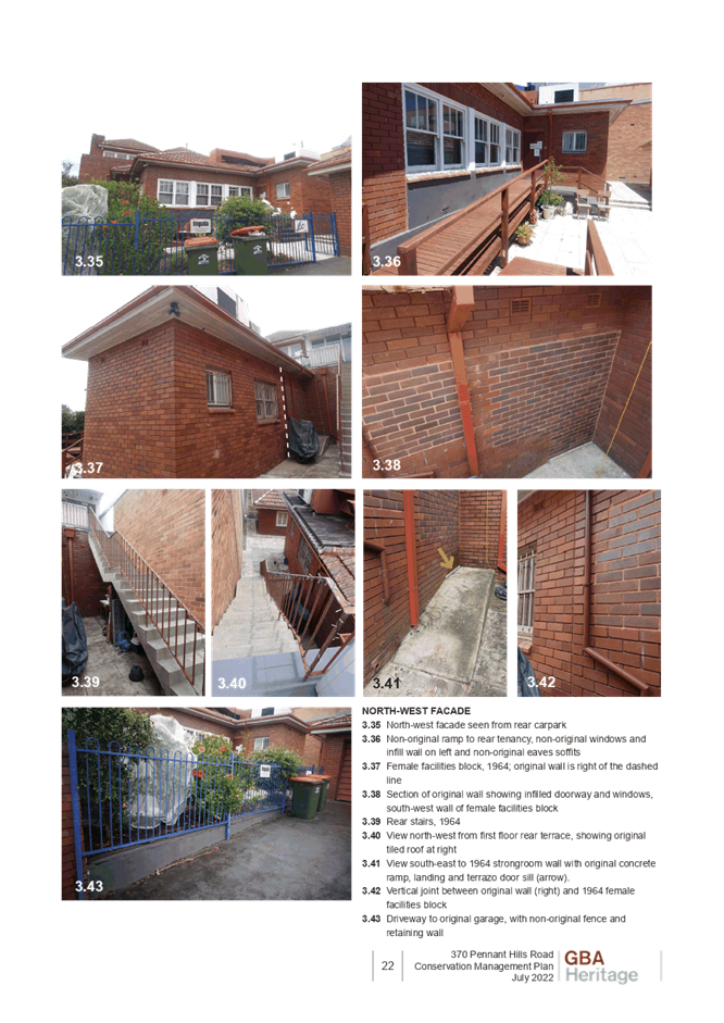
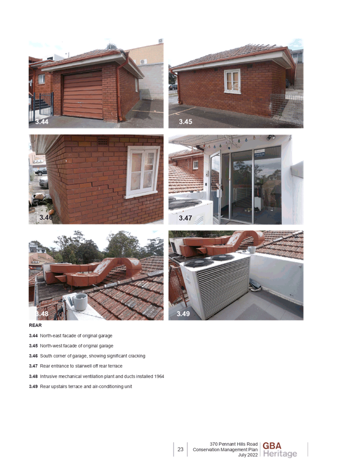
Local Planning Panel
Date of Meeting: 30/11/2022
5 DA/987/2022 - ALTERATIONS AND ADDITIONS TO EXISTING DWELLING AND NEW SWIMMING POOL - 19 MARCELLA STREET, NORTH EPPING
EXECUTIVE SUMMARY
|
DA No: |
DA/987/2022 (Lodged on 15 September 2022) |
|
Description: |
Alterations and additions to an existing dwelling, including new first floor addition and construction of a swimming pool |
|
Property: |
Lot 3 DP 231814, No. 19 Marcella Street, North Epping |
|
Applicant: |
Mr Andrew Grieve |
|
Owner: |
Mrs Fiona Maria McKinnon & Mr Jonathon Lee McKinnon |
|
Estimated Value: |
$356,900 |
|
Ward: |
C Ward |
· The application involves alterations and additions to a dwelling house and construction of a swimming pool.
· The proposal does not comply with the Hornsby Local Environmental Plan 2013 with regard to Clause 4.3 ‘Height of buildings’. The applicant has made a submission in accordance with Clause 4.6 ‘Exceptions to development standards’ of the Hornsby Local Environmental Plan 2013 to contravene the height of buildings development standard. The submission is considered well founded and is supported.
· A total of 1 submission has been received in respect of the application.
· The application is required to be determined by the Hornsby Local Planning Panel as the proposal would contravene the Hornsby Local Environmental Plan 2013 development standard for maximum height of buildings by more than 10 percent.
· It is recommended that the application be approved.
|
THAT the Hornsby Local Planning Panel assume the concurrence of the Secretary of the Department of Planning and Environment pursuant to Clause 4.6 of the Hornsby Local Environmental Plan 2013 and approve Development Application No. DA/987/2022 for alterations and additions to existing dwelling and construction of a swimming pool at Lot 3 DP 231814, No. 19 Marcella Street, North Epping subject to the conditions of consent detailed in Schedule 1 of LPP Report No. LPP 70/22. |
BACKGROUND
On 18 July 2014, a Complying Development Certificate (CDP/841/2014) was approved for residential alterations and additions (SEPP Controls) comprising construction of a rear timber deck, timber pergola, replacement of front balustrade, demolition of laundry and minor internal works to doors.
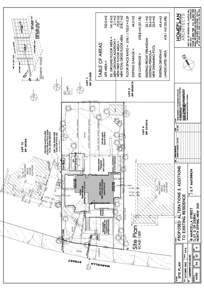
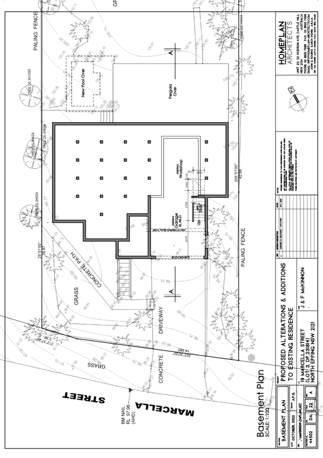
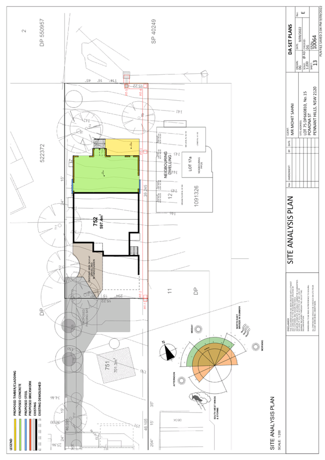
SITE
The development site comprises a single 746.1m2 allotment on the north-eastern side of Marcella Street. The site currently contains a one and two storey dwelling house. The existing garage and worksite on the ground floor contribute to the two storey element of the site. The site is used for residential purposes.
The site experiences a gentle 2 metre fall from the rear north-eastern boundary to the street. The site is not bushfire or flood prone. No trees are proposed to be removed to facilitate development works.
The surrounding locality is dominated by one and two storey dwelling houses. All dwelling houses in the vicinity to the subject site contain either an attached carport or attached garage. Notably, previous excavation works to facilitate the driveway development for the subject site result in a level driveway access opposed to adjoining properties that slope upwards to the dwelling.
The site does not contain a heritage listed item, is not in a heritage conservation area and is not in the vicinity of a heritage conservation item. The site does not contain ecologically endangered communities, and is not burdened by an easement.
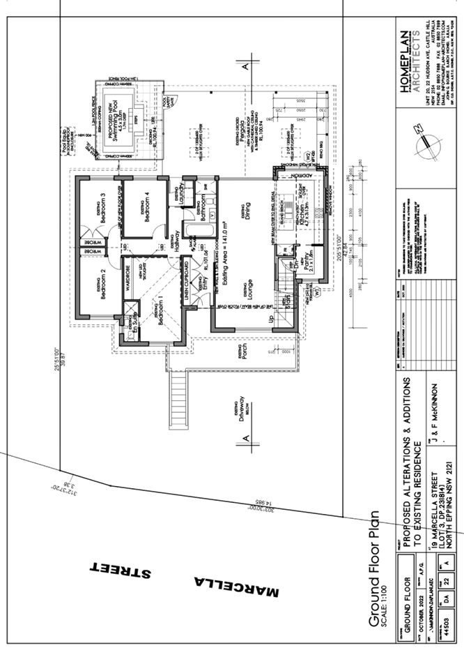
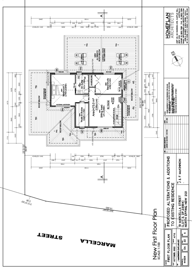
PROPOSAL
The proposal seeks consent for the following works:
· New first floor addition with two bedrooms, ensuite, sitting area and associated stairwell
· Rear ground floor minor extension towards property rear for a renovated kitchen area
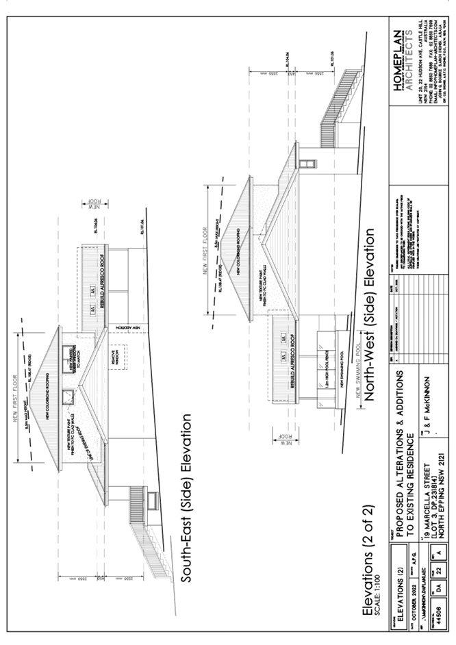
· Replacement of existing pergola roof to gable roof
· Construction of an inground swimming pool at the rear of the property
All proposed works would be located within the building footprint of the existing dwelling house, excluding the in-ground swimming pool.
ASSESSMENT
The development application has been assessed having regard to the Greater Sydney Region Plan - A Metropolis of Three Cities, the North District Plan and the matters for consideration prescribed under Section 4.15 of the Environmental Planning and Assessment Act 1979 (the Act). The following issues have been identified for further consideration.
1. STRATEGIC CONTEXT
1.1 Greater Sydney Region Plan - A Metropolis of Three Cities and North District Plan
The Greater Sydney Region Plan - A Metropolis of Three Cities has been prepared by the NSW State Government to guide land use planning decisions over the next 40 years to 2056. The Plan sets a strategy and actions for accommodating Sydney’s future population growth and identifies dwelling targets to ensure supply meets demand. The Plan also identifies that the most suitable areas for new housing are in locations close to jobs, public transport, community facilities and services.
The NSW Government will use the subregional planning process to define objectives and set goals for job creation, housing supply and choice in each subregion. Hornsby Shire has been grouped with Hunters Hill, Ku-ring-gai, Lane Cove, Mosman, North Sydney, Ryde, Northern Beaches and Willoughby to form the North District. The Greater Sydney Commission has released the North District Plan which includes priorities and actions for Northern District for the next 20 years. The identified challenge for Hornsby Shire will be to provide an additional 4,350 dwellings by 2021 with further strategic supply targets to be identified to deliver 97,000 additional dwellings in the North District by 2036.
The proposed development would be consistent with the Greater Sydney Region Plan - A Metropolis of Three Cities and the North District Plan, by contributing to a mix of housing types for the region.
2. STATUTORY CONTROLS
Section 4.15(1)(a) requires Council to consider “any relevant environmental planning instruments, draft environmental planning instruments, development control plans, planning agreements and regulations”.
2.1 Hornsby Local Environmental Plan 2013
The proposed development has been assessed having regard to the provisions of the Hornsby Local Environmental Plan 2013 (HLEP).
2.1.1 Zoning of Land and Permissibility
The subject land is zoned R2 Low density residential under the HLEP. The objectives of the R2 zone are:
· To provide for the housing needs of the community within a low-density residential environment.
· To enable other land uses that provide facilities or services to meet the day to day needs of residents.
The proposed development is defined as ‘dwelling house’ and is permissible in the R2 zone with Council’s consent.
2.1.2 Height of Buildings
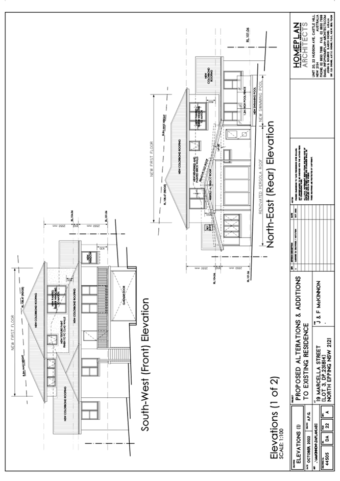
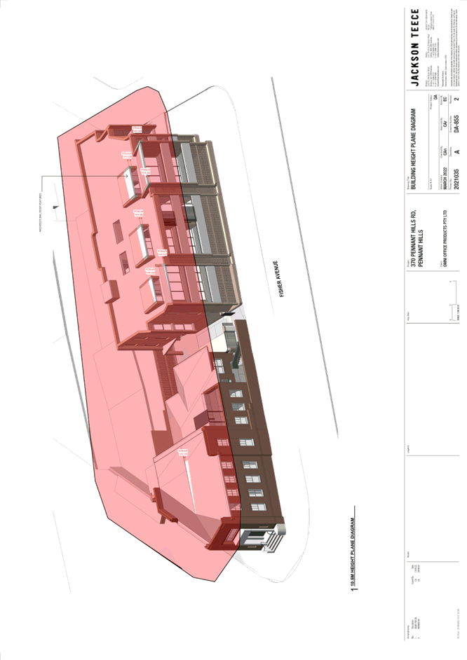
Clause 4.3 of the HLEP provides that the height of a building on any land should not exceed the maximum height shown for the land on the Height of Buildings Map. The maximum permissible height for the subject site is 8.5m. The proposal has a maximum height of 9.86m and does not comply with this provision.
The application is supported by a written request pursuant to Clause 4.6 of the HLEP to contravene the maximum height of building development standard, which is discussed in Section 2.1.3 of this report.
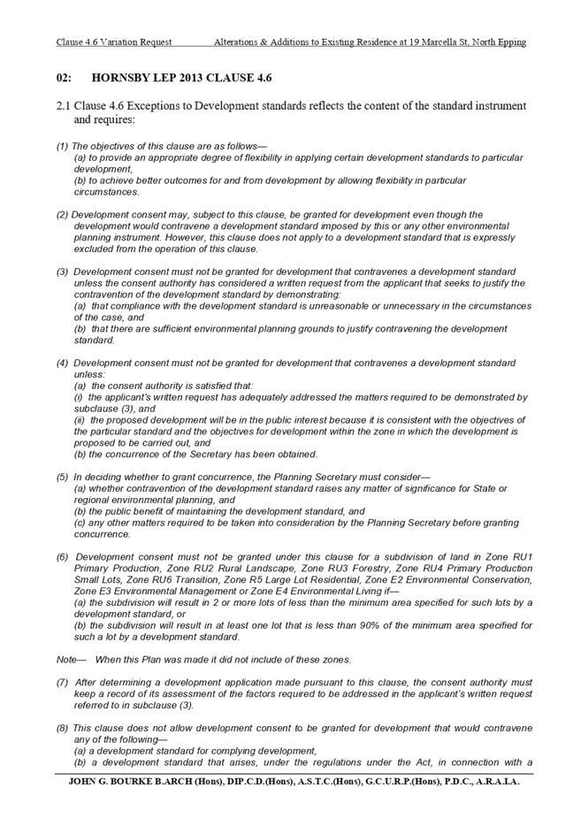
2.1.3 Exceptions to Development Standards
The applicant submitted a written request to contravene the height of building development standard contained within Clause 4.3 of the HLEP.
The written request prepared by John G. Bourke of Homeplan Project Design Resources, describes the extent of the contravention as follows:
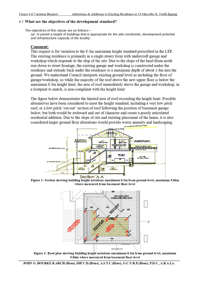
This request is for variation to the 8.5m maximum height standard prescribed in the LEP. The existing residence is primarily in a single storey form with undercroft garage and workshop which responds to the slop of the site. Due to the slope of the land (from north rear down to street frontage, the existing garage and workshop is constructed under the residence and extends back under the residence to a maximum depth of about 1.8m into the ground. We understand Council interprets existing ground level as including the floor of garage/workshop, so while the majority of the roof above the new upper floor is below the maximum 8.5m height limit, the area of roof immediately above the garage and workshop, in a footprint to match, is non-compliant with the height limit.
The figure below demonstrates the limited area of roof exceeding the height limit. Possible alternatives have been considered to meet the height standard, including a very low pitch roof, or a low pitch ‘cut-out’ section of roof following the position of basement garage below, but both would be awkward and out of character and create a poorly articulated residential addition. Due to the slope of site and existing placement of the home, it is also considered larger ground floor alterations would provide worse amenity and landscaping.
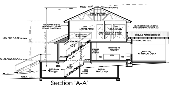
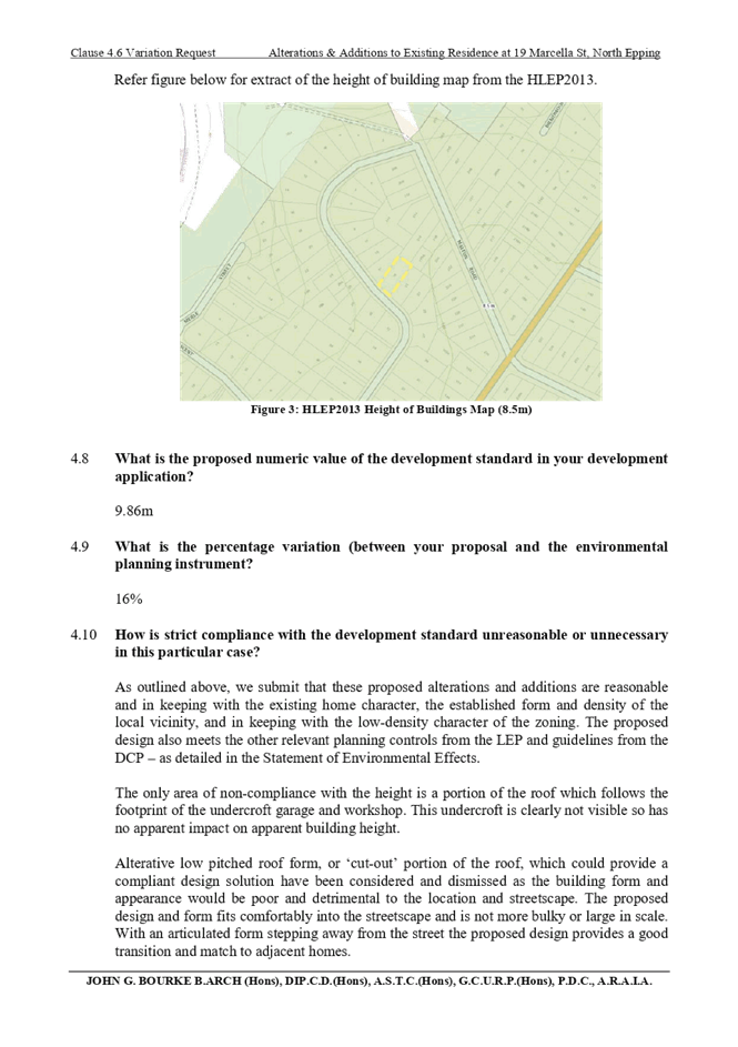
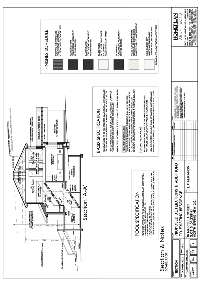
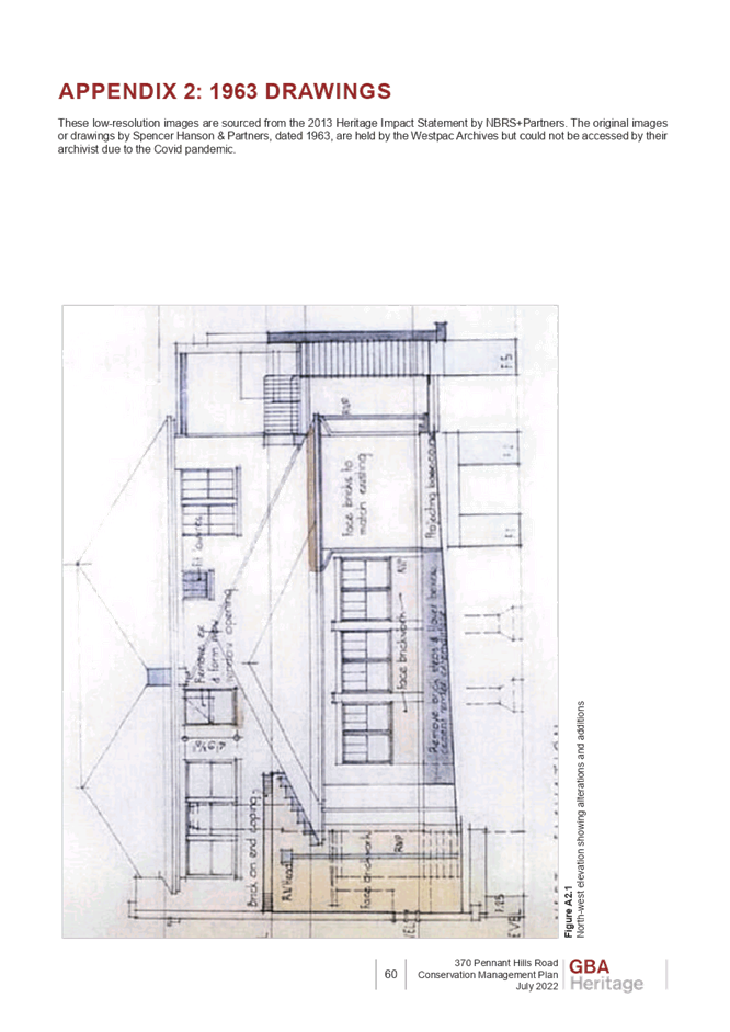
Figure 1: Section showing building height notations (maximum 8.3m from ground level, maximum 9.86m when measured from basement floor level)
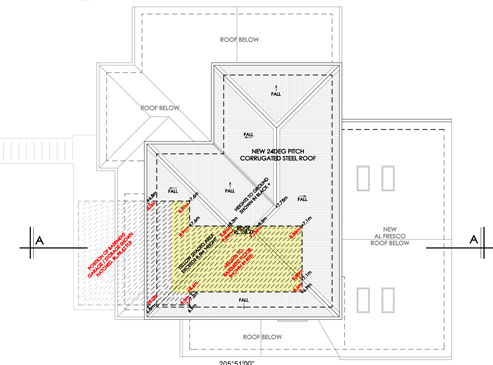
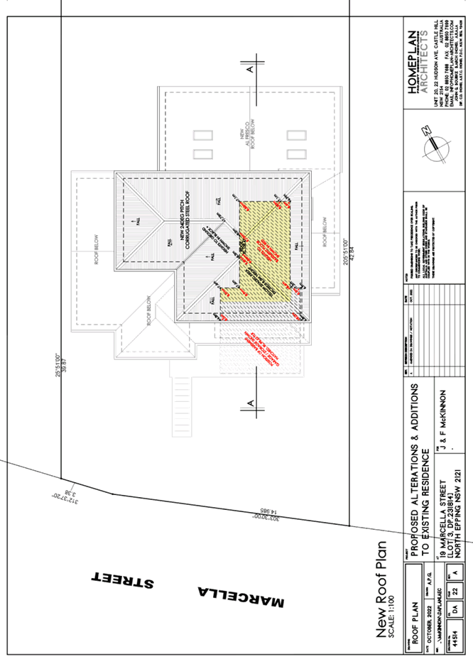
Figure 2: Roof plan showing building height notations (maximum 8.3m from ground level, maximum 9.86m when measured from basement floor level)
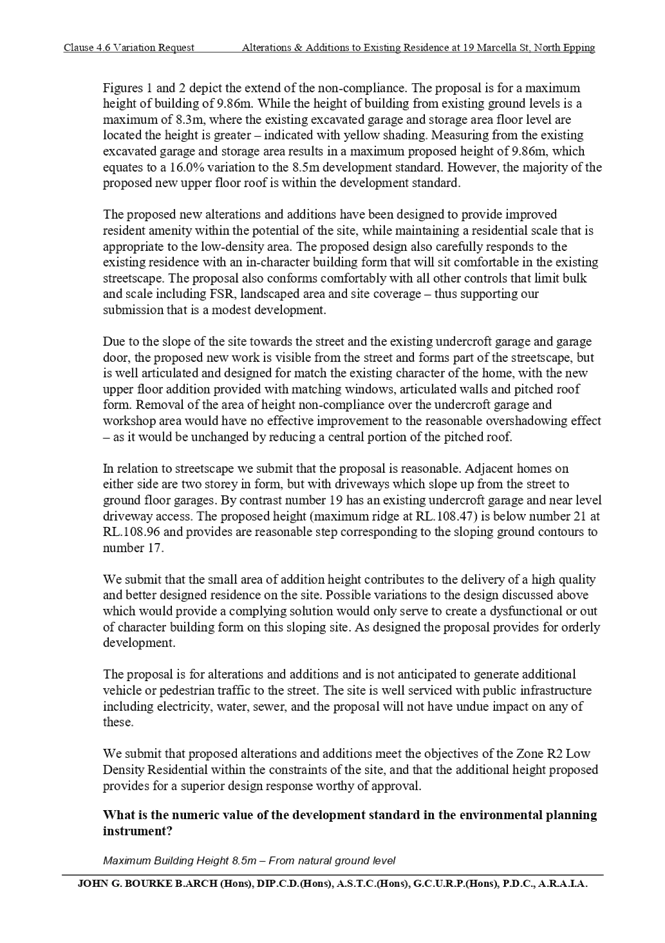
Figures 1 and 2 depict the extend of the non-compliance. The proposal is for a maximum height of building of 9.86m. While the height of building from existing ground levels is a maximum of 8.3m, where the existing excavated garage and storage area floor level are located the height is greater – indicated with yellow shading. Measuring from the existing excavated garage and storage area results in a maximum proposed height of 9.86m, which equates to a 16.0% variation to the 8.5m development standard. However, the majority of the proposed new upper floor roof is within the development standard.
The application has been assessed against the requirements of Clause 4.6 of the HLEP. This clause provides flexibility in the application of the development standards in circumstances where strict compliance with those standards would, in any particular case, be unreasonable or unnecessary or tender to hinder the attainment of the objectives of the zone.
In particular, Clause 4.6 provides criteria that must be satisfied prior to a consent authority granting consent to development that contravenes a development standard. These criteria demonstrated under Clause 4.6(3) are as follows:
(a) That compliance with the development standard is unreasonable or unnecessary in the circumstances of the case, and
(b) That there are sufficient environmental planning grounds to justify contravening the development standard.
A discussion regarding the criteria provided at Clause 4.6(3), with respect to the development application is provided below.
2.1.3.1 Unreasonable or Unnecessary Clause 4.6(3)(a)
There are five common methods by which an applicant can demonstrate that compliance with a development standards is unreasonable or unnecessary in the circumstances of the development. Initially proposed for objections under clause 6 of SEPP 1 in the decision of Wehbe v Pittwater Council [2007] NSWLEC 827 Pearson C summarised and applied these methods to written requests made under Clause 4.6 in Four2Five Pty Ltd v Ashfield Council [2015] NSWLEC 1009 [61-62]. These five methods are generally as follows:
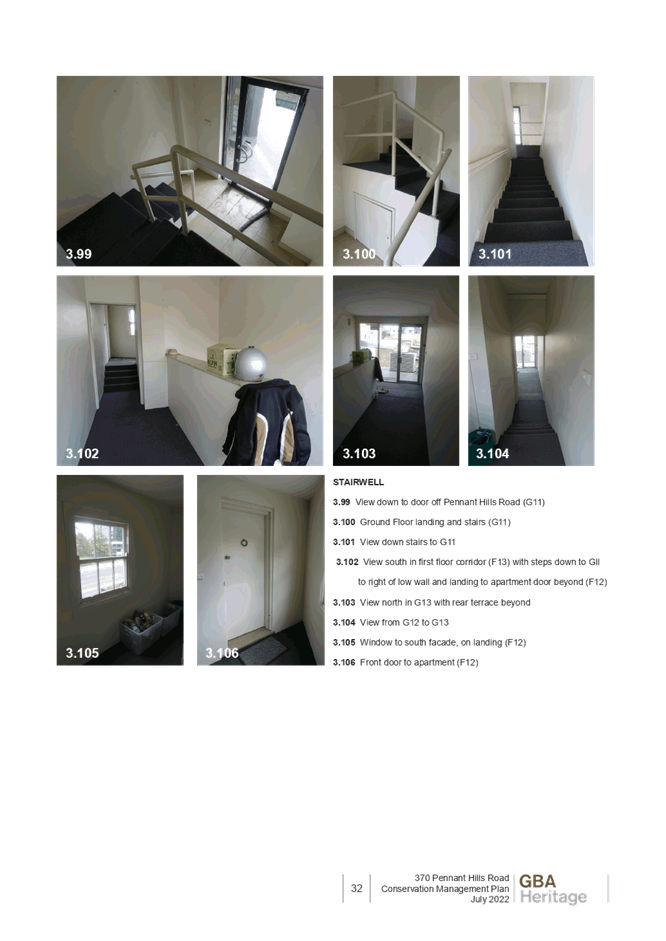
· The objectives of the development standard are achieved notwithstanding non-compliance with the standard.
· The underlying objective or purpose is not relevant to the development.
· That the objective would be defeated or thwarted if compliance was required.
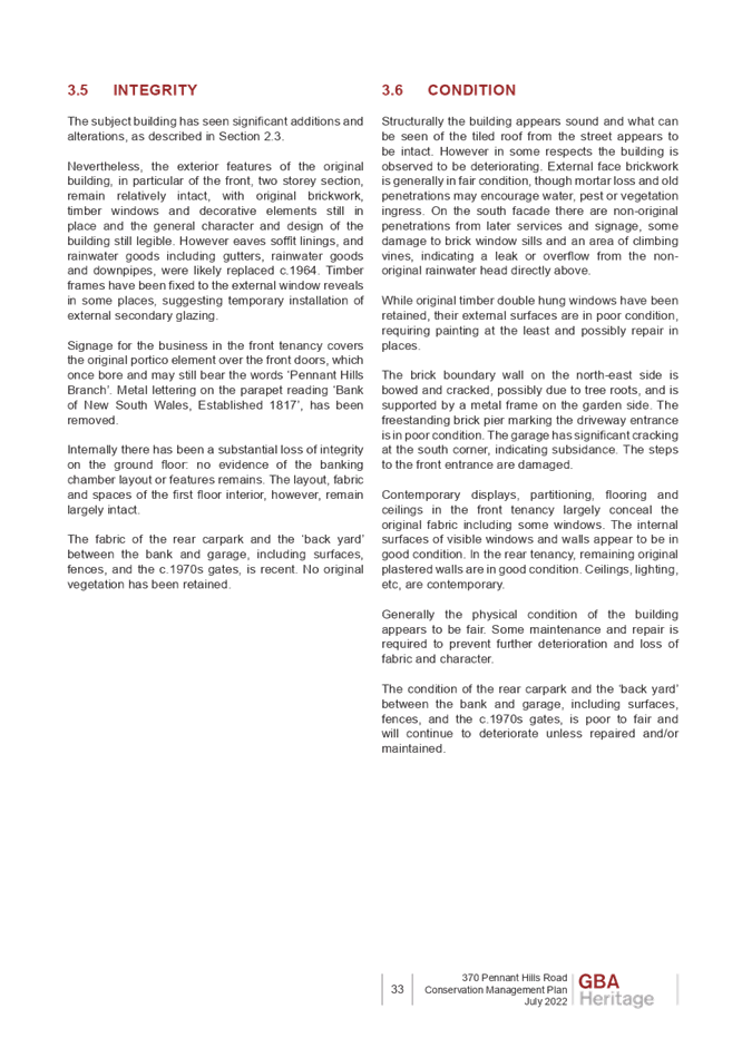
· That the development standard has been virtually abandoned or destroyed by the Council’s own actions in departing from the standard.
· The zoning of the land is unreasonable or inappropriate.
It is not required to demonstrate that a development meets multiple methods as listed above, and the satisfaction of one can be adequate to demonstrate that the development standard is unreasonable or unnecessary.
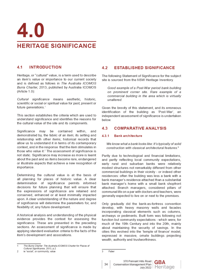
The written request prepared by Homeplan Project Design Resources, dated October 2022 provides a detailed assessment of the proposal with respect to the development standard sought to be contravened. The written request provides reasoning on all five of the Wehbe tests, however, Council is of the opinion that the justification provided for the first test, being “The objectives of the development standard are achieved notwithstanding non-compliance with the standard” is the most appropriate reasoning provided. Justification provided under the remaining four Wehbe tests are noted, however they are considered to be supporting arguments, that do not meet the required level of justification to support contravention of the ‘height of buildings’ development standard.
The reasoning provided within the written request to demonstrate that the objectives of the development standard are achieved notwithstanding non-compliance with the standard are as follows:
The relevant objective underpinning the building height development standard is:
The additional height proposed (above the existing building) contributes to the delivery of a high-quality development on this site. The zoning of the site and surrounding industrial lands includes land of relatively steep topography that may be considered in some respects unsuitable for industrial development. Consequently, a number of industrial complexes in the locality have been approved by Council in contravention of the current LEP height standard. The proposed building works are consistent with the height and scale of the building constructed immediately adjoining the site to the west.
The existing dwelling is constructed at 7.62 metres height. The minor additional breach in height at small elements of the building is considered acceptable in the circumstances and in the context of the surrounding development.
The lateral expansion of the building to achieve Council’s maximum permitted height would involve major reconstruction to allow for necessary construction machinery to access the rear of the site.
The objectives of the standard can be achieved, notwithstanding the additional height, and that a superior development outcome would result.
With reference to the reasoning provided by the applicant above, Council does not object to the conclusion that the proposed additions meet the objectives of Clause 4.3. In reaching this conclusion the following points are noted:
· The only area of non-compliance with the height is a portion of the roof which follows the footprint of the undercroft garage and workshop. This ground floor garage and workshop does not dominate the building façade, and would generate negligible impacts to the streetscape and amenity accordingly.
· The additional floor space assists in achieving the envisioned development potential for the site and brings the development closer to the maximum permissible floor area. Placing this additional floor space within the building envelope would assist in protecting the remnant vegetation on site.
· The locality of the area is characterised by dwellings between one and three storeys. A development of such nature would not result in adverse impacts to the building character of the North Epping area, nor set precedent to permit unreasonable development.
· Dwelling houses in the locality comprise largely of attached garages and carports. These dwelling houses however slope upwards to the property unlike the subject site that has reduced gradient. Accordingly, the site is constrained by previous excavation works to facilitate development of the ground floor garage and workshop area resulting in surrounding land of the ground floor either being partially or fully underground, or the portion of land that serves as the access driveway.
· Alterative low pitched roof form, or ‘cut-out’ portion of the roof, which could provide a compliant design solution have been considered and dismissed as the building form and appearance would be poor and detrimental to the location and streetscape. The proposed design and form fits comfortably into the streetscape and is not more bulky or large in scale. With an articulated form stepping away from the street the proposed design provides a good transition and match to adjacent homes.
· The maximum proposed ridge level of the subject site is 108.47 metres ASL, which is 0.49 metres lower than the dwelling house at adjoining property to the east No. 21 Marcella Street at 108.96 metres ASL. The adjoining property to the east No. 17 Marcella Street has a maximum height of 106.93 metres ASL, which is a minor difference of 1.54 metres which would not be considered uncommon or unreasonable between dwelling houses in the locality.
· Positioning the first-floor addition at the alternate portion of the dwelling would be unfeasible as the associated stairway required would involve major internal reconfiguration of existing bedrooms rather than positioning it in an open living space.
· Facilitating lateral extension of the existing first floor would prove highly complex as access for required construction machinery would be extremely limited.
· There would be negligible adverse impacts to solar access, view loss and privacy.
For the reasons outlined above, it is considered that the written request to contravene the height of buildings development standard adequately demonstrates that the objectives of the development standard contained within Clause 4.3 of the HLEP are achieved, notwithstanding contravention of the development standard.
2.1.3.2 Environmental Planning Grounds - Clause 4.6(3)(b)
In addition to demonstrating that compliance is unreasonable or unnecessary, Clause 4.6(3)(b) requires that there are sufficient environmental planning grounds to justify contravening the development standard. In demonstrating that sufficient environmental planning grounds exist it must be demonstrated that the planning grounds are particular to the circumstances of the development on the subject site (summarised from Four2Five Pty Ltd v Ashfield Council [2015] NSWLEC 1009 [60].
The applicant provided the following planning grounds for the contravention of the development standard:
· The potential for negative town planning and urban outcomes that may arise from strict compliance with the requirement are negligible when considering the context of the site with surrounding development.
· The unique qualities of the site and the proposed alterations and additions will maintain and enhance these and the character of the locality.
· The extent of the non-compliance is minor in the context of the existing built form.
· The non-compliance arises solely from the existing, non-visible, undercroft garage and storage spaces. Using floor levels in this vicinity to limit roof form immediately above, rather than the natural ground levels and trend of contours is unreasonable when these levels have no impact on actual building form.
· Alternative fully compliant roof responses to the portion of undercroft garage and workshop would provide for a poor design solution not in keeping with the existing character or contributing positively to streetscape. - The request for a 16% variation to maximum height – which only affects a portion of the roof area – does not impact on full compliance with the other LEP controls and DCP guidelines.
· All other controls that limit bulk scale including floor area, area of landscaping and maximum site coverage are met – indicating that the proposed alterations maintain a reasonable low-density form.
· The proposal is consistent with the objectives of the clause 4.3 height standard in the LEP.
· The requested variation to the maximum height standard will have no adverse impact on adjoining residents in relation to overshadowing, views or privacy.
· The variation results from particulars of the existing dwelling and site contours and would not establish a precedent for other unjustified non-compliances.
· The proposed variation to the height standard does not conflict with any matters of State or regional environmental planning significance, nor does it conflict with any State Planning Policies or Ministerial directives. The significance of the non-compliance is acceptable in the context of the overall development of the broader Hornsby area.
· The public benefit would be best served by approval of this application, despite the height variation proposed as doing so provides for a higher quality design outcome which responds suitably to the natural site levels.
· The additional height is a negligible issue within the context of the greater planning benefit, including opportunities for the protection and enhancement of local values and provision of high-quality residential development that would result from the minor variation to the height standard.
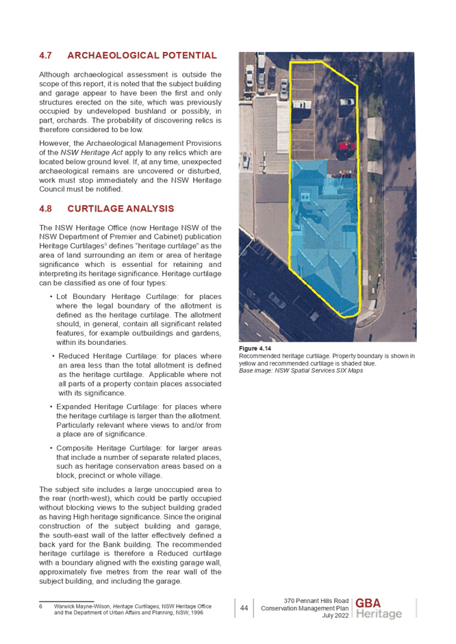
In this regard, there are sufficient environmental planning grounds specific to this site to justify the proposed departure from the development standard.
The underlying objective of the height standard is to minimise potential adverse environmental impacts of development of the site on the surrounding area.
Although the proposal breaches the height of buildings control, the development achieves appropriate building envelopes and separation to the adjacent dwelling houses. It is also worth noting that the development does comply with solar access, site coverage and other similar requirements adopted by Council.
Council considers that the environmental planning grounds stated within the written request are sufficient with respect to Clause 4.6(3)(b) and that the stated grounds are specific to the proposed development and the circumstances of the development site. It is therefore considered that the written request adequately demonstrates compliance with the clause and is acceptable in this regard.
In demonstrating the unreasonable and unnecessary test, the applicant further established satisfactory environmental planning grounds with respect to the site and the surrounding constraints.
Council is therefore satisfied that Clause 4.6(3)(b) of the HLEP is adequately addressed.
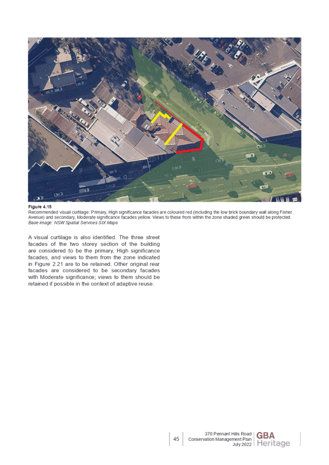
2.1.3.3 Public Interest and Clause 4.6(4)
Clause 4.6(4) states that development consent must not be granted for development that contravenes a development standard unless:
(a) The consent authority is satisfied that:
(i) The applicant’s written request has adequately addressed the matters required to be demonstrated by subclause (3), and
(ii) The proposed development will be in the public interest because it is consistent with the objectives of the particular standard and the objectives for development within the zone in which the development is proposed to be carried out, and
(b) The concurrence of the Planning Secretary has been obtained.
With regard to part (a)(i), the written request is considered to adequately address the matters required to be demonstrated as outlined above.
With regard to part (a)(ii), the proposed development is considered to be in the public interest because it is consistent with the objectives of the particular standard and the objectives for development within the zone in which the development is proposed to be carried out.
· The development contravenes a numerical standard by greater than 10%.
· The variation is to a non-numerical standard.
Local Planning Panels constituted under the Environmental Planning and Assessment Act 1979 exercise consent authority functions on behalf of a Council and are not delegates of Council. Therefore, Local Planning Panels may determine a development application notwithstanding, a numerical non-compliance in excess of 10%.
Therefore, the exceedance of the height of buildings development standard is supported in this instance.
2.1.4 Heritage Conservation
Clause 5.10 of the HLEP sets out heritage conservation provisions for Hornsby Shire. The site does not include a heritage item and is not located in a heritage conservation area. Accordingly, no further assessment regarding heritage is necessary.
2.1.5 Earthworks
Clause 6.2 of the HLEP states that consent is required for proposed earthworks on site. Before granting consent for earthworks, Council is required to assess the impacts of the works on adjoining properties, drainage patterns and soil stability of the locality.
The application proposes excavation associated with the proposed inground swimming pool At its deepest point, the excavation would be 1 metre below the existing ground level.
|
Comment |
|
|
(a) The likely disruption of, or any detrimental effect on, drainage patterns and soil stability in the locality of the development |
A stormwater concept plan provided by the applicant details that stormwater generated by the proposed development would be disposed via a sewer as shown on the Stormwater Concept Plan. |
|
(b) The effect of the development on the likely future use or redevelopment of the land |
Proposed excavation of the pool development is ancillary to the dwelling house. The dwelling house is existing and to remain in its original footprint. There is ample space in alternate locations of the rear yard to enable potential future development. |
|
(c) The quality of the fill or the soil to be excavated, or both |
An examination of Council’s records and aerial photography has determined that the site has been historically used for residential purposes. It is not likely that the site has experienced any significant contamination, and further assessment |
|
(d) The effect of the development on the existing and likely amenity of adjoining properties |
Excavation works to facilitate development of a swimming pool would generate negligible amenity impacts to adjoining properties. There would be no change from the existing impacts to proposed amenity impacts as the footprint of the proposed pool is within the principle private open space of the subject site. |
|
(e) The source of any fill material and the destination of any excavated material |
A suitable condition of consent has been recommended requiring all excavated material removed from the site must be classified by a suitably qualified environmental consultant in accordance with the NSW Environment Protection Authority’s Waste Classification Guidelines and Protection of the Environment Operations (Waste) Regulation 2014 prior to disposal to a licensed waste management facility. |
|
(f) The likelihood of disturbing relics |
Council has no record of any historical items or events of note on the subject site, of either Aboriginal or European Heritage. It is therefore considered that the proposed works are unlikely to disturb any relics. |
|
(g) The proximity to, and potential for adverse impacts on, any waterway, drinking water catchment or environmentally sensitive area |
There is no drinking water catchment within close proximity to the site. …. (Further discussion regarding environmental impact is contained within the body of this report) |
|
(h) Any appropriate measures proposed to avoid, minimise or mitigate the impacts of the development |
Appropriate measures have been included as conditions of consent in Schedule 1 of this report to avoid, minimise and mitigate the impacts of the development. |
2.2 State Environmental Planning Policy (Biodiversity and Conservation) 2021
The application has been assessed against the requirements of Chapters 2 and 10 of State Environmental Planning Policy (Biodiversity and Conservation) 2021.
2.2.1 Chapter 2 Vegetation in Non-Rural Areas
Chapter 2 of this policy aims to protect the biodiversity and amenity values of trees within non-rural areas of the state.
Part 2.3 of the policy states that a development control plan may make a declaration in any manner relating to species, size, location and presence of vegetation. Accordingly, Part 1B.6.1 of the HDCP prescribes works that can be undertaken with or without consent to trees and objectives for tree preservation.
Section 3.1.1 of this report provides an assessment in accordance with Part 1B.6.1 of the HDCP.
2.2.2 Chapter 10 Sydney Harbour Catchment
The plan addresses matters related to biodiversity, ecology and environment protection; public access to, and use of, foreshores and waterways; maintenance of a working harbour; interrelationship of waterway and foreshore uses; foreshore and waterways scenic quality; maintenance, protection and enhancement of views and boat storage facilities.
Subject to the implementation of sediment and erosion control measures and stormwater management to protect water quality, the proposal would have minimal potential to impact on the Sydney Harbour Catchment and would comply with the requirements of chapter 10 of the Biodiversity and Conservation SEPP.
2.3 State Environmental Planning Policy (Building Sustainability Index: BASIX) 2004
The application has been assessed against the requirements of State Environmental Planning Policy (BASIX) 2004 which seeks to encourage sustainable residential development.
The proposal includes a BASIX certificate in accordance with the requirements of the SEPP including the list of commitments to be complied with at the construction stage and during the use of the premises. The BASIX certificate achieves the minimum scores for thermal comfort, water and energy.
The proposal is acceptable in this regard.
2.4 State Environmental Planning Policy (Resilience and Hazards) 2021
2.4.1 Chapter 4 Remediation of Land
Should the land be contaminated, Council must be satisfied that the land is suitable in a contaminated state for the proposed use. If the land requires remediation to be undertaken to make the land suitable for the proposed use, Council must be satisfied that the land will be remediated before the land is used for that purpose.
An examination of Council’s records and aerial photography has determined that the site has been historically used for residential purposes. It is not likely that the site has experienced any significant contamination, and further assessment under chapter 4 of the Resilience and Hazards SEPP is not required.
2.5 Section 3.42 Environmental Planning and Assessment Act 1979 - Purpose and Status of Development Control Plans
Section 3.42 of the Environmental Planning and Assessment Act 1979 states that a DCP provision will have no effect if it prevents or unreasonably restricts development that is otherwise permitted and complies with the development standards in relevant Local Environmental Plans and State Environmental Planning Policies.
The principal purpose of a development control plan is to provide guidance on the aims of any environmental planning instrument that applies to the development; facilitate development that is permissible under any such instrument; and achieve the objectives of land zones. The provisions contained in a DCP are not statutory requirements and are for guidance purposes only. Consent authorities have flexibility to consider innovative solutions when assessing development proposals, to assist achieve good planning outcomes.
2.6 Hornsby Development Control Plan 2013
The proposed development has been assessed having regard to the relevant desired outcomes and prescriptive requirements within the Hornsby Development Control Plan 2013 (HDCP). The following table sets out the proposal’s compliance with the prescriptive requirements of the Plan:
|
HDCP - Part 3.1 Dwelling Houses |
|||
|
Control |
Proposal |
Requirement |
Complies |
|
Site Area |
746.1m2 |
N/A |
N/A |
|
Building Height |
9.86m |
8.5m |
No |
|
No. storeys |
2 |
max. 2 + attic |
Yes |
|
Site Coverage |
22.9% |
max 50% |
Yes |
|
Floor Area |
204.9m2 |
380m2 |
Yes |
|
Setbacks |
|
|
|
|
- Front (south-west) |
8.7m |
6m |
Yes |
|
- Side (north-west) |
|
|
|
|
Ground floor dwelling |
900mm |
900mm |
Yes |
|
Ground floor rainwater tank |
0mm |
900mm |
No |
|
First floor |
3.9m |
1.5m |
Yes |
|
- Side (south-east) |
|
|
|
|
950mm |
900mm |
Yes |
|
|
First floor |
3m |
1.5m |
Yes |
|
- Rear (north-east) |
|
|
|
|
Ground floor |
14.9m |
3m |
Yes |
|
First floor |
21m |
8m |
Yes |
|
Landscaped Area (% of lot size) |
403.1m2 |
min 223.8m2 |
Yes |
|
Private Open Space |
|
|
|
|
- minimum area |
>24m2 |
24m2 |
Yes |
|
- minimum dimension |
>3m2 |
3m |
Yes |
|
Car Parking |
2 spaces |
2 spaces |
Yes |
As detailed in the above table, the proposed development complies with the prescriptive measures within the HDCP with the exception of building height. A brief discussion on compliance with relevant performance requirements and Part 1C General Controls is provided below.
2.6.1 Height of Building
The development does not comply with the 8.5m height of buildings prescriptive measure. This aspect of the development is discussed in detail in Section 2.1.3 of this report.
2.6.2 Setbacks
The development complies with all setbacks with the exception of the proposed rainwater tank associated with the proposed swimming pool. As this would not create adverse impacts to any vegetation or raise acoustic or amenity concerns, Council raises no objection to the position of the rainwater tank.
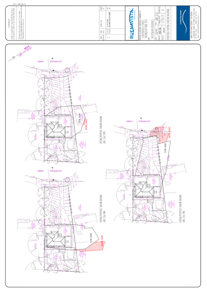
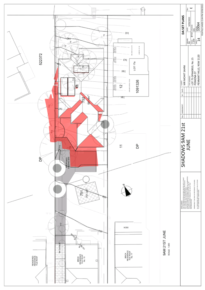
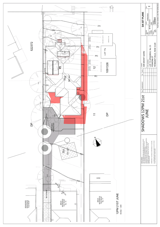
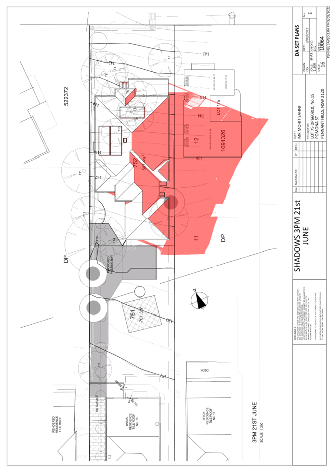
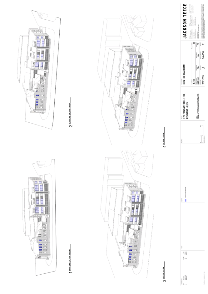
2.6.3 Sunlight Access
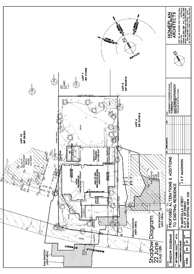
The desired outcome of Part 3.1.5 Sunlight of the HDCP is development designed to provide reasonable sunlight to sensitive areas. The first floor addition of the dwelling would not generate any adverse impacts to the subject site or adjoining properties with respect to sunlight access as shown from the provided shadow diagram.
2.6.4 Privacy
The application complies with the desired outcome and all prescriptive measures of Part 3.1.6 Privacy of the HDCP. Both proposed windows facing adjoining property No. 21 Marcella Street on the south-eastern and north-western elevations have a sill height of 1.6 metres. There are no proposed windows on the north-western side elevation.
All proposed windows on the first floor addition facing the property rear would not serve living or entertaining rooms of the dwelling. All windows would comply with all prescriptive measures of privacy of the HDCP. No proposed living spaces of the dwelling would overlook the private open space of adjoining dwellings.
The proposed pool coping would be elevated 900mm from existing ground level, which does not comply with the 600mm prescriptive measure. In support of this non-compliance, this area would serve as a passive space used for pool maintenance and access rather than entertainment. This area of the pool would also be screened by existing dense vegetation screening views to the adjoining dwelling No. 17 Marcella Street, North Epping.
2.7 Section 7.12 Contributions Plans
Hornsby Shire Council Section 7.12 Contributions Plan 2019-2029 applies to the development as the estimated costs of works is greater than $100,000. Should the application be approved, an appropriate condition of consent is recommended requiring the payment of a contribution in accordance with the Plan.
3. ENVIRONMENTAL IMPACTS
Section 4.15(1)(b) of the Act requires Council to consider “the likely impacts of that development, including environmental impacts on both the natural and built environments, and social and economic impacts in the locality”.
3.1 Natural Environment
3.1.1 Tree and Vegetation Preservation
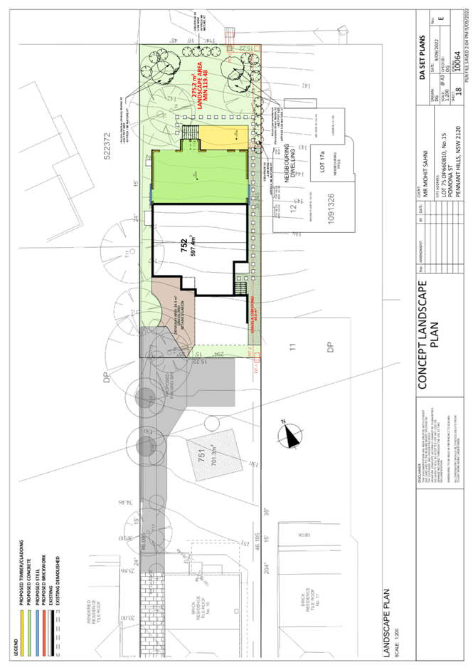
No trees would be adversely impacted to facilitate development works. A palm tree in the adjoining property would be retained and protected by a boundary fence. Minor vegetation removal of a shrub would be required to facilitate development of the swimming pool. No tree protection measures would be required.
3.1.2 Stormwater Management
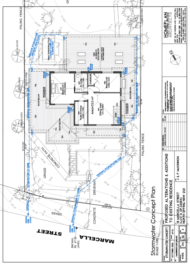
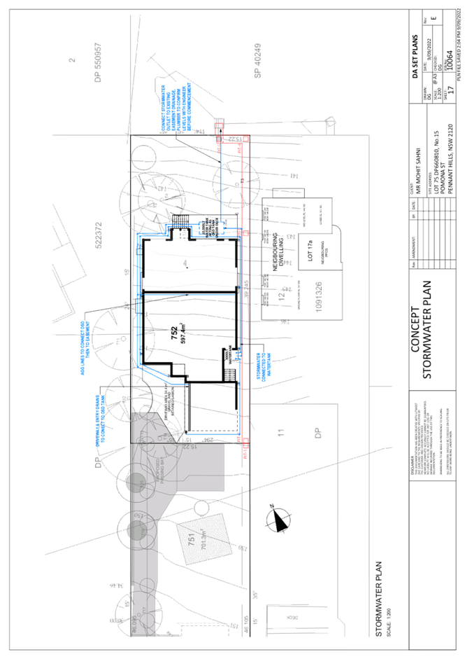
The application proposes to dispose of stormwater generated by the first floor addition by connecting to the existing stormwater system of the dwelling house that drains stormwater directly to the street. Stormwater generated by the proposed pool would be connected to the sewer.
3.2 Built Environment
3.2.1 Built Form
As discussed in Part 2.1.3 of this report, the proposed built form on the subject site is appropriate with regard to the existing dwelling house or swimming pool, and the one and two storey residential dwelling developments in the surrounding locality. No objections are raised to the built form of the proposed alterations and additions.
3.3 Social Impacts
The proposed alterations and additions to existing residence, including new first floor and swimming pool would not have any adverse social impacts to the locality.
3.4 Economic Impacts
The proposed alterations and additions to existing residence, including new first floor and swimming pool would not have any adverse economic impacts to the locality.
4. SITE SUITABILITY
Section 4.15(1)(c) of the Act requires Council to consider “the suitability of the site for the development”.
The subject site has not been identified as bushfire prone or flood prone land. The site is considered to be capable of accommodating the proposed development. The scale of the proposed development is consistent with the capability of the site, the surrounding R2 zoned residential development and on balance, is considered acceptable.
5. PUBLIC PARTICIPATION
Section 4.15(1)(d) of the Act requires Council to consider “any submissions made in accordance with this Act”.
5.1 Community Consultation
The proposed development was placed on public exhibition and was notified to adjoining and nearby landowners between 26 September 2022 and 10 October 2022 in accordance with the Hornsby Community Engagement Plan. During this period, Council received one submission. The map below illustrates the location of those nearby landowners who made a submission that are in close proximity to the development site.
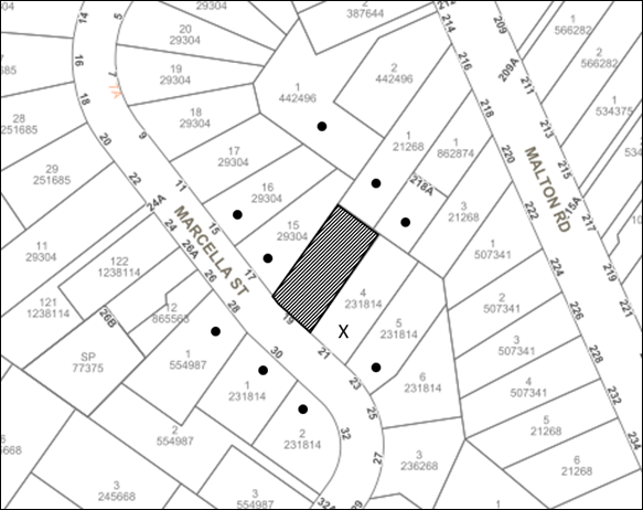
|
NOTIFICATION PLAN |
|||
|
• PROPERTIES NOTIFIED |
X SUBMISSIONS RECEIVED |
|
|
One submission objected to the development, generally on the grounds that the south-eastern and north-eastern elevated windows of the proposed first floor addition development would generate adverse privacy impacts
5.2 Public Agencies
The development application was not referred to any Public Agencies for comment.
6. THE PUBLIC INTEREST
Section 4.15(1)(e) of the Act requires Council to consider “the public interest”.
The public interest is an overarching requirement, which includes the consideration of the matters discussed in this report. Implicit to the public interest is the achievement of future built outcomes adequately responding to and respecting the future desired outcomes expressed in environmental planning instruments and development control plans.
The application is considered to have satisfactorily addressed Council’s and relevant agencies’ criteria and would provide a development outcome that, on balance, would result in a positive impact for the community. Accordingly, it is considered that the approval of the proposed development would be in the public interest.
CONCLUSION
The application proposes alterations and additions to existing residence, including new first floor and swimming pool.
The development generally meets the desired outcomes of Council’s planning controls and is satisfactory having regard to the matters for consideration under Section 4.15 of the Environmental Planning and Assessment Act 1979.
Council received one submission during the public notification period. The matters raised have been addressed in the body of the report in Section 5.1.
Having regard to the circumstances of the case, approval/refusal of the application is recommended.
The reasons for this decision are:
· The request under Clause 4.6 of Hornsby Local Environmental Plan 2013 to contravene the Clause 4.3 Height of Buildings development standard is well founded. Strict compliance with the development standard is considered unreasonable and unnecessary in the circumstances of the case and sufficient environmental planning grounds have been submitted to justify the contravention to the development standard.
· The proposed development complies with the requirements of the relevant environmental planning instruments and the Hornsby Development Control Plan 2013.
· The proposed development does not create unreasonable environmental impacts to adjoining development with regard to visual bulk, solar access, amenity or privacy.
Note: At the time of the completion of this planning report, no persons have made a Political Donations Disclosure Statement pursuant to Section 10.4 of the Environmental Planning and Assessment Act 1979 in respect of the subject planning application.
RESPONSIBLE OFFICER
The officer responsible for the preparation of this report is Sophie Valentine.
|
Cassandra Williams Major Development Manager - Development Assessments Planning and Compliance Division |
Rod Pickles Manager - Development Assessments Planning and Compliance Division |
|
1.⇩ |
Locality Plan |
|
|
|
2.⇩ |
Clause 4.6 |
|
|
|
3.⇩ |
Architectural Plans |
|
|
|
4.⇩ |
Shadow Diagram |
|
|
|
5.⇩ |
Stormwater Concept Plan |
|
|
File Reference: DA/987/2022
Document Number: D08509983
SCHEDULE 1
GENERAL CONDITIONS
The conditions of consent within this notice of determination have been applied to ensure that the use of the land and/or building is carried out in such a manner that is consistent with the aims and objectives of the relevant legislation, planning instruments and council policies affecting the land and does not disrupt the amenity of the neighbourhood or impact upon the environment.
Note: For the purpose of this consent, the term ‘applicant’ means any person who has the authority to act on or the benefit of the development consent.
Note: For the purpose of this consent, any reference to an Act, Regulation, Australian Standard or publication by a public authority shall be taken to mean the gazetted Act or Regulation, or adopted Australian Standard or publication as in force on the date that the application for a construction certificate is made.
1. Approved Plans and Supporting Documentation
The development must be carried out in accordance with the plans and documentation listed below and endorsed with Council’s stamp, except where amended by Council and/or other conditions of this consent:
Approved Plans
|
Plan No. |
Plan Title |
Drawn by |
Dated |
Council Reference |
|
44501 |
Site Plan |
Homeplan Architects |
September 2022 |
|
|
44502 |
Basement Plan |
Homeplan Architects |
September 2022 |
|
|
44503 |
Ground Floor Plan |
Homeplan Architects |
September 2022 |
|
|
44504 |
New First Floor Plan |
Homeplan Architects |
September 2022 |
|
|
44505 |
Elevations (1 of 2) |
Homeplan Architects |
September 2022 |
|
|
44506 Rev A |
Elevations (2 of 2) |
Homeplan Architects |
September 2022 |
|
|
44507 |
Section & Notes |
Homeplan Architects |
September 2022 |
|
|
44514 |
New Roof Plan |
Homeplan Architects |
October 2022 |
|
|
44508 |
Existing Basement Plan |
Homeplan Architects |
September 2022 |
|
|
44509 |
Existing Floor Plan |
Homeplan Architects |
September 2022 |
|
|
44510 |
Existing Roof Plan |
Homeplan Architects |
September 2022 |
|
|
44515 Rev A |
Stormwater Concept Plan |
Homeplan Architects |
October 2022 |
|
|
44513 Rev A |
Shadow Diagrams |
Homeplan Architects |
October 2022 |
|
Supporting Documentation
|
Document Title |
Prepared by |
Dated |
Council Reference |
|
BASIX Certificate No. A470468 |
Homeplan Project Design Resources |
14 September 2022 |
D08495965 |
|
Waste Management Plan |
Homeplan Architects |
13 September 2022 |
D08495993 |
2. Construction Certificate
a) A Construction Certificate is required to be approved by Council or a Private Certifying Authority prior to the commencement of any construction works under this consent.
b) The Construction Certificate plans must be consistent with the Development Consent plans.
3. Section 7.12 Development Contributions
a) In accordance with Section 4.17(1) of the Environmental Planning and Assessment Act 1979 and the Hornsby Shire Council Section 7.12 Development Contributions Plan 2019 - 2029, $3,569.00 must be paid towards the provision, extension or augmentation of public amenities or public services, based on development costs of $356,900.00.
b) The value of this contribution is current as of 4 November 2022. If the contributions are not paid within the financial quarter that this consent is granted, the contributions payable will be adjusted in accordance with the provisions of the Hornsby Shire Council Section 7.12 Development Contributions Plan and the amount payable will be calculated at the time of payment in the following manner:
|
$CPY |
= |
|
|
$CDC x CPIPY |
|
|
|
|
|
CPIDC |
Where:
$CPY is the amount of the contribution at the date of Payment.
$CDC is the amount of the contribution as set out in this Development Consent.
CPIPY is the latest release of the Consumer Price Index (Sydney – All Groups) at the date of Payment as published by the ABS.
CPIDC is the Consumer Price Index (Sydney – All Groups) for the financial quarter at the date of this Development Consent.
c) The monetary contributions shall be paid to Council:
(i) Prior to the issue of the Subdivision Certificate where the development is for subdivision.
(ii) Prior to the issue of the first Construction Certificate where the development is for building work.
(iii) Prior to issue of the Subdivision Certificate or first Construction Certificate, whichever occurs first, where the development involves both subdivision and building work.
(iv) Prior to the works commencing where the development does not require a Construction Certificate or Subdivision Certificate.
Note: It is the professional responsibility of the Principal Certifying Authority to ensure that the monetary contributions have been paid to Council in accordance with the above timeframes.
Note: The Hornsby Shire Council Section 7.12 Development Contributions Plan may be viewed at www.hornsby.nsw.gov.au or a copy may be inspected at Council’s Administration Centre during normal business hours.
REQUIREMENTS PRIOR TO THE ISSUE OF A CONSTRUCTION CERTIFICATE
Detailed plans, specifications and supporting information is required to be submitted to the certifying authority detailing how the proposed building work achieves compliance with the National Construction Code - Building Code of Australia. All building work must be carried out in accordance with the requirements of the National Construction Code - Building Code of Australia.
5. Contract of Insurance (Residential Building Work)
Where residential building work for which the Home Building Act 1989 requires there to be a contract of insurance in force in accordance with Part 6 of that Act, this contract of insurance must be in force before any building work authorised to be carried out by the consent commences.
6. Notification of Home Building Act 1989 Requirements
Residential building work within the meaning of the Home Building Act 1989 must not be carried out unless the principal certifying authority for the development to which the work relates (not being Council) has given Council written notice of the following information:
a) In the case of work for which a principal contractor is required to be appointed:
i) The name and licence number of the principal contractor.
ii) The name of the insurer by which the work is insured under Part 6 of that Act.
b) In the case of work to be done by an owner-builder:
i) The name of the owner-builder.
ii) If the owner-builder is required to hold an owner-builder’s permit under that Act, the number of the owner-builder’s permit.
Note: If arrangements for doing the residential building work are changed while the work is in progress so that the information notified becomes out of date, further work must not be carried out unless the principal certifying authority for the development to which the work relates (not being Council) has given Council written notification of the updated information.
7. Sydney Water – Approval
This application must be submitted to Sydney Water for approval to determine whether the development would affect any Sydney Water infrastructure, and whether further requirements are to be met.
Note: Building plan approvals can be obtained online via Sydney Water Tap inTM through www.sydneywater.com.au under the Building and Development tab.
8. Stormwater Drainage – Dwellings
The stormwater drainage system for the development must be designed for an average recurrence interval (ARI) of 20 years and be gravity drained to the existing internal drainage system.
REQUIREMENTS PRIOR TO THE COMMENCEMENT OF ANY WORKS
9. Erection of Construction Sign
a) A sign must be erected in a prominent position on any site on which any approved work is being carried out:
i) Showing the name, address and telephone number of the principal certifying authority for the work.
ii) Showing the name of the principal contractor (if any) for any demolition or building work and a telephone number on which that person may be contacted outside working hours.
iii) Stating that unauthorised entry to the work site is prohibited.
b) The sign is to be maintained while the approved work is being carried out and must be removed when the work has been completed.
10. Protection of Adjoining Areas
A temporary hoarding, fence or awning must be erected between the work site and adjoining lands before the works begin and must be kept in place until after the completion of the works if the works:
a) Could cause a danger, obstruction or inconvenience to pedestrian or vehicular traffic.
b) Could cause damage to adjoining lands by falling objects.
c) Involve the enclosure of a public place or part of a public place.
d) Have been identified as requiring a temporary hoarding, fence or awning within the Council approved Construction Management Plan (CMP).
Note: Notwithstanding the above, Council’s separate written approval is required prior to the erection of any structure or other obstruction on public land.
11. Toilet Facilities
a) To provide a safe and hygienic workplace, toilet facilities must be available or be installed at the works site before works begin and must be maintained until the works are completed at a ratio of one toilet for every 20 persons employed at the site.
b) Each toilet must:
i) Be a standard flushing toilet connected to a public sewer.
ii) Be a temporary chemical closet approved under the Local Government Act 1993.
12. Erosion and Sediment Control
To protect the water quality of the downstream environment, erosion and sediment control measures must be provided and maintained throughout the construction period in accordance with the manual ‘Soils and Construction 2004 (Bluebook)’, the approved plans, Council specifications and to the satisfaction of the principal certifying authority. The erosion and sediment control devices must remain in place until the site has been stabilised and revegetated.
Note: On the spot penalties may be issued for any non-compliance with this requirement without any further notification or warning.
REQUIREMENTS DURING CONSTRUCTION
13. Construction Work Hours
All works on site, including demolition and earth works, must only occur between 7am and 5pm Monday to Saturday.
No work is to be undertaken on Sundays or public holidays.
14. Demolition
To protect the surrounding environment, all demolition work must be carried out in accordance with Australian Standard AS2601-2001 Demolition of structures and the following requirements
a) Demolition material must be disposed of to an authorised recycling and/or waste disposal site and/or in accordance with an approved waste management plan; and
b) Demolition works, where asbestos material is being removed, must be undertaken by a contractor that holds an appropriate licence issued by SafeWork NSW in accordance with the Work Health and Safety Regulation 2017 and be appropriately transported and disposed of in accordance with the Protection of the Environment Operations (Waste) Regulation 2014; and
c) On construction sites where any building contain asbestos material, a standard commercially manufactured sign containing the words ‘DANGER ASBESTOS REMOVAL IN PROGRESS’ and measuring not less than 400mm x 300mm must be displayed in a prominent position visible from the street.
15. Environmental Management
To prevent sediment run-off, excessive dust, noise or odour emanating from the site during the construction, the site must be managed in accordance with the publication ‘Managing Urban Stormwater – Landcom (March 2004) and the Protection of the Environment Operations Act 1997.
16. Council Property
To ensure that the public reserve is kept in a clean, tidy and safe condition during construction works, no building materials, waste, machinery or related matter is to be stored on the road or footpath.
17. Disturbance of Existing Site
During construction works, the existing ground levels of open space areas and natural landscape features, including natural rock-outcrops, vegetation, soil and watercourses must not be altered unless otherwise nominated on the approved plans.
18. Excavated Material
All excavated material removed from the site must be classified by a suitably qualified environmental consultant in accordance with the NSW Environment Protection Authority’s Waste Classification Guidelines and Protection of the Environment Operations (Waste) Regulation 2014 prior to disposal to a licensed waste management facility. Tipping dockets for the total volume of excavated material that are received from the licensed waste management facility must be provided to the principal certifying authority prior to the issue of an Occupation Certificate.
19. Survey Report
A report(s) must be prepared by a registered surveyor and submitted to the principal certifying authority:
Prior to the pouring of concrete at each level of the building certifying that:
a) The building, retaining walls and the like have been correctly positioned on the site.
b) The finished floor level(s) are in accordance with the approved plans.
20. Waste Management
All work must be carried out in accordance with the approved waste management plan.
21. Unexpected Finds
Should the presence of asbestos or soil contamination, not recognised during the application process be identified during any stage of works, the applicant must immediately notify the PCA and Council.
REQUIREMENTS PRIOR TO THE ISSUE OF AN OCCUPATION CERTIFICATE
22. Fulfilment of BASIX Commitments
The applicant must demonstrate the fulfilment of BASIX commitments pertaining to the development.
23. Damage to Council Assets
To protect public property and infrastructure, any damage caused to Council’s assets as a result of the construction or demolition of the development must be rectified by the applicant in accordance with AUS-SPEC Specifications (www.hornsby.nsw.gov.au/property/build/aus-spec-terms-and-conditions. Rectification works must be undertaken prior to the issue of an Occupation Certificate, or sooner, as directed by Council.
OPERATIONAL CONDITIONS
24. Swimming Pool Requirements
The construction and operation of the swimming pool must comply with the provisions of the Swimming Pool Act 1992, the Swimming Pool Regulation 2008, Australian Standard AS1926.1-3 Swimming Pool Safety and the following requirements:
a) All waste water from the pool’s filtration system must be piped to Sydney Water’s sewer system. In the event that Sydney Water’s sewer system is not accessible, a filtration system that does not require backwashing must be installed.
b) The filtration motor and pump, or spa heater and blower unit must be housed in a soundproofed structure. Sound from the equipment must not exceed 5(dBA) above ambient noise levels at any residential property boundary.
c) A certificate shall be provided to the certifying authority upon installation of any swimming pool reticulation system verifying design and installation in accordance with Australian Standard AS1926.3 Water recirculation systems.
- END OF CONDITIONS -
ADVISORY NOTES
The following information is provided for your assistance to ensure compliance with the Environmental Planning and Assessment Act, 1979, Environmental Planning and Assessment Regulation 2021, other relevant legislation and Council’s policies and specifications. This information does not form part of the conditions of development consent pursuant to Section 4.17 of the Act.
Environmental Planning and Assessment Act 1979 Requirements
The Environmental Planning and Assessment Act 1979 requires:
· The issue of a construction certificate prior to the commencement of any works. Enquiries can be made to Council’s Customer Services Branch on 9847 6760.
· A principal certifying authority to be nominated and Council notified of that appointment prior to the commencement of any works.
· Council to be given at least two days written notice prior to the commencement of any works.
· Mandatory inspections of nominated stages of the construction inspected.
· An occupation certificate to be issued before occupying any building or commencing the use of the land.
Long Service Levy
In accordance with Section 34 of the Building and Construction Industry Long Service Payments Act 1986, a ‘Long Service Levy’ must be paid to the Long Service Payments Corporation or Hornsby Council.
Note: The rate of the Long Service Levy is 0.35% of the total cost of the work.
Note: Hornsby Council requires the payment of the Long Service Levy prior to the issue of a construction certificate.
Tree and Vegetation Preservation
Hornsby Development Control Plan 2013 Tree and Vegetation Preservation provisions have been developed under Council’s authorities contained in State Environmental Planning Policy (Vegetation in Non-Rural Areas) 2017 and the Environmental Planning and Assessment Act 1979.
In accordance with these provisions a person must not cut down, fell, uproot, kill, poison, ringbark, burn or otherwise destroy the vegetation, lop or otherwise remove a substantial part of the trees or vegetation to which any such development control plan applies without the authority conferred by a development consent or a permit granted by Council.
Fines may be imposed for non-compliance with the Hornsby Development Control Plan 2013.
Note: A tree is defined as a long lived, woody perennial plant with one or relatively few main stems with the potential to grow to a height greater than three metres (3m). (HDCP 1B.6.1.c).
The land upon which the subject building is to be constructed may be affected by restrictive covenants. Council issues this approval without enquiry as to whether any restrictive covenant affecting the land would be breached by the construction of the building, the subject of this consent. Applicants must rely on their own enquiries as to whether or not the building breaches any such covenant.
Prior to commencing any works, the applicant is encouraged to contact Dial Before You Dig on 1100 or www.dialbeforeyoudig.com.au for free information on potential underground pipes and cables within the vicinity of the development site.
Telecommunications Act 1997 (Commonwealth)
If you are aware of any works or proposed works which may affect or impact on Telstra’s assets in any way, you are required to contact: Telstra’s Network Integrity Team on Phone Number 1800810443.
Should asbestos or asbestos products be encountered during demolition or construction works, you are advised to seek advice and information prior to disturbing this material. It is recommended that a contractor holding an asbestos-handling permit (issued by SafeWork NSW) be engaged to manage the proper handling of this material. Further information regarding the safe handling and removal of asbestos can be found at:
Alternatively, telephone the SafeWork NSW on 13 10 50.
LPP Report No. LPP68/22
Local Planning Panel
Date of Meeting: 30/11/2022
6 DA/787/2022 - ALTERATIONS AND ADDITIONS TO EXISTING DWELLING AND NEW SWIMMING POOL - 3 BUTTERFIELD STREET, THORNLEIGH
EXECUTIVE SUMMARY
|
DA No: |
DA/787/2022 (Lodged on 1 August 2022) |
|
Description: |
Alterations and additions to existing dwelling, including first floor addition and construction of a swimming pool |
|
Property: |
Lot 1 DP 539226, No. 3 Butterfield Street, Thornleigh |
|
Applicant: |
Mr R J Hale |
|
Owner: |
Mrs Belinda Lee Boutsikakis & Mr Costa Boutsikakis |
|
Estimated Value: |
$320,000 |
|
Ward: |
B Ward |
· The application involves alterations and additions to a dwelling house and construction of a swimming pool.
· The proposal does not comply with the Hornsby Shire Local Environment Plan 2013 with regard to Clause 4.3 ‘Height of Buildings’. The applicant has made a submission in accordance with Clause 4.6 ‘Exceptions to development standards’ of the Hornsby Shire Local Environmental Plan 2013 to contravene the height of buildings development standard. The submission is considered well founded and is supported.
· No submissions have been received in respect of the application.
· The application is required to be determined by the Hornsby Council Local Planning Panel as the proposal would contravene the Hornsby Shire Local Environment Plan 2013 development standard for maximum height of buildings by more than 10 percent.
· It is recommended that the application be approved.
|
THAT the Hornsby Local Planning Panel assume the concurrence of the Secretary of the Department of Planning and Environment pursuant to Clause 4.6 of the Hornsby Local Environmental Plan 2013 and approve Development Application No. DA/787/2022 for alterations and additions to existing dwelling and construction of a swimming pool at Lot 1 DP 539226, No. 3 Butterfield Street, Thornleigh subject to the conditions of consent detailed in Schedule 1 of LPP Report No. LPP 68/22. |
BACKGROUND
The subject site has historically been used for residential purposes. Development Application No. 1111-71 for a double garage under brick veneer dwelling was approved on 18 May, 1971.
SITE
The 803.0m2 site is located on the western side of Butterfield Street and contains a part one and part two storey residential dwelling.
The site experiences a 6m fall from the north-eastern rear boundary towards the street. Accordingly, stormwater from the site is drained directly to the street.
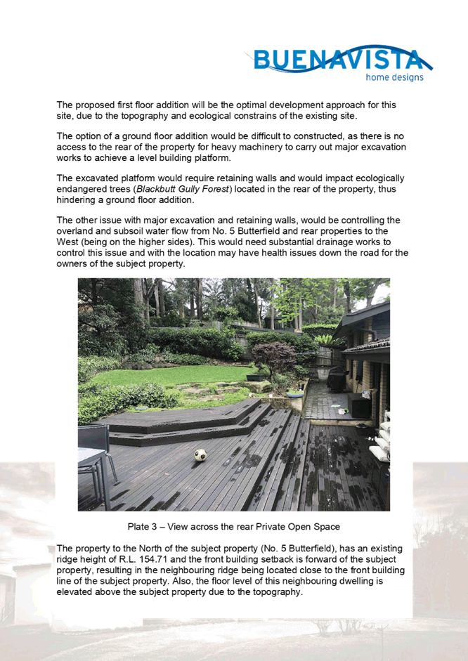
The rear portion of the site is mapped as containing Blackbutt Gully Forest. The site is in close proximity to Environmental heritage item Trees No. 709, located on the south-eastern side of Hillmont Avenue. The site is also in close proximity to heritage item No. A68 Lane Cove National Park. The site does not contain a heritage listed item and is not within a heritage conservation area.
The site is not burdened by an easement. No trees are proposed to be removed to facilitate development. The site surrounds contains dense vegetation directly adjacent Lane Cove National Park.
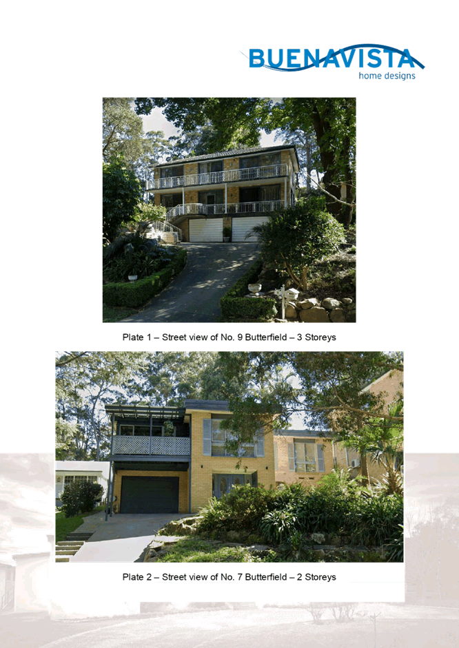
The surrounding locality is characterised by one, two and three storey dwelling houses with ample front setbacks and attached garages. The street serves local residential traffic for residential purposes as a cul-de-sac directly adjacent The Comenarra Parkway.
The properties on the same side of Butterfield Street north-east of the site experience similar slope. No. 5 Butterfield Street directly adjacent the subject site contains an attached garage of similar nature to the subject site, with the surrounding ground floor land as subfloor partially underground due to similar topography constraints. No. 1 Butterfield Street directly adjacent the development site contains two storeys of similar size, however, is not constrained by sloped topography.
The dwelling house of No. 3 Butterfield has been constructed as a predominantly split level with respect to the sloped topography of the property, minimising the need for additional excavation. The attached garage is the only element of the existing dwelling house contributing to a two storey structure.
PROPOSAL
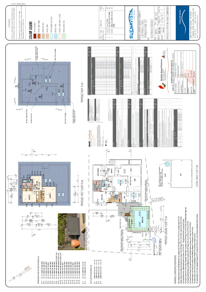
The application proposes alterations and additions to the existing split-level and two storey dwelling and constructions of an inground swimming pool. The proposed scope of works for the dwelling are as follows:
· Ground Floor
o Merging of existing Bedroom 2 and Bedroom 3 to create a rumpus room and internal staircase leading up towards the proposed first floor addition, including the addition of an external aluminium Bi-fold door and steps.
o Reconfiguration of existing Laundry, including blocking a portion of the existing external door to create a new window opening.
o Construction of a new wall between the existing Lounge Room and Sitting/Dining Room.
o Installation of new skylights to the lounge and kitchen areas.
· Proposed First Floor
o Internal alterations including converting existing bathroom into an en-suite and converting the existing WC into a powder room.
o A first-floor addition to the existing dwelling which includes two bedrooms with built-in-robes, one bathroom and one study.
o The removal of existing cement roof tiles to be replaced by Colorbond sheet metal roof.
o The removal of existing guttering to be replaced by Colorbond gutters to match the new metal roof.
No trees would be removed to facilitate the development. Minor excavation works are required to facilitate construction of the swimming pool.
ASSESSMENT
The development application has been assessed having regard to the Greater Sydney Region Plan - A Metropolis of Three Cities, the North District Plan and the matters for consideration prescribed under Section 4.15 of the Environmental Planning and Assessment Act 1979 (the Act). The following issues have been identified for further consideration.
1. STRATEGIC CONTEXT
1.1 Greater Sydney Region Plan - A Metropolis of Three Cities and North District Plan
The Greater Sydney Region Plan - A Metropolis of Three Cities has been prepared by the NSW State Government to guide land use planning decisions over the next 40 years to 2056. The Plan sets a strategy and actions for accommodating Sydney’s future population growth and identifies dwelling targets to ensure supply meets demand. The Plan also identifies that the most suitable areas for new housing are in locations close to jobs, public transport, community facilities and services.
The NSW Government will use the subregional planning process to define objectives and set goals for job creation, housing supply and choice in each subregion. Hornsby Shire has been grouped with Hunters Hill, Ku-ring-gai, Lane Cove, Mosman, North Sydney, Ryde, Northern Beaches and Willoughby to form the North District. The Greater Sydney Commission has released the North District Plan which includes priorities and actions for Northern District over the next 20 years. The identified challenge for Hornsby Shire will be to provide an additional 4,350 dwellings by 2021 with further strategic supply targets to be identified to deliver 97,000 additional dwellings in the North District by 2036.
The proposed development would be consistent with the Greater Sydney Region Plan - A Metropolis of Three Cities and the North District Plan, by contributing to achieving the dwelling targets for the region.
2. STATUTORY CONTROLS
Section 4.15(1)(a) requires Council to consider “any relevant environmental planning instruments, draft environmental planning instruments, development control plans, planning agreements and regulations”.
2.1 Hornsby Local Environmental Plan 2013
The proposed development has been assessed having regard to the provisions of the Hornsby Local Environmental Plan 2013 (HLEP).
2.1.1 Zoning of Land and Permissibility
The subject land is zoned R2 Low Density Residential under the HLEP. The objectives of the R2 zone are:
· To provide for the housing needs of the community within a low-density residential environment.
· To enable other land uses that provide facilities or services to meet the day to day needs of residents.
The proposed development is defined as alterations and addition to a ‘dwelling house’, is permissible in the zone with Council’s consent and would meet the objectives of the zone by providing for the housing needs of the community within a low-density residential environment.
2.1.2 Height of Buildings
Clause 4.3 of the HLEP provides that the height of a building on any land should not exceed the maximum height shown for the land on the Height of Buildings Map. The maximum permissible height for the subject site is 8.5m. The proposal has a maximum height of 9.56m and does not comply with this provision.
The application is supported by a submission pursuant to Clause 4.6 of the HLEP to contravene the maximum height of buildings development standard, which is discussed below in Section 2.1.3 of this report.
2.1.3 Exceptions to Development Standards
The applicant submitted a written request to contravene the height of building development standard contained within Clause 4.3 of the HLEP.
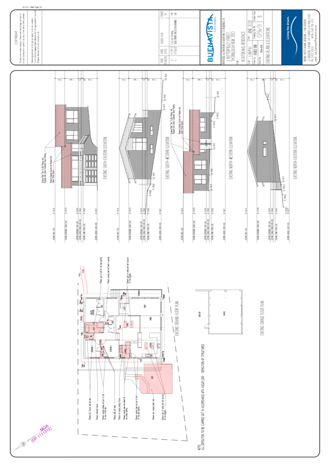
The written request prepared by Rodney Hale of Buena Vista Home Designs, describes the extent of the contravention as follows:
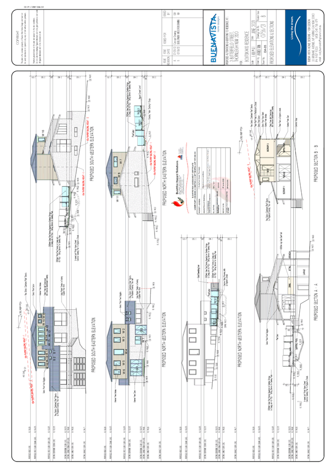
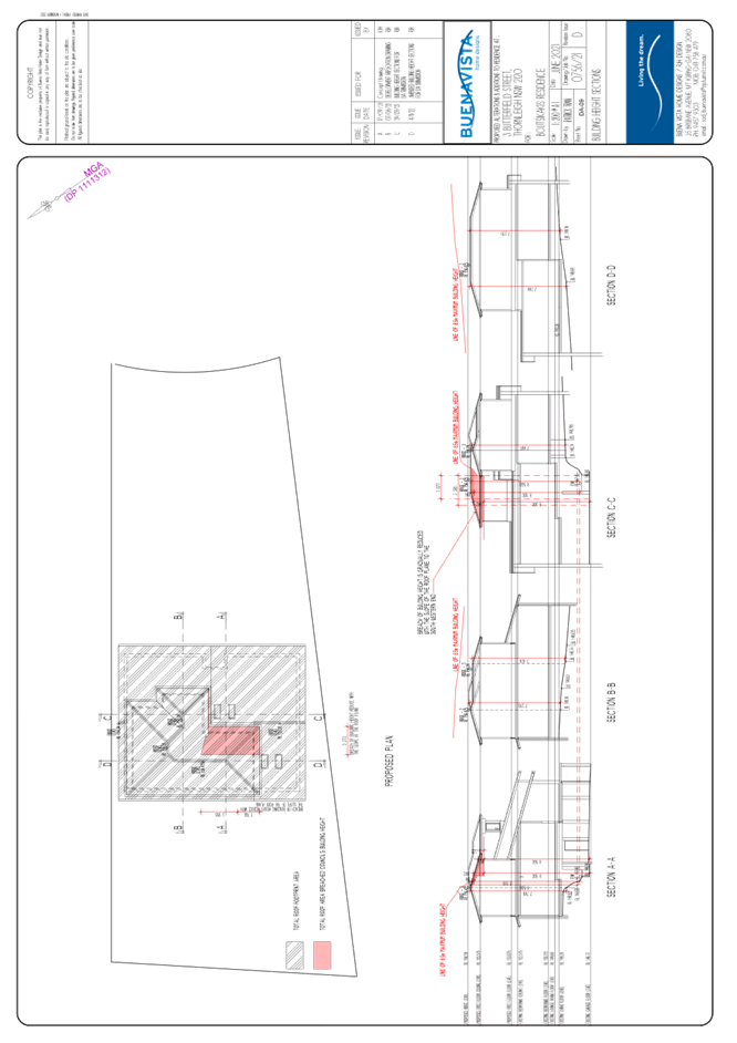
The proposed first floor addition development results in small portion of the addition breaching the Council’s 8.5m maximum building height. This breach occurs at the south-western corner of the proposed addition, when measured directly from the existing sub-floor level. The submitted drawing number DA-09 (Building Height Sections), details the extent of the proposed area that breaches the Council’s maximum building height. The non-compliance in building height is depicted on Drawing Section C-C, which indicates the highest maximum proposed height at 9.56m, which is a height increase of 12.47%.
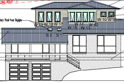
Figure 1: South-eastern elevation of the proposed first floor addition
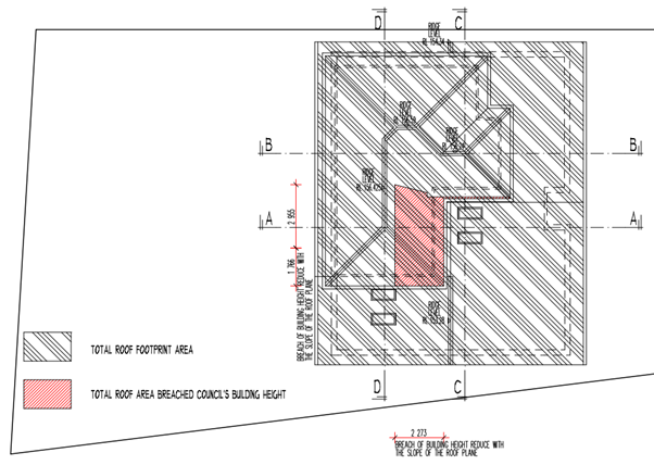
Figure 2: Proposed area of non-compliance to HLEP 8.5 metre maximum building height.
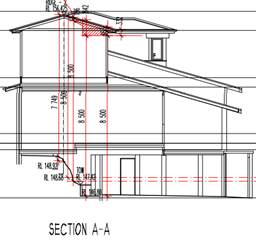
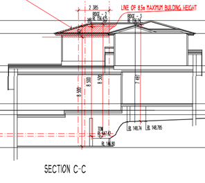
Figure 3: Section A-A and Section C-C depicting areas of non-compliance to the HLEP 8.5 metre building height limit.
The application has been assessed against the requirements of Clause 4.6 of the HLEP. This clause provides flexibility in the application of the development standards in circumstances where strict compliance with those standards would, in any particular case, be unreasonable or unnecessary or tender to hinder the attainment of the objectives of the zone.
In particular, Clause 4.6 provides criteria that must be satisfied prior to a consent authority granting consent to development that contravenes a development standard. These criteria demonstrated under Clause 4.6(3) are as follows:
(a) That compliance with the development standard is unreasonable or unnecessary in the circumstances of the case, and
(b) That there are sufficient environmental planning grounds to justify contravening the development standard.
2.1.3.1 Unreasonable or Unnecessary Clause 4.6(3)(a)
There are five common methods by which an applicant can demonstrate that compliance with a development standard is unreasonable or unnecessary in the circumstances of the development. Initially proposed for objections under clause 6 of SEPP 1 in the decision of Wehbe v Pittwater Council [2007] NSWLEC 827 Pearson C summarised and applied these methods to written requests made under Clause 4.6 in Four2Five Pty Ltd v Ashfield Council [2015] NSWLEC 1009 [61-62]. These five methods are generally as follows:
· The objectives of the development standard are achieved notwithstanding non-compliance with the standard.
· The underlying objective or purpose is not relevant to the development.
· That the objective would be defeated or thwarted if compliance was required.
· That the development standard has been virtually abandoned or destroyed by the Council’s own actions in departing from the standard.
· The zoning of the land is unreasonable or inappropriate.
It is not required to demonstrate that a development meets multiple methods as listed above, and the satisfaction of one can be adequate to demonstrate that the development standard is unreasonable or unnecessary.
The written request prepared by Buena Vista Home Designs, dated 4 November 2022 provides a detailed assessment of the proposal with respect to the development standard sought to be contravened. The request argues that:
· Extension of the existing dwelling first floor at the rear of the property would require retaining walls and extensive excavation works. There would be encroachment onto ecologically endangered tree species (Blackbutt Gully Forest).
· Facilitating construction would be unfeasible as there is no access to the rear of the property for heavy machinery.
· The overland and subsoil drainage would be compromised by development towards the property rear.
· The neighbouring property No. 5 Butterfield roof RLs are 154.71 metres ASL, opposed to the subject site proposing a maximum roof RL of 156.59 metre, equating a height difference of 1.88 metres.
· Development is unfeasible on the ground floor, constituted by the ground floor located partially underground. Development to extend this level would require extensive excavation works to the dwelling house.
· Overall visual appearance would align with the existing character and streetscape of the Thornleigh area. Construction of a flat roof would enable compliance to the 8.5 metre LEP maximum building height limit, however this would not align with the surrounding character of pitched roofs.
· No privacy impacts would be created as a result of the development.
The reasoning provided within the written request to demonstrate that the objectives of the development standard are achieved notwithstanding non-compliance with the standard are as follows:
The relevant objective underpinning the building height development standard is:
“(a) to permit a height of buildings that is appropriate for the site constraints, development potential and infrastructure capacity of the locality.”
The relatively modest additional height proposed above the existing dwelling contributes to the delivery of appropriate residential planning. The zoning of the site and surrounding residential lands includes land of somewhat steep topography. The proposed building works are consistent with the height and scale of the building constructed immediately adjoining the site to the west.
The minor additional breach in height at small elements of the building is considered acceptable in the circumstances and in the context of the surrounding development.
The lateral expansion of the building to achieve the councils floor space expectations for residential development of the site will impact adversely on the endangered ecological community situated upon the site and the additional height responds to the ecological constraints on the site. The natural topography of the site will result in unreasonable impacts by way of excavation should the additional floor space be provided outside the existing building envelope.
The objectives of the standard can be achieved, notwithstanding the additional height, and that a superior development outcome would result.
With reference to the reasoning provided by the applicant above, Council does not object to the conclusion that the proposed additions meet the objectives of Clause 4.3.
In reaching this conclusion the following points are noted:
· Overall visual appearance would align with the existing character and streetscape of the Thornleigh area. Construction of a flat roof would enable compliance to the 8.5 metre LEP maximum building height limit, however this would not fit in with the surrounding character of pitched roofs.
· No privacy impacts would be created as a result of the development.
· The overall extent of non-compliance of the first-floor addition is minor relative to the development proposed. The development has taken into consideration sloped topography of the site, and accordingly proposed the first floor addition towards the northern aspect with respect to constraints of construction in the rear yard as detailed above.
· Construction of a first floor addition opposed to lateral expansion of the existing first floor would provide a better outcome than compliance with the 8.5m height limit of the HLEP.
For the reasons outlined above, it is considered that the written request to contravene the height of building standard adequately demonstrates that the objectives of the Height of Buildings development standard contained within Clause 4.3 of the HLEP are achieved, notwithstanding non-compliance with the standard.
2.1.3.2 Environmental Planning Grounds - Clause 4.6(3)(b)
In addition to demonstrating that compliance is unreasonable or unnecessary, Clause 4.6(3)(b) requires that there are sufficient environmental planning grounds to justify contravening the development standard. In demonstrating that sufficient environmental planning grounds exist it must be demonstrated that the planning grounds are particular to the circumstances of the development on the subject site (summarised from Four2Five Pty Ltd v Ashfield Council [2015] NSWLEC 1009 [60].
The applicant provided the following planning grounds for the contravention of the development standard:
· Overall visual appearance of the first floor addition structure will blended-in comfortably with the existing dwelling and will have little to none negative impact to the streetscaped.
· Overall setbacks from the street front boundary and the side boundary together with portion of the first-floor addition contained within the existing roof space will reduce the bulkiness or imposing to the surrounding properties.
· The dwelling would largely appear as a 2 storey dwelling-house throughout.
· Privacy impacts of adjoining properties would not be compromise by the non-compliance of the proposal.
In demonstrating the unreasonable and unnecessary test, the applicant further established satisfactory environmental planning grounds with respect to the site and the surrounding constraints.
Council is therefore satisfied that Clause 4.6(3)(b) of the HLEP is adequately addressed.
2.1.3.3 Public Interest and Clause 4.6(4)
Clause 4.6(4) states that development consent must not be granted for development that contravenes a development standard unless:
(a) The consent authority is satisfied that:
(i) The applicant’s written request has adequately addressed the matters required to be demonstrated by subclause (3), and
(ii) The proposed development will be in the public interest because it is consistent with the objectives of the particular standard and the objectives for development within the zone in which the development is proposed to be carried out, and
(b) The concurrence of the Planning Secretary has been obtained.
With regard to part (a)(i), the written request is considered to adequately address the matter required to be demonstrated as outlined above.
With regard to part (a)(ii), the proposed development is considered to be in the public interest because it is consistent with the objectives of the particular standard and the objectives for development within the zone in which the development is proposed to be carried out.
With regard to (b), on 21 February 2018, the Secretary of the Department of Planning and Environment issued a Notice under cl. 64 of the Environmental Planning and Assessment Regulation 2000. The Secretary’s concurrence may not be assumed by a delegate of council if:
· The development contravenes a numerical standard by greater than 10%.
· The variation is to a non-numerical standard.
Local Planning Panels constituted under the Environmental Planning and Assessment Act 1979 exercise consent authority functions on behalf of a Council and are not delegates of Council. Therefore, Local Planning Panels may determine a development application notwithstanding, a numerical non-compliance in excess of 10%.
Therefore, the exceedance of Clause 4.3 Height of Buildings development standard is supported in this instance.
2.1.4 Heritage Conservation
Clause 5.10 of the HLEP sets out heritage conservation provisions for Hornsby Shire. The site does not include a heritage item and is not located in a heritage conservation area. The site is however located adjacent to environmental heritage items No. 709 ‘Trees’ at 22-56 Hillmont Avenue, and heritage item No. A68 ‘Lane Cove National Park as identified by Schedule 5 of the HLEP.
In assessing the heritage impacts of the proposal, it is noted that the proposal seeks to alter the built form within the subject site only. The adjoining environmental heritage items preserve the scenic and remnant environmental landscape elements of the Thornleigh area. The proposal would have negligible impact on these items and would not adversely impact the continued heritage value of the Trees at Nos. 22-56 Hillmont Avenue or Lane Cove National Park.
The proposal meets the relevant objectives of Clause 5.10 of the HELP and the desired outcome of Part 9.4.1 Development in the Vicinity of Heritage Items and is considered acceptable.
2.1.5 Earthworks
Clause 6.2 of the HLEP states that consent is required for proposed earthworks on site. Before granting consent for earthworks, Council is required to assess the impacts of the works on adjoining properties, drainage patterns and soil stability of the locality. These matters are addressed below:
|
Matter for Consideration |
Comment |
|
(a) The likely disruption of, or any detrimental effect on, drainage patterns and soil stability in the locality of the development |
A stormwater concept plan provided by the applicant details that stormwater generated by the proposed development would be disposed via the existing stormwater drainage system by draining to the street. |
|
(b) The effect of the development on the likely future use or redevelopment of the land |
Proposed excavation of the pool development is ancillary to the dwelling house. The dwelling house is existing and to remain in its original footprint. Redevelopment of the land is not proposed as the dwelling house facilitates the primary use of residency. |
|
(c) The quality of the fill or the soil to be excavated, or both |
An examination of Council’s records and aerial photography has determined that the site has been historically used for residential purposes. It is not likely that the site has experienced any significant contamination, and further assessment |
|
(d) The effect of the development on the existing and likely amenity of adjoining properties |
Excavation works to facilitate development of a swimming pool would generate negligible amenity impacts to adjoining properties. There would be no change from the existing impacts to proposed amenity impacts as the footprint of the proposed pool is within the principle private open space of the subject site. |
|
(e) The source of any fill material and the destination of any excavated material |
A suitable condition of consent has been recommended requiring all excavated material removed from the site must be classified by a suitably qualified environmental consultant in accordance with the NSW Environment Protection Authority’s Waste Classification Guidelines and Protection of the Environment Operations (Waste) Regulation 2014 prior to disposal to a licensed waste management facility. |
|
(f) The likelihood of disturbing relics |
Council has no record of any historical items or events of note on the subject site, of either Aboriginal or European Heritage. It is therefore considered that the proposed works are unlikely to disturb any relics. |
|
(g) The proximity to, and potential for adverse impacts on, any waterway, drinking water catchment or environmentally sensitive area |
There is no drinking water catchment within close proximity to the site. |
|
(h) Any appropriate measures proposed to avoid, minimise or mitigate the impacts of the development |
Appropriate measures have been included as conditions of development consent in Schedule 1 of this report to avoid, minimise and mitigate the impacts of the development. |
2.2 State Environmental Planning Policy (Biodiversity and Conservation) 2021
The application has been assessed against the requirements of chapter 2 and 10 of State Environmental Planning Policy (Biodiversity and Conservation) 2021.
2.2.1 Chapter 2 Vegetation in Non-Rural Areas
Chapter 2 of this policy aims to protect the biodiversity and amenity values of trees within non-rural areas of the state.
Part 2.3 of the policy states that a development control plan may make a declaration in any manner relating to species, size, location and presence of vegetation. Accordingly, Part 1B.6.1 of the HDCP prescribes works that can be undertaken with or without consent to trees and objectives for tree preservation.
Section 3.1.1 of this report provides an assessment in accordance with Part 1B.6.1 of the HDCP.
2.2.2 Chapter 10 Sydney Harbour Catchment
The site is located within the catchment of Sydney Harbour. The aim of this chapter is to ensure that the catchment, foreshores, waterways and islands of Sydney Harbour are recognised, protected, enhanced and maintained. This chapter provides general planning considerations and strategies to ensure that the catchment, foreshores, waterways and islands of Sydney Harbour are recognised, protected, enhanced and maintained.
The plan addresses matters related to biodiversity, ecology and environment protection; public access to, and use of, foreshores and waterways; maintenance of a working harbour; interrelationship of waterway and foreshore uses; foreshore and waterways scenic quality; maintenance, protection and enhancement of views and boat storage facilities.
Subject to the implementation of sediment and erosion control measures and stormwater management to protect water quality, the proposal would have minimal potential to impact on the Sydney Harbour Catchment and would comply with the requirements of chapter 10 of the Biodiversity and Conservation SEPP.
2.3 State Environmental Planning Policy (Building Sustainability Index: BASIX) 2004
The application has been assessed against the requirements of State Environmental Planning Policy (BASIX) 2004 which seeks to encourage sustainable residential development.
The proposal includes a BASIX certificate (A380041_2) in accordance with the requirements of the SEPP including the list of commitments to be complied with at the construction stage and during the use of the premises. The BASIX certificate achieves the minimum scores for thermal comfort, water and energy.
The proposal is acceptable in this regard.
2.4 State Environmental Planning Policy (Resilience and Hazards) 2021
The application has been assessed against the requirements of Chapter 4 of State Environmental Planning Policy (Resilience and Hazards) 2021.
2.4.1 Chapter 4 Remediation of Land
Section 4.6 of the Resilience and Hazard SEPP states that consent must not be granted to the carrying out of any development on land unless the consent authority has considered whether the land is contaminated or requires remediation for the proposed use.
Should the land be contaminated, Council must be satisfied that the land is suitable in a contaminated state for the proposed use. If the land requires remediation to be undertaken to make the land suitable for the proposed use, Council must be satisfied that the land will be remediated before the land is used for that purpose.
An examination of Council’s records and aerial photography has determined that the site has been historically used for residential purposes. It is not likely that the site has experienced any significant contamination, and further assessment under chapter 4 of the Resilience and Hazards SEPP is not required.
2.5 Section 3.42 Environmental Planning and Assessment Act 1979 - Purpose and Status of Development Control Plans
Section 3.42 of the Environmental Planning and Assessment Act 1979 states that a DCP provision will have no effect if it prevents or unreasonably restricts development that is otherwise permitted and complies with the development standards in relevant Local Environmental Plans and State Environmental Planning Policies.
The principal purpose of a development control plan is to provide guidance on the aims of any environmental planning instrument that applies to the development; facilitate development that is permissible under any such instrument; and achieve the objectives of land zones. The provisions contained in a DCP are not statutory requirements and are for guidance purposes only. Consent authorities have flexibility to consider innovative solutions when assessing development proposals, to assist achieve good planning outcomes.
2.6 Hornsby Development Control Plan 2013
The proposed development has been assessed having regard to the relevant desired outcomes and prescriptive requirements within the Hornsby Development Control Plan 2013 (HDCP). The following table sets out the proposal’s compliance with the prescriptive requirements of the Plan:
|
HDCP - Part 3.1 Dwelling Houses |
|||
|
Control |
Proposal |
Requirement |
Complies |
|
Site Area |
803.0m2 |
N/A |
N/A |
|
Building Height |
8.5m |
8.5m |
Yes |
|
No. storeys |
2 |
max. 2 + attic |
Yes |
|
Site Coverage |
Unchanged |
50% |
Yes |
|
Floor Area |
233m2 |
380m2 |
Yes |
|
Setbacks |
|
|
|
|
- Front (South-Eastern) |
Unchanged |
6m |
Yes |
|
- Side (North-Eastern) |
|
|
|
|
· Ground floor |
1.66m |
900mm |
Yes |
|
· First floor |
1.66m |
1.5m |
Yes |
|
- Side (South-Western) |
|
|
|
|
· Ground floor |
475mm |
900mm |
No |
|
· First floor |
5.8m |
1.5m |
Yes |
|
- Rear (North-Western) |
|
|
|
|
· Ground floor |
6.1m |
3m |
Yes |
|
First floor |
14.0m |
8m |
Yes |
|
Landscaped Area (30% of lot size) |
390.4m2 |
240.9m2 |
Yes |
|
Private Open Space |
|
|
|
|
- minimum area |
>24m2 |
24m2 |
Yes |
|
- minimum dimension |
>3m |
3m |
Yes |
|
Car Parking |
Unchanged |
2 spaces |
Yes |
As detailed in the above table, the proposed development generally complies with the prescriptive measures within the HDCP with the exception of the ground floor side setback. A brief discussion on compliance with relevant performance requirements and Part 1C General Controls is provided below.
2.6.1 Height of Building
2.6.2 Setbacks
The desired outcomes of Part 3.1.2 Setbacks of the HDCP are to encourage “setbacks that are compatible with adjacent development and compliment the streetscape” and “setbacks that allow for canopy trees to be retained and planted along the rear property boundaries”.
These desired outcomes are supported by the prescriptive measure which states “The minimum setback of all buildings and structures to the boundaries of the site should comply with Table 3.1.2(a)” which prescribes a minimum side boundary setback of 0.9m for up to 1 storey elements.
The application proposes a setback of the south-western side boundary of 475mm for the pool coping which does not comply with the 900mm prescriptive measure.
In support of the 425mm encroachment, the following is noted:
· An existing timber fence and dense vegetation in No. 31 The Commenara Parkway adjacent the boundary of No. 3 Butterfield Street would address potential privacy and acoustic concerns. Compliance to Australian Standard AS1926.1-3 Swimming Pool Safety would require the boundary fence to be 1.8 metres in height.
· The proposed development site within the property is relatively level comparative to the remainder of the private open space within the site which is limited by steep topography and rock areas.
· The development of the pool elsewhere within the property would require further excavation than the existing levels proposed.
· The development of the pool elsewhere behind the building line of the property would likely encroach further into areas mapped by Council as containing ecologically endangered community species (Blackbutt Gully Forest).
· The footprint of the proposed pool is to utilise a portion of the existing deck, thus limiting the reduction of landscaped area within the property.
The proposal meets the desired outcomes of Part 3.1.2 Setbacks of the HDCP and is considered acceptable, subject to conditions.
2.6.3 Sunlight Access
The application provided a shadow diagram of the proposed first floor addition in accordance with Part 3.1.5 Sunlight Access of the HDCP. The subject site and adjoining properties would continue to receive the required minimum amount of sunlight in the private open space. No concerns have been raised with respect to sunlight access.
2.6.4 Privacy
The application has been assessed against Section 3.1.6 Privacy of the HDCP. No privacy concerns were raised regarding the proposed development with respect to the desired outcome and all prescriptive measures of the Part 3.1.6 of the HDCP. Existing dense vegetation and a boundary fence provides additional screening to all adjoining properties
2.6.5 Earthworks
The extent of earthworks proposed is addressed in Section 2.1.7 of the report. The earthworks proposed are to facilitate construction of the proposed swimming pool. No concerns have been raised with respect to earthworks.
2.6.6 Heritage
Potential heritage concerns with respect to the proposed development are addressed in Section 2.1.6. No heritage concerns are raised regarding the proposed development.
2.7 Section 7.12 Contributions Plans
Hornsby Shire Council Section 7.12 Contributions Plan 2019-2029 applies to the development as the estimated costs of works is greater than $100,000. Should the application be approved, an appropriate condition of consent is recommended requiring the payment of a contribution in accordance with the Plan.
3. ENVIRONMENTAL IMPACTS
Section 4.15(1)(b) of the Act requires Council to consider “the likely impacts of that development, including environmental impacts on both the natural and built environments, and social and economic impacts in the locality”.
3.1 Natural Environment
3.1.1 Tree and Vegetation Preservation
The proposal does not require the removal of trees. However, it is noted that Tree 7 is located 4m from the development site and 5.2m from the proposed excavation works. Tree 7 has a height of 17m, a diameter of 0.4m and a spread of 3m, which would require a TPZ of 4m. Whilst there would be a minor encroachment into the TPZ of T7, this is considered acceptable subject to conditions.
Suitable conditions have been recommended in Schedule 1 of this report regarding tree protection measures.
The proposal meets the prescriptive measures of Part 1B.6.1 Tree Preservation of the HDCP and is considered acceptable, subject to conditions.
3.1.2 Stormwater Management
Stormwater from the proposed first floor will be drained via gravity and connect with the existing stormwater drainage system. The proposed first floor will not create additional stormwater to the drainage system.
The proposal meets the desired outcomes of Part 1C 1.2 Stormwater Management of the HDCP and is considered acceptable.
3.2 Built Environment
3.2.1 Built Form
As discussed in Section 2.1 of this report, the proposed built form on the subject site is appropriate with regard to the existing dwelling house and the residential development in the surrounding locality. No objections are raised to the built form of the proposed first floor addition or in-ground swimming pool.
3.3 Social Impacts
The residential development would improve housing choice in the locality by providing a range of house hold types. This is consistent with Council’s Housing Strategy which identifies the need to provide a mix of housing options to meet future demographic needs in Hornsby Shire.
3.4 Economic Impacts
The proposal would have a minor positive impact on the local economy in conjunction with other new low density residential development in the locality by generating an increase in demand for local services.
4. SITE SUITABILITY
Section 4.15(1)(c) of the Act requires Council to consider “the suitability of the site for the development”.
The site is considered to be capable of accommodating the proposed development as discussed in the body of this assessment report. The scale of the proposed development is consistent with the capability of the site, the surrounding residential development and on balance, is considered acceptable. A discussion on the site’s bushfire risk as it applies to the development site is provided below.
4.1 Bushfire Risk
The land is identified as being subject to bushfire risk, with a Bushfire Attack Level (BAL) rating of BAL-12.5 and the application is supported by a Bushfire Assessment Report prepared by Building Code & Bushfire Hazard Solutions Pty Ltd, dated 8 June 2022.
Suitable conditions have been recommended in Schedule 1 of this report to address the required bushfire protection measures.
The proposal meets the desired outcomes of Part 1C.3.1 Bushfire of the HDCP and is considered acceptable, subject to conditions.
5. PUBLIC PARTICIPATION
Section 4.15(1)(d) of the Act requires Council to consider “any submissions made in accordance with this Act”.
5.1 Community Consultation
The proposed development was placed on public exhibition and was notified to adjoining and nearby landowners between 11 August 2022 and 25 August 2022 in accordance with the Hornsby Community Engagement Plan. During this period, Council received no submissions. The map below illustrates the location of those nearby landowners who made a submission that are in close proximity to the development site.
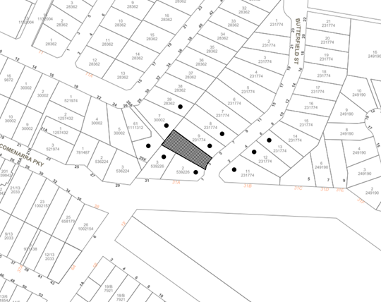
|
NOTIFICATION PLAN |
|||
|
• PROPERTIES NOTIFIED |
X SUBMISSIONS RECEIVED |
|
|
5.2 Public Agencies
The development application was not referred to any Public Agencies for comment.
6. THE PUBLIC INTEREST
Section 4.15(1)(e) of the Act requires Council to consider “the public interest”.
The public interest is an overarching requirement, which includes the consideration of the matters discussed in this report. Implicit to the public interest is the achievement of future built outcomes adequately responding to and respecting the future desired outcomes expressed in environmental planning instruments and development control plans.
The application is considered to have satisfactorily addressed Council’s and relevant agencies’ criteria and would provide a development outcome that, on balance, would result in a positive impact for the community. Accordingly, it is considered that the approval of the proposed development would be in the public interest.
CONCLUSION
The application proposes alterations and additions to dwelling including first floor addition and construction of a swimming pool
The development generally meets the desired outcomes of Council’s planning controls and is satisfactory having regard to the matters for consideration under Section 4.15 of the Environmental Planning and Assessment Act 1979.
Council received no submissions during the public notification period.
Having regard to the circumstances of the case, approval of the application is recommended.
The reasons for this decision are:
· The request under Clause 4.6 of Hornsby Local Environmental Plan 2013 to contravene the Clause 4.3 Height of Buildings development standard is well founded. Strict compliance with the development standard is considered unreasonable and unnecessary in the circumstances of the case and sufficient environmental planning grounds have been submitted to justify the contravention to the development standard.
· The proposed development complies with the requirements of the relevant environmental planning instruments and the Hornsby Development Control Plan 2013.
· The proposed development does not create unreasonable environmental impacts to adjoining development with regard to visual bulk, solar access, amenity or privacy.
Note: At the time of the completion of this planning report, no persons have made a Political Donations Disclosure Statement pursuant to Section 10.4 of the Environmental Planning and Assessment Act 1979 in respect of the subject planning application.
RESPONSIBLE OFFICER
The officer responsible for the preparation of this report is Sophie Valentine.
|
Cassandra Williams Major Development Manager - Development Assessments Planning and Compliance Division |
Rod Pickles Manager - Development Assessments Planning and Compliance Division |
|
1.⇩ |
Locality Plan |
|
|
|
2.⇩ |
Clause 4.6 |
|
|
|
3.⇩ |
Architectural Plans |
|
|
|
4.⇩ |
Proposed Floor plans |
|
|
|
5.⇩ |
Building Height Sections |
|
|
File Reference: DA/787/2022
Document Number: D08509931
SCHEDULE 1
GENERAL CONDITIONS
The conditions of consent within this notice of determination have been applied to ensure that the use of the land and/or building is carried out in such a manner that is consistent with the aims and objectives of the relevant legislation, planning instruments and council policies affecting the land and does not disrupt the amenity of the neighbourhood or impact upon the environment.
Note: For the purpose of this consent, the term ‘applicant’ means any person who has the authority to act on or the benefit of the development consent.
Note: For the purpose of this consent, any reference to an Act, Regulation, Australian Standard or publication by a public authority shall be taken to mean the gazetted Act or Regulation, or adopted Australian Standard or publication as in force on the date that the application for a construction certificate is made.
1. Approved Plans and Supporting Documentation
The development must be carried out in accordance with the plans and documentation listed below and endorsed with Council’s stamp, except where amended by Council and/or other conditions of this consent:
Approved Plans
|
Plan No. |
Plan Title |
Drawn by |
Dated |
Council Reference |
|
01, Rev B |
Proposed Site Plans |
Buenavista Home Designs |
June 2021 |
|
|
02, Rev C |
Proposed Floor Plans & BASIX Commitments |
Buenavista Home Designs |
June 2021 |
|
|
03, Rev B |
Architectural Plans |
Buenavista Home Designs |
June 2021 |
|
|
04, Rev B |
Survey-Site Analysis Plan |
Buenavista Home Designs |
June 2021 |
|
Supporting Documentation
|
Document Title |
Prepared by |
Dated |
Council Reference |
|
Waste Management Plan |
Buenavista Home Designs |
6 June 2022 |
D08462890 |
|
Bushfire Assessment Report |
Building Code & Bushfire Hazard Solutions |
8 June 2022 |
D08462875 |
|
BASIX Certificate A380041_02 |
Frys Energywise |
7 July 2022 |
D08462874 |
2. Construction Certificate
a) A Construction Certificate is required to be approved by Council or a Private Certifying Authority prior to the commencement of any construction works under this consent.
b) The Construction Certificate plans must be consistent with the Development Consent plans.
REQUIREMENTS PRIOR TO THE ISSUE OF A CONSTRUCTION CERTIFICATE
3. Building Code of Australia
Detailed plans, specifications and supporting information is required to be submitted to the certifying authority detailing how the proposed building work achieves compliance with the National Construction Code - Building Code of Australia. All building work must be carried out in accordance with the requirements of the National Construction Code - Building Code of Australia.
4. Contract of Insurance (Residential Building Work)
Where residential building work for which the Home Building Act 1989 requires there to be a contract of insurance in force in accordance with Part 6 of that Act, this contract of insurance must be in force before any building work authorised to be carried out by the consent commences.
5. Notification of Home Building Act 1989 Requirements
Residential building work within the meaning of the Home Building Act 1989 must not be carried out unless the principal certifying authority for the development to which the work relates (not being Council) has given Council written notice of the following information:
a) In the case of work for which a principal contractor is required to be appointed:
i) The name and licence number of the principal contractor.
ii) The name of the insurer by which the work is insured under Part 6 of that Act.
b) In the case of work to be done by an owner-builder:
i) The name of the owner-builder.
ii) If the owner-builder is required to hold an owner-builder’s permit under that Act, the number of the owner-builder’s permit.
Note: If arrangements for doing the residential building work are changed while the work is in progress so that the information notified becomes out of date, further work must not be carried out unless the principal certifying authority for the development to which the work relates (not being Council) has given Council written notification of the updated information.
6. Sydney Water – Approval
This application must be submitted to Sydney Water for approval to determine whether the development would affect any Sydney Water infrastructure, and whether further requirements are to be met.
Note: Building plan approvals can be obtained online via Sydney Water Tap inTM through www.sydneywater.com.au under the Building and Development tab.
7. Design and Construction - Bushfire Attack Category
New construction must comply with the current Australian Standard AS3959 Construction of Buildings in Bush Fire-prone Areas Section 3 and 5 and Planning for Bushfire Protection 2019.
Note: Further information concerning planning for bush fire protection can be found at: www.rfs.nsw.gov.au.
8. Stormwater Drainage – Dwellings
The stormwater drainage system for the development must be designed for an average recurrence interval (ARI) of 20 years and be gravity drained to the existing internal drainage system.
REQUIREMENTS PRIOR TO THE COMMENCEMENT OF ANY WORKS
9. Erection of Construction Sign
a) A sign must be erected in a prominent position on any site on which any approved work is being carried out:
i) Showing the name, address and telephone number of the principal certifying authority for the work.
ii) Showing the name of the principal contractor (if any) for any demolition or building work and a telephone number on which that person may be contacted outside working hours.
iii) Stating that unauthorised entry to the work site is prohibited.
b) The sign is to be maintained while the approved work is being carried out and must be removed when the work has been completed.
10. Protection of Adjoining Areas
A temporary hoarding, fence or awning must be erected between the work site and adjoining lands before the works begin and must be kept in place until after the completion of the works if the works:
a) Could cause a danger, obstruction or inconvenience to pedestrian or vehicular traffic.
b) Could cause damage to adjoining lands by falling objects.
c) Involve the enclosure of a public place or part of a public place.
d) Have been identified as requiring a temporary hoarding, fence or awning within the Council approved Construction Management Plan (CMP).
Note: Notwithstanding the above, Council’s separate written approval is required prior to the erection of any structure or other obstruction on public land.
a) To provide a safe and hygienic workplace, toilet facilities must be available or be installed at the works site before works begin and must be maintained until the works are completed at a ratio of one toilet for every 20 persons employed at the site.
b) Each toilet must:
i) Be a standard flushing toilet connected to a public sewer.
ii) Be a temporary chemical closet approved under the Local Government Act 1993.
12. Erosion and Sediment Control
To protect the water quality of the downstream environment, erosion and sediment control measures must be provided and maintained throughout the construction period in accordance with the manual ‘Soils and Construction 2004 (Bluebook)’, the approved plans, Council specifications and to the satisfaction of the principal certifying authority. The erosion and sediment control devices must remain in place until the site has been stabilised and revegetated.
Note: On the spot penalties may be issued for any non-compliance with this requirement without any further notification or warning.
13. Installation of Tree Protection Measures
a) Tree No. 7 to be retained must have tree protection measures for the ground, trunk and canopy installed in accordance with Australian Standard AS4687-2007 Temporary fencing and hoardings.
b) Tree protection fencing for tree to be retained numbered 7 must be installed and consist of 1.8m high temporary fencing panels installed in accordance with Australian Standard AS4687-2007 Temporary fencing and hoardings.
c) The installation of all required tree protection fencing must include shade cloth attached to the fencing to reduce transport of dust, particulates and liquids from entering the tree protection zone.
d) The installation of all required tree protection fencing must have a TPZ radius as listed in the Table below:
|
Tree number |
TPZ radius from centre of tree |
|
7 |
4 metres |
e) The circumference of the trunk(s) must be wrapped in hessian material to provide cushioning for the installation of timber planks.
f) Timber planks (50 x100mm) must be spaced at 100mm intervals and must be attached using adjustable ratchet straps.
14. Bushfire Management – Protection Zones
At the commencement of building works the entire property must be managed as an Inner Protection Area (IPA) as outlined within Appendix 4 of Planning for Bush Fire Protection 2019 and the NSW Rural Fire Service’s document Standards for asset protection zones.
Note: Further information concerning planning for bush fire protection can be found at: www.rfs.nsw.gov.au.
REQUIREMENTS DURING DEMOLITION AND CONSTRUCTION
15. Demolition
To protect the surrounding environment, all demolition work must be carried out in accordance with Australian Standard AS2601-2001 Demolition of structures and the following requirements
a) Demolition material must be disposed of to an authorised recycling and/or waste disposal site and/or in accordance with an approved waste management plan.
b) Demolition works, where asbestos material is being removed, must be undertaken by a contractor that holds an appropriate licence issued by SafeWork NSW in accordance with the Work Health and Safety Regulation 2017 and be appropriately transported and disposed of in accordance with the Protection of the Environment Operations (Waste) Regulation 2014.
c) On construction sites where any building contain asbestos material, a standard commercially manufactured sign containing the words ‘DANGER ASBESTOS REMOVAL IN PROGRESS’ and measuring not less than 400mm x 300mm must be displayed in a prominent position visible from the street.
To ensure that the public reserve is kept in a clean, tidy and safe condition during construction works, no building materials, waste, machinery or related matter is to be stored on the road or footpath.
Note: This consent does not give right of access to the site via Council’s park or reserve. Should such access be required, separate written approval is to be obtained from Council.
17. Excavated Material
All excavated material removed from the site must be classified by a suitably qualified environmental consultant in accordance with the NSW Environment Protection Authority’s Waste Classification Guidelines and Protection of the Environment Operations (Waste) Regulation 2014 prior to disposal to a licensed waste management facility. Tipping dockets for the total volume of excavated material that are received from the licensed waste management facility must be provided to the principal certifying authority prior to the issue of an Occupation Certificate.
18. Waste Management
All work must be carried out in accordance with the approved waste management plan.
19. Prohibited Actions within the Fenced Tree Protection Zone
The following activities are prohibited within the approved fenced tree protection zones unless otherwise approved by Council:
a) Soil cutting or filling, including excavation and trenching
b) Soil cultivation, disturbance or compaction
c) Stockpiling storage or mixing of materials
d) The parking, storing, washing and repairing of tools, equipment and machinery
e) The disposal of liquids and refuelling
f) The disposal of building materials
g) The siting of offices or sheds
h) Any action leading to the impact on tree health or structure
20. Approved Works within Tree Protection Zone Incursions
a) Approved excavations within the Tree Protection Zone of trees to be retained numbered 7 not associated with installation of services must be undertaken as follows:
i) Excavations associated within the Tree Protection Zone of trees numbered 7 must be overseen by the AQF 5 project arborist for the first 1 metre undertaken manually to locate roots and allow for pruning.
ii) Excavations for the construction within the Tree Protection Zone of trees to be retained numbered 7 on the approved plans must be supervised by the project arborist for the first 1.000 metre undertaken manually to locate roots and allow for pruning.
b) Grade changes in the form of cutting are permissible outside the Structural Root Zone to a depth of 1 metre.
c) To minimise impacts within the Tree Protection Zone (TPZ) of trees numbered 7 on the approved plans, the installation of services must be undertaken as follows:
i) The installation of any underground services which either enter or transect the designated TPZ must be undertaken manually.
d) Where scaffolding is required, ground protection must be installed beneath the scaffolding in the following order:
i) Installation of a 100mm deep layer of woodchip.
ii) Installation of geotextile fabric ground covering.
iii) Installation of scaffold boarding above the woodchip and geotextile fabric.
21. Unexpected Finds
Should the presence of asbestos or soil contamination, not recognised during the application process be identified during any stage of works, the applicant must immediately notify the PCA and Council.
REQUIREMENTS PRIOR TO THE ISSUE OF AN OCCUPATION CERTIFICATE
22. Fulfilment of BASIX Commitments
The applicant must demonstrate the fulfilment of BASIX commitments pertaining to the development.
23. Sydney Water – s73 Certificate
A s73 Certificate must be obtained from Sydney Water and submitted to the PCA.
Note: Sydney Water requires that s73 applications are to be made through an authorised Sydney Water Servicing Coordinator. Refer to www.sydneywater.com.au or telephone 13 20 92 for assistance.
24. Smoke Alarms – Dwelling Additions
To warn the occupants of the development in the event of a fire, hard wired and interconnected smoke alarms (interconnected where there is a requirement for more than one smoke alarm) shall be provided to all building levels of the existing building and proposed additions in accordance with the requirements of the National Construction Code - Building Code of Australia and Australian Standard AS3786-2014 Smoke Alarms.
OPERATIONAL CONDITIONS
25. Swimming Pool Requirements
The construction and operation of the swimming pool must comply with the provisions of the Swimming Pool Act 1992, the Swimming Pool Regulation 2008, Australian Standard AS1926.1-3 Swimming Pool Safety and the following requirements:
a) All waste water from the pool’s filtration system must be piped to Sydney Water’s sewer system. In the event that Sydney Water’s sewer system is not accessible, a filtration system that does not require backwashing must be installed.
b) The filtration motor and pump, or spa heater and blower unit must be housed in a soundproofed structure. Sound from the equipment must not exceed 5(dBA) above ambient noise levels at any residential property boundary.
c) The swimming pool must be located a minimum of 6 metres from any existing wastewater disposal area as outlined in the “Environment & Health Protection Guidelines – Onsite Sewage Management for Single Households (1998)”.
d) The applicant must participate in the ‘Static Water Supply Project’ initiative of the NSW Fire Brigade, to make available the water in the swimming pool for use as a static water supply for fire fighting purposes by the NSW Fire Brigade or the NSW Rural Fire Service.
e) A certificate shall be provided to the certifying authority upon installation of any swimming pool reticulation system verifying design and installation in accordance with Australian Standard AS1926.3 Water recirculation systems.
Note: On completion of the swimming pool, the applicant is to contact the local NSW Fire Brigade Station or NSW Rural Fire Service Station to arrange the installation of a static water supply identification plate.
26. Landscaping
Landscaping must comply with the principles of Appendix 4 of Planning for Bush Fire Protection 2019 and Section 3.7 Landscaping under Planning for Bushfire Protection.
27. Bush Fire Survival Plan
Occupants of the subject building must complete and implement a Bush Fire Survival Plan as directed by the associated Bushfire Assessment Report dated 8 June 2022.
- END OF CONDITIONS -
ADVISORY NOTES
The following information is provided for your assistance to ensure compliance with the Environmental Planning and Assessment Act, 1979, Environmental Planning and Assessment Regulation 2021, other relevant legislation and Council’s policies and specifications. This information does not form part of the conditions of development consent pursuant to Section 4.17 of the Act.
Environmental Planning and Assessment Act 1979 Requirements
The Environmental Planning and Assessment Act 1979 requires:
· The issue of a construction certificate prior to the commencement of any works. Enquiries can be made to Council’s Customer Services Branch on 9847 6760.
· A principal certifying authority to be nominated and Council notified of that appointment prior to the commencement of any works.
· Council to be given at least two days written notice prior to the commencement of any works.
· Mandatory inspections of nominated stages of the construction inspected.
· An occupation certificate to be issued before occupying any building or commencing the use of the land.
Long Service Levy
In accordance with Section 34 of the Building and Construction Industry Long Service Payments Act 1986, a ‘Long Service Levy’ must be paid to the Long Service Payments Corporation or Hornsby Council.
Note: The rate of the Long Service Levy is 0.35% of the total cost of the work.
Note: Hornsby Council requires the payment of the Long Service Levy prior to the issue of a construction certificate.
Tree and Vegetation Preservation
Hornsby Development Control Plan 2013 Tree and Vegetation Preservation provisions have been developed under Council’s authorities contained in State Environmental Planning Policy (Vegetation in Non-Rural Areas) 2017 and the Environmental Planning and Assessment Act 1979.
In accordance with these provisions a person must not cut down, fell, uproot, kill, poison, ringbark, burn or otherwise destroy the vegetation, lop or otherwise remove a substantial part of the trees or vegetation to which any such development control plan applies without the authority conferred by a development consent or a permit granted by Council.
Fines may be imposed for non-compliance with the Hornsby Development Control Plan 2013.
Note: A tree is defined as a long lived, woody perennial plant with one or relatively few main stems with the potential to grow to a height greater than three metres (3m). (HDCP 1B.6.1.c).
Covenants
The land upon which the subject building is to be constructed may be affected by restrictive covenants. Council issues this approval without enquiry as to whether any restrictive covenant affecting the land would be breached by the construction of the building, the subject of this consent. Applicants must rely on their own enquiries as to whether or not the building breaches any such covenant.
Dial Before You Dig
Prior to commencing any works, the applicant is encouraged to contact Dial Before You Dig on 1100 or www.dialbeforeyoudig.com.au for free information on potential underground pipes and cables within the vicinity of the development site.
Telecommunications Act 1997 (Commonwealth)
If you are aware of any works or proposed works which may affect or impact on Telstra’s assets in any way, you are required to contact: Telstra’s Network Integrity Team on Phone Number 1800810443.
Asbestos Warning
Should asbestos or asbestos products be encountered during demolition or construction works, you are advised to seek advice and information prior to disturbing this material. It is recommended that a contractor holding an asbestos-handling permit (issued by SafeWork NSW) be engaged to manage the proper handling of this material. Further information regarding the safe handling and removal of asbestos can be found at:
Alternatively, telephone the SafeWork NSW on 13 10 50.
LPP Report No. LPP71/22
Local Planning Panel
Date of Meeting: 30/11/2022
7 DA/742/2021 - SECTION 8.2 APPLICATION - CONSTRUCTION OF A DWELLING HOUSE - 15 POMONA STREET, PENNANT HILLS
EXECUTIVE SUMMARY
|
DA No: |
DA/742/2021 (Lodged on 19 September 2022) |
|
Description: |
Section 8.2 review for construction of a dwelling house |
|
Property: |
Lot 75 DP 660810, No. 15 Pomona Street, Pennant Hills |
|
Applicant: |
Mr Mohit Sahni |
|
Owner: |
Mr Mohit Sahni |
|
Estimated Value: |
$688,000 |
|
Ward: |
B Ward |
· The application involves the construction of a dwelling house.
· The proposal complies with the relevant development standards of the Hornsby local Environmental Plan 2013 but does not satisfy the prescriptive measures of the Hornsby Development Control Plan 2013 with respect to Earthworks and Slope, Privacy and Stormwater Management.
· A total of 3 submissions have been received in respect of the Section 8.2 application.
· The application is required to be determined by the Hornsby Council Local Planning Panel as the original application DA/742/2021 was refused by the Hornsby Council Local Planning Panel on 23 February 2022.
· It is recommended that the application be refused.
|
THAT Council refuse the section 8.2 review of Development Application No. DA/742/2021 for construction of a dwelling house at Lot 75 DP 660810, No. 15 Pomona Street, Pennant Hills subject to the reasons detailed in Schedule 1 of LPP Report No. LPP71/22. |
BACKGROUND
On 21 November 2018, Council approved DA/677/2018 for the Torrens title subdivision of one allotment into two lots and the demolition of a garage, subject to a deferred commencement condition. The consent would not be operative until the applicant registered and created an Easement to Drain Water over the downstream property at SP 40249 (No. 18-22 Paling Street, Thornleigh. The subject site, No. 15A Pomona Street, was created through this subdivision.
On 2 May 2019, the applicant informed Council that the required Easement to Drain Water was registered as per the deferred commencement condition for DA/677/2018.
On 3 May 2019, Council informed the applicant that the consent for DA/677/2018 was operative and could be acted upon.
On 13 November 2019, Council approved Subdivision Construction Certificate No. SCC/32/2019 for subdivision works associated with DA/677/2018.
The subject site was created through the subdivision approved by Council under DA/677/2018. However, at the time of this assessment, the subdivision has yet to be registered with NSW Land Registry Services.
On 13 May 2020, Council issued pre-lodgement written advice under PL/28/2020 for the construction of a two-storey dwelling on the subject site.
On 26 July 2021, Development Application No. DA/742/2021 for construction of a dwelling house on proposed Lot 2 was lodged.
On 23 February 2022, the Hornsby Local Planning Panel refused Development Application No. DA/742/2021 for construction of a dwelling house on proposed Lot 2 on the following grounds:
1. The proposal is unsatisfactory in respect to Section 4.15(a)(i) of the Environmental Planning and Assessment Act 1979 as the development is not consistent with the aims of State Environmental Planning Policy (Vegetation in Non-Rural Areas) 2017 and does not seek to appropriately protect the biodiversity and amenity values of trees.
2. The proposal is unsatisfactory in respect to Section 4.15(1)(a)(iii) of the Environmental Planning and Assessment Act 1979, as the proposal does not comply with the desired outcome and the prescriptive measures of Hornsby Development Control Plan 2013 (HDCP) as follows:
a) The proposal does not comply with the prescriptive measures within Part 3.1.1 Scale of the HDCP with regard to maximum floor area of a dwelling house.
b) The proposal does not comply with the prescriptive measures within Part 1C.1.4 Earthworks and Slope of the HDCP referring to the siting of development on areas of land presenting the least topographic constraints.
c) The proposal does not satisfy the desired outcomes of Part 3.1.6 Privacy of the HDCP referring to the provision of reasonable privacy to adjacent properties.
3. The proposal is unsatisfactory in respect to Section 4.15(1)(b) of the Environmental Planning and Assessment Act 1979, as the proposal would have detrimental environmental impacts on the natural environment in the locality.
4. The proposal is unsatisfactory in respect to Section 4.15(1)(a)(d) and (e) of the Environmental Planning and Assessment Act 1979, as the proposal would not be in the public interest.
On 19 September 2022, the applicant requested a Section 8.2(1)(a) review of the determination of DA/742/2021. Amended plans were submitted as part of the Section 8.2(1)(a) review, which are the subject of this report.
On 4 October 2022, DA/677/2018/A was lodged to relocate the approved drainage easement from the north-western side boundary to the south-eastern side boundary. This application is currently under assessment at the time of writing this report.
SITE
The 597.4m2 (592.6m2 excluding access) battle-axe site is located on the north-eastern side of Pomona Street, Pennant Hills and is currently vacant. The site falls 8.8m from the south-west (front) to the north-east (rear).
The Pomona Street streetscape is characterised by primarily single storey dwelling houses in a landscaped setting reflective of a low-density residential area.
The site is not bushfire prone. The site is subject to overland flows at the rear.
The site is to be burdened by a variable width Right of Access and Easement for Services, a 1m wide Easement to Drain Water and a Positive Covenant.
The site is listed as heritage item No. 656 - House under Schedule 5 of the Hornsby Local Environmental Plan 2013 and described as a good example of a small brick Federation cottage in good condition and virtually unaltered.
The site is also in the vicinity of the following local heritage items:
· Item No. 655 - House at No. 12-14 Pomona Street
· Item No. 657 - House at No. 17 Pomona Street
· Item No. 658 - House at No. 22 Pomona Street
· Item No. 659 - House at No. 23 Pomona Street
The site is not located in a heritage conservation area.
PROPOSAL
The Section 8.2(1)(a) review seeks approval for the construction of a dwelling house.
The lower ground floor level would comprise of two bedrooms, a laundry, bathroom, rumpus room and attached deck.
The ground floor level would comprise of a double carport, three bedrooms, a walk in wardrobe, an ensuite, bathroom, study, lounge room, kitchen with butler’s pantry, dining room, internal stairwell, living room and covered balcony.
Six trees are proposed to be removed.
ASSESSMENT
The development application has been assessed having regard to the Greater Sydney Region Plan - A Metropolis of Three Cities, the North District Plan and the matters for consideration prescribed under Section 4.15 of the Environmental Planning and Assessment Act 1979 (the Act). The following issues have been identified for further consideration.
1. STRATEGIC CONTEXT
1.1 Greater Sydney Region Plan - A Metropolis of Three Cities and North District Plan
The Greater Sydney Region Plan - A Metropolis of Three Cities has been prepared by the NSW State Government to guide land use planning decisions over the next 40 years to 2056. The Plan sets a strategy and actions for accommodating Sydney’s future population growth and identifies dwelling targets to ensure supply meets demand. The Plan also identifies that the most suitable areas for new housing are in locations close to jobs, public transport, community facilities and services.
The NSW Government will use the subregional planning process to define objectives and set goals for job creation, housing supply and choice in each subregion. Hornsby Shire has been grouped with Hunters Hill, Ku-ring-gai, Lane Cove, Mosman, North Sydney, Ryde, Northern Beaches and Willoughby to form the North District. The Greater Sydney Commission has released the North District Plan which includes priorities and actions for Northern District over the next 20 years. The identified challenge for Hornsby Shire will be to provide an additional 4,350 dwellings by 2021 with further strategic supply targets to be identified to deliver 97,000 additional dwellings in the North District by 2036.
The proposed development would be consistent with the Greater Sydney Region Plan - A Metropolis of Three Cities and the North District Plan, by contributing to achieving the dwelling targets for the region.
2. STATUTORY CONTROLS
Section 4.15(1)(a) requires Council to consider “any relevant environmental planning instruments, draft environmental planning instruments, development control plans, planning agreements and regulations”.
2.1 Environmental Planning and Assessment Act 1979 - Section 8.2 Review
Section 8.2 of the Environmental Planning and Assessment Act 1979 (the Act) permits an applicant to request a review of a determination by a Council or Local Planning Panel.
Clause 8.10 of the Act states that:
An appeal under this Division (except by an objector) may be made only within the following periods after the relevant date (being the date the decision appealed against is notified or registered on the NSW planning portal or the date of deemed refusal under section 8.11)—
(a) 6 months after the relevant date, if the relevant date occurs after the prescribed period, or
(b) 12 months after the relevant date, if the relevant date occurs—
(i) during the prescribed period, or
(ii) during the 6-month period immediately before the prescribed period.
Clause 8.10(3) states that, in this section – ‘prescribed period’ means the period commencing on 25 March 2020 and ending on 25 March 2022.
As the application was refused on 23 February 2022, during the prescribed period, this review application must be determined within 12 months from the date of determination.
Therefore, this review application must be determined by 23 February 2023.
Section 8.4 of the Act allows the consent authority to change the original determination.
In addressing the reasons for refusal outlined in in the background section of this report, the applicant has submitted amended plans and amended documentation which have made the following changes:
· Retained trees 4 and 5
· Increased the rear setback from 9m to 10.155m
· Reduced the depth of cut and fill
· Reduced the required excavation from 41m3 to 9m3
· Relocated the stormwater easement through DA/677/2018/A
· Reduced the length of the first-floor level deck
An assessment of the amended proposal is provided below.
2.2 Hornsby Local Environmental Plan 2013
The proposed development has been assessed having regard to the provisions of the Hornsby Local Environmental Plan 2013 (HLEP).
2.2.1 Zoning of Land and Permissibility
The subject land is zoned R2 Low Density Residential under the HLEP. The objectives of the R2 zone are:
· To provide for the housing needs of the community within a low-density residential environment.
· To enable other land uses that provide facilities or services to meet the day to day needs of residents.
The proposed development is defined as a ‘dwelling house’ and is permissible in the R2 zone with Council’s consent.
2.2.2 Height of Buildings
Clause 4.3 of the HLEP provides that the height of a building on any land should not exceed the maximum height shown for the land on the Height of Buildings Map. The maximum permissible height for the subject site is 8.5m. The proposal has a maximum height of 8.3m and does comply with this provision.
2.2.3 Heritage Conservation
Clause 5.10 of the HLEP sets out the heritage conservation provisions for Hornsby Shire. The proposal has been considered with regard to the heritage requirements of the HLEP, the HDCP and the documentation submitted with the application.
The property is listed as Heritage Item No. 656 (“House” of local significance) under the provisions of Schedule 5 of the HLEP. The existing dwelling is described as a good example of a small brick Federation cottage in good condition and virtually unaltered.
This item is identified as identical to dwellings in the vicinity which are also heritage listed, located at No. 17 Pomona Street (Item No. 657 - House) and No. 23 Pomona Street (No. 659 - House). Other heritage items in the vicinity include No. 655 (House) at No. 12-14 Pomona Street and No. 658 (House) at No. 22 Pomona Street.
The new dwelling is to be located on the vacant allotment located at the rear of a heritage listed dwelling at No.15 Pomona Street, Pennant Hills created under DA/677/2018. Council’s heritage assessment raised no objection to the subdivision proposal on heritage grounds which resulted in the creation of the subject lot.
A detailed discussion of the proposed new dwelling with respect to the heritage requirements of the Hornsby Development Control Plan 2013 is provided in Section XXX of the report.
2.2.4 Earthworks
The objective of Clause 6.2 Earthworks of the HLEP is to ensure that earthworks for which development consent is required would not have detrimental impact on environmental functions and processes, neighbouring uses, cultural or heritage items or features of the surrounding land.
An assessment is provided below in accordance with Clause 6.2 of the HLEP.
(a) The likely disruption of, or any detrimental effect on, drainage patterns and soil stability in the locality of the development.
Comment: The proposed earthworks and retaining walls are unlikely to have a detrimental effect on the drainage patterns given that stormwater from the property would still flow towards the north-eastern downstream properties.
A 1m-wide Easement to Drain Water burdens the rear adjoining property, at No. 18-22 Paling Street, Thornleigh to the benefit of the subject site.
A Landslip Risk Assessment Report prepared by BMB Engineers dated October 2020 states that the subject site possesses a ‘very low’ to ‘low’ risk level for landslides. The Report concludes that an increase of risk to the stability of the site is unlikely during the construction of the proposed dwelling house subject to the implementation of the geotechnical recommendations for earthworks and retaining walls. Should the application be approved, these recommendations would be included in the conditions of consent.
(b) The effect of the development on the likely future use or redevelopment of the land.
Comment: The earthworks would not likely restrict future use or redevelopment of the land.
(c) The quality of the fill or the soil to be excavated, or both,
Comment: Whilst is it not anticipated that fill would be imported to facilitate the proposed works. Should the application be supported a condition would be recommended that any and all imported fill must be classified by a suitably qualified person as consisting wholly of virgin excavated natural material (VENM).
Should the application be approved, a condition would be recommended that any and all excavated material removed from the site must be classified by a suitably qualified person and disposed of at an approved waste management facility.
(d) The effect of the development on the existing and likely amenity of adjoining properties.
Comment: Should the application be approved; conditions would be recommended to limit amenity impacts during the construction period.
(e) The source of any fill material and the destination of any excavated material.
Comment: Should the application be approved; a condition would be recommended that any and all imported fill must be classified by a suitably qualified person as consisting wholly of virgin excavated natural material (VENM).
Likewise, a condition would be recommended that any and all excavated material removed from the site must be classified by a suitably qualified person and disposed of at an approved waste management facility.
(f) The likelihood of disturbing relics.
Comment: Council records do not show the property as being host to any relics.
(g) The proximity to, and potential for adverse impacts on, any waterway, drinking water catchment or environmentally sensitive area.
Comment: The proposed works would not be located in proximity to any environmentally sensitive area. Subject to appropriate erosion and sediment conditions, it is considered that any adverse impacts can be mitigated.
(h) Any appropriate measures proposed to avoid, minimise or mitigate the impacts of the development.
Comment: Conditions would be recommended that erosion and sediment controls be in place prior to the commencement of any works.
In summary, the proposal is acceptable with respect to Clause 6.2 of the HLEP.
2.3 State Environmental Planning Policy (Exempt and Complying Development Codes) 2008
State Environmental Planning Policy (Exempt and Complying Development Codes) 2008 (NSW Housing Code) provides exempt and complying development codes that have State-wide application.
The Policy also identifies types of development that are of minimal environmental impact that may be carried out without the need for development consent and types of complying development (including dwelling houses) that may be carried out in accordance with a complying development certificate.
The proposed development cannot be approved as Complying Development as the site is identified as a heritage item and the development would require the removal of trees.
2.4 State Environmental Planning Policy (Building Sustainability Index: BASIX) 2004
The application has been assessed against the requirements of State Environmental Planning Policy (BASIX) 2004 which seeks to encourage sustainable residential development.
The proposal includes a BASIX certificate in accordance with the requirements of the SEPP including the list of commitments to be complied with at the construction stage and during the use of the premises. The BASIX certificate achieves the minimum scores for thermal comfort, water and energy.
The proposal is acceptable in this regard.
2.5 State Environmental Planning Policy (Biodiversity and Conservation) 2021
The application has been assessed against the requirements of chapter 2 and 10 of State Environmental Planning Policy (Biodiversity and Conservation) 2021.
2.5.1 Chapter 2 Vegetation in Non-Rural Areas
Chapter 2 of this policy aims to protect the biodiversity and amenity values of trees within non-rural areas of the state.
Part 2.3 of the policy states that a development control plan may make a declaration in any manner relating to species, size, location and presence of vegetation. Accordingly, Part 1B.6.1 of the HDCP prescribes works that can be undertaken with or without consent to trees and objectives for tree preservation.
Section 3.1.1 of this report provides an assessment in accordance with Part 1B.6.1 of the HDCP.
2.5.2 Chapter 10 Sydney Harbour Catchment
The site is located within the catchment of Sydney Harbour. The aim of this chapter is to ensure that the catchment, foreshores, waterways and islands of Sydney Harbour are recognised, protected, enhanced and maintained. This chapter provides general planning considerations and strategies to ensure that the catchment, foreshores, waterways and islands of Sydney Harbour are recognised, protected, enhanced and maintained.
The plan addresses matters related to biodiversity, ecology and environment protection; public access to, and use of, foreshores and waterways; maintenance of a working harbour; interrelationship of waterway and foreshore uses; foreshore and waterways scenic quality; maintenance, protection and enhancement of views and boat storage facilities.
Subject to the implementation of sediment and erosion control measures and stormwater management to protect water quality, the proposal would have minimal potential to impact on the Sydney Harbour Catchment and would comply with the requirements of chapter 10 of the Biodiversity and Conservation SEPP.
2.6 State Environmental Planning Policy (Resilience and Hazards) 2021
The application has been assessed against the requirements of chapter 4 of State Environmental Planning Policy (Resilience and Hazards) 2021.
2.6.1 Chapter 4 Remediation of Land
Section 4.6 of the Resilience and Hazard SEPP states that consent must not be granted to the carrying out of any development on land unless the consent authority has considered whether the land is contaminated or requires remediation for the proposed use.
Should the land be contaminated, Council must be satisfied that the land is suitable in a contaminated state for the proposed use. If the land requires remediation to be undertaken to make the land suitable for the proposed use, Council must be satisfied that the land will be remediated before the land is used for that purpose.
An examination of Council’s records and aerial photography has determined that the site has been historically used for residential purposes. It is not likely that the site has experienced any significant contamination, and further assessment under chapter 4 of the Resilience and Hazards SEPP is not required.
2.7 Section 3.42 Environmental Planning and Assessment Act 1979 - Purpose and Status of Development Control Plans
Section 3.42 of the Environmental Planning and Assessment Act 1979 states that a DCP provision will have no effect if it prevents or unreasonably restricts development that is otherwise permitted and complies with the development standards in relevant Local Environmental Plans and State Environmental Planning Policies.
The principal purpose of a development control plan is to provide guidance on the aims of any environmental planning instrument that applies to the development; facilitate development that is permissible under any such instrument; and achieve the objectives of land zones. The provisions contained in a DCP are not statutory requirements and are for guidance purposes only. Consent authorities have flexibility to consider innovative solutions when assessing development proposals, to assist achieve good planning outcomes.
2.8 Hornsby Development Control Plan 2013
The proposed development has been assessed having regard to the relevant desired outcomes and prescriptive requirements within the Hornsby Development Control Plan 2013 (HDCP). The following table sets out the proposal’s compliance with the prescriptive requirements of the Plan:
|
HDCP – Part 3.1 Dwelling Houses |
||||
|
Control |
Original |
8.2 review |
Requirement |
Complies |
|
Site Area (excluding access) |
592.6m2 |
unchanged |
N/A |
N/A |
|
Building Height |
8.4m |
8.3m |
8.5m |
Yes |
|
No. storeys |
2 |
2 |
max. 2 + attic |
Yes |
|
Site Coverage |
41.3% |
38% |
50% |
Yes |
|
Floor Area |
360.3m2 |
309m2 |
330m2 |
Yes |
|
Setbacks |
|
|
|
|
|
- Side (south-west) |
|
|
|
|
|
Ground floor |
1.5m |
1.58m |
0.9m |
Yes |
|
- Side (north-west) |
|
|
|
|
|
Lower Ground floor |
1.7m |
1.5m |
0.9m |
Yes |
|
Ground floor |
1.7m |
1.5m |
1.5m |
Yes |
|
- Side (south-east) |
|
|
|
|
|
Lower Ground floor |
1.5m |
1.6m |
0.9m |
Yes |
|
Ground floor |
1.5m |
1.6m |
1.5m |
Yes |
|
- Rear |
|
|
|
|
|
Lower Ground floor |
9m |
10.155m |
3m |
Yes |
|
Ground floor |
9m |
10.155m |
8m |
Yes |
|
Landscaped Area (% of lot size) |
34% |
44% |
20% |
Yes |
|
Private Open Space |
|
|
|
|
|
- minimum area |
>24m2 |
19m2 |
24m2 |
No |
|
- minimum dimension |
>3m |
3m |
3m |
Yes |
|
Car Parking |
2 spaces |
2 spaces |
2 spaces |
Yes |
As detailed in the above table, the proposed development does not comply with the prescriptive measures for private open space within the HDCP. A discussion on this non-compliance and compliance and with relevant performance requirements and Part 1C General Controls is provided below.
2.8.1 Scale
The desired outcome of Part 3.1.1 Scale of the HDCP is to encourage “development with a height, bulk and scale that is compatible with a low-density residential environment”.
As detailed in the above table, the original application did not comply with the maximum floor area prescriptive measure.
This review application includes amended plans which has reduced the proposed floor area to 309m2 which complies with the 330m2 prescriptive measure.
The proposed development complies with respect to building height, floor area, site coverage and landscaping.
Further discussion on the suitability of the design with respect to the topography of the site is discussed further in Section 2.8.5 of this report.
2.8.2 Open Space
The desired outcomes of Part 3.1.4 Open Space of the HDCP encourages “private open space that functions as an extension to the dwelling house.”
This is supported by the prescriptive measures set out in table 3.1.4(a) of the HDCP which prescribes a minimum principal private open space (POS) area of 24m2 and that the POS be directly accessible from the living area of the dwelling.
The application has reduced the size of the balconies to limit privacy impacts to adjoining properties, in doing so the provided POS within each deck is 19m2 which does not comply with the 24m2 prescriptive measure.
Notwithstanding this, it is noted that there is sufficient space within the rear yard to provide the required private open space which is accessed from the rear balcony.
The proposed development complies with the desired outcomes of Part 3.1.4 Open Space of the HDCP and is considered acceptable.
2.8.3 Sunlight Access
The desired outcomes of Part 3.1.5 Sunlight Access of the HDCP is to encourage “dwelling houses designed to provide solar access to open space areas” and “development designed to provide reasonable sunlight to adjacent properties”.
This is supported by the prescriptive measure 3.1.5(a) requiring “50 per cent of the principal private open space of the subject site to receive at least 3 hours of unobstructed sunlight access between 9am and 3pm” during the day of the winter solstice and prescriptive measure 3.1.5(b) requiring “50 per cent of the principal private open space on any adjoining property to receive at least 3 hours of unobstructed sunlight access between 9am and 3pm.”
An assessment of the shadow diagrams provided by the applicant illustrate that the subject site and the adjoining properties neighbour, No. 9 and 17A Pomona Street, would still receive at least 3 hours of unobstructed sunlight access to 50 per cent of their private open space between 9am and 3pm on the day of the winter solstice.
The proposal meets the desired outcomes of Part 3.1.5 Sunlight Access of the HDCP and is considered acceptable.
2.8.4 Privacy
The desired outcome of Part 3.1.6 Privacy of the HDCP is to encourage “development that is designed to provide reasonable privacy to adjacent properties.”
This is supported by the prescriptive measures that state that:
a) “Living and entertaining areas of dwelling houses should be located on the ground floor and oriented towards the private open space of the dwelling house and not side boundaries.
b) A proposed window in a dwelling house should have a privacy screen if:
· it is a window to a habitable room, other than a bedroom, that has a floor level of more than 1 metre above existing ground level.
· the window is setback less than 3 metres from a side or rear boundary.
· the window has a sill height of less than 1.5 metres.
c) A deck, balcony, terrace or the like should be located within 600mm of existing ground level where possible to minimise potential visual and acoustic privacy conflicts.
d) Decks and the like that need to be located more than 600mm above existing ground should not face a window of another habitable room, balcony or private open space of another dwelling located within 9 metres of the proposed deck unless appropriately screened.”
The application proposes two balconies along the rear of the dwelling house which would be elevated 1.6 metres and 4.8 metres above the existing ground level which does not comply with the 600mm prescriptive measure.
With respect to the ground floor level balcony, the applicant has proposed 1.8-metre-high privacy screens along the north-eastern and south-western elevations to reduce the privacy impacts to adjoining properties. This balcony would also be setback 10.155m from the rear setback.
While the proposed balcony complies with the rear setback and would be greater than 9m from the rear boundary, the slope of the land would allow residents standing on the proposed balconies to directly overlook into the private open space of the rear adjacent property which is a townhouse development at No. 18-22 Paling Street.
The lower-level balcony does not propose any privacy screens along the side boundaries. It is noted that the landscape plan provides screen planting along the north-eastern side boundary.
A submission raised concerns to the proposed landscaping along the north-eastern boundary as the applicant has lodged an amendment to DA/677/2018 to modify the stormwater plan to divert to a drainage easement along the north-eastern boundary. The objector outlines that any landscaping along the north-eastern boundary would be impeded by the drainage easement.
Council acknowledges that landscaping within a drainage easement is not appropriate and further notes that landscaping is not a sufficient measure to reduce the privacy impacts to adjoining properties.
The proposal in its current design would have detrimental amenity impacts to the adjoining property No. 17A Pomona Street by allowing overlooking the private open space of the neighbouring property.
It is noted that a dwelling house designed and located within the indicative building envelope depicted in DA/677/2018 would be more suitable to the subject site and reduce amenity impacts to adjoining properties by locating the building away from the rear of the site.
The proposal does not the meet the desired outcome of Part 3.1.6 Privacy of the HDCP and is not considered acceptable.
2.8.5 Heritage
Part 9 of the HDCP applies to Aboriginal cultural heritage, listed heritage items, heritage conservation areas and places in the vicinity of heritage items and heritage conservation areas.
Council’s heritage assessment of the proposed new dwelling is provided below.
2.8.5.1 New Dwelling House
Part 9.2.1 of the HDCP prescribes that works to heritage items retain the significance of the item and minimise impacts on the setting of the item.
The proposed dwelling house has a sympathetic pitched roof form and would be approximately 13m from rear of the Federation cottage and downslope of the heritage item. The front of the dwelling house and garage is single storey and has an overall ridge height of RL152.742, which is below that of the Federation dwelling.
The location of the dwelling house on the lower slopes of the site enables it to be largely screened from the street and maintain the setting of the listed Federation cottage at the street frontage. Whilst the dwelling is contemporary with a metal roof, the proposal would have minimal impact on the setting of the heritage item at No. 15 Pomona Street.
2.8.5.2 Landscaping/Trees
Part 9.2.3 of the HDCP prescribes that trees, gardens and landscapes listed or contribute to an item’s significance be conserved.
The site does not contain any significant gardens, vegetation or trees that contribute to the item’s individual significance. The site contains some mature remnant native and exotic trees at the rear of the site retained under the subdivision approval. The proposed dwelling requires the majority of trees on the site to be removed and Council’s assessment regarding tree removal is discussed in detail in Section 3.1.1 of this report.
2.8.5.3 Development in the Vicinity of Heritage
Part 9.4.1 of the HDCP includes measures to maintain and respect the setting and significance of heritage items in the vicinity of the site. A number of measures prescribed include the design and siting of new work being sympathetic to the primary characteristics and heritage values.
The proposal would have minimal impact on the setting and significance of the heritage items in the vicinity due to the location of the proposed dwelling house down slope below and at the rear of the existing heritage item. Public domain views of the item would not be affected.
In summary, the proposed dwelling house, whilst contemporary in design, is well separated and located away from the existing heritage item at No. 15 Pomona Street that enables the significance and setting of the item and items in the vicinity to be maintained.
The proposal satisfies the heritage conservation requirements of the HLEP and the HDCP and no objections are raised on heritage grounds.
2.8.6 Earthworks and Slope
The desired outcomes of Part 1C.1.4 Earthworks and Slope of the HDCP are to encourage “development that is designed to respect the natural landform characteristics and protects the stability of land” and “development that limits landform modification to maintain the amenity of adjoining properties and streetscape character”.
These outcomes are supported by prescriptive measure 1C.1.4(a) which states that “development should be sited on the area of land presenting the least topographic constraints and away from ridge lines”.
During the original assessment, Council requested the applicant consider redesigning the dwelling house to use the existing cleared and level southern area of the battle-axe allotment. The ‘Potential Site Usage Plan’ submitted with DA/677/2018 demonstrated that a 200m2 indicative building envelope could be accommodated in this area. Additionally, it was requested that the applicant employ a stepped design to respond to the slope of the land. A stepped design would lessen the perceived bulk of the dwelling when viewed from adjoining properties and would reduce the elevation of any living and entertaining areas located to the rear of the building.
The original application was subsequently refused on the grounds that the proposed development did not respond to the topography of the land.
The plans provided with this review application marginally increases the rear boundary setback however, the proposed dwelling house is not located within the 200m2 indicative building envelope assessed under DA/677/2018.
The applicant has provided a minor step-down design within the ground floor level of approximately 0.5m which is considered minor and insignificant with respect to reducing the bulk and scale of the development.
The architectural plans submitted with the application illustrate that the proposed dwelling house would have a ground floor level elevated up to 4.5m and a lower ground floor level elevated up to 1.5m above existing ground level due to the significant slope of the land towards the rear of the site.
These elevated floor levels substantiate the concerns received from submissions stating that the proposal does not respond to the slope of the land and is inconsistent with the management of residential amenity by way of its bulk and privacy impacts.
The proposed architectural plans have reduced the proposed excavation from 41m3 to 9m3 which has not allowed the building to be stepped down within the existing topography which increases the bulk and scale of the development when viewed from adjoining properties.
In its current form, the proposal does not demonstrate a design which respects the natural landform characteristics of the land and does not maintain the amenity of adjoining properties. As such, the proposal does not satisfy the desired outcomes of part 1C.1.4 Earthworks and Slope of the HDCP and cannot be supported.
2.9 Section 7.12 Contributions Plans
The Hornsby Shire Council Section 7.12 Contributions Plan 2019-2029 does not apply to the development as the land on which the development is to be carried out is subject to monetary contributions applied under DA/677/2018.
3. ENVIRONMENTAL IMPACTS
Section 4.15(1)(b) of the Act requires Council to consider “the likely impacts of that development, including environmental impacts on both the natural and built environments, and social and economic impacts in the locality”.
3.1 Natural Environment
3.1.1 Tree and Vegetation Preservation
The subdivision application DA/677/2018 approved the removal of trees numbered T13, T14, T15, T16 and T17 and required the retention of trees numbered T1, T2, T3, T4, T5, T6, T7, T8, T9, T10, T11 and T12.
The original application proposed the removal of 7 trees numbered T2, T4, T5, T7, T8, T9 and T10 within the subject site to facilitate the proposed development while retaining tree T3. This application was subsequently refused as the application failed to protect and retain sufficient trees within the subject site.
This review application proposed to remove six trees numbered T1, T6, T7, T8, T9 and T10 while retaining trees numbered T3, T4 and T5.
The trees to be removed are identified in the Arboricultural Impact Assessment (AIA) report prepared by Michael Shaw Consulting Arborist dated 15 August 2022 as the following, T1 (Box Elder), (T6 (Deodar Cedar), T7 (Cypress), T8 (Trident Maple), T9 (Crepe Myrtle) and T10 (Trident Maple).
The 3 trees to be retained are identified as T3 (Brush box), T4 (Cypress) and T5 (Jacaranda).
A redesign of the proposed dwelling house to be located within the indicative building footprint assessed during the subdivision application (DA/677/2018) would reduce the required tree loss and allow for the retention of trees T6, T7, T8 and T9 through the use of tree sensitive construction methods.
A submission has been received raising concern regarding the protection and retention of trees T11 and T12 located on the adjacent property No. 9 Pomona Street. The tree removal plan provided in the architectural plans indicate that these trees would be ‘trimmed back and protected’. However it is unclear in the arborist report the extent tree required to be trimmed. Insufficient information has been provided to determine the impacts to trees T11 and T12 with respect to pruning of these trees.
Council does not support the number of trees to be removed to facilitate the proposed dwelling house as it is considered that amended designs can retain additional trees within the subject site.
3.1.2 Stormwater Management
Roof water collected from the proposed dwelling house is to be connected to an underground rainwater tank having a capacity of 3,000 litres in accordance with BASIX requirements. Overflow from the rainwater tank would be connected to an OSD system then onwards to an inter-allotment drainage easement.
3.2 Built Environment
3.2.1 Built Form
The proposed built form does not respond to the topography of the site. Furthermore, the applicant has not reasonably addressed the reasons for refusal in the original application with respect to the proposed dwelling house on a sloping site.
3.2.2 Traffic
The proposed dwelling house accommodates 2 car parking spaces which complies with Council’s off-street parking requirements for residential developments. Swept path diagrams within the architectural plans demonstrate that vehicles can enter and exit the property in a forward direction.
3.3 Social Impacts
The proposed dwelling house would make a positive social contribution by providing for the housing needs of the community within a low-density residential environment. However, as evidenced by the number of objections received and Council’s unresolved concerns regarding building scale, privacy and tree preservation, the proposal in its current form would be detrimental to the residential amenity of immediate properties.
3.4 Economic Impacts
Should the application be approved, the proposal would have a minor positive impact on the local economy in conjunction with other new low density residential development in the locality by generating an increase in demand for local services.
4. SITE SUITABILITY
Section 4.15(1)(c) of the Act requires Council to consider “the suitability of the site for the development”.
The site is flood prone and bushfire prone as discussed below:
4.1 Flooding
Council’s records indicate that a portion of the site, along the rear boundary, is subject to an overland flow path running north-west to south-east towards Scout Creek.
The architectural plans provided indicate that the rear of the site would remain unaltered.
Council’s engineering assessment has determined that it would be highly unlikely that the overland flow path would affect the proposed dwelling house as the finished lower ground floor level (RL144.765 AHD) is 4m above existing ground levels at the rear boundary (RL 140 AHD).
4.2 Bushfire Risk
The application includes a Bushfire Assessment Statement prepared by Building Code & Bushfire Hazard Solutions dated 7 November 2020.
The Statement concludes that the subject site benefits from an available asset protection zone (APZ) of more than 100m to the east which separates it from the identified hazard vegetation associated with Scout Creek and is considered to have a bushfire attack level rating of BAL-LOW. Consequently, there is insufficient risk to warrant specific construction requirements.
Council raises no objections to the conclusions of the report.
5. PUBLIC PARTICIPATION
Section 4.15(1)(d) of the Act requires Council to consider “any submissions made in accordance with this Act”.
5.1 Community Consultation
The proposed development was placed on public exhibition and was notified to adjoining and nearby landowners between 20 September 2022 and 11 October 2022 in accordance with the Hornsby Community Engagement Plan. During this period, Council received 3 submissions. The map below illustrates the location of those nearby landowners who made a submission that are in close proximity to the development site.
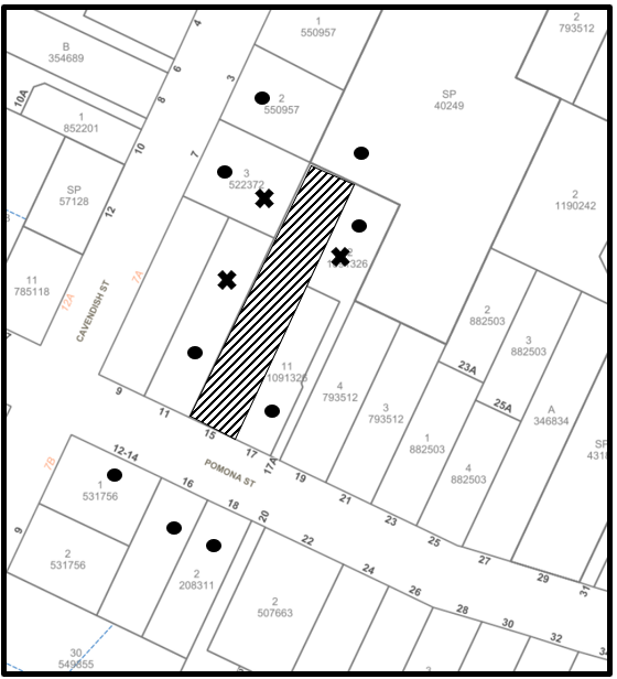
|
NOTIFICATION PLAN |
|||
|
• PROPERTIES NOTIFIED |
X SUBMISSIONS RECEIVED |
|
|
Three submissions objected to the development, generally on the grounds that the development would result in:
· Development that is excessive in bulk and scale
· Unacceptable privacy and amenity concerns
· Validity of DA/742/2021
· Impacts to trees 11 and 12
· Relocation of Stormwater reducing opportunity
The merits of the matters raised in community submissions have been addressed in the body of the report with the exception of the following:
5.1.1 Validity of DA/742/2021
The submission raised concerns that if DA/742/2021 was approved it would allow two dwellings on one residential allotment.
It is noted that the subject site was created through the subdivision approved by Council under DA/677/2018. However, at the time of this assessment, the subdivision has yet to be registered with NSW Land Registry Services.
In response to this submission, it is noted that if this application were to be approved, it would be approved as a deferred commencement to ensure construction of the proposed dwelling house could not occur until the new lot was registered with NSW Land Registry Services.
5.2 Public Agencies
The development application was not referred to any Public Agencies for comment.
6. THE PUBLIC INTEREST
Section 4.15(1)(e) of the Act requires Council to consider “the public interest”.
The public interest is an overarching requirement, which includes the consideration of the matters discussed in this report. Implicit to the public interest is the achievement of future built outcomes adequately responding to and respecting the future desired outcomes expressed in environmental planning instruments and development control plans.
The application is considered to have not satisfactorily addressed Council’s criteria and would not provide a development outcome that, on balance, would result in a positive impact for the community. Accordingly, it is considered that the approval of the proposed development would not be in the public interest.
CONCLUSION
The application proposes the construction of a dwelling house.
The development fails to meet the desired outcomes of Council’s planning controls and is unsatisfactory having regard to the matters for consideration under Section 4.15 of the Environmental Planning and Assessment Act 1979.
Council received two submissions during the public notification period. The matters raised have been addressed in the body of the report.
Having regard to the circumstances of the case, refusal of the application is recommended.
The reasons for this decision are:
· The proposal does not meet the desired outcomes of Part 1C.1.4 Earthworks and Slope of the Hornsby Development Control Plan 2013 as it has not been designed to respect the natural landform characteristics of the land nor to maintain the amenity of adjoining properties.
· The proposal does not meet the desired outcomes of Part 3.1.6 Privacy of the Hornsby Development Control Plan 2013 as it has not been designed to provide reasonable privacy to adjoining properties.
Note: At the time of the completion of this planning report, no persons have made a Political Donations Disclosure Statement pursuant to Section 10.4 of the Environmental Planning and Assessment Act 1979 in respect of the subject planning application.
RESPONSIBLE OFFICER
The officer responsible for the preparation of this report is Tim Buwalda.
|
Cassandra Williams Major Development Manager - Development Assessments Planning and Compliance Division |
Rod Pickles Manager - Development Assessments Planning and Compliance Division |
|
1.⇩ |
Locality Plan |
|
|
|
2.⇩ |
Architectural Plans |
|
|
File Reference: DA/742/2021
Document Number: D08509988
SCHEDULE 1
1. The proposal is unsatisfactory in respect to Section 4.15(1)(a)(iii) of the Environmental Planning and Assessment Act 1979, as the proposal does not comply with the desired outcome and the prescriptive measures of Hornsby Development Control Plan 2013 (HDCP) as follows:
a) The proposal does not comply with the prescriptive measures within Part 1C.1.4 Earthworks and Slope of the HDCP referring to the siting of development on areas of land presenting the least topographic constraints.
b) The proposal does not satisfy the desired outcomes of Part 3.1.6 Privacy of the HDCP referring to the provision of reasonable privacy to adjacent properties.
2. The proposal is unsatisfactory in respect to Section 4.15(1)(b) of the Environmental Planning and Assessment Act 1979, as the proposal would have detrimental environmental impacts on the natural environment in the locality.
3. The proposal is unsatisfactory in respect to Section 4.15(1)(a)(d) and (e) of the Environmental Planning and Assessment Act 1979, as the proposal would not be in the public interest.
- END OF REASONS FOR REFUSAL -
LPP Report No. LPP72/22
Local Planning Panel
Date of Meeting: 30/11/2022
8 REPORT ON HERITAGE CONSERVATION MANAGEMENT PLAN FOR DA/667/2022
EXECUTIVE SUMMARY
· In accordance with Clause 5.10(10) of the Hornsby Local Environmental Plan 2013 it is considered that the submitted Heritage Conservation Management Plan is consistent with and satisfies the requirements and thresholds of the clause.
· The application is required to be determined by the Hornsby Council Local Planning Panel as the panel is the consent authority for the determination of DA/667/2022.
· It is recommended that the Panel endorse the recommendations of this report.
|
THAT: 1. The Hornsby Local Planning Panel approve the conservation management plan (CMP) titled Conservation Management Plan 370 Pennant Hills Road, Pennant Hills Issue D, prepared by GBA Heritage, dated July 2022 for the purpose of satisfying the ‘heritage management document that has been approved by the consent authority’ threshold requirement of Clause 5.10(10)(b) of the Hornsby Local Environmental Plan 2013. 2. The Panel as the consent authority approve the Conservation Management Plan prior to determining Development Application No. 667/2022. |
PURPOSE
The purpose of this report is to seek the Local Planning Panels approval of the Heritage Conservation Management Plan submitted in conjunction with Development Application No. DA/667/2022 for demolition of the rear addition and garage and construction of a mixed use shop top housing development comprising 7 residential units and 2 commercial tenancies at Pt Lot 23, DP 11134, No. 370 Pennant Hills Road, Pennant Hills, from the Hornsby Local Planning Panel.
BACKGROUND
On 28 June 2022, Development Application No. DA/667/2022 for demolition of the rear addition and garage and construction of a mixed use shop top housing development comprising 7 residential units and 2 commercial tenancies at Pt Lot 23, DP 11134, No. 370 Pennant Hills Road, Pennant Hills.
DA/667/2022 seeks to utilise the provision of Clause 5.10(10) of the Hornsby Local Environmental Plan 2013 regarding land use permissibility.
discussion
The Conservation Management Plan (CMP) submitted in conjunction with DA/667/2022 has been assessed having regard to the provisions of Clause 5.10 of the Hornsby Local Environmental Plan 2013 (HLEP), which sets out heritage conservation provisions for Hornsby Shire.
DA/667/2022 relies on Clause 5.10(10) of the HLEP to permit the proposed rear stand-alone residential flat building, a prohibited land use in the B6 Enterprise corridor zone.
Clause 5.10(10) is a heritage incentive provision that permits development that is not otherwise permissible by the HLEP, if the development will facilitate the conservation of a heritage item on the relevant land and meet other specified requirements. The clause provides that the consent authority may grant consent to development that is otherwise prohibited if it is satisfied that the proposed development meets all subclauses of Clause 5.10(10) of the HLEP:
(10) Conservation incentives The consent authority may grant consent to development for any purpose of a building that is a heritage item or of the land on which such a building is erected, or for any purpose on an Aboriginal place of heritage significance, even though development for that purpose would otherwise not be allowed by this Plan, if the consent authority is satisfied that—
(a) the conservation of the heritage item or Aboriginal place of heritage significance is facilitated by the granting of consent, and
(b) the proposed development is in accordance with a heritage management document that has been approved by the consent authority, and
(c) the consent to the proposed development would require that all necessary conservation work identified in the heritage management document is carried out, and
(d) the proposed development would not adversely affect the heritage significance of the heritage item, including its setting, or the heritage significance of the Aboriginal place of heritage significance, and
(e) the proposed development would not have any significant adverse effect on the amenity of the surrounding area.
1.1 Clause 5(10)(10)(b) - Approval of a Heritage Management Document
GBA Heritage’s CMP was submitted to support development application No. DA667/2022.
The CMP is evaluated in Table 1 for overall consistency with the key CMP best practice indicators identified in the Heritage Council of NSW’s Statement of best practice for conservation management plans (2021). The indicators in the Statement have been paraphrased for the purposes of this report.
|
Table 1: Evaluation of the submitted ‘Conservation Management Plan 370 Pennant Hills Road, Pennant Hills’ prepared by GBA Heritage, dated July 2022 |
|
Indicator: A best practice CMP is based on the Australia ICOMOS Burra Charter Indicator: A best practice CMP flows from evidence to analysis, to the statement of significance, to constraints and opportunities, to the conservation management policies and actions. |
|
The Introduction to the CMP (1.3 Methodology and Structure) indicates that it has been prepared in accordance with the guidelines contained in The Conservation Management Plan, by James Semple Kerr, and The Burra Charter: the Australia ICOMOS Charter for Places of Cultural Significance, 2013. The guideline documents provide definitions, principles, and processes for managing and conserving items of cultural significance. The CMP provides: a history of the site and Bank building and a physical description/condition assessment of the interior and exterior Bank building and the site overall (evidence); an assessment of significance of the Bank building as whole, its elements and other features on the site, identification of constraints and opportunities such as building condition and owner’s and legislative requirements (analysis); policies based on significance and a heritage maintenance strategy (policies and actions). Comment: The CMP reflects the sequence of processes established in the Burra Charter to manage places of cultural significance - understand significance, develop policy and manage according to policy. As it is based on the Burra Charter, and is a well-researched, comprehensive and detailed document, the CMP appropriately establishes flow and nexus between its evidence, analysis, policies sections and its recommendations. |
|
Indicator: The CMP will include an understanding of the heritage significance of the item |
|
Part 4 of the CMP establishes the heritage significance of the property as a whole and its parts. The assessment is based on detailed historical research and fabric survey, a curtilage analysis, an evaluation of the integrity and condition of the Bank building (identified in Part 3.5 of the CMP), a comparative analysis with similar buildings and a significance assessment according to the NSW Heritage Office Assessing Heritage Significance criteria. Building and site elements are individually graded as high, moderate or little heritage significance (Table 4.1) based on historical research and fabric survey and the contribution the element makes to the overall significance of the item. No elements are graded as exceptional. The CMP illustrates the grading in plans and elevations and itemises grading in the schedules of individual elements in Tables 4.2 and 4.3. The ground floor banking chamber interior is assessed as having little significance except for the original brick walls as no evidence of the banking chamber layout or features remain. The visual curtilage analysis in the CMP identifies that the three street facades of the two-storey section of the Bank building are considered to be the primary, high significance facades, and views to them are to be retained. The updated Statement of Significance in the CMP determines that the Bank building is primarily of heritage significance for its historical and aesthetic values and its role in the community, that buildings of its type are rare in Pennant Hills and that it is of local significance. Comment: The CMP comprehensively establishes and documents a clear understanding of the heritage significance of the item as a whole and its individual elements. |
|
Indicator: A best practice CMP identifies key issues and opportunities and discusses constraints. |
|
Part 5 of the CMP outlines constraints, opportunities and issues arising from the established significance of the place, the practice requirements of the Burra Charter, the statutory and non-statutory listings that apply, the physical condition of site fabric and the owner’s requirements. Issues arising from significance include the need to retain all significant facades and elements, interpretation of social significance and owner requirements including the need to consider the contemporary regulatory and market environment and the related expectations for safety, functionality and amenity. With regards to change of use, Policy 6.2.5 of the CMP specifies that Conservation of the site should be in the form of on-going or new compatible uses for the site, which respect the scale, form and internal configuration of the heritage building, with minimal changes to the structure, significant fabric or spaces and the external envelope. The change of use should have no adverse heritage impact on the subject site. Comment: The CMP outlines constraints and opportunities, but as it has been written to guide and inform a specific redevelopment scenario, it does not explore alternative adaptive re-use opportunities to any substantial degree. Notwithstanding this scope limit, the CMP appropriately identifies the constraints and opportunities related to heritage significance and heritage best practice that would apply to the site in any redevelopment context. |
|
Indicator: The CMP will include a set of policies to care for and manage this significance Indicator: The CMP will include guidance on managing the item in accordance with the policies |
|
Part 6 of the CMP establishes conservation policies and explains how the Bank building and individual elements at the site can be managed according to each policy. The policies are based on the Statement of Significance and the grading of contributory elements and include principles for reuse, new design and managing building interiors and exteriors. Policies for conservation and maintenance require preparing a schedule of conservation works and a heritage maintenance schedule and there are policies for Code compliance, access, signage, colour and services. Policy 6.5.1 - Focusing of change - applies to building elements of high significance and establishes that future changes should be focused on areas or components which provide a lesser contribution to the overall significance and are, therefore, less sensitive to change. Policy 6.5.2 reinforces this by establishing that any work which affects fabric, spaces or relationships with a high assessed heritage value should be confined to preservation, restoration, reconstruction and adaptation as defined in The Burra Charter. Comment: The CMP includes appropriate principles and policies to manage change and care for the former Bank building and site elements based on the heritage significance of the site as a whole and the identified significance of individual elements. |
|
Indicator: Maintenance plans should include a policy framework and maintenance plans and schedules should identify tasks or actions including urgent works, timing, frequency, priority/staging and responsibilities. |
|
A heritage maintenance schedule is included in the CMP as Appendix 1 and a separate Schedule of Conservation Works is in Appendix 12 of the SEE. The maintenance schedule applies to elements at the site graded as high or medium heritage significance and it establishes yearly, 5 yearly and 10 yearly routine inspection and maintenance requirements. The Schedule of Conservation Works covers conservation philosophy and approach, protective works, new work affecting heritage fabric and make good works, and includes requirements for professional supervision during development by an Appointed Heritage Consultant (AHC). Section 4 details new or repair works to heritage fabric based on condition, integrity and significance. Comment: The CMP includes a brief maintenance schedule including works needed in Year 1 and the separate Schedule of Conservation Works specifies detailed conservation works applicable to the current proposal that could also apply to an alternative adaptive re-use development. Both documents are based on the CMP and its policies and are appropriate to guide decisions affecting heritage fabric. |
The CMP is a comprehensive document that has been prepared in accordance with applicable heritage management document guidelines and standards. It appropriately identifies that its main objective is to ‘develop strategies and guidelines prior to any future upgrading of the existing heritage building and the site for continued use’, complies with accepted industry content and format guidelines and best practice, and details the significance of the site and its elements.
The CMP includes clear and relevant polices, strategies and actions to maintain that significance within a development context. The policies are reflected in the Heritage Maintenance Schedule (CMP Appendix 1) and in the works, actions and responsibilities identified in the Schedule of Conservation Works (SEE Appendix 12).
1.2 Clauses 5.10(10) (a), (b) (c), (d) and (e) of the HLEP
Table 2 assesses the proposal against each sub-clause of Clause 5(10)(10) of the HLEP.
|
Table 2: Assessment against Heritage Incentive Clause 5(10)(10) of the HLEP |
|
(a) The conservation of the heritage item or Aboriginal place of heritage significance is facilitated by the granting of consent, and |
|
Table 6 of the SEE and Section 6.5.2 of the HIS identify that the proposed residential flat building (the non-permitted use) would introduce a revenue stream that would facilitate the short term and long-term conservation of the former Bank building as specified in the Maintenance Schedule in the CMP and the Schedule of Conservation Works. Comment: The submitted documents do not examine the feasibility of alternative revenue streams that may not require a non-permitted use to achieve the short term and long-term conservation and maintenance of the former Bank building. Notwithstanding that development alternatives are not provided, it could be argued that the nexus between the proposal and the conservation and maintenance of the item is already partly satisfied by the completion of the CMP, the heritage maintenance schedule, and the Schedule of Conservation Works, each prepared to guide and inform the scope and form of the proposal. To reinforce and ensure a nexus between the non-permitted use and the short and long-term conservation of the heritage item, a condition of consent is recommended to require that applicable maintenance and all required conservation works are appropriately undertaken and completed to the satisfaction of a conservation architect, prior to the granting of any occupation certificate in whole or part for the former Bank building or for the residential flat building. Provided the recommended condition is applied to any approval for the development under DA/667/2022, it is considered that the submitted CMP satisfies Clause 5.10(10)(a) of the HLEP. |
|
(b) The proposed development is in accordance with a heritage management document that has been approved by the consent authority, and |
|
Table 6.1 of the HIS assessed the proposal against the relevant conservation policies of the CMP. The table indicates that most works comply, or substantially comply with the CMP. With regards to change of use, the HIS concludes that the proposal complies with Policy 6.2.5 of the CMP as the rear RFB is a use compatible with the original and ongoing partly residential use of the site, the Bank building will remain part of the commercial corridor along Pennant Hills Road, and the separate new building will be sympathetic to the Bank building, with all significant views remaining. Comment: Review of the plans submitted with the application, the SEE, HIS, Maintenance Schedule and Schedule of Conservation Works, indicates that the proposed development is in accordance with the identified heritage significance assessments and policies the CMP, which is recommended for approval by the Consent Authority in Part 9 of this report. Consequently, it is considered that the submitted CMP satisfies Clause 5.10(10)(b) of the HLEP. |
|
(c) The consent to the proposed development would require that all necessary conservation work identified in the heritage management document is carried out, and |
|
The Schedule of Conservation Works submitted with the proposal includes sections that cover conservation philosophy and approach, protective works, new work affecting heritage fabric and make good works, and includes requirements for professional supervision during development by an Appointed Heritage Consultant (AHC). Section 4 details new or repair works to heritage fabric based on condition, integrity and significance. Comment: To ensure all necessary conservation work identified in the CMP and Schedule of Conservation Works is carried out, a condition of consent is recommended to require that applicable maintenance and all required conservation works are appropriately undertaken and completed to the satisfaction of a conservation architect, prior to the granting of any occupation certificate in whole or part for the former Bank building or for the residential flat building. Provided the recommended condition is applied to any approval for the development under DA/667/2022, it is considered that the submitted CMP satisfies Clause 5.10(10)(c) of the HLEP. |
|
(d) The proposed development would not adversely affect the heritage significance of the heritage item, including its setting, or the heritage significance of the Aboriginal place of heritage significance, |
|
Section 6.2 of the HIS assesses the heritage impact of the proposal. It identifies that other than conservation works, no changes are proposed to the original primary facades (south, east and north-east) of the Bank building with minor external additions mostly to the rear commercial entry. Intrusive elements such as illuminated signage and rooftop mechanical equipment would be removed, and internal alterations to original interior fabric limited to the partial reconfiguration of the first-floor residential apartment. The HIS concludes that the rear RFB would have no adverse impact on the significance of the site or its setting as the new building will be lower in height and set behind the former Bank building, will allow the rear of the bank to remain visible and will not obstruct significant views to or from it. The HIS further concludes that the new building reflects the scale, verticality, solid to void ratio, materiality and detailing of the former Bank, that its highly articulated facades reduce its perceived mass, and that it will not dominate the Bank building. Comment: While some site elements including the rear garage (of Moderate heritage significance) would be removed, some alterations to the Bank building made and a new building constructed to its rear, the conclusions of the HIS are generally agreed. The proposal includes the conservation of the Bank building which is a positive impact, and the location, form and design detail of new elements are sensitive to it and would have minimal adverse impact on its overall significance. To ensure the identified conservation works are prioritised, a condition of consent is recommended to require that applicable maintenance and all required conservation works are appropriately undertaken and completed to the satisfaction of a conservation architect, prior to the granting of any occupation certificate in whole or part for the former Bank building or for the residential flat building. Provided the recommended condition is applied to any approval for the development under DA/667/2022, it is considered that the submitted CMP satisfies Clause 5.10(10)(d). |
|
(e) The proposed development would not have any significant adverse effect on the amenity of the surrounding area |
|
The surrounding area is characterised by low-scale inter-war and post-war commercial retail and commercial development with some recent high-rise residential and commercial buildings on the opposite side of Pennant Hills Road. Fisher Avenue includes part of the local retail precinct. The site does not adjoin any existing residential uses and the submitted documentation does not identify any overshadowing or amenity impacts. Comment: The proposed rear 3 storey RFB is commensurate in scale, form and materials to the existing former Bank building and many nearby buildings in the surrounding area. It would have no adverse visual impact on the amenity of the surrounding area and as a stand-alone structure, set back from the rear of the bank, it is unlikely to visually detract from bank’s contribution to the vicinity or local amenity. The proposed development will have no adverse visual or heritage impact on any other heritage items It is considered that the proposed development would satisfy HLEP Clause 5.10(10)(e) with regards to the visual amenity of the surrounding area. |
An evaluation of the proposal with regards to HLEP Clause 5(10)(10), indicates that it meets and is consistent with the requirements and thresholds of each sub-clause, provided a condition of consent is imposed to secure the nexus between the proposed non-permitted use and the short and long-term conservation of the heritage item. A condition that requires that applicable maintenance and all required conservation works are appropriately undertaken and completed to the satisfaction of a conservation architect, prior to the granting of any occupation certificate for DA/667/2022 for the former Bank building or for the residential flat building, is recommended.
Provided the recommendation is applied to any approval, it is considered that the submitted CMP would satisfy Clause 5.10(10) of the HLEP.
CONCLUSION
Council’s heritage assessment concluded that the submitted conservation management plan titled ‘Conservation Management Plan 370 Pennant Hills Road, Pennant Hills’ Issue D, prepared by GBA Heritage, dated July 2022 satisfactorily addresses the requirements of Clause 5.10(10) of the Hornsby Local Environmental Plan 2013.
Having regard to the circumstances of the case, approval is sought from the Hornsby Local Planning Panel for the purpose of satisfying the ‘heritage management document that has been approved by the consent authority’ threshold requirement of Clause 5.10(10)(b) of the Hornsby Local Environmental Plan 2013. To enable the determination of DA/667/2022.
Note: At the time of the completion of this planning report, no persons have made a Political Donations Disclosure Statement pursuant to Section 10.4 of the Environmental Planning and Assessment Act 1979 in respect of the subject planning application.
RESPONSIBLE OFFICER
The officer responsible for the preparation of this report is Thomas Dales.
|
Cassandra Williams Major Development Manager - Development Assessments Planning and Compliance Division |
Rod Pickles Manager - Development Assessments Planning and Compliance Division |
|
1.⇩ |
Conservation Management Plan Report |
|
|
File Reference: DA/667/2022
Document Number: D08525835
|
Attachment to Report No. LPP65/22 Page -4 |
LPP Report No. LPP65/22
Local Planning Panel
Date of Meeting: 30/11/2022
9 DA/667/2022 - MIXED USE DEVELOPMENT COMPRISING SHOP TOP HOUSING AND RESIDENTIAL FLAT BUILDING - 370 PENNANT HILLS ROAD, PENNANT HILLS
EXECUTIVE SUMMARY
|
DA No: |
DA/667/2022 (Lodged on 28 June 2022) |
|
Description: |
Demolition of the rear addition and garage and construction of a mixed use development comprising shop top housing and residential flat building with 7 residential apartments and 2 commercial tenancies |
|
Property: |
Pt Lot 23 DP 11134, No. 370 Pennant Hills Road, Pennant Hills |
|
Applicant: |
The Trustee for the Omni Unit Trust |
|
Owner: |
Omni Office Products Pty Ltd |
|
Estimated Value: |
$4,574,696 |
|
Ward: |
B Ward |
· The application involves the demolition of the rear addition and garage and construction of a mixed-use development comprising shop top housing and residential flat building.
· No submissions have been received in respect of the application.
· The application is required to be determined by the Hornsby Local Planning Panel as State Environmental Planning Policy No. 65 Design Quality of Residential Flat Development applies.
· It is recommended that the application be approved.
|
THAT Development Application No. DA/667/2022 for the demolition of the rear addition and garage and construction of a mixed-use development comprising shop top housing and residential flat building at Pt Lot 23 DP 11134, No. 370 Pennant Hills Road, Pennant Hills be approved subject to the conditions of consent detailed in Schedule 1 of LPP Report No. LPP65/22. |
BACKGROUND
On 7 July 2004, Council approved DA/2443/2003 for the change of use of the existing building for kitchen showroom and signage (heritage item). Subsequent modification applications were approved for signage and to allow trading on Sundays. The approved operating hours are as follows:
Monday to Friday 8:30am to 5:30pm
Saturdays 8:30am to 5:00pm
Sundays 10:00am to 5:00pm
On 15 May 2007, Council approved DA/199/2007 for the change of use of the second tenancy to an educational establishment (music tuition). The approved operating hours are:
Monday to Friday 8:00am to 9:00pm
Saturday and Sunday 8:00am to 6:00pm
On 26 August 2014, Council approved Development Application No. DA/1430/2013 for alterations and additions to the existing commercial building (heritage item) for shop-top housing comprising 4 units and strata subdivision. Of relevance to the subject application (DA/667/2022), Council approved the development with a shortfall of 6 on-site parking spaces upon the findings of a street parking survey which demonstrated adequate on-street car parking and public carpark spaces was available for the commercial use.
On 12 August 2021, Council held a pre-lodgement meeting with the applicant (PL/73/2021) to discuss the merits of a future development application proposing the demolition of the rear addition and garage and construction of a mixed use development comprising shop top housing and residential flat building.
On 7 March 2022, upon revisions to the architectural plans addressing Council’s commentary as part of the pre-lodgement application, the Hornsby Design Excellence Panel (DEP) held a meeting with the applicant to discuss the architectural and urban design elements of the amended proposal pursuant to the Design Excellence provisions under Clause 6.8 of the HLEP.
Application History
The applicant submitted the development application on 28 June 2022.
On 21 July 2022, Council sought independent legal advice to corroborate the findings of the applicants own legal advice submitted with the application supporting the utilisation of Clause 5.10(10) of the Hornsby Local Environmental Plan 2013 (HLEP) regarding land use permissibility. On 25 August 2022, Council received its independent legal advice to support the use of Clause 5.10(10) of the HLEP.
On 3 August 2022, Council’s DEP held a meeting with the applicant to discuss the architectural and urban design elements of the proposal.
Following the completion of the Panel’s assessment, and Council’s preliminary review, a request for additional information and amended plans was sent to the applicant on 17 August 2022. The request sought changes in relation to:
· Design Excellence Matters, including boundary setbacks, building separation, landscaping, communal open space size and passive surveillance;
· Streetscape impacts relating to the fire hydrant utilities required under the BCA;
· Further detail regarding the contamination sampling on site, to demonstrate compliance with the requirements of State Environmental Planning Policy No. 55 Remediation of Land; and
· The submission of a Preliminary Construction Management Plan to address traffic impacts during construction.
On 29 August 2022, Council requested the submission of additional information in the form of an amended Traffic Report and the provision of a street parking survey to determine whether the on-site parking shortfall would be appropriate under the circumstances.
On 5 September 2022, Council requested additional hydraulic details to assist Council’s assessment of stormwater detention and discharge.
Between 12 July and 4 October 2022, Council received the requested additional information (including Revision 2 of the Architectural Plans).
SITE
The 917m2 site is known as 370 Pennant Hills Road, Pennant Hills, being legally described as Pt Lot 23 DP11134.
The site is located at the corner of Pennant Hills Road and Fisher Avenue.
The site is not mapped as bushfire or flood prone and is not burdened by any easements or restrictions.
The site affords a primary frontage of 19m to Pennant Hills Road to the south, a frontage of 50m to Fisher Avenue and a frontage of 8m to an unnamed laneway.
Access to the site is currently facilitated from Fisher Avenue via a driveway crossover leading to the at-grade carpark.
The existing heritage listed building on the site comprises a two storey Bank building designed with regard to the corner site. The building c1938 includes a later single storey rear addition as a bank residence and a free standing garage constructed in 1964. The vacant rear part of the site forms an open bitumen paved car parking area. The ground floor of the building is currently used for a kitchen showroom (Impala Kitchens) accessed at the corner entry. A separate ground floor entry at the Pennant Hills Road frontage includes separate office accommodation. The first floor is used for commercial offices with external stair access at the rear of the building.
The site is listed as local Heritage Item 651 - Former Bank of New South Wales, in Schedule 5 of the HLEP.
The site is located within the B6 Enterprise Corridor zone of the HLEP and identified as part of the Pennant Hills Town Centre.
The Pennant Hills locality along Pennant Hills Road is characterised by commercial and retail uses with low and high density residential development located to the north.
The site is accessible via public transport with the Pennant Hills Railway Station and bus services along Pennant Hills Road, providing connectivity to the surrounding suburbs and the wider region.
PROPOSAL
The application proposes a mixed-use development comprising shop top housing and residential flat building (RFB), summarised as follows:
· Demolition of the rear garage and part of the addition to the heritage building erected circa 1964 and existing hardstand parking at the rear.
· Demolition of part of existing brick fence and freestanding pier and removal of existing gates.
· Construction of mixed use development including shop top housing and RFB development, comprising a total of 7 residential apartments and 2 commercial tenancies as follows:
o Alterations and additions to heritage building known as Former Bank of New South Wales Building to enable the proposed shop top housing development comprising:
Ø Retention of existing commercial Tenancy 1 and Tenancy 2.
Ø Internal alterations to the existing commercial tenancies.
Ø Repair works to the exterior of the building.
Ø Internal alterations to existing heritage building to create a 3 bedroom residential apartment on Level 1 including 2 bathrooms, living and dining rooms.
o Construction of a 3 storey residential flat building located at the rear of the site comprising:
Ø At grade undercover car parking comprising of 8 car parking spaces on ground level.
Ø Provision of 3 bedroom, 2 bedroom and 1 bedroom units on Level 1 and 2 with a total of 6 units fronting Fisher Avenue.
Ø Each unit includes living area, dining area, bathroom, kitchen and a balcony.
· Associated landscaping and communal open space areas.
· Associated civil stormwater engineering works including the provision of On-Site Detention (OSD)/rainwater tank.
ASSESSMENT
The development application has been assessed having regard to the Greater Sydney Region Plan – A Metropolis of Three Cities, the North District Plan and the matters for consideration prescribed under Section 4.15 of the Environmental Planning and Assessment Act 1979 (the Act). The following issues have been identified for further consideration.
1. STRATEGIC CONTEXT
1.1 Greater Sydney Region Plan - A Metropolis of Three Cities and North District Plan
The Greater Sydney Region Plan - A Metropolis of Three Cities has been prepared by the NSW State Government to guide land use planning decisions for the next 40 years (to 2056). The Plan sets a strategy and actions for accommodating Sydney’s future population growth and identifies dwelling targets to ensure supply meets demand. The Plan also identifies that the most suitable areas for new housing are in locations close to jobs, public transport, community facilities and services.
The NSW Government will use the subregional planning process to define objectives and set goals for job creation, housing supply and choice in each subregion. Hornsby Shire has been grouped with Hunters Hill, Ku-ring-gai, Lane Cove, Mosman, North Sydney, Ryde, Northern Beaches and Willoughby to form the North District. The Greater Sydney Commission has released the North District Plan which includes priorities and actions for Northern District for the next 20 years. The identified challenge for Hornsby Shire will be to provide an additional 4,350 dwellings by 2021 with further strategic supply targets to be identified to deliver 97,000 additional dwellings in the North District by 2036.
The proposed development would be consistent with the Greater Sydney Region Plan - A Metropolis of Three Cities and the North District Plan, by contributing to achieving the dwelling targets for the region.
2. STATUTORY CONTROLS
Section 4.15(1)(a) requires Council to consider “any relevant environmental planning instruments, draft environmental planning instruments, development control plans, planning agreements and regulations”.
2.1 Hornsby Local Environmental Plan 2013
The proposed development has been assessed having regard to the provisions of the Hornsby Local Environmental Plan 2013 (HLEP).
2.1.1 Zoning of Land and Permissibility
The subject land is zoned B6 Enterprise Corridor under the HLEP. The objectives of the B6 zone are:
· To promote businesses along main roads and to encourage a mix of compatible uses.
· To provide a range of employment uses (including business, office, retail and light industrial uses).
· To maintain the economic strength of centres by limiting retailing activity.
· To provide for residential uses, but only as part of a mixed use development
The proposed development is defined as ‘residential flat building’ and ‘shop top housing’ under the HLEP.
Within the B6 zone the following land uses are permissible with consent: Business premises; Community facilities; Food and drink premises; Garden centres; Group homes; Hardware and building supplies; Hotel or motel accommodation; Kiosks; Landscaping material supplies; Light industries; Neighbourhood shops; Oyster aquaculture; Passenger transport facilities; Plant nurseries; Roads; Shop top housing; Specialised retail premises; Tank-based aquaculture; Timber yards; Vehicle sales or hire premises; Warehouse or distribution centres; Water reticulation systems; Any other development not specified in item 2 or 4
Within the B6 zone the following are prohibited:
Agriculture; Air transport facilities; Airstrips; Biosolids treatment facilities; Boat building and repair facilities; Boat launching ramps; Boat sheds; Camping grounds; Caravan parks; Cemeteries; Charter and tourism boating facilities; Correctional centres; Crematoria; Eco-tourist,facilities; Electricity generating works; Environmental facilities; Exhibition homes; Exhibition villages; Extractive industries; Farm buildings; Forestry; Freight transport facilities; Heavy industrial storage establishments; Helipads; Highway service centres; Home businesses; Home occupations (sex services); Industries; Jetties; Marinas; Mooring pens; Moorings; Mortuaries; Open cut mining; Pond-based aquaculture Research stations; Residential accommodation; Resource recovery facilities; Retail premises; Rural industries; Serviced apartments; Sewage treatment plants; Sex services premises; Truck depots; Waste disposal facilities; Water recreation structures; Water supply systems; Wharf or boating facilities
The proposed development comprises a mixed-use development including shop top housing and a residential flat building (RFB).
The HLEP provides the following relevant definitions:
mixed use development means a building or place comprising 2 or more different land uses.
shop top housing means one or more dwellings located above the ground floor of a building, where at least the ground floor is used for commercial premises or health services facilities.
Note— Shop top housing is a type of residential accommodation—see the definition of that term in this Dictionary.
It is noted that the residential building at the rear of the site would not meet the definition of shop top housing as ground floor commercial premises or health services is not proposed. The building would be defined as a residential flat building that is provided under the parent definition of residential accommodation which is prohibited within the zone.
Development for the purpose of an RFB is provided the following definition under the HLEP:
residential flat building means a building containing 3 or more dwellings, but does not include an attached dwelling, co-living housing or multi dwelling housing. Note— Residential flat buildings are a type of residential accommodation—see the definition of that term in this Dictionary.
Notwithstanding the above, the proposed residential flat building component of the development is submitted to Council as permissible development in accordance with the provisions of Clause 5.10(10) of the HLEP.
(10) Conservation incentives The consent authority may grant consent to development for any purpose of a building that is a heritage item or of the land on which such a building is erected, or for any purpose on an Aboriginal place of heritage significance, even though development for that purpose would otherwise not be allowed by this Plan, if the consent authority is satisfied that…
The provisions of Clause 5.10(10) of the HLEP are addressed under Section 2.1.5 of this report.
2.1.2 Height of Buildings
Clause 4.3 of the HLEP provides that the height of a building on any land should not exceed the maximum height shown for the land on the Height of Buildings Map. The maximum permissible height for the subject site is 10.5m. The proposal has a maximum height of 11m and does not comply with this provision.
The application seeks a to contravene the maximum building height development standard utilising the provisions of Clause 5.6 (architectural roof features) of the HLEP. Section 2.1.4 of this report addresses the proposed contravention under Clause 5.6 of the HLEP.
2.1.3 Floor Space Ratio
Clause 4.4 of the HLEP provides that the maximum floor space ratio (FSR) for a building on the subject site is not to exceed the floor space ratio shown of 1:1.
The subject site has a site area of 916.8m2. The proposed development would result in a total Gross Floor Area (GFA) of 907m2.
The proposal achieves an FSR of 1:1 and complies with Clause 4.4 of the HLEP.
2.1.4 Architectural Roof Features
An architectural roof feature comprising eyelid windows is proposed which provides a minor exceedance to Clause 4.3 Height of buildings development standard.
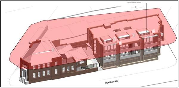
Figure 1:
It is noted that the exceedance is limited to the proposed eyelid windows and the predominate built form is below the maximum height of buildings development standard. Figure 1 above showcases the extent of the exceedance.
Clause 5.6 Architectural roof features of the HLEP provides the following objectives in subclause (1):
(a) to permit variations to maximum building height standards for roof features of visual interest,
(b) to ensure that roof features are decorative elements and that the majority of the roof is contained within the maximum building height standard.
The proposed eyelid windows are considered to enhance the visual interest of the building as removing the decorative element will result in a flat roof with no architectural design elements. It is noted that the proposed decorative element cannot be converted into GFA and acts solely as an architectural roof feature.
Accordingly, objective (a) is satisfied as the feature promotes the visual interest of the building. Additionally, objective (b) provides that the roof feature must be a decorative element and that majority of the roof is contained within the maximum building. The proposed development is consistent with this objective, and it is noted that removal of this feature will result in a flat roof form with no articulated design elements. Additionally, as demonstrated in Figure 1 above, the majority of the proposed roof is contained wholly within the maximum building height standard and the exceedance is limited to the proposed eyelid windows.
In light of the above, the proposed development is considered to be an architectural roof feature and consistent with the objectives of Clause 5.6.
In addition to the above, the consent authority must be satisfied the roof feature satisfies the following criteria under Clause 5.6(3) of the HLEP:
(a) the architectural roof feature:
(i) comprises a decorative element on the uppermost portion of a building, and
(ii) is not an advertising structure, and
(iii) does not include floor space area and is not reasonably capable of modification to include floor space area, and
(iv) will cause minimal overshadowing, and
(b) any building identification signage or equipment for servicing the building (such as plant, lift motor rooms, fire stairs and the like) contained in or supported by the roof feature is fully integrated into the design of the roof feature.
As outlined above it is considered that the proposed roof feature is a decorative element of the roof as the proposed eyelid windows facilitate articulation to the roof form of the building. Further, the proposed features have been designed to integrate with the roof form whilst being compatible with the streetscape character of Fisher Avenue. Notably, the proposed roof features are set back from the building’s façade and will not be visible when viewed from the public domain along Fisher Avenue, which demonstrates that the proposed eyelid windows will not result in any clutter or adverse visual impact. The proposed eyelid windows provide improved amenity to units including cross ventilation for the 1 bedroom units.
The proposed roof feature is considered to provide a better design outcome when compared to a height compliant scenario with a flat roof and no architectural design elements. The proposed development does not result in any additional overshadowing to the east noting that the site adjoins Fisher Avenue and given the minor nature of the departure.
In addition, it is noted that the Design Excellence Panel have advised that “the Panel does not consider the height of the development to be an issue”.
The proposed architectural roof feature has satisfactorily addressed the requirements of Clause 5.6 of the HLEP and is considered acceptable.
2.1.5 Heritage Conservation
Clause 5.10 of the HLEP sets out heritage conservation provisions for Hornsby Shire. No. 370 Pennant Hills Road Pennant Hills is listed as local Heritage Item 651 - Former Bank of New South Wales, in Schedule 5 of the HLEP. The heritage listing identifies that the face brick 1940s Post-War Functionalist style Bank building on the site is a rare example of a commercial building in the area and that (in 1993 when the listing was finalised) the building was virtually unaltered. The listing notes a prominent formal entry splay at the corner of the two streets with decorative Art Deco render, original doors and windows and grille over entry skylight.
The area surrounding the subject site is characterised by low low-scale interwar and post-war commercial retail development with some recent high-rise residential and commercial buildings on the opposite side Pennant Hills Road. Fisher Avenue includes part of the local shopping precinct.
The subject site has three street boundaries: Pennant Hills Road, Fisher Avenue, and an unnamed lane to the rear. The former Bank building covers the southern half of the site at the corner of Pennant Hills Road and Fisher Avenue. To its rear are a freestanding garage and a bitumen-paved carpark. Views to the site are primarily from the east along Pennant Hills Road.
The ground floor banking chamber of the Bank building has been extensively altered for commercial tenancies and no original interior elements or fabric of the previous banking use remain. While some exterior alterations and additions are also evident, all the buildings on the subject site are of red face brick and tile and similar mid/post-war Georgian Revival, functionalist style. An original low brick boundary fence extends from the rear of the front section of the former Bank building to the original driveway off Fisher Avenue. Together, all elements on the site can readily be seen from the public domain as related parts of an early to mid-twentieth century suburban commercial/ residential complex.
The subject is not in the vicinity of other heritage items and is not in a Heritage Conservation Area.
The application has been supported by the following documents which were considered in the heritage assessment detailed below:
· Amended Schedule of Conservation Works prepared by GBA Heritage dated 8 July 2022 (Issue D).
· Amended Statement of Heritage Impact prepared by GBA Heritage dated 8 July 2022 (Issue C).
· Amended Conservation Management Plan (CMP) prepared by GBA Heritage dated 8 July 2022 (Issue D).
· Supplementary Statement of Heritage Impact prepared by GBA Heritage dated 20 September 2022.
2.1.5.1 Heritage Incentives - HLEP Clause 5.10(10)
The application relies on HLEP Clause 5.10(10) to allow the proposed rear stand-alone residential flat building, a non-permitted use in the B6 zone. The clause is a heritage incentive that permits development that is not otherwise allowed by the HLEP, if the development will facilitate the conservation of a heritage item on the relevant land and meet other specified requirements. The clause provides that the consent authority may grant consent to development that is otherwise prohibited if it is satisfied that the proposed development meets all subclauses of Clause 5.10(10) of the HLEP, as follows:
(a) the conservation of the heritage item or Aboriginal place of heritage significance is facilitated by the granting of consent, and
(b) the proposed development is in accordance with a heritage management document that has been approved by the consent authority, and
(c) the consent to the proposed development would require that all necessary conservation work identified in the heritage management document is carried out, and
(d) the proposed development would not adversely affect the heritage significance of the heritage item, including its setting, or the heritage significance of the Aboriginal place of heritage significance, and
(e) the proposed development would not have any significant adverse effect on the amenity of the surrounding area.
Comment: An assessment of the submitted conservation management document for the purpose of addressing the heritage management document is provided as a separate report LPP72/2022 for the purposes of satisfying Clause 5(10)(10) of the HLEP. This report assumes that the consent authority, Hornsby Local Planning Panel has approved the heritage management document prior to determining this development application in accordance with Clause 5(10)(10)(b).
2.1.6 Earthworks
Clause 6.2 of the HLEP states that consent is required for proposed earthworks on site. Before granting consent for earthworks, Council is required to assess the impacts of the works on adjoining properties, drainage patterns and soil stability of the locality.
The proposed development would require excavation to a maximum depth of 1m to facilitate the provision of a level building platform beneath the residential flat building. The scale of the proposed earthworks is considered minor and commensurate to the scale of the proposed building works.
A condition has been recommended under Schedule 1 requiring that all excavated material removed from the site be classified by a suitably qualified environmental consultant in accordance with the NSW Environment Protection Authority’s Waste Classification Guidelines and Protection of the Environment Operations (Waste) Regulation 2014 prior to disposal to a licensed waste management facility.
The proposed earthworks would not detrimentally impact the surrounding natural and built environment with regard to drainage patterns and soil stability of the locality.
The proposal complies with Clause 6.2(3) of the HLEP and is considered acceptable in this regard.
2.1.7 Design Excellence
Clause 6.8 of the HLEP provides considerations for the delivery of the highest standard of architectural and urban design. The application was referred to Council’s Design Excellence Panel (DEP) on 3 August 2022 for review.
The Panel reviewed the proposed development and concluded the following:
The site is narrow, and a large part of the site area is occupied by a heritage item.
On the other hand the site has three street frontages and only one shared boundary. The property is on a main road with bus stops nearby, is within proximity to a train station and public parking area. A Traffic Plan will need to consider the availability of sufficient parking opportunities in the vicinity.
The opportunity to adapt the heritage building and to develop the site as a mixed-use development is generally supported by the Panel subject to the changes recommended throughout this report.
With adjustments to the design of the development recommended in this report, the Panel considers the proposal capable of achieving design excellence.
Some of the key considerations identified by the Panel for the applicant are:
1. The provision and design of communal open space and deep soil areas.
2. Fisher Avenue and Pennant Hills Road entrances.
3. Splayed window orientated towards the rear lane.
4. Improve solar protection to living spaces and bedrooms
5. Public domain improvements.
6. Ecologically Sustainable Development provisions
Council provided the detailed DEP assessment of the proposal to the applicant for consideration and the applicant supplied amended plans and further detail regarding the key considerations outlined above.
As the DEP identified that the key considerations were a prerequisite to achieving design excellence, a review of the additional detail provided by the applicant for each of the 6 considerations is provided below:
Consideration 1 - The provision of deep soil area and design of communal open space (COS)
With regard to Consideration 1, the DEP provided the following comments:
The deep soil zone (DSZ) has been calculated based on the site area excluding the heritage building existing on the site. It is generally accepted that the 7% requirement is based on to the total site area, not only the part of the site that is to be developed. It should also have a minimum width of 3m for a site of this size. Technically and in principle, the objectives of the DSZ requirement have not been met. Mitigation is required to offset the objectives of the provision of ‘deep soil planting’ areas. However, given the constraints of the site, the location of the largest portion of the DSZ adjacent to the COS and lobby seems appropriate and should be maximised via permeable paving, WSUD strategies and proportion. If it can be demonstrated that the DSZ is this location benefits the COS and allows the inclusion of several medium - large canopy trees it not meeting the ADG seems acceptable.
Similar to the DSZ the COS has been calculated based on the site area excluding the heritage building existing on the site. It is generally accepted that the 25% requirement is based on the total site area, not only the part of the site that is to be developed. Only 10% of the site has been provided as COS, of which a large proportion is circulation space. However, POS in the form of balconies is provided that is larger than the required minimums and, given the small unit numbers, this goes some way to alleviating the lack of COS. The site constraints themselves logically lend themselves to providing COS where it has been proposed however also result in a narrow slot between the heritage and proposed built form. The resultant COS therefore acts as both entry landscape and usable space creating the potential for conflict by not separating the usable COS from the path of travel. It still appears that the removal of one unit to provide COS on L2 could be explored and would allow the scheme to become compliant. Further to this, there are a series of rooms at the rear of the heritage building, directly adjacent to the COS that could be incorporated for communal use. While achieving the ADG’s requirement of 25% may be difficult, a greater amount of COS, with a more appropriate layout, and with ADG compliant solar access, must be provided.
The applicant provided amended plans that adequately address the concerns of the panel and no objections are raised to the communal open space design and the calculation of the COS and DSZ which are discussed in the body of this report.
Consideration 2 - Fisher Avenue and Pennant Hills Road entrances
With regard to Consideration 2, the DEP provided the following comments:
The Panel is generally satisfied with the proposed entrances in Fisher Avenue and Pennant Hills Road with regard to privacy and security. Further improvements are recommended above to address shortfalls in landscaping and common open space. Any modifications to the entry sequence to maintain clear sightlines from Fisher Avenue towards the main entrance lobby and compliance with CPTED requirements.
The revised plans have resulted in improvements to the COS as discussed above. Furthermore, increased solar access is provided to the area and the development continues to maintain compliance with Crime Prevention Through Environmental Design Requirements (CPTED).
Consideration 3 - Splayed window orientated towards the rear lane
With regard to Consideration 3, the DEP provided the following comments:
That consideration be given to a splayed window orientated towards the rear lane for south facing bedrooms to address privacy issues and the non-compliance with separation requirements under the ADG.
The splayed window has been explored by the applicant and, on balance, does not provide increased daylight access in comparison to the proposed design. Additionally, splay windows would require Automatic Fire Shutters which are not considered commensurate with the proposed design of the building.
Consideration 4 - Improve solar protection to living spaces and bedrooms
With regard to Consideration 4, the DEP provided the following comments:
Provide shading to all north, east and west facing windows.
Balconies facing Fisher Avenue are provided with overhangs for solar protection to living spaces and bedrooms are provided with shading and privacy screens. The majority of windows facing north, east and west are proposed with blades to provide solar protection which are small in width.
Consideration 5 - Public domain improvements
With regard to Consideration 5, the DEP provided the following comments:
The proposed lawn in the verge, and between the footpath and development should be replaced with low planting. If parking exists areas of stepping stones may be considered to allow movement across the verge. Lawn is not a good solution as it requires long term maintenance and may impact the health of the trees if poorly maintained (e.g. ringbarking).
Additional planting has been added to the proposed development in the verge which is discussed further in the body of this report.
Consideration 6 - Ecologically Sustainable Development (ESD)
With regard to Consideration 6, the DEP provided the following comments:
Areas for Solar PV’s are now shown on the roof plan. No EV charging facilities are indicated on the plans, an A/C condensers only shown for the unit in the heritage building and no ceiling fans are shown for any of the units. These should be included in the DA as recommended previously
EV charging facilities and ceiling fans have been included in the updated architectural plans.
As detailed above, the application has undergone a detailed design review with the objective of ensuring an adequate level of design excellence. Council considers that the considerations provided by the DEP have been adequately addressed and the development as proposed is consistent with the requirements of Clause 6.8 of the HLEP.
2.2 State Environmental Planning Policy No. 65 Design Quality of Residential Flat Development
State Environmental Planning Policy No. 65 Design Quality of Residential Flat Development (SEPP 65) provides for design principles to improve the design quality of residential flat development and for consistency in planning controls across the State.
SEPP 65 adopts the Apartment Design Guide which prevails in the event of any inconsistency with a Development Control Plan. The Policy includes objectives to meet housing and population targets, affordable housing and to facilitate timely and efficient assessment of development applications. SEPP 65 makes further provision for design review panels; includes additional provisions for the determination of development application and for standards for car parking, visual privacy, solar and daylight access, common circulation and spaces, apartment size and layout, ceiling heights, private open space and balconies, natural ventilation and storage, which cannot be used as grounds for refusal of development consent.
The applicant has submitted a “Design Verification Statement” prepared by a qualified Architect stating how the proposed development achieves the design principles of SEPP 65. An assessment of the proposal against the design quality principles contained within Schedule 1 of SEPP 65 and the submitted design verification statement are addressed in the following table:
|
SEPP 65 - Schedule 1 Assessment |
|
|
Principle |
Compliance |
|
1. CONTEXT AND NEIGHBOURHOOD CHARACTER |
Yes |
|
Comment: The site is located on the corner of Fisher Ave and Pennant Hills and backs on to a lane. It is an irregular shape 917m2 lot, with a gentle fall to the rear. On its corner is a Heritage Listed building formerly a branch of the Bank of NSW, identified as Item 651 in schedule 5 of the HLEP. It is a two storey building of face brick with Marseilles tiles constructed in 1928 in an inter-war Gregorian Revival Style. Pennant Hills Road is a key thoroughfare connecting to northern Sydney and Newcastle. Pennant Hills Station is 400m to its northeast. The surrounding context is mixed with immediate buildings on Pennant Hills Road being 1-2 storey commercial premises, those to the west are residential in nature 5-6 storeys in height and along Fisher some single storey residential dwellings. Opposite is a low rise shopping centre with on grade car parking. The proposal responds to the context, it is well designed to acknowledge the heritage building on the site and being a three storey masonry building it is in keeping with the general surrounds and context. |
|
|
2. BUILT FORM AND SCALE |
Yes |
|
Comment: The proposed development retains most of the Heritage building with parts of lesser significance being removed. The new 3 storey building is setback from the Heritage Building to provide it with a curtilage and provide light and privacy for the apartments. The ground floor is an on grade carpark which has been designed as part of the building. The new building has a strong architectural expression which compliments the heritage building. It uses a similar toned brick and patterning to the heritage building, it is highly articulated with the use of ‘fanned form’, curved blades and contrasting balustrades, and uses landscaping on its façade to soften the building. At street level the hit and miss brickwork allow site lines into the carpark, and the planter beds and seat at the entry increase its identity and interest at the street. The new building has a small floor plate with three apartments and is 11m in height. The proposal is development that is appropriate to the existing and desired future character of the street. |
|
|
3. DENSITY |
Yes |
|
Comment: All apartments receive a high level of amenity with apartments being orientated to the north and all but one being cross ventilated. The proposal complies with the 1:1 FSR requirement on the site. The proposed density is considered to be sustainable as it responds to the regional context, availability of infrastructure, public transport, community facilities and environmental quality and is acceptable in terms of density despite non-compliant setback distances and building height (discussed in further detail in the body of this report). |
|
|
4. SUSTAINABILITY |
Yes |
|
Comment: The lift lobby and corridors have access to daylight and natural ventilation. Additional sustainable initiatives are solar panels on the roof, water efficient fittings, and indigenous planting that require low irrigation, rainwater reuse and all electric appliances. The development is supported by a BASIX certificate that demonstrates compliance with BASIX requirements. In addition, native landscaping is proposed on the site, with permeable paving and rain garden areas to reduce stormwater runoff. Solar access is provided to all units to reduce the requirements for artificial lighting during the day, with living areas and bedrooms provided adjacent to building facades. Cross ventilation is also provided at minimum required levels to reduce the requirement for air conditioning. |
|
|
5. LANDSCAPE |
Yes |
|
Comment: Landscaping is integrated into the design. The building itself has planters to the Fisher Street façade with two vertical elements used as climbers for landscaping to grow up the building. Additional street trees have been nominated external to the site to assist the streetscape and provide a pleasant outlook from the apartments. Although there is limited space for communal open space, the area provided is of high quality and is effective. It is co located with the deep soil zone, has a BBQ area and two different seating zones.
|
|
|
6. AMENITY |
Yes |
|
Comment: 100% of apartments achieve 2 hours of sunlight in midwinter and 86% of apartments would be cross ventilated. All apartments: · Meet the minimum storage requirements, some with the additional of storage in the basement · Have balconies that are larger than the ADG minimum · Have indoor and outdoor spaces with northern aspect The proposed units are designed with appropriate room dimensions and layout to maximise amenity for future residents. The proposal incorporates good design in terms of achieving natural ventilation, solar access and acoustic privacy. All units incorporate balconies accessible from living areas and privacy has been achieved through appropriate design and orientation of balconies and living areas. |
|
|
7. SAFETY AND SECURITY |
Yes |
|
Comment: Apartments are orientated to overlook both streets, as well as the communal open space at ground; hence the public domain and the internal public areas have appropriate means of surveillance. The rear of the property provides an entry from Pennant Hills Rd and is also a servicing path for both the commercial and residential residents to the lane. There is visual surveillance to this area from both the lane and Pennant hills Road. External lighting will be provided to ensure surveillance is maintained during night time. The design orientates the balconies of individual apartments towards the street, providing passive surveillance of the public domain. Both the pedestrian and vehicular entry points are secured and visibly prominent on Park Avenue. The development would be capable of compliance with Crime Prevention Through Environmental Design Principles (CPTED). |
|
|
8. SOCIAL DIMENSIONS AND HOUSING AFFORDABILITY |
Yes |
|
Comment: The proposal will contribute to the neighbourhood in a positive way both socially and economically bringing more people to live in the area and contribute financially to the local businesses by future occupants’ needs. The development provides an opportunity for a diverse range of people to form a community, with 1, 2, and 3 bedroom dwellings which reflect different household requirements. A total of 10% of the development is provided as adaptable apartments, and 100% are liveable allowing for further diversity in the community. All common areas are fully accessible and available for use by all residents and their guests. |
|
|
9. AESTHETICS |
Yes |
|
Comment: The new building has a strong architectural expression which compliments the heritage building, as agreed by the Design Excellence Panel. It was designed to take design cues from the existing building and this was done by: · Using a similar toned brick (complimenting whilst not copying the Heritage building) · Using brick patterning used on the heritage building, such as vertically stacked bricks under windows, and vertically stacked window head · Bond brick datum along the street aligning with that on the heritage building · Similar solid to opening ratio The design is highly articulated with the use of ‘fanned form’, splayed openings for windows, curved blades and contrasting balustrades with pop up skylights to create a visually engaged and modern building. The uses landscaping on its façade also softens the building. At street level the hit and miss brickwork allow site lines into the carpark, and the planter beds and seat at the entry increase its identity and interest at the street. |
|
Clause 30(2) of SEPP 65 provides that development consent must not be granted if, in the opinion of the consent authority, the development or modification does not demonstrate that adequate regard has been given to the design quality principles. As outlined in the table above, it is considered that that proposed development demonstrates adequate regard to the design quality principles.
2.3 Apartment Design Guide
Amendment No. 3 of SEPP 65 also requires consideration of the Apartment Design Guide (ADG), NSW Department of Planning and Environment 2015. The ADG includes development controls and best practice benchmarks for achieving the design principles of SEPP 65. The following table sets out the proposal’s compliance with the ADG:
|
Apartment Design Guide |
|||
|
Control |
Proposal |
Requirement |
Compliance |
|
Communal Open Space (3D-1) |
17% |
25% of site area |
No |
|
Solar Access (Communal open space areas) (3D-1) |
<50% direct sunlight for >2 hours |
50% direct sunlight access for 2 hours |
No |
|
Deep Soil Zone (3E-1) |
9.3% |
7% of site area |
Yes |
|
Building Separation (3F-1) |
|
|
|
|
- southern side boundary |
1.5m – 2m
|
6m to adjoining commercial buildings |
No |
|
- rear boundary |
>8.5m
|
6m to adjoining commercial buildings |
Yes |
|
- Internal Separation |
15.8m |
12m between habitable rooms within buildings on same site |
Yes |
|
Car Parking (3J-1) |
8 spaces |
13 spaces |
No |
|
Solar Access (4A-1) |
|
|
|
|
- Living rooms |
3+ hours for 100% |
2 hours for Min. 70% units |
Yes |
|
- Private open space |
4+ hours for 100% |
2 hours for Min. 70% units |
Yes |
|
No Solar Access allowable for units (4A-1) |
0% of Units |
15% of units (max) |
Yes |
|
Natural Cross Ventilation (4B-3) |
86% |
min. 60% |
Yes |
|
Ceiling Height (4C-1) |
|
|
|
|
- habitable rooms |
2.8m - 2.95m |
min. 2.7m |
Yes |
|
- non-habitable rooms |
2.95m |
min. 2.4m |
Yes |
|
- Mixed Use Areas |
3.3m (ex. building) |
min. 3.3m for ground and 1st floor to promote future flexibility of use |
Yes |
|
|
|
|
|
|
- 1 Bed units |
50m2 |
50m2 |
Yes |
|
- 2 bed units |
80m2 |
70m2 |
Yes |
|
- 3 bed units |
109m2 - 140m2 |
90m2 (+5m2 for additional bathrooms) |
Yes |
|
Minimum Window Size (4D-1) |
>10% of floor area of room |
10% of the floor area of the room |
Yes |
|
Habitable Room Depth (4D-2) |
>8m |
8m from a window (max for open plan) OR 2.5x ceiling height |
Yes |
|
Apartment Layouts – Minimum Bedroom Size (4D-3) |
Min. 10m2
Min. 9m2 |
10m2 min master bedroom size Min 9m2 bedroom size |
Yes
Yes |
|
Apartment Layouts – Combined Living / Dining Rooms Minimum Width (4D-3) |
3.75m
3.95m |
3.6m – Studio and 1 bedroom 4m - 2 and 3 bedroom |
Yes
Yes |
|
Apartment Layouts – Cross Through Apartments (4D-3) |
7m |
Min 4m width |
Yes |
|
|
|
|
|
|
- 1 Bed units |
11m2 / 2.4m |
8m2 / 2m depth |
Yes |
|
- 2 bed units |
16m2 / 2.4m |
10m2 / 2m depth |
Yes |
|
- 3 bed units |
15m2 / 2.4m |
12m2 / 2m depth |
Yes |
|
Maximum Number of Units on a Single Level (4F-1) |
4 units |
Max. 8 units off a circulation core |
Yes |
|
Storage (4G-1) |
|
|
|
|
- 1 Bed units |
6m3 |
6m3 |
Yes |
|
- 2 bed units |
10m3 |
8m3 |
Yes |
|
- 3+ bed units |
10.3m3 |
10m3 |
Yes |
|
- % located within unit |
>50% |
50% |
Yes |
As detailed in the above table, the proposed development contains generally complies with the numerical requirements of the Apartment Design Guide (ADG) with the exception of communal open space size, solar access to the communal open space, southern side boundary setback and on-site car parking provisions. Below is a brief discussion regarding the relevant development controls and best practice guidelines with respect to areas of non-compliance.
2.3.1 Communal Open Space
Objective 3D-1 of the Apartment Design Guide (ADG) is as follows: “an adequate area of communal open space is provided to enhance residential amenity and to provide opportunities for landscaping”.
The design criteria of 3D-1 of the ADG states that communal open space is to have a minimum area equal to 25% of the site and the development is to achieve a minimum of 50% direct sunlight to the principal usable part of the communal open space for a minimum of 2 hours between 9 am and 3 pm on 21 June (mid-winter).
To address concerns raised by Council and the DEP, the proposed development has been appropriately amended to address concerns regarding the provision and design of communal open space and deep soil areas. Greater open space areas and deep soil areas have been achieved by demolishing a 1960’s extension to the existing heritage building on the site. As noted within the accompanying Heritage Impact Statement to the DA submission and the supporting Heritage Impact Letter, the demolition of this ‘non original portion of the building will have no adverse heritage impact’.
The amendments increase both the communal open space and deep soil provision on the site by 17m2 and 11.1m2 respectively. The proposed development will achieve the following:
· 108m2 (11.8% of the site area) as communal open space
· 85.3m2 (9.3% of the site area) deep soil area
The proposed deep soil complies with the benchmark set by the ADG (i.e. 7% of site area) however not all the areas meet the minimum width of 3m. The minor variation to the ADG criteria is considered acceptable for the following reasons:
· The available ground plane is constrained by the existing heritage building and the need to provide car parking at grade as a basement parking is not feasible on the Site given the Site dimensions.
· A large portion of deep soil achieves the 3m minimum width.
· The area including is consolidated in the centre of the Site and co-located with the communal open space contributing to the overall amenity of the development.
· An additional canopy tree has been incorporated in the revised design equating to four (4) canopy trees across the development.
For the reasons provided above and as demonstrated within the accompanying documentation, the proposed amendments to the deep soil provision for the development is considered appropriate and within acceptable limits.
Whilst the communal open space does not achieve the minimum benchmark set by the ADG (i. e. 2 hours access to 50% of the principal usable area), it is considered acceptable for the following reasons:
· Solar access is measured at the Winter Solstice – the ‘worst case scenario’.
· The solar access achieved between 10.00am and 11.00am is below 50%, it still represents a reasonably sized area for all residents of the development to enjoy.
Further, the private open space of each dwelling receives direct solar access at all hours, between 9am-3pm at the Winter Solstice and residents are able to access sun in outdoor areas if desired.
2.3.2 Building Separation
Objective 3F-1 of the ADG is excerpted as follows: “Adequate building separation distances are shared equitably between neighbouring sites, to achieve reasonable levels of external and internal visual privacy”.
The design criteria and design guidance of 3F-1 of the ADG states that the separation distances between residential buildings and commercial buildings is to be a minimum of 6m. The proposed development would be located between 1.5m to 2m to the adjoining commercial building to the south at No. 372 Pennant Hills Road and does not comply with this provision.
Council considers this variation to be within acceptable limits for the following reasons:
· Existing development comprises of commercial development with no anticipated privacy impacts between the buildings.
· Two windows are proposed on the upper levels of the RFB to this elevation including a glazed corridor end and a bedroom window. Additionally, the proposed openings are considered small and would be able to be addressed should redevelopment of the adjoining site occur.
In light of the above, it is considered that the separation to the adjoining property at the southern boundary is within acceptable limits.
2.3.3 On-Site Car Parking
Design Criteria 3J-1 of the ADG states that for development on sites that are within 800m of a railway station in the Sydney Metropolitan Area, the minimum car parking requirement for residents and visitors is set out in the Guide to Traffic Generating Developments, or the car parking requirement prescribed by the relevant council, whichever is less.
It is noted that the development site is located approximately 300m walking distance from Pennant Hills Railway Station. The RTA’s ‘Guide to Traffic Generating Developments’ stipulates that the applicable parking provisions for the development are 12.5 on-site parking spaces (5.7 commercial & 6.8 residential), while the HDCP generates a demand for 14.7 parking spaces (5.7 commercial & 9 residential). As the ADG states that the lesser parking rate is to be utilised, a minimum of 13 on-site parking spaces are required for the development.
The proposed development includes 8 covered on-site parking spaces within the ground floor level and does not comply with the ADG requirement.
Section 2.9.8 of this report addresses the on-site car parking shortfall.
2.4 State Environmental Planning Policy (Building Sustainability Index: BASIX) 2004
The application has been assessed against the requirements of State Environmental Planning Policy (BASIX) 2004 which seeks to encourage sustainable residential development.
The proposal includes a BASIX certificate in accordance with the requirements of the SEPP including the list of commitments to be complied with at the construction stage and during the use of the premises. The BASIX certificate achieves the minimum scores for thermal comfort, water and energy.
The proposal is acceptable in this regard.
2.5 State Environmental Planning Policy (Resilience and Hazards) 2021
The application has been assessed against the requirements of chapter 4 of State Environmental Planning Policy (Resilience and Hazards) 2021.
2.5.1 Chapter 4 Remediation of Land
Section 4.6 of the Resilience and Hazard SEPP states that consent must not be granted to the carrying out of any development on land unless the consent authority has considered whether the land is contaminated or requires remediation for the proposed use.
Should the land be contaminated, Council must be satisfied that the land is suitable in a contaminated state for the proposed use. If the land requires remediation to be undertaken to make the land suitable for the proposed use, Council must be satisfied that the land will be remediated before the land is used for that purpose.
The application was supported by a Detailed Site Investigation (DSI) and a Hazardous Materials Survey prepared by Aargus dated 20 May 2022. The DSI revealed contamination exceeding criteria prescribed by the National Environment Protection (Assessment of Site Contamination) Measure 1999 (NEPM) and in accordance with the NSW Environment Protection Authority’s Contaminated Sites Guidelines. Accordingly, Council requested the provision of a Remedial Action Plan (RAP) to address the presence of contamination at the site.
A Remedial Action Plan (RAP) prepared by Aargus dated 21 September 2022 was submitted to Council for review. Council’s assessment raised no concerns with regard to site contamination subject to the implementation of the recommended actions of the RAP, summarised as follows:
· Prepare the site with fences, erosion controls, signage and environmental controls.
· An accredited Occupational Hygienist is to prepare an Asbestos Removal Control Plan (ARCP) which will outline the requirements for the handling, monitoring and contractor (CLASS B) disposal requirements for the ACM on the site surfaces.
· An asbestos licenced contractor (CLASS B) will be required to remove the ACM fragments and then an occupational hygienist is to provide a clearance certificate prior to any further excavation works within the site.
· Excavate Hotspot BH3, that being the entire proposed landscaping area in the centre of the site, 7m x 3m x 0.3m vertically deep and place into the one stockpile, with an approximate volume of 6.3m3.
· The stockpile (SP1) will be sampled by recovering 3 samples to allow for an appropriate waste classification report to be prepared.
Appropriate conditions have been imposed in Schedule 1 of this report to ensure the implementation of these actions.
2.6 State Environmental Planning Policy (Transport and Infrastructure) 2021
The application has been assessed against the requirements of Division 17 Roads and traffic of State Environmental Planning Policy (Transport and Infrastructure) 2021.
2.6.1 Frontage to a Classified Road
The application is subject to assessment under Section 2.119 of the Transport and Infrastructure SEPP given the proposal has a frontage to a classified road being Pennant Hills Road.
Section 2.119(2) of the Policy states:
(2) The consent authority must not grant consent to development on land that has a frontage to a classified road unless it is satisfied that:
(a) where practicable, vehicular access to the land is provided by a road other than the classified road, and
(b) the safety, efficiency and ongoing operation of the classified road will not be adversely affected by the development as a result of:
(i) the design of the vehicular access to the land, or
(ii) the emission of smoke or dust from the development, or
(iii) the nature, volume or frequency of vehicles using the classified road to gain access to the land, and
(c) the development is of a type that is not sensitive to traffic noise or vehicle emissions, or is appropriately located and designed, or includes measures, to ameliorate potential traffic noise or vehicle emissions within the site of the development arising from the adjacent classified road.
In regard to Section 2.119(2)(a), vehicle access to the site is facilitated via an entry to the secondary frontage along Fisher Avenue, which satisfies this requirement.
In regard to Section 2.119(2)(b), the application was referred to Transport for NSW (TfNSW) for comment and no concerns were raised with regard to traffic, safety or the ongoing operation of the classified road. In addition, Council’s Traffic and Road Safety Team assessed the proposed design and raised no objections to the proposed application subject to the implementation of the submitted Green Travel Plan and that all employees working in the commercial business of the development be advised that full day parking is not provided on-site.
Subject to these conditions, Council is satisfied that the safety, efficiency and operation of the classified road would not be adversely impacted by the proposal.
In regard to Section 2.119(2)(c), the development is appropriately designed and includes measures to ameliorate potential traffic noise and vehicle emissions within the site.
2.6.2 Impact of road noise or vibration on non-road development
The application is subject to assessment under Section 2.120 of the Transport and Infrastructure SEPP given the proposal has the development is adjacent to Pennant Hills Road.
Section 2.120(1) and (3) of the Policy states:
(1) This section applies to development for any of the following purposes that is on land in or adjacent to the road corridor for a freeway, a tollway or a transitway or any other road with an annual average daily traffic volume of more than 20,000 vehicles (based on the traffic volume data published on the website of TfNSW) and that the consent authority considers is likely to be adversely affected by road noise or vibration—
(a) residential accommodation.
(b) a place of public worship.
(c) a hospital.
(d) an educational establishment or centre-based child care facility.
(3) If the development is for the purposes of residential accommodation, the consent authority must not grant consent to the development unless it is satisfied that appropriate measures will be taken to ensure that the following LAeq levels are not exceeded—
(a) in any bedroom in the residential accommodation—35 dB(A) at any time between 10 pm and 7 am.
(b) anywhere else in the residential accommodation (other than a garage, kitchen, bathroom or hallway)—40 dB(A) at any time.
The application has been supported by an Acoustic Report prepared by JHA Services dated 25 May 2022. Section 5 of the submitted Acoustic Report provides a noise impact assessment and recommendations to ensure that noise emissions to and from the development comply with the relevant criteria. The report concludes that the proposed development achieves compliance with appropriate noise criteria in accordance with the relevant guidelines, subject to the implementation of the recommendations under Section 5 of the Acoustic Report, including:
· In order to meet the Transport and Infrastructure SEPP criterion during night-time for the proposed development in the residential unit of the heritage building, the nominated glazing systems shall achieve a sound insulation rating of RW45. Hence, for the windows in bedrooms facing Pennant Hills Road in the residential unit of the heritage building only, it is highly recommended to maintain the size of the airgap and increase the thickness of the internal pane to a minimum of 6.38mm laminated
· The bedroom windows of the residential building shall achieve a minimum sound insulation rating of RW30 to comply with the Transport and Infrastructure SEPP night-time internal noise level criterion. This sound insulation rating can be achieved with a 6.38mm laminated glazing, similar to the proposed glazing in Appendix C of ‘Development near Rail Corridors and Busy Roads – Interim Guideline’.
· Waste collection and delivery shall not operate during night-time period i.e. 10pm to 7am.
Council’s acoustic assessment concurs with the findings of the Acoustic Report and raises no concerns, subject to recommended conditions in Schedule 1.
2.7 State Environmental Planning Policy (Biodiversity and Conservation) 2021
The application has been assessed against the requirements of chapter 2 and 9 of State Environmental Planning Policy (Biodiversity and Conservation) 2021.
2.7.1 Chapter 2 Vegetation in Non-Rural Areas
Chapter 2 of this policy aims to protect the biodiversity and amenity values of trees within non-rural areas of the state.
Part 2.3 of the policy states that a development control plan may make a declaration in any manner relating to species, size, location and presence of vegetation. Accordingly, Part 1B.6.1 of the HDCP prescribes works that can be undertaken with or without consent to trees and objectives for tree preservation.
Section 3.1.1 of this report provides an assessment in accordance with Part 1B.6.1 of the HDCP.
2.7.2 Chapter 9 Hawkesbury-Nepean River
The site is located within the catchment of the Hawkesbury-Nepean River. The aim of this chapter is to protect the environment of the Hawkesbury-Nepean River system by ensuring that the impacts of development are considered in the regional context. Part 9.2 of this Plan contains general planning considerations and strategies requiring Council to consider the impacts of development on water quality, aquaculture, significant vegetation habitats, extraction, environmental heritage and scenic quality, recreation and tourism, and agriculture.
Subject to the implementation of sediment and erosion control measures and stormwater management to protect water quality, the proposal would not impact on the water quality of the catchment and would comply with the requirements of chapter 9 of the Biodiversity and Conservation SEPP.
2.8 Section 3.42 Environmental Planning and Assessment Act, 1979 - Purpose and Status of Development Control Plans
Section 3.42 of the Environmental Planning and Assessment Act 1979 states that a DCP provision will have no effect if it prevents or unreasonably restricts development that is otherwise permitted and complies with the development standards in relevant Local Environmental Plans and State Environmental Planning Policies.
The principal purpose of a Development Control Plan is to provide guidance on the aims of any environmental planning instrument that applies to the development; facilitate development that is permissible under any such instrument; and achieve the objectives of land zones. The provisions contained in a DCP are not statutory requirements and are for guidance purposes only. Consent authorities have flexibility to consider innovative solutions when assessing development proposals, to assist achieve good planning outcomes.
2.9 Hornsby Development Control Plan 2013
The proposed development has been assessed having regard to the relevant desired outcomes and prescriptive requirements within the Hornsby Development Control Plan 2013 (HDCP). The following table sets out the proposal’s compliance with the prescriptive requirements of the Plan:
|
Hornsby Development Control Plan 2013 - Part 3.3 |
|||
|
Control |
Proposal |
Requirement |
Compliance |
|
Height |
i) 11m |
10.5m |
No* architectural roof feature |
|
Number of Storeys |
ii) 3 storeys |
2 Storeys + Basement |
No |
|
Floor Space Ratio (FSR) |
iii) 1:1 |
1:1 |
Yes |
|
Setbacks |
iv) |
|
|
|
- Pennant Hills Road |
v) 19m |
0m |
Yes |
|
- Fisher Avenue |
vi) 0m - 680mm |
5m |
No |
|
- Rear Laneway |
vii) 150mm - 3.6m |
3m |
No |
|
- Side Setback (south) |
viii) 1.5m - 2m |
0m |
Yes |
|
Open Space |
ix) |
|
|
|
- 1 Bed Unit |
x) 11m2 - 2.4m(w) |
Min 8m2 & 2m width |
Yes |
|
- 2 Bed Unit |
xi) 16m2 - 2.4m(w) |
Min 10m2 & 2m width |
Yes |
|
- 3+ Bed Unit |
xii) 17m2 - 2.4m(w) |
Min 12m2 & 2.4m width |
Yes |
|
Sunlight Access |
xiii) 3+ hours for 100% units |
70% of units receive 2+ hours of sunlight |
Yes |
|
Cross Ventilation |
xiv) 86% |
Min 60% of units |
Yes |
|
Car Parking |
xv) |
|
|
|
- Car |
8 spaces |
15 spaces |
No |
|
- Motorcycle Parking |
xvi) 1 space |
1 space |
Yes |
|
- Bicycle Parking |
xvii) 4 spaces |
2 spaces |
Yes |
|
- Accessible Spaces |
xviii) 1 space |
1 space |
Yes |
As detailed in the above table, the proposed development complies with the prescriptive measures within the HDCP, with the exception of building height, number of storeys, setbacks and car parking. A brief discussion on compliance with relevant performance requirements and Part 1C General Controls is provided below.
Note: Objectives, design criteria and design guidance in Parts 3 and 4 of the Apartment Design Guide that are referred to in SEPP 65 will prevail over any inconsistent DCP control.
2.9.1 Site Requirements
Part 3.3.3 of the HDCP prescribes the minimum site requirements for 3 storey RFB developments. These site requirements include a minimum width of 30m, lot consolidation, limited driveway crossovers and avoidance of the creation of isolated sites.
It is noted that the lot width and site isolation requirements in Part 3.3.3 of the HDCP only apply to development in residential zones. The subject site is zoned ‘B6 Enterprise Corridor’ and therefore the development is not subject to these prescriptive measures. Notwithstanding, the subject site adjoins commercial zoning to west and the proposal would not isolate the adjoining sites from achieving their development potential.
It is considered that the application has effectively demonstrated that the narrow 16.5m lot width is capable of supporting a residential built form that achieves design excellence and positively contributes to the amenity of the area. This is further supported by the DEP’s comments regarding the proposed development.
2.9.2 Height
The HDCP stipulates a maximum building height of 10.5m and a maximum of two storeys on the subject site. The proposal would achieve a maximum height of 11m and would be a three-storey development and does not comply with the HDCP in this regard.
It is noted in accordance with the envisaged desired future character of the Pennant Hills Town Centre, the existing mix of commercial and residential land uses comprises moderately scaled development including 2 to 4 storeys. Development fronting Pennant Hills Road on the same side as the subject site currently comprises of 1 to 3 storeys. As discussed in Sections 2.1.2 and 2.1.4 of this report, the proposed building height is considered acceptable.
2.9.3 Setbacks
The HDCP requires a minimum 5m setback to Fisher Avenue and a minimum 3m setback to the rear laneway.
The proposed development would provide a setback of approximately 680mm from Fisher Avenue. It is noted that the proposed development has been designed to ensure vehicular access, swept paths and servicing are provided in accordance with the relevant Australian Standards. Given the irregular shape of the site and its physical constraints, the provision of a 5m setback from Fisher Avenue would impact on the feasibility and functionality of the development and the pedestrian access paths to the building. It is noted that the existing heritage building is located with a nil setback to Fisher Avenue, as such the proposed setback is commensurate and responding to the existing built form on the site.
The proposed development would be setback between 150mm-3.6m to the rear laneway. The technical non-compliance is a result of the splayed rear boundary and it is noted that the majority of the built form would be setback 3m or greater from this boundary.
2.9.4 Landscaping
The HDCP requires that landscaping be included in building setback areas to complement the appearance of the building.
It is considered that the proposed development has optimised the opportunity for the provision of landscaping within the site. High quality landscaping will be incorporated throughout the site to soften the built form of the development and enhance the visual amenity of the building when viewed from Fisher Avenue and the northern laneway.
The proposal as amended includes 5 trees across the development site and 6 trees along the Council verge on Fisher Avenue. Further, numerous shrubs and groundcovers have been proposed along the perimeter of the site and throughout the central communal open space area.
The proposal meets the desired outcomes of the Landscape section of the HDCP.
2.9.5 Open Space
It is noted the provision of communal open space remains below the benchmark set by the ADG (i.e. 25% of site area). In the circumstances of the case, the amount of communal open space is considered appropriate given the constraints of the site including a heritage item and the relatively small number of dwellings proposed.
In addition, the proposed communal open space, as amended, provides useable, high amenity spaces including the following amendments between the existing heritage building and the proposed new residential building:
· Increase the separation between the smaller ‘seating/activity area’ and the boundary.
· Increase the size of the BBQ area.
· Greater definition between circulation and gathering areas, through physical separation, materiality and tree placement.
· Increase the area of soft landscaping/deep soil co-located with the communal open space including additional tree canopy cover.
It should also be noted that the communal open space provision is augmented by greater than the required private open space to all dwellings including enlarged balcony sizes.
In addition, to increase the size of the communal open space areas, a splay angle at the entry to the site on Fisher Avenue allows for increased solar access to the area including:
· Direct solar access to over 50% of the COS area, between 9am-10 am.
· Direct solar access to between 45% and 24% of the COS area, between 10am-11am.
Common open space has been increased in the area between the RFB and the heritage building.
2.9.6 Privacy and Security
The proposed development does not give rise to any overlooking opportunity as the site adjoins a laneway to the north and public roads to the southern and eastern boundaries. Furthermore, the site adjoins commercial development to the west and privacy is not anticipated to be impacted. In addition, it is noted that visual privacy from the proposed level 1 apartment within the heritage building will not provide any unreasonable overlooking opportunity to the proposed RFB as a distance of approximately 15.8m is provided. The apartments articulated to the eastern boundary will not give rise to any overlooking opportunity to the east. Accordingly, the visual privacy impacts of the proposed development are considered within acceptable limits.
The legible configuration of circulation areas would provide clear sight lines to pedestrian and lift lobby entries, access to both natural daylight and ventilation, and would also allow good visual surveillance of the adjacent communal and public areas to enhance the means of addressing CPTED principles including windows to the communal open space. Passive surveillance over the public domain would be afforded by balconies, windows over the streetscape facing the unnamed laneway, Fisher Avenue and Pennant Hills Road. There would also be appropriate lighting to all exterior areas, including all communal spaces.
Access to the non-communal areas of the shop top and RFB development would be controlled, with a security system employed at all entry points and within elevators. Residential car parking would be provided with suitable pinned/keyed access. The rear lane is activated as a result of pedestrian and vehicular entries to all street frontages. It is noted proposed landscaped areas would reinforce the private nature of the residential accommodation.
2.9.7 Sunlight and Ventilation
Given the orientation of the site, all residential apartments would receive in excess of the minimum 2 hours of sunlight in the Winter Solstice period from 9am to 3pm. Sufficient cross ventilation has been provided within the lower ground level of the eastern wing residential rooms and the development will achieve solar access as demonstrated within the detailed accompanying solar access diagrams analysis. Communal open space areas will receive a minimum of 2 hours of solar access primarily in the morning period from 9am to 12pm and comply with the HDCP in this regard.
2.9.8 Vehicle Access and Parking
The HDCP requires 15 on-site car parking spaces, comprising 6 commercial and 9 residential spaces.
Design Criteria 3J-1 of the ADG states that for development on sites that are within 800 metres of a railway station in the Sydney Metropolitan Area the minimum car parking requirement for residents and visitors is set out in the Guide to Traffic Generating Developments, or the car parking requirement prescribed by the relevant council, whichever is less. As discussed in Section 2.6 of this report, a minimum of 13 on-site parking spaces are required for the development and overrides the HDCP parking generation rates. The proposed development includes 8 covered on-site parking spaces within the ground floor level and does not comply with the ADG requirement.
Council’s Traffic Branch concurs with the findings of the Parking Survey and agrees that adequate street parking is available in the vicinity. Council raises no concerns to the proposed on-site parking shortfall, subject to conditions recommended in Schedule 1 requiring the implementation of the Green Travel Plan and that all employees working in the existing commercial business be notified that there is no parking provided on-site.
2.9.9 Waste Management
The residential component will require 3 of 240L garbage bins serviced twice per week, 4 of 240L recycling bins serviced weekly and 2 of FOGO bins serviced weekly. The existing commercial tenants have 2 of 240L garbage bins and 1 of 240L recycling bin. This is acceptable for office and similar tenancies.
The Better Practice Guide for Resource Recovery in Residential Developments requires the bin storage to be no more than 30m walking distance from each dwelling. This is generally achieved for 6 of the dwellings, while the dwelling in the Heritage listed building is about 50m from the bin storage room. Given that an additional bin storage located to reduce the walking distance would impact the heritage values of this site, the longer walking distance for one dwelling is accepted.
The bulky waste storage area of 8 square metres has been provided. The inward swinging double doors reduce the available storage space and should be replaced by a sliding door matching the commercial bin storage sliding door. A condition has been recommended in Schedule 1 in this regard.
The proposal is deemed acceptable having regard to the waste management provisions of the HDCP.
2.10 Section 7.11 Contributions Plans
Hornsby Shire Council Section 7.11 Contributions Plan 2020-2030 applies to the development as it would result in an additional 7 residential units. Accordingly, the requirement for a monetary Section 7.11 contribution is recommended as a condition of consent.
3. ENVIRONMENTAL IMPACTS
Section 4.15(1)(b) of the Act requires Council to consider “the likely impacts of that development, including environmental impacts on both the natural and built environments, and social and economic impacts in the locality”.
3.1 Natural Environment
3.1.1 Tree and Vegetation Preservation
The application does not propose the removal of any trees and the development would not be within close proximity of any trees proposed to be retained.
3.1.2 Stormwater Management
The application proposes to drain the stormwater captured by the proposed development to Fisher Avenue via an on-site stormwater detention system. Council’s engineering assessment raises no concerns to the proposed method of stormwater disposal, subject to conditions recommended in Schedule 1.
3.1.3 Traffic
A traffic and parking assessment has been submitted with the proposal, prepared by TTPA, which included a parking survey and Green Travel Plan to address the parking shortfall. The findings of the survey reveal an overall low level of parking space occupancy with generally more than 50% availability, although this reduces in streets closer to the railway station.
Council’s Traffic Branch concurs with the findings of the Parking Survey and agrees that adequate street parking is available in the vicinity. Council’s Traffic Branch also noted that traffic generation is not considered an issue for this development.
Council raises no concerns to the proposed on-site parking shortfall, subject to conditions recommended in Schedule 1 requiring the implementation of the Green Travel Plan and that all employees working in the existing commercial business be notified that there is no parking provided on-site.
3.2 Social Impacts
The residential component of the development would improve housing choice in the locality by providing a range of household types. This is consistent with Council’s Housing Strategy which identifies the need to provide a mix of housing options to meet future demographic needs in Hornsby Shire. The commercial component of the development would continue to provide employment to residents in the locality consistent with the State Government’s Greater Sydney Region Plan - A Metropolis of Three Cities’ which identifies the need to provide an additional 689,000 new jobs by 2031.
3.3 Economic Impacts
The proposed development would have a positive economic impact by creating housing within a pre-defined high density precinct. This will have flow on effects including demand for goods and services in the local area, in a locality that is highly serviced and well located within existing public transport networks.
4. SITE SUITABILITY
Section 4.15(1)(c) of the Act requires Council to consider “the suitability of the site for the development”.
The subject site has not been identified as bushfire prone or flood prone land. The site is considered to be capable of accommodating the proposed development. The scale of the proposed development is consistent with the capability of the site and is considered acceptable.
5. PUBLIC PARTICIPATION
Section 4.15(1)(d) of the Act requires Council to consider “any submissions made in accordance with this Act”.
5.1 Community Consultation
The proposed development was placed on public exhibition and was notified to adjoining and nearby landowners between 30 June 2022 and 21 July 2022 in accordance with the Hornsby Community Engagement Plan. During this period, Council received no submissions. The map below illustrates the location of those nearby landowners who were notified of the proposal and are in close proximity to the development site.
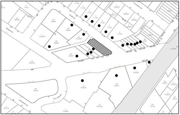
|
NOTIFICATION PLAN |
|||
|
• PROPERTIES NOTIFIED |
X SUBMISSIONS RECEIVED |
|
|
5.2 Public Agencies
The development application was referred to the following Agencies for comment:
5.2.1 Transport for NSW
The application was referred to Transport for NSW (TfNSW) for comment pursuant to Section 2.119 of State Environmental Planning Policy (Transport & Infrastructure) 2021. No concerns were raised, subject to standard conditions.
6. THE PUBLIC INTEREST
Section 4.15(1)(e) of the Act requires Council to consider “the public interest”.
The public interest is an overarching requirement, which includes the consideration of the matters discussed in this report. Implicit to the public interest is the achievement of future built outcomes adequately responding to and respecting the future desired outcomes expressed in environmental planning instruments and development control plans.
The application is considered to have satisfactorily addressed Council’s criteria and would provide a development outcome that, on balance, would result in a positive impact for the community. Accordingly, it is considered that the approval of the proposed development would be in the public interest.
CONCLUSION
The application proposes the demolition of the rear addition and garage of an existing heritage listed commercial building and construction of a mixed-use development comprising shop top housing and residential flat building.
The development generally meets the desired outcomes of Council’s planning controls and is satisfactory having regard to the matters for consideration in Section 4.15 of the Environmental Planning and Assessment Act 1979.
Having regard to the circumstances of the case, approval of the application is recommended.
The reasons for this decision are:
· The proposed development generally complies with the requirements of the relevant environmental planning instruments and the Hornsby Development Control Plan 2013.
· The proposed residential flat building component of the development meets the conservation incentives in accordance with the provisions of Clause 5.10(10) of the HLEP 2013.
· The proposed development does not create unreasonable environmental impacts to adjoining development with regard to visual bulk, parking, traffic, heritage conservation, solar access, amenity or privacy.
Note: At the time of the completion of this planning report, no persons have made a Political Donations Disclosure Statement pursuant to Section 10.4 of the Environmental Planning and Assessment Act 1979 in respect of the subject planning application.
RESPONSIBLE OFFICER
The officer responsible for the preparation of this report is Thomas Dales.
|
Cassandra Williams Major Development Manager - Development Assessments Planning and Compliance Division |
Rod Pickles Manager - Development Assessments Planning and Compliance Division |
|
1.⇩ |
Locality Plan |
|
|
|
2.⇩ |
Architectural Plans |
|
|
|
3.⇩ |
Landscape Plans |
|
|
File Reference: DA/667/2022
Document Number: D08505217
SCHEDULE 1
The conditions of consent within this notice of determination have been applied to ensure that the use of the land and/or building is carried out in such a manner that is consistent with the aims and objectives of the relevant legislation, planning instruments and Council policies affecting the land and does not disrupt the amenity of the neighbourhood or impact upon the environment.
Note: For the purpose of this consent, the term ‘applicant’ means any person who has the authority to act on or the benefit of the development consent.
Note: For the purpose of this consent, any reference to an Act, Regulation, Australian Standard or publication by a public authority shall be taken to mean the gazetted Act or Regulation, or adopted Australian Standard or publication as in force on the date that the application for a construction certificate is made.
1. Approved Plans and Supporting Documentation
The development must be carried out in accordance with the plans and documentation listed below and endorsed with Council’s stamp, except where amended by Council and/or other conditions of this consent:
Approved Plans
|
Plan No. |
Plan Title |
Drawn by |
Dated |
Council Reference |
|
DA-110, Rev 2 |
Ground Floor Plan |
Jackson Teece |
20.9.22 |
|
|
DA-111, Rev 2 |
First Floor Plan |
Jackson Teece |
20.9.22 |
|
|
DA-112, Rev 2 |
Level 2 Plan |
Jackson Teece |
20.9.22 |
|
|
DA-121, Rev 2 |
Roof Plan |
Jackson Teece |
20.9.22 |
|
|
DA-200, Rev 2 |
North & South Elevations |
Jackson Teece |
20.9.22 |
|
|
DA-201, Rev 2 |
West & East Elevations |
Jackson Teece |
20.9.22 |
|
|
DA-202, Rev 2 |
East Elevation - Internal |
Jackson Teece |
20.9.22 |
|
|
DA-203, Rev 2 |
Street Elevation |
Jackson Teece |
20.9.22 |
|
|
DA-300, Rev 2 |
Site Section |
Jackson Teece |
20.9.22 |
|
|
Dwg No. 3, Rev 05 |
Overall Plan |
Place Design Group |
21.9.22 |
|
|
Dwg No. 4, Rev 05 |
Detail Plan |
Place Design Group |
21.9.22 |
|
|
Dwg No. 5, Rev 05 |
Section A |
Place Design Group |
21.9.22 |
|
|
Dwg No. 6, Rev 05 |
Section B |
Place Design Group |
21.9.22 |
|
|
Dwg No. 7, Rev 05 |
Section C |
Place Design Group |
21.9.22 |
|
|
Dwg No. 9, Rev 05 |
Planting Plan |
Place Design Group |
21.9.22 |
|
|
Dwg No. 10, Rev 05 |
Planting Schedule |
Place Design Group |
21.9.22 |
|
|
Dwg No. 11, Rev 05 |
Materials Precedent |
Place Design Group |
21.9.22 |
|
|
21Q22_DA_C100, Rev 05 |
Site Detail Plan |
Henry & Hymas |
20.9.22 |
- |
Supporting Documentation
|
Document Title |
Prepared by |
Dated |
Council Reference |
|
Schedule of Conservation Works, Issue D |
GBA Heritage |
July 2022 |
D08447909 |
|
Conservation Management Plan, Issue D |
GBA Heritage |
July 2022 |
D08447907 |
|
Statement of Heritage Impact, Issue C |
GBA Heritage |
July 2022 |
D08447906 |
|
Access Report |
Morris Goding Access Consulting |
27.5.22 |
D08440486 |
|
Acoustic Report |
JHA |
25.5.22 |
D08440485 |
|
BASIX Certificate No. A454313 |
JHA Consulting Engineers |
20.5.22 |
D08440481 |
|
BASIX Certificate No. 1294256M_02 |
JHA Consulting Engineers |
20.5.22 |
D08440479 |
|
Waste Management Plan |
Elephants Foot Consulting |
25.5.22 |
D08440441 |
To comply with Councils requirement in terms of sediment control, the approved plans are to be amended as follows:
a) The Sediment and Erosion Control Plan, prepared by Henry and Hymas, reference 21Q22_DA_SE01 Rev 01, dated 20/4/22 must be updated as follows:
i) The stabilised site access and proposed vehicle shaker grid must be shown at all proposed access / egress points, including the vehicle crossing at Fisher Avenue.
b) These amended plans must be submitted with the application for the Construction Certificate.
3. Construction Certificate
a) A Construction Certificate is required to be approved by Council or a Private Certifying Authority prior to the commencement of any construction works under this consent.
b) A separate approval must be obtained from Council for all works within the public road reserve under S138 of the Roads Act.
c) The Construction Certificate / Section 138 Roads Act Application plans must be consistent with the Development Consent plans.
4. Section 7.11 Development Contributions
a) In accordance with Section 4.17(1) of the Environmental Planning and Assessment Act 1979 and the Hornsby Shire Council Section 7.11 Development Contributions Plan 2020-2030, the following monetary contributions must be paid to Council to cater for the increased demand for community infrastructure resulting from the development:
|
Description |
Contribution (4) |
|
Roads |
$3,246.45 |
|
Open Space and Recreation |
$77,231.70 |
|
Community Facilities |
$47,567.70 |
|
Plan Preparation and Administration |
$640.20 |
|
TOTAL |
$128,686.05 |
being for seven residential units comprising 2 x 1 bedroom units, 2 x 2 bedroom units and 3 x 3 bedroom units.
b) The value of this contribution is current as 3 November 2022. If the contribution is not paid within the financial quarter that this condition was generated, the contribution payable will be adjusted in accordance with the provisions of the Hornsby Shire Council Section 7.11 Development Contributions Plan and the amount payable will be calculated at the time of payment in the following manner:
$CPY = $CDC x CPIPY
CPIDC
Where:
$CPY is the amount of the contribution at the date of Payment.
$CDC is the amount of the contribution as set out in this Development Consent.
CPIPY is the latest release of the Consumer Price Index (Sydney – All Groups) at the date of Payment as published by the ABS.
CPIDC is the Consumer Price Index (Sydney – All Groups) for the financial quarter at the date applicable in this Development Consent Condition.
c) The monetary contribution must be paid to Council:
i) Prior to the issue of the Subdivision Certificate where the development is for subdivision.
ii) Prior to the issue of the first Construction Certificate where the development is for building work.
iii) Prior to issue of the Subdivision Certificate or first Construction Certificate, whichever occurs first, where the development involves both subdivision and building work.
iv) Prior to the works commencing where the development does not require a Construction Certificate or Subdivision Certificate.
Note: It is the professional responsibility of the Principal Certifying Authority to ensure that the monetary contributions have been paid to Council in accordance with the above timeframes.
Note: In accordance with Ministerial Directions, the payment of contribution fees for development with a cost of works of over $10 million can be deferred to prior to Occupation Certificate.
Note: Council’s Development Contributions Plan may be viewed at www.hornsby.nsw.gov.au or a copy may be inspected at Council’s Administration Centre during normal business hours.
5. Noise Attenuation and Mitigation Measures
All mitigation and control measures recommended by the Acoustic Report prepared by JHA dated 25 May 2022, revision B, reference 210559 must be implemented, including the following:
a) The windows in bedrooms facing Pennant Hills Road in the residential unit of the heritage building only, it is required to maintain the size of the airgap and increase the thickness of the internal pane to a minimum of 6.38mm laminated.
b) The bedroom windows of the residential building must achieve a minimum sound insulation rating of RW30. This sound insulation rating can be achieved with a 6.38mm laminated glazing, similar to the proposed glazing in Appendix C of ‘Development near Rail Corridors and Busy Roads – Interim Guideline’.
REQUIREMENTS PRIOR TO THE ISSUE OF A CONSTRUCTION CERTIFICATE
a) Prior to the commencement of any works on site, the applicant must submit for approval by the Principal Certifying Authority (with a copy forwarded to Council) a ‘Dilapidation Report’ detailing the structural condition of the adjoining properties:
i) Lot 1 DP 796816, No. 372 Pennant Hills Road Pennant Hills.
ii) The heritage listed building on Pt Lot 23 DP 11134, No. 370 Pennant Hills Road, Pennant Hills (the development site).
b) The report must include a photographic survey of the adjoining properties detailing their physical condition, both internally and externally, including such items as walls, ceilings, roof, structural members and other similar items. The report must be completed by a chartered structural/geotechnical engineer. A copy of the dilapidation report must be submitted to Council.
c) In the event access to adjoining allotments for the completion of a dilapidation survey is denied, the applicant must demonstrate in writing that all reasonable steps have been taken to advise the adjoining allotment owners of the benefit of this survey and details of failure to gain consent for access to the satisfaction of the Principle Certifying Authority.
Note: This documentation is for record keeping purposes only and can be made available to an applicant or affected property owner should it be requested to resolve any dispute over damage to adjoining properties arising from works. It is in the applicant’s and adjoining owner’s interest for it to be as detailed as possible
7. Waste Transport and Disposal Records
Prior to the issue of a Construction Certificate, all relevant documentation to satisfy all regulatory requirements related to the transportation of contaminated waste excavated during remediation must be providing to the Principal Certifying Authority and Council, including but not limited to transport certificates, consignment numbers and records of waste disposal through NSW EPA’s ‘Waste Locate’ system.
8. Validation Report
a) Prior to the issue of a Construction Certificate, a Validation Report must be prepared by a certified consultant as recognised under the Certified Environmental Practitioners Scheme - Site Contamination (CEnvP (SC)) and the Certified Professional Soil Scientist Contaminated Site Assessment and Management (CPSS CSAM) certification, verifying that the site has been remediated in accordance with the NSW Environment Protection Authority’s Contaminated Sites Guidelines, the National Environment Protection (Assessment of Site Contamination) Measure 2013 (NEPM) and the recommendations of the Council approved Remediation Action Plan. The Validation Report must state that the site has been remediated and is suitable for its approved use.
b) The Validation Report must be submitted to the Principal Certifying Authority and a copy provided to Council prior to the issue of a Construction Certificate.
c) Waste Transport and Disposal Records must be appended to the Site Validation Report.
8. Stormwater Drainage
The stormwater drainage system for the development must be designed in accordance with AUS-SPEC Specifications (www.hornsby.nsw.gov.au/property/build/aus-spec-terms-and-conditions) and the following requirements:
a) The Stormwater Site Detail Plan Drawing No. 21Q22_DA_C100 Revision 05 dated 20.09.2022 by Henry & Hymas shall be amended to remove pipe bends located within the public road reserve. All pipe bends shall be located wholly within the development site by including the provision of a junction pit at the property boundary.
b) The site discharge point shall be connected directly to the kerb and gutter in Fisher Avenue with a 200 x 100 mm Galvanised Rectangular Hollow Section.
9. On Site Stormwater Detention
An on-site stormwater detention system must be designed by a chartered civil engineer generally in accordance with the Stormwater Site Detail Plan Drawing No. 21Q22_DA_C100 Revision 05 dated 20.09.2022 by Henry & Hymas with the following requirements:
a) Have a capacity of not less than 7.5 cubic metres, and a maximum discharge (when full) of 24.0 litres per second.
b) Have a surcharge/inspection grate located directly above the outlet.
c) Discharge from the detention system must be controlled via 1 metre length of pipe, not less than 50 millimetres diameter or via a stainless plate with sharply drilled orifice bolted over the face of the outlet discharging into a larger diameter pipe capable of carrying the design flow to an approved Council system.
d) Where above ground and the average depth is greater than 0.3 metres, a ‘pool type’ safety fence and warning signs must be installed.
e) Not be constructed in a location that would impact upon the visual or recreational amenity of residents.
10. Internal Driveway/Vehicular Areas
The driveway and parking areas on site must be designed, constructed and a Construction Certificate issued in accordance with Australian Standards AS2890.1, AS2890.2, AS3727 and the following requirements:
a) The access driveway shall be amended to incorporate the design levels at the front boundary obtained from Council by lodging an “Application for Vehicular Crossing Boundary Levels”.
b) The driveway be a rigid pavement.
c) Longitudinal sections along both sides of the access driveway shall be submitted to the principal certifying authority in accordance with the relevant sections of AS 2890.1. The maximum grade of the driveway shall not exceed 1 in 4 (25%) with the maximum changes of grade of 1 in 8 (12.5%) for summit grades and 1 in 6.7 (15%) for sag grades. Any transition grades shall have a minimum length of 2 metres. The longitudinal sections shall incorporate the design levels obtained by Council.
d) Prior to the issue of a construction certificate, a certificate from a qualified engineer shall be submitted to the principal certifying authority certifying that the access driveway, parking and services areas have been designed in accordance with Australian Standards AS2890.1 and AS 2890.2.
11. Footpath
A concrete footpath must be designed along the full frontage of the development site in Fisher Avenue in accordance AUS-SPEC Specifications and the following requirements:
a) The existing concrete footpath along the full frontage of the development site in Fisher Avenue shall be removed and reconstructed.
b) The land adjoining the footpath to be fully turfed.
c) Any public utility adjustments to be carried out at the cost of the applicant and to the requirements of the relevant public authority.
12. Road Works
Prior to the issue of a Construction Certificate, a separate approval under Section 138 of the Roads Act 1993 must be obtained from Council by lodging an application via the NSW e-planning portal for works within the public road reserve. All road works approved under this consent must be designed in accordance with Council’s AUS SPEC Specification and the following requirements:
a) The kerb and gutter, footpath and pavement along the full frontage of the development site in Fisher Avenue and the rear Lane, together with footpath formation, necessary drainage and sealing of road pavement between the existing pavement and lip of the gutter.
b) The existing road pavement to be saw cut a minimum of 500 mm from the existing edge of the bitumen and reconstructed.
c) The submission of a compaction certificate from a geotechnical engineer for any fill within road reserves, and all road sub-grade and road pavement materials.
13. Fire Hydrant Booster
The wall located adjacent to the proposed fire hydrant booster is required to meet the requirements of Part 3.5.3.1 of Australian Standards AS2419.1:2017 Fire hydrant installations. The screen planting must not impact on NSW Fire and Rescue ability to access and operate the hydrant in an emergency situation.
14. Fire Safety Schedule
A schedule of all proposed essential fire safety measures to be installed in the building (e.g. hydrants, hose reels, emergency warning systems etc.) must be submitted with the construction certificate application. The schedule shall distinguish between existing and proposed fire safety measures.
15. Building Accessibility
The new building, new part of the building or affected part of the building is required to meet the requirements of the Disability (Access to Premises Buildings) Standards 2010.
16. Building Code of Australia
Detailed plans, specifications and supporting information is required to be submitted to the certifying authority detailing how the proposed building work achieves compliance with the National Construction Code - Building Code of Australia. All building work must be carried out in accordance with the requirements of the National Construction Code - Building Code of Australia.
17. Contract of Insurance (Residential Building Work)
Where residential building work for which the Home Building Act 1989 requires there to be a contract of insurance in force in accordance with Part 6 of that Act, this contract of insurance must be in force before any building work authorised to be carried out by the consent commences.
18. Notification of Home Building Act 1989 Requirements
Residential building work within the meaning of the Home Building Act 1989 must not be carried out unless the principal certifying authority for the development to which the work relates (not being Council) has given Council written notice of the following information:
a) In the case of work for which a principal contractor is required to be appointed:
i) The name and licence number of the principal contractor.
ii) The name of the insurer by which the work is insured under Part 6 of that Act.
b) In the case of work to be done by an owner-builder:
i) The name of the owner-builder.
ii) If the owner-builder is required to hold an owner-builder’s permit under that Act, the number of the owner-builder’s permit.
Note: If arrangements for doing the residential building work are changed while the work is in progress so that the information notified becomes out of date, further work must not be carried out unless the principal certifying authority for the development to which the work relates (not being Council) has given Council written notification of the updated information.
The following waste management requirements must be complied with:
a) Should there be any conflict between approved plans and/or consent conditions related to the waste management system or the waste collection vehicle travel path on site, then written clarification must be obtained from Council.
c) A design certificate and detailed plans are to accompany any Construction Certificate application, which demonstrate that all bin storage room(s) have been designed to be constructed in accordance with the Waste Minimisation and Management Guidelines and including the following requirements:
i) The floor is to be constructed of concrete at least 75mm thick and adequately graded to drain to a Sydney Water approved drainage fitting.
ii) The floor must be finished so that it is non-slip, sealed and impervious, and has a smooth and even surface coved at all intersections.
iii) The ceilings and walls must be finished with smooth faced non-absorbent material capable of being cleaned.
iv) The room is to be provided with artificial light controllable within the room and adequate ventilation.
v) The room is to be provided with an adequate supply of hot and cold water mixed through a centralised mixing valve with hose cock.
vi) The doors are to be robust and lockable, with a door opening of no less than 1.5m. The doors must be able to be opened from inside the room without a key.
d) There must be no steps along any bin carting route. Ramps and service lifts are acceptable.
e) A dedicated bulky waste storage area of at least 8 square metres internal area must be provided at the ground level within 5m walking distance of an entry point to the site. The internal area does not include wall thickness, door thickness etc which must be added. The bulky waste storage area must be integrated into the overall design of the development and landscaping to minimise impact on the streetscape, and include screening to a height of no less than 1.5 m. The door must be a sliding door similar to that on the commercial bin storage room.
i) An estimate of the types and volumes of waste and recyclables to be generated.
ii) A site plan showing sorting and storage areas for demolition and construction waste and the vehicle access to these areas.
iii) How excavation, demolition and construction waste materials will be reused or recycled and where residual wastes will be disposed.
iv) The total percentage (by weight) of demolition and construction waste that will be reused or recycled.
Note: the site(s) to which the waste materials are taken must be legally able to accept those wastes.
REQUIREMENTS PRIOR TO THE COMMENCEMENT OF ANY WORKS
20. Asbestos Removal Control Plan
An Asbestos Removal Control Plan (ARCP) prepared by a suitably qualified and accredited Occupational Hygienist must be submitted to Council. The plan must, as a minimum, detail the requirements for the handling, monitoring and contractor (CLASS B) disposal requirements for the ACM on the site surfaces.
21. Implementation of the Remediation Action Plan
The site must be remediated in accordance with the Remedial Action Plan, prepared by Aargus Pty Ltd, dated 6/9/22, reference ES8491/3, including the following:
a) The applicant must engage a certified consultant as recognised under the Certified Environmental Practitioners Scheme - Site Contamination (CEnvP (SC)) and the Certified Professional Soil Scientist Contaminated Site Assessment and Management (CPSS CSAM) certification to supervise all aspects of site remediation and validation in accordance with the approved Remediation Action Plan.
b) Should unidentified contamination which alters previous conclusions about site contamination be identified during site works, Council and the Principal Certifying Authority must be immediately notified.
c) Should any variations to the approved Remediation Action Plan be required, an addendum Remediation Action Plan must be prepared by a certified consultant as recognised under the Certified Environmental Practitioners Scheme - Site Contamination (CEnvP (SC)) and the Certified Professional Soil Scientist Contaminated Site Assessment and Management (CPSS CSAM) certification, and be provided to Council for approval.
22. Construction Management Plan (CMP)
To assist in the protection of the public, the environment and Council’s assets, a separate Construction Management Plan must be prepared by a suitably qualified environmental consultant in consultation with a qualified traffic engineer and AQF 5 arborist and submitted to Council’s Compliance Team via Council’s Online Services Portal for review and written approval.
The CMP must include the following details:
a) A Construction Traffic Management Plan (CTMP) including the following:
i) The order of remediation, demolition and construction works and arrangement of all construction machines and vehicles being used during all stages.
ii) The CTMP plans shall be in accordance with all other plans including but not limited to the Remediation Action Plan and Stormwater Plans submitted to Council as part of this development proposal.
iii) A statement confirming that no building materials, work sheds, vehicles, machines or the like shall be allowed to remain in the road reserve area without the written consent of Hornsby Shire Council.
iv) The Plan shall be in compliance with the requirements of the Roads and Maritime Services Traffic control at work sites Manual 2018 and detail:
a. Public notification of proposed works.
b. Long term signage requirements.
c. Short term (during actual works) signage.
d. Vehicle Movement Plans, where applicable.
e. Traffic Management Plans.
f. Pedestrian and Cyclist access and safety.
v) Traffic controls including those used during non-working hours. Pedestrian access and two-way traffic in the public road must be able to be facilitated at all times.
vi) Details of parking arrangements for all employees and contractors, including layover areas for large trucks during all stages of works. The parking or stopping of truck and dog vehicles associated with the development will not be permitted other than on the site and the plan must demonstrate this will be achieved.
vii) Confirmation that a street ‘scrub and dry’ service will be in operation during all stages of works.
viii) Proposed truck routes to and from the site including details of the frequency of truck movements for all stages of the development.
ix) Swept path analysis for ingress and egress of the site for all stages of works including remediation, demolition, excavation and construction.
x) Site plans for all stages of works including the location of site sheds, concrete pump and crane locations, unloading and loading areas, waste and storage areas, existing survey marks, vehicle entry, surrounding pedestrian footpaths and hoarding (fencing) locations.
xi) The total quantity and size of trucks for all importation and exportation of fill and excavated material on site throughout all stages of works, and a breakdown of total quantities of trucks for each stage of works.
xii) The number of weeks trucks will be accessing and leaving the site with excavated or imported fill material throughout all stages of work including remediation, demolition, excavation and construction.
xiii) The maximum number of trucks travelling to and from the site on any given day for each stage of works.
xiv) The maximum number of truck movements on any given day during peak commuting periods for all stages of works.
xv) The source site location of any proposed fill to be imported to the site, for all stages of works.
xvi) The Plan must state that the applicant and all employees of contractors on the site must obey any direction or notice from the Prescribed Certifying Authority or Hornsby Shire Council in order to ensure the above.
xvii) If there is a requirement to obtain a Work Zone, Out of Hours permit, partial Road Closure or Crane Permit, the Plan must detail these requirements and include a statement that an application to Hornsby Shire Council will be made to obtain such a permit.
b) A Construction Waste Management Plan detailing the following:
i) Details of the importation or excavation of soil and fill, the classification of the fill, disposal methods and authorised disposal depots that will be used for the fill.
ii) Asbestos management requirement and procedures for removal and disposal from the site in accordance with AS 2601–2001 – ‘The Demolition of Structures’, and the Protection of the Environment Operations (Waste) Regulation 2005.
iii) General construction waste details including construction waste skip bin locations and litter management for workers.
iv) Proposed record keeping and documentation methodology for waste dockets, trucks accessing site (e.g., a dedicated register maintained by the site supervisor or other responsible site personnel). The register must note as a minimum:
a. Truck registration number and driver contact details for trucks importing and exporting waste from site.
b. Time and date of truck access to site.
c. Waste docket detailing the type and quantity of waste being imported or exported.
d. Copies of other relevant certificates including tipping dockets received from the licensed waste facility, Waste Classification Certificate for waste imported to site, etc.
c) A Tree Protection Plan (TPP) prepared by an AQF 5 Arborist in accordance with any approved Arboricultural Impact Assessment and tree location plans, detailing the following:
i) A site plan showing tree protection zones (TPZ) and structural root zones (SRZ) of trees to be retained and specific details of tree protection measures inclusive of distances (in metres) measured from tree trunks.
ii) Construction methodology to avoid damage to trees proposed to be retained during construction works.
iii) Specifications on tree protection materials used and methods within the TPZ or SRZ.
iii) Location of dedicated material storage space on site outside of TPZ’s and SRZ’s for retained trees.
d) A Construction Noise and Vibration Management Plan (CNMP) which includes:
i) Existing noise and vibration levels within the proximity of the proposed development site.
ii) Details of the extent of rock breaking or rock sawing works forming part of the proposed development works.
iii) The maximum level of noise and vibration predicted to be emitted during each stage of construction.
iv) The duration of each stage of works where the maximum level of noise and vibration are predicted to be emitted for.
v) Details of mitigation measures, inclusive of respite periods, that will meet acoustic standards and guidelines at each stage of works.
vi) Details of a complaints handling process for the surrounding neighbourhood for each stage of works.
e) Identification of approved sediment and erosion control measures.
f) The CMP must detail the contact information for developers, builder, private certifier and any emergency details during and outside work hours.
g) The plan must include but not be limited to the location details of the licensed waste facility where excavated material required for removal will be disposed to.
h) The plan must include the location details of the source site of any proposed fill to be imported for site remediation purposes.
i) The Plan must state that the applicant and all employees of contractors on the site must obey any direction or notice from the Certifying Authority or Hornsby Shire Council in order to ensure all works are undertaken in accordance with the CMP.
Note: The CMP must be lodged via Council’s Online Services Portal at: https://hornsbyprd-pwy-epw.cloud.infor.com/ePathway/Production/Web/Default.aspx and by selecting the following menu options: Applications > New Applications > Under ‘Application Types’: Management Plans.
23. Erection of Construction Sign
a) A sign must be erected in a prominent position on any site on which any approved work is being carried out:
i) Showing the name, address and telephone number of the principal certifying authority for the work.
ii) Showing the name of the principal contractor (if any) for any demolition or building work and a telephone number on which that person may be contacted outside working hours.
iii) Stating that unauthorised entry to the work site is prohibited.
b) The sign is to be maintained while the approved work is being carried out and must be removed when the work has been completed.
24. Protection of Adjoining Areas
A temporary hoarding, fence or awning must be erected between the work site and adjoining lands before the works begin and must be kept in place until after the completion of the works if the works:
a) Could cause a danger, obstruction or inconvenience to pedestrian or vehicular traffic.
b) Could cause damage to adjoining lands by falling objects.
c) Involve the enclosure of a public place or part of a public place.
d) Have been identified as requiring a temporary hoarding, fence or awning within the Council approved Construction Management Plan (CMP).
Note: Notwithstanding the above, Council’s separate written approval is required prior to the erection of any structure or other obstruction on public land.
25. Toilet Facilities
a) To provide a safe and hygienic workplace, toilet facilities must be available or be installed at the works site before works begin and must be maintained until the works are completed at a ratio of one toilet for every 20 persons employed at the site.
b) Each toilet must:
i) Be a standard flushing toilet connected to a public sewer.
ii) Be a temporary chemical closet approved under the Local Government Act 1993.
iii) Have an on-site effluent disposal system approved under the Local Government Act 1993.
26. Erosion and Sediment Control
To protect the water quality of the downstream environment, erosion and sediment control measures must be provided and maintained throughout the construction period in accordance with the manual ‘Soils and Construction 2004 (Bluebook)’, the approved plans, Council specifications and to the satisfaction of the principal certifying authority. The erosion and sediment control devices must remain in place until the site has been stabilised and revegetated.
Note: On the spot penalties may be issued for any non-compliance with this requirement without any further notification or warning.
27. Garbage Receptacle
a) A garbage receptacle must be provided at the work site before works begin and must be maintained until all works are completed.
a) The garbage receptacle must have a tight fitting lid and be suitable for the reception of food scraps and papers.
b) The receptacle lid must be kept closed at all times, other than when garbage is being deposited.
c) Food scraps must be placed in the garbage receptacle and not in demolition and construction waste bins.
REQUIREMENTS DURING DEMOLITION AND CONSTRUCTION
28. Compliance with Construction Management Plan
The Council approved Construction Management Plan must be complied with for the duration of works, unless otherwise approved by Council.
29. Compliance with the Remediation Action Plan (RAP)
The Council approved Remediation Action Plan, prepared by Aargus Pty Ltd, dated 6/9/22, reference ES8491/3, must be complied with for the duration of works, unless otherwise approved by Council.
30. Construction Work Hours
All works on site, including demolition and earth works, must only occur between 7am and 5pm Monday to Saturday.
No work is to be undertaken on Sundays or public holidays.
31. Demolition
To protect the surrounding environment, all demolition work must be carried out in accordance with Australian Standard AS2601-2001 Demolition of structures and the following requirements:
a) Demolition material must be disposed of to an authorised recycling and/or waste disposal site and/or in accordance with an approved waste management plan; and
b) Demolition works, where asbestos material is being removed, must be undertaken by a contractor that holds an appropriate licence issued by SafeWork NSW in accordance with the Work Health and Safety Regulation 2017 and be appropriately transported and disposed of in accordance with the Protection of the Environment Operations (Waste) Regulation 2014; and
c) On construction sites where any building contain asbestos material, a standard commercially manufactured sign containing the words ‘DANGER ASBESTOS REMOVAL IN PROGRESS’ and measuring not less than 400mm x 300mm must be displayed in a prominent position visible from the street.
32. Environmental Management
To prevent sediment run-off, excessive dust, noise or odour emanating from the site during the construction, the site must be managed in accordance with the publication ‘Managing Urban Stormwater – Landcom (March 2004) and the Protection of the Environment Operations Act 1997.
33. Council Property
To ensure that the public reserve is kept in a clean, tidy and safe condition during construction works, no building materials, waste, machinery or related matter is to be stored on the road or footpath.
Note: This consent does not give right of access to the site via Council’s park or reserve. Should such access be required, separate written approval is to be obtained from Council.
34. Disturbance of Existing Site
During construction works, the existing ground levels of open space areas and natural landscape features, including natural rock-outcrops, vegetation, soil and watercourses must not be altered unless otherwise nominated on the approved plans.
35. Landfill
a) Prior to any fill material being imported to the site, a Waste Classification Certificate shall be obtained from a suitably qualified environmental consultant confirming the fill wholly consists of Virgin Excavated Natural Material (VENM) as defined in Schedule 1 of the Protection of the Environment Operations Act 1997 or a material approved under the NSW Environment Protection Authority’s Resource Recovery Orders and Exemptions.
b) The required Waste Classification Certificate must be obtained by the Principal Contractor prior to fill being imported to the site and made available to Council at its request.
36. Excavated Material
Any/all excavated material removed from the site must be classified by a suitably qualified environmental consultant in accordance with the NSW Environment Protection Authority’s Waste Classification Guidelines and Protection of the Environment Operations (Waste) Regulation 2014 prior to disposal to a licensed waste management facility. Tipping dockets for the total volume of excavated material that are received from the licensed waste management facility must be provided to the principal certifying authority prior to the issue of an Occupation Certificate.
37. Unexpected Finds
Should the presence of asbestos or soil contamination, not recognised during the application process be identified during any stage of works, the applicant must immediately notify the Principal Certifying Authority and Hornsby Shire Council.
38. Survey Report
A report(s) must be prepared by a registered surveyor and submitted to the principal certifying authority:
a) Prior to the pouring of concrete at each level of the building certifying that:
i) The building, retaining walls and the like have been correctly positioned on the site.
ii) The finished floor level(s) are in accordance with the approved plans.
39. Waste Management
All work must be carried out in accordance with the approved waste management plan.
Requirements of the approved Waste Management Plan shall be complied with during all site preparation works, demolition and throughout all construction works. When implementing the Waste Management Plan, the developer is to ensure:
a) The disposal of any demolition and construction waste must be undertaken in accordance with the requirements of the Protection of Environment Operations Act 1997
b) All waste on site is to be stored, handled and disposed of in such a manner as to not create air pollution, offensive noise or pollution of land and water as defined by the Protection of Environment Operations Act 1997
c) Generation, storage, treatment and disposal of hazardous waste is conducted in accordance with the relevant waste legislation administered by the EPA and relevant Occupational Health and Safety legislation administered by WorkCover NSW
d) All waste generated (including excavated materials) which cannot be reused or recycled must be transported to a facility which can lawfully accept it
e) All materials and resources that are to be stored on site during construction works are contained on the site. The provisions of the Protection of Environment Operations Act 1997 must be complied with when placing/stock piling loose material, disposal of concrete waste or activities which have potential to pollute drains and water courses
f) The storage of waste and recycling containers must be within the boundaries of the development site at all times. Public footways and roads must not be used for the storage of any waste and must be kept clear of obstructions during all construction works
g) Additionally, written records of the following items must be maintained during the removal of any waste from the site and such information submitted to the Principal Certifying Authority within fourteen days of the date of completion of the works:
i) The identity of the person removing the waste.
ii) The waste carrier vehicle registration.
iii) Date and time of waste collection.
iv) A description of the waste (type of waste and estimated quantity).
v) Details of the site to which the waste is to be taken.
vi) The corresponding weighbridge tip docket/receipt from the site to which the waste is transferred (noting date and time of delivery, description (type and quantity) of waste).
vii) Whether the waste is expected to be reused, recycled or go to landfill.
Note: In accordance with the Protection of the Environment Operations Act 1997, the definition of waste includes any unwanted substance, regardless of whether it is reused, recycled or disposed to landfill.
h) The on-going collection of waste from occupied buildings must not be impeded by construction works.
41. Road Opening Permit
A road opening permit shall be obtained from the Council to permit a person to dig into Council assets, such as roads, footpaths and nature strips. The applicable fees for the restoration of any public asset by Council shall be at the applicant’s full expense.
42. Vehicular Crossing
A separate application under the Local Government Act, 1993 and the Roads Act 1993 being an “Application to Construct Vehicular Crossing from Roadway to Property” must be submitted to Council for the installation of a new vehicular crossing and the removal of the redundant crossing. The vehicular crossing must be constructed in accordance with Council’s Civil Works Design Specification 2005 and the following requirements:
a) Any redundant crossings must be replaced with integral kerb and gutter.
b) The footway area must be restored by turfing.
c) Approval must be obtained from all relevant utility providers that all necessary conduits be provided and protected under the crossing.
Note: An application for a vehicular crossing can only be made to one of Council’s Authorised Vehicular Crossing Contractors. You are advised to contact Council on 02 9847 6940 to obtain a list of contractors.
43. Asbestos Clearance Certificate
Should any asbestos be encountered during demolition or construction works, a licenced asbestos assessor is required to provide a Clearance Certificate to the Certifier prior to the issue of an Occupation Certificate, certifying that the asbestos has been removed and appropriately disposed of, and the site is now suitable for its approved use.
44. Waste Receipts to the Principal Certifying Authority
Tipping dockets received from the licensed waste facility for the total volume of excavated material that was disposed offsite must be provided to the Principal Certifying Authority prior to the issue of an Occupation Certificate.
45. Sydney Water – s73 Certificate
A s73 Certificate must be obtained from Sydney Water and submitted to the PCA.
Note: Sydney Water requires that s73 applications are to be made through an authorised Sydney Water Servicing Coordinator. Refer to www.sydneywater.com.au or telephone 13 20 92 for assistance.
46. Creation of Easements
The following matter(s) must be nominated on the plan of subdivision under s88B or s88E of the Conveyancing Act 1919:
a) The creation of an appropriate "Positive Covenant" and "Restriction as to User" over the constructed on-site detention/retention systems, and outlet works, within the lots in favour of Council in accordance with Council’s prescribed wording. The position of the on-site detention system is to be clearly indicated on the title.
b) To register the OSD easement, the restriction on the use of land “works-as-executed” details of the on-site-detention system must be submitted verifying that the required storage and discharge rates have been constructed in accordance with the design requirements. The details must show the invert levels of the on-site detention system together with pipe sizes and grades. Any variations to the approved plans must be shown in red on the “works-as-executed” plan and supported by calculations.
Note: Council must be nominated as the authority to release, vary or modify any easement, restriction or covenant.
47. Construction of Engineering Works
All engineering works identified in this consent are to be completed and a Compliance Certificate issued prior to the release of the Occupation Certificate.
48. Preservation of Survey Marks
A certificate by a Registered Surveyor must be submitted to the Principal Certifying Authority, certifying that there has been no removal, damage, destruction, displacement or defacing of the existing survey marks in the vicinity of the proposed development or otherwise the re-establishment of damaged, removed or displaced survey marks has been undertaken in accordance with the Surveyor General’s Direction No.11 Preservation of Survey Infrastructure.
49. Works as Executed Plan
A works-as-executed plan(s) must be prepared by a registered surveyor and submitted to Council for completed on-site detention, council drainage, road pavement and kerb & gutter. The plan(s) must be accompanied by a certificate from a registered surveyor certifying that all pipelines and associated structures lie wholly within any relevant easements.
50. Fire Safety Statement – Final
In accordance with the Environmental Planning & Assessment (Development Certification and Fire Safety) Regulation 2021, upon completion of the building, the owner must provide Council with a certificate in relation to each fire safety measure implemented in the building.
51. Heritage Conservation Works
a) To secure the nexus between the proposed non-permitted use and the short and long-term conservation of the heritage item, and to ensure the maintenance and conservation work identified in the GBA Heritage CMP, July 2022 and in the GBA Heritage Schedule of Conservation Works July 2022 is carried out, the specified conservation works are to be undertaken and completed to the satisfaction of the appointed conservation architect, prior to the granting of any occupation certificate in whole or part for the former Bank building or for the residential flat building.
b) The appointed conservation architect is required to document conservation works and a copy of the documentation is to be submitted as an electronic report to Council for its records.
Note: The documentation is to be sent to devmail@hornsby.nsw.gov.au addressed to Council’s Strategic Landuse Planning Branch.
52. Fulfilment of BASIX Commitments
The applicant must demonstrate the fulfilment of BASIX commitments pertaining to the development.
53. Damage to Council Assets
To protect public property and infrastructure, any damage caused to Council’s assets including the removal, damage, destruction, displacement or defacing of the existing survey marks as a result of the construction or demolition of the development must be rectified by the applicant in accordance with AUS-SPEC Specifications. Rectification works must be undertaken prior to the issue of an Occupation Certificate, or sooner, as directed by Council.
54. Retaining Walls
All required retaining walls must be constructed as part of the development.
The following waste management requirements must be complied with:
a) Prior to an Occupation Certificate being issued or the use commencing, whichever is earlier, the Principal Certifying Authority must obtain Council’s approval of the waste and recycling management facilities provided in the development and ensure arrangements are in place for domestic waste collection by Council.
Note: Waste and recycling management facilities includes everything required for on-going waste management on the site. For example the bin storage areas, bulky waste storage area, bin collection area, waste collection vehicle access, doors wide enough to fit the bin through, accessibility, bin carting routes etc.
c) A report must be prepared by an appropriately qualified person, certifying the following:
i) A comparison of the estimated quantities of each demolition and construction waste type against the actual quantities of each waste type.
1. Note: Explanations of any deviations to the approved Waste Management Plan is required to be included in this report
ii) That at least 60% of the waste generated during the demolition and construction phase of the development was reused or recycled.
2. Note: If the 60% diversion from landfill cannot be achieved in the Construction Stage, the Report is to include the reasons why this occurred and certify that appropriate work practices were employed to implement the approved Waste Management Plan. The Report must be based on documentary evidence such as tipping dockets/receipts from recycling depots, transfer stations and landfills, audits of procedures etc. which are to be attached to the report.
iii) All demolition and construction waste was taken to site(s) that were lawfully permitted to accept that waste.
d) The bin carting routes must be devoid of any steps.
Note: Ramps and service lifts between different levels are acceptable.
f) There must be a dedicated communal bulky waste storage area of at least 8 square metres.
g) Space must be provided for either individual compost containers for each unit or a communal compost container.
Note: The location of the compost containers should have regard for potential amenity impacts.
h) All lockable doors and gates, both pedestrian and vehicular, that are required to be opened by Council’s waste collection contractor in the provision of waste collection services, must be able to be opened using a pin code. That is, locks requiring keys, remote controls, key fobs etc are not acceptable.
A certificate must be submitted to the PCA by a practicing landscape architect, horticulturalist or person with similar qualifications and experience certifying that all required landscaping works have been satisfactorily completed in accordance with the approved landscape plans.
Note: Advice on suitable species for landscaping can be obtained from Council’s planting guide ‘Indigenous Plants for the Bushland Shire’, available at www.hornsby.nsw.gov.au.
57. External Lighting
a) To protect the amenity of adjacent premises, all external lighting must be designed and installed in accordance with Australian Standard AS4282 Control of the obtrusive effects of outdoor lighting.
b) Certification of compliance with this Standard must be obtained from a suitably qualified person and submitted to the PCA with the application for the Certificate.
58. Safety and Security
This site must include the following elements:
a) An intercom system must be installed at gate locations to ensure screening of persons entering the units.
b) Wayfinding signage is to be provided within the ground floor lobby indicating the direction of the front entrance, rear communal open space and lift.
c) Lighting is to be provided to pathways, building foyer entries, driveways and common external spaces.
d) Security gate access is to be provided to the car parking areas allowing residents only access to private car spaces.
e) CCTV cameras must be installed at the entry and exit points to the building.
f) The communal open spaces within the site must be illuminated with high luminance by motion sensor lighting.
g) The driveway and car parking must be illuminated with low luminance at all times.
h) Security deadlocks are to be provided to each apartment door.
i) Peep holes are to be provided to individual apartment doors to promote resident safety.
OPERATIONAL CONDITIONS
Noise and vibration from the use and operation of any plant and equipment and/or building services associated with the premises shall not give rise to "offensive noise' as defined by the Protection of the Environment Operations Act 1997.
60. Deliveries and Waste Collection
During ongoing use of the commercial premises, all deliveries, waste and recycling collection shall be undertaken only during the hours of 7am - 10pm.
61. Fire Safety Statement - Annual
On at least one occasion in every 12 month period following the date of the first ‘Fire Safety Certificate’ issued for the property, the owner must provide Council with an annual ‘Fire Safety Certificate’ certifying each essential service installed in the building.
62. Waste Management
The waste management on site must be in accordance with the following requirements:
c) Waste collection services must not take place between 8PM and 5AM weekdays or 8PM and 8AM on weekends and public holidays.
Note: Time-of-day service restrictions apply to commercial developments located near residential areas.
d) The management plan for commercial units must specifically include the management of waste generated on site, litter and dumped rubbish. The site management/owners’ corporation must be responsible for the prompt removal of litter and dumped rubbish.
Note: In accordance with the Protection of the Environment Operations Act 1997, the definition of waste includes any unwanted substance, regardless of whether it is reused, recycled or disposed to landfill.
e) The residential component and non-residential component of the development must have separate and self-contained waste management systems, including separate bin storage rooms. Commercial tenants must be prevented (via signage, locked doors and other means) from using the residential waste/recycling bins and vice versa.
f) All commercial tenant(s) must have a sufficient number of bins to contain the volume of waste and recycling expected to be generated between collection services.
g) The development must operate in full compliance with Council’s waste management collection requirements.
h) There must be a sufficient number of bins on site to contain the volume of domestic waste and recycling expected to be generated between collection services.
i) A site caretaker must be employed and be responsible for moving bins where and when necessary, washing bins and maintaining waste storage areas and signage, managing the communal composting area and worm farm, managing the bulky item storage area, arranging collections where the service is not provided by Council (e.g. clothing bins, e-waste), arranging the prompt removal of dumped rubbish, arranging for shopping trolleys to be promptly returned to the local shopping centre(s), ensuring the recycling bins are free of contamination (which includes but is not limited to garbage, plastic bags, clothing, etc.), ensuring the commercial waste and recycling is kept separate from the residential waste and recycling (and vice versa), addressing overflowing bins and pest infestations, liaising with Council on waste matters, and ensuring all residents and commercial tenants are informed and kept up to date on the use of the waste management system. The site caretaker must be employed for a sufficient number of hours each week to allow all waste management responsibilities to be carried out to a satisfactory standard.
j) No waste storage containers are to be located or placed outside of the approved waste storage area at any time except for collection purposes.
k) The nominated on-site collection point is to be utilised to facilitate the collection of waste and recycling bins for the development. The on-site collection point is to be kept clear of obstructions at all times so not to restrict the collection of waste and recycling bins.
Note: Council may be able to assist with signage.
m) Where the development incorporates strata title subdivision, the by-laws are to clearly set out the management responsibilities for the developments waste management system.
63. On-Site Parking and Green Travel Plan
a) The Green Travel Plan prepared by TTPA dated September 2022 is to be implemented during the operation of the site.
b) Employees of the commercial portion of the site are to be advised that on-site parking is not available.
64. Car Parking
a) Car parking, loading and manoeuvring areas to be used solely for nominated purposes.
b) All parking areas and driveways are to be sealed to an all weather standard, line marked and signposted.
c) All vehicular entry on to the site and egress from the site shall be made in a forward direction.
d) Any proposed landscaping and/or fencing must not restrict sight distance to pedestrians and cyclists travelling along the footpath.
CONDITIONS OF CONCURRENCE – TRANSPORT FOR NSW (TfNSW)
The following conditions of consent are from the nominated State Agency pursuant to Section 4.13 of the Environmental Planning and Assessment Act 1979 and must be complied with to the satisfaction of that Agency.
65. TfNSW Condition No. 1
All buildings and structures, together with any improvements integral to the future use of the site are wholly within the freehold property unlimited in height or depth along the Pennant Hills Road boundary.
66. TfNSW Condition No. 2
Detailed design plans and hydraulic calculations of any changes to the stormwater drainage system on Pennant Hills Road are to be submitted to TfNSW for approval, prior to the commencement of any works. Please send all documentation to development.sydney@transport.nsw.gov.au
A plan checking fee will be payable and a performance bond may be required before TfNSW approval is issued. 3
67. TfNSW Condition No. 3
A Road Occupancy Licence (ROL) should be obtained from Transport Management Centre for any works that may impact on traffic flows on Pennant Hills Road during construction activities. A ROL can be obtained through
https://myrta.com/oplinc2/pages/security/oplincLogin.jsf
ADVISORY NOTES
The following information is provided for your assistance to ensure compliance with the Environmental Planning and Assessment Act 1979, Environmental Planning and Assessment Regulation 2000, other relevant legislation and Council’s policies and specifications. This information does not form part of the conditions of development consent pursuant to Section 4.17 of the Act.
Environmental Planning and Assessment Act 1979 Requirements
The Environmental Planning and Assessment Act 1979 requires:
· The issue of a construction certificate prior to the commencement of any works. Enquiries can be made to Council’s Customer Services Branch on 9847 6760.
· A principal certifying authority to be nominated and Council notified of that appointment prior to the commencement of any works.
· Council to be given at least two days written notice prior to the commencement of any works.
· Mandatory inspections of nominated stages of the construction inspected.
· An occupation certificate to be issued before occupying any building or commencing the use of the land.
Long Service Levy
In accordance with Section 34 of the Building and Construction Industry Long Service Payments Act 1986, a ‘Long Service Levy’ must be paid to the Long Service Payments Corporation or Hornsby Council.
Note: The rate of the Long Service Levy is 0.35% of the total cost of the work.
Note: Hornsby Council requires the payment of the Long Service Levy prior to the issue of a construction certificate.
Tree and Vegetation Preservation
A person must not ringbark, cut down, top, lop, remove, injure or wilfully destroy any tree or other vegetation protected under the Hornsby Development Control Plan 2013 without the authority conferred by a development consent or a permit granted by Council.
Notes: A tree is defined as a long lived, woody perennial plant with one or relatively few main stems with the potential to grow to a height greater than three metres (3M). (HDCP 1B.6.1.c).
Tree protection measures and distances are determined using the Australian Standard AS 4970:2009, “Protection of Trees on Development Sites”.
Fines may be imposed for non-compliance with the Hornsby Development Control Plan 2013.
The applicant’s attention is drawn to the existence of the Disability Discrimination Act 1992. A construction certificate is required to be obtained for the proposed building/s, which will provide consideration under the Building Code of Australia, however, the development may not comply with the requirements of the Disability Discrimination Act 1992. This is the sole responsibility of the applicant.
Covenants
The land upon which the subject building is to be constructed may be affected by restrictive covenants. Council issues this approval without enquiry as to whether any restrictive covenant affecting the land would be breached by the construction of the building, the subject of this consent. Applicants must rely on their own enquiries as to whether or not the building breaches any such covenant.
Dial Before You Dig
Prior to commencing any works, the applicant is encouraged to contact Dial Before You Dig on 1100 or www.dialbeforeyoudig.com.au for free information on potential underground pipes and cables within the vicinity of the development site.
Asbestos Warning
Should asbestos or asbestos products be encountered during demolition or construction works, you are advised to seek advice and information prior to disturbing this material. It is recommended that a contractor holding an asbestos-handling permit (issued by SafeWork NSW) be engaged to manage the proper handling of this material. Further information regarding the safe handling and removal of asbestos can be found at:
Alternatively, telephone the SafeWork NSW on 13 10 50.
Telecommunications Act 1997 (Commonwealth)
If you are aware of any works or proposed works which may affect or impact on Telstra’s assets in any way, you are required to contact: Telstra’s Network Integrity Team on Phone Number 1800810443.